
Meghalaya Portion (Phulbari – Goeragre) - JICA
377
Supplementary Environmental Impact Assessment report C. E. TESTING COMPANY PRIVATE LIMITED Report No PI/CETKI20-03/R0 Revision No. A2 21-07-2022 Supplementary Environmental Impact Assessment (SEIA) Report Construction & Up-gradation of the NH127B – Meghalaya Portion (Phulbari – Goeragre)
-
Upload
khangminh22 -
Category
Documents
-
view
0 -
download
0
Transcript of Meghalaya Portion (Phulbari – Goeragre) - JICA

Supplementary Environmental Impact Assessment report
C. E. TESTING COMPANY PRIVATE
LIMITED
Report No PI/CETKI20-03/R0
Revision No. A2
21-07-2022
Supplementary Environmental Impact Assessment (SEIA) Report Construction & Up-gradation of the NH127B –Meghalaya Portion (Phulbari – Goeragre)

Consultancy services for Preparation of Phase II Reports for Improvement of NH127B (Meghalaya Portion), Phulbari to Goeragre to NH standard Corridor No: NH127B (Meghalaya); Phulbari to Goeragre
Phase II: Supplementary Environmental Impact Assessment
Doc No: PI/CETKI20-03/R0
Revision: A2 July, 2022 Page: ii
TABLE OF CONTENT_
1. INTRODUCTION………………………………………………………..2 A. General ……………………………………………………………1 B. Project Background ……………………………………………………2 C. Nature, Size and Location of Sub-project Road ……………………2 D. Objective and Scope of the Study ……………………………3 E. Extent of the EIA ……………………………………………………7 F. Methodology Adopted for EIA Study ……………………………8 G. Structure of the Report …………………………………………..13 2. POLICY, LEGAL AND ADMINISTRATIVE FRAMEWORK……...14 A. National Laws & Regulations …………………………………..14 B. State Laws & Regulations …………………………………………..21 C. Social Regulatory Requirements in India …………………..22 D. JICA Safeguard Policy …………………………………………..23 3. PROJECT DESCRIPTION …………………………………………..25 A. Introduction …………………………………………………………..25 B. Project Type …………………………………………………………..25 C. Project Details …………………………………………………..25 D. Traffic Projection …………………………………………………..35 E. Bus Bay …………………………………………………………..43 F. Utilities Shifting …………………………………………………..43 G. Project Benefits …………………………………………………..43 H. Natural Resources/Materials …………………………………..44 I. Cost Estimation …………………………………………………..45 4. ANALYSIS OF ALTERNATIVE …………………………………..47 A. Introduction (Comparison with the zero option) ….……………….47 B. Alternative analysis …………………………………………………..47 C. ‘Without Project’ Scenario …………………………………………..48 D. ‘With Project’ Scenario …………………………………………..48 5. BASELINE ENVIRONMENT STUDIES …………………………..54 A. Introduction …………………………………………………………..54 B. Physical Environment …………………………………………..55 C. Biological Environment …………………………………………..90 D. Socio Economy Environment …………………………………119 6. ANTICIPATED ENVIRONMENTAL IMPACTS AND MITIGATION MEASURES
………………………………………………………………….130
A. Introduction ………………………………………………………….130 B. Positive Impacts due to improvement of sub-project road ….131 C. Adverse Environmental Impacts due to improvement of subproject road
………………………………………………………………….131 D. Impacts and Mitigation Measure of the Sub-Project ………….131 E. Summary of Impacts & Conclusion ………………………….184

Consultancy services for Preparation of Phase II Reports for Improvement of NH127B (Meghalaya Portion), Phulbari to Goeragre to NH standard Corridor No: NH127B (Meghalaya); Phulbari to Goeragre
Phase II: Supplementary Environmental Impact Assessment
Doc No: PI/CETKI20-03/R0
Revision: A2 July, 2022 Page: iii
7.Public Consultation & Information disclosure………………………186
A. Meaningful Consultation …………………………………………..186 B. Objectives of the Public Consultations …………………………..186 C. Methodology…………………………………………………………..186 D. Consultation with the Gov. Officials …………………………..186 E. Stakeholders Consultations …………………………………..187 F. Major outcome of Public Consultation …………………………..189 8. Environment Management and Monitoring Plan …………..191
A. Introduction …………………………………………………………..191 B. Objectives Of Environment Management Plan …………………..191 C. Pre-Construction Stage …………………………………………..191 D. Construction Stage …………………………………………………..192 E. Operation Stage …………………………………………………..192 F. Environment Management Plan …………………………………..192 G. Environmental Monitoring Program ……………..235 H. Performance Indicators 235 I. Monitoring Plans for Environment Condition 236 J. Proposed Institutional Arrangement …………………………..241 K. Reporting System …………………………………………………..243 L. Non Conformity To Environmental Management Plan (EMP) …..243 M. Institutional/Capacity Building …………………………………..244 N. Environmental Budget …………………………………………..245 9. GRIEVANCE REDRESSAL MECHANISM …………………..249
A. Introduction …………………………………………………………..249 10. CONCLUSION AND RECOMMENDATION …………………...251 A. Significant Findings: …………………………………………...251
LIST OF ANNEXURES Annex 1:JICA’s Scoping Matrix for Environmental Assessment ................................................................ 253 Annex 2: NOC from DFO (Dhubri Division) .............................................................................................. 214 Annex 3: GoI Ambient Air Quality Standards ............................................................................................ 217 Annex 4:GoI Ambient Noise Level Standards ........................................................................................... 218 Annex 5:Indian Standard Drinking Water Specification: II 10500:1991...................................................... 219 Annex 6:Record of Public Consultations .................................................................................................. 221 Annex 7:GRM Information Sheet ............................................................................................................. 235 Annex 8: Road STrip Plan…………………………………………………………………………………………...236 Annex 9: HDM 4 Output…………………………………………………………………………………………...…253 Annex 10:Guidelines for Tree Plantation and Management ...................................................................... 267 Annex 11:Guidelines for Borrow Area Management ................................................................................. 269 Annex 12:Guidelines for Emergency Management System ...................................................................... 273 Annex 13:Guidelines for Waste Disposal and Management ..................................................................... 275 Annex 14:Outline of an Environmental Monitoring Report......................................................................... 277 Annex 15: Guidelines for Siting and Layout of Construction Camp ........................................................... 283 Annex 16: Guidelines For Siting, Operation And Re-Development Of Quarrying And Stone Crushing Operations............................................................................................................................................... 292

Consultancy services for Preparation of Phase II Reports for Improvement of NH127B (Meghalaya Portion), Phulbari to Goeragre to NH standard Corridor No: NH127B (Meghalaya); Phulbari to Goeragre
Phase II: Supplementary Environmental Impact Assessment
Doc No: PI/CETKI20-03/R0
Revision: A2 July, 2022 Page: iv
Annex 17: Guideline for Siting and Management of Debris Disposal Site.................................................. 299 Annex 18: Guidelines For Top Soil Conversation And Reuse ................................................................... 301 Annex 19: Guidelines On Slope Stabilization ........................................................................................... 302 Annex 20: Guidelines To Ensure Worker’s Safety During Construction .................................................... 308 Annex 21: Guidelines For Preparation Of Traffic Management Plan ......................................................... 317 Annex 22: Guidelines For Sediment Control............................................................................................. 322 Annex 23: Analysis of Rate ...................................................................................................................... 322 A. Rate of Scheduled items .................................................................................................................. 322 B. Rate of nonscheduled items ............................................................................................................. 326
LIST OF FIGURES
Figure 1: Road Map of Meghalaya State ....................................................................................... 1 Figure 2: Proposed Road Alignment of Phulbari to Goeragre road stretch on satellite imagery ............... 2 Figure 3: Existing Road Alignment from Fakirganj to Rongram via Phulbari road stretch on satellite imagery .................................................................................................................................................25 Figure 4: Map showing surrounding road network and major place marks along the road within a 10 km radius ....................................................................................................................................................27 Figure 5: Satellite Image of terrain classificationalong the project road around a 10 km radius ..............28 Figure 6: Satellite Image of Land Use along the project road within a 10 km radius ................................29 Figure 7: image of existing major bridge at chainage 12+400km ............................................................32 Figure 8: image of existing minor bridge at chainage 18+015km ..........................................................33 Figure 9: GIS Image of Alternative Alignment Option Study for Bypass ...................................................48 Figure 10: Map of Study Area .........................................................................................................54 Figure 11: Graphical representation showing the annual trends of rainfall in mm and rainfall days of last few years in Tura, West Garo Hill District (Source: https://www.worldweatheronline.com/lang/en-in/tura-
weather-averages/meghalaya/in.aspx) ....................................................................................................56 Figure 12:Graphical representation showing the annual trends of temperature in ℃ of last few
years in Tura, West Garo Hill District (Source: https://www.worldweatheronline.com/lang/en-in/tura-
weather-averages/meghalaya/in.aspx) ....................................................................................................57 Figure 13: Graphical representation showing the annual trends of relative humidity in % of last few years in Tura, West garo hill district(Source: https://www.worldweatheronline.com/lang/en-in/tura-
weather-averages/meghalaya/in.aspx) ....................................................................................................57 Figure 14: Graphical representation showing the annual trends of wind speed and gust in kmph of last few years in Tura, West garo hill district (Source: https://www.worldweatheronline.com/lang/en-in/tura-
weather-averages/meghalaya/in.aspx) ....................................................................................................58 Figure 15: Windrose diagram showing the wind direction in Tura, West garo hill district (https://www.meteoblue.com/en/weather/historyclimate/climatemodelled/tura_india_1254046) ......59 Figure 16: Seismic zone map of India and Meghalaya (Source: https://www.mapsofindia.com/maps/india/seismiczone.htm) ..................................................................60 Figure 17: Photographs of road side landuse .........................................................................................62 Figure 18: Elevation Map of the Project Road and Project Influence Area ..............................................63 Figure 19: Soil sampling stations along the project road ........................................................................64 Figure 20: Drainage Network of Project Study Area ...............................................................................68 Figure 21: photographs of few surface water bodies along the project road ..........................................69 Figure 22: Surface water Monitoring locations.......................................................................................70 Figure 23: Ground water sampling locations along the project road ......................................................74 Figure 24: Air quality monitoring stations along the project road ...........................................................79 Figure 25: Average values of air pollutants in all locations (March 2021)................................................82 Figure 26: PM10 values in all locations along with NAAQMS standard .....................................................83 Figure 27: PM2.5 values in all locations along with NAAQMS standard ....................................................83

Consultancy services for Preparation of Phase II Reports for Improvement of NH127B (Meghalaya Portion), Phulbari to Goeragre to NH standard Corridor No: NH127B (Meghalaya); Phulbari to Goeragre
Phase II: Supplementary Environmental Impact Assessment
Doc No: PI/CETKI20-03/R0
Revision: A2 July, 2022 Page: v
Figure 28: SOx values in all locations along with NAAQMS standard ......................................................84 Figure 29: NOx values in all locations along with NAAQMS standard ......................................................84 Figure 30: Noise monitoring locations along the project road ................................................................86 Figure 31: Noise monitoring results in day and night time along the project road ..................................88 Figure 32: Plantation observed along the Project Road ..........................................................................94 Figure 33: Distance of Nokrek National Park from the project road ........................................................98
LIST OF TABLES
Table 1: Scope of study as per TOR ......................................................................................................... 3 Table 2: Impact Evaluation Matrix .........................................................................................................10 Table 3: Severity classification based on a qualitative scale....................................................................11 Table 4: Relevant National Environmental Laws & Regulations ..............................................................14 Table 5: Summary of Clearances & NOCs Applicable as per State Legislation .........................................21 Table 6: Summary of Clearances & NOCs Not Applicable for this Sub-Project .........................................22 Table 7: Widening/Improvement Proposal ............................................................................................30 Table 8: Details of Minor bridges ...........................................................................................................31 Table 9: Details of Culverts ....................................................................................................................33 Table 10: Classified Traffic Volume Count ..............................................................................................35 Table 11: Traffic Projection of Project Road for Km 19+500 ...................................................................37 Table 12: Traffic Projection of Project Road for Km 47+200 ...................................................................39 Table 13: Traffic Projection of Project Road for Km 67+200 ...................................................................41 Table 14: Location of projected bus bay.................................................................................................43 Table 15: Leads for Various Materials (data is awaited from DPR consultant) ........................................45 Table 16: Analysis of Alternatives ..........................................................................................................49 Table 17: "With and Without" Project Scenarios - A Comparative Assessment .......................................51 Table 18: Land Use Classification of Study Area .....................................................................................60 Table 19: Soil sampling location details ..................................................................................................64 Table 20: Physio-Chemical Analysis of soil quality ..................................................................................65 Table 21: Ponds along the project road..................................................................................................67 Table 22: Sampling location details of Surface Water .............................................................................70 Table 23: Analytical result of surface water quality along the project road.............................................71 Table 24: Categorisation of surface water by CPCB and MOEF&CC ........................................................73 Table 25: Sampling location details of Ground Water ............................................................................73 Table 26: Analytical results of Ground water quality along the project road ...........................................75 Table 27: Bottom sediment result ..........................................................................................................77 Table 28: Ambient Air Quality Standard .................................................................................................78 Table 29: Sampling location details of Ambient Air Quality ....................................................................78 Table 30: Analysis of ambient air quality monitoringalong the project road ...........................................79 Table 31: National Ambient Noise Level Standards ................................................................................85 Table 32: Sampling location details of Noise ..........................................................................................85 Table 33: Analysis of noise monitoringin all locations ............................................................................87 Table 34: Ecologically/ culturally significant area along the project road ................................................92 Table 35: Plant Biodiversity in the Study Area ........................................................................................98 Table 36: List of Mammals along the project road ...............................................................................101 Table 37: Snakes and lizards along the project road .............................................................................102 Table 38: Name of the common birds in study area .............................................................................104 Table 39: Sensitive Ecological profile of the project area ......................................................................111 Table 40: Name of the common fishes .................................................................................................112 Table 41: Species Diversity of Phytoplankton at various Location of River: Redundant part of
river at ch. (0+300km) ......................................................................................................................116

Consultancy services for Preparation of Phase II Reports for Improvement of NH127B (Meghalaya Portion), Phulbari to Goeragre to NH standard Corridor No: NH127B (Meghalaya); Phulbari to Goeragre
Phase II: Supplementary Environmental Impact Assessment
Doc No: PI/CETKI20-03/R0
Revision: A2 July, 2022 Page: vi
Table 42: Species Diversity of Zooplankton at various Location of River: Redundant part of
River at ch. 0+300km .......................................................................................................................117 Table 43: Species Diversity of Phytoplankton at various Location of River: Redundant part of
river at ch. (1+500km) ......................................................................................................................117 Table 44: Species Diversity of Zooplankton at various Location of River: Redundant part
of River at ch. 1+500km .................................................................................................................118 Table 45: Species Diversity of Phytoplankton at various Location of River: Redundant part of
river at ch. (12+400km) ....................................................................................................................118 Table 46: Species Diversity of Zooplankton at various Location of River: Redundant part
of River at ch. 12+400km ...............................................................................................................119 Table 47: Educational Institutes near the Project Road ........................................................................124 Table 48: Health Centres near the Project Road ...................................................................................126 Table 49: Religious structure near the Project Road .............................................................................127 Table 50: Type of CPR along the project road.......................................................................................128 Table 51: Activity-Impact Identification Matrix ....................................................................................130 Table 52: Impact on Topography, Soil & Land and Mitigation Measures...............................................135 Table 53: Adverse impacts on air quality during construction stage .....................................................136 Table 54: Impact on Air Environment and Mitigation Measures ...........................................................137 Table 55: Air predicted data for Segment 1 (2021) ...............................................................................139 Table 56: Air predicted data for Segment 1 (2044) ...............................................................................140 Table 57: Air prediction near Receptor of section 1 (2021)...................................................................140 Table 58: Air prediction near Receptor of section 1 (2044)...................................................................141 Table 59: Air predicted data for Segment 2 (2021) ...............................................................................142 Table 60: Air predicted data for Segment 2 (2044) ...............................................................................142 Table 61: Air prediction near Receptor of Segment 2 (2021) ................................................................143 Table 62: Air prediction near Receptor of Segment 2 (2044) ................................................................143 Table 63: Air predicted data for Segment 3 (2021) ...............................................................................144 Table 64: Air predicted data for Segment 3 (2044) ...............................................................................144 Table 65: Air prediction near Receptor for segment 3 (2021) ...............................................................145 Table 66: Air prediction near Receptor (2044) .....................................................................................146 Table 67: Typical breakdown of GHG emissions by generator for various road categories (t CO2eq. /km)............................................................................................................................................................150 Table 68: Annual CO2 Emission (tonnes), Base Case - Without Project .................................................151 Table 69: Annual CO2 Emission (tonnes), Improvement Case - With Project .......................................152 Table 68: Impact on Noise Environment and Mitigation Measures.......................................................153 Table 69: Output of Transport Noise Model version 3.0 .......................................................................158 Table 70: Magnitude of Impact of Vibration Annoyance ......................................................................166 Table 71: Impact on Water Environment and Mitigation Measures......................................................172 Table 72: Abstract of Muck Generated in the project ...........................................................................174 Table 73: Muck Disposal Locations ......................................................................................................174 Table 74: Species Recommended for Plantation ..................................................................................179 Table 75: Brief Description of Some Sample Public Consultation ..........................................................187 Table 76: Environment Management Plan ...........................................................................................193 Table 77: Environmental monitoring plan ............................................................................................236 Table 78: Environmental Monitoring Budget.......................................................................................240 Table 79: Responsibilities for Environmental Safeguards Implementation ................................................241 Table 80: Outline Capacity Building Program on EMP Implementation.................................................244 Table 81: Mitigation and enhancement cost in construction and operation phase ...............................245 Table 82: Summary of Environmental Management Budget ................................................................247 Table 83: Location of Stone / Coarse Aggregate Material .....................................................................333 Table 84: Details to be inspected for Monitoring Construction Material Reuse & Disposal ...................341

Consultancy services for Preparation of Phase II Reports for Improvement of NH127B (Meghalaya Portion), Phulbari to Goeragre to NH standard Corridor No: NH127B (Meghalaya); Phulbari to Goeragre
Phase II: Supplementary Environmental Impact Assessment
Doc No: PI/CETKI20-03/R0
Revision: A2 July, 2022 Page: vii
List of Abbreviations
AADT Annual Average Daily Traffic
AAQ Ambient air quality
AAQM Ambient air quality monitoring
AH Asian Highway
ASI Archaeological Survey of India
BDL Below detectable limit
BGL Below ground level
BOD Biochemical oxygen demand
BOQ Bill of quantity
CCE Chief Controller of Explosives
CGWA Central Ground Water Authority
CITES Convention on International Trade in Endangered Species
CO Carbon monoxide
COD Chemical oxygen demand
CPCB Central Pollution Control Board
CSC Construction Supervision Consultant
DFO Divisional Forest Officer
DG Diesel generating set
DO Dissolved oxygen
DPR Detailed project report
DSC District Steering Committee
E&S Environment and social
EA Executing agency
EAC Expert Appraisal Committee
EFP Environmental Focal Person
EHS Environment Health and Safety
EIA Environmental impact assessment
EMOP Environmental monitoring plan
EMP Environmental management plan
ESCAP
United Nations Economic and Social Commission for Asia and Pacific
ESSU Environmental and Social Safeguard Unit
GHG Greenhouse gas
GIS Geographical information system
GOI Government of India
GRC Grievance redress committee
GRM Grievance redress mechanism
HFL Highest flood level
IA Implementing Agency
IMD Indian Meteorological Department
IRC Indian Road Congress
IUCN International Union for Conservation of Nature
IVI Important value index
JICA Japan International Cooperation Agency
LHS Left hand side
LPG Liquefied petroleum gas
MOEF Ministry of Environment and Forests MORTH
MPRSD Ministry of Road Surface Transport and Highways
Master Plan Road Sector Development

Consultancy services for Preparation of Phase II Reports for Improvement of NH127B (Meghalaya Portion), Phulbari to Goeragre to NH standard Corridor No: NH127B (Meghalaya); Phulbari to Goeragre
Phase II: Supplementary Environmental Impact Assessment
Doc No: PI/CETKI20-03/R0
Revision: A2 July, 2022 Page: viii
NGO Non-governmental organization
NH National Highway
NOC No Objection Certificate
PCR Public Community Resources
PCU Passenger Car Units
PCMC Project Construction Management Consultant
PD Project Director
PM Particulate Matter
PMU Project Monitoring Unit
PMUHSGO Public Management Unit Head, Safeguards and Gender Officer
PIU Project Implementation Unit
PPE Personal protective equipment
PUC Pollution Under Control
R&R Rehabilitation and Resettlement
RHS Right hand side
ROW Right of way
RSPM Respiratory suspended particulate matter
SEIAA State Environmental Impact Assessment Authority
SEMU Social and Environmental Management Unit
SIA Social Impact Assessment
SPCB State Pollution Control Board
SPM Suspended Particulate Matter
TDS Total dissolved solids
TSS Total Suspended Solids
UNESCO United Nations Educational, Scientific and Cultural Organization
USEPA United States Environmental Protection Agency
WEIGHTS AND MEASURES
dB(A) – A-weighted decibel
ha – hectare km – kilometre
km2 – square kilometre
KWA – kilowatt ampere
Leq – equivalent continuous noise level
µg – microgram
m – meter
MW (megawatt) – megawatt
PM 2.5 or 10 – Particulate Matter of 2.5 micron or 10 micron size

Consultancy services for Preparation of Phase II Reports for Improvement of NH127B (Meghalaya Portion), Phulbari to Goeragre to NH standard Corridor No: NH127B (Meghalaya); Phulbari to Goeragre
Phase II: Supplementary Environmental Impact Assessment
Doc No: PI/CETKI20-03/R0
Revision: A2 July, 2022 Page: 1
1. INTRODUCTION
A. General
Meghalaya is a state in Northeast India. Meghalaya was formed by carving out two districts from the state of Assam: the United Khasi Hills and Jaintia Hills, and the Garo Hills on 21 January 1972. The state is bound to the south by the Bangladeshi divisions of Mymensingh and Sylhet, to the west by the Bangladeshi division of Rangpur, and to the north and east by India's State of Assam. The capital of Meghalaya is Shillong. During the British rule of India, the British imperial authorities nicknamed it the "Scotland of the East". It comprises of seven districts extending over an area of 22,429 sq.km.
Transportation is the backbone of any country. It plays very vital role in the infrastructure development leading to economic growth of a country. The Meghalaya state has transportation network consisting of roads and airways, which form the lifeline for the economic and social activities of the state. The road network of Meghalaya State comprises of National Highways, State Highways, Major and Other District Roads. The state has only 5 main National Highway transitory i.e. National Highway number 40, 51, 62, 44 and 44E with a distance of approximately 461 Km. Road transport is a dominant mode in the state for goods and passengers. In this context the study for improving the road connectivity assumes greater importance, not only for benefit of the economic development, but also for improving the accessibility and mobility of the people living in the region. Project stretch is one such corridor where the intensity of traffic has increased and there is requirement of augmentation of capacity for safe and efficient movement of traffic.
Figure 1: Road Map of Meghalaya State
The deficient road network and the quality of the road infrastructure is an important deterrent factor constraining the development of major parts of the state. In this regard, the state government has invested on extending the road network rather than on improving the quality of roads. The total length of the project road is about 62.000 km (as per design length). On behalf of MoRT&H, Meghalaya Public Work Department (PWD) NH Works acting as an executing agency had appointed M/s EDMAC Engineering Consultant (India) Pvt Ltd as consultant to carry out

Consultancy services for Preparation of Phase II Reports for Improvement of NH127B (Meghalaya Portion), Phulbari to Goeragre to NH standard Corridor No: NH127B (Meghalaya); Phulbari to Goeragre
Phase II: Supplementary Environmental Impact Assessment
Doc No: PI/CETKI20-03/R0
Revision: A2 July, 2022 Page: 2
the Detailed Project Report for the proposed improvement and up-gradation of the roadway. After the approval of the project PAPR by NHIDCL in 2019, the Government of India requested Japan International Co-operation Agency (JICA), the aid agency of Japan, to provide this project finance for the NH-127B improvement and widening Project. Subsequently, C.E. Testing Company Pvt. Ltd. (CETEST) is appointed to provide Supplementary Environmental Impact Assessment (SEIA) report for
this project road.
B. Project Background
Government of Meghalaya, India through PWD Roads National Highways has decided to take up the development of various National Highway corridors across Meghalaya for the augmentation of capacity for safe and efficient movement of traffic by widening and strengthening to standard 2 lanes with paved shoulders. The new National Highway 127B is one such corridor starting from Phulbari and connecting to Goeragre (Meghalaya). Project road traverses through Nidanpur, Phulbari, Rajabala, Selsella & Babadam and Goeragre. This road passes through the only one district namely West Garo Hills of Meghalaya. The total length of New NH-127B is 62.000 Km. Initally, the total length of the road was 81.293 km. However, Chainage 0+000 km to 15+450 km was descoped as the bridge over river Brahmaputra is now ending at Phulbari. Also, a bypass was taken up to minimize LA and RR in the town portion.
As per the JICA’s guidelines for environmental and social considerations (2010)1, a supplemental EIA is being undertaken to disclose the key environmental aspects before the intended stakeholder
meetings.
C. Nature, Size and Location of Sub-project Road
The new National Highway 127B (Meghalaya) starts from Phulbari in Assam-Meghalaya border and connects to Goeragre (Meghalaya). Project road traverses through Phulbari, Rajabala, Selsella & Babadam and Goeragre. Alignment from Selsella to Goeragre is a new alignment consisting of existing village road on both end and cart track. Satellite image of existing road alignment of Phulbari to Goeragre road stretch is shown in Figure 2.
Figure 2: Proposed Road Alignment of Phulbari to Goeragre road stretch on satellite imagery
1https://www.jica.go.jp/english/our_work/social_environmental/guideline/index.html

Consultancy services for Preparation of Phase II Reports for Improvement of NH127B (Meghalaya Portion), Phulbari to Goeragre to NH standard Corridor No: NH127B (Meghalaya); Phulbari to Goeragre
Phase II: Supplementary Environmental Impact Assessment
Doc No: PI/CETKI20-03/R0
Revision: A2 July, 2022 Page: 3
Starting Coordinates: Lat 25°53'16.00"N Long 90° 2'25.06"E End point coordinates: Lat 25°35'4.19"N Long 90°14'22.97"E The existing road has a number of geometric deficiencies as the existing road is of Major District Road (MDR) standard and towns & villages are only connected with road facilities without proper geometrics. For the improvement of existing alignment, a number of realignments & bypasses are required with land acquisition at large extent. The longitudinal profile of the project road from Ch 0.000 to Ch 32.000 is generally flat / rolling gradients and these mostly appear to be within the maximum value permitted in the Standards. The vertical curves do not appear to meet the Standards at few locations in hill stretch from Ch 32.000 to Ch 62.200, also including approaches to major bridges, and this leads to reduced sight distance. The high embankment sections are at approaches to major/minor Bridges. However, the part of project road which is in Brahmaputra River flood zone, requires significant road embankment to be kept high. On the other hand, for the road passing through hilly area and community forest, proper management plan should be implemented.
D. Objective and Scope of the Study
D.1. Objective of the project
The JICA guidelines require both EIA and RAP surveys due to the proposed project’s “Category A” status. Processes of EIA and RAP preparation in the JICA Guidelines are different from that of Indian EIA Notification 2006 and its amendments thereafter. In order to evaluate the project’s environmental impacts in accordance with the JICA guidelines, this Supplementary EIA is being conducted.
D.2. Scope of the Study
The scope of supplementary EIA study is presented in below.
Table 1: Scope of study as per TOR
Sl No. Item Study/Survey Methodology
1 Air pollution Present and estimated values (quantitative) 1. Impact of construction periods (by
construction vehicles, and machinery) shall be evaluated quantitatively.
2. Impact of operation time (vehicles/trucks) evaluated in the same manner.
3. Mitigation measures shall be proposed, if necessary.
Quantitative analysis and discussion on mitigation measures. At least eight points should be selected for the 5 parameters (PM10, PM2.5, NOx, Sox, CO), make estimated values in at least 5 relevant locations in all parameters. Relevant areas shall be in the major residential areas in both construction and operations times. Comparison with EHS guidelines and other applicable international guidelines such as WHO. Detailed methodology shall be proposed.

Consultancy services for Preparation of Phase II Reports for Improvement of NH127B (Meghalaya Portion), Phulbari to Goeragre to NH standard Corridor No: NH127B (Meghalaya); Phulbari to Goeragre
Phase II: Supplementary Environmental Impact Assessment
Doc No: PI/CETKI20-03/R0
Revision: A2 July, 2022 Page: 4
Sl No. Item Study/Survey Methodology
2 Water pollution
Present (quantitative) values and estimated impacts (qualitative) 4. Turbidity dispersion of the major
existing river, streams, and other channels along with the project site shall be evaluated.
5. Mitigation measures shall be proposed, if necessary.
Common 8 parameters of groundwater, and 39 parameters of surface water in at least 5 location each should be measured at 4 locations. Discuss the estimated values in each location in both construction and operations times. Discussion on mitigation measures. Comparison with EHS guidelines and other relevant international guidelines such as WHO. Assumptions and countermeasures calculated from the increased risks based on expected the bridge constructions
3 Waste Present and estimated values(quantitative) 6. Present waste management systems 7. Impact in both construction and
operation periods shall be evaluated quantitatively.
8. Mitigation measures shall be proposed, if necessary.
Quantify the waste from the present management systems and estimated wastes volume and disposal during construction and operation, management recommendation through discussion with competent authorities as per C&D waste management rule 2016
4 Soil Pollution
Present values (quantitative) and expected impacts (qualitative) 9. Present values
10. Impactson both construction and operation periods shall be evaluated quantitatively.
11. Mitigation measures shall be proposed, if necessary.
Quantitative measures for common 19 parameters in at least four locations. Estimate the impacts on soil contamination during both construction and operation and their mitigation measures. Relevant pollutants mentioned in the present EIA and other pollutants of international standards. Comparison with EHS guidelines and other relevant international guidelines such as WHO. A detailed methodology shall be proposed.
5 Noise and Vibration
Present values and estimated values of noise/ vibrations (quantitative)
12. Present values 13. The impact of transportation during
construction time shall be evaluated quantitatively.
14. The impact of operation period shall be evaluated quantitatively.
15. Mitigation measures shall be proposed, if necessary.
Noise: Present values in at least 8 locations. Quantitative analysis and discussion on mitigation measures based on mathematical noise impact modelling2. Using the present values, estimate the values in both construction and operation time
2Ref. Anticipated Impact, 5.3 Air Environment, Ministry of Environment & ForestsEIA GUIDANCE MANUAL – HIGHWAYS (2010)

Consultancy services for Preparation of Phase II Reports for Improvement of NH127B (Meghalaya Portion), Phulbari to Goeragre to NH standard Corridor No: NH127B (Meghalaya); Phulbari to Goeragre
Phase II: Supplementary Environmental Impact Assessment
Doc No: PI/CETKI20-03/R0
Revision: A2 July, 2022 Page: 5
Sl No. Item Study/Survey Methodology Vibration: Quantitative analysis and discussion on mitigation measures based on mathematical noise impact modelling Construction and Operation time shall be discussed in general and in the relevant areas (if any). Comparison with EHS guidelines and other relevant international guidelines such as WHO. A detailed methodology shall be proposed.
6 Bottom Sediment
Present values and anticipated impacts
16. Present values and estimated impact of bridge/pier construction. Discussions on sedimentation and erosion.
17. Mitigation measures shall be proposed, if necessary.
Present: investigate the planned bridge areas of at least three (3) representative rivers/creeks Quantitative analysis and discussion on mitigation measures. (Including the reviews of the engineer portion of the report) A detailed methodology shall be proposed.
7 Protected Area
Present conditions and anticipated impacts
18. Mapping of the protected areas, 10km radius map from the alignment
19. Consultants should qualitatively assess the impacts to the protected areas and propose mitigation measures.
Clarify the boundaries of the forest (FCA, community forest, other forests identified by the state rules) and prepare a GIS based map (ESRI/QGIS, etc. & Google earth), wildlife protected area (core and ESZ), and other designated area by authorities Describe the process of acquiring approval from the competent authorities for the required clearances. A detailed methodology shall be proposed.
8 Ecosystem Present and anticipated impacts 20. Ecosystem data for two seasons (dry
and rain) by primary data collection or secondary data collection
21. Terrestrial ecosystem (forests, hills) 22. Aquatic ecosystem (rivers, streams,
wetlands) distribution and its composition
23. Comparison with the list of endangered species (IUCN red list categories, Attachment 2)
24. Distribution map of ecosystem (ecology map for mangrove, seagrass bed), within the 10km
Data collection: through the recognized ecological studies in the project region, additional primary survey or secondary data from other studies shall be collected. Consultation with recognised expert in the region shall be conducted before finalizing the baseline survey and impact assessment. MAP: GIS based and separate layers and combined them with

Consultancy services for Preparation of Phase II Reports for Improvement of NH127B (Meghalaya Portion), Phulbari to Goeragre to NH standard Corridor No: NH127B (Meghalaya); Phulbari to Goeragre
Phase II: Supplementary Environmental Impact Assessment
Doc No: PI/CETKI20-03/R0
Revision: A2 July, 2022 Page: 6
Sl No. Item Study/Survey Methodology radius, shall be developed using available data and supplemental field survey.
protected area map above with google earth kmz file Study on impact on ecosystems during construction and operation phase. Analysis shall be 10km radius from the ROW. Clarify whether there are seasonal ecosystem changes along the project area and, assess the seasonal impact if any, and propose practical mitigation measures referring to the available guidelines3. A detailed methodology shall be proposed.
9 Hydrology Present and anticipated impacts 25. Impact on the existing rivers/creeks
during and after completion of the bridge on the river
26. Mitigation measures shall be proposed, if necessary.
Quantitative/qualitative assessment of the hydrological change during construction and after the bridge and other structures on the river by the careful reviews of the engineer portion of the reports. A detailed methodology shall be proposed.
10 Topography and Geology
Present and estimated conditions 27. Detailed information shall be
obtained to evaluate the appropriateness Construction period: civil works, such as cutting and filling will cause slope failures or landslides, soil runoff will result from cut and fill areas, waste soil disposal sites, and borrow sites Operation period: soft ground on the route, landslides possibility, soil runoff
28. Mitigation measures shall be proposed, if necessary.
Consultants should pursue a detailed evaluation of the information of the existing studies. Qualitative evaluation after completion of the Bridge on the River A detailed methodology shall be proposed.
11 Working condition
Present and anticipated impacts 29. Working safety (legal frameworks &
safety policies of -NHIDCL) shall be summarized. Improvement practices shall be proposed if it is necessary in accordance with national and JICA safety guidelines.
Review of relevant JICA appraisal reports and NHAI, NHIDCL safety guidelines and good practices into the EMP/EMoP A detailed methodology shall be proposed.
11 Accident Present anticipated impacts 30. Review of the road accidents and
their countermeasures in EIAs & Assessment of road accidents caused by increased vehicle traffic
31. Improvement plan of the safety management plan shall be proposed as per JICA safety guidelines, if
Understanding of the present accident situation and authorities’ policies and actions for safety measures based on the consultation with relevant authorities and statistics Based on the DPR,
3IRC SP 19-2001: “Manual for Survey, Investigation and Preparation of RoadProjects” and Wildlife Institute of India Manual on “Eco-
friendly Measures to Mitigate Impacts of Linear Infrastructures on Wildlife”, cf. MoRTH Circular No RW-NH-11013 /02/2019-S&R(P&B), 29/5/2019

Consultancy services for Preparation of Phase II Reports for Improvement of NH127B (Meghalaya Portion), Phulbari to Goeragre to NH standard Corridor No: NH127B (Meghalaya); Phulbari to Goeragre
Phase II: Supplementary Environmental Impact Assessment
Doc No: PI/CETKI20-03/R0
Revision: A2 July, 2022 Page: 7
Sl No. Item Study/Survey Methodology necessary. particularly construction plan,
assumption of anticipated risks and propose national/regional good practices during construction and operation phase. Detailed methodology shall be proposed.
12 The cross border & Climate change
Present and estimated values 32. CO2 emissions from the following
items shall be estimated based on JICA Survey Team’s construction plan and available secondary data.
Impact sources (construction stage): construction machineries, trucks, construction/transportation vehicles, cutter-suction dredgers
Impact sources (operation stage): increased trucks/vehicles for other areas based on present logistic patterns and their emissions
33. Estimation of CO2 emissions from the existing facilities based on available secondary data and hearing
34. General impact assessment of the present values includes a review of the Indian emission standards and a summary of the necessary actions by existing facilities
Refer to: Basic Information and Data Collection Study on Connectivity Improvement in North Eastern Region of India Ch6. Final Report
Assumption of emission based on available secondary data and published data (ex. CO2 emission factors, present logistic patterns) and recommendations on mitigation measures to reduce CO2 emission. Discussion on ADDITIONAL CO2 emission from new facilities in compliance with the India National Distribution Contribution (NDC) of the United Nations Framework Convention on Climate Change (UNFCCC) or other relevant national plans to reduce CO2 emissions. Please also refer to Japan International Cooperation Agency (JICA) Climate Finance Impact Tool for Adaptation JICA Climate-FIT (Adaptation) and include in your methodology. Use: Highway Development and Management Model (HDM-4). HDM-4 can compute the estimated amount of CO2 emissions as well as the standard benefit items of travel time cost (TTC) savings and vehicle operating cost (VOC) savings.
E. Extent of the EIA
This Supplementary Environmental Impact Assessment (SEIA) report has been prepared on the basis of detailed engineering design, field investigations and stakeholder consultations to meet the applicable requirements as per prevailing policy statement. EIA extent has been decided considering all the risks involved and likely impacts in the context of the project's area of influence. The study area is considered up to 10 km on either side of road alignment for larger analysis of
landuse and other environmental features.
E.1. EIA Objectives
The Supplementary EIA (SEIA) report covers the general environmental profile of the study area and includes an overview of the potential environmental impacts and their magnitude on physical, ecological, economical, social and cultural resources within the project's area of influence during

Consultancy services for Preparation of Phase II Reports for Improvement of NH127B (Meghalaya Portion), Phulbari to Goeragre to NH standard Corridor No: NH127B (Meghalaya); Phulbari to Goeragre
Phase II: Supplementary Environmental Impact Assessment
Doc No: PI/CETKI20-03/R0
Revision: A2 July, 2022 Page: 8
design, construction, and operation stages. It also reflects the gaps of environmental issues of previous EIA report (March 2020). An Environmental Management Plan (EMP) is also proposed as part of this report which includes mitigation measures for identified environmental impacts during construction and operation of the project, environmental monitoring program, and the responsible entities for mitigation and monitoring.
SEIA has four basic objectives; (i) identify the environmental issues that should be taken into account (ii) determine the magnitude of potential environmental concerns and to ensure that environmental considerations are given adequate weight at planning/design stage (iii) identify need
for further environmental studies or EIA and (iv) suggest enhancement measures, if any.
F. Methodology Adopted for EIA Study
EIA commenced with the review of technical details provided by the DPR team and preceding environmental assessment reports conducted for the project road. This was followed by a reconnaissance site visit and discussion with the implementing agency to reconfirm the technical details of the project road improvement work. This helped to identify those environmental attributes which may get altered with the passage of time and incorporate additional information to the baseline environmental scenario/environmental setting of the project. Further steps followed for
SEIA have been concisely described in following paragraphs.
Review of Country's Legal Framework: India has a well-defined policy/legal framework for the
safeguard of environment. Prior to initiation of any civil work, it is essential to analyze the various
permissions/clearances required for any developmental project. Same has been presented in later
section of this chapter.
Primary Data Collection: Environmental resource inventory is prepared for all environmental
features viz. terrain, landuse, waterways/water bodies, road side vegetation, sensitive receptors,
common property resources, utilities, drainage, flooding/water logging, industries, accident prone
areas etc. within the area of interest/core zone. Information about this will be done by trained persons
under the supervision of an expert team. Baseline monitoring was conducted at the locations for
which data was not available in the previous environmental assessment report conducted by a
detailed design team.
Secondary Data Collection: Secondary sources include published government reports,
environmental impact assessments conducted in the similar region, government websites,
recognized institutions and relevant government departments (forest, irrigation, pollution control
board, fisheries, statistics, Indian Meteorological Department (IMD) etc. Recent Google images have
been captured to view environmental features at regional scale.
Public Consultation: Meaningful consultations were organized with the NHIDCL, local
people/beneficiary population to know the level of project acceptability, understand their concerns,
apprehensions, and overall opinion. Information was gathered about the existing baseline
environmental condition viz. ambient levels and its effects on health, water resources, water
logging/flooding, flora and fauna, socio-economic standing of local people, impact due to loss of land
other assets and common property resources, accident risk during construction and operation stage,
perceived benefits and losses, etc. Information thus gathered was used to integrate it in the project
design and formulate mitigation measures and environmental management plan. Moreover,
consultations (through video-conference) were held with senior officials of NH PWD on 7th July, 2022,
which was chaired by Chief Engineer (NH PWD, Meghalaya) and was attended by Superintending
Engineer and other officials from NH PWD Tura Division, Environment and Social Safeguard
Specialist from PADECO, Japan and Environment and Social Safeguard Specialist from ESIA
Consultant team (CE Testing) besides other officials. Consultations are still ongoing at the time of

Consultancy services for Preparation of Phase II Reports for Improvement of NH127B (Meghalaya Portion), Phulbari to Goeragre to NH standard Corridor No: NH127B (Meghalaya); Phulbari to Goeragre
Phase II: Supplementary Environmental Impact Assessment
Doc No: PI/CETKI20-03/R0
Revision: A2 July, 2022 Page: 9
writing this Report, with the next dates being 27th to 29th July, 2022, at 6 different locations. The
locations are however, yet to be finalized.
Other Tools, Surveys and Studies: Assessment of landuse of larger area beyond the project site
has been prepared for better planning and decision-making. Remote sensing and Geographic
Information System (GIS) based landuse map of the study area (10 km buffer) was prepared
through recent satellite imagery. A rapid bio-diversity assessment was also carried out to generate
baseline on floral and faunal elements in the project area. The survey also helped in assessing
impact on any rare threatened or endangered species of floral species in the project area. Extensive
air, noise, water & soil quality monitoring & analysis has been carried out in the project road.
Assessment of Potential Impacts: The impact assessment has been done undertaken to ascertain
whether the project is environmentally sustainable or not. Nature of impacts is classified as significant,
insignificant, short-term, long-term, reversible, irreversible etc. After identification of nature and extent
of impacts, mitigation measures have been suggested.
Preparation of the Environment Management Plan: The project specific Environment
Management Plan (EMP) was formulated with an aim to avoid, reduce, mitigate, or compensate
for adverse environmental impacts/risks and propose enhancement measures. This includes
Mitigation of potentially adverse impacts
Monitoring of impacts and mitigation measures during project implementation and
operation Institutional capacity building and training
Compliance to statutory requirements
Integration of EMP with Project planning, design, construction and operation.
Environment Monitoring Plan: Monitoring involves periodic checking to ascertain whether activities are going according to the plan or not. It provides the necessary feedback for project management to ensure project environmental objectives are met and on schedule.
The reporting system is based on accountability to ensure that the mitigation measures are implemented efficiently. Environmental monitoring program has the underlying objective to ensure that the intended environmental mitigations are realized and these results in desired benefits to the target population causing minimal deterioration to the environmental parameters. Such program targets proper implementation of the EMOP. The broad objectives are:
To evaluate the performance of mitigation measures proposed in the EMP.
To evaluate the adequacy of environmental assessment.
To suggest ongoing improvements in management plan based on the monitoring
To enhance environmental quality through proper implementation of mitigation measures.
To meet existing environmental regulatory framework and community obligations.
Performance Indicators: The significant physical, biological and social components affecting the
environment at critical locations serve as wider/overall performance Indicators. However, the
following specific environmental parameters can be quantitatively measured and compared over a
period of time and are, therefore, selected as specific Performance Indicators (PIs) for monitoring
because of their regulatory importance and the availability of standardized procedures and relevant
expertise. Performance indicators requiring quantitative measurements are:
Air quality with respect to PM2.5, PM10, NOx and SO2 at selected location.
Water quality as per CPCB prescribed standards
Noise levels at sensitive receptors (schools, hospitals, community/religious places).
Survival rates of trees planted as compensatory plantation.

Consultancy services for Preparation of Phase II Reports for Improvement of NH127B (Meghalaya Portion), Phulbari to Goeragre to NH standard Corridor No: NH127B (Meghalaya); Phulbari to Goeragre
Phase II: Supplementary Environmental Impact Assessment
Doc No: PI/CETKI20-03/R0
Revision: A2 July, 2022 Page: 10
Assessment of impacts to address the environmental concern of the project:
EIA assess the capacity of the executing agency for effective implementation of EMP. Accordingly, if needed, a training and awareness program will be formulated to enhance the capacity of officials for implementing proposed mitigation measures and monitoring the resultant effects, as well as create awareness amongst workers and public. The institutions/agencies like regional office of MoEF, SPCB/CPCB, and Indian Institute of Technologies can be consulted for such trainings. Independent subject's experts/consultants can also be the resource persons to impart trainings. A separate budget
for the training shall be allocated under the Construction Supervision Consultant budget.
F.1. Delineation of Project Impact Zone
The environmental impacts caused due to the development of the project road sections can be categorised as primary (direct) and secondary (indirect) impacts. Primary impacts are those which are induced directly by the project whereas the secondary impacts are those which are indirectly induced and typically include the associated investment and changing patterns of social and economic activities due to the proposed action.
The study area for the environmental screening is categorized in two influence areas:
i. Corridor of Impact (CoI): Proposed ROW of the alignment
ii. Indirect influence area: 10km around the project road.
F.2. Approach to Environmental Impact Assessment
Environmental Impact Assessment (EIA) is an assessment of the possible impacts, positive or negative, that a proposed project may have on the environment, together consisting of the natural, social and economic aspects. Its purpose is to identify, examine, assess and evaluate the likely and probable impacts of a proposed project on the environment and, thereby, to work out remedial action plans to minimize adverse impact on the environment.
For the purpose of a transparent presentation and evaluation, a tabulated evaluation (Table 2) has
been applied. On the basis of a point scale, the severity of the particular environmental or social impact together with its general trend - that is, negative or positive - is described. The following evaluation scale is applied: Extent of impact:
ΔΔΔ = high negative ΔΔ = medium negative Δ = low negative Θ= nil + = locally positive + + = regionally positive
As a basis for the evaluation, the duration of an impactand the impact magnitude is estimated
Table 2: Impact Evaluation Matrix
Severity Duration
Transient Long Term Irreversible
Catastrophic Medium High High
Major Low Medium High
Minor Low Low Medium
The severity classification is presented below on a qualitative scale. It may be noted that severity of magnitude ‘Notable’ has been treated in this project as ‘Nil’.

Consultancy services for Preparation of Phase II Reports for Improvement of NH127B (Meghalaya Portion), Phulbari to Goeragre to NH standard Corridor No: NH127B (Meghalaya); Phulbari to Goeragre
Phase II: Supplementary Environmental Impact Assessment
Doc No: PI/CETKI20-03/R0
Revision: A2 July, 2022 Page: 11
Table 3: Severity classification based on a qualitative scale
Effect Area Air Water Waste Biodiversity Resources Regulation Society
Catastrophic Extending Over a wide Area 50 km2 from site
Significant Acute impact On the receptor(s) potentially Leading to fatality. Significant Deterioration of Air quality on a National and Regional level.
Regional or Inter-state contamination or depletion of potable groundwater. Regional or inter-state contamination of marine environment.
Significant uncontrolled generation, handling, Storage or Disposal of priority hazardous Waste leading to catastrophic contamination of valued groundwater, soil and/or loss of non- renewable natural resources.
Significant Effect on regionally important attributesof the ecological environment is observable or measurable over a wide area notified by National authorities
Significant damage to archaeological, culturalor natural resources regional /international importance.
Constant very high exceedance of statutory or prescribed limits (Assessed not To be ALARP) Immediate Intervention by Third parties or governmental body
High profile community outrage/ repeated complaints
Major Extending Over 10 km2 from site
Acute impact On the receptors. Significant Deterioration of Air quality on a national level.
Serious local contamination or depletion of potable groundwater. Serious local Or considerable national contamination of marine environment.
Serious uncontrolled generation, handling, storage or disposal of hazardous waste leading to serious contamination of valued groundwater, soil and/or loss of non- renewable natural resources.
A serious effect on locally important attributes of the ecological environment is observable or measurable locally.
Serious damage to archaeological, cultural or natural resources of national importance.
Repeated Exceedance of Statutory or prescribed limits (Assessed not To be ALARP) Significant Alarm raised by Third parties or governmental body with instruction to mitigate
Serious community concern and complaints.

Consultancy services for Preparation of Phase II Reports for Improvement of NH127B (Meghalaya Portion), Phulbari to Goeragre to NH standard Corridor No: NH127B (Meghalaya); Phulbari to Goeragre
Phase II: Supplementary Environmental Impact Assessment
Doc No: PI/CETKI20-03/R0
Revision: A2 July, 2022 Page: 12
Effect Area Air Water Waste Biodiversity Resources Regulation Society
Minor Extending Over 10,000 m2 area.
Limited Deterioration of Air quality on a limited level. Some odor And irritation Caused by Deterioration of air quality
Limited Degradation of potable groundwater quality or reduction of its volume Limited contamination of marine environment.
Limited uncontrolled generation, handling, storage or disposal of waste leading to limited loss of natural resources and/or land contamination without putting valued ground- water at risk.
A limited effect on significant attributes of the ecological environment is observable or measurable
Limited impact on natural resourcesordamage any archaeological or cultural resources of local importance.
Few Exceedance of Statutory or prescribed limits but assessed to be ALARP No complaint from third parties or governmental body
Some community concern raised.
Notable Measurable above background Confined within Fence line
Slight change of ambient air quality over a limited area. Some local influence.
Slight degradation of quality or reduction of volume of potable groundwater. Some contamination of marine environment.
Controlled generation, handling, storage disposal of waste.
Negligible effect on any attribute of the or ecological of environment is observable or measurable above background.
Some impact on natural resources or damage to archaeological or cultural resources.
No exceedance of statutory or prescribed limits but assessed to be ALARP. No third party or government concern.
No Possible community focuses.

Consultancy services for Preparation of Phase II Reports for Improvement of NH127B (Meghalaya Portion), Phulbari to Goeragre to NH standard Corridor No: NH127B (Meghalaya); Phulbari to Goeragre
Phase II: Supplementary Environmental Impact Assessment
Doc No: PI/CETKI20-03/R0
Revision: A2 July, 2022 Page: 13
G. Structure of the Report
SEIA has been structured based on JICA Guidelines for Environmental and Social Considerations (April, 2010) as presented bellow; Chapter 1 – Introduction Chapter 2 – Policy, Legal and Administrative Framework Chapter 3 – Project Description Chapter 4 – Analysis of Alternatives Chapter 5 – Baseline Environmental Studies Chapter 6 – Anticipated Environmental Impacts and Mitigation Measures Chapter 7 – Public Consultation & Information disclosure Chapter 8 – Environmental Management Plan, Monitoring Plan Chapter 9 – Grievance Redress Mechanism Chapter 10 – Conclusions and Recommendations.

Consultancy services for Preparation of Phase II Reports for Improvement of NH127B (Meghalaya Portion), Phulbari to Goeragre to NH standard Corridor No: NH127B (Meghalaya); Phulbari to Goeragre
Phase II: Supplementary Environmental Impact Assessment
Doc No: PI/CETKI20-03/R0
Revision: A2 July, 2022 Page: 14
2. POLICY, LEGAL AND ADMINISTRATIVE FRAMEWORK
India has well defined institutional and legislative framework. The legislation covers all components of environment viz. air, water, soil, terrestrial and aquatic flora and fauna, natural resources, and sensitive habitats. The Ministry of Environment, Forest & Climate Change made it mandatory for introducing environment assessment into the planning process of road projects as well as environmental impact appraisal as per Environmental Protection Act, 1986. The MoEFCC have assigned all central and State authorities to develop policies towards protection of environment for any infrastructure development activities as per the act. The Ministry of Environment, Forest & Climate Change (MoEFCC) has overall authority for the administration and implementation of government policies, laws and regulations. In the present project the environment acts, policy guidelines of both State and Central Government will be applicable. The environmental management and protection policies, regulations and administrative framework governing the project is reviewed in this section. The review includes sector-specific environmental policies & regulations of the Government of India, State Govt of Meghalaya, JICA Guidelines for Environment and Social Considerations (2010), and the administrative framework of various agencies, such as the MoEF&CC, the State Pollution Control Boards (SPCB) and other bodies associated with the implementation of the proposed project. The following subsections summarized the legislative framework in which the present project will be addressed with respect to the environment including social issues.
A. National Laws & Regulations
The Government of India has formulated various policy guidelines; acts and regulations aimed at protection and enhancement of environmental resources. The following table surmise the existing legislations pertaining to the project, the various clearances required for the project and the status as on date.
Table 4: Relevant National Environmental Laws & Regulations
Law Description Applicable Yes/No
Applicability in the project Implementing / Responsible Agency
The Environmental (Protection) Act.
1986, and the Environmental
(Protection) Rules, 1987-2002 (various
amendments)
Umbrella Act. Protection and improvement of the environment. Establishes the standards for emission of noise in the atmosphere.
Yes. All environmental notifications, rules and schedules are issued under the act.
MoEF. (Govt. of Meghalaya) State Gov. SPCB
The EIA Notification, 14th September 2006 and subsequent
amendments
The EIA Notification of 2006 set out the requirement for environmental assessment in India. Environmental Clearance is required for certain defined activities/projects, and this must be obtained before any construction work or land preparation (except land acquisition) may commence.
No Environmental clearance is not required as project activity does not attract provisions of EIA notification 2006 and its amendment till date.
MoEF SEIAA
Water (Prevention and Control of
Pollution) Act of 1974, Rules of
1975, and
Act was enacted to provide for the prevention and control of water pollution and the maintaining or restoring
Yes Consent to Establish (CTE) before start of construction works and Consent to Operate (CTO) before start of operation
SPCB

Consultancy services for Preparation of Phase II Reports for Improvement of NH127B (Meghalaya Portion), Phulbari to Goeragre to NH standard Corridor No: NH127B (Meghalaya); Phulbari to Goeragre
Phase II: Supplementary Environmental Impact Assessment
Doc No: PI/CETKI20-03/R0
Revision: A2 July, 2022 Page: 15
Law Description Applicable Yes/No
Applicability in the project Implementing / Responsible Agency
amendments (1987)
of wholesomeness of water, by Central and State Pollution Control Boards and for conferring on and assigning to CPCB/SPCBs powers and functions relating to water pollution control. Such projects have to obtain Consent to Establish (CTE) under Section 25 of the Act from State Pollution Control Board (SPCB) before starting implementation and Consent to Operate (CTO) before commissioning.
will be required for (if any)-
Batching Plant
Hot mix plants; and
Sand mining
Air (Prevention and Control of
Pollution) Act of 1981, Rules of 1982 and amendments.
This Act was enacted to achieve prevention, control and abatement of air pollution activities by assigning regulatory powers to Central and State boards for all such functions. The Act also establishes ambient air quality standards.
Yes Following will require CTE and CTO from SPCB: Establishment of DG sets more than 10 KVA.
Batching Plant
Hot mix plants; and
Crushers
Sand mining, if any
SPCB
Noise Pollution (Regulation and Control) Rules,
2000 amended up to 2010.
Rule 3 of the Act specifies ambient air quality standards in respect of noise for different areas/zones.
Yes Ensure applicable noise standards and noise limits for DG sets.
SPCB
Central Motor Vehicle Act Central
Motor Vehicle Rules and
(Amendment) Rules (1988 and
amendment thereafter)
Objective of this Act is to check vehicular air and noise pollution. Vehicles to be used for construction and other purposes need to meet the standards and certificates prescribed as per the Rules, 1989 to control noise, pollution, etc.
Yes
Ensure vehicle exhaust emission standards.
Motor Vehicle Department
Ancient Monuments and Archaeological
Sites and Remains Act, 1958 and
Ancient Monuments and Archaeological
Sites and Remains (Amendment and Validation) Act,
The Act designates areas within 100 meters (m) of the “protected monument/area” as “prohibited area” and beyond that up to 200 m as “regulated area” respectively. No “construction” is permitted in the “prohibited area” and any
No Not applicable as no such monuments within the project corridors.
National Monument Authority

Consultancy services for Preparation of Phase II Reports for Improvement of NH127B (Meghalaya Portion), Phulbari to Goeragre to NH standard Corridor No: NH127B (Meghalaya); Phulbari to Goeragre
Phase II: Supplementary Environmental Impact Assessment
Doc No: PI/CETKI20-03/R0
Revision: A2 July, 2022 Page: 16
Law Description Applicable Yes/No
Applicability in the project Implementing / Responsible Agency
2010 construction activity in the “regulated area” requires prior permission of the Archaeological Survey of India (ASI).
Seventy Third Constitution
Amendment Act 1992
This act guides governments to establish rules for Panchayat involvement in project preparation and implementation. The Act stipulates involvement of the institutions especially, the Gram Sabha/ Panchayat during project preparation and implementation. The Panchayats at the village level will be involved for preparation and implementation of the project.
Yes Ensure involvements of Gram Sabha/Gram Panhayat in the project design.
Ministry of Rural Development, Panchayat
Labor Laws The contractor shall not make employment decisions based upon personal characteristics unrelated to job requirements. The contractor shall base the employment relationship upon equal opportunity and fair treatment, and shall not discriminate with respect to aspects of the employment relationship, including recruitment and hiring, compensation (including wages and benefits), working conditions and terms of employment or retirement, and discipline. The contractor shall provide equal wages and benefits to men and women for work of equal value or type.
Yes Applicable labor laws including amendments issued from time to time applicable to establishments engaged in construction of civil works.
Ministry of Labor and Employment
Wildlife Protection Act, 1972
amendment 1991
This overarching Act provides protection to wild animals, birds, plants and matters connected with habitat protection, processes to declare protected areas, regulation of wildlife trade, constitution of state
No There is no national park, wildlife sanctuary along the project road. Furthermore, the project road does not come under any ESZ.
Forest Department, Gol and Govt. of Meghalaya

Consultancy services for Preparation of Phase II Reports for Improvement of NH127B (Meghalaya Portion), Phulbari to Goeragre to NH standard Corridor No: NH127B (Meghalaya); Phulbari to Goeragre
Phase II: Supplementary Environmental Impact Assessment
Doc No: PI/CETKI20-03/R0
Revision: A2 July, 2022 Page: 17
Law Description Applicable Yes/No
Applicability in the project Implementing / Responsible Agency
and national board for wildlife, zoo authority, tiger conservation authority, penalty clauses and other important regulations.
Forest (Conservation) Act,
1980
The Forest (Conservation) Act prohibits the use of forest land for non-forest purposes without the approval of Ministry of Environment and Forests and Climate Change (MoEF&CC), Government of India
No. This particular project road widening and improvement work does not require diversion of significant forest land
Forest Department, Gol and Govt. of Meghalaya
Solid Waste Management Rules
2016
Responsibility of Solid Waste Generator (i) segregate and store the waste generated in three separate streams namely bio-degradable, non-biodegradable and domestic hazardous wastes in suitable bins and handover segregated wastes to authorized waste pickers or waste collectors as per the direction or notification by the local authorities from time to time.
Yes Contractor to follow all the rules during construction works.
SPCB and local municipality
Construction and Demolition Waste
Management Rules 2016
(i) Every waste generator shall segregate construction and demolition waste and deposit at collection centre or handover it to the authorized processing facilities (ii) Shall ensure that there is no littering or deposition so as to prevent obstruction to the traffic or the public or drains. (iii) Large generators (who generate more than 20 tons or more in one day or 300 tons per project in a month) shall submit waste management plan and get appropriate approvals from the local authority before starting
Yes Contractor to follow all the rules during construction works.
SPCB and local municipality

Consultancy services for Preparation of Phase II Reports for Improvement of NH127B (Meghalaya Portion), Phulbari to Goeragre to NH standard Corridor No: NH127B (Meghalaya); Phulbari to Goeragre
Phase II: Supplementary Environmental Impact Assessment
Doc No: PI/CETKI20-03/R0
Revision: A2 July, 2022 Page: 18
Law Description Applicable Yes/No
Applicability in the project Implementing / Responsible Agency
construction or demolition or re-modeling work, (iv) Large generators shall have environment management plan to address the likely environmental issues from construction, demolition, storage, transportation process and disposal / reuse of C & D Waste. (v) Large generators shall segregate the waste into four streams such as concrete, soil, steel, wood and plastics, bricks and mortar, Large generators shall pay relevant charges for collection, transportation, processing and disposal as notified by the concerned authorities;
Hazardous Waste Rules 2016
Responsibilities of the occupier for management of hazardous and other wastes. - (1) For the management of hazardous and other wastes, an occupier shall follow the following steps, namely: - (a) prevention; (b) minimization; (c) reuse, (d) recycling; (e) recovery.
Yes Contractor to comply all the requirements of this Act during construction works.
SPCB
Notification for use of fly ash, 25.01.2016
Reuse large quantity of fly ash discharged from thermal power plant to minimize land use for disposal
Yes Bongaigaon NTPC (63km away from project road)
MOEF&CC
Office memorandum dated 18.05.12 by MoEF in view of Apex Court order dated 27.2.2012
Conserve top soil, aquatic biodiversity, hydrological regime etc. by haphazard and unscientific mining of minor minerals
Yes In case of renewal of quarries and opening of
new borrow areas
SEIAA
National Environment Appellate Authority Act (NEAA) 1997
Address Grievances regarding the process of environmental clearance.
No This project will not require environmental clearance.
NEAA
Public Liability and Insurance Act 1991
Protection from hazardous materials and accidents.
Yes Contractor needs to stock hazardous material like
diesel, Bitumen, Emulsions
SPCB

Consultancy services for Preparation of Phase II Reports for Improvement of NH127B (Meghalaya Portion), Phulbari to Goeragre to NH standard Corridor No: NH127B (Meghalaya); Phulbari to Goeragre
Phase II: Supplementary Environmental Impact Assessment
Doc No: PI/CETKI20-03/R0
Revision: A2 July, 2022 Page: 19
Law Description Applicable Yes/No
Applicability in the project Implementing / Responsible Agency
etc. Minor Mineral and concession Rules
For opening new quarry. Yes Regulate use of minor minerals like stone, soil,
river sand etc.
District Collector
The Explosives Act (& Rules) 1884 (1983)
Sets out the regulations as to regards the use of explosives and precautionary measures while blasting & quarrying.
No (Not
anticipated)
New quarrying operation Chief Controller of Explosives
Manufacture, storage and Import of Hazardous Chemical Rules 1989
Storage of fuel oil, lubricants, explosives, diesel etc. at construction camp.
Yes Storage of hazardous material
State Pollution Control Board &
PESO.
Chemical Accidents (Emergency Planning, Preparedness and Response) Rules, 1996
Protection against chemical accident while handling any hazardous chemicals resulting
yes Handling of hazardous (flammable, toxic and explosive) chemicals
during road construction
District & Local Crisis Group
headed by the DM and SDM
International conventions and treaties Ramsar
Convention, 1971 The Ramsar Convention is an intergovernmental treaty that provides the framework for national action and international co-operation for the conservation and wise use of wetlands and their resources. India is one of the signatories to the treaty. The Ramsar convention made it mandatory for the signatory countries to include wetland conservation in their national land use plans.
No Not applicable to this project as there is no declared site within the vicinity of the project.
-
Wetlands (Conservation and
Management) Rules, 2017
The Rules specify activities which are harmful and prohibited in the wetlands such as industrialization, construction, dumping of untreated waste and effluents, and reclamation. The Central Government may permit any of the prohibited activities on the recommendation of Central Wetlands Regulatory Authority.
No Not applicable as project components are not located in designated wetland area.
-

Consultancy services for Preparation of Phase II Reports for Improvement of NH127B (Meghalaya Portion), Phulbari to Goeragre to NH standard Corridor No: NH127B (Meghalaya); Phulbari to Goeragre
Phase II: Supplementary Environmental Impact Assessment
Doc No: PI/CETKI20-03/R0
Revision: A2 July, 2022 Page: 20
Law Description Applicable Yes/No
Applicability in the project Implementing / Responsible Agency
Montreal Protocol 1992
India is a signatory of this convention which aims to reduction in the consumption and production of ozone-depleting substances (ODS), while recognizing differences in a nation’s responsibilities. Ozone depleting substances are divided in two groups Chlorofluorocarbons (CFCs) and Hydro chlorofluorocarbons (HCFCs).
No Not applicable in this project as no ODS are involved in construction works.
-
Basel Convention on Trans-boundary
Movement of Hazardous Wastes,
1989
India is a signatory of this convention which aims to reduce trans-boundary movement and creation of hazardous wastes.
Yes Contractor to follow the provisions of Hazardous Waste Rules 2016 for storage, handling, transport and disposal of hazardous waste generated during construction works/operational activities.
-
Convention on Migratory Species of Wild Animals
(CMS), 1979 (Bonn convention)
CMS, also known as Bonn convention was adopted in 1979 and entered into force on 1 November 1983, which recognizes that states must be the protectors of migratory species that live within or pass through their national jurisdictions, and aims to conserve terrestrial, marine and avian migratory species throughout their ranges. CMS Parties strive towards strictly protecting these species, conserving or restoring the places where they live, mitigating obstacles to migration and controlling other factors that might endanger them.
No Not applicable to this project as no migratory species of wild animals are reported in the project areas.
-
Based on the conversation with Meghalaya PWD (Reference – Annexure 2), it is known that, this project road does not come under any Eco Sensitive Zone (ESZ). Hence wildlife clearance may not be required for this project road.

Consultancy services for Preparation of Phase II Reports for Improvement of NH127B (Meghalaya Portion), Phulbari to Goeragre to NH standard Corridor No: NH127B (Meghalaya); Phulbari to Goeragre
Phase II: Supplementary Environmental Impact Assessment
Doc No: PI/CETKI20-03/R0
Revision: A2 July, 2022 Page: 21
A.1. Environmental Categorisation as per MoEF&CC According to the Environmental Impact Assessment Notification, dated 14th September 2006 (amended till date) various development projects and activities require prior Environmental Clearances. All these projects and activities are categorized into two categories - Category A and B, based on the spatial extent of potential impacts on human health, natural and manmade resources.
The requirements for highway projects are specified in schedule item 7(f) of the Notification, 2006,
Project or Activity Category with Threshold Limit Conditions, if any
A B
(1) (2) (3) (4) (5)
7 (f) Highways (i) New National
Highways; and
(ii) Expansion of
National
Highways
greater than 100
km involving
additional right
of way or land
acquisition
greater than
40m on existing
alignments and
60m on re-
alignments or
by-passes.
(i) All New State
Highway Projects;
and
(ii) State Highway
expansion projects
in hilly terrain
(above 1000 MSL)
and/or ecologically
sensitive areas.
General Condition shall
apply.
General Conditions: Any project or activity specified in Category ‘B’ will be treated as Category ‘A’, if located in whole or in part within 10km from the boundary of: i) Protected Areas notified under Wild Life (Protection) Act, 1972; ii) Critically Polluted areas as notified by the Central Pollution Control Board from time to time; iii) Notified Eco-sensitive areas; iv) Inter-state boundaries and international boundaries. Note: Highways include Expressways.
The project includes the widening and strengthening of National highway with length less than 100km. Therefore, the project does not belong to Category ‘A’ projects. Further, this being a National Highway, Category ‘B’ is also not applicable. Hence, this project does not require prior ‘Environmental Clearance’ as per EIA Notification, 2006 and amendments made thereafter.
B. State Laws & Regulations
The following table shows lists the state legislations and which clearances are required from the state. Further, Table 5 details estimated time requirements for various clearances, agency responsible for obtaining clearance, and the stage at which these clearances will be required.
Table 5: Summary of Clearances & NOCs Applicable as per State Legislation
Sl. No Type of clearance Statutory Authority Applicability Project stage Time required
1. Tree felling permission State Department of Environment and Forest
Felling of trees Pre construction 1-2 months

Consultancy services for Preparation of Phase II Reports for Improvement of NH127B (Meghalaya Portion), Phulbari to Goeragre to NH standard Corridor No: NH127B (Meghalaya); Phulbari to Goeragre
Phase II: Supplementary Environmental Impact Assessment
Doc No: PI/CETKI20-03/R0
Revision: A2 July, 2022 Page: 22
2. NOC And consents under Air, Water, EP Acts & Noise rules of SPCB
State Pollution Control Board
For establishing Hot mix plants and batching plants.
Construction (Prior to work
initiation)
2-3 months
3. NOC and consents under Air, Water, EP Acts & Noise rules of SPCB
State Pollution Control Board
For operating Hot mix plants & batching plant,
Construction (Prior to work
initiation)
1-2 months
4. Permission to store Hazardous Materials
State Pollution Control Board
Generation, Storage and Transportation of Hazardous Materials and Explosives
Construction (Prior to work
initiation)
2-3 months
5. PUC certificate for use of vehicles for construction
Department of Transport
For all construction vehicles
Construction (Prior to work
initiation)
1-2 months
6. NOC for water extraction for construction and allied works
Ground Water Authority
Ground water extraction Construction (Prior to work
initiation)
2-3 months
7. NOC for establishment of DG sets of capacity more than 10 KVA
State Pollution Control Board
For use of DG sets Before use of DG sets
1-2 months
Table 6: Summary of Clearances & NOCs Not Applicable for this Sub-Project
Sl. No
Type of clearance Statutory Authority Reason
1 Prior Environmental Clearance MoEF / SEIAA Not a category A / B project
2 Permission for Activities near archaeological protected area
Archaeological survey of India / the state department of
Archaeology
No Archaeological structures in the project road
3 Diversion of Sanctuary land / Permission for road construction
NBWL Project road is not passing through any sanctuary
C. Social Regulatory Requirements in India
There are many rules and regulations framed by the Government of India for the protection of
workers. Most of these legislations will be applicable to contractors in charge of construction. EA will
ensure compliance to these social legislations through contractual obligation and regular checks &
penalties. These legislations include;
The Building and Other Construction Workers (Regulation of Employment and Conditions of
Service) Act, 1996;
Child Labour (prohibition and Regulation) Act, 1986;
Minimum Wages Act, 1948;
Workmen Compensation Act, 1923;
Payment of Gratuity Act, 1972;
Employee State Insurance Act; Employees P.F. and Miscellaneous Provision Act, 1952;
Maternity Benefit Act, 1951;
Right to Fair Compensation and Transparency in Land Acquisition, Rehabilitation and
Resettlement Act (RFCTLARR), 2013, Govt. ofIndia;
RFCTLARR (Removal of Difficulties) Order, 2015;

Consultancy services for Preparation of Phase II Reports for Improvement of NH127B (Meghalaya Portion), Phulbari to Goeragre to NH standard Corridor No: NH127B (Meghalaya); Phulbari to Goeragre
Phase II: Supplementary Environmental Impact Assessment
Doc No: PI/CETKI20-03/R0
Revision: A2 July, 2022 Page: 23
The Meghalaya Right to Fair Compensation and Transparency in Land Acquisition,
Rehabilitation and Resettlement Rules, 2015;
Scheduled Caste and Scheduled Tribes Orders (Amendment) Act, 2002;
The Scheduled Tribes and Other Traditional Forest Dwellers (Recognition of Forest Rights)
Act, 2006; National Tribal Policy, 2006;
Payment of Wages Act, 1936;
Equal Remuneration Act, 1979;
Inter-State Migrant Workmen’s (Regulation of Employment & Conditions of Service) Act,
1979;
Equal Remuneration Act, 1979 etc.
D. JICA Safeguard Policy
In accordance with JICA’s Guidelines for Environment and Social Considerations (ESC) is a pre-
requisite for all project funded by JICA. If a significantly adverse impact on the environment or society is identified in JICA-assisted project, following steps are taken: 1. ESCs are pre-requisite
a. JICA will take necessary measures to ensure that the appropriate ESC is given;
b. When JICA reviews a project proposal and finds that the project could cause negative impacts on the environment or society, JICA advises the project proponents to provide appropriate ESC;
c. If the negative impact of the project cannot be avoided or mitigated to an acceptable level, JICA will not support its implementation.
2. Respect human rights
a. Development project should aim for fair distribution of its benefits and must not burden or exclude certain stakeholders for the sake of others;
b. The project proponents must respect the rights of all people concerned, and pay special attention to vulnerable social groups such as women, elderly, the poor, people with disabilities, indigenous peoples, ethnic minorities, and other minority groups to ensure that they are involved in decision-making processes and that they benefit from the project;
c. JICA’s ESC Guidelines defines ‘stakeholders’ as local residents including non- titleholders who are affected by the project as well as local NGOs. By involving local stakeholders from the early stage of the project, the project proponents can receive their inputs and plan appropriate measures to address their concerns, avoid conflict, and achieve higher results with their support. For this reason, the project proponents should conduct a series of consultations with local stakeholders in an interactive and meaningful manner. During this process, appropriate consideration must be given to socially vulnerable or different people such as women, children, the elderly and ethnic minorities.
3. Avoid adverse impacts
a. Priority should be given to the avoidance of adverse impacts on the environment or society when a project is planned;
b. Minimization or mitigation of impacts should be considered only if avoidance is not feasible and if the benefit of the project outweighs the cost of mitigation measures;
c. The project proponents must assess the environmental and social impacts at the earliest possible stage of planning, and implement ESC measures in accordance with the ESC Guidelines.

Consultancy services for Preparation of Phase II Reports for Improvement of NH127B (Meghalaya Portion), Phulbari to Goeragre to NH standard Corridor No: NH127B (Meghalaya); Phulbari to Goeragre
Phase II: Supplementary Environmental Impact Assessment
Doc No: PI/CETKI20-03/R0
Revision: A2 July, 2022 Page: 24
4. Information on ESC must be disclosed to the public
a. Information disclosure is key in ESC. Project proponents must proactively release relevant information to the public;
b. Sharing information with a wide range of stakeholders from the early stage, the project proponents can utilize their feedback to improve the plan/project. In addition, the project proponents can ensure that unnecessary concerns and misunderstandings among the stakeholders are ameliorated.
5. Host country’s laws, standards, policies and plans
a. JICA-funded project must comply with the laws, standards, policies, and plans of the host country;
b. If the standard set by the host country differs from the international standard, the project proponents are advised to adopt international standard that better serves the purpose of attaining a higher level of ESC.
D.1. Categorization of the Project as per JICA Safeguard Policy
Projects in sensitive sectors, projects that have characteristics that are liable to cause adverse environmental impacts, and projects located in or near sensitive areas are consider as Category A project as per JICA guideline (April 2010)4. In accordance with Appendix 3 of JICA Guideline, flood plain and erosion prone areas and primary forests or natural forests in tropical areas are considered as sensitive areas. Hence some part of the project road is located in flood prone area and most of the project road is located close to primary or natural forests, it comes under category A project as per JICA guidelines for environmental and social considerations (April, 2010).
4 https://www.jica.go.jp/english/our_work/social_environmental/guideline/pdf/guideline100326.pdf

Consultancy services for Preparation of Phase II Reports for Improvement of NH127B (Meghalaya Portion), Phulbari to Goeragre to NH standard Corridor No: NH127B (Meghalaya); Phulbari to Goeragre
Phase II: Supplementary Environmental Impact Assessment
Doc No: PI/CETKI20-03/R0
Revision: A2 July, 2022 Page: 25
3. PROJECT DESCRIPTION
A. Introduction
The project road is currently a single lane/ Intermediate Road. The total length of the road is about 62.000 km (as per Design length).
The project road is of significant importance. The project road is traverses in plain terrain passing through rural areas. In rural areas the land use on both sides is agricultural land/open spaces interspersed with small structures. The abutting land use in the built-up areas is predominantly residential and semi-commercial. Few Educational institutions and worship places exist along the roads in some of the villages and semi-urban sections. It is observed that the vertical alignment of the road is quite flat except at few bridge and culvert locations. The existing formation height of the project road varies from 3.75 m to 7 m and even more at approaches to bridges, where it is higher. In some stretches it is flushing with GL resulting in serious drainage problems.
B. Project Type
The improvement proposal consists of improvement to existing carriageway by reconstruction/new construction/ widening to two Lane with Paved Shoulders. The improvement proposal includes improvement to geometrically deficient curves and grades to meet the geometrical standards, Proposed New Bypasses and Realignments. All existing minor and major bridges proposed for reconstruction / widening / new construction as per standards of MoRT&H. It is also proposed for reconstruction / widening / new construction of Hume Pipe Culverts / Slab drains to meet the National
Highway standards.
C. Project Details
C.1. Project Location
The new National Highway 127B (Meghalaya) starts from Phulbari in Assam-Meghalaya border and connecting to Goeragre (Meghalaya). Project road traverses through Phulbari, Rajabala, Selsella & Babadam and Goeragre
Figure 3: Existing Road Alignment from Fakirganj to Rongram via Phulbari road stretch on satellite
imagery

Consultancy services for Preparation of Phase II Reports for Improvement of NH127B (Meghalaya Portion), Phulbari to Goeragre to NH standard Corridor No: NH127B (Meghalaya); Phulbari to Goeragre
Phase II: Supplementary Environmental Impact Assessment
Doc No: PI/CETKI20-03/R0
Revision: A2 July, 2022 Page: 26
C.2. Settlement along the project road
Project Road traverse through mainly semi-urban and rural settlements. The towns/ Built-up section along the stretch are not many and small with pockets of habitation. The following are the major built -up places on the project stretch and also shown below. Surrounding road network and places along the project road is shown in Figure 4.
Phulbari Village at Ch 0+500
Rajabala Village at Ch 18+700
Selsella Village at Ch 30+500
Tura City Built-up towards the end

Consultancy services for Preparation of Phase II Reports for Improvement of NH127B (Meghalaya Portion), Phulbari to Goeragre to NH standard Corridor No: NH127B (Meghalaya); Phulbari to Goeragre
Phase II: Supplementary Environmental Impact Assessment
Doc No: PI/CETKI20-03/R0
Revision: A2 July, 2022 Page: 27
Figure 4: Map showing surrounding road network and major place marks along the road within a 10 km
radius

Consultancy services for Preparation of Phase II Reports for Improvement of NH127B (Meghalaya Portion), Phulbari to Goeragre to NH standard Corridor No: NH127B (Meghalaya); Phulbari to Goeragre
Phase II: Supplementary Environmental Impact Assessment
Doc No: PI/CETKI20-03/R0
Revision: A2 July, 2022 Page: 28
C.3. Terrain type The terrain on this stretch is broadly divided into three parts, section one from Ch 0+000 to Ch 9+500 (9.500 km) is mostly plains, second section from Ch 9+500 to 30+500 (21.0km) is both mostly plains and rolling whereas last section from Ch 30+000 to Ch 62+000 is mostly rolling and hill section. The topography is mostly rural in nature. Satellite Image of the terrain classification along the project road area within a 10 km radius is shown in Figure 5.
Figure 5: Satellite Image of terrain classificationalong the project road around a 10 km radius

Consultancy services for Preparation of Phase II Reports for Improvement of NH127B (Meghalaya Portion), Phulbari to Goeragre to NH standard Corridor No: NH127B (Meghalaya); Phulbari to Goeragre
Phase II: Supplementary Environmental Impact Assessment
Doc No: PI/CETKI20-03/R0
Revision: A2 July, 2022 Page: 29
C.3. Land Use Pattern The abutting land use pattern includes built up areas, agricultural land, Forest land and barren lands along the Project Highway. Satellite Image of land use of the project road area is shown in Figure 5.
Figure 6: Satellite Image of Land Use along the project road within a 10 km radius

Consultancy services for Preparation of Phase II Reports for Improvement of NH127B (Meghalaya Portion), Phulbari to Goeragre to NH standard Corridor No: NH127B (Meghalaya); Phulbari to Goeragre
Phase II: Supplementary Environmental Impact Assessment
Doc No: PI/CETKI20-03/R0
Revision: A2 July, 2022 Page: 30
C.4. Right of Way (ROW) Right of Way (RoW) is observed at number of locations along the project road. Considering that stretch is passing through plan & rolling / hill terrain and also through settlement, it is expected that existing right of way to vary from 6m to 20m. Proposed improvements on NH127B require a right of way of 25-30m for stretch between Phulbari to Selsella & 20-25m for stretch between Selsella to Goeragre. The project road doesn’t have sufficient RoW for proposed upgradation and widening. The actual additional land requirements can be assessed when the design philosophy, necessity and locations of bypasses are decided and. The additional land requirement and land actuation related details are provided separately in Land Acquisition Plan (LAP).
The concept of development improvement & construction of the project highway to Two/Four Lane with Paved Shoulders is for reduction in transport cost, enhanced safety & Level of Service for road users, with superior operation & maintenance enabling enhanced operation efficiency, minimal adverse impact on the local population, minimal adverse impact on environment, minimal land acquisition by appropriate engineering solutions. The preliminary designs of the major components are carried out for the alternative alignment options of project road.
C.5. Pavement Condition The existing bituminous road surface has been classified into poor, and failed on visual inspection and BBD test. Pavement has been found to poor with absolutely cracking, raveling, rutting and potholes almost the full stretch and some proportion DBM and WBM layer fully exposed. Existing pavement thickness has been found to vary from 60 mm to 1000 mm.
C.6. Main Carriage Way The existing carriageway width is generally 3.5m to 5.00m. The geometric of existing alignment was reviewed based on survey drawing and data showing the existing road alignment and it is revealed that horizontal alignment and vertical profile at most of the places are deficient in geometrics.
C.7. Typical Cross Section Details The Table below showing below is the proposed project length after geometric improvement of the project road.
Table 7: Widening/Improvement Proposal
Sl no Length(m) TCS Section TCS Details
I 10410 TCS-1 Rural Section Typical cross section for 2-lane Widening / reconstruction with 2.50m paved shoulder in both sides in rural area
II 15040 TCS-1A Rural Section Typical cross section for 2-lane widening / realigment with 2.50m paved shoulder in both sides in rural area. New Construction due to Geometric Improvement.
III 21730 TCS-2 Urban Section Typical cross section for 2-lane widening / reconstruction with 2.50m paved shoulder in both sides in urban area
IV 820 TCS-2A Urban Section Typical cross section for 2-lane widening / realigment with 2.50m paved shoulder in both sides inUrban area. New Construction due to Geometric Improvement
v 16150 TCS - 3 Rural Section Typical Cross Section For 2-Lane widening / reconstruction with 0.90m paved shoulder in one side hill & one side valley
VI 3065 TCS – 3A Rural Section Typical cross section for 2-lane Realignment with 0.90m paved Shoulder in one side hill & one Side valley

Consultancy services for Preparation of Phase II Reports for Improvement of NH127B (Meghalaya Portion), Phulbari to Goeragre to NH standard Corridor No: NH127B (Meghalaya); Phulbari to Goeragre
Phase II: Supplementary Environmental Impact Assessment
Doc No: PI/CETKI20-03/R0
Revision: A2 July, 2022 Page: 31
Sl no Length(m) TCS Section TCS Details
VII 11740 TCS – 4 Rural Section Typical cross section for 2-lane widening /
reconstruction with 0.90m paved shoulder in one side
Hill & one side valley VII 2340 TCS – 4 Rural Section Typical cross section for 2-lane Realignment with
0.90m paved Shoulder in one side hill & one Side
valley
C.8. Intersections The existing project road has a number of junctions mainly with village roads. Junctions have been classified into “Major” and “Minor” junctions according to functional importance and future prospects. At most of “Major” junctions channelized at-grade junction improvement has been proposed. Traffic island and rotary have been provided wherever necessary to channelize flow of traffic and minimize collision points and increase road safety. There are 4 Nos of major intersections present along the project stretch mainly with National highways and State highways along with many minor junctions with other categories of roads. The details of Major junctions are shown in given below.
Major Junction with SH-02- Three Leg Junction
Major Junction with SH-46-Three Leg Junction
Major Junction with SH-11-Three Leg Junction
Major Junction with Old NH127B-Three Leg Junction
C.9. Details of Service Roads (data is awaited from DPR consultant) C.10. Major and Minor Bridges Bridges, culverts form a vital link between the road sections and are basic infrastructure elements in any highway network. Bridges, in India, are categorized as follows:
Major Bridge Total length exceeding 60 m
Minor Bridge Total length upto 60 m, but exceeding 6 m
Culverts C D Works of length upto 6 m.
The existing alignment includes 21 minor bridges and 221 number of cross drainages structures. 2 nos. of existing major bridges have been proposed for reconstruction and one major bridge has been retained. Moreover 19 no. of minor bridges has been proposed in the project road. All existing minor and major bridges proposed for reconstruction / widening / new construction will be as per standards of MoRT&H. Details of major and minor bridges are given below;
Table 8: Details of Minor bridges
Sl no Proposed Chainage
Span Arrangement
Span/Dia Type of structure
Type of Work
1 18+015 1 15 Minor Bridge Reconstruction
2 18+578 1 15 Minor Bridge Reconstruction
3 22+140 2 25 Minor Bridge Retained
4 24+537 1 10 Minor Bridge Retained

Consultancy services for Preparation of Phase II Reports for Improvement of NH127B (Meghalaya Portion), Phulbari to Goeragre to NH standard Corridor No: NH127B (Meghalaya); Phulbari to Goeragre
Phase II: Supplementary Environmental Impact Assessment
Doc No: PI/CETKI20-03/R0
Revision: A2 July, 2022 Page: 32
Sl no Proposed Chainage
Span Arrangement
Span/Dia Type of structure
Type of Work
5 26+025 3 25 Minor Bridge Retained
6 27+345 2 19 Minor Bridge Retained
7 28+364 1 25 Minor Bridge Retained
8 29+329 1 15 Minor Bridge Reconstruction
9 35+440 2 22.5 Minor Bridge Retained
10 36+095 1 10.8 Minor Bridge Retained
11 37+044 2 25 Minor Bridge New Construction
12 43+845 2 19 Minor Bridge New Construction
13 44+980 1 20 Minor Bridge New Construction
14 62+090 1 15 Minor Bridge Reconstruction
15 62+209 1 15 Minor Bridge Reconstruction
16 67+252 1 30 Minor Bridge Reconstruction
17 68+212 1 15 Minor Bridge Reconstruction
18 79+900 1 35 Minor Bridge New Construction
Figure 7: image of existing major bridge at chainage 12+400km

Consultancy services for Preparation of Phase II Reports for Improvement of NH127B (Meghalaya Portion), Phulbari to Goeragre to NH standard Corridor No: NH127B (Meghalaya); Phulbari to Goeragre
Phase II: Supplementary Environmental Impact Assessment
Doc No: PI/CETKI20-03/R0
Revision: A2 July, 2022 Page: 33
Figure 8: image of existing minor bridge at chainage 18+015km
C.11. Culverts There are 221 nos. of culverts are proposed out of which 122 nos. are Pipe culverts and 99 no. is
RCC Box culvert/slab culverts. The details of the existing and new proposals are given in Table 9
Table 9: Details of Culverts
Type PipeCulvert
Slab / BoxCulvert
Total
To be widened - - -
To be reconstructed 83 48 131
New construction 39 51 90
Numbers to be Retained
- - -
Numbers to be Abandoned
- - -
Total no. of Structures
122 99 221
C.12. Vehicular Underpass/Light Vehicular Underpass There is one Vehicular Underpass in the existing project road stretch.
C.13. Road Over Bridges (ROB) and Level Crossing
There is no existing manned railway crossing (LC)/ROB in the existing project road stretch.
C.14. Bypasses
There is 1 number of by pass proposed along the project road. The bypass should be taken up to minimize LA and RR in the town portion.

Consultancy services for Preparation of Phase II Reports for Improvement of NH127B (Meghalaya Portion), Phulbari to Goeragre to NH standard Corridor No: NH127B (Meghalaya); Phulbari to Goeragre
Phase II: Supplementary Environmental Impact Assessment
Doc No: PI/CETKI20-03/R0
Revision: A2 July, 2022 Page: 34
C.15. Slope Protection/Protection work
Fillings in slopes have been involved in widening the road to 2/4-lane configuration including the high-embankment in bridge approaches. Predominant nature of the soil in the slopes is to be grader-trimmed machined earth of ordinary/heavy type available in the locality. A natural slope of 1:1.5 and flatter, found stable with adequate factor of safety, has been proposed. Protection of the cut and fil l slopes will be provided with turfs grown by mulching and seeding.
Protection works in the major bridge will be provided matching the protection work used in the existing bridges. IRC-89-1997 will be followed in detailing the protection works.
i. Return walls of required length will be provided in all bridges and culverts to stop the spilling of
earth into the waterway,
ii. Flooring will be provided over both side of the base raft of culverts to guard against
deterioration of the base raft
iii. Perimetral cut-off walls around the base raft of culverts and boulder apron on both upstream
and downstream sides will be provided to reduce the scouring,
The perimetral cut-off walls will also increase the effective depth of foundation in addition to their protective functions.
C.16. Miscellaneous Works
Provision of signs and road markings proposed to ensure road safety- Retro reflective road
signs shall be provided at all locations necessitating informatory, Cautionary and Mandatory signs as per guidelines given in IRC: 35 – 1997 and IRC: 67 – 2001 for road markings, painting and signage systems. In addition to this proper safely signs and marking shall be provided at all busy crossings for safety of traffic and pedestrians. For visibility at night times all road sections passing through built up areas shall be provided with lighting system as per standards and specifications. Crash Barriers (CB) - Steel Single W-Beam Metal Crash Barrier shall be installed mainly at major hazard locations. It will also generally be installed on sections of the road (a) where the embankment height is more than 3m (b) bridge approaches and (c) on the outside of curves. These Guardrails shall be installed along the edge of the outside shoulder with an offset of 2.5m from the edge of the pavement of carriageway. Guard Posts- Guard posts are proposed on embankments of height more than 1.0m, bridge
approaches and horizontal curves of radius greater than 170m. The spacing of guard post shall be 2.0m c/c in these areas. Typical Guard post consists of precast (M20) post of size 200mm x 200mm and a height of 600mm above ground level. They are encased in M15 cement concrete for a depth of 450mm below ground level. Guard posts are painted with alternate black and white reflective paint of 150mm wide bands. Delineators-Delineators are provided for visual assistance to drivers to follow and negotiate the
alignment of road ahead and provide warning about hazards particularly at night times. Various types in use are: - Clustered Red Reflectors on triangular nodes as object markers are provided at the edge of
median and directional islands.
Circular red reflectors on face / top of islands and medians.
Circular white Reflectors on Guard Posts.
Boundary Stones- Road Boundary stones shall be fixed on both sides of the road to demarcate the
boundary of new ROW. These shall be fixed with proper founding concrete and dowel bars to guard against tampering.

Consultancy services for Preparation of Phase II Reports for Improvement of NH127B (Meghalaya Portion), Phulbari to Goeragre to NH standard Corridor No: NH127B (Meghalaya); Phulbari to Goeragre
Phase II: Supplementary Environmental Impact Assessment
Doc No: PI/CETKI20-03/R0
Revision: A2 July, 2022 Page: 35
Traffic Signals- All at grade junctions in built up areas shall be provided with traffic signals. These
shall be provided as per safety manual. Lighting System- All road stretch passing through built up area shall be provided with lighting system erected on poles with adequate height and 30 m c/c., such that it shall provide uniform illumination of 40 lux minimum at all places. Landscaping and Arboriculture - The environment along the proposed corridor shall be enhanced
using various techniques of soft landscapes, principally through plantation of various types of shade and ornamental trees along with shrubs. Landscaping strategy has been developed to enhance the visual quality of the project road. Tree plantations have manifold benefits. They may help in reducing the air pollution levels, especially Suspended Particulate Matter (SPM) in the surrounding area. A marginal decrease of 3 to 4 dB (A) in noise levels may also be expected due to the plantation used for landscaping. The scheme of Landscaping shall be part of overall Environmental Mitigation Plan (EMP). The planting shall be such that it does not obstruct the visibility of traffic from any side and shall be pleasing in appearance.
D. Traffic Projection
Three homogeneous sections have been identified for traffic study.
The ADT along different sections of the project Highway vary between a minimum of total 810 vehicles (611 PCUs) at Km. 47.200 to a maximum of total 4268 vehicles (3675 PCUs) at Km. 19.500. From survey location Km. 19.500 to survey location Km. 47.200, the traffic levels are highly reducing along the project stretch, as the traffic is diverting towards Selsella at Rajabala junction Km. 19.200. . Based on traffic flow intensity along the project stretch, it can be divided into three homogeneous sections. First homogeneous section is from starting of the project stretch to Rajabala Junction at Km. 19.200, second is from Rajabala junction to Selsella and the third is from Selsella to end of the project stretch, i.e., upto Tura.
Table 10: Classified Traffic Volume Count
Vehicle Type Km. 19.500 Km. 47.200 Km. 67.200
To Phulbari
To Nidanpur
To Rajabala
To Selsella
To Tura
To Garobadha
Two Wheelers
1004 1018 311 303 498 558
Auto Rickshaw (Pass & Goods)
830 806 123 108 316 341
Car/Jeep/Van 179 207 70 69 331 396
Taxi 56 64 6 4 45 28
Mini Bus 6 4 8 8 31 19
Standard Bus
24 18 6 8 50 43
LCV 11 14 5 4 21 25
2Axle 19 14 3 3 24 26
3Axle 0 1 0 0 3 4
MAV 1 1 0 0 0 0
Tractor 1 0 0 0 0 0
Tractor Trailer
1 0 0 0 0 0
Cycle 350 324 6 6 60 35

Consultancy services for Preparation of Phase II Reports for Improvement of NH127B (Meghalaya Portion), Phulbari to Goeragre to NH standard Corridor No: NH127B (Meghalaya); Phulbari to Goeragre
Phase II: Supplementary Environmental Impact Assessment
Doc No: PI/CETKI20-03/R0
Revision: A2 July, 2022 Page: 36
Vehicle Type Km. 19.500 Km. 47.200 Km. 67.200
To Phulbari
To Nidanpur
To Rajabala
To Selsella
To Tura
To Garobadha
Cycle Rickshaw
222 219 0 0 0 0
Animal Drawn Vehicles
0 0 0 0 0 0
Hand Cart 1 2 0 0 0 0
Others 0 0 0 1 0 0
Govt. Car/ Jeep/ Van
0 0 0 0 0 0
Govt. Bus 0 0 0 0 0 0
Govt. LCV 0 0 0 0 0 0
Govt. Truck 0 0 0 0 0 0
Tollable Traffic (vehicles)
294 322 98 96 505 541
Tollable Traffic (PCU's)
390 399 123 124 686 686
Total Traffic (vehicles)
2703 2691 538 514 1379 1475
Total Traffic (PCU's))
2349 2320 405 388 1281 1348
Traffic projections from year 2015 to 2045 were collected as presented in Table 11 , Table 13 and Table 13.

Consultancy services for Preparation of Phase II Reports for Improvement of NH127B (Meghalaya Portion), Phulbari to Goeragre to NH standard Corridor No: NH127B (Meghalaya); Phulbari to Goeragre
Phase II: Supplementary Environmental Impact Assessment
Doc No: PI/CETKI20-03/R0
Revision: A2 July, 2022 Page: 37
Table 11: Traffic Projection of Project Road for Km 19+500
Year Two Wheelers
Auto Rickshaw
Car/ Jeep/Van
Taxi Busses LCV Trucks MCV Tractor
Tractor Trailer
Cycle Cycle Rickshaw
hand Cart
Total Traffic
volume in
Numbers
Total tollable traffic
volume in
numbers
Total traffic
in PCU
Mini Bus
Standard Bus
2 Axle
3 Axle
2015 1555 1257 297 92 8 31 18 25 1 2 1 1 518 339 1 4146 474 3586
2016 1757 1408 333 103 8 33 20 26 1 2 1 1 528 346 1 4569 526 3917
2017 1968 1563 370 115 8 34 22 27 1 2 1 1 539 353 1 5005 579 4256
2018 2204 1735 410 127 9 35 25 28 1 2 1 1 550 360 1 5490 638 4631
2019 2469 1926 455 141 9 36 28 30 1 2 1 1 561 367 1 6029 703 5047
2020 2765 2138 505 157 9 37 31 31 1 3 1 1 572 374 1 6627 775 5507
2021 3097 2373 561 174 10 39 35 32 1 3 1 1 583 382 1 7293 855 6017
2022 3438 2610 617 191 10 40 39 34 1 3 1 1 595 389 1 7970 934 6532
2023 3816 2871 679 210 10 41 43 35 2 3 1 1 607 397 1 8717 1022 7099
2024 4236 3158 747 231 10 42 48 36 2 3 1 1 619 405 1 9540 1118 7722
2025 4701 3474 821 255 11 43 53 37 2 3 1 1 631 413 1 10448 1224 8407
2026 5219 3822 903 280 11 44 59 39 2 4 1 1 644 422 1 11450 1340 9161
2027 5740 4166 985 305 11 44 64 40 2 4 1 1 657 430 1 12452 1455 9911
2028 6315 4540 1073 333 11 45 71 41 2 4 1 1 670 439 1 13547 1580 10730
2029 6946 4949 1170 363 12 46 78 42 2 4 1 1 683 447 1 14746 1716 11623
2030 7641 5395 1275 395 12 47 86 43 2 4 1 1 697 456 1 16056 1864 12597
2031 8405 5880 1390 431 12 48 94 44 2 4 1 1 711 465 1 17490 2025 13661
2032 9161 6350 1501 465 12 49 102 45 2 4 1 1 725 475 1 18897 2182 14700
2033 9986 6858 1621 502 13 50 111 46 2 5 1 1 740 484 1 20423 2351 15825
2034 10884 7407 1751 543 13 51 121 47 2 5 1 1 755 494 1 22077 2533 17042

Consultancy services for Preparation of Phase II Reports for Improvement of NH127B (Meghalaya Portion), Phulbari to Goeragre to NH standard Corridor No: NH127B (Meghalaya); Phulbari to Goeragre
Phase II: Supplementary Environmental Impact Assessment
Doc No: PI/CETKI20-03/R0
Revision: A2 July, 2022 Page: 38
Year Two Wheelers
Auto Rickshaw
Car/ Jeep/Van
Taxi Busses LCV Trucks MCV Tractor
Tractor Trailer
Cycle Cycle Rickshaw
hand Cart
Total Traffic
volume in
Numbers
Total tollable traffic
volume in
numbers
Total traffic
in PCU
Mini Bus
Standard Bus
2 Axle
3 Axle
2035 11864 8000 1891 586 13 52 132 48 2 5 1 1 770 504 1 23871 2730 18360
2036 12932 8640 2042 633 13 53 144 49 3 5 1 1 785 514 2 25817 2942 19785
2037 14095 9331 2206 684 14 54 157 50 3 5 2 2 801 524 2 27928 3172 21328
2038 15364 10077 2382 738 14 55 171 51 3 5 2 2 817 535 2 30217 3420 22998
2039 16747 10884 2573 797 14 56 186 53 3 6 2 2 833 545 2 32701 3687 24806
2040 18254 11754 2779 861 14 57 202 54 3 6 2 2 850 556 2 35395 3976 26763
2041 19897 12695 3001 930 15 59 220 55 3 6 2 2 867 567 2 38319 4288 28883
2042 21688 13710 3241 1004 15 60 240 56 3 6 2 2 884 579 2 41491 4626 31178
2043 23639 14807 3500 1085 15 61 261 58 3 6 2 2 902 590 2 44933 4990 33664
2044 25767 15992 3780 1172 16 62 285 59 3 6 2 2 920 602 2 48668 5383 36356
2045 28086 17271 4083 1265 16 63 310 60 3 7 2 2 938 614 2 52722 5807 39272

Consultancy services for Preparation of Phase II Reports for Improvement of NH127B (Meghalaya Portion), Phulbari to Goeragre to NH standard Corridor No: NH127B (Meghalaya); Phulbari to Goeragre
Phase II: Supplementary Environmental Impact Assessment
Doc No: PI/CETKI20-03/R0
Revision: A2 July, 2022 Page: 39
Table 12: Traffic Projection of Project Road for Km 47+200
Year Two Wheelers
Auto Rickshaw
Car/ Jeep/Van
Taxi Busses LCV Trucks MCV Cycle Others Total Traffic
volume in Numbers
Total tollable traffic
volume in numbers
Total traffic in
PCU Mini Bus
Standard Bus
2 Axle 3 Axle
2015 448 174 105 7 12 11 7 4 0 0 10 0 778 145 588
2016 507 195 118 8 12 11 8 4 0 0 10 0 873 161 655
2017 567 217 131 9 13 12 8 4 0 0 10 0 971 176 724
2018 636 241 145 9 13 12 9 5 0 0 11 0 1080 193 801
2019 712 267 161 11 13 12 10 5 0 0 11 0 1202 212 887
2020 797 297 179 12 14 13 11 5 0 0 11 0 1338 233 982
2021 893 329 199 13 14 13 12 5 0 0 11 0 1490 256 1088
2022 991 362 218 14 15 13 13 6 0 0 11 0 1644 279 1195
2023 1100 398 240 16 15 14 15 6 0 0 12 0 1815 305 1313
2024 1221 438 264 17 15 14 16 6 0 0 12 0 2004 332 1443
2025 1356 482 291 19 15 14 17 6 0 0 12 0 2213 363 1586
2026 1505 530 320 21 16 15 19 7 0 0 12 0 2444 396 1745
2027 1655 578 348 23 16 15 20 7 0 0 13 0 2675 429 1903
2028 1821 630 380 25 16 15 22 7 0 0 13 0 2929 465 2075
2029 2003 687 414 27 17 15 24 7 0 0 13 0 3207 504 2264
2030 2203 748 451 29 17 16 26 7 0 0 13 0 3512 547 2471
2031 2423 816 492 32 17 16 28 8 0 0 14 0 3846 593 2697
2032 2641 881 531 35 18 16 30 8 0 0 14 0 4174 638 2919
2033 2879 952 574 37 18 17 32 8 0 0 14 0 4531 686 3159
2034 3138 1028 620 40 19 17 34 8 0 0 15 0 4918 738 3419

Consultancy services for Preparation of Phase II Reports for Improvement of NH127B (Meghalaya Portion), Phulbari to Goeragre to NH standard Corridor No: NH127B (Meghalaya); Phulbari to Goeragre
Phase II: Supplementary Environmental Impact Assessment
Doc No: PI/CETKI20-03/R0
Revision: A2 July, 2022 Page: 40
Year Two Wheelers
Auto Rickshaw
Car/ Jeep/Van
Taxi Busses LCV Trucks MCV Cycle Others Total Traffic
volume in Numbers
Total tollable traffic
volume in numbers
Total traffic in
PCU Mini Bus
Standard Bus
2 Axle 3 Axle
2035 3421 1110 669 44 19 17 36 9 0 0 15 0 5340 794 3701
2036 3729 1199 723 47 19 18 39 9 0 0 15 0 5797 855 4007
2037 4064 1295 781 51 20 18 42 9 0 0 15 0 6294 920 4339
2038 4430 1398 843 55 20 18 45 9 0 0 16 0 6834 990 4699
2039 4829 1510 910 59 20 19 48 10 0 0 16 0 7421 1066 5090
2040 5263 1631 983 64 21 19 51 10 0 0 16 0 8059 1148 5513
2041 5737 1761 1062 69 21 20 55 10 0 0 17 0 8752 1237 5972
2042 6253 1902 1147 75 22 20 58 11 0 0 17 0 9505 1332 6471
2043 6816 2054 1239 81 22 20 62 11 0 0 17 0 10323 1435 7011
2044 7429 2219 1338 87 23 21 67 11 0 0 18 0 11212 1546 7597
2045 8098 2396 1445 94 23 21 71 12 0 0 18 0 12179 1666 8233

Consultancy services for Preparation of Phase II Reports for Improvement of NH127B (Meghalaya Portion), Phulbari to Goeragre to NH standard Corridor No: NH127B (Meghalaya); Phulbari to Goeragre
Phase II: Supplementary Environmental Impact Assessment
Doc No: PI/CETKI20-03/R0
Revision: A2 July, 2022 Page: 41
Table 13: Traffic Projection of Project Road for Km 67+200
Year Two Wheelers
Auto Rickshaw
Car/ Jeep/Van
Taxi Busses LCV Trucks MCV Cycle Animal cart
hand Cart
Others Govt. Car
Total Traffic
volume in
Numbers
Total tollable traffic
volume in
numbers
Total traffic in PCU
Mini Bus
Standard Bus
2 Axle
3 Axle
2015 780 505 548 57 39 72 36 38 5 0 73 0 0 0 0 2152 795 1994
2016 881 566 614 64 41 75 39 41 5 0 74 0 0 0 0 2399 878 2203
2017 987 628 681 71 42 77 42 43 6 0 76 0 0 0 0 2652 962 2415
2018 1105 697 756 79 43 79 46 45 6 0 77 0 0 0 0 2934 1055 2649
2019 1238 774 839 87 44 82 49 48 7 0 79 0 0 0 0 3247 1157 2909
2020 1386 859 931 97 46 84 53 51 7 0 81 0 0 0 0 3595 1270 3196
2021 1552 953 1034 108 47 87 58 54 8 0 82 0 0 0 0 3982 1394 3514
2022 1723 1048 1137 118 48 89 62 56 8 0 84 0 0 0 0 4374 1518 3831
2023 1913 1153 1251 130 49 90 66 59 9 0 86 0 0 0 0 4806 1654 4180
2024 2123 1269 1376 143 50 92 71 62 9 0 87 0 0 0 0 5282 1803 4563
2025 2357 1395 1514 157 51 94 76 65 10 0 89 0 0 0 0 5807 1966 4985
2026 2616 1535 1665 173 52 96 81 68 10 0 91 0 0 0 0 6387 2145 5448
2027 2877 1673 1815 189 53 98 86 70 11 0 93 0 0 0 0 6965 2322 5907
2028 3165 1824 1978 206 54 100 91 73 11 0 94 0 0 0 0 7597 2513 6408
2029 3482 1988 2156 224 55 102 96 76 12 0 96 0 0 0 0 8288 2722 6953
2030 3830 2167 2350 245 56 104 102 79 12 0 98 0 0 0 0 9043 2948 7548
2031 4213 2362 2562 267 57 106 108 82 13 0 100 0 0 0 0 9870 3195 8197
2032 4592 2551 2767 288 59 108 114 86 13 0 102 0 0 0 0 10679 3434 8832
2033 5005 2755 2988 311 60 110 119 90 14 0 104 0 0 0 0 11556 3692 9519
2034 5456 2975 3227 336 61 113 125 94 15 0 106 0 0 0 0 12507 3970 10261
2035 5947 3213 3485 363 62 115 132 98 15 0 108 0 0 0 0 13538 4270 11063

Consultancy services for Preparation of Phase II Reports for Improvement of NH127B (Meghalaya Portion), Phulbari to Goeragre to NH standard Corridor No: NH127B (Meghalaya); Phulbari to Goeragre
Phase II: Supplementary Environmental Impact Assessment
Doc No: PI/CETKI20-03/R0
Revision: A2 July, 2022 Page: 42
Year Two Wheelers
Auto Rickshaw
Car/ Jeep/Van
Taxi Busses LCV Trucks MCV Cycle Animal cart
hand Cart
Others Govt. Car
Total Traffic
volume in
Numbers
Total tollable traffic
volume in
numbers
Total traffic in PCU
Mini Bus
Standard Bus
2 Axle
3 Axle
2036 6482 3470 3764 392 63 117 138 103 16 0 111 0 0 0 0 14656 4593 11931
2037 7065 3748 4065 423 65 119 145 107 16 0 113 0 0 0 0 15867 4941 12870
2038 7701 4047 4391 457 66 122 152 112 17 0 115 0 0 0 0 17181 5317 13884
2039 8394 4371 4742 493 67 124 160 118 18 0 117 0 0 0 0 18605 5722 14982
2040 9150 4721 5121 533 69 127 168 123 18 0 120 0 0 0 0 20150 6159 16170
2041 9973 5099 5531 575 70 129 176 129 19 0 122 0 0 0 0 21824 6630 17454
2042 10871 5507 5973 622 71 132 185 135 20 0 125 0 0 0 0 23640 7138 18844
2043 11849 5947 6451 671 73 134 194 141 21 0 127 0 0 0 0 25610 7686 20348
2044 12916 6423 6967 725 74 137 204 148 22 0 130 0 0 0 0 27746 8277 21975
2045 14078 6937 7525 783 76 140 214 155 22 0 132 0 0 0 0 30062 8915 23736

Consultancy services for Preparation of Phase II Reports for Improvement of NH127B (Meghalaya Portion), Phulbari to Goeragre to NH standard Corridor No: NH127B (Meghalaya); Phulbari to Goeragre
Phase II: Supplementary Environmental Impact Assessment
Doc No: PI/CETKI20-03/R0
Revision: A2 July, 2022 Page: 43
E. Bus Bay
15 Nos of Bus lay byes are proposed as per the recommendations contained in IRC: 80-1981. The typical bus bay consists of deceleration and acceleration lanes of 45m length with stopping lane of 5.0 m wide, 15m long in rural areas. A raised footpath of 2.5m wide is proposed for the safety of waiting passengers. In urban areas, where the frequency of buses stopping is more, the length of the stopping lane has been kept as 30m to accommodate two buses stopping at the same time. Adequate arrangements have also been made to drain off surface water. The locations of bus lay byes will be freezed in consultation of local authority.
Bus Bay with passenger shelter is provided near village area at 15 locations in the project road. The details of Bus Bay locations are given below;
Table 14: Location of projected bus bay
Bus Bay
Sl.no Chainage
Form To Side
1 2000 2200 Both
2 3145 3345 Both
3 10657 10975 Both
4 11775 11985 LHS side
5 11885 12100 Rhs Side
6 15070 18285 Both
7 16110 16323 Both
8 34040 34226 Both
9 45000 45180 Both
10 61755 61815 LHS
11 61815 61875 RHS
There is no existing truck lay bye on project road. No Truck lay bye is proposed in this project road
F. Utilities Shifting
Both LT and HT lines run along / across the road at a number of places. At few stretches, telephone lines and water pipes also exist. Telephone, LT lines need relocation in consultation with local electricity authorities. OFC lines are also to be realigned. Strip plans showing relocation of utilities have been prepared and submitted with DPR. Provisions have been made in the cross-section for accommodating Utilities at both over as well as underground as the case may be and a 2.0 m wide strip of land at the extreme of ROW as prescribed in MANUAL are kept for accommodating Utility Services. Provisions contained in IRC: 98 have been followed to accommodate Utility Services for Project Highway in built up area.
G. Project Benefits
Transportation/Highway projects are generally intended to improve the economic and social welfare of the people and the locality. The proposed project would act as the prime artery for the economic flow to this region. It will enhance economic development, provide employment opportunities to locals, strengthen tourist

Consultancy services for Preparation of Phase II Reports for Improvement of NH127B (Meghalaya Portion), Phulbari to Goeragre to NH standard Corridor No: NH127B (Meghalaya); Phulbari to Goeragre
Phase II: Supplementary Environmental Impact Assessment
Doc No: PI/CETKI20-03/R0
Revision: A2 July, 2022 Page: 44
development, ensure road safety and provide better transportation facilities and other facilities such as way side amenities. Vehicle operating cost will also be reduced due to improved road quality. Overall improvement will be expected in project area in terms of:
Improvements in the physical infrastructure and road access.
Improvement in social services due to quicker and safe mode of transport
Enhanced connectivity between rural & urban population which will benefit the all
sections of the society like general population, small-medium-large scale industries,
farmers, businessmen etc.
Reduction in pollution, vehicle maintenance costs, fuel usage due to free flow of traffic
Employment potential for skilled, semi-skilled and unskilled labour, during construction
and operational phases of the project, with specific attention to employment potential of
local population as well as necessity for imparting any specialized skills to them to be
eligible for such employment in the project
Over-all development in economy in terms of industry and improved lifestyle
Minimize road accidents by increasing road widths.
Minimize the travel time.
Better connectivity to economic, social and political hubs of Meghalaya.
Better approach to medical, educational and essential services.
Faster transportation of perishable goods like fruits, fish, vegetables, and dairy products.
Better opportunities for transporting, processing and marketing of agricultural products.
Development of tourism and pilgrimage.
Opening up of opportunities for new occupations and trade on the route.
Improved road connectivity helps in better implementation and management of
government schemes.
The construction of the project road in the state of Meghalaya will ensure smooth flow of the traffic. Installation of proper road safety system through signage, barricades, and crash barriers will add to be safety to the traffic. Bus bays, truck lay bays, rest areas, ROBs, service roads are proposed in the project, which shall enhance the road safety
H. Natural Resources/Materials
Detailed analysis of the availability of water requirement and construction material such as selected soil, hard rock, fine aggregates and coarse aggregates was carried out as part of detailed engineering design. During the investigations borrow areas and quarries for earth, sand & aggregates were identified. Details of each type of material source are given below: Stone Aggregates/Stone Quarries: Potential approved stone quarries for extraction of
aggregates and stone exists at the nearby locations within 40 kms.
1. Sand: The sand is available at Damalgre, on AMPT road, which is 28 Km away from the
middle of the project road.
Moorum & Earth: The good quality laterite moorum will be collected from nearby locality with a lead of 20 kms. Barren lands and agricultural land, where the owners are planning to lower the levels of the land for making it irrigated or develop to a pond/fishery pond will be used for borrow area. The area around and along the proposed project was surveyed for the selection of borrow areas. The survey revealed that adequate materials are available in the borrow areas.

Consultancy services for Preparation of Phase II Reports for Improvement of NH127B (Meghalaya Portion), Phulbari to Goeragre to NH standard Corridor No: NH127B (Meghalaya); Phulbari to Goeragre
Phase II: Supplementary Environmental Impact Assessment
Doc No: PI/CETKI20-03/R0
Revision: A2 July, 2022 Page: 45
Fly Ash: Fly ash should be used, if available within 300 kms approach of the project as per
MoEF & CC fly ash notification. Few sources of fly ash available within 300 kms of project road
and will be used as per the requirement and suitability.
Table 15: Leads for Various Materials (data is awaited from DPR consultant)
Sl. No. Material Place Av. Lead
(Km.)
1 Sand (Fine) Shillong 292
2 Lime
3 Moorum/ Rubbish
4 Stone Metal
5 Stone Boulder
6 Stone Chips, Aggregate
7 Coarse Sand
8 Cement
9 Steel
10 Tar, Bitumen
11 Bitumen Emulsion
12 Structural Steel
I. Cost Estimation
The estimated cost for widening and strengthening into 4 laning with paved shoulder with all structure, road furniture in all respect is Rs. 1487.70 Crores. The package cost wise breakup is as follow:
SUMMARY OF COST
Sr. No.
Particulars Amount (In Cr.) % of Cost
1 Bill No. 1: Site clearance and Dismantling 3,26,16,256 0.427
2 Bill No. 2: Earth Work 1,11,45,60,614 14.604
3 Bill No. 3: Grannular Sub Base Courses and Base Courses (Non-Bituminous) 1,31,59,06,718 17.242
4 Bill No. 4: Bituminous Courses /Rigid Pavement 98,06,39,666 12.849
5 Bill No. 5: Culverts 67,70,70,440 8.872
6 Bill No. 6: Drainage & Protective Works
A.) Longitudinal Drains 47,47,42,741 6.221
B.) RRM Retaining wall and Parapet wall 1,26,92,46,630 16.631
C.) Stone Masonry Breast wall and Hydroseeding Protection 46,63,81,326 6.111
D.) Composite RE Wall 0 0.000
7 Bill No. 7: Traffic signs, Road markings and other road appurtunences 20,54,67,689 2.692
8 Bill No. 8: Bridges 88,96,48,839 11.657
9 Bill No. 8A: Repair & Reh. 41,97,344 0.055

Consultancy services for Preparation of Phase II Reports for Improvement of NH127B (Meghalaya Portion), Phulbari to Goeragre to NH standard Corridor No: NH127B (Meghalaya); Phulbari to Goeragre
Phase II: Supplementary Environmental Impact Assessment
Doc No: PI/CETKI20-03/R0
Revision: A2 July, 2022 Page: 46
10 Bill No. 9: VUP/PUP 0 0.000
11 Bill No. 10: RE Wall Cost 0 0.000
12 Bill No. 11: Toll Plaza 16,85,26,700 2.208
13 Bill No. 12: Environmental Plan 3,27,83,266 0.430
Civil Cost (A) 7,63,17,88,228 100.00
GST @12% On Civil Cost 91,58,14,587 Total Civil Cost (B) 8,54,76,02,816 Contingenies @ 2.8 % of Civil Cost 21,36,90,070 Supervision Charges @ 3% of Civil Cost 22,89,53,647 Agency Charges @ 3% of Civil Cost 22,89,53,647 Escalation Charges @ 2.5% after first year of Civil Cost 19,07,94,706 Maintenance @2.5% for 5 years 19,07,94,706 Forest Clearance 1,50,00,000

Consultancy services for Preparation of Phase II Reports for Improvement of NH127B (Meghalaya Portion), Phulbari to Goeragre to NH standard Corridor No: NH127B (Meghalaya); Phulbari to Goeragre
Phase II: Supplementary Environmental Impact Assessment
Doc No: PI/CETKI20-03/R0
Revision: A2 July, 2022 Page: 47
4. ANALYSIS OF ALTERNATIVE
A. Introduction (Comparison with the zero option)
The ‘With’ and ‘without’ project scenarios are analysed with this backdrop of requirement of reliable quality infrastructure for sustained growth of state’s economy and consequent well-being of its citizens.
The project will have multiple benefits. The project will unlock the potential of development of the area and fast connectivity. This project will also reduce the travel time substantially. In addition, this project road will provide further other benefits like:
Fast and safe connectivity resulting in saving in fuel, travel time and Total Transportation Cost to the Society;
Employment opportunities to people;
Development of local industry, agriculture and handicrafts;
Transporting, processing and marketing of agricultural products;
Reduction in accidents;
Reduction in pollution;
Opening of opportunities for new occupations;
Better approach to Medical & Educational services and quick transportation of Perishable goods like fruits, Vegetables and Dairy products; and
Improved quality of life for people and so on. Providing better connectivity will ensure that goods and people from areas covered by the road can move in and out of the areas quicker and save time. Increased trade and commerce activity are expected. Accounting just for the savings in the Vehicle Operating Costs makes the project viable. However, there would be an increase in the vehicular pollution-air and noise, in the vicinity of the highway. Some agricultural land will have to be diverted for road use to widen and realignments planned. This construction will result in loss of private properties and loss of living.
If the project is not implemented, there is likelihood that the roads presently carrying the traffic between Nidanpur – Rongram Road will deteriorate further and rampant traffic disruptions will hinder the free flow of the traffic. In the absence of the project, the road agencies responsible for construction and maintenance of NH-127B will also find it extremely difficult to generate funds for such a massive improvement of the road infrastructure from their own resources. Increased air pollution, due to slow moving traffic and congestion, will follow suit. Noise levels in built up portions will rise due to deterioration of the pavement as well as increased honking.
Therefore, “With” project scenario, with its minor adverse impacts is more acceptable than the “Without” project scenario which would mean an aggravation of the existing problems. The potential benefits of the proposed road improvements are substantial and far- reaching both in terms of the geographical spread and time. Hence, it is clear that the implementation of the project will be a definite advantage to State of Meghalaya in order to achieve all-round development of its economy and progress of its people.
B. Alternative analysis
The criteria for selecting the preferred Alignment based on alternative alignment study are: Design Speed: The proposed alignment should maintain design speed between 80-100
kmph. Riding Comfort: The proposed alignment is such that passengers of the vehicle feel
comfort while traveling through the proposed Road. Land Acquisition: Minimum land to be acquired. Try to acquire Govt. land as much as
possible and minimum acquisition of existing structures has been used for fixation of proposed alignment.

Consultancy services for Preparation of Phase II Reports for Improvement of NH127B (Meghalaya Portion), Phulbari to Goeragre to NH standard Corridor No: NH127B (Meghalaya); Phulbari to Goeragre
Phase II: Supplementary Environmental Impact Assessment
Doc No: PI/CETKI20-03/R0
Revision: A2 July, 2022 Page: 48
Social Impact & Severance: The proposed alignment has minimized effect upon the
existing structures which minimizes the R&R impact of that locality. Cost Effectiveness: The Project cost consisting of Civil construction Cost, LA & R&R
Utility Shifting cost of the proposed alignment has been kept minimal. Safety: The proposed alignment has been prepared in such a way that it requires minimum
safety hazards along its entire length. Environment: Lost Forest land Expected Pollution.
C. ‘Without Project’ Scenario
In the case of ‘without project’ scenario the existing road carriageway is considered ‘as is’. Considering the present traffic volume and potential for growth in near future, the capacity of the present road is insufficient for handling expected traffic volume and calls in for immediate improvements. The poor road conditions, population growth, increase in traffic volumes and the economic development along the project corridor would continue to occur and will exacerbate the present situation. The existing unsafe conditions and the adverse environmental consequences, in terms of impact on ambient air and noise along the roads, would continue to worsen in the absence of the proposed improvements.
Therefore, the no-action alternative is neither a reasonable nor a prudent course of action for the proposed project, as it would amount to failure to initiate any further improvements and impede economic development.
D. ‘With Project’ Scenario
Alternative Alignment Option Study for Bypass
The overview of the three alternatives along with features of the alternative plan is described in the following tables and figures.
Figure 9: GIS Image of Alternative Alignment Option Study for Bypass

Consultancy services for Preparation of Phase II Reports for Improvement of NH127B (Meghalaya Portion), Phulbari to Goeragre to NH standard Corridor No: NH127B (Meghalaya); Phulbari to Goeragre
Phase II: Supplementary Environmental Impact Assessment
Doc No: PI/CETKI20-03/R0
Revision: A2 July, 2022 Page: 49
Options Symbol Node Length (km)
Option 1 A-B-C
Follow Existing alignment with improvement
6.52
Option 2 A-D-F-C
With Bypass 4.28
Option 3 A-E-F-C
With Bypass 4.68
Table 16: Analysis of Alternatives
No. Design, Safety & Other Parameters
Option 0
Option- 1 (A-B-C)
Option –2 (A-D-F-C)
Option 3 (A-E-F-C)
1 Design Speed 30-40 Kmph 80 Kmph 80-100 Kmph 80-100 Kmph
2 Total Length 6.52 km 6.52 km 4.28 km 4.68
3 Land Acquisition (ha) (Of which the non-forest government land)
No land acquisition
Total affected land 12.02 ha
Total affected land
13.5 ha
Total affected land
13.7 ha
4 Description of alignment
Project road does not follow IRC: SP: 73-2007 and Ministry of Road Transport and Highways (MoRTH) Guidelines
Project road widening
will follow IRC: SP: 73-
2007 and Ministry of
Road Transport and
Highways (MoRTH)
Guidelines
Project road widening
will follow IRC: SP: 73-
2007 and Ministry of
Road Transport and
Highways (MoRTH)
Guidelines
Project road widening
will follow IRC: SP:
73-2007 and Ministry
of Road Transport
and Highways
(MoRTH) Guidelines
5 Environment-lost Forest land (ha) and number of lost trees
(Of which the number of trees of private owners)
No forest land diversion No felling of trees
No forest land
diversion
Approximately 129
trees wil be felled.
No forest land diversion
Approximately 25 trees
wil be felled
No forest land
diversion
Approximately 25
trees wil be felled
6 Environment-Expected Pollution
With passage of time operational traffic volume will increase due to increase in population. Therefore, no project will lead to deterioration in road condition as well as air and noise pollution.
This alignment
primarily follows
existing road and
passes through
existing habitation
area. Hence, widening
and strengthening
along this alignment
would lead to more
exposure to local
people in terms of air
and noise pollution due
to higher traffic volume
during operational
phase
Most of the landuse
along this proposed
bypass is agriculutural
in nature and population
density along this
alignment is
comparatively lesser
than Option 1. So. It will
cause lesser effect on
local people in terms of
exposure to air and
noise pollution during
operational phase.
Most of the landuse
along this proposed
bypass is agricultural
in nature and
population density
along this alignment
is comparatively
lesser than Option 1.
So. It will cause
lesser effect on local
people interms of
exposure to air and
noise pollution during
operational phase.
7 Number of affected structures
Not affected No of affected
Structure (Titleholder
or Non - title holder)
540
No of affected Structure
(Titleholder or Non - title
holder) 46
No of affected
Structure (Titleholder
or Non - title holder)
44

Consultancy services for Preparation of Phase II Reports for Improvement of NH127B (Meghalaya Portion), Phulbari to Goeragre to NH standard Corridor No: NH127B (Meghalaya); Phulbari to Goeragre
Phase II: Supplementary Environmental Impact Assessment
Doc No: PI/CETKI20-03/R0
Revision: A2 July, 2022 Page: 50
8 Number of physically displaced persons/families (must-include)
Not affected No of physically
displaced families
(Residential and
Residential Cum
Commercial) 54 of
which 231 persons
No of physically
displaced families
(Residential and
Residential Cum
Commercial) 17 of
which 72 persons
No of physically
displaced families
(Residential and
Residential Cum
Commercial) 16 of
which 69 persons
9 Number of project affected persons (PAPs)/families (If possible, to collect info)
Not affected Project Affected
Person (PAP) living
within these 1458
Families is 6226
persons
Project Affected Person
(PAP) living within these
1101 Families is 4714
persons
Project Affected
Person (PAP) living
within these 1099
Families is 4704
persons
10 Structures and Protective Works
NA Data is awaited from
DPR consultant
Data is awaited from
DPR consultant
Data is awaited from
DPR consultant
11 Geometric Design
Not Affected This alignment
includes sharp curves
and paases through
congested areas
This alignment includes
sharp curves.
This alignment is
almost straight and
has a good geometry.
12 Civil Cost (million rupee)
NA Data is awaited from
DPR consultant
Data is awaited from
DPR consultant
Data is awaited from
DPR consultant
13 resettlement and rehabilitation & LA Cost (million rupee)
NA Data is awaited from
DPR consultant
Data is awaited from
DPR consultant
Data is awaited from
DPR consultant
14 Total Cost Including resettlement and rehabilitation and LA (million rupee)
No Additional cost Data is awaited from
DPR consultant
Data is awaited from
DPR consultant
Data is awaited from
DPR consultant
15 Utility Shifting Cost (Million rupee)
NA Data is awaited from
DPR consultant
Data is awaited from
DPR consultant
Data is awaited from
DPR consultant
16 Result (selected route)
✔ (Initial
Assessment)
17 Comment With passage of time operational traffic volume will increase due to increase in population. Therefore, with increased traffic and deteriorating road condition will lead to traffic blockage resulting in higher fuel consumption as well as air and noise pollution.
The new road will result in smoother traffic movement due to improved surface. This will in turn lead to lesser fuel consumption and lesser air and noise emission. However, improvement on this alignment will result in significant social impact as well as exposure to air and noise pollution due to presence of existing communities on both
The new road will result in smoother traffic movement due to improved surface. This will in turn lead to lesser fuel consumption and lesser air and noise emission. Further, the proposed alignment being primarily agricultural in nature will cause lesser exposure to air and noise pollution for the local communities. However, the social impact for this
Least environmental and social imapcts compared to other options.

Consultancy services for Preparation of Phase II Reports for Improvement of NH127B (Meghalaya Portion), Phulbari to Goeragre to NH standard Corridor No: NH127B (Meghalaya); Phulbari to Goeragre
Phase II: Supplementary Environmental Impact Assessment
Doc No: PI/CETKI20-03/R0
Revision: A2 July, 2022 Page: 51
sides. alignment is comparatively higher than Option 3
All the three options were studied in detail to find out the best feasible option with lesser impacts
both in terms of environmental and social impacts. As is evident from Table 16, the existing road
(Option 1) passes through settlement areas making widening of the existing road more difficult due to social conditions. Also, the local people will be exposed to increased air and noise pollution due to construction works as there existing communities on both sides. Additionally, the improvement of the existing road will result in more number of trees being felled. Social impact of this option is also high. Thus, Option 1 is not a viable option Between Options 2 and 3, Option 3 is considered as this option has the least environmental and social impact among the two. Though, most of the landuse along the proposed bypass of both Option 2 and Option 3 is agricultural in nature and population density along the alignment is comparatively lesser than Option 1. Thus, it will cause lesser effect on local people in terms of exposure to air and noise pollution during operational phase. But the social impact of Option 2 is higher than option 3. Therefore, considering both environmental and social impacts Option 3 has been chosen. The ‘with project scenario’ is found to have a positive impact in the long run on social, environmental, economic and financial issues. This scenario includes the widening to two lanes of the existing single lane stretch as envisaged in the project objectives. The scenario is economically viable and will improve the existing conditions. It, would thereby, contribute to the development goals envisaged by the Government of Meghalaya and India, and enhance the growth potential of the area. To avoid the large-scale acquisition of land and properties, the project envisages the two-laning of the highway within the existing ROW, but for critical locations like where toll plaza and other amenities have been proposed. In spite of the various development benefits likely to accrue due to the project, as is the case of every road development project, the project would be accompanied by certain impacts on the natural, social and environmental components. The potential impacts on the various environmental components can be avoided through good environmental practices. Wherever avoidance of negative impact has not been possible, appropriate mitigation and enhancement actions will be worked out to effectively offset the environmental damages inflicted due to the project. A detailed Resettlement and Rehabilitation (R&R) Action Plan is also being worked out to improve the well-being and livelihood of the people to be impacted. Comparative assessments of the “with and without” project scenarios are presented in the following table.
Table 17: "With and Without" Project Scenarios - A Comparative Assessment
Component "With" Project Scenario 'Without" Project Scenario
Highway Geometrics
Divided two lanes carriageway with geometric improvements
Existing single lane carriageway with poor geometrics
Design Speed 80-100 Kmph (in hill section 50 Kmph) 50-60 Kmph in rural Sections, 30-40 Kmph in Urban Sections
Congestion in Settlements
Segregation of local and through traffic by the provision of service roads or realignment will greatly relieve congestion.
Congestion In urban areas due to mixing of local, pedestrian and through traffic.
Felling of road side trees
Felling of both old and young trees. Old and weak trees near the road edge shall be a road hazard and shall be felled.
No felling of trees. The old trees may become a safety hazard to the road users with passage of time.

Consultancy services for Preparation of Phase II Reports for Improvement of NH127B (Meghalaya Portion), Phulbari to Goeragre to NH standard Corridor No: NH127B (Meghalaya); Phulbari to Goeragre
Phase II: Supplementary Environmental Impact Assessment
Doc No: PI/CETKI20-03/R0
Revision: A2 July, 2022 Page: 52
Component "With" Project Scenario 'Without" Project Scenario
Double the number of new young and healthy trees to be planted in compensation.
Road Safety Measures
Provision of proper road markings, zebra crossings, service roads, crash barriers and improvement of geometry to reduce accidents.
Accident incidents shall rise with an increased traffic volume.
Environmental Quality
Provision of service lane in the settlements area improves environmental quality within the project areas due to lowered pollution levels and relieving of congestion. Besides an aggressive tree plantation and provision of enhancement features shall not only provide aesthetics but also improve the quality of air
Poor due to congestion and high emission levels because of slow movement of traffic. A further deterioration is expected due to Increase in traffic volumes and further congestion.
Drainage Will be improved due to reconstruction of culverts / bridges with adequate hydraulics.
These issues remain unaddressed without the project
Road Side Amenities
Appropriate road side amenities to be provided at various locations along the corridor.
Not adequate.
Wayside Facilities
Wayside facilities proposed at several locations, where necessary like rest areas, with appropriate facilities for recreation, hotels, highway patrol pump, highway public telephones etc.
Not of adequate standards, quality and number
Environmental Enhancement
Enhancement of community and cultural properties and also water front in an aesthetic manner.
No enhancement measures involved.
Development Higher potential for development due to improvement in access and consequent increase in connectivity
Development activities will be greatly hampered by the gross inadequacy of infrastructure.
E. Alignment Selection due to Environmental Considerations
The selection of the alignment / widening options along various sections has been worked out based on continuous interaction between the engineering design team and environmental study teams. Various alignment improvement alternatives for the project road have been analyzed along entire project road considering rural sections, urban sections, forest areas and junctions.
The factors considered for evaluation of alternatives are:
Flora and fauna likely to be impacted;
Productive agricultural land likely to be impacted;
Impacted water resource and surface water bodies;
Environmental quality to be impacted;
Land availability;
Land use along the alignment;
Residential / Commercial structures Impacted;
Utilities likely to be impacted;
Common property resources likely to be impacted;
Religious structures affected;

Consultancy services for Preparation of Phase II Reports for Improvement of NH127B (Meghalaya Portion), Phulbari to Goeragre to NH standard Corridor No: NH127B (Meghalaya); Phulbari to Goeragre
Phase II: Supplementary Environmental Impact Assessment
Doc No: PI/CETKI20-03/R0
Revision: A2 July, 2022 Page: 53
Impact onsensitive, cultural and community properties; Impact on air and noise quality
F. Conclusion
The analysis of alternatives for the Phulbari to Goeragre Project alignment indicates that
the socio economic and environmental considerations have been given due weightage in
the finalisation of the alignment. The minor adverse impacts would be manageable to an
acceptable level by implementing Environmental Management Plan and the unavoidable
loses will be compensated as per the applicable R&R guiding principles.

Consultancy services for Preparation of Phase II Reports for Improvement of NH127B (Meghalaya Portion), Phulbari to Goeragre to NH standard Corridor No: NH127B (Meghalaya); Phulbari to Goeragre
Phase II: Supplementary Environmental Impact Assessment
Doc No: PI/CETKI20-03/R0
Revision: A2 July, 2022 Page: 54
5. ENVIRONMENTAL BASELINE STUDIES
A. Introduction
This chapter describes the baseline environmental conditions in and around the project road sections. It comprises both secondary information and primary information collected through baseline studies, secondary data collection and primary field surveys. Details of the environmental baseline are required for decision making on project design, implementation and operation from the environmental perspectives. The data has been collected from the primary surveys and secondary sources. It is essential to establish the base line environmental status of the physical, natural and socio-cultural environmental parameters along the project roads and within the project area of influence (10 Kms radious). The baseline condition describes the state of the existing environment before the onset of the proposed development work. The collection of baseline information of the project area is the most important reference for conducting environmental screening and preliminary EIA study. The existing baseline conditions have been analyzed based on the secondary data/information collected from published authentic sources and various government agencies. Efforts have been made to collect the latest information both at regional as well as local level. The proposed road passes through West Garo Hills district in the state of Meghalaya. The existing baseline data and analysis around the project road covering the district is presented in the following
sections.
A.1. Study Area The project road corridor Nidanpur – Rongram is currently a single lane/ Intermediate Road. The road starts from Nidanpur (Near Fakirganj) and ends at Rongram (Near Tura), covering a distance of 81.200 km. Some part of the road stretch passes through plain land and flood prone area, hilly terrain and community forest areas. The project road sections pass through, Phulbari, Rajabala, Selsella & Babadam and Goeragre en route to Tura. Map of the study area is shown in Figure 10.
Figure 10: Map of Study Area
The area of direct influence is confined in a linear fashion along the corridor, where the construction activities take place. The area of direct influence of 500 m on either side of PRoW has been considered. Secondary data have been collected within 10 km aerial distances

Consultancy services for Preparation of Phase II Reports for Improvement of NH127B (Meghalaya Portion), Phulbari to Goeragre to NH standard Corridor No: NH127B (Meghalaya); Phulbari to Goeragre
Phase II: Supplementary Environmental Impact Assessment
Doc No: PI/CETKI20-03/R0
Revision: A2 July, 2022 Page: 55
specifically mentioned at Para 9(iii) of Form I of EIA Notification 2006.
Baseline Environment
Baseline environmental conditions about all facet of environment viz. physical, biological and socioeconomic have been established using both primary and secondary sources. Efforts have been made to collect the latest information's both at regional as well as local level especially along the project corridor. This will help to predict likely changes in the environment due to the
project and will serve as performance indicators for various components.The profile presented below comprises of the following:
Physical Environment Meteorology, Geology, Topography, Soil characteristics, Air quality, Surface and sub-surface water quality
Biological Environment Aquatic, Biotic and marine flora, fauna and mammals.
Land Environment Land use, Soil composition
B. Physical Environment
B.1. Topography
The West Garo Hills district is situated between 25° 13' N and 26° 1' N Latitudes and 89° 50' E and 90° 27' E Longitudes. The district has hills and plains including a large number of rivers and streams in a criss cross manner. The district portrays a hilly as well as rugged landscape. Due to hilly topographical condition of the district, most of the settlements are situated along Assam and Bangladesh borders (District Census Handbook, West Garo Hills, 2011). The West Garo Hills has three important mountain ranges in the districts of Garo Hills namely, Tura and Arbella ranges lying parallel in the central and eastern part respectively of the district and in the Ranggira range lies in the western part. The Tura range is about 50 kms in length. The mountain peaks located in this range are Tura Peak, Nengminjok Peak, Chitmang Peak, Nokrek Peak and Meminram Peak. The highest peak is the Nokrek (1412 m.) which lies 13 kms south-east of Tura.
Project Influence Area: The terrain on this stretch is broadly divided into three parts,
section one from Ch 0+000 toCh 38+000 (38.0 km) as mostly plains, second section from Ch 38+000 to 55+000 (27.0km) as mostly plains and rolling both whereas last section from Ch 55+000 to Ch 82+232 ismostly rolling and hill section. Alignment at the start is passing through the plains adjoining Brahmaputra River and terminates at Goeragre in Tura city situated on the foot hills of Turapeak. Elevation varies from about 95 ft to 985 ft above MSL.
B.2. Climate and Meteorology
The climate of Meghalaya is influenced by elevation as well as distribution of physical relief. Based on the weather condition, Meghalaya is characterized by four distinct seasons which are- rainy season from May to early October, cool season from early October to November, cold season from December to February and warm season from March to April (ENVIS centre on eco–tourism, Department of Science & Technology, Sikkim, 2011). The district has a tropical type of climate and is largely controlled by South-West monsoon including seasonal winds. The climate of the district is relatively lower in altitude to the rest of the state and experiences a fairly high temperature for most portion of the year (Brief Industrial Profile of West Garo Hills District by Ministry of MSME, Govt. of India). The climatic condition often varies within the district due to the considerable variations in altitude but mostly it is hot as well as humid during summer and in winter, it is pleasantly warm borders. In this district, summer months are from April to August, the monsoon months from June to August and winter months are from October to February (District Census Handbook, West Garo Hills, 2011).
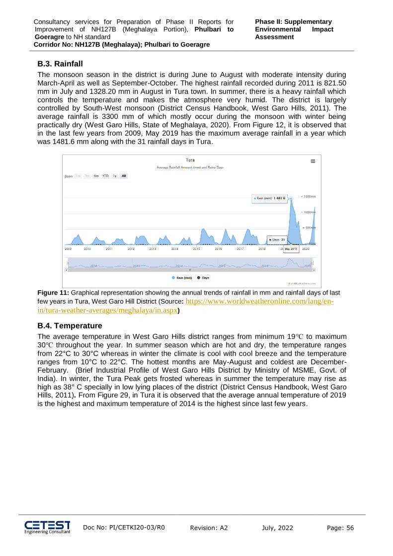
Consultancy services for Preparation of Phase II Reports for Improvement of NH127B (Meghalaya Portion), Phulbari to Goeragre to NH standard Corridor No: NH127B (Meghalaya); Phulbari to Goeragre
Phase II: Supplementary Environmental Impact Assessment
Doc No: PI/CETKI20-03/R0
Revision: A2 July, 2022 Page: 56
B.3. Rainfall
The monsoon season in the district is during June to August with moderate intensity during March-April as well as September-October. The highest rainfall recorded during 2011 is 821.50 mm in July and 1328.20 mm in August in Tura town. In summer, there is a heavy rainfall which controls the temperature and makes the atmosphere very humid. The district is largely controlled by South-West monsoon (District Census Handbook, West Garo Hills, 2011). The average rainfall is 3300 mm of which mostly occur during the monsoon with winter being practically dry (West Garo Hills, State of Meghalaya, 2020). From Figure 12, it is observed that in the last few years from 2009, May 2019 has the maximum average rainfall in a year which was 1481.6 mm along with the 31 rainfall days in Tura.
Figure 11: Graphical representation showing the annual trends of rainfall in mm and rainfall days of last
few years in Tura, West Garo Hill District (Source: https://www.worldweatheronline.com/lang/en-
in/tura-weather-averages/meghalaya/in.aspx)
B.4. Temperature
The average temperature in West Garo Hills district ranges from minimum 19℃ to maximum 30℃ throughout the year. In summer season which are hot and dry, the temperature ranges
from 22°C to 30°C whereas in winter the climate is cool with cool breeze and the temperature ranges from 10°C to 22°C. The hottest months are May-August and coldest are December-February. (Brief Industrial Profile of West Garo Hills District by Ministry of MSME, Govt. of India). In winter, the Tura Peak gets frosted whereas in summer the temperature may rise as high as 38° C specially in low lying places of the district (District Census Handbook, West Garo Hills, 2011). From Figure 29, in Tura it is observed that the average annual temperature of 2019
is the highest and maximum temperature of 2014 is the highest since last few years.

Consultancy services for Preparation of Phase II Reports for Improvement of NH127B (Meghalaya Portion), Phulbari to Goeragre to NH standard Corridor No: NH127B (Meghalaya); Phulbari to Goeragre
Phase II: Supplementary Environmental Impact Assessment
Doc No: PI/CETKI20-03/R0
Revision: A2 July, 2022 Page: 57
Figure 12:Graphical representation showing the annual trends of temperature in ℃ of last few years in
Tura, West Garo Hill District (Source: https://www.worldweatheronline.com/lang/en-in/tura-
weather-averages/meghalaya/in.aspx)
B.5. Relative Humidity:
The district is highly humid during the summer season and is controlled by the south west monsoon and seasonal winds. The average humidity is high in the winter months and post monsoon period with maximum of 78% to minimum of 67% (District Census Handbook, West Garo Hills, 2011). Figure 11 shows the relative humidity percentage is very high in the Tura region.
Figure 13: Graphical representation showing the annual trends of relative humidity in % of last few
years in Tura, West garo hill district(Source: https://www.worldweatheronline.com/lang/en-in/tura-
weather-averages/meghalaya/in.aspx)
B.6. Wind Speed: The average hourly wind speed in this district experiences mild seasonal variation throughout the year along with seasonal winds. The windier part of the year lasts for about 6.0 months ranging between late February to late August. The calmer part of the year lasts for about 6.0 months ranging between late August to February (From Figure 12, it is observed that the

Consultancy services for Preparation of Phase II Reports for Improvement of NH127B (Meghalaya Portion), Phulbari to Goeragre to NH standard Corridor No: NH127B (Meghalaya); Phulbari to Goeragre
Phase II: Supplementary Environmental Impact Assessment
Doc No: PI/CETKI20-03/R0
Revision: A2 July, 2022 Page: 58
average wind gust of the district lies in the range of 6 to 16 kmph and average wind lies in the range of 4 to 8 kmph; it is also seen that the average wind gust in July 2019 was the highest (15.8 kmph). The predominant average hourly wind direction varies throughout the year. The wind is most often from the west from end of January to end of March; from the south from end of March to early October; and from north from mid October to end of January. In Figure 13, the windrose diagram for Tura shows the hours per year the wind blows from the indicated direction
and it is seen that the wind mostly blows towards the north east.
Figure 14: Graphical representation showing the annual trends of wind speed and gust in kmph of
last few years in Tura, West garo hill district (Source: https://www.worldweatheronline.com/lang/en-
in/tura-weather-averages/meghalaya/in.aspx)

Consultancy services for Preparation of Phase II Reports for Improvement of NH127B (Meghalaya Portion), Phulbari to Goeragre to NH standard Corridor No: NH127B (Meghalaya); Phulbari to Goeragre
Phase II: Supplementary Environmental Impact Assessment
Doc No: PI/CETKI20-03/R0
Revision: A2 July, 2022 Page: 59
Figure 15: Windrose diagram showing the wind direction in Tura, West garo hill district
(https://www.meteoblue.com/en/weather/historyclimate/climatemodelled/tura_india_1254046)
The predominant average hourly wind direction in this district varies throughout the year. The wind is often from the south in mid early May to late September; from the east in late late September to early May.In the windrose diagram for Tura shows the hours per year the wind
blows from the indicated direction and it is seen that the wind mostly blows towards the north east.
B.7. Geology:
The district comprises of hills and plains. The North-West region is situated in the north- western part of the district which presents a dissected as well as rugged hilly land surface mostly composed of gneissic rocks along with old inliers Sela group of rock. The northern belt of this region comprises of recent alluvium with an exception of a narrow belt in the South which is covered by laterite soils. Other rocks of Jaintia series and Disang series are found in patches. Thi region has irregular landscape whose elevation is 100-800 m from the mean sea level it is a plain area along the Brahmaputra valley. The South-West region is situated in the north-eastern part which forms the watershed of almost all rivers present in the region. The Southern part of this is dissected to plain which at the end merges with the plain in Bangladesh. The region is composed of rocks like gneiss, Jaintia series, Disang series, Surma series, Dihing series, Duptila series, Baghmara formation, Barail series and Simsang formation and has laterite as well as red and yellow soil. The central part has the rocks of Surma series and Brahmaputra formation, Tipam series and Chengapara formation as well as Barail series (District Census Handbook, West Garo Hills, 2011). The minerals found in the district are coal, limestone, phosphorite, lithomargic clay, fireclay, gypsum, glass sand, kaolin, quartzite, sillimanite, granites, feldspar, banded hematite-quartzite and Dolerites (Brief Industrial Profile of West Garo Hills District by Ministry of MSME, Govt. of India).
B.8. Seismicity:

Consultancy services for Preparation of Phase II Reports for Improvement of NH127B (Meghalaya Portion), Phulbari to Goeragre to NH standard Corridor No: NH127B (Meghalaya); Phulbari to Goeragre
Phase II: Supplementary Environmental Impact Assessment
Doc No: PI/CETKI20-03/R0
Revision: A2 July, 2022 Page: 60
The Meghalaya falls in a region of high to very high seismic hazard. As per the 2002 Bureau of Indian Standards (BIS) map, this state falls in Zone V (Figure 16) because of the active fault
planes underneath formed because of the convergence of three plate tectonic plates namely, India Plate, Eurasian Plate as well as Burma Plate. Regions of this state have experienced seismic activity more than M6.0 including an M8.1 in 1897 (Amateur Seismic Centre, Pune, 2020). Therefore, the district is under seismic Zone V.
Figure 16: Seismic zone map of India and Meghalaya (Source:
https://www.mapsofindia.com/maps/india/seismiczone.htm)
From the above map it is clear that the project road comes under zone V, which is susceptible to major earthquakes.
B.9. Land Use Land use refers to, `man's activities and the various uses which are carried on land'. Land cover refers to, `natural vegetation, water bodies, rock/soil, artificial cover and others resulting due to land transformations. The term’s land use and land cover being closely related are inter-changeable, because the former is generally inferred based on the cover and on the contextual evidence.
Along the Project Road The project study area is dominated by Mixed Forest (38.55 %) while crop land is 24.80% which shows that farming is very prevalent in the study area. Plantation is covered in 9.16 % of the study area while urban and rural settlement is 1.24 %. Some of the area along the project road is flood prone. Some images of land use have been shown in Figure 17. The detailed land use
and land cover map is shown in Figure 6. Table 18: Land Use Classification of Study Area
S. No. LULC Classes Area (in %)
1 Settlements 1.24

Consultancy services for Preparation of Phase II Reports for Improvement of NH127B (Meghalaya Portion), Phulbari to Goeragre to NH standard Corridor No: NH127B (Meghalaya); Phulbari to Goeragre
Phase II: Supplementary Environmental Impact Assessment
Doc No: PI/CETKI20-03/R0
Revision: A2 July, 2022 Page: 61
2 Evergreen Broad leaf 0.62
3 Deciduous Broadleaf 1.09
4 Mixed Forest 38.55
5 Grassland 0.52
6 Shrubland 3.84
7 Water Bodies 20.18
8 Cropland 24.80
9 Plantation 9.16
TOTAL 100.00

Consultancy services for Preparation of Phase II Reports for Improvement of NH127B (Meghalaya Portion), Phulbari to Goeragre to NH standard Corridor No: NH127B (Meghalaya); Phulbari to Goeragre
Phase II: Supplementary Environmental Impact Assessment
Doc No: PI/CETKI20-03/R0
Revision: A2 July, 2022 Page: 62
Figure 17: Photographs of road side landuse
B.10. Elevation B 10. Elevation
The elevation of the project road and project influence area has been presented in Figure 18. As shown in the elevation map, the elevation of the project road start point is lower than end point. The general slope of the project road and project influence area is south to north.

Consultancy services for Preparation of Phase II Reports for Improvement of NH127B (Meghalaya Portion), Phulbari to Goeragre to NH standard Corridor No: NH127B (Meghalaya); Phulbari to Goeragre
Phase II: Supplementary Environmental Impact Assessment
Doc No: PI/CETKI20-03/R0
Revision: A2 July, 2022 Page: 63
Figure 18: Elevation Map of the Project Road and Project Influence Area

Consultancy services for Preparation of Phase II Reports for Improvement of NH127B (Meghalaya Portion), Phulbari to Goeragre to NH standard Corridor No: NH127B (Meghalaya); Phulbari to Goeragre
Phase II: Supplementary Environmental Impact Assessment
Doc No: PI/CETKI20-03/R0
Revision: A2 July, 2022 Page: 64
B.11. Soil West Garo Hills district: Major Soils (common names like red sandy loam deep soils (etc.,) - Red and lateritic sandy loam soils. Soil of West Garo hills district, Meghalaya mainly fall under five physiography:
Sl. No Physiography Area Percentage
1 Hill top / Ridge 2933 ha 0.80
2 Hill side slope 292427 ha 79.53
3 Foot hill 1034 ha 0.28
4 Hillock / Hummock 32476 ha 8.83
5 Alluvium plain / Flood plain
37278 ha 10.14
Soils of the area are taxonomically classified into four orders i.e. Alfisols, Entisols, Inceptisols and ultisol.
Soil Quality To understand the soil characteristics of the study area, 3 locations in the study area were
selected for soil sampling. The soil sampling locations are shown in Figure 19. Table 19: Soil sampling location details
Location Area Chainage Latitude Longitude Distance from Alignment
Near Katmail Eidga Math (SSM 1) 7+100 Km 25°50’52.962” N 90°0’51.7572”E 30m
Near Selsella CHC (SSM 2) 27+500 Km 25°41’51.2376” N 90°0’47.6892”E 15m
Babadam Playground (SSM 3) 48+900 Km 25°36’0.882” N 90°7’35.8176”E 50m
Figure 19: Soil sampling stations along the project road
The analysis results of soil quality are presented in Table 20.

Consultancy services for Preparation of Phase II Reports for Improvement of NH127B (Meghalaya Portion), Phulbari to Goeragre to NH standard Corridor No: NH127B (Meghalaya); Phulbari to Goeragre
Phase II: Supplementary Environmental Impact Assessment
Doc No: PI/CETKI20-03/R0
Revision: A2 July, 2022 Page: 65
Table 20: Physio-Chemical Analysis of soil quality
Sl. No.
Parameters Unit Soil Sample -1 Soil Sample -2 Soil Sample -3 Minimum BDL value
1 Soil Texture - Loam Loam Sandy Loam -
2 Soil Colour
Whitish Brown Whitish Brown Whitish Brown -
3 pH Value at 25°C - 7.94 8.24 7.98 1.0
4 Conductivity at 25°C
µS/cm 634 684 745 1.0
5 Moisture
% by mass
13.2 11.5 14.2 1.0
6 Bulk Density gm/cc 1.39 1.31 1.41 0.5
7 Water Holding Capacity
Inches/foot
1.24 1.18 1.14 0.5
8 Nitrogen as N mg/Kg 21.4 22.1 21.4 2.0
9 Phosphorus mg/Kg 2.28 3.12 3.6 0.5
10 Potassium (as K) mg/Kg 48.9 74.1 51.4 1.0
11 Calcium as Ca mg/Kg 40.2 38.2 41.2 1.0
12 Nitrate as NO3 mg/Kg 681 74.2 75 1.0
13 Sulphate as SO4 mg/Kg 14.1 11.5 12.1 1.0
14 Chloride mg/Kg 3.5 2.8 2.4 0.5
15 Organic Carbon
% by mass
5.2 4.9 4.5 0.5
16 Organic Matter
% by mass
4.5 4.2 3.6 0.5

Consultancy services for Preparation of Phase II Reports for Improvement of NH127B (Meghalaya Portion), Phulbari to Goeragre to NH standard Corridor No: NH127B (Meghalaya); Phulbari to Goeragre
Phase II: Supplementary Environmental Impact Assessment
Doc No: PI/CETKI20-03/R0
Revision: A2 July, 2022 Page: 66
Sl. No.
Parameters Unit Soil Sample -1 Soil Sample -2 Soil Sample -3 Minimum BDL value
17 Total Soluble Solids
mg/Kg 12.5 11.6 10.2 1.0
A Sand
% by mass
31.2 28.4 37.1 1.0
B Silt
% by mass
32.4 39.5 22.1 1.0
C Clay
% by mass
36.4 32.1 40.8 1.0

Consultancy services for Preparation of Phase II Reports for Improvement of NH127B (Meghalaya Portion), Phulbari to Goeragre to NH standard Corridor No: NH127B (Meghalaya); Phulbari to Goeragre
Phase II: Supplementary Environmental Impact Assessment
Doc No: PI/CETKI20-03/R0
Revision: A2 July, 2022 Page: 67
Soil texture of Babadam Playground is sandy loam, whereas the soil texture of Near Katmail Eidga Math and Near Selsella CHC is loam. The soil samples were alkaline, pH value at 25°C ranges between 7.94 to 8.24. The moisture content is medium. Bulk density in all locations varies from 1.31 to 1.41. The electrical conductivity is in the range of 634 – 745 µs/cm. Based on above analysis, it can be inferred that all locations have moderate leaching potential and thus in case of any hydrocarbon/ chemical spill, there would be potential for groundwater contamination.
B.12. Water Resource and Hydrology Water resources of the study area are classified into the following categories:
(i) Surface Water Resource: River, Nallah, Ponds, etc.
(ii) Ground Water Resources: Accumulation of water in deeper strata of ground. The only source of recharging for surface water and ground water is from the atmospheric precipitation, which is in the form of rainfall.
Surface Water Resource: There is 1 river and few other water bodies (i.e., ponds, lakes etc along the project road). List of
ponds along the project road are given in Table 21: Ponds along the project road. Satellite image of
water bodies along the project road is shown inFigure 20. Detailed Road strip plan is attached in Annexure 8.
Table 21: Ponds along the project road
Sl no Chainage Side Distance the form
road
1 10+100 LHS 10m
2 10+200 LHS 10m
3 11+500 LHS 10m
4 16+100 RHS 7.5M
5 17+700 LHS 8M
6 22+400 RHS 10M
7 38+100 LHS 12M
8 44+700 RHS 5M
9 46+100 LHS 50M
10 48+900 LHS 30M
11 54+400 LHS 25M
12 54+800 RHS 2M
13 55+600 RHS 5M

Consultancy services for Preparation of Phase II Reports for Improvement of NH127B (Meghalaya Portion), Phulbari to Goeragre to NH standard Corridor No: NH127B (Meghalaya); Phulbari to Goeragre
Phase II: Supplementary Environmental Impact Assessment
Doc No: PI/CETKI20-03/R0
Revision: A2 July, 2022 Page: 68
Figure 20: Drainage Network of Project Study Area

Consultancy services for Preparation of Phase II Reports for Improvement of NH127B (Meghalaya Portion), Phulbari to Goeragre to NH standard Corridor No: NH127B (Meghalaya); Phulbari to Goeragre
Phase II: Supplementary Environmental Impact Assessment
Doc No: PI/CETKI20-03/R0
Revision: A2 July, 2022 Page: 69
Some photographs of road side ponds and rivers are shown in Figure 21.
Figure 21: photographs of few surface water bodies along the project road
Ground Water Resource The Tura range form watersheds in this district from which the rivers flow towards Bangladesh plains in the south and towards the Brahmaputra valley in north and west. The important rivers of the north region are Ganol, Ringgi and Didak. The important rivers of the south region are Bhogai, Dareng etc. The Tura range is also the source of the Simsang which is one of the major rivers of Meghalaya and its valley is the most important feature in the South Garo Hills (Brief Industrial Profile of West Garo Hills District by Ministry of MSME, Govt. of India). Ground water occurs in the pore spaces of the unconsolidated alluvial sediments in the zone of saturation. The near surface sediments are predominantly sandy clays and clays grading into sediments which have varied proportions of sand and clays. These sediments occur as inter layered sequence and pockets. Kankar is mainly found in clay in the form of lenses and layers as well as interspersed. These mixed sediments occur down to 20 m and support large number of dug wells. The depth of dug wells range between 6 to 20 m. Below the top 4 to 10 m silty clays and clays, there occurs the sand formations which form a part of aquifer system. This aquifer is largely unconfined to semi-confined and supports a large number of cavity/shallow tube wells.
Hydrogeology:
The hydrogeological framework of the district is mainly controlled by distribution of rainfall, geological setting and movement of ground water through inter-connect weak planes because of joints, fissures as well as faults, primary and secondary porosities of the Geological formation. Hydrogeologically, the district is divided into three units which are consolidated, semi-consolidated and unconsolidated formations. In the deeper aquifer of the older alluvium,

Consultancy services for Preparation of Phase II Reports for Improvement of NH127B (Meghalaya Portion), Phulbari to Goeragre to NH standard Corridor No: NH127B (Meghalaya); Phulbari to Goeragre
Phase II: Supplementary Environmental Impact Assessment
Doc No: PI/CETKI20-03/R0
Revision: A2 July, 2022 Page: 70
medium/heavy duty tube wells ranging in depth from 82 to 93 m and tap 18–36 m of granular zone yielding 55 – 110 m3 per hour for draw down ranging up to 9 m. On the other hand, in the Younger alluvial areas, there is no deep tube well. However, the low duty small diameter (8 cm) shallow tube wells constructed in the similar younger alluvium range in depth from 25 to 30 m tapping 8 – 10 m granular zones and yield about 25 – 40 m3 per hour for a draw down up to 8 m (Rongram Rongrenggre Darugre Road -Environment Report, PWD, Govt. of Meghalaya, 2020).
B.13. Water Quality Surface Water Surface water includes drainage channels (eg. rivers, streams, and canals) and stagnant water bodies (eg. lakes, ponds, tanks and other impounded water bodies). A highway project can significantly alter the hydrological setting of the project area by acting as an impediment to the natural drainage system of the region. It is, therefore, essential that all surface water resources and their characteristics be identified and examined along the project road. To understand the surface water characteristics of the study area, 4 locations in the study area were selected for surface water sampling. The sampling locations are shown in Figure 22.
Table 22: Sampling location details of Surface Water
Location Area Chainage Latitude Longitude Distance from Alignment
Nimaikata (SWM 1) 5+000 Km 25°51’52.2” N 90°1’27.0552” E 200 m
Near Bhoralgaon (SWM 2) 15+200 Km 25°47'45.39"N 89°58'40.17"E 50m
Near Balnangiri (SWM 3) 43+850 Km 25°37’26.868” N 90°6’28.9476” E 200m
Rongram Chi (SWM 4) 60+900 Km 25°34’59.6568” N 90°13’47.1684” E
300m
Figure 22: Surface water Monitoring locations
Analytical results of surface water quality along the project road are shown in Table 23;

Consultancy services for Preparation of Phase II Reports for Improvement of NH127B (Meghalaya Portion), Phulbari to Goeragre to NH standard Corridor No: NH127B (Meghalaya); Phulbari to Goeragre
Phase II: Supplementary Environmental Impact Assessment
Doc No: PI/CETKI20-03/R0
Revision: A2 July, 2022 Page: 71
Table 23: Analytical result of surface water quality along the project road
S. No.
Parameter(s) Nimaikata Bhoralgaon
Balnangiri
Rongram Chi
Acceptable Limit
Permissible Limit
Minimum BDL value
WHO Guideline Value (4th Edition)
1 pH Value at 25°C 7.46 7.67 7.08 7.55 6.5 – 8.5 No Relaxation 1.0 6.5-8.0
2 Conductivity at 25°C, µS/cm 422 324 384 401 - - 1.0 -
3 Total Dissolve Solids, mg/l 274 211 250 261 500 Max 2000 Max 5.0 1000
4 Turbidity, mg/l 14 12 19 16 1.0 5
5 Calcium (as Ca),mg/l 49.2 35.8 41.5 44.5 75 Max 200 Max 0.2 75
6 Magnesium (as Mg) , mg/l 12.4 11.2 16.4 17.2 30 Max 100 Max 0.2 50
7 Sodium (as Na) ,mg/l 6.4 5.4 6.5 4.8 - - 0.2 200
8 Potassium (as K) ,mg/l 4.2 3.2 4.1 4.1 - - 0.2 20
9 Total Alkalinity (as CaCO3) ,mg/l 212 158 184 186.2 200 Max 600 Max 2.0 -
10 Sulphate (as SO4) ,mg/l 18.4 11.5 12.5 24.1 200 Max 400 Max 2.0 250
11 Chloride (as Cl),mg/l 9.8 7.8 8.8 7.4 250 Max 1000 Max 1.0 250
12 Nitrate (as NO3) ,mg/l 2.1 2.2 2.6 2.8 45 Max No Relaxation 1.0 50
13 * Fluoride as F, mg/l 0.05 0.05 0.1 0.12 0.05 1.5
14 Sodium Absorption Ratio (SAR) 1.15 1.11 1.21 0.86 - -
15 Iron (as Fe),mg/l 0.09 0.08 0.14 0.17 0.3 Max No Relaxation 0.1 0.3
16 * Dissolve Phosphate (as PO4) ,mg/l
0.24 0.36 0.41 0.22 - - 0.05 -
17 Total Hardness (as CaCO3) ,mg/l
173 135 171 189 200 Max 600 Max 5.0 500
18 Biochemical Oxygen Demand, mg/l
6.4 4.2 4.5 5.8 - - 1.0 -
19 Dissolve Oxygen, mg/l 5.4 6.2 6.1 5.3 - - 0.2 -
20 Chemical Oxygen Demand, mg/l 18 16 14 20 - - 2 -
21 * Phenolic compound (as C6H5OH), mg/l
BDL BDL BDL BDL 0.003 -
22 * Lead (as Pb), mg/l BDL BDL BDL BDL 0.01 No Relaxation 0.01 0.01

Consultancy services for Preparation of Phase II Reports for Improvement of NH127B (Meghalaya Portion), Phulbari to Goeragre to NH standard Corridor No: NH127B (Meghalaya); Phulbari to Goeragre
Phase II: Supplementary Environmental Impact Assessment
Doc No: PI/CETKI20-03/R0
Revision: A2 July, 2022 Page: 72
23 * Nickel (as Ni), mg/l BDL BDL BDL BDL 0.02 No Relaxation 0.01 0.07
24 * Copper (as Cu), mg/l BDL BDL BDL BDL 0.05 1.5 0.01 2.0
25 * Zinc (as Zn), mg/l 1.6 1.8 1.8 1.6 5 15 0.01 3-5
26 * Cadmium (as Cd), mg/l BDL BDL BDL BDL 0.003 No Relaxation 0.001 0.003
27 * Arsenic (as As), mg/l BDL BDL BDL BDL 0.01 0.05 0.01 0.01
28 * Manganese (as Mn), mg/l BDL BDL BDL BDL 0.1 1-5
29 *Boron (as B), mg/l 0.05 0.04 0.08 BDL 0.05 2.4
30 * HexaChromium (as Cr6+, mg/l BDL BDL BDL BDL 0.01 0.05
31 Faecal Coliform MPN/100 ml 56 67 77 86 - -

Consultancy services for Preparation of Phase II Reports for Improvement of NH127B (Meghalaya Portion), Phulbari to Goeragre to NH standard Corridor No: NH127B (Meghalaya); Phulbari to Goeragre
Phase II: Supplementary Environmental Impact Assessment
Doc No: PI/CETKI20-03/R0
Revision: A2 July, 2022 Page: 73
From the above monitoring result, it can be concluded that, the pH value varies from 7.08 to 7.66. Whereas BOD and DO values are almost close in all locations and COD value ranges between 16-20. CPCB and MOEF&CC has categorized the surface water in 5 different categories namely A, B, C, D
and E (Ref: http://cpcb.nic.in/water-quality-criteria/) as presented in Table 24.
Table 24: Categorisation of surface water by CPCB and MOEF&CC
Designated-Best-Use Class of water
Criteria
Drinking Water Source without conventional treatment but after disinfection
A Total Coliforms Organism MPN/100ml shall be 50 or less
pH between 6.5 and 8.5
Dissolved Oxygen 6mg/l or more
Biochemical Oxygen Demand 5 days 20C 2mg/l or less
Outdoor bathing (Organised) B Total Coliforms Organism MPN/100ml shall be 500 or less pH between 6.5 and 8.5 Dissolved Oxygen 5mg/l or more
Biochemical Oxygen Demand 5 days 20C 3mg/l or less
Drinking water source after conventional treatment and disinfection
C Total Coliforms Organism MPN/100ml shall be 5000 or less pH between 6 to 9 Dissolved Oxygen 4mg/l or more
Biochemical Oxygen Demand 5 days 20C 3mg/l or less
Propagation of Wild life and Fisheries
D pH between 6.5 to 8.5 Dissolved Oxygen 4mg/l or more
Free Ammonia (as N) 1.2 mg/l or less Irrigation, Industrial Cooling, Controlled Waste disposal
E pH between 6.0 to 8.5
Electrical Conductivity at 25C micro mhos/cm Max.2250
Sodium absorption Ratio Max. 26
Boron Max. 2mg/l
As per the categorization the surface water along the project road can be classified as Category D.
Ground Water Groundwater quality is a concern during road construction to establish baseline quality, ground water samples were drawn from 3 locations along the project road and analyzed as per IS 10500. The locations of ground water sampling are shown in Figure 23.
Table 25: Sampling location details of Ground Water
Location Area Chainage Latitude Longitude Distance from Alignment
Near Bypass (GWM 1) 00+100Km 25°52'49.74"N 90° 2'46.18"E 61m
Near Babadam (GWM 2) 48+700 Km 25°36’5.0652” N 90°7’31.7496”E 40m
Near Endpoint (GWM 3) 62+000 Km 25°35’2.2416” N 90°14’22.9812”E 50m

Consultancy services for Preparation of Phase II Reports for Improvement of NH127B (Meghalaya Portion), Phulbari to Goeragre to NH standard Corridor No: NH127B (Meghalaya); Phulbari to Goeragre
Phase II: Supplementary Environmental Impact Assessment
Doc No: PI/CETKI20-03/R0
Revision: A2 July, 2022 Page: 74
Figure 23: Ground water sampling locations along the project road
Analytical results of ground water quality along project road alignment are shown in Table 26.

Consultancy services for Preparation of Phase II Reports for Improvement of NH127B (Meghalaya Portion), Phulbari to Goeragre to NH standard Corridor No: NH127B (Meghalaya); Phulbari to Goeragre
Phase II: Supplementary Environmental Impact Assessment
Doc No: PI/CETKI20-03/R0
Revision: A2 July, 2022 Page: 75
Table 26: Analytical results of Ground water quality along the project road
Sl no.
Parameter(s) Near Bypass
Near Babadam
Near Endpoint
Acceptable Limit
Permissible Limit
Minimum BDL value
WHO Guideline Value (4th Edition)
1 Colour, Hazen units < 1 < 1 < 1 5 Max 15 Max 2.0 5.0
2 Odour Agreeable Agreeable Agreeable Agreeable Agreeable - Unobjectionable
3 Temperature, °C 19.2 18.7 20.2 - - 1.0 12-25
4 pH Value at 25°C 7.64 7.14 7.33 6.5 – 8.5 No Relaxation 1.0 6.5-8.0
5 Conductivity at 25°C, µS/cm 621 432 456 - - 1.0 -
6 Total Dissolve Solids, mg/l 404 281 224 500 Max 2000 Max 5.0 1000
7 Turbidity, mg/l <1 <1 <1 1 5 0.5 5
8 Calcium (as Ca),mg/l 47.2 38.2 24.1 75 Max 200 Max 0.2 75
9 Magnesium (as Mg) , mg/l 35.2 19.4 16.5 30 Max 100 Max 0.2 50
10 Sodium (as Na) ,mg/l 14.2 13.2 11.2 - - 0.2 200
11 Potassium (as K) ,mg/l 8.1 7.5 5.4 - - 0.2 20
12 Total Alkalinity (as CaCO3) ,mg/l
245 188 156 200 Max 600 Max 2.0 -
13 Sulphate (as SO4) ,mg/l 64.1 24.1 18.4 200 Max 400 Max 2.0 250
14 Chloride (as Cl),mg/l 19.4 13.5 12.4 250 Max 1000 Max 1.0 250
15 Nitrate (as NO3) ,mg/l 6.5 5.5 3.8 45 Max No Relaxation 1.0 50
16 *Fluoride as F, mg/l 0.07 0.05 0.05 1.0 1.5 0.05 1.5
17 Iron (as Fe),mg/l 0.27 0.06 0.08 0.3 Max No Relaxation 0.10 0.3
18 *Dissolve Phosphate (as PO4) ,mg/l
0.19 0.10 0.16 - - 0.05 -
19 Total Hardness (as CaCO3) ,mg/l
262 175 128 200 Max 600 Max 5.0 500
20 Phenolic compound (as C6H5OH), mg/l
BDL BDL BDL 0.001 Max 0.002 Max 0.001 -
21 *Lead (as Pb), mg/l BDL BDL BDL 0.01 Max No Relaxation 0.01 0.01
22 *Nickel (as Ni), mg/l BDL BDL BDL 0.02 Max No Relaxation 0.01 0.07
23 *Copper (as Cu), mg/l BDL BDL BDL 0.05 Max 1.5 Max 0.01 2.0

Consultancy services for Preparation of Phase II Reports for Improvement of NH127B (Meghalaya Portion), Phulbari to Goeragre to NH standard Corridor No: NH127B (Meghalaya); Phulbari to Goeragre
Phase II: Supplementary Environmental Impact Assessment
Doc No: PI/CETKI20-03/R0
Revision: A2 July, 2022 Page: 76
24 *Zinc (as Zn), mg/l 1.6 1.0 1.1 5 Max 15 Max 0.1 3-5
25 *Cadmium (as Cd), mg/l BDL BDL BDL 0.003 No Relaxation 0.002 0.003
26 *Arsenic (as As), mg/l BDL BDL BDL 0.01 Max 0.05 Max 0.01 0.01
27 *Aluminium (as Al), mg/l BDL BDL BDL 0.03 Max 0.2 Max 0.01 -
28 Boron (as B), mg/l 0.06 0.08 0.04 0.5 Max 1.0 Max 0.1 2.4
29 Total Chromium (as Cr), mg/l BDL BDL BDL 0.05 Max No Relaxation 0.05 0.05
30 E. Coli, (MPN/100ml) Absent Absent Absent Shall not be detected in 100ml sample
- -
31 Total Coliform, (MPN/100ml) Absent Absent Absent Shall not be detected in 100ml sample
- -

Consultancy services for Preparation of Phase II Reports for Improvement of NH127B (Meghalaya Portion), Phulbari to Goeragre to NH standard Corridor No: NH127B (Meghalaya); Phulbari to Goeragre
Phase II: Supplementary Environmental Impact Assessment
Doc No: PI/CETKI20-03/R0
Revision: A2 July, 2022 Page: 77
Analysis results when compared with potable IS:10500 norms indicates that all parameters are within the permissible limit and maybe used as drinking water. Indian standard specification drinking water specification: II 10500:1991 is attached in annexure 5.
Bottom Sediment Sediments form a natural buffer and filter system and often play an important role in the storage and release of nutrients in the aquatic ecosystems. During the last two centuries, heavy metals released by human activities have superimposed new pattern of metal distribution on those which are naturally occurring. In rivers the predominant source of bottom sediments is land runoff. Impoundments and estuaries are often characterized by heavy siltation from tributary streams. The bottom sediment sample were collected at the major bridge at ch. 0+300km from redundant part of river, Ch 1+500km, Ch. 12+400km.
Table 27: Bottom sediment result
From the above baseline monitoring it can be conclude that, organic carbon percentage varies from 5.84 to 7.51. The total nitrogen level varies between 4.08 to 4.64.
B.14. Ambient Air Environment Air pollution is caused due to both natural and manmade processes. The main source of air pollution is human induced/manmade, which includes industrialization and its by products, burning of timber, heat and light, rapid urbanization, vehicular pollution, plastics, burning of polymers and processing of various materials emitting obnoxious gases, generation of smoke, dust and fine respirable particles due to construction activity and rapid burning etc. Vehicular emission is major source of air pollution now-a-day. Presently some patches of study area are in the locality of heavy traffic movement particularly at congested places i.e at major market areas, which may impact the ambient air quality of the area. During construction stage of the project, temporary air pollution arises due to the movement of construction vehicles, operation of plants & machineries, dust emission due to excavation and demolition etc. The air quality parameters considered for the construction phase includes PM10, PM2.5, Nitrogen Oxides (NOx) Sulphur Di-oxide (SO2), and Carbon monoxide (CO).
S. No.
Parameter(s) Test Method Test Result Minimum BDL value Location-
1 Location-
2 Location-
3
1 pH Value at 25°C ITL/W&W/SOP/02 7.47 7.94 7.91 1.0
2 Organic Carbon, % ITL/W&W/SOP/07 7.51 5.84 6.64 1.0
3 Organic Matter, % ITL/W&W/SOP/07 7.36 6.81 7.81 1.0
4 Total Nitrogen, mg/g
ITL/W&W/SOP/08 4.08 4.14 4.64 0.5
5 Phosphate (Available), mg/g
ITL/W&W/SOP/09 0.12 0.10 0.16 0.05
6 Potassium, mg/g ITL/W&W/SOP/10 17.2 16.5 18.9 1.0
7 Chloride as Cl, mg/g
ITL/W&W/SOP/11 34.2 32.2 35.7 2.0
8 Sodium as Na, mg/g
ITL/W&W/SOP/13 27.6 27.4 28.6 1.0
9 Copper as Cu, mg/g
ITL/W&W/SOP/15 0.015 0.012 0.015 0.2
10 Zinc as Zn, mg/g ITL/W&W/SOP/12 0.031 0.028 0.038 0.2
11 Lead as Pb, mg/g ITL/W&W/SOP/16 0.020 0.017 0.024 0.2
12 Nickel as Ni, mg/g ITL/W&W/SOP/18 0.028 0.029 0.034 0.2

Consultancy services for Preparation of Phase II Reports for Improvement of NH127B (Meghalaya Portion), Phulbari to Goeragre to NH standard Corridor No: NH127B (Meghalaya); Phulbari to Goeragre
Phase II: Supplementary Environmental Impact Assessment
Doc No: PI/CETKI20-03/R0
Revision: A2 July, 2022 Page: 78
Table 28: Ambient Air Quality Standard
Parameter Technique Technical Protocol NAAQM Standards
(24 hrs basis)
Particulate Matter (Size less than 10µm)
or PM10, µg/m3
Respirable Dust Sampler (Gravimetric method)
IS-5182 (Part-IV) 100
Particulate Matter (Size less than 2.5µm)
or PM2.5 , µg/m3
PM 2.5 APM 550 Fine Particle Sampler (Gravimetric method)
60
Sulphur Dioxide (SO2), µg/m3
Improved West and Gaeke Method IS-5182 (Part-II) 80
Nitrogen Dioxide (NO2), µg/m3
Jacob and Hochheiser IS-5182 (Part-IV) 80
Carbon Monoxide (CO), mg/m3
Non – dispersive Infrared (NDIR) Spectroscopy
IS-5182 (Part-IV) 4
Along the Project Road
Ambient air quality monitoring has been conducted at 6 locations along the project road alignments. The air sampling locations is shown in below. SPM and RPM have been determined gravimetrically and as specified in IS 5182 (Part 23): 2006.The concentration of NOx has been estimated using IS 5182 Part 2:2001 method and SOx has been estimated by IS 5182 Part 6:2006 method. CO was measured as per EPA Method 13. Sampling duration for SO2, NOx, PM2.5 and PM10 was 24 hourly as per NAAQS Standards requirements and CO sampling duration was 1 Hr. The monitoring stations had been distributed throughout the project road so as to get a representative baseline of any variation in land use as well as road geometrics and traffic conditions across the project road. The purpose is also to establish a benchmark, which can form the reference for monitoring in the construction and operation period. GOI ambient air quality standard is given in annexure 3.
Table 29: Sampling location details of Ambient Air Quality
Location Area Chainage Latitude Longitude Distance from Alignment
Starting Point (AAQM 1) 0+000 Km 25°52’14.42” N 90°03’38.38” E 8m
New Bhaitbari (AAQM 2) 15+800 Km 25°47’27.00” N 89°58’41.81” E 16m
Sibukolgre (AAQM 3) 31+500 Km 25°40’50.09” N 90°02’18.48” E 16m
Babadam UP (AAQM 4) 48+600 Km 25°36’03.91” N 90°07’26.75” E 16m
Chibra Songma Local Baptist Church (AAQM 5)
58+300 Km 25°35’09.05” N 90°12’27.29” E 15m
End Point (AAQM 6) 61+900 Km 25°35’04.50” N 90°14’24.95” E 15m

Consultancy services for Preparation of Phase II Reports for Improvement of NH127B (Meghalaya Portion), Phulbari to Goeragre to NH standard Corridor No: NH127B (Meghalaya); Phulbari to Goeragre
Phase II: Supplementary Environmental Impact Assessment
Doc No: PI/CETKI20-03/R0
Revision: A2 July, 2022 Page: 79
Figure 24: Air quality monitoring stations along the project road
Table 30: Analysis of ambient air quality monitoringalong the project road
S.N.
Date of sampling
PM10 (μg/m3)
PM2.5 (μg/m3)
SO2 (μg/m3)
NO2 (μg/m3)
CO (mg/m3)
Location –Near Starting Point Bypass (AAQM 1)
Week 1 1
01/03/2021 to 02/03/2021
82.4 43.2 10.2 14.5 BDL
2 05/03/2021 to 06/03/2021
85.4 42.9 9.4 16.2 BDL
Week2 3
08/03/2021 to 09/03/2021
81.4 41.8 8.9 13.5 BDL
4 11/03/2021 to 12/03/2021
86.5 42.5 11.2 16.5 BDL
Week3 5
14/03/2021 to 15/03/2021
82.4 43.2 10.8 14.5 BDL
6 17/03/2021 to 18/03/2021
80.9 42.5 9.2 13.6 BDL
Week4 7
20/03/2021 to 21/03/2021
88.2 43.5 11.2 16.5 BDL
8 23/03/2021 to 24/03/2021
83.2 41.8 10.1 13.5 BDL
Minimum 80.9 41.8 8.9 13.5 -
Maximum 88.2 43.5 11.2 16.5 -
Average 83.8 42.675 10.125 14.85 -
WHO Air quality guideline 2005, Guidance 50 25 40** 20 -

Consultancy services for Preparation of Phase II Reports for Improvement of NH127B (Meghalaya Portion), Phulbari to Goeragre to NH standard Corridor No: NH127B (Meghalaya); Phulbari to Goeragre
Phase II: Supplementary Environmental Impact Assessment
Doc No: PI/CETKI20-03/R0
Revision: A2 July, 2022 Page: 80
S.N.
Date of sampling
PM10 (μg/m3)
PM2.5 (μg/m3)
SO2 (μg/m3)
NO2 (μg/m3)
CO (mg/m3)
Value
NAAQMS Standard 100 60 80 80 2
Minimum BDL value 25 10 5 5 1.14
Location – New Bhaitbari (AAQM 2)
Week 1 1
02/03/2021 to 03/03/2021
78.9 42.5 9.8 12.4 BDL
2 06/03/2021 to 07/03/2021
81.2 45.2 10.2 13.5 BDL
Week2 3
09/03/2021 to 10/03/2021
84.2 39.4 10.1 14.5 BDL
4 12/03/2021 to 13/03/2021
78.5 38.7 9.8 12.5 BDL
Week3 5
15/03/2021 to 16/03/2021
81.2 41.6 9.4 13.5 BDL
6 18/03/2021 to 19/03/2021
84.2 42.5 10.4 15.2 BDL
Week4 7
21/03/2021 to 22/03/2021
80.1 42.1 9.6 12.9 BDL
8 24/03/2021 to 25/03/2021
82.5 41.5 9.7 13.5 BDL
Minimum 78.5 38.7 9.4 12.4 -
Maximum 84.2 45.2 10.4 15.2 -
Average 81.35 41.69 9.88 13.5 -
WHO Air quality guideline 2005, Guidance Value
50 25 40** 20 -
NAAQMS Standard 100 60 80 80 2
Minimum BDL value 25 10 5 5 1.14
Location - Sibukolgre (AAQM 3)
Week 1 1 02/03/2021 to 03/03/2021
66.8 34.8 6.8 10.1 BDL
2
06/03/2021 to 07/03/2021
71.2 38.9 8.1 13.2 BDL
Week2 3 09/03/2021 to 10/03/2021
69.2 37.7 6.9 11.1 BDL
4
12/03/2021 to 13/03/2021
71.2 38.7 7.2 12.2 BDL
Week3 5 15/03/2021 to 16/03/2021
67.8 34.8 6.5 11.2 BDL
6
18/03/2021 to 19/03/2021
68.4 37.6 6.8 10.2 BDL
Week4 7 21/03/2021 to 22/03/2021
76.5 38.4 8.9 12.4 BDL
8
24/03/2021 to 25/03/2021
72.4 38.7 8.4 11.4 BDL
Minimum 66.8 34.8 6.5 10.1 -
Maximum 76.5 38.9 8.9 13.2 -
Average 70.44 37.45 7.45 11.48 -
WHO Air quality guideline 2005, Guidance Value
50 25 40** 20 -

Consultancy services for Preparation of Phase II Reports for Improvement of NH127B (Meghalaya Portion), Phulbari to Goeragre to NH standard Corridor No: NH127B (Meghalaya); Phulbari to Goeragre
Phase II: Supplementary Environmental Impact Assessment
Doc No: PI/CETKI20-03/R0
Revision: A2 July, 2022 Page: 81
S.N.
Date of sampling
PM10 (μg/m3)
PM2.5 (μg/m3)
SO2 (μg/m3)
NO2 (μg/m3)
CO (mg/m3)
NAAQMS Standard. 100 60 80 80 2
Minimum BDL value 25 10 5 5 1.14
Location - Babadam UP (AAQM 4)
Week 1 1 02/03/2021 to 03/03/2021
78.1 37.8 10.1 13.8 BDL
2
06/03/2021 to 07/03/2021
77.5 38.4 9.9 13.5 BDL
Week2 3 09/03/2021 to 10/03/2021
78.5 38.4 9.6 13.5 BDL
4
12/03/2021 to 13/03/2021
81.2 39.8 10.1 14 BDL
Week3 5 15/03/2021 to 16/03/2021
79.4 40.1 10.2 14.2 BDL
6
18/03/2021 to 19/03/2021
80.1 39.4 9.6 13.5 BDL
Week4 7 21/03/2021 to 22/03/2021
76.5 41.2 9.4 12.5 BDL
8
24/03/2021 to 25/03/2021
77.8 41.2 9.2 13.4 BDL
Minimum 76.5 37.8 9.2 12.5 -
Maximum 81.2 41.2 10.2 14.2 -
Average 78.64 39.54 9.76 13.55 -
WHO Air quality guideline 2005, Guidance Value
50 25 40** 20 -
NAAQMS Standard. 100 60 80 80 2
Minimum BDL value 25 10 5 5 1.14
Location - Near Chibra Songma Local Baptist Church (AAQM 5)
Week 1 1 03/03/2021 to 04/03/2021
77.4 41.2 9.5 13.5 BDL
2
07/03/2021 to 08/03/2021
78.5 40.5 9.4 13.6 BDL
Week2 3 10/03/2021 to 11/03/2021
74.2 39.4 8.9 12.9 BDL
4
13/03/2021 to 14/03/2021
79.4 38.4 10.2 14.5 BDL
Week3 5 16/03/2021 to 17/03/2021
75.2 38.6 8.9 12.8 BDL
6
19/03/2021 to 20/03/2021
76.4 38.4 8.8 13.1 BDL
Week4 7 22/03/2021 to 23/03/2021
76.8 40.1 9.2 12.8 BDL
8
25/03/2021 to 26/03/2021
78.9 38.7 10.1 14.5 BDL
Minimum 74.2 38.4 8.8 12.8 -
Maximum 79.4 41.2 10.2 14.5 -
Average 77.10 39.41 9.38 13.46 -
WHO Air quality guideline 2005, Guidance Value
50 25 40** 20 -
NAAQMS Standard. 100 60 80 80 2

Consultancy services for Preparation of Phase II Reports for Improvement of NH127B (Meghalaya Portion), Phulbari to Goeragre to NH standard Corridor No: NH127B (Meghalaya); Phulbari to Goeragre
Phase II: Supplementary Environmental Impact Assessment
Doc No: PI/CETKI20-03/R0
Revision: A2 July, 2022 Page: 82
S.N.
Date of sampling
PM10 (μg/m3)
PM2.5 (μg/m3)
SO2 (μg/m3)
NO2 (μg/m3)
CO (mg/m3)
Minimum BDL value 25 10 5 5 1.14
Location - Near End Point (AAQM 6)
Week 1 1 03/03/2021 to 04/03/2021
81.2 41.2 10.2 14.5 BDL
2
07/03/2021 to 08/03/2021
87.5 43.2 11.2 14.5 BDL
Week2 3 10/03/2021 to 11/03/2021
84.5 41.7 10.8 13.8 BDL
4
13/03/2021 to 14/03/2021
79.8 39.4 11.2 15.2 BDL
Week3 5 16/03/2021 to 17/03/2021
78.8 39.2 9.9 13.5 BDL
6
19/03/2021 to 20/03/2021
77.4 38.9 8.7 13.5 BDL
Week4 7 22/03/2021 to 23/03/2021
79.2 38.4 10.2 14.3 BDL
8
25/03/2021 to 26/03/2021
80.4 39.2 9.4 13.5 BDL
Minimum 77.4 38.4 8.7 13.5 -
Maximum 87.5 43.2 11.2 15.2 -
Average 81.10 40.15 10.20 14.10 -
WHO Air quality guideline 2005, Guidance Value
50 25 40** 20 -
NAAQMS Standard. 100 60 80 80 2
Minimum BDL value 25 10 5 5 1.14
** Annual Mean All monitoring was conducted between 1stMarch, 2021 to 31st March, 2021.
Figure 25: Average values of air pollutants in all locations (March 2021)
0
10
20
30
40
50
60
70
80
90
AAQM 1 AAQM 2 AAQM 3 AAQM 4 AAQM 5 AAQM 6
PM10 (μg/m3)
PM2.5 (μg/m3)
SO2 (μg/m3)
NO2 (μg/m3)
CO (mg/m3)

Consultancy services for Preparation of Phase II Reports for Improvement of NH127B (Meghalaya Portion), Phulbari to Goeragre to NH standard Corridor No: NH127B (Meghalaya); Phulbari to Goeragre
Phase II: Supplementary Environmental Impact Assessment
Doc No: PI/CETKI20-03/R0
Revision: A2 July, 2022 Page: 83
Air monitoring baseline analysis The PM10 concentrations in the all locations were found below the NAAQMS standard value (100ug/m3) current monitoring (i.e., month of March, 2021).
Figure 26: PM10 values in all locations along with NAAQMS standard
Figure 27: PM2.5 values in all locations along with NAAQMS standard
0
20
40
60
80
100
120
Day 1 Day 2 Day 3 Day 4 Day 5 Day 6 Day 7 Day 8
Pollutant: PM10
AAQM 1 AAQM 2 AAQM 3
AAQM 4 AAQM 5 AAQM 6
NAAQMS Standard
0
10
20
30
40
50
60
70
Day 1 Day 2 Day 3 Day 4 Day 5 Day 6 Day 7 Day 8
AAQM 1 AAQM 2 AAQM 3
AAQM 4 AAQM 5 AAQM 6
NAAQMS Standard

Consultancy services for Preparation of Phase II Reports for Improvement of NH127B (Meghalaya Portion), Phulbari to Goeragre to NH standard Corridor No: NH127B (Meghalaya); Phulbari to Goeragre
Phase II: Supplementary Environmental Impact Assessment
Doc No: PI/CETKI20-03/R0
Revision: A2 July, 2022 Page: 84
Figure 28: SOx values in all locations along with NAAQMS standard
Figure 29: NOx values in all locations along with NAAQMS standard
The analysis shows that measured PM10 and PM2.5 concentrations are mostly below the NAAQS standard in all 6 locations. The SOx and NOx values along the project road are also within the NAAQS standard.
B.15. Noise Environment Noise attributed to roads depends on factors such as traffic intensity, the type and condition of the vehicles plying on the road, acceleration/deceleration/gear changes by the vehicles depending on the level of congestion and smoothness of road surface. High noise levels are a concern for sensitive receptors i.e., hospitals, educational institutions, etc. Silence zone is defined as an area up to 100 meters around such premises as hospitals, educational institutions and courts. The silence zones are to be declared by the competent authority. The Central Pollution Control Board (CPCB) has specified ambient noise levels for different land uses for day and night times as presented in below and Annexure 4.
0
10
20
30
40
50
60
70
80
90
Day 1 Day 2 Day 3 Day 4 Day 5 Day 6 Day 7 Day 8
Pollutant: SOxAAQM 1
AAQM 2
AAQM 3
AAQM 4
AAQM 5
AAQM 6
NAAQMSStandard
0
10
20
30
40
50
60
70
80
90
Day 1 Day 2 Day 3 Day 4 Day 5 Day 6 Day 7 Day 8
Pollutant: NOxAAQM 1
AAQM 2
AAQM 3
AAQM 6
AAQM 7
AAQM 8
NAAQMSStandard

Consultancy services for Preparation of Phase II Reports for Improvement of NH127B (Meghalaya Portion), Phulbari to Goeragre to NH standard Corridor No: NH127B (Meghalaya); Phulbari to Goeragre
Phase II: Supplementary Environmental Impact Assessment
Doc No: PI/CETKI20-03/R0
Revision: A2 July, 2022 Page: 85
Importance was given to the timing of exposure and areas designated as sensitive.
Table 31: National Ambient Noise Level Standards
Area Code Category Limits in Decibels (dB A)
Day time Night tme
A Industrial 75 70
B Commercial 65 55
C Residential 55 45
D Silence Zones 50 40
Source: Central Pollution Control Board, New Delhi Note:
1) Day-time: 6 AM to 10 P.M., Night-time: 10 PM to 6 AM; 2) Silence zone is an area up to 100 m around premises as hospitals, educational institutions and
courts.
Locations for noise monitoring along the project road were identified based on the criteria same as those used for air monitoring but the relative importance of each criterion carries a weightage in arriving at the final set of locations. In case of noise monitoring locations, sensitive land use such as schools, hospitals and religious places gains more importance due to ill effects of noise. The noise levels were monitored with Integrated Noise Level Meter. Locations of noise monitoring is shown in below.
Table 32: Sampling location details of Noise
Location Area Chainage Latitude Longitude Category
Starting Point Bypass (NM 1) 0+000 Km 25°52’14.42” N 90°03’38.38” E Commercial
New Bhaitbari (NM 2) 15+800 Km 25°47’27.00”N 89°58’41.81” E Residential
Sibukolgre (NM 3) 31+500 Km 25°40’50.09” N 90°02’18.48” E Sensitive
Babadam UP (NM 4) 48+600 Km 25°36’03.91” N 90°07’26.75” E Resi + Rural Area
Chibra Songma Local Baptist Church (NM 5)
58+300 Km 25°35’09.05” N 90°12’27.29” E Residential
End Point (NM 6) 61+900 Km 25°35’04.50” N 90°14’24.95” E Commercial
All monitoring was conducted between 1st March, 2021 to 31st March, 2021

Consultancy services for Preparation of Phase II Reports for Improvement of NH127B (Meghalaya Portion), Phulbari to Goeragre to NH standard Corridor No: NH127B (Meghalaya); Phulbari to Goeragre
Phase II: Supplementary Environmental Impact Assessment
Doc No: PI/CETKI20-03/R0
Revision: A2 July, 2022 Page: 86
Figure 30: Noise monitoring locations along the project road

Consultancy services for Preparation of Phase II Reports for Improvement of NH127B (Meghalaya Portion), Phulbari to Goeragre to NH standard Corridor No: NH127B (Meghalaya); Phulbari to Goeragre
Phase II: Supplementary Environmental Impact Assessment
Doc No: PI/CETKI20-03/R0
Revision: A2 July, 2022 Page: 87
Table 33: Analysis of noise monitoringin all locations
Starting Point Bypass (NM 1)
New Bhaitbari (NM 2)
Sibukolgre (NM 3) Babadam UP (NM 4)
Chibra Songma Local Baptist
Church (NM 5)
End Point (NM 6)
Classification Commercial Residential Sensitive Resi + Rural Area
Residential Commercial
Date Day 1
Day 2 Day 1
Day 2 Day 1
Day 2 Day 1
Day 2 Day 1
Day 2 Day 1
Day 2
Maximum 58.2 51.8 52.6 56.2 51.9 52.1 54.2 52.9 53.7 51.4 56.2 56.2
Minimum 38.7 36.8 37.1 37.2 34.5 34.8 37.1 37.3 37.1 37.0 40.2 37.9
Leqday 51.3 49.4 49.8 50.9 49.4 49.4 48.9 50.8 49.7 48.7 52.6 51.8
Leqnight 39.7 38.7 38.7 39.6 37.6 36.6 37.2 39.6 39.3 38.4 41.5 40.7
Leq 50.8 49.2 49.5 50.5 48.9 48.6 48.4 50.4 49.5 48.6 52.3 51.5
STANDARD Day – 65
Night - 55
Day – 55 Night –
45 Day - 50 Night -
40 Day - 55 Night -
45 Day - 55 Night -
45 Day - 65 Night - 55

Consultancy services for Preparation of Phase II Reports for Improvement of NH127B (Meghalaya Portion), Phulbari to Goeragre to NH standard Corridor No: NH127B (Meghalaya); Phulbari to Goeragre
Phase II: Supplementary Environmental Impact Assessment
Doc No: PI/CETKI20-03/R0
Revision: A2 July, 2022 Page: 88
Figure 31: Noise monitoring results in day and night time along the project road
0
10
20
30
40
50
60
70
NM 1 NM 2 NM 3 NM 4 NM 5 NM 6
De
cib
els
Noise Monitoring Locations
Noise result day time
Leqday Standard
0
10
20
30
40
50
60
NM 1 NM 2 NM 3 NM 4 NM 5 NM 6
DE
CIB
ELS
NOISE MONITORING LOCATIONS
Noise result night time
Leqday Standard

Consultancy services for Preparation of Phase II Reports for Improvement of NH127B (Meghalaya Portion), Phulbari to Goeragre to NH standard Corridor No: NH127B (Meghalaya); Phulbari to Goeragre
Phase II: Supplementary Environmental Impact Assessment
Doc No: PI/CETKI20-03/R0
Revision: A2 July, 2022 Page: 89
WHO Guidelines for Community Noise:
Specific environment
Critical health effect(s) LAeq [dB]
Time
base
[hours]
LAmax
, fast
[dB]
Outdoor living area Serious annoyance, daytime and evening
Moderate annoyance, daytime and evening
55
50
16
16
-
-
Dwelling, indoors
Inside bedrooms
Speech intelligibility and moderate annoyance, daytime and evening
Sleep disturbance, night-time
35
30
16
8
45
Outside bedrooms Sleep disturbance, window open (outdoor
values)
45 8 60
School class rooms and pre-schools,
indoors
Speech intelligibility, disturbance of information extraction, message
communication
35 during class
-
Pre-school
Bedrooms, indoors
Sleep disturbance 30 sleeping
-time
45
School, playground
outdoor
Annoyance (external source) 55 during
play
-
Hospital, ward rooms, indoors
Sleep disturbance, night-time
Sleep disturbance, daytime and evenings
30
30
8
16
40
-
Hospitals, treatment
rooms, indoors
Interference with rest and recovery #1
Industrial, commercial, shopping and traffic areas, indoors and
Outdoors
Hearing impairment 70 24 110
Ceremonies, festivals and entertainment
events
Hearing impairment (patrons:<5 times/year) 100 4 110
Public addresses,
indoors and
outdoors
Hearing impairment 85 1 110
Music through
headphones/
Earphones
Hearing impairment (free-field value) 85 #4 1 110
Impulse sounds from
toys, fireworks
and firearms
Hearing impairment (adults)
Hearing impairment (children)
-
-
-
-
140 #2
120 #2
Outdoors in parkland and conservation
areas
Disruption of tranquillity #3
#1: as low as possible;
#2: peak sound pressure (not LAmax, fast), measured 100 mm from the ear;

Consultancy services for Preparation of Phase II Reports for Improvement of NH127B (Meghalaya Portion), Phulbari to Goeragre to NH standard Corridor No: NH127B (Meghalaya); Phulbari to Goeragre
Phase II: Supplementary Environmental Impact Assessment
Doc No: PI/CETKI20-03/R0
Revision: A2 July, 2022 Page: 90
#3: existing quiet outdoor areas should be preserved and the ratio of intruding noise to natural background sound should be kept low;
#4: under headphones, adapted to free-field values
An analysis of the results indicates that the day & night time noise levels in all six locations were mostly within the permissible limit.
C. Biological Environment
An ecological survey of the study area was conducted particularly with reference to recording the existing biological resources in the study area. Ecological studies are one of the important aspects of Environmental Impact Assessment with a view to conserve environmental quality and biodiversity. Ecological systems show complex inter-relationships between biotic and abiotic components including dependence, competition and mutualism. Biotic components comprise of both plant and animal communities, which interact not only within and between themselves but also with the abiotic components viz. physical and chemical components of the environment.
Generally, biological communities are good indicators of climatic and edaphic factors. Studies on biological aspects of ecosystems are important in Environmental Impact Assessment for safety of natural flora and fauna. The biological environment includes terrestrial and aquatic ecosystems.
Ecological resources are among the most important resources impacted by the road/infrastructure projects. The detailed baseline study of the ecological resources is essential to estimate the magnitude of potential impacts and to avoid or mitigate any loss caused by the proposed project. In this section
baseline details of the flora and fauna are presented.
Biodiversity of Meghalaya
Meghalaya is one of the main constituents of “Seven Sister” and is predominantly a land of hills and valley. Due to its vast natural beauty and grace, it has been also named as ‘Scotland of the East’. Till 1970 Meghalaya was part of undivided Assam, with Shillong as its capital. On January 21, 1972, Meghalaya was created by combining the hill regions of Garo, Khasi, and Jaintia to form a separate state, housing a Legislative Assembly of its own. Geographical location of the state is between 89o 45’ to 92o 48’ and 25o 02’ to 26o 05’. The total geographical area of the state is 22, 429 Sq Km, extending 300 km west to east and 100 km from north to south. The state comprises 11 districts, namely South Garo Hills, South West Garo Hills, West Garo Hills, East Garo Hills, North Garo Hills, West Khasi Hills, East Khasi Hills, South Khasi Hill, Ri bhoi, West Jaintia Hills and East Jaintia Hills. It is bounded on the north by Goalpara, Kamrup, Karbi Anglong and Nagaon districts, east by Cachar and North Cachar Hills districts of Assam and west and on the south by Rangpur division and Mymensingh divisions of Bangladesh. The altitude ranges from 50 – 1950 m (Talukdar et al. 2004). The highest peak is Shillong Peak. The state has population of about 29.67 lakhs with a density of 132-persons/ km2. The sex ratio is 989 females: 1000 males and the total literacy rate is 74.43%; male 75.59% and female 72.89 %; urban 90.79% rural 69.92 % (Census of India, 2011).
The main tribes in Meghalaya are the Khasis, the Garos, and the Jaintias. Each tribe has its own culture, traditions, dress, and language. The majority of the population and the major tribal groups in Meghalaya follow a matrilineal system where lineage and inheritance are traced through women. All the three major ethnic tribal groups, namely, the Khasis, Jaintias and the Garos also have their own traditional political institutions that have existed for hundreds of years.
The major rivers of the state are Ganol, Ringgi, Damring, Manda, Darong, Bhogai, simsang, Dareng, Umkhri, Umtrew, Umiam, Kopili, Kynshiang,Shella, Umngot, Myntdu, Lubha, etc. One of the marked features of River Kynshi in West Khasi Hills is the formation of River Island called Nongkhnum. Nongkhnum is not only India’s but Asia’s second largest river island.
The three geographical sub-regions of Meghalaya, viz., Khasi, Garo and Jaintia hills are among the wettest regions of the world, with clouds persisting in various areas nearly throughout the year.

Consultancy services for Preparation of Phase II Reports for Improvement of NH127B (Meghalaya Portion), Phulbari to Goeragre to NH standard Corridor No: NH127B (Meghalaya); Phulbari to Goeragre
Phase II: Supplementary Environmental Impact Assessment
Doc No: PI/CETKI20-03/R0
Revision: A2 July, 2022 Page: 91
Meghalaya falls under the Indo-Myanmar Bioddiversity Hotspot zone. Meghalaya, is one of the biodiversity rich states of India in terms of diversity of both flora and fauna due to its unique geographical position at the meeting point of Indo-Malayan and Eastern Himalayan bio-geographical regions. Thus, it shares biodiversity elements including flora and fauna from both the regions. Meghalaya also shares rich species diversity containing species from Indo-China and rest of India. The diverse landscape of the state also supports a large array of forest types and species. The flora of Meghalaya comprises about 3,128 species of flowering plants of which a large number of species are endemic. Meghalaya harbours a rich diversity of orchids (Family: Orchidaceae), of which nearly 110 genera and 439 taxa are reported from the state. However, many authors believe that Meghalaya may have more species of orchids and many are still to be discovered (Kakati 1986). Meghalaya is also considered as center of origin for a number of crop plants like rice, and Citrus based on the large number of wild relatives found in the state.
The faunal diversity of Meghalaya constitutes a total of 5538 species recorded so far, of a total 89,451 species known from India. Nearly 35 % of Indian Mammals and 50 % of the birds are represented in the state (. Invertebrates are represented by 2114 genera and 4580 species, of which 3624 species are insects. Among invertebrates, the porifera is the smallest group represented by only one genus and one species. Meghalaya has 139 species of Mammals, 659 species of Birds, 107 species of Reptiles, 55 species of Amphibia and 152 species of Fishes. Of these, 35 species of Mammals are endangered, vulnerable or insufficiently known. Similarly, 10 species of birds and 9 species of reptiles are either endangered or vulnerable. Along with the species diversity, the State has a significant percentage of endemic elements.
Government of Meghalaya, India through PWD Roads National Highways has decided to take up the development of various National Highway corridors across Meghalaya for the augmentation of capacity for safe and efficient movement of traffic by widening and strengthening to standard 2 lanes with paved shoulders. The new National Highway 127B is one such corridor. The new National Highway 127B (Meghalaya) starts from Phulbari in Assam-Meghalaya border and connecting to Rongram near Tura (Meghalaya). Project road traverses through Phulbari, Rajabala, Selsella & Babadam and Goeragre enroute to Rongram. Alignment from Selsella to Goiragre is a new alignment consisting of existing village road on either end and both end and cart track. . This road passes through the only one district namely West Garo Hills of Meghalaya.
No. of Genera No. of Species
Vertebrates
Mammalia 83 139
Aves 232 659
Reptilia 51 107
Amphibia 11 55
Pisces 74 152
Invertebrates 2114 4580
Bryozoa 3 5
Arthropoda 1825 3901
Annelida 25 49
Mollusca 67 223
Nematoda 49 77
Rotifera 30 111
Platyhelminthes 56 83
Medusae 2 2
Porifera 1 1
Protozoa 56 128

Consultancy services for Preparation of Phase II Reports for Improvement of NH127B (Meghalaya Portion), Phulbari to Goeragre to NH standard Corridor No: NH127B (Meghalaya); Phulbari to Goeragre
Phase II: Supplementary Environmental Impact Assessment
Doc No: PI/CETKI20-03/R0
Revision: A2 July, 2022 Page: 92
C.1. Flora of West Garo Hill District Dense tropical mixed forest along with a small patch of temperate forest is found in this district. The district is rich in unique flora and it is considered to be the original home of the Citrus (District Census Handbook, West Garo Hills, 2011). The vegetation of the hills is categorized into flora of tropical and sub-tropical zones on the basis of altitude. The vegetation of tropical zone vegetation covers evergreen, semi-evergreen and deciduous forests, grasslands and bamboo thickets including riparian forests and swamps. The forests mainly have Shorea robusta and Tectona grandis. The tallest trees are Schima wallichii, Aesculus assamica, Aporusa wallichii, Terminalia belirilia belirica, Engelhardtia spicata, Bridelia retusa, Lagerstroemia parviflora, Gmelina arborea, Cryptocarya andersonii, Talauma hodgsonii, etc.; and the lower canopy is formed by Miliusa velutina, Engelhardtia spicata, Hibiscus macrocarpus, Zizyphus rugosa, Helicia robusta and Ficus prostrata etc. A few palms species like Areca, Pinanga, Caryota and Didymosperma are also found. The Shrubby species are Capparis zeylanica, Mimosa himalayayana, Acacia Concinna, Garcinia lancifolia, Bauhinia acuminata, Mussaenda Roxburghii, Solanum Kurzii, Eupatorium Modiflorum, and Phlogacanthus tubiflorus etc. In a few areas, trees like Dysolobium grande, Paederia scanders, Solena heterophylla, Mucuna bracteata, Fissistigma wallichii and Aristolocjia saccata are prominent. In most of the open moist localities as well as near water sources, herbs such as Dictyospermum, Aneilema Scaberrimum, Aneilema Scaberrimum, Coix sp., Burmania sp., Cyprus spp., Anemone spp., Burmania Sp., Coiictyospermum, Oxalis corniculate and Ericcaulon are present. Alpinia, Amomum, Hedychium, Colocasia, Costus are found in the evergreen forests along with epiphytic orchids. The epiphytic creepers such as Rhaphidophora spp., Hoya spp., etc. along with stem parasites of Loranthaceae as well as total root parasite Cuscuta reflexa are also found in this district. Ferns as well as fern-allies,
mosses and liverworts etc. are found on old tree trunks or stones near water sources including shady places. Because of excessive ‘Jhum’ practice most of the forests got cleared and secondary monoculture forests of Shorea robusta were established (West Garo Hills, State of Meghalaya, 2020).
The sub-tropical forest is restricted in Tura Peak, Nokrek Peak etc. These are generally evergreen forests along with few segments of deciduous forests. The upper canopy is contributed by Betula culindristachvs, Kavea floribunda, Castanopsis hystrix, Garonia affinis, Cyathocalvx martabanicus, Dryntes lancifolia, Talauma rabaniania, Taluma phellocarna, Pasania xylocarpa, Fiscus spp. and Aldina cordifolia, Machilus gamblei, M. Villosa, Milletia orainii, Sterculia villosa, Garuga pinnata, Carnicia paniculata, Eriobotrya benghalensis, Emblica offinialis, Ebretia acuminata, Quercus semiserrata, Sageraea juarina, Symolocus ferruginea, Betula alnoides with Litsea spp. etc. forms the middle canopy of trees. The lowest canopy consists of Aglata roxburghii, Antidesma bunius, Mitrephora tomentosa, Styrax serrulatim, Breynia patens, Pasania spicata, Premna multiflora. Entada phaseoloides, Spatholobus roxburghii, Conophalus suaveolens, Dalbergia stipulacea and Vitis latifolia
etc. stretch from one tree to another in the forests. The branches of old tree trunks are mainly moss-laden thus fully covered by few epiphytic orchids. Ferns, liverworts as well as mosses are also predominant in this part (West Garo Hills, State of Meghalaya, 2020). Nearest forest area along the project road are given in Table 34.
Table 34: Ecologically/ culturally significant area along the project road
Ecologically/Culturally significant feature
Closest Site/Remarks
Wildlife Sanctuary No WLS is in close vicinity
National Park Nearest National Park is Nokrek which is about 10 km
Ramsar Site No Ramsar Site is present in Meghalaya
Biodiversity Heritage Site No biodiversity Heritages sites are located in in close vicinity

Consultancy services for Preparation of Phase II Reports for Improvement of NH127B (Meghalaya Portion), Phulbari to Goeragre to NH standard Corridor No: NH127B (Meghalaya); Phulbari to Goeragre
Phase II: Supplementary Environmental Impact Assessment
Doc No: PI/CETKI20-03/R0
Revision: A2 July, 2022 Page: 93
Ecologically/Culturally significant feature
Closest Site/Remarks
Biosphere Reserve
Nearest National Park is Nokrek which is about 7 km from the nearest ROW
Important Bird Area Nearest National Park is Nokrek which is about 10 km
Wildlife Corridor No wildlife corridor is mentioned or documented
Elephant Corridor The Nearest and only elephant corridor present in the West Garo Hill is the Ranggira – Nokrek which is about 8 km from the ROW
Tiger Reserve Meghalaya Doesn’t have any Tiger Rerserve
Reserve Forest 1. Tura Peak RF: The distance from the Tura peak RF is
more than 10 km,
Elephant Reserve
Nokrek and Balpakram National Park forms the core area (400 Km2 ) of the Elephant Reserve and majority of the part of the Elephant Reserve is situated in East Garo and South Garo Hill Districts.
Community Forests No Community Forests sites are located in in close vicinity
Sacred Groove No Sacred Grove sites are located in in close vicinity
Archeological Sites None
Unprotected / Non Classified Forest
Yes
Major River None
Fish Sanctuary No declared Fish sanctuary lying in close vicinity of the project site
Surface water bodies Yes.
Small ponds mostly used for fishery.
Vegetation Along the Project Road: Vegetation around 10 km and 15 km buffer of the study area mostly comprises of large/ medium/ small trees bushy shrubs and annuals perennial or biennials herbs. No scheduled species as per Wildlife Protetion Act, 1972 had been described from the project site nor any species listed under Endangered or Vulnerable as per IUCN status had been described from the project site. The tropical vegetation covers areas upto an elevation of about 1000. As the project road , covers both the hilly and flood planins of West Garo hills district, diversity of vegetation is quite high around 10 km and 15 km buffer of the study area.The majority of the forests viz. Dilma, Dhima, Chimabangsi, Rajasimla Ildek, Darugre, Rongrenggre, Songsak, Siju, Rewak, Emangre, baghmara, Phulbari, Rongmatchokgre, Rongchugre, Singimari etc. fall in this zone. It embraces evergreen, semi-evergreen and deciduous forests, bamboo thickets and grasslands including riparian forests and swamps. These forests mainly consist of Shorea robusta and in certain area Tectona grandis has also been introduced. Between Chainage 53+000 to 60+000, few patches of natural vegetation of Sal (Shorea robusta) had been observed. But due to large scale Cashew, Areca Nut plantation and jhum cultivation by the local community the natural vegetation in the study area has been immensely affected. Natural Vegetation had been replaced by economic plantation.

Consultancy services for Preparation of Phase II Reports for Improvement of NH127B (Meghalaya Portion), Phulbari to Goeragre to NH standard Corridor No: NH127B (Meghalaya); Phulbari to Goeragre
Phase II: Supplementary Environmental Impact Assessment
Doc No: PI/CETKI20-03/R0
Revision: A2 July, 2022 Page: 94
Sal Plantation along the project road Betel Nut Plantation along the Project road
Betel Nut Plantation along the Project road Cashews Plantation along the Project Road
Figure 32: Plantation observed along the Project Road
Economic Plantation: Since time immemorial, Areca nut has been grown in Meghalaya as an important commercial crop. All along the study area large scale areca nut orchard had been seen. Cashew is one of the most important cash crops in the west garo hills and West Garo Hills District has an area of 4899 ha. under cashew nut with an estimated annual production of about 12603 Metric tonnes of raw cashew nut (2012-13). The Selsella CD block is one of the important cashew growing area in west garo Hills and the project road passes through this block mainly. Very isolated efforts are made by farmers of West Garo Hills under Selsella Development Block for area expansion through planting recommended variety of cashew. The average area of cashew orchard per family is 1 acre. 5% farmers in the West Garo Hills were found to undertake intercropping with pineapples. Small scale rubber plantation is also observed in some pockets between chainage 37+000 to 60+000.It could be noted that, majority of these plantation has replaced natural plantation in the study area.

Consultancy services for Preparation of Phase II Reports for Improvement of NH127B (Meghalaya Portion), Phulbari to Goeragre to NH standard Corridor No: NH127B (Meghalaya); Phulbari to Goeragre
Phase II: Supplementary Environmental Impact Assessment
Doc No: PI/CETKI20-03/R0
Revision: A2 July, 2022 Page: 95
Mammal of study area: Though the state of Meghalaya recorded presence of about 139 different species of mammals, but mmmalian Diversity is not high in the project site as the area doesn’t have any dense forest cover or protected areas within direct influence zone of project site. Due to large scale Cashew, Areca Nut plantation and jhum cultivation by the local community the natural vegetation in the study area has immensely affected the wildlife population of the study area. Traditional hunting practices by tribal community was also one of the major causes of depletion of wildlife in hilly region of West Garo hills. Presently only minor wildlife is being reported from the study area. In the report, wildlife around 10 km and 15 km buffer of the study area is being tabulated.It should be noted that the mighty Brahmaputra, Norkrek National Park and Dibru Hill RF falls within 15 km buffer of the study area. Gangetic Dolphin is only found in the waters of Brahmaputra which donot fall under direct influence zone of the project site.
Nokrek National Park- Nokrek National Park is located in the Garo Hills of Meghalaya state, covering parts of three districts, i.e., East Garo Hills, West Garo Hills, and South Garo Hills. Nokrek was declared as a national park in 1986, while the final notification was issued in 1997. The area has been acquired by outright purchase of land from the local communities by the Government of Meghalaya. Though this park covers an area of 47.48 km2, most places in the NP are less than 5 km in width. The park plays a significant role in conservation of regional biodiversity typical of the Garo Hills hence, the area surrounding the National Park has been declared as the Nokrek Biodiversity Reserve (UNESCO 1988). The forest habitat mainly consists of Tropical Evergreen, Moist Deciduous, Tropical Semi-evergreen, Sub tropical Evergreen forests and Riverine forests. The National Park is one of the least disturbed forest tracts of Sub-Himalayan range. The park is home to a variety of animals, birds and pheasants, beside some rare and endemic flora. Important animals found here are Indian Elephant, Hoolock Gibbons, Capped Langur, Stump Tailed Macaque, Clouded Leopard, Leopard, Gaur, Sambar, Barking Deer, Himalayan Black Bear, Sloth Bear. Many species of birds can also be spotted here and the national park is considered to be an important bird area and an ideal spot for bird watchers. Citrus indica which is mother of all citrus fruit in the world is endemic to this place and the locals call it by name memangnarang ('orange of the spirits').
Important Birds of Nokrek NP: About 150 bird species have been recorded from Nokrek NP, in a survey of the avifauna. Nokrek national park is a designated IBA (Important Bird Area). As per IBA, some of the threatened birds of
the national park are-
Common Nane Scienctific Name IUCN Status
White-rumped Vulture Gyps bengalensis Critically Endangered (CR)
Slender-billed Vulture Gyps tenuirostris Critically Endangered (CR)
Yellow-breasted Bunting Emberiza aureola Endangered (EN)
Lesser Adjutant Leptoptilos javanicus Vulnerable (VU)
River Lapwing Vanellus duvaucelii Near Threatened (NT)
Oriental Darter Anhinga melanogaster Near Threatened (NT)
Lesser Fish-eagle Ichthyophaga humilis Near Threatened (NT)
Great Pied Hornbill Buceros bicornis Near Threatened (NT)
Red-breasted Parakeet Psittacula alexandri Near Threatened (NT)
Mammals: The fauna of the NP include many threatened and endangered species of mammals. Nokrek is famed for its diversity of large and small cats, ranging from Tiger (Panthera tigris), Leopard (P. pardus), Clouded Leopard (Neofelis nebulosa), Golden Cat (Catopuma temmincki), to Leopard Cat (Prionailurus bengalensis). The main Canids are Golden Jackal (Canis aureus) and Wild Dog (Cuon alpinus). The Asiatic Black Bear (Ursus thibetanus) is another large carnivore. However, in recent

Consultancy services for Preparation of Phase II Reports for Improvement of NH127B (Meghalaya Portion), Phulbari to Goeragre to NH standard Corridor No: NH127B (Meghalaya); Phulbari to Goeragre
Phase II: Supplementary Environmental Impact Assessment
Doc No: PI/CETKI20-03/R0
Revision: A2 July, 2022 Page: 96
years there have been no sightings of tiger inside the park. The local communities in Nokrek Biosphere Reserve have also not reported any signs of tiger. Other important species reported from Nokrek NP include Red Panda (Ailurus fulgens) and Binturong (Arctictis binturong), slow loris (Nycticebus bengalensis), pig-tailed macaque (Macaca leonina), stump-tailed macaque (Macaca arctoides), rhesus macaque (Macaca mulatta), capped langur (Trachypithecus pileatus), and western hoolock gibbon (Hoolock hoolock). Some threatened mammalian fauna of the Nokrek NP is listed below:
Scientific Name Common Name IUCN Status
1 Panthera tigris Tiger EN
2 Neofelis nebulosa Clouded leopard VU
3 Panthera pardus Leopard LC
4 Pardofelis marmorata Marbled cat NT
5 Catopuma temmincki Golden Cat NT
6 Ailurus fulgens Red Panda EN
7 Arctonyx collaris Hog badger VU
8 Rusa unicolor Sambar VU
9 Elephas maximus Asian Elephant EN
10 Macaca assamensis Assamese macaque VU
11 Macaca leonina Pigtailed macaque VU
12 Trachypithecus pileatus Capped langur VU
13 Hoolock hoolock Western Hoolock gibbon EN
14 Nycticebus bengalensis Bengal slow loris VU
15 Macaca arctoides stump-tailed macaque NT
16 Ratufa bicolor Malayan giant squirrel NT
17 Bos gaurus Gaur VU
18 Ursus thibetanus Asiatic black bear VU
19 Melursus ursinus Sloth bear VU
20 Helarctos malayanus sun bear VU
21 Capricornis thar Himalayan serow NT
Herpetofauna: The herpetofauna diversity of Nokrek National Park is also very high. Different species of Snakes, Turtles, Lizards and Amphibian had been documented from the National Park area. Some important threatened species are-
Scientific Name Common Name / Local Name IUCN status
Snakes
Typhlops jerdoni Jerdon Blind Snake / Chipu Chikgil NT
Amphiesma stolatum Striped Keelback Snake/ Samrok NT
Chrysopelea ornate Ornate Flying Snake/Phultok NT
Oligodon dorsalis Red-tailed Kukri Snake / Chipu Kime-gitchak VU
Psammodynastes pulverulentus Common Mock Viper/Rete VU
Rhabdophis himalayanus Himalayan Keelback Snake / Wamikglo NT
Rhabdophis subminiatus Red-necked Keelback/ Tilang ba Gitok gitchak VU
Sibynophis collaris Collared Black-headed Snake / Sko-Gisim NT

Consultancy services for Preparation of Phase II Reports for Improvement of NH127B (Meghalaya Portion), Phulbari to Goeragre to NH standard Corridor No: NH127B (Meghalaya); Phulbari to Goeragre
Phase II: Supplementary Environmental Impact Assessment
Doc No: PI/CETKI20-03/R0
Revision: A2 July, 2022 Page: 97
Xenochrophis sanctijohannis St.John’s Keelback /Chipu-Gipok NT
Oligodon nikhili Nikhil’s Kukri Snake /Bisgre Chipu CR
Python molurus Burmese python / Chipu-Nokma NT
Lizards
Calotes emma Spiny-headed Lizard /Gara Sko-busugnang NT
Calotes maria Gray’s Forest Lizard /Gara Tangsek NT
Calotes calotes Common green ForestLizard / Gara Tangsek NT
Japalura planidorsata Flat-backed Mountain/Lizard/ Gara Janggil pelgap VU
Ptyctolaemus gularis Blue-throated lizard/ Gara Gitokblu EN
Cyrtodactylus khasiensis Khasi Hills Bent-toed Gecko /Benchidik Ja. gongge VU
Eutrophis multifasciata Many lined Skink/ Andlewak Ritingbang NT
Varanus bengalensis Bengal Monitor lizard/ Mappu Dalgap VU
Varanus salvator Water Monitor / Mappu VU
Turtles and Tortoise
Pangshura sylhetensis Assam roofed turtle EN
Cyclemys gemeli Asian leaf turtle DD
Amphibians
Occidozyga borealis Northern trickle Frog /Bengblok Chonteng VU
Philautus garo Garo Hills Bush Frog/Bengbrek Jaksima VU
Fish: Due to presence of numerous river and streams, the fish diversity of the Nokrek National Park is quite high. Simsang River, which originates from Norkrek Peak, is an important river system of Nokrek NP. Some scheduled fishes of the Nokrek Park are-
Scientific Name Common Name / Local Name IUCN status
Botia rostrate Gangetic Loach VU
Tor putitora Golden Mahsheer EN
Labeo pangusia NT
Neolissocheilus hexagonolepis Copper Mahsheer NT
Ompok pabda Butter catfish NT
Wallago attu wallago catfish NT
Anguilla bengalensis Indian mottled eel NT
Bagarius sp Goonch/ Giant devil catfish NT
Ailia coila Kajoli NT
Relevance of Nokrek National Park with regards to NH-127B (Meghalaya Section)
Nokrek National Park though formally notified in 1997 but till date the declaration for eco-sensitive zone (ESZ) around this important national park has not been completed. A draft notification for declaration of ESZ around this NP was issued in 2015 which was suppressed and re-drafted in 2018. However, the approval is still pending. The proposed road alignment for NH127B is more than 5 km away from the ESZ boundary notified in the last draft notification (published in 2018).

Consultancy services for Preparation of Phase II Reports for Improvement of NH127B (Meghalaya Portion), Phulbari to Goeragre to NH standard Corridor No: NH127B (Meghalaya); Phulbari to Goeragre
Phase II: Supplementary Environmental Impact Assessment
Doc No: PI/CETKI20-03/R0
Revision: A2 July, 2022 Page: 98
Figure 33: Distance of Nokrek National Park from the project road
Vegetation Along the Project Road: Vegetation around 10 km and 15 km buffer of the study area mostly comprises of large/ medium/
small trees bushy shrubs and annuals perennial or biennials herbs. No scheduled species as per Wildlife Protetion Act, 1972 had been described from the project site nor any species listed under Endangered or Vulnerable as per IUCN status had been described from the project site. The tropical vegetation covers areas upto an elevation of about 1000. The majority of the forests viz. Dilma, Dhima, Chimabangsi, Rajasimla Ildek, Darugre, Rongrenggre, Songsak, Siju, Rewak, Emangre, baghmara, Phulbari, Rongmatchokgre, Rongchugre, Singimari etc. fall in this zone. It embraces evergreen, semi-evergreen and deciduous forests, bamboo thickets and grasslands including riparian forests and swamps. These forests mainly consist of Shorea robusta and in certain area Tectona grandis has also
been introduced.
Table 35: Plant Biodiversity in the Study Area 5
Scientific Name Family Habit Local
Availability
IUCN *
Status
(A) ANGIOSPERMS
Acacia pennata Mimosaceae Herb Common LC
Ageratum conyzoides Asteraceae Herb Very Common NA
Albizzia procera Mimosaceae Tree Rare NA
Anthocephalus chinensis Rubiaceae Tree Common NA
Artocarpus integrifolia Moraceae Small Tree Common NA
Arundinella nepalensis Poaceae Herb Common NA
Arundo donax Poaceae Herb Common LC
Asparagus racemosus Liliaceae Herb Rare NA
Bauhinia acuminata Caesalpiniaceae Small Tree Common LC
5 Reference: 1. https://avibase.bsc-eoc.org/avibase.jsp 2. http://asbb.gov.in/

Consultancy services for Preparation of Phase II Reports for Improvement of NH127B (Meghalaya Portion), Phulbari to Goeragre to NH standard Corridor No: NH127B (Meghalaya); Phulbari to Goeragre
Phase II: Supplementary Environmental Impact Assessment
Doc No: PI/CETKI20-03/R0
Revision: A2 July, 2022 Page: 99
Scientific Name Family Habit Local
Availability
IUCN *
Status
Bombax ceiba Bambacaceae Tree Very Common
NA
Cardamine impatiens Brassicaceae Herb Common NA
Cassia fistula Caesalpiniaceae Small Tree Common NA
Cassia tora Caesalpiniaceae Shrub Common NA
Chrysopogon fulvus Poaceae Herb Common NA
Cissampelos pariera Manispermaceae Herb Rare NANIC
Commelina bengalensis Commelinaceae Herb Very Common
NANIC
Cyperus rotundus Cyperaceae Herb Abundant NANIC
Dendrocalamus hamiltonii
Poaceae Herb Common NA
Dioscorea bulbifera Dioscoreaceae Climber Common NA
Erythrina variegata Papilionaceae Small Tree Rare NA
Eucalyptus tereticornis** Myrtaceae Tree Rare NA
Euphorbia emodi Euphorbiaceae Herb Common LC
E. hirta Euphorbiaceae Herb Common NA
Ficus hispida Moraceae Tree Common NA
Galium sp. Rubiaceae Herb Common NA
Gmelina arborea Verbenaceae Tree Common NA
Imperata cylindrica Poaceae Herb Common LC
Ipomoea aquatica Convolvulaceae Herb Common NA
I. cairica Convolvulaceae Creeper Very common
NA
Justicia adhatoda Acanthaceae Shrub Common NA
Lagerstroemia sp Lytharaceae Tree Rare NA
Lathyrus aphaca Fabaceae Herb Common NA
Lemna minor Lemnaceae Herb Common LC
Lepidium virginicum Brassicaceae Herb Common NA
Litsea glutinosa Lauraceae Tree Rare NA
Mallotus philippensis Euphorbiaceae Small Tree Common NA
Mimosa pudica Mimosaceae Herb Rare NA
Phragmites karka Poaceae Herb Common LC
Phyllanthus emblica Euphorbiaceae Tree Common NA
Poa annua Poaceae Herb Common LC
Potamogeton pectinatus Potomogetonaceae Herb Common LC
Pycrius spp. Cyperaceae Herb Abundant NA

Consultancy services for Preparation of Phase II Reports for Improvement of NH127B (Meghalaya Portion), Phulbari to Goeragre to NH standard Corridor No: NH127B (Meghalaya); Phulbari to Goeragre
Phase II: Supplementary Environmental Impact Assessment
Doc No: PI/CETKI20-03/R0
Revision: A2 July, 2022 Page: 100
Scientific Name Family Habit Local
Availability
IUCN *
Status
Ranunculus arvensis Ranunculaceae Herb Common NA
Saccharum spontaneum Poaceae Herb Abundant LC
Sapium baccatum Euphorbiaceae Tree Common NA
Scripus spp. Cyperaceae Herb Common NA
Shorea robusta Dipterocarpaceae tree Rare NA
Smilex zylanica Smilaceae Climber Rare LR
Solanum erianthum Solanaceae Herb Common NANIC
Sonchus spp. Asteraceae Herb Common NA
Stellaria media Caryophylaceae Herb Common NA
Syzygium cumini Myrtaceae Tree Common NA
Tectona grandis** Verbenaceae Tree Common NA
Thysanolaena maxima Poaceae Herb Common NA
Tinospora cordifolia Manispermaceae Climber Rare NA
Toona ciliata Meliaceae Tree Common NA
Trewia nudiflora Euphorbiaceae Tree Rare LR
Vitex peduncularis Verbenaceae Tree Rare NA
Zizyphus mauritiana Rhamnaceae Tall Shrub Abundant NANIC
(B) FERNS AND FERN ALLIES
Adiantum caudatum Adiantaceae Herb Common NA
Equisetum diffusum Equisetaceae Herb Common NA
Marselia minuta Marseliaceae Herb Common NANIC
Pteris biaurita Pterideae Herb Rare NA
Seleginella helferi Selaginellaceae Herb Common NANIC
Abbreviations: VU = Vulnerable, NA = Not assessed but present in the catalogue of Life, NANIC = Not assessed and not present in the catalogue of Life, LC = Least concern, LR = Low risk
C.2. Fauna of West Garo Hill District:
The terrestrial fauna of this district are Hoolock gibbon, Assamese macaque, Slow loris, Golden langur, Capped langur, Common monkey, Tiger, Leopard, Leopard cat, Clouded leopard, Golden cat, Marbled cat, Jungle cat, Large Indian civet, Masked Palm civet, Binturong, Indian Grey mongoose, Indian fox, Himalayan Black bear, Yellow-Bellied weasel, Madras Tree shrew, Yellow Throated marten, Yellow-Bellied weasel, Madras Tree shrew, Indian flying squirrel, Malayan Giant squirrel,

Consultancy services for Preparation of Phase II Reports for Improvement of NH127B (Meghalaya Portion), Phulbari to Goeragre to NH standard Corridor No: NH127B (Meghalaya); Phulbari to Goeragre
Phase II: Supplementary Environmental Impact Assessment
Doc No: PI/CETKI20-03/R0
Revision: A2 July, 2022 Page: 101
Bandicoot rat, Lesser Bamboo rat, Rufous-tailed hare, Indian elephant, Sambar, Indian Wild boar, Different Species of Bats etc. Avifaunal species present are White-crested Laughing Thrush, Indian black baza , Cockoo-shrike, Green Barbet, Chloropsis, Barred jungle owlet, Red jungle-fowl, Green Himalayan Barbet, Scarlet Minivet, Jungle myna, Black-headed Oriole, White–capped Redstart, Magpie Robin, Yellow Bulbul, Thick-billed green pigeon, Hill Myna, Red headed trogon, Pied Myna, Grey-headed Sibia, Indian three-toed forest kingfisher, Brown Fish Owl, Bee-Eaters, Serpent Eagle, Slaty-headed Scimitar Babbler as well as various species of Parrots, Hornbills, Nightjars, Egrets, Swallow-Shrikes, etc. Reptile fauna include several varieties of lizards, snakes. Different species of lizards, geckos and skinks including Cnemaspis Jerdoni, Cytodac Tylus Khasiensis, Calotes Emma, C. Maria, C. Versicolor, Cosymbotus Platyrus, Gekko Gecko, Japalura Planidorsata, Hemidactylus Brooki, H. Frenatus etc. Red necked Keelback are important poisonous species including Indian Cobra and Vipers (West Garo Hills, State of Meghalaya, 2020).
Fauna in Study Area: On the basis field observations, there is no major wildlife as there are no forest areas in and around the project road alignment. Primary field surveys are conducted through random observation in the study area and also information collected from elderly persons of the area, forest officials. This area hosts jackal, foxes and other animals. There are no endangered animals in project influence area. But withing 10 km and 15 km Buffer area of the project site presence of Gangetic Dolphins had been reported from the Brahmaputra River, but the proposed project would not have any impact as the Gangetic Dolphins is not coming under direct influence zone.
Mammal of study area: Though the state of Meghalaya recorded presence of about 139 different species of mammals, but mammalian diversity is not high in the project site as the area doesn’t have any dense forest cover. Only minor mammals are seen. Gangetic Dolphin is only found in the waters of Brahmaputra which do not fall under direct influence zone of the project site.
Table 36: List of Mammals along the project road
Order Common Name Scientific Name Local Availability
IUCN Status
WPA Status
Artiodactyla Gangetic Dolphin Platanista gangetica Common EN I
Primates Monkey Macaca mulatta Common LC II
Primates Assamese macaque Macaca assamensis Rare NT II
Primates Capped Langur Presbytis pileatus Rare EN I
Primates Pig Tailed Macaque Macaca leonine Rare VU II
Pholidota Chinese pangolin Manis pentadactyla Very Rare CR I
Proboscidea Asian Elephant Elephas maximus Seasonal EN I
Artiodactyla Wild Boar Sus scrofa Common LC III
Artiodactyla Barking Deer Muntiacus muntjak Common LC II
Artiodactyla Gaur/Indian Bison Bos gaurus Very Rare VU I
Carnivora Jackal Canis aureus Rare LC II
Carnivora Bengal Fox Vulpes bengalensis Rare LC II
Carnivora Jungle Cat Felis chaus Rare LC II
Carnivora Common Palm Civet Paradoxurus hermaphroditus
Common LC II
Carnivora Large Indian civet Viverra zibetha Rare LC II
Carnivora Small Indian civet Viverra indica Rare LC II
Carnivora Asiatic Black Bear Ursus thibetanus Very Rare VU I

Consultancy services for Preparation of Phase II Reports for Improvement of NH127B (Meghalaya Portion), Phulbari to Goeragre to NH standard Corridor No: NH127B (Meghalaya); Phulbari to Goeragre
Phase II: Supplementary Environmental Impact Assessment
Doc No: PI/CETKI20-03/R0
Revision: A2 July, 2022 Page: 102
Carnivora Indian Grey mongoose Herpestes edwarsdii Common LC IV
Lagomorpha Black-Naped Hare Lepus nigricollis Common LC IV
Chiroptera Flying Fox Pteropus giganteus Common LC V
Eulipotyphla The Asian House Shrew Suncus murinus Common LC V
Rodentia Himalayan Porcupine Hystrix brachyura Common LC II
Rodentia The red giant flying squirrel Petaurista petaurista Rare LC II
Rodentia Hoary-Bellied Squirrel Callosciurus pygerythrus Common LC V
Rodentia The House Mouse Mus musculus Common LC V
Rodentia Bandicoot Rat Bandicota bengalensis Common LC IV
Herpetofauna of study area:
Herpetofauna includes Reptiles and amphibian animals of a particular area. Major reptiles include snakes, lizards, turtles and tortoises. Turtles and Tortoise are found mostly in Brahmaputra river system and large water bodies which are not in direct influence zone of project site. Snakes, lizards are common in the project site as the area being a predominantly agriculture zone. Few snakes are also venomous such as Banded Krait, Monocled Cobra, Spectacled Cobra and Red Necked Keelback.
Table 37: Snakes and lizards along the project road
Order Common Name Scientific Name Local availability
IUCN Status
WPA Status
Snakes and lizards
Agamidae Garden Lizard Calotes versicolor Common LC IV
Gekkonidae Brooke's house gecko Hemidactylus brooki Common LC IV
Gekkonidae Tokay Gecko Gekko gecko Rare LC IV
Gekkonidae Indian House Gecko Hemidactylus sp Common LC IV
Scincidae Common Skink Eutropis carinata Common LC IV
Scincidae Indian Forest Skink Sphenomorphus indicus
Commom NE ~
Varanidae Common Indian Monitor Varanus bengalensis Common LC I
Pythonidae Burmese Python Python bivittatus Common VU I
Typhlopidae Brahminy blind snake Indotyphlops braminus
Common LC IV
Colubridae Common Wolf Snake Lycodon aulicus Common LC IV
Colubridae Copper-Headed Trinket Snake
Coelognathus radiatus
Common LC IV
Colubridae Indian Rat Snake Ptyas mucosa Common LC IV
Colubridae Checkered Keelback Fowlea piscator Common LC IV
Colubridae Indo-Chinese Rat snake Ptyas korros Common LC IV
Colubridae Green cat snake Boiga cyanea Common LC IV
Colubridae Common cat snake Boiga gokool Common LC IV
Colubridae Gray cat snake Boiga siamensis Common LC IV
Colubridae Ornate flying snake, flying snake
Chrysopelea ornata Common LC IV
Elapidae Banded Krait Bungarus fasciatus Common LC IV
Elapidae King cobra Ophiophagus hannah Rare VU I
Elapidae Northeastern hill krait Bungarus bungaroides
rare LC IV
Elapidae Greater black krait Bungarus niger Rare LC IV

Consultancy services for Preparation of Phase II Reports for Improvement of NH127B (Meghalaya Portion), Phulbari to Goeragre to NH standard Corridor No: NH127B (Meghalaya); Phulbari to Goeragre
Phase II: Supplementary Environmental Impact Assessment
Doc No: PI/CETKI20-03/R0
Revision: A2 July, 2022 Page: 103
Order Common Name Scientific Name Local availability
IUCN Status
WPA Status
Colubridae Spectacled Cobra Naja naja Rare LC II
Colubridae Monocled Cobra Naja kaouthia Common LC II
Colubridae
Red Necked Keelback Snake
Rhabdophis subminiatus
Common LC IV
Colubridae Vine Snake Ahaetulla Sp Common LC IV
Colubridae Ornate Flying Snake Chrysopelea ornata Common LC IV
Colubridae
Painted Bronzeback Tree Snake
Dedrelaphis pictus
Common LC IV
Turtles and Tortoises
Testudines Indian Tent Turtle Pangshura tentoria Rare LC ~
Testudines The Assam Leaf Turtle Cyclemys gemeli Rare ~ ~
Testudines Tricarinate Turtle Melanochelys tricarinata
Rare EN I
Testudines Indian Flap-Shelled Turtle
Lissemys punctata andersonii
Rare LC I
Testudines Narrow-Headed Softshell Turtle
Chitra indica Rare EN IV
Testudines Indian Peacock Soft-Shell Turtle
Nilssonia hurum Rare VU I
Testudines Gangetic Soft-Shell Turtle
Nilssonia gangeticus Rare VU I
Testudines Yellow Tortoise Indotestudo elongata Rare EN IV
Amphibians
Bufonidae Common Asian Toad Duttaphrynus melanostictus
Common LC ~
Bufonidae Himalayan Toad Duttaphrynus himalayanus
Common LC ~
Rhacophoridae Terai Tree Frog Polypedates teraiensis
Common LC ~
Rhacophoridae Common Tree Frog Polypedates leucomystax
Common LC ~
Rhacophoridae Assam Tree Frog Polypedates assamensis
Common LC ~
Dicroglossidae
Indian Bull Frog Hoplobatrachus tigerinus
Common LC IV
Dicroglossidae
Indian Skipping Frog Euphylctis cyanophlyctis
Common LC IV
Microhylidae
Ornate Narrow Mouth Frog
Microhyla ornata Common LC ~
Microhylidae
Ballon Frog Uperodon globulosus Common LC ~
LC= Least Concern, EN= Endangered,NT= Near Threatened, VU= Vulnerable
Common Birds of study area: Due to presence of numerous fish rich water bodies and mighty Brahmaputra River, agricultural fields, different types of vegetation the area is home to numerous bird species. Brahmaputra River which is

Consultancy services for Preparation of Phase II Reports for Improvement of NH127B (Meghalaya Portion), Phulbari to Goeragre to NH standard Corridor No: NH127B (Meghalaya); Phulbari to Goeragre
Phase II: Supplementary Environmental Impact Assessment
Doc No: PI/CETKI20-03/R0
Revision: A2 July, 2022 Page: 104
falling under 10 km zone of the project site, act as winter migration habitat for many species. There are reports of rare sightings of White Rumped Vulture from the area but no nesting sites had been reported in close vicinity of the project’s direct influence zone.
Table 38: Name of the common birds in study area
Order Common Name Scientific name Local Avaiability
IUCN Status
WPA Status
ANSERIFORMES Lesser Whistling Duck
Dendrocygna javanica
Rare, Winter visitor
LC IV
ANSERIFORMES Common Shelduck
Tadorna tadorna Rare, Winter visitor
LC IV
ANSERIFORMES Ruddy Shelduck Tadorna ferruginea
Rare, Winter visitor
LC IV
ANSERIFORMES Red-Crested Pochard
Netta rufina Rare, Winter visitor
LC IV
ANSERIFORMES Tufted Duck Aythya fuligula Rare, Winter visitor
LC IV
ANSERIFORMES Garganey Spatula querquedula
Rare, Winter visitor
LC IV
ANSERIFORMES Northern Shoveler
Spatula clypeata Rare, Winter visitor
LC IV
ANSERIFORMES Gadwall Mareca strepera Rare, Winter visitor
LC IV
ANSERIFORMES Eurasian Wigeon Mareca penelope
Rare, Winter visitor
LC IV
ANSERIFORMES Indian Spot-Billed Duck
Anas poecilorhyncha
Rare, Winter visitor
LC IV
ANSERIFORMES Mallard Anas platyrhynchos
Rare, Winter visitor
LC IV
ANSERIFORMES Northern Pintail Anas acuta Rare, Winter visitor
LC IV
ANSERIFORMES Common Teal Anas crecca Rare, Winter visitor
LC IV
PHOENICOPTERIFORMES Little Grebe Tachybaptus ruficollis
Rare, Winter visitor
LC IV
COLUMBIFORMES Rock Dove Columba livia Common LC IV
COLUMBIFORMES Oriental Turtle Dove
Streptopelia orientalis
Common LC IV
COLUMBIFORMES Yellow-Footed Green-Pigeon
Treron phoenicoptera
Common LC IV
COLUMBIFORMES Spotted Dove Streptopelia chinensis
Common LC IV
COLUMBIFORMES Red Collared Dove
Streptopelia tranquebarica
Common LC IV
COLUMBIFORMES Emerald Dove Chalcophaps indica
Rare
CAPRIMULGIFORMES Common Swift Apus apus Common LC IV
CAPRIMULGIFORMES large-tailed nightjar
Caprimulgus macrurus
Rare LC IV
CUCULIFORMES Greater Coucal Centropus sinensis
Rare LC IV

Consultancy services for Preparation of Phase II Reports for Improvement of NH127B (Meghalaya Portion), Phulbari to Goeragre to NH standard Corridor No: NH127B (Meghalaya); Phulbari to Goeragre
Phase II: Supplementary Environmental Impact Assessment
Doc No: PI/CETKI20-03/R0
Revision: A2 July, 2022 Page: 105
Order Common Name Scientific name Local Avaiability
IUCN Status
WPA Status
CUCULIFORMES Indian Cuckoo Cuculus micropterus
Common LC IV
CUCULIFORMES Asian Koel Eudynamys scolopaceus
Common LC IV
GALLIFORMES Red Jungle Fowl Gallus gallus Common LC IV
GALLIFORMES Kalij Pheasant Lophura leucomelanos
Rare LC IV
GRUIFORMES White-Breasted Waterhen
Amaurornis phoenicurus
Common LC IV
GRUIFORMES Purple Swamp Hen
Porphyrio porphyrio
Rare LC IV
GRUIFORMES Common Coot Fulica atra Winter visitor LC IV
PELECANIFORMES Lesser Adjutant Leptoptilos javanicus
Winter Visitor VU IV
PELECANIFORMES Asian Openbill Anastomus oscitans
Common LC IV
PELECANIFORMES Indian Pond Heron
Ardeola grayii Common LC IV
PELECANIFORMES Cattle Egret Bubulcus ibis Common LC IV
PELECANIFORMES Great Egret Ardea alba Common LC IV
PELECANIFORMES Intermediate Egret
Ardea intermedia
Common LC IV
PELECANIFORMES Little Egret Egretta garzetta Common LC IV
PELECANIFORMES Little Cormorant Microcarbo niger Common LC IV
CHARADRIIFORMES Northern Lapwing Vanellus vanellus
Rare, Winter visitor
NT IV
CHARADRIIFORMES Grey-Headed Lapwing
Vanellus cinereus
Rare, Winter visitor
NT IV
CHARADRIIFORMES Red-Wattled Lapwing
Vanellus indicus Rare, Winter visitor
LC IV
CHARADRIIFORMES River Lapwing Vanellus duvaucelii
Rare, Winter visitor
LC IV
CHARADRIIFORMES Pheasant-Tailed Jacana
Hydrophasianus chirurgus
Rare LC IV
CHARADRIIFORMES Bronze-Winged Jacana
Metopidius indicu
Common LC IV
CHARADRIIFORMES Common Sandpiper
Actitis hypoleucos
Rare LC IV
CHARADRIIFORMES Common Greenshank
Tringa nebularia Rare LC IV
CHARADRIIFORMES Marsh Sandpiper Tringa stagnatilis
Rare LC IV
CHARADRIIFORMES Common Snipe Gallinago gallinago
Rare LC IV
CHARADRIIFORMES Black-Headed Gull
Chroicocephalus ridibundus
Rare LC IV
CHARADRIIFORMES Whiskered Tern Chlidonias hybrida
Rare LC IV
ACCIPITRIFORMES Black-Winged Kite
Elanus caeruleus
Rare LC IV

Consultancy services for Preparation of Phase II Reports for Improvement of NH127B (Meghalaya Portion), Phulbari to Goeragre to NH standard Corridor No: NH127B (Meghalaya); Phulbari to Goeragre
Phase II: Supplementary Environmental Impact Assessment
Doc No: PI/CETKI20-03/R0
Revision: A2 July, 2022 Page: 106
Order Common Name Scientific name Local Avaiability
IUCN Status
WPA Status
ACCIPITRIFORMES Himalayan Griffon
Gyps himalayensis
Very Rare EN IV
ACCIPITRIFORMES White Rumped Vulture
Gyps indicus Very Rare CR I
ACCIPITRIFORMES Crested Serpent-Eagle
Spilornis cheela Very Rare LC IV
ACCIPITRIFORMES Black Kite Milvus migrans Very Rare LC IV
ACCIPITRIFORMES Pallas's Fish-Eagle
Haliaeetus leucoryphus
EN IV
ACCIPITRIFORMES Gray-Headed Fish-Eagle
Haliaeetus ichthyaetus
Very Rare NT IV
STRIGIFORMES Barn Owl Tyto alba Very Rare LC IV
STRIGIFORMES Brown Fish-Owl Ketupa zeylonensis
Very Rare LC IV
STRIGIFORMES Asian Barred Owlet
Glaucidium cuculoides
Rare LC IV
STRIGIFORMES Jungle Owlet Glaucidium radiatum
Rare LC IV
STRIGIFORMES Spotted Owlet Athene brama Rare LC IV
BUCEROTIFORMES Oriental Pied-Hornbill
Anthracoceros albirostris
Rare LC IV
BUCEROTIFORMES Common Hoopoe Upupa epops Common LC IV
CORACIIFORMES Common Kingfisher
Alcedo atthis Common LC IV
CORACIIFORMES White-Throated Kingfisher
Halcyon smyrnensis
Common LC IV
CORACIIFORMES Pied Kingfisher Ceryle rudis Common LC IV
CORACIIFORMES Green Bee-Eater Merops orientalis
Common LC IV
CORACIIFORMES Chestnut-Headed Bee-Eater
Merops leschenaulti
Common LC IV
CORACIIFORMES Indian Roller Coracias benghalensis
Common LC IV
PICIFORMES Coppersmith Barbet
Psilopogon haemacephalus
Common LC IV
PICIFORMES Blue-Eared Barbet
Psilopogon duvaucelii
Common LC IV
PICIFORMES Lineated Barbet Psilopogon lineatus
Common LC IV
PICIFORMES Blue-Throated Barbet
Psilopogon asiaticus
Common LC IV
PICIFORMES Common Flame-Backed
Woodpecker
Dinopium javanense
Common LC IV
PICIFORMES Black-Rumped Flameback
Dinopium benghalense
Common LC IV
PICIFORMES Greater Flameback
Chrysocolaptes guttacristatus
Common LC IV
PSITTACIFORMES Alexandrine Parakeet
Psittacula eupatria
Common NT IV

Consultancy services for Preparation of Phase II Reports for Improvement of NH127B (Meghalaya Portion), Phulbari to Goeragre to NH standard Corridor No: NH127B (Meghalaya); Phulbari to Goeragre
Phase II: Supplementary Environmental Impact Assessment
Doc No: PI/CETKI20-03/R0
Revision: A2 July, 2022 Page: 107
Order Common Name Scientific name Local Avaiability
IUCN Status
WPA Status
PSITTACIFORMES Rose-Ringed Parakeet
Psittacula krameri
Common LC IV
PSITTACIFORMES Gray-Headed Parakeet
Psittacula finschii
Common NT IV
PSITTACIFORMES Blossom-Headed Parakeet
Psittacula roseata
Common NT IV
PSITTACIFORMES Red-Breasted Parakeet
Psittacula alexandri
Common NT IV
PASSERIFORMES Scarlet Minivet Pericrocotus speciosus
Common LC IV
PASSERIFORMES Black-Hooded Oriole
Oriolus xanthornus
Common LC IV
PASSERIFORMES Indian Golden Oriole
Oriolus kundoo LC IV
PASSERIFORMES Black-Naped Oriole
Oriolus chinensis
Common LC IV
PASSERIFORMES Common Iora Aegithina tiphia Common LC IV
PASSERIFORMES Black Drongo Dicrurus macrocercus
Common LC IV
PASSERIFORMES Bronzed Drongo Dicrurus aneus Common LC IV
PASSERIFORMES Ashy Drongo Dicrurus leucophaeus
Common LC IV
PASSERIFORMES Long-Tailed Shrike
Lanius schach Common LC IV
PASSERIFORMES Rufous Treepie Dendrocitta vagabunda
Common LC IV
PASSERIFORMES House Crow Corvus splendens
Common LC IV
PASSERIFORMES Common Tailorbird
Orthotomus sutorius
Common LC IV
PASSERIFORMES Paddyfield Warbler
Acrocephalus agricola
Common LC IV
PASSERIFORMES Red-vented Bulbul
Pycnonotus cafer
Common LC IV
PASSERIFORMES Ashy Bulbul Hemixos flavala Common LC IV
PASSERIFORMES Red-whiskered Bulbul
Pycnonotus jacosus
Common LC IV
PASSERIFORMES Red-whiskered Bulbul
Pycnonotus jocosus
Common LC IV
PASSERIFORMES Jungle Babbler Turdoides striata Common LC IV
PASSERIFORMES Indian White-eye Zosterops palpebrosus
Common LC IV
PASSERIFORMES Asian Pied Starling
Gracupica contra
Common LC IV
PASSERIFORMES Common Myna Acridotheres tristis
Common LC IV
PASSERIFORMES Bank Myna Acridotheres ginginianus
Common LC IV
PASSERIFORMES Jungle Myna Acridotheres fuscus
Common LC IV

Consultancy services for Preparation of Phase II Reports for Improvement of NH127B (Meghalaya Portion), Phulbari to Goeragre to NH standard Corridor No: NH127B (Meghalaya); Phulbari to Goeragre
Phase II: Supplementary Environmental Impact Assessment
Doc No: PI/CETKI20-03/R0
Revision: A2 July, 2022 Page: 108
Order Common Name Scientific name Local Avaiability
IUCN Status
WPA Status
PASSERIFORMES Great Myna Acridotheres grandis
Common LC IV
PASSERIFORMES Common Hill Myna
Gracula religiosa
Common LC IV
PASSERIFORMES House Sparrow Passer domesticus
Common LC IV
PASSERIFORMES Oriental Magpie-Robin
Copsychus saularis
Common LC IV
PASSERIFORMES Baya Weaver Ploceus philippinus
Common LC IV
PASSERIFORMES Western Yellow Wagtail
Motacilla flava Common LC IV
PASSERIFORMES Gray Wagtail Motacilla cinerea
Rare LC IV
PASSERIFORMES Citrine Wagtail Motacilla citreola Rare LC IV
PASSERIFORMES White Wagtail Motacilla alba Rare LC IV
PASSERIFORMES Olive-backed Pipit
Anthus hodgsonii
Rare LC IV
PASSERIFORMES Rosy Pipit Anthus roseatus Rare LC IV
PASSERIFORMES Scally Breasted Munia
Lonchura punctulata
Rare LC IV
PASSERIFORMES White-backed Munia
Lonchura striata Common
PASSERIFORMES Purple Sunbird Cinnyris asiaticus
Common LC IV
PASSERIFORMES Crimson Sunbird Aethopyga siparaja
Common LC IV
PASSERIFORMES Black Redstart Phoenicurus ochrurus
Common LC IV
PASSERIFORMES White-Rumped Shama
Copsicus malabaricus
Common LC IV
PASSERIFORMES Blue-throated Flycatcher
Cyornis ruberculoides
Common LC IV
PASSERIFORMES Grey Bushchat Saxicola jerdoni Common LC IV
PASSERIFORMES Orange-Bellied Leafbird
Chloropsis hardwickii
Common LC IV
PASSERIFORMES Plain Prinia Prinia inornata Common LC IV
C.3. Forest Area of West Garo Hill District:
The area under forests of this district is 1, 65,508 ha. The types of forest found in the district are Reserved Forests which are under the Forest Department, Village Reserved Forests managed by the Garo Hills Autonomous District Council, National Park, Biosphere Reserves and Private/Community Forests present under ‘Nokma’ system. Development schemes of several forest produces/trees such as teak, sal, critical area plantation and other plantations are being implemented each and every year by the Forest Department through the budgetary allocations. The Meghalaya Forest Development Corporation, a state owned Corporation has been set up by the State Govt. to avail of institutional credit linked afforestation schemes. The dept. is also maintaining five nurseries which have a capacity of 90000 to 100000 numbers of seedlings/saplings in the district (Brief Industrial Profile of West Garo

Consultancy services for Preparation of Phase II Reports for Improvement of NH127B (Meghalaya Portion), Phulbari to Goeragre to NH standard Corridor No: NH127B (Meghalaya); Phulbari to Goeragre
Phase II: Supplementary Environmental Impact Assessment
Doc No: PI/CETKI20-03/R0
Revision: A2 July, 2022 Page: 109
Hills District by Ministry of MSME, Govt. of India). According to IFSR 2019, West Garo Hills district records 77.79 percent of the district’s geographical area as forested along with a gain of 23.22 sq. km. in forest cover from 2017 report data. In West Garo Hills, under DFO West & South West Garo Hills Territorial Division, Tura, there are two reserved forests namely Dibru Hills R.F. (Area is 15.02 sq. km.) & Tura peak R.F. (Area is 4.19 sq. km.) (Forest Administration, Meghalaya Forest and Environment Department, 2019). Nokrek Biosphere Reserve extends to three districts which are West Garo Hills, East Garo Hills and South Garo Hills District. It covers an area of 820 sq. kms. Where the core zone is 47.48 Sq.Kms. (having Nokrek National Park), buffer zone is 227.92 Sq.Kms. and transition zone is 544.60 Sq.Kms. It is the First Biosphere Reserve in the North-East India which has been designated for inclusion in the World Network of Biosphere Reserve of Man and the Biosphere Programme, UNESCO on 26-05-2009. The tribal people residing in this district have customary right over their forest and managed by the District Council. Forest patches are only confined to the banks of rivers and rivulets in the district except in the Tura Peak as well as the Nokrek Peak. Because of excessive Jhum cultivation, road and building constructions including urban expansion etc., many forests of this region are being destroyed which resulted in an irreplaceable loss of the green heritage and also jeopardize ecological stability. The sub tropical vegetation occurs at an elevation of approximately 1200m above the mean sea level which is restricted to Tura Peak, Nokrek Peak, etc. These are mainly evergreen forest with few segments of deciduous forests. The district is rich in forest resources covering an area of 1, 65,508 ha and important species are sal, teak, champa, gamari, khokon, etc. The Tropical Wet Evergreen Forests are distributed in high rainfall areas and near catchments areas. Few deciduous species such as Careya arborea, Callicarpa arborea and Dillenia pentagyna are found in Tropical Semi-evergreen
Forests. The rolling grasslands covering large patches are distributed throughout the district (District Census Handbook, West Garo Hills, 2011).
Sacred forest: In West Garo hills, there are about 8 recorded sacred groves and none of these sacred groves are present on the proposed alignment. The sacerd forest details are geven in below table.
Sl.no Name of the Scared Grove of West Garo Hill District
Area in Ha.
1 Angalgiri 20 2 Asigiri 4 3 Damalgiri 50 4 Daronggiri 25 5 Goragiri 25 6 Jelbongpara 20 7 Jhanjipara 7 8 Sadolpara 30
Elephant Corridors: According to ‘Right of Passage: Elephant Corridors of India (2017), five active elephant corridors have been identified in the State of Meghalaya. The only elephant corridor present in the West Garo Hill is the Ranggira – Nokrek which is not located within the proposed project site. The Present status of the Ranggira – Nokrek Elephant corridor as described in the Right of Passage: Elephant Corridors of India (2017), read as follows - Elephants from Ranggira, Sanchangiri and Galwang village forest area use this corridor to move to Nokrek National Park. Earlier, they moved via Bismagre, Bibragre, Sakalgre and Mandalgre private forests. However, the establishment of human settlements, construction of the North-Eastern Hill University (NEHU) campus, the Garo Students Union building, a fishery pond, the 2nd Police Battalion campus and other artefacts along the Tura-Rongram road has almost blocked the corridor.

Consultancy services for Preparation of Phase II Reports for Improvement of NH127B (Meghalaya Portion), Phulbari to Goeragre to NH standard Corridor No: NH127B (Meghalaya); Phulbari to Goeragre
Phase II: Supplementary Environmental Impact Assessment
Doc No: PI/CETKI20-03/R0
Revision: A2 July, 2022 Page: 110
The book also states that, there is very rare movement of elephants through this corridor as majority of the corridor is blocked due to anthropogenic activities and constructions. Beyond Ranggira, there is hardly any elephant movement towards east nor there is any suitable elephant habitat left pres Comm, with Dr. K Ramkumar , Editor of Right of Passage: Elephant Corridors of India, who died due to Covid in May 2021). There might be very poor possibility of witnessing some elephants in the ROW seasonally, there are no permanent residential elephants in the ROW area and there are no corridors that go through the ROW area. During field survey, locals also confirmed very sparse and very rare
visit of elephants in the area.
Tiger: As per latest All India Tiger Estimation, No Tiger presence had been reported from the State of Meghalaya.
Leopard: No recent sightings had been reported by the State Forest department or local community. Thus, there is very very less possibility of encounter of Leopard from the ROW.
Bears: Though there are reports of presence bears from Nokrek national Park, but no reports of recent sightings is found from the study area. During interview, the community members were unsure about presence of any bear in their close vicinity. Thus, it implies that, bears are mostly confined to Nokrek only.
Figure: 34 Map showing the distribution of national parks, wildlife sanctuaries and reserve forests of
Meghlaya

Consultancy services for Preparation of Phase II Reports for Improvement of NH127B (Meghalaya Portion), Phulbari to Goeragre to NH standard Corridor No: NH127B (Meghalaya); Phulbari to Goeragre
Phase II: Supplementary Environmental Impact Assessment
Doc No: PI/CETKI20-03/R0
Revision: A2 July, 2022 Page: 111
Profile of project area in Terms of Sensitive Ecological and cultural attributes:
The table below gives the ecological profile of the project area indicating the critical ecological, Historical and cultural features –
Table 39: Sensitive Ecological profile of the project area
Ecologically/Culturally significant feature
Availability within project area
Wildlife Sanctuary No
National Park No
Ramsar Site No
Biodiversity Heritage Site No
Biosphere Reserve No
Important Bird Area No
Wildlife Corridor No
Elephant Corridor No
Tiger Reserve No
Reserve Forest No
Elephant Reserve No( Project side is out of the core area)
Community Forests No
Sacred Groove No
Archeological Sites No
Unprotected / Non Classified Forest Yes
Major River No
Fish Sanctuary No
Surface water bodies
Yes.
Small ponds mostly used for fishery.
C.4. Aquatic Ecosystem: The Tura range form watersheds in the West Garo Hills district from which the rivers flows towards Bangladesh plains in the south as well as the Brahmaputra valley in the north and the west. The important rivers of the northern part are the Ganol, Ringgi and the Didak. Ganol starts from Tura peak running towards the west through Damalgre, Garobadha and Rangapani before entering Goalpara

Consultancy services for Preparation of Phase II Reports for Improvement of NH127B (Meghalaya Portion), Phulbari to Goeragre to NH standard Corridor No: NH127B (Meghalaya); Phulbari to Goeragre
Phase II: Supplementary Environmental Impact Assessment
Doc No: PI/CETKI20-03/R0
Revision: A2 July, 2022 Page: 112
district including its chief tributaries are Dilni and Rongram rivers. Ringgi starts from Arabela peak running through Ringgegre village and then falling into Jinjiram river. Didak starts from Anogre village running through Garo Hills district before entering Goalpara district. The important rivers of the southern part of the district are the Bhogai and Dareng. Bhogai starts from the southern side of Nokrek Mountains running through Dalu village and entering Mymensingh district in Bangladesh. Dareng is present on the southern side of Nokrek mountain. It runs southwards through Silkigre and then entering into Bangladesh. It has several deep pools such as Bamon, Warima, Rong´ang, etc. where Bamon is the deepest. The Tura range is also the source of the river Simsang which is an important river of Meghalaya starting from Nokrek mountains and running towards the east, passing through Rongrenggre, Williamnagar the headquarters of East Garo Hills district, Nongalbibra, Siju, Rewak and at the end Baghmara the headquarters of South Garo Hills district. The upper corse of this river has huge stones while the lower course has many deep pools and falls such as Mirik, Matma, Jamiseng, Warisik, Bobra, Kan´chru Suk, Goka etc. (Brief Industrial Profile of West Garo Hills District by Ministry of MSME, Govt. of India).
There are 256 wetlands in this district including natural and man-made comprising of 7196 ha area. For open water, the pre monsoon area is 5672 ha and the post monsoon area is 6496 ha. The major wetland types are River/Stream, waterlogged areas, Lakes/Ponds and Ox-bow lakes (National Wetland Atlas: Meghalaya, MoEF, 2009). There are few Fish Seed Farms in the district namely Digrichiring farm and Dalu Demonstration farm in which there are indigenous carps. Turtles and variety of snakes are present.
Common Fishes of study area:
Fish diversity of the West Garo hills is quite high due to presence of numerous water bodies, smalls Strems. As commercial fishery is an important livelihood option in West Garo hills, many different species of fishes are farmed in the region. West Garo Hill District has 5 Fish Sanctuary where endangered species like Golden Mahsheer, Chocolate Mahsheer, Goonch are being protected and conserved. The project site does not have any major river system and fish sanctuary within its limits.
Table 40: Name of the common fishes
Order Scientific Name Common Name
Local Name Local Avaiability
IUCN Status
Remarks
Cypriniformes Gudusia chapra Indian river shad
Na Patchi/Puti
Common LC
Cypriniformes Danio sp Zebra Fish Na bat Common LC
Cypriniformes Puntius Chola Barb Na Patchi/Puti
Common LC
Cypriniformes Puntius conchonius
Na Patchi/Puti
Common LC
Cypriniformes Puntius sophore Na Patchi/Puti
Common LC
Common
Cypriniformes Amblypharyngodon mola
Mola Carplet
Kha Muka Common LC
Cypriniformes Botia rostrata Gangetic Loach
Kah Syiem(khasi)
No VU Ganol River , Simsang river lower course, out side study area
Cypriniformes Garra sp Common LC
Cypriniformes Neolissocheilus Copper Na rong NO NT Wachi Wari

Consultancy services for Preparation of Phase II Reports for Improvement of NH127B (Meghalaya Portion), Phulbari to Goeragre to NH standard Corridor No: NH127B (Meghalaya); Phulbari to Goeragre
Phase II: Supplementary Environmental Impact Assessment
Doc No: PI/CETKI20-03/R0
Revision: A2 July, 2022 Page: 113
hexagonolepis Mahsheer Fish Sanctuary, Simsang River, out side study area
Cypriniformes Tor putitora GOLDEN Mahsheer
Na gitchak NO EN Wachi Wari Fish Sanctuary, Simsang River, out side study area
Cypriniformes Labeo pangusia Na wak NO NT Ganol River , lower course, out side study area
Cypriniformes Labeo rohita Rohu khabaw Common LC
Cypriniformes Catla catla catla Common LC
Cypriniformes Labeo gonius kuria Kha ski Common LC
Cypriniformes Cyprinus carpio Common carp
Common VU Locally common, farm fish
Cypriniformes Chagunius chagunio
Common LC
Cypriniformes Esomus danricus Indian flying barb
shalynnai Common LC
Cypriniformes Raiamas bola The trout barb
Common LC
Perciformes Channa stewartii Snakehead Na Chi Common LC
Perciformes Channa gachua Snakehead Na Chi Common LC
Perciformes Badis badis Chameleon fish
A sinta Common LC
Perciformes Chanda nama Chanda Kha snad Common LC
Anabantiformes Anabas testudineus
climbing perch
Common LC
Anabantiformes Colisa sota gourami Common LC
Actinopterygii Parambassis ranga Glassy perchlet
Kha Snad Common LC
Actinopterygii Barilius vagra Vagra Baril Bangbol Common LC
Actinopterygii Barilius bendelisis Hamilton Baril
Bangbol Common LC
Actinopterygii Anguilla bengalensis
Indian mottled eel
Na nil NO NT Simsang River, outside study area
Siluriformes Mystus sp Tengra tengila Common LC
Siluriformes Ompok pabo Pabo cat fish
Kha babia(khasi)
NO NT Brahmaputra River
Siluriformes Sperata sp Aar Common LC
Siluriformes Heteropneustes Singi Common LC

Consultancy services for Preparation of Phase II Reports for Improvement of NH127B (Meghalaya Portion), Phulbari to Goeragre to NH standard Corridor No: NH127B (Meghalaya); Phulbari to Goeragre
Phase II: Supplementary Environmental Impact Assessment
Doc No: PI/CETKI20-03/R0
Revision: A2 July, 2022 Page: 114
C.5. Comparison with the list of Endangered Species (Iucn Red List)6 Common Name/
Local Name Scientific Name Type IUCN
Status Remarks
Gangetic Dolphin Platanista gangetica Mammals EN Predominantly seen in deep waters of Brahmaputra River . Well outside of the direct influce of the ROW
Assamese macaque Macaca assamensis Mammals NT Deep forest dweller, rare sightings reported by villagers
Capped Langur Presbytis pileatus Mammals EN Deep forest dweller, rare sightings reported by villagers
Pig Tailed Macaque Macaca leonine Mammals VU Deep forest dweller, rare sightings reported by villagers
Chinese pangolin Manis pentadactyla Mammals CR Very rare Asian Elephant Elephas maximus Mammals EN Seasonal Presence recorded
within the 15 km zone of the project site
Gaur/Indian Bison Bos gaurus Mammals VU Very Rare Asiatic Black Bear Ursus thibetanus Very Rae VU Very rare, mostly reported from
Nokrek Area Burmese Python Python bivittatus Reptile VU Locally Common, mostly found in
forested areas. Elapidae King cobra Ophiophagus
hannah VU Rarely sighted
Assam Roofed Turtle
Pangshura sylhetensis
Reptile EN Rare. Found mostly in river waters of Brahmaputra . Out side of ROW.
Indian Eyed Turtle Morenia petersi Reptile VU Rare. Found mostly in river waters of Brahmaputra . Outside of ROW.
Tricarinate Turtle Melanochelys tricarinata
Reptile EN Rare. Found mostly in forested areas. Outside of ROW
Narrow-Headed Softshell Turtle
Chitra indica Reptile EN Rare. Found mostly in river waters of Brahmaputra . Out side of ROW.
6 Reference: http://www.iucnredlist.org/
fossilis
Siluriformes Wallago attu Barali NO NT Brahmaputra River
Siluriformes Bagarius sp Goonch Kha khla No NT Songkal Wari, Simsang River, out side study area
Siluriformes Clupisoma garua Common LC
Osteoglossiformes Chitala chitala Chital No NT Brahmaputra River
Osteoglossiformes Notopterus notopterus
Kanduli Kha blang Common LC
LC= Least Concern,NT= Near Threatened, VU= Vulnerable,

Consultancy services for Preparation of Phase II Reports for Improvement of NH127B (Meghalaya Portion), Phulbari to Goeragre to NH standard Corridor No: NH127B (Meghalaya); Phulbari to Goeragre
Phase II: Supplementary Environmental Impact Assessment
Doc No: PI/CETKI20-03/R0
Revision: A2 July, 2022 Page: 115
Common Name/ Local Name
Scientific Name Type IUCN Status
Remarks
Indian Peacock Soft-Shell Turtle
Nilssonia hurum Reptile VU Rare. Found mostly in river waters of Brahmaputra . Out side of ROW.
Gangetic Soft-Shell Turtle
Nilssonia gangeticus Reptile VU Rare. Found mostly in river waters of Brahmaputra . Out side of ROW.
Crowned River Turtle
Hardella thurjii Reptile VU Rare.Found mostly in river waters of Brahmaputra . Out side of ROW.
Yellow Tortoise Indotestudo elongata Reptile EN Rare. Found mostly in forested areas. Outside of ROW
Three-Striped Roofed Turtle
Batagur dhongoka Reptile EN Rare. Found mostly in river waters of Brahmaputra . Out side of ROW.
Botia rostrata Gangetic Loach Fish VU Ganol River , Simsang river lower course, out side study area
Common carp Cyprinus carpio Fish VU Locally Common. Mostly found in deep river waters or Beels.
Tor putitora GOLDEN Mahsheer Fish EN Wachi Wari Fish Sanctuary, Simsang River, out side study area
Labeo pangusia Fish NT Ganol River , lower course, out side study area
Silver carp Hypopthalmychthys molitrix
Fish NT Locally Common. Mostly found in deep river waters or Beels. Farm fish
Chital Chitala chitala Fish NT Locally Common. Mostly found in deep river waters or Beels. Farming is also done.
Neolissocheilus hexagonolepis
Copper Mahsheer Fish NT Wachi Wari Fish Sanctuary, Simsang River, out side study area
Pavo Ompok pabda Fish NT Locally Common. Mostly found in deep river waters or Beels.
Barali Wallago attu Fish NT Locally Common. Mostly found in deep river waters or Beels and ponds.
Anguilla bengalensis
Indian mottled eel Fish NT Simsang River, outside study area
Bagarius sp Goonch Fish NT Songkal Wari, Simsang River, out side study area
Kajoli Ailia coila Fish NT Locally Common. Mostly found in deep river waters or Beels.
Lesser Adjutant Leptoptilos javanicus Bird VU Migratory. Mostly found near large water bodies( Beels) or River Beds
Northern Lapwing Vanellus vanellus Bird NT Migratory. Mostly found near large water bodies( Beels) or River Beds
Grey-Headed Lapwing
Vanellus cinereus Bird NT Migratory. Mostly found near large water bodies( Beels) or River Beds
Himalayan Griffon Gyps himalayensis Bird EN Rare visitor. No nesting sites reported in close vicinity of ROW
White Rumped Gyps indicus Bird CR Rare visitor. No nesting sites

Consultancy services for Preparation of Phase II Reports for Improvement of NH127B (Meghalaya Portion), Phulbari to Goeragre to NH standard Corridor No: NH127B (Meghalaya); Phulbari to Goeragre
Phase II: Supplementary Environmental Impact Assessment
Doc No: PI/CETKI20-03/R0
Revision: A2 July, 2022 Page: 116
Common Name/ Local Name
Scientific Name Type IUCN Status
Remarks
Vulture reported in close vicinity of ROW. Pallas's Fish-Eagle Haliaeetus
leucoryphus Bird EN Mostly found near large water
bodies (Beels) or River banks. No nesting sites reported in close vicinity of ROW.
Gray-Headed Fish-Eagle
Haliaeetus ichthyaetus
Bird NT Mostly found near large water bodies (Beels) or River banks. No nesting sites reported in close vicinity of ROW.
Alexandrine Parakeet
Psittacula eupatria Bird NT Locally Common.
Gray-Headed Parakeet
Psittacula finschii Bird NT Locally Common.
Blossom-Headed Parakeet
Psittacula roseata Bird NT Locally Common.
Red-Breasted Parakeet
Psittacula alexandri Bird NT Locally Common.
VU = Vulnerable, T = Near Threatened, EN = Endangered, CR = Critically Endangered,
Seasonal Ecological Variation along the project road The field study was conducted in the summer season which produces minimum bio diversity in the site. The tree and shrub diversity will remain same in other seasons of the year. In case of herb and grass species, there will be insignificant changes in rest of the year. Similarly in case of the bird species (winter migration) and faunal diversity there will be minor variations. The secondary data is limited to a checklist of species which does not differentiate the availability of bio diversity in different seasons. However, being a linear project the impacts on seasonal variation of bio diversity is very limited and detailed seasonal variation study is unlikely to be required. The team tried to present an overall list of flora and fauna based on records available with forest dept, biodiversity board, district website and mainly with discussion with local community who are best person to provide on ground grass level information.
C.6. Species Diversity Analysis Plankton are the microscopic organisms that drift on the water currents. Phytoplankton forms the sole base of food chain in aquatic system as they act as energy transducers and convert the solar energy into chemical energy of food. Zooplankton passes this food energy to the higher trophic levels and thus provides a link between energy producers and the consumers. These organisms are important biological indicators of water quality and trophic status of aquatic ecosystem as they respond quickly to the environmental changes. Table 41: Species Diversity of Phytoplankton at various Location of River: Redundant part of river at ch. (0+300km) SlNo Name of Species No/L
Location 1 Location 2 Location 3 Location 4
1 Frustulia sp. + + + +
2 Gyrosigma sp. + + + +
3 Navicula sp. + * * *
4 Tabellaria sp. * + + +
5 Gomphonema sp. + + + +
6 Fragilaria sp. + + + +

Consultancy services for Preparation of Phase II Reports for Improvement of NH127B (Meghalaya Portion), Phulbari to Goeragre to NH standard Corridor No: NH127B (Meghalaya); Phulbari to Goeragre
Phase II: Supplementary Environmental Impact Assessment
Doc No: PI/CETKI20-03/R0
Revision: A2 July, 2022 Page: 117
7 Synedra sp. + + + +
8 Pinnularia sp. + + + +
9 Draparnaldiopsis sp. + + + +
10 Hyalotheca sp. * * + *
11 Spirogyra sp. + + + +
12 Gonatozygon sp. + + + +
13 Ulothrix sp. * + * +
14 Eudorina sp. + + + +
15 Anabaena sp. + + + +
16 Oscillatoria sp. + * + +
17 Spirulina sp. + + + +
18 Nostoc sp. + + + *
19 Mougeotia sp. * + + +
20 Zygnema sp. + * * +
21 Microspora sp. + + + *
22 Triploceras sp. + + + +
23 Eudorina sp. + * + +
24 Ceratium sp. * + + +
25 Glenodinium sp. + + + +
26 Closterium sp. + + + +
Total 20 21 23 22
* Organism not present Table 42: Species Diversity of Zooplankton at various Location of River: Redundant part of River at ch. 0+300km S.
No
Name of Species No/m3
Location 1 Location 2 Location 3 Location 4
1 Nauplii sp. larvea + + + +
2 Cyclops sp. + + + +
3 Diaptomus sp. + + * +
4 Mesocyclops sp. + * + +
5 Tropocyclops sp. * + * +
6 Moina sp. + + + +
7 Bosmina sp. + + + +
8 Ceriodaphnia sp. + + + +
9 Daphnia sp. + + * +
10 Monostyla sp. + + + +
11 Brachionus sp. * * + +
12 Keratella sp. + + + +
13 Lepadella sp. + + * *
14 Nauplius sp. + + + +
15 Euchlanis sp. * + + +
16 Paramoecium sp. + + * +
17 Euglena sp. + + + +
Total 14 15 12 16
* Organism not present Table 43: Species Diversity of Phytoplankton at various Location of River: Redundant part of river at ch. (1+500km) S.
No
Name of Species No/L
Location 1 Location 2 Location 3 Location 4
1 Frustulia sp. + + + +
2 Gyrosigma sp. + + + *
3 Navicula sp. + + + +
4 Tabellaria sp. + + + +
5 Gomphonema sp. + + + *
6 Fragilaria sp. + * + +
7 Synedra sp. + + + +
8 Pinnularia sp. + + + *

Consultancy services for Preparation of Phase II Reports for Improvement of NH127B (Meghalaya Portion), Phulbari to Goeragre to NH standard Corridor No: NH127B (Meghalaya); Phulbari to Goeragre
Phase II: Supplementary Environmental Impact Assessment
Doc No: PI/CETKI20-03/R0
Revision: A2 July, 2022 Page: 118
9 Draparnaldiopsis sp. + + * +
10 Hyalotheca sp. + + + +
11 Spirogyra sp. + + + *
12 Gonatozygon sp. + + * +
13 Ulothrix sp. * + + +
14 Eudorina sp. * * + *
15 Anabaena sp. * + + +
16 Oscillatoria sp. + + + *
17 Spirulina sp. + + + +
18 Nostoc sp. + + * +
19 Mougeotia sp. + + + +
20 Zygnema sp. * + + +
21 Microspora sp. * + * +
22 Triploceras sp. * * + *
23 Eudorina sp. + + + +
24 Ceratium sp. * + + *
25 Glenodinium sp. + + + +
26 Closterium sp. + + + +
Total 19 23 22 18
* Organism not present Table 44: Species Diversity of Zooplankton at various Location of River: Redundant part of River at ch. 1+500km S.
No
Name of Species No/m3
Location 1 Location 2 Location 3 Location 4
1 Nauplii sp. larvea + + + +
2 Cyclops sp. + + + *
3 Diaptomus sp. + + + +
4 Mesocyclops sp. + + + *
5 Tropocyclops sp. + + + +
6 Moina sp. + * + *
7 Bosmina sp. * * * +
8 Ceriodaphnia sp. + + + +
9 Daphnia sp. + + + *
10 Monostyla sp. + * + +
11 Brachionus sp. + + + +
12 Keratella sp. + + + +
13 Lepadella sp. * + * *
14 Nauplius sp. + * + +
15 Euchlanis sp. + + + *
16 Paramoecium sp. + + + +
17 Euglena sp. + + + +
Total 16 13 15 12
* Organism not present
Table 45: Species Diversity of Phytoplankton at various Location of River: Redundant part of river at ch. (12+400km) S.
No
Name of Species No/L
Location 1 Location 2 Location 3 Location 4
1 Frustulia sp. + + + +
2 Gyrosigma sp. + + + +
3 Navicula sp. + + + +
4 Tabellaria sp. + + + *
5 Gomphonema sp. + + + +
6 Fragilaria sp. * + * +
7 Synedra sp. + + + +
8 Pinnularia sp. * + + +
9 Draparnaldiopsis sp. + + * +

Consultancy services for Preparation of Phase II Reports for Improvement of NH127B (Meghalaya Portion), Phulbari to Goeragre to NH standard Corridor No: NH127B (Meghalaya); Phulbari to Goeragre
Phase II: Supplementary Environmental Impact Assessment
Doc No: PI/CETKI20-03/R0
Revision: A2 July, 2022 Page: 119
10 Hyalotheca sp. + * + *
11 Spirogyra sp. + + + +
12 Gonatozygon sp. + + * +
13 Ulothrix sp. * + + *
14 Eudorina sp. + + + +
15 Anabaena sp. + + + +
16 Oscillatoria sp. + + + *
17 Spirulina sp. * + + +
18 Nostoc sp. + + + *
19 Mougeotia sp. + * + +
20 Zygnema sp. + + + +
21 Microspora sp. + + * *
22 Triploceras sp. + + + +
23 Eudorina sp. + + + +
24 Ceratium sp. + + * +
25 Glenodinium sp. + + + +
26 Closterium sp. + + + +
Total 22 24 21 20
* Organism not present
Table 46: Species Diversity of Zooplankton at various Location of River: Redundant part of River at ch. 12+400km
S.
No
Name of Species No/m3
Location 1 Location 2 Location 3 Location 4
1 Nauplii sp. larvea + + + +
2 Cyclops sp. + + + +
3 Diaptomus sp. + + * *
4 Mesocyclops sp. + + + +
5 Tropocyclops sp. + * + +
6 Moina sp. + + + *
7 Bosmina sp. * + * +
8 Ceriodaphnia sp. + + + +
9 Daphnia sp. + * + *
10 Monostyla sp. + + * +
11 Brachionus sp. + * + +
12 Keratella sp. + + * *
13 Lepadella sp. * + + +
14 Nauplius sp. + + + *
15 Euchlanis sp. + * + *
16 Paramoecium sp. + + + +
17 Euglena sp. + + + +
Total 15 13 13 11
* Organism not present
The sampling site is mainly a redundant part of river course which presently acts as a seasonal part time natural reservoir and drainage system for flood water during the monsoon season in Meghalaya. The sampling sites get inundated after receiving excess runoff waters from the nearby village lakes, ponds, Beels, small seasonal creeks and surface runoffs from nearby agricultural fields which get flooded during the monsoon. Along with the flood water, different microorganisms present in different surrounding water sources and agricultural fields also reach the sampling sites. Hence the area might show a higher degree of planktonic diversity during the month of Monsoon i.e. June –September. The sampling and study of Plankton diversity was conducted in the month of March 2021, which is the summer period. Therefore, there is also possibility of documentation of some species of planktons which might be present in the stagnant water of this old redundant part of River in rainy season.
D. Socio Economy Environment

Consultancy services for Preparation of Phase II Reports for Improvement of NH127B (Meghalaya Portion), Phulbari to Goeragre to NH standard Corridor No: NH127B (Meghalaya); Phulbari to Goeragre
Phase II: Supplementary Environmental Impact Assessment
Doc No: PI/CETKI20-03/R0
Revision: A2 July, 2022 Page: 120
As stated in previous section, the project road alignment traverses from West Garo Hill district. The demographic profile of this district has been taken as reference for primary assessment. The Primary data/ Socio economic profile of the villages/ blocks/will be generated using structured questioner once the alignment is frizzed. This survey will include detailed community consultation, socio-economic & census survey and estimation of community properties resources, religious structure, and educational intuitions coming to RoW (if any). The detail of assessment on socio-economic profile has been given in separate chapter (SIA) of this report. The socio demographic status of project influence districts
have been illustrated below section.
D.1. Socio-Demographic Setup West Garo Hills is one of the largest district of Meghalaya located in the western part of the State. The Garo Hills district was divided into two districts, viz the West Garo Hills district and the East Garo Hills district in October 1976. The erstwhile West Garo Hills district was further divided into two administrative districts of West and South Garo Hills on June 1992. The district headquarters of West Garo Hills is Tura, which is the second largest town in the State after Shillong. The West Garo Hills district lies on the western part of the state of Meghalaya bounded by the East Garo Hills district on the east, the South Garo Hills on the south-east, the Goalpara district of Assam on the north and north-west and Bangladesh on the south. The district is situated approximately between the latitudes
90° 30' and 89° 40' E, and the longitudes of 26° and 25° 20' N.
Total Population (Urban and rural) In 2011, West Garo Hills had population of 643,291 of which male and female were 324,159 and 319,132 respectively. In 2001 census, West Garo Hills had a population of 518,390 of which males were 263,424 and remaining 254,966 were females. West Garo Hills District population constituted 21.68 percent of total Maharashtra population. In 2001 census, this figure for West Garo Hills District was at 22.36 percent of Maharashtra population. There was change of 24.09 percent in the population compared to population as per 2001. In the previous census of India 2001, West Garo Hills District recorded increase of 28.41 percent to its population compared to 1991.
Religion –wise Population Description Total Percentage
Hindu 122,936 19.11%
Muslims 106,788 16.60%
Christian 389,956 60.62%

Consultancy services for Preparation of Phase II Reports for Improvement of NH127B (Meghalaya Portion), Phulbari to Goeragre to NH standard Corridor No: NH127B (Meghalaya); Phulbari to Goeragre
Phase II: Supplementary Environmental Impact Assessment
Doc No: PI/CETKI20-03/R0
Revision: A2 July, 2022 Page: 121
Sikh 209 0.03%
Buddhist 3,392 0.53%
Jain 144 0.02%
Others 16,950 2.63%
Not Stated 2,916 0.45%
Population Density The initial provisional data released by census India 2011, shows that density of West Garo Hills district for 2011 is 175 people per sq. km. In 2001, West Garo Hills district density was at 140 people per sq. km. West Garo Hills district administers 3,677 square kilometers of areas.
Literacy Rate Average literacy rate of West Garo Hills in 2011 were 67.58 compared to 50.69 of 2001. If things are looked out at gender wise, male and female literacy were 72.39 and 62.70 respectively. For 2001 census, same figures stood at 57.04 and 44.15 in West Garo Hills District. Total literate in West Garo Hills District were 358,702 of which male and female were 193,438 and 165,264 respectively. In 2001, West Garo Hills District had 211,499 in its district.
Sex Ratio With regards to Sex Ratio in West Garo Hills, it stood at 984 per 1000 male compared to 2001 census figure of 968. The average national sex ratio in India is 940 as per latest reports of Census 2011 Directorate. In 2011 census, child sex ratio is 976 girls per 1000 boys compared to figure of 960 girls per 1000 boys of 2001 census data.
Child Population In census enumeration, data regarding child under 0-6 age were also collected for all districts including West Garo Hills. There were total 112,514 children under age of 0-6 against 101,026 of 2001 census. Of total 112,514 male and female were 56,950 and 55,564 respectively. Child Sex Ratio as per census 2011 was 976 compared to 960 of census 2001. In 2011, Children under 0-6 formed 17.49 percent of West Garo Hills District compared to 19.49 percent of 2001. There was net change of -2 percent in this compared to previous census of India.
Houseless Population In 2011, total 84 families live on footpath or without any roof cover in West Garo Hills district of Meghalaya. Total Population of all who lived without roof at the time of Census 2011 numbers to 362. This approx 0.06% of total population of West Garo Hills district.
D.2. Agriculture and Forestry In this district, Wet cultivation is practiced in the plain areas whereas Jhum or shifting cultivation is practiced in the hilly areas but gradually the Jhum cultivation has reduced. About 62% of the people residing in this district are engaged in agricultutal activities as per Census 2011 which makes the economy of West Garo Hills agrarian in nature. The main crop which is produced here is paddy (rice) but the agro climatic conditions are conducive for many agricultural activities. The agriculture in this district has features including dependence on rainfall, traditional methods of cultivation and predominance of seasonal crops. The rice is grown in the wet paddy fields in plains whereas on jhum fields in the hills. Other than rice, there are several other major crops such as maize, tapioca, millets, other pulses and cereals including different cash crops like jute-mesta, mustard, cotton, ginger, tobacco, sugarcane, etc. Rearing of livestock is a subsidiary occupation of the rural areas of the district. In this district, Net Area Sown for land use is 94481 hectares; Total cropped area is 119438 hectares and Area sown more than once is 24957 hectares; Cultivable barren land is 15270 hectares (District Census Handbook, West Garo Hills, 2011). The district is mostly covered with dense tropical mixed forest along with a small patch of temperate forest present in the higher parts of the Tura range (Brief Industrial Profile of West Garo Hills District by Ministry of MSME, Govt. of India).

Consultancy services for Preparation of Phase II Reports for Improvement of NH127B (Meghalaya Portion), Phulbari to Goeragre to NH standard Corridor No: NH127B (Meghalaya); Phulbari to Goeragre
Phase II: Supplementary Environmental Impact Assessment
Doc No: PI/CETKI20-03/R0
Revision: A2 July, 2022 Page: 122
D.3. Transportation Road transport is the only mode of communication in the district. The important roads present in the district are National Highway - NH-51, Paikan (Damring -Tura -Dalu road) which traverse through the district for about 126.28 Kilometres. The state roads which are constructed by North Eastern Council (NEC): Agia – Medhipara – Phulbari – Tura road which is 133.45 Km and Garobada-Mankachar road which is of 20.00 Kms. Other major district roads are Tura-Garobada-Betasing-Ampati-Zilkzak-Mahendraganj Road, Tura-Selsella-Rajabala-Phulbari Road and Tura-Dadenjgiri-Phulbari-Tikrikilla Road. All the C. & R. D. Block Headquarters and several other important places are connected by black topped road. The Private Buses have increased considerably as well as plying in all the roads of the West Garo Hills district more than state buses. As per the Census 2011, the vehicles in this district seen in the year 2011-2012 are 1733 trucks, 63 buses, 71 taxi, 54 maxi taxi, 691 cars, 141 jeeps, 61 Govt. vehicles, 6649 two wheelers, 310 three wheelers and others 678 etc. and registered vehicles in West Garo Hills district are 10397 (District Census Handbook, West Garo Hills, 2011).
D.4. Industrial Situation Weaving is one of the most important occupation of the district. Medium scale industries such as Cotton ginning mill and Cashew nut processing industry are found in the district including making of bamboo mats, Pottery making and basket making run as small scale industries. The cane and bamboo work is one of the traditional and popular industries of the district. They are carried on as major subsidiary occupations as well as most of the rural families produce their own requirements such as moras, winnower, traditional baskets of various size and shapes such as kok, mats, tray, fishing traps, boxes and containers made from bamboo (District Census Handbook, West Garo Hills, 2011). There is no industrial estate in this district. There are Agro based industries, soda water manufacturers, beverage manufacturing industries, jute and cotton textiles, woolen and silk clothings, wood and wood products, paper and paper products, furniture and fixtures, mineral and metal based products, leather based and chemical based ready-made garments and embroidery and electrical machinery, transport equipment and engineering units. As this is a hilly area, scope for service industries are very less and for new MSMEs, the potential area is food processing industry (Brief Industrial Profile of West Garo Hills District by Ministry of MSME, Govt. of India).
D.5. Cultural/ Religious and Public Utility Structures
Festivals and cultural activities are being celebrated throughout the year in Meghalaya. The department of arts and cultural has taken various activities like promotion of art and culture, preservation of old and historical monuments. The primary data/ socio economic profile of the villages/ blocks/will be generated using structured questioner once the alignment is frizzed. This survey includes, detailed community consultation, socio-economic & census survey and estimation of community properties resources, religious structure, and educational intuitions coming to RoW (if any). The detail of assessment on socio-economic profile has been given in separate chapter (Social Impact Assessment -SIA) of this report. There are few sensitive receptors such as schools, religious centres and health care centres along the project road. Utmost care will be taken to conserve these structures. However, if not feasible these will be either properly relocated or reconstructed in consultations with the local community. There are 84 community structures along this project road (

Consultancy services for Preparation of Phase II Reports for Improvement of NH127B (Meghalaya Portion), Phulbari to Goeragre to NH standard Corridor No: NH127B (Meghalaya); Phulbari to Goeragre
Phase II: Supplementary Environmental Impact Assessment
Doc No: PI/CETKI20-03/R0
Revision: A2 July, 2022 Page: 123
PHC near chainage KM 9+600 Hospital near chainage KM 16+400
Religious Structure: There are few numbers of religious structure are along the project road and 2 touching the ROW. Details of religious structures in the project road has been given below in Table 49
Table 49: Religious structure near the Project Road
S. No Ch. Km Type of Structure (School/college/ Hospitals etc.
Distance from Centre Line
(Main Structure)
Side (Left/Right
Physical Impact
(Yes/NO)
Needs Relocation (Yes/No
1. 0+100 Temple 34.91 m RHS No No
2. 0+200 Temple 10m LHS No No
3. 0+400 Church 50 m LHS No No
4. 1+300 Church 16 m LHS No No
5. 1+700 Church 45.6 m LHS No No
6. 3+200 Temple 5.3 m LHS No No
7. 5+400 Masjid 76.39m LHS No No
8. 5+600 Masjid 10 m LHS No No
9. 6+100 Masjid 25.54 m LHS No No
10. 6+150 Eidga Math 16.32 m RHS No No
11. 6+900 Masjid 5 m LHS No No
12. 8+600 Masjid 0 m RHS Yes Yes
13. 9+100 Masjid 10 RHS No No
14. 9+500 Eid gah 10 LHS no no
15. 9+800 Mosque 18.70m RHS No No
16. 10+400 Masjid 11.23 m RHS No No
17. 12+500 Masjid 15 m RHS No No
18. 12+700 Masjid 65.79m RHS No No
19. 13+300 Masjid 1 m RHS Yes Yes
20. 13+400 Masque 134.25m RHS No No
21. 14+400 Masjid 134.25m RHS No No

Consultancy services for Preparation of Phase II Reports for Improvement of NH127B (Meghalaya Portion), Phulbari to Goeragre to NH standard Corridor No: NH127B (Meghalaya); Phulbari to Goeragre
Phase II: Supplementary Environmental Impact Assessment
Doc No: PI/CETKI20-03/R0
Revision: A2 July, 2022 Page: 124
S. No Ch. Km Type of Structure (School/college/ Hospitals etc.
Distance from Centre Line
(Main Structure)
Side (Left/Right
Physical Impact
(Yes/NO)
Needs Relocation (Yes/No
22. 14+700 Masjid 92.03 m LHS No No
23. 15+000 Masjid 25.28m RHS Yes Yes
24. 15+400 Temple 38.14m LHS Yes Yes
25. 15+400 Temple 11.89m RHS No No
26. 15+600 Masjid 69.48m LHS No No
27. 16+200 Mosque 3 m RHS Yes Yes
28. 16+600 Masjid 16.2 m LHS No No
29. 17+300 Masjid 31.02m LHS No No
30. 17+800 Masque 119.39m LHS No No
31. 18+000 Masque 94 m RHS No No
32. 18+100 Masque 10.77 m RHS No No
33. 20+000 Church 37.61 m LHS No No
34. 24+900 Temple 120.13m LHS No No
35. 27+800 Church 130.86 m RHS No No
36. 28+200 Church 435.57 m LHS No No
37. 30+200 Church 100 m LHS No No
38. 31+200 Church 2.99 m RHS No No
39. 31+400 Church 15 m LHS No No
40. 50+300 Church 209.15 m RHS No No
41. 52+300 Church 50 m LHS No No
42. 53+900 Church 15 m LHS No No
43. 60+100 Church 10 m RHS No No
44. 60+300 Church 53.66 m RHS No No
45. 60+500 Church 50 m LHS No No
46. 61+300 Church 100 m RHS No No
47. 61+900 Temple LHS
Table 50), some photographs are also provided below (Figure ). Educational Facilities: There are numbers of higher secondary schools, high schools, primary
schools, numbers Anganbadis (institution to care for poor and deprived children as creche homes) etc. recorded in the project road stretch. Details of 20 major academic institutes near the ROW and 5 touching the ROW of the project road have been given below in Table 47
Table 47: Educational Institutes near the Project Road
S. No Ch. Km Type of Structure (School/college)
Distance from Centre Line (Main
Structure)
Side (Left/Right
Physical Impact
(Yes/NO)
Needs Relocation (Yes/No
1 1+600 Shyam Nagar College 3m LHS No No

Consultancy services for Preparation of Phase II Reports for Improvement of NH127B (Meghalaya Portion), Phulbari to Goeragre to NH standard Corridor No: NH127B (Meghalaya); Phulbari to Goeragre
Phase II: Supplementary Environmental Impact Assessment
Doc No: PI/CETKI20-03/R0
Revision: A2 July, 2022 Page: 125
2. 3+800 School 101 m RHS No No
3. 9+900 Mosque 130 m RHS No No
4. 10+100 Dr APJ Abdul Kalam College 11 m LHS No No
5. 10+500 School 19.61 m RHS No No
6. 11+200 School 41.23 m LHS No No
7. 12+200 School 58 m LHS No No
8. 15+200 School 211 m RHS No No
9. 15+500 Madrassa 73.28 m RHS No No
10 15+800 School 5m LHS No No
11 16+200 College 0m(within the ROW) LHS Yes Yes
12. 18+200 School 71.69 m RHS No No
13 19+300 School 0m(within the ROW) RHS Yes Yes
14 23+050
St. John Mary Vinery Higher Secondary School
0m(within the ROW) RHS Yes Yes
15. 31+500 School 2 m RHS Yes No
16 36+500 School 0m(within the ROW) RHS Yes Yes
17. 42+200 School 49.41 m LHS No No
18 49+400 School 0m(within the ROW) LHS Yes Yes
19 52+300 School 50m RHS no no
20 61+600 School 100 m RHS No No
School near Chainage KM 3+800 School Near Chainage 15+800

Consultancy services for Preparation of Phase II Reports for Improvement of NH127B (Meghalaya Portion), Phulbari to Goeragre to NH standard Corridor No: NH127B (Meghalaya); Phulbari to Goeragre
Phase II: Supplementary Environmental Impact Assessment
Doc No: PI/CETKI20-03/R0
Revision: A2 July, 2022 Page: 126
College Near Chainage KM 15+900 School Near Chainage KM 61+400
Health Care Facilities: There are 4 numbers of public health care centres along the project road, one of
them is inside the project road ROW. Details of health centres in the project road has been given below in Table 48
Table 48: Health Centres near the Project Road
S. No Ch. Km Type of Structure (Hospitals etc.)
Distance from Centre Line
(Main Structure)
Side (Left/Right
Physical Impact
(Yes/NO)
Needs Relocation (Yes/No
1. 9+600 PHC 88.9 m LHS No No
2. 15+300 Hospital 5m LHS Yes Yes 3. 16+400 Hospital 50m LHS Yes No
4. 27+900 CHC 155 m RHS No No

Consultancy services for Preparation of Phase II Reports for Improvement of NH127B (Meghalaya Portion), Phulbari to Goeragre to NH standard Corridor No: NH127B (Meghalaya); Phulbari to Goeragre
Phase II: Supplementary Environmental Impact Assessment
Doc No: PI/CETKI20-03/R0
Revision: A2 July, 2022 Page: 127
PHC near chainage KM 9+600 Hospital near chainage KM 16+400
Religious Structure: There are few numbers of religious structure are along the project road and 2 touching the ROW. Details of religious structures in the project road has been given below in Table 49
Table 49: Religious structure near the Project Road
S. No Ch. Km Type of Structure (School/college/ Hospitals etc.
Distance from Centre Line
(Main Structure)
Side (Left/Right
Physical Impact
(Yes/NO)
Needs Relocation (Yes/No
48. 0+100 Temple 34.91 m RHS No No
49. 0+200 Temple 10m LHS No No
50. 0+400 Church 50 m LHS No No
51. 1+300 Church 16 m LHS No No
52. 1+700 Church 45.6 m LHS No No
53. 3+200 Temple 5.3 m LHS No No
54. 5+400 Masjid 76.39m LHS No No
55. 5+600 Masjid 10 m LHS No No
56. 6+100 Masjid 25.54 m LHS No No
57. 6+150 Eidga Math 16.32 m RHS No No
58. 6+900 Masjid 5 m LHS No No
59. 8+600 Masjid 0 m RHS Yes Yes
60. 9+100 Masjid 10 RHS No No
61. 9+500 Eid gah 10 LHS no no
62. 9+800 Mosque 18.70m RHS No No
63. 10+400 Masjid 11.23 m RHS No No
64. 12+500 Masjid 15 m RHS No No
65. 12+700 Masjid 65.79m RHS No No
66. 13+300 Masjid 1 m RHS Yes Yes
67. 13+400 Masque 134.25m RHS No No
68. 14+400 Masjid 134.25m RHS No No
69. 14+700 Masjid 92.03 m LHS No No
70. 15+000 Masjid 25.28m RHS Yes Yes
71. 15+400 Temple 38.14m LHS Yes Yes
72. 15+400 Temple 11.89m RHS No No
73. 15+600 Masjid 69.48m LHS No No
74. 16+200 Mosque 3 m RHS Yes Yes
75. 16+600 Masjid 16.2 m LHS No No
76. 17+300 Masjid 31.02m LHS No No
77. 17+800 Masque 119.39m LHS No No
78. 18+000 Masque 94 m RHS No No
79. 18+100 Masque 10.77 m RHS No No
80. 20+000 Church 37.61 m LHS No No
81. 24+900 Temple 120.13m LHS No No

Consultancy services for Preparation of Phase II Reports for Improvement of NH127B (Meghalaya Portion), Phulbari to Goeragre to NH standard Corridor No: NH127B (Meghalaya); Phulbari to Goeragre
Phase II: Supplementary Environmental Impact Assessment
Doc No: PI/CETKI20-03/R0
Revision: A2 July, 2022 Page: 128
S. No Ch. Km Type of Structure (School/college/ Hospitals etc.
Distance from Centre Line
(Main Structure)
Side (Left/Right
Physical Impact
(Yes/NO)
Needs Relocation (Yes/No
82. 27+800 Church 130.86 m RHS No No
83. 28+200 Church 435.57 m LHS No No
84. 30+200 Church 100 m LHS No No
85. 31+200 Church 2.99 m RHS No No
86. 31+400 Church 15 m LHS No No
87. 50+300 Church 209.15 m RHS No No
88. 52+300 Church 50 m LHS No No
89. 53+900 Church 15 m LHS No No
90. 60+100 Church 10 m RHS No No
91. 60+300 Church 53.66 m RHS No No
92. 60+500 Church 50 m LHS No No
93. 61+300 Church 100 m RHS No No
94. 61+900 Temple LHS
Table 50: Type of CPR along the project road SR.NO Type of CPR TOTAL 1. Hand Pump 03
2. Wells 00 3. Religious Structure 47 4. Schools/college 20 5. Hospital 04 6. Gov. Buildings 6 7. Other 03 GRAND TOTAL 83

Consultancy services for Preparation of Phase II Reports for Improvement of NH127B (Meghalaya Portion), Phulbari to Goeragre to NH standard Corridor No: NH127B (Meghalaya); Phulbari to Goeragre
Phase II: Supplementary Environmental Impact Assessment
Doc No: PI/CETKI20-03/R0
Revision: A2 July, 2022 Page: 129
Figure 35: Photographs of CPR along the project road
D.7. Archaeological Heritage
As per discussion with different stakeholders, field survey and informations obtained from ASI, it has been confirmed that there is no archaeological heritage site nearto existing or proposed RoW and
also not in immediate project influence area.

Consultancy services for Preparation of Phase II Reports for Improvement of NH127B (Meghalaya Portion), Phulbari to Goeragre to NH standard Corridor No: NH127B (Meghalaya); Phulbari to Goeragre
Phase II: Supplementary Environmental Impact Assessment
Doc No: PI/CETKI20-03/R0
Revision: A2 July, 2022 Page: 130
6. ANTICIPATED ENVIRONMENTAL IMPACTS AND MITIGATION MEASURES
A. Introduction
During planning and design phase the road alignment, construction details, materials of construction etc. ultimately decide the impacts during later phases. Most of the impacts occur during construction and operation phase. While some of the construction phase impacts are temporary, others are permanent. Operation phase impacts are continuous in nature. The important criteria for identification of impact are the identification of the impact zone. For present study, a direct Corridor of Impact (COI) within 500 m and indirect impact of 10 Kms of the road alignment has been considered.
Environmental parameters are broadly classified into three groups. a) Physical Environment includes: Air Quality, Water Resources, Water Quality, Noise and
Land environment etc. b) Biological Environment includes: Terrestrial & Aquatic Biodiversity and Roadside
Plantation etc. c) Social Environment includes: Demography, Employment, Health, Economy, Agriculture,
Housing, Culture etc. This chapter assesses the nature, type and magnitude of the potential impacts on the physical, biological and socio-cultural environmental components along the project road. This chapter presents key environmental issues associated with various aspects of the proposed project. The environmental impacts anticipated due to the development of the project road sections can be categorized as primary (direct) and secondary (indirect) impacts. Primary impacts are those which are induced directly by the project whereas the secondary impacts are those which are indirectly induced and typically include the associated investment and changing patterns of social and economic activities due to the proposed action. Interaction of the project activities with environmental attributes is presented as Activity-Impact matrix in Table 51.
Table 51: Activity-Impact Identification Matrix
Sl No.
Activities Type of
Impact
Air Water Noise Flora Fauna Soil Topography
1. Labour and
Constrcution camp
- ve/t
activities
2. Quarrying -ve/t - ve/t - ve/p - ve/p - ve/t - ve/p
3. Material transport and - ve/t - ve/t
storage
5. Earthwork - ve/t - ve/t - ve/t
6. Use of construction - ve/t - ve/t - ve/t - ve/t
equipments
7. Plantation +ve/p +ve/p +ve/p +ve/p +ve/p +ve/p
8. Drainage work - ve/t ve/t - ve/t - ve/t - ve/t
9. Culvert and bridge - ve/t ve/t - ve/t - ve/t -ve/t - ve/t ve/p
construction
10. Stripping of top soil - ve/t - ve/p - ve/p
11. Debris generation - ve/t - ve/t
12. Oil and grease - ve/t - ve/t
13. Construction in forest - ve/t - ve/t - ve/t - ve/t - ve/p - ve/p
and sensitive areas

Consultancy services for Preparation of Phase II Reports for Improvement of NH127B (Meghalaya Portion), Phulbari to Goeragre to NH standard Corridor No: NH127B (Meghalaya); Phulbari to Goeragre
Phase II: Supplementary Environmental Impact Assessment
Doc No: PI/CETKI20-03/R0
Revision: A2 July, 2022 Page: 131
Notes: t – temporary, p – permanent. Impact indicated in bold letters indicates significant impacts.
B. Positive Impacts due to improvement of sub-project road
The positive impacts expected from the up-gradation of the newly declared NH-127 B (Meghalaya portion) starting from Phulbari at Chainage 0.000 km to Goeragre near Tura at chainage 62.200 km includes:
The project will have multiple benefits as it will provide all weather high speed National Highway.
Other than this, the project road will also be benefitted as mentioned below;-
Fast and safe connectivity resulting in saving of fuel, travel time and total transportation cost to
the society
Employment opportunity to people
Development of local industry, agriculture and handicrafts
Transporting, processing and marketing of agricultural products
Reduction in pollution
Opening up of opportunities for new occupations
Better approach to Medical & Educational services and quick transportation of perishable goods
like fruits , vegetables and dairy products
Improved quality of life for people.
C. Adverse Environmental Impacts due to improvement of subproject road
The adverse environmental impacts anticipated from the improvement of the project road section are:
Change in topography and land use due to acquisition of land for new alignment.
Starting part of the project road is in river flood prone area. So soil erosion is one of the major issues in this project.
Loss of productive soil and agriculture land,
Cutting of road side trees that falls within formation width i.e. 10-30 m may reduce the ecological balance of the area and also increase soil erosion problem.
Air, Water, Noise pollution and disposal of construction waste, during construction, will adversely impact the local environment band of the local residents. The impacts are generally temporary and limited to the construction period.
A number of quarries and other sources will be established which will change the landscape and also lead to a loss of the natural resources. However, the operation of quarries is an independent and regulated activity.
Adverse impacts on water quality of rivers crossing or running parallel to the proposed alignment in the form of silt deposition and runoff during construction are expected. However, this is short term and will be taken care of by controlled construction activities.
Improvement on existing road and construction of new road and bridges, although limited, may enhance soil erosion, landslips and reduce the micro-level ecological balance of the area. Construction may also disturb the habitation of faunal diversity living in this area. These should, however, be only temporary/reversible effects.
The project road mostly passes through mixed forests. So some part of those forests may be hampered during construction and operational phase.
The improvement will also require the cutting of about 6185 trees.
D. Impacts and Mitigation Measure of the Sub-Project

Consultancy services for Preparation of Phase II Reports for Improvement of NH127B (Meghalaya Portion), Phulbari to Goeragre to NH standard Corridor No: NH127B (Meghalaya); Phulbari to Goeragre
Phase II: Supplementary Environmental Impact Assessment
Doc No: PI/CETKI20-03/R0
Revision: A2 July, 2022 Page: 132
Identification and assessment of the potential environmental impacts are based on secondary information supplemented by field visits. Impacts on various environmental components have been assessed at three different stages, namely:
Design and Pre-Construction Stage
Construction Stage
Operation Stage A few permanent as well as short-term and long-term adverse effects, mainly at the construction and operation stages, are, nonetheless, anticipated. Temporary short term impacts can be kept in check through proper planning and adopting environment friendly road construction methods and the appropriate regulatory measures.
D.1.Meteorological Parameters
I. Pre-Construction Stage
The Project Highway is located in a subtropical region with marked monsoon effects. Widening of roads usually leads to felling of roadside trees. In this project also, according to design stage EIA report more than approxmectly 6185 trees (as per field survey) were cut. Felling of roadside trees and addition of pavement surface may have led to formation of heat islands especially along the inhabited sections affecting the micro-climate. In addition, at green tunnel locations, the removal of trees increases the amount of direct sunlight resulting in higher temperatures along the highway. This increase in the daytime temperature assumes significance especially to the slow-moving traffic, the pedestrians and the first row of residences / receptors along the corridor, as the entire project stretch experiences temperatures as high as 38°C during summers. Although the impact is significant and long term in nature, it is reversible in nature provided trees as part of compensatory afforestation is planted and maintained along the road. It must be noted that the impact is unavoidable.
Mitigation Measure Avoidance measures, such as the minimising of the number of trees to be cut etc, have been worked out as part of the design finalization. Though no major change in the macro-climatic setting (precipitation, temperature and wind) is envisaged due to the project, the microclimate is likely to be temporarily modified by vegetation removal, loss of roadside plantations and the addition of increased pavement surface. However, there will be a total of 61850 trees are proposed to be planted along the road.
Impact of/ on Extent of Impact (after Mitigation)
Meteorological Parameters Δ
D.2. Land and Soil
Land Acquisition and Loss of Productive Land
I. Pre-Construction/Construction Stage
The proposed project road will need additional land for the widening & modernisation and construction of cross drainage structures as per the new design. Although land acquisition requirement has been kept to minimum level, it will have impacts on topography and change in land use in the region. Mostly the adjacent agricultural land to the road will be acquired for the widening purpose, which resulting in the loss of livelihood of the local residents.
Mitigation Measures:
Adequate compensation and rehabilitation assistance shall be proposed for affected households as per the Government of India's policies.

Consultancy services for Preparation of Phase II Reports for Improvement of NH127B (Meghalaya Portion), Phulbari to Goeragre to NH standard Corridor No: NH127B (Meghalaya); Phulbari to Goeragre
Phase II: Supplementary Environmental Impact Assessment
Doc No: PI/CETKI20-03/R0
Revision: A2 July, 2022 Page: 133
Income restoration measures/livelihood options for vulnerable group/resource poor sections and other affected persons as recommended shall be implemented.
Alignment will be adjusted to avoid and minimize land acquisition
Topsoil management during construction.
Use of existing alignment to the maximum extent.
Felling of Trees The project road is not passing through any reserved or protected forest. As the widening of proposed project road will required felling of approx. 6185 of trees. Mitigation Measures: To minimize loss of trees, the following mitigation measures have been /will be adopted during the detailed design and construction stage of the project:
Widening option with minimal tree cutting has been considered.
The compensatory plan has been developed in consultation with local forest department. As per compensatory afforestation, the tree plantation will be done ten times of tree cutting. Around 6185 numbers of trees will be planted against 61850 number of trees felled.
Compaction and Contamination of Soil Contamination of soil during construction stage may happen primarily due to construction and allied activities. The sites where construction vehicles are parked and serviced are likely to be contaminated because of leakage or spillage of fuel and lubricants. Contamination of soil during construction might be a major long-term residual negative impact. Unwarranted disposal of construction spoil and debris will add to soil contamination. This contamination is likely to be carried over to water bodies in case of dumping near water bodies. Mitigation Measures:
Construction equipment/vehicles should be routinely maintained to prevent leakage of fuels/ lubricants;
Construction equipment/vehicles should be parked and maintained in designated areas on hard stand having perimeter drains to collect spilled liquids;
Fuels and other liquid chemicals should be stored in designated storage areas with drip trays to collect leaked materials, if any.
The Contractors shall ensure the use of a relatively new, well maintained hot mix plant (batch type) and maintenance of hot mix plants and batching plants should be regular and periodic to prevent any kind of oil leakage on soil surface.
Soil Erosion The removal of roadside vegetation will cause erosion, and increased run-off would in turn lead to erosion of productive soil. The direct impact of erosion is the loss of embankment soil and danger of stability loss for the road itself. This impact is generally restricted to the ROW. The project has taken care of this issue at the engineering design stage itself, as at design gradients of 1:2, the slopes of the embankments are perceived to be stable for all stretches of road. These sections of the road embankment would need stone pitching or any other suitable turfing. Mitigation Measures:
Good engineering practices should be followed:
Land clearance should be kept to a minimum (Site Boundary only);

Consultancy services for Preparation of Phase II Reports for Improvement of NH127B (Meghalaya Portion), Phulbari to Goeragre to NH standard Corridor No: NH127B (Meghalaya); Phulbari to Goeragre
Phase II: Supplementary Environmental Impact Assessment
Doc No: PI/CETKI20-03/R0
Revision: A2 July, 2022 Page: 134
Areas that have been cleared shall have a dust suppressing system;
Where practicable, excavated areas should be backfilled at the end of the working day. Borrow Areas and Quarries Need for opening borrows areas is anticipated. It may cause some adverse impacts if left un-rehabilitated. It may pose risk to people, particularly children and animals of accidentally falling into it as well as become potential breeding ground for mosquitoes and vector born disease. Illegal quarrying may lead to unstable soil condition; destroy the landscape of the terrain, air and noise pollution. Quarry material will be sourced from existing licensed quarries. The dredging and use of dredged material, if involved, may have its impact in terms of localized sedimentation level increase and dispersion of pollutants present in the dredged material in the river water. Mitigation Measures
Borrow areas if required, shall not be located near forest areas. The edges of borrow sites shall be no closer than 3 meters from any fence line or boundary. Adequate clearance shall be provided for the construction of catch drains. Borrow sites shall have adequate drainage outlets unless the relevant landowner has agreed that the borrow area is to create a permanent tank or dam. Cut batter slopes shall not be steeper than 3 to 1 and shall be left by the Contractor in a tidy and safe condition to the satisfaction of the Engineer. Written clearance from the land owner/village head shall be obtained before leaving a site
Borrow pits shall be selected from barren land/wasteland to the extent possible. Borrow areas should not be located on cultivable lands except in the situations where land owners desires to level the land. The top soil shall be preserved and depth shall be restricted to the desired level.
Borrow areas should be excavated as per the intended end use by the owner. The Indian Road Congress (IRC):10-1961 guideline should be used for selection of borrow pits and amount that can be borrowed.
The dredged material from the nearby water body shall be tested for presence of heavy metals and other pollutants before its reuse.
The depths in borrow pits to be regulated so that the sides shall not be steeper than 25%, to the extent possible, borrow areas shall be sited away from populated areas. Borrow areas shall be leveled with salvaged material or other filling materials which do not pose contamination of soil.
Impact of/ on Extent of Impact (after Mitigation)
Land & Soil Environment Δ
II. Operation Stage
During the operation stage, soil contamination due to accidental spills or leaks from vehicle is a low probability as one of the main objectives of the project is to reduce accidents, but potentially disastrous to the receiving environment should they occur. These impacts can be long term depending upon the extent of spill. Further, generation of Solid waste from the rest areas, toll plaza, etc can also have an impact on land if not managed properly. Dumping of solid waste on the land can cause the following impact:
ground water contamination by the leachate generated by the waste dump
surface water contamination by the run-off from the waste dump
bad odour, pests, rodents and wind-blown litter in and around the waste dump
generation of inflammable gas (e.g. methane) within the waste dump
fires within the waste dump
epidemics through stray animals
acidity to surrounding soil
release of greenhouse gas

Consultancy services for Preparation of Phase II Reports for Improvement of NH127B (Meghalaya Portion), Phulbari to Goeragre to NH standard Corridor No: NH127B (Meghalaya); Phulbari to Goeragre
Phase II: Supplementary Environmental Impact Assessment
Doc No: PI/CETKI20-03/R0
Revision: A2 July, 2022 Page: 135
Mitigation Measures:
The project should develop a disaster management plan with specific reference to spill response.
Solid waste generated should be segregated properly.
Development of Solid Waste management Plan for the proper disposal of solid waste generated
Table 52: Impact on Topography, Soil & Land and Mitigation Measures
Parameters Potential Impact Mitigation Measures Suggested
Topography and Soil Cut and fill operations during road construction
The alignment passes through hill terrain and plain terrain. no substantial cut and fill operations are planned. Minimum cut will be ensured and the cut material will be reused as per the suitability.
Borrow earth Borrow earth will be procured from approved area
IRC guidelines will be followed during excavation
Top soil will be preserved & stockpiled properly.
Borrow area Redevelopment plan will be submitted prior to operation of the same.
Necessary clearance needs to be obtained prior to operation of the borrow area.
Quarries Operational and government licensed quarry have been identified, which will be used for procuring material.
Pollution Control Measures should be taken care.
Necessary clearance needs to be obtained prior to operation of the borrow area.
Land Environment Loss of topsoil Topsoil on stripping shall be removed and stockpiled on sides to be used on the side slopes, for top cover of borrow areas and for plantation pits
Loss of topsoil from borrowing
Arable lands will be avoided for earth borrowing. If needed, topsoil will be separated and refilled after excavation
Borrowing of fill material
Excavation from pre selected locations. After excavation the borrow pits will be dressed to match with the surrounding.
Impact of/ on Extent of Impact (after Mitigation)
Land Δ
D.3. Ambient Air Quality
I. Pre-Construction Stage
Impact to air environment during pre-construction stage will be limited to activities such as setting of construction camp, unloading of materials, exhaust from Diesel Generators, etc.

Consultancy services for Preparation of Phase II Reports for Improvement of NH127B (Meghalaya Portion), Phulbari to Goeragre to NH standard Corridor No: NH127B (Meghalaya); Phulbari to Goeragre
Phase II: Supplementary Environmental Impact Assessment
Doc No: PI/CETKI20-03/R0
Revision: A2 July, 2022 Page: 136
Mitigation Measure:
Consent to Establish for emission/continuation of emission under Section 21 of the Air (Prevention and Control of Pollution) Act, 1981 should be obtained for Diesel Generator Set (s) of > 15 KVA for Non-Industrial use from SPCB
LPG should be used in the labour camps for cooking purposes instead of wood.
II. Construction Stage
Construction stage impacts will have adverse impacts on the workers as well as the settlements adjacent to the road, especially those in the down wind direction.
The adverse impacts on air quality during construction stage are classified and presented in the table below. There are two types of pollution i.e. dust pollution and pollution from harmful gases.
Table 53: Adverse impacts on air quality during construction stage
Sl. No.
Impact Source
1 Generation of dust
Transportation and tipping of cut material - while the former will occur over the entire stretch between the cutting location and disposal site, the latter is more location specific and more intense;
Transportation of raw materials from quarries and borrow sites
Stone crushing, handling and storage of aggregates in asphalt plants
Site levelling, clearing of trees, laying of asphalt
Concrete batching plants;
Asphalt mix plants – due to the mixing of aggregates with bitumen;
Construction of structures and allied activities 2 Generation
of polluting gases including SO2, NOx and HC
Hot mix plants
Large construction equipment, trucks and asphalt producing and paving equipment
The movement of heavy machinery, oil tankers etc.
Toxic gases released through the heating process during bitumen production
Inadequate vehicle maintenance and the use of adulterated fuel in vehicles.
The impacts are expected to be temporary (limited to construction period) and confined within construction areas. Mitigation Measures:
Vehicles delivering loose and fine materials shall be covered
Limiting unnecessary idling of heavy machineries and other vehicles significantly reduce emission of polluting gases.
Loading and unloading of construction materials in covered area or provisions of water fogging around these locations.
Storage areas should be located downwind of the habitation area.
Periodic water sprinkling needs to be done wherever required.
Regular maintenance of machinery and equipment needs to be done. Vehicular pollution check shall be made mandatory and renewed as per requirement.
Hot mix plants and other plants should be located at least 1.5 km from the nearest habitation, school, hospital, archaeological site, forest, rivers, streams and lakes, 500 m from ponds, and national highway, 250 m from state highway, unless otherwise required by statutory requirements after securing a No-Objection Certificate (NOC) from the SPCB. Hot mix plant shall be fitted with stack of adequate height as may be prescribed by SPCB to ensure enough dispersion of exit gases.
Bitumen emulsion and bitumen heaters should be used to extent feasible.

Consultancy services for Preparation of Phase II Reports for Improvement of NH127B (Meghalaya Portion), Phulbari to Goeragre to NH standard Corridor No: NH127B (Meghalaya); Phulbari to Goeragre
Phase II: Supplementary Environmental Impact Assessment
Doc No: PI/CETKI20-03/R0
Revision: A2 July, 2022 Page: 137
CTE & CTO for HMP, BMP, crushers & DG sets needs to be obtained.
LPG should be used as fuel source in construction/labour camps instead of firewood.
Mask and other PPE shall be provided to all the staffs/workers at construction site.
Diesel Generating (DG) sets shall be fitted with stack/chimney of adequate height as per regulations (Height of stack = height of the building + 0.2 KVA. Low sulphur diesel shall be used in DG sets as well as machineries.
Contractor should submit a site specific air pollution management plan.
Avenue plantation may improve the air quality during operation stage.
Regular air monitoring will be done to check the ambient air quality of the area.
Table 54: Impact on Air Environment and Mitigation Measures
Parameters Potential Impact Mitigation Measures Suggested
Air Environment Generation of dust Sprinkling of water a. Earth handling site b. Borrow area c. Road construction site d. Access road route
Air pollution control at crusher and Plants a. PPE for Workers b. Stone crushing units and Plants should be
with environment compliance. c. Necessary clearance needs to be obtained
prior to operation of the borrow area.
Regulations of construction timings near sensitive receptors and settlements
Gaseous Pollution Vehicles and machineries will be regularly maintained to conform to the emission standards.
Asphalt mixing sites and Crusher should be placed 1 km away from residential area and outside forest area.
Asphalt plant will be equipped with pollution control equipment
Use of PPE by workers engaged in construction and application of asphalt mix on road surface.
Impact of/ on Extent of Impact (after Mitigation)
Air Environment Δ
III. Operation Stage:
Operation phase impact to ambient air will be primarily because of eissions from vehicles plying on the project road. In order to assess the impact from vehicular emission, an air dispersion model was run using ADMS-Roads – an internationally recognized dispersion model to predict impacts on air environment due to vehicular movements. The model was run for the criteria pollutants NOx, PM10 and CO. Although VOC is not a criteria pollutant but it was also modeled as it has significant impact on health and climate change. The SO2 was not modeled as the ambient concentration of this was found very low. The model set-up and outputs are presented below for the projected traffic in the year 2020 and 2034. For the purpose of modeling, Atmospheric Dispersion Modeling System (ADMS) ROAD uses vehicular emission rates provided in the Design Manual for Roads and Bridges, UK database. The Project emission rates are calculated based on the vehicle class and speed in accordance with following equation.

Consultancy services for Preparation of Phase II Reports for Improvement of NH127B (Meghalaya Portion), Phulbari to Goeragre to NH standard Corridor No: NH127B (Meghalaya); Phulbari to Goeragre
Phase II: Supplementary Environmental Impact Assessment
Doc No: PI/CETKI20-03/R0
Revision: A2 July, 2022 Page: 138
E = (a + b.v + c.v2 + d.ve + f.ln(v) + g.v3 + h/v + i/v2 + j/v3).x Where: E is the emission rate expressed in g/km v is the average vehicle speed in km/hr[The valid speed ranges are 5 km/h to 130 km/h for light duty vehicles, and 5 km/h to 100 km/h for heavy-duty vehicles.] a to j, and x are coefficients
The projected traffic was split into 2 categories: i) vehicles weighing less than 3.5 ton; and ii) vehicles weighing more than 3.5 ton. Vehicle exhaust emission rates
Emission rate for Passeneger Car(Gross Vehicle Weight < 3.5 ton )7
CO(g/kmhr) HC (g/kmhr) NOx (g/kmhr) PM(g/kmhr) Gasoline (Petrol) Vehicles
Bharat Stage-IV (2017) 1 0.1 0.08 -
Bharat Stage-VI (2020) 1 0.10 0.06 0.0045 Diesel Vehicles
Bharat Stage-IV (2017) 0.5 - 0.25 0.025
Bharat Stage-VI (2020) 0.5 - 0.08 0.0045
Emission rate for Heavy – duty diesel vehicles(GVW > 3.5 ton )8
CO(g/kmhr) HC (g/kmhr)9 NOx (g/kmhr) PM(g/kmhr)
Bharat Stage-VI (2020) 4 0.16 0.46 0.01
ADMS Road uses a wide range of emission rates - from DEFRA database to user given emission rates. In this project, Euro 4 emission rates have been used for the year 2019 while Euro 6 emission rates have been used for year 2043. It should be noted that since the year 2000, India started adopting European emission and fuel regulations for four-wheeled light-duty and for heavy-duty vehicles. Further, India adopted Euro 4 and Euro 6 emission standards and remaned those as Bharat Stage IV and VI. Therefore, we believe that the emission rates used in the model are very much applicable to Indian context. This section is revised to add ress the comments. Till April, 2020 vehicles in India were manufactured to comply with Bharat stage –IV (2017) emission standard. Hence, BS-IV is considered as vehicle eahaust emission rates during calculation of 2020. Bharat stage –VI is implemented in India from April, 2020. Although being cognizant that there might be an enhanced emission standard in future but in want of any specific standard, BS-VI has been
considered as vehicle exhaust emission rates for modelling of the year 2044. It is pertinent to note here that significant reduction in vehicle exhaust parameters are expected with
change from BS-IV to BS-VI, especially in case of diesel driven vehicles. Details of Input data:
1) Traffic details: - Refer Chapter 3, Section D 2) Meteorology – West Garo Hills District, 2020
Treatment of Oxides of Nitrogen Concentrations
The key element in assessing the potential environmental impacts from ground level NO2 concentrations is estimating the NO2 concentrations from modelled NOX emissions. The final NO2
concentration is a combination of the NOX emitted as NO2from vehicles the amount of NOX that is converted to NO2 by oxidation in the exhaust after release. Generally, after NOX is emitted from the vehicle, additional NO2 is formed as the exhaust and reacts with the surrounding air. There are several reactions that both form and destroy NO2, but the primary reaction is oxidation with ozone according to the following equation:
7 It is assumed that 50% of light passenger vehicles are run on gasoline (Petrol) and rest of 50% on diesel 8 100% of heavy vehicles run on diesel 9 It is assumed that 100% of HC emissions are in the form of VOC

Consultancy services for Preparation of Phase II Reports for Improvement of NH127B (Meghalaya Portion), Phulbari to Goeragre to NH standard Corridor No: NH127B (Meghalaya); Phulbari to Goeragre
Phase II: Supplementary Environmental Impact Assessment
Doc No: PI/CETKI20-03/R0
Revision: A2 July, 2022 Page: 139
NO + O3 NO2 + O2
This reaction is essentially instantaneous as the exhaust entrains the surrounding air. It is limited by the amount of ozone available and by how quickly the exhaust mixes with the surrounding air. Thus, the ratio of NO2 to NOX increases as the plume disperses downwind. There are four common methods used to estimate the final ratio of NO2 to NOX:
- Total Conversion: This method conservatively assumes all NOX is converted to NO2.
- USEPA Tier 2 Assumption: This method assumes a national default ration of NO2 to NOX of 0.75;
- Ozone Limiting Method (OLM): This method commonly assumes 10% of the Vehicle NOX emission is NO2 and that ozone is the limiting reagent for the above equation. The estimated NO2 concentration can be calculated using the following equation:
NO2 = (0.1 x NOx) + O3
Where: NO2 = estimated GLC of nitrogen dioxide (ppm) NOx = predicted GLC of oxides of nitrogen (ppm) O3 = measured background concentration of zone (ppm)
- Ambient Ratio Method (ARM): This method typically relies on at least a year worth of ambient monitoring data and assumes the final exhaust NO2 to NOX ratio will be equal to the existing ambient NO2 to NOX ratio.
The total Conversion assumption were considered overly conservative and the OLM and ARM requires detailed baseline conditions which are not available for the study area. Accordingly, the USEPA Tier 2 assumption was considered the most appropriate method while still remaining conservative enough that the actual NO2 concentrations are likely less than those predicted by the modeling. The project road is devided into 3 homogenous ection. Each of the homogenious section traffic volume is given in Table 11 to Table 13. Traffic Segment 1- Chainage Km 0.00-Km 19+500 Traffic Segment 2- Chainage Km 19+500-Km 47+200 Traffic Segment 2- Chainage Km 47+200-Km 62+100
Table 55: Air predicted data for Segment 1 (2021)
Model Year: 2021
Scenario: 1 hr Averaging Period.
Assumptions: The average vehicle speed for light duty vehicles – 80 km/hr The average vehicle speed for heavy duty vehicles – 60 km/hr The height of canyon – 0m
Maximum Predicted GLC in µg/m3
Parameters Easting Northing Predicted Conc.
NO2 205435.47 2864667.00 33.99
PM10 205435.47 2864667.00 1.50
CO 205435.47 2864667.00 85.46
CO is in mg/m3 i.e. 85.46 µg /m3 = 0.085 mg/m3

Consultancy services for Preparation of Phase II Reports for Improvement of NH127B (Meghalaya Portion), Phulbari to Goeragre to NH standard Corridor No: NH127B (Meghalaya); Phulbari to Goeragre
Phase II: Supplementary Environmental Impact Assessment
Doc No: PI/CETKI20-03/R0
Revision: A2 July, 2022 Page: 140
Scenario: 24 hr Averaging Period.
Maximum Predicted GLC in µg/m3
Parameters Easting Northing Predicted Conc.
NO210 205435.47 2864667.00 11.96
PM10 205435.47 2864667.00 00.57
Table 56: Air predicted data for Segment 1 (2044)
Model Year: 2044
Scenario: 1 hr Averaging Period.
Assumptions: The average vehicle speed for light duty vehicles – 80 km/hr The average vehicle speed for heavy duty vehicles – 60 km/hr The height of canyon – 0m
Maximum Predicted GLC in µg/m3
Parameters Easting Northing Predicted Conc.
NO2 205435.47 2864667.00 160.13
PM10 205435.47 2864667.00 6.56
CO 205435.47 2864667.00 387.96
CO is in mg/m3 i.e. 387.96µg /m3 = 0.39 mg/m3
Scenario: 24 hr Averaging Period.
Maximum Predicted GLC in µg/m3
Parameters Easting Northing Predicted Conc.
NO2 205435.47 2864667.00 66.01
PM10 205435.47 2864667.00 3.41
Table 57: Air prediction near Receptor of section 1 (2021)
10 We get NOx data in ADMS Road as output data and take national default ration of NO2 to NOX of 0.75;
Model Year: 2021
Scenario: 1 hr Averaging Period.
Assumptions: The average vehicle speed for light duty vehicles – 80 km/hr The average vehicle speed for heavy duty vehicles – 60 km/hr The height of canyon – 0m
Maximum Predicted GLC in µg/m3
Air monitoring Location 1
Parameters Easting Northing Predicted Conc.
Background Conc.

Consultancy services for Preparation of Phase II Reports for Improvement of NH127B (Meghalaya Portion), Phulbari to Goeragre to NH standard Corridor No: NH127B (Meghalaya); Phulbari to Goeragre
Phase II: Supplementary Environmental Impact Assessment
Doc No: PI/CETKI20-03/R0
Revision: A2 July, 2022 Page: 141
Table 58: Air prediction near Receptor of section 1 (2044)
Model Year: 2044
Scenario: 1 hr Averaging Period.
Assumptions: The average vehicle speed for light duty vehicles – 80 km/hr The average vehicle speed for heavy duty vehicles – 60 km/hr The height of canyon – 0m
Maximum Predicted GLC in µg/m3
Air monitoring Location 1
Parameters Easting Northing Predicted Conc.
NO2 210031.9 2873541 44.23
PM10 210031.9 2873541 2.28
CO 210031.9 2873541 135.16
CO is in mg/m3 i.e. 135.16µg /m3 = 0.14 mg/m3
Air monitoring Location 2
NO2 205435.5 2864667 160.13
PM10 205435.5 2864667 8.27
CO 205435.5 2864667 489.25
CO is in mg/m3 i.e. 489.25µg /m3 = 0.49 mg/m3
Air monitoring Location 3
NOx 201822.7 2866623 13.05
NO2 210031.9 2873541 6.78 12.73
PM10 210031.9 2873541 0.32 79.59
CO 210031.9 2873541 18.42 00
CO is in mg/m3 i.e. 18.42µg /m3 = 0.018 mg/m3
Air monitoring Location 2
NO2 205435.5 2864667 33.99 14.85
PM10 205435.5 2864667 1.62 83.8
CO 205435.5 2864667 92.33 00
CO is in mg/m3 i.e. 92.33µg /m3 = 0.092 mg/m3
Air monitoring Location 3
NOx 201822.7 2866623 2.07 14.48
PM10 201822.7 2866623 0.10 84.18
CO 201822.7 2866623 5.63 00
CO is in mg/m3 i.e. 18.42µg /m3 = 0.006 mg/m3

Consultancy services for Preparation of Phase II Reports for Improvement of NH127B (Meghalaya Portion), Phulbari to Goeragre to NH standard Corridor No: NH127B (Meghalaya); Phulbari to Goeragre
Phase II: Supplementary Environmental Impact Assessment
Doc No: PI/CETKI20-03/R0
Revision: A2 July, 2022 Page: 142
PM10 201822.7 2866623 0.67
CO 201822.7 2866623 39.93
CO is in mg/m3 i.e. 39.93µg /m3 = 0.039 mg/m3
Table 59: Air predicted data for Segment 2 (2021)
Model Year: 2021
Scenario: 1 hr Averaging Period.
Assumptions: The average vehicle speed for light duty vehicles – 80 km/hr The average vehicle speed for heavy duty vehicles – 60 km/hr The height of canyon – 0m
Maximum Predicted GLC in µg/m3
Parameters Easting Northing Predicted Conc.
NO2 799614.44 2860383.00 10.02
PM10 799614.44 2860383.00 0.47
CO 799614.44 2860383.00 26.87
CO is in mg/m3 i.e. 26.87µg /m3 = 0.027 mg/m3
Scenario: 24 hr Averaging Period.
Maximum Predicted GLC in µg/m3
Parameters Easting Northing Predicted Conc.
NO2 799614.44 2860383.00 4.10
PM10 799614.44 2860383.00 00.15
Table 60: Air predicted data for Segment 2 (2044)
Model Year: 2044
Scenario: 1 hr Averaging Period.
Assumptions: The average vehicle speed for light duty vehicles – 80 km/hr The average vehicle speed for heavy duty vehicles – 60 km/hr The height of canyon – 0m
Maximum Predicted GLC in µg/m3
Parameters Easting Northing Predicted Conc.
NO2 799709.3 2852160 48.73
PM10 799709.3 2852160 2.49
CO 799709.3 2852160 146.91

Consultancy services for Preparation of Phase II Reports for Improvement of NH127B (Meghalaya Portion), Phulbari to Goeragre to NH standard Corridor No: NH127B (Meghalaya); Phulbari to Goeragre
Phase II: Supplementary Environmental Impact Assessment
Doc No: PI/CETKI20-03/R0
Revision: A2 July, 2022 Page: 143
Model Year: 2044
CO is in mg/m3 i.e. 146.91 µg /m3 = 0.15 mg/m3
Scenario: 24 hr Averaging Period.
Maximum Predicted GLC in µg/m3
Parameters Easting Northing Predicted Conc.
NO2 199134.80 2847983.25 18.3234
PM10 199134.80 2847983.25 0.94
Table 61: Air prediction near Receptor of Segment 2 (2021)
Model Year: 2021
Scenario: 1 hr Averaging Period.
Assumptions: The average vehicle speed for light duty vehicles – 80 km/hr The average vehicle speed for heavy duty vehicles – 60 km/hr The height of canyon – 0m
Maximum Predicted GLC in µg/m3
Air monitoring Location 4
Parameters Easting Northing Predicted Conc. Background conc.
NO2 798668.3 2855901 8.70 10.12
PM10 798668.3 2855901 0.31 81.35
CO 798668.3 2855901 17.49 00
CO is in mg/m3 i.e. 17.49µg /m3 = 0.017 mg/m3
Table 62: Air prediction near Receptor of Segment 2 (2044)
Model Year: 2044
Scenario: 1 hr Averaging Period.
Assumptions: The average vehicle speed for light duty vehicles – 80 km/hr The average vehicle speed for heavy duty vehicles – 60 km/hr The height of canyon – 0m
Maximum Predicted GLC in µg/m3
Air monitoring Location 4
Parameters Easting Northing Predicted Conc.
NO2 798668.3 2855901 37.76

Consultancy services for Preparation of Phase II Reports for Improvement of NH127B (Meghalaya Portion), Phulbari to Goeragre to NH standard Corridor No: NH127B (Meghalaya); Phulbari to Goeragre
Phase II: Supplementary Environmental Impact Assessment
Doc No: PI/CETKI20-03/R0
Revision: A2 July, 2022 Page: 144
PM10 798668.3 2855901 1.93
CO 798668.3 2855901 113.82
CO is in mg/m3 i.e. 113.82µg /m3 = 0.11 mg/m3
Table 63: Air predicted data for Segment 3 (2021)
Model Year: 2021
Scenario: 1 hr Averaging Period.
Assumptions: The average vehicle speed for light duty vehicles – 80 km/hr The average vehicle speed for heavy duty vehicles – 60 km/hr The height of canyon – 0m
Maximum Predicted GLC in µg/m3
Parameters Easting Northing Predicted Conc.
NO2 214829.59 2833839.50 25.935
PM10 214829.59 2833839.50 1.04
CO 214829.59 2833839.50 53.78
CO is in mg/m3 i.e. 53.78 µg /m3 = 0.054 mg/m3
Scenario: 24 hr Averaging Period.
Maximum Predicted GLC in µg/m3
Parameters Easting Northing Predicted Conc.
NO2 214829.59 2833839.50 15.19
PM10 214829.59 2833839.50 00.46
Table 64: Air predicted data for Segment 3 (2044)
Model Year: 2044
Scenario: 1 hr Averaging Period.
Assumptions: The average vehicle speed for light duty vehicles – 80 km/hr The average vehicle speed for heavy duty vehicles – 60 km/hr The height of canyon – 0m
Maximum Predicted GLC in µg/m3
Parameters Easting Northing Predicted Conc.
NO2 206130.70 2841919.50 111.29
PM10 206130.70 2841919.50 5.59
CO 206130.70 2841919.50 317.47
CO is in mg/m3 i.e. 317.47µg /m3 = 0.317 mg/m3

Consultancy services for Preparation of Phase II Reports for Improvement of NH127B (Meghalaya Portion), Phulbari to Goeragre to NH standard Corridor No: NH127B (Meghalaya); Phulbari to Goeragre
Phase II: Supplementary Environmental Impact Assessment
Doc No: PI/CETKI20-03/R0
Revision: A2 July, 2022 Page: 145
Scenario: 24 hr Averaging Period.
Maximum Predicted GLC in µg/m3
Parameters Easting Northing Predicted Conc.
NO2 206130.70 2841919.50 51.60
PM10 206130.70 2841919.50 2.59
Table 65: Air prediction near Receptor for segment 3 (2021)
Model Year: 2021
Scenario: 1 hr Averaging Period.
Assumptions: The average vehicle speed for light duty vehicles – 80 km/hr The average vehicle speed for heavy duty vehicles – 60 km/hr The height of canyon – 0m
Maximum Predicted GLC in µg/m3
Air monitoring Location 5
Parameters Easting Northing Predicted Conc.
Background conc.
NO2 202735.7 2843646 9.17 11.48
PM10 202735.7 2843646 0.37 70.44
CO 202735.7 2843646 19.03 00
CO is in mg/m3 i.e. 19.03µg /m3 = 0.019 mg/m3
Air monitoring Location 6
NO2 211142.8 2834647 30.77 13.55
PM10 211142.8 2834647 1.23 78.64
CO 211142.8 2834647 63.80 00
CO is in mg/m3 i.e. 63.88µg /m3 = 0.064 mg/m3
Air monitoring Location 7
NOx 221197.6 2832754 22.77 13.46
PM10 221197.6 2832754 0.91 77.1
CO 221197.6 2832754 47.19 00
CO is in mg/m3 i.e. 47.19µg /m3 = 0.047 mg/m3
Air monitoring Location 8
NOx 222779.9 2832566 5.36 14.1
PM10 222779.9 2832566 0.21 81.1
CO 222779.9 2832566 11.12 00
CO is in mg/m3 i.e. 11.14µg /m3 = 0.011mg/m3

Consultancy services for Preparation of Phase II Reports for Improvement of NH127B (Meghalaya Portion), Phulbari to Goeragre to NH standard Corridor No: NH127B (Meghalaya); Phulbari to Goeragre
Phase II: Supplementary Environmental Impact Assessment
Doc No: PI/CETKI20-03/R0
Revision: A2 July, 2022 Page: 146
Table 66: Air prediction near Receptor (2044)
Model Year: 2044
Scenario: 1 hr Averaging Period.
Assumptions: The average vehicle speed for light duty vehicles – 80 km/hr The average vehicle speed for heavy duty vehicles – 60 km/hr The height of canyon – 0m
Maximum Predicted GLC in µg/m3
Air monitoring Location 5
Parameters Easting Northing Predicted Conc.
NO2 211142.8 2834647
37.18973
PM10 211142.8 2834647 1.87
CO 211142.8 2834647 105.09
CO is in mg/m3 i.e. 105.09 µg /m3 = 0.105 mg/m3
Air monitoring Location 6
NO2 211142.8 2834647 113.9805
PM10 211142.8 2834647 5.73
CO 211142.8 2834647 325.19
CO is in mg/m3 i.e. 325.19µg /m3 = 0.325 mg/m3
Air monitoring Location 7
NOx 221197.6 2832754 105.26
PM10 221197.6 2832754 5.29
CO 221197.6 2832754 300.26
CO is in mg/m3 i.e. 300.26µg /m3 = 0.3 mg/m3
NOx 222779.9 2832566 23.62
PM10 222779.9 2832566 1.19
CO 222779.9 2832566 67.40
CO is in mg/m3 i.e. 67.01 µg /m3 = 0.067mg/m3
Predicted Ground Level Concentration for NOx – 1 hr Averaging Period, 2021

Consultancy services for Preparation of Phase II Reports for Improvement of NH127B (Meghalaya Portion), Phulbari to Goeragre to NH standard Corridor No: NH127B (Meghalaya); Phulbari to Goeragre
Phase II: Supplementary Environmental Impact Assessment
Doc No: PI/CETKI20-03/R0
Revision: A2 July, 2022 Page: 147
Segment-1 Segment-2 Segment-3
Predicted Ground Level Concentration for NOx – 1 hr Averaging Period, 2044
Segment-1 Segment-2 Segment-3
Predicted Ground Level Concentration for CO – 1 hr Averaging Period, 2021

Consultancy services for Preparation of Phase II Reports for Improvement of NH127B (Meghalaya Portion), Phulbari to Goeragre to NH standard Corridor No: NH127B (Meghalaya); Phulbari to Goeragre
Phase II: Supplementary Environmental Impact Assessment
Doc No: PI/CETKI20-03/R0
Revision: A2 July, 2022 Page: 148
Segment-1 Segment-2 Segment-3
Predicted Ground Level Concentration for CO – 1 hr Averaging Period, 2044
Segment 1 Segment 2 Segment 3
Predicted Ground Level Concentration for PM10 – 1 hr Averaging Period, 2021

Consultancy services for Preparation of Phase II Reports for Improvement of NH127B (Meghalaya Portion), Phulbari to Goeragre to NH standard Corridor No: NH127B (Meghalaya); Phulbari to Goeragre
Phase II: Supplementary Environmental Impact Assessment
Doc No: PI/CETKI20-03/R0
Revision: A2 July, 2022 Page: 149
Segment 1 Segment 2 Segment 3
Predicted Ground Level Concentration for PM10 – 1 hr Averaging Period, 2044
Segment 1 Segment 2 Segment 3

Consultancy services for Preparation of Phase II Reports for Improvement of NH127B (Meghalaya Portion), Phulbari to Goeragre to NH standard Corridor No: NH127B (Meghalaya); Phulbari to Goeragre
Phase II: Supplementary Environmental Impact Assessment
Doc No: PI/CETKI20-03/R0
Revision: A2 July, 2022 Page: 150
Anticipated Residual Impact- Year 2044
Therefore, based on the above, it can be concluded that the operation of the project road in the year 2044 is likely to cause exceedance for the selected criteria pollutants. It was predicted that in the year 2044, few exidence of NO2 will take place due to high traffic volume and this will be increase further impact on air environment. It should be noted that there is no 24-hrly average for VOC however, EU prescribes a limit of 5 µg/m3 as an annual average. It has been observed from the model output that when the traffic volume increases, the concentration of air pollutants also increases correspondingly. However, the maximum predicted pollutant concentrations of CO, NO2 and PM10 over the existing ambient air quality are found to be within the National Ambient Air Quality Standards. Mitigation Measures: Implementation of stricter emission norms for the vehicles is the only mitigation measure that will have significant influence on the ambient air quality. In the year 2044, if 50% of the total vechile turns into electric vechile then the impact will be less. However, implementation of such norms for vehicles plying on the project road is beyond the control of the proponent. Therefore, the proponent may take initiatives to raise the awareness of the road users.
D.4. GHG Emission
I. Construction Stage
The GHG emissions during a road construction project involve the following major sources:
Transport emissions owing to transportation of man and material
Material emissions owing to extraction/production of construction materials
Machines emissions owing to consumption of fuel by engines used in construction A detailed study conducted for the World Bank titled “Greenhouse Gas Emissions Mitigation in Road Construction and Rehabilitation- A Toolkit for Developing Countries” established the typical GHG emission rate in terms of ton CO2eq per km of road construction. According to this study, for national road, GHG emissions due to material production such as aggregate, bitumen, structures and road furniture are the main contributor, at about 66 percent of total emissions. Materials transport is also a significant GHG producer, at around 30 percent for national road.
Table 67: Typical breakdown of GHG emissions by generator for various road categories (t CO2eq. /km)
Type of Road
Transport emissions
Material emissions
Machines emissions
Total (t C02 eq.)
National Road 235 523 36 794
Source: Greenhouse Gas Emissions Mitigation in Road Construction and Rehabilitation - A Toolkit for Developing Countries,
World Bank, 2010. (http://siteresources.worldbank.org/INTEAPASTAE/Resources/GHG-ExecSummary.pdf) Therefore, the 62.000 km of road construction would result in emission of approximately 49,228 t CO2eq. Mitigation Measures:
Alternative practice Work components & GHG generators concerned
Remarks, if any
Use labor intensive techniques for excavation
Earthworks (Transport, Equipment)
Optimize location of road safety barriers
Equipment/furniture (Materials, Transport, Equipment)
GHG emissions from barriers > 5% of total emissions
Optimize street lighting Equipment/furniture (Materials,

Consultancy services for Preparation of Phase II Reports for Improvement of NH127B (Meghalaya Portion), Phulbari to Goeragre to NH standard Corridor No: NH127B (Meghalaya); Phulbari to Goeragre
Phase II: Supplementary Environmental Impact Assessment
Doc No: PI/CETKI20-03/R0
Revision: A2 July, 2022 Page: 151
Transport, Equipment) Use recycling Pavement (Materials, Transport,
Equipment)
Consider gravel roads and surface treatment instead of bituminous / cement concrete pavements
Pavement (Materials, Transport, Equipment)
Ensure low roughness Structures (Materials, Transport) Ensure recycling of steel Structures (Materials, Transport) GHG emissions from metal >
10% of total emissions
Reduction in Transport Emissions: Transport of materials represents about 30% of the GHG emissions of a road project. From that, about 50% are related to local transport.
Use of more efficient road vehicle fleets having a lower unit emission ratio. This can be significant as the efficiency improves with the use of trucks with higher payload (50% decrease in unit emission and savings of more than 20% in total transport emissions).
Modal shift from road to more efficient modes (rail or water having unit emissions 17 times lower) over long distances. Further improvement can be up to 8% of the total emissions after road transport has been optimized
Reduction in Material Emissions:
Excavation in hard soil generates two to three times more GHG than in ordinary soil.
The use of drilling rigs rather than light drillers is twice as productive, but produces 35% more GHG per cubic meter of rock excavated.
Cold mixtures as well as recycling technologies and materials have lower emissions (a factor of three when compared to hot mixture bituminous structures).
Reduction in Machine Emissions: Regular maintenance of the machineries ensures optimum performance of the machines.
II. Operation Phase
The GHG emissions are estimated based on the per day traffic volume of the yearly estimated total Passenger car unit (PCU) at each section. GHG emissions based on HDM-4 are presented in Table 68 and Table 69. Sections are defined as per old DPR data.
Table 68: Annual CO2 Emission (tonnes), Base Case - Without Project
Year Annual Emission Quantities in tonnes
Hydrocar
bon (HC)
Carbon
monoxide
(CO)
Nitrous
oxide
(NOx)
Sulphur
dioxide
SO2
Carbon
dioxide
(CO2)
Particulates
Par Lead
(Pb)
Section 1 (0.000-26.000)km
2022 263.71 528.10 178.30 21.09 18,906.31 65.91 0.00
2030 549.14 1,099.60 371.23 43.91 39,366.91 137.25 0.01
2035 829.90 1,661.80 561.01 66.37 59,493.98 207.42 0.01
2040 1,338.85 2,680.96 905.08 107.07 95,980.61 334.62 0.02
2045 2,402.33 4,810.85 1,624.14 192.11 172,229.66 600.40 0.03
2050 2,362.32 4,730.75 1,597.08 188.91 169,361.39 590.40 0.03
Section 2 (26.000-48.000)km
2022 70.49 141.55 47.82 5.63 5,064.51 17.61 0.00
2030 143.88 289.02 97.66 11.50 10,340.43 35.94 0.01

Consultancy services for Preparation of Phase II Reports for Improvement of NH127B (Meghalaya Portion), Phulbari to Goeragre to NH standard Corridor No: NH127B (Meghalaya); Phulbari to Goeragre
Phase II: Supplementary Environmental Impact Assessment
Doc No: PI/CETKI20-03/R0
Revision: A2 July, 2022 Page: 152
2035 207.30 416.55 140.76 16.56 14,902.23 51.77 0.01
2040 305.28 613.59 207.35 24.39 21,950.14 76.24 0.02
2045 459.16 923.05 311.92 36.68 33,018.78 114.66 0.03
2050 723.28 1,454.21 491.41 57.78 52,017.63 180.62 0.04
Section 3 (48.000-81.200)km
2022 384.45 771.83 260.66 30.72 27,611.44 96.02 0.02
2030 716.09 1,438.69 485.90 57.20 51,456.58 178.81 0.03
2035 971.86 1,953.95 659.97 77.61 69,871.10 242.63 0.05
2040 1,416.29 2,849.06 962.37 113.08 101,863.06 353.52 0.09
2045 2,230.88 4,490.42 1,517.23 178.09 160,523.38 556.78 0.15
2050 3,686.36 7,427.04 2,509.73 294.19 265,439.06 919.82 0.29
Table 69: Annual CO2 Emission (tonnes), Improvement Case - With Project
Year Annual Emission Quantities in tonnes
Hydrocarbo
n (HC)
Carbon
monoxide
(CO)
Nitrous
oxide NOx
Sulphur
dioxide (SO2)
Carbon dioxide
(CO2)
Particulates
(Par)
Lead (Pb)
Section 1 (0.000-26.000)km
2022 260.53 521.73 176.15 20.83 18,678.20 65.11 0.00
2030 443.07 887.49 299.77 35.43 31,769.16 110.72 0.01
2035 660.46 1,322.89 446.82 52.81 47,354.89 165.05 0.01
2040 1,068.09 2,138.67 722.06 85.42 76,566.45 266.95 0.01
2045 1,608.97 3,221.66 1,087.67 128.67 115,338.24 402.13 0.02
2050 2,461.72 4,929.07 1,664.07 196.87 176,465.20 615.25 0.03
Section 2 (26.000-48.000)km
2022 70.49 141.55 47.82 5.63 5,064.51 17.61 0.00
2030 143.88 289.02 97.66 11.50 10,340.43 35.94 0.01
2035 207.30 416.55 140.76 16.56 14,902.23 51.77 0.01
2040 305.28 613.59 207.35 24.39 21,950.14 76.24 0.02
2045 459.16 923.05 311.92 36.68 33,018.78 114.66 0.03
2050 723.28 1,454.21 491.41 57.78 52,017.63 180.62 0.04
Section 3 (48.000-81.200)km
2022 384.45 771.83 260.66 30.72 27,611.44 96.02 0.02
2030 716.09 1,438.69 485.90 57.20 51,456.58 178.81 0.03
2035 971.86 1,953.95 659.97 77.61 69,871.10 242.63 0.05
2040 1,416.29 2,849.06 962.37 113.08 101,863.06 353.52 0.09
2045 2,230.88 4,490.42 1,517.23 178.09 160,523.38 556.78 0.15
2050 3,686.36 7,427.04 2,509.73 294.19 265,439.06 919.82 0.29
The generated CO and CO2 emission without project in (section 1) 2022 is expected to be 528.10 and 18,906.31 Tones in the base case. The expected CO and CO2 emission with project in the projected year 2050 would be 4,929.07 and 176,465.20Tones which are 9.3 times more than the base year of GHG calculation. Whereas without project CO and CO2 emmision in 2050 is 4,730.75 and the impact due to other green house gases is expected to be insignificient. Emissions summary of each years are presented in Annex-9.
Mitigation Measures:
Record energy consumption by grid, fuel and other necessary machineries regularly
Carry out annual energy audits to find out energy efficiency measures to reduce consumption

Consultancy services for Preparation of Phase II Reports for Improvement of NH127B (Meghalaya Portion), Phulbari to Goeragre to NH standard Corridor No: NH127B (Meghalaya); Phulbari to Goeragre
Phase II: Supplementary Environmental Impact Assessment
Doc No: PI/CETKI20-03/R0
Revision: A2 July, 2022 Page: 153
Reduce air trips from head office and use common pooling during travel to site
Optimization of electrical equipment and machineries using fossil fuel
D.5. Noise and Vibration:
Noise level may increase temporarily in the close vicinity of construction activities, maintenance workshops and earth work site. These construction activities are expected to produce noise levels in the range of 80 - 95 dB (A) (at a distance of about 5 m from the source). Although this level of noise is higher the permissible limit for ambient noise level for residential/commercial levels but will occur only intermittently and temporary. This noise level will attenuate fast with increase in distance from noise source. Since the project road is passing through considerable built-up area, impact of noise on sensitive structures such as schools, hospitals is highly anticipated. There are several noise sensitive receptors such as educational institutes, health centres alongwith residential areas. Noise barriers shall be provided in those sensitive noise receptors to avoid detrimentalimpact due to noise pollution.
Impacts on Noise Level
The assessment of potential road noise impacts helps in understanding one of the most significant pollution, the noise pollution. Some salient features related to potential noise impact of a road development include: (i) the road noise impact is greatest where busy road passes through densely populated areas, townships and markets (ii) the range of noise level should be understood in relation to the habitation type also; for example, road noise in industrial area is not likely to be problematic but at sensitive location like schools and hospitals; its impact may be significant, (iii) mitigation of noise in urban areas is rather difficult, especially at the road intersections.
I. Construction Phase
Noise will be generated due to different construction activities in the project stretch and at plant areas. Piling, if necessary, will cause vibration. Noise and vibration from this source will be unavoidable but the impact will only be temporary and affect people living or working near the project locations. The different sources of noise are as below
(i) Movement and operation of heavy construction machineries, equipments & vehicles. (ii) Construction and demolition activities (iii) Operation of plants & crusher (iv) Excavation work for foundations and grading
Mitigation Measures:
New machineries and equipments shall be used for the project.
DG sets shall be fitted with acoustic enclosures or kept within a room.
PPEs (ear plugs) shall be provided to all the staffs/workers at construction sites.
Machineries, equipments, plants and vehicles need to be maintained on regular basis.
Noise barrier (Vegetative) needs to be provided at sensitive (Noise) locations.
Construction activities should be limited to day time only.
No horn board shall be provided at sensitive (Noise) locations.
Avenue plantation may form an effective sound buffer during the operation stage.
Regular noise monitoring shall be done to check the noise limit with respect to the standard prescribed limit of CPCB.
Table 70: Impact on Noise Environment and Mitigation Measures
Parameters Potential Impact Mitigation Measures Suggested
Noise Environment Noise level may likely to increase during construction phase
Properly maintained equipment to be used
Noise levels of machineries used shall

Consultancy services for Preparation of Phase II Reports for Improvement of NH127B (Meghalaya Portion), Phulbari to Goeragre to NH standard Corridor No: NH127B (Meghalaya); Phulbari to Goeragre
Phase II: Supplementary Environmental Impact Assessment
Doc No: PI/CETKI20-03/R0
Revision: A2 July, 2022 Page: 154
confirm to relevant standard prescribed in Environment (Protection) Rules, 1986.
Ear plugs and muffs will be used by the workers as per requirement during construction activities.
Regulation of timing of construction work generating noise pollution near the sensitive areas.
Estimation of Construction Phase Noise At the outset, it should be noted that unavailability of exact information on the construction methodology, hours of work, no. of equipment and their ratings / fuel consumption, construction schedule, etc. are the limiting factors while estimate the construction noise for this subject project; however, to represent the possible worst case scenario, an effort has been made based on our knowledge on the construction of similar project using QUESTOR Construction Noise Tool. The QUESTOR Construction Noise Tool is a simple application capable of calculating noise levels for construction sites. It is based on the construction site noise calculation model documented in PR70 "How much noise do you make A guide to assessing and managing noise on construction sites" by Dr Alan Wills (KVÆRNER) and David Churcher (CIRIA). The tool itself works on a relationship of one receiver to many sources. ‘QUESTOR Construction Noise Tool’ provides a library of sample plants and the activities they are performing from the BS 5228 standard: The British Standard on Noise. The total noise level calculated by the application is the noise level at the receiver.
ID Type Noise pressure (dB), 1m from the source
Distance (m)
Barrier Reflection On Time (%)
Angle of
View (0)
Traffic Volume /
hour
Speed (km/hr)
Total (dB(A))
Site Clearing
1 Dozer 116 50 None None 20 90 10 10 46
2 Tracked excavator
113 20 90 76
3 Tracked loader
113 20 90 76
4 Wheeled loader
108 20 90 71
Total noise from site at receiver 80
Ground Excavation
1 Dozer 114 50 None None 20 90 10 10 44
2 Tracked excavator idling
96 20 90 59
3 Tracked excavator
113 20 90 76
4 Wheeled loader
104 20 90 67
5 Tracked loader
112 20 90 75

Consultancy services for Preparation of Phase II Reports for Improvement of NH127B (Meghalaya Portion), Phulbari to Goeragre to NH standard Corridor No: NH127B (Meghalaya); Phulbari to Goeragre
Phase II: Supplementary Environmental Impact Assessment
Doc No: PI/CETKI20-03/R0
Revision: A2 July, 2022 Page: 155
ID Type Noise pressure (dB), 1m from the source
Distance (m)
Barrier Reflection On Time (%)
Angle of
View (0)
Traffic Volume /
hour
Speed (km/hr)
Total (dB(A))
Total noise from site at receiver 79
Tipping Fill
1 Dump Truck 110 50 None None 100 90 10 10 57
Total noise from site at receiver 57
Spreading Fill
1 Wheeled excavator / loader
104 50 None None 50 90 10 10 81
2 Dozer 117 50 90 10 10 61
Total noise from site at receiver 81
Spreading Fill
1 Wheeled excavator / loader
104 50 None None 50 90 10 10 81
2 Dozer 117 50 90 10 10 61
Total noise from site at receiver 81
Ground leveling
1 Dozer 114 50 None None 50 90 10 10 58
2 Grader 111 50 90 10 10 55
Total noise from site at receiver 60
Unloading
1 Tipper lorry 113 50 None None 50 90 10 10 57
2 Tracked loader
112 50 90 10 10 89
Total noise from site at receiver 89
Rolling gravel / bricks
1 Road roller 108 50 None None 100 90 10 10 55
Total noise from site at receiver 85
Compacting fill
1 Vibratory roller
106 50 None None 50 90 20 15 84
2 Compactor rammer
108 50 None None 50 90 20 15 86
Total noise from site at receiver 88
Compacting sub-base
1 Compactor rammer
108 50 None None 100 90 20 15 89

Consultancy services for Preparation of Phase II Reports for Improvement of NH127B (Meghalaya Portion), Phulbari to Goeragre to NH standard Corridor No: NH127B (Meghalaya); Phulbari to Goeragre
Phase II: Supplementary Environmental Impact Assessment
Doc No: PI/CETKI20-03/R0
Revision: A2 July, 2022 Page: 156
ID Type Noise pressure (dB), 1m from the source
Distance (m)
Barrier Reflection On Time (%)
Angle of
View (0)
Traffic Volume /
hour
Speed (km/hr)
Total (dB(A))
Total noise from site at receiver 89
Compacting earth
1 Compactor rammer
108 50 None None 100 90 20 15 89
Total noise from site at receiver 89
Road surfacing
1 Asphalt melter (Stationary)
103 50 None None 70 NA NA NA 59
2 Asphalt spreader
110 50 None None 70 90 10 10 88
3 Road roller and lorry
96 50 None None 80 90 10 10 42
Total noise from site at receiver 88
Installation of traffic light controls
1 Groove cutter
115 50 None None 100 NA NA NA 73
Total noise from site at receiver 73
Assumptions
Receiver Distance: The minimum distance in meters between the source plant and the receiver – considered as 50m.
On Time (%): The percentage of time (of the overall time period in question) for which this plant is on.
Barrier: If there is a barrier between the source and the receiver (None - To reflect the worst-case scenario)
Reflection: If the receiver is within 1m of a wall then select this option
Angle of view: 900
Traffic Volume (veh/hour): Total number of return journeys that is made by the mobile plant in an hour
Speed: Average speed of the plant in kilometers per hour
As depicted in the above picture, it is considered that for particular construction zone, the source is located at a distance of 50m with 900 angle of view. Accordingly, the sound pressure levels are predicted at the receptor location during different activities.

Consultancy services for Preparation of Phase II Reports for Improvement of NH127B (Meghalaya Portion), Phulbari to Goeragre to NH standard Corridor No: NH127B (Meghalaya); Phulbari to Goeragre
Phase II: Supplementary Environmental Impact Assessment
Doc No: PI/CETKI20-03/R0
Revision: A2 July, 2022 Page: 157
Assessment of Impact:
Based on the calculations presented below, it is anticipated that whenever the construction will happen in any zone other than industrial, the ambient noise level will exceed the statutory level at a distance of 50m away from the construction zone, if no barrier is put. Hence, the impact is categorized as minor-negative due to a minor impact of transient nature.
Mitigation Measures:
In view of above, following mitigation measures are proposed:
All construction equipment used for an 8 hour shift shall conform to a standard of less than 90 dB(A). If required, machinery producing high noise as concrete mixers, generators etc., must be provided with noise shields;
At construction sites within 500m of human settlements, noisy construction activities shall be stopped between 9.00 PM and 6.00 AM;
Vehicles and construction machinery shall be monitored regularly with particular attention to silencers and mufflers to maintain noise levels to minimum;
Workers in the vicinity of high noise levels must wear ear plugs and should be engaged in diversified activities to prevent prolonged exposure to noise levels of more than 85 dB(A) per 8-hour shift.
II. Operation Phase
To assess the noise levels at the various sensitive receptor locations along the corridor, the prediction of noise levels has been made for the horizon years 2035 and 2045, using the FHWA Transport Noise Model version 3.0. TNM computes incremental highway traffic noise at nearby receivers. As sources of noise, it includes noise emission levels for the following vehicle types:
Automobiles: all vehicles with two axles and four tires -- primarily designed to carry nine or fewer people (passenger cars, vans) or cargo (vans, light trucks) – generally with gross vehicle weight less than 4,500 kg (9,900 lb);
Medium trucks: all cargo vehicles with two axles and six tires -- generally with gross vehicle weight between 4,500 kg (9,900 lb) and 12,000 kg (26,400 lb);
Heavy trucks: all cargo vehicles with three or more axles -- generally with gross vehicle weight more than 12,000 kg (26,400 lb);
Buses: all vehicles designed to carry more than nine passengers; and
Motorcycles: all vehicles with two or three tires and an open-air driver / passenger compartment
The procedure for prediction of noise levels involves the following steps:
Identification of various receivers,
Assemble input parameters, and
Application of the model. Input Data are used to run the model are as following:
Traffic Volume- one hourly data of traffic volume from public consultant has been presented.
Design Speed- data of design speed from engineering consultant has been used which is 80Km for light vehicles and 60Km for heavy vehicles.
The receptor site condition in terms of tree zone, barrier is also incorporated In order to assess the impact on ambient noise during the operation phase comparisons are made between the baseline noise level and predicted noise level for the year 2035 and that in year 2045.

Consultancy services for Preparation of Phase II Reports for Improvement of NH127B (Meghalaya Portion), Phulbari to Goeragre to NH standard Corridor No: NH127B (Meghalaya); Phulbari to Goeragre
Phase II: Supplementary Environmental Impact Assessment
Doc No: PI/CETKI20-03/R0
Revision: A2 July, 2022 Page: 158
Table 71: Output of Transport Noise Model version 3.0
Receptor Name
Description of Receptor
Coordinates Baseline Noise Level
Predicted Noise Level
in 2035
Predicted Noise
level in 2045
Remarks
Easting Northing
clg 1.600-1
College 204241
2865186
49.3 54.7 58.4 The predicted noise level in 2035 and 2045 exceeds the baseline noise level.
The difference between the baseline noise level and predicted noise level is more than 3dB.
The difference between the noise level in 2035 and 2045 is more than 3dB.
Sch 3.800-1
School 202981.86
2864541.35
45.9 51.3 55.0 The predicted noise level in 2035 and 2045 exceeds the baseline noise level.
The difference between the baseline noise level and predicted noise level is more than 3dB.
The difference between the noise level in 2035 and 2045 is more than 3dB.
Sch 31.500-10
School 202754.55
2843655.46
61.8 67.1 70.8 The baseline noise level and predicted noise level in 2035 and 2045 exceeds the baseline noise level.
The difference between the baseline noise level and predicted noise level is more than 3dB.
The difference between the noise level in 2035 and 2045 is more than 3dB.
Sch 36.500-11
School 205724.04
2841988.28
46.2 51.4 55.1 The predicted noise level in 2035 and 2045 exceeds the baseline noise level.
The difference between the baseline noise level and predicted noise level is more than

Consultancy services for Preparation of Phase II Reports for Improvement of NH127B (Meghalaya Portion), Phulbari to Goeragre to NH standard Corridor No: NH127B (Meghalaya); Phulbari to Goeragre
Phase II: Supplementary Environmental Impact Assessment
Doc No: PI/CETKI20-03/R0
Revision: A2 July, 2022 Page: 159
Receptor Name
Description of Receptor
Coordinates Baseline Noise Level
Predicted Noise Level
in 2035
Predicted Noise
level in 2045
Remarks
Easting Northing
3dB.
The difference between the noise level in 2035 and 2045 is more than 3dB.
Sch 37.300-12
School 206301.5
2841706.89
44.3 49.6 53.3 The predicted noise level in 2045 exceeds the baseline noise level.
The difference between the baseline noise level and predicted noise level is more than 3dB.
The difference between the noise level in 2035 and 2045 is more than 3dB.
Sch 42.200-13
School 209213.26
2838379.52
57.1 62.3 65.9 The baseline noise level and predicted noise level in 2035 and 2045 exceeds the baseline noise level.
The difference between the baseline noise level and predicted noise level is more than 3dB.
The difference between the noise level in 2035 and 2045 is more than 3dB.
Sch 49.400-14
School 211818.54
2834210.96
48.5 53.8 57.4 The predicted noise level in 2035 and 2045 exceeds the baseline noise level.
The difference between the baseline noise level and predicted noise level is more than 3dB.
The difference between the noise level in 2035 and 2045 is more than 3dB.
Sch 52.300-15
School 214293.17
2833399.57
39.7 45.0 48.6 The baseline and predicted noise level in 2022, 2035 and 2045 does not exceed the permissible level of noise i.e. 50dBA.

Consultancy services for Preparation of Phase II Reports for Improvement of NH127B (Meghalaya Portion), Phulbari to Goeragre to NH standard Corridor No: NH127B (Meghalaya); Phulbari to Goeragre
Phase II: Supplementary Environmental Impact Assessment
Doc No: PI/CETKI20-03/R0
Revision: A2 July, 2022 Page: 160
Receptor Name
Description of Receptor
Coordinates Baseline Noise Level
Predicted Noise Level
in 2035
Predicted Noise
level in 2045
Remarks
Easting Northing
The difference between the baseline noise level and predicted noise level is more than 3dB.
The difference between the noise level in 2035 and 2045 is more than 3dB.
Sch 61.600-16
School 222425.74
2832205.51
39.7 44.9 48.6 The baseline and predicted noise level in 2022, 2035 and 2045 does not exceed the permissible level of noise i.e. 50dBA.
The difference between the baseline noise level and predicted noise level is more than 3dB.
The difference between the noise level in 2035 and 2045 is more than 3dB.
Chc 27.900-1
Church 200290.09
2845118.06
32.5 37.9 41.6 The baseline and predicted noise level in 2022, 2035 and 2045 does not exceed the permissible level of noise i.e. 50dBA.
The difference between the baseline noise level and predicted noise level is more than 3dB.
The difference between the noise level in 2035 and 2045 is more than 3dB.
Msq 9.900-1
Masque 799993.31
2860670.57
38.9 44.2 47.9 The baseline and predicted noise level in 2022, 2035 and 2045 does not exceed the permissible level of noise i.e. 50dBA.
The difference between the baseline noise level and predicted noise level is more than 3dB.
The difference between the noise level in 2035 and 2045 is more than 3dB.

Consultancy services for Preparation of Phase II Reports for Improvement of NH127B (Meghalaya Portion), Phulbari to Goeragre to NH standard Corridor No: NH127B (Meghalaya); Phulbari to Goeragre
Phase II: Supplementary Environmental Impact Assessment
Doc No: PI/CETKI20-03/R0
Revision: A2 July, 2022 Page: 161
Receptor Name
Description of Receptor
Coordinates Baseline Noise Level
Predicted Noise Level
in 2035
Predicted Noise
level in 2045
Remarks
Easting Northing
Clg 10.100-2
College 799810.66
2860511.64
43.3 48.7 52.4 The baseline and predicted noise level in 2022 and 2035 does not exceed the permissible level of noise i.e. 50dBA.
The noise level in the year of 2045 exceeds the permissible limit of noise.
The difference between the baseline noise level and predicted noise level is more than 3dB.
The difference between the noise level in 2035 and 2045 is more than 3dB.
Sch 10.500-2
School 799473.99
2860310.74
36.3 41.7 45.4 The baseline and predicted noise level in 2022, 2035 and 2045 does not exceed the permissible level of noise i.e. 50dBA.
The difference between the baseline noise level and predicted noise level is more than 3dB.
The difference between the noise level in 2035 and 2045 is more than 3dB.
Sch 11.200-3
School 798869.84
2859964.61
38.9 44.3 48.0 The baseline and predicted noise level in 2022, 2035 and 2045 does not exceed the permissible level of noise i.e. 50dBA.
The difference between the baseline noise level and predicted noise level is more than 3dB.
The difference between the noise level in 2035 and 2045 is more than 3dB.
Sch 12.200-4
School 798129.14
2859339.72
39.2 44.6 48.3 The baseline and predicted noise level in 2022, 2035 and 2045 does not exceed the permissible level of noise i.e. 50dBA.
The difference between the baseline noise level and predicted noise level is more than

Consultancy services for Preparation of Phase II Reports for Improvement of NH127B (Meghalaya Portion), Phulbari to Goeragre to NH standard Corridor No: NH127B (Meghalaya); Phulbari to Goeragre
Phase II: Supplementary Environmental Impact Assessment
Doc No: PI/CETKI20-03/R0
Revision: A2 July, 2022 Page: 162
Receptor Name
Description of Receptor
Coordinates Baseline Noise Level
Predicted Noise Level
in 2035
Predicted Noise
level in 2045
Remarks
Easting Northing
3dB.
The difference between the noise level in 2035 and 2045 is more than 3dB.
Sch 15.200-5
School 798394.28
2856426.99
32.3 37.6 41.3 The baseline and predicted noise level in 2022, 2035 and 2045 does not exceed the permissible level of noise i.e. 50dBA.
The difference between the baseline noise level and predicted noise level is more than 3dB. The difference between the noise level in 2035 and 2045 is more than 3dB.
Mds 15.500-1
Madrassa 798546.51
2856243.27
31.9 37.3 41.0 The baseline and predicted noise level in 2022, 2035 and 2045 does not exceed the permissible level of noise i.e. 50dBA.
Sch 15.800-6
School
798670.72
2855891.14
35.9 41.3 45.0 The difference between the baseline noise level and predicted noise level is more than 3dB.
Clg 16.200-3
College 798813.82
2855521.56
36.3 41.7 45.4 The predicted noise level in 2035 and 2045 exceeds the permissible level of noise i.e. 50dBA.
The difference between the noise levels of 2035 and 2045 is more than 3 dB.
Sch 18.200-7
School 799130.63
2853499.95
35.5 40.9 44.6 The baseline and predicted noise level in 2022, 2035 and 2045 does not exceed the permissible level of noise i.e. 50dBA.
The difference between the baseline noise level and predicted noise level is more than 3dB.
The difference between the noise level in 2035 and 2045 is more than 3dB.
Sch 19.300-8 School 799538.12 2852536.86 34.4 39.8 43.5 The baseline and predicted noise level in

Consultancy services for Preparation of Phase II Reports for Improvement of NH127B (Meghalaya Portion), Phulbari to Goeragre to NH standard Corridor No: NH127B (Meghalaya); Phulbari to Goeragre
Phase II: Supplementary Environmental Impact Assessment
Doc No: PI/CETKI20-03/R0
Revision: A2 July, 2022 Page: 163
Receptor Name
Description of Receptor
Coordinates Baseline Noise Level
Predicted Noise Level
in 2035
Predicted Noise
level in 2045
Remarks
Easting Northing
2022, 2035 and 2045 does not exceed the permissible level of noise i.e. 50dBA.
The difference between the baseline noise level and predicted noise level is more than 3dB.
The difference between the noise level in 2035 and 2045 is more than 3dB.
Sch 23.050-9
School 199213.15
2849469.33
32.3 37.7 41.4 The baseline and predicted noise level in 2022, 2035 and 2045 does not exceed the permissible level of noise i.e. 50dBA.
The difference between the baseline noise level and predicted noise level is more than 3dB.
The difference between the noise level in 2035 and 2045 is more than 3dB.
Phc 9.600-1
Public Health Centre
800204.69
2860871.78
50.6 56.0 59.7 The predicted noise level in 2022, 2035 and 2045 exceeds the permissible level of noise i.e. 50dB.
The difference between the noise levels of 2022, 2035 and 2045 is more than 3 dB.
Vhs 12.000-1
Veterinary Hospital
798206.58
2859566.48
40.2 45.5 49.2 The baseline and predicted noise level in 2022, 2035 and 2045 does not exceed the permissible level of noise i.e. 50dBA.
The difference between the baseline noise level and predicted noise level is more than 3dB.
The difference between the noise level in 2035 and 2045 is more than 3dB.
Hsp 15.300-1
Hospital 798616.51
2856339.93
45.3 50.7 54.4 The noise level in the year of 2022 does not exceed the permissible noise limit.
The predicted noise level in 2035 and 2045

Consultancy services for Preparation of Phase II Reports for Improvement of NH127B (Meghalaya Portion), Phulbari to Goeragre to NH standard Corridor No: NH127B (Meghalaya); Phulbari to Goeragre
Phase II: Supplementary Environmental Impact Assessment
Doc No: PI/CETKI20-03/R0
Revision: A2 July, 2022 Page: 164
Receptor Name
Description of Receptor
Coordinates Baseline Noise Level
Predicted Noise Level
in 2035
Predicted Noise
level in 2045
Remarks
Easting Northing
exceeds the permissible level of noise i.e. 50dBA.
The difference between the noise levels of 2035 and 2045 is more than 3 dB.
Hsp 16.400-2
Hospital 798909.59
2855308.83
38.6 44.0 47.7 The baseline and predicted noise level in 2022, 2035 and 2045 does not exceed the permissible level of noise i.e. 50dBA.
The difference between the baseline noise level and predicted noise level is more than 3dB.
The difference between the noise level in 2035 and 2045 is more than 3dB.

Consultancy services for Preparation of Phase II Reports for Improvement of NH127B (Meghalaya Portion), Phulbari to Goeragre to NH standard Corridor No: NH127B (Meghalaya); Phulbari to Goeragre
Phase II: Supplementary Environmental Impact Assessment
Doc No: PI/CETKI20-03/R0
Revision: A2 July, 2022 Page: 165
Conclusion –
Based on the analysis present in the above table it may be concluded that:
Noise levels (Leq) near the receivers are found to be marginally higher than desired levels for the respective categories. The predicted levels show increase in noise levels for future years at all receivers considering increase in traffic volume.
50% and above receptors shows that the predicted noise level in 2035 and 2045 are more than the permissible noise level i.e., 50 dB. So, it has a significant impact upon ambient noise.
Less than 25% receptor shows that the predicted noise level in 2035 does not exceed the permissible noise level i.e., 50 dB.
The difference between the noise level of 50% and receptors in 2035 and 2045 are more than 3 dB. So it has a significant impact on ambient noise of this area.
Noise dispersion A small road corridor has been selected to develop noise contour for year 2035 as well as year 2045 also. The contour lines are generated by plotting a contour zone within 500 m distance from edge of the project road on both side of the road. Due to model limitation, it is not possible to select the whole road corridor in the modelling domain. Therefore, spatial dispersions of noise have been show with a small stretch of road. Figure 36 and 37 shows noise level contour around a small road corridor for year 2035 and 2045 respectively.
Figure 36: Noise contour for year 2035
Figure 37: Noise contour for year 2045
It can be seen from the Table 71 that noise levels (Leq) near the receivers are found to be higher than
desired levels for the respective categories when compared with prescribed standards of CPCB
75
70
65
60
55
50
In dB(A)

Consultancy services for Preparation of Phase II Reports for Improvement of NH127B (Meghalaya Portion), Phulbari to Goeragre to NH standard Corridor No: NH127B (Meghalaya); Phulbari to Goeragre
Phase II: Supplementary Environmental Impact Assessment
Doc No: PI/CETKI20-03/R0
Revision: A2 July, 2022 Page: 166
(Government of India) as well as IFC (World Bank EHS Guidelines). The predicted levels show increase in noise levels for future years at all receivers considering increase in traffic volume. The current spot measurement level at few sensitive receptors shows much lower value compared to the traffic-based assessment indicating noise is being attenuated by various existing barriers like trees, buildings etc. Installations of physical noise barriers are proposed sensitive locations to keep the projected noise levels at these locations within CPCB/WB EHS standards i.e. 50 dB(A).
Mitigation Measures:
If the line-of-sight is broken by the barrier between the source and the receiver, barrier insertion loss is typically 5 dB. For each additional 1 m (3 ft) of barrier height beyond the line-of-sight blockage, an increase in barrier insertion loss of 1.5 dB can be considered typical. Noise barriers are usually designed with an insertion loss goal of 10 dB in mind. Actual barrier insertion losses of between 6 and 8 dB are quite common11.
Beside the existing barrier in terms of tree zones and/or walls it is recommended to put additional wall of 3m height and width of 30cm, so that 15 dB noise will reduce.
The plantation grown will also act as a noise barrier. Predicted noise levels indicate that beyond 500m distances no impact of project road vehicular noise will be felt.
Impact of/ on Extent of Impact (after Mitigation)
Noise Environment ΔΔ
Vibration
Vibration is a mechanical phenomenon whereby oscillations occur about an equilibrium point. Ambient vibration or environmental vibration seldom have such magnitude to beperceptible or cause audible ground borne noise unless there are specific vibration sources close by. During the project construction and operation stage, the impact of vibration is very negligible and temporary during construction stage. Source of Vibration
Increase in noise levels due to running of heavy construction equipment
Frequent vibration impact due to demolition (existing pavement, road surfaces, etc.),piling, and compaction work.
Noise propagation due to plying of heavy construction vehicles at the sites
Blasting operation (if any) may lead to temporary ground borne vibration
High noise emitting from the construction equipment
Noise generated from the running of heavy vehicles deployed in the construction activities.
Table 72: Magnitude of Impact of Vibration Annoyance
Vibration Level, mm/sec
Effect Magnitude of Impact
10 Vibration is likely to be intolerable for more than a very brief exposure to this level
Major
1.0 It is likely that vibration of this level in residential environments will cause complaint, but can be tolerated if prior warning and explanation has been given to residents
moderate
0.3 Vibration might be just perceptible in residential environments
Minor
11 Source- https://www.fhwa.dot.gov/ENVIRonment/noise/measurement/mhrn06.cfm

Consultancy services for Preparation of Phase II Reports for Improvement of NH127B (Meghalaya Portion), Phulbari to Goeragre to NH standard Corridor No: NH127B (Meghalaya); Phulbari to Goeragre
Phase II: Supplementary Environmental Impact Assessment
Doc No: PI/CETKI20-03/R0
Revision: A2 July, 2022 Page: 167
Vibration Level, mm/sec
Effect Magnitude of Impact
0.14 Vibration might be just perceptible in most sensitive situations for most vibration frequencies associated with construction. At lower frequencies, people are less sensitive to vibration.
Negligible/
No change
Impact of Vibration due to Road Construction and Operation
Ground-borne vibration can be a concern for nearby habitation of a transit system route or maintenance facility, causing buildings to shake and rumbling sounds to be heard. In contrast to airborne noise, ground-borne vibration is not a common environmental problem. It is unusual for vibration from sources such as buses and trucks to be perceptible, even in locations close to major roads. Some common sources of ground-borne vibration are heavy vehicles on rough roads, and construction activities such as drilling, compaction, piling and operation of heavy earth-moving equipment.
Many construction activities related to road infrastructure give rise to ground-borne vibration that may cause damage to structures or be perceptible to occupants in adjacent buildings and, therefore, give rise to complaints.
These vibrations are produced by the varying forces between tyre and road and can become perceptible in buildings if heavy vehicles pass over irregularities in the road near the properties. Both compression and shear waves are produced and their amplitudes and attenuation with distance depend on a number of factors including the soil composition and the nature of the geological strata.
Mitigation Measures
After using the above methods to locate potential human impacts or building damage from construction vibrations, the next step is to identify control measures. Similar to the approach for construction noise, mitigation of construction vibration requires consideration of equipment location and processes, as follows:
Notify the local people prior to undertake the construction activities associating with higher vibration level such as activities using vibrating rollers.
The vibrations should be reducedconsiderablyby ensuring and keeping correcttrack geometry by advanced measurement.
Expanding the right of way (buffer zone) is sometimes the easiest method of reducing the vibrationimpact.
Design considerations and project layout:
Route heavily-loaded trucks away from residential streets, if possible. Select streets with fewest homes if no alternatives are available.
Operate earth-moving equipment on the construction lot as far away from vibration-sensitive sites as possible.
Sequence of operations:
Phase demolition, earth-moving and ground-impacting operations so as not to occur in the same time period. Unlike noise, the total vibration level produced could be significantly less when each vibration source operates separately.
Avoid night time activities. People are more aware of vibration in their homes during the night time hours.

Consultancy services for Preparation of Phase II Reports for Improvement of NH127B (Meghalaya Portion), Phulbari to Goeragre to NH standard Corridor No: NH127B (Meghalaya); Phulbari to Goeragre
Phase II: Supplementary Environmental Impact Assessment
Doc No: PI/CETKI20-03/R0
Revision: A2 July, 2022 Page: 168
Alternative construction methods:
Avoid impact pile-driving where possible in vibration-sensitive areas. Drilled piles or the use of a sonic or vibratory pile driver causes lower vibration levels where the geological conditions permit their use (however, see cautionary note below).
Select demolition methods not involving impact, where possible. For example, sawing bridge decks into sections that can be loaded onto trucks results in lower vibration levels than impact demolition by pavement breakers, and milling generates lower vibration levels than excavation using clam shell or chisel drops.
Avoid vibratory rollers and packers near sensitive areas.
Noise and Vibration Management
There are several measures indicated tocurtail the noise levels emanating from the construction sites in the EMP:
Noise barriers such as temporary wallsshould be established around the yard near residential area and sensitive receptor during the activities such as pile driving which generate the high level of noise;
Reroute truck traffic away from the residential areas, if possible select streets with fewer homes if no alternative routeisavailable;
Site equipment to be placed away from the residential location and sensitive areas;
Construct walled enclosures around especially noisy activities or clusters of noisegenerating equipment;
All plant equipment and vehiclesbeingfittedwithappropriatenoise suppression equipment to reduce noise levels as far as possible;
All equipment should be operating in good condition.Use of equipmenthavinginbuilt enclosed aircompressor and mufflers onallengines;
All site workers are trained in noise reduction such asproperuseofmachinery and hearing protection;
All site workers must wear appropriate hearing protection if in close proximity to machinery for extended periods;
Avoid night time construction activities as much as possible in noise sensitive areas;
Avoid pile driving work where possible in noise sensitive areas by quieter alternatives where geological conditions permit their use;
Plantations of trees and shrubs (as green belts) for instance would contribute little to actual noise reduction, but they do have a psychological effect in reducing the perceived nuisance of the construction noise, and they are often used to soften the visual appearance of mounds and walls.
Impact of/ on Extent of Impact (after Mitigation)
Vibration Θ
D.6. Water Quality and Resources:
I. Consruction Phase
The different construction activities and allied components may contaminate both surface and ground water quality. The different potential impacts on water quality due to the project activities are as below:

Consultancy services for Preparation of Phase II Reports for Improvement of NH127B (Meghalaya Portion), Phulbari to Goeragre to NH standard Corridor No: NH127B (Meghalaya); Phulbari to Goeragre
Phase II: Supplementary Environmental Impact Assessment
Doc No: PI/CETKI20-03/R0
Revision: A2 July, 2022 Page: 169
Surface Water Quality and Siltation:
Construction activities may increase turbidity level increasing the sediment load. Sometimes contamination of surface water may take place due to accidental spills of construction materials, oil, grease, fuel, and paint. Degradation of water quality is also possible due to accidental discharges into watercourses from drainage of workers camps and from spillages from vehicle parking and/or fuel and lubricant storage areas. During construction phase, care would be exercised to control silt so that the water available in the ponds and wells especially those located very near to the ROW may not be contaminated. Extraction of sand from the river bed will increase turbidity and affect propagation of fishes and other aquatic life mainly benthic organisms. The macro-benthic life which remains attached to the river bed material may get dislodged and carried away downstream by turbulent flow. Mining and dredging activities, poorly planned stockpiling and uncontrolled dumping of overburden, and chemical/fuel spills from equipment's and machinery involved in dredging may cause deterioration of water quality for downstream users, and poisoning of aquatic life. However, the river bed sand quarries identified for the project have no density and diversity of benthic fauna. Fishing is practiced in the water bodies intersecting the project road. There are several ponds adjacent to the proposed project road. Moreover, any extraction of river bed material is regulated by different authorities like State Environmental Impact Assessment Authority, State Pollution Control Board and State Mining Department with an objective to conserve top soil, avoid impact on aquatic biodiversity, hydrological regime etc. by haphazard and unscientific mining of minor minerals. The project will utilize river bed materials from existing licensed quarries with all stipulated conditions of above mentioned authorities. Mitigation Measure:
Construction works near waterways/water bodies will not be undertaken during the monsoon season
Retaining walls have been proposed to prevent erosion
Install temporary silt traps or sedimentation basins along the drainage leading to the water bodies;
No construction camp within 500m of any water body
Locate all parking, repair and fuel and hazardous material storage area away from any water body. Vehicle parking and maintenance areas will have waterproof floors from which drainage is collected and treated to legal standards.
Refuel vehicles only in dedicated areas with waterproof floors from which drainage flows to an oil/water separator before discharge
Collect all waste oil, store in sealed damage-proof containers and dispose it to recyclers.
All equipment operators, drivers, and warehouse personnel will be trained in immediate response for spill containment and eventual cleanup.
Temporary retention ponds, interception drains, and silt traps are installed to prevent silt laden water from entering adjacent water bodies/waterways;
The slopes of embankments leading to water bodies should be modified and rechanneled to prevent entry of contaminants.
Comply with requirements of the clearance issued by the relevant state authority for mining in rivers
No construction related activities of bridges during breeding season of fish and other aquatic species.
Loss of Water Bodies:
There are 13 locations where the proposed road passes through the edge of ponds. Most of them are within the right of way very close to the alignment. Retaining walls are proposed at such locations. Earth filling may be required in some cases but limited to a narrow strip of 1-1.5 m. Thiswill cause reduction in volumetric capacity of these ponds. However, overall impact will not be significantsince the project area is endowed with abundant surface water resources. Moreover, the usage of

Consultancy services for Preparation of Phase II Reports for Improvement of NH127B (Meghalaya Portion), Phulbari to Goeragre to NH standard Corridor No: NH127B (Meghalaya); Phulbari to Goeragre
Phase II: Supplementary Environmental Impact Assessment
Doc No: PI/CETKI20-03/R0
Revision: A2 July, 2022 Page: 170
theseponds is limited to washing/cattle bathing and fishing. No other aquaculture was observed other thanfishing of some indigenous variety mostly for domestic consumption and restricting mosquito breeding. Construction activities on bridges shall be stopped during breeding time of fish andother aquatic species.
Mitigation Measure
Alignment may be suitably modified to avoid encroachment of water bodies wherever possible
Efforts shall be made to increase its volumetric capacity either by increasing depth or area wherever feasible.
Borrow areas shall be converted into ponds at least equivalent to filling.
Alteration of Surface Water Hydrology/Drainage:
There are few minor bridges and major bridges found in the project road.None of these bridges are situated on any major river or its tributaries. All are either seasonal Nullah, Water logged area or Redundant part of old River channel. Three major bridge is proosed in the project road. Diversion of some nallahs may be required for a very short period. Courses of those nallahs will bebrought back to original within no time once construction is finished. Mitigation Measure
Construction will be carried out during lean flow period as far as possible;
All slopes will be stone or brick pitched as per design recommendations;
Silt fencing will be provided at base of embankment of entire water body;
Siltation of soil into water bodies will be prevented;
All solid waste/ construction material will be properly disposed off from bridge sites;
Contractor will ensure that construction material/ solid wastes are not disposed off in water body;
No oil or lubricant will be discharged from construction yard or machinery into water body
The Construction materials will be stored at a minimum distance of 500m from the water body.
To maintain an efficient storm water flow, all drains will be regularly cleaned as part of regular maintenance.
Ground Water Quality:
Water for construction purpose will be sourced mainly through major streams along the project road. Suitable arrangement for drinking in the campsite will be managed by contractor without affecting availability to local community. The area is not classified as critical semi-critical or overexploited by CGWB. However, uncontrolled drinking water abstraction can deteriorate the situation. Contamination of groundwater is not envisaged since all construction camps will have septic tanks or mobile toilets depending on the number of workers in each camp.
Mitigation Measures:
Provision for adequate numbers of septic tank to avoid contamination of ground water.
Requisite permission will be obtained for abstraction of groundwater.
The contractor will make arrangements for water required for construction in such a way that the water availability and supply to nearby communities remain unaffected.
Water harvesting structures shall be proposed for groundwater augmentation in the project area.
No change in groundwater regime is envisaged hence no mitigation is proposed.
Drainage pattern: Diversion of major streams due to construction is expected. Hence, diversion of
some nallahs may be required for a very short period. Courses of those nallahs will be brought back to original within no time once construction is finished.

Consultancy services for Preparation of Phase II Reports for Improvement of NH127B (Meghalaya Portion), Phulbari to Goeragre to NH standard Corridor No: NH127B (Meghalaya); Phulbari to Goeragre
Phase II: Supplementary Environmental Impact Assessment
Doc No: PI/CETKI20-03/R0
Revision: A2 July, 2022 Page: 171
Mitigation Measures:
Provision of proper drainage through culverts along the project road (if required)
All the water bodies will be crossed by the bridges and structures without affecting their original course and flow
Stabilizing and turfing of slopes along the water bodies (If required)
Protection of a Groundwater Source
With respect to water intended for human consumption, a Special Protect on Zone around potable abstraction sources (springs, wells, boreholes) is established to protect them from pollution. The adjacent figure shows a typical arrangement of zones around an abstraction source. Immediately adjacent to the source and based upon a 50-day travel time from any point below the water table to the source (50 days being the decay period for most biological contaminants). All potable sources should have a minimum Protection Zone of 50m radius.
Rain Water Harvesting
Rainwater harvesting structures should be installed to compensate for the loss of groundwater for construction purpose and a part of water conservation. These are cost effective method for recharging of ground water level in the project area. The rainwater-harvesting chamber shall be placed at different locations along the project road.
The typical dimensions of the rainwater harvesting structures are 2 x 2 x 0.75m3. A perforated RCC Slab covers the chamber. There is a 20cm filling, which also acts as sediment trap. There is another sediment trap in the bottom from where debris can be removed manually after certain period. A vertical drain (PVC pipe) is then sunk from the bottom of the chamber to a depth which varies as per the water table. However, the Rainwater harvesting pit should be at least 3 - 5 m. above the highest ground water table.
Figure 38: Rain Water Harvesting Structure
Contractor, along with the Engineer shall identify exact locations considering their feasibility where water can be stored for the summer. This shall act as good environmental practice. Mitigation Measures:
Silt fencing should be implemented while constructing along the project road,
Fuelling of equipment and machineries should be done in designated place having appropriate spill containment.

Consultancy services for Preparation of Phase II Reports for Improvement of NH127B (Meghalaya Portion), Phulbari to Goeragre to NH standard Corridor No: NH127B (Meghalaya); Phulbari to Goeragre
Phase II: Supplementary Environmental Impact Assessment
Doc No: PI/CETKI20-03/R0
Revision: A2 July, 2022 Page: 172
Table 73: Impact on Water Environment and Mitigation Measures
Parameters Potential Impact Mitigation Measures Suggested
Water Environment
Drainage pattern Provision of proper drainage through culverts along the project road (if required)
All the water bodies will be crossed by the bridges and structures without affecting their original course and flow
Stabilizing and turfing of slopes along the water bodies (If required)
Siltation of water bodies
Silt fencing around water bodies during construction to avoid silt laden runoff entering water body (If Required)
No solid waste will be dumped in or near the water bodies or rivers
Flooding due to siltation of drainage channel
Excavated earth and other construction materials should be stored away from water bodies
Water for construction
Water surface would be selected so that local availability is not affected
Contamination from waste
Provision of septic tanks to prevent any untreated sewage discharge from construction worker camps
Oil interceptions at construction machine maintenance yards
Contamination from fuel and waste
Vehicle maintenance will be carried out in a confined area, away from water sources and it will be ensured that used oil or lubricants are not disposed to water courses
Sanitation and water use in construction camps
Construction camp will be organized in a planned manner
Proper sanitation facilities including toilets should be provided
Camps will have separate water supply facilities so that local water sources are not affected
Impact of/ on Extent of Impact (after Mitigation)
Water Environment Δ
II. Operation Phase It is envisaged that the construction and renovation of cross-drainage structures will improve existing drainage system leading to positive impact. However, risk of spillages should be managed adequately. Management of Spillages
When considering the risk of spillages from a highway and potential pollution to the receiving environment, the following factors must be considered:
the calculated spillage risk return period must not be greater than 1 in 100 years;
the calculated spillage risk return period must not be greater than 1 in 200 years where spillage could affect: important drinking water supplies or important commercial activities; and
spillage risk from existing outfalls must not be increased.
Impact of/ on Extent of Impact (after Mitigation)
Water Environment Δ
Bottom Sediment

Consultancy services for Preparation of Phase II Reports for Improvement of NH127B (Meghalaya Portion), Phulbari to Goeragre to NH standard Corridor No: NH127B (Meghalaya); Phulbari to Goeragre
Phase II: Supplementary Environmental Impact Assessment
Doc No: PI/CETKI20-03/R0
Revision: A2 July, 2022 Page: 173
A number of processes influence the sedimentary content and quality of river water. Sediments have an important role in the nutrient cycle of aquatic environment. In rivers the predominant source of bottom sediments is land runoff. Impoundments and estuaries are often characterized by heavy siltation from tributary streams. It is necessarytoknowthe existing geochemical characteristics of the bottomsedimentof the surface water bodiesas during the construction phase, foundation of the piers/well shall be constructed inthe crossing rivers/estuaries which may cause some disturbance.
Impact on bottom sediment during Road Construction and Operation stage
There may be some disturbance to the bottom sediment during the construction phase, particularly during the construction of bridge. As there is only 01 major bridge (ch. 51+536km at redundant part of river), it is anticipated that the impact on bottom sediment is negligible and for a short time.
During operation stage no adverse impact on bottom sediment is envisaged.
Mitigation Measures:
Construction works near waterways/water bodies will not be undertaken during the monsoon season
Retaining walls have been proposed to prevent erosion wherever required.
Provision of temporary silt traps or sedimentation basins along the drainage leading to the water bodies;
No construction camp will be established within 500m of any water body
Locate all parking, repair and fuel and hazardous material storage area away from any water body. Vehicle parking and maintenance areas will have waterproof floors from which drainage is collected and treated to legal standards.
Refuel vehicles only in dedicated areas with waterproof floors from which drainage flows to an oil/water separator before discharge
Collect all waste oil, store in sealed damage-proof containers and dispose it to authorized recyclers.
All equipment operators, drivers, and warehouse personnel will be trained in immediate response for spill containment and eventual cleanup.
Temporary retention ponds, interception drains, and silt traps are installed to prevent silt laden water from entering adjacent water bodies/waterways;
The slopes of embankments leading to water bodies should be modified and rechanneled to prevent entry of contaminants.
Comply with requirements of the clearance issued by the relevant state authority for mining in rivers
No construction related activities of bridges during breeding season of fish and other aquatic species.
Turbidity
Construction activities may increase turbidity level increasing the sediment load. Sometimes contamination of surface water may take place due to accidental spills of construction materials, oil, grease, fuel etc. Degradation of water quality is also possible due to accidental discharges into watercourses from drainage of workers camps and from spillages from vehicle parking and/or fuel and lubricant storage areas. During construction phase, care would be exercised to control silt so that the water available in the ponds and wells especially those located very near to the ROW may not be contaminated.
Extraction of sand from the river bed will increase turbidity and affect propagation of fishes and other aquatic life mainly benthic organisms. Mining and dredging activities, poorly planned stockpiling and uncontrolled dumping of overburden, and chemical/fuel spills from equipment's and machinery

Consultancy services for Preparation of Phase II Reports for Improvement of NH127B (Meghalaya Portion), Phulbari to Goeragre to NH standard Corridor No: NH127B (Meghalaya); Phulbari to Goeragre
Phase II: Supplementary Environmental Impact Assessment
Doc No: PI/CETKI20-03/R0
Revision: A2 July, 2022 Page: 174
involved in dredging may cause deterioration of water quality for downstream users, and poisoning of aquatic life.
Mitigation Measure:
Retaining walls have been proposed to prevent erosion wherever required.
Construction works near waterways/water bodies will not be undertaken during the monsoon season
Locate all parking, repair and fuel and hazardous material storage area away from any water body. Vehicle parking and maintenance areas will have waterproof floors from which drainage is collected and treated to legal standards.
Refuel vehicles only in dedicated areas with waterproof floors from which drainage flows to an oil/water separator before discharge.
Collect all waste oil, store in sealed damage-proof containers and dispose it to recyclers.
Temporary retention ponds, interception drains, and silt traps are installed to prevent silt laden water from entering adjacent water bodies/waterways;
D.7. Construction Waste and Management
Excavated earth/muck is likely to be generated due to dismantling of existing pavement. The muck will also be generated during cutting of road section. All the muck generated will be disposed as per C&D Waste Management rule 2016. The details of muck generated in the project and its disposal locations are provided below: Muck generated in the project and muck disposal location data awaited from DPR consultant. (These table will update upon the receipt below mentioned information from DPR consultant)
Table 74: Abstract of Muck Generated in the project
Abstract of Muck Generated in the project
Chainage Total
Cutting Volume
Total Filling Volume
Quantity of Muck
Generated
Quantity of Muck Utilized
in different construction
Activity
Balance Quantity of Muck for disposal
From To (Cum) (Cum) (Cum) (Cum) (Cum)
Table 75: Muck Disposal Locations
Muck Disposal Locations
District Location Coordinates Capacity of
Dumping Site (Cum)
Amount of Muck Disposed (Cum)

Consultancy services for Preparation of Phase II Reports for Improvement of NH127B (Meghalaya Portion), Phulbari to Goeragre to NH standard Corridor No: NH127B (Meghalaya); Phulbari to Goeragre
Phase II: Supplementary Environmental Impact Assessment
Doc No: PI/CETKI20-03/R0
Revision: A2 July, 2022 Page: 175
Muck Disposal Locations
District Location Coordinates Capacity of
Dumping Site (Cum)
Amount of Muck Disposed (Cum)
Mitigation measures:
Contractor will use the excavated road side material for construction of road. The rest unsuitable material will be disposed suitably. The lead and lift has been considered in cost estimates. The Contractor will not dispose the excavated unsuitable material generated from hill section to other side (valley side) of the project road. Proper disposal plan will be prepared by the Contractor to dispose the unsuitable material generated from hill cutting/ road excavation.
D.8. Natural Disaster
Flood and flash flood is common during the monsoon in the vicinity of the proposed project road. During public consultation it was revealed by the local people that flash flood occurs in several villages in the project area during the months of monsoon season. Hence All CD structures have been proposed to design with anticipated risk of flood. Embankment height along potential flood affected areas shall increase. Lined and unlined side drains have been included in the design to avoid water-logging. Relevant IS codes have been adopted in designing the structures to sustain the highest magnitude of earthquake.
D.9. Ecology and Biodiversity:
The building of highways leads to direct destruction and removal of existing ecosystems, and the reconfiguration of local landforms. Moreover, expansion of roads has diverse ecological effects on the topography which is signified by both abiotic and biotic components of terrestrial and aquatic ecosystems. The activities like land clearing, ground excavation, cut and fill operations and the construction of a particularl facility itself adds a substantial amount of PM into the atmosphere and are also a source of airborne particles. These activities have also been identified as a major source of pollutants to natural water bodies such as rivers, lakes and streams. Pollutants emitting from various activities like soil erosion, use of fossil fuels, paint, solvents, cleaners, use of harmful chemicals, construction debris and dirt are added to adjacent water bodies through both direct and indirect discharges which leads to physical, chemical and biological degradation of water quality.
Heavy loss of roadside trees is also asociated with the construction of Highways. Dust also provides adsorption surfaces for volatile contaminants that are subsequently deposited either by dry or wet deposition, thus causing phytotoxic pollutants to enter plant tissues, hence results in respiratory ailments in animals and humans. Road dust impacts vegetation by covering surfaces and affecting photosynthesis, respiration and transpiration, there by resulting in plant injury and decreased productivity.
It has been established that automobile act as line sources of heavy metal pollutants.The deposition of heavy metals on the soil surface can also lead to their absorption through roots by the plants and their subsequent accumulation. However, the concentration of metals has been known to decrease with distance. The level of contamination could lead to the leaching of these metals to adjacent farmlands and potable water sources, which would eventually find their way into the food chain. Also, constant exposures to the vehicular emissions could lead to the bioaccumulation of these metals in plants and humans until it reaches the critical maximum level of toxicity.
The roadway infrastructure causes measurable impacts on the morphology of stream and river channels which in turn disturbs the biota. The most damaging agent in aquatic habitats has been said

Consultancy services for Preparation of Phase II Reports for Improvement of NH127B (Meghalaya Portion), Phulbari to Goeragre to NH standard Corridor No: NH127B (Meghalaya); Phulbari to Goeragre
Phase II: Supplementary Environmental Impact Assessment
Doc No: PI/CETKI20-03/R0
Revision: A2 July, 2022 Page: 176
to be siltation and increasing nutrient loads. This can lead to changes in the diversity of aquatic species.
The loss of habitat, reduced habitat quality by fragmentation and the loss of connectivity through the transformation of existing land covers to roads and road-induced land use and land cover change are some major effects to landscapes due to road network. Habitat fragmentation is believed to have the greatest long-term impact on nature and the effect of road construction varies and depends on the type of road, being constructed.
The microclimatic changes produced affect the leaf litter and vegetation composition, soil macro invertebrates, interior-dwelling forest birds, herpetiles, mammals and overall species richness. Roads infrastructure affects both biotic and the abiotic components of ecosystem by changing the dynamics of populations of plants and animals, altering flows of materials in the landscape, introducing exotic elements, and changing levels of available resources, such as water, light and nutrients.
The impacts of the highways on the ecological environment can be divided into the impact on environment, vegetation and animals. The impacts include:
Exposure and erosion of soil surface
Destruction of surface vegetation
Decrease in plant species and ecosystem structure and function
Destruction of wildlife habitat Disturbances in wildlife migration
Changing direction of surface run-off Landscape patching
Change the state of riverbed
Reduce the flood discharge capacity of the river Change the topography of the river, hydrological conditions and surface vegetation
Most of the project road stretch passes through human habitation, agricultural area, built-up and degraded non classified forest areas without any National Parks, Wildlife Sanctuaries and other eco-sensitive areas nearby. There is hardly presence of any Presence of Endangered/ Schedule - I species in the project area confirm by site visit as well as consultation with community and Forest/Wildlife department. Majority of the important species are reported from outside of the ROW. The traffic – animal conflicts during the operation stage shall be resolved by implementing speed calming mitigation measures such as road humps, rumble strips, speed limits, sign boards etc. The acquisition of productive agricultural land at some stretches is inherent to the road development projects. The loss of crops on productive agricultural land is inevitable during construction stage due to operating heavy vehicles. It is essential to make provisions for the transportation of agricultural equipment and animal crossing wherever necessary by providing service roads, speed breakers (road humps, rumble strips, signboards, etc.). Although situation does not warrant for the provision of exclusive underpasses, all possible efforts shall be made to avoid animal- traffic conflict arising out of proposed improvement of project roads. There is a scope of slight impact to local domestic animals, which graze in the area especially after the road is constructed. Increased vehicle movement in the area might lead to accidents involving animals. Apart from this, micro-ecosystems developed on the roadside with the birds, animals and insects using the plantation over the years would be lost due to loss of their habitat.

Consultancy services for Preparation of Phase II Reports for Improvement of NH127B (Meghalaya Portion), Phulbari to Goeragre to NH standard Corridor No: NH127B (Meghalaya); Phulbari to Goeragre
Phase II: Supplementary Environmental Impact Assessment
Doc No: PI/CETKI20-03/R0
Revision: A2 July, 2022 Page: 177
Mitigation Measures:
The Contractor shall take reasonable precaution to prevent his workmen or any other persons
from removing and damaging any flora (plant/vegetation) and fauna (animal) including fishing
in any water body and hunting of any animal.
Mandatory / Regulatory sign for entire section of project road for every 2 km at alternate side
is proposed.
The compensatory plantation shall act as the new habitat for the birds, animals and insects
species
If any animal is found near the construction site at any point of time, the contractor shall
immediately upon discovery thereof contact authorized wildlife rescuer or Forest Dept for
rescue of snakes or other distressed wildlife.
Special care of Ponds shall be taken since the wildlife and Public dependent on these water
bodies.
Impact on Flora and Mitigation measures: The project has a significant, direct and long-term impact on roadside trees in the Pre-construction stage. The cutting of trees shall have manifold impact. Most visible impact is the loss of shade. Also, there is a possibility of the local people being deprived of tree products, such as wood, fruits, leaves etc. Removal of roadside tress will reduce comfort levels for slow moving traffic and pedestrians. Approximately 6185 numbers of trees needs to be fallen down due to the proposed road project. Felling of trees is also involved resulting in habitat destruction and fragmentation. Plantation in adjacent unused land shall be carried out throughout the project road effectively with proper provision as per state forest department guidelines. This will bring down the adverse impact of tree felling and help in restoration process of local ecosystem. Special care must be taken for rare, threatened or endangered species (if any) in project area. Mitigation Measures:
Trees impacted due to the project shall only be cut after requisite permission from State Forest
Department is obtained.
Trees impacted by the project shall be compensated by planting of endemic tree species
which are highly tolerable to vehicular emissions and dust will be taken up as per IRC: SP 21.
The median in urban sectors are landscaped with small tree/bushes and blooming shrubs to
avoid future tree cutting when the road is upgraded further.
All necessary measures such as siting of construction establishments away from human
habitations; increase of stack height; regular maintenance of construction equipments and
vehicles; etc. shall be taken up to reduce the dust and gaseous emissions during construction
activities.
The compensatory plantation shall act as the new habitat for avifauna, lesser mammals,
herpetofauna & insects. List of species recommended for taking up compensatory
afforestation has been presented in below tables. Local authority and populace may also be
consulted for selection of species types.
All efforts shall be made for survival of planted trees. A Memorandum of Understanding should
be signed with competent authority or agency to take up the plantation.

Consultancy services for Preparation of Phase II Reports for Improvement of NH127B (Meghalaya Portion), Phulbari to Goeragre to NH standard Corridor No: NH127B (Meghalaya); Phulbari to Goeragre
Phase II: Supplementary Environmental Impact Assessment
Doc No: PI/CETKI20-03/R0
Revision: A2 July, 2022 Page: 178
Roadkill Possibility The proposed road alignment is not located inside or within a 10-kilometer distance from a legally protected or key biodiversity area which was identified as the corridor of impact. There is very little or zero possibility of road kill of major wildlife in the proposed ROW. Majority of the species, are confined only in Nokrek itself. Allthough there is very less probability of presence of elephants or other wildlife in the area, the project team would still be proposing some mitigation measures-
Mitigation Measures: If any animal/wildlife is found near the construction site at any point of time, the contractor
shall immediately upon discovery thereof contact authorized wildlife rescuer or Forest Dept for
rescue of snakes or other distressed wildlife.
For safety of the working force, adequate lights would be installed in labour camps and
construction areas to avoid any conflict with elephants or other wildlife.
Mandatory / Regulatory sign for entire section of project road for every 2 km at alternate side
is proposed especially near Rongram Town.
All ditches and trenches excavated during would be barricaded proper during construction
and would be filled properly to avoid any accidents.
A orientation program on wildlife and biodiversity would be organized by team for the
construction workers with emphasis on important “ Do’s and Don’ts” and personal safety.

Consultancy services for Preparation of Phase II Reports for Improvement of NH127B (Meghalaya Portion), Phulbari to Goeragre to NH standard Corridor No: NH127B (Meghalaya); Phulbari to Goeragre
Phase II: Supplementary Environmental Impact Assessment
Doc No: PI/CETKI20-03/R0
Revision: A2 July, 2022 Page: 179
Table 76: Species Recommended for Plantation
Scientific Name Role
AzadirachtaiIndica Noise barrier, Pollution sink, Economic & Medicinal Value
Cassia fistula Landscaping, Flowering plant, Pollution sink
Ficus bengalensis Noise barrier, Pollution sink, Shade, Supports other species, Religious values
Ficus religiosa Noise barrier, Pollution sink, Shade, Supports other species, Religious values
Magnifera indica Noise barrier, Pollution sink, Shed, Economic & Medicinal Value
Syzygium cumini Pollution sink, Economic Value (fruit bearing)
Terminalia arjuna Noise barrier, Pollution sink
Terminalia chebula Noise barrier, Pollution sink, Shed, Economic & Medicinal Value
Alstonia scholaris Noise barrier, Pollution sink, Shade, Supports other species
Dillenia indica Noise barrier, Pollution sink, Shed, Economic & Medicinal Value
Mimusops elengi Noise barrier, Pollution sink, Shed, fruit
Lagerstroemia speciosa Landscaping, Flowering plant, Pollution sink
Bombax ceiba Landscaping, Flowering plant, Pollution sink
Mesua ferrea Noise barrier, Pollution sink, Shed, Economic & Medicinal Value
Neolamarckia cadamba Noise barrier, Pollution sink, Shed, Economic & Medicinal Value
Impacts on Aquatic Ecology & Biodiversity
Impacts on the aquatic ecology during construction include increase in the silt inflow to the surface water bodies and disposal of liquid wastes and untreated sewage from construction camps and labour camps into the surface water bodies. There is no significant impact on aquatic ecology during operation stage except during accidental chemical spill in the project area entering the surrounding water bodies and proving detrimental to aquatic fauna. Contamination of the surface water due to spillage of construction material, sediment loading & increased turbidity shall result in decline in the number and diversity of aquatic flora and fauna and thus the food web species during construction period. No negative impacts are envisaged on the aquatic ecology during the operational phase. Presence of Gangetic Dolphins and Chelonia Species art documented from the Brahmaputra River system which is outside of the direct influence zone of the project site, thus there would be minimal or no impact on them .

Consultancy services for Preparation of Phase II Reports for Improvement of NH127B (Meghalaya Portion), Phulbari to Goeragre to NH standard Corridor No: NH127B (Meghalaya); Phulbari to Goeragre
Phase II: Supplementary Environmental Impact Assessment
Doc No: PI/CETKI20-03/R0
Revision: A2 July, 2022 Page: 180
Mitigation Measures
Construction of road embankments shall be adhered to specified norms as per slope ratio and
turfing on the slopes will reduce the embankment erosion. Construction of cross drainage
structures will be taken up during lean flow period to avoid the silt inflow to the surface water
bodies.
If any aquatic animals such as turtles are found near the construction site at any point of time,
the contractor shall immediately upon discovery thereof contact authorized wildlife rescuer or
Forest Dept for rescue of said animals.
No fishing should be allowed by construction workers
Liquid wastes and sewage from the construction establishments will be treated to meet the
CPCB standards before disposing it into water bodies.
Accidental chemical spills shall be handled by emergency spill procedure such as stopping the
flow; removing ignition source; initiating emergency response; cleanup and safe disposal will
be followed.
Provision for silt traps has been made at regular intervals, especially at major cross drainage
structures to trap the silt before it reaches the water bodies along the subproject road.
I. Construction Stage
The construction of balanced road shall involve removal of topsoil and clearing of vegetation cover and felling of trees. However, in this project, widening and strengthening of the road does not involved acquisition of forest land. Hence diversion of forest land is not required. Though the loss of these trees is an irreversible and long-term impact, the loss of the roadside plantations shall have to be compensated in accordance to the principles of the Forest (Conservation) Act.
Impact of/ on Extent of Impact (after Mitigation)
Biological Environment Δ
II. Operation Phase
The operation phase is envisaged to have significant long-term positive impact with regard to roadside plantation. In accordance with the NGT ruling, 1:10 trees will have to be planted and maintained as part of this project. It is recommended to plant two rows of trees and shrubs on either side of the road. Large sized trees can be planted at the back and small trees or shrubs can be planted in the front in an alternate manner, between two large trees.
Impact of/ on Extent of Impact (after Mitigation)
Biological Environment ΔΔΔ (Positive)
D.10. Social Environment
Amenities and Facilities The traffic movement will be within the constricted width available and the traffic shall be managed as per the Traffic management Plan during construction of the project road.
Mitigation Measures:

Consultancy services for Preparation of Phase II Reports for Improvement of NH127B (Meghalaya Portion), Phulbari to Goeragre to NH standard Corridor No: NH127B (Meghalaya); Phulbari to Goeragre
Phase II: Supplementary Environmental Impact Assessment
Doc No: PI/CETKI20-03/R0
Revision: A2 July, 2022 Page: 181
Traffic management Plan shall be developed for each area of construction with clear marking of entry and exit points, timings for loading/ unloading. The local administration should be informed of project activities and schedule.
All public utilities like electricity lines, telephone lines or water pipelines which are likely to be impacted shall be replaced before the start of work.
Some squatters shall be affected and the compensation and mitigation shall be as per the RAP prepared for the project.
Change in Land Use
The construction of the project road, bypasses and rest areas will induce a chain reaction towards change in land use. Change In land use will be sparked off as a result of land speculation. The availability of cheap labour and easy access to markets in the city will make roadside areas quite an incentive for the industrialist and hoteliers. Reduced transportation costs and availability of high-class transportation facilities for raw materials and products will be the most important advantage of the improved road.
Mitigation Measures:
Anticipating the future land use changes, the local administration should develop a master plan for this area.
Exploitation of Resource base
Development of a road in areas previously not easily accessible can work like a double-edged sword for the environmental resources in the area. While the road would unlock potential value in the area, stimulate growth and make the environment hospitable, the rapid depletion of natural resources, by means with which these areas cannot cope is a distinct possibility. Development of such vital Infrastructure will lead to over exploitation of the environmental resources (e.g. too much groundwater pumping, indiscriminate wastewater disposal, etc.). While the medium term impacts may not be large enough to be noticed, the long-term implications of such depletion are potentially disastrous.
Mitigation Measures:
Local administration should anticipate these impacts and accordingly develop a master plan with adequately designed infrastructure.
Cultural Properties
Cultural properties lying near the ROW are most susceptible to impacts due to pre construction and construction activities. Clearing of the site during movement of road construction machinery is likely to require a belt of about 4-5m from the edge of the carriageway, which is likely to adversely impact cultural properties. Cultural properties will be subjected to varying degree of impact depending upon their placement in the ROW. Structures, which are close to the proposed CW, are likely to need relocation. The project shall directly impact some temples which have to be relocated. The construction shall also partially impact some cultural assets which shall be rehabilitated. The access of some of these cultural properties shall also be compromised.
Loss of Monuments/ Religious structures
There is no monument along the project road, which might be impacted due to the widening activity. There are 12 number of religious structures are on the ROW of project road. Adjustment in alignment is required in order to minimize the loss to these religious structures.
Socio-Economic Profile
The impact of the improvements of project road on the socio-economic environment will be significantly beneficial. Improved access and reduced travel time and cost will be major stimuli to economic growth, particularly in rural areas. Better access of agricultural goods to market will be

Consultancy services for Preparation of Phase II Reports for Improvement of NH127B (Meghalaya Portion), Phulbari to Goeragre to NH standard Corridor No: NH127B (Meghalaya); Phulbari to Goeragre
Phase II: Supplementary Environmental Impact Assessment
Doc No: PI/CETKI20-03/R0
Revision: A2 July, 2022 Page: 182
important and a major contributor to poverty reduction. Increased labour mobility will occur. This has both positive and negative impacts. Increased access is a two-way phenomenon, and the corollary to increased access to the project areas is increased access for the residents of these areas to more sub-urban life-styles. Out-migration may result. There is also the likelihood of the relocation of homes and businesses to new roadside locations.
During construction, benefits to local people can be maximized if the contractor recruits construction workers locally regardless of gender. Where possible, he/she should also not discriminate in the employment of women.
Community Impacts
Community impacts are mostly due to the resettlement of people due to widening and strengthening of the project road to 4 lanes. Construction camps may put stress on local resources and the infrastructure in nearby communities resulting to people raising grievances. This sometimes leads to aggression between residents and migrant workers.
Construction Safety and Accidental Risk
Construction of the road will result in the generation of waste. In isolated places, the amount of waste generated may be greater than normal because of substandard subsoil materials, which will need to the replaced.
Debris generated on account of the above-mentioned activities if not properly disposed might give rise to health problems in the area. However, the structures to be dismantled during pre-construction phase will mainly be of semi-permanent and temporary nature and much of the waste shall be salvageable.
In and around vegetation areas if alternative fuels are not made available to the workforce, there is a likelihood that trees / branches will be cut down for cooking or heating purposes.
Unsanitary conditions in the labour camps might also result in impact on health of labourers as well as the local population. Transmission of diseases is also facilitated by the migration of people. During the construction phase work, crews and their dependents may bring with them a multitude of communicable diseases including Sexually Transmitted Diseases (STDs) like AIDS. This is more so if the nature of the project requires more male-workers, who have migrated from other parts of the state or country.
During road construction allied activities like quarrying and crushing operations, traffic diversions, etc., may cause disruption of social and economic life of the local population of the nearby areas. Dust and noise generated in crushing and blasting operations may cause nuisance to the nearby communities. Other problems perceived during construction period is inconvenience to the local people as well as the highway passengers due to traffic jams and congestion, loss of access and other road accident risks, as a result of diversion of traffic and construction work on road.
The traffic amount and speeds are likely to increase throughout the road corridors. The accident risk would tend to increase. Although the design speeds have been kept lower in the major settlement areas, some amount of severance is expected in the rural areas.
Mitigation measures:
During the construction phase, contractors shall be required to adopt and maintain safe working practices. Internationally accepted and widely used safety procedures should be followed during (i) road works (ii) handling of large construction equipment and machineries, (iii) handling of chemicals and hazardous materials and inflammable substances (iii) welding (iv) electrical works etc.
Contractor shall arrange all PPEs for workers, first aid and fire-fighting equipment's at construction sites. An emergency plan shall be prepared duly approved by engineer in charge to respond to any instance of safety hazard.

Consultancy services for Preparation of Phase II Reports for Improvement of NH127B (Meghalaya Portion), Phulbari to Goeragre to NH standard Corridor No: NH127B (Meghalaya); Phulbari to Goeragre
Phase II: Supplementary Environmental Impact Assessment
Doc No: PI/CETKI20-03/R0
Revision: A2 July, 2022 Page: 183
To avoid disruption of the existing traffic due to construction activities, comprehensive traffic management plan shall be drawn up by the concessionaire. Traffic in construction zones shall be managed as per the provisions of IRC SP 55.
After construction is completed in a particular zone, it shall be opened for normal operation. All diversions/access roads should be closed before start of normal operation.
Use of retro-reflective traffic signs, and cantilever/gantry types overhead signs, thermoplastic road marking paints, delineators, traffic cones, empty bitumen drums, barricades, and flagmen will be used to ensure traffic management and safety. Conduct of regular safety audit on safety measures adopted during construction. The audit will cover manpower and their safety, machinery, temporary works, equipment and vehicles, materials storage and handling, construction procedures, environment, site safety guidelines, and miscellaneous services.
Risk at Hazardous Activity
All workers employed on mixing asphaltic material, cement, lime mortars, concrete etc., will be provided with protective footwear and protective goggles. Workers, who are engaged in welding works, would be provided with welder’s protective eye-shields. Stonebreakers will be provided with protective goggles and clothing and will be seated at sufficiently safe intervals. The use of any toxic chemical, if any will be strictly in accordance with the manufacturer’s instructions. The Engineer will be given at least 6 working days’ notice of the proposed use of any toxic chemical. A register of all toxic chemicals delivered to the site will be kept and maintained up to date by Contractor. The register will include the trade name, physical properties and characteristics, chemical ingredients, health and safety hazard information, handling and storage procedures, and emergency and first and procedures for the product.
Risk of Lead Pollution
No man / woman below the age of 18 years will be employed on the work of painting with products containing lead in any form. No paint containing lead or lead products will be used except in the form of paste or readymade paint. Face masks will be supplied for use by the workers when paint is applied in the form of spray or a surface having lead paint dry rubbed and scrapped.
First Aid
At every workplace, a readily available first and unit including an adequate supply of sterilized dressing material and appliances will be provided as per the Factory Rules. Workplaces remote and far away from regular hospitals will have indoor heath units with one bed for every 250 workers. Suitable transport will be provided to facilitate take injured or ill person(s) to the nearest applicable hospital. At every workplace an ambulance room containing the prescribed equipment and nursing staff will be provided as prescribed.
Potable Water
In every workplace at suitable and easily accessible places a sufficient supply of cold potable water (as per IS:10500) will be provided and maintained. If the drinking water is obtained from an intermittent public water supply then, storage tanks will be provided. All water supply storage will be at a distance of not less than 15m from any latrine, drain or other source of pollution. Where water has to be drawn from an existing well, which is within such proximity of any latrine, drain or any other source of pollution, the well will be properly chlorinated before water is drawn from it for drinking water. All such wells will be entirely closed in and be provided with a trap door, which will be dust proof and waterproof. A reliable pump will be fitted to each covered well. The trap door will be kept locked and opened only for cleaning or inspection, which will be done at least once a month.

Consultancy services for Preparation of Phase II Reports for Improvement of NH127B (Meghalaya Portion), Phulbari to Goeragre to NH standard Corridor No: NH127B (Meghalaya); Phulbari to Goeragre
Phase II: Supplementary Environmental Impact Assessment
Doc No: PI/CETKI20-03/R0
Revision: A2 July, 2022 Page: 184
Accidents Involving Hazardous Materials
Pre Construction and Construction Stage
During pre construction and construction stage the storage of hazardous materials such as fuel and lubricants at construction camps will be after obtaining permissions/ license from State Chief Controller of Explosives.
Operation Stage
Accidents involving hazardous chemicals will generally be catastrophic to the environment, though the probability of occurrence is low. Prevention of an accident involving hazardous material is a better way of minimising the impacts. The provisions mandated by 'The Hazardous Wastes (Management and Handling) rules, 1989' and “Manufacture Storage and import of Hazardous Chemicals Rules” 1989 under the Environmental (Protection) Act, 1986 will be complied with. Vehicles delivering hazardous substances will be printed with appropriate warning signs. In case of spillage, the report to relevant departments will be made and instructions will be followed in taking up the contingency measures immediately.
Nuisance to Nearby Properties
Nuisance to nearby properties is likely to result from:
noise and vibration from mechanical devices and construction plant;
dust during quarrying, construction and the trafficking of new surfaces prior to sealing
gaseous emissions from heavy equipment; and
Fumes from asphalt boiling sites. These will be of particular concern at the locations where service roads will be constructed. There will be regular watering of the road surfaces or the application of emulsion coats near villages, where dust is a nuisance. Noise generating equipment such as power generators and concrete mixers will be kept away from populated/commercial areas.
Impact of/ on Extent of Impact (after Mitigation)
Social Environment +
E. Summary of Impacts & Conclusion
In conclusion, from the results of the impact assessment it can be seen that the environmental impacts will be low or medium, if all proposed mitigation measures of the EMP are implemented. Positive impacts are related to creating of job opportunities especially during construction. The summary of Impacts are as under
Impact of/ on Extent of Impact (after Mitigation)
Pre-construction / Construction Phase Operation Phase
Meteorological Parameters Δ Δ
Land Environment Δ Δ
Air Environment Δ ΔΔ
GHG Emission Δ
Water Environment Δ Δ
Noise Environment Δ ΔΔ
Biological Environment Δ Δ
Social Environment Δ Δ

Consultancy services for Preparation of Phase II Reports for Improvement of NH127B (Meghalaya Portion), Phulbari to Goeragre to NH standard Corridor No: NH127B (Meghalaya); Phulbari to Goeragre
Phase II: Supplementary Environmental Impact Assessment
Doc No: PI/CETKI20-03/R0
Revision: A2 July, 2022 Page: 185
Extent of impact:
ΔΔΔ = high negative ΔΔ = medium negative Δ = low negative Θ = nil + = locally positive + + = regionally positive
Based on the analysis of environmental impacts in the above sections, it can be concluded that the project is anticipated to cause the following environmental impacts: No direct physical impact on Sensitive receptors like educational institutes during the remaining constructions. Minimum impact on vegetation during the remaining constructions, as there are few areas where vegetation need to be removed. No damage to Cultural and religious structures during remaining constructions is envisaged. Whenever Construction will happen in any zone other than industrial, the ambient noise level will exceed the statutory level at a distance of 50m away from the construction zone, if no barrier is put. Hence, proper mitigation measures should be implemented.

Consultancy services for Preparation of Phase II Reports for Improvement of NH127B (Meghalaya Portion), Phulbari to Goeragre to NH standard Corridor No: NH127B (Meghalaya); Phulbari to Goeragre
Phase II: Supplementary Environmental Impact Assessment
Doc No: PI/CETKI20-03/R0
Revision: A2 July, 2022 Page: 186
7. Public Consultation & Information disclosure
A. Meaningful Consultation
Meaningful consultations were carried out during detailed design and Supplementary EIA preparation.
All the principles of information dissemination, information solicitation, integration, co-ordination, and engagement into dialogue were incorporated in the consultation process. A framework of mitigating different environmental impacts likely from the project was strengthened and modified based on opinions of all those consulted, especially at the micro level by setting up a dialogue with the village people from whom information on site facts and prevailing conditions were collected. This will be continued during the implementation of the project through grievance redress mechanism.
B. Objectives of the Public Consultations
The process of public participation/ consultations was taken up as an integral part of the project in accordance with environmental assessment requirements. The objectives of these consultations are:
To inform and educate the general public, specially potentially impacted communities/ individuals and stakeholders about the proposed project activities;
To familiarize the people with technical, environmental, social and economic issues of the project for better understanding;
To solicit the opinion of the affected communities/ individuals on environmental issues and assess the significance of impacts due to the proposed development;
To foster co-operation among officers of PWD, the communities and the stakeholders to achieve a cordial working relationship for smooth implementation of the project;
To identify the environmental issues relating to the road improvement work; Assess the views of the beneficiary communities and their willingness to participate in the
project in a bottom up planning and decision making process; To secure people’s inputs in respect of project planning, selection of mitigation measures and
monitoring strategies;
To ensure lessening of public resistance to change by providing them a platform in the decision making process;
To inculcate the sense of belongingness among the public about the project.
C. Methodology
Consultation with the stakeholders, beneficiaries, and community leaders were carried out using standard structured questionnaires as well as unstructured questionnaires. Questionnaire survey/ discussions were designed to obtain background information and details of general environmental issues that concern people in the project area. In addition, environmental issues were discussed with relevant organizations, government officials, beneficiaries, community leaders and experts. In addition, personal discussions with officials, on site discussion with affected stakeholders, and reconnaissance
visits have also been made to the project area.
D. Consultation with the Gov. Officials
Consultation with Government officials like; PWD officials, Forest official, Block Development officers, Circle inspectors etc. revealed that most of them were aware about the project. The details were shared in the meetings. The details of existing RoW were also shared with them and as alignment is finalized the impacts on agricultural land, common properties resources and structures are assessed

Consultancy services for Preparation of Phase II Reports for Improvement of NH127B (Meghalaya Portion), Phulbari to Goeragre to NH standard Corridor No: NH127B (Meghalaya); Phulbari to Goeragre
Phase II: Supplementary Environmental Impact Assessment
Doc No: PI/CETKI20-03/R0
Revision: A2 July, 2022 Page: 187
and documented in Social Impact Assessment (SIA) Report.
E. Stakeholders Consultations
Stakeholder Consultation & interview with key persons of the villages and surrounding area were other major sources of primary data, apart from sample Families surveys to appraise existing condition and proper perspective of Government’s development schemes in operation in the area.
The stakeholders are all the people getting affected by the project or are responsible for the project, whether directly or indirectly. The community participation programmes in social impact assessment ensured that information is disseminated to all the PAPs and other stakeholders in appropriate ways. The information dissemination has taken place in vernacular, detailing about the main project features and the entitlement framework. Due consideration has also been given to address the views of the women and vulnerable groups.
Both primary and secondary stakeholders were identified, based on the above criteria. They were invited to take part in the consultation series and were solicited to participate in planning and implementation of the R&R programme.
Primary stakeholders included those affected negatively or positively by the project, like the PAPs, project beneficiaries and project implementing agencies. Secondary stakeholders included other individuals and groups, with an interest in the project.
The details of the Public Consultation with the attendance sheet are annexed as Annexure 6 and some photographes during public consultation is shown in fig. 39.
Table 77: Brief Description of Some Sample Public Consultation
Date / Place No of
Participants Major Issues
Agreed upon
Mitigation Measures - Input to technical Design
Place: Fakirganj Bazar,
20/10/2020
Total-13
Male-13
Female-0
The existing alignment passes through the town area. It is also a junction town and many Goods vehicles passes through the town. There are both commercial and residential establishments along the alignment. It has been revealed from the Public consultations that the people on both side of the road, considering future potential in development, but afraid of road accident and menace like trafficking and HIV. Some of them also put the issue of construction of concrete drains for the development of the sewage system of the town.
Combined effort of the local authorities with the Government officials as well as the other stake holders would remove all the obstacles for development.
The local authorities also assured that they would help in development of roads project. Road safety awareness campaign should be made at schools

Consultancy services for Preparation of Phase II Reports for Improvement of NH127B (Meghalaya Portion), Phulbari to Goeragre to NH standard Corridor No: NH127B (Meghalaya); Phulbari to Goeragre
Phase II: Supplementary Environmental Impact Assessment
Doc No: PI/CETKI20-03/R0
Revision: A2 July, 2022 Page: 188
Date / Place No of
Participants Major Issues
Agreed upon
Mitigation Measures - Input to technical Design
Place : Pathorkata,
24/10/2020
Total-24
Male-20
Female-4
A detailed public consultation was organized with the potential project affected persons, people’s representatives, shopkeepers, businessmen, and others regarding the project benefits and vis-à-vis estimated loss. The most important topic of discussion was the alignment which passes through the two-market complex, which is fully affected. The residents with their representatives all disagree in demolishing of the market complex, partially or fully.
The local people had agreed in the view of the proposed road project which will bring some hope to the movement of the heavy vehicles and development of the area but against any damages to the market structures.
The PWD officials had agreed to take special care for traffic movement and road safety.
Place : Rajabala,
23/10/2020
Total-8
Male-8
Female-0
Detailed discussion infront of a community structure being held to understand the requirement of the affected community and their vision for the rehabilitation of the same. The perceived benefits and losses in relation to the project were also discussed and the views of the local people regarding the project were recorded. People are aware about the positive impacts of the project in terms of the improved road infrastructure and other benefits in relation to the overall communication development.
Combined effort of the local authorities with the Government officials as well as the other stake holders would remove all the obstacles for development. Road Safety will be look after
The local authorities also assured that they would help in development of road project. Road safety awareness campaign should be made at schools. There would ample signage and other road furniture to reduce the accident.
Place: Haldibari,
20/10/2020
Total-10
Male-8
Female-2
If the existing road is to be improved, there is loss of residential & commercial and religious structure. The livelihood loss of the people is apprehended. Therefore, the local people had trade of this loss for future development. The local were positive about development. As per the suggestions received through public consultation, the proposed project and its benefits is the only feasible option for development of the area.
The proposed road project is the only feasible option for development.
The people agreed to cooperate and help in all possible ways for the successful of the project.As the people are very much against the demolishing the religious structures some less PRoW would be acquired
Place : Bhaitbari,
22/10/2020
Total-48
Male-38
Female-10
People are aware about the positive impacts of the project in terms of the improved road infrastructure and other benefits in relation to the overall communication development.
The road after constructed would have major impact on both the economic and social life of the locals of the area.
The road is expected to be completed by two years.

Consultancy services for Preparation of Phase II Reports for Improvement of NH127B (Meghalaya Portion), Phulbari to Goeragre to NH standard Corridor No: NH127B (Meghalaya); Phulbari to Goeragre
Phase II: Supplementary Environmental Impact Assessment
Doc No: PI/CETKI20-03/R0
Revision: A2 July, 2022 Page: 189
Date / Place No of
Participants Major Issues
Agreed upon
Mitigation Measures - Input to technical Design
Place : Nidanpur,
20/10/2020
Total-7
Male-7
Female-0
The livelihood loss of the people is apprehended. The local people want some jobs of unskilled labour and petty supplier to the Civil Contractor. The local were positive about development. As per the suggestions received through public consultation, the proposed project and its benefits is the only feasible option for development of the area.
The proposed road project is the only feasible option for development.
The people agreed to cooperate and help in all possible ways for the successful of the project. The PWD assure to provide jobs and petty contract as many as possible to the local people.
Place : Selsella,
23/07/2020
Total-14
Male-14
Female-0
It is also a junction town and many Goods vehicles passes through the town. There are both commercial and residential establishments along the alignment. Some of them also put the issue of construction of concrete drains for the development of the sewage system of the town.
Combined effort of the local authorities with the Government officials as well as the other stake holders would remove all the obstacles for development.
The local authorities also assured that they would help in development of roads project. Road safety awareness campaign should be made at schools
Place: Babadam,
24/07/2020
Total-11
Male-6
Female-5
The youths were also explained in detail about the projects and their entitlements about trainings. The conception and myths regarding the developmental works were also noted. The main point of discussion was health and education which is poor in the area due to lack of communication.
The proposed road project is the only feasible option for development.
The people agreed to cooperate and help in all possible ways for the successful of the project.
Place : Chakchakia
Hat,
23/10/2020
Total-16
Male-10
Female-6
The town is basically a trading hub. The cultivators as well as the traders are concern of selling their agricultural and industrial output at proper price Though the town lacks in many infrastructural facilities, but they think that with better communication there would be economic development their prosperity. All other issues would be solved automatically.
The road after constructed would have major impact on both the economic and social life of the locals of the area.
The road is expected to be completed by two years and being look as a positive step to future.
In addition to the above specific public consultations and FGDs the peoples were also consulted. In the villages the impact of social and economic are more. In all the villages the access to the market would increase and based on this the valuation of land and properties would also increase. Detailed public consultation are given in Section 7.11
F. Major outcome of Public Consultation
Most of the local communities consulted were agree to extend their full co-operation. Some of them were aware that road is being upgraded and other inventory survey were
already in progress and they have already interacted with them.

Consultancy services for Preparation of Phase II Reports for Improvement of NH127B (Meghalaya Portion), Phulbari to Goeragre to NH standard Corridor No: NH127B (Meghalaya); Phulbari to Goeragre
Phase II: Supplementary Environmental Impact Assessment
Doc No: PI/CETKI20-03/R0
Revision: A2 July, 2022 Page: 190
According to local people poor condition of the existing road is a major issue of transport. According to local people water logging during rainy season is one of the major issues along
the project road. Community consultations will help to avoid opposition to the project, which is otherwise likely
to occur at any stage or time. Villagers also expressed their concern related to unavailability of drinking water, power supply,
medical facilities, public toilets, drainage system in the area. Though this particular component is not within the scope of this project but if required PWD-MoRTH can separately look into the scope of development of the area and provide the basic amenities.
Most of the consulted community was concern for drainage problem in market area and they are expecting their remedy after construction of project road. However, it was conveyed that alignment proposed alignment is traversing in market area and proper mitigation measure will be adopted during construction. They also asked that during construction proper lighting should be provided in construction area to avoid accident as they have experienced in similar
work sometimes ago.

Consultancy services for Preparation of Phase II Reports for Improvement of NH127B (Meghalaya Portion), Phulbari to Goeragre to NH standard Corridor No: NH127B (Meghalaya); Phulbari to Goeragre
Phase II: Supplementary Environmental Impact Assessment
Doc No: PI/CETKI20-03/R0
Revision: A2 July, 2022 Page: 191
8. Environment Management and Monitoring Plan
A. Introduction
Environmental impacts could be positive or negative, direct or indirect, local or regional and also reversible or irreversible. The impacts generated during Pre-construction /Design stage, construction and operational stage of the road, along with management plan for these impacts has been discussed in this section. Environmental management considerations in the form of EMP have been designed for project activities based on the client’s requirement. The plan outlines existing and potential problems that may impact the environment and recommends corrective measures wherever required. Enhancement measures are also proposed in order to provide good environmental practices and improve the aesthetics of the project area. This EMP consists of a set of mitigation, monitoring and institutional measures to be taken up for the project to avoid, minimize and mitigate adverse environmental impacts and enhance positive impacts. The plan also includes the actions needed for the implementation of these measures. The major components of the Environmental Management Plan are:
Mitigation of potentially adverse impacts;
Monitoring of EMP implementation during project implementation and operation; and
Institutional arrangements to implement the EMP
The environmental management measures shall be implemented during the various stages of the project viz: Pre-construction/Design stage, Construction stage and Operational stage.
B. Objectives Of Environment Management Plan
The Environmental Management Plan (EMP) consists of a set of mitigation, monitoring and institutional measures to be taken during the design, construction and operational phases of the project to eliminate adverse environmental impacts, to offset them, or to reduce them to acceptable levels. The main aim of the Environmental Management Plan is to ensure that the various adverse impacts are mitigated and the positive impacts are enhanced. The main objectives of this EMP are:
To formulate avoidance, mitigation and compensation measures for anticipated adverse
environmental impacts during construction and operation, and ensure that environmentally
sound, sustainable and good practices are adopted;
To stipulate monitoring and institutional requirements for ensuring safeguard compliance; and
The project road should be environmentally sustainable.
Environmental management measures shall be implemented during the various stages of the project
viz: Pre-construction stage, Construction stage and Operational stage.
C. Pre-Construction Stage
C.1. Pre-construction activities by the Authority/ Consultant
Prior to the contractor mobilization, the PIU will ensure that an encumbrance free Corridor is handed over to enable the start of construction. Clearance involves the following activities:
Removal and felling of trees, which is very minimal;
Relocation of common property resources and utilities like telephone poles, electric poles and hand pumps;

Consultancy services for Preparation of Phase II Reports for Improvement of NH127B (Meghalaya Portion), Phulbari to Goeragre to NH standard Corridor No: NH127B (Meghalaya); Phulbari to Goeragre
Phase II: Supplementary Environmental Impact Assessment
Doc No: PI/CETKI20-03/R0
Revision: A2 July, 2022 Page: 192
Formal arrangements for maintenance of enhancement sites. This includes plantation of trees and barricades along the road; and
Modification (if any), of the contract documents by the Engineer of the Independent Consultant.
C.2. Pre-construction Activities by Contractor
Pre-construction stage involves mobilisation of the Contractor and the activities undertaken by the Contractor pertaining to the planning of logistics and site preparation necessary for commencing construction activities. The activities include:
Joint field verification by the Environment Specialist of the Independent Consultant and Contractor to check the different applicable component of EMP.
Identification and selection of material sources (quarry and borrow material, water, sand etc). Procurement of construction equipment / machinery such as crushers, hot mix plants, batching
plants and other construction equipment and machineries. Selection, design and layout of construction areas, hot mix and batching plants, labour camps etc. Apply for and obtain all the necessary clearances/ NOC’s/ consents from the agencies concerned. Planning traffic diversions and detours including arrangements for temporary land acquisition .
D. Construction Stage
D.1. Construction Activities by the Contractor
Construction stage is the most crucial stage in terms of activities that require careful management to avoid environmental impacts. There are several other environmental issues that have been addressed as part of good engineering practices, the costs for which have been accounted for in the Engineering Costs.
D.2. Construction Activities by the Authority/ Consultants
The PIU/Consultant shall be involved in the smooth execution of the project and assisting the contractor during this phase. Their work shall include but not limited to:
Monitoring and guiding the contractor for the implementation of EMP and EMoP during construction stage;
Monitoring and guiding the contractor on adopting good environmental and engineering practices; Arrangement of plantation through the Forest Department; Arranging training to the contractor and other stakeholders according to the needs rising; and To make changes in the design if need so arises.
E. Operation Stage
The operational stage involves the following activities by the Authority Monitoring of environmental conditions through approved monitoring agency; and Monitoring of operational performance of the various mitigation/enhancement measures carried out. In this project operation phase is considered for 2 years.
F. Environment Management Plan
The Environmental Management Plan indicating the issues, management measures, locations and responsibility matrix is presented in the below table.

Consultancy services for Preparation of Phase II Reports for Improvement of NH127B (Meghalaya Portion), Phulbari to Goeragre to NH standard Corridor No: NH127B (Meghalaya); Phulbari to Goeragre
Phase II: Supplementary Environmental Impact Assessment
Doc No: PI/CETKI20-03/R0
Revision: A2 July, 2022 Page: 193
Table 78: Environment Management Plan
Sl. No.
Environmental Issue
Management Measures Monitoring Methods
Mitigation Costs
Location Responsibility
Planning and Execution
Supervision/ Monitoring
PRE-CONSTRUCTION STAGE
P1 Alignment, The alignment as finalized by shifting / adjusting the centreline of the road, adopting of suitable cross-sections and adjustment of the median width to minimize land acquisition, loss of settlements and to avoid environmentally sensitive features compatible with project activities.
Interaction with concerned utility
authorities and local public
Included under DPR
Throughout Corridor
PIU, Revenue Dept. NGOs
Collaborating Agencies
-
P2 Land Acquisition
The acquisition of land and private properties will be carried out in accordance with the RAP and entitlement framework for the project. It will be ensured that all R & R activities including implementation of Environment Management Plan are completed before the start of work.
PIU has to ascertain that any additional environmental impacts resulting from acquisition of land are addressed and integrated into the EMP and other relevant documents.
Review final design.
Included under DPR
Throughout Corridor
PIU,
Revenue Dept.
NGOs
Collaborating Agencies
-
P3 Preservation of Trees
All efforts will be made to preserve trees including evaluation of minor design adjustments/ alternatives to save trees. Specific attention will be given for protecting giant trees, and locally important trees (religiously important etc.).
Tree cutting is to proceed only after all the
Check budget provision
for compensatory and additional
plantation.
Covered under
costs for DPR
consultants
Throughout Corridor
PIU Forest Department Contractor
-

Consultancy services for Preparation of Phase II Reports for Improvement of NH127B (Meghalaya Portion), Phulbari to Goeragre to NH standard Corridor No: NH127B (Meghalaya); Phulbari to Goeragre
Phase II: Supplementary Environmental Impact Assessment
Doc No: PI/CETKI20-03/R0
Revision: A2 July, 2022 Page: 194
Sl. No.
Environmental Issue
Management Measures Monitoring Methods
Mitigation Costs
Location Responsibility
Planning and Execution
Supervision/ Monitoring
legal requirements including attaining of In-principle and formal Clearances from the Forest Dept./ MoEF& CC are completed and subsequently a written order is issued to the Contractor.
In the event of design changes, additional assessments including the possibility to save trees shall be made.
Stacking, transport and storage of the wood will be done as per the relevant norms.
P4 Relocation of Utilities and Common Property Resources (CPR)
All utilities and CPRs i.e., water supply lines, religious structures, hand pumps will be relocated before the construction starts.
There are 5 educational institute (ref to Table 47), 2 religious stractureand (ref to Table 49) no health (ref to
Table 48) care center comes on the ROW
The PIU will relocate these properties in consultation and written agreement with the agency/ owner/community.
Environmental considerations with suitable/required actions including health and hygiene aspects will be kept in mind while relocating all utilities and CPRs.
Interaction with concerned utility
authorities and local public
Part of Administrative
and resettlement
costs
Throughout Corridor
PIU Concerned Agencies Contractor
-
P5 Orientation of Implementing Agency and
The PIU shall organize orientation sessions and regular training sessions during all stages of the project. This shall include on-
- Covered under
costs for
Throughout Corridor
Contractor PIU

Consultancy services for Preparation of Phase II Reports for Improvement of NH127B (Meghalaya Portion), Phulbari to Goeragre to NH standard Corridor No: NH127B (Meghalaya); Phulbari to Goeragre
Phase II: Supplementary Environmental Impact Assessment
Doc No: PI/CETKI20-03/R0
Revision: A2 July, 2022 Page: 195
Sl. No.
Environmental Issue
Management Measures Monitoring Methods
Mitigation Costs
Location Responsibility
Planning and Execution
Supervision/ Monitoring
Contractors site training (general as well as in the specific context of the sub-project).
These sessions shall involve all staff of Authority Engineer, field level implementation staff of PIU and Contractor. The contractor will ensure that his staff including engineers, supervisors and operators attend the training sessions.
DPR consultants
P6 Joint Field Verification
The Environmental Expert of AE and the Contractor will carry out joint field verification to ascertain any additional possibility to saving trees, environmental and community resources.
The verification exercise should assess the need for additional protection measures or changes in design/ scale/ nature of protection measures including the efficacy of enhancement measures suggested in the EMP.
Proper documentation and justifications/reasons shall be maintained in all such cases where deviation from the original EMP is proposed.
- Covered under
costs for DPR
Throughout out Corridor
Contractor Environmental Expert of AE
PIU
P7 Assessment of Impacts due to Changes/Revisions/Additions in the Project Work
The Environmental Expert of AE will assess impacts and revise/ modify the EMP and other required sections of the project documents in the event of changes/ revisions (including addition or deletion) in the project’s scope of work.
Review of detail design
documents & drawings and
comparison with site conditions
Covered under
costs for DPR
Throughout out Corridor
Contractor Environmental Expert of AE
PIU
P8 Crushers, Hot- Hot mix plants and batching plants will be Throughout Contractor Environmental

Consultancy services for Preparation of Phase II Reports for Improvement of NH127B (Meghalaya Portion), Phulbari to Goeragre to NH standard Corridor No: NH127B (Meghalaya); Phulbari to Goeragre
Phase II: Supplementary Environmental Impact Assessment
Doc No: PI/CETKI20-03/R0
Revision: A2 July, 2022 Page: 196
Sl. No.
Environmental Issue
Management Measures Monitoring Methods
Mitigation Costs
Location Responsibility
Planning and Execution
Supervision/ Monitoring
mix plants and Batching Plants Location
sited sufficiently away from settlements and agricultural operations or any commercial establishments. Such plants will be located at least 1 Km away from the nearest village/ settlement preferably in the downwind direction.
The Contractor shall submit a detailed layout plan for all such sites and approval of Environmental Expert of AE/PMC shall be necessary prior to their establishment.
Arrangements to control dust pollution through provision of windscreens, sprinklers, and dust encapsulation will have to be provided at all such sites.
Specifications of crushers, hot mix plants and batching plants will comply with the requirements of the relevant current emission control legislations and Consent/NOC for all such plants shall be submitted to the “PIU through Environmental Expert of AE/PMC.
The Contractor shall not initiate plant/s operation till the required legal clearances are obtained and submitted. The engineer will ensure that the regulatory and legal requirements are being complied with.
out Corridor Expert of AE and PIU
P9 Other Construction Vehicles, Equipment
All vehicles, equipment and machinery to be procured for construction will confirm to the relevant Indian Standard (IS) norms. The discharge standards promulgated
Site observation Included in civil works
cost.
Throughout out Corridor
Contractor Environmental Expert of AE
and PIU

Consultancy services for Preparation of Phase II Reports for Improvement of NH127B (Meghalaya Portion), Phulbari to Goeragre to NH standard Corridor No: NH127B (Meghalaya); Phulbari to Goeragre
Phase II: Supplementary Environmental Impact Assessment
Doc No: PI/CETKI20-03/R0
Revision: A2 July, 2022 Page: 197
Sl. No.
Environmental Issue
Management Measures Monitoring Methods
Mitigation Costs
Location Responsibility
Planning and Execution
Supervision/ Monitoring
and Machinery under the Environment Protection Act, 1986 will be strictly adhered to.
Noise limits for construction equipments to be procured such as compactors, rollers, front loaders concrete mixers, cranes (moveable), vibrators and saws will not exceed 75 dB (A), measured at one meter from the edge of the equipment in free field, as specified in the Environment (Protection) Rules, 1986.
The Contractor shall maintain a record of PUC for all vehicles and machinery used during the contract period, which shall be produced for NH verification whenever required.
Mobile equipment shall be placed at least 100 m away from the nearest dwelling.
P10 Borrow Areas Finalizing borrow areas for borrowing earth and all logistic arrangements as well as compliance to environmental requirements, as applicable, will be the sole responsibility of the contractor.
The Contractor will not start borrowing earth from selected borrow areas until the formal agreement is signed between landowner and contractor and a copy is submitted to the PIU/Environmental Expert of AE through the Engineer.
Locations finalized by the contractor shall be reported to the Environmental Expert of
Review of design
documents, contractor
documents and site observation
Included in civil works cost
Along the Project
Influence Area
Contractor Environmental Expert of AE
and PIU

Consultancy services for Preparation of Phase II Reports for Improvement of NH127B (Meghalaya Portion), Phulbari to Goeragre to NH standard Corridor No: NH127B (Meghalaya); Phulbari to Goeragre
Phase II: Supplementary Environmental Impact Assessment
Doc No: PI/CETKI20-03/R0
Revision: A2 July, 2022 Page: 198
Sl. No.
Environmental Issue
Management Measures Monitoring Methods
Mitigation Costs
Location Responsibility
Planning and Execution
Supervision/ Monitoring
AE and who will in turn report to PIU.
Planning of haul roads for accessing borrow materials will be undertaken during this stage. The haul roads shall be routed to avoid agricultural areas as far as possible (in case such a land is disturbed, the Contractor will rehabilitate it as per Borrow Area Rehabilitation Guidelines) and will use the existing village roads wherever available.
In addition to testing for the quality of borrow materials by the AE, the environmental personnel of the AE will be required to inspect every borrow area location prior to approval
The AE will make sure that each such site is in line with IRC and other project guidelines.
Necessary clearances need to be obtained prior to operation of Borrow areas.
P11 Setting up construction camps
Camps shall be located at least 500m away from the nearest built-up area.
Sewage system for a construction laborer’s camp shall be designed, built and operated so that no pollution to ground or adjacent water bodies/watercourses take place.
Garbage bins shall be provided in the camps and regularly emptied and the garbage disposed off in a hygienic manner, to the satisfaction of the relevant norms
Review of design
documents, contractor
documents and site observation
Included in civil works cost
All construction
campsite identified by
the contractor
Contractor Environmental Expert of AE
and PIU

Consultancy services for Preparation of Phase II Reports for Improvement of NH127B (Meghalaya Portion), Phulbari to Goeragre to NH standard Corridor No: NH127B (Meghalaya); Phulbari to Goeragre
Phase II: Supplementary Environmental Impact Assessment
Doc No: PI/CETKI20-03/R0
Revision: A2 July, 2022 Page: 199
Sl. No.
Environmental Issue
Management Measures Monitoring Methods
Mitigation Costs
Location Responsibility
Planning and Execution
Supervision/ Monitoring
and the Engineer.
In relation to underground water resources, the contractor shall take all necessary precaution to prevent interference with such water resources.
All relevant provisions of the Factories Act, 1948 and the Building And other Construction Workers (regulation of Employment and Conditions of Service) Act, 1996 shall be adhered to.
P12 Quarry Contractor will finalize the quarry for procurement of construction materials after assessment of the availability of sufficient materials, quality and other logistic arrangements.
In case the contractor decides to use quarries other than recommended by DPR consultants, then it will be selected based on the suitability of the materials and as per established law.
The contractor will procure necessary permission for procurement of materials from Mining Department, District Administration and State Pollution Control Board and shall submit a copy of the approval and the rehabilitation plan to the PIU through Engineer.
Contractor will also work out haul road network and report to Environmental Expert of AE and will inspect and in turn report to
Review of design
documents, contractor
documents and site observation
Included in civil works cost
Along the Project
Influence Area
Contractor Environmental Expert of AE
and PIU

Consultancy services for Preparation of Phase II Reports for Improvement of NH127B (Meghalaya Portion), Phulbari to Goeragre to NH standard Corridor No: NH127B (Meghalaya); Phulbari to Goeragre
Phase II: Supplementary Environmental Impact Assessment
Doc No: PI/CETKI20-03/R0
Revision: A2 July, 2022 Page: 200
Sl. No.
Environmental Issue
Management Measures Monitoring Methods
Mitigation Costs
Location Responsibility
Planning and Execution
Supervision/ Monitoring
PIU before approval.
P13 Arrangement for Construction Water
To avoid disruption/disturbance to other water users, the contractor will extract water from fixed locations and consult the Environmental Expert of AE before finalizing the locations.
The contractor will not be allowed to pump from any irrigation canal and surface water bodies used by community.
The contractor will need to comply with the requirements of the State Ground Water Department and seek their approval for doing so and submit copies of the permission to AE and PIU prior to initiation of any construction work.
Checking of documentation
and Talk to local people
Included in civil works cost
Along the
Project Road
Contractor Environmental Expert of AE and PIU
P14 Labor Requirements
The contractor preferably will use unskilled labor from local communities to give the maximum benefit to the local community.
Interaction with Local people
Included in civil works cost
Along the Project Area
Contractor Environmental Expert of AE and PIU
P15 Construction Camp Locations – Selection, Design and Lay-out
Sitting of the construction camps will be selected by the contractor as per the guidelines.
Construction camps will not be proposed within 500 m from the nearest settlements to avoid conflicts and stress over the infrastructure facilities with the local community.
Location for stockyards for construction materials will be identified at least 1000 m from watercourses.
The waste disposal and sewage system for
Review of design
documents and site observation
Included in civil works cost
Along the Project Road
Contractor Environmental Expert of AE and PIU

Consultancy services for Preparation of Phase II Reports for Improvement of NH127B (Meghalaya Portion), Phulbari to Goeragre to NH standard Corridor No: NH127B (Meghalaya); Phulbari to Goeragre
Phase II: Supplementary Environmental Impact Assessment
Doc No: PI/CETKI20-03/R0
Revision: A2 July, 2022 Page: 201
Sl. No.
Environmental Issue
Management Measures Monitoring Methods
Mitigation Costs
Location Responsibility
Planning and Execution
Supervision/ Monitoring
the camp will be designed, built and operated such that no odor is generated.
P16 Arrangements for Temporary Land Requirement
The contractor as per prevalent rules will carry out negotiations with the landowners for obtaining their consent for temporary use of lands for construction sites/hot mix plants/traffic detours/borrow areas etc.
The Contractor will submit a copy of agreement to the Environmental Expert of AE. The Environmental Expert will be required to ensure that the clearing up of the site prior to handing over to the owner (after construction or completion of the activity) is included in the contract.
Check LA records; design
drawings vs. land plans;
Part of Administrative
and resettlement
costs
Along the Project Road
Contractor Environmental Expert of AE and PIU
P17 Implementation -Information Meetings
The contractor will organize at least 2 implementation information meetings in the vicinity of Project Site (minimum one in each section) for general public to consult and inform people about his plans covering overall construction schedule, safety, use of local resources (such as earth, water), traffic safety and management plans of debris disposal, drainage protection during construction, pollution abetment and other plans, measures to minimize disruption, damage and in convenience to roadside users and people along the road.
The first Implementation information meeting be conducted within four weeks of mobilization. The people should be
- Covered under
costs for DPR
consultants
Along the Project Road
Contractor Environmental Expert of AE
and PIU

Consultancy services for Preparation of Phase II Reports for Improvement of NH127B (Meghalaya Portion), Phulbari to Goeragre to NH standard Corridor No: NH127B (Meghalaya); Phulbari to Goeragre
Phase II: Supplementary Environmental Impact Assessment
Doc No: PI/CETKI20-03/R0
Revision: A2 July, 2022 Page: 202
Sl. No.
Environmental Issue
Management Measures Monitoring Methods
Mitigation Costs
Location Responsibility
Planning and Execution
Supervision/ Monitoring
informed about the date, time and venue at least 7 days prior to meetings. Public shall be informed about the meeting through display of posters at prominent public places (panchayat offices, offices of Market committees, Notice board of religious places etc.) and distribution of pamphlets along roadside communities or in any manner deemed fit.
The contractor will maintain a channel of communication with the communities through his designated Environment and Safety Officer to address any concern or grievances.
Periodic meetings will also be conducted during the construction period to take feedback from communities or their representatives to ensure minimum disturbance. The mechanism and contents for disclosure shall be approved by PIU prior to the meetings.
CONSTRUCTION STAGE
C1 Clearing and Grubbing
Vegetation will be removed from the construction zone before commencement of construction. All works will be carried out such that the damage or disruption to flora other than those identified for cutting is minimum.
Only ground cover/shrubs that impinge directly on the permanent works or
Review of relevant documents tree cutting permit, compensatory plantation plan
compensatory plantation
cost is included in
section 4.2 of Table 81
Along the work in progress
Contractor Environmental Expert of AE
and PIU

Consultancy services for Preparation of Phase II Reports for Improvement of NH127B (Meghalaya Portion), Phulbari to Goeragre to NH standard Corridor No: NH127B (Meghalaya); Phulbari to Goeragre
Phase II: Supplementary Environmental Impact Assessment
Doc No: PI/CETKI20-03/R0
Revision: A2 July, 2022 Page: 203
Sl. No.
Environmental Issue
Management Measures Monitoring Methods
Mitigation Costs
Location Responsibility
Planning and Execution
Supervision/ Monitoring
necessary temporary works will be removed with prior approval from the Environmental Expert of AE.
During construction, at any point in time, if rare / threatened / endangered flora species is found, it shall be conserved in a suitable manner in consultation with authorities. The Engineer shall approve detailed conservation processes, plans and designs as well as associated modification in the project design.
The Contractor under any circumstances will not cut trees other than those identified for cutting and for which he has written instructions from the PIU. The PIU will issue these instructions only after receiving all stages of clearances from the Forest Department/ MoEF& CC.
Vegetation only with girth of over 30 cm will be considered as trees and shall be compensated, in the event of PIU’s instruction to undertake tree cutting.
The sub grade of the existing pavement shall be used as embankment fill material.
The existing base and sub-base material shall be recycled as sub-base of the haul road or access roads.
The existing bitumen surface may be utilized for the paving of cross roads, access roads and paving works in

Consultancy services for Preparation of Phase II Reports for Improvement of NH127B (Meghalaya Portion), Phulbari to Goeragre to NH standard Corridor No: NH127B (Meghalaya); Phulbari to Goeragre
Phase II: Supplementary Environmental Impact Assessment
Doc No: PI/CETKI20-03/R0
Revision: A2 July, 2022 Page: 204
Sl. No.
Environmental Issue
Management Measures Monitoring Methods
Mitigation Costs
Location Responsibility
Planning and Execution
Supervision/ Monitoring
construction sites and campus, temporary traffic diversions, haulage routes etc.
C2 Disposal of debris from dismantling structures and road surface
The contractor shall identify disposal sites. The identified locations will be reported to the Environmental Expert of AE. These locations will be checked on site and accordingly approved by Environmental Expert of AE prior to any disposal of waste materials.
All arrangements for transportation during construction including provision, maintenance, dismantling and clearing debris, will be considered incidental to the work and will be planned and implemented by the contractor as approved and directed by the Environmental Expert of AE.
The pre-designed disposal locations will be a part of Comprehensive Solid Waste Management Plan to be prepared by Contractor in consultation and with approval of Environmental Expert of AE.
Debris generated from pile driving or other construction activities shall be disposed such that it does not flow into the surface water bodies or form mud puddles in the area. Guidelines for management of Debris Disposal site is attached in Annexure 17.
Field survey and interaction with local people.
Review of consent letter
Included in civil works
cost.
Along the work
in progress
Contractor Environmental Expert of AE
and PIU
C3 Other Construction Waste Disposal
The pre-identified disposal locations will be a part of Comprehensive Waste Disposal Management Plan to be prepared by the
Check Contractor Records.
Included in civil works
cost.
Along the Road
Contractor Environmental Expert of AE
and PIU

Consultancy services for Preparation of Phase II Reports for Improvement of NH127B (Meghalaya Portion), Phulbari to Goeragre to NH standard Corridor No: NH127B (Meghalaya); Phulbari to Goeragre
Phase II: Supplementary Environmental Impact Assessment
Doc No: PI/CETKI20-03/R0
Revision: A2 July, 2022 Page: 205
Sl. No.
Environmental Issue
Management Measures Monitoring Methods
Mitigation Costs
Location Responsibility
Planning and Execution
Supervision/ Monitoring
Contractor in consultation and with approval of Environmental Expert of AE. Location of disposal sites will be finalized prior to initiation of works on any particular section of the road.
The Environmental Expert of AE will approve these disposal sites after conducting a joint inspection on the site with the Contractor.
Contractor will ensure that any spoils of material unsuitable for embankment fill will not be disposed off near any water course, agricultural land, and natural habitat like grass lands or pastures. Such spoils from excavation can be used to reclaim borrow pits and low-lying areas located in barren lands along the project corridors (if so desired by the owner/community and approved by the Environmental Expert of AE).
All waste materials will be completely disposed and the site will be fully cleaned and certified by Environmental Expert of AE before handing over. Guideline for waste disposal and management is attached in annexure 13.
The contractor at its cost shall resolve any claim, arising out of waste disposal or any non-compliance that may arise on account of lack of action on his part.
Field observation

Consultancy services for Preparation of Phase II Reports for Improvement of NH127B (Meghalaya Portion), Phulbari to Goeragre to NH standard Corridor No: NH127B (Meghalaya); Phulbari to Goeragre
Phase II: Supplementary Environmental Impact Assessment
Doc No: PI/CETKI20-03/R0
Revision: A2 July, 2022 Page: 206
Sl. No.
Environmental Issue
Management Measures Monitoring Methods
Mitigation Costs
Location Responsibility
Planning and Execution
Supervision/ Monitoring
C4 Stripping, stocking and
preservation of top soil
The topsoil from all areas of cutting and all areas to be permanently covered will be stripped to a specified depth of 150 mm and stored in stockpiles. A portion of the temporarily acquired area and/or Right of Way will be earmarked for storing topsoil. The locations for stock piling will be pre-identified in consultation and with approval of Environmental Expert of AE.Guideline for soil conversation and reuse is attached in annexure 18. The following precautionary measures will be taken to preserve them till they are used:
Stockpile will be designed such that the slope does not exceed 1:2 (vertical to horizontal), and height of the pile is restricted to 2 m. To retain soil and to allow percolation of water, silt fencing will protect the edges of the pile.
Stockpiles will not be surcharged or otherwise loaded and multiple handling will be kept to a minimum to ensure that no compaction will occur. The stockpiles shall be covered with gunny bags or vegetation.
It will be ensured by the contractor that the topsoil will not be unnecessarily trafficked either before stripping or when in stockpiles.
Such stockpiled topsoil will be utilized for -
covering all disturbed areas including
Site observation Included in civil works
cost.
Along the Road
Contractor Environmental Expert of AE
and PIU

Consultancy services for Preparation of Phase II Reports for Improvement of NH127B (Meghalaya Portion), Phulbari to Goeragre to NH standard Corridor No: NH127B (Meghalaya); Phulbari to Goeragre
Phase II: Supplementary Environmental Impact Assessment
Doc No: PI/CETKI20-03/R0
Revision: A2 July, 2022 Page: 207
Sl. No.
Environmental Issue
Management Measures Monitoring Methods
Mitigation Costs
Location Responsibility
Planning and Execution
Supervision/ Monitoring
borrow areas only in case where these are to be rehabilitated as farm lands (not those in barren areas)
top dressing of the road embankment and fill slopes,
filling up of tree pits, in the median and in the agricultural fields of farmers, acquired temporarily.
C5 Accessibility The contractor will provide safe and convenient passage for vehicles, pedestrians and livestock to and from roadsides and property accesses connecting the project road, providing temporary connecting road.
The contractor will take care that schools and religious places are accessible to Public. The contractor will also ensure that the work on / at existing accesses will not be undertaken without providing adequate provisions and to the prior satisfaction of Environmental Expert of AE.
The contractor will take care that the cross roads are constructed in such a sequence that construction work over the adjacent cross roads are taken up one after one so that traffic movement in any given area not get affected much.
Review traffic Management plan Field observation of traffic management and safety system
Included in Civil work cost
Along the Road
Contractor Environmental Expert of AE and PIU
C6 Planning for Traffic Diversions and Detours
Temporary diversions will be constructed with the approval of the Resident Engineer and Environmental Expert of AE for which
Review traffic Management
plan Field
Included in Civil work cost
Along the
Contractor Environmental Expert of AE and PIU

Consultancy services for Preparation of Phase II Reports for Improvement of NH127B (Meghalaya Portion), Phulbari to Goeragre to NH standard Corridor No: NH127B (Meghalaya); Phulbari to Goeragre
Phase II: Supplementary Environmental Impact Assessment
Doc No: PI/CETKI20-03/R0
Revision: A2 July, 2022 Page: 208
Sl. No.
Environmental Issue
Management Measures Monitoring Methods
Mitigation Costs
Location Responsibility
Planning and Execution
Supervision/ Monitoring
contractor will seek prior approval for such plans.
Detailed Traffic Control Plans will be prepared and submitted to the Resident Engineer for approval, seven days prior to commencement of works on any section of road. The traffic control plans shall contain details diversions; traffic safety arrangement during construction; safety measures for night – time traffic and precautions for transportation of hazardous materials. Traffic control plans shall be prepared in line with requirements of IRC’s SP- 55 document and The Contractor will ensure that the diversion/detour is always maintained in running condition, particularly during the monsoon to avoid disruption to traffic flow.
The contractor will also inform local community of changes to traffic routes, conditions and pedestrian access arrangements with assistance from AE and PIU. The temporary traffic detours will be kept free of dust by sprinkling of water three times a day and as required under specific conditions (depending on weather conditions, construction in the settlement areas and volume of traffic).
observation of traffic
management and safety
system
Road
C7 Earth from Borrow Areas for
No borrow area will be opened without permission of the Environmental Expert of
Review of design
Included in civil works
Borrow Areas
Contractor Environmental Expert of AE

Consultancy services for Preparation of Phase II Reports for Improvement of NH127B (Meghalaya Portion), Phulbari to Goeragre to NH standard Corridor No: NH127B (Meghalaya); Phulbari to Goeragre
Phase II: Supplementary Environmental Impact Assessment
Doc No: PI/CETKI20-03/R0
Revision: A2 July, 2022 Page: 209
Sl. No.
Environmental Issue
Management Measures Monitoring Methods
Mitigation Costs
Location Responsibility
Planning and Execution
Supervision/ Monitoring
Construction AE. The location, shape and size of the designated borrow areas will be as approved by the Environmental Expert of AE and in accordance to the IRC recommended practice for borrow pits for road embankments (IRC 10: 1961). The borrowing operations will be carried out as specified in the guidelines for sitting and operation of borrow areas. Borrow area management guideline is attached in annexure 11.
The unpaved surfaces used for the haulage of borrow materials, if passing through the settlement areas or habitations; will be maintained dust free by the contractor. Sprinkling of water will be carried out twice a day to control dust along such roads during their period of use.
During dry seasons (winter and summer) frequency of water sprinkling will be increased in the settlement areas and Environmental Expert of AE will decide the numbers of sprinkling depending on the local requirements.
Contractor will rehabilitate the borrow areas as soon as borrowing is over from a particular borrow area in accordance with the guidelines for Redevelopment of Borrow Areas or as suggested by Environmental Expert of AE.
documents and site
observations
cost and PIU

Consultancy services for Preparation of Phase II Reports for Improvement of NH127B (Meghalaya Portion), Phulbari to Goeragre to NH standard Corridor No: NH127B (Meghalaya); Phulbari to Goeragre
Phase II: Supplementary Environmental Impact Assessment
Doc No: PI/CETKI20-03/R0
Revision: A2 July, 2022 Page: 210
Sl. No.
Environmental Issue
Management Measures Monitoring Methods
Mitigation Costs
Location Responsibility
Planning and Execution
Supervision/ Monitoring
The final rehabilitation plans will be approved by the Environmental Expert of AE.
C8 Quarry Operations
The contractor shall obtain materials from quarries only after the consent of the Department of Mining / SPCB (both the states) / District Administration or will use existing approved sources of such materials. Copies of consent/ approval/ rehabilitation plan for opening a new quarry or use of an existing quarry source will be submitted to Environmental Expert of AE and the Resident Engineer.
The contractor will develop a Comprehensive Quarry Redevelopment plan, as per the Mining Rules of the state and submit a copy to PIU and AE prior to opening of the quarry site. Guideline for siting operation and re-development of quarry operations is attached in annexure 16.
The quarry operations will be undertaken within the rules and regulations in force in the state.
Review of design
documents and site
observations
Included in civil works
cost
Quarry Areas Contractor Environmental Expert of AE and PIU
C9 Transporting Construction Materials and Haul Road Management
Contractor will maintain all roads (existing or built for the project), which are used for transporting construction materials, equipment and machineries as précised. All vehicles delivering fine materials to the site will be covered to avoid spillage of
On site observation Interaction with workers and local community
Included in civil works
cost
All Roads Used
Contractor Environmental Expert of AE and PIU

Consultancy services for Preparation of Phase II Reports for Improvement of NH127B (Meghalaya Portion), Phulbari to Goeragre to NH standard Corridor No: NH127B (Meghalaya); Phulbari to Goeragre
Phase II: Supplementary Environmental Impact Assessment
Doc No: PI/CETKI20-03/R0
Revision: A2 July, 2022 Page: 211
Sl. No.
Environmental Issue
Management Measures Monitoring Methods
Mitigation Costs
Location Responsibility
Planning and Execution
Supervision/ Monitoring
materials.
All existing highways and roads used by vehicles of the contractor or any of his sub-contractor or suppliers of materials and similarly roads, which are part of the works, will be kept clear of all dust/mud or other extraneous materials dropped by such vehicles.
Contractor will arrange for regular water sprinkling as necessary for dust suppression of all such roads and surfaces with specific attention to the settlement areas.
The unloading of materials at construction sites/close to settlements will be restricted to daytime only.
C10 Construction Water
Contractor will arrange adequate supply and storage of water for the whole construction period at his own costs. The Contractor will submit a list of source/s from where water will be used for the project to ‘PIU’ through the Engineer.
The contractor will source the requirement of water preferentially from ground water but with prior permission from the Central Ground Water Board. A copy of the permission will be submitted to ‘PIU’ through the Engineer prior to initiation of construction.
The contractor will take all precaution to
Checking of Documentation and talk to local
people
Included in civil works cost
Along the Project
Contractor Environmental Expert of AE
and PIU

Consultancy services for Preparation of Phase II Reports for Improvement of NH127B (Meghalaya Portion), Phulbari to Goeragre to NH standard Corridor No: NH127B (Meghalaya); Phulbari to Goeragre
Phase II: Supplementary Environmental Impact Assessment
Doc No: PI/CETKI20-03/R0
Revision: A2 July, 2022 Page: 212
Sl. No.
Environmental Issue
Management Measures Monitoring Methods
Mitigation Costs
Location Responsibility
Planning and Execution
Supervision/ Monitoring
minimize the wastage of water in the construction process/ operation.
C11 Disruption to Other Users of Water
While working across or close to any perennial water bodies, contractor will not obstruct/ prevent the flow of water.
Construction over and close to the perennial streams shall not be undertaken in any season.
The contractor will take prior approval of the River Authority or Irrigation Department for any such activity. The PIU and the Engineer will ensure that contractor has served the notice to the downstream users of water well in advance.
Checking of Documentation and talk to local
people
Included in civil works cost
All Water Bodies Used
Contractor Environmental Expert of AE and PIU
C12 Drainage Contractor will ensure that no construction materials like earth, stone, ash or appendage is disposed off in a manner that blocks the flow of water of any water course and cross drainage channels. Contractor will take all-necessary measures to prevent any blockage to water flow. In addition to the design requirements, the contractor will take all required measures as directed by the Environmental Expert of AE and the ‘Resident Engineer’ to prevent temporary or permanent flooding of the site or any adjacent area.
To maintain the surface water flow/drainage, proper mitigation measures
Review of design
documents
Included in civil works cost
Drainage line along the road
Contractor Environmental Expert of AE and PIU

Consultancy services for Preparation of Phase II Reports for Improvement of NH127B (Meghalaya Portion), Phulbari to Goeragre to NH standard Corridor No: NH127B (Meghalaya); Phulbari to Goeragre
Phase II: Supplementary Environmental Impact Assessment
Doc No: PI/CETKI20-03/R0
Revision: A2 July, 2022 Page: 213
Sl. No.
Environmental Issue
Management Measures Monitoring Methods
Mitigation Costs
Location Responsibility
Planning and Execution
Supervision/ Monitoring
will be taken along the road, like: i. Drainage line will be constructed all
along the project road. ii. Good engineering and construction
practice should be followed Use of sediment traps, silt fencing, oil and grease turfing etc. to minimise of the soil movement. Guideline for sediment control is attached in annexure 22.
C13 Siltation of Water Bodies and Degradation of Water Quality
The Contractor will not excavate beds of any stream/canals/ any other water body for borrowing earth for embankment construction.
Contractor will construct silt fencing at the base of the embankment construction for the entire perimeter of water bodies (including wells) adjacent to the ROW and around the stockpiles at the construction sites close to water bodies.
The fencing will be provided prior to commencement of earthwork and continue till the stabilization of the embankment slopes, on the particular sub-section of the road. The contractor will also put up sedimentation cum grease traps at the outer mouth of the drains located in truck lay byes and bus bays which are ultimately entering into any surface water bodies / water channels with a fall exceeding 1.5 m. in present case three Sedimentation Cum
Field observation
Included in civil works cost
All Surface Water Bodies
Along the Road
Contractor Environmental Expert of AE
and PIU

Consultancy services for Preparation of Phase II Reports for Improvement of NH127B (Meghalaya Portion), Phulbari to Goeragre to NH standard Corridor No: NH127B (Meghalaya); Phulbari to Goeragre
Phase II: Supplementary Environmental Impact Assessment
Doc No: PI/CETKI20-03/R0
Revision: A2 July, 2022 Page: 214
Sl. No.
Environmental Issue
Management Measures Monitoring Methods
Mitigation Costs
Location Responsibility
Planning and Execution
Supervision/ Monitoring
Grease Trap are proposed, However the item has been kept in case need arises during construction.
Enhancement of road side ponds, mostly big ponds; ch10+100km, ch 10+200, ch 11+500km, ch 16+100km, ch 17+700km, ch 22+400km, ch 44+700km, ch 54+800km and ch 55+600km) should be considered.
Contractor will ensure that construction materials containing fine particles are stored in an enclosure such that sediment-laden water does not drain into nearby watercourse.
C14 Slope Protection and Control of Soil Erosion
The contractor will take slope protection measures as per design, or as directed by the Environmental Expert of AE to control soil erosion and sedimentation.
All temporary sedimentation, pollution control works and maintenance thereof will be deemed as incidental to the earth work or other items of work and as such as no separate payment will be made for them. Guidelines for slope stabilisation is given in Annexure 19.
Contractor will ensure the following aspects: 1.During construction activities on road embankment, the side slopes of all cut and fill areas will be graded and covered with stone pitching, grass and shrub as per
Review of design
documents and site observation
Included in civil works
cost
Along the Roads
Contractor Environmental Expert of AE
and PIU

Consultancy services for Preparation of Phase II Reports for Improvement of NH127B (Meghalaya Portion), Phulbari to Goeragre to NH standard Corridor No: NH127B (Meghalaya); Phulbari to Goeragre
Phase II: Supplementary Environmental Impact Assessment
Doc No: PI/CETKI20-03/R0
Revision: A2 July, 2022 Page: 215
Sl. No.
Environmental Issue
Management Measures Monitoring Methods
Mitigation Costs
Location Responsibility
Planning and Execution
Supervision/ Monitoring
design specifications. 2.Turfing works will be taken up as soon as possible provided the season is favourable for the establishment of grass sods. Other measures of slope stabilization will include mulching netting and seeding of batters and drains immediately on completion of earthworks. 3.In borrow pits, the depth shall be so regulated that the sides of the excavation will have a slope not steeper than 1 vertical to 2 horizontal, from the edge of the final section of the bank. 4.Along sections abutting water bodies, stone pitching as per design specification will protect slopes.
C15 Water Pollution from Construction Wastes
The Contractor will take all precautionary measures to prevent the wastewater generated during construction from entering into streams, water bodies or the irrigation system. Contractor will avoid construction works close to the streams or water bodies.
All waste arising from the project is to be disposed off in the manner that is acceptable and as per norms of the State Pollution Control Board.
Review of Monitoring data maintained by
contractor
Included in monitoring
cost (ref. Table 80)
Along the road Contractor Environmental Expert of AE and PIU
C16 Water Pollution from Fuel and Lubricants
The contractor will ensure that all construction vehicle parking location, fuel/lubricants storage sites, vehicle,
Review of Monitoring data maintained by
Included in monitoring
cost (ref. Table
Along the Roads
Contractor Environmental Expert of AE and PIU

Consultancy services for Preparation of Phase II Reports for Improvement of NH127B (Meghalaya Portion), Phulbari to Goeragre to NH standard Corridor No: NH127B (Meghalaya); Phulbari to Goeragre
Phase II: Supplementary Environmental Impact Assessment
Doc No: PI/CETKI20-03/R0
Revision: A2 July, 2022 Page: 216
Sl. No.
Environmental Issue
Management Measures Monitoring Methods
Mitigation Costs
Location Responsibility
Planning and Execution
Supervision/ Monitoring
machinery and equipment maintenance and refuelling sites will be located at least 500 m from rivers and irrigation canal/ponds.
All location and layout plans of such sites will be submitted by the Contractor prior to their establishment and will be approved by the Environmental Expert of AE and PIU.
Contractor will ensure that all vehicle/machinery and equipment operation, maintenance and refuelling will be carried out in such a fashion that spillage of fuels and lubricants does not contaminate the ground. Oil interceptors will be provided for vehicle parking, wash down and refuelling areas as per the design provided.
Oil and grease traps will be provided at fuelling locations, to prevent contamination of water.
‘Oil interceptors’ shall be provided in wash down areas and re-fuelling areas
In all, fuel storage and refuelling areas, if located on agricultural land or areas supporting vegetation, the top soil will be stripped, stockpiled and returned after cessation of such storage.
Contractor will arrange for collection, storing and disposal of oily wastes to the
contractor 80)

Consultancy services for Preparation of Phase II Reports for Improvement of NH127B (Meghalaya Portion), Phulbari to Goeragre to NH standard Corridor No: NH127B (Meghalaya); Phulbari to Goeragre
Phase II: Supplementary Environmental Impact Assessment
Doc No: PI/CETKI20-03/R0
Revision: A2 July, 2022 Page: 217
Sl. No.
Environmental Issue
Management Measures Monitoring Methods
Mitigation Costs
Location Responsibility
Planning and Execution
Supervision/ Monitoring
pre-identified disposal sites (list to be submitted to AE and PIU) and approved by the Environmental Expert of AE. All spills and collected petroleum products will be disposed off in accordance with MoEF&CC and state PCB guidelines.
Environmental Expert of AE and Resident Engineer’ will certify that all arrangements comply with the guidelines of PCB/ MoEF&CC or any other relevant laws.
C17 Dust Pollution The contractor will take every precaution to reduce the level of dust from crushers/hot mix plants, construction sites involving earthwork by sprinkling of water, encapsulation of dust source and by erection of screen/barriers.
All the plants will be sited at least 1 km in the downwind direction from the nearest human settlement.
The contractor will provide necessary certificates to confirm that all crushers used in construction conform to relevant dust emission control legislation.
The suspended particulate matter value at a distance of 40m from a unit located in a cluster should be less than 500 g/m3. The pollution monitoring is to be conducted as per the monitoring plan.
Alternatively, only crushers licensed by the SPCB shall be used. Required certificates
Standards CPCB methods
Observations
Review of Monitoring data maintained by
contractor
Included in monitoring cost (ref. Table 80)
Along the Roads,
Construction Site/ Camps
Contractor Environmental Expert of AE and PIU

Consultancy services for Preparation of Phase II Reports for Improvement of NH127B (Meghalaya Portion), Phulbari to Goeragre to NH standard Corridor No: NH127B (Meghalaya); Phulbari to Goeragre
Phase II: Supplementary Environmental Impact Assessment
Doc No: PI/CETKI20-03/R0
Revision: A2 July, 2022 Page: 218
Sl. No.
Environmental Issue
Management Measures Monitoring Methods
Mitigation Costs
Location Responsibility
Planning and Execution
Supervision/ Monitoring
and consents shall be submitted by the Contractor in such a case to the Environmental Expert of AE through the ‘Engineer’.
Dust screening vegetation will be planted on the edge of the ROW for all existing roadside crushers. Hot mix plant will be fitted with dust extraction units.
C18 Emission from Construction Vehicles, Equipment and Machineries
Contractor will ensure that all vehicles, equipment and machinery used for construction are regularly maintained and confirm that pollution emission levels comply with the relevant requirements of SPCB.
The Contractor will submit PUC certificates for all vehicles/ equipment/machinery used for the project. Monitoring results will also be submitted to ‘PIU’ through the ‘Engineer’.
Standards CPCB methods
Review of monitoring data maintained by
contractor
Included in monitoring
cost (ref. Table 80)
Along the Roads , all
vehicles used/ Camps
Contractor Environmental Expert of AE and PIU
C19 Noise Pollution: Noise from Vehicles, Plants and Equipments
The Contractor will confirm the following:
All plants and equipment used in construction shall strictly conform to the MoEF& CC/CPCB noise standards.
All vehicles and equipment used in construction will be fitted with exhaust silencers.
Servicing of all construction vehicles and machinery will be done regularly and during routine servicing operations, the effectiveness of exhaust silencers will be
As per Noise rule, 2000
Consultation with local people and Review of
noise level monitoring
data maintained by contractor
Observation of construction site
Included in monitoring
cost (ref. Table 80)
Along the Roads , all vehicles
used/Camps
Contractor Environmental Expert of AE and PIU

Consultancy services for Preparation of Phase II Reports for Improvement of NH127B (Meghalaya Portion), Phulbari to Goeragre to NH standard Corridor No: NH127B (Meghalaya); Phulbari to Goeragre
Phase II: Supplementary Environmental Impact Assessment
Doc No: PI/CETKI20-03/R0
Revision: A2 July, 2022 Page: 219
Sl. No.
Environmental Issue
Management Measures Monitoring Methods
Mitigation Costs
Location Responsibility
Planning and Execution
Supervision/ Monitoring
checked and if found defective will be replaced.
Limits for construction equipment used in the project such as compactors, rollers, front loaders, concrete mixers, cranes (moveable), vibrators and saws shall not exceed 75 dB (A) (measured at one meter from the edge of equipment in the free field), as specified in the Environment (Protection) rules, 1986.
Maintenance of vehicles, equipment and machinery shall be regular to keep noise levels at the minimum.
At the construction sites within 150 m of the nearest habitation, noisy construction work such as crushing, concrete mixing, batching will be stopped during the night time between 10.00 pm to 6.00 am.
No construction activities will be permitted around educational institutes/health centres (silence zones) up to a distance of 100 m from the sensitive receptors i.e., school, health centres and hospitals between 10.00 pm to 6.00 am.
Monitoring shall be carried out at the construction sites as per the monitoring schedule and results will be submitted to Environmental Expert of AE through the ‘Engineer’.
Noise barriers / trees will be planted along

Consultancy services for Preparation of Phase II Reports for Improvement of NH127B (Meghalaya Portion), Phulbari to Goeragre to NH standard Corridor No: NH127B (Meghalaya); Phulbari to Goeragre
Phase II: Supplementary Environmental Impact Assessment
Doc No: PI/CETKI20-03/R0
Revision: A2 July, 2022 Page: 220
Sl. No.
Environmental Issue
Management Measures Monitoring Methods
Mitigation Costs
Location Responsibility
Planning and Execution
Supervision/ Monitoring
the road especially in front of sensitive locations, for such mitigation measure. the boundary wall should be 50 m. before and after the sensitive locations.
C20 Personal Safety Measures for Labour
Contractor will provide:
Protective footwear and protective goggles to all workers employed on mixing asphalt materials, cement, lime mortars, concrete etc.
Welder's protective eye-shields to workers who are engaged in welding works
Protective goggles and clothing to workers engaged in stone breaking activities and workers will be seated at sufficiently safe intervals
Earplugs to workers exposed to loud noise, and workers working in crushing, compaction, or concrete mixing operation.
Adequate safety measures for workers during handling of materials.
The contractor will comply with all regulations regarding safe scaffolding, ladders, working platforms, gangway, stairwells, excavations, trenches and safe means of entry and egress.
The contractor will comply with all the precautions as required for ensuring the safety of the workmen as per the International Labor Organization (ILO) Convention No. 62 as far as those are
Site observation Review records on
safety training and accidents.
Interact with construction
workers
Included in civil works
cost
Along the Roads , all vehicles
used/Camps
Contractor Environmental Expert of AE
and PIU

Consultancy services for Preparation of Phase II Reports for Improvement of NH127B (Meghalaya Portion), Phulbari to Goeragre to NH standard Corridor No: NH127B (Meghalaya); Phulbari to Goeragre
Phase II: Supplementary Environmental Impact Assessment
Doc No: PI/CETKI20-03/R0
Revision: A2 July, 2022 Page: 221
Sl. No.
Environmental Issue
Management Measures Monitoring Methods
Mitigation Costs
Location Responsibility
Planning and Execution
Supervision/ Monitoring
applicable to this contract.Guideline to ensure worker’s safety during construction is attached annexure 20.
The contractor will make sure that during the construction work all relevant provisions of the Factories Act, 1948 and the Building and other Construction Workers (regulation of Employment and Conditions of Services) Act, 1996 are adhered to.
The contractor will not employ any person below the age of 14 years for any work and no woman will be employed on the work of painting with products containing lead in any form.
The contractor will also ensure that no paint containing lead or lead products is used except in the form of paste or readymade paint.
Contractor will provide facemasks for use to the workers when paint is applied in the form of spray or a surface having lead paint dry is rubbed and scrapped.
The Contractor will mark ‘hard hat’ and ‘no smoking’ and other ‘high risk’ areas and enforce non-compliance of use of PPE with zero tolerance. These will be reflected in the Construction Safety Plan to be prepared by the Contractor during mobilization and will be approved by AE

Consultancy services for Preparation of Phase II Reports for Improvement of NH127B (Meghalaya Portion), Phulbari to Goeragre to NH standard Corridor No: NH127B (Meghalaya); Phulbari to Goeragre
Phase II: Supplementary Environmental Impact Assessment
Doc No: PI/CETKI20-03/R0
Revision: A2 July, 2022 Page: 222
Sl. No.
Environmental Issue
Management Measures Monitoring Methods
Mitigation Costs
Location Responsibility
Planning and Execution
Supervision/ Monitoring
and PIU.
C21 Traffic and Safety
The contractor will take all necessary measures for the safety of traffic during construction and provide, erect and maintain such barricades, including signs, markings, flags, lights and flagmen as proposed in the Traffic Control Plan/Drawings and as required by the Environmental Expert of AE and ‘Resident Engineer’ for the information and protection of traffic approaching or passing through the section of any existing cross roads. Proper guideline of traffic management plan is attached in annexure 21.
The contractor will ensure that all signs, barricades, pavement markings are provided as per the MOSRT&H specifications. Before taking up of construction on any section of the existing lanes of the highway, a Traffic Control Plan will be devised and implemented to the satisfaction of Environmental Expert of AE and ‘ Resident Engineer’
Review traffic management
plan Field observation of
traffic management
and safety system
Included in civil works
cost
Along the Roads , all vehicles
used/Camps
Contractor Environmental Expert of AE
and PIU
C22 Risk from Electrical Equipment(s)
The Contractor will take all required precautions to prevent danger from electrical equipment and ensure that:
No material will be so stacked or placed as to cause danger or inconvenience to any person or the public.
All necessary fencing and lights will be
Fild observation and interaction
with construction workers.
Included in civil works
cost
Along the Roads
Contractor Environmental Expert of AE
and PIU

Consultancy services for Preparation of Phase II Reports for Improvement of NH127B (Meghalaya Portion), Phulbari to Goeragre to NH standard Corridor No: NH127B (Meghalaya); Phulbari to Goeragre
Phase II: Supplementary Environmental Impact Assessment
Doc No: PI/CETKI20-03/R0
Revision: A2 July, 2022 Page: 223
Sl. No.
Environmental Issue
Management Measures Monitoring Methods
Mitigation Costs
Location Responsibility
Planning and Execution
Supervision/ Monitoring
provided to protect the public in construction zones.
All machines to be used in the construction will conform to the relevant Indian Standards (IS) codes, will be free from patent defect, will be kept in good working order, will be regularly inspected and properly maintained as per IS provision and to the satisfaction of the ‘Resident Engineer’.
C23 Risk at Hazardous Activity
All workers employed on mixing Asphaltic material, cement, lime mortars, concrete etc., will be provided with protective footwear and protective goggles. Workers, who are engaged in welding works, would be provided with welder’s protective eye-shields. Stone-breakers will be provided with protective goggles and clothing and will be seated at sufficiently safe intervals.
The use of any herbicide or other toxic chemical shall be strictly in accordance with the manufacturer’s instructions. The Engineer shall be given at least 6 working days’ notice of the proposed use of any herbicide or toxic chemical. A register of all herbicides and other toxic chemicals delivered to the site shall be kept and maintained up to date by the Contractor. The register shall include the trade name, physical properties and characteristics,
Field survey and interaction
with local people.
Included in civil works
cost
Along the Roads,
construction Camps
Contractor Environmental Expert of AE
and PIU

Consultancy services for Preparation of Phase II Reports for Improvement of NH127B (Meghalaya Portion), Phulbari to Goeragre to NH standard Corridor No: NH127B (Meghalaya); Phulbari to Goeragre
Phase II: Supplementary Environmental Impact Assessment
Doc No: PI/CETKI20-03/R0
Revision: A2 July, 2022 Page: 224
Sl. No.
Environmental Issue
Management Measures Monitoring Methods
Mitigation Costs
Location Responsibility
Planning and Execution
Supervision/ Monitoring
chemical ingredients, health and safety hazard information, safe handling and storage procedures, and emergency and first aid procedures for the product. This should comply with Hazardous Material Act.
C24 Risk of Lead Pollution
Nobody below the age of 18 years and no woman shall be employed on the work of painting with products containing lead in any form. No paint containing lead or lead products will be used except in the form of paste or readymade paint.
Facemasks will be supplied for use by the workers when paint is applied in the form of spray or a surface having lead paint dry rubbed and scrapped
Field survey and interaction
with local people.
Included in civil works
cost
Along the Roads,
construction Camps
Contractor Environmental Expert of AE
and PIU
C25 Risk Force Measure
The contractor will take all reasonable precautions to prevent danger to the workers and public from fire, flood etc. resulting due to construction activities.
The contractor will make required arrangements so that in case of any mishap all necessary steps can be taken for prompt first aid treatment. Construction Safety Plan prepared by the Contractor will identify necessary actions in the event of an emergency.Guidelines for emergency management system is attached in annexure 12.
Site observation and Review records on
safety training
Included in civil works
cost
Along the Roads,
construction Camps
Contractor Environmental Expert of AE and PIU
C26 First Aid The contractor will arrange for - Interact with Included in Along the Contractor Environmental

Consultancy services for Preparation of Phase II Reports for Improvement of NH127B (Meghalaya Portion), Phulbari to Goeragre to NH standard Corridor No: NH127B (Meghalaya); Phulbari to Goeragre
Phase II: Supplementary Environmental Impact Assessment
Doc No: PI/CETKI20-03/R0
Revision: A2 July, 2022 Page: 225
Sl. No.
Environmental Issue
Management Measures Monitoring Methods
Mitigation Costs
Location Responsibility
Planning and Execution
Supervision/ Monitoring
a readily available first aid unit including an adequate supply of sterilized dressing materials and appliances as per the Factories Rules in every work zone
availability of suitable transport at all times to take injured or sick person(s) to the nearest hospital
Equipment and trained nursing staff at construction camp.
construction workers
civil works cost
Roads, construction
Camps
Expert of AE and PIU
C27 Informatory Signs and Hoardings
The contractor will provide, erect and maintain informatory/safety signs, hoardings written in English and local language, wherever required as per IRC and MoRT&H specifications.
Site observation Included in civil works
cost
Along the Roads,
construction Camps
Contractor Environmental Expert of AE and PIU
C28 Road side Plantation Strategy
The contractor will do the plantation at median and/or turfing at embankment slopes as per the tree plantation strategy prepared for the project.
Minimum 90 percent survival rate of the saplings will be acceptable otherwise the contractor will replace dead plants at his own cost. The contractor will maintain the plantation till they handover the project site to NHAI.
Environmental Expert of AE will inspect regularly the survival rate of the plants and compliance of tree plantation guidelines.
Review of relevant
documents tree cutting permit, compensatory plantation plan
Included in the environmental budget (Ref:
Table 81)
Along the Roads
Contractor Environmental Expert of AE and PIU
C29 Flora and Fauna The contractor will take reasonable precaution to prevent his workmen or any
Field observations
Included in civil works
Along the Roads
Contractor Environmental Expert of AE

Consultancy services for Preparation of Phase II Reports for Improvement of NH127B (Meghalaya Portion), Phulbari to Goeragre to NH standard Corridor No: NH127B (Meghalaya); Phulbari to Goeragre
Phase II: Supplementary Environmental Impact Assessment
Doc No: PI/CETKI20-03/R0
Revision: A2 July, 2022 Page: 226
Sl. No.
Environmental Issue
Management Measures Monitoring Methods
Mitigation Costs
Location Responsibility
Planning and Execution
Supervision/ Monitoring
other persons from removing and damaging any flora (plant/vegetation) and fauna (animal) including fishing in any water body and hunting of any animal.
If any wild animal is found near the construction site at any point of time, the contractor will immediately upon discovery thereof acquaint the Environmental Expert of AE and carry out the AE instructions for dealing with the same.
Environmental Expert of AE will report to the nearby forest office (range office or divisional office) and will take appropriate steps/ measures, if required in consultation with the forest officials.
All efforts during the design stage should be made to minimize the tree felling requirement
Compensatory plantation should be started during construction phase parallel to the construction activities. . Guideline for tree plantation is attached in annexure 10.
Monitoring of tree felling along the road
cost and PIU
Pedestrians, animal movement
Temporary access and diversion, with proper drainage facilities.
Access to the schools, temples and other public places must be maintained when construction takes place near them.
Fencing wherever cattle movement is expected.
Field observation
Interaction with local people
Included in civil works
cost
Near habitation on both sides of schools, temples, hospitals, graveyards,co
Contractor Environmental Expert of AE and PIU

Consultancy services for Preparation of Phase II Reports for Improvement of NH127B (Meghalaya Portion), Phulbari to Goeragre to NH standard Corridor No: NH127B (Meghalaya); Phulbari to Goeragre
Phase II: Supplementary Environmental Impact Assessment
Doc No: PI/CETKI20-03/R0
Revision: A2 July, 2022 Page: 227
Sl. No.
Environmental Issue
Management Measures Monitoring Methods
Mitigation Costs
Location Responsibility
Planning and Execution
Supervision/ Monitoring
If any animal/wildlife is found near the construction site at any point of time, the contractor shall immediately upon discovery thereof contact authorized wildlife rescuer or Forest Dept for rescue of snakes or other distressed wildlife.
nstruction sites, haulage roads, diversion sites.
C30 Chance Found Archaeological Property
All fossils, coins, articles of value of antiquity, structures and other remains or things of geological or archaeological interest discovered on the site shall be the property of the Government and shall be dealt with as per provisions of the relevant legislation.
The contractor will take reasonable precautions to prevent his workmen or any other persons from removing and damaging any such article or thing. He will, immediately upon discovery thereof and before removal acquaint the Environmental Expert of AE of such discovery and carry out the AE instructions for dealing with the same, waiting which all work shall be stopped.
The AE will seek direction from the Archaeological Survey of India (ASI) before instructing the Contractor to recommence the work in the site.
Check LA records; design
drawings vs. land plans;
Included in civil works
cost
Along the Roads,
construction sites/Camps
Contractor Environmental Expert of AE
and PIU
C31 Labour Accommodation
Contractor will follow all relevant provisions of the Factories Act, 1948 and the Building and the other Construction Workers
On site observation Interaction with
Included in civil works
cost
Along the Roads,
construction
Contractor Environmental Expert of AE
and PIU

Consultancy services for Preparation of Phase II Reports for Improvement of NH127B (Meghalaya Portion), Phulbari to Goeragre to NH standard Corridor No: NH127B (Meghalaya); Phulbari to Goeragre
Phase II: Supplementary Environmental Impact Assessment
Doc No: PI/CETKI20-03/R0
Revision: A2 July, 2022 Page: 228
Sl. No.
Environmental Issue
Management Measures Monitoring Methods
Mitigation Costs
Location Responsibility
Planning and Execution
Supervision/ Monitoring
(Regulation of Employment and Conditions of Service) Act, 1996 for construction and maintenance of labor camp.
The location, layout and basic facility provision of each labor camp will be submitted to AE and ‘PIU’ prior to their construction.
The construction will commence only upon the written approval of the Environmental Expert of AE.
The contractor will maintain necessary living accommodation and ancillary facilities in functional and hygienic manner and as approved by the AE.
The construction camps will be located away from the habitation as discussed in chapter 3 (project description, section F). guideline for siting construction camp is given in annexure 15.
The sewage system for such camps will be properly designed and built so that no water pollution takes place in adjacent canals
workers and local community
Camps/site
C30 Potable Water The Contractor will construct and maintain all labour accommodation in such a fashion that uncontaminated water is available for drinking, cooking and washing.
The Contractor will also provide potable water facilities within the precincts of every workplace in an accessible place, as per
Review of design
documents and site observation
Included in civil
works cost
Along the Roads,
construction Camps/constr
uction site
Contractor Environmental Expert of AE
and PIU

Consultancy services for Preparation of Phase II Reports for Improvement of NH127B (Meghalaya Portion), Phulbari to Goeragre to NH standard Corridor No: NH127B (Meghalaya); Phulbari to Goeragre
Phase II: Supplementary Environmental Impact Assessment
Doc No: PI/CETKI20-03/R0
Revision: A2 July, 2022 Page: 229
Sl. No.
Environmental Issue
Management Measures Monitoring Methods
Mitigation Costs
Location Responsibility
Planning and Execution
Supervision/ Monitoring
standards set by the Building and other Construction Workers (Regulation of Employment and Conditions of Service) Act, 1996.
Testing of water will be done as per parameters prescribed in IS 10500:1991.
C31 Sanitation and Sewage System
The contractor will ensure that -
the sewage system for the camp are designed, built and operated in such a fashion that no health hazards occurs and no pollution to the air, ground water or adjacent water courses take place
separate toilets/bathrooms, wherever required, screened from those from men (marked in vernacular) are to be provided for women
Adequate water supply is to be provided in all toilets and urinals
Along the Roads,
construction Camps/Constr
uction Sites
Contractor Environmental Expert of AE
and PIU
C32 Waste Disposal The contractor will provide garbage bins in the camps and ensure that these are regularly emptied and disposed off in a hygienic manner as per the Comprehensive Solid Waste Management Plan approved by the Environmental Expert of AE.
Unless otherwise arranged by local sanitary authority, arrangements for disposal of night soils (human excreta) suitably approved by the local medical health or municipal authorities or as
Along the Roads,
construction Camps
Contractor Environmental Expert of AE and PIU

Consultancy services for Preparation of Phase II Reports for Improvement of NH127B (Meghalaya Portion), Phulbari to Goeragre to NH standard Corridor No: NH127B (Meghalaya); Phulbari to Goeragre
Phase II: Supplementary Environmental Impact Assessment
Doc No: PI/CETKI20-03/R0
Revision: A2 July, 2022 Page: 230
Sl. No.
Environmental Issue
Management Measures Monitoring Methods
Mitigation Costs
Location Responsibility
Planning and Execution
Supervision/ Monitoring
directed by Environmental Expert of AE will have to be provided by the contractor.
C33 Consultation The Environmental Expert of AE will contact the responsible people with the enhancement drawing of the site for which enhancement has been proposed and take their consent before the start of work.
Accesses to Different Schools along the road will be developed to the satisfaction of ‘PIU’.
Along the
Roads
Contractor Environmental Expert of AE
and PIU
C34 Clean-up Operations, Restoration and Rehabilitation
Contractor will prepare site restoration plans, which will be approved by the Environmental Expert of AE. The clean-up and restoration operations are to be implemented by the contractor prior to demobilization. The contractor will clear all temporary structures; dispose all garbage, night soils and POL waste as per Comprehensive Waste Management Plan and as approved by AE.
All disposal pits or trenches will be filled in and effectively sealed off. Residual topsoil, if any will be distributed in pre identified approved areas or in places suggested by the Environmental Expert of AE areas in a layer of thickness of 75 mm-l50 mm. All construction zones including river-beds, culverts, road-side areas, camps, hot mix plant sites, crushers, batching plant sites and any other area used/affected by the
Along the Roads,
construction Camps
Contractor Environmental Expert of AE
and PIU

Consultancy services for Preparation of Phase II Reports for Improvement of NH127B (Meghalaya Portion), Phulbari to Goeragre to NH standard Corridor No: NH127B (Meghalaya); Phulbari to Goeragre
Phase II: Supplementary Environmental Impact Assessment
Doc No: PI/CETKI20-03/R0
Revision: A2 July, 2022 Page: 231
Sl. No.
Environmental Issue
Management Measures Monitoring Methods
Mitigation Costs
Location Responsibility
Planning and Execution
Supervision/ Monitoring
project will be left clean and tidy, at the contractor's expense, to the entire satisfaction to the Environmental Expert of AE and PIU will certify in this regard.
OPERATION STAGE
O1 Air pollution due to vehicular movement
Compensatory tree plantations shall be maintained as prescribed by forest department.80% survival rate for additional plantation shall be maintained
Regular maintenance of the road will be done to ensure good surface condition
Ambient air quality monitoring. If monitored parameters exceeds prescribed limit, suitable control measures must be taken.
Signages shall be provided reminding the drivers/road users to properly maintain their vehicles to economize on fuel consumption.
Enforcement of vehicle emission rules in coordination with transport department or installing emission checking equipments
As per CPCB requirements
Included in Operation/
Maintenance cost (Ref: Table 81)
Throughout the
Corridor
PIU PIU
O2 Noise due to movement of traffic
Effective traffic management and good riding conditions shall be maintained
Speed limitation and honking restrictions near sensitive receptors.
Construction of noise barriers near sensitive receptors with consent of local community
The effectiveness of the multilayered
Noise monitoring as per noise rules
,2000 Discussion with
people at sensitive
receptor sites
Included in Operation/
Maintenance cost (Table 81)
At Sensitive receptors
PIU PIU

Consultancy services for Preparation of Phase II Reports for Improvement of NH127B (Meghalaya Portion), Phulbari to Goeragre to NH standard Corridor No: NH127B (Meghalaya); Phulbari to Goeragre
Phase II: Supplementary Environmental Impact Assessment
Doc No: PI/CETKI20-03/R0
Revision: A2 July, 2022 Page: 232
Sl. No.
Environmental Issue
Management Measures Monitoring Methods
Mitigation Costs
Location Responsibility
Planning and Execution
Supervision/ Monitoring
plantation should be monitored and if need be, solid noise barrier shall be placed.
Create awareness amongst the residents about likely noise levels from road operation at different distances, the safe ambient noise limits and easy to implement noise reduction measures while constructing a building near road.
O3
Soil erosion at embankment during heavy rainfall.
Periodic checking to be carried to assess the effectiveness of the stabilization measures viz. turfing, stone pitching, river training structures etc.
Necessary measures to be followed wherever there are failures
On site observation
Included in Operation/
Maintenance cost
At bridge locations and embankment slopes and
other probable soil erosion
areas.
PIU PIU
O4 Siltation/ Contamination
Regular visual checks shall be made to observe any incidence of blockade of drains. Regular checks shall be made for soil erosion.
Monitoring of surface water bodies
On site observation
Included in Operation/
Maintenance cost
Near surface Waterbodies
PIU PIU
O5 Water logging due to blockage of drains,culverts or streams
Regular visual checks and cleaning (at least once before monsoon) of drains to ensure that flow of water is maintained through cross drains and other channels/streams.
Monitoring of water borne diseases due to stagnant water bodies
On site observation
Included in Operation/
Maintenance cost
Near surface Water
bodies/cross drains/side
drains
PIU PIU
O6 Vegetation Planted trees, shrubs, and grasses to be properly maintained.
The tree survival audit to be conducted at
Records and field
observations.
Included in Operation/
Maintenance
Project tree plantation
sites
PIU PIU

Consultancy services for Preparation of Phase II Reports for Improvement of NH127B (Meghalaya Portion), Phulbari to Goeragre to NH standard Corridor No: NH127B (Meghalaya); Phulbari to Goeragre
Phase II: Supplementary Environmental Impact Assessment
Doc No: PI/CETKI20-03/R0
Revision: A2 July, 2022 Page: 233
Sl. No.
Environmental Issue
Management Measures Monitoring Methods
Mitigation Costs
Location Responsibility
Planning and Execution
Supervision/ Monitoring
least once in a year to assess the effectiveness
Information from Forestry
Department
cost
O7 Accident Risk due to uncontrolled growth of vegetation
Maintain shoulder completely clear of vegetation.
Minimum offset as prescribed in IRC:SP:21-2009 to be maintained
Regular maintenance/trimming of plantation along the roadside
No invasive plantation near theroad.
Visual inspection and check accident
records
Included in Operation/
Maintenance cost
Throughout the project
stretch
PIU PIU
O8 Accident risk associated with traffic movement.
Traffic control measures, including speed limits, will be forced strictly.
Further encroachment of squatters within the ROW will be prevented.
No school or hospital will be allowed to be established beyond the stipulated planning line as per relevant local law
Monitor/ensure that all safety provisions included in design and construction plan
seareproperlymaintained
Highway patrol unit(s) for round the clock patrolling. Phone booth for accidental reporting and ambulance
services with minimum response time for rescue of any accident victims, if possible.
Tow-way facility for the break down vehicles if possible.
Review accident records
Included in Operation/
Maintenance cost
Accidents prone areas
PIU PIU
O9 Transport of Dangerous Goods
Existence of spill prevention and control and emergency responsive system
Review of spill prevention and
emergency
Included in Operation/
Maintenance
Throughout the project
stretch
PIU PIU

Consultancy services for Preparation of Phase II Reports for Improvement of NH127B (Meghalaya Portion), Phulbari to Goeragre to NH standard Corridor No: NH127B (Meghalaya); Phulbari to Goeragre
Phase II: Supplementary Environmental Impact Assessment
Doc No: PI/CETKI20-03/R0
Revision: A2 July, 2022 Page: 234
Sl. No.
Environmental Issue
Management Measures Monitoring Methods
Mitigation Costs
Location Responsibility
Planning and Execution
Supervision/ Monitoring
Emergency plan for vehicles carrying hazardous material
response plan Spill accident
records
cost
AE: Authority Engineer, PIU: Project Implementation Unit

Consultancy services for Preparation of Phase II Reports for Improvement of NH127B (Meghalaya Portion), Phulbari to Goeragre to NH standard Corridor No: NH127B (Meghalaya); Phulbari to Goeragre
Phase II: Supplementary Environmental Impact Assessment
Doc No: PI/CETKI20-03/R0
Revision: A2 July, 2022 Page: 235
G. Environmental Monitoring Program
The purpose of the monitoring program is to ensure that the envisaged purpose of the project is achieved and results in desired benefits to the target population. To ensure the effective implementation of the Environmental Management Plan (EMP), it is essential that an effective monitoring program should be designed and carried out. The environmental monitoring program provides such information based on which management decision may be taken during construction and operational stages. It provides basis for evaluating the efficiency of mitigation and enhancement measures and suggest further actions that need to be taken to achieve the desired effect.
G.1 Objective of Monitoring Program The Objectives of environmental monitoring program are-
Evaluation of the efficiency of mitigation and enhancement measures;
Updating of the actions and impacts of baseline data;
Adoption of additional mitigation measures if the present measures are insufficient; and
Generating the data, which may be incorporated in environmental management plan in future projects.
G.2. Environmental Monitoring Environmental monitoring describes the processes and activities that need to take place to characterize and monitor the quality of the environment. Environmental monitoring is used in the preparation of environmental impact assessments, as well as in many circumstances in which human activities carry a risk of harmful effects on the natural environment. All monitoring strategies and program have reasons and justifications which are often designed to establish the current status of an environment or to establish trends in environmental parameters. In all cases the results of monitoring will be reviewed, analyzed statistically and published. The design of a monitoring program must therefore have regard to the final use of the data before monitoring starts.
G.3. Methodology Monitoring methodology covers the following key aspects:
Components to be monitored;
Parameters for monitoring of the above components;
Monitoring frequency;
Monitoring standards;
Responsibilities for monitoring; and
H. Performance Indicators
The Environmental monitoring of the parameters involved and the threshold limits specified are discussed below:-
Ambient Air Quality Monitoring
The air quality parameters viz. Sulphur di-oxide (SO2), Oxides of Nitrogen (NOX), Carbon Monoxide (CO) and Particulate Matter (PM 2.5 & PM 10) shall be regularly monitored at identified locations from the start of the construction activity. The air quality parameters shall be monitored in accordance with the National Ambient Air Quality Standards. The duration and the pollution parameters to be monitored and the responsible institutional arrangements are detailed out in the Environmental Monitoring Plan.

Consultancy services for Preparation of Phase II Reports for Improvement of NH127B (Meghalaya Portion), Phulbari to Goeragre to NH standard Corridor No: NH127B (Meghalaya); Phulbari to Goeragre
Phase II: Supplementary Environmental Impact Assessment
Doc No: PI/CETKI20-03/R0
Revision: A2 July, 2022 Page: 236
Noise Quality Monitoring
The noise levels shall be monitored at designated locations in accordance with the Ambient Noise Quality standards. The duration and the noise pollution parameters to be monitored and the responsible institutional arrangements are detailed in the Environmental Monitoring Plan.
Water Quality Monitoring
Water quality parameters such as pH, BOD, COD, DO, Coliform, Total Suspended Solids, Total Dissolved Solids, Iron, etc. shall be monitored at all identified locations during the construction stage as per standards prescribed by Central Pollution Control Board and IS:10500 quality standards. The duration and the pollution parameters to be monitored and the responsible institutional arrangements are detailed out in the Environmental Monitoring Plan.
Soil Quality Monitoring
Soil quality parameters such as NPK, oil & grease and heavy metals shall be monitored at all the identified locations during the construction stage as per the standards. The duration and the pollution parameters to be monitored and the responsible institutional arrangements are detailed out in the Environmental Monitoring Plan.
I. Monitoring Plans for Environment Condition
To ensure the effective implementation of the mitigation measures and environmental management plan, it is essential that an effective Environmental Monitoring Plan (EMoP) to be designed. The EMoP contains parameters, location, sampling and analysis methods, frequency, and compared to standards or agreed actions that will indicate non-compliances and trigger necessary corrective actions. The objectives of the EMoP are to:
Ensure that impacts do not exceed the applicable legal standards
Check the implementation of mitigation measures in the manner described in the EIA report
Monitor implementation of the EMP
Provide an early warning of potential environmental damage Check whether the proposed mitigation measures have been achieved the intended
results, and or/ other environmental impacts occurred.
Monitoring plan does not include the requirement of arising out of Regulation Provision such as obtaining NOC/ consent for plant site operate.
Table 79: Environmental monitoring plan

Consultancy services for Preparation of Phase II Reports for Improvement of NH127B (Meghalaya Portion), Phulbari to Goeragre to NH standard Corridor No: NH127B (Meghalaya); Phulbari to Goeragre
Phase II: Supplementary Environmental Impact Assessment
Doc No: PI/CETKI20-03/R0
Revision: A2 July, 2022 Page: 237
Env. Indicators
Project Stage
Parameters Method/ Guidelines
Location Frequency and Duration
Standards Approximate cost (₹)
Implementation Supervision
Air Quality Construction stage
PM 10 PM2.5 SO2, NOX,
CO
High volume sampler to be located 50 m
from the selected
locations in the downwind
direction. Use method
specified by CPCB
Active construction site, HMP site and
representative sample 1 each for
residential, commercial/Industrial
and 2 Sensitive Locations (Total 6
Locations)-
24 hr. continuous, 3/year for 2
years
Air quality standard by
CPCB
6x5600x3x2=Rs 201600
Contractor through
approved monitoring
agency
Environment Expert-
AE
Operation stage
Representative sample 1 each for
residential, sensitive, commercial and industrial area (4
Locations)-
24 hr. continuous,
3/year for 2 year
Air quality standard by
CPCB
4X5600x3X2 =Rs 168000
through NABL approved monitoring
agency
P I U
Water Quality
Construction stage
Ground water: (IS:
10500:1991) and Surface water criteria for freshwater classification
Grab sample collected from
source and analyse as per
Standard Methods for
Examination of Water and
Wastewater
Groundwater at 4 location (Construction
Camps, HP of residential area) and
Surface water of Perennial
Rivers/Ponds (4 Samples) -
3/year for 2 years
Water quality
standard by CPCB
8x 5000x3X2 =Rs 240000
through NABL approved monitoring
agency
P I U
Operation stage
Groundwater at 4 locations and surface water at 4 locations and pond developed due to Borrows areas – (Total 8 Samples)
3/year for 1 year Water quality
standard by CPCB
8X3x5000X2 =Rs 240000
through NABL approved monitoring
agency
P I U

Consultancy services for Preparation of Phase II Reports for Improvement of NH127B (Meghalaya Portion), Phulbari to Goeragre to NH standard Corridor No: NH127B (Meghalaya); Phulbari to Goeragre
Phase II: Supplementary Environmental Impact Assessment
Doc No: PI/CETKI20-03/R0
Revision: A2 July, 2022 Page: 238
Env. Indicators
Project Stage
Parameters Method/ Guidelines
Location Frequency and Duration
Standards Approximate cost (₹)
Implementation Supervision
Noise levels Construction stage
Equivalent Noise levels on dB (A)
scale for day and night
IS:4954-1968 as adopted by CPCB for
Identified Study Area
CPCB/IS:4954-1968Using Noise level
meter
Construction sites, Construction Camp
and 1each at residential,
commercial and 2 sensitive locations
along the alignment. (6 Locations) -
24 hr. continuous, 3*/year for 2
years
National Ambient Noise
Standard specified in Environment Protection Act, 1986
6x700x3x2=Rs. 25200
through NABL approved monitoring
agency
P I U
Operation stage
Near Sensitive and residential/Commercial areas(5 Locations)
3 / year for 2 year
5x700x3X2 =Rs 21000
through NABL approved monitoring
agency
P I U
Soil Quality Construction Stage
NPK (ICAR standard ) and heavy metals
As specified by the site engineer BSRDC / CSC
Camp/ HMP sites Dumping Site and
one random sample from agricultural Land
(4 location)
Twice in a year for 2.5 years
ICAR standard
4x4500x3X2=75,000
through NABL approved monitoring
agency
P I U
Operation stage
Oil and grease At oil spillage locations and other
probable soil contamination
location (4 Locations)
Twice for the first year of operation
CPCB standard
4x4500x3X2=20000
through NABL approved monitoring
agency
P I U
Soil Erosion Constructio
n Stage
Visual check for
Soil erosion and
siltation
Throughout the Project Corridor
especially at
After first rain Visual Checks
Included in Engineering
Cost
Contractor PIU
Operation Stage
River banks, bridge locations and river training structures
Once during operation of 1st
year
Visual Checks
Included in Engineering
Cost
Contractor PIU
Drainage Congestion
Construction Stage
Visual Checks Throughout the Project
Corridor especially Probable drainage
Once in a year before rainy
season
None Specific
Included in Engineering
Cost
Contractor PIU
Operation Once in a year None Included in Contractor PIU

Consultancy services for Preparation of Phase II Reports for Improvement of NH127B (Meghalaya Portion), Phulbari to Goeragre to NH standard Corridor No: NH127B (Meghalaya); Phulbari to Goeragre
Phase II: Supplementary Environmental Impact Assessment
Doc No: PI/CETKI20-03/R0
Revision: A2 July, 2022 Page: 239
Env. Indicators
Project Stage
Parameters Method/ Guidelines
Location Frequency and Duration
Standards Approximate cost (₹)
Implementation Supervision
Stage congestion areas before rainy season
Specific Engineering Cost
Construction Sites and Labour Camp
Construction
stage
Hygiene, drainage Medical
Facilities Etc.
Rapid audit as per
reporting format
Construction Sites and
Camp
Quarterly during construction
period
IRC guidelines
Part of the regular
monitoring
Contractor PIU
Tree Plantation
Construction Stage
Surveillance monitoring of trees felling Throughout the
Project Section
During site clearance in construction
phase
As suggested by Forest
Dept.
Refer to Table 70
Compensatory: Local Forest Departments
Additional Plantation: through contractors of forest
Dept
Operation Stage
Audit for survival rate of trees plantation
Throughout the Project Section
IRC: SP:2009 The Engineer will be responsible for monitoring up to the Defect Liability Period in
any particular stretch. After this period PIU will be
responsible for monitoring additional plantation
Monitoring Costs: INR 1111800

Consultancy services for Preparation of Phase II Reports for Improvement of NH127B (Meghalaya Portion), Phulbari to Goeragre to NH standard Corridor No : NH127B (Meghalaya); Phulbari – Goeragre
Phase II: Supplementary Environmental Impact Assessment
Doc No: PI/CETKI20-03/R0
Revision: A2 July, 2022 Page: 240
Table 80: Environmental Monitoring Budget
S. No. Parameters/ Components Frequency Total Sample
s
UnitCost/Sample(Rs)
TotalCost(Rs)
1 AmbientAirMonitoring
Construction Stage
At 06 locations for three season in a year for 2 years
(Total 36 samples in 2 years)
36 5600 201600
Operation Stage
At 5 locations for three season for a year
(Total 30 samples in 2 year)
230
5600 168000
2 Ground WaterSampling
Construction Stage
At 4 locations for three season in a year for 2 years
(Total 24 samples in 2 years)
24 5000 120000
Operation Stage
At 4 locations for three season for a year
(Total 24 samples in 2 year)
24 5000 120000
3 Surface Water Sampling Construction Stage
At 4 locations for three season in a year for 2 years
(Total 24 samples in 2 years)
24 5000 120000
Operation Stage
At 4 locations for three season for a year
(Total 24 samples in 2 year)
24 5000 120000
4 NoiseMonitoring
Construction Stage
At 06 locations for three season in a year for 2 years
(Total 36 samples in 2 years)
36 700 25200
Operation stage
At 05 locations for three season for a year
(Total 30 samples in 2 year)
30 700 21000
5 Soil Monitoring
Construction Stage
At 04 locations for three season in a year for 2 years
(Total 24 samples in 2 years)
24 4500 81000
Operation Stage
At 04 locations for for three season for a year
(Total 24 samples in 2 year)
24 4500 81000
TotalMonitoringCost 1111800

Consultancy services for Preparation of Phase II Reports for Improvement of NH127B (Meghalaya Portion), Phulbari to Goeragre to NH standard Corridor No : NH127B (Meghalaya); Phulbari – Goeragre
Phase II: Supplementary Environmental Impact Assessment
Doc No: PI/CETKI20-03/R0
Revision: A2 July, 2022 Page: 241
J. Proposed Institutional Arrangement
NHIDCL, as the Project Executing Agency, shall be responsible for overall implementation of the project, and shall perform, or cause to be performed, its obligations as set forth herein and the Project Agreement through Government of Meghalaya.
A dedicated safeguards team for implementation of safeguards for all projects under NHIDCL including the current project, shall be appointed. The team will be headed by the Member (Administration) and supported by a Deputy General Manager (DGM) and Manager at the headquarter level and an engineer from each Project Implementation Unit (PIU) at the field level.
NHIDCL shall establish field Project Implementation Unit (PIU) for implementing the project. PIU will oversee works for roads under the project. One of the engineers in PIU will be appointed as the safeguards focal person and be responsible for overseeing implementation of EMP.
A construction supervision consultant (CSC) firm will be recruited to supervise and administer civil works contracts and to ensure the works are executed in accordance with the drawings, technical specifications and contract conditions including implementation of EMP. The CSC team will include one environmental specialist and one wildlife specialist. Responsibilities for environmental safeguard implementation is described in below table;
Table 81: Responsibilities for Environmental Safeguards Implementation
S. No Agency Responsibility
1. NHIDCL - HQ Level, Member (Administration), Deputy General Manager (DGM), Manager
Ensure that project complies with GOI laws and regulations
Ensure that contract documents include all relevant parts of the environmental assessment and project agreements.
Ensure that sufficient funds are available to properly implement all agreed environmental safeguards measures
Obtain all statutory clearances and permissions.
Review and approve the Contractor’s Implementation Plan with Supervision Consultant for the environmental measures, as per the EMP
Review the environmental performance of the project through an assessment of the periodic environmental monitoring reports submitted by the Supervision Consultants
overall project coordination and management through PIU supported by CSC
Formation of Grievance Redress Mechanism
Ensure updating of the EMP if any new or unanticipated environmental impacts occur during project implementation
due to design change or other reasons

Consultancy services for Preparation of Phase II Reports for Improvement of NH127B (Meghalaya Portion), Phulbari to Goeragre to NH standard Corridor No : NH127B (Meghalaya); Phulbari – Goeragre
Phase II: Supplementary Environmental Impact Assessment
Doc No: PI/CETKI20-03/R0
Revision: A2 July, 2022 Page: 242
S. No Agency Responsibility
2. Project Implementation Unit (PIU) – Field Level
Ensure that Project complies with GoI laws and regulations
Ensure that the environment checklist is completed on time by contractor, reviewed by CSC and submitted to NHIDCL
Participating in State and District level meetings to facilitate LA and R&R activities
Periodic appraisal of progress and reporting to the HQ on monthly basis,
Facilitating the contractor to obtain necessary permissions/ approvals and its submission to HQ
Directly interact with project affected persons and record their views and grievances and transmit the same to HQ
Settle grievances if any at field level.
Review and approve the package specific EMP’s and EMOP’s and make necessary modifications if required.
Facilitate the establishment of a grievance redress mechanism, to receive and facilitate resolution of affected peoples' concerns, complaints, and grievances related to environment safeguards
Ensure that all mitigation measures as given in the EMP are implemented properly
Ensure proper conduction of environmental monitoring during pre-construction, construction and operation phases
Verify the monitoring checklists/reports prepared by the CSC
Ensure annual environmental monitoring reports are prepared
Identify environmental corrective actions and prepare a corrective action plan, as necessary
3. Environment Specialist, Construction Supervision Consultant (CSC)
Review and approve the contract package specific EMAP’s prepared by the contractor
Daily on site supervision for implementation of environmental safeguards
Completion of monitoring checklists
Close coordination and communication with the contractor to facilitate implementation of all mitigation measures identified in EMP
Preparation of monitoring reports and submission to PIU
Provide technical support and advise for addressing complaints and grievances
Provide technical advice and on the job training to the contractors as necessary
Preparation of annual monitoring reports based on the monitoring checklists and submission to NHIDCL
Review and approve updated/revised contract specific EMP’s if an new or unanticipated environmental impacts occur during project implementation due to design change or other reasons

Consultancy services for Preparation of Phase II Reports for Improvement of NH127B (Meghalaya Portion), Phulbari to Goeragre to NH standard Corridor No : NH127B (Meghalaya); Phulbari – Goeragre
Phase II: Supplementary Environmental Impact Assessment
Doc No: PI/CETKI20-03/R0
Revision: A2 July, 2022 Page: 243
S. No Agency Responsibility
4. Contractor Responsible for the physical implementation of the mitigation measures proposed in the Environmental Management Plans (EMP) associated with the construction activities.
Responsible for implementation of the Environmental Monitoring Program (EMOP) on collection of environmental quality data. Prepare contract package specific (EMOP) for approval by the CSC and/or PIU before the start of physical works
Ensure that adequate budget provisions are made for implementing all mitigation measures specified in the EMP and EMOP
Participate in induction training on EMP provisions and requirements delivered by the PIU
Obtain necessary environmental license(s), permits etc. from relevant agencies for associated facilities for project road works, quarries, hot-mix plant etc. prior to commencement of civil works contracts.
Implement all mitigation measures in the EMP
Ensure that all workers, site agents, including site supervisors and management participate in training sessions delivered by CSC.
Ensure compliance with contractual obligations
Collect the baseline data on environmental quality before the start of physical works and continue collection of environmental quality data as given in the Environmental Monitoring Plan during construction
Respond promptly to grievances raised by the local community or and implement corrective actions
K. Reporting System
The Monitoring and Evaluation of the management measures envisaged are critical activities in implementation of the Project. The rationale for a reporting system is based on accountability to ensure that the measures proposed as part of the Environmental Management Plan get implemented in the Project. Project Monitoring Cell will be set up in the PIU, which will act as the Contract Management Unit (CMU) and will be responsible for execution of the Project. Project Execution Units will be set up under the supervision of the Contract Management Unit for the Contract Package.
L. Non Conformity To Environmental Management Plan (EMP)
The Contractor will implement necessary mitigation measures for which responsibility is assigned
to him as stipulated in the EMP. Any lapse in implementing the same will attract the damage
clause as detailed below:
Any complaints of public, within the scope of the Contractor, formally registered with the PIU and communicated to the Contractor, which is not properly addressed within the time period intimated by the PIU shall be treated as a major lapse.
Non-conformity to any of the mitigation measures like unsafe conditions, non-collection of excavated material (during laying of drainage pipes) regularly and other unattended

Consultancy services for Preparation of Phase II Reports for Improvement of NH127B (Meghalaya Portion), Phulbari to Goeragre to NH standard Corridor No : NH127B (Meghalaya); Phulbari – Goeragre
Phase II: Supplementary Environmental Impact Assessment
Doc No: PI/CETKI20-03/R0
Revision: A2 July, 2022 Page: 244
Environment, Health & Safety (EHS) issues, as stipulated in the EMP Report (other than stated above) shall be considered as a minor lapse.
On observing any lapses, PIU shall issue a notice to the Contractor, to rectify the same.
Any minor lapse for which notice was issued and not rectified, first and second reminders shall be given after ten days from the original notice date and first reminder date respectively. Any minor lapse, which is not rectified, shall be treated as a major lapse from the date of issuing the second reminder.
If a major lapse is not rectified upon receiving the notice PIU shall invoke reduction, in the subsequent interim payment certificate.
For major lapses, 1% of the interim payment certificate will be deducted, subject to a maximum limit of about 0.1% of the contract value.
M. Institutional/Capacity Building
To enhance the capacity of officials for effective implementation of proposed mitigation measures and monitoring the resultant effects, as well as create awareness amongst workers and public, the training and awareness program is planned and is given in Table 82. The institutions/agencies like regional office of MoEF, SPCB/CPCB, and Indian Institute of Technologies can be consulted for such trainings. Independent subject's experts/consultants (e.g., for the environmental awareness program, impact assessment specialist will be the resource person) can also be the resource persons to impart trainings. These experts /agencies shall be appointed based on specific need for the training. A separate budget for training has been allocated under the CSC budget.
Table 82: Outline Capacity Building Program on EMP Implementation
Description
Target Participants and Venue
Estimate (₹)12
Cost and Source of Funds
1. Introduction and Sensitization to Environmental Issues (1 day) - JICA environmental safeguard policy - Government of India and Meghalaya applicable safeguard laws, regulations and policies including but not limited to core labor standards, occupational health and safety, etc. - Incorporation of environmental management plan (EMP) into the project design and contracts - Monitoring, reporting and corrective action planning - Awareness programme for COVID -19
All staff and consultants involved in the project
At project management unit (PMU) (combined program for all subprojects)
- Included in the overall program cost
2. EMP implementation (1/2 day per alternative month for 24 month = 12 mandays) - EMP mitigation and monitoring measures -Roles and responsibilities - Public relations, -Consultations - Grievance redress - Monitoring and corrective action planning - Reporting and disclosure
All project implementation unit (PIU) staff, contractor staff and consultants involved in the subproject
At PIU
₹120,000 Typical manday rate of an JICA Consultant 20,000/-. (20,000x0.5x12)= 120,000/-
Included in subproject cost estimates
12 The rate are as per current market rate.

Consultancy services for Preparation of Phase II Reports for Improvement of NH127B (Meghalaya Portion), Phulbari to Goeragre to NH standard Corridor No : NH127B (Meghalaya); Phulbari – Goeragre
Phase II: Supplementary Environmental Impact Assessment
Doc No: PI/CETKI20-03/R0
Revision: A2 July, 2022 Page: 245
Description
Target Participants and Venue
Estimate (₹)12
Cost and Source of Funds
- Construction site standard operating procedures (SOP) -- Chance find (archeological) protocol - AC pipe protocol - Traffic management plan - Waste management plan Site clean-up and restoration
3. Contractors Orientation to Workers (1/2 day) - Environment, health and safety in project construction
Once before start of work, and thereafter regular briefing every month once. Daily briefing on safety prior to start of work All workers (including unskilled laborers)
- Contractors cost
N. Environmental Budget
The environmental budget for the various environmental management measures proposed in the EMP is detailed in table below. The budget has been worked out on the basis of market rates.
Table 83: Mitigation and enhancement cost in construction and operation phase
Sl. no Environmental
Components
Particulars Unit Rate In (Rs.)
Approx. Quantity
Total Cost In
(Rs.)
Mitigation / Enhancement Cost
2 Construction Stage
2.1 Air Dust Management with sprinkling of water, covers for vehicles transporting construction material
62.000 Km Cost included in Total Civil Cost
2.2 Water Provision of Taps No. Included in utility shifting and replacement cost.
Water Bodies Enhancement of Road side Ponds (13 big ponds as per EMP Table 78 Total length of water bodies
proposed for enhancement
No. Retaining wall has been proposed to protect this water bodies. Cost of retaining wall is included in total Civil Cost.
Oil trap at parking/servicing of construction vehicles (at three location every 14km)-
No. Ref: Project Cost Estimate

Consultancy services for Preparation of Phase II Reports for Improvement of NH127B (Meghalaya Portion), Phulbari to Goeragre to NH standard Corridor No : NH127B (Meghalaya); Phulbari – Goeragre
Phase II: Supplementary Environmental Impact Assessment
Doc No: PI/CETKI20-03/R0
Revision: A2 July, 2022 Page: 246
Sl. no Environmental
Components
Particulars Unit Rate In (Rs.)
Approx. Quantity
Total Cost In
(Rs.)
2.3 Environmental Enhancements
Enhancement of traffic sign outside of most sensitive locations mentioned in EMP, by planting of traffic sign and planting of 1 row of trees at a distance of 3m c/c and as per directions of the Engineer
No. At this location proper traffic sign has been proposed. The cost of traffic sign is included in total civil cost.
2.4 Flora 1. Compensatory Afforestation @ 1:10 ratio (Number of trees to be cut =6185) Compensatory Afforestation (Greenbelt) will be provided within the ROW along the roadside at available locations and especially in some of the project section where roadside plantation (greenbelt) does not exist or found very few, including watering and maintenance of Planted trees for 5 years
Nos. 831 for per year
for 1 year.13
61850 236427810
Tree guarding (Making Tree Guard 53 cm dia and 1.3 m each 359.00 high as per design from empty bitumen Drum) Price details as per SoR, PWD, Meghalaya is attached in annexure 23
Nos. 359 61850 22,204,150
Noise barrier Provide the Noise barrier at sensitive areas like schools and hospitals. The noise barriers of hollow brick wall/reinforced concrete panels with height of 3.5m. The design of the noise barrier shall be approved by the engineer in charge.
Cost of noise barrier is included in Total Civil Cost.
2.5 Silt Runoff Control
Slope stabilization, turfing, silt fencing etc
For slope stabilization turfing has been proposed on high embankment. Cost of slope stabilization is included in Total Civil Cost.
13 Considering typical 90% survival rate after 1 year. Source: http://www.indiaenvironmentportal.org.in/files/file/Green%20Highways%20(Plantation%20&%20Maintenance)%20Policy-2015.pdf

Consultancy services for Preparation of Phase II Reports for Improvement of NH127B (Meghalaya Portion), Phulbari to Goeragre to NH standard Corridor No : NH127B (Meghalaya); Phulbari – Goeragre
Phase II: Supplementary Environmental Impact Assessment
Doc No: PI/CETKI20-03/R0
Revision: A2 July, 2022 Page: 247
Sl. no Environmental
Components
Particulars Unit Rate In (Rs.)
Approx. Quantity
Total Cost In
(Rs.)
2.6 Slope/ embankment
protection measures
Stone pitching, Gabion, Retaining wall, Turfing at toe line, etc
For Slope/ embankment protection Retaining wall, Turfing has been proposed. Cost of Slope/ embankment is included in Total Civil Cost.
2.7 Relocation of sensitive receptor
Relocation of 2 religious stracture, and 6 educational properties
Cost of relocation is included in Total Civil Cost.
Total Mitigation / Enhancement Cost 258631960
3 Operation Stage
3.1 Soil erosion Mitigation measure for soil erosion included in Total Civil Cost
3.2 Contamination from spills due to traffic
and accidents
Clearing of spills at accident site
Average cost
(detailed calculation is given in annexure
23)
700,000
3.3 Flora Maintenance of planted trees Already included in construction phase
3.4 Safety Traffic management and Traffic control
Part of project construction cost.
Total Mitigation / Enhancement Cost 700,000
Table 84: Summary of Environmental Management Budget
Sl. No. Environmental Components
Cost (Rs.)
1 Construction Phase
1.1 Total Mitigation / Enhancement Cost
258631960
1.2 Environmental Monitoring Cost
574800
Total Cost in Construction phase
259206760
2 Operation Phase

Consultancy services for Preparation of Phase II Reports for Improvement of NH127B (Meghalaya Portion), Phulbari to Goeragre to NH standard Corridor No : NH127B (Meghalaya); Phulbari – Goeragre
Phase II: Supplementary Environmental Impact Assessment
Doc No: PI/CETKI20-03/R0
Revision: A2 July, 2022 Page: 248
Sl. No. Environmental Components
Cost (Rs.)
2.1 Total Mitigation / Enhancement Cost
700,000
2.2 Environmental Monitoring Cost
537000
Total Cost in Operation Phase
12,37,000
3 Miscellaneous Cost
3.1 Environmental Awareness and Training
120,000
3.2 Administrative Charges including logistics
4,00,000
Total Cost in Miscellaneous
5,20,000
TOTAL BUDGETED COST (1+2+3) 260963760
An environmental management budget at of INR 260963760 has been estimated for
implementation of the environmental management plan. This budget includes cost of environmental monitoring and associated trainings.

Consultancy services for Preparation of Phase II Reports for Improvement of NH127B (Meghalaya Portion), Phulbari to Goeragre to NH standard Corridor No : NH127B (Meghalaya); Phulbari – Goeragre
Phase II: Supplementary Environmental Impact Assessment
Doc No: PI/CETKI20-03/R0
Revision: A2 July, 2022 Page: 249
9. GRIEVANCE REDRESSAL MECHANISM
A. Introduction
Grievance Redressal Mechanism is an integral part of the institutional arrangement in relation to social safeguard issues. At present, there is no established grievance redressal mechanism in PMU. A common GRM will be put in place to redress social, environmental or any other project and/or subproject related grievances. Public awareness campaign is being conducted to ensure that awareness on the project and its grievance redress procedures is generated. The campaign ensured that the poor, vulnerable and others are made aware of grievance redress procedures and entitlements as per project entitlement matrix. PMU through Project Construction Management Consultant (PCMC) ensure that their grievances are addressed. Anticipated grievances from the environmental point of view could be;
Affected persons missed out/ not enumerated during the survey,
Social category and vulnerability incorrect,
Difference in land area acquired/purchased and measured at site,
Type and use of land acquired/purchased not considered correctly,
Wrong measurement of structure/building affected,
Wrong valuation of structure/building,
Damage to adjoining property,
Construction activities at the site, quality of works, safety, etc.
Road safety ,
Environmental hazards like dust, noise, air pollution etc.
In view of the above, a Grievance Redressal Committee (GRC) will be constituted by the Project Authority with the aim to resolve as many grievances as possible related to resettlement and rehabilitation and land acquisition/purchase through consultations and negotiation. Affected persons have the flexibility of conveying grievances/suggestions by dropping grievance redress/suggestion forms in complaints/suggestion boxes or through telephone hotlines at accessible locations, by e-mail, by post, or by writing in a complaint register in Gram Panchayat office or PMU or PCMC office. Careful documentation of the name of the complainant, date of receipt of the complaint, address/contact details of the person, location of the problem area, and how the problem was resolved is recorded. The name of the persons to be included in the field level GRM will be suggested shortly. The flow chart of grievance redress process is shown in Figure . GRM information sheet is attached in annexure 7.

Consultancy services for Preparation of Phase II Reports for Improvement of NH127B (Meghalaya Portion), Phulbari to Goeragre to NH standard Corridor No : NH127B (Meghalaya); Phulbari – Goeragre
Phase II: Supplementary Environmental Impact Assessment
Doc No: PI/CETKI20-03/R0
Revision: A2 July, 2022 Page: 250
Figure 40: Grievance Redress Mechanism
JICA GRS: Communities and individuals who believe that they are adversely affected by a JICA
supported project may submit complaints to existing project-level grievance redress mechanisms or the JICA’s Grievance Redress Service (GRS). The GRS ensures that complaints received are promptly reviewed in order to address project-related concerns. Project affected communities and individuals may submit their complaint to the JICA’s independent Inspection Panel which determines whether harm occurred, or could occur, as a result of JICA non-compliance with its policies and procedures. Complaints may be submitted at any time after concerns have been brought directly to the JICA attention, and Bank Management has been given an opportunity to respond.
A detailed process of Grievance Redressal Mechanism has been described in Chapter 11 of Supplementary Social Impact Assessment (SEIA).

Consultancy services for Preparation of Phase II Reports for Improvement of NH127B (Meghalaya Portion), Phulbari to Goeragre to NH standard Corridor No : NH127B (Meghalaya); Phulbari – Goeragre
Phase II: Supplementary Environmental Impact Assessment
Doc No: PI/CETKI20-03/R0
Revision: A2 July, 2022 Page: 251
10. CONCLUSION AND RECOMMENDATION Generally the infrastructure projects are intended to improve the economic and social welfare of the people. At the same time, they may also create adverse impacts on the surrounding environment. The development and operation should, therefore, be planned with careful consideration of the environmental impacts. To minimize these adverse effects that may be created by the projects, the techniques of EIA become necessary.
The new National Highway 127B is one such corridor starting from Fakirganj in Assam-Meghalaya border and connecting to road near Rongram (Meghalaya). This road passes through the only one district namely West Garo Hills of Meghalaya. The total lengthof New NH-127B is 62.000 Km.
A. Significant Findings:
The report was prepared after thorough interaction with the engineering section of the consultants, interaction with Govt. officials, public consultations, baseline surveys, collection of primary and secondary datas, so that the negative impacts on the environment and human population could be avoided as far as possible. Some of the important findings of the study are as follows: -
1. There will be no loss of bio-diversity as no rare plant or animal species are going to be affected by the present project.
2. Total 2 of religious stracture, 5 numbers of school and no health care center will be affected due to this project.
3. Approximately 6185 trees will be cut down due to the proposed project improvement and 67850 (10 times) of trees will be planted as part of the compensation.
4. There is no wildlife migrant route in the project section, which could be affected.
5. Temporary impact on land and air environment due to locating construction camp;
6. The proposed road alignment for NH127B from Fakirganj to Rongram (near Tura) is more than 5 km away from the ESZ boundary.
7. No monuments protected by the Archaeological Survey of India (ASI) are located within the ROW of highway.
8. The project road traverses through a flood prone area, hence soil erosion & flooding is a major issue, for which suitable management measures like sufficient CD structures, increased height of embankments etc. are provided in the design report.
9. Temporary impact on land, air and water environment due to establishing and operating construction plants (Hot Mix Plant and Diesel Generator [DG] sets);
10. Impact on land and water environment due to disposal of waste materials; and
11. Impact on occupational health and safety due to all on-site and off-site construction works.
Besides, series of mitigation measures have been proposed that are described in the EIA Report and addressed comprehensively in the environmental management plan. These include provision of bioengineering applications for stabilizing slopes, use of spoil disposal areas to minimize destruction of forests down-slope of the alignment, proper sizing of hydraulic structures to assure adequate capacity and prevent destruction of adjacent land, provision of sign boards along migratory paths of animals and other precious ecological zones, provision of bridges and culverts designed especially for facilitating the movement of animals, identification of vulnerable community infrastructure that must be preserved or replaced under construction

Consultancy services for Preparation of Phase II Reports for Improvement of NH127B (Meghalaya Portion), Phulbari to Goeragre to NH standard Corridor No : NH127B (Meghalaya); Phulbari – Goeragre
Phase II: Supplementary Environmental Impact Assessment
Doc No: PI/CETKI20-03/R0
Revision: A2 July, 2022 Page: 252
contracts, limits on location and access of workers and other provisions regarding construction to assure minimum impact, and other basic provisions found in the EMP. All the above observations and mitigation measures will be included in the tender documents for contract works.
Potential adverse effects during operations of the roadways have been minimized by aligning the road in optimal locations in relation to roadway safety and community impact, through provision of designs and budgets for superior roadway drainage structures.

Consultancy services for Preparation of Phase II Reports for Improvement of NH127B (Meghalaya Portion), Phulbari to Goeragre to NH standard Corridor No : NH127B (Meghalaya); Phulbari – Goeragre
Phase II: Supplementary Environmental Impact Assessment
Doc No: PI/CETKI20-03/R0
Revision: A2 April, 2022 Page: 253
ANNEXURES
Annex 1: JICA Scoping Matrix for Environmental Impact Assessment and Environmental Screening checklist
No. Impact
Scoping
Rationale Item
Pr
e c
on
str
ucti
on
sta
ge
co
nstr
ucti
on
P
hase
Op
era
tio
n P
hase
Pollution Control
1 Air Quality D B- B- Pre Construction phase: Nil Construction phase: - Minimum dust dispersion will be expected. - Maintenance of machinery will be conducted regularly, resulting in reducing exhaust gas emissions. Operation phase:
- Air pollution caused by exhaust gas generated as the more vehicles traffic predicted.
2 Water Quality D B- B- Pre Construction phase: Nil Construction/Operation phase: For wastewater accompanying concrete construction and wastewater containing oil, the muddy stream caused by embankment at the time of rainy weather.
3 Waste D B- D Pre Construction phase: Nil Construction phase: Generally C & D & hazardous waste generated during construction phase, suitable mitigation and disposal facility will be provided. Operation phase: No waste will be generated
4 Soil Contamination
D B- B- Pre Construction phase: Nil Construction phase: There is chance of soil contamination due to leakage of oil from the operation and maintenance of equipments and machineries. Suitable measures like provision of oil interceptor, secondary containment will be provided along with suitable disposal. Operation phase: May occurred in case of any oil spill in the road and leaching to the surrounding.
5 Noise and Vibration
D B- B- Pre Construction phase: Nil Construction phase: Minor noise may be generated due to construction activity and movement of vehicles. Suitable mitigation measures will be adopted during construction phase and strict timeline will be followed in the residential and sensitive areas. Operation phase: Noise may be generated from the movement of vehicles and machineries, which is temporary.
7 Sediment D B- D Pre Construction phase: Nil Construction phase: Sedimentation may occur due construction of cross drainage structures and bridges

Consultancy services for Preparation of Phase II Reports for Improvement of NH127B (Meghalaya Portion), Phulbari to Goeragre to NH standard Corridor No : NH127B (Meghalaya); Phulbari – Goeragre
Phase II: Supplementary Environmental Impact Assessment
Doc No: PI/CETKI20-03/R0
Revision: A2 April, 2022 Page: 254
No. Impact
Scoping
Rationale Item
Pr
e c
on
str
ucti
on
sta
ge
co
nstr
ucti
on
P
hase
Op
era
tio
n P
hase
on river. Suitable mitigation measures will be provided. Operation phase: Nil
Natural Environment
8 Protected Areas
D D D Pre Construction phase: No protected area falls within 10 kms of the project road. Construction phase: No protected area falls within 10 kms of the project road.
Operation phase:No protected area falls within 10 kms of the project road.
9 Ecosystem D B- B- Pre Construction phase: Nil Construction phase: Cutting of trees and habitat fragmentation may caused by the proposed project, which has some impact on the ecosystem. Mitigation measures like under passes, compensatory afforestation will be there.
Operation phase: Temporary impact is there like Vehicular noise disturbs the hearing of animals and birds, lighting on animals and accidents road during crossing.
Natural Environment
10 Hydrology D B- D Pre Construction phase: Nil Construction phase: May alter the hydrological process during construction of bridges in the river. Sedimentation may also have some impact on it. Suitable measures will be provided.
Operation phase: No impact
11 Topography and Geology
D B- D Pre Construction phase: Nil Construction phase: As the road is in plain and rolling terrain with section under hilly terrain, no major change will occur in the topography. Only the widening of road and new bypasses due to cutting and filling will slightly change the topography.
Operation phase:Nil
12 Soil Erosion D B- B- Pre Construction phase: Nil Construction phase: As the few portion project is in flood prone area and parallel to a river, soil erosion is common particularly in rainy season. Suitable mitigation measures will be provided during construction phase to avoid soil erosion and for embankment protection.
Operation phase: During flood and heavy rain, soil erosion may take place. Suitable mitigation measures will be in place and monitored.
Social Environment
12 Resettlement and Land Acquisition
C D B+ Pre Construction phase: The project will require Resettlement and land acquisition, however the extent is yet to be finalised.

Consultancy services for Preparation of Phase II Reports for Improvement of NH127B (Meghalaya Portion), Phulbari to Goeragre to NH standard Corridor No : NH127B (Meghalaya); Phulbari – Goeragre
Phase II: Supplementary Environmental Impact Assessment
Doc No: PI/CETKI20-03/R0
Revision: A2 April, 2022 Page: 255
No. Impact
Scoping
Rationale Item
Pr
e c
on
str
ucti
on
sta
ge
co
nstr
ucti
on
P
hase
Op
era
tio
n P
hase
Construction phase: Nil Operation phase: implementation of RAP is expected to generate beneficial impacts.
13 Poor Classes D B+ B+ Pre Construction phase: Nil Construction phase and Operational phase: Envisage to have increase employment/ income generation opportunity.
14 Tribal Peoples
D C C Pre Construction phase: Nil Construction phase and Operational phase :It is known that the project road is passing through areas, inhabited by Schedule tribes. However, the extent of impact on STs will be determined upon receipt of DPR.
15 Local Economy such as Employment and Livelihood, etc.
D B+ B+ Pre Construction phase: Nil Construction phase and Operational phase: Envisage to have increase employment/ income generation opportunity.
Social Environment
16 Land Use and the Utilization of Local Resources
B B- B+ Pre Construction phase: It is envisage that proper utilization of local resources in project will be incorporated in the project design. Construction phase: Potential exploitation of local resources Operational phase: Due to better connectivity land use planning and utilization of local resources is expected to reap positive benefits.
17 Water Usage and Water Rights
B B- D Pre Construction phase: proper planning of the local water resources for road construction is expected to avoid any competing water usage and water right issues. Construction phase: here are potential contamination which may limit the water usage for other users. Operational phase: Nil
18 Existing Social Infrastructure and Services
B B- A+ Pre Construction phase: Road alignment has been done in such a way to minimize adverse impacts on social infrastructures and services. Construction phase: Temporary access restrictions. Operational phase: Significant positive impacts due to enhanced social infrastructures (additional CPR) and services (improved connectivity).
19 Local Communities and Decision-making Institutions
D B- B+ Pre Construction phase: Nil Construction phase: Community property resource (CPR) will be impacted during the construction of project by collective decision of the community which will be restored/rehabilitated/resettled during operation Operational phase: New CPR will be developed in Post construction phase.

Consultancy services for Preparation of Phase II Reports for Improvement of NH127B (Meghalaya Portion), Phulbari to Goeragre to NH standard Corridor No : NH127B (Meghalaya); Phulbari – Goeragre
Phase II: Supplementary Environmental Impact Assessment
Doc No: PI/CETKI20-03/R0
Revision: A2 April, 2022 Page: 256
No. Impact
Scoping
Rationale Item
Pr
e c
on
str
ucti
on
sta
ge
co
nstr
ucti
on
P
hase
Op
era
tio
n P
hase
20 Unequal Distribution of Benefits and Damages
D B D Pre Construction phase: Nil Construction phase: Vulnerable population will be given a special assistance of Rs. 25,000/- over and above all other compensation and assistance. Potential unequal wages to women workers. Operational phase: Nil
21 Local Conflicts of Interest
D B D Pre Construction phase: Nil Construction phase: Local community will be involved in construction works and petty contractors. Operational phase: Nil
22 Cultural Heritage
B B- B+ Pre Construction phase: Road alignment has been done in such a way to minimize adverse impacts on cultural heritages properties. Construction phase: Religious places as well as cultural properties (local theatres, festival ground etc) may get damaged/impacted due to restricted access. Operational phase: This will be enhanced.
23 Landscape B B- B- Pre Construction phase: Road alignment has been done in such a way to minimize change in existing land scape. Construction phase and Operational phase: There would be changes in land scape such as conversion of crop land in roads and other built up structures.
24 Gender D B+ B+ Pre Construction phase: Nil Construction phase: Local females will be employed as unskilled/skilled worker and also play an important role in GRM. Operational phase: Training to the local people specially the women, will be provided for livelihood restoration.
26 Children’s Rights
B B- B+ Pre Construction phase: use of child labour in any of project activities will be strictly prohibited through contract.
Construction phase: Potential exploitation of child labour. Operational phase: Better access to health and educational institutes for children.
27 Infectious Disease such as HIV/AIDS
D B- B- Pre Construction phase: Nil Construction phase: Because of influx of migrant labours probability of increase in HIV/AIDS. Operational phase: Due to improved road connectivity numbers of heavy vehicle (Trucks) will be increased. Therefore there is probability of increase of HIV/AIDS through truck drivers.
28 Work Environment (Including Work Safety)
B+ B- B+ Pre Construction phase: Improved design the existing road to enhance the work safety. Construction phase: During construction work environment and work safety can be affected.

Consultancy services for Preparation of Phase II Reports for Improvement of NH127B (Meghalaya Portion), Phulbari to Goeragre to NH standard Corridor No : NH127B (Meghalaya); Phulbari – Goeragre
Phase II: Supplementary Environmental Impact Assessment
Doc No: PI/CETKI20-03/R0
Revision: A2 April, 2022 Page: 257
No. Impact
Scoping
Rationale Item
Pr
e c
on
str
ucti
on
sta
ge
co
nstr
ucti
on
P
hase
Op
era
tio
n P
hase
Operational phase: Because of improved design operation phase work environment and work safety is expected to be improved.
29 Sunlight D D D There is no impacts is anticipated.
30 Accidents B+ B- B+ Pre Construction phase: project is designed in such a way to minimize traffic accidents. Construction phase: there can be various construction related accidents. Operation phase: better road design will expected to reduce traffic accidents.
31 Cross-boundary Impact and Climate Change
B+ B- B- No cross boundary impact is anticipated due to this project. Pre Construction phase: project design has been done in such a way to minimize all adverse impacts of climate changes. Construction phase: Construction instruments including hotmix plant, batching plant etc are potential source of GHG emission. Operation phase: Better road connectivity leads to increase traffic volume which will cause more GHG emission.
Others 32 Climate Change
D B- B- Pre Construction phase: Nil Construction phase: The emission of GHGs from use of construction machines and operation of vehicles will have minor impact. Regular maintenance of vehicles and machineries will be done. New machineries and vehicles will be encourages for the project. Operation phase: The GHG emission will increase due to an increase in traffic volume.
33 Natural Disaster
D B- B+ Pre Construction phase: Nil Construction phase: The project road is prone to flood and thus appropriate measures will be provided for the construction work to minimize the impact. Operation phase: Slope protection/stabilization measures and drainage are expected to significantly reduce the risk of natural disaster.

Consultancy services for Preparation of Phase II Reports for Improvement of NH127B (Meghalaya Portion), Phulbari to Goeragre to NH standard Corridor No : NH127B (Meghalaya); Phulbari – Goeragre
Phase II: Supplementary Environmental Impact Assessment
Doc No: PI/CETKI20-03/R0
Revision: A2 April, 2022 Page: 258
Screening Checklist (As per TOR)
Category Env. Item Check Items
Yes:
Y
No:
N
Confirmation of Env.
Considerations
(Reasons, Mitigation
Measures)
1 Permits
and
Explanation
(1) Main EIA
and
Environment
al Permits
(a) Have EIA reports been already prepared in
official process?
(b) Have EIA reports been approved by authorities
of the host country's government?
(c) Have EIA reports been unconditionally
approved? If conditions are imposed on the
approval of EIA reports, are the conditions
satisfied?
(d) In addition to the above approvals, have other
required environmental permits been obtained
from the appropriate regulatory authorities of the
host country's government?
(a) Y
(b) N
(c) N
(d) N
(a) Previous EIA was
prepared in
February 2020
(b) Previous EIA has
been submitted
officially, yet to get any
formal approval.
(c) Yet to receive any
comment.
(d) Approval in
progress
(2)
Explanation
to the Local
Stakeholders
(a) Have contents of the project and the potential
impacts been adequately explained to the Local
stakeholders based on appropriate procedures,
including information disclosure? Is understanding
obtained from the Local stakeholders?
(b) Have the comment from the stakeholders
(such as local residents) been reflected to the
project design?
(a) Y
(b) Y
(a) Focal group
discussion along
the project road
has been
conducted by the
Environmental –
Social Survey
team. Further,
formal disclosure
has been prepared
for sharing with
local panchyat and
other district
authorities. Refer:
Annexure 4. (b) Yes, it will be
incorporated in SIEA. Post consultation with all stakeholders, panchyat and district authority
(3)
Examination
of
Alternatives
(a) Have alternative plans of the project been
examined with social and environmental
considerations?
(a) Y 11. Reference:
Chapter VII: Analysis of Alternates / Bypass Options
This will be further reviewed upon receipt of the DPR.

Consultancy services for Preparation of Phase II Reports for Improvement of NH127B (Meghalaya Portion), Phulbari to Goeragre to NH standard Corridor No : NH127B (Meghalaya); Phulbari – Goeragre
Phase II: Supplementary Environmental Impact Assessment
Doc No: PI/CETKI20-03/R0
Revision: A2 April, 2022 Page: 259
Category Env. Item Check Items
Yes:
Y
No:
N
Confirmation of Env.
Considerations
(Reasons, Mitigation
Measures)
2 Pollution
Control
(1) Air
Quality
(a) Is there a possibility that air pollutants emitted
from the project related sources, such as vehicles
traffic will affect ambient air quality? Does ambient
air quality comply with the country's air quality
standards? Are any mitigating measures taken?
(b) Where industrial areas already exist near the
route, is there a possibility that the project will
make air pollution worse?
(a) Y
(b) N
(a) Based on
secondary
information and site
observations, air
quality parameters
seemed mostly
complying with
CPCB standard.
However, this will be
further validated
during the present
study and
appropriate
mitigation measures
will be incorporated
in SEIA. (b) There is no
industrial area along the project road.
(2) Water
Quality
(a) Is there a possibility that soil runoff from the
bare lands resulting from earthmoving activities,
such as cutting and filling will cause water quality
degradation in downstream water areas?
(b) Is there a possibility that surface runoff from
roads will contaminate water sources, such as
groundwater?
(c) Do effluents from various facilities, such as
parking areas/service areas comply with the
country's effluent standards and ambient water
quality standards? Is there a possibility that the
effluents will cause areas not to comply with the
country's ambient water quality standards?
(a) Y
(b) Y
(c) Y
(a) Since a significant
stretch of the
project road is in
flood prone area,
cutting and filling
will be involved in
this project.
(3) Wastes
(a) Are wastes generated from the project
facilities, such as parking areas/service areas,
properly treated and disposed of in accordance
with the country's regulations?
(a) Y
(4) Noise and
Vibration
(a) Do noise and vibrations from the vehicle and
train traffic comply with the country's standards?
(a) Y
3 Natural
Environment
(1) Protected
Areas
(a) Is the project site located in protected areas
designated by the country's laws or international
treaties and conventions? Is there a possibility that
the project will affect the protected areas?
(a) N The project road is not
located in or near any
protected area and
hence, there is no
possibility that the
project will affect the
protected areas
(2)
Ecosystem
(a) Does the project site encompass primeval
forests, tropical rain forests, ecologically valuable
habitats (e.g., coral reefs, mangroves, or tidal
flats)?
(a) N
a) project site does not
encompass primeval
forests, tropical rain
forests, ecologically
valuable habitats (e.g.,
coral reefs,

Consultancy services for Preparation of Phase II Reports for Improvement of NH127B (Meghalaya Portion), Phulbari to Goeragre to NH standard Corridor No : NH127B (Meghalaya); Phulbari – Goeragre
Phase II: Supplementary Environmental Impact Assessment
Doc No: PI/CETKI20-03/R0
Revision: A2 April, 2022 Page: 260
Category Env. Item Check Items
Yes:
Y
No:
N
Confirmation of Env.
Considerations
(Reasons, Mitigation
Measures)
(b) Does the project site encompass the protected
habitats of endangered species designated by the
country's laws or international treaties and
conventions?
(c) If significant ecological impacts are anticipated,
are adequate protection measures taken to reduce
the impacts on the ecosystem?
(d) Are adequate protection measures taken to
prevent impacts, such as disruption of migration
routes, habitat fragmentation, and traffic accident
of wildlife and livestock?
(e) Is there a possibility that installation of roads
will cause impacts, such as destruction of forest,
poaching, desertification, reduction in wetland
areas, and disturbance of ecosystems due to
introduction of exotic (non-native invasive) species
and pests? Are adequate measures for preventing
such impacts considered?
(b) N
(c) Y
(d) Y
(e) Y
mangroves, or tidal
flats)
b)project site does not
encompass any
protected habitat of
endangered species.
c) Although certain
numbers of roadside
trees will be felled and
some cropland will
need to be converted
for this project but
these trees being
indigenous to the area,
significant ecological
impacts are not
anticipated due to this
project.
d) The project is not
located in any known
wildlife habitat or
migration route.
Therefore, habitat
fragmentation or
impact to migration
route is not anticipated
due to this project.
However, there is
potential for traffic
accidents involving
livestock. Accordingly,
mitigation measures
such as fencing,
pedestrian crossing,
underpass, service
roads, etc. have been
included in road
design.
e) There is no
possibility that project
road will cause
impacts, such as
destruction of forest,
poaching,
desertification,
reduction in wetland
areas. However, there
is potential for
disturbance of

Consultancy services for Preparation of Phase II Reports for Improvement of NH127B (Meghalaya Portion), Phulbari to Goeragre to NH standard Corridor No : NH127B (Meghalaya); Phulbari – Goeragre
Phase II: Supplementary Environmental Impact Assessment
Doc No: PI/CETKI20-03/R0
Revision: A2 April, 2022 Page: 261
Category Env. Item Check Items
Yes:
Y
No:
N
Confirmation of Env.
Considerations
(Reasons, Mitigation
Measures)
(f) In cases the project site is located at
undeveloped areas, is there a possibility that the
new development will result in extensive loss of
natural environments?
(f) N
ecosystems due to
introduction of exotic
(non-native invasive)
species during
compensatory
plantation for felled
roadside trees. In
order to prevent such
possibility, specific
guidelines for planting
of indigenous species
only will be
incorporated in the
supplementary EIA
report.
f) Asthe project site is
located in
predominantly
developed areas, it is
unlikely that the new
development will result
in extensive loss of
natural environments.
(3) Hydrology
(a) Is there a possibility that alteration of
topographic features and installation of structures,
such as tunnels will adversely affect surface water
and groundwater flows?
(a) Y The widening and
upgrade of the project
road may adversely
affect drainage, in
particular surface
water flows.
Accordingly, adequate
numbers of cross-
drainage structures
are being proposed.
(4)
Topography
and Geology
(a) Is there any soft ground on the route that may
cause slope failures or landslides? Are adequate
measures considered to prevent slope failures or
landslides, where needed?
(b) Is there a possibility that civil works, such as
cutting and filling will cause slope failures or
landslides? Are adequate measures considered to
prevent slope failures or landslides?
(c) Is there a possibility that soil runoff will result
from cut and fill areas, waste soil disposal sites,
and borrow sites? Are adequate measures taken
to prevent soil runoff?
(a) Y
(b) Y
(c) Y
Appropriate mitigation
measures will be
incorporated in EMP,
part of SEIA

Consultancy services for Preparation of Phase II Reports for Improvement of NH127B (Meghalaya Portion), Phulbari to Goeragre to NH standard Corridor No : NH127B (Meghalaya); Phulbari – Goeragre
Phase II: Supplementary Environmental Impact Assessment
Doc No: PI/CETKI20-03/R0
Revision: A2 April, 2022 Page: 262
Category Env. Item Check Items
Yes:
Y
No:
N
Confirmation of Env.
Considerations
(Reasons, Mitigation
Measures)
4 Social
Environment
(1)
Resettlement
(a) Is involuntary resettlement caused by project
implementation? If involuntary resettlement is
caused, are efforts made to minimize the impacts
caused by the resettlement?
(b) Is adequate explanation on compensation and
resettlement assistance given to affected people
prior to resettlement?
(c) Is the resettlement plan, including
compensation with full replacement costs,
restoration of livelihoods and living standards
developed based on socioeconomic studies on
resettlement?
(d) Are the compensations going to be paid prior
to the resettlement?
(e) Are the compensation policies prepared in
document?
(f) Does the resettlement plan pay particular
attention to vulnerable groups or people, including
women, children, the elderly, people below the
poverty line, ethnic minorities, and indigenous
peoples?
(g) Are agreements with the affected people
obtained prior to resettlement?
(h) Is the organizational framework established to
properly implement resettlement? Are the capacity
and budget secured to implement the plan?
(i) Are any plans developed to monitor the impacts
of resettlement?
(j) Is the grievance redress mechanism
established?
(a) Y
(b) Y
(c) Y
(d) Y
(e) Y
(f) Y
(g) Y
(h) Y
(i) Y
(j) Y
a) Resettlement Plan,
Option Study during
DPR
b) Public Consultation
Conducted (Ref:
Annexure 3)
c) Entitlement Matrix
depict the eligibility
and entitlements.
d) Compensation to be
paid before mobilizing
the Civil Contractor
e) The Legal and
Policy Framework has
been prepared
f) Special Vulnerable
assistance of Rs.
25,000 will be given
above other
assistance
g) Agreement with the
Title Holders are in
process
h) Organizational
Framework already
discussed with appoint
of NGO for
implementation
i) Plans are there for
both Internal and
External Monitoring
j) Plans are there for
establishing Grievance
Redressal Mechanism
(2) Living and
Livelihood
(a) Where roads are newly installed, is there a
possibility that the project will affect the existing
means of transportation and the associated
workers? Is there a possibility that the project will
cause significant impacts, such as extensive
alteration of existing land uses, changes in
sources of livelihood, or unemployment? Are
adequate measures considered for preventing
these impacts?
(a) N
a) Engineering Team
visited and noted
the natural flow of
water. Culverts
have been
provided for the
natural flow of
water. There is no
impacts both
temporary or
permanent
regarding the

Consultancy services for Preparation of Phase II Reports for Improvement of NH127B (Meghalaya Portion), Phulbari to Goeragre to NH standard Corridor No : NH127B (Meghalaya); Phulbari – Goeragre
Phase II: Supplementary Environmental Impact Assessment
Doc No: PI/CETKI20-03/R0
Revision: A2 April, 2022 Page: 263
Category Env. Item Check Items
Yes:
Y
No:
N
Confirmation of Env.
Considerations
(Reasons, Mitigation
Measures)
(b) Is there any possibility that the project will
adversely affect the living conditions of the
inhabitants other than the target population? Are
adequate measures considered to reduce the
impacts, if necessary?
(c) Is there any possibility that diseases, including
infectious diseases, such as HIV will be brought
due to immigration of workers associated with the
project? Are adequate considerations given to
public health, if necessary?
(d) Is there any possibility that the project will
adversely affect road traffic in the surrounding
areas (e.g., increase of traffic congestion and
traffic accidents)?
(e) Is there any possibility that roads will impede
the movement of
inhabitants?
(f) Is there any possibility that structures
associated with roads(such as bridges) will cause
a sun shading and radio interference?
(b) N
(c) N
(d) N
(e) N
(f) N
hindrance of
accessibility.
b) There will be
positive impact of
the project other
than the target
population
c) Awareness
campaign about
HIV/AIDS and
STDs will be taken
up by the NGO
d) The widening and
upgrading of the
road will reduce the
traffic congestion
and road accident
e) There will provide
places to cross
over at all major
and minor junctions
f) Possibility is very
less
4 Social
Environment
(3) Heritage
(a) Is there a possibility that the project will
damage the local archeological, historical, cultural,
and religious heritage? Are adequate measures
considered to protect these sites in accordance
with the country's laws?
(a) N Care had been taken
so that no
archaeological,
historical, cultural, and
religious heritage are
impacted
(4)
Landscape
(a) Is there a possibility that the project will
adversely affect the local landscape? Are
necessary measures taken?
(a) N Local landscape
beyond the road will
remain same
(5) Ethnic
Minorities
and
Indigenous
Peoples
(a) Are considerations given to reduce impacts on
the culture and lifestyle of ethnic minorities and
indigenous peoples?
(b) Are all of the rights of ethnic minorities and
indigenous peoples in relation to land and
resources to be respected?
(a) Y
(b) Y
Special Plan for
Indigenous is being
developed and no land
or structure is
impacted which is
associated with the
beliefs of the IP
community

Consultancy services for Preparation of Phase II Reports for Improvement of NH127B (Meghalaya Portion), Phulbari to Goeragre to NH standard Corridor No : NH127B (Meghalaya); Phulbari – Goeragre
Phase II: Supplementary Environmental Impact Assessment
Doc No: PI/CETKI20-03/R0
Revision: A2 April, 2022 Page: 264
Category Env. Item Check Items
Yes:
Y
No:
N
Confirmation of Env.
Considerations
(Reasons, Mitigation
Measures)
(6) Working
Conditions
(a) Is the project proponent not violating any laws
and ordinances associated with the working
conditions of the country which the project
proponent should observe in the project?
(b) Are tangible safety considerations in place for
individuals involved in the project, such as the
installation of safety equipment which prevents
industrial accidents, and management of
hazardous materials?
(c) Are intangible measures being planned and
implemented for individuals involved in the project,
such as the establishment of a safety and health
program, and safety training (including traffic
safety and public health) for workers etc.?
(d) Are appropriate measures being taken to
ensure that security guards involved in the project
not to violate safety of other individuals involved,
or local residents?
(a) N
(b) Y
(c) Y
(d) Y
a) None of the
Country’s Law is
Violated
b) Country’s Acts,
Rules and Policies
and regarding
safety to be
followed
c) Heath and Road
Safety campaign
are to organised by
the NGO. Safety
Campaign and
training will be the
part of the
Contractor
d) Security guard who
will be recruited
should be trained
to give respect to
the local
community.
5 Others
(1) Impacts
during
Construction
(a) Are adequate measures considered to reduce
impacts during construction (e.g., noise,
vibrations, turbid water, dust, exhaust gases, and
wastes)?
(b) If construction activities adversely affect the
natural environment (ecosystem), are adequate
measures considered to reduce impacts?
(c) If construction activities adversely affect the
social environment, are adequate measures
considered to reduce impacts?
(a) Y
(b) Y
(c) Y
Appropriate mitigation
measures will be
incorporated in SEIA
(2) Monitoring
(a) Does the proponent develop and implement
monitoring program for the environmental items
that are considered to have potential impacts?
(b) What are the items, methods and frequencies
of the monitoring program?
(c) Does the proponent establish an adequate
monitoring framework (organization, personnel,
equipment, and adequate budget to sustain the
monitoring framework)?
(a) Y
(b) Y
(c) Y
(a) Appropriate
monitoring plan will
be incorporated in
EMP as part of
SEIA. (b) For baseline
environmental monitoring refer Chapter X. However for construction and operational phase monitoring it will be part of EMP of SEIA.
(c) It is part of EMP

Consultancy services for Preparation of Phase II Reports for Improvement of NH127B (Meghalaya Portion), Phulbari to Goeragre to NH standard Corridor No : NH127B (Meghalaya); Phulbari – Goeragre
Phase II: Supplementary Environmental Impact Assessment
Doc No: PI/CETKI20-03/R0
Revision: A2 April, 2022 Page: 265
Category Env. Item Check Items
Yes:
Y
No:
N
Confirmation of Env.
Considerations
(Reasons, Mitigation
Measures)
(d) Are any regulatory requirements pertaining to
the monitoring report system identified, such as
the format and frequency of reports from the
proponent to the regulatory authorities?
(d) Y (d) If hotmix plant,
batching plant and generators capacity more than 10 kw, are utilized for this project NOC, CTE and CTO is required from SPCB and the associated conditions includes periodic reporting as per SPCB guideline.
6 Note
Reference to
Checklist of
Other
Sectors
(a) Where necessary, pertinent items described in
the Forestry Projects checklist should also be
checked (e.g., projects including large areas of
deforestation).
(b) Where necessary, pertinent items described in
the Power Transmission and Distribution Lines
checklist should also be checked (e.g., projects
including installation of power transmission lines
and/or electric distribution facilities).
(a) Y
(b) Y
Not Applicable
Not Applicable
Note on
Using
Environment
al Checklist
(a) If necessary, the impacts to transboundary or
global issues should be confirmed, if necessary
(e.g., the project includes factors that may cause
problems, such as transboundary waste treatment,
acid rain, destruction of the ozone layer, or global
warming).
(a) Y Not Applicable

Consultancy services for Preparation of Phase II Reports for Improvement of NH127B (Meghalaya Portion), Phulbari to Goeragre to NH standard Corridor No : NH127B (Meghalaya); Phulbari – Goeragre
Phase II: Supplementary Environmental Impact Assessment
Doc No: PI/CETKI20-03/R0
Revision: A2 April, 2022 Page: 266
Annex 2: Conversation with PWD official regarding ESZ of Nokrek national park
i

Consultancy services for Preparation of Phase II Reports for Improvement of NH127B (Meghalaya Portion), Phulbari to Goeragre to NH standard Corridor No : NH127B (Meghalaya); Phulbari – Goeragre
Phase II: Supplementary Environmental Impact Assessment
Doc No: PI/CETKI20-03/R0
Revision: A2 April, 2022 Page: 267
Annex 3:GoI Ambient Air Quality Standards
Concentration in Ambient air ( g/m3)
Pollutant Time Weighted Industrial,
Ecologically Average Residential, Rural
Sensitive Areas and Other Areas
Sulphur Dioxide (SO2)
Annual Average* 50 20
24 hr** 80 80
Oxides of Nitrogen (as NO2)
Annual Average * 40 30
24 hr** 80 80
Particulate Matter: PM10 (<10 μm )
Annual Average * 60 60
24 hr** 100 100
Particulate Matter: PM2.5 (<2.5 μm)
Annual Average * 40 40
24 hr** 60 60
Lead
Annual Average * 0.5 0.5
24 hr** 1.0 1.0
Carbon monoxide mg/m3
8 hr 2.0 2.0
1 hr 4.0 4.0 Annual Arithmetic mean of minimum 104 measurement in a year taken for a week 24 hourly at uniform interval. 24 hourly or 8 hourly or 1 hourly monitored values should meet 98 percent of the time in a year Source: MoEF notification Central Pollution Control Board (1997) National Ambient Air Quality Monitoring Series, NAQMS/a/1996-
97

Consultancy services for Preparation of Phase II Reports for Improvement of NH127B (Meghalaya Portion), Phulbari to Goeragre to NH standard Corridor No : NH127B (Meghalaya); Phulbari – Goeragre
Phase II: Supplementary Environmental Impact Assessment
Doc No: PI/CETKI20-03/R0
Revision: A2 April, 2022 Page: 268
Annex 4:GoI Ambient Noise Level Standards
Area Code Category Limits in Decibels (dB A)
A Industrial 75 70
B Commercial 65 55
C Residential 55 45
D Silence Zones 50 40
Note: (1) Daytime: 6 AM to 10 P.M., Night-time 10 PM to 6 AM; Silence zone is an area up to 100 m around premises as hospitals, educational institutions and courts. Source:
Central Pollution Control Board, New Delhi

Consultancy services for Preparation of Phase II Reports for Improvement of NH127B (Meghalaya Portion), Phulbari to Goeragre to NH standard Corridor No : NH127B (Meghalaya); Phulbari – Goeragre
Phase II: Supplementary Environmental Impact Assessment
Doc No: PI/CETKI20-03/R0
Revision: A2 April, 2022 Page: 269
Annex 5:Indian Standard Drinking Water Specification: IS 10500:1991
Sl. No.
Substance/ Characteristic Desirable Limit Permissible
limit Remarks
Extended to 25 if toxicsubstance are not suspected in absence of alternate
1 Colour, Hazen units, Max 5 25 Sources
2 Odour Unobjectionable a) Test cold and when heated
b) Test at several dilution
3 Taste Agreeable Test to be conducted only after safety has been established
4 Turbidity NTU, Max 5 10 5 pH value 6.5 to 8.5 No relaxation
6
Total Hardness (as CaCO3
600 600
mg/lit)
7 Iron (as Fe mg/lit, Max 0.3 1.0 8 Chlorides (as Cl mg/lit Max 250 1000
To be applicable only when water is chlorinated. Treated
9 Residual Free Chlorine,
0.2 at consumer end. When
mg/lit Max
protection against viral infection is required, it should be Min 0.5 mg/lit
10 Dissolved Solids mg/l, Max 500 2000 11 Calcium (as Ca) mg/l, Max 75 200
12 Copper (as Cu) mg/l, Max 0.05 1.5
13 Manganese (Mn) mg/l Max 0.1 0.3 May be extended up to 400
14 Sulphate (As SO4), Max 200 400 provided (as Mg) does not exceed 30
15 Nitrate (as NO3) mg/l, Max 45 100
16 Fluoride (as F) mg/l, Max 1.0 1.5
17 Phenolic Compounds (as
0.001 0.002
C6H6OH) mg/l Max
18 Arsenic (as As mg/l 0.05 No relaxation To be tested when pollution is
Suspected

Consultancy services for Preparation of Phase II Reports for Improvement of NH127B (Meghalaya Portion), Phulbari to Goeragre to NH standard Corridor No : NH127B (Meghalaya); Phulbari – Goeragre
Phase II: Supplementary Environmental Impact Assessment
Doc No: PI/CETKI20-03/R0
Revision: A2 April, 2022 Page: 270
19 Lead (as Pb) mg/l 0.05 No relaxation
20 Anionic Detergents (as
0.2 1.0
MBAS) mg/l
21 Chromium (as Cr) mg/l 0.05 1.0 To be tested when pollution is
Suspected 22 Mineral Oil mg/l 0.01 0.03 23 Alkalinity mg/l 200 600
24 Total Coliform 95% of the sample should not contain coliform in 100 ml. 10
coliform /100 ml

Consultancy services for Preparation of Phase II Reports for Improvement of NH127B (Meghalaya Portion), Phulbari to Goeragre to NH standard Corridor No : NH127B (Meghalaya); Phulbari – Goeragre
Phase II: Supplementary Environmental Impact Assessment
Doc No: PI/CETKI20-03/R0
Revision: A2 April, 2022 Page: 271
Annex 6: Record of Public Consultations
List of Consulted Person & Issues Discussed During Field Visit Sl no
Meeting Location Chainage Name & Contact Details
Date Issues raised
Respond
1 PABOMARI 2+000 YUSUF ALI 10/09/2020
2 PABOMARI 2+000 MUSTOFA MIA 10/09/2020
3 PABOMARI 2+000 SOHIT ALI 10/09/2020
Issues which are need to discuss
Major problem with the road Very bad condition
Local environmental issues e.g. flood, noise, dust, etc.(ѵ,×,ѵ)
Presence of Wild animal along the project road (×)
Congestion and traffic jam along the project road ( ×)
Issues in street crossing (×)
Traffic density along the project road (×)
Need for the upgradation- What they think (opinion of the local people) (Hoping for new road)
Road Side Water logging issues and Duration ( Yes,nearly 6 month)
Safety of Local traffic andpedestrian in Built-up Zone ( Yes, during the new construction)
Effect of Noise and Dust Pollution ( ×)
Relocation of Road Side Religious Structure (if any) (×)
Noise and dust pollution in environmental sensitive zone ( ×)
Impact on the road side structures due to Upgradation of the project road ( Shop/House during the
new double lane construction)
Health issues of the local people during construction (×)
Adequate traffic signal and signs along the project road (ѵ)
Any major festival or public gathering along the project road ( during EID)

Consultancy services for Preparation of Phase II Reports for Improvement of NH127B (Meghalaya Portion), Phulbari to Goeragre to NH standard Corridor No : NH127B (Meghalaya); Phulbari – Goeragre
Phase II: Supplementary Environmental Impact Assessment
Doc No: PI/CETKI20-03/R0
Revision: A2 April, 2022 Page: 272
List of Consulted Person & Issues Discussed During Field Visit Sl no
Meeting Location Chainage Name & Contact Details
Date Issues raised
Respond
1 SYAMNAGAR 16+400 TROYLLINE MARAK
10/09/2020
2 SYAMNAGAR 16+400 DROYOVER MARAK
10/09/2020
3 SYAMNAGAR 16+400 CHOTO MARAK 10/09/2020
Issues which are need to discuss
Major problem with the road Very bad condition
Local environmental issues e.g. flood, noise, dust, etc.(ѵ,×,ѵ)
Presence of Wild animal along the project road (×)
Congestion and traffic jam along the project road ( ×)
Issues in street crossing (×)
Traffic density along the project road (×)
Need for the upgradation- What they think (opinion of the local people) ( Demanding Zebra crossing
and Speed breaker after new NH complete)
Road Side Water logging issues and Duration ( Yes,nearly 4 month)
Safety of Local traffic andpedestrian in Built-up Zone ( Yes near Church and School)
Effect of Noise and Dust Pollution ( ѵ)
Relocation of Road Side Religious Structure (if any) (×)
Noise and dust pollution in environmental sensitive zone ( ×)
Impact on the road side structures due to Upgradation of the project road ( Church boundary and gate
if Double lane )
Health issues of the local people during construction (×)
Adequate traffic signal and signs along the project road (ѵ)
Any major festival or public gathering along the project road ( yes during Christmas)
List of Consulted Person & Issues Discussed During Field Visit

Consultancy services for Preparation of Phase II Reports for Improvement of NH127B (Meghalaya Portion), Phulbari to Goeragre to NH standard Corridor No : NH127B (Meghalaya); Phulbari – Goeragre
Phase II: Supplementary Environmental Impact Assessment
Doc No: PI/CETKI20-03/R0
Revision: A2 April, 2022 Page: 273
Sl no
Meeting Location Chainage Name & Contact Details
Date Issues raised
Respond
1. Khilbhoi 39+600 Mohindra Koch 24/09/20
2. Khilboi 39+600 Chibendra Koch
24/09/20
3. Khilbhoi 39+600 Chunaki Koch 24/09/20
Issues which are need to discuss
Major problem with the road (Very bad condition)
Local environmental issues e.g. flood, noise, dust, etc.(ѵ,ѵ,×)
Presence of Wild animal along the project road (Elephant & Fox)
Congestion and traffic jam along the project road (×)
Issues in street crossing (Need Speed breaker & Zeebra Crossing near Church)
Traffic density along the project road (×)
Need for the upgradation- What they think (opinion of the local people)(Want Speed Breaker)
Road Side Water logging issues and Duration (Nearly 3 month)
Safety of Local traffic andpedestrian in Built-up Zone (ѵ)
Effect of Noise and Dust Pollution (×)
Relocation of Road Side Religious Structure (if any ) (×)
Noise and dust pollution in environmental sensitive zone (×)
Impact on the road side structures due to Upgradation of the project road (ѵ)
Health issues of the local people during construction (×)
Adequate traffic signal and signs along the project road (ѵ)
Any major festival or public gathering along the project road( During Christmass)

Consultancy services for Preparation of Phase II Reports for Improvement of NH127B (Meghalaya Portion), Phulbari to Goeragre to NH standard Corridor No : NH127B (Meghalaya); Phulbari – Goeragre
Phase II: Supplementary Environmental Impact Assessment
Doc No: PI/CETKI20-03/R0
Revision: A2 April, 2022 Page: 274
List of Consulted Person & Issues Discussed During Field Visit Sl no
Meeting Location Chainage Name & Contact Details
Date Issues raised
Respond
1. Mokbolkholgre 55+800 Nongseng D Sangma
25/09/20
2. Mokbolkholgre 55+800 Premison Marak
25/09/20
3. Mokbolkholgre 55+800 Rangen Marak 25/09/20
4. Mokbolkholgre 55+800 Warjong Sangma
25/09/20
5.
6.
7.
Issues which are need to discuss
Major problem with the road (Good condition,PMGSY road)
Local environmental issues e.g. flood, noise, dust, etc.(×,×,×)
Presence of Wild animal along the project road (Elephants ,Fox, King Kobra,Gram,Reti,Colingsak)
Congestion and traffic jam along the project road (×)
Issues in street crossing (Need Speed breaker At starting & ending point of weekly market)
Traffic density along the project road (×)
Need for the upgradation- What they think (opinion of the local people) (Want Speed Breaker & Zeebra
crossing)
Road Side Water logging issues and Duration (×)
Safety of Local traffic andpedestrian in Built-up Zone (ѵ)
Effect of Noise and Dust Pollution (×)
Relocation of Road Side Religious Structure (if any )(×)
Noise and dust pollution in environmental sensitive zone (×)
Impact on the road side structures due to Upgradation of the project road (×)
Health issues of the local people during construction (×)
Adequate traffic signal and signs along the project road (ѵ)
Any major festival or public gathering along the project road (During Weekly Market day)

Consultancy services for Preparation of Phase II Reports for Improvement of NH127B (Meghalaya Portion), Phulbari to Goeragre to NH standard Corridor No : NH127B (Meghalaya); Phulbari – Goeragre
Phase II: Supplementary Environmental Impact Assessment
Doc No: PI/CETKI20-03/R0
Revision: A2 April, 2022 Page: 275

Consultancy services for Preparation of Phase II Reports for Improvement of NH127B (Meghalaya Portion), Phulbari to Goeragre to NH standard Corridor No : NH127B (Meghalaya); Phulbari – Goeragre
Phase II: Supplementary Environmental Impact Assessment
Doc No: PI/CETKI20-03/R0
Revision: A2 April, 2022 Page: 276
Annex 7: GRM Information Sheet
SAMPLE GRIEVANCE REGISTRATION FORM
(To be available in Asamese and English)
The Project welcomes complaints, suggestions,queriesandcommentsregardingprojectimplementation.Weencouragepersonswithgrievance toprovidetheirnameandcontactinformationtoenableustogetintouchwithyouforclarification andfeedback. Should you choose to include your personal details but want that information to remain confidential,pleaseinformusbywriting/typing*(CONFIDENTIAL)*aboveyourname.Thankyou.
Date Place of registration Project Town
Project:
Contact information/personal details Name Gender * Male
* Female Age
Home address
Place
Phone no.
Complaint/suggestion/comment/question Please provide the details (who, what, where, and how) of your grievance below:
If included as attachment/note/letter, please tick here: How do you want us to reach you for feedback or update on your comment/grievance?
FOR OFFICIAL USE ONLY
Registered by: (Name of official registering grievance)
Mode of communication: Note/letter/e-mail/verbal/telephonic
Reviewed by: (Names/positions of officials reviewing grievance)
Action taken:
Whether action taken disclosed: Yes No
Means of disclosure:

FIELD WORK DATA Consultancy services for Preparation of Phase II Reports for Improvement of NH127B (Meghalaya Portion), Phulbari to Goeragre to NH standard Corridor No : NH127B (Meghalaya); Phulbari to Goeragre
Phase II: Supplementary Environmental Impact Assessment
Doc No: PI/CETKI20-03/R0
Revision: A2 April, 2022 Page: 277
Annex 8: Road Strip Plan
Land use Water bodies Trees Commercial
structure Religious place
Health Care
Facility
Education
institute Chainage
Education
institute
Health Care
Facility Religious place
Left Hand Side (LHS) Right Hand Side (RHS)
Land use Water bodies Trees Commercial
structure Religious place
Health Care Facility
Education institute
Chainage Education institute
Health Care Facility
Religious place
Chn. Dist(m) Chn. Dist.(m) Chn. Dist.(m) Chn. Dist.(m) Chn. Distance(m) Chn. Dist(m) Chn. Dist(m) Chn. Distance
(m) Chn. Dist(m)
Chn.
Distance(m)
Chn.
0+100 Temple-
10.94
0+100
0+200
0+200
Temple 10
0+300
0+400 Church-52.80
0+400
0+500
0+600
0+700
0+800
0+900
0+900
0
1+000
1+100
1+200
1+300
1+3
00
Church-
24.70
1+400
1+500
1+600

FIELD WORK DATA Consultancy services for Preparation of Phase II Reports for Improvement of NH127B (Meghalaya Portion), Phulbari to Goeragre to NH standard Corridor No : NH127B (Meghalaya); Phulbari to Goeragre
Phase II: Supplementary Environmental Impact Assessment
Doc No: PI/CETKI20-03/R0
Revision: A2 April, 2022 Page: 278
1+700 Church-118.11
1+700
1+800
1+900
2+000 2+000 to 3+200 diversion through agricultue field
2+100
2+200
2+300
2+400
2+500
2+600
2+700
2+800
2+900
3+000
3+100
3+200 Temple
50
3+200
3+300
3+400
3+500
Stream 10
3+500
3+600
3+700
3+800 School
50 3+800
3+900
4+000
4+100
4+200
4+300
4+400

FIELD WORK DATA Consultancy services for Preparation of Phase II Reports for Improvement of NH127B (Meghalaya Portion), Phulbari to Goeragre to NH standard Corridor No : NH127B (Meghalaya); Phulbari to Goeragre
Phase II: Supplementary Environmental Impact Assessment
Doc No: PI/CETKI20-03/R0
Revision: A2 April, 2022 Page: 279
4+500
4+600
4+700 upto 5+600 diversion through crop field
4+800
4+900
5+000
5+100
5+200
5+300
5+400
5+400
5+500
5+600
5+600
5+700
5+800
5+900
6+000
6+100
6+100
6+200
6+300
6+400
6+500
6+600
6+700
6+800
6+900 Masjid
5m
6+900
7+000
7+100

FIELD WORK DATA Consultancy services for Preparation of Phase II Reports for Improvement of NH127B (Meghalaya Portion), Phulbari to Goeragre to NH standard Corridor No : NH127B (Meghalaya); Phulbari to Goeragre
Phase II: Supplementary Environmental Impact Assessment
Doc No: PI/CETKI20-03/R0
Revision: A2 April, 2022 Page: 280
7+200
7+300
7+400
7+500
7+600
7+700
7+800
7+900
8+000
8+100
8+200
8+300
8+400
8+500
8+600
8+700
8+800
8+900
9+000
9+100
9+200
9+300
9+400
eid gah 10 m 9+500
Health Centre 9+600
9+700
9+800
nala 9+800 Masjid-18.65 Madrasa 9+900

FIELD WORK DATA Consultancy services for Preparation of Phase II Reports for Improvement of NH127B (Meghalaya Portion), Phulbari to Goeragre to NH standard Corridor No : NH127B (Meghalaya); Phulbari to Goeragre
Phase II: Supplementary Environmental Impact Assessment
Doc No: PI/CETKI20-03/R0
Revision: A2 April, 2022 Page: 281
10+000
pond 10 m 10+100
pond 10 m 10+200
10+300
10+400 10+400
10+500
10+600
10+700
10+800
10+900
11+000
11+100
11+200
11+300
11+400
Pond 10 m
11+500
11+600
11+700
11+800
11+900
12+000
Vet Hospital 10m 12+000
12+100
12+200
12+300
12+400
12+500
12+600

FIELD WORK DATA Consultancy services for Preparation of Phase II Reports for Improvement of NH127B (Meghalaya Portion), Phulbari to Goeragre to NH standard Corridor No : NH127B (Meghalaya); Phulbari to Goeragre
Phase II: Supplementary Environmental Impact Assessment
Doc No: PI/CETKI20-03/R0
Revision: A2 April, 2022 Page: 282
12+700 Masjid-652.79 12+700
12+800
12+900
13+000
13+100
13+200
13+300
13+400 Masque-1034.25 13+400
13+500
13+600
13+700
13+800
13+900
14+000
14+100
14+200
14+300
14+400 Masjid-433.89 14+400
14+500
14+600
14+700 Masjid-920.03 14+700
14+800
14+900
15+000 15+000
15+100
15+200 School 5m
15+300 Hospi

FIELD WORK DATA Consultancy services for Preparation of Phase II Reports for Improvement of NH127B (Meghalaya Portion), Phulbari to Goeragre to NH standard Corridor No : NH127B (Meghalaya); Phulbari to Goeragre
Phase II: Supplementary Environmental Impact Assessment
Doc No: PI/CETKI20-03/R0
Revision: A2 April, 2022 Page: 283
tal 5m
15+400 Temple-11.89 15+400 15+400
15+500 Madrassa-89.15 15+500
15+600 Masjid-69.48 15+600
15+700
School 5m 15+800
college 5 m 15+900
16+000
16+100
16+200
16+300
16+400 Hospital-52.93 16+400
16+500
16+600 Masjid-13.63 16+600
16+700
16+800
16+900
17+000
17+100
17+200
17+300 Masjid-242.57 17+300
17+400
17+500
17+600
Pond 17+700
17+800 Masque- 17+800

FIELD WORK DATA Consultancy services for Preparation of Phase II Reports for Improvement of NH127B (Meghalaya Portion), Phulbari to Goeragre to NH standard Corridor No : NH127B (Meghalaya); Phulbari to Goeragre
Phase II: Supplementary Environmental Impact Assessment
Doc No: PI/CETKI20-03/R0
Revision: A2 April, 2022 Page: 284
191.44
17+900
18+00 to 20+600 div through crop field 18+000 18+000
18+100
18+200
18+300 18+200
18+400
18+500
18+600
18+700
18+800
18+900
19+000
19+100
19+200
19+300 School-647.75 19+300
19+400
19+500
19+600
19+700
19+800
19+900

FIELD WORK DATA Consultancy services for Preparation of Phase II Reports for Improvement of NH127B (Meghalaya Portion), Phulbari to Goeragre to NH standard Corridor No : NH127B (Meghalaya); Phulbari to Goeragre
Phase II: Supplementary Environmental Impact Assessment
Doc No: PI/CETKI20-03/R0
Revision: A2 April, 2022 Page: 285
20+000 Church-177.81 20+000
20+100
20+200
20+300
20+400
20+500
20+600
20+700
20+800 20+800 to 21+400 div through crop field
20+900
21+000
21+100
21+200
21+300
21+400
21+500
21+600
21+700
Tree 5m 21+800 21+800
21+900
22+000
22+100
22+200
22+300
22+400
22+500
22+600
22+700
22+800

FIELD WORK DATA Consultancy services for Preparation of Phase II Reports for Improvement of NH127B (Meghalaya Portion), Phulbari to Goeragre to NH standard Corridor No : NH127B (Meghalaya); Phulbari to Goeragre
Phase II: Supplementary Environmental Impact Assessment
Doc No: PI/CETKI20-03/R0
Revision: A2 April, 2022 Page: 286
22+900
23+000
23+100
23+200
23+300
23+400
23+500
23+600
23+700
23+800
23+900
24+000
24+100
24+200 Cashew Plantation both
side
24+300
24+400
24+500
24+600
24+700
24+800
24+900 Temple-648.17 24+900
25+000
25+100 25+100

FIELD WORK DATA Consultancy services for Preparation of Phase II Reports for Improvement of NH127B (Meghalaya Portion), Phulbari to Goeragre to NH standard Corridor No : NH127B (Meghalaya); Phulbari to Goeragre
Phase II: Supplementary Environmental Impact Assessment
Doc No: PI/CETKI20-03/R0
Revision: A2 April, 2022 Page: 287
to 27+800
div through
crop field
25+200
25+300
25+400
25+500
25+600
25+700
25+800
25+900
26+000
26+100
26+200
26+300
26+400
26+500
26+600
26+700
26+800
26+900
27+000
27+100
School +girl hostel
27+200
27+300
27+400

FIELD WORK DATA Consultancy services for Preparation of Phase II Reports for Improvement of NH127B (Meghalaya Portion), Phulbari to Goeragre to NH standard Corridor No : NH127B (Meghalaya); Phulbari to Goeragre
Phase II: Supplementary Environmental Impact Assessment
Doc No: PI/CETKI20-03/R0
Revision: A2 April, 2022 Page: 288
27+500
27+600
27+700 upto 30+200 div through crop field
27+800
27+900
Statdium 28+000
28+100
28+200 Church-435.57 28+200
28+300
28+400
28+500
28+600
28+700
28+800
28+900
29+000
30+000
30+100
30+200 Church-100 30+200
30+300
30+400
30+500
30+600
30+700
30+800
30+900

FIELD WORK DATA Consultancy services for Preparation of Phase II Reports for Improvement of NH127B (Meghalaya Portion), Phulbari to Goeragre to NH standard Corridor No : NH127B (Meghalaya); Phulbari to Goeragre
Phase II: Supplementary Environmental Impact Assessment
Doc No: PI/CETKI20-03/R0
Revision: A2 April, 2022 Page: 289
31+000
31+100
31+200
31+300
Church 15 m 31+400
31+500
31+600
31+700
31+800
31+900
32+000
32+100
32+200
32+300
32+400
Kaju plantati
on
32+500
32+600
32+700
32+800
32+900
33+000
33+100
33+200

FIELD WORK DATA Consultancy services for Preparation of Phase II Reports for Improvement of NH127B (Meghalaya Portion), Phulbari to Goeragre to NH standard Corridor No : NH127B (Meghalaya); Phulbari to Goeragre
Phase II: Supplementary Environmental Impact Assessment
Doc No: PI/CETKI20-03/R0
Revision: A2 April, 2022 Page: 290
33+300
33+400
33+500
33+600
33+700
33+800
33+900
34+000
34+100
34+200
34+300
34+400
34+500
34+600
34+700
34+800
34+900
35+000
35+100
35+200

FIELD WORK DATA Consultancy services for Preparation of Phase II Reports for Improvement of NH127B (Meghalaya Portion), Phulbari to Goeragre to NH standard Corridor No : NH127B (Meghalaya); Phulbari to Goeragre
Phase II: Supplementary Environmental Impact Assessment
Doc No: PI/CETKI20-03/R0
Revision: A2 April, 2022 Page: 291
35+300
35+400
35+500
35+600
35+700
35+800
35+900
36+000
36+100
36+200
36+300
36+400
36+500
36+600
36+700
36+800

FIELD WORK DATA Consultancy services for Preparation of Phase II Reports for Improvement of NH127B (Meghalaya Portion), Phulbari to Goeragre to NH standard Corridor No : NH127B (Meghalaya); Phulbari to Goeragre
Phase II: Supplementary Environmental Impact Assessment
Doc No: PI/CETKI20-03/R0
Revision: A2 April, 2022 Page: 292
36+900
37+000
37+100
37+200
37+300
37+400
37+500
37+600
37+700
37+800
37+900
38+000
Pond 10m 38+100
38+200
38+300
38+400
38+500
38+600
38+700
38+800
38+900

FIELD WORK DATA Consultancy services for Preparation of Phase II Reports for Improvement of NH127B (Meghalaya Portion), Phulbari to Goeragre to NH standard Corridor No : NH127B (Meghalaya); Phulbari to Goeragre
Phase II: Supplementary Environmental Impact Assessment
Doc No: PI/CETKI20-03/R0
Revision: A2 April, 2022 Page: 293
39+000
39+100
39+200
39+300
39+400
39+500
39+600
39+700
39+800
39+900
40+000
40+100
Kaju plantation
40+200
40+300
40+400
40+500
40+600
40+700
40+800
40+900
41+000
41+100

FIELD WORK DATA Consultancy services for Preparation of Phase II Reports for Improvement of NH127B (Meghalaya Portion), Phulbari to Goeragre to NH standard Corridor No : NH127B (Meghalaya); Phulbari to Goeragre
Phase II: Supplementary Environmental Impact Assessment
Doc No: PI/CETKI20-03/R0
Revision: A2 April, 2022 Page: 294
41+200
41+300
41+400
41+500
41+600
41+700
41+800
41+900
42+000
42+100
School 15 m 42+200
42+300
42+400
42+500
42+600
Kaju plantation
42+700
42+800
42+900
43+000
43+100
43+200
43+300
43+400
43+500
43+600
43+700
43+800
43+900

FIELD WORK DATA Consultancy services for Preparation of Phase II Reports for Improvement of NH127B (Meghalaya Portion), Phulbari to Goeragre to NH standard Corridor No : NH127B (Meghalaya); Phulbari to Goeragre
Phase II: Supplementary Environmental Impact Assessment
Doc No: PI/CETKI20-03/R0
Revision: A2 April, 2022 Page: 295
44+000
44+100
44+200
44+300
44+400
44+500
44+600
44+700
44+800
44+900
45+000
45+100
45+200
45+300
Play Ground
45+400
45+500
45+600
45+700
Kaju plantation
45+800
45+900
46+000
Pond 50m 46+100
46+200
46+300
46+400
46+500

FIELD WORK DATA Consultancy services for Preparation of Phase II Reports for Improvement of NH127B (Meghalaya Portion), Phulbari to Goeragre to NH standard Corridor No : NH127B (Meghalaya); Phulbari to Goeragre
Phase II: Supplementary Environmental Impact Assessment
Doc No: PI/CETKI20-03/R0
Revision: A2 April, 2022 Page: 296
46+600
46+700
46+800
46+900
47+000
47+100
47+200
47+300
47+400
47+500
47+600
47+700
47+800
Kaju plantation
47+900
48+000
48+100
48+200
48+300
Stream 5m 48+400
48+500
48+600
48+700
48+800
pond 30m 48+900
49+000
49+100
49+200

FIELD WORK DATA Consultancy services for Preparation of Phase II Reports for Improvement of NH127B (Meghalaya Portion), Phulbari to Goeragre to NH standard Corridor No : NH127B (Meghalaya); Phulbari to Goeragre
Phase II: Supplementary Environmental Impact Assessment
Doc No: PI/CETKI20-03/R0
Revision: A2 April, 2022 Page: 297
49+300
School 20m 49+400
49+500
49+600
49+700
49+800
49+900
50+000 50+000
50+100
50+200
50+300
50+400
50+500
50+600
50+700
50+800
50+900
51+000
51+100
51+200
51+300

FIELD WORK DATA Consultancy services for Preparation of Phase II Reports for Improvement of NH127B (Meghalaya Portion), Phulbari to Goeragre to NH standard Corridor No : NH127B (Meghalaya); Phulbari to Goeragre
Phase II: Supplementary Environmental Impact Assessment
Doc No: PI/CETKI20-03/R0
Revision: A2 April, 2022 Page: 298
51+400
51+500
51+600
51+700
Kaju plantation
51+800
51+900
52+000
52+100
52+200
Church 50m 52+300
School 50m
52+400
52+500
52+600
52+700
52+800
52+900
53+000
53+100
53+200
53+300
53+400
53+500
53+600
53+700
53+800
Church 15m 53+900
54+000

FIELD WORK DATA Consultancy services for Preparation of Phase II Reports for Improvement of NH127B (Meghalaya Portion), Phulbari to Goeragre to NH standard Corridor No : NH127B (Meghalaya); Phulbari to Goeragre
Phase II: Supplementary Environmental Impact Assessment
Doc No: PI/CETKI20-03/R0
Revision: A2 April, 2022 Page: 299
Sacred Tree 5m 54+100
54+200
Pond 25m 54+300
54+400
Water body 10m 54+500
Water body 10m 54+600
54+700
54+800
54+900
55+000
55+100
55+200
55+300
55+400
55+500
55+600
55+700
55+800
55+900
56+000
56+100
56+200
56+300
56+400
Tea plantation
56+500

FIELD WORK DATA Consultancy services for Preparation of Phase II Reports for Improvement of NH127B (Meghalaya Portion), Phulbari to Goeragre to NH standard Corridor No : NH127B (Meghalaya); Phulbari to Goeragre
Phase II: Supplementary Environmental Impact Assessment
Doc No: PI/CETKI20-03/R0
Revision: A2 April, 2022 Page: 300
56+600
56+700
56+800
56+900
57+000
57+100
57+200
57+300
57+400
57+500
57+600
57+700
57+800
57+900
58+000
58+100
58+200
58+300
58+400
58+500
58+600
58+700
58+800
58+900
59+000
59+100
59+200
59+300
59+400
59+500

FIELD WORK DATA Consultancy services for Preparation of Phase II Reports for Improvement of NH127B (Meghalaya Portion), Phulbari to Goeragre to NH standard Corridor No : NH127B (Meghalaya); Phulbari to Goeragre
Phase II: Supplementary Environmental Impact Assessment
Doc No: PI/CETKI20-03/R0
Revision: A2 April, 2022 Page: 301
59+600
59+700
59+800
59+900
60+000
60+100
60+200
60+300
60+400
Church 50m 60+500
60+600
60+700
60+800
Picnic Spot
60+900
61+000
61+100
61+200
61+300
61+400
61+500
61+600
School 100m
61+700
61+800
61+900 Temple-185.70 61+900
0 62+000

Consultancy services for Preparation of Phase II Reports for Improvement of NH127B (Meghalaya Portion), Phulbari to Goeragre to NH standard Corridor No : NH127B (Meghalaya); Phulbari to Goeragre
Phase II: Supplementary Environmental Impact Assessment
Doc No: PI/CETKI20-03/R0
Revision: A2 April, 2022 Page: 302
Annex 9: HDM 4 Output- Emissions by different types of Vehicles

Consultancy services for Preparation of Phase II Reports for Improvement of NH127B (Meghalaya Portion), Phulbari to Goeragre to NH standard Corridor No : NH127B (Meghalaya); Phulbari to Goeragre
Phase II: Supplementary Environmental Impact Assessment
Doc No: PI/CETKI20-03/R0
Revision: A2 April, 2022 Page: 303

Consultancy services for Preparation of Phase II Reports for Improvement of NH127B (Meghalaya Portion), Phulbari to Goeragre to NH standard Corridor No : NH127B (Meghalaya); Phulbari to Goeragre
Phase II: Supplementary Environmental Impact Assessment
Doc No: PI/CETKI20-03/R0
Revision: A2 April, 2022 Page: 304

Consultancy services for Preparation of Phase II Reports for Improvement of NH127B (Meghalaya Portion), Phulbari to Goeragre to NH standard Corridor No : NH127B (Meghalaya); Phulbari to Goeragre
Phase II: Supplementary Environmental Impact Assessment
Doc No: PI/CETKI20-03/R0
Revision: A2 April, 2022 Page: 305

Consultancy services for Preparation of Phase II Reports for Improvement of NH127B (Meghalaya Portion), Phulbari to Goeragre to NH standard Corridor No : NH127B (Meghalaya); Phulbari to Goeragre
Phase II: Supplementary Environmental Impact Assessment
Doc No: PI/CETKI20-03/R0
Revision: A2 April, 2022 Page: 306

Consultancy services for Preparation of Phase II Reports for Improvement of NH127B (Meghalaya Portion), Phulbari to Goeragre to NH standard Corridor No : NH127B (Meghalaya); Phulbari to Goeragre
Phase II: Supplementary Environmental Impact Assessment
Doc No: PI/CETKI20-03/R0
Revision: A2 April, 2022 Page: 307

Consultancy services for Preparation of Phase II Reports for Improvement of NH127B (Meghalaya Portion), Phulbari to Goeragre to NH standard Corridor No : NH127B (Meghalaya); Phulbari to Goeragre
Phase II: Supplementary Environmental Impact Assessment
Doc No: PI/CETKI20-03/R0
Revision: A2 April, 2022 Page: 308
Annex 10: Guidelines for Tree Plantation and Management
Purpose To develop eco-friendly road with participation of the community, farmers, NGOs, private sector, institutions, government agencies and the Forest Department. Documentation of
species to be planted along road.
Objectives
To reduce the impacts of air pollution and dust as trees and shrubsare known to be natural sink for air pollutants
To reduce the impact of ever increasing noise pollution caused dueto increase in number of vehicles
To arrest soil erosion at the embankment slopes
Moderating the effect of wind and incoming radiation
Selection of Tree Species for roadside plantations
The planting species are decided based on the physical growth characteristics of trees, like form and shape, foliage pattern, growth rate, branching pattern, soil characteristics and conditions of the strip like water logged areas etc. While selecting the species of trees for landscaping a great care should be taken to choose the species, which already exist along the project corridor. On the other hand, if a pure avenue of single species is planted for a considerable length of the road, it gives a harmonious and pleasing look. It is, therefore, essential that mixtures of different species should be avoided and pure avenues of a single species be planted over long stretches of road.
Plantation Pattern
A concept should be evolved so as to maintain visual characteristics and uniformity interms of landscape along the stretch. In the absence of uniform land availability for the plantations,different schemes may be worked out in tune with the local variations inthe design. To achieve this, the entire stretch of the project corridorshould be divided into homogenous landscape sections based on similarityin terms of available width, soil conditions, climate (temperature andrainfall) and topography. A study on the local flora and vegetative covernative to these sections should be carried out as part of the field surveysto enable a choice of the suitable species for particular section. Dependingon the available ROW, plantation pattern should be worked out as follows:-
The first row along the Highways will be of small to medium sized ornamental trees.
Planting of shrubs in the median.
Turfing with grass in the median, special landscapes, and embankment slopes
The shrubs to be planted in the median should be of low or medium height for prevention of the headlight glare

Consultancy services for Preparation of Phase II Reports for Improvement of NH127B (Meghalaya Portion), Phulbari to Goeragre to NH standard Corridor No : NH127B (Meghalaya); Phulbari to Goeragre
Phase II: Supplementary Environmental Impact Assessment
Doc No: PI/CETKI20-03/R0
Revision: A2 April, 2022 Page: 309
Complianceto Forest Conservation Act and local laws
Before starting any plantation, the local forest department will be consulted for ensuring compliance to any regulation in force that mayaffect raising, maintenance, and harvesting of the raised plantation.Necessary modifications will be made in the plantation scheme, inconsultation with the forest department, to ensure compliance to law and toavoid complications at the time of harvesting and transportation of forestproduce. In case the State Government has any provision for registration ofsuch plantations, the same will be ensured under the relevant scheme
Guidelines for Median Plantation
One or two rows of flowering shrubs are recommended in accordance to the varying width of the median in different sections. In sections where median width is less than 1.5 meter, only grass turf is recommended. In median width of 3 meters, one row of shrub whereas in 5 meter median width, plantation of two rows of flowering shrubs are proposed. Only two rows of shrubs will be planted on median width of 5 meters and these plants will be at a spacing of 1.5 meters from the inner edge of the median. The plants will be at spacing of 3 x 3 meters and size of the pits for planting will be 0.6m dia and deep. Therefore, total no. of plants per km will be 333 in case where single row is proposed and 666 in case of two rows. The surface for the median plantation should be well prepared. The masses of loose derbies on the median and any convexities will be removed and similarly any concavities are to be filled by good soil. The surface should have sufficient layer of good quality soil so as to have a better growth and survival of grasses and shrubs.
Protection measures
The fencing of single row plantations will be done by using iron/brick/cement guards. Locally available bamboo guards or thorn fencing may also be used where protection can be ensured through these. The specifications for the iron guards are as per IRC-SP-21, 2009 The fencing of multiple row plantations will be done preferably by barbed wire. A five strand barbed wire fencing, with cross strands, stretched on angle iron poles fixed at a distance of 4 meter from one another; is recommended. Live fencing/bamboo fencing/thorn fencing may also be used where protection can be ensured through these. The specifications for barbed wire fencing are as per IRC-SP-21, 2009
Maintenance of Plantation
The scope of the maintenance work is as per Model Tor of plantation and maintenance, IRC-SP-21, 2009 and also as per adjoining forest schedule for those items which are not included in the model Tor/IRC guidelines.
Monitoring
The Monitoring Agency will monitor progress of planting and status of plantations on continuous basis
This agency shall carry out the site visit for field verification in respect of survival, growth and size of plantation and maintenance of the same

Consultancy services for Preparation of Phase II Reports for Improvement of NH127B (Meghalaya Portion), Phulbari to Goeragre to NH standard Corridor No : NH127B (Meghalaya); Phulbari to Goeragre
Phase II: Supplementary Environmental Impact Assessment
Doc No: PI/CETKI20-03/R0
Revision: A2 April, 2022 Page: 310
Annex 11: Guidelines for Borrow Area Management
Purpose Borrow areas are generally required to provide material for road construction sites, can have significant adverse environmental effects, especially on ecologically sensitive areas. Borrow areas can become environmental hotspots and can significantly affect the visual appearance of an area. Special mitigation and management measures are often required to avoid or minimise the environmental and social impacts of borrow areas. Scope These guidelines for borrow areas cover:
statutory approvals
environmental and social impacts of borrow areas
selection of borrow areas
operation of borrow areas
rehabilitation of borrow areas
The guidelines seek to ensure that Contractors:
comply with the regulatory requirements in force at the time
reasonably manage any impacts
reinstate and rehabilitate the land appropriately
consult with affected communities Impacts Some of the potential impacts of borrow areas are:
trucks transporting materials to the site causing air pollution, and noise and vibrations
ponds of stagnant water forming in excavated areas giving rise to the breeding of mosquitoes and the spreading of malaria and other mosquito-borne diseases
natural beauty of the landscape being affected by excavations and the removal of vegetation
natural drainage systems in the area being affected by excavations
agriculture land and productive soils being lost, especially in paddy field areas In IRC: 10 and Clause 305.2.2.2 of MoRTH Specification, exclusive guideline has been given for borrow areas located alongside the road and only some of the requirements have been indicated for borrow areas located outside the road land. Following guideline is proposed to supplement the existing stipulation in IRC:10 and Clause 305.2.2.2 of MoRTH Specification for Roads and Bridge Works: Location
Identify areas having present land use as barren land, riverside land. Otherwise, un-irrigated agriculture land or land without vegetation and tree cover;
Prefer borrow areas on bed of irrigation water storage tank;
Prefer areas of highland with respect to surroundings;
Avoid locating borrow area close to any road (maintain atleast 30 m distance from ROW and 10 m from toe of embankment, whichever is higher);
Should be at least 1.5 km away from inhabited areas;
Maintain a distance of about 1.5km from ecologically sensitive area i.e. Reserve Forest, Protected Forest, Sanctuary, wetland etc.;
Maintain a distance of about 1.5 km from school, hospital and any archaeological sites;
Having adequate approach road with minimum length of earthen road;
Ensure that unsuitable soft rock is not prominent within the proposed depth of excavation which will render rehabilitation difficult;
Depth of excavation should be decided based on natural ground level of the land and the surroundings, and rehabilitation plan. In case higher depth of excavation is agreed

Consultancy services for Preparation of Phase II Reports for Improvement of NH127B (Meghalaya Portion), Phulbari to Goeragre to NH standard Corridor No : NH127B (Meghalaya); Phulbari to Goeragre
Phase II: Supplementary Environmental Impact Assessment
Doc No: PI/CETKI20-03/R0
Revision: A2 April, 2022 Page: 311
with backfilling by unsuitable excavated soil (from roadway), then filling should be adequately compacted except topsoil which is to be spread on topmost layer (for at least 20cm thick).
Operation
Controlled operation as per agreed / approved plan;
Preservation of topsoil at designated areas e.g. corners of the area etc.;
Maintain necessary buffer zone in all directions and go for vertical cut within this area. Final cut slope should be maintained within the buffer zone;
Step-wise excavation if borrow area is located on inclined area having more than 2% slope;
Restricting excavation up to 2m for each stages of operation if allowed depth is more;
Avoid cutting of any tree of girth size > 30cm16. if any tree cutting is inevitable, prior permission (written) from the competent authority should be taken and compensatory plantation has to be raised.
Rehabilitation
Prior approval of Rehabilitation Plan considering terrain, land use and local need;
Restricting operation as agreed by landowner and approved by the Engineer;
Rehabilitation within agreed timeframe and before taking over;
Integrate debris disposal and borrow area redevelopment. Management Procedure
The important aspects of this procedure are:
The first and foremost thing is to have tentative estimate of borrow material requirement chainage-wise. For this, BoQ quantity for earth work, which is given as total quantity for the entire package/milestone, has to be distributed chainage-wise. The requirement of borrow material chainage-wise then has to be estimated based on the suitability of roadway excavation material for reuse and BoQ.
Contractor to site borrow areas fulfilling environmental requirements and obtaining one time approval of the Engineer both on quality as well asenvironmental consideration thereby integrating environmental safeguard measures into day-to-day activities;
Contractor to submit environmental information in prescribed format for obtaining
Engineer’s approval, as given in the following format (Borrow Area Identification).
The format has been so designed that it stipulates the requirements as well as what is actual for each borrow areas and could be easily understood by any person, whoever in-charge of identifying borrow areas;
Contractor to submit Borrow Area Layout Plan as attachment to the format showing the land use of the proposed and surrounding area along with the presence of other environmental features such as water bodies, forests, settlement, temple and any sensitive receptor i.e. health and educational institution, roads etc. within a radius of 1.5km area from the boundary of the borrow area;
Contractor to prepare and submit Block Contour Map of each borrow area (especially which are located close to road and on undulating terrain) for deciding on operation and redevelopment plan;
Contractor to prepare Operation Plan and submit as attachment to the format including cross sections on both directions (x,y) mentioning natural ground level, depth of topsoil (if any), total depth of excavation, cut side slope and bed slope;
Contractor to prepare Redevelopment Plan and submit as attachment to the format include cross sections on both directions (x,y) mentioning natural ground level, excavated profile, finished profile after redevelopment etc.;
Contractor to maintain Borrow Material Register;
Periodic joint inspections of each borrow area until rehabilitation is complete as agreed and approved.

Consultancy services for Preparation of Phase II Reports for Improvement of NH127B (Meghalaya Portion), Phulbari to Goeragre to NH standard Corridor No : NH127B (Meghalaya); Phulbari to Goeragre
Phase II: Supplementary Environmental Impact Assessment
Doc No: PI/CETKI20-03/R0
Revision: A2 April, 2022 Page: 312
The checklist for periodic inspection is given in this Annexure.
Borrow Areas Identification
Construction Stage Report:One Time Date:
Location of Borrow Area (Ch. & Offset): Revenue Survey No.:
Sl. Item / Requirement Details as per Actual (to
No. be filled by Contractor &
checked by Engineer)
1 Date of Borrow Area planned to be operational
2 Current Land use (preference to barren land, riverside
land, otherwise, un-irrigated agriculture land or land
without tree cover)
3 Size (Sq.m) and area (m x m) of Borrow Area
4 Proposed maximum depth of pit in m (IRC 10 & Clause
305.2.2 of MoRTH Spec.)
5 Details of riverside borrow area (inner edge should not be
less than 10m from the toe of the bank and bottom of pit
should not cut the imaginary line of 1:4 from embankment
top)
6 Borrow area in cultivable land (should be avoided or
restricted to total depth of 45cm including preservation of
15cm topsoil)
7 Quantity Available (Cum)
8 Quantity of top soil to be removed (Sq.m& depth in cm)
9 Details of preservation (storage) and management (re-use
/ re-laid) of top soil
10 Width of Haul road (m)
11 Total Length of Haul Road (km)
12 Length of Non-metal Haul Road (should be as minimum
as possible)
13 No of settlements within 200 m of Non-metal Haul Road
(should be as minimum as possible)
14 Distance from settlement (should be minimum 1500 m)
15 Should be away from water bodies. Give details of water
bodies within 250 m.
16 Details of water sources for dust suppression
17 Quantity of water required for dust suppression i.e.
sprinkling at borrow area and on haul road (Cum)
18 Availability of water required for dust suppression (Cum)
19 Details of ecologically sensitive area i.e. RF, PF,
Sanctuary etc. within 1500m (should be nil)
20 Details of school, hospital and any archaeological sites
within 1500m (should be nil)
21 Distance from nearby road embankment, fence line /
boundary (should be minimum 30m from ROW and 10m
from toe of embankment, whichever is higher)
22 No of Trees with girth more than 0.3 m (No tree should be
affected)

Consultancy services for Preparation of Phase II Reports for Improvement of NH127B (Meghalaya Portion), Phulbari to Goeragre to NH standard Corridor No : NH127B (Meghalaya); Phulbari to Goeragre
Phase II: Supplementary Environmental Impact Assessment
Doc No: PI/CETKI20-03/R0
Revision: A2 April, 2022 Page: 313
Documents to be attached:
Site plan and layout plan of borrow area;
Proposed borrow area operation and redevelopment plan;
Written consent from competent authority for use of water for dust suppression
Written consent of landowner on agreed operation and redevelopment plan
Certified that the furnished information is correct and all relevant information as required is attached

Consultancy services for Preparation of Phase II Reports for Improvement of NH127B (Meghalaya Portion), Phulbari to Goeragre to NH standard Corridor No : NH127B (Meghalaya); Phulbari to Goeragre
Phase II: Supplementary Environmental Impact Assessment
Doc No: PI/CETKI20-03/R0
Revision: A2 April, 2022 Page: 314
Annex 12: Guidelines for Emergency Management System
All employees of the Construction Contractor shall immediately report all environmental incidents to their site supervisor who will investigate the incident with the Construction Contractor Manager.
It is a Construction Contractor requirement that all incidents are reported and investigated, such as:
Any injury to any person, including first-aid,
Any illness,
Any damage to property or equipment,
Any loss of containment of hazardous materials,
Any environmental incident, and
Any 'near-miss', that is, an incident with no injury, damage or loss but which could have resulted in significant injury, damage or loss.
No matter how minor, the employee is to report the incident immediately to the relevant supervisor. In every case the site supervisor is to document the incident using the Construction Contractor's Incident Management System.
All incident reports shall be discussed at toolbox meetings to ensure all site personnel learn from the incident.
Incidents that have the potential to cause localized environmental impacts need to be reported to the Project Manager and Environment Team within 24 hours. Incidents that cause or have the potential to cause environmental impacts external to the facility boundary need to be reported to Environment Team and the Project Manager immediately. Full copies of the report / incident investigation shall be provided to the Project Manager upon completion.
First Aid / Spill Response Kits
The Construction Contractor will ensure that First Aid facilities (First Aid Kits) and spill response kits are available on the project site at all times. First Aid Kits shall be stored in the site office and/or the site supervisor's car. First Aid Kits shall also be audited on a regular basis by Construction Contractor and supplies re-ordered as required. The spill response kit shall be stored in the area where refuelling activities shall be undertaken as a priority. Re-fuelling should be limited to small equipment and on hardstand areas only where any spills can be cleaned up immediately. Spill trays should be used during refuelling to prevent spillage.
The Construction Contractor shall also ensure that at least ten percent (10%) of employees are trained in First Aid principles and spill response or site clean-up procedures, including the site supervisor. An emergency contact list shall also be posted on site, which will display the contact details for the nearest hospital and emergency services. This information shall also be covered in the start-up / site induction.
Fire Emergency
The Construction Contractor will ensure that its work areas and facilities are equipped with firefighting equipment suitable for the work being performed. Employees shall also be made aware of the location of firefighting equipment available on site through signage and at the start-up site induction.
The Construction Contractor Manager shall also ensure that the firefighting equipment is checked on a regular basis by competent personnel.

Consultancy services for Preparation of Phase II Reports for Improvement of NH127B (Meghalaya Portion), Phulbari to Goeragre to NH standard Corridor No : NH127B (Meghalaya); Phulbari to Goeragre
Phase II: Supplementary Environmental Impact Assessment
Doc No: PI/CETKI20-03/R0
Revision: A2 April, 2022 Page: 315
The Construction Contractor Manager should be contacted to report any fires immediately. If it is a life threatening, emergency contact 101 or local fire services should be called first followed by call to Construction Contractor Manager.
Wardens / Coordinators
The Site Supervisor is nominated as the senior coordinator for emergency procedures for the project. The Site Supervisor or delegate will take charge in the event of an emergency event and ensure that personnel get to the nearest muster point and that all personnel are accounted for.
Site Specific Emergency Contact Details
Emergency Contact Address / Contact Name Telephone Number
Emergencies (Save 101 for emergencies)
Police
Closest Hospital
Construction Contractor Manager
Project Manager
EHS Manager

Consultancy services for Preparation of Phase II Reports for Improvement of NH127B (Meghalaya Portion), Phulbari to Goeragre to NH standard Corridor No : NH127B (Meghalaya); Phulbari to Goeragre
Phase II: Supplementary Environmental Impact Assessment
Doc No: PI/CETKI20-03/R0
Revision: A2 April, 2022 Page: 316
Annex 13: Guidelines for Waste Disposal and Management
Purpose
To maximize re-use of material generated during construction and
To avoid environmental hazards due to improper disposal of construction waste material.
Procedure
The following procedures should be followed for upkeep of storage and disposal sites:
Contractor shall maintain register for keeping records on kilometer-wise quantities of material generated during grubbing, stripping, excavation and scarifying;
Contractor shall re-use construction material to the extent possible based on engineering properties. Possible re-use areas are fill sections, embankment slope, village approach roads etc. Debris without bitumen could be used for backfilling of quarry / borrow areas as recommended by the Engineer. At locations identified for dumping of residual bituminous wastes, the dumping shall be carried out over a 60mm thick layer of rammed clay so as to eliminate the possibility of the leaching of the wastes into the ground water. The contractor shall ensure that the filled area is covered with a layer of preserved topsoil layer of preserved topsoil.
Contractor shall estimate the chainage-wise quantities of various waste material to be disposed of;
Contractor shall restrict waste disposal strictly at approved site/s only;
Contractor shall prepare a plan including detailed lay out plan and cross-section for disposal of debris and bitumen waste and get approval of the same by the Engineer;
Bentonite slurry or similar debris generated from pile driving or other construction activities shall be disposed such that it does not flow into the surface water bodies or form mud puddles in the area;
Contractor and Engineer shall ensure that disposal areas are properly treated as per agreed plan;
Contractor and Engineer’s representatives shall undertake joint weekly inspection to ensure compliance of various environmental requirements.
Engineer’s representatives shall issue non-compliance if disposal site is not managed as per agreed plan;
All arrangement for transportation during construction including provision, maintenance, dismantling and clearing debris, where necessary will be considered incidental to the work and should be planned and implemented by the contractor as approved and directed by the SC.
Site Inspection Weekly joint site inspection shall be undertaken for all the storage areas. The details of attributes, which are to be inspected, are given as follows. The Contractor shall ensure compliance of the requirements.

Consultancy services for Preparation of Phase II Reports for Improvement of NH127B (Meghalaya Portion), Phulbari to Goeragre to NH standard Corridor No : NH127B (Meghalaya); Phulbari to Goeragre
Phase II: Supplementary Environmental Impact Assessment
Doc No: PI/CETKI20-03/R0
Revision: A2 April, 2022 Page: 317
Details to be inspected for Monitoring Construction Material Reuse & Disposal
Attributes Requirements
Construction material generation and re-use
Segregating debris and bitumen during generation; Segregating re-usable portion of debris and bitumen and
storing preferably near areas of re-use; and Temporary storage of waste material at sites as directed by
the Engineer.
Waste disposal Disposal of waste material at approved disposal site within a week of generation;
Disposal site should be properly demarcated;
Proper leveling / grading at disposal site/s;
Recommended / agreed safeguard measures to avoid ground water contamination by leachate from disposal of scarified material are to be implemented;
Recommended / agreed safeguard measures to avoid soil erosion are to be implemented;
Recommended / agreed plan for surface treatment of waste disposal site/s are to be implement.

Consultancy services for Preparation of Phase II Reports for Improvement of NH127B (Meghalaya Portion), Phulbari to Goeragre to NH standard Corridor No : NH127B (Meghalaya); Phulbari to Goeragre
Phase II: Supplementary Environmental Impact Assessment
Doc No: PI/CETKI20-03/R0
Revision: A2 April, 2022 Page: 318
Annex 14: Outline of an Environmental Monitoring Report
1. Introduction
Overall project description andobjectives
Environmental category of each subproject as per national laws andregulations
Project SafeguardsTeam Name Designation/Office Email Address Contact Number
1. PMU
2. PIUs
3. Consultants
Overall project and sub-project progress andstatus
Descriptionofsubprojects(package-wise)andstatusofimplementation(preliminary,detailed design, on-going construction, completed, and/or O&Mstage)
Package Components/List Status of Implementation Contract If On-going Number of Works (Preliminary Design/Detailed Status Construction
Design/On-going (specify if %Physical Expected Construction/Completed/O&M)a
under Progress Completion bidding or Date contract
awarded)
aIf on-going construction, include %physical progress and expected date of completion.
2. Compliance Status With National/State/Local Statutory EnvironmentalRequirementsa Package
No. Subproject
Name Statutory
Environmental Requirementsb
Status of Compliancec
Validity if obtained
Action Required
Specific Conditions that
will require environmental monitoring as
per Environment Clearance,
Consent/Permit to Establishd

Consultancy services for Preparation of Phase II Reports for Improvement of NH127B (Meghalaya Portion), Phulbari to Goeragre to NH standard Corridor No : NH127B (Meghalaya); Phulbari to Goeragre
Phase II: Supplementary Environmental Impact Assessment
Doc No: PI/CETKI20-03/R0
Revision: A2 April, 2022 Page: 319
aAllstatutoryclearance/s,no-objectioncertificates,permit/s,etc.shouldbeobtainedpriortoawardofcontract/s. Attach as appendix all clearance obtained during the reporting period. If already reported, specify in the “remarks” column. b Specify (environmental clearance? Permit/consent to establish? Forest clearance? Etc.) c Specify if obtained, submitted and awaiting approval, application not yet submitted d Example: Environmental Clearance requires ambient air quality monitoring, Forest Clearance/Tree-cutting Permit
requires 5 trees for every tree cut, etc.
3. Compliance Status With Environmental LoanCovenants No. (List schedule
and paragraph number of Loan
Agreement)
Covenant Status of Compliance Action Required
4. Compliance Status with the Environmental Management Plan (Refer to EMP Tables in ApprovedEIA/S) Confirm if EIA/s require contractors to submit site-specific EMP/construction EMPs.If not,
describe the methodology of monitoring each package underimplementation.
Package-wise Implementation Status Package Components DesignStatus Final EIA based on Detailed Design Site-specific Remarks Number (Preliminary
Design Stage/ Detailed Design
Completed)
Not yetdue(det
ailed design not
yet completed)
Submittedto JICA
(Provide Date of
Submission)
DisclosedOn
project website (Provide
Link)
Final EIAprovided
to Contractor/s
(Yes/No)
EMP (orConstructio
n EMP)
approved by Project
Director? (Yes/No)
Identify the role/s of Safeguards Team including schedule of on-site verification of reports submitted by consultants andcontractors.
For each package, provide name/s and contact details of contractor/s’ nodal person/s for environmentalsafeguards.
Include as appendix all supporting documents including signedmonthly environmental site inspection reports prepared by consultants and/orcontractors.
With reference to approved EMP/site-specific EMP/construction EMP, complete the table below
Provide the monitoring results as per the parameters outlined in the approved EMP (or site- specific EMP/construction EMP whenapplicable).
In addition to the table on EMP implementation, the main text of the report should discuss in details the followingitems:
(i) Grievance Redress Mechanism. Provide information on establishment of grievance redress mechanism and capacity of grievance redress committee to address project-relatedissues/complaints.IncludeasappendixNotificationoftheGRM(town-wise ifapplicable).
(ii) Complaints Received during the Reporting Period. Provide information on number, nature, and resolution of complaints received during reporting period. Attach records as per GRM in the approved EIA. Identify safeguards team member/s involvedin the GRM process. Attach minutes of meetings (ensure English translation isprovided).

Consultancy services for Preparation of Phase II Reports for Improvement of NH127B (Meghalaya Portion), Phulbari to Goeragre to NH standard Corridor No : NH127B (Meghalaya); Phulbari to Goeragre
Phase II: Supplementary Environmental Impact Assessment
Doc No: PI/CETKI20-03/R0
Revision: A2 April, 2022 Page: 320
o Confirm if any dust was noted to escape the site boundaries and identify dust suppression techniques followed forsite/s.
o Identifymuddywaterwasescapingsiteboundariesormuddytrackswereseenon adjacentroads. o Identify type of erosion and sediment control measures installed on site/s, condition of
erosion and sediment control measures including if these were intact following heavyrain; o Identify designated areas for concrete works, chemical storage, construction materials,
and refueling. Attach photographs of eacharea.
o Confirm spill kits on site and site procedure for handlingemergencies. o Identify any chemical stored on site and provide information on storage condition.
Attachphotograph. o Describe management of stockpiles (construction materials, excavated soils, spoils, etc.).
Providephotographs. o Describe management of solid and liquid wastes on-site (quantity generated, transport,
storage and disposal). Providephotographs. o Provide information on barricades, signages, and on-site boards. Provide photographs.
o ProvideinformationonCheckingifthereareanyactivitiesbeingundertakenout of working hours and how that is beingmanaged.

Consultancy services for Preparation of Phase II Reports for Improvement of NH127B (Meghalaya Portion), Phulbari to Goeragre to NH standard Corridor No : NH127B (Meghalaya); Phulbari to Goeragre
Phase II: Supplementary Environmental Impact Assessment
Doc No: PI/CETKI20-03/R0
Revision: A2 April, 2022 Page: 321
5. Summary of Environmental Monitoring Activities (for the Reporting Period) Impacts (List
from EIA) Mitigation
Measures (List from EIA)
Parameters Monitored (As a minimum those identified in the EIA should bemonitored)
Method of Monitoring
Location of Monitoring
Date of Monitoring Conducted
Name of Person Who Conducted the Monitoring
Design Phase
Pre-Construction Phase
Construction Phase
Operational Phase
aAttach Laboratory Results and Sampling Map/Locations

Consultancy services for Preparation of Phase II Reports for Improvement of NH127B (Meghalaya Portion), Phulbari to Goeragre to NH standard Corridor No : NH127B (Meghalaya); Phulbari to Goeragre
Phase II: Supplementary Environmental Impact Assessment
Doc No: PI/CETKI20-03/R0
Revision: A2 April, 2022 Page: 322
6. Overall Compliance with CEMP/ EMP
No. Sub-Project Name
EMP/ CEMP Part of
Contract Documents
(Y/N)
CEMP/ EMP Being
Implemented (Y/N)
Status of Implementation
(Excellent/Satisfactory/ Partially Satisfactory/ Below Satisfactory)
Action Proposedand
Additional Measures Required
7. Approach and Methodology for Environmental Monitoring of the Project
Briefdescriptionontheapproachandmethodologyusedforenvironmentalmonitoringofeach sub-project
8. Monitoring of Environmental Impacts on Project Surroundings (Ambient Air, Water Quality and NoiseLevels)
Brief discussion on the basis formonitoring
Indicate type and location of environmental parameters to bemonitored
Indicate the method of monitoring and equipment to beused
Providemonitoringresultsandananalysisofresultsinrelationtobaselinedataandstatutory requirements
As a minimum the results should be presented as per the tables below. 9. Air Quality Results
Site No.
Date of Testing
Site Location
Parameters (Government Standards)
PM10 µg/m3
SO2 µg/m3
NO2 µg/m3
Site No.
Date of Testing
Site Location
Parameters (Monitoring Results)
PM10 µg/m3
SO2 µg/m3
NO2 µg/m3
10. Water Quality Results
Site No.
Date of Sampling
Site Location
Parameters (Government Standards)
pH Conductivity µS/cm
BOD mg/L
TSS mg/L
TN mg/L
TP mg/L
11. Noise Quality Results
Site No. Date of Testing Site Location LAeq (dBA) (Government Standard)
Day Time Night Time

Consultancy services for Preparation of Phase II Reports for Improvement of NH127B (Meghalaya Portion), Phulbari to Goeragre to NH standard Corridor No : NH127B (Meghalaya); Phulbari to Goeragre
Phase II: Supplementary Environmental Impact Assessment
Doc No: PI/CETKI20-03/R0
Revision: A2 April, 2022 Page: 323
Site No. Date of Testing Site Location LAeq (dBA) (Monitoring Results)
Day Time Night Time
12. Summary of Key Issues and Remedial Actions Summary of follow up time-bound actions to be taken within a settimeframe.
13. Appendixes Photos
Summary ofconsultations
Copies of environmental clearances andpermits
Sample of environmental site inspectionreport
Other

Consultancy services for Preparation of Phase II Reports for Improvement of NH127B (Meghalaya Portion), Phulbari to Goeragre to NH standard Corridor No : NH127B (Meghalaya); Phulbari to Goeragre
Phase II: Supplementary Environmental Impact Assessment
Doc No: PI/CETKI20-03/R0
Revision: A2 April, 2022 Page: 324
Annex 15: Guidelines for Siting and Layout of Construction Camp
Purpose
Campsite of a contractor represents the single potentially most polluting location during implementation of any road project. Air pollution may be caused by emissions from Crushers, Hot-Mix, and Concrete Batching Plants. Water pollution may be caused by discharge of sediment, oil & grease, and organics laden run-off from these plants and their ancillary facilities as well as workshops, residential quarters for the labor. Land may be polluted due to indiscriminate disposal of domestic waste or (accidental) release of hazardous solids from storage areas.
While the installation and operation of Crushers and Hot-Mix Plants are regulated by the respective Pollution Control Boards, the other sources described above usually do not appear to be causes of significant concern. Items to be considered for labor camps are mentioned briefly in Clause 105.2 (as part of 105: Scope of Work) of the Ministry of Road Transport and Highways (MoRTH) publication: Specifications for Road and Bridge Works. Some specific requirements for labor accommodation and facilities are to be met by the Contractor in line with Building and Other Construction Workers (Regulation of Employment and Conditions of Service) Act, 1996. Currently, there is no one-point guidance regarding the environmental management aspects of the Contractor’s campsite. This guideline on Campsites is designed to fill this gap.
Scope
This guideline covers the Contractors’ camp sites – whether used by in-house crew or by any sub-contractors’crew. It covers siting, operation, maintenance, repair and dismantling procedures for facilities for labor employed on project (and ancillary) activities as well as equipment and vehicles. It does not include siting, operation, maintenance, repair anddismantling of major plants – Hot-mix Plant, Concrete Batching Plant, Crusher or Wet Mix Macadam Plant.
Siting, Establishing, Operation and Closure of Construction Camp
Potential Environmental Impacts
Construction camps require large areas for siting facilities like major plants, storage areas for material, residential accommodation for construction labor and supervisors, and offices. Removal of topsoil and vegetation from the land to be utilized for camps is the first direct impact of any such establishment. In addition, local drainage may be impaired if proper drainage is not effected by grading. Other impacts may include damage to ecologically important flora and fauna, if campsites are located close to such areas. Water pollution because of discharge of sediment, fuel and chemicals is also a possibility. Pollution of land due to indiscriminate disposal of construction wastes including scarified pavement, concrete and even substantial quantities of domestic wastes from residential areas can also be potentially disastrous, especially if the site is reverted to its original use after the project (mostly agriculture).
Mitigation Measures
Siting up Construction Camp
The following guidelines will assist the Contractor to avoid any environmental issues while siting construction camps:

Consultancy services for Preparation of Phase II Reports for Improvement of NH127B (Meghalaya Portion), Phulbari to Goeragre to NH standard Corridor No : NH127B (Meghalaya); Phulbari to Goeragre
Phase II: Supplementary Environmental Impact Assessment
Doc No: PI/CETKI20-03/R0
Revision: A2 April, 2022 Page: 325
Maintain a distance of at least 1.5 km from boundaries of designated Reserved
Forests,Sanctuary or National Park area for locating any temporary or permanent camps.
Maintain 1.5 km from river, stream and lake and 500m from ponds
Maintain 250 m from the boundary of state and national highways
Locate facilities in areas not affected by flooding and clear of any natural or storm water
courses.
Locate campsites in the (most prevalent) downwind direction of nearest village(s). The
boundary of the campsite should be at least 1.5 km from the nearest habitation so that the
incoming labor does not stress the existing local civic facilities.
The ground should have gentle slope to allow free drainage of the site.
Recorded consultations should be held with residents of the nearest settlement and/or their
representatives to understand and incorporate where possible, what they would like to see
within their locality.
Establishment, Operation, and Closure of Camps
The facilities within the camp site should be laid out so that the separation distances suggested in other guidelines are maintained. A notional lay-out of the facilities except the major plants is included in this guideline.
Topsoil from the area of the plant shall be stored separately for the duration of the operation
of the camp and protected from being washed away, unless agreed otherwise in writing with
the owner. If stored, it will be returned on to its original location at the time of closure of the
site.
The Contractor shall prepare, make widely available (especially to staff responsible for water
and material management), and implement a Storm water Management Plan (SWMP) for (all)
the site(s) following approval of the same by the Engineer.
The Contractor shall prepare an Emergency and Spill Response Plan as per the requirements
The Contractor shall prepare a Waste Management Plan describing the types and quantities
that are likely to be generated from within the camp site, with the period and duration during
the construction schedule; methods to be adopted to minimize these; methods of removal,
treatment and (on-site or off-site) disposal for each type; as well as location of final disposal
site, if any.
The Contractor shall provide safe ingress and egress for vehicles from the site and public
roads and shall not impact existing through traffic.
Water tankers with sprayers must be available at the camp site at all times to prevent dust
generation.
In case of stockpiles of stored material rising higher than wind-breaking perimeter fencing
provided, sprinklers shall be available on site to prevent dusting from the piles during windy
days.
On completion of works, the Contractor shall restore the site to the condition it was in before
the establishment of the campsite, unless agreed otherwise in writing with the owner(s) of the
site(s). If such a written agreement has beenmade, the Contractor shall hand over the site to
the owner(s) in accordance with such an agreement.
Equipment and Vehicle-related issues
Potential Environmental Impacts
The maintenance and repair of equipment and vehicles in Contractor’s camp are activities that can have significant adverse impacts if not carried out properly. The concern mainly arises from discharge of wash water contaminated with oil and grease, whether from washing of vehicles or degreasing of equipment and vehicle parts. Vehicle washing,

Consultancy services for Preparation of Phase II Reports for Improvement of NH127B (Meghalaya Portion), Phulbari to Goeragre to NH standard Corridor No : NH127B (Meghalaya); Phulbari to Goeragre
Phase II: Supplementary Environmental Impact Assessment
Doc No: PI/CETKI20-03/R0
Revision: A2 April, 2022 Page: 326
especially dirt from tires, also gives rise to sediment-laden run-off. No such discharges should be directly allowed into surface water bodies since they can be harmful to aquatic species.
Mitigation Measures
Vehicles
All vehicles used by the Contractor must have copies of currently valid Pollution Under Control Certificates displayed as per the requirement of the Motor Vehicles Department for the duration of the Contract.
All vehicles and equipment will be fitted with silencers and/or mufflers which will be serviced regularly to maintain them in good working condition and conforming to the standard of 75dB (A) at 1m from surface of enclosure.
Workshop and Maintenance areas
These areas must have impervious flooring to prevent seepage of any leaked oilgrease into the ground. The area should be covered with a roof to prevent the entry of rainwater.
The flooring shall be sloped to from both directions to one corner where an oil-and-grease trap with sufficient capacity should be installed. All discharges from the workshop area must pass through the trap to remove the floating oil and grease before entering the drainage system of the site. The trap should be designed to provide a hydraulic residence time of about 20 minutes for the peak hourly discharge anticipated from the area (as per following figure).
Alternatively, degreasing can also be carried out using mechanical spray type degreaser, with complete recycle using an enclosure with nozzles and two sieves, coarse above and fine below, may be used as shown in the adjacent photograph. This arrangement will require some initial investment and running cost for the pump, but the payback period, in terms of the use of diesel, under Indian conditions, has been reported to be less than 1 year.

Consultancy services for Preparation of Phase II Reports for Improvement of NH127B (Meghalaya Portion), Phulbari to Goeragre to NH standard Corridor No : NH127B (Meghalaya); Phulbari to Goeragre
Phase II: Supplementary Environmental Impact Assessment
Doc No: PI/CETKI20-03/R0
Revision: A2 April, 2022 Page: 327
Workshop Area Pollution Control
All the waste oil collected, from skimming of the oil trap as well as from the drip pans, or the mechanical degreaser shall be stored in accordance with the Environment Protection (Storage and Disposal of Hazardous Wastes) Rules, 1989. For this purpose, metallic drums should be used. These should be stored separately in sheds, preferably bunded. The advantage of this arrangement is that it allows for accurate accounting in case the waste material is sold to oilwaste recyclers or other users like brick-kiln owners who can burn such inferior fuel.
A separate vehicle washing ramp shall be constructed adjacent to the workshop for washing vehicles, including truck mounted concrete mixers, if any, after each day’s construction is over, or as required. This ramp should have an impervious bottom and it should be sloped so that it drains into a separate chamber to remove the sediment from the wash water before discharge. The chamber should allow for a hydraulic residence time of about 10 minutes for discharge associated with the washing of each truck. Following figure 2 shows an outline sketch for a sedimentation chamber.

Consultancy services for Preparation of Phase II Reports for Improvement of NH127B (Meghalaya Portion), Phulbari to Goeragre to NH standard Corridor No : NH127B (Meghalaya); Phulbari to Goeragre
Phase II: Supplementary Environmental Impact Assessment
Doc No: PI/CETKI20-03/R0
Revision: A2 April, 2022 Page: 328
Sedimentation Chamber for vehicle washing ramp discharge
Facilities for Labour
Potential Environmental Impacts The sudden arrival and relatively longer duration of stay of construction crew can cause substantial strain on the existing infrastructure facilities like water supply, sanitation and medical care, especially in rural areas. Pollution from domestic wastes can affect local sources of water supply and may harm the crew themselves as well as local residents. Improper sanitation and inadequate health care also potential bottlenecks that the Contractor can eliminate with relatively little effort. Mitigation Measures It should be emphasized that the Indian Law requires that the Contractor provide several facilities to for the workers as per Building and Other Construction Workers (Regulation of Employment and Conditions of Service) Act, 1996. Some of the provisions described herein are more stringent to act as benchmark for improved environmental performance of road projects:
The contractor shall provide free-of-charge temporary accommodation to all the labour
employed for the project. The accommodation includes separate cooking place, bathing,
washing and lavatory facilities. At least, one toilet will be provided for every 35 people and
one urinal will be provided for every 20 persons. More toilets and/or urinals may have to be
provided if the Engineer decides that these numbers are insufficient. In case female labourers
are employed, separate toilet and urinals will be provided in locations clearly marked “Ladies
Toilets” in a language understood by most labourers.

Consultancy services for Preparation of Phase II Reports for Improvement of NH127B (Meghalaya Portion), Phulbari to Goeragre to NH standard Corridor No : NH127B (Meghalaya); Phulbari to Goeragre
Phase II: Supplementary Environmental Impact Assessment
Doc No: PI/CETKI20-03/R0
Revision: A2 April, 2022 Page: 329
The contractor shall ensure the supply of wholesome water for all the labour, including those
employed by any other agency working for the contractor. These locations will be marked
“Drinking Water” in the language most commonly understood among the labour. In hot
season, the contractor shall make efforts to ensure supply of cool water. No water point shall
be located within 15 m of any washing place, urinal, or latrine.
The contractor shall ensure that adequate cooking fuel, preferably kerosene or LPG, is
available on-site. The contractor will ensure that wood/ coal are not used as fuel on the site.
Workers need to be made aware of this restriction. In cases where more than 250 labours are
employed, canteen facility should be provided by the Contractor.
A crèche must be provided in each campsite where more than 50 female labourers are
employed, whether directly or indirectly, for the project or its ancillary activities.
Contractor must provide adequate facilities for first-aid treatment at the campsite. A doctor /
ambulance should be available on call for the duration of project implementation.
The contractor shall obtain the approval of the Engineer for these facilities within 30 days of
mobilization.

Consultancy services for Preparation of Phase II Reports for Improvement of NH127B (Meghalaya Portion), Phulbari to Goeragre to NH standard Corridor No : NH127B (Meghalaya); Phulbari to Goeragre
Phase II: Supplementary Environmental Impact Assessment
Doc No: PI/CETKI20-03/R0
Revision: A2 April, 2022 Page: 330

Consultancy services for Preparation of Phase II Reports for Improvement of NH127B (Meghalaya Portion), Phulbari to Goeragre to NH standard Corridor No : NH127B (Meghalaya); Phulbari to Goeragre
Phase II: Supplementary Environmental Impact Assessment
Doc No: PI/CETKI20-03/R0
Revision: A2 April, 2022 Page: 331
Typical Drawing of Workers’ Camp Sanitary Facility

Consultancy services for Preparation of Phase II Reports for Improvement of NH127B (Meghalaya Portion), Phulbari to Goeragre to NH standard Corridor No : NH127B (Meghalaya); Phulbari to Goeragre
Phase II: Supplementary Environmental Impact Assessment
Doc No: PI/CETKI20-03/R0
Revision: A2 April, 2022 Page: 332
Layout of a Construction camp

Consultancy services for Preparation of Phase II Reports for Improvement of NH127B (Meghalaya Portion), Phulbari to Goeragre to NH standard Corridor No : NH127B (Meghalaya); Phulbari to Goeragre
Phase II: Supplementary Environmental Impact Assessment
Doc No: PI/CETKI20-03/R0
Revision: A2 April, 2022 Page: 333
Annex 16: Guidelines For Siting, Operation And Re-Development Of Quarrying And Stone Crushing Operations
Introduction
Name of quarry /village and approximate lead distances from project site are tabulated below: Table 85: Location of Stone / Coarse Aggregate Material
Lead Charts
Sl. No. Material Place Av.Lead
(Km.)
1 Sand (Fine)
2 Lime
3 Moorum/ Rubbish
4 Stone Metal
5 Stone Boulder
6 Stone Chips, Aggregate
7 Coarse Sand
8 Cement
9 Steel
10 Tar, Bitumen
11 Bitumen Emulsion
12 Structural Steel
Overview
A quarry is a type of open-pit mine from which rock or minerals are extracted for building materials, such as dimension stone, construction aggregate, riprap, sand, and gravel. Quarrying causes environmental damages like air and noise pollution, water logging etc. and requires permission from regulatory authorities like mining department, state pollution control board etc. It requires a careful approach in the site selection process, scientific method of quarrying and appropriate measures to redevelop it.
Criteria for Locating the Site/s
The selection of a quarry is sole responsibility of the contractor and should be undertaken in adherence to the rules & regulations of the authorities. Following criteria should be followed while selecting a quarry site:
To the extent possible barren land or waste lands shall be preferred during site selection and
fertile land and agricultural land shall be avoided.

Consultancy services for Preparation of Phase II Reports for Improvement of NH127B (Meghalaya Portion), Phulbari to Goeragre to NH standard Corridor No : NH127B (Meghalaya); Phulbari to Goeragre
Phase II: Supplementary Environmental Impact Assessment
Doc No: PI/CETKI20-03/R0
Revision: A2 April, 2022 Page: 334
There shall be no quarrying of sand in any river bed or adjoining area or any other area which
is located within 500 meters radial distance from the location of any bridge, water supply
system, infiltration well or pumping installation of any of the local bodies or Central or State
Government
Department or any area identified for locating water supply schemes by any of the
Government Department or other bodies.
Quarry site shall be located at a minimum distance of 1km from any human settlements and
100 meters from any surface water body / natural drainage channel.
Locate the quarry and crusher at a min. distance of 1.5 km away from forests / wildlife
habitats / ecologically sensitive areas
Access roads to quarry sites must be wide enough for heavy vehicle movement without
inconvenience to local traffic.
After identification of the site the Contractor should fill up the prescribed reporting format and
submit the same for approval to the Sr. Environmental Specialist of the Independent Engineer
without which any activity shouldn’t be started on the site.
Finalization of Selected Site/s
The selected site/s shall be approved by IE and PIU, after considering the compliance with the EMP clauses. No agreements or payments shall be made to the land owner/s prior to receipt of a written approval from the IE and PIU. Any consequence of rejection prior to the approval shall be the responsibility of the Contractor and shall be made good at his own cost.
Setting up of quarrying and Stone Crusher
Quarrying involves not only extraction of material (rock) but also crushing and screening that makes the rock suitable for use as construction material. Following are the major parameters to be considered before the start of quarrying and stone crushing operations: Site Preparation The stripping, stacking and preservation of top soil will be mandatory and absolutely no activity should be allowed prior to the satisfactory completion of this conservation measure as per guidelines in EMP. The boundary of the quarry should be demarcated using barbed wire fencing in order to avoid the future dispute over land as well as to avoid accidental trespassing of people. There should be recorded documents of exact no of trees cut. Contour trenches should be dug along the quarry area boundary and at any other appropriate places considering the topography to reduce the surface run off and conserve soil and water. Side slopes shall be constructed with slope drains at applicable locations to provide drainage and avoid any landslides. All the drainage constructed should be linked to existing drainages in order to avoid flooding and water logging.
Setting up of a Quarry Site
The layout of a quarry should provide a gravity flow of material from the face to the crusher, from the crusher to the storage bin and from the bin to the hauling equipment. Adequate arrangements should be made for avoiding fugitive emissions from quarry and crusher premises. This will include:
housing the noise and dust producing units of the crusher plant in a building with wall of
minimum 23 cm thickness and with suitable roofing
control of air pollution through provision of in-built dust extraction systems in thecrusher unit
and all transfer points
a chimney of appropriate height for the DG set (as specified by SPCB)
water sprinkling facilities for the camp premises
facilities to store water required for 3 days use

Consultancy services for Preparation of Phase II Reports for Improvement of NH127B (Meghalaya Portion), Phulbari to Goeragre to NH standard Corridor No : NH127B (Meghalaya); Phulbari to Goeragre
Phase II: Supplementary Environmental Impact Assessment
Doc No: PI/CETKI20-03/R0
Revision: A2 April, 2022 Page: 335
Consent to Operate the crusher unit should be obtained from SPCB under Air (Prevention and Control of Pollution) Act, 1981 before starting the operation.
Safety Aspects
Blasting timings in quarry should be fixed avoiding the rush hours and these timings should
be adhered to in order to avoid the conflict between the surrounding communities or
population. Provide warning sirens 10 minutes before each explosion as a warning alarm to
people in and outside the quarry. Damaged explosives must be disposed-off in a safe manner
away from the operational area. Speed of the vehicles around the quarry should be restricted
to a low speed in order to reduce the noise pollution and dust generation. Workers should not
be exposed to sound of more than 85 – 90 dB for more than eight hours a day and shall be
provided with adequate safety wears and personal protective equipment like ear muffs / plugs
etc. Fire extinguishers should be provided in the site office
Traffic movements should be restricted along the access road around times thatchildren walk
to and from school. Proper first aid facilities should be providedwithin the site office and in
case of an accident, quick access to nearby hospital/clinic should be provided.
Facilities for Workers
Potable drinking water should be provided in the site office in a hygienicenvironment sufficient
for all the people.
Adequate no. of toilets shall be provided for the workers with adequate watersupply, proper
drainage and effluent treatment system like septic tank with soakpit. Soak pit should have a
sealed bottom, honey comb wall and 75cm thick,2mm sand envelope around that.
The sewage system for the camp must be properly sited, designed, built andoperated so that
no health hazard occurs and no pollution to the air, ground oradjacent watercourses takes
place.
Waste Disposal
The Contractor should provide separate garbage bins for biodegradable, nonbiodegradable
and hazardous wastes in the camps and ensure that these are regularly emptied and
disposed-off in a hygienic manner.
No incineration or burning of wastes shall be carried out by the Contractor.
The disposal of any biodegradable matter shall be carried out in pits covered with a layer of
earth within the camp site. Discarded plastic bags, paper and paper products, bottles,
packaging material, gunny bags, hessian, metal containers, strips and scraps of metal, PVC
pipe scrubber and poly urethane foam, auto mobile spares, tubes, tires, belts, filters, waste oil,
drums and other such materials shall be either reused or sold /given out for recycling.
POL (petroleum, oil and lubricants) waste shall be disposed-off by transfer only to recycler/
re-refiners possessing valid authorization from the State Pollution Control Board and valid
registration from the Central Pollution Control Board.
Used lead batteries, if any, should be disposed as per the Batteries (Management and
Handling) Rules 2001.
Quarry areas should be protected from illegal dumping of waste by third parties. The
overburden should kept as minimum to maximize the commercial efficiency of the quarry, it
can be utilized for creating earth bunds to mitigate the noise and visual impacts and also for
the site rehabilitation process.
No quarry waste shall be dumped within a 100 m either side of the road. The overburden
should be reused or disposed properly. Site for overburden disposal should be planned within
the quarry site or any other appropriate site.
Training to Workers

Consultancy services for Preparation of Phase II Reports for Improvement of NH127B (Meghalaya Portion), Phulbari to Goeragre to NH standard Corridor No : NH127B (Meghalaya); Phulbari to Goeragre
Phase II: Supplementary Environmental Impact Assessment
Doc No: PI/CETKI20-03/R0
Revision: A2 April, 2022 Page: 336
Workers shall be trained in smooth and safe operation of plants and equipment,their regular
maintenance and various safety measures to be followed as well asabout the need and
importance for adherence to these measures.
All the drivers should be trained about safe driving and should be made awareabout the need
to observe caution while plying through access roads, especiallyduring the time when children
walk to and from school.
Conduct education programs with the locals regarding the potential impacts ofblasting,
blasting warning systems, schedules etc.
Information Dissemination
There should be a sign board of size 6’ x 4’ mentioning the project details and contractor’s
details to disseminate the information to the public.
There should be a second sign board displaying the latest air and noise monitoring data
against the standards specified.
Warning sign boards should be set up at the entrance gate for the public as well as at other
required places for the workers to alert them about the nature of operation being undertaken.
Other Mitigation Measures
The quarry should not damage any building, work, property or rights of other persons.
The quarry should not alter any right of way, well or tank.
Roads inside the crusher premises should be tarred or concreted.
Water course, if any, from a higher slope should be properly drained out.
Strom water drainage shall be provided to prevent water logging and flooding in and around
the area.
The possibility of collecting the storm water in a pit or a tank should be explored so that it can
be reused for dust suppression and the dependence on other water sources could be reduced.
If this is not possible, the water should be safely channeled out of the quarry without
disturbing any nearby human settlement.
A register should be provided in the camp site for public to record their grievances if any.
Environmental monitoring (air, noise, surface & ground water) should be conducted on
quarterly basis.
The concerned authority – AE / PIU should regularly review the environmental, health and
safety aspects. If any adverse effect on environment, habitat and concern of safety is noticed,
appropriate measures should be taken as suggested by AE or should arrange an alternative
for road construction materials.
In the case of existing quarries and additional quarries, the contractor has to ensure that all
actions in these quarries are in compliance with EMP.
Operation of Quarry Site and Stone Crushing Unit
No quarrying operation shall be done without the approval from the concerned authority.
The equipment used in quarry should be wear faced, which extends the equipment life and
reduce the demand for spare parts.
Adopt controlled blasting techniques and conduct quarrying in a skillful, scientific and
systematic manner.
All units should operate only between 6 am and 10 pm. or as specified by SPCB in the
consent letter.
Accessory facilities to be provided in the quarry includes sprinklers to spray water for dousing
the dust generation, noise suppressers and rubberized mounting to reduce noise and
vibration and tarpaulins or covers over material transporting vehicles.
Provide sufficient water storage facility for 2 days’ use.

Consultancy services for Preparation of Phase II Reports for Improvement of NH127B (Meghalaya Portion), Phulbari to Goeragre to NH standard Corridor No : NH127B (Meghalaya); Phulbari to Goeragre
Phase II: Supplementary Environmental Impact Assessment
Doc No: PI/CETKI20-03/R0
Revision: A2 April, 2022 Page: 337
Measures have to be taken to reduce the dust generation during drilling operation. Deep
wetting of drilling zones also to be done by water sprinkling and drilling machine shall be fitted
with dust suppression, collection and disposal arrangements.
To avoid spillage of fuel and lubricants, the vehicles and equipment should be properly
maintained and repaired. Maintenance should be carried out on impervious platforms with
spill collection provisions.
Following conditions regarding sound generation should be complied with in a quarry /crusher unit:
The sound level (Leq) measured at a distance of 1 m from the boundary of the site shall not
exceed 55 dB(A) during day time (6 a.m. to 6 p.m.) and 45 dB(A) during night time (6 p.m. to
6 a.m.).
The DG set shall be provided with exhaust muffler /acoustic enclosure/acoustic treatment with
an insertion loss of minimum 25 dB(A) and its emission levels should be within relevant SPCB
guidelines.
A proper, routine and preventive maintenance procedure for the DG set shall beset and
followed in consultation with the DG set manufacturer.
Quarry Management Plan
Quarry Management Plan shall be documented as follows for each quarrying sites:
Sl. No.
Item Unit Details
1. Name / identity of the location
2. Nearest project road Chainage
3. Name of the owner
4. Area involved M2
5. Existing land use (verification from land records with Revenue Dept.)
6. Land use of the area surrounding the proposed site including a Map
7. Access Roads– existing conditions, proposed development andmaintenance
8. Tree cutting and vegetation clearance if any, along withcompensation measures
Nos.
9. Arrangement with the owner (agreement with land owner should beattached as an annexure)
10. Quantity of material to be quarried Cum
11. Machinery and equipment to be used
12. Copy of the Consents to Establish and Operate should be attachedas an annexure
13. Copy of the license from Mining and Geology, Police and FireDepartment

Consultancy services for Preparation of Phase II Reports for Improvement of NH127B (Meghalaya Portion), Phulbari to Goeragre to NH standard Corridor No : NH127B (Meghalaya); Phulbari to Goeragre
Phase II: Supplementary Environmental Impact Assessment
Doc No: PI/CETKI20-03/R0
Revision: A2 April, 2022 Page: 338
Sl. No.
Item Unit Details
14. Conditions laid down in the clearances / licenses and plans to ensurecompliance
15. Information on whether or not the quarry shall be closed under thisproject. If yes, the proposed closure and restoration plan.
16. Concern of the local people living in the immediate / near vicinity(through dialogue / consultation)
17. Photographs showing before and after conditions as well as duringoperations at regular intervals
18. Quarry Site Plan
19. Quarry Operation Plan
20. Quality Plan
21. Safety Plan
22. Waste Management Plan
23. Restoration and Rehabilitation Plan
24. Monitoring Plan
Redevelopment of Quarry Area
The main objective of the redevelopment of quarries is to make the area safe and secure place and adapt it to a suitable land use like leisure place or fishing place etc. which is suitable for the physical environment as well as for the community around. Along with the preparation of quarry and crusher management plan the contractor should also prepare a re-developmentplan, which will be submitted for approval to IE who in turn will be responsible for approving andmonitoring these plans. The restoration plan should indicate following points:
List of structures to be demolished and list of the cleanup activities that needs tobe undertaken.
Presence of facilities that could be put in use by the land owner if it is a leasedout private land
or community in case of a public property
The proposed use of the quarry site with a layout plan showing the proposedfacilities /
improvement measures, list of local plant species that could be plantedetc.
Photographs of the site before and during the quarrying process
Possible re-development options include the following:
Re-vegetation of the quarry to merge with surrounding landscape with reuse oftop soil mixed
together with farm yard manure.
Development of exhausted quarries as water bodies, where the quarry pit isdeveloped into
pond or a rainwater harvesting structure
Pits created as a result of blasting could be filled with over burden which areremoved and
stockpiled in other areas or with construction debris. Top soilshould be spread back and trees
should be planted along the boundary.

Consultancy services for Preparation of Phase II Reports for Improvement of NH127B (Meghalaya Portion), Phulbari to Goeragre to NH standard Corridor No : NH127B (Meghalaya); Phulbari to Goeragre
Phase II: Supplementary Environmental Impact Assessment
Doc No: PI/CETKI20-03/R0
Revision: A2 April, 2022 Page: 339
Tree plantation where ever possible depending on the proposed use, erosioncontrol
measures etc. should be taken up as part of the redevelopment plan.
De-mobilization of the Site
The contractor should clear all temporary structures; dispose all building debris, garbage,
night soils and POL waste as per the approved debris management plan.
All disposal pits or trenches should be filled in, disinfected and effectively sealedoff.
Once the re-development plan is implemented and the site is restored, the sameshould be
intimated to IE by the contractor.
The IE shall ensure that all clean-up and restoration operations are completedsatisfactorily
and written approval is given to the contractor before the ‘workscompletion’ certificate is
issued / recommended.
The PIU shall ensure through site inspection that the Contractor and IE havecomplied with all
these provisions.
The site can then be handed over to the concerned owner or local bodies or forlocal
communities as the case may be.
Certification / documentation pertaining to approval for clean-up and restorationoperations
and thereafter handing-over to the owner shall be properly maintainedby the Contractor,
Supervision Consultant and PIU.

Consultancy services for Preparation of Phase II Reports for Improvement of NH127B (Meghalaya Portion), Phulbari to Goeragre to NH standard Corridor No : NH127B (Meghalaya); Phulbari to Goeragre
Phase II: Supplementary Environmental Impact Assessment
Doc No: PI/CETKI20-03/R0
Revision: A2 April, 2022 Page: 340
Annex 17: Guideline for Siting and Management of Debris Disposal Site
Purpose
To maximize re-use of material generated during construction and
To avoid environmental hazards due to improper disposal of construction waste material.
Procedure
The following procedures should be followed for upkeep of storage and disposal sites:
Contractor shall maintain register for keeping records on kilometer-wise quantities of material
generated during grubbing, stripping, excavation and scarifying;
Contractor shall re-use construction material to the extent possible based on engineering
properties. Possible re-use areas are fill sections, embankment slope, village approach roads
etc. Debris without bitumen could be used for backfilling of quarry / borrow areas as
recommended by the Engineer. At locations identified for dumping of residualbituminous
wastes, the dumping shall be carried out over a 60mm thick layer of rammed clay so as to
eliminate the possibility of the leaching of the wastes into the ground water. The contractor
shall ensure that the filled area is covered with a layer of preserved topsoil layer of preserved
topsoil.
Contractor shall estimate the chainage-wise quantities of various waste material to be
disposed of;
Contractor shall restrict waste disposal strictly at approved site/s only
Contractor shall prepare a plan including detailed lay out plan and cross-section for disposal
of debris and bitumen waste and get approval of the same by the Engineer;
Bentonite slurry or similar debris generated from pile driving or other construction activities
shall be disposed such that it does not flow into the surface water bodies or form mud puddles
in the area;
Contractor and Engineer shall ensure that disposal areas are properly treated as per agreed
plan;
Contractor and Engineer’s representatives shall undertake joint weekly inspection to ensure
compliance of various environmental requirements.Engineer’s representatives shall issue
non-compliance if disposal site is not managed as per agreed plan;
All arrangement for transportation during construction including provision, maintenance,
dismantling and clearing debris, where necessary will be considered incidental to the work
and should be planned and implemented by the contractor as approved and directed by the
SC.
Site Inspection
Weekly joint site inspection shall be undertaken for all the storage areas. The details of attributes, which are to be inspected, are given as follows. The Contractor shall ensure compliance of the requirements.

Consultancy services for Preparation of Phase II Reports for Improvement of NH127B (Meghalaya Portion), Phulbari to Goeragre to NH standard Corridor No : NH127B (Meghalaya); Phulbari to Goeragre
Phase II: Supplementary Environmental Impact Assessment
Doc No: PI/CETKI20-03/R0
Revision: A2 April, 2022 Page: 341
Table 86: Details to be inspected for Monitoring Construction Material Reuse & Disposal
Attributes Requirements
Constructionmaterialgeneration andre-use
Segregating debris and bitumen during generation;
Segregating re-usable portion of debris and bitumen and storingpreferably near areas of re-use; and
Temporary storage of waste material at sites as directed by theEngineer.
Waste disposal Disposal of waste material at approved disposal site within a week ofgeneration;
Disposal site should be properly demarcated;
Proper leveling / grading at disposal site/s;
Recommended / agreed safeguard measures to avoid ground water contamination by leachate from disposal of scarified material are to be implemented;
Recommended / agreed safeguard measures to avoid soil erosion are to be implemented;
Recommended / agreed plan for surface treatment of waste disposal site/s are to be implement.

Consultancy services for Preparation of Phase II Reports for Improvement of NH127B (Meghalaya Portion), Phulbari to Goeragre to NH standard Corridor No : NH127B (Meghalaya); Phulbari to Goeragre
Phase II: Supplementary Environmental Impact Assessment
Doc No: PI/CETKI20-03/R0
Revision: A2 April, 2022 Page: 342
Annex 18: Guidelines For Top Soil Conversation And Reuse
The top soil from all sites including road side widening and working area, cutting areas, quarry sites, borrow areas, construction camps, haul roads in agricultural fields (if any) and areas to be permanently covered shall be stripped to a specified depth of 15 cm and stored in stock piles for reuse.
At least 10% of the temporary acquired area for construction purposes shall be earmarked for stockpiling of fertile top soil. The locations for stacking will be pre-identified in consultation and with approval of Environmental Specialist of the Independent Engineer. The following precautionary measures will be taken by the contractor to preserve thestock piles till they are re-used:
Slop of the stockpiles should not exceed 1:2 (vertical to horizontal), and height isrestricted to
2m to retain soil and allow percolation of H2O.
The edges of pile should be protected by silt fencing and allow percolation ofwater, which will
help to retain soil
Multiple handling kept to a minimum to ensure that no compaction occurs.
Stockpiles shall be covered with empty gunny bags or will be planted withgrasses to prevent
the loss during rains.
Such stockpiled topsoil will be utilized for Covering reclamation sites or other disturbed areas including borrow areas (notthose in
barren areas).
Top dressing and raising turfs in embankment slopes
Filling up of tree pits
For developing median plantation
In the agricultural fields of farmers, acquired temporarily that needs to berestored.
Residual top soil, if there is any, shall be utilized for the plantations works along the road corridor. The utilization as far as possible shall be in the same area from where top soil was removed. The stripping, preservation and reuse shall be carefully inspected, closely supervised and properly recorded by the Environmental Specialist of the Independent Engineer.

Consultancy services for Preparation of Phase II Reports for Improvement of NH127B (Meghalaya Portion), Phulbari to Goeragre to NH standard Corridor No : NH127B (Meghalaya); Phulbari to Goeragre
Phase II: Supplementary Environmental Impact Assessment
Doc No: PI/CETKI20-03/R0
Revision: A2 April, 2022 Page: 343
Annex 19: Guidelines On Slope Stabilization
Introduction
Erosion Control on roads is fundamental for the protection of water quality. Soil stabilization and erosion control practices are needed and should be used in areas where soil is exposed. Bare ground should be covered, typically with grass seed and some form of matting or mulch. This will help prevent erosion and subsequent movement of sediment into river, streams, lakes and ponds. This movement of sediment can occur during and after road construction. Erosion control measures need to be implemented immediately following construction and every time an area is disturbed.
Soil Erosion Control Soil erosion is the process of detachment and transportation of soil particles by wind, water principally. Normally non-cohesive soil particles are blown away by wind erosion. The kinetic energy of falling rain drops causes detachment of soil particles and subsequently carried away by surface run-off. Erodibility co-efficient of soil and impact of rain drops are determinant factors in the process. This is guided by the nature of soil (clay content), particle size distribution and soil condition like saturation, density, permeability, plasticity etc. Dislodged soil particles flow down the slope with the overland flow, eroding and destabilizing the soil-body. When the intensity of rainfall increases surface run-off velocity accelerates and facilitates carriage of subsequent particles and ultimately results in disorders in the form of rill to gully and finally to erosion ditches. These disorders will impair slope stability worst if not controlled with proper protective measures. Ground cover is considered as the most suitable solution for erosion protection. Tress, grass and other plant species are natural soil-binders and provide the best natural solution against erosion. In bio-engineering, plants have mainly two functions viz. hydrological and mechanical. Hydrological effects of plants are many such as interception (rain drops strike the leaves first before striking the ground soil), storage (leaves and stems hold water for some time before it eventually reaches the ground), infiltration (stems and shoots roughen and loosen the ground, enabling water to infiltrate more easily) etc. Mechanical function of plant is to reinforce the soil by binding the loose soil particles with its fibrous root system. Bio-engineering is the technique of utilizing vegetation in addressing geotechnical problems. Environmental uncertainties are prompting engineers to favour bioengineering measures. Vegetation as an aid to artificial methods in controlling surficial soil erosion is gaining larger acceptability among engineers all over the world. Growth of appropriate vegetation on exposed soil surface is facilitated by use of natural geotextiles such as Coir Geotextiles. Properly designed Coir Geotextiles laid on slopes or any other exposed soil surface provides a cover over exposed soil lessening the probability of soil detachment and at the same time reduces the velocity of surface runoff, the main agent of soil dissociation. Natural geotextiles bios-degrade quicker than man-made counterpart, but facilitate growth of vegetation quicker and better due to its inherent characteristics. Road slope stabilization can range from allowing native grass (Vetiver grass) to re-establish on a disturbed slope to building an engineered wall.
Role of Coir Geotextile in Slope Stabilization Coir is a biodegradable organic fibre material which is coarse, rigid and strong. The constituents of coir have been found to be mostly cellulose and lignin. Coir fibre is weather resistant and resistant to fungal and bacterial decomposition. The rate of decomposition of coir is much less than any other natural fibre. These characteristics are attributed due to the high lignin content in the fibre. Coir in the form of woven mesh mattings or non-woven stitch bonded blankets are used in engineering applications in the geotechnical field. Due to

Consultancy services for Preparation of Phase II Reports for Improvement of NH127B (Meghalaya Portion), Phulbari to Goeragre to NH standard Corridor No : NH127B (Meghalaya); Phulbari to Goeragre
Phase II: Supplementary Environmental Impact Assessment
Doc No: PI/CETKI20-03/R0
Revision: A2 April, 2022 Page: 344
growing awareness to preserve environment, use of biodegradable natural material has gained popularity. The natural fibre, coir, which has been used in geotextiles for the past 20 years, has already proved its worth. Coir geotextiles are made fromcoconut fibre extracted from the husk ofcoconut. Like other polymeric counterparts,coir geotextiles are developed for specificapplication in civil engineering like erosioncontrol, ground improvement, filtration,drainage, river bank protection, roadpavements, slope stability etc. Thisbiodegradable and environment friendlymaterial is virtually irreplaceable by any of themodern synthetic substitutes.
Advantages of Coir Geotextile
The high tensile strength of coir fiber protects steep surface from heavy flows anddebris
movement
It can withstand considerable pedestrian movement and vehicular traffic withoutdeterioration
Easy to install and huge contour of the soil surface due to its heavy weight andability to
absorb water
Totally Biodegradable, 100% natural
Water absorbent, thus act as mulch on the surface and as a wick in the soilmantle
Environmentally friendly and aesthetically pleasing and nonpolluting
Provides excellent microclimate for plant establishment and healthy growth
The thick and protruding fibers from the yarn render an extra protection againstsoil erosion
and Provide roughness to the surface floor and hold the soil particlesin place.
The coir geo textile gives the grass plenty of room to grow and at the same timeprovides large
number of "CHECK DAMS" per square meter of soil media
During the manufacturing process of coir yarn, non-chemicals are used
Holds the seeds and saplings in place

Consultancy services for Preparation of Phase II Reports for Improvement of NH127B (Meghalaya Portion), Phulbari to Goeragre to NH standard Corridor No : NH127B (Meghalaya); Phulbari to Goeragre
Phase II: Supplementary Environmental Impact Assessment
Doc No: PI/CETKI20-03/R0
Revision: A2 April, 2022 Page: 345
Allows sunlight to pass through
Coir Geotextile is laid on the shoulder and slope surface helped retain the soil particles and prevented detachment of soil particles from the prepared slope. Establishment of vegetation ensured stabilization of the soil on the slope surface. It is a bio-degradable natural geotextile, can conveniently be used for controlling surface soil erosion and help growth of vegetation as a bio-engineering measure. After biodegradation coalesces with the soil and adds nutrient to the soil and fosters growth of vegetation.
Role of Vetiver Grass in Slope Stabilization Vetiver grass (Chrysopogonzizanioides) is native to India. It has been has been shown to be a simple and economical method to conserve soil by slowing the velocity of water and trapping sediment, filtering out nutrients, and stabilizing steep slopes. In western and northern India, it is popularly known as khus. Several aspects of Vetiver make it an excellent erosion control plant in warmer climates:
Vetiver grass does not havestolons or rhizomes. It’s massivefinely structured root system
thatcan grow very fast; in someapplications rooting depth canreach 3 to 4m in the first
year.This deep root system makesVetiver plant extremely droughttolerant and difficult to
dislodgeby strong current.
Stiff and erect stems, which canstand up to relatively deep waterflow
Highly resistance to pests, diseases and fire
A dense hedge is formed when planted close together acting as a very effective sediment
filter and water spreader
New roots grow from nodes when buried by trapped sediment. Vetiver will continue to grow
up with the deposited silt eventually forming terraces, if trapped sediment is not removed.
Tolerance to extreme climatic variation such as prolonged drought, flood, submergence and
extreme temperature from -14C to +55C
Tolerance to wide range of soil pH from 3.3 to 12.5 without soil amendment
High level of tolerance to herbicides and pesticides
Highly efficient in absorbing dissolved nutrients such as N and P and heavy metals in polluted
water.
Highly tolerant to growing medium high in acidity, alkalinity, salinity and magnesium

Consultancy services for Preparation of Phase II Reports for Improvement of NH127B (Meghalaya Portion), Phulbari to Goeragre to NH standard Corridor No : NH127B (Meghalaya); Phulbari to Goeragre
Phase II: Supplementary Environmental Impact Assessment
Doc No: PI/CETKI20-03/R0
Revision: A2 April, 2022 Page: 346
Highly tolerant to Al, Mn and heavy metals such as As, Cd, Cr, Ni, Pb, Hg, Se and Zn in the
soils
As typical tropical grass, Vetiver is intolerant to shading. Shading will reduce its growth and in
extreme cases, may even eliminate Vetiver in the long term. Therefore Vetiver grows best in
the open and weed free environment, weed control may be needed during establishment
phase. On erodible or unstable ground Vetiver first reduces erosion, stabilizes the erodible
ground (particularly steep slopes), then because of nutrient and moisture conservation,
improves its microenvironment so other volunteered or sown plants can establish later.
Because of these characteristics Vetiver can be considered as a nurse plant on disturbed
lands
Vetiver is useful to treat pollution due to its capacity to quickly absorb nutrients and heavy
metals, and its tolerance to elevated levels of these elements. Although the concentrations of
these elements in Vetiver plants is often not as high as those of hyper-accumulators, it’s very
fast growth and high yield allows Vetiver to remove a much higher volume of nutrients and
heavy metals from contaminated lands than most hyper-accumulators.

Consultancy services for Preparation of Phase II Reports for Improvement of NH127B (Meghalaya Portion), Phulbari to Goeragre to NH standard Corridor No : NH127B (Meghalaya); Phulbari to Goeragre
Phase II: Supplementary Environmental Impact Assessment
Doc No: PI/CETKI20-03/R0
Revision: A2 April, 2022 Page: 347
When planted closely together, Vetiver plants form dense hedges that reduce flow velocity,
spread and divert runoff water and create a very effective filter that controls erosion. The
hedges slow down the flow and spreads it out, allowingmore time for water to soak into the
ground.
Acting as a very effective filter, Vetiver hedges help to reduce the turbidity ofsurface run-off.
Since new roots develop from nodes when buried by trappedsediment, Vetiver continues to
rise with the new ground level. Terraces form atthe face of the hedges; this sediment should
never be removed. The fertilesediment typically contains seeds of local plants, which
facilitates their reestablishment.

Consultancy services for Preparation of Phase II Reports for Improvement of NH127B (Meghalaya Portion), Phulbari to Goeragre to NH standard Corridor No : NH127B (Meghalaya); Phulbari to Goeragre
Phase II: Supplementary Environmental Impact Assessment
Doc No: PI/CETKI20-03/R0
Revision: A2 April, 2022 Page: 348
Cost Analysis Cost of slope stabilization using Coir Geo-textile and Vetiver Grass is Rs. 450/- per square meter, which includes coir geo-textiles (erosion control blanket) 600 to 700 GSM woven or non-woven type (inclusive of transportation to site), GI hooks of 4 mm diameter U-Shaped point sharp edges of 300 mm length, installation charges, coir mat spreading, cutting, seeds mix broadcasting, over lapping, watering for 7-9 days twice per day and after complete installation of work get the quality certification from the authorized technical agency.

Consultancy services for Preparation of Phase II Reports for Improvement of NH127B (Meghalaya Portion), Phulbari to Goeragre to NH standard Corridor No : NH127B (Meghalaya); Phulbari to Goeragre
Phase II: Supplementary Environmental Impact Assessment
Doc No: PI/CETKI20-03/R0
Revision: A2 April, 2022 Page: 349
Annex 20: Guidelines To Ensure Worker’s Safety During Construction
In order to ensure worker’s safety while undertaking various operations / stages of construction many safety measures needs to be followed, which are listed down below:
Tree Felling
Use hard hats during tree felling
Ensure safe use and storage of tools such as axes, power chain saw, hand saw of different
types, HDPE ropes of approved thickness to drag felled trees and logs.
Keep the saw blades in proper lubrication and sharpened state for efficient workability.
Determine proper foot and body position when using the implements for felling, cutting and
dragging.
Wear appropriate foot protection
Avoid cutting overhead branches
Keep first aid kits ready at the site.
Determine possible hazards in the area, e.g. electrical or telephone or other utility lines,
buildings, vehicles and domestic cattle that may create unsafe work situations.
Prior to felling, determine the safest direction of fall and orient fixing of ropes and cutting
positions accordingly.
Determine the proper hinge size before directing the fall.
Keep machineries and workers ready for speedy removal of the tree from the main traffic
movement area.
Keep flag men and warning signal signage at either end of felling area to control movement of
traffic and warn passers-by
Plant Sites, Construction Camp and Quarry Areas
Install perimeter fencing
Ensure good visibility and safe access at site entrances
Provide adequate warning signs at the entrance and exit, as necessary
Provide adequate space / area for loading and unloading, storage of materials, plant and
machinery
Display emergency procedure and statutory notices at conspicuous locations
Provide areas for collecting garbage and other waste material, and also arrange for their
regular / periodic disposal.
Arrange appropriate storage, transportation and use of fuel, other flammable materials and
explosives in line with the license requirements obtained from concerned authorities
Provide defined access roads and movement areas within the site
Ensure availability of first aid facilities and display notices at various work places showing the
location of first aid facilities and emergency contact numbers
Provide and enforce use of PPE at plant and quarry sites
House Keeping Practices
Provide proper slope in kitchen, canteens, washrooms, toilets and bathrooms for easy and
immediate draining of water
Keep all walkways and circulation areas clear and unobstructed at all times
Ensure that spillages of oil and grease are avoided and in case of accidental spills, these
should be collected immediately

Consultancy services for Preparation of Phase II Reports for Improvement of NH127B (Meghalaya Portion), Phulbari to Goeragre to NH standard Corridor No : NH127B (Meghalaya); Phulbari to Goeragre
Phase II: Supplementary Environmental Impact Assessment
Doc No: PI/CETKI20-03/R0
Revision: A2 April, 2022 Page: 350
Use metal bins for collection of oily and greasy rags
Stack raw materials and finished products out of walkways
Do not leave tools on the floor or in any location where they can be easily dislodged
Keep windows and light fittings clean
Maintain the workplace floors dry and in a non-slippery condition
Provide and maintain proper drainage system to prevent water logging and unhygienic
conditions
Ensure that protruding nails in boards or walls are moved or bent over or removed so that
they do not constitute a hazard to people
Store all flammable materials in appropriate bins, racks or cabinets with proper cover and
labels as required for various products
Make sure that hazardous / dangerous chemicals are kept in the goods stores with the
appropriate labeling, display of the material-safety-data-sheet (MSDS) and other
precautionary measures.
Display ‘no smoking’ signs in areas with high risks of fire, (e.g. near fuelling areas, diesel /oils
/ lubricant /paint storage area, hessians, rubber, wood and plastic etc.) in and around working
area
Safety during Excavation The risk of accidents involving people and vehicles remains high in excavated sites. All pits or
excavations shall to be barricaded to warn the road users and residents and to avoid any
unauthorized entry of persons, children, domestic cattle or wildlife. For deep excavations and
culvert construction sites, painted GI sheets, delineators, lamps (as required) and retro-
reflective signage shall be used.
Excavation more than 1.5 m is to be done in steps of minimum 500 mm offsets with plank and
stuttering support, as required under contract clauses.
For excavation in slippery or water logged area, try to dewater the area and spread minimum
150 mm thick sand layer to avoid slipping.
For excavation for drain, the area should be properly barricaded with sign boards and
illumination / lamps for night time safety. In congested stretches, watchmen / guards can also
be placed for vigil.
Snake bites or Scorpion stings during excavation - in areas with vegetation, tall grasses and
forest cover, the contractor shall provide the labour with gum boots and gloves. He shall also
make snake antidotes available on site. Emergency vehicles should also be kept ready to
rush the patient to the nearest hospital.
Safety during Some Typical Construction Work Centering and Scaffolding
Many a times ballies joined together give away due to weak joints. Use of metal scaffolding
and centering plates with metal fasteners are the safest and highlyrecommended materials for
use in all road construction works for ensuringsafety, stability and casting of structures. All
such scaffolding should be placedon a firm and a level base on the ground for ensuring
stability. No woodenscaffolding or bamboo scaffolding is to be used for any casting of heavy
(RCC)structural construction as the risk to safety of workers is higher.
Railings are to be provided along working platforms and ladders for better safety. Nets shall
be hung below the scaffolding or structures where work is on-going to prevent fall of debris,

Consultancy services for Preparation of Phase II Reports for Improvement of NH127B (Meghalaya Portion), Phulbari to Goeragre to NH standard Corridor No : NH127B (Meghalaya); Phulbari to Goeragre
Phase II: Supplementary Environmental Impact Assessment
Doc No: PI/CETKI20-03/R0
Revision: A2 April, 2022 Page: 351
stones, bricks, equipment and other heavy to retain soil objects and even workmen, which
could be fatal.
Form-work for small/light beams and slabs The collapse of bottom of the beam that may bring down the slab as well is a risk in such
operations, which may injure the labour or supervision staff. Slender ballies without bracing
are not be allowed for such works. No concreting should be allowed without bracing at 300
mm above ground and at midway for normal beams and slabs. The bracings should be for the
support of beams as well as the slabs.
Direct ballies support from the ground and the practice of tying planks with binding wire to the
steel reinforcement shall not be allowed. A temporary railing and properly based working
platforms along the periphery of slab reduces risk to the life of labour and supervision staff
Dismantling of Scaffoldings Dismantled materials may fall on passer-by and workers. Workers could also get injured
during the removal of such materials. Prior to dismantling of scaffoldings / working platforms,
the area of operation should be closed for all outsiders. No one should be allowed within 50 m.
from the place of demolition.
Helmets, safety belts and other PPE must be worn by all the workers engaged in such a work.
This work requires careful handling by an experienced supervisor / work force and should be
executed with utmost caution. Gradual dislodging and use of PPE is required.
Column Reinforcements The tendency of bar-benders is to tie the vertical steel with coir rope or 8 mm steel rods as
ties on all four sides of the column reinforcements. Reinforcement to columns shall be by
welding MS rods with metal scaffolding to keep it in position till the final casting of RCC is
done
Falling of Objects or Debris from a Height
At bridges construction sites (or in work areas at a height above ground level) thick nylon net
or hessian barriers shall be used to prevent any splinter, debris, mortar or concrete from
falling onto the passersby or workmen around.
Site Cleaning Throwing of waste materials, broken concrete pieces, brick bats, sand etc. straight from the
top of a structure onto the ground can injure a worker or a passerby. Such materials should
be brought to the ground with the help of lift or the use of rope over pully with a bucket.
Operation of Excavators Ensure that excavators are operated by authorized persons who have been adequately
trained.
Prevent any unauthorized use of the excavators.
Ensure that only experienced and competent persons are engaged in supervising all
excavations and leveling activity.
Check and maintain as per the manufacturer’s manual.
Issue relevant information, including that related to instructions, training, supervision and safe
system of work in writing and provides expert supervision for guidance.
Ensure that the operation and maintenance manuals, manufacturer's specifications,
inspection and maintenance log books are provided for the use of the mechanics, service
engineers or other safety personnel during periodic maintenance, inspection and examination.

Consultancy services for Preparation of Phase II Reports for Improvement of NH127B (Meghalaya Portion), Phulbari to Goeragre to NH standard Corridor No : NH127B (Meghalaya); Phulbari to Goeragre
Phase II: Supplementary Environmental Impact Assessment
Doc No: PI/CETKI20-03/R0
Revision: A2 April, 2022 Page: 352
During tipping or running alongside the trenches, excavators must be provided with stop
blocks.
Excavators must be rested on firm ground after field operation away from the road
Locate and identify underground services including telephone cables, OFC cables, sewerage
and drainage lines, water supply, electrical cables etc. by checking with all concerned
underground utility providers.
When reversing or in cases where the operator's view is restricted, adequate supervision and
signaling arrangements shall be provided.
Ensure that the type and capacity of the excavator are properly chosen for the intended
purposes and site conditions. Never use a machine for any purposes other than it is designed
for.
Check and report for excessive wear and any breakage of the bucket, blade, edge, tooth and
other working tools of the excavator and ensure replacement / repair to avoid mishap and
break down.
Check that all linkages / hinges are properly lubricated and linkage pins are secured. Never
use improper linkage pins.
Operation of Trucks and Dumpers
Ensure that only trained, authorized and licensed drivers operate the vehicles.
Switch-off the engine when not in use to save fuel, prevent accidents and unnecessary noise
and air pollution.
Lower the tipping bodies when the machine is unattended, but if it is necessary to leave them
in the raised position they should be blocked to prevent their fall by fixing a sturdy support
below.
Carryout periodic servicing as per the manufacturer’s requirements
All records of maintenance and repairs should be in writing and available for verification
Keep the vehicle tidy and the cabin free from clumsy utilities, which might obstruct the
controls and create hazards.
Follow safe driving principles including speed limits as per traffic signage.
Avoid carrying additional passengers in the cabin or on the body of the dumper, while in field
operation other than the connected workers.
Provide stop blocks when the vehicle is tipping into or running alongside excavations or when
it is parked.
Do not overload the vehicle.
Carry only well secured loads and use proper covers and fasteners
Manual Handling and Lifting Avoid manual handling of heavy and hazardous objects and chemicals.
Pre-assess the actual requirement of manpower in case of emergency situations.
The hazardous and poisonous materials should not be manually handled without proper
equipment /gears and prior declaration of the risks needs to be made to the involved workers.
All concerned persons shall be trained in proper methods of lifting and carrying.
In all manual operations where groups of workers are involved, a team leader with necessary
training to handle the entire work force in unison has to be provided for.
Watch and ward to control / supervise / guide movement of equipment and machineries,
loading and unloading operations, stability of the stockpiled materials and irregularly shaped
objects have to be provided for safety and security of workers
Carriageway used by the workers must be free from objects, which are dangerous.

Consultancy services for Preparation of Phase II Reports for Improvement of NH127B (Meghalaya Portion), Phulbari to Goeragre to NH standard Corridor No : NH127B (Meghalaya); Phulbari to Goeragre
Phase II: Supplementary Environmental Impact Assessment
Doc No: PI/CETKI20-03/R0
Revision: A2 April, 2022 Page: 353
Loading and unloading from vehicles shall be under strict supervision.
Gas Welding The welders and welding units should follow all the basic principles of welding for safety and
security
Use face shield to protect the eyes
Use goggles, particularly when chipping slag and cutting strips.
Use gloves long enough to protect wrists and forearms against heat, sparks, molten metal
and radiation hazards.
Use high-top boots / gum boots to prevent sparks, splinters, sharp edges of metal and hot
welded strips, welding rods, electric cables etc. from injuring the legs.
Avoid inhaling the noxious fumes and gasses from burning electrodes by using gas masks
and screen of the work area to prevent the glare moving outside it.
Keep the key hung from the regulator control for split seconds operations to stop the valve in
case of any accidental damage or leakage to supply pipeline that may catch fire and cause
accidents in case acetylene or LPG cylinder.
The welding area should have sufficient openings with fixed exhaust ventilators or adequate
air flow openings to remove poisonous fumes and gases.
Take precautions of wearing hard hats or fiber helmets to prevent injury due to fall of any
object and accidental injury from projections while welding.
Welders operating above ground should have adequate safety belt secured to stable platform
to prevent accidental fall or injury from the scaffold. All electrical and gas connection lines up
to the welder should be sufficiently insulated and protected from sharp edges and sharp
objects. These shall not come into contact with hot metal.
Do not use gas cylinders for supporting work or as rollers. While using LPG or CNG cylinders
for welding, follow all safety precautions as has been prescribed by the supplier company.
Avoid fire hazards and accidents by posting safety supervisors to oversee the activities of
workers.
Do not store explosives, high inflammable materials, loose hanging overhead objects, hot
welded strips etc. near gas cylinders.
Close all valves, switches and circuits while leaving the work place under proper lock and key.
In case of mobile units, proper carriage procedure have to be followed for safety and security
of men and materials
Electrical Hazards in Construction Areas Statutory warning leaflets / posters are to be distributed / displayed by the Contractor in the
vicinity of work sites for the benefit of all workers, officers and supervisors as well as the
public, indicating the do’s and don’ts and warning related to electrical hazards associated with
operations to be executed / in progress.
All wires shall be treated as live wires
Report about dangling wires to the site-in-charge and do not touch them.
Only a qualified electrician should attempt electrical repairs.
Train all workers about electrical safety.
Shut down the equipment that is sparking or getting over heated or emitting smoke at the time
of operation, if it is not the normal way of working of such machines.
Inform technical person/s for required maintenance.
Never used damaged wires for electrical connection
Demolition, tree felling and removal of overhead transmission lines shall be undertaken with
strong, efficient and closely monitored arrangements to avoid accidents.

Consultancy services for Preparation of Phase II Reports for Improvement of NH127B (Meghalaya Portion), Phulbari to Goeragre to NH standard Corridor No : NH127B (Meghalaya); Phulbari to Goeragre
Phase II: Supplementary Environmental Impact Assessment
Doc No: PI/CETKI20-03/R0
Revision: A2 April, 2022 Page: 354
Use and Storage of Gas (LPG)
Store filled LPG cylinder in a secure area – mark this as a no smoking area.
Transport, store, use and secure cylinders in upright position
Ensure proper ventilation at the ground level in locations where LPG is in use.
Avoid physical damage to the cylinders
Never weld near the cylinder
Store empty cylinders secured and upright
Make sure that the cylinder is closed immediately after use
Investigate immediately if there is the smell of LPG or gas
Make sure that there is no other unrelated fire in the vicinity of the cylinder.
Fire Safety Practices Store flammable material in proper areas having adequate fire protection systems
Display sufficient warning signs
Install fire alarm wherever required and test regularly.
Inspect fire extinguishers regularly and replace as necessary.
Train selected personal on use of fire extinguishers
Fire escape route should be kept clear at all times and clearly indicated
Train workers about the escape route and assembly point/s.
Carryout fire drill periodically
When fire breaks out alert all persons through fire alarms or other methods.
Put off the fire with appropriate fire extinguishers only when you are sure that you are safe to
do so.
Escape if you are in danger through the fire escape route to assembly point.
Call-up Fire Service
Fire officers to carryout head count at the assembly point.
Noise Hazards and its Control

Consultancy services for Preparation of Phase II Reports for Improvement of NH127B (Meghalaya Portion), Phulbari to Goeragre to NH standard Corridor No : NH127B (Meghalaya); Phulbari to Goeragre
Phase II: Supplementary Environmental Impact Assessment
Doc No: PI/CETKI20-03/R0
Revision: A2 April, 2022 Page: 355
Plan camp lay-out in a manner that ensures barriers /buffers between residential / office units
and high noise generating zones.
Use sound meters to measure the level of noise and if it exceeds 75 dB(A), then ensure
preventive measures.
Make personnel aware of noisy areas by using suitable warning signs and insist on use of ear
protectors / ear plugs to prevent excess noise affecting the workmen.
Reduce noise at source by: use of improved equipment; regular and proper maintenance of
the machinery as per the manufacturer’s manual; by replacing rickety and noisy equipment
and machineries.
Screening locations with noise absorbing material; making changes in the process /
equipment; controlling machine speeds; ensuring that two noise-generating machines are not
running at the same time close to each other at same location; using cutting oils and hydraulic
noise breakers; providing vibration and noise absorbing platform and firm embedding of
equipment with fasteners.
Appoint a competent person to carryout a detailed noise assessment of the site; designate
ear protection zone/s; give training / instructions on the necessaryprecautionary measures to
be observed by site personnel including using suitable type of ear protection equipment.
Personal Protective Equipment (General)
Provision of personal protective equipment has to be made over and above all measures
taken for removing or controlling safety hazards on a work site.
Ensure that sufficient personal protective equipment are provided and that they are readily
available for every person who may need to use them.
The Contractor’s Project Manager shall ensure that all persons make full and proper use of
the personal protective equipment provided.
Provide instruction/s and training for the proper use and care of personal protective
equipment.
Ensure that the personal protective equipment is in good condition.
Train workers to report unintentional damages for replacement and to always keep the
personal protective equipment clean. PPE includes, but may not be limited to, hard hats,
goggles, ear plugs, gloves, air filters/masks, boots, ropes etc.
Eye Protection
Road construction work sites, quarries and crushers are full of dust particles, sand, splinter,
harmful gases, bright light and welding arc lights, which are injurious for the eyes. Therefore,
eye protection and adequate lighting in work areas is required. All workers, supervisors and
inspection officers and dignitaries coming over for study of works should be compelled to
wear eye protecting glasses /goggles properly fitting the eye sockets to prevent damage due
to dust, gases and other particles.

Consultancy services for Preparation of Phase II Reports for Improvement of NH127B (Meghalaya Portion), Phulbari to Goeragre to NH standard Corridor No : NH127B (Meghalaya); Phulbari to Goeragre
Phase II: Supplementary Environmental Impact Assessment
Doc No: PI/CETKI20-03/R0
Revision: A2 April, 2022 Page: 356
Head Protection
Hard hats are compulsory for all workers, supervisors and managers /officials while working
and / or inspecting a work sites. Hard hat areas shall be demarcated clearly.
Hearing Protection
Provide ear plugs or ear muffs to the workers and to those who need to get in and out of a
high noise area frequently.
Use re-usable earplugs when the reduction required (15-25 dBA) is not excessive.
Use earmuffs where a large attenuation of up to 40 dBA is demanded.
Do not use dry cotton wool for hearing protection because it doesn’t provide any such
protection.
Provide disposable ear plugs for infrequent visitors and ensure that these are never re-used.
Replenish ear plugs from time to time for those who need to work continuously for a long
period in a high noise area/s.
Use ear muffs with replaceable ear cushions because they deteriorate with age or may be
damaged in use.
Avoid wearing spectacles with ear muffs. Use soap and water or the recommended solvent
for cleaning ear muffs.
Respiratory (Protective) Equipment
Wear suitable masks for protection when there is a potential for small particles entering the
lungs, e.g. emptying of cement bags, working at crusher sites etc.
Provide training to all persons using the masks / respirators for their correct fitting, use,
limitations and symptoms of exposure.
Clean and inspect all respirators before and after use
Store respirators properly when not in use
Safety Footwear
Wear suitable footwear for work
Wear suitable safety shoes or ankle boots when working anywhere where there is high risk of
foot injuries from slippery or uneven ground, sharp objects, falling objects etc.
All safety footwear, including safety shoes, ankle boots and rubber boots, should be fitted with
steel toecaps.
Avoid wearing flip flops, high heeled shoes, slippers, light sport shoes in situations where
there is a risk of foot injury and keep shoelace knots tight.
Hand Protection
Wear suitable gloves for selected activities such as welding, cutting and manual handling of
materials and equipment.
Do not wear gloves where there is a risk of them becoming entangled in moving parts of
machinery.
Wash hands properly with disinfectant soap and clean water before drinking or eating.
Wash hands immediately after each operation on site when the situation warrants.
First Aid
Provide first aid boxes at every work site in a cool and shaded place.

Consultancy services for Preparation of Phase II Reports for Improvement of NH127B (Meghalaya Portion), Phulbari to Goeragre to NH standard Corridor No : NH127B (Meghalaya); Phulbari to Goeragre
Phase II: Supplementary Environmental Impact Assessment
Doc No: PI/CETKI20-03/R0
Revision: A2 April, 2022 Page: 357
Ensure that training on the use of the first aid box is provided to at least every supervisor on
the site.
Display the list of persons along with their contact numbers who are trained on providing first
aid.
Ensure that every first aid box is marked "First Aid" in English and in local language.
Check for expiry dates and replace the contents, as necessary.
Maintain a register on health records including injuries / accidents.
Accident Investigations
Carryout the investigation/s as quickly as possible
Investigation should be carried out both internally as well as through third party.
Conduct interviews with as many witnesses as necessary including the affected persons and
supervising officials.
Do not rely on any one / limited source of evidence.
Check all the log books, stock registers, issue registers and movement registers on site
Safety regulations, traffic signals and signal men activities, signage, as well as other field
positions and keep a record of all investigations through audio-visual and electronic medium
for presenting an evaluation of the incident/s.
After completion of the investigation / enquiry, a summary of the facts recorded, sequence of
happenings, persons-in-charge, persons examined, equipment and machineries tested,
follow-up of action as per legal requirements, copy of station diary entry, hospital entry, safety
regulations etc. to be prepared with a comparative analysis for proper assessment.

Consultancy services for Preparation of Phase II Reports for Improvement of NH127B (Meghalaya Portion), Phulbari to Goeragre to NH standard Corridor No : NH127B (Meghalaya); Phulbari to Goeragre
Phase II: Supplementary Environmental Impact Assessment
Doc No: PI/CETKI20-03/R0
Revision: A2 April, 2022 Page: 358
Annex 21: Guidelines For Preparation Of Traffic Management Plan
The Contractor shall at all times carry out work on the road in manner creating least interference to the flow of traffic with the satisfactory execution. For all works involving improvements to the existing state highway, the Contractor shall, in accordance with the directives of the Sr. Environmental Specialist of the Independent Engineer (IE), provide and maintain, during execution of the work, a passage for traffic either along a part of the existing carriageway under improvement, or along a temporary diversion constructed close to the state highway. The Contractor shall take prior approval of the IE regarding traffic arrangements during construction.
Traffic Safety and Roads Works
Delineate advance warning zones, transition zones and construction zones at both ends of a
work front. Use devices such as regulatory signs, delineators, barricades, cones, pavement
markings, lanterns and traffic control lights, reflectors and signal men in appropriate manner
round the clock. No work front should be ‘touched’ without putting appropriate safety measures in place. Sr.
Environmental Specialist of the Independent Engineer will be responsible to ensure that the
permission for any activity is not given without the required safety plan and practices in place.
Put signage at appropriate locations as per the road construction activity plan to warn the
road users, construction vehicles / equipment operators, pedestrians and local residents
about the work in progress, speed controls, hindrances / blockages, diversions, depressions
etc. in lines with contract requirements and IRC guidelines
Signage has to be: (i) simple, easy-tounderstand and should convey only one message at a
time; (ii) has florescent and reflective properties of the paints; (iii) broad, prominent and with
appropriate size of letters and figures; (iv) placed at the appropriate ‘point/s’ as specified in
the IRC guidelines to allow proper stoppage / reaction time to approaching vehicles.
Express a regret signage for the inconvenience caused and alert about thedangers ahead on
account of construction activity.
Different sign boards shall have a mix of pictorial signs and messages in locallanguage, Hindi
and English.
While using barricades, ensure that traffic is keptaway from work areas and the road user is
guided tothe safe, alternative movement track.
Ensure that excavation sites are provided with effective barriers and reflecting signage to
prevent any accidental approach by vehicles during the day or night.
Provide proper uniform (light reflecting garments) to flagmen engaged in traffic control at
diversions so that they can be singled out from the moving traffic.
Prevent entry of cattle and wildlife through proper fencing / barricading around the excavation
sites.
Provide wide red and green flags or red and greenlights to flagmen for controlling traffic. In
high trafficzones and congested areas, use of wirelesscommunication devices with protective
headgearand shoes by flagmen has to be ensured toprevent confusion and minimize the risk
of accidents.
Ensuring Traffic Control
Where the execution of the works requires temporary closure of road traffic use, the
Contractor should provide and maintain temporary traffic diversions. The diversions should
generally consist of 200 mm thickness of gravel laid directly upon natural ground and
earthworks.

Consultancy services for Preparation of Phase II Reports for Improvement of NH127B (Meghalaya Portion), Phulbari to Goeragre to NH standard Corridor No : NH127B (Meghalaya); Phulbari to Goeragre
Phase II: Supplementary Environmental Impact Assessment
Doc No: PI/CETKI20-03/R0
Revision: A2 April, 2022 Page: 359
Where the execution of the works requires single-lane operation on public road,the Contractor
should provide and maintain all necessary barriers, warning signsand traffic control signals.
At the points where traffic is to deviate from its normal path (whether on temporary diversion
or part width of the Carriageway) the lane width path for traffic should be clearly marked with
the aid of pavement markings and painted drums or a similar device. At night, the passage
should be delineated with lanterns or other suitable light source.
One-way traffic operation shall be established whenever the traffic is to be passed over part
of the carriageway inadequate for two-lane traffic. This should be done with the help of
temporary traffic signals or flagmen kept positioned on opposite sides during all hours. For
regulation of traffic, the flagmen should be equipped with red and green flags and lanterns /
lights.
On both sides, suitable regulatory / warnings signs as approved by the IE shall be installed for
the guidance of road users. On each approach, at least two signs shall be put up, one close
to the point where transition of carriageway begins and the other 120 m away. The signs
should be of design and of reflector type.
Upon completion of the works for which the temporary traffic arrangements or diversions have
been made, the Contractor should remove all temporary installations and signs and reinstate
all affected roads and other structures or installations to the conditions that existed before the
work started.

Consultancy services for Preparation of Phase II Reports for Improvement of NH127B (Meghalaya Portion), Phulbari to Goeragre to NH standard Corridor No : NH127B (Meghalaya); Phulbari to Goeragre
Phase II: Supplementary Environmental Impact Assessment
Doc No: PI/CETKI20-03/R0
Revision: A2 April, 2022 Page: 360
Work on Shoulder or Parking Lane and Shoulder or Parking Lane Closed on Divided Road

Consultancy services for Preparation of Phase II Reports for Improvement of NH127B (Meghalaya Portion), Phulbari to Goeragre to NH standard Corridor No : NH127B (Meghalaya); Phulbari to Goeragre
Phase II: Supplementary Environmental Impact Assessment
Doc No: PI/CETKI20-03/R0
Revision: A2 April, 2022 Page: 361
Work in Travel Lane and Lane Closure on Road with Low Volume

Consultancy services for Preparation of Phase II Reports for Improvement of NH127B (Meghalaya Portion), Phulbari to Goeragre to NH standard Corridor No : NH127B (Meghalaya); Phulbari to Goeragre
Phase II: Supplementary Environmental Impact Assessment
Doc No: PI/CETKI20-03/R0
Revision: A2 April, 2022 Page: 362
Street Closure with Detour

Consultancy services for Preparation of Phase II Reports for Improvement of NH127B (Meghalaya Portion), Phulbari to Goeragre to NH standard Corridor No : NH127B (Meghalaya);
Phase II: Supplementary Environmental Impact Assessment
Doc No: PI/CETKI20-03/R0
Revision: A2 April, 2022 Page: 363
Annex 22: Guidelines For Sediment Control
Right at the initial stage of the work, the operations such as clearing and grubbing, roadway and drainage excavation, embankment / sub-grade construction, bridges and other structures across, pavement courses and shoulders are undertaken. These activities generate huge wastes and debris, which should not find their way into drainage channels and water courses nor should remain exposed to wind at the site and allowed to erode and contaminate productive soils or generate windblown dust particles in the atmosphere. Erosion and sediment control measures shall, therefore, be planned to prevent soil erosion and sedimentation. These measures may involve temporary measures at construction stage, such as of temporary berms, dikes, sediment basins, slope drains, use of temporary mulches, fabrics, mats, seeding or other control devices .Permanent erosion control measures aim at preventing erosion during the project life cycle and should be planned as a part of the project design. These may involve turfing or pitching the embankment Slopes, turfing / mulching / vegetating the exposed areas, vegetating or reinforcing the cut slopes by appropriate methods such as shot-creting, rock bolting, soil-nailing, gabions etc. Sediment control, whether temporary or permanent, would be mostly project and site specific. However, some of the generic measures shall be as follows.
Debris generated at construction site must be removed immediately and dumped at the designated
dump sites after useful recyclable materials are sorted out, and properly stocked or stacked.
The site cleared after removal of debris would usually be prone to erosion. These areas should be
treated by mulching and other dust palliation measures.
There could be many mulching options such as seeding top soil and spreading the mulch (organic)
to permit growth of grass, or other methods like mulches of tiles, brick bats, stone chips, or any other
non-erodible wastes, which cover the exposed soil, allow moisture to be retained within soil and
prevent erosion.
Dust palliation measures by any suitable commercially available dust palliatives, application of water,
cement, lime or bitumen emulsion in thin application to bind the dust particles together.
All slush at construction sites, which after drying up become erodible must be either dredged and
removed or treated appropriately in-situ (say by mulching).
Temporary drains combined with sedimentation tanks should be created at the periphery or edge of
the work sites to arrest the sediments brought by rains or construction activities requiring water and
discharge only sediment free water into the water courses.

Consultancy services for Preparation of Phase II Reports for Improvement of NH127B (Meghalaya Portion), Phulbari to Goeragre to NH standard Corridor No : NH127B (Meghalaya);
Phase II: Supplementary Environmental Impact Assessment
Doc No: PI/CETKI20-03/R0
Revision: A2 April, 2022 Page: 364
Annex 23: Analysis of Rate
A. Rate of Scheduled items

Consultancy services for Preparation of Phase II Reports for Improvement of NH127B (Meghalaya Portion), Phulbari to Goeragre to NH standard Corridor No : NH127B (Meghalaya);
Phase II: Supplementary Environmental Impact Assessment
Doc No: PI/CETKI20-03/R0
Revision: A2 April, 2022 Page: 365
B. Rate of nonscheduled items
1. Quotation for spill kit
Quote 1 (55 gallon – 200 liter per kit)
Quote 2 (17 gallon – 65 liter per kit)

Consultancy services for Preparation of Phase II Reports for Improvement of NH127B (Meghalaya Portion), Phulbari to Goeragre to NH standard Corridor No : NH127B (Meghalaya);
Phase II: Supplementary Environmental Impact Assessment
Doc No: PI/CETKI20-03/R0
Revision: A2 April, 2022 Page: 366
Quote 3 (38 liters per kit)
Calculation of average cost
Considering the accidental spill contamination kit for a medium size tanker (tanker capacity 5000 liter)
Quotations Unit size Requirement (considering for 5000 Liter tanker)
Unit cost (per piece)
Total cost
Quote 1 200 liter (5000/200) = 25 nos. 24,500 /- 612,500/-
Quote 2 65 liter (5000/65) = 77 nos. 11,800 /- 908,600/-
Quote 3 38 liter (5000/38) = 132 nos. 4,550 /- 600,600/-
Approx average cost 700,000/-

Consultancy services for Preparation of Phase II Reports for Improvement of NH127B (Meghalaya Portion), Phulbari to Goeragre to NH standard Corridor No : NH127B (Meghalaya);
Phase II: Supplementary Environmental Impact Assessment
Doc No: PI/CETKI20-03/R0
Revision: A2 April, 2022 Page: 367
2.Quotation for environmental monitoring
Quotation 1 for environmental monitoring

Consultancy services for Preparation of Phase II Reports for Improvement of NH127B (Meghalaya Portion), Phulbari to Goeragre to NH standard Corridor No : NH127B (Meghalaya);
Phase II: Supplementary Environmental Impact Assessment
Doc No: PI/CETKI20-03/R0
Revision: A2 April, 2022 Page: 368
Quotation 2 for environmental monitoring

Consultancy services for Preparation of Phase II Reports for Improvement of NH127B (Meghalaya Portion), Phulbari to Goeragre to NH standard Corridor No : NH127B (Meghalaya);
Phase II: Supplementary Environmental Impact Assessment
Doc No: PI/CETKI20-03/R0
Revision: A2 April, 2022 Page: 369
Quotation 3 for environmental monitoring