Meetings, agendas, and minutes - Lichfield District Council
185
PLANNING COMMITTEE 23 rd July 2012 Agenda Item 4 Contact Officer: Claire Billings Telephone: 01543 308171 Report of the Strategic Director – Democratic, Development and Legal Services LOCAL GOVERNMENT (ACCESS TO INFORMATION) ACT, 1985 All documents and correspondence referred to within the report as History, Consultations and Letters of Representation, those items listed as ‘OTHER BACKGROUND DOCUMENTS’ together with the application itself comprise background papers for the purposes of the Local Government (Access to Information) Act, 1985. Other consultations and representations related to items on the Agenda which are received after its compilation (and received up to 5 p.m. on the Friday preceding the meeting) will be included in a Supplementary Report to be available at the Committee meeting. Any items received on the day of the meeting will be brought to the Committee’s attention. These will also be background papers for the purposes of the Act. FORMAT OF REPORT Please note that in the reports which follow 1 ‘Planning Policy’ referred to are the most directly relevant Development Plan Policies in each case. The Development Plan comprises the Regional Spatial Strategy for the West Midlands (2008), the Lichfield District Local Plan (1998) (saved policies) and the Staffordshire and Stoke on Trent Structure Plan (2001) (saved policies). National guidance is referred to in the ‘Observations’ section as relevant. 2 The responses of Parish/Town/City Councils consultees, neighbours etc. are summarised to highlight the key issues raised. Full responses are available on the relevant file and can be inspected on request. 3 Planning histories of the sites in question quote only items of relevance to the application in hand. ITEM ‘A’ Applications for determination by the County Council on which observations are required. (Gold Sheets) ITEM ‘B’ Applications for determination by Committee - FULL REPORT (Gold Sheets) ITEM ‘C’ Lichfield District Council applications (if any) and any items (Gold Sheets) submitted by Members or Officers of the Council. ITEM ‘D’ Consultations submitted in accordance with Circular 18/84 on which observations are required (if any). (Gold Sheets)
-
Upload
khangminh22 -
Category
Documents
-
view
1 -
download
0
Transcript of Meetings, agendas, and minutes - Lichfield District Council

PLANNING COMMITTEE
23rd July 2012
Agenda Item 4
Contact Officer: Claire Billings
Telephone: 01543 308171
Report of the Strategic Director – Democratic, Development and Legal Services
LOCAL GOVERNMENT (ACCESS TO INFORMATION) ACT, 1985
All documents and correspondence referred to within the report as History, Consultations and Letters of Representation, those items listed as ‘OTHER BACKGROUND DOCUMENTS’ together with the application itself comprise background papers for the purposes of the Local Government (Access to Information) Act, 1985. Other consultations and representations related to items on the Agenda which are received after its compilation (and received up to 5 p.m. on the Friday preceding the meeting) will be included in a Supplementary Report to be available at the Committee meeting. Any items received on the day of the meeting will be brought to the Committee’s attention. These will also be background papers for the purposes of the Act. FORMAT OF REPORT Please note that in the reports which follow 1 ‘Planning Policy’ referred to are the most directly relevant Development Plan Policies in each
case. The Development Plan comprises the Regional Spatial Strategy for the West Midlands (2008), the Lichfield District Local Plan (1998) (saved policies) and the Staffordshire and Stoke on Trent Structure Plan (2001) (saved policies). National guidance is referred to in the ‘Observations’ section as relevant.
2 The responses of Parish/Town/City Councils consultees, neighbours etc. are summarised to
highlight the key issues raised. Full responses are available on the relevant file and can be inspected on request.
3 Planning histories of the sites in question quote only items of relevance to the application in
hand. ITEM ‘A’ Applications for determination by the County Council on which observations are required. (Gold Sheets) ITEM ‘B’ Applications for determination by Committee - FULL REPORT (Gold Sheets) ITEM ‘C’ Lichfield District Council applications (if any) and any items (Gold Sheets) submitted by Members or Officers of the Council. ITEM ‘D’ Consultations submitted in accordance with Circular 18/84 on which observations are required (if any). (Gold Sheets)

AGENDA ITEM NO. 4
ITEM B
APPLICATIONS FOR DETERMINATION BY COMMITTEE: FULL REPORT
23rd July 2012
CONTENTS
Page No.
Case No. Site Address Parish/Town Council
B1
10/01498/OUTMEI (Executive Summary)
Land at Fradley Park, Halifax Avenue, Fradley
Fradley
B12
10/01498/OUTMEI
Land at Fradley Park, Halifax Avenue, Fradley
Fradley
B76
11/00449/FUL
Land North Of Braddocks Barn Blithbury Road, Hamstall Ridware
Hamstall Ridware
B99
12/00044/FULM
Fish Pits Farm Manor Lane, Harlaston
Harlaston
B124
12/00209/FUL
34A Rugeley Road Armitage
Armitage with Handsacre
B134
12/00640/COU
78 Princess Street Burntwood
Burntwood
D i s t r i c t C o u n c i l H o u s eF r o g L a n eL i c h f i e l d
S t a f f s W S 1 3 6 Y Y
T e l e p h o n e : 0 1 5 4 3 3 0 8 0 0 0e n q u i r i e s @ l i c h f i e l d d c . g o v . u k
Reproduced from the Ordnance Survey mapping with the permissionOf the Controller of Her Majesty’s Stationery Office © Crown Copyright.Unauthorised reproduction infringes Crown Copyright and may lead toProsecution or civil proceedings. Lichfield District Council. Licence No : 100017765. Dated 2006
Scale:
Drawn By:
Dated:
:Drawing No:
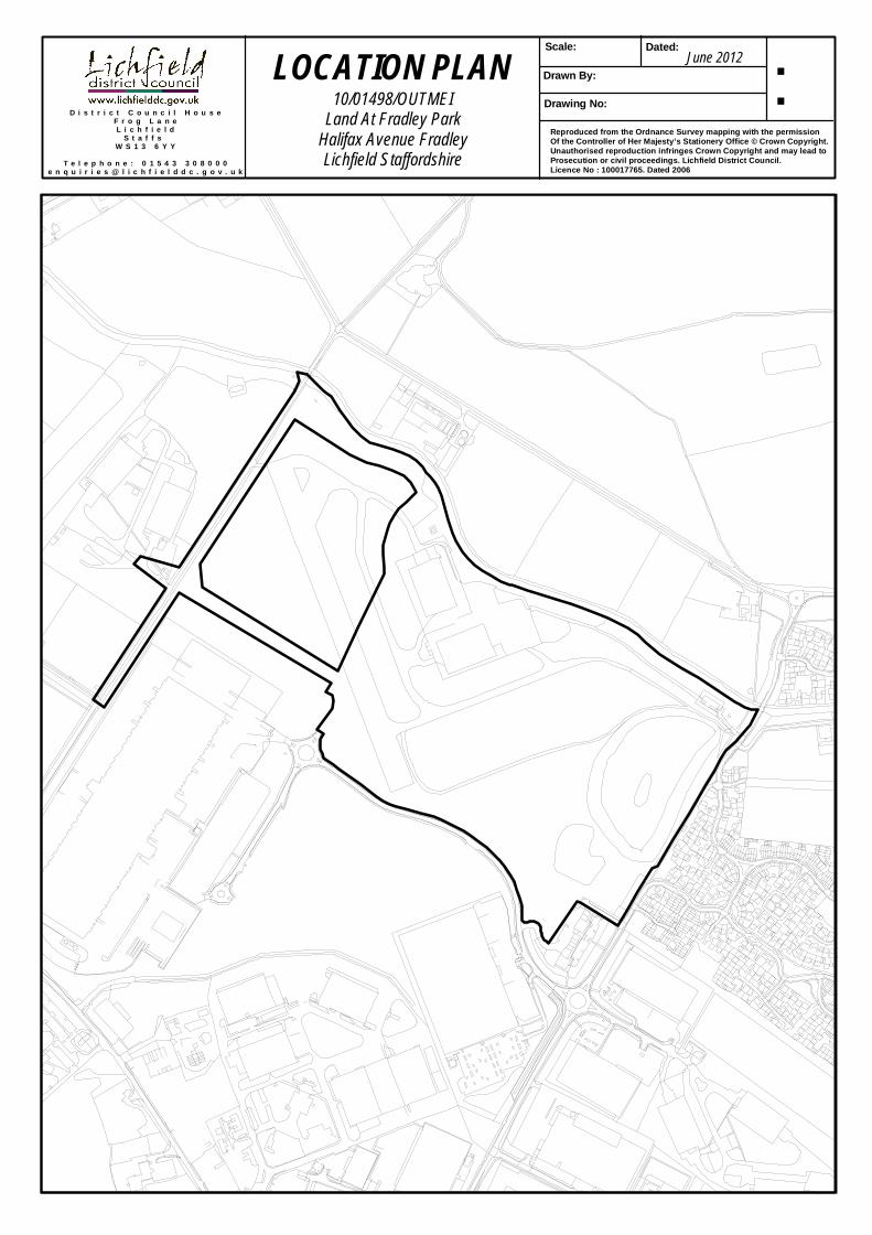
June 2012LOCATION PLAN10/01498/OUTMEI
Land At Fradley ParkHalifax Avenue FradleyLichfield Staffordshire


10/01498/OUTMEI DEMOLITION OF EXISTING BUILDINGS AND REDEVELOPMENT OF THE SITE TO PROVIDE UP TO 750 NEW HOMES, PRIMARY SCHOOL, HEALTH CENTRE, NURSERY, PUBLIC HOUSE, PUBLIC AND PRIVATE OPEN SPACE, CAR AND CYCLE PARKING TOGETHER WITH LANDSCAPING AND ASSOCIATED SERVICING (ALL MATTERS RESERVED EXCEPT POINTS OF ACCESS) LAND AT FRADLEY PARK, HALIFAX AVENUE, FRADLEY FOR FRADLEY PARK DEVELOPMENTS LTD Registered 30/11/10
EXECUTIVE SUMMARY OF MAIN REPORT TO PLANNING COMMITTEE This summary report is intended to give an overview of the layout of the attached committee report (Pages B12 – B75) which considers the application submissions for the above proposed development. This report also sets out a summary of the officer recommendation; a description of the site location; an overview of the proposals; and conclusions reached on each of the determining planning issues as considered in the attached report. The attached application report provides full details of the considerations that have been taken into account by officers in formulating a recommendation to be presented to members of the Planning Committee. All of the page references in brackets (e.g. B12- B16) refer to the relevant pages of the main planning report. Recommendation and Reasons (Pages B12 – B21) Recommendation - Approve, subject to the application being referred to the Secretary of State for Communities and Local Government and subject to owners/applicants first entering into a Section 106 Legal Agreement under the Town and Country Planning Act (as amended) to secure contributions/planning obligations towards:-
1. 25% Affordable Housing 2. On-site Public Open Space and Maintenance Contribution 3. Off-Site Playing Pitch and Maintenance Contribution 4. Soc.2 Contributions 5. Nursery, Primary Provision and Secondary Education Contribution 6. Land for a Health Care Facility 7. Improvements to Pedestrian and Cycle Connectivity 8. Improvements and Enhancement to Public Transport, including Bus Voucher
Scheme 9. Residential Travel Plan 10. Travel Plan Monitoring Fee 11. Contributions towards mitigations for the Cannock Chase Special Area of
Conservation
Page B1

Summary of reasons for granting planning permission (Pages B21-B22) It is considered that although a departure from the Development Plan, the principle of residential development on this previously developed, sustainably located site is acceptable and that the release of employment land for housing would not undermine the ability for the Local Planning Authority to meet current and future employment needs of the District. The development accords to the core planning principles of the National Planning Policy Framework and the proposal is of a scale and in a location that accords with the emerging spatial strategy for the District and would not therefore prejudice a wider strategy for Fradley. It is also concluded that currently the Local Planning Authority cannot demonstrate a 5-year housing land supply. It is therefore considered that the principle of residential development on this site would accord with Policies RR1, CF2, CF4, CF5 and PA6 of the Regional Spatial Strategy; Policies D1, E8, H3, H4 and T1A of the Structure Plan; and the guidance contained within the National Planning Policy Framework. With regard to the design and layout, the application provides a robust and comprehensive analysis of the local character and context and provides sufficient information that a high quality development will be achieved, subject to conditions, and the amount of development of up to 750 dwellings is appropriate for this site and in the context of the character and appearance of the surrounding area. It is further considered that adequate, high quality public open space and pitch provision will be provided on site or locally to meet the needs of the future residents. It is therefore considered that the design and layout is consistent with Policies QE1, QE2, QE3, and QE4 of the Regional Spatial Strategy; Policies D2, D8 and H3 of the Structure Plan; Policies H2, H3, R1, T3, Soc1, Soc2 and DC1 of the Local Plan; the guidance contained within the adopted Supplementary Planning Documents, ‘A Planning Guide to Residential Extensions’, ‘Trees and Development’ and the ‘Residential Design Guide’; and the guidance contained within the National Planning Policy Framework. With regard to transport and highways, adequate information and detail included within the supporting information to demonstrate that adequate sustainable travel choice will be provided within the development. Benefits to the existing community will also be made through the enhancement to existing bus services. Acceptable details have been provided with regard to access to ensure that the development can be safely and appropriately accessed without undue harm to the character and appearance of the area, existing or future residents and highway and pedestrian safety. Subject to condition, it is therefore considered that in transport terms the development would accord with Policies RR1, QE2, T1, T2, T3, T4, T5 and T9 of the Regional Spatial Strategy; Policies D1, D4, D8, T1A, T1B, T3, T4, T5, T7, T12, T13 and T18A of the Structure Plan; Policies H3, T4 and T8 of the Local Plan; and the guidance contained within the National Planning Policy Framework. In terms of the development and its effect on the River Mease Special Area of Conservation and the Cannock Chase Special Area of Conservation, Natural England and the Local Planning Authority considers that the proposals will not give rise to likely significant effects upon site integrity and that, subject to conditions and planning obligations no formal appropriate assessment is required and that the development is acceptable. No other unacceptable harm to protected species or habitat has been identified and adequate mitigation has been provided. It is therefore considered that in terms of ecological impacts, the proposal meets the requirements of Policies QE1 and
Page B2

QE7 of the Regional Spatial Strategy; Policies NC6, NC7A, NC7C and NC9 of the Structure Plan; Policies E14, E18A and E18B of the Local Plan; and the guidance contained within the National Planning Policy Framework. With regard to drainage, sustainability/climate change, amenity and the development’s impact on heritage assets and landscape, it is considered that adequate mitigation is provided and that, subject to condition, no harm will ensue. It is further considered that subject to condition, further details and information relating to sustainability and climate change can be secured and that as the application is made in Outline only, sufficient detail has been provided at this stage. Consequently, it is considered that the application is in accordance with Policies QE1, QE2, QE3, QE4, QE5, QE6, QE8, QE9, EN1 and EN2 of the Regional Spatial Strategy; Policies D1, D2, D7, D8, NC1, NC2, NC9, NC13, NC14, R5A and RC7 of the Structure Plan; Policies E3, E14, E15, E17, DC1, DC2, DC15, DC17 and DC18 of the Local Plan; the guidance contained within the adopted Supplementary Planning Document, ‘Trees and Development’; and the guidance contained within the National Planning Policy Framework. It is therefore considered that the principle of residential development is acceptable and that no other material planning considerations exist to warrant the refusal of the planning application. Whilst the development is not in accordance with the Development Plan, it is considered that in weighing matters such as housing land supply, sustainable development, the emerging plan, the ability to demonstrate the loss of employment land would not undermine the ability for the Local Planning Authority to meet current and future employment needs and the guidance within the National Planning Policy Framework, the balance weighs in favour of the application. It is therefore considered that, subject to conditions and the applicant entering into a Section 106 Agreement, the principle of development is acceptable. Planning Policy and Relevant Planning History (Pages B24 – B25) The proposal is a major departure from the Development Plan as the site is allocated in the ‘saved’ Local Plan for employment uses and the application is for a large scale residential development. There are numerous national and local planning policies listed that are relevant to the consideration of the proposals. The relevant planning history for the site is summarised as follows: Outline planning permission was granted on 15th February 1996 for, B1/B2 and B8 and ancillary uses with associated landscaping (Ref. L950584) on land at Fradley Park, which includes this part of the former airfield. The final reserved matters application related to the above outline permission was approved on 30th June 2011 (10/01403/REMM) and included the application site. Development on the application site comprised 3,252sqm of office space (6 units), 96,617sqm of B8 warehousing (2 units) and 36,138sqm of B2 warehousing (2 units), a pub, pharmacy and children’s day nursery. The drainage strategy for the application includes an off-site attenuation pond located to the northwest of Gorse Lane. The planning history for this pond is as follows: 05/00910/FULM - Landscaped balancing pond. Approved (18/11/05)
Page B3

10/01365/FULM - Provision of a landscaped balancing pond (Extension of time for application 05/00910/FULM). Approved (27/06/11) Consultations (Pages B23 – B37) A summary of the consultation responses is set out in the main report. Letters of Representation (Pages B37 – B41) A summary of the letters of representation are set out in the main report. Background Documents (Page B41 – B42) The application has been accompanied by an Environmental Impact Assessment (EIA) and as such has been the subject of consultation as required within the relevant legislation. A list of the documents submitted as part of the EIA and all other supporting documents, is contained at page B38 – B39 Observations (Page B42 – B43) Site and Location The application site comprises 34 hectares of previously developed land and includes part of the former RAF Lichfield. The airfield was constructed in 1939-40 and was used during WWII to train aircrews on Wellington bombers. The airfield was closed in 1958 and was disposed of by the Air Ministry in 1962 Existing features on the site include an existing 2.7ha attenuation pond located to the southeast of the site close to Common Lane (used as part of the surface water drainage for the adjacent employment site); 2 former hangers located on the northwest and currently used for storage and distribution; an area of woodland alongside the canal and adjacent to the hangers; and a public footpath (no.257) which runs from Common Lane along the southern edge of the site to Gorse Lane. The site is bound to the south by Halifax Avenue, which serves the Tesco warehouse via a small traffic island and is accessed from Common Lane to the southeast. To the north runs the Coventry Canal and to the west Gorse Lane. An historic canal bridge (New Bridge) crosses the canal on Gorse Lane with a second more modern road bridge (Fradley Bridge) to the southeast end of the site. A small parade of shops has recently been finished, and is now mostly occupied, to the south of the site, alongside the access from Common Lane. In terms of surrounding development, Fradley Village and Fradley South are located to the northeast and east/southeast respectively. Fradley Village is the original settlement, containing a church, post office, community centre and church with a wide range of house types and sizes. Containing a small number of historic properties, Fradley Village was enlarged in the 1980s/early 1990s to broadly the size it is today. Fradley South was constructed on part of the former airfield, with the main circular vehicular route through the development a remnant of the former service runways/roads. A small number of houses were constructed on this site in the early 1960s. By the 1980s
Page B4

this had slowly grown around the service runways/roads. However, the majority of the area known as Fradley South was constructed in the 1990s/early 2000s. To the south of the site is the remainder of Fradley Park, a large employment site totalling 86ha comprising mainly B8 warehouse/distribution. The proposals The application seeks outline consent for the erection of up to 750 dwellings. All matters except from access are reserved for future consideration. However, as is normal for an application of this size and nature, the application has been submitted with an Illustrative Masterplan, Parameter Plans and Design and Access Statement, which explains how the applicant has considered the proposal and understood what is appropriate and feasible for the site in its context. In terms of vehicular access, the site will be accessed from the existing access to the Stirling Centre on Common Lane, two new access points from Halifax Avenue and a new access off an existing arm on the small roundabout on Halifax Avenue. An extension of Halifax Avenue is proposed to link up to Gorse Lane and would be constructed at a later phase of development. A further vehicular access will be constructed on to Turnbull Road south of Fradley Bridge. More broadly, the planning application proposes the following elements to support the proposed development:
Up to 750 new dwellings Affordable housing - up to 25 percent provision Financial contributions for the extension of St. Stephen’s Primary School or
an alternative of constructing a new primary school with the potential for up to 1.5 forms of entry
Nursery provision Public transport services and improvements to existing bus services Public house Provision of land for health care facilities Public Open Space Green Infrastructure
Determining Issues 1. Principle of Development (Pages B44 - B50)
Prior to the publication of the NPPF it would have been the view of the Planning Policy Manager that the appropriateness of the suitability of a housing allocation of this scale and in this location should be evaluated and tested through the formal processes of the preparation of a Local Plan, and that granting planning permission for this development would prejudice the preparation of the Local Plan and a comprehensive spatial strategy that reflects the communities’ needs and aspirations for Fradley. Indeed, early comments indicate this stance. However, with the NPPF’s emphasis on the presumption in favour of sustainable development allied with the fact the NPPF makes it clear that, where the Development Plan is
Page B5

out of date, it is necessary to demonstrate that the adverse impacts of granting planning permission would significantly and demonstrably outweigh the benefits before consent could be refused; added with the inability of the Council to be able to currently demonstrate a 5-year housing land supply and the further public engagement undertaken to date, the Planning Policy Manager now feels able to offer support for the application in principle.
With regard to the loss of employment land, it is considered that there is clear evidence of an oversupply of employment land in the District Council’s employment land portfolio. Consequently, it is considered that the loss of the application site for employment uses would not undermine the ability for the Council to meet current and future employment needs and attract inward investment in the period to 2028 and that residential use is acceptable in principle. Importantly, it is also considered that the proposal accords with the core planning principles contained within the NPPF and that the proposal is of a scale and in a location that accords with the emerging spatial strategy for the District and would not prejudice the emerging wider strategy for Fradley. The site benefits from permission for development (B2 and B8 uses, office use, public house, children’s nursery and doctors/pharmacy), is a previously developed site and is located within a sustainable location. Subject to appropriate infrastructure being secured in a Section 106 Agreement, the principle of residential development on this site is supported.
2. Access, Highways (local and strategic) and Transport (Pages B51- B56) It is considered that the application and information provided satisfies the
requirements of the NPPF, the ‘saved’ policies of the Development Plan and accords to the design principles advocated in Manual for Streets (MfS). Furthermore, it is considered that the details provided demonstrate that an acceptable, quality development will be delivered at later design stages meeting the needs of existing and future residents. Significant enhancements will be secured to the public transport system, including the reinstatement of half hourly bus services, thus benefiting existing and future residents of Fradley, offering a greater choice of sustainable travel. With regard to all matters relating to access and transport, the application similarly accords with the NPPF and the Development Plan and is acceptable in planning and highway safety terms. Therefore, it is recommended that access for this development, as detailed in the application documents, be approved at this stage, subject to condition and the entering into a Section 106 Agreement.
3. Design and Layout (Pages B56 – B60) The combination of the illustrative layout, density, building heights, contextual
analysis and street widths outlined in the Design and Access Statement are considered to be appropriate for this site and respond to its specific characteristics. The analysis and proposals outlined in the Design and Access Statement are considered to provide a good framework that will deliver an innovative, high quality development. It will allow for a diverse and appropriate character to evolve in later detailed design stages whilst providing for a good mix of house types and tenures to meet local need. In order to ensure that the quality of the development is
Page B6

delivered, detailed design guidance from which the determination of later reserved matters will be judged will be required. The NPPF advocates the use of Design Codes and it is considered that, in this instance, they are essential to the delivery of a high quality place. To this end, a condition has been recommended ensuring that a Design Code for the entire site is adopted prior to the submission of the first reserved matters application. It is therefore considered that, in design terms, the proposal is acceptable and accords to the development plan and the requirements of the National Planning Policy Framework.
4. Consideration of Cannock Chase Special Area of Conservation (SAC) and the
River Mease Special Area of Conservation (SAC). (Pages B60 - B63) It is considered from the information provided and from advice received by Natural
England that the proposal is not likely to have a significant effect upon the Cannock Chase SAC or the River Mease SAC, subject to the measures and financial contribution being secured in a Section 106 Agreement. It is therefore not considered necessary to undertake a full Appropriate Assessment of the development proposals and that the application is acceptable in this regard.
5. Drainage and Flood Risk (Pages B63 - B64) The drainage strategy includes the construction of a new balancing pond located
northwest of Gorse Lane which benefits from extant planning permission. The drainage proposals include opportunities for SUDS which will be subject to detailed design once the final layout of the development has been determined. With regard to foul water, it will be treated at the Curborough Wastewater Treatment Works operated by Severn Trent Water who have confirmed that there are no capacity issues and that no contributions are necessary to upgrade/increase capacity at the facility. The Environment Agency has considered the information and are satisfied that, subject to a number of conditions, the development will not give rise to any flood risk or drainage issues
6. Impact on Protected Species (Pages B64 - B65) The Countryside Officer has advised that, based on the updated ecological reports
and information provided as part of the application, she is satisfied that there will not be any significant impacts on local biodiversity, and recommends that the precautionary measures and mitigation/compensation set out in the reports be secured by means of appropriate conditions. Similarly, Natural England has raised no objections, and do not consider that the proposal will have a significant impact on protected species. The application is therefore considered acceptable in this regard.
7. Landscape Character and Visual Impact (Pages B65 - B66) It is considered that the boundaries of the site are well defined and partly contain
the land from wider views. It has been demonstrated that wider / long distance views of the site and proposed development will not be possible and that views will be limited to short / medium within the locality. It is also concluded that the site is of low landscape sensitivity. Despite the location of the Coventry Canal, it is considered that the site has a developed but dilapidated appearance set against a
Page B7

large housing estate and large Employment Park. Collectively they have an urbanising influence on the character of the site reinforcing its low sensitivity to change. Having regard to the existing landscape qualities of the site, visual containment and limited long distance views / impacts of the development, allied with the urbanising influences of immediately surrounding development, it is considered that the development will have limited visual impact and thus accords with the development plan.
8. Amenity – Future & Existing Residents and Contaminated Land (Pages B66 -B67)
With regard to existing residents, the main source of disturbance possible would be a result of additional traffic in Fradley South as a result of people either accessing the Fradley Junction on the A38 or the school, community centre, church and other facilities/families. Mitigation has been proposed by way of an additional vehicular access from the development on to Turnbull Road. This would provide a choice of routes for residents and would limit the number of people living in the new development from travelling through Fradley South. It is proposed to deliver this access in the third phase of development.
Sufficient assessment has been undertaken to assess land contamination. Conditions have been recommended to safeguard the future occupants of the development and adjacent watercourses from pollution.
Other issues relating to odour, noise and light for future and existing residents have been assessed in the EIA and have been considered by the Council’s Environmental Health Officer. Subject to conditions, it is considered that the development of up to 750 dwellings could be built without undue harm to their amenity being caused by surrounding land uses. Moreover, it is considered that the living conditions and amenity of existing residents of Fradley will not be significantly harmed. No objections are therefore raised to the proposed development on these grounds, subject to conditions.
9. Impact on Archaeology and Cultural Heritage (Pages B67) With regard to heritage assets, the Trent & Mersey Canal is a designated
Conservation Area and Fradley Junction, itself a heritage asset, contains a number of listed buildings. The development will have no direct visual impact on these assets and it is considered that the increase in public use of these areas will not cause significant harm. The Coventry Canal runs alongside the development site and whilst not a designated Conservation Area, is considered a heritage asset. The retention of a significant portion of existing vegetation along the canal bank, the indication of a canalside footpath and the distance separation shown for properties, are an appropriate response to the canal and its character. Sufficient safeguard for existing heritage assets on the site can be secured via condition, for example, by photographic and written records and the inclusion of some structures within the development. It is considered that the proposal will not cause demonstrable harm to archaeology or the cultural heritage of the area and is therefore acceptable in this regard.
Page B8

10. Sustainability/Climate Change (Page B68) The close proximity of the Employment Park and the Stirling Centre and the
number of dwellings proposed suggests that a critical mass could exist to make larger scale renewable technology measures sustainable in the long term. The variety of land uses and businesses also provide opportunities for energy to be used throughout the day and at different peaks. The application outlines that there is scope for further assessment, subject to detailed consideration and design/layout. It is therefore considered reasonable and appropriate to recommend a condition to ensure further and more detailed consideration is given to the inclusion of sustainability measures within the development. Subject to condition, I therefore consider the application is acceptable and accords with the sustainability measures advocated in the NPPF.
11. Planning Obligations, including Public Open Space (POS), Social and Community
Provision and Education and Sport/Leisure Provision (Pages B68- B72) The following planning obligations will be secured through a Section 106 Legal Agreement: - 25% Affordable Housing - On-site Public Open Space and Maintenance - Off-Site Playing Pitch and Maintenance - Soc.2 Contributions - Nursery, Primary and Secondary Education Provision - Land for a Health Care Facility - Improvements to Pedestrian and Cycle Connectivity - Improvements and Enhancement to Public Transport, including Bus Voucher
Scheme - Residential Travel Plan - Travel Plan Monitoring Fee - Contributions towards mitigations for the Cannock Chase Special Area of
Conservation Conclusion (Pages B72 - B75) It is considered that although a departure from the Development Plan, the principle of residential development on this previously developed, sustainably located site is acceptable and that the release of employment land for housing would not undermine the ability for the Local Planning Authority to meet current and future employment needs of the District. The development accords to the core planning principles of the National Planning Policy Framework and the proposal is of a scale and in a location that accords with the emerging spatial strategy for the District and would not therefore prejudice a wider strategy for Fradley. It is also concluded that currently the Local Planning Authority cannot demonstrate a 5-year housing land supply. It is therefore considered that the principle of residential development on this site would accord with Policies RR1, CF2, CF3, CF4, CF5 and PA6 of the Regional Spatial Strategy; Policies D1, E1, E8, H3, H4 and T1A of the Structure Plan; and the guidance contained within the National Planning Policy Framework.
Page B9

With regard to the design and layout, the application provides a robust and comprehensive analysis of the local character and context and provides sufficient information that a high quality development will be achieved, subject to conditions, and the amount of development of up to 750 dwellings is appropriate for this site and in the context of the character and appearance of the surrounding area. It is further considered that adequate, high quality public open space and pitch provision will be provided on site or locally to meet the needs of the future residents. It is therefore considered that the design and layout is consistent with Policies QE1, QE2, QE3, and QE4 of the Regional Spatial Strategy; Policies D2, D8 and H3 of the Structure Plan; Policies H2, H3, R1, T3, Soc1, Soc2 and DC1 of the Local Plan; the guidance contained within the adopted Supplementary Planning Documents, ‘A Planning Guide to Residential Extensions’, ‘Trees and Development’ and the ‘Residential Design Guide’; and the guidance contained within the National Planning Policy Framework. With regard to transport and highways, adequate information and detail included within the supporting information to demonstrate that adequate sustainable travel choice will be provided within the development. Benefits to the existing community will also be made through the enhancement to existing bus services. Acceptable details have been provided with regard to access to ensure that the development can be safely and appropriately accessed without undue harm to the character and appearance of the area, existing or future residents and highway and pedestrian safety. Subject to condition, it is therefore considered that in transport terms the development would accord with Policies RR1, QE2, T1, T2, T3, T4, T5 and T9 of the Regional Spatial Strategy; Policies D1, D4, D8, T1A, T1B, T3, T4, T5, T7, T12, T13 and T18A of the Structure Plan; Policies H3, T4 and T8 of the Local Plan; and the guidance contained within the National Planning Policy Framework. In terms of the development and its effect on the River Mease Special Area of Conservation and the Cannock Chase Special Area of Conservation, Natural England and the Local Planning Authority considers that the proposals will not give rise to likely significant effects upon site integrity and that, subject to conditions and planning obligations no formal appropriate assessment is required and that the development is acceptable. No other unacceptable harm to protected species or habitat has been identified and adequate mitigation has been provided. It is therefore considered that in terms of ecological impacts, the proposal meets the requirements of Policies QE1 and QE7 of the Regional Spatial Strategy; Policies NC6, NC7A, NC7C and NC9 of the Structure Plan; Policies E14, E18A and E18B of the Local Plan; and the guidance contained within the National Planning Policy Framework. With regard to drainage, sustainability/climate change, amenity and the development’s impact on heritage assets and landscape, it is considered that adequate mitigation is provided and that, subject to condition, no harm will ensue. It is further considered that subject to condition, further details and information relating to sustainability and climate change can be secured and that as the application is made in Outline only, sufficient detail has been provided at this stage. Consequently, it is considered that the application is in accordance with Policies QE1, QE2, QE3, QE4, QE5, QE6, QE8, QE9, EN1 and EN2 of the Regional Spatial Strategy; Policies D1, D2, D7, D8, NC1, NC2, NC9, NC13, NC14, R5A and RC7 of the Structure Plan; Policies E3, E14, E15, E17, DC1, DC2, DC15, DC17 and DC18 of the Local Plan; the guidance contained within the adopted Supplementary Planning Document, ‘Trees and Development’; and the guidance contained within the National Planning Policy Framework.
Page B10

Page B11
It is therefore considered that the principle of residential development is acceptable and that no other material planning considerations exist to warrant the refusal of the planning application. Whilst the development is not in accordance with the Development Plan, it is considered that in weighing matters such as housing land supply, sustainable development, the emerging plan, the ability to demonstrate the loss of employment land would not undermine the ability for the Local Planning Authority to meet current and future employment needs and the guidance within the National Planning Policy Framework, the balance weighs in favour of the application. It is therefore considered that, subject to conditions and the applicant entering into a Section 106 Agreement, the principle of development is acceptable.

10/01498/OUTMEI DEMOLITION OF EXISTING BUILDINGS AND REDEVELOPMENT OF THE SITE TO PROVIDE UP TO 750 NEW HOMES, PRIMARY SCHOOL, HEALTH CENTRE, NURSERY, PUBLIC HOUSE, PUBLIC AND PRIVATE OPEN SPACE, CAR AND CYCLE PARKING TOGETHER WITH LANDSCAPING AND ASSOCIATED SERVICING (ALL MATTERS RESERVED EXCEPT POINTS OF ACCESS) LAND AT FRADLEY PARK, HALIFAX AVENUE, FRADLEY FOR FRADLEY PARK DEVELOPMENTS LTD Registered 30/11/10 Parish: Fradley and Streethay RECOMMENDATION: Subject to referral to the Secretary of State and subject to owners/applicants first entering into a Section 106 Legal Agreement under the Town and Country Planning Act (as amended) to secure contributions/planning obligations towards:-
1. 25% Affordable Housing 2. On-site Public Open Space and Maintenance Contribution 3. Off-Site Playing Pitch and Maintenance Contribution 4. Soc.2 Contributions 5. Nursery, Primary Provision and Secondary Education Contribution 6. Land for a Health Care Facility 7. Improvements to Pedestrian and Cycle Connectivity 8. Improvements and Enhancement to Public Transport, including Bus
Voucher Scheme 9. Residential Travel Plan 10. Travel Plan Monitoring Fee 11. Contributions towards mitigations for the Cannock Chase Special Area of
Conservation Approve, subject to the following conditions and summary of reasons for granting consent: CONDITIONS: 1. The development hereby approved shall be begun either before the expiration of three years from the date of this permission, or before the expiration of two years from the date of approval of the last of the reserved matters to be approved, whichever is the later. Application(s) for the approval of the reserved matters shall be made to the Local Planning Authority before the expiration of seven years from the date of this permission. 2. The first reserved matters application shall be made within 3 years of the date of this planning permission. 3. The details required by conditions 9, 10, 11, 13 and 15 can be submitted and discharged on a phased basis in accordance with the approved phasing plan pursuant to condition 8.
Page B12

CONDITIONS to be complied with PRIOR to the commencement of development hereby approved: 4. This is an outline planning permission and no phase of development shall be commenced until details of the layout of the site including the disposition of roads and buildings; existing and proposed ground level and finished floor level; full road construction, street lighting and drainage including longitudinal sections and a satisfactory means of draining roads to an acceptable drainage outfall; the design of all buildings and structures; the external appearance of all buildings and structures including materials to be used on all external surfaces; the means of pedestrian and vehicular access and parking layout; and the landscape and planting of the site shall be submitted to and approved by the Local Planning Authority by way of reserved matters application(s). 5. Prior to the submission of any Reserved Matters, pursuant to Condition 1, a Masterplan for the development of the site shall be submitted to and approved in writing by the Local Planning Authority. The Masterplan shall be in accordance with the parameter plans listed in this decision and shall include a 200 metre buffer from the nearby piggery as detailed in dwg no. Figure 10.6 and detailed in the Technical Note provided by Halcrow dated the 16th September 2011. The Masterplan shall also identify the locations of equipped areas of play. Proposals contained within applications for the approval of Reserved Matters pursuant to Condition 1 shall thereafter conform to the approved Masterplan, unless otherwise agreed in writing by the Local Planning Authority. 6. Prior to the submission of any Reserved Matters, pursuant to Condition 1, a Design Code for the entire site shall be submitted to, and approved in writing by, the Local Planning Authority. The Design Code shall include and codify the following matters: Built form
(i) Character areas
(ii) Building forms and types;
(iii) Corner treatment
(iv) Elevational composition;
(v) Placement of entrances;
(vi) Building materials palette; Public realm
(i) Street types and Road Hierarchy;
(ii) Landscape design principles;
(iii) Boundary treatments;
Page B13

(iv) Surface materials palette; (v) Planting palette;
(vi) Integration of car parking and cycle parking;
(vii) Types of refuse and recycling storage; and
(viii) Footpaths and cycle networks
Proposals contained within applications for the approval of Reserved Matters pursuant to Condition 1 shall conform to the approved Design Code, unless otherwise first agreed in writing with the Local Planning Authority. There shall be no amendment to the approved Design Code, unless such an amendment is first agreed in writing with the Local Planning Authority. 7. Each application for the approval of details of Reserved Matters, pursuant to Condition 1, shall be accompanied by a statement that demonstrates that such details of reserved matters accord with the design principles of the approved Masterplan, pursuant to Condition 5, to the Design & Access Statement received on the 3rd May 2012 and the Design Code pursuant to Condition 6. The statement shall include matters of the following:
(i) Building mass (ii) Public realm and amenity space
(iii) Accessibility for all
(iv) Footpaths and cycle ways
(v) Car and cycle parking, including visitor car parking and secure cycle
parking
(vi) Vehicular accesses and circulation
(vii) Service arrangements
(viii) Principles of hard and soft landscaping
(ix) Ecological design principles
(x) Existing and proposed levels
(xi) Security and safety
(xii) Principles of energy efficiency
(xiii) Materials
(xiv) Layout
Page B14

The development of that Reserved Matters parcel shall not be commenced until the statement has been approved in writing by the Local Planning Authority. Development shall thereafter be carried out in accordance with the details approved, unless otherwise agreed in writing by the Local Planning Authority. 8. Prior to the submission of any Reserved Matters, pursuant to Condition 1, a scheme for the phasing of the development of the entire site shall be submitted to and approved in writing by the Local Planning Authority. The phasing plan shall include details of the phasing of green infrastructure and shall ensure that the green infrastructure around the existing balancing pond west of Fradley South is completed and made available for use by the public prior to the completion of the first phase. The development shall thereafter be undertaken in accordance with the approved phasing plan, unless otherwise agreed in writing by the Local Planning Authority. 9. Prior to the submission of any Reserved Matters, pursuant to Condition 1, a Method of Construction Statement shall be submitted to and approved in writing by the Local Planning Authority. The Method of Construction Statement shall include details of;
(i) The methods to be used and undertaken to control the emission of dust, noise and vibration from construction works;
(ii) A scheme for dust deposition monitoring;
(iii) Measures (including wheel wash facilities) to control the deposit of mud
and similar debris on adjoining public highways;
(iv) Site fencing and security;
(v) Details of parking for vehicles of site personnel, operatives and visitors;
(vi) Details of site operative accommodation and location of compounds;
(vii) Details of working hours;
(viii) Details of the use of generators;
(ix) A programme of works (including measures of traffic management); The approved Method of Construction Statement shall thereafter be implemented throughout the entire construction period, unless otherwise agreed in writing by the Local Planning Authority. 10. No development shall take place in a particular zone, approved pursuant to Condition 8, until the applicant has secured the implementation of a programme of archaeological work, including excavation, post-excavation analysis and publication of a report, in accordance with a written scheme of investigation, which has been submitted to and approved in writing by the Local Planning Authority. The programme of archaeological work shall thereafter be fully implemented in accordance with the approved scheme of investigation.
Page B15

11. Prior to the submission of any Reserved Matters, pursuant to Condition 1, a surface water drainage scheme, including details for the disposal of surface water and foul water and outfall, shall be submitted to an approved in writing by the Local Planning Authority. The scheme shall be based on sustainable drainage principles and an assessment of the hydrological and hydrogeological context of the development. The development shall thereafter be undertaken in accordance with the approved details. 12. No part of the development hereby approved shall be commenced until the application site has been subjected to a detailed scheme for the investigation and recording of any contamination of the site and a report has been submitted to and approved in writing by the Local Planning Authority. The report shall identify any contamination on the site, the subsequent remediation works considered necessary to render the contamination harmless and the methodology used. The approved remediation scheme shall thereafter be completed in accordance with the phasing plan approved pursuant to Condition 8 and a validation report submitted to and approved in writing by the Local Planning Authority within 1 month of the approved remediation being completed, to ensure that all contaminated land issues on the site have been adequately addressed prior to the first occupation of any part of the development. 13. Prior to the submission of any Reserved Matters, pursuant to Condition 1, a scheme for protecting the existing / proposed dwelling(s) from noise from surrounding land uses, from construction and from proposed uses shall be submitted to and approved in writing by the Local Planning Authority. The approved scheme of noise protection shall thereafter be implemented before the development is first occupied and shall be the subject of a validation report which shall be submitted to and approved in writing by the Local Planning Authority prior to the development being first occupied. The validation report shall ensure that all noise issues on the site have been adequately addressed prior to the development being first occupied. The approved measures shall thereafter be maintained for the life of the development. 14. No works on site, including site clearance and demolition, shall commence until an Ecological Management Plan has been submitted to and approved in writing by the Local Planning Authority. The Ecological Management Plan shall thereafter be implemented in accordance with the approved details and timescales. 15. Prior to the submission of any Reserved Matters, pursuant to Condition 1, a Landscape Management Plan, including long term design objectives, management responsibilities and maintenance schedules for all landscape areas, other than small, privately owned domestic gardens, shall be submitted to and approved in writing by the Local Planning Authority, unless otherwise agreed in writing by the Local Planning Authority. The Landscape Management Plan shall thereafter be implemented in accordance with the approved details and timescales. 16. Before development hereby approved is commenced, details of the extension of Halifax Avenue to Gorse Lane as indicated on drawing No. 1319-GA-101 Rev C shall be submitted to and approved in writing by the Local Planning Authority. The submitted details shall include:
(i) A new junction with Gorse Lane and revised access to the hangar site west of Gorse Lane;
Page B16

(ii) Footway/Cycleways including all crossing points and tactile paving;
(iii) Site accesses; and
(iv) Forward visibility splays.
The works shall thereafter be constructed in accordance with the approved details and be complete and open to traffic prior to occupation of the 101st dwelling. 17. Before development hereby approved is commenced, details of the Turnbull Road access and associated highway works as indicated on Drawing No. 1319/SK/101 REV D, including a raised junction plateau at Common Lane/Turnbull Road, zebra crossing and revised access to the gas governor compound, shall be submitted to and approved in writing by the Local Planning Authority. The submitted plans shall include details of surfacing materials, signage and lighting. The works shall thereafter be constructed in accordance with the approved details and be complete and open to vehicular traffic prior to occupation of any dwelling within Phase 3 as indicated on the Illustrative Phasing Plan on page 95 of the Design and Access Statement received on the 3rd May 2012. All other CONDITIONS to be complied with: 18. There shall be no more than 750 dwellings provided on the site. 19. No sewage, trade effluent or water resulting from vehicle cleaning shall be discharged to any surface water drainage system. 20. The development hereby approved shall only be carried out in accordance with the approved Flood Risk Assessment (FRA) and Drainage Strategy undertaken by WSP, dated the 24th October 2010. Development shall limit the surface water run-off generated by the 1 in 100 year plus 30% for climate change critical storm so that it will not exceed the run-off from the undeveloped site and not increase the risk of flooding off-site. 21. The height of the proposed buildings within the development shall not exceed the heights stated on pages 85 and 87 of the Design and Access Statement received on the 3rd May 2012 and Dwg No. 0604.2 Rev. E received on the 3rd May 2012. 22. All dwellings hereby permitted shall be constructed to the Lifetime Homes Standard, unless otherwise agreed in writing by the Local Planning Authority. Prior to the commencement of each phase of development, other than ground works, site preparation and remediation, details of compliance with Lifetime Homes Standards for the residential units and of the provision of no less than 10% of the residential units to wheelchair housing standard or accessible to this standard, shall be submitted to and approved in writing by the Local Planning Authority. Development shall thereafter be implemented in accordance with the details as approved. 23. The development shall be carried out in full accordance with the mitigation and compensation outlined within the Environmental Impact Assessment, the submitted ecological report dated May 2011 by SLR Global Environmental Solutions (Ref. 424.03036.00003) and the details/compensation outlined within the Ecology Solutions Ltd report dated April 2012 (Ref. 5425.IAA.vf).
Page B17

REASONS FOR CONDITIONS: 1. In order to comply with the requirements of Section 91 of the Town and Country Planning Act 1990, as amended. 2. In order to comply with the requirements of Section 91 of the Town and Country Planning Act 1990, as amended. 3. The application has been made for outline permission only with these matters reserved for subsequent approval. Therefore such details are required to be submitted and agreed to ensure that the development meets the requirements of Policies D2 and H7 of the Structure Plan and Policies H3 and DC1 of the Local Plan. 4. For the avoidance of doubt in that the application has been made for outline permission only, to ensure a satisfactory form and appearance of development and to safeguard the amenity of future residents, in accordance with the requirements of Policies D2 and H7 of the Structure Plan and Policies H3 and DC1 of the Local Plan. 5. To ensure a high quality and cohesive form and appearance of development, in the interests of highway safety, to comply with Staffordshire County Council requirements for access and to safeguard the amenity of future occupiers, in accordance with the requirements of Policies D2, D8, T4, T5, T7, T13, T18A and H7 of the Structure Plan and Policies H3, T4, DC1 and D2 of the Local Plan. 6. To ensure high quality form and appearance of development, in the interests of highway safety and to comply with Staffordshire County Council requirements for access, in accordance with the requirements of Policies D2, D8, T4, T5, T7, T13, T18A and H7 of the Structure Plan and Policies H3, T4 and DC1 of the Local Plan. 7. To ensure high quality form and appearance of development, in the interests of highway safety and to comply with Staffordshire County Council requirements for access, in accordance with the requirements of Policies D2, D8, T4, T5, T7, T13, T18A and H7 of the Structure Plan and Policies H3, T4 and DC1 of the Local Plan. 8. To ensure the appropriate timing of delivery of housing, green infrastructure, highway and transport improvements and social infrastructure, to promote a sustainable development, to safeguard residential amenity and the appearance of the development, in accordance with the requirements of Policies D2, D8, T4, T5, T7, T13, T18A and H7 of the Structure Plan and Policies H3, T4 and DC1 of the Local Plan. 9. In the interests of safety and to safeguard the amenity of residential occupiers, in accordance with the requirements of Policy D2 of the Structure Plan and Policy DC1 of the Local Plan. 10. To ensure full evaluation of and protection of any archaeological remains within the site, in accordance with Policy NC14 of the Structure Plan and Policy DC15 of the Local Plan. 11. To ensure the provision of satisfactory means of drainage to serve the development, to reduce the risk of creating or exacerbating flooding problems and to
Page B18

minimise the risk of pollution and to ensure that sustainability and environmental objectives are met, in accordance with provisions of Policies D2 and NC9 of the Structure Plan and Policies E14, E15 and DC1 of the Local Plan. 12. To protect the water environment and to safeguard residential amenity, in accordance with the requirements of Policy D2 and NC9 of the Structure Plan and Policies E17 and DC1 of the Local Plan. 13. To safeguard the amenity of residential occupiers, in accordance with the requirements of Policy D2 of the Structure Plan and Policy DC1 of the Local Plan. 14. In order to safeguard the ecological interests of the site and encourage enhancements in biodiversity and habitat, in accordance with the requirements of Policy QE7 of the Regional Spatial Strategy and Government Guidance contained in the National Planning Policy Framework. 15. To ensure high quality form and appearance of development and to enhance natural habitat, in accordance with the requirements of Policy QE7 of the Regional Spatial Strategy, Policies D2 and H7 of the Structure Plan, Policies H3 and DC1 of the Local Plan and Government Guidance contained in the National Planning Policy Framework. 16. In the interests of highway safety and to comply with Staffordshire County Council requirements for access, in accordance with the requirements of Policies D2, D8, T4, T5, T7, T13, T18A and H7 of the Structure Plan and Policies H3, T4 and DC1 of the Local Plan. 17. In the interests of highway safety, to comply with Staffordshire County Council requirements for access and to safeguard the amenity of residents living on Turnbull Road and Common Lane in Fradley South, in accordance with the requirements of Policies D2, D8, T4, T5, T7, T13, T18A and H7 of the Structure Plan and Policies H3, T4 and DC1 of the Local Plan. 18. For the avoidance of doubt, in accordance with the applicant’s stated and to ensure the development will be adequately served by infrastructure and social and community provision/facilities, in order to meet the requirements of Policy D2 of the Structure Plan and Policy DC1 of the Local Plan. 19. To ensure the development site and other land does not suffer an unacceptable or increased risk of pollution, in accordance with Policies D2 and NC9 of the Structure Plan and Policies E14 and E15 of the Local Plan. 20. To ensure the development site and other land does not suffer an unacceptable or increased risk of flooding and/or pollution and to ensure that sustainability and environmental objectives are met, in accordance with Policies D2 and NC9 of the Structure Plan and Policies E14 and E15 of the Local Plan. 21. To ensure a high quality form and appearance of development that is appropriate in the context of the locality, in accordance with the requirements of Policies D2 and H7 of the Structure Plan, Policies H3 and DC1 of the Local Plan and the guidance contained within the National Planning Policy Framework.
Page B19

22. To ensure a satisfactory form of development, accessible to all, in accordance with the requirements of Policy D2 of the Structure Plan and Policy DC1 of the Local Plan. 23. In order to safeguard the ecological interests of the site, in accordance with the requirements of Policy QE7 of the Regional Spatial Strategy, Policies NC6, NC7A, NC7C and NC9 of the Structure Plan and Government Guidance contained in the National Planning Policy Framework.
NOTES TO APPLICANT: 1. The Development Plan comprises of the Regional Spatial Strategy for the West Midlands (2008), the Staffordshire and Stoke-on-Trent Structure Plan (2001) (saved policies) and the Lichfield District Local Plan (1998) (saved policies). 2. The applicant’s attention is drawn to Article 21 of The Town and Country Planning (General Development Procedure) Order 1995 as amended and Circular 04/2008, which now requires that any written request to discharge a planning condition(s) shall be accompanied by a fee of £25 for a householder application or £85 for any other application including reserved matters. 3. All site and ground clearance works shall be completed outside of the bird nesting season (March to September). 4. The proposed development requires a public right of way to be diverted. As such no development hereby approved shall be commenced until details of the diverted right of way have been submitted to and approved in writing by the Local Planning Authority. The approved diverted right of way shall be constructed and open for public use in accordance with the approved details prior to closure of the existing right of way. (Note: For more information on rights of way issues see http://www.staffordshire.gov.uk/environment/e-land/RightsofWay/ or contact: Rights of Way Section, Environment & Countryside Unit, Staffordshire Place 1, Staffordshire County Council, Wedgwood Building, Tipping Street, Stafford, Staffordshire ST16 2DH. 5. This consent will require approval under Section 7 of the Staffordshire Act 1983 and will require a Section 38 agreement of the Highways Act 1980. Please contact Staffordshire County Council to ensure that approvals and agreements are secured before commencement of works. 6. The new accesses and off-site highway works shall require a Major Works Agreement/s with Staffordshire County Council and the applicant is therefore requested to contact Staffordshire County Council in respect of securing the Agreement. The website below provides access to a Major Works information Pack and an application form. Please complete and send to the address indicated on the application from which is Staffordshire County Council at Network Management Unit, Staffordshire Place 1, Wedgwood Building, Tipping Street, Stafford, Staffordshire ST16 2DH. (Or email to [email protected])
Page B20

6. The public right of way was diverted previously to accommodate the industrial development proposals however as the scheme has now changed and the alignment of Halifax Avenue has been moved the right of way will need to be diverted again. SUMMARY OF REASONS FOR GRANTING PLANNING PERMISSION including DEVELOPMENT PLAN POLICIES that were relevant in the determination of this application: It is considered that although a departure from the Development Plan, the principle of residential development on this previously developed, sustainably located site is acceptable and that the release of employment land for housing would not undermine the ability for the Local Planning Authority to meet current and future employment needs of the District. The development accords to the core planning principles of the National Planning Policy Framework and the proposal is of a scale and in a location that accords with the emerging spatial strategy for the District and would not therefore prejudice a wider strategy for Fradley. It is also concluded that currently the Local Planning Authority cannot demonstrate a 5-year housing land supply. It is therefore considered that the principle of residential development on this site would accord with Policies RR1, CF2, CF4, CF5 and PA6 of the Regional Spatial Strategy; Policies D1, E8, H3, H4 and T1A of the Structure Plan; and the guidance contained within the National Planning Policy Framework. With regard to the design and layout, the application provides a robust and comprehensive analysis of the local character and context and provides sufficient information that a high quality development will be achieved, subject to conditions, and the amount of development of up to 750 dwellings is appropriate for this site and in the context of the character and appearance of the surrounding area. It is further considered that adequate, high quality public open space and pitch provision will be provided on site or locally to meet the needs of the future residents. It is therefore considered that the design and layout is consistent with Policies QE1, QE2, QE3, and QE4 of the Regional Spatial Strategy; Policies D2, D8 and H3 of the Structure Plan; Policies H2, H3, R1, T3, Soc1, Soc2 and DC1 of the Local Plan; the guidance contained within the adopted Supplementary Planning Documents, ‘A Planning Guide to Residential Extensions’, ‘Trees and Development’ and the ‘Residential Design Guide’; and the guidance contained within the National Planning Policy Framework. With regard to transport and highways, adequate information and detail included within the supporting information to demonstrate that adequate sustainable travel choice will be provided within the development. Benefits to the existing community will also be made through the enhancement to existing bus services. Acceptable details have been provided with regard to access to ensure that the development can be safely and appropriately accessed without undue harm to the character and appearance of the area, existing or future residents and highway and pedestrian safety. Subject to condition, it is therefore considered that in transport terms the development would accord with Policies RR1, QE2, T1, T2, T3, T4, T5 and T9 of the Regional Spatial Strategy; Policies D1, D4, D8, T1A, T1B, T3, T4, T5, T7, T12, T13 and T18A of the Structure Plan; Policies H3, T4 and T8 of the Local Plan; and the guidance contained within the National Planning Policy Framework. In terms of the development and its effect on the River Mease Special Area of Conservation and the Cannock Chase Special Area of Conservation, Natural England
Page B21

and the Local Planning Authority considers that the proposals will not give rise to likely significant effects upon site integrity and that, subject to conditions and planning obligations no formal appropriate assessment is required and that the development is acceptable. No other unacceptable harm to protected species or habitat has been identified and adequate mitigation has been provided. It is therefore considered that in terms of ecological impacts, the proposal meets the requirements of Policies QE1 and QE7 of the Regional Spatial Strategy; Policies NC6, NC7A, NC7C and NC9 of the Structure Plan; Policies E14, E18A and E18B of the Local Plan; and the guidance contained within the National Planning Policy Framework. With regard to drainage, sustainability/climate change, amenity and the development’s impact on heritage assets and landscape, it is considered that adequate mitigation is provided and that, subject to condition, no harm will ensue. It is further considered that subject to condition, further details and information relating to sustainability and climate change can be secured and that as the application is made in Outline only, sufficient detail has been provided at this stage. Consequently, it is considered that the application is in accordance with Policies QE1, QE2, QE3, QE4, QE5, QE6, QE8, QE9, EN1 and EN2 of the Regional Spatial Strategy; Policies D1, D2, D7, D8, NC1, NC2, NC9, NC13, NC14, R5A and RC7 of the Structure Plan; Policies E3, E14, E15, E17, DC1, DC2, DC15, DC17 and DC18 of the Local Plan; the guidance contained within the adopted Supplementary Planning Document, ‘Trees and Development’; and the guidance contained within the National Planning Policy Framework. It is therefore considered that the principle of residential development is acceptable and that no other material planning considerations exist to warrant the refusal of the planning application. Whilst the development is not in accordance with the Development Plan, it is considered that in weighing matters such as housing land supply, sustainable development, the emerging plan, the ability to demonstrate the loss of employment land would not undermine the ability for the Local Planning Authority to meet current and future employment needs and the guidance within the National Planning Policy Framework, the balance weighs in favour of the application. It is therefore considered that, subject to conditions and the applicant entering into a Section 106 Agreement, the principle of development is acceptable. PREAMBLE Members will recall that this application was deferred at Planning Committee on the 2nd July 2012 so that the Highways Agency and Staffordshire County Council Highways can be invited to attend to explain their views and to reassure Members with regard to the highway issues raised by this application. The original report, as amended to include the additional elements contained within the Supplementary Agenda which include the letter received from RPS on behalf of the Fradley West Consortium and the additional comments of Fradley and Streethay Parish Council, reads as follows: PLANNING POLICY Major Departure – Yes
Page B22

Government Guidance National Planning Policy Framework Technical Guidance to the National Planning Policy Framework Regional Spatial Strategy Policy RR1 – Rural Renaissance Policy CF2 – Housing Beyond the Major Urban Areas Policy CF3 – Levels and Distribution of Housing Development Policy CF4 – The Reuse of Land and Buildings for Housing Policy CF5 – Delivering Affordable Housing and Mixed Communities Policy PA1 – Prosperity for All Policy PA6 – Portfolio of Employment Land Policy QE1 – Conserving and Enhancing the Environment Policy QE2 – Restoring Degraded Areas and Managing and Creating High Quality New Environments Policy QE3 – Creating a High Quality Built Environment for All Policy QE4 – Greenery, Urban Greenspace and Public Spaces Policy QE5 – Protection and Enhancement of the Historic Environment Policy QE6 – The Conservation, Enhancement and Restoration of the Region’s Landscape Policy QE7 – Protecting, Managing and Enhancing the Region’s Biodiversity and Nature Conservation Resources Policy QE8 – Forestry and Woodlands Policy QE9 – The Water Environment Policy EN1 – Energy Generation Policy EN2 – Energy Conservation Policy T1 – Developing Accessibility and Mobility within the Region to Support the Spatial Strategy Policy T2 – Reducing the Need to Travel Policy T3 – Walking and Cycling Policy T4 – Promoting Travel Awareness Policy T5 – Public Transport Policy T9 – The Management and Development of National and Regional Transport Networks Staffordshire and Stoke on Trent Structure Plan Policy D1 – Sustainable Forms of Development Policy D2 – The Design and Environmental Quality of Development Policy D4 – Managing Change in Rural Areas Policy D7 – Conserving Energy and Water Policy D8 – Providing Infrastructure Services, Facilities and/or Mitigating Measures Associated with Development Policy E1 – Employment Land Provision and Distribution Policy E8 – Loss of Employment Land and Buildings Policy H3 – Mixed Use Developments Policy H4 – Portfolio of Sites Policy T1A – Sustainable Location Policy T1B – An Integrated Transport Strategy Policy T3 – Rural Areas Policy T4 – Walking Policy T5 – Cycling
Page B23

Policy T7 – Public Transport Provision Policy T11 – Management of Traffic Policy T12 – Strategic Highway Network Policy T13 – Local Roads Policy T18A – Transport and Development Policy NC1 – Protection of the Countryside: General Considerations Policy NC2 – Landscape Protection and Restoration Policy NC6 – Important Semi-Natural Habitats Policy NC7A – Sites of International Nature Conservation Importance Policy NC7C – Sites of Local Nature Conservation Importance Policy NC9 – Water Resources Policy NC13 – Protection of Trees, Hedgerows and Woodlands Policy NC14 – Sites of Archaeological Importance Policy R5A – Water Areas and Rivers Policy R7 – Canal Facilities Lichfield District Local Plan Policy E3 – Trees and Woodlands Policy E6 – Development in Rural Areas Policy E14 – Water Habitats Policy E15 – Flood Protection Policy E17 – Contaminated Land Policy E18A – National Sites Policy E18B – Development Affecting Nature Conservation sites – Sites Designated Locally Policy H2 – Housing Mix Policy H3 – Housing Design Standards Policy R1 – Open Space Provision Policy T3 – Private Sector Contributions Policy T4 – Parking Policy T8 – Cycling Policy Soc1 – Community Facilities Policy Soc2 – Community Provision Arising from Development Policy DC1 – Amenity and Design Principles for Development Policy DC2 – Amenity Policy DC15 – Archaeological Assessment Policy DC17 – Existing Trees and Hedgerows on Development Sites Policy DC18 – New Tree Planting on Development Sites RELEVANT PLANNING HISTORY Outline planning permission was granted on 15th February 1996 for, B1/B2 and B8 and ancillary uses with associated landscaping (Ref. L950584) on land at Fradley Park, which includes this part of the former airfield. The final reserved matters application related to the above outline permission was approved on 30th June 2011 (10/01403/REMM) and included the application site. Development on the application site comprised 3,252sqm of office space (6 units), 96,617sqm of B8 warehousing (2 units) and 36,138sqm of B2 warehousing (2 units), a pub, pharmacy and children’s day nursery.
Page B24

The drainage strategy for the application includes an off-site attenuation pond located to the northwest of Gorse Lane. The planning history for this pond is as follows:
05/00910/FULM - Landscaped balancing pond. Approved (18/11/05)
10/01365/FULM - Provision of a landscaped balancing pond (Extension of time for application 05/00910/FULM). Approved (27/06/11)
CONSULTATIONS The Inland Waterway Association – Although the Coventry Canal has not yet been designated a Conservation Area, it shares the same heritage, architectural, environmental and recreational value as the nearby Trent & Mersey Canal Conservation Area and merits similar protection. Support the principle of residential development on this site; having recently objected to the reserved matters application alongside the canal (10/01403/REMM). Consider residential development will be less intrusive and will better integrate with the canal. Welcome landscaped corridor along the canal but concerned that houses appear to back on to it. Consider that the internal layout and external access should be redesigned to take better account of the opportunities offered by the canal frontage and to better integrate with the existing community (08/12/10). Operations Manager – The initial plan shows relatively good access to all areas. Further involvement will be necessary at the reserved matters stage (13/12/10). Severn Trent Water – No objections, subject to condition relating to disposal of surface water and foul sewage (13/12/10). In the case of the Fradley Park, we were already aware that Lichfield District Council were looking at development options on the former Fradley airfield together with other proposals in Lichfield and Fradley village which would have an impact on Curborough sewage treatment works. On this basis we are already initiated a capital investment project to provide additional treatment capacity at Curborough sewage treatment works. This work is programmed for completion in 2014. On the issue of funding these improvements, we would not be seeking any contributions towards the cost of sewage treatment capacity improvements (13/01/11). English Heritage – No comments to make (16/12/10). Housing Strategy and Enabling Manager – As no specific details regarding the type or location of affordable housing has been provided, we do not wish to submit detailed comments at this stage. However, welcome the proposed split of 80% houses, 20% flats and would expect the type and size of affordable housing to be provided in the same proportion as that proposed for the whole site. Affordable housing should be provided at 25% i.e. 188 dwellings. It should be evenly spread across each phase and across the site. The suggestion in the Design and Access Statement (DAS) of ‘clusters’ of 15-20 affordable dwellings appears slightly high. Would prefer the ‘cluster’ size to be reduced to 10-15 affordable dwellings (18/12/10). Highways Agency – No objections, provided the Travel Plan is secured on the planning permission (20/12/10).
Page B25

In respect of the updated Transport Assessment and Travel Plan, given that the proposal is materially the same as those previously accepted by the Highways Agency, no objections are raised (02/09/11). Staffordshire County Council (Highways) – Recommend refusal. There is insufficient information to fully assess the traffic impact of the proposed development in that (20/12/10):
The Transport Assessment (TA) does not fully address the implications of the proposed development in relation to the outline permission for the employment uses (L950584) and the current reserved matters (10/01403/REMM) with specific reference to the trigger points for outstanding highway works in exchanging the consented employment use for residential use.
The Travel Plan (TP) does not demonstrate it provides for sustainable travel choice.
The drawing for access point 4 is incomplete. No details have been provided for the proposed crossing facility on Hay End
Lane. In respect of the updated Transport Assessment and Travel Plan, the additional information provided does address concerns previously raised. However, an issue has come to light regarding the alignment of the connection from Halifax Avenue to Gorse Lane. Before being able to withdraw objections, the red line (application site) needs to be extended to take in the revised road alignment and the resultant new access to the hangers on Gorse lane (05/09/11). With regard to the addendum to the Transport Assessment, including additional access drawings and the amended Travel Plan, no objections subject to condition and s106 agreement. Conditions to include details of road layout, design code, phasing, construction traffic management scheme, extension of Halifax Avenue to Gorse Lane, the creation of a vehicular access on to Turnbull Road prior to occupation of phase 3 and limiting the permission to no more than 750 dwellings. Section 106 Agreement to include the following:
Capital contribution of £105,000 towards improving pedestrian and cycle connectivity from the site to surrounding areas (Total amount made up of £100,000 cost estimate of providing a puffin crossing and raised plateau and £5,000 estimate for implementing TRO on Netherstowe Lane);
Obligation for the developer to provide a peak hour bus service to deliver 3 arrivals and 3 departures from Fradley to Lichfield between 7am and 8:30am and the same between 5pm and 6:30pm to be operational prior to first occupation up until the daily half hourly service becomes operational;
Capital contribution of £500,000 towards the provision of a half hourly bus service from Fradley to Lichfield. Payable before occupation of the 425th dwelling;
Residential Travel Plan; Travel Plan Monitoring Fee of £6,200; Bus voucher scheme for 12 months free bus travel per household limited to 30%
uptake. Monitoring of uptake will be required. (11/05/12) Central Networks – No objections (21/12/10).
Page B26

Staffordshire County Council (School Organisation Team) – The development should provide a 1 form entry primary school (210 places plus nursery provision) on a site large enough to expand to 1.5 forms of entry (315 places plus nursery provision). With regard to a secondary school education contribution, a review of the demographic date is being undertaken to establish what this sum is (21/12/10). With regard to secondary education, concerned about the pressure on high school numbers. It is appreciated that the numbers in high schools are currently relatively low and don’t demonstrate a need for additional capacity up to 2014/15 which would be the County’s normal projection time when considering the impact of new housing. However, it is considered that a site as large as 750 houses will take a considerable time to build out. Working on an indication given of a build rate of around 100 houses per year, it will mean that the site may not be completed until around 2020. Contribution of £1,349,622 for secondary education requested. Does not include sixth form (03/03/11). The catchment area school for this development is the Friary High School which is currently full to capacity and is expected to remain full for the foreseeable future. As it is acknowledged that there is some pupil movement between catchment areas within Lichfield, the LEA has taken into consideration the capacity and pupil numbers at all three of the Lichfield high schools. They have also acknowledged that this is a large site and the pupil yield was added into the projections based on an agreed build rate over an 8 year period. For these reasons, the LEA request that the application provide for 81 high school places and no contribution for sixth form. The financial contribution equates to £1,349,622 (13/06/12). Staffordshire County Council (Ecology, Landscape, Historic Environment, Rights of Way) comment individually in respect of (21/12/10): Archaeology and Historic Landscape Character – While there is demonstrable archaeological potential across the site, there is nothing in the surrounding area to suggest that it is likely to be nationally significant. Therefore, satisfied this work can be controlled via condition. Regarding the standing structures on site, the general approach would appear to be reasonable with building recording advised in all instances. The reference to a Pickett Hamilton (PH) fort as being of low value is of concern. These are a relatively rare type of pillbox and as such if it is to be removed a level 3 building recording should be carried out. The other structures should be subject to a level 1 building recording. There are no historic landscape character concerns. Historic Built Environment – Clarification is needed as to whether any of the pillboxes are to be retained. The airfield is acknowledged within the Lichfield Historic Environment Assessment (HEA). The HEA aims to establish the potential for the historic environment to absorb new development and housing in particular. Historic Environment Character Zones (HECZs) have been created to assess the significance of the heritage assets in each zone. The site falls in HECZ 9 (Fradley Airfield & Fradley South). This states that there is potential for the airfield to be promoted as a public amenity and its history interpreted. It also states that the historic environment could accommodate medium to large scale development but that the airfield would suffer adverse effects.
Page B27

Ecology – The Appropriate Assessment (AA) findings do not appear to meet the requirements of the legislation as they are based on assumptions rather than evidence. The area and layout of greenspace proposed appears to involve very poor provision for residents in terms of local and Natural England standards and is unlikely to provide the benefits for residents and biodiversity stated in the application. Regarding the revised AA Report, consider that the traffic impacts remain to be resolved and that the trip distribution data used is not appropriate. Further, consider the residential impact requires further assessment. Evidence should be provided to show that the SAC is sufficient distance away from the site to not draw regular visitors from the application site. Further information on Suitable Alternative Natural Green Spaces (SANGS) is required (05/10/11). Landscape – The landscape and visual assessment submitted is a comprehensive and fair assessment. The proposed Landscape and Biodiversity Management Strategy is welcomed. This will be essential to secure sustainable long-term management of the proposed habitats and structural planting. Forestry – No objections. Rights of Way – No objections. Countryside Officer – The information provided in respect of European Protected Species, nationally protected species and loss of habitats/mitigation/compensation is considered to be insufficient, so a fully informed planning decision cannot be made. Furthermore, legislation and regional policy requirements for enhancement and maintenance of habitats have not been fully adhered to. The information submitted in respect the Special Areas of Conservation is considered to be insufficient as it is based on a lack of evidence, thus the Authority is not able to make a fully informed planning decision. Further information is required with regard to Great Crested Newts (GCNs) and mitigation/compensation for habitat of numerous red listed and BAP birds (21/12/11). No objections subject to condition. Satisfied from the additional information provided that no harm will be caused to protected species and that adequate compensatory mitigation is provided. With regard to the issues relating to the Cannock Chase SAC, concur with the view of Natural England and further information should be requested (20/10/11). Staffordshire Fire and Rescue Service – No objections (22/12/10). Arboricultural Officer – Support the overall layout of the masterplan in respect of retention of existing vegetation and key features. Concerned about the lack of tree planting in the area between the local centre/between Halifax Avenue and the proposed main street. Recommend that tree planting be shown within the street. There should be no change in levels within 15 metres of existing trees. The provision within gardens, schools and open spaces is amenity tree and shrub planting, not woodland habitat creation and these should not be confused. An extension to the existing woodland and canal sidewalk of this size would be supported. The EA states that a Landscape and Biodiversity Management Strategy should be developed at the detailed design stage. This should be stipulated as one of the
Page B28

conditions of this application and must include a 10-year woodland management plan and tree survey and plans to the relevant/up to date British Standards at the first reserved matters. Further surveys required at phases 1, 3, 6 and 7. The phasing, design and implementation of the landscaping is split over the documents and does not give sufficient detail to ensure that the strategic open spaces will be envisaged and designed as a whole. The phasing in the DAS shows each of the strategic open spaces being delivered in sections by different development phases. Whilst it is appreciated that a fully worked design is not appropriate at this point, I consider the vision for each space, the major elements within and their design, location and timing of provision should be agreed (22/12/10). In respect of the amended DAS, notes the loss of several groups of trees and hedgerow however it is not considered their loss will be significant in visual terms. Mitigation for tree loss should be included within the detailed design. No objections (21/03/12). British Waterways – No objections, subject to conditions and a range of contributions secured under a Section 106 Legal Agreement for the following; creation of new access on to canal at New Bridge (£5,000), the improvement of link north of Fradley Bridge (£2,000), improvements to planting on canal between Gorse Lane and Fradley Junction (£5,000), signage (£1,500), additional maintenance charge for 20-years (£23,915 per year totalling £478,3000 over the 20-year period). (22/12/10). Further comments received in connection with planning obligations. Now consider that a case can only be made for improvement of the canal towpath from New Bridge on Gorse Lane to Fradley Junction at a cost of £75,000-£78,000. Consider improvements to the towpath from existing informal, grassed verge with path to tar, spray and stone chip (09/03/12). Police Architectural Liaison Officer – No objections (23/12/10). Ramblers Association – No objections (23/12/10). Environment Agency – No objection, subject to conditions (24/12/10). Staffordshire County Council (Waste and Minerals) – No objection subject to a Site Waste Management Plan (SWMP) being submitted and agree prior to development commencing. Notes that an adjacent site has been granted permission for waste management activities such as handling, processing and storage of dry recyclable waste materials (L10/01/862W). The proposal is unlikely to affect the operation of the facility but it would be prudent for the LPA to check the matter with the Environmental Health Officer (22/12/10). Health and Safety Executive – No comment to make on the application (05/01/11). Lichfield City Council – Recommend refusal. Although the City Council agrees in principle with major development at Fradley it objects to this application, as it is premature to the Local Development Framework (LDF). A major proposal such as this needs to be considered within a district-wide context which will be provided by the LDF, and as the LDF is now in its final stages of preparation determination of this application should wait until the LDF core strategy is finalised (06/01/11).
Page B29

Sport England – Object to the development. The application fails to address sport adequately. No consideration has been given to the needs of indoor sport and outdoor sport has only been provided through community access to the primary school playing field (10/01/11). Consider that the LPA should request financial contributions towards the provision of 17sqm of swimming pool space at the cost of £186,963 and 0.5 of a badminton court at a cost of £299,926 (total £486,889). Evidence shows that there is a shortfall and that the development will generate a need. In terms of outdoor provision, do not discriminate between off-site/on-site provision (30/05/12). Environmental Health Manager – Require more information relating to the CHP chimney at the Tesco warehouse. Require clarification of the findings relating to the odour emanating from the nearby pig farm and how large the ‘buffer’, within which there should be no residential development, should be. The noise, vibration, lighting and contaminated land sections are satisfactory and no issues are raised in this regard, subject to condition (14/01/11). The revised assessments relating to ‘What-a-Waste’ and the Tesco CHP chimney is acceptable and show no impact on the proposal (31/08/11). Additional technical note to explain an justify the 200m odour buffer around the pig farm is acceptable. This buffer should be in place in any design. No objections to the application, subject to conditions (21/09/11). Campaign to Protect Rural England (CPRE) – Aware that this site forms one of the Strategic Development Locations in the Core Strategy. Until growth and housing targets are decided, consider the application is premature and therefore should be withdrawn or refused. Development at Fradley has substantial transportation implications which need addressing including traffic movement on the A38 and also in other directions (18/01/11). Alrewas Parish Council – No objections (18/01/11). Greens & Open Spaces Strategy Manager (Incorporating comments from Leisure, Parks and Play Directorate) – Support the overall layout of the masterplan in respect of the retention of woodland along the canal, the use of the lake and surrounding vegetation as a Public Open Space (POS), the inclusion of the two converging linear open spaces and the retention and enhancement of the landscape buffer planting. Welcome the concept of linking formal open space with the surrounding countryside, creating linkages and corridors and the strong emphasis on trees in civic spaces and streets. Welcome the focus towards natural and free play and the provision of wildlife rich areas within amenity green spaces and on residential doorsteps There is a lack of formal playing pitch provision and if the opportunity for shared use with the school’s pitch provision is not deliverable then the provision of sports pitches off site is essential. Concerned about the phasing, design, implementation and adoption of the landscaping and POS and that the application is not explicit enough to ensure that the strategic open spaces will be envisaged and designed as a whole (21/01/11).
Page B30

Maintain support for layout and welcome the focus towards natural and free play and the provision of wildlife rich areas within the amenity green spaces. Core concepts of public open space are included within the DAS but some finer detail would assist. This could be addressed in a condition securing a landscape and design strategy. If playing pitches cannot be provided on site they should be provided within Fradley and a contribution should be sought to that effect. The kickabout area next to the pond needs to be retained as such. The number of equipped areas of play are not objected to and their location needs to be agreed. A landscape and biodiversity management strategy should be condition which should incorporate a long term woodland management plan. POS should become available when homes are occupied and at least one park should be part of phase 1. The proposals meet a number of the strategic objectives of the Council’s Play Strategy. No objections therefore raised subject to condition (02/03/12). With regard to indoor sports provision, considers that the application does not take into account the need for indoor sport and leisure facilities. A purpose built facility within the development to serve the local residents or a contribution towards a development of a larger facility is sought. Includes contributions towards a new 6 court hall in Lichfield, the development of a new 25 metre (4 lane) pool and teaching pool in Lichfield (22/05/12). Conservation and Urban Design Manager – Retention of WWII features, such as the pillboxes associated with the former RAF Lichfield aerodrome is welcomed and will reinforce local heritage. The Design and Access Statement (DAS) assesses local historic character/history of the site and shows that this is a driver for the overall vision and plan layout. This should enhance local distinctiveness and interpretation. The 4 storey element, identified under ‘Design Parameters – Storey Height’, appears extensive, particularly given the findings of the precedent studies. Whilst a variety of housing types are necessary, justification for 4 storey buildings is unclear. It is good that a range of street/block typologies have been produced. Whilst appreciating this is an outline application, and the detail of the proposed development will have to be defined through design codes for character areas, an indication of articulation of built form and style of approach (modern/traditional) would be useful. The proposed layout will allow flexibility in terms of the extent to which development extends across this site. It is important that development on this site helps to provide, in part, cohesion of Fradley settlement as a whole. This could be achieved with this amount of development on this site. With regard to the revised DAS received in February 2012, comments that the Council has identified that Fradley is a settlement that could sustain growth and the Fradley Park proposal would appear consistent with this objective. The DAS for this application is very good in terms of its scope and illustrative quality. Do not object to the shape/form of the proposed layout and consider it innovative and responsive to the site in particular. The indicative block layouts, for various densities of development, appear convincing, but the overall structure within which these individual blocks sit will necessitate reduced
Page B31

frontage-to-frontage distances. The DAS examines ‘local spatial context’ and highlights that tall buildings are rarely matched across the street by buildings of an equivalent height in the existing village context – that is, taller buildings tend to have lower buildings, or breaks in built form, opposite them. It also identifies the relative positions (eg. pinch points) and shapes (eg. gable end on) of such buildings. These patterns are consistent with the council’s adopted residential design guide and must be carried through into any detailed design. Some of the density ranges quoted in the DAS (eg. 15-35 dwelling per hectare, p.111 & 113) are very broad. An area of development at 15dph will look and feel very different to one at 31dph. Nevertheless, if these ranges were to be flattened too much, we could end up with a less distinctive, more homogenous development, making it difficult to achieve differing areas of character through design – via mechanisms, such as design codes. Strongly feel that any housing provided on the site allocated for the primary school should form part of the overall ‘up to 750’, and not be in addition to this – should the preferable alternative of the extension of St. Stephens be delivered. Furthermore, consider that any housing design for this plot should incorporate a sizeable area of green space, in order to maintain a balance of openness across the development site. Recommended that, if this application is approved, a condition be imposed that requires, prior to any development taking place, a design code for the site as a whole be approved and adopted. This should ensure that densities and phasing are tied together through delivery (24/04/12). With regard to amended DAS (May 2012); in terms of scale and massing consider the height parameter plan is unhelpful in terms of the extent of ‘up to 3 storey’ as it could give the hope or expectation to developers that the LPA would accept that amount of 3 storey development, which is not the case. The inclusion of the indicative and supporting detail in this application, if granted, will be crucial in defining how the LPA will achieve a variety in character (23/05/12). Natural England – As the site lies within 12 miles of the Cannock Chase Special Area of Conservation (SAC), and therefore within the zone of influence, it is suggested that the Council consider the application under the Habitat Regulations, particularly Regulations 61 and 62. In terms of the Appropriate Assessment Report, it is considered that further information is required before the Council can conclude that there will be no likely significant effect on the SAC. This should include:
An assessment of the development in combination with other plans and projects both proposed and approved schemes yet to be commenced. This should include plans and projects outside the boundary of Lichfield District where necessary.
An assessment of alternative sites in the vicinity of the application site, which
may include: - An assessment of local open space
Page B32

- Alternatives to the Cannock Chase visitor experience, including bridleways, bike trails, picnic sites and large open semi natural areas
- Reference to any local surveys or reports on resident behaviour and where they are likely to visit for the activities likely to cause harm to Cannock Chase SAC. It is possible that you may have to undertake these surveys should no existing and relevant surveys be available.
Clarification on how the proposed open areas within the site will seek to replicate or provide alternative but equally high quality visitor experience.
Further evidence to support the claim/assumption that emissions from vehicles originating from the site will be negligible should also be provided (28/01/11). In response to a request from applicants to clarify aspects of the Cannock Chase SAC and the level of information required, Natural England clarified the following:
The assessment of ‘in combination’ effects of plans and projects, consideration should be had to other local authority’s (within zone of influence – ZOI) plans and information from organisations such as water companies, AONB unit and DEFRA bodies.
The report should consider major schemes and Local Development Frameworks, which will generally feature details of the number of dwellings likely to be developed.
Provided that the above and the remaining action points discussed at their meeting are provided, it is likely that Natural England (NE) will be able to withdraw their holding objection (09/05/11). Maintain holding objection as there is insufficient information for NE to advise the LPA whether the proposal is likely to have a significant effect on the two SACs. Whilst the revised AA report goes some way in addressing the ‘alone or in combination’ test, NE do not believe the conclusion of no adverse effect on integrity of the SAC has been adequately supported by evidence. Unclear whether the Curborough Wastewater Treatment Works discharge into the River Mease SAC catchment. With regard to the Cannock Chase SAC, traffic related impacts need further assessment, other plans and projects need to be accounted for and visitor impact needs assessing (04/10/11). Following submission of the Ecology Solutions report, NE withdraw holding objection and consider an appropriate assessment is not required. With regard to the River Mease SAC, waste water will be treated and discharged outside the River Mease SAC. NE therefore does not object, subject to the application being implemented in accordance with submitted details. With regard to the Cannock Chase SAC, NE advise that the proposal is not likely to have a significant effect upon the SAC, subject to the application being implemented in accordance with submitted details and the securing of financial contributions (£35,000) to be directed towards education, interpretation and management. In addition, welcome the Travel Plan and have no objections on landscape grounds subject to a landscape and biodiversity management strategy being secured. No objections in respect of protected, priority UK BAP species and biodiversity enhancement (14/05/12).
Page B33

Fradley and Streethay Parish Council – The Parish Council supports a housing development in preference to more commercial development for this site but wish for the following points to be addressed before any approval is granted. Before the application is approved the Parish Council would wish to be fully engaged in determining the density of houses on the site, the design of houses and the road layout. Concerned that there are too many homes and that the designs do not reflect the village, in particular the 4 storey houses. The Parish Council is interested in any proposals to fund improvements to community facilities and where these may be directed. Any scheme must enhance existing environmental amenities and ensure there is a green buffer between the commercial sites adjacent to any new houses (16/03/11). Supplementary comments lifted from Parish Council’s response to the Core Strategy consultation,
"There is concern that the previous development undertaken at Fradley South paid little regard for the design and character of the old village and a high density town house development with associated road access problems (for buses and other large public service vehicles) plus kerb and verge side car parking issues must not be replicated in any new housing development. 5.3 refers to an urban neighbourhood for Fradley (as well as other villages), Fradley is a rural village and the Council would wish references to urban neighbourhood removed and replaced with a more suitable description.
The Parish Council would wish to see produced a proper and bespoke design statement for Fradley as distinct from off the shelf designs and ones that did not take account of local architecture and design that creates the village character. The development of the brown field site land identified in the Strategic Development must address this issue before any application to build is granted. In particular issues of design including density, character and size of houses, infrastructure - in particular road design and layout, proportion of affordable housing taking proper account of local need, use of green areas ponds and landscaping. The Parish Council would wish to have the opportunity to influence and comment upon all these areas before any final plans are agreed and approved." In terms of density and four storey houses there was also concern over light and that the design and type of houses had a risk of cutting out light and creating a gloomy environment for residents. One of the attractions of Fradley identified in the consultation is the "big sky views" and open aspects countryside (16/03/11).
In response to the updated Transport Assessment and Travel Plan, raise concern about the amount of traffic the proposal would generate. Concerned that it could overload Turnbull Road and other local roads and consider that a relief road is needed, which should be secured via a condition of any approval (30/08/11).
Agree with the Fradley Residents Association and object strongly to this proposal in its present form and make the following suggestion:
A new access/exit route must be provided regardless of where the future primary school is sited.
Page B34

The proposed access/exit route must be of a suitable size/width to carry traffic as is the case with for example Worthington Road.
The restricted vehicular access around the pond must be removed and the new road continued around that area to link with the main route through the development as was proposed in our Option 1.
Alternatively, a completely new independent vehicular route should be designed and provided alongside the Common lane footpath sited between the fence and pond in order to maintain the existing footpath. A further alternative could be to construct a new vehicular road and pathway along the area shown as the ''Potential long view to St Stephens Church'' across the Coventry Canal (24/05/12). Object to the development. Question whether, in the revised Design and Access Statement, the applicant has put in an adequate solution to the highway and traffic management issues the Parish Council has previously raised. This is relation to whether the road will achieve what was intended to move traffic off Turnbull Road and away from the route through the Fradley South development (20/06/12). The Parish Council withdraws the objection to the proposals in the Design and Access Statement (22/06/12). Planning Policy Manager – Application should be refused on the following policy grounds:
The proposal is not in accordance with the policies of the development plan.
A proposal of this scale and in this location within Lichfield District would have a major influence on the spatial strategy for the District, which the District Council is seeking to determine through the preparation of a Core Strategy. Therefore it is considered that the grant of planning permission would prejudice the preparation of the Local Development Framework and a comprehensive spatial strategy that reflects the communities’ needs and aspirations for Fradley.
No objections. Following further progress being made on the emerging Local Plan, the gathering of additional evidence, including an updated Employment Land Review and on housing numbers, further progress on the rural masterplanning exercise and the publication of the National Planning Policy Framework (NPPF) raise no objections to the proposed development, subject to the necessary infrastructure being secured within a s106 agreement. Notes that there is evidence to support the release of employment site for housing, that the LPA cannot currently demonstrate a 5-year housing land supply and that the application would help to secure the identification of a 5-year supply, that the proposal is consistent with the principles of the NPPF and that approving the application would not prejudice the preparation of the emerging Local Plan (17/05/11): With regard to planning obligations (s106) comments as follows:
A target of 25% affordable housing should be sought. The best option for primary education is the extension of St. Stephen’s Primary
School.
Page B35

A package of measures to improve sustainability, including the reinstatement of a half hourly bus service to both Lichfield and Burton.
Land for a health care facility should be provided and mechanisms for its delivery should be considered.
The amount of on-site open space has been accepted by the Greens & Open Spaces Manager; therefore assume it is an acceptable provision for this development. Off-site playing pitch contribution required amounting to £123,270. Maintenance contribution of £849,328 should the District Council take on the ownership and maintenance of the POS.
Soc2 – Consider that £2,500 per dwelling is an unreasonable contribution amount in this instance, due to the amount of provision being made on-site. However, contribution for indoor sport and for improvements to the canal network will be required as well as for facilities/provision such as changing rooms and public art. It is considered a contribution of between £500 and £750 per dwelling is appropriate, subject to further negotiation (18/06/12).
South Staffordshire Primary Care Trust – Alrewas surgery has the largest Fradley population on its list and no concerns or problems have been raised by those patients. Note that there is currently little room for expansion here and that they currently do not have plans to open a branch surgery. Westgate practice in Lichfield has the next largest Fradley population. They do not have plans to provide a more local service to residents but patients have not identified a problem with travelling to Lichfield. The development would generate around 1800 new residents, which is considered insufficient to make any new surgery viable. Patients would only have access to limited services, as is the case with most branch surgeries, and they would still need to travel to the main surgery to access the full range of services. Estimate a new build, two GP practice would cost around £350,000 which would the minimum size considered. However, as people rarely change their GP there are no guarantees that over 3,000 patients would register there – the number required to make the new surgery viable. On a recent poll of Lichfield surgeries, all stated that they had capacity to take on additional patients from Fradley (24/05/12). Fradley Residents Association – We object strongly to this proposal in its present form and make the following suggestion:
A new access/exit route must be provided regardless of where the future primary school is sited.
The proposed access/exit route must be of a suitable size/width to carry traffic as is the case with for example Worthington Road.
The restricted vehicular access around the pond must be removed and the new road continued around that area to link with the main route through the development as was proposed in our Option 1.
Alternatively, a completely new independent vehicular route should be designed and provided alongside the Common lane footpath sited between the fence and pond in order to maintain the existing footpath. A further alternative could be to construct a new
Page B36

vehicular road and pathway along the area shown as the ''Potential long view to St Stephens Church'' across the Coventry Canal (22/05/12). LETTERS OF REPRESENTATION A total 21 letters of representation were received in relation the application proposals. A total of 7 of these did not object to the proposals, with 6 supporting the proposals outright. Those against the proposal included Mr Greaves (promoting the ‘New Village Option’), FACT, Wilson Bowden Developments, Miller Homes and Persimmon Homes. The comments submitted for and against the development are summarised below:
The infrastructure is unsuitable for the proposed development and the roads would get too busy at peak times. Could lead to traffic going through the old village to its detriment.
Too many houses in the area already. A new secondary school should be provided, as the existing ones serving
Fradley are full. No overall issue with the housing development as long as they are in keeping
with the housing type for the area. It appears no one has thought through what is proposed. Support the proposals as do not drive and find Fradley quite isolated sometimes. The health clinic would negate the need to travel to Lichfield by taxi. The nursery
and play areas would benefit young families and are very much needed. The pub means Fradley would become its very own modern village with things
for the people of Fradley to do as a community. Appears well thought out with a balanced mix of housing and community
facilities. The proposal appears to provide an opportunity to develop a new village centre
with adequate space to accommodate all existing community use and be flexible enough to take account of increasing use from the new housing development. Suggest the provision of a new large community building so that retrospective extensions are not required to keep up with demand.
Support the application and consider it to be a significantly more acceptable plan than the alternative of either industrial use or wasteland.
Whilst raise no objection the development, concerned about the vehicular access onto Common Lane and the impact this will have on Fradley South. Considers that the original link from Fradley Village, which has been part pedestrianised and re-routed along Worthington Road and Turnbull Road should be reinstated.
General support as think it will improve the area greatly but raise a number of points for consideration; development should be limited to a max of 3 storey; construction period too long and should be reduced to limit impact on local community; and construction traffic should be restricted/managed to avoid Fradley South and Fradley Village.
Too many houses in too small a space. Where are all the jobs? Increased traffic in Fradley Village/Fradley South.
An early exhibition (Jan 2009) held by the applicant proposed 500 units with further potential for up to 700. The now proposed 750 represents an unacceptable ‘creep’ without any demonstrable local needs evidence base.
The LDF is currently out to consultation and therefore the view that Fradley should accept growth of around 1,000 dwellings has not been publicly
Page B37

established. Application should not be determined until the LDF/Core Strategy has been adopted.
Concerned that the size of the school is such that it appears only to create a hub for a larger development area than the application suggests.
It is unclear against what housing numbers this application is being assessed. The development will blight the village environment during the 7-10 year
construction process. The development is not essential to ensure sustainability for the local community. The development will generate significant ‘in-migration’ and ‘out-commuting’
which is counter-intuitive to the Localism Agenda. Concerned about the length of the consultation period. Considers it inadequate to
enable the public to comment. The development will significantly damage the semi-rural feel of Fradley. The location of the school adjacent to Halifax Avenue will be a problem in terms
of highway safety with people dropping children off. A big settlement in one location is not a good idea. It is better for families all over
the District to have smaller groups of houses, including affordable housing, spread across the District so that people can choose where to live.
Schools and infrastructure will suffer in the Lichfield area. Pegasus Planning Group on behalf of Miller Homes and Persimmon Homes
Objections are raised to the effective disregard to the Regional Spatial Strategy (RSS) as this still forms part of the Development Plan.
The applicant has submitted an application, which has yet to be determined, for reserved matters for the remaining employment uses/buildings on land at Fradley, which includes this site. This land is allocated employment land in the Local Plan and therefore the application for housing is contrary to policies within the Local Plan.
The submitted Planning Statement does not sufficiently consider the loss of allocated employment land.
With regard to the Planning Statement Addendum, it does not overcome previous objections. It does not address the issue that the proposal does not accord with the development plan given the failure to address the provisions of the RSS or the sites allocation for employment use in the Local Plan.
Pegasus Planning Group on behalf of Wilson Bowden Developments
Wilson Bowden Developments is actively promoting a site north of Hay End Lane, Fradley. Notes that the application includes provision for a new primary school within the proposed development, and that it allows for any further expansion in the village.
Understand that SCC would prefer for the existing St. Stephens Primary School to be extended as opposed to providing a new school on the application site.
Wilson Bowden propose to accommodate an extension to the existing school as part of their development. This will ensure that land is available to facilitate the extension of the school to accommodate all pupils generated from the developments planned at Fradley. This would therefore negate the need to provide a primary school on the current application site.
Ask the LPA to consider the approach to primary education provision through any s106 agreement in a manner which would allow for the possibility or not prevent the payment of a fair and reasonable contribution to primary provision in another
Page B38

location. This ‘either/or’ approach will ensure that the proper planning of the area is not unreasonably compromised.
FACT Campaign Group
Object to the premature submission of this proposal whilst the principle of development of this scale remains unresolved through the LDF process.
The LDF is currently out for public consultation, including the issue of overall housing delivery. Approval of the application would prejudice the outcome of this consultation exercise.
With regard to the principle, it is understood the housing figure of 8,000 assumed a level of demand for in-migration, which amounted to about half that overall figure. Local acceptance of this would encourage higher levels of commuting representing an unsustainable pattern of development having adverse impacts on climate change and CO2 emissions.
Permitting higher levels of housing to meet other than local needs will merely encourage further development of the District as a commuter dormitory with adverse social as well as environmental impacts and is the wrong strategic direction for the Council to take the community.
Likely to object to the levels of housing growth currently proposed and to the level being proposed at Fradley as its appropriateness remains unproven.
The amount proposed represents 10% of the overall proposed housing allocation for the District. Fradley is an inappropriate and unsustainable location for such a large proportion of housing demand to be met.
Fradley is not a sustainable settlement in the sense that people have to drive to work, retail and leisure opportunities.
Redevelopment of such a large area of employment land will reduce opportunities to access local employment.
Growth should be focused on extending Lichfield and to a lesser degree Burntwood as they already have the facilities to meet the needs of new occupants.
Development will lead to substantial additional impact on the A38 and A515. Concerned about impacts on Gorse Lane, Hay End Lane, Church Lane and Fradley Lane.
Concerned about safety of users of the existing school, church, village hall and play area. This area is already congested at times and further traffic will increase risks of accidents. Similar concerns with regard to Turnbull Road and Common Lane.
The roundabout joining Turnbull Road, Common Lane and Worthington Road represents a particular hazard with increase in traffic. Adverse impact on highway safety.
The old canal bridge on Gorse Lane (New Bridge) is unsuitable for higher levels of traffic.
If Fradley is to improve as a ‘village’, the community need to be involved in drawing a masterplan for its growth.
Mr J. Greaves (Promoting the ‘New Village’ Option)
A parallel consultation exercise about the desirability of a new village alternative received a positive response, with a number supporting that option rather than the current fragmented proposals proposed in the Core Strategy.
Page B39

The ATLAS Rural Masterplanning event has received fewer responses than was received during their own consultation for the new village option.
Reiterates the comments made by FACT. Approving the application before the production of a local Parish Development
Plan and the adoption of an agreed Core Strategy, it would force the adoption of the ATLAS report and deliver to local residents a “fait accompli”.
Considers that application should be refused on prematurity grounds. The application should be rejected as premature as this development is such a
scale that if approved would dominate the overall strategic direction of the developing Core Strategy before it is approved by Councillors and agreed by an Inspector as sound.
The public consultation event at Fradley, run by the applicant, resulted in only 14 people completing feedback forms, hardly a fair representation from a population of 1,689 people. The Council’s own consultation fared little better.
There are many other issues that have not yet been resolved within the Core Strategy, especially on developing houses on approved employment land in an existing local plan.
On behalf of Mr Greaves, Drivers Jonas Deloitte objected to the proposal
Particular concerns raised on prematurity and the loss of employment land. With regard to prematurity, the application is significant in nature, having a major
influence on the future direction of housing growth in the District. Whilst the proposals are broadly in line with the Council’s draft Core Strategy ‘Shaping Our District’ consultation document issued Nov 2010, a formal submission is yet to be agreed. Further, once agreed, this will need to be issued for formal consultation and the submitted to the SoS. Given the stages still to be carried out, this will limit the weight the LPA can attach to its policies at present.
The emerging policies also need to be consistent with the NPPF. It is considered that the Fradley Park draft residential allocation does not fully accord or deliver certain core planning polices in the NPPF. Further, it scores much less favourably than the new village option being promoted by Mr Greaves.
With regard to the loss of employment land, Fradley Park is of regional significance and is a unique opportunity within the District, capable of accommodating major regional and national inward investors. Notwithstanding the conclusions of the Council’s Employment Land Study, whilst the site has yet to come forward for employment, this does not mean that there is no reasonable prospect of it being developed for employment over the course of the plan period. The current application would impact on the supply of available land at Fradley Park and hence limit the ability of the site to attract and accommodate major regional and national investment.
RPS Planning on behalf of the Fradley West Consortium (formally the Curborough Consortium)
The application should be considered as a first phase of a comprehensive approach to development in the Fradley area. The area has consistently been recognised through many stages of independent scrutiny to be the most appropriate strategic location to accommodate planning growth in Lichfield District. Independent scrutiny concluded that development should be focused on the former airfield and that the landowner and developer interests should collaborate in the context of a comprehensive proposal.
Page B40

The Consortium has withdrawn its application for a new settlement which included a significant area southwest of Wood End Lane, away from the airfield. A revised approach has been provided to the Local Planning Authority (LPA) which includes an alternative Strategic Development Area for consideration through the Core Strategy. This is centred on the former airfield and no longer includes land outside the boundary of the former airfield to the south.
It is recognised that the application site is currently a committed employment land and that residential development is a departure from the adopted Local Plan. It is also noted that the independent work undertaken on the Employment Land position confirmed that the current level of employment land commitments was required for the plan period to at least 2026, albeit concluding that if any existing employment land were to be considered for reallocation to residential use, then land at Fradley was the most appropriate.
The Consortium supports the principle of residential development and welcomes the proposed supporting social infrastructure, subject to a comprehensive approach that addresses the loss of employment land. Whilst recognising that the previous Curborough new settlement proposal was clearly not considered appropriate by the LPA, the Consortium feels the basic principles of creating new homes within a development capable of providing a full range of facilities so as to be sustainable in all aspects must remain uppermost.
Determination of the application should be undertaken in the context that the grant of permission should facilitate and not frustrate the delivery of large scale development in the former airfield area which takes in to account the need for strategic employment land over the coming plan period.
The development should make a fair and equitable contribution towards required infrastructure improvements to serve development in the Fradley area. This should include transport infrastructure improvements and ensuring education contributions allow, for example, for the future expansion of a single form entry primary school to include a further second form entry. The proposed location of the new primary school gives proper consideration to the provision of further new homes in the Fradley West area straddling Gorse Lane.
The loss of employment land is a significant issue. The Consortium’s view is that land should be identified to provide a suitable level of replacement in the Wood End Lane corridor. However, this area is currently not allocated for such use and the LPA should satisfy itself that there is suitable land available for allocation in the wider area in the emerging plan to offset the loss in supply should permission be granted.
BACKGROUND DOCUMENTS In support of the application a number of documents have been received, namely: Planning Statement Environmental Statement Environmental Statement Non-Technical Summary Transport Statement Travel Plan Design and Access Statement Drainage Strategy Utilities Statement
Page B41

Statement of Community Involvement Flood Risk Assessment Appropriate Assessment Statement Illustrative Masterplan Throughout the application process, a number of revised and updated documents were submitted. These included the following: Amended Design and Access Statement Revised Appropriate Assessment Report Amended Illustrative Masterplan Parameter Plans Ecology Solutions Report – providing additional information on Special Areas of
Conservation (SACs) Addendum to the Transport Assessment Amended Travel Plan Additional Ecology and Habitat Survey/Assessment OBSERVATIONS Site and Location The application site comprises 34 hectares of previously developed land and includes part of the former RAF Lichfield. The airfield was constructed in 1939-40 and was used during WWII to train aircrews on Wellington bombers. The airfield was closed in 1958 and was disposed of by the Air Ministry in 1962. Existing features on the site include an existing 2.7ha attenuation pond located to the southeast of the site close to Common Lane (used as part of the surface water drainage for the adjacent employment site); 2 former hangers located on the northwest and currently used for storage and distribution; an area of woodland alongside the canal and adjacent to the hangers; and a public footpath (no.257) which runs from Common Lane along the southern edge of the site to Gorse Lane. The site is bound to the south by Halifax Avenue, which serves the Tesco warehouse via a small traffic island and is accessed from Common Lane to the southeast. To the north runs the Coventry Canal and to the west Gorse Lane. An historic canal bridge (New Bridge) crosses the canal on Gorse Lane with a second more modern road bridge (Fradley Bridge) to the southeast end of the site. A small parade of shops has recently been finished, and is now mostly occupied, to the south of the site, alongside the access from Common Lane. In terms of surrounding development, Fradley Village and Fradley South are located to the northeast and east/southeast respectively. Fradley Village is the original settlement, containing a church, post office, community centre and church with a wide range of house types and sizes. Containing a small number of historic properties, Fradley Village was enlarged in the 1980s/early 1990s to broadly the size it is today. Fradley South was constructed on part of the former airfield, with the main circular vehicular route through the development a remnant of the former service runways/roads.
Page B42

A small number of houses were constructed on this site in the early 1960s. By the 1980s this had slowly grown around the service runways/roads. However, the majority of the area known as Fradley South was constructed in the 1990s/early 2000s. To the south of the site is the remainder of Fradley Park; a large employment site totalling 86ha comprising mainly B8 warehouse/distribution. Proposals The application seeks outline consent for the erection of up to 750 dwellings. All matters except from access are reserved for future consideration. However, as is normal for an application of this size and nature, the application has been submitted with an illustrative Masterplan, Parameter Plans and Design and Access Statement, which explains how the applicant has considered the proposal and understood what is appropriate and feasible for the site in its context. In terms of vehicular access, the site will be accessed from the existing access to the Stirling Centre on Common Lane, two new access points from Halifax Avenue and a new access off an existing arm on the small roundabout on Halifax Avenue. An extension of Halifax Avenue is proposed to link up to Gorse Lane and would be constructed at a later phase of development. A further vehicular access will be constructed on to Turnbull Road south of Fradley Bridge. More broadly, the planning application proposes the following elements to support the proposed development:
Up to 750 new dwellings. Affordable housing - up to 25 percent provision. Financial contributions for the extension of St. Stephen’s Primary School or an
alternative of constructing a new primary school with the potential for up to 1.5 forms of entry.
Nursery provision. Public transport services and improvements to existing bus services. Public house. Provision of land for health care facilities. Public Open Space.
Determining Issues:
1 Principle of Development 2 Access, Highways (local and strategic) and Transport 3 Design and Layout 4 Consideration of Cannock Chase Special Area of Conservation (SAC) and
the River Mease Special Area of Conservation (SAC). 5 Drainage and Flood Risk 6 Impact on Protected Species 7 Landscape Character and Visual Impact 8 Amenity – Future & Existing Residents and Contaminated Lane 9 Impact on Archaeology and Cultural Heritage 10 Sustainability/Climate Change
Page B43

11 Planning Obligations, including Public Open Space (POS), Social and Community Provision and Education and Sport/Leisure Provision
12 Human Rights
1. Principle of Development 1.1 Section 38 (6) of the Planning and Compulsory Purchase Act (2004) sets out that
the determination of applications must be made in accordance with the development plan, unless material considerations indicate otherwise. The Development Plan for Lichfield District includes the Lichfield District Local Plan (1998) (saved policies), the Staffordshire and Stoke on Trent Structure Plan (2001) (saved policies) and the West Midlands Regional Spatial Strategy (RSS) (2008).
1.2 With regard to the RSS, despite the announcement by the Secretary of State
(SoS) on the 6th July 2010 regarding the revocation of Regional Strategies, it is the case that they remain part of the development plan at this time.
1.3 Following the publication of the National Planning Policy Framework (NPPF), it
should be noted that the saved policies of the Local Plan and Structure Plan continue to have weight subject to them being consistent with the NPPF. The Local Planning Authority (LPA) may also give weight to relevant policies in emerging plans according to the stage of preparation, the extent to which there are unresolved objections and the degree of consistency of the relevant policies in the emerging plan to the NPPF.
‘Un-Saved’ Policies
1.4 The applicant’s Planning Statement does make reference to un-saved policies
and, whilst they do not underpin the applicant’s case, it merits discussion. 1.5 The applicant contends that in terms of context, un-saved Policy H1 of the
Structure Plan is relevant to the application. The policy allocated some 3,000 dwellings centred on the former Fradley Airfield and it is the applicant’s view, therefore, that it recognises Fradley as being suitable to accommodate development of a significant scale due to its location outside of the Green Belt and because it is close enough to Lichfield to benefit from its facilities.
1.6 Whilst I acknowledge that previously the area was earmarked for substantial
development, and that the site benefits from permission for large scale employment development, it remains that the policy has not been saved. A legal challenge was made in relation to this decision of the SoS, but the decision to not save the policy was upheld in 2008. It is therefore the view of the LPA that no weight should be given to this policy.
5-Year Housing Land Supply 1.7 The NPPF was published on 27th March 2012. The policies contained within the
NPPF apply from the day of publication and replace the majority of Planning Policy Guidance notes and Planning Policy Statements.
Page B44

1.8 At the heart of the NPPF is a presumption in favour of sustainable development. For decision-making this means approving development proposals that accord with the development plan without delay; and where the development plan is absent, silent or relevant policies are out-of-date, granting permission unless:
Any adverse impacts of doing so would significantly and demonstrably
outweigh the benefits, when assessed against the policies in this Framework taken as a whole; or
Specific policies in this Framework indicate development should be restricted.
1.9 Para.49 reiterates this point stating that, “housing applications should be
considered in the context of the presumption in favour of sustainable development”. With regard to housing land supply, it reads on to state that “Relevant policies for the supply of housing should not be considered up-to-date if the local planning authority cannot demonstrate a five-year supply of deliverable housing sites”. In support of the planning application is Core Policy 14 of the NPPF which makes clear that where the Development Plan is out of date then it is necessary to demonstrate that the adverse impacts of granting planning permission would significantly and demonstrably outweigh the benefits before consent could be refused. It is considered that this reinforces the validity of the approach taken and the support given for approval of the principle of this residential development.
1.10 The Council has recently commissioned consultants to consider the appropriate
housing requirement that should apply to the District locally, in the period 2006 to 2028. This work has been used to inform the calculation of a five year supply. Current evidence suggests that currently the District Council is unable to demonstrate a 5-year supply of deliverable sites against the range identified in the Southern Staffordshire Districts Housing Needs Study and Strategic Housing Market Assessment (SHMA) Update. However, if this application was granted planning permission, and completions were assumed to be delivered from 2014, the grant of permission would assist in indentifying a five-year supply, including an additional 5% buffer as required by the NPPF.
The National Planning Policy Framework (NPPF) – ‘The 12-Principles’
1.11 As the ‘saved’ Local Plan is not up-to-date, it is considered necessary to examine the application against the Core Planning Principles. These are set out in para.17 of the NPPF, which states that they should “underpin both plan-making and decision-taking”.
1.12 Be genuinely plan-led, empowering local people to shape their
surroundings. It is clear that the application is not consistent with the ‘saved’ Local Plan. However to inform the emerging Core Strategy/Local Plan significant work has been undertaken with the local community and key stakeholders to shape a vision, key objectives and an overall strategy for Fradley, responsive to local ambitions and community requirements in the spirit of localism. During 2011 a series of workshops were held which sought to build consensus and develop a spatial vision for Fradley. Key outputs from these events included a draft vision and a set of guiding principles. It was also noted that development of the former
Page B45

airfield for a mixture of housing (on the application site) and employment appeared to gain support. The lack of objection to the development of this site can also be evidenced through the relative lack of objections received from members of the community for the planning application.
1.13 Following the community engagement exercise further technical work has been
undertaken by the Council to assist in developing a spatial strategy for the Fradley area, which has been supported by further levels of engagement including questionnaires being sent to all households in Fradley. This masterplanning work in Fradley, which has been ongoing since 2011, will inform our emerging Core Strategy/Local Plan, which is due to be published for formal consultation in July 2012.
1.14 It is therefore considered that there has been a good number of opportunities for
the local community to be involved in the future planning of Fradley through the preparation of the Core Strategy/Local Plan and through this current planning application which has gone through a number of rounds of public consultation during and preceding submission (as evidenced in the applicant’s Statement of Community Involvement).
1.15 Not simply be about scrutiny, but instead be a creative exercise in finding
ways to enhance and improve the places in which people live their lives. The Fradley Masterplanning exercise has considered a range of options identified by local residents and key stakeholders and has been concerned with how Fradley functions as a place where people live and work. Consideration has been given to the relationship between Fradley village, Fradley South and the employment park. One of the fundamental objectives that has been identified through the masterplanning work is to assist in making Fradley a more cohesive village and the community’s desire to see a stronger ‘village heart’ developed. The development provides a more desirable alternative to the approved employment-led development for residents of Fradley, particularly Fradley South. With regard to the development proposal, it is considered that it will seal the edge of the employment park and allow more integrated use of the existing landscape features for existing residents. Pedestrian connectivity between the new development and Fradley South is good and adequate links are provided to Fradley Village - vehicular, pedestrian and for cyclists. Whilst the extent of development does mean that, as an isolated piece of development, its furthest reaches are quite distant from areas of Fradley Village and Fradley South, this is no different to other villages of similar sizes in the District, for example, Shenstone and Alrewas. Further, the proposal does not conflict and indeed, in spatial terms, supports the emerging spatial strategy in the Core Strategy/Local Plan.
1.16 Proactively drive and support sustainable economic development to deliver
the homes, business and industrial units, infrastructure and thriving local places that the country needs. The application site is currently allocated for employment in the ‘saved’ Local Plan. It is important that the Council continues to retain a portfolio of employment land that is aligned to meeting the District’s employment needs, and will attract inward investment and create jobs that match the skills of our resident population and reduces the need to travel. The issue of whether or not this land is retained for employment uses is dealt with below. It should however be recognised that allowing this site to come forward for
Page B46

residential use would not preclude further employment uses being delivered in Fradley, as other infill sites would remain within the employment park and to the west of the application site. Furthermore, the proposal would assist in supporting and sustaining existing businesses in Fradley/Stirling Centre.
1.17 Always seek to secure high quality design and a good standard of amenity
for all existing and future occupants of land and buildings. The merits of the proposal in design terms are discussed later in this report, which concludes that the proposal will enable a high quality development to evolve. The submission also includes a comprehensive analysis of the local area in terms of character which is discussed in the design section of this report. It is therefore considered that the application takes account of the different roles and character of the area.
1.18 Support the transition to a low carbon future in a changing climate. The
overall layout and amount of development is of a design and size such to enable carbon reduction on the basis of a greater range of facilities being provided locally and reducing the need to travel. The Travel Plan proposes measures to encourage the use of public transport including the provision of bus passes and increasing the frequency of the bus service, thus delivering improvements for the existing community and encouraging further reductions in travel by private car than might otherwise be achieved. The report discusses the merits of the proposal in terms of sustainability and climate change and whilst there is scope for greater sustainable measures, it is considered that a suitably worded condition can be imposed to ensure further detailed consideration is given to such matters at an appropriate time. Certainly, with regard to layout, provision of local amenities and public transport, it is considered that the application supports a low carbon future.
1.19 Contribute to conserving and enhancing the natural environment and
reducing pollution. The application has identified a number of species and habitat and has, in the view of the Council’s Countryside Officer and Natural England, satisfactorily addressed and mitigated any impacts on them. It is also considered by the Environment Agency and Environmental Health Officers that, subject to condition, there is no significant constraint in terms of land contamination and that the health and welling being of residents, water quality, habitat and the environment more broadly will be safeguarded.
1.20 Encourage the effective use of land by re-using land that has been
previously developed (brownfield land) provided that it is not of high environmental value. The application site is previously developed land with a number of buildings and structures of the former RAF Lichfield remaining. The site is also not considered to be of high environmental value. As the site is already allocated within the existing Local Plan, albeit for employment uses, there is a presumption that built development on the site is acceptable in principle.
1.21 Promote mixed use developments, and encourage multiple benefits from the
use of land in urban and rural areas. As well as proposing to provide up to 750 dwellings, the application also provides land for the delivery of a health centre, a nursery, public house and a range of formal and informal open spaces, either within the site itself or within the wider Fradley area.
Page B47

1.22 Conserve heritage assets in a manner appropriate to their significance. In terms of the evidence base underpinning the emerging Local Plan, evidence demonstrates that the application site does not have historic landscape character importance. Impacts on other heritage assets are considered below but are considered to be acceptable.
1.23 Actively manage patterns of growth to make the fullest possible use of
public transport, walking and cycling, and focus significant development in locations which are or can be made sustainable. Although Fradley has some local facilities this proposal will deliver significant sustainability improvements. Whilst the District Council’s overall rating of sustainability for Fradley has increased in recent years, mainly due to the Stirling Centre being delivered, there are a number of transport issues that need to be addressed, including the frequency of bus service which has fallen from half hourly to hourly recently. The proposal will improve the frequency of the bus service and will create attractive pedestrian/cycle routes whilst integrating existing routes to key facilities.
1.24 Take account of and support local strategies to improve health, social and
cultural wellbeing for all, and deliver sufficient community and cultural facilities and services to meet local needs. Whilst the application safeguards land for the construction of a health facility, the Primary Care Trust (PCT) have commented that the existing local health facilities for Fradley in Lichfield will have capacity to accommodate forecasted resident numbers for this development. Capacity might also be available at Alrewas where a number of residents of Fradley attend the surgery. Of note is their view that there are no guarantees that over 3,000 patients (the number required to make a new surgery viable) would actually register at a new practice. The proposed development is likely to generate around 1,800 residents; significantly below the number considered necessary. Notwithstanding, the application safeguards land for a surgery should a need/opportunity arise in the future. New playing pitches would be delivered within Fradley through this development which would fill a gap in provision. Two community halls exist in Fradley and it would therefore be unnecessary and unreasonable for this development to provide its own. It would also run counter to the objective of creating a more cohesive community. It is therefore considered that opportunities have been provided that accord with this principle both for existing and future residents of Fradley.
Loss of Employment Land 1.25 Whilst our ‘saved’ Local Plan policies relating to housing supply could be argued
to carry no weight there are other policies that remain relevant and consistent with the new national framework. Clearly the proposal is at odds with ‘saved’ Policy EA1 of the Local Plan as it relates to an industrial/employment allocation. The Council has recently published (Feb 2012) an updated Employment Land Review. With Fradley Park being a significant employer in the District, the application site was considered within this review.
1.26 Whilst the site was considered in this report to have merit as an employment site,
and that it is the largest remaining plot from the original planning consent, it is acknowledged that employment development has taken some time to come forward. There is, therefore, a need to reconsider the allocation of this site, in
Page B48

order to consider the possibility of providing more residential and community facilities at Fradley to make it a more sustainable, coherent settlement that doesn’t undermine the overall employment strategy for the District.
1.28 Development of Fradley Park has been focused predominantly on the distribution
market, and whilst this has been extremely successful to date, the distribution sector is forecasted to see a fall in demand over the plan period. This is confirmed both in the Advantaged West Midlands (AWM) Future Profiles and the Council’s consultants (commissioned to undertake the Review) own economic forecasts. It is necessary therefore, to consider whether this site should be re-allocated from its current employment designation and be considered for other uses.
1.29 The Council’s consultants have concluded that the application site, in addition to a
number of others, could be removed from the Employment Land Portfolio. In removing a number of sites from the Employment Land Portfolio it can be demonstrated that there is a potential shortfall of employment land for offices of circa 3ha and industrial of circa 6ha. However, there is a potential over supply for distribution uses of over 24ha.
1.30 It is the view of the Council’s Planning Policy Manager that, on balance, there is
clear evidence of an oversupply of employment land in the District Council’s employment land portfolio if we were to include all current local plan allocations, established employment parks and sites with extant permission. Consequently, he considers that the loss of this site for employment uses would not undermine the ability for the Council to meet current and future employment needs and attract inward investment in the period to 2028. Whilst I note the objections raised by other developers on this matter, from the evidence the Council has collated and in view of the advice of the Council’s Planning Policy Manager, I consider that the loss of this employment site to residential uses is acceptable.
Emerging Local Plan – Core Strategy and the Spatial Options 1.31 In line with the NPPF the emerging Local Plan carries weight where there is a
level of consensus achieved. To date the District Council has undertaken a number of consultations on various progressive stages of the production of the Core Strategy. Most recently the Council has consulted on an emerging Core Strategy Document entitled “Shaping our District”. The vision for Fradley set out in this document stated that:
“Fradley will remain as a major focus for employment, but will also play a
major role in meeting rural housing need with an expansion of the existing settlements. This will be supported by community, education and health facilities, as well as public transport measures and green infrastructure, to assist on the creation of a cohesive and sustainable community”.
In order to achieve this vision, around 700 - 750 to be accommodated within
a Strategic Development Location (SDL) centred on the former airfield. Although the SDL proposed through the emerging Core Strategy ‘Shaping our District’ document would appear to support the current planning application it is the case that this is a consultation document, not the
Page B49

Publication version of the Core Strategy, and therefore does not carry the full weight of an adopted Core Strategy/Local Plan.
1.32 However, the application should be determined on its merits, weighed against a
range of policy and other material considerations. As headed, little weight can be given to the emerging plan at this stage; however, it is clear that should approval be granted for the application, the proposal would not run counter to the Council’s spatial strategy for Fradley; contrary, it would in fact support its objectives. Therefore, whilst I note that the application has been submitted in advance of the publication for formal consultation and prior to formal submission, the extensive work undertaken with the community through the Masterplanning exercise, the lack of significant local objection to the planning application and the fact the development assists in delivering sustainable development lead me to conclude that approval would not prejudice the preparation of the Local Plan.
Policy Conclusion
1.33 Prior to the publication of the NPPF it would have been the view of the Planning Policy Manager that the appropriateness of the suitability of a housing allocation of this scale and in this location should be evaluated and tested through the formal processes of the preparation of a Local Plan, and that granting planning permission for this development would prejudice the preparation of the Local Plan and a comprehensive spatial strategy that reflects the communities’ needs and aspirations for Fradley. Indeed, early comments indicate this stance. However, with the NPPF’s emphasis on the presumption in favour of sustainable development, the inability of the Council to be able to demonstrate a 5-year housing land supply and the further public engagement undertaken to date, the Planning Policy Manager now feels able to offer support for this application in principle.
1.34 It is therefore considered that the proposal accords with the core planning
principles contained within the NPPF and that the proposal is of a scale and in a location that accords with the emerging spatial strategy for the District and would not prejudice the emerging wider strategy for Fradley. In addition, the proposed development would not prejudice or prohibit any other alternative strategy for housing growth, in spatial terms. The site benefits from permission for development, is previously developed and in a sustainable location. Subject to no material planning considerations indicating that planning permission should not be granted and appropriate infrastructure being secured in a s106 agreement, I raise no objections to the principle of residential development on this site.
1.35 As the site is currently allocated for employment in the ‘saved’ Local Plan, and the
proposal is for residential use, the application is considered to be a ‘departure’ from policy. Circular 02/2009 provides guidance on when application should be referred to the Secretary of State (SoS). The guidance does not state that when a proposal is a ‘departure’ from policy and where the LPA is recommending approval, it should be referred. In light of this advice, it is not considered necessary to refer the application, on grounds of it constituting a ‘departure’ from policy, to the SoS in this instance.
Page B50

2. Access, Highways (local and strategic) and Transport 2.1 The application seeks a number of transport measures to facilitate the
development. Although the application is for outline permission, means of access is included for consideration at this stage. To this end, the proposal is supported by a detailed Transport Assessment (TA), which has been assessed by both Staffordshire County Council (Highways) and the Highways Agency (HA).
2.2 The HA have raised no objection to the development on the basis that the
vehicular traffic generated by the proposed development is no greater than what would be generated under the employment development approved under 10/01403/REMM. This favourable position of the HA was based on the TA originally submitted.
2.3 SCC (Highways) originally raised objections to the application on a number of
grounds. They stated that, in their opinion, the TA did not fully address the implications of the proposed development in relation to the outline permission for the employment uses (L950584) and the reserved matters (10/01403/REMM) with specific reference to the trigger points for outstanding highway works in exchanging the consented employment use for residential use. In addition, further points of objection were raised, including the lack of details for access and a pedestrian crossing on Hay End Lane and that the Travel Plan (TP) did not demonstrate sustainable travel choice. An addendum to the TA and an amended TP has been submitted, in addition to further details on points of access, in order to address SCC (Highways) concerns.
2.4 Before commenting on the detail of the access and transport arrangements, it is
first important to establish the trip generation from the proposed development. This is important in order to establish whether works/improvements would be required on the local highway network and, of more expense and significance, whether the junctions on to the A38 required improvement as a result of the increase in traffic. Fundamental to this is the consideration of the committed development on the site. In effect, the application aims to demonstrate that the traffic generated by the proposed development is no greater than what could be generated under approved uses/development (outline permission L950584 and later reserved matters applications). The contention is that in doing so, they avoid the trigger to improve the A38 junction, Hilliards Cross. Weighing a proposed development against committed development is a material consideration therefore the approach taken is an appropriate one.
Planning History – Committed Development / A38 junctions 2.5 The former airfield site benefits from a 1996 outline planning permission
(L950584) for B1, B2 and B8 land use classes. The Outline permission was granted with conditions on the maximum level of floor space allowed to be developed before the improvement works to the A38/Hilliards Cross junction are required. The maximum floor space which can be developed before the A38/Hilliards Cross improvement works are required is as follows;
B1 Use Class - 186,925 sq ft (17,365 sqm) B2 Use Class - 585,556 sq ft (54,398 sqm)
Page B51

B8 Use Class - 552,834 sq ft (51,358 sqm) 2.6 The Outline planning permission also includes a ‘borrowing mechanism’ that
allows floor space within the use classes permitted to be exchanged e.g. if the B1 floor space is decreased the B8 floor space could be increased in the trigger point listed above. The borrowing mechanism allows for the following variations in floor space within the scope of the Outline permission;
B1 Use Class - 10,764 sq ft. (1,000 sqm) equals B2 Use Class - 23,680 sq ft. (2,200 sqm) equals B8 Use Class - 149,618 sq ft (13,900 sqm).
2.7 The ‘borrowing mechanism’ was derived from the inbound morning peak trip rates
as agreed under the Outline consent which were B1 – 1.9 trips per 100sqm; B2 - 0.88 trips per 100sqm; and B8 0.137 trips per 100sqm. Effectively this creates a traffic threshold for consented uses at Fradley Park of 880 inbound morning trips before improvements to Hilliards Cross are required. As Fradley Park has been built out as predominately B8 the relevant trigger points are at present someway off.
2.8 With the Outline application expiring on 15th February 2011 the last reserved
matters submission (10/01403/REMM, approved on 30th June 2011) fixed what can be built on the remainder of the site. When adding the floor space approved under 10/01403/REMM to the already consented and built floor space on the airfield covered by the 1996 Outline permission, the trip generation was below the 880 trigger point by 1 trip.
2.9 The trip generation figure of 880 is crucial. The proposed residential development
would have to stay below that figure in order to avoid having to finance/contribute to the improvement of Hilliards Cross. The addendum to the TA quantified the proposed trip generation for the proposed development in comparison to committed development and concludes that the proposed housing development of up to 750 dwellings plus committed development generates 723 trips - significantly under the traffic threshold before the A38/Hilliards Cross junction improvement works are required.
2.10 SCC (Highways) are satisfied with this conclusion and agree that the proposed
development generates fewer trips overall when compared to the employment uses and thus does not trigger improvements to Hilliards Cross. They have also agreed with the assertion in the TA that as fewer trips are generated than the extant permitted use it would be unreasonable to ask for any other highway capacity works.
2.11 In light of the planning history of the site and committed development, the
additional TA information and the comments of SCC (Highways), I am of the opinion that, with regard to the traffic generation and in particular the requirement to improve the Hilliards Cross junction, the application is acceptable and no improvements to that junction will be required.
2.12 With regard to the Fradley Village junction on to the A38, the TA has assessed the
junction. As a ‘sensitivity test’ two scenarios were assessed to determine whether
Page B52

the junction would operate safely in capacity terms. The scenarios were assigned 100% of development trips through the junction and include firstly 750 dwellings plus 50,000sqm of B8 development and, secondly, 1000 dwellings reflecting an entire change of land use, replacing the remaining consented 50,000sqm of B8 development to a further 250 dwellings. Whilst 100% of development traffic using this junction is highly unlikely, the conclusions drawn indicate that even if this was the case, it would operate well within capacity. No objections have been raised by the HA or from SCC (Highways) with regard to this junction, consequently, I find the development acceptable in this regard.
Sustainable Travel
2.13 The National Planning Policy Framework (NPPF) directs at para. 29 that
development should give people a real choice about how they travel. It reads on to state that TA’s should include, and decision takers should take account of, information on whether opportunities for sustainable transport modes have been taken up so to reduce the need for major transport infrastructure. This philosophy is reiterated in the Local Transport Plan (Staffordshire Local Transport Plan – 2006-2011) which aims to reduce the impact of traffic and the reliance on private vehicles, along with improving accessibility and attractiveness of sustainable modes. To this end, a Travel Plan has been submitted which sets 6 objectives and proposes 5 measures to achieve them. The Travel Plan was amended following initial assessment by SCC (Highways).
2.14 The objectives include, inter alia, minimising the total distance travelled by
residents, employees and visitors; the promotion of more sustainable travel modes; and the provision of information to visitors and residents on their sustainable travel choices. In order to achieve these objectives, the 5 measures are categorised under the following:
a) Infrastructure b) Communications c) Incentives d) Services e) Travel Plan Coordinator 2.15 In terms of ‘Infrastructure’ the development proposes to link footpaths and
cycleways with the existing network and to extend the off-road cycle lane along Halifax Avenue westwards to link with Gorse Lane and the National Cycle Network (NCN) 54. The NCN 54 will also be better signposted as a main cycle route into Lichfield via Netherstowe Lane. Of note is the offer to contribute to the creation of an Access-Only route down this road to make it more attractive to users. This would be secured via a s106. New pedestrian crossings will be created at key routes, for example, on Hay End Lane towards the St. Stephen’s Primary School and on Turnbull Road near Fradley South. The TP commits to ensuring that almost all residents are within 350 metres walking distance of a bus stop and that, internally, routes will be designed to give priority to pedestrians. Similarly, the application indicates that a large portion of the development site will be able to safely and conveniently access services and facilities e.g. education facilities on-site or an extended St. Stephen’s Primary School, community halls, and the Stirling Centre. This is encouraged in the NPPF which states at para.38 that
Page B53

“…within large scale residential developments, key facilities such as primary schools and local shops should be located within walking distance of most properties”. Manual for Streets (MfS) clarifies the term “within walking distance” as places being characterised by having a range of facilities within 10 minutes (up to 800 metres) walking distance of residential areas” (pg.45).
2.16 With regard to ‘Communications’, the key proposal is for a “Welcome Pack” to be
included within the new homeowner packs. This would provide information, timetables and maps of walking, cycling, public transport and car sharing options. It would also include a ‘bus travel card voucher’ which would offer free bus travel for 12 months per household, limited to 30% take-up within the development. This would be secured via a s106 agreement.
2.17 In addition to the bus travel card voucher, other ‘Incentives’ include cycle vouchers
which allows residents a £25 reduction on any purchases of cycles or cycle equipment. The key measure identified to improve ‘Services’ relate to the improvement to the local bus service. This includes providing a peak hour bus service (e.g. to deliver 3 arrivals and 3 departures from Fradley to Lichfield between 7am and 8.30am and the same between 5pm and 6.30pm) and a contribution towards the provision of a half hourly bus service from Fradley to Lichfield.
2.18 The above measures have been considered by SCC (Highways) and subject to
securing their implementation in a s106 agreement, they have confirmed that the additional information submitted for the application addresses their previous concerns. I am also of the view that the measures accord with the principles advocated in the NPPF. In particular, it is considered that they not only offer sustainable travel choices for future residents, but also improvements to the bus service thus offering considerable benefits to the existing community at Fradley. Therefore, with regard to sustainable travel, it is considered that the application provides sufficient measures to enable satisfactory alternatives to travel by the private car and accord with local and national planning policy, including policies T2, T3, T4 and T5 of the RSS, policies T1B, T4, T5, T7, T13 and T18A of the Structure Plan and policies T4 and T8 of the Local Plan.
Access Arrangements and Design, inc. Parking
2.19 The NPPF requires that TA’s demonstrate that safe and suitable access to sites
can be achieved for all people (para.32). With regard to design, MfS states at pg.84 that, ”junctions are places of interaction among street users. Their design is therefore critical to achieving a proper balance between their place and movement functions”. Because of this, MfS advocates the determination of junction forms at the masterplanning stage. Clearly, as the application seeks approval for access at this time, the TA aims to demonstrate that the site can be safely accessed at all points and that junctions are designed appropriately to reflect the users.
2.20 With regard to access, the application proposes that the site be accessed by
vehicular traffic in 5 locations;
1. Existing access to the Stirling Centre, 2. Turnbull Road,
Page B54

3. Two access points off Halifax Avenue, 4. Via a new arm off the roundabout on Halifax Avenue and continuing up to
Gorse Lane. 2.21 The junction design on Halifax Avenue has been amended to better reflect the
principles of MfS. The visibility splays have been significantly reduced so to create a less engineered response, whilst still being suitable for larger vehicles that may enter the site e.g. bus, delivery vehicles etc. The new arm off the roundabout further along Halifax Avenue and the extension of the road to meet Gorse Lane is also of acceptable dimensions according to principles of MfS and being designed in such a way to prohibit HGVs from the adjacent employment park from being misdirected through the residential area. The timing of the extension of Halifax Avenue to Gorse Lane has been discussed by officers and the applicant and it has been agreed that, to meet the needs of the development, it will be constructed and open to traffic prior to the occupation of 101st dwelling. The extension of Halifax Avenue will be secured through a suitably worded condition.
2.22 A further access will be delivered onto Turnbull Road. This has been the subject of
significant discussion with the Parish Council and the applicant, both in terms of its inclusion and the trigger for delivery. The access was originally proposed as a pedestrian route only. However, through consultation, it became evident that there was local concern about the existing traffic problems encountered in Fradley South and that, if St. Stephen’s Primary School was extended, parents who chose to drive their children to school would be diverted through the residential estate, thus exacerbating existing problems. Following discussions with the applicant, it is now proposed to construct a vehicular access at this point, which will be constructed whether the existing primary school is extended or whether a new school is built on site. The phasing of its delivery will be a condition on the application and will see its construction within phase 3 of the development. This is a practical response and also assists the Council’s wider spatial strategy at Fradley. In terms of timing, phase 3 will include housing within the area of the access. To deliver before this will mean that residential traffic will have to drive through a building site which would not be practical or particularly safe. Whilst I understand residents of Fradley South might wish to see the access delivered from the out-set, I do not consider that would be necessary in terms of safeguarding amenity of residents.
2.23 With regard to design and parking, the application, within the Design and Access
Statement (DAS) contains information on how a development of this size, nature and scale could be built out. The information contained within the DAS supports the design ethos of the proposal and, whilst it will be used to underpin Design Codes at later stages of development (to be discussed below), it should be noted that the information is in the main illustrative and seeks to demonstrate that an appropriate design/character could evolve. The detail of the internal road network would be addressed in a reserved matters application; however, the DAS does contain information on character types/areas. This involves detailing various street typologies (pg.96) which are reinforced with further detail (pg.100-120) setting out typical examples of how development blocks might be accessed accompanied by information on street widths/sections. MfS provides useful guidance on street dimensions and states (pg.52) that a variety of street character types dictates how pedestrians and traffic use the street. It reads on to state that whilst there are no
Page B55

fixed rules relating to street widths, account should be taken of the variety of activities taking place in the street and of the scale of the buildings on either side. The latter will be discussed in greater detail within the Design section of the report. The former though is backed up in MfS by typical examples of street widths for different types of streets. The examples included within the DAS for each character area/type fit within the ranges set out in MfS and are considered appropriate for their location/purpose and will allow for a successful development to evolve in detailed design stages.
2.24 With regard to parking, as the detailed design is not being considered at this time,
the DAS proposes a range of options to meet the development’s need (pg.81). All options are appropriate. In particular, the recommendation that rear parking areas will serve no more than 6 dwellings, is well overlooked and where 6 or more spaces are provided, landscape and planting will be included to soften the visual impact is welcomed.
2.25 In consideration of the above and the Outline stage of this proposal, I consider the
application and information provided satisfies the requirements of the NPPF and accords to the design principles advocated in MfS. Furthermore, it is considered that the details provided allow for sufficient evidence to demonstrate that an acceptable, quality development will be delivered at later design stages meeting the needs of existing and future residents. With regard to all matters relating to access and transport and providing a sustainable choice of travel, the application similarly accords with the NPPF and the development plan and is acceptable in planning terms. Therefore, it is recommended that access for this development, as detailed in the application documents, be approved at this stage, subject to condition and the entering into a s106 agreement.
3. Design and Layout 3.1 High quality design was at the forefront of previous national policy, with PPS1
making it clear that “good design is indivisible from good planning”. These principles were enshrined in PPS3, which sought to improve the quality of design by advocating key considerations such as better accessibility, improved connections, integration and distinctiveness. The publication of the NPPF and subsequent cancellation of relevant PPG’s/PPS’s maintains this emphasis in stating that, “Good design is a key aspect of sustainable development, is indivisible from good planning, and should contribute positively to making places better for people” (para.56).
3.2 Circular 01/2006 provides guidance with respect to outline planning applications
and states that, when taken alongside the requirement to submit a Design and Access Statement (DAS), Outline applications will have to demonstrate more clearly, than previously so, that the proposals have been properly considered in the light of relevant policies, site constraints and opportunities. In this context, the submitted DAS along with an Illustrative Masterplan and various parameter plans have been submitted to seek to demonstrate an acceptable scheme.
3.3 The NPPF states that as well as understanding and evaluating an area’s defining
characteristics developments should,
Page B56

- add to the overall quality of the area, - establish a strong sense of place, - create and sustain an appropriate mix, - respond to local character and history, and reflect local surroundings and
materials, - create safe and accessible environments, and - be visually attractive.
The methodology of the DAS has been constructed in such a way that these important attributes of good design are addressed. The DAS begins with an analysis of the site context which looks at existing connectivity and land use as well as built form and landscape qualities. This is followed by a comprehensive analysis of local context with studies undertaken of the Fradley Village, Fradley South and Alrewas by way of ‘precedent studies’. This considered matters such as local scale and form, setbacks, access and boundary treatments as well as broad densities. Local materials and their colour palette were also considered as was local vernacular/architectural references (chimney, eave and window detail for example). This comprehensive study arguably goes further than is necessary for an Outline application where ‘appearance’ is a reserved matter. However, it does indicate that appropriate forms of development have been considered. Whilst the LPA would not advocate development slavishly copies local styles, drawing from local cues to inform design is appropriate and it is considered sufficient information has been provided to support the preparation and ultimate adoption of Design Codes and meets, in part, guiding criteria outlined in the NPPF.
3.4 With regard to layout, the Illustrative Masterplan presents a ‘grid layout’ heavily influenced by the characteristics of the former airfield. The two linear parks and continuation into the main street form two strong lines intersecting one another and seek to emulate the alignment of the former runway. Such a layout is considered acceptable in this location insofar as reflecting local context and being ’of its kind’. Whilst not a traditional rural pattern of development, there is an argument that such a layout can often feel forced. Certainly, the specific characteristics of the site; its former land use, its location next to a large employment centre and close to a modern, and often criticised (in design terms) housing estate lend to a more site specific response that will enable a different, more innovative character to evolve. The Council’s Urban Design Manager supports this approach and states that the shape and form of the layout is “innovative” and responds to the site. It is also considered that it provides a development framework within which a range and variety of modern housing could be provided.
3.5 In terms of layout, therefore, I consider that illustrative Masterplan shows an
individualistic approach which would not replicate housing layouts across the country. It will be site specific, allow for innovation in design whilst responding to local context in terms of architectural cues. With regard to integration, the development ‘touches’ Common Lane alongside the Stirling Centre. The pond and open space surrounding it is to be significantly enhanced with existing barriers removed between the development site and Fradley South. Vehicular and pedestrian connectivity is provided in appropriate locations so to enhance movement across the site and wider area. Overall, whilst the extent of the development results in parts some distance from the far eastern side of Fradley
Page B57

South, I consider it sufficiently integrates with existing areas of development and will in fact offer improvements to the health and well being of existing residents by opening up and improving areas of open space.
3.6 With regard to density, as with developments of the size, density range differs
across the site but averages across the site at 31dph. The variation in density is important in order to avoid a homogenous development lacking in substance, definition or character. The ranges set out within the current DAS have been amended since the original submission due to concern that some areas would be built at too high a density. The applicant has also provided some additional information/explanation on density and its relationship with character.
3.7 They correctly make the point (pg.46) that “density by itself doesn’t determine
urban form and cannot be used as an indicator of urban quality”. They go on to state that “density must be read in conjunction with many other aspects of urban form including housing mix, plot ratio, building scale, form and development pattern in order to have any meaningful relationship with urban character”. Whilst the use of the term “urban” is not particularly helpful due to the location of this development, the principles of these statements are correct in any location. I agree therefore that density needs to be considered in the round as ultimately it is character that needs to be appropriate for the site context.
3.8 In this regard, the DAS indicates several density ranges including higher density of
45-55dph, medium density of 30-35dph and lower density ranges of 20-25dph. The density parameter plan (pg.83) indicates that 57% of the development would be built out at the medium density range, 28% higher density range and 15% at the lower end. By way of justification for these ranges, the DAS contends that the site is a brownfield and as such the most efficient use of the land should be made. Further, the higher density accounts for a significant proportion of smaller units or apartments which they claim are needed to meet an identified need at Fradley.
3.9 As the DAS states, density is one aspect of character. Building heights, designs,
street width ratios and the form and manner in which the development combines is also key. Building heights across the development will, in the main, be 2 storey in height with the maximum building height limited to 3 storey. This response has followed discussions with officers who expressed concern at the inclusion of a large amount of 3 and 4 storey development. 3 storey development will now be used for wayfinding and to denote specific viewpoints/terminate views or for apartment buildings. Importantly, where 3 storey buildings are located, the DAS advocates that open space or “breathing space” will be provided in front of the building or it will interface with lower 2 storey development. This is characteristic of the area where 3 storey development is generally limited to individual properties.
3.10 The Urban Design Manager remains of the view that the height parameter plan
(pg.85) is unhelpful in terms of showing the majority of development as being ‘up to 3 storey’ in height. The concern principally relating to the uncharacteristic nature of such an amount of 3 storey development and that it could provide developers in the future with the expectation that much more 3 storey development is acceptable than it actually is. I agree that 3 storey development should be limited within the development and understand the concerns raised. However, sufficient control remains with the LPA in later reserved matters to restrict the amount of 3 storey
Page B58

development. The key to the parameter plan clearly states “up to 3 storey” development. The accompanying text makes it clear that the majority of houses will be 2 storey (some with rooms in the roof) and that any 3 storey buildings will be limited to apartment buildings or larger houses in landmark and key locations. They’ll also adhere to the principle set out in the above paragraph. I am therefore satisfied that an appropriate balance has been struck in providing the developer with the flexibility that an outline application provides and the ability for the LPA to manage development/character in an appropriate way, for example, through Design Code and the detailed consideration of reserved matters.
3.11 The combination of density, building heights, contextual analysis and street widths
outlined in the DAS are, in my opinion, appropriate for this site and respond to its specific characteristics. It will allow for a diverse and appropriate character to evolve in later detailed design stages whilst providing for a good mix of properties to meet local need. Notwithstanding this, ensuring the quality of the development is delivered will require further detailed design guidance from which the determination of later reserved matters will be judged. The NPPF advocates the use of Design Codes where they could help deliver high quality outcomes (para.59) and it is considered that in this instance, they are essential to the delivery of a quality place. Design Codes essentially comprise written and graphically presented rules for building out a development. These are established in a collaborative approach with participation by inter alia design professionals, officers of the Council, Ward Members and Parish Councillors for example. Once ‘adopted’ any application submitted as a Reserved Matter would have to demonstrate how they abide with the ‘Code’. The benefit being speedier decision making, greater clarity for the LPA, public and developers and construction of a comprehensive, coordinated quality place. To this end, a condition has been recommended ensuring that a Design Code for the entire site is adopted prior to the submission of the first reserved matters application.
3.12 With regard to the above, it is considered that in design terms, the application is
consistent with Policies H2, H3 and DC1 of the Local Plan, Policies D1, D2 and H3 of the Structure Plan and accords with the guiding principles outlined in the NPPF. Consequently, subject to condition, the application is considered acceptable in this regard.
Fradley Rural Masterplanning
3.13 As discussed above in the Policy/Principle section of the report, the application
site forms a proposed Strategic Development Location in the emerging Core Strategy ‘Shaping our District’ document. The status of this is discussed above; however, the Council’s Urban Design Manager quite rightly refers to the need to, “Consider the spatial worth of this proposal in relation to the Council’s and the community’s wider objectives for the growth of the settlement of Fradley as a whole”.
3.13 Due to the status of the Core Strategy/Local Plan and the limited weight it attracts,
the following is merely an observation of how the proposal could assist in wider spatial objectives. The development site has planning permission for employment uses, which include large B8 and B2 sheds. The benefits to existing residents of a housing development are far greater in terms of assimilation/integration.
Page B59

Connectivity and access allows for ease of movement for vehicles, pedestrians and cyclists between the site, Fradley South and Fradley Village. The extent of the site is limited and does not extend up to Gorse Lane. This helps create a more focused development relating better in spatial terms to existing development. In terms of consolidation of the settlement, infrastructure and facilities, it is considered that the development of this brownfield site for housing could meet the emerging strategy if that strategy were approved. The fact it is a brownfield site and located close to Fradley South and the existing large employment buildings supports a greater proportion of development. As explained above, it is considered the density/character is acceptable and that up to 750 dwellings can be accommodated on site in a quality way. It is therefore considered that both alone and/or in combination with other possible forms of development, the site, numbers and proposal is acceptable.
4. Consideration of Cannock Chase Special Area of Conservation (SAC) and the
River Mease Special Area of Conservation (SAC) (Page 4.1 The application site is located, at its closest point, approximately 12.4km (8 miles)
from the Cannock Chase SAC and approximately 4km (2 miles) from the River Mease SAC. Due to the scale of development and its proximity to the two SAC’s consideration is had in terms of the environmental impacts of the development on the favourable status of both of these European Designated sites.
4.2 By way of background, protection of these sites falls under the Habitats Directive
and the UK legislation, through the Habitats Regulations (2010). The former obliges Member States to take special measures to maintain the distribution and abundance of certain priority habitats and species. In doing so, they are required to designate suitable sites as SACs. The protection afforded to SACs under the Habitats Directive requires Member States to take appropriate steps to avoid the deterioration of natural habitats and disturbance of species for which the sites have been designated for. It also requires that a plan or project (the planning application in this instance) not directly connected with the management of the site, but likely to have a significant effect upon it, either individually or in combination with other plans or projects, must be subject to an Appropriate Assessment of its implications on the site. This needs to be carried out in view of the site’s conservation objectives.
4.3 The Habitat Regulations transpose the requirements of the Habitats Directive into
UK legislation and require that competent authorities (the Local Planning Authority in this instance) have a duty to ensure that all the activities they regulate have no adverse effect on the integrity of any such designated site. To this end, the applicant has provided information to allow the LPA to determine whether the development will maintain the favourable status of the two SACs and importantly to show that there will be no likely significant effects on either site.
4.4 The Cannock Chase SAC is essentially a heathland site, its environmental
importance and reasons for its designation are listed as, ‘European dry heaths’ and ‘Northern Atlantic wet heaths’. Notable pressures on the SAC include air quality impacts, through increase traffic for example, and disturbance/erosion caused by visitors and recreational users, cyclists, horse riders and dog walkers for example.
Page B60

4.5 The River Mease SAC is designated due to its riparian habitat features (type of
wildlife habitat found along the banks of a river, stream, lake or other body of water) and presence of species including Spined Loach, Bullhead, White-clawed Crayfish and Otter. Conservation objectives include restoring to favourable condition the water quality and ensuring that proposed plans and projects do not further degrade water quality.
4.6 Objections were previously raised by Natural England, who considered that
insufficient information had been submitted to enable the LPA to fully assess the likely effects of the proposed development. With regard to the River Mease SAC, the applicant has since provided information, via Severn Trent Water, which shows that foul water from the application site is to be treated at Curborough Wastewater Treatment works. This discharges into watercourses outside the catchment area and the Management Plan area and as such the development is not considered to have a significant effect on the River Mease SAC. Natural England raises no objections to the development in this regard, a view I support.
4.7 With regard to the Cannock Chase SAC, the original information submitted has
since been supplemented by further information prepared by the applicant’s consultants, Ecology Solutions (ES), in consultation with officers and Natural England. In terms of air quality impacts, the assessment work undertaken demonstrates that new residents commuting to work are highly unlikely to use roads which run either through or in close proximity to the SAC. This view has been taken on the basis that such routes would involve highly protracted journeys to those towns where residents would likely work in. In terms of air quality being effected by visitor trips, again the distance from the application site to the SAC is a consideration. Evidence put forward in the ES report, which is extracted from Footprint Ecology Evidence Base, suggests that visit rates from houses within 10-20 miles of the site decline per property in the region of 25 times less than those in the closest bands. It is also of note that a significant draw is for dog walkers. Such activities will generally be undertaken closer to home and there are plenty of areas local to the application site which offer the opportunity for pleasant walks. It is therefore considered, and supported by Natural England, that with regard to air quality, the application will not have a significant effect on the integrity of the SAC.
4.8 With regard to recreational pressures, evidence put forward, and supported by
Natural England, suggests that most visits are short (less than 2 hours) and entail walking (80% of visitors) which include dog walking (around 27% of those walking walked with dogs). Mountain biking was also found to be a popular recreational activity, particularly following the successful establishment of Birches Valley and the provision of cycle hire, bicycle maintenance facilities and way-marked cycle routes. The impact of such visits on the heathland habitat includes widening of existing footpaths, the creation of new paths and the altering of vegetation.
4.9 The ES report details studies undertaken at the Dorset Heathlands SPA (a
comparable designated site) which found that 75% of visitors travel less than 4.4km (2.7 miles) while 90% travel less than 7.3km (4.5 miles). Notwithstanding, the report does acknowledge the special attraction of Cannock Chase and that special visits from further afield can take place on a regular and repeat basis. However, despite this, with the nearest car park associated with the SAC being
Page B61

approximately 21km (13 miles) away it is considered that the increase in dog walkers would not be significant. No objections have been raised to this conclusion by Natural England. I consider the conclusions drawn are a reasonable assessment of the likelihood of dog walkers using the SAC and whilst visits will undoubtedly occur, the majority of new residents will find local routes much more convenient and accessible. In addition, the Welcome Pack referred to in the Transport section above, which is to be secured within the Travel Plan, includes information on walking and cycling routes which would further encourage people to use well established and pleasant alternatives to the SAC.
4.10 With regard to other pressures, such as mountain biking, the Forestry Commission
has established a ‘honeypot’ for recreation at Birches Valley. This includes a pay and display car park, café, cycle shops and maintenance facilities and other leisure/recreational activities. This is already well managed with the mountain biking trails being particularly successful and in many ways containing visitors on to established trails/routes thus limiting potential harm on to the SAC – note that Birches Valley is outside the SAC but trails/routes do extend into it. This attraction cannot be replicated locally as its draw is in part due to the special landscape and terrain. However, for recreational riders and other visitors, the ES report identifies a number of alternative areas. As stated above, the report makes reference to the relative distant proximity of the application site to the SAC. In weighing the distance and the alternative sites, the report concludes that, on balance, no significant effects would be likely to arise in respect of increased recreational activity.
4.11 Notwithstanding this, the report commits to a number of areas of mitigation on the
basis that strategic mitigation strategy to manage recreational effects at the SAC is currently being devised. It states that this strategy will likely require new residential development within 19km (12 miles) of the SAC to provide contributions towards a (strategic) package of mitigation / avoidance measures. The applicant has stated that they are willing to commit to such mitigation / avoidance measures and that should any third party conclude differently to Natural England/Ecology Solutions in relation to likely significant effects, the measures will already be in place to off set any possible effects. The contribution would be focused on 4 measures; education, interpretation, site acquisition/management and additional measures and would total £35,000. This would be secured via a s106 agreement.
4.12 As headed in this section, a further consideration is the ‘in-combination test’. The
ES report states that, notwithstanding their conclusion that the application proposal would at worst give rise to a de minims effect, for an in-combination effect to materialise, there would have to be an assumption that a plan/project could gain planning permission which did not incorporate sufficient mitigation for any real effects. They contend that this is highly unlikely given the fact that proposed developments are scrutinised so carefully by competent authorities and statutory authorities in light of the Habitat Regulations.
4.13 In light of the additional information Natural England have advised that there is
undoubtedly a challenge for the land managers of the SAC and the broader heathland in managing visitor impacts but that they are not in a position to say that these impacts are attributable to development. Natural England suggests that to an extent it could be argued that they are a permanent feature of the heathland
Page B62

which needs to be managed as a matter of course. To inform management of the heathland, they will be encouraging the SAC/AONB Partnership to further investigate the trends in visitor impacts over time and look at management options, for example by putting in place particular measures and monitoring their effectiveness. With regard to the financial contributions, Natural England welcome them and they agree with the areas where it should be focused. They are of the opinion that they are a justifiable precaution, insofar as enabling more informed consideration of mitigation options if visitor impacts are raised again at a later stage in the authorisation of these proposals, and that they are a pragmatic response to those who perceive that more houses will mean more visitors to the SAC.
4.14 It is to be noted that the NPPF (para.119) states that the “presumption in favour of
sustainable development does not apply where development requiring appropriate assessment under the Habitats Directives is being considered, planned or determined”. As will be concluded, the development does not require an appropriate assessment and therefore the ‘presumption in favour’ remains in this instance. In conclusion, therefore, it is considered from the information provided and from advice received by Natural England that the proposal is not likely to have a significant effect upon the Cannock Chase SAC, subject to the measures/contribution offered being secured in a s106 agreement. It is therefore not considered necessary to undertake a full Appropriate Assessment of the development proposals and that the application is acceptable in this regard.
5. Drainage and Flood Risk 5.1 The application site is located within Flood Zone 1, which is defined as having little
or no risk of flooding. All built development is proposed within this zone. Such zones generally comprise land assessed as having a less that 1 in 1000 annual probability of river or sea flooding in any year. The NPPF states (footnote no.20, pg.24) that a site specific Flood Risk Assessment (FRA) is required for proposals of 1ha or greater in Flood Zone 1. This is a continuation of the advice in PPS25 (Development & Flood Risk) which has been cancelled following the publication of the NPPF.
5.2 The application has been accompanied by an FRA and a Drainage Strategy in
order to demonstrate that the development is acceptable in terms of drainage and flooding. It considered surface water drainage and other flooding mechanisms. These included examining the impact of increased run off and assessing the risks of flooding from fluvial, groundwater, artificial drainage systems and infrastructure failure resources. It also examined the opportunities for the use of Sustainable Urban Drainage Systems (SUDS) within the development. In addition to considering the implications of the development on the immediate surroundings, the NPPF states at para.103 that when determining planning applications, LPAs should “ensure flood risk is not increased elsewhere” thus taking into account potential impacts further ‘downstream’.
5.3 In terms of drainage, the site will be split into two surface water catchments. One
catchment is to the east of the site comprising approximately 7.1ha of residential development located broadly behind the Stirling Centre and around the existing attenuation pond, the alternative school option site and highways. Note that the
Page B63

Stirling Centre, existing employment development abutting the southern side of Halifax Avenue and areas of Fradley South already drain to this existing attenuation pond. The second catchment is to the west incorporating the remaining areas towards Gorse Lane. This area will be restricted to Greenfield run-off and discharge to the existing watercourse. The restricted discharge to the watercourse requires the provision of a new attenuation pond located northwest of Gorse Lane. The pond benefits from planning permission 05/00910/FULM which was extended under permission 10/01365/FULM for a further 3-years (expires on 27th June 2014). This pond is designed to ensure no surface water flooding for up to the 1 in 30 year return period design storm and no flooding of properties for up to the 1 in 100 year plus climate change.
5.4 With regard to SUDS, they will be incorporated into the drainage and attenuation
features and will be subject to detailed design, the final layout of the development and the adoption/maintenance policy current at the time of the development. Note that Flood and Water Management Act identifies that adoption/maintenance will be by the Lead Local Flood Authority; possibly Staffordshire County Council in this instance. However, the responsibilities and regulations of the Act are yet to be fully implemented.
5.5 With regard to foul water, it will be treated at the Curborough Wastewater
Treatment Works operated by Severn Trent Water. No objections have been raised by Severn Trent who has also confirmed that allowances have been made to accommodate the additional capacity required for a development of this size within their own capital budget. No contributions have therefore been requested in this regard.
5.6 The Environment Agency (EA) have considered the information provided and are
satisfied that, subject to a number of conditions, the development will not give rise to any flood risk or drainage issues. In light of the advice from the EA and Severn Trent Water, I consider the application is in accordance with Policies D7 and NC9 of the Structure Plan, Policy E15 of the Local Plan and the policies within the NPPF and is acceptable in this regard.
6. Impacts on Protected Species 6.1 There are no saved policies within the Local and Structure Plans that relate to
protected species. Therefore, the application should be determined in accordance with the guidance enshrined within the NPPF. This follows key principles outlined in the now cancelled PPS9 in that the planning system should contribute to and enhance the natural and local environment. This includes protecting and enhancing valued landscapes and minimising impacts on biodiversity. With regard to protected species, the NPPF, as PPS9 did, makes it clear that LPAs should refuse permission where significant harm to the species or their habitats would result.
6.2 In this context, the Council’s Countryside Officer commented that the original
protected species surveys that sought to respond to the original layout were deemed insufficient to make a fully informed decision on the application. The concerns related to Great Crested Newts (GCNs) and in particular that whilst the Extended Phase 1 Habitat Survey indentified 3 ponds, they were not surveyed for
Page B64

GCNs. They advised that all ponds within 500 metres of the development site needed to be surveyed prior to a decision being made. In addition, they requested that additional habitat mitigation / compensation for 5 red listed birds and Biodiversity Action Plan (BAP) birds be provided.
6.3 Further surveys were undertaken as requested, which identified a single GCN on
land west of Gorse Lane i.e. not on the application site. This was in close proximity to the attenuation pond discussed above. The survey recommends that a one-way fence be installed along the edge of Gorse Lane to prevent colonisation of the application site; land that is noted as being low quality in terms of GCN habitat. This fence has since been installed and is visible on Gorse Lane as a low (approximately 2ft in height) green barrier. The survey/report also recommends habitat enhancement through the creation of 3 new GCN ponds on land west of Gorse Lane to link together other existing isolated ponds.
6.4 With regard to the additional habitat mitigation / compensation, areas of shingle
and bare ground habitat will be created around the edges of the main balancing pond on order to create conditions suitable for breeding. The Countryside Officer has responded to the additional information and has confirmed that the application is now acceptable. I therefore consider that the application accords with the NPPF and is acceptable in this regard.
7. Landscape Character and Visual Impact 7.1 The Staffordshire County Council Supplementary Planning Document (SPD),
‘Planning for Landscape Change’ identifies the site as being within the ‘Settled Heathlands: Farmland’ landscape character type wherein the policy objective is innovative landscape regeneration. Policies D2, and specifically NC2, of the Structure Plan are relevant and direct that development should be informed by and be sympathetic to landscape character and quality and should contribute, as appropriate, to the regeneration, restoration, enhancement, maintenance or active conservation of the landscape likely to be affected. Policy NC2 reads on to state that proposals should have regard to the extent to which they would cause unacceptable visual harm; introduce (or remove) incongruous landscape elements; cause the disturbance/loss of semi-natural vegetation characteristic of the landscape type, visual condition and tranquillity.
7.2 The EIA assesses the visual impact and concludes that the boundaries of the site
are well defined and partly contain the land from wider views. The assessment demonstrates that wider / long distance views of the site and proposed development will not be possible and will be limited to short / medium views within the locality. It is also concluded that the site is of low landscape sensitivity. Despite the location of the Coventry Canal, I share this view and consider the site has a development but dilapidated appearance set against a large housing estate and growing Employment Park. Collectively they have an urbanising influence on the character of the site reinforcing its low sensitivity to change.
7.3 SCC has considered the proposal against their policy/SPD with regard to
landscape and considers the information submitted is sufficient to enable the LPA to make an informed judgement in relation to Policy NC2 of the Structure Plan. Having regard to the existing poor landscape qualities of the site, visual
Page B65

containment and limited long distance views / impacts of the development, allied with the urbanising influences of immediately surrounding development, I consider the development accords with relevant development plan policies and is therefore acceptable in this regard.
8. Amenity – Future and Existing Residents and Contaminated Land 8.1 The application is in outline form with all matters reserved except for access.
However, whilst the disposition of buildings/uses is not fixed at this point, the surrounding land uses are and there impact on the residential development should therefore be considered. Likewise, the impact of this proposal on existing residents within Fradley, through for example, increased traffic, should be assessed.
8.2 The main sources of potential disturbance / nuisance that could affect residential
occupiers are the units within the Employment Park, the waste recycling facility on the western side of Gorse Lane and the piggery north of the site and south of Hay End Lane. Issues broadly would relate to noise (from traffic for example), odour (from the piggery) and lighting (from adjacent Employment Park).
8.3 Following consultation with Environmental Health Officers, the Illustrative
Masterplan was amended to include a 200 metre buffer around the piggery. This followed an assessment of the odour and its impact on residential development. The Illustrative Masterplan shows that the development could be constructed within this constraint and a condition is recommended to ensure no residential development is constructed within that buffer. With regard to noise, the applicant has demonstrated that the existing sources of noise will not cause harm to residential development, subject to detailed design. Likewise, lighting issues have been considered. Both sources of potential nuisance have been considered by Environmental Health Officers and have been considered to have a acceptable level of impact.
8.4 Due to the site’s previous use as RAF Lichfield and its subsequent
industrial/employment uses, the likelihood for land contamination were considered reasonably high. The EIA considers contaminated land the information has been assessed by both Environmental Health Officers and the Environment Agency. The conclusions that there are no major contamination (limited quantities of hydrocarbon contamination have been identified) on site have been agreed by Environmental Health Officers and the Environment Agency. The latter is of the view that the development proposes no risk to Controlled Water Receptors and the former considers that, subject to condition, the development can proceed without causing undue harm to the health and well being of future residents.
8.5 With regard to existing residents, the main source of disturbance possible is
through additional traffic in Fradley South as a result of people either accessing the Fradley Junction on the A38 or the school, community centre, church and other facilities/families. The level of traffic generated by this development can be quantified and has been within the Transport Assessment. However, the direction of travel for residents is more difficult to determine. The preference for the extension of St. Stephen’s Primary School to meet education needs does however indicate that an increase in vehicular traffic through Fradley South could be
Page B66

possible. The extent to which this additional flow would cause demonstrable harm to neighbouring amenity is arguable. However, in order to mitigate any potential affects, following discussions with the Parish Council and officers, the applicant has agreed to include an additional vehicular access from the development on to Turnbull Road. This would provide a choice of routes for residents and would limit the number of people living in the new development from travelling through Fradley South. It is proposed to deliver this access in the third phase of development which is a practical decision in terms of timing of infrastructure and the creation of a safe and convenient route for road users. A condition has been recommended accordingly.
8.6 In summary, it is considered that the development of up to 750 dwellings could be
built without undue harm to their amenity being caused by surrounding land uses. Moreover, it is considered that the living conditions and amenity of existing residents of Fradley will not be significantly harmed, such to warrant refusal of the application on these grounds. I therefore conclude that application meets the requirements of Policies DC1 and D2 of the Local Plan, Policy D2 of the Structure Plan and the guidance contained within the NPPF and consequently is acceptable.
9. Impact on Archaeology and Cultural Heritage 9.1 SCC has commented that from an archaeological perspective, there is potential
for the presence of archaeological remains within the application site. This will be safeguard by a suitably worded condition as recommended. With regard to the site’s former use as RAF Lichfield, a number of buildings/structures remain, including 2 hangers, a number of pillboxes and a Pickett Hamilton fort. A complete building recording will be undertaken on these structures and a number of the pillboxes have been retained within the canalside open space. These could form area of play, subject to detail design, health and safety and consideration of anti social behaviour. There retention and integration is supported and will preserve an identifiable record of the site’s important history.
9.2 With regard to other heritage assets, the Trent & Mersey Canal is a designated
Conservation Area and Fradley Junction, itself a heritage asset, contains a number of listed buildings. The development will have no direct visual impact on these assets and it is considered that the increase in public use of these areas will not cause significant harm. The Coventry Canal runs alongside the development site and whilst not a designated Conservation Area, is considered a heritage asset. The retention of a significant portion of existing vegetation along the canal bank, the indication of a canalside footpath and the distance separation shown for properties, in my view are an appropriate response to the canal and its character. It is considered this approach is more appropriate than the construction of properties directly up to the canal as the character in this location is far more rural than wharf-side canal development generally found in urban environments or at key canal junctions such as Fradley Junction.
9.3 I therefore consider the application will not be in conflict with the requirements of
the NPPF, Policies NC18 and NC19 of the Structure Plan and Policies C1 and C2 of the Local Plan, in terms of impact on the Conservation Area, Listed Buildings and other local heritage assets.
Page B67

10. Sustainability/Climate Change 10.1 The application discusses sustainability within the DAS and focuses on layout and
design in order to address sustainability and climate change. It refers to matters such as solar aspect, natural ventilation and SUDS in order to improve environmental efficiency. The DAS refers to a mixed, sustainable community with public transport being within walking distance of all parts of the development and local services and education being accessible locally. Such matters are, in my opinion, fundamental to achieving a quality sustainable development and should be the norm in any large scale residential development. Confirmation that buildings will achieve Code for Sustainable Homes Level 3 is less than ambitious, particularly as Code Level 3 is currently the statutory minima for Building Regulations.
10.2 Other measures to combat climate change include tree planting and open spaces
for urban cooling. The dissemination of information packs to new residents advising them of walkable routes and recycling are also suggested to foster greater sustainability. With regard to micro-generation and larger scale sustainable energy creation, the application lacks commitment. A variety of options are listed in the DAS (pg.129) but caveat that whilst they “could be considered”, each of them would require further detailed assessment to clarify specific outputs. The close proximity of the Employment Park and the Stirling Centre and the number of dwellings proposed suggests that a critical mass could exist to make larger scale measures sustainable in the long term. The variety of land uses and businesses also provide opportunities for energy to be used throughout the day and at different peaks.
10.3 Notwithstanding the above, the application suggests scope for further assessment,
subject to detailed consideration and design/layout. I therefore consider it reasonable and appropriate to recommend a condition to ensure further and more detailed consideration is given to the inclusion of sustainability measures within the development. Subject to condition, I therefore consider the application is acceptable and accords with the sustainability measures advocated in the NPPF.
11. Planning Obligations, including Public Open Space (POS), Social and Community
Provision and Education and Sport/Leisure Provision 11.1 An application of this nature and scale triggers the requirement for education,
open space, community provision, affordable houses and transport/highway improvements. Other matters specific to the development, such as for ecology/biodiversity purposes are also sought. The requirements for such provision/contributions are set out in policies within the Development Plan, the Council’s Supplementary Planning Document (SPD); ‘Planning Obligations’ and national Government guidance/policy. Relevant policies include Policies R1 and Soc.2 of the Local Plan, which seek to provide open space and social and community and education facilities respectively. Policy T3 of the Local Plan and D8 of the Structure Plan, which provide the framework to lever private sector contributions in relation to highway infrastructure and, in the case of Policy D8, contributions relating to education and community facilities and affordable housing. Highway and transport provision is discussed in the relevant section
Page B68

above. The following paragraphs will briefly summarise the relevant planning obligations being sought.
Affordable Housing 11.2 The applicant has indicated that the proposed development will provide up to 25%
affordable housing. In the case of this development, should 750 houses be constructed, it would equate to 188 affordable housing units. Current evidence indicates that affordable housing should be provided on the basis of 65% social rent, 15% affordable rent and 20% intermediate, including shared ownership. This target, in terms of overall amount and tenure split will be secured in a s106 agreement. The Housing Strategy and Enabling Manager initially had concerns of the suggested ‘clusters’ of affordable dwellings being 15-20 in number and requested that this be reduced to 10-15 in number. The DAS has since been amended to indicate a typical ‘cluster’ in line with this request. The detail of where affordable housing will be located will be determined in reserved matters applications, but the commitment to ensuring they are appropriately spread throughout the development and not grouped in significant numbers is supported.
11.3 As with developments of this size, it would be constructed in phases. It is therefore
important to ensure that affordable housing is delivered within each phase in an equitable way. The s106 agreement will include a clause that 25% of any particular phase will be affordable, subject to economic viability. The onus is on the applicant to demonstrate a phase is not economically viable at the appropriate juncture however a clause will be inserted that ensures a minimum of 5% of any particular phase will be affordable regardless of whether it is economically viable of not.
Public Open Space (POS) 11.4 The revised DAS provides details in respect of POS provision within the
development. The Council’s Greens and Open Spaces Manager supports the open space as indicated, subject to adequate and reasonable management structures in place, for example through the submission of Landscape and Design Strategy, being secured via a Section 106 Legal Agreement. The application is in outline and the focus in the DAS is on quality. For example by ensuring that POS links to other POS and provides safe and pleasant routes whilst allowing opportunity for formal and informal play. This focus on quality and accessibility is important and advocated by the Greens and Open Spaces Manager. In terms of contributions, an off-site contribution for playing pitches will amount to £123,270 with a maintenance contribution of £253,728. Maintenance contributions for on site POS, equipped and casual play equate to £75,000 for equipped play, £28,000 for casual play and £492,000 for informal open space. It is considered that the amount and type of space is acceptable and sufficient financial contributions will be secured in a s106 agreement.
Community Provision, inc. ‘Soc.2’ Contributions and Indoor Sports/Leisure
Provision
11.5 Policy Soc.2 of the Local Plan states that the Council will require major new housing development to provide for new social, recreation, education, community
Page B69

and health facilities commensurate with the scale and nature of the proposals. The Planning Obligations SPD (2006) provides further information in relation to the policy and proposes an interim figure of £2,500 per dwelling for contributions. On the basis of 750 dwellings this could require a contribution of up to £1,875,000.
11.6 The application includes secondary, primary and nursery education provision; land
for a health care facility; a public house; improvements for access on to and along the Coventry Canal from New Bridge to Fradley Junction. It is therefore considered that a full contribution of £2,500 per dwelling would be unreasonable, as much will be provided directly through the development. Notwithstanding, it is considered that there will be a need for a level of contribution.
11.7 Through the consultation on the application and work undertaken to consider a
wider strategy for Fradley, the proposal gives rise to a number of further social and community pressures.
11.8 With regard to swimming pool and sports hall provision, there is a demonstrated
need for further swimming pool and sports hall provision within Lichfield City and its hinterland. The Facilities Planning Model (FPM) (2010) looks at sports hall and swimming pool need within Lichfield District across the plan period and recommends that additional facilities will be required to meet existing need and the need of the projected population over the plan period within Lichfield City to serve the needs of the District. The FPM recommends a sports hall of the equivalent size of 6 badminton courts and a swimming pool including a separate learner pool. Indeed Sport England has requested a contribution of £486,889 towards these two facilities.
11.9 The Leisure Team is currently working on a Sports and Physical Activity Strategy
which will inform how leisure facilities are delivered across the District over the plan period. The Sport England Sports Facilities calculator provides a broad tool designed to underpin S106 agreements and suggests the above figure would be required to mitigate for the swimming pool and sports hall needs arising from this development. It is recognised that the Sports and Physical Activities Strategy which would establish the Council’s strategy for indoor sports is, as yet, unpublished. However, the Planning Obligations SPD requirement of £2,500 was based on the delivery of a number of key facilities within the District – this included £395 per property for necessary improvements to indoor sports facilities within Lichfield City (Friary Grange Leisure Centre). It is considered that a financial contribution towards the improvement to existing facilities would be a request that is reasonably related to this proposal as, at present, no alternative leisure centre proposal has been identified but the demand on services will increase as Fradley generally looks towards Lichfield for its leisure needs.
11.10 Whilst a contribution will be sought under Policy Soc.2 of the Local Plan, as
outlined above, for improvements to indoor sport facilities, the contribution requested from Sport England is considered unreasonable as the Sports and Physical Activities Strategy has not been published and there is no Development Plan policy to support the request. A contribution under Soc.2 as described in the paragraph above is considered more appropriate in this instance and in accordance with the statutory tests.
Page B70

11.11 Given the concerns of Sport England with regard to indoor sport and given the size and importance of the application, it is considered that a precautionary approach should be taken and the application referred to the Secretary of State on these grounds.
11.12 With regard to outdoor playing pitch provision, the applicant will provide a financial
contribution to the sum of £123,270 to enable the establishment of 2 playing pitches within the Fradley area and a contribution of £253,728 for its maintenance. It is considered that locating them more centrally within the wider village is preferable in terms of meeting the village need. Sport England does not object to this approach, commenting that they do not discriminate between on-site/off-site provision but encourage large multi-sport sites over small/single pitch sites. This will be secured within a s106 agreement and is considered acceptable.
11.13 The application also makes significant reference to improved connectivity and, as
part of their assessment of impacts on the Cannock Chase Special Area of Conservation, makes reference to the local canal network as a local leisure/recreational pull.
11.14 British Waterways have highlighted the need to carry out improvements to the
canal towpath and access to the towpath to improve the linkages from this proposed development site. They estimate that the cost for doing this is between £75,000 and £78,000. It should be recognised that the local community wish to retain the rural feel to this footpath, a view I share, however, improvements should made along the stretch between New Bridge and Fradley Junction as the latter is a significant draw for local residents and thus added pressure will be placed on this section of the towpath. A contribution of £78,000 would equate to a financial requirement of £104 per property.
11.15 With regard to other facilities, the District Council’s work to determine a wider
strategy for Fradley has identified key infrastructure requirements that are necessary to create a more sustainable, cohesive settlement. These include health facilities. It is recognised that the applicant has identified land for a potential health facility, but delivery cannot be secured due to the manner in which these facilities are delivered. In addition, the provision of public art and a social facility, to include changing facilities linked to off-site pitch provision should also be provided, in line with the wider vision for Fradley, the aspirations of the local community and in line with Policy Soc.2 of the Local Plan.
11.16 With this in mind, the Development Plans Manager has suggested that a Soc2
contribution of between £500 and £750 per dwelling is appropriate, subject to further negotiation. In weighing the amount and cost of infrastructure and social provision that the development will provide itself, and in consideration of the requirements of Policy Soc.2 and the adopted Supplementary Planning Document, “Planning Obligations”, I consider a reduced contribution is appropriate in this instance.
Education
11.17 In terms of education provision, the application identifies land sufficient for a 1.5 Form Entry (FE) primary school and for nursery provision. It is considered that this
Page B71

size of school would be appropriate to meet the needs of the development. However, it is the Council’s and community’s preference to extend the existing St. Stephen’s Primary School rather than construct a second school in the village. This would assist with creating a cohesive community and also prevent wasteful use of land, facilities and unnecessary added expense of operating two schools in such close proximity e.g. dueling up of kitchens, halls, playing fields, staff etc.
11.18 The option of extending the existing school will be addressed in the s106
agreement and will ensure that the construction of a school on the application site is considered as a last resort. The ‘alternative’ delivery provision is considered appropriate and acceptable and will allow a significant opportunity for the school to be extended. However, it should be noted that as education provision can be provided on site to meet the needs of the development, resisting the application on the basis that a new school would be constructed on site would, in my opinion, be unreasonable, despite it being the least favourable option.
11.19 With regard to a secondary education contribution, the Local Education Authority
(LEA) has requested a contribution to fund 81 high school places in secondary school(s) in Lichfield - as residents in Fradley attend schools within this catchment. The contribution requested for secondary education provision amounts to £1,349,622. It is noted that the LEA are not requesting any financial contribution towards sixth form education.
12. Human Rights 12.1 The proposals set out in the report are considered to be compatible with the
Human Rights Act 1998. The proposals may interfere with an individual’s rights under Article 8 of Schedule 1 to the Human Rights Act, which provides that everyone has the right to respect for their private and family life, home and correspondence. Interference with this right can only be justified if it is in accordance with the law and is necessary in a democratic society. The potential interference here has been fully considered within the report and on balance is justified and proportionate in relation to the policies of the Development Plan and National Planning Policy Guidance.
Conclusion It is considered that although a departure from the Development Plan, the principle of residential development on this previously developed, sustainably located site is acceptable and that the release of employment land for housing would not undermine the ability for the Local Planning Authority to meet current and future employment needs of the District. The development accords to the core planning principles of the National Planning Policy Framework and the proposal is of a scale and in a location that accords with the emerging spatial strategy for the District and would not therefore prejudice a wider strategy for Fradley. It is also concluded that currently the Local Planning Authority cannot demonstrate a 5-year housing land supply. It is therefore considered that the principle of residential development on this site would accord with Policies RR1, CF2, CF3, CF4, CF5 and PA6 of the Regional Spatial Strategy; Policies D1, E1, E8, H3, H4 and T1A of the Structure Plan; and the guidance contained within the National Planning Policy Framework.
Page B72

With regard to the design and layout, the application provides a robust and comprehensive analysis of the local character and context and provides sufficient information that a high quality development will be achieved, subject to conditions, and the amount of development of up to 750 dwellings is appropriate for this site and in the context of the character and appearance of the surrounding area. It is further considered that adequate, high quality public open space and pitch provision will be provided on site or locally to meet the needs of the future residents. It is therefore considered that the design and layout is consistent with Policies QE1, QE2, QE3, and QE4 of the Regional Spatial Strategy; Policies D2, D8 and H3 of the Structure Plan; Policies H2, H3, R1, T3, Soc1, Soc2 and DC1 of the Local Plan; the guidance contained within the adopted Supplementary Planning Documents, ‘A Planning Guide to Residential Extensions’, ‘Trees and Development’ and the ‘Residential Design Guide’; and the guidance contained within the National Planning Policy Framework. With regard to transport and highways, adequate information and detail included within the supporting information to demonstrate that adequate sustainable travel choice will be provided within the development. Benefits to the existing community will also be made through the enhancement to existing bus services. Acceptable details have been provided with regard to access to ensure that the development can be safely and appropriately accessed without undue harm to the character and appearance of the area, existing or future residents and highway and pedestrian safety. Subject to condition, it is therefore considered that in transport terms the development would accord with Policies RR1, QE2, T1, T2, T3, T4, T5 and T9 of the Regional Spatial Strategy; Policies D1, D4, D8, T1A, T1B, T3, T4, T5, T7, T12, T13 and T18A of the Structure Plan; Policies H3, T4 and T8 of the Local Plan; and the guidance contained within the National Planning Policy Framework. In terms of the development and its effect on the River Mease Special Area of Conservation and the Cannock Chase Special Area of Conservation, Natural England and the Local Planning Authority considers that the proposals will not give rise to likely significant effects upon site integrity and that, subject to conditions and planning obligations no formal appropriate assessment is required and that the development is acceptable. No other unacceptable harm to protected species or habitat has been identified and adequate mitigation has been provided. It is therefore considered that in terms of ecological impacts, the proposal meets the requirements of Policies QE1 and QE7 of the Regional Spatial Strategy; Policies NC6, NC7A, NC7C and NC9 of the Structure Plan; Policies E14, E18A and E18B of the Local Plan; and the guidance contained within the National Planning Policy Framework. With regard to drainage, sustainability/climate change, amenity and the development’s impact on heritage assets and landscape, it is considered that adequate mitigation is provided and that, subject to condition, no harm will ensue. It is further considered that subject to condition, further details and information relating to sustainability and climate change can be secured and that as the application is made in Outline only, sufficient detail has been provided at this stage. Consequently, it is considered that the application is in accordance with Policies QE1, QE2, QE3, QE4, QE5, QE6, QE8, QE9, EN1 and EN2 of the Regional Spatial Strategy; Policies D1, D2, D7, D8, NC1, NC2, NC9, NC13, NC14, R5A and RC7 of the Structure Plan; Policies E3, E14, E15, E17, DC1, DC2, DC15, DC17 and DC18 of the Local Plan; the guidance contained within the adopted Supplementary Planning Document, ‘Trees and Development’; and the guidance contained within the National Planning Policy Framework.
Page B73

It is therefore considered that the principle of residential development is acceptable and that no other material planning considerations exist to warrant the refusal of the planning application. Whilst the development is not in accordance with the Development Plan, it is considered that in weighing matters such as housing land supply, sustainable development, the emerging plan, the ability to demonstrate the loss of employment land would not undermine the ability for the Local Planning Authority to meet current and future employment needs and the guidance within the National Planning Policy Framework, the balance weighs in favour of the application. It is therefore considered that, subject to conditions and the applicant entering into a Section 106 Agreement, the principle of development is acceptable. ADDITIONAL OBSERVATIONS Members will recall that this application was deferred at Planning Committee on the 2nd July 2012 so that the Highways Agency (Agency) and Staffordshire County Council Highways could attend to explain their views and to reassure Members with regard to the highway issues raised by this application. SCC (Highways) has confirmed that an officer will attend Planning Committee to discuss any highways related issues on the local highway network. Unfortunately the Agency has written to the Local Planning Authority (LPA) advising that they will not attend the Committee meeting. The Agency has however provided an additional statement for Members of the Planning Committee which summarises their position with regard to the current planning application. The Agency is responsible for the safe and efficient operation of the Strategic Road Network (SRN) in England. In the vicinity of the Fradley Park site the A38 forms part of the SRN. The Agency’s main concerns include safety and the implication of the development on the safe operation of the A38 in the area. Additionally, consideration is had to capacity and assessing whether the development is likely to have an adverse impact on the operation of the A38 in the area.
The application relates to the area of land covered by the Strategic Development Location (SDL) in the emerging plan with extant permission for employment use. The Agency has provided formal comments to the Council in relation to the emerging plan. The Agency’s response was informed by technical analysis, including the development of a detailed VISSIM traffic model. It provides full coverage of both the A38 junctions (Fradley and Hilliard’s Cross) in the vicinity of the Fradley site. The response noted that in overall terms the replacement of the employment allocation with a residential allocation would result in a net decrease in trip generation.
The VISSIM analysis assessed the likely impact on the trunk road network of the emerging plan for the year 2026 and considered the mitigation measures required. The analysis specifically considered the allocation of a total of 1000 dwellings at Fradley.
The proposal for 750 homes on the application site already has an extant planning permission for employment uses. Analysis has shown that for these junctions, the
Page B74

Page B75
residential site would result in a net decrease in vehicular trips compared with the extant permission.
Given the above, the Agency formally responded to the planning application on the 16th December 2010 in a supportive manner and issued a TR110 offering no objections. The recommendation set out in the main report presented to Members on the 2nd July 2012 remains one of approval, subject to conditions, the entering into a Section 106 Legal Agreement and referral to the Secretary of State.

D i s t r i c t C o u n c i l H o u s eF r o g L a n eL i c h f i e l d
S t a f f s W S 1 3 6 Y Y
T e l e p h o n e : 0 1 5 4 3 3 0 8 0 0 0e n q u i r i e s @ l i c h f i e l d d c . g o v . u k
Reproduced from the Ordnance Survey mapping with the permissionOf the Controller of Her Majesty’s Stationery Office © Crown Copyright.Unauthorised reproduction infringes Crown Copyright and may lead toProsecution or civil proceedings. Lichfield District Council. Licence No : 100017765. Dated 2006
Scale:
Drawn By:
Dated:
:Drawing No:
June 2012LOCATION PLAN11/00449/FUL
Land North Of Braddocks BarnBlithbury Road Hamstall Ridware
Rugeley Staffordshire
Application Site

11/00449/FUL ERECTION OF 1 NO. 50M HIGH (TO HUB) WIND TURBINE AND ASSOCIATED WORKS LAND NORTH OF BRADDOCKS BARN, BLITHBURY ROAD, HAMSTALL RIDWARE FOR BJB FARMING LTD Registered on 1/12/11 Parish: Hamstall Ridware
RECOMMENDATION: Approve, subject to the following conditions and summary of reasons for granting consent: CONDITIONS: 1. The development hereby approved shall be begun before the expiration of three years from the date of this permission 2. The development authorised by this permission shall be carried out in complete accordance with the approved plans and specification, as listed on this decision notice, except insofar as may be otherwise required by other conditions to which this permission is subject. CONDITIONS to be complied with PRIOR to the commencement of development hereby approved: 3. Notwithstanding any details in the application documents, before the development hereby approved is commenced, details of the size, design and colour finish of the turbine tower, nacelle and blades, shall be submitted to and approved in writing by the Local Planning Authority. Development shall thereafter be carried out in accordance with the approved details. No name, sign, symbol or logo shall be displayed on the turbine other than to meet health and safety requirements. 4. Before the development hereby approved is commenced, a Construction Traffic Management Plan shall be submitted to and approved in writing by the Local Planning Authority. The submitted Construction Traffic Management Plan shall include:
(i) A routing agreement for all construction traffic and abnormal loads to access the site via the submitted Transportation Route;
(ii) A comprehensive study of the Transport Route including swept path analysis and identification of locations where highway accommodation works will be required including the clearance of any vegetation and removal of any street furniture to create a 5m x 5m envelope;
(iii) Details of reinstatement of any street furniture removed and any other accommodation works including a programme for such reinstatement;
(iv) Details of the measures to be taken to manage and control construction traffic on
the proposed route to include advance notification, abnormal load traffic management, escort vehicles, warning signage, diversion routes and signage of diversions. Including
Page B76

specific consideration to the Blithbury Road / Lichfield Road junction and on-street parking;
(v) Timing of deliveries to be off-peak; and
(vi) A timetable for the construction programme and delivery of turbine components.
The development shall thereafter be carried out in accordance with the approved Construction Traffic Management Plan. 5. Before the development hereby approved is commenced, a landscape and planting scheme relating to the enhancement of the wider landscape, shall be submitted to and approved in writing by the Local Planning Authority. The approved landscaping shall be implemented within eight months of the completion of the construction works. Any tree, hedge or shrub planted as part of the approved landscape and planting scheme (or replacement tree/hedge) on the site, which dies or is lost through any cause during a period of 5 years from the date of first planting, shall be replaced in the next planting season with others of similar size and species, unless otherwise agreed in writing by the Local Planning Authority. 6. Before the development hereby approved is commenced, a scheme of noise attenuation measures designed to protect nearby premises from noise nuisance shall be submitted to and approved in writing by the Local Planning Authority. The approved scheme of noise attenuation measures shall thereafter be installed prior to first use of the development and shall be retained as such for the life of the development, unless otherwise agreed in writing by the Local Planning Authority. 7. No development shall take place within the area of the approved turbine until the applicant, or their agents or successors in title have secured the implementation of a programme of archaeological work (to include post-excavation, reporting and appropriate publication) in accordance with a written scheme of investigation which has been submitted to and approved in writing by the Local Planning Authority. The programme of works shall thereafter be implemented in accordance with the approved scheme. All other CONDITIONS to be complied with: 8. Works for the construction, operation and decommissioning of the development hereby approved shall carried out fully in accordance with the recommended mitigation and compensation measures set out in the Protected Species Survey by S. Christopher Smith, dated 13th November 2011, unless otherwise agreed in writing by the Local Planning Authority. 9. Notwithstanding the provisions of the Town and Country Planning (General Permitted Development) Order 1995 (or any order revoking and re-enacting that Order with or without modification), no fences or boundary walls shall be erected within the site, without the prior written permission, on application to the Local Planning Authority. 10. All cables within the development site from the turbine to the substation shall be set underground. 11. If the wind turbine hereby approved ceases to operate for a continuous period of 6 months then, unless otherwise approved in writing by the Local Planning Authority, a scheme for the decommissioning and removal of the wind turbine and any other ancillary equipment,
Page B77

including a timetable for its removal, shall be submitted to and approved in writing by the Local Planning Authority, within 3 months of the end of the 6 month cessation period. The approved scheme shall thereafter be implemented in accordance with the approved details. 12. The overall height of the turbine, to tip of blade, shall not exceed 75 metres. 13. This permission shall endure for a period of 25 years from the date when electricity is first exported from the wind turbine to the electricity grid network (the First Export Date). Written confirmation of the First Export Date shall be provided to the Local Planning Authority within 1 month of the First Export Date. 14. During the first 6 months of operation of the turbine hereby approved, trials shall be carried out by the applicants/operator to investigate the behaviour of the airflow around and downwind of the turbine. Throughout this trial period, the applicants/operator shall monitor the operation of gliders from the Needwood Forest Gliding Club and if it is assessed that the wind is in such direction that it could affect the safety of the gliders, the turbine shall be turned off for the duration of the flying time. Following completion of the trial period and within eight months of the first operation of the turbine, a report of the findings together with any recommendations for mitigation, if appropriate, shall be submitted to and approved in writing by the Local Planning Authority. The turbine shall thereafter be operated in accordance with any subsequently approved recommendations in the report. REASONS FOR CONDITIONS 1. In order to comply with the requirements of Section 91 of the Town and Country Planning Act 1990, as amended. 2. For the avoidance of doubt and in accordance with the applicant’s stated intentions, in order to meet the requirements of Policy D2 of the Structure Plan, Policy DC1 of the Local Plan and the guidance contained with the Government document, ‘Greater Flexibility for Planning Permissions'. 3. To safeguard the character of the area, and nearby heritage assets in accordance with the requirements of Policies D2, D4, NC1, NC18 and NC19 of the Structure Plan and Policies E6, C1, C2 and DC1 of the Local Plan. 4. In the interests of highways safety in accordance with the requirements of Policies D2 and T13 of the Structure Plan and Policy DC1 of the Local Plan. 5. To safeguard and enhance the rural landscape, in accordance with the requirements of Policies NC1 and NC2 and of the Structure Plan and Policies DC1 and DC18 of the Local Plan. 6. To safeguard the amenities of neighbouring residents in accordance with the requirements of Policy D2 of the Structure Plan and Policy DC1 of the Local Plan. 7. To safeguard archaeological interests in accordance with the requirements of Policy NC14 of the Structure Plan and Policy DC15 of the Local Plan. 8. In order to safeguard ecological interests in accordance with the requirements of Policy QE7 of the Regional Spatial Strategy, the Biodiversity Strategy for Lichfield District and the advice in the National Planning Policy Framework and Circular 06/2005.
Page B78

9. To safeguard the character of the area, and the setting of nearby heritage assets in accordance with the requirements of Policies D2, D4, NC1, NC18 and NC19 of the Structure Plan and Policies E6, C1, C2 and DC1 of the Local Plan. 10. To safeguard the character of the area, and the setting of nearby heritage assets in accordance with the requirements of Policies D2, D4, NC1, NC18 and NC19 of the Structure Plan and Policies E6, C1, C2 and DC1 of the Local Plan. 11. To safeguard the character of the area, and the setting of nearby heritage assets in accordance with the requirements of Policies D2, D4, NC1, NC18 and NC19 of the Structure Plan and Policies E6, C1, C2 and DC1 of the Local Plan. 12. To safeguard the character of the area, and the setting of nearby heritage assets in accordance with the requirements of Policies D2, D4, NC1, NC18 and NC19 of the Structure Plan and Policies E6, C1, C2 and DC1 of the Local Plan. 13. To safeguard the character of the landscape and the setting of nearby heritage assets in the long term in accordance with the requirements of D2, NC1, NC2, NC18 and NC19 of the Structure Plan and Policies E6, C1, C2 and DC1 of the Local Plan. 14. In the interests of aviation safety, in accordance with the requirements of Policy D2 of the Structure Plan. NOTE TO APPLICANT 1 The Development Plan comprises the Regional Spatial Strategy for the West Midlands (2008), the Staffordshire and Stoke on Trent Structure Plan (2001) (saved policies) and the Lichfield District Local Plan (1998) (saved policies). 2. The applicant’s attention is drawn to Article 30 of The Town and Country Planning (Development Management Procedure) (England) Order 2010 and Circular 04/2008, which requires that any written request for compliance of a planning condition(s) shall be accompanied by a fee of £25 for a householder application or £85 for any other application including reserved matters. SUMMARY OF REASONS FOR GRANTING PLANNING PERMISSION including DEVELOPMENT PLAN POLICIES that were relevant in the determination of this application: The decision to grant planning permission has been taken because there is clear support for the promotion of renewable energy generation, including wind power, in current and emerging local and national policies and the proposed turbine would make a valuable contribution towards regional and local targets. The Council is satisfied, subject to appropriate conditions, that the impact on ecological interests, trees and hedges, local highways and public footpaths will not be significant and that the amenities of neighbouring residents will not be materially harmed. Whilst the development due to its scale, will have a significant impact on the local landscape and the setting of heritage assets, it is considered, on balance, that any harm is outweighed by the benefits of the development in terms of climate change objectives. In terms of aviation interests, the Council is satisfied, on balance, that any potential risks to air safety are slight, and do not warrant a rejection of the scheme. Overall the Council considers that the environmental impacts
Page B79

identified will be outweighed by the benefits of the development in terms of renewable energy production. The decision to grant planning permission has also been taken having regard to all the relevant material planning considerations and to the following relevant policies and proposals in the Development Plan: Policies QE1 (Conserving and Enhancing the Environment), QE5 (Protection and Enhancement of the Historic Environment), QE6 (The Conservation, Enhancement and Restoration of the Region’s Landscape), QE7 (Protecting, Managing and Enhancing the Region’s Biodiversity and Nature Conservation Resources) and EN1 (Energy Generation) of the Regional Spatial Strategy; Policies D2 (The Design and Environmental Quality of Development), D1 (Sustainable Forms of Development), D4 (Managing Change in Rural Areas), D7 (Conserving Energy and Water), T13 (Local Roads), NC1 (Protection of the Countryside: General Considerations), NC2 (Landscape Protection and Restoration), NC11 (Establishment of Trees and Woodlands), NC13 (Protection of Trees, Hedgerows and Woodlands), Policy NC14 (Sites of Archaeological Importance), NC18 (Listed Buildings) and NC19 (Conservation Areas) of the Structure Plan and Policies E6 (Development in Rural Areas), C1 (Listed Buildings), C2 (Character of Conservation Areas), DC1 (Amenity and Design Principles for Development), Policy DC15 (Archaeological Assessment), DC17 (Existing Trees and Hedges on Development Sites) and Policy DC18 (New Tree Planting on Development Sites) of the Local Plan and to government guidance contained in the National Planning Policy Framework; the Companion Guide to PPS22 (Planning for Renewable Energy); and Circular 06/2005 (Biodiversity and Geological Conservation –Statutory Obligations and Their Impact within the Planning System). PLANNING POLICY Major Departure – No Government Guidance National Planning Policy Framework Companion Guide to PPS22 – Planning for Renewable Energy Circular 06/2005 - Biodiversity and Geological Conservation – Statutory Obligations and Their Impact within the Planning System. Regional Spatial Strategy Policy QE1 – Conserving and Enhancing the Environment Policy QE5 – Protection and Enhancement of the Historic Environment Policy QE6 – The Conservation, Enhancement and Restoration of the Region’s Landscape Policy QE7 – Protecting, Managing and Enhancing the Region’s Biodiversity and Nature Conservation Resources Policy EN1 – Energy Generation Staffordshire and Stoke on Trent Structure Plan Policy D2 – The Design and Environmental Quality of Development Policy D1 – Sustainable Forms of Development Policy D4 – Managing Change in Rural Areas Policy D7 – Conserving Energy and Water Policy T13 – Local Roads Policy NC1 – Protection of the Countryside: General Considerations Policy NC2 – Landscape Protection and Restoration
Page B80

Policy NC11 – Establishment of Trees and Woodlands Policy NC13 – Protection of Trees, Hedgerows and Woodlands Policy NC14 – Sites of Archaeological Importance Policy NC18 – Listed Buildings Policy NC19 –Conservation Areas Lichfield District Local Plan Policy E6 – Development in Rural Areas Policy C1 - Listed Buildings Policy C2 –Character of Conservation Areas Policy DC1 – Amenity and Design Principles for Development Policy DC15 –Archaeological Assessment Policy DC17 – Existing Trees and Hedges on Development Sites Policy DC18 –New Tree Planting on Development Sites Supplementary Planning Documents Planning for Landscape Change – Staffordshire County Council (2000) ‘A Hard Rain’ –Staffordshire County Council’s Corporate Climate Change Strategy (2005) Trees and Development (2005) Biodiversity Strategy for Lichfield District (2003 –2013) RELEVANT PLANNING HISTORY 10/01140/FUL – Erection of a 70 metre wind monitoring mast for a temporary period of two years. Refused 3.11.10 On land to the south of the site, close to Braddocks Barn: 11/01424/COU – Retention of rally cart racing track and retention of use of former agricultural building for use as a facility building and garage/workshop. Approved 21.2.12 CONSULTATIONS Hamstall Ridware Parish Council – No response received. Staffordshire County Council (Highways) – Recommend refusal as there is insufficient information contained within the transport statement to determine the application. (19.12.11) Staffordshire County Council (Highways) – Following the receipt of further information, no objections subject to conditions (28.6.12) Ministry of Defence – No objection. (3.1.12) NATS (National Air Traffic Services) – No safeguarding objection in relation to en-route air traffic. (29.12.11) Civil Aviation Authority – Consultation should be undertaken in accordance with the relevant Circular, including NATS and Ministry of Defence as well as aerodromes, as appropriate. Therefore, Needwood Forest Gliding Club should be consulted to determine their position regarding the proposed development. (12.1.12)
Page B81

British Gliding Association – Strongly object to the proposal. The Needwood Forest Gliding Club is within 1 km of the site and is likely to be adversely affected. The development would compromise the safety of gliding operations, as it would create a physical obstruction and create a significant hazard to gliders taking off and in circuit approach and land. The wind turbine would penetrate the Obstacle Limitation Surfaces, as defined by the Civil Aviation Authority. Where an obstacle constitutes a threat to air safety, it may constitute an offence under the Air Navigation Order. (17.12.11) British Gliding Association - Clarify that the site is 1.3KM and not 1.0km from the boundary with the airfield, as previously stated. However, this does not alter the fact that the turbine would penetrate the Obstacle Limitation Surfaces for the airfield and therefore, still strongly object. (9.2.12) British Gliding Association - Following the submission, by the applicant’s agent, of a risk assessment – confirm that their objection still stands. (17.4.12 and 19.4.12) Conservation Officer – Recommends refusal. Notes that the design and access statement only considers the impact on Braddocks Barn Farmhouse, but using methodology in guidance produced by English Heritage, it is considered that there is potential for 11 heritage assets to be affected: one grade 1 listed building, eight grade 11 and grade 11* listed buildings; a Scheduled Ancient Monument and the Hamstall Ridware Conservation Area. The village is within the River Blithe valley and the application site is on the northern valley slope with Cowley and Hunger Hills forming part of the opposite valley slope. Views are contained by the valley slopes. From an inspection of the area, and using the viewpoints provided in the visual assessment, 3 key viewpoints have been identified: it is considered that the turbine would be visible above and between the trees in the approach to the Grade 1 listed St Michaels and All Angels Church and that the blades will be visible adjacent to the corner of the church. The church has high aesthetic and historic value and the historic value is enhanced as its original use is still in place. As a place of worship, it also has high communal and spiritual value. It is assessed that the turbine would have a major effect on the significance of this asset. Next, from the footpath that runs up and along to Cowley/Hunger Hills to the south of the village, the heritage assets can be viewed together as a group and the slender spire of the church is prominent with the Old Rectory, the Hamstall Hall Complex and the other cottages in the Conservation Area around it. Consider that the turbine will be highly visible in the majority of views along this footpath and it will be seen behind and to either side of the church spire as you move through them. Consider that it will compete with and dominate the views of these important heritage assets as a group, and will be a major effect on the significance of the assets. The third viewpoint is the access track to Braddocks Barn. Modern agricultural buildings impose on this view but the farmhouse is prominent on the valley slope. The turbine would be above and behind the farmhouse and I consider that it would dominate the approach to this grade 11 listed building which has high historic and aesthetic value. It is assessed that there would be a moderate effect. Taking the analysis into account, consider that the turbine would have a substantially harmful impact on the setting of St Michael and All Angels Church, the Old Rectory, Hamstall Hall and Hamstall Ridware Conservation Area. 25 years is a long temporary period and that this does not outweigh the harm caused by this proposal. (19.4.12) English Heritage – The application site occupies elevated land to the north west of Braddocks Barn Farm, a grade 2 listed building. The site is approximately one mile from the grade 1 listed church of St Michael; the complex of 16th century buildings forming the scheduled ancient
Page B82

monument at Hamstall Hall as well as occupied listed buildings on that site and the designated Hamstall Ridware Conservation Area. English Heritage has studied the papers submitted in support of the application very carefully and regrets that very little weight has been given to appraising any possible impacts of the development on the setting of and views to and from the heritage assets. Before we can offer any definitive comment, it will be necessary to carry out an inspection of the site and the surrounding area. Although the application is accompanied by extensive information about transport arrangements, note that these do not include any assessment of whether the very long and wide loads involved will be able to navigate the narrow and twisting lanes which access Hamstall Ridware, without the need for carriageway realignment, tree or hedge removal. This could have a major impact on the character of the surrounding area and possibly the Conservation Area. It is requested that determination of the application is deferred to allow time to inspect the site and surrounding area. (9.5.12) English Heritage – The site has been inspected as well as a number of public vantage points in the surrounding area which offer a view of the development site. It is clear that the open and elevated nature of the terrain will afford many unobstructed views of the turbine across the surrounding countryside. It will be very prominent in views of the grade 2 listed Braddocks Barn itself which is closest to the site. It will also be visible from the east end of the church and churchyard although, because of the topography and tree screening along the River Blithe, not from ground level adjacent to the scheduled ancient monument or elsewhere in the Conservation Area. The turbine will be seen in the background of views across the conservation area and in particular, over the church spire and hall complex from the public footpath along the ridge at Hunger Hill. There is no doubt that it will have a visible and intrusive presence, especially with the motion of the blades in this otherwise unspoilt rural setting and appear an incongruous background feature in views across and from heritage assets. However, taking into account the relatively limited height of the turbine and either its distance from the viewpoints or the narrow field of view afforded, English Heritage does not consider the development will cause substantial harm to the heritage assets or their setting. It is recommended that the Council address these issues and determine the application in accordance with national and local policy guidance, and on the basis of your specialist conservation advice. (30.5.12) Staffordshire County Council (Archaeology) – The turbine site lies close to a series of small water courses and to the southwest of the proposed site, the Historic Environment Record records the presence of a series of linear cropmarks suggesting the presence of enclosures and field boundaries. At present, these features are undated although it remains a possibility that these cropmarks represent later prehistoric activity (and potentially settlement) in the area close to a ready supply of water. Such a pattern has been observed on other Staffordshire rivers. Taking into consideration the scale of the proposed scheme and its associated infrastructure and the demonstrable potential for archaeological remains to be present closely associated with water courses, it is therefore advised that an archaeological brief be maintained during all elements of groundworks. This work would be most appropriately secured via a planning condition. Any works likely to directly impact on the Scheduled Monument site of Hamstall Hall or which may affect its setting may require Scheduled Monument Consent. (26.6.12) Countryside Officer – Satisfied through the information provided for the Protected Species Survey as well information attained through a visit to the site, that there is unlikely to be any significant impacts on protected species, local protected sites, priority habitats or biodiversity in general. Recommend that all precautionary measures contained within the report be given full consideration. (12.12.11)
Page B83

Natural England – The ecological survey has identified that there will not be any significant impacts on protected sites or species but the Council should maximise opportunities in and around the site for building in beneficial features, eg landscaping. (16.12.11) West Midland Bird Club – Do not object to the proposal but advise that extra care should be taken to consider nesting birds and should work need to be conducted during this time, extra care should be taken to prevent disturbance to nesting birds. Also recommend the monitoring of ecological impacts by carrying out regular breeding birds surveys. (4.1.12) Arboricultural Officer – No objections. No protected trees exist within the site and the development should not impact upon trees retained within the site. (10.12.11) Environmental Health – The submitted noise report is simply a statement and is not supported by any factual data on noise. It states that the nearest property is 900m away but from the information available, it appears to be no more than 500m. Furthermore, the background noise data referred to is not included. Recommend that a suitably qualified acoustic consultant is engaged. Therefore recommend the imposition of a planning condition requiring a scheme of noise attenuation measures. (5.1.12) Open Spaces Society – Object. There is a public footpath near to the development area and safety and noise needs to be considered. (12.12.11) Staffordshire Ramblers – Would be located in close proximity to a public footpath and will also be an unwelcome intrusion into otherwise open countryside. (24.12.11) East Staffordshire Borough Council – Notes that the proposed turbine lies within 1.5km of Needwood Forest Gliding Club. This is an authorised use with planning permission granted in 1997. It is recommended that consideration be given to aviation safety. (1.2.12) Staffordshire County Council (Environment and Countryside) – The Landscape and Visual Impact Assessment submitted does not follow the Landscape Institute Guidelines. There is no reference to landscape character and potential impacts on character. It only examines the views from a small number of vantage points and it is unclear how these have been selected. There appear to be no mitigation proposals. The site is within the character type ‘settled plateau farmland slopes’ in the ‘Needwood Claylands’ and this area is identified as being of highest sensitivity to the impacts of development. Landscape Restoration is the policy objective for the area and if the development is considered appropriate, enhancements should be secured that will make a contribution to landscape restoration. (18.1.12) LETTERS OF REPRESENTATION 1 letter of support has been received from residents of Hamstall Ridware which expresses the view that the wind is required for power production and is a necessary development. 7 letters of objection have been received from residents of Hamstall Ridware, Rowley Park, Hoar Cross and Abbots Bromley. These may be summarised as follows:
Would have a damaging impact on a beautiful unspoiled area of countryside, where there are no other visible power cables.
The movement of the blades would dominate open views over a large area, and would appear as a discordant feature.
Page B84

Would dominate views from their property. There are ancient woodlands, a designated Conservation Area, Listed Buildings, a
Scheduled Monument and historic villages in the surrounding area, which attract many visitors.
Would be harmful to the cultural heritage amenity of Hamstall Ridware The panoramic landscape, with its sense of space, remoteness and tranquillity,
accentuated by the dominance of sky, would be lost. Noise pollution to residents in the vicinity. Evidence of noise nuisance from turbines
elsewhere is well documented. Health risks associated with noise, particularly low frequency noise. Danger of the blades breaking off and endangering lives. Disruption to television reception. Adverse impact on wildlife. The site is on the flight path of wildfowl which fly along the
Blyth valley. Wind energy is inefficient and does little to reduce global warming, especially in the
construction phase. Will not benefit the environment or the economy. A previous application was refused. Devaluation of properties
In addition, letters of objection have been received from Needwood Forest Gliding Club, which operates from adjoining land. Their concerns are summarised as follows:
The application site is within the circuit pattern used for gliders operating from their site. The proximity and height of the turbine is such that it would penetrate the obstacle
limitation surfaces for the site, as defined by the Civil Aviation Authority, and would present a hazard for gliders taking off and landing.
The previous application for a 70m monitoring mast on the same site was refused for safety hazard reasons.
In documents submitted with the application, statements regarding the potential risk are uninformed and materially inaccurate.
Needwood Gliding Club has also submitted a report, which followed a meeting with the applicants, and the submission of the aviation reports by the applicants’ agents. This includes detailed technical information relating to the operation of gliders and an explanation of CAA guidance regarding safeguarding of aerodromes and policy in relation to wind turbines. The report maintains the Club’s objection to the proposals. OTHER BACKGROUND DOCUMENTS The application is accompanied by the following documents:
Design and Access Statement Protected Species Survey Short Noise Assessment Transport, storage and crane guidelines Short landscape and Visual Assessment Statement –original and updated version Transport Statement
Page B85

In addition various supporting documentation has been received from the applicants’ agents in relation to the aviation safety issue, including:
Aviation Safety Aspects of a Wind Turbine – report by RJ Commander, Commander Aviation Services.
Letters from Lupton Fawcett LLP together with enclosures, including report by Commander Aviation Services, relating to aviation safety issues in relation to a temporary mast near Nympsfield, Gloucestershire. The main points of the letters are summarised as follows:
o The turbine would be approximately 90 degrees and 0.9 miles south of the
runway. It would not be possible for a glider to be in the immediate vicinity of the proposed turbine, when taking off and landing. No gliders have been seen passing through the airspace in the vicinity of the site, in the last 20 years.
o There are numerous examples of flying clubs and airports that have either turbines or high structures within close proximity. Examples include Nene Valley Gliding Club in Cumbria and Nympsfield Gliding Club in Gloucestershire.
o The number of takeoffs and landings at the Gliding Club is much less than stated by the Club in relation to the previous application for a monitoring mast. It is noted that is a small, non-commercial, not for profit, unlicensed club, with only 5 gliders, which is only permitted to fly weekends and Wednesdays. The objection made by the club in relation to air safety, is a deliberate attempt at scaremongering.
o British Gliding Association rules make it clear that it is the responsibility of glider pilots not to fly within the vicinity of existing structures and to maintain a height of 500ft.
o There is no local or national policy preventing any development within the vicinity of flying clubs or airports. The CAA standards referred to are merely guidelines to assist in safeguarding unlicensed airfields. Refusal of permission would suggest that a very small gliding club was entitled to sterilise an area of approximately 1 mile in every direction from all development of tall structures, purely for the benefit of a few people indulging in a hobby.
o It is noted that no objections have been raised by the Ministry of Defence or NATS.
o The applicants will take whatever steps are necessary to alleviate safety concerns. eg by lighting the turbine (although CAA only require this for structures over 300ft).
Letter from applicants (5.3.12), which may be summarised as follows:
o We have commissioned a full safety report and risk assessment which shows that whilst the turbine would penetrate the obstacle limitation surface (OLS), this in itself is not necessarily a safety issue. The reports have been undertaken by experts in aviation with excellent credentials.
o Almost every airport will have some structure that penetrates their OLS, and this ensures that a risk assessment is taken and necessary steps put in place to alleviate any danger.
o The objections by the Gliding Club and BGA are not backed up with any evidence. The BGA acts on behalf of its members and are funded by them. Their views therefore need to be considered in this context
Page B86

o We have a large amount of support from local residents.
E-mails to and from the applicants and their agents with various enclosures. Appeal decisions relating to sites elsewhere.
OBSERVATIONS Site and Location Braddocks Barn is a grade 2 listed farmhouse located approximately 1 km north of the village of Hamstall Ridware. The site of the proposed turbine is some 450m north of this property, close to some existing farm silos and an area of hardstanding, and is surrounded on all sides by arable land. Both Braddocks Barn and the site of the turbine are close to a vehicular track, which runs north from the village, and which is the route of a public footpath. Surrounding land is undulating with land rising up from the village to the north such that the site, some 89m above sea level, is elevated above both the existing farmhouse and the village. To the south of the site, close to Braddocks Barn farmhouse is a quad bike and rally cart track, recently approved under 11/01424/COU. The site is relatively close (some 200m) of the boundary with East Staffordshire district. The site is approximately 1.5 km south-west of an airfield at Cross Hayes; the location of the Needwood Forest Gliding Club. Proposals The proposal is for a single 500 KW wind turbine, comprising a steel self-supporting hub, 46.9 m in height, nacelle and 3 No.26m radius blades, with an overall height to tip of some 74.5m. The turbine will be secured to the ground by an anchor set in concrete and large anchor bolts, with a geological survey first being undertaken to determine the strength and composition of the sub soil. A short access track would be formed from crushed stone, from the existing area of hardstanding to the site of the turbine. An underground cable will run from the turbine to a transponder at the farm/Braddocks Barn farmhouse. Determining Issues
1 Policy/Principle of Development 2 Visual Impact 3 Cultural Heritage 4 Impact on Residential Amenity 5 Highways Issues 6 Ecology 7 Aviation Issues 8 Other Issues 9 Human Rights
1. Policy/Principle of Development 1.1 The National Planning Policy Framework (NFFP) sets out the Government’s planning
policies for England and states that the purpose of the planning system is to contribute to the achievement of sustainable development. It regards planning as playing a key role in helping to secure radical reductions in greenhouse gas emissions and supporting the
Page B87

delivery of renewable energy and low carbon energy and associated infrastructure. It requires that Local Planning Authorities have positive strategies to promote energy from renewable and low carbon sources and consider identifying areas suitable for low carbon energy sources and supporting infrastructure. In determining planning applications, it requires that local planning authorities should not require applicants to demonstrate the overall need for renewable or low carbon energy and should approve applications, if its impacts are, or can be made acceptable, unless material considerations indicate otherwise.
1.2 Although previous national guidance on renewable energy contained in PPS22 has now
been superseded by the NPPF, the companion guide to PPS22 remains in place and in terms of targets, it refers to the aims, arising from the 1997 Kyoto protocol, of reducing greenhouse emissions in the UK to 12.5% below 1990 levels by 2009-2012, and delivering 20% of electricity from renewable sources by 2020. The Climate Change Act, 2008, which updates the targets in PPS22, sets national targets of at least an 80% reduction in greenhouse gas emissions by 2050 and at least 34% by 2020, compared to 1990 levels. The existing UK target for the generation of electricity from renewable sources is 15% by 2020, ie. a four-fold increase on the current capacity. Wind power is likely to contribute to a major part of this growth and wind energy is one of the most cost effective renewable energy sources available. In 2011 there were 35 built on-shore wind farms in the UK with a total capacity of some 540MW, with a further 71 approved (34 in England), which, together will generate around a total of 1582.58MW of electricity. Locally, Lichfield District Council’s Draft Carbon Reduction Plan 2011/12 -2012/13 sets an interim target, for CO₂ emissions reduction of 33.37% over the next 10 years, which is reduction of 3.34% per year or 104.86 tonnes of CO₂ for the District as a whole.
1.3 At sub-regional level, an assessment of the potential for wind energy within Lichfield
District has formed part of the Staffordshire County-wide Renewable/Low Carbon Energy Study (camco study), published in September 2010. This has considered the energy generation potential of stand- alone decentralised wind projects, assumed to be at least one turbine of megawatt scale. The findings and recommendations have been used to inform local policy development, as part of the emerging Core Strategy. The emerging policy identifies that six 2.5MW wind turbines, or equivalent capacity, will be considered in the District to 2030, and for sites of 3 or more turbines, preferably located in areas compatible with the sites of greatest opportunity for wind energy generation. Although this policy carries little weight at present, it is a material consideration in the determination of applications. The proposed turbine is clearly below that scale, but nevertheless, would make a small contribution towards local renewable energy targets.
1.4 It is clear from the above that both national policy and emerging local plan policies support
renewable energy generation, including wind power developments, and therefore, subject to general development control criteria, including impact on the character of the area, amenity, heritage assets, and aviation interests, the principle of such a wind turbine is supported.
2. Visual Impact 2.1 There are currently a range of policies at local and regional level, which focus on
landscape quality and character, seeking to ensure that regard is had to the impact of any development proposals on the landscape. Regional policy QE1 seeks the protection and enhancement of the distinctive character of different parts of the region; QE5 requires that
Page B88

change be managed in such a way that respects local character and distinctiveness recognising historic rural landscapes as contributing to this character, whilst QE6 sets out that local authorities and other agencies, in their plans, policies and proposals should conserve, enhance and where necessary, restore the quality, diversity and distinctiveness of landscape character throughout the region. Structure Plan policy NC1 states that the countryside will be protected for its own sake and that development which is acceptable with respect to other Structure Plan policies, should respect the character of the countryside or improve the environment, although allows that where overriding economic or social interests outweigh the need for environmental maintenance or improvement, development proposals should include measures for adequate mitigation of, or compensation for, adverse environmental impacts. Policy NC2 requires that proposals with landscape and visual implications be assessed having regard to the extent they would cause unacceptable visual harm; introduce (or conversely remove) incongruous landscape elements and cause the disturbance or loss of (or conversely help to maintain) landscape elements that contribute to local distinctiveness, historic elements which contribute to landscape character and quality, the visual condition of landscape elements and tranquility.
2.2 In the County Council’s landscape assessment for the County (the SPD: ‘Planning for
Landscape Change’), the application site falls within the ‘Needwood Claylands’ regional character area, and within the ‘Settled Plateau Farmland Slopes’ local landscape character area. This is described as a landscape of irregular hedged fields and numerous trees on a sloping land form, often dissected by steep sided wooded stream valleys, where the predominantly low intensity of past rural farming together with a network of narrow often sunken lanes and clustered farmsteads, hamlets and villages of traditional Staffordshire red brick lend the landscape a peaceful rural feel. However, it recognises that agricultural intensification has led to a more open landscape in parts with larger fields and some loss of vegetation but inspite of this, still having a strong rural character. The policy objective is one of ‘landscape restoration’, being a landscape at risk of loss of character.
2.3 The application is accompanied by both a The Design and Access Statement and Short
Landscape and Visual Statement, which include photomontages to illustrate the potential impact using viewpoints from a number of locations around the site and further afield. Additional photomontages have subsequently been provided, at the Council’s request. The accompanying text in these documents contains a brief description of the surrounding countryside, but very little analysis of how the turbine would impact on the particular character of this area, other than concluding that a turbine of the height proposed in this location would be visible and would to an extent change the appreciation of this site within its rural context. The photomontages illustrate, as would be expected, that clearest views of the turbine would be obtained from locations closest to the site. These are mainly viewpoints taken from the surrounding farmland and track/public footpath at distances 500m-800m from the site, where the turbine appears large and dominant in the landscape. From the north-east and east at Rowley Farm and Lower Rowley Farm, which are some 1.2 -1.4 km from the site, the turbine is clearly visible, but appears as a much less significant features in the landscape. From the north at 1.2 – 1.4 km away, the turbine is more clearly visible while at 1.7m to the north-west, it appears that it would be screened by vegetation and the topography of the landscape. To the east, from Blithbury, at some 2km, it would be visible but appear smaller than power lines. From the south east, some 1.4 km, it would be clearly visible but would not appear as a significant component in the landscape.
Page B89
2.4 In terms of views from Hamstall Ridware itself, the village sits in a valley with land rising
both to the north, towards the appeal site, and to the south-west at Cowley Hill and Hunger Hill. The original submission included viewpoints from Yoxall Road and from the churchyard, which both appeared to show that the turbine would be mainly screened from view by intervening vegetation. Also from Town End Farm, west of Blithbury Road from where the turbine would be clearly visible above the farm buildings, but appear relatively small and distant. However, the applicants were asked to select additional viewpoints. The first, taken from the approach to St Michael and All Angels Church, Hamstall Ridware, shows that the turbine blades would be visible, although appear relatively small in a gap between the church and adjacent trees. The viewpoint from Hunger Hill was requested because an inspection of the site and surrounding area by officers showed that from the public footpaths to Cowley Hill and Hunger Hill, the existing silos on the application site, although some 2 km away, are clearly visible above the buildings and vegetation in the village, because of the topography of the landscape. Therefore, it was apparent that the much taller turbine would also be clearly visible from this location and a photomontage was requested to gauge the impact. However, whilst the photomontage provided shows the turbine blades clearly visible above the village and tree line, the view is fairly hazy and I am of the view that in clear weather conditions, the turbine would appear more significant in the landscape than is suggested.
2.5 As identified in the SPD ‘Planning for Landscape Change’, this is a landscape which is still
very much rural in character, but one where its landscape character is sensitive to agricultural intensification and other modern influences. As already noted for example, there is an existing rally cart circuit close to the farmhouse. There is no doubt that the turbine would have a significant impact on the immediate landscape, including views from the public footpath which passes close to the site. In terms of longer distance views, I am satisfied that from most viewpoints to the north, north-west and north-east, that the turbine will either not be readily visible or will appear as an insignificant feature in the landscape. However, in views from public footpaths on the higher land to the south of the village, where the village is viewed nestling in a valley surrounded by gently rolling landscape, I consider that it will be somewhat of a discordant feature in the background. It is to be appreciated that government guidance and case law suggest that some harm to the landscape is, in many cases, inevitable and that a balance has to be struck between the benefits of wind energy and the severity of the impact. This is not one of the largest scale turbines and in many viewpoints, including views from the south it will appear quite small and distant. The application documents indicate that the turbine would be white in colour and I consider that it would be more easily absorbed into the landscape, in the sensitive views from the south, if it is finished in a darker colour, say grey. The applicants have been requested to carry out some landscaping, to assist in the policy objective in the SPD of ‘Landscape Restoration’, and this they have agreed. On balance, it is my view that subject to this landscape enhancement and a darker colour finish for the turbine, that the small harm to the landscape is outweighed by the benefits of the development in terms of climate change objectives.
3. Cultural Heritage 3.1 Government Policy contained in the NPPF and a number of development plan policies aim
to protect heritage assets. The NPPF makes it clear that the more important the asset, the greater weight should be given to its conservation. The submitted documents include a short appraisal of heritage assets, referring to the finite lifecycle of wind turbines
Page B90

compared the longevity of historic buildings, and to the acknowledgement, in English Heritage guidance, of climate change issue. It goes on to conclude that there are no Conservation Areas affected by the proposals and that whilst Braddocks Barn is a Listed Building, it is sufficiently distant so as not to detract from the qualities of this Listed Building.
3.2 In terms of archaeology, it will be noted that the County archaeologist has recommended
an archaeological watching brief, due to the possibility of encountering archaeological remains relating to prehistoric activity around the water courses. A suitable condition is therefore recommended in this respect. He has also highlighted the possible need for Scheduled Monument Consent, if the development directly impacts on the Scheduled site of Hamstall Hall (remains of an Elizabethan manor house) or affects its setting. However, English Heritage, who advise the Secretary of State on such matters have not highlighted the need for such consent in this instance and the Conservation Officer is of the view that the need for such consent would not apply in this instance.
3.3 It is necessary to consider the impact of the turbine on the setting of any heritage assets.
The NPPF defines the setting of a heritage asset as the surroundings in which it is experienced. Its extent is not fixed and may change as the asset and its surroundings evolve. Elements of a setting may make a positive or negative contribution to the significance of an asset, and may affect the ability to appreciate the significance or may be neutral. Significance is defined as the value of a heritage asset to this and future generations because of its heritage interest. Significance derives not only from a heritage asset’s physical presence, but also from its setting. The fact that a turbine might be visible in the same view as a listed building or would be seen from, towards or across a Conservation Area does not necessarily make it unacceptable. In considering whether a proposed development would lead to substantial or less than substantial harm to the significance of a designated heritage asset, the NPPF requires the harm to be weighed against any public benefits – the greater the negative impact the greater the benefit required to justify approval.
3.4 The Conservation Officer has identified that there are 11 heritage assets that could
potentially be affected by the development. These include Braddocks Barn itself, a grade 2 Listed Building; St Michael and All Angels Church, a grade 1 Listed Building, Hamstall Hall and the cluster of grade 2 and 2* Listed Buildings/structures around it and the Hamstall Ridware Conservation Area. They go on to assess the impact of the turbine on these assets in turn. As will be noted above from consultation responses, the Conservation Officer assesses that although the turbine would be seen above Braddocks Barn, as viewed from the track leading to the site, it would have only a medium impact and moderate effect. However they consider that it would have a substantially harmful impact on the setting of St Michael and All Angels Church, the Old Rectory, Hamstall Hall and Hamstall Ridware Conservation Area which is not outweighed by the benefits of the proposal.
3.5 However, English Heritage, whilst acknowledging that the turbine would be prominent in
views across the Conservation Area and in particular over the church spire and hall complex from the public footpath at Hunger Hill, and consider that it would have a visible and intrusive presence; do not consider that the development would cause substantial harm to the heritage assets or their setting, given the height of the turbine, the distances involved and what they consider to be the narrow field of view afforded. They advise that the application should be determined in accordance with national and local policy
Page B91

guidance and on the basis of the Council’s specialist conservation advice. In this respect, the Council’s specialist advice is clearly at odds with the conclusions reached by English Heritage in this matter. Given the stance of English Heritage, whilst I can appreciate the concerns of the Conservation Officer, I am of the view that in this instance, a refusal on conservation grounds would be difficult to defend at appeal. Accordingly, on balance, the conclusion reached in this instance is that that the benefits of the proposal outweigh the harm to the heritage assets identified.
4. Impact on Residential Amenity 4.1 Structure Plan policy D2 states that development should generally conserve and, where
possible, improve the quality of life and the environment, including the need to avoid hazards to heath and safety. Local Plan policy DC1 makes it clear that developments should not cause loss of amenity to adjacent properties or the neighbourhood through overlooking, or loss of privacy, noise, dust, fumes or other disturbance. Whilst overlooking and loss of privacy is not considered to be an issue in the case of this proposal, I consider that it is necessary to consider the impact of the proposed turbine on nearest residential properties in terms of noise, impact of shadow flicker and outlook.
4.2 Other than the applicant’s own property, Braddocks Barn Farmhouse, which is some
450m from the turbine, nearest dwellings are some distance away. Closest are properties at Rowley Farm holdings to the east, which are some 950m -1.2 km from the site; properties at Rough Park to the south-east which are some 1.2 -1.25 km from the site and properties at Manor Yard, Blithbury Road to the south west, which are some 1.5 km away. The short noise assessment submitted with the application concludes that due to the distances involved, the topography of the landscape, and the presence of other noise generating activities, noise from the wind turbine would not be audible above the normal background noise, day or night. It bases this assessment on noise emissions data from the wind turbine manufacturer, and using the published guidance “The Assessment and Rating of Noise from Wind Farms” (ETSU-R-97). It also sets out that the design of the wind turbine, ie. a direct drive turbine with no gearbox such that it does not emit the same ‘whirring noise’ as geared wind turbines, makes it substantially quieter in operation than older type turbines. The applicants have included a noise assessment undertaken at their nearby quad bike and rally cart circuit. It will be noted that Environmental Health have identified some shortcomings in the data, relating mainly to an assessment of the impact of the development on the applicants’ own property, but they are satisfied that in this particular case, that a more robust assessment can be secured by means of a suitable noise attenuation condition. I would concur with this view, given the distances involved in this instance, and such a condition is therefore recommended.
4.3 Shadow flicker is an effect which can occur under certain combinations of geographical
position, time of day and year, wind speed and wind direction, when the sun can pass behind the rotor blades and cast a shadow over the windows of neighbouring properties. The shadow appears to flick on and off. It occurs only within buildings where the flicker appears through a window opening and only in buildings within 130 degrees either side of north relative to the turbine and within ten rotor diameters of a turbine. There is no standard for the assessment of shadow flicker and there are no guidelines, which quantify what exposure levels, would be acceptable. However, the companion guide to PPS22 states, “Although problems caused by shadow flicker are rare, for sites where existing development may be subject to this problem, applicants for planning permission for wind turbine installations should provide an analysis to quantify the effect”. In this instance the
Page B92

ten-rotor diameter distance would be 260m from the turbine column and as there are no properties within this distance, nearest properties would not be affected by shadow flicker.
4.4 In terms of outlook, it is a well established planning principle that there is no right to a
view, but where residential outlook is so affected that the living conditions of those residents is materially harmed, then it is generally regarded as material planning consideration. I am satisfied that in this instance, given the size of the turbine, the distances involved and the fact that views from some properties would be obscured by virtue of the local topography and intervening buildings and vegetation, that the turbine will not appear so dominant and overwhelming, that the living conditions of the residents of those properties would be materially harmed.
4.5 Concern about the impact of the proposal on health, has been raised in objections. This
is an issue which is often raised and usually relates to health concerns arising from the effect of low frequency noise. In looking at this issue in respect of cases elsewhere, it does appear that whilst there is some antidotal evidence that some people have reported heath problems, it is generally thought that the low frequency noise from turbines is no greater a problem than that generated from several other noise sources, and that like turbine noise generally, whilst many people are able to ‘shut out’ the noise, others are more sensitive to it, and the impact can feel overwhelming. The companion guide to PPS22 states that there is no evidence that ground transmitted low frequency noise from wind turbines is at a sufficient level to be harmful to human health and in the absence of any hard evidence to the contrary, I consider that a refusal on these grounds would be difficult to justify
4.6 Overall therefore, in terms of residential amenity, I am satisfied that subject to suitable
noise attenuation which can be secured through an appropriate condition, there will be no significant harm to the amenities of neighbouring residents.
5. Highways Issues 5.1 Structure Plan Policy T13 seeks to improve safety for all users of local roads and Local
Plan Policy DC1 states that traffic resulting from the development should not result in problems or increases in existing problems or congestion or danger on the local road network. The main potential issue of concern in relation to large wind turbines relates to the delivery of the turbine components and whether the local highway network is capable of accommodating such abnormal loads, without damage to any buildings or structures, including highways infrastructure along the route. The initial application was accompanied by a Transport Statement, although this referred only to the access track from Blithbury Road, and the number of deliveries required to deliver concrete for the foundations. The submitted ‘Transport, storage and crane guidelines’ comprises manufacturers guidelines on the vehicles/cranes required for the transportation and handling various sizes of turbine components, ie. information for customers. Neither these documents or the Design and Access Statement contain details and analysis of the delivery route. For this reason, the application was initially recommended for refusal by Staffordshire County Council (Highways).
5.2 Details of the proposed delivery route have now been submitted and these show a route
from the A38 to the site, via the A513, Handsacre, the B5014 and Pipe Lane/Lichfield Road/Blithbury Road. However, as no analysis of the route and the junctions along it have been submitted, Staffordshire County Council (Highways) have undertaken their own
Page B93

assessment and consider that the only potential difficulty is at the junction of Lichfield Road and Blithbury Road in the centre of the village itself, where on-street parking occurs. Consequently, additional information/analysis of how this issue would be resolved was sought and such information has now been provided. County highways are now satisfied that safe delivery of components can be achieved and subject to the imposition of a condition requiring the submission of a detailed construction traffic management plan, no longer raise any objections to the application. Accordingly, I am now satisfied that the proposals will not compromise highway safety, subject to an appropriate condition, as recommended.
6. Ecology 6.1 An important issue to be addressed in any such proposal is its potential impact on birds,
bats and other ecological interests. Apart from the legislative protection afforded to a wide range of species, there is a presumption, in current planning policy, towards protection of ecological interests, wherever possible. For example, Regional Policy QE7 and Structure Plan Policy NC6, as well as Government Policy contained in the National Planning Policy Framework.
6.2 In this instance, there is an existing established vehicular track to the site, such that no
hedgerows or trees would need to be removed but the submitted ecological survey, examines the potential impacts on birds and bats nesting or roosting in the nearest tree; on badgers and on Great Crested Newts, which are potentially present in the area. The report concluded that there was no evidence of birds or bats nesting or using the nearest tree; that it would not involve the destruction of roosting places for bats; that there are no protected or Biodiversity Action Plan bird species recorded in the area; that the development would not affect any ponds, refuge areas or commuting routes for Great Crested Newts and that that there was no evidence that badgers would be disturbed by the construction. However, it recommends precautionary measures to be followed in the construction process, so as not to harm any protected species. The Countryside Officer is now satisfied that subject to the precautionary measures, that ecological interests will not be adversely affected. An appropriate condition is therefore recommended in this respect.
7. Aviation Issues 7.1 As will be noted from consultation responses, letters of representation and other
background documents, the potential impact on the safety of gliders operating from a nearby airfield has been raised and is an important issue of consideration. Needwood Forest Gliding Club operates from an airfield at Cross Hayes, Hoar Cross, to the north-east of the site of the turbine, just outside Lichfield District’s boundary. This airfield is within 1.5km of the proposed turbine. As it is operated for recreational rather than commercial purposes, it is an unlicensed airfield, but nevertheless, is an established operation with full planning permission. The previous application for the wind monitoring mast (ref. 10/01140/FUL) was refused on the grounds that the mast could pose a potential threat to gliders taking off and landing. Therefore prior to the submission of the current application, the applicants advised that they sought to engage in discussion with the gliding club with a view to allaying their concerns. Nevertheless, both the gliding club and the British Gliding Association have objected to the current application.
7.2 There are two main areas of concern – the danger of collision and the threat to air safety
arising from turbulence. In relation to the first issue, the Needwood Forest Gliding Club
Page B94

and British Gliding Association argue that the turbine would penetrate the ‘obstacle limitation surface’ for the airfield. This is a term and concept derived from Civil Aviation Authority (CAA) guidelines and comprises a volumetric area around an airfield, the extent and depth of which is based on the extent and location of runways, and through which, there should be no obstruction by obstacles. The gliding club advises that the turbine, because of its height and location, would penetrate the lower obstacle limitation surface by some 15 metres, and thus form a potential obstruction to gliders taking off and/or landing. They advise that they would withdraw their objection if the turbine were to be repositioned to a lower level and/or the height reduced.
7.3 In response to this, agents for the applicants have submitted a number of detailed
representations and reports, including a number from Bob Commander of Commander Aviation Services, who is a member of the British Association of Aviation Consultants, and who has a background in military and civil aviation. In summary, the main points made are: that the turbine is a sufficient distance from the airfield so as not to affect take-offs and landings; that the turbine is to the south of the airfield whereas take-off are east/west; that gliders would be much higher than the turbine when taking off and landing; that there are numerous examples of wind turbines within 1 mile of flying clubs and airports, an example being a gliding club at Nympsfield, Gloucestershire which uses an active turbine as a guide to landing; that a glider has never been seen in the airspace above the site in the 20 years that the applicants have been at the site; the fact that it is a small club, which only operates weekends and Wednesdays, April to October; and that as an unlicensed club, they are not bound by the CAA standards, which are merely guidelines. Reference is made to the British Gliding Association’s own guidelines which set out that it is the responsibility of the glider pilots to maintain minimum distances from fixed objects, and therefore, if they fly close to the turbine, they would be contravening their own guidelines. Furthermore, that it is the pilots own responsibility to ensure that a flight can be safely undertaken avoiding an en-route obstacles, and being expected, for example, to obtain up to date weather forecasts which gives expected visibility for an area, before undertaking a flight.
7.4 The submissions include a risk assessment undertaken by Commander Aviation Services,
which concludes that generally the turbine would have minimal effect on gliders operating from the Needwood Forest site or on any other aircraft transiting through the area and, although it could cause a very minor risk in the sense that under some lighting conditions the turbine may be difficult to see or could be forgotten through familiarity, this is only a very small risk which is assessed to be acceptable. It concludes that overall, this should not preclude the erection of a wind turbine on grounds of aviation safety.
7.5 The Gliding Club, whilst conceding that the risk of collision is very small, nevertheless
considers that it cannot be ruled out and that the turbine would introduce an additional hazard within the circuit pattern. They make the point that a novice pilot, for example, could get distracted and that they have a duty of care to trainee pilots. They point out that whilst the CAA guidelines are not mandatory, it is highly recommended that the standards are adhered to. In response to the comparisons between the proposals and the situation at Nympsfield, Gloucestershire, representatives of the Club visited that location and submitted further representations, highlighting a number of differences between Nympsfield and Cross Hayes Gliding Clubs, namely topography, orientation of the landing areas in relation to the turbine and distance from the turbine. As such, they do not consider that these examples from elsewhere can be used as a valid precedent.
Page B95

7.6 Because of the technical nature of the issue and the opposing viewpoints put forward, I have sought independent advice from the CAA. Whilst they advise that they no longer have the resources to make detailed and specific comments in relation to wind turbine proposals and their policy is therefore not to provide written advice, they have however, commented verbally/informally. They advise that a good test is whether the gliding club could continue to operate if the turbine were in place and it is their view that in this instance, the Club could carry on operating safely, provided the pilots took all necessary steps to avoid the turbine and were suitably briefed. They confirm that the CAA guidance referred to is only advisory and for unlicensed aerodromes there are no mandatory standards. Instead, the onus is on the aerodrome to stay safe. They further point out that the British Gliding Association are funded by their members and as such are likely to represent their views, and as such, are not truly independent.
7.7 Based on all the information submitted, including the informal views of the CAA, I consider
that, on balance, a refusal based on risk of collision would be difficult to substantiate. I have considered whether there would be any advantage to requiring a light to be fitted to the turbine for use in conditions of poor visibility or for it to be highlighted in some other way. In relation to lighting, there is no statutory requirement to fit safety lighting to structures below 150m in height, and I am advised that lighting would not in any case be easily seen by pilots in conditions of poor visibility and in any event, gliders should not be operating in such conditions. In relation to some other form of warning device, such as the use of high visibility paint, this would in my view, accentuate the turbine’s prominence in the landscape, thereby raising further concerns in relation to the impact on the setting of the Conservation Area. Accordingly, I do not consider think such measures are appropriate or necessary in this instance.
7.8. In relation to the issue of potential turbulence caused by the wind turbine, the Gliding Club
advise that a glider is one 6th of the weight of a light aircraft and therefore much more susceptible to turbulence. They fear that it could ‘upset’, a glider, possibly causing it to spin. They refer to CAA guidance on wind turbines which, in relation to turbulence, states, inter alia:…” published research shows measurements at 16 rotor diameters downstream of the wind turbine indicating that turbulence effects are still noticeable”…”until the result of further research is known, analysis of turbulence can only be undertaken on a case-by-case basis, taking into account the proximity of the development…turbulence is of particular concern to those involved in very light sport aviation such as gliding, parachuting, hang-gliding, paragliding or microlight operations”.
7.9 In response to these concerns, the applicants have submitted a report on wind turbine
turbulence, by an aviation consultancy, which examines published guidance from the CAA and follows this up with some practical testing by an actual aircraft. This finds that only slight turbulence was experienced by the aircraft, with no noticeable effect on pitch, roll, yaw or altitude, and concludes that turbulence from turbines is highly misconceived, any turbulence is negligible and only noticeable in very close proximity to the turbine (within 500 feet). The Gliding Club, however, questions the validity of these findings on the basis that the tests were undertaken by a powered aircraft rather than a glider. Commander Aviation Services, for the applicants have sought to provide further clarification on the issue advising that there is a possibility of disturbed airflow downwind of any structure and that the rotating blades of the turbine are extracting energy from the wind, rather than putting energy into the airstream, as in the case of helicopters, for example. They state that for the size of the turbine proposed, any resulting turbulence will be light and sink to the surface and dissipate before getting anywhere near the glider site. They acknowledge
Page B96

that a powered aircraft is heavier than a glider but in terms of susceptibility to turbulence, point out that a glider is designed to fly in turbulent air. However, in response to the concerns, provide the results of research undertaken of sites elsewhere from which they conclude that there is no likelihood of turbulence from the turbine adversely affecting glider operations.
7.10 I have also sought the informal views of the CAA in relation to this issue. They advise that
there is much conflicting anecdotal evidence with regard to turbulence, but that they have commissioned a study, which will provide some tangible data in the future. In the meantime however, whilst they do not consider there is likely to be a problem, they have suggested that if we have a concern, we could possibly consider imposing a condition requiring that the turbine is turned off when the wind is coming from certain directions, say, between 190 and 290 degrees magnetic in order to remove the risk of resulting turbulence extending towards aircraft operating at Cross Hayes airfield. I have discussed this with the applicants who, whilst not opposed in principle to mitigation measures, feel that such a condition would be unduly onerous, as well as unnecessary. I also have concerns that it would be difficult to enforce. Instead, they have offered to monitor the behaviour of the airflow during the first 6 months of operation, and submit a report of the findings together with mitigation measures if appropriate. I consider that such a condition is more appropriate and should assist in alleviating the concerns of the gliding club.
7.11 Overall therefore, in terms of aviation safety, whilst the concerns of the Gliding Club and
the BGA are appreciated, I am satisfied, on balance, based on the information submitted, views of the CAA and subject to appropriate monitoring of the turbine, that the potential risks to air safety are not so significant as to justify refusal of the application.
8. Other Issues 8.1 One of the objectors raises a concern regarding the possible danger posed by the turbine
blades breaking off. This is a concern which is often raised, particularly in relation to the users of nearby roads and footpaths. The companion guide to PPS22 sets out that experience indicates that properly designed and maintained wind turbines are a safe technology and that the very few accidents have occurred involving injury to humans, have involved failure to observe manufacturers’ and operators instructions, with no examples of injury to a member of the public. It states that the only source of possible danger to humans or animals would be the loss of a piece of the blade, or in most exceptional circumstances, of the whole blade. Although this is considered unlikely, the guidance recommends that although a wind turbine erected in accordance with best engineering practice should be a stable structure, it may be advisable to achieve a se-back distance from roads of at least fall over distance (ie., height of the turbine to tip of blade) so as to achieve maximum safety. In this instance, this distance is exceeded by some considerable margin in relation to the nearest road, ie Blithbury Road. In respect of footpaths, as for roads, the companion guide points out that there is no statutory separation distance and sets out that fall over distance is often considered an acceptable separation, with the minimum distance often being taken to be that the turbine blades should not be permitted to oversail a public right of way. There is, as noted, a public footpath which runs north-south along the track leading to the site. As this is approximately 8 metres from the site at its closest point, and the blades are 26m, this distance is not met. However, only a small section of the footpath would be affected and given this and the low probability of accidents, it is not considered that the development could be rejected on the grounds of danger to the users of the footpath.
Page B97

Page B98
8.2 In terms of possible television interference, the application documents set out that the
digital network in the UK is not affected by electromagnetic interference which was previously associated with analogue TV services and transmission stations. Furthermore, that the scattering and disruption of signal is a rare occurrence in any event. This is borne out by evidence provided in respect of wind turbine applications elsewhere, and accordingly, I do not regard this as an issue of concern.
8.3 Objectors have questioned viability of the scheme, expressing the view that a turbine of
this size it would make an insignificant contribution to the environment, in terms of renewable energy production. However, government guidance is clear on this issue, advising that whatever the scale of the project, it will make some contribution to climate change objectors and that developers are not required to demonstrate the overall need for renewable energy.
8.4 Finally, concerns have been raised regarding the impact on property values. However, this
is not a material planning consideration as government guidance makes it clear that the planning system does not extend to protecting the private interests of one person against each other. Rather, the issue is whether the development would unacceptably affect amenities and the existing use of land that ought to be protected in the public interest and this has been addressed in the report.
9. Human Rights 9.1 The proposals set out in the report are considered to be compatible with the Human
Rights Act 1998. The proposals may interfere with an individuals rights under Article 8 of Schedule 1 to the Human Rights Act, which provides that everyone has the right to respect for their private and family life, home and correspondence. Interference with this right can only be justified if it is in accordance with the law and is necessary in a democratic society. The potential interference here has been fully considered within the report and, on balance is justified and proportionate in relation to the provisions of the policies of the Development Plan and national planning policy.
Conclusion There is clearly support for the promotion of renewable energy generation, including wind power, in current and emerging local and national policies and the proposed turbine would make a valuable contribution towards regional and local targets. However, a balance must be struck between the environmental and other impacts of the turbine and the environmental and economic benefits. I am satisfied, subject to appropriate conditions, that the impact on ecological interests, trees and hedges, local highways and public footpaths will not be significant and that the amenities of neighbouring residents will not be materially harmed. Whilst the development due to its scale, will have a significant impact on the local landscape and the setting of heritage assets, it is considered, on balance, that in this instance any harm is outweighed by the benefits of the development in terms of climate change objectives and that appropriate conditions can minimise the impact caused. In terms of aviation interests, I am satisfied, on balance, that any potential risks to air safety are slight, and do not warrant a rejection of the scheme. Overall therefore, I consider that the environmental impacts identified will be outweighed by the benefits of the development in terms of renewable energy production and approval is recommended subject to the conditions set out above.

Harlaston
Little
8
2
1
5
4
3
9
6
GP
PO
Church Farm
ETL
TCB
Hall
Pond
Track
63.1m
Ponds
YewTree
Drain
Po
st
Ashfield
Rectory
Row
Off
ice
Recn Gd
Gate
Jades
11
House
Sunset
Cottage
Medina
The Cott
13
26
17
21
27
12
15
The Forge
Meadow
Vectis House
Willow Lodge
Holly Cott
The Poplars
Rose Cottage
Hedgebank
MA
IN R
OA
D
Manor Side
The Manor
Church Cott
Meadow Ridge
Manor View
Hawthorns
MANOR CLOSE
MANO
R LANE
Mistlethrush
Rectory
Harlaston
Manor View
Pond
Cottage
1
Church Farm
Cottage
Harlaston
1
Cottage
13
Fishpits Farm
View
Glenesk
Willow
Bank
D i s t r i c t C o u n c i l H o u s eF r o g L a n eL i c h f i e l d
S t a f f s W S 1 3 6 Y Y
T e l e p h o n e : 0 1 5 4 3 3 0 8 0 0 0e n q u i r i e s @ l i c h f i e l d d c . g o v . u k
Reproduced from the Ordnance Survey mapping with the permissionOf the Controller of Her Majesty’s Stationery Office © Crown Copyright.Unauthorised reproduction infringes Crown Copyright and may lead toProsecution or civil proceedings. Lichfield District Council. Licence No : 100017765. Dated 2006
Scale:
Drawn By:
Dated:
:Drawing No:
June 2012LOCATION PLAN12/00044/FULM
Fish Pits Farm Manor LaneHarlaston Tamworth
Staffordshire B79 9JS


12/00044/FULM PROPOSED DEMOLITION OF EXISTING FARM BUILDINGS AND ERECTION OF 14 NEW DWELLINGS, TOGETHER WITH THE PROPOSED CLOSURE OF EXISTING FARM ACCESS FROM MANOR LANE AND CREATION OF A NEW FARM ACCESS FROM MAIN ROAD TO SERVE AGRICULTURAL GRAIN STORE. FISH PITS FARM, MANOR LANE, HARLASTON FOR F. W. ROWE & SONS Registered on 24/02/12 Parish: Harlaston Note: This application is being reported to Planning Committee because it involves a Section 106 Agreement with 2 or more planning obligations and the proposal represents a departure form current development plan policy. RECOMMENDATION: Subject to the owners first entering into a Section 106 Agreement under the Town and Country Planning Act (as amended) to secure contributions towards:-
1. Social and Community Facilities 2. Public Open Space/Sport and Recreation Facilities 3. Affordable housing
Approve, subject to the following conditions and summary of reasons for granting consent: CONDITIONS: 1. The development hereby approved shall be begun before the expiration of three years from the date of this permission. 2. The development authorised by this permission shall be carried out in complete accordance with the approved plans and specification, as listed on this decision notice, except insofar as may be otherwise required by other conditions to which this permission is subject CONDITIONS to be complied with PRIOR to the commencement of development hereby approved: 3. Before any development hereby approved is commenced full details of the following shall be submitted to and approved in writing by the Local Planning Authority:
(i) the bricks to be used in the construction of the external walls; (ii) the exterior roof materials
(iii) sections at a scale of 1:5 and elevations at 1:20, of all external joinery including
fenestration and doors and exterior finish;
(iv) full details of the roof lights to be used;
Page B99

(v) a sample panel of the mortar mix, colour, gauge of jointing and pointing;
(vi) the eaves detailing; and
(vii) rainwater goods, their materials and designs. The development shall thereafter be carried out in accordance with the approved details, unless otherwise agreed in writing by the Local Planning Authority. 4. Before the development hereby approved is commenced, a detailed landscape and planting scheme including details of existing trees and hedges on and adjacent to the site, identifying which are to be retained/removed and providing full details of additional planting to include native hedgerows, shall be submitted to and approved in writing by the Local Planning Authority. The approved landscape and planting scheme shall thereafter be implemented within eight months of any part of the development being brought into use, unless otherwise agreed in writing by the Local Planning Authority. 5. Before the development hereby approved is commenced, full details of the height, type and position of all site and plot boundary walls, retaining walls, fences and other means of enclosure to be erected on the site shall be submitted to and approved in writing by the Local Planning Authority. Development shall thereafter be undertaken in accordance with the approved details before the respective part of the development the boundary treatment/enclosure is to serve is first occupied. 6. Before the development hereby approved is commenced, details of the surface treatment of all paths, vehicular accesses and manoeuvring areas and all other hard surfaced areas within the site, shall be submitted to and approved in writing by the Local Planning Authority. The development shall thereafter be implemented in accordance with the approved details before any of the dwellings hereby approved are first occupied and shall thereafter be retained as such for the life of the development, unless otherwise agreed in writing by the Local Planning Authority. 7. Before the development hereby approved is commenced, full details of the finished floor levels of the new dwellings, including their relationship to the levels of the highway, existing surrounding development and existing ground levels, shall be submitted to and approved in writing by the Local Planning Authority. The development shall subsequently be undertaken in accordance with the approved details. 8. Before the development hereby approved is commenced, drainage plans for the disposal of surface water and foul sewage, incorporating sustainable drainage principles, shall be submitted to and approved in writing by the Local Planning Authority in consultation with Severn Trent Water and Natural England. The approved drainage scheme shall thereafter be provided before any of the dwellings are first occupied, unless otherwise agreed in writing with the Local Planning Authority. 9. Before the development hereby approved in relation to the new dwellings and associated works to be accessed via Manor Lane is commenced, the new access off Main Road to serve the grain store, within the limits of the public highway shall be completed, the access drive leading to the grain store shall be surfaced in a bound material for the first 15m back from the site boundary and the access shall be open for use.
Page B100

10. Notwithstanding any details shown on the approved plans, before any part of the development hereby approved to be served off Manor Lane is commenced, revised access details indicating a turning head constructed to adoptable standards with a minimum carriageway width of 5m and 6m radius kerbs shall be submitted to and approved in writing by the Local Planning Authority. The development shall thereafter be implemented in accordance with the approved details and the revised access completed prior to first occupation of any of the dwellings hereby approved and shall thereafter be retained as such for the lifetime of the development. 11. Before any part of the development hereby approved is commenced, the land comprising the former farmyard and agricultural buildings served off Manor Lane on which the new dwellings hereby approved are to be built, shall be subjected to a detailed scheme for the investigation and recording of any contamination of the site and a report shall be submitted to and approved in writing by the Local Planning Authority. The report shall identify any contamination on the site, the subsequent remediation works considered necessary to render the contamination harmless and the methodology used. The approved remediation scheme shall thereafter be completed and a validation report submitted to the Local Planning Authority within 1 month of the approved remediation being completed for prior written approval, to ensure that all contaminated land issues on the site have been adequately addressed prior to the first occupation of any part of the development. 12. Before the development hereby approved is commenced, a method statement for the demolition of the existing farm buildings and any site clearance works shall be submitted to and approved in writing by the Local Planning Authority. Development/demolition works shall thereafter take place in accordance with the approved method statement, unless otherwise agreed in writing by the Local Planning Authority. 13. Before the development hereby approved including any demolition and / or site clearance works is commenced or any equipment, machinery or materials is brought onto site, full details of protective fencing and/or other protective measures to safeguard existing trees and/or hedgerow on the site shall be submitted to and approved in writing by the Local Planning Authority. The agreed tree/hedge protection measures shall thereafter be provided in accordance with the British Standard 5837: 2005 and retained for the duration of construction (including any demolition and / or site clearance works), unless otherwise agreed in writing by the Local Planning Authority. No fires, excavation, change in levels, storage of materials, vehicles or plant, cement or cement mixing, discharge of liquids, site facilities or passage of vehicles, plant or pedestrians, shall occur within the protected areas. The approved scheme shall be kept in place until all parts of the development have been completed, and all equipment; machinery and surplus materials have been removed from the site. 14. Before the development hereby approved is commenced, full details of the design and location of bat and bird boxes to be erected in multiples of two, shall be submitted to and approved in writing by the Local Planning Authority. The boxes shall thereafter be installed in accordance with the approved details before the development is brought into use, or such other period as may be agreed in writing with the Local Planning Authority. The bird and bat boxes shall thereafter be retained for the life of the development. 15. Before the development hereby approved is commenced, full details of bin storage and refuse collection arrangements shall be submitted to and approved in writing by the Local planning Authority. The agreed refuse collection arrangements shall be implemented upon first
Page B101

occupation of any of the dwellings hereby approved and thereafter retained for the life of the development. All other CONDITIONS to be complied with: 16. Any tree, hedge or shrub planted as part of the approved landscape and planting scheme (or replacement tree/hedge) on the site and which dies or is lost through any cause during a period of 5 years from the date of first planting shall be replaced in the next planting season with others of a similar size and species, unless otherwise agreed in writing by the Local Planning Authority. 17. Before the new access off Main Road is first brought into use, the visibility splays shown on plan reference 710-05 C shall be provided. The visibility splays shall thereafter be kept free of all obstructions to visibility over a height of 900mm above the adjacent carriageway level for the life of the development. 18. Before the development hereby approved is first brought into use, the existing site access to Main Road, which shall include the access crossing between the site and carriageway edge made redundant as a consequence of the development hereby approved, shall be permanently closed and the access crossing reinstated as verge. All existing field gates between the proposed new access and the junction with Peggs Lane shall be removed and replaced with post and rail fencing in accordance with the approved plans. 19. Before any of the dwellings hereby approved are first occupied, the access drive, parking and turning areas serving that dwelling shall be provided in accordance with the approved plans and the details approved under condition 6. The access, parking and turning areas shall thereafter be retained for the life of the development. 20. Notwithstanding the provisions of the Town and Country Planning (General Permitted Development) Order 1995 (as amended), (or any Order revoking and re-enacting the Order with or without modification) the dwellings hereby approved shall not be enlarged or extended and neither shall any buildings, enclosures or other structures required for a purpose incidental to the enjoyment of the dwellinghouses be erected within their curtilages without the prior written permission, on application, to the Local Planning Authority. 21. Notwithstanding the provisions of the Town and Country Planning (General Permitted Development) Order 1995 (as amended), (or any Order revoking and re-enacting the Order with or without modification) no windows, dormers or other openings shall be created in the dwellings hereby approved in addition to or as enlargements of any which may be hereby approved without the prior written permission, on application, to the Local Planning Authority. 22. Notwithstanding the provisions of the Town and Country Planning (General Permitted Development) Order 1995 (as amended), (or any Order revoking or re-enacting the Order with or without modification), no gates, fences, walls or other means of enclosure shall be erected without the prior written permission, on application, to the Local Planning Authority. 23. The dwellings hereby approved shall achieve a minimum of Code Level 3 in accordance with the requirements of the Code for Sustainable Homes: Technical Guide (or such national measure of sustainability for house design that replaces that scheme). No dwelling shall be occupied until a Final Code Certificate has been issued for it certifying that Code Level 3 has been achieved, unless otherwise agreed in writing by the Local Planning Authority.
Page B102

REASONS FOR CONDITIONS 1. In order to comply with the requirements of Section 91 of the Town and Country Planning Act 1990, as amended. 2. For the avoidance of doubt and in accordance with the applicant’s stated intentions, in order to meet the requirements of Policy D2 of the Structure Plan, Policy DC1 of the Local Plan and the guidance contained with the Government document, ‘Greater Flexibility for Planning Permissions'. 3. To ensure the satisfactory appearance of the development and to preserve the special character of the Harlaston Conservation Area, in accordance with the requirements of Policies D2 and NC19 of the Structure Plan, Policies DC1 and C2 of the Local Plan and Government guidance contained within the National Planning Policy Framework. 4. To safeguard existing tree and hedge planting and ensure the satisfactory appearance of the development, in accordance with the requirements of Policies D2, NC13 and NC19 of the Structure Plan and Policies DC1, DC17, H3 and C2 of the Local Plan. 5. To ensure the satisfactory appearance of the development and to preserve the special character of the Harlaston Conservation Area and the amenities of neighbouring occupiers, in accordance with the requirements of Policies D2 and NC19 of the Structure Plan, Policies DC1, H3 and C2 of the Local Plan and Government guidance contained within the National Planning Policy Framework. 6. To ensure the satisfactory appearance of the development and to preserve the special character of the Harlaston Conservation Area, in accordance with the requirements of Policies D2 and NC19 of the Structure Plan, Policies DC1 and C2 of the Local Plan and Government guidance contained within the National Planning Policy Framework. 7. To ensure the satisfactory appearance of the development and to preserve the special character of the Harlaston Conservation Area and the amenities of neighbouring occupiers, in accordance with the requirements of Policies D2 and NC19 of the Structure Plan, Policies DC1, H3 and C2 of the Local Plan and Government guidance contained within the National Planning Policy Framework. 8. To ensure that the development is provided with a satisfactory means of drainage as well as to reduce the risk of creating or exacerbating a flooding problem and to minimise the risk of pollution and ensure measures to protect the River Mease SAC and SSSI, in accordance with the requirements of Policy QE7 of the Regional Spatial Strategy Policies NC7A, NC7B and NC9 of the Structure Plan, Policy E14 of the Local Plan, the Lichfield District Biodiversity Strategy and Government guidance contained within the National Planning Policy Framework. 9. In the interests of highway safety and to prevent construction traffic mixing with agricultural traffic on Manor Lane during the build phase, in accordance with the requirements of Policies D2 and T13 of the Structure Plan, Policy DC1 of the Local Plan. 10. In the interests of highway safety and to ensure the satisfactory appearance of the development and preserve the special character of the Harlaston Conservation Area, in accordance with the requirements of Policies D2, T13 and NC19 of the Structure Plan, Policies
Page B103

DC1, H3 and C2 of the Local Plan and Government guidance contained within the National Planning Policy Framework. 11. To protect the water environment and to safeguard residential amenity, in accordance with the requirements of Policies D2 and NC9 of the Structure Plan and Policies E14, E17 and DC1 of the Local Plan. 12. To ensure that the trees and hedges on the site, which are to be retained, are not adversely affected by the development, and in the interests of preserving the special character of the Harlaston Conservation Area, in accordance with the requirements of Policies D2 and NC13 of the Structure Plan and Policies DC1 and DC17 of the Local Plan. 13. To ensure that the trees and hedges on the site, which are to be retained, are not adversely affected by the development, and in the interests of preserving the special character of the Harlaston Conservation Area, in accordance with the requirements of Policies D2 and NC13 of the Structure Plan and Policies DC1 and DC17 of the Local Plan. 14. To ensure measures are implemented to protect and enhance local bat and bird populations, in accordance with the requirements of Policy QE7 of the Regional Spatial Strategy, the Lichfield District Biodiversity Strategy and Government guidance contained within the National Planning Policy Framework. 15. To ensure adequate arrangements are in place for the storage and disposal of refuse generated by the development, in accordance with the requirements of Policy D2 of the Structure Plan and Policy DC1 of the Local Plan. 16. To ensure the satisfactory appearance of the development and to preserve the special character of the Harlaston Conservation Area, in accordance with the requirements of Policies D2 and NC19 of the Structure Plan, Policies DC1 and C2 of the Local Plan and Government guidance contained within the National Planning Policy Framework. 17. In the interests of highway safety, in accordance with the requirements of Policies D2 and T13 of the Structure Plan and Policy DC1 of the Local Plan. 18. In the interests of highway safety, in accordance with the requirements of Policies D2 and T13 of the Structure Plan and Policy DC1 of the Local Plan. 19. In the interests of highway safety, in accordance with the requirements of Policies D2 and T13 of the Structure Plan and Policy DC1 of the Local Plan. 20. To ensure the satisfactory appearance of the development within the Harlaston Conservation Area and to safeguard the amenity of the occupiers of adjacent residential properties in accordance with Policies D2 and NC19 of the Structure Plan, Policies H3, C2 and DC1 of the Local Plan and Government guidance contained within the National Planning Policy Framework. 21. To ensure the satisfactory appearance of the development within the Harlaston Conservation Area and to safeguard the privacy and amenity of the adjoining occupiers in accordance with Policies D2 and NC19 of the Structure Plan, Policies H3, C2 and DC1 of the Local Plan and Government guidance contained within the National Planning Policy Framework
Page B104

22. To ensure the satisfactory appearance of the development within the Harlaston Conservation Area and to safeguard the amenity of the occupiers of adjacent residential properties in accordance with Policies D2 and NC19 of the Structure Plan, Policies H3, C2 and DC1 of the Local Plan and Government guidance contained within the National Planning Policy Framework. 23. In the interests of sustainability and to ensure measures to protect the River Mease SAC and SSSI, in accordance with the requirements of Policy QE7 of the Regional Spatial Strategy Policies D1, D7, NC7A, NC7B and NC9 of the Structure Plan, Policies E14 and DC1 of the Local Plan, the Lichfield District Biodiversity Strategy and Government guidance contained within the National Planning Policy Framework. NOTES TO APPLICANT 1. The Development Plan comprises the Regional Spatial Strategy for the West Midlands (2008), the Staffordshire and Stoke-on-Trent Structure Plan (2001) (saved policies) and the Lichfield District Local Plan (1998) (saved policies). 2. The applicant’s attention is drawn to Article 30 of The Town and Country Planning (Development Management Procedure) (England) Order 2010 and Circular 04/2008, which requires that any written request for compliance of a planning condition(s) shall be accompanied by a fee of £25 for a householder application or £85 for any other application including reserved matters. 3. The access to Main Road and access reinstatement shall require a Minor Works Agreement with Staffordshire County Council and the applicant is therefore requested to contact Staffordshire County Council in respect of securing the Agreement. The website (http://www.staffordshire.gov.uk/transport/staffshighways/licences/) provides access to a Minor Works Information Pack and an application form. Please complete and send to the address indicated on the application form which is Staffordshire County Council at Network Management Unit, Staffordshire Place 1, Wedgwood Building, Tipping Street, STAFFORD Staffordshire, ST16 2DH (or email to [email protected]). 4. This consent will require approval under Section 7 of the Staffordshire Act 1983 and will require a Section 38 agreement of the Highways Act 1980. Please contact Staffordshire County Council to ensure that approvals and agreements are secured before commencement of works. 5. The applicant’s attention is drawn to the presence of a number of public rights of way in the vicinity of the application site. Any grant of planning permission does not construe the right to divert, extinguish or obstruct any part of a public path. It is important that users of the paths are still able to exercise their Public Rights safely at all times both during the construction phase and following completion of the development and that the path is reinstated if any damage to the surface occurs as a result of the proposed development. For more information on rights of way issues see: http://www.staffordshire.gov.uk/environment/e-land/RightsofWay/ or contact: Rights of Way Section, Environment & Countryside Unit, Staffordshire Place 1, Staffordshire County Council, Wedgwood Building, Tipping Street, Stafford, Staffordshire ST16 2DH 6. The applicant is advised that, before commencing the development hereby approved they must secure Conservation Area Consent for the demolition of the existing agricultural buildings on the site.
Page B105

7. The applicant’s attention is drawn to the attached comments of Staffordshire Police dated 2nd April 2012. 8. The applicant is advised that, should there be a need to carry out any excavation or engineering operations in order to form a private way linking the access hereby approved onto Main Road to the grain warehouse, this would be subject to the conditions set out within Part 6 of the Town and County Planning (General Permitted Development) Order 1995 which requires the developer to apply to the Local Planning Authority for a determination as to whether the prior approval of the Authority will be required to the siting and means of construction of the private way. SUMMARY OF REASONS FOR GRANTING PLANNING PERMISSION including DEVELOPMENT PLAN POLICIES that were relevant in the determination of this application: The decision to grant planning permission has been taken because the Council is satisfied that the benefits of the development in terms of Conservation Area enhancement and removal of potential ‘bad neighbour’ commercial use, buildings and associated traffic, together with the local support for the scheme and the fact that the Council does not have a demonstrated current 5-year housing land supply, are sufficient to outweigh any harm to the character and appearance of the open countryside resulting from development outside of the established settlement boundary. Subject to the imposition of conditions, the development will enhance the character and appearance of the Harlaston Conservation Area and provide a satisfactory environment for future residents, and will not cause harm to the amenities of nearby residents or the safe functioning of the highway. Furthermore, subject to conditions, the development will not harm the special interest features of the River Mease Site of Special Scientific Interest or Special Area of Conservation; existing trees/hedgerows; or protected species. The decision to grant planning permission has also been taken having regard to all the relevant material planning considerations and to the following relevant policies and proposals in the Development Plan: Policies CF2 (Housing Beyond the Major Urban Areas), CF4 (The Re-use of Land and Buildings for Housing), CF5 (Delivering Affordable Housing and Mixed Communities), QE1 (Conserving and Enhancing the Environment), QE3 (Creating a High Quality Built Environment for All), QE5 (Protection and Enhancement of the Historic Environment), QE6 (The Conservation, Enhancement and Restoration of the Region's Landscape) and QE7 (Protecting, Managing and Enhancing the Regions Biodiversity and Nature Conservation Resources) of the West Midlands Regional Spatial Strategy; Policies D1 (Sustainable Forms of Development), D2 (The Design & Environmental Quality of Development), D4 (Managing Change in Rural Areas), D7 (Conserving Energy and Water), D8 (Providing Infrastructure Services, Facilities and/or Mitigating Measures Associated with Development), H11 (Affordable Housing in Rural Areas), NC1 (Protection of Countryside: General Considerations), NC2 (Landscape Protection and Restoration), NC6 (Important Semi-Natural Habitats), NC7A (Sites of International Nature Conservation Importance), NC7B (Sites of National Nature Conservation Importance), NC9 (Water Resources), NC13 (Protection of Trees, Hedgerows and Woodlands), NC19 (Conservation Areas), T1A (Sustainable Location) and T13 (Local Roads) of the Structure Plan; Policies E3 (Trees and Woodlands), E6 (Development in Rural Areas), E14 (Water Habitats), E17 (Contaminated Land), E18A (Development Affecting Nature Conservation Sites – National Sites), C2 (Character of Conservation Areas – Development Proposals), C3 (Demolition), C7 (Buildings out of Scale and Character), H2 (Housing Mix), H3 (Housing Design Standards), H9 (Affordable Housing in Rural Areas), R1 (Open Space Provision), Soc2 (Community Provision Arising from Development ), T4 (Parking), DC1 (Amenity & Design Principles for Development),
Page B106

DC17 (Existing Trees and Hedges on Development Sites) and DC18 (New Tree Planting on Development Sites) of the Local Plan; guidance contained in the Council’s adopted Supplementary Planning Documents, ‘A Planning Guide to Residential Extensions’, ‘Residential Design Guide’, ‘Trees and Development’ and Biodiversity Strategy and to Government guidance contained within the National Planning Policy Framework. PLANNING POLICY Major Departure - No National Government Guidance National Planning Policy Framework West Midlands Regional Spatial Strategy Policy CF2 – Housing Beyond the Major Urban Areas Policy CF4 – The Re-use of Land and Buildings for Housing Policy CF5 – Delivering Affordable Housing and Mixed Communities Policy QE1 – Conserving and Enhancing the Environment Policy QE3 – Creating a High Quality Built Environment for All Policy QE5 – Protection and Enhancement of the Historic Environment Policy QE6 – The Conservation, Enhancement and Restoration of the Region's Landscape Policy QE7 - Protecting, Managing and Enhancing the Regions Biodiversity and Nature Conservation Resources Staffordshire and Stoke on Trent Structure Plan Policy D1 - Sustainable Forms of Development Policy D2 – The Design and Environmental Quality of Development Policy D4 – Managing Change in Rural Areas Policy D7 – Conserving Energy and Water Policy D8 – Providing Infrastructure Services, Facilities and/or Mitigating Measures Associated with Development Policy H10 – Affordable Housing in Rural Areas Policy H11 – Housing in Open Countryside Policy T1A – Sustainable Location Policy T13 - Local Roads Policy NC1 – Protection of Countryside: General Considerations Policy NC2 – Landscape Protection and Restoration Policy NC6 – Important Semi-Natural Habitats Policy NC7A – Sites of International Nature Conservation Importance Policy NC7B – Sites of National Nature Conservation Importance Policy NC9 – Water Resources Policy NC13 - Protection of Trees, Hedgerows and Woodlands Policy NC19 – Conservation Areas Lichfield District Local Plan Policy E3 – Trees and Woodlands Policy E6 – Development in Rural Areas Policy E14 – Water Habitats Policy E17 – Contaminated Land Policy E18A – Development Affecting Nature Conservation Sites – National Sites
Page B107

Policy C2 – Character of Conservation Areas – Development Proposals Policy C3 – Demolition Policy C7 – Buildings out of Scale and Character Policy H2 – Housing Mix Policy H3 – Housing Design Standards Policy H9 – Affordable Housing in Rural Areas Policy R1 – Open Space Provision Policy T4 – Parking Policy Soc2 – Community Provision Arising from Development Policy DC1 - Amenity and Design Principles Policy DC17 – Existing Trees and Hedges on Development Sites Policy DC18 – New Tree Planting on Development Sites Supplementary Planning Documents Planning Guide to Residential Extensions Residential Design Guide Trees and Development Planning Obligations Biodiversity Strategy RELEVANT PLANNING HISTORY 11/00365/REMM – Erection of agricultural grain store – Approved 01/07/11 10/00137/OUTM – Proposed erection of agricultural grain store (outline) – Approved 17/06/10 00/00331/FUL – Renewal of permission L950279 – Agricultural grain store – Approved 06/06/00 L950279 – Agricultural grain store – Approved 20/06/95 L940907 – Extension infill to existing agricultural buildings – Approved 11/01/95 L6259 – Extension to house, games room, office, bathroom and bedrooms – Approved 26/11/79 L2520 – Agricultural steel portal and lean to potato store – Approved 26/07/76 CONSULTATIONS Harlaston Parish Council – No objection. The Parish Council is broadly supportive of the proposal. (26/05/12) Development Plans – Saved Policy E6 of the Local Plan applies. This states that, in rural areas, development will not be permitted outside the village boundaries unless an exception applies. The proposal does not meet the criteria within Policy E6 and as such does not show that an exception applies. The NPPF states that Planning Authorities should be responsive to local circumstances and plan housing developments to reflect local requirements particularly where there is a need for affordable homes. The Localism Act and NPPF place increasing powers on local people to make decisions. There is increasing emphasis on local people making decisions through neighbourhood and Parish Plans. Whilst there is no Neighbourhood or Parish Plan for
Page B108

Harlaston, I note that the applicant has provided evidence of consultation within the local community and local support for the scheme. This would appear to be in the spirit of localism. The emerging Core Strategy (Shaping Our District November 2010) states that growth will be focused on the larger, sustainable settlements of Lichfield and Burntwood and a number of 'Key Rural Settlements' identified within the document. Harlaston is not considered to be a 'Key Rural Settlement' and as such the emerging Core Strategy states that only limited development will be permitted within smaller rural settlements to meet identified local needs. Affordable Housing: The Planning Obligations SPD which supplements saved Policy H2 states that a threshold of 0.5ha will be applied in relation to affordable housing. As the site is over this threshold, affordable housing contribution would be sought. The proposal of 14 dwellings would constitute up to a 25% affordable housing contribution and therefore at least 3 dwellings should be affordable the tenure of which should be agreed with the Housing Strategy Manager. River Mease SAC: Development in Harlaston sees waste sent to Edingale Water Treatment Works (WTW). The Water Cycle Study July 2010 (WCS) identifies that Edingale WTW affects the River Mease SAC and SSSI. The WCS identifies Edingale WTW as having limited headroom and having physical issues limiting the potential for expansion of the works. The applicant has included information from discussions with Severn Trent Water (STW) stating that the existing treatment works has capacity for such a development (Dated 2011). However, the 2012 Headroom assessment produced by STW shows the Edingale WTW to have capacity for 11 additional dwellings – 14 are proposed. Further advice should be sought from the Environment Agency and STW. The WCS states that development within the Edingale WTW may impact upon the condition of the River Mease SAC and SSSI, as such a Habitat Regulations Assessment may be required. Financial Contributions: Should the scheme be recommended for approval, a contribution of £2,500 per self contained dwelling should be sought towards Social and Community Facilities in line with Policy Soc2, equating to £35,000 for a scheme of 14 dwellings. The emerging open space assessment identifies the play area in Harlaston as being in need of redevelopment. This is a fact supported by consultation with the Parish Council who have a scheme for a redeveloped play area costed at £26,000. As such it is felt that the Open Space, Sport and Recreation contribution for this development would be to provide the aforementioned play area. Staffordshire County Council is responsible for provision of education within Lichfield district and should be consulted to secure mitigation of any development proposals upon the local education system arising from the proposals. (22/03/12) Housing Strategy and Enabling Manager – The site is outside the village boundary and as such would be classed as a rural exception site. The NPPF indicates that such sites should be for affordable housing and should meet the needs of the local community. In terms of meeting local needs, the Rural Housing Needs Survey and recent update to Strategic Housing Market Assessment indicate a need for more smaller house types (two and three bed). New development should aim to ensure that homes are adaptable and meet the requirements of lifetime homes. Affordable housing should be included and consideration should be given to reducing the number of 4 bed homes and increasing the 2 and 3 beds to ensure that the scheme provides a
Page B109

better housing mix and is more sustainable to meet the housing needs of current and future residents in the locality. (04/04/12) Staffordshire Wildlife Trust – Bat and bird surveys would be expected along with a Habitat Suitability Index assessment of ponds. Plans look positive - increase in green areas and reduction in impermeable surfaces from 65% to 37%. Native hedge planting around the site perimeter and grassed areas seeded with some short flower species to add to diversity of lawns would be beneficial. Recommend that surface water does not flow into drains that connect to River Mease. Soakaways are good but reinstatement of slurry or creation of new pond to take rainwater run-off would be very positive. (06/04/12). Countryside Officer – After extensive discussions between the development consultants and the Countryside Team, the decision was taken by the development consultants to withdraw their currently submitted GCN habitat suitability index (HSI) report due to potential inaccuracies leading to its results being invalid. A new GCT his report will need to be conducted on all water bodies within 500m of the area of proposed works and the findings submitted to the LPA prior to determination. New information from STW (March 2012) suggests that, due to limited capacity for foul water discharge, the development may have a negative impact on the River Mease SAC. It is recommended that further information regarding the proposed development's potential impacts on the River Mease SAC is sought of both the applicant and STW and that advice is sought of the statutory bodies (Natural England and Environment Agency). (04/04/12) (Great Crested Newt Survey received 24/05/12) Satisfied with the information provided in the applicants new Great Crested Newt survey, that the proposed development will not have a significant negative impact on the local population of the species. Also satisfied that the proposed development will not have a significant negative impact on any other protected or priority species, or protected or priority habitat. However, as set out in the National Planning Policy Framework, it is requested that enhancements for local biodiversity, in the form of erecting bat and bird boxes, be made a condition of any planning permission. (05/07/12). Conservation and Urban Design Team – The removal of the farm sheds would enhance the character and appearance of Harlaston Conservation Area. In design terms this proposal offers an acceptable option for such change. Nevertheless the intention should be to produce a scheme of high quality, in layout and detail to add greater weight in light of possible policy conflict. The open communal areas which should be the foci of the layout may be diluted by the amount of routeways and individual driveways that distract from the definition of these spaces. Surface treatment within these areas should be rationalised and ideally established pre-determination rather than via condition. There should be more linkage or closer proximity of properties to help hold and define the open spaces – more akin to the Churchside development on the other side of Main Road. Enhancement to the sense of enclosure could be achieved through provision of traditional (Oak/brick/tile) carports/parking barns and other outbuildings in order to create a succession of spaces. Improvements to the design and appearance of the original farmhouse are welcomed.
Page B110

The application displays a generally appropriate rural vernacular, but given it, location within the Conservation Area additional notes are needed on plans to confirm further details and should be unambiguous rather than reliant on conditions. Drawings should be annotated to show clay tiles to all roofing, timber joinery, lead to dormer cheeks, pressed gravel courtyards/driveways, etc. No objection subject to suggested amendments. (16/05/12). Following receipt of amended plans that include minor amendments to the layout and annotation on the plans with details of materials etc. This has the potential to be a good scheme and Conservation/Urban Design Team is now happy with the overall layout. The linear (rectangular) building forms are in line with the adopted Residential Design Guide, as are the clusters in which the dwellings are arranged. The success or otherwise of the proposal will now depend on the details. In particular, as well as the unit designs, the surface treatments/ finishes and boundary treatments are likely to have a great bearing on the 'feel' and appearance of the scheme. Accepting the adoptable area of roadway will be black top, the entrance strip and edging of this should be in sets (rather than concrete curbs) to reinforce a rural appearance. The un-adopted driveways should be in a permeable material. The surfacing in the 'farm court' should be bound gravel, or similar. The rear boundaries to unit Nos. 9-15 will need careful consideration, as these are exposed to view from the open countryside. The boundary shown demarking the farm court (between units 4 and 7) need not be a wall; an open fence/ estate railing may be more appropriate. This treatment could also be used to reinforce the hedge planting alongside unit 3. PD rights to all units should be removed. (28/06/12). Arboricultural Officer – There a number of third party trees close to the site boundary. The majority appear not to be affected by the proposals. Three trees (Norway Maple, Oak and Beech) standing within the curtilage of the village hall are considered to be an important arboricultural feature with significance in the local landscape. There is potential for negative changes within their existing growth environment which must be clarified as part of this application. It is recommended that a Pre-Development Tree Survey is provided. (21/03/12) Following further discussion with the applicant's agent, it is confirmed that a method statement for demolition together with a tree protection plan could be submitted rather than a tree survey. (18/05/12) The new access presents no issues from an Arboricultural perspective. (02/07/12). Environmental Health – No objections on noise grounds. Standard contaminated land condition is recommended. (11/04/12 & 12/04/12) Natural England – The site lies within the catchment of the River Mease, designated as a Special Area of Conservation (SAC) requiring the highest level of protection, appropriate management, enhancement and where necessary, restoration. Natural England is currently not able to support major development in the River Mease catchment due to potential impacts on the SAC. In this instance, as the proposal seeks to replace the existing working farm with a new residential use of 14 dwellings, it is advised that the applicant could undertake calculations of waste water volume to determine whether the removal of waste water generated by the existing use can offset any of the waste water volume generated by the new use. This may demonstrate an overall betterment on the existing situation, or may at least demonstrate that the net volume is such that it is equivalent to a development of much smaller scale. (11/04/12).
Page B111

Additional information was provided on 18th May 2012, including a comparison of the waste water output from the site as a farm and under the proposed development and a commitment to achieve Code Level 3 in the new development. This proposal is a site with a previous use as a dairy farm. Noting the information provided by the applicant, it is apparent that the site will have made a significant phosphate contribution within the River Mease catchment. It is therefore recognised that the proposal, noting the previous use and also the water efficiency measures proposed, is likely to make a net contribution of phosphate that is equivalent to less than 10 houses, and could potentially result in an overall betterment in terms of phosphate load. The proposal, if undertaken in strict accordance with the details submitted, is not likely to have a significant effect on the interest features for which the River Mease SAC has been classified. Given the nature and scale of this proposal, Natural England is satisfied that there is not likely to be an adverse effect on the site as a result of the proposal being carried out in strict accordance with the details of the application as submitted. No objections. In accordance with paragraph 118 of the NPPF, measures should be incorporated in the scheme to enhance the biodiversity of the site. (22/06/12). Environment Agency – No objection to the proposed development as submitted. However, it is advised that Severn Trent Water is consulted to ensure they have the capacity to accept foul drainage from the development. (11/06/12) Staffordshire County Council (Education) – The development will put additional pressure on school places but current pupil demographics indicate that the schools should be able to accommodate the likely demand from pupils generated by the development. (29/03/12) Staffordshire County Council (Highways) – No objections, subject to conditions relating to access, parking and turning areas and requiring the new access to the grain store to be completed and open for use before the residential development is commenced. (29/03/12). Staffordshire Police Architectural Liaison Officer – No objections. Advised to incorporate Secured by Design principles. (02/04/12) Severn Trent Water – No objections, subject to a condition relating to disposal of surface water and foul sewage. (28/03/12) Spare capacity at Edingale STW currently stands at 11 additional properties. This is additional properties, so the number of existing connections to be removed from the system as a consequence of the development needs to be taken into account. (15/05/12). Open Spaces Society – A number of public footpaths would be affected by the development, none of which have been taken into consideration. Staffordshire County Council (SCC) Rights of Way Section should be consulted. Diversion of footpaths may be required. (19/03/12). Ramblers – No objection in principle, but concern is expressed that no mention is made within the application submission of the rights of way in or adjacent to the site and no provision is made for footpath No IR/2981 Harlaston Parish which runs from Manor Lane to connect with footpaths to the south. It is not clear whether Footpath No 3 Harlaston Parish enters the site. SCC Rights of Way should be consulted. (03/04/12).
Page B112

Staffordshire County Council (Rights of Way) – The applicant is making provision for a footpath between Manor Lane and Public Footpath No 3 and this is supported. Public Footpath No 2 does not appear to be affected by the development and Public Footpath IR/2981 is clearly recognised. The applicant should follow the legal lines in respect of the definitive map. (17/04/12) Joint Waste Services – Provide details of general requirements for refuse/recycling storage and collection. Each house must be provided with facilities for storage of at least three wheeled bins and space on the front boundary, adjacent to adopted highway, to present bins on collection days. The Council does not encourage use of bin collection points – an individual property should present their waste at the curtilage of their property. The Council's refuse and recycling service does not normally take vehicles into private roads and courtyards. Road surface should be sufficient to take a 32 tonne vehicle and there should be sufficient space to allow safe access and egress for an RCV. Refuse/recycling collectors should have a pull distance no greater than 10m. (11/04/12) Network Rail – No objections. (19/03/12). LETTERS OF REPRESENTATION Six letters have been received from local residents comprising three in support of the proposed development, one raising no objection but expressing concern that a new sewer will be required and two objections. Grounds of objection are summarised as follows:
Inappropriate development contrary to Local Plan Policy E6 Increased traffic in Manor Lane The site lies within the Conservation Area Impact on the sewage system A smaller development (4 each of 2 and 3 bed dwellings) would be more suitable and in
line with Government need for affordable housing Expressions of support relate to the positive impacts that new housing and resultant 'new blood' would have on the local community and the removal of agricultural traffic using Manor Lane. Harlaston Parochial Church Council – Concern is expressed regarding the capacity of the sewage system to cope with these extra residences, a condition is requested to ensure that the sewage system is upgraded. (26/03/12). OTHER BACKGROUND DOCUMENTS Planning, Design and Access Statement Further supporting statement Drainage Strategy Report Sustainability Statement Noise Assessment (Farmyard Activities) Noise Assessment (Agricultural Grain Store) (received 11/04/12) Great Crested Newt Survey (received 24/05/12) Additional justification statement (received 17/05/12)
Page B113

OBSERVATIONS Site and Location The application site relates to an established farm lying at the end of Manor Lane outside but adjacent to the south-eastern settlement boundary of the village of Harlaston. The site is partially within the Harlaston Conservation Area. The farm currently comprises a range of large portal framed agricultural buildings, smaller brick storage buildings and a farmhouse together with extensive areas of hardstanding. The site is surrounded by open countryside on all but its north-western side and sits on a plateau with the surrounding land sloping down to the south and east. A track running through the farmyard leads to Fishpits Barn, a small range of traditional agricultural buildings completely surrounded by open countryside and there is extant planning permission for a large grain store on currently open land lying to the north-east of the track, approximately 780m from the main farm complex. There are no significant trees within the site but there are trees on adjoining land, within the curtilage of the Village Hall to the west of the site, which are close enough to the site boundary to be potentially affected by the proposals. Background The existing farmyard and buildings are no longer suitable for the large volumes of crops required to be harvested dried and then stored and for this reason, a new grain store was proposed and subsequently approved on land, approximately 780m away, to the south of the village. Once the new grain store is completed, the existing buildings around the farmyard will be redundant and the purpose of this application is to secure a suitable and appropriate re-use for the site. Proposals Permission is sought to clear the site of all existing agricultural buildings, retaining just the farmhouse, and to redevelop the site with 14 new dwellings to complement the retained farmhouse. The proposed layout comprises a mix of 7 no. 4 bed, 4 no. 3 bed and 3 no. 2 bed dwellings in three phases. The first phase represents a continuation of development fronting Manor Lane on its north-eastern side and comprises two relatively modern designed 4-bedroom, detached houses fronting the highway and following the same build line as existing development to the north-west. The second phase, to the left (north) on entering the site would be reminiscent of a farmyard barn conversion scheme arranged around a central courtyard and comprising 1.5 and 2 storey ‘barn style’ dwellings set around the remodelled existing farmhouse. Garaging would be provided to the rear (north-west) of plots 4 and 5 with access between these two dwellings. Plots 3, 6, 7 and 8 (the existing farmhouse) would have integral or attached garages. Phase 3 at the southern end of the site would comprise cottage style dwellings in a terrace of 3no. 2 bed units and two pairs of 3 bed semi-detached units arranged on two sides of a small village green with a parking area in the southern corner comprising a garage block and open parking spaces, and four open parking spaces to the north of the two bed units. It is proposed that the terrace of three 2-bed units would be affordable housing. In addition, it is proposed to create a new access to serve the grain store, thus negating the need for agricultural traffic to pass through the proposed residential development. The new
Page B114

access would be sited on Main Road, approximately 80m south of the junction with Peggs Lane. As Main Road is an adopted highway, the creation of the new access requires planning permission. The applicant’s agent states that the point of access onto Main Road is to be used for the movement of agricultural vehicles within established agricultural land and considers that permission is not required for the access way thereto. However, if engineering operations are required to create a private way linking the access onto the highway with the grain store, then this would need to be subject of the prior approval procedure. Determining Issues
1 Policy and Principle of Development 2 Impact on the Conservation Area 3 Density, Housing Mix, Design and Layout 4 Residential Amenity 5 Parking and Access Issues 6 Biodiversity and Arboricultural Issues 7 Planning Obligations 8 Human Rights
1. Policy and Principle of Development 1.1 At the heart of the National Planning Policy Framework (NPPF) is a presumption in favour
of sustainable development. The NPPF identifies 12 core planning principles, which include: supporting sustainable economic development to deliver homes, taking account of the needs of the residential community; securing high quality design and a good standard of amenity; taking account of the different roles and character of different areas and recognising the intrinsic character and beauty of the countryside; encouraging the effective use of land by reusing land that has been previously developed (brownfield land); promoting mixed use developments and encouraging multiple benefits from the use of land; conserving heritage assets; actively managing patterns of growth to make fullest possible use of public transport, walking and cycling and focusing development in sustainable locations.
1.2 The need to actively manage patterns of growth and focus development in sustainable
locations and to recognise the intrinsic character and beauty of the countryside is recognised in the core planning principles set out in the NPPF. These principles are enshrined within policy NC1 of the Structure Plan, which relates to the 'Protection of the Countryside: General Considerations', stating that the countryside will be safeguarded for its own sake and that new building in the open countryside will be strictly controlled; and Policy NC2 which seeks to protect the countryside for its own intrinsic value, restricting development outside existing settlement boundaries. The key principle for these restrictions is the protection of the countryside for its own sake and Policy D4 of the Structure Plan also affords protection to the rural area, as it seeks to manage change in such locations. Policy E6 of the Local Plan advances this policy approach further by stipulating that development in rural areas shall only be permitted where it relates to agriculture, forestry, outdoor recreation or involves the reuse of existing buildings.
1.3 Policy CF2 of the Regional Spatial Strategy states that, in rural areas, the provision of new
housing should generally be restricted to meeting local housing needs and/or to support
Page B115

local services, with priority being given to the re-use of previously developed land and buildings within existing villages enhancing their character wherever possible. Policy H11 of the Structure Plan states that new-build housing in the open countryside, outside of development boundaries will not be permitted except where special circumstances exist, such as where development is essential to the operation of rural activities, and Policy H10 sets out that exceptionally, affordable housing may be allowed within or on the edge of villages in rural areas to meet a genuine local need. Policy H9 of the Local Plan also relates to the exceptional provision of affordable housing in rural areas to meet local needs.
1.4 Whilst the presence of existing development and the location of the site immediately
adjacent to the village envelope make it difficult to describe the site as ‘open’ countryside, it is nevertheless outside of the settlement boundary and subject to the restrictions on development as set out in national and local policy guidance relating to open countryside. General market housing is proposed, with only three units (approx 21.5%) of affordable, and as such the rural exceptions policies do not apply. Therefore the proposed development, by virtue of its location in a rural area, outside of the settlement boundary conflicts with various policies of the Development Plan including, Policies E6 of the Local Plan and H11 of the Structure Plan.
1.5 The applicant is aware that the proposals conflict with policy and seeks to justify the
development on the basis of betterment, both in terms of removal of a potential nuisance use adjacent to residential properties and, enhancement of the Harlaston Conservation Area and, also by virtue of the fact that there is local support for the scheme; which, in line with the Localism Bill should be a material consideration in the determination of the application. In this respect, there is a degree of support within Policies D4, NC1 and NC2 of the Structure Plan in that there are already buildings on the site and these would be replaced with more attractive and smaller scaled buildings together with a significant reduction in the amount of hardstanding on the site, thus improving the visual aspect of this part of the countryside.
1.6 The NPPF requires LPA's to take account of the desirability of sustaining and enhancing
the significance of heritage assets. Great weight should be given to the conservation of designated heritage assets and the more important the asset, the greater the weight should be. LPA's should look for opportunities for new development within Conservation Areas and within the setting of heritage assets, to enhance or better reveal their significance. Proposals that preserve those elements of the setting that make a positive contribution to or better reveal the significance of the asset should be treated favourably. Policies NC19 of the Structure Plan and C2 of the Local Plan relate to Conservation Areas and state that there will be a presumption in favour of retaining and enhancing buildings, groups of buildings, or other features including open spaces and views through, into or out of the areas which contribute to their special character, appearance or interest. Proposals are required to either preserve or enhance the character and appearance of a Conservation Area. Conversely, Policy C7 of the Local Plan encourages the redevelopment or refurbishment of individual and groups of buildings which are out of character or scale within Conservation Areas subject to the achievement of high standards of design and to meeting other Development Control standards. Issues relating to the impact of the proposed development on the Conservation Area are considered further in section 2 of this report.
Page B116

1.7 It is also advanced by the applicant that there is support amongst local residents for the redevelopment of this site for housing and that this accords with the principles of Localism. I agree that local support is now a material consideration and, note that the Parish Council are broadly supportive of the scheme and that some letters of support have also been received from local residents.
1.8 Paragraph 49 of the NPPF states that “housing applications should be considered in the
context of a presumption in favour of sustainable development”. With regard to housing land supply it reads on to state that, “Relevant policies for the supply of housing should not be considered up-to-date if the local planning authority cannot demonstrate a five-year supply of deliverable housing sites.” Core policy 14 of the NPPF provides support for the application, as it makes it clear that where the Development Plan is out of date, it is necessary to demonstrate that the adverse impacts of granting permission would significantly and demonstrably outweigh the benefits before consent could be refused. The Council’s recent housing evidence suggests that the Council is unable to demonstrate a 5-year supply.
1.9 The NPPF encourages a mix of housing, based on current and future demographic trends,
market trends and the needs of different groups in the community. In rural areas housing development should reflect local needs, particularly for affordable housing. Policy H2 of the Local Plan requires regard to be had to the recognised housing needs of the District in determining an appropriate mix of dwelling types within each site. Affordable housing will be required on sites which meet threshold criteria. Issues relating to housing mix and affordable housing are considered later in section 3.
1.11 In view of the above, it is considered that, although the proposals for residential
development outside the settlement boundary represents a departure from current development plan policy, there are extenuating circumstances relating to this particular scheme which provide support for the development, sufficient to outweigh the local policy conflict. The proposed scheme does meet some of the NPPF core planning principles, in that it does take account of the needs of the residential community (has local support); encourages the effective use of previously developed land; conserves, and even enhances heritage assets (Harlaston Conservation Area). Furthermore, as explained in the sections below, the scheme would result in visual improvement and includes high quality design, and there would be reduced traffic/improved highway conditions, leading to an enhancement to the amenity of local residents. In addition it is appreciated that the Council is unable to demonstrate a current 5-year land supply for housing and therefore NPPF core policy 14 is supportive of the proposal. In conclusion, it is therefore considered that the scheme meets national guidance contained in the NPPF and is accordingly acceptable in principle.
2. Impact on the Conservation Area 2.1 Part of the site lies within the Harlaston Conservation Area, the boundary of which extends
from the Village Hall boundary at the western corner of the site across to the eastern corner and encompasses the majority of existing agricultural buildings on the site. The buildings are visible from Manor Lane and from outside the village on approach along Main Road from the south. The buildings are unattractive and utilitarian in character and do not make any positive contribution to the Conservation Area, and their use results in the presence of agricultural machinery and vehicles entering and exiting through the village and along Manor Lane. The impacts resulting from the use of the buildings are
Page B117

considered to be greater than the physical presence of the buildings themselves and these impacts are unlikely to be removed when the new grain store is completed and agricultural operations transfer, as the access would be the same and, in any event, the buildings are likely to be re-used either for agriculture or for some other commercial use.
2.2 The removal of the agricultural buildings and, consequently, the impacts associated with
their use would enhance the character and appearance of the Harlaston Conservation Area. It is appreciated however, that this enhancement would accrue whether or not the site is redeveloped for residential purposes. However, it is highly unlikely that the site owner would remove the buildings and leave the site open once the new grain warehouse is operating and the site becomes redundant. It is more likely that they would retain and seek alternative uses for the buildings or, as is the case with this application, seek to redevelop the site. I consider that, given the fall-back position of buildings retained and potentially used for commercial purposes, a sympathetic redevelopment would result in the least detriment to the Conservation Area and the final result would constitute an improvement over the current situation. However, in view of the fact that the development is outside the settlement boundary and in conflict with development plan policy, I consider that any new-build development should be of a very high standard of design, construction and materials that provides substantial benefits in terms of visual amenity.
2.3 I am satisfied that the removal of the existing agricultural buildings together with a high
quality residential development on this site would enhance the character of the Conservation Area and, subject to details of design and layout as discussed in the following section, I therefore consider the proposed development to be acceptable in terms of impact on the heritage asset. This view is supported by the Council’s Conservation and Urban Design Team.
3.0 Density, Housing Mix, Design and Layout 3.1 The NPPF does not prescribe either minimum or maximum densities, stating that Local
Planning Authorities should set out their own approach to housing density to reflect local circumstances, but states that housing applications should be considered in the context of the presumption in favour of sustainable development. Policy H3 of the Local Plan, states that new residential development should have regard to the character of the area and local building styles, and should seek to achieve a harmonious relationship within their setting, having regard to the scale and density of adjoining properties. Furthermore, new residential development should be of a scale, which reflects the existing settlement and be designed sympathetically and laid out in keeping with the character of the settlement and the local environment.
3.2 The application site lies at the head of a cul-de-sac comprising one and two storey
detached and semi-detached dwellings with an overall density in the order of 18 dwellings per hectare. The application proposes a mix of two storey detached, semi-detached and terraced units with a density of approximately 16.5 dwellings per hectare which is considered to compare favourably, in line with national and local policy.
3.3 The Strategic Housing Market Assessment 2007/2008 identifies a need for smaller house
types and on that basis, the Council would encourage development weighted in favour of smaller (two and three bed) units. The scheme under consideration comprises a mix of 2, 3 and 4 bedroom dwellings but includes a 50/50 split between smaller (2 and 3 bed) and larger (4 bed) units and is not therefore considered to be weighted in favour of smaller
Page B118

units. The applicant was asked to consider this and responded by saying that, as the needs of the District as a whole include a need for some larger (4 bed) house types as well as the smaller ones, the mix cannot be said to be inappropriate (Rural Needs Survey of 2008 published 2009, paragraph 2.9.14 states: “The overall housing demand form existing and potential new forming households in Rural East is primarily for three and four bedroom detached housing and two bedroom semi-detached housing”). Whilst the Council’s preference would be for a scheme which provides more of the smaller units, given the modest size of the proposal (14 new units) this would only be likely to provide 2 or 3 additional smaller dwellings, the contribution of which to the overall housing mix across the District would be negligible. Clearly a mix of house size/type would be provided and, I do not consider, on a small site such as this, that refusal could be sustained based purely on the fact that the mix does not quite meet the Council’s aspirations.
3.4 In terms of design and layout, the three elements of the proposed scheme are distinctly
different but all appear appropriate to their surroundings. The first phase, comprising plots 1 and 2 reflects the scale and layout of its immediate neighbours in Manor Lane. The second phase, comprising units 3 to 7, have been designed to emulate a group of converted traditional brick agricultural outbuildings, as would formerly have been associated with the retained and refurbished farmhouse. They have thus been designed to display strong rural vernacular in terms of their scale and design features with large ‘cart’ doors and otherwise small and irregular spaced openings displaying a high solid to void ratio, as is often the case with traditional agricultural buildings. The final phase would evoke the idea of a group of almshouses around a village green and relates well to previous development on this part of the site as evidenced on historic mapping held by the Council. The layout of this element provides an attractive sense of enclosure to the ‘village green’ and careful use of landscape features separates this from the car parking area to the southern corner, between plots 12 and 13.
3.5 As set out above, due to its location within and adjacent to the Harlaston Conservation
Area, any development on this site should be of a high standard of design and materials which positively enhances its surrounding. I am satisfied that the scheme, subject to confirmation of suitable materials and detailing, as recommended, would, achieve this.
3.6 In view of the above, I am satisfied that the development is of a suitable density and its
design and layout are in keeping with neighbouring development and appropriate to its rural location and Conservation Area setting and, therefore, is considered to be acceptable.
4. Residential Amenity 4.1 The Councils adopted Supplementary Planning Document, A Planning Guide to
Residential Extensions (SPD), provides guidance on minimum space about dwellings and privacy/separation distances. The standards most relevant to this scheme include a minimum separation requirement of 10m between first floor principle windows overlooking neighbouring private amenity space, 21m between facing principal windows and a minimum of 13m from principal windows to facing blank two storey gables. The site is bounded to the north, south and east by open countryside and along part of its western side by a community building (The Village Hall) as such, there is little opportunity for the new dwellings to unacceptably overlook any existing neighbours’ private amenity space or habitable windows and I am satisfied that the SPD guidelines are met in relation to
Page B119

existing surrounding development. Furthermore, the proposed development is at relatively low density resulting in a spacious layout which meets all of the above standards within the site.
4.2 In addition the Council operates a 45/25 degree rule to protect neighbours’ amenity in
terms of light and outlook, and the proposed layout would comply with this rule both within the new development and in relation to existing neighbouring properties.
4.3 The SPD also sets standards for amenity space, which should be afforded for residential
development. This states that there should be a minimum of 65 square metres of private garden space for dwellings of 2 bedrooms and above and that gardens should average at least 11m in length and 5m wide. The two bedroom dwellings proposed would have the smallest gardens, with that for Plot 15 falling below the recommended standard at 60 square metres (10m long by 6m wide) and those for Plots 13 and 14 just meeting the standard at 66 square metres (11m long by 6m wide). I am satisfied that this would provide sufficient space for children to play, to dry washing or for sitting out and it is noted that these dwellings would overlook the shared green area and would have views over open countryside to the rear and as such would not appear deficient in open amenity space. The remainder of the gardens for the development range in size from approximately 100 square meters for plot 9 to 380 square metres for Plot 5. Whilst several of these (Plots 1, 2, 4, 5, 11 and 12) barely meet the recommended 11m average length, they would all be wide enough to compensate for this and the layout is such that there would be no unacceptable overlooking of neighbours' private amenity space. I am therefore satisfied that future occupiers would enjoy a satisfactory level of amenity.
4.4 The redevelopment of the site for residential use would improve the outlook from nearby
properties which currently overlook large agricultural sheds, and would also negate the possibility of ‘bad neighbour’ commercial use within the now redundant buildings. This would lead to reduced traffic, noise and disturbance, resulting in improved local amenity for residents along Manor Lane.
4.5 The proposal would comply with all of the Council’s standards in respect of privacy and
outlook as set out in the SPD. Furthermore, the removal of the existing agricultural use and associated traffic movements would enhance the amenity of local residents. I therefore consider that the proposals would not cause undue harm to the amenities of neighbouring occupiers and there would be appropriate amenity for the future residents of the development.
5. Parking and Access Issues 5.1 Policy T4 of the Local Plan relates to car parking and states that adequate parking should
be provided to meet current standards. The adopted standard for parking as detailed in the Local Plan, Appendix 2, is 2 spaces per dwelling. The proposed layout includes two garages and at least two drive spaces each for plots 1, 2, 3, 4, 5, 6 and 7. The existing farmhouse (plot 8) does not form part of this application but it is noted that this is indicated as having two garage and two drive spaces. Plots 9 to 12 would each have a garage and an open parking pace and plots 13 to 15 would each have two open car spaces. There is one additional space within the parking area in the southern corner of the site which would serve for visitors. I am therefore satisfied that sufficient car parking would be provided to meet the needs of the development.
Page B120

5.2 Staffordshire County Council (Highways) has raised no objection on highway grounds to the proposals, subject to conditions relating to parking, turning and access arrangements. Highways consider that the new access for the grain warehouse should be completed before the residential element is commenced to avoid conflict between construction traffic and farm vehicles in Manor Lane and I concur with this view and recommend conditions accordingly. Furthermore, I concur with the view that none of the new dwellings should be occupied until the communal access drives, parking and turning areas within the residential element of the scheme have been completed.
5.3 Manor Lane does not currently include a formal turning head. The site layout provides
opportunity to extend the length of adopted highway from Manor Lane into the first junction within the site to provide a formal turning head and this is welcomed.
5.4 In view of the above and subject to appropriate conditions, I consider that the scheme is
acceptable in respect of highway safety and consider that the on-site parking will be sufficient for the existing and proposed dwellings.
6. Biodiversity and Arboricultural Issues 6.1 The site lies within the catchment of the River Mease; in accordance with the
Conservation of Habitats and Species Regulations 2010 (the ‘Habitats Regulations’), the River Mease is designated as a Special Area of Conservation (SAC), requiring the highest level of protection, appropriate management, enhancement and where necessary, restoration. A Local Planning Authority is a ‘competent authority’ under the Habitats Regulations and must only give planning permission for a development where it can be demonstrated that any European site will not be adversely affected. Development within the catchment of the River Mease SAC has the potential to contribute to adverse effects on the River Mease SAC in terms of poor water quality, and the Council must take this potential impact into account in determining this application.
6.2 Notwithstanding that, Natural England (NE) is not currently able to support major
development in the River Mease catchment due to potential impacts on the SAC. This proposal is for the replacement of an existing use on the site and on that basis, NE has advised that the applicant could undertake calculations of waste water volume to determine whether the removal of waste water generated by the existing use can offset any waste water volume generated by the new use. The applicant submits that the majority of waste water from the existing use comprises surface runoff which enters the Mease, in an untreated state, via field drains. This is likely to include pollutants such as oil, rubber and fuel leakages from agricultural vehicles; pesticides, fertilizers and contaminants from vehicles and trailers when they are washed down, and animal waste from 200 head of cattle which cross the yard 4 times daily for milking. In addition, the applicant has agreed to accept a condition that the new dwellings should achieve Code for Sustainable Homes Level 3 or better which contains significantly lower targets for waste consumption per head/per day than the current average consumption for the area; and to include Sustainable Urban Drainage principles to further reduce waste/water usage.
6.3 Additional information from the applicant was forwarded to NE who confirmed that,
provided the development is carried out in strict accordance with the details submitted, the development is not likely to have a significant effect on the interest features of the River Mease SAC or on the SSSI. NE also advises that there is no need for the Council to
Page B121

undertake an Appropriate Assessment. Conditions are therefore recommended to ensure that Code Level 3 is achieved and that sustainable drainage principles are adhered to.
6.4 Following receipt of an updated Great Crested Newt Survey, the Council’s Countryside
Team has confirmed that the development would not affect any biodiversity interests. In accordance with Government guidance contained within the NPPF, biodiversity enhancements in the form of bat and bird boxes should be provided and, a suitable condition is accordingly recommended.
6.5 In relation to trees, policies NC13 of the Structure Plan, E3 and DC17 of the Local Plan,
seek to protect existing mature trees and hedgerows on development sites in the interest of safeguarding the character and appearance of the surrounding area. There are a number of trees around the site, not all of which are shown on the submitted plans. The Council’s Arboricultural Officer observes that it appears the proposed layout respects the presence of the trees and allows for their appropriate retention, however, there is the potential for negative changes within their existing growth environment which requires further clarification. It was initially suggested that a Pre-Development Tree Survey and subsequent tree protection details be provided prior to determination, however, following further discussions with the applicant it has now been agreed that this could be covered by submission of a method statement for demolition along with a tree protection plan rather than a tree survey and that this could be addressed by condition. Such a condition is accordingly recommended. In addition, it is noted that there would be several areas of tree/hedge planting within the proposed scheme, full details of which would form part of the landscaping scheme required by condition.
6.6 The construction of the new access onto Main Road does not raise any Arboricultural
issues. 6.7 In conclusion, subject to conditions, there would be no harm to trees/landscape features
or biodiversity interests. 7. Planning Obligations 7.1 Local Plan Policy R1 provides a standard for open space provision to serve new
residential developments. On housing development of less than 50 dwellings, the policy states that open space requirements will be assessed individually in relation to housing layout, density and the setting of the site. The adopted SPD on Planning Obligations makes provision for contributions towards the enhancement of existing facilities where open space is required but not practicable within the Development. Local Plan Policy Soc2 requires new housing, commercial and industrial development to provide for new social, recreation, education, community and health facilities. For residential development, the threshold for this contribution is 10 units and above. In relation to education, the County Council has advised that no contribution is requested. It is however recommended that contributions be required under the terms of a Section 106 Agreement, to ensure the provision of social and community facilities (Soc2) and open space (R1) as appropriate and commensurate to the development.
7.2 The applicant has indicated that the development would provide three units of affordable
housing equating to approximately 21.5% which accords with the recommendations of the Development Plans Manager. The Housing Strategy Manager has indicated a preference
Page B122

Page B123
for social rented accommodation and the applicant has agreed to this. These matters will be addressed within the S106 agreement.
7.3 In addition, due to the nature of the layout, including areas of communal open space and
private drives, there is a need to establish a management company to ensure these areas are managed and maintained and this will also be included within the S106.
8. Human Rights 8.1 The proposals set out in the report are considered to be compatible with the Human
Rights Act 1998. The proposals may interfere with neighbours’ rights under Article 8 of Schedule 1 to the Human Rights Act, which provides that everyone has the right to respect for their private and family life, home and correspondence. Interference with this right can only be justified if it is in accordance with the law and is necessary in a democratic society. The potential interference here has been fully considered within the report and on balance is justified and proportionate in relation to the provisions of national planning policy and the policies of the Development Plan.
Conclusion Notwithstanding the location of the site, outside of the Harlaston settlement boundary and conflict thereto with development plan policy, I am satisfied that, subject to conditions, the benefits of the proposed residential scheme in terms of Conservation Area and general visual enhancement, including the removal of potential ‘bad neighbour’ commercial use and buildings, together with the local support for the scheme and the fact that the Council does not have a demonstrated current 5-year housing land supply, are sufficient to outweigh the policy conflicts in regard to this particular development. The proposals are therefore supported by NPPF core principles. Furthermore, it is considered that the modest encroachment beyond the village boundary will not in this instance, due to the high quality design and layout proposed, cause harm to the character and appearance of the open countryside. The proposals would provide a satisfactory environment for future residents and would not be detrimental to the amenities of nearby residents or to the safe functioning of the highway. Also, subject to conditions, the proposals would not harm the special interest features of the River Mease SSSI or SAC; biodiversity or Arboricultural interests. Accordingly, subject to the conditions set out above and a Section 106 Agreement, approval is recommended.

1
94 82
6
3
5
Primary School
TCB
Pat
h
75.9m
Play Area
11
ROAD
Mews
CHAPEL
26
31
25
12
15
13
24
57
22
10
23
1434
35
17
48
1833
50
47
67
Briarwood
DAWES CLOSE
SIM
PS
ON
CL
OS
E
57a
10
9
3
4
13
1
1
2
26
2
1
1
12
24
26
32
19
34a
1
2
D i s t r i c t C o u n c i l H o u s eF r o g L a n eL i c h f i e l d
S t a f f s W S 1 3 6 Y Y
T e l e p h o n e : 0 1 5 4 3 3 0 8 0 0 0e n q u i r i e s @ l i c h f i e l d d c . g o v . u k
Reproduced from the Ordnance Survey mapping with the permissionOf the Controller of Her Majesty’s Stationery Office © Crown Copyright.Unauthorised reproduction infringes Crown Copyright and may lead toProsecution or civil proceedings. Lichfield District Council. Licence No : 100017765. Dated 2006
Scale:
Drawn By:
Dated:
:Drawing No:
June 2012LOCATION PLAN12/00209/FUL
34A Rugeley RoadArmitage Rugeley
Staffordshire WS15 4BD


12/00209/FUL CONVERSION OF EXISTING DWELLING TO FORM 4 DWELLINGS 34A RUGELEY ROAD, ARMITAGE FOR P WALLIS Registered on 23/02/12 Parish: Armitage with Handsacre Note: This application is being reported to Planning Committee because of significant planning objections raised by Armitage with Handsacre Parish Council on the grounds that the dwellings are too overpowering on the site; insufficient parking; and that vehicular use of the access in close proximity to a “Right of Way” would be dangerous to the walking and disabled users of the path. RECOMMENDATION: Approve, subject to the following conditions and summary of reasons for granting consent: CONDITIONS: 1. The development hereby approved shall be begun before the expiration of three years from the date of this permission. 2. The development authorised by this permission shall be carried out in complete accordance with the approved plans and specification, as listed on this decision notice, except insofar as may be otherwise required by other conditions to which this permission is subject. CONDITIONS to be complied with PRIOR to the commencement of development hereby approved: 3. Before the development hereby approved is commenced, full details of all external materials to be used for the development, including surfacing materials for the access, parking and turning areas to be used, shall be submitted to and approved in writing by the Local Planning Authority. Development shall thereafter be undertaken in accordance with the approved details. 4. Before the development hereby approved is commenced, details of the height, type and position of all site and plot boundary walls, retaining walls, fences and other means of enclosure to be erected on the site, shall be submitted to and approved in writing by the Local Planning Authority. Development shall thereafter be undertaken in accordance with the approved details prior to the first occupation of any of the dwellings. All other CONDITIONS to be complied with: 5. Before the first occupation of any of the dwellings hereby approved, the parking and turning areas shall be provided in accordance with the approved plans and shall thereafter be retained as such for the life of the development.
Page B124

REASONS FOR CONDITIONS: 1. In order to comply with the requirements of Section 91 of the Town and Country Planning Act 1990, as amended. 2. For the avoidance of doubt and in accordance with the applicant’s stated intentions, in order to meet the requirements of Policy D2 of the Structure Plan, Policy DC1 of the Local Plan and the guidance contained with the Government document, ‘Greater Flexibility for Planning Permissions'. 3. To ensure the satisfactory appearance of the development, in accordance with Policy D2 of the Structure Plan and Policy DC1 of the Local Plan. 4. To ensure the satisfactory appearance of the development and safeguard the privacy and amenity of residents, in accordance with Policy D2 of the Structure Plan and Policy DC1 of the Local Plan. 5. To ensure the satisfactory provision of off-street parking and turning facilities in the interests of the safety and convenience of users of the highway, in accordance with Policies T13 and D2 of the Structure Plan and Policies T4 and DC1 of the Local Plan. NOTES TO APPLICANT 1. The Development Plan comprises the Regional Spatial Strategy for the West Midlands (2008), the Staffordshire and Stoke-on-Trent Structure Plan (2001) (saved policies) and the Lichfield District Local Plan (1998) (saved policies). 2. The applicant’s attention is drawn to Article 30 of The Town and Country Planning (Development Management Procedure) (England) Order 2010 and Circular 04/2008, which requires that any written request for compliance of a planning condition(s) shall be accompanied by a fee of £25 for a householder application or £85 for any other application including reserved matters. 3. The attention of the developer is drawn to the existence of a public right of way adjacent to the site access. Any planning permission given does not construe the right to divert, extinguish or obstruct any part of the public path. It is important that users of the path are still able to exercise their Public Rights safely and that the path is reinstated if any damage to the surface occurs as a result of the proposed development. Staffordshire County Council has not received any application under Section 53 of the Wildlife and Countryside Act 1981 to add or modify the Definitive Map of Public Rights of Way, which affects the land in question. It should be noted, however, that this does not preclude the possibility of the existence of a right of way at common law, or by virtue of a presumed dedication under Section 31 of the Highways Act 1980. It may, therefore, be necessary to make further local enquiries and seek legal advice in respect of any physically evident route affecting the land, or the apparent exercise of a right of way by members of the public. 4. The applicant is advised that this permission does not imply or convey any ownership rights or other legal agreements including rights of way which must also be respected in carrying out any development hereby approved.
Page B125

SUMMARY OF REASONS FOR GRANTING PLANNING PERMISSION including DEVELOPMENT PLAN POLICIES that were relevant in the determination of this application: The decision to grant planning permission has been taken because the principle of residential development on this site has already been established and the Council is satisfied that, subject to the imposition of conditions, the development would provide for an acceptable layout and design, which would not detract from the character and appearance of the streetscene. Furthermore the amenity of neighbouring occupiers would not be harmed and the layout would provide an acceptable level of amenity for future occupiers. Also, the development would not adversely affect the safety of users of the highway or any public right of way. The decision to grant planning permission has also been taken having regard to all the relevant material planning considerations and to the following relevant policies and proposals in the Development Plan: Policies CF2 (Housing Beyond the Major Urban Areas), CF4 (The Re-use of Land and Buildings for Housing), QE1 (Conserving and Enhancing the Environment), QE1 (Conserving and Enhancing the Environment) and QE3 (Creating a High Quality Environment for All) of the Regional Spatial Strategy for the West Midlands; Policies D1 (Sustainable Forms of Development), D2 (The Design and Environmental Quality of Development), D3 (Urban Regeneration), H6 (Conversions) and T13 (Local Roads) of the Structure Plan; Policies H2 (Housing Mix), H3 (Housing Design Standards ), H5 (New Housing within Settlements), T4 (Parking) and DC1 (Amenity and Design Principles for Development) of the Local Plan; the Council’s adopted Supplementary Planning Documents: ‘A Planning Guide to Residential Extensions’ and ‘Residential Design Guide’, and Government guidance contained within The National Planning Policy Framework. PLANNING POLICY Major Departure – No National Government Guidance National Planning Policy Framework West Midlands Regional Spatial Strategy Policy CF2 - Housing Beyond the Major Urban Areas Policy CF4 – The Re-use of Land and Buildings for Housing Policy QE1 – Conserving and Enhancing the Environment Policy QE3 – Creating a High Quality Built Environment for All Staffordshire and Stoke on Trent Structure Plan Policy D1 – Sustainable Forms of Development Policy D2 – The Design and Environmental Quality of Development Policy D3 – Urban Regeneration Policy H6 – Conversions Policy T13 – Local Roads Lichfield District Local Plan Policy H2 – Housing Mix Policy H3 – Housing Design Standards
Page B126

Policy H5 – Housing within Settlements Policy T4 – Parking Policy DC1 – Amenity and Design Principles for Development Supplementary Planning Documents Planning Guide to Residential Extensions Residential Design Guide RELEVANT PLANNING HISTORY 02/01304/COU – Change of use of school premises to single residential unit – Approved 06/01/03 L950618 – Extensions to school and dwelling – Approved 29/01/96 L900242 – Single storey extension to form additional classroom – Approved 23/04/90 L890897 – Additional accommodation to form classroom, toilets and office – Approved 06/11/89 L870370 – Change of use from Nursery School to Kindergarten (children 2 ½ to 7 years) – Approved 20/07/87 L11947 – Extension of Rainbow Nursery School into Parish Hall. Conversion of Hall into two storeys, ground floor nursery, first floor dwelling. Provision of car park. Use of temporary residential caravan on site while alterations carried out – Approved 23/09/85 L9169 – Present purpose and nursery school – Approved 06/09/82 CONSULTATIONS Armitage with Handsacre Parish Council – Strong objection on the basis that the dwellings are too overpowering on the proposed site and that sufficient parking has not been considered. Also, the access to the site is one of a “Right of Way” and has been used by the public for many years. Should vehicles be given access to the development, then other residents of the existing houses behind, may use as a drive (which has happened in recent times) and this would be dangerous to the walking and disabled users who use the path every day. The “right of way” must be protected. The Council have tried for many years to locate the owner of the path but to no avail. The Council would not like a private resident to own the path, it is the public’s path. (18/06/12). Staffordshire County Council (Highways) - No objections, subject to minor amendments to layout to ensure provision of 6 car parking spaces. (15/03/12) Following receipt of amended plans proposing four units (two flats and two houses): No objections, subject to a condition relating to parking and turning areas. (15/06/12). Staffordshire County Council (Rights of Way) – The access between Rugeley Road and the start of Public Footpath No 28 Armitage with Handsacre at the south east of Chapel Road is not currently recorded as a public footpath on the Definitive Map. The access from Rugeley Road to the footpath has been used for many years and the presumption in law would be that
Page B127

it has acquired public footpath status by virtue of a presumed dedication under section 31 of the Highways Act 1980. From plan 112.3b it is not clear how the path would be safeguarded from the development as the car parking spaces appear to be shown as lying over the route. In the other plan, however, the development site appears to lie outside the northern boundary of the path. More detailed plans should be requested from the applicant. (12/06/12). Following more detailed analysis of the Plans: No objection. A note is recommended drawing attention to the presence of a public right of way. (05/07/12). Environmental Health – No adverse comments. (19/03/12). LETTERS OF REPRESENTATION None received. OBSERVATIONS Site and Location The application site relates to a former school and nursery which has, since around 2003, been occupied as a single dwellinghouse. The site comprises a former Parish Hall at the front (south-west) of the site, linked, at ground floor level only, to a more modern former Nursery building to the rear. There is a garden and car parking to the south-east, at the rear of adjoining neighbouring properties; 26 to 32 Rugeley Road. Vehicular access to the site is gained via a drive to the east of no. 26 and there is a public footpath running parallel to the access which continues through neighbouring properties towards the Trent and Mersey Canal. The site is surrounded by predominantly residential development, although the immediate neighbour to the west comprises a dental surgery on the ground floor with a flat above. Proposals This application seeks permission to convert the existing buildings to create two houses and two flats. The former Parish Hall would be subdivided to create 2 No. 1 bed flats at the front (south) and a 4-bedroom dwelling at the rear. The existing single storey link between this and the modern nursery building would be demolished. The nursery building would be converted to create a 3-bed dwelling. The majority of the existing garden/parking area would be sub-divided to provide gardens and two car parking spaces for each of the two houses. Three car parking spaces would be provided at the eastern end of the site for the two flats. Determining Issues
1 Policy and Principle of Development 2 Design and Layout 3 Amenity Issues 4 Parking and Access Issues 5 Human Rights
Page B128

1. Policy and Principle of Development 1.1 The principle of residential development has already been established on this site
through the granting of planning permission 02/01304/COU; for change of use to one residential unit. Furthermore, the site is within the Armitage with Handsacre settlement boundary where residential development is generally supported in principle, subject to the proposals meeting the criteria of relevant Local Plan policies relating to new residential development, including Policies H3 and H5 of the Local Plan, and meeting general development control criteria as set out in Policy DC1 of the Local Plan.
1.2 Policy D1 of the Structure Plan relates to ‘Sustainable Forms of Development’ and states
that sustainable forms and patterns of new development will be sought, which consider all possibilities for reuse of land and buildings. Policy H6 encourages the provision for increased residential capacities either from within the existing housing stock or through the reuse and conversion of other buildings, provided, amongst other things, the amenity and character of existing residential areas would be retained. The National Planning Policy Framework sets out that there is a presumption in favour of sustainable development, and identifies 12 core planning principles which include: supporting sustainable economic development to deliver homes; and focusing development in sustainable locations. Armitage is one of the more sustainable villages in the District having a good range of shops and services; education and employment opportunities and with good public transport links to Lichfield, Rugeley and Stafford. In view of the above, I am satisfied that the proposals accord with the relevant policies and principles of sustainable development.
1.3 The NPPF also makes it clear that the Government attaches great importance to good
design in the built environment and sets out that decisions should aim to ensure, for example, that developments respond to local character and reflect the identity of local surroundings and materials. This reflects the thrust of previous guidance and existing saved policies in the development plan. For example, Policy D2 of the Structure Plan and Policies H3 and DC1 of the Local Plan, which require development to have regard to the character of the area and seek to achieve a harmonious relationship with their setting. Policy QE3 of the Regional Spatial Strategy similarly supports this approach. Matters of layout and design are addressed in section 2 of this report.
1.4 In respect of neighbouring amenity Policy D2 of the Structure Plan states that
development should generally conserve and where possible improve the quality of life and the environment. Policy DC1 of the Local Plan adds that proposals should not cause a loss of amenity to neighbouring occupiers or their surroundings. The Council’s SPD: A Planning Guide to Residential Extensions sets out standards to achieve adequate amenity and the scheme is examined in relation to these standards below, in section 3.
1.5 In respect of highways issues, Policy T13 of the Structure Plan, which relates to Local
Roads, states that the priorities for local roads will be to improve safety for all users and reduce the impact of motor vehicular traffic on people. Policy DC1 of the Local Plan advances this policy approach further, stipulating that new development should not result in problems or increases in existing problems of congestion or danger on the local road network, and that adequate vehicular access, parking and manoeuvring space should be provided to meet current standards. Policy T4 of the Local Plan relates to car parking and states that adequate parking should be provided to meet current standards. Issues arising from these policies are considered in more detail below.
Page B129

1.6 The principle of residential development is acceptable in this instance, having already
been established in the granting of permission to convert the buildings from a school to a single residential unit. Furthermore, there is support within the NPPF and relevant development plan policies for schemes that re-use existing buildings to increase housing stock in sustainable locations. Thus, the determining issues relate primarily to the potential impacts in relation to residential amenity, parking and highway safety that could result from the intensification of use from one dwelling to four.
2. Design and Layout 2.1 The application premises comprise a former Parish Hall fronting the highway and a more
modern purpose built nursery building to the rear of the site, linked to the Parish Hall by a single storey element. The main physical change would be the demolition of the ground floor link element, thus separating the former Parish Hall from the modern nursery building. Otherwise changes would be limited to alterations to fenestration and doors, the majority of which would only be visible from within the site. The only changes visible from the highway would be a new door in the west elevation and a door in a set back projection to the east side, which is to be replaced by a window. As such, I am satisfied that the proposed development would reflect the character of the existing streetscene and complement the surrounding pattern of development much the same as the existing building does.
2.2 Changes to the layout of the site are restricted to the removal of the single storey link
building to provide outdoor space for the central dwelling unit, and the addition of 1.8m high close boarded fences to define and separate the different property’s private amenity space. Much of the outside area is currently hard surfaced (concrete) as this provided parking for the former school and the existing areas are sufficient to provide the majority of the car parking required for the four dwellings proposed. A small additional area would be required to provide two spaces for the rear unit but it is anticipated that some of the concrete would be lifted to create garden space for the central dwelling unit, thus there is unlikely to be any significant increase in hard surfacing on the site.
2.3 The Parish Council is concerned that the dwellings are ‘too overpowering’. I consider
that as the building already exists and would not be extended or significantly altered other than the demolition of the linking element between the former Parish Hall and modern nursery building, this concern could not justify a reason for refusal.
2.4 Overall, it is considered that the minimal changes proposed to the layout and
appearance of this already developed site would not result in any discernable difference to the character and appearance of the streetscene or the pattern and form of surrounding development. Furthermore, it is considered that the retention of the frontage building reinforces local distinctiveness, with a scheme that sits comfortably within its context. I therefore consider that the development, subject to conditions, complies with the relevant requirements of the development plan with regard to design and layout.
Page B130

3. Amenity Issues 3.1 The Council’s adopted Supplementary Planning Document, ‘A Planning Guide to
Residential Extensions’ sets out guidelines in relation to separation distances and privacy standards relating to extensions to dwellings, but is equally relevant in situations such as this where accommodation which is currently in the same ownership would be assigned to a completely separate neighbouring residential unit. The guidelines include a minimum separation requirement of 21m between facing habitable room windows in neighbouring properties; 13m between habitable room windows and blank two-storey elevations; 10m between first floor habitable room windows and neighbours’ private amenity space and 6m between ground floor habitable room windows and site boundaries.
3.2 In terms of the relationships to existing neighbouring residential properties, these would
be broadly similar to the existing situation since the application buildings are already in use as a dwelling and no new windows are proposed which would overlook any third party land. It is noted, for example that there are currently bedroom windows in the former nursery building facing towards the first floor flat, above the dental surgery lying to the north-west of the site, which fail to meet the 21m window to window standard or the 10m garden overlooking standard, and that there are windows within the gable wall forming the boundary with the garden of no. 32 Rugeley Road which clearly fail the 10m overlooking standard, and that these would remain as part of the proposed scheme. It is however noted that the only first floor windows in the side of the flat to the north-east serve a bathroom and landing and are therefore non-habitable thus this relationship is acceptable. The windows overlooking the garden of no.32 are currently to a ground floor kitchen and a ‘garden’ room on the first floor. Under the proposed scheme the ground floor window would still serve a kitchen but the first floor would be to a bedroom. It is noted that this room already has rooflights in the southern roof slope and a small dormer containing a door in the northern roof slope (currently opening onto the roof of the link building which is to be demolished). The door is proposed to be replaced with a small window meaning that the first floor window to the side, overlooking no. 32, could be obscure glazed if necessary. However, bearing in mind that this already serves a habitable room and the garden area to No 32 would still be overlooked by the ground floor kitchen windows which are much larger and closer, I would not consider this to be expedient. I therefore do not consider that the proposed change from a single dwelling to four dwellings would result in any greater detriment to neighbouring residential amenity than the existing situation.
3.3 The new units would be close together and not conventionally arranged in terms of their
juxtaposition. The two flats at the front (south) of the site would have limited outside space but as they have only one bedroom would be unlikely to appeal to families with children thus, outside space is less important. Indeed many people would prefer low maintenance accommodation without gardens and the provision of such, as a contribution to a mix of dwelling types, would accord with Policy H2 of the Local Plan. No new windows are proposed in the flats thus their relationship to neighbouring residential properties would be as existing. Whilst it is noted that the front facing windows are less than 6m from the highway boundary, as these are existing habitable windows, this could not be cited as a ground for refusal.
Page B131

3.4 The central dwelling would have habitable windows to the north-west, north-east and south-east elevations and first floor windows to north-east and south-east with rooflights to the north-west. The north-east facing windows would be only 4m from the two storey gable of the rear unit within the former nursery block. The ground floor living room and third bedroom on the first floor have windows in other elevations, thus the north-east facing ones need not be termed as the principle windows serving these rooms and the relationship is therefore in accordance with the SPD. In relation to bedroom 2, this has only one window and does not meet the SPD guidelines, however it would not impact negatively on any other parties and any future purchaser would be aware of the situation when taking the decision to buy. Approximately 76 square metres of private amenity space would be provided for this proposed dwelling, in a narrow space between this and the rear unit and extending down behind the adjacent Nos. 26 to 32 Rugeley Road. This would be of sufficient size in relation to the SPD recommended minimum of 65 square metres but would not meet the recommended average dimensions of 11m long by 5m wide. However, in converting existing buildings a degree of flexibility is necessary and I am satisfied that the occupants would enjoy a reasonable level of amenity with sufficient private space in which to sit out, dry washing or for children to play.
3.5 The rear dwelling would be accommodated wholly within the former nursery building
and its windows would face north-west and south-east as is currently the case. As set out above, the north-west facing windows would overlook the adjoining property and, at a distance of 1.8m this does not meet the SPD standard (10m). However, as this is no different to the current situation and the only windows affected serve non-habitable spaces, I do not consider that refusal could be sustained on this basis. This dwelling would have the largest garden area measuring approximately 20m long by 10m wide and 200 square metres in area. Parts of the garden adjacent to the house would be overlooked by a bedroom window in the central unit but future occupiers would be aware of this situation when taking the decision to purchase.
3.6 The proposals relate to an existing very large dwelling which would be subdivided to
create smaller units of occupation. When considering the re-use of buildings in this way it is beneficial to exercise a degree of flexibility and, in this instance, whilst the proposed scheme does not meet the SPD recommendations in all areas, I am satisfied that it performs very well considering the constraints of the existing site and surroundings. I consider that subject to appropriate conditions, there would be no undue harm to the residential amenity of existing neighbouring residents and that the limited shortfalls in the amenity of the future occupiers of the development would be outweighed by the benefits of re-using this building to provide additional residential accommodation in a sustainable location.
4. Parking and Access Issues 4.1 The adopted standard for parking as detailed in the Local Plan, Appendix 2, is 2 spaces
per dwelling for units of 2 bedrooms and above, and one space per dwelling plus one visitor space per 4 dwellings for single bedroom units of accommodation with shared parking areas. The proposed layout indicates a total of 7 spaces which equates to two spaces for each of the houses and 1 for each of the flats plus one visitor space. I am therefore satisfied that sufficient car parking would be provided to meet the needs of the development. Furthermore, the parking area is laid out so that there would be sufficient space to turn around within the site, to enter and exit in forward gear.
Page B132

Page B133
4.2 Staffordshire County Council (Highways) has raised no objection on highway grounds to the proposals, subject to a condition to ensure that parking and turning areas are provided before the new dwellings are first occupied. I concur with these views and a condition is recommended accordingly.
4.3 The Parish Council has expressed concern that use of the access would endanger
pedestrian and wheelchair users of a public right of way which exists immediately to the south-east of the access to this site. Similar concerns were initially expressed by the County Council Rights of Way Officer, as it appeared that the access to the site was across the right of way. Upon closer inspection of the plans however, it is clear that the site access is separate to the right of way. There is sufficient width available to accommodate the access, at approximately 4.3m wide, and still leave in excess of 3m for the right of way. The Rights of Way Officer has since confirmed that he has no objection to the proposed development, subject to a note informing the applicant of the need to ensure the right of way is not obstructed.
4.4 The Parish Council’s concern that the grant of planning permission would in some way
convey ownership of the access way on the applicant is unfounded. The applicant is aware that he does not own this land but has confirmed that his deeds include a right of access across it. It is considered that a note on any planning permission advising that no ownership rights are conveyed by the grant of planning permission would be appropriate in this instance.
4.5 In view of the above, I am satisfied that the scheme is acceptable in respect of
pedestrian and highway safety and consider that the on-site parking will be sufficient for the proposed development.
5. Human Rights 5.1 The proposals set out in the report are considered to be compatible with the Human
Rights Act 1998. The proposals may interfere with neighbours’ rights under Article 8 of Schedule 1 to the Human Rights Act, which provides that everyone has the right to respect for their private and family life, home and correspondence. Interference with this right can only be justified if it is in accordance with the law and is necessary in a democratic society. The potential interference here has been fully considered within the report and on balance, is justified and proportionate in relation to the provisions of the policies of the Development Plan and Government Guidance.
Conclusion The principle of residential use on this site has already been established and is considered to be acceptable on this brownfield site, given its sustainable location within a settlement. Furthermore, subject to conditions as recommended, it is considered that the applicants have submitted a suitable scheme which meets with the requirements of the relevant Development Plan policies. Furthermore, the development would not have an adverse impact upon the character or appearance of the surrounding area, nor adversely affect the amenity of neighbouring residents or prejudice highway safety. Accordingly, approval of the application is recommended, subject to conditions.

CHASE TERRACE
1
8
7
2
Chase Terrace Park
70
46 44
14
37
57
35
78
53
97
13
32
80
47
51
58
41
76
24
50
56
42
90
60
28
22
16
17
18
27
45
49
43
25
52
82
12 26
68
40
15
LBPs
HIGH
115
119
117
St John's
129
50a
101 44a
37b
35a33b
135
37a
58a
47aHIGH STREET
38 36
EASTGATE STREET
TCB
4 to 14
Abattoir
Shelter
174.7m
179.2m
Casamia
Cloverdown
The Hollies
Grassmere
Ivy House
Brookhouse
Chase Haven
The Charmwood
1
50a
13
44
80
50
2
35
28
27
113
78a
Community Church
MethChurch
ST JOHNS CLOSE
War Memorial
STREET
78
D i s t r i c t C o u n c i l H o u s eF r o g L a n eL i c h f i e l d
S t a f f s W S 1 3 6 Y Y
T e l e p h o n e : 0 1 5 4 3 3 0 8 0 0 0e n q u i r i e s @ l i c h f i e l d d c . g o v . u k
Reproduced from the Ordnance Survey mapping with the permissionOf the Controller of Her Majesty’s Stationery Office © Crown Copyright.Unauthorised reproduction infringes Crown Copyright and may lead toProsecution or civil proceedings. Lichfield District Council. Licence No : 100017765. Dated 2006
Scale:
Drawn By:
Dated:
:Drawing No:
June 2012LOCATION PLAN12/00640/COU
78 Princess StreetBurntwoodWS7 1JH


12/00640/COU CHANGE OF USE TO OFFICES AND THE ERECTION OF A TWO STOREY REAR EXTENSION 78 PRINCESS STREET, BURNTWOOD, STAFFORDSHIRE. FOR ACCESS BOOKINGS LTD Registered on 09/06/12 Parish: Burntwood Note: This application is being reported to Planning Committee at the request of Councillor Drinkwater on the grounds that the development is considered to have an impact on highways, residential amenity and ecology. RECOMMENDATION: Approve, subject to the following conditions and summary of reasons for granting consent: CONDITIONS: 1 The development hereby approved shall be begun before the expiration of three years from the date of this permission. 2 The development authorised by this permission shall be carried out in complete accordance with the approved plans and specification, as listed on this decision notice, except insofar as may be otherwise required by other conditions to which this permission is subject. 3 Notwithstanding any description/details of external materials in the application documents, the facing materials to be used for the external walls and roof of the extension shall match in colour and texture, those of the existing property, unless otherwise agreed in writing by the Local Planning Authority. 4 The windows cross hatched in black on drawing Nos. AC/3A and AC/2A (received 9th June 2012) shall be fitted with obscure glazing and shall be non-opening. The windows shall thereafter be retained as such for the life of the development, unless otherwise agreed in writing by the Local Planning Authority. 5 The premises shall be open for office use only between the hours of 08:00 and 20.00 on Mondays to Saturdays inclusive, and there shall be no opening on Sundays, Public or Bank Holidays, unless otherwise agreed in writing by the Local Planning Authority. 6 Before the development hereby approved is first brought into use, the parking areas indicated on the approved plans (LDC 02 received on 9th June 2012) shall be provided in accordance with the approved details and shall thereafter be retained as such for the life of the development. 7 The premises shall be used for the purposes of Class B1(a) and for no other purpose, including any other purpose in Class B1 of the schedule to the Town and Country Planning (Use Classes) (Amendment) (England) Order 2005 (or any provision
Page B134

equivalent to that Class in any statutory instrument revoking and re-enacting that Order with or without modification). REASONS FOR CONDITIONS 1 In order to comply with the requirements of Section 91 of the Town and Country Planning Act 1990, as amended. 2 For the avoidance of doubt and in accordance with the applicant’s stated intentions, in order to meet the requirements of Policy D2 of the Structure Plan, Policy DC1 of the Local Plan and the guidance contained with the Government document, ‘Greater Flexibility for Planning Permissions'. 3 To ensure the satisfactory appearance of the development, in accordance with the requirements of Policy D2 of the Structure Plan and Policy DC1 of the Local Plan. 4 To safeguard the privacy of the occupiers of adjacent properties, in accordance with Policy D2 of the Structure Plan and Policy DC1 of the Local Plan. 5 To safeguard the amenity of neighbouring residents, in accordance with the requirements of Policy D2 of the Structure Plan and Policy DC1 of the Local Plan. 6 In the interests of highway safety, in accordance with Policy T13 of the Structure Plan and Policy DC1 of the Local Plan. 7 To ensure an appropriate use of the premises in the interests of protecting the amenity of the area and the residential amenity of neighbouring occupiers, in accordance with the requirements of Policy D2 of the Structure Plan and Policy DC1 of the Local Plan. NOTES TO APPLICANT: 1 The Development Plan comprises the Regional Spatial Strategy for the West Midlands (2008), the Staffordshire and Stoke-on-Trent Structure Plan (2001) (saved policies) and the Lichfield District Local Plan (1998) (saved policies). 2 The applicant’s attention is drawn to Article 30 of The Town and Country Planning (Development Management Procedure) (England) Order 2010 and Circular 04/2008, which requires that any written request for compliance of a planning condition(s) shall be accompanied by a fee of £25 for a householder application or £85 for any other application including reserved matters. SUMMARY OF REASONS FOR GRANTING PLANNING PERMISSION including DEVELOPMENT PLAN POLICIES that were relevant in the determination of this application: The decision to grant planning permission has been taken because the Council is satisfied that the development is an acceptable use in this particular location. Subject to conditions the development will not adversely affect the character and appearance of the immediate street scene, and will not materially harm the amenity of occupiers of neighbouring properties by reason of noise and other disturbance. Furthermore, the development will not have a detrimental impact on highway safety.
Page B135

The decision to grant planning permission has been taken having regard to all the relevant material planning considerations and to the following relevant policies and proposals in the Development Plan: Policies QE1 (Conserving and Enhancing the Environment) and QE3 (Creating a High Quality Built Environment for All) of the Regional Spatial Strategy; Policies D2 (The Design and Environmental Quality of Development), E7 (Existing Industries) and T13 (Local Roads) of the Structure Plan; Policies DC1 (Amenity and Design Principles for Development) and T4 (Parking) of the Local Plan and Government Guidance contained within the National Planning Policy Framework. PLANNING POLICY Major Departure - No Government Guidance The National Planning Policy Framework West Midlands Regional Spatial Strategy Policy QE1 - Conserving and Enhancing the Environment Policy QE3 - Creating a High Quality Built Environment for All Staffordshire and Stoke on Trent Structure Plan Policy D2 – The Design and Environmental Quality of Development Policy T13 - Local Roads Policy E7 – Existing Industries Lichfield District Local Plan Policy DC1 – Amenity and Design Principles for Development Policy T4 – Parking Supplementary Planning Documents Supplementary Planning Document - Planning Guide to Residential Extensions RELEVANT PLANNING HISTORY 11/01053/COU - Change of use to offices and the erection of a two storey rear extension – Withdrawn 27/10/11 11/00614/FUL - Two storey rear extension to form offices – Withdrawn 13/07/11. 00/00417/FUL - Two storey extension and improvement of existing bedsit accommodation – Approved 11/07/00. L960883 – Internal rearrangements ext to provide additional 6 bedsits – Refused 03/02/97. L930104 – Extension at rear to form bedsitter furnished accommodation – Refused 22/03/93. L920660 – Extension at rear to form bedsitter furnished accommodation – Refused 18/01/93.
Page B136

L920240 – Bedsit flats with kitchen, dining room and games room extension – Approved 18/05/92. L900870 – Kitchen, playroom to rear and change of use to residential – Approved 14/01/91. L900718 – Kitchen, playroom to rear, change of use of detached garage to bungalow – Refused 24/09/90. L891178 – Side extension/internal alterations to increase from 16 to 23 bedsits– Refused 19/02/90. L870212 – New lounge, laundry and 7 bedrooms – Approved 01/06/87. L870280 – Garage and store – Approved 01/06/87. L12351 - Caretakers bungalow in connection with existing dwelling – Refused 28/04/86. L11895 – Conversion of existing house and shop to provide bed sitting rooms – Approved 02/09/85. L11650 – Extension to proposed home for the retired– Approved 20/05/85. L11415 – Formation of accommodation for elderly residents – Approved 18/02/85. L10927 - Existing building to be used as Hostel for 8 10 mentally handicapped over 16 Years Old Persons - Approved 23/07/84. L5819 – Demolition of no.78 and erection of 2 houses with detached garages – Approved 09/07/79. CONSULTATIONS Note: Consultation/notification period expires 17/7/12. Any further consultation responses received will be reported in the Supplementary Agenda. Burntwood Town Council – Comments awaited. Environmental Health – Comments awaited. Development Plans Manager – Comments awaited. Staffordshire County Council (Highways) – No Objections subject to condition (22/06/12). LETTERS OF REPRESENTATION One letter of representation has been received from a resident of High Street who has a ‘neutral’ stance on the application, although comments that :
Appears to be an intensive use of the site in a predominantly residential area. The premises appear to operate 24/7.
Page B137

Outbuildings appear to be used as office accommodation. Planning regulations seem to be ignored.
OBSERVATIONS Site and Location The application relates to a detached, two storey property located on the eastern side of Princess Street, Chase Terrace. The site is within the Burntwood settlement boundary in a predominantly residential area. The site is bounded in all directions by residential properties, which vary in style, size and age. Immediately south of the site lies Chase Terrace Methodist Church Hall, further south on the corner of Eastgate Street and Princess Street is a local convenience store and to the west, beyond the properties fronting Princess Street, is the Abattoir. To the rear/east of the site is Chase Terrace Park. The overall site measures approximately 1595sqm of which there is approximately 938sqm allocated for car parking. Located in the south east corner of the site is a detached store building. Background Permission was last approved in June 2000 (ref: 00/00417/FUL) for a two storey rear extension to provide additional accommodation to improve living conditions. At that time the premises were still being used for bedsit accommodation. An application for a two storey rear extension for office accommodation was submitted June 2011 (ref: 11/00614/FUL). However, it was identified that planning permission had never been approved for office use and the applicants were advised to withdraw the application and seek approval for the existing change of use and the proposed rear two storey extension. An application was resubmitted for a change of use and rear two storey extension (ref: 11/01053/COU) but was withdrawn by the applicant before determination. It appears that the majority of the premises are already in B1 office use. The internal space at first floor currently provides office space, along with an IT room at ground floor, coffee area, staff kitchen and one remaining bedsit (kitchen, living room, bedroom, WC). The applicant is also currently seeking permission for a change of use at a premise at 20 St John Street, Lichfield (ref: 12/00524/COU) in which to also carry out the business in conjunction with the premises in Burntwood. This application is not determined. In the submitted Design & Access Statement the applicant has stated that they intend to retain the premises at Princess Street for IT staff and accounts, due to staff living locally and due to the systems that are in place for such operations. However, they explain that the main business operation will be transferred to Lichfield, including the 24 hour per day availability.
Page B138

Proposals The proposal relates to an application for a retrospective change of use to offices and a two storey rear extension. The proposal will involve the removal of an existing single storey conservatory to the rear, in order to accommodate the proposed two storey extension. The two storey extension would be created off the west facing elevation of the property and would create an ‘L-shape’. The proposed extension has a ground floor area of approximately 75.5sqm which when added to the existing 225sqm office space would take the total office floorspace to approximately 301sqm. The extension would have a maximum length of 7.3m and a minimum length of 4m. The overall width of the extension will measure 14.8m. The extension would produce two rear facing gables, one measuring 8.5m in height the other measuring 9.3m in height although both would sit lower than the main ridgeline of the existing building. The extension will include windows within the rear (east) elevation and two new openings in the side (north) elevation. Materials used in the construction will mach those of the existing property. The extension would provide additional 74sqm of office space at ground and first floor. The proposal includes the conversion of the existing bedsit into office space. The applicants, ‘Access Bookings Ltd’ arranges bookings, conferences and hotel accommodation for the film and television industry. There is no increase proposed to the overall number of employees but there are additional parking spaces proposed. It is understood in a statement provided by the agent in 2011 that ‘Access Bookings’ relocated to the premises around eight years ago. Determining Issues
1 Policy & Principle of Development 2 Design and Appearance 3. Residential Amenity 4. Access and Highway Safety 5. Ecology 6. Human Rights
1. Policy & Principle of Development 1.1 The site lies within the settlement boundary of Burntwood within a predominantly
residential area. Government guidance contained in the National Planning Policy Framework sets out that there should be a presumption in favor of sustainable development and also recognises the need to support sustainable economic growth. Furthermore there is no longer a requirement for a sequential test to be applied in considering locations for offices and accordingly offices do not need to be located in town centres.
1.2 Policy E7 of the Structure Plan recognises the need to allow local firms to expand
within the same location or move to new sites of a quality in whish to match their aspirations. The needs of existing industry will be supported providing that no unacceptable environmental conditions would occur.
Page B139

1.3 Policy D2 of the Structure Plan states that proposals should be informed by, or be sympathetic to the character and qualities of its surroundings, in terms of location, scale and design. Policies DC1 of the Local Plan and QE3 of the Regional Spatial Strategy similarly require proposals to respect the character and appearance of their surroundings.
1.4 In view of the above, subject to normal development control criterion, I consider
the principle of office development in this location is acceptable and meets National Planning Policy and development Plan Policy.
2. Design and Appearance 2.1 Since an earlier submission (11/00614/FUL) the scheme has been amended to
reduce the overall length of the two storey extension by 1m and the inclusion of a pitched roof. In terms of design, I am of the view that this amended scheme has resulted in an extension which is now much more in keeping with the character and appearance of the existing property and surrounding area and it is considered that the extension would not appear overly dominant in the streetscene when viewed from its side/west elevation.
2.2 The extension will see the existing flat roof to the rear of the property removed
which not only will significantly improve the appearance of the property but has the advantage of a low maintenance cost and a much longer life. The pitched roof will also have a reduced ridge height to that of the existing making it appear subservient and will be constructed from roof tiles to match that of the existing.
2.3 In view of the above, I consider the design of the extension will be in keeping with
the existing building and there would be no undue harm to the character of the existing streetscene.
3. Residential Amenity 3.1 The proposed extension will involve the creation of new openings to the rear and
side elevation (north). With regards to the rear facing windows, these will overlook the existing car parking area with a separation distance of 40m to the rear boundary. Beyond this rear boundary is Chase Terrace Park. The windows proposed in the north facing side elevation will serve office accommodation and space towards 78a Princess Street; a residential property.
3.2 The Supplementary Planning Document for residential extensions recommends
that where principle side facing windows are necessary, there should be a separation distance of 10m to a boundary. There would be an approximate 7m separation distance to the north boundary shared with number 78a. Although 78a falls under the same ownership of No.78 and the existing ground floor side facing window serves a bathroom, the amenity of any future occupants needs to be taken into consideration, therefore a condition to ensure these windows are obscure glazed and fixed shut is recommended. It should be noted that the side bathroom window to 78a is obscure glazed and therefore there would be no direct overlooking.
Page B140

3.3 With regards to outlook of neighbouring residents, the SPD for residential
extensions recommends that where the side of one dwelling faces the rear of a neighbouring property, there should be a separation distance of 13m. There would be approximately 15m separation distance between the corner of the proposed extension and nearest corner of No. 27 Eastgate Street. I am therefore satisfied that there would be no overbearing impact on neighbouring or nearby residents.
3.4 In addition, the SPD requires any proposed extensions to comply with the 45
degree daylight rule. To comply with the 45 degree rule, extensions shall be designed so as not to cross the 45-degreee line from the centre point of an adjoining neighbour’s nearest window. The 45 degree line is not breached by the proposed extension, and accordingly I consider there would be no undue loss of light to neighbouring properties.
3.5 In respect of the change of use to office accommodation, it is considered that
given the nature of the business, that the proposal would not cause adverse harm to the amenity of occupiers of neighbouring properties by reason of loss of privacy, noise and other disturbances. However, to ensure and safeguard the amenity of local residents in terms of the comings and goings from the property, a condition restricting the hours of use of the offices is recommended (8am to 8pm Monday to Saturday only).
3.6 Cllr Drinkwater has identified that there have been a number of complaints from
residents with regards to late night noise from employees leaving the premises, noise disturbance from car radios and nuisance from car headlights. However, there have been no registered complaints made by local residents to the planning enforcement team or environmental health department about such concerns.
4. Access and Highway Safety 4.1 Access to the site is to remain off Princess Street. I acknowledge the concerns of
Cllr Drinkwater, however Staffordshire County Council (Highways) does not consider that the change of use would be detrimental to highway safety.
4.2 It is considered that sufficient space would be provided within the confines of the
site to allow for the parking of 29 vehicles. The Local Plan parking standards states that there should be one car space per 20sqm of office space up to 200sqm which equates to a requirement of 10 spaces. This parking standard is more than met and it is therefore my opinion that the development would not exacerbate on street parking problems in Princess Street, and that the proposal accords with the Development Plan with regard to access and parking provision.
5. Ecology 5.1 Concerns have been raised regarding ecology, however it is not considered that
the proposal would have any impacts on local ecology, protected species or trees.
Page B141

Page B142
6. Human Rights 6.1 The proposals set out in the report are considered to be compatible with the
Human Rights Act 1998. The proposals may interfere with an individual’s rights under Article 8 of Schedule 1 to the Human Rights Act, which provides that everyone has the right to respect for their private and family life, home and correspondence. Interference with this right can only be justified if it is in accordance with the law and is necessary in a democratic society. The potential interference here has been fully considered within the report and, on balance, is justified and proportionate in relation to the provisions of the policies of the Development Plan.
Conclusion For the reasons outlined above, I consider that the proposal represents an appropriate form of development in this location. It is considered that the extension would not unduly detract from the character of the area and its design and appearance would relate satisfactorily to the existing property. Furthermore, subject to conditions, the proposals would not cause significant harm to the amenity of nearby residents or highway safety. I accordingly recommend approval, subject to conditions.

AGENDA ITEM NO. 4
ITEM C
LICHFIELD DISTRICT COUNCIL APPLICATIONS AND ANY ITEMS SUBMITTED BY MEMBERS OR OFFICERS OF THE COUNCIL
23rd July 2012
CONTENTS
Page No.
Case No. Site Address Parish/Town Council
C1
12/00586/FULM
The Friary Outer Car Park The Friary, Lichfield
Lichfield
C24
12/00614/FUL
6 Moorcroft Colton
Colton

9
2
8
4
1
TelephoneExchange
PH
11
23
3028 25
17
29
19
10
Garage
Car Park
STREET
Charter House
Charter Mews
Sandford Gate
SANDFORD
Car and Lorry Park
SWAN
RO
AD
PCs
SANDFORD STREET
Court
1 to
12
Friars
Alley
Friary View
9
Car Park
2
17
Car Park
SWAN ROAD
5
PH
LB
CarFria
r's A
lley
THE FRIA
RY
Park
TCB
Sandford
StablesThe Old
Car Park
D i s t r i c t C o u n c i l H o u s eF r o g L a n eL i c h f i e l d
S t a f f s W S 1 3 6 Y Y
T e l e p h o n e : 0 1 5 4 3 3 0 8 0 0 0e n q u i r i e s @ l i c h f i e l d d c . g o v . u k
Reproduced from the Ordnance Survey mapping with the permissionOf the Controller of Her Majesty’s Stationery Office © Crown Copyright.Unauthorised reproduction infringes Crown Copyright and may lead toProsecution or civil proceedings. Lichfield District Council. Licence No : 100017765. Dated 2006
Scale:
Drawn By:
Dated:
:Drawing No:
June 2012LOCATION PLAN12/00586/FULM
The Friary Outer Car ParkThe FriaryLichfield


12/00586/FULM VARIATION OF CONDITION NOS. 2, 4, 7, 8, 9 AND 12 OF PERMISSION 11/00072/FULM TO ALLOW FOR A MINOR MATERIAL AMENDMENT TO THE APPROVED DRAWINGS AND TO ALLOW FOR THE PHASED CONSTRUCTION OF THE DEVELOPMENT AND THE REMOVAL OF CONDTIONS 11 AND 13 THE FRIARY OUTER CAR PARK, THE FRIARY, LICHFIELD, STAFFORDSHIRE FOR S HARRISON DEVELOPMENTS LTD Registered on 23/05/12 Parish: Lichfield RECOMMENDATION: Approve, subject to the following conditions and summary of reasons for granting consent: 1. The development hereby approved shall be begun before the expiration of three years from 5th April 2011. 2. The development authorised by this permission shall be carried out in complete accordance with the approved plans and specification, as listed on this decision notice, except insofar as may be otherwise required by other conditions to which this permission is subject. CONDITIONS to be complied with PRIOR to the commencement of the development hereby approved: 3. Before development hereby approved is commenced on the hotel/restaurant building, full details of surface and foul water drainage related to that part of the development, shall be submitted to and approved in writing by the Local Planning Authority. The surface drainage scheme shall include for the provision and implementation of surface water run-off limitation. The drainage works shall thereafter be completed in accordance with the approved details prior to the first occupation or use of any part of the development, unless otherwise agreed in writing by the Local Planning Authority. 4. Within 6 weeks of the date this permission, full details of surface and foul water drainage related to the development, shall be submitted to the Local Planning Authority for prior written approval. The surface drainage scheme shall include the provision and implementation of surface water run-off limitation. The drainage works shall thereafter be completed in accordance with the approved details prior to the first occupation or use of any part of the development, unless otherwise agreed in writing by the Local Planning Authority. 5. Before the development hereby approved is commenced on the hotel/restaurant building, a scheme of noise attenuation measures designed to protect nearby premises and the occupiers of the 6 residential apartments, subject of this permission, from noise nuisance shall be submitted to and approved in writing by the Local Planning Authority.
Page C1

The scheme of noise attenuation shall include details of all plant, machinery and extraction systems and noise associated with the restaurant. If noise mitigation measures are required, including the restriction of the hours of operation for the restaurant fronting Swan Road, these shall be implemented in accordance with details and timescales for implementation which shall be first submitted to and approved in writing by the Local Planning Authority. The approved scheme of noise attenuation measures shall thereafter be installed prior to first use of the hotel/restaurant and shall be retained as such for the life of the development, unless otherwise agreed in writing by the Local Planning Authority. 6. Within 6 weeks of the date of this permission, a scheme for protecting the 6 residential apartments, subject of this permission from noise from the hotel/restaurant subject of this permission shall be submitted to the Local Planning Authority for prior written approval. The approved scheme of noise protection shall thereafter be implemented before the apartments are first occupied and shall be the subject of a validation report which shall be submitted to and approved in writing by the Local Planning Authority prior to the apartments being first occupied. The validation report shall ensure that all noise issues have been adequately addressed prior to the apartments being first occupied. The approved measures shall thereafter be maintained for the life of the development, unless otherwise agreed in writing by the Local Planning Authority. 7. Before development hereby approved is commenced, a scheme to deal with the risks associated with contamination of the site shall be submitted to and approved in writing by the Local Planning Authority, unless otherwise agreed in writing by the Local Planning Authority. The scheme shall include the following elements, unless otherwise specifically excluded/agreed in writing by the Local Planning Authority in consultation with the Environment Agency:
(i) A desk study that includes all previous uses; potential contaminants associated with those uses; a conceptual model of the site indicating sources, pathways and receptors; potentially unacceptable risks arising from contamination at the site.
(ii) A site investigation scheme, based on (i) to provide information for an assessment of the risk to all receptors that may be affected, including those off site.
(iii) The results of the site investigation and risk assessment (ii) and a method statement based on those results giving full details of the remediation measures required and how they are to be undertaken.
(iv) A verification report on completion of the works set out in (iii) confirming the remediation measures that have been undertaken in accordance with the method statement and setting out measures for maintenance, further monitoring and reporting.
The development shall thereafter be carried out in accordance with the approved details, unless otherwise agreed in writing by the Local Planning Authority.
Page C2

8. Before the development hereby approved is commenced on the hotel/restaurant building, details of a scheme for the control of odour and other emissions from the development shall be submitted to and approved in writing by the Local Planning Authority. The approved scheme shall be installed prior to first use of the development and shall thereafter be retained as such for the life of the development, unless otherwise agreed in writing by the Local Planning Authority. 9. Notwithstanding the details shown on the approved plans, before the development hereby approved is commenced on the hotel/restaurant building, full details of the following shall be submitted to and approved in writing by the Local Planning Authority:
i) All external materials, including bricks and cladding. Details shall include the depth of, and width between, any standing seams; ii) The mortar mix, colour, gauge of jointing and pointing;
iii) Rainwater goods and any external pipework/flues, their materials and designs
iv) The siting and design of any aerial, dish and/or receiver;
v) Sections at a scale of 1:5 and elevations at 1:20 showing how the cladding will be joined/fixed to the building;
vi) Sections at a scale of 1:5 and elevations at 1:20, of all external joinery including fenestration and doors and their exterior finish. Details shall be provided showing the depth of all window and door reveals;
vii) Treatment of the coping/cornice level
viii) Window spandrels, including their colour;
ix) External treatment/materials, including materials, colour and finish, of the restaurant/reception projection.
The development shall thereafter be carried out in accordance with the approved details, unless otherwise agreed in writing by the Local Planning Authority. 10. Within 6 weeks of the date of this permission, full details of the following shall be submitted to the Local Planning Authority for prior written approval in connection with the 6 residential apartments:
i) Details of the depth of, and width between, any standing seams;
ii) Rainwater goods and any external pipework/flues, their materials and designs;
iii) The siting and design of any aerial, dish and/or receiver;
Page C3

iv) Details of all external joinery including fenestration and doors and their exterior finish.
v) Window spandrels, including their colour.
The development shall thereafter be carried out in accordance with the approved details, unless otherwise agreed in writing by the Local Planning Authority. 11. Notwithstanding the details shown on the approved plans, prior to the occupation/first use of any part of the development, a detailed landscape and planting scheme shall be submitted to and approved in writing by the Local Planning Authority. The approved landscape and planting scheme shall thereafter be implemented within eight months of the development being brought into use. 12. Before the development hereby approved is commenced on the hotel/restaurant building, full details of the finished floor levels of the development, including its relationship to the levels of the highway, existing development and existing ground levels, shall be submitted to and approved in writing by the Local Planning Authority. The development shall thereafter be undertaken in accordance with these approved details. 13. Before the development hereby approved is commenced on the 6 residential apartments, full details of the finished floor levels of the development, including its relationship to the levels of the highway, existing development and existing ground levels, shall be submitted to and approved in writing by the Local Planning Authority. The development shall thereafter be undertaken in accordance with these approved details. 14. Before the development hereby approved is commenced on the hotel/restaurant building, details, including external materials and doors, of the rear bin store located within the service area shall be submitted to and approved in writing by the Local Planning Authority. The development shall thereafter be carried out in accordance with the approved details, unless otherwise agreed in writing by the Local Planning Authority. All other CONDITIONS to be complied with: 15. The development hereby approved shall be implemented in accordance with the archaeological details approved pursuant to condition 15 of permission 11/00043/FULM in letter to Greenwood Projects Ltd dated 9th January 2012. The development shall thereafter be constructed in accordance with the approved details, unless otherwise agreed in writing by the Local Planning Authority. 16. All external surfacing materials to be used in the construction of access ways including footpaths, taxi lay-by, servicing and turning areas shall be in accordance with the details approved pursuant to condition 9 of permission 11/00043/FULM in letter to Greenwood Projects Ltd dated 29th March 2012. The development shall thereafter be constructed in accordance with the approved details, unless otherwise agreed in writing by the Local Planning Authority. 17. The following external materials shall be used in the construction of the 6 residential apartments hereby approved:
Facing bricks shall be Hanson Breckland Multi Reserve.
Page C4

String course shall be Hanson Blue Smooth. Plinth shall be Ibstock Red Fireborn. Cladding shall be the Tata standing seam cladding (Colour - Anthracite RAL
7016). 18. Prior to the occupation of the 6 residential units hereby approved, samples, including the colour/finish, of the balcony access screen as indicated on Dwg No. PL140 shall be submitted to and approved in writing by the Local Planning Authority. The development shall thereafter be carried out in accordance with the approved details, unless otherwise agreed in writing by the Local Planning Authority. 19. Before the development hereby approved is first brought into use, turning/servicing areas shall be provided in accordance with plans to be first submitted to and approved in writing with the Local Planning Authority. Thereafter, the approved turning/servicing areas shall be retained for the life of the development, unless otherwise agreed in writing by the Local Planning Authority, in consultation with Staffordshire County Council. 20. Prior to the installation and operation of any external lighting within the development hereby approved, full details of the location, means of illumination and design of the lighting systems shall be submitted to and approved in writing by the Local Planning Authority. The means of lighting shall thereafter by installed in accordance with the approved details and shall not thereafter be amended/altered, unless otherwise agreed in writing by the Local Planning Authority. 21. The landscape and planting scheme approved pursuant to Condition 11 shall be implemented within 8 months of the completion of the development hereby approved. The landscaping, including tree planting shall thereafter be maintained for a period of 5 years following initial planting. If any tree, hedge or shrub planted as part of the approved landscaping scheme (or replacement tree/hedge) on the site dies or is lost through any cause during a period of 5 years from the date of first planting, it shall be replaced in the next planting season with others of similar size and species, unless otherwise agreed in writing by the Local Planning Authority. The maintenance of the landscape areas shall be carried out in accordance with a detailed landscape maintenance plan, to be first submitted to and approved in writing by the Local Planning Authority, prior to the implementation of any landscape or planting, unless otherwise agreed in writing by the Local Planning Authority. 22. Prior to the first occupation or use of any part of the development hereby approved, provision shall be made for the inclusion of a CCTV security system within the scheme, in accordance with details to be first submitted to and approved in writing by the Local Planning Authority. The approved CCTV system/cameras shall thereafter be implemented/installed in accordance with the timescales approved in writing by the Local Planning Authority and be retained for the life of the development, unless otherwise agreed in writing by the Local Planning Authority. 23. No buildings shall be erected or trees planted within 2.5 metres of either side of the public sewer, which crosses the site.
Page C5

24. Prior to the first occupation or use of any part of the development hereby approved, the multi storey car park approved within the land edged blue shall have been fully completed and be open to use by the public. 25. Prior to the first occupation or use of any part of the development hereby approved, the access to the site within the limits of the public highway off Swan Road shall be completed. 26. The taxi lay-by shall only be used by taxis for dropping off or picking up customers and shall not be used as a taxi rank. 27. No plant or machinery shall be fixed or placed on the roof of any buildings hereby approved, unless otherwise agreed in writing by the Local Planning Authority. 28. There shall be no outside storage within the rear service area, which shall remain clear at all times other than at times when the hotel/restaurant is being serviced. REASONS FOR CONDITIONS: 1. In order to allow sufficient time for the implementation of a major proposal which will comply with the requirements of Section 91 of the Town and Country Planning Act 1990, as amended. 2. For the avoidance of doubt and in accordance with the applicant’s stated intentions, in order to meet the requirements of Policy D2 of the Structure Plan, Policy DC1 of the Local Plan and the guidance contained with the Government document, ‘Greater Flexibility for Planning Permissions'. 3. To ensure the provision of satisfactory means of drainage to serve the development, to reduce the risk of creating or exacerbating flooding problems and to minimise the risk of pollution, also to ensure the protection of existing and proposed vegetation, in accordance with provisions of Policies D2 and NC13 of the Structure Plan and Policies E15, DC1, DC17 and DC18 of the Local Plan. 4. To ensure the provision of satisfactory means of drainage to serve the development, to reduce the risk of creating or exacerbating flooding problems and to minimise the risk of pollution, also to ensure the protection of existing and proposed vegetation, in accordance with provisions of Policies D2 and NC13 of the Structure Plan and Policies E15, DC1, DC17 and DC18 of the Local Plan. 5. To ensure no undue noise disturbance to nearby residents and the future residents of the development, in accordance with the provisions of Policies DC1 and DC2 of the Local Plan. 6. To ensure no undue noise disturbance to nearby residents and the future residents of the development, in accordance with the provisions of Policies DC1 and DC2 of the Local Plan. 7. To prevent the pollution of ‘controlled waters’, in accordance with the provisions of Policy D2 of the Structure Plan and Policies E17 and DC1 of the Local Plan.
Page C6

8. To ensure the satisfactory appearance of the development and to safeguard the character and appearance of Lichfield City Conservation Area, in accordance with the provisions of Policies D2 and NC19 of the Structure Plan and Policies DC1 and C2 of the Local Plan. 9. To ensure the satisfactory appearance of the development and to safeguard the character and appearance of Lichfield City Conservation Area, in accordance with the provisions of Policies D2 and NC19 of the Structure Plan and Policies DC1 and C2 of the Local Plan. 10. To ensure the satisfactory appearance of the development and to safeguard the character and appearance of Lichfield City Conservation Area, in accordance with the provisions of Policies D2 and NC19 of the Structure Plan and Policies DC1 and C2 of the Local Plan. 11. To ensure a satisfactory scheme of landscaping, to protect and enhance the amenity of the surrounding area and to safeguard the character and appearance of Lichfield City Conservation Area, in accordance with the provisions of Policies D2, NC13 and NC19 of the Structure Plan and Policies C2, DC1, DC17 and DC18 of the Local Plan. 12. To ensure the satisfactory appearance of the development and to safeguard the character and appearance of Lichfield City Conservation Area, in accordance with the provisions of Policies D2 and NC19 of the Structure Plan and Policies DC1 and C2 of the Local Plan. 13. To ensure the satisfactory appearance of the development and to safeguard the character and appearance of Lichfield City Conservation Area and nearby Listed Buildings, in accordance with the provisions of Policies D2, NC18 and NC19 of the Structure Plan and Policies DC1, C1 and C2 of the Local Plan. 14. To ensure the satisfactory appearance of the development and to safeguard the character and appearance of Lichfield City Conservation Area, in accordance with the provisions of Policies D2 and NC19 of the Structure Plan and Policies DC1 and C2 of the Local Plan. 15. To ensure full evaluation of and protection of, as necessary, of any archaeological remains within the site, in accordance with the provisions of Policy NC14 of the Structure Plan and Policy DC1 of the Local Plan. 16. In the interests of highway safety, in accordance with the provisions of Policy D2 of the Structure Plan and Policy DC1 of the Local Plan. 17. To ensure the satisfactory appearance of the development and to safeguard the character and appearance of Lichfield City Conservation Area and nearby Listed Buildings, in accordance with the provisions of Policies D2, NC18 and NC19 of the Structure Plan and Policies DC1, C1 and C2 of the Local Plan. 18. To ensure the satisfactory appearance of the development and to safeguard the character and appearance of Lichfield City Conservation Area and nearby Listed
Page C7

Buildings, in accordance with the provisions of Policies D2, NC18 and NC19 of the Structure Plan and Policies DC1, C1 and C2 of the Local Plan. 19. In the interests of highway safety, in accordance with the provisions of Policy D2 of the Structure Plan and Policy DC1 of the Local Plan. 20. To protect the residential amenity of existing adjoining residents and future occupiers of the residential units hereby approved, in accordance with the provisions of Policy D2 of the Structure Plan and Policy DC1 of the Local Plan. 21. To ensure the implementation and maintenance of the approved landscape and planting scheme, in order to protect and enhance the visual amenity of the site and the Lichfield City Conservation Area, in accordance with the provisions of Policies D2, NC13 and NC19 of the Structure Plan and Policies C2, DC1 and DC17 of the Local Plan. 22. To ensure the provision of adequate security measures within the scheme, in the interests of public and neighbouring occupiers’ amenity, ensuring the provision of a safe and secure public car parking facility, in accordance with the provisions of Policy DC1 of the Local Plan. 23. To protect and maintain the structural integrity of the existing public sewerage system, in accordance with the provisions of Policies D2 and NC13 of the Structure Plan and Policies E15 and DC1 of the Local Plan. 24. To ensure a satisfactory form of development, to ensure a satisfactory level of car parking and in the interest of highway safety, in accordance with the provisions of Policy D2 of the Structure Plan and Policies DC1 and T4 of the Local Plan. 25. To ensure a satisfactory form of development in the interest of highway safety and in accordance with the provisions of Policy D2 of the Structure Plan and Policy DC1 of the Local Plan. 26. To ensure a satisfactory form of development in the interest of highway safety and in accordance with the provisions of Policy D2 of the Structure Plan and Policy DC1 of the Local Plan. 27. To ensure the satisfactory appearance of the development and to safeguard the character and appearance of the Conservation Area, in accordance with the provisions of Policies D2 and NC19 of the Structure Plan and Policies DC1 and C2 of the Local Plan. 28. To ensure a satisfactory form of development in the interest of highway safety and in accordance with the provisions of Policy D2 of the Structure Plan and Policy DC1 of the Local Plan. NOTES TO APPLICANT 1. The Development Plan comprises the Regional Spatial Strategy for the West Midlands (2008), the Staffordshire and Stoke-on-Trent Structure Plan (2001) (saved policies) and the Lichfield District Local Plan (1998) (saved policies).'
Page C8

2. The applicant’s attention to is drawn to Article 30 of the Town and Country Planning (Development Management Procedure) Order 2010 and Circular 04/2008, which requires that any written request for compliance of a planning condition(s) shall be accompanied by a fee of £25 for a householder application or £85 for any other application including reserved. 3. Severn Trent Water advises that there is a public sewer located within the application site. Public sewers have statutory protection and may not be built close to, directly over or diverted without consent. You are advised to contact Severn Trent Water to discuss your proposals. Severn Trent Water will seek to assist you obtaining a solution, which protects both the public sewer and the building. Please note, when submitting a Building Regulations application, the Building Control Officer/Approved Inspector is required to check the sewer maps supplied by Severn Trent Water and advise them of any proposals located over or within 3 metres of a public sewer. In many cases under the provisions of Building Regulations 2000 Part H4, Severn Trent Water can direct the Building Control Officer/Approved Inspector to refuse Building Regulations Approval. 4. The condition for the Swan Road will require a Minor Works Agreement with Staffordshire County Council (SCC) and the applicant is therefore requested to contact SCC in respect of securing the Agreement. A ‘Minor Works Information Pack’ and an application cab obtained via www.staffordshire.gov.uk/transport/staffshighways/licences/ or from the address below. Please complete and send to the address indicated on the application form, which is Staffordshire County Council at Network Management Unit, Riverway, Stafford, ST16 3TJ (or email to [email protected]). 5. Pursuant to Condition 8, the scheme for the control of odour and other emissions should demonstrate compliance with the 'Department of Environment Guidance on the Control of Odour and Noise from Commercial Kitchen Exhaust Systems'. 6. Pursuant to Conditions 5 and 6, should the 6 residential apartments be commenced prior to the hotel, the applicant is advised that when the noise survey is completed for the hotel, the 6 new residential units will be considered the nearest receptor. SUMMARY OF REASONS FOR GRANTING PLANNING PERMISSION including DEVELOPMENT PLAN POLICIES that were relevant in the determination of this application: It is considered that the principle of this development, in this location, remains acceptable and is in accordance with the National Planning Policy Framework. The minor material amendment to the external appearance of the development is considered acceptable and appropriate in terms of its relationship with surrounding development. It is considered that the development will therefore not cause harm to the character and appearance of the streetscene or Lichfield City Conservation Area over and above any impact considered acceptable under the original permission. The increase in the number of hotel rooms does not result in any significant additional demand on car parking which cannot be accommodated in the approved multi storey car park on The Friary. Subject to conditions, it is further considered that there will be no
Page C9

material harm to the amenity of existing and future neighbouring occupiers or to highway safety. The variations of conditions will allow for the phased construction of the development thus allowing work to commence lawfully on the 6 apartments before construction begins on the hotel. Conditions 11 and 13 of permission 11/00072/FULM are no longer considered necessary. No harm to the surrounding area, amenity or to highway safety will be caused due to the phased construction and the varied conditions remain compliant with Circular 11/95. The decision to grant planning permission has also been taken having regard to all the relevant material planning considerations, including government guidance contained within the National Planning Policy Framework and to the following relevant policies and proposals in the Development Plan: Policies UR3 (Enhancing the Role of City, Town and District Centres), CF4 (The Reuse of Land and Buildings for Housing), CF5 (Delivering Affordable Housing and Mixed Communities), PA1 (Prosperity for All), QE1 (Conserving and Enhancing the Environment), QE2 (Restoring Degraded Areas and Managing and Creating High Quality New Environments), QE3 (Creating High Quality Built Environment for All), QE4 (Greenery, Urban Greenspace and Public Spaces), QE5 (Protection and Enhancement of the Historic Environment), QE9 (The Water Environment), T2 (Reducing the Need to Travel), T3 (Walking and Cycling), T7 (Car Parking Standards and Management) of the West Midlands Regional Spatial Strategy; Policies D1 (Sustainable Forms of Development), D2 (The Design and Environmental Quality of Development), D3 (Urban Regeneration), D7 (Conserving Energy and Water), D8 (Providing Infrastructure Services, Facilities and/or Mitigating Measures Associated with Development), H3 (Mixed Use Developments), H4 (Portfolio of Sites (Housing), T1A (Sustainable Location), T4 (Walking), T5 (Cycling), T7 (Public Transport Provision), T11 (Management of Traffic), T13 (Local Roads), T18A (Transport and Development), NC2 (Landscape Protection and Restoration), NC13 (Protection of Trees, Hedgerows and Woodlands), NC14 (Sites of Archaeological Importance), NC18 (Listed Buildings), NC19 (Conservation Areas) and TC1 (Ensuring the Future of Town Centres) of the Structure Plan; Policies E15 (Flood Protection), E17 (Contaminated Land), C1 (Listed Buildings), C2 (Character of Conservation Areas), C3 (Demolition within Conservation Areas), H2 (Housing Mix), H3 (Housing Design Standards), R1 (Open Space Provision), T4 (Parking), T8 (Cycling), Soc1 (Community Facilities), Soc2 (Community Provision Arising from Development), L12 (Office Development - Sandford Street), L19 (Business Areas), L27 (Pedestrian Access to the City Centre), L46 (Shop Fronts), L48 (Protection of Views), L49 (Framework Open Space), L50 (Landscape Improvements in Framework Open Space), DC1 (Amenity and Design Principles for Development), DC2 (Amenity), DC15 (Archaeological Assessment), DC17 (Existing Trees and Hedges on Development Sites) and DC18 (New Tree Planting on Development Sites) of the Local Plan and the guidance contained within the adopted Supplementary Planning Documents, ‘A Planning Guide to Residential Extensions’ and ‘Residential Design Guide’ and the Government guidance contained within the National Planning Policy Framework. PLANNING POLICY Major Departure – No
Page C10

National Government Guidance National Planning Policy Framework West Midlands Regional Spatial Strategy (RPG11) Policy UR3 - Enhancing the Role of City, Town and District Centres Policy CF4 - The Reuse of Land and Buildings for Housing Policy CF5 - Delivering Affordable Housing and Mixed Communities Policy PA1 - Prosperity for All Policy QE1 - Conserving and Enhancing the Environment Policy QE2 - Restoring Degraded Areas and Managing and Creating High Quality New Environments Policy QE3 - Creating High Quality Built Environment for All Policy QE4 - Greenery, Urban Greenspace and Public Spaces Policy QE5 - Protection and Enhancement of the Historic Environment Policy QE9 - The Water Environment Policy T2 - Reducing the Need to Travel Policy T3 - Walking and Cycling Policy T7 - Car Parking Standards and Management Staffordshire and Stoke on Trent Structure Plan Policy D1 - Sustainable Forms of Development Policy D2 - The Design and Environmental Quality of Development Policy D3 - Urban Regeneration Policy D7 - Conserving Energy and Water Policy D8 - Providing Infrastructure Services, Facilities and/or Mitigating measures associated with Development Policy H3 - Mixed Use Developments Policy H4 - Portfolio of Sites (Housing) Policy T1A - Sustainable Location Policy T4 - Walking Policy T5 - Cycling Policy T7 - Public Transport Provision Policy T11 - Management of Traffic Policy T13 - Local Roads Policy T18A - Transport and Development Policy NC2 - Landscape Protection and Restoration Policy NC13 - Protection of Trees, Hedgerows and Woodlands Policy NC14 - Sites of Archaeological Importance Policy NC18 - Listed Buildings Policy NC19 - Conservation Areas Policy TC1 - Ensuring the Future of Town Centres Lichfield District Local Plan Policy E15 - Flood Protection Policy E17 - Contaminated Land Policy C1 - Listed Buildings Policy C2 - Character of Conservation Areas Policy C3 - Demolition (within Conservation Areas) Policy H2 - Housing Mix
Page C11

Policy H3 - Housing Design Standards Policy R1 - Open Space Provision Policy T4 - Parking Policy T8 - Cycling Policy Soc1 - Community Facilities Policy Soc2 - Community Provision Arising from Development Policy L12 - Office Development - Sandford Street Policy L19 - Business Areas Policy L27 - Pedestrian Access to the City Centre Policy L46 - Shopfronts Policy L48 - Protection of Views Policy L49 - Framework Open Space Policy L50 - Landscape Improvements in Framework Open Space Policy DC1 - Amenity and Design Principles for Development Policy DC2 - Amenity Policy DC15 - Archaeological Assessment Policy DC17 - Existing Trees and Hedges on Development Sites Policy DC18 - New Tree Planting on Development Sites Supplementary Planning Document A Planning Guide to Residential Extensions (Adopted July 2005) Residential Design Guide (Adopted December 2007) RELEVANT PLANNING HISTORY 11/00072/FULM - Proposed mixed use development incorporating a hotel (Class C1), residential accommodation (Class C3) and a retail/restaurant unit (Class A1/A3) together with access, servicing and landscaping – Approved 05/04/11. 11/00043/FULM - Variation of condition nos. 2, 10 and 20 of permission 11/00029/FULM to allow for a minor material amendment to the approved drawings, to remove the reference to the number of sheltered apartments and to alter the restrictions associated with the occupation of the sheltered apartments – Approved 15/03/11. 11/00029/FULM & 11/00030/CON - Extension of time for application 08/00119/FULM and demolition of the toilet block – Approved 21/02/11. 08/00119/FULM - Amendment to planning permission 07/00364/FULM for redevelopment of existing car park and toilet block to provide 443 space multi-storey car park and toilet facilities; 30 residential apartments; 55 sheltered apartments for the retired; ground floor retail showrooms unit (Class A1) and an office unit (Class A2/B1) with additional landscaping and enhancement works to Festival Gardens Approved 18/03/08. 07/00364/FULM - Redevelopment of existing car park and toilet block to provide 442 space multi-storey car park and toilet facilities; 30 residential apartments; 55 sheltered apartments for the retired; ground floor retail showrooms unit (class A1) and an office unit (class A2/B1) with additional landscaping and enhancement works to Festival Gardens – Approved 19/12/07.
Page C12

07/00365/CON - Conservation Area Consent sought for the demolition of the toilet block – Approved 19/12/07. CONSULTATIONS Staffordshire County Council (School Organisation Team) – As the application is with regard to the hotel, there is no impact on education and therefore raise no comments on the application (06/06/12). Lichfield City Council – No objections (07/06/12). Staffordshire County Council (Highways) – No objections, subject to all other conditions included on 11/00072/FULM being replicated on any new planning permission (13/06/12). Severn Trent Water – No objection, subject to condition relating to surface and foul sewage drainage (14/06/12). Lichfield District Venture – The District Council has been seeking to bring forward the redevelopment of its Friary Outer car park since 2005 when it approved a Development Brief for the site. That Brief sought a mixed use scheme comprising public car parking, residential and commercial uses. The current application to amend the proposed hotel element of the scheme reflects difficulties that the developer was experiencing with the originally selected hotel operator (Travelodge) and the changed requirements of the new operator, Premier Inns. Premier Inns are a well-known brand with a strong provenance and will be a good addition to the city’s economy and hotel offer. The fact that they will also provide a restaurant facility (Travelodge did not) is to be particularly welcomed since it will provide the comprehensive development and use of the Swan Road frontage. Similarly the creation of some 30 new full and part time jobs is good news for the city. The proposed design of the hotel reflects the general form, siting and massing of the previous approvals and the key principles of the Development Brief. The hotel will be of a contemporary appearance but in terms of its architectural forms, use of vertical bays, materials and detailing it does reflect both the other approved elements of the Friary Outer scheme and the local vernacular/conservation context. In conclusion the hotel now being proposed is the final element of the Friary Outer scheme and, if approved, will be built as part of the current construction programme. I believe it to be well designed and in keeping with its context and therefore support its approval (14/06/12). Environmental Health Officer – Object to the variation of condition 4 (noise attenuation). The noise survey should be completed for the whole site up front because it is unknown what mitigation measures may be required on any elements of the development. It is also in the developers’ interest as retro fit noise mitigation works are considerably more expensive than original fit (15/06/12). No objection. Following the submission of further information relating to condition 11 of permission 11/00043/FULM, whilst a couple of points of clarification are still required,
Page C13

this does not prohibit the variation of condition 4 of permission 11/00072/FULM. This variation effectively separates the 6 residential units and the hotel noise survey wise. This will allow the works (subject to satisfying the condition) to commence on the 6 residential units prior to the hotel satisfying the condition. The consequence of this is that when the noise survey is completed for the hotel, the 6 new residential units will now be considered the nearest receptor. To progress this application it would be prudent if the applicant could confirm they understand and accept this. Note that the introduction of a nearer residential receptor may mean the hotel requires additional noise mitigation measures (09/07/11). Ramblers Association – No observations (18/06/12). English Heritage – The application should be determined in accordance with national and local policy guidance and on the basis of the Council’s conservation advice (20/06/12). Arboricultural Officer – No objections. The amendments to the previous scheme do not impact on the arboricultural aspects of the development (21/06/12). Staffordshire County Council (Archaeology) – No objections. The Historic Environment Record (HER) has been consulted. Bearing in mind the scale and focus of the proposals, can confirm that the proposed amendments to the design will not impact further on archaeological deposits (02/07/10). Conservation and Urban Design – No objection, subject to condition. In comparison with the extant consent, this iteration appears plainer and bulkier. It is less sculpted, visually, in that it now appears as one block, with texture and detail applied. However, the design is far from a ‘standard’ response and the designers have worked hard to retain some of the traits of the previous permission and translate them into this version, which takes on the practicalities of this type of hotel operation. The brickwork attempts to create a rhythm and pattern reminiscent of a Georgian block, and this is referenced as a single unit facing Friary Road. The top/4th storey will be clad, and this drops down to 1st storey on two corners. The quality of this cladding will be crucial to the appearance of this building as it ‘holds’ the composition of design together. The use of blue brick string courses between the ground and 1st floor and ‘cornice’ levels are useful details that must be included, in terms of visual richness. The detailing and quality of the fenestration, doors and rainwater goods will also be important features in the context of this building. The treatment of the entrance/ restaurant ‘pod’ appears rather dull, as rendered on the drawings, and further consideration should be given as to how this is treated, in terms of colour and type of material/ finish. As the ground floor of this proposal has been retracted from the back of footpath, the planting in front of the hotel and the boundary treatment will now define the street edge – and their composition is therefore important (04/07/12).
Page C14

LETTERS OF REPRESENTATION None received. OTHER BACKGROUND DOCUMENTS Design and Access Statement. OBSERVATIONS Site and Location The site lies within the Lichfield City Conservation Area and comprises the north-eastern part of the ‘Friary Outer’ surface level car park. A Grade II listed building, 5 Queen Street, is located to the west and is closest to the 6 proposed apartments. Adjacent to the site on Queen Street is a row of approximately 7/8 properties, comprising a mix of two-storey terraced residential properties and commercial properties, including an accountants’ office and dentist surgery. Adjoining the site to the southwest is the 2-storey Telephone Exchange, which fronts onto The Friary. On the opposite side of The Friary are detached residential properties and the grounds of the Lichfield University (currently being used as a temporary car park) and on the opposite side of Swan Road is a public car park, part of which has planning permission for a 3-storey mixed use commercial and residential development (31a Sandford Street). The medieval pedestrian route known as Friar’s Alley runs across the site from Festival Gardens to Swan Road. Proposals Planning permission is sought to vary Conditions 2, 4, 7, 8, 9 and 12 and remove conditions 11 and 13 imposed on permission 11/00072/FULM. Condition 2 relates to the approved plans with the variation of the condition effectively seeking to make minor material amendments to the external appearance and internal arrangements of the hotel. The changes relate only to the hotel building and are the result of the changing operational requirements and needs of the end user. A key change to note, other than the external alterations, is the increase in bedrooms from 65 to 79. This involves bedrooms on the ground floor and the reduction in the size of the restaurant unit. The restaurant is to be operated by the hotel operator and will be open to the general public. The alternative A1 (bulky goods retail) use for the ground floor unit approved under the previous permission is no longer an option as part of this development. The changes in design and their merits will be discussed later in the report, however, in brief, the changes to the hotel building include:
Removal of the ground floor projecting restaurant/retail unit and its replacement by a smaller projecting restaurant alongside Friars Alley and an enclosed area of landscaping.
Page C15

The hotel would still be 4-storeys in height and would measure 13.6m in height for its full length (41.7m). The previous design measured 13.2m to the ridge of the main body and 14.6m in height at the stair corner alongside Friars Alley.
The step back of the roof at the coping level has been significantly reduced so that the roof is now only set back from the brickwork by approximately 250mm.
The height of the brickwork façade from ground floor to the coping level measures 9.6m compared to 11m on the original scheme.
The façade retains the brick ‘bays’ divided by a shallow recess. The amended scheme reduces the number of bays from 6 to 5 with their width being increased from 6.4m to 7.4m.
The building has moved 1.3m closer to The Friary. The section fronting The Friary measures 7.7m in width and is 14m to its pitched
roof. This compares to the previous design which measured 6.6m in width and 11m in height (thus being lower than the previous height of the hotel).
The gap between the 6 shared ownership apartments and the hotel (the width of Friars Alley) has been increased from 5m to 8m.
The façade of the building is, at its closest point, 4m rear of the highway and, at its furthest, 7.4m. The 2-storey part of the original proposal measured 6m and 9m respectively.
There are now 13 bedrooms on ground floor, including 4 No. universal access rooms, and 22 bedrooms on each of the other 3 floors.
The ground floor area of the restaurant measures approximately 133sqm, excluding the kitchen.
Taxi drop off/pick up has been retained albeit relocated. Service area remodelled and increased in size slightly.
No changes in design are proposed to the 6 shared ownership apartments, which remain as previously approved under permission 11/00072/FULM. With regard to the other variations, conditions 4 (noise attenuation), 7 (construction details/materials), 8 (external surfacing materials), 9 (landscape and planting) and 12 (finished floor levels), the applicant is seeking to separate the condition compliance for the hotel and the 6 shared ownership apartments. This is to allow for a phased construction and enable the 6 apartments to be started lawfully in advance of the hotel. The application also seeks to remove conditions 11 (stopping up of Friar’s Alley) and 13 (design detail) as they are no longer necessary. The stopping up of Friar’s Alley has already taken place and as the design has changed the requirement for further design detail specific to the previous design is no longer required/necessary. Background The Government guidance “Greater Flexibility for Planning Permissions” explains that the most suitable mechanism for making minor material amendments is under the existing Section 73 (s.73) of the Town and Country Planning Act 1990 i.e. a variation of Condition. Condition 2 of permission 11/00072/FULM related to the approved plans and it is this condition that is being varied to amend the design.
Page C16

The non-statutory definition of a minor material amendment and the reasons why this s.73 route is considered acceptable and appropriate in this instance will be explored later in the report. Members will recall that planning permission was granted for the hotel-led development on Swan Road on 5th April 2011 under 11/00072/FULM. That permission was a variance to the earlier permission for the re-development of the wider Friary Outer car park. Earlier proposals on this site were for mixed use but primarily residential-led development fronting Swan Road. The reason for the variation is due to the change in the operator of the hotel and their change in requirements. The new operator requires more bedrooms which need to include universal access (disabled) bedrooms on the ground floor. They also operate the restaurant, which was previously intended to be let separately. Determining Issues
1 Policy and Principle of Development 2 Minor Material Amendment - Procedure 3 Design and Impact on the Conservation Area and Listed Building 4 Variation/Removal of Conditions 4, 7, 8, 9, 11, 12 and 13 5 Highways/Servicing 6 Other Matters 7 Human Rights
1. Policy and Principle of Development 1.1 Whilst the application is for a minor material amendment and therefore, by
definition, the development has already been judged acceptable in principle through the granting of permission 11/00072/FULM, it is necessary to consider the revised proposal against the National Planning Policy Framework which was published after the approval of the original development.
1.2 Sustainable development and the “presumption in favour” is the key thrust within
national policy, “seen as a golden thread” running through decision-taking. The NPPF advises early on that where proposals accord with the development plan and where no material considerations indicate otherwise, permission should be granted without delay. The NPPF also aims to encourage economic growth, advising that significant weight should be placed on the need to support economic growth through the planning system.
1.3 With regard to town centre policy, the NPPF continues the sequential approach for
applications for main town centre uses that are not in an existing centre and not in accordance with an up-to-date Local Plan. It requires that such uses be located within town centres first. It follows then to edge of centre locations and, only if suitable sites are not available should out of centre sites be considered. This is broadly the approach taken in PPS4 against which the original approval was determined. It should be noted that a hotel is considered a town centre use.
Page C17

1.4 The following is an extract from the committee report for 11/00072/FULM, which
addressed the matter of a sequential approach, “With regard to the sequential tests of PPS4, the applicant has considered 7
alternative sites against the following tests:
Whether they are available or likely to become available in a reasonable period of time; Suitable for the type of development proposed; and Viable for the proposed development.
The 7 sites were agreed between the Development Plans Team and the applicant
and were informed by the Lichfield City Centre Strategy, extant permissions and sites identified through the emerging Local Development Framework process. For information, these sites include Friarsgate site, Fire Station, sites at Redcourt House, Bird Street Car Park site, Sandford Street Car Park, Swan Road Car Park, former Kwik Save site, and vacant units.
These sites are considered to be largely unsuitable or unavailable and in some cases, not preferable in sequential terms. The Development Plans Manager is satisfied that the analysis shows that there are no sequentially preferable sites suitable, available and viable within Lichfield City and I concur with this assessment.”
1.5 Since the consideration of the original permission, the developers of Friarsgate
have sought to remove the hotel from the scheme and have now submitted a planning application to that effect (App No. 12/00634/FULM). Therefore, for the purposes of this application and applying the sequential approach, the Friarsgate scheme/site is no longer available.
1.6 In conclusion, the principle for the hotel/restaurant development has already been established by the grant of permission for 11/00072/FULM and the subsequent publication of the NPPF has not materially changed the acceptability of the proposal in this regard. I therefore consider that the principle of development remains acceptable.
2. Minor Material Amendment - Procedure 2.1 As explained above in the Background section, it is important to consider the
definition of a minor material amendment. It is to be noted that accepting a change as an amendment should not be interpreted as approval or acceptance of that particular change on planning grounds.
2.2 The Guidance on this topic defines a minor material amendment as follows, “One
whose scale and nature results in a development which is not substantially different from the one which has been approved”. This is not a statutory definition and as such, the appropriateness of using this route is determined by the Local Planning Authority. In determining whether the proposed amendments were indeed ‘minor’, reference is had to firstly the degree or extent of the proposed alteration (absolute) and secondly to the scale of the change (relative).
Page C18

2.3 The first point addresses the issues of the absolute change i.e. the change
between the original permission and the minor material change. The second point deals with the relative change i.e. the scale of the change between the original permission and the minor material change. Case law helps sets limits which, if exceeded, would require the submission of a new planning application. These ‘limitations’ are “a difference in substance” or a “fundamental alteration”. Therefore, the essence of a minor material amendment is that it should be for substantially the same development, in terms of floorspace, size, design and range of uses, whilst affording applicants the ability to make appropriate moderate changes. Examples of this could include changes in house types or the reconfiguration of commercial developments. Importantly, a minor material amendment should not substantially change a scheme or scale them up into something which was never envisaged.
2.4 In my opinion, the changes, whilst affecting the external appearance of the hotel
building, do not substantially change the range of uses on the site (as the A1 bulky goods was an alternative use for the restaurant) or the size of the building proposed. In respect of the external design changes, the scale, bulk and mass is broadly comparable to the consented development, albeit re-modelled. In respect of appearance, the building is broken down into several bays in a similar way to the previous design and a projection is retained on ground floor, albeit for only part of the width of the building. Fundamentally, the development will not be different in substance to that already benefiting from planning permission. On this basis, I am satisfied that the use of Section 73 of the Town and Country Planning Act to make a minor material amendment to the approved development is appropriate in this instance. The merits of the design change will be discussed in the following section.
3. Design and Impact on the Conservation Area and Listed Building 3.1 The specific changes to the design are described in the ‘Proposals’ section of the
report. However, the changes which have the most significant effect on the appearance of the hotel are the omission of the ground floor retail/restaurant unit and the increase in the number of hotel rooms from 65 to 79. Whilst the proposal still includes a restaurant, it is now integral to the hotel, to be operated by the end user of the hotel and occupies only a portion of the ground floor area and projects forward to a lesser degree. The remaining ground floor area is to be occupied by 13 No. hotel rooms which consequently ‘grounds’ the hotel presenting bedroom windows to the street level instead of the restaurant/retail unit which presented a more active, glazed aspect to the road. Due to the inclusion of rooms at ground floor, there is now a necessity to create a ‘defensible space’ so that the hotel room windows are not immediately back of footpath. To achieve this, a walled area of landscaping has been included which follows the alignment of Swan Road. The previous design showed the restaurant/retail unit projecting forward of the hotel following the line of the road/footpath for the length of the building. Whilst this treatment is perhaps preferable, subject to suitable wall/railing and planting, including tree planting, I consider the development will still hold the streetscene successfully.
3.2 The increase in room numbers and the reduction in the size of the projection have
resulted in possibly the greatest change in the design - that is the increase in the
Page C19

overall bulk and mass of the building. The previous design incorporated a projecting ground floor, the upper two storeys set back some distance from that level and the fourth storey attic space set back a further 1m or so from the cornice. This sculpturing of the building broke down the overall mass of the building. The amended design is broadly now one block with details applied and subsequently presents a greater bulk and mass on to Swan Road. The Urban Design Manager sums up the difference succinctly, “It is less sculpted, visually, in that it now appears as one block, with texture and detail applied. However, the design is far from a ‘standard’ response and the designers have worked hard to retain some of the traits of the previous permission and translate them into this version, which takes on the practicalities of this type of hotel operation.”
3.3 The building uses brickwork with recessed channels between to create a series of
‘bays’ reminiscent of the previous design. Whilst clearly a modern approach, this creates a rhythm and pattern reflective of Georgian design elsewhere within the City. Although not set back as far, the use of metal cladding for the fourth storey/roof and the incorporation of a string course at the ‘cornice’ level creates a distinct layering to the building adequately breaking the scale of the building and adding a “visual richness” to the elevation. As the Urban Design Manager intimates, the success of the building will be down to the detail and quality of materials. It is therefore considered essential that these elements, for example, brick and cladding materials, rainwater goods and fenestration and other pipework and plant/air conditioning paraphernalia be controlled via condition; as recommended.
3.4 The section of the building fronting on to The Friary has increased in height and
has been capped with a pitched roof. It is also treated with cladding to bookend the development with the section alongside Friar’s Alley. It has also moved 1.3m closer to The Friary. Whilst this encroachment does reduce the breathing space at the junction, I do not consider it would be too close or the increase in bulk at the corner so great for it to appear incongruous within the streetscene.
3.5 I agree with the comment of the Urban Design Manager in that, “the treatment of
the entrance/restaurant ‘pod’ appears rather dull, as rendered on the drawings, and further consideration should be given as to how this is treated, in terms of colour and type of material/ finish”. A condition requiring this additional detail has therefore been recommended.
3.6 With regard to No.5 Queen Street, a Grade II Listed building, the application does
not propose changes to the external appearance of the neighbouring proposed 6 residential apartments. This relationship was found to be acceptable under the previous permission (11/00072/FULM) and, with regard to this relationship, there are no new material considerations to consider otherwise in this current application. With regard to the alterations to the hotel, the building is located some distance from the Listed Building and will not detrimentally affect its historic setting or character. I therefore consider that the application is acceptable in terms of its impact on this Listed Building.
3.7 The architect has produced a non-standard response which takes on the
practicalities of this type of hotel development. Whilst the bulk and mass appear greater than the previous, the amended design includes significant traits of the
Page C20

previous and, importantly, it is considered that it will not harm the character or setting of the Conservation Area. The building will include a richness and variety within its elevation sufficient for it to have an interest and architectural quality suitable to this sensitive location. Subject to conditions relating to materials and detailing, it is considered that the amended design is in accordance with the development plan and the National Planning Policy Framework and is of an acceptable quality for its location within a Conservation Area. Therefore I consider the design of the building is acceptable, subject to conditions.
4. Variation/Removal of Conditions 4.1 The hotel and 6 shared ownership units are part of the wider Friary Outer
development which is currently under construction. The developer has appointed Miller Construction to undertake the construction of the car park, sheltered accommodation and the 6 shared ownership properties. The contractors for the hotel element have yet to be appointed, however it is anticipated that the hotel will be completed at the same time, or thereabouts, as the wider development. There is therefore a need to allow a degree of flexibility to allow for a phased construction and enable the 6 shared ownership properties to be lawfully commenced prior to works/development commencing on the hotel. The variations of the conditions simply allow for them to be discharged on a phased basis i.e. the housing first then the hotel.
4.2 Condition 4 relates to noise attenuation and has been imposed to safeguard the
amenity of nearby residents and the future residents of the development. This related specifically to the uses within the hotel building. Condition 11 imposed on permission 11/00043/FULM contained the same wording, and information has been submitted to discharge that condition. The Environment Health Officer (EHO) originally raised concern that without understanding the existing background noise they would be unwilling to accept the variation of the condition to allow for a phased construction – as there maybe a need, for example, to include attenuation to the 6 residential units due to existing background noise levels. The applicant has since provided additional details pursuant to condition 11 of permission 11/00043/FULM, which has been assessed by the EHO. Whilst a couple of points of clarification remain in order to completely satisfy the condition relating to the permission for the car park and sheltered accommodation, for the purposes of this current application; that is the variation of condition 4 of permission 11/00072/FULM to allow for a phased construction, they have confirmed that this is now possible. The applicant is aware of the implications of this variation in as much as the 6 apartments will be considered the nearest receptor when the noise survey is undertaken for the hotel. This may ultimately require the hotel/restaurant to include/provide additional noise mitigation measures. A note to the applicant is recommended to further advise them of this situation.
4.3 Conditions 7, 8, 9 and 12 relate to construction details/materials, external surfacing
materials, landscape and planting and finished floor levels respectively. The reasons for those conditions will still apply and will not be affected by the variation. The phasing of these conditions will essentially have no harm on the area or on neighbouring amenity but will allow flexibility and will facilitate its coordinated construction. There are therefore no objections to this phased approach which
Page C21

should, in my opinion, be a consideration for significant/major development in the future.
4.4 With regard to the removal of condition 11 (stopping up of Friar’s Alley) and 13
(design detail) they are no longer necessary. Friar’s Alley has already been stopped up and information has been received from Staffordshire County Council to confirm this. Condition 13 requested design details that have now been included in the amended design (the recessed vertical detailing) and as such the condition is no longer required.
4.5 Due to the timing of construction, there is a need to start the construction of the 6
shared ownership properties in advance of the 23 July 2012 (Planning Committee date). Having spoken with the applicant and representatives of Miller Construction, it is anticipated that within the next 4-6 weeks, the strip foundations and the floor plate for the 6 residential units will be completed. There are no conditions under 11/00043/FULM that require discharging prior to the development reaching that stage. I am therefore satisfied that the conditions can be re-worded to secure the submission of information pursuant to the conditions within 4-weeks of permission being granted. This will enable works to proceed but will maintain an acceptable level of control for the Local Planning Authority.
5. Highways/Servicing 5.1 The amended design relocates the taxi drop off/pick up away from the hotel
entrance to a new position within Friar’s Alley. It is provided by way of an unallocated lay-by thus maintains sufficient width for service vehicles to enter to rear service area and for pedestrians to walk through to the car park and Festival Gardens.
5.2 The rear service area has been slightly re-modelled but is to a similar dimension to
the previously acceptable area. SCC (Highways) have raised no objections to the development and are satisfied vehicles can enter and exit the area without causing harm to pedestrian or highway safety.
5.3 With regard to parking, as under the previous scheme, parking will be provided
within the new multi-storey car park but no spaces will be specifically allocated to the hotel/restaurant. The previous report for this development discussed this stating, “The publicly available spaces will remain at the same level (386 spaces) as approved under the previous permission (08/00119/FULM) and therefore remains acceptable in terms of public provision. I note that this represents an increase of 132 spaces from the existing 254 public car park spaces currently available.”
5.4 In light of the minimal changes in highway and servicing terms and the comments
of SCC (Highways), it is considered that the development, subject to conditions, is acceptable in this regard.
6. Human Rights 6.1 No interests giving rise to rights protected under the Human Rights Act have
been identified in this application.
Page C22

Page C23
Conclusion It is considered that the principle of this development, in this location, remains acceptable and is in accordance with the National Planning Policy Framework. The minor material amendment to the external appearance of the development is considered acceptable and appropriate in terms of its relationship with surrounding development. It is therefore considered that, subject to conditions, the development will not cause harm to the character and appearance of the streetscene or Lichfield City Conservation Area over and above any impact considered acceptable under the original permission. The increase in the number of hotel rooms does not result in any significant additional demand on car parking which cannot be accommodated in the approved multi storey car park on The Friary. Subject to conditions, it is further considered that there will be no material harm to the amenity of existing and future neighbouring occupiers or to highway safety. The variations of conditions will allow for the phased construction of the development thus allowing work to commence lawfully on the 6 apartments before construction begins on the hotel. Conditions 11 and 13 of permission 11/00072/FULM are no longer considered necessary. No harm to the surrounding area, amenity or to highway safety will be caused due to the phased construction and the varied conditions remain compliant with Circular 11/95. The development is therefore considered to be in accordance with the Development Plan and national planning policy and, subject to conditions, the application is considered acceptable.

LB
2
9
31
4
5
7
8
Leac
roft
96.0m
94.2m
Ye Olde
11
Dun Cow
Littlehay Manor61
22
80
15
76
18
10
78
20
14
57
30
71
73
HE
AT
HW
AY
Oakwood
MANOR WAY
MOOR CROFT (PH)
21
1
1
1
3
3
10
6
12
Maple86Rise
5
D i s t r i c t C o u n c i l H o u s eF r o g L a n eL i c h f i e l d
S t a f f s W S 1 3 6 Y Y
T e l e p h o n e : 0 1 5 4 3 3 0 8 0 0 0e n q u i r i e s @ l i c h f i e l d d c . g o v . u k
Reproduced from the Ordnance Survey mapping with the permissionOf the Controller of Her Majesty’s Stationery Office © Crown Copyright.Unauthorised reproduction infringes Crown Copyright and may lead toProsecution or civil proceedings. Lichfield District Council. Licence No : 100017765. Dated 2006
Scale:
Drawn By:
Dated:
:Drawing No:
June 2012LOCATION PLAN12/00614/FUL
6 Moorcroft ColtonRugeley Staffordshire
WS15 3ND


12/00614/FUL SINGLE AND TWO STOREY EXTENSIONS TO FORM PORCH, GARAGE, SUN LOUNGE, DINING ROOM, KITCHEN AND BEDROOM 6 MOORCROFT, COLTON, RUGELEY FOR MR G HARE Registered on 29/05/12 Parish: Colton Note: This application is being reported to the Planning Committee due to the fact that the property is owned by and the applicant is an employee of Lichfield District Council. RECOMMENDATION: Approve, subject to the following conditions and summary of reasons for granting consent: CONDITIONS: 1 The development hereby approved shall be begun before the expiration of three years from the date of this permission. 2 The development authorised by this permission shall be carried out in complete accordance with the approved plans and specification, as listed on this decision notice, except insofar as may be otherwise required by other conditions to which this permission is subject. 3 Notwithstanding any description/details of external materials in the application documents, the facing materials to be used for the external walls and roof of the extension shall match in colour and texture, those of the existing property, unless otherwise agreed in writing by the Local Planning Authority. REASONS FOR CONDITIONS 1 In order to comply with the requirements of Section 91 of the Town and Country Planning Act 1990, as amended. 2 For the avoidance of doubt and in accordance with the applicant’s stated intentions, in order to meet the requirements of Policy D2 of the Structure Plan, Policy DC1 of the Local Plan and the guidance contained with the Government document, ‘Greater Flexibility for Planning Permissions'. 3 To ensure the satisfactory appearance of the development, in accordance with the requirements of Policy D2 of the Structure Plan and Policy DC1 of the Local Plan. NOTES TO APPLICANT: 1 The Development Plan comprises the Regional Spatial Strategy for the West Midlands (2008), the Staffordshire and Stoke-on-Trent Structure Plan (2001) (saved policies) and the Lichfield District Local Plan (1998) (saved policies).
Page C24

2 The applicant’s attention is drawn to Article 30 of The Town and Country Planning (Development Management Procedure) (England) Order 2010 and Circular 04/2008, which requires that any written request for compliance of a planning condition(s) shall be accompanied by a fee of £25 for a householder application or £85 for any other application including reserved matters. SUMMARY OF REASONS FOR GRANTING PLANNING PERMISSION including DEVELOPMENT PLAN POLICIES that were relevant in the determination of this application: The decision to grant planning permission has been taken because the Council is satisfied that, subject to the imposition of conditions, the development will relate satisfactorily to the existing property and its surroundings and, there will not be any significant detrimental impact on the amenity of neighbouring occupiers. The decision to grant planning permission has been taken having regard to all the relevant material planning considerations and to the following relevant policies and proposals in the Development Plan: Policy QE3 (Creating a High Quality Built Environment for All) of the Regional Spatial Strategy; Policy D2 (The Design and Environmental Quality of Development) of the Structure Plan; Policy DC1 (Amenity and Design Principles for Development) of the Local Plan and the adopted Supplementary Planning Document: A Planning Guide to Residential Extensions and Government Guidance contained within the National Planning Policy Framework. PLANNING POLICY Major Departure - No Government Guidance The National Planning Policy Framework West Midlands Regional Spatial Strategy Policy QE3 - Creating a High Quality Built Environment for All Staffordshire and Stoke on Trent Structure Plan Policy D2 – The Design and Environmental Quality of Development Lichfield District Local Plan Policy DC1 – Amenity and Design Principles for Development Supplementary Planning Documents Supplementary Planning Document - Planning Guide to Residential Extensions RELEVANT PLANNING HISTORY 12/00373/CLP - Certificate of Lawfulness (Proposed): Single storey rear extension to form sun lounge, dining room and kitchen – Withdrawn 17/05/12. 99/00102/FUL - First floor extension to provide bath and bedrooms – Approved 30/03/99.
Page C25

L7585 - Extension to existing dwelling – Approved 15/12/80. CONSULTATIONS Colton Parish Council – No objections (4/7/12). LETTERS OF REPRESENTATION None received. OBSERVATIONS Site and Location The application relates to a detached, two storey property located on the north eastern side of Moorcroft, Colton. The site is within the Colton settlement boundary in a predominantly residential area. The site is bounded in all directions by residential properties, which vary in style, size and age. Further east of the site lies Ye Olde Dun Cow Public House. Proposals The proposal relates to an application for a two storey front extension and single storey rear extension to the dwelling. The works to the front will provide an extension to the existing garage and bedroom at first floor, along with a single storey porch extension at ground floor, and the works to the rear will include a single storey rear extension to provide a sun lounge, dining room and kitchen extension. The two storey front extension would be created off the south west elevation of the property and would come forward of the principal elevation 1.5m, would measure 4m in width and 6m in height. The extension will sit 1.1m below the existing ridgeline of the dwelling and will provide a gable feature. The single storey porch extension will measure 1.5m in depth, 3.1m in width and 3.1m in height. The single storey rear extension will see the removal of an existing conservatory and utility extension. The rear extension will measure 3.2m in depth, 10.7m, in width and 3.4m in height. Materials used in the construction will mach those of the existing property. Determining Issues
1 Policy & Principle of Development 2 Design and Appearance 3 Residential Amenity 4 Human Rights
1. Policy & Principle of Development
1.1 Policy D2 of the Structure Plan states that proposals should be informed by, or be sympathetic to the character and qualities of its surroundings in its location, scale and design. Policies DC1 of the Local Plan and QE3 of the Regional Spatial Strategy similarly require proposals to respect the character and appearance of
Page C26

Page C27
their surroundings. The National Planning Policy Frameworks also attaches great importance to high quality and inclusive design for all development.
1.2 Policy DC1 of the Local Plan requires development to safeguard the amenity of
adjacent properties in respect of overlooking or loss of privacy. This is supported by the guidance contained in the Council’s Supplementary Planning Document on residential extensions, which outlines that development by reason if its size, position, design and location of openings should not cause loss of amenity to adjacent properties through a significant loss of privacy, outlook and daylight.
2. Design and Appearance 2.1 In terms of design, I am of the view that the extensions would be in keeping with
the character and appearance of the existing property and surrounding area and, that the front extension would not appear overly dominant in the streetscene.
2.2 The two storey extension to the front will have a reduced ridge height to that of the
existing dwelling making it appear subservient and will be constructed from materials to match that of the existing. The introduction of a gable feature to the front elevation will break up the existing flat frontage and visually is considered as an improvement.
3. Residential Amenity 3.1 The proposed extensions will involve the creation of new openings to the rear and
front elevations. With regards to the rear facing windows, these will overlook the applicant’s rear garden with a separation distance of 17m-18m to the rear boundary. The windows proposed in the principal front elevation will have a separation distance of 6m to the front boundary. No windows are proposed within the side elevations of the extensions.
3.2 The Residential Extensions SPD requires any proposed extensions to comply with
the 45 degree daylight rule. To comply with the 45 degree rule, extensions shall be designed so as not to cross the 45-degreee line from the centre point of an adjoining neighbour’s nearest principal window. It is not considered the proposed works would have any significant impact on daylight or sunlight and that the 45 degree rule is not breached.
4. Human Rights 4.1 The proposals set out in the report are considered to be compatible with the
Human Rights Act 1998. Conclusion I consider that the extensions would not unduly detract from the character of the area and the design and appearance would relate satisfactorily to the existing property. Furthermore, the proposal would not cause significant harm to the amenity of nearby residents. I accordingly recommend approval.