Mean atmospheric circulation leading to generalized frosts in central southern South America
18
Theor. Appl. Climatol. 82, 95–112 (2005) DOI 10.1007/s00704-004-0107-y 1 Departamento de Ci ^ encias Atmosf ericas, Instituto de Astronomia, Geofisica e Ci^ encias Atmosf ericas Universidade de S~ ao Paulo, Brasil 2 Centro de Investigaciones del Mar y la Atm osfera, Universidad de Buenos Aires, Argentina Mean atmospheric circulation leading to generalized frosts in central southern South America G. V. Mu ¨ ller 1 , T. Ambrizzi 1 , and M. N. Nu ´n ˜ez 2 With 11 Figures Received October 26, 2003; revised September 20, 2004; accepted October 4, 2004 Published online May 30, 2005 # Springer-Verlag 2005 Summary The purpose of this study is to analyze the atmospheric circulation patterns associated to extreme frost episodes which affect the extensive region known as the Wet Pampas in the center-south of South America during the 1961–1990 period. The years with an extreme frequency of generalized frost are identified by selecting the cases beyond one standard deviation above and below the average of the corresponding period. Two groups were formed: one for the years with events above the average (þs) and the other with those below the average (s). The years of general- ized frosts were separated into the periods from May to September, June to August and individual months. From the comparison between the composite of the two groups (þs and s), it was possible to determine that the anomaly fields are opposite in almost all the periods studied. In the seasonal composites of generalized frosts below aver- age, the circulation field presented a barotropic structure with an anomalous cyclonic persistence over the south-west of South America and a weak subtropical jet over the continent. On the other hand, the structure and evolution of the systems that produce generalized frosts in extremely cold winters were analyzed by calculating the composites of the daily fields from these episodes. The results showed that the incur- sion of cold air in the lower levels begins with a migratory anticyclone moving from the south-east Pacific to the south of the continent and a deepening of an anomalous low pres- sure center over the south-east of the Argentine Atlantic coast. Both systems cause cold, dry air advection from the south, with a reduction in temperature over the center and eastern parts of the country. The development of a mid-lati- tude wave was observed at higher levels with a large-ampli- tude trough over South America extending to tropical latitudes and a progressive amplification from another trough located upstream in the Pacific Ocean. The analysis of the different periods confirmed the rela- tionship between the intensification of the subtropical jet in South America and the higher frequency of generalized frosts. The intensification of the jet may be related to an amplification of the pressure gradient in the region due to the increase in Rossby wave activity. 1. Introduction Among many meteorological parameters whose variability significantly affects human activities, frosts may be considered as one of the most impor- tant because of their impact on everyday life. The processes involved in producing these extremely cold conditions are associated with complex inter- action mechanisms at different atmospheric scales. The combination of factors such as those related to atmospheric circulation, radiative balance, soil humidity and topographic features are an example of the multiple processes taking part to produce a marked drop in temperature. In South America, the cold air outbreaks which come from the south–southwest of the
-
Upload
independent -
Category
Documents
-
view
5 -
download
0
Transcript of Mean atmospheric circulation leading to generalized frosts in central southern South America
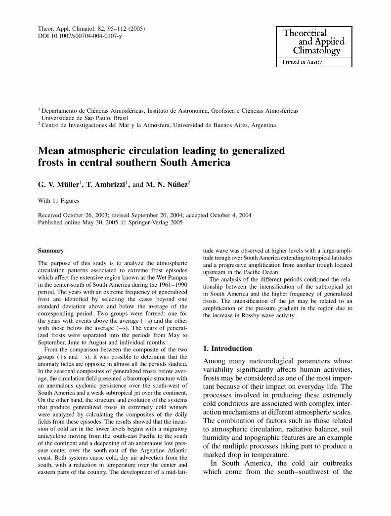
Theor. Appl. Climatol. 82, 95–112 (2005)DOI 10.1007/s00704-004-0107-y
1 Departamento de Cieencias Atmosf�eericas, Instituto de Astronomia, Geofisica e Cieencias Atmosf�eericasUniversidade de S~aao Paulo, Brasil
2 Centro de Investigaciones del Mar y la Atm�oosfera, Universidad de Buenos Aires, Argentina
Mean atmospheric circulation leading to generalizedfrosts in central southern South America
G. V. Muller1, T. Ambrizzi1, and M. N. Nunez2
With 11 Figures
Received October 26, 2003; revised September 20, 2004; accepted October 4, 2004Published online May 30, 2005 # Springer-Verlag 2005
Summary
The purpose of this study is to analyze the atmosphericcirculation patterns associated to extreme frost episodeswhich affect the extensive region known as the Wet Pampasin the center-south of South America during the 1961–1990period. The years with an extreme frequency of generalizedfrost are identified by selecting the cases beyond onestandard deviation above and below the average of thecorresponding period. Two groups were formed: one forthe years with events above the average (þs) and the otherwith those below the average (�s). The years of general-ized frosts were separated into the periods from May toSeptember, June to August and individual months.
From the comparison between the composite of the twogroups (þs and �s), it was possible to determine that theanomaly fields are opposite in almost all the periods studied.In the seasonal composites of generalized frosts below aver-age, the circulation field presented a barotropic structure withan anomalous cyclonic persistence over the south-west ofSouth America and a weak subtropical jet over the continent.On the other hand, the structure and evolution of the systemsthat produce generalized frosts in extremely cold winterswere analyzed by calculating the composites of the dailyfields from these episodes. The results showed that the incur-sion of cold air in the lower levels begins with a migratoryanticyclone moving from the south-east Pacific to the southof the continent and a deepening of an anomalous low pres-sure center over the south-east of the Argentine Atlanticcoast. Both systems cause cold, dry air advection from thesouth, with a reduction in temperature over the center andeastern parts of the country. The development of a mid-lati-
tude wave was observed at higher levels with a large-ampli-tude trough over South America extending to tropical latitudesand a progressive amplification from another trough locatedupstream in the Pacific Ocean.
The analysis of the different periods confirmed the rela-tionship between the intensification of the subtropical jetin South America and the higher frequency of generalizedfrosts. The intensification of the jet may be related to anamplification of the pressure gradient in the region due tothe increase in Rossby wave activity.
1. Introduction
Among many meteorological parameters whosevariability significantly affects human activities,frosts may be considered as one of the most impor-tant because of their impact on everyday life. Theprocesses involved in producing these extremelycold conditions are associated with complex inter-action mechanisms at different atmospheric scales.The combination of factors such as those relatedto atmospheric circulation, radiative balance, soilhumidity and topographic features are an exampleof the multiple processes taking part to produce amarked drop in temperature.
In South America, the cold air outbreakswhich come from the south–southwest of the
continent in winter, occur with a weekly or bi-weekly frequency. Mid and upper level circula-tion over South America during these outbreakshave a mid-latitude wave with a ridge to the westof the Pacific coast and a trough extendingtowards the southeast from the subtropicalregion of the south Atlantic (Garreaud, 2000).Krishnamutri et al. (1999) showed that the largeamplitude of the ridge-trough system duringthese episodes is the result of the overlap of thequick movement of the synoptic wave and quasi-stationary planetary waves. The largest amplifi-cation of the wave at upper levels during themature stage of the cold surge is, in part, dueto the baroclinic growth of the synoptic wavewith cold air at the low levels moving north-wards below the axis of the upper level trough(Marengo et al., 1997; Krishnamurti et al., 1999).As has been shown in the literature, the typicalfeature of these episodes is the presence of ananticyclonic surface disturbance over the coastof Chile, which enters South America to thesouth of 45� S, where the Andes are relativelylow, and moves along the Andes following acontinental path. The flow from the south, whichis typical of these situations, and its relation tothe channeling effect of the Andes, has beenobserved in climatological studies (Garreaud1998, 1991) as well as during some case studiesof frost events in the south and southeast ofBrazil (Marengo et al., 1997; Krishnamurti et al.,1999).
In an analysis of frequencies, intensities andextension of frosts, M€uuller et al. (2000) classifiedthese events into different groups according totheir spatial occurrence over a large region ofsouth-central South America known as the WetPampas. This region lies in a highly baroclinicarea associated with the passage of transientsystems. Small disturbances in the cyclone andanticyclone paths have a great impact on theoccurrence of frosts in central and northeasternArgentina. However, not all of these have thesame effect and questions have arisen such ashow and why some of these waves are colderthan others; why the propagation of one transientsystem is more able to penetrate even into tropi-cal latitudes than others; and why the persistenceof some systems is longer than others. Theemphasis on generalized frosts in this paperattempts to answer these questions. These events
have a spatial representativeness which in prin-ciple would make the sample homogeneous andspecifically independent from the intensity of thecold wave which affects the region, its latitudinalpenetration or its persistence. According to thespatial classification of M€uuller et al. (2000), thegeneralized frosts group is chosen for days whenmore than 75% of the Pampas meteorologicalstations registered temperatures less than orequal to 0�.
In a recent paper, M€uuller et al. (2003a) classi-fied the patterns associated with generalized andpartial frosts (0 �C from 25 to 75% of the meteo-rological stations) based on Principal Component(PC) Analysis. They made a synoptic-climaticclassification of atmospheric circulation in orderto obtain synoptic patterns related to frost in theWet Pampas. They analyzed synoptic situationsrepresented by surface pressure fields on dayswhen partial or generalized frosts occurred. Thedifferent situations obtained, represented by thefirst six PCs, explained 94% of the total variance.The most important patterns were representedby the 1st (Pattern A), 2nd (Pattern B) and 3rd PCs(Pattern C). Pattern A showed a high pressuresystem north of 40� S. This is connected to radia-tive cooling rather than advection since it hasweak gradients that give rise to light winds orcalm conditions over the Wet Pampas. PatternB consisted of a post-frontal high pressure sys-tem moving onto the continent towards the Poleat 40� S. This pattern generates south to south-west winds that cause a marked advection of verycold and dry polar air across the area, favoringadvection and frosts. Pattern C represents a lowpressure system to the east of the continent and ahigh pressure system entering from the Pacific,affecting the Wet Pampas from the west andproducing a strong flow of cold and dry air fromthe south. This situation is also associated with aridge in the middle troposphere that favors adrop in temperature due to clear skies andnocturnal radiation. The remaining patterns areconnected to cold anticyclones which causeadvective and=or radiative frosts.
In this paper, the seasonal and monthly circu-lation patterns of generalized frosts (Sects. 3.1and 3.2 respectively) are analyzed through thecomposite of atmospheric fields in the years ofextreme frequency of these episodes. The sea-sonal analysis was completed by making an
96 G. V. M€uuller et al.
analogy between the anomalous fields resultingfrom the composites of winters with generalizedfrosts above (below) average and those obtainedfor another group of cold (warm) anomalouswinters. The evolution of circulation fields be-fore and after the generalized frost, which tookplace during the winters of the years with a max-imum frequency of these events, was also studied(Sect. 3.3).
2. Data and methodology
Following the spatial criterion applied by M€uulleret al. (2000), generalized frosts days are definedas days on which minimum temperatures below0� were recorded at more than 75% of meteo-
rological stations in the Pampas (see their Fig. 1for stations location in the Argentine Pampas).Table 1 shows the number of generalized frostsfor each year from 1961 to 1990. In order tofacilitate the analysis, the events were separatedin the following periods: from May to September(MJJAS), June to August (JJA) and each monthof the frosts occurrence. Table 1 also indicates(in bold) the number of frosts above (þs) orbelow (�s) one standard deviation from the aver-age. This criterion was used to separate the high-est and lowest number of episodes in the period.Therefore, two groups were defined and compo-sites were calculated for different meteorologicalvariables. The anomalies of the following vari-ables were considered: sea-level pressure, upper
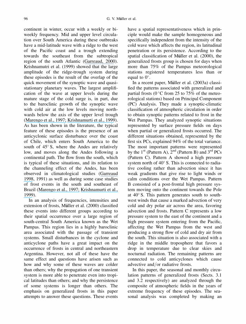
Fig. 1. Anomalies of (a) sea level pressure (hPa), (b) wind vector (m s�1) at 850 hPa, (c) surface temperature (�C) and (d)specific humidity (g kg�1) at 850 hPa, for composites of winters with generalized frosts above average (þ�). Positive(negative) contours in full (dotted) line
Mean atmospheric circulation in central southern South America 97
and lower level geopotential height, surface tem-perature, humidity at 850 hPa, wind vector at 850and 250 hPa, and zonal and meridional wind at250 hPa. Anomalies were calculated with respectto the 1968–1996 climatology for each periodanalyzed. The NCEP reanalyses data were usedwith a horizontal resolution of 2.5� latitude and2.5� longitude (Kalnay et al., 1996). For the SSTcomposites COADS data were used (Woodruff,1998).
The study of the patterns leading to general-ized frost was based on the composite of indivi-dual events during the winter (JJA). The selectioncriterion considered the spatial distribution ofthe explained variance for events in the band ofsynoptic scale. According to Escobar (2001) thisband is located between 3.7 and 6.6 days and
behaves fairly homogeneously across the wholeregion, covering south-central South America. Asimilar analysis was made for the longer wavesbetween 7.1 and 13 days and showed that thelargest variance is again in the same area, de-creasing southward. Based on these results aminimum of 7 days of time interval in a sequenceof days with generalized frosts will be consideredalong with the selected dates shown in Table 2.A comprehensive analysis of the evolution ofmean and anomaly fields of atmospheric circula-tion was made on the basis of the composite ofindividual events which covers three days beforethe event (identified as day 0) and one day after.
In order to determine whether the wintercirculation anomalies correspond to situationswhich favor extreme generalized frost or aresimply conditions characteristic of very cold orvery warm years, a selection of years with gener-alized frosts events above (below) average wereobtained for a group of anomalously cold (warm)winters. The classification of extreme winterswas based on the Barrucand and Rusticucci(2002) study. They defined extremely cold yearsas those with more than 65% of meteorologicalstations with cold minimum temperatures formany days and statistically significant. The extre-mely warm years correspond to those with lessthan 10% of the meteorological stations in whichextremely cold minimum temperatures wereregistered for the winter. Table 3 shows the yearsselected by this criterion from 1961 to 1990. Itshould be noted that the respective years
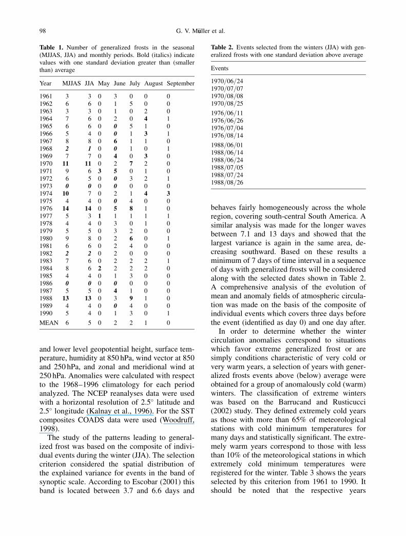
Table 1. Number of generalized frosts in the seasonal(MJJAS, JJA) and monthly periods. Bold (italics) indicatevalues with one standard deviation greater than (smallerthan) average
Year MJJAS JJA May June July August September
1961 3 3 0 3 0 0 01962 6 6 0 1 5 0 01963 3 3 0 1 0 2 01964 7 6 0 2 0 4 11965 6 6 0 0 5 1 01966 5 4 0 0 1 3 11967 8 8 0 6 1 1 01968 2 1 0 0 1 0 11969 7 7 0 4 0 3 01970 11 11 0 2 7 2 01971 9 6 3 5 0 1 01972 6 5 0 0 3 2 11973 0 0 0 0 0 0 01974 10 7 0 2 1 4 31975 4 4 0 0 4 0 01976 14 14 0 5 8 1 01977 5 3 1 1 1 1 11978 4 4 0 3 0 1 01979 5 5 0 3 2 0 01980 9 8 0 2 6 0 11981 6 6 0 2 4 0 01982 2 2 0 2 0 0 01983 7 6 0 2 2 2 11984 8 6 2 2 2 2 01985 4 4 0 1 3 0 01986 0 0 0 0 0 0 01987 5 5 0 4 1 0 01988 13 13 0 3 9 1 01989 4 4 0 0 4 0 01990 5 4 0 1 3 0 1
MEAN 6 5 0 2 2 1 0
Table 2. Events selected from the winters (JJA) with gen-eralized frosts with one standard deviation above average
Events
1970=06=241970=07=071970=08=081970=08=25
1976=06=111976=06=261976=07=041976=08=14
1988=06=011988=06=141988=06=241988=07=051988=07=241988=08=26
98 G. V. M€uuller et al.
obtained using the extreme criterion of general-ized frost frequency (Table 1) are within theabove mentioned group of extreme winters(Table 3). Therefore, this comparative analysisincludes all the years with anomalous winterswith the exception of those with extreme general-ized frosts (Table 2). The years of the anomalouscold winters (AC) are 1961, 1962, 1964, 1967,1983 and the anomalous warm winters (AW) cor-respond to 1972, 1977, 1985, 1987 and 1989.
3. Analysis of results
3.1 Seasonal composites
The seasonal analysis will concentrate on the JJAperiod once the composites obtained for MJJAS
show a similar atmospheric pattern structure,though with smaller amplitudes. Two wintergroups, one formed by the years with a general-ized frost frequency above average (þ�) andthe other with a generalized frost frequencybelow average (��) will be discussed next.
3.1.1 þ� winters
The results for the þ� winters show a surfacepressure field with a high pressure center insouthwestern South America at approximately110� W, 50� S with an anomaly greater than4 hPa (Fig. 1a). Physically, this anomaly reflectsa higher incidence of intense anticyclones whicheventually enter the continent around 35� Swhere the Andes are lower (approx. 2,000 m)(Garreaud, 2000; Seluchi and Marengo, 2000,among others). From the 850 hPa wind field(Fig. 1b), one can see a meridional flow in acrosssouthwest Argentina, favoring the channelingof cold air towards the whole country, verifiedby the negative temperature anomalies observedduring the three winters formed by the composite(Fig. 1c). From a climatic-synoptic point of view,the anticyclones cause advective and=or radiativecooling depending on their location over the con-tinent. They are the most frequent events respon-sible for the frosts in the Wet Pampas region(M€uuller et al., 2003a). These extreme conditionsare accompanied by low humidity all overArgentina, particularlly in the Pampas (Fig. 1d).
Table 3. Anomalous cold and warm winters in the period1961–1990, from the classification of Barrucand andRusticucci (2002)
Anomalous cold winters Anomalous warm winters
1961 19681962 19721964 19731967 19771970 19821976 19851983 19861988 1987
1989
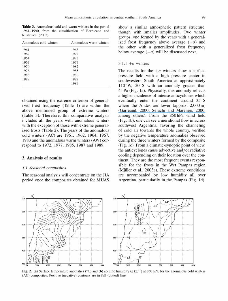
Fig. 2. (a) Surface temperature anomalies (�C) and (b) specific humidity (g kg�1) at 850 hPa, for the anomalous cold winters(AC) composites. Positive (negative) contours are in full (dotted) line
Mean atmospheric circulation in central southern South America 99
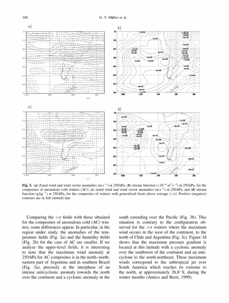
Comparing the þ� fields with those obtainedfor the composites of anomalous cold (AC) win-ters, some differences appear. In particular, in theregion under study, the anomalies of the tem-perature fields (Fig. 2a) and the humidity fields(Fig. 2b) for the case of AC are smaller. If weanalyze the upper-level fields, it is interestingto note that the maximum wind anomaly at250 hPa for AC composites is in the north–north-eastern part of Argentina and in southern Brazil(Fig. 3a), precisely at the interphase of anintense anticyclonic anomaly towards the northover the continent and a cyclonic anomaly in the
south extending over the Pacific (Fig. 3b). Thissituation is contrary to the configuration ob-served for the þ� winters where the maximumwind occurs in the west of the continent, to thenorth of Chile and Argentina (Fig. 3c). Figure 3dshows that the maximum pressure gradient islocated at this latitude with a cyclonic anomalyover the southwest of the continent and an anti-cyclone to the north-northeast. These maximumwinds correspond to the subtropical jet overSouth America which reaches its extreme tothe north, at approximately 26.8� S, during thewinter months (Antico and Berri, 1999).
Fig. 3. (a) Zonal wind and wind vector anomalies (m s�1) at 250 hPa, (b) stream function (�10�6 m2 s�1) at 250 hPa, for thecomposites of anomalous cold winters (AC); (c) zonal wind and wind vector anomalies (m s�1) at 250 hPa, and (d) streamfunction (g kg�1) at 250 hPa, for the composites of winters with generalized frosts above average (þ�). Positive (negative)contours are in full (dotted) line
100 G. V. M€uuller et al.
The anomalies observed in the jet for bothþ� and AC may be related to the tropicalPacific Sea Surface Temperature (SST) anoma-lies. Grimm and Silva Dias (1995) suggestedthe existence of a link between SST in theeastern region of the tropical Pacific and anupper-level circulation anomaly which affectsthe jet. During a warm ENSO phase, Karoly(1989) found a global scale zonal wind patternat 200 hPa associated with the intensification ofthe subtropical jet. An anomalous warming inthe tropical ocean can intensify the convectionand therefore the Hadley cell. The hypothesisof an anomalous meridional direct circulationin the east Pacific which affects the subtropicaljet over South America during the EI Ni~nno andLa Ni~nna events has already been proposed byRopelewski and Halpert (1987 and 1989) andSouza and Ambrizzi (2002), among others.
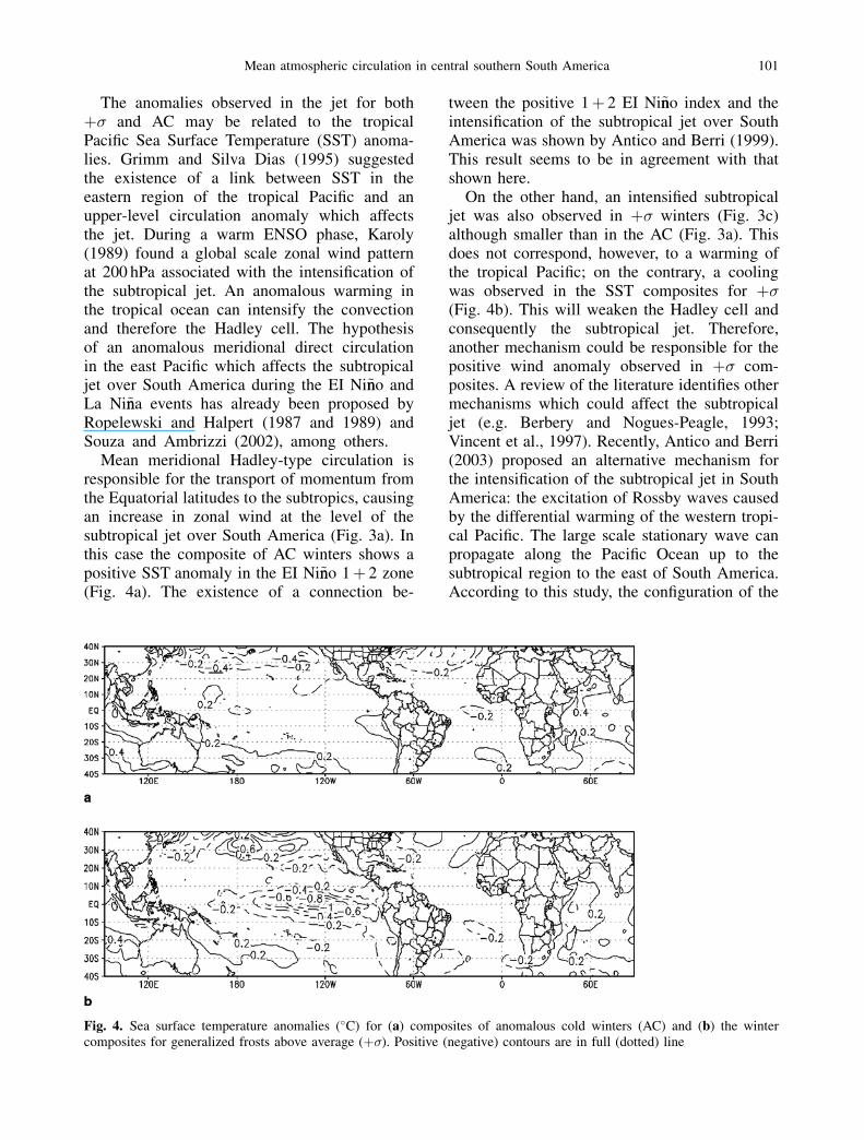
Mean meridional Hadley-type circulation isresponsible for the transport of momentum fromthe Equatorial latitudes to the subtropics, causingan increase in zonal wind at the level of thesubtropical jet over South America (Fig. 3a). Inthis case the composite of AC winters shows apositive SST anomaly in the EI Ni~nno 1þ 2 zone(Fig. 4a). The existence of a connection be-
tween the positive 1þ 2 EI Ni~nno index and theintensification of the subtropical jet over SouthAmerica was shown by Antico and Berri (1999).This result seems to be in agreement with thatshown here.
On the other hand, an intensified subtropicaljet was also observed in þ� winters (Fig. 3c)although smaller than in the AC (Fig. 3a). Thisdoes not correspond, however, to a warming ofthe tropical Pacific; on the contrary, a coolingwas observed in the SST composites for þ�(Fig. 4b). This will weaken the Hadley cell andconsequently the subtropical jet. Therefore,another mechanism could be responsible for thepositive wind anomaly observed in þ� com-posites. A review of the literature identifies othermechanisms which could affect the subtropicaljet (e.g. Berbery and Nogues-Peagle, 1993;Vincent et al., 1997). Recently, Antico and Berri(2003) proposed an alternative mechanism forthe intensification of the subtropical jet in SouthAmerica: the excitation of Rossby waves causedby the differential warming of the western tropi-cal Pacific. The large scale stationary wave canpropagate along the Pacific Ocean up to thesubtropical region to the east of South America.According to this study, the configuration of the
Fig. 4. Sea surface temperature anomalies (�C) for (a) composites of anomalous cold winters (AC) and (b) the wintercomposites for generalized frosts above average (þ�). Positive (negative) contours are in full (dotted) line
Mean atmospheric circulation in central southern South America 101
anomaly pattern generates a pressure gradientthat strengthens the western circulation in theregion of the jet.
The interaction between tropical convectionand global circulation may occur through the dis-persion of the extratropical Rossby waves, which
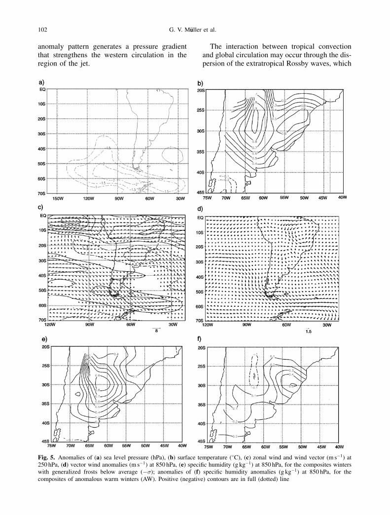
Fig. 5. Anomalies of (a) sea level pressure (hPa), (b) surface temperature (�C), (c) zonal wind and wind vector (m s�1) at250 hPa, (d) vector wind anomalies (m s�1) at 850 hPa, (e) specific humidity (g kg�1) at 850 hPa, for the composites winterswith generalized frosts below average (��); anomalies of (f) specific humidity anomalies (g kg�1) at 850 hPa, for thecomposites of anomalous warm winters (AW). Positive (negative) contours are in full (dotted) line
102 G. V. M€uuller et al.
move towards the Equator. On the other hand,wave propagation essentially depends on thestructure of the basic state and the source of heat(Ambrizzi et al., 1995). With a basic state formedby the þ� winters, M€uuller et al. (2003b) showedthe tropical-extratropical interaction through anumerical study. According to them, the differ-ential warming observed in the western tropicalPacific acts as a Rossby wavemaker, whichpropagate to the South American continent. As aresult, the anomalies in the fields of stream func-tion, shown in Fig. 3d, are the result of Rossbywave action, generating a pressure gradient thatintensifies the subtropical jet in South America(Fig. 3c).
3.1.2 �� winters
The surface field in Fig. 5a shows the prevalenceof a negative pressure anomaly in southwestSouth America, blocking the flow towards thecontinent. Physically consistent with what hasbeen said about the þ� group, these anomaliesindicate a lower than normal recurrence of coldmigratory anticyclones in the region, whichagrees with the smaller number of frosts in theWet Pampas. This explains the high temperaturesobserved in Argentina during these winters andeven the absence of generalized frosts in the WetPampas during 1973 and 1986 (see Table 1). Thisevidence is corroborated by the composites oftemperature anomaly fields for �� winters witha prevalence of positive anomalies in the wholecentral and northern part of the country (Fig. 5b).
The wind composites in Fig. 5c show theweakening of the subtropical jet around 25� S.This pattern favors the occurrence of positivetemperature anomalies in the Wet Pampas as thisallows a quick passage of frontal systems to thenorth of 30� S and the re-establishment of thecirculation with a northern component over mostof Argentina (Fig. 5d). This explains the highhumidity values observed in the north and centralparts of the country (Fig. 5e).
Comparing these results with those obtainedfor the warm anomalous (AW) winters, differ-ences appear mainly in the values of the anoma-lies rather than the configuration of the fields, asoccurred in the AC winters. The temperature andhumidity fields for AW show anomalies of thesame sign but much less intense than in ��.The example is given for the composite of the
humidity field (Fig. 5f) indicating small negativevalues in the Wet Pampas region. The AW com-posites also show a weak subtropical jet (figurenot shown) similar to �� winters (Fig. 5c).
3.2 Monthly composites
In the monthly composites from May toSeptember, June is the only month presentinga below average number of frosts following thecriterion used (see item 2). The years whichform the composite for the different months,are not necessarily the same (see Table 1) andso the circulation anomaly fields may differ.August is a good example of this. The surfacepressure field configuration obtained for thismonth shows an important cyclonic anomalylocated to the south–east of the continent andan anticyclone in the south Pacific, which ismuch more intense than that observed inFig. 1a for JJA. This configuration affects thesouth and the coast of Argentina (Fig. 6a). AsFig. 6b suggests, this situation generates a flowfrom the southwest to 40� S approximately. Thecirculation anomaly and low temperatures overthe whole of Argentina (Fig. 6c) characterize asynoptic condition which favors frosts in theWet Pampas. This configuration may be asso-ciated with to the most frequent frost patternin the Pampas region following M€uuller et al.(2003a) synoptic-climatic classification. This isrepresented by the presence of cyclonic circula-tion towards the south of the continent andanticyclonic to the north of 40� S, favoringsubsidence conditions, weak surface winds, lowhumidity and clear skies, all of which causenocturnal radiative cooling.
Surface circulation in July is basically repre-sented by the same structure as that obtainedfor the þ� seasonal composite (see Fig. 1a). Inthis case the positive pressure anomaly is moreintense, affecting the northeast of Argentinaand southeast of Brazil (Fig. 6d). This configura-tion is represented by the pattern of the 4th PCin the classification of M€uuller et al. (2003a)and corresponds to an anticyclone which favorsradiative loss in its region of influence. Frost for-mation, in this case, is favored by the anticyclon-ic anomaly in the southwest of the continent,mentioned previously in the þ� composites oncea succession of anticyclones in the same regionenhances frost formation.
Mean atmospheric circulation in central southern South America 103
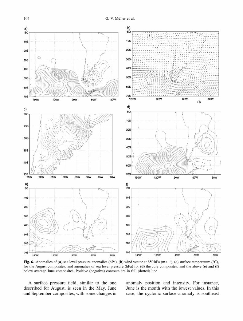
A surface pressure field, similar to the onedescribed for August, is seen in the May, Juneand September composites, with some changes in
anomaly position and intensity. For instance,June is the month with the lowest values. In thiscase, the cyclonic surface anomaly is southeast
Fig. 6. Anomalies of (a) sea level pressure anomalies (hPa), (b) wind vector at 850 hPa (m s�1), (c) surface temperature (�C),for the August composites; and anomalies of sea level pressure (hPa) for (d) the July composites; and the above (e) and (f)below average June composites. Positive (negative) contours are in full (dotted) line
104 G. V. M€uuller et al.
of the Argentine coast while the anticyclonicanomaly is near the continent in the east Pacific(Fig. 6e). This pattern coincides with the 3rd PC,according to the decreasing order of explainedvariance in the classification of synoptic eventscausing frosts in the Wet Pampas (M€uuller et al.,2003a).
The only month that presented below averagefrost occurrence was June, and its composite showsa cyclonic anomaly dominating most of Argentina(Fig. 6f). This feature is different to the oneobtained for the �� winters which only occupiesthe south of the continent and spreads to the eastPacific (Fig. 5a). The prevalence of this configura-tion does not favor surface temperature dropswhich explains the absence of generalized frostsduring the years of the June composites (Table 1).
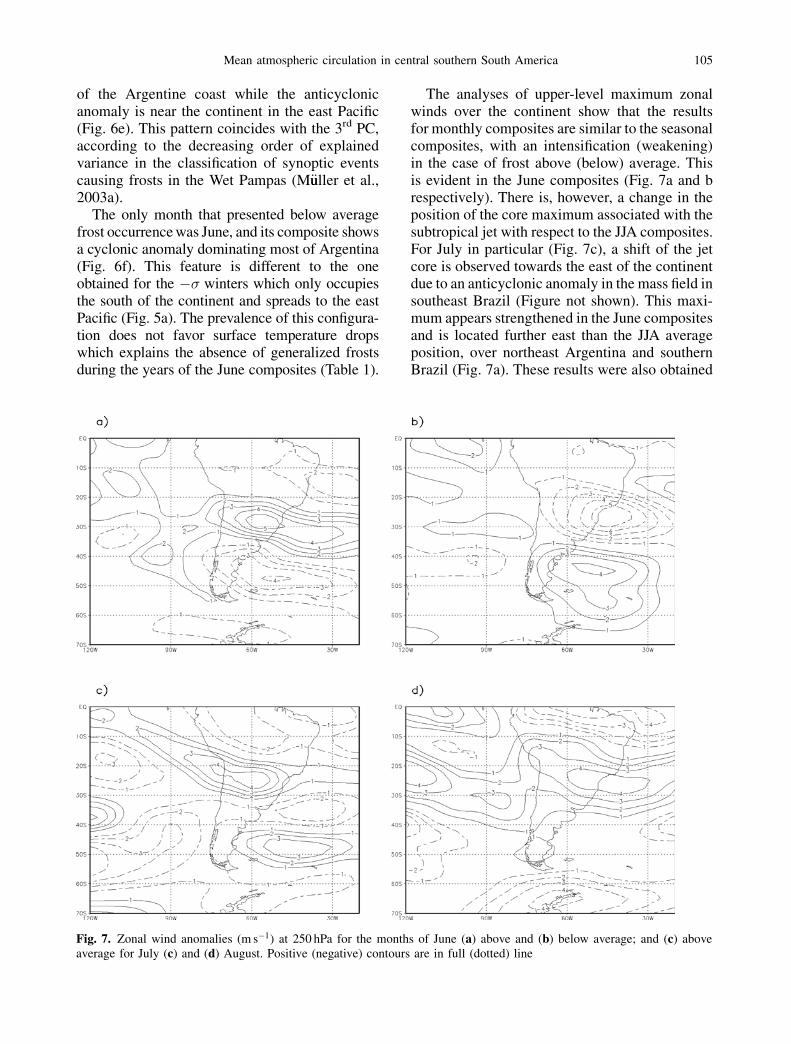
The analyses of upper-level maximum zonalwinds over the continent show that the resultsfor monthly composites are similar to the seasonalcomposites, with an intensification (weakening)in the case of frost above (below) average. Thisis evident in the June composites (Fig. 7a and brespectively). There is, however, a change in theposition of the core maximum associated with thesubtropical jet with respect to the JJA composites.For July in particular (Fig. 7c), a shift of the jetcore is observed towards the east of the continentdue to an anticyclonic anomaly in the mass field insoutheast Brazil (Figure not shown). This maxi-mum appears strengthened in the June compositesand is located further east than the JJA averageposition, over northeast Argentina and southernBrazil (Fig. 7a). These results were also obtained
Fig. 7. Zonal wind anomalies (m s�1) at 250 hPa for the months of June (a) above and (b) below average; and (c) aboveaverage for July (c) and (d) August. Positive (negative) contours are in full (dotted) line
Mean atmospheric circulation in central southern South America 105
by Antico and Berri (1999) who showed anincrease in the mean intensity of the subtropicaljet over South America in June compared to July.The composites of the years with frosts aboveaverage in August show a large positive zonalwind anomaly which extends along the Pacificwith one of its main cores to the east of the con-tinent over southern Brazil (Fig. 7d).
3.3 Daily composites
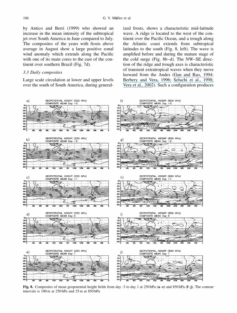
Large scale circulation at lower and upper levelsover the south of South America, during general-
ized frosts, shows a characteristic mid-latitudewave. A ridge is located to the west of the con-tinent over the Pacific Ocean, and a trough alongthe Atlantic coast extends from subtropicallatitudes to the south (Fig. 8, left). The wave isamplified before and during the mature stage ofthe cold surge (Fig. 8b–d). The NW–SE direc-tion of the ridge and trough axes is characteristicof transient extratropical waves when they moveleeward from the Andes (Gan and Rao, 1994;Berbery and Vera, 1996; Seluchi et al., 1998;Vera et al., 2002). Such a configuration produces
Fig. 8. Composites of mean geopotential height fields from day -3 to day 1 at 250 hPa (a–e) and 850 hPa (f–j). The contourintervals is 100 m at 250 hPa and 25 m at 850 hPa
106 G. V. M€uuller et al.
strong anticyclonic vorticity advection to the eastof the Andes between 30� S and 40� S (Garreaud,2000), latitudes that include the Wet Pampasregion. In addition, the amplification of a troughto the east of 180� W is impressive at lower levels(Fig. 8, right). Krishnamurti et al. (1999) showedthat a downstream amplification mechanism ofwaves propagating along the Pacific on daysprior to the event, could be a precursor of the
stronger frosts in southeast Brazil. It manifestsitself by ridges and troughs that propagate tothe east. In an analysis of these events, they sug-gested that the growth of long stationary wavesmay be due to scale interaction between the com-ponents of the wave.
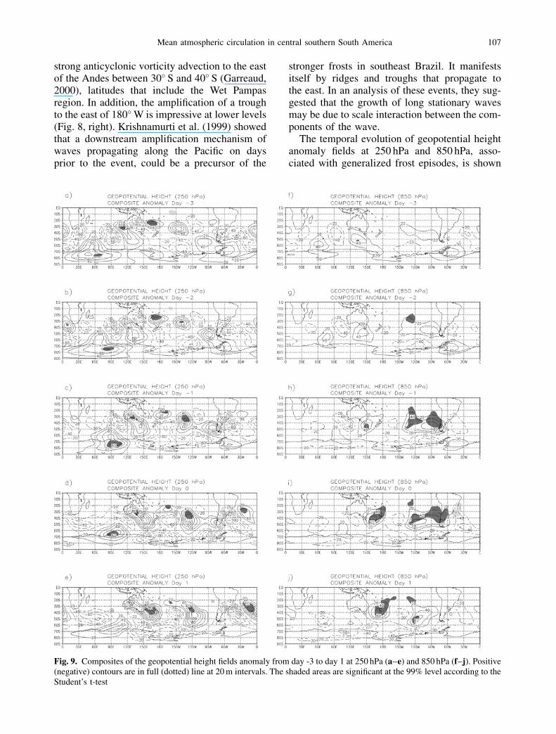
The temporal evolution of geopotential heightanomaly fields at 250 hPa and 850 hPa, asso-ciated with generalized frost episodes, is shown
Fig. 9. Composites of the geopotential height fields anomaly from day -3 to day 1 at 250 hPa (a–e) and 850 hPa (f–j). Positive(negative) contours are in full (dotted) line at 20 m intervals. The shaded areas are significant at the 99% level according to theStudent’s t-test
Mean atmospheric circulation in central southern South America 107
in Fig. 9. At upper levels, the anomalies oversouthern South America show wave propagationtowards the Equator three days before the event(Fig. 9a–d) with a progressive deepening andintensification of a significant negative anomalyfollowed by a positive anomaly to the southwestof the continent. The position of both vorticesdetermines the leading movement observed atlow levels, where a positive anomaly associatedwith an anticyclone from day 2 starts to penetratethrough the high latitudes of South America atthe lowest part of the Andes (Fig. 9g–h). Then,the rapid propagation leeward of the Andes iscaused by the effect this has on the systems(Marengo, 1997; Garreaud, 2000; Seluchi andMarengo, 2000). On day 0 (Fig. 9i), the anomalyhas spread over the whole country. Vera andVigliarolo (2000) showed that the intensificationof the leeward anticyclonic disturbance is pro-duced by a strong meridional ageostrophic cir-culation on the polar side of the frontal surfacewhich accompanies the advection of cold airwhich affect South America. These authors alsoobserved a cyclonic disturbance entering the eastof the continent from subpolar latitudes. Figure 9,on the right, shows a negative anomaly locatedto the east of the positive anomaly over the SouthAtlantic 2 days prior to the event, intensifyingtowards day 0 which is statistically significantat the 99% level. In this way, the cold air advec-tion coming from the south, due to the surface
anticyclone, is reinforced by this cyclonic anom-aly and together they cause an extensive coolingover the region. The type of configuration de-scribed here is one of the most frequent pat-terns responsible for frosts in the Wet Pampas,according to M€uuller et al. (2003a) climatic-synoptic classification, representing their 2nd
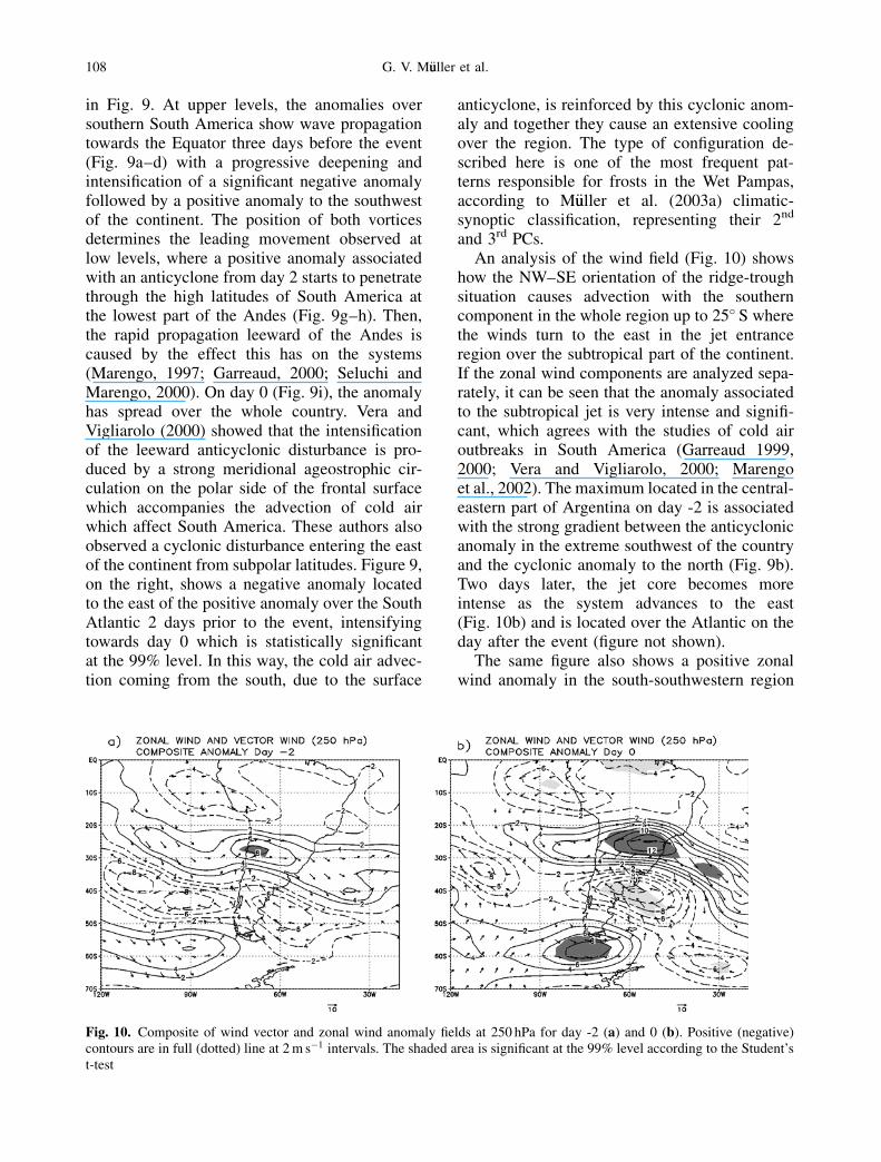
and 3rd PCs.An analysis of the wind field (Fig. 10) shows
how the NW–SE orientation of the ridge-troughsituation causes advection with the southerncomponent in the whole region up to 25� S wherethe winds turn to the east in the jet entranceregion over the subtropical part of the continent.If the zonal wind components are analyzed sepa-rately, it can be seen that the anomaly associatedto the subtropical jet is very intense and signifi-cant, which agrees with the studies of cold airoutbreaks in South America (Garreaud 1999,2000; Vera and Vigliarolo, 2000; Marengoet al., 2002). The maximum located in the central-eastern part of Argentina on day -2 is associatedwith the strong gradient between the anticyclonicanomaly in the extreme southwest of the countryand the cyclonic anomaly to the north (Fig. 9b).Two days later, the jet core becomes moreintense as the system advances to the east(Fig. 10b) and is located over the Atlantic on theday after the event (figure not shown).
The same figure also shows a positive zonalwind anomaly in the south-southwestern region
Fig. 10. Composite of wind vector and zonal wind anomaly fields at 250 hPa for day -2 (a) and 0 (b). Positive (negative)contours are in full (dotted) line at 2 m s�1 intervals. The shaded area is significant at the 99% level according to the Student’st-test
108 G. V. M€uuller et al.
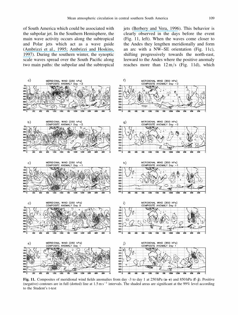
of South America which could be associated withthe subpolar jet. In the Southern Hemisphere, themain wave activity occurs along the subtropicaland Polar jets which act as a wave guide(Ambrizzi et al., 1995; Ambrizzi and Hoskins,1997). During the southern winter, the synopticscale waves spread over the South Pacific alongtwo main paths: the subpolar and the subtropical
jets (Berbery and Vera, 1996). This behavior isclearly observed in the days before the event(Fig. 11, left). When the waves come closer tothe Andes they lengthen meridionally and forman arc with a NW–SE orientation (Fig. 11c),shifting progressively towards the north-east,leeward to the Andes where the positive anomalyreaches more than 12 m=s (Fig. 11d), which
Fig. 11. Composites of meridional wind fields anomalies from day -3 to day 1 at 250 hPa (a–e) and 850 hPa (f–j). Positive(negative) contours are in full (dotted) line at 1.5 m s�1 intervals. The shaded areas are significant at the 99% level accordingto the Student’s t-test
Mean atmospheric circulation in central southern South America 109

agrees with other studies (Berbery and Vera,1996; Vera and Vigliarolo, 2000). Once thewaves have crossed the Andes, they spread to-wards the north developing in a way which isconsistent with the concept of Rossby wave dis-persion on a sphere (Hsu, 1987). Comparing thesurface meridional wind (on the right) with theupper levels (on the left, Fig. 11) the typicalstructure of a synoptic scale wave can be seenwith a significant meridional wind anomalywhich reaches its peak at upper levels and leanstowards the south-west with height. On thesurface, the train of shorter waves appears lessintense and organized than at upper levels excepton days 0 and 1 when there is a strong flowtowards the Equator, leeward of the Andes, evenreaching subtropical latitudes, with a 99% signif-icance level.
4. Conclusions
The analysis of atmospheric field composites ofgeneralized frost periods with an extreme occur-rence frequency indicate that these episodes arerelated to large scale patterns characterized bywell-defined wind and pressure fields.
The anomalous anticyclonic circulation ob-served in the composites of periods with a num-ber of frost episodes above the average (þ�),suggests a greater anticyclonic activity allowingthe entrance of cold air into the South Ameri-can continent. The prevalence of this situationexplains the low temperatures identified dur-ing the winters with a maximum number ofgeneralized frosts. A similar configuration is ob-served in the composites for July, where a strongpositive anomaly located to the north-eastof Argentina and south of Brazil is observed.In the May, June and September composites, acyclonic anomaly over south-east Argentina iscoupled with the positive anomaly in the eastPacific. The mean surface fields obtained fromthe monthly composites were able to reproducethe most frequent situations which result in frostsin the Wet Pampas. According to the M€uuller et al.(2003a) synoptic-climatic classification, there aresix patterns which explain 94% of the varianceand therefore represent the most frequent synop-tic conditions responsible for frosts in the areaunder study. The first four patterns have beenlinked to generalized frosts according to the
results of the composites for each of the monthsanalyzed.
The surface circulation observed for the wintercomposites with a number of events below aver-age (��), reflects a decrease in the passage ofanticyclones on the continent. The opposite pat-tern between the two groups, þ� and ��, wasobserved in all the variables analyzed. The posi-tive values in surface temperature anomalies andin the humidity field are characteristic of the ��winter composites, responding to the prevalenceof the northern flow showed in the low level windanomaly field which affects the whole of theWet Pampas region. For the monthly analysis, theprevalent surface situation corresponds to anegative pressure anomaly affecting the extremesouth of the continent, explaining the absence ofgeneralized frosts during the period.
To determine whether the winter circulationanomalies correspond to situations which favorextreme generalized frosts or are simply charac-teristic of colder or warmer years, the resultsobtained for the þ� and �� winters were com-pared with a group of unusually cold and warmyears (AC and AW), respectively. All the yearshaving higher (smaller) number of generalizedfrosts in the Wet Pampas correspond to winterswhich were extremely cold (warm) in centralArgentina. This implies that, even though theseyears had anomalous temperatures, there are fea-tures of the atmospheric circulation which favoror inhibit conditions of extensive frosts in thePampas, causing an extreme occurrence of suchevents.
The results presented here show differencesbetween the þ� winter composites and thoseobtained for AC winters and between the ��winter composites and those of AW winters. Dif-ferences in the humidity and temperature fieldsin particular, are associated with the circulation ineach case, characterized by a similar structurein the groups compared, but with differences inthe anomaly values. The intense positive anomalyin the pressure field located to the south-west ofthe continent for þ� composites, is considerablygreater than in AC. The upper-level field is alsodifferent in the two pressure fields. The majorconsequence can be seen in the subtropical jetin South America. Although both the þ� wintercomposites and the AC present an intensificationof the subtropical jet over South America, the
110 G. V. M€uuller et al.
mechanism causing this anomaly could be differ-ent in each case. During the AC winters theintensification of the Hadley cell due to a warm-ing in the east of the tropical Pacific may be themost important contributor, while in the þ� adifferential warming in the west tropical Pacificcan act as a Rossby wavemaker, which propa-gates beyond the tropics. Thus, the mass fieldconfiguration may result in an increased pressuregradient and a more intense subtropical jet inSouth America. These results support M€uulleret al.’s (2003b) hypothesis that a teleconnectionmechanism would be the precursor of general-ized frosts in the Wet Pampas.
Both the AW and the �� winters have a nega-tive wind anomaly in the South American sub-tropical jet region, indicating a prevalence offlow from the east. The weakening of the jet dur-ing the winter may suggest some dynamic pro-cess changes in the maintenance of the jet andwhich could be associated with the reduction ofextensive frosts in southern South America oreven a complete absence during some winters,as occurred in 1973 and 1986.
The monthly composites of the subtropical jetin South America show similar results as the sea-sonal composites, with an intensification (weak-ening) in the case of frosts above (below) averageand some changes in position and intensity of theanomalies during the months.
The analysis of daily composites of general-ized frosts which occurred during the winterswith events above average, shows a large-amplitude trough in middle latitudes whichextends over the continent towards the tropicalregions and a progressive amplification fromanother trough located in the Pacific to the eastof 180� W. Ahead of this trough, the associatedgeopotential field positive anomaly presents sta-tistically significant values (99% level) from daysprior to and even after the event. A significantupper-level cyclonic disturbance to the east ofthe Andes at subtropical latitudes can be seenon days preceding event. At the surface there isa progressive deepening of a significant cyclonicanomaly located over the Atlantic. This extendstowards South America from subpolar latitudestogether with an anticyclonic anomaly whichenters from the south-west of the southern cone.Both cause the prevalence of cold air advectionfrom the south which causes generalized frosts.
Acknowledgements
IAI-CRN 055 and CNPq 302459=02-2 projects supportedthis study. GM is also grateful for the CNPq grant no.1900057=02-5 and for the help of Simone Ferraz in prepar-ing the figures.
References
Ambrizzi T, Hoskins BJ, Hsu HH (1995) Rossby wavepropagation and teleconnection patterns in the australwinter. J Atmos Sci 52: 3661–3672
Ambrizzi T, Hoskins BJ (1997) Stationary Rossby wavepropagation in a baroclinic atmosphere. Quart J RoyMeteor Soc 123: 919–928
Antico PL, Berri GJ (1999) Variability of the intensity andlatitudinal position of the subtropical jet stream overSouth America and its relationship with the sea surfacetemperatures of the equatorial Pacific Ocean. Preprints,Eighth Conference on Climate Variations, Denver, CO,Amer Meteor Soc, pp 122–125
Barrucand MG, Rusticucci MM (2002) Climatologıa detemperaturas extremas en la Argentina. Variablidad tem-poral y regional. Meteorol�oogica 26: 85–101
Berbery EH, Nogues-Paegle J, Horel J (1992) WavelikeSouthern Hemisphere extratropical teleconnections.J Atmos Sci 49: 155–177
Berbery EH, Vera CS (1996) Characteristics of the Southernhemisphere winter storm track with filtered and unfiltereddata. J Atmos Sci 53: 468–481
Escobar GCJ (2001) La circulaci�oon en la trop�oosfera asociadacon irrupciones de aire frıo en el centro de Argentina.Tesis Doctoral. Ciencias de la Atm�oosfera, Facultad deCiencias Exactas y Naturales, Universidad de BuenosAires. Pag 136
Gan MA, Rao VB (1994) The influence of the Andescordillera on transient disturbances. Mon Wea Rev 122:1141–1157
Garreaud RD, Wallace JM (1998) Summertime incursionsof midlatitude air into tropical and subtropical SouthAmerica. Mon Wea Rev 126: 2713–2733
Garreaud RD (1999) Cold air incursions over subtropicaland tropical South America. A numerical case study.Mon Wea Rev 122: 2823–2853
Garreaud RD (2000) Cold air incursions over subtropicalSouth America: mean structure and dynamics. Mon WeaRev 128: 2544–2559
Hsu HH (1987) Propagation of low-level circulationfeatures in the vicinity of mountain ranges. Mon WeaRev 115: 1864–1892
Kalnay E, Kanamitsu M, Kistler R, Collins W, Deaven D,Gandin L, Iredell M, Saha S, White G, Woollen J, Zhu Y,Celliah M, Ebisuzaki W, Higgins W, Janowiak J, Mo KC,Ropelewski C, Wang J, Leetmaa A, Reynolds R, Jenne RE,Joseph D (1996) The Ncep=Ncar 40-Year ReanalysisProject. Bull Amer Meteor Soc 77(3): 437–471
Krishnamurti TN, Tewari M, Chakraborty DR, Marengo JA,Silva Dias PL, Satyamurti P (1999) Downstream ampli-fication: A possible precursor to major freeze events oversouth-eastern Brazil. Wea Forecast 14: 242–270
Mean atmospheric circulation in central southern South America 111
Marengo JA, Ambrizzi T, Kiladis G, Liebmann B (2002)Upper-air wave trains over the Pacific Ocean and winter-time cold surges in tropical-subtropical South Americaleading to Freezes in Southern and Southeastern Brazil.Theor Appl Climatol 74: 243–247
Marengo JA, Cornejo A, Satyamurty P, Nobre C, Sea W(1997) Cold surges in tropical and extratropical SouthAmerica: The strong event in June 1994. Mon Wea Rev125: 2759–2786
M€uuller GV, Nu~nnez MN, Seluchi ME (2000) Relationshipbetween ENSO cycles and frosts events within the PampaH�uumeda Region. Int J Climatol 20: 1619–1637
M€uuller GV, Compagnucci RH, N�uu~nnez MN, Salles MA(2003a) Spatial analysis of surface circulation associatedto frosts in the wet Pampas. Int J Climatol 23: 943–961
M€uuller GV, Ambrizzi T, Nu~nnez MN, Ferraz S (2003b)Teleconnection between tropical west Pacific Convectionand Cold Surges in the Southern South America duringAustral Winter. 7th International Conference on SouthernHemisphere Meteorology and Oceanography. 24–28March, Wellington, New Zealand
Seluchi M, Serafini YV, Le Treut H (1998) The impact of theAndes on transient atmospheric systems: A comparisonbetween observations and GCM results. Mon Wea Rev126: 895–912
Seluchi ME, Marengo JA (2000) Tropical-midlatitudeexchange of air masses during summer and winter in
South America: climatic aspects and examples of intenseevents. Int J Climatol 20: 1167–1190
Souza EB, Ambrizzi T (2002) ENSO impacts on the SouthAmerican rainfall during 1980s: Hadley and Walkercirculation. Atm�oosfera 15: 105–120
Vera CS, Vigliarolo PK (2000) A diagnostic study of cold-airoutbreaks over South America. Mon Wea Rev 128: 3–24
Vera CS, Vigliarolo PK, Berbery EH (2002) Cold seasonwaves over subtropical South America. Mon Wea Rev130: 684–699
Woodruff SD, Dias HF, Elms JD, Worley SJ (1998) COADSrelease 2 data and metadata enhancements for improve-ments of marine surface flux fields. Phys Chem Earth 23:517–526
Yu JY, Hartmann DL (1995) Orographic influences on thedistribution and generation of atmospheric variability in aGCM. J Atmos Sci 52: 2428–2443
Authors’ addresses: Gabriela V. M€uuller (e-mail: [email protected]), Tercio Ambrizzi (e-mail: [email protected]), Departamento de Cieencias Atmosf�eericas,Instituto de Astronomia, Geofısica e Cieencias Atmosf�eericas,Universidad de S~aao Paulo, Rua do Mat~aao 1226, 05508-900S~aao Paulo, Brazil; Mario N. N�uu~nnez, Centro de Investiga-ciones del Mar y la Atm�oosfera (CONICET=UBA), Universi-dad de Buenos Aires, Argentina.
112 G. V. M€uuller et al.: Mean atmospheric circulation in central southern South America