Mars Express Interplanetary Navigation from Launch to Mars Orbit Insertion: The JPL Experience
6
MARS EXPRESS INTERPLANETARY NAVIGATION FROM LAUNCH TO MARS ORBIT INSERTION: THE JPL EXPERIENCE “18 TH INTERNATIONAL SYMPOSIUM ON SPACE FLIGHT DYNAMICS” Dongsuk Han (1) , Dolan Highsmith (2) , Moriba Jah (3) , Diane Craig (4) , James Border (5) , Peter Kroger (6) (1 – 6) Member Technical Staff, Jet Propulsion Laboratory, California Institute of Technology, 4800 Oak Grove Drive, Pasadena CA 91109 (USA), [email protected] ABSTRACT The Jet Propulsion Laboratory (JPL), California Institute of Technology and the National Aeronautics and Space Administration have played a significant role in supporting the safe arrival of the European Space Agency (ESA) Mars Express (MEX) orbiter to Mars on 25 December 2003. MEX mission is an international collaboration between member nations of the ESA and NASA, where NASA is supporting partner. JPL's involvement included providing commanding and tracking service with JPL's Deep Space Network (DSN), in addition to navigation assurance. The collaborative navigation effort between European Space Operations Centre (ESOC) and JPL is the first since ESA's last deep space mission, Giotto, and began many years before the MEX launch. This paper discusses the navigational experience during the cruise and final approach phase of the mission from JPL's perspective. Topics include technical challenges such as orbit determination using non-DSN tracking data and media calibrations, and modelling of spacecraft physical properties for accurate representation of non-gravitational dynamics. Also mentioned in this paper is preparation and usage of DSN Delta Differential One-way Range (Δ DOR) measurements, a key element to the accuracy of the orbit determination. 1. INTRODUCTION Mars Express was the first Mars interplanetary mission for the ESA, as well as its first deep space mission since Giotto, a mission to Comet Halley in the mid-1980s [1]. At that time, ESA established a relationship with the NASA JPL to assist with the deep space navigation. The success of the cooperation with Giotto led to the establishment of a similar relationship for tracking and navigation services for the Earth-to-Mars phase of MEX. 1.1 Mars Express Orbit Determination MEX launched 2 June 2003 from the Baikonur Cosmodrome in Kazakhstan. Trajectory correction maneuvers were made along the way to precisely target the release location of the Beagle 2 lander on 19 December 2003. The following day, MEX performed a maneuver to divert from the impact trajectory necessary for Beagle 2 to a path that allowed the spacecraft to enter orbit around the Red Planet. It arrived at Mars on 25 December 2003, performing a flawless capture maneuver [2]. A critical aspect of such interplanetary navigation is the orbit determination (OD). The OD evaluates radiometric and interferometric tracking data to estimate the spacecraft position and velocity, along with other dynamic modelling quantities like solar radiation pressure. These parameters are then used to predict the trajectory and design maneuvers to keep the spacecraft on its intended path. JPL heritage on deep space missions stretches back for 40 years, highlighted by flight-tested capabilities for trajectory modelling and orbit determination. The ESOC Flight Dynamics Division (FDD) developed new navigation software that required validation. The primary goal of the relationship between ESOC FDD and JPL Navigation was to produce comparisons of the output from their respective navigation tools, both before and after launch, to seek agreement in their basic capabilities. 1.2 JPL Navigation Responsibilities The specific responsibilities of NASA regarding the MEX mission are set forth in a Memorandum of Understanding (MOU) between ESA and NASA [3]. The MOU requires NASA to provide the following navigation related items: • Delta Differential One-way Ranging (ΔDOR); • Approach navigation support; • NASA-derived tracking data types for ESA validation of its navigation performance; • Pre- and post-launch navigation support in consultancy, independent cross-verification of navigation, consultancy on interplanetary operational issues and necessary tracking data produced from the NASA DSN to ESA; • All relevant review information as required supporting the above items.
Transcript of Mars Express Interplanetary Navigation from Launch to Mars Orbit Insertion: The JPL Experience
MARS EXPRESS INTERPLANETARY NAVIGATION FROM LAUNCH TO MARSORBIT INSERTION: THE JPL EXPERIENCE
“18TH INTERNATIONAL SYMPOSIUM ON SPACE FLIGHT DYNAMICS”
Dongsuk Han (1), Dolan Highsmith (2), Moriba Jah (3), Diane Craig (4), James Border (5), Peter Kroger (6)
(1 – 6) Member Technical Staff, Jet Propulsion Laboratory, California Institute of Technology, 4800 Oak Grove Drive,Pasadena CA 91109 (USA), [email protected]
ABSTRACT
The Jet Propulsion Laboratory (JPL), CaliforniaInstitute of Technology and the National Aeronauticsand Space Administration have played a significant rolein supporting the safe arrival of the European SpaceAgency (ESA) Mars Express (MEX) orbiter to Mars on25 December 2003. MEX mission is an internationalcollaboration between member nations of the ESA andNASA, where NASA is supporting partner. JPL'sinvolvement included providing commanding andtracking service with JPL's Deep Space Network (DSN),in addition to navigation assurance. The collaborativenavigation effort between European Space OperationsCentre (ESOC) and JPL is the first since ESA's last deepspace mission, Giotto, and began many years before theMEX launch. This paper discusses the navigationalexperience during the cruise and final approach phase ofthe mission from JPL's perspective. Topics includetechnical challenges such as orbit determination usingnon-DSN tracking data and media calibrations, andmodelling of spacecraft physical properties for accuraterepresentation of non-gravitational dynamics. Alsomentioned in this paper is preparation and usage ofDSN Delta Differential One-way Range (ΔD O R )measurements, a key element to the accuracy of theorbit determination.
1. INTRODUCTION
Mars Express was the first Mars interplanetary missionfor the ESA, as well as its first deep space mission sinceGiotto, a mission to Comet Halley in the mid-1980s [1].At that time, ESA established a relationship with theNASA JPL to assist with the deep space navigation. Thesuccess of the cooperation with Giotto led to theestablishment of a similar relationship for tracking andnavigation services for the Earth-to-Mars phase ofMEX.
1.1 Mars Express Orbit Determination
MEX launched 2 June 2003 from the BaikonurCosmodrome in Kazakhstan. Trajectory correctionmaneuvers were made along the way to precisely targetthe release location of the Beagle 2 lander on 19
December 2003. The following day, MEX performed amaneuver to divert from the impact trajectory necessaryfor Beagle 2 to a path that allowed the spacecraft toenter orbit around the Red Planet. It arrived at Mars on25 December 2003, performing a flawless capturemaneuver [2].
A critical aspect of such interplanetary navigation is theorbit determination (OD). The OD evaluates radiometricand interferometric tracking data to estimate thespacecraft position and velocity, along with otherdynamic modelling quantities like solar radiationpressure. These parameters are then used to predict thetrajectory and design maneuvers to keep the spacecrafton its intended path.
JPL heritage on deep space missions stretches back for40 years, highlighted by flight-tested capabilities fortrajectory modelling and orbit determination. The ESOCFlight Dynamics Division (FDD) developed newnavigation software that required validation. Theprimary goal of the relationship between ESOC FDDand JPL Navigation was to produce comparisons of theoutput from their respective navigation tools, bothbefore and after launch, to seek agreement in their basiccapabilities.
1.2 JPL Navigation Responsibilities
The specific responsibilities of NASA regarding theMEX mission are set forth in a Memorandum ofUnderstanding (MOU) between ESA and NASA [3].The MOU requires NASA to provide the followingnavigation related items:
• Delta Differential One-way Ranging (ΔDOR);• Approach navigation support;• NASA-derived tracking data types for ESA
validation of its navigation performance;• Pre- and post-launch navigation support in
consultancy, independent cross-verification ofnavigation, consultancy on interplanetaryoperational issues and necessary tracking dataproduced from the NASA DSN to ESA;
• All relevant review information as requiredsupporting the above items.
Montenbruck
“18TH INTERNATIONAL SYMPOSIUM ON SPACE FLIGHT DYNAMICS”

1.3 JPL Role in Operations
Much of the cross-verification of navigation softwareand validation of tracking data types occurred prior tothe MEX launch, making use of tracking data from theUlysses spacecraft [4]. The focus of this paper,however, is the role that JPL Navigation played in MEXflight operations during Earth-to-Mars cruise.
Activities performed included a final software cross-verification test during an intensive two-week trackingcampaign two months after launch; implementation andtesting of ΔDOR measurements to greatly improve theaccuracy of the orbit determination; and approachnavigation support in the form of daily solutionexchanges during the last several weeks before reachingMars. Products provided in addition to those required bythe MOU included estimates of the Beagle 2atmospheric entry interface point and landing ellipse.The following sections provide details of each of theseactivities to summarize the JPL experience regardingMEX Earth-to-Mars navigation.
2. DYNAMIC MODELLING
Of the elements required to deliver a spacecraftsuccessfully to Mars, proper dynamic modelling of thespacecraft is of prime importance. The gravitationalinfluences upon the spacecraft are well understood andmodelled in high fidelity. The forces that become lesstrivial to model are those due to non-gravitationalsources. These forces can be understood as those due tosolar radiation pressure, trajectory correction maneuvers(TCM), momentum wheel off-loadings (WOLs), andpossible outgassing events. Residual accelerationmodels may also be required due to inexact orapproximate modelling of the dynamics impressed uponthe spacecraft.
2.1 ESOC Inputs
JPL Navigation relied upon ESOC Flight Dynamics toprovide appropriate information concerning spacecraftdynamics. As part of the JPL Navigation/ESOC FDDagreement [5], a set of interface files was defined toprovide this information. The files containedinformation related to the spacecraft attitude andplanned thrusting events. Other relevant files providedas a means of dynamic model verification were aninertial accelerations file and a solar radiation pressureacceleration file.
Various scripts were employed to ingest these interfacefiles and produce the appropriate inputs for the JPLnavigation software. On a routine basis, the inputs usedfor orbit determination and trajectory modellingincluded the following:
• Maneuver summary, which included previouslyperformed TCMs and WOLs reconstructed fromspacecraft telemetry.
• Predicted maneuvers, which included thepreliminary values for future TCMs and WOLs.
• Spacecraft attitude quaternions.• Solar panel orientation (gimbal angles).
Each input provided key dynamic modellinginformation that allowed for more accurate estimationof thrusting events, solar radiation pressure, andtrajectory prediction. As an example, withoutaccounting for the commanded attitude and solar panelorientations, a noticeable dynamic mismodellingsignature is introduced in the tracking data residuals.This, in turn, can be aliased into the spacecraft stateestimation, producing a less accurate estimate of its trueorbit.
2.2 JPL Models
The remainder of the dynamic modelling, includinggravitational perturbations, solar radiation pressure, andspacecraft physical modelling, was performed with thecapabilities of the JPL Navigation software. Thephysical model of MEX has a direct impact on theaccuracy of the SRP computation. In order to properlymodel the SRP, JPL implemented a 6-componentmodel. This model consisted of three flat plates torepresent the spacecraft bus (taking into account theBeagle 2 lander attached to the spacecraft +Z face), twoflat plates to represent the solar arrays, and a self-shadowing parabolic dish to represent the High-GainAntenna (HGA). The HGA was modelled as having a 5°offset in the spacecraft X-Z plane rotated about the Y-axis by –5°. The solar power arrays were nominallypointed at the Sun. The spacecraft bus components wereoriented along the spacecraft bus-fixed axes.
The spacecraft areas and optical properties wereobtained primarily from the MEX Flight Dynamics DataBase (FDDB). These optical properties were thenconverted to the appropriate navigation software inputs.Interestingly, a consistent 14% bias in solar radiationpressure acceleration was estimated by both JPL andESOC. Because other dynamic mismodelling effectssuch as outgassing are usually on the same order as thesolar radiation pressure acceleration, it is difficult toseparate or differentiate the source of dynamicmismodelling.
Therefore, in order to refine the solar pressure model, aquiescent time during cruise needed to be found so as toallow for the estimation of solar pressure areas andreflectivities without the possible aliasing effects fromother sources (i.e. thrusting events, attitude changes,solar panel orientation changes, etc.). The quietest arcfound (and used) was between August 6 and August 14,2003. During this arc, there were only two momentum

WOLs. The refined areas and reflectivities produced asolar pressure scale factor estimate near the desiredvalue of 1.0, versus the previous value of 1.14, whichreflected the 14% bias.
3. TRACKING DATA
The primary ground station for MEX was the new ESA35 meter deep space antenna located at New Norcia insouthwestern Australia. The NASA Deep SpaceNetwork (DSN) provided additional coverage mainlyfrom its ground station in Madrid, Spain, butoccasionally from Goldstone, California, and Canberra,Australia. Tracking data used during the MEXinterplanetary phase included radiometric andinterferometric types.
3.1 Radiometric
The bulk of the MEX tracking data consisted ofradiometric observations, primarily 2-way Doppler andranging. The 2-way Doppler measures the Doppler shiftin the frequency of a radio signal transmitted from theground to the spacecraft, which then coherentlyretransmits the signal back to the ground. It is a directmeasurement of the velocity of the spacecraft along theline of sight from the ground station. By modulating aknown code onto the same carrier signal, the groundstation also measures the range to the spacecraft bycomparing the time of transmission to the time ofreception of the code sequence. Assuming the signaltravels at the speed of light, this is a measure of twicethe distance to the spacecraft (up, then back).
JPL Navigation has had many years of experienceprocessing the Doppler and range measurements fromthe DSN, which provided about half the radiometrictracking data for MEX. However, processing themeasurements from the ESA ground station at NewNorcia (NNO) was new to JPL. Fundamentally the samemeasurements, the NNO tracking data takes on adifferent format, referred to as Intermediate Frequencyand Modem System (IFMS). The IFMS data had to beconverted to an input format compatible with the JPLsoftware, including transforming the range measurementfrom a different coding scheme to the equivalent DSNmeasurement. Also, without a direct link between NNOand JPL, the tracking data files had to be routed throughESOC Flight Dynamics, where they were pre-processedand then transferred to a server at JPL.
Since accurate computation of the Doppler and rangerequires adjusting for media effects, ionosphere andtroposphere calibrations for New Norcia were alsorequired. Ionosphere calibration files were generated byJPL using data from the Global Positioning System(GPS) Receiver at NNO. The GPS receiver is part of theInternational Global Network (IGS) of receivers used by
JPL to produce global ionosphere maps. Thetroposphere calibration, however, required local weathermeasurements that are part of the IFMS delivery withthe tracking data. Part of the pre-processing of the dataperformed by ESOC Flight Dynamics includedgenerating the troposphere calibration covering theperiod of the tracking pass. This file was delivered toJPL along with the tracking data.
3.2 Interferometric
Interferometric measurements of the MEX spacecraftwere a critical component of the total navigation dataset. The system that has been developed by the DSN forthis measurement type is called Delta Differential One-way Range (ΔDOR). A detailed description of theΔDOR measurement system can be found in [6]. Whileradiometric data types measure line of sight componentsof the spacecraft state, ΔDOR is more sensitive to thespacecraft position perpendicular to the line of sight.Hence, ΔDOR provides very accurate measurements ofthe spacecraft position in plane of sky coordinates.
The fundamental ΔDOR observable is the difference inarrival times of spacecraft signals (delay) at two widelyseparated antennas. This signal delay is determined bycross correlation of the signals recorded at each antennaat a central processing facility. In the case of MEX, theantenna pairs were those of the DSN complexes atGoldstone, California; Madrid, Spain; and Canberra,Australia. ΔDOR observations were made using eitherthe Goldstone – Madrid, or the Goldstone – Canberrabaseline. Data recorded at these sites were transmittedto a central processing facility at JPL where the basicdelay observables were computed.
Thornton and Border [6] provide a detailed discussionof the error sources in ΔDOR measurements. Ofparticular relevance to the MEX measurements is thespanned bandwidth of the spacecraft signal. Animportant component of the ΔDOR error budget isinversely proportional to this quantity. The relativelynarrow bandwidth of the MEX spacecraft signalspectrum limited the nominal accuracy of the ΔDORdelay observable to approximately 0.25 nsec, or theequivalent of 1.4 km in the spacecraft position atMartian distances. To take maximum advantage of theΔDOR observable, spacecraft transponders may bedesigned to maximize the spanned bandwidth of thesignal spectrum. This has been accomplished on earliermissions through the incorporation of widely separated“DOR tones” in the spectrum of the spacecraft signal.
Each of the 55 MEX ΔDOR measurements requiredpreparation of a detailed sequence of events (SOE) tocoordinate the activities at the DSN stations andonboard the MEX spacecraft. Prior to eachmeasurement, the spacecraft transponder was
commanded to enter a special telemetry mode. Thewidely spaced spacecraft signals, or “tones”, necessaryfor forming the ΔDOR observable were available onlyin this configuration of the MEX telemetry system. TheSOE also specified the events that had to occursimultaneously at each of the two ground stationsincluding antenna pointing and signal recording times.A failure at either of these locations would have resultedin loss of the ΔDOR measurement.
4. TRACKING CAMPAIGN
Two months after launch, JPL and ESOC performed afinal set of software and auxiliary file cross-verificationtests during a two-week tracking campaign. Thecampaign was designed to verify the equivalence of theJPL and ESOC navigation solutions, test the fileexchange interfaces, and ensure that the output productsthat would be used during final approach werecompatible and complete.
Six solutions were exchanged, culminating in an end-to-end process check. Exhaustive comparisons of the pre-and post-fit residuals of 27 DSN and 21 IFMS Dopplerand Range passes and eight sets of Δ D O Rmeasurements were performed. Successful comparisonsof MEX trajectory files confirmed file formatconversion processes and software agreement. Theformat of solution summary files was solidified anderror ellipse plots at the Mars B-plane were comparedand found to be equivalent. The successful campaignprovided confidence to both JPL and ESOC during thecritical Mars approach phase.
5. APPROACH TO MARS
In the weeks leading up to MOI, MEX performedmaneuvers to target the Beagle 2 release point, releasedBeagle 2, and then retargeted the spacecraft from animpact trajectory to one that would allow it to enterorbit around Mars. The accuracy of the orbitdetermination was critical to the trajectory predictionand maneuver design. Key elements of this processduring Mars approach included performing ΔD O Rmeasurements, comparing daily solutions between JPLand ESOC, observing the Doppler signature due toBeagle 2 release, and propagating the Beagle 2trajectory from release to the surface.
1.1 ΔDOR Performance
The ΔDOR measurement system performed extremelywell throughout the entire MEX cruise navigationcampaign. Of 55 scheduled ΔDOR measurements onlyone failure was reported, which was due to an operationschedule change at the last minute. During the cruisephase of the mission, ΔDOR measurements werecompleted every three to four days, with nearly equal
numbers on both the Goldstone-Canberra (25) andGoldstone-Madrid baselines (30). Average observationtime for each ΔDOR measurement was approximately90 minutes.
Immediately prior to critical mission events, such as theBeagle 2 separation and Mars orbit insertion, ΔDORmeasurements were performed with much greaterfrequency, sometimes twice daily. For the most criticalmission event, Mars orbit insertion, final ΔDORobservables were delivered to project navigation within12 hours of measurement completion.
-0.3
-0.2
-0.1
0
0.1
0.2
0.3
300 310 320 330 340 350 360
Goldstone - Canberra baselineGoldstone - Madrid baseline
Post
-fit d
elta
DO
R re
sidu
al (n
sec)
Day of year 2003
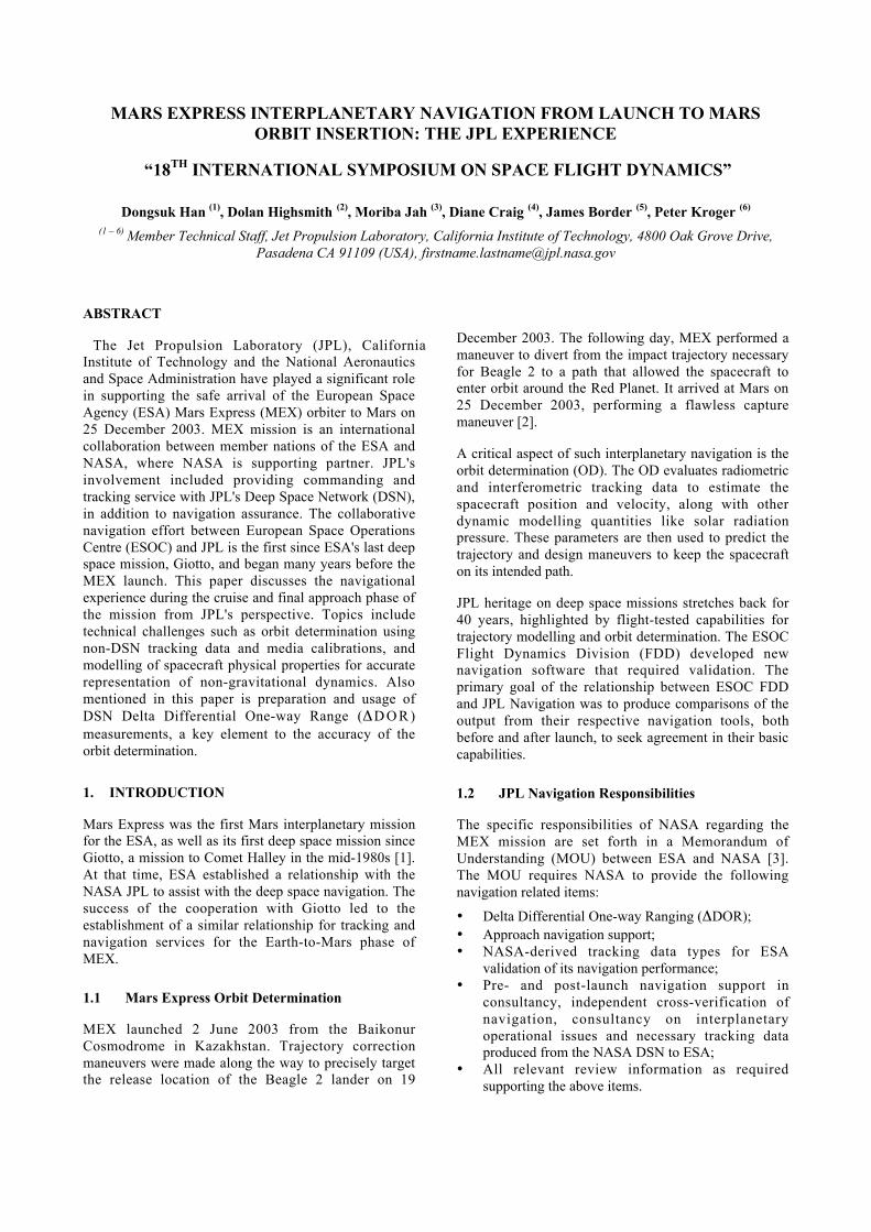
Figure 5-1. Post-fit delay residuals for all ΔDORmeasurements completed during the period Oct. 29 –Dec. 25, 2003. The root-mean-square scatter of these
residuals is less than 0.1 nsec.
Based upon post-flight analysis, the precision of ΔDORmeasurements met or exceeded expectations. Figure 5-1shows the post-fit ΔDOR residuals for all measurementscompleted between Oct. 29 and Dec. 25, 2003. Theroot-mean-square scatter in these residuals is less than0.1 nsec, corresponding to a precision of ~0.6 km in themeasured plane of sky spacecraft position at Mars.
1.2 Daily Solution Comparisons
During the last several weeks prior to MOI, JPL andESOC exchanged orbit determination solutions on adaily basis. Each day included tracking passes fromMadrid and New Norcia. Days that included ΔDORmeasurements also included a limited amount ofDoppler and range from Goldstone. Tracking data cutoffoccurred after the NNO pass, at approximately 1600GMT. At 1830 GMT, JPL Navigation and ESOC FlightDynamics held a teleconference to discuss theirrespective orbit determination solutions andcorresponding trajectory predictions. JPL Navigationalso computed a daily intermediate solution based ontracking data from the Madrid pass that ended later that
day (locally) at approximately 0000 GMT, as well asany ΔDOR measurements delivered after the 1600GMT data cutoff. This solution was then available forcomparison by ESOC when they arrived to work thenext day. In addition, to address immediate concernsand facilitate the daily interactions, The lead author wasthe JPL navigation liaison present at the ESOC facilityin Darmstadt, Germany, during this period.
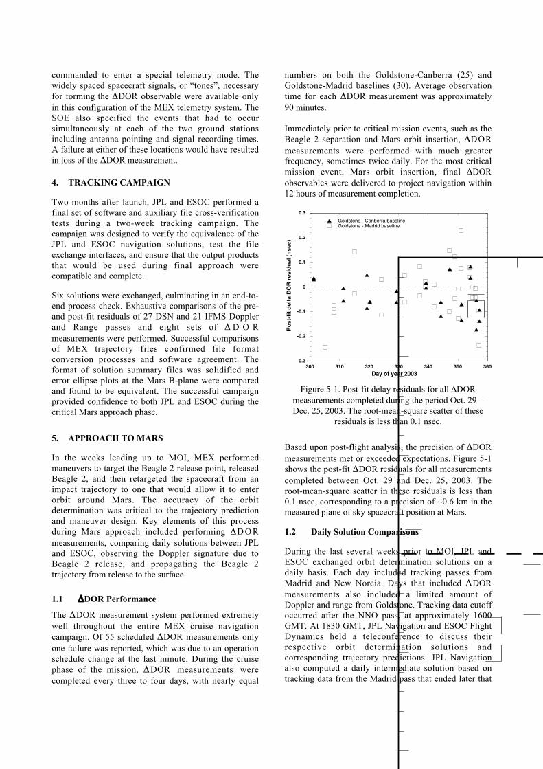
Figure 5-2. JPL and ESOC B-plane ellipses for the 24Dec. 2003 solutions. Delivery requirement was +/-75km from the target, so the solutions are well within thatrange. The two solutions are comparable, with the sizeand location difference due to slightly different dataweights and error assumptions.
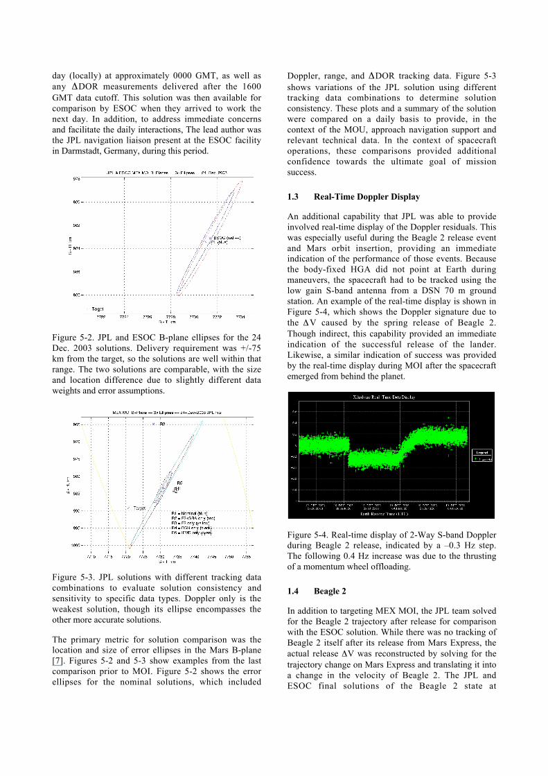
Figure 5-3. JPL solutions with different tracking datacombinations to evaluate solution consistency andsensitivity to specific data types. Doppler only is theweakest solution, though its ellipse encompasses theother more accurate solutions.
The primary metric for solution comparison was thelocation and size of error ellipses in the Mars B-plane[7]. Figures 5-2 and 5-3 show examples from the lastcomparison prior to MOI. Figure 5-2 shows the errorellipses for the nominal solutions, which included
Doppler, range, and ΔDOR tracking data. Figure 5-3shows variations of the JPL solution using differenttracking data combinations to determine solutionconsistency. These plots and a summary of the solutionwere compared on a daily basis to provide, in thecontext of the MOU, approach navigation support andrelevant technical data. In the context of spacecraftoperations, these comparisons provided additionalconfidence towards the ultimate goal of missionsuccess.
1.3 Real-Time Doppler Display
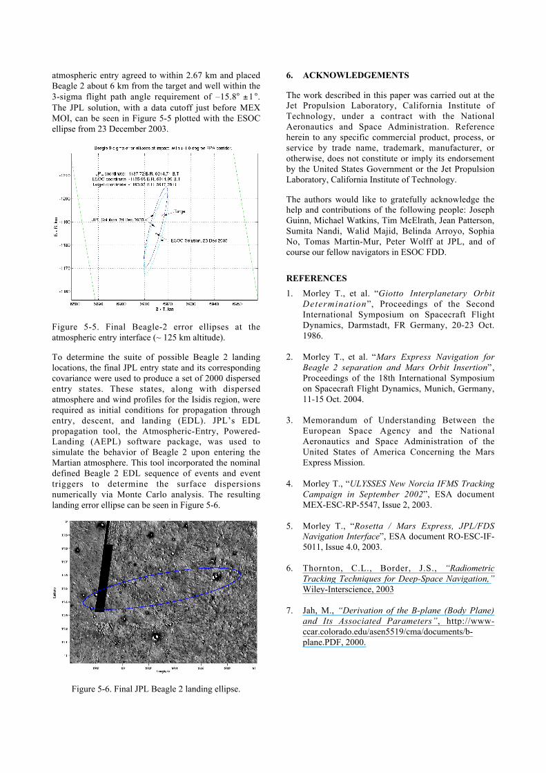
An additional capability that JPL was able to provideinvolved real-time display of the Doppler residuals. Thiswas especially useful during the Beagle 2 release eventand Mars orbit insertion, providing an immediateindication of the performance of those events. Becausethe body-fixed HGA did not point at Earth duringmaneuvers, the spacecraft had to be tracked using thelow gain S-band antenna from a DSN 70 m groundstation. An example of the real-time display is shown inFigure 5-4, which shows the Doppler signature due tothe ΔV caused by the spring release of Beagle 2.Though indirect, this capability provided an immediateindication of the successful release of the lander.Likewise, a similar indication of success was providedby the real-time display during MOI after the spacecraftemerged from behind the planet.
Figure 5-4. Real-time display of 2-Way S-band Dopplerduring Beagle 2 release, indicated by a –0.3 Hz step.The following 0.4 Hz increase was due to the thrustingof a momentum wheel offloading.
1.4 Beagle 2
In addition to targeting MEX MOI, the JPL team solvedfor the Beagle 2 trajectory after release for comparisonwith the ESOC solution. While there was no tracking ofBeagle 2 itself after its release from Mars Express, theactual release ΔV was reconstructed by solving for thetrajectory change on Mars Express and translating it intoa change in the velocity of Beagle 2. The JPL andESOC final solutions of the Beagle 2 state at
atmospheric entry agreed to within 2.67 km and placedBeagle 2 about 6 km from the target and well within the3-sigma flight path angle requirement of –15.8° ±1°.The JPL solution, with a data cutoff just before MEXMOI, can be seen in Figure 5-5 plotted with the ESOCellipse from 23 December 2003.
Figure 5-5. Final Beagle-2 error ellipses at theatmospheric entry interface (~ 125 km altitude).
To determine the suite of possible Beagle 2 landinglocations, the final JPL entry state and its correspondingcovariance were used to produce a set of 2000 dispersedentry states. These states, along with dispersedatmosphere and wind profiles for the Isidis region, wererequired as initial conditions for propagation throughentry, descent, and landing (EDL). JPL’s EDLpropagation tool, the Atmospheric-Entry, Powered-Landing (AEPL) software package, was used tosimulate the behavior of Beagle 2 upon entering theMartian atmosphere. This tool incorporated the nominaldefined Beagle 2 EDL sequence of events and eventtriggers to determine the surface dispersionsnumerically via Monte Carlo analysis. The resultinglanding error ellipse can be seen in Figure 5-6.
Figure 5-6. Final JPL Beagle 2 landing ellipse.
6. ACKNOWLEDGEMENTS
The work described in this paper was carried out at theJet Propulsion Laboratory, California Institute ofTechnology, under a contract with the NationalAeronautics and Space Administration. Referenceherein to any specific commercial product, process, orservice by trade name, trademark, manufacturer, orotherwise, does not constitute or imply its endorsementby the United States Government or the Jet PropulsionLaboratory, California Institute of Technology.
The authors would like to gratefully acknowledge thehelp and contributions of the following people: JosephGuinn, Michael Watkins, Tim McElrath, Jean Patterson,Sumita Nandi, Walid Majid, Belinda Arroyo, SophiaNo, Tomas Martin-Mur, Peter Wolff at JPL, and ofcourse our fellow navigators in ESOC FDD.
REFERENCES
1. Morley T., et al. “Giotto Interplanetary OrbitDetermination”, Proceedings of the SecondInternational Symposium on Spacecraft FlightDynamics, Darmstadt, FR Germany, 20-23 Oct.1986.
2. Morley T., et al. “Mars Express Navigation forBeagle 2 separation and Mars Orbit Insertion”,Proceedings of the 18th International Symposiumon Spacecraft Flight Dynamics, Munich, Germany,11-15 Oct. 2004.
3. Memorandum of Understanding Between theEuropean Space Agency and the NationalAeronautics and Space Administration of theUnited States of America Concerning the MarsExpress Mission.
4. Morley T., “ULYSSES New Norcia IFMS TrackingCampaign in September 2002”, ESA documentMEX-ESC-RP-5547, Issue 2, 2003.
5. Morley T., “Rosetta / Mars Express, JPL/FDSNavigation Interface”, ESA document RO-ESC-IF-5011, Issue 4.0, 2003.
6. Thornton, C.L., Border, J.S., “RadiometricTracking Techniques for Deep-Space Navigation,”Wiley-Interscience, 2003
7. Jah, M., “Derivation of the B-plane (Body Plane)and Its Associated Parameters”, http://www-ccar.colorado.edu/asen5519/cma/documents/b-plane.PDF, 2000.