Section 1 - General Aptitude_English Subject - Cochin Shipyard
Upload
khangminh22Category
view
0download
0
FINAL MARE ISLAND NAVAL SHIPYARD Restoration Advisory Board (RAB) Meeting Minutes
Final MINS RAB Meeting Minutes 1 January 26, 2017 CESJ-2215-0007-0073
HELD THURSDAY, January 26, 2017
The Restoration Advisory Board (RAB) for former Mare Island Naval Shipyard (MINS) held its regular meeting on Thursday, January 26, 2017 at the Mare Island Conference Center, 375 G Street, Vallejo, California. The meeting started at 7:03 p.m. and adjourned at 9:33 p.m. These minutes contain a transcript of the discussions and presentations from the RAB Meeting.
RAB Community Members in Attendance:
• Myrna Hayes (Community Co-Chair) • Paula Tygielski
RAB Navy, Developers, Regulatory, and Other Agency Members in Attendance:
• Janet Lear (Navy Co-Chair) • Valerie Harris (Navy Lead Remedial Project
Manager) • Brooks Pauly (Navy Remedial Project
Manager) • Elizabeth Wells (RWQCB)
• Neal Siler (Lennar Mare Island) • Erin Hanford (City of Vallejo) • Jesus Cruz (DTSC) • Dan Murphy (DTSC)
Community Guests in Attendance:
• Gaylene Bartlett • Stephen Hallett • Jimmy Genn • Boudicca Todi
• Jim Porterfield • Ken Szutu • Kay Flavell • Horace Nelson
RAB Support from Construction Engineering Services, LLC, in Attendance:
• Emily Siegel (CES) • Kathleen Soloaga (Stenographer) • Wally Neville (Audio/Visual Support)
I. WELCOME AND INTRODUCTIONS (Myrna Hayes [Community Co-Chair] and Janet Lear [Navy Co-Chair])
CO-CHAIR LEAR: Let's go ahead and get started. Welcome everyone to the Mare Island Restoration Advisory Board Meeting.
We start our meetings with introductions. I want to introduce myself. I'm Janet Lear, I'm the Navy Co-Chair.

Final MINS RAB Meeting Minutes 2 January 26, 2017 CESJ-2215-0007-0073
CO-CHAIR HAYES: And I'm Myrna Hayes, the Community Co-Chair, and I want to welcome some community folks here this evening who I recognize, hi, some I don't know, but hello, hello. And I live in Vallejo, and it looks like right this moment, I'm the only community member here tonight. Paula will probably show up in a moment.
MS. BARTLETT: I am. We live here.
CO-CHAIR HAYES: No, but I mean serving on the Restoration Advisory Board. I apologize, yeah. So there are openings, lots of them, as you can see, for community members.
MS. PAULY: Brooks Pauly, Navy RPM.
MS. HARRIS: Valerie Harris, Navy Lead Remedial Project Manager.
MR. SILER: Neal Siler, Lennar Mare Island.
MS. HANFORD: Erin Hanford, City of Vallejo.
MR. CRUZ: Jesus Cruz, Department of Toxic Substances Control. Sacramento is where I'm based.
MR. MURPHY: Daniel Murphy, Department of Toxic Substances Control.
MS. WELLS: Hi, I'm Elizabeth Wells, and I'm with the San Francisco Bay Regional Water Quality Control Board.
MS. BARTLETT: My name is Gaylene Bartlett, I live here in Vallejo.
MR. HALLETT: Hi, my name is Stephen Hallett. I live here in Vallejo, and I am with the office of Supervisor Monica Brown.
MR. GENN: Jimmy Genn, live in Vallejo. This might not be political, but I'm on Vallejo's Architectural Heritage and Landmarks Commission.
MS. TODI: Boudicca Todi, live here in Vallejo, Fresh Air Vallejo, and I have an experience in historic development with Old Sacramento, Waterloo, various sites in London.
MR. SZUTU: Ken Szutu, resident of Vallejo, and I'm interested in the environmental issues in this area.
MS. FLAVELL: Kay Flavell, I'm director of New Pacific Studio, which is a nonprofit, and I will say I've set up Friends of Old Sperry Mill because I have 15 years' experience in historic preservation in New Zealand, so I'm here for the long fight. Thank you.
MR. NELSON: I'm Horace Nelson. I'm a resident of Vallejo, and I'm with Lennar Mare Island.
CO-CHAIR LEAR: Okay. So we'll start the evening with our first presentation. The presentation is South Shore Area Remedial Investigation Report Update, and our presenter is Brooks Pauly with the Navy.
II. PRESENTATION (Brooks Pauly [Navy]) South Shore Area Remedial Investigation Report Update
MS. PAULY: Good evening, everyone. Hopefully, you can hear me. Let's see, I've got my pointer. Thanks for coming tonight. As Janet mentioned, I'll be presenting an overview of the remedial investigation project at the South Shore Area, including a summary of the draft report that was sent to the agencies for review in late December. It's been a while since we've talked

Final MINS RAB Meeting Minutes 3 January 26, 2017 CESJ-2215-0007-0073
about this project. We last discussed our plans for going out and sampling this area back in July of 2015. We did do the sampling and now we're back to talk about it.
So first, a quick overview of my talk. As usual, I'll go through the site location, a little bit of the history and land use for the site, especially for the new folks that don't know the site, and we'll talk about previous actions and investigations; and then I'll refresh people who heard the presentation back in July and also give the new folks the information on our remedial investigation, or RI, describe remedial investigation project objectives, and then the remedial investigation sampling, the risk assessments and the results; and then the recommendations for the remedial investigation are really the meat of what's in the reporting document.
Finally, we'll do the next steps and there will be a chance for questions at the end, although feel free, if something really doesn't make sense, raise a hand and I can answer questions as we go along, as well.
So just to point out, the South Shore Area is located, as you might expect, along the southern portion of Mare Island here highlighted in purple.
And then I want to let everybody know, throughout the presentation tonight, there will be some slides that have figures like this on them, and for your convenience, the figures are also available on 11-by-17 size paper, because we know on the slides you can't always see everything. They are useful for what I'm doing and I think they will serve our purpose for what we're talking about tonight. There's also a list of acronyms and abbreviations that I may or may not use.
CO-CHAIR HAYES: I was looking for that.
MS. PAULY: That I'll try not to use but you may see in the presentation, and so it's in the last pages of the handout if you need to reference it in the future for tonight.
All right. So we're talking about site history and land use. What we have here is a close-up of the—
(Ms. Tygielski enters room.)
MS. PAULY: Oh, hey, Paula. You made it.
Give Paula a second to sit down. We've just started the presentation on the SSA remedial investigation.
MS. TYGIELSKI: Okay. Thank you.
MS. PAULY: Paula was here for the last one, so she's somewhat familiar with the site.
In this site, you can see a close-up of the South Shore Area with some of its features, in particular, Pier 34 over here on the east; Dike 14, which I'll be mentioning in the presentation; here, Pier 35; and then Dike 12 is over here on the western portion of the site.
So as the slide mentions, and I won't read all of the stuff on the slide, but this area was created in several stages between 1930 and '47, so essentially it was created with fill material, rock and soil and that kind of thing, so this area didn't exist originally but it was built up for the Navy's use. At the base, essentially, of the cliffs here, it's a little hard to see on this map, but these are actually higher cliffs and then this is a much lower area here. And so the --

Final MINS RAB Meeting Minutes 4 January 26, 2017 CESJ-2215-0007-0073
CO-CHAIR HAYES: You can also just see the -- between the two treed areas, which are steep ravines, that area right there you're pointing at, that was actually carved with steam shovels and men and picks and oxen and mules and laid out -- and laid down to expand onto the floor.
MS. PAULY: Yes, down here especially.
CO-CHAIR HAYES: It was all open bay right at the hill's edge and so --
MS. PAULY: Right.
CO-CHAIR HAYES: -- where you see those magazines, those are all carve-outs into the hill used for a natural revetment to protect from explosion; but they severely carved out that area between those two ravines.
MS. PAULY: Thank you, Myrna. That's a really good point. And that leads me into what the site was used for, which was primarily staging and loading and unloading of munitions from ships, and so they did have that precautionary measure of having it near these strong rock outcroppings.
There was some munitions repair work and that kind of thing, but mostly this was limited use for storage and then there was some storage of munitions, and then some limited uses for storage of hazardous materials like diesel fuels and things like that for the ships.
CO-CHAIR HAYES: And not to go on interrupting you --
MS. PAULY: Oh, okay.
CO-CHAIR HAYES: -- but a critical aspect of that lay-down area or the filled area was that there was a rail line.
MS. PAULY: That's right, right here.
CO-CHAIR HAYES: That extended around, like you're doing, and onto the pier, as well as around the island to the western magazine.
MS. PAULY: Yes, which goes off exactly that way.
CO-CHAIR HAYES: And that's not listed on this list.
MS. PAULY: That is true, but I appreciate you adding to the list. I didn't want to go into too many words on the slide, but it's much more interesting to hear someone talk about it, as well.
There's another aspect to this, which is munitions items and related debris were actually disposed of in this area, so they were buried, and that's something that we've come to deal with and that's part of what I'll talk about tonight.
As I mentioned, the current land use is industrial, in the sense that it's not open to the public, it was originally used as an industrial site for the Navy, but the future planned use is for a park in the uplands area and then a wildlife preserve and habitat area in the wetlands, which -- and I should say, the wetlands you can see right here in this figure and here, primarily, and there are a few others.
MS. BARTLETT: So wetlands that have been developed since the infill came in?
MS. PAULY: That's correct.

Final MINS RAB Meeting Minutes 5 January 26, 2017 CESJ-2215-0007-0073
All right. So there were multiple previous actions and investigations at the site before what I'm going to be speaking about specifically tonight, which is the 2015 remedial investigation fieldwork which happened in the fall/winter of 2015. And on the slide, I have listed some details of the various items that were removed during those previous actions and investigations.
So it started off in 1990 with some emergency removal actions, there were three of them between '90 and '93, and these were items that were found during maintenancr work.
That triggered the responses, and then additional responses happened between '97 and '99, what we called the unexploded ordnance or UXO intrusive investigation, and you can see there's various items that were recovered during those times, including one radioluminescent deck marker, which is actually near the base of Dike 14, which we saw on the previous picture here, so right in that area.
And then once they did that removal, the investigation removal, they realized that there was a lot more at the site and they -- between 2003 and 2006, there were, I think, two or three digital geophysical mapping surveys.
So what they used is sensors that can detect metal below the ground surface, and there were over 14,000, what we call, anomaly or metallic locations found, and so that led us to the largest removal action at the site, which was the munitions non-time-critical removal action. It's an administrative term that we use.
And so they used that location data from the 2003 to 2006 surveys that the Navy had performed to essentially start digging, and --
CO-CHAIR HAYES: Start digging.
MS. PAULY: Start digging. And there were over 17,000 locations dug during that time. It was between -- I think it was May of 2012 to July of 2013.
And so at those 17,000 locations, these guys are essentially reacquiring what we're calling the anomalies, they use instruments such as these to then go back out and find those locations with GPS coordinates, but also with handheld detectors just to make sure they were in the right spot.
As part of those 17,000 locations, radiological field scanning was performed in the uplands and wetlands at a hundred percent of the dig locations, and no radiological items or materials were detected in all of those scans.
And this is a picture down here of the radiological screening that was done within the excavation, so you can see the digs were approximately two-foot diameter -- or two-foot radius, so four-foot diameter and about down to four-foot deep.
During that time, it wasn't all just those small locations. We did find several subsurface disposal areas, quite big ones, and those actually were excavated down to 10 to -- sometimes I think in a couple locations they even went down to 12 feet deep, so these were the disposal pits that I had mentioned earlier.
We also found some buried drums. They were empty, but there were 41 total found in two different locations, and we had -- as part of this plan, we identified sort of these different types of burial pits, and so there was some that had small arms only, or some that had larger munitions items, and some that just had debris.

Final MINS RAB Meeting Minutes 6 January 26, 2017 CESJ-2215-0007-0073
We took soil samples from six of those type of locations and sampled those for munitions constituents, so energetics, and did not find those. They were all non-detect for that.
And then I mentioned the -- oh, one of the other things besides the drums, similarly, some underground storage tanks were found. We actually think they were more water-infiltration-type tanks or dry -- with the two dry wells and associated piping, but we'll get to that later.
CO-CHAIR HAYES: I kind of skipped ahead here, and I don't see one of the more interesting finds listed, so could I add to your list on page 4?
MS. PAULY: Absolutely.
CO-CHAIR HAYES: You forgot the World War II 300-pound submarine depth charge.
MS. PAULY: The MP 6 depth charge, absolutely.
And that was found in this location, so right along the shoreline there during the non-time-critical removal action. You're exactly right. I am kind of surprised that --
CO-CHAIR HAYES: And so -- just so you know, it's no longer there.
MS. PAULY: That's correct.
CO-CHAIR HAYES: It was picked up and driven out to Top Gun, to Fallon, Nevada, and it was disposed of there. We don't really have a disposal range big enough to destruct that depth charge.
MS. PAULY: That is correct.
My understanding is they put a little bit of C4 on it and got about two miles away, and very nicely sent us some pictures of the big splat on the ground.
CO-CHAIR HAYES: We didn't get pictures, even though we asked.
MS. PAULY: It was just a dark mark on the ground, but it was satisfying to see it.
From the site history and the previous investigations, we developed our conceptual site model, so essentially the conceptual site model just talks about what we -- what we know about the history and where we think probable mechanisms of release and contaminants may have occurred.
And so, as I mentioned, it was used for storage and handling of munitions, general shipyard items, things like that, and we did consider everything for this remedial investigation, so it takes into account all of the previous investigations and then the current one, as well.
So our most probable release mechanisms, based on the history and the investigations, was direct release to the subsurface, again, from any kind of pipelines or tanks and things like that; disposal to the subsurface, as I mentioned, from burying trash, munitions items, other debris; and then surface releases, so the typical kinds of things that you would see where trucks and other things leak, maybe they were handling the diesel and it might have leaked, so we considered all of those types of things; and together, all this information forms the conceptual site model and it guides us as to where we sample.
And by the way, just a preview, a preface, is that nothing that we found actually during the site investigation changed our conceptual site model, didn't find anything too surprising.

Final MINS RAB Meeting Minutes 7 January 26, 2017 CESJ-2215-0007-0073
CO-CHAIR HAYES: Could I also note something that you haven't brought up yet, and that is, that to date, and you can correct me, but it's my understanding that to date, we have never found anything on Mare Island that was a munition item that was fired, fused, or armed.
MS. PAULY: That is my understanding.
CO-CHAIR HAYES: So we --
MS. PAULY: That's a good distinction.
CO-CHAIR HAYES: -- haven't found any duds.
You know, probably some wisdom there. We don't have training ranges, maneuver ranges, like, say, Fort Ord or places where so-called duds or unexploded ordnance, UXO, was left behind by somebody who didn't re-acquire it on their way back to camp.
So here we use the term which you see as an acronym on one of the images, it's called munitions and explosives of concern, MEC, instead of UXO, because we don't have any.
MS. PAULY: That's true, and even though the original investigations back in, I think it was, '97 to '99 were called UXO investigations or unexploded ordnance, that is just because they didn't know at the time; and that was also sort of a more broad terminology until it became more specific later on as that field developed and got more sophisticated. So, yeah, that's actually -- that's a good point.
Okay. So I think we're back to the remedial investigation project objectives. So just as a reminder for some and new for others, there are sort of primary and secondary objectives to this remedial investigation.
As with all remedial investigations, the primary objective is based on our conceptual site model, the historical activities, and then any emergency investigations. You want to figure out if the -- if those activities resulted in any chemical or munitions-related impacts to the soil and groundwater.
Now, we already knew about the munitions for sure. We did a little bit of sampling, as I mentioned, with the soil for energetics to see if the munitions had impacted -- that sort of the chemical side of munitions had impacted it.
But during this remedial investigation, we then were going to do further sampling with this, it's a more broad sweep of analyze for things, chemicals that we analyze for, to see if that -- there were any other impacts.
And then if you find impacts, you want to characterize the nature and extent, so you want to find out what it is and how far it went, and then we evaluate the risk to human health and the environment and recommend future action, so it's pretty straightforward objectives.
In this case, because we knew about a lot of the other things at the site, we had some secondary objectives. So during the non-time-critical removal action, we had found a debris pit, that one I mentioned that went down to 10 to 12 feet just south of Building 259. And I think I'll get to a picture of that, but I can go back if anyone needs to figure out where the building is, but it was kind of right in the middle of that picture of the site.
And so we had been able to dig out most of it, but we ran out of -- we ran out of money, is what it was.

Final MINS RAB Meeting Minutes 8 January 26, 2017 CESJ-2215-0007-0073
So we knew that there was more because we had that wall that we could see on the side, we had to fill it back in, and then we knew we needed to delineate the extent of it further, and so that was our -- one of our secondary objectives for this remedial investigation.
And another secondary objective was to conduct a final status survey, which is just an investigation doing basically field scanning and then doing some soil sampling for radiological items, because we had found that one radioluminescent deck marker back in 1999 down at the base of Dike 12, so --
MS. BARTLETT: Is that radium?
MS. PAULY: It is radium. That particular deck marker was -- used radium 226, yeah, exactly.
So we wanted to do that, and that type of survey had not been done at that time. They had done excavations, they'd done scanning, but they hadn't done this particular type of survey and so we wanted to get that done.
And I think I had sort of hinted at this at the beginning of the primary objectives here, but at this phase in of the process, we combined the Munitions Response Program, essentially, within the Navy with what we called the Installation Restoration Programs.
And so munitions, as you might expect, is just munitions and munitions constituents, which is like the energetics and the metals, and then the Installation Restoration kind of deals with all the other chemicals.
So we're combining all of that information and all of those programs in this one remedial investigation project at this point.
And then just to kind of connect this to the next part of the process for you, give you a little preview, all of the results from this remedial investigation are used to prepare what we call a Feasibility Study, and that's a report that talks about all of the alternatives for cleanup if you do find something.
Okay. So now that we've gone into that, we can actually talk about what we did. So this is the meat.
This is the meat of what we were doing to fulfill our primary objectives, see if any chemical impacts are at the site, and if so, to what extent.
CO-CHAIR HAYES: So you can use the --
MS. PAULY: This is where you can kind of see -- and so this figure is quite crowded here and even in the 11 by 17, but essentially I just wanted to show you that -- where we did a lot of the soil and groundwater sampling, so it was site-wide. It was focused on where we knew certain site activities had occurred along pipelines, the storm drain, the sewer pipelines, and things like that, where we knew there were tanks, where we found those drums, the burial pits, and things like that.
So we did -- thank you for referring to the 11 by 17. You actually predicted one of my notes on here. So we mentioned that they are based on the site features.
There's actually no surface water at the south shore area. The groundwater there is shallow, it's about four to nine feet below ground surface and generally flows, as you might expect, toward the strait, sort of radiating out.

Final MINS RAB Meeting Minutes 9 January 26, 2017 CESJ-2215-0007-0073
And so there were, in addition to the soil samples, we also installed nine monitoring wells at sort of strategic locations, so where we could see if anything had come from the buildings and was going towards the strait.
And during all of this, I want to say that something that's very important to the Navy, as well, is resource protection. There were biological monitors that were on site to check for the presence of rare plants and other sensitive wildlife, such as the salt marsh harvest mouse.
Oh, and I do want to say that the soil samples, just to give you a sense of it, there were over 60-plus soil samples just during this investigation, there had been previous ones, at various depths, so at the zero to half a foot, two to five feet down, and then as deep as five to ten feet down, to where the groundwater would be.
We would analyze for things like volatile organic chemicals, semi-volatile organic compounds, total petroleum hydrocarbons, polychlorinated biphenyls, so some people -- you have heard of PCBs.
Yes, ma'am.
MS. TODI: I love that this is going on. I was a kid when the Presidio was horrible, and now it's wonderful; and then Alameda is getting wonderful, and I love that; you know, we're here talking about making Mare Island and Vallejo wonderful, so when I'm a little old lady, it's going to be great.
My question to you is, when you talk about we are doing soil testing, is that the Navy or is that a third-party testing group?
MS. PAULY: Oh, that's a good point.
So the Navy is the primary driver of this, but we do hire contractors to go out and take the samples, and then we do send them to Navy-approved labs, laboratories.
MS. TODI: Oh, who are those? Are they in the notes?
MS. PAULY: Uh --
MS. TODI: The contractors.
MS. PAULY: The contractors or the labs?
MS. TODI: The contractors doing the soil samples.
MS. PAULY: Let's see, at this time this was a company called Noreas Incorporated, I believe it is, that did those soil samples, but there were quite a few other contractors that had done the previous ones.
MS. TODI: Okay.
MS. PAULY: Sorry, I don't have those right offhand.
MS. TODI: Okay, thank you.
MS. PAULY: You're very welcome.
So I was mentioning metals, dioxins, furans, pesticides, things like that, so those are the types of things we sampled for.

Final MINS RAB Meeting Minutes 10 January 26, 2017 CESJ-2215-0007-0073
And then I did want to point out -- oh, this is where I can point out Building A259. So the building is right here, and you can see the first disposal pit was excavated right here, and then we actually delineated, further to the east, the rest of the pit.
And then we -- I've also pointed out previously, this is the area where the deck marker, the radioluminescent deck marker, was found, and then there was a little area here that needed to be rescanned.
The other features of sampling that I mentioned, and I don't want to go over this too much, I just mentioned the debris pit south of Building A259, that that was essentially gathering sensor data as one of our secondary objectives.
As one of the primary objectives, we did sampling around buildings, so it looked like there was some petroleum hydrocarbons, likely from vehicle leakage, near A259, as well. We were able to sample that area and then step down to where we got to non-detect samples, and so that was able to -- that's the delineation of an area of impact.
And then also this is the view of that final status survey location at the base of Dike 14. This is where they actually excavated out that area, as well, so they could get to the same elevation as where the original items had been found, and they scanned that area and all of the soil associated with it, and this was a -- this was also another debris pit not associated with the debris pit I was mentioning earlier.
And they did the field scanning for the radium 226, like we mentioned, and then we also did soil samples for two radiological isotopes because there are two types of isotopes that are associated with deck markers, strontium 90 and radium 226, that had found elsewhere on Mare Island but we did not find that here.
So we did find -- the one thing we did find, though, in this scan while we were sifting the soil right at the edge of where this debris pit had been, we did find one additional radium 226 deck marker in 2015; and so, of course, that was removed, the soil around it was removed, scanned, field scanned but also taken soil samples to the lab, and those were proven to be non-detect for radium 226.
MS. BARTLETT: So you found a total of two of those.
MS. PAULY: Two of the radioluminescent deck markers, yes.
CO-CHAIR HAYES: As compared to the larger stash we found, which was around 1200 of them, right, in the paint waste area?
MS. PAULY: In the paint waste area, yes.
CO-CHAIR HAYES: Yeah, so ...
MS. PAULY: By the way, folks, this is a tire.
That's not the deck marker. Deck markers are about the size of a quarter. So, all righty, just for reference.
Okay. Lastly, some of the other things we sampled, I mentioned the underground storage tanks. Turned out they really weren't tanks. We tested around them, and this was actually their piping that was associated with those, and we've tested all along the pipe there, as well.

Final MINS RAB Meeting Minutes 11 January 26, 2017 CESJ-2215-0007-0073
This was a drum location that we'd found some buried drums here and then over to the western side of the site here, it's actually under -- oh, here it is, right down here, in the curve along the shoreline here on the western portion of the site.
So all this sampling resulted in 26 figures of results, and I'm not going to bore you with those, but we took all that data and we performed the human health and ecological risk assessments.
Before we get to the results of the risk assessments, I do want to give you just a little bit of background so you kind of know what we did and how it applies.
For the human health risk assessments, we looked at the upland soil and the wetland soil, the groundwater, and we look at different receptors, so what type of humans are going to be at the site.
We've got commercial and industrial workers -- and essentially we're all the same type of human, but there are different factors in how long you are at the site, how you use the site, how you interact with the site, and that's really what makes the difference in how we evaluate the different receptors.
Recreational users are only going to be there for a few hours, maybe once or twice, or they might come for a few hours weekly. There's a number associated with that. Construction workers, there are numbers associated with the time of use on that site.
And then we always calculate the risk to a future resident, adult and children, but it's hypothetical because, as I mentioned before, this site is not planned for any kind of residential reuse.
So the various methods we used, there were multiple methods to calculate risk, and that's to give us an idea so that we don't miss something, so we're using different methods to look at things, so the Environmental Protection Agency method for cancer risk, as well as the California Environmental Protection Agency methods. And, essentially, in a broad generalization, unacceptable risk is considered something that's risk greater than 1 additional person getting cancer in 10,000 people.
We also looked at the non-cancer risk, so that's something that's indicated with a factor called a hazard index. If you see a hazard index greater than 1, there's an unacceptable risk of non-cancer impacts.
MS. BARTLETT: Non-cancer?
MS. PAULY: Non-cancer, so like asthma or something like that.
MS. BARTLETT: Okay.
MS. PAULY: Chronic. -- So if you had volatile organic chemicals or compounds.
MS. BARTLETT: A risk other than cancer.
MS. PAULY: Other than cancer, thank you, that's a really good point.
And then we did a computer model called RESRAD, to model the radiological data that we got just from the debris pit at Dike 14, so just at that little area that we wanted to clear associated with those two radioluminescent deck markers. So, essentially, yes, those are related to chemicals, that's chemical exposure.

Final MINS RAB Meeting Minutes 12 January 26, 2017 CESJ-2215-0007-0073
And then the munitions and explosives of concern, as Myrna mentioned, the MEC hazard assessment was performed, and that essentially relates more to the risk of being impacted by an explosion from an item and that is, in our case, very low because of exactly the reason that Myrna mentioned, is that none of these items are fused and they haven't been fired.
And the other thing that we did was the ecological risk assessment. Again, we were looking at these types of factors for different receptors at the site, ecological receptors, so plants and animals.
So the most important point, though, is that the Remedial Investigation report incorporates all of the available data from the previous investigations, as well as this removal action, and I think I mentioned that before.
Okay. So, finally, for the results that I know you've all been waiting for, the human health risk assessment results were specifically related to chemicals. There was no unacceptable risk to human health for all of the different methods that we used, except for a future construction worker and that hypothetical future resident child. And that non-cancer risk was by both methods, by the Environmental Protection Agency's non-cancer risk method and the California Environmental Protection Agency non-cancer risk method. There was no cancer risk associated at all. The non-cancer risks were associated with manganese in the soil.
And the good news there is that, again, this is not planned for residential use, and future construction workers have the ability to use protective equipment to mitigate that kind of contact risk to something like soil.
Yes, Myrna.
CO-CHAIR HAYES: What's the source of manganese; is it a -- naturally occurring?
MS. PAULY: It is, actually, in this case, yeah.
CO-CHAIR HAYES: That's an example of on Mare Island or throughout California, areas of California, there's naturally occurring levels of arsenic, for example, that don't meet these standards. They are above the standards that are protective of human health and the environment.
However, because they are naturally occurring, they are there. There is not too much you can do about it. You can't remediate half of California, so manganese is in that same category. It wasn't part of the manufacturing or storage process.
MS. PAULY: Not in this case. It is right in line, actually, typically below the background that we see at Mare Island and in other areas.
So the results were also good for the munitions. The evaluations show that this is the lowest risk level, especially since most of them have been -- well, since all of the surface removals have been done and so much subsurface removal of munitions items has been done and that -- potential future munitions items that were deeper at other locations where we couldn't actually sense them from the surface or even as we got lower down into the pits. Again, no one's going out there to dig recreationally, there would be a prohibition typically in the form of signage and other education. There you go.
Tag, you're it, Myrna.
CO-CHAIR HAYES: I cannot believe how --

Final MINS RAB Meeting Minutes 13 January 26, 2017 CESJ-2215-0007-0073
MS. BARTLETT: How about that hypothetical resident child?
CO-CHAIR HAYES: Well, there won't be any resident children.
MS. BARTLETT: Okay.
MS. PAULY: Oh, definitely not, yes. And just as you were about to say --
CO-CHAIR HAYES: And metal-detector people, they're obsessed with going there. And I try to say it's a bad idea to mix metal detecting and munitions, but that actually just eggs them on, I guess, so –
MS. PAULY: Well ...
CO-CHAIR HAYES: Yeah. Well, they'll have to have a pretty powerful metal detector to find much.
MS. PAULY: Well, especially since we have cleared --
CO-CHAIR HAYES: Swept so often, yeah.
MS. PAULY: Yeah, swept so often and cleared down to four feet. I don't actually know of any metal detectors that are individually available that can do that.
As I mentioned, too, the other good news is that this was not a radiological-use site, and as I mentioned, the RESRAD modeling of that section of the debris pit where the two radioluminescent deck markers were found showed no unacceptable risk to human receptors.
And recall, too, that in those 17,000 digs from the non-time-critical removal action, we had also scanned and it had indicated no radiological detections there either; so it's not just in that one little location, there had been a lot of scanning of the site, so that was the good news.
There's also good news for the ecological receptors. Again from a chemical standpoint, dioxins in the wetlands, and I left the -- I'm sorry, I left the word "hydric" in there. That actually just means shoreline, so like sediment soils that are impacted by the water at the shoreline.
There's a potentially significant hazard toward the ornate shrew in that wetland area, and there was an area -- let's see if I can show it to you -- containing the former oven and primer pits. I'm going to go back.
That's essentially this area right here were the former oven and primer pits, and so there was a little bit of dioxin detected there.
CO-CHAIR HAYES: Maybe you should just say what an oven is in this context, and primer pits, what that might mean.
MS. PAULY: This is an area where munitions were burned.
Thank you, that's a really good point.
This is an area where the Navy disposed of munitions by burning them and then burying, as well.
So, again, for the ecological receptors, the munitions hazard is very low for the same reason as the human receptors and -- same as humans. It's not a radiological-use site, and there were -- the RESRAD modeling for ecological receptors showed that there was no unacceptable risk from radiological materials, as well.
So, again, that is the good news.

Final MINS RAB Meeting Minutes 14 January 26, 2017 CESJ-2215-0007-0073
Yes?
CO-CHAIR LEAR: Could you just point out the oven area, that was actually removed previously, where there was excavation done?
MS. PAULY: Absolutely. It was actually removed, I believe, during the -- between 1997 and '99 was that removal, so that has been removed; and then we just wanted to go back and take a few more samples to get more current data because we have more sensitive analysis methods now.
Okay. So we have some recommendations. So based on our results, the Remedial Investigation report makes these following recommendations: First of all, as a sort of an administrative designation, we have solid waste management units. This, again, is just a way of tracking certain subsurface disposal places, and they've been given different names and numbers.
So Solid Waste Management Unit Number 93 is the storm drain system for the whole island, and so we're asking for closure of just the portion that's on the south shore area, similarly with the sanitary sewer.
And there was a solid waste management unit called 125 that was just the whole southern area end of the island. We're asking for closure of that one, as well. It was really just southern end of the island associated with munitions.
So we're requesting the closure of the three underground storage tanks and the related piping, and then there were the following recommendations for future investigations.
So, specifically, there was a debris mass that was found along the shoreline of Dike 12; and I know I showed you Dike 12 at the very beginning, but that was on the western side of the site. And you can see it in the picture here, it's this little ball right here. We have seen similar balls to this in other parts of Mare Island, although they were much bigger, and it's just kind of a mass of metal and other things and rock and soil and things fused together, and so we want to make sure we get that out and investigate that properly.
And also that disposal pit, the debris pit that I was talking about that was south of Building A259, we did that delineation. And it's a little hard to see in this figure, but there are these little blue tufts, little whiskers, they call them, and it shows the whole outline of that additional debris pit.
So, as Myrna mentioned, it's like you're reading my mind, Myrna, we did not recommend removal of the manganese in the soil, again, because it's at background levels, essentially, so it's consistent with the background levels for the site.
And then the final recommendation, as I mentioned, kind of gave you a little preview before, is to conduct a feasibility study. That report looks at remedial alternatives for the dioxins, for the munitions that are left at the site, that are site-wide.
All right. And the last --
CO-CHAIR HAYES: Can you explain on that --
MS. PAULY: Yeah.
CO-CHAIR HAYES: -- figure, it's the one that goes up and down like that, would be the easiest to look at, would you clarify your two descriptors, the red area that you talked about tonight is

Final MINS RAB Meeting Minutes 15 January 26, 2017 CESJ-2215-0007-0073
upland, or on land, and it's -- it's called SSA, so -- and then on the other side, lots of green area and it says "IA K." Maybe you could explain those two different descriptors.
MS. PAULY: Absolutely.
Okay. Well, the SSA is essentially our site, the South Shore Area; and then IA K is another designated area, Investigation Area K. That is considered offshore.
So this line that you see, and, actually, I'm hoping everyone is looking at Figure 4-4. This is actually a figure that's on this site here. Actually, I can use this. So this line especially that goes -- the red line that goes along here is as far as you can walk out onto the mud-flats area at the lowest, lowest, lowest tide, so that's how we designated that line; and then essentially the Investigation Area K that Myrna was mentioning is always underwater.
Does that answer that?
CO-CHAIR HAYES: And that you have two separate investigations.
MS. PAULY: That's exactly right, that are going on at the same time.
All right. For our next steps, just as a matter of housekeeping, we'll be responding to the regulator comments and input because we want to make sure that we're all on the same page with how we evaluated the data and the methods, and we'll be finalizing the Remedial Investigation report.
We're going to perform that investigation of the debris pit and that debris mass that I mentioned and then conduct that feasibility study and report those results, and there with be another presentation for that, as well.
Thank you so much for sticking with me and listening.
Are there any questions?
All right. Thank you all very --
CO-CHAIR HAYES: Well, of course, I might have one question.
This nice picture you show of this beachy area with the palm, no one can imagine how frigidly cold that is about right now, would you say that they -- so far we don't have a final conclusion here on your work, but that that beach would be safe to be accessed by the public when it's all transferred for parkland?
MS. PAULY: Well, when it -- when it is transferred, it will have to be in a condition that is considered acceptable for the future use, which is as a parkland.
But it's worth pointing out here that there are wetlands right here -- this is looking west, kind of with Dike 14 behind you. And so there are wetlands here, and actually where you can't see in the picture just behind you, there are wetlands there, as well, and so there's this -- it's not much of a beach.
CO-CHAIR HAYES: Well, in this town, we don't put our feet in the water anywhere in our riverfront, so even a tiny beach might become incredibly important to the enjoyment of all Californians, since it will be State land at some point.
MS. BARTLETT: So the eventual goal is to turn this into a State park open to the public, or is it going to be a wildlife preserve?

Final MINS RAB Meeting Minutes 16 January 26, 2017 CESJ-2215-0007-0073
CO-CHAIR HAYES: Well, to clarify,it's slated to be part of the regional park, which we now call the Mare Island Shoreline Heritage Preserve.
CO-CHAIR LEAR: Well, let me answer, but the wetlands portion of it is set aside for wetlands habitat.
MS. BARTLETT: Okay. So we're delineating between the beach and the wetlands here.
CO-CHAIR HAYES: Well, it delineates itself.
MS. BARTLETT: Okay.
CO-CHAIR LEAR: So the larger site is going to be part of the regional park, that's what the re-use plan says, but the wetlands part are supposed to be conserved for that use.
CO-CHAIR HAYES: You actually have a special conservation easement on the wetlands.
CO-CHAIR LEAR: As part of the EIS, yes.
CO-CHAIR HAYES: Right, yeah.
I just wanted to note that -- two things: You had mentioned at the beginning of the -- of your presentation that because it's an industrial site and it's being cleaned up right now that the public can't go there, but I am very proud to say, hopefully, that with the City of Vallejo's hard work on a piece of paperwork we have to complete between now and the Flyway Festival in two weeks' time and with the really solid cooperation of the -- of the Navy, who owns the property now, and their regional center that does the day-to-day oversight on the property, if everything goes as planned, we will hold our 21st Flyway Festival on February 10, 11, and 12, and we'll hold our 21st walks on this property on February 10, 11, and 12.
So you would have a chance, through a Navy escort, with a guide from the Mare Island Shoreline Heritage Preserve, you would have a chance to visit this property during those hikes.
And I can say that the dates and times are, say, 10:30 to 12:30 on Friday and then more in the 9:00 to 11:00 timeframe on Saturday and Sunday, but you'll see in the schedule that's to be confirmed, but we're working hard on it to get that all lined up for you.
And then I also would comment that this property will look quite different depending on the remedy that you come up with for long-term, protective environmental remediation, you know, plans, and it will also look different over time just based on sea level rising expectations.
So stick around, you may have more -- less beach and more open water as time goes by.
MS. PAULY: Thanks, Myrna. Thanks everyone.
CO-CHAIR LEAR: Thank you, Brooks.
And we'll jump right into our next presentation, Neal Siler with Lennar Mare Island. He is going to talk about Lennar Mare Island's Environmental Update 2016 to 2017.
III. PRESENTATION (Neal Siler [Lennar Mare Island]) Lennar Mare Island Environmental Update 2016-2017
MR. SILER: Okay. First thing I want to do is I want to apologize for the packet that you got. You're going to need one of these 11-by-17 sheets if you haven't got it already.

Final MINS RAB Meeting Minutes 17 January 26, 2017 CESJ-2215-0007-0073
When I tried to print this out, there's a number of slides that the printer just -- the two printers that I use would just not print out; so you will see the slides here on the screen, but you don't have it in your packet because all it was doing was printing out white sheets of paper with nothing on it, so I just took those out of the presentation, so you will see that as we move along.
But what I'm going to talk about, as I've done a few times in the past, and this is a good time to do it, is some of the major accomplishments that we've been able to get through in 2016 and where we hope to move forward in 2017.
So you have just a bare-bones portion of this figure that just shows you the Eastern Early Transfer Parcel, which is the portion of Mare Island that Lennar Mare Island occupies.
And just an explanation of this map here is these areas that are colored in light blue, those are all areas that we have what's called no further action certification, so those have been cleaned up, those have been accepted by the regulators, and those can be developed as we move forward.
Some of these other areas that you see in green, like this one right here, which is C3, which is along the waterfront, that's getting very close to being provided no further action certification. There's one right here, C3, there's also one right here, D1.3 south.
And then the areas that are yellow that are investigation areas C1 and C2, those are in yellow because they have the most sites in it. They were the most heavily industrialized naval operation areas on the island. Each of those carries about 250 sites that we have to actually work on and close before we can get closure of the entire investigation area.
So these next few slides, which I apologize again, you don't have, and they move actually from north to south down the island, they have aerial photographs, and they show some of the sites where we're working here.
This is Industrial Pump Station 4, this is T2 oil/water separator, this is -- "IR" means Investigation Restoration Program site and it's a major site on the island, and then here is some of the buildings that we're working at.
This is the U-shaped structure of Building 85, 87, 89, 91, and then the middle of it is 271 and there's Building 7. Lennar Mare Island's office is in Building 459, which is 690 Walnut Avenue, and you can see these sites as we're moving along the waterfront down from north to south.
So, again, moving down, here are some other sites. Investigation Restoration Site 15, Building 121; Domestic Pump Station Site Number 6 and the cooling water loop, which runs from Building 121 down to the strait; and this is an oil houses and cistern site that we're working on which is very close to the Mare Island Museum.
Again, moving further south on the island, this is Investigation Area C3, where the dry docks are; Building 141, oil/water separator; the Investigation Area C3, black granular material triangle; and then a couple of PCB sites in Building 516 and 516A.
Moving further south, again, this is Investigation Area C2. We have some PCB sites in Building 746, an underground storage tank site at the former Building 866 area. This is Buildings 386, 388, and 390, where XKT is located.
And then this, moving out to the -- further out to the west, this is Building 84 right here.
MS. BARTLETT: Excuse me. Where who is located?

Final MINS RAB Meeting Minutes 18 January 26, 2017 CESJ-2215-0007-0073
MR. SILER: XKT Engineering, that's our tenant there.
And then some additional sites. Here are some fuel/oil pipeline segments, some additional PCB sites in Building 742, a PCB site down in Building 1342, and another PCB site down at Building 730.
And if you look on the last page of your handout, all these acronyms are explained there. And if you look through the text portion of the handout, you will see that I've defined all these acronyms as we go forward.
So the first site that -- or area that we were able to get a lot of work accomplished was Investigation Area B.2-2, and we were able to close this site out this year. This is about 20 acres of property. About 11 acres of this property will be redeveloped as commercial industrial property, and the remaining 9 acres will be developed as residential property.
So you can see, we've got some no-further-action certification for one of the last remaining site in there in February. We submitted what's called the implementation report for the entire investigation area in March, and we were able to receive no-further-action certification for this investigation area in October.
We executed the land-use covenant for the northern portion of the site which will be redeveloped for commercial industrial use; and then the entire property has what's called a land-use covenant, it's called the pre-decision covenant, and when we put a new covenant on a property or we've cleaned it up to unrestricted land use, then that -- after we get all of the paperwork signed, then that pre-decision covenant gets released for that portion of the property, and that's the last step.
Now, the only thing we have left to do on this site, excuse me, is to get the Comprehensive Environmental Response, Liability, and Compensation Act warranty from the Navy and then integrate this program into what -- our annual inspection and five-year review program that we do as part of closing out these sites.
CO-CHAIR HAYES: Just to give folks an idea, how long did this project site take you from beginning to end?
MR. SILER: Well, we've been out here since 2001, so this takes a long, long time to get everything through the process.
CO-CHAIR HAYES: Well, depending on what the -- what the cleanup is. Not all of them take as long as this one did, right?
MR. SILER: Well, they don't --
CO-CHAIR HAYES: I'm just --
MR. SILER: -- all take as long --
CO-CHAIR HAYES: -- asking specifically --
MR. SILER: -- as this one. This one took about that time period.
Some of the other areas -- the more commercial industrial portions of the property take longer because there are a lot more environmental issues on those properties.
Former residential areas down the western side of the property don't take as long because they don't have as many environmental issues that we have to deal with.

Final MINS RAB Meeting Minutes 19 January 26, 2017 CESJ-2215-0007-0073
MR. SZUTU: Question.
MR. SILER: Yes, sir.
MR. SZUTU: You mentioned earlier a lot of the buildings, you referred them as "the PCB building" and -- or something of that designation, so can you explain a little bit more and what is–
MR. SILER: Well, they're not -- they're not PCB buildings. What they do is, there is a polychlorinated biphenyl site in the building or associated with the building that was a part of a known or unknown condition that we have to clean up to be able to get our no-further-action certification for that issue and for the investigation area as a whole.
Now, that could be anything from a little oil spill that may be, you know, five-by-five-foot oil spill; to a transformer that has leaked underneath it; to something like Building 680, which the entire floor, which was 260,000 square feet, was a PCB site that we had to remediate.
Does that answer your question, sir?
MR. SZUTU: I guess my -- okay. Next question is who is supposed to -- who is responsible for remediation of the situation?
MR. SILER: Well, Lennar Mare Island is responsible for remediation of the situation, and we work with the Navy and we work with the regulatory agencies.
In this case, polychlorinated biphenyls, or PCBs, are regulated by two different agencies. There's United States Environmental Protection Agency, and they regulate PCBs under what's called the Toxic Substances Control Act; and then we also work with the California Department of Toxic Substances Control, and they regulate PCBs under CERCLA, which is the Comprehensive Environmental Response, Compensation, and Liability Act.
So we do -- we do the work, we actually put forth what we're going to do, they concur with what we're going to do, we do the work, and then they comment back on it. If we have to do additional things, we go out and do additional things. If not, then they give us a no-further-action certification on that site.
MR. SZUTU: Next question is when -- when I heard some of the building which is, I think, designated as a PCB building and I heard that Lennar is going to propose to tear it down, so -- so I'm just wondering, is that -- what is -- how did you decide which building you were going to tear down because of PCB or which one you are going to --
MR. SILER: Well, I don't think we have proposed to tear anything down at this time.
CO-CHAIR HAYES: Mm-hmm. Building 84.
MR. SILER: Well, we have not proposed to tear it down, and I'll get to that as we move forward in the presentation so we can talk about -- that's one building, and the reason why that building is problematic is that although we have -- we have cleaned up all of the PCB issue that was part of the environmental sites that were both known and unknown as we came onto this property, it still has PCB in the indoor air which prevent us from being able to develop that property.
CO-CHAIR HAYES: More specifically, prevent you from developing it as residential, not as commercial.

Final MINS RAB Meeting Minutes 20 January 26, 2017 CESJ-2215-0007-0073
MR. SILER: It still has some issues from commercial. It never has gotten the levels down to what are considered to be acceptable for commercial use, also.
CO-CHAIR HAYES: Well, I visited the site about a year and a half ago, I think it was with Sheila Roebuck from your staff, and she told me two things: One, that you were intending -- you were requesting to tear it down because you couldn't achieve a residential air quality, and that it does -- it is acceptable for use as commercial, but that your two commercial ideas that your commercial consultant had, which was like a Trader Joe's or a CVS, would both be too noisy for the residential areas that you planned around the building, which is why you were requesting to tear it down.
MR. SILER: And I don't think there's been a formal request to tear it down. We're working –
CO-CHAIR HAYES: Well, she told me this when she brought me there, so ...
MR. SILER: -- with the City of Vallejo to evaluate things that we can do, and once we get to that point, we'll make a decision.
MR. SZUTU: Another question. Since you say there's no formal request, but when I look at the City of Vallejo's website, there is -- actually, there is a, like, proposal or -- to tear down Building 84, which is actually a formal document on the City of Vallejo's website.
So if you are not requesting formally, then I think we need to ask the City of Vallejo, why do we have that proposal in the City documents?
MR. SILER: Erin, do you know why that is?
MS. HANFORD: I don't.
MR. SILER: Yes, because I am not aware of it, sir.
CO-CHAIR HAYES: Could you look into it and report back to us?
MS. HANFORD: If you bring enough cookies next time. Yes, definitely.
CO-CHAIR HAYES: I brought some.
MR. SZUTU: As far as I know, I think there is -- also the resident for the community has made the request to make a second -- because I think the PCB reports we have on file is done, I don't know, like a couple years ago. There was a request to do it again, and I don't know if Lennar Mare Island has done that or what is the result.
MR. SILER: And once we get to that portion of the Investigation Area D1.3, I'll talk about that a little bit, okay?
MR. SZUTU: Okay.
MR. SILER: So the next area is Investigation Area C1, and this with the next investigation area I will talk about. These are the two most robust and complicated portions of the property, they had the most industrial sites that we had to clean up, but what we've done is we're continuing remediation on a number of sites.
This is IR 15, we're continuing remediation there. We're trying to develop a remedy for some soil gas, and it's chlorinated solvents and soil gas that are in Building 85, 87, and 271; so we've been able to get that sampling and analysis plan together, and we'll be implementing that early this year.

Final MINS RAB Meeting Minutes 21 January 26, 2017 CESJ-2215-0007-0073
We have received regulatory agency concurrence for doing some remedial work at the cooling water loop intake arm that goes from the strait into Building 121, and then we have completed PCB remediation at three PCB sites and one petroleum hydrocarbon site, and we're continuing to do our remediation and post-remediation monitoring at a number of sites in Investigation Area C1.
So our hope next -- for 2017 is to finalize what's called the Remedial Action Plan for Investigation Area C1; and that will probably happen later in the year, not earlier in the year, finalize a number of corrective action plans, implement a number of sampling and corrective action plans, and move things along so we can get closure at this site.
So this next slide just kind of gives you an idea of where this site is. It's bound by G Street to the north, the former building ways to the south, essentially Railroad Avenue to the west, and the quay wall to the east.
MS. BARTLETT: Excuse me.
MR. SILER: Just one second, ma'am.
And then it kind of makes a real hitch right here and comes down -- this is Building 43, 121, and then these Buildings right here, 65, 99, 99A, those are in Investigation Area C2.
What's your question, ma'am?
MS. BARTLETT: I don't know about the other people here, but my eyesight's going, I can't see anything this small.
Is this online so that I can enlarge it?
MR. SILER: It's not online. I can give you the -- the presentation so you can take a look at it, so I can send that to you. If you give me an address or something, I can send that to you.
MS. BARTLETT: Okay. Thank you. I appreciate that.
CO-CHAIR HAYES: Can you -- you mentioned you haven't -- you have all these building numbers, but on your third bullet thing here, it says concurrence for cooling water loop, intake arm, corrective action plan.
What the heck is that and where -- what building number is it?
MR. SILER: Let me show you.
CO-CHAIR HAYES: Sounds fancy and I think it might have to do with that -- the power plant and the smoke stack, but I can't tell.
MR. SILER: This is Building 121 here, which was the former power plant on the island.
CO-CHAIR HAYES: Oh, yeah.
MR. SILER: And there was actually a loop where they actually had pumps in the building that they pumped water into -- from the strait into the building to act as cooling water. They cycled the water through, and then there was an outtake arm that goes out here and discharges to the strait. This intake arm has sediment that has petroleum hydrocarbons in it.
CO-CHAIR HAYES: You gave us that presentation.

Final MINS RAB Meeting Minutes 22 January 26, 2017 CESJ-2215-0007-0073
MR. SILER: Yes. So what we're trying to do is we're going to get the petroleum hydrocarbons out of that.
In association with that, there's a domestic pump station right here, DOM 6, and it has the petroleum hydrocarbon around it, also. So we're trying to do both of these corrective actions plans at the same time, take care of what is in the northern pipe of the intake arm of the cooling water loop, and then take care of what is outside of the cooling water loop at DOM 6, so that's what we're working on there.
CO-CHAIR HAYES: So on that Building 121, the power plant and the smoke stack, what other environmental cleanup is needed at that building that you're working on?
MR. SILER: Well, the only other thing we have is there's a petroleum hydrocarbon site that's right here on the north side of the building. We believe we have that completed. I just have the report right now, so that's all taken care of. There was a resin regeneration unit that was on the west side of the building, that's all been taken care of. So this is the only thing that I understand that is remaining at Building 121.
CO-CHAIR HAYES: So the smoke stack doesn't have any contaminants of concern in it or –
MR. SILER: Well, the only --
CO-CHAIR HAYES: -- burn --
MR. SILER: It has asbestos in it. It has asbestos that's in the -- in the concrete as a binding unit.
CO-CHAIR HAYES: And you don't have to do anything really with that, that's all good to go?
MR. SILER: It depends on what is going to go forward with development of that, and that's not what I do.
CO-CHAIR HAYES: Because it's not a cleanup issue or ...
MR. SILER: It's not a cleanup issue for me, no.
CO-CHAIR HAYES: Okay.
MR. SILER: So, again, this is the slide that shows you where Investigation Area C1 is, and you can see there's a number of sites in Investigation Area C1.
This is the Installation Restoration Program site that we're working at with groundwater monitoring data. This is Building 85 and 87, where we're going to be doing some soil vapor work.
CO-CHAIR HAYES: And, to your credit, those are the images that you said you couldn't get the printer to print large?
MR. SILER: Well, not these.
CO-CHAIR HAYES: Oh.
MR. SILER: It was those aerial photographs.
CO-CHAIR HAYES: Oh, okay.
MR. SILER: I just printed out a blank page.
CO-CHAIR HAYES: So these you just intended to be tiny.
Final MINS RAB Meeting Minutes 23 January 26, 2017 CESJ-2215-0007-0073
MR. SILER: Yeah, these are here just the way they are.
CO-CHAIR HAYES: All right. And, by the way, I gotta say, those aerial photos I'm very impressed with. It makes it so much easier. I do know the lay of the land, but it's the best you've ever done, Neal.
MR. SILER: Oh, thank you.
CO-CHAIR HAYES: So thank you. 'Cause, you know, I kind of severely complain about that a lot of times, that I don't know where these building numbers are like you do.
MR. SILER: Okay. So the next investigation area is Investigation Area C2, we received concurrence on the one remaining storm system site earlier in the year.
We're getting a number of regulatory agency concurrences on a number of plans to remediate on a couple of what are called underground storage tank sites on the island.
This is M57 in the Building 866 area, which we're converting from commercial industrial to unrestricted or residential land use.
These oil houses and cisterns, those are down by the museum. We're getting that work going forward. We've got one major PCB site we're looking at and then we're -- completed remedial activities at three fuel oil pipeline and four PCB sites.
So, in 2017, again, this one, we're trying to get this Remedial Action Plan taken care of; and that one is back into the regulator's hands. We're hoping to get that done here in the first part of the year. There will be a presentation on that.
Received regulatory agency concurrence on a number of FOPL sites, a number of these underground storage tank sites, PCB sites, and try to get all these sites cleaned up so we can get no further action for this large commercial industrial area on the site.
So the next slide just shows you where this area is located. There's Building 680 right there, that's Building 386, 390 complex, Building 678, Building 676. So this gives you an idea, it was too -- I couldn't get an aerial photograph far enough back to get the entire thing on it, and it would have been really hard to see what was there; and then this gives you an idea of the sites that are in that investigation area.
So now getting back to, I think, what your question is, sir, when you're talking about Building 84 -- well, not yet. This is C3. This is another area that we're going to be looking at; and on this one, we only have one remaining site in this area, which is this Building 144, oil/water separator, and we're getting all of the documentation in place to move this along to closure, and we're trying to get that taken care of in 2017.
And along with that, because this is commercial industrial property and we have a number of engineering controls at these sites, we're going to have land-use covenants that will be associated with them and then operation and maintenance plans as we move forward with these sites.
So, if we can get regulatory agency concurrence at this site right here, it's just basically getting all of the paperwork done as we move forward.
Yes, sir.

Final MINS RAB Meeting Minutes 24 January 26, 2017 CESJ-2215-0007-0073
MR. SZUTU: I have a question about the C3 area and -- because I think we -- Mare Island, on this area, is designated as heavy industry, and that actually we have, like, several plants there which is falling into the heavy industry area.
So I was wondering, like, how do we delineate between -- for example, and for heavy industry in that area, there is a potential of pollution into the existing ground or the air, so how do we delineate between Navy's responsibility and the new tenants, or the people who are actually currently using that facilities? If we find out there is a pollution, how do we know, like, who is causing that pollution?
MR. SILER: Well, again, as we move forward with these sites, we have a number of designated areas that we're required to clean up. And as we do that, we get the concurrence of the Department of Toxic Substances Control, the U.S. Environmental Protection Agency, and the Regional Water Quality Control Board, so they are overseeing all of that as it gets done.
And usually what happens, when you have a tenant come in that has an industrial operation, they actually have a baseline and they have a plan that usually gets set forward that says: Here's what we're going to do, and here's -- when we're done, here is how we clean it up. So, if you look at environmental, it's basically you're planning to do something, you're building it, or you're closing it, so those are the types of things that you look at.
And when new industries come in that have those types of things, then they usually run a baseline. They usually have a plan saying: Here is our operation, how we're going to maintain that operation, and how we're going to close it if we actually decide that the business moves out of there and goes somewhere else.
MR. SZUTU: But because I think the reason why I bring this up is we -- I work -- or as a community, we work with some industry in that area, they have plan, but when we ask for specific test result, and specifically we're talking about air pollution, okay, and when we ask, this is just in general, like, as you say, they have a plan, but when we trying to find out the detail and specific about their plan implementation, there's nothing; so even though they -- they may have a plan, but I think it depends on who is checking those plan.
So I -- so there is -- of course, I mean, if the existing thing, which the Navy has to be responsible for removing it, but as I -- I think there is also potential, because currently has been used as a heavy industry, there might be extra pollution added on top of the Navy, the pollution which the Navy was supposed to be responsible, so I think we need to have a clear system so we are not going to pile everything on top of the Navy.
MR. SILER: Well, we're not piling everything onto the Navy because we're responsible for certain designated sites that were part of the transfer process and, as things come up as unknown sites, that are taken care of through insurance.
So once that is -- has been taken care of at that point, then because of all the permitting process that the new operations come in and do and their plans, is that the agencies that oversee those permits and how they -- how they have to monitor whatever they do, you should be able to talk to those agencies and they should be able to give you information.
Myrna.
CO-CHAIR HAYES: Also, you're the landlord, and ultimately the City is the landlord, so you have some role, no?

Final MINS RAB Meeting Minutes 25 January 26, 2017 CESJ-2215-0007-0073
MR. SILER: What we do is we do tenant surveys every year.
CO-CHAIR HAYES: Hmm-hmm.
MR. SILER: We don't go to every property owner every year, we go to the ones that are looking at that and we make sure they have the proper plans and things in place and they're meeting their requirements under the law, so that's what we can do.
But as far as asking for a specific thing, they may decide that's proprietary, may not give it to us, you know, then it becomes basically the lawyers against lawyers, and it's very hard to litigate some of those things. But you should be able to go to the agencies that oversee them and get those processes through there, but we do -- we do monitor our tenants.
So this just gives you an area, again, of where Investigation Area C3, here is the dry-dock area right down here, and it extends a lot farther south. You can see, here is the dry-dock area right here, has a real thin sliver that runs right down here by Berth 17 -- 16, 17, then comes back out to one of the finger piers out here.
So, I apologize, getting to your other question about Investigation Area D1.3, major accomplishments is we're trying to get the implementation report finalized for Investigation Area D1.3 south, which is the former western shoreline area, and I'll show that area to you; and then we're also trying to move that PCB issue in Building 84, so we've prepared and received regulatory agency approval and implemented phase one of the sampling and analysis plan for some components of the building itself; and based on that, we've gone out again, and they just did this a few weeks ago and took some additional samples.
So the person to talk to about that was Sheila Roebuck. She is not here this week, but if you have questions, you can send them through the appropriate channels and we can get back to you on those questions.
So, hopefully, we will be able to finalize and receive closure for Investigation Area D1.3 South, receive that no-further-action certification, you know, get that release from the previous covenant and move forward with finding out exactly the source of the PCBs in the indoor air in Building 84.
CO-CHAIR HAYES: So you're expecting to get a no-further-action letter from the agencies for that D1.3, yet you haven't resolved the PCB issue?
MR. SILER: We're not asking it for the Building 84 area, which we designated D1.3 Central; so what we're looking at is D1.3 South, which is this area right here, this is that former shoreline area, and you can see where it lies right here, it's out right in here. This is Building 84 right in here. We're not asking them for the no-further-action closure at that site.
CO-CHAIR HAYES: Well, all right. Maybe I am confused because you don't ever use the word -- words Investigative Area D1.3, dash, Central on this page 12, so maybe that's why I didn't know that that was a separate breakout.
MR. SILER: Okay.
CO-CHAIR HAYES: Thank you.
MR. SILER: Then the final area to take a look at is Investigation Area H2, and that's located right -- oh, I'm sorry, sir. Go ahead.

Final MINS RAB Meeting Minutes 26 January 26, 2017 CESJ-2215-0007-0073
MR. GENN: Jimmy Genn. So, wait, is Sheila the -- someone that would be concerned –
MR. SILER: Sheila Roebuck is the person that oversees the Investigation Area D1.3 area, which includes the Central and the South area.
MR. GENN: So send her a message of these concerns or ideas or whatever?
MR. SILER: Yes, yes.
MR. GENN: Okay.
MR. SILER: So this last investigation area is designated H2, so that one we were able to receive closure on that investigation area this year. We recorded the land-use covenant for a portion of that property. That's the only portion that has a land-use covenant on it in December of 2014.
We submitted the report for this site in June, and we received regulatory agency certification in December and executed and recorded the release of covenant in December, also; so the only thing we have to do at this site is request and receive the CERCLA warranty from the Navy, and it's also integrated into the land-use covenant program. Last year was the first year that we actually did an annual inspection on that property and submitted that report.
So this next page is a summary slide that shows you where this area is, this B.2 dash here to the north, Investigation Area H2; the Installation Restoration Program Site 10/13 area is out here, it's Kansas Street, Azuar Drive. This is all going to be residential property moving forward.
So just to summarize, the major accomplishments in 2016, we received no-further-action certification for two investigation areas. We're near to receiving no-further-action certification for two more areas. Once we get that -- those other two areas done, right now we're about -- 67 percent of the property has received no-further-action status. When we get the other two areas, it will be about 75 percent of the property that will receive no-further-action certification. We want to get these remedial action plans developed for Investigation Area C1 and C2 and get those finalized.
Just to give you an idea of where we are, there's the polychlorinated biphenyl sites. We have closed 553 of the 570 sites, or 97 percent, and we're at various stages in getting the remaining 17 taken care of.
The underground storage tank program currently have closed out 103 of 113 sites, or 91 percent. We're moving those 10 remaining sites forward.
Same with the fuel oil pipeline program, again, 112 out of 116 segments, 97 percent have been closed out. We've got one where the remediation has been completed, we're just trying to get the final documentation back for the no-further-action certification, and we're trying to get those last 3 done; and we're just continuing remediation and monitoring at the other problematic sites as we move forward.
So, if anybody else has any questions, please let me know.
MS. TODI: I do. Hi --
MR. SILER: Yes, ma'am.
MS. TODI: -- I'm Boudicca Todi. I know that today is about cleanup and taking care of the buildings and the land and the environment. What is the next steps for understanding Lennar, when you build these houses, to have infrastructure of grocery stores, because this is like a food

Final MINS RAB Meeting Minutes 27 January 26, 2017 CESJ-2215-0007-0073
desert out here right now, just ask the kids at the university, um, bike paths, um, ferries, water service; when does that happen in this process?
MR. SILER: Well, after the environmental cleanup, it then goes through a whole mapping process to get everything developed and get the new infrastructure in, and that usually takes about 18 months after I get done with that. Now, they are talking with different, you know, potential tenants to come in and do some of these things, but, again, you know, it sounds really easy but the details get it really muffed up and it takes a while when you get through the details to do that.
But as one of the things that they are hoping I know to start service in the spring is the ferry facility; and if you have noticed, it's moved here from the north part of the island down to by Building 165; and my understand is they are hoping that they will get that ferry service started here in the spring sometime.
MS. TODI: Okay. And so is that announcements on your Web site, or is it --
MR. SILER: Well, that's all the, you know, water emergency transportation authority --
MS. TODI: Well, no --
MR. SILER: -- you have to look at them.
MS. TODI: -- I just meant the 18-month part, the grocery stores and the bike paths part.
MR. SILER: Well, that's all in, I think, the EIR, EIS documents. If you take a look at those –
MS. TODI: Okay.
MR. SILER: -- and they should have a time line in there.
MS. TODI: Okay. Thank you.
MR. SILER: Unfortunately, when this whole thing got started, everybody thought that the environmental cleanup was going to be done in 5 years and here we are, you know, 16 years later and we're still going. We're getting there, but it's still moving forward.
CO-CHAIR HAYES: And we definitely had a major recession, depression, whatever you want to call it, in that time frame, as well.
And you might note that the Navy itself, while -- while Neal's been talking about Lennar's responsibility for environmental cleanup, what you don't know is probably is that the Navy has responsibility ultimately for all the environmental cleanup on Mare Island; and Lennar, as well as Weston Solutions and the City, in two different parcels, was able to make an arrangement and receive grants to, they felt, expedite the environmental cleanup on Mare Island by receiving the property from the Navy and getting a grant of money to do the work themselves, and so that's called the eastern early transfer parcel. That's Lennar's part.
And Weston's part was called the Western Early Transfer Parcel, so those have been -- those -- that -- those environmental cleanup processes have been funded, but you probably also know that the military has different priorities, not that environmental cleanup comes right at the top, and so that has in some ways sort of paced the environmental cleanup at Mare Island. So to the best of their ability, the Navy -- the environmental cleanup for the Navy remaining part is driven by the City of Vallejo's requirements.

Final MINS RAB Meeting Minutes 28 January 26, 2017 CESJ-2215-0007-0073
So, for instance, the Navy went ahead and worked pretty hard or is working hard on some parcels on the north end of the island in expectation of having a development take place that the City was very eager to have them get the rest of the parcels cleaned up for. Don't know if -- doesn't look like maybe that's going to happen, but that's the way the environmental cleanup is prioritized, and it definitely is not going to be prioritized, I don't think, any more robustly in the current federal administration than it -- than it has; but, very frankly, environmental cleanup has just not been the top priority of the Department of Defense -- no secret, it's no grudge, it's bipartisan, whatever, somebody made a plan to go fight wars in foreign countries rather than clean up the environmental -- the lands on our own soil so that we could get the property and use it for our enjoyment or for our commerce.
So it's been sort of a perfect storm here of, you know, slowing down of the process, but to the Navy's credit, they've continued to move forward, as you heard today, on this -- the munitions issues and other chemical issues on the properties that they still do retain, so -- I don't know if that helps a little bit in the overview of what we're doing here. So we basically have three responsible parties, instead of just the Navy, at Mare Island now with Lennar having taken the responsibility to do the lead on the areas that Neal portrayed tonight.
MR. SILER: Thank you very much.
CO-CHAIR HAYES: However, the Navy is still on the hook in perpetuity because they were the initial responsible party, they were the ones that contaminated the land and will have the ultimate responsibility over time, just like any other industrial development -- I mean, industrial manufacturer or any other polluter, they -- if you know who it is and they are still around, they are still on the hook in perpetuity.
CO-CHAIR LEAR: Okay. If there are no further questions, we are at our first public comment period. This is just an opportunity, if anyone has any comments, to come up to the microphone and speak to the group.
IV. FIRST PUBLIC COMMENT PERIOD MS. TODI: Thank you. Boudicca Todi, and I would like to be --
CO-CHAIR HAYES: Turn it on.
MS. TODI: Oh, turn it on.
CO-CHAIR HAYES: Slide it towards you.
Yeah, you don't have to break your back.
MS. TODI: Thank you.
I want to thank everyone for your work here and also ask you to consider historic public tourism as we look at the development of Mare Island.
When you look around the world at historic sites and what has been done, for example, Fort Mac down in the Long Beach area has a huge event that would be perfect for this kind of area where reenactment societies from all over the world fly in and bring those tourist dollars; that Building 84, that's the prison, oh, my gosh, all of those Civil War reenacters would go nuts. They would spend so much money out here for an experience like that, so experiential history in California is important.

Final MINS RAB Meeting Minutes 29 January 26, 2017 CESJ-2215-0007-0073
I know there's also looking to do -- you know, Williamsburg on the East, many sites have been trying to be the Williamsburg of the West. Sacramento is too hot. Old Town Sacramento has been trying to do that, but every summer it just gets so hot that the train museum fails at it. I have been up there the last six summers trying to get that off the ground. It has not worked.
I think Vallejo has the beautiful weather where it's temperate in the summer where we could have a successful site like that, so as we look at, you know, building housing that the Bay Area absolutely needs and grocery stores that support that housing and low greenhouse gas transport, because south Vallejo is an SB85 site, did I get that right, CAL EPA SB85 site, meaning that we are one of the hardest hit -- we have the worst air. Congratulations, you're breathing the worst air in California right now, us, Hunters Point, and other former military sites, so we need to be reducing greenhouse gases everywhere.
So all of these things please take into consideration, and I look forward to being part of the process.
CO-CHAIR HAYES: I certainly want to thank you, Ms. Todi.
MS. TODI: Just call me --
CO-CHAIR HAYES: Todi.
I just want to make one note for the record, and from time to time we have to do that. During this public-comment period, you can absolutely talk about anything you want. It doesn't have to be on the agenda. A RAB member can talk about anything they want, it doesn't have to have been agendized.
I just also want to note, however, in response to your great comment -- and I'm thinking Building 84 would make an awesome nightmare island set, as well, but -- it's pretty macabre -- is that the Restoration Advisory Board was developed by the Department of Defense and the Department of Energy in the early '90's for any site that was owned by either one of those agencies, operated by them, that had an environmental cleanup issue and that had public interest in having a restoration advisory board. It was initially developed for -- as a rule and later became a law.
And so when we were founded, we were under the rule. And what it was, was the notion that instead of the public learning about environmental cleanup plans at the very end of the process, when it's -- you had a 30- or 45- or a 50-day comment period and, boom, that was it, that was what you were going to get shoved down your throat whether you liked it or whether it was beneficial to your community, the restoration advisory boards were set up as a progressive, forward-thinking way to get the community involved early and often in the environmental cleanup process.
Having said that, kind of a long answer to a comment I want to make, and that is, that we were restricted to what we can do, and we meet -- and our focus is the environmental cleanup that makes the re-use possible; so the really rich ideas that you presented us with -- to us and other ideas that you may have about the re-use, you know, you're right on to focus at City Hall, to focus in in the community and to talk with the developers directly or managers of some of the -- of some of the properties that have already been transferred.
MS. TODI: Thank you, Myrna.
MS. FLAVELL: I wasn't going to talk, but just following up on Todi's comments about the historic tourist aspect of Mare Island. I have been working for a couple of years on the idea of
Final MINS RAB Meeting Minutes 30 January 26, 2017 CESJ-2215-0007-0073
having a memorial lighthouse to -- called the Kate McDougal lighthouse, which was right at the end of the island and was in operation -- I can still see the building there in the 1940's even though it was decommissioned in 1917.
And so there is a huge potential for developing lighthouse tourism, which I am currently exploring. I joined the U.S. Lighthouse Society.
And there were, in fact, two lighthouses there because after 1910, at the end of the long pier extending from Sandy Beach, a triple lighthouse, Coast Guard family lighthouse, was erected; and that lighthouse was subsequently towed around the corner, down Carquinez Strait, and is now the central building in the Glen Cove Marina.
So I hope that within a couple of years, the San Francisco lighthouse tours will include a memorial tower on south Mare Island at the end of Old Lighthouse Trail and the Glen Cove lighthouse.
I'm also obviously very interested in the -- when the houses, which are still under naval control, in the south end of the island are released. Thank you very much.
MR. SZUTU: Even though I think today's focus is in restore damaged environment, I think we should also pay attention to preventing pollution into our environment, especially if we look at the Mare Island.
Mare Island basically have -- I mean, from the general plan's point of view, we have two major area: One is heavy industry, which is close to the strait; and then we have residential area, which is on the other part of the Mare Island.
So I think whenever we mix heavy industry with residential, there is a potential danger for polluting and harming the residents around the heavy industry area, and I think I -- I would really like Lennar Mare Island will do a little bit -- will take more initiative in monitoring environment.
I think, for example, what I was told earlier is I should go after or ask for the agency and just make sure because -- about the pollution situation. More specifically on here, I think, for example, the air pollution, just like Todi mentioned, this area, actually the air is pretty bad.
And if we look at the heavy industry part of the Mare Island, okay, we also have -- we have this -- for example, the dry dock, which -- I mean, they are repairing the ship and they are removing the dust by blasting, and then we have other industry use -- user here which basically they use a lot of VOC type of paint, and so all this needs to be monitored.
Even though -- yes, I work with BAAQMD, which is the Bay Area Air Quality Management District, but their operation basically set up for monitor 24/7 kind of operation, like refinery, which they -- the operation is continuous, but in Mare Island situation, it's very different.
For example, like the dry-dock situation may be for months, like 25 days, everything is fine because they are doing something inside the ship and whatever, but then there is two or three days they might be preparing for the painting and they do the -- removing the dust with high pressure, either sand or water, so those are the days which, for example, the BAQMD (sic), which is the agency responsible for the air quality, they cannot monitor like one day or two day, and besides that, this is not a stationary operation or continuous operation. In the whole City of Vallejo, we only have one monitoring station, which is Tuolumne, which is like miles away.

Final MINS RAB Meeting Minutes 31 January 26, 2017 CESJ-2215-0007-0073
So, yes, I think the easy answer for Lennar Mare Island to tell resident, "Okay, go check with the agency, if they have a permit, they should be okay," but the reality is not, especially when Lennar Mare Island is going to build new house in this part of Mare Island so close to the heavy industry.
I think that Lennar should invest more money, not -- actually not a lot of money, just a little bit, to do the -- for example, air-quality monitoring.
CO-CHAIR HAYES: Yeah, that's true.
MR. SZUTU: And I think that's -- think about how many new -- more new people you are going to bring in into this area. And if, for example, the way which I was told to report air quality, like air pollution, is to call someone, and this person -- and that's not the way to -- it's -- we need a system. It's not just individual.
I should call them and they ask me, "How does it smell like?" This is not the way to handle like air-pollution situation. Should I answer like -- smell like onion or what? And then what's the next step?
So, anyway, I'm taking too much of your time, but I will -- I'd like to -- not only just trying to repair the environment after it's damaged, let's prevent it from happening.
Thank you.
CO-CHAIR HAYES: Well, and I have to agree with you, Ken, that it is a -- it would be a nice, secure blanket, a little insurance for very little cost for Lennar, as they do develop this mixed use further, to be able to reassure their residents or potential home buyers that they do collect data and that it is available.
As you say, not just for what cleanup has been done from the historic issues, but what their best management practices are in that buffer zone but, you know, adjacent to the houses next to the industrial. I think that that makes a lot of just corporate, you know, logic and marketing -- has marketing appeal.
MS. BARTLETT: The last price I heard quoted on air monitors runs about, what was it, $35?
CO-CHAIR HAYES: Yeah.
MS. BARTLETT: Per unit. It's not hideously expensive, and they don't have to be in every home.
MS. TODI: I'm sorry. I wanted to add two pieces of data I had pulled up in my brain.
My question to the lady from the Navy -- thank you. Is Tetra Tech one of the companies that is doing the testing of the soil? If you will look in the news, Tetra Tech was the company that faked the soil samples in Hunters Bay Point. And so if you could look them up, please.
And for everyone concerned about air and soil, it's the new CalEnviroScreen 3.0. Please make that -- look that in your notes, CalEnviroScreen 3.0, and you can see that Vallejo is 90th percentile, so basically we're peach and our neighbors are green.
CO-CHAIR LEAR: Okay. If we have no further public comments, we are at ten-minute break. Take a stretch.

Final MINS RAB Meeting Minutes 32 January 26, 2017 CESJ-2215-0007-0073
V. ADMINISTRATIVE BUSINESS (Myrna Hayes [Community Co-Chair] and Janet Lear [Navy Co-Chair])
CO-CHAIR LEAR: Okay. Let's get started, folks.
All right. We are at administrative business. If you have comments on the meeting minutes from our last meeting, which wouldn't have been to the December one, it would have been the October one, because in December we had a RAB tour, so our last meeting minutes were from –
MS. PAULY: September.
CO-CHAIR LEAR: September? Oh, that's right, September.
So, if you have comments on the September meeting minutes, please get those to Myrna or myself.
VI. FOCUS GROUPS REPORTS CO-CHAIR LEAR: We are at focus groups, and I am going to jump down to the technical focus group.
Paula, do you have anything to report?
MS. TYGIELSKI: I missed the introductions because I was late, so I ought to introduce myself. My name is Paula Tygielski. I'm a resident of Benicia and community member of this Restoration Advisory Board.
CO-CHAIR HAYES: For almost 20, 30 years.
MS. TYGIELSKI: Yeah, it has been almost 22 years. Yeah, my youngest was in diapers when this started.
Anyway, the technical focus group has nothing to report.
CO-CHAIR LEAR: Okay, City.
a) City of Vallejo (Erin Hanford [City of Vallejo]) MS. HANFORD: Hi, this is Erin. I don't have anything formal to report, but open to any questions if anyone has any for the City.
CO-CHAIR HAYES: Well, could you just let us know what the status maybe is of the -- and I haven't read the paper, but of the -- I know you have been reporting on the progress on the -- a tenant for the north island, and we've got a lot of environmental cleanup going on in preparation for that tenant. What's the status of that?
MS. HANFORD: Yeah, I don't have a lot to report on that. For those of you that don't know, the City was in an exclusive right to negotiate or is currently still in the exclusive right-to-negotiate period with Faraday Futures.
They had a -- it was originally a six-month agreement, expired -- don't quote me on this -- November 1st of 2016, but it had two 90-day extension option rights. Faraday asked for the first extension right and, with City Council review and approval, it was granted after a thorough review, so that I think would get us to March 1st.
Final MINS RAB Meeting Minutes 33 January 26, 2017 CESJ-2215-0007-0073
But I thought most folks already knew that, and I don't have any more update, other than we're still within that 90-day period; but if I do find anything out, I would be happy to share that.
CO-CHAIR HAYES: Well, thank you. And whether people know it or not, I just like to have -- if it's been a topic that's come up, you know, or you've brought up, it is nice to have it on the record because these are court-reported minutes for -- and a lot of people read them who may not even live in this community, so thank you.
CO-CHAIR LEAR: Lennar update.
b) Lennar Update (Neal Siler [Lennar Mare Island]) CO-CHAIR HAYES: What else could you have to say?
MR. SILER: Not much else, but if you have this 11-by-17 sheet that tells us where we are on -- in January of 2017, but there's about 13 documents that are currently in review with the regulatory agencies that we're hoping to get comments back or concurrence back in the near future.
There's some fieldwork going on or that we have performed. We did our second semiannual groundwater monitoring event at a number of sites on the island.
We started remediation at the underground storage tank M57 site in the Building 866 area, and we also started remediation at a PCB site in Building 742 which deals with the two elevators within the building. Upcoming --
MS. BARTLETT: I don't have that big map.
MR. SILER: Let me get one for you.
Got that one? Thank you.
Upcoming fieldwork, we're going to be doing some characterization work at -- I mentioned at a soil vapor site in Building 85, 87, 271. We're going to be doing some additional characterization at one of the PCB sites at Building 688; and we're also going to be doing a number of initiation of remediation at a number of sites, the cooling water loop, hopefully DOM 6, a couple of FOPL sites, a couple of underground storage tank sites, so we're moving forward as we continue to try to get closure of this entire area.
So if anybody has any questions, please let me know.
CO-CHAIR LEAR: Okay. Thank you, Neal.
c) Weston Update (Dwight Gemar [Weston Solutions, Inc.]) CO-CHAIR LEAR: So we don't have anyone from Weston here tonight, but they did bring their sheet here, the RAB update, of the -- Myrna did mention the western early transfer parcel, and Weston is the City's contractor doing the work on that parcel.
There is a document, the land use control remedial design document for IR Site 5 dredge pond 7S and western magazine area coming up. They did prepare that, and that is with the Navy for review.
They are also responsible for doing the groundwater monitoring at the Investigation Area H1 containment area, and the remedy status report for that site will be submitted in March of 2017.

Final MINS RAB Meeting Minutes 34 January 26, 2017 CESJ-2215-0007-0073
If there are no questions about the Weston report, I will turn it over to the regulatory agency representatives to give us their update.
d) Regulatory Agency Update (Elizabeth Wells [Regional Water Quality Control Board], and Dan Murphy [Department of Toxic Substances Control])
MR. MURPHY: DTSC is currently reviewing 13 documents that ...
(Laughter.)
MR. MURPHY: We are also going to have conversation, starting to have some conversations with both the Navy and Weston about how to deal with solid waste management units and close-out in the Lennar parcels.
We are reviewing Investigation Area C3 PCB land-use covenants and O&M plans currently.
On the Navy side, we're looking at -- we're reviewing IR reports for DRMO South, the Paint Waste Area, and the Crane Test Area North. You heard about the South Shore Area, we're working with them on that, in the presentation.
We're reviewing options for an O&M plan for the Western Early Transfer Parcel.
We're proceeding -- we're continuing to provide oversight on IR 17, on Installation Restoration Site 17.
CO-CHAIR HAYES: Thank you.
MR. MURPHY: You bet.
Operation and Maintenance Plan for the Western Early Transfer Parcel, sorry.
And we're also overseeing the investigation of Solid Waste Management Unit 78.
We're going to have some conversations with the Navy tomorrow about Investigation Area K, which is the offshore area; and we're continuing to move forward with review of UXO 3 documents for stuff and things. There you are.
THE REPORTER: Could you state your name for me, please.
MR. MURPHY: Chip Gribble. No, Dan Murphy.
THE REPORTER: Thanks.
MR. MURPHY: You bet.
MS. WELLS: Elizabeth Wells with the Water Board, and what he said
is true, although I don't think we're reviewing 13 Lennar documents.
But I was going to add that I had the pleasure of going out to visit Installation Restoration Site 17 and Building 503 Area, after some of the excavation had been done. I got to crawl under the building, very exciting, a little bit muddy, and DRMO was the Defense Reutilization and Marketing Office, that will be in the record; and I think that's it.
MR. CRUZ: I have a couple of minor things.

Final MINS RAB Meeting Minutes 35 January 26, 2017 CESJ-2215-0007-0073
Jesus Cruz, Department of Toxic Substances Control. I work with public participation and try to get information to the community and just regular, everyday people like myself. I am outreach and public relations, community outreach, rather than technical.
To that end, we have, as someone mentioned, a new version of EnviroScreen, and EnviroScreen being, you know, I'll just put it in easy words, something -- major information data on demographics, communities, you know, environmental issues in those communities, and check it out. It's called EnviroScreen.
And we're quickly developing -- making it more user friendly. It's something that the Department of Toxic Substances Control came up with. Within three years, we've gone from 1.0 to 2.0 to now 3.0, and all this is not in an effort to make it more complicated or offer -- or drown you in more information, but to make it easier to navigate and easier to understand, that's EnviroScreen. It is -- even I am impressed by it. It was put together by a lot of the toxicologists, thermographers, all -- various people within our organization.
We also have something that's been around a little bit longer called EnviroStor. Every major project, including Mare Island, its project is on there on EnviroStor, as well as names, contacts, major documents that are posted on there. Rather than having DTSC mail them -- sometimes they are a hundred-, two hundred-, three hundred-page document, as you know-- we post them up there digitally on EnviroStor.
So those are available, and in every case, there's even a comment box to say: Hey, I'm having a hard -- you know, that's how -- what made us put together about 3.0 version is that people said, you know, "I went 20 on there but it took me a long time, it's hard to navigate." So we get comments and keep hopefully improving it, but it's still a work in progress.
That's it.
MS. TYGIELSKI: Quick question. What is the web address to access that?
MS. WELLS: The Web address to access EnviroStor?
MS. TYGIELSKI: (Nodding head.)
MS. WELLS: I think -- the way I usually do it is I type "EnviroStor" into Google.
MS. TYGIELSKI: Okay.
MS. WELLS: And it's E-n-v-i-r-o-s-t-o-r, with no "e" on the end.
MR. CRUZ: Yeah.
VII. CO-CHAIRS REPORT (Myrna Hayes [Community Co-Chair] and Janet Lear [Navy Co-Chair])
CO-CHAIR LEAR: Okay. Co-chair reports.
Do you want me to go first?
CO-CHAIR HAYES: Yeah.
CO-CHAIR LEAR: All right. So the Navy has received some questions about some issues that have gone on at other bases recently, and I just wanted to start by saying that the Navy takes public safety and environmental protection very seriously.

Final MINS RAB Meeting Minutes 36 January 26, 2017 CESJ-2215-0007-0073
We work very closely with the regulatory agencies and the RAB during our implementation of the environmental cleanup program. Quality control and quality assurance on all our projects are implemented in accordance with regulatory approved work plans. Field oversight and data review are conducted by Navy personnel and regulatory agencies.
Now, during one of these internal Navy data reviews, the Navy uncovered some data inconsistencies during a radiological cleanup program project at Hunters Point Naval Shipyard.
And I want to reiterate that this was the Navy that discovered this inconsistency as a result of our internal quality reviews. Then immediately an investigation was initiated. Bottom line, Tetra Tech ECI mischaracterized soil sampling data for that project.
The Nuclear Regulatory Commission is the government agency responsible for inspection, enforcement, and emergency response for nuclear materials. The NRC, which is the acronym for the Nuclear Regulatory Commission, completed its investigation. However, there are other investigations that are still ongoing.
Some of the questions that I've received is has Tetra Tech ECI done work on Mare Island? So I want to explain, Tetra Tech is essentially two companies: There's Tetra Tech ECI, who does a lot of the cleanup work, and they were the company that was involved with Hunters Point Naval Shipyard Radiological Clean-Up Program. Tetra Tech ECI has done very little work on Mare Island.
Tetra Tech EMI, which is the other Tetra Tech company, I believe EMI stands for environmental management incorporated. They have done investigations on Mare Island, mostly involved with remedial investigations and site inspections.
They have also been involved on the RAB, you -- if you remember a few years ago, and I think for many years, they were the administrative support for these RAB meetings.
CO-CHAIR HAYES: Mm-hmm.
CO-CHAIR LEAR: So they have been involved, EMI has. ECI has done very little work. In fact, to my knowledge, they've done one phase of the Building 742 --
MS. PAULY: That was it.
CO-CHAIR LEAR: -- work, but since I have been involved, they haven't done any other projects on Mare Island.
I also want to note that, to my knowledge, no radiological cleanup work on Mare Island has been done by Tetra Tech. Most of it has been done by either a Navy organization or Weston Solutions.
And also due to the nature of the projects and contracts, size of contracts for Mare Island, none of the sites on Mare Island have been exclusively done by any single contractor, which means you have layers of people looking at the site in multiple ways, looking at data that other people have collected, resampling areas, so we just don't have one contractor doing major work over years and years.
I feel very comfortable that the work that has been done on Mare Island meets all of the Navy's very high standards for quality control. So I hope that this helps to allay some of your concerns about that particular and very unfortunate incident that is being investigated.

Final MINS RAB Meeting Minutes 37 January 26, 2017 CESJ-2215-0007-0073
I also want to say that due to that incident, the Navy has implemented a much more rigorous third-party review of its major radiological projects.
So if there are any questions on -- any more questions on that particular subject, I would be happy to try and answer them.
MS. TODI: Yes, where do -- where are these things posted?
CO-CHAIR LEAR: Where are what things?
MS. TODI: The results of the studies. Are they made public in some way?
CO-CHAIR LEAR: I don't have information on the other investigations, they are ongoing –
MS. TODI: Okay.
CO-CHAIR LEAR: -- and I don't have that information. I think that the Nuclear Regulatory Commission may have a statement, or it may have a number on their website to call and maybe they can provide information, but I don't have -- I am not privy to that.
MS. TODI: Would that be something that the City would be able to take on to help educate the residents?
MS. HANFORD: I'm not sure what the "ask" is, so what -- I will follow up with the Navy after this early next week so we can talk a little bit more about this.
MS. TODI: Just about how to educate the public, 'cause this is so above my pay grade.
CO-CHAIR HAYES: Well, it definitely is a topic that has come up, you know, just because of the press around it. And I have had a lot of phone calls, and I don't know if Janet has, but I have certainly conveyed to her that I have had phone calls and -- not e-mails but really they were all phone calls regarding -- oh, may have been a Facebook request for information; and at least one gentleman who was very, very, very insistent on, you know, doing a formal request for a review of all the data collected by Tetra Tech, and they definitely did do a great deal of work.
Remember, these contracts are bid and, you know, low bidder gets the work, usually, if they are qualified, and it's been a long environmental cleanup at Mare Island. I know I got here in '94, and it was well under way by then, by the Navy in the early '90's and late '80's actually. So there's been millions of bits of data collected by probably hundreds, if not thousands, of contractors.
And so I appreciate Janet making this statement, and to the extent that these are court-recorded minutes we have tonight, as those become public, even if we can have Janet's comments, you know, distributed -- available electronically and able to be distributed in the community, I think that that would be very, very helpful because I do appreciate your thoughtful presentation.
I will just briefly say that in terms of radiological cleanup at Mare Island, virtually -- well, a hundred percent of the work to clean up radiological contamination, to survey for it and cleanup was completed prior to the closure of the base in 1996 with the regulatory oversight of the California EPA Department of Toxic Substance Control and, of course, the nuclear regulatory board.
And that was $130 million the Navy spent on that survey and environmental -- and remediation of what's called general radiological material throughout the island, wherever they suspected or knew there might have been that type of activity taking place. And when I say "general

Final MINS RAB Meeting Minutes 38 January 26, 2017 CESJ-2215-0007-0073
radiological," that means like the mezzanines and buildings that -- wooden mezzanines where people were put to work painting dials and repairing equipment that -- radioluminescent paints, and that's the majority of what was cleaned up at Mare Island during that time, or surveyed for.
And we had the DMRO, the Defense Marketing Reutilization Office, tested some very, very, very new technology that we saw demonstration of. We had a captain come out from the Navy and -- radiological division, whatever he was, it was the highest-ranking officer we have ever had at a restoration advisory board meeting.
And when -- and we demanded, we thought it was silly that they would leave some radiological contamination in place -- we as the RAB -- when they could spend some extra effort, use some new technology, it turned out, and get a hundred percent.
And so they did do that, they got down to, oh, it was like 18 inches with some new technology, and they kept on cutting down and using that 18-inch, you know, tool to be able to go further and further.
And he personally oversaw that, captain somebody, oversaw that whole work to be able to assure us that the Navy was committed to that program and committed to doing it and doing it right.
So the rest of the radiological work post-closure is actually focused on, you know, this prophylactic, I guess, looking around for radiological items that may or -- may be there as they are doing other work and, indeed, they have found them primarily, as far as I can recall, only radioluminescent deck markers, which, as was explained to us, Paula knows -- can talk about that better than me, what the risk of exposure from those markers might be.
MS. TYGIELSKI: I was very, very, very impressed by the radiological cleanup.
CO-CHAIR HAYES: Me, too.
MS. TYGIELSKI: Amazing, good work.
CO-CHAIR HAYES: Yep.
MR. MURPHY: Wasn't it Leo Fragoso?
CO-CHAIR HAYES: The captain?
MR. MURPHY: (Nodding head.)
CO-CHAIR HAYES: No, it was Roberts, I think his name was. Yeah, he was a very good-looking, Navy, mm-hmm, guy, you know, with that nice little outfit they wear and everything, uniform, all the stuff all over him, you know, he was highly skilled at what he was doing.
And he was doing a PR job as well as a technical job, I assure you, because we got kind of hot and bothered back then. Now we're really nice, but that stuff did not set well with us, did it?
And we had a big crew of community people that would jump up and down. We can't jump up and down anymore.
MS. TYGIELSKI: I remember doing that presentation where, "You gotta clean this up. You haven't even characterized this spot. You gotta characterize it."
CO-CHAIR HAYES: Yeah.
"We can't do that."

Final MINS RAB Meeting Minutes 39 January 26, 2017 CESJ-2215-0007-0073
"Oh, yes, you can."
And we went out to the site, and he demonstrated the equipment. It was really, really a very proud moment in the Restoration Advisory Board.
So, anyhow, I hope that helps a little bit, and one of the things that the Navy had was this incredible expertise of all the nuclear engineers who had worked day-to-day in the industry at Mare Island and were so highly skilled and trained, and they were just turned into surveyors. And to this day, those are the people on the team that the Navy's used for the environmental cleanup. And we trust those guys, Bob O'Brien and –
MS. TYGIELSKI: Yeah.
CO-CHAIR HAYES: -- Bruce Christianson and those, that's their life.
MS. TYGIELSKI: They made it a point of saying, "We live in this community, we're gettin' it clean."
CO-CHAIR HAYES: Yep, yep, and that's just the Mare Island attitude. That's the way we saw the Navy all along. Their civilian employees were just, you know, out of this world.
MS. TYGIELSKI: And very, very competent employees. They knew what they were doing.
CO-CHAIR HAYES: Yep, yep, yep. So the radioluminescent buttons, tell us what we were told about that exposure risk.
MS. TYGIELSKI: Not a lot.
CO-CHAIR HAYES: The Brazil nut or the banana?
MS. TYGIELSKI: Yeah, not real high.
CO-CHAIR HAYES: Yeah, yeah, yeah, yeah, so -- okay, there. We're taking a lot of time, but I thought that might help.
CO-CHAIR LEAR: Okay. So I also handed out the Navy monthly progress report, but it's getting really late, so I'll just let you take this home and read it, like, I don't know, when you get bored.
But we have done some cleanup work. We're -- as Myrna mentioned earlier, we're working on the IR17 cleanup, so that's ongoing. There's a couple good pictures in here of the work that's been going on, but most of it is shut down right now because it got really, really rainy and wet.
MS. BARTLETT: Yes, it has.
CO-CHAIR HAYES: And there's a great photo of us on the tour, too.
CO-CHAIR LEAR: That's right.
MS. TYGIELSKI: Yeah.
CO-CHAIR HAYES: Nitro looks good.
I just want to remind people that the Flyway Festival comes up February 10 through 12th, and it's -- thank Lennar for providing a building for us, Building 221, 880 Walnut Avenue, and that's February 10 through 12.

Final MINS RAB Meeting Minutes 40 January 26, 2017 CESJ-2215-0007-0073
The wildlife expo Saturday and Sunday, 9:00 to 4:00 at that building, and then outings throughout the bay and a lot of outings concentrated on Mare Island, and that's for our 21st year, the 22nd event. The Navy did the first event with us in January of '96.
Thank you.
CO-CHAIR LEAR: All right.
VIII. SECOND PUBLIC COMMENTS PERIODCO-CHAIR HAYES: Final comment.
CO-CHAIR LEAR: Final comment period, you are correct.
Any final comments?
CO-CHAIR HAYES: Oh, I should say that I attended the Department of Toxic Substance Control. It was a review panel at their Berkeley office, a review panel that is reviewing the entire operation of the Department of Toxic Substance Control; and that day was very specific regarding the really incredibly sophisticated lab that DTSC has in Berkeley.
It was a totally riveting presentation that morning. I mean, the -- you know, they have emerging chemicals of concern, like MTBE, they were on the forefront of that. What was the -- the fire retardant, bad, bad, bad, bad stuff that's in all the furniture and, you know, your dogs die of it 'cause they -- it's in the carpet. They identified that.
Women in California have the highest concentration of that product in their breast tissue in the world, and this was because the fire-retardant industry had gotten out and made everybody think they were all gonna die if they -- you know, of smoking a cigarette on the couch if they didn't have that stuff in it, in the couch, and the DTSC lab has been on the forefront.
It's the top six, is what I learned, the top six labs in the world in detecting emerging chemical cocktails that are gonna kill us or have -- make terrible things happen to us, so yay for them.
And I thought it was a really interesting review process, so thanks to whoever invited me from -- reminded me. You had told us about it, Jesus --
MR. CRUZ: Yes.
CO-CHAIR HAYES: -- but somebody at DTSC sent me something to remind me of that meeting, so thank you for having me over.
Okay, promise.
CO-CHAIR LEAR: Anything else?
CO-CHAIR HAYES: No.
CO-CHAIR LEAR: All right. Thanks everyone. Drive safe and see you next time.
(Thereupon the proceedings ended at 9:33 p.m.)

Final MINS RAB Meeting Minutes 41 January 26, 2017 CESJ-2215-0007-0073
List of Handouts:
• Presentation Handout – South Shore Area Remedial Investigation Report UpdatePresentation
• Presentation Handout – Lennar Mare Island Eastern Early Transfer Parcel EnvironmentalUpdate 2016-2017 Presentation
• Lennar Mare Island January 2017 RAB Update
• Navy Monthly Progress Report

Final MINS RAB Meeting Minutes January 26, 2017 CESJ-2215-0007-0073
Attachment 1. South Shore Area Remedial Investigation Report Update Presentation

0 Asset Management, BRAC Program Management Office
SOUTH SHORE AREAREMEDIAL INVESTIGATION REPORT UPDATE
Restoration Advisory Board Meeting
January 26, 2017

1 Asset Management, BRAC Program Management Office
Presentation Outline
• Site Location, History, and Land Use
• Previous Actions/Investigations• Conceptual Site Model• Remedial Investigation (RI)
Project Objectives• RI Sampling• Risk Assessments and Results • Recommendations• Project Next Steps • Questions
January 26, 2017

2 Asset Management, BRAC Program Management Office
Site History/Land Use
January 26, 2017
• Approximately 38 acre site located at southern end of Mare Island
• Created in several stages between 1930 and 1947
• Staging and loading/unloading of munitions from ships
• Some munitions repair work conducted, but munitions were not manufactured
• Limited use/storage of hazardous materials – mainly diesel fuel
• Munitions items and related debris was disposed of (buried) at some locations
• Current land use is industrial; future is park/wildlife preserve
Pier 35
Dike 14
Pier 34
Dike 12

3 Asset Management, BRAC Program Management Office
Previous Actions/Investigations
1990 – 1993 3 Emergency Removal Actions5000 pounds - small arms ammunition, projectile fuses, and anti-aircraft rounds (20-millimeter and 40-millimeter)
1997 – 1999Unexploded Ordnance, UXO Intrusive Investigation1,810 munitions items, 156,753 small arms, 767,373 inert ordnance items, 688,419 pounds of scrap metal, 3 discrete pits (excavated), 1 radioluminescent deck marker, field screening indicated no energetics
2003 – 2006Digital Geophysical MappingIdentified 14,324 geophysical (metallic) anomalies at the South Shore Area (SSA)
January 26, 2017
Debris
MEC

4 Asset Management, BRAC Program Management Office
Previous Actions/Investigations
2012 – 2013Munitions Non-Time Critical Removal Action (NTCRA)• Over 17,000 locations dug • Radiological field scanning in uplands
and wetlands at 100% of dig locations - no radiological items or materials detected
• Several subsurface disposal areas identified and excavated to 10 feet
• Buried drums (41 total found in 2 locations)
• No energetics detected in soil from 6 locations with munitions items
• 3 underground storage tanks and 2 dry wells of unknown origin
January 26, 2017
RAD Screening
Debris
Reacquiring Anomalies

5 Asset Management, BRAC Program Management Office
Conceptual Site Model
• South Shore Area (SSA) historically used for storage/handling of munitions and general shipyard items
• Remedial Investigation approach considered all potential contaminant sources at SSA
• Most probable release mechanisms for potential contaminants include:– Direct release to subsurface
(at depth) from leaking pipelines or tanks
– Direct disposal to subsurface by burial with trash, debris, or munitions items
– Surface releases in areas where hazardous materials stored and/or used
January 26, 2017

6 Asset Management, BRAC Program Management Office
Remedial Investigation Project Objectives
PRIMARY
1. Determine if historical activities at the South Shore Area (SSA) have resulted in chemical or munitions-related impacts to the soil and groundwater, and
2. Characterize the nature and extent of any impacts
3. Evaluate risk to human health and the environment
4. Recommend future actions
SECONDARY
• Delineate the remainder of the Debris Pit south of building A259
• Conduct the Final Status Survey (FSS) to obtain unrestricted release of a location where a radioluminescent deck marker was found and removed in 1999
January 26, 2017

7 Asset Management, BRAC Program Management Office
Remedial Investigation – SOIL AND GROUNDWATER SAMPLING
January 26, 2017

8 Asset Management, BRAC Program Management Office
Remedial Investigation – OTHER FEATURES SAMPLING
• The Debris Pit south of building A259 was delineated with ground penetrating radar (GPR) and Schonstedt electromagnetic (EM) detector
• As part of sampling around buildings, soil samples were taken to delineate an apparent surface spill of petroleum hydrocarbons (likely from vehicle leakage) at A259
January 26, 2017
EM detector
GPR

9 Asset Management, BRAC Program Management Office
Remedial Investigation – OTHER FEATURES SAMPLING
• A Final Status Survey (FSS) was performed at the base of Dike 14 in a part of a former Debris Pit–this included field scanning (Radium 226, only) and soil samples for two radiological isotopes associated with radioluminescent deck markers (Strontium 90 and Radium 226)
January 26, 2017

10 Asset Management, BRAC Program Management Office
Remedial Investigation – OTHER FEATURES SAMPLING
• The soil and groundwater was sampled near the underground storage tanks (USTs)
• The soil and groundwater was sampled near the 2 buried drum areas found
January 26, 2017

11 Asset Management, BRAC Program Management Office
Risk Assessments
January 26, 2017
Human Health Risk Assessment (HHRA) evaluated if past releases to site upland soil, wetland soil and/or groundwater pose unacceptable risk to human health
Potential receptors selected for the HHRA include the following:・ Current and future commercial/industrial workers ・ Future recreational users・ Future construction workers・ Hypothetical future residents (adults and children)
The methods used include:
・ the Environmental Protection Agency (EPA) and California EPA (CalEPA) methods for cancer risk (risk greater than 1 in 10,000),
・ non-cancer risk (Hazard Index, HI, greater than 1), and・ a computer model, called RESRAD, to model radiological data from Dike 14 debris pit
Munitions and Explosives of Concern (MEC) Hazard Assessment performed using results of previous removal actions and historical site information
Ecological Risk Assessment (ERA) evaluated if site poses an unacceptable risk to potential ecological receptors such as the salt marsh harvest mouse (Hazard Quotient, HQ, greater than 1)

12 Asset Management, BRAC Program Management Office
Human Health Risk Assessment Results
• CHEMICAL - No unacceptable risk to human health receptors for all methods except:– Estimated non-cancer risk (EPA) to the Future Construction Worker
(Hazard Index, HI = 11.2) [Based on manganese in soil]– Estimated non-cancer risk (EPA) to the Hypothetical Future Resident –
Child (HI = 1.6) [Based on cumulative hazard, no specific hazard driver identified in soil]
– Estimated non-cancer risk (CalEPA) to the Future Construction Worker (HI = 5.5) [Based on manganese in soil]
– Estimated non-cancer risk (CalEPA) to the Hypothetical Future Resident – Child (HI = 2.2) [Based on manganese in soil]
• MUNITIONS - lowest risk level (probability of contact is low)
• RADIOLOGICAL- not a radiological use site; RESRAD modeling of the section of the debris pit with 2 radioluminescent deck markers (Dike 14) indicates no unacceptable risks to human receptors
January 26, 2017

13 Asset Management, BRAC Program Management Office
Ecological Risk Assessment Results
• CHEMICAL - dioxins in wetland hydric surface soils are a potentially significant hazard to the ornate shrew (in the wetland area containing the former oven and primer pits); Hazard Quotient, HQ = 3.3
• MUNITIONS - lowest risk level (probability of contact is low)
• RADIOLOGICAL- not a radiological use site; RESRAD modeling of the section of the Debris Pit with 2 radioluminescent deck markers (Dike 14)indicates no unacceptable risks to ecological receptors
January 26, 2017

14 Asset Management, BRAC Program Management Office
Remedial Investigation Recommendations
• Request Closure for:– portion of solid waste
management unit (SWMU) 93 (storm drain system) located on the SSA
– portion of SWMU 106 (sanitary sewer system) located on the SSA; and
– SWMU 125 (associated with the southern end of the island)
• Request Closure of the 3 underground storage tanks (USTs) and related piping
January 26, 2017
Soil sampling adjacent to Storm Drain outside Bldg. A195 (SWMU 93)

15 Asset Management, BRAC Program Management Office
Remedial Investigation Recommendations
• Investigation of the Debris Mass (near Dike 12) and the Debris Pit south of Building A259
January 26, 2017
Debris Mass
Outline of remaining Debris Pit at A259

16 Asset Management, BRAC Program Management Office
Remedial Investigation Recommendations
• Conduct a Feasibility Study of remedial alternatives for the area of dioxin detections in the wetlands and munitions
January 26, 2017
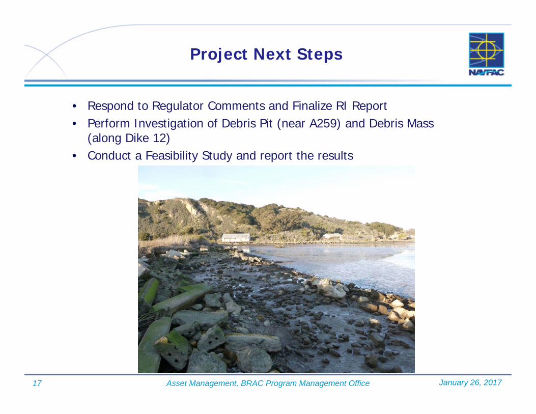
17 Asset Management, BRAC Program Management Office
Project Next Steps
January 26, 2017
• Respond to Regulator Comments and Finalize RI Report• Perform Investigation of Debris Pit (near A259) and Debris Mass
(along Dike 12) • Conduct a Feasibility Study and report the results
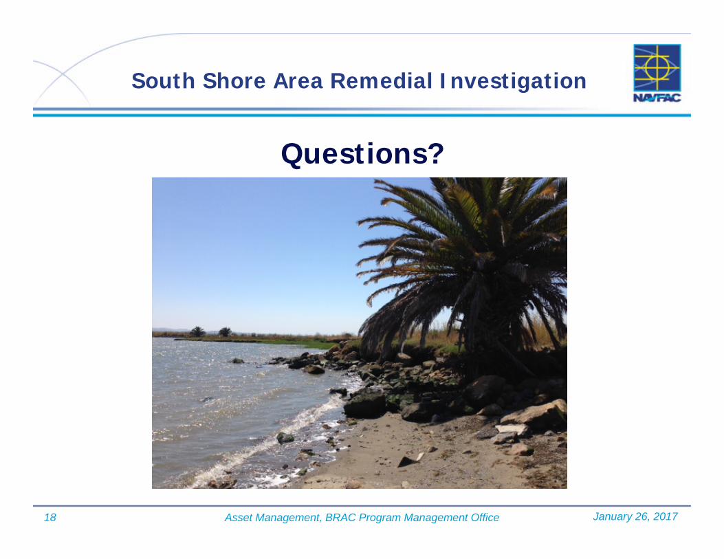
18 Asset Management, BRAC Program Management Office
South Shore Area Remedial Investigation
Questions?
January 26, 2017
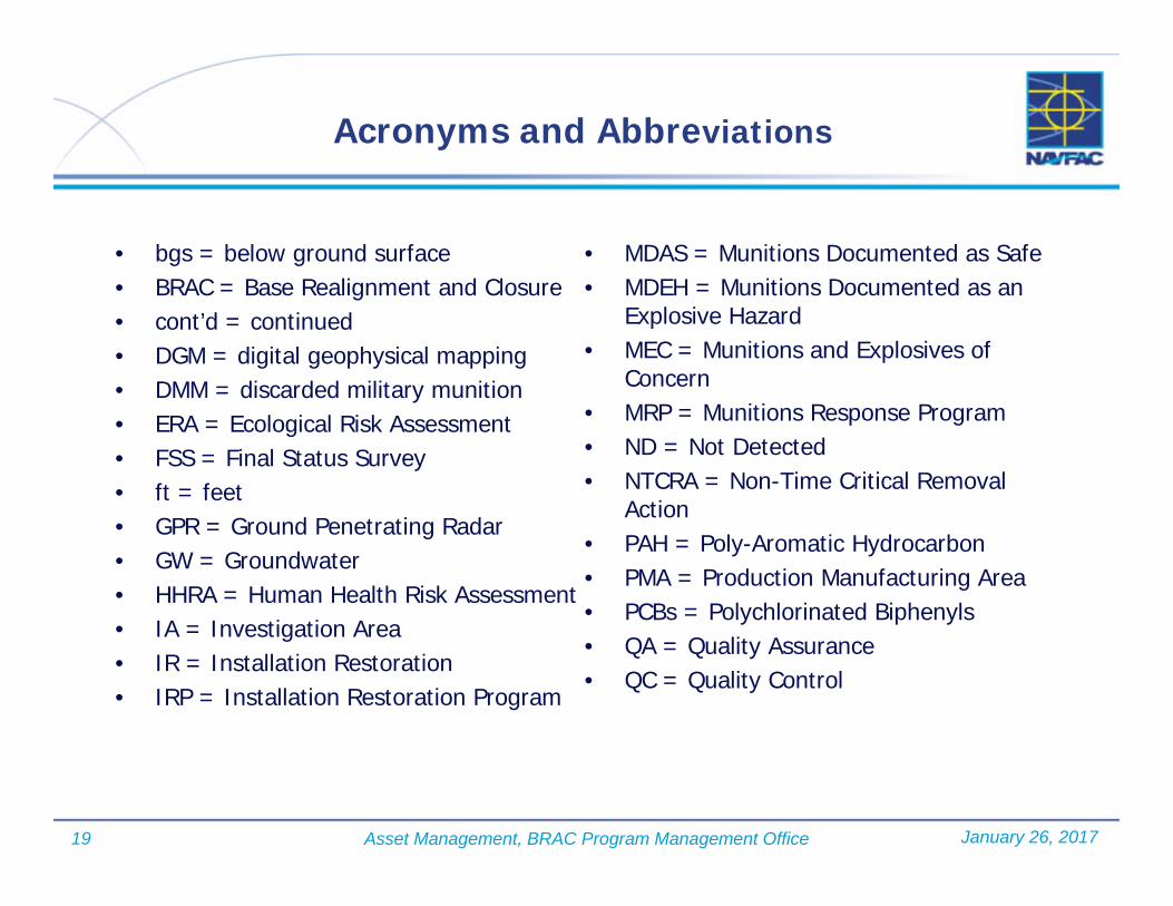
19 Asset Management, BRAC Program Management Office
Acronyms and Abbreviations
• bgs = below ground surface• BRAC = Base Realignment and Closure• cont’d = continued• DGM = digital geophysical mapping• DMM = discarded military munition• ERA = Ecological Risk Assessment• FSS = Final Status Survey• ft = feet• GPR = Ground Penetrating Radar• GW = Groundwater• HHRA = Human Health Risk Assessment• IA = Investigation Area• IR = Installation Restoration• IRP = Installation Restoration Program
• MDAS = Munitions Documented as Safe• MDEH = Munitions Documented as an
Explosive Hazard• MEC = Munitions and Explosives of
Concern• MRP = Munitions Response Program• ND = Not Detected• NTCRA = Non-Time Critical Removal
Action• PAH = Poly-Aromatic Hydrocarbon• PMA = Production Manufacturing Area• PCBs = Polychlorinated Biphenyls• QA = Quality Assurance• QC = Quality Control
January 26, 2017

20 Asset Management, BRAC Program Management Office
Acronyms and Abbreviations (cont’d)
• RAB = Residential Advisory Board• RAD = radiological• RI = Remedial Investigation• RMR = Risk Management Range• SSA = South Shore Area• SVOC = Semi-Volatile Organic
Compound• TDS = Total Dissolved Solids• TPH = Total Petroleum Hydrocarbons• UXO = Unexploded Ordnance• UST = Underground Storage Tank• VOC = Volatile Organic Compound
January 26, 2017

Final MINS RAB Meeting Minutes January 26, 2017 CESJ-2215-0007-0073
Attachment 2. Lennar Mare Island Eastern Early Transfer Parcel Environmental Update 2016-2017 Presentation

Lennar Mare IslandEastern Early Transfer Parcel
Environmental Update2016 - 2017
Presented to Mare Island Restoration Advisory Board
January 26, 2017
Agenda
• Summarize Major Submittals / Activities Initiated / Performed / Completed in 2016
• Summarize Planned Major Submittals / Activities for 2017
• Questions and Answers
2

Eastern Early Transfer Parcel (EETP) Investigation Areas
3
Buildings 85/87/271 Area

Investigation Area B.2-2
• Major Accomplishments of 2016 Received Concurrence from Regulatory Agencies and
No Further Action (NFA) Required at Building 637 Area Site – February 2016
Received Regulatory Agency Certification of Remedial Actions in Investigation Area (IA) B.2-2 – October 2016
Executed, Recorded and Implemented Land Use Covenant (LUC) for Commercial / Industrial Portion of IA B.2-2 – Northern 11 Acres – October 2016
Executed and Recorded Release of Pre-Decision Covenant for IA B.2-2 – November 2016
• Major Activities Planned for 2017 Request and Receive Comprehensive Environmental
Response Compensation and Liability Act (CERCLA) Warranty from Navy
Integrate LUC Portion of Property into Annual Inspection and Five-Year Review Process
4

Investigation Area
5
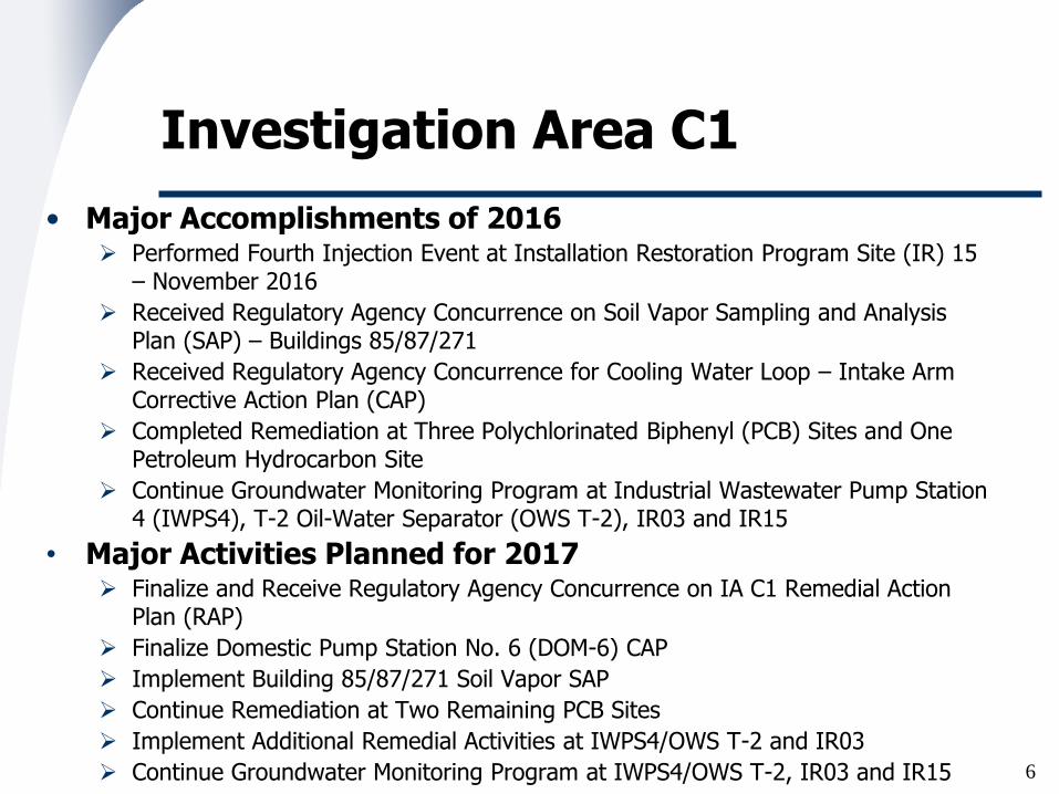
Investigation Area C1
• Major Accomplishments of 2016 Performed Fourth Injection Event at Installation Restoration Program Site (IR) 15
– November 2016
Received Regulatory Agency Concurrence on Soil Vapor Sampling and Analysis Plan (SAP) – Buildings 85/87/271
Received Regulatory Agency Concurrence for Cooling Water Loop – Intake Arm Corrective Action Plan (CAP)
Completed Remediation at Three Polychlorinated Biphenyl (PCB) Sites and One Petroleum Hydrocarbon Site
Continue Groundwater Monitoring Program at Industrial Wastewater Pump Station 4 (IWPS4), T-2 Oil-Water Separator (OWS T-2), IR03 and IR15
• Major Activities Planned for 2017 Finalize and Receive Regulatory Agency Concurrence on IA C1 Remedial Action
Plan (RAP)
Finalize Domestic Pump Station No. 6 (DOM-6) CAP
Implement Building 85/87/271 Soil Vapor SAP
Continue Remediation at Two Remaining PCB Sites
Implement Additional Remedial Activities at IWPS4/OWS T-2 and IR03
Continue Groundwater Monitoring Program at IWPS4/OWS T-2, IR03 and IR15 6

7
Railroad Avenue
Quay Wall
Investigation Area C1

Investigation Area C2
• Major Accomplishments of 2016 Received Regulatory Agency Concurrence on One Storm System Site – IR21 and
Buildings 386/388/390 Area
Received Regulatory Agency Concurrence for One Underground Storage Tank (UST) Site CAP – UST M57, Building 866 Area
Received Regulatory Agency Concurrence for Oil Houses 434 and 862 and Cistern 36 Site CAP
Submitted Cleanup Plan / Notification for One PCB Site
Completed Remedial Activities at Three FOPL and Four PCB Sites
• Major Activities Planned for 2017 Finalize and Receive Regulatory Agency Concurrence on IA C2 RAP
Receive Regulatory Agency NFA Concurrence for Three FOPL Sites
Implement CAPs for UST and Oil House / Cistern Sites
Continue Remedial Activities at Three PCB Sites
Finalize Cleanup Plan / Notification for One PCB Site
Prepare Implementation Report for Building 866 Area – Property Use Change from Commercial / Industrial to Residential (LMI Voluntary Cleanup)
8

Investigation Area
9

Investigation Area C3
• Major Accomplishments of 2016 Prepared Request for Closure Activities and Report for Building 144 OWS Site
Finalized and Implemented SAP for Building 1342 PCB Site
Prepared Final LUCs for Black Granular Material (BGM) Triangle, Building 516 and 516A PCB Sites and Building 730 PCB Site
Prepared Final LUC Operation and Maintenance Plans (O&M Plans) for BGM Triangle, Building 516 and 516A PCB Sites and Building 730 PCB Site
• Major Activities Planned for 2017 Receive Closure Concurrence for Building 144 OWS Site
Receive Regulatory Concurrence for Building 1342 PCB Site SAP Implementation
Finalize LUCs for BGM Triangle, Building 516 and 516A PCB Sites and Building 730 PCB Site
Finalize LUC O&M Plans for BGM Triangle, Building 516 and 516A PCB Sites and Building 730 PCB Site
Finalize IA C3-Wide LUC
Finalize IA C3 Implementation Report
10

Investigation Area C3
11

Investigation Area D1.3
• Major Accomplishments of 2016 Prepared IA D1.3-South (Former Western Shoreline) Implementation
Report
Prepared, Received Regulatory Agency Approval and Implemented SAP to Perform Testing to Investigate the Source of the PCBs in Building 84 Indoor-Air
• Major Activities Planned for 2017 Finalize IA D1.3-South Implementation Report
Receive NFA for IA D1.3-South
Prepare, Execute and Record Release of Pre-Decision Covenant for IA D1.3 South
Perform Additional Testing to Investigate the Source of the PCBs in Building 84 Indoor-Air
12

Investigation Area
13

Investigation Area H2
• Major Accomplishments of 2016 Executed and Recorded IR10 / IR13 LUC – December 2014
Received Regulatory Agency Certification of Remedial Actions in IA H2 – December 2016
Executed and Recorded Release of Pre-Decision Covenant for IA H2 – December 2016
• Major Activities Planned for 2017 Request and Receive CERCLA Warranty from Navy
14

Investigation Area H2
15
Azuar Drive

Eastern Early Transfer ParcelEnvironmental Cleanup Summary
• Two Investigation Areas Received NFA Certification in 2016
• Two Investigation Areas Near to Receiving NFA Certification
• Two Investigation Area RAPs Being Finalized
• PCB Program Currently, 553 of 570 Sites (97%) Have Received NFA Concurrence
Final 17 Sites are at Various States of Completion
• UST Program Currently, 103 of 113 Sites (91%) Have Received NFA Concurrence
Final 10 Sites are at Various States of Completion
• FOPL Program Currently, 112 of 116 Sites (97%) Have Received NFA Concurrence
At 1 Site, Remediation Has Been Completed – Need Final Documentation from Regulatory Agencies
Final 3 Sites are at Various States of Completion
• Other Sites Remediation and Monitoring Continuing at Several IR and Other Sites
16

Questions?

Acronyms and Abbreviations
• BGM – Black Granular Material
• CAP – Corrective Action Plan
• CERCLA – Comprehensive Environmental Response, Compensation and Liability Act
• EETP – Eastern Early Transfer Parcel
• FOPL – Fuel-Oil Pipeline
• IA – Investigation Area
• IR – Installation Restoration Program Site
• IWPS – Industrial Wastewater Pump Station
• LUC – Land Use Covenant
• NFA – No further Action
• O&M – Operations and Maintenance
• OWS – Oil-Water Separator
• PCB – Polychlorinated biphenyl
• RAP – Remedial Action Plan
• SAP – Sampling and Analysis Plan
• UST – Underground Storage Tank
18

Final MINS RAB Meeting Minutes January 26, 2017 CESJ-2215-0007-0073
Attachment 3. Lennar Mare Island January 2017 RAB Update

"S"S"S
"S
"S
!
!
!
!
!!
!
!
!
!!!!!
!!!!
AZUAR DR
WALNUT AVE
CALIFORNIA AVEDUMP RD
MESA RD
C ST
RAILROAD AVE
I ST
CLUB
DR
J ST
7TH ST
A ST
L ST
MARE ISLAND CAUSEWAY
ACCESS RD
D ST
M ST
SARGO WAY
B ST
4TH ST3RD ST
K ST
P ST
E ST
N ST
ACAC
IAL ST
1ST ST
Q ST
15TH ST
9TH ST
MADRONE AVE
10TH ST
OAK AVE
DENT RD
WAHOO AVE
LAWS AVE
PRESTON ST
17TH AVE
FIREDELL AVE
CRISP AVE
WAWSMUTH AVE
KLEIN AVE
18TH ST
IHONSON LN
RAILROAD AVE
OAK AVE
C ST
WATERFRONT AVEW 13TH ST
12TH ST
14TH ST
14TH ST
MOISES WY
TISDALE AVE
5TH ST
5TH ST
E ST
SUISUN AVE
WISEMAN AVE
DETORO WAY
9TH ST
9TH ST
13TH ST
GROVE ST
POMPANO AVE
8TH ST
8TH ST
10TH ST
POPLAR AVE
WEST ELM ST
SAN PABLO
2ND ST
KIRKLAND AVE
REEVES AVE
SAN PABLO AVE
PETALUMA AVE
CURRY ST
SARGO AVE
MAGN
OLIA
ST
H ST
HENLEY AVEKLEIN AVE
ACCESS RD
BUILDINGS 85/89/271
IWPS 4
IR03
IR15
OWS T-2
UST 243BUILDING 121
D1.3
BUILDING 516 AL#01,BUILDING 516A AL#01,BUILDING 516 UL#01
IR13IR10
IR21
BUILDING 386/388/390
FORMER BUILDING637 AREA
H1/X/B207S
BUILDING 1342 UL#01
IA C3 BGM TRIANGLE
BUILDING 742 UL#02
BUILDING 811
BUILDING 207
BUILDING 46
BUILDING 742 UL#03 - UL#06
BUILDING 382/BUILDING 388 FOPLs
BUILDING 144 OIL WATER SEPARATOR (BUILDING 144 OWS)
BUILDING 483 UL#02
ARMY
SCHOOL
A3
B.1
D1.2
D1.1
D1.2
D1.3
D1.1
C1
D2
H2
D1.3
D1.1
B.2-1
B.2-2
C2
C3OIL HOUSE 862
BUILDING 730 AL#01
BUILDING 688 UL#01
CISTERN 36
OIL HOUSE 434
BERTH11
BERTH14
BERTH 02
BERTH
10
BERTH 03BERTH 04
BERTH 05
BERTH 16
BERTH 06
BERTH 15
BERTH 13
BERTH09
BERTH 07
BERTH 12
BERTH 20
BERTH 08
BERTH 17
BERTH18
BERTH 24
WAYS 02
DRY D
OCK
NO. 0
4
WAYS 01
DRY DOCK NO. 01
PIER 22
PIER 21
PIER 23
DRY DOCKNO. 03
DRY DOCK NO. 02
CRITIGEN RDD R:\REMEDYLMI20000895\MAPFILES\LMI_STATUS\COM_11X17L20170124.MXD KDOLAN 1/25/2017 10:57:09 AM
FEATURES WITHIN THE EETPJANUARY 2017 RAB UPDATELENNAR MARE ISLAND, VALLEJO, CALIFORNIA
LEGEND! PCB SITE!! FORMER IWL FEATURES"S FORMER UNDERGROUND STORAGE TANK
FUEL-OIL PIPELINEINVESTIGATION AREAEETPGROUP I SITESSTRUCTURESROADSWETLANDS
FOUR KEY STAGES OF CLEANUPSURVEY & SAMPLINGREMEDIAL INVESTIGATION / FEASIBILITY STUDYREMEDIAL ACTION / CLEANUPPENDING CLOSURE / CLOSED
0 1,200Feet
³
BUILDING 746 UL#01
Upcoming Documents:IA C1 Remedial Action Plan for Public ReviewRevised FOPL Segment H1/2/B85S Implementation Report and Request for Closure, IA C1Building 151 PCB Site AL#01 Site Characterization and Cleanup Action Summary Report, IA C1Building 746 PCB Site UL#01, Site Characterization and Cleanup Action Summary Report, IA C2Building 121, Rooms 101 and 103, Petroleum Hydrocarbon Remedial Action Summary Report, IA C2Revised Building 144 Oil/Water Separator Summary Report and Request for Closure and Response to Comments, IA C3Draft Final IA C3 Implementation ReportGroundwater Beneficial Use Exception, IA D1.3 CentralFinal IA D1.3 South Implementation Report, IA D1.3-South
Agency Reviewed / Commented or Concurred Documents:Revised Draft DOM-6 Corrective Action Plan, IA C1 (DTSC and Water Board Comments)Revised Cooling Water Loop Corrective Action Plan, IA C1 (DTSC Comments and Concurrence)Revised Buildings 85/87/271 Soil Vapor Sampling and Analysis Plan and Response to Comments, IA C1 (DTSC Concurrence)Cooling Water Loop Corrective Action Plan, IA C1 (Comments)Revised Sanitary Sewer Sites Data Gap Site Characterization Report, IA's C1 and C2 (Water Board Concurrence)Revised Buildings 382/388 Fuel-Oil Pipeline Remedial Action Implementation Summary Report, IA C2 (Water Board Comments and Concurrence)Site Characterization and Cleanup Action Summary Report, Building 746A PCB Site UL#01, IA C2 (USEPA Comments)Building 144 Oil/Water Separator Summary Report and Request for Closure, IA C3 (Comments)B1342 UL#01, PCBs Sampling Report, IA C3 (Concurrence)Final Building 516 AL#01, 516A AL#01 and 516 UL#01 PCB Sites Land Use Covenant, IA C3 (Comments)Final Building 730 PCB Site AL#01 Operation and Maintenance Plan, IA C3 (Comments)Black Granular Material Triangle, Final Land Use Covenant Plan, IA C3 (Comments)Black Granular Material Triangle, Final Operation and Maintenance Plan, IA C3 (Comments)IA H2 Pre-Decision Covenant Release (Concurrence, Execution and Recordation)
Field Work Performed:Second Semi-Annual Groundwater Monitoring Event, IR03, IWPS4/OWS T-2 and IR15 Sites, IA C1 UST M57 Corrective Action Plan Groundwater Monitoring Event, Building 866 Area, IA C2 (Post-Remediation Monitoring)Building 742 PCB Site UL#02, IA C2 (Continuation of Remediation)
Upcoming Field Work:Building 87 PCB Site UL#01, IA C1 (Continuation of Remediation)Building 91 PCB Site UL#01, IA C1 (Continuation of Remediation)Buildings 85/87/271 Soil Vapor Sampling and Analysis Plan Implementation, IA C1 (Soil Vapor Sampling)DOM-6 Corrective Action Plan, IA C1 (Initiation of Remediation)Cooling Water Loop Corrective Action Plan Implementation, IA C1 (Initiation of Remediation)FOPL Segment H1/X/B207S, Petroleum Corrective Action Plan Implementation, IA C1 (Initiation of Remediation)Oil Houses 434 and 862 and Cistern 36 Corrective Action Plan Implementation, IA C2 (Initiation of Remediation)UST M57 Groundwater Monitoring Event, IA C2 (Continuation of Groundwater Monitoring)Building 688 PCB Site UL#01, IA C2 (Continuation of Remediation)Building 746A UL#01 PCB Site Remediation, IA C2 (Additional Characterization)Building 742 UL#02 PCB Site Remediation, IA C2 (Continuation of Remediation)
Documents Submitted and/or in Review/Modification:Final DOM-6 Corrective Action Plan, IA C1 First Semi-Annual 2016 Groundwater Monitoring Report, IR03, IWPS4 / OWS T-2, IA C1First Semi-Annual 2016 Groundwater Monitoring Report, IR15 Site, IA C1Building 151 PCB Site AL#01 Site Characterization and Cleanup Action Summary Report, IA C1Revised Sanitary Sewer Sites, Data Gap Site Characterization Report and Response to Comments, IAs C1 and C2Revised Draft for Public Review, IA C2 Remedial Action Plan, IA C2Site Characterization and Cleanup Action Summary Report, Building 688 Pits PCB Site, IA C2Building 746 PCB Site UL#01, Site Characterization and Cleanup Action Summary Report, IA C2B116 Cleanup Plan/Notification, IA C2 (DTSC)Summary Report And Request For No Further Action Building 144, IA C3Final B1342 UL#01 Land Use Covenant, IA C3Final Building 730 PCB Site AL#01 Land Use Covenant, IA C3Black Granular Material Triangle, Revised Final Land Use Covenant, IA C3Black Granular Material Triangle, Revised Final Operation and Maintenance Plan, IA C3Amendment No. 2, Eastern Early Transfer Parcel-Wide Land Use Covenant Operation and Maintenance Plan

Final MINS RAB Meeting Minutes January 26, 2017 CESJ-2215-0007-0073
Attachment 4. Navy Monthly Progress Report
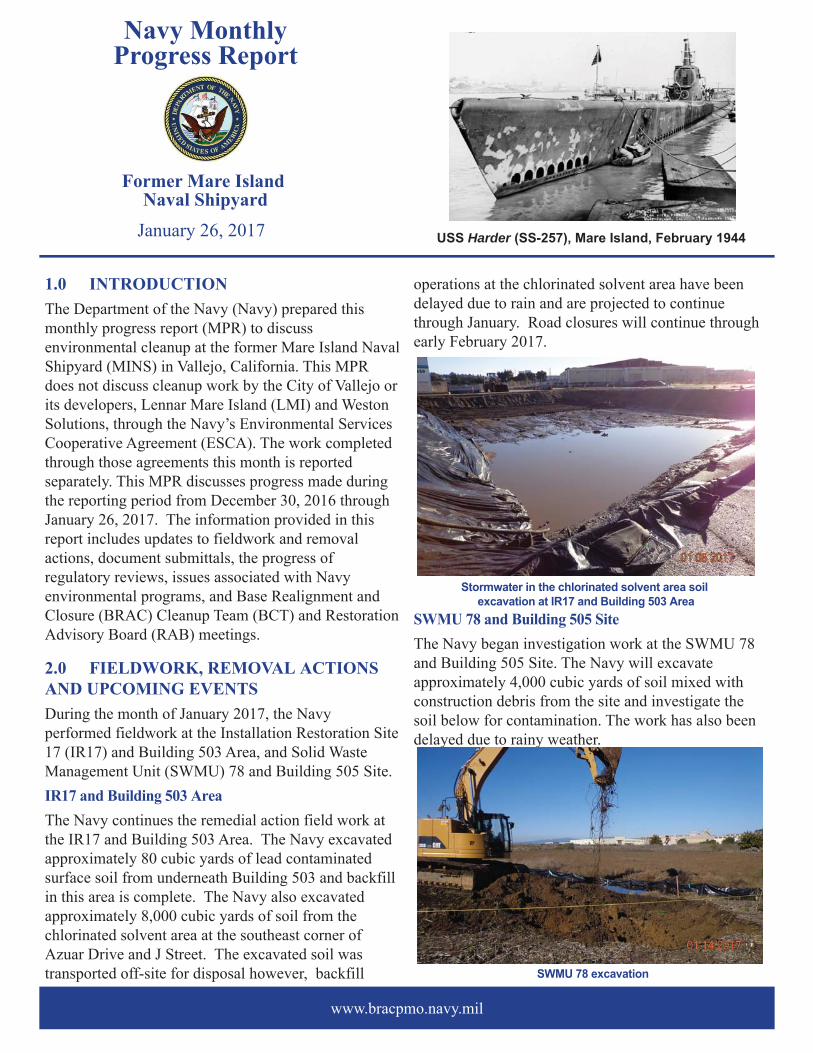
1.0 INTRODUCTIONThe Department of the Navy (Navy) prepared this monthly progress report (MPR) to discuss environmental cleanup at the former Mare Island Naval Shipyard (MINS) in Vallejo, California. This MPR does not discuss cleanup work by the City of Vallejo or its developers, Lennar Mare Island (LMI) and Weston Solutions, through the Navy’s Environmental Services Cooperative Agreement (ESCA). The work completed through those agreements this month is reported separately. This MPR discusses progress made during the reporting period from December 30, 2016 through January 26, 2017. The information provided in this report includes updates to fieldwork and removal actions, document submittals, the progress of regulatory reviews, issues associated with Navy environmental programs, and Base Realignment and Closure (BRAC) Cleanup Team (BCT) and Restoration Advisory Board (RAB) meetings.
2.0 FIELDWORK, REMOVAL ACTIONS AND UPCOMING EVENTS During the month of January 2017, the Navy performed fieldwork at the Installation Restoration Site 17 (IR17) and Building 503 Area, and Solid Waste Management Unit (SWMU) 78 and Building 505 Site. IR17 and Building 503 AreaThe Navy continues the remedial action field work at the IR17 and Building 503 Area. The Navy excavated approximately 80 cubic yards of lead contaminated surface soil from underneath Building 503 and backfill in this area is complete. The Navy also excavated approximately 8,000 cubic yards of soil from the chlorinated solvent area at the southeast corner of Azuar Drive and J Street. The excavated soil was transported off-site for disposal however, backfill
operations at the chlorinated solvent area have been delayed due to rain and are projected to continue through January. Road closures will continue through early February 2017.
SWMU 78 and Building 505 SiteThe Navy began investigation work at the SWMU 78 and Building 505 Site. The Navy will excavate approximately 4,000 cubic yards of soil mixed with construction debris from the site and investigate the soil below for contamination. The work has also been delayed due to rainy weather.
Navy MonthlyProgress Report
Former Mare Island Naval Shipyard
www.bracpmo.navy.mil
USS Harder (SS-257), Mare Island, February 1944January 26, 2017
SWMU 78 excavation
Stormwater in the chlorinated solvent area soil excavation at IR17 and Building 503 Area

January 26, 2017 draypihS lavaN dnalsI eraM remroF - tropeR ssergorP ylhtnoM
www.bracpmo.navy.mil
Mare Island RAB Tour:The Mare Island RAB held a tour of several environmental remediation sites in progress at the island. Attendees came from as far away as Davis to learn about the Navy and LMI remediation efforts.
3.0 DOCUMENT SUBMITTALS AND PROGRESS OF REGULATORY REVIEW The Navy submitted the following documents during the reporting period:
• Draft Unexploded Ordnance Site 7 (UXO 7) South Shore Area (SSA) Remedial Investigation (RI) Report
• Draft Work Plan, As-Needed Groundwater Sampling, Soil Gas Sampling, Well Installation and Well Abandonment
The Navy received comments or concurrence from regulatory agencies on the following documents during the reporting period:• Comments received from the DTSC on the UXO
7 SSA Munitions and Explosives of Concern Time Critical Removal Action Radiological Sampling Analysis Plan
• Comments received from the DTSC on the Draft RI Report for the Munitions Response Program in Investigation Area K
4.0 REGULATORY REVIEW:YEAR-TO-DATE PROGRESSThe documents presented in the following table include only documents that address sites where the Navy remains responsible for the cleanup work.
BCT meetings are held regularly with the Navy,DTSC, and Regional Water Board to discuss the progress of environmental cleanup at MINS. The next BCT meeting will be held on March 30, 2017.
Mare Island RAB Tour Attendees
Number of Documents Submitted by the Navy 2
2
0
0
Number of DTSC Comments Received by the NavyNumber of Regional Water Board Comments Received by the NavyNumber of EPA Comments Received by the Navy
NAVY CONTACT INFORMATIONJanet Lear
BRAC Environmental CoordinatorE-mail: [email protected]
Local Telephone: (707) 562-3104San Diego Telephone: (619) 524-1924
San Diego Fax: (619) 524-0575www.bracpmo.navy.mil
RAB MEETING SCHEDULEThe RAB meets the last Thursday of every othermonth, unless otherwise noted in bold. The next RAB meetings are scheduled for:
• March 30, 2017• May 25, 2017• July 27, 2017
Meetings begin at 7:00 p.m. and are held at:Mare Island Conference Center375 G Street, Vallejo, CA 94592
Copyright © 2022 FDOKUMEN