Mapping natural resource-based poverty, with an application to rural Syria
11
This article appeared in a journal published by Elsevier. The attached copy is furnished to the author for internal non-commercial research and education use, including for instruction at the authors institution and sharing with colleagues. Other uses, including reproduction and distribution, or selling or licensing copies, or posting to personal, institutional or third party websites are prohibited. In most cases authors are permitted to post their version of the article (e.g. in Word or Tex form) to their personal website or institutional repository. Authors requiring further information regarding Elsevier’s archiving and manuscript policies are encouraged to visit: http://www.elsevier.com/copyright
-
Upload
independent -
Category
Documents
-
view
3 -
download
0
Transcript of Mapping natural resource-based poverty, with an application to rural Syria
This article appeared in a journal published by Elsevier. The attachedcopy is furnished to the author for internal non-commercial researchand education use, including for instruction at the authors institution
and sharing with colleagues.
Other uses, including reproduction and distribution, or selling orlicensing copies, or posting to personal, institutional or third party
websites are prohibited.
In most cases authors are permitted to post their version of thearticle (e.g. in Word or Tex form) to their personal website orinstitutional repository. Authors requiring further information
regarding Elsevier’s archiving and manuscript policies areencouraged to visit:
http://www.elsevier.com/copyright

Author's personal copy
Mapping natural resource-based poverty, with an application to rural Syria
Judit Szonyi a,*,1, Eddy De Pauw b,2, Roberto La Rovere a, Aden Aw-Hassan b,2
a CIMMYT, Apdo. Postal 6-641, 06600, D.F., Mexicob ICARDA, Int., P.O. Box 5466, Aleppo, Syrian Arab Republic
a r t i c l e i n f o
Article history:Received 13 February 2008Received in revised form 5 June 2009Accepted 11 June 2009
Keywords:Agricultural income distributionPoverty mapNatural resource endowmentSyria
a b s t r a c t
This study presents advances in resource-based poverty mapping. It illustrates how agricultural incomedistribution maps can be generated at small pixel-level, providing an application of the approach in ruralSyria. Census data on agriculture and population are disaggregated based on pixel-level agricultural pro-ductivity coefficients derived in a GIS environment. The approach, triangulated with survey results andcompared with sub-national poverty maps, shows that the better-income areas of Syria are located inthe irrigated and higher-rainfall areas, though lower-income pockets exist due to the presence of ecolog-ical and topographic factors or due to high population density. The method can be used for developinghigh-resolution, low cost maps for rapid detection of resource-driven poverty in low income countrieswhere agriculture is a major source of rural income, and where poverty mapping is rarely undertakendue to the high costs involved.
� 2009 Elsevier Ltd. All rights reserved.
Introduction
The importance of poverty reduction to the world developmentagenda has motivated greater interest in the geographic dimen-sions of poverty and food security (Hyman et al., 2005). In the ruralareas of developing countries, poverty is strongly linked with geo-graphical conditions and natural resources availability (Okwi et. al.,2007). The state and trends of natural resources on which rurallivelihoods depend have emerged as key determinants of well-being and poverty. Recent maps (WRI and others, 2007) highlightthe benefits nature provides to people and the linkages betweenpoverty and ecosystem services in Kenya, showing how map-basedanalyses of poverty-ecosystem relationships can influence policydevelopment and implementation.
Coefficients derived from agro-ecological constraints (soils,heat, water, slope) can provide estimates for the distribution of re-source-based poverty; these can be used to derive high-resolutionincome distribution maps that provide visual information for pol-icy simulations. Information on the spatial distribution of povertyand environmental degradation is of interest to policy makers
and researchers as it can be used to quantify disparities in welfareacross regions, to facilitate the targeting of food insecurity andpoverty alleviation programs, and to shed light on the geographicfactors associated with poverty (Okwi et al., 2006).
International organizations involved in the global effort to re-duce poverty have developed different poverty map approaches(Hyman et al., 2005), well synthesized in Food Policy’s 2005 specialissue on ‘Poverty and Food Security Mapping’. The InternationalCentre for Agricultural Research in Dry Areas (ICARDA) has also ini-tiated a wider effort to address resource-driven poverty and bettertarget its interventions where poverty and food security are prior-ity concerns and where natural resource constraints are limitingresearch and development efforts most.
This study describes ICARDA’s experience and contribution tothe literature on the topic. In the following chapters, we illustratehow resource-based poverty maps can be generated at small pixel3
level, introduce the use of poverty maps in the context of countrieswhere natural resource poverty is dominant, with focus on the Syriacase study, and provide insights on the opportunity to apply thepresent approach for rapid poverty appraisal exercises, where theseare most needed.
Poverty maps and the environment
Poverty maps can be used to integrate biophysical informationand socio-economic data to show a more systematic, analyticalpicture of human welfare and poverty (Henninger and Snel,2002). The inclusion of biophysical information greatly helps to
0306-9192/$ - see front matter � 2009 Elsevier Ltd. All rights reserved.doi:10.1016/j.foodpol.2009.06.007
* Corresponding author. Tel.: +52 55 5804 2004; fax: +52 55 5804 7558/59.E-mail address: [email protected] (J. Szonyi).URL: http://www.cimmyt.org (J. Szonyi).
1 US Postal address: (exclusively for letters), CIMMYT, Int., C.I.P./Mexico, ImpactsTargeting and Assessment Program, AP 370, P.O. Box 60326, Houston, TX 77205, USA.Tel.: +1 650 833 6655; Courier Service address: Km. 45 Carretera México-Veracruz, ElBatán, Texcoco, Edo. De México, C.P. 56130, México. Tel.: +52 55 5804 2004x2119;fax: +52 55 5804 7558/9.
2 Tel.: +963 21 2213433; fax: +963 21 2213490. 3 Pixels are internally uniform cells used in GIS (and other visual) applications.
Food Policy 35 (2010) 41–50
Contents lists available at ScienceDirect
Food Policy
journal homepage: www.elsevier .com/locate / foodpol

Author's personal copy
improve the poverty estimates and also enables targeting of pov-erty reduction work (Okwi et al., 2006). They can improve develop-ment efforts by making the spatial allocation of national orinternational funds for agricultural research and developmentmore effective. They can highlight areas marginalized by resourceconstraints, help in setting priorities for developing technologiesand in transferring resources where they are most needed andlikely to have greater impacts on poverty. By identifying who andwhere the poor are, poverty maps help to target research and to re-veal why communities or people are poor.
Various studies have attempted to link sub-national well-being,geographic and environmental variables, using correlation and vi-sual spatial analysis. Spatial analysis uses various techniques andgeo-referenced data. As data quality improves with satellite tech-nology, the understanding of the ecological and resource con-straints linked to the spatial distribution of poverty also improves.
Geographic location and climate have a large effect on incomelevels and growth, by affecting agricultural productivity, transportcosts, and diseases (Gallup and Sachs, 1999). Sullivan (2002) linkedphysical indicators of water availability with socio-economic vari-ables and introduced a water poverty index for regional compari-sons. Godilano et al. (2000) link disaggregated poverty incidenceto environmental risk (flooding) in Bangladesh and area suitabilityfor rice production.
Small area regression estimation, a widely applied approach foranalyzing rural poverty and food security, as reviewed for sevencountries by Hyman et al. (2005) shows that topography, soil char-acteristics, rainfall, evapotranspiration and vegetation are impor-tant explanatory factors in describing poverty. You and Wood(2006) use an entropy-based approach to make spatially disaggre-gated assessments of distribution of crop production using data oncrop production statistics, farming system characteristics, satellite-derived land cover, biophysical crop suitability assessments, andpopulation density. Okwi et al. (2007) use a spatial regression toexplore the effects of geographic factors on poverty; slope, soiltype, distance/travel time, public resources, elevation, land-useand demographic variables were significant in explaining the spa-tial patterns of poverty. The atlas from WRI and others (2007) over-lays geo-referenced statistical information on population and
household expenditure with spatial data on ecosystems and ser-vices (water availability, wood supply, wildlife population) show-ing how land, people, and prosperity are related in Kenya. Theseand other studies point at the strong linkages that exist betweenrural poverty, access to resources (e.g. owned land, water, animals,machinery), and agro-ecological variables (e.g. climate, soil, avail-ability of water for irrigation) and suggest an existing potentialfor integrating current and emerging GIS-based data on environ-mental characteristics with socio-economic data, in order to ana-lyze the interaction between poverty and natural resources.
Agriculture, natural resources and poverty in Syria
Syria is a mid-size country with total land area of about18.5 million ha of which 13.7 are for agricultural purposes. Abouthalf of the total (17 million) population resides in rural areas(CBS, 2004). Almost two third of rural households are involved inagriculture, but poor households rely much more on agriculture(Keyzer et al., 2006). Natural resource endowment is a critical fac-tor for rural poverty. Precipitation varies from 1500 mm in thewest to less than 100 mm in the southeast. Drought is inherentin local systems, only attenuated by the gradual expansion of irri-gation (1.33 million ha irrigated, out of the 5.42 million arableland, FAOSTAT 2003) mostly in the Orontes river valley in the westand Euphrates valley in the east.
Syria ranks relatively low in human development indicators(UNDP, 2005). However, national-level indicators of human wel-fare hide a complex picture of rural poverty and food insecurity.While poverty in Syria remains not well documented and the sta-tistical database is not publicly available, recent studies by the Uni-ted Nations Development Program (UNDP) and International Fundfor Agricultural Development (IFAD) have provided a good pictureof poverty distribution.
The UNDP study by El-Laithy and Abu-Ismail (2005) was basedon the statistical analysis of a sample of 30,000 urban and ruralhouseholds. The study concluded that in 2003–2004 about 10% ofpeople were below the income poverty line of 2 US$ a day, but thatpoverty is shallow, with most people clustered just below the pov-erty line. The North-East of the country, both the rural and the ur-
Nomenclature
CRIj climatic resource index in pixel jTRIj topographic resource index in pixel jSRIj soil resource index in pixel jCDBPI climatically determined biomass productivity indexAHU annual growing-degree-days (GDD) above 0 �CAIadj adjusted aridity indexopt1, opt2 optimum values of the CDBPIINCj income from agriculture (SYL)APCj agricultural production coefficientMw,j % of irrigated ‘ir’, and rainfed ‘r’ areas in pixel jqi agricultural production in agricultural sub-zonepi price for agricultural productnz pixel area (number of pixels in the sub-zone)ARIj agricultural resource potential indexlcj livestock distribution coefficientLVj livestock value in pixel jBk correction factor for ‘useful’ biomass in land-use/land
cover type k0
APk,j proportional area of land-use/land cover type k in pixel jSSEi standard settlement equivalentSSEaar adjusted standard settlement equationAi area of settlement i (in m2)
As standard settlement area (0.03125 km2)Ap size of the pilot areaAar size of the agricultural regionFT township fractionFV villages fractionRF adjustment fractionPopn population in the nahiaPopn,ar estimated population in each agricultural region within
a nahian N of agricultural regions inside a nahiapar proportion of the agricultural region inside the nahiaDSSEar standard settlement density for the agricultural regionDSSEaar adjusted standard settlement density for the
agricultural region
Suffixesz subzonesj pixels (�1 km2)i products (e.g. crops, fruits, vegetables, livestock)w water availability (‘r’ rainfed, ‘ir’ irrigated)k different land-use/land cover typesl livestock
42 J. Szonyi et al. / Food Policy 35 (2010) 41–50
Author's personal copy
ban areas, shows the greatest incidence, depth and severity ofpoverty.
The IFAD study (Keyzer et al., 2006), based on a large-scale sur-vey of 30,000 households by the Syrian Ministry of Agriculture andAgrarian Reform, focused on rural poverty and made a finer spatialdifferentiation of poverty features than the UNDP study. The IFADmaps indicate that rural poverty is highest in the northeast, mainlyin Deir-ez-Zor, Al-Rakka and Hassakeh, while living standards aremost favourable in the coastal and southern governorates. TheIFAD study also shows that extreme poverty, as defined by the1 US$ a day line, is low in Syria.
At the national-level poverty concerns the availability of land,water, soils, and topographic resources for agriculture; at thehousehold level it concerns the individual household’s access to re-sources. The two are linked, since in areas with a poor resource ba-sis, such as arid or rocky parts of the country, few households haveaccess to quality land, while in areas with good natural resourceshouseholds may not benefit from the land, either because of limit-ing property rights or because many people depend on the sameresources. Insufficient access to land is most likely a determinantof rural poverty, since the share of households owning land is low-er among the poor households than among the non-poor house-holds (Keyzer et al., 2006). Additionally, in Syria natural resourcepoverty is expressed by the need of parts of the rural people touse land marginal for agricultural productivity or with severe topo-graphic or soil limitations.
Objectives of the study
The objective of this study was to develop a cost-effective andeasily transferable GIS-based methodology to link the natural re-sources endowment to the income from agricultural activities. Thisapproach, usable by development agencies and national statisticalservices in developing and middle income countries can help inidentifying areas that are falling behind in terms of economicdevelopment, by detecting the ‘hot-spots’ of low agricultural in-come due to resource poverty. The study complements other moredata intensive methods, such as those by IFAD and UNDP, by pro-posing a low cost and more rapid approach to poverty assessment,and to visualize resource poor rural areas where livelihoods and of-ten food security are based on agriculture.
Materials and methods
Our approach is based on the hypothesis that in countrieswhere a high proportion of population has livelihoods based onagriculture the lack of a natural resource base for agriculture (re-source poverty) is an indicator of human poverty. If appropriateindicators are chosen, resource poverty is easier to assess than hu-man poverty, thanks to the large public domain database currentlyavailable on climate, soils, topography, irrigated areas and satelliteimagery. Also, in contrast with the coarse spatial resolution of in-come related indicators, such as agricultural production, yieldsand prices, and the scattered nature of household surveys, resourcedata in most cases have both comprehensive spatial coverage and afiner spatial resolution. In those cases where no direct and compre-hensive poverty mapping is feasible, it makes sense to track pov-erty hot-spots by an indirect method that combines coarse-resolution agricultural statistics, price information, data on popu-lation and finer-resolution natural resource data. The methodologywe use is therefore based on a spatial representation of the incomedistribution from agriculture, through a disaggregation procedurethat uses agro-ecological data and natural resource constraints.
As seen from the literature review, one very common povertymapping approach is spatial regression, which requires a large
geo-referenced socio-economic (household) dataset, and whichwas not available in this study. One key innovative aspect of ourapproach was combining spatial analytical techniques (e.g. inter-polation, simulation and modeling) and geographical data withavailable census data, in order to generate resource-based povertymaps on small pixel-level.
In the next sections we discuss the concept of agricultural re-source potential index (ARI) used in the disaggregation procedure,how the ARI was used to disaggregate agricultural income data tothe fine pixel-level, and how to adjust the population densities ob-tained from statistical reporting units to the pixel-level, to gener-ate fine-resolution per-capita agricultural income maps.
Assessing agricultural resource endowment
To quantify agricultural resource endowments by means of anagricultural resource potential index (ARI), different resource indi-ces were developed, quantified and merged into a single index thatprovides the basis for the spatial allocation of agricultural income.The method considers all relevant biophysical factors and allowsconsistent comparisons between different locations, since all thefour indices have a common scale of (0–100). The method allowsassessing the contribution of individual environmental factors to-wards agricultural resource poverty, is scale-independent, andcan be applied using GIS global datasets that normally are cur-rently available. The components of the ARI are:
(1) Climate resource index (CRI) shows the climatic potential toproduce biomass;
(2) Soil resource index (SRI) is the proportion of the pixel withoutproblematic soil types;
(3) Topographic resource index (TRI) is the proportion of pixelwithout topographic limits.
The low value of CRI represents severe climate (temperatureand lack of water) constrains on production. The low value of SRIrepresents severe soil constrains to agricultural production. Thelow value of TRI shows areas where there is severe constrains toagriculture due to slopes. High scores show instead that no limita-tions are present. The three indices are selected as they representthe key factors of agricultural resource potential under naturalconditions (climate, soils, and topography). A fourth factor (pres-ence of irrigation water) is a modifier of the climatic resource in-dex. The indices are not correlated, so that they capture themaximum variation of the agricultural environments. All threeindices have the same spatial resolution (0.00833 decimal degrees,corresponding with approximately 1 km2 grid cell size). These arerelatively small regular divisions of the area to be evaluated, equiv-alent to the ‘pixels’ of a remotely-sensed image, and are processedusing automated methods in a raster-based4 GIS, at a finer-resolu-tion than other recent studies (e.g. You and Wood (2006) use 25–100 km2 pixels). Some technical notes on the steps for explaininghow resource indices are derived are highlighted in Table 1.
Climatic resource index
The Climatic resource index (CRI) captures the climatic poten-tial for biomass production; it is scaled to the 0–100 range (Eqs.(1)–(3) in Appendix) by using the distance of the ClimaticallyDetermined Biomass Productivity Index-values (CDBPI) from anoptimum range (Fig. 1). This range was determined empiricallyfrom parts of Central and West Asia and North Africa (Szonyi
4 ‘Raster’ is a term used in GIS to designate a file structure in which a map or imageis stored as a grid-like pattern of values for small, internally uniform cells (pixels).
J. Szonyi et al. / Food Policy 35 (2010) 41–50 43

Author's personal copy
et al., 2005). The CDBPI is a proxy for the annual atmospheric en-ergy available for biomass production, expressed by accumulatedtemperature (AHU), and adjusted for drought stress (Eq. (4)). Themeasure for drought stress was the aridity index, which is the ratiobetween annual precipitation and annual potential evapotranspi-ration, calculated by the Penman–Monteith method. The inputdata used to map the CDBPI consisted of 1-km resolution climate‘surfaces’; these are raster files prepared by the spatial interpola-tion5 of point climatic data using the thin-plate smoothing splinemethod (Hutchinson, 1995). Climatic data for individual stationswas obtained from the FAOCLIM database (FAO, 2001) and nationalmeteorological datasets. AHU values were obtained from climatesurfaces of mean monthly temperature. The aridity index was ob-tained from surfaces of annual precipitation and potential evapo-transpiration. If the AI values exceeded 1, they were adjusted to 1,to ensure that very cold areas (with low AHU) do not get an exces-sive CDBPI through compensation from high AI (as is often the casein cold areas because of low evapotranspiration rates). In irrigatedareas the AI values were also set to 1, to indicate no moisture limi-tation. For irrigated pixels the CDBPI is thus equal to the AHU. In coldareas, AHU is also very low, so it remains possible to differentiateareas with high rainfall from cold ones.
Soil resource index
The Soil resource index (SRI) is the proportion of the pixel with-out problematic soil types. Problematic soils are those that areeither unsuitable for agricultural production due to severe physicallimitations, or soils that are very expensive to reclaim for produc-tion. The following problematic soils were considered as relevantto Syria and feasible to be mapped at a national-level: (1) salinesoils, (2) stony soils, (3) shallow soils, and (4) soils with texturallimitations (too heavy or coarse). The dataset used to develop theSRI for Syria was a 1982 soil survey by the United States Agencyfor International Development and by the Syrian Ministry of Agri-
culture (Louis Berger International, 1982). In the case of salinityand soils, despite that more degradation may have occurred since1982, the data we used is the one commonly used by ICARDA.
Topographic resource index
The Topographic resource index (TRI) was derived from a Shut-tle Radar Topographic Mission Digital Elevation Model (CGIAR-CSIonline database, 2004) by calculating the slope for each 90-m pixel.In order to match the resolution of the other datasets used to cal-culate the CRI and SRI, the slope pixels were aggregated to a pixelsize 100� larger. The TRI was calculated as the percentage of SRTMpixels with a slope below 15%, which corresponds well with theslope limit delineating what constitutes sustainable agriculturewithout resorting to terracing.
Agricultural resource potential index
This study is testing an approach to approximate rural povertythrough biophysical variables in countries, where household sur-vey data is not available. The thematic indices (CRI, SRI and TRI)were combined as raster themes in GIS, with the same spatialscope and resolution, into the agricultural resource potential index(ARI) (Eq. (5)). The ARI is calculated as the lowest value of the CRI,SRI, and TRI indices for rainfed areas. If, however, a fraction of thepixel is irrigated, only the CRI is considered for the irrigated frac-tion in the ARI calculation, this assuming that irrigation takes placewhere soil and topographic conditions are not severely constrain-ing. The irrigation water availability matrix (Mw) (Eq. (7)) showsthe proportion of an irrigated pixel (using a previous land-use/landcover map, De Pauw et al., 2004). On steep slopes the ARI normallyis low, because the TRI is low as steep slopes are unsuitable for sus-tainable agriculture. If slopes are terraced, the TRI changes for thebetter, and the ARI will indicate a higher resource potential.
The approach was developed to provide a simple, yet effectiveway to integrate aspects of natural resource potential to aid map-ping and target poverty. For all countries climatic and topographydata and national soil maps are available. In most countries land-use/cover maps are available, and where they are not global prod-ucts are now becoming available with resolutions from 300–1000 m. The process for calculating the different resources indicesand the integrated ARI takes a few days to one week, depending onthe state of the initial soil and climate databases (Table 1).
Income distribution based on agricultural resource endowment
For administration purposes, Syria is divided into mohafazas(provinces), and each mohafaza is divided into mantikas (districts).Each mantika is divided into administrative units called nahias (the
Table 1Technical notes on resource indices.
CRI Step 1: Global climatic databases on precipitation, temperature and potentialevapotranspiration are supplemented with national data. Temperature isconverted into ‘annual growing-degree-days’Step 2: Spatial interpolation, using GIS software, to obtain raster files with1 km resolution of precipitation, annual growing-degree-days, potentialevapotranspiration and aridity indexStep 3: Calculation of the CDBPI using Eq. (4)Step 4: Calculation of the CRI by inserting a formula equivalent to Eqs. (1)–(3)in the raster calculator module of the GIS software
SRI Step 1: Start with a national soil map, already in the database format:mapping unit (soil unit x, % of soil unit x). If soil map is not yet in this format,its conversion may take from 1 day to 1 week, depending on size of thecountry, detail of the soil map, and complexity of the soil map units.Step 2: Interpreting each soil unit as either ‘problematic’ or notStep 3: Calculating the percentage of ‘problematic soils’ in each mapping unitand adding it to the attribute table of the digitized soil map in vector formatStep 4: Converting the vector layer to raster at 1 km resolution, using the‘problematic soils percentage’ field
TRI Step 1: Starting with the SRTM digital elevation model with 90 m resolutionStep 2: Calculating the slope from the SRTM DEMStep 3: Creating a new grid at the same resolution which contains theinformation that each grid cell has either a slope below 15% or notStep 4: Calculating TRI by aggregation of new grid using a cell of 100� theoriginal grid (to bring it to 1 km resolution) and summation technique foraggregation
ARI Step 1: Calculating the minimum of the three indices (CRI, SRI, TRI) using theminimum function in the raster calculator of the GIS software
Fig. 1. Empirical relationships between CRI and CDBPI (see Eq. (1) in Appendix).
5 Spatial interpolation methods estimate geo-variables at unobserved locationsbased on values at observed locations.
44 J. Szonyi et al. / Food Policy 35 (2010) 41–50

Author's personal copy
equivalent of counties), each covering a number of villages. Thereare in total 14 mohafazas, 60 mantikas, and 211 nahias in Syria(CBS, 2003). Besides an administrative zoning, Syria also has anagricultural zoning system with five classes (or ‘Agricultural Stabil-ity Zones’) based on the quantity and reliability of annual precipi-tation (MAAR, 1994–2004).
The Agricultural Production Database of Syria (NAPC, 2003) pro-vides production and price data for crops, fruits, vegetables andanimal products for ‘agricultural sub-zones’, which are the spatialunits resulting from the intersections of the provinces and theAgricultural Stability Zones’. Prices of products not included inNAPC were taken from the FAO database or from a local marketsurvey in Aleppo based on year 2000 data. The sum of all agricul-tural products was multiplied by their wholesale value; this wasconsistent with the share of agriculture in the national account,equivalent to about 25% of the Gross Domestic Product in year2000 (NAPC, 2003).
Agricultural income (INC) is a function of prices (p) and agricul-tural production (q), which depends on agricultural resource con-ditions (Eq. (6)). Aggregate census data of the ‘agricultural sub-zones’ was spatially disaggregated by rescaling the database withthe mean of the ARI index for the same area. This derived an Agri-cultural Production Coefficient (APC) database [from 0 to 2] (with amean value equal to 1 in each sub-zone), which determined the va-lue of income in each pixel. The distance from the ARI mean valuedetermines if the APC is above or below 1, hence augments or less-ens the distribution of the average income. In the allocation of in-come to the individual pixels from rainfed or irrigated agriculture,the ARI values were weighted according to the proportion of rain-fed or irrigated land present in each pixel (Eqs. (6–8)).
Capturing the geographic distribution of income from livestockproved more difficult as some of the statistical data is available onlyat the provincial level (MAAR, 1994–2004). These are generallylarge spatial units that may contain much diversity in terms of graz-ing value. Income from sheep, goat and cattle includes sale of liveanimals, meat, wool, milk and other dairy products; income from
poultry includes the sales of meat and eggs. Eqs. (9)–(11) calculatethe disaggregated livestock income. To obtain some reasonableallocation coefficients of the total value per pixel, a livestock distri-bution coefficient was introduced (Eq. (10)), based on estimates oflivestock proportionality by land-use/land cover type (from theland-use/land cover map by De Pauw et al. (2004)). This 67-classsystem was reclassified using five basic land-use/land cover (LULC)types, characterized by a ‘biomass fraction ðBkÞ0, a proportion of thebiomass in each LULC class ‘useful’ to livestock, estimated by expertjudgment. Rainfed cultivation was considered to have a livestockbiomass fraction of 0.2, irrigated cultivation 0.4, bare land 0.05, for-est 0.1 and rangeland 0.7. Each map unit of the LULC map was thenassigned a ‘Livestock Value’ (LV), on the basis of the presence andproportion of basic LULC types in the mapping unit, and their bio-mass fractions (Eq. (11)). Once all pixels in a province had been as-signed a livestock value, the allocated total livestock value per pixelwas based on the ratio of the pixel’s livestock value to the sum of alllivestock values in the province. The agro-industries (e.g. lamb fat-tening, dairy) are taken into account in calculating livestock incomeby means of the added value from sales.
Per-capita income distribution from agriculture
To represent the per-capita income distribution from agricul-ture, population density also had to be disaggregated from the low-est administrative level (nahia) for which data was available, to thepixel-level. The population data for the nahia, obtained from thelatest census survey (CBS, 1994 data), were updated with annualgrowth rates for rural areas in the different administrative regions(CBS, several years). Nahia-level population densities were ad-justed to the pixel-level by intersecting the nahia with the bound-aries of ‘agricultural regions’. ‘Agricultural regions’ are integratedspatial units in which available water resources, climate, terrain,and soil conditions combine to create unique environments, asso-ciated with distinct farming systems, land-use and settlement pat-terns. The agricultural regions were mapped through visual
Fig. 2. Agricultural resource potential index (ARI) in Syria.
J. Szonyi et al. / Food Policy 35 (2010) 41–50 45

Author's personal copy
interpretation of Landsat imagery for the summer of 2002 and thespring of 2003 covering all of Syria by De Pauw (Szonyi et al.,2005). The Landsat imagery was also used to identify and map set-tlement patterns in pilot areas covering all agricultural regions andabout 45,000 km2 (24%) of Syria. In these pilot areas settlementareas were measured and converted into standard settlement den-sities for each agricultural region. In a final step the nahia-levelpopulation densities were recalculated according to adjustmentfactors applicable to agricultural regions. For each nahia–agricul-tural region combination, weights were applied to the nahia-basedpopulation densities that reflected the differences in settlementdensity between agricultural regions. The adjustment of popula-tion density to the pixel-level was done by using estimated popu-lation density coefficients (Eqs. (12)–(17)) obtained from amapping procedure based on identified ‘agricultural regions’ (Szo-nyi et al., 2005). Characterization of agricultural regions based onsettlement patterns (by satellite images), multiplied by the propor-tion factor (pr) of the sample provides estimates of population den-sity (DSSE), that are used to disaggregate population census data atthe pixel-level (Eqs. (12)–(17)).
Results from the Syria case study
The pattern of the ARI in Syria (Fig. 2) is due to two mainsources of resource potential: the rainfall gradient from north tosouth and west to east, and the presence of irrigated areas. Areaswith low ARI are associated with low rainfall (especially steppeareas), the absence of sources of irrigation water, and the presenceof mountain ranges with steep topography and shallow soils.
The resource-based pixel-level allocation of total income fromagriculture and livestock in rural Syria is given in Fig. 3. The overallpattern of the ARI-modelled income distribution clearly reflects thegradients in precipitation and the distribution of irrigated land.Ultimately these are the key resources of agriculture in Syria, sinceeven livestock income depends on them. Within the better-incomeareas, pockets with shallow soils or unfavourable topography ap-pear as lower-income spots. One exception is the coastal moun-
tains in the west of Syria, where income is better than expectedfrom its agricultural resource potential. This is explained bylarge-scale investments by the government and private sector inland improvement, chiefly through terracing and rock removal,which have significantly improved the earning capacity of localagriculture. Fig. 4 shows the overall pattern of per-capita incomedistribution from agriculture. To avoid artefacts creating artificiallyhigh per-capita income where very few people live, a ‘mask’ wasapplied to exclude areas with less than 5 persons/km2. The trendfor per-capita income is similar, though more fragmented, alikethat of total income from agriculture: where total income is high,so is per-capita income, and vice-versa. Exceptions exist, e.g. theEuphrates plain southeast of Deir-ez-Zor has, despite a high totalannual income (SYL 5,000,000/pixel) it has fairly low per-capita in-come (SYL 10,000–20,000/person/pixel) from agricultural activi-ties. In such areas higher population densities explain the lowerper-capita income and could point to a high poverty incidence. Infact, all poverty indicators used by Keyzer et al. indicate the areadownstream of Deir-ez-Zor as a major poverty cluster. Thoughthe Damascus area shows high income, this is partially explainedby not accounting for urban population in the per-capita account.The model, in fact, does not include urban income. The assumptionthat agricultural income is generated and redistributed in ruralareas, may not be true in some cases (e.g. lamb fattening profitmay go to urban businessmen), but may be true in other caseswhen it goes to local (rural) employees.
Discussion
A comparison of the IFAD poverty indicators with our per-capitaagricultural income maps reveals a high consistency in povertyclusters in the hilly system of North Western Syria, in areas eastof Aleppo and west of Lake Assad, and partial agreement in theEuphrates and the Khabour river valleys. However, the povertyhot-spot in the transition zone to the rangeland east of Hama isnot detected. With the exception of the Deir-ez-Zor area, the spa-tial patterns of pixel-level per-capita income estimates could not
Fig. 3. Spatially disaggregated total income from agriculture (in SYL/pixel/year).
46 J. Szonyi et al. / Food Policy 35 (2010) 41–50

Author's personal copy
be matched consistently with the poverty clusters identified by theIFAD study. This is unsurprising given that in Syria income sourcesare diverse, with wage income the most important source in allprovinces, and agricultural income a close second. In the Deir-ezZor area the share of agricultural income is higher than nationalaverages and the wage income lower, which may explain why apoverty hot-spot shows up in per-capita income from agriculture.Our resource-based income map shows higher percentages of pop-ulation below 1 and 2 USD/day per-capita than from the UNDPstudy; the difference, also in this case, can be explained by the highpercentage of off-farm income from non-farming work andremittances.
The overall pattern of the pixel-level allocated total incomefrom agriculture corresponds well with the areas of high and lowagricultural potential, as identified by resource surveys (e.g. LouisBerger). This strengthens the confidence that the indices used toquantify the resource potential and to downscale agricultural in-come to the pixel-level can stand reality tests. In fact, a recentstudy provided site specific validation of the ARI-based allocationmethod at the landscape level in the Khanasser area, situated innorth-eastern Syria between the cropped and rangeland rainfedsystems (box in Fig. 3). At 200–250 mm annual rainfall, this agri-culturally marginal area of 630 km2, with a population of 27,000and a density of 93 persons/km2, has a quantified total income at0.5 billion SYL/year, including off-farm earnings (La Rovere et al.,2006). The total income for the same area modelled through ourapproach is 0.31 billion SYL/year, excluding income from off-farmlabour. Adding the local percentage of off-farm income (42% of to-
tal income, La Rovere et al., 2006), the total income is 0.53 billionSP/year, very close to the other independent assessment of agricul-tural income. More case studies to validate the approach arebecoming available at ICARDA, for instance in northern Syria, andin Sudan.
A recent survey of the nutritional status of children (Ghoshet al., 2004) compared malnutrition indicators in three villages lo-cated in Agricultural Stability Zone 1 (two in a productive irrigatedsite, and one in an olive and fruit production area), with two vil-lages in Zone 4, where barley and livestock are main livelihoodsources. Data in Table 2 suggests that livelihood systems, resourceendowments, and the nutritional status of children aged under 10,are closely related. The least vulnerable group comprised childrenin the irrigated system, where farmers diversify their diets by pro-ducing different crops and generating more cash from farming (en-abling them to buy the needed food). In the barley/livestock andthe olive/fruit-tree systems, however, there is limited opportunityfor cash crop production, and less income is generated as localenvironments are poor in resources. This case study also illustrateshow the ARI is more capable of detecting resource poverty due tosoil or topographic constraints, as is the case of the Yakhor village.
In terms of approach, the ARI index is of critical importance forthis study. A key component for assessing the ARI is a land-use/land cover layer that represents irrigated areas, since these are indry areas those with highest agricultural productivity and majorsource of agricultural income. Another key component is a soilmap that: (i) can be reliably interpreted in terms of agriculturalmanagement properties at the spatial scale of the assessment,
Fig. 4. Spatially disaggregated per-capita income from agriculture (in SYL/pixel/year).
Table 2Comparison of the ARI and the percentage of stunted and underweight children (under the age of 10) in different production systems in north-western Syria.
System (Zone) Annual rainfall (mm) Villages Stunteda Underweighta ARI
Boys Girls Boys Girls
Irrigated (1) 600+ Zerifa, Mastura 12.5 12.5 5.6 1.4 20Olive/fruit tree (1) 350–600 Yakhor 22.8 18.9 13.0 13.5 10Barley/livestock (4) 200–250 Serdah, Ruwayhib 17.3 28.3 15.4 13.4 10
a Source: Data on child nutrition taken from Ghosh et al. (2004).
J. Szonyi et al. / Food Policy 35 (2010) 41–50 47
Author's personal copy
and (ii) is sufficiently up-to-date to show main land improvements(e.g. de-rocking, terracing) or degradation (e.g. salinization) thatmay influence the soil potential. Also, the network of climatic sta-tions in the area should be sufficiently dense to allow a realisticinterpolation for estimating the climatic resource index.
The approach presented has various advantages. First of all, itdoes not require a survey. It uses national statistical data and a sys-tem of equations to disaggregate in a limited time the data basedon geophysical data. In this study we relied on pre-existing house-hold surveys only to validate our results. The other advantage isthat in poor countries poverty mapping, with its requirement forlarge-scale sampling for statistical significance, is often too expen-sive to be undertaken at an appropriate scale and to be repeatedquickly to be useful for informed poverty reduction strategies.
The approach for downscaling statistical information usingagro-ecological data adds a natural resource base context to sub-national production statistics, and is easy to adopt by the nationalstatistical services. It provides an option that can contribute tosolve the well-known pitfall of spatial data: the Modifiable ArealUnit Problem (MAUP). Minot and Baulch (2002) have in fact ana-lyzed the MAUP effect in poverty mapping and advocated cautionin the use of aggregated data, since it tends to exaggerate the dif-ferences between poor and less poor areas.
The main value of the disaggregated income maps and theirsupporting databases is in linking statistical information on agri-cultural production, prices and population, to the resource basefor agricultural production, at a spatial scale fine enough to detectthe hot-spots of resource poverty. While the latter cannot be con-sistently linked to human poverty, even in Syria, with its low levelof extreme poverty, it can represent a major contributing factor (cf.with Hyman et al., 2005).
Whereas our approach is most useful at a macro-scale, it can beimproved by strengthening the link with micro-level analysis andby accounting for local income distribution inequalities based onthe existence of diverse household types, productive assets, andnet production values. Given that large parts of rural income inSyria is from outside agriculture, a real picture of poverty can begained by linking our approach to household surveys coveringthe rural non-farm economy.
The present paper also provides a valuable and empirical basisfor further research in:
(1) Recurrent mapping at regular intervals coinciding with cen-sus surveys can provide rich databases for future predic-tions, and poverty estimates for non-census years (seeEmwanu et al., 2006; Okwi et al., 2006 for low cost methodson panel data for non-census years).
(2) Incorporating feedback of human induced impacts (e.g. landdegradation, resource use) or impact of natural ecologicalphenomena on agricultural productivity. This can greatlyenhance the dynamic feature of maps to support environ-mental and development policy.
(3) Integrating other dimensions of poverty, like access to mar-kets, or access to clean water, nutritional and health indica-tors, etc. For example the CRI can provide a spatialdimension to the water poverty index (Sullivan, 2002), byvisualizing water supply constraints.
The approach also provides an option to spatially improve pol-icy decision support systems. In fact, the coefficients commonlyused in regional macro models, e.g. Input–Output models (seeLeontief, 1986), in sectors with a distinctive spatial dimension likeagriculture, have often lacked high-resolution visualization. Recentadvances in satellite technology and spatial mapping have openeda new set of opportunities. We suggest using the exogenous APCcoefficient to link the output of agricultural production with its
geographic location, so to allow high-resolution spatial maps andto better visualize the distribution of agricultural income. Thiscan expand such models with a third, spatial dimension and allowenhancing the effectiveness of targeting the efforts of researchorganizations (e.g. ICARDA) and development or government insti-tutions to the poor.
Conclusions
The relevance of the approach is in its rapid appraisal of naturalresource-based poverty and the novel mechanism it provides forintegrating fine-resolution agro-ecological data with coarse-reso-lution statistical summaries. The method can become a cost-effi-cient policy tool to visualize areas in low- or medium-incomecountries where resource poverty, in combination with a highdependency on agriculture for livelihoods, is a determinant of hu-man poverty, and where the financial resources and populationdata are inadequate to conduct fully-fledged poverty studies.
The ARI coefficient allows mapping the potential and limita-tions of agricultural environments through simple combinationsof indices related to the state of climatic, soils, terrain and waterresources at fine spatial resolution. These indices can be calculatedon the basis of public domain GIS datasets. As the latter keepimproving in resolution, quality and availability, the value of thisapproach to researchers, international organizations, and nationaldecision-makers involved in poverty alleviation increases.
The quality of the results obtainable from this approach de-pends on the quality of the available geo-referenced and local sta-tistical (census) data. The approach requires that the databases onthe state of the natural resources are sufficiently accurate and up-to-date. If data is poorly available, other techniques can be used toestimate crop patterns and production, e.g. by global agriculturalproduction databases, or GIS approaches to estimate land-use pat-terns, though the results might not be as accurate. Some globalcrop maps are also available, but few national statistical officescan count on geo-referenced data.
Verifying the results with local surveys allows validating thequality of the average income per-capita generated at the aggre-gated village level, but it does not show income differencesamongst households. At local-level targeting should be combinedwith a local selection procedure of poor households. Yet thestrength of the method is that it highlights the poorer areas and ex-plains the resource or population based reasons why people arepoor. One advantage is that this approach is built on GIS dataand, given the recent fast advances in satellite technology, this ap-proach may improve so fast that it can catch up with econometricbased methods in terms of quality of data.
Comparisons with national and local-level case studies in Syriaindicate that where agriculture is the main source of livelihoodsand resources are a key problem, either due to poor quality or scar-city, our method can capture well the poverty hot-spots. The meth-od can become very useful when it can show the spatialimplication of regional policies. It also provides a solid empiricaland practical basis for further applications and more researchaimed at rapid, cost-efficient policy impact scenarios at country-levels, and for better targeting development policies.
Although in terms of precision and quality of data our approachis no substitute for poverty maps based on extensive householddata, it does address resource and rainfall-related poverty, and isa more rapid and lower cost option useful where country-levelpoverty maps are rarely undertaken due to the high cost involved(cf. with You and Wood, 2006). Policies often must be designedbased on information that cannot wait for large sums of moneyto be mobilized to run extensive surveys; policy makers will thusbenefit of having a choice between data intensive approaches, such
48 J. Szonyi et al. / Food Policy 35 (2010) 41–50
Author's personal copy
as those being used by UNDP and IFAD, and the lower cost, morerapid one we propose.
Acknowledgements
To Adel El-Beltagy and Kamel Shideed for facilitating and sup-porting the project, Adriana Bruggeman, Cathy Fairnworth, Abe-lardo Rodriguez and Freddy Nachtergaele amongst others fortheir review of this and earlier versions of this manuscript, and Ba-shar Nseir for his assistance with map production.
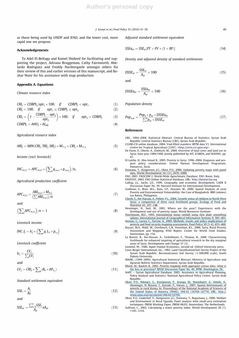
Appendix A. Equations
Climate resource index
CRIj ¼ CDBPIj=opt1 � 100; if CDBPIj < opt1 ð1ÞCRIj ¼ 100; if opt1 6 CDBPIj 6 opt2 ð2Þ
CRIj ¼ 1� CDBPIj � opt2
opt2
� �� 100; if opt2 < CDBPIj ð3Þ
CDBPIj ¼ AHUj � AIadj ð4Þ
Agricultural resource index
ARIj ¼ MINðCRIj; TRIj; SRIjÞ �M’r’;j þ CRIj �M’ir’;j ð5Þ
Income (excl. livestock)
INCw;j;z ¼ APCw;j;z �X
iqi;w;z � pi;w;z
� �=nz ð6Þ
Agricultural production coefficient
APCw;j;z ¼ARIw;j;z �Mw;jP
ARIw;j;z� �
=nð7Þ
andX
jAPCw;j;z
� �=n ¼ 1 ð8Þ
Livestock income
INC lj ¼ lcj �X
iq li;z � pi;z
� �ð9Þ
Livestock coefficient
lcj ¼LVjP
jLVjð10Þ
and
LVj ¼ CRIj �X
kðBk � APk;j Þ ð11Þ
Standard settlement equivalent
SSEi ¼Ai
Asð12Þ
and
SSEar ¼Pn
i¼1SSEi
ApxAar ð13Þ
Adjusted standard settlement equivalent
SSEaar ¼ SSEar½FT þ FV � ð1þ RFÞ� ð14Þ
Density and adjusted density of standard settlements
DSSEar ¼SSEar
Aar� 100 ð15Þ
and
DSSEaar ¼SSEaar
Aar� 100 ð16Þ
Population density
Popn;ar ¼Popn � par � DSSEaarPn
i par � DSSEarð17Þ
References
CBS., 1994–2004. Statistical Abstract. Central Bureau of Statistics, Syrian ArabRepublic Central Statistics Bureau (CBS), Syrian Arab Republic.
CGIAR-CSI online database, 2004. Void-filled seamless SRTM data V1, InternationalCentre for Tropical Agriculture (CIAT). <http://srtm.csi.cgiar.org>.
De Pauw, E., Oberle, A., Zoebisch, M., 2004. Overview of land cover and land use inSyria: base year 1989/1990. Jointly published by AIT, ICARDA, and WASWC, pp.47.
El-Laithy, H., Abu-Ismail K., 2005. Poverty in Syria: 1996–2004. Diagnosis and pro-poor policy considerations. United Nations Development Programme,Damascus, Syria.
Emwanu, T., Hoogeveen, J.G., Okwi, P.O., 2006. Updating poverty maps with paneldata. World Development 34 (12), 2076–2088.
FAO, 2001. FAOCLIM 2. World-Wide Agroclimatic Database. FAO, Rome, Italy.FAOSTAT, 2003. FAO Online Statistical Database, URL: http://faostat.fao.orgGallup, J.L., Sachs, J.D., 1999. Geography and economic development, CAER II
Discussion Paper No. 39. Harvard Institute for International Development.Godilano, E., Bose, M.L., Kam, S.P., Hussein, M., 2000. Spatial Analysis of rural
Poverty and Environmental Vulnerability: the Case of Bangladesh. IRRI (mimeo)Los Banos, Philippines.
Ghosh, S., Aw-Hassan, A., Pellett, P.L., 2004. Growth status of children in North WestSyria: a comparison of three rural livelihood groups. Ecology of Food andNutrition 43, 107–148.
Henninger, N., Snel, M., 2002. Where are the poor? Experiences with thedevelopment and use of poverty maps. World Resources Institute.
Hutchinson, M.F., 1995. Interpolating mean rainfall using thin plate smoothingsplines. International Journal of Geographical Information Systems 9, 385–403.
Hyman, G., Larrea, C., Farrow, A., 2005. Methods, results and policy implications ofpoverty and food security mapping assessments. Food Policy 30 (5–6), 453–460.
Keyzer, M.A., Nubé, M., Overbosch, G.B., Voortman, R.L., 2006. Syria, Rural PovertyAssessment and Mapping, IFAD Report. Center for World Food Studies,Amsterdam, pp. 154.
La Rovere, R., Aw-Hassan, A., Turkelboom, F., Thomas, R., 2006. Characterizinglivelihoods for enhanced targeting of agricultural research in the dry marginalareas of Syria. Development and Change 37 (3).
Leontief, W., 1986. Input–Output Economics, second ed. Oxford University press.Louis Berger International, Inc., 1982. Land Classification/Soil Survey Project of the
Syrian Arab Republic. Reconnaissance Soil Survey, (1:500,000 scale), SouthDakota University.
MAAR., (1994–2004). Agricultural Statistical Abstract, Ministry of Agriculture andAgrarian Reform Statistics Department, Syrian Arab Republic.
Minot, M., Baulch, B., 2002. Poverty mapping with aggregate census data: what isthe loss in precision? MSSD Discussion Paper No. 49. IFPRI, Washington, DC.
NAPC – Syrian Agricultural Database, 2003. Assistance in Agricultural Planning,Policy Analysis and Statistics. National Agricultural Policy Center, Syrian ArabRepublic.
Okwi, P.O., Ndeng’e, G., Kristjanson, P., Arunga, M., Notenbaert, A., Omolo, A.,Henninger, N, Benson, T., Kariuki, P., Owuor, J., 2007. Spatial determinants ofpoverty in rural Kenya. In: Proceedings of the National Academy of Sciences ofthe United States of America (PNAS), 104:43 (16769–16774) URL: http://www.pnas.org/cgi/reprint/104/43/16769.
Okwi, P.O., Linderhof, V., Hoogeveen, J.G., Emwanu, T., Begumana, J., 2006. Welfareand Environment in Rural Uganda, Panel analysis with small-area estimationtechniques. PREM Working Paper, PREM 06/03, Amsterdam, The Netherlands.
Sullivan, C., 2002. Calculating a water poverty index. World Development 30 (7),1195–1210.
J. Szonyi et al. / Food Policy 35 (2010) 41–50 49

Author's personal copy
Szonyi, J., De Pauw, E., Aw-Hassan, A, La Rovere, R., Nseir, B., 2005. Mappingagricultural income distribution in rural Syria: A case study in linking povertyto resource endowment. ICARDA, Aleppo, Syria, viii + 48 pp. ISBN: 92-9127-182-X.
UNDP., 2005. Human Development Report 2005: URL: hdr.undp.org/reports/global/2005.WRI, Department of Resource Surveys and Remote Sensing, Ministry of
Environment and Natural Resources, Kenya; Central Bureau of Statistics,
Ministry of Planning and National Development, Kenya; and InternationalLivestock Research Institute., 2007. Nature’s Benefits in Kenya, An Atlas ofEcosystems and Human Well-Being. Washington, DC and Nairobi: WorldResources Institute. URL: http://www.wri.org/publication/natures-benefits-in-kenya#.
You, L., Wood, S., 2006. An entropy approach to the spatial disaggregation ofagricultural production. Agricultural Systems 90 (1–3), 329–347.
50 J. Szonyi et al. / Food Policy 35 (2010) 41–50