Reading Rome from the Farther Shore: Aeneid 6 in the Augustan Urban Landscape

Urban Ecology & Environmental Quality:A Case Study of Tehran-IRAN
ABSTRACTCities are open living systems whose land cover mosaic is greatly influencedby bio-physical and socio-economic mutual driving forces. Similar to otherlandscapes the urban mosaic element's composition and their spatialconfiguration illustrate processes engaged in their pattern construction anddemonstrate environmental functions that may be expected from it. Adopted thesame structure-function or pattern-process principle we have approachedenvironmental planning in Tehran Metropolitan Region. Integration of naturaland socio-economic features of the city resulted to nine heterogeneous zoneswith different composition and configuration of green, open and built patchtypes, different natural structural elements (river valley corridors, coreremnant patches, etc…), specific community social capital and economic statusand various measures (intensity and timing) of urban tissue alterations. Whenthese characteristics are compared to those ecological characteristics thatare suppose to reflect stability and to provide or promote environmentallivability (such as the presence of green patch network with aggregate withoutliers model) priority planning strategies may be defined for each zone,then for each major section (such as suburban, central, eastern, etc..) andfinally for the whole urban region of Tehran.
Potentials for landscape structural restoration seem to be more cost effectiveregarding increasing the connectivity of natural matrix of mountain andpresence of the life support system in the city with an added value in itstrickledown positive consequences for the whole city. In the southern urbanfringe of Tehran suburban natural matrix connectivity and enhancement of theurban refuge network restoration within the whole urban region may be bestachieved through urban forestry on abandoned fields and remaining large opencores remaining there.. In the absence of river valleys, the action planchanges towards advantageous reuse of available drainage water; downstreamflow of drainage and run off waste water actually creating environmental illsand energy consumption for constant pumping to prevent inundations isallocated for improving the sink capacity of assimilation of excess wastewater and air pollution while satisfying the major urban regional aim ofincreased presence of green and open network connected to suburban naturalmatrix.
Regarding the central Tehran, restoration (of green and open patch mosaic) isvery hard (and too expensive) in the short and medium terms because itconsists of large scale reclamation of privately owned land. Furthermorethere are none left to be preserved as urgent protective measures. Restoringenvironmental quality of central down town may be searched as part of the samestrategic urban refuge network restoration plan that would be best to beginfrom northern mountains and from the southern fringe towards central Tehran.
1

Choice of (priority and timing) for such a general "outside-in" landscaperestoration spatial frame work from north and south and then from east andwest of Tehran not only enjoys an advantages spatial frame work but also anadvantageous administrative or institutional frame work that not only preventsirreversible degradations of natural matrix still present in the suburbs butthrough focusing on local projects avoid discouraging large scaleinstitutional and planning logistic needs while being spatially coordinatedfor a whole urban region restoration plan and further up scaling byexperimental planning approaches.
Keywords: Urban Landscape, Mosaic, Zoning, Refuge Network, Tehran, SpatialHeterogeneity, Driving Forces, Pattern-Process Principle
2

INTRODUCTONThe current unprecedented and often unattended urbanization hasconfronted environmental experts with increased new and cumulativeimpacts at local to global levels (Alberti, 2005). Meanwhile,historically changes and developments in ecological methods havealways been affected or encouraged by new requirements and new demandsby environmental planners (Forster, 2002). Likewise, new approacheshave developed concerning urban planning as they have been require fora better understanding with more responsive practices concerning urbanenvironmental management. These new principles and methods are basedon "Landscape Scale Ecology", "Ecology Of Cities" (in contrast to thepast "Ecology In The City") and "Human Ecology". Urban systems arehence now understood as open living systems in which natural andsocial processes constitute mutual and integral sub-systems. Urbansystems as open and dynamic living systems enjoying self-awarenesshave the potential to exploit the non-genetic information in theirnon-biophysical sub-systems to protect their dynamics (Pickette etal., 2004) but, contrary to the classic viewpoint these openecological systems are also externally regulated from adjacent ordistant stimulating processes (Pickett & Cadenasso, 2004). Thisunderlines the importance of natural and cultural contexts. Ecologicallife support systems of natural matrix on which any urbanagglomeration exists and depends not only highlights the significanceof location but also demonstrated the importance of diversechorological interactions (between the city and its surroundings) fordecision makings in urban planning. The roles of human communities(and cultural matrix) was also acknowledged as driving forces fromnear or far away and at local to global scales affecting these openhuman dominated systems. When the significance of social and naturalcapital is acknowledged human wellbeing and ecological integrity ofthe landscape are considered as major assessments criteria rather thanmaximum economic benefit (Forster, 2002).
In addition to previous use of demographic and employment statisticssocial capital and cultural heritage are also considered as importantdeterminants of urban environmental quality. Along with and moreimportant than the flow of energy or circulation of materials as it isin natural ecological systems, the resilience of urban human-orientedecological systems relay on the accumulation and the constant flow ofinformation; as history, experience, culture, participatory attitudeetc… ( ). Getting to recognize cities as elaborateliving systems consisting of an assortment of interrelated natural and
3

artificial, healthy and disturbed ecosystems whose integrity at anytime is dependent also on receiving the necessary feedbacks from itssocial subsystem (Pickett & Cadenasso, 2004) ecological resilience ofcities increase through accumulation of knowledge, and the ability topredict and to adapt to changes without long lag times (Anderson,2006). Using these principles and methods we have studied the stateof environment in various parts of Tehran in relation to their urbanlandscape structural features in different homogeneous parts ofTehran.
Years ago (DOE; 2001), the Iranian Department Of Environment - DOEdeclared air and water related problems as the two most alarmingenvironmental concerns threatening public health in the capital. Eversince longer stagnation of emission still prevails in spite ofcontinued costly mitigation efforts. Accelerated unattended growth ofurban structure over valuable natural matrix has ultimatelycontributed to environmental and human impoverishment (Forman & Gordon1986, Turner 1989) and this has remained an unattended and neglectedecological problem at the scale of landscape. The fact is that webelieve that the present condition of air and water resources and theprevalent environmental ills in Tehran are largely due to a generalneglect of ecological aspects in regional land use developmentplanning.
MATERIAL & METHODThe contemporary urban development pattern of Tehran dates back toonly after the Second World War, when a significant rural exodustransformed the cultural landscapes of provincial centers; and wasparticularly noticeable in the capital city. As Iran’s political,economical, cultural, and administrative capital, Tehran has undergonean exponential growth in population. Over a 30-year period (1930-1960), Tehran’s growth had initially been from downtown towards thenorth, with a vertical axe of development that was defined by majoraxes of transportation at early times. Due to continued migrations,the urban growth pattern around major vertical (north-south) axes wasfirst replaced by a temporary east to west axis of growth (TehranComprehensive Plan, 2006), but supplanted later by a sporadic, patchygrowth pattern in the suburban zones. The unprecedented and phenomenalgrowth has exacerbated several environmental problems, as well asinfrastructure deficiencies within the city and the TMA. These
4

problems have placed Tehran in a very low grade in recent citiesinternational ranking concerning existing quality of life indicators.(AB advisorThe variegated consequences of this unattended urban growthincluded complex and gradual landscape transformations veering towardsan almost complete loss of natural capital accompanied withincremental deterioration of public health conditions due toalterations of vital ecological processes.
Referred to as one of the largest mega regions of the world; the“Tehran Metropolitan Area” (TMA); consisting of the city with itssurrounding urbanized region has the highest urban concentration ofpopulation in Iran and the Middle-East; over 12 million live in theTMA (in 2005) that comprises over 90% of Tehran Province and atpresent, includes more than 50 municipalities and 1500 villages(Barakpour).
Figure 1; Political territories and local management zones inTehran Metropolitan Region
METHODLandscape ecology studies the interaction between spatial and temporalpattern and ecological process (Turner et al. 2001). By applyinglandscape ecology principles and methods to urban development, we canbetter understand what urban landscape alterations are and how theymay possibly be restored for an improved urban environment. Theunderlying premise of urban ecology as a sub-discipline of ecology isthat the explicit composition and spatial form of an urban landscape
5

mosaic consisting of interdependent ecosystems affects ecologicalprocesses (Burel 2003, Forman and Godron 1986) and chorologicalinterdependencies between heterogeneous environments provide spatialsolutions in addressing land use objectives including urbandevelopment planning (Forman 1995).
The newly emerging process-oriented (as opposed to object-oriented)discourse in ecological studies attains practical value only whenconsidered in relation to specific processes with their respectivespecific paths or corridor networks. While spatial designs aresupported by a holistic methodology each flow or process needs its ownspecific network type. An ecological path may increase connection orreduce it by acting as a barrier depending on the flow of interest.Variation and spatial arrangement of each attribute was described andmapped separately. In reference to the irreplaceable position oflandscape mosaic patches in juxtaposition to urban growth (Kong andNakagoshi 2005, Nilson & Randrup 1997), and the rehabilitation ofdegraded urban environment (Forman & Godron 1986, Naveh 2005), the“function-structure” relations matrix (see Table 1) insisted on open,green and built patch network mosaic (for calculations) as structuralcomponents having the highest interdependency with air and waterrelated ecological processes and urban environmental issues (Gustafson1998, Botequilha & Ahrea 2002). Landscape mosaic structural evaluationfocused on open, green and built patch types, their grain size as wellas composition and configuration of landscape patch mosaic and theintensity of urban spatial structural alterations was rated fordifferent parts of Tehran; degree of alteration regarding patch types.Both remnant patch mosaic structural analysis and restoration planningrequire more than one level of analysis. Transformations in dynamicpatch mosaics with explicit spatial and temporal dimensions can beanalyzed through process and structure theories which then can beapplied in affairs related to urban management.
Data & ScaleUrban ecology responds to the spatial dimension of urban environmentalissues or landscape function on the basis of “function-structure”linkages or feedbacks between specific urban landscape structuralalterations and particular urban environmental functions and issues.But all spatially relevant issues are scale dependent in the sensethat their explicit partial perception require specific scales ofobservation. There are no normative scales of analysis becauselandscapes are essentially unique living entities (Baschak & Brown1998), and different levels of analysis at different scales are
6

required for a general understanding of relations between urbanlandscape structure and urban environmental function or for a specificcomprehension of relations between remnant patch mosaic networks andair and water related environmental issues.
In spite the fact that corrective measures and restoration tasks haveclear priorities in respect to time and in regard to locations withinthe city, an efficient restoration plan requires the adoption of anintegrated approach to cope with the complex set of correctivemeasures regarding the remnant patch network and its context and toaccount for different scales with their feed backs at the same ordifferent scales separately or simultaneously. Considering the space-time dimension of resources with intensive vertical connectivitybetween heterogeneous landscapes in closed water basins of non-regional arid zones, the restoration of remnant patch mosaic networkof Tehran involves taking into account complex structural organizationas its context or as where remnant patch mosaic network is embeddedand functions. To integrate various corrective measures andsimultaneous tasks at different scales, and to guide its effectiveimplementation, a conceptual framework as a well as one for spatialdesign were needed. The final analysis phase of landscape assessmenthelps define the frameworks needed for a comprehensive restorationplan.
Further more air and water related ecological processes andenvironmental functions at any one level of analysis might havesignificant effects on or may be significantly affected by otherlevels of analysis. For example, air and water related issues (orproblems), when considered as resources, greatly reduce or increaseenvironmental capability or ecosystem carrying capacity. This in turn,affects the remnant patch function and structure through the remnantpatch mosaic composition and configuration and remnant patch networks’connectedness and class area proportion. Only by recognizing andaddressing landscape changes across different scales (perhaps at leastthree) can planners and designers maximize protection of naturalprocesses (Forman 1999) such as those related to air and water.
Metrics used in evaluation and diagnosis were computed and measuredusing large scale (1:2,000 to 1:5,000) land use maps of Tehran (2002to 2004). In order to relate spatial patterns of urban growth to thenatural regional context, metrics were computed for each of theindividual landscapes identified through aforementioned classificationas well as for the whole landscape association within the urban
7

region. While those metrics related to the remnant patch mosaic werecomputed based on their total populations, grain size and structuralheterogeneity of urban landscapes were computed using samples taken tobest include all diverse situations. Metrics for the remnant open andgreen patches were computed at both patch class type and landscapelevels.
We have used integration of different layers of spatial data regardingnatural, social and urban environmental characteristics in order toanalyze and to interpret spatial patterns and temporal characteristicchanges of landscape structure and patch composition and configurationin respect to various environmental functions. Part of spatial data onland use types and information concerning landscape structure wereprovided by 30 meters (with 7 bands) resolution Landsat images takenat 1998 and 2002. Land use maps of 1:12,000 and 1:5,000 scales andbase topographic maps of 1:25,000, officially released by the CentralIranian Bureau of Statistic (2000 to 2004) and the GeographicalInstitute of the Army (2004) were also employed. These spatial landuse data and disaggregated statistics were used once completed andverified by random field inventories. For overlays and finalintegration statistics and field survey results were transferred,compiled, and organized on geo-referenced maps and data bases asrectified covers in GIS (Arc Info). Social driving forces were alsodefined in each urban area based on the statistics made available bythe National Statistical Center of Iran at the scale of urban plots(1:5000 maps) for 2005. This included demography employment andeducational characteristics in respect to age and ex as well asstatistics on lodging and livelihood expenses etc.. For mappingslandscape structural features as well as the relevant social andeconomic attributes Land-sat satellite images (of 2002 and ….) as wellas the most recent land use maps (……………………..) were used. Urban patchtypes were classified in three categories of green, open, and builtand using FRAGSTAT extension of GIS software composition andconfiguration of these selected patches (each category) as well assome structural elements with significant roles regarding ecologicalservices; refuge network of river valleys etc. were monitoredregarding their spatial as well as temporal characteristics usingmetrics.
Urban Mosaic & MetricsDefining the landscape patch mosaic composition and configuration bymetrics has emerged during the last decade as a useful method forlandscape structural evaluation (Turner 1998). Conventionally, metrics8

are used to measure, describe or define the relative composition andspatial configuration of patch class types in different landscapemosaic networks (Gustafson 1998, Botequilha & Ahrea 2002). Landscapemetrics have assisted planners in evaluating urban landscape withregard to the expansion of urban green spaces or remnant patch mosaicconnectedness (Botequilha & Ahrea 2002). We have selected thefollowing metrics to measure, describe or define the relativecomposition and spatial configuration of open, green and built patchclass types in different landscape mosaic networks to describe andanalyze the structure of a landscape and provide quickcharacterizations of entire landscapes, land cover types withinlandscapes or specific patches of a given cover type within thelandscape as well as their interdependencies to each other and tovarious specific urban environmental functions. The following fourmetrics were selected for diagnosis focused specifically on theexisting remnant patch mosaic composition and configuration within theinterior structural context of each of the landscapes identifiedthrough the classification phase of assessments as well as within thecontext of the urban region as a whole:A- Number and density of remnant patches;1-“The Number of Patches” - NP metric was used to measure the totalnumber of remnant patches existing in each landscape and the region asa whole. B- Area and proportion of remnant patch cover type;2-“The Class Area Patch” - CAP metric or the “proportion or percentageof the total area occupied by a particular patch type”C- Relative size of remnant patches and distances between them;3-“The Mean Patch Size” - MPS metric was used to measure the averagesize of remnant patches in different parts of both the entirelandscape and the whole region. MPS was calculated by dividing theremnant patch surface area with NP at each scale that was required.4-“Mean Nearest Neighborhood Distance” - As a surrogate forconnectivity, MNND was measured directly between remnant patches withsurface areas larger than the average patch size on samples selectedin each landscape according to their interior spatial structure;mosaic grain size, and relative heterogeneity. Metrics for theremnant open and green patches were computed at both patch class typeand landscape levels. In order to relate spatial patterns of urbangrowth to the natural regional context, metrics were computed for eachof the individual landscapes identified through aforementionedclassification as well as for the whole landscape association withinthe urban region.
9
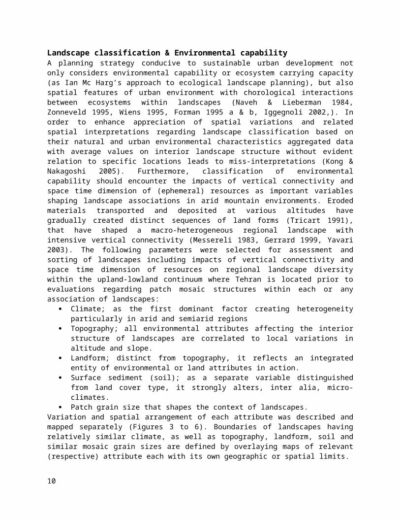
Landscape classification & Environmental capability A planning strategy conducive to sustainable urban development notonly considers environmental capability or ecosystem carrying capacity(as Ian Mc Harg’s approach to ecological landscape planning), but alsospatial features of urban environment with chorological interactionsbetween ecosystems within landscapes (Naveh & Lieberman 1984,Zonneveld 1995, Wiens 1995, Forman 1995 a & b, Iggegnoli 2002,). Inorder to enhance appreciation of spatial variations and relatedspatial interpretations regarding landscape classification based ontheir natural and urban environmental characteristics aggregated datawith average values on interior landscape structure without evidentrelation to specific locations leads to miss-interpretations (Kong &Nakagoshi 2005). Furthermore, classification of environmentalcapability should encounter the impacts of vertical connectivity andspace time dimension of (ephemeral) resources as important variablesshaping landscape associations in arid mountain environments. Erodedmaterials transported and deposited at various altitudes havegradually created distinct sequences of land forms (Tricart 1991),that have shaped a macro-heterogeneous regional landscape withintensive vertical connectivity (Messereli 1983, Gerrard 1999, Yavari2003). The following parameters were selected for assessment andsorting of landscapes including impacts of vertical connectivity andspace time dimension of resources on regional landscape diversitywithin the upland-lowland continuum where Tehran is located prior toevaluations regarding patch mosaic structures within each or anyassociation of landscapes:
Climate; as the first dominant factor creating heterogeneityparticularly in arid and semiarid regions
Topography; all environmental attributes affecting the interiorstructure of landscapes are correlated to local variations inaltitude and slope.
Landform; distinct from topography, it reflects an integratedentity of environmental or land attributes in action.
Surface sediment (soil); as a separate variable distinguishedfrom land cover type, it strongly alters, inter alia, micro-climates.
Patch grain size that shapes the context of landscapes. Variation and spatial arrangement of each attribute was described andmapped separately (Figures 3 to 6). Boundaries of landscapes havingrelatively similar climate, as well as topography, landform, soil andsimilar mosaic grain sizes are defined by overlaying maps of relevant(respective) attribute each with its own geographic or spatial limits.
10

Ecology & Human Dominated EcosystemsFor any urban ecological analysis a profound understanding of socialand cultural as well as economic aspects is necessary to comprehendthe presence of dominant impacts of socio-economic and culturaldriving forces on urban systems' dynamic. Applied sociology withspatial explications and representation of cultural infrastructure aswell as class structure and other human factors considered in urbanecology may be studied and included in urban system dynamic throughthe followings attributes:Demography; population density, changes (migration or immigration) andother specific attributes; age classes etc..
Social system: organization and interdependencies of economicwith social phenomenon,
Social resources: active population, educational levels, andsocial institutions,
Social organization: rights, governance and leisure, Social changes: positions, acceptance of innovation and
environmental awareness, Social differentiation as the result of relative presence or
absence of these attributes with their respective spatialrepresentation,
According to this differentiation there are social classes, whocontrol resource allocation and their property rights which influencesgreatly both land use and its governance. Final impact of resource useand appropriation are significant features that control ecologicalprocesses. The fact that; who has what? where? and who control what?How? and where? have important ecological implications and urbanconsequences (Borch 92 Machlis, 97) with in a time space dimension andwithin several different scales. Final outcomes of cyberneticinteractions between the bio-physical and socio-economic heterogeneousstructure and physical, ecological and social resources existingwithin the urban landscape are reflected in the urban tissue or itspatch mosaic structure. Access to resources and material cycle orenergy flow as well as ecological processes have direct or feedbacktype of interactions which result to different landscape pattern orstructural features. Their spatial representation may be definedwithin the frame work of "Variable Source Areas. Even though part of the urban spatial heterogeneity is due todifferent social institutions but it is also (and more so) the socialstructural differentiation of urban landscapes that influences thesystem through feedbacks between biological, economic, physical andinfrastructural features. Urban landscape mosaic and structural
11

heterogeneity might then be able to explain differential presence ofthese driving forces through spatial frame works of their impacts onmaterial and energy flow and particular presence or absence of anyparticular vegetative growth or land use types or explain relativepresence of patch types in correlation to these variables. Then we canexplain how relative impacts of different strategies and constraintsof environmental or socio-economic characteristics are reflected inlandscape mosaic structure ( through structure-function principles).
Final analysis & integrationTo integrate various corrective measures and simultaneous tasks atdifferent scales, and to guide its effective implementation, aconceptual framework as a well as one for spatial design were needed.During the final phase of analysis all findings obtained by thelandscape assessment procedure are integrated. Once driving forcesresponsible for particular landscape structural features areidentified, considering (monitoring) the urban landscape mosaic withcomposition and configuration of relevant elements provide the plannerthe information needed for decision making regarding urban sustainabledevelopment by appropriate interventions through "Pattern – Process"or by "Structure-Function" interdependency principles. Eachheterogeneous zone identified is then compared with what is thought tobe the favored mosaic structure; one that according to landscapeecology principles demonstrates landscape structural integrity whileproviding environmental livability, priority aims and strategies forseparate zones and for the whole urban region may be deduced. What isrequire where and when and with what priority to preserve, protect andrehabilitate may be deduced by comparison between the favorablelandscape (mosaic) structural condition assuring ecological integrity,and providing environmental livability with each different part of theTehran regional urban landscape association as well as generalstrategies needed for sustainable urban development of Tehran as awhole urban region (Tehran Metropolitan Area – TMA).
Table 1.; “Structure-Function” inter-dependencies regarding air and waterrelated ecological processes in Tehran urban environment.
Environmental features
Relevance to air resource & related process#
Relevance to water resource & relatedprocess#
Micro/Meso-ClimateAir quality, ventilation,pollution, temperature &
evaporation
Supply, consumption, & evapo-transpiration rate flow,
GeomorphologyLandform *
Air sheds, ventilation & corridorsof air flow,
Infiltration run off or erosion, flowand quality
Soil/SedimentAir qualityInfiltration, erosion, movements &
12

flowTopography
Altitude & SlopeVentilation, temperature,
humidity, evapo-transpirationRunoff or infiltration, water table,
flow &Land use & cover tpesAir quality, temperature humidity
flow & pollution (emissions) Water use, balance, infiltration,
quality flow ,Landscape mosaic
type, size & relativeheterogeneity
Air quality, ventilation,temperature, heat islands
pollutions & flow
Water supply, provision, use, flow,circulation, quality,
Remnant patch &natural matrix
Air quality, temperature,humidity, flow, & ventilation
Water quality, balance, flow,circulation, infiltration quality,
FINDINGS & DISCUSSIONConsidering the space-time dimension of resources with intensivevertical connectivity between heterogeneous landscapes in closed waterbasins of non-regional arid zones, the restoration of remnant patchmosaic network of Tehran involves taking into account complexstructural organization as its context or as where remnant patchmosaic network is embedded and functions. Eroded materialstransported and deposited at various altitudes through intensivevertical connectivity of closed upland-lowland continuums such asTehran have gradually created distinct sequences of land forms(Tricart 1991), that have shaped a macro-heterogeneous regionallandscape with intensive vertical connectivity (Messereli 1983,Gerrard 1999, Yavari 2003). But, the present urban landscapestructural difference is also a result of transformations caused bythe multivalent impacts of urban growth patterns on distinct naturallandscapes within the Tehran urban region during the past few decades.The integration of natural environmental diversity (Figure 8 and Table3) -- evidenced in the landscape association of four parallellandscapes from plain to mountain --with impacts of contemporary urbangrowth pattern on mosaic structure demonstrate the presence of furtherstructural heterogeneity within each natural landscape. Metric valuesalso demonstrate gradients of change and increasing heterogeneity inlandscape mosaic including remnant patches from the center towardssuburban regions, from south to north and from east to west of Tehran.
Within the ‘main” urban region of Tehran variations in environmentalconditions seem to be closely correlated to altitude (Tables 2 and 3)and time-space dimension of environmental conditions and resourceavailability. These heterogeneous natural landscapes with distinctecosystems at different altitudes are in close association to eachother through path flows and corridors that maintain the regionalvertical connectivity within Tehran’s urban area. Overlay of climateand geomorphology (land forms) illustrates the initial zoning on
13
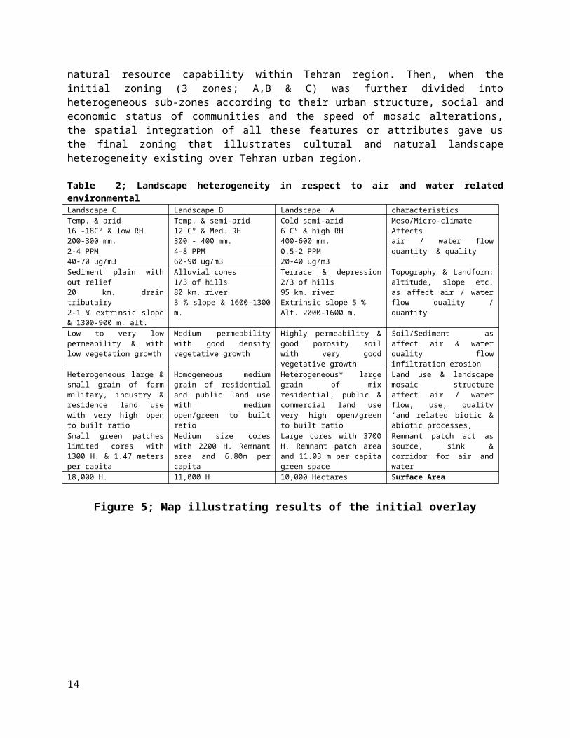
natural resource capability within Tehran region. Then, when theinitial zoning (3 zones; A,B & C) was further divided intoheterogeneous sub-zones according to their urban structure, social andeconomic status of communities and the speed of mosaic alterations,the spatial integration of all these features or attributes gave usthe final zoning that illustrates cultural and natural landscapeheterogeneity existing over Tehran urban region.
Table 2; Landscape heterogeneity in respect to air and water relatedenvironmental
characteristicsLandscape ALandscape BLandscape CMeso/Micro-climate Affects air / water flowquantity & quality
Cold semi-arid6 C° & high RH400-600 mm.0.5-2 PPM20-40 ug/m3
Temp. & semi-arid12 C° & Med. RH300 - 400 mm.4-8 PPM60-90 ug/m3
Temp. & arid16 -18C° & low RH200-300 mm.2-4 PPM40-70 ug/m3
Topography & Landform;altitude, slope etc.as affect air / waterflow quality /quantity
Terrace & depression2/3 of hills 95 km. river Extrinsic slope 5 % Alt. 2000-1600 m.
Alluvial cones1/3 of hills80 km. river 3 % slope & 1600-1300m.
Sediment plain without relief 20 km. draintributairy 2-1 % extrinsic slope& 1300-900 m. alt.
Soil/Sediment asaffect air & waterquality flowinfiltration erosion
Highly permeability &good porosity soilwith very goodvegetative growth
Medium permeabilitywith good densityvegetative growth
Low to very lowpermeability & withlow vegetation growth
Land use & landscapemosaic structureaffect air / waterflow, use, quality‘and related biotic &abiotic processes,
Heterogeneous* largegrain of mixresidential, public &commercial land usevery high open/greento built ratio
Homogeneous mediumgrain of residentialand public land usewith mediumopen/green to builtratio
Heterogeneous large &small grain of farmmilitary, industry &residence land usewith very high opento built ratio
Remnant patch act assource, sink &corridor for air andwater
Large cores with 3700H. Remnant patch areaand 11.03 m per capitagreen space
Medium size coreswith 2200 H. Remnantarea and 6.80m percapita
Small green patcheslimited cores with1300 H. & 1.47 metersper capita
Surface Area10,000 Hectares11,000 H.18,000 H.
Figure 5; Map illustrating results of the initial overlay
14

Table 3 : subsystems and the list of driving forces affecting and beingaffected by the urban environent
Dimension or(subsystems)
Spatial presentation of driving forcesfor integration
Significance
Ecological status; Potential of resources &environmental capability
Climate, water resources andphysiography & hydro- Geomorphology
Strategic considerations ofplanning and improvementmeasures
Urban structure;Landscape mosaicstructural features
Patch types & grain size in urbanlandscape mosaic structureHomogeneity of physical structure
Technical considerationconcerning executivepriorities
Socio-economic status;Social capital andeconomic and culturalwelfare,
Population density, employment,education & financial status, Real estate prices & livelihooddifferences
Relative distribution ofsocial and economic resourcesof stakeholders
Trend of changes in openand green spaces
Temporal transformations regardingspatial composition and configurationof patches and landscape structure
Identifying specificprotection needs withimprovement priorities
Zone
Sub-Zone
CAP%
MPSHa.
MNNDm.
NPCAP%
MPSHa.
MNNDm.
CAP%
MPSHa.
MNNDm.
AA1>50>1<11<180
>50>12<37<12<4<2141400-1800
A2>50>1<11<180
>50>12<37<12<4<214<1100
BB111-
500/42-1
<34<350
22-50
>1237-45
13-50
4-14<591400-1800
B211-50
0/42-1
<34<350
22-50
>1237-45
13-50
4-14<591200-1400
B311-50
0/42-1
<34<350
22-50
>1237-45
13-50
4-14<591100
C<10<0/42
<281<68<21<12>45>50>14<591100-1400
15

Table 4 ; landscape mosaic composition and configuration of open, green andbuilt patches.Table 5; Socioeconomic and cultural status of communities living ineach of the zones
zonzonee
Grows rateGrows ratemigrationsocialcapital
Prices s financialstatus
Populationdensity(2007)
1High (3/9 -85/2 %)
HighMediumMediumHighMedium (250-150 (
2High (15/5 %)Medium_High
HighHighHighLow (lessthan 150)
3High (3/9 -85/2 %)
HighHighHighHighLow (lessthan 150)
4High (3/9 -85/2 %)
HighHighHighHighLow (lessthan 150)
5-HighMediumMediumHigh-6Low (35/0 %)Medium_ LowMediumMediumHighMedium (232 )7Medium (7/2 -
9/1 %)Medium_High
LowMedium_Low
LowMedium (250-150 (
8Medium (7/2 -9/1 %)
Medium_High
LowMediumLowLow (lessthan 150)
9-LowLowMediumLow-Figure 7; Final zones (9) with homogeneous landscape.
Table 6; Characteristic of climate and structure of each zonesClimate*
Composition &configuration: open
Composition &configuration:green
Composition &configuration;built
CA(ha)
MPS(ha)
MNN(m)
NPCA(ha)
MPS(ha)
MNNDm.
NPCA(Ha)
MPS(Ha)
MNNDm.
NP
16

1Semiarid
18181/1431606
7/1201
3/15692531071/840383
2Semiarid
10488/0391275
7/1334
9/19/4172319967/3621073
3Semiarid
15663/1411226
7541/15/7572124389/644352
4Semiarid
20357/1411194
4/809
7/17/7247824676/956257
5Semiarid
44799/13363226/973
1/46/9623957702/1
63569
6Arid2224/0494888/150
7/07/744/206
105587/45
3344
7Arid5619/0466322/372
3/12/6430114985/17
41105
8Arid5/1135
6/24/426329/548
21/642618/1193
5/18
2/45156
9Arid9/2325
5/27/369236/351
7/0795067/2518
43/5
8/35464
Homogeneous landscapes / Zones within Tehran urban region.Data integration (all inventories translated to spatial data in formof maps with 1:25,000 scale), was by map overlay of environmentalcapability zoning, urban structural features, social and economicstatus of communities and the degree and speed of mosaic alterationsencountered, resulted to nine heterogeneous sub-zones that areillustrated below. These identified as the basic building blocks ofTehran over which decision making may proceed represent the culturaland natural landscape heterogeneity existing over Tehran urban region.The following 9 zones described below also illustrate the spatialdistribution of driving forces acting on and responsible for thepresent landscape structure. Zone I: urban district No. 4 with ……Ha. Surface area
Particular featureNatural; High altitude of 1400- 1,700 m. and a favorable climate.Landscape with a heterogeneous mosaic consisting remnant patch networkwith medium to coarse grain sizes, medium (but) decreasing connectednessand reduced connectivity with suburban natural matrix and with strategicstructural elements such as natural corridors of river-valleys, and core
17

remnant open spaces as hills.Urban; Constructed land cover patches are still fine-grain but areincreasingly dominant (replacing the natural matrix) with a medium growthrate and qualitative alterations rated also as being equal to the averagerate in the capital. There is still a low pollution levels.Sicio-economic; High population density and growth rate of 3/9 -85/2 %.The community is at the middle social class with average awareness &participation potential. All together there is a low social capitalpresent.
Zone II:. district No. 1 & 3 with ……….Ha. Surface area
Particular featureNatural; High altitude of 1,700 m. Favorable semi-arid climate. Landscapeis with a heterogeneous mosaic of reduced connectivity with suburbannatural matrix and structural elements such as river-valleys, hills andremnant patch network with medium to coarse grain sizes, and decreasingconnectedness of its network.Urban; Constructed land cover remains as fine-grain patch but withincreasingly dominant proportion (as matrix). Medium growth rate withqualitative alterations dominate. The lowest pollution level in theCapital is still in this zone. Socio-economic; High social capital with a medium to low populationdensity but with a high ( 15/5 %) growth rate. The highest social statusbut with a lower participation of the community.
Zone III: district No.2 with …… ….Ha. Surface area
18

Particular featureNatural; Medium to high altitude of 1400 - 1600 m. Favorable semi-aridclimate. Landscape structural elements clude: river-valleys, hills andremnant patch network with medium to coarse grain sizes, still with ahigh connectedness between the network mosaic and connectivity withsuburban natural matrix.Urban; Heterogeneous medium grain mosaic with fast qualitative andquantitative changes for finer grain size towards towards south; the citycenter. The zone has a high pollution level.Socio-economic; High population density with a high Growth rate (3/9 -85/2 %). Higher education and awareness levels and high participation andacceptance of innovation results to a high social capital despite the lowlevel of effective participation!
Zone IV: district No. 5 with …….…. Ha. Surface area
Particular featureNatural; Upper part of this zone also belongs to the upland portion ofTehran with valleys and heterogeneous large to medium grain size patch
19

mosaic. Landscape structural elements include: river-valleys, hills andremnant patch network with medium to coarse grain sizes, but decreasingconnectedness between patches and reduced connectivity with suburbannatural matrix.Urban; Urban mosaic is changing towards small grained specially in thedown town where a medium growth rate with qualitative and quantitativealterations exists. High to low pollution levels depends on seasons.Socio-economic; High population density with high growth rate (3/9 - 85/2%)of a community with high incomes high education and awareness and highsocial capital but with low effective participation
Zone V: district No. 22 (+ 21) with …… …. Ha. Surface area
Particular featureNatural; Situated at 1200-1400 m. at the transition zone where mountainchange to hill with good air ventilation and favorable semi-arid climate.Landscape structural elements are river-valleys, hills, core remnantpatches & coarse grain sizes mosaic with a medium to good connectivitywith suburban natural matrix.Urban; Constructed spaces are fortunately still fine-grained with lowconnectedness while open spaces still remain coarse-grained with higherconnectedness. Urban matrix is heterogeneous with coarse-grain open andgreen patches but experience a fast quantitative change particularly insouthern portion. High pollution increases towards the city center.Socio-economic; Low population with low growth rates and high to mediumincome. Low acceptance for innovations & Lower percentage of womenemployment. Hence social capital is low to medium with a medium effectiveparticipation
Zone VI: district No. central parts with ………. Ha. Surface area
20

Particular featureNatural; At 1100 to 1200 m. of altitude has a arid climate. Is over alluvialfans/cones and hills with fine-grained sediment. Down town part of thecapital lacks any particularly valuable landscape structural elements wheregreen spaces are fine-grained with very low connectivity.Urban; Small grained and heterogeneous mosaic of city center withqualitative and more quantitative changes threatens open spaces whichalready are highly fine-grained with low connectivity and high fragmentationrates. Mean patch size of built spaces is growing higher and high pollutionlevels are dominant.Socio-economic; High to medium population density with a low growth rate(35/0 % with a Low income and low awareness levels participation andcollaboration levels are also low with a low effective participation andmedium social capital.
Zone VII: parts of district No. 15 & 20 with …… Ha. Surface area
Particular featureNatural; This zone at 1100 to 1200 m. altitude with arid climate and islocated lower down on alluvial plains which are sink of air & waterpollution with accumulating underground water close to surface. Lacksstrategic natural structural elements and has a low & decreasingconnectivity with suburban natural matrix.Urban; Urban landscape mosaic is fine-grained with small to very small grain
21

mosaic but still heterogeneous. With high to very high rates of qualitativealterations. Open spaces are fine-grained with lower connectivity andincreasing fragmentation. High chronic pollution levels exist.Socio-economic; High population density with a medium (7/2 - 9/1 % growthrate and low income and education Despite lower incomes women are stillhouse wife with low to medium effective participation &low awareness rates. Hence social capital; is low.
Zone VIII: district No. with ………. Ha. Surface area
Particular featureNatural; Situated downstream at less than 1000 meters with an aridclimate. Located over old alluvial fans and alluvial plains there is amedium (but) decreasing connectivity with suburban natural matrix ofheterogeneous mosaic of small green and open patch types and largerpatches of open spaces and abandoned farms larger coarse grain openpatches increasing towards suburbsUrban; There is a high to very high rates of qualitative alterationstowards urban center and medium growth rate with high quantitativealterations. Pollution level is high and increases towards west.Socio-economic; Medium population density & medium growth rate (7/2 - 9/1%) of a low income (minimum) low welfare and education and lowparticipation as low acceptance of innovation effective participation islow to medium. Social capital may be rated low.
Zone IX: .... district No. with ……. Ha. Surface area
22

Particular featureHigh altitude of 1400 - 1600 m. Arid climate. Urban mosaics heterogeneouswith large open patches and small grain green and built patch types.Structural elements are: hills and remnant patch network with medium tocoarse grain sizes, with a good connectivity with suburban natural matrix.Constructed land cover patches are coarse grain and with increasing growthrates & qualitative alterations. Due to the presence of industries, thepollution is high in this zone.Socio-economic; High population density. Social capital; medium tending tohigh with effective participation & awareness are low to medium.
CONCLUSIONThe underlying premise of urban ecology as a sub-discipline of ecologyis that the explicit composition and spatial form of an urbanlandscape mosaic consisting of interdependent ecosystems affectsecological processes in ways that would be different if the mosaiccomposition or arrangement were different. Spatial solutions foraddressing urban development planning have been provided throughimproved understandings of chorological interdependencies betweenheterogeneous environments. The conceptual framework implies a staticconceptual construct that represents and simplifies the dynamicreality (Pickett et al. 94 in Makhzoumi & Puggetti 1999) of theobjective for which it is created. An adapted spatial design frameworkis also needed to ensure effective implementation of the restorationplan in tandem with the selected conceptual framework and in thespecific urban region of Tehran. Specific spatial design conventionsand general guidance instruments have been provided to secure thesufficient presence of nature and functional remnant patch networks inlandscapes (Forman & Godron 1986, Farina 1999, Forman 1999, Burel2003), based on the “Aggregate-with-outliers” model for all land useplanning including sustainable urban development (Forman & Godron
23

1986, Forman 1995 a & b, Turner 1989). Accordingly there areinterpretations and proposals presented here in respect to each zoneas case specific planning proposals and there are also theirintegrations presented as general planning strategies for future urbanplanning and management of Tehran. There are general strategies foundby integration of separate local strategies for several or themajority of zones. For example upland priority regarding protectionand restoration of natural capital compared to the lowland parts dueto their downstream effects. Restoration of matrix connectivity andapplication of landscape structural models regarding connectedness ofremnant patches on the scale of the whole urban landscape associationsor regarding natural corridors.
One of the main spatial design frameworks in ecological networkdesign and restoration with in the Mediterranean region is the“Maquis-Ravine” network whose restoration assures further developmentof many other ecological networks in altered urban landscapes. Thephysical characteristic of the ravine, namely its linearity andtransverse position, allows it to link the remaining components andcontribute towards the development of ecological networks (Nowicki 96in Makhzoumi & Puggetti 1999). Considering that Tehran is surroundedby a valuable remnant natural matrix of protected areas and nationalparks with high natural values as source of natural services and as alife support system, then reduced natural matrix connectivity may becompensated by the remnant patch mosaic network connectedness toensure the presence of nature in that urban region (Kendle & Forbes1997). Large green remnant patches have been recognized asirreplaceable elements of a quality urban environment since a decadeago (Forman 1995; Forman and College 1995). Their centrality to theprovision of air and water quality, flow and other related ecologicalprocesses otherwise unattainable is also well-known (Forman 1995). Thevital presence of natural ecological functions and processes in urbanregions may be achieved by the means of natural matrix connectivitythroughout the city (Kendle & Forbes 1997). In order to retain thenecessary natural matrix connectivity, appropriate balance of remnantpatch class area proportion with built land cover area may beconsidered. This is however, largely impossible, at least in the shortand medium run. Alternatively in Tehran with very high price of landriver valleys and hills are the only extent that remain as property ofgovernment and there are buffer zones partially respected, Thisgreatly facilitates implementation of restoration projects, a properremnant patch mosaic proportion with appropriate connectedness to thesuburban natural matrix may provide, at least some of the principal
24

missing natural services otherwise realized by natural matrixconnectivity within the urban region.
A river valley corridor network may provide the needed spatial designclosely adapted to ecological network layouts that also assureregional scale vertical connectivity within the upland-lowland contextof the closed water basins continuum system of Tehran. In the case ofTehran, a river valley corridor network may be the most efficientalternative for improving connectivity at the landscape and urbanregion levels while increasing the natural matrix connectivity in theurban environment as well. River valleys allow for the introduction ofnature to the city, and provide connectedness of remnant patch networkas air and water flow paths at the urban region within the closedbasin. In many cases and particularly in arid zones, urban forestrydevelopment is planned in close relation to surface water (corridors)and within the framework of a process-oriented ecological approach (atthe scale of watershed rather than urban limits). In that event, anadapted spatial design framework based on a solid conceptual frameworkwould be successfully created by a process-oriented ecologicaldiscourse, known as a “Refuge Network” (Tjallingii 2000). It providesa balancing mechanism for urban landscape and region by the sufficientpresence of nature. River valleys possess the ecosystem capability andenvironmental resource suitability required at the finer scale. As acarrier of ecological functions in relation to both air and water(Tjallingii 2000), such a refuge network encourages appropriate airand water resource allocation and provides opportunities for improvingthe proportion of remnant green patch area as well as its regionalconnectedness while also assuring the presence of nature andenvironmental livability in the city. Hills crossing the city fromeast to west (Atek Consultant 1999-2000) in the form of a continuousrow of core open remnant patches may be considered as the other mainelement of the prospective refuge network. Hills and river valleysextending from north to south and from east to west respectively,also create and maintain the presence of a natural matrix inside thecity.
According to findings and their interpretations specially whenlandscape aggregate with-outlier and corridor patch matrix (matrixconnectivity) is considered, two main strategic aims for environmentalquality improvement and ecological integrity or sustainabledevelopment of Tehran are:
25

1- Improved or restoration of natural matrix connectivity into theurban landscape through open and green patch mosaicconnectedness,
2- Restoration or rehabilitation of natural refuge network (greenpatches and water flow) consisting of river-valley corridorsextending from mountains into the city and assuring necessaryvertical connectivity,
Besides and based on the above urban region landscape structuralrestoration conceptual frame work, each zone has specific potentialsand identified state of urban mosaic structure as well as specificedge and river valley length based on our findings which is importantregarding implementation of projects in practice, for above aims. Onthe other hand urban landscape change or alteration and growth of thebuilt mosaic is faster in some parts while in other there arepotentials for protective measures before it is to late. Theseconsiderations and finally the social capital and economic status ofcommunities and local institutions which may facilitate or furthercomplicate implementation of projects. These are among more importantvariables in deciding where and when and what to do in order to attainabove goals. For decision making regarding spatial frame work ofimproving natural matrix connectivity and refuge network connectednesswithin Tehran matrices are constructed for rating zones in respect totheir potentials and priorities (table …. & .. below).
Each zone is then rated accordingly for implementation of priorityactivities aimed at above goals (while on the whole these arecoordinated such as to be helpful for future tasks and proceedingpriorities and to also have cumulative added values regarding improvedecological restoration and environmental livability in TehranMetropolitan Area as whole). Again findings demonstrate thatpotentials for landscape structural restoration would be more costeffective and protective measures are more urgently needed in thenorth of Tehran due to the presence of river valleys in aheterogeneous mosaic of large grain green and open patch network.Structural restoration greatly increases the natural matrixconnectivity of the mountain life support system into the city with anadded value in its trickledown positive consequences for the wholecity. In the southern urban fringe of Tehran the same general priorityapplies based on suburban natural matrix connectivity and enhancementof the urban refuge network restoration within the whole urban region.But due to the presence of large open patches and availability of(down stream flow of drainage and run off waste) water and absence of
26

river valleys, the action plan changes towards creation of urbanforestry with advantageous effect of increasing the sink capacity forassimilation of excess waste water and air pollution. Regardingcentral parts of Tehran restoration of green and open patch mosaic ishard and very expensive to achieve in the short and medium termsbecause it consists large scale rehabilitation and restorationprojects on land with private ownership and does not include anyurgent protective measures. Restoring environmental quality of centraldown town may be also searched for through the same general urbanrefuge network restoration that is best to begin from northernmountains and from the southern fringe towards the centre of Tehran.Same applies to restoring hills extending from eastern mountains andthe national park to be connected together to reach remnant open andforested hills in western Tehran through the same long term strategyof urban refuge network rehabilitation.
Rating relative role of zones regarding restoration of Tehran's MatrixConnectivity
Zones
Share%
Ecologicalpriority
Urbanpriority
Facility &promotion
Finalpriority
Notes
I16ThirdThirdSecond2.6II14FirstThirdThird2.3III5FirstFirstSecond1.5IV6FirstFirstSecond1.5V16ThirdSecondFirst2VI7ThirdThirdSecond2.6VII14ThirdThirdThird3VIII14SecondSecondFirst1.6IX8SecondThirdFirst2
Rating relative role of zones regarding restoration of Tehran's RefugeNetwork Connectedness
Zones
Share%
Ecological
priority
Urbanpriori
ty
Facility &
promotion
Finalpriority
Notes
I15SecondSecondSecond2II23FirstThirdSecond1.6III18FirstFirstFirst1
27

IV15FirstFirstFirst1V8FirstThirdFirst1.6VI8SecondThirdThird2.6VII5ThirdSecondThird2.6VIII
4ThirdThirdThird3
IX4ThirdSecondThird2.6
Choice of (priority and timing) for a general "outside-in" landscaperestoration plan that begins from north and south and then from eastand west of Tehran also enjoys an advantageous spatial andadministrative framework; beginning in the marginal fringe preventsrepeated mistakes and irreversible degradations of natural matrix andthrough focusing on local tasks but with spatially coordinatedobjectives, institutional obstacles that discourage large scale urbanlandscape structural restoration plans; demanding new approaches,institutional rearrangements and planning units is avoided. Based ontables it appears that all activities would better be concentrated inIII, IV and V and proceed to VIII and IX, Zones I and II follow theseas third priority and zones VI and VII remain as the last to beattended for good reason as explained above. According to this termsof reference costs and efforts would be more effective and the stagewould be prepared for other next investments. What remains is togovern and coordinate social and institutional conditions as best (seetable …. Below ) to facilitate implementations and to promotesuccessful results with potential up scaling by the same participationof social actors and responsible authorities then with neededexperiences for future investments and their maintenance. Priorityinvestments are to be assigned to the northern urban fringe ofTehran's urban margin which comprises about one fourth of total suburband also about half of the river valleys extending down from there into the central part of Tehran. In fact terms of reference in practiceconsists of protection and restoration of open and green patch mosaicwithin northern Tehran which harbors half of the river valleysextending down from mountain in the capital. This requiresinstitutional and public collaboration which consists of the followingmajor policy according to our findings.
Rating relative role of zones regarding restoration of Tehran'snatural Matrix Connectivity and its Refuge Network Connectedness
Zones
Restoration
Share %
Share% NMC
Share%
Notes
28

Priority
RNCTotal
I151615II231418III18511IV15610V81612VI877VII5149VIII
4149
IX486
Institutional arrangementConstraints that urban environmental planning and management face inthe capital of Iran has two dimensions; contextual and structural (andspatial). There are contradictions between spatial and contextualarrangements within the urban governance system with important impactson economic efficiency and on the quality of the urban environment.Consequently, the significant inefficiencies due to a poor spatialstructure are often ignored until it is too late to do anything aboutit. A city’s spatial structure is constantly evolving. The planningdepartment of municipalities should constantly monitor the evolutionof the spatial structure of their city, and adjust eventually thebalance and nature of regulatory incentives and disincentives, plannew and different infrastructure investments and reform local taxes ifnecessary. (AB Housing). Cities’ survival depends on finding rapidlyimaginative solutions to new emerging problems which could not havebeen anticipated by the author of master plans.
Tehran is one of the most dynamic urban areas of the worldconsidering its land cover type changes. Land use types change in amatter of seasons and this for reduced permeable land cover types.Budgets are also scarce for restoration measures and municipalitiesare engaged with preserving natural capitals constantly threatened byconstructions while they should also maintain or renew degradationsand externalities of past urban growth projects (Bourlon et al. 2002).The trans-disciplinary nature of ecologically oriented planningapproaches demands the collaboration of several institutions withinthe conceptual and spatial frameworks of an integrated restorationplan-- a requirement that is presently lacking. Creative substitutions
29

and alternative institutional arrangements would also be necessary.The most important factor for the realization of this goal is creatinga common perspective and its acceptance by all influential elements inthe region's governance and management. (Barakpour).
30

References:Ahern jack.2011. from fail-safe to safe_ to_ fail : ustainability andresilience in the new urban world . Landscape and urban planning100(2011)341-343Akhoundi A., Barakpour N. et al 2006; Governance of Tehran City -Region: Challenges and Trends, A paper for presentation at the Citiesin City-Regions Conference, 11-14 May, , Warsaw, PolandAlberti, M; 2005.The Effects of Urban pattern on ecosystem function.Integration Regional Science Review.28(2):168-19Andersson Erik,2006. Urban Landscapes and Sustainable Cities. Ecologyand Society 11(1):34 Baschak, L & Brown, R.; 1998, River systems and Landscape networks,in:Mosaic landscape and ecological processes, edited by Hansson L.et al.Chaman & Hall, London, U.K.Beatley T, 2000; Green Urbanism : Learning from European Cities.Island Press, Washington DC.Bertaud, A; ???? Tehran spatial structure: Constraints andOpportunities for Future Development National Land and HousingOrganization Ministry of Housing and Urban Development, of IranBotequilha, A. and Ahrea, J.; 2002, Applying landscape ecologicalconcepts and metrics in sustainable landscape planning, in Landscapeand Urban Planning, 59 (2002), 65-93, Elsevier Press, Montreal.Bourlon A-M., Beltrando Y. & Bouregard A.; 2002, Rapport de MissionTeheran-Iran, Ministere Des Affairs Etrangeres, Republique FrancaiseBurel F.; 2003, Landscape Ecology: Concepts, Methods and Applications,Science Publishers, Inc. USACentre Statistics of Iran, survey results at plot level, 2005Darvish-zadeh, A; 1990, Geology of Iran, Amir Kabir Publisher, Tehran,IranDOE - Department Of Environment; 2001, Urban environment report of thecapital, Tehran, IranFarina, A; 1999, Principles and Methods in Landscape Ecology, Chapman& HallCambridge History of Iran 1968 on, Vol. I, The land of Iran, Vols IV,V, and VI History of Iran at different periods, Cambridge UniversityPress, U.KForman R T.T., Godron M.; 1986, Landscape Ecology, John Wiley & Sons,New York, N.Y, USA.Forman R.TT.; 1995 (a), Some general principles of landscape andregional ecology, Landscape Ecology, vol. 10 no. 3 pp. 133-142 (1995)SPB Academic Publishing by AmsterdamForman R.TT.; 1995 (b), Land Mosaics, The ecology of landscape andregions” second edition, Cambridge University Press, USA31

Forman R. TT.; 1999, Sustainable Development and Ecological Planning,1999Gerrard R.; 1992, Mountain Environment, MIT Press, NY, USAGordon D. 1990; Green Cities: Approaches to Urban Space. N.Y. BlackRose Gustafson E.J.; 1998, Quantifying Landscape Pattern in Ecosystem 1/143-156Ingegnoli, Vittorio. 2002. Landscape Ecology :A widening Foundation.Springer:N.YKendle T. & Forbes S,; 1997, Urban nature conservation, Chapmann &Hall, Published by E&FN Spon Kolatan, sulan , 2002. Probes in to a bio –physical approach to urbandesign.Architecture Research seminar. cornell university AAP ,NYCKong F. & Nakagoshi N. ; 2005, Spatial-temporal gradient analysis ofurban green spaces in Jinan, China, Landscape and Urban Planning, xxx(2005) xxx-xxx, ElsevierMakhzoumi,J & Pungetti G; 1999 Ecological landscape design andplanning Routledge NY, USAMesserli, B.; 1983, Upland-lowland interactive systems, InternationalSym. ICIMOD Bern, SwitzerlandNaveh, Z. & Liberman, A.S.; 1984, Landscape ecology, Springer-Verlag,New York, N.Y. U.S.A. Naveh, Z.; 2005 Epilogue: Towards a Trasdisciplinary Science ofEcological and Cultural Landscape Restoration, Restoration Ecology,Vol. 13, No. 1, pp. 228-234, March 2005Nilson K. & Randrup T.B. 1997; Proceedings of the Eleventh WorldForestry Congress, Anatalya, Turkey, 13-22 October 1997Grimm Nancy B. Pickett Steward. T.A, J.Morgan Grove., Charles L.Redman,2000; Integrated Approaches to Long-Term Studies of Urban Ecological Systems. BioScience.vol.50,No7Pickett.S.T.A, Cadenasso.M.L, Grove J.M,2004.Resilient Cities:Meaning,Model and Metaphor for Integrating the Ecological, Socio-Economic and Planning Realms in .Landscape & Urban Planning:69(369-384) Ryan Robert L. 2011. The social landscape of planning: Integratingsocial and perceptual research with spatial planning. Landscape andurban planning 100(2011)361-363Starfinger U. & Sukopp H.; ???? Assessment of urban biotopes of natureconservation.Tehran master Plan Reports, 2006Tjallingii, S.P.; 2000, Ecology on the edge: Landscape ecology betweentown and country, Landscape and Urban Planning, 48 (2000), P. 103 –119, Elsevier
32

Tricart J.; 1991, Le Models Des Regions Seches - in Persian by Sadighi& Kermani,; 2000, Astan ghods press, Mashad, IranTurner M.G. ; 1998, Landscape ecology; The effect of pattern onprocess, in Annual Review Ecological Systems, 20, 171-197Zimmer.K.S.1994. human geology and the new ecology: the prospect andpromise of integration. Analysis of the Association of AmericanGeographers.84(1):108-125Vrijlandt P. & Kerkstra K. 1995; A strategy for ecological and urbandevelopmentWiens John A. 1995 Landscape mosaic and ecological theory, Mosaiclandscape and ecological processes, Chapman & Hall LondonYavari A-R.; 2003, Land-use Planning in Arid Mountain Environment,First Seminar on Resource Utilization: Local Structure vs.Globalization, German Academic Exchange Service and The University ofTehran, Tehran, IranYavari ,A .Sotoudeh ,A.Parivar, P. (2006): Urban EnvironmentalManagement & Landscape Structural Restoration In MontainEnvironmental Of Non Regional Arid Zones Of Asia , Tehran -Iran ,Submitted To Jornal Of Landscape And Urban PlanningZonneveld, I.S; 1995; Landscape ecology and ecological networksZovashtiaq,S.; 1999, Tehran comprehensive plan, Pardazesh pub. TehranIran
33
Copyright © 2022 FDOKUMEN