Mallow Castle House and Demesne - Cork County Council
34
Mallow Castle House and Demesne HISTORIC DESIGNED LANDSCAPE APPRAISAL REPORT With Impact Assessment of Proposed Part VIII Works (Improved access and playground at Mallow Castle House) COURTHOUSE CHAMBERS, 27/29 WASHINGTON STREET, CORK T12WN8F 5 th December 2019 TEL 353 021 4393800 FAX 353 021 4854145 Email: [email protected] Website: www.jca.ie
-
Upload
khangminh22 -
Category
Documents
-
view
0 -
download
0
Transcript of Mallow Castle House and Demesne - Cork County Council
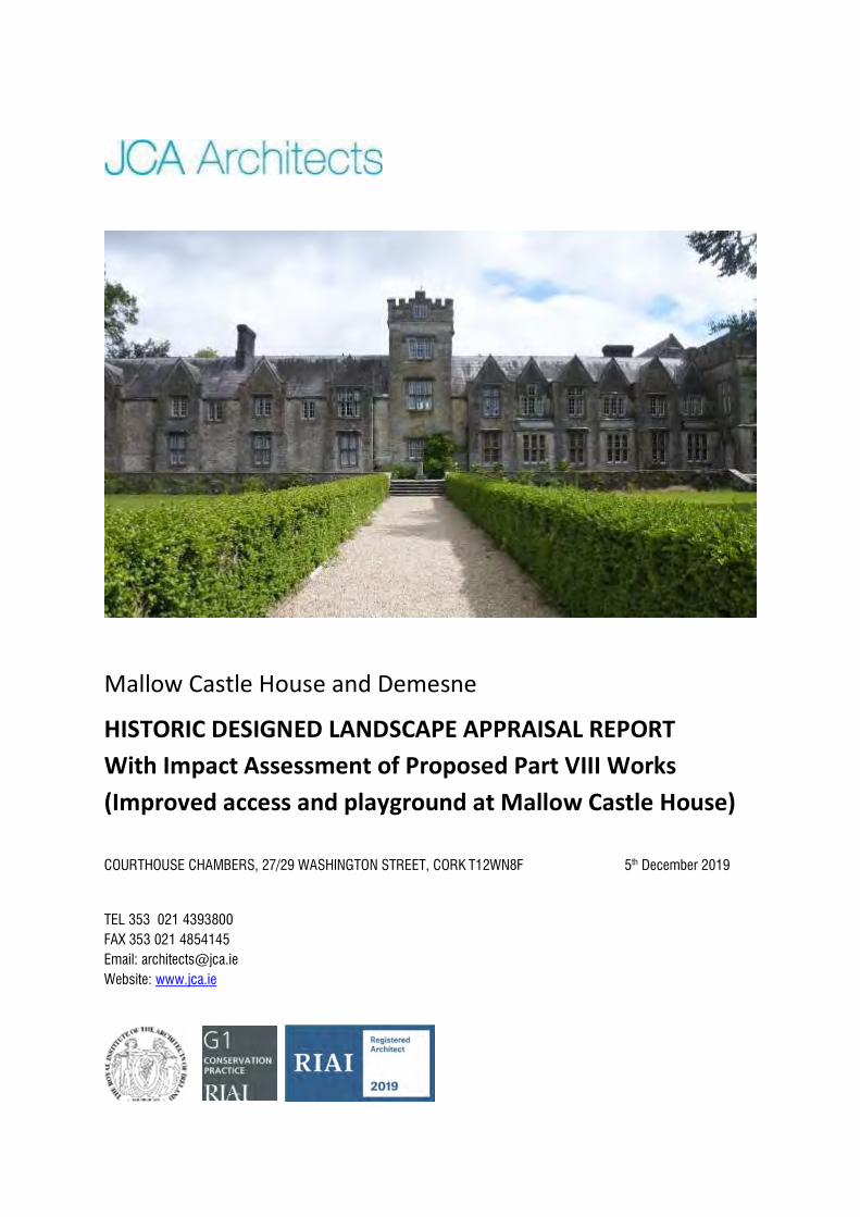
Mallow Castle House and Demesne
HISTORIC DESIGNED LANDSCAPE APPRAISAL REPORT With Impact Assessment of Proposed Part VIII Works (Improved access and playground at Mallow Castle House)
COURTHOUSE CHAMBERS, 27/29 WASHINGTON STREET, CORK T12WN8F 5th December 2019
TEL 353 021 4393800 FAX 353 021 4854145 Email: [email protected] Website: www.jca.ie
2
CONTENTS Introduction 3 Part 1: History and Record of Historic Landscape at Mallow Castle House - Historical Development of the Demesne and Designed Landscape 4 - Extent of Historic Landscape Retained 15 - Statement of Significance 22
Part 2: Impact Assessment of Development Proposals
- Description of Proposed Development 24
- Likely Impacts of the Proposed Works 24
- Mitigation Measures and Recommendations 28
Appendix I – Photographic Record
Appendix II – BSM Existing Built and Natural Features Drawing
Appendix III – Record of Glass House Structure, with Proposals for Repair.
3
Introduction Mallow Castle House (sometimes known as New Mallow Castle, or Mallow Manor) is situated in the centre of Mallow town, with demesne lands extending south to the banks of the Blackwater River. A short distance to the south of the house the ruins of the earlier Mallow Castle, a fortified house, are retained. These buildings, a gate lodge and a number of outbuilding complexes, all currently share the same entrance off Bridewell Lane. Mallow Castle House is a protected structure on the Mallow Town Plan (Reg. No. 15), as is the ruined earlier castle (Reg. No. 13) and the entrance gates, lodge, outbuildings and garden complex (Reg. Nos. 14 – 18). Any garden structures or features within the curtilage of these structures, such as stone walls, gates, glass houses, embankments etc would be including in the protected structure status of Reg. Nos. 13 – 18. In addition to being a protected structure, Mallow Castle House is also an archaeological monument (CO033-009002-), and being in the ownership of the Local Authority, the building has National Monument status.1The definition of a National Monument includes the land adjacent to the site or structure, which is necessary to preserve the amenities of that monument.
The adjacent ruined castle is also a National Monument (CO033-009001-). Several other archaeological monuments are recorded within the demesne, including the remains of a tower house, bawn (CO033-009006), a lime kiln and a rath. Historic landscape features associated with the earlier castle are also included on the Record of Monuments and Places (CO033-092---). These are described as a rectilinear system of low earth works banks within the deer-park, immediately east of the 19th century country house.
The following report has been prepared for Cork County Council as part of Framework Master Plan for the demesne lands still associated with the castle, and for grounds to the southwest along the river. The first phase of the proposed works is associated with the gardens retained to the north of the house which will form the basis of a Part VIII planning application. While the following report includes information on the historic development of the demesne of Mallow Castle House, the analysis of proposed works will be based on the proposals included in the Part VIII application.
1 National Monuments are defined as those structures or sites for which the Minister of the Environment, Heritage and Local Government or a local authority has ownership or guardianship (in addition to those structures or sites which are subject to a preservation order). Section 14 of the 1930 national Monuments Act as amended by Section 5 of the 2004 National Monuments (Amendment) Act requires that anyone wishing to demolish, remove, or disfigure, deface or alter a National Monument must obtain consent from the Minister for the Environment, Heritage and Local Government in advance. It is also unlawful to excavate, dig, plough or otherwise disturb the ground within, around or in proximity to a National Monument without ministerial consent. Unless consent has been applied for and granted in writing, it is an offence to interfere with a National Monument.
4
Part 1: History and Record of Historic Landscape at Mallow Castle House
Historical Development of the Demesne and Designed Landscape An extensive written description and discussion of the historical development of the castle, house and demesne is contained in Dan Noonan’s Mallow Castle House and Demesne Conservation Plan, November 2012, prepared for the Heritage Unit of Cork County Council with support from the Heritage Council.2 The following historical context summarises the findings of that report providing the historical development of the demesne and gardens in chronological order. This information is supplemented by recent additional historical research in the form of historical accounts of the demesne which helps to build a picture of the origins of the designed landscape elements on the site including the gardens and farm. The Jephson Papers in the Mallow Castle Collection, held by UCC, were also consulted with maps and account ledgers providing additional relevant information regarding the gardens, landscape and demesne associated with the house. The Sixteenth Century The earliest descriptive record available, which mentions also the grounds associated with the castle, was written in 1584 as part of a survey of the forfeited lands of Gerald, Earl of Desmond.3 This account refers to an earlier structure on or adjacent to the site of the present ruined fortified house and is described as ‘..one castle containing two small courts and one great barbican.’ It is thought that the current ruined structure located to the south-east of the castle today may once have been part of the bawn wall of this earlier castle. The survey records that the house and castle stand in a dry, good and wholesome place ‘..having on the north side very good arable land’. It mentions that fish (salmon, trout and other fresh fish) can be fished in the river, and that there are substantial woods belonging to the manor and that there is a rabbit warren on the east side of the castle and ‘..in the woods and lands..are many beasts, as well as red deer as fallow, a great many partridges, pheasants and the like’. The above account, associated with the earlier castle, makes no mention of gardens or walled areas, although the arable land to the north became the fields of the later demesne, while the rabbit warren is mentioned in later accounts also. The emphasis in this survey was on the hunting and fishing opportunities provided by the lands associated with the castle and the ample supply of wild food sources rather than farm or garden produce. The Seventeenth Century Harold Leask, who carried out extensive investigations and research into the surviving Mallow Castle structure during the 1930s-40s, determined that the castle dated to the marriage of Sir John Jephson to Elizabeth Norreys which occurred in c. 1610.4 In 1622, James I issued a commission to make a thorough inquiry into the general condition of the plantations in Ireland. This survey of the plantation of Munster recorded that ‘a goodly, strong and sumptuous house’ had been built by Sir Thomas Norris upon the ruins of the old castle, and that it had a bawn and many convenient houses of office. Interestingly, the survey
2 Greene, F. and Noonan, D., Mallow Castle House and Demesne Conservation Plan, November 2012 3 Quoted in Berry, Henry F., The Manor and Castle of Mallow in the days of the Tudors, JCHAS 1893, Vol 2, No. 14. 4 Leask, H.G., Mallow Castle, Co. Cork, JCHAS 1944, Vol. 49, No. 169, pages 19-24.
5
also notes that the house had two gardens and an orchard, containing about four acres of ground, ‘..one garden being walled with a stone wall, twelve foot in height. The other garden and orchard strongly fenced.’ 5 Just eleven years later, in 1633, the Earl of Cork wrote of the manor house at Mallow in a letter to Sir John Jephson which describes the gardens and grounds associated with the house. He mentions orchards, gardens, houses of office, a pigeon house and 150 acres of lands ‘..laid as a demesne to the house…with a parck [sic] of deer.’ 6 The Earl also mentions a ‘smale connye warren [sic]’, or rabbit warren, first mentioned in the 1584 survey. Sir John Jephson’s will of 1658 describes the gardens and lands associated with the castle in the mid-17th century, and confirms that the earlier description by the Earl of Cork of a designed landscape associated with Mallow Castle at this time. Jephson, who desired that his wife would live in Ireland following his death, writes of his ‘..house in mallow, which I give her for life, with all the gardens and orchards, the long warren in the glyn, and all lands behind the castle to Gallows Hill lane, with the little meadow under the castle, if she shall live there however until my son and heir come to age.’7 A further mid-17th century description by the physician and antiquarian Dr. E. Borlase reads as follows:
To the castle, which for strength and beauty is inferior to few in the kingdom, doth belong a fair and large demesne, two pigeon house, a coneygerre [rabbit warren], a pleasant and spacious park, well impaled, of over four and a half miles circumference, equally composed of lawns, sheerewood, coppices, brakes and shelter, with a large paddock of sixty acres, and so well furnished with fallow deer (and some red deer also) that there would have been this next season one hundred full complete bucks, most of which are now killed or driven thence and the pale destroyed in many place. . . there is no place in the kingdom that can scarce parallel this.8
It is clear from these descriptions that in addition to the retention of earlier elements of the grounds associated with the castle, such as the deer park and rabbit warren, formal walled gardens and planted orchards were developed during the first half of the 17th century. These structured gardens, in addition to the large tracts of land fenced in by palisades, were typical elements of designed landscapes of the 17th century and show a comprehensive project to formalise the grounds around the castle. Pigeon houses also were typical of the period (although they had existed since the medieval period) and housed birds which were bred for food. The pigeon houses also provided manure, used as a soil enricher, and were therefore often situated within or close to the pleasure garden.9 Borlase’s account describes a formally managed demesne, of lawns and carefully planned pasture land in the form of fenced paddocks with managed plantations of trees replacing the woodlands in earlier descriptions.
5 This survey is quoted in Dunlop. Robert, An Unpublished Survey of the Plantation of Munster in 1622, JCHAS, 1924, Vol. 14, pages 128-146. 6 Quoted in Berry, Henry F., JCHAS, The English Settlement in Mallow under the Jephson Family, 1906, Vol. 12, No. 69, pages 1-26. 7 Quoted in Ibid., page 3. 8 Quoted in Jephson, Maurice Denham, An Anglo-Irish Miscellany: some records of the Jephsons of Mallow, 1964, Dublin, p.2. 9 Costello, Vandra, Irish Demesne Landscapes, 1660-1740, Dublin, 2015, p.70.
6
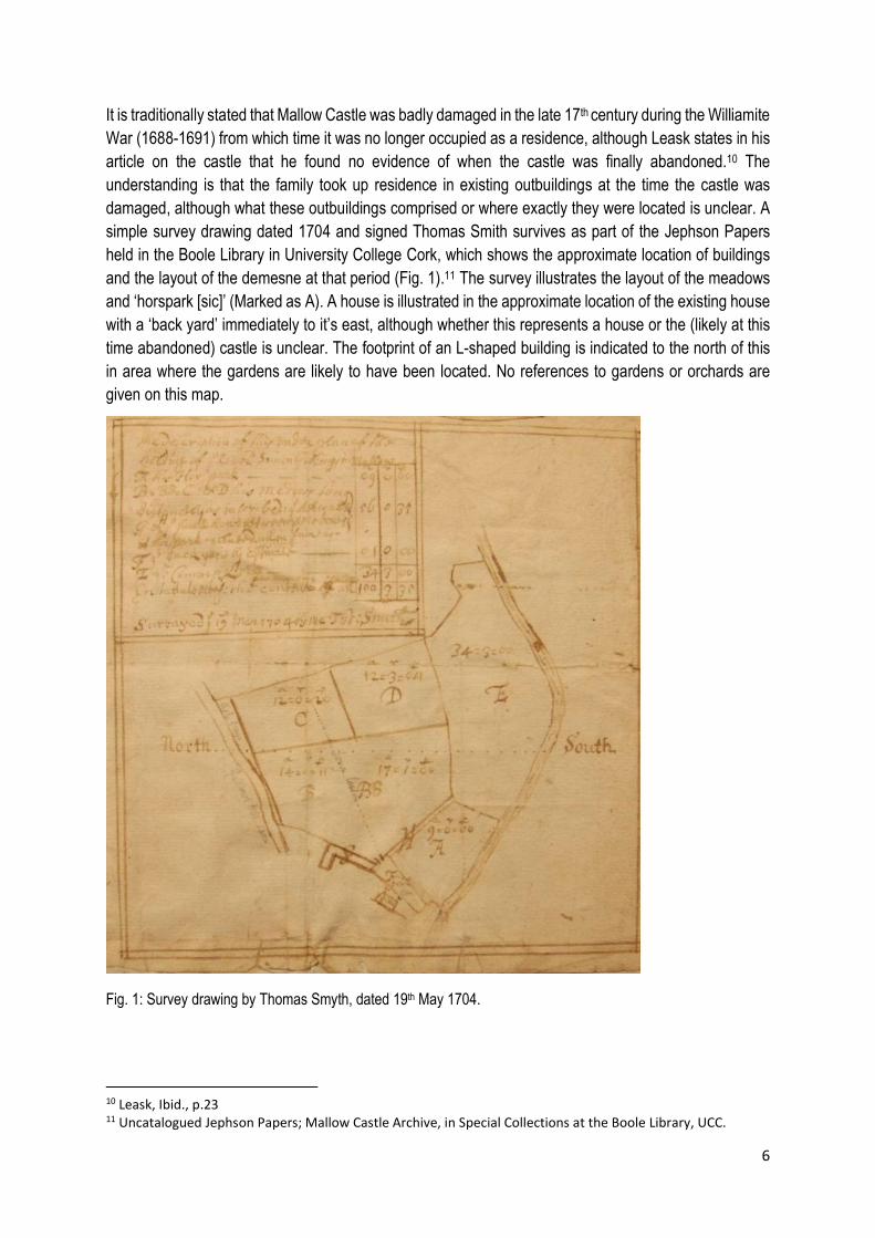
It is traditionally stated that Mallow Castle was badly damaged in the late 17th century during the Williamite War (1688-1691) from which time it was no longer occupied as a residence, although Leask states in his article on the castle that he found no evidence of when the castle was finally abandoned.10 The understanding is that the family took up residence in existing outbuildings at the time the castle was damaged, although what these outbuildings comprised or where exactly they were located is unclear. A simple survey drawing dated 1704 and signed Thomas Smith survives as part of the Jephson Papers held in the Boole Library in University College Cork, which shows the approximate location of buildings and the layout of the demesne at that period (Fig. 1).11 The survey illustrates the layout of the meadows and ‘horspark [sic]’ (Marked as A). A house is illustrated in the approximate location of the existing house with a ‘back yard’ immediately to it’s east, although whether this represents a house or the (likely at this time abandoned) castle is unclear. The footprint of an L-shaped building is indicated to the north of this in area where the gardens are likely to have been located. No references to gardens or orchards are given on this map. Fig. 1: Survey drawing by Thomas Smyth, dated 19th May 1704.
10 Leask, Ibid., p.23 11 Uncatalogued Jephson Papers; Mallow Castle Archive, in Special Collections at the Boole Library, UCC.
7
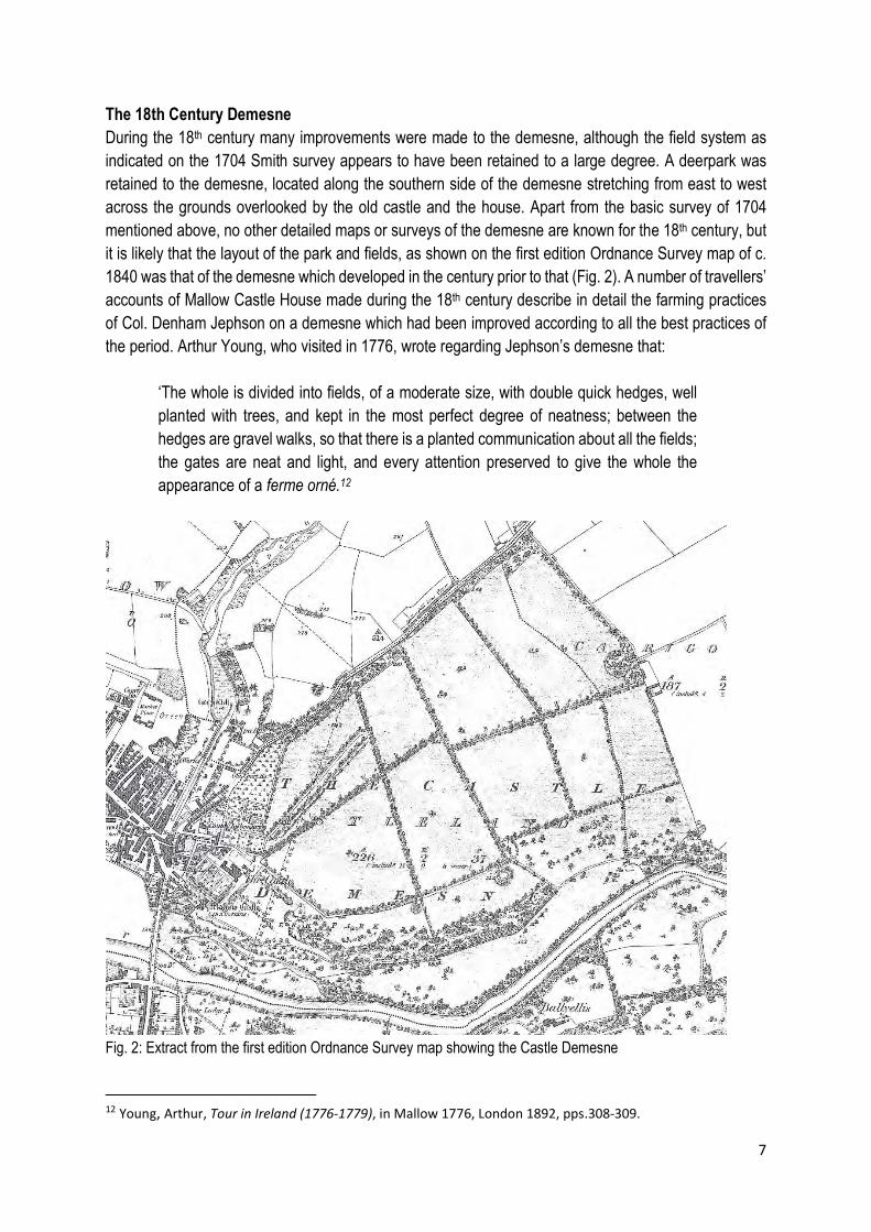
The 18th Century Demesne During the 18th century many improvements were made to the demesne, although the field system as indicated on the 1704 Smith survey appears to have been retained to a large degree. A deerpark was retained to the demesne, located along the southern side of the demesne stretching from east to west across the grounds overlooked by the old castle and the house. Apart from the basic survey of 1704 mentioned above, no other detailed maps or surveys of the demesne are known for the 18th century, but it is likely that the layout of the park and fields, as shown on the first edition Ordnance Survey map of c. 1840 was that of the demesne which developed in the century prior to that (Fig. 2). A number of travellers’ accounts of Mallow Castle House made during the 18th century describe in detail the farming practices of Col. Denham Jephson on a demesne which had been improved according to all the best practices of the period. Arthur Young, who visited in 1776, wrote regarding Jephson’s demesne that:
‘The whole is divided into fields, of a moderate size, with double quick hedges, well planted with trees, and kept in the most perfect degree of neatness; between the hedges are gravel walks, so that there is a planted communication about all the fields; the gates are neat and light, and every attention preserved to give the whole the appearance of a ferme orné.12
Fig. 2: Extract from the first edition Ordnance Survey map showing the Castle Demesne
12 Young, Arthur, Tour in Ireland (1776-1779), in Mallow 1776, London 1892, pps.308-309.
8
In addition to the above, Young described the farming practices of the demesne, with crops of potatoes, oats and wheat, and with a herd of up to 60 dairy cows, with the farm producing both butter and cheese. He notes that great quantities of lime were used, with 100 barrels an acre laid. A number of years later, in 1786, William Wilson recorded his visit to Mallow Castle House, writing that ‘The park is well stocked with deer; the shrubberies, fields and walks are planned in a style of elegant simplicity, which reflects great credit on the taste of Mr. Jephson.’13 In 1810 Reverend Horatio Townsend was equally impressed with the orderly arrangement of the grounds into fields surrounded by double fences of quicks (hawthorns or other thorny hedgerow plants) writing that ‘As a ferme orné (so it has been appropriately termed by Mr Young), it is not, perhaps, exceeded by any demesne in the kingdom.’14 The improvements made to the demesne in the 18th century, and the earlier landscape features retained as part of this, are illustrated on the first edition Ordnance Survey map. This map shows the extent of the demesne which reaches from the Blackwater to the south to the large ring fort preserved to the northeast, just inside the townland boundary of Carrigoonbeg. Two other ring forts are also preserved in the demesne lands. To the south is the deer park which comprises a mixture of woodlands and open park. While medieval deer parks tended to be composed of dense natural woodlands, their later counterparts were designed to make the chase easier and to encourage breeding, with open pasture included for grazing.15 It is this arrangement that can be clearly identified on the first edition OS map which is cut through with a long, meandering pathway leading through the woodland to the easternmost side of the demesne. Remnants of two formal straight avenues also appear to be indicated to the front of the house. Avenues and Walks The double quick fences with gravel paths between, mentioned in the travellers’ accounts of the demesne in the 18th century, are clearly visible on the first edition Ordnance Survey map (Fig. 2). They provided access around the perimeters of all the main fields in the demesne, while also ensuring that the animals did not stray from the enclosures. The longest of these paths, those running from the house in a northeast direction towards the end of the demesne, are indicated on the OS map as ‘The Long Walk’ and ‘The Dower Walk’. These walks or paths, while having a practical function in allowing access to the fields of the demesne, are laid out in a formal manner, particularly the two named walks which run from the house to the east. Such avenues are very distinctive features of late-17th or early-18th century designed landscapes. The Dower Walk terminated in a mount, which was a feature of 17th century gardens but had been in existence since medieval times.16 Naturally occurring or ancient mounts were sometimes incorporated into garden schemes, while in other cases the mount was created as a way of using spoil or earth from
13 Wilson, William, The Post-chaise Companion: or Travellers Directory Through Ireland, 1786. 14 Townsend, Rev. Horatio, Statistical Survey of Cork, 1810 15 Costello, Ibid, p.166. 16 Undated sketch of walkways in the garden, showing the fort at the northeastern end of the demesne and annotating a mount. Uncatalogued Jephson Papers; Mallow Castle Archive, in Special Collections at the Boole Library, UCC.
9
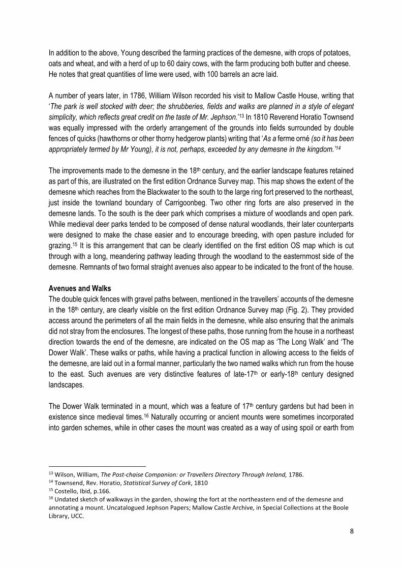
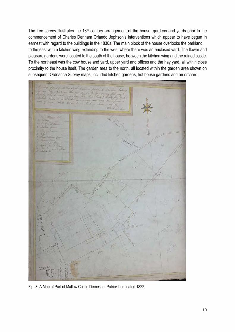
the creation of other garden features.17 A mount would have allowed views across the demesne, and often terminated a walk. Another significant tree-lined walk is indicated on the first edition Ordnance Survey map, which later became known as the Long Avenue. In the early-19th century however, it formed a walk which extended northeast from the outbuildings, near the start of the Long Walk, but looped back on itself and returned in the direction of the house. On later 19th century maps this walk had been extended as a straight formal tree lined avenue running the length of the demesne, with the return pathway removed. It is not named on any of the Ordnance Survey maps. These formal walks and avenues appear to have been developed in the late-17th or early 18th century. Smith’s survey drawing of 1704 indicates one formal avenue only running along the northern boundary of what if identified in this drawing as the ‘horspark’ [sic]. This avenue is clearly identified on all the Ordnance Survey maps and survives today. It is slightly raised and retains some of its historic surfacing material and limestone kerbs. In addition to the improvements carried out to the demesne during the 18th century, Col. Jephson also built a new house. It is traditionally understood that the family moved to accommodation housed in the out offices of the castle when it was badly damaged in the late-17th century. It is unlikely that this accommodation sufficed, and a new house was built at some time in the 18th century, undated drawings for which survive in the Jephson Papers Archive held in UCC. The drawings show a modest house, of seven bays over two storeys with a projecting stairwell to the rear. The house overlooked the deer park with a kitchen wing to the rear overlooking the formal garden and the castle. The 19th Century Charles Denham Orlando Jephson (later Norreys) succeeded to the estate in 1813 and continued to carry out improvements to the demesne he had inherited at Mallow Castle House. He is remembered particularly for rebuilding the main house and for the large stable yard and outbuildings located off the rear avenue. Jephson had the house and yards surveyed by Patrick Lee in 1822 with this drawing showing the arrangement of the mansion house (as it is called on the drawing), out buildings and gardens at this time (Fig.3).18 It appears that Jephson’s work began in earnest around this time, as a ledger survives recording work carried out between March 1821 and April 1822 which details a huge amount of improvements to the demesne and buildings; in Jephson’s own words ‘Jobs almost innumerable in house and offices.’19
17 Costello, Ibid, p.73. 18 A map of part of the Mallow Castle Demesne for Charles Denham Orlando Jephson Esq., dated January 1822, by Patrick Lee. Uncatalogued Jephson Papers; Mallow Castle Archive, in Special Collections at the Boole Library, UCC. 19 Ledger 50. Uncatalogued Jephson Papers; Mallow Castle Archive, in Special Collections at the Boole Library, UCC.
10
The Lee survey illustrates the 18th century arrangement of the house, gardens and yards prior to the commencement of Charles Denham Orlando Jephson’s interventions which appear to have begun in earnest with regard to the buildings in the 1830s. The main block of the house overlooks the parkland to the east with a kitchen wing extending to the west where there was an enclosed yard. The flower and pleasure gardens were located to the south of the house, between the kitchen wing and the ruined castle. To the northeast was the cow house and yard, upper yard and offices and the hay yard, all within close proximity to the house itself. The garden area to the north, all located within the garden area shown on subsequent Ordnance Survey maps, included kitchen gardens, hot house gardens and an orchard. Fig. 3: A Map of Part of Mallow Castle Demesne, Patrick Lee, dated 1822.
11
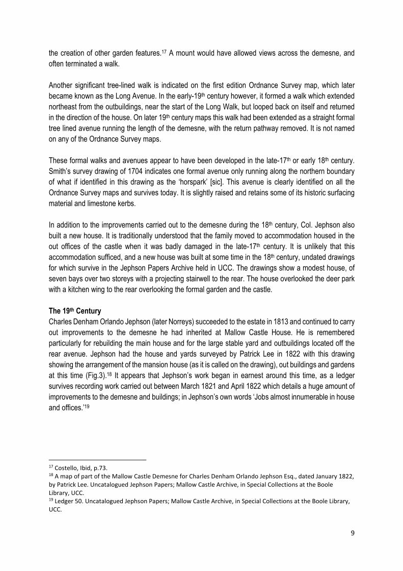
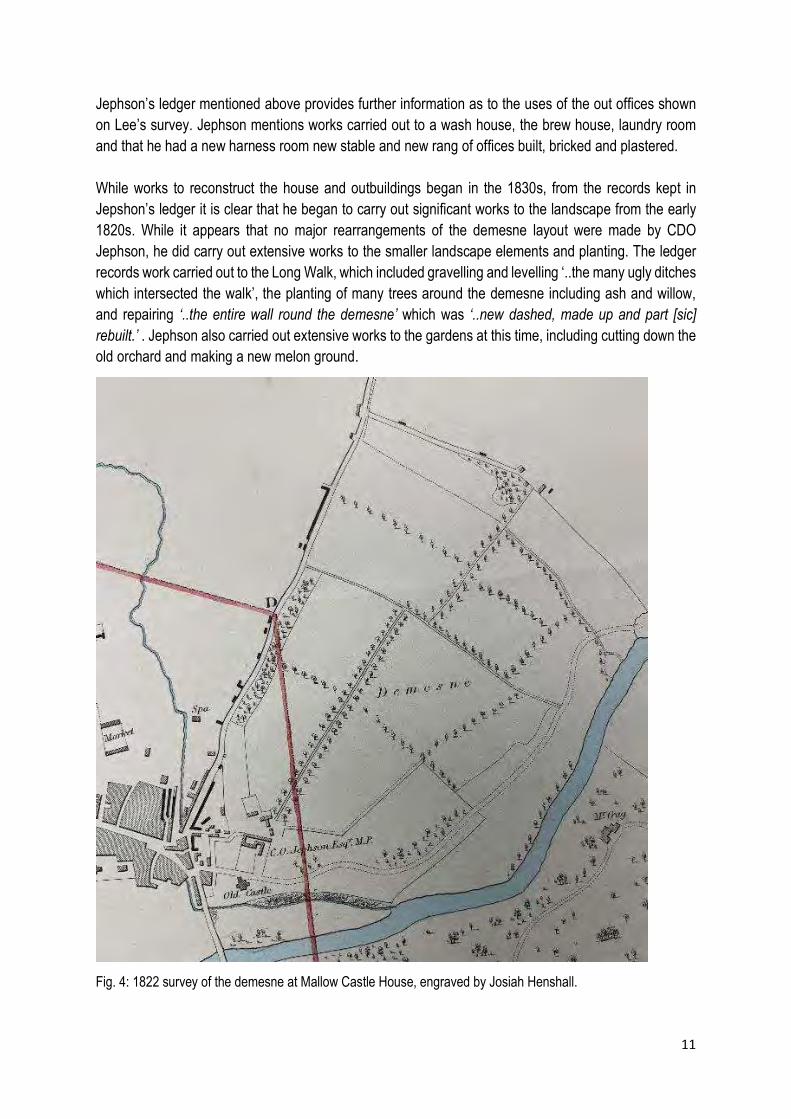
Jephson’s ledger mentioned above provides further information as to the uses of the out offices shown on Lee’s survey. Jephson mentions works carried out to a wash house, the brew house, laundry room and that he had a new harness room new stable and new rang of offices built, bricked and plastered. While works to reconstruct the house and outbuildings began in the 1830s, from the records kept in Jepshon’s ledger it is clear that he began to carry out significant works to the landscape from the early 1820s. While it appears that no major rearrangements of the demesne layout were made by CDO Jephson, he did carry out extensive works to the smaller landscape elements and planting. The ledger records work carried out to the Long Walk, which included gravelling and levelling ‘..the many ugly ditches which intersected the walk’, the planting of many trees around the demesne including ash and willow, and repairing ‘..the entire wall round the demesne’ which was ‘..new dashed, made up and part [sic] rebuilt.’ . Jephson also carried out extensive works to the gardens at this time, including cutting down the old orchard and making a new melon ground.
Fig. 4: 1822 survey of the demesne at Mallow Castle House, engraved by Josiah Henshall.

12
Jephson also recorded in this ledger that he carried out repairs to the ice house. The ice house is shown on the first edition Ordnance Survey map, located to the north of the house within the kitchen gardens. In Britain and Ireland the practice of storing ice and snow in specially constructed chambers began in the 17th century. 20 Ice houses had a sunken chamber which was built below ground and covered over with earth to increase insulation. The ice house at Mallow Castle House was removed in the late-1990s when a housing development was constructed on the northern part of the demesne lands. It was recorded prior to demolition as having a circular brick-lined chamber of two and half metres in diameter covered with a domed brick roof. Jephson also appears to have commissioned a more extensive survey of his demesne, and two maps are included in the Jephson Papers Archive in UCC. One is titled the Manor of Mallow and one Mallow, the latter engraved by Josiah Henshall of London (Fig.4). This map also bears a note handwritten in pencil which reads ‘This is very likely “the large map of the Manor of Mallow” which Capt. Geo. Gipps stated in a letter to C.D.O. Jephson, dated 21/6/1832, he hoped to send shortly.’ The former appears to be of an earlier date as it shows fewer outbuildings and offices to the main house yard, although the scale is very small. Both show very similar layouts to the demesne landscape, although neither show the looped, tree-lined avenue or walk which is shown on the first edition Ordnance Survey map. The Long Walk and the Dower Walk, as well as other tree-lined walk ways to the periphery of the main fields are indicated, as is a rough indication of a garden located between the house and the ruined castle.
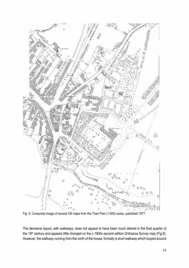
The first edition Ordnance Survey map of c. 1840 provides a lot of additional detail for the gardens and demesne lands associated with the house at this time, and the results of the improvements Jephson had been implementing since the 1820s. (Fig.2) The production gardens are located to the northwest of the house, where the location of the ice house is indicated. Northwest again of the production gardens is an orchard, and area to the southwest of the house is laid out as formal gardens. A long tree-lined walk, which returns back on itself, has been laid out by this time to the area north of the house between the orchard and the Long Walk. The house has been remodelled by this time and many of the outbuildings which appear on the 1822 maps have been demolished. A number of large buildings are retained to the northeast of the house where both the Long Walk and the more recent, looped, tree-lined walks originate. By the time of the Ordnance Survey Town Plan of 1878, the farmyard buildings to the northwest of the house have been constructed, which allowed for the removal of all the remaining outbuildings adjacent to the house to be removed (Fig.5). The walkways have been extended further south across the area where the former outbuildings stood, and all farm and stable related activities have been removed to the purpose-built buildings of the farmyard. Large glass houses have been constructed to the northern end of the productive gardens by this time. The gardens to the south of the house are clearly the pleasure gardens, with formal layouts of planting and a croquet ground indicated to the southwest of the house. The layout of the fields to the demesne has been retained, and a deer park is indicated to the area east of the house and ruined castle.
20 Costello, Ibid. p. 69.
13
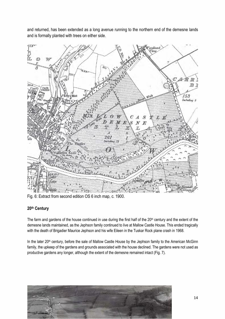
Fig. 5: Composite image of several OS maps from the Town Plan (1:500) series, published 1877. The demesne layout, with walkways, does not appear to have been much altered in the final quarter of the 19th century and appears little changed on the c.1900s second edition Ordnance Survey map (Fig.6). However, the walkway running from the north of the house, formally a short walkway which looped around
14
and returned, has been extended as a long avenue running to the northern end of the demesne lands and is formally planted with trees on either side.
Fig. 6: Extract from second edition OS 6 inch map, c. 1900. 20th Century The farm and gardens of the house continued in use during the first half of the 20th century and the extent of the demesne lands maintained, as the Jephson family continued to live at Mallow Castle House. This ended tragically with the death of Brigadier Maurice Jephson and his wife Eileen in the Tuskar Rock plane crash in 1968. In the later 20th century, before the sale of Mallow Castle House by the Jephson family to the American McGinn family, the upkeep of the gardens and grounds associated with the house declined. The gardens were not used as productive gardens any longer, although the extent of the demesne remained intact (Fig. 7).

15
Fig. 7: Aerial photograph by Daphne Pochin Mould, post 1970. A large part of the demesne lands north of the house was sold c. 2000 and housing developed on these grounds. Continued lack of maintenance to the grounds resulted in further decline of the garden structures such as the glass houses and overgrowth of the planted features such as beech and box hedging. Extent of Historic Landscape Retained
Fig. 8: Recent aerial photograph showing the location of Mallow Castle House and the extent of development which has taken place on the former demesne lands to the north and northwest of the house. Demesne Lands:
Ringfort or rath, RMP No. CO033-012---
Demesne lands developed as housing Mallow
House
16
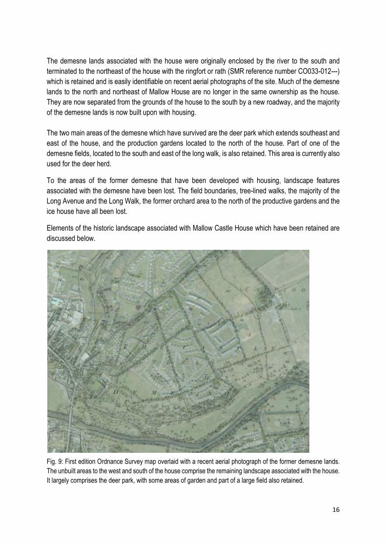
The demesne lands associated with the house were originally enclosed by the river to the south and terminated to the northeast of the house with the ringfort or rath (SMR reference number CO033-012---) which is retained and is easily identifiable on recent aerial photographs of the site. Much of the demesne lands to the north and northeast of Mallow House are no longer in the same ownership as the house. They are now separated from the grounds of the house to the south by a new roadway, and the majority of the demesne lands is now built upon with housing. The two main areas of the demesne which have survived are the deer park which extends southeast and east of the house, and the production gardens located to the north of the house. Part of one of the demesne fields, located to the south and east of the long walk, is also retained. This area is currently also used for the deer herd.
To the areas of the former demesne that have been developed with housing, landscape features associated with the demesne have been lost. The field boundaries, tree-lined walks, the majority of the Long Avenue and the Long Walk, the former orchard area to the north of the productive gardens and the ice house have all been lost.
Elements of the historic landscape associated with Mallow Castle House which have been retained are discussed below.
Fig. 9: First edition Ordnance Survey map overlaid with a recent aerial photograph of the former demesne lands. The unbuilt areas to the west and south of the house comprise the remaining landscape associated with the house. It largely comprises the deer park, with some areas of garden and part of a large field also retained.
17
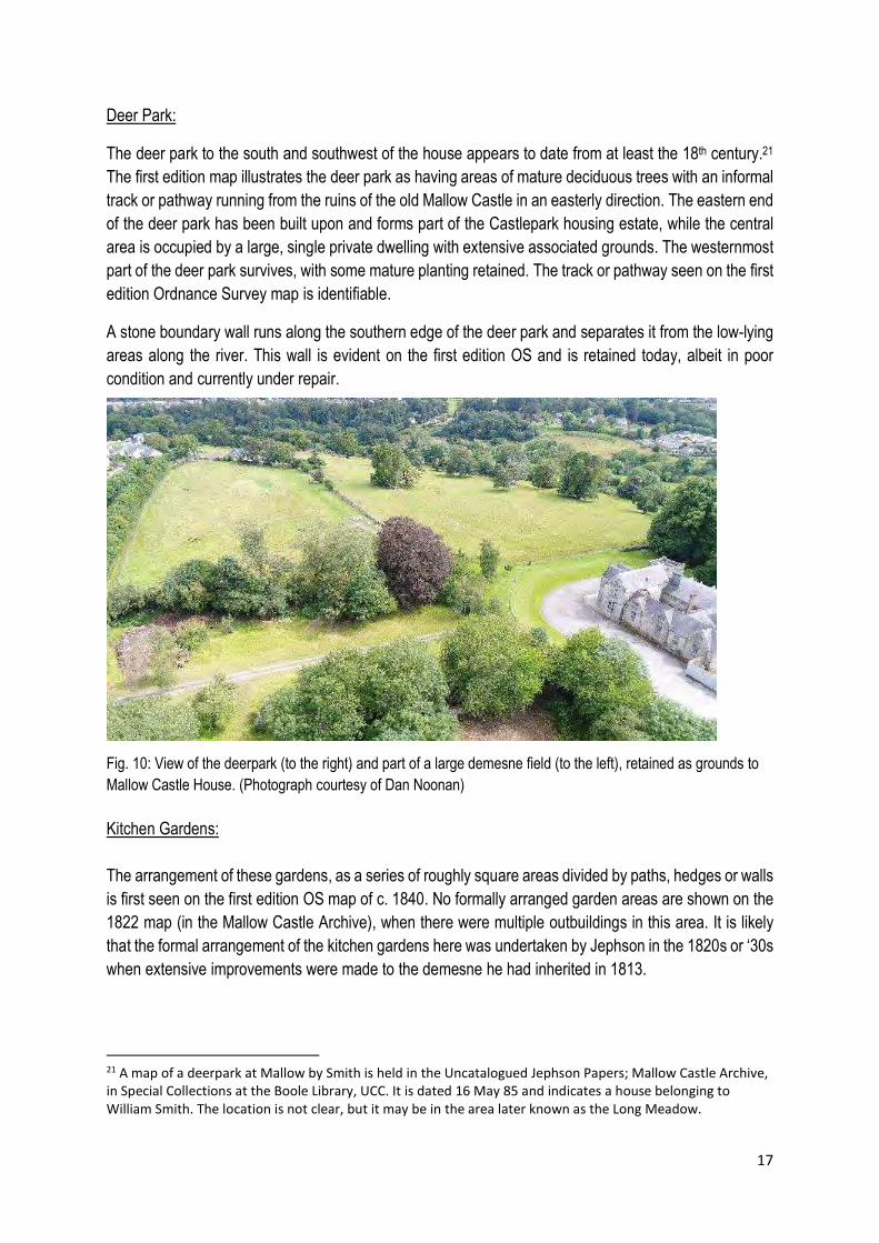
Deer Park:
The deer park to the south and southwest of the house appears to date from at least the 18th century.21 The first edition map illustrates the deer park as having areas of mature deciduous trees with an informal track or pathway running from the ruins of the old Mallow Castle in an easterly direction. The eastern end of the deer park has been built upon and forms part of the Castlepark housing estate, while the central area is occupied by a large, single private dwelling with extensive associated grounds. The westernmost part of the deer park survives, with some mature planting retained. The track or pathway seen on the first edition Ordnance Survey map is identifiable.
A stone boundary wall runs along the southern edge of the deer park and separates it from the low-lying areas along the river. This wall is evident on the first edition OS and is retained today, albeit in poor condition and currently under repair.
Fig. 10: View of the deerpark (to the right) and part of a large demesne field (to the left), retained as grounds to Mallow Castle House. (Photograph courtesy of Dan Noonan) Kitchen Gardens: The arrangement of these gardens, as a series of roughly square areas divided by paths, hedges or walls is first seen on the first edition OS map of c. 1840. No formally arranged garden areas are shown on the 1822 map (in the Mallow Castle Archive), when there were multiple outbuildings in this area. It is likely that the formal arrangement of the kitchen gardens here was undertaken by Jephson in the 1820s or ‘30s when extensive improvements were made to the demesne he had inherited in 1813.
21 A map of a deerpark at Mallow by Smith is held in the Uncatalogued Jephson Papers; Mallow Castle Archive, in Special Collections at the Boole Library, UCC. It is dated 16 May 85 and indicates a house belonging to William Smith. The location is not clear, but it may be in the area later known as the Long Meadow.

18
Fig.11: Aerial view showing the remains of the kitchen gardens, located to the north of the house. Jephson continued to improve these productive gardens in the mid-19th century, and a clear layout of them is included on the 1878 OS Town Plan (Fig. 5). By this time all remaining outbuildings had been removed from this area, with their uses accommodated in the new stable/farmyard which Jephson had built to the northwest of the house. Jephson repaired and retained the ice house, and constructed two new glasshouses to his own design. 22 (A third glass house was added later in the 19th century, and is indicated on the c.1900 OS map). It is elements of this arrangement of the gardens which survive today.
Fig. 12: Mid-20th century photograph of Mallow Castle House and gardens (Cork Examiner), showing the remains of the kitchen gardens to the north of the house. Note that all three glass houses were intact at this time.
22 Detailed drawings of the proposed new glass houses are held in the Uncatalogued Jephson Papers; Mallow Castle Archive, in Special Collections at the Boole Library, UCC.
19
Verbal communication from the manager of the grounds to the author confirmed that the kitchen gardens were used to produce fruit and vegetables until the mid-20th century, with the excess produce sold to residents of the town.
The elements associated with the kitchen gardens which survive have been recorded on BSM’s drawing titled Existing Built and Natural Features (included as Appendix II) and include a high, stone wall enclosing a large area to the southernmost portion of the gardens, a high rubble limestone wall running north/south to the north of this, remnants of a glass house, the foundations of a second lean-to glass house, steel gates, and remnants of mature yew and beech hedges.
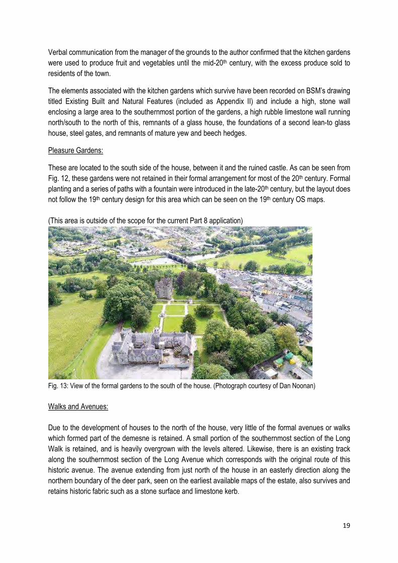
Pleasure Gardens:
These are located to the south side of the house, between it and the ruined castle. As can be seen from Fig. 12, these gardens were not retained in their formal arrangement for most of the 20th century. Formal planting and a series of paths with a fountain were introduced in the late-20th century, but the layout does not follow the 19th century design for this area which can be seen on the 19th century OS maps. (This area is outside of the scope for the current Part 8 application)
Fig. 13: View of the formal gardens to the south of the house. (Photograph courtesy of Dan Noonan) Walks and Avenues: Due to the development of houses to the north of the house, very little of the formal avenues or walks which formed part of the demesne is retained. A small portion of the southernmost section of the Long Walk is retained, and is heavily overgrown with the levels altered. Likewise, there is an existing track along the southernmost section of the Long Avenue which corresponds with the original route of this historic avenue. The avenue extending from just north of the house in an easterly direction along the northern boundary of the deer park, seen on the earliest available maps of the estate, also survives and retains historic fabric such as a stone surface and limestone kerb.
20
The grassy track across the deer park, running east from in front of the old castle, is also identifiable on aerial photographs and follows the route indicated on historic Ordnance Survey maps. Garden Structures:
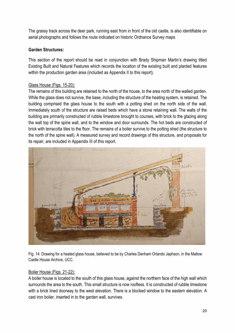
This section of the report should be read in conjunction with Brady Shipman Martin’s drawing titled Existing Built and Natural Features which records the location of the existing built and planted features within the production garden area (included as Appendix II to this report). Glass House (Figs. 15-20): The remains of this building are retained to the north of the house, to the area north of the walled garden. While the glass does not survive, the base, including the structure of the heating system, is retained. The building comprised the glass house to the south with a potting shed on the north side of the wall. Immediately south of the structure are raised beds which have a stone retaining wall. The walls of the building are primarily constructed of rubble limestone brought to courses, with brick to the glazing along the wall top of the spine wall, and to the window and door surrounds. The hot beds are constructed of brick with terracotta tiles to the floor. The remains of a boiler survive to the potting shed (the structure to the north of the spine wall). A measured survey and record drawings of this structure, and proposals for its repair, are included in Appendix III of this report. Fig. 14: Drawing for a heated glass house, believed to be by Charles Denham Orlando Jephson, in the Mallow Castle House Archive, UCC. Boiler House (Figs. 21-22): A boiler house is located to the south of this glass house, against the northern face of the high wall which surrounds the area to the south. This small structure is now roofless. It is constructed of rubble limestone with a brick lined doorway to the west elevation. There is a blocked window to the eastern elevation. A cast iron boiler, inserted in to the garden wall, survives.
21
Base of Glass House (Figs. 23-24): The base of a second glass house is retained to the southern side of the northern wall of the walled garden (on the other side of the wall from the boiler). No upstands or glass are retained, however the terracotta tiled floor survives. This was a lean-to structure which used the high garden wall as the main support. Holding Tank: This is located to the southwest of the large glasshouse and is a below ground level water tank. Forcing Pit (Fig. 25): Located to the southeast of the large glasshouse, base walls only are retained. These are rendered with a modern cementitious plaster (but brick base walls may be retained below). Garden Walls (Figs. 26-33): High stone walls (approx. 2.5 metres) surround the southern portion of the production gardens. A long section (running north/south) is also retained to the western side of the large glasshouse, and a smaller section northeast of the glasshouse. There are a number of gateways allowing pedestrian access through the walls to various areas of the garden, and one larger vehicular gateway with squared limestone piers to the eastern boundary. There appears to have been a large vehicular gateway also to the long range of wall located west of the glass house, which was blocked up many years ago. The walls are generally sound, but suffer from a number of issues which are affecting the condition, and which will eventually undermine their structural stability. There is heavy vegetation growth to many areas, where extensive ivy growth in particular is enveloping the walls. This vegetation growth, and lack of maintenance, has also resulted in widespread loss of pointing to the walls. The stones to the wall tops in particular have become loose, and in some areas there has been substantial loss of masonry. These issues have caused some structural damage to the heads over the pedestrian gateways through the walls which have required propping.

22
Statement of Significance At legislative level, the house at Mallow Castle House, its gardens and grounds are protected under the Planning and Development Act 2000, as a protected structure includes the land lying within the curtilage of the protected structure. The Architectural Heritage Protection Guidelines for Planning Authorities outlines the general principals of curtilage and attendant grounds associated with a protected structure and notes that:
Features within the curtilage and attendant grounds of a protected structure can make a significant contribution to the character of that structure. The designed landscape associated with a protected structure was often an intrinsic part of the original design concept, and, as such, inseparable from the building.23
In addition to the significance of the grounds, the subject of this report, the structures themselves on the site, the castle, the house, the gate lodge and outbuildings are also both protected structures and National Monuments. As with protected structures, the definition of a National Monument includes the land adjacent to the site or structure, which is necessary to preserve the amenities of that monument. Both sets of legislation therefore, the Planning and Development Act 2000 and the National Monuments Act, recognise the significance of attendant grounds and provide protection for the grounds associated with the structures. While much of the demesne lands to the north of Mallow Castle House have been lost, the production gardens, the pleasure gardens, part of one of the demesne fields, much of the deer park and the lower ground to the south of the old castle are all presently retained as grounds to the house. As recorded above, many structures and garden features within these areas also survive. Given the layers of habitation on the site, and the phases of designed landscape associated with the occupancy of the castle, and later the house (in its various forms), the historical significance of the grounds associated with Mallow Castle/Mallow Castle House is high. In the Conservation Plan prepared for the Heritage Unit of Cork County Council for Mallow Castle House and Demesne in 2012, Dan Noonan assessed the house and demesne lands to be of National Significance in terms of their Cultural Significance. Dan Noonan references the ICOMOS Burra Charter 1999’s definition of Cultural Significance:
Cultural significance means aesthetic, historic, scientific, social, or spiritual value for past, present or future generations. Cultural significance is embodied in the place itself its fabric, setting, use, associations, meanings, records, related places and related objects.
Although the demesne associated with Mallow Castle House has been reduced from its original extent, the landscaped and garden areas which do survive are of high significance and provide evidence of the long duration of human settlement on the site, and in particular designed landscape and garden features associated with a large house (both the castle and the house) belonging to generations of an influential
23 DoEHLG, Architectural Heritage Protection Guidelines for Planning Authorities, p.193, 2004.

23
family. While documentary evidence survives relating to a ferme orné laid out in the 18th century, earlier references suggest extensive gardens associated with the castle and house of the earlier period. Traces of these multiple layers of designed landscape survive within the grounds and are evidence of several centuries of garden and landscaping activities on the site. While some such designed landscapes are known at other locations in Ireland, these are more often associated with larger houses of the 18th century. The documentary and physical evidence associated with several centuries of the designed gardens and attendant grounds of Mallow Castle/Mallow Castle House allows for an understanding of the development of a small demesne from the late medieval period and is of high interest and significance.
24
Part 2: Assessment of Development Proposals
Description of the Proposed Development It is proposed to provide new public access to the grounds of Mallow Castle/Mallow Castle House from Castlepark Avenue, and to construct a 28 no. car park in one area of the gardens of Mallow Castle House adjacent to this new entrance. In addition, it is proposed to provide a playground, accessible pathways and new boundary fencing in the area of the gardens located north of Mallow Castle House, the former production gardens. Associated conservation works to the glass house and high stone garden walls are proposed as part of this phase of work. The likely physical and visual impacts of the proposed works on the gardens, designed landscape and garden structures are outlined below. This section is followed by a description of the mitigation measures it is proposed to employ in order to minimise the potential impacts on both the physical elements of the gardens and on the special character of this area of the grounds associated with Mallow Castle House.
Likely Impacts of the Proposed Works
Proposed Works: Provision of car parking and new vehicular access from Castlepark Avenue, comprising 28 car parking spaces.
Physical Impacts: In order to provide vehicular access from Castlepark Avenue, it is proposed to demolish a section of the existing boundary wall. This wall is constructed of concrete blockwork and is not of historical or architectural value. The historic stone garden wall to the east and south boundaries of the proposed car parking area, and the existing pedestrian gateways, will be retained and repair works carried out to the stonework as required. There are no further upstanding structures or remains of structures in this area. (The large glass house to this area seen on historic maps was demolished a number of years ago).
Visual Impacts: Buff permeable asphalt is proposed for surfacing with a concrete set pathway to the western side. To the south, limestone paving is proposed to signal the pedestrian exists from the car park to other areas of the gardens. The removal of the grass to this area and its replacement with hard surfacing will have a high visual impact on the existing character of this area of the gardens. Screen planting is proposed to the western boundary where an existing blockwork wall will be retained, whereas low level planting is proposed to the boundaries where the historic stone walls are retained. This, together with additional soft landscaping will help to mitigate against the visual impacts of the proposed new materials to this area.
Proposed Works: Provision of a playground to north of Mallow Castle House
Physical Impacts: It is proposed to provide a playground in the north-eastern area of the surviving gardens associated with Mallow Castle House. Part of the
25
area proposed for a playground falls within the historic production garden area as developed in the 19th century (and prior to this formed working yard areas associated with the farm outbuildings), while the eastern side of the playground will be located adjacent to the Long Walk, which historically formed the central boundary of the large fields of the demesne. The route of the Long Avenue will run through the centre of the main playground area. It is proposed to avoid both the Long Walk and the Long Avenue when positioning playground elements, and no physical impact is likely on these features. In other areas ground disturbance will be minimised and located locally around the proposed playground elements.
Visual Impacts: The proposed playground will alter the current and historic character of this area of the gardens and demesne lands. The playground equipment, in addition to the proposed new pathways, safety surfaces and resurfacing of the Long Avenue will introduce new materials and reduce the grass coverage and soft landscaping of the area. The retention of mature trees and other planting in this area will help to mitigate these visual impacts to some degree.
Proposed Works: Resurfacing of Long Avenue and deer park avenue
Physical Impacts: The proposed hard surfacing of the Long Avenue (tar and local red sandstone chip) will continue along part of the avenue which extends along the northern boundary of the historic deer park. Historic fabric survives in this avenue in the form of limestone kerbing and stone surfacing material. The proposed resurfacing should be designed to protect this historic fabric in situ.
Visual Impacts: Given the proximity of these historic avenues to the house, new surfacing materials should be carefully considered in order to minimise impacts on the historic character of these avenues and the grounds through which they pass.
Proposed Works: New pedestrian pathways
Physical Impacts: The proposed pedestrian pathways will have minimal physical impact on the garden areas. They are designed to utilise existing pedestrian gateways through the garden walls and will not impact on any of the surviving garden features or structures.
Visual Impacts: The paths are proposed as Breedon gravel paths. In some cases the path will follow established pedestrian routes through the garden, while
26
new routes will also be introduced. The proposed paths will introduce a new hard surface material into the garden area which will visually impact on the historic character of the gardens. The visual impacts can be mitigated by the choice and colour of gravel used.
Proposed Works: Services including lighting and security cameras, wayfinding signage, lecterns, notice boards, etc.
Physical Impacts: The physical impacts will be confined to the footings required for the upstand elements of these interventions. These should be kept away from historic garden features or structures in order to minimise disturbance.
Visual Impacts: Individually these interventions will have minimal visual impact. Cumulative visual impact will occur if a high number of these elements are introduced into the garden area.
Proposed Works: New boundary fences and gates
Physical Impacts: The physical impacts of the proposed works will be localised and minimal.
Visual Impacts: The fencing proposed is steel estate railing and will be used in a number of locations, including along the eastern side of the Long Walk, to the southern end of the playground, to the south of the walled garden, between the production garden (the location of the glass house) and partially surrounding the glass house. The introduction of this fencing will have a visual impact on the garden areas and will also subdivide some areas which are currently connected. It is proposed to plant yew hedges along the fences in some of the above locations, which will help to mitigate its visual impact. The choice of colour of this fencing can also help to mitigate the visual impact.
Proposed Works: Proposed works to glass house
Physical Impacts: It is proposed to carry out conservation and repair works to the glass house located within the walled garden. Works were previously carried out to this structure in the 1980s when some of the original or historic fabric of the glass house structure was replaced. The glass is all now missing and much of the structure itself is lost, although the hot bed structure and tiled floor is retained. The potting shed attached to the north of the glass house also survives although the roof is lost. The
27
proposed works (detailed in Appendix III of this report) will involve the replacement of some surviving fabric due to the decayed state of the structure. However, an approach of minimal replacement is proposed in as far as condition allows.
Visual Impacts: The building is currently in ruinous condition and works to repair the glass house are urgent in order to protect the remaining fabric from further decay. The proposed works will have a long term, positive visual impact on the structure and the surrounding garden area.
Proposed Works: Proposed works to garden walls
Physical Impacts: It is proposed to carry out conservation and repair works to the stone garden walls located in the production garden area. The existing walls will be retained, as will existing pedestrian and vehicular gateways through the walls. The stonework will be repaired using the existing material with introduction of new stone minimised. (The proposed works are detailed in 2 no. drawings by JCA Architects which are included in the Part VIII submission).
Visual Impacts: The proposed works will have a long term, positive visual impact on the garden walls and the surrounding garden areas.
28
Mitigation Measures and Recommendations
An approach of minimal intervention and maximum reuse of historic fabric and materials should be taken with regard to all repair works proposed to the garden structures and surviving landscape features on the site.
Repair works should employ traditional techniques and materials and the introduction of modern materials and technologies should only be considered where these are unavoidable.
The proposed works should not result in the loss of historic fabric in the form of surviving garden or landscape features, with proposed new interventions suitably situated so as to avoid the loss of historic elements associated with Mallow Castle House and Mallow Castle.
All proposed repair works or other interventions which will potentially result in the loss of surviving historic fabric should be specified and supervised by a suitably experienced conservation architect and/or archaeologist as required.
Proposed new surfacing materials for existing pedestrian and avenue routes, new pathways and car parking areas should be carefully chosen to minimise visual impacts on the historic garden areas and on the larger attendant grounds associated with Mallow Castle House. Hard surfacing should be minimised in order to protect the special character of the garden areas.
New surfacing of existing pathways, avenues and other routes should not be carried out where existing historic fabric and materials will be lost as a result of the works.
New fencing, lighting, signage and gates should be minimised in order to avoid cumulative visual impacts and visual clutter in the garden areas and wider attendant grounds. New fencing should not interrupt the historic circulation between individual areas of the gardens and grounds, and all existing pedestrian and vehicular access points should be maintained.
New planting should be cognisant of the historic views to and from Mallow Castle House with regard to the garden areas, surviving demesne lands and the deer park. Proposed planting should not interrupt historic views or alter the historic relationship between the house and the attendant grounds.

29
Appendix I – Photographic Record – Garden Structures

30
Fig. 15: Glass house (courtesy Dan Noonan) Fig. 16:Glass house, north (potting shed)
Fig. 17: Glass house, west end. Fig. 18: Glass house, south
Fig. 19: Glass house, hot beds Fig. 20: Glass house, west end
Fig. 21: Boiler house Fig. 22: Boiler house

31
Fig. 23: Base of second glass house, from east Fig. 24: Base of second glass house, from west
Fig. 25: Forcing pit Fig. 26: High garden wall, north gardens
Fig. 27: Garden wall, north gardens Fig. 28: Gate from north gardens to stable yard
Fig. 29: Eastern face of wall to north gardens Fig. 30: Blocked gateway

32
Fig. 31: Gateway from north gardens to walled garden
Fig. 32: Walled gardens
Fig.33: Gateway north of walled gardens

33
Appendix II – BSM Existing Built and Natural Features Drawing

34
Appendix III – Record of Glass House Structure, with Proposals for Repair.