Main Roads Western Australia - the EPA consultation hub
262
Main Roads Western Australia Mitchell Freeway extension: Burns Beach Rd to Romeo Rd Level 2 Flora & Level 1 Fauna Assessment February 2014
-
Upload
khangminh22 -
Category
Documents
-
view
0 -
download
0
Transcript of Main Roads Western Australia - the EPA consultation hub

Main Roads Western Australia Mitchell Freeway extension: Burns Beach Rd to Romeo Rd
Level 2 Flora & Level 1 Fauna Assessment
February 2014

GHD | Report for Main Roads Western Australia - Mitchell Freeway extension: Burns Beach Rd to Romeo Rd, 61/29435
| i
Executive summary The Mitchell Freeway provides the primary road access route from the Perth north-west corridor towards the City of Perth. The freeway currently terminates at Burns Beach Road. The freeway has been constructed in several stages since the 1960s, with further extensions and widening works planned. The Mitchell Freeway Extension has been the subject of a planning process undertaken by Main Roads Western Australia.
GHD was commissioned by Main Roads Western Australia to conduct a Level 2 flora and vegetation assessment and Level 1 fauna assessment for the proposed Mitchell Freeway Extension and associated works between Burns Beach Road and Romeo Road, located north of Perth, Western Australia (the Study Area). The business case prepared for the project divides the project into three stages to be completed over a period of time. These stages are:
Stage 1 – Freeway extension from Burns Beach Road to Hester Avenue and the connecting roads (Neerabup Road and Hester Avenue) 2015–2017
Stage 2 – Freeway extension from Hester Avenue to Romeo Road and connecting road (Romeo Road) 2017–2021
Stage 3 – Wanneroo Road duplication from Joondalup Drive to Hall Road 2027–2029
The information from this assessment will be used to support an Environmental Impact Assessment and subsequent Federal and State approvals documentation, as required.
The Study Area includes the corridor and other associated works required between Burns Beach Road and Romeo Road as part of the Mitchell Freeway Extension Project, located approximately 30 km north of Perth (within the Cities of Joondalup and Wanneroo). The Study Area is approximately 438 hectares (ha) in total and is larger than will be required for the proposed works. A smaller disturbance area will be defined during detailed design works.
Desktop assessment
A desktop review was conducted prior to the commencement of the field surveys which identified the following:
A large proportion of the Study Area is classified as Environmentally Sensitive Areas (ESAs) (Government of Western Australia, 2012). The ESAs are associated with Bush Forever sites and Threatened Ecological Communities (TECs).
Two conservation reserves managed by the Department of Parks and Wildlife (DPaW) (Neerabup National Park and Neerabup Nature Reserve) are present within the boundaries of the Study Area.
The following three Bush Forever sites occur within the boundaries of the Study Area:
– Site 299 (Yellagonga Regional Park)
– Site 383 (Neerabup National Park, Lake Nowergup Reserve and adjacent bushland)
– Site 384 (Neerabup Lake and adjacent bushland)
Broadscale vegetation mapping undertaken by Beard (1979) has identified the presence of the following four vegetation associations within the Study Area:
– Medium woodland; tuart [Eucalyptus gomphocephala] & jarrah [E. marginata] (association 6)
– Shrublands; teatree [Agonis flexuosa] thicket (association 37)
– Low woodland; banksia [Banksia spp.] (association 949)
GHD | Report for Main Roads Western Australia - Mitchell Freeway extension: Burns Beach Rd to Romeo Rd, 61/29435
| ii
– Medium woodland; tuart [E. gomphocephala] (association 998).
Mapping undertaken by Heddle et al. (1980) identified the following four vegetation complexes within the Study Area:
– Cottesloe complex (Quindalup Dunes)
– Cottesloe complex – central and south (Spearwood Dunes)
– Karrakatta complex – central and south (Spearwood Dunes)
– Herdsman complex (Spearwood Dunes)
Field assessment
During May–July and September–October, 2013, GHD conducted Level 2 flora and vegetation assessments of the Study Area in accordance with the Environmental Protection Authority (EPA) Guidance Statement 51 and Position Statement No. 3 and a Level 1 fauna assessment (reconnaissance survey) in accordance with Guidance Statement No. 56. The results of these assessments are summarised below.
Flora & vegetation
The Study Area is located adjacent to existing roads and railways (a total of 231 ha is generally in Completely Degraded condition), as well as a new alignment through the Neerabup National Park and in other intact patches of native vegetation (ranging in condition from Excellent to Degraded). The following six vegetation types (and an additional mosaic vegetation types) were mapped within the Study Area:
1: Banksia woodland (93.4 ha)
2: Jarrah–Banksia woodland (10.8 ha)
3: Tuart woodland (59.2 ha)
4: Mixed low heath on limestone (22.3 ha)
5: Melaleuca huegelii–M. systena shrubland on limestone (0.6 ha and additional minor occurrences)
6: Banksia sessilis closed tall scrub (7.7 ha)
Mosaic of vegetation types 1 (Banksia woodland) and 4 (Mixed low heath on limestone) (14.3 ha)
Vegetation types 3, 4 and 6 (a total of 89.2 ha in Excellent to Degraded–Completely Degraded condition) appear to correspond with the Priority 3 Priority Ecological Community (PEC) “Northern Spearwood Shrublands and Woodlands”. Vegetation type 5 (0.6 ha and additional minor occurrences) appears to correspond with the state listed Endangered TEC “Melaleuca huegelii–M. acerosa [now M. systena] shrublands on limestone ridges”.
Of the 392 flora species identified during the survey, none were listed under the Environment Protection and Biodiversity Conservation Act 1999 (EPBC Act) or Wildlife Conservation Act 1950 (WC Act). However, the following five are listed as DPaW Priority species:
Acacia ?benthamii (Priority 2): two individuals were observed within a fenced off portion alongside the railway approximately 1.5 km north of Hester Avenue within vegetation type 1 (Stage 2).
Eucalytpus caesia (Priority 4): identified in roadside plantings. This species is widely grown as an ornamental plant. As a result, the individuals observed within the Study Area are not considered to be wild, naturally occurring specimens.

GHD | Report for Main Roads Western Australia - Mitchell Freeway extension: Burns Beach Rd to Romeo Rd, 61/29435
| iii
Jacksonia sericea (Priority 4): approximately 6020 individuals were observed, scattered predominantly throughout vegetation type 1 and alongside disturbed areas (Stages 1, 2 and 3).
Pimelea calcicola (Priority 3): approximately 516 individuals were observed within vegetation types 4 and 5 (Stages 2 and 3).
Stylidium maritimum (Priority 3): approximately 1455 individuals were observed within vegetation type 4 (Stages 2 and 3).
In addition to the five species of conservation significance identified during previous surveys (Acacia benthamii and the Priority 2 species, Fabronia hampeana) and the GHD survey (Acacia benthamii, Eucalytpus caesia, Jacksonia sericea, Pimelea calcicola and Stylidium maritimum), the likelihood of occurrence assessment determined that two species listed under both the EPBC Act and WC Act and eight DPaW Priority-listed species may occur within the Study Area:
Caladenia huegelii (Grand Spider Orchid) (State Threatened, Federal Endangered)
Drakaea micrantha (Dwarf hammer-orchid) (State Threatened, Federal Vulnerable)
Austrostipa mundula (Priority 2)
Conostylis bracteata (Priority 3)
Conostylis pauciflora subsp. euryrhipis (Priority 4)
Conostylis pauciflora subsp. pauciflora (Priority 4)
Lecania turicensis var. turicensis (a lichen) (Priority 2)
Sarcozona bicarinata (Priority 3)
Schoenus griffinianus (Priority 3)
Thelymitra variegata (Priority 3)
In addition to the flora species of conservation significance, seven other significant flora were observed within the Study Area. However, two are not considered to be naturally occurring as they were present as roadside plantings.
The following three introduced flora species identified within the Study Area are considered to be Weeds of National Significance (WoNS) and/or listed as Declared Pests under State legislation:
*Asparagus asparagoides (bridal creeper) (Declared Pest C3 Management for the Whole of the State, WoNS)
*Solanum linnaeanum (apple of Sodom) (Declared Pest C3 Management for the South West Land Division)
*Zantedeschia aethiopica (arum lily) (Declared Pest C3 Management for the Whole of the State).
Fauna
The following six broad fauna habitat types were identified in the Study Area, based on the predominant landforms, soil and vegetation structure in the area:
Low heathland on limestone outcrops
Banksia woodland on grey/brown sand
Tuart (Eucalyptus gomphocephala) woodland in deep dark brown sand
Banksia sessilis tall shrubland on grey sand and limestone outcropping

GHD | Report for Main Roads Western Australia - Mitchell Freeway extension: Burns Beach Rd to Romeo Rd, 61/29435
| iv
Jarrah (E. marginata)–Banksia woodland on grey/brown sand
Planted roadside vegetation/highly degraded/cleared
The native vegetation within the Study Area consists predominantly of a combination of mixed eucalypt woodlands and Banksia woodlands. These habitat types consist of a dominant overstorey of E. gomphocephala (tuart), E. marginata (jarrah), Corymbia calophylla (marri), Banksia attenuata and B. menziesii and were generally associated with grey sandy soils on plains or low undulating dune systems. The eucalypt and Banksia woodlands ranged from degraded to excellent condition and provided particularly high habitat value for fauna species due to the variety of microhabitats and various resource niches available (i.e. fallen logs, hollows, leaf litter, sandy soil).
The areas of remnant vegetation in and immediately surrounding the Study Area are part of a regionally significant contiguous bushland/wetland linkage, with a large proportion of this vegetation currently protected as national park and a series of Bush Forever sites. The vegetation within Neerabup National Park (Bush Forever site 383) is linked to vegetation to the north, south (Bush Forever site 299, across the road), east and west (Site 323, through bushland to Site 397); and is part of Greenways 35, 2, 5. Neerabup National Park provides a narrow corridor to allow movement of animals along the coastal plain and associated wetlands.
A total of 61 fauna species, consisting of 47 birds, seven reptiles and seven mammals were recorded within the Study Area during the field surveys. Of these, nine are introduced (feral) species. The following two conservation significant fauna species were recorded during the survey:
Carnaby’s Black Cockatoo (Calyptorhynchus latirostris) listed as Endangered under the EPBC Act and Threatened under the WC Act
Carpet Python (Morelia spilota imbricata) listed as Schedule 4 under the WC Act.
The field assessment also identified from potential diggings the likely presence of DPaW Priority 5 species, Quenda/Southern Brown Bandicoot (Isoodon obesulus fusciventer).
In addition to the fauna species recorded during the field survey, a number of conservation significant fauna species were identified as potentially occurring within the Study Area based on the species biology, availability of suitable habitat and known records in the area. The assessment identified eight species as likely to occur and four species as possibly occurring within the Study Area.
Ten bird species recorded during the survey are considered to be significant birds of the Swan Coastal Plain portion of the Perth Metropolitan Region. They include the Brown Goshawk, Carnaby’s Black Cockatoo, Emu, Splendid Fairy-wren, New Holland Honeyeater, White-cheeked Honeyeater, Grey Shrike-thrush, Golden Whistler and Scarlet Robin. These species are either habitat specialists with a reduced distribution on the Swan Coastal Plain or are wide-ranging species with reduced populations on the Swan Coastal Plain. Additionally the Carpet Python and Echidna would also be considered to be locally significant fauna as even though they have large distributions they have declined on the Swan Coastal Plain. The Study Area is also considered to contain suitable habitat for a number of other fauna species identified as locally significant, including the Honey Possum, White-striped Bat, Speckled Granite Gecko (Swan Coastal Plain population) and Little Eagle.
This report is subject to, and must be read in conjunction with, the limitations set out in Section 1.5 and the assumptions and qualifications contained throughout the Report.
GHD | Report for Main Roads Western Australia - Mitchell Freeway extension: Burns Beach Rd to Romeo Rd, 61/29435
| v
Table of contents 1. Introduction ............................................................................................................................... 1
1.1 Project background ......................................................................................................... 1 1.2 Purpose of this report ...................................................................................................... 1 1.3 Study Area ...................................................................................................................... 1 1.4 Scope of works ................................................................................................................ 2 1.5 Limitations ....................................................................................................................... 2 1.6 Assumptions.................................................................................................................... 3
2. Relevant legislation, conservation codes & background information ........................................... 4
3. Methodology ............................................................................................................................. 5 3.1 Desktop assessment ....................................................................................................... 5 3.2 Field survey ..................................................................................................................... 5 3.3 Limitations ..................................................................................................................... 10
4. Results & discussion ............................................................................................................... 14 4.1 Bioregion ....................................................................................................................... 14 4.2 Climate .......................................................................................................................... 14 4.3 Environmentally Sensitive Areas .................................................................................... 14 4.4 Reserves & conservation areas ..................................................................................... 14 4.5 Broad vegetation types .................................................................................................. 15 4.6 Vegetation type & condition ........................................................................................... 16 4.7 Threatened & Priority Ecological Communities............................................................... 21 4.8 Flora diversity ................................................................................................................ 24 4.9 Fauna............................................................................................................................ 34
5. References ............................................................................................................................. 39
Table index Table 1 Key relevant environmental legislation ............................................................................. 4
Table 2 Dates of the flora & fauna surveys ................................................................................... 6
Table 3 Data collected during the field survey .............................................................................. 7
Table 4 Vegetation condition rating scale ..................................................................................... 7
Table 5 List of Gibson et al. (1994) quadrats used in PATN analysis ............................................ 8
Table 6 Field survey limitations .................................................................................................. 11
Table 7 GHD vegetation types within each Stage of the Study Area ........................................... 17
Table 8 Vegetation types within the Study Area .......................................................................... 18
Table 9 Conservation significant communities occurring & possibly occurring within the Study Area .................................................................................................................... 22

GHD | Report for Main Roads Western Australia - Mitchell Freeway extension: Burns Beach Rd to Romeo Rd, 61/29435
| vi
Table 10 Conservation significant flora species possibly occurring, likely or known to occur within the Study Area ........................................................................................... 30
Table 11 Other significant flora identified within the Study Area .................................................... 31
Table 12 Locations of Declared Pests & Weeds of National Significance ...................................... 32
Table 13 Conservation significant fauna species identified as present, likely to occur & possibly occurring within the Study Area ........................................................................ 37
Figure index Figure 1 Locality .......................................................................................................................... 44
Figure 2 Environmental context ................................................................................................... 44
Figure 3 Vegetation type & sampling points ................................................................................. 44
Figure 4 Vegetation condition& weeds ......................................................................................... 44
Figure 5 Conservation significant vegetation & flora..................................................................... 44
Figure 6 Fauna habitat types & conservation significant fauna records ........................................ 44
Appendices Appendix A – Figures
Appendix B – Desktop searches
Appendix C – Conservation codes
Appendix D – Flora results
Appendix E – Fauna results

GHD | Report for Main Roads Western Australia - Mitchell Freeway extension: Burns Beach Rd to Romeo Rd, 61/29435
| 1
1. Introduction 1.1 Project background
The Mitchell Freeway provides the primary road access route from the Perth north-west corridor towards the City of Perth. The freeway currently terminates at Burns Beach Road. The freeway has been constructed in several stages since the 1960s, with further extensions and widening works planned. The Mitchell Freeway Extension has been the subject of a planning process undertaken by Main Roads Western Australia (Main Roads).
The business case prepared for the project divides the project into three stages to be completed over a period of time. These stages are:
Stage 1 – Freeway extension from Burns Beach Road to Hester Avenue and the connecting roads (Neerabup Road and Hester Avenue) 2015–2017
Stage 2 – Freeway extension from Hester Avenue to Romeo Road and connecting road (Romeo Road) 2017–2021
Stage 3 – Wanneroo Road duplication from Joondalup Drive to Hall Road 2027–2029
Main Roads commissioned GHD Pty Ltd (GHD) to conduct a flora and fauna assessment for the proposed Mitchell Freeway Extension and associated works between Burns Beach Road and Romeo Road.
1.2 Purpose of this report
Information from this flora and fauna assessment will be used to support an Environmental Impact Assessment (EIA) and subsequent Federal and State approvals documentation, as required.
1.3 Study Area
The Study Area includes the corridor and other associated works required between Burns Beach Road and Romeo Road as part of the Mitchell Freeway Extension Project, and is located approximately 30 km north of Perth, Western Australia (within the Cities of Joondalup and Wanneroo). The Study Area is approximately 438 hectares (ha) in total and is larger than will be required for the proposed works. A smaller disturbance area will be defined during detailed design works.
The Study Area includes the Mitchell Freeway Metropolitan Region Scheme (MRS) reservation area between Burns Beach Road and Romeo Road as well as associated side roads and intersection areas, including:
Neerabup Road east of the Freeway to Wanneroo Road
Hester Avenue to Wanneroo Road
Intersections at Neerabup Road, Hester Avenue and Burns Beach Road
PSP Bridge at Burns Beach Road
Demolition of the bridge at Hester Avenue
Romeo Road East to Wanneroo Road
Wanneroo Road
Neerabup Road West

GHD | Report for Main Roads Western Australia - Mitchell Freeway extension: Burns Beach Rd to Romeo Rd, 61/29435
| 2
Connolly Drive (between Neerabup Road and Hester Avenue)
The Study Area boundary is shown on Figure 1, Appendix A.
1.4 Scope of works
The scope of works as per the project brief and GHD proposal was to:
Undertake a desktop assessment of environmental aspects and constraints (Appendix B)
Undertake a Level 2 vegetation and flora survey to provide:
– A description and mapping of vegetation units and vegetation condition
– An assessment of presence of Threatened and Priority Ecological Communities (TEC and PEC) within the Study Area (including a statistical analysis)
– An inventory of vascular flora
– Locations and counts of conservation significant flora (Threatened and Priority Flora)
– An assessment of the likelihood of occurrence of flora species of conservation significance within the Study Area
– Locations and counts of Declared Pest flora and Weeds of National Significance (WoNS)
– Identification of other significant flora
Undertake a Level 1 fauna survey to provide:
– Description and mapping of fauna habitat
– Inventory of fauna recorded within the Study Area
– An indication of the presence or likelihood of occurrence of conservation significant fauna within the Study Area
Prepare a flora and fauna assessment including the results of the desktop assessment and Level 1 surveys.
1.5 Limitations
This report has been prepared by GHD for Main Roads Western Australia and may only be used and relied on by Main Roads Western Australia for the purpose agreed between GHD and the Main Roads Western Australia as set out in section 1.4 of this report.
GHD otherwise disclaims responsibility to any person other than Main Roads Western Australia arising in connection with this report. GHD also excludes implied warranties and conditions, to the extent legally permissible.
The services conducted by GHD in connection with preparing this report were limited to those specifically detailed in the report and are subject to the scope limitations set out in the report.
The opinions, conclusions and any recommendations in this report are based on conditions encountered and information reviewed at the date of preparation of the report. GHD has no responsibility or obligation to update this report to account for events or changes occurring subsequent to the date that the report was prepared.
The opinions, conclusions and any recommendations in this report are based on assumptions made by GHD described in this report. GHD disclaims liability arising from any of the assumptions being incorrect.
GHD has prepared this report on the basis of information provided by Main Roads Western Australia and others who provided information to GHD (including Government authorities), which GHD has not independently verified or checked beyond the agreed scope of work. GHD
GHD | Report for Main Roads Western Australia - Mitchell Freeway extension: Burns Beach Rd to Romeo Rd, 61/29435
| 3
does not accept liability in connection with such unverified information, including errors and omissions in the report which were caused by errors or omissions in that information.
The opinions, conclusions and any recommendations in this report are based on information obtained from, and testing conducted at or in connection with, specific sample points. Site conditions at other parts of the site may be different from the site conditions found at the specific sample points.
Investigations conducted in respect of this report are constrained by the particular site conditions, such as the location of buildings, services and vegetation. As a result, not all relevant site features and conditions may have been identified in this report.
Site conditions may change after the date of this Report. GHD does not accept responsibility arising from, or in connection with, any change to the site conditions. GHD is also not responsible for updating this report if the site conditions change.
1.6 Assumptions
This report has assessed the flora and fauna within the Study Area (Figure 1, Appendix A).Should the Study Area change or be refined, further assessment may be required.

GHD | Report for Main Roads Western Australia - Mitchell Freeway extension: Burns Beach Rd to Romeo Rd, 61/29435
| 4
2. Relevant legislation, conservation codes & background information Table 1 provides a summary of legislation, conservation codes and background information relevant to the Project. Further details on the conservation codes and other background information are provided in Appendix C.
Table 1 Key relevant environmental legislation
Legislation Responsible Government agency
Aspect
State Legislation Agricultural and Related Resources Protection Act 1976
ARRP Act
Department of Agriculture and Food (WA)
Weeds and feral animals
Environmental Protection Act 1986 (Part III) (the Environmental Protection (Swan Coastal Plain Lakes) Policy 1992 (SCPL))
EP Act
Department of Environmental Regulation (DER) (formerly Department of Environment and Conservation – DEC)
Swan Coastal Plain Lakes
Environmental Protection Act 1986 (Part IV)
EP Act
Office of the Environmental Protection Authority (OPEA)
Environmental impact assessment and management
Environmental Protection Act 1986 (Part V)
EP Act
OEPA Works Approvals and Licenses for Prescribed Premises
Environmental Protection (Clearing of Native Vegetation) Regulations 2004
- DER Clearing of native vegetation
Wildlife Conservation Act 1950
WC Act
Department of Parks and Wildlife (DPaW) (formerly DEC)
Protection of native wildlife
Agricultural and Related Resources Protection Act 1976
ARRP Act
Department of Agriculture and Food (WA)
Weeds and feral animals
Federal Legislation Environment Protection and Biodiversity Conservation Act 1999
EPBC Act
Department of the Environment (DotE) (formerly the Department of Sustainability, Environment, Water, Population and Communities – DSEWPaC)
Matters of National Environmental Significance including listed threatened species, populations and ecological communities and migratory species

GHD | Report for Main Roads Western Australia - Mitchell Freeway extension: Burns Beach Rd to Romeo Rd, 61/29435
| 5
3. Methodology 3.1 Desktop assessment
A desktop review was conducted prior to the commencement of field surveys.
3.1.1 Flora
A review of the Department of Parks and Wildlife (DPaW) NatureMap database (2007–), and the DPaW Threatened Flora Database (DPaW, 2012) for flora species previously recorded within a 10 km buffer of the Study Area
A review of the DPaW TEC and PEC databases to determine the potential for TEC or PEC to be present within the Study Area (DPaW, 2013a and DPaW, 2013b)
A review of the Department of the Environment (DotE) Protected Matters database – to identify species and communities listed under the Environment Protection and Biodiversity Conservation Act 1999 (EPBC Act) potentially occurring within the Study Area (DotE, 2013b)
Reviews of Environmental Protection Authority (EPA) (2000a, 2000b) documents.
3.1.2 Fauna
A review of the DPaW NatureMap database (DPaW, 2007–), for fauna species previously recorded within a 10 km buffer of the Study Area
A review of DotE Protected Matters database to identify species listed under the EPBC Act potentially occurring within the Study Area (DotE, 2013b)
Reviews of EPA (2000a, 2000b) documents.
3.2 Field survey
3.2.1 Flora and vegetation
GHD conducted a Level 2 flora and vegetation assessment (in accordance with the EPA Guidance Statement 51 (EPA, 2004a) and Position Statement No. 3 (EPA, 2002)) of the Study Area in two seasons of 2013. The initial phase of the flora and vegetation assessment was conducted between May 16 and July 4 2013, while the second phase was conducted in spring, between September 24 and October 29 2013 (Table 2). The survey was conducted to provide descriptions of the dominant vegetation types present, vegetation condition and flora species visible at the time of the survey. In order to record plant species and vegetation types at the time of the surveys, field assessment methodology involved:
Quadrats: 28 quadrats were visited over the course of both assessments, with a selection of quadrats established during the initial phase revisited during the spring surveys (Figure 3, Appendix A)
Photograph points: 20 photograph points located in representative vegetation types in both phases (Figure 3, Appendix A)
Meandering walking transects

GHD | Report for Main Roads Western Australia - Mitchell Freeway extension: Burns Beach Rd to Romeo Rd, 61/29435
| 6
Vegetation units were identified and boundaries delineated using a combination of aerial photography interpretation, topographical features, previous mapping (Beard, 1979 and Heddle et al. 1980) and field observations and were compared against Floristic Community Types (FCT) identified by Gibson et al. (1994) as present on the Swan Coastal Plain. Quadrat sampling sites were 10 m × 10 m in size and the position of each site was recorded using a handheld Global Positioning System (GPS) unit. The information presented in Table 3 was recorded for each quadrat. Vegetation units were described based on structure, dominant taxa and cover characteristics as defined by quadrat data. Vegetation unit descriptions follow the National Vegetation Information System (NVIS) (ESCAVI, 2003).
Species that were well-known to the survey botanists were identified in the field, while species that were unknown were collected and assigned a unique collection number to facilitate tracking. Plant species were identified by the use of local and regional flora keys and by comparison with the named species held at the Western Australian Herbarium (WA Herbarium). When necessary, plant taxonomists considered to be authorities on particular plant groups were consulted.
In addition to the spring survey, an assessment targeting flora species and vegetation types of conservation significance was conducted. The targeted flora assessment involved up to three people traversing the Study Area on foot in a relatively straight line fashion, with 10–30 m between each person. Areas of intact vegetation were traversed, focussing specifically on areas of known habitat for flora species of conservation significance. The vegetation surrounding any previously recorded or observed location of flora species of conservation significance was focussed on in greater detail, with less than 10 m between each person.
The conservation status of all recorded flora was compared against the current lists available on FloraBase (WA Herbarium, 1998–) and the EPBC Act Threatened species database provided by DotE (2013b).
Nomenclature used in the report follows that used by the Western Australian Herbarium as reported on FloraBase (WA Herbarium, 1998–).
Table 2 Dates of the flora & fauna surveys
15/0
5/20
13
16/0
5/20
13
17/0
5/20
13
24/0
5/20
13
05/0
6/20
13
18/0
6/20
13
19/0
6/20
13
20/0
6/20
13
03/0
7/20
13
04/0
7/20
13
Initial flora & vegetation survey × × × × × × × × × Level 1 fauna × × × × × × × × ×
24/0
9/20
13
25/0
9/20
13
26/0
9/20
13
27/0
9/20
13
03/1
0/20
13
04/1
0/20
13
07/1
0/20
13
09/1
0/20
13
10/1
0/20
13
29/1
0/20
13
Spring flora & vegetation survey & targeted flora searches × × × × × × × × × ×

GHD | Report for Main Roads Western Australia - Mitchell Freeway extension: Burns Beach Rd to Romeo Rd, 61/29435
| 7
Table 3 Data collected during the field survey
Aspect Measurement Physical features Aspect, soil attributes. Percentage surface cover by: rocks, logs and
branches, leaf litter, bare ground. Location of important features
Coordinates recorded in GDA94 datum using a hand-held Global Positioning System (GPS) tool to accuracy approximately ± 5 m.
Vegetation condition Vegetation condition was assessed using the condition rating scale devised by Keighery (1994).
Disturbance Level and nature of disturbances (e.g. weed presence, fire — and time since last fire, impacts from grazing, exploration activities).
Flora List of dominant flora from each structural layer.
Vegetation condition
The vegetation condition of the Study Area was assessed using the vegetation condition rating scale developed by Keighery (1994) that recognises the intactness of vegetation, which is defined by the following:
Completeness of structural levels.
Extent of weed invasion.
Historical disturbance from tracks and other clearing or dumping.
The potential for natural or assisted regeneration.
The scale consists of six rating levels as outlined in Table 4.
Table 4 Vegetation condition rating scale
Vegetation condition rating
Vegetation condition
Description
1 Pristine or Nearly So
No obvious signs of disturbance.
2 Excellent Vegetation structure intact, disturbance affecting individual species, and weeds are non-aggressive species.
3 Very Good Vegetation structure altered, obvious signs of disturbance. 4 Good Vegetation structure significantly altered by very obvious
signs of multiple disturbances retains basic vegetation structure or ability to regenerate it.
5 Degraded Basic vegetation structure severely impacted by disturbance. Scope for regeneration but not in a state approaching good condition without intensive management.
6 Completely Degraded
The structure of the vegetation is no longer intact and the area is completely or almost without native species.
(Keighery, 1994)
PATN Analysis
PATN analysis (furthest neighbour analysis on Bray–Curtis dissimilarity index) was used to generate an estimate of association between vegetation types by comparing species present within representative quadrats. The PATN classifies the quadrats into groups, condenses the information into three dimensions and displays the patterns graphically.
Data from GHD quadrats visited in spring (Q01, Q11, Q12, Q13, Q16, Q17, Q18, Q19, Q20, Q25, Q26, Q27, Q28) was analysed using PATN to assist in the determination of vegetation types, with those quadrats grouped together in PATN being typically assigned to the same vegetation type. The results of the PATN analysis were verified against field observations to derive the final vegetation types. As PATN compares the species present in each quadrat (and

GHD | Report for Main Roads Western Australia - Mitchell Freeway extension: Burns Beach Rd to Romeo Rd, 61/29435
| 8
GHD has not included dominance) occasionally quadrats are grouped together due to similarities in the species complex which may appear distinctly different in the field (either based on dominance of key species, soils, landform or presence of disturbance factors). As a result, a degree of discretion is required when interpreting PATN outputs. In these instances, GHD has assigned the vegetation type based on field assessment not PATN results.
PATN analysis was used to compare the GHD quadrats to existing data (where available) for TEC/PEC of the Swan Coastal Plain. PATN is limited in use for this purpose as analysis is based on all species recorded in quadrats, includes introduced species and does not take into account dominance of species. Further interpretation of PATN results, coupled with field and desktop information is needed to determine whether the vegetation types are representative of a TEC or PEC.
Information from the Swan Coastal Plain dataset (Gibson et al., 1994) was extracted for each of the TEC/PEC identified during desktop searches. These TEC/PEC align with FCT described and surveyed by Gibson et al. (1994). A representative sample of the FCT potentially found in the area was selected. The quadrats shown in Table 5 were used for each of the relevant FCT.
Table 5 List of Gibson et al. (1994) quadrats used in PATN analysis
Floristic Community Type
Quadrats
SCP19a PB-1, PB-6, rich01
SCP19b cool 09, cool14, cool15, xyan10
SCP24 bold07, bold09, BOLD-1, bold12, bold13, bold14, BOLD-2, bold23, BOLD-3, BOLD-4, buck01, CHIDPT-1, cool 02, cool 03, cool 08, Hepb03, KERO-1, KERO-2, MI23, MTB-1, MTB-2, MTB-3, MTB-4, NAVB-3, NAVB-4, NEER-1, NERR-10, NEER-11, NEER-7, NEER-9, PTWALT-1, star01, star02, THOM-2, TRIG-5, TRIG-6, xbeer01
SCP26a CLIFT02, CLIFT02, CLIFT03, SHE-4, SHE-5, SVH-1, WABL-1, YAN-12, YAN-13, YAN-15, YAN-2, YAN-24, zYAN4, zYAN5
SCP28 4M03, beel01, BULL-1, BULL-10, BULL-11, BULL-4, BULL-9, DEPOT-1, Guild08, HARRY-1, HARRY-2, Hepb01, KING-1, KING-2, leda02, MILT-4, moore01, moore02, moore03, much01, much03, NEER-2, NEER-20, NEER-21, NEER-22, NEER-23, NEER-3, NEER-4, NEER-5, NEER-6, NEER-8, Pinn01, Pinn03, quinn02, sams01, sand01, SEAB-6, SHE-2, SHENT-1, star03, tokyu03, TRIG-3, TRIG-4, WABL-4, WARI-1, WARI-2, WATERRD1, wilb06, wilb07
3.2.2 Fauna
The fauna assessment was consistent with a Level 1 assessment (reconnaissance survey) in accordance with Guidance Statement No. 56 (EPA, 2004b). Nomenclature follows that used by the Western Australian Museum and the DPaW NatureMap database, as it is deemed to contain the most up-to-date species information for Western Australia, with the exception of birds, which uses Christidis and Boles (2008).

GHD | Report for Main Roads Western Australia - Mitchell Freeway extension: Burns Beach Rd to Romeo Rd, 61/29435
| 9
GHD ecologists conducted a reconnaissance survey of the Study Area on foot over a series of nine days between May and July 2013 to identify habitat types. A fauna habitat assessment check sheet was used to document the type, condition and extent of habitats within the Study Area, this included:
Habitat structure (e.g. vegetation type, presence/absence of overstorey, midstorey, understorey, ground cover)
Presence/absence of refuge including: fallen timber (coarse woody debris), hollow-bearing trees and stags and rocks/boulder piles, and the type and extent of each refuge
Presence/absence of waterways including type, extent and habitat quality within waterways
Land use or disturbance history
Location of habitat within the surrounding landscape and habitat connectivity
Identification of wildlife corridors within and immediately adjacent Study Area
Evaluation of the likelihood of occurrence of listed fauna occurring within the habitat (based on presence of suitable habitat)
Opportunistic fauna searches were also conducted across the Study Area. Opportunistic searches involved:
Searching through microhabitats including turning over logs or rocks, turning over leaf litter and examining tree hollows and hollow logs
Visual and aural surveys. This accounted for many bird species potentially utilising the Study Area
Searching the Study Area for tracks, scats, bones, diggings and feeding areas for both native and feral fauna
A general habitat assessment of the potential for black cockatoo habitat within the Study Area was also conducted. The survey documented the presence/absence of suitable habitat trees (e.g. eucalypt trees with diameter at breast height (DBH) greater than 50 centimetres (cm) or greater than 30 cm for wandoo and salmon gum). General notes were also taken regarding the presence and extent of foraging habitat and the presence/absence of black cockatoo species within the Study Area. The results of this assessment are provided in more detail within the Black Cockatoo Assessment report (GHD, 2013).

GHD | Report for Main Roads Western Australia - Mitchell Freeway extension: Burns Beach Rd to Romeo Rd, 61/29435
| 10
3.3 Limitations
3.3.1 Desktop investigation limitations
Queries of the DotE Protected Matters database (the Protected Matters Search Tool – PMST) is used to identify species listed under the EPBC Act and draws on various sources to report on the potential of the species occurrence within an area. The database is based on bioclimatic modelling for the potential presence of species. As such, this does not represent actual records of the species within the area. Additionally, it is broad-scale in its reporting and often the specific habitat requirements of the species do not occur, or are unlikely to occur, within a Study Area. For this reason not all species reported by the search tool need to be considered in management decisions. The DPaW NatureMap database reports on actual records of the species within the designated area and can provide more accurate information of the likelihood of species presence. However, some records of collections, sightings or trappings can be dated and often misrepresent the current range of threatened species. Neither data base can be considered exhaustive. Species of conservation significance may be found during surveys that are not listed in the databases.
3.3.2 Field survey limitations
The limitations surrounding the flora and fauna survey are provided in Table 6.

GHD | Report for Main Roads Western Australia - Mitchell Freeway extension: Burns Beach Rd to Romeo Rd, 61/29435 | 11
Table 6 Field survey limitations
Limitation Constraint Impact on survey outcomes Sources of information and availability of contextual information
Nil Adequate information is available for the Study Area, this includes: Previous mapping by HGM (2001) Broad scale (1:250,000) mapping by Beard (1979) and Shepherd et al. (2002) Broad scale (1:250,000) mapping by Heddle et al. (1980) FloraBase records (WA Herbarium, 1998–) Threatened and Priority Ecological Community records (DPaW, 2013a and 2013b) Threatened flora records (DPaW, 2012) NatureMap records (DPaW, 2007–) (also includes fauna records) Vegetation extents (Government of Western Australia, 2013 and EPA, 2006a)
Suitable habitat mapping and database records for most fauna species (and some flora species) is often lacking and not verified by the appropriate authority.
Scope (i.e. what life forms were sampled etc.)
Nil Vascular flora and vertebrate fauna taxa were sampled during the survey. Non-vascular flora taxa were not assessed as part of the survey.
Proportion of flora collected and identified (based on sampling, timing and intensity).
Moderate The flora recorded from the field survey is detailed in Section 4.8 and a full flora species list provided in Appendix D. A total of 392 taxa representing 79 families and 234 genera were recorded during the survey. Due to the absence of adequate flowering parts and/or fruiting bodies required for identification, eight taxa could be identified to family only and 35 taxa could be identified to genus only. In addition, two species were only tentatively identified to species and some herbs and grasses were too immature to be unidentifiable. The first phase of the survey was conducted in May–July, 2013, which is outside of the optimal spring survey season. Many taxa (e.g. shrubs, herbs, sedges and grasses) were not flowering and many annual species (e.g. orchids) would not yet have emerged (most appear after winter rains). However, the second phase of the survey was conducted in September and October, 2013, which is within the optimal spring survey season. A total of 28 quadrats were described by GHD ecologists. The distribution of quadrats is consistent with EPA (2004) Guidance Statement No. 51 which stipulates a minimum of two sites per vegetation unit. In addition to quadrats, GHD recorded 20 photograph points.
Flora determination Nil Flora determination was undertaken by GHD ecologists in the field and in consultation with staff at the WA Herbarium. The taxonomy and conservation status of the Western Australian flora is dynamic. This report was prepared with reliance on taxonomy and conservation current at the time issuing, but it should be noted this may change.

GHD | Report for Main Roads Western Australia - Mitchell Freeway extension: Burns Beach Rd to Romeo Rd, 61/29435 | 12
Limitation Constraint Impact on survey outcomes Intensity of survey – fauna Nil The fauna assessment conducted was a reconnaissance (Level 1) survey only and thus only sampled
those species that can be easily seen, heard or have distinctive signs, such as tracks, scats, diggings etc. Many cryptic and nocturnal species would not have been identified during a reconnaissance survey and seasonal variation within species often requires targeted surveys at a particular time of the year. The fauna assessment was aimed at identifying habitat types and terrestrial vertebrate fauna utilising the Study Area. No sampling for invertebrates or aquatic species occurred. The information available on the identification, distribution and conservation status of invertebrates is generally less extensive than that of vertebrate species.
Completeness and further work which might be needed (e.g. was the relevant area fully surveyed?)
Moderate The majority of the Study Area was accessible during the field survey. Some fenced portions were not accessed by the field team during the initial phase of the survey. However, these areas were successfully accessed during the second phase of the survey. Areas of land owned by the Public Transport Authority were accessed during both phases of the survey. It is considered that the majority of the taxa identifiable at the time of the surveys would have been observed. The Gibson et al. (1994) “analysis of plant communities on the Swan Coastal Plain … is the most recent regional floristic work on public lands, … [and considers] the patterning of plant distribution on the Plain and relates to the total flora of the Plain” (Government of Western Australia, 2000). Floristic Community Types (FCT) are based on the results of multivariant analysis conducted on 1122 quadrats. Comparison of vegetation identified at the Project area against FCT identified by Gibson et al. (1994) can assist in determining the presence of TEC or PEC. The vegetation types identified within the Study Area have been aligned with various FCT. Although, clarification with the Department of Parks and Wildlife (DPaW) is often recommended for certainty. In addition, FCT cannot be definitively determined when the remaining vegetation has been too disturbed to sample adequately or not enough information about the vegetation can be obtained (Government of Western Australia, 2000).
Mapping reliability Nil The vegetation of the Study Area was mapped at a scale of 1:10,000, using aerial photography captured in 2013. As the majority of the Study Area had not been burnt for over five years, fire is not considered to have an impact upon the vegetation type or condition identified during the survey.
GHD | Report for Main Roads Western Australia - Mitchell Freeway extension: Burns Beach Rd to Romeo Rd, 61/29435 | 13
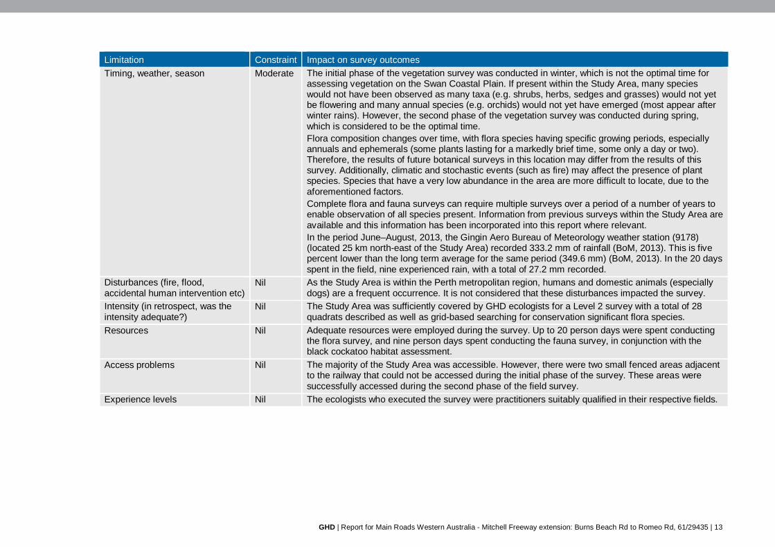
Limitation Constraint Impact on survey outcomes Timing, weather, season Moderate The initial phase of the vegetation survey was conducted in winter, which is not the optimal time for
assessing vegetation on the Swan Coastal Plain. If present within the Study Area, many species would not have been observed as many taxa (e.g. shrubs, herbs, sedges and grasses) would not yet be flowering and many annual species (e.g. orchids) would not yet have emerged (most appear after winter rains). However, the second phase of the vegetation survey was conducted during spring, which is considered to be the optimal time. Flora composition changes over time, with flora species having specific growing periods, especially annuals and ephemerals (some plants lasting for a markedly brief time, some only a day or two). Therefore, the results of future botanical surveys in this location may differ from the results of this survey. Additionally, climatic and stochastic events (such as fire) may affect the presence of plant species. Species that have a very low abundance in the area are more difficult to locate, due to the aforementioned factors. Complete flora and fauna surveys can require multiple surveys over a period of a number of years to enable observation of all species present. Information from previous surveys within the Study Area are available and this information has been incorporated into this report where relevant. In the period June–August, 2013, the Gingin Aero Bureau of Meteorology weather station (9178) (located 25 km north-east of the Study Area) recorded 333.2 mm of rainfall (BoM, 2013). This is five percent lower than the long term average for the same period (349.6 mm) (BoM, 2013). In the 20 days spent in the field, nine experienced rain, with a total of 27.2 mm recorded.
Disturbances (fire, flood, accidental human intervention etc)
Nil As the Study Area is within the Perth metropolitan region, humans and domestic animals (especially dogs) are a frequent occurrence. It is not considered that these disturbances impacted the survey.
Intensity (in retrospect, was the intensity adequate?)
Nil The Study Area was sufficiently covered by GHD ecologists for a Level 2 survey with a total of 28 quadrats described as well as grid-based searching for conservation significant flora species.
Resources Nil Adequate resources were employed during the survey. Up to 20 person days were spent conducting the flora survey, and nine person days spent conducting the fauna survey, in conjunction with the black cockatoo habitat assessment.
Access problems Nil The majority of the Study Area was accessible. However, there were two small fenced areas adjacent to the railway that could not be accessed during the initial phase of the survey. These areas were successfully accessed during the second phase of the field survey.
Experience levels Nil The ecologists who executed the survey were practitioners suitably qualified in their respective fields.
GHD | Report for Main Roads Western Australia - Mitchell Freeway extension: Burns Beach Rd to Romeo Rd, 61/29435
| 14
4. Results & discussion 4.1 Bioregion
The Study Area is located within the Swan Coastal Plain Interim Biogeographic Regionalisation of Australia (IBRA) Bioregion, Perth Sub-Region (SWA02). This sub-region is dominated by woodlands of Banksia and Tuart on sandy soils, sheoak on outwash plains, and paperbark in swampy areas. The colluvial and aeolian sand areas represent three phases of Quaternary marine sand dune development (which provide relief), and include a complex series of seasonal fresh water wetlands, alluvial river flats, coastal limestone and several off-shore islands. Younger sandy areas and limestone are dominated by heath and/or Tuart woodlands, while Banksia and Jarrah–Banksia woodlands are found on the older dune systems (Mitchell et al., 2002).
4.2 Climate
The Study Area experiences a Mediterranean climate, with mild wet winters and hot dry summers. The closest Bureau of Meteorology (BoM) weather station to the Study Area is located 25 km north-east at Gingin Aero (station number 9178). A summary of the climatic data (BoM, 2013) for this weather station is below:
Mean maximum temperature: 18.3 °C (July) to 33.3 °C (February)
Mean minimum temperature: 6.1 °C (July) to 17.0 °C (February)
Rainfall: 649.0 mm
Mean number of days of rain 1 mm: 76.3
4.3 Environmentally Sensitive Areas
A large proportion of the Study Area is classified as an Environmentally Sensitive Area (ESA) (Government of Western Australia, 2012) (Figure 2, Appendix A). The ESA is associated with Bush Forever sites and TECs.
There is an ESA that covers much of the Study Area which is associated with Bush Forever site 383. Two small sections of ESA are associated with Bush Forever Sites 384 and 299 .Bush Forever sites are discussed further in Section 4.4.
The round ESAs located towards the northern end of the freeway alignment and Wanneroo Rd are associated with the buffer of the TEC ‘Melaleuca huegelii–M. acerosa [now M. systena] shrublands on limestone ridges’ (discussed further in Section 4.7).
4.4 Reserves & conservation areas
The following two DPaW-managed reserves occur within the Study Area (Government of Western Australia, 2012) (Figure 2, Appendix A):
Neerabup National Park (4.93 ha within the Study Area)
Neerabup Nature Reserve (east of Wanneroo Rd) (1.78 ha within the Study Area)
In addition, the Study Area is surrounded by the following three DPaW-managed reserves (Government of Western Australia, 2012):
Lake Joondalup Nature Reserve (south of the Study Area)
Gnangara–Moore River State Forest (east of the Study Area)
GHD | Report for Main Roads Western Australia - Mitchell Freeway extension: Burns Beach Rd to Romeo Rd, 61/29435
| 15
Marmion Marine Park (west of the Study Area)
The following three Bush Forever sites occur within the boundaries of the Study Area (Government of Western Australia, 2012) (Figure 2, Appendix A):
Yellagonga Regional Park, Wanneroo/Woodvale/Kingsley (site 299) (0.03 ha within the Study Area)
Neerabup National Park, Lake Nowergup Nature Reserve and adjacent bushland, Neerabup (site 383) (147.87 ha within the Study Area)
Neerabup Lake and adjacent bushland, Neerabup (site 384) (0.04 ha within the Study Area).
4.5 Broad vegetation types
Broadscale vegetation mapping of the area (Beard, 1979) identified the following four vegetation associations present within the Study Area (Figure 2, Appendix A):
Medium woodland; tuart [Eucalyptus gomphocephala] & jarrah [E. marginata] (association 6)
Shrublands; teatree [Agonis flexuosa] thicket (association 37)
Low woodland; banksia [Banksia spp.] (association 949)
Medium woodland; tuart [E. gomphocephala] (association 998)
The Heddle et al. (1980) mapping identified the following vegetation complexes on Aeolian Deposits of the Swan Coastal Plain within the Study Area (Government of Western Australia, 2000) (Figure 2, Appendix A):
Quindalup dunes
Quindalup complex: Coastal dune complex consisting mainly of two alliances – the strand and fore-dune alliance and the mobile and stable dune alliance. Local variations include the low closed forest of Melaleuca lanceolata – Callitris preissii and the closed scrub of Acacia rostellifera: Occurs at the western end of Romeo Rd.
Spearwood Dunes
Cottesloe complex – central and south: Mosaic of woodland of Eucalyptus gomphocephala and open forest of E. gomphocephala – E. marginata – E. calophylla [now Corymbia calophylla]; closed heath on the Limestone outcrops: Occurs across the majority of the Study Area.
Karrakatta complex – central and south: Predominantly open forest of E. gomphocephala – E. marginata – C. calophylla and woodland of E. marginata – Banksia species: Occurs at the southern section of Wanneroo Rd.
Wetlands
Herdsman complex: Sedgelands and fringing woodland of E. rudis – Melaleuca species: intersects a small section of the Study Area at Wanneroo Rd and Burns Beach Rd
The mapping of Beard (1979) and Heddle et al. (1980) is broad-scale and used for desktop assessment. The vegetation types present within the Study Area do not necessarily reflect this broad-scale mapping. Vegetation types specific to the Study Area have been determined from the field assessment (see below – Section 4.6)
GHD | Report for Main Roads Western Australia - Mitchell Freeway extension: Burns Beach Rd to Romeo Rd, 61/29435
| 16
4.6 Vegetation type & condition
4.6.1 Vegetation type
The majority of the Study Area is located alongside established residential areas, roads, tracks and the Clarkson line railway. As such, much of the Study Area has been highly disturbed and is cleared or has been revegetated with native or introduced plant species. The vegetation types of each Stage of the Study Area are provided in Table 7.
The remnant vegetation (208 ha – 47 percent) within the Study Area consists of six vegetation types (Table 8). In addition, the Study Area is composed of mosaics1 of two vegetation types. These vegetation types are generally associated with the landforms upon which they lie, with tall woodlands to forests in lower-lying areas with deep soils, low shrublands and heaths on shallow soils on hilltops and ridges, and woodlands in intermediate landforms. The remnant vegetation of the Study Area appears to align with the following Gibson et al. (1980) vegetation complexes (Table 8):
FCT 24: Northern Spearwood shrublands and woodlands (Priority 3 PEC)
FCT 26a: Melaleuca acerosa [now M. systena]/M. huegelii shrublands on limestone ridges (Endangered TEC)
FCT 28: Spearwood Banksia attenuata or Banksia attenuata/Eucalyptus woodlands.
The PATN analysis grouped all GHD quadrats together, separate from Gibson et al. (1994) quadrats of each FCT (Appendix D). This indicates that the GHD quadrats from each different vegetation type were distinctly dissimilar to all analysed Gibson FCTs.
PATN analysis identified GHD quadrats as being similar to one another (e.g. quadrats 17 and 18 were grouped together and both are within VT3). However, many other GHD quadrats were identified as containing similar species to each another, but have been assigned to different vegetation types. GHD quadrats 11, 12, 13 and 20 were correctly grouped as containing similar species. Even though these vegetation types share many species (as determined by PATN analysis), the landforms are dissimilar and provide different habitats. As a result, these quadrats have been split between VT4 and VT5. Although not corroborated by PATN analysis, field assessment has determined that the Study Area contains vegetation matching the aforementioned FCT.
The Gibson et al. (1994) data contains taxa which are no longer current (e.g. Dryandra sessilis has been superseded by Banksia sessilis; *Anagallis arvensis is more recently known as *Lysimachia arvensis). As PATN analyses text for similarities and differences, the currency of taxa is necessary to provide a significant output. The discrepancies between Gibson et al. (1994) and GHD taxa has limited the output provided by PATN analysis. DPaW has not updated the Gibson et al. (1994) dataset since 2005 and has advised against altering the data in any way.
The vegetation of the Study Area is mapped in Figure 3 (Appendix A).
1 Mosaics are vegetation/habitat units with more than one vegetation/habitat type within them. These mosaics are examples of “structurally and floristically different vegetation[/habitat] types within one map unit that are not uniquely tied together ecologically (e.g. are part of the patterning of the landscape)” (ESCAVI 2003). These mosaics occur because occurrences of each vegetation/habitat type are smaller than the scale of the minimum mapping unit (i.e. 1:10,000).

GHD | Report for Main Roads Western Australia - Mitchell Freeway extension: Burns Beach Rd to Romeo Rd, 61/29435
| 17
Table 7 GHD vegetation types within each Stage of the Study Area
Vegetation type
Sta
ge 1
Sta
ge 2
Sta
ge 3
1: Banksia woodland × × ×
2: Jarrah–Banksia woodland × × ×
3: Tuart woodlandi × × ×
4: Mixed low heath on limestonei × ×
5: Melaleuca huegelii–M. systena shrubland on limestoneii × ×
6: Banksia sessilis closed tall scrubi × ×
7: Mosaic of vegetation types 1 & 4 × ×
8: Disturbed/roads/tracks/railway × × ×
9: Rehabilitation ×
10: Planted ×
i Floristic Community Type 24: Northern Spearwood shrublands and woodlands (Department of Parks and Wildlife Priority 3 Priority Ecological Community) ii Floristic Community Type 26a: Melaleuca acerosa [now M. systena]/M. huegelii shrublands on limestone ridges (Department of Parks and Wildlife Endangered Threatened Ecological Community)

GHD | Report for Main Roads Western Australia - Mitchell Freeway extension: Burns Beach Rd to Romeo Rd, 61/29435 | 18
Table 8 Vegetation types within the Study Area
Vegetation type Vegetation description Area of Study Area (ha)
Location Potential corresponding Gibson et al. (1994) vegetation complex
Indicative photograph
1: Banksia woodland
Woodland of Banksia attenuata/B. menziesii (with occasional Eucalyptus/Corymbia species and Allocasuarina fraseriana) over shrubland of Hibbertia hypericoides, Xanthorrhoea preissii and Acacia pulchella over dense understorey of Mesomelaena pseudostygia, weedy grasses and herbs and Desmocladus flexuosus on grey to brown sand.
93.4 Occurs across the Study Area and is the dominant vegetation near Romeo Road and the northern section of Wanneroo Road Sampling points: Q01, Q02, Q03, Q04, Q05, Q14, Q15, Q19, Q22, PP01, PP03, PP13, PP14 Mosaic sampling points: Q18, Q23, Q24, PP11
FCT 28: Spearwood Banksia attenuata or Banksia attenuata/Eucalyptus woodlands
2: Jarrah–Banksia woodland
Woodland of Eucalyptus marginata and Banksia attenuata/B. menziesii over shrubland of Hibbertia hypericoides, Xanthorrhoea preissii and Acacia pulchella over dense understorey of Mesomelaena pseudostygia, weedy grasses and herbs and Desmocladus flexuosus on grey to brown sand.
10.8 Isolated occurrences across the Study Area. This vegetation type was not large enough to conduct quadrat assessments. Sampling points: Q25, Q26, PP02, PP08, PP09, PP20
FCT 28: Spearwood Banksia attenuata or Banksia attenuata/Eucalyptus woodlands
3: Tuart woodland
Woodland of Eucalyptus gomphocephala over sparse shrubland of Xanthorrhoea preissii, Acacia saligna, Rhagodia baccata and Hakea lissocarpha over sparse understorey of weedy grasses and herbs in deep dark brown sand.
59.2 Occurrences in the southern section of the freeway alignment, the Neerabup Road area and the southern section of Wanneroo Road as well as isolated occurrences in low-lying areas in the north of the Study Area. Sampling points: Q06, Q07, Q08, Q17, Q18, Q21, Q27, PP04, PP06, PP07, PP15, PP16, PP17, PP18, PP19
FCT 24: Northern Spearwood shrublands and woodlands (Priority 3 PEC)

GHD | Report for Main Roads Western Australia - Mitchell Freeway extension: Burns Beach Rd to Romeo Rd, 61/29435 | 19
Vegetation type Vegetation description Area of Study Area (ha)
Location Potential corresponding Gibson et al. (1994) vegetation complex
Indicative photograph
4: Mixed low heath on limestone
Low heath of mixed species (dominated by Melaleuca systena, Acacia lasiocarpa, Hibbertia hypericoides and Xanthorrhoea preissii) over a dense mixed understorey (dominated by Desmocladus flexuosus and Drosera erythrorhiza and weedy grasses and herbs) on limestone.
22.3 Occurs on limestone ridges in the freeway alignment to the north of Lukin Drive. Sampling points: Q09, Q10, Q12, Q13 Mosaic sampling points: Q23, Q24, PP11
FCT 24: Northern Spearwood shrublands and woodlands (Priority 3 PEC)
5: Melaleuca huegelii–M. systena shrubland on limestone
Shrubland of Melaleuca huegelii, M. systena, Acacia pulchella and Grevillea preissii subsp. preissii over a sparse understorey of Desmocladus flexuosus, Lomandra species and mixed weedy herbs and grasses on outcropping limestone.
0.6 plus small patches
Small, isolated occurrences on outcropping limestone ridges within the freeway alignment north of Lukin Drive. Sampling points: Q11, Q20
FCT 26a: Melaleuca systena/M. huegelii shrublands on limestone ridges (Endangered TEC)
6: Banksia sessilis closed tall scrub
Closed tall scrub of Banksia sessilis over a sparse understorey of mixed weedy herbs and grasses on grey sand.
7.7 Occurs along the western end of the Romeo Road extension and isolated patches throughout the Study Area. Likely to be a disturbed vegetation type. Sampling points: Q16, Q24, Q28, PP12
This vegetation type may be a more disturbed form of the Priority 3 PEC FCT 24 (Northern Spearwood shrublands and woodlands)
7: Mosaic of vegetation types 1 & 4 14.3 Occurs along the railway alignment.
Sampling points: Q23, Q24, PP11 Combination of FCT 28 (Spearwood Banksia attenuata or Banksia attenuata/Eucalyptus woodlands) and FCT 24 (Northern Spearwood shrublands and woodlands – Priority 3 PEC)
8: Degraded/roads/tracks/railway 210.9 Occurs throughout the Study Area. -
9: Planted 7.1 Occurs throughout the Study Area along roads. -

GHD | Report for Main Roads Western Australia - Mitchell Freeway extension: Burns Beach Rd to Romeo Rd, 61/29435 | 20
Vegetation type Vegetation description Area of Study Area (ha)
Location Potential corresponding Gibson et al. (1994) vegetation complex
Indicative photograph
10: Rehabilitation 12.6 Occurs along the railway alignment and within the Burns Beach Road/Mitchell Freeway off-ramp.
-
PEC Department of Parks and Wildlife Priority Ecological Community
TEC Department of Parks and Wildlife Threatened Ecological Community

GHD | Report for Main Roads Western Australia - Mitchell Freeway extension: Burns Beach Rd to Romeo Rd, 61/29435
| 21
4.6.2 Vegetation condition
Vegetation condition of the Study Area ranged from Excellent (2) to Completely Degraded (6) (Figure 4, Appendix A). Roads, tracks, the train line and other cleared areas were considered to be Completely Degraded. Vegetated areas may consist of remnant vegetation and roadside plantings (with native and exotic species) or rehabilitation. Roadside plantings were generally considered to be Completely Degraded. Depending on the stage of regrowth, rehabilitated areas have been assigned conditions of Degraded to Completely Degraded. Remnant vegetation ranged in condition from Excellent to Completely Degraded. In general, the greater distance from roads and residential areas, the better condition of the vegetation. Large portions of vegetation adjacent to the train line were in Excellent condition, whereas areas alongside arterial roads were in Completely Degraded condition. The majority of the Neerabup Road portion bounded by Neerabup National Park was in Excellent condition, in part due to restricted access to the general public.
4.7 Threatened & Priority Ecological Communities
Desktop investigations (DotE, 2013a; DPaW, 2013a; and DPaW 2013b) and surveys by HGM (2001) identified three conservation significant communities that occur or are predicted to occur within the Study Area (Figure 2, Appendix A). Of these, GHD observed one TEC (Melaleuca huegelii–M. acerosa [now M. systena] shrublands on limestone ridges) and one Priority 3 PEC (Northern Spearwood Shrublands and Woodlands) (Table 9) within the Study Area (Figure 5, Appendix A).
GHD observed no DotE listed TECs within the Study Area.

GHD | Report for Main Roads Western Australia - Mitchell Freeway extension: Burns Beach Rd to Romeo Rd, 61/29435 | 22
Table 9 Conservation significant communities occurring & possibly occurring within the Study Area
Conservation significant community
Status Description Presence within Study Area State (WC Act/DPaW listing)
Federal (EPBC Act listing)
Desktop GHD survey
Sedgelands in Holocene dune swales of the southern Swan Coastal Plain
Critically Endangered TEC
Endangered TEC
This community occurs in linear damplands and occasionally sumplands, between Holocene dunes. Typical and common native species are the shrubs Acacia rostellifera, A. saligna, Xanthorrhoea preissii, the sedges Baumea juncea, Ficinia nodosa, Lepidosperma gladiatum and the grass Poa porphyroclados (English et al., 2002). Corresponds to Gibson et al. (1994) SCPFCT19.
Previous mapping in the area for the MRS amendment has not identified vegetation types corresponding to this vegetation type.
Not present.
Melaleuca huegelii–M. acerosa [now M. systena] shrublands on limestone ridges
Endangered TEC
Corresponds to Gibson et al. (1994) SCPFCT26a.
This corresponds to HGM (2001) vegetation type: Mixed Low Heath.
Present as vegetation type (0.6 ha and additional minor occurrences):
5 (Melaleuca huegelii–M. systena shrubland on limestone) o Freeway alignment
north of Lukin Drive.

GHD | Report for Main Roads Western Australia - Mitchell Freeway extension: Burns Beach Rd to Romeo Rd, 61/29435 | 23
Conservation significant community
Status Description Presence within Study Area State (WC Act/DPaW listing)
Federal (EPBC Act listing)
Desktop GHD survey
Northern Spearwood Shrublands and Woodlands
Priority 3 PEC
Heaths with scattered Eucalyptus gomphocephala occurring on deeper soils north from Woodman Point. Most sites occur on the Cottesloe unit of the Spearwood system. The heathlands in this group typically include Dryandra sessilis [now Banksia sessilis], Calothamnus quadrifidus and Schoenus grandiflorus. Corresponds to Gibson et al. (1994) SCPFCT24.
This corresponds to HGM (2001) vegetation types Tuart Woodland and Banksia (Dryandra) sessilis Heath and occurs throughout the MRS extent and it is expected to occur throughout Neerabup National Park.
Present as vegetation types (total of 82.0 ha):
3 (Tuart woodland): o Southern section of
freeway alignment, Neerabup Road, southern section of Wanneroo Road, isolated in the north
4 (Mixed low heath on limestone): o Freeway alignment
north of Lukin Drive May be present as vegetation type (7.7 ha):
6 (Banksia sessilis closed tall scrub): o Western end of
Romeo Road, isolated patches throughout.
DPaW Department of Parks and Wildlife
PEC Priority Ecological Community
SCPFCT Swan Coastal Plain Floristic Community Type
TEC Threatened Ecological Community
WC Act Wildlife Conservation Act 1950

GHD | Report for Main Roads Western Australia - Mitchell Freeway extension: Burns Beach Rd to Romeo Rd, 61/29435
| 24
4.8 Flora diversity
The desktop assessment (DPaW, 2007–) identified 1023 plant taxa (including subspecies and varieties), representing 143 families and 483 genera, that have previously been recorded within 10 km of the Study Area. This total is comprised of 820 native species and 203 introduced (exotic) species. Dominant families recorded within 10 km of the Study Area include:
Fabaceae: 90 species
Asteraceae: 72 species
Myrtaceae: 64 species
The GHD survey identified a total of 392 flora species from 79 families and 234 genera within the Study Area. This number included 246 native species and 146 introduced/planted species. Dominant families recorded during the survey Study Area were:
Fabaceae: 49 taxa
Asteraceae, Myrtaceae and Poaceae: 32 taxa each
Proteaceae: 25 taxa
4.8.1 Conservation significant flora
Searches of the DPaW Threatened Flora (2012) and the Western Australian Herbarium (WAHERB) databases, EPBC Act PMST (DotE, 2013a) and Western Australian Museum/DPaW NatureMap records (DPaW, 2007–) identified one vascular flora species of conservation significance (Acacia benthamii – Priority 2) previously recorded within the Study Area. One non-vascular species (Fabronia hampeana – a Priority 2 moss) has also previously been recorded within the Study Area. An additional 36 species of conservation significance have been recorded or potentially occur within 10 km of the Study Area (Appendix B). Species of conservation significance previously recorded within 10 km of the Study Area have been mapped in Figure 2 (Appendix A).
No species listed under the EPBC Act or Wildlife Conservation Act 1950 (WC Act) were recorded during the survey. Fabronia hampeana was not recorded during the field survey. However, five other DPaW Priority species were recorded within the Study Area:
Acacia benthamii (Priority 2)
Eucalytpus caesia (Priority 4)
Jacksonia sericea (Priority 4)
Pimelea calcicola (Priority 3)
Stylidium maritimum (Priority 3)
Eucalyptus caesia was identified in roadside plantings. This species is widely grown as an ornamental plant. As a result, the individuals observed within the Study Area are not considered to be wild, naturally occurring specimens.
Acacia benthamii (DPaW Priority 2)
Acacia benthamii is described as a shrub around 1 m high, with yellow flowers present in August to September. This species is found in sandy soils, typically on limestone breakaways (WA Herbarium, 1998–). Acacia benthamii is restricted to the Kings Park and Subiaco areas of Perth, Wanneroo and near Yanchep (Maslin, 2001).
Two individuals of this species were observed (Plate 1, page 26) on sandy soils within a fenced off portion alongside the railway approximately 1.5 km north of Hester Avenue within vegetation

GHD | Report for Main Roads Western Australia - Mitchell Freeway extension: Burns Beach Rd to Romeo Rd, 61/29435
| 25
type 1 (Banksia woodland) (Stage 2) (Figure 5, Appendix A and Appendix D). The two plants had been individually fenced off using chicken wire, indicating that they have been previously identified for protection by the landholder. As no adequate flowering or fruiting material was present at the time of the survey, it is not possible to verify these specimens.
Jacksonia sericea (DPaW Priority 4)
Jacksonia sericea is described as a low spreading shrub to 60 cm high, with orange flowers (present in December or January to February), and is found in calcareous and sandy soils (WA Herbarium, 1998–). Research has shown J. sericea appears to be restricted to the highly populated area of Perth and occurs within highly fragmented reserves (Malcolm, 2012). In addition to the extensive clearing of habitat for development, this species is considered to be under threat of habitat loss due to dieback (Phytophthora cinnamomi), of which the species is moderately susceptible (Malcolm, 2012). Dieback is impacting on vegetation communities by changing species composition, degrading the habitat and allowing invasion of weedy species, which in turn leads to higher impacts from grazing and changes in fire regimes (Mitchell et al., 2002).
Discussion with the WA Herbarium (pers. comm.) determined that within the Wanneroo region (near the Study Area), J. sericea species intergrades with J. calcicola (Chappill et al., 2007), which is not listed under any legislation or as a Priority species. As a result, many individuals within the Wanneroo region possess intermediate characteristics or traits of both species. As no adequate flowering material was present at the time of the survey, it is not possible to verify these specimens.
Approximately 6,020 individuals of this species (Plate 2, page 27) were observed, scattered predominantly throughout vegetation type 1 (Banksia woodland) and alongside disturbed areas of the Study Area (Stages 1, 2 and 3) (Figure 5, Appendix A and Appendix D).
Pimelea calcicola (DPaW Priority 3)
Pimelea calcicola is described as an erect to spreading shrub, growing from 0.2 m to 1 m tall in sand on coastal limestone ridges (WA Herbarium, 1998–). It produces pink flowers in September to November.
Approximately 516 individuals of this species were observed (Plate 3, page 28) within GHD vegetation types 4 (Mixed low heath on limestone) and 5 (Melaleuca huegelii–M. systena shrubland on limestone) (Stages 2 and 3) (Figure 5, Appendix A and Appendix D).
Stylidium maritimum (DPaW Priority 3)
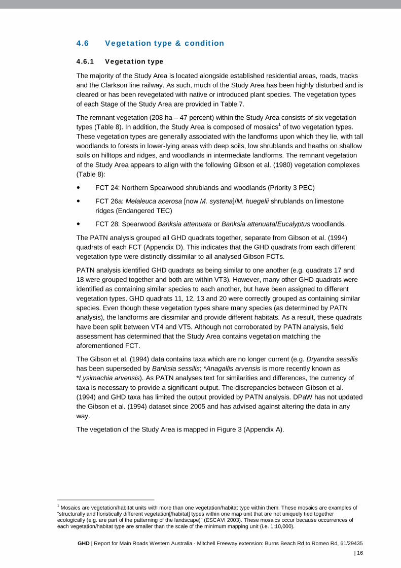
Stylidium maritimum is described as a caespitose perennial herb, growing up to 0.7 m high, with tufted, linear leaves. It produces white/purple/pink flowers in from September to November. This species grows in sand over limestone, on dune slopes, flats, coastal heath and shrubland and open Banksia woodland (WA Herbarium, 1998–).
Approximately 1,455 individuals of this species were observed (Plate 4, page 29) within vegetation type 4 (Mixed low heath on limestone) (Stages 2 and 3) (Figure 5, Appendix A and Appendix D).

GHD | Report for Main Roads Western Australia - Mitchell Freeway extension: Burns Beach Rd to Romeo Rd, 61/29435 | 26
Plate 1 Acacia benthamii & habitat as observed within the Study Area

GHD | Report for Main Roads Western Australia - Mitchell Freeway extension: Burns Beach Rd to Romeo Rd, 61/29435 | 27
Plate 2 Jacksonia sericea as observed within the Study Area

GHD | Report for Main Roads Western Australia - Mitchell Freeway extension: Burns Beach Rd to Romeo Rd, 61/29435 | 28
Plate 3 Pimelea calcicola & habitat as observed within the Study Area
GHD | Report for Main Roads Western Australia - Mitchell Freeway extension: Burns Beach Rd to Romeo Rd, 61/29435 | 29
Plate 4 Stylidium maritimum & habitat as observed within the Study Area

GHD | Report for Main Roads Western Australia - Mitchell Freeway extension: Burns Beach Rd to Romeo Rd, 61/29435
| 30
Likelihood of occurrence assessment
A likelihood of occurrence assessment of conservation significant species (based on the range, habitat requirements and previous records of the species as well as taking into account the intensity of field survey and season) was conducted for all conservation significant species identified in the desktop assessment (Appendix D). As the survey included a targeted search for species of conservation significance, the likelihood of occurrence assessment also took into account the ease of identification of each species and the probability that, if present, the species would have been observed. In addition to the five species of conservation significance identified during previous surveys and the GHD survey (Section 4.8.1), the likelihood of occurrence assessment determined that two species listed under both the EPBC Act and WC Act and eight DPaW Priority-listed species may occur within the Study Area (Table 10).
Table 10 Conservation significant flora species possibly occurring, likely or known to occur within the Study Area
Taxa Common name
Status Likelihood of occurrence
Recorded within Study Area
State (WC Act/DPaW listing)
Federal (EPBC Act listing)
Acacia benthamii Priority 2 Known previously
GHD
Austrostipa mundula Priority 2 Possible - Caladenia huegelii Grand Spider
Orchid Threatened Endangered Possible -
Conostylis bracteata Priority 3 Possible - Conostylis pauciflora subsp. euryrhipis
Priority 4 Possible -
Conostylis pauciflora subsp. pauciflora
Priority 4 Possible -
Drakaea micrantha Dwarf Hammer-orchid
Threatened Vulnerable Possible -
Fabronia hampeana A moss Priority 2 Known Previous Jacksonia sericea Waldjumi Priority 4 Known GHD Lecania turicensis var. turicensis
A lichen Priority 2 Possible -
Pimelea calcicola Priority 3 Known GHD Sarcozona bicarinata Priority 3 Possible - Schoenus griffinianus Priority 3 Possible - Stylidium maritimum Priority 3 Known GHD Thelymitra variegata Queen of
Sheba Priority 3 Possible -
4.8.2 Other significant flora
In addition to the DPaW Priority species, the survey identified seven other significant flora within the Study Area. Of these, two are not considered to be naturally occurring as they have been used in roadside plantings (Table 11).

GHD | Report for Main Roads Western Australia - Mitchell Freeway extension: Burns Beach Rd to Romeo Rd, 61/29435
| 31
Table 11 Other significant flora identified within the Study Area
Species Status (Government of Western Australia, 2000) DPaW Priority
r d p s E Planted
Agonis flexuosa × × Acacia benthamii Priority 2 × × × Astroloma microcalyx × Callitris preissii × × × Conospermum triplinervium × × Eucalyptus caesia Priority 4 × Jacksonia sericea Priority 4 × × × Lechenaultia linarioides × Melaleuca lanceolata × × Pimelea ?calcicola Priority 3 × × Significant flora codes (Government of Western Australia, 2000)
Geographical variation significance
r Populations at the northern or southern limit of their known geographic range
d Populations disjunct from their known geographic range
p Considered to be poorly reserved (applies to all Threatened and Priority taxa)
s Significant populations (applies to all Threatened and Priority taxa)
Regional ecological preferences
E Taxa endemic to the Swan Coastal Plain in the Perth Metropolitan Region
4.8.3 Introduced flora
A total of 146 introduced (exotic) and planted species were recorded within the Study Area. Three species (apple of Sodom, arum lily and bridal creeper) are listed as Declared Pests under Section 22 of the BAM Act. Bridal creeper is also listed as a WoNS (Australian Weeds Committee, 2010). Information for each species are provided in Table 12, locations are provided in Appendix D and mapped in Figure 4, Appendix A.
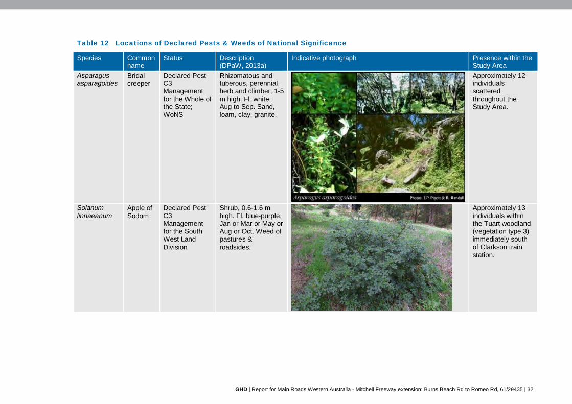
GHD | Report for Main Roads Western Australia - Mitchell Freeway extension: Burns Beach Rd to Romeo Rd, 61/29435 | 32
Table 12 Locations of Declared Pests & Weeds of National Significance
Species Common name
Status Description (DPaW, 2013a)
Indicative photograph Presence within the Study Area
Asparagus asparagoides
Bridal creeper
Declared Pest C3 Management for the Whole of the State; WoNS
Rhizomatous and tuberous, perennial, herb and climber, 1-5 m high. Fl. white, Aug to Sep. Sand, loam, clay, granite.
Approximately 12 individuals scattered throughout the Study Area.
Solanum linnaeanum
Apple of Sodom
Declared Pest C3 Management for the South West Land Division
Shrub, 0.6-1.6 m high. Fl. blue-purple, Jan or Mar or May or Aug or Oct. Weed of pastures & roadsides.
Approximately 13 individuals within the Tuart woodland (vegetation type 3) immediately south of Clarkson train station.

GHD | Report for Main Roads Western Australia - Mitchell Freeway extension: Burns Beach Rd to Romeo Rd, 61/29435 | 33
Species Common name
Status Description (DPaW, 2013a)
Indicative photograph Presence within the Study Area
Zantedeschia aethiopica
Arum lily Declared Pest C3 Management for the Whole of the State
Rhizomatous (tuber-like), perennial, herb, to 1 m high. Fl. white, Jul to Nov. Loam, sand. Swamps, rarely uplands.
Approximately 100 individuals at the intersection of Romeo and Wanneroo Roads.
Images with black borders obtained from WA Herbarium (1998–)

GHD | Report for Main Roads Western Australia - Mitchell Freeway extension: Burns Beach Rd to Romeo Rd, 61/29435
| 34
4.9 Fauna
4.9.1 Fauna habitat
Six broad fauna habitat types have been identified in the Study Area based on the predominant landforms, soil and vegetation structure in the area. These following habitat types closely correspond to the vegetation types outlined in section 4.6.1:
Low heathland on limestone outcrops (22.3 ha)
Banksia woodland on grey/brown sand (93.4 ha)
Tuart (Eucalyptus gomphocephala) woodland in deep dark brown sand (59.2 ha)
Banksia sessilis tall shrubland on grey sand and limestone outcropping (7.7 ha)
Jarrah (E. marginata)–Banksia woodland on grey/brown sand (10.8 ha)
Planted roadside vegetation/highly degraded/cleared (230.6 ha)
In addition to these six fauna habitat types, there were the following two mosaic vegetation types (mosaics are described in footnote 1, page 16):
Mosaic of Banksia woodland and low heathland (14.3 ha)
The fauna habitat of the Study Area is mapped in Figure 6 (Appendix A).
The native vegetation within the Study Area consists predominantly of a combination of mixed eucalypt woodlands and Banksia woodlands. These habitat types consist of a dominant overstorey of Eucalyptus gomphocephala (tuart), E. marginata (jarrah), Corymbia calophylla (marri), Banksia attenuata and B. menziesii and were generally associated with grey sandy soils on plains or low undulating dune systems. The eucalypt and Banksia woodlands ranged from degraded to excellent condition and provided particularly high habitat value for fauna species due to the variety of microhabitats and various resource niches available (i.e. fallen logs, hollows, leaf litter, sandy soil).
The woodlands would be expected to support a high diversity of bird species. Across these woodlands are areas of loose sands that are particularly suitable for burrowing reptiles. The woodlands range from an open to closed canopy with a relatively sparse mid-storey and thick ground cover in some areas. This ground cover would provide foraging opportunities and refuge areas for ground-dwelling mammals such as the Echidna, Southern Brown Bandicoot/Quenda and Western Brush Wallaby and reptiles such as goannas and skinks. Micro-habitat features such as tree hollows and cavities provide habitat for a number of birds, reptiles and small mammal species. The presence of tuart, jarrah, marri, banksia and other proteaceous species provides key foraging habitat for conservation significant black cockatoo species. Some of the larger eucalypts also provide potential breeding and roosting habitat for black cockatoos.
The areas which have been highly degraded, cleared or contain planted species along roadsides provide very little to no habitat value for most fauna species as these areas are generally devoid of vegetation. Roadside vegetation may provide some shelter and opportunistic food for some bird species.
4.9.2 Fauna habitat connectivity
Habitat linkages are important to allow animals to move between areas of resource availability. They are important for ground and aerial fauna, providing cover, resources, and linking areas suitable for rest and reproduction. Fragmentation of habitat limits the resources available to species, particularly sedentary species, which means they may be more vulnerable to natural disasters or habitat changes over time. Fragmentation of habitat can also lead to edge effects,

GHD | Report for Main Roads Western Australia - Mitchell Freeway extension: Burns Beach Rd to Romeo Rd, 61/29435
| 35
leading to degradation of the habitat. Where the distance between habitat fragments is small, species may still be able to move between these habitat areas, but may be more exposed to predation pressures in the cleared areas.
Locally, the habitat within the Study Area located to the east and north of the railway is connected to habitat in the immediately adjacent Neerabup National Park and associated Bush Forever sites. The vegetation within the PTA rail boundary is currently fenced off with 2.5 m high chain mesh fencing which presents a barrier to movement of ground dwelling fauna between remnant vegetation to the east and west of the existing railway. The majority of the Study Area west of the railway has been cleared or is currently being cleared for urban development, with only small patches of remnant vegetation remaining.
The areas of remnant vegetation in and immediately surrounding the Study Area are part of a regionally significant contiguous bushland/wetland linkage (Government of Western Australia, 2000), with a large proportion of this vegetation currently protected as national park and a series of Bush Forever sites (Government of Western Australia, 2000). The vegetation within Neerabup National Park (Bush Forever site 383) is linked to vegetation to the north, south (Bush Forever site 299, across the road), east and west (Site 323, through bushland to Site 397); and is part of Greenways 35, 2, 5 (Tingay, Alan and Associates, 1998). Neerabup National Park provides a narrow corridor to allow movement of animals along the coastal plain and associated wetlands.
4.9.3 Fauna diversity
A NatureMap search (DPaW, 2007–) identified 456 fauna species as previously recorded within 10 km of the Study Area, of which 438 species are native and 18 are pest (introduced) species (Appendix B). These results consisted of 216 bird, 37 mammal, 65 reptile, 7 amphibian, 54 fish and 77 invertebrate species.
During the field surveys, a total of 61 fauna species, consisting of 47 birds, seven reptiles and seven mammals were recorded within the Study Area. Of these, nine are introduced (feral) species. The list of fauna species recorded during the survey is provided in Appendix E.
4.9.4 Conservation significant fauna
Searches of the EPBC Act PMST (DotE, 2013a) and Western Australian Museum/DPaW NatureMap records (DPaW, 2007–) identified the presence or potential presence of the following:
20 Threatened fauna listed under the EPBC Act
28 Migratory birds listed under the EPBC Act
24 Threatened or other specially protected species listed under the WC Act
13 Priority fauna species listed by the DPaW
In addition to these, the desktop searches identified a number of marine mammal, shark, reptile and bird species. These species have been excluded from this assessment as no marine habitat is present within the Study Area or will be impacted as a result of the proposed Project. The list of conservation significant fauna species identified in the desktop review is provided in Appendix B.
During the field survey one species listed as Endangered under the EPBC Act and Threatened under the WC Act and one species listed as Schedule 4 under the WC Act were recorded. They are as follows:
Carnaby’s Black Cockatoo (Calyptorhynchus latirostris)

GHD | Report for Main Roads Western Australia - Mitchell Freeway extension: Burns Beach Rd to Romeo Rd, 61/29435
| 36
Carpet Python (Morelia spilota imbricata)
The field survey also identified the likely presence of the Priority 5 Quenda/Southern Brown Bandicoot (Isoodon obesulus fusciventer) which was identified from potential diggings.
A brief description of each of these species and their associated habitat types within the Study Area are described below.
Carnaby’s Black Cockatoo (Calyptorhynchus latirostris)
The Carnaby’s Black Cockatoo is listed Endangered under the EPBC Act and Threatened (Schedule 1) under the WC Act. It is distributed across the south-west of Western Australia in uncleared or remnant areas of Eucalyptus woodland and shrubland of kwongan heath. The Carnaby’s Black Cockatoo was recorded multiple times in the Study Area during the field surveys. Numbers of birds recorded at each sighting ranged from a pair of birds to flocks of over 100 individuals. Additionally, evidence of feeding was recorded throughout the Study Area in areas of suitable foraging habitat.
Generally, all the areas containing remnant native vegetation within the Study Area are considered to represent suitable foraging habitat as they all contain plant species documented as foraging habitat. The most dominant/obvious species include Eucalyptus gomphocephala (tuart), E. marginata (jarrah), E. todtiana (coastal blackbutt), Corymbia calophylla (marri), Banksia grandis, B. menziesii, B. attenuata, B. sessilis and Allocasuarina fraseriana (sheoak).
The Study Area is partially located within the known breeding range for the Carnaby’s Black Cockatoo (DotE, 2012). It nests in hollows in live or dead trees of E. salmonophloia (salmon gum), E. wandoo (wandoo), tuart, jarrah, E. rudis (flooded gum), E. loxophleba subsp. loxophleba (York gum), E. accedens (powderbark), E. diversicolor (karri) and marri. Of these species, tuart, jarrah, and marri were all recorded from the Study Area. The Tuart woodlands and to a lesser extent, the Jarrah-Banksia woodlands are considered to be the most valuable habitat types in terms of providing potential breeding habitat for black cockatoos within the Study Area.
One tree was identified as a potential roosting site. Suitable roosting habitat was identified in the Study Area based on the presence of suitable tall trees, close proximity of known roosting sites (Department of Planning, 2011) and presence of suitable foraging habitat. Although there is no standing water within the Study Area, there are a number of lake systems in the nearby area, including Lake Joondalup to the south and Neerabup and Nowergup lakes to the east.
A more detailed assessment on threatened black cockatoo habitat was undertaken by GHD for the Study Area, which is provided as a separate report (GHD, 2013).
Carpet Python (Morelia spilota imbricata)
The Carpet Python is listed as Schedule 4 (other specially protected fauna) under the WC Act. This subspecies inhabits temperate climatic areas with good winter rains and dry summers. It occurs in south-west Western Australia, from Northampton, south to Albany and eastwards to Kalgoorlie, including undisturbed remnant bushland near Perth and the Darling Ranges, Yanchep National Park, and Garden Island. It has been recorded in semi-arid coastal and inland habitats consisting of Banksia woodland, eucalypt woodlands, and grasslands (DEC, 2012).
This species was identified in the Study Area from a snake dropping within a tree hollow during the field survey. The majority of the Study Area containing remnant native vegetation provides suitable habitat for this species. It is likely that this species would generally inhabit the larger areas of contiguous native vegetation within the Study Area.
GHD | Report for Main Roads Western Australia - Mitchell Freeway extension: Burns Beach Rd to Romeo Rd, 61/29435
| 37
Quenda/Southern Brown Bandicoot (Isoodon obesulus fusciventer)
The Quenda, or Southern Brown Bandicoot, is listed as a Priority 5 by the DPaW. This species is widely distributed in the south west of the state from Guilderton, north of Perth, to east of Esperance. They are patchily distributed through the Swan Coastal Plain where they are often associated with wetlands. Quenda inhabit scrubby, often swampy, vegetation with dense cover up to 1 m high and often feed in adjacent forest and woodland (Van Dyck and Strahan, 2008).
Two distinctive conical diggings were observed in the Study Area during the survey. (Figure 6, Appendix A). Although there are no wetlands or wetland associated vegetation within the Study Area, the eucalypt and Banksia woodlands provide some suitable habitat for Quenda, particularly areas with a dense understorey.
Likelihood of occurrence assessment
In addition to the fauna species recorded during the field survey, a number of conservation significant fauna species were identified as potentially occurring within the Study Area during the desktop investigation. An assessment on the likelihood of these species occurring in the Study Area was undertaken. This assessment is based on species biology, habitat requirements, the quality and availability of suitable habitat and records of the species in the area. The assessment is provided in Appendix E.
The assessment concluded that two species are known to occur, eight species are likely to occur, four species could possibly occur, and forty species are considered unlikely or highly unlikely to occur within the Study Area. The species determined as present, likely to occur or could possibly occur within the Study Area are listed in Table 13.
Table 13 Conservation significant fauna species identified as present, likely to occur & possibly occurring within the Study Area
Taxa Common name Status Likelihood of Occurrence State (WC
Act/DPaW listing)
Federal (EPBC Act listing)
Birds Calyptorhynchus latirostris
Carnaby's Black Cockatoo
Threatened Endangered Present
Falco peregrinus Peregrine Falcon
Schedule 4 Likely
Apus pacificus Fork-tailed Swift
Schedule 3 Migratory Possible
Merops ornatus Rainbow Bee-eater
Schedule 3 Migratory Likely
Mammals Isoodon obesulus fusciventer
Quenda / Southern Brown Bandicoot
Priority 5 Likely
Macropus irma Western Brush Wallaby
Priority 4 Likely
Reptiles Ctenotus gemmula (Swan Coastal Plain subspecies)
Jewelled Ctenotus
Priority 3 Possible
Morelia spilota imbricata Carpet Python Schedule 4 Present Neelaps calonotos Black-striped Priority 3 Likely

GHD | Report for Main Roads Western Australia - Mitchell Freeway extension: Burns Beach Rd to Romeo Rd, 61/29435
| 38
Taxa Common name Status Likelihood of Occurrence State (WC
Act/DPaW listing)
Federal (EPBC Act listing)
Birds Snake
Invertebrates Austrosaga spinifer A cricket Priority 3 Likely Hylaeus globuliferus A bee Priority 3 Likely Idiosoma nigrum Shield-backed
Trapdoor Spider
Threatened Possible
Leioproctus contrarius A bee Priority 3 Likely Synemon gratiosa Graceful Sun
Moth Priority 4 Possible
4.9.5 Locally significant fauna
Locally significant fauna are those which are not formally listed under State or Commonwealth legislation or listed as Priority fauna by the DPaW but are considered to have a restricted distribution on the Swan Coastal Plain or have dramatically declined in numbers since European settlement.
Ten bird species recorded during the survey are considered to be significant birds of the Swan Coastal Plain portion of the Perth Metropolitan Region (Government of Western Australia, 2000). They include the Brown Goshawk, Carnaby’s Black Cockatoo, Emu, Splendid Fairy-wren, New Holland Honeyeater, White-cheeked Honeyeater, Grey Shrike-thrush, Golden Whistler and Scarlet Robin. These species are either habitat specialists with a reduced distribution on the Swan Coastal Plain or are wide-ranging species with reduced populations on the Swan Coastal Plain. Additionally the Carpet Python and Echidna would also be considered to be locally significant fauna, even though they have large distributions they have declined on the Swan Coastal Plain.
The Study Area is also considered to contain suitable habitat for a number of other fauna species identified by NatureMap. A number of these species are considered to be locally significant and include the Honey Possum, White-striped Bat, Speckled Granite Gecko (Swan Coastal Plain population) and Little Eagle.

GHD | Report for Main Roads Western Australia - Mitchell Freeway extension: Burns Beach Rd to Romeo Rd, 61/29435
| 39
5. References Australia New Zealand Environment and Conservation Council (ANZECC) 2000, Core
Environmental Indicators for Reporting on the State of Environment, ANZECC State of the Environment Reporting Task Force.
Australian Government 2012, Weeds in Australia, retrieved April 2013, from http://www.environment.gov.au/biodiversity/invasive/weeds/index.html.
Australian Weeds Committee 2010, Weeds of National Significance: Update 2010, Launceston, Commonwealth of Australia.
Beard, JS 1979, Vegetation Survey of Western Australia: Perth Map and Explanatory Memoir 1:250,000 series, Perth, Vegmap Publications.
Burbidge, AA 2004, Threatened Animals of Western Australia, Perth, Department of Conservation and Land Management.
Bureau of Meteorology 2013, Climate Data Online, retrieved July, 2013, from http://www.bom.gov.au/climate/data/?ref=ftr.
Bush, B, Maryan, B, Browne-Cooper, R & Robinson, D 1995, A Guide to the Reptiles and Frogs of the Perth Region, Nedlands, University of Western Australia Press.
Bush, B, Maryan, B, Browne-Cooper, R & Robinson, D 2010, Field Guide to the Reptiles and Frogs of the Perth Region, Perth, Western Australian Museum.
Chappill, JA, Wilkins, CF & Crisp, MD 2007, ‘Taxonomic revision of Jacksonia (Leguminosae: Mirbelieae)’, Australian Systematic Botany, vol 20, pp 473–623.
Christidis, L & Boles, WE 2008, Systematics and Taxonomy of Australian Birds, Melbourne, CSIRO Publishing.
Commonwealth of Australia 2001, National Targets and Objectives for Biodiversity Conservation 2001–2005, Canberrra, AGPS.
Davis, RA 2009, Terrestrial Avian Diversity and Threatening processes on the Gnangara Groundwater Mound, Wester Australia, prepared on behalf of the Department of Parks and Wildlife for the Gnangara Sustainability Strategy, University of Western Australia.
del Hoyo, J; Elliot, A & Sargatal, J. 1992. Handbook of the Birds of the World, vol. 1: Ostrich to Ducks. Lynx Edicions, Barcelona, Spain.
Department of Environment and Conservation (DEC) 2012, ‘Fauna profiles, get to know Western Australia’s fauna: Carpet Python (Morelia spilota)’, retrieved 25 July, 2013, from http://www.dec.wa.gov.au/management-and-protection/animals/fauna-species-profiles.html?showall=&start=3.
Department of Parks and Wildlife (DPaW) 2007–, NatureMap: Mapping Western Australia's Biodiversity, retrieved July, 2013, from http://NatureMap.dec.wa.gov.au/.
Department of Parks and Wildlife (DPaW) 2012, Department of Environment and Conservation Threatened Flora (Rare Flora Notice 2012(2)), updated 6 November, 2012.
Department of Parks and Wildlife (DPaW) 2013a, Priority ecological communities for Western Australia, 26 March 2013.
Department of Parks and Wildlife (DPaW) 2013b, Threatened ecological communities endorsed by the Minister for the Environment, May 2013.

GHD | Report for Main Roads Western Australia - Mitchell Freeway extension: Burns Beach Rd to Romeo Rd, 61/29435
| 40
Department of Planning Western Australia 2011, Metropolitan Region Scheme (MRS) North West – Potential habitat for the Carnaby’s Black Cockatoo which may require further assessment, Perth, Department of Planning WA on behalf of Western Australian Planning Commission.
Department of the Environment (DotE) (formerly the Department of Sustainability, Environment, Water, Population and Communities – DSEWPaC) 2012, Environmental Protection and Biodiversity Conservation Act 1999 referral guidelines for three threatened black cockatoo species, Canberra, DotE.
Department of the Environment (DotE) (formerly the Department of Sustainability, Environment, Water, Population and Communities – DSEWPaC) 2013a, Protected Matters Search Tool Results, retrieved May 29, 2013, from http://www.environment.gov.au/epbc/pmst/index.html.
Department of the Environment (DotE) (formerly the Department of Sustainability, Environment, Water, Population and Communities – DSEWPaC) 2013b, Threatened species & ecological communities, retrieved July, 2013, from http://www.environment.gov.au/biodiversity/threatened/index.html.
English, V & Blyth, J 1997, Identifying and Conserving Threatened Ecological Communities in the South West Botanical Province, Perth, Department of Conservation and Land Management.
English, V, Blyth, J, Gibson, N, Pember, D, Davis, J, Tucker, J, Jennings, P & Walker, B 2002, Sedgelands in Holocene dune swales: Interim Recovery Plan Number 110 (2002–2007), Perth, Department of Conservation and Land Management, Western Australian Threatened Species and Communities Unit.
Environmental Protection Authority (EPA) 2000a, Bulletin 971: Metropolitan Region Scheme Amendment No. 992/33 Clarkson-Butler, Wanneroo, report and recommendations of the Environmental Protection Authority provided to the Western Australian Planning Commission, Perth, Environmental Protection Authority.
Environmental Protection Authority (EPA) 2000b, Bulletin 1002: Proposed Extension of the Northern suburbs rail transit system from Currambine to Butler, report and recommendations of the Environmental Protection Authority provided to the Department of Transport, Perth, Environmental Protection Authority.
Environmental Protection Authority (EPA) 2000c, Environmental Protection of Native Vegetation in Western Australia. Clearing of native vegetation, with particular reference to the agricultural area. Position Statement No. 2, Perth, Environmental Protection Authority.
Environmental Protection Authority (EPA) 2002, Terrestrial Biological Surveys as an Element of Biodiversity Protection: Position Statement No. 3, Perth, EPA.
Environmental Protection Authority (EPA) 2004a, Guidance Statement No. 51: Terrestrial Flora and Vegetation Surveys for Impact Assessment in Western Australia, Perth, EPA.
Environmental Protection Authority (EPA) 2004b, Guidance Statement No. 56: Terrestrial Fauna Surveys for Environmental Impact Assessment in Western Australia, Perth, Environmental Protection Authority.
Environmental Protection Authority (EPA) 2006a, Guidance for the Assessment of Environmental Factors (in accordance with the Environmental Protection Act 1986): Level of Assessment for Proposals Affecting Natural Areas Within the System 6 Region and Swan Coastal Plain Portion of the System 1 Region (No. 10), Perth, Environmental Protection Authority.

GHD | Report for Main Roads Western Australia - Mitchell Freeway extension: Burns Beach Rd to Romeo Rd, 61/29435
| 41
Environmental Protection Authority (EPA) 2006b, Position Statement No. 9: Environmental Offsets, Perth, Environmental Protection Authority.
Executive Steering Committee for Australian Vegetation Information (ESCAVI) 2003, Australian Vegetation Attribute Manual: National Vegetation Information System, Version 6.0, Canberra, Department of the Environment and Heritage.
GHD Pty Ltd (GHD) 2013, Mitchell Freeway Extension: Black Cockatoo assessment, unpublished report prepared for Main Roads Western Australia.
Gibson, N, Keighery, BJ, Keighery, GJ, Burbidge, AH & Lyons, MN 1994, A Floristic Survey of the Southern Swan Coastal Plain, unpublished report prepared for the Australian Heritage Commission prepared by the Department of Conservation and Land Management and The Conservation Council of Western Australia (Inc.).
Government of Western Australia 2000, Bush Forever – Keeping the Bush in the City. Volumes 1 (Policies, Principals and Processes) & 2 (Directory of Bush Forever Sites), Perth, Government of Western Australia.
Government of Western Australia 2012, Natural Resource Management Shared Land Information Platform, retrieved April 15, 2013, from http://spatial.agric.wa.gov.au/slip/.
Clearing Regulations – Environmentally Sensitive Areas (ESA) layer published April 1, 2011.
DEC [now DPaW] Managed Lands and Waters layer published 30 June, 2012.
Government of Western Australia 2013, 2012 Statewide Vegetation Statistics incorporating the CAR Reserve Analysis (Full Report): current as of October 2012, retrieved July 20, 2013, from https://www2.landgate.wa.gov.au/web/guest/downloader.
Halpern Glick Maunsell (HGM) 2001, Fauna and Vegetation management Plan for the Northern Suburbs Transportation Corridor, unpublished report prepared for the Department of Transport.
Heddle, EM, Loneragan, OW, & Havel, JJ 1980, ‘Vegetation Complexes of the Darling System, Western Australia’, In Atlas of Natural Resources, Darling System, Western Australia, Perth, Department of Conservation and Environment.
Hockey, PAR, Dean, WRJ, Ryan, PG 2005, Roberts birds of southern Africa, Cape Town Trustees of the John Voelcker Bird Book Fund.
How, RA & Shine, R 1999, ‘Ecological traits and conservation biology of five fossorial “sand-swimming” snake species (Simoselaps: Elapidae) in south-western Australia’, Journal of Zoology, vol 249, pp 269-282.
Johnstone, RE & Storr, GM 1998, Handbook of Western Australian Birds Vol. 1: Non-passerines (Emu to Dollarbird), Perth, West Australian Museum.
Keighery, B 1994, Bushland Plant Survey: a Guide to Plant Community Survey for the Community, Nedlands, Wildflower Society of WA (Inc.).
Malcolm, P 2012, Jacksonia sericea, In IUCN 2013 Red List of Threatened Species: Version 2013.1, retrieved July 12, 2013, from http://www.iucnredlist.org/details/summary/19891688/0.
Marchant, S, & Higgins, PJ (eds) 1990, Handbook of Australian, New Zealand and Antarctic Birds, Melbourne, Oxford University Press.
Maryan, B & Shea, GM 2010, Ctenotus gemmula, In IUCN Red List of Threatened Species, Version 2012.2, retrieved May 29, 2013, from www.iucnredlist.org.

GHD | Report for Main Roads Western Australia - Mitchell Freeway extension: Burns Beach Rd to Romeo Rd, 61/29435
| 42
Maslin, BR (coordinator) 2001, WATTLE: Acacias of Australia. CD-ROM, Version 1.0, Canberra, Australian Biological Resources Study, and Perth, Department of Conservation and Land Management.
Mitchell, D, Williams, K & Desmond, A 2002, ‘Swan Coastal Plain 2 (SWA2 — Swan Coastal Plain subregion)’, In A Biodiversity Audit of Western Australia’s 53 Biogeographical Subregions in 2002, Perth, Department of Conservation and Land Management.
Morcombe, M 2003, Field Guide to Australian Birds, Australia, Steve Parish Publishing Pty Ltd.
Shepherd, DP, Beeston, GR & Hopkins, AJM 2002, Native Vegetation in Western Australia – Extent, Type and Status, Resource Management Technical Report 249, Perth, Department of Agriculture.
Nevill, S 2008, Birds of the Greater South West Western Australia, Perth, Simon Nevill Publications.
Orell, P & Morris, K 1994, Chuditch Recovery Plan 1992-2001, retrieved from, http://www.environment.gov.au/biodiversity/threatened/publications/recovery/chuditch/index.html.
Tingay, Alan & Associates 1998, A Strategic Plan for Perth’s Greenways – Final Report, prepared for Environment Australia, Ministry for Planning.
Van Dyke, S & Strahan, R (eds) 2008, The Mammals of Australia (Third Edition), Australia, Reed New Holland.
Walker, K 2010 Native contrarius colletid (Leioproctus (Colletopsis) contrarius), retrieved January, 2011, from http://www.padil.gov.au.
Western Australian (WA) Herbarium 1998–, FloraBase—the Western Australian Flora, retrieved July, 2013, from http://florabase.dpaw.wa.gov.au/.
Wilson, S & Swan, G 2008, A complete guide to reptiles of Australia (Second edition), Australia, New Holland Publishers.

GHD | Report for Main Roads Western Australia - Mitchell Freeway extension: Burns Beach Rd to Romeo Rd, 61/29435
Appendices

GHD | Report for Main Roads Western Australia - Mitchell Freeway extension: Burns Beach Rd to Romeo Rd, 61/29435
| 44
Appendix A – Figures Figure 1 Locality
Figure 2 Environmental context
Figure 3 Vegetation type & sampling points
Figure 4 Vegetation condition& weeds
Figure 5 Conservation significant vegetation & flora
Figure 6 Fauna habitat types & conservation significant fauna records

376,000
376,000
382,000
382,000
6,486,
000
6,486,
000
6,492,
000
6,492,
000
6,498,
000
6,498,
000
6,504,
000
6,504,
000
G:\61\29435\GIS\Maps\MXD\612943501_G001_Fig01_Rev0.mxd
LEGEND
Map Projection: Transverse MercatorHorizontal Datum: Geocentric Datum of Australia
Grid: Map Grid of Australia 1994, Zone 50
© 2013. Whilst every care has been taken to prepare this map, GHD, GA and MRWA make no representations or warranties about its accuracy, reliability, completeness or suitability for any particular purpose and cannot accept liability and responsibility of any kind (whether in contract, tort or otherwise) for any expenses, losses, damages and/or costs (including indirect or consequential damage) which are or may be incurred by any party as a result of the map being inaccurate, incomplete or unsuitable in any way and for any reason.
Main Roads Western AustraliaMitchell Freeway - Level 1 flora & fauna survey
Figure 1
Job NumberRevision 0
61-2943501
25 Nov 2013
Locality
Date
Data source: GA: Topo 250k Series 3 - 2006; GHD: Stage - 20130905; Landgate: Street Smart - 2011. Created by: slee2, vdinh, erice
239 Adelaide Terrace Perth WA 6004 Australia T 61 8 6222 8222 F 61 8 6222 8555 E [email protected] W www.ghd.com.au
!
!
!
!
!
!
! !
!
!
!
!
!
!
!
!
!
!
!
!
!
PERTH
GINGIN
YANCHEP
MIDLAND
WANNEROO
TWO ROCKS
MUNDARING
FREMANTLE
DARLING RANGE
EAST BULLSBROOK
INDIAN OCEAN
Locality Map
DRAFT
1: 60,000 (at A3)
o0 0.5 1 1.5 2 2.5 30.25
Kilometres
StageStage 1
Stage 2
Stage 3
Indian Ocean

#*
#*
#*#*
#*
#*
#*#*
#*
#*#*
#*
#*
#*
#*
#*
#*#*#*#*#*#*#*
#*
#*
#*
#*
#*
#*#*
#*#*
#*
#*
#*
#*
#*
#*
#*
#*
#*
#*
#*
#*#*
#*
#*#*
6
998
949
949
949
1007
37
1007
126
51
129
51
998
998
51
376,000
376,000
380,000
380,000
384,000
384,000
6,492,
000
6,492,
000
6,496,
000
6,496,
000
6,500,
000
6,500,
000
G:\61\29435\GIS\Maps\MXD\612943501_G003_Fig02_Rev0.mxd
Map Projection: Transverse MercatorHorizontal Datum: Geocentric Datum of Australia
Grid: Map Grid of Australia 1994, Zone 50
© 2013. Whilst every care has been taken to prepare this map, GHD, GA, DPaW, DAFWA, DOP and MRWA make no representations or warranties about its accuracy, reliability, completeness or suitability for any particular purpose and cannot accept liability and responsibility of any kind (whether in contract, tort or otherwise) for any expenses, losses, damages and/or costs (including indirect or consequential damage) which are or may be incurred by any party as a result of the map being inaccurate, incomplete or unsuitable in any way and for any reason.
Main Roads Western AustraliaMitchell Freeway - Level 1 flora & fauna survey
Figure 2
Job NumberRevision 0
61-2943501
25 Nov 2013
Environmental Context
Date
Data source: GA: Topo 250k Series 3 - 2006; GHD: Stage - 20130905; DPaW: Decalred Rara & Priority Species - 20130520, Environmentall Sensitive Areas - 20130513, Threatened Ecological Community & Priority Ecological Community - 201306, DPaW managed estates - 20130513, Heddle et al. (1980) vegegattion complex - 20130513; Landgate: Roads - 20130513; DOP: Bush Forever Sites - 20130626; DAFWA: Pre-European Vegetation - 20130513. Created by: slee2, jrutherford
239 Adelaide Terrace Perth WA 6004 Australia T 61 8 6222 8222 F 61 8 6222 8555 E [email protected] W www.ghd.com.au
1: 40,000 (at A3)
o0 0.4 0.8 1.2 1.6 20.2
Kilometres
Indian Ocean
DRAFT
Declared Rare & Priority Species
#* (T) Threatened Rare Flora - Extant Taxa
#* Priority 1 - Poorly Known Taxa
#* Priority 2 - Poorly Known Taxa
#* Priority 3 - Poorly Known Taxa
#* Priority 4 - Rare Taxa
Roads
Bush Forever Sites
Environmental Sensitive Area
Threatened Ecological Community
Priority Ecological Community
StageStage 1
Stage 2
Stage 3
DPaW-managed estates
Heddle et al.(1980) vegetation complexesCottesloe complex - central and south
Herdsman Complex
Karrakatta complex - central and south
Pinjar complex
Quindalup complex
Pre-European vegetation (Beard, 1979)Medium woodland; tuart & jarrah (association 6)
Shrublands; teatree thicket (association 37)
Sedgeland; reed swamps, occasionally with heath (association 51)
Bare areas; freshwater lakes (association 126)
Bare areas; rock outcrops (association 129)
Low woodland; banksia (association 949)
Medium woodland; tuart (association 998)
Mosaic: Shrublands; Acacia lasiocarpa & Melaleuca acerosaheath / Shrublands; Acacia rostellifera & Acacia cyclops thicket (association 1007)
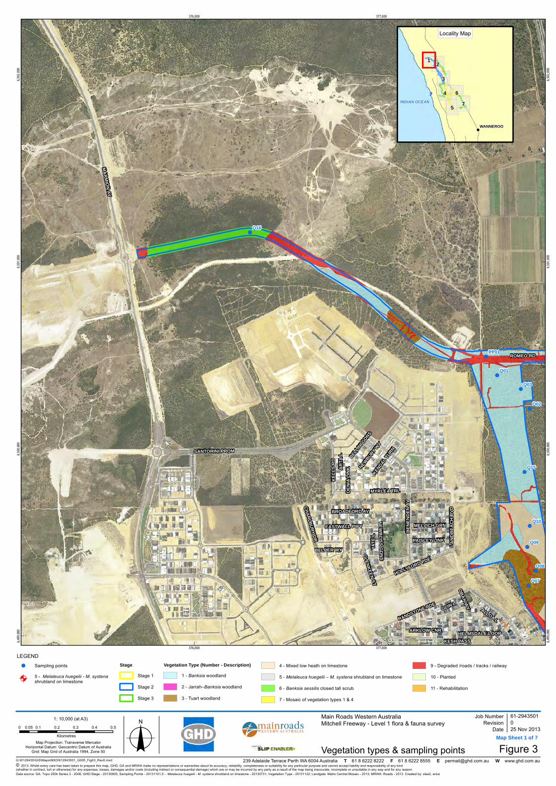
!A
!(
!(
!(
!(
!(
!(
!(
!(
!(
!(
!(
Q16
Q15
Q10
Q09
Q08
Q07
Q03
Q02
Q01
PP01
MARMION AV
BENE
NDEN
AV
SANTORINI PROMLA
NDBE
ACH
BVD
KELL
S RD
RANDSTONE PDE
EASTWALL PWY
ROMEO RD
BROADFORD AV
HOLLYFORD PDE
YATE
L
NEWBURY WY
GLIN L
MYRLEA TRL
CHARLBURY DR PAISLEY LINK
MELVICH GRN
KENDAL T
URN
BELLIN
I GDNS
NEWBLISS GDNS
DENI
A LIN
K
HELMSDALE LOOP
ALLOA L
ARTA
L
GLENKEEN ST
OBAN WY
BELPER WY
KESH PASSARKLOW CNR
376,000
376,000
377,000
377,000
6,499,
000
6,499,
000
6,500,
000
6,500,
000
6,501,
000
6,501,
000
6,502,
000
6,502,
000
G:\61\29435\GIS\Maps\MXD\612943501_G005_Fig03_Rev0.mxd
LEGEND
Map Projection: Transverse MercatorHorizontal Datum: Geocentric Datum of Australia
Grid: Map Grid of Australia 1994, Zone 50
© 2013. Whilst every care has been taken to prepare this map, GHD, GA and MRWA make no representations or warranties about its accuracy, reliability, completeness or suitability for any particular purpose and cannot accept liability and responsibility of any kind (whether in contract, tort or otherwise) for any expenses, losses, damages and/or costs (including indirect or consequential damage) which are or may be incurred by any party as a result of the map being inaccurate, incomplete or unsuitable in any way and for any reason.
Main Roads Western AustraliaMitchell Freeway - Level 1 flora & fauna survey
Figure 3
Job NumberRevision 0
61-2943501
25 Nov 2013
Vegetation types & sampling pointsDate
Data source: GA: Topo 250k Series 3 - 2006; GHD:Stage - 20130905, Sampling Points - 20131101,5 - Melaleuca huegelii - M. systena shrubland on limestone - 20130731; Vegetation Type - 20131122; Landgate: Metro Central Mosaic - 2013; MRWA: Roads - 2013. Created by: slee2, erice
239 Adelaide Terrace Perth WA 6004 Australia T 61 8 6222 8222 F 61 8 6222 8555 E [email protected] W www.ghd.com.au
7
1 2
3
4 6
5
WANNEROO
INDIAN OCEAN
Locality Map
1: 10,000 (at A3)
o0 0.1 0.2 0.3 0.4 0.50.05Kilometres
DRAFT
Map Sheet 1 of 7
!( Sampling points
!A5 - Melaleuca huegelii - M. systena shrubland on limestone
StageStage 1
Stage 2
Stage 3
Vegetation Type (Number - Description)1 - Banksia woodland
2 - Jarrah–Banksia woodland
3 - Tuart woodland
4 - Mixed low heath on limestone
5 - Melaleuca huegelii – M. systena shrubland on limestone
6 - Banksia sessilis closed tall scrub
7 - Mosaic of vegetation types 1 & 4
9 - Degraded /roads / tracks / railway
10 - Planted
11 - Rehabilitation

!A!(
!(
!(
!(
!(
!(
!(
!(
!(
!(
!(
!(
!(
!(
!(!(
!(
Q15
Q14
Q13
Q11
Q10
Q09
Q08
Q07
Q04
Q03
Q02
Q01
Q26PP20
PP09PP01
WANNEROO RD
BENE
NDEN
AV
LAND
BEAC
H BV
D
GIBBS RD
KILN RDKARO
BORU
P RD
ROMEO RD
HUNTLY AVCONNOLLY DR
ROSE
GREE
N AV
THURLEIGH APP
RANDSTONE PDE
IMPIN
GTON
RD
HOLLYFORD PDE
MANASOTA APP
AMERSHAM CR
BLACKROCK AV
TOBERMORY CR
KILL
CARR
Y AV
GLIN L
REDINGTON DR
PAISLEY LINK
PORT
SALO
N PW
Y
MELVICH GRN
CANOVA RD
IRMA
WY
CHESHIRE ENTCLONTARF WY
MARYPORT WYTIKI L
WICK LINK
ROGART BEND
ULLAPOOL L
ALLOA L
MEDSTEAD WY
CLAREMORRIS PWY
ARDARA BEND
BEAU
FORT
L
FINGLAS MNDR
PETT
IGO
L
REINHOLD PL
DIRLETON LOOP
COMR
IE L
OBAN WY
HOLM
AN L
DOOL
IN B
END
CROW
N PO
INT C
R
ARKLOW CNR
MALLOW LINK
378,000
378,000
379,000
379,000
6,499,
000
6,499,
000
6,500,
000
6,500,
000
6,501,
000
6,501,
000
G:\61\29435\GIS\Maps\MXD\612943501_G005_Fig03_Rev0.mxd
LEGEND
Map Projection: Transverse MercatorHorizontal Datum: Geocentric Datum of Australia
Grid: Map Grid of Australia 1994, Zone 50
© 2013. Whilst every care has been taken to prepare this map, GHD, GA and MRWA make no representations or warranties about its accuracy, reliability, completeness or suitability for any particular purpose and cannot accept liability and responsibility of any kind (whether in contract, tort or otherwise) for any expenses, losses, damages and/or costs (including indirect or consequential damage) which are or may be incurred by any party as a result of the map being inaccurate, incomplete or unsuitable in any way and for any reason.
Main Roads Western AustraliaMitchell Freeway - Level 1 flora & fauna survey
Figure 3
Job NumberRevision 0
61-2943501
25 Nov 2013
Vegetation types & sampling pointsDate
Data source: GA: Topo 250k Series 3 - 2006; GHD:Stage - 20130905, Sampling Points - 20131101,5 - Melaleuca huegelii - M. systena shrubland on limestone - 20130731; Vegetation Type - 20131122; Landgate: Metro Central Mosaic - 2013; MRWA: Roads - 2013. Created by: slee2, erice
239 Adelaide Terrace Perth WA 6004 Australia T 61 8 6222 8222 F 61 8 6222 8555 E [email protected] W www.ghd.com.au
7
1 2
3
4 6
5
WANNEROO
INDIAN OCEAN
Locality Map
1: 10,000 (at A3)
o0 0.1 0.2 0.3 0.4 0.50.05Kilometres
DRAFT
Map Sheet 2 of 7
!( Sampling points
!A5 - Melaleuca huegelii - M. systena shrubland on limestone
StageStage 1
Stage 2
Stage 3
Vegetation Type (Number - Description)1 - Banksia woodland
2 - Jarrah–Banksia woodland
3 - Tuart woodland
4 - Mixed low heath on limestone
5 - Melaleuca huegelii – M. systena shrubland on limestone
6 - Banksia sessilis closed tall scrub
7 - Mosaic of vegetation types 1 & 4
9 - Degraded /roads / tracks / railway
10 - Planted
11 - Rehabilitation

!A
!A
!A
!(
!(
!(
!(
!(
!(!(
!(
Q20
Q12
Q04
PP11
PP10 PP08
PP03
PP02 HESTER AV
WANNEROO RD
GIBB
S RD
CONNOLLY DR
HINCHINBROOK AV
RIDGEWOOD BVD
DUNSTAN RD
WATTLE AV
KILKEE ST
Mitchell Fwy
REDINGTON DR
WHITSU
NDAY
AV
MANZAS PL
RATHKEALE BVD
JENOLAN WY
ASHB
OURN
E AV
SANC
TUAR
Y GDN
S
CLOGHER ST
TARBERT PDE
GIBB
S RD
SPUR
PORONGURUP DR
COLDSTREAM CIR
FEAKLE BEND
DAYDREAM WY
CAPTIVA APP
DANIA WY
KILMAINE RD
MEELUP L VANDERLIN CR
DONABATE RD
AGAT
E L
LOFTIA VIEW
UNNAMED A
WANNEROO RD SVC RD
OPAL
L
KAHANA PWY
SKERRIES WY
BANDON LBALLYMOTE GDNS
ROOS
KY A
PP
BELFAST CR
ERINA WY
HOLWELL GDNS
CORINDA WY
BREAKSEA WY
YASS WY
NEWROSS L
HIDDEN VALLEY RTT
FEDAMORE APP
KLON
DIKE
APP
CASHEL L
TURT
LE L
LUKIN DR
BALTIMORE PDE
LANSDOWNE PL
LEEU
WIN
L
HYLAND CR
DEKLE L
BALD
WIN
LINK
HELBY CL (B)
FRAN
GIST
A RD
VOLTAIRE CR
INMAN CT
BEEC
ROFT
MEW
S
DENHAM WY
TWILIGHT CCT
FORB
ES CT
RONSARD VIEW
TRANMORE L
RADSTOCK CL
LINDEMAN HTS
FULHAM WY
SERPENTINE GDNS
EASTWOOD ST
RUDALL CT
ORCH
ID CT
INLE
T L
DENISON TURN
GOULBURN PL
MAGENTA RISE
LINLEE L
CRUMLIN WY
STOKES RTT
NAVAN WY
CULVER L
RYTON L SPUR
NERANG MEWS
TUG COVETUROSS PL
TEBB MEWS
BADJA PL (A)
Mitchell Fwy
WANN
EROO
RD
379,000
379,000
380,000
380,000
381,000
381,000
6,495,
000
6,495,
000
6,496,
000
6,496,
000
6,497,
000
6,497,
000
6,498,
000
6,498,
000
G:\61\29435\GIS\Maps\MXD\612943501_G005_Fig03_Rev0.mxd
LEGEND
Map Projection: Transverse MercatorHorizontal Datum: Geocentric Datum of Australia
Grid: Map Grid of Australia 1994, Zone 50
© 2013. Whilst every care has been taken to prepare this map, GHD, GA and MRWA make no representations or warranties about its accuracy, reliability, completeness or suitability for any particular purpose and cannot accept liability and responsibility of any kind (whether in contract, tort or otherwise) for any expenses, losses, damages and/or costs (including indirect or consequential damage) which are or may be incurred by any party as a result of the map being inaccurate, incomplete or unsuitable in any way and for any reason.
Main Roads Western AustraliaMitchell Freeway - Level 1 flora & fauna survey
Figure 3
Job NumberRevision 0
61-2943501
25 Nov 2013
Vegetation types & sampling pointsDate
Data source: GA: Topo 250k Series 3 - 2006; GHD:Stage - 20130905, Sampling Points - 20131101,5 - Melaleuca huegelii - M. systena shrubland on limestone - 20130731; Vegetation Type - 20131122; Landgate: Metro Central Mosaic - 2013; MRWA: Roads - 2013. Created by: slee2, erice
239 Adelaide Terrace Perth WA 6004 Australia T 61 8 6222 8222 F 61 8 6222 8555 E [email protected] W www.ghd.com.au
7
1 2
3
4 6
5
WANNEROO
INDIAN OCEAN
Locality Map
1: 10,000 (at A3)
o0 0.1 0.2 0.3 0.4 0.50.05Kilometres
DRAFT
Map Sheet 3 of 7
!( Sampling points
!A5 - Melaleuca huegelii - M. systena shrubland on limestone
StageStage 1
Stage 2
Stage 3
Vegetation Type (Number - Description)1 - Banksia woodland
2 - Jarrah–Banksia woodland
3 - Tuart woodland
4 - Mixed low heath on limestone
5 - Melaleuca huegelii – M. systena shrubland on limestone
6 - Banksia sessilis closed tall scrub
7 - Mosaic of vegetation types 1 & 4
9 - Degraded /roads / tracks / railway
10 - Planted
11 - Rehabilitation

!(
!(
!(
!(
!(
!(
!(
!(!(
!(
!(
!(
Q22
Q21
Q19
Q05
PP16PP15
PP14PP13
PP04
Mitchell Fwy
CONNOLLY DR
HALL RD
OCEAN KEYS BVD
NEERABUP RD
ALDERSEA CIR
CELEBRATION BVD
WANNEROO RD
LADERA DR
LIBERTY DR
HANNAFORD AV
BORANUP AV
WALYU
NGA B
VD
SOMERLY DR
ARVADA ST
LITHG
OW D
R
VICTO
RSEN
PDE
MARMION AV
CHATTANOOGA VSTA
HOMESTEAD DR
ELMHURST DR
WARI
NG G
RNLO
WER
KEYS
DR
BLOUNT L
DEWAR MEWS
LANTERN WY
GAUDI WY
ARAGON LHACIENDA DR
GRANDOAK DR
JAKES L
HARMONY AV
SALISHAN ST
KEY L
ARGO
DR
HOYT L
CALOUNDRA RD
DAKOTA L
TAMARAMA CR
KEADY RISE
MENCHETTI RD
CAPITOL TURN
BATESON HTS
RIVERLINKS DR
PITCHFORD GLD
OAKPARK GRN
POLGLASE FAWY
ION L
LONGLEAF DR
BELLEVILLE GDNS
HASKELL GDNS
PORONGURUP DR
AIRLIE CH
PALL
ADIO
PASS
ORANGE GROVE BVD
FORDHAM AV
MIAM
I L
HAYES L
FRAWLEY RMBL
MARO
OCHY
DORE
WY
DEPOT L
CHEROKEE GRN
DULLES WY
TUPELO FAWY
HYLAND CR
THE STRAITS
HATTON L
PETR
E GR
CAGAN L
CARBERRY SQ
REDBANK RISE
CACTUS LINK
CRONULLA RD
MARO
UBRA
WY
LAKEWOOD TCE
ORENCO BEND
RIDGLEA LINK
ASLINGS CT
WILL
OUGH
BY R
TT
SPRINGTHORPE TCE
KAWANA P
L
VICKERY LOOP
HUBBLE PWY
GAFF
NEY R
GE
TARRA CL
GALVIN HTS
LINLEE L
NORTHCLIF
FE AV
STOKES RTT BALIN L
DEKLAB LINK
PORTSLADE L
CODY WY
ELY PL
STANMORE PL
BURRA CT
GLENNON VIEW
MEERE L
LESIN
A WY
WARBY L
PAVONIA LINK
FARREN HTS
GUNN
AMAT
TA LO
OPASTOR LINK
POMONA WY
SYKES COVE
LAND
A CT
WANNEROO RD
CONNOLLY DR
Mitchell Fwy
KEY LARGO DR
379,000
379,000
380,000
380,000
381,000
381,000
6,492,
000
6,492,
000
6,493,
000
6,493,
000
6,494,
000
6,494,
000
6,495,
000
6,495,
000
G:\61\29435\GIS\Maps\MXD\612943501_G005_Fig03_Rev0.mxd
LEGEND
Map Projection: Transverse MercatorHorizontal Datum: Geocentric Datum of Australia
Grid: Map Grid of Australia 1994, Zone 50
© 2013. Whilst every care has been taken to prepare this map, GHD, GA and MRWA make no representations or warranties about its accuracy, reliability, completeness or suitability for any particular purpose and cannot accept liability and responsibility of any kind (whether in contract, tort or otherwise) for any expenses, losses, damages and/or costs (including indirect or consequential damage) which are or may be incurred by any party as a result of the map being inaccurate, incomplete or unsuitable in any way and for any reason.
Main Roads Western AustraliaMitchell Freeway - Level 1 flora & fauna survey
Figure 3
Job NumberRevision 0
61-2943501
25 Nov 2013
Vegetation types & sampling pointsDate
Data source: GA: Topo 250k Series 3 - 2006; GHD:Stage - 20130905, Sampling Points - 20131101,5 - Melaleuca huegelii - M. systena shrubland on limestone - 20130731; Vegetation Type - 20131122; Landgate: Metro Central Mosaic - 2013; MRWA: Roads - 2013. Created by: slee2, erice
239 Adelaide Terrace Perth WA 6004 Australia T 61 8 6222 8222 F 61 8 6222 8555 E [email protected] W www.ghd.com.au
7
1 2
3
4 6
5
WANNEROO
INDIAN OCEAN
Locality Map
1: 10,000 (at A3)
o0 0.1 0.2 0.3 0.4 0.50.05Kilometres
DRAFT
Map Sheet 4 of 7
!( Sampling points
!A5 - Melaleuca huegelii - M. systena shrubland on limestone
StageStage 1
Stage 2
Stage 3
Vegetation Type (Number - Description)1 - Banksia woodland
2 - Jarrah–Banksia woodland
3 - Tuart woodland
4 - Mixed low heath on limestone
5 - Melaleuca huegelii – M. systena shrubland on limestone
6 - Banksia sessilis closed tall scrub
7 - Mosaic of vegetation types 1 & 4
9 - Degraded /roads / tracks / railway
10 - Planted
11 - Rehabilitation
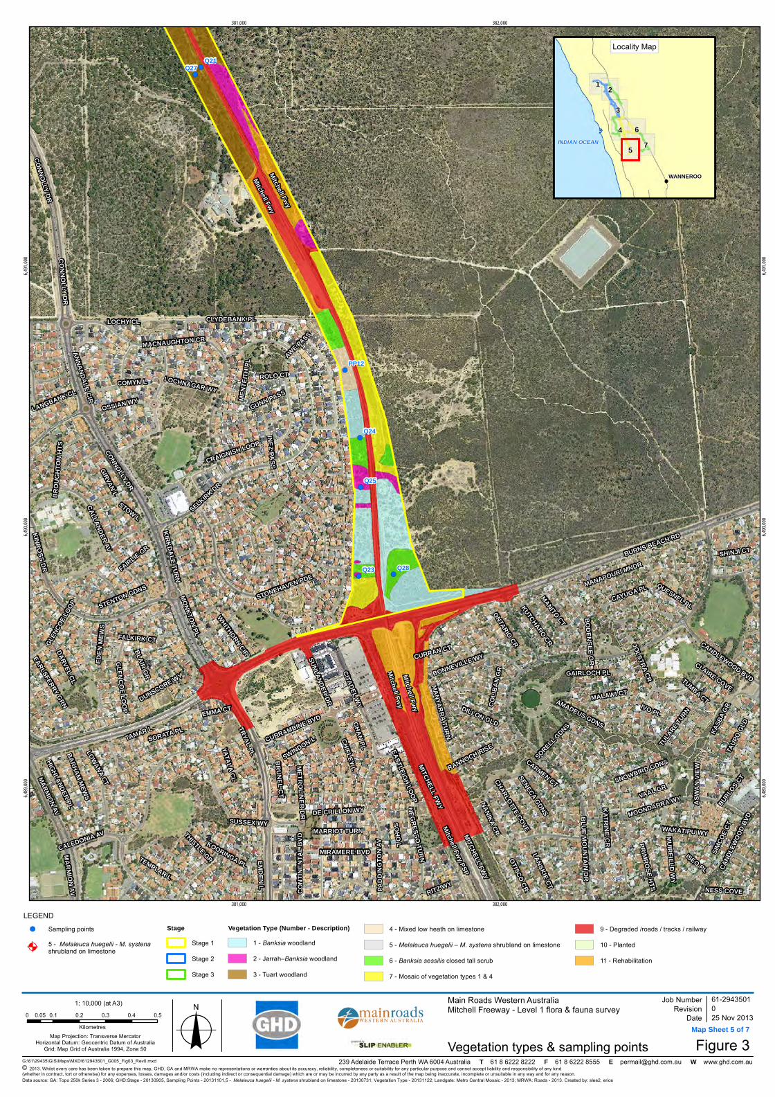
!(
!(
!(
!(
!(
!(
!(
Q24
Q23
Q21
Q28
Q27
Q25
PP12
Mitchell Fwy
BURNS BEACH RD
BLUE MOUNTAIN DR
Mitchell Fwy PSP
SELKIRK DR
MITCHELL FWY
CONNOLLY DR
KINROSS DR
PADD
INGT
ON AV
MARMION AV
MACNAUGHTON CR
CALLANDER AV
CLYDEBANK PL
MOONDARRA WY
CALEDONIA AV
GLENCOE LOOP
NANIKA CR
SIMCO
E CT
MIRAMERE BVD
STONEHAVEN PDE
KATRINE CR
CURRAMBINE BVD
JOLSTRA CR
CAND
LEWOO
D BVD
OTISCO CR
QUESNEL PL
VAAL GR
KASB
A GR
BODENSEE GR
METROLINER DR
BONNEVILLE WY
MUIRFIELD WY
KUTCHARO CR
CARMEN CT
SUNLANDER DR
BRUNEL CT
MANITO CT
AMADEUS GDNS
LANSKIE CT
TRYAL PL
OSSIAN WY
SHINJI CT
MALAWI CT
DILLON GLD
ONTARIO CR
STENTON GDNS
SORELL GDNS
DE CRILLON WY
RANNOCH RISE
PRIMROSE HTS
CONT
INEN
TAL B
VD
SOHO L
MANAPOURI MNDR
EARLSFERRY GRN
SNOWBIRD GDNS
FALKIRK CT
MANYARRA TURN
GAIRLOCH PL
DUNSCORE WY
ANNANDALE CIR
CAYUGA PLMONKTON PL
RITZ WY
LOCHNAGAR WY
WAKATIPU WY
TULA
RE TURN
TAUP
O GLD
HIGHLANDER PL
SENECA GDNS
KOORINGA PL
MENT
EITH
PL
GHAN PL
CITADEL WY
STOW L
TEMPLAR L
CRAIGNISH LOOP
NEGRESSO TURN
LOCHY CL
BROU
GHTO
N HT
S
BLAIR GR
YATALA CL
THISTLE GR
DARVEL CL
MARRIOT TURN
KIRKDALE TURN
CHIFLEY L
SUSSEX WY
TUMBA CT
BURLOS CT
SORATA PL
SWINDON L
GUNN PASS
ISEO PL
LOWANA CTGIRVAN L
LANGBANK CL
IVO PL
ROLO CT
BARHAM MEWS
EDEN
MEW
S
CHARLOTTE COVE
TAMAR L
FAIRLIE GR
EMDEN L
WHITHORN CIR
COMYN L
EMMA CTAS
WAN
VIEW
INEZ PASS
CLAIRE COVE
EASTLEIGH LOOP
COLIB
AN G
R
AWE PASS
CURRAN CT
NESS COVE
Mitchell Fwy
CONNOLLY DR
Mitchell Fwy
Mitchell Fwy
CONNOLLY DR
MARMION AV
CANDLEWOOD BVD
MITCHELL FWY
GLEN
COE L
OOP
381,000
381,000
382,000
382,000
6,489,
000
6,489,
000
6,490,
000
6,490,
000
6,491,
000
6,491,
000
G:\61\29435\GIS\Maps\MXD\612943501_G005_Fig03_Rev0.mxd
LEGEND
Map Projection: Transverse MercatorHorizontal Datum: Geocentric Datum of Australia
Grid: Map Grid of Australia 1994, Zone 50
© 2013. Whilst every care has been taken to prepare this map, GHD, GA and MRWA make no representations or warranties about its accuracy, reliability, completeness or suitability for any particular purpose and cannot accept liability and responsibility of any kind (whether in contract, tort or otherwise) for any expenses, losses, damages and/or costs (including indirect or consequential damage) which are or may be incurred by any party as a result of the map being inaccurate, incomplete or unsuitable in any way and for any reason.
Main Roads Western AustraliaMitchell Freeway - Level 1 flora & fauna survey
Figure 3
Job NumberRevision 0
61-2943501
25 Nov 2013
Vegetation types & sampling pointsDate
Data source: GA: Topo 250k Series 3 - 2006; GHD:Stage - 20130905, Sampling Points - 20131101,5 - Melaleuca huegelii - M. systena shrubland on limestone - 20130731; Vegetation Type - 20131122; Landgate: Metro Central Mosaic - 2013; MRWA: Roads - 2013. Created by: slee2, erice
239 Adelaide Terrace Perth WA 6004 Australia T 61 8 6222 8222 F 61 8 6222 8555 E [email protected] W www.ghd.com.au
7
1 2
3
4 6
5
WANNEROO
INDIAN OCEAN
Locality Map
1: 10,000 (at A3)
o0 0.1 0.2 0.3 0.4 0.50.05Kilometres
DRAFT
Map Sheet 5 of 7
!( Sampling points
!A5 - Melaleuca huegelii - M. systena shrubland on limestone
StageStage 1
Stage 2
Stage 3
Vegetation Type (Number - Description)1 - Banksia woodland
2 - Jarrah–Banksia woodland
3 - Tuart woodland
4 - Mixed low heath on limestone
5 - Melaleuca huegelii – M. systena shrubland on limestone
6 - Banksia sessilis closed tall scrub
7 - Mosaic of vegetation types 1 & 4
9 - Degraded /roads / tracks / railway
10 - Planted
11 - Rehabilitation
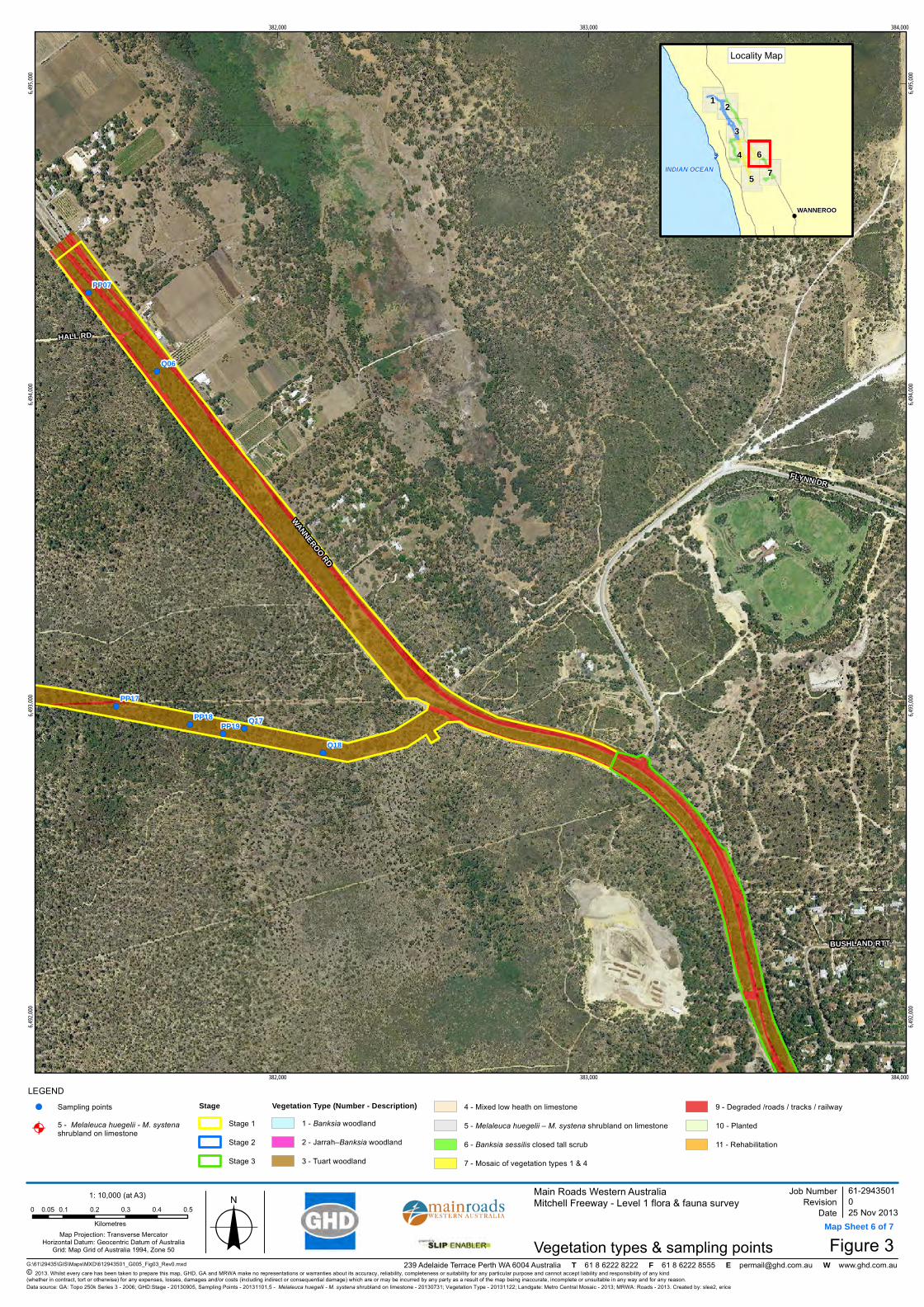
!(
!(
!(
!(
!(
!(
!(
!(
!(
Q18
Q17
Q06
PP19PP18
PP17
PP07
WANNEROO RD
FLYNN DR
HALL RD
BUSHLAND RTT
382,000
382,000
383,000
383,000
384,000
384,000
6,492,
000
6,492,
000
6,493,
000
6,493,
000
6,494,
000
6,494,
000
6,495,
000
6,495,
000
G:\61\29435\GIS\Maps\MXD\612943501_G005_Fig03_Rev0.mxd
LEGEND
Map Projection: Transverse MercatorHorizontal Datum: Geocentric Datum of Australia
Grid: Map Grid of Australia 1994, Zone 50
© 2013. Whilst every care has been taken to prepare this map, GHD, GA and MRWA make no representations or warranties about its accuracy, reliability, completeness or suitability for any particular purpose and cannot accept liability and responsibility of any kind (whether in contract, tort or otherwise) for any expenses, losses, damages and/or costs (including indirect or consequential damage) which are or may be incurred by any party as a result of the map being inaccurate, incomplete or unsuitable in any way and for any reason.
Main Roads Western AustraliaMitchell Freeway - Level 1 flora & fauna survey
Figure 3
Job NumberRevision 0
61-2943501
25 Nov 2013
Vegetation types & sampling pointsDate
Data source: GA: Topo 250k Series 3 - 2006; GHD:Stage - 20130905, Sampling Points - 20131101,5 - Melaleuca huegelii - M. systena shrubland on limestone - 20130731; Vegetation Type - 20131122; Landgate: Metro Central Mosaic - 2013; MRWA: Roads - 2013. Created by: slee2, erice
239 Adelaide Terrace Perth WA 6004 Australia T 61 8 6222 8222 F 61 8 6222 8555 E [email protected] W www.ghd.com.au
7
1 2
3
4 6
5
WANNEROO
INDIAN OCEAN
Locality Map
1: 10,000 (at A3)
o0 0.1 0.2 0.3 0.4 0.50.05Kilometres
DRAFT
Map Sheet 6 of 7
!( Sampling points
!A5 - Melaleuca huegelii - M. systena shrubland on limestone
StageStage 1
Stage 2
Stage 3
Vegetation Type (Number - Description)1 - Banksia woodland
2 - Jarrah–Banksia woodland
3 - Tuart woodland
4 - Mixed low heath on limestone
5 - Melaleuca huegelii – M. systena shrubland on limestone
6 - Banksia sessilis closed tall scrub
7 - Mosaic of vegetation types 1 & 4
9 - Degraded /roads / tracks / railway
10 - Planted
11 - Rehabilitation

!(
!(PP06
PP05
WANNEROO RDGOLF LINKS DR
RUST
IC G
DNS
TRAN
QUIL
DR
WILDFLOWER DR
HOUGHTON DR
CHERITON DR
BURNS BEACH RD
JOON
DALU
P DR
CLARKSON AV
DROVERS PL
BALLADONG LOOP
KIRK
IMBI
E ST
ST STEPHENS CR
MILLENDON ST
BUSHLAND RTTFERNHILL AV
TAHLEE RTT
KITE L
GLENFINE WY
BERI
GORA
AV
STAUNTON VL
CARRAMAR RD
GOSH
AWK
ST
SHINJI CT
CANDLEWOOD BVD
WINDERMERE CIR
RAWLINNA PWY
MARY
LAND
DR
PALLID LMINER L
INVERELL GRN
PALMERSTON CR
EGRE
TTA
RD
PINTAIL PASS
OHRID
PL
SUBLIME GLD
LYSSOS WY
TIBIC
EN R
D
KIPPILAW LOOP
SPRINGPARK TRL
MALLINA CTMONALTRIE LOOP
CARWOOLA CL
OLLERA MNDR
KERLIN WY
DENFIELD RISE
CAMELOT GR
MINJAH CL
SANDILANDS CCT
EUCUMBENE CR
MERRANG CL
TITICACA CT
TADORNA ENT
NORWOOD LOOP
NANKEEN CIR
BRIG
HTLA
NDS C
CT
ARROW PLNERO CL
WOODBINE LOOP
GARDA GR
YARRA CT
INGLEBY L
GALILEE GR
HULA COVEKALK PL
TILAGE CT
MILLEN
DON ST
383,000
383,000
384,000
384,000
385,000
385,000
6,490,
000
6,490,
000
6,491,
000
6,491,
000
6,492,
000
6,492,
000
G:\61\29435\GIS\Maps\MXD\612943501_G005_Fig03_Rev0.mxd
LEGEND
Map Projection: Transverse MercatorHorizontal Datum: Geocentric Datum of Australia
Grid: Map Grid of Australia 1994, Zone 50
© 2013. Whilst every care has been taken to prepare this map, GHD, GA and MRWA make no representations or warranties about its accuracy, reliability, completeness or suitability for any particular purpose and cannot accept liability and responsibility of any kind (whether in contract, tort or otherwise) for any expenses, losses, damages and/or costs (including indirect or consequential damage) which are or may be incurred by any party as a result of the map being inaccurate, incomplete or unsuitable in any way and for any reason.
Main Roads Western AustraliaMitchell Freeway - Level 1 flora & fauna survey
Figure 3
Job NumberRevision 0
61-2943501
25 Nov 2013
Vegetation types & sampling pointsDate
Data source: GA: Topo 250k Series 3 - 2006; GHD:Stage - 20130905, Sampling Points - 20131101,5 - Melaleuca huegelii - M. systena shrubland on limestone - 20130731; Vegetation Type - 20131122; Landgate: Metro Central Mosaic - 2013; MRWA: Roads - 2013. Created by: slee2, erice
239 Adelaide Terrace Perth WA 6004 Australia T 61 8 6222 8222 F 61 8 6222 8555 E [email protected] W www.ghd.com.au
7
1 2
3
4 6
5
WANNEROO
INDIAN OCEAN
Locality Map
1: 10,000 (at A3)
o0 0.1 0.2 0.3 0.4 0.50.05Kilometres
DRAFT
Map Sheet 7 of 7
!( Sampling points
!A5 - Melaleuca huegelii - M. systena shrubland on limestone
StageStage 1
Stage 2
Stage 3
Vegetation Type (Number - Description)1 - Banksia woodland
2 - Jarrah–Banksia woodland
3 - Tuart woodland
4 - Mixed low heath on limestone
5 - Melaleuca huegelii – M. systena shrubland on limestone
6 - Banksia sessilis closed tall scrub
7 - Mosaic of vegetation types 1 & 4
9 - Degraded /roads / tracks / railway
10 - Planted
11 - Rehabilitation

!(D
!(D
!(D!(D
!(D
!(D
2
3
6
4-5
2-3
4 5-6
MA
RM
ION
AVBE
NE
ND
EN
AV
SANTORINI PROMLA
ND
BEA
CH
BV
D
KELL
S R
D
EASTWALL PWY
RANDSTONE PDE
ROMEO RD
BROADFORD AV
HOLLYFORD PDE
YATE
L
NEWBURY
WY
GLIN L
MYRLEA TRL
CH
ARLBU
RY D
R
PAISLEY LINK
MELVICH GRN
ALVA L
MALDON L
KENDAL
TURN
BELL
INI G
DNS
CO
STE
LLO
E G
DN
S
NEW
BLIS
S G
DN
S
RO
SE
GR
EE
N A
V
KILL
CA
RR
Y AV
DEN
IA L
INK
ALLOA L
BRETTON GRA
ARTA
L
GLENKEEN
ST
BEA
UFO
RT
L
LOCKERBIE TURN
SAN
MA
RIA
WY
SOR
AN W
Y
RED
HILL L
OBAN
WY
TOBERMORY CR
BELPER WY
ARKLOW CNR
ELG
IN W
Y
376,000
376,000
377,000
377,000
6,499,
000
6,499,
000
6,500,
000
6,500,
000
6,501,
000
6,501,
000
6,502,
000
6,502,
000
G:\61\29435\GIS\Maps\MXD\612943501_G006_Fig04_Rev0.mxd
Map Projection: Transverse MercatorHorizontal Datum: Geocentric Datum of Australia
Grid: Map Grid of Australia 1994, Zone 50
© 2013. Whilst every care has been taken to prepare this map, GHD, GA and MRWA make no representations or warranties about its accuracy, reliability, completeness or suitability for any particular purpose and cannot accept liability and responsibility of any kind (whether in contract, tort or otherwise) for any expenses, losses, damages and/or costs (including indirect or consequential damage) which are or may be incurred by any party as a result of the map being inaccurate, incomplete or unsuitable in any way and for any reason.
Main Roads Western AustraliaMitchell Freeway - Level 1 flora & fauna survey
Figure 4
Job NumberRevision 0
61-2943501
25 Nov 2013
Vegetation condition & weed locations
Date
Data source: GA: Topo 250k Series 3 - 2006; GHD: Declared Pests (under the BAM Act) & Weeds of National Significance (WoNS) (Australian Weeds Committee, 2010) - 20130726, Stage - 20130905, Vegetation Condition - 20131101; MRWA: Metro Central Mosaic - 20130615, IRIS Roads - 201305. Created by: slee2, erice
239 Adelaide Terrace Perth WA 6004 Australia T 61 8 6222 8222 F 61 8 6222 8555 E [email protected] W www.ghd.com.au
7
12
3
4 6
5
INDIAN OCEAN
Locality Map
1: 10,000 (at A3)
o0 0.1 0.2 0.3 0.4 0.50.05
Kilometres
DRAFT
Map Sheet 1 of 7
Declared Pests (under the BAM Act) & Weeds of NationalSignificance (WoNS) (Australian Weeds Committee, 2010)!(D
*Asparagus asparagoides (bridal creeper)(Declared Pest C3 Management for the Whole of the State, WoNS)
!(D*Solanum linnaeanum (apple of Sodom) (Declared Pest C3 Management for the South West Land Division)
!(D*Zantedeschia aethiopica (arum lily)(Declared Pest C3 Management for the Whole of the State)
Roads
StageStage 1
Stage 2
Stage 3
Vegetation condition (Keighery, 1994)Pristine (1)
Excellent (2)
Excellent - Very Good (2 - 3)
Very Good (3)
Very Good - Good (3 - 4)
Good (4)
Good - Degraded (3)
Degraded (5)
Degraded - Completely Degraded (5 - 6)
Completely Degraded (6)

!(D
!(D
!(D!(D
!(D
!(D
!(D!(D
!(D
6
2 2-3
4-5
3
54 5-6
WANNERO
O RD
BEN
EN
DE
N A
V
LAN
DB
EAC
H B
VD
GIBBS RD
KILN R
D
KAR
OBO
RU
P R
D
ROMEO RD
HUNTLY AVCONNO
LLY DR
RO
SE
GR
EE
N A
V
THURLEIGH APP
RANDSTONE PDE
MANASOTA APP
HOLLYFORD PDE
IMP
ING
TON
RD
AMERSHAM CR
HAPUNA ST
BLACKROCK AV
KILL
CA
RR
Y AV
GLIN L
TOLLESBURY AV
TOBERM
ORY CR
REDINGTON DR
NEAH PL
PAISLEY LINK
POR
TSA
LON
PW
Y
MELVICH GRN
IRM
A W
Y
CLONTARF WY
CHESHIRE ENT
MALDON L
CO
STE
LLO
E G
DN
SSW
INFO
RD
APP
MARYPORT WY H
OLG
ATE
L
TIKI L
PAN
AM
A R
D
MALPAS L
SHEPPERTON DR
NEWBRIDGE GRN
WICK LINK
EXMOUTH DR
ROGART BEND
ULLAPOOL L
ALLOA L
PORTREE LINK
GILFO
RD
GR
N
CAPE MEARES CR
CARNFORTH RD
FEAT
HE
RS
TON
E G
DN
S
ARDARA BEND
BEA
UFO
RT
L
CLAREMO
RRIS PWY
MEDSTEAD W
Y
LOCKERBIE TURN
REINHOLD PL
DIRLETON LOOP
CO
MR
IE L
OBAN
WY
BADLEY LOOP
VER
WO
OD
GR
N
DO
OLI
N B
EN
D
CR
OW
N P
OIN
T C
R
ARKLOW CNR
378,000
378,000
379,000
379,000
6,499,
000
6,499,
000
6,500,
000
6,500,
000
6,501,
000
6,501,
000
G:\61\29435\GIS\Maps\MXD\612943501_G006_Fig04_Rev0.mxd
Map Projection: Transverse MercatorHorizontal Datum: Geocentric Datum of Australia
Grid: Map Grid of Australia 1994, Zone 50
© 2013. Whilst every care has been taken to prepare this map, GHD, GA and MRWA make no representations or warranties about its accuracy, reliability, completeness or suitability for any particular purpose and cannot accept liability and responsibility of any kind (whether in contract, tort or otherwise) for any expenses, losses, damages and/or costs (including indirect or consequential damage) which are or may be incurred by any party as a result of the map being inaccurate, incomplete or unsuitable in any way and for any reason.
Main Roads Western AustraliaMitchell Freeway - Level 1 flora & fauna survey
Figure 4
Job NumberRevision 0
61-2943501
25 Nov 2013
Vegetation condition & weed locations
Date
Data source: GA: Topo 250k Series 3 - 2006; GHD: Declared Pests (under the BAM Act) & Weeds of National Significance (WoNS) (Australian Weeds Committee, 2010) - 20130726, Stage - 20130905, Vegetation Condition - 20131101; MRWA: Metro Central Mosaic - 20130615, IRIS Roads - 201305. Created by: slee2, erice
239 Adelaide Terrace Perth WA 6004 Australia T 61 8 6222 8222 F 61 8 6222 8555 E [email protected] W www.ghd.com.au
7
12
3
4 6
5
INDIAN OCEAN
Locality Map
1: 10,000 (at A3)
o0 0.1 0.2 0.3 0.4 0.50.05
Kilometres
DRAFT
Map Sheet 2 of 7
Declared Pests (under the BAM Act) & Weeds of NationalSignificance (WoNS) (Australian Weeds Committee, 2010)!(D
*Asparagus asparagoides (bridal creeper)(Declared Pest C3 Management for the Whole of the State, WoNS)
!(D*Solanum linnaeanum (apple of Sodom) (Declared Pest C3 Management for the South West Land Division)
!(D*Zantedeschia aethiopica (arum lily)(Declared Pest C3 Management for the Whole of the State)
Roads
StageStage 1
Stage 2
Stage 3
Vegetation condition (Keighery, 1994)Pristine (1)
Excellent (2)
Excellent - Very Good (2 - 3)
Very Good (3)
Very Good - Good (3 - 4)
Good (4)
Good - Degraded (3)
Degraded (5)
Degraded - Completely Degraded (5 - 6)
Completely Degraded (6)

!(D
!(D
!(D!(D
!(D !(D
!(D!(D
!(D
!(D!(D
6
2
3
4
4-5
2-3
5
5-6
HESTER AV
WANNEROO RD
GIB
BS
RD
CO
NN
OLLY D
R
HIN
CH
INB
RO
OK
AV
RID
GE
WO
OD
BV
D
WATTLE AV
DU
NS
TAN
RD
Mitchell Fw
y
KILKEE ST
RED
ING
TON
DR
WHI
TSUN
DAY
AV
MANZAS PL
RATHKEALE BVD
JENOLAN W
Y
ASH
BO
UR
NE
AV
SAN
CTU
AR
Y G
DN
S
TARBERT PDE
CLOGHER ST
GIB
BS
RD
SP
UR
POR
ON
GU
RU
P DR
CO
LDSTR
EAM C
IR
WAL
YUNG
A BV
D
FEAKLE BEND
CAPTIVA APP
DAYD
REAM
WY
DANIA WY
KILMAINE RD
MEELUP L
VAN
DE
RLIN
CR
DONABATE RD
AGAT
E L
OPA
L L
UNNAMED A
LOFTIA VIEW
WANNEROO RD SVC RD
KAHANA PWY
BANDON LBALLYMOTE GDNS
SKERRIES WY
BELFAST CR RO
OS
KY
AP
P
ERINA WY
HOLWELL GDNS
BREAKSEA WY
CO
RIN
DA W
YH
IDD
EN VALLEY R
TT
YASS WY
NEWROSS L
CASHEL L
KLO
ND
IKE
APP
FEDAMORE APP
LEVEQUE RMBL
TUR
TLE
L
LUKIN DR
BALTIMORE PDE
LANSDOWNE PL
BOY
LE R
D
LEEU
WIN
L
WILLOUGHBY RTT
DEKLE L
BALD
WIN
LIN
K
HELBY C
L (B)
PASC
AL M
EWS
VOLTAIRE CR
LARSSON WK
INMAN CT
SAINTFIELD CNR
WALPO
LE PL
BEEC
RO
FT M
EWS
DENHAM WY
STR
AD
BR
OK
E G
DN
S
CLAXTON L
TWILIG
HT C
CT
NOWERGUP RD
PORTLAND WY
TATHRA WY
FORBES CT
MUSGRAVE PROM
RONSARD VIEW
RADSTOCK CL
TRANMORE L
LINDEMAN HTS
FULHAM WY
RUDALL CT
SERPEN
TINE G
DN
S
EASTWOOD ST
OR
CH
ID C
T
KIOR
A L
DENISON T
URN
MAG
ENTA R
ISE
LINLEE L
CRUMLIN WY
RUSH L
STOKES RTT
NAVAN WY
HARCUS RTT
HEMM
INGS CL
BURRA CT
RYTON L SPUR
PRUDHOE M
EWS
NERANG MEWS
BRIGSLEY WY
TUG COVE
FARREN HTS
TEBB MEWS
LENSWOOD RTT
REN
VILL
E L
INK
WESTALL LIN
K
PENOLA CT
BADJA PL (A)PER
RIN
CR
ST
ALDERSEA CIR
WANNEROO RD
Mitchell Fw
y
WA
NN
ER
OO
RD
379,000
379,000
380,000
380,000
381,000
381,000
6,495,
000
6,495,
000
6,496,
000
6,496,
000
6,497,
000
6,497,
000
6,498,
000
6,498,
000
G:\61\29435\GIS\Maps\MXD\612943501_G006_Fig04_Rev0.mxd
Map Projection: Transverse MercatorHorizontal Datum: Geocentric Datum of Australia
Grid: Map Grid of Australia 1994, Zone 50
© 2013. Whilst every care has been taken to prepare this map, GHD, GA and MRWA make no representations or warranties about its accuracy, reliability, completeness or suitability for any particular purpose and cannot accept liability and responsibility of any kind (whether in contract, tort or otherwise) for any expenses, losses, damages and/or costs (including indirect or consequential damage) which are or may be incurred by any party as a result of the map being inaccurate, incomplete or unsuitable in any way and for any reason.
Main Roads Western AustraliaMitchell Freeway - Level 1 flora & fauna survey
Figure 4
Job NumberRevision 0
61-2943501
25 Nov 2013
Vegetation condition & weed locations
Date
Data source: GA: Topo 250k Series 3 - 2006; GHD: Declared Pests (under the BAM Act) & Weeds of National Significance (WoNS) (Australian Weeds Committee, 2010) - 20130726, Stage - 20130905, Vegetation Condition - 20131101; MRWA: Metro Central Mosaic - 20130615, IRIS Roads - 201305. Created by: slee2, erice
239 Adelaide Terrace Perth WA 6004 Australia T 61 8 6222 8222 F 61 8 6222 8555 E [email protected] W www.ghd.com.au
7
12
3
4 6
5
INDIAN OCEAN
Locality Map
1: 10,000 (at A3)
o0 0.1 0.2 0.3 0.4 0.50.05
Kilometres
DRAFT
Map Sheet 3 of 7
Declared Pests (under the BAM Act) & Weeds of NationalSignificance (WoNS) (Australian Weeds Committee, 2010)!(D
*Asparagus asparagoides (bridal creeper)(Declared Pest C3 Management for the Whole of the State, WoNS)
!(D*Solanum linnaeanum (apple of Sodom) (Declared Pest C3 Management for the South West Land Division)
!(D*Zantedeschia aethiopica (arum lily)(Declared Pest C3 Management for the Whole of the State)
Roads
StageStage 1
Stage 2
Stage 3
Vegetation condition (Keighery, 1994)Pristine (1)
Excellent (2)
Excellent - Very Good (2 - 3)
Very Good (3)
Very Good - Good (3 - 4)
Good (4)
Good - Degraded (3)
Degraded (5)
Degraded - Completely Degraded (5 - 6)
Completely Degraded (6)

!(D !(D!(D !(D
!(D
!(D
!(D
6
2
5
5-6
4-5
4
2-3
Mitchell Fw
y
CO
NN
OLLY D
R
HALL RD
OCEAN KEYS BVD
NEERABUP RD
ALDERSEA CIR
CELEBRATION BVD
WANNEROO RD
LADER
A DR
LIBERTY D
R
BORANUP AV
HAN
NAFO
RD
AV
WAL
YUNG
A BV
D
SOMERLY DR
ARVADA ST
LITH
GO
W D
R
VIC
TOR
SE
N P
DE
MAR
MIO
N AV
CH
ATTANO
OG
A VSTA
HOMESTEAD DR
ELMH
UR
ST DR
WA
RIN
G G
RN
BLOUNT L
LOW
ER K
EYS
DR
ARAGON L
DEWAR MEWS
LANTERN WY
GAUDI WY
HACIENDA DR
JAKES L
GRANDOAK DR
OBSERVATORY DR
HAR
MO
NY AV
SALISHAN ST
KEY
LAR
GO
DR
DAKOTA L
HOYT L
CALOUNDRA RD
TAM
AR
AM
A CR
KEAD
Y R
ISE
CAPITOL TURN
BATESON HTS
MENCHETTI RD
RIVERLINKS DR
LA MIRADA AV
OAKPARK GRN
ION L
POLGLASE FAWY
PITCHFORD GLD
LON
GLEAF D
R
KYARA CT
BELLEVILLE GDNS
HASKELL GDNS
VER
RA
DO
WY
AIRLIE CH
PORONGURUP DR
LOM
ITA LINK
PALL
AD
IO P
ASS
MIA
MI L
OR
AN
GE
GR
OV
E BV
DHAYES L
FOR
DH
AM AV
FRAWLEY RMBL
CALDWELL TURN
MA
RO
OC
HY
DO
RE
WY
DEPOT L
TREPH
INA M
EWS
CHEROKEE GRN
SANTA CLARA CR
DULLES WY
TUPELO
FAWY
HYLAND CR
HATTON L
COALDALE LINK
THE STRAITS
CAGAN L
PETR
E G
R
SUFFO
LK L
INJID
UP LO
OP
BEACHPORT RTT
CAR
BER
RY
SQ
REDBANK RISE
BLISS WYTUTOR L
CACTUS LINK
MAR
OU
BRA
WY
CARIBBEAN CCT
LAKEWOOD TCE
BROOKES PASS
ORENCO BEND
CORDOVA TURN
ELKING
TON
MEW
SAS
LING
S C
T
PEB
BLY W
Y
KAW
ANA
PL
WIL
LOU
GH
BY
RTT
WALLIS AV
YAROOMBA PL
SPRINGTHORPE TCE
ORMISTON GDNS
VICKERY LO
OP
HUBBLE PWY
UTICA TCE
TARRA CL
OR
CH
ID C
T
LENSWOOD RTT
GA
LVIN
HTS
PENGILLY WY
SHIN
NE
RS
GR
N
GA
FFN
EY
RG
E
KEM
PTO
N G
R
LINLEE L
NORTHCLI
FFE
AV
PETERSEN CL
TUFN
ELL
L
BALIN L
STOKES RTT
CO
NN
OR
S R
TT
HAY
MO
UN
T W
Y
PORTSLADE L
ELY PL
CODY W
Y
BURRA CT
NEW
LIN M
EW
S
LESI
NA W
Y
WARBY L
KEN
TLA
ND
S L
PRIDMORE GLEN
PAVONIA LINK
HOLLYWOOD HTS
FARREN HTS
ASTOR LINK
POMONA WY
HOPMAN RISE
ALDRIDGE RISE
SYKES COVE
Mitchell Fw
y
MAR
MIO
N AV
WANNEROO RD
CONNO
LLY DR
379,000
379,000
380,000
380,000
381,000
381,000
6,492,
000
6,492,
000
6,493,
000
6,493,
000
6,494,
000
6,494,
000
6,495,
000
6,495,
000
G:\61\29435\GIS\Maps\MXD\612943501_G006_Fig04_Rev0.mxd
Map Projection: Transverse MercatorHorizontal Datum: Geocentric Datum of Australia
Grid: Map Grid of Australia 1994, Zone 50
© 2013. Whilst every care has been taken to prepare this map, GHD, GA and MRWA make no representations or warranties about its accuracy, reliability, completeness or suitability for any particular purpose and cannot accept liability and responsibility of any kind (whether in contract, tort or otherwise) for any expenses, losses, damages and/or costs (including indirect or consequential damage) which are or may be incurred by any party as a result of the map being inaccurate, incomplete or unsuitable in any way and for any reason.
Main Roads Western AustraliaMitchell Freeway - Level 1 flora & fauna survey
Figure 4
Job NumberRevision 0
61-2943501
25 Nov 2013
Vegetation condition & weed locations
Date
Data source: GA: Topo 250k Series 3 - 2006; GHD: Declared Pests (under the BAM Act) & Weeds of National Significance (WoNS) (Australian Weeds Committee, 2010) - 20130726, Stage - 20130905, Vegetation Condition - 20131101; MRWA: Metro Central Mosaic - 20130615, IRIS Roads - 201305. Created by: slee2, erice
239 Adelaide Terrace Perth WA 6004 Australia T 61 8 6222 8222 F 61 8 6222 8555 E [email protected] W www.ghd.com.au
7
12
3
4 6
5
INDIAN OCEAN
Locality Map
1: 10,000 (at A3)
o0 0.1 0.2 0.3 0.4 0.50.05
Kilometres
DRAFT
Map Sheet 4 of 7
Declared Pests (under the BAM Act) & Weeds of NationalSignificance (WoNS) (Australian Weeds Committee, 2010)!(D
*Asparagus asparagoides (bridal creeper)(Declared Pest C3 Management for the Whole of the State, WoNS)
!(D*Solanum linnaeanum (apple of Sodom) (Declared Pest C3 Management for the South West Land Division)
!(D*Zantedeschia aethiopica (arum lily)(Declared Pest C3 Management for the Whole of the State)
Roads
StageStage 1
Stage 2
Stage 3
Vegetation condition (Keighery, 1994)Pristine (1)
Excellent (2)
Excellent - Very Good (2 - 3)
Very Good (3)
Very Good - Good (3 - 4)
Good (4)
Good - Degraded (3)
Degraded (5)
Degraded - Completely Degraded (5 - 6)
Completely Degraded (6)

6
2
5
4-5
3
2-3
4
Mitchell Fwy
BURNS BEACH RD
BLUE M
OU
NTA
IN D
R
Mitchell Fwy PSP
SELKIRK DR
MITCHELL FW
Y
CO
NN
OLLY D
R
KINR
OSS D
R
PAD
DIN
GTO
N A
V
MARM
ION AV
MACNAUGHTON CR
CALLAN
DER
AV
CLYDEBANK PL
CALEDONIA AV
MOONDARRA WY
GLE
NC
OE LO
OP
NANIKA CR
SIM
COE
CT
MIRAMERE BVD
STONEHAVEN PDE
KATRIN
E C
R
JOLS
TRA
CR
CURRAMBINE BVDCA
NDL
EWO
OD
BVD
VAAL GR
OTISCO
CR
KASB
A GR
QUESNEL PL
BONNEVILLE WY
BOD
EN
SEE
GR
ME
TRO
LINE
R D
R
MU
IRFIE
LD W
Y
KUTCHARO CR
NO
RM
AN
DY
PDE
HAR
TFOR
D R
MBL
CAR
MEN
CT
WALDORF RMBL
SUN
LAND
ER D
R
BRU
NEL C
T
MANITO
CT
TRYAL PL
LANSKIE CT
AMADEUS GDNS
OSSIAN WY
MAL
AWI C
T
SHINJI CT
DILLON GLD
ABITIBI TURN ONTARIO CR
IRO
QU
OIS
GD
NS
SORELL
GDNS
DE CRILLON WY
STENTON GDNS
RANNOCH RISE
CO
NTI
NE
NTA
L BV
D
PRIM
RO
SE HTS
SOH
O L
YELLOW
STONE W
Y
MANAPOURI MNDR
PYA PL
EARLSFERRY GRN
FALKIRK CT
SNO
WB
IRD
GD
NS
CAR
LTON
TUR
N
CAS
TLE R
OC
K TU
RN
MAN
YARR
A TUR
N
GRANGEMOUTH TURN
CAR
NO
CK
WY
PETER
BOR
OU
GH
DR
RUTHERGLEN CIR
GAIRLOCH PL
ANN
AND
ALE CIR
CAYUGA PL
DUNSCORE WY
MONKTON P
L
RITZ WY
LOCHNAGAR WY
WAKATIPU WY
ULLS
WATE
R G
LD
TULA
RE TU
RN
TAUP
O G
LD
HIGHLANDER PL
ASCOT WY
CAIRNSMORE CH
SENECA GDNS
KOORINGA PL
GH
AN PL
ME
NTE
ITH
PL
CITAD
EL WY
REN
OIR
LTEMPLAR L
STOW L
SOMERSBY GDNS
SHETLAND RISE
GALLOWAY TURN
LOCHY CL
CRAIGNISH LOOP
YATALA C
L
NEGRESSO TURN
BLAIR GR
BRO
UG
HTO
N H
TS
RAP
HA
EL L
DARVEL CL
THORNTON RTT
FISHERTON CCTAM
BA
SSA
DO
R D
R
THISTLE GR
BOW
STRI
NG P
L
BALLIOL ELB
KIRKD
ALE TUR
N
MARRIOT TURN
CH
IFLEY L
TRIPOLI MEWS
SUSSEX WY
TUMBA CT
SORATA PL
FON
TAN
A CO
VE
LEVEN RISE
FOR
FAR G
LENBURLO
S CT
WE
STWIN
D PL
CO
RSO
CK LO
OP
SWINDON L
GUNN PASS
ISEO PL
LOW
ANA CTG
IRVAN L
IVO PL
ROLO CT
BARH
AM M
EWS
TAMAR L
CHARLOTTE COVE
FAIR
LIE G
R
KILMO
RY G
R
EMD
EN
L
ARBROATH CIR
GLOMACH CCT
WHITHO
RN CIR
ALLIANCE CT
GARDINER HTS
LOCHMABEN RTT
KOW
LOO
N C
NR
EMMA CT
COMYN L
AIRDRIE CNR
ARAB
ELLA
MEW
S
LUCY L
ASW
AN
VIE
W
LANGLEY MEWS
KING
LASSIE CIR
EASTLEIGH
LOO
P
CO
LIBA
N G
R
TALBINGO TURN
ELSKIE RISE
DUNDAFF TURN
WHIM CT
GLENCRAIG CR
AWE PASS
CURRAN CT
DAUPHINE PL
KEPPOCH CT
ROCNOKE L
JESSUP PA
SS
Mitchell Fwy
CONNOLLY DR
Mitchell Fw
y
Mitchell Fw
y
CO
NN
OLLY D
R
MA
RM
ION
AV
MITCHELL FW
Y
GLENCOE
LOOP
381,000
381,000
382,000
382,000
6,489,
000
6,489,
000
6,490,
000
6,490,
000
6,491,
000
6,491,
000
G:\61\29435\GIS\Maps\MXD\612943501_G006_Fig04_Rev0.mxd
Map Projection: Transverse MercatorHorizontal Datum: Geocentric Datum of Australia
Grid: Map Grid of Australia 1994, Zone 50
© 2013. Whilst every care has been taken to prepare this map, GHD, GA and MRWA make no representations or warranties about its accuracy, reliability, completeness or suitability for any particular purpose and cannot accept liability and responsibility of any kind (whether in contract, tort or otherwise) for any expenses, losses, damages and/or costs (including indirect or consequential damage) which are or may be incurred by any party as a result of the map being inaccurate, incomplete or unsuitable in any way and for any reason.
Main Roads Western AustraliaMitchell Freeway - Level 1 flora & fauna survey
Figure 4
Job NumberRevision 0
61-2943501
25 Nov 2013
Vegetation condition & weed locations
Date
Data source: GA: Topo 250k Series 3 - 2006; GHD: Declared Pests (under the BAM Act) & Weeds of National Significance (WoNS) (Australian Weeds Committee, 2010) - 20130726, Stage - 20130905, Vegetation Condition - 20131101; MRWA: Metro Central Mosaic - 20130615, IRIS Roads - 201305. Created by: slee2, erice
239 Adelaide Terrace Perth WA 6004 Australia T 61 8 6222 8222 F 61 8 6222 8555 E [email protected] W www.ghd.com.au
7
12
3
4 6
5
INDIAN OCEAN
Locality Map
1: 10,000 (at A3)
o0 0.1 0.2 0.3 0.4 0.50.05
Kilometres
DRAFT
Map Sheet 5 of 7
Declared Pests (under the BAM Act) & Weeds of NationalSignificance (WoNS) (Australian Weeds Committee, 2010)!(D
*Asparagus asparagoides (bridal creeper)(Declared Pest C3 Management for the Whole of the State, WoNS)
!(D*Solanum linnaeanum (apple of Sodom) (Declared Pest C3 Management for the South West Land Division)
!(D*Zantedeschia aethiopica (arum lily)(Declared Pest C3 Management for the Whole of the State)
Roads
StageStage 1
Stage 2
Stage 3
Vegetation condition (Keighery, 1994)Pristine (1)
Excellent (2)
Excellent - Very Good (2 - 3)
Very Good (3)
Very Good - Good (3 - 4)
Good (4)
Good - Degraded (3)
Degraded (5)
Degraded - Completely Degraded (5 - 6)
Completely Degraded (6)
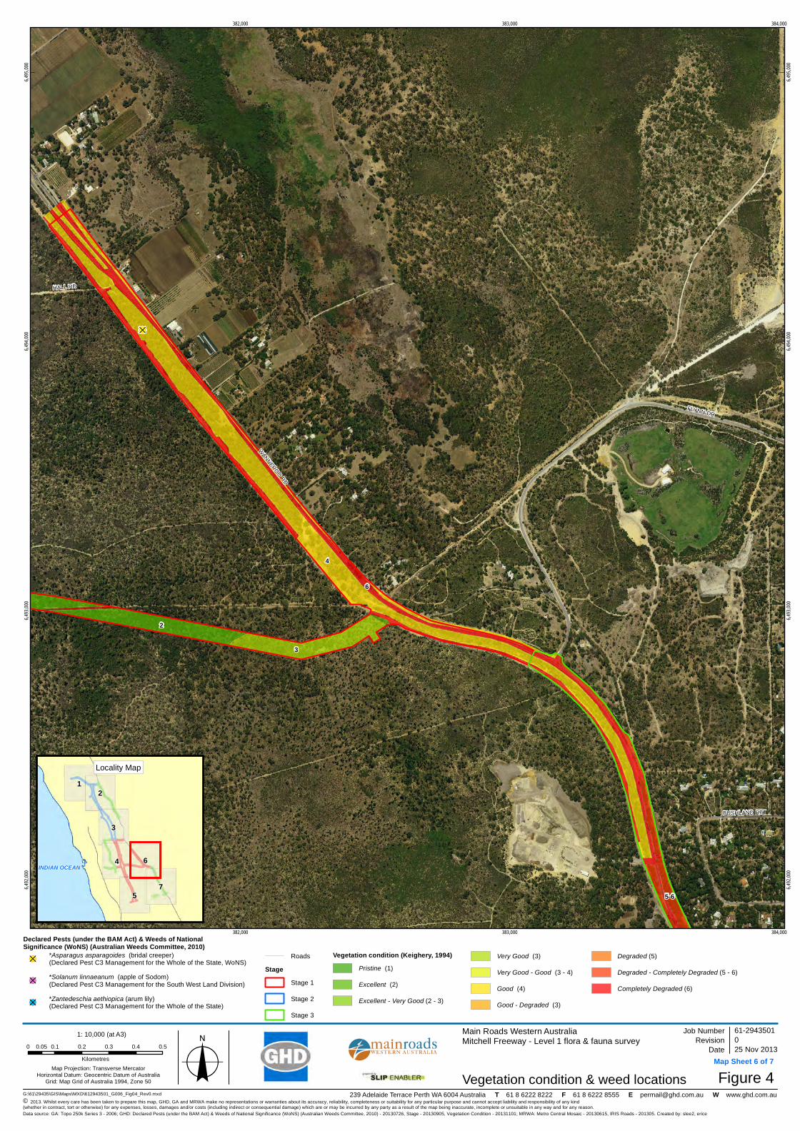
!(D
!(D
4
3
2
6
5-6
WANNEROO RD
FLYNN DR
HALL RD
BUSHLAND RTT
382,000
382,000
383,000
383,000
384,000
384,000
6,492,
000
6,492,
000
6,493,
000
6,493,
000
6,494,
000
6,494,
000
6,495,
000
6,495,
000
G:\61\29435\GIS\Maps\MXD\612943501_G006_Fig04_Rev0.mxd
Map Projection: Transverse MercatorHorizontal Datum: Geocentric Datum of Australia
Grid: Map Grid of Australia 1994, Zone 50
© 2013. Whilst every care has been taken to prepare this map, GHD, GA and MRWA make no representations or warranties about its accuracy, reliability, completeness or suitability for any particular purpose and cannot accept liability and responsibility of any kind (whether in contract, tort or otherwise) for any expenses, losses, damages and/or costs (including indirect or consequential damage) which are or may be incurred by any party as a result of the map being inaccurate, incomplete or unsuitable in any way and for any reason.
Main Roads Western AustraliaMitchell Freeway - Level 1 flora & fauna survey
Figure 4
Job NumberRevision 0
61-2943501
25 Nov 2013
Vegetation condition & weed locations
Date
Data source: GA: Topo 250k Series 3 - 2006; GHD: Declared Pests (under the BAM Act) & Weeds of National Significance (WoNS) (Australian Weeds Committee, 2010) - 20130726, Stage - 20130905, Vegetation Condition - 20131101; MRWA: Metro Central Mosaic - 20130615, IRIS Roads - 201305. Created by: slee2, erice
239 Adelaide Terrace Perth WA 6004 Australia T 61 8 6222 8222 F 61 8 6222 8555 E [email protected] W www.ghd.com.au
7
12
3
4 6
5
INDIAN OCEAN
Locality Map
1: 10,000 (at A3)
o0 0.1 0.2 0.3 0.4 0.50.05
Kilometres
DRAFT
Map Sheet 6 of 7
Declared Pests (under the BAM Act) & Weeds of NationalSignificance (WoNS) (Australian Weeds Committee, 2010)!(D
*Asparagus asparagoides (bridal creeper)(Declared Pest C3 Management for the Whole of the State, WoNS)
!(D*Solanum linnaeanum (apple of Sodom) (Declared Pest C3 Management for the South West Land Division)
!(D*Zantedeschia aethiopica (arum lily)(Declared Pest C3 Management for the Whole of the State)
Roads
StageStage 1
Stage 2
Stage 3
Vegetation condition (Keighery, 1994)Pristine (1)
Excellent (2)
Excellent - Very Good (2 - 3)
Very Good (3)
Very Good - Good (3 - 4)
Good (4)
Good - Degraded (3)
Degraded (5)
Degraded - Completely Degraded (5 - 6)
Completely Degraded (6)

6
4
5-6
WANNERO
O RD
GOLF LINKS DR
RU
STI
C G
DN
S
TRAN
QU
IL D
R
WILDFLOWER DR
HO
UG
HTO
N D
R
CHERITON DR
BURNS BEACH RD
JOO
ND
ALU
P D
R
CLARKSON AV
BALLADONG
LOO
P
DROVERS PL
KIR
KIM
BIE
ST
ST STEPHENS CR
MILLENDON STFER
NH
ILL
AV
BUSHLAND RTT
TAHLEE RTT
KITE L
BER
IGO
RA
AV
GLENFINE WY
STAUNTON VL
CARRAMAR RD
GO
SH
AWK
ST
BLUE M
OU
NTA
IN D
R
SHINJI CT
CANDLEWOOD BVD
WINDERMERE CIR
RAW
LINN
A PWY
PALLID L
MA
RY
LAN
D D
R
MINER L
INVERELL GRN
PALMERSTON CR
EGR
ETT
A R
D
PINTAIL PASS
HAR
RIN
GTO
N A
V
OH
RID
PL
JUB
ATA
TUR
N
SUBLIME GLD
LYSS
OS
WY
KIPPILAW LOOP
TIBI
CE
N R
D
SPRINGPARK TRL
DER
WE
NT
MN
DR
ARDEA WY
HONEYSUCKLE GR
MALLINA CT
CARWOOLA CL
MO
NALTRIE LOO
P
OLLERA M
NDR
KERLIN WY
JOLS
TRA
CR
ULLS
WATE
R G
LD
BRIENZ DR
BITTERN ST
DENFIELD RISE
MINJA
H CL
CAM
ELO
T G
R
SANDILANDS C
CT
ME
RR
AN
G C
L
TITICACA CT
EUCUMBENE CR
TRILLER BEND
TADORNA ENT
KASTOR
IAS CL
NO
RW
OO
D LO
OP
PORZANA BVD
NANKEEN CIR
BRIG
HTL
AN
DS
CC
T
SETOM
A CT
ARROW PLQUESNEL PL
NERO CL
FON
TAN
A CO
VE
WOODBINE LOOP
SHERLOCK RISE
IANDRA LOOP
YARRA CT
INGLEBY L
KIRK
HA
M L
GALILEE GR
COOLAMINE CL
MANITOBA CT
KOLOR CT
COMBEWOOD LO
OP
KALK PL
STROUD CT
BRUCEDALE PASS
YAMA CL
TILAGE CT
PRESPA CT
MIL
LEND
ON
ST
383,000
383,000
384,000
384,000
385,000
385,000
6,490,
000
6,490,
000
6,491,
000
6,491,
000
6,492,
000
6,492,
000
G:\61\29435\GIS\Maps\MXD\612943501_G006_Fig04_Rev0.mxd
Map Projection: Transverse MercatorHorizontal Datum: Geocentric Datum of Australia
Grid: Map Grid of Australia 1994, Zone 50
© 2013. Whilst every care has been taken to prepare this map, GHD, GA and MRWA make no representations or warranties about its accuracy, reliability, completeness or suitability for any particular purpose and cannot accept liability and responsibility of any kind (whether in contract, tort or otherwise) for any expenses, losses, damages and/or costs (including indirect or consequential damage) which are or may be incurred by any party as a result of the map being inaccurate, incomplete or unsuitable in any way and for any reason.
Main Roads Western AustraliaMitchell Freeway - Level 1 flora & fauna survey
Figure 4
Job NumberRevision 0
61-2943501
25 Nov 2013
Vegetation condition & weed locations
Date
Data source: GA: Topo 250k Series 3 - 2006; GHD: Declared Pests (under the BAM Act) & Weeds of National Significance (WoNS) (Australian Weeds Committee, 2010) - 20130726, Stage - 20130905, Vegetation Condition - 20131101; MRWA: Metro Central Mosaic - 20130615, IRIS Roads - 201305. Created by: slee2, erice
239 Adelaide Terrace Perth WA 6004 Australia T 61 8 6222 8222 F 61 8 6222 8555 E [email protected] W www.ghd.com.au
7
12
3
4 6
5
INDIAN OCEAN
Locality Map
1: 10,000 (at A3)
o0 0.1 0.2 0.3 0.4 0.50.05
Kilometres
DRAFT
Map Sheet 7 of 7
Declared Pests (under the BAM Act) & Weeds of NationalSignificance (WoNS) (Australian Weeds Committee, 2010)!(D
*Asparagus asparagoides (bridal creeper)(Declared Pest C3 Management for the Whole of the State, WoNS)
!(D*Solanum linnaeanum (apple of Sodom) (Declared Pest C3 Management for the South West Land Division)
!(D*Zantedeschia aethiopica (arum lily)(Declared Pest C3 Management for the Whole of the State)
Roads
StageStage 1
Stage 2
Stage 3
Vegetation condition (Keighery, 1994)Pristine (1)
Excellent (2)
Excellent - Very Good (2 - 3)
Very Good (3)
Very Good - Good (3 - 4)
Good (4)
Good - Degraded (3)
Degraded (5)
Degraded - Completely Degraded (5 - 6)
Completely Degraded (6)
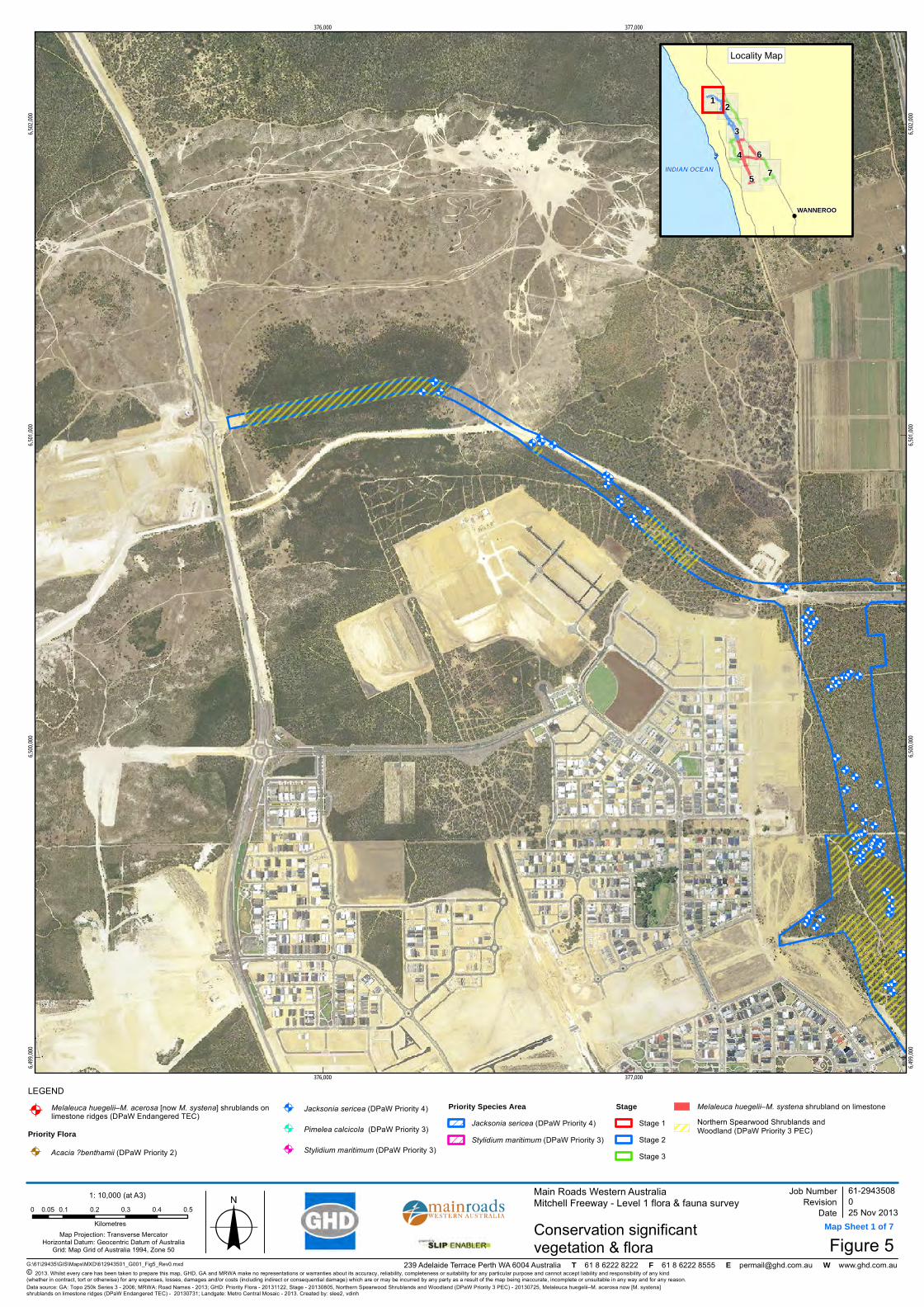
!A
!A
!A!A
!A!A!A !A
!A!A!A!A
!A!A!A
!A!A
!A
!A
!A
!A
!A!A
!A
!A
!A
!A
!A!A
!A!A
!A!A
!A
!A!A
!A
!A
!A!A
!A
!A
!A
!A
!A
!A
!A
!A
!A!A
!A
!A
!A!A!A!A
!A
!A
!A
!A
!A!A
!A
!A
!A
!A!A!A
!A!A
!A
!A
!A
!A
!A
!A
!A
!A
!A!A!A
!A!A
!A
!A !A
376,000
376,000
377,000
377,000
6,499,
000
6,499,
000
6,500,
000
6,500,
000
6,501,
000
6,501,
000
6,502,
000
6,502,
000
G:\61\29435\GIS\Maps\MXD\612943501_G001_Fig5_Rev0.mxd
LEGEND
Map Projection: Transverse MercatorHorizontal Datum: Geocentric Datum of Australia
Grid: Map Grid of Australia 1994, Zone 50
© 2013. Whilst every care has been taken to prepare this map, GHD, GA and MRWA make no representations or warranties about its accuracy, reliability, completeness or suitability for any particular purpose and cannot accept liability and responsibility of any kind (whether in contract, tort or otherwise) for any expenses, losses, damages and/or costs (including indirect or consequential damage) which are or may be incurred by any party as a result of the map being inaccurate, incomplete or unsuitable in any way and for any reason.
Main Roads Western AustraliaMitchell Freeway - Level 1 flora & fauna survey
Figure 5
Job NumberRevision 0
61-2943508
25 Nov 2013Conservation significant vegetation & flora
Date
Data source: GA: Topo 250k Series 3 - 2006; MRWA: Road Names - 2013; GHD: Priority Flora - 20131122, Stage - 20130805, Northern Spearwood Shrublands and Woodland (DPaW Priority 3 PEC) - 20130725, Melaleuca huegelii–M. acerosa now [M. systena]shrublands on limestone ridges (DPaW Endangered TEC) - 20130731; Landgate: Metro Central Mosaic - 2013. Created by: slee2, vdinh
239 Adelaide Terrace Perth WA 6004 Australia T 61 8 6222 8222 F 61 8 6222 8555 E [email protected] W www.ghd.com.au
7
1 2
3
4 6
5
WANNEROO
INDIAN OCEAN
Locality Map
1: 10,000 (at A3)
o0 0.1 0.2 0.3 0.4 0.50.05Kilometres
!AMelaleuca huegelii–M. acerosa [now M. systena] shrublands onlimestone ridges (DPaW Endangered TEC)
Priority Flora
!A Acacia ?benthamii (DPaW Priority 2)
!A Jacksonia sericea (DPaW Priority 4)
!A Pimelea calcicola (DPaW Priority 3)
!A Stylidium maritimum (DPaW Priority 3)
Priority Species AreaJacksonia sericea (DPaW Priority 4) Stylidium maritimum (DPaW Priority 3)
StageStage 1Stage 2Stage 3
Melaleuca huegelii–M. systena shrubland on limestoneNorthern Spearwood Shrublands and Woodland (DPaW Priority 3 PEC)
DRAFT
Map Sheet 1 of 7

!A
!A!A!A!A
!A!A!A
!A!A
!A
!A
!A
!A
!A!A
!A
!A
!A
!A
!A!A
!A!A
!A!A
!A
!A!A
!A
!A
!A!A
!A
!A
!A
!A
!A
!A
!A
!A
!A!A
!A
!A
!A!A!A!A
!A
!A
!A
!A
!A!A
!A
!A
!A
!A!A!A
!A!A
!A
!A
!A
!A
!A
!A
!A
!A
!A!A!A
!A!A
!A
!A!A!A!A
!A!A!A!A!A!A!A
!A!A!A
!A!A!A!A
!A
!A
!A
!A
!A!A
!A
!A
!A
!A
!A
!A!A!A!A
!A
!A!A!A!A
!A!A
!A
!A!A
!A
!A
!A!A
!A!A
!A!A
!A!A
!A!A!A
!A
!A
!A!A!A
!A!A!A!A
!A
!A
!A!A
!A
!A
!A!A !A
!A!A
!A!A!A!A!A!A!A!A!A!A!A!A!A!A!A
!A!A!A!A
!A
!A
!A
!A!A!A!A!A!A!A!A
!A
!A!A!A!A
!A!A!A!A!A!A!A!A!A!A
!A
!A!A
!A!A
!A!A!A
!A!A!A
!A!A!A
!A
!A!A!A!A!A!A
!A!A!A!A!A!A!A!A!A
!A
!A!A!A!A!A!A!A!A!A!A!A!A!A!A!A
!A!A!A!A
!A
!A!A!A
!A!A!A
!A
!A!A!A!A!A!A!A
!A!A!A!A
!A
!A!A!A
!A
!A
!A!A!A!A!A!A!A!A
378,000
378,000
379,000
379,000
6,499,
000
6,499,
000
6,500,
000
6,500,
000
6,501,
000
6,501,
000
G:\61\29435\GIS\Maps\MXD\612943501_G001_Fig5_Rev0.mxd
LEGEND
Map Projection: Transverse MercatorHorizontal Datum: Geocentric Datum of Australia
Grid: Map Grid of Australia 1994, Zone 50
© 2013. Whilst every care has been taken to prepare this map, GHD, GA and MRWA make no representations or warranties about its accuracy, reliability, completeness or suitability for any particular purpose and cannot accept liability and responsibility of any kind (whether in contract, tort or otherwise) for any expenses, losses, damages and/or costs (including indirect or consequential damage) which are or may be incurred by any party as a result of the map being inaccurate, incomplete or unsuitable in any way and for any reason.
Main Roads Western AustraliaMitchell Freeway - Level 1 flora & fauna survey
Figure 5
Job NumberRevision 0
61-2943508
25 Nov 2013Conservation significant vegetation & flora
Date
Data source: GA: Topo 250k Series 3 - 2006; MRWA: Road Names - 2013; GHD: Priority Flora - 20131122, Stage - 20130805, Northern Spearwood Shrublands and Woodland (DPaW Priority 3 PEC) - 20130725, Melaleuca huegelii–M. acerosa now [M. systena]shrublands on limestone ridges (DPaW Endangered TEC) - 20130731; Landgate: Metro Central Mosaic - 2013. Created by: slee2, vdinh
239 Adelaide Terrace Perth WA 6004 Australia T 61 8 6222 8222 F 61 8 6222 8555 E [email protected] W www.ghd.com.au
7
1 2
3
4 6
5
WANNEROO
INDIAN OCEAN
Locality Map
1: 10,000 (at A3)
o0 0.1 0.2 0.3 0.4 0.50.05Kilometres
!AMelaleuca huegelii–M. acerosa [now M. systena] shrublands onlimestone ridges (DPaW Endangered TEC)
Priority Flora
!A Acacia ?benthamii (DPaW Priority 2)
!A Jacksonia sericea (DPaW Priority 4)
!A Pimelea calcicola (DPaW Priority 3)
!A Stylidium maritimum (DPaW Priority 3)
Priority Species AreaJacksonia sericea (DPaW Priority 4) Stylidium maritimum (DPaW Priority 3)
StageStage 1Stage 2Stage 3
Melaleuca huegelii–M. systena shrubland on limestoneNorthern Spearwood Shrublands and Woodland (DPaW Priority 3 PEC)
DRAFT
Map Sheet 2 of 7

!A
!A
!A
!A
!A
!A!A!A
!A!A
!A!A
!A!A!A!A!A!A!A
!A
!A!A
!A
!A
!A!A
!A!A
!A
!A!A
!A!A!A!A
!A!A!A
!A!A
!A
!A
!A
!A!A!A!A!A!A
!A
!A!A!A
!A!A
!A
!A!A
!A
!A
!A!A
!A!A!A!A
!A
!A
!A
!A
!A
!A
!A
!A!A
!A!A!A!A
!A!A
!A
!A!A!A!A
!A
!A
!A
!A
!A
!A
!A
!A!A
!A!A
!A
!A
!A!A!A
!A!A
!A
!A
!A!A
!A!A!A
!A!A!A!A!A!A!A!A!A!A!A!A!A!A!A
!A!A
!A
!A
!A
!A!A!A!A!A!A!A!A
!A
!A!A!A!A
!A
!A!A!A!A!A
!A
!A
!A
!A!A
!A!A!A!A!A!A!A!A!A!A
!A
!A!A
!A!A
!A!A!A
!A!A!A!A!A!A
!A!A!A
!A
!A!A!A!A!A!A
!A!A!A!A!A!A!A!A!A
!A
!A!A!A!A!A!A!A!A!A!A!A!A!A!A!A
!A
!A!A!A!A
!A
!A!A!A
!A!A
!A!A!A!A
!A!A!A!A
!A
!A
!A
!A
!A!A
!A
!A!A!A!A!A
!A
!A
!A
!A
!A
!A
!A!A
!A
!A!A!A!A!A!A!A!A!A!A!A!A!A!A!A!A!A
!A
!A
!A
!A!A
!A
!A!A
!A!A!A
!A!A
!A!A!A!A!A!A
!A
!A!A!A
!A
!A!A!A!A!A!A!A
!A!A!A!A
!A
!A!A!A
!A
!A
!A!A!A!A!A!A!A!A
!A!A!A!A
!A!A!A!A!A!A!A!A!A
Melaleuca huegelii–M. systena shrubland on limestone
379,000
379,000
380,000
380,000
381,000
381,000
6,495,
000
6,495,
000
6,496,
000
6,496,
000
6,497,
000
6,497,
000
6,498,
000
6,498,
000
G:\61\29435\GIS\Maps\MXD\612943501_G001_Fig5_Rev0.mxd
LEGEND
Map Projection: Transverse MercatorHorizontal Datum: Geocentric Datum of Australia
Grid: Map Grid of Australia 1994, Zone 50
© 2013. Whilst every care has been taken to prepare this map, GHD, GA and MRWA make no representations or warranties about its accuracy, reliability, completeness or suitability for any particular purpose and cannot accept liability and responsibility of any kind (whether in contract, tort or otherwise) for any expenses, losses, damages and/or costs (including indirect or consequential damage) which are or may be incurred by any party as a result of the map being inaccurate, incomplete or unsuitable in any way and for any reason.
Main Roads Western AustraliaMitchell Freeway - Level 1 flora & fauna survey
Figure 5
Job NumberRevision 0
61-2943508
25 Nov 2013Conservation significant vegetation & flora
Date
Data source: GA: Topo 250k Series 3 - 2006; MRWA: Road Names - 2013; GHD: Priority Flora - 20131122, Stage - 20130805, Northern Spearwood Shrublands and Woodland (DPaW Priority 3 PEC) - 20130725, Melaleuca huegelii–M. acerosa now [M. systena]shrublands on limestone ridges (DPaW Endangered TEC) - 20130731; Landgate: Metro Central Mosaic - 2013. Created by: slee2, vdinh
239 Adelaide Terrace Perth WA 6004 Australia T 61 8 6222 8222 F 61 8 6222 8555 E [email protected] W www.ghd.com.au
7
1 2
3
4 6
5
WANNEROO
INDIAN OCEAN
Locality Map
1: 10,000 (at A3)
o0 0.1 0.2 0.3 0.4 0.50.05Kilometres
!AMelaleuca huegelii–M. acerosa [now M. systena] shrublands onlimestone ridges (DPaW Endangered TEC)
Priority Flora
!A Acacia ?benthamii (DPaW Priority 2)
!A Jacksonia sericea (DPaW Priority 4)
!A Pimelea calcicola (DPaW Priority 3)
!A Stylidium maritimum (DPaW Priority 3)
Priority Species AreaJacksonia sericea (DPaW Priority 4) Stylidium maritimum (DPaW Priority 3)
StageStage 1Stage 2Stage 3
Melaleuca huegelii–M. systena shrubland on limestoneNorthern Spearwood Shrublands and Woodland (DPaW Priority 3 PEC)
DRAFT
Map Sheet 3 of 7
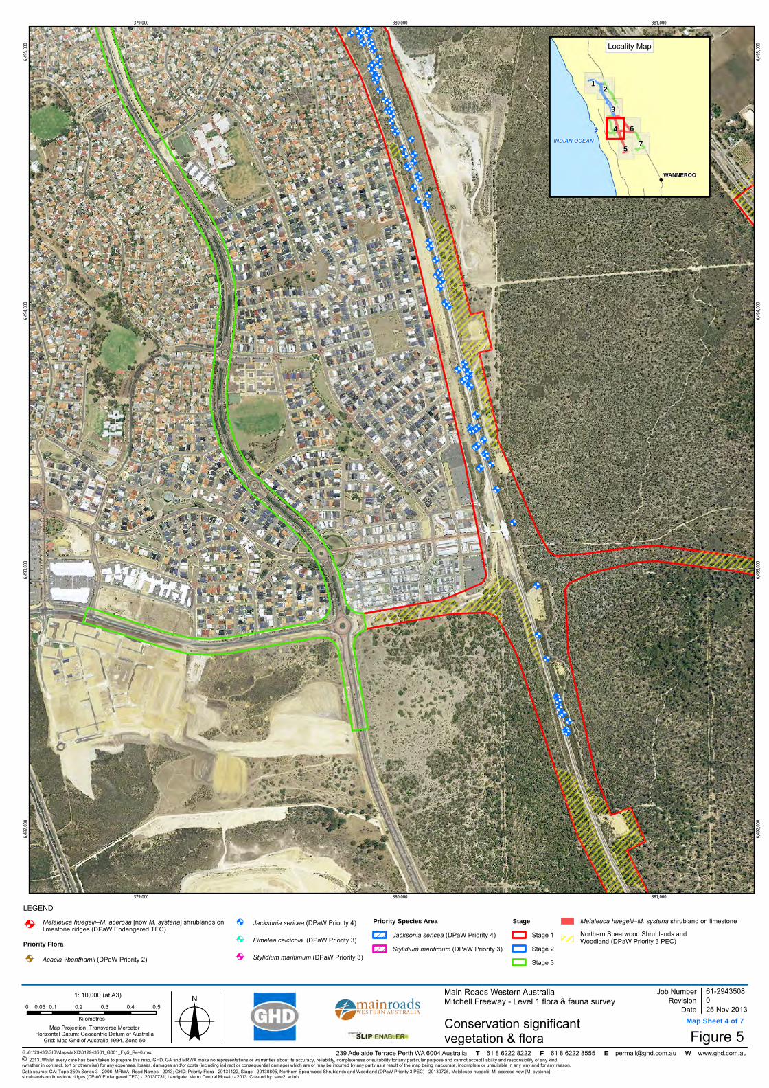
!A!A !A!A!A
!A
!A
!A
!A
!A
!A!A!A!A
!A!A
!A
!A!A!A!A
!A!A
!A
!A
!A
!A!A
!A
!A!A!A
!A!A
!A!A!A
!A!A
!A!A
!A!A
!A!A
!A!A
!A
!A
!A
!A
!A
!A!A
!A!A
!A
!A!A
!A
!A!A
!A!A
!A!A
!A
!A
!A!A!A!A
!A!A
!A!A!A
!A
!A
!A
!A
!A!A
!A
!A!A!A
!A
!A
!A
!A
!A
!A!A!A!A!A!A!A
!A!A
!A
379,000
379,000
380,000
380,000
381,000
381,000
6,492,
000
6,492,
000
6,493,
000
6,493,
000
6,494,
000
6,494,
000
6,495,
000
6,495,
000
G:\61\29435\GIS\Maps\MXD\612943501_G001_Fig5_Rev0.mxd
LEGEND
Map Projection: Transverse MercatorHorizontal Datum: Geocentric Datum of Australia
Grid: Map Grid of Australia 1994, Zone 50
© 2013. Whilst every care has been taken to prepare this map, GHD, GA and MRWA make no representations or warranties about its accuracy, reliability, completeness or suitability for any particular purpose and cannot accept liability and responsibility of any kind (whether in contract, tort or otherwise) for any expenses, losses, damages and/or costs (including indirect or consequential damage) which are or may be incurred by any party as a result of the map being inaccurate, incomplete or unsuitable in any way and for any reason.
Main Roads Western AustraliaMitchell Freeway - Level 1 flora & fauna survey
Figure 5
Job NumberRevision 0
61-2943508
25 Nov 2013Conservation significant vegetation & flora
Date
Data source: GA: Topo 250k Series 3 - 2006; MRWA: Road Names - 2013; GHD: Priority Flora - 20131122, Stage - 20130805, Northern Spearwood Shrublands and Woodland (DPaW Priority 3 PEC) - 20130725, Melaleuca huegelii–M. acerosa now [M. systena]shrublands on limestone ridges (DPaW Endangered TEC) - 20130731; Landgate: Metro Central Mosaic - 2013. Created by: slee2, vdinh
239 Adelaide Terrace Perth WA 6004 Australia T 61 8 6222 8222 F 61 8 6222 8555 E [email protected] W www.ghd.com.au
7
1 2
3
4 6
5
WANNEROO
INDIAN OCEAN
Locality Map
1: 10,000 (at A3)
o0 0.1 0.2 0.3 0.4 0.50.05Kilometres
!AMelaleuca huegelii–M. acerosa [now M. systena] shrublands onlimestone ridges (DPaW Endangered TEC)
Priority Flora
!A Acacia ?benthamii (DPaW Priority 2)
!A Jacksonia sericea (DPaW Priority 4)
!A Pimelea calcicola (DPaW Priority 3)
!A Stylidium maritimum (DPaW Priority 3)
Priority Species AreaJacksonia sericea (DPaW Priority 4) Stylidium maritimum (DPaW Priority 3)
StageStage 1Stage 2Stage 3
Melaleuca huegelii–M. systena shrubland on limestoneNorthern Spearwood Shrublands and Woodland (DPaW Priority 3 PEC)
DRAFT
Map Sheet 4 of 7

!A!A!A!A
!A
!A
!A
!A
!A
!A
!A
381,000
381,000
382,000
382,000
6,489,
000
6,489,
000
6,490,
000
6,490,
000
6,491,
000
6,491,
000
G:\61\29435\GIS\Maps\MXD\612943501_G001_Fig5_Rev0.mxd
LEGEND
Map Projection: Transverse MercatorHorizontal Datum: Geocentric Datum of Australia
Grid: Map Grid of Australia 1994, Zone 50
© 2013. Whilst every care has been taken to prepare this map, GHD, GA and MRWA make no representations or warranties about its accuracy, reliability, completeness or suitability for any particular purpose and cannot accept liability and responsibility of any kind (whether in contract, tort or otherwise) for any expenses, losses, damages and/or costs (including indirect or consequential damage) which are or may be incurred by any party as a result of the map being inaccurate, incomplete or unsuitable in any way and for any reason.
Main Roads Western AustraliaMitchell Freeway - Level 1 flora & fauna survey
Figure 5
Job NumberRevision 0
61-2943508
25 Nov 2013Conservation significant vegetation & flora
Date
Data source: GA: Topo 250k Series 3 - 2006; MRWA: Road Names - 2013; GHD: Priority Flora - 20131122, Stage - 20130805, Northern Spearwood Shrublands and Woodland (DPaW Priority 3 PEC) - 20130725, Melaleuca huegelii–M. acerosa now [M. systena]shrublands on limestone ridges (DPaW Endangered TEC) - 20130731; Landgate: Metro Central Mosaic - 2013. Created by: slee2, vdinh
239 Adelaide Terrace Perth WA 6004 Australia T 61 8 6222 8222 F 61 8 6222 8555 E [email protected] W www.ghd.com.au
7
1 2
3
4 6
5
WANNEROO
INDIAN OCEAN
Locality Map
1: 10,000 (at A3)
o0 0.1 0.2 0.3 0.4 0.50.05Kilometres
!AMelaleuca huegelii–M. acerosa [now M. systena] shrublands onlimestone ridges (DPaW Endangered TEC)
Priority Flora
!A Acacia ?benthamii (DPaW Priority 2)
!A Jacksonia sericea (DPaW Priority 4)
!A Pimelea calcicola (DPaW Priority 3)
!A Stylidium maritimum (DPaW Priority 3)
Priority Species AreaJacksonia sericea (DPaW Priority 4) Stylidium maritimum (DPaW Priority 3)
StageStage 1Stage 2Stage 3
Melaleuca huegelii–M. systena shrubland on limestoneNorthern Spearwood Shrublands and Woodland (DPaW Priority 3 PEC)
DRAFT
Map Sheet 5 of 7

!A !A!A!A!A!A!A!A!A!A
!A
382,000
382,000
383,000
383,000
384,000
384,000
6,492,
000
6,492,
000
6,493,
000
6,493,
000
6,494,
000
6,494,
000
6,495,
000
6,495,
000
G:\61\29435\GIS\Maps\MXD\612943501_G001_Fig5_Rev0.mxd
LEGEND
Map Projection: Transverse MercatorHorizontal Datum: Geocentric Datum of Australia
Grid: Map Grid of Australia 1994, Zone 50
© 2013. Whilst every care has been taken to prepare this map, GHD, GA and MRWA make no representations or warranties about its accuracy, reliability, completeness or suitability for any particular purpose and cannot accept liability and responsibility of any kind (whether in contract, tort or otherwise) for any expenses, losses, damages and/or costs (including indirect or consequential damage) which are or may be incurred by any party as a result of the map being inaccurate, incomplete or unsuitable in any way and for any reason.
Main Roads Western AustraliaMitchell Freeway - Level 1 flora & fauna survey
Figure 5
Job NumberRevision 0
61-2943508
25 Nov 2013Conservation significant vegetation & flora
Date
Data source: GA: Topo 250k Series 3 - 2006; MRWA: Road Names - 2013; GHD: Priority Flora - 20131122, Stage - 20130805, Northern Spearwood Shrublands and Woodland (DPaW Priority 3 PEC) - 20130725, Melaleuca huegelii–M. acerosa now [M. systena]shrublands on limestone ridges (DPaW Endangered TEC) - 20130731; Landgate: Metro Central Mosaic - 2013. Created by: slee2, vdinh
239 Adelaide Terrace Perth WA 6004 Australia T 61 8 6222 8222 F 61 8 6222 8555 E [email protected] W www.ghd.com.au
7
1 2
3
4 6
5
WANNEROO
INDIAN OCEAN
Locality Map
1: 10,000 (at A3)
o0 0.1 0.2 0.3 0.4 0.50.05Kilometres
!AMelaleuca huegelii–M. acerosa [now M. systena] shrublands onlimestone ridges (DPaW Endangered TEC)
Priority Flora
!A Acacia ?benthamii (DPaW Priority 2)
!A Jacksonia sericea (DPaW Priority 4)
!A Pimelea calcicola (DPaW Priority 3)
!A Stylidium maritimum (DPaW Priority 3)
Priority Species AreaJacksonia sericea (DPaW Priority 4) Stylidium maritimum (DPaW Priority 3)
StageStage 1Stage 2Stage 3
Melaleuca huegelii–M. systena shrubland on limestoneNorthern Spearwood Shrublands and Woodland (DPaW Priority 3 PEC)
DRAFT
Map Sheet 6 of 7

!A !A!A!A!A!A!A!A!A!A
!A
383,000
383,000
384,000
384,000
385,000
385,000
6,490,
000
6,490,
000
6,491,
000
6,491,
000
6,492,
000
6,492,
000
G:\61\29435\GIS\Maps\MXD\612943501_G001_Fig5_Rev0.mxd
LEGEND
Map Projection: Transverse MercatorHorizontal Datum: Geocentric Datum of Australia
Grid: Map Grid of Australia 1994, Zone 50
© 2013. Whilst every care has been taken to prepare this map, GHD, GA and MRWA make no representations or warranties about its accuracy, reliability, completeness or suitability for any particular purpose and cannot accept liability and responsibility of any kind (whether in contract, tort or otherwise) for any expenses, losses, damages and/or costs (including indirect or consequential damage) which are or may be incurred by any party as a result of the map being inaccurate, incomplete or unsuitable in any way and for any reason.
Main Roads Western AustraliaMitchell Freeway - Level 1 flora & fauna survey
Figure 5
Job NumberRevision 0
61-2943508
25 Nov 2013Conservation significant vegetation & flora
Date
Data source: GA: Topo 250k Series 3 - 2006; MRWA: Road Names - 2013; GHD: Priority Flora - 20131122, Stage - 20130805, Northern Spearwood Shrublands and Woodland (DPaW Priority 3 PEC) - 20130725, Melaleuca huegelii–M. acerosa now [M. systena]shrublands on limestone ridges (DPaW Endangered TEC) - 20130731; Landgate: Metro Central Mosaic - 2013. Created by: slee2, vdinh
239 Adelaide Terrace Perth WA 6004 Australia T 61 8 6222 8222 F 61 8 6222 8555 E [email protected] W www.ghd.com.au
7
1 2
3
4 6
5
WANNEROO
INDIAN OCEAN
Locality Map
1: 10,000 (at A3)
o0 0.1 0.2 0.3 0.4 0.50.05Kilometres
!AMelaleuca huegelii–M. acerosa [now M. systena] shrublands onlimestone ridges (DPaW Endangered TEC)
Priority Flora
!A Acacia ?benthamii (DPaW Priority 2)
!A Jacksonia sericea (DPaW Priority 4)
!A Pimelea calcicola (DPaW Priority 3)
!A Stylidium maritimum (DPaW Priority 3)
Priority Species AreaJacksonia sericea (DPaW Priority 4) Stylidium maritimum (DPaW Priority 3)
StageStage 1Stage 2Stage 3
Melaleuca huegelii–M. systena shrubland on limestoneNorthern Spearwood Shrublands and Woodland (DPaW Priority 3 PEC)
DRAFT
Map Sheet 7 of 7

376,000
376,000
377,000
377,000
6,499,
000
6,499,
000
6,500,
000
6,500,
000
6,501,
000
6,501,
000
6,502,
000
6,502,
000
G:\61\29435\GIS\Maps\MXD\612943501_G008_Fig06_Rev0.mxd
LEGEND
Map Projection: Transverse MercatorHorizontal Datum: Geocentric Datum of Australia
Grid: Map Grid of Australia 1994, Zone 50
© 2013. Whilst every care has been taken to prepare this map, GHD, GA and MRWA make no representations or warranties about its accuracy, reliability, completeness or suitability for any particular purpose and cannot accept liability and responsibility of any kind (whether in contract, tort or otherwise) for any expenses, losses, damages and/or costs (including indirect or consequential damage) which are or may be incurred by any party as a result of the map being inaccurate, incomplete or unsuitable in any way and for any reason.
Main Roads Western AustraliaMitchell Freeway - Level 1 flora & fauna survey
Figure 6
Job NumberRevision 0
61-2943501
25 Nov 2013Fauna habitat types & conservationsignificant fauna records
Date
Data source: GA: Topo 250k Series 3 - 2006; GHD: Stage - 20131125, Habitat type - 20130730; MRWA: Metro Central Mosaic - 2013, Roads - IRIS network - 2013. Created by: slee2, vdinh
239 Adelaide Terrace Perth WA 6004 Australia T 61 8 6222 8222 F 61 8 6222 8555 E [email protected] W www.ghd.com.au
7
12
3
4 6
5
INDIAN OCEAN
Locality Map
1: 10,000 (at A3)
o0 0.1 0.2 0.3 0.4 0.50.05Kilometres
RoadStage
Stage 1
Stage 2
Stage 3
Habitat typeBanksia sessilis tall schrubland
Banksia woodland
Jarrah–Banksia woodland
Low heatland
Mosaic Banksia woodland and low heathland
Mosaic Banksia woodland and tuart woodland
Tuart woodland
Planted roadside vegetation / highly disturbed / cleared
DRAFT
Map Sheet 1 of 7

378,000
378,000
379,000
379,000
6,499,
000
6,499,
000
6,500,
000
6,500,
000
6,501,
000
6,501,
000
G:\61\29435\GIS\Maps\MXD\612943501_G008_Fig06_Rev0.mxd
LEGEND
Map Projection: Transverse MercatorHorizontal Datum: Geocentric Datum of Australia
Grid: Map Grid of Australia 1994, Zone 50
© 2013. Whilst every care has been taken to prepare this map, GHD, GA and MRWA make no representations or warranties about its accuracy, reliability, completeness or suitability for any particular purpose and cannot accept liability and responsibility of any kind (whether in contract, tort or otherwise) for any expenses, losses, damages and/or costs (including indirect or consequential damage) which are or may be incurred by any party as a result of the map being inaccurate, incomplete or unsuitable in any way and for any reason.
Main Roads Western AustraliaMitchell Freeway - Level 1 flora & fauna survey
Figure 6
Job NumberRevision 0
61-2943501
25 Nov 2013Fauna habitat types & conservationsignificant fauna records
Date
Data source: GA: Topo 250k Series 3 - 2006; GHD: Stage - 20131125, Habitat type - 20130730; MRWA: Metro Central Mosaic - 2013, Roads - IRIS network - 2013. Created by: slee2, vdinh
239 Adelaide Terrace Perth WA 6004 Australia T 61 8 6222 8222 F 61 8 6222 8555 E [email protected] W www.ghd.com.au
7
12
3
4 6
5
INDIAN OCEAN
Locality Map
1: 10,000 (at A3)
o0 0.1 0.2 0.3 0.4 0.50.05Kilometres
RoadStage
Stage 1
Stage 2
Stage 3
Habitat typeBanksia sessilis tall schrubland
Banksia woodland
Jarrah–Banksia woodland
Low heatland
Mosaic Banksia woodland and low heathland
Mosaic Banksia woodland and tuart woodland
Tuart woodland
Planted roadside vegetation / highly disturbed / cleared
DRAFT
Map Sheet 2 of 7

379,000
379,000
380,000
380,000
381,000
381,000
6,495,
000
6,495,
000
6,496,
000
6,496,
000
6,497,
000
6,497,
000
6,498,
000
6,498,
000
G:\61\29435\GIS\Maps\MXD\612943501_G008_Fig06_Rev0.mxd
LEGEND
Map Projection: Transverse MercatorHorizontal Datum: Geocentric Datum of Australia
Grid: Map Grid of Australia 1994, Zone 50
© 2013. Whilst every care has been taken to prepare this map, GHD, GA and MRWA make no representations or warranties about its accuracy, reliability, completeness or suitability for any particular purpose and cannot accept liability and responsibility of any kind (whether in contract, tort or otherwise) for any expenses, losses, damages and/or costs (including indirect or consequential damage) which are or may be incurred by any party as a result of the map being inaccurate, incomplete or unsuitable in any way and for any reason.
Main Roads Western AustraliaMitchell Freeway - Level 1 flora & fauna survey
Figure 6
Job NumberRevision 0
61-2943501
25 Nov 2013Fauna habitat types & conservationsignificant fauna records
Date
Data source: GA: Topo 250k Series 3 - 2006; GHD: Stage - 20131125, Habitat type - 20130730; MRWA: Metro Central Mosaic - 2013, Roads - IRIS network - 2013. Created by: slee2, vdinh
239 Adelaide Terrace Perth WA 6004 Australia T 61 8 6222 8222 F 61 8 6222 8555 E [email protected] W www.ghd.com.au
7
12
3
4 6
5
INDIAN OCEAN
Locality Map
1: 10,000 (at A3)
o0 0.1 0.2 0.3 0.4 0.50.05Kilometres
RoadStage
Stage 1
Stage 2
Stage 3
Habitat typeBanksia sessilis tall schrubland
Banksia woodland
Jarrah–Banksia woodland
Low heatland
Mosaic Banksia woodland and low heathland
Mosaic Banksia woodland and tuart woodland
Tuart woodland
Planted roadside vegetation / highly disturbed / cleared
DRAFT
Map Sheet 3 of 7
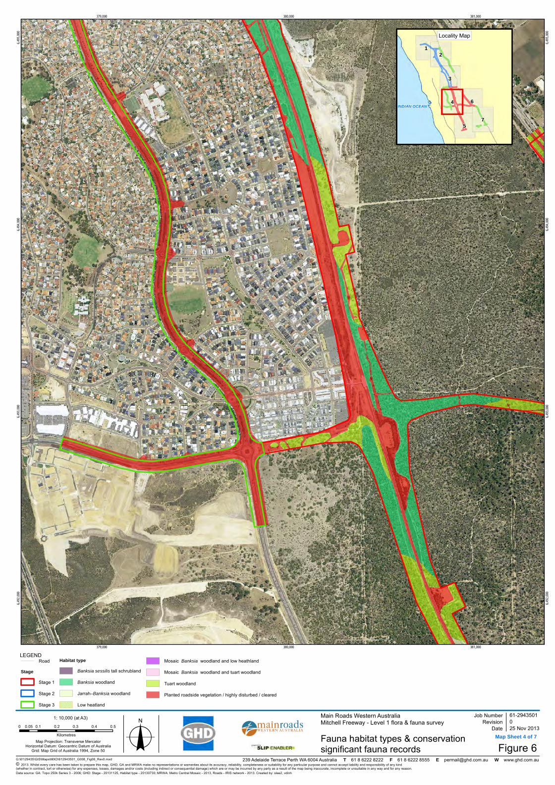
379,000
379,000
380,000
380,000
381,000
381,000
6,492,
000
6,492,
000
6,493,
000
6,493,
000
6,494,
000
6,494,
000
6,495,
000
6,495,
000
G:\61\29435\GIS\Maps\MXD\612943501_G008_Fig06_Rev0.mxd
LEGEND
Map Projection: Transverse MercatorHorizontal Datum: Geocentric Datum of Australia
Grid: Map Grid of Australia 1994, Zone 50
© 2013. Whilst every care has been taken to prepare this map, GHD, GA and MRWA make no representations or warranties about its accuracy, reliability, completeness or suitability for any particular purpose and cannot accept liability and responsibility of any kind (whether in contract, tort or otherwise) for any expenses, losses, damages and/or costs (including indirect or consequential damage) which are or may be incurred by any party as a result of the map being inaccurate, incomplete or unsuitable in any way and for any reason.
Main Roads Western AustraliaMitchell Freeway - Level 1 flora & fauna survey
Figure 6
Job NumberRevision 0
61-2943501
25 Nov 2013Fauna habitat types & conservationsignificant fauna records
Date
Data source: GA: Topo 250k Series 3 - 2006; GHD: Stage - 20131125, Habitat type - 20130730; MRWA: Metro Central Mosaic - 2013, Roads - IRIS network - 2013. Created by: slee2, vdinh
239 Adelaide Terrace Perth WA 6004 Australia T 61 8 6222 8222 F 61 8 6222 8555 E [email protected] W www.ghd.com.au
7
12
3
4 6
5
INDIAN OCEAN
Locality Map
1: 10,000 (at A3)
o0 0.1 0.2 0.3 0.4 0.50.05Kilometres
RoadStage
Stage 1
Stage 2
Stage 3
Habitat typeBanksia sessilis tall schrubland
Banksia woodland
Jarrah–Banksia woodland
Low heatland
Mosaic Banksia woodland and low heathland
Mosaic Banksia woodland and tuart woodland
Tuart woodland
Planted roadside vegetation / highly disturbed / cleared
DRAFT
Map Sheet 4 of 7

381,000
381,000
382,000
382,000
6,489,
000
6,489,
000
6,490,
000
6,490,
000
6,491,
000
6,491,
000
G:\61\29435\GIS\Maps\MXD\612943501_G008_Fig06_Rev0.mxd
LEGEND
Map Projection: Transverse MercatorHorizontal Datum: Geocentric Datum of Australia
Grid: Map Grid of Australia 1994, Zone 50
© 2013. Whilst every care has been taken to prepare this map, GHD, GA and MRWA make no representations or warranties about its accuracy, reliability, completeness or suitability for any particular purpose and cannot accept liability and responsibility of any kind (whether in contract, tort or otherwise) for any expenses, losses, damages and/or costs (including indirect or consequential damage) which are or may be incurred by any party as a result of the map being inaccurate, incomplete or unsuitable in any way and for any reason.
Main Roads Western AustraliaMitchell Freeway - Level 1 flora & fauna survey
Figure 6
Job NumberRevision 0
61-2943501
25 Nov 2013Fauna habitat types & conservationsignificant fauna records
Date
Data source: GA: Topo 250k Series 3 - 2006; GHD: Stage - 20131125, Habitat type - 20130730; MRWA: Metro Central Mosaic - 2013, Roads - IRIS network - 2013. Created by: slee2, vdinh
239 Adelaide Terrace Perth WA 6004 Australia T 61 8 6222 8222 F 61 8 6222 8555 E [email protected] W www.ghd.com.au
7
12
3
4 6
5
INDIAN OCEAN
Locality Map
1: 10,000 (at A3)
o0 0.1 0.2 0.3 0.4 0.50.05Kilometres
RoadStage
Stage 1
Stage 2
Stage 3
Habitat typeBanksia sessilis tall schrubland
Banksia woodland
Jarrah–Banksia woodland
Low heatland
Mosaic Banksia woodland and low heathland
Mosaic Banksia woodland and tuart woodland
Tuart woodland
Planted roadside vegetation / highly disturbed / cleared
DRAFT
Map Sheet 5 of 7

382,000
382,000
383,000
383,000
384,000
384,000
6,492,
000
6,492,
000
6,493,
000
6,493,
000
6,494,
000
6,494,
000
6,495,
000
6,495,
000
G:\61\29435\GIS\Maps\MXD\612943501_G008_Fig06_Rev0.mxd
LEGEND
Map Projection: Transverse MercatorHorizontal Datum: Geocentric Datum of Australia
Grid: Map Grid of Australia 1994, Zone 50
© 2013. Whilst every care has been taken to prepare this map, GHD, GA and MRWA make no representations or warranties about its accuracy, reliability, completeness or suitability for any particular purpose and cannot accept liability and responsibility of any kind (whether in contract, tort or otherwise) for any expenses, losses, damages and/or costs (including indirect or consequential damage) which are or may be incurred by any party as a result of the map being inaccurate, incomplete or unsuitable in any way and for any reason.
Main Roads Western AustraliaMitchell Freeway - Level 1 flora & fauna survey
Figure 6
Job NumberRevision 0
61-2943501
25 Nov 2013Fauna habitat types & conservationsignificant fauna records
Date
Data source: GA: Topo 250k Series 3 - 2006; GHD: Stage - 20131125, Habitat type - 20130730; MRWA: Metro Central Mosaic - 2013, Roads - IRIS network - 2013. Created by: slee2, vdinh
239 Adelaide Terrace Perth WA 6004 Australia T 61 8 6222 8222 F 61 8 6222 8555 E [email protected] W www.ghd.com.au
7
12
3
4 6
5
INDIAN OCEAN
Locality Map
1: 10,000 (at A3)
o0 0.1 0.2 0.3 0.4 0.50.05Kilometres
RoadStage
Stage 1
Stage 2
Stage 3
Habitat typeBanksia sessilis tall schrubland
Banksia woodland
Jarrah–Banksia woodland
Low heatland
Mosaic Banksia woodland and low heathland
Mosaic Banksia woodland and tuart woodland
Tuart woodland
Planted roadside vegetation / highly disturbed / cleared
DRAFT
Map Sheet 6 of 7

383,000
383,000
384,000
384,000
385,000
385,000
6,490,
000
6,490,
000
6,491,
000
6,491,
000
6,492,
000
6,492,
000
G:\61\29435\GIS\Maps\MXD\612943501_G008_Fig06_Rev0.mxd
LEGEND
Map Projection: Transverse MercatorHorizontal Datum: Geocentric Datum of Australia
Grid: Map Grid of Australia 1994, Zone 50
© 2013. Whilst every care has been taken to prepare this map, GHD, GA and MRWA make no representations or warranties about its accuracy, reliability, completeness or suitability for any particular purpose and cannot accept liability and responsibility of any kind (whether in contract, tort or otherwise) for any expenses, losses, damages and/or costs (including indirect or consequential damage) which are or may be incurred by any party as a result of the map being inaccurate, incomplete or unsuitable in any way and for any reason.
Main Roads Western AustraliaMitchell Freeway - Level 1 flora & fauna survey
Figure 6
Job NumberRevision 0
61-2943501
25 Nov 2013Fauna habitat types & conservationsignificant fauna records
Date
Data source: GA: Topo 250k Series 3 - 2006; GHD: Stage - 20131125, Habitat type - 20130730; MRWA: Metro Central Mosaic - 2013, Roads - IRIS network - 2013. Created by: slee2, vdinh
239 Adelaide Terrace Perth WA 6004 Australia T 61 8 6222 8222 F 61 8 6222 8555 E [email protected] W www.ghd.com.au
7
12
3
4 6
5
INDIAN OCEAN
Locality Map
1: 10,000 (at A3)
o0 0.1 0.2 0.3 0.4 0.50.05Kilometres
RoadStage
Stage 1
Stage 2
Stage 3
Habitat typeBanksia sessilis tall schrubland
Banksia woodland
Jarrah–Banksia woodland
Low heatland
Mosaic Banksia woodland and low heathland
Mosaic Banksia woodland and tuart woodland
Tuart woodland
Planted roadside vegetation / highly disturbed / cleared
DRAFT
Map Sheet 7 of 7

GHD | Report for Main Roads Western Australia - Mitchell Freeway extension: Burns Beach Rd to Romeo Rd, 61/29435
Appendix B – Desktop searches Environment Protection and Biodiversity Conservation Act 1999 Protected Matters Search Tool results
NatureMap flora search results
NatureMap fauna search results

EPBC Act Protected Matters Report
This report provides general guidance on matters of national environmental significance and othermatters protected by the EPBC Act in the area you have selected.
Information on the coverage of this report and qualifications on data supporting this report arecontained in the caveat at the end of the report.
Information is available about Environment Assessments and the EPBC Act including significanceguidelines, forms and application process details.
Other Matters Protected by the EPBC Act
Acknowledgements
Buffer: 10.0Km
Matters of NES
Report created: 29/05/13 17:05:14
Coordinates
This map may contain data which are©Commonwealth of Australia(Geoscience Australia), ©PSMA 2010
CaveatExtra Information
DetailsSummary

Summary
This part of the report summarises the matters of national environmental significance that may occurin, or may relate to, the area you nominated. Further information is available in the detail part of thereport, which can be accessed by scrolling or following the links below. If you are proposing toundertake an activity that may have a significant impact on one or more matters of nationalenvironmental significance then you should consider the Administrative Guidelines on Significance.
Matters of National Environmental Significance
Listed Threatened Ecological Communities:
Listed Migratory Species:
2
Great Barrier Reef Marine Park:
Wetlands of International Importance:
Listed Threatened Species:
None
47
None
None
National Heritage Places:
Commonwealth Marine Areas:
World Heritage Properties:
None
1
36
This part of the report summarises other matters protected under the Act that may relate to the areayou nominated. Approval may be required for a proposed activity that significantly affects theenvironment on Commonwealth land, when the action is outside the Commonwealth land, or theenvironment anywhere when the action is taken on Commonwealth land. Approval may also berequired for the Commonwealth or Commonwealth agencies proposing to take an action that is likelyto have a significant impact on the environment anywhere.
The EPBC Act protects the environment on Commonwealth land, the environment from the actionstaken on Commonwealth land, and the environment from actions taken by Commonwealth agencies.As heritage values of a place are part of the 'environment', these aspects of the EPBC Act protect theCommonwealth Heritage values of a Commonwealth Heritage place and the heritage values of aplace on the Register of the National Estate.
This part of the report summarises other matters protected under the Act that may relate to the areayou nominated. Approval may be required for a proposed activity that significantly affects theenvironment on Commonwealth land, when the action is outside the Commonwealth land, or theenvironment anywhere when the action is taken on Commonwealth land. Approval may also berequired for the Commonwealth or Commonwealth agencies proposing to take an action that is likelyto have a significant impact on the environment anywhere.
A permit may be required for activities in or on a Commonwealth area that may affect a member of alisted threatened species or ecological community, a member of a listed migratory species, whalesand other cetaceans, or a member of a listed marine species.
Other Matters Protected by the EPBC Act
None
None
13
Listed Marine Species:
Whales and Other Cetaceans:
62
Commonwealth Heritage Places:
2
1
Critical Habitats:
Commonwealth Land:
Commonwealth Reserves:

This part of the report provides information that may also be relevant to the area you have nominated.
Extra Information
Regional Forest Agreements:
41
Place on the RNE:
10
2
Invasive Species:
None
Nationally Important Wetlands:
State and Territory Reserves:
24
Key Ecological Features (Marine) 2
Details
Listed Threatened Species [ Resource Information ]Name Status Type of PresenceBirds
Australian Lesser Noddy [26000] Vulnerable Species or specieshabitat may occur withinarea
Anous tenuirostris melanops
Australasian Bittern [1001] Endangered Species or specieshabitat likely to occurwithin area
Botaurus poiciloptilus
Baudin's Black-Cockatoo, Long-billed Black-Cockatoo [769]
Vulnerable Species or specieshabitat likely to occurwithin area
Calyptorhynchus baudinii
Commonwealth Marine Areas [ Resource Information ]
Name
Approval may be required for a proposed activity that is likely to have a significant impact on theenvironment in a Commonwealth Marine Area, when the action is outside the Commonwealth MarineArea, or the environment anywhere when the action is taken within the Commonwealth Marine Area.Generally the Commonwealth Marine Area stretches from three nautical miles to two hundrednautical miles from the coast.
EEZ and Territorial Sea
For threatened ecological communities where the distribution is well known, maps are derived fromrecovery plans, State vegetation maps, remote sensing imagery and other sources. Where threatenedecological community distributions are less well known, existing vegetation maps and point locationdata are used to produce indicative distribution maps.
Listed Threatened Ecological Communities [ Resource Information ]
Name Status Type of PresenceAquatic Root Mat Community in Caves of theSwan Coastal Plain
Endangered Community known tooccur within area
Sedgelands in Holocene dune swales of thesouthern Swan Coastal Plain
Endangered Community known tooccur within area
Matters of National Environmental Significance
If you are planning to undertake action in an area in or close to a Commonwealth Marine Area, and amarine bioregional plan has been prepared for the Commonwealth Marine Area in that area, themarine bioregional plan may inform your decision as to whether to refer your proposed action underthe EPBC Act.
Marine Regions [ Resource Information ]
NameSouth-west
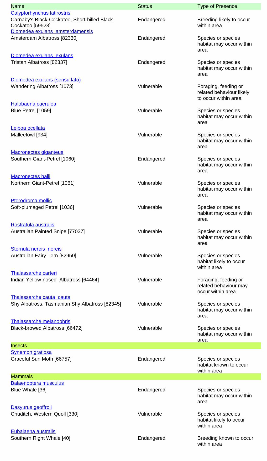
Name Status Type of Presence
Carnaby's Black-Cockatoo, Short-billed Black-Cockatoo [59523]
Endangered Breeding likely to occurwithin area
Calyptorhynchus latirostris
Amsterdam Albatross [82330] Endangered Species or specieshabitat may occur withinarea
Diomedea exulans amsterdamensis
Tristan Albatross [82337] Endangered Species or specieshabitat may occur withinarea
Diomedea exulans exulans
Wandering Albatross [1073] Vulnerable Foraging, feeding orrelated behaviour likelyto occur within area
Diomedea exulans (sensu lato)
Blue Petrel [1059] Vulnerable Species or specieshabitat may occur withinarea
Halobaena caerulea
Malleefowl [934] Vulnerable Species or specieshabitat may occur withinarea
Leipoa ocellata
Southern Giant-Petrel [1060] Endangered Species or specieshabitat may occur withinarea
Macronectes giganteus
Northern Giant-Petrel [1061] Vulnerable Species or specieshabitat may occur withinarea
Macronectes halli
Soft-plumaged Petrel [1036] Vulnerable Species or specieshabitat may occur withinarea
Pterodroma mollis
Australian Painted Snipe [77037] Vulnerable Species or specieshabitat may occur withinarea
Rostratula australis
Australian Fairy Tern [82950] Vulnerable Species or specieshabitat likely to occurwithin area
Sternula nereis nereis
Indian Yellow-nosed Albatross [64464] Vulnerable Foraging, feeding orrelated behaviour mayoccur within area
Thalassarche carteri
Shy Albatross, Tasmanian Shy Albatross [82345] Vulnerable Species or specieshabitat may occur withinarea
Thalassarche cauta cauta
Black-browed Albatross [66472] Vulnerable Species or specieshabitat may occur withinarea
Thalassarche melanophris
Insects
Graceful Sun Moth [66757] Endangered Species or specieshabitat known to occurwithin area
Synemon gratiosa
Mammals
Blue Whale [36] Endangered Species or specieshabitat may occur withinarea
Balaenoptera musculus
Chuditch, Western Quoll [330] Vulnerable Species or specieshabitat likely to occurwithin area
Dasyurus geoffroii
Southern Right Whale [40] Endangered Breeding known to occurwithin area
Eubalaena australis

Name Status Type of Presence
Humpback Whale [38] Vulnerable Species or specieshabitat known to occurwithin area
Megaptera novaeangliae
Australian Sea-lion [22] Vulnerable Foraging, feeding orrelated behaviour likelyto occur within area
Neophoca cinerea
Plants
Slender Andersonia [14470] Endangered Species or specieshabitat may occur withinarea
Andersonia gracilis
Dwarf Green Kangaroo Paw [3435] Vulnerable Species or specieshabitat likely to occurwithin area
Anigozanthos viridis subsp. terraspectans
King Spider-orchid, Grand Spider-orchid, RustySpider-orchid [7309]
Endangered Species or specieshabitat likely to occurwithin area
Caladenia huegelii
[6393] Endangered Species or specieshabitat likely to occurwithin area
Centrolepis caespitosa
Muchea Bell [83190] Critically Endangered Species or specieshabitat likely to occurwithin area
Darwinia foetida
Dwarf Bee-orchid [55082] Vulnerable Species or specieshabitat likely to occurwithin area
Diuris micrantha
Purdie's Donkey-orchid [12950] Endangered Species or specieshabitat may occur withinarea
Diuris purdiei
Glossy-leafed Hammer-orchid, Praying Virgin[16753]
Endangered Species or specieshabitat likely to occurwithin area
Drakaea elastica
Dwarf Hammer-orchid [56755] Vulnerable Species or specieshabitat may occur withinarea
Drakaea micrantha
Baby Blue Orchid, Blue Babe-in-the-cradleOrchid, Blue Babe-in-a-cradle [67182]
Endangered Species or specieshabitat may occur withinarea
Epiblema grandiflorum var. cyaneum
Yanchep Mallee, Wabling Hill Mallee [24263] Vulnerable Species or specieshabitat likely to occurwithin area
Eucalyptus argutifolia
Curved-leaf Grevillea [64908] Endangered Species or specieshabitat likely to occurwithin area
Grevillea curviloba subsp. curviloba
Narrow curved-leaf Grevillea [64909] Endangered Species or specieshabitat may occur withinarea
Grevillea curviloba subsp. incurva
Hook-leaf Isopogon [20871] Endangered Species or specieshabitat may occur withinarea
Isopogon uncinatus
Beaked Lepidosperma [14152] Endangered Species or specieshabitat likely to occurwithin area
Lepidosperma rostratum
[67443] Endangered Species or specieshabitat likely to occurwithin area
Thelymitra manginii K.Dixon & Batty ms.

Name Status Type of Presence
Mountain Villarsia [10886] Endangered Species or specieshabitat likely to occurwithin area
Villarsia calthifolia
Reptiles
Loggerhead Turtle [1763] Endangered Foraging, feeding orrelated behaviour knownto occur within area
Caretta caretta
Green Turtle [1765] Vulnerable Foraging, feeding orrelated behaviour knownto occur within area
Chelonia mydas
Leatherback Turtle, Leathery Turtle, Luth [1768] Endangered Foraging, feeding orrelated behaviour knownto occur within area
Dermochelys coriacea
Flatback Turtle [59257] Vulnerable Foraging, feeding orrelated behaviour knownto occur within area
Natator depressus
Sharks
Grey Nurse Shark (west coast population) [68752] Vulnerable Species or specieshabitat may occur withinarea
Carcharias taurus (west coast population)
Great White Shark [64470] Vulnerable Species or specieshabitat may occur withinarea
Carcharodon carcharias
Whale Shark [66680] Vulnerable Species or specieshabitat may occur withinarea
Rhincodon typus
Listed Migratory Species [ Resource Information ]* Species is listed under a different scientific name on the EPBC Act - Threatened Species list.Name Threatened Type of PresenceMigratory Marine Birds
Fork-tailed Swift [678] Species or specieshabitat likely to occurwithin area
Apus pacificus
Amsterdam Albatross [64405] Endangered* Species or specieshabitat may occur withinarea
Diomedea amsterdamensis
Tristan Albatross [66471] Endangered* Species or specieshabitat may occur withinarea
Diomedea dabbenena
Wandering Albatross [1073] Vulnerable Foraging, feeding orrelated behaviour likelyto occur within area
Diomedea exulans (sensu lato)
Southern Giant-Petrel [1060] Endangered Species or specieshabitat may occur withinarea
Macronectes giganteus
Northern Giant-Petrel [1061] Vulnerable Species or specieshabitat may occur withinarea
Macronectes halli
Flesh-footed Shearwater, Fleshy-footedShearwater [1043]
Species or specieshabitat likely to occurwithin area
Puffinus carneipes
Bridled Tern [814] Breeding known to occurwithin area
Sterna anaethetus
Caspian Tern [59467] Foraging, feeding orSterna caspia

Name Threatened Type of Presencerelated behaviour knownto occur within area
Roseate Tern [817] Foraging, feeding orrelated behaviour likelyto occur within area
Sterna dougallii
Indian Yellow-nosed Albatross [64464] Vulnerable Foraging, feeding orrelated behaviour mayoccur within area
Thalassarche carteri
Shy Albatross, Tasmanian Shy Albatross [64697] Vulnerable* Species or specieshabitat may occur withinarea
Thalassarche cauta (sensu stricto)
Black-browed Albatross [66472] Vulnerable Species or specieshabitat may occur withinarea
Thalassarche melanophris
Migratory Marine Species
Bryde's Whale [35] Species or specieshabitat may occur withinarea
Balaenoptera edeni
Blue Whale [36] Endangered Species or specieshabitat may occur withinarea
Balaenoptera musculus
Pygmy Right Whale [39] Species or specieshabitat may occur withinarea
Caperea marginata
Great White Shark [64470] Vulnerable Species or specieshabitat may occur withinarea
Carcharodon carcharias
Loggerhead Turtle [1763] Endangered Foraging, feeding orrelated behaviour knownto occur within area
Caretta caretta
Green Turtle [1765] Vulnerable Foraging, feeding orrelated behaviour knownto occur within area
Chelonia mydas
Leatherback Turtle, Leathery Turtle, Luth [1768] Endangered Foraging, feeding orrelated behaviour knownto occur within area
Dermochelys coriacea
Southern Right Whale [40] Endangered Breeding known to occurwithin area
Eubalaena australis
Dusky Dolphin [43] Species or specieshabitat may occur withinarea
Lagenorhynchus obscurus
Porbeagle, Mackerel Shark [83288] Species or specieshabitat may occur withinarea
Lamna nasus
Humpback Whale [38] Vulnerable Species or specieshabitat known to occurwithin area
Megaptera novaeangliae
Flatback Turtle [59257] Vulnerable Foraging, feeding orrelated behaviour knownto occur within area
Natator depressus
Killer Whale, Orca [46] Species or specieshabitat may occur withinarea
Orcinus orca
Whale Shark [66680] Vulnerable Species or specieshabitat may occur within
Rhincodon typus

Name Threatened Type of Presencearea
Migratory Terrestrial Species
White-bellied Sea-Eagle [943] Species or specieshabitat known to occurwithin area
Haliaeetus leucogaster
Malleefowl [934] Vulnerable Species or specieshabitat may occur withinarea
Leipoa ocellata
Rainbow Bee-eater [670] Species or specieshabitat may occur withinarea
Merops ornatus
Migratory Wetlands Species
Great Egret, White Egret [59541] Species or specieshabitat known to occurwithin area
Ardea alba
Cattle Egret [59542] Species or specieshabitat likely to occurwithin area
Ardea ibis
Sharp-tailed Sandpiper [874] Species or specieshabitat known to occurwithin area
Calidris acuminata
Red-necked Stint [860] Species or specieshabitat known to occurwithin area
Calidris ruficollis
Painted Snipe [889] Vulnerable* Species or specieshabitat may occur withinarea
Rostratula benghalensis (sensu lato)
Wood Sandpiper [829] Species or specieshabitat known to occurwithin area
Tringa glareola
Listed Marine Species [ Resource Information ]* Species is listed under a different scientific name on the EPBC Act - Threatened Species list.Name Threatened Type of PresenceBirds
Australian Lesser Noddy [26000] Vulnerable Species or specieshabitat may occur withinarea
Anous tenuirostris melanops
Fork-tailed Swift [678] Species or specieshabitat likely to occurwithin area
Apus pacificus
Great Egret, White Egret [59541] Species or specieshabitat known to occur
Ardea alba
Commonwealth Land [ Resource Information ]The Commonwealth area listed below may indicate the presence of Commonwealth land in thisvicinity. Due to the unreliability of the data source, all proposals should be checked as to whether itimpacts on a Commonwealth area, before making a definitive decision. Contact the State or Territorygovernment land department for further information.
NameCommonwealth Land -Defence - MUCHEA ARMAMENT RANGE
Commonwealth Heritage Places [ Resource Information ]Name StatusStateNatural
Indicative PlaceMuchea / Pearce Air Weapons Range WA
Other Matters Protected by the EPBC Act

Name Threatened Type of Presencewithin area
Cattle Egret [59542] Species or specieshabitat likely to occurwithin area
Ardea ibis
Sharp-tailed Sandpiper [874] Species or specieshabitat known to occurwithin area
Calidris acuminata
Red-necked Stint [860] Species or specieshabitat known to occurwithin area
Calidris ruficollis
Long-toed Stint [861] Species or specieshabitat known to occurwithin area
Calidris subminuta
Great Skua [59472] Species or specieshabitat may occur withinarea
Catharacta skua
Red-capped Plover [881] Species or specieshabitat known to occurwithin area
Charadrius ruficapillus
Amsterdam Albatross [64405] Endangered* Species or specieshabitat may occur withinarea
Diomedea amsterdamensis
Tristan Albatross [66471] Endangered* Species or specieshabitat may occur withinarea
Diomedea dabbenena
Wandering Albatross [1073] Vulnerable Foraging, feeding orrelated behaviour likelyto occur within area
Diomedea exulans (sensu lato)
White-bellied Sea-Eagle [943] Species or specieshabitat known to occurwithin area
Haliaeetus leucogaster
Blue Petrel [1059] Vulnerable Species or specieshabitat may occur withinarea
Halobaena caerulea
Black-winged Stilt [870] Species or specieshabitat known to occurwithin area
Himantopus himantopus
Silver Gull [810] Breeding known to occurwithin area
Larus novaehollandiae
Pacific Gull [811] Foraging, feeding orrelated behaviour mayoccur within area
Larus pacificus
Southern Giant-Petrel [1060] Endangered Species or specieshabitat may occur withinarea
Macronectes giganteus
Northern Giant-Petrel [1061] Vulnerable Species or specieshabitat may occur withinarea
Macronectes halli
Rainbow Bee-eater [670] Species or specieshabitat may occur withinarea
Merops ornatus
Osprey [952] Species or specieshabitat known to occurwithin area
Pandion haliaetus

Name Threatened Type of Presence
Soft-plumaged Petrel [1036] Vulnerable Species or specieshabitat may occur withinarea
Pterodroma mollis
Little Shearwater [59363] Foraging, feeding orrelated behaviour knownto occur within area
Puffinus assimilis
Flesh-footed Shearwater, Fleshy-footedShearwater [1043]
Species or specieshabitat likely to occurwithin area
Puffinus carneipes
Red-necked Avocet [871] Species or specieshabitat known to occurwithin area
Recurvirostra novaehollandiae
Painted Snipe [889] Vulnerable* Species or specieshabitat may occur withinarea
Rostratula benghalensis (sensu lato)
Bridled Tern [814] Breeding known to occurwithin area
Sterna anaethetus
Caspian Tern [59467] Foraging, feeding orrelated behaviour knownto occur within area
Sterna caspia
Roseate Tern [817] Foraging, feeding orrelated behaviour likelyto occur within area
Sterna dougallii
Indian Yellow-nosed Albatross [64464] Vulnerable Foraging, feeding orrelated behaviour mayoccur within area
Thalassarche carteri
Shy Albatross, Tasmanian Shy Albatross [64697] Vulnerable* Species or specieshabitat may occur withinarea
Thalassarche cauta (sensu stricto)
Black-browed Albatross [66472] Vulnerable Species or specieshabitat may occur withinarea
Thalassarche melanophris
Wood Sandpiper [829] Species or specieshabitat known to occurwithin area
Tringa glareola
Fish
Southern Pygmy Pipehorse [66185] Species or specieshabitat may occur withinarea
Acentronura australe
Gale's Pipefish [66191] Species or specieshabitat may occur withinarea
Campichthys galei
Pig-snouted Pipefish [66198] Species or specieshabitat may occur withinarea
Choeroichthys suillus
Brock's Pipefish [66219] Species or specieshabitat may occur withinarea
Halicampus brocki
Western Spiny Seahorse, Narrow-bellied Seahorse[66234]
Species or specieshabitat may occur withinarea
Hippocampus angustus
Short-head Seahorse, Short-snouted Seahorse[66235]
Species or specieshabitat may occur withinarea
Hippocampus breviceps

Name Threatened Type of Presence
West Australian Seahorse [66722] Species or specieshabitat may occur withinarea
Hippocampus subelongatus
Prophet's Pipefish [66250] Species or specieshabitat may occur withinarea
Lissocampus fatiloquus
Sawtooth Pipefish [66252] Species or specieshabitat may occur withinarea
Maroubra perserrata
Western Crested Pipefish [66259] Species or specieshabitat may occur withinarea
Mitotichthys meraculus
Bonyhead Pipefish, Bony-headed Pipefish [66264] Species or specieshabitat may occur withinarea
Nannocampus subosseus
Leafy Seadragon [66267] Species or specieshabitat may occur withinarea
Phycodurus eques
Common Seadragon, Weedy Seadragon [66268] Species or specieshabitat may occur withinarea
Phyllopteryx taeniolatus
Pugnose Pipefish, Pug-nosed Pipefish [66269] Species or specieshabitat may occur withinarea
Pugnaso curtirostris
Gunther's Pipehorse, Indonesian Pipefish [66273] Species or specieshabitat may occur withinarea
Solegnathus lettiensis
Spotted Pipefish, Gulf Pipefish [66276] Species or specieshabitat may occur withinarea
Stigmatopora argus
Widebody Pipefish, Wide-bodied Pipefish, BlackPipefish [66277]
Species or specieshabitat may occur withinarea
Stigmatopora nigra
Double-end Pipehorse, Double-ended Pipehorse,Alligator Pipefish [66279]
Species or specieshabitat may occur withinarea
Syngnathoides biaculeatus
Hairy Pipefish [66282] Species or specieshabitat may occur withinarea
Urocampus carinirostris
Mother-of-pearl Pipefish [66283] Species or specieshabitat may occur withinarea
Vanacampus margaritifer
Mammals
New Zealand Fur-seal [20] Species or specieshabitat may occur withinarea
Arctocephalus forsteri
Australian Sea-lion [22] Vulnerable Foraging, feeding orrelated behaviour likelyto occur within area
Neophoca cinerea
Reptiles
Shark Bay Seasnake [66061] Species or specieshabitat may occur withinarea
Aipysurus pooleorum
Loggerhead Turtle [1763] Endangered Foraging, feeding orrelated behaviour known
Caretta caretta
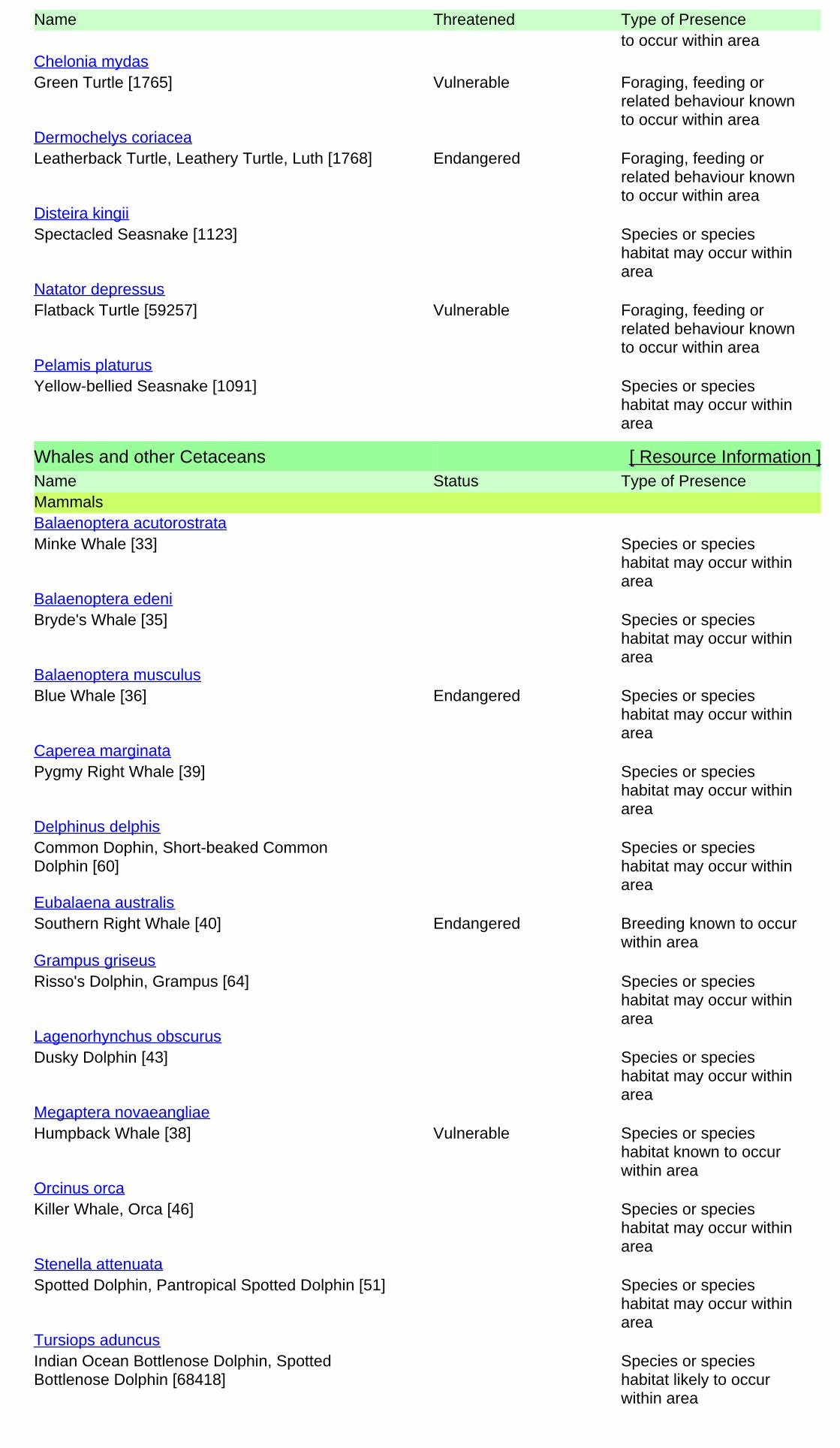
Name Threatened Type of Presenceto occur within area
Green Turtle [1765] Vulnerable Foraging, feeding orrelated behaviour knownto occur within area
Chelonia mydas
Leatherback Turtle, Leathery Turtle, Luth [1768] Endangered Foraging, feeding orrelated behaviour knownto occur within area
Dermochelys coriacea
Spectacled Seasnake [1123] Species or specieshabitat may occur withinarea
Disteira kingii
Flatback Turtle [59257] Vulnerable Foraging, feeding orrelated behaviour knownto occur within area
Natator depressus
Yellow-bellied Seasnake [1091] Species or specieshabitat may occur withinarea
Pelamis platurus
Whales and other Cetaceans [ Resource Information ]Name Status Type of PresenceMammals
Minke Whale [33] Species or specieshabitat may occur withinarea
Balaenoptera acutorostrata
Bryde's Whale [35] Species or specieshabitat may occur withinarea
Balaenoptera edeni
Blue Whale [36] Endangered Species or specieshabitat may occur withinarea
Balaenoptera musculus
Pygmy Right Whale [39] Species or specieshabitat may occur withinarea
Caperea marginata
Common Dophin, Short-beaked CommonDolphin [60]
Species or specieshabitat may occur withinarea
Delphinus delphis
Southern Right Whale [40] Endangered Breeding known to occurwithin area
Eubalaena australis
Risso's Dolphin, Grampus [64] Species or specieshabitat may occur withinarea
Grampus griseus
Dusky Dolphin [43] Species or specieshabitat may occur withinarea
Lagenorhynchus obscurus
Humpback Whale [38] Vulnerable Species or specieshabitat known to occurwithin area
Megaptera novaeangliae
Killer Whale, Orca [46] Species or specieshabitat may occur withinarea
Orcinus orca
Spotted Dolphin, Pantropical Spotted Dolphin [51] Species or specieshabitat may occur withinarea
Stenella attenuata
Indian Ocean Bottlenose Dolphin, SpottedBottlenose Dolphin [68418]
Species or specieshabitat likely to occurwithin area
Tursiops aduncus

Name Status Type of Presence
Bottlenose Dolphin [68417] Species or specieshabitat may occur withinarea
Tursiops truncatus s. str.
State and Territory Reserves [ Resource Information ]Name StateJandabup WALake Joondalup WAMarmion WANeerabup WANeerabup WAUnnamed WA21176 WAUnnamed WA43290 WAUnnamedW A46926 WAWoodvale Nature Reserve WAYanchep WA
Extra Information
Places on the RNE [ Resource Information ]
Note that not all Indigenous sites may be listed.
Name StatusStateNatural
Indicative PlaceMarmion Marine Park WAIndicative PlaceMuchea / Pearce Air Weapons Range WAIndicative PlaceRidges Management Priority Area WAIndicative PlaceRidges Management Priority Area and State Forest No 65 WAIndicative PlaceWanneroo Wetlands Eastern Chain WAIndicative PlaceWhitfords Coastal Strip WAInterim ListHepburn Heights - Pinnaroo Park Area WARegisteredJandabup Lake Nature Reserve WARegisteredLake Joondalup Reserves WARegisteredNeerabup National Park WARegisteredNowergup Lake Fauna Reserve WARegisteredWanneroo Research Station WARegisteredYanchep National Park WARegisteredYeal - Gnangara Area WA
IndigenousIndicative PlaceDoogarch Site WARegisteredOrchestra Shell Cave WARegisteredWanneroo Scarred Tree WA
HistoricRegisteredAdministration Building Yanchep National Park WARegisteredCockman House WARegisteredConcrete Bunkers WARegisteredEglinton Shipwreck WARegisteredGloucester Lodge including Garden and Pool WARegisteredMcNess House WARegisteredYanchep Inn and Garden WA
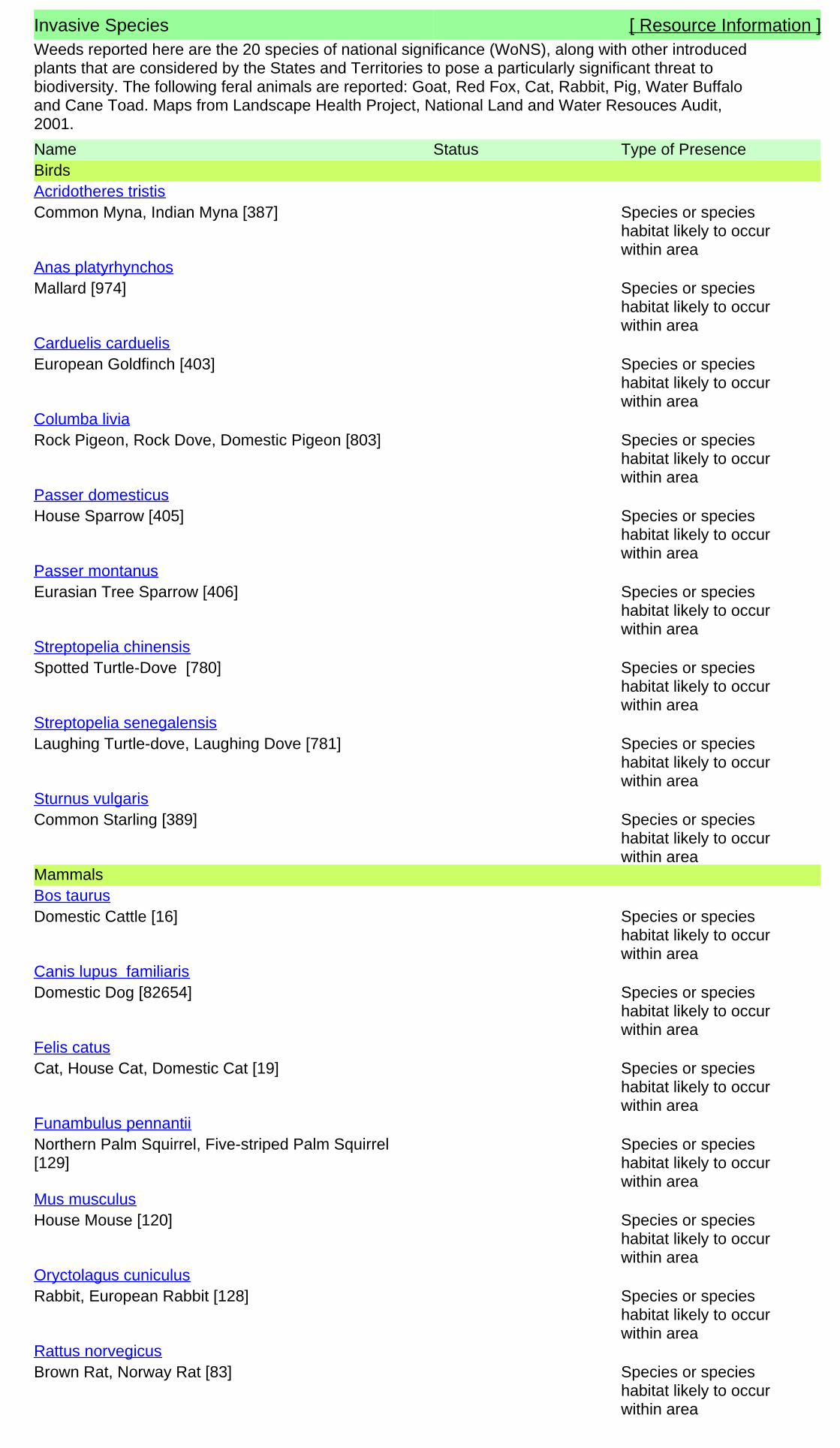
Invasive Species [ Resource Information ]Weeds reported here are the 20 species of national significance (WoNS), along with other introducedplants that are considered by the States and Territories to pose a particularly significant threat tobiodiversity. The following feral animals are reported: Goat, Red Fox, Cat, Rabbit, Pig, Water Buffaloand Cane Toad. Maps from Landscape Health Project, National Land and Water Resouces Audit,2001.
Name Status Type of PresenceBirds
Common Myna, Indian Myna [387] Species or specieshabitat likely to occurwithin area
Acridotheres tristis
Mallard [974] Species or specieshabitat likely to occurwithin area
Anas platyrhynchos
European Goldfinch [403] Species or specieshabitat likely to occurwithin area
Carduelis carduelis
Rock Pigeon, Rock Dove, Domestic Pigeon [803] Species or specieshabitat likely to occurwithin area
Columba livia
House Sparrow [405] Species or specieshabitat likely to occurwithin area
Passer domesticus
Eurasian Tree Sparrow [406] Species or specieshabitat likely to occurwithin area
Passer montanus
Spotted Turtle-Dove [780] Species or specieshabitat likely to occurwithin area
Streptopelia chinensis
Laughing Turtle-dove, Laughing Dove [781] Species or specieshabitat likely to occurwithin area
Streptopelia senegalensis
Common Starling [389] Species or specieshabitat likely to occurwithin area
Sturnus vulgaris
Mammals
Domestic Cattle [16] Species or specieshabitat likely to occurwithin area
Bos taurus
Domestic Dog [82654] Species or specieshabitat likely to occurwithin area
Canis lupus familiaris
Cat, House Cat, Domestic Cat [19] Species or specieshabitat likely to occurwithin area
Felis catus
Northern Palm Squirrel, Five-striped Palm Squirrel[129]
Species or specieshabitat likely to occurwithin area
Funambulus pennantii
House Mouse [120] Species or specieshabitat likely to occurwithin area
Mus musculus
Rabbit, European Rabbit [128] Species or specieshabitat likely to occurwithin area
Oryctolagus cuniculus
Brown Rat, Norway Rat [83] Species or specieshabitat likely to occurwithin area
Rattus norvegicus

Name Status Type of Presence
Black Rat, Ship Rat [84] Species or specieshabitat likely to occurwithin area
Rattus rattus
Red Fox, Fox [18] Species or specieshabitat likely to occurwithin area
Vulpes vulpes
Plants
Madeira Vine, Jalap, Lamb's-tail, Mignonette Vine,Anredera, Gulf Madeiravine, HeartleafMadeiravine, Potato Vine [2643]
Species or specieshabitat likely to occurwithin area
Anredera cordifolia
Asparagus Fern, Ground Asparagus, Basket Fern,Sprengi's Fern, Bushy Asparagus, EmeraldAsparagus [62425]
Species or specieshabitat likely to occurwithin area
Asparagus aethiopicus
Bridal Creeper, Bridal Veil Creeper, Smilax,Florist's Smilax, Smilax Asparagus [22473]
Species or specieshabitat likely to occurwithin area
Asparagus asparagoides
Bridal Veil, Bridal Veil Creeper, Pale BerryAsparagus Fern, Asparagus Fern, South AfricanCreeper [66908]
Species or specieshabitat likely to occurwithin area
Asparagus declinatus
Climbing Asparagus-fern [48993] Species or specieshabitat likely to occurwithin area
Asparagus plumosus
Para Grass [5879] Species or specieshabitat may occur withinarea
Brachiaria mutica
Buffel-grass, Black Buffel-grass [20213] Species or specieshabitat may occur withinarea
Cenchrus ciliaris
Bitou Bush, Boneseed [18983] Species or specieshabitat may occur withinarea
Chrysanthemoides monilifera
Boneseed [16905] Species or specieshabitat likely to occurwithin area
Chrysanthemoides monilifera subsp. monilifera
Flax-leaved Broom, Mediterranean Broom, FlaxBroom [2800]
Species or specieshabitat likely to occurwithin area
Genista linifolia
Broom [67538] Species or specieshabitat may occur withinarea
Genista sp. X Genista monspessulana
Lantana, Common Lantana, Kamara Lantana,Large-leaf Lantana, Pink Flowered Lantana, RedFlowered Lantana, Red-Flowered Sage, WhiteSage, Wild Sage [10892]
Species or specieshabitat likely to occurwithin area
Lantana camara
African Boxthorn, Boxthorn [19235] Species or specieshabitat likely to occurwithin area
Lycium ferocissimum
Olive, Common Olive [9160] Species or specieshabitat may occur withinarea
Olea europaea
Prickly Pears [82753] Species or specieshabitat likely to occurwithin area
Opuntia spp.
Radiata Pine Monterey Pine, Insignis Pine, WildingPine [20780]
Species or specieshabitat may occur within
Pinus radiata

Nationally Important Wetlands [ Resource Information ]Name StateJoondalup Lake WALoch McNess System WA
Name Status Type of Presencearea
Climbing Asparagus-fern, Ferny Asparagus[11747]
Species or specieshabitat likely to occurwithin area
Protasparagus plumosus
Blackberry, European Blackberry [68406] Species or specieshabitat likely to occurwithin area
Rubus fruticosus aggregate
Willows except Weeping Willow, Pussy Willow andSterile Pussy Willow [68497]
Species or specieshabitat likely to occurwithin area
Salix spp. except S.babylonica, S.x calodendron & S.x reichardtii
Salvinia, Giant Salvinia, Aquarium Watermoss,Kariba Weed [13665]
Species or specieshabitat likely to occurwithin area
Salvinia molesta
Athel Pine, Athel Tree, Tamarisk, Athel Tamarisk,Athel Tamarix, Desert Tamarisk, FloweringCypress, Salt Cedar [16018]
Species or specieshabitat likely to occurwithin area
Tamarix aphylla
Reptiles
Asian House Gecko [1708] Species or specieshabitat likely to occurwithin area
Hemidactylus frenatus
Flowerpot Blind Snake, Brahminy Blind Snake,Cacing Besi [1258]
Species or specieshabitat likely to occurwithin area
Ramphotyphlops braminus
Key Ecological Features are the parts of the marine ecosystem that are considered to be importantfor the biodiversity or ecosystem functioning and integrity of the Commonwealth Marine Area.
Key Ecological Features (Marine) [ Resource Information ]
Name RegionCommonwealth marine environment within and South-westWestern rock lobster South-west

-31.610185 115.713426,-31.618216 115.687847,-31.730051 115.736329,-31.716369115.78481,-31.609888 115.713129
Coordinates
- non-threatened seabirds which have only been mapped for recorded breeding sites
- migratory species that are very widespread, vagrant, or only occur in small numbers
- some species and ecological communities that have only recently been listed
Not all species listed under the EPBC Act have been mapped (see below) and therefore a report is a generalguide only. Where available data supports mapping, the type of presence that can be determined from thedata is indicated in general terms. People using this information in making a referral may need to considerthe qualifications below and may need to seek and consider other information sources.
For threatened ecological communities where the distribution is well known, maps are derived fromrecovery plans, State vegetation maps, remote sensing imagery and other sources. Where threatenedecological community distributions are less well known, existing vegetation maps and point location dataare used to produce indicative distribution maps.
- seals which have only been mapped for breeding sites near the Australian continentSuch breeding sites may be important for the protection of the Commonwealth Marine environment.
For species where the distributions are well known, maps are digitised from sources such as recovery plansand detailed habitat studies. Where appropriate, core breeding, foraging and roosting areas are indicatedunder 'type of presence'. For species whose distributions are less well known, point locations are collatedfrom government wildlife authorities, museums, and non-government organisations; bioclimaticdistribution models are generated and these validated by experts. In some cases, the distribution maps arebased solely on expert knowledge.
The information presented in this report has been provided by a range of data sources as acknowledged atthe end of the report.
Caveat
- migratory and
The following species and ecological communities have not been mapped and do not appear in reportsproduced from this database:
- marine
This report is designed to assist in identifying the locations of places which may be relevant in determiningobligations under the Environment Protection and Biodiversity Conservation Act 1999. It holds mappedlocations of World Heritage and Register of National Estate properties, Wetlands of InternationalImportance, Commonwealth and State/Territory reserves, listed threatened, migratory and marine speciesand listed threatened ecological communities. Mapping of Commonwealth land is not complete at thisstage. Maps have been collated from a range of sources at various resolutions.
- threatened species listed as extinct or considered as vagrants
- some terrestrial species that overfly the Commonwealth marine area
The following groups have been mapped, but may not cover the complete distribution of the species:
Only selected species covered by the following provisions of the EPBC Act have been mapped:

-Department of the Environment, Climate Change, Energy and Water-Birds Australia-Australian Bird and Bat Banding Scheme
-Department of Environment and Conservation, Western Australia
Acknowledgements
-Department of Environment, Climate Change and Water, New South Wales
-Department of Primary Industries, Parks, Water and Environment, Tasmania
-Parks and Wildlife Service NT, NT Dept of Natural Resources, Environment and the Arts-Environmental and Resource Management, Queensland
-Department of Sustainability and Environment, Victoria
-Australian National Wildlife Collection
-Department of Environment and Natural Resources, South Australia
This database has been compiled from a range of data sources. The department acknowledges thefollowing custodians who have contributed valuable data and advice:
-Australian Museum
-National Herbarium of NSW
-State Forests of NSW-Australian Government, Department of Defence
-State Herbarium of South Australia
The Department is extremely grateful to the many organisations and individuals who providedexpert advice and information on numerous draft distributions.
-Natural history museums of Australia
-Queensland Museum
-Australian National Herbarium, Atherton and Canberra
-Royal Botanic Gardens and National Herbarium of Victoria
-Geoscience Australia
-Ocean Biogeographic Information System
-Online Zoological Collections of Australian Museums-Queensland Herbarium
-Western Australian Herbarium
-Tasmanian Herbarium
-Northern Territory Herbarium
-SA Museum
-Museum Victoria
-University of New England
-CSIRO-Other groups and individuals
© Commonwealth of Australia
+61 2 6274 1111
Canberra ACT 2601 Australia
GPO Box 787
Department of Sustainability, Environment, Water, Population and Communities
Please feel free to provide feedback via the Contact Us page.

Page 1
NatureMap Flora Species Report 10 km
Created By Melissa Longman on 29/05/2013
Kingdom Current Names Only Core Datasets Only
Method Group By
Plantae Yes Yes 'By Line' Family
Family Species Records Acrotylaceae 2 7 Aizoaceae 6 17 Amaranthaceae 11 38 Anacardiaceae 1 1 Anarthriaceae 2 3 Apiaceae 10 66 Apocynaceae 2 2 Araceae 2 4 Araliaceae 8 50 Arecaceae 1 2 Areschougiaceae 5 10 Asparagaceae 32 166 Asteraceae 72 308 Bonnemaisoniaceae 2 3 Brassicaceae 14 43 Bryaceae 4 10 Campanulaceae 8 34 Caprifoliaceae 1 4 Caryophyllaceae 9 39 Casuarinaceae 4 22 Caulerpaceae 10 36 Celastraceae 3 10 Centrolepidaceae 5 28 Ceramiaceae 11 14 Champiaceae 1 2 Chenopodiaceae 7 21 Cladophoraceae 2 3 Codiaceae 5 6 Colchicaceae 4 11 Commelinaceae 1 2 Convolvulaceae 3 4 Corallinaceae 6 6 Crassulaceae 7 27 Cucurbitaceae 2 3 Cupressaceae 1 2 Cymodoceaceae 2 2 Cyperaceae 51 239 Cystocloniaceae 2 2 Dasyaceae 1 1 Dasypogonaceae 4 16 Delesseriaceae 3 3 Dennstaedtiaceae 1 1 Dicranaceae 1 4 Dicranemataceae 1 2 Dilleniaceae 9 96 Ditrichaceae 2 2 Droseraceae 10 69 Elaeocarpaceae 1 3 Ericaceae 25 180 Euphorbiaceae 5 12 Fabaceae 90 423 Fabroniaceae 1 7 Faucheaceae 1 2 Fissidentaceae 1 1 Frankeniaceae 1 1 Funariaceae 1 1 Gelidiaceae 3 4 Gentianaceae 2 3 Geraniaceae 7 33 Gigaspermaceae 1 1 Goodeniaceae 16 57 Gracilariaceae 3 5 Gyrostemonaceae 2 7 Haemodoraceae 24 138 Halimedaceae 1 3 Haloragaceae 6 18 Halymeniaceae 5 16 Hemerocallidaceae 10 55 Hydatellaceae 1 1 Hydrocharitaceae 1 1 Hypneaceae 4 5 Iridaceae 10 58 Juncaceae 1 3 Juncaginaceae 3 9 Kallymeniaceae 2 2 Lamiaceae 11 31 Lauraceae 5 19 Lentibulariaceae 4 9 Linaceae 1 1
NatureMap is a collaborative project of the Department of Environment and Conservation, Western Australia, and the Western Australian Museum.

Page 2
Loganiaceae 2 7 Loranthaceae 1 9 Lythraceae 1 2 Malvaceae 5 14 Meliaceae 1 1 Menyanthaceae 2 2 Molluginaceae 2 3 Moraceae 1 1 Mychodeaceae 1 2 Myrtaceae 64 252 Nitrariaceae 1 1 Nizymeniaceae 1 4 Olacaceae 1 2 Oleaceae 1 1 Onagraceae 8 23 Orchidaceae 41 133 Orobanchaceae 4 11 Orthotrichaceae 1 4 Oxalidaceae 2 2 Papaveraceae 2 2 Passifloraceae 1 1 Phacelocarpaceae 2 2 Phyllanthaceae 5 42 Phytolaccaceae 1 4 Pittosporaceae 4 7 Plantaginaceae 5 6 Plocamiaceae 3 6 Plumbaginaceae 1 1 Poaceae 58 210 Polygalaceae 3 15 Polygonaceae 6 20 Portulacaceae 5 11 Posidoniaceae 4 11 Potamogetonaceae 1 1 Pottiaceae 6 10 Primulaceae 1 1 Proteaceae 41 252 Pteridaceae 1 1 Racopilaceae 1 2 Ranunculaceae 4 10 Restionaceae 11 42 Rhamnaceae 8 47 Rhodomelaceae 21 52 Rhodymeniaceae 3 7 Rubiaceae 3 13 Rutaceae 7 28 Santalaceae 5 12 Sapindaceae 2 4 Sarcomeniaceae 1 1 Schizymeniaceae 2 2 Scrophulariaceae 8 24 Siphonocladaceae 1 1 Solanaceae 8 31 Stylidiaceae 26 118 Thuidiaceae 1 1 Thymelaeaceae 9 31 Typhaceae 1 1 Ulvaceae 2 4 Urticaceae 2 6 Verbenaceae 2 4 Violaceae 2 23 Vitaceae 1 1 Xanthorrhoeaceae 1 30 Zamiaceae 1 13 TOTAL 1023 4135
NatureMap is a collaborative project of the Department of Environment and Conservation, Western Australia, and the Western Australian Museum.

Page 3
Name ID Species Name Naturalised Conservation Code 1Endemic To QueryArea
Acrotylaceae1. 26665 Claviclonium ovatum
2. 26915 Hennedya crispa
Aizoaceae3. 2795 Carpobrotus edulis (Hottentot Fig) Y
4. 2798 Carpobrotus virescens (Coastal Pigface, Kolboko)
5. 11571 Galenia pubescens var. pubescens Y
6. 17543 Sarcozona bicarinata P3
7. 2820 Tetragonia decumbens (Sea Spinach) Y
8. 40680 Tetragonia tetragonioides (New Zealand Spinach)
Amaranthaceae9. 2652 Alternanthera nodiflora (Common Joyweed)
10. 2653 Alternanthera pungens (Khaki Weed) Y
11. 25840 Amaranthus blitum Y
12. 2668 Amaranthus powellii (Powell's Amaranth) Y
13. 2671 Amaranthus viridis (Green Amaranth) Y
14. 2718 Ptilotus drummondii (Narrowleaf Mulla Mulla)
15. 11260 Ptilotus drummondii var. drummondii (Pussytail)
16. 2742 Ptilotus manglesii (Pom Poms, Mulamula)
17. 2751 Ptilotus polystachyus (Prince of Wales Feather)
18. 15856 Ptilotus sericostachyus subsp. sericostachyus
19. 40841 Ptilotus stirlingii subsp. stirlingii
Anacardiaceae20. 11027 Schinus terebinthifolius Y
Anarthriaceae21. 1097 Lyginia barbata
22. 18049 Lyginia imberbis
Apiaceae23. 6205 Actinotus leucocephalus (Flannel Flower)
24. 6210 Apium annuum
25. 8595 Apium graveolens (Wild Celery) Y
26. 12040 Apium prostratum var. prostratum (Sea Celery)
27. 6214 Centella asiatica
28. 6218 Daucus glochidiatus (Australian Carrot)
29. 6219 Eryngium pinnatifidum (Blue Devils)
30. 6222 Homalosciadium homalocarpum
31. 18355 Petroselinum crispum (Parsley) Y
32. 6289 Xanthosia huegelii
Apocynaceae33. 6565 Alyxia buxifolia (Dysentery Bush)
34. 11051 Gomphocarpus physocarpus Y
Araceae35. 28342 Landoltia punctata (Thin Duckweed)
36. 1051 Lemna disperma (Duckweed)
Araliaceae37. 6224 Hydrocotyle blepharocarpa
38. 6226 Hydrocotyle callicarpa (Small Pennywort)
39. 6229 Hydrocotyle diantha
40. 6232 Hydrocotyle hispidula
41. 11546 Hydrocotyle pilifera var. glabrata
42. 20649 Tetrapanax papyrifer Y Y
43. 19041 Trachymene coerulea subsp. coerulea
44. 6280 Trachymene pilosa (Native Parsnip)
Arecaceae45. 17910 Washingtonia filifera Y
Areschougiaceae46. 26503 Betaphycus speciosum
47. 26534 Callophycus dorsifer
48. 26535 Callophycus harveyanus
49. 26536 Callophycus oppositifolius
50. 26821 Erythroclonium muelleri
Asparagaceae
NatureMap is a collaborative project of the Department of Environment and Conservation, Western Australia, and the Western Australian Museum.

Page 4
Name ID Species Name Naturalised Conservation Code 1Endemic To QueryArea
51. 1208 Acanthocarpus preissii
52. 20752 Asparagus aethiopicus Y
53. 1201 Asparagus officinalis (Asparagus) Y
54. 1280 Chamaescilla corymbosa (Blue Squill)
55. 11299 Chamaescilla corymbosa var. corymbosa
56. 1287 Dichopogon capillipes
57. 16091 Lachenalia bulbifera Y
58. 1370 Lachenalia reflexa Y
59. 1307 Laxmannia ramosa (Branching Lily)
60. 11911 Laxmannia ramosa subsp. ramosa
61. 1308 Laxmannia sessiliflora (Nodding Lily)
62. 11464 Laxmannia sessiliflora subsp. australis
63. 1309 Laxmannia squarrosa
64. 1223 Lomandra caespitosa (Tufted Mat Rush)
65. 1228 Lomandra hermaphrodita
66. 1231 Lomandra maritima
67. 1232 Lomandra micrantha (Small-flower Mat-rush)
68. 14542 Lomandra micrantha subsp. micrantha
69. 1234 Lomandra nigricans
70. 1239 Lomandra preissii
71. 1243 Lomandra sericea (Silky Mat Rush)
72. 1246 Lomandra suaveolens
73. 1312 Sowerbaea laxiflora (Purple Tassels)
74. 1318 Thysanotus arbuscula
75. 1319 Thysanotus arenarius
76. 1338 Thysanotus manglesianus (Fringed Lily)
77. 1339 Thysanotus multiflorus (Many-flowered Fringe Lily)
78. 1343 Thysanotus patersonii
79. 1348 Thysanotus rectantherus
80. 1351 Thysanotus sparteus
81. 1357 Thysanotus thyrsoideus
82. 1358 Thysanotus triandrus
Asteraceae83. 7818 Actites megalocarpus (Dune Thistle)
84. 7838 Arctotheca calendula (Cape Weed) Y
85. 7839 Arctotheca populifolia (Dune Arctotheca) Y
86. 7840 Arctotis stoechadifolia (White Arctotis) Y
87. 7851 Asteridea pulverulenta (Common Bristle Daisy)
88. 7867 Brachyscome bellidioides
89. 7878 Brachyscome iberidifolia
90. 7883 Brachyscome pusilla
91. 7909 Carduus pycnocephalus (Slender Thistle) Y
92. 7916 Centaurea melitensis (Maltese Cockspur) Y
93. 7937 Cirsium vulgare (Spear Thistle) Y
94. 7939 Conyza bonariensis (Flaxleaf Fleabane) Y
95. 7941 Conyza parva Y
96. 20074 Conyza sumatrensis Y
97. 7943 Cotula australis (Common Cotula)
98. 7945 Cotula coronopifolia (Waterbuttons) Y
99. 42009 Craspedia sp. Yalgorup National Park (G.J. Keighery 14449)
100. 15137 Euchiton sphaericus
101. 7976 Galinsoga parviflora (Potato Weed) Y
102. 16311 Gazania linearis Y
103. 8005 Gnephosis uniflora
104. 29594 Helichrysum luteoalbum (Jersey Cudweed)
105. 8027 Helichrysum macranthum
106. 8084 Helminthotheca echioides Y
107. 12741 Hyalosperma cotula
108. 8086 Hypochaeris glabra (Smooth Catsear) Y
109. 9352 Hypochaeris radicata (Flat Weed) Y
110. 8096 Lactuca serriola (Prickly Lettuce) Y
111. 29046 Lactuca serriola forma serriola Y
112. 18585 Lagenophora huegelii
113. 17852 Leptorhynchos scaber (Lanky Buttons)
114. 8105 Millotia myosotidifolia
115. 8106 Millotia tenuifolia (Soft Millotia)
116. 29418 Monoculus monstrosus Y
117. 8127 Olearia axillaris (Coastal Daisybush)
118. 32716 Olearia lehmanniana
119. 8149 Olearia rudis (Rough Daisybush)
NatureMap is a collaborative project of the Department of Environment and Conservation, Western Australia, and the Western Australian Museum.

Page 5
Name ID Species Name Naturalised Conservation Code 1Endemic To QueryArea
120. 42281 Pithocarpa cordata
121. 8163 Pithocarpa corymbulosa (Corymbose Pithocarpa) P3
122. 8165 Pithocarpa pulchella (Beautiful Pithocarpa)
123. 18352 Pithocarpa pulchella var. melanostigma
124. 18353 Pithocarpa pulchella var. pulchella
125. 8172 Podolepis canescens (Bright Podolepis, Grey Podolepis)
126. 8175 Podolepis gracilis (Slender Podolepis)
127. 8177 Podolepis lessonii
128. 8182 Podotheca angustifolia (Sticky Longheads)
129. 8183 Podotheca chrysantha (Yellow Podotheca)
130. 8184 Podotheca gnaphalioides (Golden Long-heads)
131. 8195 Quinetia urvillei
132. 13300 Rhodanthe citrina
133. 15035 Rhodanthe corymbosa
134. 13312 Rhodanthe pyrethrum
135. 8208 Senecio hispidulus (Hispid Fireweed)
136. 20663 Senecio multicaulis subsp. multicaulis
137. 25884 Senecio pinnatifolius var. latilobus
138. 8218 Senecio ramosissimus (Auricled Groundsel)
139. 8220 Senecio vulgaris (Common Groundsel) Y
140. 8225 Siloxerus humifusus (Procumbent Siloxerus)
141. 8230 Sonchus asper (Rough Sowthistle) Y
142. 9367 Sonchus hydrophilus (Native Sowthistle)
143. 8231 Sonchus oleraceus (Common Sowthistle) Y
144. 8245 Taraxacum officinale (Dandelion) Y
145. 8254 Urospermum picroides (False Hawkbit) Y
146. 8255 Ursinia anthemoides (Ursinia) Y
147. 38388 Ursinia anthemoides subsp. anthemoides Y
148. 8257 Vellereophyton dealbatum (White Cudweed) Y
149. 15725 Verbesina encelioides Y
150. 13331 Waitzia acuminata var. acuminata
151. 13328 Waitzia nitida
152. 8282 Waitzia suaveolens (Fragrant Waitzia)
153. 13333 Waitzia suaveolens var. suaveolens
154. 19938 Xerochrysum bracteatum
Bonnemaisoniaceae155. 26485 Asparagopsis armata
156. 26486 Asparagopsis taxiformis
Brassicaceae157. 11187 Brassica barrelieri subsp. oxyrrhina (Smooth-stem Turnip) Y
158. 2993 Brassica fruticulosa (Twiggy Turnip) Y
159. 3000 Brassica tournefortii (Mediterranean Turnip) Y
160. 3002 Cakile maritima (Sea Rocket) Y
161. 3005 Cardamine hirsuta (Common Bittercress) Y
162. 18555 Cardamine sp. Jandakot (P. Luff s.n. 4/7/1969) Y
163. 3011 Diplotaxis muralis (Wall Rocket) Y
164. 3016 Heliophila pusilla Y
165. 3042 Lepidium pseudotasmanicum P4
166. 3044 Lepidium rotundum (Veined Peppercress)
167. 3049 Matthiola incana (Common Stock) Y
168. 3061 Raphanus raphanistrum (Wild Radish) Y
169. 19403 Stenopetalum gracile
170. 3080 Stenopetalum robustum
Bryaceae171. 32331 Bryum lanatum
172. 32380 Gemmabryum pachythecum
173. 32381 Gemmabryum preissianum
174. 32425 Rosulabryum billarderi
Campanulaceae175. 37500 Grammatotheca bergiana var. bergiana Y
176. 7396 Isotoma hypocrateriformis (Woodbridge Poison)
177. 9289 Lobelia anceps (Angled Lobelia)
178. 7408 Lobelia tenuior (Slender Lobelia)
179. 7384 Wahlenbergia capensis (Cape Bluebell) Y
180. 7386 Wahlenbergia gracilenta (Annual Bluebell)
181. 7388 Wahlenbergia multicaulis
182. 7389 Wahlenbergia preissii
NatureMap is a collaborative project of the Department of Environment and Conservation, Western Australia, and the Western Australian Museum.

Page 6
Name ID Species Name Naturalised Conservation Code 1Endemic To QueryArea
Caprifoliaceae183. 7368 Scabiosa atropurpurea (Purple Pincushion) Y
Caryophyllaceae184. 2889 Cerastium glomeratum (Mouse Ear Chickweed) Y
185. 16693 Minuartia mediterranea Y
186. 19825 Petrorhagia dubia Y
187. 2905 Polycarpon tetraphyllum (Fourleaf Allseed) Y
188. 2906 Sagina apetala (Annual Pearlwort) Y
189. 2909 Silene gallica (French Catchfly) Y
190. 15972 Silene gallica var. gallica Y
191. 2910 Silene nocturna (Mediterranean Catchfly) Y
192. 2918 Stellaria media (Chickweed) Y
Casuarinaceae193. 1728 Allocasuarina fraseriana (Sheoak, Kondil)
194. 1732 Allocasuarina humilis (Dwarf Sheoak)
195. 13908 Allocasuarina lehmanniana subsp. lehmanniana
196. 18314 Casuarina cunninghamiana subsp. cunninghamiana Y
Caulerpaceae197. 26556 Caulerpa cactoides
198. 26560 Caulerpa distichophylla
199. 26561 Caulerpa ellistoniae
200. 26562 Caulerpa fergusonii
201. 26563 Caulerpa flexilis
202. 27382 Caulerpa longifolia forma crispata
203. 26570 Caulerpa obscura
204. 26573 Caulerpa racemosa
205. 26574 Caulerpa scalpelliformis
206. 27388 Caulerpa sedoides forma geminata
Celastraceae207. 4733 Stackhousia monogyna
208. 4737 Tripterococcus brunonis (Winged Stackhousia)
209. 16998 Tripterococcus paniculatus P4
Centrolepidaceae210. 1121 Centrolepis aristata (Pointed Centrolepis)
211. 1125 Centrolepis drummondiana
212. 1131 Centrolepis inconspicua
213. 1132 Centrolepis mutica
214. 1134 Centrolepis polygyna (Wiry Centrolepis)
Ceramiaceae215. 26468 Anotrichium licmophorum
216. 26471 Antithamnion armatum
217. 26475 Antithamnion hanovioides
218. 26511 Bornetia binderiana
219. 26600 Ceramium pusillum
220. 26830 Euptilota articulata
221. 26884 Griffithsia ovalis
222. 26886 Griffithsia teges
223. 26900 Haloplegma preissii
224. 26942 Hirsutithallia laricina
225. 27301 Spongoclonium conspicuum
Champiaceae226. 26621 Champia zostericola
Chenopodiaceae227. 2452 Atriplex cinerea (Grey Saltbush)
228. 2483 Chenopodium album (Fat Hen) Y
229. 2490 Chenopodium glaucum (Glaucous Goosefoot) Y
230. 2491 Chenopodium macrospermum Y
231. 11341 Rhagodia baccata subsp. baccata
232. 11930 Rhagodia baccata subsp. dioica (Sea Berry Saltbush)
233. 2591 Sarcocornia blackiana
Cladophoraceae234. 26481 Apjohnia laetevirens
235. 26654 Cladophora lehmanniana
Codiaceae236. 26671 Codium duthieae
NatureMap is a collaborative project of the Department of Environment and Conservation, Western Australia, and the Western Australian Museum.

Page 7
Name ID Species Name Naturalised Conservation Code 1Endemic To QueryArea
237. 26672 Codium galeatum
238. 26674 Codium harveyi
239. 26675 Codium laminarioides
240. 26678 Codium muelleri
Colchicaceae241. 12770 Burchardia congesta
242. 1385 Burchardia multiflora (Dwarf Burchardia)
243. 1398 Wurmbea monantha
244. 1401 Wurmbea pygmaea
Commelinaceae245. 1162 Cartonema philydroides
Convolvulaceae246. 11021 Cuscuta planiflora Y
247. 31597 Dichondra micrantha Y Y
248. 6620 Ipomoea cairica (Coast Morning Glory) Y
Corallinaceae249. 26458 Amphiroa anceps
250. 26463 Amphiroa gracilis
251. 13141 Haliptilon roseum
252. 26988 Jania verrucosa
253. 27068 Metagoniolithon radiatum
254. 27070 Metamastophora flabellata
Crassulaceae255. 3136 Crassula alata Y
256. 3137 Crassula colorata (Dense Stonecrop)
257. 11709 Crassula colorata var. acuminata
258. 11563 Crassula colorata var. colorata
259. 11349 Crassula decumbens var. decumbens
260. 3140 Crassula glomerata Y
261. 3146 Crassula thunbergiana Y
Cucurbitaceae262. 7370 Citrullus lanatus (Pie Melon) Y
263. 25825 Cucurbita pepo Y Y
Cupressaceae264. 96 Callitris preissii (Rottnest Island Pine, Maro)
Cymodoceaceae265. 127 Amphibolis griffithii
266. 134 Thalassodendron pachyrhizum
Cyperaceae267. 740 Baumea arthrophylla
268. 741 Baumea articulata (Jointed Rush)
269. 743 Baumea juncea (Bare Twigrush)
270. 745 Baumea preissii
271. 15837 Baumea preissii subsp. laxa
272. 15836 Baumea preissii subsp. preissii
273. 749 Bolboschoenus caldwellii (Marsh Club-rush)
274. 753 Carex appressa (Tall Sedge)
275. 754 Carex divisa (Divided Sedge) Y
276. 755 Carex fascicularis (Tassel Sedge)
277. 757 Carex preissii
278. 760 Caustis dioica
279. 16245 Cyathochaeta teretifolia P3
280. 18318 Cyperus involucratus Y
281. 810 Cyperus rotundus (Nut Grass) Y
282. 816 Cyperus tenuiflorus (Scaly Sedge) Y
283. 20216 Ficinia nodosa (Knotted Club Rush)
284. 907 Gahnia trifida (Coast Saw-sedge)
285. 910 Isolepis cernua (Nodding Club-rush)
286. 20200 Isolepis cernua var. setiformis
287. 917 Isolepis marginata (Coarse Club-rush) Y
288. 919 Isolepis oldfieldiana
289. 921 Isolepis producta
290. 925 Lepidosperma angustatum
291. 932 Lepidosperma effusum (Spreading Sword-sedge)
292. 933 Lepidosperma gladiatum (Coast Sword-sedge, Kerbin)
293. 936 Lepidosperma leptostachyum
NatureMap is a collaborative project of the Department of Environment and Conservation, Western Australia, and the Western Australian Museum.

Page 8
Name ID Species Name Naturalised Conservation Code 1Endemic To QueryArea
294. 937 Lepidosperma longitudinale (Pithy Sword-sedge)
295. 940 Lepidosperma pubisquameum
296. 944 Lepidosperma scabrum
297. 36060 Lepidosperma sp. Coastal Dunes (R.J. Cranfield 9963)
298. 945 Lepidosperma squamatum
299. 946 Lepidosperma striatum
300. 953 Mesomelaena graciliceps
301. 955 Mesomelaena pseudostygia
302. 969 Schoenoplectus validus (Lake Club-rush)
303. 973 Schoenus asperocarpus (Poison Sedge)
304. 979 Schoenus caespititius
305. 982 Schoenus clandestinus
306. 984 Schoenus curvifolius
307. 985 Schoenus discifer
308. 992 Schoenus grandiflorus (Large Flowered Bogrush)
309. 997 Schoenus lanatus (Woolly Bog-rush)
310. 1002 Schoenus nanus (Tiny Bog Rush)
311. 1006 Schoenus odontocarpus
312. 1018 Schoenus subfascicularis
313. 1023 Schoenus tenellus
314. 1026 Schoenus unispiculatus
315. 1036 Tetraria octandra
316. 35581 Tetraria sp. Chandala (G.J. Keighery 17055) P2
317. 12048 Tricostularia neesii var. neesii
Cystocloniaceae318. 26704 Craspedocarpus venosus
319. 27222 Rhodophyllis volans
Dasyaceae320. 26735 Dasya cliftonii
Dasypogonaceae321. 1213 Calectasia cyanea (Blue Tinsel Lily) T
322. 19309 Calectasia narragara
323. 29103 Calectasia sp. Pinjar (C. Tauss 557) P1
324. 1218 Dasypogon bromeliifolius (Pineapple Bush)
Delesseriaceae325. 26622 Chauviniella coriifolia
326. 27056 Martensia elegans
327. 27149 Platysiphonia mutabilis
Dennstaedtiaceae328. 41651 Pteridium esculentum subsp. esculentum
Dicranaceae329. 32338 Campylopus introflexus Y
Dicranemataceae330. 27347 Tylotus obtusatus
Dilleniaceae331. 5112 Hibbertia aurea
332. 5133 Hibbertia helianthemoides P4
333. 5134 Hibbertia huegelii
334. 5135 Hibbertia hypericoides (Yellow Buttercups)
335. 5154 Hibbertia perfoliata
336. 5162 Hibbertia racemosa (Stalked Guinea Flower)
337. 20034 Hibbertia sp. Gnangara (J.R. Wheeler 2329)
338. 11461 Hibbertia spicata subsp. leptotheca P3
339. 5173 Hibbertia subvaginata
Ditrichaceae340. 32462 Ceratodon purpureus subsp. convolutus
341. 32351 Eccremidium pulchellum
Droseraceae342. 3092 Drosera bulbosa (Red-leaved Sundew)
343. 3095 Drosera erythrorhiza (Red Ink Sundew)
344. 3106 Drosera macrantha (Bridal Rainbow)
345. 14298 Drosera macrantha subsp. macrantha
346. 3109 Drosera menziesii (Pink Rainbow)
347. 13216 Drosera menziesii subsp. penicillaris
348. 3116 Drosera omissa (Bright Sundew)
NatureMap is a collaborative project of the Department of Environment and Conservation, Western Australia, and the Western Australian Museum.

Page 9
Name ID Species Name Naturalised Conservation Code 1Endemic To QueryArea
349. 3118 Drosera pallida (Pale Rainbow)
350. 31233 Drosera patens
351. 30712 Drosera x sidjamesii P1
Elaeocarpaceae352. 4524 Platytheca galioides
Ericaceae353. 6295 Acrotriche cordata (Coast Ground Berry)
354. 6311 Andersonia heterophylla
355. 6314 Andersonia lehmanniana
356. 11471 Andersonia lehmanniana subsp. lehmanniana
357. 6323 Astroloma ciliatum (Candle Cranberry)
358. 6331 Astroloma microcalyx (Native Cranberry)
359. 6334 Astroloma pallidum (Kick Bush)
360. 6339 Astroloma xerophyllum
361. 6347 Conostephium minus (Pink-tipped Pearl flower)
362. 6348 Conostephium pendulum (Pearl Flower)
363. 6349 Conostephium preissii
364. 6360 Leucopogon australis (Spiked Beard-heath)
365. 6374 Leucopogon conostephioides
366. 6405 Leucopogon insularis
367. 40801 Leucopogon maritimus P1
368. 6425 Leucopogon oxycedrus
369. 6427 Leucopogon parviflorus (Coast Beard-heath)
370. 6434 Leucopogon polymorphus
371. 6436 Leucopogon propinquus
372. 6440 Leucopogon racemulosus
373. 19579 Leucopogon sp. Murdoch (M. Hislop 1037)
374. 19460 Leucopogon sp. Yanchep (M. Hislop 1986) P3
375. 40803 Leucopogon squarrosus subsp. squarrosus
376. 6456 Lysinema ciliatum (Curry Flower)
377. 34736 Lysinema pentapetalum
Euphorbiaceae378. 4638 Euphorbia peplus (Petty Spurge) Y
379. 4648 Euphorbia terracina (Geraldton Carnation Weed) Y
380. 4666 Monotaxis occidentalis
381. 19942 Ricinocarpos undulatus
382. 4713 Stachystemon axillaris (Leafy Stachystemon)
Fabaceae383. 3207 Acacia alata (Winged Wattle)
384. 15430 Acacia alata var. tetrantha
385. 15466 Acacia applanata
386. 15470 Acacia barbinervis subsp. borealis
387. 3237 Acacia benthamii P2
388. 3262 Acacia cochlearis (Rigid Wattle)
389. 3271 Acacia costata
390. 3282 Acacia cyclops (Coastal Wattle)
391. 3374 Acacia huegelii
392. 3409 Acacia lasiocarpa (Panjang)
393. 11611 Acacia lasiocarpa var. lasiocarpa
394. 15721 Acacia lasiocarpa var. sedifolia
395. 17861 Acacia longifolia Y
396. 3502 Acacia pulchella (Prickly Moses)
397. 15481 Acacia pulchella var. glaberrima
398. 15482 Acacia pulchella var. goadbyi
399. 3525 Acacia rostellifera (Summer-scented Wattle)
400. 3527 Acacia saligna (Orange Wattle, Kudjong)
401. 30032 Acacia saligna subsp. saligna
402. 3541 Acacia sessilis
403. 3557 Acacia stenoptera (Narrow Winged Wattle)
404. 3584 Acacia truncata
405. 3602 Acacia willdenowiana (Grass Wattle)
406. 3604 Acacia xanthina (White-stemmed Wattle)
407. 3692 Aotus procumbens
408. 3710 Bossiaea eriocarpa (Common Brown Pea)
409. 10861 Callistachys lanceolata (Wonnich)
410. 18156 Chamaecytisus palmensis (Tagasaste) Y
411. 3793 Daviesia angulata
412. 3805 Daviesia decurrens (Prickly Bitter-pea)
NatureMap is a collaborative project of the Department of Environment and Conservation, Western Australia, and the Western Australian Museum.

Page 10
Name ID Species Name Naturalised Conservation Code 1Endemic To QueryArea
413. 3807 Daviesia divaricata (Marno)
414. 18560 Daviesia divaricata subsp. divaricata
415. 3815 Daviesia horrida (Prickly Bitter-pea)
416. 3824 Daviesia nudiflora
417. 16585 Daviesia nudiflora subsp. nudiflora
418. 3832 Daviesia physodes
419. 3833 Daviesia podophylla
420. 3845 Daviesia triflora
421. 3872 Euchilopsis linearis (Swamp Pea)
422. 20475 Gastrolobium capitatum
423. 20473 Gastrolobium ebracteolatum
424. 20483 Gastrolobium linearifolium
425. 20482 Gastrolobium nervosum
426. 3945 Gompholobium aristatum
427. 10909 Gompholobium confertum
428. 3950 Gompholobium knightianum
429. 19295 Gompholobium pungens
430. 11083 Gompholobium scabrum
431. 3957 Gompholobium tomentosum (Hairy Yellow Pea)
432. 3961 Hardenbergia comptoniana (Native Wisteria)
433. 3966 Hovea pungens (Devil's Pins, Puyenak)
434. 3967 Hovea stricta
435. 3968 Hovea trisperma (Common Hovea)
436. 12859 Hovea trisperma var. trisperma
437. 3992 Isotropis cuneifolia (Granny Bonnets)
438. 19700 Isotropis cuneifolia subsp. cuneifolia
439. 14783 Jacksonia calcicola
440. 4010 Jacksonia floribunda (Holly Pea)
441. 4012 Jacksonia furcellata (Grey Stinkwood)
442. 4027 Jacksonia sericea (Waldjumi) P4
443. 4029 Jacksonia sternbergiana (Stinkwood, Kapur)
444. 4037 Kennedia coccinea (Coral Vine)
445. 4044 Kennedia prostrata (Scarlet Runner)
446. 4052 Latrobea tenella
447. 19821 Lessertia frutescens Y
448. 4066 Lupinus cosentinii Y
449. 4075 Medicago littoralis (Strand Medic) Y
450. 4079 Medicago polymorpha (Burr Medic) Y
451. 4085 Melilotus indicus Y
452. 4100 Mirbelia spinosa
453. 4155 Psoralea pinnata (African Scurfpea) Y
454. 4181 Pultenaea reticulata
455. 19183 Retama raetam Y
456. 20348 Sphaerolobium calcicola P3
457. 17551 Sphaerolobium drummondii
458. 4207 Sphaerolobium medium
459. 4256 Templetonia retusa (Cockies Tongues)
460. 4291 Trifolium arvense (Hare's Foot Clover) Y
461. 17542 Trifolium arvense var. arvense Y
462. 4292 Trifolium campestre (Hop Clover) Y
463. 17763 Trifolium campestre var. campestre (Hop Clover) Y
464. 4295 Trifolium dubium (Suckling Clover) Y
465. 4297 Trifolium glomeratum (Cluster Clover) Y
466. 4298 Trifolium hirtum (Rose Clover) Y
467. 14738 Trifolium resupinatum var. resupinatum Y
468. 4309 Trifolium scabrum (Rough Clover) Y
469. 4310 Trifolium spumosum (Bladder Clover) Y
470. 4322 Vicia sativa (Common Vetch) Y
471. 11474 Vicia sativa subsp. nigra Y
472. 4325 Viminaria juncea (Swishbush, Koweda)
Fabroniaceae473. 20162 Fabronia hampeana P2
Faucheaceae474. 27362 Webervanbossea splachnoides
Fissidentaceae475. 32369 Fissidens tenellus
Frankeniaceae476. 5209 Frankenia pauciflora (Seaheath)
NatureMap is a collaborative project of the Department of Environment and Conservation, Western Australia, and the Western Australian Museum.

Page 11
Name ID Species Name Naturalised Conservation Code 1Endemic To QueryArea
Funariaceae477. 32370 Funaria hygrometrica
Gelidiaceae478. 26848 Gelidium crinale
479. 27195 Pterocladia lucida
480. 27206 Ptilophora prolifera
Gentianaceae481. 6539 Centaurium erythraea (Common Centaury) Y
482. 6542 Centaurium tenuiflorum Y
Geraniaceae483. 4332 Erodium botrys (Long Storksbill) Y
484. 4333 Erodium cicutarium (Common Storksbill) Y
485. 4336 Erodium moschatum (Musky Crowfoot) Y
486. 4339 Geranium molle (Dove's Foot Cranesbill) Y
487. 4341 Geranium solanderi (Native Geranium)
488. 4343 Pelargonium capitatum (Rose Pelargonium) Y
489. 4346 Pelargonium littorale
Gigaspermaceae490. 32384 Gigaspermum repens
Goodeniaceae491. 12724 Anthotium junciforme
492. 7454 Dampiera linearis (Common Dampiera)
493. 19286 Goodenia pulchella subsp. Coastal Plain A (M. Hislop 634)
494. 7568 Lechenaultia biloba (Blue Leschenaultia)
495. 7574 Lechenaultia floribunda (Free-flowering Leschenaultia)
496. 7577 Lechenaultia hirsuta (Hairy Leschenaultia)
497. 7580 Lechenaultia linarioides (Yellow Leschenaultia)
498. 7586 Lechenaultia stenosepala (Narrow-sepaled Leschenaultia)
499. 7603 Scaevola canescens (Grey Scaevola)
500. 7606 Scaevola crassifolia (Thick-leaved Fan-flower)
501. 7614 Scaevola globulifera
502. 7626 Scaevola nitida (Shining Fanflower)
503. 13181 Scaevola repens var. angustifolia
504. 13182 Scaevola repens var. repens
505. 13152 Scaevola thesioides subsp. thesioides
506. 7666 Verreauxia reinwardtii (Common Verreauxia)
Gracilariaceae507. 26712 Curdiea obesa
508. 26871 Gracilaria flagelliformis
509. 26876 Gracilaria verrucosa
Gyrostemonaceae510. 2784 Gyrostemon ramulosus (Corkybark)
511. 2791 Tersonia cyathiflora (Button Creeper)
Haemodoraceae512. 1409 Anigozanthos humilis (Catspaw)
513. 11434 Anigozanthos humilis subsp. humilis
514. 11261 Anigozanthos manglesii subsp. manglesii
515. 1418 Conostylis aculeata (Prickly Conostylis)
516. 11826 Conostylis aculeata subsp. aculeata
517. 11552 Conostylis aculeata subsp. bromelioides
518. 11513 Conostylis aculeata subsp. cygnorum
519. 1423 Conostylis aurea (Golden Conostylis)
520. 1425 Conostylis bracteata P3
521. 1427 Conostylis candicans (Grey Cottonhead)
522. 12027 Conostylis candicans subsp. calcicola
523. 11438 Conostylis candicans subsp. candicans
524. 1436 Conostylis juncea
525. 1443 Conostylis pauciflora (Dawesville Conostylis)
526. 11388 Conostylis pauciflora subsp. euryrhipis P4
527. 11657 Conostylis pauciflora subsp. pauciflora P4
528. 1454 Conostylis setigera (Bristly Cottonhead)
529. 11597 Conostylis setigera subsp. setigera
530. 11870 Conostylis teretifolia subsp. teretifolia
531. 1468 Haemodorum laxum
532. 1470 Haemodorum paniculatum (Mardja)
533. 1475 Haemodorum spicatum (Mardja)
NatureMap is a collaborative project of the Department of Environment and Conservation, Western Australia, and the Western Australian Museum.

Page 12
Name ID Species Name Naturalised Conservation Code 1Endemic To QueryArea
534. 1477 Macropidia fuliginosa (Black Kangaroo Paw)
535. 1478 Phlebocarya ciliata
Halimedaceae536. 26890 Halimeda cuneata
Haloragaceae537. 33620 Glischrocaryon angustifolium
538. 6143 Glischrocaryon aureum (Common Popflower)
539. 6161 Gonocarpus pithyoides
540. 34676 Meionectes brownii (Swamp Raspwort)
541. 6192 Myriophyllum drummondii
542. 6199 Myriophyllum tillaeoides
Halymeniaceae543. 26709 Cryptonemia undulata
544. 26850 Gelinaria ulvoidea
545. 37640 Halymenia floresii
546. 37641 Halymenia floresii subsp. harveyana
547. 27112 Pachymenia orbicularis Y
Hemerocallidaceae548. 1264 Arnocrinum preissii
549. 1276 Caesia micrantha (Pale Grass Lily)
550. 1285 Corynotheca micrantha (Sand Lily)
551. 11283 Corynotheca micrantha var. micrantha
552. 1259 Dianella revoluta (Blueberry Lily)
553. 11636 Dianella revoluta var. divaricata
554. 1293 Hensmania turbinata
555. 1260 Stypandra glauca (Blind Grass)
556. 1361 Tricoryne elatior (Yellow Autumn Lily)
557. 1363 Tricoryne tenella
Hydatellaceae558. 1141 Trithuria submersa
Hydrocharitaceae559. 164 Halophila ovalis (Sea Wrack)
Hypneaceae560. 35922 Hypnea cornuta
561. 35898 Hypnea musciformis
562. 26971 Hypnea ramentacea
563. 26973 Hypnea valentiae
Iridaceae564. 1513 Chasmanthe floribunda (African Cornflag) Y
565. 1520 Gladiolus caryophyllaceus (Wild Gladiolus) Y
566. 1526 Hesperantha falcata Y
567. 19179 Moraea flaccida (One-leaf Cape Tulip) Y
568. 1537 Orthrosanthus laxus (Morning Iris)
569. 11749 Orthrosanthus laxus var. laxus (Morning Iris)
570. 1550 Patersonia occidentalis (Purple Flag, Koma)
571. 30472 Patersonia occidentalis var. occidentalis
572. 1556 Romulea rosea (Guildford Grass) Y
573. 1558 Sparaxis bulbifera Y
Juncaceae574. 1188 Juncus pallidus (Pale Rush)
Juncaginaceae575. 33276 Triglochin isingiana
576. 18587 Triglochin nana
577. 152 Triglochin trichophora
Kallymeniaceae578. 26990 Kallymenia cribrosa
579. 27329 Thamnophyllis lacerata
Lamiaceae580. 16934 Hemiandra glabra subsp. glabra
581. 6836 Hemiandra incana
582. 6838 Hemiandra linearis (Speckled Snakebush)
583. 6839 Hemiandra pungens (Snakebush)
584. 38320 Hemiandra sp. Jurien (B.J. Conn & M.E. Tozer BJC 3885)
585. 6871 Hemigenia sericea (Silky Hemigenia)
NatureMap is a collaborative project of the Department of Environment and Conservation, Western Australia, and the Western Australian Museum.
Page 13
Name ID Species Name Naturalised Conservation Code 1Endemic To QueryArea
586. 41020 Hemiphora bartlingii (Woolly Dragon)
587. 6880 Leonotis leonurus (Lion's Ear) Y
588. 15994 Mentha x piperita var. citrata Y
589. 6929 Salvia verbenaca (Wild Sage) Y
590. 6939 Westringia dampieri
Lauraceae591. 2951 Cassytha flava (Dodder Laurel)
592. 2952 Cassytha glabella (Tangled Dodder Laurel)
593. 2956 Cassytha pomiformis (Dodder Laurel)
594. 2957 Cassytha racemosa (Dodder Laurel)
595. 11799 Cassytha racemosa forma racemosa
Lentibulariaceae596. 7125 Utricularia australis
597. 7131 Utricularia dichotoma (Fairy Aprons)
598. 12493 Utricularia gibba
599. 7158 Utricularia volubilis (Twining Bladderwort)
Linaceae600. 4364 Linum usitatissimum (Flax) Y
Loganiaceae601. 6515 Logania vaginalis (White Spray)
602. 16177 Phyllangium paradoxum
Loranthaceae603. 2401 Nuytsia floribunda (Christmas Tree, Mudja)
Lythraceae604. 5281 Lythrum hyssopifolia (Lesser Loosestrife) Y
Malvaceae605. 4906 Alyogyne huegelii (Lilac Hibiscus)
606. 15458 Alyogyne huegelii var. huegelii
607. 5011 Guichenotia ledifolia
608. 5038 Lasiopetalum membranaceum P3
609. 5105 Thomasia triphylla
Meliaceae610. 4516 Melia azedarach (White Cedar)
Menyanthaceae611. 36160 Liparophyllum capitatum
612. 36177 Ornduffia albiflora
Molluginaceae613. 2838 Macarthuria apetala
614. 2839 Macarthuria australis
Moraceae615. 1747 Ficus carica (Common Fig) Y
Mychodeaceae616. 27081 Mychodea gracilaria
Myrtaceae617. 20283 Astartea scoparia
618. 34161 Baeckea sp. Limestone (N. Gibson & M.N. Lyons 1425) P1
619. 5382 Beaufortia elegans
620. 5411 Calothamnus hirsutus
621. 5415 Calothamnus lateralis
622. 5426 Calothamnus quadrifidus (One-sided Bottlebrush, Kwowdjard)
623. 35816 Calothamnus quadrifidus subsp. quadrifidus
624. 5429 Calothamnus sanguineus (Silky-leaved Blood flower, Pindak)
625. 5439 Calytrix angulata (Yellow Starflower)
626. 5458 Calytrix flavescens (Summer Starflower)
627. 5460 Calytrix fraseri (Pink Summer Calytrix)
628. 5476 Calytrix sapphirina
629. 5479 Calytrix strigosa
630. 5498 Chamelaucium uncinatum (Geraldton Wax)
631. 17104 Corymbia calophylla (Marri)
632. 13949 Eremaea asterocarpa
633. 13950 Eremaea asterocarpa subsp. asterocarpa
634. 5540 Eremaea fimbriata
635. 5541 Eremaea pauciflora
636. 14104 Eremaea pauciflora var. pauciflora
NatureMap is a collaborative project of the Department of Environment and Conservation, Western Australia, and the Western Australian Museum.

Page 14
Name ID Species Name Naturalised Conservation Code 1Endemic To QueryArea
637. 13091 Eucalyptus argutifolia (Wabling Hill Mallee) T
638. 5615 Eucalyptus decipiens (Limestone Marlock, Moit)
639. 13536 Eucalyptus decipiens subsp. decipiens
640. 5649 Eucalyptus foecunda (Narrow-leaved Red Mallee)
641. 5659 Eucalyptus gomphocephala (Tuart, Duart)
642. 5708 Eucalyptus marginata (Jarrah, Djara)
643. 13547 Eucalyptus marginata subsp. marginata (Jarrah)
644. 20808 Eucalyptus petiolaris Y
645. 13541 Eucalyptus petrensis
646. 18551 Eucalyptus platypus subsp. platypus
647. 5763 Eucalyptus rudis (Flooded Gum, Kulurda)
648. 13511 Eucalyptus rudis subsp. rudis
649. 5790 Eucalyptus todtiana (Coastal Blackbutt)
650. 5817 Hypocalymma angustifolium (White Myrtle, Kudjid)
651. 5825 Hypocalymma robustum (Swan River Myrtle)
652. 15498 Kunzea glabrescens (Spearwood)
653. 5847 Leptospermum erubescens (Roadside Teatree)
654. 5857 Leptospermum spinescens
655. 5887 Melaleuca cardiophylla (Tangling Melaleuca)
656. 5920 Melaleuca huegelii (Chenille Honeymyrtle)
657. 13271 Melaleuca huegelii subsp. huegelii
658. 18394 Melaleuca parviceps
659. 5952 Melaleuca preissiana (Moonah)
660. 5959 Melaleuca rhaphiophylla (Swamp Paperbark)
661. 5964 Melaleuca seriata
662. 33022 Melaleuca sp. Wanneroo (G.J. Keighery 16705) P1 Y
663. 18598 Melaleuca systena
664. 5978 Melaleuca teretifolia (Banbar)
665. 5983 Melaleuca trichophylla
666. 5986 Melaleuca urceolaris
667. 16477 Pericalymma ellipticum var. ellipticum
668. 6012 Regelia ciliata
669. 6014 Regelia inops
670. 6033 Scholtzia involucrata (Spiked Scholtzia)
671. 12388 Verticordia acerosa var. preissii
672. 12402 Verticordia chrysanthella
673. 12411 Verticordia densiflora var. cespitosa
674. 15432 Verticordia densiflora var. densiflora
675. 6077 Verticordia drummondii (Drummond's Featherflower)
676. 15433 Verticordia huegelii var. huegelii
677. 6101 Verticordia nitens (Morrison Featherflower, Kodjeningara)
678. 10822 Verticordia nobilis
679. 6103 Verticordia ovalifolia
680. 6109 Verticordia picta (Painted Featherflower)
Nitrariaceae681. 4366 Nitraria billardierei (Nitre Bush)
Nizymeniaceae682. 27103 Nizymenia conferta
Olacaceae683. 2365 Olax benthamiana
Oleaceae684. 6503 Olea europaea (Olive) Y
Onagraceae685. 11570 Epilobium billardiereanum subsp. billardiereanum (Smooth Willow Herb)
686. 11992 Epilobium billardiereanum subsp. intermedium
687. 6132 Epilobium ciliatum Y
688. 6133 Epilobium hirtigerum (Hairy Willow Herb)
689. 14289 Epilobium tetragonum subsp. tetragonum Y
690. 16390 Oenothera drummondii subsp. drummondii Y
691. 6139 Oenothera glazioviana (Evening Primrose) Y
692. 14293 Oenothera indecora subsp. bonariensis Y
Orchidaceae693. 15330 Caladenia arenicola
694. 11038 Caladenia bicalliata
695. 1592 Caladenia flava (Cowslip Orchid)
696. 15348 Caladenia flava subsp. flava
697. 15352 Caladenia georgei
NatureMap is a collaborative project of the Department of Environment and Conservation, Western Australia, and the Western Australian Museum.

Page 15
Name ID Species Name Naturalised Conservation Code 1Endemic To QueryArea
698. 1595 Caladenia hirta (Sugar Candy Orchid)
699. 1599 Caladenia latifolia (Pink Fairy Orchid)
700. 15360 Caladenia longicauda subsp. borealis
701. 15361 Caladenia longicauda subsp. calcigena
702. 15377 Caladenia reptans subsp. reptans
703. 15114 Cyanicula gemmata
704. 10916 Cyrtostylis huegelii
705. 19649 Disa bracteata Y
706. 11049 Diuris corymbosa
707. 1635 Diuris longifolia (Common Donkey Orchid)
708. 12939 Diuris magnifica
709. 1640 Drakaea glyptodon (King-in-his-carriage)
710. 1643 Elythranthera brunonis (Purple Enamel Orchid)
711. 1644 Elythranthera emarginata (Pink Enamel Orchid)
712. 1645 Epiblema grandiflorum (Babe-in-a-cradle)
713. 1646 Eriochilus dilatatus (White Bunny Orchid)
714. 15410 Eriochilus dilatatus subsp. dilatatus
715. 1653 Leporella fimbriata (Hare Orchid)
716. 15418 Leptoceras menziesii
717. 34158 Microtis alboviridis
718. 15419 Microtis media subsp. media
719. 1667 Paracaleana nigrita (Flying Duck Orchid)
720. 20460 Pheladenia deformis
721. 1672 Prasophyllum fimbria (Fringed Leek Orchid)
722. 1680 Prasophyllum parvifolium (Autumn Leek Orchid)
723. 15426 Pterostylis aspera
724. 17267 Pterostylis brevisepala
725. 1693 Pterostylis recurva (Jug Orchid)
726. 12217 Pterostylis sanguinea
727. 18645 Pterostylis sp. limestone (B.J. Keighery & G.J. Keighery 65)
728. 18658 Pterostylis sp. short sepals (W. Jackson BJ259)
729. 1698 Pterostylis vittata (Banded Greenhood)
730. 16367 Pyrorchis nigricans (Red beaks, Elephants ears)
731. 1705 Thelymitra crinita (Blue Lady Orchid)
732. 1708 Thelymitra fuscolutea (Chestnut Sun Orchid)
733. 1717 Thelymitra variegata (Queen of Sheba) P3
Orobanchaceae734. 15037 Bartsia trixago Y
735. 7122 Orobanche minor (Lesser Broomrape) Y
736. 7089 Parentucellia latifolia (Common Bartsia) Y
737. 7090 Parentucellia viscosa (Sticky Bartsia) Y
Orthotrichaceae738. 36218 Zygodon menziesii
Oxalidaceae739. 30375 Oxalis exilis
740. 4356 Oxalis pes-caprae (Soursob) Y
Papaveraceae741. 2971 Fumaria muralis (Wall Fumitory) Y
742. 2967 Romneya coulteri (California Tree Poppy) Y
Passifloraceae743. 5225 Passiflora filamentosa Y
Phacelocarpaceae744. 27134 Phacelocarpus peperocarpos
745. 27135 Phacelocarpus sessilis
Phyllanthaceae746. 4675 Phyllanthus calycinus (False Boronia)
747. 17794 Phyllanthus tenellus Y
748. 4688 Poranthera drummondii
749. 4689 Poranthera ericoides (Heath Poranthera)
750. 4691 Poranthera microphylla (Small Poranthera)
Phytolaccaceae751. 2793 Phytolacca octandra (Red Ink Plant) Y
Pittosporaceae752. 25788 Billardiera fraseri (Elegant Pronaya)
753. 25819 Marianthus paralius T
754. 19744 Pittosporum angustifolium
NatureMap is a collaborative project of the Department of Environment and Conservation, Western Australia, and the Western Australian Museum.

Page 16
Name ID Species Name Naturalised Conservation Code 1Endemic To QueryArea
755. 19745 Pittosporum ligustrifolium
Plantaginaceae756. 16346 Bacopa monnieri Y
757. 7299 Plantago debilis
758. 7304 Plantago major (Greater Plantain) Y
759. 7109 Veronica calycina (Cup Speedwell)
760. 7110 Veronica distans
Plocamiaceae761. 27155 Plocamium cartilagineum
762. 27156 Plocamium mertensii
763. 27157 Plocamium preissianum
Plumbaginaceae764. 6489 Limonium sinuatum (Perennial Sea Lavender) Y
Poaceae765. 184 Aira caryophyllea (Silvery Hairgrass) Y
766. 185 Aira cupaniana (Silvery Hairgrass) Y
767. 20184 Amphipogon laguroides subsp. laguroides
768. 200 Amphipogon turbinatus
769. 226 Arundo donax (Giant Reed) Y
770. 17234 Austrostipa compressa
771. 17240 Austrostipa flavescens
772. 35317 Austrostipa mundula P2
773. 17246 Austrostipa nitida
774. 17254 Austrostipa tenuifolia
775. 231 Avellinia michelii Y
776. 233 Avena barbata (Bearded Oat) Y
777. 244 Briza maxima (Blowfly Grass) Y
778. 245 Briza minor (Shivery Grass) Y
779. 247 Bromus arenarius (Sand Brome)
780. 249 Bromus diandrus (Great Brome) Y
781. 250 Bromus hordeaceus (Soft Brome) Y
782. 253 Bromus rubens (Red Brome) Y
783. 13685 Catapodium rigidum (Rigid Fescue) Y
784. 258 Cenchrus ciliaris (Buffel Grass) Y
785. 277 Cortaderia selloana (Pampas Grass) Y
786. 283 Cynodon dactylon (Couch) Y
787. 299 Deyeuxia quadriseta (Reed Bentgrass)
788. 306 Dichelachne crinita (Longhair Plumegrass)
789. 320 Digitaria sanguinalis (Crab Grass) Y
790. 11485 Ehrharta brevifolia var. cuspidata Y
791. 347 Ehrharta calycina (Perennial Veldt Grass) Y
792. 349 Ehrharta longiflora (Annual Veldt Grass) Y
793. 376 Eragrostis curvula (African Lovegrass) Y
794. 439 Hemarthria uncinata (Matgrass)
795. 443 Heteropogon contortus (Bunch Speargrass)
796. 444 Holcus lanatus (Yorkshire Fog) Y
797. 445 Holcus setiger (Annual Fog) Y
798. 449 Hordeum leporinum (Barley Grass) Y
799. 20019 Lachnagrostis filiformis
800. 467 Lagurus ovatus (Hare's Tail Grass) Y
801. 8682 Lolium loliaceum (Stiff Ryegrass) Y
802. 475 Lolium multiflorum (Italian Ryegrass) Y
803. 476 Lolium perenne (Perennial Ryegrass) Y
804. 478 Lolium rigidum (Wimmera Ryegrass) Y
805. 485 Microlaena stipoides (Weeping Grass)
806. 532 Paspalum urvillei (Vasey Grass) Y
807. 40423 Pentameris airoides (False Hairgrass) Y
808. 571 Poa annua (Winter Grass) Y
809. 573 Poa drummondiana (Knotted Poa)
810. 577 Poa poiformis (Coastal Poa)
811. 578 Poa porphyroclados
812. 582 Polypogon monspeliensis (Annual Beardgrass) Y
813. 10970 Rostraria cristata Y
814. 40426 Rytidosperma occidentale
815. 624 Spinifex hirsutus (Hairy Spinifex)
816. 635 Sporobolus virginicus (Marine Couch)
817. 10874 Thinopyrum distichum Y
818. 708 Triticum aestivum (Wheat) Y
NatureMap is a collaborative project of the Department of Environment and Conservation, Western Australia, and the Western Australian Museum.

Page 17
Name ID Species Name Naturalised Conservation Code 1Endemic To QueryArea
819. 716 Urochloa mutica Y
820. 11137 Vulpia fasciculata Y
821. 724 Vulpia myuros (Rat's Tail Fescue) Y
822. 33101 Vulpia myuros forma myuros Y
Polygalaceae823. 4550 Comesperma calymega (Blue-spike Milkwort)
824. 4552 Comesperma confertum
825. 4554 Comesperma flavum
Polygonaceae826. 17774 Acetosella vulgaris Y
827. 2415 Muehlenbeckia polybotrya
828. 13911 Persicaria decipiens
829. 16984 Persicaria lapathifolia Y
830. 2433 Rumex crispus (Curled Dock) Y
831. 2440 Rumex pulcher (Fiddle Dock) Y
Portulacaceae832. 2845 Calandrinia brevipedata (Short-stalked Purslane)
833. 2848 Calandrinia corrigioloides (Strap Purslane)
834. 2854 Calandrinia granulifera (Pygmy Purslane)
835. 2856 Calandrinia liniflora (Parakeelya)
836. 40827 Calandrinia tholiformis
Posidoniaceae837. 122 Posidonia angustifolia
838. 105 Posidonia coriacea
839. 124 Posidonia ostenfeldii
840. 125 Posidonia sinuosa
Potamogetonaceae841. 110 Potamogeton drummondii
Pottiaceae842. 32315 Barbula calycina
843. 32345 Didymodon australasiae
844. 32346 Didymodon torquatus
845. 32437 Syntrichia antarctica
846. 32438 Syntrichia pagorum
847. 32450 Trichostomum eckelianum
Primulaceae848. 6483 Samolus junceus
Proteaceae849. 11837 Adenanthos cygnorum subsp. cygnorum (Common Woollybush)
850. 1800 Banksia attenuata (Slender Banksia, Piara)
851. 32580 Banksia dallanneyi var. dallanneyi
852. 1819 Banksia grandis (Bull Banksia, Pulgarla)
853. 1822 Banksia ilicifolia (Holly-leaved Banksia)
854. 11386 Banksia leptophylla var. melletica
855. 1830 Banksia littoralis (Swamp Banksia, Pungura)
856. 1834 Banksia menziesii (Firewood Banksia)
857. 32077 Banksia sessilis var. cygnorum
858. 1857 Conospermum acerosum (Needle-leaved Smokebush)
859. 15607 Conospermum acerosum subsp. acerosum
860. 15511 Conospermum boreale
861. 15513 Conospermum boreale subsp. boreale
862. 1859 Conospermum brachyphyllum
863. 15516 Conospermum canaliculatum subsp. canaliculatum
864. 1876 Conospermum incurvum (Plume Smokebush)
865. 1882 Conospermum stoechadis (Common Smokebush)
866. 15611 Conospermum stoechadis subsp. stoechadis (Common Smokebush)
867. 1885 Conospermum triplinervium (Tree Smokebush)
868. 15521 Conospermum unilaterale
869. 1982 Grevillea crithmifolia
870. 15839 Grevillea preissii subsp. preissii
871. 33737 Grevillea sp. Ocean Reef (D. Pike Joon 4) P1 Y
872. 2119 Grevillea vestita
873. 12824 Grevillea vestita subsp. vestita
874. 2146 Hakea costata (Ribbed Hakea)
875. 2175 Hakea lissocarpha (Honey Bush)
876. 2197 Hakea prostrata (Harsh Hakea)
NatureMap is a collaborative project of the Department of Environment and Conservation, Western Australia, and the Western Australian Museum.

Page 18
Name ID Species Name Naturalised Conservation Code 1Endemic To QueryArea
877. 2203 Hakea ruscifolia (Candle Hakea)
878. 2214 Hakea trifurcata (Two-leaf Hakea)
879. 2258 Persoonia comata
880. 2273 Persoonia saccata (Snottygobble)
881. 20368 Petrophile axillaris
882. 2286 Petrophile brevifolia
883. 2299 Petrophile linearis (Pixie Mops)
884. 2301 Petrophile macrostachya
885. 2309 Petrophile serruriae
886. 2316 Stirlingia latifolia (Blueboy)
887. 2329 Synaphea spinulosa
888. 15532 Synaphea spinulosa subsp. spinulosa
889. 2331 Xylomelum occidentale (Woody Pear, Djandin)
Pteridaceae890. 45 Pteris vittata (Chinese Brake)
Racopilaceae891. 32480 Racopilum cuspidigerum var. convolutaceum
Ranunculaceae892. 10804 Clematis linearifolia
893. 2929 Clematis pubescens (Common Clematis)
894. 2932 Ranunculus colonorum (Common Buttercup)
895. 2933 Ranunculus muricatus (Sharp Buttercup) Y
Restionaceae896. 1056 Alexgeorgea nitens
897. 17833 Chordifex microcodon
898. 17663 Desmocladus asper
899. 17691 Desmocladus fasciculatus
900. 16595 Desmocladus flexuosus
901. 1070 Hypolaena exsulca
902. 17841 Hypolaena pubescens
903. 1075 Lepidobolus preissianus
904. 18074 Lepidobolus preissianus subsp. preissianus
905. 1090 Lepyrodia muirii
906. 17694 Meeboldina scariosa
Rhamnaceae907. 4802 Cryptandra mutila
908. 4809 Cryptandra pungens
909. 4810 Cryptandra scoparia
910. 4828 Spyridium globulosum (Basket Bush)
911. 15066 Stenanthemum notiale subsp. chamelum
912. 19704 Stenanthemum sublineare P2
913. 11665 Trymalium ledifolium var. ledifolium
914. 33418 Trymalium odoratissimum subsp. odoratissimum
Rhodomelaceae915. 26688 Coeloclonium tasmanicum
916. 26752 Dasyclonium incisum
917. 26761 Dictyomenia harveyana
918. 26762 Dictyomenia sonderi
919. 26763 Dictyomenia tridens
920. 26919 Herposiphonia rostrata
921. 26922 Herposiphonia versicolor
922. 26925 Heterocladia caudata
923. 26995 Kuetzingia canaliculata
924. 26998 Laurencia brongniartii
925. 27000 Laurencia elata
926. 27001 Laurencia filiformis
927. 27008 Laurencia shepherdii
928. 27011 Lenormandia latifolia
929. 27013 Lenormandia spectabilis
930. 27107 Osmundaria prolifera
931. 27108 Osmundaria spiralis
932. 27162 Pollexfenia pedicellata
933. 27173 Polysiphonia decipiens
934. 27190 Protokuetzingia australasica
935. 27360 Vidalia spiralis
Rhodymeniaceae936. 26864 Gloiosaccion brownii
NatureMap is a collaborative project of the Department of Environment and Conservation, Western Australia, and the Western Australian Museum.
Page 19
Name ID Species Name Naturalised Conservation Code 1Endemic To QueryArea
937. 27015 Leptosomia rosea
938. 27224 Rhodymenia sonderi
Rubiaceae939. 7323 Galium murale (Small Goosegrass) Y
940. 7348 Opercularia hispidula (Hispid Stinkweed)
941. 18255 Opercularia vaginata (Dog Weed)
Rutaceae942. 17665 Boronia purdieana subsp. purdieana
943. 11381 Boronia ramosa subsp. anethifolia
944. 11564 Boronia ramosa subsp. ramosa
945. 4453 Diplolaena angustifolia (Yanchep Rose)
946. 4454 Diplolaena dampieri (Southern Diplolaena)
947. 18529 Philotheca spicata (Pepper and Salt)
948. 18547 Rhadinothamnus anceps
Santalaceae949. 10765 Exocarpos sparteus (Broom Ballart, Djuk)
950. 2344 Leptomeria empetriformis
951. 2350 Leptomeria pauciflora (Sparse-flowered Currant Bush)
952. 2352 Leptomeria preissiana
953. 2356 Santalum acuminatum (Quandong, Warnga)
Sapindaceae954. 4746 Diplopeltis huegelii
955. 18541 Diplopeltis huegelii subsp. huegelii
Sarcomeniaceae956. 27229 Sarcomenia delesserioides
Schizymeniaceae957. 27144 Platoma cyclocolpum
958. 27268 Schizymenia dubyi
Scrophulariaceae959. 7054 Dischisma arenarium Y
960. 7215 Eremophila glabra (Tar Bush)
961. 17175 Eremophila glabra subsp. albicans
962. 7289 Myoporum caprarioides (Slender Myoporum)
963. 7291 Myoporum insulare (Blueberry Tree, boobialla)
964. 7295 Myoporum tetrandrum (Boobialla)
965. 19161 Nemesia strumosa Y
966. 7107 Verbascum virgatum (Twiggy Mullein) Y
Siphonocladaceae967. 27318 Struvea plumosa
Solanaceae968. 11725 Anthocercis ilicifolia subsp. ilicifolia
969. 6949 Anthocercis littorea (Yellow Tailflower)
970. 10900 Lycopersicon esculentum Y
971. 6983 Physalis peruviana (Cape Gooseberry) Y
972. 6988 Solanum americanum (Glossy Nightshade) Y
973. 7020 Solanum linnaeanum (Apple of Sodom) Y
974. 7022 Solanum nigrum (Black Berry Nightshade) Y
975. 7037 Solanum symonii
Stylidiaceae976. 7676 Levenhookia pusilla (Midget Stylewort)
977. 7677 Levenhookia stipitata (Common Stylewort)
978. 7679 Stylidium adpressum (Trigger-on-stilts)
979. 30278 Stylidium androsaceum
980. 25831 Stylidium araeophyllum
981. 7693 Stylidium brunonianum (Pink Fountain Triggerplant)
982. 7694 Stylidium bulbiferum (Circus Triggerplant)
983. 7696 Stylidium calcaratum (Book Triggerplant)
984. 7709 Stylidium crossocephalum (Posy Triggerplant)
985. 7710 Stylidium cygnorum
986. 7713 Stylidium dichotomum (Pins-and-needles)
987. 7716 Stylidium diuroides (Donkey Triggerplant)
988. 11808 Stylidium diuroides subsp. diuroides
989. 7717 Stylidium divaricatum (Daddy-long-legs)
990. 25801 Stylidium hesperium
991. 7745 Stylidium junceum (Reed Triggerplant)
NatureMap is a collaborative project of the Department of Environment and Conservation, Western Australia, and the Western Australian Museum.

Page 20
Name ID Species Name Naturalised Conservation Code 1Endemic To QueryArea
992. 7756 Stylidium longitubum (Jumping Jacks) P3
993. 13127 Stylidium maritimum P3
994. 25829 Stylidium neurophyllum
995. 7774 Stylidium piliferum (Common Butterfly Triggerplant)
996. 7785 Stylidium repens (Matted Triggerplant)
997. 20521 Stylidium rigidulum
998. 25806 Stylidium scariosum
999. 7798 Stylidium schoenoides (Cow Kicks)
1000. 25830 Stylidium sp. Darling Range (H. Bowler 371)
1001. 7806 Stylidium utricularioides (Pink Fan Triggerplant)
Thuidiaceae1002. 32486 Thuidium sparsum var. hastatum
Thymelaeaceae1003. 5232 Pimelea argentea (Silvery Leaved Pimelea)
1004. 5237 Pimelea calcicola P3
1005. 5243 Pimelea ferruginea
1006. 5244 Pimelea floribunda
1007. 11402 Pimelea imbricata var. piligera
1008. 5254 Pimelea leucantha
1009. 18117 Pimelea rosea subsp. rosea
1010. 5268 Pimelea sulphurea (Yellow Banjine)
1011. 5272 Pimelea villifera
Typhaceae1012. 99 Typha orientalis (Bulrush, Cumbungi) Y
Ulvaceae1013. 35263 Ulva flexuosa
1014. 27352 Ulva lactuca
Urticaceae1015. 12670 Parietaria cardiostegia
1016. 1762 Parietaria debilis (Pellitory)
Verbenaceae1017. 18197 Phyla nodiflora Y
1018. 6734 Phyla nodiflora var. nodiflora Y
Violaceae1019. 5216 Hybanthus calycinus (Wild Violet)
1020. 12007 Hybanthus floribundus subsp. floribundus
Vitaceae1021. 17042 Vitis vinifera Y
Xanthorrhoeaceae1022. 1256 Xanthorrhoea preissii (Grass tree, Palga)
Zamiaceae1023. 85 Macrozamia riedlei (Zamia, Djiridji)
Conservation CodesT - Rare or likely to become extinctX - Presumed extinctIA - Protected under international agreementS - Other specially protected fauna1 - Priority 12 - Priority 23 - Priority 34 - Priority 45 - Priority 5
1 For NatureMap's purposes, species flagged as endemic are those whose records are wholely contained within the search area. Note that only those records complying with the search criterion are included in the
calculation. For example, if you limit records to those from a specific datasource, only records from that datasource are used to determine if a species is restricted to the query area.
NatureMap is a collaborative project of the Department of Environment and Conservation, Western Australia, and the Western Australian Museum.

Page 1
NatureMap Fauna Species Report
Created By Guest user on 31/05/2013
Kingdom Current Names Only Core Datasets Only
Method Group By
Animalia Yes Yes 'By Line' Species Group
Species Group Species Records Amphibian 7 134 Bird 216 9682 Fish 54 80 Invertebrate 77 876 Mammal 37 216 Reptile 65 740 TOTAL 456 11728
Name ID Species Name Naturalised Conservation Code 1Endemic To QueryArea
Amphibian1. 25400 Crinia insignifera (Squelching Froglet)
2. 25410 Heleioporus eyrei (Moaning Frog)
3. 25415 Limnodynastes dorsalis (Western Banjo Frog)
4. 25378 Litoria adelaidensis (Slender Tree Frog)
5. 25388 Litoria moorei (Motorbike Frog)
6. 25420 Myobatrachus gouldii (Turtle Frog)
7. 25433 Pseudophryne guentheri (Crawling Toadlet)
Bird8. 24559 Acanthagenys rufogularis (Spiny-cheeked Honeyeater)
9. 24260 Acanthiza apicalis (Broad-tailed Thornbill, Inland Thornbill)
10. 24261 Acanthiza chrysorrhoa (Yellow-rumped Thornbill)
11. 24262 Acanthiza inornata (Western Thornbill)
12. 24560 Acanthorhynchus superciliosus (Western Spinebill)
13. 25535 Accipiter cirrocephalus (Collared Sparrowhawk)
14. 24281 Accipiter cirrocephalus subsp. cirrocephalus (Collared Sparrowhawk)
15. 25536 Accipiter fasciatus (Brown Goshawk)
16. 24282 Accipiter fasciatus subsp. fasciatus (Brown Goshawk)
17. 25755 Acrocephalus australis (Australian Reed Warbler)
18. 24831 Acrocephalus australis subsp. gouldi (Australian Reed Warbler)
19. 41323 Actitis hypoleucos (Common Sandpiper) IA
20. 24310 Anas castanea (Chestnut Teal)
21. 24312 Anas gracilis (Grey Teal)
22. 24313 Anas platyrhynchos (Mallard)
23. 24315 Anas rhynchotis (Australasian Shoveler)
24. 24316 Anas superciliosa (Pacific Black Duck)
25. 24506 Anous tenuirostris subsp. melanops (Australian Lesser Noddy) T
26. 24561 Anthochaera carunculata (Red Wattlebird)
27. 24562 Anthochaera lunulata (Western Little Wattlebird)
28. 24599 Anthus australis subsp. australis (Australian Pipit)
29. 25554 Apus pacificus (Fork-tailed Swift) IA
30. 24285 Aquila audax (Wedge-tailed Eagle)
31. 25538 Aquila morphnoides (Little Eagle)
32. 24286 Aquila morphnoides subsp. morphnoides (Little Eagle)
33. 25558 Ardea ibis (Cattle Egret) IA
34. 41324 Ardea modesta (Eastern Great Egret) IA
35. 24340 Ardea novaehollandiae (White-faced Heron)
36. 24341 Ardea pacifica (White-necked Heron)
37. 25566 Artamus cinereus (Black-faced Woodswallow)
38. 24353 Artamus cyanopterus (Dusky Woodswallow)
39. 24356 Artamus personatus (Masked Woodswallow)
40. 24318 Aythya australis (Hardhead)
41. 24319 Biziura lobata (Musk Duck)
NatureMap is a collaborative project of the Department of Environment and Conservation, Western Australia, and the Western Australian Museum.

Page 2
Name ID Species Name Naturalised Conservation Code 1Endemic To QueryArea
42. 24345 Botaurus poiciloptilus (Australasian Bittern) T
43. 25713 Cacatua galerita (Sulphur-crested Cockatoo)
44. 24721 Cacatua galerita subsp. galerita (Sulphur-crested Cockatoo) Y
45. 25714 Cacatua pastinator (Western Long-billed Corella)
46. 25715 Cacatua roseicapilla (Galah)
47. 25716 Cacatua sanguinea (Little Corella)
48. 24727 Cacatua sanguinea subsp. westralensis (Little Corella)
49. 24729 Cacatua tenuirostris (Eastern Long-billed Corella) Y
50. 25598 Cacomantis flabelliformis (Fan-tailed Cuckoo)
51. 24427 Cacomantis flabelliformis subsp. flabelliformis (Fan-tailed Cuckoo)
52. 42307 Cacomantis pallidus (Pallid Cuckoo)
53. 24784 Calidris ferruginea (Curlew Sandpiper) T
54. 24788 Calidris ruficollis (Red-necked Stint) IA
55. 25717 Calyptorhynchus banksii (Red-tailed Black-Cockatoo)
56. 24733 Calyptorhynchus baudinii (Baudin's Cockatoo (long-billed black-cockatoo), Baudin's
Cockatoo)T
57. 24734 Calyptorhynchus latirostris (Carnaby's Cockatoo (short-billed black-cockatoo),
Carnaby's Cockatoo)T
58. 25625 Carduelis carduelis (Goldfinch, European Goldfinch) Y
59. 24377 Charadrius ruficapillus (Red-capped Plover)
60. 24321 Chenonetta jubata (Australian Wood Duck, Wood Duck)
61. 24488 Cheramoeca leucosternus (White-backed Swallow)
62. 24431 Chrysococcyx basalis (Horsfield's Bronze Cuckoo)
63. 24432 Chrysococcyx lucidus subsp. plagosus (Shining Bronze Cuckoo)
64. 24834 Cincloramphus mathewsi (Rufous Songlark)
65. 24288 Circus approximans (Swamp Harrier)
66. 24289 Circus assimilis (Spotted Harrier)
67. 24774 Cladorhynchus leucocephalus (Banded Stilt)
68. 24396 Climacteris rufa (Rufous Treecreeper)
69. 25675 Colluricincla harmonica (Grey Shrike-thrush)
70. 24613 Colluricincla harmonica subsp. rufiventris (Grey Shrike-thrush)
71. 24399 Columba livia (Domestic Pigeon) Y
72. 25568 Coracina novaehollandiae (Black-faced Cuckoo-shrike)
73. 24416 Corvus bennetti (Little Crow)
74. 25592 Corvus coronoides (Australian Raven)
75. 24417 Corvus coronoides subsp. perplexus (Australian Raven)
76. 24671 Coturnix pectoralis (Stubble Quail)
77. 24420 Cracticus nigrogularis (Pied Butcherbird)
78. 25595 Cracticus tibicen (Australian Magpie)
79. 24422 Cracticus tibicen subsp. dorsalis (White-backed Magpie)
80. 25596 Cracticus torquatus (Grey Butcherbird)
81. 24424 Cracticus torquatus subsp. torquatus (Grey Butcherbird)
82. 24322 Cygnus atratus (Black Swan)
83. 30901 Dacelo novaeguineae (Laughing Kookaburra) Y
84. 25673 Daphoenositta chrysoptera (Varied Sittella)
85. 24325 Dendrocygna eytoni (Plumed Whistling Duck)
86. 25607 Dicaeum hirundinaceum (Mistletoebird)
87. 30908 Diomedea chlororhynchos (Yellow-nosed Albatross) T
88. 24468 Diomedea chrysostoma (Grey-headed Albatross) T
89. 24469 Diomedea melanophris subsp. melanophris (Black-browed Albatross) T
90. 24470 Dromaius novaehollandiae (Emu)
91. 24290 Elanus caeruleus subsp. axillaris (Australian Black-shouldered Kite)
92. 24652 Eopsaltria georgiana (White-breasted Robin)
93. 24567 Epthianura albifrons (White-fronted Chat)
94. 24818 Eudyptula minor subsp. novaehollandiae (Little Penguin)
95. 24368 Eurostopodus argus (Spotted Nightjar)
96. 25621 Falco berigora (Brown Falcon)
97. 24471 Falco berigora subsp. berigora (Brown Falcon)
98. 25622 Falco cenchroides (Australian Kestrel)
99. 24472 Falco cenchroides subsp. cenchroides (Australian Kestrel)
100. 25623 Falco longipennis (Australian Hobby)
101. 25624 Falco peregrinus (Peregrine Falcon) S
102. 24475 Falco peregrinus subsp. macropus (Australian Peregrine Falcon) S
103. 24616 Falcunculus frontatus subsp. leucogaster (Western Shrike-tit, Crested Shrike-tit) P4
104. 25727 Fulica atra (Eurasian Coot)
105. 25729 Gallinula tenebrosa (Dusky Moorhen)
106. 24763 Gallinula tenebrosa subsp. tenebrosa (Dusky Moorhen)
107. 25730 Gallirallus philippensis (Buff-banded Rail)
108. 25530 Gerygone fusca (Western Gerygone)
109. 24271 Gerygone fusca subsp. fusca (Western Gerygone)
NatureMap is a collaborative project of the Department of Environment and Conservation, Western Australia, and the Western Australian Museum.

Page 3
Name ID Species Name Naturalised Conservation Code 1Endemic To QueryArea
110. 24735 Glossopsitta porphyrocephala (Purple-crowned Lorikeet)
111. 24443 Grallina cyanoleuca (Magpie-lark)
112. 24293 Haliaeetus leucogaster (White-bellied Sea-Eagle) IA
113. 24295 Haliastur sphenurus (Whistling Kite)
114. 24689 Halobaena caerulea (Blue Petrel)
115. 25734 Himantopus himantopus (Black-winged Stilt)
116. 24491 Hirundo neoxena (Welcome Swallow)
117. 25629 Hirundo nigricans (Tree Martin)
118. 24347 Ixobrychus flavicollis subsp. australis (Australian Black Bittern) P3
119. 25563 Ixobrychus minutus (Little Bittern) P4
120. 24348 Ixobrychus minutus subsp. dubius (Australian Little Bittern) P4
121. 24367 Lalage tricolor (White-winged Triller)
122. 25637 Larus novaehollandiae (Silver Gull)
123. 24511 Larus novaehollandiae subsp. novaehollandiae (Silver Gull)
124. 25638 Larus pacificus (Pacific Gull)
125. 25659 Lichenostomus leucotis (White-eared Honeyeater)
126. 25661 Lichmera indistincta (Brown Honeyeater)
127. 24582 Lichmera indistincta subsp. indistincta (Brown Honeyeater)
128. 24690 Macronectes giganteus (Southern Giant Petrel) P4
129. 24326 Malacorhynchus membranaceus (Pink-eared Duck)
130. 25651 Malurus lamberti (Variegated Fairy-wren)
131. 25652 Malurus leucopterus (White-winged Fairy-wren)
132. 24549 Malurus leucopterus subsp. leuconotus (White-winged Fairy-wren)
133. 25654 Malurus splendens (Splendid Fairy-wren)
134. 24552 Malurus splendens subsp. splendens (Splendid Fairy-wren)
135. 24583 Manorina flavigula (Yellow-throated Miner)
136. 25758 Megalurus gramineus (Little Grassbird)
137. 24838 Megalurus gramineus subsp. gramineus (Little Grassbird)
138. 25663 Melithreptus brevirostris (Brown-headed Honeyeater)
139. 24598 Merops ornatus (Rainbow Bee-eater) IA
140. 25693 Microeca fascinans (Jacky Winter)
141. 25610 Myiagra inquieta (Restless Flycatcher)
142. 24738 Neophema elegans (Elegant Parrot)
143. 25748 Ninox novaeseelandiae (Boobook Owl)
144. 24820 Ninox novaeseelandiae subsp. boobook (Boobook Owl)
145. 25564 Nycticorax caledonicus (Rufous Night Heron)
146. 24407 Ocyphaps lophotes (Crested Pigeon)
147. 24328 Oxyura australis (Blue-billed Duck)
148. 25679 Pachycephala pectoralis (Golden Whistler)
149. 24623 Pachycephala pectoralis subsp. fuliginosa (Golden Whistler)
150. 25680 Pachycephala rufiventris (Rufous Whistler)
151. 24624 Pachycephala rufiventris subsp. rufiventris (Rufous Whistler)
152. 24693 Pachyptila desolata (Antarctic Prion)
153. 25681 Pardalotus punctatus (Spotted Pardalote)
154. 25682 Pardalotus striatus (Striated Pardalote)
155. 24630 Pardalotus striatus subsp. westraliensis (Striated Pardalote)
156. 25687 Passer domesticus (House Sparrow) Y
157. 24641 Passer domesticus subsp. domesticus (House Sparrow) Y
158. 24648 Pelecanus conspicillatus (Australian Pelican)
159. 24658 Petroica cucullata (Hooded Robin)
160. 24659 Petroica goodenovii (Red-capped Robin)
161. 25695 Petroica multicolor (Scarlet Robin)
162. 24660 Petroica multicolor subsp. campbelli (Scarlet Robin)
163. 25697 Phalacrocorax carbo (Great Cormorant)
164. 25698 Phalacrocorax melanoleucos (Little Pied Cormorant)
165. 24666 Phalacrocorax melanoleucos subsp. melanoleucos (Little Pied Cormorant)
166. 24667 Phalacrocorax sulcirostris (Little Black Cormorant)
167. 25699 Phalacrocorax varius (Pied Cormorant)
168. 24409 Phaps chalcoptera (Common Bronzewing)
169. 25587 Phaps elegans (Brush Bronzewing)
170. 24595 Phylidonyris nigra subsp. gouldii (White-cheeked Honeyeater)
171. 24596 Phylidonyris novaehollandiae (New Holland Honeyeater)
172. 24841 Platalea flavipes (Yellow-billed Spoonbill)
173. 24842 Platalea regia (Royal Spoonbill)
174. 25720 Platycercus icterotis (Western Rosella)
175. 24747 Platycercus spurius (Red-capped Parrot)
176. 25721 Platycercus zonarius (Australian Ringneck, Ring-necked Parrot)
177. 24750 Platycercus zonarius subsp. semitorquatus (Twenty-eight Parrot)
178. 24843 Plegadis falcinellus (Glossy Ibis) IA
179. 25703 Podargus strigoides (Tawny Frogmouth)
NatureMap is a collaborative project of the Department of Environment and Conservation, Western Australia, and the Western Australian Museum.

Page 4
Name ID Species Name Naturalised Conservation Code 1Endemic To QueryArea
180. 24679 Podargus strigoides subsp. brachypterus (Tawny Frogmouth)
181. 25704 Podiceps cristatus (Great Crested Grebe)
182. 24680 Podiceps cristatus subsp. australis (Great Crested Grebe)
183. 24681 Poliocephalus poliocephalus (Hoary-headed Grebe)
184. 25722 Polytelis anthopeplus (Regent Parrot)
185. 25731 Porphyrio porphyrio (Purple Swamphen)
186. 24767 Porphyrio porphyrio subsp. bellus (Purple Swamphen)
187. 24769 Porzana fluminea (Australian Spotted Crake)
188. 25732 Porzana pusilla (Baillon's Crake)
189. 24771 Porzana tabuensis (Spotless Crake)
190. 24698 Procellaria aequinoctialis subsp. aequinoctialis (White-chinned Petrel) T
191. 24702 Pterodroma brevirostris (Kerguelen Petrel)
192. 42340 Ptilotula ornatus (Yellow-plumed Honeyeater)
193. 24712 Puffinus carneipes (Fleshy-footed Shearwater) IA
194. 24716 Puffinus pacificus (Wedge-tailed Shearwater) IA
195. 24776 Recurvirostra novaehollandiae (Red-necked Avocet)
196. 25613 Rhipidura fuliginosa (Grey Fantail)
197. 25614 Rhipidura leucophrys (Willie Wagtail)
198. 24454 Rhipidura leucophrys subsp. leucophrys (Willie Wagtail)
199. 25534 Sericornis frontalis (White-browed Scrubwren)
200. 24279 Sericornis frontalis subsp. maculatus (White-browed Scrubwren)
201. 30948 Smicrornis brevirostris (Weebill)
202. 24520 Sterna anaethetus subsp. anaethetus (Bridled Tern)
203. 24530 Sterna nereis subsp. nereis (Fairy Tern) T
204. 24329 Stictonetta naevosa (Freckled Duck)
205. 25597 Strepera versicolor (Grey Currawong)
206. 25589 Streptopelia chinensis (Spotted Turtle-Dove) Y
207. 25590 Streptopelia senegalensis (Laughing Turtle-Dove) Y
208. 25705 Tachybaptus novaehollandiae (Australasian Grebe, Black-throated Grebe)
209. 24331 Tadorna tadornoides (Australian Shelduck, Mountain Duck)
210. 24844 Threskiornis molucca (Australian White Ibis)
211. 24845 Threskiornis spinicollis (Straw-necked Ibis)
212. 25549 Todiramphus sanctus (Sacred Kingfisher)
213. 24309 Todiramphus sanctus subsp. sanctus (Sacred Kingfisher)
214. 25723 Trichoglossus haematodus (Rainbow Lorikeet)
215. 24755 Trichoglossus haematodus subsp. moluccanus (Rainbow Lorikeet) Y
216. 24806 Tringa glareola (Wood Sandpiper) IA
217. 24808 Tringa nebularia (Common Greenshank) IA
218. 24809 Tringa stagnatilis (Marsh Sandpiper) IA
219. 24851 Turnix velox (Little Button-quail)
220. 24852 Tyto alba subsp. delicatula (Barn Owl)
221. 24855 Tyto novaehollandiae subsp. novaehollandiae (Masked Owl (southern subsp)) P3
222. 25765 Zosterops lateralis (Grey-breasted White-eye, Silvereye)
223. 24856 Zosterops lateralis subsp. gouldi (Grey-breasted White-eye)
Fish224. -14106 Acanthaluteres vittiger
225. -16038 Acanthistius pardalotus
226. -14144 Acanthistius serratus
227. -16089 Aetapcus maculatus
228. -14305 Austrolabrus maculatus
229. -14346 Batrachomoeus rubricephalus
230. -14142 Bostockia porosa
231. -16939 Brachaluteres jacksonianus
232. -15846 Caesioscorpis theagenes
233. -14699 Capropygia unistriata
234. -14099 Carassius auratus
235. -14126 Centroberyx australis
236. -13996 Chaetodermis penicilligera
237. -15430 Chaetodon assarius
238. -15420 Cheilodactylus gibbosus
239. -16983 Cheilodactylus rubrolabiatus
240. -15176 Chelidonichthys kumu
241. -13810 Chelmonops curiosus
242. -16773 Cleidopus gloriamaris
243. -13874 Cookeolus japonicus
244. -15613 Coris auricularis
245. -16807 Edelia vittata
246. -16738 Engraulis australis
247. 34028 Galaxias occidentalis (Western Minnow)
248. -16769 Gambusia affinis
NatureMap is a collaborative project of the Department of Environment and Conservation, Western Australia, and the Western Australian Museum.
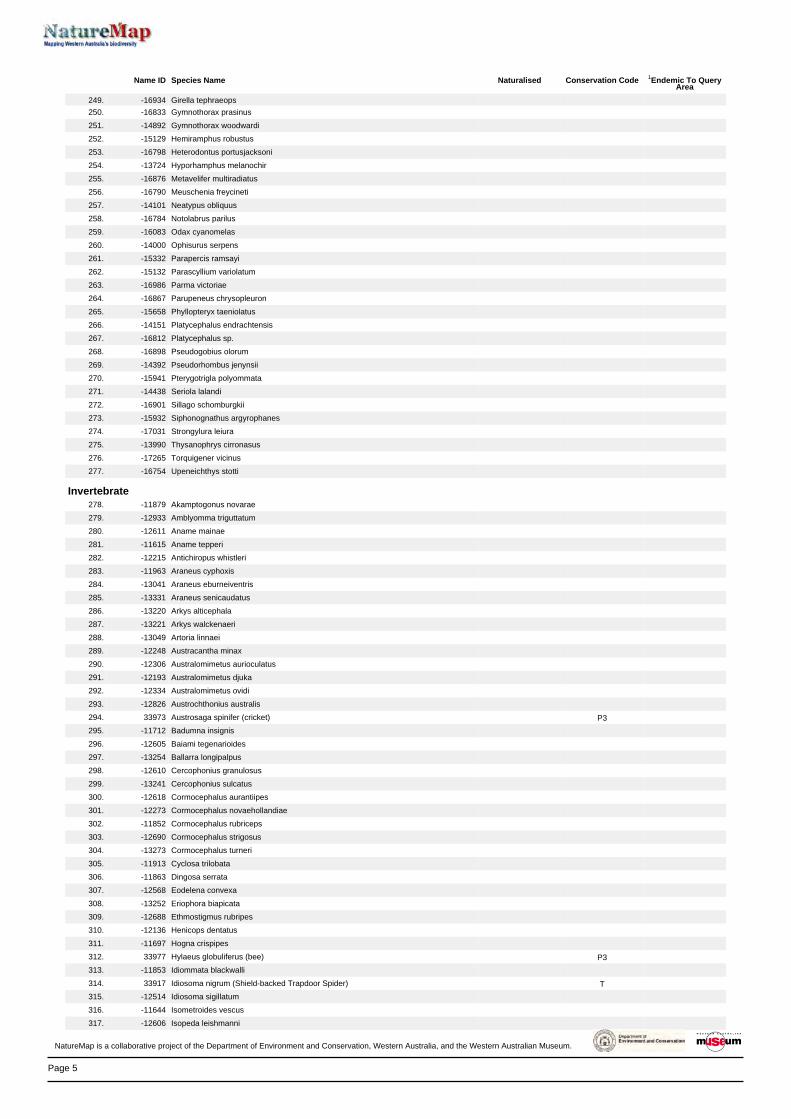
Page 5
Name ID Species Name Naturalised Conservation Code 1Endemic To QueryArea
249. -16934 Girella tephraeops
250. -16833 Gymnothorax prasinus
251. -14892 Gymnothorax woodwardi
252. -15129 Hemiramphus robustus
253. -16798 Heterodontus portusjacksoni
254. -13724 Hyporhamphus melanochir
255. -16876 Metavelifer multiradiatus
256. -16790 Meuschenia freycineti
257. -14101 Neatypus obliquus
258. -16784 Notolabrus parilus
259. -16083 Odax cyanomelas
260. -14000 Ophisurus serpens
261. -15332 Parapercis ramsayi
262. -15132 Parascyllium variolatum
263. -16986 Parma victoriae
264. -16867 Parupeneus chrysopleuron
265. -15658 Phyllopteryx taeniolatus
266. -14151 Platycephalus endrachtensis
267. -16812 Platycephalus sp.
268. -16898 Pseudogobius olorum
269. -14392 Pseudorhombus jenynsii
270. -15941 Pterygotrigla polyommata
271. -14438 Seriola lalandi
272. -16901 Sillago schomburgkii
273. -15932 Siphonognathus argyrophanes
274. -17031 Strongylura leiura
275. -13990 Thysanophrys cirronasus
276. -17265 Torquigener vicinus
277. -16754 Upeneichthys stotti
Invertebrate278. -11879 Akamptogonus novarae
279. -12933 Amblyomma triguttatum
280. -12611 Aname mainae
281. -11615 Aname tepperi
282. -12215 Antichiropus whistleri
283. -11963 Araneus cyphoxis
284. -13041 Araneus eburneiventris
285. -13331 Araneus senicaudatus
286. -13220 Arkys alticephala
287. -13221 Arkys walckenaeri
288. -13049 Artoria linnaei
289. -12248 Austracantha minax
290. -12306 Australomimetus aurioculatus
291. -12193 Australomimetus djuka
292. -12334 Australomimetus ovidi
293. -12826 Austrochthonius australis
294. 33973 Austrosaga spinifer (cricket) P3
295. -11712 Badumna insignis
296. -12605 Baiami tegenarioides
297. -13254 Ballarra longipalpus
298. -12610 Cercophonius granulosus
299. -13241 Cercophonius sulcatus
300. -12618 Cormocephalus aurantiipes
301. -12273 Cormocephalus novaehollandiae
302. -11852 Cormocephalus rubriceps
303. -12690 Cormocephalus strigosus
304. -13273 Cormocephalus turneri
305. -11913 Cyclosa trilobata
306. -11863 Dingosa serrata
307. -12568 Eodelena convexa
308. -13252 Eriophora biapicata
309. -12688 Ethmostigmus rubripes
310. -12136 Henicops dentatus
311. -11697 Hogna crispipes
312. 33977 Hylaeus globuliferus (bee) P3
313. -11853 Idiommata blackwalli
314. 33917 Idiosoma nigrum (Shield-backed Trapdoor Spider) T
315. -12514 Idiosoma sigillatum
316. -11644 Isometroides vescus
317. -12606 Isopeda leishmanni
NatureMap is a collaborative project of the Department of Environment and Conservation, Western Australia, and the Western Australian Museum.

Page 6
Name ID Species Name Naturalised Conservation Code 1Endemic To QueryArea
318. -12830 Lampona yanchep
319. 33982 Leioproctus contrarius (bee) P3
320. -12145 Lycosa australicola
321. -11923 Lycosa gilberta
322. -11620 Lycosa godeffroyi
323. -12919 Masasteron sampeyae
324. -11896 Masasteron tuart
325. -11910 Missulena granulosa subsp. granulosa
326. -13260 Missulena occatoria
327. -11650 Myandra cambridgei
328. -12564 Notiasemus glauerti
329. -12948 Occiperipatoides gilesii
330. -13075 Oecobius navus
331. -12807 Ommatoiulus moreletii
332. -13235 Oratemnus curtus
333. -12415 Oxidus gracilis
334. -11695 Parapallene haddoni
335. -11981 Paraplectanoides crassipes
336. -12292 Pholcus phalangioides
337. -12921 Pinkfloydia harveii
338. -12094 Protochelifer cavernarum
339. -12924 Raveniella arenacea
340. -12621 Raveniella cirrata
341. -12104 Raveniella peckorum
342. -12329 Servaea melaina
343. -13155 Simonus lineatus Y
344. -12300 Steatoda capensis
345. -11770 Stylopallene cheilorhynchus
346. 33992 Synemon gratiosa (Graceful Sunmoth) P4
347. -13304 Synothele mullaloo
348. -12009 Tamopsis perthensis
349. -11915 Taphiassa robertsi
350. -11859 Tasmanicosa leuckartii
351. -13208 Urodacus novaehollandiae
352. -12224 Venator immansueta
353. 34113 Westralunio carteri (Carter's Freshwater Mussel) P4
354. -12219 Westrarchaea spinosa
Mammal355. 24209 Arctocephalus tropicalis (Sub-antarctic Fur Seal)
356. 24161 Bettongia lesueur subsp. graii (Boodie, Burrowing Bettong)
357. 24162 Bettongia penicillata subsp. ogilbyi (Woylie, Brush-tailed Bettong) T
358. 24251 Bos taurus (European Cattle) Y
359. 24254 Camelus dromedarius (Dromedary, Camel) Y
360. 30883 Canis lupus subsp. familiaris (Dog) Y
361. 24086 Cercartetus concinnus (Western Pygmy-possum, Mundarda)
362. 24186 Chalinolobus gouldii (Gould's Wattled Bat)
363. 24187 Chalinolobus morio (Chocolate Wattled Bat)
364. 24092 Dasyurus geoffroii (Chuditch, Western Quoll) T
365. 24043 Eubalaena australis (Southern Right Whale) T
366. 24041 Felis catus (Cat) Y
367. 25478 Isoodon obesulus (Southern Brown Bandicoot) P5
368. 24153 Isoodon obesulus subsp. fusciventer (Quenda, Southern Brown Bandicoot) P5
369. 24070 Kogia breviceps (Pygmy Sperm Whale)
370. 24132 Macropus fuliginosus (Western Grey Kangaroo)
371. 24133 Macropus irma (Western Brush Wallaby) P4
372. 24051 Megaptera novaeangliae (Humpback Whale) T
373. 24076 Mesoplodon bowdoini (Andrew's Beaked Whale)
374. 24223 Mus musculus (House Mouse) Y
375. 24210 Neophoca cinerea (Australian Sea Lion) S
376. 24194 Nyctophilus geoffroyi (Lesser Long-eared Bat)
377. 24085 Oryctolagus cuniculus (Rabbit) Y
378. 34016 Ovis aries (Sheep)
379. 24142 Petrogale lateralis subsp. lateralis (Black-flanked Rock-wallaby, Black-footed Rock-
wallaby)T
380. 24073 Physeter macrocephalus (Sperm Whale) P4
381. 24230 Pseudomys albocinereus (Ash-grey Mouse)
382. 24243 Rattus fuscipes (Western Bush Rat)
383. 24245 Rattus rattus (Black Rat) Y
384. 24108 Sminthopsis crassicaudata (Fat-tailed Dunnart)
385. 24207 Tachyglossus aculeatus (Short-beaked Echidna)
NatureMap is a collaborative project of the Department of Environment and Conservation, Western Australia, and the Western Australian Museum.
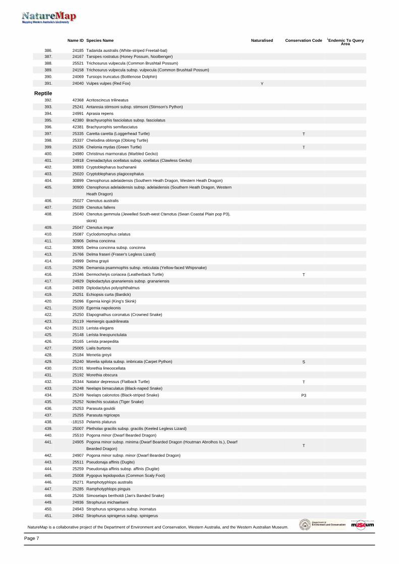
Page 7
Name ID Species Name Naturalised Conservation Code 1Endemic To QueryArea
386. 24185 Tadarida australis (White-striped Freetail-bat)
387. 24167 Tarsipes rostratus (Honey Possum, Noolbenger)
388. 25521 Trichosurus vulpecula (Common Brushtail Possum)
389. 24158 Trichosurus vulpecula subsp. vulpecula (Common Brushtail Possum)
390. 24069 Tursiops truncatus (Bottlenose Dolphin)
391. 24040 Vulpes vulpes (Red Fox) Y
Reptile392. 42368 Acritoscincus trilineatus
393. 25241 Antaresia stimsoni subsp. stimsoni (Stimson's Python)
394. 24991 Aprasia repens
395. 42380 Brachyurophis fasciolatus subsp. fasciolatus
396. 42381 Brachyurophis semifasciatus
397. 25335 Caretta caretta (Loggerhead Turtle) T
398. 25337 Chelodina oblonga (Oblong Turtle)
399. 25336 Chelonia mydas (Green Turtle) T
400. 24980 Christinus marmoratus (Marbled Gecko)
401. 24918 Crenadactylus ocellatus subsp. ocellatus (Clawless Gecko)
402. 30893 Cryptoblepharus buchananii
403. 25020 Cryptoblepharus plagiocephalus
404. 30899 Ctenophorus adelaidensis (Southern Heath Dragon, Western Heath Dragon)
405. 30900 Ctenophorus adelaidensis subsp. adelaidensis (Southern Heath Dragon, Western
Heath Dragon)
406. 25027 Ctenotus australis
407. 25039 Ctenotus fallens
408. 25040 Ctenotus gemmula (Jewelled South-west Ctenotus (Swan Coastal Plain pop P3),
skink)
409. 25047 Ctenotus impar
410. 25087 Cyclodomorphus celatus
411. 30906 Delma concinna
412. 30905 Delma concinna subsp. concinna
413. 25766 Delma fraseri (Fraser's Legless Lizard)
414. 24999 Delma grayii
415. 25296 Demansia psammophis subsp. reticulata (Yellow-faced Whipsnake)
416. 25346 Dermochelys coriacea (Leatherback Turtle) T
417. 24929 Diplodactylus granariensis subsp. granariensis
418. 24939 Diplodactylus polyophthalmus
419. 25251 Echiopsis curta (Bardick)
420. 25096 Egernia kingii (King's Skink)
421. 25100 Egernia napoleonis
422. 25250 Elapognathus coronatus (Crowned Snake)
423. 25119 Hemiergis quadrilineata
424. 25133 Lerista elegans
425. 25148 Lerista lineopunctulata
426. 25165 Lerista praepedita
427. 25005 Lialis burtonis
428. 25184 Menetia greyii
429. 25240 Morelia spilota subsp. imbricata (Carpet Python) S
430. 25191 Morethia lineoocellata
431. 25192 Morethia obscura
432. 25344 Natator depressus (Flatback Turtle) T
433. 25248 Neelaps bimaculatus (Black-naped Snake)
434. 25249 Neelaps calonotos (Black-striped Snake) P3
435. 25252 Notechis scutatus (Tiger Snake)
436. 25253 Parasuta gouldii
437. 25255 Parasuta nigriceps
438. -18153 Pelamis platurus
439. 25007 Pletholax gracilis subsp. gracilis (Keeled Legless Lizard)
440. 25510 Pogona minor (Dwarf Bearded Dragon)
441. 24905 Pogona minor subsp. minima (Dwarf Bearded Dragon (Houtman Abrolhos Is.), Dwarf
Bearded Dragon)T
442. 24907 Pogona minor subsp. minor (Dwarf Bearded Dragon)
443. 25511 Pseudonaja affinis (Dugite)
444. 25259 Pseudonaja affinis subsp. affinis (Dugite)
445. 25008 Pygopus lepidopodus (Common Scaly Foot)
446. 25271 Ramphotyphlops australis
447. 25285 Ramphotyphlops pinguis
448. 25266 Simoselaps bertholdi (Jan's Banded Snake)
449. 24936 Strophurus michaelseni
450. 24943 Strophurus spinigerus subsp. inornatus
451. 24942 Strophurus spinigerus subsp. spinigerus
NatureMap is a collaborative project of the Department of Environment and Conservation, Western Australia, and the Western Australian Museum.
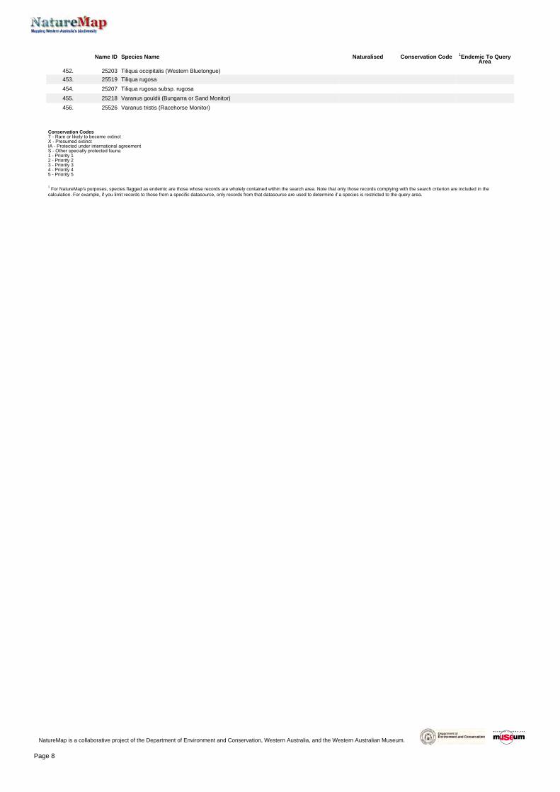
Page 8
Name ID Species Name Naturalised Conservation Code 1Endemic To QueryArea
452. 25203 Tiliqua occipitalis (Western Bluetongue)
453. 25519 Tiliqua rugosa
454. 25207 Tiliqua rugosa subsp. rugosa
455. 25218 Varanus gouldii (Bungarra or Sand Monitor)
456. 25526 Varanus tristis (Racehorse Monitor)
Conservation CodesT - Rare or likely to become extinctX - Presumed extinctIA - Protected under international agreementS - Other specially protected fauna1 - Priority 12 - Priority 23 - Priority 34 - Priority 45 - Priority 5
1 For NatureMap's purposes, species flagged as endemic are those whose records are wholely contained within the search area. Note that only those records complying with the search criterion are included in the
calculation. For example, if you limit records to those from a specific datasource, only records from that datasource are used to determine if a species is restricted to the query area.
NatureMap is a collaborative project of the Department of Environment and Conservation, Western Australia, and the Western Australian Museum.

GHD | Report for Main Roads Western Australia - Mitchell Freeway extension: Burns Beach Rd to Romeo Rd, 61/29435
Appendix C – Conservation codes

GHD | Report for Main Roads Western Australia - Mitchell Freeway extension, 61/29435
C.1 Legislation
C.1.1 Federal Environment Protection and Biodiversity Conservation Act 1999
The Environment Protection and Biodiversity Conservation Act 1999 (EPBC Act) is the Federal Government’s central piece of environmental legislation. It provides a legal framework to protect and manage nationally and internationally important flora, fauna, ecological communities and heritage places, which are defined in the EPBC Act as matters of national environmental significance (MNES).
The biological aspects listed as MNES include:
Nationally threatened flora and fauna species and ecological communities.
Migratory species.
A person must not take an action that has, will have, or is likely to have a significant impact MNES, without approval from the Federal Minister for the Environment.
C.1.2 State Environmental Protection Act 1986
The Environmental Protection Act 1986 (EP Act) is the primary legislative Act dealing with the protection of the environment in Western Australia. It provides for an Environmental Protection Authority (EPA), for the prevention, control and abatement of pollution and environmental harm, for the conservation, preservation, protection, enhancement and management of the environment and for matters incidental to or connected with the above.
Clearing of native vegetation in Western Australia requires a permit from the Department of Parks and Wildlife (DPaW) (formerly the Department of Environment and Conservation – DEC), unless exemptions apply. Native vegetation includes aquatic and terrestrial vegetation indigenous to Western Australia, and intentionally planted vegetation declared by regulation to be native, but not vegetation planted in a plantation or planted with commercial intent.
In the EP Act Section 51A, clearing is defined as the killing or destruction of; the removal of; the severing or ringbarking of trunks or stems of; or the doing of substantial damage of some or all of the native vegetation in an area, including the flooding of land, the burning of vegetation, the grazing of stock or an act or activity that results in the above.
When making a decision to grant or refuse a permit to clear native vegetation the assessment considers clearing against the ten clearing principles as specified in Schedule 5 of the EP Act:
a. Native vegetation should not be cleared if it comprises a high level of biodiversity.
b. Native vegetation should not be cleared if it comprises the whole or a part of, or is necessary for the maintenance of a significance habitat for fauna indigenous to Western Australia.
c. Native vegetation should not be cleared if it includes, or is necessary, for the continued existence of rare flora.
d. Native vegetation should not be cleared if it comprises the whole or part of native vegetation in an area that has been extensively cleared.
e. Native vegetation should not be cleared if it is significant as a remnant of native vegetation in an area that has been extensively cleared.
f. Native vegetation should not be cleared if it is growing in, or in association with, an environment associated with a watercourse or wetland.
GHD | Report for Main Roads Western Australia - Mitchell Freeway extension, 61/29435
g. Native vegetation should not be cleared if the clearing of the vegetation is likely to have an impact on the environmental values of any adjacent or nearby conservation area.
h. Native vegetation should not be cleared if the clearing of the vegetation is likely to cause appreciable land degradation.
i. Native vegetation should not be cleared if the clearing of the vegetation is likely to cause deterioration in the quality of surface or underground water.
j. Native vegetation should not be cleared if clearing the vegetation is likely to cause, or exacerbate, the incidence of flooding.
There are a number of Environmentally Sensitive Areas (ESA) within Western Australia where exemptions in regulations do not apply. ESA include locations of threatened communities and species.
C.1.3 State Environmental Protection (Clearing of Native Vegetation) Regulations 2004
ESA are declared by a notice under Section 51B of the EP Act. Table C.1 outlines the aspects of areas declared as ESA (under the Environmental Protection (Clearing of Native Vegetation) Regulations 2004 – Reg 6).
Table C.1 Aspects of Environmentally Sensitive Areas
Aspects of Environmentally Sensitive Areas A declared World Heritage property as defined in Section 13 of the Environment Protection and Biodiversity Conservation Act 1999 (EPBC Act). An area that is registered on the Register of the National Estate (RNE), because of its natural values, under the Australian Heritage Commission Act 1975 of the Commonwealth (the RNE was closed in 2007 and is no longer a statutory list – all references to the RNE were removed from the EPBC Act on 19 February 2012). A defined wetland and the area within 50 m of the wetland. The area covered by vegetation within 50 m of rare flora, to the extent to which the vegetation is continuous with the vegetation in which the rare flora is located. The area covered by a TEC. A Bush Forever Site. The areas covered by the following policies: a. The Environmental Protection (Gnangara Mound Crown Land) Policy 1992. b. The Environmental Protection (Western Swamp Tortoise Habitat) Policy 2002. The areas covered by the lakes to which the Environmental Protection (Swan Coastal Plain Lakes) Policy 1992 (SCPL) (EPP Lakes) applies. Protected wetlands as defined in the Environmental Protection (South West Agricultural Zone Wetlands) Policy 1998. Areas of fringing native vegetation in the policy area as defined in the Environmental Protection (Swan and Canning Rivers) Policy 1997.
C.1.4 State Wildlife Conservation Act 1950
The Wildlife Conservation Act 1950 (WC Act) provides for the conservation and protection of wildlife. It is administered by the DPaW and applies to both flora and fauna. Any person wanting to capture, collect, disturb or study fauna requires a permit to do so. A permit is required under the WC Act if removal of threatened species is required.
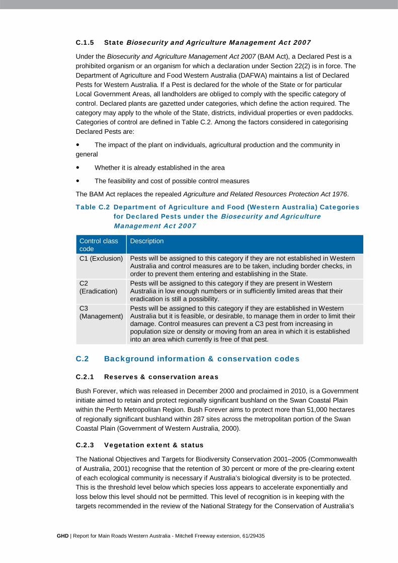
GHD | Report for Main Roads Western Australia - Mitchell Freeway extension, 61/29435
C.1.5 State Biosecurity and Agriculture Management Act 2007
Under the Biosecurity and Agriculture Management Act 2007 (BAM Act), a Declared Pest is a prohibited organism or an organism for which a declaration under Section 22(2) is in force. The Department of Agriculture and Food Western Australia (DAFWA) maintains a list of Declared Pests for Western Australia. If a Pest is declared for the whole of the State or for particular Local Government Areas, all landholders are obliged to comply with the specific category of control. Declared plants are gazetted under categories, which define the action required. The category may apply to the whole of the State, districts, individual properties or even paddocks. Categories of control are defined in Table C.2. Among the factors considered in categorising Declared Pests are:
The impact of the plant on individuals, agricultural production and the community in general
Whether it is already established in the area
The feasibility and cost of possible control measures
The BAM Act replaces the repealed Agriculture and Related Resources Protection Act 1976.
Table C.2 Department of Agriculture and Food (Western Australia) Categories for Declared Pests under the Biosecurity and Agriculture Management Act 2007
Control class code
Description
C1 (Exclusion) Pests will be assigned to this category if they are not established in Western Australia and control measures are to be taken, including border checks, in order to prevent them entering and establishing in the State.
C2 (Eradication)
Pests will be assigned to this category if they are present in Western Australia in low enough numbers or in sufficiently limited areas that their eradication is still a possibility.
C3 (Management)
Pests will be assigned to this category if they are established in Western Australia but it is feasible, or desirable, to manage them in order to limit their damage. Control measures can prevent a C3 pest from increasing in population size or density or moving from an area in which it is established into an area which currently is free of that pest.
C.2 Background information & conservation codes
C.2.1 Reserves & conservation areas
Bush Forever, which was released in December 2000 and proclaimed in 2010, is a Government initiate aimed to retain and protect regionally significant bushland on the Swan Coastal Plain within the Perth Metropolitan Region. Bush Forever aims to protect more than 51,000 hectares of regionally significant bushland within 287 sites across the metropolitan portion of the Swan Coastal Plain (Government of Western Australia, 2000).
C.2.3 Vegetation extent & status
The National Objectives and Targets for Biodiversity Conservation 2001–2005 (Commonwealth of Australia, 2001) recognise that the retention of 30 percent or more of the pre-clearing extent of each ecological community is necessary if Australia’s biological diversity is to be protected. This is the threshold level below which species loss appears to accelerate exponentially and loss below this level should not be permitted. This level of recognition is in keeping with the targets recommended in the review of the National Strategy for the Conservation of Australia’s

GHD | Report for Main Roads Western Australia - Mitchell Freeway extension, 61/29435
Biological Diversity (ANZECC, 2000) and in EPA Position Statement No. 2 on environmental protection of native vegetation in Western Australia (EPA, 2000c).
From a purely biodiversity perspective and taking no account of any other land degradation issues, there are a number of key criteria now being applied to the clearing of native vegetation in Western Australia (EPA, 2000c).
The “threshold level” below which species loss appears to accelerate exponentially at an ecosystem level is regarded as being at a level of 30 percent of the pre-European extent of the vegetation type.
A level of 10 percent of the original extent is regarded as being a level representing Endangered.
Clearing which would put the threat level into the class below should be avoided.
From a biodiversity perspective, stream reserves should generally be in the order of at least 200 metres (m) wide.
Within the Swan Coastal Plain, EPA Position Statement No. 9 (EPA, 2006b) identifies vegetation complexes with 30 percent or less or their pre-clearing extent remaining in a bioregion, or 10 percent or less of their pre-clearing extent remaining in constrained areas (i.e. areas of urban development in cities and major town) on the Swan Coastal Plain, to be critical assets.
The extent of remnant native vegetation has been assessed by Shepherd et al. (2002) and the Government of Western Australia (2013), based on broadscale vegetation association mapping by Beard (1979).
The EPA Guidance Statement No. 10 (EPA, 2006a) assesses the extent of Heddle et al. (1980) vegetation complexes currently present against presumed pre-European extents. It is important to note that the “remnant native vegetation mapping used in the Region is derived from dated aerial photography (in this case 1998) with limited ground-truthing. As a consequence, the percentages of ecological communities remaining are generally an overestimate of the native vegetation remaining at present and at the date of this Guidance (2006). The principal factors contributing to this overestimation are:
The preferential mapping of treed landscapes, leading to some mapping of areas that are parkland cleared or completely degraded
The inclusion of areas that are approved for clearing through development approvals and/or clearing permits
Some areas that have been cleared since the time of the aerial photography
It is therefore important to bear these issues in mind when the percentage of the vegetation complexes remaining is approaching 30 percent” (EPA, 2006a). Furthermore, as a result of the clearing of the Swan Coastal Plain since 1998, it is likely that the actual percentage remaining of each vegetation type is less.
C.2.4 Conservation codes
Species of significant flora, fauna and communities are protected under both Federal and State Acts. The Federal EPBC Act provides a legal framework to protect and manage nationally important flora and communities. The State WC Act is the primary wildlife conservation legislation in Western Australia. Information on the conservation codes is summarised in the following sections.

GHD | Report for Main Roads Western Australia - Mitchell Freeway extension, 61/29435
Conservation significant communities
Ecological communities are defined as naturally occurring biological assemblages that occur in a particular type of habitat (English and Blyth, 1997). Federally listed Threatened Ecological Communities (TEC) are protected under the EPBC Act administered by the Department of Sustainability, Environment, Water, Population and Communities (DSEWPaC). The DPaW also maintains a list of TEC for Western Australia; some of which are also protected under the EPBC Act. TEC are ecological communities that have been assessed and assigned to one of four categories related to the status of the threat to the community, i.e. Presumed Totally Destroyed, Critically Endangered, Endangered and Vulnerable (Table C.3).
Possible TEC that do not meet survey criteria are added to the DPaW Priority Ecological Community (PEC) List under Priorities 1, 2 and 3 (Table C.4). These are ecological communities that are adequately known; are rare but not threatened, or meet criteria for Near Threatened. PEC that have been recently removed from the threatened list are placed in Priority 4. These ecological communities require regular monitoring. Conservation dependent ecological communities are placed in Priority 5. PEC are not listed under any formal Federal or State legislation.

GHD | Report for Main Roads Western Australia - Mitchell Freeway extension, 61/29435
Table C.3 Conservation codes & definitions for Threatened Ecological Communities (TEC) endorsed by the Western Australian Minister for the Environment & listed under the EPBC Act
Western Australia conservation categories Federal Government Conservation Categories (EPBC Act)
Presumed Totally Destroyed (PD)
The community has been found to be totally destroyed or so extensively modified throughout its range that no occurrence of it is likely to recover its species composition and/or structure in the foreseeable future.
Critically Endangered (CR)
If, at that time, it is facing an extremely high risk of extinction in the wild in the immediate future
Critically Endangered (CR)
An ecological community that has been adequately surveyed and found to have been subject to a major contraction in area and/or that was originally of limited distribution and is facing severe modification or destruction throughout its range in the immediate future, or is already severely degraded throughout its range but capable of being substantially restored or rehabilitated
Endangered (EN)
If, at that time, it is not critically endangered and is facing a very high risk of extinction in the wild in the near future
Endangered (EN)
An ecological community that has been adequately surveyed and found to have been subject to a major contraction in area and/or was originally of limited distribution and is in danger of significant modification throughout its range or severe modification or destruction over most of its range in the near future.
Vulnerable (VU)
If, at that time, it is not critically endangered or endangered, and is facing a high risk of extinction in the wild in the medium-term future
Vulnerable (VU)
An ecological community that has been adequately surveyed and is found to be declining and/or has declined in distribution and/or condition and whose ultimate security has not yet been assured and/or a community that is still widespread but is believed likely to move into a category of higher threat in the near future if threatening processes continue or begin operating throughout its range.

GHD | Report for Main Roads Western Australia - Mitchell Freeway extension, 61/29435
Table C.4 Conservation categories & definitions for Priority Ecological Communities (PEC) as listed by the DPaW
Category Description Priority 1 Poorly known ecological communities.
Ecological communities that are known from very few occurrences with a very restricted distribution (generally 5 occurrences or a total area of 100 ha). Occurrences are believed to be under threat either due to limited extent, or being on lands under immediate threat (e.g. within agricultural or pastoral lands, urban areas, active mineral leases) or for which current threats exist. May include communities with occurrences on protected lands. Communities may be included if they are comparatively well-known from one or more localities but do not meet adequacy of survey requirements, and/or are not well defined, and appear to be under immediate threat from known threatening processes across their range.
Priority 2 Poorly known ecological communities. Communities that are known from few occurrences with a restricted distribution (generally 10 occurrences or a total area of 200 ha). At least some occurrences are not believed to be under immediate threat of destruction or degradation. Communities may be included if they are comparatively well known from one or more localities but do not meet adequacy of survey requirements, and/or are not well defined, and appear to be under threat from known threatening processes.
Priority 3 Poorly known ecological communities. (i) Communities that are known from several to many occurrences, a significant number or area of which are not under threat of habitat destruction or degradation or: (ii) communities known from a few widespread occurrences, which are either large or with significant remaining areas of habitat in which other occurrences may occur, much of it not under imminent threat, or; (iii) communities made up of large, and/or widespread occurrences, that may or may not be represented in the reserve system, but are under threat of modification across much of their range from processes such as grazing by domestic and/or feral stock, and inappropriate fire regimes. Communities may be included if they are comparatively well known from several localities but do not meet adequacy of survey requirements and/or are not well defined, and known threatening processes exist that could affect them.
Priority 4 Ecological communities that are adequately known, rare but not threatened or meet criteria for Near Threatened, or that have been recently removed from the threatened list. These communities require regular monitoring. (i) Rare. Ecological communities known from few occurrences that are considered to have been adequately surveyed, or for which sufficient knowledge is available, and that are considered not currently threatened or in need of special protection, but could be if present circumstances change. These communities are usually represented on conservation lands. (ii) Near Threatened. Ecological communities that are considered to have been adequately surveyed and that do not qualify for Conservation Dependent, but that are close to qualifying for Vulnerable. (iii) Ecological communities that have been removed from the list of threatened communities during the past five years.
Priority 5 Conservation Dependent ecological communities. Ecological communities that are not threatened but are subject to a specific conservation program, the cessation of which would result in the community becoming threatened within five years.

GHD | Report for Main Roads Western Australia - Mitchell Freeway extension, 61/29435
Other significant vegetation
Vegetation may be significant for a range of reasons, other than a statutory listing as TEC or because the extent is below a threshold level. The EPA (2004a) states that significant vegetation may include vegetation that includes the following:
Scarcity
Unusual species
Novel combinations of species
A role as a refuge
A role as a key habitat for Threatened species or large population representing a significant proportion of the local to regional total population of a species
Being representative of the range of a unit (particularly, a good local and/or regional example of a unit in ‘prime’ habitat, at the extremes of range, recently discovered range extensions, or isolated outliers of the main range)
A restricted distribution
This may apply at a number of levels, so the unit may be significant when considered at the fine-scale (intra-locality), intermediate-scale (locality or inter-locality) or broad-scale (local to region).
Conservation significant flora & fauna
Species of significant flora are protected under both Federal and State legislation. Any activities that are deemed to have a significant impact on species that are recognised by the EPBC Act, and/or the WC Act can warrant referral to the DSEWPaC and/or the EPA. According to the DPaW (WA Herbarium, 1998–): “Threatened flora are plants which have been assessed as being at risk of extinction. In Western Australia the term Declared Rare Flora (DRF) is applied to Threatened flora due to the laws regarding threatened flora conservation. The WC Act is the primary wildlife conservation legislation in the State and the Minster for the Environment can declare taxa (species, subspecies or variety) as “Rare Flora” if they are considered to be in danger of extinction, rare or otherwise in need of special protection.” For the purposes of this report, flora listed by the WC Act as DRF is described as Threatened.
The Federal conservation level of flora and fauna species and their significance status is assessed under the EPBC Act (Table C.5). The significance levels for fauna used in the EPBC Act are those recommended by the International Union for the Conservation of Nature and Natural Resources (IUCN).
The State conservation level of fauna species and their significance status is assessed under the State WC Act (Wildlife Conservation (Specially Protected Fauna) Notice 2010(2)). This Act uses a set of Schedules (Table C.6) but also classifies species using some of the IUCN categories. Schedule 3 fauna species are those which are “subject to an agreement between the Government of Australia and the Governments of Japan, China and the Republic of Korea relating to the protection of migratory birds, are declared to be fauna that is in need of special protection”.
In Western Australia, the DPaW also maintains a list of Priority listed flora species. Conservation codes for Priority species are assigned by the DPaW to define the level of conservation significance (Table C.6). Priority species are not currently protected under the WC Act.
In addition to conservation significant species flora and fauna can be considered important if they are significant either on the Swan Coastal Plain or in the Perth metropolitan region. This

GHD | Report for Main Roads Western Australia - Mitchell Freeway extension, 61/29435
includes species discussed in Government of Western Australia (2000) as being rare, poorly known, restricted in distribution or with some other distinctive feature.
For the purposes of this assessment, all species listed under the EPBC Act, WC Act and DPaW Priority species are considered conservation significant.
Table C.5 Conservation categories & definitions for Environment Protection and Biodiversity Conservation Act 1999 listed flora & fauna species
Conservation category
Definition
Extinct Taxa not definitely located in the wild during the past 50 years
Extinct in the Wild Taxa known to survive only in captivity
Critically Endangered
Taxa facing an extremely high risk of extinction in the wild in the immediate future
Endangered Taxa facing a very high risk of extinction in the wild in the near future
Vulnerable Taxa facing a high risk of extinction in the wild in the medium-term
Near Threatened Taxa that risk becoming Vulnerable in the wild
Conservation Dependent
Taxa whose survival depends upon ongoing conservation measures. Without these measures, a conservation dependent taxon would be classified as Vulnerable or more severely threatened.
Data Deficient (Insufficiently Known)
Taxa suspected of being Rare, Vulnerable or Endangered, but whose true status cannot be determined without more information.
Least Concern Taxa that are not considered Threatened
Table C.6 Conservation codes and descriptions for Western Australian flora & fauna
Code Conservation category
Description
Wildlife Conservation Act 1950 T Schedule 1 under the
WC Act Threatened Fauna (Fauna that is rare or is likely to become extinct) Threatened Flora (Declared Rare Flora – Extant) Taxa that have been adequately searched for and are deemed to be in the wild either rare, in danger of extinction, or otherwise in need of special protection, and have been gazetted as such. CR: Critically Endangered – considered to be facing an extremely high risk of extinction in the wild. EN: Endangered – considered to be facing a very high risk of extinction in the wild. VU: Vulnerable – considered to be facing a high risk of extinction in the wild.

GHD | Report for Main Roads Western Australia - Mitchell Freeway extension, 61/29435
Code Conservation category
Description
X Schedule 2 under the WC Act
Presumed Extinct Fauna Presumed Extinct Flora (Declared Rare Flora – Extinct) Taxa which have been adequately searched for and there is no reasonable doubt that the last individual has died, and have been gazetted as such.
IA Schedule 3 under the WC Act
Birds protected under an international agreement. Birds that are subject to an agreement between governments of Australia and Japan relating to the protection of migratory birds and birds in danger of extinction.
S Schedule 4 under the WC Act
Other specially protected fauna. Fauna that is in need of special protection, otherwise than for the reasons mentioned in the above schedules.
DPaW Priority Listed 1 Priority One: Poorly-
known taxa Taxa that are known from one or a few collections or sight records (generally less than five), all on lands not managed for conservation, e.g. agricultural or pastoral lands, urban areas, Shire, Westrail and Main Roads WA road, gravel and soil reserves, and active mineral leases and under threat of habitat destruction or degradation. Taxa may be included if they are comparatively well known from one or more localities but do not meet adequacy of survey requirements and appear to be under immediate threat from known threatening processes.
2 Priority Two: Poorly-known taxa
Taxa that are known from one or a few collections or sight records, some of which are on lands not under imminent threat of habitat destruction or degradation, e.g. national parks, conservation parks, nature reserves, State forest, vacant Crown land, water reserves, etc. Taxa may be included if they are comparatively well known from one or more localities but do not meet adequacy of survey requirements and appear to be under threat from known threatening processes.
3 Priority Three: Poorly-known taxa
Taxa that are known from collections or sight records from several localities not under imminent threat, or from few but widespread localities with either large population size or significant remaining areas of apparently suitable habitat, much of it not under imminent threat. Taxa may be included if they are comparatively well known from several localities but do not meet adequacy of survey requirements and known threatening processes exist that could affect them.
4 Priority Four: Rare, Near Threatened and other taxa in need of monitoring
(a) Rare. Taxa that are considered to have been adequately surveyed, or for which sufficient knowledge is available, and that are considered not currently threatened or in need of special protection, but could be if present circumstances change. These taxa are usually represented on conservation lands. (b) Near Threatened. Taxa that are considered to have been adequately surveyed and that do not qualify for Conservation Dependent, but that are close to qualifying for Vulnerable. (c) Taxa that have been removed from the list of threatened species during the past five years for reasons other than taxonomy.
5 Priority 5: Conservation Dependent taxa
Taxa that are not threatened but are subject to a specific conservation program, the cessation of which would result in the taxon becoming threatened within five years.

GHD | Report for Main Roads Western Australia - Mitchell Freeway extension, 61/29435
Migratory species listed under the EPBC Act
The EPBC Act also protects land and migratory species that are listed under International Agreements. The list of migratory species established under section 209 of the EPBC Act comprises:
Migratory species which are native to Australia and are included in the appendices to the Bonn Convention (Convention on the Conservation of Migratory Species of Wild Animals Appendices I and II)
Migratory species included in annexes established under the Japan-Australia Migratory Bird Agreement (JAMBA) and the China–Australia Migratory Bird Agreement (CAMBA)
Native, migratory species identified in a list established under, or an instrument made under, an international agreement approved by the Minister, such as the republic of Korea–Australia Migratory Bird Agreement (ROKAMBA)
Introduced plants (weeds)
Weeds of National Significance
The spread of weeds across a range of land uses or ecosystems is important in the context of socio-economic and environmental values. The assessment of Weeds of National Significance (WoNS) is based on four major criteria:
Invasiveness
Impacts
Potential for spread
Socio-economic and environmental values
Australian state and territory governments have identified thirty two Weeds of National Significance (WoNS); a list of 20 WoNS was endorsed in 1999 and a further 12 were added in 2012 (Australian Government, 2012).
Information on species considered to be Declared Pests is provided in C.1.5.
Other significant flora & fauna
A total of “178 vascular plant taxa recorded on the Swan Coastal Plain are of particular interest as they are rare, poorly known, restricted in distribution or have some other distinctive feature” (Government of Western Australia, 2000).
Other significant fauna are “those birds that are habitat specialists with a reduced distribution on the Swan Coastal Plain or wide-ranging species with reduced populations on the Swan Coastal Plain; those mammals that have few populations on the Swan Coastal Plain; and those reptile species that have reduced ranges or few recent records on the Swan Coastal Plain” (Government of Western Australia, 2000).

GHD | Report for Main Roads Western Australia - Mitchell Freeway extension: Burns Beach Rd to Romeo Rd, 61/29435
Appendix D – Flora results PATN analysis
Quadrat data & photographs
Flora species list recorded within the Study Area during the field surveys (May-October 2013)
Priority flora species recorded within the Study Area during the field surveys (May-October 2013)
Declared Pest flora species & Weeds of National Significance recorded within the Study Area during the field surveys (May-October 2013)
Likelihood of occurrence assessment of conservation significant flora identified in the desktop assessment as potentially occurring within the Study Area

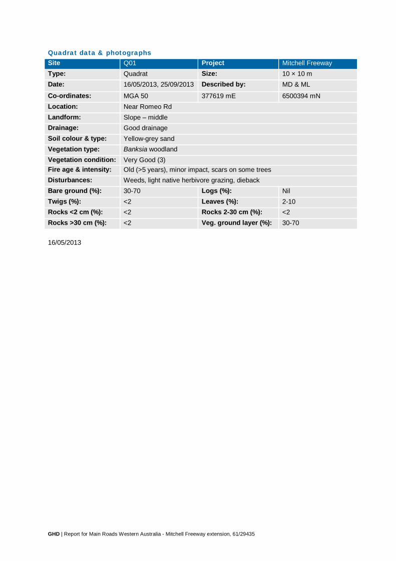
GHD | Report for Main Roads Western Australia - Mitchell Freeway extension, 61/29435
Quadrat data & photographs Site Q01 Project Mitchell Freeway Type: Quadrat Size: 10 × 10 m Date: 16/05/2013, 25/09/2013 Described by: MD & ML
Co-ordinates: MGA 50 377619 mE 6500394 mN Location: Near Romeo Rd Landform: Slope – middle Drainage: Good drainage Soil colour & type: Yellow-grey sand Vegetation type: Banksia woodland Vegetation condition: Very Good (3) Fire age & intensity: Old (>5 years), minor impact, scars on some trees Disturbances: Weeds, light native herbivore grazing, dieback Bare ground (%): 30-70 Logs (%): Nil Twigs (%): <2 Leaves (%): 2-10 Rocks <2 cm (%): <2 Rocks 2-30 cm (%): <2 Rocks >30 cm (%): <2 Veg. ground layer (%): 30-70 16/05/2013

GHD | Report for Main Roads Western Australia - Mitchell Freeway extension, 61/29435

GHD | Report for Main Roads Western Australia - Mitchell Freeway extension, 61/29435
25/09/2013
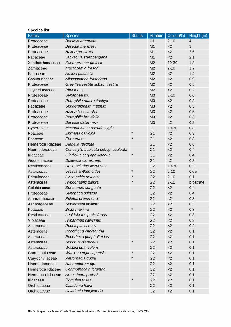
GHD | Report for Main Roads Western Australia - Mitchell Freeway extension, 61/29435
Species list Family Species Status Stratum Cover (%) Height (m) Proteaceae Banksia attenuata U1 2-10 4 Proteaceae Banksia menziesii M1 <2 3 Proteaceae Hakea prostrata M1 <2 2.5 Fabaceae Jacksonia sternbergiana M1 <2 2.1 Xanthorrhoeaceae Xanthorrhoea preissii M2 10-30 1.8 Zamiaceae Macrozamia fraseri M2 2-10 1.7 Fabaceae Acacia pulchella M2 <2 1.4 Casuarinaceae Allocasuarina fraseriana M2 <2 0.9 Proteaceae Grevillea vestita subsp. vestita M2 <2 0.5 Thymelaeaceae Pimelea sp. M2 <2 0.2 Proteaceae Synaphea sp. M3 2-10 0.6 Proteaceae Petrophile macrostachya M3 <2 0.8 Fabaceae Sphaerolobium medium M3 <2 0.5 Proteaceae Hakea lissocarpha M3 <2 0.5 Proteaceae Petrophile brevifolia M3 <2 0.3 Proteaceae Banksia dallanneyi M3 <2 0.2 Cyperaceae Mesomelaena pseudostygia G1 10-30 0.8 Poaceae Ehrharta calycina * G1 <2 0.8 Poaceae Ehrharta sp. * G1 <2 0.8 Hemerocallidaceae Dianella revoluta G1 <2 0.6 Haemodoraceae Conostylis aculeata subsp. aculeata G1 <2 0.4 Iridaceae Gladiolus caryophyllaceus * G1 <2 0.4 Goodeniaceae Scaevola canescens G1 <2 0.3 Restionaceae Desmocladus flexuosus G2 10-30 0.3 Asteraceae Ursinia anthemoides * G2 2-10 0.05 Primulaceae Lysimachia arvensis * G2 2-10 0.1 Asteraceae Hypochaeris glabra * G2 2-10 prostrate Colchicaceae Burchardia congesta G2 <2 0.4 Proteaceae Synaphea spinosa G2 <2 0.4 Amaranthaceae Ptilotus drummondii G2 <2 0.3 Asparagaceae Sowerbaea laxiflora G2 <2 0.3 Poaceae Briza maxima * G2 <2 0.3 Restionaceae Lepidobolus preissianus G2 <2 0.3 Violaceae Hybanthus calycinus G2 <2 0.3 Asteraceae Podolepis lessonii G2 <2 0.2 Asteraceae Podotheca chrysantha G2 <2 0.1 Asteraceae Podotheca gnaphalioides G2 <2 0.1 Asteraceae Sonchus oleraceus * G2 <2 0.1 Asteraceae Waitzia suaveolens G2 <2 0.1 Campanulaceae Wahlenbergia capensis * G2 <2 0.1 Caryophyllaceae Petrorhagia dubia * G2 <2 0.1 Haemodoraceae Haemodorum sp. G2 <2 0.1 Hemerocallidaceae Corynotheca micrantha G2 <2 0.1 Hemerocallidaceae Arnocrinum preissii G2 <2 0.1 Iridaceae Romulea rosea * G2 <2 0.1 Orchidaceae Caladenia flava G2 <2 0.1 Orchidaceae Caladenia longicauda G2 <2 0.1

GHD | Report for Main Roads Western Australia - Mitchell Freeway extension, 61/29435
Family Species Status Stratum Cover (%) Height (m) Portulacaceae Calandrinia liniflora G2 <2 0.1 Stylidiaceae Stylidium calcaratum G2 <2 0.1 Araliaceae Trachymene pilosa G2 <2 0.05 Cyperaceae Schoenus curvifolius G2 <2 0.05 Poaceae Rytidosperma caespitosum G2 <2 0.05 Poaceae Vulpia myuros * G2 <2 0.05 Restionaceae Desmocladus asper G2 <2 0.05 Rubiaceae Opercularia vaginata G2 <2 0.05 Droseraceae Drosera erythrorhiza G2 <2 prostrate Orchidaceae Pyrorchis nigricans G2 <2 prostrate

GHD | Report for Main Roads Western Australia - Mitchell Freeway extension, 61/29435
Site Q02 Project Mitchell Freeway Type: Quadrat Size: 10 × 10 m Date: 16/05/2013 Described by: MD & ML
Co-ordinates: MGA 50 377793 mE 6500215 mN Location: Near Romeo Rd Landform: Slope – middle Drainage: Good drainage Soil colour & type: Yellow-grey sand Vegetation type: Banksia woodland Vegetation condition: Excellent (2) – Very Good (3) Fire age & intensity: Old (>5 years), minor impact, scars on some trees Disturbances: Weeds, dieback, rubbish Bare ground (%): 10-30 Logs (%): <2 Twigs (%): <2 Leaves (%): 2-10 Rocks <2 cm (%): <2 Rocks 2-30 cm (%): <2 Rocks >30 cm (%): <2 Veg. ground layer (%): 70-100

GHD | Report for Main Roads Western Australia - Mitchell Freeway extension, 61/29435
Species list Family Species Status Stratum Cover (%) Height (m) Proteaceae Banksia menziesii U1 2-10 4 Casuarinaceae Allocasuarina fraseriana U1 <2 4 Xanthorrhoeaceae Xanthorrhoea preissii M1 2-10 2.1 Proteaceae Banksia attenuata M1 <2 2.5 Proteaceae Banksia menziesii M1 <2 2.5 Casuarinaceae Allocasuarina fraseriana M2 2-10 1.5 Casuarinaceae Allocasuarina humilis M2 <2 1.3 Casuarinaceae Allocasuarina humilis M3 30-70 0.8 Dilleniaceae Hibbertia hypericoides M3 2-10 0.5 Ericaceae Conostephium pendulum M3 2-10 0.2 Ericaceae Leucopogon polymorphus M3 2-10 0.4 Dasypogonaceae Calectasia narragara M3 <2 0.4 Fabaceae Bossiaea eriocarpa M3 <2 0.3 Fabaceae Gastrolobium capitatum M3 <2 0.2 Fabaceae Gompholobium tomentosum M3 <2 0.3 Myrtaceae Calytrix fraseri M3 <2 0.6 Proteaceae Hakea lissocarpha M3 <2 0.7 Proteaceae Petrophile linearis M3 <2 0.4 Proteaceae Petrophile macrostachya M3 <2 0.5 Proteaceae Stirlingia latifolia M3 <2 0.7 Cyperaceae Mesomelaena pseudostygia G1 10-30 0.6 Colchicaceae Burchardia congesta G1 <2 0.3 Haemodoraceae Conostylis aculeata G1 <2 0.2 Iridaceae Gladiolus caryophyllaceus * G1 <2 0.5 Restionaceae Desmocladus flexuosus G2 2-10 0.2 Aizoaceae Carpobrotus sp. * G2 <2 0.1 Asteraceae Hypochaeris sp. * G2 <2 prostrate Asteraceae Ursinia anthemoides * G2 <2 0.01 Droseraceae Drosera sp. G2 <2 0.1 Haemodoraceae Conostylis setigera G2 <2 0.05

GHD | Report for Main Roads Western Australia - Mitchell Freeway extension, 61/29435
Site Q03 Project Mitchell Freeway Type: Quadrat Size: 10 × 10 m Date: 16/05/2013 Described by: MD & ML
Co-ordinates: MGA 50 377745 mE 6500320 mN Location: Near Romeo Rd Landform: Valley Drainage: Good drainage Soil colour & type: Yellow-grey sand Vegetation type: Banksia woodland Vegetation condition: Excellent (2) – Very Good (3) Fire age & intensity: Old (>5 years), few trees killed, most resprouting Disturbances: Weeds, dieback, track nearby Bare ground (%): 2-10 Logs (%): <2 Twigs (%): <2 Leaves (%): <2 Rocks <2 cm (%): <2 Rocks 2-30 cm (%): <2 Rocks >30 cm (%): <2 Veg. ground layer (%): 30-70
Species list Family Species Status Stratum Cover (%) Height (m) Myrtaceae Eucalyptus todtiana U1 2-10 4 Proteaceae Banksia menziesii U1 <2 4.5 Zamiaceae Macrozamia fraseri M1 <2 1.8 Casuarinaceae Allocasuarina humilis M2 30-70 0.8 Proteaceae Petrophile macrostachya M2 2-10 0.5 Xanthorrhoeaceae Xanthorrhoea preissii M2 2-10 0.9 Myrtaceae Eremaea pauciflora M3 2-10 0.5 Aizoaceae Carpobrotus sp. * M3 <2 0.1 Ericaceae Astroloma pallidum M3 <2 0.1 Ericaceae Leucopogon propinquus M3 <2 0.4 Fabaceae Acacia pulchella M3 <2 0.6 Fabaceae Bossiaea eriocarpa M3 <2 0.2 Fabaceae Daviesia decurrens M3 <2 0.4 Fabaceae Gastrolobium capitatum M3 <2 0.6

GHD | Report for Main Roads Western Australia - Mitchell Freeway extension, 61/29435
Family Species Status Stratum Cover (%) Height (m) Fabaceae Gompholobium tomentosum M3 <2 0.3 Goodeniaceae Scaevola canescens M3 <2 0.2 Proteaceae Banksia dallanneyi M3 <2 0.3 Proteaceae Petrophile linearis M3 <2 0.5 Proteaceae Stirlingia latifolia M3 <2 0.5 Proteaceae Synaphea sp. M3 <2 0.1 Thymelaeaceae Pimelea sp. M3 <2 0.4 Thymelaeaceae Pimelea sp. M3 <2 0.2 Cyperaceae Mesomelaena pseudostygia G1 10-30 0.6 Asparagaceae Lomandra purpurea G1 <2 0.3 Cyperaceae Lepidosperma angustatum G1 <2 0.6 Cyperaceae Lepidosperma leptostachyum G1 <2 0.6 Cyperaceae Lepidosperma leptostachyum G1 <2 0.2 Haemodoraceae Conostylis aculeata G1 <2 0.2 Iridaceae Gladiolus caryophyllaceus * G1 <2 0.2 Poaceae Briza maxima * G1 <2 0.2 Poaceae Ehrharta sp. * G1 <2 0.2 Restionaceae Desmocladus flexuosus G2 2-10 0.1 Apiaceae Xanthosia huegelii G2 <2 0.1 Asteraceae Ursinia anthemoides * G2 <2 0.05 Droseraceae Drosera erythrorhiza G2 <2 prostrate Stylidiaceae Stylidium piliferum G2 <2 0.2

GHD | Report for Main Roads Western Australia - Mitchell Freeway extension, 61/29435
Site Q04 Project Mitchell Freeway Type: Quadrat Size: 10 × 10 m Date: 16/05/2013 Described by: MD & ML
Co-ordinates: MGA 50 679670 mE 6498181 mN Location: Wanneroo Rd, west side Landform: Plain Drainage: Good drainage Soil colour & type: Yellow-brown loamy sand Vegetation type: Banksia woodland Vegetation condition: Very Good (3) Fire age & intensity: Old (>5 years), no damage Disturbances: Weeds, dieback, rubbish Bare ground (%): 2-10 Logs (%): <2 Twigs (%): 2-10 Leaves (%): 10-30 Rocks <2 cm (%): <2 Rocks 2-30 cm (%): <2 Rocks >30 cm (%): <2 Veg. ground layer (%): 10-30

GHD | Report for Main Roads Western Australia - Mitchell Freeway extension, 61/29435
Species list Family Species Status Stratum Cover (%) Height (m) Casuarinaceae Allocasuarina fraseriana U1 2-10 8 Proteaceae Banksia attenuata U1 2-10 6 Proteaceae Banksia attenuata M1 <2 3 Proteaceae Banksia attenuata M2 <2 1.8 Xanthorrhoeaceae Xanthorrhoea preissii M2 <2 1.4 Dilleniaceae Hibbertia hypericoides M3 30-70 0.6 Fabaceae Acacia pulchella M3 2-10 0.4 Xanthorrhoeaceae Xanthorrhoea preissii M3 2-10 0.8 Ericaceae Leucopogon propinquus M3 <2 0.4 Fabaceae Gastrolobium capitatum M3 <2 0.1 Lauraceae Cassytha sp. M3 <2 climbing Proteaceae Petrophile macrostachya M3 <2 0.6 Cyperaceae Mesomelaena pseudostygia G1 30-70 0.7 Colchicaceae Burchardia congesta G1 <2 0.5 Haemodoraceae Conostylis aculeata G1 <2 0.3 Haemodoraceae Haemodorum sp. G1 <2 0.8 Hemerocallidaceae Dianella revoluta G1 <2 0.3 Iridaceae Patersonia sp. G1 <2 0.2 Poaceae Avena barbata * G1 <2 0.5 Restionaceae Desmocladus flexuosus G2 2-10 0.1 Asteraceae Ursinia anthemoides * G2 <2 0.1 Iridaceae Gladiolus caryophyllaceus * G2 <2 0.2 Primulaceae Lysimachia arvensis * G2 <2 0.1
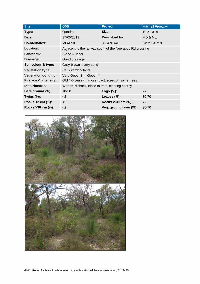
GHD | Report for Main Roads Western Australia - Mitchell Freeway extension, 61/29435
Site Q05 Project Mitchell Freeway Type: Quadrat Size: 10 × 10 m Date: 17/05/2013 Described by: MD & ML
Co-ordinates: MGA 50 380470 mE 6492754 mN Location: Adjacent to the railway south of the Neerabup Rd crossing Landform: Slope – upper Drainage: Good drainage Soil colour & type: Grey-brown loamy sand Vegetation type: Banksia woodland Vegetation condition: Very Good (3) – Good (4) Fire age & intensity: Old (>5 years), minor impact, scars on some trees Disturbances: Weeds, dieback, close to train, clearing nearby Bare ground (%): 10-30 Logs (%): <2 Twigs (%): <2 Leaves (%): 30-70 Rocks <2 cm (%): <2 Rocks 2-30 cm (%): <2 Rocks >30 cm (%): <2 Veg. ground layer (%): 30-70
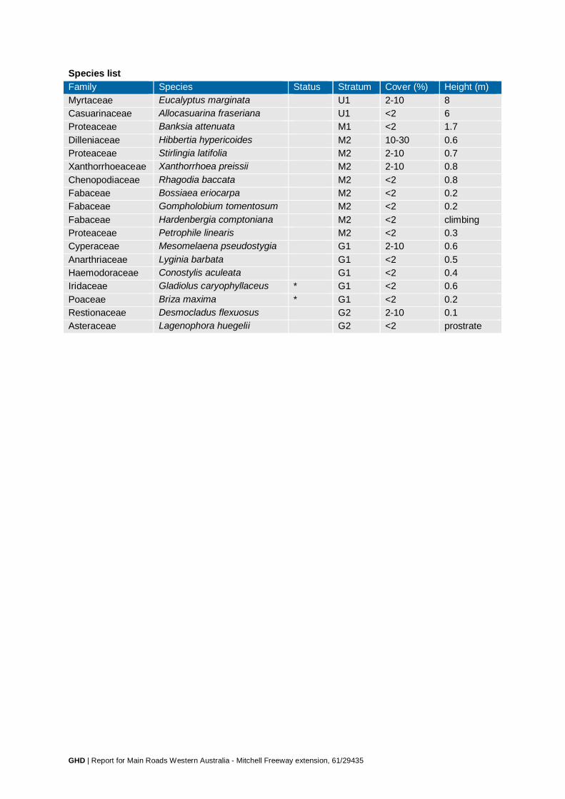
GHD | Report for Main Roads Western Australia - Mitchell Freeway extension, 61/29435
Species list Family Species Status Stratum Cover (%) Height (m) Myrtaceae Eucalyptus marginata U1 2-10 8 Casuarinaceae Allocasuarina fraseriana U1 <2 6 Proteaceae Banksia attenuata M1 <2 1.7 Dilleniaceae Hibbertia hypericoides M2 10-30 0.6 Proteaceae Stirlingia latifolia M2 2-10 0.7 Xanthorrhoeaceae Xanthorrhoea preissii M2 2-10 0.8 Chenopodiaceae Rhagodia baccata M2 <2 0.8 Fabaceae Bossiaea eriocarpa M2 <2 0.2 Fabaceae Gompholobium tomentosum M2 <2 0.2 Fabaceae Hardenbergia comptoniana M2 <2 climbing Proteaceae Petrophile linearis M2 <2 0.3 Cyperaceae Mesomelaena pseudostygia G1 2-10 0.6 Anarthriaceae Lyginia barbata G1 <2 0.5 Haemodoraceae Conostylis aculeata G1 <2 0.4 Iridaceae Gladiolus caryophyllaceus * G1 <2 0.6 Poaceae Briza maxima * G1 <2 0.2 Restionaceae Desmocladus flexuosus G2 2-10 0.1 Asteraceae Lagenophora huegelii G2 <2 prostrate

GHD | Report for Main Roads Western Australia - Mitchell Freeway extension, 61/29435
Site Q06 Project Mitchell Freeway Type: Quadrat Size: 10 × 10 m Date: 17/05/2013 Described by: MD & ML
Co-ordinates: MGA 50 381612 mE 6494075 mN Location: Wanneroo Rd Landform: Slope – middle (gradual) Drainage: Good drainage Soil colour & type: Dark brown loamy sand Vegetation type: Tuart woodland Vegetation condition: Good (4) – Degraded (5) Fire age & intensity: Old (>5 years), minor impact, scars on some trees Disturbances: Clearing, weeds, light rabbit grazing Bare ground (%): <2 Logs (%): <2 Twigs (%): 2-10 Leaves (%): 70-100 Rocks <2 cm (%): <2 Rocks 2-30 cm (%): <2 Rocks >30 cm (%): <2 Veg. ground layer (%): 70-100
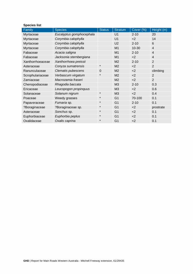
GHD | Report for Main Roads Western Australia - Mitchell Freeway extension, 61/29435
Species list Family Species Status Stratum Cover (%) Height (m) Myrtaceae Eucalyptus gomphocephala U1 2-10 20 Myrtaceae Corymbia calophylla U1 <2 14 Myrtaceae Corymbia calophylla U2 2-10 6 Myrtaceae Corymbia calophylla M1 10-30 4 Fabaceae Acacia saligna M1 2-10 4 Fabaceae Jacksonia sternbergiana M1 <2 4 Xanthorrhoeaceae Xanthorrhoea preissii M2 2-10 2 Asteraceae Conyza sumatrensis * M2 <2 2 Ranunculaceae Clematis pubescens 0 M2 <2 climbing Scrophulariaceae Verbascum virgatum * M2 <2 2 Zamiaceae Macrozamia fraseri M2 <2 2 Chenopodiaceae Rhagodia baccata M3 2-10 0.3 Ericaceae Leucopogon propinquus M3 <2 0.6 Solanaceae Solanum nigrum * M3 <2 0.4 Poaceae Weedy grasses * G1 70-100 0.1 Papaveraceae Fumaria sp. * G1 2-10 0.1 ?Boraginaceae ?Boraginaceae sp. * G1 <2 prostrate Asteraceae Sonchus sp. * G1 <2 0.1 Euphorbiaceae Euphorbia peplus * G1 <2 0.1 Oxalidaceae Oxalis caprina * G1 <2 0.1

GHD | Report for Main Roads Western Australia - Mitchell Freeway extension, 61/29435
Site Q07 Project Mitchell Freeway Type: Quadrat Size: 10 × 10 m Date: 24/05/2013 Described by: JH & ML
Co-ordinates: MGA 50 377786 mE 6499270 mN Location: Railway alignment south of Romeo Rd Landform: Flat Drainage: Good drainage Soil colour & type: Yellow sand Vegetation type: Tuart woodland Vegetation condition: Good (4) Fire age & intensity: Moderate (1–5 years), minor impact, scars on most trees Disturbances: Clearing, weeds, light native herbivore grazing, road nearby Bare ground (%): 30-70 Logs (%): <2 Twigs (%): 10-30 Leaves (%): 10-30 Rocks <2 cm (%): <2 Rocks 2-30 cm (%): <2 Rocks >30 cm (%): <2 Veg. ground layer (%): 2-10
Species list Family Species Status Stratum Cover (%) Height (m) Myrtaceae Eucalyptus gomphocephala U1 10-30 15 Myrtaceae Eucalyptus gomphocephala U2 2-10 3 Xanthorrhoeaceae Xanthorrhoea preissii M1 2-10 2 Solanaceae Anthocercis littorea M1 <2 2.5 Xanthorrhoeaceae Xanthorrhoea preissii M2 2-10 2 Fabaceae Acacia saligna M2 <2 1.5 Fabaceae Jacksonia sternbergiana M2 <2 2 Chenopodiaceae Rhagodia baccata M3 <2 0.6 Aizoaceae Carpobrotus sp. * G1 <2 0.2 Ericaceae Astroloma microcalyx G1 <2 0.2 Fabaceae Hardenbergia comptoniana G1 <2 0.1 Fabaceae Kennedia sp. G1 <2 0.1 Fabaceae Lupinus angustifolius * G1 <2 0.1 Geraniaceae Geranium molle * G1 <2 0.1

GHD | Report for Main Roads Western Australia - Mitchell Freeway extension, 61/29435
Family Species Status Stratum Cover (%) Height (m) Geraniaceae Pelargonium capitatum * G1 <2 0.2 Weedy grasses/herbs * G2 10-30 0.1 Asteraceae Hypochaeris sp. * G2 <2 0.1 Asteraceae Sonchus sp. * G2 <2 0.1 Fabaceae Medicago sp. * G2 <2 0.1 Poaceae Poaceae sp. G2 <2 0.1
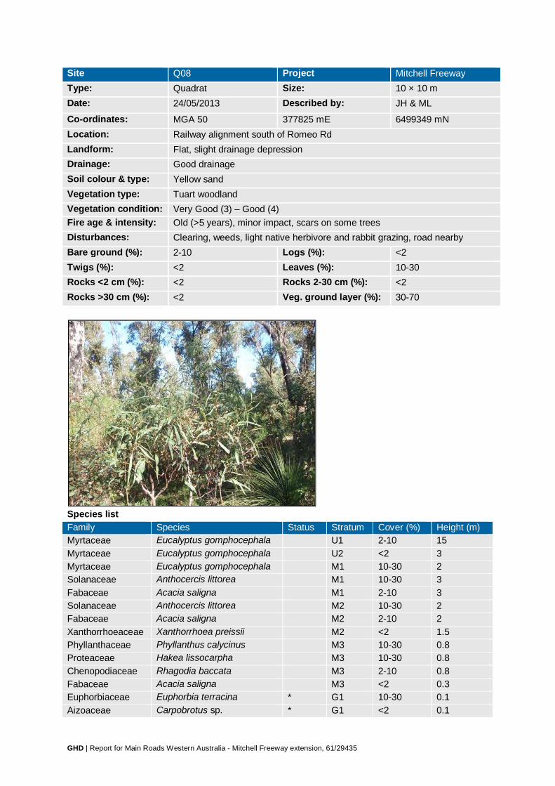
GHD | Report for Main Roads Western Australia - Mitchell Freeway extension, 61/29435
Site Q08 Project Mitchell Freeway Type: Quadrat Size: 10 × 10 m Date: 24/05/2013 Described by: JH & ML
Co-ordinates: MGA 50 377825 mE 6499349 mN Location: Railway alignment south of Romeo Rd Landform: Flat, slight drainage depression Drainage: Good drainage Soil colour & type: Yellow sand Vegetation type: Tuart woodland Vegetation condition: Very Good (3) – Good (4) Fire age & intensity: Old (>5 years), minor impact, scars on some trees Disturbances: Clearing, weeds, light native herbivore and rabbit grazing, road nearby Bare ground (%): 2-10 Logs (%): <2 Twigs (%): <2 Leaves (%): 10-30 Rocks <2 cm (%): <2 Rocks 2-30 cm (%): <2 Rocks >30 cm (%): <2 Veg. ground layer (%): 30-70
Species list Family Species Status Stratum Cover (%) Height (m) Myrtaceae Eucalyptus gomphocephala U1 2-10 15 Myrtaceae Eucalyptus gomphocephala U2 <2 3 Myrtaceae Eucalyptus gomphocephala M1 10-30 2 Solanaceae Anthocercis littorea M1 10-30 3 Fabaceae Acacia saligna M1 2-10 3 Solanaceae Anthocercis littorea M2 10-30 2 Fabaceae Acacia saligna M2 2-10 2 Xanthorrhoeaceae Xanthorrhoea preissii M2 <2 1.5 Phyllanthaceae Phyllanthus calycinus M3 10-30 0.8 Proteaceae Hakea lissocarpha M3 10-30 0.8 Chenopodiaceae Rhagodia baccata M3 2-10 0.8 Fabaceae Acacia saligna M3 <2 0.3 Euphorbiaceae Euphorbia terracina * G1 10-30 0.1 Aizoaceae Carpobrotus sp. * G1 <2 0.1

GHD | Report for Main Roads Western Australia - Mitchell Freeway extension, 61/29435
Family Species Status Stratum Cover (%) Height (m) Cyperaceae Mesomelaena pseudostygia G1 <2 0.3 Ericaceae Astroloma ciliatum G1 <2 0.1 Fabaceae Jacksonia sericea P4 G1 <2 0.3 Haemodoraceae Conostylis candicans G1 <2 0.1 Haemodoraceae Conostylis setigera G1 <2 0.1 Proteaceae Banksia dallanneyi G1 <2 0.3 Restionaceae Desmocladus flexuosus G1 <2 0.1 Weedy grasses/herbs * G2 30-70 0.1 Fabaceae Kennedia sp. G2 <2 prostrate Fabaceae Medicago polymorpha * G2 <2 0.1 Geraniaceae Erodium sp. * G2 <2 prostrate

GHD | Report for Main Roads Western Australia - Mitchell Freeway extension, 61/29435
Site Q09 Project Mitchell Freeway Type: Quadrat Size: 10 × 10 m Date: 24/05/2013 Described by: JH & ML
Co-ordinates: MGA 50 377780 mE 6499476 mN Location: Railway alignment south of Romeo Rd, north of Hester Ave Landform: Slope – middle Drainage: Good drainage Soil colour & type: Yellow-orange sand Vegetation type: Mixed low heath on limestone Vegetation condition: Excellent (2) Fire age & intensity: Moderate (1–5 years), minor impact, scars on most trees Disturbances: Weeds Bare ground (%): 10-30 Logs (%): <2 Twigs (%): 2-10 Leaves (%): <2 Rocks <2 cm (%): <2 Rocks 2-30 cm (%): <2 Rocks >30 cm (%): 2-10 limestone Veg. ground layer (%): 70-100
Species list Family Species Status Stratum Cover (%) Height (m) Xanthorrhoeaceae Xanthorrhoea preissii M1 2-10 1.5 Proteaceae Banksia sessilis M2 <2 1.3 Fabaceae Acacia lasiocarpa M3 30-70 0.9 Myrtaceae Calothamnus quadrifidus M3 30-70 0.9 Fabaceae Jacksonia calcicola M3 10-30 0.2 Dilleniaceae Hibbertia hypericoides M3 2-10 0.8 Myrtaceae Melaleuca systena M3 2-10 0.9 Proteaceae Banksia sessilis M3 2-10 1 Chenopodiaceae Rhagodia baccata M3 <2 0.5 Fabaceae Gastrolobium capitatum M3 <2 0.5 Goodeniaceae Lechenaultia linarioides M3 <2 0.2 Hemerocallidaceae Dianella revoluta M3 <2 0.8 Haemodoraceae Conostylis candicans G1 2-10 0.2 Aizoaceae Carpobrotus sp. * G1 <2 0.1

GHD | Report for Main Roads Western Australia - Mitchell Freeway extension, 61/29435
Family Species Status Stratum Cover (%) Height (m) Asparagaceae Acanthocarpus preissii G1 <2 0.1 Asparagaceae Lomandra caespitosa G1 <2 0.1 Asteraceae Ursinia anthemoides * G1 <2 0.1 Cyperaceae Mesomelaena pseudostygia G1 <2 0.6 Fabaceae Gompholobium tomentosum G1 <2 0.1 Iridaceae Gladiolus caryophyllaceus * G1 <2 0.2 Primulaceae Lysimachia arvensis * G1 <2 0.1 Proteaceae Banksia dallanneyi G1 <2 0.1 Restionaceae Desmocladus flexuosus G1 <2 0.1 Droseraceae Drosera erythrorhiza G2 10-30 prostrate Weedy herbs * G2 10-30 prostrate Asteraceae Arctotheca calendula * G2 <2 prostrate Fabaceae Kennedia sp. G2 <2 prostrate Fabaceae Medicago polymorpha * G2 <2 0.1 Geraniaceae Geranium molle * G2 <2 prostrate

GHD | Report for Main Roads Western Australia - Mitchell Freeway extension, 61/29435
Site Q10 Project Mitchell Freeway Type: Quadrat Size: 10 × 10 m Date: 24/05/2013 Described by: JH & ML
Co-ordinates: MGA 50 377793 mE 6499589 mN Location: Railway alignment south of Romeo Rd, north of Hester Ave Landform: Slope – middle Drainage: Good drainage Soil colour & type: Yellow-orange sand Vegetation type: Mixed low heath on limestone Vegetation condition: Excellent (2) Fire age & intensity: Moderate (1–5 years), minor impact, scars on most trees Disturbances: Weeds, light rabbit grazing Bare ground (%): 30-70 Logs (%): <2 Twigs (%): <2 Leaves (%): <2 Rocks <2 cm (%): <2 Rocks 2-30 cm (%): <2 Rocks >30 cm (%): 2-10 limestone Veg. ground layer (%): 70-100
Species list Family Species Status Stratum Cover (%) Height (m) Fabaceae Acacia pulchella M1 30-70 1.3 Proteaceae Banksia sessilis M1 10-30 1.3 Proteaceae Hakea trifurcata M1 10-30 1.6 Xanthorrhoeaceae Xanthorrhoea preissii M1 2-10 1.5 Myrtaceae Melaleuca systena M2 10-30 1 Dilleniaceae Hibbertia hypericoides M2 2-10 0.6 Fabaceae Acacia lasiocarpa M2 2-10 0.8 Fabaceae Jacksonia calcicola M2 <2 0.5 Phyllanthaceae Phyllanthus calycinus G1 10-30 0.4 Asteraceae Ursinia anthemoides * G1 2-10 0.1 Restionaceae Desmocladus flexuosus G1 2-10 0.1 Aizoaceae Carpobrotus sp. * G1 <2 0.1 Asparagaceae Lomandra caespitosa G1 <2 0.1 Asteraceae Conyza sp. * G1 <2 0.7

GHD | Report for Main Roads Western Australia - Mitchell Freeway extension, 61/29435
Family Species Status Stratum Cover (%) Height (m) Cyperaceae Lepidosperma angustatum G1 <2 0.1 Cyperaceae Mesomelaena pseudostygia G1 <2 0.5 Ericaceae Leucopogon parviflorus G1 <2 0.1 Fabaceae Acacia lasiocarpa G1 <2 0.3 Fabaceae Gompholobium tomentosum G1 <2 0.1 Goodeniaceae Lechenaultia linarioides G1 <2 0.2 Haemodoraceae Conostylis candicans G1 <2 0.2 Haemodoraceae Conostylis setigera G1 <2 0.1 Hemerocallidaceae Dianella revoluta G1 <2 0.6 Hemerocallidaceae Tricoryne elatior G1 <2 0.3 Myrtaceae Calothamnus quadrifidus G1 <2 0.5 Restionaceae Loxocarya cinerea G1 <2 0.1 Fabaceae Kennedia sp. G2 2-10 prostrate Weedy grasses/herbs * G2 2-10 prostrate Asparagaceae Lomandra sp. G2 <2 0.1 Droseraceae Drosera erythrorhiza G2 <2 prostrate Fabaceae Hardenbergia comptoniana G2 <2 prostrate

GHD | Report for Main Roads Western Australia - Mitchell Freeway extension, 61/29435
Site Q11 Project Mitchell Freeway Type: Quadrat Size: 10 × 10 m Date: 24/05/2013, 10/10/2013 Described by: JH & ML, CB & ML
Co-ordinates: MGA 50 377924 mE 6499085 mN Location: Railway alignment south of Romeo Rd, north of Hester Ave Landform: Slope – upper Drainage: Good drainage Soil colour & type: Brown sand Vegetation type: Melaleuca huegelii–M. systena shrubland on limestone Vegetation condition: Excellent (2) Fire age & intensity: Old (>5 years), minor impact, scars on some trees Disturbances: Weeds Bare ground (%): 2-10 Logs (%): <2 Twigs (%): <2 Leaves (%): <2 Rocks <2 cm (%): 2-10 limestone Rocks 2-30 cm (%): 2-10 limestone Rocks >30 cm (%): 10-30 limestone Veg. ground layer (%): 70-100 24/05/2013

GHD | Report for Main Roads Western Australia - Mitchell Freeway extension, 61/29435
10/10/2013
Species list Family Species Status Stratum Cover (%) Height (m) Myrtaceae Melaleuca huegelii M1 10-30 1.6 Solanaceae Anthocercis littorea M1 <2 0.5 Myrtaceae Melaleuca systena M2 30-70 0.8 Proteaceae Grevillea preissii subsp.
preissii M2 10-30 0.5
Fabaceae Acacia lasiocarpa M2 2-10 0.6 Asteraceae Olearia rudis M2 <2 0.9 Ericaceae Leucopogon parviflorus M2 <2 0.5 Fabaceae Bossiaea eriocarpa M2 <2 0.3 Goodeniaceae Scaevola anchusifolia M2 <2 0.5 Hemerocallidaceae Dianella revoluta M2 <2 0.6 Phyllanthaceae Phyllanthus calycinus M2 <2 0.3 Proteaceae Banksia sessilis M2 <2 0.5 Xanthorrhoeaceae Xanthorrhoea preissii M2 <2 0.3 Restionaceae Desmocladus flexuosus G1 30-70 0.2 Asparagaceae Lomandra caespitosa G1 10-30 0.3 Rubiaceae Opercularia vaginata G1 10-30 0.2 Poaceae Austrostipa compressa G1 <2 0.7 Stylidiaceae Stylidium maritimum P3 G1 <2 0.7 Haemodoraceae Anigozanthos manglesianus G1 <2 0.4 Iridaceae Gladiolus caryophyllaceus * G1 <2 0.3 Cyperaceae Lepidosperma costale G1 <2 0.2 Goodeniaceae Lechenaultia linarioides G1 <2 0.1 Weedy herbs * G2 30-70 prostrate Asteraceae Ursinia anthemoides * G2 10-30 0.2 Primulaceae Lysimachia arvensis * G2 2-10 prostrate Poaceae Ehrharta longiflora * G2 <2 0.4 Caryophyllaceae Petrorhagia dubia * G2 <2 0.3 Haemodoraceae Conostylis aculeata G2 <2 0.2 Poaceae Vulpia bromoides * G2 <2 0.2 Aizoaceae Carpobrotus sp. * G2 <2 0.1

GHD | Report for Main Roads Western Australia - Mitchell Freeway extension, 61/29435
Family Species Status Stratum Cover (%) Height (m) Asparagaceae Thysanotus sp. G2 <2 0.1 Asteraceae Hypochaeris sp. * G2 <2 0.1 Cyperaceae Lepidosperma angustatum G2 <2 0.1 Fabaceae Gompholobium tomentosum G2 <2 0.1 Poaceae Briza maxima * G2 <2 0.1 Poaceae Lolium rigidum * G2 <2 0.1 Restionaceae Desmocladus fasciculatus G2 <2 0.1 Rhamnaceae Cryptandra scoparia G2 <2 0.1 Haemodoraceae Conostylis candicans G2 <2 prostrate Fabaceae Kennedia prostrata G2 <2 prostrate
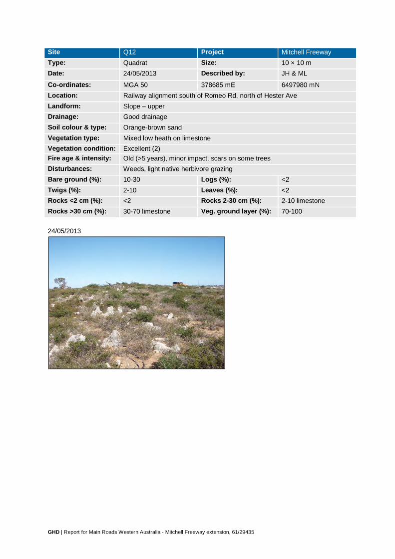
GHD | Report for Main Roads Western Australia - Mitchell Freeway extension, 61/29435
Site Q12 Project Mitchell Freeway Type: Quadrat Size: 10 × 10 m Date: 24/05/2013 Described by: JH & ML
Co-ordinates: MGA 50 378685 mE 6497980 mN Location: Railway alignment south of Romeo Rd, north of Hester Ave Landform: Slope – upper Drainage: Good drainage Soil colour & type: Orange-brown sand Vegetation type: Mixed low heath on limestone Vegetation condition: Excellent (2) Fire age & intensity: Old (>5 years), minor impact, scars on some trees Disturbances: Weeds, light native herbivore grazing Bare ground (%): 10-30 Logs (%): <2 Twigs (%): 2-10 Leaves (%): <2 Rocks <2 cm (%): <2 Rocks 2-30 cm (%): 2-10 limestone Rocks >30 cm (%): 30-70 limestone Veg. ground layer (%): 70-100 24/05/2013

GHD | Report for Main Roads Western Australia - Mitchell Freeway extension, 61/29435
04/10/2013
Species list Family Species Status Stratum Cover (%) Height (m) Myrtaceae Melaleuca systena M1 30-70 0.8 Dilleniaceae Hibbertia hypericoides M1 10-30 0.8 Fabaceae Acacia lasiocarpa M1 10-30 0.8 Fabaceae Templetonia retusa M1 <2 0.5 Proteaceae Hakea trifurcata M1 <2 0.4 Santalaceae Leptomeria pauciflora M1 <2 0.4 Thymelaeaceae Pimelea calcicola P3 M1 <2 0.4 Rutaceae Philotheca spicata M1 <2 0.2 Convolvulaceae Cuscuta epithymum * M1 <2 climbing Droseraceae Drosera sp. M1 <2 climbing Goodeniaceae Scaevola nitida G1 2-10 0.4 Proteaceae Grevillea preissii subsp. preissii G1 2-10 0.5 Proteaceae Banksia dallanneyi G1 2-10 0.2 Brassicaceae Brassica tournefortii * G1 <2 0.4 Caryophyllaceae Petrorhagia dubia * G1 <2 0.3 Caryophyllaceae Silene gallica * G1 <2 0.3 Cyperaceae Mesomelaena pseudostygia G1 <2 0.3 Phyllanthaceae Phyllanthus calycinus G1 <2 0.3 Asteraceae Hypochaeris sp. * G1 <2 0.2 Asteraceae Sonchus oleraceus * G1 <2 0.2 Fabaceae Jacksonia calcicola G1 <2 0.2 Iridaceae Gladiolus caryophyllaceus * G1 <2 0.2 Poaceae Briza maxima * G1 <2 0.2 Poaceae Briza minor * G1 <2 0.2 Proteaceae Petrophile serruriae G1 <2 0.2 Violaceae Hybanthus calycinus G1 <2 0.2 Aizoaceae Carpobrotus sp. * G1 <2 0.1 Apiaceae Daucus glochidiatus G1 <2 0.1 Asteraceae Urospermum picroides * G1 <2 0.1 Asteraceae Ursinia anthemoides * G1 <2 0.1 Fabaceae Gompholobium tomentosum G1 <2 0.1

GHD | Report for Main Roads Western Australia - Mitchell Freeway extension, 61/29435
Family Species Status Stratum Cover (%) Height (m) Haemodoraceae Conostylis aculeata G1 <2 0.1 Poaceae Ehrharta longiflora * G1 <2 0.1 Restionaceae Desmocladus flexuosus G2 10-30 0.1 Araliaceae Trachymene pilosa G2 <2 0.05 Asteraceae Millotia myosotidifolia G2 <2 0.05 Brassicaceae Heliophila pusilla * G2 <2 0.05 Crassulaceae Crassula colorata G2 <2 0.05 Cyperaceae Schoenus curvifolius G2 <2 0.05 Fabaceae Trifolium arvense * G2 <2 0.05 Fabaceae Trifolium campestre * G2 <2 0.05 Poaceae Catapodium rigidum * G2 <2 0.05 Poaceae Phleum arenarium * G2 <2 0.05 Primulaceae Lysimachia arvensis * G2 <2 0.05

GHD | Report for Main Roads Western Australia - Mitchell Freeway extension, 61/29435
Site Q13 Project Mitchell Freeway Type: Quadrat Size: 10 × 10 m Date: 24/05/2013, 10/10/2013 Described by: JH & ML, CB & ML
Co-ordinates: MGA 50 378083 mE 6498797 mN Location: Railway alignment south of Romeo Rd, north of Hester Ave Landform: Flat Drainage: Good drainage Soil colour & type: Orange-brown sand Vegetation type: Mixed low heath on limestone Vegetation condition: Excellent (2) Fire age & intensity: Old (>5 years), minor impact, scars on most trees Disturbances: Weeds, light native herbivore and rabbit grazing Bare ground (%): 2-10 Logs (%): <2 Twigs (%): 2-10 Leaves (%): 10-30 Rocks <2 cm (%): <2 Rocks 2-30 cm (%): <2 Rocks >30 cm (%): <2 Veg. ground layer (%): 70-100 24/05/2013
10/10/2013

GHD | Report for Main Roads Western Australia - Mitchell Freeway extension, 61/29435
Species list Family Species Status Stratum Cover (%) Height (m) Xanthorrhoeaceae Xanthorrhoea preissii M1 2-10 2.3 Proteaceae Hakea prostrata M1 <2 1.8 Myrtaceae Melaleuca systena M2 30-70 1.5 Fabaceae Acacia lasiocarpa M2 10-30 1.5 Proteaceae Hakea lissocarpha M2 10-30 1.5 Casuarinaceae Allocasuarina humilis M2 <2 0.4 Myrtaceae Melaleuca systena M3 30-70 0.8 Fabaceae Acacia lasiocarpa M3 10-30 0.8 Proteaceae Hakea lissocarpha M3 10-30 0.8 Asteraceae Hypochaeris sp. * M3 <2 0.4 Myrtaceae Calothamnus quadrifidus M3 <2 0.4 Asparagaceae Lomandra maritima G1 10-30 0.3 Cyperaceae Mesomelaena pseudostygia G1 10-30 0.3 Haemodoraceae Conostylis aculeata G1 <2 0.3 Ericaceae Leucopogon propinquus M3 <2 0.2 Fabaceae Bossiaea eriocarpa M3 <2 0.2 Proteaceae Banksia dallanneyi M3 <2 0.2 Rubiaceae Opercularia vaginata G1 <2 0.3 Caryophyllaceae Petrorhagia dubia * G1 <2 0.2 Aizoaceae Carpobrotus sp. * G1 <2 0.1 Ericaceae Leucopogon insularis G1 <2 0.1 Fabaceae Gompholobium tomentosum G1 <2 0.1 Iridaceae Gladiolus caryophyllaceus * G1 <2 0.1 Rhamnaceae Cryptandra scoparia G1 <2 0.1 Primulaceae Lysimachia arvensis * G2 30-70 0.05 Restionaceae Desmocladus flexuosus G2 10-30 0.1 Asteraceae Ursinia anthemoides * G2 2-10 0.1 Brassicaceae Heliophila pusilla * G2 2-10 0.05 Droseraceae Drosera erythrorhiza G2 2-10 prostrate Poaceae Briza maxima * G2 <2 0.1 Poaceae Briza minor * G2 <2 0.1 Araliaceae Trachymene pilosa G2 <2 0.05 Asteraceae Millotia myosotidifolia G2 <2 0.05

GHD | Report for Main Roads Western Australia - Mitchell Freeway extension, 61/29435
Family Species Status Stratum Cover (%) Height (m) Poaceae Aira cupaniana * G2 <2 0.05 Poaceae Bromus hordeaceus * G2 <2 0.05 Portulacaceae Calandrinia liniflora G2 <2 0.05 Stylidiaceae Stylidium rigidulum G2 <2 0.05 Weedy herbs * G2 <2 prostrate

GHD | Report for Main Roads Western Australia - Mitchell Freeway extension, 61/29435
Site Q14 Project Mitchell Freeway Type: Quadrat Size: 10 × 10 m Date: 24/05/2013 Described by: JH & ML
Co-ordinates: MGA 50 378004 mE 6498951 mN Location: Railway alignment south of Romeo Rd, north of Hester Ave Landform: Flat Drainage: Good drainage Soil colour & type: Yellow sand Vegetation type: Banksia woodland Vegetation condition: Very Good (3) Fire age & intensity: Old (>5 years), minor impact, scars on some trees Disturbances: Light native herbivore and rabbit grazing, dieback Bare ground (%): 30-70 Logs (%): <2 Twigs (%): 10-30 Leaves (%): 30-70 Rocks <2 cm (%): <2 Rocks 2-30 cm (%): <2 Rocks >30 cm (%): <2 Veg. ground layer (%): 10-30
Species list Family Species Status Stratum Cover (%) Height (m) Casuarinaceae Allocasuarina fraseriana U1 2-10 4 Proteaceae Banksia attenuata U1 2-10 5 Proteaceae Banksia attenuata U2 <2 1.3 Proteaceae Banksia menziesii U2 <2 1.9 Fabaceae Acacia pulchella M1 10-30 1.5 Proteaceae Hakea ruscifolia M1 <2 1.8 Zamiaceae Macrozamia fraseri M1 <2 1.6 Dilleniaceae Hibbertia hypericoides M2 10-30 0.5 Proteaceae Hakea trifurcata M2 10-30 0.9 Fabaceae Acacia pulchella M2 2-10 0.8 Ericaceae Conostephium pendulum M3 <2 0.3 Ericaceae Leucopogon propinquus M3 <2 0.3 Goodeniaceae Lechenaultia linarioides M3 <2 0.3 Phyllanthaceae Phyllanthus calycinus M3 <2 0.2
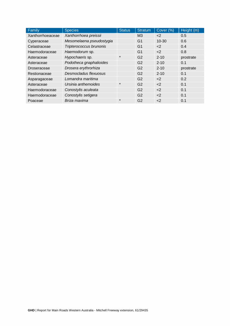
GHD | Report for Main Roads Western Australia - Mitchell Freeway extension, 61/29435
Family Species Status Stratum Cover (%) Height (m) Xanthorrhoeaceae Xanthorrhoea preissii M3 <2 0.5 Cyperaceae Mesomelaena pseudostygia G1 10-30 0.6 Celastraceae Tripterococcus brunonis G1 <2 0.4 Haemodoraceae Haemodorum sp. G1 <2 0.8 Asteraceae Hypochaeris sp. * G2 2-10 prostrate Asteraceae Podotheca gnaphalioides G2 2-10 0.1 Droseraceae Drosera erythrorhiza G2 2-10 prostrate Restionaceae Desmocladus flexuosus G2 2-10 0.1 Asparagaceae Lomandra maritima G2 <2 0.2 Asteraceae Ursinia anthemoides * G2 <2 0.1 Haemodoraceae Conostylis aculeata G2 <2 0.1 Haemodoraceae Conostylis setigera G2 <2 0.1 Poaceae Briza maxima * G2 <2 0.1

GHD | Report for Main Roads Western Australia - Mitchell Freeway extension, 61/29435
Site Q15 Project Mitchell Freeway Type: Quadrat Size: 10 × 10 m Date: 24/05/2013 Described by: JH & ML
Co-ordinates: MGA 50 377765 mE 6499877 mN Location: Railway alignment south of Romeo Rd Landform: Slope – middle Drainage: Good drainage Soil colour & type: Yellow sand Vegetation type: Banksia woodland Vegetation condition: Very Good (3) Fire age & intensity: Old (>5 years), no damage Disturbances: Weeds, light native herbivore and rabbit grazing, dieback Bare ground (%): 30-70 Logs (%): <2 Twigs (%): <2 Leaves (%): 2-10 Rocks <2 cm (%): <2 Rocks 2-30 cm (%): <2 Rocks >30 cm (%): <2 Veg. ground layer (%): 30-70
Species list Family Species Status Stratum Cover (%) Height (m) Proteaceae Banksia attenuata U1 2-10 4 Proteaceae Banksia menziesii U1 2-10 4 Proteaceae Banksia attenuata U2 <2 2.5 Proteaceae Banksia menziesii U2 <2 2.3 Fabaceae Acacia pulchella M1 2-10 1.2 Dilleniaceae Hibbertia hypericoides M2 10-30 0.8 Myrtaceae Calothamnus quadrifidus M2 10-30 0.5 Proteaceae Hakea costata M2 2-10 0.9 Casuarinaceae Allocasuarina humilis M2 <2 0.6 Ericaceae Leucopogon polymorphus M3 <2 0.5 Fabaceae Jacksonia calcicola M3 <2 0.3 Myrtaceae Calytrix flavescens M3 <2 0.3 Proteaceae Hakea lissocarpha M3 <2 0.5 Proteaceae Petrophile linearis M3 <2 0.4
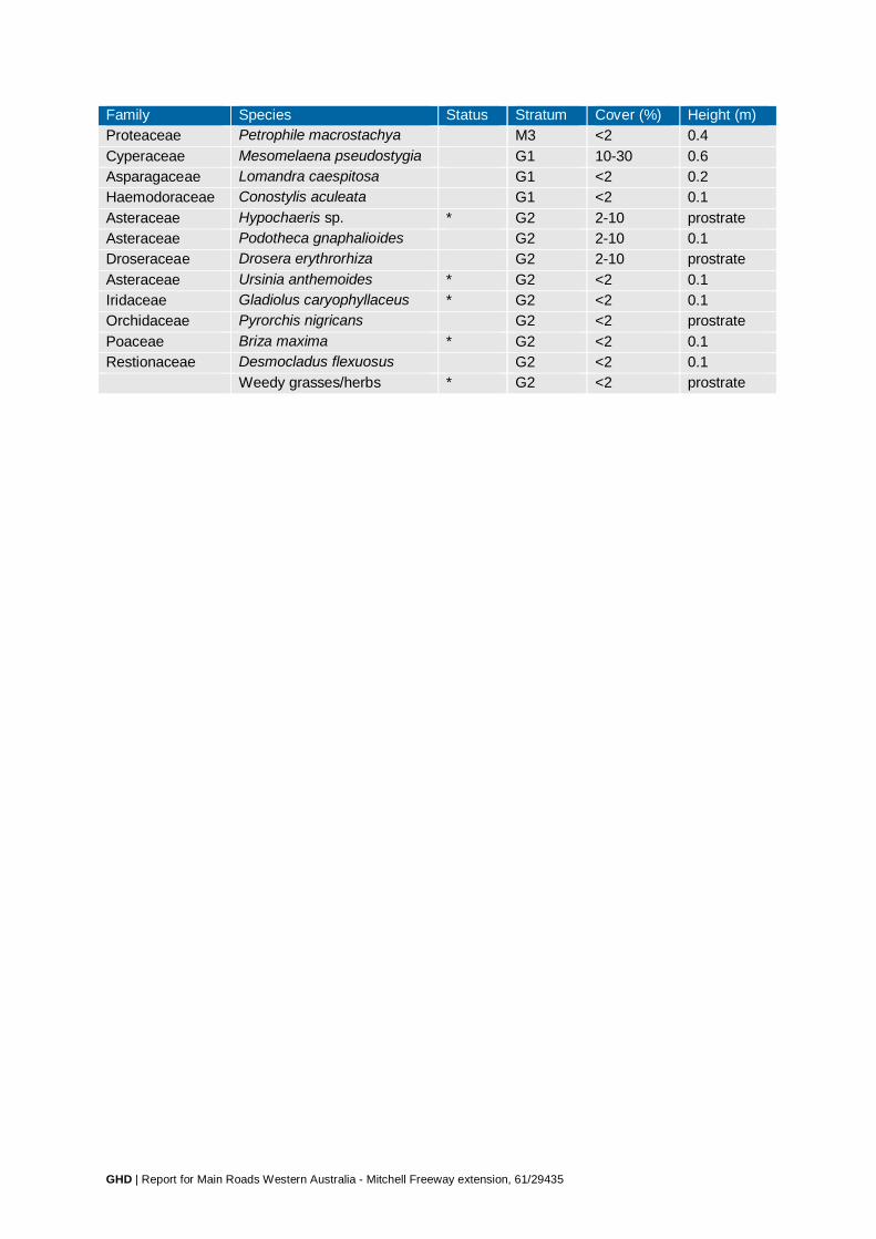
GHD | Report for Main Roads Western Australia - Mitchell Freeway extension, 61/29435
Family Species Status Stratum Cover (%) Height (m) Proteaceae Petrophile macrostachya M3 <2 0.4 Cyperaceae Mesomelaena pseudostygia G1 10-30 0.6 Asparagaceae Lomandra caespitosa G1 <2 0.2 Haemodoraceae Conostylis aculeata G1 <2 0.1 Asteraceae Hypochaeris sp. * G2 2-10 prostrate Asteraceae Podotheca gnaphalioides G2 2-10 0.1 Droseraceae Drosera erythrorhiza G2 2-10 prostrate Asteraceae Ursinia anthemoides * G2 <2 0.1 Iridaceae Gladiolus caryophyllaceus * G2 <2 0.1 Orchidaceae Pyrorchis nigricans G2 <2 prostrate Poaceae Briza maxima * G2 <2 0.1 Restionaceae Desmocladus flexuosus G2 <2 0.1 Weedy grasses/herbs * G2 <2 prostrate

GHD | Report for Main Roads Western Australia - Mitchell Freeway extension, 61/29435
Site Q16 Project Mitchell Freeway Type: Quadrat Size: 10 × 10 m Date: 05/06/2013 Described by: MD & ML, CB & ML
Co-ordinates: MGA 50 376298 mE 6501157 mN Location: North-west of Romeo Rd Landform: Slope – upper Drainage: Good drainage Soil colour & type: Orange sand Vegetation type: Banksia sessilis closed tall scrub Vegetation condition: Excellent (2) Fire age & intensity: Old (>5 years), no damage Disturbances: Weeds Bare ground (%): 2-10 Logs (%): <2 Twigs (%): 2-10 Leaves (%): 30-70 Rocks <2 cm (%): <2 Rocks 2-30 cm (%): <2 Rocks >30 cm (%): 2-10 limestone Veg. ground layer (%): 70-100 05/06/2013
10/10/2013

GHD | Report for Main Roads Western Australia - Mitchell Freeway extension, 61/29435
Species list Family Species Status Stratum Cover (%) Height (m) Proteaceae Banksia sessilis M1 70-100 2.5 Xanthorrhoeaceae Xanthorrhoea preissii M1 10-30 2.8 Myrtaceae Calothamnus quadrifidus M2 10-30 1.9 Proteaceae Hakea trifurcata M2 2-10 1.9 Fabaceae Acacia pulchella M2 <2 1.5 Myrtaceae Melaleuca systena M2 <2 1.9 Myrtaceae Melaleuca systena M3 2-10 0.8 Dilleniaceae Hibbertia hypericoides M3 <2 0.5 Rhamnaceae Spyridium globulosum M3 <2 0.3 Asparagaceae Lomandra maritima G1 <2 0.3 Droseraceae Drosera sp. G1 <2 climbing Lauraceae Cassytha sp. G1 <2 climbing Poaceae Austrostipa flavescens G1 <2 0.7 Poaceae Ehrharta longiflora * G1 30-70 0.6 Poaceae Briza maxima * G1 10-30 0.2 Solanaceae Solanum nigrum * G1 <2 0.7 Poaceae Ehrharta calycina * G1 <2 0.6 Apiaceae Daucus glochidiatus G1 <2 0.2 Asteraceae Hypochaeris sp. * G2 2-10 0.1 Poaceae Bromus hordeaceus * G2 2-10 0.1 Restionaceae Desmocladus flexuosus G2 <2 0.2 Asteraceae Urospermum picroides * G2 <2 0.1 Poaceae Aira cupaniana * G2 <2 0.1 Apiaceae Trachymene pilosa G2 <2 0.05 Geraniaceae Geranium molle * G2 <2 0.05

GHD | Report for Main Roads Western Australia - Mitchell Freeway extension, 61/29435
Site Q17 Project Mitchell Freeway Type: Quadrat Size: 10 × 10 m Date: 18/06/2013 Described by: JH & ML, MD & ML
Co-ordinates: MGA 50 381893 mE 6492927 mN Location: Neerabup Rd alignment near Wanneroo Rd Landform: Slope – middle (gentle SW) Drainage: Good drainage Soil colour & type: Brown/orange sand Vegetation type: Tuart woodland Vegetation condition: Very Good (3) Fire age & intensity: Old (>5 years), minor impact, scars on most trees Disturbances: Weeds, rabbit grazing, evidence of horses Bare ground (%): 10-30 Logs (%): 2-10 Twigs (%): 2-10 Leaves (%): 10-30 Rocks <2 cm (%): <2 Rocks 2-30 cm (%): <2 Rocks >30 cm (%): <2 Veg. ground layer (%): 30-70 18/06/2013
03/10/2013

GHD | Report for Main Roads Western Australia - Mitchell Freeway extension, 61/29435
Species list Family Species Status Stratum Cover (%) Height (m) Myrtaceae Eucalyptus gomphocephala U1 30-70 15 Xanthorrhoeaceae Xanthorrhoea preissii M1 2-10 1.5 Fabaceae Acacia rostellifera M1 <2 1.5 Ranunculaceae Clematis linearifolia M2 30-70 climbing Chenopodiaceae Rhagodia baccata M2 10-30 0.5 Dilleniaceae Hibbertia hypericoides M2 10-30 0.5 Proteaceae Hakea lissocarpha M2 2-10 0.8 Fabaceae Acacia xanthina M2 <2 0.8 Phyllanthaceae Phyllanthus calycinus M2 <2 0.5 Scrophulariaceae Myoporum caprarioides M2 <2 0.5 Rhamnaceae Spyridium globulosum M2 <2 0.3 Scrophulariaceae Pimelea argentea M2 <2 0.3 Solanaceae Solanum nigrum * M2 <2 0.3 Iridaceae Moraea sp. * G1 2-10 0.4 Campanulaceae Wahlenbergia capensis * G1 <2 0.4 Asteraceae Senecio sp. G1 <2 0.2 Hemerocallidaceae Tricoryne elatior G1 <2 0.3 Brassicaceae Heliophila pusilla * G1 <2 0.2 Aizoaceae Carpobrotus sp. * G1 <2 0.1 Fabaceae Bossiaea eriocarpa G1 <2 0.1 Fabaceae Vicia sativa * G1 <2 0.1 Oxalidaceae Oxalis sp. * G1 <2 0.05 Poaceae Weedy grasses * G1 <2 0.05 Poaceae Ehrharta longiflora * G2 <2 0.1 Poaceae Vulpia bromoides * G2 2-10 0.1 Asteraceae Sonchus oleraceus * G2 <2 0.05 Cyperaceae Isolepis cernua G2 <2 0.05 Fabaceae Trifolium campestre * G2 <2 0.05 Iridaceae Romulea rosea * G2 <2 0.05 Poaceae Aira sp. * G2 <2 0.05 Poaceae Briza minor * G2 <2 0.05 Poaceae Vulpia myuros * G2 <2 0.05 Primulaceae Lysimachia arvensis * G2 <2 0.05

GHD | Report for Main Roads Western Australia - Mitchell Freeway extension, 61/29435
Family Species Status Stratum Cover (%) Height (m) Restionaceae Desmocladus flexuosus G2 <2 0.05

GHD | Report for Main Roads Western Australia - Mitchell Freeway extension, 61/29435
Site Q18 Project Mitchell Freeway Type: Quadrat Size: 10 × 10 m Date: 18/06/2013, 03/10/2013 Described by: JH & ML, MD & ML
Co-ordinates: MGA 50 382146 mE 6492849 mN Location: Neerabup Rd alignment near Wanneroo Rd Landform: Slope – middle (gentle) Drainage: Good drainage Soil colour & type: Brown/orange sand Vegetation type: Tuart woodland Vegetation condition: Very Good (3) Fire age & intensity: Old (>5 years), minor impact, scars on most trees with few trees killed, most
resprouting Disturbances: Weeds Bare ground (%): 2-10 Logs (%): 2-10 Twigs (%): 10-30 Leaves (%): 10-30 Rocks <2 cm (%): <2 Rocks 2-30 cm (%): <2 Rocks >30 cm (%): <2 Veg. ground layer (%): 70-100 18/06/2013
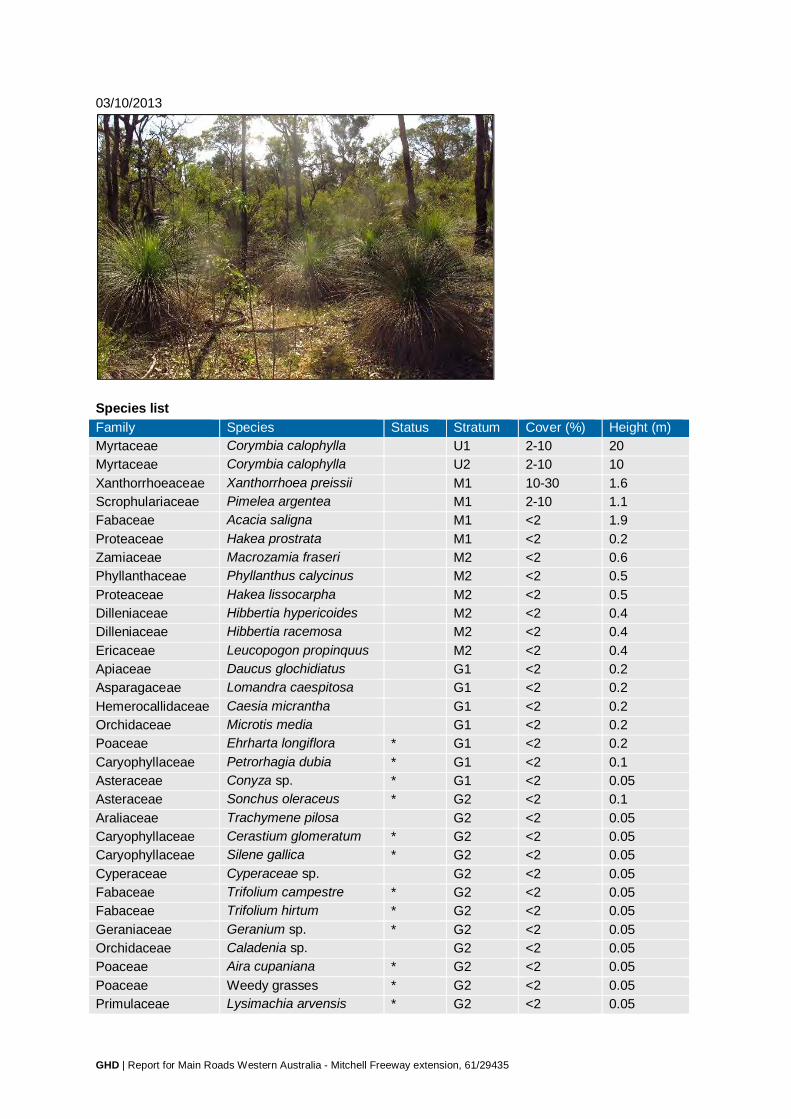
GHD | Report for Main Roads Western Australia - Mitchell Freeway extension, 61/29435
03/10/2013
Species list Family Species Status Stratum Cover (%) Height (m) Myrtaceae Corymbia calophylla U1 2-10 20 Myrtaceae Corymbia calophylla U2 2-10 10 Xanthorrhoeaceae Xanthorrhoea preissii M1 10-30 1.6 Scrophulariaceae Pimelea argentea M1 2-10 1.1 Fabaceae Acacia saligna M1 <2 1.9 Proteaceae Hakea prostrata M1 <2 0.2 Zamiaceae Macrozamia fraseri M2 <2 0.6 Phyllanthaceae Phyllanthus calycinus M2 <2 0.5 Proteaceae Hakea lissocarpha M2 <2 0.5 Dilleniaceae Hibbertia hypericoides M2 <2 0.4 Dilleniaceae Hibbertia racemosa M2 <2 0.4 Ericaceae Leucopogon propinquus M2 <2 0.4 Apiaceae Daucus glochidiatus G1 <2 0.2 Asparagaceae Lomandra caespitosa G1 <2 0.2 Hemerocallidaceae Caesia micrantha G1 <2 0.2 Orchidaceae Microtis media G1 <2 0.2 Poaceae Ehrharta longiflora * G1 <2 0.2 Caryophyllaceae Petrorhagia dubia * G1 <2 0.1 Asteraceae Conyza sp. * G1 <2 0.05 Asteraceae Sonchus oleraceus * G2 <2 0.1 Araliaceae Trachymene pilosa G2 <2 0.05 Caryophyllaceae Cerastium glomeratum * G2 <2 0.05 Caryophyllaceae Silene gallica * G2 <2 0.05 Cyperaceae Cyperaceae sp. G2 <2 0.05 Fabaceae Trifolium campestre * G2 <2 0.05 Fabaceae Trifolium hirtum * G2 <2 0.05 Geraniaceae Geranium sp. * G2 <2 0.05 Orchidaceae Caladenia sp. G2 <2 0.05 Poaceae Aira cupaniana * G2 <2 0.05 Poaceae Weedy grasses * G2 <2 0.05 Primulaceae Lysimachia arvensis * G2 <2 0.05

GHD | Report for Main Roads Western Australia - Mitchell Freeway extension, 61/29435
Family Species Status Stratum Cover (%) Height (m) Phyllanthaceae Poranthera drummondii G2 <2 0.05 Asteraceae Hypochaeris sp. * G2 <2 prostrate
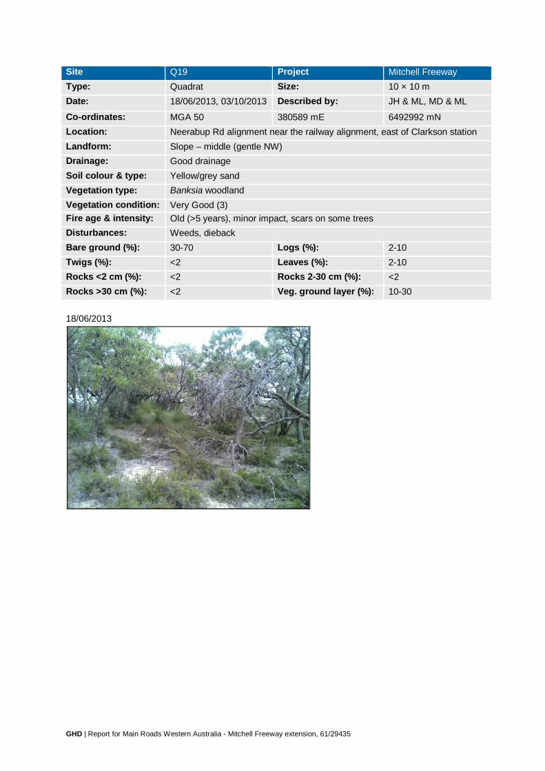
GHD | Report for Main Roads Western Australia - Mitchell Freeway extension, 61/29435
Site Q19 Project Mitchell Freeway Type: Quadrat Size: 10 × 10 m Date: 18/06/2013, 03/10/2013 Described by: JH & ML, MD & ML
Co-ordinates: MGA 50 380589 mE 6492992 mN Location: Neerabup Rd alignment near the railway alignment, east of Clarkson station Landform: Slope – middle (gentle NW) Drainage: Good drainage Soil colour & type: Yellow/grey sand Vegetation type: Banksia woodland Vegetation condition: Very Good (3) Fire age & intensity: Old (>5 years), minor impact, scars on some trees Disturbances: Weeds, dieback Bare ground (%): 30-70 Logs (%): 2-10 Twigs (%): <2 Leaves (%): 2-10 Rocks <2 cm (%): <2 Rocks 2-30 cm (%): <2 Rocks >30 cm (%): <2 Veg. ground layer (%): 10-30 18/06/2013

GHD | Report for Main Roads Western Australia - Mitchell Freeway extension, 61/29435
03/10/2013
Species list Family Species Status Stratum Cover (%) Height (m) Proteaceae Banksia attenuata U1 30-70 4 Casuarinaceae Allocasuarina fraseriana U1 2-10 4 Xanthorrhoeaceae Xanthorrhoea preissii M1 2-10 1.9 Dilleniaceae Hibbertia hypericoides M2 30-70 0.5 Rutaceae Philotheca spicata M2 2-10 0.4 Proteaceae Petrophile linearis M2 2-10 0.2 Proteaceae Stirlingia latifolia M2 <2 0.3 Dilleniaceae Hibbertia racemosa M2 <2 0.2 Weedy grasses/herbs * G1 30-70 0.05 Asteraceae Ursinia anthemoides * G1 2-10 0.05 Brassicaceae Brassica tournefortii * G1 <2 0.5 Restionaceae Desmocladus flexuosus G1 <2 0.3 Aizoaceae Carpobrotus sp. * G1 <2 0.1 Asteraceae Podotheca gnaphalioides G1 <2 0.1 Brassicaceae Heliophila pusilla * G1 <2 0.1 Caryophyllaceae Petrorhagia dubia * G1 <2 0.1 Cyperaceae Mesomelaena pseudostygia G1 <2 0.1 Fabaceae Hovea trisperma G1 <2 0.1 Poaceae Briza maxima * G1 <2 0.1 Poaceae Ehrharta longiflora * G1 <2 0.1 Droseraceae Drosera erythrorhiza G2 2-10 prostrate Araliaceae Trachymene pilosa G2 <2 0.05 Asteraceae Millotia myosotidifolia G2 <2 0.05 Asteraceae Podotheca chrysantha G2 <2 0.05 Asteraceae Quinetia urvillei G2 <2 0.05 Crassulaceae Crassula sp. G2 <2 0.05 Cyperaceae Isolepis marginata * G2 <2 0.05 Iridaceae Gladiolus caryophyllaceus * G2 <2 0.05 Fabaceae Trifolium campestre * G2 <2 0.05 Phyllanthaceae Poranthera drummondii G2 <2 0.05 Primulaceae Lysimachia arvensis * G2 <2 0.05

GHD | Report for Main Roads Western Australia - Mitchell Freeway extension, 61/29435
Family Species Status Stratum Cover (%) Height (m) Asteraceae Hypochaeris sp. * G2 <2 prostrate Asteraceae Lagenophora huegelii G2 <2 prostrate

GHD | Report for Main Roads Western Australia - Mitchell Freeway extension, 61/29435
Site Q20 Project Mitchell Freeway Type: Quadrat Size: 10 × 10 m Date: 20/06/2013, 03/10/2013 Described by: MD & ML
Co-ordinates: MGA 50 378756 mE 6497880 mN Location: Railway alignment south of Romeo Rd, north of Hester Ave Landform: Hill crest, ridge Drainage: Good drainage Soil colour & type: Brown/grey sand Vegetation type: Melaleuca huegelii–M. systena shrubland on limestone Vegetation condition: Excellent (2) Fire age & intensity: Moderate (1-5 years), minor impact, scars on some shrubs Disturbances: Weeds Bare ground (%): 10-30 Logs (%): <2 Twigs (%): <2 Leaves (%): 2-10 Rocks <2 cm (%): <2 Rocks 2-30 cm (%): 2-10 limestone Rocks >30 cm (%): 2-10 limestone Veg. ground layer (%): 30-70 20/06/2013

GHD | Report for Main Roads Western Australia - Mitchell Freeway extension, 61/29435
03/10/2013
Species list Family Species Status Stratum Cover (%) Height (m) Myrtaceae Melaleuca huegelii M1 30-70 1.5 Fabaceae Acacia lasiocarpa M2 10-30 0.6 Myrtaceae Melaleuca systena M2 10-30 0.7 Fabaceae Templetonia retusa M2 <2 0.7 Rubiaceae Opercularia vaginata M2 <2 0.4 Fabaceae Acacia pulchella M2 <2 0.3 Phyllanthaceae Phyllanthus calycinus M2 <2 0.3 Restionaceae Desmocladus flexuosus G1 2-10 0.2 Proteaceae Banksia dallanneyi G1 2-10 0.1 Primulaceae Lysimachia arvensis * G1 2-10 0.05 Asteraceae Urospermum picroides * G1 <2 0.3 Caryophyllaceae Petrorhagia dubia * G1 <2 0.2 Brassicaceae Heliophila pusilla * G1 <2 0.1 Hemerocallidaceae Dianella revoluta G1 <2 0.1 Poaceae Briza maxima * G1 <2 0.1 Poaceae Ehrharta longiflora * G1 <2 0.1 Poaceae Lolium sp. * G1 <2 0.1 Poaceae Vulpia bromoides * G1 <2 0.1

GHD | Report for Main Roads Western Australia - Mitchell Freeway extension, 61/29435
Family Species Status Stratum Cover (%) Height (m) Proteaceae Grevillea preissii subsp.
preissii G1 <2 0.1
Rhamnaceae Cryptandra mutila G1 <2 0.1 Amaranthaceae Ptilotus polystachyus G1 <2 0.05 Iridaceae Romulea rosea * G1 <2 0.05 Convolvulaceae Cuscuta epithymum * G1 <2 climbing Droseraceae Drosera sp. G1 <2 climbing Lauraceae Cassytha pomiformis G1 <2 climbing Fabaceae Trifolium campestre * G2 2-10 prostrate Poaceae Weedy grasses * G2 2-10 prostrate Weedy herbs * G2 2-10 prostrate Mosses G2 2-10 prostrate Asteraceae Brachyscome glandulosa G2 <2 0.05 Asteraceae Millotia myosotidifolia G2 <2 0.05 Caryophyllaceae Cerastium glomeratum * G2 <2 0.05 Crassulaceae Crassula sp. G2 <2 0.05 Geraniaceae Erodium cicutarium * G2 <2 0.05 Orobanchaceae Parentucellia viscosa * G2 <2 0.05 Oxalidaceae Oxalis sp. * G2 <2 0.05 Poaceae Briza minor * G2 <2 0.05 Poaceae Phleum arenarium * G2 <2 0.05 Asteraceae Hypochaeris glabra * G2 <2 prostrate Brassicaceae Brassica tournefortii * G2 <2 prostrate Fabaceae Trifolium scabrum * G2 <2 prostrate
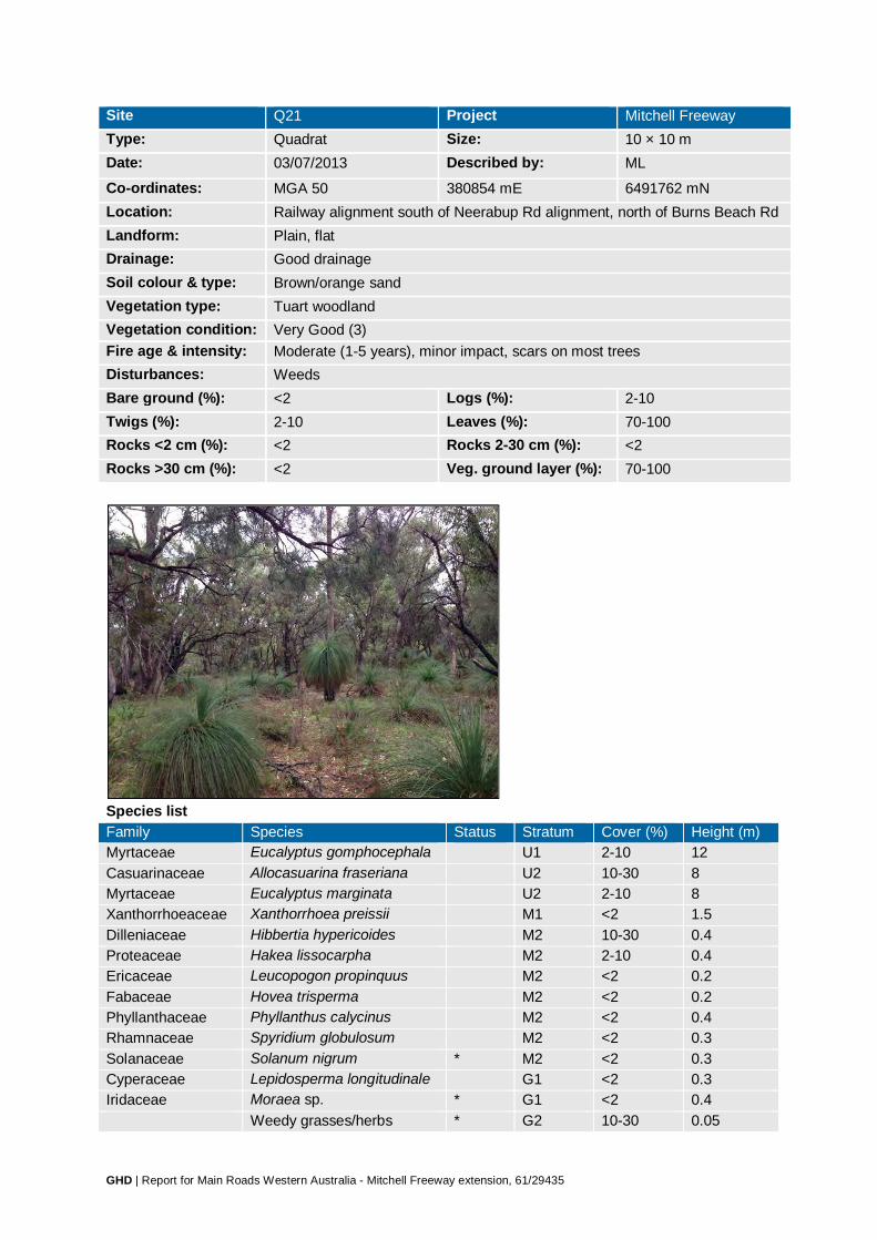
GHD | Report for Main Roads Western Australia - Mitchell Freeway extension, 61/29435
Site Q21 Project Mitchell Freeway Type: Quadrat Size: 10 × 10 m Date: 03/07/2013 Described by: ML
Co-ordinates: MGA 50 380854 mE 6491762 mN Location: Railway alignment south of Neerabup Rd alignment, north of Burns Beach Rd Landform: Plain, flat Drainage: Good drainage Soil colour & type: Brown/orange sand Vegetation type: Tuart woodland Vegetation condition: Very Good (3) Fire age & intensity: Moderate (1-5 years), minor impact, scars on most trees Disturbances: Weeds Bare ground (%): <2 Logs (%): 2-10 Twigs (%): 2-10 Leaves (%): 70-100 Rocks <2 cm (%): <2 Rocks 2-30 cm (%): <2 Rocks >30 cm (%): <2 Veg. ground layer (%): 70-100
Species list Family Species Status Stratum Cover (%) Height (m) Myrtaceae Eucalyptus gomphocephala U1 2-10 12 Casuarinaceae Allocasuarina fraseriana U2 10-30 8 Myrtaceae Eucalyptus marginata U2 2-10 8 Xanthorrhoeaceae Xanthorrhoea preissii M1 <2 1.5 Dilleniaceae Hibbertia hypericoides M2 10-30 0.4 Proteaceae Hakea lissocarpha M2 2-10 0.4 Ericaceae Leucopogon propinquus M2 <2 0.2 Fabaceae Hovea trisperma M2 <2 0.2 Phyllanthaceae Phyllanthus calycinus M2 <2 0.4 Rhamnaceae Spyridium globulosum M2 <2 0.3 Solanaceae Solanum nigrum * M2 <2 0.3 Cyperaceae Lepidosperma longitudinale G1 <2 0.3 Iridaceae Moraea sp. * G1 <2 0.4 Weedy grasses/herbs * G2 10-30 0.05

GHD | Report for Main Roads Western Australia - Mitchell Freeway extension, 61/29435
Family Species Status Stratum Cover (%) Height (m) Asteraceae Hypochaeris sp. * G2 2-10 prostrate Droseraceae Drosera erythrorhiza G2 2-10 prostrate Fabaceae Trifolium campestre * G2 2-10 0.05 Araliaceae Trachymene sp. G2 <2 0.05 Asteraceae Lagenophora huegelii G2 <2 prostrate Asteraceae Ursinia anthemoides * G2 <2 0.05 Iridaceae Romulea rosea * G2 <2 0.05
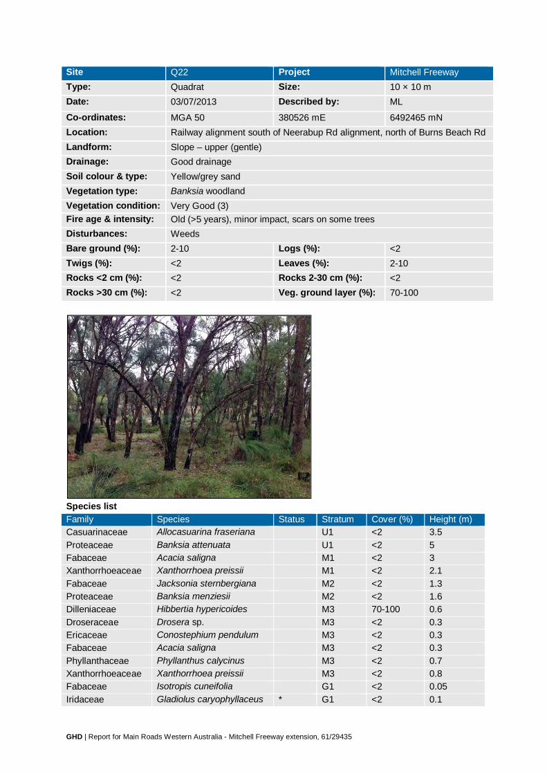
GHD | Report for Main Roads Western Australia - Mitchell Freeway extension, 61/29435
Site Q22 Project Mitchell Freeway Type: Quadrat Size: 10 × 10 m Date: 03/07/2013 Described by: ML
Co-ordinates: MGA 50 380526 mE 6492465 mN Location: Railway alignment south of Neerabup Rd alignment, north of Burns Beach Rd Landform: Slope – upper (gentle) Drainage: Good drainage Soil colour & type: Yellow/grey sand Vegetation type: Banksia woodland Vegetation condition: Very Good (3) Fire age & intensity: Old (>5 years), minor impact, scars on some trees Disturbances: Weeds Bare ground (%): 2-10 Logs (%): <2 Twigs (%): <2 Leaves (%): 2-10 Rocks <2 cm (%): <2 Rocks 2-30 cm (%): <2 Rocks >30 cm (%): <2 Veg. ground layer (%): 70-100
Species list Family Species Status Stratum Cover (%) Height (m) Casuarinaceae Allocasuarina fraseriana U1 <2 3.5 Proteaceae Banksia attenuata U1 <2 5 Fabaceae Acacia saligna M1 <2 3 Xanthorrhoeaceae Xanthorrhoea preissii M1 <2 2.1 Fabaceae Jacksonia sternbergiana M2 <2 1.3 Proteaceae Banksia menziesii M2 <2 1.6 Dilleniaceae Hibbertia hypericoides M3 70-100 0.6 Droseraceae Drosera sp. M3 <2 0.3 Ericaceae Conostephium pendulum M3 <2 0.3 Fabaceae Acacia saligna M3 <2 0.3 Phyllanthaceae Phyllanthus calycinus M3 <2 0.7 Xanthorrhoeaceae Xanthorrhoea preissii M3 <2 0.8 Fabaceae Isotropis cuneifolia G1 <2 0.05 Iridaceae Gladiolus caryophyllaceus * G1 <2 0.1

GHD | Report for Main Roads Western Australia - Mitchell Freeway extension, 61/29435
Family Species Status Stratum Cover (%) Height (m) Iridaceae Moraea sp. * G1 <2 0.3 Amaranthaceae Ptilotus manglesii G2 <2 prostrate Araliaceae Trachymene sp. G2 <2 prostrate Asteraceae Hypochaeris sp. * G2 <2 prostrate Asteraceae Ursinia anthemoides * G2 <2 prostrate Brassicaceae Brassicaceae sp. * G2 <2 prostrate Droseraceae Drosera erythrorhiza G2 <2 prostrate Iridaceae Romulea rosea * G2 <2 prostrate Orchidaceae Pyrorchis nigricans G2 <2 prostrate Weedy grasses/herbs * G2 <2 prostrate

GHD | Report for Main Roads Western Australia - Mitchell Freeway extension, 61/29435
Site Q23 Project Mitchell Freeway Type: Quadrat Size: 10 × 10 m Date: 04/07/2013 Described by: ML
Co-ordinates: MGA 50 381459 mE 6489813 mN Location: Railway alignment north of Burns Beach Rd Landform: Slope – upper (moderate S) Drainage: Good drainage Soil colour & type: Brown/orange sand Vegetation type: Mosaic of Banksia woodland and Mixed low heath on limestone Vegetation condition: Excellent (2) – Very Good (3) Fire age & intensity: Old (>5 years), minor impact, scars on some grasstrees Disturbances: Weeds, illegal rubbish dumping Bare ground (%): 2-10 Logs (%): <2 Twigs (%): <2 Leaves (%): 2-10 Rocks <2 cm (%): <2 Rocks 2-30 cm (%): <2 Rocks >30 cm (%): <2 Veg. ground layer (%): 70-100
Species list Family Species Status Stratum Cover (%) Height (m) Proteaceae Banksia menziesii U1 <2 4.5 Casuarinaceae Allocasuarina humilis M1 2-10 1.8 Proteaceae Hakea trifurcata M1 <2 1.9 Xanthorrhoeaceae Xanthorrhoea preissii M1 <2 1.5 Dilleniaceae Hibbertia hypericoides M2 70-100 0.8 Casuarinaceae Allocasuarina humilis M2 10-30 0.9 Proteaceae Hakea trifurcata M2 2-10 0.8 Droseraceae Drosera sp. M2 <2 0.4 Fabaceae Daviesia triflora M2 <2 0.6 Fabaceae Gompholobium tomentosum M2 <2 0.3 Proteaceae Banksia dallanneyi M2 <2 0.2 Proteaceae Hakea lissocarpha M2 <2 0.4 Proteaceae Petrophile brevifolia M2 <2 0.4 Proteaceae Petrophile macrostachya M2 <2 0.4

GHD | Report for Main Roads Western Australia - Mitchell Freeway extension, 61/29435
Family Species Status Stratum Cover (%) Height (m) Rhamnaceae Cryptandra arbutiflora M2 <2 0.4 Xanthorrhoeaceae Xanthorrhoea preissii M2 <2 0.7 Colchicaceae Burchardia congesta G1 <2 0.3 Cyperaceae Lepidosperma squamatum G1 <2 0.3 Cyperaceae Mesomelaena pseudostygia G1 <2 0.4 Iridaceae Gladiolus caryophyllaceus * G1 <2 0.5 Poaceae Briza maxima * G1 <2 0.3 Asteraceae Hypochaeris sp. * G2 10-30 prostrate Droseraceae Drosera erythrorhiza G2 10-30 prostrate Cyperaceae Schoenus curvifolius G2 2-10 0.05 Weedy grasses/herbs * G2 2-10 0.05 Araliaceae Trachymene sp. G2 <2 0.05 Asteraceae Ursinia anthemoides * G2 <2 0.05 Geraniaceae Geraniaceae sp. G2 <2 prostrate Haemodoraceae Conostylis setigera G2 <2 0.05 Primulaceae Lysimachia arvensis * G2 <2 0.05 Stylidiaceae Stylidium ?carnosum G2 <2 0.2
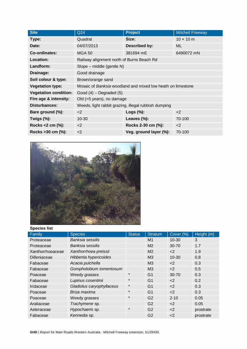
GHD | Report for Main Roads Western Australia - Mitchell Freeway extension, 61/29435
Site Q24 Project Mitchell Freeway Type: Quadrat Size: 10 × 10 m Date: 04/07/2013 Described by: ML
Co-ordinates: MGA 50 381694 mE 6490072 mN Location: Railway alignment north of Burns Beach Rd Landform: Slope – middle (gentle N) Drainage: Good drainage Soil colour & type: Brown/orange sand Vegetation type: Mosaic of Banksia woodland and mixed low heath on limestone Vegetation condition: Good (4) – Degraded (5) Fire age & intensity: Old (>5 years), no damage Disturbances: Weeds, light rabbit grazing, illegal rubbish dumping Bare ground (%): <2 Logs (%): <2 Twigs (%): 10-30 Leaves (%): 70-100 Rocks <2 cm (%): <2 Rocks 2-30 cm (%): <2 Rocks >30 cm (%): <2 Veg. ground layer (%): 70-100
Species list Family Species Status Stratum Cover (%) Height (m) Proteaceae Banksia sessilis M1 10-30 3 Proteaceae Banksia sessilis M2 30-70 1.7 Xanthorrhoeaceae Xanthorrhoea preissii M2 <2 1.9 Dilleniaceae Hibbertia hypericoides M3 10-30 0.8 Fabaceae Acacia pulchella M3 <2 0.3 Fabaceae Gompholobium tomentosum M3 <2 0.5 Poaceae Weedy grasses * G1 30-70 0.3 Fabaceae Lupinus cosentinii * G1 <2 0.2 Iridaceae Gladiolus caryophyllaceus * G1 <2 0.3 Poaceae Briza maxima * G1 <2 0.3 Poaceae Weedy grasses * G2 2-10 0.05 Araliaceae Trachymene sp. G2 <2 0.05 Asteraceae Hypochaeris sp. * G2 <2 prostrate Fabaceae Kennedia sp. G2 <2 prostrate

GHD | Report for Main Roads Western Australia - Mitchell Freeway extension, 61/29435
Family Species Status Stratum Cover (%) Height (m) Fabaceae Trifolium campestre * G2 <2 0.05

GHD | Report for Main Roads Western Australia - Mitchell Freeway extension, 61/29435
Site Q25 Project Mitchell Freeway Type: Quadrat Size: 10 × 10 m Date: 09/10/2013 Described by: CB & ML
Co-ordinates: MGA 50 381466 mE 6490154 mN Location: Railway just north of Burns Beach Road Landform: Flat, Slope – middle Drainage: Good drainage Soil colour & type: Brown/orange loamy sand Vegetation type: Jarrah–Banksia woodland Vegetation condition: Good (4) Fire age & intensity: Old (>5 years), Minor impact, scars on some trees Disturbances: Weeds, light grazing, illegal rubbish dumping, residential impact nearby Bare ground (%): <2 Logs (%): <2 Twigs (%): 10-30 Leaves (%): 30-70 Rocks <2 cm (%): <2 Rocks 2-30 cm (%): <2 Rocks >30 cm (%): <2 Veg. ground layer (%): 70-100
Species list Family Species Status Stratum Cover (%) Height (m) Myrtaceae Eucalyptus marginata U1 70-100 10 Rhamnaceae Spyridium globulosum M1 <2 2.2 Dilleniaceae Hibbertia hypericoides M2 30-70 0.8 Xanthorrhoeaceae Xanthorrhoea preissii M2 2-10 1.6 Zamiaceae Macrozamia fraseri M2 <2 1.9 Poaceae Ehrharta longiflora * M3 10-30 0.8 Fabaceae Acacia pulchella M3 <2 0.8 Haemodoraceae Haemodorum sp. M3 <2 0.8 Proteaceae Hakea lissocarpha M3 <2 0.8 Geraniaceae Pelargonium capitatum * M3 <2 0.6 Poaceae Ehrharta sp. * G1 30-70 0.4 Poaceae Briza maxima * G1 30-70 0.2 Poaceae Bromus diandrus * G1 10-30 0.4 Asparagaceae Lomandra sp. G1 2-10 0.2

GHD | Report for Main Roads Western Australia - Mitchell Freeway extension, 61/29435
Family Species Status Stratum Cover (%) Height (m) Cyperaceae Lepidosperma sp. G1 <2 0.5 Asteraceae Podotheca gnaphalioides G1 <2 0.4 Iridaceae Gladiolus caryophyllaceus * G1 <2 0.3 Asteraceae Urospermum picroides * G1 <2 0.1 Asteraceae Ursinia anthemoides * G1 <2 0.1 Fabaceae Hardenbergia comptoniana G1 <2 climbing Restionaceae Desmocladus flexuosus G2 10-30 0.1 Asteraceae Hypochaeris sp. * G2 2-10 prostrate Araliaceae Trachymene pilosa G2 <2 0.05 Asteraceae Sonchus oleraceus * G2 <2 0.05 Caryophyllaceae Silene gallica * G2 <2 0.05 Fabaceae Trifolium campestre * G2 <2 0.05 Geraniaceae Geranium molle * G2 <2 0.05 Orchidaceae Caladenia sp. G2 <2 0.05 Orchidaceae Pterostylis sp. G2 <2 0.05 Poaceae Aira cupaniana * G2 <2 0.05 Poaceae Briza minor * G2 <2 0.05

GHD | Report for Main Roads Western Australia - Mitchell Freeway extension, 61/29435
Site Q26 Project Mitchell Freeway Type: Quadrat Size: 10 × 10 m Date: 10/10/2013 Described by: CB & ML
Co-ordinates: MGA 50 378033 mE 6499034 mN Location: Railway between Romeo Road and Hester Avenue Landform: Flat, Slope – middle Drainage: Good drainage Soil colour & type: Brown/grey sand Vegetation type: Jarrah–Banksia woodland Vegetation condition: Very Good (3) Fire age & intensity: Old (>5 years), Minor impact, scars on most trees Disturbances: Weeds, light rabbit grazing, illegal rubbish dumping, residential impact nearby Bare ground (%): <2 Logs (%): 2-10 Twigs (%): 10-30 Leaves (%): 70-100 Rocks <2 cm (%): <2 Rocks 2-30 cm (%): <2 Rocks >30 cm (%): <2 Veg. ground layer (%): 70-100
Species list

GHD | Report for Main Roads Western Australia - Mitchell Freeway extension, 61/29435
Family Species Status Stratum Cover (%) Height (m) Myrtaceae Eucalyptus marginata U1 30-70 8 Fabaceae Acacia pulchella M1 10-30 1.6 Fabaceae Acacia pulchella M2 2-10 0.9 Zamiaceae Macrozamia fraseri M2 2-10 0.9 Xanthorrhoeaceae Xanthorrhoea preissii M2 <2 0.9 Colchicaceae Burchardia congesta M2 <2 0.5 Dilleniaceae Hibbertia hypericoides M3 30-70 0.5 Casuarinaceae Allocasuarina humilis M3 <2 0.5 Rutaceae Philotheca spicata M3 <2 0.5 Cyperaceae Mesomelaena pseudostygia M3 <2 0.4 Fabaceae Bossiaea eriocarpa M3 <2 0.4 Haemodoraceae Haemodorum sp. M3 <2 0.4 Ericaceae Conostephium pendulum M3 <2 0.2 Fabaceae Gompholobium tomentosum M3 <2 0.2 Fabaceae Gastrolobium capitatum M3 <2 0.1 Asparagaceae Lomandra caespitosa G1 2-10 0.2 Asteraceae Hypochaeris sp. * G1 2-10 0.2 Poaceae Briza maxima * G1 2-10 0.2 Orchidaceae Caladenia flava G1 <2 0.4 Apiaceae Daucus glochidiatus G1 <2 0.2 Asteraceae Podotheca gnaphalioides G1 <2 0.2 Caryophyllaceae Petrorhagia dubia * G1 <2 0.2 Orchidaceae Caladenia sp. G1 <2 0.2 Stylidiaceae Stylidium rigidulum G1 <2 0.2 Asparagaceae Thysanotus
patersonii/manglesianus complex
G1 <2 climbing
Fabaceae Hardenbergia comptoniana G1 <2 climbing Fabaceae Trifolium campestre * G2 30-70 0.1 Restionaceae Desmocladus flexuosus G2 2-10 0.2 Haemodoraceae Conostylis aculeata G2 <2 0.2 Poaceae Ehrharta calycina * G2 <2 0.1 Araliaceae Trachymene pilosa G2 <2 0.05 Asteraceae Lagenophora huegelii G2 <2 0.05

GHD | Report for Main Roads Western Australia - Mitchell Freeway extension, 61/29435
Site Q27 Project Mitchell Freeway Type: Quadrat Size: 10 × 10 m Date: 09/10/2013 Described by: CB & ML
Co-ordinates: MGA 50 380832 mE 6491734 mN Location: Railway south of Neerabup, north of Burns Beach Road Landform: Flat Drainage: Good drainage Soil colour & type: Brown/grey sand Vegetation type: Tuart woodland Vegetation condition: Good (4) Fire age & intensity: Old (>5 years), No damage Disturbances: Weeds, light rabbit grazing Bare ground (%): <2 Logs (%): 2-10 Twigs (%): 10-30 Leaves (%): 70-100 Rocks <2 cm (%): <2 Rocks 2-30 cm (%): <2 Rocks >30 cm (%): <2 Veg. ground layer (%): 70-100
Species list Family Species Status Stratum Cover (%) Height (m) Myrtaceae Eucalyptus
gomphocephala U1 70-100 30
Fabaceae Acacia saligna M1 2-10 2.2 Xanthorrhoeaceae Xanthorrhoea preissii M1 2-10 2.0 Asparagaceae Asparagus asparagoides * Declared
Pest C3 Management for the Whole of the State, WoNS
M1 <2 creeper
Xanthorrhoeaceae Xanthorrhoea preissii M2 <2 1.5 Fabaceae Acacia cyclops M2 <2 1.3 Rhamnaceae Spyridium globulosum M2 <2 1.2 Asparagaceae Acanthocarpus preissii M3 2-10 0.9 Proteaceae Hakea lissocarpha M3 2-10 0.4

GHD | Report for Main Roads Western Australia - Mitchell Freeway extension, 61/29435
Family Species Status Stratum Cover (%) Height (m) Chenopodiaceae Rhagodia baccata M3 2-10 0.2 Haemodoraceae Haemodorum laxum M3 <2 0.8 Fabaceae Acacia cyclops M3 <2 0.5 Proteaceae Petrophile macrostachya M3 <2 0.4 Fabaceae Gompholobium
tomentosum M3 <2 0.2
Zamiaceae Macrozamia fraseri M3 <2 0.1 Cyperaceae Mesomelaena
pseudostygia G1 30-70 0.6
Iridaceae Moraea sp. * G1 30-70 0.6 Poaceae Ehrharta calycina * G1 10-30 0.3 Poaceae Briza maxima * G1 10-30 0.2 Amaranthaceae Ptilotus drummondii G1 2-10 0.3 Aizoaceae Carpobrotus edulis * G1 2-10 0.2 Poaceae Avena barbata * G1 2-10 0.2 Poaceae Bromus diandrus * G1 2-10 0.2 Geraniaceae Geranium sp. * G1 2-10 0.1 Asparagaceae Lomandra hermaphrodita G1 <2 0.4 Cyperaceae Lepidosperma sp. G1 <2 0.3 Apiaceae Daucus glochidiatus G1 <2 0.2 Asparagaceae Lomandra sp. G1 <2 0.2 Asparagaceae Sowerbaea laxiflora G1 <2 0.2 Caryophyllaceae Petrorhagia dubia * G1 <2 0.2 Asteraceae Urospermum picroides * G1 <2 0.1 Fabaceae Trifolium campestre * G2 30-70 0.1 Restionaceae Desmocladus flexuosus G2 30-70 0.05 Iridaceae Romulea rosea * G2 10-30 0.1 Primulaceae Lysimachia arvensis * G2 10-30 0.1 Asteraceae Ursinia anthemoides * G2 <2 0.1 Haemodoraceae Conostylis aculeata G2 <2 0.1 Araliaceae Trachymene pilosa G2 <2 0.05 Fabaceae Hardenbergia
comptoniana G2 <2 0.05
Orchidaceae Caladenia sp. G2 <2 0.05 Asteraceae Lagenophora huegelii G2 <2 prostrate Droseraceae Drosera erythrorhiza G2 <2 prostrate
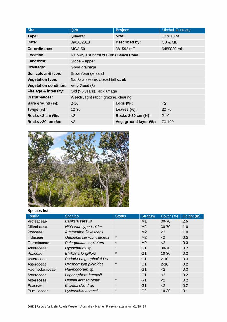
GHD | Report for Main Roads Western Australia - Mitchell Freeway extension, 61/29435
Site Q28 Project Mitchell Freeway Type: Quadrat Size: 10 × 10 m Date: 09/10/2013 Described by: CB & ML
Co-ordinates: MGA 50 381592 mE 6489820 mN Location: Railway just north of Burns Beach Road Landform: Slope – upper Drainage: Good drainage Soil colour & type: Brown/orange sand Vegetation type: Banksia sessilis closed tall scrub Vegetation condition: Very Good (3) Fire age & intensity: Old (>5 years), No damage Disturbances: Weeds, light rabbit grazing, clearing Bare ground (%): 2-10 Logs (%): <2 Twigs (%): 10-30 Leaves (%): 30-70 Rocks <2 cm (%): <2 Rocks 2-30 cm (%): 2-10 Rocks >30 cm (%): <2 Veg. ground layer (%): 70-100
Species list Family Species Status Stratum Cover (%) Height (m) Proteaceae Banksia sessilis M1 30-70 2.5 Dilleniaceae Hibbertia hypericoides M2 30-70 1.0 Poaceae Austrostipa flavescens M2 <2 1.0 Iridaceae Gladiolus caryophyllaceus * M2 <2 0.5 Geraniaceae Pelargonium capitatum * M2 <2 0.3 Asteraceae Hypochaeris sp. * G1 30-70 0.2 Poaceae Ehrharta longiflora * G1 10-30 0.3 Asteraceae Podotheca gnaphalioides G1 2-10 0.3 Asteraceae Urospermum picroides * G1 2-10 0.2 Haemodoraceae Haemodorum sp. G1 <2 0.3 Asteraceae Lagenophora huegelii G1 <2 0.2 Asteraceae Ursinia anthemoides * G1 <2 0.2 Poaceae Bromus diandrus * G1 <2 0.2 Primulaceae Lysimachia arvensis * G2 10-30 0.1

GHD | Report for Main Roads Western Australia - Mitchell Freeway extension, 61/29435
Family Species Status Stratum Cover (%) Height (m) Araliaceae Trachymene pilosa G2 10-30 0.05 Apiaceae Daucus glochidiatus G2 <2 0.1 Asteraceae Podolepis gracilis G2 <2 0.1 Asteraceae Sonchus oleraceus * G2 <2 0.1 Geraniaceae Erodium botrys * G2 <2 0.1 Orchidaceae Caladenia flava G2 <2 0.1 Orobanchaceae Orobanche minor * G2 <2 0.1 Poaceae Briza minor * G2 <2 0.1 Asteraceae Millotia myosotidifolia G2 <2 0.05 Caryophyllaceae Petrorhagia dubia * G2 <2 0.05 Fabaceae Acacia ?pulchella G2 <2 0.05 Fabaceae Trifolium campestre * G2 <2 0.05 Orchidaceae Caladenia sp. G2 <2 0.05 Poaceae Pentameris airoides * G2 <2 0.05

GHD | Report for Main Roads Western Australia - Mitchell Freeway extension, 61/29435
Site PP01 Project Mitchell Freeway Date: 16/05/2013 Described by: MD & ML
Co-ordinates: MGA 50 377559 mE 6500494 mN Location: Romeo Rd Vegetation type: Banksia woodland
Site PP02 Project Mitchell Freeway Date: 16/05/2013 Described by: MD & ML
Co-ordinates: MGA 50 380319 mE 6495342 mN Location: Hester Avenue Vegetation type: Jarrah–Banksia woodland

GHD | Report for Main Roads Western Australia - Mitchell Freeway extension, 61/29435
Site PP03 Project Mitchell Freeway Date: 16/05/2013 Described by: MD & ML
Co-ordinates: MGA 50 379434 mE 6495424 mN Location: Hester Ave Vegetation type: Banksia woodland
Site PP04 Project Mitchell Freeway Date: 17/05/2013 Described by: MD & ML
Co-ordinates: MGA 50 379953 mE 6492816 mN Location: Between Connolly Rd and Railway, on Neerabup Rd alignment Vegetation type: Tuart woodland

GHD | Report for Main Roads Western Australia - Mitchell Freeway extension, 61/29435
Site PP05 Project Mitchell Freeway Date: 17/05/2013 Described by: MD & ML
Co-ordinates: MGA 50 384348 mE 6490517 mN Location: Wanneroo Rd, near Burns Beach Rd Vegetation type: Degraded roadside vegetation
Site PP06 Project Mitchell Freeway Date: 17/05/2013 Described by: MD & ML
Co-ordinates: MGA 50 383704 mE 6491746 mN Location: Wanneroo Rd Vegetation type: Tuart woodland

GHD | Report for Main Roads Western Australia - Mitchell Freeway extension, 61/29435
Site PP07 Project Mitchell Freeway Date: 17/05/2013 Described by: MD & ML
Co-ordinates: MGA 50 381932 mE 6494328 mN Location: Wanneroo Rd Vegetation type: Tuart woodland
Site PP08 Project Mitchell Freeway Date: 16/05/2013 Described by: MD & ML
Co-ordinates: MGA 50 380140 mE 6495365 mN Location: Vegetation type: Jarrah–Banksia woodland

GHD | Report for Main Roads Western Australia - Mitchell Freeway extension, 61/29435
Site PP09 Project Mitchell Freeway Date: 16/05/2013 Described by: MD & ML
Co-ordinates: MGA 50 378065 mE 6500510 mN Location: Hester Ave Vegetation type: Jarrah–Banksia woodland
Site PP10 Project Mitchell Freeway Date: 18/06/2013 Described by: MD & ML
Co-ordinates: MGA 50 379717 mE 6495373 mN Location: Within PTA land alongside railway Vegetation type: Degraded
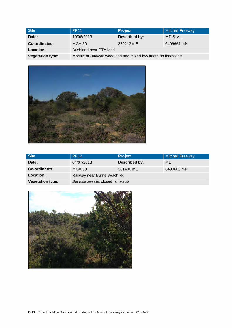
GHD | Report for Main Roads Western Australia - Mitchell Freeway extension, 61/29435
Site PP11 Project Mitchell Freeway Date: 19/06/2013 Described by: MD & ML
Co-ordinates: MGA 50 379213 mE 6496664 mN Location: Bushland near PTA land Vegetation type: Mosaic of Banksia woodland and mixed low heath on limestone
Site PP12 Project Mitchell Freeway Date: 04/07/2013 Described by: ML
Co-ordinates: MGA 50 381406 mE 6490602 mN Location: Railway near Burns Beach Rd Vegetation type: Banksia sessilis closed tall scrub

GHD | Report for Main Roads Western Australia - Mitchell Freeway extension, 61/29435
Site PP13 Project Mitchell Freeway Date: 25/06/2013 Described by: JH & ML
Co-ordinates: MGA 50 380822 mE 6493052 mN Location: Neerabup Rd Vegetation type: Banksia woodland
Site PP14 Project Mitchell Freeway Date: 25/06/2013 Described by: JH & ML
Co-ordinates: MGA 50 381033 mE 6493025 mN Location: Neerabup Rd Vegetation type: Banksia woodland

GHD | Report for Main Roads Western Australia - Mitchell Freeway extension, 61/29435
Site PP15 Project Mitchell Freeway Date: 25/06/2013 Described by: JH & ML
Co-ordinates: MGA 50 381086 mE 6493055 mN Location: Neerabup Rd Vegetation type: Tuart woodland
Site PP16 Project Mitchell Freeway Date: 25/06/2013 Described by: JH & ML
Co-ordinates: MGA 50 381164 mE 6493087 mN Location: Neerabup Rd Vegetation type: Tuart woodland

GHD | Report for Main Roads Western Australia - Mitchell Freeway extension, 61/29435
Site PP17 Project Mitchell Freeway Date: 25/06/2013 Described by: JH & ML
Co-ordinates: MGA 50 381481 mE 6492999 mN Location: Neerabup Rd Vegetation type: Tuart woodland
Site PP18 Project Mitchell Freeway Date: 25/06/2013 Described by: JH & ML
Co-ordinates: MGA 50 381718 mE 6492940 mN Location: Neerabup Rd Vegetation type: Tuart woodland
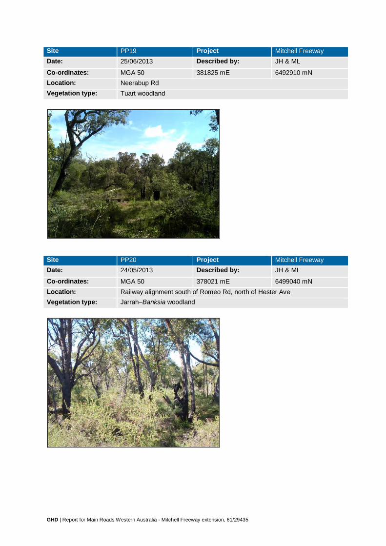
GHD | Report for Main Roads Western Australia - Mitchell Freeway extension, 61/29435
Site PP19 Project Mitchell Freeway Date: 25/06/2013 Described by: JH & ML
Co-ordinates: MGA 50 381825 mE 6492910 mN Location: Neerabup Rd Vegetation type: Tuart woodland
Site PP20 Project Mitchell Freeway Date: 24/05/2013 Described by: JH & ML
Co-ordinates: MGA 50 378021 mE 6499040 mN Location: Railway alignment south of Romeo Rd, north of Hester Ave Vegetation type: Jarrah–Banksia woodland

Flora species list recorded within the Study Area during the field surveys (May-October 2013) Family Taxa Status?Boraginaceae ?Boraginaceae sp. *Aizoaceae Carpobrotus edulis *Aizoaceae Tetragonia decumbens *Amaranthaceae Ptilotus drummondiiAmaranthaceae Ptilotus manglesii Amaranthaceae Ptilotus polystachyus Anacardiaceae Schinus terebinthifolius *Anarthriaceae Lyginia barbataApiaceae Daucus glochidiatusApiaceae Eryngium pinnatifidum Apiaceae Foeniculum vulgare *Apiaceae Homalosciadium homalocarpumApiaceae Xanthosia huegelii Apocynaceae Gomphocarpus fruticosus *
Araceae Zantedeschia aethiopica
* Declared Pest C3 Management for the Whole of the State
Araliaceae Trachymene pilosaAraliaceae Trachymene sp.Arecaceae Arecaceae sp. *Asparagaceae Acanthocarpus preissii Asparagaceae Agave americana *
Asparagaceae Asparagus asparagoides
* Declared Pest C3 Management for the Whole of the State, WoNS
Asparagaceae Laxmannia ramosaAsparagaceae Lomandra caespitosa Asparagaceae Lomandra maritimaAsparagaceae Lomandra purpureaAsparagaceae Lomandra sp.Asparagaceae Sowerbaea laxifloraAsparagaceae Thysanotus arbusculaAsparagaceae Thysanotus patersonii /manglesianus complexAsparagaceae Thysanotus sp.Asparagaceae Thysanotus triandrusAsparagaceae Yucca aloifolia *Asphodelaceae Aloe vera *Asphodelaceae Asphodelus fistulosus *Asphodelaceae Trachyandra divaricata *Asteraceae Arctotheca calendula *Asteraceae Conyza sp. *Asteraceae Conyza sumatrensis *Asteraceae Cotula sp. *Asteraceae Dimorphotheca ecklonis *Asteraceae Gazania linearis *Asteraceae Helichrysum luteoalbumAsteraceae Hypochaeris glabra *Asteraceae Hypochaeris sp. *Asteraceae Lactuca serriola *Asteraceae Lagenophora huegelii Asteraceae Millotia myosotidifoliaAsteraceae Monoculus monstrosus *Asteraceae Olearia axillaris Asteraceae Olearia rudisAsteraceae Ozothamnus cordatus Asteraceae Pithocarpa cordataAsteraceae Podolepis gracilis
GHD | Report for Main Roads Western Australia - Mitchell Freeway extension, 61/29435

Flora species list recorded within the Study Area during the field surveys (May-October 2013) Family Taxa StatusAsteraceae Podolepis lessoniiAsteraceae Podotheca chrysanthaAsteraceae Podotheca gnaphalioides Asteraceae Quinetia urvilleiAsteraceae Senecio pinnatifoliusAsteraceae Senecio sp.Asteraceae Sonchus asper *Asteraceae Sonchus oleraceus *Asteraceae Tagetes minuta *Asteraceae Taraxacum officinale *Asteraceae Urospermum picroides *Asteraceae Ursinia anthemoides *Asteraceae Verbesina encelioides *Asteraceae Waitzia suaveolens var. suaveolensBoraginaceae Echium plantagineum *Brassicaceae Brassica napus *Brassicaceae Brassica tournefortii *Brassicaceae Brassicaceae sp. *Brassicaceae Heliophila pusilla *Brassicaceae Lobularia maritima *Brassicaceae Raphanus raphanistrum *Brassicaceae Stenopetalum gracileCactaceae Opuntia sp. *Campanulaceae Lobelia heterophyllaCampanulaceae Wahlenbergia capensis *Campanulaceae Wahlenbergia preissiiCaprifoliaceae Centranthus macrosiphon *Caprifoliaceae Scabiosa atropurpurea *Caryophyllaceae Cerastium glomeratum *Caryophyllaceae Petrorhagia dubia *Caryophyllaceae Silene gallica *Casuarinaceae Allocasuarina fraseriana Casuarinaceae Allocasuarina humilis Casuarinaceae Casuarina equisetifolia *Celastraceae Stackhousia monogynaCelastraceae Tripterococcus brunonis Chenopodiaceae Enchylaena tomentosaChenopodiaceae Rhagodia baccata Colchicaceae Burchardia congesta Convolvulaceae Cuscuta epithymum *Convolvulaceae Ipomoea indica *Crassulaceae Crassula colorataCrassulaceae Crassula glomerata *Cucurbitaceae Citrullus lanatus *Cupressaceae Callitris preissii s, E, plantedCyperaceae Cyperaceae sp.Cyperaceae Ficinia nodosaCyperaceae Isolepis cernuaCyperaceae Isolepis marginata *Cyperaceae Lepidosperma angustatum Cyperaceae Lepidosperma costaleCyperaceae Lepidosperma gladiatumCyperaceae Lepidosperma leptostachyumCyperaceae Lepidosperma longitudinale Cyperaceae Lepidosperma pubisquameumCyperaceae Lepidosperma sp.Cyperaceae Lepidosperma squamatum
GHD | Report for Main Roads Western Australia - Mitchell Freeway extension, 61/29435

Flora species list recorded within the Study Area during the field surveys (May-October 2013) Family Taxa StatusCyperaceae Mesomelaena pseudostygia Cyperaceae Schoenus clandestinusCyperaceae Schoenus curvifolius Cyperaceae Schoenus grandiflorus Dasypogonaceae Calectasia narragaraDasypogonaceae Calectasia sp.Dilleniaceae Hibbertia huegelii Dilleniaceae Hibbertia hypericoides Dilleniaceae Hibbertia racemosa Dilleniaceae Hibbertia subvaginata Droseraceae Drosera erythrorhiza Droseraceae Drosera sp.Ericaceae Astroloma ciliatum Ericaceae Astroloma microcalyx sEricaceae Astroloma pallidum Ericaceae Conostephium pendulum Ericaceae Conostephium preissiiEricaceae Leucopogon insularis Ericaceae Leucopogon parviflorus Ericaceae Leucopogon polymorphus Ericaceae Leucopogon propinquus Ericaceae Lysinema ciliatum Euphorbiaceae Euphorbia australis *Euphorbiaceae Euphorbia peplus *Euphorbiaceae Euphorbia terracina *Euphorbiaceae Ricinus communis *Fabaceae Acacia ?benthamii P2, p, s, EFabaceae Acacia alataFabaceae Acacia applanataFabaceae Acacia cochlearisFabaceae Acacia cyclops Fabaceae Acacia huegelii Fabaceae Acacia iteaphylla *Fabaceae Acacia lasiocarpa Fabaceae Acacia longifolia *Fabaceae Acacia pulchella Fabaceae Acacia pulchella var. goadbyi Fabaceae Acacia rostellifera Fabaceae Acacia saligna Fabaceae Acacia sp.Fabaceae Acacia sp. plantedFabaceae Acacia truncata Fabaceae Acacia willdenowiana Fabaceae Acacia xanthinaFabaceae Bossiaea eriocarpa Fabaceae Daviesia decurrens Fabaceae Daviesia divaricata Fabaceae Daviesia divaricata subsp. divaricata Fabaceae Daviesia triflora Fabaceae Gastrolobium capitatum Fabaceae Gompholobium tomentosum Fabaceae Hardenbergia comptoniana Fabaceae Hovea trisperma Fabaceae Isotropis cuneifolia Fabaceae Jacksonia calcicolaFabaceae Jacksonia furcellata Fabaceae Jacksonia sericea P4, p, s, E
GHD | Report for Main Roads Western Australia - Mitchell Freeway extension, 61/29435
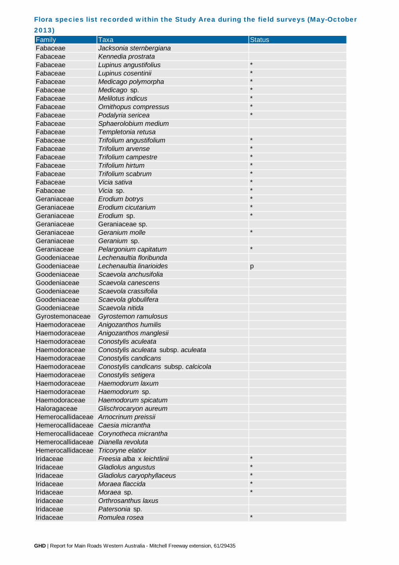
Flora species list recorded within the Study Area during the field surveys (May-October 2013) Family Taxa StatusFabaceae Jacksonia sternbergiana Fabaceae Kennedia prostrataFabaceae Lupinus angustifolius *Fabaceae Lupinus cosentinii *Fabaceae Medicago polymorpha *Fabaceae Medicago sp. *Fabaceae Melilotus indicus *Fabaceae Ornithopus compressus *Fabaceae Podalyria sericea *Fabaceae Sphaerolobium mediumFabaceae Templetonia retusa Fabaceae Trifolium angustifolium *Fabaceae Trifolium arvense *Fabaceae Trifolium campestre *Fabaceae Trifolium hirtum *Fabaceae Trifolium scabrum *Fabaceae Vicia sativa *Fabaceae Vicia sp. *Geraniaceae Erodium botrys *Geraniaceae Erodium cicutarium *Geraniaceae Erodium sp. *Geraniaceae Geraniaceae sp.Geraniaceae Geranium molle *Geraniaceae Geranium sp.Geraniaceae Pelargonium capitatum *Goodeniaceae Lechenaultia floribunda Goodeniaceae Lechenaultia linarioides pGoodeniaceae Scaevola anchusifoliaGoodeniaceae Scaevola canescens Goodeniaceae Scaevola crassifolia Goodeniaceae Scaevola globuliferaGoodeniaceae Scaevola nitidaGyrostemonaceae Gyrostemon ramulosus Haemodoraceae Anigozanthos humilisHaemodoraceae Anigozanthos manglesii Haemodoraceae Conostylis aculeata Haemodoraceae Conostylis aculeata subsp. aculeata Haemodoraceae Conostylis candicans Haemodoraceae Conostylis candicans subsp. calcicolaHaemodoraceae Conostylis setigera Haemodoraceae Haemodorum laxumHaemodoraceae Haemodorum sp.Haemodoraceae Haemodorum spicatumHaloragaceae Glischrocaryon aureumHemerocallidaceae Arnocrinum preissiiHemerocallidaceae Caesia micranthaHemerocallidaceae Corynotheca micrantha Hemerocallidaceae Dianella revoluta Hemerocallidaceae Tricoryne elatior Iridaceae Freesia alba x leichtlinii *Iridaceae Gladiolus angustus *Iridaceae Gladiolus caryophyllaceus *Iridaceae Moraea flaccida *Iridaceae Moraea sp. *Iridaceae Orthrosanthus laxusIridaceae Patersonia sp.Iridaceae Romulea rosea *
GHD | Report for Main Roads Western Australia - Mitchell Freeway extension, 61/29435

Flora species list recorded within the Study Area during the field surveys (May-October 2013) Family Taxa StatusJuncaceae Luzula meridionalisLamiaceae Hemiandra pungens Lamiaceae Lavandula stoechas *Lamiaceae Rosmarinus officinalis *Lauraceae Cassytha racemosaLauraceae Cassytha sp.Loranthaceae Nuytsia floribunda Malvaceae ?Alyogyne huegeliiMalvaceae Thomasia triphylla Meliaceae Melia azedarach Myrtaceae Agonis flexuosa r, sMyrtaceae Baeckea robustaMyrtaceae Callistemon sp. *Myrtaceae Calothamnus quadrifidus Myrtaceae Calothamnus sanguineus Myrtaceae Calytrix flavescens Myrtaceae Calytrix fraseri Myrtaceae Chamelaucium uncinatum *Myrtaceae Corymbia calophylla Myrtaceae Corymbia maculata *Myrtaceae Eremaea paucifloraMyrtaceae Eucalyptus ?maculata plantedMyrtaceae Eucalyptus caesia P4, plantedMyrtaceae Eucalyptus decipiensMyrtaceae Eucalyptus erythrocorys plantedMyrtaceae Eucalyptus gomphocephala Myrtaceae Eucalyptus leucoxylon *Myrtaceae Eucalyptus marginata Myrtaceae Eucalyptus platypus plantedMyrtaceae Eucalyptus sp. plantedMyrtaceae Eucalyptus todtiana Myrtaceae Kunzea glabrescensMyrtaceae Leptospermum laevigatum *Myrtaceae Melaleuca huegelii Myrtaceae Melaleuca lanceolata d, sMyrtaceae Melaleuca nesophila plantedMyrtaceae Melaleuca quinquenervia plantedMyrtaceae Melaleuca systena Myrtaceae Myrtaceae sp. 1 plantedMyrtaceae Myrtaceae sp. 2 plantedMyrtaceae Regelia ciliataMyrtaceae Scholtzia involucrataOleaceae Olea europaea *Onagraceae Oenothera glazioviana *Onagraceae Oenothera sp. *Orchidaceae Caladenia arenicolaOrchidaceae Caladenia flavaOrchidaceae Caladenia longicaudaOrchidaceae Diuris longifoliaOrchidaceae Elythranthera brunonisOrchidaceae Leptoceras menziesiiOrchidaceae Microtis mediaOrchidaceae Pterostylis recurvaOrchidaceae Pterostylis sp.Orchidaceae Pyrorchis nigricansOrchidaceae Thelymitra macrophyllaOrobanchaceae Orobanche minor *
GHD | Report for Main Roads Western Australia - Mitchell Freeway extension, 61/29435

Flora species list recorded within the Study Area during the field surveys (May-October 2013) Family Taxa StatusOrobanchaceae Parentucellia latifolia *Orobanchaceae Parentucellia viscosa *Oxalidaceae Oxalis caprina *Oxalidaceae Oxalis compressa *Oxalidaceae Oxalis pes-caprae *Oxalidaceae Oxalis sp. *Papaveraceae Fumaria sp. *Phyllanthaceae Phyllanthus calycinus Phyllanthaceae Poranthera drummondiiPhytolaccaceae Phytolacca octandra *Platanaceae Platanus sp. *Plumbaginaceae Plumbago sp. *Poaceae Aira cupaniana *Poaceae Aira sp. *Poaceae Austrostipa compressaPoaceae Austrostipa elegantissimaPoaceae Austrostipa flavescensPoaceae Austrostipa sp.Poaceae Avena barbata *Poaceae Briza maxima *Poaceae Briza minor *Poaceae Bromus diandrus *Poaceae Bromus hordeaceus *Poaceae Catapodium rigidum *Poaceae Cenchrus clandestinus *Poaceae Cenchrus setaceus *Poaceae Cortaderia selloana *Poaceae Cynodon dactylon *Poaceae Ehrharta calycina *Poaceae Ehrharta longiflora *Poaceae Eragrostis curvula *Poaceae Hordeum sp. *Poaceae Hyparrhenia hirta *Poaceae Lagurus ovatus *Poaceae Lolium rigidum *Poaceae Melinis repens *Poaceae Neurachne alopecuroideaPoaceae Pentameris airoides *Poaceae Phleum arenarium *Poaceae Poa porphyrocladosPoaceae Poaceae sp.Poaceae Rytidosperma occidentalePoaceae Vulpia bromoides *Poaceae Vulpia myurosPolygonaceae Rumex pulcher *Portulacaceae Calandrinia linifloraPrimulaceae Lysimachia arvensis *Proteaceae Adenanthos obovatusProteaceae Banksia attenuata Proteaceae Banksia dallanneyiProteaceae Banksia grandis Proteaceae Banksia menziesii Proteaceae Banksia sessilisProteaceae Conospermum triplinervium r, sProteaceae Grevillea olivacea x Grevillea preissii plantedProteaceae Grevillea preissii subsp. preissii Proteaceae Grevillea sp.
GHD | Report for Main Roads Western Australia - Mitchell Freeway extension, 61/29435

Flora species list recorded within the Study Area during the field surveys (May-October 2013) Family Taxa StatusProteaceae Grevillea vestita Proteaceae Grevillea vestita subsp. vestita Proteaceae Hakea costata Proteaceae Hakea lissocarpha Proteaceae Hakea prostrataProteaceae Hakea ruscifolia Proteaceae Hakea trifurcata Proteaceae Persoonia comata Proteaceae Petrophile brevifolia Proteaceae Petrophile linearis Proteaceae Petrophile macrostachya Proteaceae Petrophile serruriaeProteaceae Stirlingia latifolia Proteaceae Synaphea sp.Proteaceae Synaphea spinosaRanunculaceae Clematis linearifoliaRanunculaceae Clematis pubescensRestionaceae Desmocladus asperRestionaceae Desmocladus fasciculatusRestionaceae Desmocladus flexuosus Restionaceae Lepidobolus preissianusRestionaceae Loxocarya cinereaRhamnaceae Cryptandra arbutifloraRhamnaceae Cryptandra mutilaRhamnaceae Cryptandra scopariaRhamnaceae Spyridium globulosum Rhamnaceae Stenanthemum notialeRhamnaceae Trymalium ledifolium var. ledifoliumRubiaceae Galium murale *Rubiaceae Opercularia vaginataRutaceae Philotheca spicata Santalaceae Exocarpos sparteus Santalaceae Leptomeria paucifloraScrophulariaceae Eremophila glabra Scrophulariaceae Myoporum caprarioides Scrophulariaceae Verbascum virgatum *Solanaceae Anthocercis littorea
Solanaceae Solanum linnaeanum
* Declared Pest C3 Management for the South West Land Division
Solanaceae Solanum nigrum *Solanaceae Solanum symonii Stylidiaceae Styldium maritimum P3, p, sStylidiaceae Stylidium brunonianumStylidiaceae Stylidium calcaratumStylidiaceae Stylidium piliferumStylidiaceae Stylidium rigidulumThymelaeaceae Pimelea argenteaThymelaeaceae Pimelea calcicola P3, p, sThymelaeaceae Pimelea sp.Tropaeolaceae Tropaeolum majus *Urticaceae Parietaria cardiostegiaViolaceae Hybanthus calycinus Xanthorrhoeaceae Xanthorrhoea preissii Zamiaceae Macrozamia fraseriZygophyllaceae Tribulus terrestris *
Mosses
GHD | Report for Main Roads Western Australia - Mitchell Freeway extension, 61/29435

Priority flora species recorded within the Study Area during the field surveys (May-October 2013) Species Status CountAcacia ?benthamii P2 1 379440.5374 6496903.499Acacia ?benthamii P2 1 379474.6913 6496942.884Jacksonia sericea P4 1 376320 6501139Jacksonia sericea P4 4 376359 6501172Jacksonia sericea P4 1 376377 6501140Jacksonia sericea P4 2 376674 6500975Jacksonia sericea P4 1 376699 6500990Jacksonia sericea P4 3 376702 6500978Jacksonia sericea P4 3 376741 6500969Jacksonia sericea P4 31 376912 6500870Jacksonia sericea P4 4 376914 6500840Jacksonia sericea P4 51 376914 6500840Jacksonia sericea P4 5 376923 6500862Jacksonia sericea P4 32 376955 6500782Jacksonia sericea P4 2 376955 6500798Jacksonia sericea P4 5 376956 6500781Jacksonia sericea P4 10 376996 6500734Jacksonia sericea P4 10 377002 6500719Jacksonia sericea P4 1 377039 6500759Jacksonia sericea P4 5 377484 6500508Jacksonia sericea P4 30 377548 6500410Jacksonia sericea P4 5 377556 6499433Jacksonia sericea P4 10 377557 6500337Jacksonia sericea P4 15 377560 6500367Jacksonia sericea P4 2 377561 6499445Jacksonia sericea P4 15 377561 6500394Jacksonia sericea P4 10 377565 6500435Jacksonia sericea P4 2 377568 6499460Jacksonia sericea P4 1 377574 6500390Jacksonia sericea P4 5 377583 6500405Jacksonia sericea P4 2 377584 6499420Jacksonia sericea P4 1 377604 6499447Jacksonia sericea P4 15 377630 6500187Jacksonia sericea P4 5 377645 6500213Jacksonia sericea P4 1 377652 6499964Jacksonia sericea P4 5 377655 6500200Jacksonia sericea P4 8 377674 6500225Jacksonia sericea P4 1 377680 6499925Jacksonia sericea P4 1 377681 6499861Jacksonia sericea P4 10 377688 6500225Jacksonia sericea P4 10 377694 6500235Jacksonia sericea P4 10 377703 6499664Jacksonia sericea P4 10 377709 6499804Jacksonia sericea P4 1 377710 6499709Jacksonia sericea P4 1 377711 6499902Jacksonia sericea P4 2 377723 6499631Jacksonia sericea P4 30 377723 6500226Jacksonia sericea P4 15 377725 6499682Jacksonia sericea P4 3 377729 6499720Jacksonia sericea P4 20 377732 6499637Jacksonia sericea P4 20 377732 6499654Jacksonia sericea P4 15 377737 6499722Jacksonia sericea P4 30 377741 6499758Jacksonia sericea P4 20 377752 6499675Jacksonia sericea P4 3 377768 6499680Jacksonia sericea P4 20 377769 6499690Jacksonia sericea P4 8 377772 6499693Jacksonia sericea P4 3 377772 6499745
Location
GHD | Report for Main Roads Western Australia - Mitchell Freeway extension, 61/29435
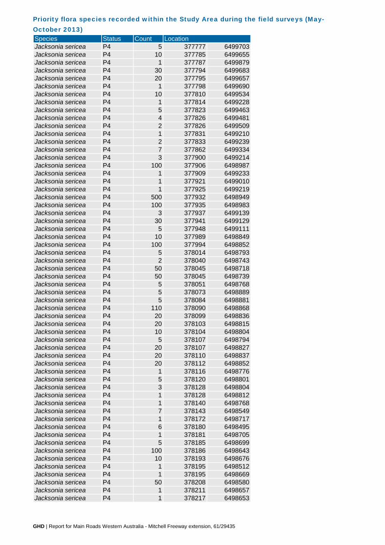
Priority flora species recorded within the Study Area during the field surveys (May-October 2013) Species Status Count LocationJacksonia sericea P4 5 377777 6499703Jacksonia sericea P4 10 377785 6499655Jacksonia sericea P4 1 377787 6499879Jacksonia sericea P4 30 377794 6499683Jacksonia sericea P4 20 377795 6499657Jacksonia sericea P4 1 377798 6499690Jacksonia sericea P4 10 377810 6499534Jacksonia sericea P4 1 377814 6499228Jacksonia sericea P4 5 377823 6499463Jacksonia sericea P4 4 377826 6499481Jacksonia sericea P4 2 377826 6499509Jacksonia sericea P4 1 377831 6499210Jacksonia sericea P4 2 377833 6499239Jacksonia sericea P4 7 377862 6499334Jacksonia sericea P4 3 377900 6499214Jacksonia sericea P4 100 377906 6498987Jacksonia sericea P4 1 377909 6499233Jacksonia sericea P4 1 377921 6499010Jacksonia sericea P4 1 377925 6499219Jacksonia sericea P4 500 377932 6498949Jacksonia sericea P4 100 377935 6498983Jacksonia sericea P4 3 377937 6499139Jacksonia sericea P4 30 377941 6499129Jacksonia sericea P4 5 377948 6499111Jacksonia sericea P4 10 377989 6498849Jacksonia sericea P4 100 377994 6498852Jacksonia sericea P4 5 378014 6498793Jacksonia sericea P4 2 378040 6498743Jacksonia sericea P4 50 378045 6498718Jacksonia sericea P4 50 378045 6498739Jacksonia sericea P4 5 378051 6498768Jacksonia sericea P4 5 378073 6498889Jacksonia sericea P4 5 378084 6498881Jacksonia sericea P4 110 378090 6498868Jacksonia sericea P4 20 378099 6498836Jacksonia sericea P4 20 378103 6498815Jacksonia sericea P4 10 378104 6498804Jacksonia sericea P4 5 378107 6498794Jacksonia sericea P4 20 378107 6498827Jacksonia sericea P4 20 378110 6498837Jacksonia sericea P4 20 378112 6498852Jacksonia sericea P4 1 378116 6498776Jacksonia sericea P4 5 378120 6498801Jacksonia sericea P4 3 378128 6498804Jacksonia sericea P4 1 378128 6498812Jacksonia sericea P4 1 378140 6498768Jacksonia sericea P4 7 378143 6498549Jacksonia sericea P4 1 378172 6498717Jacksonia sericea P4 6 378180 6498495Jacksonia sericea P4 1 378181 6498705Jacksonia sericea P4 5 378185 6498699Jacksonia sericea P4 100 378186 6498643Jacksonia sericea P4 10 378193 6498676Jacksonia sericea P4 1 378195 6498512Jacksonia sericea P4 1 378195 6498669Jacksonia sericea P4 50 378208 6498580Jacksonia sericea P4 1 378211 6498657Jacksonia sericea P4 1 378217 6498653
GHD | Report for Main Roads Western Australia - Mitchell Freeway extension, 61/29435
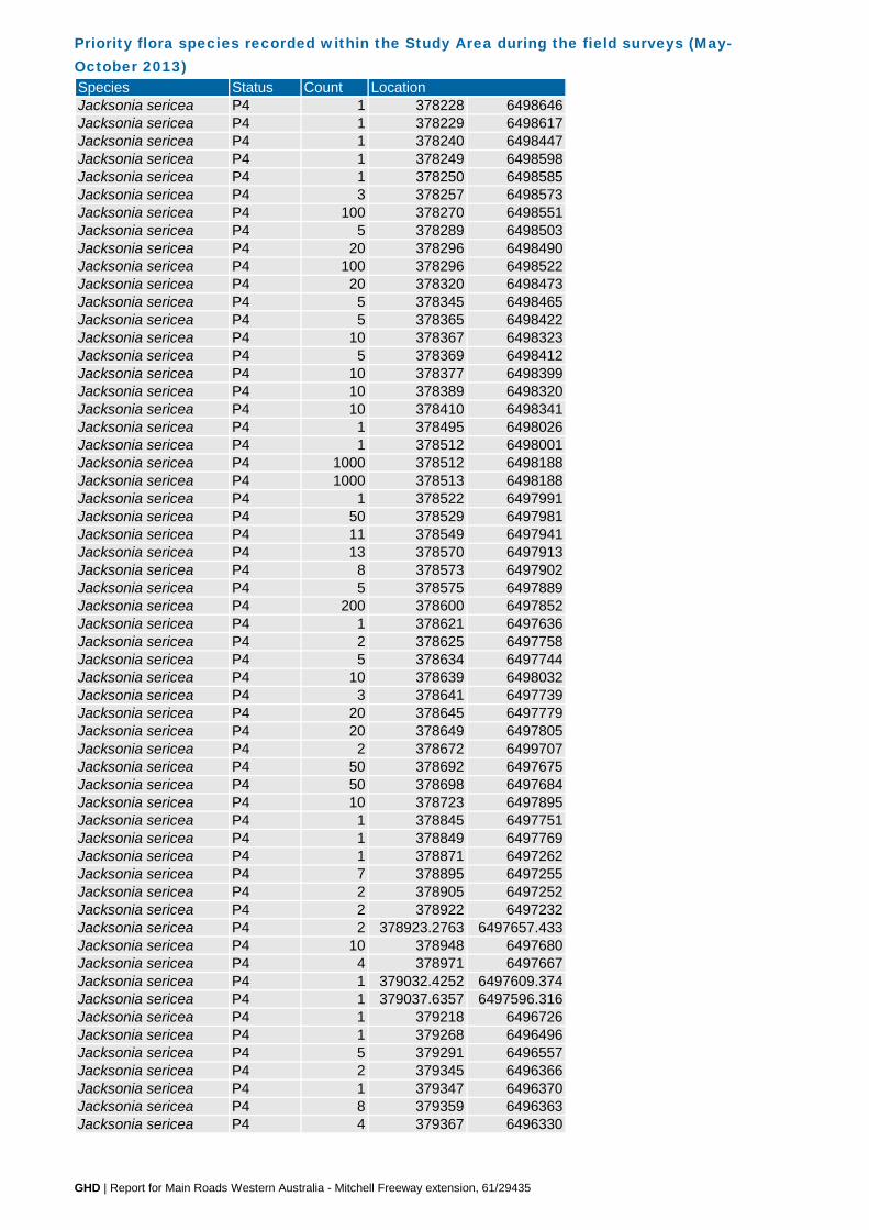
Priority flora species recorded within the Study Area during the field surveys (May-October 2013) Species Status Count LocationJacksonia sericea P4 1 378228 6498646Jacksonia sericea P4 1 378229 6498617Jacksonia sericea P4 1 378240 6498447Jacksonia sericea P4 1 378249 6498598Jacksonia sericea P4 1 378250 6498585Jacksonia sericea P4 3 378257 6498573Jacksonia sericea P4 100 378270 6498551Jacksonia sericea P4 5 378289 6498503Jacksonia sericea P4 20 378296 6498490Jacksonia sericea P4 100 378296 6498522Jacksonia sericea P4 20 378320 6498473Jacksonia sericea P4 5 378345 6498465Jacksonia sericea P4 5 378365 6498422Jacksonia sericea P4 10 378367 6498323Jacksonia sericea P4 5 378369 6498412Jacksonia sericea P4 10 378377 6498399Jacksonia sericea P4 10 378389 6498320Jacksonia sericea P4 10 378410 6498341Jacksonia sericea P4 1 378495 6498026Jacksonia sericea P4 1 378512 6498001Jacksonia sericea P4 1000 378512 6498188Jacksonia sericea P4 1000 378513 6498188Jacksonia sericea P4 1 378522 6497991Jacksonia sericea P4 50 378529 6497981Jacksonia sericea P4 11 378549 6497941Jacksonia sericea P4 13 378570 6497913Jacksonia sericea P4 8 378573 6497902Jacksonia sericea P4 5 378575 6497889Jacksonia sericea P4 200 378600 6497852Jacksonia sericea P4 1 378621 6497636Jacksonia sericea P4 2 378625 6497758Jacksonia sericea P4 5 378634 6497744Jacksonia sericea P4 10 378639 6498032Jacksonia sericea P4 3 378641 6497739Jacksonia sericea P4 20 378645 6497779Jacksonia sericea P4 20 378649 6497805Jacksonia sericea P4 2 378672 6499707Jacksonia sericea P4 50 378692 6497675Jacksonia sericea P4 50 378698 6497684Jacksonia sericea P4 10 378723 6497895Jacksonia sericea P4 1 378845 6497751Jacksonia sericea P4 1 378849 6497769Jacksonia sericea P4 1 378871 6497262Jacksonia sericea P4 7 378895 6497255Jacksonia sericea P4 2 378905 6497252Jacksonia sericea P4 2 378922 6497232Jacksonia sericea P4 2 378923.2763 6497657.433Jacksonia sericea P4 10 378948 6497680Jacksonia sericea P4 4 378971 6497667Jacksonia sericea P4 1 379032.4252 6497609.374Jacksonia sericea P4 1 379037.6357 6497596.316Jacksonia sericea P4 1 379218 6496726Jacksonia sericea P4 1 379268 6496496Jacksonia sericea P4 5 379291 6496557Jacksonia sericea P4 2 379345 6496366Jacksonia sericea P4 1 379347 6496370Jacksonia sericea P4 8 379359 6496363Jacksonia sericea P4 4 379367 6496330
GHD | Report for Main Roads Western Australia - Mitchell Freeway extension, 61/29435
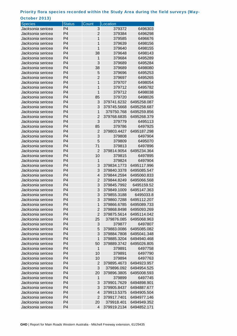
Priority flora species recorded within the Study Area during the field surveys (May-October 2013) Species Status Count LocationJacksonia sericea P4 3 379372 6496303Jacksonia sericea P4 2 379384 6496298Jacksonia sericea P4 1 379585 6496676Jacksonia sericea P4 1 379639 6498156Jacksonia sericea P4 1 379640 6498155Jacksonia sericea P4 38 379648 6498143Jacksonia sericea P4 1 379684 6495289Jacksonia sericea P4 3 379689 6495284Jacksonia sericea P4 38 379689 6498080Jacksonia sericea P4 5 379696 6495253Jacksonia sericea P4 2 379697 6495265Jacksonia sericea P4 1 379707 6498054Jacksonia sericea P4 1 379712 6495782Jacksonia sericea P4 1 379712 6498038Jacksonia sericea P4 85 379720 6498026Jacksonia sericea P4 3 379741.6232 6495258.087Jacksonia sericea P4 3 379745.5668 6495258.687Jacksonia sericea P4 1 379750.768 6495259.856Jacksonia sericea P4 2 379768.6835 6495268.379Jacksonia sericea P4 3 379779 6495113Jacksonia sericea P4 85 379786 6497925Jacksonia sericea P4 2 379803.4427 6495187.298Jacksonia sericea P4 3 379808 6497904Jacksonia sericea P4 5 379809 6495070Jacksonia sericea P4 71 379813 6497896Jacksonia sericea P4 2 379814.9054 6495234.364Jacksonia sericea P4 10 379815 6497895Jacksonia sericea P4 1 379824 6497904Jacksonia sericea P4 3 379834.1773 6495117.996Jacksonia sericea P4 3 379840.3378 6495085.547Jacksonia sericea P4 4 379844.2594 6495060.833Jacksonia sericea P4 2 379844.8249 6495066.568Jacksonia sericea P4 3 379845.7992 6495159.52Jacksonia sericea P4 3 379849.1009 6495147.363Jacksonia sericea P4 3 379855.3188 6495033.8Jacksonia sericea P4 3 379860.7288 6495112.207Jacksonia sericea P4 1 379866.6785 6495089.733Jacksonia sericea P4 2 379868.8498 6495093.269Jacksonia sericea P4 2 379875.5614 6495114.042Jacksonia sericea P4 25 379876.085 6495068.963Jacksonia sericea P4 3 379877 6497807Jacksonia sericea P4 5 379883.0086 6495085.082Jacksonia sericea P4 3 379884.7808 6495041.348Jacksonia sericea P4 1 379885.3204 6494940.468Jacksonia sericea P4 50 379889.3742 6495026.805Jacksonia sericea P4 1 379891 6497758Jacksonia sericea P4 10 379891 6497790Jacksonia sericea P4 10 379894 6497763Jacksonia sericea P4 2 379895.4673 6494923.957Jacksonia sericea P4 3 379896.092 6494954.525Jacksonia sericea P4 20 379896.3805 6495008.593Jacksonia sericea P4 1 379899 6497745Jacksonia sericea P4 3 379901.7629 6494898.901Jacksonia sericea P4 3 379905.8437 6494887.677Jacksonia sericea P4 4 379913.5375 6494905.504Jacksonia sericea P4 2 379917.7401 6494977.146Jacksonia sericea P4 20 379918.401 6494949.352Jacksonia sericea P4 4 379919.2134 6494852.171
GHD | Report for Main Roads Western Australia - Mitchell Freeway extension, 61/29435

Priority flora species recorded within the Study Area during the field surveys (May-October 2013) Species Status Count LocationJacksonia sericea P4 71 379924 6497723Jacksonia sericea P4 1 379940.3526 6494814.353Jacksonia sericea P4 1 379950.1268 6494775.479Jacksonia sericea P4 4 379954.4991 6494807.2Jacksonia sericea P4 2 379963.0247 6494775.149Jacksonia sericea P4 1 379964.8739 6494730.196Jacksonia sericea P4 2 379969.6986 6494755.603Jacksonia sericea P4 2 379976.4088 6494702.984Jacksonia sericea P4 5 379985.1033 6494689.042Jacksonia sericea P4 2 380011.4637 6494628.816Jacksonia sericea P4 3 380018.695 6494602.071Jacksonia sericea P4 1 380027.2101 6494560.004Jacksonia sericea P4 1 380032.6654 6494552.861Jacksonia sericea P4 2 380043.4195 6494661.729Jacksonia sericea P4 10 380052.6374 6494574.712Jacksonia sericea P4 5 380052.9898 6494476.232Jacksonia sericea P4 3 380053.7408 6494604.867Jacksonia sericea P4 3 380067.2984 6494427.802Jacksonia sericea P4 10 380070.1274 6494524.471Jacksonia sericea P4 3 380072.6537 6494511.012Jacksonia sericea P4 2 380099.8661 6494412.659Jacksonia sericea P4 1 380102.975 6494403.456Jacksonia sericea P4 5 380108.3563 6494449.01Jacksonia sericea P4 2 380111.6697 6494266.825Jacksonia sericea P4 2 380114.9242 6494245.059Jacksonia sericea P4 2 380137.7234 6494197.467Jacksonia sericea P4 3 380140.8316 6494136.528Jacksonia sericea P4 1 380150.6679 6494152.163Jacksonia sericea P4 1 380152.4302 6494090.1Jacksonia sericea P4 1 380160.2686 6494117.241Jacksonia sericea P4 1 380174.0674 6494030.927Jacksonia sericea P4 1 380185.7923 6494017.205Jacksonia sericea P4 1 380222.9368 6493773.292Jacksonia sericea P4 2 380242.6769 6493730.505Jacksonia sericea P4 2 380247.6214 6493797.413Jacksonia sericea P4 1 380251.6333 6493778.428Jacksonia sericea P4 5 380264.134 6493746.148Jacksonia sericea P4 2 380265.4062 6493761.978Jacksonia sericea P4 3 380265.9642 6493714.293Jacksonia sericea P4 2 380270.4646 6493707.693Jacksonia sericea P4 1 380271.8203 6493549.728Jacksonia sericea P4 1 380274.6321 6493538.859Jacksonia sericea P4 1 380286.5912 6493540.328Jacksonia sericea P4 2 380291.0248 6493474.008Jacksonia sericea P4 5 380292.2747 6493598.006Jacksonia sericea P4 2 380297.9093 6493479.816Jacksonia sericea P4 1 380299.3101 6493549.861Jacksonia sericea P4 2 380307.7764 6493391.793Jacksonia sericea P4 2 380308.2161 6493394.755Jacksonia sericea P4 4 380321.8906 6493502.321Jacksonia sericea P4 3 380328.1258 6493449.124Jacksonia sericea P4 3 380331.593 6493436.23Jacksonia sericea P4 2 380351.5173 6493408.96Jacksonia sericea P4 1 380372.2266 6493310.87Jacksonia sericea P4 3 380437.0094 6493181.982Jacksonia sericea P4 2 380527.7109 6492940.165Jacksonia sericea P4 2 380532.6112 6492748.612Jacksonia sericea P4 2 380564.7758 6492656.629
GHD | Report for Main Roads Western Australia - Mitchell Freeway extension, 61/29435

Priority flora species recorded within the Study Area during the field surveys (May-October 2013) Species Status Count LocationJacksonia sericea P4 1 380604.8601 6492511.828Jacksonia sericea P4 10 380607.6287 6492504.654Jacksonia sericea P4 3 380611.7143 6492479.203Jacksonia sericea P4 1 380612.0978 6492492.828Jacksonia sericea P4 2 380616.3015 6492465.028Jacksonia sericea P4 5 380622.1267 6492439.412Jacksonia sericea P4 5 380629.2295 6492445.11Jacksonia sericea P4 10 380641.7518 6492381.62Jacksonia sericea P4 100 380645.6538 6492372.057Jacksonia sericea P4 20 380650.1692 6492415.85Jacksonia sericea P4 3 381156 6491091Jacksonia sericea P4 5 381168 6491071Jacksonia sericea P4 1 381186 6491041Jacksonia sericea P4 1 381197 6491022Jacksonia sericea P4 1 381427 6490415Jacksonia sericea P4 1 381434.9421 6490607.877Jacksonia sericea P4 1 381442 6490291Jacksonia sericea P4 1 381444.2856 6490578.236Jacksonia sericea P4 3 381512.9094 6490284.916Jacksonia sericea P4 3 381524.0897 6489886.621Jacksonia sericea P4 1 381602 6489691Jacksonia sericea P4 50 382891 6492870Jacksonia sericea P4 30 382934 6492861Jacksonia sericea P4 1 382940 6492862Jacksonia sericea P4 10 382955 6492856Jacksonia sericea P4 5 382961 6492854Jacksonia sericea P4 30 382977 6492847Jacksonia sericea P4 1 383011 6492836Jacksonia sericea P4 10 383062 6492797Jacksonia sericea P4 55 383065 6492812Jacksonia sericea P4 5 383068 6492783Jacksonia sericea P4 5 383208 6492714Pimelea calcicola P3 5 377900 6499091Pimelea calcicola P3 1 378036 6498846Pimelea calcicola P3 2 378053 6498790Pimelea calcicola P3 1 378053 6498802Pimelea calcicola P3 1 378063 6498757Pimelea calcicola P3 1 378063 6498798Pimelea calcicola P3 2 378071 6498739Pimelea calcicola P3 1 378076 6498749Pimelea calcicola P3 1 378115 6498758Pimelea calcicola P3 1 378124 6498777Pimelea calcicola P3 3 378134 6498756Pimelea calcicola P3 6 378323 6498358Pimelea calcicola P3 8 378323 6498362Pimelea calcicola P3 3 378327 6498357Pimelea calcicola P3 1 378328 6498354Pimelea calcicola P3 10 378331 6498354Pimelea calcicola P3 10 378333 6498348Pimelea calcicola P3 10 378336 6498343Pimelea calcicola P3 2 378338 6498352Pimelea calcicola P3 5 378339 6498358Pimelea calcicola P3 2 378339 6498361Pimelea calcicola P3 10 378342 6498346Pimelea calcicola P3 4 378342 6498348Pimelea calcicola P3 1 378345 6498358Pimelea calcicola P3 4 378351 6498365Pimelea calcicola P3 3 378365 6498359
GHD | Report for Main Roads Western Australia - Mitchell Freeway extension, 61/29435

Priority flora species recorded within the Study Area during the field surveys (May-October 2013) Species Status Count LocationPimelea calcicola P3 1 378376 6498394Pimelea calcicola P3 1 378392 6498374Pimelea calcicola P3 25 378402 6498376Pimelea calcicola P3 10 378408 6498382Pimelea calcicola P3 1 378441 6498133Pimelea calcicola P3 1 378484 6498079Pimelea calcicola P3 6 378529 6498183Pimelea calcicola P3 4 378530 6498130Pimelea calcicola P3 2 378533 6498126Pimelea calcicola P3 3 378536 6498145Pimelea calcicola P3 5 378546 6498147Pimelea calcicola P3 1 378548 6498147Pimelea calcicola P3 1 378550 6498139Pimelea calcicola P3 2 378553 6498150Pimelea calcicola P3 5 378558 6498150Pimelea calcicola P3 1 378560 6497966Pimelea calcicola P3 2 378564 6498150Pimelea calcicola P3 13 378567 6498146Pimelea calcicola P3 3 378567 6498152Pimelea calcicola P3 1 378572 6498151Pimelea calcicola P3 3 378578 6497867Pimelea calcicola P3 3 378589 6497911Pimelea calcicola P3 9 378590 6497922Pimelea calcicola P3 0 378591 6497910Pimelea calcicola P3 1 378592 6497915Pimelea calcicola P3 3 378593 6497907Pimelea calcicola P3 12 378595 6497858Pimelea calcicola P3 2 378595 6497904Pimelea calcicola P3 3 378596 6497851Pimelea calcicola P3 1 378597 6497904Pimelea calcicola P3 3 378600 6497901Pimelea calcicola P3 1 378620 6497985Pimelea calcicola P3 1 378620 6497989Pimelea calcicola P3 1 378622 6497979Pimelea calcicola P3 1 378622 6497986Pimelea calcicola P3 1 378623 6497987Pimelea calcicola P3 1 378623 6497991Pimelea calcicola P3 1 378629 6498002Pimelea calcicola P3 1 378631 6497991Pimelea calcicola P3 3 378640 6498001Pimelea calcicola P3 2 378642 6498001Pimelea calcicola P3 4 378650 6498037Pimelea calcicola P3 1 378652 6497960Pimelea calcicola P3 1 378653 6497944Pimelea calcicola P3 1 378654 6498036Pimelea calcicola P3 1 378657 6498048Pimelea calcicola P3 1 378660 6498001Pimelea calcicola P3 1 378660 6498009Pimelea calcicola P3 1 378664 6498007Pimelea calcicola P3 1 378665 6497929Pimelea calcicola P3 1 378665 6497940Pimelea calcicola P3 1 378667 6497938Pimelea calcicola P3 1 378671 6497953Pimelea calcicola P3 1 378672 6497914Pimelea calcicola P3 1 378674 6497920Pimelea calcicola P3 1 378674 6498000Pimelea calcicola P3 2 378676 6497995Pimelea calcicola P3 1 378679 6497966
GHD | Report for Main Roads Western Australia - Mitchell Freeway extension, 61/29435

Priority flora species recorded within the Study Area during the field surveys (May-October 2013) Species Status Count LocationPimelea calcicola P3 1 378679 6498000Pimelea calcicola P3 2 378681 6497953Pimelea calcicola P3 3 378682 6497947Pimelea calcicola P3 1 378682 6497964Pimelea calcicola P3 1 378682 6497977Pimelea calcicola P3 3 378683 6497954Pimelea calcicola P3 7 378684 6497956Pimelea calcicola P3 2 378684 6497994Pimelea calcicola P3 5 378686 6497959Pimelea calcicola P3 9 378686 6497983Pimelea calcicola P3 1 378686 6497986Pimelea calcicola P3 2 378686 6497986Pimelea calcicola P3 6 378687 6497963Pimelea calcicola P3 3 378688 6497985Pimelea calcicola P3 2 378689 6497975Pimelea calcicola P3 1 378689 6497978Pimelea calcicola P3 1 378690 6497933Pimelea calcicola P3 1 378692 6497965Pimelea calcicola P3 2 378693 6497949Pimelea calcicola P3 9 378693 6497968Pimelea calcicola P3 2 378693 6497970Pimelea calcicola P3 3 378693 6497981Pimelea calcicola P3 2 378693 6497988Pimelea calcicola P3 1 378693 6497989Pimelea calcicola P3 4 378694 6497986Pimelea calcicola P3 1 378694 6497990Pimelea calcicola P3 2 378695 6497969Pimelea calcicola P3 3 378695 6497970Pimelea calcicola P3 1 378695 6497980Pimelea calcicola P3 1 378695 6497993Pimelea calcicola P3 2 378698 6497991Pimelea calcicola P3 3 378699 6497991Pimelea calcicola P3 1 378705 6497938Pimelea calcicola P3 1 378711 6497682Pimelea calcicola P3 1 378712 6497687Pimelea calcicola P3 1 378714 6497657Pimelea calcicola P3 1 378714 6497658Pimelea calcicola P3 2 378714 6497905Pimelea calcicola P3 4 378716 6497950Pimelea calcicola P3 11 378716 6497955Pimelea calcicola P3 1 378719 6497956Pimelea calcicola P3 1 378725 6497654Pimelea calcicola P3 2 378727 6497654Pimelea calcicola P3 1 378729 6497817Pimelea calcicola P3 1 378730 6497811Pimelea calcicola P3 1 378732 6497808Pimelea calcicola P3 8 378737 6497801Pimelea calcicola P3 2 378738 6497893Pimelea calcicola P3 3 378741 6497890Pimelea calcicola P3 5 378741 6497892Pimelea calcicola P3 3 378741 6497902Pimelea calcicola P3 3 378743 6497798Pimelea calcicola P3 1 378746 6497846Pimelea calcicola P3 6 378747 6497783Pimelea calcicola P3 1 378748 6497851Pimelea calcicola P3 6 378749 6497797Pimelea calcicola P3 11 378749 6497802Pimelea calcicola P3 7 378749 6497862
GHD | Report for Main Roads Western Australia - Mitchell Freeway extension, 61/29435

Priority flora species recorded within the Study Area during the field surveys (May-October 2013) Species Status Count LocationPimelea calcicola P3 3 378751 6497792Pimelea calcicola P3 4 378753 6497774Pimelea calcicola P3 1 378754 6497799Pimelea calcicola P3 1 378755 6497786Pimelea calcicola P3 1 378757 6497786Pimelea calcicola P3 2 378757 6497925Pimelea calcicola P3 4 378758 6497862Pimelea calcicola P3 3 378759 6497785Pimelea calcicola P3 1 378760 6497916Pimelea calcicola P3 3 378761 6497863Pimelea calcicola P3 1 378762 6497801Pimelea calcicola P3 2 378762 6497863Pimelea calcicola P3 4 378766 6497863Pimelea calcicola P3 1 378772 6497768Pimelea calcicola P3 2 378776 6497860Pimelea calcicola P3 3 378777 6497862Pimelea calcicola P3 1 378777 6497865Pimelea calcicola P3 2 378779 6497859Pimelea calcicola P3 2 378779 6497862Pimelea calcicola P3 2 378780 6497869Pimelea calcicola P3 2 378781 6497863Pimelea calcicola P3 2 378782 6497860Pimelea calcicola P3 1 378784 6497868Pimelea calcicola P3 1 378784 6497873Pimelea calcicola P3 3 378785 6497869Pimelea calcicola P3 1 378792 6497874Pimelea calcicola P3 1 378808 6497834Pimelea calcicola P3 1 378809 6497827Pimelea calcicola P3 1 378811 6497832Pimelea calcicola P3 1 378817 6497832Pimelea calcicola P3 1 378817 6497833Pimelea calcicola P3 1 378819 6497765Pimelea calcicola P3 1 378821 6497830Pimelea calcicola P3 1 378824 6497771Pimelea calcicola P3 1 378825 6497824Pimelea calcicola P3 1 378826 6497827Pimelea calcicola P3 2 378827 6497738Pimelea calcicola P3 1 378828 6497832Pimelea calcicola P3 1 378830 6497820Pimelea calcicola P3 2 378833 6497760Pimelea calcicola P3 1 378833 6497764Pimelea calcicola P3 1 378839 6497749Pimelea calcicola P3 1 378841 6497826Pimelea calcicola P3 1 378842 6497819Pimelea calcicola P3 1 378849 6497751Pimelea calcicola P3 1 378850 6497747Pimelea calcicola P3 1 378855 6497751Pimelea calcicola P3 1 379895 6497779Pimelea calcicola P3 1 379896 6497766Pimelea calcicola P3 1 379897 6497774Pimelea calcicola P3 1 379908 6497730Pimelea calcicola P3 1 379997 6497602Pimelea calcicola P3 1 380005 6497580Pimelea calcicola P3 2 380008 6497580Stylidium maritimum P3 10 378010 6499073Stylidium maritimum P3 1 378068 6498744Stylidium maritimum P3 50 378130 6498755Stylidium maritimum P3 30 378134 6498756
GHD | Report for Main Roads Western Australia - Mitchell Freeway extension, 61/29435
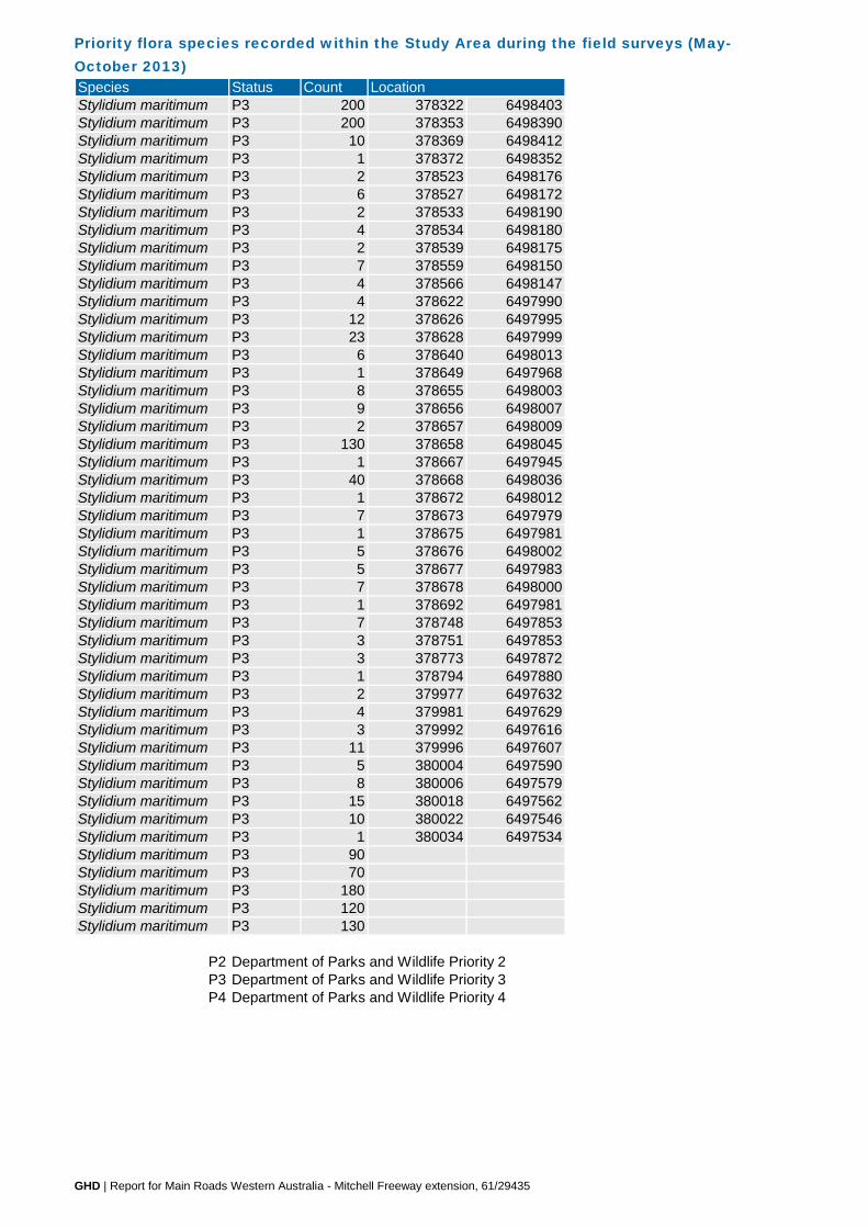
Priority flora species recorded within the Study Area during the field surveys (May-October 2013) Species Status Count LocationStylidium maritimum P3 200 378322 6498403Stylidium maritimum P3 200 378353 6498390Stylidium maritimum P3 10 378369 6498412Stylidium maritimum P3 1 378372 6498352Stylidium maritimum P3 2 378523 6498176Stylidium maritimum P3 6 378527 6498172Stylidium maritimum P3 2 378533 6498190Stylidium maritimum P3 4 378534 6498180Stylidium maritimum P3 2 378539 6498175Stylidium maritimum P3 7 378559 6498150Stylidium maritimum P3 4 378566 6498147Stylidium maritimum P3 4 378622 6497990Stylidium maritimum P3 12 378626 6497995Stylidium maritimum P3 23 378628 6497999Stylidium maritimum P3 6 378640 6498013Stylidium maritimum P3 1 378649 6497968Stylidium maritimum P3 8 378655 6498003Stylidium maritimum P3 9 378656 6498007Stylidium maritimum P3 2 378657 6498009Stylidium maritimum P3 130 378658 6498045Stylidium maritimum P3 1 378667 6497945Stylidium maritimum P3 40 378668 6498036Stylidium maritimum P3 1 378672 6498012Stylidium maritimum P3 7 378673 6497979Stylidium maritimum P3 1 378675 6497981Stylidium maritimum P3 5 378676 6498002Stylidium maritimum P3 5 378677 6497983Stylidium maritimum P3 7 378678 6498000Stylidium maritimum P3 1 378692 6497981Stylidium maritimum P3 7 378748 6497853Stylidium maritimum P3 3 378751 6497853Stylidium maritimum P3 3 378773 6497872Stylidium maritimum P3 1 378794 6497880Stylidium maritimum P3 2 379977 6497632Stylidium maritimum P3 4 379981 6497629Stylidium maritimum P3 3 379992 6497616Stylidium maritimum P3 11 379996 6497607Stylidium maritimum P3 5 380004 6497590Stylidium maritimum P3 8 380006 6497579Stylidium maritimum P3 15 380018 6497562Stylidium maritimum P3 10 380022 6497546Stylidium maritimum P3 1 380034 6497534Stylidium maritimum P3 90Stylidium maritimum P3 70Stylidium maritimum P3 180Stylidium maritimum P3 120Stylidium maritimum P3 130
P2 Department of Parks and Wildlife Priority 2P3 Department of Parks and Wildlife Priority 3P4 Department of Parks and Wildlife Priority 4
GHD | Report for Main Roads Western Australia - Mitchell Freeway extension, 61/29435

Flora species list recorded within the Study Area during the field surveys (May-October 2013) Family Taxa Status
Weedy grasses/herbs *
* Introduced (weed) speciesP3P4
r
dp
sX
eE
Populations at the northern or southern limit of their known geographic range
Department of Parks and Wildlife (DPaW) Priority 4 speciesDepartment of Parks and Wildlife (DPaW) Priority 3 species
Significant flora codes (Government of Western Australia, 2000)Geographical variation significance
Considered to be poorly reserved (applies to all Threatened and Priority taxa)
Populations disjunct from their known geographic range
Regional ecological preferences
Taxa endemic to the Swan Coastal Plain in the Perth Metropolitan Region
Taxa endemic to the Swan Coastal Plain
Considered lost in the Perth Metropolitan RegionSignificant populations (applies to all Threatened and Priority taxa)
GHD | Report for Main Roads Western Australia - Mitchell Freeway extension, 61/29435

Declared Pest flora species Weeds of National Significance recorded within the Study Area during the field surveys (May-October 2013) Species Common name Status Count
379683 6498128 1379647 6498211 1379620 6498251 1379676 6498280 1380378 6495352 1380420 6495359 1380573 6495453 1377868 6499205 1380569 6495478 1378594 6497892 1380605 6495354 1381637 6494042 1380011 6492841 1380048 6492845 1380052 6492866 1380233 6492852 1380138 6492822 1379827 6492611 1377358 6500489 1377190 6500594 1377151 6500620 1376927 6500771 1378529 6497914 1376417 6501156 1381171 6493039 1
Zantedeschia aethiopica Arum lily Declared Pest C3 Management for the Whole of the State 378145 6500489 100
WoNS
Asparagus asparagoides
Solanum linnaeanum
Weeds of National Significance
Location
Apple of Sodom Declared Pest C3 Management for the South West Land Division
Declared Pest C3 Management for the Whole of the State, WoNS
Bridal creeper
GHD | Report for Main Roads Western Australia - Mitchell Freeway extension, 61/29435

Likelihood of occurrence assessment of conservation significant fauna identified in the desktop assessment as potentially occurring within the Study Area
State Federal NatureMapWAHERB/TPFL
EPBC PMST
Acacia benthamii P2 X XShrub, ca 1 m high. Fl. yellow, Aug to Sep. Sand. Typically on limestone breakaways.
Known within the Study Area from previous surveys and the GHD survey.
Andersonia gracilis Slender Andersonia T E X
Slender erect or open straggly shrub, 0.1-0.5(-1) m high. Fl. white-pink-purple, Sep to Nov. White/grey sand, sandy clay, gravelly loam. Winter-wet areas, near swamps.
Highly unlikely. The nearest record on the Swan Coastal Plain is approximately 100 km north of the Study Area and the Study Area does not contain optimal habitat for this species.
Anigozanthos viridis subsp. terraspectans Dwarf Green Kangaroo Paw T V X
Rhizomatous, perennial, herb, 0.05-0.2 m high. Fl. green/yellow-green, Aug to Sep. Grey sand, clay loam. Winter-wet depressions.
Highly unlikely. The nearest record on the Swan Coastal Plain is approximately 50 km north-east of the Study Area.
Austrostipa mundula P2 X X
Perennial caespitose grass 0.35-0.5 m high x 0.05-0.2 m wide. Fl. brown, purple, Sep-Nov. Dry grey sand, shallow cream sand and limestone. Plain, road verge, plateau of coastal cliffs, coastal dunes. Possible.
Baeckea sp. Limestone (N. Gibson & M.N. Lyons 1425) PN P1 X
Compact shrub, 1.2-2 m high, 1 m wide. Fl. pale pink, white, Jun, Oct-Dec. Grey/yellow-brown sand over limestone. Hill, limestone ridge. Unlikely.
Caladenia huegelii Grand Spider Orchid T E X XTuberous, perennial, herb, 0.25-0.6 m high. Fl. green & cream & red, Sep to Oct. Grey or brown sand, clay loam. Possible.
Calectasia cyanea Blue Tinsel Lily T CE X
Rhizomatous, clump forming, woody perennial, herb, 0.1-0.6 m high, to 0.3 m wide. Fl. blue/purple, Jun to Oct. White, grey or yellow sand, gravel.
Highly unlikely. Only known from a location 10 km south of Albany with records elsewhere considered to be mis-identifications.
Calectasia sp. Pinjar (C. Tauss 557) P1 X
Perennial, herb, to 0.4 m high, with multiple stems and roots. Deep grey quartz soils. Gentle slopes, above damplands. Unlikely.
Centrolepis caespitosa P4 E XTufted annual, herb (forming a rounded cushion up to 25 mm across). Fl. Oct to Dec. White sand, clay. Salt flats, wet areas.
Unlikely. The nearest record on the Swan Coastal Plain is approximately 30 km south-east of the Study Area at the foothills of the Darling Scarp. The Darling Scarp experiences very different conditions and would provide a very different habitat to what is found at the Study Area.
Conostylis bracteata P3 X X
Rhizomatous, tufted or shortly proliferous perennial, grass-like or herb, 0.2-0.45 m high. Fl. yellow, Aug to Sep. Sand, limestone. Consolidated sand dunes. Possible.
Conostylis pauciflora subsp. euryrhipis P4 X X
Rhizomatous, stoloniferous perennial, grass-like or herb, 0.06-0.18 m high. Fl. yellow, Aug to Oct. White, grey or yellow sand. Consolidated dunes. Possible.
Conostylis pauciflora subsp. pauciflora P4 X X
Rhizomatous, stoloniferous perennial, grass-like or herb, 0.1-0.35 m high. Fl. yellow, Aug to Oct. Grey sand, limestone. Hillslopes, consolidated dunes. Possible.
Darwinia foetida Muchea Bell T CE X
Erect, or spreading, shrub to 0.7 m high, often using other shrubs for support. Young branches are slender, green-brown with prominent, decurrent leaf bases, becoming grey and woody. Fl. green, Oct to Nov. Grey or white sand, swampy, seasonally wet sites.
Highly unlikely. The nearest record on the Swan Coastal Plain is approximately 20 km east of the Study Area at the foothills of the Darling Scarp. The Darling Scarp experiences very different conditions and would provide a very different habitat to what is found at the Study Area.
Taxa Common name
Status Search
Description & habitat requirements Likelihood of occurrence
GHD | Report for Main Roads Western Australia - Mitchell Freeway extension, 61/29435

Likelihood of occurrence assessment of conservation significant fauna identified in the desktop assessment as potentially occurring within the Study Area
State Federal NatureMapWAHERB/TPFL
EPBC PMSTTaxa Common name
Status Search
Description & habitat requirements Likelihood of occurrence
Diuris micrantha Dwarf Bee-orchid T V XTuberous, perennial, herb, 0.3-0.6 m high. Fl. yellow & brown, Sep to Oct. Brown loamy clay. Winter-wet swamps, in shallow water.
Highly unlikely. The nearest record on the Swan Coastal Plain is approximately 65 km south of the Study Area and the Study Area does not contain optimal habitat for this species.
Diuris purdiei Purdie's Donkey-orchid T V XTuberous, perennial, herb, 0.15-0.35 m high. Fl. yellow, Sep to Oct. Grey-black sand, moist. Winter-wet swamps.
Highly unlikely. The nearest record on the Swan Coastal Plain is approximately 50 km south of the Study Area. The Study Area does not contain optimal habitat for this species.
Drakaea elastica Glossy-leafed Hammer-orchid T E X
Tuberous, perennial, herb, 0.12-0.3 m high. Fl. red & green & yellow, Oct to Nov. White or grey sand. Low-lying situations adjoining winter-wet swamps.
Highly unlikely. The nearest record on the Swan Coastal Plain is approximately 30 km north of the Study Area. The Study Area does not contain optimalm habitat for this species.
Drakaea micrantha Dwarf Hammer-orchid T V XTuberous, perennial, herb, 0.15-0.3 m high. Fl. red & yellow, Sep to Oct. White-grey sand.
Possible. The nearest record on the Swan Coastal Plain is approximately 50 km south of the Study Area.
Drosera x sidjamesii P1 X
Fibrous-rooted perennial, herb, to 0.06 m high. Fl. green-pink, Nov to Dec or Jan to Mar. Peaty sand. Along lake margins, close to winter high-water line.
Unlikely. The Study Area does not contain optimal habitat for this species.
Eucalyptus argutifolia Wabling Hill Mallee T V X X XMallee, 1.5-4 m high, bark smooth. Fl. white, Mar to Apr. Shallow soils over limestone. Slopes or gullies of limestone ridges, outcrops. Unlikely.
Fabronia hampeana P2 X XMoss, white. Growing on cycad, Melaleuca lanceolata . Between limestone outcrops with yellow sand.
Known within the Study Area from previous surveys.
Grevillea elongata T V XShrub, 1.5-2 m high. Fl. white-cream, Oct. Gravelly clay, sandy clay, sand. Road verges, swamps, creek banks.
Unlikely. The Study Area does not contain optimal habitat for this species.
Grevillea thelemanniana subsp. thelemanniana P4 X
Widely spreading shrub 0.2-1.5 m high, 0.5-1.5 m wide. Fl. red, May-Nov. Moist grey-brown sandy loam over clay, yellow sand/grey clay soils. Edge of seasonal clay depression, on slightly deeper sandier soils, winter-wet, swampy area, flat.
Unlikely. The Study Area does not contain optimal habitat for this species.
Grevillea sp. Ocean Reef (D. Pike Joon 4) P1 X X
Erect, spreading shrub, 1.5-2 m high, 3 m wide. Fl. November. Dry brown/grey sand, yellow-brown sand. Sandy dune, gully. Unlikely.
Hibbertia spicata subsp. leptotheca P3 X X
Erect or spreading shrub, 0.2-0.5 m high. Fl. yellow, Jul to Oct. Sand. Near-coastal limestone ridges, outcrops & cliffs. Unlikely.
Isopogon uncinatus Hook-leaf Isopogon T E X
Tufted spreading or prostrate, non-lignotuberous shrub, 0.05-0.4 m high. Fl. yellow/cream, Oct to Nov. Loam or sand on granite, peaty sand. Swampy depressions, hillslopes.
Highly unlikely. The nearest record is located in Albany and the Study Area does not contain optimal habitat for this species.
Jacksonia sericea Waldjumi P4 X XLow spreading shrub, to 0.6 m high. Fl. orange, usually Dec or Jan to Feb. Calcareous & sandy soils.
Known within the Study Area from the GHD survey.
Lecania turicensis var. turicensis P2 X Lichen. Coastal rocks, limestone. Possible.
Lepidosperma rostratum Beaked Lepidosperma T E XRhizomatous, tufted perennial, grass-like or herb (sedge), 0.5 m high. Fl. brown. Peaty sand, clay.
Highly unlikely. The nearest records on the Swan Coastal Plain are approximately 50 km north and south of the Study Area and the Study Area does not contain optimal habitat for this species.
GHD | Report for Main Roads Western Australia - Mitchell Freeway extension, 61/29435

Likelihood of occurrence assessment of conservation significant fauna identified in the desktop assessment as potentially occurring within the Study Area
State Federal NatureMapWAHERB/TPFL
EPBC PMSTTaxa Common name
Status Search
Description & habitat requirements Likelihood of occurrence
Leucopogon maritimus P1 X
Spreading shrub, 0.2-0.4 m high, 0.2-0.5 m wide. Fl. white, Mar-Jun, Aug, Nov. Dry pale yellow/white sand over limestone. Upper slopes of coastal dunes. Unlikely.
Leucopogon sp. Yanchep (M. Hislop 1986) P3 X X
Erect shrub, 0.15-1 m high, to 0.6 m wide. Fl. white/pink, Apr to Jun or Sep. Light grey-yellow sand, brown loam, limestone, laterite, granite. Coastal plain, breakaways, valley slopes, low hills. Unlikely.
Marianthus paralius T X XAlmost prostrate, eventually scandent, woody shrub. Fl. red, Sep to Nov. White sand over limestone. Low coastal cliffs. Unlikely.
Melaleuca sp. Wanneroo (G.J. Keighery 16705) P1 X X
Slender erect shrub, 2-3 m high, 1-2 m wide. Fl. yellow, December. Mossy black sand. Rugged limestone ridge. Unlikely.
Pimelea calcicola P3 X XErect to spreading shrub, 0.2-1 m high. Fl. pink, Sep to Nov. Sand. Coastal limestone ridges.
Known within the Study Area from the GHD survey.
Sarcozona bicarinata P3 X X Shrub, ca 0.1 m high. Fl. white, Aug. White sand. Possible.
Schoenus griffinianus P3 XSmall, tufted perennial, grass-like or herb (sedge), to 0.1 m high. Fl. Sep to Oct. White sand. Possible.
Stylidium maritimum P3 X X
Caespitose perennial, herb, 0.3-0.7 m high, Leaves tufted, linear to narrowly oblanceolate, 10-40 cm long, 1-5.5 mm wide, apex acute to mucronate, margin involute, glabrous. Membraneous scale leaves present at base of mature leaves. Scape glandular throughout. Inflorescence paniculate. Fl. white/purple, Sep to Nov. Sand over limestone. Dune slopes and flats. Coastal heath and shrubland, open Banksia woodland.
Known within the Study Area from the GHD survey.
Tetraria sp. Chandala (G.J. Keighery 17055) P2 X X
Slender, erect, rhizomatous sedge, 1.5-1.6 m high, 0.3-1 m wide. Fl. brown, Feb, Jul. Peaty sand, black peat over clay. Mound spring.
Unlikely. The Study Area does not contain optimal habitat for this species
Thelymitra variegata Queen of Sheba P3 X XTuberous, perennial, herb, 0.1-0.35 m high. Fl. orange & red & purple & pink, Jun to Sep. Sandy clay, sand, laterite. Possible.
Conservation codes are provided in Appendix C
The likelihood of occurrence assessment has been based on the range, habitat requirements and previous records of the species and takes into account the intensity of the field survey.
GHD | Report for Main Roads Western Australia - Mitchell Freeway extension, 61/29435

Likelihood of occurrence assessment of conservation significant fauna identified in the desktop assessment as potentially occurring within the Study AreaLikelihood of occurrence DefinitionKnown Species definitely recorded within the Project Area
either from previous records or field survey results.Likely Species previously recorded within 5 km and suitable
habitat occurs at the Project Area.Possible
Species previously recorded within 5 km with marginally suitable habitat occurring at the Project Area.
ORSpecies not previously recorded within 5 km, but suitable habitat does occur at the Project Area.
ORSpecies not identified during the field survey. However, the cryptic nature of the species or discrepancy in flowering time means it may be present but not observed during the field survey.
Unlikely Species previously recorded within 5 km but suitable habitat does not occur at the Project Area.
ORSpecies considered to be easily observed. However, was not observed during the field survey so not considered to be present within the Study Area.
Highly unlikelySpecies not previously recorded within 5 km, suitable habitat does not occur at the Project Area and/ or Project Area is outside the species’ natural distribution.
GHD | Report for Main Roads Western Australia - Mitchell Freeway extension, 61/29435

GHD | Report for Main Roads Western Australia - Mitchell Freeway extension: Burns Beach Rd to Romeo Rd, 61/29435
Appendix E – Fauna results Fauna species recorded within the Study Area during the field surveys (May-July 2013)
Fauna likelihood of occurrence assessment of conservation significant fauna identified in the desktop assessment as potentially occurring within the Study Area
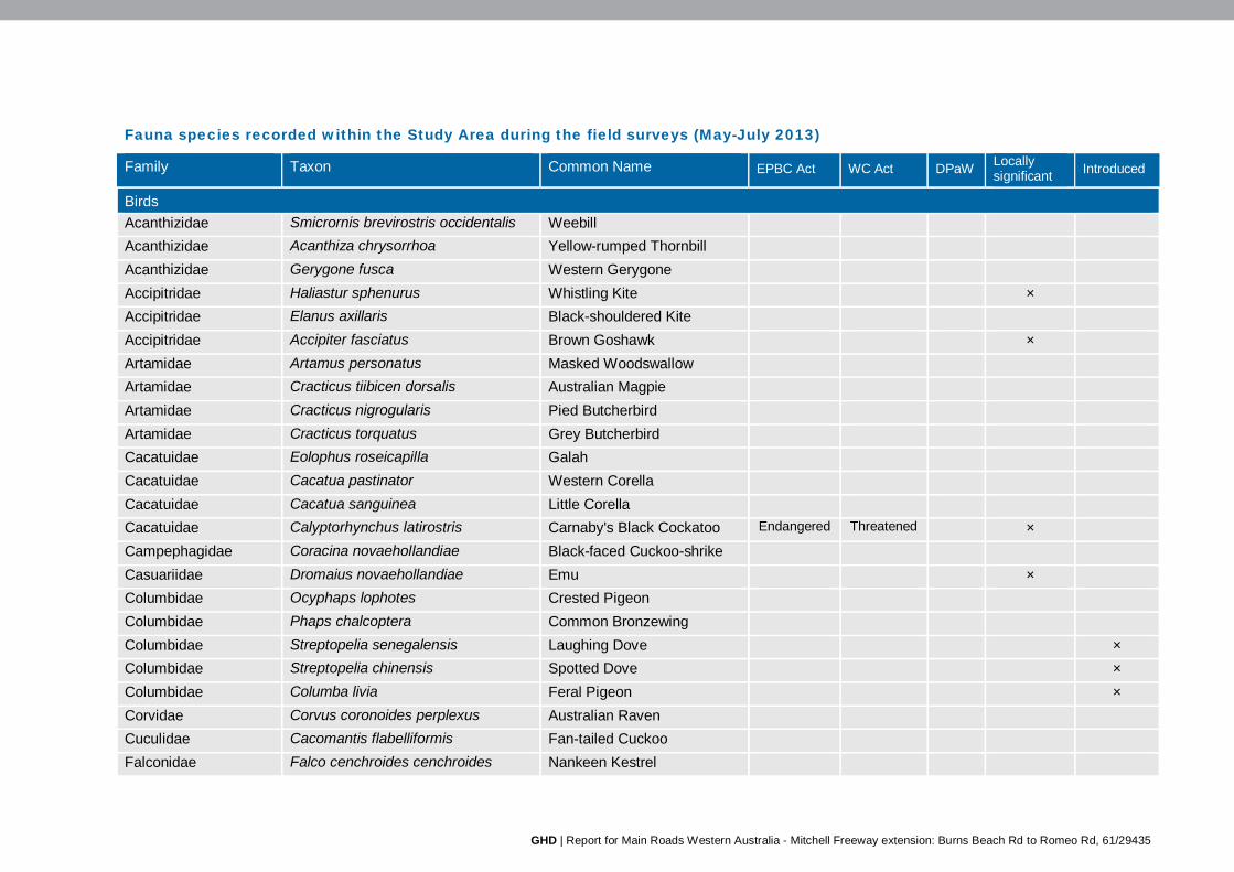
GHD | Report for Main Roads Western Australia - Mitchell Freeway extension: Burns Beach Rd to Romeo Rd, 61/29435
Fauna species recorded within the Study Area during the field surveys (May-July 2013)
Family Taxon Common Name EPBC Act WC Act DPaW Locally significant Introduced
Birds Acanthizidae Smicrornis brevirostris occidentalis Weebill Acanthizidae Acanthiza chrysorrhoa Yellow-rumped Thornbill Acanthizidae Gerygone fusca Western Gerygone Accipitridae Haliastur sphenurus Whistling Kite × Accipitridae Elanus axillaris Black-shouldered Kite Accipitridae Accipiter fasciatus Brown Goshawk × Artamidae Artamus personatus Masked Woodswallow Artamidae Cracticus tiibicen dorsalis Australian Magpie Artamidae Cracticus nigrogularis Pied Butcherbird Artamidae Cracticus torquatus Grey Butcherbird Cacatuidae Eolophus roseicapilla Galah Cacatuidae Cacatua pastinator Western Corella Cacatuidae Cacatua sanguinea Little Corella Cacatuidae Calyptorhynchus latirostris Carnaby's Black Cockatoo Endangered Threatened × Campephagidae Coracina novaehollandiae Black-faced Cuckoo-shrike Casuariidae Dromaius novaehollandiae Emu × Columbidae Ocyphaps lophotes Crested Pigeon Columbidae Phaps chalcoptera Common Bronzewing Columbidae Streptopelia senegalensis Laughing Dove × Columbidae Streptopelia chinensis Spotted Dove × Columbidae Columba livia Feral Pigeon × Corvidae Corvus coronoides perplexus Australian Raven Cuculidae Cacomantis flabelliformis Fan-tailed Cuckoo Falconidae Falco cenchroides cenchroides Nankeen Kestrel

GHD | Report for Main Roads Western Australia - Mitchell Freeway extension: Burns Beach Rd to Romeo Rd, 61/29435
Family Taxon Common Name EPBC Act WC Act DPaW Locally significant Introduced
Halcyonidae Dacelo novaequineae Laughing Kookaburra × Hirundinidae Petrochelidon nigricans Tree Martin Hirundinidae Hirundo neoxena Welcome Swallow Maluridae Malurus splendens Splendid Fairy-wren × Meliphagidae Phylidonyris novaehollandiae New Holland Honeyeater × Meliphagidae Phylidonyris niger White-cheeked Honeyeater × Meliphagidae Anthochaera carunculata Red Wattlebird Meliphagidae Lichenostomus virescens virescens Singing Honeyeater Meliphagidae Lichmera indistincta Brown Honeyeater Monarchidae Grallina cyanoleuca Magpie-lark Motacillidae Anthus novaeseelandiae Richards Pipit Pachycephalidae Colluricincla harmonica Grey Shrike-thrush × Pachycephalidae Pachycephala pectoralis Golden Whistler × Pachycephalidae Pachycephala rufiventris Rufous Whistler Pardalotidae Pardalotus striatus Striated Pardalote Petroicidae Petroica boodang Scarlet Robin × Petroicidae Microeca fascinans Jacky Winter Podargidae Podargus strigoides Tawny Frogmouth Psittacidae Barnardius zonarius semitorquatus Twenty-eight Parrot Psittacidae Purpureicephalus spurius Red-capped Parrot Psittacidae Trichoglossus haematodus Rainbow Lorikeet × Rhipiduridae Rhipidura albiscapa Grey Fantail Rhipiduridae Rhipidura leucophrys leucophrys Willie Wagtail Timaliidae Zosterops lateralis Silvereye
Reptiles Agamidae Pogona minor minor Western Bearded Dragon

GHD | Report for Main Roads Western Australia - Mitchell Freeway extension: Burns Beach Rd to Romeo Rd, 61/29435
Family Taxon Common Name EPBC Act WC Act DPaW Locally significant Introduced
Boidae Morelia spilota imbricata Carpet Python Schedule 4
×
Elapidae Neelaps bimaculatus Black-naped Snake Scincidae Cryptoblephorus buchananii Fence Skink Scincidae Cyclodomorphus celatus Western Slender Blue-
tongue
Scincidae Hemiergis quadrilineata Two-toed Earless Skink Scincidae Tiliqua rugosa Bobtail
Mammals Canidae Vulpes vulpes Red Fox × Canidae Canis lupus Domestic Dog × Felidae Felis catus Cat × Leporidae Oryctolagus cuniculus European Rabbit × Macropodidae Macropus fuliginosus Western Grey Kangaroo Phalangeridae Trichosurus vulpecula Common Brushtail Possum Tachyglossidae Tachyglossus aculeatus Echidna

GHD | Report for Main Roads Western Australia - Mitchell Freeway extension: Burns Beach Rd to Romeo Rd, 61/29435
Fauna likelihood of occurrence assessment of conservation significant fauna identified in the desktop assessment as potentially occurring within the Study Area
Species name Status Source Habitat requirements Likelihood of occurrence
EPBC Act
WC Act
DPaW EPBC Act PMST
NatureMap search
Birds Anous tenuirostris melanops Australian Lesser Noddy
Vu T X X The Australian Lesser Noddy usually occupies coral-limestone islands that are densely fringed with White Mangrove Avicennia marina. It occasionally occurs on shingle or sandy beaches. The Australian Lesser Noddy roosts mainly in mangroves, especially at night but may sometimes rest on beaches (DotE, 2013b).
Highly unlikely There is no suitable habitat for this species within the Study Area.
Botaurus poiciloptilus Australasian Bittern
En T X X Densely vegetated freshwater wetlands and, rarely, in estuaries or tidal wetlands. In the southwest of Western Australia, the Bittern is found in beds of tall rush mixed with or near short fine sedge or open pools. It also occurs around swamps, lakes, pools, rivers and channels fringed with Lignum muehlenbeckia, canegrass Eragrostis or other dense vegetation. It occasionally ventures into areas of open water or onto banks (DotE 2013b).
Highly unlikely There is no suitable habitat for this species within the Study Area.

GHD | Report for Main Roads Western Australia - Mitchell Freeway extension: Burns Beach Rd to Romeo Rd, 61/29435
Species name Status Source Habitat requirements Likelihood of occurrence
EPBC Act
WC Act
DPaW EPBC Act PMST
NatureMap search
Calidris ferruginea Curlew Sandpiper
Mi T; S3
X In Western Australia, the Curlew Sandpiper is widespread around coastal and sub-coastal plains from Cape Arid to south-west Kimberley Division, but are more sparsely distributed between Carnarvon and Dampier Archipelago. They mainly occur on intertidal mudflats in sheltered coastal areas as well as inland around ephemeral and permanent lakes, dams, waterholes and bore drain, usually with bare edges of mud or sand (DotE 2013b).
Highly unlikely There is no suitable habitat for this species within the Study Area.
Calyptorhynchus baudinii Baudin's Black Cockatoo
Vu T X X This species occurs in high-rainfall areas, usually at sites that are heavily forested and dominated by Marri and Eucalyptus species, especially Karri and Jarrah. The species also occurs in woodlands of Wandoo, Blackbutt, Flooded Gum, and Yate (DotE 2012b).
Unlikely According to the EPBC Act Referral Guidelines (DotE 2012b) the Study Area is outside the currently known foraging and breeding range for this species.
Calyptorhynchus latirostris Carnaby's Black Cockatoo
En T X X This species mainly occurs in uncleared or remnant native eucalypt woodlands and in shrublands or kwongan heathland dominated by Hakea, Dryandra, Banksia and Grevillea species. The species also occurs in forests containing Marri, Jarrah or Karri (DotE 2012b).
Present This species was recorded in the Study Area during the field surveys. There is suitable foraging habitat and potential breeding and roosting habitat in the Study Area for this species, including the Banksia and Tuart woodlands.
Diomedea amsterdamensis Amsterdam Albatross
En; Mi T X Albatrosses breed on subantarctic and other southern ocean islands and fly enormous distances in the southern oceans searching for food (Burbidge 2004). They are all marine, pelagic seabirds which generally sleep and rest on ocean waters when not breeding (DotE 2013b).
Highly unlikely There is no suitable habitat for theseis species within the Study Area.
Diomedea carteri Indian Yellow-nosed Albatross
Vu; Mi T X X

GHD | Report for Main Roads Western Australia - Mitchell Freeway extension: Burns Beach Rd to Romeo Rd, 61/29435
Species name Status Source Habitat requirements Likelihood of occurrence
EPBC Act
WC Act
DPaW EPBC Act PMST
NatureMap search
Diomedea cauta Shy Albatross
Vu; Mi T X
Diomedea chlororhynchos Atlantic Yellow-nosed Albatross
Mi T X
Diomedea chrysostoma Grey-headed Albatross
En; Mi T X
Diomedea dabbenena Tristan Albatross
En; Mi T X
Diomedea exulans Wandering Albatross
Vu; Mi T; S3
X
Diomedea melanophris Black-browed Albatross
Vu; Mi T X X
Falco peregrinus Australian Peregrine Falcon
S4 X The Peregrine Falcon is seen occasionally anywhere in the south-west of Western Australia. It is found everywhere from woodlands to open grasslands and coastal cliffs - though less frequently in desert regions. It is widespread and uncommon but is known to nest and hunt in the Perth CBD and is not considered at risk from urbanisation (Davis 2009)
Likely The closest known records of this species are at Lake Joondalup, less than 3 km south of the Study Area. These records are from 2005 and 2008 (DPaW and WAM 2013). There is suitable habitat for this species in the Study Area.

GHD | Report for Main Roads Western Australia - Mitchell Freeway extension: Burns Beach Rd to Romeo Rd, 61/29435
Species name Status Source Habitat requirements Likelihood of occurrence
EPBC Act
WC Act
DPaW EPBC Act PMST
NatureMap search
Falcunculus frontatus leucogaster Western Shrike-tit, Crested Shrike-tit
P4 X The Western Shrike-tit is found in south-west Western Australia. This subspecies occurs in woodlands, scrubs and more open forests of Eucalyptus, especially of Wandoo, Flat-topped Yate, Karri, Tingle, Flooded Gum, Salmon Gum and Gimlet. It is locally common (e.g. Cranbrook and Boyup Brook districts) but generally scarce and locally extinct (e.g. Swan Coastal Plain and much of the Wheatbelt). Its status on the Swan Coastal Plain is uncertain, perhaps formally a rare inhabitant of tuart forests in the western zone. Records are limited from Wanneroo (specimen, 1907 and 1943) and Bunbury (specimen 1902 and observations Whitlock (1930) over several years of a pair or more in the largest remaining tract of tuart) (Johnstone and Storr 2004).
Highly unlikely The closest known records of this species are near Lake Joondalup, less than 10 km south of the Study Area, recorded in 1907 and 1943 (DPaW and WAM 2013). This species is considered to be locally extinct from the Swan Coastal Plain (Government of Western Australia 2000). Given the Study Area has been highly fragmented and impacted by encroaching urban expansion; it is considered highly unlikely this species occurs in the Study Area.
Ixobrychus flavicollis australis Australian Black Bittern
P3 X The Black Bittern inhabits both terrestrial and estuarine wetlands, generally in areas of permanent water and dense vegetation. Where permanent water is present, this species may occur in flooded grassland, forest, woodland, rainforest and mangroves (Marchant & Higgins 1990).
Highly unlikely There is no suitable habitat for the species within the Study Area.

GHD | Report for Main Roads Western Australia - Mitchell Freeway extension: Burns Beach Rd to Romeo Rd, 61/29435
Species name Status Source Habitat requirements Likelihood of occurrence
EPBC Act
WC Act
DPaW EPBC Act PMST
NatureMap search
Ixobrychus minutus dubius Australian Little Bittern
P4 X The species is most common in freshwater marshes with beds of bulrushes Typha spp., reeds Phragmites spp. (Hockey et al. 2005) or other dense aquatic vegetation, preferably also with deciduous bushes and trees. It may also occupy the margins of lakes, pools and reservoirs, wooded and marshy banks of streams and rivers (del Hoyo et al. 1992).
Highly unlikely There is no suitable habitat for the species within the Study Area.
Leipoa ocellata Malleefowl
Vu, Mi T X Shrublands and low woodlands that are dominated by mallee vegetation, as well as native pine Callitris woodlands, Acacia shrublands, Broombush Melaleuca uncinata vegetation or coastal heathlands (Nevill 2008). This species formally occurred on the northern Swan Coastal Plain at Beermullah (Johnstone and Storr 1998). This population died out in early this century (Johnstone and Storr 1998).
Highly unlikely The Study Area is outside the currently known distribution for this species.
Halobaena caerulea Blue Petrel
Vu X Petrels are a marine and oceanic bird that generally breed in Antarctic or sub-Antarctic waters.
Highly unlikely There is no suitable habitat for these species within the Study Area.
Macronectes giganteus Southern Giant Petrel
En; Mi P4 X X
Macronectes halli Northern Giant Petrel
Vu; Mi X

GHD | Report for Main Roads Western Australia - Mitchell Freeway extension: Burns Beach Rd to Romeo Rd, 61/29435
Species name Status Source Habitat requirements Likelihood of occurrence
EPBC Act
WC Act
DPaW EPBC Act PMST
NatureMap search
Procellaria aequinoctialis aequinoctialis White-chinned Petrel
Mi T X
Pterodroma mollis Soft-plumaged Petrel
Vu X
Rostratula benghalensis australis Australian Painted Snipe
Vu, Mi T X The Australian Painted Snipe generally inhabits shallow terrestrial freshwater (occasionally brackish) wetlands, including temporary and permanent lakes, swamps and claypans. Australian Painted Snipe breeding habitat requirements may be quite specific: shallow wetlands with areas of bare wet mud and both upper and canopy cover nearby (DotE 2013b).
Highly unlikely There is no suitable habitat for the species within the Study Area.
Sternula nereis nereis Australian Fairy Tern
Vu T X X The Fairy Tern (Australian) nests on sheltered sandy beaches, spits and banks above the high tide line and below vegetation. The subspecies has been found in embayments of a variety of habitats including offshore, estuarine or lacustrine (lake) islands, wetlands and mainland coastline (DotE 2013b).
Highly unlikely There is no suitable habitat for this species within the Study Area.

GHD | Report for Main Roads Western Australia - Mitchell Freeway extension: Burns Beach Rd to Romeo Rd, 61/29435
Species name Status Source Habitat requirements Likelihood of occurrence
EPBC Act
WC Act
DPaW EPBC Act PMST
NatureMap search
Migratory birds Actitis hypoleucos Common Sandpiper
Mi S3 X This species is widespread and in small numbers and is found along all coastlines of Australia and in many areas inland. It utilises a wide range of coastal wetlands and some inland wetlands, with varying levels of salinity, and is mostly found around muddy margins or rocky shores and rarely on mudflats (DotE 2013b).
Highly unlikely There is no suitable habitat for this species within the Study Area.
Apus pacificus Fork-tailed Swift
Mi S3 X X In south-west WA there are sparsely scattered records along the south coast, ranging from the Eyre Bird Observatory and west to Denmark. They are widespread in coastal and sub-coastal areas between Augusta and Carnarvon, including some on nearshore and offshore islands. This species is almost exclusively aerial, flying less than 1 m to at least 300 m above ground. This species is considered rare in the south-west region (DotE 2013b).
Possible The closest known record of this species are less than 2 km east of Wanneroo Road recorded in 2009 (DPaW and WAM 2013). There is potential this species may occur as an occasional vagrant however considering it is an almost exclusively aerial species, the Study Area is not considered to contain optimum habitat for this species.
Ardea modesta Eastern Great Egret
Mi S3 X The eastern Great Egret is widespread in Australia. They have been reported in a wide range of wetland habitats, include swamps and marshes; margins of rivers and lakes; damp or flooded grasslands, pasture or agricultural lands; reservoirs; sewerage treatment ponds; drainage channels; salt pans; salt marshes; mangrove, and a range of coastal/marine habitats (DotE 2013b).
Highly unlikely There is no suitable habitat for this species within the Study Area.

GHD | Report for Main Roads Western Australia - Mitchell Freeway extension: Burns Beach Rd to Romeo Rd, 61/29435
Species name Status Source Habitat requirements Likelihood of occurrence
EPBC Act
WC Act
DPaW EPBC Act PMST
NatureMap search
Ardea ibis Cattle Egret
Mi S3 X X The Cattle Egret is a common and widespread species. Typical habitat includes tropical and temperate grasslands, wooded lands and terrestrial wetlands. It often forages away from water on low lying grasslands, improved pastures and croplands and roosts in trees, or amongst ground vegetation in or near lakes and swamps.
Highly unlikely There is no suitable habitat for this species within the Study Area.
Ardenna carneipes Fleshy-footed Shearwater
Mi S3 X X The Fleshy-footed Shearwater is a marine species mainly found offshore over continental shelves. Its breeding season begins in September or October, with colonies forming on vegetated hills or slopes facing the sea (del Hoyo et al. 1992)
Highly unlikely There is no suitable habitat for this species within the Study Area.
Calidris acuminata Sharp-tailed Sandpiper
Mi S3 X This species is found from Carnarvon to Hamelin Bay occasionally on the coast but mostly in flooded samphire or the many bores with overfklow pools that create wet grassy areas. Found throughout many wetlands along the Swan Coastal Plain (Nevill 2008).
Highly unlikely There is no suitable habitat for this species within the Study Area.
Calidris ruficollis Red-necked stint
Mi S3 X X The Red-necked Stint is distributed along most of the Australian coastline with large densities on the Victorian and Tasmanian coasts. It is mostly found in coastal areas, including in sheltered inlets, bays, lagoons and estuaries with intertidal mudflats, near spits, islets and banks (DotE 2013b).
Highly unlikely There is no suitable habitat for this species within the Study Area.

GHD | Report for Main Roads Western Australia - Mitchell Freeway extension: Burns Beach Rd to Romeo Rd, 61/29435
Species name Status Source Habitat requirements Likelihood of occurrence
EPBC Act
WC Act
DPaW EPBC Act PMST
NatureMap search
Haliaeetus leucogaster White-bellied Sea-Eagle
Mi S3 X X Coastal habitats (especially those close to the sea-shore as well as any habitat characterised by the presence of large areas of open water (larger rivers, swamps, lakes, the sea) (Morcombe 2003).
Unlikely There is no suitable habitat for this species within the Study Area.
Hydroprogne caspia Caspian Tern
Mi S3 X Within Australia, the Caspian Tern has a widespread occurrence and can be found in both coastal and inland habitat. In WA, breeding occurs from Recherche Archipelago to Dirk Hartog Island and Faure Island in Shark Bay, and also in the Pilbara region and more rarely, in the Kimberley (DotE 2013b).
Unlikely There is no suitable habitat for this species within the Study Area.
Merops ornatus Rainbow Bee-eater
Mi S3 X X Open forests and woodlands, shrublands, and in various cleared or semi-cleared habitats, including farmland and areas of human habitation. It also inhabits sand dune systems in coastal areas and at inland sites that are in close proximity to water (DotE 2013b).
Likely The Study Area contains suitable habitat for this species. The Rainbow Bee-eater has previously been recorded in the area.
Onychoprion anaethetus Bridled Tern
Mi S3 X In Australia, the Bridled Tern is widespread, breeding on offshore islands in western, northern and north-eastern Australia. The species forages in offshore, continental shelf waters and is only rarely recorded along mainland coasts (DotE 2013b).
Highly unlikely There is no suitable habitat for this species within the Study Area.

GHD | Report for Main Roads Western Australia - Mitchell Freeway extension: Burns Beach Rd to Romeo Rd, 61/29435
Species name Status Source Habitat requirements Likelihood of occurrence
EPBC Act
WC Act
DPaW EPBC Act PMST
NatureMap search
Plegadis falcinellus Glossy Ibis
Mi S3 X Within Australia, the Glossy Ibis is generally located east of the Kimberley. The species is also known to be patchily distributed in the rest of Western Australia. Its preferred habitat for foraging and breeding are freshwater marshes at the edges of lakes and rivers, lagoons, floodplains, wet meadows, swamps, reservoirs, sewerage ponds, rice-fields and cultivated areas under irrigation (DotE 2013b).
Highly unlikely There is no suitable habitat for this species within the Study Area.
Sterna dougallii Roseate Tern
Mi S3 X In Australia, the Roseate Tern occurs in north-western and west coasts and islands from the Sir Graham Moore Is south to Mandurah and as far offshore as Ashmore Reef, Bedout Is and the Houtman Abrolhos. Its habitat consists of the blue-water seas close to land (especially islands) (Johnstone and Storr 1998).
Highly unlikely There is no suitable habitat for this species within the Study Area.
Tringa glareola Wood Sandpiper
Mi S3 X X The Wood Sandpiper has its largest numbers recorded in north-west Australia. Typical habitat includes well-vegetated, shallow, freshwater wetlands, such as swamps, billabongs, lakes, pools and waterholes. This species does not breed in Australia (DotE 2013b).
Highly unlikely There is no suitable habitat for this species within the Study Area.
Mammals

GHD | Report for Main Roads Western Australia - Mitchell Freeway extension: Burns Beach Rd to Romeo Rd, 61/29435
Species name Status Source Habitat requirements Likelihood of occurrence
EPBC Act
WC Act
DPaW EPBC Act PMST
NatureMap search
Bettongia penicillata ogilbyi Woylie, Brush-tailed Bettong
En T X The preferred habitat of the Woylie includes dense undergrowth, logs and rock-cavities and occasionally in burrows (Burbidge 2004). Scattered Woylie populations may be found throughout the Jarrah forest in the south-west corner of Western Australia. Extant naturally occurring populations are restricted to three small wheatbelt reserves in WA – Dryandra Woodland, Tutanning Nature Reserve and Perup Forest. All are characterised by the presence of thickets of the plant Gastrolobium (Van Dyck and Strahan 2008).
Unlikely This species has experienced considerable population decline in the wild, and only naturally occurs in three wheatbelt reserves in WA. The highly fragmented nature of the Study Area and presence of feral cats and foxes would reduce the likelihood of the species.
Dasyurus geoffroii Chuditch
Vu T X X Eucalypt forest (especially Jarrah), dry woodland and mallee shrublands. In Jarrah forest, Chuditch populations occur in both moist, densely vegetated, steeply sloping forest and drier, open, gently sloping forest (DotE 2013b).
Highly unlikely The Chuditch had disappeared from the Swan Coastal Plain by the 1930s, according to Orell and Morris (1994).
Isoodon obesulus fusciventer Southern Brown Bandicoot / Quenda
P5 X This species is found in forest, woodland, shrub and heath communities at localities in southern and eastern Australia, and these sites generally display a combination of sandy soils with dense healthy vegetation in the lower stratum (Van Dyck and Strahan 2008).
Likely The Study Area provides some suitable habitat for this species, restricted mainly to vegetation associated with a dense understorey. This species is known to occur in the Neerabup National Park and the nearby Nowergup Lake and Joondalup Lake (DPaW and WAM 2013). A potential digging was identified in the Study Area during the field survey.

GHD | Report for Main Roads Western Australia - Mitchell Freeway extension: Burns Beach Rd to Romeo Rd, 61/29435
Species name Status Source Habitat requirements Likelihood of occurrence
EPBC Act
WC Act
DPaW EPBC Act PMST
NatureMap search
Macropus irma Western Brush Wallaby
P4 X Habitat includes open forest or woodland, particularly favouring open, seasonally wet flats with low grasses and open scrubby thickets. It is also found in some areas of mallee and heathland, and is uncommon in karri forest (Van Dyck and Strahan 2008).
Likely The Study Area provides some suitable habitat for this species. This species has been recorded previously within the Study Area in the Neerabup National Park (DPaW and WAM 2013). The Western Brush Wallaby is likely to only occur in larger areas of contiguous native vegetation within the Study Area.
Petrogale lateralis lateralis Black-flanked Rock-wallaby
T X The Black-flanked Rock-wallaby has undergone a large range restriction. It was once widespread but scattered in the Great Sandy, Little Sandy, Gibson and Great Victoria deserts, the Central Ranges region, Ashburton, North West Cape and the south-west from Kalbarri to the southern Wheatbelt. Their distribution is now greatly reduced, with remnant populations in the Wheatbelt, Cape Range, the southern edge of the Pilbara, Barrow and Salisbury islands and a very small colony in the Calvert Range (Burbidge 2004). The habitat varies between colonies but always involves grassland feeding habitat in close proximity to cliff, rock-pile, talus or escarpment refuge habitat.
Highly unlikely There is no suitable habitat present for this species within the Study Area which is outside the currently known distribution for this species.
Reptiles

GHD | Report for Main Roads Western Australia - Mitchell Freeway extension: Burns Beach Rd to Romeo Rd, 61/29435
Species name Status Source Habitat requirements Likelihood of occurrence
EPBC Act
WC Act
DPaW EPBC Act PMST
NatureMap search
Ctenotus gemmula (Swan Coastal Plain population)
P3 X This species occurs in two isolated populations in Western Australia; one along the lower west coastal plain from Cataby south to Perth, the second along the south coast and adjacent interior, from Rocky Gully east to the beginning of the Great Australian Bight, and inland to Lake Magenta (Maryan and Shea 2010). Preferred habitat includes pale sand-plains supporting heaths in association with banksia or mallee woodland (Wilson and Swan, 2008).
Possible There is suitable habitat present for this species within the Study Area. The closest known record is less than 10 km east of the southern extent of the Study Area, recorded in 1977 (DPaW and WAM 2013).
Morelia spilota imbricata Carpet Python
S4 X Semi-arid coastal and inland habitats, Banksia woodland, eucalypt woodlands, and grasslands. The carpet python generally occurs in large, undisturbed bush; and areas, preferring coastal limestone and woodlands on the Swan Coastal Plain (Bush et al. 1995; 2010).
Present This species was identified in the Study Area from a snake skin slough during the field survey. There is suitable habitat present for this species, and it has previously been recorded within the Study Area (DPaW and WAM 2013). It is likely that the Carpet Python would only occur in larger areas of contiguous native vegetation within the Study Area.

GHD | Report for Main Roads Western Australia - Mitchell Freeway extension: Burns Beach Rd to Romeo Rd, 61/29435
Species name Status Source Habitat requirements Likelihood of occurrence
EPBC Act
WC Act
DPaW EPBC Act PMST
NatureMap search
Neelaps calonotos Black-striped Snake
P3 X This Black-striped Snake is restricted to the sandy coastal strip near Perth, between Mandurah and Lancelin. It occurs on dunes and sand-plains vegetated with heaths and eucalypt/banksia woodlands. This species is seriously threatened by increasing development within its restricted distribution (Wilson and Swan 2008). How and Shine (1999) suggest the Black-striped Snake and similar fossorial snakes require large areas of continuous habitat for long-term persistence.
Likely Suitable habitat for the Black-striped Snake is present within the Study Area and there are a number of records of this species within 10 km of the Study Area (DPaW and WAM 2013). It is likely to only occur in larger areas of contiguous native vegetation within the Study Area.
Pogona minor minima Dwarf Bearded Dragon (Houtman Abrolhos Is.)
T X This subspecies is restricted to the Houtman Abrolhos Islands off the lower west coast of Western Australia (Wilson and Swan, 2008).
Highly unlikely The Study Area is outside the currently known distribution for this species.
Invertebrates Austrosaga spinifer Cricket
P3 X This species of cricket is an endemic to Australia. There is no habitat description available for this species.
Likely There are two records of this species within the Study Area, along Wanneroo Road, recorded in 1981 and 1982.
Hylaeus globuliferus Bee
P3 X This native bee is thought to favour flowers of Adenanthos cygnorum for feeding, but has also been recorded on Banksia attenuata.
Likely The closest known records of this species are less than 3 km east of the Study Area, recorded in 1995 and 1996 (DPaW and WAM 2013). Suitable habitat is present within the Study Area.

GHD | Report for Main Roads Western Australia - Mitchell Freeway extension: Burns Beach Rd to Romeo Rd, 61/29435
Species name Status Source Habitat requirements Likelihood of occurrence
EPBC Act
WC Act
DPaW EPBC Act PMST
NatureMap search
Idiosoma nigrum Shield-backed Trapdoor Spider
T X This spider occurs throughout the mid-west, south to Toodyay, Northam and Beverley, extending northwards to Nanga. Nests are usually located in litter within acacia woodland or shrubland, particularly in Acacia acuminata on granitic soils, but also in eucalypt woodlands on heavy soils (Burbidge, 2004).
Possible There is one recent record of this species less than 5 km south of the Study Area, recorded in 2011 (DPaW and WAM 2013). However the majority of habitat present in the Study Area is not considered suitable for this species.
Leioproctus contrarius Bee
P3 X This species is apparently dependent on flowers of the Goodeniaceae family, particularly Leschenaultia spp. (PaDIL, 2013).
Likely There is one record of this species less than 10 km east of the Study Area (Melaleuca Park), recorded in 1982 (DPaW and WAM 2013). There is suitable habitat for this species within the Study Area.
Synemon gratiosa Graceful Sun Moth
P4 X The Graceful Sun-moth (GSM) is closely associated with Banksia woodland. The species is also dependent upon Lomandra maritima and L. hermaphrodita being present for breeding.
Possible A GSM survey was conducted by GHD in March 2013. No GSM were recorded in the Study Area during this survey. However there are a number of records of this species in the surrounding region and suitable habitat is present within the Study Area.
Westralunio carteri Carter’s Freshwater Mussel
P4 X This species of mussel is south-west WA’s only freshwater mussel. It is known from the Avon, Blackwood and Canning Rivers and is found in ponds, lakes, rivers, streams, and has been collected from a dam in WA. It is tolerant to human disturbance and organic pesticides, but sensitive to salinity levels.
Highly unlikely There is no suitable habitat for this species within the Study Area.

GHD
GHD House, 239 Adelaide Tce. Perth, WA 6004 P.O. Box 3106, Perth WA 6832 T: 61 8 6222 8222 F: 61 8 6222 8555 E: [email protected]
© GHD 2014
This document is and shall remain the property of GHD. The document may only be used for the purpose for which it was commissioned and in accordance with the Terms of Engagement for the commission. Unauthorised use of this document in any form whatsoever is prohibited. G:\61\29435\WP\132266.docx
Document Status
Rev No.
Author Reviewer Approved for Issue Name Signature Name Signature Date
A M Longman E Lynch
J Reid G Gaikhorst
A Napier
0 M Longman A Napier T Moulds
T Moulds 22/11/2013
1 M Dilly T Moulds T Moulds 7/02/2014

www.ghd.com