Maar- and crater lakes of the Long Gang Volcanic Field (N.E. China)—overview, laminated sediments,...
13
Quaternary International 123–125 (2004) 135–147 Maar- and crater lakes of the Long Gang Volcanic Field (N.E. China)—overview, laminated sediments, and vegetation history of the last 900 years J. Mingram a, *, J.R.M. Allen b , C. Br . uchmann a , J. Liu c , X. Luo c,1 , J.F.W. Negendank a , N. Nowaczyk a , G. Schettler a a GeoForschungsZentrum (GFZ), Section 3.3, Telegrafenberg, D-14473 Potsdam, Germany b Environmental Research Centre, School of Biological and Biomedical Sciences, University of Durham, South Road, Durham, DH1 3LE. UK c Institute of Geology and Geophysics, Chinese Academy of Sciences, P.O. Box 9825, Beijing 100029, PR China Available online 10 May 2004 Abstract Maar- and crater lakes have, due to their specific formation and characteristic morphology, a high potential for the development and preservation of seasonally laminated sediments (varves). Within the Long Gang Volcanic Field (LGVF) in N.E. China eight maar- or crater lakes with water depths between 15 and 127 m are located. The seasonal climate with strong influence of the East Asian summer—and winter monsoon and the position of the LGVF at the northern margin of the East Asian dust storm tracks make these lakes key archives for palaeoclimatic studies. In the course of a site survey for a deep lake coring water samples and short sediment cores were investigated from all of these lakes. Detailed pollen investigations of the last 900 years from Lake Sihailongwan, an ideally bowl-shaped maar lake with 50 m water depth, revealed a very stable vegetation cover, except for the last 150 years which shows increasing anthropogenic influence. No evidence could be found in the pollen record for a climatic deterioration comparable to the European Little Ice Age. However, climatic variations can be revealed from high-resolution geochemical and sedimentological investigations on a decadal to annual scale. r 2004 Published by Elsevier Ltd. 1. Introduction—The Long Gang Volcanic Field and the Long Wan Lakes Lake sediments are, along with tree rings, glacier ice and speleothems, one of the most important terrestrial archives of palaeoenvironmental and palaeoclimatic information with up to seasonal resolution. Especially promising are sediments from small, deep crater- and maar lakes due to their specific conditions for develop- ment and preservation of seasonally laminated sedi- ments (Zolitschka et al., 2000). Young volcanic fields are potentially very interesting targets for palaeoclimatic research as they often involve a variety of water-filled or already dried up maar- and crater lakes. They offer the possibility of comparing results from different laminated lakes of a limited region for verification and assessment of their validity for a more than local or regional scale. One so far little known volcanic field with a complete ‘‘set’’ of recent volcanic lakes from very deep, young ones to already dried up ones is the Long Gang Volcanic Field (LGVF), Jilin Province, N.E. China (Fig. 1). First geological investigations in the LGVF date back to 1929 (Tokyo Geological Survey, 1929; Ogura, 1969). In the last two decades substantial progress was made with the compilation of geological maps (1:200,000 and 1:20,000, Geological Survey of Jilin, 1994). There are mainly two stratigraphic units in the area—the Upper Archean Anshan migmatite group and the Quaternary Long Gang Volcanic Group. The migmatites, as a part of the basement of the North China Craton, form a series of northeast-oriented anticlines and synclines, and the E–W striking Cenozoic alkalibasalts cover the older structures forming a plateau - like area at 600 m a.s.l. with 148 volcanic cones on top. ARTICLE IN PRESS *Corresponding author. Fax: 0049-331-288-1302. E-mail address: [email protected] (J. Mingram). 1 present address: TT, 102-1687 West Broadway, Vancouver, Canada, V6J 1 2. 1040-6182/$ - see front matter r 2004 Published by Elsevier Ltd. doi:10.1016/j.quaint.2004.02.014
-
Upload
independent -
Category
Documents
-
view
2 -
download
0
Transcript of Maar- and crater lakes of the Long Gang Volcanic Field (N.E. China)—overview, laminated sediments,...
ARTICLE IN PRESS
Quaternary International 123–125 (2004) 135–147
*Correspondin
E-mail addres1present addr
Canada, V6J 1�
1040-6182/$ - see
doi:10.1016/j.qua
Maar- and crater lakes of the Long Gang Volcanic Field(N.E. China)—overview, laminated sediments, and vegetation
history of the last 900 years
J. Mingrama,*, J.R.M. Allenb, C. Br .uchmanna, J. Liuc, X. Luoc,1, J.F.W. Negendanka,N. Nowaczyka, G. Schettlera
aGeoForschungsZentrum (GFZ), Section 3.3, Telegrafenberg, D-14473 Potsdam, GermanybEnvironmental Research Centre, School of Biological and Biomedical Sciences, University of Durham, South Road, Durham, DH1 3LE. UK
c Institute of Geology and Geophysics, Chinese Academy of Sciences, P.O. Box 9825, Beijing 100029, PR China
Available online 10 May 2004
Abstract
Maar- and crater lakes have, due to their specific formation and characteristic morphology, a high potential for the development
and preservation of seasonally laminated sediments (varves). Within the Long Gang Volcanic Field (LGVF) in N.E. China eight
maar- or crater lakes with water depths between 15 and 127m are located. The seasonal climate with strong influence of the East
Asian summer—and winter monsoon and the position of the LGVF at the northern margin of the East Asian dust storm tracks
make these lakes key archives for palaeoclimatic studies. In the course of a site survey for a deep lake coring water samples and short
sediment cores were investigated from all of these lakes. Detailed pollen investigations of the last 900 years from Lake Sihailongwan,
an ideally bowl-shaped maar lake with 50m water depth, revealed a very stable vegetation cover, except for the last 150 years which
shows increasing anthropogenic influence. No evidence could be found in the pollen record for a climatic deterioration comparable
to the European Little Ice Age. However, climatic variations can be revealed from high-resolution geochemical and sedimentological
investigations on a decadal to annual scale.
r 2004 Published by Elsevier Ltd.
1. Introduction—The Long Gang Volcanic Field and the
Long Wan Lakes
Lake sediments are, along with tree rings, glacier iceand speleothems, one of the most important terrestrialarchives of palaeoenvironmental and palaeoclimaticinformation with up to seasonal resolution. Especiallypromising are sediments from small, deep crater- andmaar lakes due to their specific conditions for develop-ment and preservation of seasonally laminated sedi-ments (Zolitschka et al., 2000). Young volcanic fields arepotentially very interesting targets for palaeoclimaticresearch as they often involve a variety of water-filled oralready dried up maar- and crater lakes. They offerthe possibility of comparing results from different
g author. Fax: 0049-331-288-1302.
s: [email protected] (J. Mingram).
ess: TT, 102-1687 West Broadway, Vancouver,
2.
front matter r 2004 Published by Elsevier Ltd.
int.2004.02.014
laminated lakes of a limited region for verification andassessment of their validity for a more than local orregional scale. One so far little known volcanic field witha complete ‘‘set’’ of recent volcanic lakes from verydeep, young ones to already dried up ones is the LongGang Volcanic Field (LGVF), Jilin Province, N.E.China (Fig. 1).
First geological investigations in the LGVF date backto 1929 (Tokyo Geological Survey, 1929; Ogura, 1969).In the last two decades substantial progress was madewith the compilation of geological maps (1:200,000 and1:20,000, Geological Survey of Jilin, 1994). There aremainly two stratigraphic units in the area—the UpperArchean Anshan migmatite group and the QuaternaryLong Gang Volcanic Group. The migmatites, as a partof the basement of the North China Craton, form aseries of northeast-oriented anticlines and synclines, andthe E–W striking Cenozoic alkalibasalts cover the olderstructures forming a plateau - like area at 600m a.s.l.with 148 volcanic cones on top.
ARTICLE IN PRESSJ. Mingram et al. / Quaternary International 123–125 (2004) 135–147136
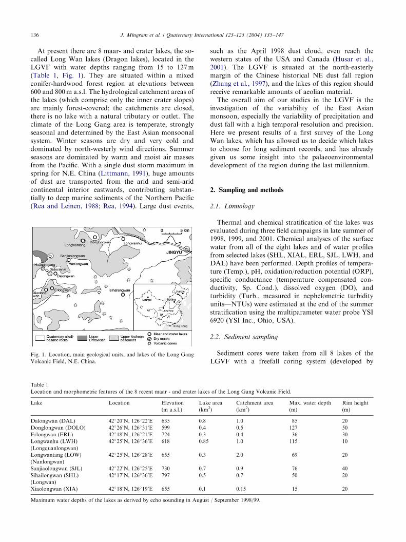
At present there are 8 maar- and crater lakes, the so-called Long Wan lakes (Dragon lakes), located in theLGVF with water depths ranging from 15 to 127m(Table 1, Fig. 1). They are situated within a mixedconifer-hardwood forest region at elevations between600 and 800m a.s.l. The hydrological catchment areas ofthe lakes (which comprise only the inner crater slopes)are mainly forest-covered; the catchments are closed,there is no lake with a natural tributary or outlet. Theclimate of the Long Gang area is temperate, stronglyseasonal and determined by the East Asian monsoonalsystem. Winter seasons are dry and very cold anddominated by north-westerly wind directions. Summerseasons are dominated by warm and moist air massesfrom the Pacific. With a single dust storm maximum inspring for N.E. China (Littmann, 1991), huge amountsof dust are transported from the arid and semi-aridcontinental interior eastwards, contributing substan-tially to deep marine sediments of the Northern Pacific(Rea and Leinen, 1988; Rea, 1994). Large dust events,
Fig. 1. Location, main geological units, and lakes of the Long Gang
Volcanic Field, N.E. China.
Table 1
Location and morphometric features of the 8 recent maar - and crater lakes
Lake Location Elevation
(m a.s.l.)
Lak
(km
Dalongwan (DAL) 42�20’N, 126�22’E 635 0.8
Donglongwan (DOLO) 42�26’N, 126�31’E 599 0.4
Erlongwan (ERL) 42�18’N, 126�21’E 724 0.3
Longwanhu (LWH)
(Longquanlongwan)
42�25’N, 126�36’E 618 0.85
Longwantang (LOW)
(Nanlongwan)
42�25’N, 126�28’E 655 0.3
Sanjiaolongwan (SJL) 42�22’N, 126�25’E 730 0.7
Sihailongwan (SHL)
(Longwan)
42�17’N, 126�36’E 797 0.5
Xiaolongwan (XIA) 42�18’N, 126�19’E 655 0.1
Maximum water depths of the lakes as derived by echo sounding in August
such as the April 1998 dust cloud, even reach thewestern states of the USA and Canada (Husar et al.,2001). The LGVF is situated at the north-easterlymargin of the Chinese historical NE dust fall region(Zhang et al., 1997), and the lakes of this region shouldreceive remarkable amounts of aeolian material.
The overall aim of our studies in the LGVF is theinvestigation of the variability of the East Asianmonsoon, especially the variability of precipitation anddust fall with a high temporal resolution and precision.Here we present results of a first survey of the LongWan lakes, which has allowed us to decide which lakesto choose for long sediment records, and has alreadygiven us some insight into the palaeoenvironmentaldevelopment of the region during the last millennium.
2. Sampling and methods
2.1. Limnology
Thermal and chemical stratification of the lakes wasevaluated during three field campaigns in late summer of1998, 1999, and 2001. Chemical analyses of the surfacewater from all of the eight lakes and of water profilesfrom selected lakes (SHL, XIAL, ERL, SJL, LWH, andDAL) have been performed. Depth profiles of tempera-ture (Temp.), pH, oxidation/reduction potential (ORP),specific conductance (temperature compensated con-ductivity, Sp. Cond.), dissolved oxygen (DO), andturbidity (Turb., measured in nephelometric turbidityunits—NTUs) were estimated at the end of the summerstratification using the multiparameter water probe YSI6920 (YSI Inc., Ohio, USA).
2.2. Sediment sampling
Sediment cores were taken from all 8 lakes of theLGVF with a freefall coring system (developed by
of the Long Gang Volcanic Field.
e area2)
Catchment area
(km2)
Max. water depth
(m)
Rim height
(m)
1.0 85 20
0.5 127 50
0.4 36 30
1.0 115 10
2.0 69 20
0.9 76 40
0.7 50 20
0.15 15 20
/ September 1998/99.
ARTICLE IN PRESSJ. Mingram et al. / Quaternary International 123–125 (2004) 135–147 137
K. Ghilardi, ETH Z .urich), reaching core lengthsbetween 32 and 112 cm. For the laminated sedimentsof Lake SHL a freeze-coring system (NiederreiterUWITEC, Austria, described in Klee and Schmidt,(1987)) was used additionally to obtain undisturbedsediments of the most recent years.
2.3. Physical methods
Magnetic susceptibility was measured at split coresurfaces with an automated Bartingtons point sensorwith a point separation of 1mm and a spatial resolutionof 4mm.
2.4. Geochemical methods
Sediment analysis: freeze-dried 1 cm samples of freezecores SHL 99/F3, SHL 99/F5 and core 01/C werehomogenised by dry sieving (o200 mm). Sample aliquotsof 0.25 g were decomposed using HNO3, HClO4, andHF in Teflon tubes. The residue was made up to a finalvolume of 50ml with HCl. Major and trace elementswere analysed by ICP-AES (IRIS, Thermo Nicolet),ICP-MS (ELAN 5000, Perkin Elmer) was used for theanalysis of selected trace elements (e.g., Pb, U). Externaland internal ICP-MS calibration procedures largelyfollow Dulski (2001). Total carbon was analysed by IR-spectrometry after burning weighed aliquots in anoxygen gas flow at 1350�C, total nitrogen was deter-mined from the same aliquots by heat conductivitydetection (LECO, CNS 2000). Inorganic carbon wasdetermined coulometrically (Str .ohlein procedure) afterthe release of CO2 by reaction with hot phosphoric acid(1:1). Total organic carbon (TOC) is given by theTC�IC difference.
Analysis of water samples: diluted inorganic carbon(DIC), Si, and anions were measured from unstabilisedsample aliquots, DIC using IR-spectrometry, Si by ICP-AES, soluble reactive phosphorus (SRP) by spectral-photometry (Mo-blue method), and F, Cl, NO3, SO4 byisocratic ion-exchange chromatography. Cation concen-trations were measured by ICP-AES in membrane-filtered water samples (0.45 mm) which were stabilised byaddition of Suprapur HNO3 (Merck).
2.5. Sediment microfacies analysis
For detailed investigations of laminated sedimentspetrographic thin sections were prepared from selectedcores (including a complete set of nine 10 cm—long,overlapping thin sections from core SHL 98/2) using afreeze-drying technique after Merkt (1971). Varvecounts of Lake SHL were made using combinedinformation from thin sections, from photos taken witha stereoscopic microscope and a fast digital camera fromsmoothed freeze core surfaces (for details of photo-
graphing freeze cores see Renberg (1981)) and from tapepeels of a freeze core (as described in Simola (1977)).
2.6. Diatom analysis
For preliminary diatom studies small amounts offresh sediment from core SHL 98/2 were taken at 10 cmintervals and embedded in Naphrax (R.I. = 1.74). Theslides were analysed under a petrographic microscope(ZEISS Axioplan, oil immersion, DIC) with a magnifi-cation of 1000� . Taxonomic identification was basedon standard floras (Krammer and Lange-Bertalot1991a,b, 1997a,b).
2.7. Pollen analysis
Pollen samples were taken from core SHL 99/2 at2 cm intervals (the top 16 cm at 1 cm intervals) down tothe basal sample at 80 cm using a 7mm diameter brasssampler; the upper 6 samples were 1 cm3, all others were0.5 cm3. Pollen was extracted using standard prepara-tion techniques (addition of Lycopodium spores, KOH,ZnCl2-floatation, Acetolysis, dehydration and suspen-sion in silicone oil). The slides were analysed using aZEISS Jenapol microscope at a magnification of x500,with x1000 magnification used to examine detailedstructure as necessary. Taxonomic identification wasbased upon Moore et al. (1991) and Reille (1992). Aminimum of 500 pollen grains of terrestrial plant taxawas counted for each sample.
3. Results
3.1. Morphometry and hydrochemistry of the Long Wan
Lakes
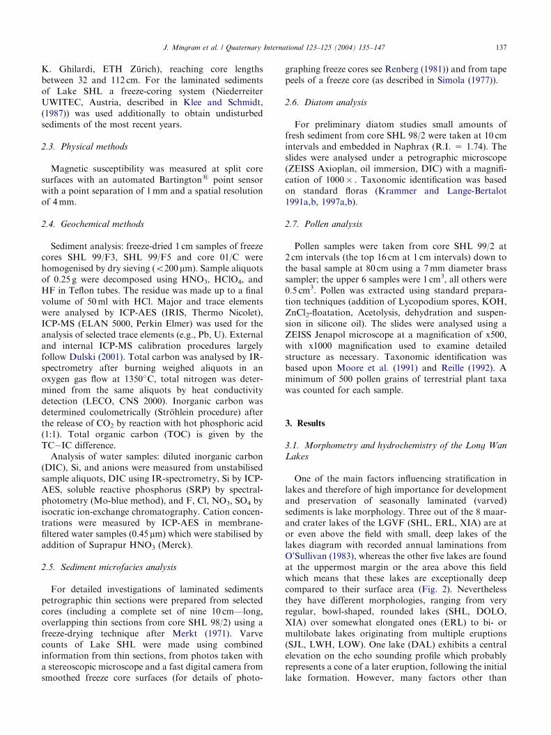
One of the main factors influencing stratification inlakes and therefore of high importance for developmentand preservation of seasonally laminated (varved)sediments is lake morphology. Three out of the 8 maar-and crater lakes of the LGVF (SHL, ERL, XIA) are ator even above the field with small, deep lakes of thelakes diagram with recorded annual laminations fromO’Sullivan (1983), whereas the other five lakes are foundat the uppermost margin or the area above this fieldwhich means that these lakes are exceptionally deepcompared to their surface area (Fig. 2). Neverthelessthey have different morphologies, ranging from veryregular, bowl-shaped, rounded lakes (SHL, DOLO,XIA) over somewhat elongated ones (ERL) to bi- ormultilobate lakes originating from multiple eruptions(SJL, LWH, LOW). One lake (DAL) exhibits a centralelevation on the echo sounding profile which probablyrepresents a cone of a later eruption, following the initiallake formation. However, many factors other than
ARTICLE IN PRESS
Fig. 2. Morphometry of the 8 Long Wan Lakes, plotted on the
Relative depth—Lake surface diagram of O’Sullivan (1983).
J. Mingram et al. / Quaternary International 123–125 (2004) 135–147138
morphology influence the development of lake bottomanoxia, which is a main presumption for the develop-ment and preservation of seasonally laminated sedi-ments in temperate fresh water lakes. Melack (1978)showed a positive relationship between the depth ofanoxia and a ratio of lake diameter and rim height formaar- and crater lakes of Africa and Australia; theamount of degradable organic matter also has a largeinfluence on the development and depth of anoxia.
In the course of summer in all lakes of the LGVF adistinct thermal stratification develops which hinders theturbulent transport of algal nutrients from the deepwater into the phototropic zone (Fig. 3A–D). Tempera-ture in the epilimnion rises above 20�C and a thermo-cline is formed at ca 10m water depth. Depending onpercolation conditions, vegetation cover and size of theindividual catchment areas, the lakes receive variousamounts of subsurface inflow of mineralized ground-water. Estimates for the chemical composition of thegroundwater discharge are based on the sampling ofsprings in the vicinity of Lake SHL and SJL, respec-tively (Table 2). The dissolved salt concentrations inmost of the lakes are distinctly lower than that of thegroundwater. This documents a high ratio betweendirect precipitation onto the lake surface and inflow ofgroundwater. Enhanced mineralization of Lake DAL isrelated to hydrothermal activity at the bottom of thislake. There is very limited recent human impact on lakesERL, SHL, and XIA only. Effluents from recreationfacilities at the lake margin of Lake SJL and fromdomestic dwellings within the crater rim of Lake LWHmay explain the sodium concentrations of these lakesexceeding that of lakes ERL, SHL and XIA.
There is clear evidence for the prevalence of dimicticconditions in the lakes LWH, SJL, ERL, SHL, and XIA
from recovered hydrochemical and thermal profiles.Enhanced mineralization of the deep water may preventseasonal overturn of the whole water body in LakeDAL. Oxic conditions in the deep water over the wholesummer stagnation are only sustained for the modernlake LWH. The lake obviously receives low externalinput of dissolved algal nutrients by groundwater inflowbecause of its small catchment.
Depending on primary productivity, all lakes show apH-increase in the phototrophic zone due to CO2-uptake by phytoplankton (Fig. 3A–D (II)). Dissolvednutrients in the groundwater inflow are largely releasedby the weathering of pumice tuff particles whichrepresent a major constituent of the soil cover in thecatchments of the lakes. Diatom growth in most of thelakes may be limited by the availability of solublereactive phosphorus (SRP). However, acid rainfallseems to have increased the release of phosphorous inthe catchments of the lakes. Limitation of diatomgrowth by Si-availability therefore may become impor-tant for some of the modern lakes.
3.2. Sediments of the Long Wan Lakes
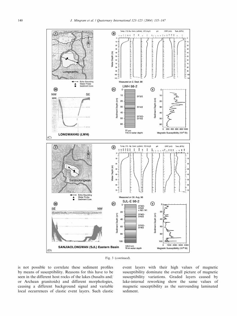
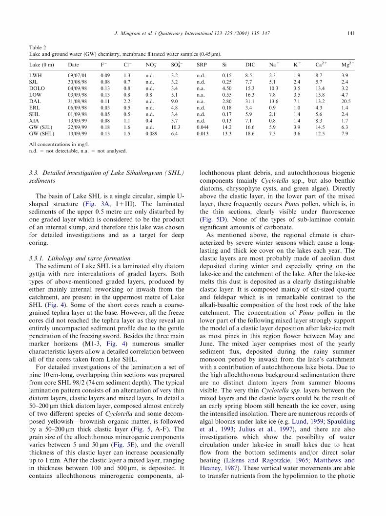
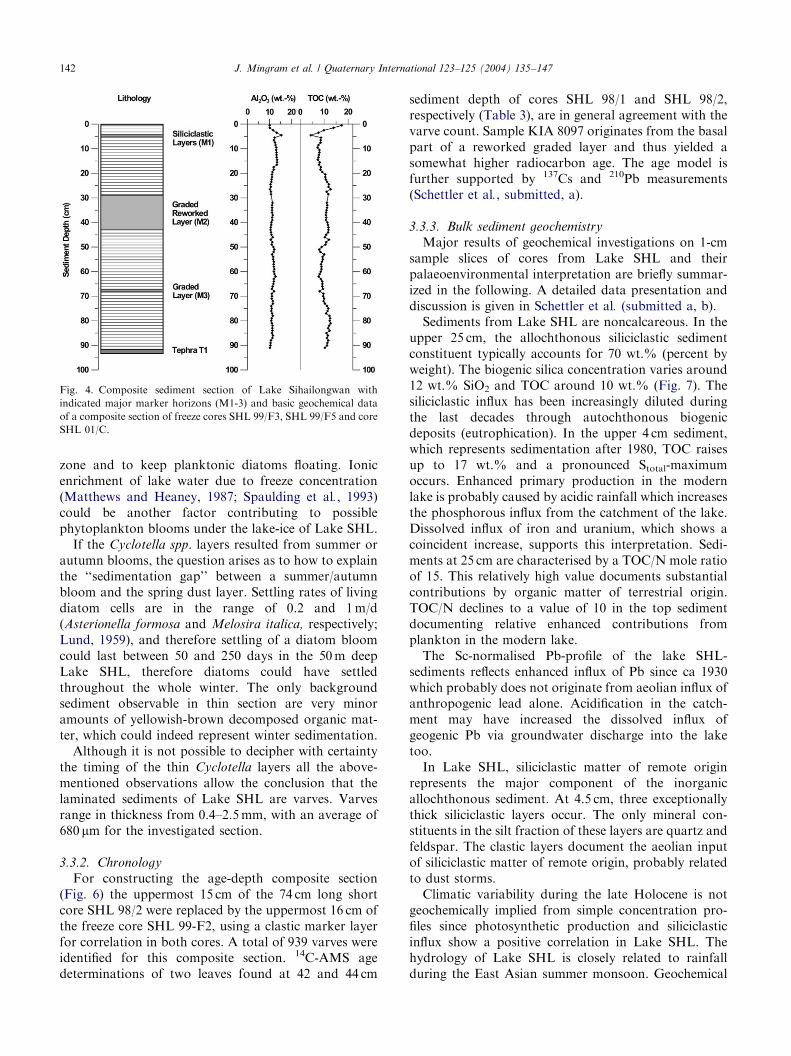
All cores macroscopically exhibit, at least partly,different types of layering. Short cores from six of thelakes (SHL, ERL, XIA, SJL, DAL and LWH) aremainly composed of homogeneous, layered or finelylaminated diatomaceous gyttja with some intercalationsof thick graded event-layers. Sediments from lakesDOLO and LOW are more influenced by allochthonousminerogenic input. Laminations are caused in general byalternations of minerogenic (mainly siliciclastic) andorganogenic (mainly diatoms) components. With theexception of sediments from Lake SHL, a seasonalorigin has not yet been verified (the laminated sedimentsof all Long Wan lakes will be discussed in more detail ina separate paper). There are two types of event layersdistinguishable, one being typical graded, minerogeniclayers which cause an additional, fast input of clasticmaterial into the lake, probably caused by heavy rainsduring the summer monsoon season or strong meltwater events in spring. The second common type isgraded layers originating from internal slumps that donot add allochthonous material to the sediment section.
Magnetic susceptibilities were measured on shortcores from six of the lakes (SHL, SJL, LOW, DOLO,LWH, and DAL). Even sections which are composedmainly of organic gyttja often show magnetic suscept-ibilities between 20 and 100� 10�6SI (Fig. 3A–D (V)).These values are much higher than expected for a typicalHolocene diatomaceous gyttja (as e.g. from LagoGrande di Monticchio, Brandt et al., 1999), thusindicating already a remarkable content of allochtho-nous minerogenic input. Although some cores fromdifferent lakes do have a similar susceptibility pattern it
ARTICLE IN PRESS
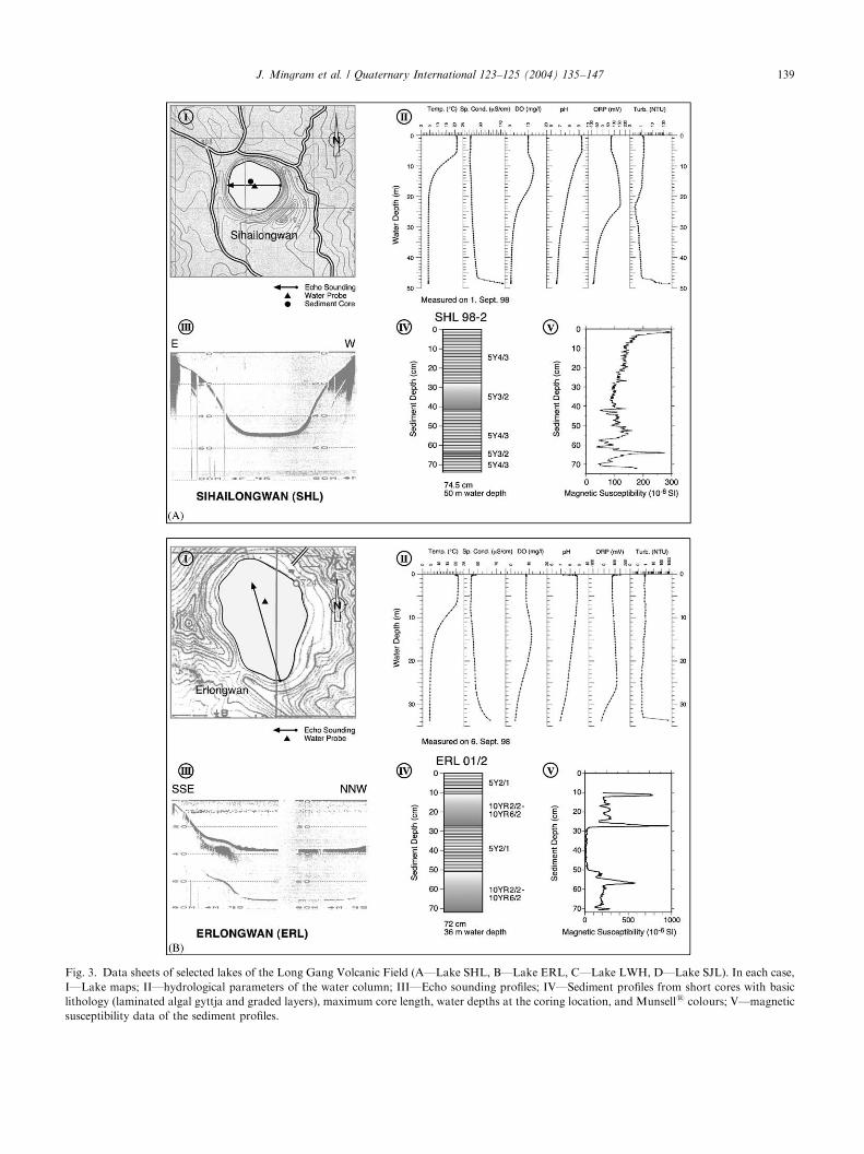
Fig. 3. Data sheets of selected lakes of the Long Gang Volcanic Field (A—Lake SHL, B—Lake ERL, C—Lake LWH, D—Lake SJL). In each case,
I—Lake maps; II—hydrological parameters of the water column; III—Echo sounding profiles; IV—Sediment profiles from short cores with basic
lithology (laminated algal gyttja and graded layers), maximum core length, water depths at the coring location, and Munsells colours; V—magnetic
susceptibility data of the sediment profiles.
J. Mingram et al. / Quaternary International 123–125 (2004) 135–147 139
ARTICLE IN PRESS
Fig. 3 (continued).
J. Mingram et al. / Quaternary International 123–125 (2004) 135–147140
is not possible to correlate these sediment profilesby means of susceptibility. Reasons for this have to beseen in the different host rocks of the lakes (basalts and/or Archean granitoids) and different morphologies,causing a different background signal and variablelocal occurrences of clastic event layers. Such clastic
event layers with their high values of magneticsusceptibility dominate the overall picture of magneticsusceptibility variations. Graded layers caused bylake-internal reworking show the same values ofmagnetic susceptibility as the surrounding laminatedsediment.
ARTICLE IN PRESS
Table 2
Lake and ground water (GW) chemistry, membrane filtrated water samples (0.45mm).
Lake (0 m) Date F� Cl� NO�3 SO2�
4 SRP Si DIC Na+ K+ Ca2+ Mg2+
LWH 09/07/01 0.09 1.3 n.d. 3.2 n.d. 0.15 8.5 2.3 1.9 8.7 3.9
SJL 30/08/98 0.08 0.7 n.d. 3.2 n.d. 0.25 7.7 5.1 2.4 5.7 2.4
DOLO 04/09/98 0.13 0.8 n.d. 3.4 n.a. 4.50 15.3 10.3 3.5 13.4 3.2
LOW 03/09/98 0.13 0.8 0.8 5.1 n.a. 0.55 16.3 7.8 3.5 15.8 4.7
DAL 31/08/98 0.11 2.2 n.d. 9.0 n.a. 2.80 31.1 13.6 7.1 13.2 20.5
ERL 06/09/98 0.03 0.5 n.d. 4.8 n.d. 0.18 3.4 0.9 1.0 4.3 1.4
SHL 01/09/98 0.05 0.5 n.d. 3.4 n.d. 0.17 5.9 2.1 1.4 5.6 2.4
XIA 13/09/99 0.08 1.1 0.4 3.7 n.d. 0.13 7.1 0.8 1.4 8.3 1.7
GW (SJL) 22/09/99 0.18 1.6 n.d. 10.3 0.044 14.2 16.6 5.9 3.9 14.5 6.3
GW (SHL) 13/09/99 0.13 1.5 0.089 6.4 0.013 13.3 18.6 7.3 3.6 12.5 7.9
All concentrations in mg/l.
n.d. = not detectable, n.a. = not analysed.
J. Mingram et al. / Quaternary International 123–125 (2004) 135–147 141
3.3. Detailed investigation of Lake Sihailongwan (SHL)
sediments
The basin of Lake SHL is a single circular, simple U-shaped structure (Fig. 3A, I+III). The laminatedsediments of the upper 0.5 metre are only disturbed byone graded layer which is considered to be the productof an internal slump, and therefore this lake was chosenfor detailed investigations and as a target for deepcoring.
3.3.1. Lithology and varve formation
The sediment of Lake SHL is a laminated silty diatomgyttja with rare intercalations of graded layers. Bothtypes of above-mentioned graded layers, produced byeither mainly internal reworking or inwash from thecatchment, are present in the uppermost metre of LakeSHL (Fig. 4). Some of the short cores reach a coarse-grained tephra layer at the base. However, all the freezecores did not reached the tephra layer as they reveal anentirely uncompacted sediment profile due to the gentlepenetration of the freezing sword. Besides the three mainmarker horizons (M1-3, Fig. 4) numerous smallercharacteristic layers allow a detailed correlation betweenall of the cores taken from Lake SHL.
For detailed investigations of the lamination a set ofnine 10 cm-long, overlapping thin sections was preparedfrom core SHL 98/2 (74 cm sediment depth). The typicallamination pattern consists of an alternation of very thindiatom layers, clastic layers and mixed layers. In detail a50–200 mm thick diatom layer, composed almost entirelyof two different species of Cyclotella and some decom-posed yellowish—brownish organic matter, is followedby a 50–200 mm thick clastic layer (Fig. 5, A-F). Thegrain size of the allochthonous minerogenic componentsvaries between 5 and 50 mm (Fig. 5E), and the overallthickness of this clastic layer can increase occasionallyup to 1mm. After the clastic layer a mixed layer, rangingin thickness between 100 and 500 mm, is deposited. Itcontains allochthonous minerogenic components, al-
lochthonous plant debris, and autochthonous biogeniccomponents (mainly Cyclotella spp., but also benthicdiatoms, chrysophyte cysts, and green algae). Directlyabove the clastic layer, in the lower part of the mixedlayer, there frequently occurs Pinus pollen, which is, inthe thin sections, clearly visible under fluorescence(Fig. 5D). None of the types of sub-laminae containsignificant amounts of carbonate.
As mentioned above, the regional climate is char-acterized by severe winter seasons which cause a long-lasting and thick ice cover on the lakes each year. Theclastic layers are most probably made of aeolian dustdeposited during winter and especially spring on thelake-ice and the catchment of the lake. After the lake-icemelts this dust is deposited as a clearly distinguishableclastic layer. It is composed mainly of silt-sized quartzand feldspar which is in remarkable contrast to thealkali-basaltic composition of the host rock of the lakecatchment. The concentration of Pinus pollen in thelower part of the following mixed layer strongly supportthe model of a clastic layer deposition after lake-ice meltas most pines in this region flower between May andJune. The mixed layer comprises most of the yearlysediment flux, deposited during the rainy summermonsoon period by inwash from the lake’s catchmentwith a contribution of autochthonous lake biota. Due tothe high allochthonous background sedimentation thereare no distinct diatom layers from summer bloomsvisible. The very thin Cyclotella spp. layers between themixed layers and the clastic layers could be the result ofan early spring bloom still beneath the ice cover, usingthe intensified insolation. There are numerous records ofalgal blooms under lake ice (e.g. Lund, 1959; Spauldinget al., 1993; Julius et al., 1997), and there are alsoinvestigations which show the possibility of watercirculation under lake-ice in small lakes due to heatflow from the bottom sediments and/or direct solarheating (Likens and Ragotzkie, 1965; Matthews andHeaney, 1987). These vertical water movements are ableto transfer nutrients from the hypolimnion to the photic
ARTICLE IN PRESS
Fig. 4. Composite sediment section of Lake Sihailongwan with
indicated major marker horizons (M1-3) and basic geochemical data
of a composite section of freeze cores SHL 99/F3, SHL 99/F5 and core
SHL 01/C.
J. Mingram et al. / Quaternary International 123–125 (2004) 135–147142
zone and to keep planktonic diatoms floating. Ionicenrichment of lake water due to freeze concentration(Matthews and Heaney, 1987; Spaulding et al., 1993)could be another factor contributing to possiblephytoplankton blooms under the lake-ice of Lake SHL.
If the Cyclotella spp. layers resulted from summer orautumn blooms, the question arises as to how to explainthe ‘‘sedimentation gap’’ between a summer/autumnbloom and the spring dust layer. Settling rates of livingdiatom cells are in the range of 0.2 and 1m/d(Asterionella formosa and Melosira italica, respectively;Lund, 1959), and therefore settling of a diatom bloomcould last between 50 and 250 days in the 50m deepLake SHL, therefore diatoms could have settledthroughout the whole winter. The only backgroundsediment observable in thin section are very minoramounts of yellowish-brown decomposed organic mat-ter, which could indeed represent winter sedimentation.
Although it is not possible to decipher with certaintythe timing of the thin Cyclotella layers all the above-mentioned observations allow the conclusion that thelaminated sediments of Lake SHL are varves. Varvesrange in thickness from 0.4–2.5mm, with an average of680 mm for the investigated section.
3.3.2. Chronology
For constructing the age-depth composite section(Fig. 6) the uppermost 15 cm of the 74 cm long shortcore SHL 98/2 were replaced by the uppermost 16 cm ofthe freeze core SHL 99-F2, using a clastic marker layerfor correlation in both cores. A total of 939 varves wereidentified for this composite section. 14C-AMS agedeterminations of two leaves found at 42 and 44 cm
sediment depth of cores SHL 98/1 and SHL 98/2,respectively (Table 3), are in general agreement with thevarve count. Sample KIA 8097 originates from the basalpart of a reworked graded layer and thus yielded asomewhat higher radiocarbon age. The age model isfurther supported by 137Cs and 210Pb measurements(Schettler et al., submitted, a).
3.3.3. Bulk sediment geochemistry
Major results of geochemical investigations on 1-cmsample slices of cores from Lake SHL and theirpalaeoenvironmental interpretation are briefly summar-ized in the following. A detailed data presentation anddiscussion is given in Schettler et al. (submitted a, b).
Sediments from Lake SHL are noncalcareous. In theupper 25 cm, the allochthonous siliciclastic sedimentconstituent typically accounts for 70 wt.% (percent byweight). The biogenic silica concentration varies around12 wt.% SiO2 and TOC around 10 wt.% (Fig. 7). Thesiliciclastic influx has been increasingly diluted duringthe last decades through autochthonous biogenicdeposits (eutrophication). In the upper 4 cm sediment,which represents sedimentation after 1980, TOC raisesup to 17 wt.% and a pronounced Stotal-maximumoccurs. Enhanced primary production in the modernlake is probably caused by acidic rainfall which increasesthe phosphorous influx from the catchment of the lake.Dissolved influx of iron and uranium, which shows acoincident increase, supports this interpretation. Sedi-ments at 25 cm are characterised by a TOC/N mole ratioof 15. This relatively high value documents substantialcontributions by organic matter of terrestrial origin.TOC/N declines to a value of 10 in the top sedimentdocumenting relative enhanced contributions fromplankton in the modern lake.
The Sc-normalised Pb-profile of the lake SHL-sediments reflects enhanced influx of Pb since ca 1930which probably does not originate from aeolian influx ofanthropogenic lead alone. Acidification in the catch-ment may have increased the dissolved influx ofgeogenic Pb via groundwater discharge into the laketoo.
In Lake SHL, siliciclastic matter of remote originrepresents the major component of the inorganicallochthonous sediment. At 4.5 cm, three exceptionallythick siliciclastic layers occur. The only mineral con-stituents in the silt fraction of these layers are quartz andfeldspar. The clastic layers document the aeolian inputof siliciclastic matter of remote origin, probably relatedto dust storms.
Climatic variability during the late Holocene is notgeochemically implied from simple concentration pro-files since photosynthetic production and siliciclasticinflux show a positive correlation in Lake SHL. Thehydrology of Lake SHL is closely related to rainfallduring the East Asian summer monsoon. Geochemical
ARTICLE IN PRESS
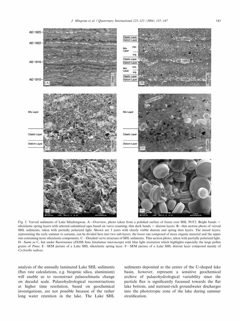
Fig. 5. Varved sediments of Lake Sihailongwan. A—Overview, photo taken from a polished surface of freeze core SHL 99/F2. Bright bands =
siliciclastic spring layers with selected calendrical ages based on varve counting; thin dark bands = diatom layers. B—thin section photo of varved
SHL sediments, taken with partially polarized light. Shown are 3 years with clearly visible diatom and spring dust layers. The mixed layers,
representing the early summer to autumn, can be divided here into two sub-layers, the lower one composed of more organic material and the upper
one containing more siliciclastic components. C—Detailed varve structure of SHL sediments. Thin section photo, taken with partially polarized light.
D—Same as C, but under fluorescence (ZEISS Jena Jenalumar microscope) with blue light excitation which highlights especially the large pollen
grains of Pinus. E—SEM picture of a Lake SHL siliciclastic spring layer. F—SEM picture of a Lake SHL diatom layer composed mainly of
Cyclotella radiosa.
J. Mingram et al. / Quaternary International 123–125 (2004) 135–147 143
analysis of the annually laminated Lake SHL sediments(flux rate calculations, e.g. biogenic silica, aluminium)will enable us to reconstruct palaeoclimatic changeon decadal scale. Palaeohydrological reconstructionsat higher time resolution, based on geochemicalinvestigations, are not possible because of the ratherlong water retention in the lake. The Lake SHL
sediments deposited at the centre of the U-shaped lakebasin, however, represent a sensitive geochemicalarchive of palaeohydrological variability since theparticle flux is significantly focussed towards the flatlake bottom, and nutrient-rich groundwater dischargesinto the phototropic zone of the lake during summerstratification.

ARTICLE IN PRESSJ. Mingram et al. / Quaternary International 123–125 (2004) 135–147144
3.3.4. Diatoms
Diatoms are well preserved throughout the Lake SHLsediment core. The assemblages of the analysed samplesare dominated by two planktonic species of the genusCyclotella comprising together B95–99% of the diatompopulation. Whereas the lowermost samples are char-acterized by the dominance of the small C. cf. stelligera,
C. radiosa becomes more abundant in the youngersamples. Other planktonic and tychoplanktonic diatomsas for example Asterionella formosa, Tabellaria floccu-
losa and Fragilaria spp. attain only minor percentages.The periphytic component includes Achnanthes lanceo-
lata, Epithemia sorex, Navicula radiosa, Surirella splen-
dida, and different species of the genera Amphora,
Cocconeis, Cymbella, Diploneis, Nitzschia, and Pinnular-
ia. The high planktonic/periphytic ratio reflects themorphology of this maar lake with a reduced habitat ofperiphytic diatoms. The overall composition of the
Fig. 6. Age—depth plot of Lake Sihailongwan composite sediment
section with indicated positions of AMS-14C samples.
Table 314C-AMS age determinations of two samples from Lake Sihailongwan, calibr
version 6’’ (Stuiver et al., 1998). A sediment depth of 42 cm in core SHL 98/1
varve age of the reworked graded layer is 1642 AD.
Nr. Core / depth Material Radiocarbon
age
Calibrated
ages
KIA
8097
SHL 98/1
42 cm
leaf 525 7 25 yrs
BP
1414 cal AD
KIA
8098
SHL 98/2
44 cm
leaf 335 7 30 yrs
BP
1520, 1587,
1625 cal AD
diatom community is characteristic for temperate,alkaline freshwater lakes.
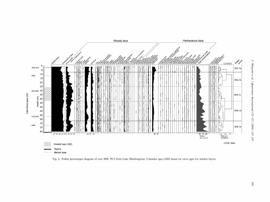
3.3.5. Pollen analysis
Based on the chronology described above, each pollensample represents ca 9 years with 25 years between themid-points of the samples which were taken at 2 cmintervals. The pollen record (Fig. 8) is dominated by pollen
ation was made by the Leibnitz Labor, Kiel, with ‘‘CALIB rev 4.0, test
equals 39 cm in core SHL 98/2 due to slightly different compaction; the
One sigma Two sigma d13C
1405–1428 cal AD 1332–1340 cal
AD, 1397–
1437 cal AD
�28.90 7 0.13 %
1486–1534 cal
AD, 1537–
1637 cal AD
1464-1645 cal AD �29.65 7 0.41 %
Fig. 7. Geochemical data of the uppermost part of freeze core SHL 99/
F5 from Lake Sihailongwan.
ARTIC
LEIN
PRES
S
Fig. 8. Pollen percentages diagram of core SHL 99/2 from Lake Sihailongwan. Calendar ages (AD) based on varve ages for marker layers.
J.
Min
gra
met
al.
/Q
ua
terna
ryIn
terna
tiona
l1
23
–1
25
(2
00
4)
13
5–
14
7145

ARTICLE IN PRESSJ. Mingram et al. / Quaternary International 123–125 (2004) 135–147146
of woody taxa (>80%) throughout; but with a slightdecline in the upper 7 cm. The size of the basin(0.5 km2) is such that the pollen record is a mainlyregional signal and thus it can be inferred that forest hasdominated the landscape for the interval represented bythis sequence.
Pinus is abundant throughout the record; and apartfrom Pinus the main woody taxa present were Betula,
Quercus, Ulmus, Juglans-type, Corylus, Ostrya and Tilia.
The only herbaceous taxa to make a major contributionto the pollen in the sediments were Chenopodiaceae andArtemisia, other taxa which are frequently present atlow relative abundances are Cyperaceae, Gramineae,and Thalictrum.
Total pollen concentration in grains per cc of wetsediment decreases up the stratigraphy. This may be aconsequence of decreasing sediment consolidation up thesequence or may be a result of a thinning of the vegetationcover in recent times. For almost the entire profile thebiome represented by the pollen assemblage (Prentice et al.,1996; Tarasov et al., 1998; Allen et al., 2000) is that oftemperate deciduous forest. The exceptions are samples at3, 5 and 6 cm which biomise as the more open woodedsteppe because the tree sum is less than 70%, againsuggesting a slight thinning of the forest cover in theseupper samples compared to the rest of the profile.In the upper 7 cm (pollen zone SHL1a) are the onlyoccurrences of pollen of cereals. Other grasses also aremore abundant than previously. Cryptogams also increasein this zone, which could be related to the opening of thelandscape.
Lake SHL lies within the deciduous broadleavedforest zone of Wu (1983) and the pollen-based biomereconstruction of temperate deciduous forest/woodedsteppe is in agreement with this. The pollen taxarecorded in samples from Lake SHL correspondclosest to the Quercus mongolica/Betula dahurica com-munities of Liu et al. (1999) as described in theirinvestigation of surface pollen from south-eastern InnerMongolia.
Throughout pollen zones SHL1b–SHL1e thewoody taxa sum does not fall below 80%. Thepalynological record indicates that for most of theinterval represented by the record the landscape hasbeen dominated by mixed boreal/deciduous forest. Thisagrees with the isopoll maps for 0 years BP and 800years BP published by Ren and Zhang (1998). Only inthe last 150 years is there evidence of thinning of theforest; agricultural activity is indicated for the last70 years.
Preliminary investigations of the pollen record fromLake Erlongwan (ERL) which lies 7 km west of LakeSHL (Fig. 1) and from which a 60 cm core (ERL 99/2)was collected in 1999 show and confirm the same generalpattern for the recent past and suggest that this site alsocould be ideal for further investigations.
4. Conclusions and perspectives
The preliminary investigations of short cores fromlakes of the LGVF, and in particular of LakeSihailongwan, have demonstrated the potential of thisarea to establish a master varve chronology for N.E.China and to yield an outstanding pollen record for aregion of China from which there are few high-resolution data. Detailed investigations of the varvedsediments of Lake Sihailongwan revealed their potentialto record inter-annual variations of seasonal sedimentflux and its relation to climatic parameters, especiallydust flux. Geochemical data of longer sediment sectionscan show especially hydrological variations on at leastdecadal scale. Long cores from Lake Sihailongwan andLake Erlongwan with maximum core depths of 38 and24m, respectively, taken in summer of 2001, will providea detailed history of palaeoenvironmental and palaeocli-matic variations of the Long Wan Lake area reachingfar back into the Last Glacial.
Acknowledgements
Special thanks are due to Daniel Acksel, DieterBerger, Guoqiang Chu, Andreas Hofmann, MichaelK .ohler, Qiang Liu, and Ingo Heymann who made thecoring successful with their ideas and enthusiasm. Thecoring campaigns were financed by the GeoForschungs-Zentrum Potsdam, Germany, and supported by theInstitute of Geology and Geophysics, Chinese Academyof Sciences, Beijing, China.
References
Allen, J.R.M., Mingram, J., Negendank, J.F.W., Schettler, G., Liu, J.,
2000. A 900 year environmental record from Sihailongwan, N.E.
China. 10th International Palynological Congress, Nanjing, China,
Abstracts, 5.
Brandt, U., Nowaczyk, N.R., Ramrath, A., Brauer, A., Mingram, J.,
Wulf, S., Negendank, J.F.W., 1999. Palaeomagnetism of Holocene
and Late Pleistocene sediments from Lago di Mezzano and Lago
Grande di Monticchio (Italy): initial results. Quaternary Science
Reviews 18, 961–976.
Dulski, P., 2001. Reference materials for geochemical studies: new
analytical data by ICP-MS and critical discussion of reference
values. Geostandards Newsletter 2, 87–125.
Geological Survey of Jilin, 1994. Geology of Jilin, China (in Chinese).
Geological Publishing House, Beijing.
Husar, R.B., D., Tratt, M.D.,et al., 2001. Asian dust events of April
1998. Journal of Geophysical Research 106(D16), 18,317-18,330.
Julius, M.L., Stoermer, E.F., Colman, S.M., Moore, T.C., 1997. A
preliminary investigation of siliceous microfossil succession in late
Quaternary sediments from Lake Baikal, Siberia. Journal of
Paleolimnology 18, 189–206.
Klee, R., Schmidt, R., 1987. Eutrophication of Mondsee (Upper
Austria) as indicated by the diatom stratigraphy of a sediment core.
Diatom Research 2, 55–76.
ARTICLE IN PRESSJ. Mingram et al. / Quaternary International 123–125 (2004) 135–147 147
Krammer, K., Lange-Bertalot, H., 1991a. Bacillariophyceae—4. Teil:
Achnanthaceae. Gustav Fischer Verlag, Stuttgart p. 437.
Krammer, K., Lange-Bertalot, H., 1991b. Bacillariophyceae—3. Teil:
Centrales, Fragilariaceae, Eunotiaceae. Gustav Fischer Verlag,
Stuttgart p. 576.
Krammer, K., Lange-Bertalot, H., 1997a. Bacillariophyceae—1. Teil:
Naviculaceae. Gustav Fischer Verlag, Stuttgart p. 876.
Krammer, K., Lange-Bertalot, H., 1997b. Bacillariophyceae—2 Teil:
Bacillariaceae, Epithemiaceae, Surirellaceae. Gustav Fischer Ver-
lag, Stuttgart p. 610.
Likens, G.E., Ragotzkie, R.A., 1965. Vertical water motions in a small
ice-covered lake. Journal of Geophysical Research 70, 2333–2344.
Littmann, T., 1991. Dust storm frequency in Asia: Climatic control
and variability. International Journal of Climatology 11, 393–412.
Liu, H., Cui, H., Pott, R., Speier, M., 1999. The surface pollen of the
woodland-steppe ecotone in southeastern Inner Mongolia. Review
of Palaeobotany and Palynology 105, 237–250.
Lund, J.W.G., 1959. Buoyancy in relation to the ecology of the
freshwater phytoplankton. British Phycological Bulletin 1, 1–17.
Matthews, P.C., Heaney, S., 1987. Solar heating and its influence on
mixing in ice-covered lakes. Freshwater Biology 18, 135–149.
Melack, J.M., 1978. Morphometric, physical and chemical features of
the volcanic crater lakes of western Uganda. Archiv f .ur Hydro-
biologie 84 (4), 430–453.
Merkt, J., 1971. Zuverl.assige Ausz.ahlungen von Jahresschichten in
Seesedimenten mit Hilfe von GroXd .unnschliffen. Archiv f .ur
Hydrobiologie 69, 145–154.
Moore, P.D., Webb, J.A., Collinson, M.E., 1991. Pollen Analysis 2nd
Edition. Blackwell, Oxford p. 216.
Ogura, T., 1969. Volcanoes in Manchuria. In: Ogura, T. (Ed.),
Geology and mineralogy of the Far East. University of Tokyo
Press, Tokyo, pp. 373–413.
O’Sullivan, P.E., 1983. Annually-laminated lake sediments and the
study of Quaternary environmental changes—a review. Quaternary
Science Reviews 1, 245–313.
Prentice, I.C., Guiot, J., Huntley, B., Jolly, D., Cheddadi, R., 1996.
Reconstructing biomes from palaecological data: a general method
and its application to European pollen data at 0 and 6 ka. Climate
Dynamics 12, 185–194.
Rea, D.K., 1994. The paleoclimatic record provided by eolian
deposition in the deep sea: the geologic history of wind. Reviews
of Geophysics 32 (2), 159–195.
Rea, D., Leinen, M., 1988. Asian aridity and the zonal westerlies: late
Pleistocene and Holocene record of eolian deposition in the
northwest Pacific Ocean. Palaeogeography Palaeoclimatology
Palaeoecology 66, 1–8.
Reille, M., 1992. Pollen et spores d’Europe et d’Afrique du nord.
Laboratoire de Botanique Historique et Palynologie, Marseille
p. 520.
Ren, G., Zhang, L., 1998. A preliminary mapped summary of
Holocene pollen data for Northeast China. Quaternary Science
Reviews 17, 669–688.
Renberg, I., 1981. Improved methods for sampling, photographing
and varve-counting of varved lake sediments. Boreas 10,
255–258.
Schettler, G., Liu, Q., Mingram, J., Negendank, J.F.W. submitted, a.
Palaeovariations in the East-Asian Monsoon regime geochemically
recorded in varved sediments of Lake Sihailongwan (NE-China,
Jilin province) Part I: Hydrological conditions and dust flux.
Journal of Paleolimnology.
Schettler, G., Mingram, J., Negendank, J.F.W., Liu, J., submitted, b.
Palaeovariations in the East-Asian Monsoon regime geochemically
recorded in varved sediments of Lake Sihailongwan (NE-China,
Jilin province). Part II: A 200 year record of atmospheric lead-210
flux variations and its palaeo-climatic implications. Journal of
Paleolimnology.
Simola, H., 1977. Diatom succession in the formation of annually
laminated sediment in Lovoj.arvi, a small eutrophicated lake.
Annales Botanici Fennici 14, 143–148.
Spaulding, S.A., Ward, J.V., Baron, J., 1993. Winter phytoplankton
dynamics in a subalpine lake, Colorado, U.S.A. Archiv f .ur
Hydrobiologie 129 (2), 179–198.
Stuiver, M., Reimer, P.J., Bard, E., Beck, J.W., Burr, G.S., Hughen,
K.A., Kromer, B., McCormac, G., van der Plicht, J., Spurk, M.,
1998. INTCAL98 radiocarbon age calibration, 24,000-0 cal BP.
Radiocarbon 40, 1041–1083.
Tarasov, P.E., Cheddadi, R., Guiot, J., Bottema, S., Peyron, O.,
Belmonte, J., Ruiz-Sanchez, V., Saadi, F., Brewer, S., 1998. A
method to determine warm and cool steppe biomes from pollen
data; application to the Mediterranean and Kazakhstan regions.
Journal of Quaternary Science 13, 335–344.
Tokyo Geological Survey, 1929. Geological Atlas of Eastern China.
Tokyo.
Wu, C.-Y., 1983. Vegetation of China. Science Press, Beijing
(in Chinese).
Zhang, X.Y., Arimoto, R., An, Z.S., 1997. Dust emission from Chinese
desert sources linked to variations in atmospheric circulation.
Journal of Geophysical Research 102 (D23), 28041–28047.
Zolitschka, B., Brauer, A., Negendank, J.F.W., Stockhausen, H.,
Lang, A., 2000. Annually dated late Weichselian continental
paleoclimate record from the Eifel, Germany. Geology 28,
783–786.