M. Popescu, A. Ranca, G. M. Cracu, Z Prefac, C. Urdea - CLIMATIC CONDITIONS’ INFLUENCE ON VINEYARD...
12
Studii şi cercetări, Geology-Geography 17, Bistriţa, p. 117-127 117 CLIMATIC CONDITIONS’ INFLUENCE ON VINEYARD LANDSCAPES FROM SOUTHERN ROMANIA M. POPESCU * , Aurora RANCA ** , G. M. CRACU * , Zoia PREFAC * , Cornelia-Maria URDEA * Abstract: The climatic changes which determined within the latest years the intensification of extreme phenomenon, like droughts and aridity, have an unfavourable influence on the agricultural crops, its fighting measures being absolutely necessary. In Southern Romania, most of the agricultural cultures require an optimal quantity of water, in view of ensuring the best production. This paper emphasizes the dryness conditions from Southern Romania, by presenting the main climatic elements, temperature and precipitations, but also the specific characteristics for drought and aridity. The relationship between some aridity index and the climatic water deficit is also herein discussed with the purpose of identifying the best solutions for the water demand, for the vineyard landscapes in Southern Romania. In order to produce qualitative grapes, the vineyard cultures from semidry areas from Southern Romania requires a greater quantity of water, especially within the summer months, July and August. Key words: climate, wine growing, landscape, water. Introduction In this paper are presented the climatic conditions from Romanian Plain and Dobrogea Plateau, semidry regions located in Southern Romania. Romanian Plain is characterized by a temperate continental climate, with submediterranean influences, more pronounced in the South-West and aridity influences, emphasized in the East, which is interposed between a transitional region, which interferes circulations from East with the West. In Dobrogea, a distinct feature of the climate represents a priority means the frequency of droughts phenomenon, which formed the fund of lower quantities of rainfall in Romania. * Ovidius University, Faculty of Natural and Agricultural Sciences, Constanta, Romania. ** Research Station for Viticulture and Enology Murfatlar, Constanta, Romania. Corresponding author: Marius Popescu, Ovidius University, Faculty of Natural and Agicultural Sciences, 1 Universitatii Str., 900470, Constanta, Romania, E-mail: [email protected]
-
Upload
independent -
Category
Documents
-
view
0 -
download
0
Transcript of M. Popescu, A. Ranca, G. M. Cracu, Z Prefac, C. Urdea - CLIMATIC CONDITIONS’ INFLUENCE ON VINEYARD...

Studii şi cercetări, Geology-Geography 17, Bistriţa, p. 117-127 117
CLIMATIC CONDITIONS’ INFLUENCE ON VINEYARD
LANDSCAPES FROM SOUTHERN ROMANIA
M. POPESCU
*, Aurora RANCA
**, G. M. CRACU
*, Zoia PREFAC
*,
Cornelia-Maria URDEA*
Abstract: The climatic changes which determined within the latest years the
intensification of extreme phenomenon, like droughts and aridity, have an unfavourable
influence on the agricultural crops, its fighting measures being absolutely necessary. In
Southern Romania, most of the agricultural cultures require an optimal quantity of water,
in view of ensuring the best production. This paper emphasizes the dryness conditions
from Southern Romania, by presenting the main climatic elements, temperature and
precipitations, but also the specific characteristics for drought and aridity. The relationship
between some aridity index and the climatic water deficit is also herein discussed with the
purpose of identifying the best solutions for the water demand, for the vineyard landscapes
in Southern Romania. In order to produce qualitative grapes, the vineyard cultures from
semidry areas from Southern Romania requires a greater quantity of water, especially
within the summer months, July and August.
Key words: climate, wine growing, landscape, water.
Introduction
In this paper are presented the climatic conditions from Romanian Plain and
Dobrogea Plateau, semidry regions located in Southern Romania.
Romanian Plain is characterized by a temperate continental climate, with
submediterranean influences, more pronounced in the South-West and aridity
influences, emphasized in the East, which is interposed between a transitional
region, which interferes circulations from East with the West.
In Dobrogea, a distinct feature of the climate represents a priority means the
frequency of droughts phenomenon, which formed the fund of lower quantities of
rainfall in Romania.
* Ovidius University, Faculty of Natural and Agricultural Sciences, Constanta, Romania.
**Research Station for Viticulture and Enology Murfatlar, Constanta, Romania.
Corresponding author: Marius Popescu, Ovidius University, Faculty of Natural and
Agicultural Sciences, 1 Universitatii Str., 900470, Constanta, Romania, E-mail:
M. POPESCU, Aurora RANCA, G. M. CRACU, Zoia PREFAC,
118 Cornelia-Maria URDEA
Among the authors who have spreaded an intensive activity in Romania,
research on irrigation of crops were counted: Botzan (1972), Grumeza et all.(1970,
1989), Păltineanu et all.(2000, 2007).
Viticulture is an old tradition in Romanian Plain, where are favorable natural
conditions of soil, climate and relief. In the land of vines from Romanian Plain
prevails areas with hybrid varieties, these representing large share in the counties of
Dolj, Olt, Teleorman, Giurgiu, Ilfov, Calarasi, Ialomita.
The vines grafted dealing largest surfaces in South-West of the sandy land in
Oltenia Plain: facing South and South-West, brightness and sufficient humidity,
sandy soils. Greaca Vineyard, located in South, on the Danube terraces, benefits of
favorable natural conditions: slopes with Southern exposure, cambisoils, brightness
and heat large enough for a fully matured grapes.
In the Eastern Plain, wine growing areas have local importance, being extended
on the Călmăţui, Ialomiţa and Danube terraces.
In Northern Dobrogea, vineyards occupies largest surfaces in areas of tradition
(Niculiţel Vineyard), but where natural meadows with low productivity were
upturned, terraced and some isolated brush were cleared (Tulcea, Babadag).
The vines have acquaintances a broad development in the last decades,
especially on the terraced slopes of valleys with degraded lands.
The largest wine growing areas of Southern Dobrogea Plateau are concentrated
on the frame of Western Cobadin Plateau (Ostrov Vineyard) and along the Carasu
Valley, currently Danube - Black Sea Canal, Murfatlar Vineyard.
These wine growing areas total about 77,000 hectares (70% in the South of the
Romanian Plain and 30% in Dobrogea Plateau).
Even if this area is not only 2% of the agricultural area of two units of relief, the
knowledge of the water needed vine crops is important in the context of
maintaining and possibly extending the space of this crop in those semidry regions
in Southern and South-Eastern Romania (Geografia României, vol. V, 2005).
The aim of this paper is to highlight aridity conditions in Southern Romania and
to present spatial distribution of evapotranspiration reference values (ET0-PM), the
actual maximum estimated evaporation (ETc-est) in Southern and South-Eastern
Romania’s vineyard cultures and the needs of water for vine crops, based on
relatively new methods, standardized at international level.
Materials and Methods
To calculate the optimum water consumption of crops and calculation of water
requirements are necessary both rainfall and crops evapotranspiration.
Penman-Monteith method for determining evapotranspiration reference (ET0-
PM, Monteith, 1965), based on physical parameters, is considered the standard
method today (Jensen et all., 1990; Păltineanu et all. 2000), recently won a general
recognition and substituting other empirical methods for determining ET0-PM, now
the only method recommended by FAO (Allen et all., 1998).

Climatic conditions’ influence on vineyard landscapes
from Southern Romania 119
This method was used in this study. Thus, for approx. 40 points of observation
(weather stations) in Southern and South-Eastern Romania were calculated
monthly average values of the climatic elements necessary to calculation: ET0-PM,
optimal consumption of water (crop evapotranspiration, ETc-est), the water
requirements of crops (WR) and rainfall (Allen et all., 1998). For zoning indicators
ETc-est and WR, their territorial allocation was made for the entire growing season
or summer, using the method Inverse Distance Weighted (IDW), to area of study.
Results for the average climatic conditions were obtained based on the
methodology proposed by Allen et all. (1998), reviewed extensively at
international level and Romania (Păltineanu et all., 2000, 2007), provided that the
technology of production for this crop. It should be noted that the results relate to
the average weather conditions in Southern and South-Eastern Romania,
characterized of more arid climate compared to other regions of Romania.
Results and Discussions
The average annual temperature of the air.
Fig. 1 Spatial distribution of annual average air temperature (°C) in Southern Romania
The higher average multiannual of the air temperatures, over 11.0˚C and 13.0˚C
over on the surface of the soil, it is noted in the half South of Romanian Plain, on
the Black Sea Coast, on a narrow area in Central Dobrogea and a wide area in
M. POPESCU, Aurora RANCA, G. M. CRACU, Zoia PREFAC,
120 Cornelia-Maria URDEA
South Dobrogea, where solar radiation and global values are higher. Annual
isotherms (Fig. 1) is diminishing, as a value, with the increase of relief altitude and
distance over the coast in South-East. Along the years have noticed large
unperiodically variations the air temperature and soil temperature. Thus, under the
advection influence of hot tropical air, the highest values have exceeded 12.0˚C
almost throughout the region. On the soil surface, the highest values have exceeded
15.0˚C, with 3.0˚C, more than air, and the lowest values was 11.0˚ - 12.0˚C
(Geografia României, vol. V, 2005).
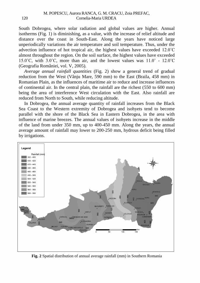
Average annual rainfall quantities (Fig. 2) show a general trend of gradual
reduction from the West (Vânju Mare, 590 mm) to the East (Braila, 458 mm) in
Romanian Plain, as the influences of maritime air to reduce and increase influences
of continental air. In the central plain, the rainfall are the richest (550 to 600 mm)
being the area of interference West circulation with the East. Also rainfall are
reduced from North to South, while reducing altitude.
In Dobrogea, the annual average quantity of rainfall increases from the Black
Sea Coast to the Western extremity of Dobrogea and isohyets tend to become
parallel with the shore of the Black Sea in Eastern Dobrogea, in the area with
influence of marine breezes. The annual values of isohyets increase in the middle
of the land from under 350 mm, up to 400-450 mm. Along the years, the annual
average amount of rainfall may lower to 200-250 mm, hydrous deficit being filled
by irrigations.
Fig. 2 Spatial distribution of annual average rainfall (mm) in Southern Romania

Climatic conditions’ influence on vineyard landscapes
from Southern Romania 121
The correlation between the amounts of rainfall and distance from the Black Sea
increases during warm semester of year (months IV-X). The amounts of rainfall
increase gradually in the interior of the land, on a distance of 30-35 km towards the
coast, in relation with reducing the influence of marine breezes. Distribution
quantities of rainfall in Dobrogea are distinguished, as in other steppe regions
around the Black Sea, through an accented variability, especially during the warm
period of year (months IV-X) (Geografia României, vol. V, 2005).
Index of aridity Emm. de Martonne. Romanian Plain and Dobrogea Plateau
required in the geographical landscape of Romania by the phenomena of dry and
drought, which are typical for the continental temperate climate in the country.
These phenomena are very complex, determined of several factors: the dynamics of
the atmosphere, surface active particularities, human influence etc.
Predominant role they hold dynamic factors, as the influence of anticyclones,
with predominant clear sky, sunstroke, reducing rainfall, or even the absence of
their total at least 10 to 15 days consecutively.
Given their ecological importance, these phenomena have been addressed along
time under various aspects: the criterion Hellmann, indices of aridity, a deficit of
water from the soil, indices bioclimatic or climate charts.
Index of aridity Emm. de Martonne was calculated for average annual values on
a period of 90 years, the formula
Ia = P / T + 10 where: Ia = aridity index; P = average annual amount of rainfall; T = average
annual temperature; 10 = one coefficient used to not get negative values. This
index present the advantage to express the characteristics of vegetation, as well as
those of the hydrographic network in relation to the dry.
Geographical distribution of this index shows that on the territory of Romanian
Plain, the level of continental influence increase from North to South and from
West to East (Fig. 3).
The lowest values of this (<22) are characteristic of extreme aridity area from
the Eastern periphery of Romanian Plain and Danube wetlands, which corresponds
to the smallest annual quantity of rainfall (<450 mm). Following, the East half of
Bărăgan Plain, with values of aridity index between 22 and 24, which correspond
to the field with a temperate continental influences of aridity.
Aridity indices of 24 to 26 characterized the field of temperate continental
climate with reduced influence of aridity corresponding to half West of Bărăgan,
Burnas and Southern part of Găvanu - Burdea, Romanaţi and Băileşti Plains.
Aridity indices greater than 26 correspond to a temperate continental climate
moderated covering most of Oltenia, Teleorman and Ialomiţa Plains in which share
of rainfall with 50 to 100 mm greater than in previous areas.
In Romanian Plain to separate two large areas where are present the phenomena
of dry and drought: Western part of this plain, where submediterranean influences
occurring annually from consecutive 3 to 3.5 months with the phenomena of dry
and 1 to 2 months with the phenomena of drought, and Eastern part with the

M. POPESCU, Aurora RANCA, G. M. CRACU, Zoia PREFAC,
122 Cornelia-Maria URDEA
continental influence of aridity, with consecutive 3 to 4 months of dry and 1 to 2
months of drought.
In the central sector of the Romanian Plain, where rainfall is more rich, occur
only dry phenomena with a duration of 1 to 3 months per year, increasing from
North to South. In Dobrogea isoline of 19 marks to the east coastal area, the most
arid of Romania, the main cause was the influence of the Black Sea. To the East of
this isoline is one of 17, respectively, above the territorial waters in the immediate
vicinity. At the west isoline of 19, the value of index aridity increase from 21 to 22
(Fig. 3).
Fig. 3 Spatial distribution of annual Aridity Index Emm. de Martonne in Southern Romania
In recent decades, due to climate warming, noting a motion translation of
isolines from East to West, so that the area is bounded by the coast isoline of 17,
the 19 isoline is situated in the inside of land. In West of Dobrogea, beyond the
area of influence of marine breezes, extremely dry periods is associated with
increased frequency of a torrential rain, with large quantities in short periods of
time.
The lower quantities of rainfall in Dobrogea occur in the area of maximum
influence of marine breezes, through attenuation of torrential rainfall and absence
of extremely dry periods.
Under the distance of 30 km over seashore and under 20 m altitude, extremely
dry periods are missing, but the quantities of rainfall are the lowest.

Climatic conditions’ influence on vineyard landscapes
from Southern Romania 123
In Dobrogea, in an average year occur consecutively from 4 to 6 months of dry
(that is the prelude drought), increasing gradually from West to East and from
North to South and records 2 to 3 consecutive months of drought.
This requires the introduction of irrigations systems as an effective means to
combat their effect (Geografia României, vol. V, 2005).
The annual ET0-PM (evapotranspiration reference, calculated using the method
Penman-Monteith) are shown in Fig. 4. The ET0-PM values varies between 750
and 800 mm, they generally increasing from North to South. ET0-PM isoline of
750 mm means actually, the upper limit of plains and low tablelands.
The South-West of the Romanian Plain and South-East of Dobrogea Plateau,
with large areas of vines crop, highlights by the highest values of ET0-PM, by 800
mm annually.
From this allocation result, obviously, that there are regions where the annual
values of ET0-PM greater than 700 mm and an average amount of rainfall, less than
this amount needs irrigations during the summer.
An acute need for irrigations during the summer presents territories where the
ET0-PM are greater than 750 mm, especially with values of 800 mm annually. Of
these, Dobrogea and Bărăgan are most dry, must be considered as priorities in the
implementation of irrigation, important both economically and as a modifier of the
landscape factor.
Fig. 4 Spatial distribution of annual ET0-PM (mm) in Southern Romania

M. POPESCU, Aurora RANCA, G. M. CRACU, Zoia PREFAC,
124 Cornelia-Maria URDEA
Fig. 5 illustrates the ETc-est (real evaporation for vine crops) values for vine
crops during the growing season, with values between 430 and 470 mm. The
highest values (460-470 mm) is recorded in the South-West of Romania through
high values (440-450 mm) in the Southern part of the Romanian Plain and
Bărăgan, and in Dobrogea, the values are higher in South - West (over 450 mm)
and the lowest up to 430 mm in the Central-North part.
Fig. 5 Spatial distribution of annual ETc-est (mm) in Southern Romania

Climatic conditions’ influence on vineyard landscapes
from Southern Romania 125
Fig. 6 Spatial distribution of vegetation period WDC (mm) in Southern Romania
The difference between the values of annual rainfall and ET0-PM, is the annual
water deficit climate (WDC), with negative sign, which characterize the essence of
the natural landscape, through the contribution of ET0 instead of temperature,
rainfall and ET0-PM with the same units of measurement, WDC present absolute
values (mm). Months of practice for water consumption of crops form of
vegetation period (Fig. 6), which extends from April to October.
Vine crops are not big consumers of water, but in some summer months,
especially in July and August, water needs could increase the production of grapes
(Grumeza et all., 1970). During the growing season, the Water Requirement (WR)
for vine crops amounted to 220 mm in the Eastern part of Dobrogea, 200 mm in the
South-West of Dobrogea and in the South-West of Oltenia Plain. In the central part
of Dobrogea is worth noting the 180 to 200 mm, while in Southern Romanian
Plain, the decrease from South to North, from 180 to 150 mm. The above, of the
territories mentioned represented in Fig. 7 the quantities of water requirement for
vine crops in Southern and South-Eastern Romania. Most of the Dobrogea Plateau
and South-West of the Romanian Plain are characterized by the values of the water
requirements of 180-220 mm.

M. POPESCU, Aurora RANCA, G. M. CRACU, Zoia PREFAC,
126 Cornelia-Maria URDEA
Fig. 7 Spatial distribution of Water Requirement (mm) in the growing season in Southern
Romania
Conclusions 1. The highest values (460-470 mm) of ETc-est during the growing season for
vineyard landscapes are located in the South-West of the Romanian Plain, crossing
the average (440-460 mm) in South-West of Dobrogea, in South of Romanian Plain
and Bărăgan, and the lowest values, under 440 mm in the Northern Dobrogea.
2. During the growing season of the vine, water requirements (WR) for vine
crops, amounted to 200-220 mm in the East and South-West of Dobrogea and in
the South-West of the Romanian Plain.
3. Most of the Romanian Plain and North-Central part of Dobrogea Plateau are
characterized by values of the WR between 180-200 mm. Most small amounts, less
than 180 mm correspond to Central-Southern area of the Romanian Plain. The
above values, of the territories mentioned, represents the greatest volume of WR for
vine crops.
4. The knowledge action of climatic factors is a real utility in improving the
development of vine crops, and development of grapes production for quality and
quantity. In semidry climatic conditions of Southern Romania, measures are
needed to offset the negative influence of climatic factors, and contribute positively
to the development of vine crops, part of vineyard landscape in this region.
Rezumat. În acest studiu este evidenţiată influenţa condiţiilor climatice asupra
peisajelor viticole din sudul şi sud-estul României, respectiv Câmpia Română şi Podişul

Climatic conditions’ influence on vineyard landscapes
from Southern Romania 127
Dobrogei. Aceste regiuni oferă condiţii eco-pedo-climatice favorabile culturilor viticole,
dar în acelaşi timp pe teritoriul lor se manifestă influenţe climatice de ariditate. Sunt
evidenţiate principalele caracteristici ale temperaturii aerului, precipitaţiilor, indicelui de
ariditate Emm. de Martonne, atât din Câmpia Română, cât şi din Podişul Dobrogei. Pentru
evidenţierea cantităţii de apă, necesară plantaţiilor viticole din aceste areale semiaride, în
lucrare sunt prezentate: distribuţia spaţială a evapotranspiraţiei ET0-PM, ca valori anuale,
distribuţia spaţială a evaporaţiei reale maximă (ETc-est) pentru culturi de viţă de vie,
deficitul climatic de apă, precum şi valorile consumului necesar de apă, în perioada de
vegetaţie a viţei de vie. Pentru a obţine producţii optime de struguri, atât calitativ, cât şi
cantitativ, culturile viticole, ca parte a peisajului specific din regiunile semiaride din sudul
şi sud-estul României, necesită o cantitate optimă de apă, în special în lunile de vară, iulie
şi august.
REFERENCES: ALLEN, R. G., PEREIRA, L. S., RAES, D. & SMITH, M., 1998, Crop evapotranspiration,
Guidelines for computing crop water requirements, FAO Irrigation and Drainage Paper
56, Rome
BOTZAN, M., 1970, Bilantul apei în solurile irigate, Ed. Academiei, Bucureşti
GRUMEZA N., ALEXANDRESCU I., MIHALACHE L., 1970, Cercetări privind regimul de
irigaţii la viţa-de-vie în podgoriile din sud-estul ţării, Analele ICIFP, Seria Îmbunătăţiri
Funciare, vol. III (VII), Bucureşti: 59-71
GRUMEZA, N., MERCULIEV, O., KLEPS, C., 1989, Prognoza şi programarea aplicării
udărilor în sistemele de irigaţie, Ed. Ceres, Bucureşti
JENSEN, M. E., BURMAN, R. D., ALLEN, R. G., 1990, Evapotranspiration and irrigation
water requirements. ASCE manual 70, New York, NY
MONTEITH, J. L., 1965, Evapotranspiration and the environment. In: The state and movement
of water in living organisms, XIXth Symposium Soc. for Exp. Biol., Swansea, Cambridge
University Press
PĂLTINEANU, CR., MIHĂILESCU, I. F., SECELEANU, I., 2000, Dobrogea. Condiţiile
pedoclimatice, consumul şi necesarul apei de irigaţie ale principalelor culturi agricole, Ed.
ExPonto, Constanţa
PĂLTINEANU, CR., MIHAILESCU, I.F., SECELEANU, I., DRAGOTĂ, CARMEN,
VASENCIUC, FELICIA, 2007, Ariditatea, seceta, evapotranspiraţia şi cerinţele de apă ale
culturilor agricole în România, Ed. Ovidius University Press, Constanţa
* * * 2005, Geografia României, vol. V, Câmpia Română, Dunărea, Podişul Dobrogei,
Litoralul românesc al Mării Negre şi Platforma continentală, Academia Română, Institutul
de Geografie, Ed. Academiei Române, Bucureşti