LOW-FREQUENCY VARIABILITY OF SEA LEVEL ALONG THE MID-ATLANTIC COAST-v30n1-art01 PDF
10
Revista Brasileira de Geof´ ısica (2012) 30(1): 1-10 © 2012 Sociedade Brasileira de Geof´ ısica ISSN 0102-261X www.scielo.br/rbg LOW-FREQUENCY VARIABILITY OF SEA LEVEL ALONG THE MID-ATLANTIC COAST OF SOUTH AMERICA, IN 1983 Alessandro Filippo 1 , Bj¨ orn Kjerfve 2 , Aud´ alio Rebelo Torres Jr. 3 and Alexandre Macedo Fernandes 4 Recebido em 22 dezembro, 2010 / Aceito em 29 marc ¸o, 2012 Received on December 22, 2010 / Accepted on March 29, 2012 ABSTRACT. Meteorological events cause pronounced low-frequency sea level variations along the mid-Atlantic coast of South America. Spectral analysis of hourly sea level data during 1983 from tide gauges at Puerto Madryn and Mar del Plata, Argentina, and Cananeia and Ilha Fiscal, Brazil, yielded energetic variance peaks with periods between 2 and 28 days, with good coherence between the four gauges. These results suggest that coherent low-frequency sea level disturbances may propagate along the mid-Atlantic coast of South America towards the northeast, mostly as barotropic shelf waves. The principal long waves were identified with heights up to 1 m, periods of 7.8 and 9.0 days, with variances of 2.5-5.4 m 2 and coherences in the order of 0.88 to 0.98. These long waves recur every 5-16 days, propagate with an average phase speed of 11 m/s, and require 77 hours to travel the 3,010 km distance from Puerto Madryn to Ilha Fiscal. Keywords: variation of the sea level, long waves, cold fronts, dynamic oceanography, South-Southeast of the South America. RESUMO. A variac ¸˜ ao do n´ ıvel do mar em func ¸˜ ao de eventos meteorol´ ogicos de baixa frequˆ encia ao longo da costa da Am´ erica do Sul no Atlˆ antico Sul ´ e bem acentuada. Da an´ alise espectral em s´ eries temporais do n´ ıvel do mar, durante o ano de 1983, das estac ¸˜ oes maregr´ aficas Puerto Madryn e Mar del Plata, Argentina, e Cananeia e Ilha Fiscal, Brasil, observou-se flutuac ¸˜ oes altas de energia a baixas frequˆ encias, com os per´ ıodos mais en´ ergicos, entre 2 e 28 dias, exibindo boa coerˆ encia. Essa variac ¸˜ ao de energia se propaga para o nordeste, na forma de ondas de plataforma barotr ´ opicas, ao longo da costa do Meio-Atlˆ antico da Am´ erica do Sul com amplitudes de at´ e ∼1 m. A variˆ ancia das ondas longas principais, com per´ ıodo de 7,8 dias e 9,0 dias, que passam por todas as estac ¸˜ oes, ficou numa faixa de 2,5- 5,4 m 2 , enquanto que a coerˆ encia ficou na faixa de 0,88-0,98. Estas ondas longas propagam em m´ edia para o equador com velocidade de fase de 11 m/s a cada 5-16 dias. Com esta velocidade m´ edia, uma onda longa leva aproximadamente 77 horas para se propagar de Puerto Madryn, Argentina, at´ e Ilha Fiscal, Brasil, percorrendo uma distˆ ancia de 3.010 km. Palavras-chave: variac ¸˜ ao do n´ ıvel do mar, ondas longas, frentes frias, oceanografia dinˆ amica, sul-sudeste da Am´ erica do Sul. 1 Departamento de Oceanografia F´ ısica, Faculdade de Oceanografia, Universidade do Estado do Rio de Janeiro, UERJ, Rua S˜ ao Francisco Xavier, 524, 4 ◦ andar, bloco E, sala 4017E, Rio de Janeiro, RJ, Brazil – E-mail: amfi[email protected] 2 World Maritime University, S-201 24 Malm¨ o, Sweden & Departments of Geography/Oceanography, Texas A&M University, College Station, TX 77843, USA – E-mail: [email protected] 3 Departamento de Meteorologia, Universidade Federal do Rio de Janeiro, Rio de Janeiro, RJ, Brazil – E-mail: [email protected] 4 Departamento de Oceanografia F´ ısica, Faculdade de Oceanografia, Universidade do Estado do Rio de Janeiro, UERJ, Rua S˜ ao Francisco Xavier, 524, 4 ◦ andar, bloco E, sala 4015E, Rio de Janeiro, RJ, Brazil – E-mail: [email protected]
Transcript of LOW-FREQUENCY VARIABILITY OF SEA LEVEL ALONG THE MID-ATLANTIC COAST-v30n1-art01 PDF

“main” — 2012/7/23 — 12:33 — page 1 — #1
Revista Brasileira de Geofısica (2012) 30(1): 1-10© 2012 Sociedade Brasileira de GeofısicaISSN 0102-261Xwww.scielo.br/rbg
LOW-FREQUENCY VARIABILITY OF SEA LEVEL ALONG THE MID-ATLANTIC COASTOF SOUTH AMERICA, IN 1983
Alessandro Filippo1, Bjorn Kjerfve2, Audalio Rebelo Torres Jr.3 and Alexandre Macedo Fernandes4
Recebido em 22 dezembro, 2010 / Aceito em 29 marco, 2012Received on December 22, 2010 / Accepted on March 29, 2012
ABSTRACT. Meteorological events cause pronounced low-frequency sea level variations along the mid-Atlantic coast of South America. Spectral analysis of hourly
sea level data during 1983 from tide gauges at Puerto Madryn and Mar del Plata, Argentina, and Cananeia and Ilha Fiscal, Brazil, yielded energetic variance peaks with
periods between 2 and 28 days, with good coherence between the four gauges. These results suggest that coherent low-frequency sea level disturbances may propagate
along the mid-Atlantic coast of South America towards the northeast, mostly as barotropic shelf waves. The principal long waves were identified with heights up to 1 m,
periods of 7.8 and 9.0 days, with variances of 2.5-5.4 m2 and coherences in the order of 0.88 to 0.98. These long waves recur every 5-16 days, propagate with an
average phase speed of 11 m/s, and require 77 hours to travel the 3,010 km distance from Puerto Madryn to Ilha Fiscal.
Keywords: variation of the sea level, long waves, cold fronts, dynamic oceanography, South-Southeast of the South America.
RESUMO. A variacao do nıvel do mar em funcao de eventos meteorologicos de baixa frequencia ao longo da costa da America do Sul no Atlantico Sul e bem
acentuada. Da analise espectral em series temporais do nıvel do mar, durante o ano de 1983, das estacoes maregraficas Puerto Madryn e Mar del Plata, Argentina, e
Cananeia e Ilha Fiscal, Brasil, observou-se flutuacoes altas de energia a baixas frequencias, com os perıodos mais energicos, entre 2 e 28 dias, exibindo boa coerencia.
Essa variacao de energia se propaga para o nordeste, na forma de ondas de plataforma barotropicas, ao longo da costa do Meio-Atlantico da America do Sul com
amplitudes de ate ∼1 m. A variancia das ondas longas principais, com perıodo de 7,8 dias e 9,0 dias, que passam por todas as estacoes, ficou numa faixa de 2,5-
5,4 m2, enquanto que a coerencia ficou na faixa de 0,88-0,98. Estas ondas longas propagam em media para o equador com velocidade de fase de 11 m/s a cada 5-16
dias. Com esta velocidade media, uma onda longa leva aproximadamente 77 horas para se propagar de Puerto Madryn, Argentina, ate Ilha Fiscal, Brasil, percorrendo
uma distancia de 3.010 km.
Palavras-chave: variacao do nıvel do mar, ondas longas, frentes frias, oceanografia dinamica, sul-sudeste da America do Sul.
1Departamento de Oceanografia Fısica, Faculdade de Oceanografia, Universidade do Estado do Rio de Janeiro, UERJ, Rua Sao Francisco Xavier, 524, 4◦ andar,
bloco E, sala 4017E, Rio de Janeiro, RJ, Brazil – E-mail: [email protected] Maritime University, S-201 24 Malmo, Sweden & Departments of Geography/Oceanography, Texas A&M University, College Station, TX 77843, USA
– E-mail: [email protected] de Meteorologia, Universidade Federal do Rio de Janeiro, Rio de Janeiro, RJ, Brazil – E-mail: [email protected] de Oceanografia Fısica, Faculdade de Oceanografia, Universidade do Estado do Rio de Janeiro, UERJ, Rua Sao Francisco Xavier, 524, 4◦ andar,
bloco E, sala 4015E, Rio de Janeiro, RJ, Brazil – E-mail: [email protected]

“main” — 2012/7/23 — 12:33 — page 2 — #2
2 LOW-FREQUENCY VARIABILITY OF SEA LEVEL ALONG THE MID-ATLANTIC COAST OF SOUTH AMERICA, IN 1983
INTRODUCTION
Low-frequency sea level variations are the response of the oceanto the changes in atmospheric pressure and wind speed with typ-ical time scales of a few days (LeBlond & Mysak, 1978; Gill& Schumann, 1979; Brink, 1991). In the mid-Atlantic coast ofSouth America, these changes are associated with passages ofcold fronts that occur frequently during the entire year (Stech &Lorenzetti, 1992; Filippo, 1997; Tomczak, 2000). The Atlanticcoast of Argentina and Brazil south of Cabo Frio (22◦S) exhibitslong waves, which propagate towards the north-northeast with thecoast to the left of wave propagation (Castro, 1985; Castro & Lee,1995; Dragani et al., 2002).
In the present study, we seek to identify low-frequency vari-ability of sea level along the east coast of South America, from43◦S to 22◦S, in order to determine the characteristics of the long(low-frequency) waves and the conditions of their propagation to-wards the equator, as expected from theory and observations.
We conducted time series analysis of historical data fromfour tide gauge stations along the south-southeast coast of SouthAmerica: Puerto Madryn and Mar del Plata, Argentina, andCananeia and Ilha Fiscal (Baıa de Guanabara), Brazil. The waterlevel data are hourly and synoptic for the four stations and extendfor the entire 1983 El Nino year. The 1982-83 El Nino was one ofthe stronger occurrences since records have been kept (CPTEC,2002). With the weakening of the prevailing South Atlantic Sub-tropical Anticyclone (SASA) by El Nino or other meteorologicalanomalies, there is a significant increase in the frequency of ener-getic meteorological events and cold fronts passages at high lati-tudes (Serra & Rastibonna, 1959; Philander, 1990). Such meteo-rological events generate Kelvin waves with periods from 5 to 18days, which propagate along the coast towards the equator (Brink,1991; Filippo, 1997). The purpose of choosing an El Nino year isnot to estimate the intensity in comparison with non El Nino yearsbut to ensure statistical robustness in terms of number of eventsthat can characterize the coastal trapped shelf waves.
METHODOLOGY
Theoretical revision
Atmospheric events, wind-induced storm surges, or earthquakescan generate long shelf waves (LeBlond & Mysak, 1978). Oncegenerated, long waves can propagate as free waves along the shelfaway from the area of generation, or they can propagate as forcedwaves under the continuous action of wind stress (Clarke, 1977).The long-wave amplitude is usually small (∼ 10 cm), the wave-length is greater than the shelf width (>200 km), phase speed
exceeds 3 m/s, and the wave frequency is lower than the Coriolisparameter (ω < f) (LeBlond & Mysak, 1978).
Along the Brazilian coast, long waves can contribute signif-icantly to the total sea level variance (Mesquita, 2003). Gill &Schumann (1979), Church et al. (1986), Brink (1991), Tomczak(2000) and others have investigated the characteristics of longwaves. In general, such waves are caused by wind stress acting lo-cally, causing either onshore or offshore surface Ekman transport.To conserve mass, a compensatory offshore/onshore flux occursin the bottom layer. As this flux crosses isobaths, it enhances thelocal relative vorticity. The vorticity is expressed in terms of speedalong the coast and, in the presence of variability along the coast(∂/∂y 6= 0), explains the propagation of coastally trapped longKelvin waves (Brink, 1991).
Long coastal waves depend on the coastal border, bottom to-pography, and water column stratification (Wang & Mooers, 1976;Clarke, 1977; Huthnance, 1978; Brink, 1982). At the inner limitof the shelf, within 100 km of the coast (Tomcsak, 2000), coastal-trapped long waves become Kelvin waves (Wang & Mooers, 1976;Gill & Schumann, 1979). These waves have maximum amplitudesnear the coast and decreases exponentially seaward, what makeup a significant portion the variance of the observed tidal motion(LeBlond & Mysak, 1978), and where stratification disappears,the waves become barotropic Kelvin waves (Brink, 1991). Brink(1982) concluded that the presence of stratification weakens theeffect of bottom friction, through the inhibition of vertical waterexchange.
Study area
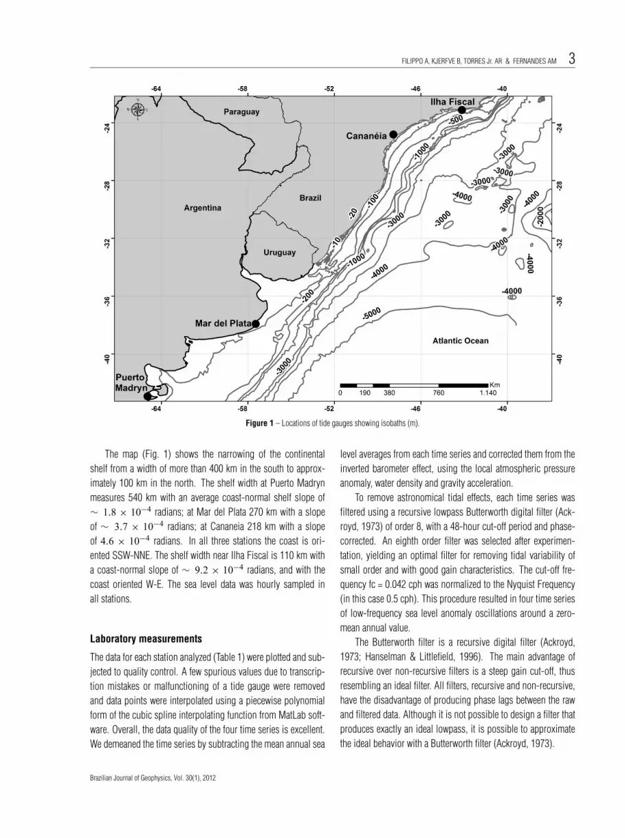
The study area extends from 22◦30′S and 42◦30′W to 47◦45′Sand 65◦55.1′W, covering 3010 km of the mid-Atlantic coast ofSouth America (Fig. 1). It includes the central and northern coastof Argentina, the coast of Uruguay, and the south-southeast coastof Brazil. The sea level data (Table 1) for 1983 were obtained fromthe Diretoria de Hidrografia e Navegacao (DHN) (Brazil) and Ser-vicio Hidrografico de la Armada (Argentina). Unfortunately, wewere unable to locate reliable and continuous water level data for1983 between Mar del Plata and Cananeia.
Table 1 – Water level stations used in the analysis of the 1983 hourly data,where n = number of data points.
StationsW◦ S◦
NMissing
Longitude Latitude data (%)
Puerto Madryn –65.03 –42.77 8760 0
Mar del Plata –57.52 –38.03 8760 0
Cananeia –47.93 –25.02 8760 0
Ilha Fiscal –43.17 –22.9 8760 0
Revista Brasileira de Geofısica, Vol. 30(1), 2012
“main” — 2012/7/23 — 12:33 — page 3 — #3
FILIPPO A, KJERFVE B, TORRES Jr. AR & FERNANDES AM 3
Figure 1 – Locations of tide gauges showing isobaths (m).
The map (Fig. 1) shows the narrowing of the continentalshelf from a width of more than 400 km in the south to approx-imately 100 km in the north. The shelf width at Puerto Madrynmeasures 540 km with an average coast-normal shelf slope of∼ 1.8 × 10⁻⁴ radians; at Mar del Plata 270 km with a slopeof ∼ 3.7 × 10⁻⁴ radians; at Cananeia 218 km with a slopeof 4.6 × 10⁻⁴ radians. In all three stations the coast is ori-ented SSW-NNE. The shelf width near Ilha Fiscal is 110 km witha coast-normal slope of ∼ 9.2 × 10⁻⁴ radians, and with thecoast oriented W-E. The sea level data was hourly sampled inall stations.
Laboratory measurements
The data for each station analyzed (Table 1) were plotted and sub-jected to quality control. A few spurious values due to transcrip-tion mistakes or malfunctioning of a tide gauge were removedand data points were interpolated using a piecewise polynomialform of the cubic spline interpolating function from MatLab soft-ware. Overall, the data quality of the four time series is excellent.We demeaned the time series by subtracting the mean annual sea
level averages from each time series and corrected them from theinverted barometer effect, using the local atmospheric pressureanomaly, water density and gravity acceleration.
To remove astronomical tidal effects, each time series wasfiltered using a recursive lowpass Butterworth digital filter (Ack-royd, 1973) of order 8, with a 48-hour cut-off period and phase-corrected. An eighth order filter was selected after experimen-tation, yielding an optimal filter for removing tidal variability ofsmall order and with good gain characteristics. The cut-off fre-quency fc = 0.042 cph was normalized to the Nyquist Frequency(in this case 0.5 cph). This procedure resulted in four time seriesof low-frequency sea level anomaly oscillations around a zero-mean annual value.
The Butterworth filter is a recursive digital filter (Ackroyd,1973; Hanselman & Littlefield, 1996). The main advantage ofrecursive over non-recursive filters is a steep gain cut-off, thusresembling an ideal filter. All filters, recursive and non-recursive,have the disadvantage of producing phase lags between the rawand filtered data. Although it is not possible to design a filter thatproduces exactly an ideal lowpass, it is possible to approximatethe ideal behavior with a Butterworth filter (Ackroyd, 1973).
Brazilian Journal of Geophysics, Vol. 30(1), 2012
“main” — 2012/7/23 — 12:33 — page 4 — #4
4 LOW-FREQUENCY VARIABILITY OF SEA LEVEL ALONG THE MID-ATLANTIC COAST OF SOUTH AMERICA, IN 1983
To correct for the phase shift the filter was applied bothways, forward and backward, and hence the original phase wasrecaptured.
The spectral analysis of the sea level data was accomplishedby applying a Fast Fourier Transform, averaged using the WelchMethod (Middleton, 2000), and smoothed using a Hanning win-dow, with 8 degrees of freedom. In the analysis, we used the in-put data with: (i) Hanning window = 4096; (ii) noverlap (specifiesthe number of signal samples that are common to two adjacentsegments) = 10; (iii) fs (sampling frequency) = 1 cph. The cross-spectral analysis yields information about the propagation of longwaves from the phase frequency spectrum. This analysis is theproduct of the FFT of one series and the conjugate of the FFT ofthe other series. The coherence of the peaks for each series pairexpresses the linear correlation index between the two compo-nents of the bivariate process as a function of frequency (Pereiraet al., 1986). It quantifies the extent to which an event, that tookplace at one station, is related to the same event at another station.
The identification and propagation characteristics of low-frequency waves is accomplished by comparing the energy of thespectra at locations along the coast, both with respect to the fre-quency of variance spikes, coherence, and phase difference be-tween the signals. We calculated the phase (propagation) velocityC from
C =(
360◦
θ
)∙ ω ∙ D (1)
where θ is the phase lag (degrees), ω is the frequency (cph),and D is the distance between the stations (km). The results areshown in Table 3. The time phase shift was calculated from
T ps =(
θ
360◦
)∙ Period (days) ∙ 24h (2)
RESULTS
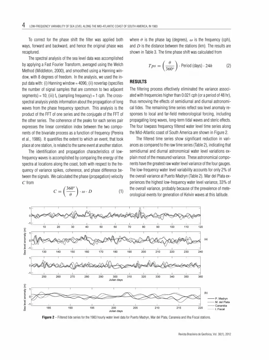
The filtering process effectively eliminated the variance associ-ated with frequencies higher than 0.021 cph (or a period of 48 hr),thus removing the effects of semidiurnal and diurnal astronomi-cal tides. The remaining time series reflect sea level anomaly re-sponses to local and far-field meteorological forcing, includingpropagating long waves, long-term tidal waves and steric effects.The four lowpass frequency filtered water level time series alongthe Mid-Atlantic coast of South America are shown in Figure 2.
The filtered time series show significant reduction in vari-ances as compared to the raw time series (Table 2), indicating thatsemidiurnal and diurnal astronomical water level variations ex-plain most of the measured variance. These astronomical compo-nents have the greatest raw water level variance of the four gauges.The low-frequency water level variability accounts for only 2% ofthe overall variance at Puerto Madryn (Table 2). Mar del Plata ex-periences the highest low-frequency water level variance, 33% ofthe overall variance, probably because of the prevalence of mete-orological events for generation of Kelvin waves at this latitude.
Figure 2 – Filtered tide series for the 1983 hourly water level data for Puerto Madryn, Mar del Plata, Cananeia and Ilha Fiscal stations.
Revista Brasileira de Geofısica, Vol. 30(1), 2012
“main” — 2012/7/23 — 12:33 — page 5 — #5
FILIPPO A, KJERFVE B, TORRES Jr. AR & FERNANDES AM 5
Table 2 – Statistics of filtered and non-filtered 1983 hourly water level data for Puerto Madryn, Mar del Plata, Cananeia, and Ilha Fiscal.
Raw series Filtered series % variance
Stations N Max Min SD Var Max Min SD Var Filtered /
(m) (m) (m) (m2) (m) (m) (m) (m2) Raw
Puerto Madryn 8760 4.13 –3.18 1.42 2.03 0.74 –0.50 0.19 0.04 2
Mar del Plata 8760 1.70 –1.51 0.43 0.18 1.10 –0.76 0.25 0.06 33
Cananeia 8760 1.28 –1.14 0.40 0.16 0.65 –0.63 0.20 0.04 25
Ilha Fiscal 8760 0.93 –1.07 0.34 0.12 0.56 –0.54 0.17 0.03 26
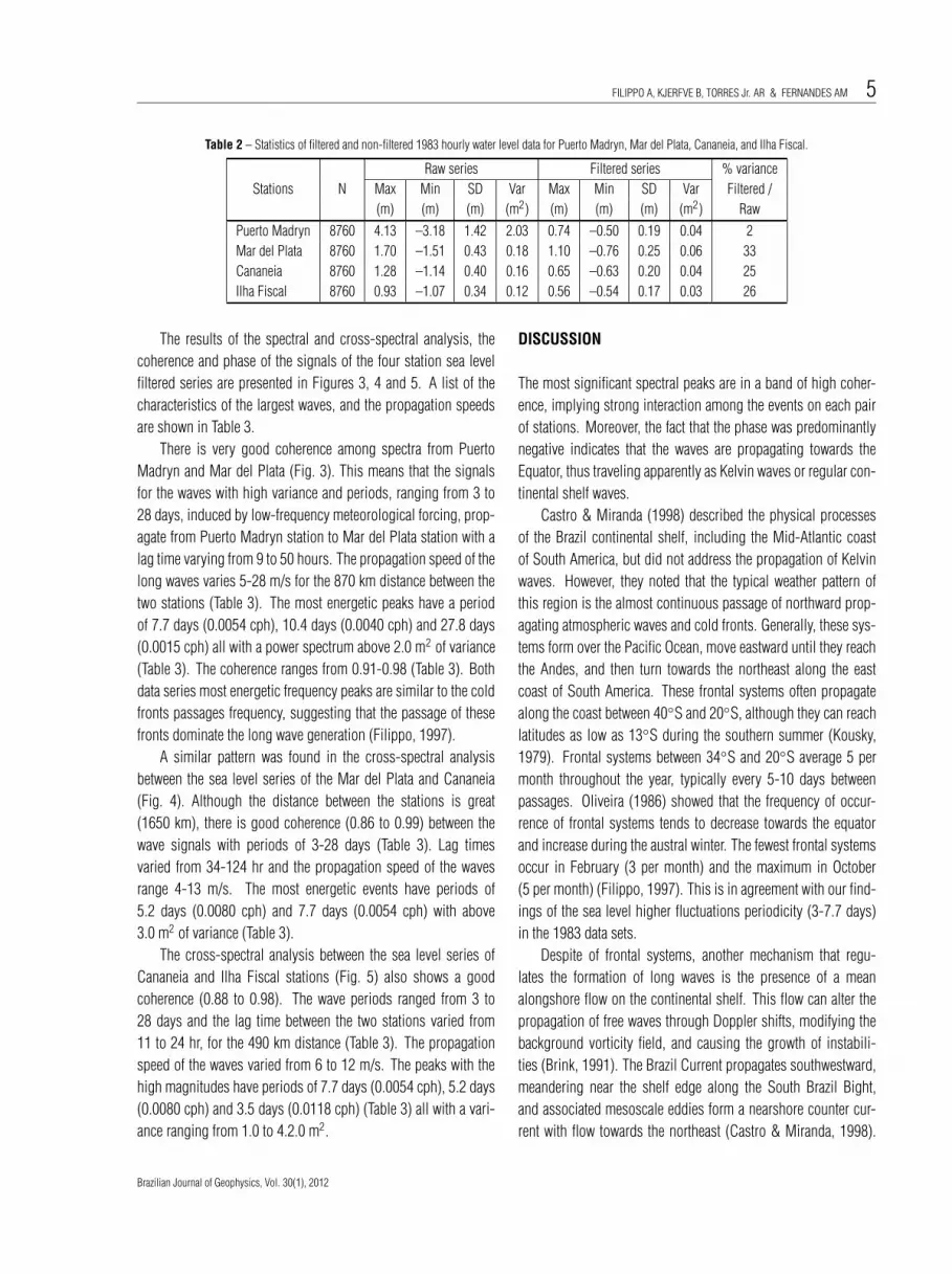
The results of the spectral and cross-spectral analysis, thecoherence and phase of the signals of the four station sea levelfiltered series are presented in Figures 3, 4 and 5. A list of thecharacteristics of the largest waves, and the propagation speedsare shown in Table 3.
There is very good coherence among spectra from PuertoMadryn and Mar del Plata (Fig. 3). This means that the signalsfor the waves with high variance and periods, ranging from 3 to28 days, induced by low-frequency meteorological forcing, prop-agate from Puerto Madryn station to Mar del Plata station with alag time varying from 9 to 50 hours. The propagation speed of thelong waves varies 5-28 m/s for the 870 km distance between thetwo stations (Table 3). The most energetic peaks have a periodof 7.7 days (0.0054 cph), 10.4 days (0.0040 cph) and 27.8 days(0.0015 cph) all with a power spectrum above 2.0 m2 of variance(Table 3). The coherence ranges from 0.91-0.98 (Table 3). Bothdata series most energetic frequency peaks are similar to the coldfronts passages frequency, suggesting that the passage of thesefronts dominate the long wave generation (Filippo, 1997).
A similar pattern was found in the cross-spectral analysisbetween the sea level series of the Mar del Plata and Cananeia(Fig. 4). Although the distance between the stations is great(1650 km), there is good coherence (0.86 to 0.99) between thewave signals with periods of 3-28 days (Table 3). Lag timesvaried from 34-124 hr and the propagation speed of the wavesrange 4-13 m/s. The most energetic events have periods of5.2 days (0.0080 cph) and 7.7 days (0.0054 cph) with above3.0 m2 of variance (Table 3).
The cross-spectral analysis between the sea level series ofCananeia and Ilha Fiscal stations (Fig. 5) also shows a goodcoherence (0.88 to 0.98). The wave periods ranged from 3 to28 days and the lag time between the two stations varied from11 to 24 hr, for the 490 km distance (Table 3). The propagationspeed of the waves varied from 6 to 12 m/s. The peaks with thehigh magnitudes have periods of 7.7 days (0.0054 cph), 5.2 days(0.0080 cph) and 3.5 days (0.0118 cph) (Table 3) all with a vari-ance ranging from 1.0 to 4.2.0 m2.
DISCUSSION
The most significant spectral peaks are in a band of high coher-ence, implying strong interaction among the events on each pairof stations. Moreover, the fact that the phase was predominantlynegative indicates that the waves are propagating towards theEquator, thus traveling apparently as Kelvin waves or regular con-tinental shelf waves.
Castro & Miranda (1998) described the physical processesof the Brazil continental shelf, including the Mid-Atlantic coastof South America, but did not address the propagation of Kelvinwaves. However, they noted that the typical weather pattern ofthis region is the almost continuous passage of northward prop-agating atmospheric waves and cold fronts. Generally, these sys-tems form over the Pacific Ocean, move eastward until they reachthe Andes, and then turn towards the northeast along the eastcoast of South America. These frontal systems often propagatealong the coast between 40◦S and 20◦S, although they can reachlatitudes as low as 13◦S during the southern summer (Kousky,1979). Frontal systems between 34◦S and 20◦S average 5 permonth throughout the year, typically every 5-10 days betweenpassages. Oliveira (1986) showed that the frequency of occur-rence of frontal systems tends to decrease towards the equatorand increase during the austral winter. The fewest frontal systemsoccur in February (3 per month) and the maximum in October(5 per month) (Filippo, 1997). This is in agreement with our find-ings of the sea level higher fluctuations periodicity (3-7.7 days)in the 1983 data sets.
Despite of frontal systems, another mechanism that regu-lates the formation of long waves is the presence of a meanalongshore flow on the continental shelf. This flow can alter thepropagation of free waves through Doppler shifts, modifying thebackground vorticity field, and causing the growth of instabili-ties (Brink, 1991). The Brazil Current propagates southwestward,meandering near the shelf edge along the South Brazil Bight,and associated mesoscale eddies form a nearshore counter cur-rent with flow towards the northeast (Castro & Miranda, 1998).
Brazilian Journal of Geophysics, Vol. 30(1), 2012
“main” — 2012/7/23 — 12:33 — page 6 — #6
6 LOW-FREQUENCY VARIABILITY OF SEA LEVEL ALONG THE MID-ATLANTIC COAST OF SOUTH AMERICA, IN 1983
Figure 3 – Cross correlation analysis between Puerto Madryn and Mar del Plata 1983 sea level data.
Table 3 – Periods, variance, coherence, phase, time of phase shift and propagation speed of the main spectral peaks from the cross-spectral analysis betweenthe Puerto Madryn and Mar del Plata (PM–MP, 870 km), Mar del Plata and Cananeia (MP–CA, 1650 km) and Cananeia and Ilha Fiscal (CA–IF, 490 kmdistance) stations.
Frequency PeriodsCo-variance
CoherencePhase Time of phase shift Propagation speed
(cph) (Days)(m2) (degrees) (h) (m/s)
PM-MP MP-CA CA-IF PM-MP MP-CA CA-IF PM-MP MP-CA CA-IF PM-MP MP-CA CA-IF PM-MP MP-CA CA-IF
0.0015 27.8 2.3 2.0 2.5 0.94 0.86 0.88 –27 –80 –7 –49.7 –124.2 –18.5 –4.9 –3.7 –7.3
0.0040 10.4 2.7 2.9 2.5 0.92 0.92 0.94 –41 –100 –32 –25.0 –71.2 –22.6 –9.7 –6.4 –6.0
0.0054 7.7 2.4 3.9 4.2 0.91 0.96 0.98 –17 –105 –22 –8.8 –53.9 –11.3 –27.5 –8.5 –12.0
0.0073 5.7 0.9 2.2 2.3 0.98 0.97 0.98 –76 –173 –37 –28.8 –65.9 –14.1 –8.4 –7.0 –9.6
0.0080 5.2 1.4 3.4 2.1 0.98 0.96 0.98 –66 –163 –41 –22.9 –56.7 –14.4 –10.6 –8.1 –9.4
0.0118 3.5 1.1 1.8 0.9 0.96 0.99 0.92 –56 139 –95 –13.2 34.8 –23.6 –18.3 13.2 –5.7
Between latitudes 34◦S and 28◦S, the Brazil and the Malvinascurrents converge. These two currents systems form the westernboundary of the Subtropical Convergence, and analytical studiesand numerical experiments (Campos, 1990) indicate the existenceof stationary or low-frequency temporally amplified and spatiallydamped long waves. When coastal trapped waves propagate in theopposite direction to the mean current, the possibility of criticalcoastal trapped waves exists, and the direction of wave propaga-tion can locally be reversed due to the strength of the mean flow(Brinks, 1991). As can be observed in Table 3, a 3.5-day periodwave exhibits positive phase speed, implying a local phase speedreversal towards the south between Mar del Plata and Cananeia.
The inner shelf is occupied mainly by “coastal water”, whichtends to be vertically homogeneous due to mixing, wind stressand tidal shear. A near bottom thermal front separates the in-ner and mid-shelf waters. The mean position of the thermal frontchanges seasonally, being closer to the coast (10-20 km) duringthe summer, and farther offshore (40-50 km) during the winter(Castro & Miranda, 1998). This typical stratification of the wa-ter column on the inner and mid-shelf facilitates the generation ofbarotropic shelf waves as opposed to baroclinic ones.
Our spectral results show that there are indeed coherent longwaves with periods of 7.7, 5.2 and 3.5 days traveling towardsthe northeast along the Mid-Atlantic coast of South America with
Revista Brasileira de Geofısica, Vol. 30(1), 2012

“main” — 2012/7/23 — 12:33 — page 7 — #7
FILIPPO A, KJERFVE B, TORRES Jr. AR & FERNANDES AM 7
Figure 4 – Cross correlation analysis between Mar del Plata and Cananeia 1983 sea level data.
Figure 5 – Cross correlation analysis between Cananeia and Ilha Fiscal 1983 sea level data.
amplitudes of ∼1 m. This is in agreement with Castro & Lee(1995) findings that sea level fluctuations in the central and north-ern portions of the South Brazilian Bight for both 9- to 12- and 6-to 7-day bands were better correlated with winds located south-ward and earlier in time than with the local wind at the time of sealevel measurements. Other waves, with longer periods, appear
only in individual records, possibly as a result of local meteoro-logical forcing, but the energy/variance has dissipated by the timethey reach the next tide gauge.
Another possibility is that the wave could exhibit differencesof a few hours in period at different stations because of variationsin width and depth of the continental shelf along the coast, as the
Brazilian Journal of Geophysics, Vol. 30(1), 2012
“main” — 2012/7/23 — 12:33 — page 8 — #8
8 LOW-FREQUENCY VARIABILITY OF SEA LEVEL ALONG THE MID-ATLANTIC COAST OF SOUTH AMERICA, IN 1983
Figure 6 – Coherence of sea level and atmospheric pressure 1983 data series at the Puerto Madryn, Mar del Plata, Cananeia and Ilha Fiscal stations.
propagation of long waves depends on width, depth, and stratifi-cation of the water column (Huthnance, 1975, Wang & Mooers,1976; Clarke, 1977; Huthnance, 1978; Brink, 1982). In addi-tion, the irregular alongshore geometry between Mar del Plata andCananeia is most likely affecting the phase propagation throughwave diffraction (Wang, 1980). Both could cause the reductionin wave energy transmission and the amplification of the waveamplitude near depth convergence zones, generating strong localdisturbances.
The importance of long waves in determining sea level varia-tion is obvious. During the 1983 El Nino event, there were meansea level variations of more than 1 meter. It seems that the highestsea level variations were found in the low-frequency portion of thespectrum along the Argentinean coast. The periods were severaldays to a few weeks, an indication that they manifest themselvesthrough slow changes in water level as well as reversals of theinshore currents at a rate of approximately once a week, as suc-cessive regions of high and low pressure pass the measurementlocations towards the equator as observed by Tomczak (2000).Being an year of El Nino, the possibility of Kelvin waves generatedin the Equatorial Pacific could propagate until Cape Horn, turnaround and enter in the Atlantic reinforcing (or attenuating) thewave train exists, once Valenzuela-Cuevas (1999) noticed thesewaves at Chilean cost moving poleward, although it is not thesubject of this study. Based on spectral analysis on Mar de Ajo,Pinamar and Mar del Plata stations, on the coast of the province of
Buenos Aires, Argentina, Dragani et al. (2002) concluded that thehigh coherence was an indication that the sea level oscillationswere coherent regionally, as we observed in the present analyses.
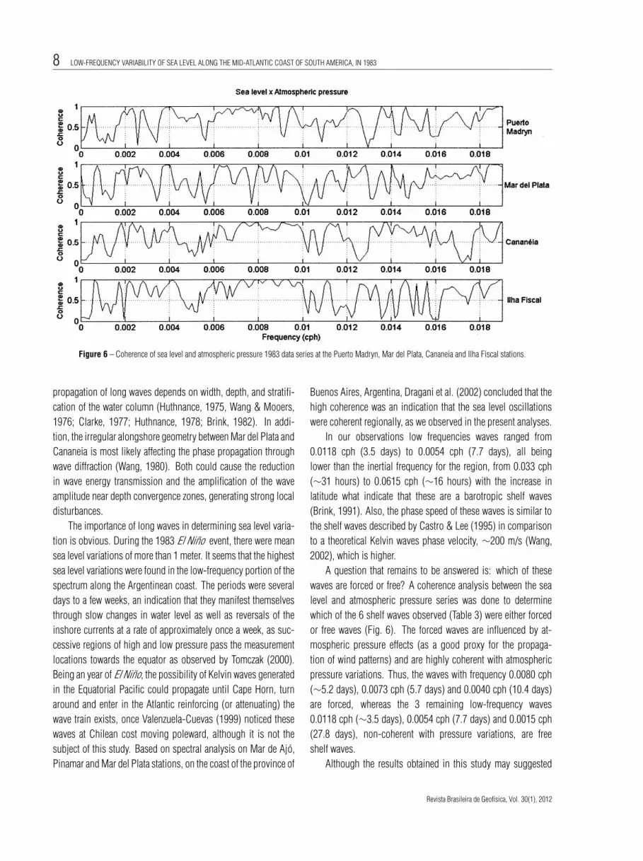
In our observations low frequencies waves ranged from0.0118 cph (3.5 days) to 0.0054 cph (7.7 days), all beinglower than the inertial frequency for the region, from 0.033 cph(∼31 hours) to 0.0615 cph (∼16 hours) with the increase inlatitude what indicate that these are a barotropic shelf waves(Brink, 1991). Also, the phase speed of these waves is similar tothe shelf waves described by Castro & Lee (1995) in comparisonto a theoretical Kelvin waves phase velocity, ∼200 m/s (Wang,2002), which is higher.
A question that remains to be answered is: which of thesewaves are forced or free? A coherence analysis between the sealevel and atmospheric pressure series was done to determinewhich of the 6 shelf waves observed (Table 3) were either forcedor free waves (Fig. 6). The forced waves are influenced by at-mospheric pressure effects (as a good proxy for the propaga-tion of wind patterns) and are highly coherent with atmosphericpressure variations. Thus, the waves with frequency 0.0080 cph(∼5.2 days), 0.0073 cph (5.7 days) and 0.0040 cph (10.4 days)are forced, whereas the 3 remaining low-frequency waves0.0118 cph (∼3.5 days), 0.0054 cph (7.7 days) and 0.0015 cph(27.8 days), non-coherent with pressure variations, are freeshelf waves.
Although the results obtained in this study may suggested
Revista Brasileira de Geofısica, Vol. 30(1), 2012
“main” — 2012/7/23 — 12:33 — page 9 — #9
FILIPPO A, KJERFVE B, TORRES Jr. AR & FERNANDES AM 9
that Shelf Waves propagate coherently, the only four stations an-alyzed here are not enough for a conclusive statement. Attemptsto compute a space-time diagram (Hovmoller diagram) were donebut the long distance between the four tide gauges did not allowfor clear results. The use of numerical models with suitable spatialresolution is required for better addressing this issue.
CONCLUSION
Most of the energy of long waves along the continent propagatesas barotropic shelf waves (LeBlond & Mysak, 1978). We con-clude that three waves in this study are free long waves and threeare a forced barotropic shelf waves, as a result of atmosphericdisturbances, somewhat modified by water column stratificationand morphology of the local continental shelf (Wang & Mooers,1976; Clarke, 1977; Huthnance, 1978; Brink, 1982).
Our main findings are:
• At Puerto Madryn, Mar del Plata, Cananeia and Ilha Fiscal,the sea level exhibits high-energy fluctuations at low fre-quencies, with the most energetic periods exhibiting goodcoherence between 3.5 and 28 days.
• The observed low-frequency waves along the Mid-Atlanticcoast of South America are barotropic shelf waves, some-what modified by the morphological characteristics of thecontinental shelf.
• The principal coherent long waves along the entire3,010 km coast have periods of 5.2 days, 5.7 days and7.7 days, all with variance above 1.0 m2.
• The coherence of the most energetic long waves rangedfrom 0.86 to 0.98.
• Shelf waves propagate towards the equator with a phasespeed of –10.9 m/s, on the average, every 5-16 days.These waves require 77 hr to propagate 3,010 km fromPuerto Madryn, Argentina, to Ilha Fiscal, Brazil.
REFERENCES
ACKROYD MH. 1973. Digital Filters. D. W. Hill, 79 pp.
BRINK KH. 1982. The effect of bottom friction on low-frequency coastal
trapped waves. Journal of Physical Oceanography, 12: 127–133.
BRINK KH. 1991. Coastal-trapped waves and wind-driven currents over
the Continental Shelf. Annual Review of Fluid Mechanics, 23: 389–412.
CAMPOS EJD. 1990. Stationary Rossby waves in Western boundary
current extensions. Ph.D. Thesis, University of Miami, Miami, 115 pp.
CASTRO BM. 1985. Subtidal response to wind forcing in South Brazil
Bight during winter. Ph.D. Thesis, University of Miami, Miami, 211 pp.
CASTRO BM & LEE TN. 1995. Wind-forced sea level variability on the
southeast Brazilian shelf. J. Geophys. Res., 100(C8): 16,045-16,056,
doi: 10.1029/95JC01499.
CASTRO BM & MIRANDA LB. 1998. Physical Oceanography of the
Western Atlantic Continental Shelf Located between 4◦N and 34◦S. In:
ROBINSON AR & BRINK KH (Eds.). The Sea. John Wiley & Sons Inc.,
p. 209–251.
CHURCH JA, FREELAND HJ & SMITH RL. 1986. Coastal-Trapped
Waves on the East Australian Continental Shelf Part I: Propagation of
Modes. Journal of Physical Oceanography, 16: 1929–1943.
CLARKE AJ. 1977. Observational and Numerical Evidence for Wind-
Forced Coastal Trapped Long Waves. Journal of Physical Oceanography,
7: 231–247.
CPTEC. 2002. El Nino e La Nina. n. 25 Novembro: Instituto Nacional de
Pesquisas Espaciais.
DRAGANI WC, MAZIO CA & NUNEZ MN. 2002. Sea level oscillations
in coastal waters of Buenos Aires province, Argentina. Continental Shelf
Research, 22: 779–790.
FILIPPO AM. 1997. Passagem de Frentes Frias na Baıa de Guanabara:
Impacto no nıvel do mar, Departamento de Geoquımica Ambiental, Uni-
versidade Federal Fluminense – UFF, 79 pp.
GILL AE & SCHUMANN EH. 1979. Topographically Induced Changes in
Structure of an Inertial Coastal Jet: Application to the Agulhas Current.
Journal of Physical Oceanography, 9: 975–991.
HANSELMAN D & LITTLEFIELD B. 1996. Mastering MatLab A Compre-
hensive Tutorial and Reference. The MatLab Curriculum Series, Prentice
Hall, 542 pp.
HUTHNANCE JM. 1975. On trapped waves over a continental shelf.
Journal of Fluid Mechanics, 69: 689–704.
HUTHNANCE JM. 1978. On Coastal Trapped Waves: Analysis and
Numerical Calculation by Inverse Iteration. Journal of Physical Oceanog-
raphy, 8: 74–92.
KOUSKY VE. 1979. Frontal influences on northeast Brazil. Mon. Weather
Rev., 107: 1140–1153.
LEBLOND PH & MYSAK LA. 1978. Waves in the Ocean. Elsevier, 602 pp.
MESQUITA AR de. 2003. Sea Level Variations along the Brazilian Coast:
A Short Review. J. Coast. Res. (SI), 35: 21–31.
MIDDLETON GV. 2000. Data analysis in the Earth Sciences Using
MatLab. Prentice Hall, 260 pp.
OLIVEIRA AS. 1986. Interacoes entre sistemas frontais na America do
Sul e conveccao na Amazonia. M.Sc. Dissertation, Instituto de Pes-
quisas Espaciais, INPE-4008-TDL/239, Sao Jose dos Campos, SP.
115 pp.
Brazilian Journal of Geophysics, Vol. 30(1), 2012
“main” — 2012/7/23 — 12:33 — page 10 — #10
10 LOW-FREQUENCY VARIABILITY OF SEA LEVEL ALONG THE MID-ATLANTIC COAST OF SOUTH AMERICA, IN 1983
PEREIRA BB, PAIS MBZ & SALES PRH. 1986. Analise Espectral de Series
Temporais - Uma Introducao para Engenharia, Economia e Estatıstica.
Arte Final Leasing Editorial, 109 pp.
PHILANDER SG. 1990. El Nino, La Nina, and the Southern Oscillation.
Vol. 46, International Geophysics Series, Academic Press, Inc., 291 pp.
SERRA A & RASTIBONNA L. 1959. As Massas de Ar da America do Sul.
Revista Geografica do Instituto Pan-Americano de Geografia e Historia,
25: 67–129.
STECH JL & LORENZZETTI JA. 1992. The response of the South Brazil
Bight to the passage of wintertime cold fronts. Journal Geophysical
Research, 97: 9507–9520.
TOMCZAK M. 2000. Coastal trapped waves and other oscillations. Lec-
ture notes Chapter 8. Available on:
<http://www.es.flinders.edu.au/mattom/ShelfCoast/chapter08.html>.
Access on: Oct. 15, 2009.
VALENZUELA-CUEVAS C. 1999. Sea level propagating coastal-trapped
waves, circulation forcing influence along central Chile, 1991-1995. In:
Ocean Circulation Science derived from the Atlantic, Indian and Arctic
Sea Level Networks, 11 May 1999, Toulouse, France. Intergovernmental
Oceanographic Commission – IOC. 171v. p. Annex III – 28–33.
WANG DP. 1980. Diffraction of Continental Shelf Waves by Irregular
Alongshore Geometry. Journal of Physical Oceanography, 10: 1187–
1199.
WANG B. 2002. Kelvin waves. SHANKAR M (Ed.). Elsevier Science Ltd.,
doi: 10.1006/rwas.2002.0191. 7 pp. Available on:
<http://www.soest.hawaii.edu/MET/Faculty/bwang/bw/paper/wang 103.pdf>.
Access on: Apr. 4, 2012.
WANG DP & MOOERS CNK. 1976. Coastal-trapped waves in a continu-
ously stratified ocean. Journal of Physical Oceanography, 6: 853–863.
NOTES ABOUT THE AUTHORS
Alessandro Mendonca Filippo. Graduated in Oceanography from the Universidade do Estado do Rio de Janeiro – UERJ (1987), M.Sc. (1997) and Ph.D. (2003)in Geosciences (Geochemistry) at Universidade Federal Fluminense – UFF. Accumulated experience in Environmental Management and environmental impactassessment, management of multi-disciplinary teams, Environmental Impact Assessment, Monitoring Programs and Water Quality, Oceanography of bays, coastallagoons, estuaries and coastal waters, mangrove ecology, numerical modeling of flow and transport in coastal systems, GIS applications to coastal systems, databasedevelopment and coastal management. Currently takes part of Concremat Engineering Environmental team and is a Substitute Professor at Department of PhysicalOceanography, School of Oceanography (UERJ).
Bjorn Kjerfve. Bjorn Kjerfve since 2009 is President of the World Maritime University, located in Malmo, Sweden, a post-graduate UN university under the auspicesof the International Maritime Organization. Kjerfve, holds a Ph.D. degree in physical oceanography, is Professor of geography and oceanography on leave from TexasA&M University in College Station, Texas, USA. Since 1988 has offered post-graduate courses on physical and estuarine and coastal oceanography and supervisedPh.D. and M.Sc. students in the Environmental Geochemistry Program at Universidade Federal Fluminense – UFF, and also at other universities in Brazil.
Audalio Rebelo Torres Jr. Graduated in Meteorology at the Universidade Federal do Rio de Janeiro (1982), specialization in signal processing at and in neuralnetworks at Petrobras (1992), master’s degree in Ocean Engineering at Universidade Federal do Rio de Janeiro (1995) Ph.D. in Ocean Engineering at UniversidadeFederal do Rio de Janeiro (2005). He is currently a professor at the Universidade Federal do Rio de Janeiro, reviewer for the International Journal of Remote Sensing,reviewer for the Revista Brasileira de Geofısica and reviewer for the Pan-American Journal of Aquatic Sciences. Has experience in the field of Oceanography, with emphasisin physical oceanography, ainly on the following themes: El Nino, ocean circulation, climate, numerical modeling, teleconnections and South Atlantic.
Alexandre Macedo Fernandes. Graduated in Physics at Universidade Federal do Rio de Janeiro (1998), Master of Oceanography (Physical Oceanography) atUniversidade de Sao Paulo (2001) and Ph.D. in Physical Oceanography at Florida State University (2007). He is currently Adjunct Professor in the Department ofPhysical Oceanography, School of Oceanography, Universidade do Estado do Rio de Janeiro (UERJ). Works in the area of Physical Oceanography, with emphasis onphysical variables of sea water and and sea water movement, acting on hydrodynamic studies of small to mesoscale and ocean vertical mixing processes.
Revista Brasileira de Geofısica, Vol. 30(1), 2012