LLANO ESTACADO UNDERGROUND WATER CONSER VA ...
31
LLANO ESTACADO UNDERGROUND WA TER CONSER VA TION DISTRICT 101 S. Main, Room B2, Gaines County Courthouse, Seminole, TX 79360 * 432-758-1127 MEMORANDUM TO: Kevin Ward Executive Administrator Texas Water Development Board II 5 1700 N. Congress P.O. Box 13231 RJTFfO FROM: General Manager Liano Estacado Undergroun ater Conservation District (LEUWCD) SUBJECT: LEUWCD Management Plan DATE: July 21, 2005 Attached is a copy of the Liano Estacado Underground Water Conservation District’s adopted “Groundwater Management Plan” for the Texas Water Development Board certification as mandated by Chapter 36 1072(a) of the Texas Water Code. The Liano Estacado UWCD Board of Directors adopted the plan on July 21, 2005. In addition, the resolution adopting the plan is attached. This plan replaces our existing Management Plan that was adopted by the District in 2000. The Liano Estacado Underground Water Conservation District Management Plan was developed during an open meeting of the Board of Directors in accordance with all notice and hearing requirements of the District. Documentation that notice and hearing requirements were followed is presented in a separate attachment. There are no surface water entities within the District. Since notice and hearings are posted within the District, and proper notice of public hearing was in a newspaper of wide circulation, no additional notification is given under Chapter 36.1071(a). A copy of the District’s rules is attached in accordance with Chapter 36.1071(f). The rules were adopted September of 1999.
-
Upload
khangminh22 -
Category
Documents
-
view
6 -
download
0
Transcript of LLANO ESTACADO UNDERGROUND WATER CONSER VA ...
LLANO ESTACADO UNDERGROUNDWA TER CONSER VA TION DISTRICT101 S. Main, Room B2, Gaines County Courthouse, Seminole, TX 79360 * 432-758-1127
MEMORANDUM TO: Kevin WardExecutive AdministratorTexas Water Development Board
II 51700 N. CongressP.O. Box 13231 RJTFfO
FROM:
General ManagerLiano Estacado Undergroun aterConservation District (LEUWCD)
SUBJECT: LEUWCD Management Plan
DATE: July 21, 2005
Attached is a copy of the Liano Estacado Underground Water Conservation District’sadopted “Groundwater Management Plan” for the Texas Water Development Boardcertification as mandated by Chapter 36 1072(a) of the Texas Water Code. The LianoEstacado UWCD Board of Directors adopted the plan on July 21, 2005. In addition, theresolution adopting the plan is attached.
This plan replaces our existing Management Plan that was adopted by the District in2000.
The Liano Estacado Underground Water Conservation District Management Plan wasdeveloped during an open meeting of the Board of Directors in accordance with all noticeand hearing requirements of the District. Documentation that notice and hearingrequirements were followed is presented in a separate attachment. There are no surfacewater entities within the District. Since notice and hearings are posted within the District,and proper notice of public hearing was in a newspaper of wide circulation, no additionalnotification is given under Chapter 36.1071(a).
A copy of the District’s rules is attached in accordance with Chapter 36.1071(f). Therules were adopted September of 1999.
The Liano Estacado Underground Water Conservation District “GroundwaterManagement Plan” will be in force for 10 years from the date it was adopted by theBoard.
If there should be any additional information that you require, please do not hesitate tocall.
CRC/lb
Attachments
Cl)
Cl)
.F—
4
C12
•r—
4
Table of ContentsDistrict Mission Statement
1Time Period for this Plan
1Guiding Principles
1General Description, Location and Extent
2Topography and Drainage
3Groundwater Resources
3Ogallala Aquifer
3Cretaceous Aquifer
4Dockum Aquifer
7Surface Water Resources
7Total Useable Amount of Groundwater
7Historical Groundwater Use
$Recharge of the Aquifer System
$Projected Groundwater Supply and Demand
9Management of Groundwater Resources
9Drought Contingency Plan
10Regional Water Planning
10Legislative Activity
10Weather Modification
11Goals, Management Objectives and Performance Standards
11Method for Tracking the District’s Progress in Achieving Management Goals 11
Goal 1.0 Encouraging the Most Efficient Use of Groundwater 11Management ObjectivesWater Level Monitoring
11Technical Field Services12Research and Demonstrations12Center Pivot Inventories12Laboratory Services13
Goal 2.0 Controlling and Preventing Waste of Groundwater 13Management ObjectivesWell Permitting and Well Completion 13Open or Uncovered Wells
13Maximum Allowable Production14Water Quality Monitoring14
Goal 3.0 Public Education and Information 14Management ObjectivesNewsletter
15News Releases15Public $peaking Engagements15Printed Material Resource Center and Technical File 15Classroom Education16
Goal 4.0 Drought Condition Information16Management Objectives
Rain Gauges16
Goal 5.0 Water Conservation and Useable Groundwater Remaining 16Management ObjectivesSaturated Thickness Maps
16Conservation Literature16
Goals not Applicable17
References1$

List of TablesTable 1: Board of Directors of the Llano Estacado UndergroundWater Conservation District
2Table 2: Projected Quantity of Water in Storage in Gaines County8Table 3: 1998-2002 Groundwater Use, by Category of Use, inGaines County, Texas
8Table 4: Projected Groundwater Supply and Demand9
List of Figuresfigure 1: Location of the Llano Estacado Underground Water Conservation District 5figure 2: Aerial extent of the Ogallala Aquifer in Texas
6
District Mission Statement
The Llano Estacado Underground Water Conservation District (the District) will develop,promote, and implement management strategies to provide for the conservation, preservation,protection, recharging, and prevention of waste of the groundwater resources, over which it hasjurisdiction, for the benefit of the people that the District serves.
Time Period for this Plan
This plan becomes effective July 21, 2005 upon adoption by the Board of Directors (the Board)of the District and remains in effect until a revised plan is approved or until July 21, 2005,whichever is earlier. The District’s groundwater management plan is a 10 year plan and will bein force from the date it was adopted by the board.
Guiding Principles
The District was formed, and has been operated from its inception, with the guiding belief thatthe ownership and pumpage of groundwater is a private property right. The Board has adoptedthe principle of “education first” and regulation as a last resort in their effort to encourageconservation of the resource. As a result, the rules of the District were designed to give alllandowners a fair and equal opportunity to use the groundwater resource underlying theirproperty for beneficial purposes. If, at the request of the constituents of the District, morestringent management strategies are needed to better manage the resource, these strategies willbe put in place after an extensive educational process and with the perceived majority approvalof the constituents. The District will continue to monitor groundwater quality and quantity inorder to better understand the dynamics of the aquifer systems over which it has jurisdiction.This document is intended for use as a tool to provide continuity in the management of theDistrict. District staff will use the plan as a guide to insure that all aspects of the goals of theDistrict are accomplished. The Board will refer to it for future planning and as a document tomeasure performance of the District staff on an annual basis.
Conditions can change over time that may cause the Board to modify this document. Thedynamic nature of this plan shall be maintained such that the District will continue to best servethe needs of the constituents. At the very least, the Board will review and readopt this plan everyfive years, or as specified by Chapter 36, Texas Water Code.
Goals, management objectives, and performance standards must be set at an attainable level inorder to be realistic and effective. Lofty ideals penned in an effort to be “all things to all people”can be the first step toward disaster. Unreasonably elevated objectives foster potentiallydamaging results when the objective cannot be met due to a lack of resources; fiscal or technical.Goals can also be set too low. Simplistic ideals can foster mediocrity. In both cases, the missionof the goal setting entity is thwarted and the benefactors of the same slighted. Although wellmeaning, when the failure to attain a goal is realized by those measuring performance, the initialresponse is to assume that those setting the goals were negligent in performing their duties when,in truth, the goals were unattainable from the start.LEUWCD Management Plan-Page 1
In the opinion of the Board, the goals, management objectives, and performance standards putforth in this planning document have been set at a reasonable level considering existing andprojected fiscal and technical resources. Conditions may change which could cause change inthe management objectives defined to reach the stated goals. The following guidelines will beused to insure that the management objectives are set at a sufficient level to be realistic andeffective:• The District’s constituency will determine if the District’s goals are set at a level that is bothmeaningftil and attainable; through their voting right, the public will appraise the District’soverall performance in the process of electing or re-electing Board members.• The duly elected Board will guide and direct District staff and will gauge the achievement ofthe goals set forth in this document.• The interests and needs of the District’s constituency shall control the direction of themanagement of the District.• The Board will endeavor to maintain local control of the privately owned resource overwhich the District has authority.• The Board will evaluate District activities on a fiscal year basis. That is, the District budgetsoperations on October 1 - September 30 fiscal year. When considering stated goals,management objectives, and performance standards, any reference to the terms annual,annually, or yearly will refer to the fiscal year of the District.
General Description, Location and Extent
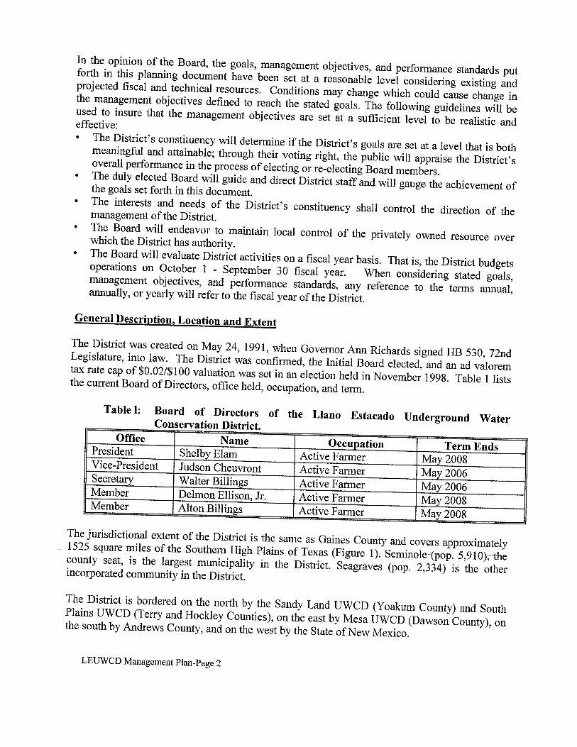
The District was created on May 24, 1991, when Governor Ann Richards signed HB 530, 72ndLegislature, into law. The District was confirmed, the Initial Board elected, and an ad valoremtax rate cap of $0.02/$100 valuation was set in an election held in November 1992. Table 1 liststhe current Board of Directors, office held, occupation, and term.
Table I: Board of Directors of the Liano Estacado Underground WaterConservation District.Office Name Occupation Term EndsPresident Shelby Elam Active farmer May 2008Vice-President Judson Cheuvront Active farmer May 2006Secretary Walter Billings Active Farmer May 2006Member Delmon Ellison, Jr. Active farmer May 200$Member Alton Billings Active Farmer May 2008
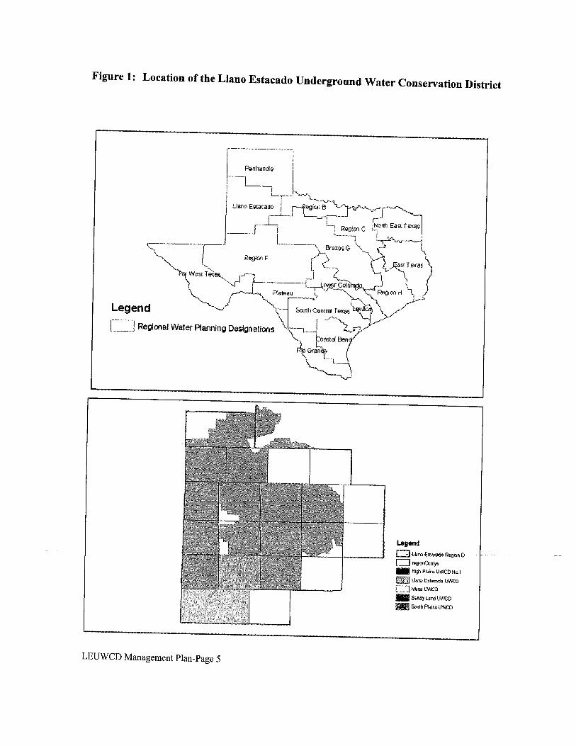
The jurisdictional extent of the District is the same as Gaines County and covers approximately1525 square miles of the Southern High Plains of Texas (figure 1). Seminole (pop. 5,910), thecounty seat, is the largest municipality in the District. Seagraves (pop. 2,334) is the otherincorporated community in the District.
The District is bordered on the north by the Sandy Land UWCD (Yoakum County) and SouthPlains UWCD (Ten-y and Hockley Counties), on the east by Mesa UWCD (Dawson County), onthe south by Andrews County, and on the west by the State of New Mexico.
LEUWCD Management Plan-Page 2
The economy of the District is supported predominately by row crop agriculture and oil and gasproduction. The 250,000 plus acres of irrigated cropland (out of total row crop acreage of640,000) affords economic stability to the area. The major crops cultivated within the Districtinclude cotton, peanuts, grain sorghum, wheat and corn; and, to a lesser extent, watermelons,sunflowers, alfalfa, and cucumbers.
Gaines County has long been known as the number one producer of oil and gas in the state. In2003, companies produced over 34,000,000 barrels of crude oil in the county.
Topography and Drainage
The land surface in the District is a nearly level to very gently undulating plain. Deep,moderately permeable, sandy soils predominate the region.
Land surface elevation drops from 3700 feet above sea level in the northwest corner of theDistrict to 2935 feet above sea level in the southeast corner of the District.
Several relic drainage ways cross the District from northwest to southeast. These “draws”(Sulfur, McKenzie, Wordswell, Seminole, and Monument) are shallow and usually dry, seldomcarrying runoff surface water.
Cedar Lake and McKenzie Lake are the largest salt lakes in the District. In periods of normalrainfall, McKenzie Lake occupies approximately 1,500 acres, and Cedar Lake, approximately3,500 acres. The lakes are bordered by calcareous soils that support various salt — tolerantsedges and grasses. The soils around the lakes and in the lake bottoms are strongly affected byalkali and are not conducive to agricultural activities.
Playas, or shallow wet-weather lakes, are common in areas where fine sandy loam and sandyclay loam soil types prevail. Playas range in size from 2 to 10 acres and are important vectorsfor local aquifer recharge.
Groundwater Resources
The District has jurisdiction over all groundwater that lies within the District’s boundaries.Three aquifers, the Ogallala, the Cretaceous, and the Dockum occur within the District. Thefollowing is a description of geological formations that may be beneficial to District constituentsby providing useable quantities of groundwater.
Ogallala Aquifer
The Ogallala Aquifer is the primary source of groundwater in the District (F1g. 2). Saturatedsections range from less than 10 feet to more than 180 feet in the area covered by the District.
The formation consists of heterogeneous sequences of clay, silt, sand and gravel. Thesesediments are thought to have been deposited by eastward flowing aggrading streams that filledand buried valleys eroded into pre-Ogallala rocks. A resistant layer of calcium carbonateLEUWCD Management Plan-Page 3
cemented caliche known locally as the “caprock” occurs near the surface of much of the area(Ashworth and Hopkins, 1995).
Water levels in the Ogallala Aquifer are primarily influenced by the rate of recharge to anddischarge from the aquifer. Recharge to the aquifer occurs primarily by infiltration ofprecipitation falling on the surface. To a lesser extent, recharge may also occur by upwardleakage from underlying Cretaceous units that, in places, have a higher potentiomefric surfacethan the Ogallala. Generally, only a small percentage of water from precipitation actuallyreaches the water table due to a combination of limited annual precipitation (15.8 inches peryear), high evaporation rate (60 — 70 inches per year), and slow infiltration rate.
Groundwater in the aquifer generally flows from northwest to southeast, normally at right anglesto water level contours. Velocities of less than one foot per day are typical, but higher velocitiesmay occur along filled erosional valleys where coarser grained deposits have greaterpermeabilities.
Discharge from the Ogallala aquifer within the District occurs through the pumping of wells;primarily irrigation wells. Groundwater pumpage typically exceeds recharge and results inwater-level declines (Ashworth and Hopkins, 1995).
The chemical quality of Ogallala groundwater varies greatly across the District. Electricalconductance (EC) varies from less than 1.0 dS/m to over 4.0 dS/m. Generally, groundwater inthe eastern and southeastern parts of the District exhibit the highest EC. Isolated occurrence ofhigh EC values elsewhere in the District may be due to pollution through oil field salt waterdisposal pits or upward leakage and mixing from the underlying Cretaceous aquifer.
The suitability of groundwater for irrigation purposes is largely dependent on the chemicalcomposition of the water and is determined primarily by the total concentration of soluble salts.Some farm acreage in the District is already limited to certain varieties of salt tolerant crops dueto limiting or damaging total salt levels.
Cretaceous Aquifer
The Edwards-Trinity (High Plains) aquifer, commonly referred to as the Cretaceous Aquifer,underlies the Ogallala Aquifer in the northern half of the District. In some areas of the District,the Cretaceous and Ogallala Aquifers may be hydrologically connected. Groundwater in theCretaceous is generally fresh to slightly saline. Water quality deteriorates where Cretaceousformations are overlain by saline lakes.
Recharge of the Cretaceous occurs directly from the bounding Ogallala formation. Some upwardmovement of groundwater from the underlying Triassic Dockum formation may occur(Ashworth and Hopkins, 1995). As mentioned earlier, in many places the potentiometric surfaceof groundwater in the Cretaceous Aquifer is higher than the Ogallala Aquifer, resulting in theupward leakage from the Cretaceous Aquifer. Movement of water in the Cretaceous is generallyeast to southeast.
LEUWCD Management Plan-Page 4
m n S Lt
C C - C C C O C C
1(0 Z
S I.11
inc
LJL
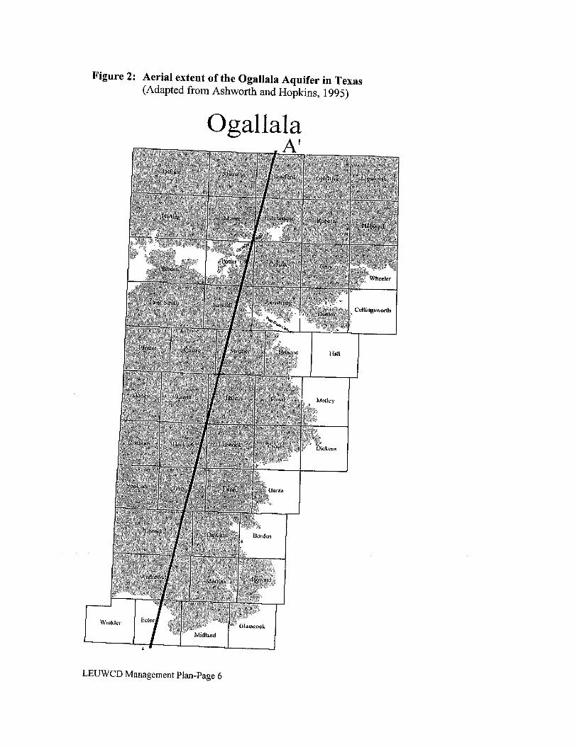
Figure 2: Aerial extent of the Ogallala Aquifer in Texas(Adapted from Ashworth and Hopkins, 1995)
Ogallala
A
LEUWCD Management Plan-Page 6
Dockum Aguifer
The Dockum Aquifer underlies the Cretaceous and Ogallala formations throughout the District.The primary water-bearing zone in the Dockum group, commonly called the “Santa Rosa”,consists of up to 700 feet of sand and conglomerate interbedded with layers of silt and shale(Ashworth and Hopkins, 1995). Aquifer permeability is typically low and well yields normallydo not exceed 300 gal/mm.
Water quality in the Dockum is the main limiting factor when considering its use within theDistrict (Ashworth and Hopkins, 1995). EC values for Dockum groundwater range from 15.0dS/m to over 50.0 d$/m. Even the most salt tolerant row crops grown cannot withstand suchlevels of salinity.
Thus, the only practical use of Dockum groundwater may be for make-up water in secondaryrecovery operations of crude oil. By using water from this aquifer, oil companies could reducetheir use of Ogallala and/or Cretaceous groundwater, thereby relieving some pumpage pressurefrom the freshwater sources.
Surface Water Resources
The only fresh surface water occurring within the District are playa lakes. The playas play animportant role in aquifer recharge and support some wildlife when rainfall events are significantenough to cause runoff to accumulate in these naturally occurring depressions. Playas are rarely,if ever, used to support irrigation activities. As previously mentioned, Cedar Lake and McKenzieLake are naturally occurring salt lakes within the District. Each of these naturally occurringimpoundments support limited wildlife populations, primarily migratory waterfowl andassociated opportunistic predators.
Total Useable Amount of Groundwater
The Texas Water Development Board (TWDB) estimated in 1990 that the total recoverableamount of groundwater underlying Gaines County, Texas, was approximately 13.63 millionacre-feet (Peckham and Ashworth, 1993). The total useable amount of groundwater underlyingthe county in 1990 was, of course, dependent on the category of use because of qualitylimitations. That is, several areas within the county were thought to have had groundwaterquality problems severe enough to preclude its use for any purpose. However, for the purposesof this plan, to meet the requirements of 36.l072(e)(3)(A), Texas Water Code, and until moreaccurate data becomes available, we will assume that all of the groundwater underlying thecounty was useable in 1990 even though we suspect that not to be the case. Table 2 shows anestimation of the volume of groundwater in storage projected to the year 2050 for GainesCounty, Texas. Please note that the information shown should be used only as a guide, andbecomes less and less representative of actual conditions the farther one looks into the future.
LEUWCD Management Plan-Page 7
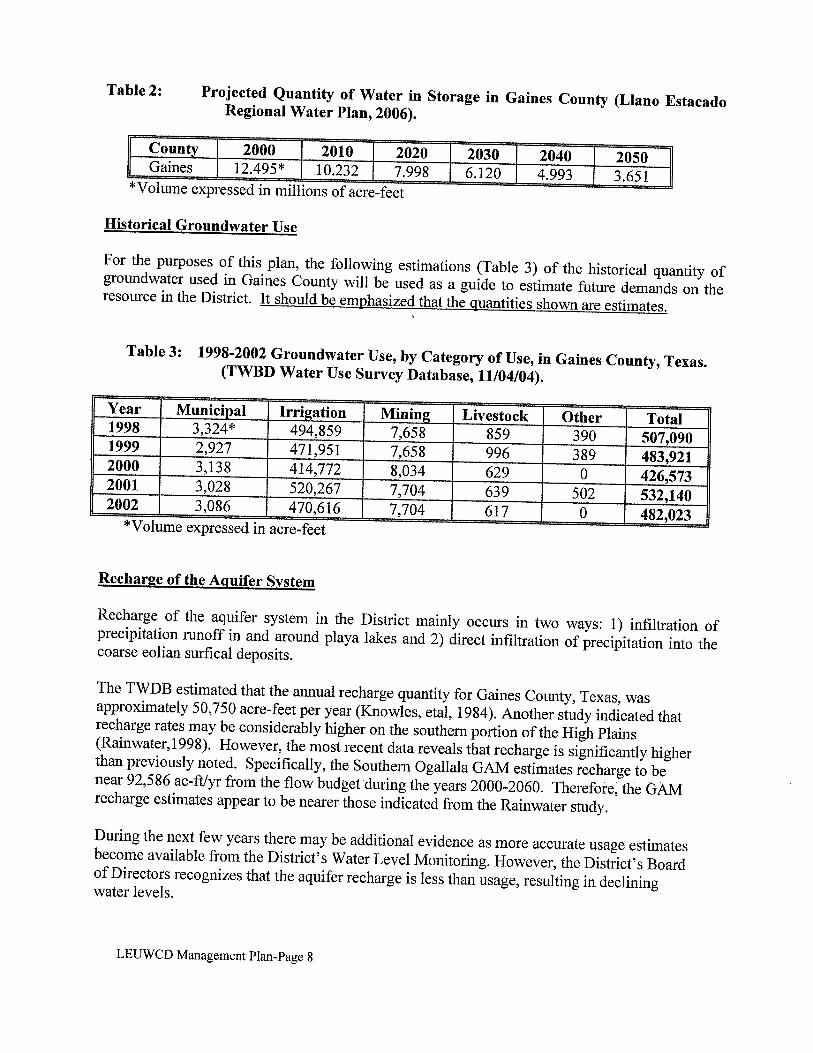
Table 2: Projected Quantity of Water in Storage in Gaines County (Liano EstacadoRegional Water Plan, 2006).
County 2000 2010 2020 2030 2040 2050Gaines 12.495* 10.232 7.99$ 6.120 4.993 3.651*Volmne expressed in millions of acre-feet
Historical Groundwater Use
For the purposes of this plan, the following estimations (Table 3) of the historical quantity ofgroundwater used in Gaines County will be used as a guide to estimate future demands on theresource in the District. It should be emphasized that the quantities shown are estimates.
Table 3: 1998-2002 Groundwater Use, by Category of Use, in Gaines County, Texas.(TWBD Water Use Survey Database, 11/04/04).
Year Municipal Irrigation Mining Livestock Other Total199$ 3,324* 494,859 7,658 $59 390 507,0901999 2,927 471,951 7,658 996 389 483,9212000 3,138 414,772 8,034 629 0 426,5732001 3,028 520,267 7,704 639 502 532,1402002 3,086 470,616 7,704 617 0 482,023*Vo1me expressed in acre-feet
Recharge of the Aquifer System
Recharge of the aquifer system in the District mainly occurs in two ways: 1) infiltration ofprecipitation runoff in and around playa lakes and 2) direct infiltration of precipitation into thecoarse eolian surfical deposits.
The TWDB estimated that the annual recharge quantity for Gaines County, Texas, wasapproximately 50,750 acre-feet per year (Knowles, eta!, 1984). Another study indicated thatrecharge rates may be considerably higher on the southern portion of the High Plains(Rainwater, 1998). However, the most recent data reveals that recharge is significantly higherthan previously noted. Specifically, the Southern Ogallala GAM estimates recharge to benear 92,586 ac-fl/yr from the flow budget during the years 2000-2060. Therefore, the GAMrecharge estimates appear to be nearer those indicated from the Rainwater study.
During the next few years there may be additional evidence as more accurate usage estimatesbecome available from the District’s Water Level Monitoring. However, the District’s Boardof Directors recognizes that the aquifer recharge is less than usage, resulting in decliningwater levels.
LEUWCD Management Plan-Page 8
Projected Groundwater SunDly and Demand
As mentioned earlier, the District’s Board of Directors understands that, currently, the usageof groundwater exceeds recharge and water levels are declining. However, the Board alsorealizes that declining water levels have reduced the ability to produce as much groundwater.Consequently, it is estimated that the projected usage of groundwater is likely to decreaseover time. While the cycle of groundwater usage typically has highs and lows, the trend islikely declining. In fact, some previously irrigated farms have been converted to drylandfarms during recent years.
Table 4: Projected Groundwater Supply and Demand (Source: Adaptedfrom Revised Projected Demands Adopted by Region 0, July 27, 2004, HDREngineering, Inc.).
Year Supply Demand2000 424,778 424,7782010 384,951 384,9512020 364,039 364,0392030 344,232 344,232
During the past year, the Region 0 Planning Group has revisited the irrigation demandestimates. TWDB estimates of on-farm irrigation water use from 1985-2000 were averagedto develop an intercept point for the year 2000. The slope of the curve for water demand isthe same as in the 2001 water plan. Because of expected declining groundwater use, theprojected supply is shown equal to demand. The District’s information on groundwater useand changing water levels support the conclusion that this methodology allows users tomaintain their livelihood while prolonging the available supply.
Management of Groundwater Resources
The District will endeavor to manage groundwater resources over which it has jurisdiction inorder to conserve the resource while seeking to maintain the economic viability of the District’sconstituents. A water level monitoring network has been established in order to track changes inthe total volume of groundwater in storage each year. Likewise, a water quality monitoringnetwork will be established in order to track water quality changes each year. The District willemploy all technical resources at its disposal to monitor and evaluate the groundwater resource.Programs to encourage conservation of groundwater will be designed and implemented as needdictates.
In October 1999, the Board, after notice and hearing, adopted the rules of the District. The rulesaddress conservation of the groundwater resources of the District through: well permitting, wellspacing, well registration, well completion, pumping limitations, open well capping, andstandards for plugging wells. As conditions dictate, and with the approval of the constituents ofthe District, the Board will consider the modification of the rules to further the mission of theDistrict. When considering modification or enforcement of the rules, the Board will base itsdecisions on the best technical evidence available. All constituents will be treated equally andfairly when applying the rules of the District.LEUWCD Management Plan-Page 9
Drought Contingency Plan
Drought is a normal, recurrent feature of climate, although many erroneously consider it arare and random event. Drought is also a temporary aberration, and differs from aridity,which is restricted to low rainfall regions and is a permanent feature of climate (“What isDrought?, National Drought Mitigation Center). The Liano Estacado Underground WaterConservation District is in an arid region that also experiences drought. However, even inthe midst of a drought, rainfall at crucial times of the growing season may significantlyreduce irrigation water demand.
Drought response conservation measures typically used in other regions of Texas (i.e.rationing) cannot and are not used in this region due to extreme economic impact potential.In the District, groundwater conservation is stressed at all times. The Board recognizes thatirrigated agriculture provides the economic stability to the communities within the District.Therefore, through the notice and hearing provisions required in the development andadoption of this management plan, the Board adopts the official position that, in times ofprecipitation shortage, irrigated agricultural producers will not be limited to any less usageof groundwater than is provided for by District rules.
In order to treat all other groundwater user groups fairly and equally, the District willencourage more stringent conservation measures, where practical, but likewise, will notlimit groundwater use in anyway not already provided for by District rules.
Regional Water Planning
The Board of Directors recognizes the regional water plan requirements listed in Ch. 36,TWC, §36.1071. Namely, the District’s management plan must be forwarded to the regionalwater planning group for their consideration in their planning process, and the plan mustaddress water supply needs such that there is no conflict with the approved regional waterplan. It is the Board’s belief that no such conflict exists.
The Board agrees that the regional water plan should include the District’s best data. TheBoard also recognizes that the regional water planning process provides a necessaryoverview of the region’s water supply and needs. However, the Board also believes it is theduty of the District to develop the best and most accurate information concerninggroundwater within the District.
Legislative Activity
The 75th Texas Legislature officially recognized groundwater districts as the preferredmethod of managing groundwater resources (p36.0015, TWC). Since its inception, theDistrict has attempted to communicate with national and state lawmakers to ensure that theproperty rights and other groundwater related interests of its residents are protected. TheBoard will continue to support the District’s participation in the legislative process, to thegreatest extent fiscally possible, to ensure that the interests of the District’s residents arerepresented. The District will attempt to keep the residents informed of legislative activitiesthrough news releases, newsletters and public speaking engagements.
LEUWCD Management Plan-Page 10
Weather Modification
Since 2000, the District has participated in a weather modification program. Beginning2002, the district is a participant in the Southern Ogallala Aquifer Rainfall Enhancement(SOAR) program, which is administered by the Sandy Land UWCD. Currently, the programcontains three groundwater conservation districts: South Plains UWCD, Sandy LandUWCD and the Liano Estacado UWCD.
The Llano Estacado UWCD Board of Directors believes that weather modification is amanagement tool that can help relieve some pressure from our groundwater resources.Rainfall at crucial points of the growing season may mean significantly less groundwaterused for irrigation. Additionally, the Board hopes that the benefits of convective cloudseeding will contribute to enhanced recharge of the groundwater resources.
The Board understands that State funding for weather modification has been cut and hopesthat local funding remains sufficient for continued participation.
GoaIs Management Objectives and Performance Standards
Method for Tracking the District’s Progress in Achieving Management Goals
The District Manager will prepare an annual report of the District’s performance with regard toachieving management goals and objectives. The report will be prepared in a format that will bereflective of the performance standards listed following each management objective. The reportwill be presented to the Board within 60 days of the end of each fiscal year. The report will bemaintained on file in the open records of the District.
The District will actively enforce all rules of the District in order to conserve, preserve, protectand prevent the waste of the groundwater resources over which the District has jurisdictionalauthority. The Board will periodically review the District’s rules, and will modify the rules, withpublic approval, in order to more adequately manage the groundwater resources within theDistrict and to carry out the duties prescribed in Chapter 36, Texas Water Code.
Goal 1.0 Implement management strategies that will protect and enhance the quantityof useable quality groundwater by encouraging the most efficient use.
Management Objective-Water Level Monitoring1.01 Annually, measure the depth to water in 80% or more of the wells in the District’s
water level monitoring network; record all measurements andlor observations;enter all measurements into District’s computer data base; file all field notes inDistrict’s filing system; maintain a network of measurement wells of 172 or morewells.
Performance Standards1.Ola Percent of water level monitoring wells for which measurements were
recorded each yearLEUWCD Management Plan-Page Ii

1.Olb Percent of water level monitoring wells for which field notes were writtendescribing reason for inability to attain measurements each year
1.Olc Number of data records entered into District’s data base each year1.Old Number of water level measurement wells for which field notes are filed in
District’s filing system each year1.Ole Number of wells in the water level measurement network each year1.Olf Number of wells added to the network, if required, each year
Management Objective-Technical Field Services1.02 On an annual basis, at the request of the constituents of the District, provide
technical field services including, but not limited to: flow testing, draw downmeasurement, sprinkler pattern efficiency testing, and water managementstrategy consultation. District staff will attempt to fulfill 80% of the requests.Record any observations, measurements, etc. in field log. Enter recordedinformation in District’s computer data base.
Performance Standards1.02a Percent of field service requests fulfilled, as evidenced by field log, each year1.02b Number of records entered into District’s computer data base each year
Management Objective-Research and Demonstrations1.03 Considering the District’s fiscal resources, participate when practical in
opportunities to conduct research or perform demonstrations of methods toprotect and enhance the quantity of useable quality groundwater in the Districton an annual basis. Record the opportunities to participate and reasons theDistrict did or did not participate in these activities, file notes in the District’sfiling system.
Performance Standards1.03a Percentage of research and demonstration project opportunities in which the
District participates each year1.03b Number of records indicating opportunities to participate each year
Management Objective-Center Pivot Inventories1.04 Beginning in 2002, and again every three years thereafter, perform a physical
inventory of the number and type of all irrigation systems in the District.Note which center pivot irrigation systems have Low Energy PrecisionApplication (LEPA) spaced nozzles as a measure of adoption of moreefficient irrigation technology. Enter data in District’s data base file by blockand section.
Performance Standards1.04a Number of irrigation systems recorded each documenting period1.04b Percentage of center pivot irrigation systems with LEPA spaced nozzles each
documenting period1 .04c Number of data entries into District’s data base each documenting period
LEUWCD Management Plan-Page 12
Management Objective—Laboratory Services1.05 On an annual basis, at the request of the constituents of the District,
provide basic water quality testing service to those requesting the service.Maintain a record of all tests performed by entering the results of all testsin the District’s computer database. Communicate results to constituentsrequesting tests.
Performance Standards1.05a Number of laboratory service requests fulfilled each year1.05b Number of records entered into District’s computer database each year1 .05c Number of results communicated to constituents requesting tests each year
Goal 2.0 Implement management strategies that will protect and enhance the quantity ofusable quality groundwater by controlling and preventing waste.
Management Objective-Well Permitting and Well Completion2.01 On an annual basis, at the request of the constituents of the District, issue
temporary water well drilling permits for the drilling and completion of non-exempt water wells in the District within 20 days of application. Inspect allwell sites to be assured that the District’s completion and spacing standardsare met. Send written notification to the well owner if the well fails to meetstandards within 30 days of inspection. The Board will vote on final approvalof the permit at the next regularly scheduled meeting after the well site hasbeen inspected and District well completion standards have been met.
Performance Standards2.Ola Average number of days taken to issue drilling permit after request each year2.Olb Number of water well drilling permits issued each year2.01 c Number of well sites inspected after well completion each year2.Old Number of well sites that fail to meet the standards of the District each year2.Ole Average number of days taken to mail notification letters each year
Management Objective-Open or Uncovered Wells2.02 Annually, the District will inspect all sites reported of open or uncovered
wells to substantiate or refute that an open or uncovered well exists. If anopen or uncovered well is found, the District will insure that the open hole isproperly closed according to District rules and, in so doing, prevent potentialcontamination of the groundwater resource. The reports shall be filed onforms provided by the District in order to track the progress of the closureprocess. The District will contact the party responsible for the open oruncovered well within 30 days of same being reported. The site will beinspected after notification to ensure the well closure process occurs within 60days of the initial contact with the responsible party. If the well is not closedby the end of the 60 day period, the District will close the well in accordancewith the District rules.
LEUWCD Management Plan-Page 13
Performance Standards2.02a Number of open or uncovered wells reported to the District each year2.02b Number of initial inspections accomplished each year2.02c Average number of days required to make initial contact with responsible
party each year2.02d Average number of days required to complete closure of open or uncovered
wells each year2.02e Percentage of wells remaining open or uncovered after 60 day period that are
closed in accordance with District rules each year
Management Objective-Maximum Allowable Production2.03 Annually, the District will investigate all reports filed by District constituents,
on fonns provided by the District, regarding pumpage of groundwater inexcess of the maximum production allowable under the District’s rules.Investigation of each occurrence shall occur within 30 days of receiving thereport. Each case will be remedied in accordance with District rules.
Performance Standards2.03a Percent of reports investigated each year2.03b Average amount of time taken to investigate reports each year2.03c Percent of incidences where violations occurred and violators were required to
change operations to be in compliance with District rules each year
Management Objective-Water Quality Monitoring2.04 Annually, District staff will obtain water quality samples from 100 or more
irrigation wells for analysis of total salts and total chlorides, in order to trackwater quality changes in the District, and will resample 90% of the wellssampled the previous year. The results of the tests will be published in mapform, entered in to the District’s computer data base, and will be madeavailable to the public.
Performance Standards2.04a Number of samples collected and analyzed each year2.04b Percent of previously sampled wells that were sampled in the current testing
year.2.04c Number of maps made available to the public each year2.04d Number of analyses entered into District’s computer data base each year
Goal 3.0 Implement management strategies that will provide public education andinformation opportunities that will assist in the accomplishment of Goals 1.0and 2.0.
LEUWCD Management Plan-Page 14
Management Objective-Newsletter3.01 Annually, the District will produce a minimum of four newsletter editions.
Newsletters will be distributed to District constituents and other interestedparties. At a minimum, two articles per year will be included that addressmethods of enhancing and protecting the quantity of useable qualitygroundwater within the District.
Performance Standards3.Ola Number of newsletter editions published each year3.Olb Number of newsletters distributed each year3.Olc Number of articles that address methods of enhancing and protecting the
quantity of useable quality groundwater each year
Management Objective-News Releases3.02 Annually, District staff in conjunction with local newspaper publishers will
prepare a minimum of four news releases, for publication in local newspapers,detailing methods of protecting and enhancing the quantity of useable qualitygroundwater within the District.
Performance Standard3.02 Number of news releases prepared, for publication in local newspapers,
detailing methods of protecting and enhancing the quantity of useable qualitygroundwater within the District each year.
Management Objective-Public Speaking Engagements3.03 Annually, District staff andIor directors shall present a minimum of four
programs that address methods to protect and enhance the quantity of useablequality groundwater in the District.
Performance Standard3.03 Number of programs that address methods to protect and enhance the quantity
of useable quality groundwater in the District presented each year
Management Objective-Printed Material Resource Center and Technical File3.04 Annually, maintain a self-service printed material resource center in the
District office. Annually inventory items in the center for quantity andcurrentness. Through the inventory process, determine the number and typeof materials procured from the center by the public each year. Maintain atechnical filing system of resource materials and annually record the numberof copies procured from the technical file by the public.
Performance Standards3.04a Number of items by type procured by the public from the resource center each
year3.04b Number of items copied and given to the public from the technical file each
year
LEUWCD Management Plan-Page 15
Management Objective—Classroom Education3.05 Annually, the District will sponsor the “Major Rivers” (or similar) water
conservation education curriculum, for all 4th grade schools within theDistrict. Annually, the District will sponsor water conservation educationbook covers for all public schools within the District.
Performance Standards3.05a Number of 4i grade schools where “Major Rivers” (or similar)
curriculums are distributed each year3.05b Number of book covers distributed to each school each year
Goal 4.0 Implement strategies that provide the District’s residents information on thestatus of drought conditions
Management Objective—Rain Gauges4.01 Maintain a network of rain gauges in the District. Publish monthly and
yearly rainfall totals in the local newspaper
Performance Standards4.Ola Number of rain gauges in the network4.Olb Number of monthly rain gauge readings
Goal 5.0 Implement management strategies that educate the District’s residents ofwater conservation techniques and provide information on the remainingamount of uscable quality groundwater
Management Objective—Saturated Thickness Maps5.01 Every 5 years, beginning 2005, provide saturated thickness maps that
show the varying thickness of groundwater remaining in storage. Publishthe saturated thickness maps in the local newspaper
Performance Standards5.01 Number of saturated thickness maps displayed and/or printed at the
District office
Management Objective—Conservation Literature5.02 Maintain a portion of the District’s material resource center devoted to
water conservation. Stock this portion with conservation tips for bothhome water conservation and farm conservation
Performance Standards5.02a Number of brochures/periodicals dedicated to conservation5.02b Number of conservation brochures/periodicals obtained by the public
LEUWCD Management Plan-Page 16
Goals not Applicable
The following goals referenced in Chapter 36, Texas Water Code, have been determined notapplicable to the District;§ 36.1071(a)(3) Controlling and preventing subsidence§ 36.1071 (a)(4) Addressing conjunctive surface water management issues§ 36.1071(a)(5) Addressing natural resource issues
LEUWCD Management Plan-Page 17
References
Ashworth, J. B. and Hopkins, 1., 1995, Aquifers of Texas: Texas Water Development BoardReport 345, 69 p.
HDR Engineering, Inc., 2006, Liano Estacado Regional Water Planning Area, Table 3-1, 3-7 p.
HDR Engineering, Inc., 2004, Projected Region 0 GAM Run (version 1) (8-12-04) No. 3 xis;GAMRun 04-07.doc
Knowles, T., Nordstrom, P. L., and Klemt, W. B., 1984 Evaluating the Groundwater Resourcesof the High Plains of Texas: Texas Department of Water Resources Report 28$, 4 vol.
Peckham, D. S. and Ashworth, J. B., 1993, The High Plains Aquifer System of Texas, 1980 to1990 Overview and Projections: Texas Water Development Board Report 341, 34 p.
Rainwater, K., 1998, Personal Communication, Texas Tech University, Lubbock, Texas
Texas Water Development Board; Estimated Groundwater Use (acre feet) Liano EstacadoUnderground Water Conservation District, Gaines County; TW3D Water Use Survey Database,11/04/04.
Wilhite, Dr. Donald A, Director, “What is Drought?”, 2003 World Wide Web, NationalDrought Mitigation Center, University of Nebraska.
LEUWCD Management Plan-Page 1$
LLANO ESTA CAD0 UNDERGR0UNDWA TER CONSER VA TIONDISTRICT
101 S. Main, Room B2, Gaines County Courthouse, Seminole, TX 79360 * 432-758-1127
Management Plan2005-2010
WHEREAS, the Liano Estacado Underground Water Conservation District (the District)was created on May 24, 1991, by authority of HB 530 of the 72id Texas legislature; and
WhEREAS, the registered voters of the District confirmed the District’s creation inNovember, 1992; and
WHEREAS, the District to adopted a Management Plan effective April 14, 2000 asrequired by SB 1 75th Texas Legislature;
WHEREAS, the current Management Plan is required by Chapter 3 6.1072, Texas WaterCode, to be renewed every five years;
WHEREAS, the Board of Directors of the District have determined that a revision of theexisting Management Plan is warranted; and
WHEREAS, the Board of Directors of the District have determined that the revisedManagement Plan adequately addresses the requirements of Chapter 36.1071, Texas WaterCode; and
WHEREAS, the revised Management Plan shall become effective on July 21, 2005,upon adoption by the Board of Directors of the District and shall remain the effect until July 21,2010 or until a revised Plan is adopted, whichever occurs first, therefore be it
RESOLVED, that the Board Of Directors of the Liano Estacado Underground WaterConservation District hereby adopt the revised Management Plan; and further
RESOLVE that this revised Management Plan shall become effective on July 21, 2005.
Adopted this 21th day of July 2005, by the Board of Directors of the Liano EstacadoUnderground Water Conservation District.
Shelby Elam, Predent udson Chevuront, Vice-President
ABSENT2 -
Walter Billings, Secretary Delmon Ellison r. MembeY
Alton Bi lings, Meir
STATE Of TEXASCOUI’JTY OF GAINES
This instrument was acknowledged before me on the 21st . day of July 2005.
‘No,y Public, State of Texas
,mL2O7 Lori Barnes
I Notary’s Name Printed:

LLANO ESTACADO UNDERGROUNDWATER CONSERVATION DISTRICT
AGENDA FOR REGULAR BOARD MEETINGJuly 21, 2005
10:00 A.M.
1. Call to order
2. Invocation
3. Consider for approval Minutes of June 9, 2005, Regular Board Meeting
4. Consider for approval Financial Report for period ending June 30, 2005
5. Public forum
6. The Board will recess
7. The Board will convene a Public Hearing for the presentation of and comment on theDistrict’s Management Plan
8. The Board will close the Public Hearing
9. The Board will reconvene
10. Discussion and possible action regarding the District’s Management Plan
11. Discussion and possible action regarding review of Bids on District Truck
12. Consider for approval Well Permits for June
13. Monthly Reports
(a) Paid bills(b) Permits(c) Non Refundable(d) Region “0” Report(e) Manager Report
14. Any other items pertinent to District Business
15. Adjourn
NOTICE OF PUBLIC HEARING
The Board of Directors of the Liano Estacado Underground Water Conservation District(LEUWCD) will conduct a public hearing, Rule 16,1(b) (1), during the scheduledmeeting on Thursday, July 21, 2005, 10:00 a.m. at its office, in the Gaines CountyCourthouse room B-2, located at 101 S. Main, Seminole, Texas to receive publictestimony on the amended LEUWCD Management Plan as per Chapter 36.1071, TexasWater Code, according to the following agenda.
1. Convene Public Hearing
2. Presentation of proposed LEUWCD Management Plan
3. Public testimony on proposed LEUWCD Management Plan
4. Adjournment of Public Hearing
Interested persons are invited to attend. This notice is published in accordance withChapter 36.1071(g), Texas Water Code.
PA
GE
8,S
emin
ole
(Tex
as)
Sen
tine
l,S
unda
y,Ju
ly10
,20
05
RE
QU
EST
FOR
PR
OP
OS
AL
Sem
inol
eIS
DD
epar
tmen
tof
food
Serv
ices
will
beac
cept
ing
prop
osal
son
Bre
ad/B
aker
yPr
oduc
ts.
Pro
posa
lfo
rms
and
spec
ific
atio
nsca
nbe
obta
ined
from
the
Foo
dSe
rvic
eD
epar
tmen
t.A
llpr
opos
als
mus
tbe
deli
vere
dto
the
addr
ess
liste
dbe
low
by9:
00a.
m.,
July
29,
2005
.A
llpr
opos
als
mus
tbe
deli
vere
din
seal
eden
velo
pes
iden
tifyi
ngth
epr
opos
alite
inan
dnu
mbe
r.S
emin
ole
ISD
rese
rves
the
righ
tto
acce
ptor
reje
ctan
yor
all
prop
osal
s.L
inda
Wri
ght,
Dir
ecto
rfo
od
Serv
ices
Sem
inol
eIS
D20
7SW
6th
Str
eet
Sem
inol
e,TX
7936
043
2-75
8-36
62Pu
blis
hed
inT
heS
emin
ole
Sent
inel
onJu
ly3
and
10,
2005
.
Est
ate
ofH
AR
OL
DJA
ME
SST
OC
KT
ON
,D
ecea
sed
do
Ster
ling
Har
mon
P0
Box
1974
Sem
inol
e,T
exas
7936
0Al
lpe
rson
sha
ving
clai
ms
agai
nst
this
Est
ate
whi
chis
cur
rent
lybe
ing
adm
inis
tere
dar
ere
quir
edto
pres
ent
them
with
inth
etim
ean
din
the
man
ner
pre
scri
bed
byla
w.
Dat
edth
is5t
hda
yof
July
,20
05.
Bar
bara
Woo
dby
:St
erlin
gH
arm
on,
Atto
rney
for
App
lican
tPu
blis
hed
inT
heSe
min
ole
Sen
tine
lon
July
10,
2005
NO
TIC
EO
FPU
BL
ICH
EA
RIN
G The
Boa
rdof
Dir
ecto
rsof
the
Lla
noE
stac
ado
Und
ergr
ound
Wat
erC
onse
rvat
ion
Dis
tric
t(L
EU
WC
D)
will
cond
uct
apu
blic
hear
ing,
Rul
e16
J(b)
(1),
dur
ing
the
sche
dule
dm
eetin
gon
Thu
rsda
y,Ju
ly21
,20
05,
10:0
0a.
m.
atits
offic
e,in
the
Gai
nes
Coun
Cou
rtho
use
Roo
m3-
2,lo
cate
dat
101
S.M
ain,
Sem
i-
nole
,T
exas
tore
ceiv
epu
blic
test
im
ony
onth
eam
ende
dL
EU
WC
DM
anag
emen
tPl
anas
per
Cha
pter
36.1
071,
Tex
asW
ater
Cod
e,ac
cord
ing
toth
efo
llow
ing
agen
da.
1.C
onve
nePu
blic
Hea
ring
2.P
rese
ntat
ion
ofpr
opos
edL
EU
WC
DM
anag
emen
tPl
an3.
Publ
icte
stim
ony
onpr
opos
edL
EU
WC
DM
anag
emen
tPl
an4.
Adj
ourn
men
tof
Publ
icH
ear
ing
Inte
rest
edpe
rson
sar
ein
vite
dto
atte
nd,
Thi
sno
tice
ispu
blis
hed
inac
cord
ance
with
Cha
pter
36.1
071(
g),
Tex
asW
ater
Cod
e.
Aut
o20
03SI
ER
RA
pick
up,
whi
te,
chro
me
tires
,lo
wm
ileag
e,to
olbo
x,go
odco
nditi
on,,
Xlvi
sate
llite
radi
o.95
5-02
26as
kfo
rD
oug.
6122
-7/1
7
2004
TA
HO
E,
blac
k,lo
wm
ile
age,
siru
ssa
telli
tera
dio,
load
ed.
955-
0226
ask
for
Dou
g.6/
22-7
/17
FOR
SALE
,Li
kene
w20
01z7
1of
fro
adC
hevy
Silv
erad
oLT
,ex
tend
edca
bpi
ckup
,le
athe
r,fu
llylo
aded
,4-
whe
eldr
ive.
432-
758-
2065
.
iiT
heS
enti
,
CI_A
SSIH
I,L
egal
s
RE
QU
EST
FOR
PR
OP
OS
AL
Sem
inol
eIS
DD
epar
tmen
tof
Food
Serv
ices
will
beac
cept
ing
Per
mia
nR
egio
nalM
edic
alin
gap
plic
atio
nsfo
rth
efo $
$75
GA
S IR
EG
IST
ER
ED
NU
RS
IL
ICE
NS
ED
VO
CA
TIO
*1.
5%pe
rye
ars
of*1
5%ev
enin
gsh
ift*
20%
nigh
tshi
ftdi
f*
20%
wee
kend
shil
App
lyw
ithH
uma
Act
ivit
yC
oord
inat
or-
I
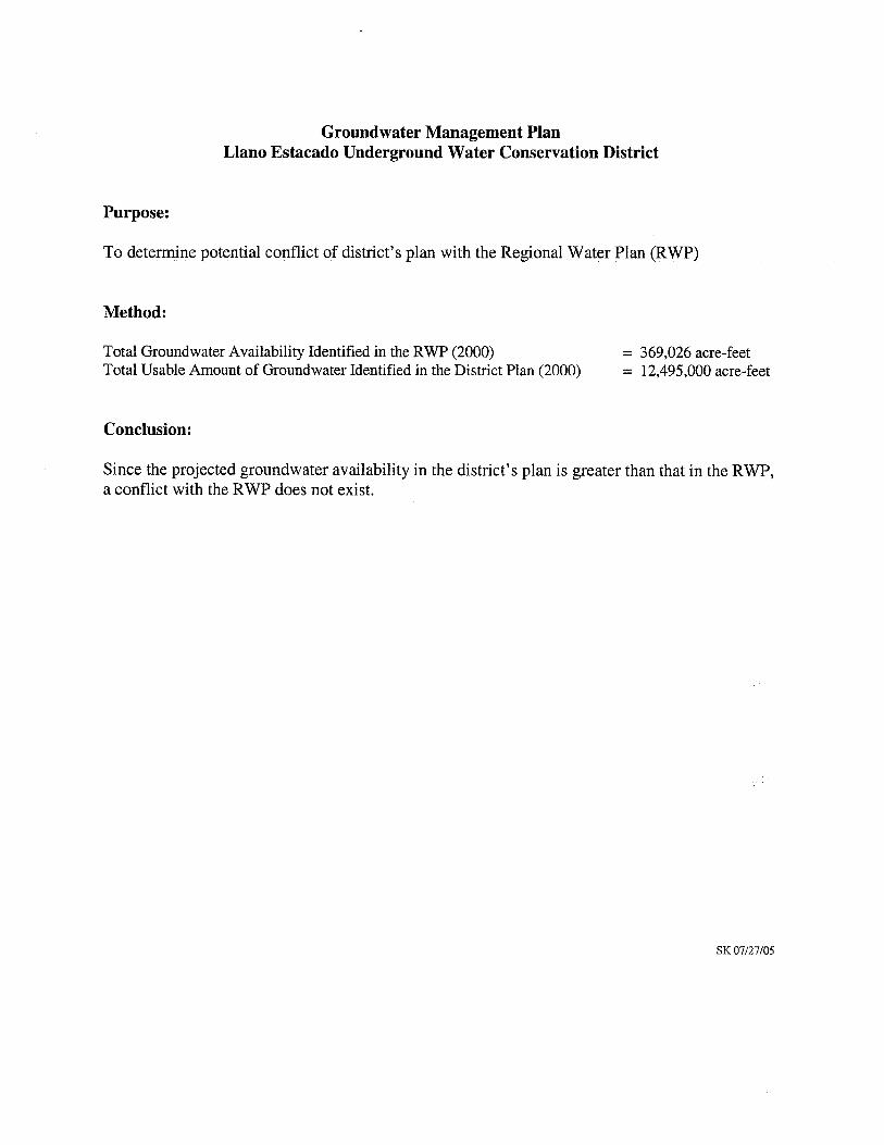
Groundwater Management PlanLiano Estacado Underground Water Conservation District
Purpose:
To determine potential conflict of district’s plan with the Regional Water Plan (RWP)
Method:
Total Groundwater Availability Identified in the RWP (2000) = 369,026 acre-feetTotal Usable Amount of Groundwater Identified in the District Plan (2000) = 12,495,000 acre-feet
Conclusion:
Since the projected groundwater availability in the district’s plan is greater than that in the RWP,a conflict with the RWP does not exist.
SK 07/27/05
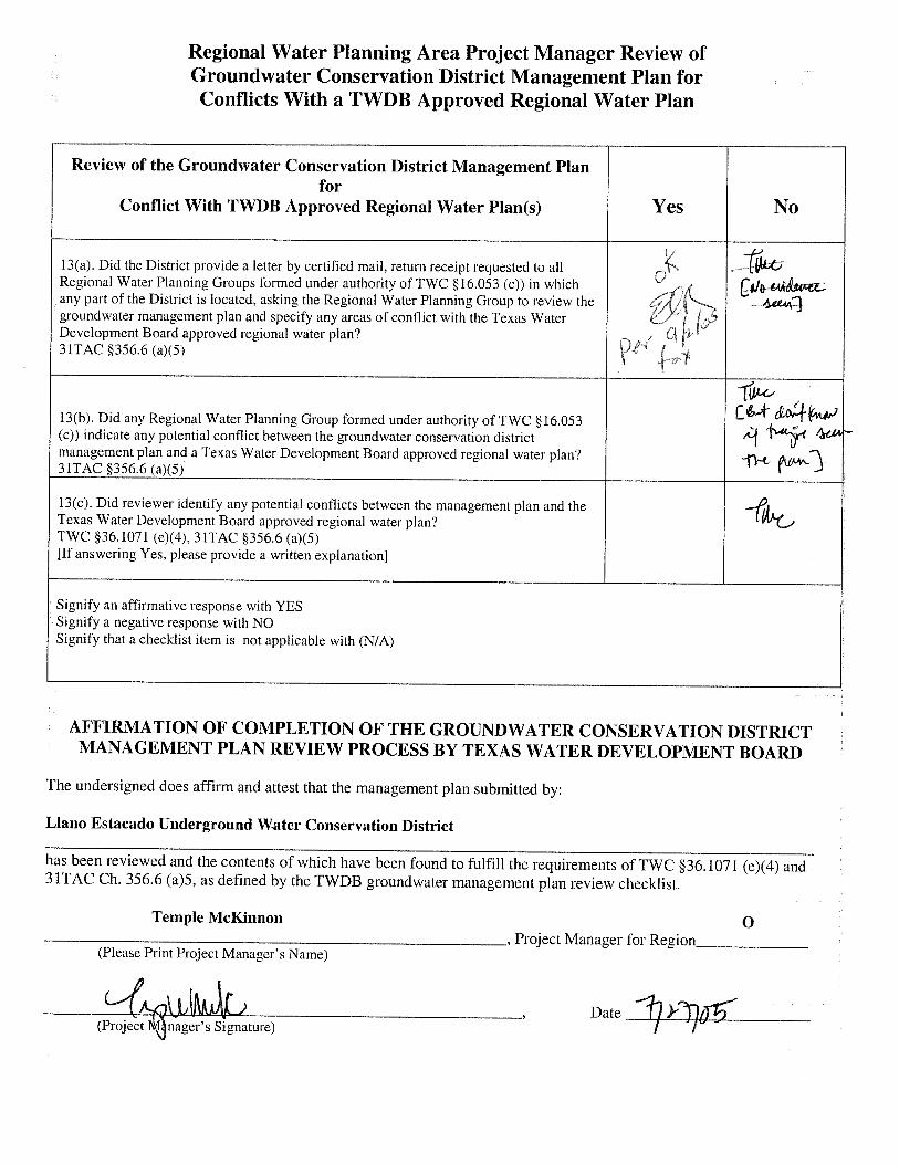
Regional Water Planning Area Project Manager Review ofGroundwater Conservation District Management Plan forConflicts With a TWDB Approved Regional Water Plan
Review of the Groundwater Conservation District Management Planfor
Conflict With TWDB Approved Regional Water Plan(s) Yes No
13(a). Did the District provide a letter by certified mail, return receipt requested to allRegional Water Planning Groups formed under authority of TWC §16.053 (c)) in which
‘
any part of the District is located, asking the Regional Water Planning Group to review thegroundwater management plan and specify any areas of conflict with the Texas Water (5
Development Board approved regional water plan?3YTAC §356.6 (a)(5) I
1’w-c-13(b). Did any Regional Water Planning Group formed under authority of TWC §16.053 :-t OI)
(c)) indicate any potential conflict between the groundwater conservation district A4management plan and a Texas Water Development Board approved regional water plan? ..j- -“j31TAC §356.6 (a)(5)
13(c). Did reviewer identify any potential conflicts between the management plan and the —
Texas Water Development Board approved regional water plan? I,vt_,
TWC §36. 1071 (e)(4), 31TAC §356,6 (a)(5)[If answering Yes, please provide a written explanation]
Signify an affirmative response with YESSignify a negative response with NOSignify that a checklist item is not applicable with (N/A)
AFFIRMATION OF COMPLETION OF THE GROUNDWATER CONSERVATION DISTRICTMANAGEMENT PLAN REVIEW PROCESS BY TEXAS WATER DEVELOPMENT BOARD
The undersigned does affirm and attest that the management plan submitted by:
Liano Estacado Underground Water Conservation District
has been reviewed and the contents of which have been found to fulfill the requirements of TWC §36.1071 (e)(4) and3 1TAC Ch. 356.6 (a)5, as defined by the TWDB groundwater management plan review checklist.
Temple McKinnon 0Project Manager for Region
(Please Print Project Manager’s Name)
__________________
Date______(Project nager’s Signature)