Lithostratigraphy of the Upper Cretaceous Series in a part of the Krayshte area (Southwest Bulgaria)
14
69 GEOLOGICA BALCANICA, 36. 3—4, Sofia, Decemb. 2007, p. 69—80. Lithostratigraphy of the Upper Cretaceous Series in a part of the Krayshte area (Southwest Bulgaria) Marin Ivanov 1 , Kristalina Stoykova 2 , Ivan Zagorchev 2 , Emil Goranov 3 1 Sofia University “St. Kliment Ohridsky”, 1000 Sofia, 15 Tsar Osvoboditel Blvd.; E-mail: [email protected] 2 Geological Institute Bulgarian Academy of Sciences, 1113 Sofia, 24 G. Bonchev Str.; E-mail: [email protected]; [email protected] 3 Ministry of Environment and Water, 1000 Sofia, 22 Maria Louisa Blvd. (Submitted: 10. 09. 2007; accepted for publication: 16.11.2007) Ì. Èâàíîâ, Ê. Ñòîéêîâà, È. Çàãîð÷åâ, Å. Ãîðàíîâ — Ëèòîñòðàòèãðàôèÿ âåðõíåìåëîâîé ñåðèè â ÷àñòè Êðàèøòåíñêîé îáëàñòè (Þãî-Çàïàäíàÿ Áîëãàðèÿ). Óñòàíîâëåíî, ÷òî âåð- õíåìåëîâûå îñàäî÷íûå ïîðîäû â îáëàñòè Êðàèøòå ðàñïðîñòðàíåíû ãîðàçäî øèðå, ÷åì ñ÷èòàëîñü äî ñèõ ïîð. Èõ âîçðàñò îïðåäåëåí ïî èçâåñòêîâûì íàíîôîññèëèÿì, êîòîðûå äîêàçàëè ïðèíàäëåæíîñòü ïîðîä ê ðàçíûì îòäåëàì êàìïàíñêîãî ÿðóñà. Ïðèâåäåíà õàðàêòåðèñòèêà ÷åòûðåõ íîâûõ îôèöèàëüíûõ ëèòîñòðàòèãðàôè÷åñêèõ åäè- íèö. Ãîðíîêîçíèöñêàÿ ñâèòà ïðåäñòàâëåíà ãðóáûìè ñèëèêîêëàñòè÷åñêèìè ïîðîäàìè. Åå âåðîÿòíûé âîçðàñò — ðàííåêàìïàíñêèé. Ãîðíîãàáðåøåâñêàÿ ñâèòà ñëîæåíà ðèòìè÷åñêèìè òóðáèäèòàìè ðàííå-ïîçäíåêàìïàíñêîãî âîçðàñòà.  Óãëÿðñêîé ñâèòå ïðåîáëàäàþò òîíêî- çåðíèñòûå ïîðîäû: ìåðãåëè, òîíêîëàìèíèðîâàííûå ãëèíèñòûå ñëàíöû è ãëèíèñòûå èçâåñò- íÿêè. Èõ âîçðàñò òîæå êàìïàíñêèé. Âñå òðè ïåðå÷èñëåííûå ñâèòû øèðîêî ïðåäñòàâëåíû â èññëåäîâàííîé îáëàñòè. ×åòâåðòàÿ (Øàáàíèöñêàÿ) ñâèòà ðàçâèòà îãðàíè÷åíî â åå âîñòî÷íîé ÷àñòè. Îíà ñëîæåíà íåëèòèôèöèðîâàííûìè ñèëèêîêëàñòè÷åñêèìè è ñìåøàíûìè ãèïî-ïî- ðîäàìè, â òîì ÷èñëå è íåìîðñêèìè îòëîæåíèÿìè: îíêîèäíûìè èçâåñòíÿêàìè è ñòðîìàòî- ëèòîâûìè îáðàçîâàíèÿìè ïîçäíåêàìïàíñêîãî âîçðàñòà. Íàêîïëåíèå âåðõíåìåëîâûõ îñàäî÷íûõ ïîðîä ïðîèñõîäèëî ïî âñåé âåðîÿòíîñòè â òåê- òîíè÷åñêè îáóñëîâëåííîì àññèìåòðè÷åñêîì áàññåéíå (áàññåéí Áàáóøíèöà — Ôó÷à — Zagorchev et al., 2006).  åãî âîñòî÷íîé ÷àñòè øëî îòëîæåíèå î÷åíü ðàçíîîáðàçíûõ ïîðîä. Ñåâåðíàÿ îêðàèíà áàññåéíà ïåðåêðûòà òðàíñãðåññèâíî ãðóáîêëàñòè÷åñêèìè ïîñëåäîâàòåëü- íîñòÿìè. Íà íèõ çàëåãàþò ïðåèìóùåñòâåííî ìîðñêèå îòëîæåíèÿ, êîòîðûå â çàïàäíîì íà- ïðàâëåíèè ïîñòåïåííî çàìåùàþòñÿ ìåðãåëüíûìè è êàðáîíàòíûìè ïîðîäàìè, âèäèìî ïå- ðåõîäÿùèìè ê ñåâåðó â èçâåñòíÿêîâóþ ïîñëåäîâàòåëüíîñòü, òèïè÷íóþ äëÿ çàïàäíûõ ÷àñòåé âåðõíåìåëîâîãî áàññåéíà íà òåððèòîðèè Ñåðáèè. Abstract. The Upper Cretaceous sediments in Krayshte area are reported to have a wider distri- bution than previously considered. They are dated using calcareous nannofossils, proving the presence of different parts of the Campanian Stage. Four new formal lithostratigraphic units are introduced and characterized. The Gorna Koznitsa Formation consists of coarse siliciclastic rocks and is probably of Early Campanian Age. The Gorno Gabreshevo Fm. is represented by rhythmic turbidites of Early to Late Campanian Age. The Uglyartsi Fm. is dominated by fine grained sediments — marls, finely laminated claystones and clayey limestones. Its age is Campanian, too. These three units are widespread in the area. The last unit, Shabanitsa Fm., is locally developed in the eastern part of the area. It is built up by loose siliciclastic and mixed hypo-rocks, including non-marine sediments — oncoid limestones and stromatolites of Late Campanian Age. The Upper Cretaceous sediments were deposited most probably in a tectonically controlled asymmetric basin (Babushnitsa-Fucha basin — Zagorchev et al., 2006). The sediments in the eastern parts of the basin exhibit the greatest variety. The coarse clastic sequences cover trans- gressively over the northern board of the basin, and are covered by predominantly marly depos-
Transcript of Lithostratigraphy of the Upper Cretaceous Series in a part of the Krayshte area (Southwest Bulgaria)
69
GEOLOGICA BALCANICA, 36. 3—4, Sofia, Decemb. 2007, p. 69—80.
Lithostratigraphy of the Upper Cretaceous Seriesin a part of the Krayshte area (Southwest Bulgaria)
Marin Ivanov1, Kristalina Stoykova2, Ivan Zagorchev2, Emil Goranov3
1 Sofia University “St. Kliment Ohridsky”, 1000 Sofia, 15 Tsar Osvoboditel Blvd.;E-mail: [email protected] Geological Institute Bulgarian Academy of Sciences, 1113 Sofia, 24 G. Bonchev Str.;E-mail: [email protected]; [email protected] Ministry of Environment and Water, 1000 Sofia, 22 Maria Louisa Blvd.
(Submitted: 10. 09. 2007; accepted for publication: 16.11.2007)
Ì. Èâàíîâ, Ê. Ñòîéêîâà, È. Çàãîð÷åâ, Å. Ãîðàíîâ — Ëèòîñòðàòèãðàôèÿ âåðõíåìåëîâîéñåðèè â ÷àñòè Êðàèøòåíñêîé îáëàñòè (Þãî-Çàïàäíàÿ Áîëãàðèÿ). Óñòàíîâëåíî, ÷òî âåð-õíåìåëîâûå îñàäî÷íûå ïîðîäû â îáëàñòè Êðàèøòå ðàñïðîñòðàíåíû ãîðàçäî øèðå, ÷åìñ÷èòàëîñü äî ñèõ ïîð. Èõ âîçðàñò îïðåäåëåí ïî èçâåñòêîâûì íàíîôîññèëèÿì, êîòîðûåäîêàçàëè ïðèíàäëåæíîñòü ïîðîä ê ðàçíûì îòäåëàì êàìïàíñêîãî ÿðóñà.
Ïðèâåäåíà õàðàêòåðèñòèêà ÷åòûðåõ íîâûõ îôèöèàëüíûõ ëèòîñòðàòèãðàôè÷åñêèõ åäè-íèö. Ãîðíîêîçíèöñêàÿ ñâèòà ïðåäñòàâëåíà ãðóáûìè ñèëèêîêëàñòè÷åñêèìè ïîðîäàìè. Ååâåðîÿòíûé âîçðàñò — ðàííåêàìïàíñêèé. Ãîðíîãàáðåøåâñêàÿ ñâèòà ñëîæåíà ðèòìè÷åñêèìèòóðáèäèòàìè ðàííå-ïîçäíåêàìïàíñêîãî âîçðàñòà.  Óãëÿðñêîé ñâèòå ïðåîáëàäàþò òîíêî-çåðíèñòûå ïîðîäû: ìåðãåëè, òîíêîëàìèíèðîâàííûå ãëèíèñòûå ñëàíöû è ãëèíèñòûå èçâåñò-íÿêè. Èõ âîçðàñò òîæå êàìïàíñêèé. Âñå òðè ïåðå÷èñëåííûå ñâèòû øèðîêî ïðåäñòàâëåíû âèññëåäîâàííîé îáëàñòè. ×åòâåðòàÿ (Øàáàíèöñêàÿ) ñâèòà ðàçâèòà îãðàíè÷åíî â åå âîñòî÷íîé÷àñòè. Îíà ñëîæåíà íåëèòèôèöèðîâàííûìè ñèëèêîêëàñòè÷åñêèìè è ñìåøàíûìè ãèïî-ïî-ðîäàìè, â òîì ÷èñëå è íåìîðñêèìè îòëîæåíèÿìè: îíêîèäíûìè èçâåñòíÿêàìè è ñòðîìàòî-ëèòîâûìè îáðàçîâàíèÿìè ïîçäíåêàìïàíñêîãî âîçðàñòà.
Íàêîïëåíèå âåðõíåìåëîâûõ îñàäî÷íûõ ïîðîä ïðîèñõîäèëî ïî âñåé âåðîÿòíîñòè â òåê-òîíè÷åñêè îáóñëîâëåííîì àññèìåòðè÷åñêîì áàññåéíå (áàññåéí Áàáóøíèöà — Ôó÷à —Zagorchev et al., 2006).  åãî âîñòî÷íîé ÷àñòè øëî îòëîæåíèå î÷åíü ðàçíîîáðàçíûõ ïîðîä.Ñåâåðíàÿ îêðàèíà áàññåéíà ïåðåêðûòà òðàíñãðåññèâíî ãðóáîêëàñòè÷åñêèìè ïîñëåäîâàòåëü-íîñòÿìè. Íà íèõ çàëåãàþò ïðåèìóùåñòâåííî ìîðñêèå îòëîæåíèÿ, êîòîðûå â çàïàäíîì íà-ïðàâëåíèè ïîñòåïåííî çàìåùàþòñÿ ìåðãåëüíûìè è êàðáîíàòíûìè ïîðîäàìè, âèäèìî ïå-ðåõîäÿùèìè ê ñåâåðó â èçâåñòíÿêîâóþ ïîñëåäîâàòåëüíîñòü, òèïè÷íóþ äëÿ çàïàäíûõ ÷àñòåéâåðõíåìåëîâîãî áàññåéíà íà òåððèòîðèè Ñåðáèè.
Abstract. The Upper Cretaceous sediments in Krayshte area are reported to have a wider distri-bution than previously considered. They are dated using calcareous nannofossils, proving thepresence of different parts of the Campanian Stage.
Four new formal lithostratigraphic units are introduced and characterized. The Gorna KoznitsaFormation consists of coarse siliciclastic rocks and is probably of Early Campanian Age. TheGorno Gabreshevo Fm. is represented by rhythmic turbidites of Early to Late Campanian Age.The Uglyartsi Fm. is dominated by fine grained sediments — marls, finely laminated claystonesand clayey limestones. Its age is Campanian, too. These three units are widespread in the area.The last unit, Shabanitsa Fm., is locally developed in the eastern part of the area. It is built up byloose siliciclastic and mixed hypo-rocks, including non-marine sediments — oncoid limestonesand stromatolites of Late Campanian Age.
The Upper Cretaceous sediments were deposited most probably in a tectonically controlledasymmetric basin (Babushnitsa-Fucha basin — Zagorchev et al., 2006). The sediments in theeastern parts of the basin exhibit the greatest variety. The coarse clastic sequences cover trans-gressively over the northern board of the basin, and are covered by predominantly marly depos-
70
its. Westwards, they are gradually replaced by marly and carbonate sediments that probably passto the north into the limestone sequences typical for the western parts of the basin on theterritory of Serbia.
Ivanov, M., K. Stoykova, I. Zagorchev, E. Goranov. 2007. Lithostratigraphy of the UpperCretaceous Series in a part of the Krayshte area (Southwest Bulgaria). — Geologica Balc.,36, 3—4; 69—80.
Key words: lithostratigraphy, Upper Cretaceous, Campanian, calcareous nannofossils,Krayshte, SW Bulgaria.
Introduction
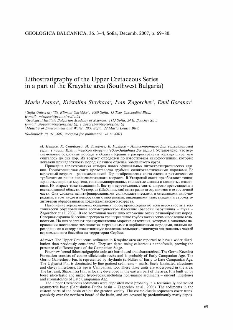
The presence of Upper Cretaceous rocks in the east-ern part of the Strouma tectonic unit (Krayshte area)has been reported only recently in the KonyavskaMountain, at the western board of the PalaeogeneBobovdol graben (Stoykova et al., 2003). Further stud-ies (Zagorchev et al., 2006) found a considerablywider occurrence, and a continuation into knownoutcrops on the territory of East Serbia. The presentpaper aims to publish the results of a more detailedresearch of the Upper Cretaceous strip, traced most-ly in the Konyavska Mountain between the villagesof Gorna Koznitsa and Golema Foucha, and fartherto the NW at Uglyartsi and Blateshnitsa to DolnaVrabcha (Fig. 1).
In all papers prior to the two publications citedabove, and on all geological maps (including this ofthe scale 1:100 000), the Upper Cretaceous rocks havebeen referred to the Palaeogene (Upper Eocene orOligocene) and/or Upper Jurassic – Lower Creta-ceous. Several informal units have been describedmostly following Beregov (Áåðåãîâ, 1935) and Dim-itrov (Äèìèòðîâ, 1931), as belonging to the Palaeo-gene on the basis of correlations with proven Palaeo-gene sediments from the Bobovdol graben (Çàãîð÷åâ,1993; Çàãîð÷åâ, Äèíêîâà, 1991):
— “variegated conglomerate formation (probableUpper Eocene?)” of coarse clastic rocks, mostly redconglomerates and sandstones;
— “sandstone formation” (flyschoid terrigenoussediments);
— “shale-sandstone formation” of rhythmically al-ternating shales and sandstones;
— “bituminous-marly formation” of finely beddedand laminated marls rich in organic matter that havebeen correlated with the uppermost Oligocene marlswith Smerdis macrurus.
The Upper Cretaceous calcareous nannoplank-ton has been initially found in several samples dur-ing the geological mapping on the scale 1:25000 in2002—2003. Four informal Upper Cretaceous (Cam-panian to Lower Maastrichtian) units have been dis-tinguished, and namely, basal breccia-conglomerate,flyschoid, limestone-marly and sandstone-marly for-mation (Stoykova et al., 2003). Later geological map-ping in the area performed by P. Milovanov, D. Sin-nyovski and collaborators has confirmed our results.
Our own field and laboratory data allow to trace theUpper Cretaceous formations in a wider area, andto establish with higher precision the volume andchronostratigraphic range of the lithological bodies.As a result, we are now able to introduce a scheme offormal lithostratigraphic units.
Description of the lithostratigraphicunits
Four Upper Cretaceous formal lithostratigraphicunits (formations) easily distinguishable in the fieldare introduced here. The type area of all four forma-tions is the eastern and western slopes of the Kon-yavska Mountain (Fig. 1). Some of the lithostrati-graphic bodies are traced also to the west near thevillage of Dolna Vrabcha. The formations are as fol-low (from base to top): Gorna Koznitsa, Gorno Gabre-shevo, Shabanitsa and Uglyartsi Formation.
Gorna Koznitsa Formation (new formation:Ãîðíîêîçíèøêà ñâèòà, íîâà ñâèòà)(Fig. 2,Pl. I, 1—2)
Previous uses and synonyms. The rocks of this for-mation have been previously referred to a “variegat-ed conglomerate formation” situated at the base ofthe Palaeogene section in the Bobovdol graben, andattributed to the probable Upper Eocene (Çàãîð÷åâ,1993). The formation corresponds to the “basal brec-cia-conglomerate formation” of Stoykova et al. (2003)and to the “coarse conglomerate and breccia”(Zagorchev et al., 2006) with a Late Cretaceous (EarlyCampanian?) age.
Name. The name of the formation comes from thevillage of Gorna Koznitsa (Kyustendil District), thetype section being situated to the North of this vil-lage.
Defining features. The formation consists mostlyof reddish or brownish polygenic breccia and con-glomerate interbedded with coarse sandstones (Pl. I,1—2). The clasts are of different size: from 3—4 cm to1—1.2 m, and a varying composition: metamorphicrocks, granitoids, quartz, Palaeozoic schists, quartz-ites and limestones; red, probably Permian and Tri-assic sandstones, Triassic and Jurassic limestones,
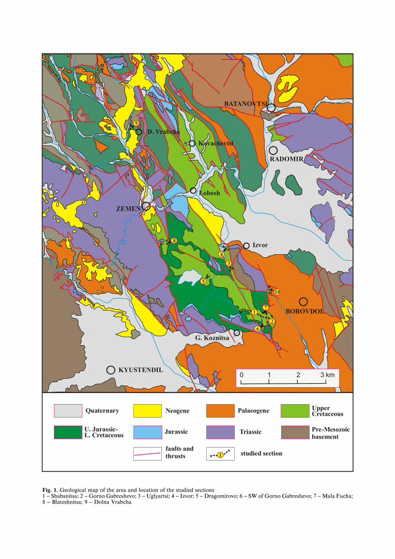
Fig. 1. Geological map of the area and location of the studied sections1 — Shabanitsa; 2 — Gorno Gabreshevo; 3 — Uglyartsi; 4 — Izvor; 5 — Dragomirovo; 6 — SW of Gorno Gabreshevo; 7 — Mala Fucha;8 — Blateshnitsa; 9 — Dolna Vrabcha
Quaternary
Jurassic
Neogene Palaeogene UpperCretaceous
U. Jurassic-L. Cretaceous Triassic Pre-Mesozoic
basement
faults and thrusts studied section 1
9
D. Vrabcha
Kovachevtsi
BATANOVTSI
RADOMIR
Lobosh
ZEMEN
8
KYUSTENDIL
G. Koznitsa6
2
17 BOBOVDOL
10
5
3
Izvor4
0 1 2 3 km

71
PLATE I
1. Outcrop of the Gorna Koznitsa Fm. (conglomerates), along the road-cut between Baikalsko and Blateshnitsa2. Conglomerates and gravels within the uppermost part of the Gorna Koznitsa Fm. in its holostratotype section Shabanitsa3. Thin and medium-bedded rhythmicity in the middle part of the Gorno Gabreshevo Fm. in its holostratotype section Shabanitsa4. Rhythmic flyschoid sediments of the Gorno Gabreshevo Fm., cropping out near the road SW of Gorno Gabreshevo5. Exposure of the base of the Shabanitsa Fm. (conglomerates, marls and limestones) in its type section between Gorno Gabre-
shevo and Mala Foucha6. Oncoid limestones (overturned beds) in the lower part of the Shabanitsa Fm. in its type section7. Thin- and fine layered marls of the Uglyartsi Fm. in the section near Dolna Vrabcha8. Detail of the same sediments — fine laminated marls — in the same section as in photo 7
debrites and sandstones from the Upper Jurassic —Lower Cretaceous sediments. In the basal parts ofthe section huge boulders and blocks (up to a fewmeters) of Upper Jurassic—Lower Cretaceous coarseconglomerates and breccia are redeposited into theGorna Koznitsa Formation.
Type section. The holostratotype is the section ex-posed to North of Gorna Koznitsa and along theridge Shabanitsa, packet 3 to 6 (Fig. 2). Packet 2 prob-ably belongs as well to the same formation.
Description of the formation in the type area. Theformation covers with unconformity (sharp lithologi-cal boundary) the Bobovo Member of the Kostel For-mation (Upper Jurassic — Lower Cretaceous). At thebase, chaotically disposed clasts of rhythmic sediments(packet 2, from the Bobovo Member) have been prob-ably gravity-driven into the forming basin. The nextpacket 3 of breccia-conglomerate clearly belongs tothe Upper Cretaceous succession. It consists of clastsof various size and rock composition. The clasts at thebase obviously underwent a very short transport. Theycome from Triassic (Radomir and Tran Formation)and Jurassic (Yavorets and Gintsi Formation) lime-stones or Jurassic carbonate debrites (Bobovo Mem-ber). The middle and upper parts of the formationare built of alternating packets of reddish to rusty-brown coarse grained sandstones, breccia-conglom-erate and unsaturated pebble conglomerates withsandy matrix (Pl. I, 2). The topmost part of the forma-tion consists of beige, predominantly coarse-grainedsandstones with lenses of gravels. The upper bound-ary of the formation is a fast lithological transition tothe rocks of the Gorno Gabreshevo Formation.
Regional aspects. The formation is traced as a strip(with small gaps) from Gorna Koznitsa to Blateshnit-sa. It is widespread NW of Gorna Koznitsa, Northand NE of Dragomirovo, and between the villages ofBaykalsko and Blateshnitsa. Small outcrops at the baseof the Upper Cretaceous section are observed NE ofUglyartsi, SW of Izvor, and West of Dolna Vrabcha.
The lithological features of the formation are rel-atively constant. Lateral changes concern the clastscomposition (in function of the local basement), andthe presence of relative amount of sandstones. In thesections where the formation is relatively thin, it isbuilt mostly or exclusively of conglomerates.
The lower boundary is transgressive unconformi-ty. The formation overlies the rocks of different age:
Paleozoic, Triassic and Late Jurassic—Early Creta-ceous. The upper boundary is a fast lithological tran-sition towards the Gorno Gabreshevo Formation orthe Uglyartsi Formation. Lateral transitions are notdirectly observed. We suggest that it is laterally re-placed in the topmost parts by the flyschoid sedi-ments of the Gorno Gabreshevo Formation.
The thickness varies from 10—30 m in the western-most (Dolna Vrabcha) and northern (Izvor) parts toabout 100—120 m in the southerly outcrops (GornaKoznitsa, Dragomirovo, Baykalsko and Blateshnitsa).
Fossil content. No fossils have been found. Thesamples from the matrix of the conglomerate (sec-ond conglomerate packet of the holostratotype) andsandstones (upper sandstone packet, same section)analyzed for calcareous nannoplankton are barren.
Chronostratigraphic range. The formation is ten-tatively referred to the Lower Campanian due to itsstratigraphic position under the Lower CampanianGorno Gabreshevo Formation.
Gorno Gabreshevo Formation(new formation; Ãîðíîãàáðåøåâñêà ñâèòà,íîâà ñâèòà)(Fig. 2, 3; Pl. I, 3—4)
Previous uses and synonyms. The rocks of this for-mation have been previously assigned to a “shale-sandstone formation” and “sandstone formation” ofsupposed Priabonian-Oligocene age (Çàãîð÷åâ, 1993)or to the Kostel Formation (Upper Juarssic—LowerCretaceous). As a “flyschoid formation” or “flyschoid(to flysch) formation” with Late Cretaceous (Cam-panian) age they have been described by Stoykova etal. (2003) and Zagorchev et al. (2006).
Name. The formation is named after the villageof Gorno Gabreshevo (now — hamlet, part of the vil-lage of Korkina), Kyustendil District.
Defining features. The formation consists of thin-to medium bedded rhythmic flyschoid alternationor by rhythmic alternation of packets of sandstoneswith marls and packets with rhythmic interbedding(Pl. I, 3—4). The flyschoid rhythms consist of sand-stones or siltstones and silty (less frequently, clayey)marls. Typical flysch textures are absent. Channeland amalgamated sandstones and slump sedimentswith different thicknesses are present within the rhyth-mic sequences.
←
72
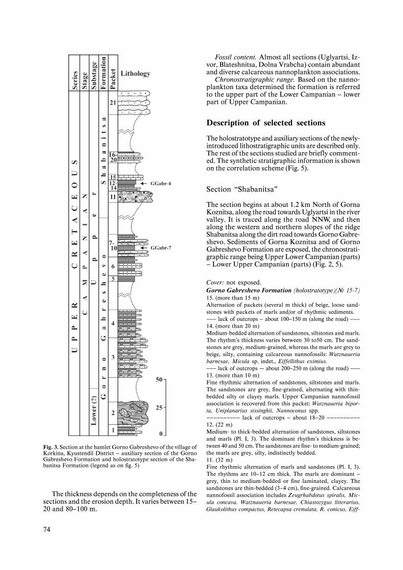
Type section. The holostratotype is the sectionNorth of Gorna Koznitsa and along the ShabanitsaRidge, packets 7 to 15 (Fig. 2). The auxiliary sectionfor the upper part of the Formation, here designat-ed, is the interval of packets 1—10 in the section Gor-no Gabreshevo.
Description of the formation in the type area.The lower boundary is a fast transition from the sand-stones of the Gorna Koznitsa Formation. Fine rhyth-mic sediments (rhythms less than 8-10 cm) dominatethe lowest parts of the section represented by sand-stones and sizable amount of claystones. A packet ofshallow channel sandstones is also present. In themiddle and upper parts of the section the rhythmic-ity is of medium thickness. The sandstones occur in20—30 cm thick beds, intercalated by silty marls. Themarly packets consist of thin-layered clayey marlsand very thin (less than 2—3 cm) sandstone or silt-stone beds. (Pl. I, 3).
The uppermost parts of the formation exhibit mac-ro rhythmicity. Packets (4—5 to 12 m) of thick-beddedpoorly cemented sandstones with thin marls intercala-tions alternate with packets of marls or rhythmic sedi-ments. Beds of variable thickness and slump origin arecommon. The marly interbeds in the sandstones con-tain clasts of sandstones and white limestones. Thedescribed alternation differs considerably from therhythmic sequence, typical of the formation. Having alimited occurrence, it is here included into the GornoGabreshevo Formation but potentially could be indi-vidualized as a separate unit (member).
Regional aspects. The formation is widespread tothe North of Gorna Koznitsa and North and West ofGorno Gabreshevo, where it builds the thickest partof the Upper Cretaceous section. Westerly it is ex-posed between Gorno Gabreshevo and Uglyartsi (Eastand West of the latter). Small outcrops appear abovethe conglomerates of the Gorna Koznitsa Formationat the lake of Izvor and in the southern end of Drag-omirovo. Outside the type area the formation is rep-resented by sandstones and marls with dominationof the latter. Rhythmicity is not always well expressed.
The formation always overlies the Gorna Koznit-sa Formation. In the type area it is covered by theShabanitsa Formation. In the area of Uglyartsi, Izvorand Dragomirovo, the Gorno Gabreshevo Formationis overlaid by the Uglyartsi Formation, probably alsothrough the lateral replacement and interfingering.
The formation thickness in the type area is great-er (more than 450 m). It decreases to the North up to40—50 m, and to the West possibly thins out, beingabsent at Dolna Vrabcha.
Fossil content. Both in the type section and inthe outcrops near the villages of Uglyartsi, Izvor andDragomirovo, Lower and Upper Campanian cal-careous nannoplankton has been recorded. Small-sized gastropods are noticed in the upper parts ofthe formation.
Chronostratigraphic range. Based on typical cal-careous nannofossil taxa the range of the formationis constrained as Lower (upper part) — Upper (lowerpart) Campanian Substage.
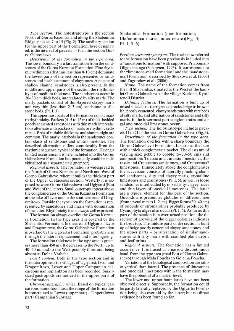
Shabanitsa Formation (new formation;Øàáàíèøêà ñâèòà, íîâà ñâèòà)(Fig. 3;Pl. I, 5—6)
Previous uses and synonyms. The rocks now referredto the formation have been previously included intoa “sandstone formation” with supposed Priabonian-Oligocene age (Çàãîð÷åâ, 1993). It corresponds tothe “limestone-marl formation” and the “sandstone-marl formation” described by Stoykova et al. (2003)and Zagorchev et al. (2006).
Name. The name of the formation comes fromthe hill Shabanitsa, situated to the West of the ham-let Gorno Gabreshevo of the village Korkina, Kyus-tendil District.
Defining features. The formation is built up ofmixed siliciclastic (terrigenous) rocks: beige to brown-ish, poorly cemented, clayey sandstones with rare bedsof silty marls, and alternation of sandstones and siltymarls. In the lowermost part conglomerates and al-gal and oncoidal limestones occur.
Type section. The holostratotype includes pack-ets 11 to 21 of the section Gorno Gabreshevo (Fig. 3).
Description of the formation in the type area.The formation overlies with a sharp boundary theGorno Gabreshevo Formation. It starts at the basewith a thick conglomerate packet. The clasts are ofvarying size: pebble to cobble (5—30—50 cm) andcomposition: Triassic and Jurassic limestones, Ju-rassic and Cretaceous sandstones, and Cretaceous?limestones. Immediately above the conglomeratesthe succession consists of laterally pinching chan-nel sandstones, silty and clayey marls, crystallinelimestones and grainstones (Pl. I, 5), as well as loosesandstones interbedded by mixed silty-clayey rocksand thin layers of oncoidal limestones. The latterare a typical element for this part of the section.Oncoids are present as globules of different size(from several mm to 1—2 cm). Bigger forms (30—40 cm)of oncoids or stromatolites probably produced byCyanophyta algae also occur (Pl. I, 6). As far as thispart of the section is in overturned position, the di-rection of growing of the bigger colonies indicatesthe beds top. The middle parts of the section is builtup of beige poorly cemented clayey sandstones, andthe upper parts — by alternation of similar sand-stones with silty marls with coalified plant debrisand leaf prints.
Regional aspects. The formation has a limitedoccurrence. It is traced as a narrow discontinuousband from the type area (road East of Gorno Gabre-shevo) through Mala Foucha to Golema Foucha.
Variations of the lithological composition are rath-er vertical than lateral. The presence of limestonesand oncoidal limestones within the formation mayhave the potential of a marker level.
The lower and upper boundaries have not beenobserved directly. Supposedly, the formation couldbe partly laterally replaced by the Uglyartsi Forma-tion being also overlaid by the latter; but no directevidence has been found so far.

73
Chronostratigraphic range. Based on calcareousnannoplankton finds, the range of the formation isconstrained as Upper Campanian Substage.
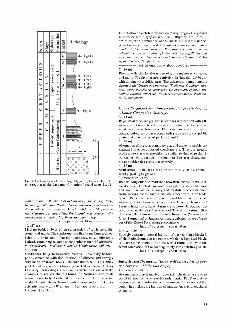
Uglyartsi Formation (new formation;Óãëÿðñêà ñâèòà, íîâà ñâèòà) (Fig. 4;Pl. I, 7—8)
Previous uses and synonyms. The rocks of the for-mation (finely bedded and finely laminated marls richin organic matter) have been formerly included inthe “bitumolite formation” or in the “formation ofvariegated clays and sandstones” with probable Oli-gocene age.
Name. The name comes from the village of Ugl-yartsi where the type section is situated.
Defining features. The formation consists of grayto beige marls with indistinct or fine bedding, finelylaminated, with very thin (3—4 to 8—10 cm) beds ofclayey limestones. The marls often contain dark bi-tumen-rich layers representing coalified fine plantdetritus that are concentrated in paper-thin lamina(“paper schists” of the old authors). Thin (1—2 cm)reddish-brownish layers and small carbonate con-cretions are also noted (Pl. I, 7—8).
Type section. The holostratotype consists of packets2 to 6 of the section situated NE of the village Ug-lyartsi (Fig. 4).
Description of the formation in the type area.The lower boundary (with the Gorno GabreshevoFormation) is not exposed. The succession consistsmostly of beige to gray marls with variable carbonatecontent, and undistinct or fine bedding. Some inter-vals contain small (1—3 cm) carbonate concretionsof irregular shape.
Regional aspects. The formation is widespread inthe vicinities and to the West of Uglyartsi, South ofIzvor, between Dragomirovo and Baykalsko, and Westof Blateshnitsa, as well as near Dolna Vrabcha.
The lithological features of the formation are con-stant. At the base sometimes rare and thin sandstonebeds are observed, and in the westerly outcrops, rarethin beds of light-gray clayey limestones occur.
The formation usually overlies (fast lithologicaltransition) the Gorno Gabreshevo Formation, andrarely the sandstones of the Gorna Koznitsa Forma-tion. The upper boundary is an unconformity (wash-out). It is covered by younger deposits, the sectionsbeing incomplete due to the erosion. To the Southand East, the formation is probably replaced by therhythmic and sandy sediments of the Gorno Gabre-shevo or Shabanitsa Formation.
Fig. 2. Section “Shabanitsa” — type-section of the Gorna Koznit-sa and the Gorno Gabreshevo Formation (legend as on fig. 5)
←
The thickness is deduced (composite sections) tobe at least 180—200 m.
Fossil content. At the base of the type section (sec-tion Gorno Gabreshevo, packet14) as well as in theuppermost parts of the formation (outcrops aroundGolema Foucha) calcareous nannoplankton has beenrecovered.
10 Geologica Balcanica, 3—4/2007
74
Fossil content. Almost all sections (Uglyartsi, Iz-vor, Blateshnitsa, Dolna Vrabcha) contain abundantand diverse calcareous nannoplankton associations.
Chronostratigraphic range. Based on the nanno-plankton taxa determined the formation is referredto the upper part of the Lower Campanian — lowerpart of Upper Campanian.
Description of selected sections
The holostratotype and auxiliary sections of the newly-introduced lithostratigraphic units are described only.The rest of the sections studied are briefly comment-ed. The synthetic stratigraphic information is shownon the correlation scheme (Fig. 5).
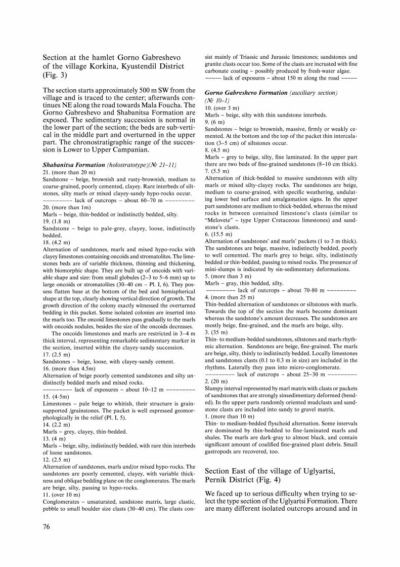
Section “Shabanitsa”
The section begins at about 1.2 km North of GornaKoznitsa, along the road towards Uglyartsi in the rivervalley. It is traced along the road NNW, and thenalong the western and northern slopes of the ridgeShabanitsa along the dirt road towards Gorno Gabre-shevo. Sediments of Gorna Koznitsa and of GornoGabreshevo Formation are exposed, the chronostrati-graphic range being Upper Lower Campanian (parts)— Lower Upper Campanian (parts) (Fig. 2, 5).
Cover: not exposed.Gorno Gabreshevo Formation (holostratotype)(¹ 15-7)15. (more than 15 m)Alternation of packets (several m thick) of beige, loose sand-stones with packets of marls and/or of rhythmic sediments.——— lack of outcrops — about 100—150 m (along the road) ———14. (more than 20 m)Medium-bedded alternation of sandstones, siltstones and marls.The rhythm’s thickness varies between 30 to50 cm. The sand-stones are grey, medium-grained, whereas the marls are grey tobeige, silty, containing calcareous nannofossils: Watznaueriabarnesae, Micula sp. indet., Eiffellithus eximius.——— lack of outcrops – about 200—250 m (along the road) ———13. (more than 10 m)Fine rhythmic alternation of sandstones, siltstones and marls.The sandstones are grey, fine-grained, alternating with thin-bedded silty or clayey marls. Upper Campanian nannofossilassociation is recovered from this packet: Watznaueria bipor-ta, Uniplanarius sissinghii, Nannoconus spp.—————————— lack of outcrops — about 18—20 ——————————12. (22 m)Medium- to thick-bedded alternation of sandstones, siltstonesand marls (Pl. I, 3). The dominant rhythm’s thickness is be-tween 40 and 50 cm. The sandstones are fine- to medium-grained;the marls are grey, silty, indistinctly bedded.11. (32 m)Fine rhythmic alternation of marls and sandstones (Pl. I, 3).The rhythms are 10—12 cm thick. The marls are dominant —grey, thin to medium-bedded or fine laminated, clayey. Thesandstones are thin-bedded (3—4 cm), fine-grained. Calcareousnannofossil association includes Zeugrhabdotus spiralis, Mic-ula concava, Watznaueria barnesae, Chiastozygus litterarius,Glaukolithus compactus, Retecapsa crenulata, R. conicus, Eiff-
The thickness depends on the completeness of thesections and the erosion depth. It varies between 15—20 and 80—100 m.
Fig. 3. Section at the hamlet Gorno Gabreshevo of the village ofKorkina, Kyustendil District — auxiliary section of the GornoGabreshevo Formation and holostratotype section of the Sha-banitsa Formation (legend as on fig. 5)
75
ellithus eximius, Reinhardites anthophorus, Quadrum gartneri,Gartnerago obliquum, Reinhardites anthophorus, Lucianorhab-dus maleformis, L. cayeuxii, Micula cubiformis, M. praemu-rus, Chiastozygus litterarius, Prediscosphaera cretacea, Cy-clagelosphaera reinhardtii, Braarudosphaera spp.—————————— lack of outcrops — about 40 m ——————————
10. (27 m)Medium-bedded (30 to 50 cm) alternation of sandstones, silt-stones and marls. The sandstones are fine to medium-grained,beige to grey in color. The marls are grey, silty, indistinctlybedded, containing calcareous nannoplankton: Arkhangelskiel-la cymbiformis, Octolithus multiplus, Uniplanarius gothicus.9. (23 m)Sandstones, beige to brownish, massive, indistinctly bedded,poorly cemented, with thin interbeds of siltstone and stronglysilty marls or mixed rocks. The sandstones built up a thickpacket that is geomorphologically marked in the relief. Theyhave irregular bedding surfaces and variable thickness, with thecharacter of shallow channel formation. Siltstones and marlscontain irregularly distributed or localized in thin layers finecoalified plant detritus. Nannofossils are rare and without char-acteristic taxa — only Watznaueria barnesae is observed.8. (more than 10 m)
Fine rhythmic flysch-like alternation of beige or gray fine-grainedsandstones with clayey or silty marls. Rhythms are up to 30cm thick, with dominance of the marls. Calcareous nanno-plankton association recorded includes: Cyclagelosphaera mar-gerelii, Watznaueria barnesae, Retecapsa crenulata, Lucian-orhabdus cayeuxii, Prediscosphaera cretacea, Eiffellithus exi-mius and reworked Nannoconus steinmanni steinmanni, N. ka-mptneri minor, N. quadratus.————————— lack of outcrops — about 20—30 m —————————7. (16 m)Rhythmic flysch-like alternation of gray sandstones, siltstonesand marls. The rhythms are relatively thin (less than 20-30 cm)with dominant turbiditic parts. The calcareous nannoplanktondetermined: Watznaueria barnesae, W. biporta, Quadrum gart-neri, Cyclagelosphaera margerelii, Cretarhabdus conicus, Eif-ellithus eximius, reworked: Nannoconus steinmanni steinman-ni, N. kamptneri.
Gorna Koznitsa Formation (holostratotype) (¹ 6-3, ?2)(?Lower Campanian Substage)6. (18 m)Beige, mostly coarse-grained sandstones interbedded with silt-stones, with thin beds or lenses of gravels and fine- to medium-sized pebble conglomerates. The conglomerates are gray tobeige in color, less often reddish, with sandy matrix and pebblecontent similar to that of packets 3 and 5.5. (24 m)Alternation of breccia, conglomerate, and gravel to pebble un-saturated matrix-supported conglomerate. They are usuallyreddish, the clasts composition is similar to that of packet 3,but the pebbles are much more rounded. The large clastic, peb-ble to boulder size clasts, occur rarely.4. (15 m)Sandstones — reddish to rusty-brown, mostly coarse-grained,locally grading to gravels.3. (more than 30 m)Breccia-conglomerate, reddish to brownish, cobble- to boulder-sized clasts. The clasts are usually angular, of different shapeand size. The matrix is sandy and reddish. The clasts comefrom various rocks: high-grade metamorphites, granitoids,quartz, Palaeozoic schists, quartzite and limestone, red sand-stones (probably Permian and/or Lower Triassic), Triassic andJurassic limestones, Upper Jurassic and Lower Cretaceous de-brites and sandstones. The clasts of Triassic limestones (Ra-domir and Trun Formation), Jurassic limestones (Yavorets andGintsi Formation) or Jurassic carbonate debrites (Bobovo Mem-ber of the Kostel Formation) predominate.—————————— lack of outcrops — about 10 m ——————————
2. (îêîëî 20 m)Strongly deformed interval built up of packets (huge blocks?)of rhythmic alternation (sometimes whole redeposited blocksof coarse conglomerate from the Kostel Formation), with dif-ferent orientation of the bedding, rarely some debrites packets.—————————— lack of outcrops — about 15 m ——————————
Base: Kostel Formation (Bobovo Member) (¹ 1) (Up-per Jurassic — ?Tithonian Stage)1. (more than 30 m)Alternation of flysch and debrite packets. The debrites are com-posed of limestone clasts with sandy matrix. The flysch alter-nations are medium-bedded with presence of thicker turbiditicbeds. The rhythms are built up of sandstones, siltstones, shalesor marls.
Fig. 4. Section East of the village Uglyartsi, Pernik District —type-section of the Uglyartsi Formation (legend as on fig. 5)
76
Section at the hamlet Gorno Gabreshevoof the village Korkina, Kyustendil District(Fig. 3)
The section starts approximately 500 m SW from thevillage and is traced to the center; afterwards con-tinues NE along the road towards Mala Foucha. TheGorno Gabreshevo and Shabanitsa Formation areexposed. The sedimentary succession is normal inthe lower part of the section; the beds are sub-verti-cal in the middle part and overturned in the upperpart. The chronostratigraphic range of the succes-sion is Lower to Upper Campanian.
Shabanitsa Formation (holostratotype)(¹ 21—11)21. (more than 20 m)Sandstone — beige, brownish and rusty-brownish, medium tocoarse-grained, poorly cemented, clayey. Rare interbeds of silt-stones, silty marls or mixed clayey-sandy hypo-rocks occur.————————— lack of outcrops — about 60—70 m —————————20. (more than 1m)Marls — beige, thin-bedded or indistinctly bedded, silty.19. (1.8 m)Sandstone — beige to pale-grey, clayey, loose, indistinctlybedded.18. (4.2 m)Alternation of sandstones, marls and mixed hypo-rocks withclayey limestones containing oncoids and stromatolites. The lime-stones beds are of variable thickness, thinning and thickening,with biomorphic shape. They are built up of oncoids with vari-able shape and size: from small globules (2—3 to 5—6 mm) up tolarge oncoids or stromatolites (30—40 cm — Pl. I, 6). They pos-sess flatten base at the bottom of the bed and hemisphericalshape at the top, clearly showing vertical direction of growth. Thegrowth direction of the colony exactly witnessed the overturnedbedding in this packet. Some isolated colonies are inserted intothe marls too. The oncoid limestones pass gradually to the marlswith oncoids nodules, besides the size of the oncoids decreases.
The oncoids limestones and marls are restricted in 3—4 mthick interval, representing remarkable sedimentary marker inthe section, inserted within the clayey-sandy succession.17. (2.5 m)Sandstones — beige, loose, with clayey-sandy cement.16. (more than 4.5m)Alternation of beige poorly cemented sandstones and silty un-distinctly bedded marls and mixed rocks.————————— lack of exposures — about 10—12 m —————————15. (4-5m)Limestones — pale beige to whitish, their structure is grain-supported /grainstones. The packet is well expressed geomor-phologically in the relief (Pl. I, 5).14. (2.2 m)Marls — grey, clayey, thin-bedded.13. (4 m)Marls — beige, silty, indistinctly bedded, with rare thin interbedsof loose sandstones.12. (2.5 m)Alternation of sandstones, marls and/or mixed hypo-rocks. Thesandstones are poorly cemented, clayey, with variable thick-ness and oblique bedding plane on the conglomerates. The marlsare beige, silty, passing to hypo-rocks.11. (over 10 m)Conglomerates — unsaturated, sandstone matrix, large clastic,pebble to small boulder size clasts (30—40 cm). The clasts con-
sist mainly of Triassic and Jurassic limestones; sandstones andgranite clasts occur too. Some of the clasts are incrusted with finecarbonate coating — possibly produced by fresh-water algae.————— lack of exposures — about 150 m along the road —————
Gorno Gabreshevo Formation (auxiliary section)(¹ 10—1)10. (over 3 m)Marls — beige, silty with thin sandstone interbeds.9. (6 m)Sandstones — beige to brownish, massive, firmly or weakly ce-mented. At the bottom and the top of the packet thin intercala-tion (3—5 cm) of siltstones occur.8. (4.5 m)Marls — grey to beige, silty, fine laminated. In the upper partthere are two beds of fine-grained sandstones (8—10 cm thick).7. (5.5 m)Alternation of thick-bedded to massive sandstones with siltymarls or mixed silty-clayey rocks. The sandstones are beige,medium to coarse-grained, with specific weathering, undulat-ing lower bed surface and amalgamation signs. In the upperpart sandstones are medium to thick-bedded, whereas the mixedrocks in between contained limestone’s clasts (similar to“Melovete” — type Upper Cretaceous limestones) and sand-stone’s clasts.6. (15.5 m)Alternation of sandstones’ and marls’ packets (1 to 3 m thick).The sandstones are beige, massive, indistinctly bedded, poorlyto well cemented. The marls grey to beige, silty, indistinctlybedded or thin-bedded, passing to mixed rocks. The presence ofmini-slumps is indicated by sin-sedimentary deformations.5. (more than 3 m)Marls — gray, thin bedded, silty.————————— lack of outcrops — about 70-80 m —————————4. (more than 25 m)Thin-bedded alternation of sandstones or siltstones with marls.Towards the top of the section the marls become dominantwhereas the sandstone’s amount decreases. The sandstones aremostly beige, fine-grained, and the marls are beige, silty.3. (35 m)Thin- to medium-bedded sandstones, siltstones and marls rhyth-mic alternation. Sandstones are beige, fine-grained. The marlsare beige, silty, thinly to indistinctly bedded. Locally limestonesand sandstones clasts (0.1 to 0.3 m in size) are included in therhythms. Laterally they pass into micro-conglomerate.————————— lack of outcrops — about 25—30 m —————————2. (20 m)Slumpy interval represented by marl matrix with clasts or packetsof sandstones that are strongly sinsedimentary deformed (bend-ed). In the upper parts randomly oriented mudclasts and sand-stone clasts are included into sandy to gravel matrix.1. (more than 10 m)Thin- to medium-bedded flyschoid alternation. Some intervalsare dominated by thin-bedded to fine-laminated marls andshales. The marls are dark-gray to almost black, and containsignificant amount of coalified fine-grained plant debris. Smallgastropods are recovered, too.
Section East of the village of Uglyartsi,Pernik District (Fig. 4)
We faced up to serious difficulty when trying to se-lect the type section of the Uglyartsi Formation. Thereare many different isolated outcrops around and in
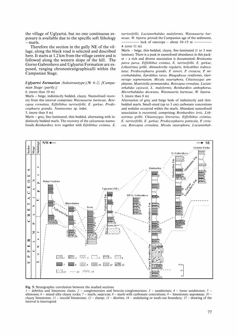
77
the village of Uglyartsi, but no one continuous ex-posure is available due to the specific soft lithology— marls.
Therefore the section in the gully NE of the vil-lage, along the black road is selected and describedhere. It starts at 1.2 km from the village centre and isfollowed along the western slope of the hill. TheGorno Gabreshevo and Uglyartsi Formation are ex-posed, ranging chronostratigraphicalli within theCampanian Stage.
Uglyartsi Formation (holostratotype)(¹ 6—2) [Campa-nian Stage (partly)]6. (more than 10 m)Marls — beige, indistinctly bedded, clayey. Nannofossil recov-ery from this interval comprises: Watznaueria barnesae, Rete-capsa crenulata, Eiffellithus turriseifellii, E. gorkae, Predis-cosphaera grandis, Nannoconus sp. indet.5. (more than 8 m)Marls — grey, fine-laminated, thin-bedded, alternating with in-distinctly bedded marls. The recovery of the calcareous nanno-fossils Reinhardites levis together with Eifellithus eximius, E.
turriseifellii, Lucianorhabdus maleformis, Watsnaueria bar-nesae, W. biporta proved the Campanian age of the sediments.————————— lack of outcrops — about 10—15 m —————————4. (over 11 m)Marls — beige, thin-bedded, clayey, fine-laminated (1 to 3 mmlaminas). There is a peak in nannofossil abundance in this pack-et — a rich and diverse association is documented: Broinsoniaparca parca, Eiffellithus eximius, E. turriseifellii, E. gorkae,Lithastrinus grillii, Ahmuelerella regularis, helicolithus trabecu-latus, Prediscosphaera grandis, P. stoveri, P. cretacea, P. mi-crorhabdulina, Eprolithus rarus, Rhagodiscus reniformis, Gart-nerago segmentatum, Micula staurophora, Chiastozygus am-phipons, Manivitella pemmatoidea, Retecapsa crenulata, Lucian-orhabdus cayeuxii, L. maleformis, Reinhardites anthophorus,Microrhabdulus decoratus, Watsnaueria barnesae, W. biporta.3. (more than 8 m)Alternation of grey and beige beds of indistinctly and thin-bedded marls. Small-sized (up to 3 cm) carbonate concretionsand nodules occurred within the marls. Abundant nannofossilassociation is recovered, comprising: Reinhardites levis, Lith-astrinus grillii, Chiastozygus litterarius, Eiffellithus eximius,E. turriseifellii, E. gorkae, Prediscosphaera ponticula, P. creta-cea, Retecapsa crenulata, Micula staurophora, Lucianorhab-
Fig. 5. Stratigraphic correlation between the studied sections1 — debrites and limestone clasts; 2 — conglomerates and breccia-conglomerates; 3 — sandstones; 4 — loose sandstones; 5 —siltstones; 6 — mixed silty-clayey rocks; 7 — marls; ìåðãåëè; 8 — marls with carbonate concretions; 9 — limestones; âàðîâèöè; 10 —clayey limestones; 11 — oncoid limestones; 12 — slump; 13 — diorites; 14 — undulating or wash-out boundary; 15 — drawing of theinterval is interrupted
78
dus cayeuxii, Cribrosphaera ehrenbergii, Watsnaueria barne-sae, Cyclagelosphaera reinhardtii.2. (over 7 m)Marls — light-grey, clayey, thin-bedded. They yield the follow-ing nannoflora: Eiffellithus eximius, E. turriseifellii, M. stauro-phora, Gartnerago segmentatum, Watznaueria barnesae.————————— lack of outcrops — about 15—20 m —————————
Gorno Gabreshevo Formation (¹ 1) (Campanian Stage,partly)1. (more than 20 m)The rocks are poorly outcropped — clasts of thin- and medium-bedded sandstones are observed. We presume that the intervalis represented by rhythmic turbidite sediments.
————————————— tectonic contact —————————————Diorites
Seven additional sections and few isolated out-crops have been investigated except of the describedabove type-sections. The sedimentary sequences ofall different formations yield 40 productive samples,containing calcareous nannoflora, thus evidencingthe Late Cretaceous — Campanian age.
In the section SW of the village of Izvor, along thebeach of the lake, the Upper Cretaceous sedimentsoverlaid transgressively Lower Triassic limestones. TheGorna Koznitsa, Gorno Gabreshevo and UglyartsiFormations are cropping out in this section. The LateCampanian age of this succession is witnessed by thesimultaneous occurrence of calcareous nannofossiltaxa Eiffellithus parallelus, E. eximius and Lith-raphidites praequadratus. It is worth to mention therelatively reduced thickness of the formations here.
The section SW of Dragomirovo (at the road forkto Baykalsko) demonstrates the boundary between theGorna Koznitsa and Gorno Gabreshevo Fm. The LatestCampanian age is categorically proved for the latterdue to the co-occurrence of the nannofossil speciesUniplanarius trifidus and Uniplanarius sissinghi.
The section SW of Gorno Gabreshevo exhibits thetypical rhythmic succession of Gorno Gabreshevo Fm.which is proved to be Campanian in age (Pl. I, 4).
The section at Mala Fucha village illustrates theuppermost part of the Gorno Gabreshevo Fm. Wesuppose that part of the flyschoid succession, as-signed so far to the Kostel Fm., can also be referredto the Gorno Gabreshevo Fm., but no palaeontolog-ical arguments available so far.
The section at the hamlet Vlasinska mahala ofBlateshnitsa village represents the sediments of theUglyartsi Fm. with proved Campanian age only.
The Upper Cretaceous succession shows specificfeatures in the westernmost section studied near DolnaVrabcha village. In this location the conglomeratesof the Gorna Koznitsa Fm. are overlaid by the lime-stones with clasts of Paleozoic phyllites. These lime-stones are covered by the marls of the Uglyartsi Fm.(Pl. I, 7—8), which are interbedded in the lower partwith clayey limestones.
The uppermost part of the Upper Cretaceous sed-imentary succession in the area is documented nearthe village of Golema Fucha. It consists of alternationof loose clayey sands with silty marls and mixed hypo-rocks. These sediments yield well preserved leaf-castsand abundant coalified plant debris. They are includ-ed into the uppermost part of the Shabanitsa Fm.
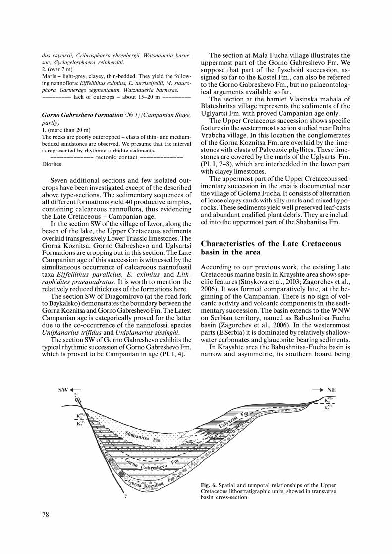
Characteristics of the Late Cretaceousbasin in the area
According to our previous work, the existing LateCretaceous marine basin in Krayshte area shows spe-cific features (Stoykova et al., 2003; Zagorchev et al.,2006). It was formed comparatively late, at the be-ginning of the Campanian. There is no sign of vol-canic activity and volcanic components in the sedi-mentary succession. The basin extends to the WNWon Serbian territory, named as Babushnitsa-Fuchabasin (Zagorchev et al., 2006). In the westernmostparts (E Serbia) it is dominated by relatively shallow-water carbonates and glauconite-bearing sediments.
In Krayshte area the Babushnitsa-Fucha basin isnarrow and asymmetric, its southern board being
Fig. 6. Spatial and temporal relationships of the UpperCretaceous lithostratigraphic units, showed in transversebasin cross-section
79
steep and most likely formed by faulting (Fig. 6). Onthis southern board, poorly sorted chaotic siliciclas-tic sediments are deposited during the Campanian.The maximal thicknesses of the basal breccia-con-glomerates (Gorna Koznitsa Fm.) and the deep-wa-ter flysch and flyschoid sediments (Gorno Gabre-shevo Fm.) are documented in the axial part of thebasin (Fig. 6). The northern board is relatively ob-lique. The onset of the marine transgression on thisboard is later (with some delay). It is marked by thedeposition of coarse clastic and non-rhythmic silici-clastic sediments with small thickness.
The amount of coarse clastics clearly decreasesto the North-NorthEast and to the West-NorthWestdirection, being replaced by the domination of marls(Uglyartsi Fm.). The marls are clayey, finely laminat-ed, interbedded by thin-bedded clayey limestones. Thefinely laminated marls, including organic-rich lay-ers are typical element of the successions in this partof the basin. These sediments make the facial transi-tion from the eastern (with dominant siliciclastic sed-imentation) to the western (with dominant carbonatesedimentation) parts of the basin.
Due to the depositional filling of the basin or eventat the end of the Campanian, the loose siliciclasticsand mixed hypo-rocks are deposited in the south-åastern part of the basin (Shabanitsa Fm.). These se-quences started with non-marine sediments, repre-sented by specific limestones with oncoids and smallstromatolites. They gradually passed to the marine,shallow-water siliciclastics and mixed rocks, contain-ing abundant plant remains.
Our previously reported data about the presenceof the Lower Maastrichtian sediments (Stoykova etal., 2003; Zagorchev et al., 2006) are revised here —there is no clear evidence about it. This problem isstill open and needs further elucidation.
Conclusion
Our new studies found a considerably wider occur-rence of the Upper Cretaceous in Krayshte area.Different parts of the Campanian Stage are evidencedin more than 10 sections, using calcareous nanno-fossils as a main biostratigraphic tool.
The field studies resulted in nomination andcharacteristics of 4 new formal lithostratigraphicunits. The Gorna Koznitsa Fm. (breccia-conglom-erates and coarse siliciclastics) is possibly of EarlyCampanian age. The Gorno Gabreshevo Fm. (fly-sch and flyschoid rhythmic sediments) is of lateEarly to early Late Campanian age. The same ageinterval is proved for the Uglyartsi Fm. (marls dom-inated, fine-laminated clayey marls interbedded bythin-bedded clayey limestones). These three forma-tions are of wide distribution in the area. The Sha-banitsa Fm. locally occurs in the eastern parts, con-sisting of loose terrigenous and mixed rocks and non-marine sediments – oncoidal limestones. Its age isrestricted to the Late Campanian only, thus revis-ing our previous statement.
The Upper Cretaceous formations were deposit-ed most probably in a tectonically controlled (exten-sional onset and evolution in a most unstable areasituated northwest of the thickened crust of theRhodope massif) asymmetric basin (Babushnitsa-Fucha basin — Zagorchev et al., 2006). The sedimentsin the eastern parts of the basin exhibit the greatestvariety. The coarse clastic sequences cover transgres-sively over the northern board of the basin, and arecovered by predominantly marly deposits. Westwards,they are gradually replaced by marly and carbonatesediments that probably pass to the north into thelimestone sequences typical for the western parts ofthe basin on the territory of Serbia.
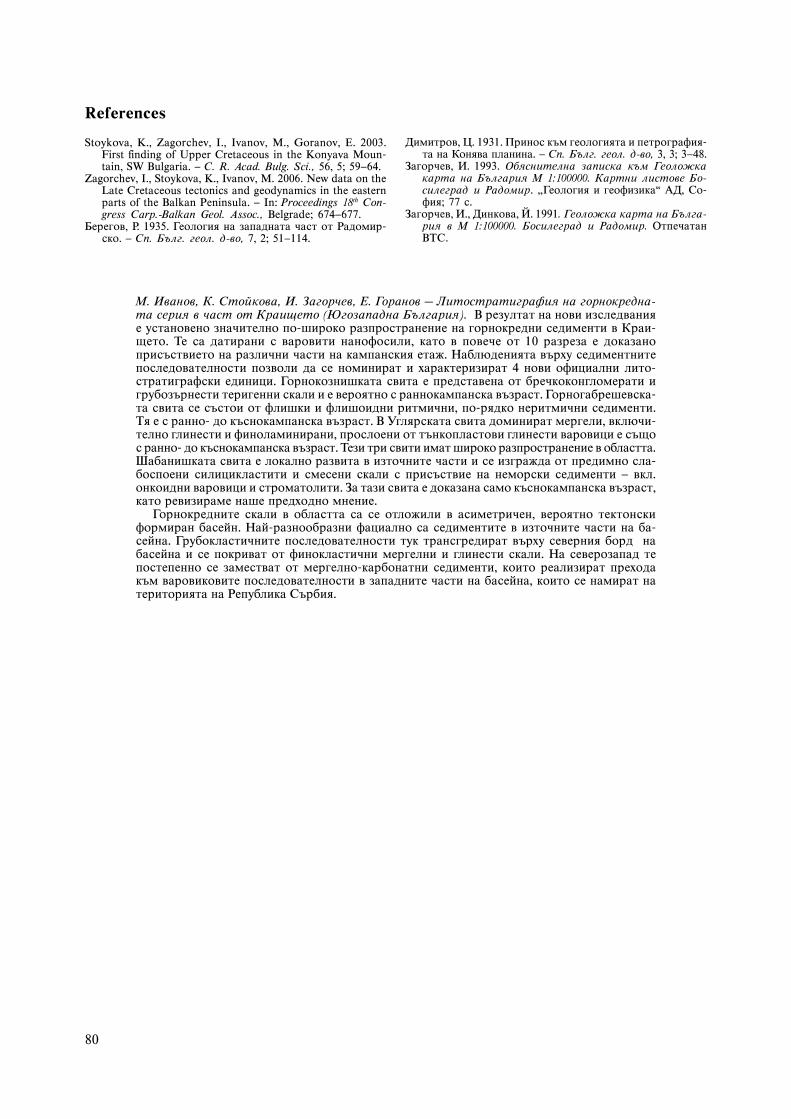
The Babushnitsa-Fucha basin suffered consid-erable post-Cretaceous deformations in Palaeogeneand earliest Miocene times. Its relics are now spreadas a belt (Fig. 7) west of the Lyubash-Golo bardohigh (cordillera?) and the Srednogorie zone. Thereal extent and geodynamics of the basin are notyet fully understood. Further studies should eluci-date the extent and relations of the basin with theLate Cretaceous basins of the Srednogorie, Balkanand South Carpathian zones thus allowing for abetter understanding of the Late Cretaceous platemotions.
Fig. 7. Sketch map (Zagorchev et al., 2006, fig. 1; after differentSerbian and Bulgarian sources and own research) for the tec-tonic structure and the distribution of Upper Cretaceous sedi-ments in parts of East Serbia and West Bulgaria. The mainareas of Upper Cretaceous occurrences are: S — Sichevo; B —Babushnitsa; M — Melovete; R — Radomir; F — Fucha
80
Ì. Èâàíîâ, Ê. Ñòîéêîâà, È. Çàãîð÷åâ, Å. Ãîðàíîâ – Ëèòîñòðàòèãðàôèÿ íà ãîðíîêðåäíà-òà ñåðèÿ â ÷àñò îò Êðàèùåòî (Þãîçàïàäíà Áúëãàðèÿ).  ðåçóëòàò íà íîâè èçñëåäâàíèÿå óñòàíîâåíî çíà÷èòåëíî ïî-øèðîêî ðàçïðîñòðàíåíèå íà ãîðíîêðåäíè ñåäèìåíòè â Êðàè-ùåòî. Òå ñà äàòèðàíè ñ âàðîâèòè íàíîôîñèëè, êàòî â ïîâå÷å îò 10 ðàçðåçà å äîêàçàíîïðèñúñòâèåòî íà ðàçëè÷íè ÷àñòè íà êàìïàíñêèÿ åòàæ. Íàáëþäåíèÿòà âúðõó ñåäèìåíòíèòåïîñëåäîâàòåëíîñòè ïîçâîëè äà ñå íîìèíèðàò è õàðàêòåðèçèðàò 4 íîâè îôèöèàëíè ëèòî-ñòðàòèãðàôñêè åäèíèöè. Ãîðíîêîçíèøêàòà ñâèòà å ïðåäñòàâåíà îò áðå÷êîêîíãëîìåðàòè èãðóáîçúðíåñòè òåðèãåííè ñêàëè è å âåðîÿòíî ñ ðàííîêàìïàíñêà âúçðàñò. Ãîðíîãàáðåøåâñêà-òà ñâèòà ñå ñúñòîè îò ôëèøêè è ôëèøîèäíè ðèòìè÷íè, ïî-ðÿäêî íåðèòìè÷íè ñåäèìåíòè.Òÿ å ñ ðàííî- äî êúñíîêàìïàíñêà âúçðàñò.  Óãëÿðñêàòà ñâèòà äîìèíèðàò ìåðãåëè, âêëþ÷è-òåëíî ãëèíåñòè è ôèíîëàìèíèðàíè, ïðîñëîåíè îò òúíêîïëàñòîâè ãëèíåñòè âàðîâèöè å ñúùîñ ðàííî- äî êúñíîêàìïàíñêà âúçðàñò. Òåçè òðè ñâèòè èìàò øèðîêî ðàçïðîñòðàíåíèå â îáëàñòòà.Øàáàíèøêàòà ñâèòà å ëîêàëíî ðàçâèòà â èçòî÷íèòå ÷àñòè è ñå èçãðàæäà îò ïðåäèìíî ñëà-áîñïîåíè ñèëèöèêëàñòèòè è ñìåñåíè ñêàëè ñ ïðèñúñòâèå íà íåìîðñêè ñåäèìåíòè — âêë.îíêîèäíè âàðîâèöè è ñòðîìàòîëèòè. Çà òàçè ñâèòà å äîêàçàíà ñàìî êúñíîêàìïàíñêà âúçðàñò,êàòî ðåâèçèðàìå íàøå ïðåäõîäíî ìíåíèå.
Ãîðíîêðåäíèòå ñêàëè â îáëàñòòà ñà ñå îòëîæèëè â àñèìåòðè÷åí, âåðîÿòíî òåêòîíñêèôîðìèðàí áàñåéí. Íàé-ðàçíîîáðàçíè ôàöèàëíî ñà ñåäèìåíòèòå â èçòî÷íèòå ÷àñòè íà áà-ñåéíà. Ãðóáîêëàñòè÷íèòå ïîñëåäîâàòåëíîñòè òóê òðàíñãðåäèðàò âúðõó ñåâåðíèÿ áîðä íàáàñåéíà è ñå ïîêðèâàò îò ôèíîêëàñòè÷íè ìåðãåëíè è ãëèíåñòè ñêàëè. Íà ñåâåðîçàïàä òåïîñòåïåííî ñå çàìåñòâàò îò ìåðãåëíî-êàðáîíàòíè ñåäèìåíòè, êîèòî ðåàëèçèðàò ïðåõîäàêúì âàðîâèêîâèòå ïîñëåäîâàòåëíîñòè â çàïàäíèòå ÷àñòè íà áàñåéíà, êîèòî ñå íàìèðàò íàòåðèòîðèÿòà íà Ðåïóáëèêà Ñúðáèÿ.
References
Stoykova, K., Zagorchev, I., Ivanov, M., Goranov, E. 2003.First finding of Upper Cretaceous in the Konyava Moun-tain, SW Bulgaria. — C. R. Acad. Bulg. Sci., 56, 5; 59—64.
Zagorchev, I., Stoykova, K., Ivanov, M. 2006. New data on theLate Cretaceous tectonics and geodynamics in the easternparts of the Balkan Peninsula. — In: Proceedings 18th Con-gress Carp.-Balkan Geol. Assoc., Belgrade; 674—677.
Áåðåãîâ, Ð. 1935. Ãåîëîãèÿ íà çàïàäíàòà ÷àñò îò Ðàäîìèð-ñêî. — Ñï. Áúëã. ãåîë. ä-âî, 7, 2; 51—114.
Äèìèòðîâ, Ö. 1931. Ïðèíîñ êúì ãåîëîãèÿòà è ïåòðîãðàôèÿ-òà íà Êîíÿâà ïëàíèíà. — Ñï. Áúëã. ãåîë. ä-âî, 3, 3; 3—48.
Çàãîð÷åâ, È. 1993. Îáÿñíèòåëíà çàïèñêà êúì Ãåîëîæêàêàðòà íà Áúëãàðèÿ Ì 1:100000. Êàðòíè ëèñòîâå Áî-ñèëåãðàä è Ðàäîìèð. „Ãåîëîãèÿ è ãåîôèçèêà“ ÀÄ, Ñî-ôèÿ; 77 ñ.
Çàãîð÷åâ, È., Äèíêîâà, É. 1991. Ãåîëîæêà êàðòà íà Áúëãà-ðèÿ â Ì 1:100000. Áîñèëåãðàä è Ðàäîìèð. Îòïå÷àòàíÂÒÑ.