Lebanon Bus Stop Design Study
42
Lebanon Bus Stop Design Study City of Lebanon, New Hampshire November, 2010
-
Upload
khangminh22 -
Category
Documents
-
view
4 -
download
0
Transcript of Lebanon Bus Stop Design Study

Lebanon Bus Stop Design StudyCity of Lebanon, New Hampshire
November, 2010

Lebanon Bus Stop Design StudyCity of Lebanon, New Hampshire
Prepared for:
Advance Transit, Inc.120 Billings Farm RoadWilder, VT 05008
City of Lebanon51 North Park StreetLebanon, NH 03766
Prepared by:
ORW Landscape Architects and PlannersWhite River Junction, Vermont
Smart Mobility, Inc.Norwich, Vermont

Table of Contents
Introduction.........................................................................................................1Study Goals...........................................................................................................6Bus Stop Inventory................................................................................................6Transit Operations ...............................................................................................6Bus Stop Design Considerations ..........................................................................8Bus Stop Conceptual Plans.................................................................................21Additional Recommendations............................................................................37
AppendixBus Stop Inventory............................................................................................A-1
List of Figures
Figure 1: Advance Transit System Routes..........................................................2 Figure 2: Detail of Routes and Bus Stops in Lebanon ....................................2Figure 3: Planned Change to the Blue Route..................................................6 Figure 4: Red Route on Route 12A .................................................................7 Figure 5: Commercial Site Plan Diagram.........................................................7Figure 6: Downtown Lebanon Existing Conditions Plan..............................21Figure 7: Downtown Lebanon Option 1: Transit Plaza ...........................22Figure 8: Downtown Lebanon Option 1: Transit Plaza Section...............23Figure 9: Downtown Lebanon Option 2: Two-Way Traffic...................24Figure 10: Downtown Lebanon Option 2: Two-Way Traffic Section..............25Figure 11: West Lebanon Main Street Existing Conditions ..............................26Figure 12: West Lebanon Main Street Future Condition .................................27Figure 13: DHMC East Entrance......................................................................... 28Figure 14: Mount Support at Timberwood Housing......... ...............................29Figure 15: Mount Support Road at Memorial Drive. ......................................30Figure 16: Miracle Mile Plaza ..........................................................................31Figure 17: Mechanic Street at Slayton Hill Road..........................................32Figure 18: Slayton Hill Road Future Pedestrian Linkages..............................33Figure 19: Romano Circle ..................................................................................34Figure 20: Gould (Sachem Village)...................................................................35Figure 21: Glen Road Plaza .................................................................................36
Lebanon Bus Stop Design Study
November, 2010
List of Tables
Table 1: Distribution of Riders by Town of Residence and by Route......................3Table 2: Residence of Advance Transit Riders......................................................3Table 3: Bus Stop Inventory Summary By Route..................................................4 Table 4: Bus Stop Hierarchy Designations .........................................................9 Figure 5: Summary of Recommendations for Other Stops..................................38

Lebanon Bus Stop Design Study
November, 20101
IntroductIon
This study has been prepared to identify physical improvements to the streetscape environment of the bus stop to better accommodate transit patrons and facilitate bus operations. Improving transit ridership in Lebanon holds many potential benefits including contribution to a more sustainable community, reduction in congestion and parking demand, improved mobil-ity and contribution to community health and wellness through use of active transportation.
In the fiscal year ending June 2010, there were 262,210 boardings on Advance Transit (AT) buses in Lebanon (these figures exclude the DHMC shuttles). Over the past five years, AT boardings in Lebanon have grown an average of 8.25% per year.
Advance transit Lebanon Facts at a Glance:
• Lebanon Boardings in Fiscal Year 2009/2010: 262,210
• Lebanon Boardings as a percentage of AT system: 56%
• Average Annual Growth 2005-2010 (Lebanon Boardings): 8.25%
• Average Annual Growth 2005-2010 (System Boardings): 7.25%
• Percent of Riders that have a car available (System wide, 2008): 53%
Advance Transit’s recently relocated Downtown Lebanon bus stop.

Lebanon Bus Stop Design Study
November, 20102
FIGURE 1: Advance Transit System Routes FIGURE 2: Detail of Routes and Bus Stops in Lebanon

Lebanon Bus Stop Design Study
November, 20103
Forty-four percent of Advance Transit riders are Lebanon residents and 56% of AT’s boardings are in Lebanon. The Blue Route, which services Down-town Lebanon, DHMC and Hanover is the route with the highest ridership. The Red Route, which operates entirely within Lebanon, carried nearly 120,000 passengers in fiscal year 2010. It is inter-esting to note that while overall ridership on the system has experienced steady growth, there has been significant growth in ‘choice’ riders that have a car available, but choose to leave the car at home and ride the bus. In 1999, 25% of riders had a car available; in 2004 that percentage had increased
There are many ingredients that work in combination to attract riders to transit: a service that is reliable, frequent, predictable and gets riders where they want to go in a timely manner (e.g., avoids unproductive loops); employer incentives to ride (and disincentives to drive); the comfort, safety and conve-nience of the bus stop environment; the overall pattern of land uses to support transit (e.g., transit-oriented development). While this study examines the bus stop environment, there are some areas of overlap between the immediate bus stop environment and these other concerns as well.
A bus stop environment that is safe, comfortable, attractive and convenient positively affects both the transit patron experience and the community within which it is located. An attractively designed bus stop sends a message to riders that they are a valued part of the community, and this can help increase the appeal of riding transit. Research shows that bus stop amenities positively in-fluence perceived waiting time and can help boost ridership (TRB, 2008). From a community planning point of view, bus stops are important public gathering spaces that can be a neighborhood focal point and, when properly located and designed, contribute to the activity and vitality of the community.
Riders waiting for the bus at Glen Road Plaza.
TABLE 1: Distribution of Riders by Town of Residence and by Route
TABLE 2: Residence of advance transit riders
to 43%; in 2008 more than half, 53%, of AT’s riders had a car available (Tom Crickelair Associates, 2008). This is an impressive figure for any transit system and speaks volumes about a transit system that is able to successfully compete with the automobile for riders.
Lebanon Bus Stop Design Study
November, 20104
Stop Name Blue
Red
Orang
eGreen
StreetTraffic Volume
Traffic Speed
Bus Stop Type
No. of Routes
Buses per day
Monthly Boardings Sign Shelter Accessibility Sidewalks
Ped Crossings Bike Racks
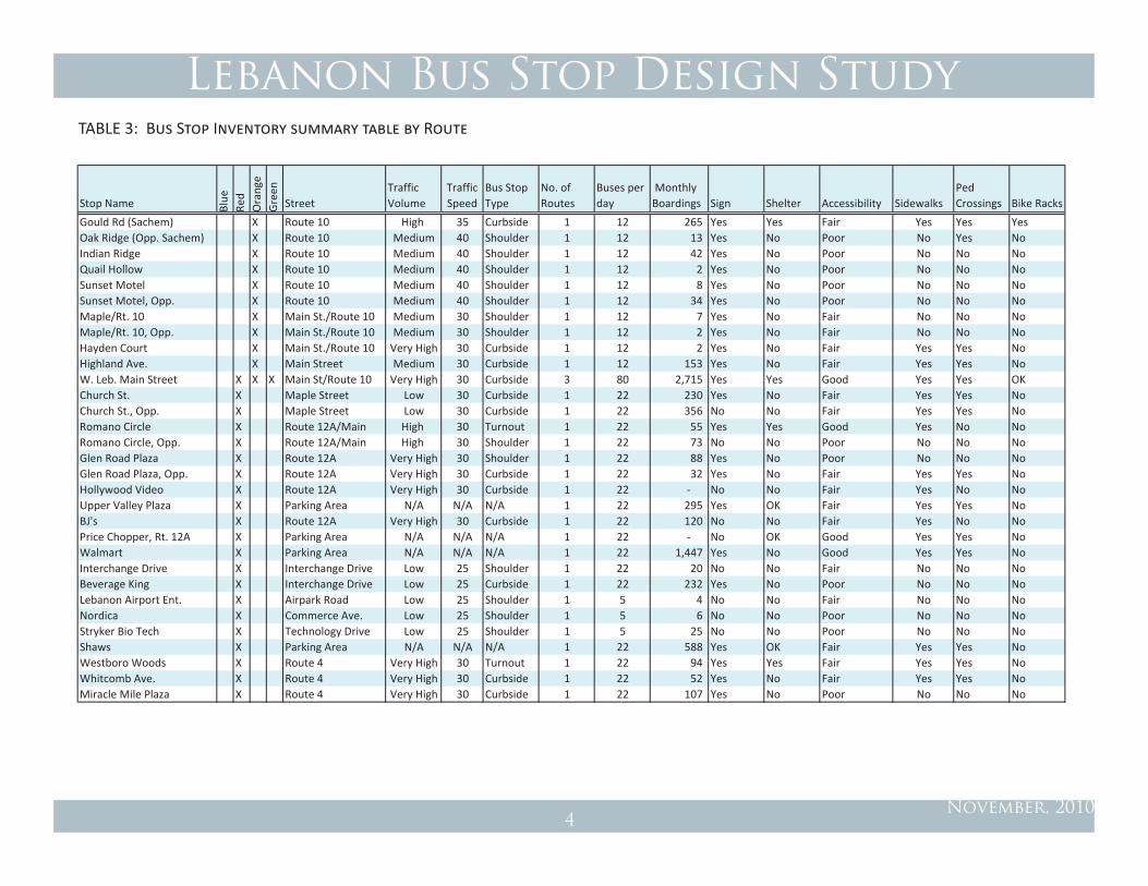
Gould Rd (Sachem) X Route 10 High 35 Curbside 1 12 265 Yes Yes Fair Yes Yes YesOak Ridge (Opp. Sachem) X Route 10 Medium 40 Shoulder 1 12 13 Yes No Poor No Yes NoIndian Ridge X Route 10 Medium 40 Shoulder 1 12 42 Yes No Poor No No NoQuail Hollow X Route 10 Medium 40 Shoulder 1 12 2 Yes No Poor No No NoSunset Motel X Route 10 Medium 40 Shoulder 1 12 8 Yes No Poor No No NoSunset Motel, Opp. X Route 10 Medium 40 Shoulder 1 12 34 Yes No Poor No No NoMaple/Rt. 10 X Main St./Route 10 Medium 30 Shoulder 1 12 7 Yes No Fair No No NoMaple/Rt. 10, Opp. X Main St./Route 10 Medium 30 Shoulder 1 12 2 Yes No Fair No No NoHayden Court X Main St./Route 10 Very High 30 Curbside 1 12 2 Yes No Fair Yes Yes NoHighland Ave. X Main Street Medium 30 Curbside 1 12 153 Yes No Fair Yes Yes NoW. Leb. Main Street X X X Main St/Route 10 Very High 30 Curbside 3 80 2,715 Yes Yes Good Yes Yes OKChurch St. X Maple Street Low 30 Curbside 1 22 230 Yes No Fair Yes Yes NoChurch St., Opp. X Maple Street Low 30 Curbside 1 22 356 No No Fair Yes Yes NoRomano Circle X Route 12A/Main High 30 Turnout 1 22 55 Yes Yes Good Yes No NoRomano Circle, Opp. X Route 12A/Main High 30 Shoulder 1 22 73 No No Poor No No NoGlen Road Plaza X Route 12A Very High 30 Shoulder 1 22 88 Yes No Poor No No NoGlen Road Plaza, Opp. X Route 12A Very High 30 Curbside 1 22 32 Yes No Fair Yes Yes NoHollywood Video X Route 12A Very High 30 Curbside 1 22 ‐ No No Fair Yes No NoUpper Valley Plaza X Parking Area N/A N/A N/A 1 22 295 Yes OK Fair Yes Yes NoBJ's X Route 12A Very High 30 Curbside 1 22 120 No No Fair Yes No NoPrice Chopper, Rt. 12A X Parking Area N/A N/A N/A 1 22 ‐ No OK Good Yes Yes NoWalmart X Parking Area N/A N/A N/A 1 22 1,447 Yes No Good Yes Yes NoInterchange Drive X Interchange Drive Low 25 Shoulder 1 22 20 No No Fair No No NoBeverage King X Interchange Drive Low 25 Curbside 1 22 232 Yes No Poor No No NoLebanon Airport Ent. X Airpark Road Low 25 Shoulder 1 5 4 No No Fair No No NoNordica X Commerce Ave. Low 25 Shoulder 1 5 6 No No Poor No No NoStryker Bio Tech X Technology Drive Low 25 Shoulder 1 5 25 No No Poor No No NoShaws X Parking Area N/A N/A N/A 1 22 588 Yes OK Fair Yes Yes NoWestboro Woods X Route 4 Very High 30 Turnout 1 22 94 Yes Yes Fair Yes Yes NoWhitcomb Ave. X Route 4 Very High 30 Curbside 1 22 52 Yes No Fair Yes Yes NoMiracle Mile Plaza X Route 4 Very High 30 Curbside 1 22 107 Yes No Poor No No No
TABLE 3: Bus Stop Inventory summary table by Route
Lebanon Bus Stop Design Study
November, 20105
Stop Name Blue
Red
Orang
eGreen
StreetTraffic Volume
Traffic Speed
Bus Stop Type
No. of Routes
Buses per day
Monthly Boardings Sign Shelter Accessibility Sidewalks
Ped Crossings Bike Racks
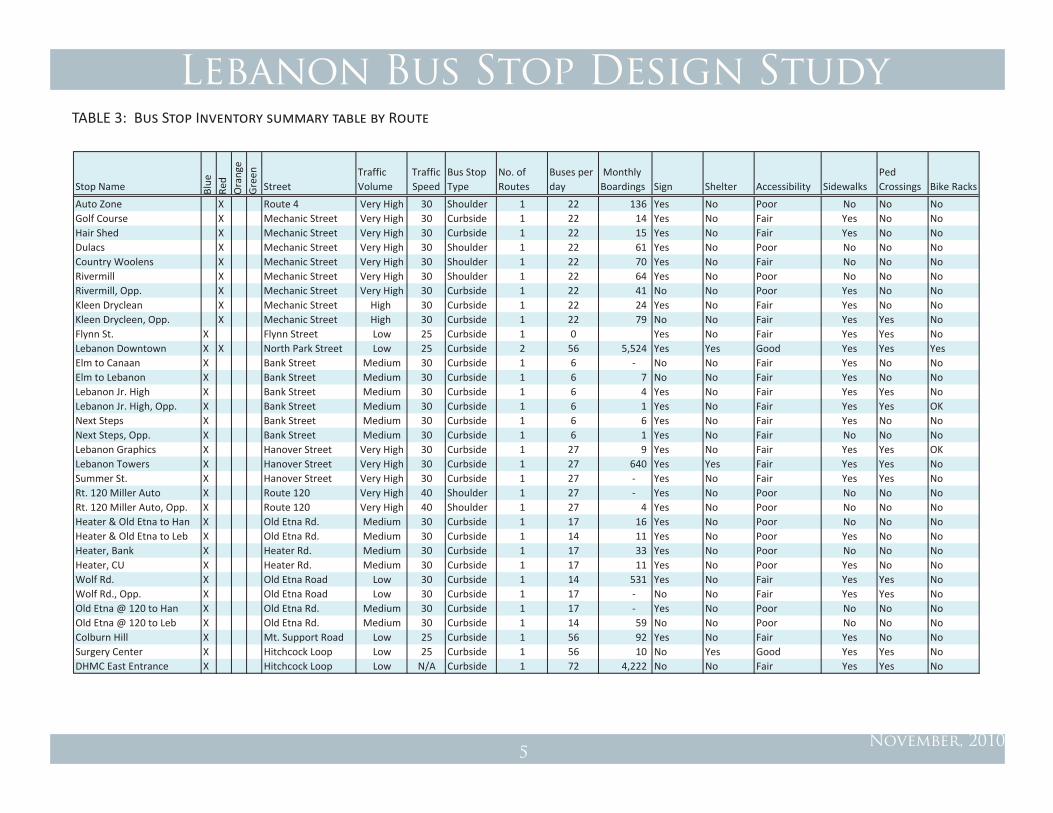
Auto Zone X Route 4 Very High 30 Shoulder 1 22 136 Yes No Poor No No NoGolf Course X Mechanic Street Very High 30 Curbside 1 22 14 Yes No Fair Yes No NoHair Shed X Mechanic Street Very High 30 Curbside 1 22 15 Yes No Fair Yes No NoDulacs X Mechanic Street Very High 30 Shoulder 1 22 61 Yes No Poor No No NoCountry Woolens X Mechanic Street Very High 30 Shoulder 1 22 70 Yes No Fair No No NoRivermill X Mechanic Street Very High 30 Shoulder 1 22 64 Yes No Poor No No NoRivermill, Opp. X Mechanic Street Very High 30 Curbside 1 22 41 No No Poor Yes No NoKleen Dryclean X Mechanic Street High 30 Curbside 1 22 24 Yes No Fair Yes No NoKleen Drycleen, Opp. X Mechanic Street High 30 Curbside 1 22 79 No No Fair Yes Yes NoFlynn St. X Flynn Street Low 25 Curbside 1 0 Yes No Fair Yes Yes NoLebanon Downtown X X North Park Street Low 25 Curbside 2 56 5,524 Yes Yes Good Yes Yes YesElm to Canaan X Bank Street Medium 30 Curbside 1 6 ‐ No No Fair Yes No NoElm to Lebanon X Bank Street Medium 30 Curbside 1 6 7 No No Fair Yes No NoLebanon Jr. High X Bank Street Medium 30 Curbside 1 6 4 Yes No Fair Yes Yes NoLebanon Jr. High, Opp. X Bank Street Medium 30 Curbside 1 6 1 Yes No Fair Yes Yes OKNext Steps X Bank Street Medium 30 Curbside 1 6 6 Yes No Fair Yes No NoNext Steps, Opp. X Bank Street Medium 30 Curbside 1 6 1 Yes No Fair No No NoLebanon Graphics X Hanover Street Very High 30 Curbside 1 27 9 Yes No Fair Yes Yes OKLebanon Towers X Hanover Street Very High 30 Curbside 1 27 640 Yes Yes Fair Yes Yes NoSummer St. X Hanover Street Very High 30 Curbside 1 27 ‐ Yes No Fair Yes Yes NoRt. 120 Miller Auto X Route 120 Very High 40 Shoulder 1 27 ‐ Yes No Poor No No NoRt. 120 Miller Auto, Opp. X Route 120 Very High 40 Shoulder 1 27 4 Yes No Poor No No NoHeater & Old Etna to Han X Old Etna Rd. Medium 30 Curbside 1 17 16 Yes No Poor No No NoHeater & Old Etna to Leb X Old Etna Rd. Medium 30 Curbside 1 14 11 Yes No Poor Yes No NoHeater, Bank X Heater Rd. Medium 30 Curbside 1 17 33 Yes No Poor No No NoHeater, CU X Heater Rd. Medium 30 Curbside 1 17 11 Yes No Poor Yes No NoWolf Rd. X Old Etna Road Low 30 Curbside 1 14 531 Yes No Fair Yes Yes NoWolf Rd., Opp. X Old Etna Road Low 30 Curbside 1 17 ‐ No No Fair Yes Yes NoOld Etna @ 120 to Han X Old Etna Rd. Medium 30 Curbside 1 17 ‐ Yes No Poor No No NoOld Etna @ 120 to Leb X Old Etna Rd. Medium 30 Curbside 1 14 59 No No Poor No No NoColburn Hill X Mt. Support Road Low 25 Curbside 1 56 92 Yes No Fair Yes No NoSurgery Center X Hitchcock Loop Low 25 Curbside 1 56 10 No Yes Good Yes Yes NoDHMC East Entrance X Hitchcock Loop Low N/A Curbside 1 72 4,222 No No Fair Yes Yes No
TABLE 3: Bus Stop Inventory summary table by Route
Lebanon Bus Stop Design Study
November, 20106
Study GoALS
The goals of the study are primarily to develop a program of bus stop improve-ments and enhancements that will achieve the major objectives of:
• Fostering increases in ridership and transit service;
• Enhancing the rider’s experience;
• Creating an attractive asset to the community; and
• Addressing potential impacts of transit service.
Legend New Mt. Support Route Discontinued Route
ROUTE 120
Etna
Rd
Alde
n Rd
Heater Rd
Mt. Support Rd
Priv
ate
Bank St
Lahaye Dr
Youn
g St
Stevens Rd
Old Pine Cemetery
Evans Dr
Spencer St
Old Etna RdWol
f Rd
Han
over
St
Townsends Ter
Centerra Pky
Hough St
Dor
othy
Per
ley
Rd
Gra
nite
St
Lafayette St
Han
over
St E
xt
Gre
at H
ollo
w R
d
Bank St Ext
Mor
gan
Dr
Winter St
Eia
St
STEVENS RD
Green St
MED
ICAL
CEN
TER
DR
Colb
urn
St
LaBo
mba
rd R
d
Peab
ody
St
Congress St
Fore
st A
ve
Cam
pbel
l St
Barrow St
Mascoma St
Cedar St
BuS Stop Inventory
A comprehensive inventory of Lebanon’s 64 bus stops was prepared as a part of this study, which is attached to this report. The inventory includes informa-tion on activity at each stop in terms of boardings, number of buses and routes, and an assessment of the existing conditions of the street (traffic volume and posted speed limit) as well as the conditions at the stop including signage, shelter, pedestrian crossing and accessibility information. Table 3 provides a summary of bus stop information; the complete inventory can be found in the Appendix.
trAnSIt operAtIonS
While the primary emphasis of this report is to provide design recom-mendations for the bus stops, there are two areas where transit operation changes are recommended to allow Advance Transit to more efficiently serve several growth areas in Lebanon. These include Mount Support Road, which is being rebuilt and is seeing substantial residential growth that could be served by transit; and the Route 12A corridor, where the land use and development patterns mean the transit service must use highly circuitous (and inefficient) routing.
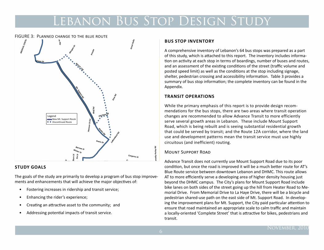
Mount Support Road
Advance Transit does not currently use Mount Support Road due to its poor condition, but once the road is improved it will be a much better route for AT’s Blue Route service between downtown Lebanon and DHMC. This route allows AT to more efficiently serve a developing area of higher density housing just beyond the DHMC campus. The City’s plans for Mount Support Road include bike lanes on both sides of the street going up the hill from Heater Road to Me-morial Drive. From Memorial Drive to La Haye Drive, there will be a bicycle and pedestrian shared-use path on the east side of Mt. Support Road. In develop-ing the improvement plans for Mt. Support, the City paid particular attention to ensure that road maintained an appropriate scale to calm traffic and maintain a locally-oriented ‘Complete Street’ that is attractive for bikes, pedestrians and transit.
FIGURE 3: Planned change to the blue route

Lebanon Bus Stop Design Study
November, 20107
Initially there would be stops at Heater Road and Old Etna Road, Mount Sup-port Road at Memorial Drive, and Mount Support Road at Timberwood Hous-ing. Conceptual bus stop designs are set forth in this report.
Route 12A
While much has been discussed about the problems with Route 12A relative to traffic congestion, it should be noted that the current configuration of Route 12A, both the street design and the pattern of development, is also completely dysfunctional for transit. The orientation of buildings set far back from the street and placed within a sea of asphalt parking impedes efficient transit ser-vice. Buses must choose to either drop pedestrians at the curb or drive in and
B U I L D I N G
P A R k I N G A R E A
Future connection
pedestrian connections
S T R E E T
Bus Stop
Commercial Parcel Redesigned for Transit and Pedestrian Orientation
B U I L D I N G
P A R k I N G A R E A
S T R E E T
Glen Rd
Rout
e 12A
Airport RdPoverty
Ln
Plai
nfiel
d Rd
Airpark Rd
ELM ST W Seminary Hill
Benning St
King
s Hw
y
Old Pin
e Cem
eter
y
CIVIL AIR PATROL RD
Tenley Dr
Inte
rcha
nge
Dr
MIRACLE MILE
Commerce Ave
Waterman Av
Armstr
ong
Av
!
!
!!
!
!
!
!!
!!
!
!
!
!
!
!
BJ's
Shaws
NordicaPricechopper
Romano Circle
Beverage King
Stryker BioTech
Hollywood VideoGlen Road Plaza
Upper Valley Plaza
Lebanon Airport Entrance
Wal Mart
Interchange Dr
FIGURE 4: Red Route on route 12a FIGURE 5: Commercial Site Plan Diagram
out of the disconnected plazas. The latter is the current routing and it is very inefficient. Ideally, bus stops would be at the curb to maximize efficient transit operations (which will pay off in ridership benefits).
As Route 12A is a robust commercial district that is beginning to experience its second wave of development, the City should ensure that new development embodies the elements of transit-oriented design. This is too large of a topic to fully address here, but the most important aspect is to orient development to the street and sidewalk and provide attractive pedestrian walkways that con-nect new development to the bus stop. Reserving the opportunity to provide access between parcels provides the first step to developing an interconnected street system that can better distribute traffic through a network as an alter-native to loading all of the circulation functions onto a single main road (see ‘Future Connections’ in diagram above).
The Planning Board has recently discussed the idea of changing the configura-tion of the Route 12A roadway to include roundabouts and possibly a central
Routing of the Red Route buses on Route 12A is circuitous and inefficient.

Lebanon Bus Stop Design Study
November, 20108
Facilitate and Improve transit Service. Evaluation and design for improvement of the bus stops will incorporate changes that make transit service more ef-ficient and convenient for the transit patron. At the same time, these improve-ments must be made in balance with other users of the street, including pedes-trians, bicyclists, cars and service vehicles. The plan will establish a priority for transit vehicle operations with convenient and accessible transit stops.
Improve the patron experience. There are opportunities for streetscape changes that can make Lebanon streets more transit and pedestrian friendly (transit riders are pedestrians at the bus stop), improving both the patron ex-perience and transit operations. The visibility of transit in the streetscape with attractive signage, schedule information and comfortable places to wait will help patrons navigate the system, ‘recruit’ additional users and provide visual cues to drivers that they are in a transit environment and should adjust their expectations accordingly.
enhance the neighborhood and community. Transit plays an important role in the livability and quality of the community. Bus stops should be integrated into the community to enhance the activity and vitality of the streetscape and neighborhood within which they are located. Bus stops should be monitored by Advance Transit and the City in order to ensure that the stop is running smoothly and negative impacts, such as noise, trash, visual obstructions, and/or lack of seating are addressed.
consider the needs of Stakeholders. The needs of all stakeholders, including Advance Transit, City of Lebanon, adjoining businesses and property own-ers have been involved in the planning process in order to begin a conversa-tion about the role of transit in the community and the specific location and design of bus stops. The role of transit in the commercial district of downtown Lebanon, West Lebanon and the Route 12 A plazas is key, considering ongoing concerns about traffic congestion and limited parking.
Look to the Long term. Evaluating the bus stops in the study area has been done with one eye to the future: What is the realistic long-term vision of how transit services will operate in five years? Ten years? Are there innovative ideas that can help improve transit service in the longer term?
median to improve traffic flow. This is an exciting development for this impor-tant area. One of the objectives for rethinking the street and development patterns along Route 12A should be to improve the area for efficient transit service as well. Accommodating bus stops at the curb with pedestrian connec-tions into the development is of primary importance. There are a number of options to evaluate as a part of improving bus service operations along Route 12A, including:
• Traffic signal prioritization for buses. If signalization remains in place, TSP systems should be considered. This allows buses to re-duce delays at red lights by the use of a wireless transmitter that allows the buses to ‘override’ the light cycle. The technology is evolving on this front, but generally the signal can ‘sense’ when a bus is within a certain distance of a signal (e.g., 400 feet) and will turn green to let the bus through the intersection. This mechanism is a tremendous benefit to maintaining transit schedules and a timely transportation service, which in turn pays off in increased ridership. This system should be considered on arteries outside of Route 12A as well.
• Shared bus/bike lanes. As the term implies, this would be a wider curb lane that accommodates both buses and bikes. This would give preferential treatment that would allow buses (and bikes) to more safely and rapidly traverse Route 12A. Buses could stop in the lane and would not need to pull in and out of traffic.
• Curbside bus stops with turnouts. If the ROW does not allow shared bus/bike lanes, curbside bus stops should be planned. In this location, it is likely that turnouts would be desirable. Attractive pedes-trian connections into the commercial developments should be devel-oped as well.
BuS Stop deSIGn conSIderAtIonS
We have taken the following approach to this bus stop design study:

Lebanon Bus Stop Design Study
November, 20109
Stop Name Blue
Red
Orang
eGreen
Stop Class Num
ber
Buses per Day
Monthly Boardings
Lebanon Downtown X X A 1 56 5,524 DHMC East X A 2 72 4,222 W. Leb. Main Street X X X A 3 80 2,715 Walmart X B 1 22 1,447 Lebanon Towers X B 2 27 640 Shaws X B 3 22 588 Wolf Rd. X B 4 14 531 Church St., Opp. X B 5 22 356 Upper Valley Plaza X B 6 22 295 Gould Rd (Sachem) X B 7 12 265 Beverage King X B 8 22 232 Church St. X B 9 22 230 Highland Ave. X B 10 12 153 Auto Zone X B 11 22 136 BJ's X B 12 22 120 Miracle Mile Plaza X B 13 22 107 Westboro Woods X B 14 22 94 Colburn Hill X B 15 56 92 Glen Road Plaza X B 16 22 88 Kleen Drycleen, Opp. X B 17 22 79 Romano Circle, Opp. X B 18 22 73 Country Woolens X B 19 22 70 Rivermill X C 1 22 64 Dulacs X C 2 22 61 Old Etna @ 120 to Leb X C 3 14 59 Romano Circle X C 4 22 55 Whitcomb Ave. X C 5 22 52 Indian Ridge X C 6 12 42 Rivermill, Opp. X C 7 22 41 Sunset Motel, Opp. X C 8 12 34
Stop Name Blue
Red
Orang
eGreen
Stop Class Num
ber
Buses per Day
Monthly Boardings
Heater, Bank X C 9 17 33 Glen Road Plaza, Opp. X C 10 22 32 Stryker Bio Tech X C 11 5 25 Kleen Dryclean X C 12 22 24 Interchange Drive C 13 22 20 Heater & Old Etna to Han X C 14 17 16 Hair Shed X C 15 22 15 Golf Course X C 16 22 14 Oak Ridge (Opp. Sachem) X C 17 12 13 Heater & Old Etna to Leb X C 18 14 11 Heater, CU X C 19 14 11 Surgery Center X C 20 56 10 Lebanon Graphics X C 21 27 9 Sunset Motel X C 22 12 8 Elm to Lebanon X C 23 6 7 Maple/Rt. 10 X C 24 12 7 Nordica X C 25 5 6 Next Steps X C 26 6 6 Lebanon Airport Ent. X C 27 5 4 Lebanon Jr. High X C 28 6 4 Rt. 120 Miller Auto, Opp. X C 29 27 4 Quail Hollow X C 30 12 2 Hayden Court X C 31 12 2 Maple/Rt. 10, Opp. X C 32 12 2 Lebanon Jr. High, Opp. X C 33 6 1 Next Steps, Opp. X C 34 6 1 Price Chopper, Rt. 12A X C 35 22 ‐ Wolf Rd., Opp. X C 36 17 ‐ Elm to Canaan X C 37 6 ‐ Hollywood Video X C 38 22 ‐ Old Etna @ 120 to Han X C 39 9 ‐ Rt. 120 Miller Auto X C 40 27 ‐ Summer St. X C 41 27 ‐ Flynn St. X C 42 0 ‐
TABLE 4: Bus Stop Hierarchy Designations

Lebanon Bus Stop Design Study
November, 201010
Recommendations
The following are the primary recommendations of this study.
Bus Stop Hierarchy
Each bus stop in the study area has been assigned a ‘level’ of A through C, based on the relative importance of each bus stop in terms of total boardings, bus frequency, and the number of bus routes served. An attached inventory table provides a listing of the bus stops, relevant data, and a proposed designa-tion. The following sections describe appropriate features of the bus stops.
Level A
These are the stops that are the highest in the hierarchy based on the number of users, transfers, bus frequency, and routes served. These stops should have the highest level of amenities, including a shelter, trash receptacles, route and schedule information, signage, safe pedestrian connections, good lighting and
ideally, real time transit arrival information. In Lebanon, these bus stops are as follows:
• Downtown Lebanon
• DHMC East Entrance
• Downtown West Lebanon
Level B
These are stops with moderate boardings and importance, and should have at a minimum: a bus shelter with map, route and schedule information; safe pe-destrian access; good lighting; an accessible environment; and signage. There are 19 bus stops in this category, and several would be improved by the addi-tion of a shelter and improvements for accessibility and pedestrian safety.
Riders waiting for the bus at Mechanic Street and Slayton Hill Road. Rider waiting for the bus at Miracle Mile Plaza.

Lebanon Bus Stop Design Study
November, 201011
Level C
These are the bus stops with the lowest numbers of boardings, and therefore are relatively less critical for improvements. Some of these stops which have low or no boardings may indicate stops where riders alight, rather than board buses, so that is a consideration for bus stop design. For example, the stop Wolf Road, Opposite logs no boardings, but Wolf Road ranks number 7 in over-all boardings. This indicates that this stop has a very directional nature (in this case toward DHMC). At a minimum, these stops should have signage, safe pe-destrian access and good lighting. It should be noted that traffic at these stops may change dramatically in association with new development, changes in fuel prices or parking policy at major employers. Therefore, continued monitoring of the boardings and activity at these stops should be conducted to determine if amenities are needed in the future.
General Design Considerations
Bus Stop Configuration: Curbside, Turnout or Bus Bulb?
The following issues should be considered in the decision of whether a bus pull off is recommended in a particular location. There is no one-size-fits-all answer, and each location should be evaluated by Advance Transit and the City in con-sideration of the context of the bus stop.
Bus Operations
Bus stop designs should provide for the bus system to maintain its schedule and efficient operations. Bus stop configurations that take more time for bus boarding, or for buses to re-enter traffic streams, can delay an entire schedule. With a “pulse” system, such as Advance Transit’s, it is important for all buses to keep on schedule to allow the critical transfers between routes. When a passenger misses their transfer, it could mean a one hour delay in their trip. If one bus is running late due to traffic congestion, it can delay all the other bus routes as they wait for connections. Therefore, providing bus stop designs that allow for efficient operations of the bus system is important. Given the high cost of running a bus system, is makes sense to allow it to operate with the greatest level of efficiency.
Safety
There are a variety of very important safety considerations in design and location of bus stops. Perhaps most importantly, the buses and pedestrians that may need to cross should have adequate lines of sight. Bus stops should also be designed to minimize potential traffic conflicts. There has been ample research and study of the optimal bus stop configurations for different types of traffic flow environments, with the following conclusions:
• In higher speed (over 40 mph traffic speeds), and in less congested envi-ronments, bus pull-offs are appropriate, in order to reduce conflicts with oncoming traffic.
• In lower speed settings, the bus stopping in the street generally results in
Main Street West Lebanon bus stop recent improvements.

Lebanon Bus Stop Design Study
November, 201012
Bus Turnout at Romano Circle.
minimal risk of crashes. On congested streets, buses in a pull-off may have difficulty finding a sufficient gap in traffic to re-enter the traffic stream, re-quiring more risky maneuvers or aggressive driving, on the part of the bus driver in order to maintain the system schedule. Requiring bus pull-offs on a slow moving, congested street is putting bus drivers in a difficult situation that can be more likely to result in a crash. Usually, it is safer for all users to simply provide curbside bus stops, with buses blocking traffic for the short boarding and alighting period.
• There are a few special situations where bus turnouts should be built. This includes any locations where there are more frequent users of the bus that require assistance boarding or alighting (e.g., senior housing, public hous-ing, boarding with baggage), or where the buses must dwell for a period to maintain their schedule or connections. In cases where a bus turnout is appropriate near a signalized intersection, the best location is on the far side of the intersection, so that gaps are created during the red light phase for the bus to safely re-enter traffic.
There are a variety of bus stop configurations, with the following sections describing some of the features of each. While the examples below all as-sume that the bus stops are on streets with sidewalks, this is often not true of Advance Transit stops, so actual conditions are not always described by the examples below.
Curbside Bus Stops
A curbside bus stop is by far the most common bus stop configuration, where the bus stops along the curb and typically blocks the travel lane while passen-gers board and alight. In cases where there is parallel parking, however, the curbside stop may occur in a “no parking” zone adjacent to parallel parking spaces. In these cases, a curbside stop allows the bus to be out of moving traf-fic.
Turnouts or Pulloffs
Some bus stops are designed to allow the bus to pull out of traffic in areas where there is not parallel parking on the street. These are found in some
locations on the Advance Transit system such as Romano Circle or Westboro Woods. Bus turnouts can be problematic for buses if they are located on streets with high traffic volumes, as they make it difficult for the bus to re-enter the traffic stream, resulting in bus system delays and the potential for accidents. However, they can be desirable for safety reasons on higher speed routes, as the bus is safely removed from the traffic streams. The Transporta-tion Research Board (TRB) suggests the following conditions may be appropri-ate for bus turnouts:
• Traffic speed is greater than 40 mph;
• Bus volumes are 10 or more per peak hour on the roadway;
• Passenger volumes exceed 20 to 40 boardings per hour (or an average of 6 or more lift- boardings per day);
• Average peak-period dwell time exceeds 30 seconds per bus;
Lebanon Bus Stop Design Study
November, 201013
• Buses are expected to layover at the stop;
• Potential for auto/bus conflicts warrants separation of transit and pas-senger vehicles;
• History of repeated traffic and/or pedestrian accidents at stop location;
• Right-of-way width is adequate to construct the bay without adversely affecting sidewalk pedestrian movement; or
• Sight distances (i.e., hills, curves) prevent traffic from stopping safely behind a stopped bus.
In all cases, the configuration of the bus stop (whether it will be a curbside, turnout or bus bulb-out) should be determined jointly between Advance Transit and the City of Lebanon.
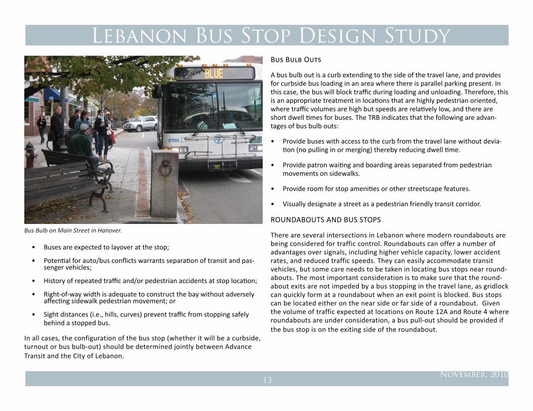
Bus Bulb Outs
A bus bulb out is a curb extending to the side of the travel lane, and provides for curbside bus loading in an area where there is parallel parking present. In this case, the bus will block traffic during loading and unloading. Therefore, this is an appropriate treatment in locations that are highly pedestrian oriented, where traffic volumes are high but speeds are relatively low, and there are short dwell times for buses. The TRB indicates that the following are advan-tages of bus bulb outs:
• Provide buses with access to the curb from the travel lane without devia-tion (no pulling in or merging) thereby reducing dwell time.
• Provide patron waiting and boarding areas separated from pedestrian movements on sidewalks.
• Provide room for stop amenities or other streetscape features.
• Visually designate a street as a pedestrian friendly transit corridor.
ROUNDABOUTS AND BUS STOPS
There are several intersections in Lebanon where modern roundabouts are being considered for traffic control. Roundabouts can offer a number of advantages over signals, including higher vehicle capacity, lower accident rates, and reduced traffic speeds. They can easily accommodate transit vehicles, but some care needs to be taken in locating bus stops near round-abouts. The most important consideration is to make sure that the round-about exits are not impeded by a bus stopping in the travel lane, as gridlock can quickly form at a roundabout when an exit point is blocked. Bus stops can be located either on the near side or far side of a roundabout. Given the volume of traffic expected at locations on Route 12A and Route 4 where roundabouts are under consideration, a bus pull-out should be provided if the bus stop is on the exiting side of the roundabout.
Bus Bulb on Main Street in Hanover.

Lebanon Bus Stop Design Study
November, 201014
Transit Vehicle Characteristics
The basic dimensional characteristics of the transit vehicles form a foundation for the bus stop designs in terms of dedicating adequate curb space to the bus stop. Currently Advance Transit’s fleet that serves the fixed route service includes two vehicles:
Standard Low-Floor Bus:
This is the standard bus currently serving the Blue and Red routes. The bus is 40-feet long with one door for boarding and alighting. This bus is a ‘low-floor’ design which has no steps and allows for faster and easier boarding especially for wheelchairs, strollers, and riders who may have difficulty walking or negoti-ating stairs. These buses have a fold-down bike rack on the front end. The bike rack adds three feet to the bus length.
Smaller Bus:
The smaller buses currently serve the Brown, Orange, Green routes. These buses are 34-feet long and have one door for boarding and alighting. There are stairs at the door and a wheelchair lift is behind the door. The buses have a fold-down bike rack on the front end which extends the bus length by three-feet.
Standard low floor bus. Smaller stair entry bus.
Lebanon Bus Stop Design Study
November, 201015
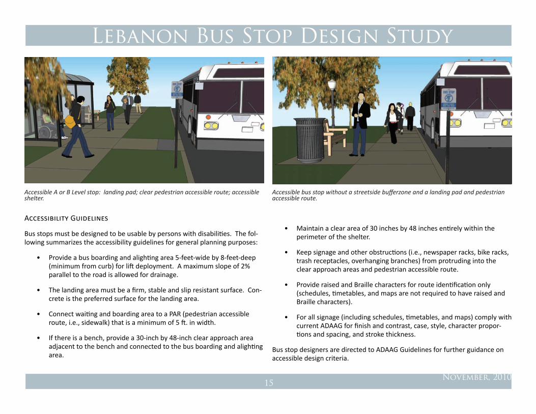
Accessibility Guidelines
Bus stops must be designed to be usable by persons with disabilities. The fol-lowing summarizes the accessibility guidelines for general planning purposes:
• Provide a bus boarding and alighting area 5-feet-wide by 8-feet-deep (minimum from curb) for lift deployment. A maximum slope of 2% parallel to the road is allowed for drainage.
• The landing area must be a firm, stable and slip resistant surface. Con-crete is the preferred surface for the landing area.
• Connect waiting and boarding area to a PAR (pedestrian accessible route, i.e., sidewalk) that is a minimum of 5 ft. in width.
• If there is a bench, provide a 30-inch by 48-inch clear approach area adjacent to the bench and connected to the bus boarding and alighting area.
• Maintain a clear area of 30 inches by 48 inches entirely within the perimeter of the shelter.
• keep signage and other obstructions (i.e., newspaper racks, bike racks, trash receptacles, overhanging branches) from protruding into the clear approach areas and pedestrian accessible route.
• Provide raised and Braille characters for route identification only (schedules, timetables, and maps are not required to have raised and Braille characters).
• For all signage (including schedules, timetables, and maps) comply with current ADAAG for finish and contrast, case, style, character propor-tions and spacing, and stroke thickness.
Bus stop designers are directed to ADAAG Guidelines for further guidance on accessible design criteria.
Accessible A or B Level stop: landing pad; clear pedestrian accessible route; accessible shelter.
Accessible bus stop without a streetside bufferzone and a landing pad and pedestrian accessible route.

Lebanon Bus Stop Design Study
November, 201016
Along more rural roads, which do not have developed sidewalks, a raised bus stop pad which elevates the waiting area above the grade of the road address-es both safety and accessibility concerns at these locations.
Sidewalks
Sidewalks and the bus stop landing pad are a core element of every bus stop. In general, bus stops should be well-connected into the surrounding neighbor-hood by sidewalks that enable transit patrons a safe and attractive travel route to and from the stop. Safe and attractive sidewalk connections to transit stops help encourage transit use.
Width. Sidewalks should be a minimum of five feet in width for acces-sibility. This should be viewed as a minimum standard for areas with light pedestrian traffic. In spatial terms, a five-foot sidewalk is wide enough for two people to walk abreast. Passing a pedestrian walking in the opposite direction, or a few people waiting at a bus stop, requires an awkward maneuver to make space on a five-foot wide sidewalk. Areas with higher
pedestrian volumes, such as the busier transit stops, neighborhood retail areas, the front of public buildings and other public gathering places, side-walks should be wider, 10-, 15- and even 20-feet in width to comfortably accommodate both pedestrian traffic and transit patrons.
Buffer Zones. Where possible, a buffer zone between the sidewalk and the curb is desirable to buffer pedestrians from the proximity of motor ve-hicles and the attendant noise, exhaust and splashing associated with traf-fic. A planted area with trees is ideal, as trees provide many environmen-tal benefits and provide shade and amenity for pedestrians, passersby and transit patrons. Street trees also provide a vertical element and sense of enclosure along the street which helps to calm and slow traffic and make the street more pedestrian friendly. Shrubs which block the view of pe-destrians around the bus stop, on the other hand, should be avoided.
LANDING PAD. As described in the Accessibility Guidelines above, at the bus stop, there must be a five-foot by eight-foot (five feet wide and eight feet from the curb edge) landing pad through the planted area for bus boarding and alighting. The landing pad must be connected to the sidewalks.
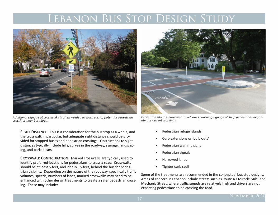
Crosswalks
Roadway crossings are one of the primary bus stop design considerations and challenges. Often overlooked is the basic fact that bus stops generally work in pairs, one on either side of the street, to serve both directions of travel. Every bus patron must cross the street either on the departing or returning trip. The location of pedestrian crossings should always be integrated into the consider-ation of the bus stop location and layout. Crosswalks should be evaluated at each bus stop location but the following are general design considerations:
Location. Crosswalks should typically be located behind buses so that pedestrians are visible to oncoming traffic and not blocked from view by the stopped bus. There are some exceptions to this rule, such as at a bus turnout or a signalized intersection, but for the majority of bus stops, crosswalks should be located behind the bus stopping zone.
An accessible C Level or rural road bus stop with a landing pad and accessible route. This can connect to a shoulder by curb ramps at either end of the sidewalk.
Lebanon Bus Stop Design Study
November, 201017
Sight Distance. This is a consideration for the bus stop as a whole, and the crosswalk in particular, but adequate sight distance should be pro-vided for stopped buses and pedestrian crossings. Obstructions to sight distances typically include hills, curves in the roadway, signage, landscap-ing, and parked cars.
Crosswalk Configuration. Marked crosswalks are typically used to identify preferred locations for pedestrians to cross a road. Crosswalks should be at least 5-feet, and ideally 15-feet, behind the bus for pedes-trian visibility. Depending on the nature of the roadway, specifically traffic volumes, speeds, numbers of lanes, marked crosswalks may need to be enhanced with other design treatments to create a safer pedestrian cross-ing. These may include:
Additional signage at crosswalks is often needed to warn cars of potential pedestrian crossings near bus stops.
• Pedestrian refuge islands
• Curb extensions or ‘bulb outs’
• Pedestrian warning signs
• Pedestrian signals
• Narrowed lanes
• Tighter curb radii
Some of the treatments are recommended in the conceptual bus stop designs. Areas of concern in Lebanon include streets such as Route 4 / Miracle Mile, and Mechanic Street, where traffic speeds are relatively high and drivers are not expecting pedestrians to be crossing the road.
Pedestrian islands, narrower travel lanes, warning signage all help pedestrians negoti-ate busy street crossings.
Lebanon Bus Stop Design Study
November, 201018
Signage
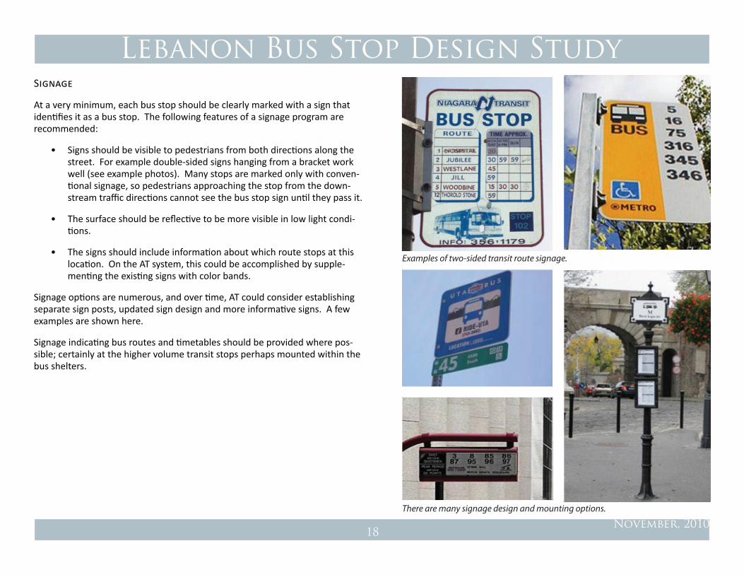
At a very minimum, each bus stop should be clearly marked with a sign that identifies it as a bus stop. The following features of a signage program are recommended:
• Signs should be visible to pedestrians from both directions along the street. For example double-sided signs hanging from a bracket work well (see example photos). Many stops are marked only with conven-tional signage, so pedestrians approaching the stop from the down-stream traffic directions cannot see the bus stop sign until they pass it.
• The surface should be reflective to be more visible in low light condi-tions.
• The signs should include information about which route stops at this location. On the AT system, this could be accomplished by supple-menting the existing signs with color bands.
Signage options are numerous, and over time, AT could consider establishing separate sign posts, updated sign design and more informative signs. A few examples are shown here.
Signage indicating bus routes and timetables should be provided where pos-sible; certainly at the higher volume transit stops perhaps mounted within the bus shelters.
Examples of two-sided transit route signage.
There are many signage design and mounting options.

Lebanon Bus Stop Design Study
November, 201019
Bus Shelters
The existing AT shelters are both attractive and durable, and work well in most cases to provide shelter for waiting passengers. In general shelters should be transparent to ensure that bus drivers can see bus patrons waiting at the stop.
There are some areas where the bus shelter design may warrant special con-sideration. Downtown Lebanon, West Lebanon and DHMC are all examples of areas where the bus shelter should be designed to be compatible with the street furniture and desired visual character of those specific locations. Many communities have developed shelters that give the transit system and environs a distinctive identity, particularly for central stops where ridership and sur-rounding context warrant special treatment. The images to the right provide a few examples of shelters built by other agencies in prominent locations, com-parable locally to downtown Lebanon, West Lebanon, and DHMC.
A variety of transit shelters that are transparent, attractive, and enhance their setting: Downtown Lebanon; Seattle, WA; Santa Monica, CA (with solar cells on roof for lighting) and Mountain View, CA.
Lebanon Bus Stop Design Study
November, 201020
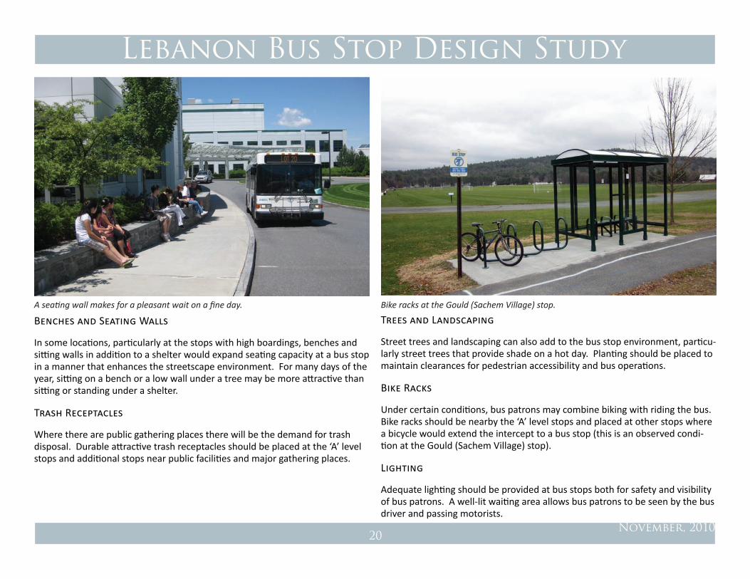
Benches and Seating Walls
In some locations, particularly at the stops with high boardings, benches and sitting walls in addition to a shelter would expand seating capacity at a bus stop in a manner that enhances the streetscape environment. For many days of the year, sitting on a bench or a low wall under a tree may be more attractive than sitting or standing under a shelter.
Trash Receptacles
Where there are public gathering places there will be the demand for trash disposal. Durable attractive trash receptacles should be placed at the ‘A’ level stops and additional stops near public facilities and major gathering places.
Trees and Landscaping
Street trees and landscaping can also add to the bus stop environment, particu-larly street trees that provide shade on a hot day. Planting should be placed to maintain clearances for pedestrian accessibility and bus operations.
Bike Racks
Under certain conditions, bus patrons may combine biking with riding the bus. Bike racks should be nearby the ‘A’ level stops and placed at other stops where a bicycle would extend the intercept to a bus stop (this is an observed condi-tion at the Gould (Sachem Village) stop).
Lighting
Adequate lighting should be provided at bus stops both for safety and visibility of bus patrons. A well-lit waiting area allows bus patrons to be seen by the bus driver and passing motorists.
A seating wall makes for a pleasant wait on a fine day. Bike racks at the Gould (Sachem Village) stop.

Lebanon Bus Stop Design Study
November, 201021
BuS Stop conceptuAL pLAnS
The following sections discuss the bus stops for which more detailed design concepts were prepared. A list of recommendations for the remaining bus stops follows in the final section of this report.
Downtown Lebanon
At this location, the Blue (DHMC and Hanover) and Red (West Lebanon and 12A Plazas) lines come together allowing transfers from one bus to the other twice an hour. There are typically two buses at the stop; however, there is a third Blue Route bus that serves Enfield and Canaan during the morning and afternoon commute hours. This occurs three times in the morning and three times in the evening hours.
Through this planning process, the downtown Lebanon bus stop has been relocated from One Court Street to the front of the City Hall / Lebanon Op-era House. Two buses stop on North Park Street, and the Enfield/Canaan bus stops on Court Street. This arrangement is a little spread out, but a vast improvement from the Court Street location. In August, 2010, AT met with Rogers House residents and made minor changes to the stopping location of the buses as requested. The stop is functioning well, the relocated handicap parking spaces are in a better location with respect to the accessible entrance to City Hall, and Rogers House residents appreciate that the stop is more acces-sible for their use.
FIGURE 6: Downtown Lebanon Existing Conditions Plan
Bus shelter and bike racks at the new Downtown Lebanon stop.

Lebanon Bus Stop Design Study
November, 201022
FIGURE 7: Downtown Lebanon Option 1: Transit Plaza
SectIon 1

Lebanon Bus Stop Design Study
November, 201023
Figure 8: Transit Plaza: section 1
While a vast improvement over the Court Street bus stop, the current stop is seen as an interim solution until one of the following longer term plans can be implemented:
Long Term Option 1: West Park Street Transit Plaza
The first longer term option involves widening, lengthening and improving the existing median strip on West Park Street and moving the buses to that loca-tion. The street right of way is very wide at this location and would allow for a linear sidewalk/plaza space, bus stopping zone and two lanes for cars. We would also recommend a bump out on the corner of North Park and West Park Street to slow traffic making the left turn to make it safer for pedestrians. In this option, the shelter should be an attractively designed structure that is compatible with other street furniture elements in the area (light fixtures, benches, park railing) and reinforces the character of the downtown.
Long Term Option 2: Two-Way Circulation
The second option takes a broader view of the downtown in terms of the circulation pattern and the pedestrian environment, and envisions a tra-ditional two-way circulation pattern around the green to slow and calm traffic to make it safer and more attractive for pedestrians. The current one way ‘race track’ circulation pattern is detrimental to pedestrians, and detracts significantly from an otherwise lovely and gracious town center. At the present time, the streets are overly wide and, coupled with the one-way street pattern, traffic moves too fast. There are blind spots and confu-sion is created by the traffic pattern. It also unnecessarily limits circulation options for vehicles and buses, and is ‘over-designed’ for the amount of traffic present.
Reallocating the space that is dedicated exclusively to auto circulation to a traditional two-way Main Street circulation pattern would create a safer and more attractive pedestrian environment, with slower traffic, broader sidewalks, more green space. With this circulation pattern, there are many opportunities to attractively accommodate the transit stop into the town center. The big benefit for transit patrons, and others, is the safer pedes-trian environment created by this arrangement.
Based on a review of available data on daily traffic volumes, the proposed traffic circulation should provide more than enough capacity for current and future traffic flows. Some type of intersection control will be needed at the street intersections, which could be stop signs or traffic signals. In order to determine the best options for traffic control, a traffic engineering study should be conducted, accompanied by peak hour traffic counts, to refine this design.

Lebanon Bus Stop Design Study
November, 201024
FIGURE 9: Downtown Lebanon Option 2: Two-Way Traffic
SectIon 2

Lebanon Bus Stop Design Study
November, 201025
West Lebanon Main Street
The downtown West Lebanon stop on Main Street in front of the kilton Library is another busy bus stop in the Advance Transit System. At this location the Red (downtown Lebanon / Route 12A Plazas), Green (Hartford) and Orange (Hanover / WRJ) lines come together twice and hour. The stop operates on a ‘pulse’ or ‘timed transfer’ operation whereby three or four buses come to-gether at once to allow bus patrons to transfer between buses. The buses stop twice an hour for a few minutes while patrons board and alight. Three buses stop once an hour; four buses stop once an hour, for a total of two ‘pulses’ per hour.
This stop provides the West Lebanon neighborhood with exceptional transit service: a resident can walk to Main Street and catch a bus to downtown Leba-non; the Route 12A plazas; downtown Hanover and Dartmouth College; and White River Junction. Similarly, the buses bring patrons into the West Lebanon business area from surrounding towns without their cars.
Advance Transit has been operating at this location for over 10 years. In 2009, a bus was added to the Red Route which increased the headways on this popular line from 60-minutes to 30-minutes, and eliminating a 30-minute wait that some patrons were experiencing to make this transfer. This service change has paid-off well in terms of ridership; however, four buses coming together at
FIGURE 10: Two-Way Traffic: section 2
Accessibility: Good
Sidewalks: Yes
Crosswalks: Yes
Bike Racks: Yes
Traffic Volume: Medium
Traffic Speed: 25 mph
Amenities: Good
Lebanon Downtown
Route(s): Blue, Red
Street: N. Park Street
Sign: Yes
Shelter: Yes
Bus Stop: Curbside: Bus Zone
Buses per Day: 56
Avg. Monthly
Boardings: 5524
Bus shelter at the West Lebanon Main Street stop.
Lebanon Bus Stop Design Study
November, 201026
once at this location feels overwhelming and has been raised as an issue with this stop. The Lebanon Library Board of Trustees has expressed their desire for the transfer function to be located elsewhere. In addition, this stop is also inadequate for the long term needs of Advance Transit to accommodate antici-pated growth in the system.
Short Term
Until a suitable new location can be developed, the transfer stop will continue to operate on Main Street. Through this planning process, the buses have been configured to stop along the curb above the relocated pedestrian crossing, keeping the Library’s main entrance plaza and the crosswalk clear. Wood plank walkways through the planting area have been installed to allow bus patrons to board and alight buses parked at the stop and minimize trampling the planting area. A shelter with the first real time transit arrival sign on the AT system has
been placed at the north end of the library building. The bus stop is generally functioning well; like the downtown stop, the seating provided by the shelter and picnic table is inadequate for the volume of passengers at this busy loca-tion. More seating options, (i.e., larger shelter, benches, sitting wall) should be integrated into the design of the relocated West Lebanon stop.
Long Term
Several options for a new transfer stop have been studied. At this point, the best option appears to be co-locating the transfer stop with new commercial development nearby. AT is currently working with the developer of the pro-posed River Park development on Main Street (north of Highland Avenue) as a possible location for the West Lebanon stop. Restructuring of the Red Route in some manner is likely in order to make this or any other new transfer location work.
FIGURE 11: West Lebanon Main Street Existing Conditions
Kilton Library
Main Street
Trac
y Str
eet

Lebanon Bus Stop Design Study
November, 201027
Main Street Stop
Once the transfer stop is relocated, it is likely that the kilton Library will con-tinue to serve as the West Lebanon Main Street bus stop (to serve the greater West Lebanon neighborhood), and there will be the need for a stop on the opposite side of the street. Taking into consideration pedestrian crossings, existing driveway locations, and curb space, the best location for the south and west bound bus stop would be in front of the old West Lebanon Library. This stop would be expected to have a high number of boardings and should be equipped with a shelter, at a minimum, and a trash receptacle, if possible.
FIGURE 12: West Lebanon Main Street Future condition
Kilton Library
Main Street
Trac
y Str
eet
West Lebanon Main Street
Route(s): Red, Orange, Green
Street: Main Street / Route 10
Sign: Yes
Shelter: Yes
Bus Stop: Curbside: Bus Zone
Buses per Day: 80
Avg. Monthly
Boardings: 2,715
Accessibility: Good
Sidewalks: Yes
Crosswalks: Yes
Bike Racks: Yes
Traffic Volume: Very High
Traffic Speed: 30
Amenities: Excellent
Lebanon Bus Stop Design Study
November, 201028
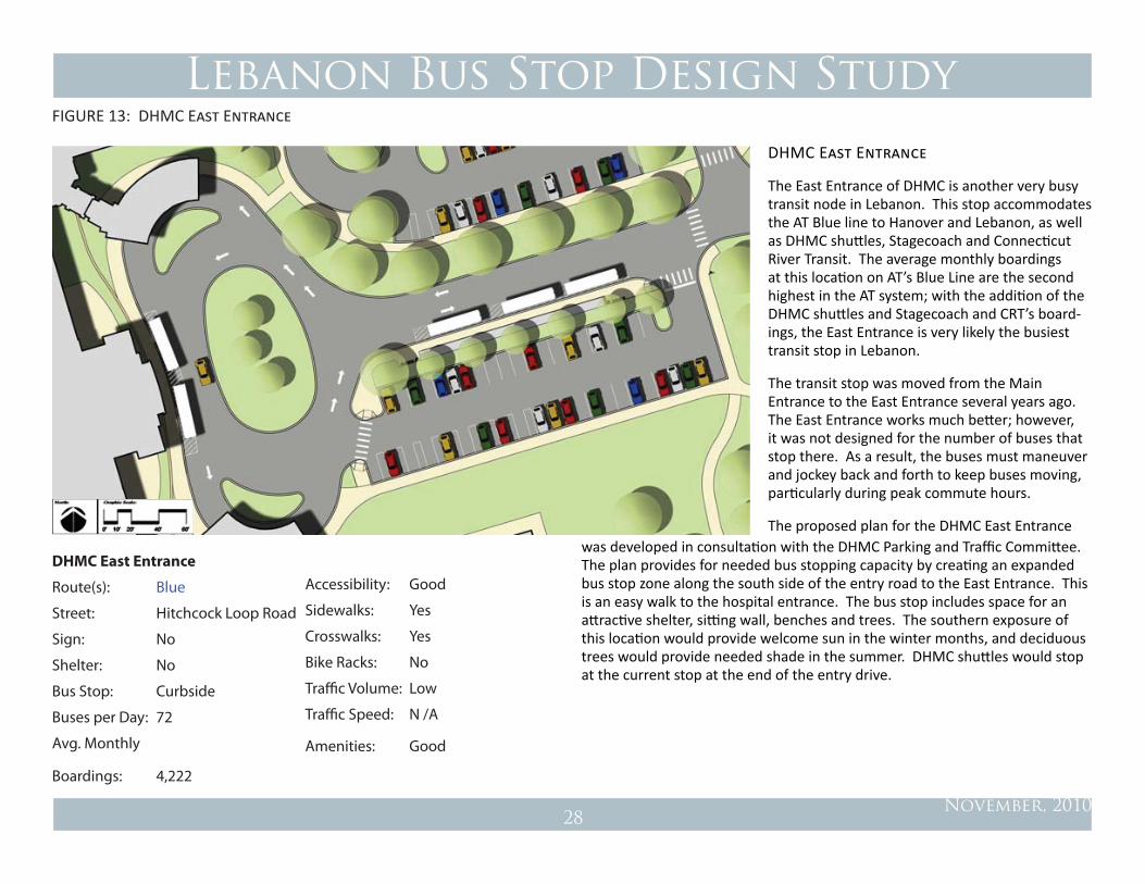
DHMC East Entrance
The East Entrance of DHMC is another very busy transit node in Lebanon. This stop accommodates the AT Blue line to Hanover and Lebanon, as well as DHMC shuttles, Stagecoach and Connecticut River Transit. The average monthly boardings at this location on AT’s Blue Line are the second highest in the AT system; with the addition of the DHMC shuttles and Stagecoach and CRT’s board-ings, the East Entrance is very likely the busiest transit stop in Lebanon.
The transit stop was moved from the Main Entrance to the East Entrance several years ago. The East Entrance works much better; however, it was not designed for the number of buses that stop there. As a result, the buses must maneuver and jockey back and forth to keep buses moving, particularly during peak commute hours.
The proposed plan for the DHMC East Entrance
FIGURE 13: DHMC East Entrance
was developed in consultation with the DHMC Parking and Traffic Committee. The plan provides for needed bus stopping capacity by creating an expanded bus stop zone along the south side of the entry road to the East Entrance. This is an easy walk to the hospital entrance. The bus stop includes space for an attractive shelter, sitting wall, benches and trees. The southern exposure of this location would provide welcome sun in the winter months, and deciduous trees would provide needed shade in the summer. DHMC shuttles would stop at the current stop at the end of the entry drive.
DHMC East Entrance
Route(s): Blue
Street: Hitchcock Loop Road
Sign: No
Shelter: No
Bus Stop: Curbside
Buses per Day: 72
Avg. Monthly
Boardings: 4,222
Accessibility: Good
Sidewalks: Yes
Crosswalks: Yes
Bike Racks: No
Traffic Volume: Low
Traffic Speed: N /A
Amenities: Good

Lebanon Bus Stop Design Study
November, 201029
Mount Support Road at Timberwood Housing
This would be a new stop once Mt. Support Road is rebuilt. The Timberwood housing development on Mount Support Road (currently under construc-tion) will include nearly 250 new housing units. At this location, a bicycle and pedestrian shared use path along the frontage of the new development will be constructed as a part of the rebuilding of Mt. Support Road. A curbside bus stop near the main walkway from the development is recommended at this location. A shelter, pedestrian crossing with curb ramps, and a bus stop land-
ing pad on the opposite side of the street is recommended for this location. In looking at the ridership statistics in the area, it is anticipated that this stop will likely be quite directional with boardings in the northbound direction (toward DHMC) and alightings in the southbound direction. For that reason a shelter on the opposite side of the street is not a high priority at this time; this could change if ridership in the downtown bound direction grows. The landing pad allows the future installation of a shelter at this location.
FIGURE 14: Mount Support Road at Timberwood Housing
Mount Support Road
Timberwood
Bicycle & Pedestrian Path

Lebanon Bus Stop Design Study
November, 201030
Mount Support Road at Memorial Drive
Memorial Drive is another area where there should be a bus stop on Mount Support Road as the road connects through to an area with a concentration of housing. At this location, a shelter and bike racks should be provided on the northbound side, and a crosswalk, curb ramps and landing on the opposite side of the street.
FIGURE 15: Mount Support Road at Memorial Drive
Mount Support Road
Bicycle & Pedestrian Path
Mem
orial Drive

Lebanon Bus Stop Design Study
November, 201031
Miracle Mile Plaza
The stops at the Miracle Mile Plaza and the Auto Zone (Opposite Miracle Mile Plaza) are particularly challenging and difficult primarily because traffic speeds are higher and this area is hostile territory for pedestrians. Along this stretch of Route 4, there are no crosswalks from Seminary Hill to Mechanic Street well beyond the Rivermill complex. It is so daunting for pedestrians to cross at this location that some bus patrons resort to boarding the bus to West Lebanon and ride it around to downtown.
The plan for this location provides for a bus turnout due to traffic speeds. Due to the volume and speed of traffic, a pedestrian refuge and crosswalk is recom-mended to be placed in the center of Route 4 to assist pedestrian crossing.
Ideally, a walkway connecting the bus stop and shopping center to Timken should be developed to allow pedestrians to walk between the bus stop, Timken and the shopping center. Overall, this area should be looked at more broadly from the perspective of pedestrian circulation.
Over the long term, it would be expected that the Miracle Mile shopping cen-ter may be intensified and the configuration of Route 4 changed in conjunction with this new development. At that time, changes may include signalization which would aid pedestrian crossings. The streetscape design for buses (and pedestrians) should be integrated into this design.
FIGURE 16: Miracle Mile Plaza
Miracle MileCrosswalk and Pedestrian
Refuge

Lebanon Bus Stop Design Study
November, 201032
Slayton Hill Road/Mechanic Street (Country Woolens)
This stop is in a key location for a number of reasons: it is currently the clos-est stop to the Alice Peck Day and Harvest Hill senior housing community, it is adjacent to the Mascoma River Greenway, and is a crossroads for neighbor-hoods on either side of Mechanic Street. Mechanic Street in this area is only two lanes wide, but the high volume of traffic and the lack of stops makes it difficult to cross the street. This area should be designed for a safe interchange of bikes, pedestrians and transit.
The plan calls for a bus stop on either side of the street that is oriented to a new accessible walkway up to the Mascoma River Greenway path and the Alice Peck Day (APD) complex. A separate study was prepared relative to evaluat-
ing the feasibility of Advance Transit service to APD (Crickelair, 2010). The recommendation of that study was to serve APD with a ‘flex route’ but until funding became available for such a service, a pedestrian tunnel from this bus stop to Mascoma Street in the vicinity of Slayton Hill Road was recom-mended. In evaluating this recommendation, several constraints to the tunnel concept became apparent, namely the grade change between Mascoma Street and Mechanic Street (which creates difficulties for an accessible tunnel) and property ownership (the land abutting Slayton Hill Road is privately owned). The conceptual plan for this stop provides a accessible path across the grade of the rail corridor behind Country Woolens, as well as a path up the City owned land that abuts Country Woolens to the north. These footpaths can link the
FIGURE 17: Mechanic Street at Slayton Hill Road
Mechanic Street
Sla
yton
Hill
Roa
d
Mascoma River Greenway
Mascoma Street
Accessible Path
Lebanon Bus Stop Design Study
November, 201033
Mechanic Street
Sla
yton
Hill
Roa
d
Mascoma River Greenway
Mascoma Street
Accessible Path
Child Care Center
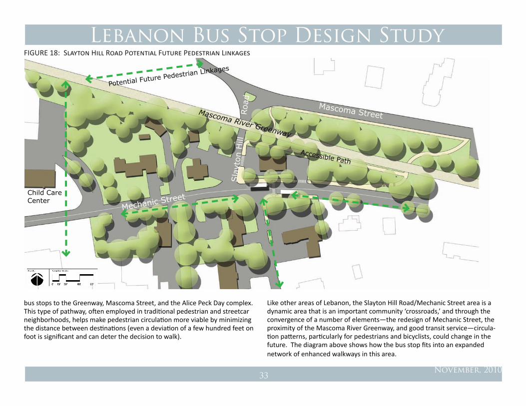
bus stops to the Greenway, Mascoma Street, and the Alice Peck Day complex. This type of pathway, often employed in traditional pedestrian and streetcar neighborhoods, helps make pedestrian circulation more viable by minimizing the distance between destinations (even a deviation of a few hundred feet on foot is significant and can deter the decision to walk).
Like other areas of Lebanon, the Slayton Hill Road/Mechanic Street area is a dynamic area that is an important community ‘crossroads,’ and through the convergence of a number of elements—the redesign of Mechanic Street, the proximity of the Mascoma River Greenway, and good transit service—circula-tion patterns, particularly for pedestrians and bicyclists, could change in the future. The diagram above shows how the bus stop fits into an expanded network of enhanced walkways in this area.
Potential Future Pedestrian Linkages
FIGURE 18: Slayton Hill Road Potential Future Pedestrian Linkages

Lebanon Bus Stop Design Study
November, 201034
Romano Circle, Opposite
A new bus turnout was constructed for southbound buses at Romano Circle and Route 12A. This arrangement is working quite well. At the present time, however transit patrons on the opposite side of the street (which incidentally experiences somewhat higher boardings) must stand in the shoulder of the roadway to wait for the bus. This is an area where a turnout would be desir-able, but there is inadequate right of way for a bus turnout. Over the long
term, a turnout may be possible in conjunction with future development on the east side of the street, but until that time a short section of curb and sidewalk lift bus patrons out of the road shoulder would be a big improvement. The crosswalk is already in place. A curbside stop has existed at this location for years. In terms of both sight distance and traffic speed, a curbside stop here is acceptable.
Figure 19: Romano Circle
South Main Street

Lebanon Bus Stop Design Study
November, 201035
Gould/ Sachem Village
The Gould / Sachem Village is a relatively busy stop. The safety and usability of this stop should be improved by relocating the pedestrian crossing to be behind the bus (a pedestrian has been hit at this location).
North Main Street / Route 10
Gould
Oak
Rid
ge
FIGURE 20: gould (sachem village)

Lebanon Bus Stop Design Study
November, 201036
GLEN ROAD
This is another area that will undergo significant change with the redevelop-ment of property on the west side of Route 12A. With this new development, we would expect usage of these bus stops to increase. The Glen Road Plaza stop (on the opposite side of the street) needs improvement, as bus patrons must stand in the roadway or in the plaza landscaping to wait for the bus. At a minimum, a sidewalk from Glen Road and a bench should be installed here; if there is enough room, a shelter should be placed here as well. The City and AT
REDEVELOPMENT SITE
Glen Road Plaza
South Main Street / Route 12A
Glen
Road
should coordinate with the property owner to develop a plan for improved ac-commodation of bus patrons at this location. If the City pursues a roundabout at this intersection, an appropriate location for the bus stop should be incor-porated into the planning and design work, as it is likely the bus stop would need to move further north up Main Street. A new bus stop and shelter with a walkway to the grocery store will be developed by the site developer on the west side of the street.
FIGURE 21: glen road Plaza

Lebanon Bus Stop Design Study
November, 201037
AddItIonAL recoMMendAtIonS
PARkING STANDARDS
Lebanon should consider reducing off-street parking requirements for devel-opment that is located near transit corridors and stops. Conventional parking requirements often result in an oversupply and under-pricing of parking which in turn favors driving over using transit or other alternative modes.
As discussed at the beginning of the report, over half of Advance Transit’s rid-ers have a car available but choose to leave it at home. This segment of riders has been a growing share of AT’s passengers over the past decade, and growth in this market would be expected to continue as gas prices rise and parking supplies tighten or are priced. More commuters will opt for taking the bus if it is manageable.
As a starting point, a parking reduction of up to 5% for development within one-quarter mile walking radius of a transit stop is recommended. This reduc-tion is based on results from current surveys of work trips in the core towns of the Upper Valley collected as a part of the Upper Valley Transportation Man-agement Association’s Smart Commute project. These surveys estimate a tran-sit mode share of approximately 3.8%. It should be noted that this standard generally reflects the status quo as opposed to providing a greater incentive to use alternative modes by reducing parking supplies. This is a topic that may merit additional consideration if increasing alternative mode share in Lebanon is desired.
MULTI-MODAL IMPACT ASSESSMENT
In keeping with Lebanon’s Complete Streets policy, the City should consider taking a multi-modal approach to traffic impact analyses. It has become standard to require a traffic impact analysis for developments of a certain size. These analyses provide detailed assessments regarding vehicular travel but no analysis is typically afforded transit service, pedestrians or bicycles. Impact
assessments should consider all modes, including how mitigation measures for vehicular traffic will impact transit service, pedestrians and bicycles.
RECOMMENDATIONS FOR OTHER BUS STOPS
Recommendations for improvements for bus stops not included in the con-ceptual plans section are summarized in Table 5. In general, priority should be placed on the stops that have higher use as generally indicated by boardings. In Lebanon, many of these stops (‘B’ level stops) will be influenced by one of three major projects: (1) the potential development of the River Park project and relocation of the West Lebanon transfer stop (all West Lebanon stops on Main Street and Church Street); (2) the redesign of Mechanic Street (Rivermill, Slayton Hill Road area stops); or (3) the rerouting of the Blue Line to Mt. Sup-port Road (Wolf Road stops). Improvements to these stops should be under-taken as a part of the planning and construction associated with these projects.
The bus stop at the Beverage King should be improved with a shelter and accessibility improvements.

Lebanon Bus Stop Design Study
November, 201038
Stop Name Stop Class Recommendations
Beverage King B Improve accessibility and pedestrian environment; provide shelter
Church St. BProvide shelter and crosswalk. Note: The Church St. stops may be eliminated with the relocation of the W. Lebanon transfer stop.
Church St., Opp. BShelter can be provided across the street at the Church St. Stop. Grade and accessibility concerns should be addressed as part of street reconstruction
Highland Ave. BProvide shelter; however this stop may be influenced by the proposed River Park Development.
Kleen Dryclean, Opp. BProvide sign. Right of way constraints prevent installing a shelter unless property owner is willing; Mechanic Street project should address transit stop
Upper Valley Plaza B Work with owner to provide bench and schedule information.
Westboro Woods B Move shelter from sidewalk; evaluate redesign as curbside stop.
Wolf Rd. BRelocate to Mt. Support Road as part of service change, provide sign, shelter and accessible pad.
Dulacs C Mechanic Street project should address transit stop improvements.
Elm to Canaan CProvide sign. Consider traffic calming along corridor to improve pedestrian environment.
Golf Course C Mechanic Street project should address transit stop improvements.
Hair Shed C Mechanic Street project should address transit stop improvements.
Hayden Court C Possible relocation with River Park Development.
Heater & Old Etna to Han C Evaluate bus stop improvements as part of the Mt. Support Road service change.
Heater, Bank CProvide rural bus stop landing pad as a part of road improvement projects or mew adjacent development.
Interchange Drive CProvide rural bus stop landing pad as a part of road improvement projects or new adjacent development.
Stop Name Stop Class Recommendations
Kleen Dryclean C Mechanic Street project should address transit stop improvements.
Lebanon Jr. High C Possibly relocate stop with new Middle School development.
Lebanon Jr. High, Opp. C Possibly relocate stop with new Middle School development.
Maple/Rt. 10 C Possible relocation with River Park Development.
Maple/Rt. 10, Opp. C Possible relocation with River Park Development.
Next Steps C Consider traffic calming along corridor to improve pedestrian environment.
Next Steps, Opp. C Consider traffic calming along corridor to improve pedestrian environment.
Quail Hollow C Provide rural bus stop landing pad as road improvement projects are conducted.
Rivermill CRelocate bus stop about 50 feet to the east, where a wider shoulder is available. Provide shelter. Mechanic Street project should address transit stop
Rivermill, Opp. C Mechanic Street project should address transit stop improvements.
Rt. 120 Miller Auto C Provide sign. Provide pedestrian crossings at traffic signals on Route 120.
Rt. 120 Miller Auto, Opp. C Provide sign. Provide pedestrian crossings at traffic signals on Route 120.
Stryker Bio Tech C Provide rural bus stop landing pad as road improvement projects are conducted.
Sunset Motel C Provide rural bus stop landing pad as road improvement projects are conducted.
Sunset Motel, Opp. C Provide rural bus stop landing pad as road improvement projects are conducted.
Wolf Rd., Opp. CRelocate to Mt. Support Road as part of service change, provide sign, shelter and accessible pad.
TABLE 5: Recommendations for Other Bus stops
Lebanon Bus Stop Design Study
November, 201039
References:
Beyard, Michael D., Michael Pawlukiewicz and Alex Bond, Ten Principles for Rebuilding Neighborhood Retail, Washington, DC: Urban Land Institute, 2003.
Centers for Disease Control and Prevention, CDC Recommendations for Improv-ing Health through Transportation Policy, April 28, 2010.
Ewing, Reid, Pedestrian and Transit Friendly Design: A Primer for Smart Growth, Smart Growth Network.
Tom Crickelair Associates, Transit Development Plan for Advance Transit, De-cember 30, 2008.
Tom Crickelair Associates, Transportation Service Plan for Alice Peck Day Hospi-tal, March 31, 2010.
Transportation Research Board, Multimodal Level of Service Analysis for Urban Streets, National Cooperative Highway Research Program Report 616, 2008.
US Department of Transportation, Federal Highway Administration, Pedestrian Safety Guide for Transit Agencies, FHWA-SA-07-017, February 2008.
US Department of Transportation, Federal Highway Administration, Round-abouts, an Informational Guide, FHWA-RD-00-67, June 2000.