Initialising PSO with randomised low-discrepancy sequences: the comparative results
Upload
khangminh22Category
view
0download
0
www.rpsgroup.com
Protected Species Mitigation and Monitoring Report
Marine Geophysical (Seismic) Survey North Pacific Ocean
Aleutian Arc 31 August 2020 – 08 October 2020
R/V Marcus G. Langseth
Prepared for:
Lamont-Doherty Earth Observatory of Columbia University 61 Route 9W, P.O. Box 1000, Palisades, NY 10964-8000
for submission to:
National Marine Fisheries Service, Office of Protected Resources 1315 East-West Hwy, Silver Spring, MD 20910-3282
Project No.
209518 RPS
Cruise ID No. MGL2003 20405 Tomball Parkway Building 2, Suite 200 Authors Amanda Dubuque, Amelia McClure, Cassandra
Frey, Kaylee McRae, Maritza Martinez Houston, Texas 77070, USA Tel: (281) 448-6188
Reviewer(s) Katherine Gideon Fax: (281) 448-6189
Submittal Date
29 January 2021 -Final E-mail: [email protected]
We: www.rpsgroup.com

209518 | Marcus G. Langseth | L-DEO/NMFS 01 29 2021
TABLE OF CONTENTS 1. EXECUTIVE SUMMARY ................................................................................... 5
2. INTRODUCTION ................................................................................................. 72.1. PROJECT OVERVIEW AND LOCATION .................................................................................. 8
2.1.1. Energy Source and Receiving Systems ................................................................... 10
3. MITIGATION AND MONITORING METHODS ............................................ 123.1. MITIGATION METHODOLOGY ................................................................................................. 12 3.2. VISUAL MONITORING SURVEY METHODOLOGY ............................................................. 16 3.3. PASSIVE ACOUSTIC MONITORING SURVEY METHODOLOGY ..................................... 17
3.3.1. Passive Acoustic Monitoring Parameters ................................................................. 18 3.3.2. Hydrophone Deployment ............................................................................................ 20
4. MONITORING EFFORT SUMMARY ............................................................. 224.1. SURVEY OPERATIONS SUMMARY ........................................................................................ 22
4.1.1. General survey parameters ........................................................................................ 22 4.1.2. MBES, SBP and ADCP operations ........................................................................... 22 4.1.3. Airgun operations ......................................................................................................... 23 4.1.4. Interactions with Other Vessels .................................................................................. 25
4.2. VISUAL MONITORING SURVEY SUMMARY ......................................................................... 26 4.3. ACOUSTIC MONITORING SURVEY SUMMARY .................................................................. 27 4.4. SIMULTANEOUS VISUAL AND ACOUSTIC MONITORING SUMMARY ......................... 28 4.5. ENVIRONMENTAL CONDITIONS ............................................................................................. 28
5. MONITORING AND DETECTION RESULTS .............................................. 315.1. VISUAL DETECTIONS ................................................................................................................ 31
5.1.1. Other Wildlife ................................................................................................................. 39 5.2. ACOUSTIC DETECTIONS .......................................................................................................... 39
6. MITIGATION ACTION SUMMARY ................................................................ 406.1. PROTECTED SPECIES KNOWN TO HAVE BEEN EXPOSED TO 160 DECIBELS OR GREATER OF RECEIVED SOUND LEVELS ..................................................................................... 41 6.2. IMPLEMENTATION AND EFFECTIVENESS OF THE BIOLOGICAL OPINION’S ITS AND IHA 44
7. LITERATURE CITED ....................................................................................... 46

209518 | Marcus G. Langseth | L-DEO/NMFS 01 29 2021
2
LIST OF FIGURES Figure 1. Location and survey lines of the Aleutian Arc marine geophysical survey. ...................................... 9 Figure 2. Protected Species Observer observation tower with mounted big-eye binoculars, as seen from
the stern of the vessel. ................................................................................................................................... 16 Figure 3: Simplified pathway of data through the PAM system on board the Langseth. .............................. 19 Figure 4. Location of the PAM cable in relation to the seismic gear during the survey program. ................ 21 Figure 5: Geospatial data of source operations for the Aleutian Arc survey area. ......................................... 25 Figure 6: All protected species detections during the survey program. ........................................................... 32 Figure 7: Protected species detections within the survey area of the Aleutian Arc survey program. .......... 33 Figure 8: All protected species observed during the survey program by species group. ................. 34 Figure 9: All protected species observed within the survey area by species group. ..................................... 35 Figure 10: Number of protected species detections and corresponding weather .......................................... 36 Figure 11: Two-part hydrophone cable with a 230-meter tow cable and detachable 20-meter hydrophone
array .................................................................................................................................................................. 51 Figure 16: Visual Detection #5; Dall's Porpoise; 02 September 2020. ............................................................ 66 Figure 17: Visual Detection #13; Sei Whale; 04 September 2020. .................................................................. 66 Figure 18: Visual Detection #13; Sei Whale; 04 September 2020. .................................................................. 66 Figure 19: Visual Detection #14; Dall's Porpoise; 04 September 2020. .......................................................... 67 Figure 20: Visual Detection #16; Sperm Whale; 04 September 2020. ............................................................ 67 Figure 21: Visual Detection #23; Dall's Porpoise; 05 September 2020. ................................................... 67 Figure 22: Visual Detection #24; Dall's Porpoise; 05 September 2020. .......................................................... 68 Figure 23: Visual Detection #25; Fin Whale; 05 September 2020. .................................................................. 68 Figure 24: Visual Detection #30; Common Minke Whale; 09 September 2020. ............................................ 68 Figure 25: Visual Detection #32; Killer Whales; 09 September 2020. ............................................................. 69 Figure 26: Visual Detection #33; Sperm Whale; 09 September 2020. ............................................................ 69 Figure 27: Visual Detection #36; Dall's Porpoise; 13 September 2020. .......................................................... 69 Figure 28: Visual Detection #38; Sperm Whale calf; 14 September 2020. ..................................................... 70 Figure 29: Visual Detection #41; Humpback Whales; 15 September 2020. ................................................... 70 Figure 30: Visual Detection #42; Humpback Whale; 15 September 2020. ..................................................... 71 Figure 31: Visual Detection #46; Dall's Porpoise; 19 September 2020. .......................................................... 71 Figure 32: Visual Detection #49; Killer Whales; 20 September 2020. ............................................................. 72 Figure 33: Visual Detection #54; Humpback Whale; 28 September 2020. ..................................................... 72 Figure 34: Visual Detection #55; Killer Whales; 29 September 2020. ............................................................. 73 Figure 35: Visual Detection #57; Sperm Whale; 30 September 2020 ............................................................. 73 Figure 36: Visual Detection #58; Sperm Whale; 30 September 2020. ............................................................ 74 Figure 37: Visual Detection #59; Sperm Whale; 30 September 2020. ............................................................ 74 Figure 38: Visual Detection #60; Humpback Whale; 30 September 2020. ..................................................... 75 Figure 39: Visual Detection #61; Northern Fur Seal; 05 October 2020. .......................................................... 75 Figure 40: Visual Detection #62; Northern Fur Seal; 06 October 2020. .......................................................... 75 Figure 41: Visual Detection #66; Sperm Whale; 07 October 2020. ................................................................. 76

209518 | Marcus G. Langseth | L-DEO/NMFS 01 29 2021
3
Figure 42: Visual Detection #68; Common Minke Whale; 07 October 2020 .................................................. 77 LIST OF TABLES Table 1: Specific detections of protected species and their required mitigation actions. 13 Table 2: Predicted 160/175/195 Decibel Zones* Implemented during the survey program. 15 Table 3: Predicted Level A Harassment Zones* for each Marine Mammal Hearing Group Implemented
during the survey program. 15 Table 4: Survey parameters of the programs. 22 Table 5: Suspension of source operations during the survey program. 22 Table 6. Total acoustic source operations during the seismic survey program. 23 Table 7: Mechanical and technical source silence. 25 Table 8: Other vessels observed during the survey program. 25 Table 9: Initiation and termination of visual monitoring during the survey program. 26 Table 10. Total visual monitoring effort during the survey program. 26 Table 11: Total visual monitoring effort from observation locations during the survey program. 26 Table 12: Initiation and termination of acoustic monitoring watches during survey program. 27 Table 13. Total Passive Acoustic Monitoring (PAM) effort during the survey program. 27 Table 14. Passive Acoustic Monitoring (PAM) downtime during the survey program. 28 Table 15: Simultaneous visual and acoustic monitoring effort during the survey program. 28 Table 16. Visibility during the survey program. 28 Table 17. Precipitation during the survey program. 28 Table 18. Duration radii were NOT fully visible during the survey program. 29 Table 19. Beaufort Sea State during the survey program. 29 Table 20. Beaufort Wind Force during the survey program. 29 Table 21. Swell Height during the survey program. 29 Table 22. Glare during the survey program. 30 Table 23. Number of visual detection records collected for each protected species during the survey
program. 31 Table 24. Average closest approach of protected species to the acoustic source at various volumes during
the survey program. 38 Table 25. Number and duration of mitigation actions implemented during the survey program. 40 Table 26: Mitigation actions and downtime duration by species during the survey program. 40 Table 27. Summary of each mitigation action implemented during the survey program. 40 Table 28. Number of authorized and potential Level A and B Harassment Takes during the survey program.
42 Table 29: Behavior of species visually observed to be exposed to sound pressure levels of 160 dB or greater
during the survey program. 43 APPENDICES: Appendix Description Appendix A Incidental Harassment Authorization Appendix B Incidental Take Statement Appendix C Basic Data Summary Form

209518 | Marcus G. Langseth | L-DEO/NMFS 01 29 2021
4
Appendix D Passive Acoustic Monitoring System Specifications on R/V Langseth Appendix E PAM Hydrophone Deployment on R/V Langseth Appendix F Survey Lines Acquired Appendix G Changes in Acoustic Source Volume During Survey Operations Appendix H Acoustic Monitoring Downtime Appendix I Summary of Visual Detections of Protected Species Appendix J Photographs of Positively Identified Protected Species Appendix K Birds and Other Wildlife Observed

209518 | Marcus G. Langseth | L-DEO/NMFS 01 29 2021
5
1. EXECUTIVE SUMMARY
The U.S. National Science Foundation (NSF) owned research vessel (R/V) Marcus G. Langseth (Langseth), operating under an existing cooperative agreement by Columbia University’s Lamont-Doherty Earth Observatory (L-DEO), conducted a two-dimensional (2D) survey in the North Pacific Ocean along the Aleutian Arc in Alaska from 2 September 2020 to 08 October 2020. The operational activities were conducted for a research survey proposed by Principal Investigators (PIs) Dr. D. Lizarralde from Woods Hole Oceanographic Institute (WHOI) and Dr. D. Shillington from Northern Arizona University (NAU).
The purpose of the survey was to collect 2D seismic reflection and refraction data to image the basic architecture of oceanic-arc crust along and across the Andreanof segment of the Aleutian Arc, and to infer processes that control chemical fractionation and lead to the creation of continent-like compositions. The geological data collected in the Alaska region could add to the understanding of geohazards, like tsunamis and earthquakes.
This report serves to comply with the reporting obligations for the survey required pursuant to the Marine Mammal Protection Act (MMPA) and Endangered Species Act (ESA). On 27 March 2020, L-DEO submitted an application to the National Marine Fisheries Service (NMFS) for an Incidental Harassment Authorization (IHA) that would allow for the potential harassment of small numbers of marine mammals incidental to the seismic survey. On 25 August 2020, NSF issued a Final Environmental Assessment (EA) for the project. On 01 September 2020, NMFS issued an IHA, an Incidental Take Statement (ITS), and a Biological Opinion (BO), and NSF issued a Finding of No Significant Impact (FONSI) for the survey. In addition, the U.S. Fish and Wildlife Service (USFWS) issued a Letter of concurrence (LOC) on 26 June 2020 concluding that the proposed seismic surveys “may affect”, but were not likely to “adversely affect”, the endangered short-tailed albatross (Phoebastria albatrus), the threatened spectacled eider (Somateria
fischeri), the threatened Steller’s eider (Polysticta stelleri), and the threatened southwest distinct population segment (DPS) of the northern sea otter (Enhydra lutris kenyoni) or its critical habitat. Mitigation measures were implemented to minimize potential impacts to marine mammals and endangered or threatened sea turtles and sea birds during the survey program. These measures included, but were not limited to, the use of NMFS approved Protected Species Observers (PSOs) for both visual and acoustic monitoring, the establishment of a 1,000 meter buffer zone from any source element (the clearance zone for activating the source from silence, and then once the source was active, the warning zone where operators would be alerted to the presence of the protected species), a 500 meter exclusion zone from any active source element (where the source would be powered-down or shut-down depending on the species present), a 100-meter exclusion zone from a single active source element in use during a power down for protected sea turtles and seabirds (where the source would be shut-down), and the implementation of ramp-up procedures.
Continuous protected species observation coverage during the survey was provided by RPS, the environmental consulting company contracted by L-DEO for the project. Pursuant to the contract, PSOs monitored and reported on the presence and behavior of protected species, and directed the implementation of the mitigation measures as described in the NSF EA and FONSI (prepared pursuant to the National Environmental Policy Act (NEPA)), and the IHA and ITS issued by NMFS. Additionally, PSO activities were consistent with the PSO standards identified in the Programmatic Environmental Impact Statement (PEIS)/Overseas Environmental Impact Statement (OEIS) for Marine Seismic Research funded by the NSF or Conducted by the U.S. Geological Survey and Record of Decision (referred to herein as the PEIS), to which the NSF EA tiered. Five PSOs, of which one was designated as the Lead PSO and one was designated as the Lead Passive Acoustic Monitoring (PAM) operator, were present on board the R/V Langseth throughout the survey program.
Throughout the survey program, PSOs conducted visual observations for a total of 503 hours 17 minutes and acoustic monitoring for a total of 396 hours six minutes. Visual and acoustic monitoring was conducted simultaneously for a total of 215 hours 40 minutes.

209518 | Marcus G. Langseth | L-DEO/NMFS 01 29 2021
6
The acoustic source was active for a total of 338 hours 10 minutes throughout the entire survey program, which occurred during 36.52% (183 hours 48 minutes) of the total visual monitoring and during 85.37% (338 hours 10 minutes) of the total acoustic monitoring.
There was a total of 68 visual detections of protected species detections during the survey program. Visual detections of positively identifies species included: four sightings of common minke whales (Balaenoptera acutorostrata), one sighting of a fin whale (Balaenoptera physalus), five sightings of humpback whales (Megaptera novaeangliae), one sighting of sei whales (Balaenoptera borealis), 11 sightings of sperm whales (Physeter macrocephalus), four sightings of killer whales (Orcinus orca), nine sightings of Dall’s porpoise (Phocoenides dalli), and two sightings of Northern fur seals (Callorhinus
ursinus). There were also 23 sightings of unidentified whales, one sighting of an unidentified dolphin, five detections of unidentified porpoises, and two detections of unidentified pinnipeds. There were no acoustic detections of protected species.
Protected species detections resulted in the implementation of two mitigation actions, both consisting of shut-downs for whales. Overall, there was one hour 25 minutes of downtime attributed to mitigation actions implemented for detections of protected species, all of which was considered to be production loss.
NMFS issued an IHA and ITS authorizing 12,412 takes for 24 species of marine mammals, including seven whale species and one pinniped species listed as endangered. Of this total, 395 individuals from only seven of these species were authorized for Level A takes, and 12,017 individuals from all 24 species were authorized for Level B takes. Takes for endangered species totaled 4,749 individuals, including 213 Level A takes from four species, and 4,536 Level B takes from all eight species. Authorized Level A takes for endangered species included two blue whales, 104 fin whales, one gray whale, and 106 humpback whales. Authorized Level B takes for endangered species included 23 blue whales, 1,650 fin whales, 62 gray whales, 1,842 humpback whales, two North Pacific right whales, five sei whales, 43 sperm whales, and 909 Steller sea lions. No takes were authorized for northern sea otters as the survey parameters had been adjusted to avoid any potential take of this species. No takes were authorized for any protected sea turtle or sea bird species.
During acoustic source operations, one protected marine mammal, a common minke whale, was observed within the predicted radius at which there is a potential for auditory injury (based upon each species hearing range and how that overlaps with the frequencies produced by the sound source), constituting a potential Level A take. A total of nine protected marine mammals were observed within the predicted 160 decibel radius (where there is a potential for a behavioral response) while the acoustic source was active, constituting potential Level B takes. This total included two humpback whales, four sperm whales, and three unidentified whales.
There were three sightings of protected seabirds throughout the survey program, each consisting of one juvenile short-tailed albatross. Only one of these sightings occurred during active acoustic source operations; however, it did not result in the implementation of a mitigation action. Mitigation measures for protected sea birds were only implemented if they were observed diving or foraging within the 500-meter exclusion zone (power-down) and 100-meter exclusion zone (shut-down) while the acoustic source was active.
A summary sheet of observation, detection, and operational totals for the survey program can be found in Appendix B.

209518 | Marcus G. Langseth | L-DEO/NMFS 01 29 2021
7
2. INTRODUCTION The following report details protected species monitoring and mitigation as well as seismic survey operations undertaken as part of the 2D marine geophysical survey on board the Langseth in the North Pacific Ocean along the Aleutian Arc. Due to logistical delays associated with COVID in Newport,OR, the Langseth arrived August 30, 2020, several days behind schedule, into Ketchikan, AK to pick up Science Party, additional crew and PSO’s. Langseth departed port in Ketchikan, AK, on 31 August 2020 enroute to an originally planned port stop in Dutch Harbor, AK ; as PSOs were onboard initiated their observations during this transit. The final survey authorizations were issued on 1 September 2020 and were received on the Langseth on 2 September 2020 at which point seismic activities were authorized and compliance with all required monitoring/mitigation measures commenced. However, the Langseth did not arrive into the field area of the survey in the Aleutians until ~September 7th. This document serves to meet the reporting requirements dictated in the IHA and ITS issued to L-DEO by NMFS on 01 September 2020 and to the vessel on 02 September 2020. The IHA and ITS authorized takes of specific marine mammals, incidental to the marine seismic survey. NMFS has stated that seismic source received sound levels equal to or greater than 160 dB re 1 µPa (root mean square (rms)) could potentially disturb marine mammals, temporarily disrupting behavior, such that they could be considered non-lethal ‘takes’ (Level B harassment). In July 2016, NMFS released new technical guidance for assessing the effects of anthropogenic sound on marine mammal hearing, which established new thresholds for permanent threshold shift (PTS) onset, Level A harassment (auditory injury), for marine mammal species. Predicted distances to Level A harassment vary based on species specific hearing groups – low frequency cetaceans, mid frequency cetaceans, high frequency cetaceans, phocid pinnipeds, otariid pinnipeds, sea otters, and sea turtles – and how each group’s hearing range overlaps with the frequencies produced by the sound source. For sea turtles, per the ESA, NMFS has stated that received sound levels equal to or greater than 175 dB re 1 µPa (root mean square (rms)) represents the current best understanding of the threshold at which they exhibit behavioral responses. NMFS requires that provisions such as a buffer zone (1,000 meters), exclusion zones (500 meters and 100 meters), delayed operations, ramp-ups, power-downs, and shut-downs be implemented to mitigate for potentially adverse effects of the acoustic source sounds on protected species. The buffer and exclusion zones were established from any element on the array as areas where the presence of a protected species would trigger the implementation of a mitigation action (delayed operations for the buffer zone, and power-downs and/or shut-downs for the 500 meter and 100-meter exclusion zones depending on the species – see section 3.1). For marine mammals, the occurrence of an individual detected approaching, entering, or within the 500-meter exclusion zone would trigger the implementation of a shut-down of the acoustic source. NMFS specified a 500 meter exclusion zone for marine mammals as it encompasses all zones within which auditory injury (Level A harassment) could occur on the basis of instantaneous exposure, provides additional protection from the potential for more severe behavioral reactions for marine mammals at relatively close range to the acoustic source, provides a consistent area for PSOs to conduct effective observational effort, and is a distance within which detection probabilities are reasonably high for most species under typical conditions. For sea turtles, the occurrence of an individual detected approaching, entering, or within the 500 meter and 100 meter exclusion zones would trigger the implementation of a power-down or shut-down of the acoustic source, respectively. For protected sea birds, the detection of one foraging or diving within the 500 meter and 100 meter exclusion zones would trigger a power-down and shut-down respectively.

209518 | Marcus G. Langseth | L-DEO/NMFS 01 29 2021
8
2.1. PROJECT OVERVIEW AND LOCATION
The survey program was comprised of a 2D seismic survey in the North Pacific Ocean along the Aleutian Arc in Alaska between approximately 49-53.5 degrees North and approximately 172.5-179 degrees West. The survey location was within the exclusive economic zone (EEZ) of Alaska near the Andreanof Islands (Figure 1). Water depths in the survey area ranged between approximately 35 meters and 7,100 meters. The purpose of the survey was to seismically image the basic architecture of oceanic-arc crust along and across the Andreanof segment of the Aleutian Arc islands in Alaska. The Andreanof segment of the Aleutian Arc is the best location in the world to study the fundamental processes that form oceanic-arc crust, as the crust in this location is relatively new (approximately 40 million years), intact (i.e. it has not been rifted, collided with, or subjected to discernable subduction erosion), the surface geochemistry is well studied, and an long-axis trend in fractionation is observed. There is no other place where this combination of attributes can be found. The data collected during this survey could be used to infer processes that control chemical fractionation and lead to the creation of continent-like compositions, and could add to the understanding of geohazards, like tsunamis and earthquakes, in the Alaska region. All seismic survey operations, including deployment and retrieval of the ocean-bottom seismometers (OBSs), were conducted solely by the Langseth. The vessel is 72 meters (235 feet) in length and utilizes a particularly quiet propulsion system to avoid interference with the seismic signals. The Langseth’s cruising speed was approximately 10 to 11 knots during transits and varied between three and five knots during the seismic surveys. Seismic acquisition of the refraction data was conducted between 09 September 2020 and 18 September 2020 and included 17 ocean-bottom seismometer (OBS) survey lines. Seismic acquisition of the reflection data was conducted between 23 September 2020 and 05 October 2020 and included 21 multi-channel seismic (MCS) survey lines. For both sets of data, several longer lines were broken into smaller segments, each labeled as a separate survey line, and several of these lines were acquired twice for both refraction and reflection data. A total of 2,638.5 kilometers were surveyed during the survey program, including 798 kilometers for the OBS survey lines and 1,840.5 kilometers for the MCS survey lines. Approximately one percent of these kilometers occurred within shallow water (less than 100 meters), approximately 26 percent occurred within intermediate water (100 to 1,000 meters), and approximately 73 percent occurred within deep water (greater than 1,000 meters).

209518 | Marcus G. Langseth | L-DEO/NMFS 01 29 2021
9
Figure 1. Location and survey lines of the Aleutian Arc marine geophysical survey.

209518 | Marcus G. Langseth | L-DEO/NMFS 01 29 2021
10
2.1.1. Energy Source and Receiving Systems
The energy source utilized during the surveys consisted of four towed acoustic source sub-arrays, each with ten source elements (for a total of 40 source elements), deployed just aft of the vessel. The source array utilized Bolt 1500LL and Bolt 1900LLX elements ranging in size from 40 to 360 cubic inches (in3), with an operating pressure of 1,950 pounds per square inch. The dominant frequency components ranged from two to 188 Hertz (Hz) and nominal source levels ranged from 259 to 265 dB re: 1 μPa (peak-to-peak). The source elements were towed at a depth of nine meters, and the center of the source was situated 230 meters from the Navigation Reference point (NRP), which was located on the PSO observation tower. This positioned the first elements on the arrays 193 meters from the stern of the vessel
For the majority of the survey production operations, the source volume was 6600 cubic inches (in3) with 36 active elements, with the additional elements considered spares in the event that one of the main elements could not be utilized. During times when acoustic source arrays were brought on board for maintenance or repair, the total source volume was reduced to varying lower volumes depended on how many of the elements and arrays were disabled. The overall source volume would also be reduced if a main element was switched with a spare element of a smaller volume. When the vessel was conducting source operations within the sea otter critical habitat (approximately 10 percent of the survey lines), the maximum source volume was 3300 in3 with 18 active elements. This adjustment was made to ensure that this critical habitat, and the protected sea otters within it, were not exposed to the larger source volume. The shot point interval for the OBS survey lines was 150 meters (approximately every 60 seconds) and the shot point interval for the MCS survey lines was 50 meters (approximately every 22 seconds). During acquisition the source elements would emit a brief (approximately 0.1 second) pulse of sound. During the intervening periods of operations, the source elements would be silent. The receiving system for the OBS survey lines consisted of 15 OBSs from Woods Hole Oceanographic Institute (WHOI) and 45 OBSs from Scripps Institution of Oceanography (SIO). The WHOI OBSs had a height of approximately one meter and a maximum diameter of 50 centimeters and utilized a 23-kilogram hot-rolled steel anchor with dimensions of 2.5x30.5x38.1 centimeter. The SIO OBSs had a height of approximately one meter and a maximum diameter of approximately one meter and utilized a 36-kilogram iron grate anchor with dimensions of 7x91x91.5 centimeters. To retrieve the OBSs from the sea floor, an acoustic release transponder transmitted a signal to the instrument at a frequency of eight to 11 kilohertz, and a response was received at a frequency of 11.5 to 13 kilohertz to activate and release the instrument. The transponder triggered the burn-wire assembly that released the instrument from the anchor on the sea floor, and the device then floated to the surface where it could be retrieved by the vessel. The anchor for the OBS is scuttled and left on the sea floor. The OBSs receive and store the returning acoustic signals internally for later analysis.
The receiving system for the MCS survey lines consisted of a hydrophone streamer that was deployed at a length of nine kilometers for the survey lines south of the islands and six kilometers for the survey lines north of the islands. As the acoustic source array was towed along the track lines, the hydrophone streamer received the returning acoustic signals and transferred the data to the on-board processing system.
Additional sound sources included a Kongsberg EM 122 multi-beam echosounder (MBES), Knudsen Chirp 3260 sub-bottom profiler (SBP), and a Teledyne RDI 75 kHz Ocean Surveyor acoustic Doppler current profiler (ADCP). The hull mounted MBES operated at frequencies between 10.5 and 13 (usually 12) kilohertz. Each ping consisted of eight (in water depths greater than 1,000 meters) or four (in water depths less than 1,000 meters) successive fan-shaped transmissions. The transmitting beam width was one or two degrees fore-aft and 150 degrees perpendicular to the ship’s line of travel. The maximum source level was 242 dB re: 1 μPa (root mean square [rms]). The hull-mounted SBP beam was transmitted as a 27-degree cone, which was directed downward by a 3.5 kilohertz transducer. The nominal power output was 10 kilowatts; however, the actual maximum radiated power was three kilowatts or 222 dB re: 1 μPa m (rms). The ping duration was 64 seconds, and the interval was one second. The hull-mounted ADCP operated at a frequency of 75 kilohertz and a maximum source level of 224 dB re: 1

209518 | Marcus G. Langseth | L-DEO/NMFS 01 29 2021
11
μPa m (rms) over a conically shaped 30-degree beam. The MBES and SBP operated simultaneously to provide information about near sea floor sedimentary features and to map the topography of the ocean floor. The ADCP was used to measure water current velocities. The Langseth also towed a Geometrics G822 Cesium magnetometer approximately 110 meters off the starboard stern of the vessel, which was also utilized in the process of mapping the sea floor.

209518 | Marcus G. Langseth | L-DEO/NMFS 01 29 2021
12
3. MITIGATION AND MONITORING METHODS The PSO monitoring program on the Langseth was established to meet the standards set forth in the PEIS, NSF EA, USFWS LOC, IHA and ITS requirements. Survey mitigation measures were designed to minimize potential impacts of the Langseth’s seismic activities on marine mammals, sea turtles, and other protected species of interest. The following monitoring protocols were implemented to meet these objectives.
• Visual observations were conducted to provide real-time sighting data, allowing for the implementation of mitigation procedures as necessary.
• A Passive Acoustic Monitoring system was operated continuously day and night to augment visual observations and provide additional marine mammal detection data.
• Effects of marine mammals and sea turtles exposed to sound levels constituting a take were observed and documented. The nature of the probable consequences was discussed when possible.
In addition to the mitigation objectives outlined in the PEIS, EA, USFWS LOC, IHA and ITS, PSOs collected and analyzed necessary data mandated by the IHA (see Appendix A).
3.1. MITIGATION METHODOLOGY
Mitigation actions were implemented for visual and acoustic detections of protected species, including marine mammals, sea turtles, and protected sea birds, as outlined in the IHA, ITS, BO and USFWS LOC. These actions included the establishment of a 1,000-meter buffer zone, 500 meter and 100 meter exclusion zones, and the implementation of delayed operations, power-downs (during which the source volume was reduced to a single active 40 cubic inch element), and shut-downs (during which the source was fully silenced) for protected species detected approaching, entering, or within their designated exclusion zones. Before the acoustic source could be activated from silence during daylight hours, two PSOs and one PAM operator conducted a 30-minute clearance survey of the buffer and exclusion zones. For source operations activated from silence during hours of darkness, the 30-minute clearance survey was conducted by one PAM operator only. In the event of a detection of protected species, a delay of source operations would be implemented if a detection of protected species occurred as outlined in Table 1. Source operations would not be cleared to begin until the protected species were observed exiting their designated zones. If the protected species were not observed exiting their designated zones (i.e. if they dove/submerged within the zone and were not re-sighted), operations would not be cleared to begin until a specific time following the final detection of the animals. For detections of small odontocetes, pinnipeds, sea otters, sea turtles, or sea birds, this time was 15 minutes following last sighting. For detections of mysticetes and other large odontocetes, including sperm whales, beaked whales, killer whales, and Risso’s dolphins, this time was 30 minutes following last sighting. Once the acoustic source was active, the 1,000-meter buffer zone from any element on the acoustic source arrays was established as an area in which the presence of a protected species would initiate an alert to the seismic operators that the animal was detected and that the implementation of a mitigation action may soon be required. PSOs and the PAM operator would keep in frequent contact with each other and the seismic team, relaying information on the location and movement of the protected species, and the implementation of any needed mitigation actions. The 500 meter and 100-meter exclusion zones from any active source element were established as areas in which the detection of a protected species would trigger a power-down or a shut-down of the acoustic source, depending on the species present. For most marine mammals, the detection of one approaching, entering, or within the 500-meter exclusion zone would trigger a shut-down of the source. For sea turtles, the detection of one approaching, entering, or within the 500 meter or 100 meter exclusion zones would trigger a power-down or a shut-down of the source, respectively. For protected sea birds, the detection of

209518 | Marcus G. Langseth | L-DEO/NMFS 01 29 2021
13
one foraging or diving within the 500 meter or 100 meter exclusion zone would trigger a power-down or a shut-down of the source, respectively. The IHA and ITS also outlined extra mitigation actions required for specific detections of protected species while the acoustic source was active as outlined in Table 1. In addition, the shut-down requirement was waived for Pacific white-sided dolphins and northern right-whale dolphins. If PSOs could identify the dolphins sighted as one of these species, no mitigation action was required if they were observed approaching, entering, or within the 500 meter exclusion zone. If there was any uncertainty regarding the species identification, visual PSOs were to use their best professional judgment in making the decision to call for a shut-down. Upon the implementation of a power-down for a detection of sea turtles or protected sea birds, source active could be resumed at the previous operating volume once the exclusion zones were confirmed to be clear of the protected species. Upon the implementation of a shut-down for a detection of protected species, a ramp-up was required to resume source activity once the protected species were confirmed to have exited their respective exclusion zones. For both power-downs and shut-downs, if the protected species could not be confirmed to have exited their respective exclusion zones (i.e. if they submerged/dove within the zone and were not re-sighted), clearance for source activity to resume would not be given until a specific time following the last sighting of the individuals within the zones. For detections of small odontocetes, pinnipeds, sea otters, sea turtles, or sea birds, this time was 15 minutes following last sighting. For detections of mysticetes and other large odontocetes, including sperm whales, beaked whales, killer whales, and Risso’s dolphins, this time was 30 minutes following last sighting. Table 1: Specific detections of protected species and their required mitigation actions.
Detection of: Mitigation Action Required A North Pacific right whale observed at any distance from the vessel.
Delayed operation of inactive source and shut-down of active source.
A large whale (defined as a sperm whale or any mysticete species) with a calf (defined as an animal less than two-thirds the body size of an adult and observed in close association with an adult) observed at any distance from the vessel.
Delayed operation of inactive source and shut-down of active source.
An aggregation of six or more large whales observed at any distance from the vessel.
Delayed operation of inactive source and shut-down of active source.
A sea otter observed approaching, entering or within the 160 decibel radius.
Delayed operation of inactive source and shut-down of active source.
A beaked whale detected approaching, entering, or within their extended 1,500 meter exclusion zone.
Delayed operation of inactive source and shut-down of active source.
A marine mammal (other than beaked whales) detected approaching, entering, or within the 1,000 meter buffer zone.
Delayed operation of inactive source and warning call to source operators of their presence (active source).
A sea turtle detected approaching, entering, or within the 175 decibel radius.
Delayed operation of inactive source and warning call to source operators of their presence (active source).
A marine mammal (other than beaked whales and some delphinid species) detected approaching, entering, or within the 500 meter exclusion zone.
Shut-down of active source.
A sea turtle detected approaching, entering, or within the 500 meter exclusion zone.
Power-down of active source.
A protected sea bird detected diving or foraging within the 500 meter exclusion zone.
Power-down of active source.
A sea turtle was detected approaching, entering, or within the 100 meter exclusion zone.
Shut-down of active source.
A protected sea bird was detected diving or foraging within the 100 meter exclusion zone.
Shut-down of active source.

209518 | Marcus G. Langseth | L-DEO/NMFS 01 29 2021
14
Any marine mammal species not authorized for take observed approaching, entering, or within the 160 decibel radius.
Delayed operation of inactive source and shut-down of active source.
Any marine mammal species for which the total authorized takes has been met observed approaching, entering, or within the 160 decibel radius.
Delayed operation of inactive source and shut-down of active source.
Table 2 describes the predicted 160 decibel radius (Level B harassment zone for marine mammals) and the predicted 175 decibel radius (Level B harassment zone for sea turtles). Table 2 describes the predicted Level A harassment zones for each protected species hearing group per the NMFS new guidelines, and the species that could occur in the survey area assigned to each group; as noted previously however, shutdowns would occur at the relevant operational EZs (e.g., 500m, 1500m, etc.).

209518 | Marcus G. Langseth | L-DEO/NMFS 01 29 2021
15
Table 2: Predicted 160/175/195 Decibel Zones* Implemented during the survey program.
Source Volume (in3) Water Depth (m)
160 dB radius – Level B harassment zone for marine mammals
175 dB radius – Level B harassment zone for sea turtles
1 element 40 >1,000 388 66 100-1,000 582 99 <100 938 145
18 elements 3300 >1,000 3,562 775 100-1,000 3,939 1,057 <100 5,263 1,633
36 Elements 6600 >1,000 5,629 1,618 100-1,000 8,233 2,210 <100 11,000 3,412
*Distances are from any single element on the array
Table 3: Predicted Level A Harassment Zones* for each Marine Mammal Hearing Group Implemented during the survey program.
Source Volume (in3)
Low Frequency Cetaceans (m)
Mid Frequency Cetaceans (m)
High Frequency Cetaceans (m)
Phocid Pinnipeds (m)
Otariid Pinnipeds/Sea Otters (m)
Sea Turtles (m)
18 elements
3300 55 11 119 25 10 10
36 elements
6600 376 14 229 42 11 13
Species anticipated that could occur in the survey area: *Distances are
from any single
element on the
acoustic source
arrays
*Shut-downs occur
at each species
relevant zones (i.e.
1,500 meters, 500
meters, 100
meters)
• North
Pacific
Right
Whale
• Humpback
Whale
• Blue Whale
• Fin Whale
• Sei Whale
• Minke
Whale
• Gray
Whale
• Sperm Whale
• Baird’s
Beaked
Whale
• Sato’s
Beaked
Whale
• Cuvier’s
Beaked
Whale
• Stejneger’s
Beaked
Whale
• Pacific White-
Sided Dolphin
• Northern
Right Whale
Dolphin
• Risso’s
Dolphin
• Killer Whale
• Dall’s Porpoise
• Harbor Porpoise
• Northern
Elephant
Seal
• Harbor
Seal
• Ribbon
Seal
• Spotted
Seal
• Steller Sea
Lion
• Northern Fur
Seal
• Northern Sea
Otter
• Leatherback
Sea Turtle

209518 | Marcus G. Langseth | L-DEO/NMFS 01 29 2021
16
3.2. VISUAL MONITORING SURVEY METHODOLOGY
There were five trained and experienced PSOs on board the Langseth during the survey program to conduct monitoring for protected species, record and report detections, and request mitigation actions in accordance with the PEIS, EA, FWS LOC, IHA and ITS. The PSOs on board were NMFS approved and held certifications from a recognized Bureau of Ocean Energy Management (BOEM) course. Visual monitoring was primarily carried out from an observation tower (Figure 2) located 18.9 meters above the surface of the water, which allowed a 360-degree viewpoint around the vessel and acoustic source.
Figure 2. Protected Species Observer observation tower with mounted big-eye binoculars, as seen from the stern of the vessel. The PSO tower was equipped with Fujinon 7x50 and Steiner Marine 7x50 binoculars, as well as two mounted 25x150 Big-eye binoculars for visual monitoring. A D-300-2MS Night Optics USA, Inc. monocular and a Butler Creek PVS-7-night vision monocular were also available for visual monitoring during reduced/restricted lighting conditions if needed. Inside the tarpaulin tent located in the middle of the platform was a laptop for data collection, a telephone for communication with the PAM station, bridge, and main lab, and a monitor that displayed current information about the vessel (e.g. position, speed, heading, etc.), sea conditions (e.g. water depth, sea temperature, etc.), weather (e.g. wind speed and direction, air temperature, etc.), and source activity (e.g. survey line number, total number of active elements, volume, etc.). Environmental conditions along with vessel and acoustic source activity were recorded at least once an hour, or every time there was a change of one or more of the variables. Most visual monitoring was held from the tower; however, during severe weather or when the ships exhaust was blowing on the tower, monitoring would be conducted from the bridge (approximately 12.8 meters above sea level) or the catwalk (approximately 12.3 meters above sea level) around the bridge. Visual monitoring methods were implemented in accordance with the survey requirements outlined in the IHA and ITS. Two PSOs visually monitored for protected species during daylight hours throughout the survey program, including from the moment the vessel departed the dock at the beginning of the survey until the vessel returned to dock at the end of the survey, regardless of acoustic source activity. Visual monitoring during the transits between the ports and the survey area were conducted for vessel strike avoidance or protected species. Visual monitoring during periods of acoustic source silence was conducted to gather baseline data on the presence and abundance of protected species in the areas. Throughout the survey program, visual monitoring was conducted each day from 30 minutes before

209518 | Marcus G. Langseth | L-DEO/NMFS 01 29 2021
17
sunrise until 30 minutes after sunset as required by the IHA and ITS. Observation times ranged between 13:30 to 06:50 Coordinated Universal Time (UTC) (04:30 to 21:50 local time). A visual monitoring schedule was established by the PSOs where each person completed visual watches of varying lengths throughout the day. Scheduled watches were a maximum four hours in duration followed by at least one hour of scheduled break time. Visual observations were conducted around the entire area of the vessel and acoustic source, with each PSO on watch focused on a specific half of the area. The smaller monitoring area for each observer increased the probability of protected species being sighted. PSOs searched for blows, fins, splashes or disturbances of the sea surface, large flocks of feeding sea birds, and other sighting cues indicating the possible presence of a protected species. Upon the visual detection of a protected species, PSOs would first identify the animals’ range to the vessel and acoustic source. Range estimations were made using reticle binoculars, the naked eye, and by relating the animal(s) to an object at a known distance, such as the acoustic source arrays and streamer head float. PSOs would also identify the species, if possible, upon initial detection to ensure that the proper mitigation measures were implemented, should any be required. As required by the IHA (section 5(d)(iii)), PSOs recorded the following information for each protected species detection:
I. Date, time of first and last sighting, observers on duty during the detection, location of the observers, vessel information (e.g. position, speed, heading), water depth, acoustic source activity (e.g. volume and number of active elements), and environmental conditions (e.g. Beaufort sea state, wind force, swell height, visibility and glare).
II. Species, detection cue, group size (including number of adults and juveniles), visual description (e.g. overall size, shape of the head, position and shape of the dorsal fin, shape of the flukes, height and direction of the blow), observed behaviors (e.g. porpoising, logging, diving, etc.), and the initial and final pace, heading, bearing, and direction of travel in relation to both the vessel and the source (e.g. towards, away, parallel, perpendicular, etc.).
III. Initial, closest, and final distance to the vessel and the source, time when entering and exiting the exclusion zones, type of mitigation action implemented, total time of the mitigation action and any production loss, description of other vessels in the area, and any avoidance maneuvers conducted.
During or immediately after each sighting event, the PSOs recorded the detection details per the requirements of the IHA and ITS in a provided detection datasheet. Each sighting event was linked to an entry on an effort datasheet where specific environmental conditions and vessel activity were logged. Species identifications were made whenever the distance from the observer, length of the sighting, and visual observation conditions allowed. Whenever possible during detections, photographs were taken with two provided Canon EOS 80D cameras that had 300-millimeter lenses. Marine mammal identification manuals were consulted, and photos were examined during observation breaks to confirm identifications.
3.3. PASSIVE ACOUSTIC MONITORING SURVEY METHODOLOGY
Passive Acoustic Monitoring (PAM) was used to augment visual monitoring efforts in the detection, identification, and locating of marine mammals. PAM was particularly beneficial during periods of darkness or low visibility when visual monitoring was not as effective. Acoustic monitoring was conducted continuously during all seismic operations and to the maximum extent possible during periods of acoustic source silence. When the acoustic source was activated from any period of silence, acoustic monitoring was conducted for at least 30 minutes prior to the activation of the source for the pre-clearance survey.
In accordance with the IHA and ITS, in the event of an issue with any of the PAM equipment, acoustic source activity could continue for 30 minutes without acoustic monitoring while the PAM operator diagnosed the issue. If the diagnosis indicated that the PAM system needed maintenance, operations could continue for an additional five hours without acoustic monitoring, during daylight hours only,

209518 | Marcus G. Langseth | L-DEO/NMFS 01 29 2021
18
provided that: (1) the sea state was less than or equal to a BSS 4; (2) with the exception of delphinids, no marine mammals were detected solely by PAM in the applicable exclusion zones in the previous two hours; (3) active acoustic source operations without acoustic monitoring did not exceed a cumulative total of five hours within any 24 hour period; and (4) NMFS was notified via email as soon as practicable of the time and location in which operations occurred without an active PAM system.
One PSO trained and experienced with the PAM system was designated as the Lead PAM Operator and oversaw all PAM operations for the survey. The other PSOs trained in the use of the PAM system also conducted acoustic monitoring to ensure continuous PAM operations. PAM shifts were a maximum of four hours in duration followed by at least one hour of scheduled break time.
The PAM system was located in the main science lab to provide space for the system, allow for quick communication with the visual PSOs and seismic technicians, and provide access to the vessel’s instrumentation screens. Information about the vessel (e.g. position, heading, and speed), water depth, source activity (e.g. line number, total source volume, number of active elements), and the PAM system (e.g. cable deployments/retrievals, changes to the system, background noise score) were recorded at least once an hour, or whenever any of the parameters changed.
Acoustic monitoring for marine mammals was conducted aurally, utilizing Sennheiser headphones, and visually with the Pamguard software program. Low to mid-frequency delphinid whistles, clicks, and burst pulses, as well as sperm whale clicks and baleen whale vocalizations, could be visualized in Pamguard’s spectrogram modules. Sperm whale, beaked whale, Kogia species, and delphinid clicks could also be visualized in low and high frequency click detector modules. Settings adjustments to amplitude range, amplitude triggers, and spectral content filters, among others, could be made in Pamguard’s spectrogram and click detector modules to maximize the distinction between cetacean vocalizations and ambient signal. The map module within Pamguard could be utilized to attempt localizing the position and range of vocalizing marine mammals. Sound recordings could be made using the high and low frequency sound recording modules when potential marine mammal vocalizations were detected, or when the operator noted unknown or unusual sound sources.
As required by the IHA (section 5(d)(iv)), PAM operators recorded the following information during acoustic detections of protected species:
I. Date, time of first and last detection, operator on duty, if the detection was linked to a visual sighting, vessel information (e.g. position, speed, heading), water depth, and acoustic source activity (e.g. volume and number of active elements).
II. Species (if determinable), group size, methods/modules on which vocalizations were detected during the event, and vocalization characteristics (e.g. signal type, frequency and amplitude range, inter-click interval, patterns, etc.)
III. Determinable bearings (to the hydrophones, vessel and source), estimated and/or attempted localizations and any ranges determined, type and time of any implemented mitigation actions and any resulting production loss.
3.3.1. Passive Acoustic Monitoring Parameters
A passive acoustic monitoring (PAM) system designed to detect most species of marine mammals was installed on board the Langseth. The system was developed by Seiche Measurements Limited and consisted of the following main components: a 250 meter hydrophone cable (configured as a separate 230 meter steel-reinforced tow cable and detachable 20 meter hydrophone array); a 100 meter deck cable; a rack-mounted electronic processing unit (EPU) that incorporated a buffer unit, RME Fireface 800 unit and computer; two desktop monitors; a keyboard and mouse; acoustic analysis software package; and headphones for aural monitoring. A complete spare system of all components was also present on board in the event that any of the main system components became damaged or inoperable. The diagram in Figure 3 is a simplified depiction of the PAM system installed on the Langseth, and further PAM system specifications can be found in Appendix C.

209518 | Marcus G. Langseth | L-DEO/NMFS 01 29 2021
19
Figure 3: Simplified pathway of data through the PAM system on board the Langseth. The hydrophone cable contained four hydrophone elements and a depth gauge molded into a 20-meter section of the cable. The four-element linear hydrophone array allowed the system to sample a large range of marine mammal vocalization frequencies. The first two hydrophones (H0 and H1) were broadband elements, with a frequency response of 200 hertz to 200 kilohertz. The third and fourth hydrophones (H2 and H3) were standard elements, with a frequency response of two kilohertz to 200 kilohertz.
The deck cable interfaced between the hydrophone cable deployed astern of the vessel and the electronics processing unit (EPU) located in the main science lab. The rack-mounted EPU was set up with the two pre-installed, wall-mounted monitors supplied by the Langseth, a keyboard, a mouse and headphones. The EPU contained a buffer unit with Universal Serial Base (USB) output, an RME Fireface 800 ADC unit with firewire output, and a rack-mounted computer. A Global Positioning System (GPS) feed of GNGGA strings was supplied from the ship’s Seapath navigation system and routed to the computer, reading data every five seconds. Data from the hydrophone cable’s depth transducer was routed through the buffer unit to the computer, via USB connection. Pamguard Beta version 1.15.11 was the software version utilized for the surveys.
Raw feed from the two standard hydrophone elements (H2 and H3) was digitized in the buffer unit using an analogue-digital National Instruments data acquisition (DAQ) soundcard at a sampling rate of 500 kilohertz. The output was filtered for high frequency (HF) content and visualized using the Pamguard software. Clicks were measured at sixth order (Butterworth) with a high-pass digital pre-filter of 30 kilohertz and a high-pass trigger filter of 40 kilohertz. Pamguard used the difference between the time that a signal arrived at each of the two hydrophones to calculate and display the bearing to the source of the signal. A scrolling bearing/time module displayed the filtered data in real time, allowing for the detection and directional mapping of click trains. Additional components of the HF click detector system in Pamguard included: an amplitude/time display that registered click intensity data in real time, as well as click waveform, click spectrum, and Wigner plot displays, providing the PAM operator immediate review of individual click characteristics in the identification process.
Raw feed from the two broadband hydrophone elements (H0 and H1) was routed from the buffer unit to the RME Fireface 800 unit, where it was digitized at a sampling rate of 48 kilohertz. The relatively low

209518 | Marcus G. Langseth | L-DEO/NMFS 01 29 2021
20
frequency (LF) output was further processed within Pamguard by applying Engine Noise Fast Fourier Transform (FFT) filters, including click suppression and spectral noise removal filters (e.g. median filter, average subtraction, Gaussian kernel smoothing and thresholding). Filtered LF content was visualized in two spectrograms, one displaying a channel feed at frequency ranges of zero to 24 kilohertz, and another displaying a channel feed at a frequency range of zero to three kilohertz. LF click detector modules allowed for review of individual click characteristics as well as the detection and tracking of click trains.
A map module on the LF system interfaced with GPS data provided by the vessel to display the vessel location, and could be used to determine range and bearing estimates based on clicks tracked in the click detector module. Pamguard contained a function for calculating the range to vocalizing marine mammals based upon the least squares fit test. This method is most effective with animals that are relatively stationary in comparison to the moving vessel, such as sperm whales. The mathematical function estimated the range to vocalizing marine mammals by calculating the most likely crossing of a series of bearing lines generated from tracked clicks or whistles and plotted on a map display. The bearings of detected whistles and moans were calculated using a Time-of-Arrival-Distance (TOAD) method (where the signal time delay between the arrival of a signal on each hydrophone was compared), and presented on a radar display, along with amplitude information for the detected signal as a proxy for range.
Additional modules displayed on the LF monitor included a LF sound recorder and clip generator. The clip generator module within Pamguard could be used to generate short sound clips in response to either an automatic detection or the operator manually selecting a portion of the spectrogram display. This module was useful in the event that the whistle-and-moan detector falsely triggered and identified a non-biological sound (i.e. echosounder) or if it missed detecting tonal signatures that the operator determined to be vocalizations.
3.3.2. Hydrophone Deployment
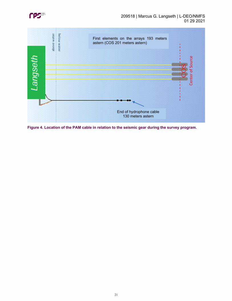
The hydrophone cable was deployed from a hydraulic winch on the port stern of the vessel’s aft deck where the acoustic source arrays were deployed. Two deck cables, a main and a spare, were installed along the deck-head running from the winch to the main science lab. A Chinese finger attached to the tow cable approximately 110 meters ahead of the connector to the hydrophone array was secured to the port side boom via lifting rope. This reduced the tension on the cable remaining on the winch, and also served as a method to pull the cable further to port and away from the source arrays. This deployment method placed the trailing end of the hydrophone cable approximately 130 meters from the port stern of the vessel, and approximately 63 meter forward of the first elements on the acoustic source arrays (Figure 4). For the initial deployment of the hydrophone cable, from 09 September 2020 to 12 September 2020, two chain lengths were secured to the hydrophone cable to help increase and stabilize the tow depth. This included a 0.4-meter chain length weighing approximately four kilograms secured to the tow cable approximately two meters ahead of the connector to the hydrophone array, and a 0.5-meter chain length weighing approximately three kilograms secured to the hydrophone array between hydrophones two and three. When the cable was retrieved on 12 September 2020 along with all other towed gear for OBS retrieval operations, a large clump of kelp was discovered caught on the chains. In order to prevent kelp build up on the cable and any potential damage caused by it for the remainder of the survey, both chains were removed from the cable before the next deployment on 16 September 2020. There was no noticeable change in the tow depth after the chains were removed, which varied between three and five meters throughout the survey program.
A more detailed description of the hydrophone deployment method, including photos of the installation, can be found in Appendix D.
209518 | Marcus G. Langseth | L-DEO/NMFS 01 29 2021
21
Figure 4. Location of the PAM cable in relation to the seismic gear during the survey program.
First elements on the arrays 193 meters astern (COS 201 meters astern)
End of hydrophone cable 130 meters astern

209518 | Marcus G. Langseth | L-DEO/NMFS 01 29 2021
22
4. MONITORING EFFORT SUMMARY
4.1. SURVEY OPERATIONS SUMMARY
4.1.1. General survey parameters
The Aleutian Arc seismic survey program began on 02 September 2020 during transit after the vessel received authorization and had already departed port in Ketchikan, Alaska on 31 August 2020 in route to Dutch Harbor. The project concluded on 08 October 2020 when the vessel arrived at port in Dutch Harbor, Alaska (Table 4). The dates and times of acquisition for each survey line on all three programs can be found in Appendix E.
Table 4: Survey parameters of the programs.
Survey Parameter Date Time (UTC) Location
Mobilization/Start of transit (Ketchikan to Dutch Harbor
31 August 2020 23:25 Ketchikan, Alaska
Start of Survey after receipt of IHA
02 September 2020 - -
First Source Activity 09 September 2020 12:40 Survey area Start of Acquisition 09 September 2020 18:14 Survey area End of Acquisition 05 October 2020 17:49 Survey area Demobilization 08 October 2020 17:40 Dutch Harbor, Alaska
During the survey program, data was acquired continuously according to the survey plan, with source operations only suspended when operationally necessary, as outlined in Table 5.
Table 5: Suspension of source operations during the survey program.
Date Time Source silenced
Date Time Ramp-up Initiated
Reason for Interruption in Acquisition
12 September 2020
11:53 UTC 16 September 2020
10:09 UTC OBS retrieval and re-deployment operations
18 September 2020
06:07 UTC 23 September 2020
21:45 UTC
OBS retrieval operations, transit to Dutch Harbor for OBS technicians to disembark, transit back to the survey area, deployment of the streamer and source arrays for MCS survey lines
4.1.2. MBES, SBP and ADCP operations
The multi-beam echosounder (MBES), sub-bottom profiler (SBP), and the acoustic Doppler current profiler (ADCP) systems were active throughout the majority of the survey program while the vessel was within the survey area. The systems were first activated on 01 September 2020 at 01:31 UTC (ADCP) and at 02:04 UTC (MBES and SBP) at the beginning of the vessel’s transit from Ketchikan, and they were disabled at 16:51 UTC on 02 September 2020 when the project authorization documents had been received and the vessel began operating under the required regulations. The systems were briefly enabled from 20:44 UTC to 22:04 UTC on 04 September 2020 for a rosette test of the OBS equipment, and then they were enabled at 14:34 UTC on 07 September 2020 after the vessel entered the survey area. The systems were active continuously from then until 14:29 UTC on 12 September 2020. Between 12 September 2020 and 14 September 2020, the systems were disabled during OBS retrieval operations and then re-enabled during the transits between OBS locations. From 18:14 UTC on 14 September 2020

209518 | Marcus G. Langseth | L-DEO/NMFS 01 29 2021
23
and 08:07 UTC on 18 September 2020, the systems were continuously active during source acquisition operations. Between 18 September 2020 and 20 September 2020, the sonars were again briefly disabled during OBS retrieval operations and then re-enabled during the transits between OBS locations. After the last OBS was onboard, the systems were re-enabled at 08:02 UTC, and then they were disabled at 15:08 UTC, right before the vessel exited the survey area to transit to Dutch Harbor. The systems were re-activated at 09:56 UTC when the vessel returned to the survey area. From 12:37 UTC on 26 September 2020 to 13:30 UTC on 27 September 2020, the systems were disabled to attempt to communicate with the OBS left on the seafloor which could not be triggered to release during the retrieval operations. The attempt was unsuccessful, and the systems were then re-enabled for the remainder of program while the vessel was within the survey area. The systems were disabled for the final time at 15:28 UTC on 06 October 2020 as the vessel exited the survey area to transit back to port at the end of the survey program.
4.1.3. Airgun operations
The acoustic source was active for a total of 338 hours 10 minutes throughout the survey program. This total included: five hours six minutes of ramp-up, 320 hours 43 minutes of operations on a survey line (278 hours 56 minutes at full volume and 41 hours 47 minutes at reduced volumes), 12 hours 13 minutes of operations not on a survey line (four hours 41 minutes at full volume and seven hours 32 minutes of reduced volumes), and eight minutes of source testing. Table 6 summarize the acoustic source operations over the course of the seismic survey program.
The acoustic source was ramped-up 17 times over the course of the survey program to commence source operations from a period of silence or to resume source operations from a mitigation shut-down for protected species. Nine ramp-ups were conducted during daylight hours and eight ramp-ups were conducted during hours of darkness. All day-time ramp-ups were cleared by both visual and acoustic monitoring. The first night-time ramp-up, the first of the project, was cleared by both visual and acoustic monitoring as a precaution while awaiting clarification of the requirements in the IHA; however, all other night-time ramp-ups were cleared by acoustic monitoring only. Ramp-ups ranged averaged 20 minutes in duration and were conducted using the automated controller program, DigiShot, which added source elements sequentially to achieve the full source volume over the required period. Ramp-ups were performed by cycling each source element two times at a shot point interval of 17 seconds, adding an additional element after each cycle, resulting in an approximately 20-minute ramp-up when all 18 or 36 elements were operating.
Operations with only a single 40 in3 source element were conducted for protected species mitigation power-downs only, which did not occur during the survey program.
There were two occasions of source testing totaling eight minutes during the survey program. Both tests occurred on 23 September 2020 and consisted of a four-minute test of the full volume array (6600 in3 with 36 active elements), and a four-minute reduced volume test of the spare elements (720 in3 with four elements).
Table 6. Total acoustic source operations during the seismic survey program.
Acoustic Source Operation Number Duration Source Tests 2 00:08 Ramp-up 17 05:06 Day-time ramp-ups from source silence 9 02:42 Night-time ramp-ups from source silence 8 02:24 Full (6600 in3)/Reduced Volume on a Survey Line1 320:43 Full (6600 in3)/Reduced Volume not on a Survey Line2 12:13 Single Source Element (40 in³) 00:00 Total Time Acoustic Source Was Active 338:10
1. On a Survey Line: 278:56 (full volume), 41:47 (reduced volume) 2. Not on a Survey Line: 04:41 (full volume), 07:32 (reduced volume)

209518 | Marcus G. Langseth | L-DEO/NMFS 01 29 2021
24
Figure 5 shows the geospatial data for source operations conducted during the survey program. Throughout the survey program, the volume of the acoustic source was changed (reduced or increased) on multiple occasions during active source operations. The reasons for these volume changes included: issues with individual source elements, source maintenance, and the vessel entering or exiting the protected sea otter critical habitat (which required reduced source volume operations). Specific information about each instance where acoustic source volume changed can be found in Appendix F.

209518 | Marcus G. Langseth | L-DEO/NMFS 01 29 2021
25
Figure 5: Geospatial data of source operations for the Aleutian Arc survey area.
In addition to the suspensions of operations outlined in Table 5, the acoustic source was silenced for mechanical/technical reasons on six occasions throughout the survey program (Table 7). Per the IHA, brief periods (less than 30 minutes) of operational silence due to mechanical/technical shut-downs did not require a ramp-up to resume full volume source operations provided that: (1) PSOs have maintained constant visual and/or acoustic observation, and (2) no visual or acoustic detections of protected species occurred within the applicable exclusion zone during that silent period. For any brief mechanical/technical shut-down at night or in periods of poor visibility (e.g. BSS of four or greater), a ramp-up was required, but if constant observation was maintained, a pre-clearance watch of 30 minutes was not required. For any longer shut-down, both a 30-pre-clearance watch and a ramp-up were required. These regulations were followed for all instances of mechanical/technical source silence except for the first. The first instance occurred during hours of darkness, and source activity was resumed without a ramp-up and without clearance from the PAM operator on duty at that time. The situation and correct procedures were reviewed with both seismic and PSO teams to ensure that this error did not occur again.
Table 7: Mechanical and technical source silence.
Date Reason for Source Silence Time Acoustic Source Silenced (UTC)
Time Acoustic Source Resumed (UTC)
10 September 2020 technical issue with Spectra 07:22 07:27 16 September 2020 mechanical issue with compressors 19:11 19:56 23 September 2020 technical issue with the
source controller software 23:57
24 September 2020 00:14 25 September 2020 mechanical issues with the streamer 06:18 15:04
27 September 2020 technical issue the source controller software during a ramp-up
11:46 11:47
28 September 2020 mechanical issue with the main engine and compressor
20:46 29 September 2020 04:01
4.1.4. Interactions with Other Vessels
In addition to visually monitoring for protected species, PSOs also observed and documented interactions with other marine vessel traffic. Over the course of the survey program, 26 other vessels were observed within the vicinity of the Langseth. This total included: one cargo vessel, five container vessels, 14 fishing vessels, two pilot vessels, two tanker vessels, and two tug boats. These vessels had an average closest distance of 2,184 meters to the Langseth, ranging between one meter and 13,704 meters.
Table 8 lists the number of each vessel type observed during the survey program as well as the closest, farthest, and average distances each vessel type was observed to the Langseth. The majority of these other vessels were observed while the vessel was transiting outside of the survey area.
There were no occasions during the survey program where other vessels, or another vessels’ gear/equipment, were observed to have some type of interaction with the Langseth’s towed seismic gear. There were no occasions during the survey program where the Langseth had to deviate from planned survey operations (e.g. diverge from the survey line, reduce speed) because of other vessels within the survey area.
Table 8: Other vessels observed during the survey program.
Vessel Type Total Number Observed
Recorded Distance to the Langseth (meters) Average Closest Farthest
Cargo 1 10,000 10,000 10,000

209518 | Marcus G. Langseth | L-DEO/NMFS 01 29 2021
26
Container 5 8,175 700 12,000 Fishing 14 1,045 600 1,500 Pilot 2 151 1 300 Tanker 2 7,752 1,800 13,704 Tug 2 1 1 1
4.2. VISUAL MONITORING SURVEY SUMMARY
Visual monitoring was conducted by two PSOs during all daylight hours throughout the survey program, beginning 30 minutes before sunrise and ending 30 minutes after sunset each day, initiating when the vessel left the dock at the beginning of the project and terminating upon the vessels return to dock at the end of the project (Table 9). This included times when the vessel was in transit, and deploying and retrieving equipment. Visual monitoring during transit was conducted for vessel strike avoidance, and visual monitoring during times with no source operations was conducted to collect baseline data about protected species abundance in the survey areas.
Table 9: Initiation and termination of visual monitoring during the survey program.
Visual Monitoring Date Time (UTC)
Initiation for the survey program 31 August 2020 23:32 Termination for the survey program 08 October 2020 17:40
Visual monitoring was conducted over a period of 39 days for a total of 503 hours 17 minutes. Of the overall total visual monitoring effort, 36.52 % (183 hours 48 minutes) was undertaken while the acoustic source was active, and 63.48% (319 hours 29 minutes) was undertaken while the acoustic source was silent. Visual monitoring while the acoustic source was silent was mainly conducted during the transits to and from the survey sites, and during equipment deployment, recovery and maintenance. Table 10 detail visuals monitoring with acoustic source operations throughout the survey program. Table 10. Total visual monitoring effort during the survey program.
Visual Monitoring Effort Duration (hh:mm) % of Overall Visual Monitoring Effort
Total monitoring while acoustic source active 183:48 36.52 Total monitoring while acoustic source silent 319:29 63.48
Total monitoring effort 503:17 - Visual observations were preferentially conducted from the PSO tower, which provided a 360-degree view of the water around the vessel and the acoustic source. Visual watches were conducted from other locations, including the catwalk, bridge, and stern if monitoring conditions could not be undertaken from the tower, such as during rough weather and sea conditions which made the tower unsafe, or when the vessel was heading directly into the wind, blowing the engine exhaust onto the tower. PSOs conducted visual monitoring from the tower (33.62%) and from the bridge (56.56%) more often than any other location during the survey program (Table 11). Monitoring was conducted simultaneously from the bridge and catwalk when the ships exhaust was blowing on the tower but monitoring conditions were otherwise favorable. Monitoring was conducted simultaneously from the tower and catwalk when the ships exhaust was only blowing on part of the tower. Table 11: Total visual monitoring effort from observation locations during the survey program.
Observation Location During Visual Effort Duration (hh:mm) % of Overall Effort Tower 169:13 33.62 Bridge 284:38 56.56

209518 | Marcus G. Langseth | L-DEO/NMFS 01 29 2021
27
Catwalk 06:53 01.37 Tower/Catwalk 00:11 0.04 Bridge/Catwalk 42:22 08.42
4.3. ACOUSTIC MONITORING SURVEY SUMMARY
Acoustic monitoring during the survey program was conducted continuously throughout acoustic source operations and to the maximum extent possible while the acoustic source was silent (Table 12). Brief periods of source activity without acoustic monitoring were not conducted for any needed assessments, adjustments, or maintenance to the PAM system. Periods without source activity or acoustic monitoring occurred when the PAM hydrophone cable was secured on board the vessel during transits, during deployment and recovery of the seismic gear, and during times when operations were suspended due to rough weather and sea conditions. Table 12: Initiation and termination of acoustic monitoring watches during survey program.
Acoustic Monitoring Date Time (UTC)
Initiation for the survey program 09 September 2020 11:35 Termination for the survey
program 05 September 2020 19:03
Acoustic monitoring was conducted on 20 days for a total of 396 hours six minutes. Of the overall total acoustic monitoring effort, 85.37% (338 hours 10 minutes) was undertaken while the acoustic source was active, and 14.63% (57 hours 56 minutes) was undertaken while the acoustic source was silent. Acoustic monitoring while the acoustic source was silent was mainly conducted during the brief periods of time between recovery/deployment of the seismic gear and recovery/deployment of the PAM cable. Table 13 details acoustic monitoring with acoustic source operations throughout the survey program. Table 13. Total Passive Acoustic Monitoring (PAM) effort during the survey program.
Acoustic Monitoring Effort Duration (hh:mm)
% of Overall Acoustic Monitoring Effort
Total night time monitoring 181:25 45.80 Total day time monitoring 214:41 54.20 Total monitoring while the acoustic source was active 338:10 85.37 Total monitoring while the acoustic source was silent 57:56 14.63
Total acoustic monitoring 396:06 - Acoustic monitoring was suspended five times throughout the survey program for several reasons, including debris removal and maintenance of the PAM cable, deployment/retrieval of the seismic equipment, and transit of the vessel. Acoustic monitoring downtime was calculated as any time acoustic monitoring was not conducted between the times when the hydrophone cable was deployed for the first time at the beginning of each survey, and the times when the hydrophone cable was retrieved for the final time at the end of each survey. Acoustic monitoring downtime totaled 235 hours 22 minutes, the majority of which was due to seismic gear deployment, retrieval, and maintenance operations (57.16%) (Table 14). Each instance of acoustic monitoring downtime is recorded in Appendix G. Acoustic monitoring downtime occurred during acoustic source activity only when the need was unavoidable. Throughout the entire survey program, there was no acoustic monitoring downtime while the acoustic source was still active.

209518 | Marcus G. Langseth | L-DEO/NMFS 01 29 2021
28
Table 14. Passive Acoustic Monitoring (PAM) downtime during the survey program.
Cause of Downtime Duration (hh:mm)
% of Overall Downtime
Debris Removal and Maintenance Hydrophone Cable 00:48 0.34
Seismic Gear Deployment/Retrieval/Maintenance 134:32 57.16
Transit (after initial PAM cable deployment for the survey) 100:02 42.50
Total Passive Acoustic Monitoring Downtime 235:22 -
4.4. SIMULTANEOUS VISUAL AND ACOUSTIC MONITORING SUMMARY
Simultaneous visual and acoustic monitoring was conducted to the maximum extent possible during the survey program for a total of 215 hours 40 minutes. Of the overall simultaneous monitoring effort, 85.23% (183 hours 49 minutes) was conducted while the acoustic source was active (Table 15). Additional visual monitoring conducted during transit periods was not accompanied by acoustic monitoring as the increased vessel speed caused the hydrophone cable to migrate to the water surface, out of the ideal tow position, where the increased background noise impaired acoustic detection capabilities. Table 15: Simultaneous visual and acoustic monitoring effort during the survey program.
Simultaneous Visual and Acoustic Monitoring Duration (hh:mm) % of Overall Downtime
Source Active 183:49 85.23
Source Silent 31:51 14.77
Overall Total 215:40 -
4.5. ENVIRONMENTAL CONDITIONS
Environmental conditions can have an impact on the probability of detecting protected species. The environmental conditions present during visual observations undertaken during this survey program were generally considered to be moderate to good. Visibility was classified as ‘excellent’ if it extended to 8 to 10 kilometers and “good” if they were between five to seven kilometers. During the survey program, 58.50% and 19.52% of monitoring effort was undertaken at ‘excellent’ and ‘good’ visibility levels respectively (Table 16). Table 16. Visibility during the survey program.
Total <2 km (poor)
2-4 km (moderate)
5-7 km (good) 8-10 km (excellent)
Duration (hh:mm) 63:46 46:52 98:13 294:26 % of effort 12.67 09.31 19.52 58.50
Reduced visibility was mainly attributed to periods of rain and fog, and the brief periods of reduced lighting before sunrise and after sunset. Throughout the survey program, precipitation was recorded during 39.92% of visual monitoring, for a total of 200 hours 56 minutes. The majority of the precipitation recorded was light rain (29.09%, 146 hours 23 minutes) (Table 17). Table 17. Precipitation during the survey program.
Total None Light Rain Moderate Rain Heavy Rain Fog Duration (hh:mm) 302:21 146:23 14:26 00:14 39:53 % of effort 60.08 29.09 02.87 0.05 07.92

209518 | Marcus G. Langseth | L-DEO/NMFS 01 29 2021
29
During visual monitoring, the entire predicted 160 decibel radius was not visible for 164 hours 45 minutes, mainly due to precipitation and the large size of the radii, which in shallow water was never fully visible. The entire 1,000-meter buffer zone was not visible for 33 hours 51 minutes, and the entire 500-meter exclusion zone was not visible for 17 hours 11 minutes. There was no time during the survey program where the entire 100-meter exclusion zone was not entirely visible during visual monitoring efforts (Table 18). Table 18. Duration radii were NOT fully visible during the survey program.
Total 160 dB 1000 m 500 m 100 m Duration (hh:mm) 164:45 33:51 17:11 - % of effort 32.74 06.73 03.41 -
The Beaufort Sea state recorded during visual monitoring ranged from level one to level nine over the course of the survey program. The majority of visual observations were undertaken in conditions where the Beaufort state was level three (163 hours 19 minutes, 32.45%), which were considered good conditions for the detection of protected species (Table 19). Table 19. Beaufort Sea State during the survey program.
Total B1 B2 B3 B4 B5 B6 B7 B8 B9
Duration (hh:mm) 05:07 102:46 163:19 98:31 85:20 21:06 07:49 11:09 08:10
% of effort 01.02 20.42 32.45 19.57 16.96 04.19 01.55 02.22 01.62 The Beaufort wind force recorded during visual monitoring ranged from zero (less than one knot) to 10 (48 to 55 knots). The majority of visual monitoring occurred during a recorded wind force of four (11 to 16 knots) for a total of 144 hours 58 minutes (28.8% of all visual monitoring effort). The highest wind speeds, between 48 and 55 knots (level 10), was recorded for a total of 59 minutes (0.20% of all visual monitoring efforts) (Table 20). Table 20. Beaufort Wind Force during the survey program.
Total B0 (<1knot)
B1 (1-3 knots)
B2 (4-6 knots)
B3 (7-10 knots)
B4 (11-16 knots)
B5 (17-21 knots)
B6 (22-27 knots)
B7 (28-33 knots)
B8 (34-40 knots)
B9 (41-47 knots)
B10 (48-55 knots)
Duration (hh:mm)
00:54 06:55 32:41 57:30 144:58
105:06 94:25 38:41 11:16 09:52 00:59
% of effort
00.18 01.37 06.49 11.42 28.80 20.88 18.76 07.69 02.24 01.96 00.20
Swell heights during visual observations were generally low, with swells of less than two meters recorded for the majority of visual observations (321 hours 23 minutes, 63.86%) (Table 21). Table 21. Swell Height during the survey program.
Total <2m 2-4m >4m Duration (hh:mm) 321:23 146:46 35:08 % of effort 63.86 29.16 06.98
The majority of visual monitoring effort during the survey program was conducted while no glare was present (269 hours 58 minutes, 53.64%) (Table 22). During times of moderate to severe glare, it is

209518 | Marcus G. Langseth | L-DEO/NMFS 01 29 2021
30
possible that the detection of protected species was hindered. Table 22. Glare during the survey program.
Total None Little Moderate Severe Duration (hh:mm) 269:58 62:11 59:05 112:03 % of effort 53.64 12.36 11.74 22.26

209518 | Marcus G. Langseth | L-DEO/NMFS 01 29 2021
31
5. MONITORING AND DETECTION RESULTS
5.1. VISUAL DETECTIONS
Visual monitoring efforts during the Aleutian Arc seismic survey program resulted in a total of 68 detections of protected species (summarized in Appendix H). This total included: 45 detections of whales, five detections of dolphins, 14 detections of porpoises, and four detections of pinnipeds.
Table 23 lists the total number of detections and total number of animals recorded for each protected species observed during the survey program. Photographs taken of visual detections can be found in Appendix I.
Table 23. Number of visual detection records collected for each protected species during the survey program. Species Total Number Detection Records Total Number Animals Recorded Whales Common Minke Whale 4 5 Fin Whale 1 1 Humpback Whale 5 10 Sei Whale 1 20 Sperm Whale 11 15 Unidentifiable Whale 23 28 Dolphins Killer Whale 4 21 Unidentifiable Dolphin 1 1 Porpoises Dall’s Porpoise 9 76 Unidentifiable Porpoise 5 25 Pinnipeds Northern Fur Seal 2 2 Unidentifiable Pinniped 2 3 TOTAL 68 207 Unidentifiable whales and sperm whales were the most frequently observed species, totaling 34% and 16% of all protected species detections, respectively. Dall’s porpoise was the most numerously observed species with 37% of the total number of individuals observed, followed by unidentifiable whales and unidentifiable porpoise, with 14% and 12% of the total, respectively. There was one detection of a large pods of porpoises (30 individuals) as well as one detection of a large pod of sei whales (20 individuals); however, in general, most sightings consisted of 10 individuals or less. In addition, there were seven juveniles observed during the survey program, including one sperm whale and three killer whales that were classified as calves. Thirty-two of the detections occurred within the survey area. This total included: three sightings of common minke whales, three sightings of Dall’s porpoise, four sightings of humpback whales, three sightings of killer whales, one sighting of a norther fur seal, nine sightings of sperm whales, one sighting of an unidentifiable dolphin, and eight sightings of unidentifiable whales. The majority of these detections occurred while the vessel was on the northern side of the islands, mainly on the western end of the survey area. Thirty-six of the detections occurred while the vessel was transiting outside of the survey area. This total included one sighting of common minke whales, six sightings of Dall’s porpoise, one sighting of fin whales, one sighting of humpback whales, one sighting of killer whales, one sighting of northern fur seals,

209518 | Marcus G. Langseth | L-DEO/NMFS 01 29 2021
32
one sighting of sei whales, two sightings of sperm whales, two sighting of unidentifiable pinnipeds, five sightings of unidentifiable porpoise, and 15 sightings of unidentifiable whales. The majority of these detections occurred while the vessel was in transit to the survey area (the first 26 detections of the program). Three of these detections occurred during week four of the survey program while the vessel was transiting to Dutch Harbor to disembark OBS technicians and then back to the survey area. The remaining seven detections occurred while the vessel was in transit back to port at the end of the survey program. Figure 6 shows all detections of protected species that occurred during the Aleutian Arc survey program, and Figure 7 shows only detections within the survey area. Figure 8 shows all detections sorted by species group (i.e. dolphins and porpoises, whales, pinnipeds, and protected sea birds), and Figure 9 shows all only detections within the survey area sorted by species group. There was a large variability in weather conditions throughout the Aleutian Arc survey program, mainly with visibility due to precipitation and high winds and rough seas caused by several passing storm systems. In general, with high numbers of visual detections corresponded with days with high visibility, small swells, and calm seas (Figure 10).
Figure 6: All protected species detections during the survey program.

209518 | Marcus G. Langseth | L-DEO/NMFS 01 29 2021
33
Figure 7: Protected species detections within the survey area of the Aleutian Arc survey program.

209518 | Marcus G. Langseth | L-DEO/NMFS 01 29 2021
34
Figure 8: All protected species observed during the survey program by species group.

209518 | Marcus G. Langseth | L-DEO/NMFS 01 29 2021
35
Figure 9: All protected species observed within the survey area by species group.

209518 | Marcus G. Langseth | L-DEO/NMFS 01 29 2021
36
Figure 10: Number of protected species detections and corresponding weather data for each day of the survey program.

209518 | Marcus G. Langseth | L-DEO/NMFS 01 29 2021
37
Of the 68 visual detections of protected species, five detections (8%) occurred while the acoustic source was active at full volume on a survey line, three detections (5%) occurred while the acoustic source was active at reduced volume on a survey line, one detection (1%) began while the source was at full volume on a survey line and concluded while the source was being ramped-up, three detections (5%) occurred while the acoustic source was deployed but silent, and 56 detections (81%) occurred while the acoustic source was not deployed (Table 24).
During full volume source operations on a survey line (6600 in3 with 36 active elements), there was one detection of a common minke whale, one detection of a sperm whale, and three detections of unidentifiable whales. Of these species, the common minke whale had the closest approach to the active source, with a distance of 300 meters. The sperm whale had a closest observed approach of 1,311 meters to the active source, and the unidentifiable whales had closest observed approaches between 1,066 and 2,070 meters to the active source. For the one detection of a humpback whale which began while the acoustic source was active at full volume on a survey line and concluded during a ramp-up, the whale had a closest approach of 520 meters to the active source and 480 meters to the silent source after a shut-down had been implemented.
During reduced volume source operations on a survey line, there were two detections of sperm whales and one detection of humpback whales. The two sperm whale detections occurred while the source was active at a volume of 3300 in3 with 18 active elements, and the whales had closest approaches of 1,935 meters and 2,167 meters to the active source. The humpback whale detection occurred while the source was active at a volume of 4950 in3 with 27 active elements, and the whale had a closest approach of 1,024 meters to the active source.
While the acoustic source was deployed but silent on a line change, there was one detection of killer whales and two detections of sperm whales. The killer whales had a closest approach of 2,529 meters to the silent source, while the sperm whales had closest approaches of 2,448 meters and 4,100 meters to the silent source.
For the 56 detections that occurred while the acoustic source was silent and secured onboard the vessel, distances to the source were calculated as if the arrays had been deployed. Of these detections, pinnipeds had the closest approaches at 40 meters (unidentifiable pinnipeds) and 70 meters (northern fur seal). For these detections: common minke whales had closest approaches between 244 and 944 meters, Dall’s porpoise had closest approaches between 137 and 581 meters, fin whales had closest approaches of 370 meters, humpback whales had closest approaches between 707 and 1,657 meters, killer whales had closest approaches between 363 and 1,133 meters, norther fur seals had closest approaches between 70 and 168 meters, sei whales had closest approaches of 200 meters, sperm whales had closest approaches between 594 and 2,240 meters, unidentifiable dolphins had closest approaches of 618 meters, unidentifiable pinnipeds had closest approaches between 40 and 70 meters, unidentifiable porpoises had closest approaches between 399 and 1,063 meters, and unidentifiable whales had closest approaches between 227 and 9,883 meters.

209518 | Marcus G. Langseth | L-DEO/NMFS 01 29 2021
38
Table 24. Average closest approach of protected species to the acoustic source at various volumes during the survey program.
Species Detected
Full or Reduced Volume on a Survey Line
Full or Reduced Volume Not on a Survey Line
Single 40 in³ Element Ramp-up Source Silent and Deployed
Source Silent and Onboard*
Number of detections
Average closest approach to source (meters)
Number of detections
Average closest approach to source (meters)
Number of detections
Average closest approach to source (meters)
Number of detections
Average closest approach to source (meters)
Number of detections
Average closest approach to source (meters)
Number of detections
Average closest approach to source (meters)
Common Minke Whale 1 300 - - - - - - - - 3 514 Fin Whale - - - - - - - - - - 1 370 Humpback Whale 1 520 1 1024 - - - - - - 3 1066 Sei Whale - - - - - - - - - - 1 200 Sperm Whale 1 1311 2 2051 - - - - 2 3274 6 1335 Unidentifiable Whale 3 2117 - - - - - - - - 20 1944 All Whales 6 1414 3 1709 - - - - 2 3274 34 1535 Killer Whale - - - - - - - - 1 2529 3 736 Unidentifiable Dolphin - - - - - - - - - - 1 618 All Dolphins - - - - - - - - 1 2529 4 707 Dall’s Porpoise - - - - - - - - - - 9 260 Unidentifiable Porpoise - - - - - - - - - - 5 644 All Porpoises - - - - - - - - - - 14 397 Northern Fur Seal - - - - - - - - - - 2 119 Unidentifiable Pinniped - - - - - - - - - - 2 106 All Pinnipeds - - - - - - - - - - 4 113 All Protected Species 6 1414 3 1709 - - - - 3 3025 56 1090
*For detections which occurred during acoustic source silence while the arrays were onboard during transits, the closest distance to the source was calculated as if the arrays had been deployed.

209518 | Marcus G. Langseth | L-DEO/NMFS 01 29 2021
39
5.1.1. Other Wildlife
Observations of other wildlife during the survey program included 29 species of birds and two species of marine invertebrates. A complete list of birds and other marine wildlife observed and identified, in addition to the approximate number of individuals observed and the number of days on which they were observed, can be found in Appendix J. No impacts to any other wildlife species as a result of research activities were observed during the survey program. There were three detections of protected bird species during the survey program, each consisting of one juvenile short-tailed albatross. All three sightings occurred within the survey area; however, only one of the sightings occurred while the acoustic source was deployed and active at full volume on a survey line. The other two sightings occurred while the vessel was conducting OBS retrieval operations and transiting within the survey area. During each of these sightings, the protected sea birds were only observed flying and soaring in the air around the vessel. Mitigation actions for protected bird species were only required if the individuals were observed diving or foraging within the exclusion zones while the source was active. No mitigation actions were required for any of these three sightings.
5.2. ACOUSTIC DETECTIONS
There were no acoustic detections of protected species during the survey program.

209518 | Marcus G. Langseth | L-DEO/NMFS 01 29 2021
40
6. MITIGATION ACTION SUMMARY There were two mitigation actions implemented during the survey program due to protected species being observed approaching, entering, or within their designated exclusion zones. This included two shut downs totaling one hour 25 minutes (Table 25). Both mitigation actions were implemented during acquisition of a survey line, and therefore, the entire duration of downtime was considered to be production loss. The first shut-down was for a common minke whale totaling 51 minutes, and the second shut-down was for a humpback whale totaling 34 minutes (Table 26). Table 27 summarizes these mitigation actions. For the sighting of the common minke whale, the whale was first and last sighted within the exclusion zone. For the sighting of the humpback whale, the whale was initially sighted approaching the exclusion zone, enter the zone after the source was silenced, and was last sighted outside of the exclusion zone. Table 25. Number and duration of mitigation actions implemented during the survey program.
Mitigation Action
Whales Dolphins Pinnipeds Sea Turtles Sea Birds
Number Duration (hh:mm) Number Duration
(hh:mm) Number Duration (hh:mm) Number Duration
(hh:mm) Number Duration (hh:mm)
Delayed Operation - - - - - - - - - -
Power-down - - - - - - - - - - Shut-down 2 01:25 - - - - - - - - All Actions - - - - - - - - - - Total 2 01:25 - - - - - - - -
Table 26: Mitigation actions and downtime duration by species during the survey program.
Species Number of Delayed Operations
Number of Power-downs
Number of Shut-downs
Duration of Mitigation action (h:mm)
Percentage of Mitigation Downtime
Common Minke Whale - - 1 00:51 60% Humpback Whale - - 1 00:34 40%
Table 27. Summary of each mitigation action implemented during the survey program.
Date
Visual or Acoustic Detection Number
Species Group Size
Source Activity (initial detection)
Closest Approach to Active Source (m)
Mitigation Action
Total Duration of Mitigation Event
Total Duration of Production Loss
26 September 2020
52 Common Minke Whale
1 Full Volume While on a Survey Line
300 Shut-down 00:51 00:51
28 September 2020
54 Humpback Whale 1
Full Volume While on a Survey Line
520 Shut-down 00:34 00:34

209518 | Marcus G. Langseth | L-DEO/NMFS 01 29 2021
41
6.1. PROTECTED SPECIES KNOWN TO HAVE BEEN EXPOSED TO 160 DECIBELS OR GREATER OF RECEIVED SOUND LEVELS
Numerous protected species are known to occur within the survey area, including several species listed as endangered or threatened under the ESA. Endangered species included: north pacific right whale, sperm whale, sei whale, fin whale, blue whale, western north pacific distinct population segment (DPS) of gray whales and humpback whales, western DPS of Steller sea lions, short-tailed albatross, and leatherback sea turtle. Threatened species included: Mexico DPS of humpback whale, southwest Alaska DPS of sea otters, Steller’s eider, and spectacled eider. The survey area also encompassed several critical habitat areas for both Steller sea lions and sea otters.
NMFS granted an IHA and ITS for the marine seismic survey authorizing a total of 12,412 takes from 24 species, including seven species of whales and one species of pinnipeds listed as endangered or threatened. Of this total, 395 individuals from seven of these species were authorized for Level A harassment takes (exposure to sound pressure levels where there is a potential for auditory injury based upon each species hearing range), including 213 takes for endangered/threatened species. A total of 12,017 individuals from all 24 species were authorized for Level B harassment takes (exposure to sound pressure levels equal to or greater than 160 dB re: 1 μPa (rms) where there is a potential for behavioral changes), including 4,536 takes for endangered/threatened species. For sea turtles, behavioral harassment was expected to occur in the 175-decibel zone. For ESA-listed sea birds, there was no specific designated harassment zone; however, mitigation actions would have been implemented if the birds were observed diving or foraging within the 500-meter (power-down) or 100-meter (shut-down) exclusion zones. There were no specific take numbers authorized for protected sea turtles or sea birds.
Throughout the Aleutian Arc survey program, one protected species, a common minke whale, was observed within the Level A harassment zone while the acoustic source was active. This total represents 50% of the authorized Level A takes for this species, and 0.25% of all authorized Level A takes for the survey. Nine protected species, including two humpback whales, four sperm whales, and three unidentifiable whales, were observed within the Level B harassment zone while the acoustic source was active. These totals represent 0.10% of authorized Level B takes for humpback whales, 9.30% of authorized Level B takes for sperm whales, and 0.05% of all authorized Level B takes for the survey. Table 28 details all of the authorized and potential Level A and Level B takes for the survey program.
The number of potential takes may be an underestimation and, therefore, may be a minimum estimate of the actual number of protected species potentially exposed to received sound levels within the predicted Level A and Level B harassment zones. It is possible that the estimated numbers of animals recorded were underestimates due to some individuals not being visually sighted or having moved away before they were observed, or some individuals not vocalizing and therefore not detected acoustically.
Additionally, weather conditions have a large impact on the ability to visually detect protected species, particularly smaller or unobtrusive species such as sea otters, sea turtles, and beaked whales. Throughout the survey program, visual monitoring was conducted for 183 hours 48 minutes while the acoustic source was active. Of this time, 17.52% (32 hours 12 minutes) was undertaken while swell heights were between two and four meters, and 38.02% (69 hours 53 minutes) was undertaken while the Beaufort Sea state was a level four or greater, which were considered moderate to poor conditions for visually sighting protected species. In addition, there were several occasions were the entire predicted radii and zones were not entirely visible, mainly due to reduced lighting in the dawn/dusk hours and precipitation. There were also periods of time where the 160-decibel radius for the full volume source (6600 in3 with 36 active elements) was never entirely visible in shallow waters (less than 100 meters) even utilizing the big-eye binoculars due to the large size of the zone (11,000 meters). Throughout the survey program, 42.27% of visual monitoring efforts (77 hours 41 minutes) while the source was active were undertaken during recorded precipitation, mainly fog and light rain. However, the total durations of the predicted radii and zones not being entirely visible was relatively low throughout the survey. While the source was active, the entire 160 decibel radius was only not entirely visible for 43 hours 27 minutes (23.64% of these visual monitoring efforts), the entire 1,000-meter buffer zone was not visible for seven hours 37 minutes (4.14% of these visual monitoring efforts), and the entire 500-meter exclusion zone was not visible for four hours nine minutes (2.26% of these visual monitoring efforts. There was never a time

209518 | Marcus G. Langseth | L-DEO/NMFS 01 29 2021
42
during visual monitoring while the acoustic source was active that the entire 100-meter exclusion zone was not entirely visible.
Table 29 describes the behavior of all animals, including unidentified species, which were visually observed within the predicted Level A and Level B harassment zones during the survey program. While there were no highly distinctive behavioral reactions observed in relation to the vessel or acoustic source during the seismic survey, the majority of the protected species detected were observed moving away from the vessel. Table 28. Number of authorized and potential Level A and B Harassment Takes during the survey program.
Species
IHA Authorized Level A Takes
Potential Level A Takes / PTS During the Program
IHA Authorized Level B Takes
Potential Level B Takes / TTS During the Program
Total IHA Authorized Takes
Total Potential Takes During the Program
ESA Listed Species North Pacific Right Whale - - 2 - 2 - Humpback Whale 106 - 1842 2 1948 2 Blue Whale 2 - 23 - 25 - Fin Whale 104 - 1650 - 1754 - Sei Whale - - 5 - 5 - Gray Whale 1 - 62 - 63 - Sperm Whale - - 43 4 43 4 Steller Sea Lion - - 909 - 909 - Northern Sea Otter - - - - - - Leatherback Sea Turtle - - - - - - Non-Listed Species Common Minke Whale 2 1 27 - 29 1 Baird’s Beaked Whale - - 24 - 24 - Sato’s Beaked Whale - - 9 - 9 - Cuvier’s Beaked Whale - - 106 - 106 - Stejneger’s Beaked Whale - - 47 - 47 - Pacific White-Sided Dolphin - - 1002 - 1002 - Northern Right-Whale Dolphin - - 58 - 58 - Risso’s Dolphin - - 22 - 22 - Killer Whale - - 141 - 141 - Dall’s Porpoise 157 - 4312 - 4469 - Harbor Porpoise 23 - 679 - 702 - Northern Fur Seal - - 789 - 789 - Northern Elephant Seal - - 106 - 106 - Harbor Seal - - 149 - 149 - Spotted Seal - - 5 - 5 - Ribbon Seal - - 5 - 5 - Unidentified species Unidentified Whale - - - 3 - 3 Unidentified Dolphin - - - - - - Unidentified Pinniped - - - - - -

209518 | Marcus G. Langseth | L-DEO/NMFS 01 29 2021
43
Species
IHA Authorized Level A Takes
Potential Level A Takes / PTS During the Program
IHA Authorized Level B Takes
Potential Level B Takes / TTS During the Program
Total IHA Authorized Takes
Total Potential Takes During the Program
Unidentified Sea Turtle - - - - - - Table 29: Behavior of species visually observed to be exposed to sound pressure levels of 160 dB or greater during the survey program.
Species Detection No.
No. of Animals
Source Volume (in3)
Highest Observed Sound Pressure Level (dB)
Initial behavior
Initial direction in relation to vessel
Subsequent and Final behavior
Subsequent and Final direction in relation to vessel
Unidentifiable Whale 43 1 6600 160 Blowing Unknown Blowing Unknown
Unidentifiable Whale 44 1 6600 160 Blowing Unknown Blowing Unknown
Common Minke Whale 52 1 6600 Level A Breaching
Parallel to the vessel in the same direction
Surfacing Parallel to the vessel in the same direction
Unidentifiable Whale 53 1 6600 160 Blowing
Away from the vessel
Blowing Away from the vessel
Humpback Whale 54 1 6600 160 Blowing
Crossing ahead of the vessel
Surfacing, Milling
Away from the vessel
Sperm Whale 58 2 3300 160 Blowing Towards the vessel
Surfacing, fast travel, diving, fluking
Away from the vessel
Sperm Whale 59 1 3300 160 Blowing Away from the vessel
Surfacing, diving, fluking
Away from the vessel
Humpback Whale 60 1 4950 160 Blowing
Parallel to the vessel in the opposite direction
Surfacing, diving, fluking
Parallel to the vessel in the opposite direction

209518 | Marcus G. Langseth | L-DEO/NMFS 01 29 2021
44
6.2. IMPLEMENTATION AND EFFECTIVENESS OF THE BIOLOGICAL OPINION’S ITS AND IHA
In order to minimize the potential impacts to marine mammals, sea turtles, and protected sea birds during the Aleutian Arc survey program, LDEO and PSOs were prepared to implement mitigation measures whenever these protected species were detected approaching, entering, or within their designated exclusion zones as outlined in the IHA, ITS, USFWS LOC, BO, and Final EA. There were two mitigation actions implemented during the survey program for protected species, including two shut-downs for whales totaling one hour 25 minutes. The confirmation of the implementation of each term and condition of the project permit documents are described in this report.
As noted in Section 3.2, the IHA and ITS outline several additional mitigation measures for certain detections of protected species as well as a mitigation exemption for two species of delphinids. During the survey program, there were no instances where these additional measures or exemptions were implemented.
As required by the USFWS LOC, mitigation measures for sea otters were to be implemented for any individual detected approaching, entering, or within the 160 decibel radius. In addition, visual monitoring for sea otters utilizing the FLIR camera was required while the vessel was operating within the designated sea otter areas during hours of darkness. Throughout the survey program, there were no visual detections of sea otters.
In the event that an injured or dead protected species was discovered during the course of the survey program, the incident was to be reported to the Office of Protected Resources (OPR), NMFS, and the NMFS Alaska Regional Stranding Coordinator as soon as possible. The report would include a detailed description of the incident (time, date, location, species identification, description of the animal, condition of the animal/carcass, observed behaviors if the animal was alive, and general circumstances under which the animal was discovered), including pictures when possible. There were no sightings of dead or injured protected species during the survey program.
In order to prevent the occurrence of the vessel striking a marine mammal during transits, PSOs and vessel crew members maintained a vigilant watch for marine mammals. The vessel speed had to be reduced to 10 knots or less when mother/calf pairs, pods, or large assemblages of cetaceans were observed near the vessel. The vessel had to maintain a minimum separation distance of 500 meters from right whales. If a whale was observed but the species could not be confirmed, the assumption was to be made that it was a right whale and appropriate action undertaken. The vessel had to maintain a minimum separation distance of 100 meters from sperm whales and all other baleen whales, and to the maximum extent possible, attempt to maintain a separation distance of 50 meters from all other marine mammals. If a marine mammal was sighted during transits, the vessel was to take action as necessary to avoid violating the relevant separation distances (e.g. attempt to remain parallel to the animal’s course, avoid excessive speed or abrupt changes in direction until the animal left the area). If marine mammals were sighted within the relevant separation distances, the vessel was required to reduce speed, shift the engines to neutral, and not engage the engines until the animals were clear of the area. These requirements did not apply in any case where compliance would create an imminent and serious threat to a person or vessel, or if the vessel was restricted in maneuverability due to towed equipment.

209518 | Marcus G. Langseth | L-DEO/NMFS 01 29 2021
45
Throughout the survey program, there was one instance where the vessel had to alter course to avoid potentially striking a marine mammal. On 14 September 2020, the vessel had just completed OBS retrieval operations and had begun transit to the next survey line with all gear onboard when an adult sperm whale surfaced approximately 321 meters ahead of the vessel off the port bow. The whale was headed away from the vessel to port; therefore, the bridge crew turned the vessel more to starboard to avoid any potential strike. The whale was initially sighted by the bridge crew of the vessel as the PSOs were observing a sperm whale calf off the port stern that had initially been sighed off the port beam approximately 10 minutes before the adult whale surfaced.
In the event of a live stranding (or near-shore atypical milling) event of marine mammals within 50 kilometers of the survey operations, where the NMFS stranding network is engaged in herding or other interventions to return the animals to the water, LDEO would be advised of the need to implement shut-down procedures for all active acoustic sources operating within 50 kilometers of the stranding. The shut-down procedures would be implemented until all of the live animals had left the area, or until the marine mammals died or were euthanized. During the survey program, there were no instances of marine mammal strandings near the survey area.
Passive acoustic monitoring was conducted throughout the survey and the majority of acoustic monitoring was undertaken while the source was active. High vessel speeds (greater than six knots) can result in high levels of background noise, which made it impractical to conduct acoustic monitoring while the vessel was in transit. This prevented baseline acoustic data from being collected both within and outside of the survey area while visual monitoring was ongoing for baseline data collection purposes. There were no acoustic detections of protected species during the survey program. For the Aleutian Arc survey program, a total of 12,412 individual marine mammals from 24 species (including seven whale species and one pinniped species listed as endangered or threatened) were authorized for takes in the IHA and ITS. Of this total, 12,017 individuals from all 24 species were authorized for Level B takes, and 395 individuals from only seven of these species were authorized for Level A takes. During the survey program, a total of nine protected species were observed within the predicted Level B harassment radius, including two humpback whales, four sperm whales, and three unidentifiable whales. This total represents 0.05% of the authorized Level B takes, or 0.0005% of the total authorized takes for the survey. There was one protected species, a common minke whale, observed within the Level A harassment zone during the survey. This total represents 0.25% of the authorized Level A takes, or 0.00008% of the total authorized takes for the survey.
PSOs likely did not detect all animals present; however, it is highly unlikely that the actual number of animals present during survey operations reached anywhere near the fully authorized levels for all species. The combination of conservative predicted mitigation zones combined with conservative take estimation by NMFS (i.e., the precautionary approach), appears for most species to have resulted in an overestimation of take and of overall impact on marine species from the activity. The monitoring and mitigation measures required by the IHA and ITS appear to have been an effective means to protect the marine species encountered during survey operations.

209518 | Marcus G. Langseth | L-DEO/NMFS 01 29 2021
46
7. LITERATURE CITED
NOAA, 2020. Endangered Species Act Section 7 Consultation Biological Opinion for a marine seismic survey by Lamont-Doherty Earth Observatory in the North Pacific Ocean and NFMS IHA issuance.
Crone, T.J., M. Tolstoy, and H. Carton. 2014. Estimating shallow water sound power levels and mitigation radii for the R/V Marcus G. Langseth using an 8 km long MCS streamer. Geochem., Geophys., Geosyst. 15(10):3793-3807.
Crone, T.J., M. Tolstoy, and H. Carton. 2017. Utilizing the R/V Marcus G. Langseth’s streamer to measure the acoustic radiation of its seismic source in the shallow waters of New Jersey’s continental shelf. PloS ONE 12(8): e0183096. http://doi.org/10.1371/journal.pone.0183

209518 | Marcus G. Langseth | L-DEO/NMFS 01 29 2021
47
APPENDIX A: Incidental Harassment Authorization for the Aleutian Arc Marine Geophysical Survey.

INCIDENTAL HARASSMENT AUTHORIZATION
The Lamont-Doherty Earth Observatory of Columbia University (L-DEO) is hereby authorized under section 101(a)(5)(D) of the Marine Mammal Protection Act (MMPA; 16 U.S.C. 1371(a)(5)(D)) to harass marine mammals incidental to a geophysical survey in the Aleutian Islands, when adhering to the following terms and conditions.
1. This Incidental Harassment Authorization (IHA) is valid for a period of one year from the date of issuance.
2. This IHA is valid only for marine geophysical survey activity, as specified in L-DEO’s IHA application.
3. General Conditions
(a) A copy of this IHA must be in the possession of L-DEO, the vessel operator, the lead protected species observer (PSO) and any other relevant designees of L-DEO operating under the authority of this IHA.
(b) The species authorized for taking are listed in Table 1. The taking, by Level A and Level B harassment only, is limited to the species and numbers listed in Table 1.
(c) The taking by serious injury or death of any of the species listed in Table 1 or any taking of any other species of marine mammal is prohibited and may result in the modification, suspension, or revocation of this IHA. Any taking exceeding the authorized amounts listed in Table 1 is prohibited and may result in the modification, suspension, or revocation of this IHA.
(d) During use of the acoustic source, if any marine mammal species that are not listed in Table 1 appear within or enter the Level B harassment zone (Table 3) the acoustic source must be shut down.
(e) L-DEO must ensure that relevant vessel personnel and PSO team participate in a joint onboard briefing led by the vessel operator and lead PSO to ensure that responsibilities, communication procedures, protected species monitoring protocols, operational procedures, and IHA requirements are clearly understood.
4. Mitigation Measures The holder of this Authorization is required to implement the following mitigation measures: (a) L-DEO must use independent, dedicated, trained visual and acoustic PSOs,
meaning that the PSOs must be employed by a third-party observer provider, must

not have tasks other than to conduct observational effort, collect data, and communicate with and instruct relevant vessel crew with regard to the presence of protected species and mitigation requirements (including brief alerts regarding maritime hazards), and must have successfully completed an approved PSO training course appropriate for their designated task (visual or acoustic). Individual PSOs may perform acoustic and visual PSO duties (though not at the same time).
(b) At least one visual and two acoustic PSOs must have a minimum of 90 days at-sea experience working in those roles, respectively, during a deep penetration seismic survey, with no more than 18 months elapsed since the conclusion of the at-sea experience
(c) Visual Observation (i) During survey operations (e.g., any day on which use of the acoustic
source is planned to occur, and whenever the acoustic source is in the water, whether activated or not), a minimum of two PSOs must be on duty and conducting visual observations at all times during daylight hours (i.e., from 30 minutes prior to sunrise through 30 minutes following sunset) and 30 minutes prior to and during ramp-up of the airgun array. Visual monitoring of the exclusion and buffer zones must begin no less than 30 minutes prior to ramp-up and must continue until one hour after use of the acoustic source ceases or until 30 minutes past sunset.
(ii) Visual PSOs must coordinate to ensure 360° visual coverage around the
vessel from the most appropriate observation posts, and must conduct visual observations using binoculars and the naked eye while free from distractions and in a consistent, systematic, and diligent manner. Estimated harassment zones are provided in Tables 2-3 for reference.
(iii) Visual PSOs must immediately communicate all observations to the
acoustic PSO(s) on duty, including any determination by the PSO regarding species identification, distance, and bearing and the degree of confidence in the determination.
(iv) During good conditions (e.g., daylight hours; Beaufort sea state (BSS) 3 or
less), visual PSOs must conduct observations when the acoustic source is not operating for comparison of sighting rates and behavior with and without use of the acoustic source and between acquisition periods, to the maximum extent practicable.
(v) Visual PSOs may be on watch for a maximum of four consecutive hours
followed by a break of at least one hour between watches and may conduct a maximum of 12 hours of observation per 24-hour period.

Combined observational duties (visual and acoustic but not at same time) may not exceed 12 hours per 24-hour period for any individual PSO.
(d) Acoustic Monitoring
(i) The source vessel must use a towed passive acoustic monitoring system (PAM) which must be monitored by, at a minimum, one on-duty acoustic PSO beginning at least 30 minutes prior to ramp-up and at all times during use of the acoustic source.
(ii) When both visual and acoustic PSOs are on duty, all detections must be
immediately communicated to the remainder of the on-duty PSO team for potential verification of visual observations by the acoustic PSO or of acoustic detections by visual PSOs.
(iii) Acoustic PSOs may be on watch for a maximum of four consecutive hours
followed by a break of at least one hour between watches and may conduct a maximum of 12 hours of observation per 24-hour period. Combined observational duties may not exceed 12 hours per 24-hour period for any individual PSO.
(iv) Survey activity may continue for 30 minutes when the PAM system
malfunctions or is damaged, while the PAM operator diagnoses the issue. If the diagnosis indicates that the PAM system must be repaired to solve the problem, operations may continue for an additional five hours without acoustic monitoring during daylight hours only under the following conditions:
a. Sea state is less than or equal to BSS 4; b. With the exception of delphinids, no marine mammals detected
solely by PAM in the applicable exclusion zone in the previous two hours;
c. NMFS is notified via email as soon as practicable with the time
and location in which operations began occurring without an active PAM system; and
d. Operations with an active acoustic source, but without an operating
PAM system, do not exceed a cumulative total of five hours in any 24-hour period.
(e) Exclusion zone and buffer zone
(i) Except as provided below in 4(e)(ii), the PSOs must establish and monitor
a 500-m exclusion zone and additional 500-m buffer zone (total 1,000 m).

The 1,000-m zone shall serve to focus observational effort but not limit such effort; observations of marine mammals beyond this distance shall also be recorded as described in 5(d) below and/or trigger shutdown as described in 4(g)(iv) below, as appropriate. The exclusion zone encompasses the area at and below the sea surface out to a radius of 500 m from the edges of the airgun array (rather than being based on the center of the array or around the vessel itself) (0–500 m). The buffer zone encompasses the area at and below the sea surface from the edge of the exclusion zone, out to a radius of 1,000 meters from the edges of the airgun array (500–1,000 m). During use of the acoustic source, occurrence of marine mammals within the buffer zone (but outside the exclusion zone) must be communicated to the operator to prepare for the potential shutdown of the acoustic source. PSOs must monitor the exclusion zone and buffer zone for a minimum of 30 minutes prior to ramp-up (i.e., pre-start clearance).
(ii) An extended 1,500-m exclusion zone must be established for all beaked whales. No buffer zone is required.
(f) Pre-start clearance and Ramp-up
(i) A ramp-up procedure must be followed at all times as part of the activation of the acoustic source, except as described under 4(f)(vi).
(ii) Ramp-up must not be initiated if any marine mammal is within the
exclusion or buffer zone. If a marine mammal is observed within the exclusion zone or the buffer zone during the 30 minute pre-start clearance period, ramp-up may not begin until the animal(s) has been observed exiting the zone or until an additional time period has elapsed with no further sightings (15 minutes for small odontocetes and pinnipeds, and 30 minutes for mysticetes and all other odontocetes, including sperm whales, beaked whales, killer whales, and Risso’s dolphins).
(iii) Ramp-up must begin by activating a single airgun of the smallest volume
in the array and must continue in stages by doubling the number of active elements at the commencement of each stage, with each stage of approximately the same duration. Duration must not be less than 20 minutes.
(iv) PSOs must monitor the exclusion and buffer zones during ramp-up, and
ramp-up must cease and the source must be shut down upon visual observation or acoustic detection of a marine mammal within the exclusion zone. Once ramp-up has begun, observations of marine mammals within the buffer zone do not require shutdown, but such observation must be communicated to the operator to prepare for the potential shutdown.

(v) Ramp-up may occur at times of poor visibility, including nighttime, if
appropriate acoustic monitoring has occurred with no detections in the 30 minutes prior to beginning ramp-up.
(vi) If the acoustic source is shut down for brief periods (i.e., less than 30
minutes) for reasons other than that described for shutdown (e.g., mechanical difficulty), it may be activated again without ramp-up if PSOs have maintained constant visual and/or acoustic observation and no visual or acoustic detections of marine mammals have occurred within the applicable exclusion zone. For any longer shutdown, pre-start clearance observation and ramp-up are required. For any shutdown at night or in periods of poor visibility (e.g., BSS 4 or greater), ramp-up is required, but if the shutdown period was brief and constant observation was maintained, pre-start clearance watch is not required.
(vii) Testing of the acoustic source involving all elements requires ramp-up.
Testing limited to individual source elements or strings does not require ramp-up but does require pre-start clearance watch.
(g) Shutdown
(i) Any PSO on duty has the authority to delay the start of survey operations or to call for shutdown of the acoustic source.
(ii) The operator must establish and maintain clear lines of communication
directly between PSOs on duty and crew controlling the acoustic source to ensure that shutdown commands are conveyed swiftly while allowing PSOs to maintain watch.
(iii) When the airgun array is active (i.e., anytime one or more airguns is
active, including during ramp-up) and (1) a marine mammal (excluding delphinids of the genera described in 4(g)(v)) appears within or enters the exclusion zone and/or (2) a marine mammal is detected acoustically and localized within the exclusion zone, the acoustic source must be shut down. When shutdown is called for by a PSO, the airgun array must be immediately deactivated. Any dispute regarding a PSO shutdown must be resolved after deactivation.
(iv) The airgun array must be shut down if any of the following are detected at
any distance:
1. North Pacific right whale.

2. Large whale (defined as a sperm whale or any mysticete species) with a calf (defined as an animal less than two-thirds the body size of an adult observed to be in close association with an adult).
3. Aggregation of six or more large whales.
(v) The shutdown requirement shall be waived for Pacific white-sided dolphins and northern right whale dolphins.
a. If a small delphinid (individual of the Family Delphinidae, which
includes the aforementioned dolphin species), is visually and/or acoustically detected and localized within the exclusion zone, no shutdown is required unless the acoustic PSO or a visual PSO confirms the individual to be of a genera other than those listed above, in which case a shutdown is required.
b. If there is uncertainty regarding identification, visual PSOs may
use best professional judgment in making the decision to call for a shutdown.
(vi) Upon implementation of shutdown, the source may be reactivated after the
marine mammal(s) has been observed exiting the applicable exclusion zone (i.e., animal is not required to fully exit the buffer zone where applicable) or following a clearance period (15 minutes for small odontocetes and pinnipeds, and 30 minutes for mysticetes and all other odontocetes, including sperm whales, beaked whales, killer whales, and Risso’s dolphins) with no further observation of the marine mammal(s).
(h) Vessel strike avoidance:
(i) Vessel operator and crew must maintain a vigilant watch for all marine mammals and slow down, stop their vessel, or alter course, as appropriate and regardless of vessel size, to avoid striking any marine mammals. A visual observer aboard the vessel must monitor a vessel strike avoidance zone around the vessel (distances stated below). Visual observers monitoring the vessel strike avoidance zone may be third-party observers (i.e., PSOs) or crew members, but crew members responsible for these duties must be provided sufficient training to 1) distinguish marine mammals from other phenomena and 2) broadly to identify a marine mammal as a right whale, other whale (defined in this context as sperm whales or baleen whales other than right whales), or other marine mammal.
(ii) Vessel speeds must also be reduced to 10 knots or less when mother/calf pairs, pods, or large assemblages of cetaceans are observed near a vessel.

(iii) The vessel must maintain a minimum separation distance of 500 m from right whales. If a whale is observed but cannot be confirmed as a species other than a right whale, the vessel operator must assume that it is a right whale and take appropriate action.
(iv) The vessel must maintain a minimum separation distance of 100 m from sperm whales and all other baleen whales.
(v) The vessel must, to the maximum extent practicable, attempt to maintain a minimum separation distance of 50 m from all other marine mammals, with an understanding that at times this may not be possible (e.g., for animals that approach the vessel).
(vi) When marine mammals are sighted while a vessel is underway, the vessel shall take action as necessary to avoid violating the relevant separation distance (e.g., attempt to remain parallel to the animal’s course, avoid excessive speed or abrupt changes in direction until the animal has left the area). If marine mammals are sighted within the relevant separation distance, the vessel must reduce speed and shift the engine to neutral, not engaging the engines until animals are clear of the area. This does not apply to any vessel towing gear or any vessel that is navigationally constrained.
(vii) These requirements do not apply in any case where compliance would create an imminent and serious threat to a person or vessel or to the extent that a vessel is restricted in its ability to maneuver and, because of the restriction, cannot comply.
5. Monitoring Requirements
The holder of this Authorization is required to conduct marine mammal monitoring during survey activity. Monitoring must be conducted in accordance with the following requirements:
(a) The operator must provide PSOs with bigeye binoculars (e.g., 25 x 150; 2.7 view
angle; individual ocular focus; height control) of appropriate quality solely for PSO use. These must be pedestal-mounted on the deck at the most appropriate vantage point that provides for optimal sea surface observation, PSO safety, and safe operation of the vessel.
(b) The operator must work with the selected third-party observer provider to ensure
PSOs have all equipment (including backup equipment) needed to adequately perform necessary tasks, including accurate determination of distance and bearing to observed marine mammals. Such equipment, at a minimum, must include:

(i) PAM must include a system that has been verified and tested by an experienced acoustic PSO that will be using it during the trip for which monitoring is required.
(ii) Reticle binoculars (e.g., 7 x 50) of appropriate quality (at least one per
PSO, plus backups). (iii) Global Positioning Unit (GPS) (plus backup). (iv) Digital single-lens reflex cameras of appropriate quality that capture
photographs and video (plus backup). (v) Compass (plus backup). (vi) Radios for communication among vessel crew and PSOs (at least one per
PSO, plus backups). (vii) Any other tools necessary to adequately perform necessary PSO tasks.
(c) Protected Species Observers (PSOs, Visual and Acoustic) Qualifications (i) PSOs must have successfully completed an acceptable PSO training
course appropriate for their designated task (visual or acoustic). Acoustic PSOs are required to complete specialized training for operating PAM systems and are encouraged to have familiarity with the vessel with which they will be working.
(ii) NMFS must review and approve PSO resumes. (iii) NMFS shall have one week to approve PSOs from the time that the
necessary information is submitted, after which PSOs meeting the minimum requirements shall automatically be considered approved.
(iv) One visual PSO with experience as shown in 4(b) shall be designated as
the lead for the entire protected species observation team. The lead must coordinate duty schedules and roles for the PSO team and serve as primary point of contact for the vessel operator. (Note that the responsibility of coordinating duty schedules and roles may instead be assigned to a shore-based, third-party monitoring coordinator.) To the maximum extent practicable, the lead PSO must devise the duty schedule such that experienced PSOs are on duty with those PSOs with appropriate training but who have not yet gained relevant experience.
(v) PSOs must successfully complete relevant training, including completion
of all required coursework and passing (80 percent or greater) a written and/or oral examination developed for the training program.

(vi) PSOs must have successfully attained a bachelor’s degree from an
accredited college or university with a major in one of the natural sciences, a minimum of 30 semester hours or equivalent in the biological sciences, and at least one undergraduate course in math or statistics.
(vii) The educational requirements may be waived if the PSO has acquired the
relevant skills through alternate experience. Requests for such a waiver must be submitted to NMFS and must include written justification. Requests must be granted or denied (with justification) by NMFS within one week of receipt of submitted information. Alternate experience that may be considered includes, but is not limited to (1) secondary education and/or experience comparable to PSO duties; (2) previous work experience conducting academic, commercial, or government-sponsored protected species surveys; or (3) previous work experience as a PSO; the PSO should demonstrate good standing and consistently good performance of PSO duties.
(d) Data Collection
(i) PSOs must use standardized data collection forms, whether hard copy or electronic. PSOs must record detailed information about any implementation of mitigation requirements, including the distance of animals to the acoustic source and description of specific actions that ensued, the behavior of the animal(s), any observed changes in behavior before and after implementation of mitigation, and if shutdown was implemented, the length of time before any subsequent ramp-up of the acoustic source. If required mitigation was not implemented, PSOs should record a description of the circumstances.
(ii) At a minimum, the following information must be recorded:
a. Vessel name and call sign; b. PSO names and affiliations; c. Date and participants of PSO briefings (as discussed in General
Requirement); d. Dates of departures and returns to port with port name; e. Dates and times (Greenwich Mean Time) of survey effort and
times corresponding with PSO effort;

f. Vessel location (latitude/longitude) when survey effort began and ended and vessel location at beginning and end of visual PSO duty shifts;
g. Vessel heading and speed at beginning and end of visual PSO duty
shifts and upon any line change; h. Environmental conditions while on visual survey (at beginning and
end of PSO shift and whenever conditions changed significantly), including BSS and any other relevant weather conditions including cloud cover, fog, sun glare, and overall visibility to the horizon;
i. Factors that may have contributed to impaired observations during
each PSO shift change or as needed as environmental conditions changed (e.g., vessel traffic, equipment malfunctions); and
j. Survey activity information, such as acoustic source power output
while in operation, number and volume of airguns operating in the array, tow depth of the array, and any other notes of significance (i.e., pre-start clearance, ramp-up, shutdown, testing, shooting, ramp-up completion, end of operations, streamers, etc.).
(iii) Upon visual observation of any marine mammal, the following
information must be recorded:
a. Watch status (sighting made by PSO on/off effort, opportunistic, crew, alternate vessel/platform);
b. PSO who sighted the animal; c. Time of sighting; d. Vessel location at time of sighting; e. Water depth; f. Direction of vessel’s travel (compass direction); g. Direction of animal’s travel relative to the vessel; h. Pace of the animal; i. Estimated distance to the animal and its heading relative to vessel
at initial sighting;

j. Identification of the animal (e.g., genus/species, lowest possible taxonomic level, or unidentified) and the composition of the group if there is a mix of species;
k. Estimated number of animals (high/low/best); l. Estimated number of animals by cohort (adults, yearlings,
juveniles, calves, group composition, etc.); m. Description (as many distinguishing features as possible of each
individual seen, including length, shape, color, pattern, scars or markings, shape and size of dorsal fin, shape of head, and blow characteristics);
n. Detailed behavior observations (e.g., number of blows/breaths,
number of surfaces, breaching, spyhopping, diving, feeding, traveling; as explicit and detailed as possible; note any observed changes in behavior);
o. Animal’s closest point of approach (CPA) and/or closest distance
from any element of the acoustic source; p. Platform activity at time of sighting (e.g., deploying, recovering,
testing, shooting, data acquisition, other); and q. Description of any actions implemented in response to the sighting
(e.g., delays, shutdown, ramp-up) and time and location of the action.
(iv) If a marine mammal is detected while using the PAM system, the
following information must be recorded:
a. An acoustic encounter identification number, and whether the detection was linked with a visual sighting;
b. Date and time when first and last heard; c. Types and nature of sounds heard (e.g., clicks, whistles, creaks,
burst pulses, continuous, sporadic, strength of signal); d. Any additional information recorded such as water depth of the
hydrophone array, bearing of the animal to the vessel (if determinable), species or taxonomic group (if determinable), spectrogram screenshot, and any other notable information.
6. Reporting

(a) L-DEO must submit a draft comprehensive report to NMFS on all activities and
monitoring results within 90 days of the completion of the survey or expiration of the IHA, whichever comes sooner. A final report must be submitted within 30 days following resolution of any comments on the draft report. The draft report must include the following:
(i) Summary of all activities conducted and sightings of marine mammals
near the activities; (ii) Summary of all data required to be collected (see 5(d)); (iii) Full documentation of methods, results, and interpretation pertaining to all
monitoring; (iii) Summary of dates and locations of survey operations (including (1) the
number of days on which the airgun array was active and (2) the percentage of time and total time the array was active during daylight vs. nighttime hours (including dawn and dusk)) and all marine mammal sightings (dates, times, locations, activities, associated survey activities);
(iv) Geo-referenced time-stamped vessel tracklines for all time periods during
which airguns were operating. Tracklines should include points recording any change in airgun status (e.g., when the airguns began operating, when they were turned off, or when they changed from full array to single gun or vice versa);
(v) GIS files in ESRI shapefile format and UTC date and time, latitude in
decimal degrees, and longitude in decimal degrees. All coordinates must be referenced to the WGS84 geographic coordinate system; and
(vi) Raw observational data.
(b) Reporting Injured or Dead Marine Mammals
(i) Discovery of Injured or Dead Marine Mammal – In the event that personnel involved in the survey activities covered by the authorization discover an injured or dead marine mammal, L-DEO must report the incident to the Office of Protected Resources (OPR), NMFS and the NMFS Alaska Regional Stranding Coordinator as soon as feasible. The report must include the following information:
a. Time, date, and location (latitude/longitude) of the first discovery
(and updated location information if known and applicable);

b. Species identification (if known) or description of the animal(s) involved;
c. Condition of the animal(s) (including carcass condition if the
animal is dead); d. Observed behaviors of the animal(s), if alive; e. If available, photographs or video footage of the animal(s); and f. General circumstances under which the animal was discovered.
(ii) Vessel Strike – In the event of a ship strike of a marine mammal by any
vessel involved in the activities covered by the authorization, L-DEO must report the incident to OPR, NMFS and to the Alaska Regional Stranding Coordinator as soon as feasible. The report must include the following information:
a. Time, date, and location (latitude/longitude) of the incident;
b. Species identification (if known) or description of the animal(s) involved;
c. Vessel’s speed during and leading up to the incident; d. Vessel’s course/heading and what operations were being
conducted (if applicable); e. Status of all sound sources in use; f. Description of avoidance measures/requirements that were in place
at the time of the strike and what additional measures were taken, if any, to avoid strike;
g. Environmental conditions (e.g., wind speed and direction, Beaufort
sea state, cloud cover, visibility) immediately preceding the strike; h. Estimated size and length of animal that was struck; i. Description of the behavior of the marine mammal immediately
preceding and following the strike; j. If available, description of the presence and behavior of any other
marine mammals immediately preceding the strike;

k. Estimated fate of the animal (e.g., dead, injured but alive, injured and moving, blood or tissue observed in the water, status unknown, disappeared); and
l. To the extent practicable, photographs or video footage of the
animal(s). 7. Actions to minimize additional harm to live-stranded (or milling) marine mammals – In
the event of a live stranding (or near-shore atypical milling) event within 50 km of the survey operations, where the NMFS stranding network is engaged in herding or other interventions to return animals to the water, the Director of OPR, NMFS (or designee) will advise L-DEO of the need to implement shutdown procedures for all active acoustic sources operating within 50 km of the stranding. Shutdown procedures for live stranding or milling marine mammals include the following: (a) If at any time, the marine mammal(s) die or are euthanized, or if
herding/intervention efforts are stopped, the Director of OPR, NMFS (or designee) will advise L-DEO that the shutdown around the animals’ location is no longer needed.
(b) Otherwise, shutdown procedures will remain in effect until the Director of OPR, NMFS (or designee) determines and advises L-DEO that all live animals involved have left the area (either of their own volition or following an intervention).
(c) If further observations of the marine mammals indicate the potential for re-
stranding, additional coordination with L-DEO will be required to determine what measures are necessary to minimize that likelihood (e.g., extending the shutdown or moving operations farther away) and to implement those measures as appropriate.
(d) Additional information requests – If NMFS determines that the circumstances of
any marine mammal stranding found in the vicinity of the activity suggest investigation of the association with survey activities is warranted, and an investigation into the stranding is being pursued, NMFS will submit a written request to L-DEO indicating that the following initial available information must be provided as soon as possible, but no later than 7 business days after the request for information.
(i) Status of all sound source use in the 48 hours preceding the estimated time
of stranding and within 50 km of the discovery/notification of the stranding by NMFS; and
(ii) If available, description of the behavior of any marine mammal(s) observed preceding (i.e., within 48 hours and 50 km) and immediately after the discovery of the stranding.

In the event that the investigation is still inconclusive, the investigation of the association of the survey activities is still warranted, and the investigation is still being pursued, NMFS may provide additional information requests, in writing, regarding the nature and location of survey operations prior to the time period above.
8. This Authorization may be modified, suspended or withdrawn if the holder fails to abide
by the conditions prescribed herein, or if NMFS determines the authorized taking is having more than a negligible impact on the species or stock of affected marine mammals.
9. Renewals - On a case-by-case basis, NMFS may issue a one-time, one-year Renewal IHA
following notice to the public providing an additional 15 days for public comments when (1) up to another year of identical, or nearly identical, activities as described in the Specified Activities section of this notice is planned or (2) the activities as described in the Specified Activities section of this notice would not be completed by the time the IHA expires and a Renewal would allow for completion of the activities beyond that described in the Dates and Duration section of this notice, provided all of the following conditions are met:
(a) A request for renewal is received no later than 60 days prior to the needed
Renewal IHA effective date (recognizing that the Renewal IHA expiration date cannot extend beyond one year from expiration of the initial IHA).
(b) The request for renewal must include the following:
(i) An explanation that the activities to be conducted under the requested
Renewal IHA are identical to the activities analyzed under the initial IHA, are a subset of the activities, or include changes so minor (e.g., reduction in pile size) that the changes do not affect the previous analyses, mitigation and monitoring requirements, or take estimates (with the exception of reducing the type or amount of take).
(ii) A preliminary monitoring report showing the results of the required monitoring to date and an explanation showing that the monitoring results do not indicate impacts of a scale or nature not previously analyzed or authorized.

(c) Upon review of the request for Renewal, the status of the affected species or stocks, and any other pertinent information, NMFS determines that there are no more than minor changes in the activities, the mitigation and monitoring measures will remain the same and appropriate, and the findings in the initial IHA remain valid.
__________________________ ___________ Donna S. Wieting, Date Director, Office of Protected Resources, National Marine Fisheries Service.

Table 1. Numbers of Incidental Take of Marine Mammals Authorized.
Species Authorized Take
Level B Level A North Pacific right whale 2 0 Humpback whale 1,842 106 Blue whale 23 2 Fin whale 1,650 104 Sei whale 5 0 Minke whale 27 2 Gray whale (ENP) 61 1 Gray whale (WNP) 1 0 Sperm whale 43 0 Baird's beaked whale 24 0 Sato’s beaked whale 9 0 Cuvier’s beaked whale 106 0 Stejneger’s beaked whale 47 0 Pacific white-sided dolphin 1,002 0 Northern right-whale dolphin 58 0 Risso’s dolphin 22 0 Killer whale 141 0 Dall's porpoise 4,312 157 Harbor porpoise 679 23 Northern fur seal 789 0 Steller sea lion 909 0 Northern elephant seal 106 0 Harbor seal 149 0 Spotted seal 5 0 Ribbon seal 5 0

Table 2. Modeled Radial Distances (m) to Isopleths Corresponding to Level A Harassment Thresholds.
Airgun Configuration Threshold
Level A harassment zone (m) LF
cetaceans MF
cetaceans HF
cetaceans Phocids Otariids
36-airgun array (6,600
in3)
SELcum 376 0 1 10 0
Peak 39 14 229 42 11
18-airgun array (3,300
in3)
SELcum 55 0 0 2 0
Peak 23 11 119 25 10
Table 3. Modeled Radial Distances (m) to Isopleths Corresponding to Level B Harassment Threshold.
Airgun Configuration Water Depth (m) Level B harassment zone (m)
18-airgun array (3,300 in3)
>1,000 3,562
100-1,000 3,939
<100 5,263
36-airgun array (6,600 in3)
>1,000 5,629
100-1,000 8,233
<100 11,000

209518 | Marcus G. Langseth | L-DEO/NMFS 01 29 2021
48
APPENDIX B: Incidental Take Statement for the Aleutian Arc Marine Geophysical Survey.

NATIONAL MARINE FISHERIES SERVICE ENDANGERED SPECIES ACT SECTION 7
BIOLOGICAL OPINION
Title: Biological Opinion on the National Science Foundation’s Proposed Marine Geophysical Survey of the Aleutian Arc by the Research Vessel Marcus G. Langseth and the Issuance of an Incidental Harassment Authorization by the National Marine Fisheries Service, Permits and Conservation Division, pursuant to Section 101(a)(5)(D) of the Marine Mammal Protection Act
Consultation Conducted By: Endangered Species Act Interagency Cooperation Division, Office of Protected Resources, National Marine Fisheries Service, National Oceanic and Atmospheric Administration, U.S. Department of Commerce
Action Agency: National Science Foundation and Permits and Conservation Division, Office of Protected Resources, National Marine Fisheries Service, National Oceanic and Atmospheric Administration, U.S. Department of Commerce
Publisher: Office of Protected Resources, National Marine Fisheries Service, National Oceanic and Atmospheric Administration, U.S. Department of Commerce
Approved:
Donna S. Wieting Director, Office of Protected Resources
Date: ________________
Consultation Tracking number: OPR-2020-00697
Digital Object Identifier (DOI): https://doi.org/10.25923/m2gq-xx75

Marine Geophysical Survey of the Aleutian Arc Tracking No. OPR-2020-00697
jeopardize the continued existence of North Pacific right whales, Western North Pacific DPS of gray whales, Western North Pacific DPS of humpback whales, Mexico DPS of humpback whales, blue whales, fin whales, sei whales, sperm whales, and Western DPS of Steller sea lions.
It is also NMFS biological opinion, that the action is not likely to adversely affect the following ESA-listed species: Central North Pacific distinct population segment (DPS) and East Pacific DPS of green turtle (Chelonia mydas); leatherback turtle (Dermochelys coriacea); North Pacific Ocean DPS of loggerhead turtle (Caretta caretta); Mexico’s Pacific Coast breeding colonies and all other areas of olive ridley turtle (Lepidochelys olivacea); lower Columbia River evolutionary significant unit (ESU), upper Columbia River spring-run ESU, Puget Sound ESU, Snake River fall-run ESU, Snake River spring/summer ESU, and Upper Willamette River ESU of chinook salmon (Oncorhynchus tshawytscha); Hood Canal summer-run ESU of chum salmon (Oncorhynchus keta); lower Columbia River ESU of coho salmon (Oncorhynchus kisutch); Snake River ESU of sockeye salmon (Oncorhynchus nerka); lower Columbia River DPS, middle Columbia River DPS, Snake River Basin DPS, upper Columbia River DPS, and upper Willamette River DPS of steelhead trout (Oncorhynchus mykiss); and Southern DPS of green sturgeon (Acipenser medirostris).
It is also NMFS biological opinion, that the action is not likely to adversely affect designated critical habitat for the Western DPS of Steller sea lions (Eumetopias jubatus).
14 INCIDENTAL TAKE STATEMENT Section 9 of the ESA and Federal regulations pursuant to section 4(d) of the ESA prohibit the take of endangered and threatened species, respectively, without a special exemption. “Take” is defined as to harass, harm, pursue, hunt, shoot, wound, kill, trap, capture or collect, or to attempt to engage in any such conduct” (16 U.S.C. §1532(19)). “Harm” is further defined by regulation to include significant habitat modification or degradation that results in death or injury to ESA-listed species by significantly impairing essential behavioral patterns, including breeding, spawning, rearing, migrating, feeding, or sheltering (50 C.F.R. §222.102).
Incidental take is take that is incidental to, and not the purpose of, the carrying out of an otherwise lawful activity. Section 7(o)(2) provides that taking that is incidental to an otherwise lawful agency action is not considered to be prohibited taking under the ESA if that action is performed in compliance with the terms and conditions of this incidental take statement.
ESA section 7(b)(4)(C) provides that take of ESA-listed marine mammals may be included in the ITS of a biological opinion only if the taking is authorized under MMPA section 101(a)(5). NMFS implementing regulations for MMPA section 101(a)(5)(D) specify that an IHA is required to conduct activities pursuant to any incidental take authorization for a specific activity that will “take” marine mammals.
120

Marine Geophysical Survey of the Aleutian Arc Tracking No. OPR-2020-00697
14.1 Amount or Extent of Take
Section 7 regulations require NMFS to specify the impact of any incidental take of endangered or threatened species; that is, the amount or extent, of such incidental taking on the species (50 C.F.R. §402.14(i)(1)(i)). The amount of take represents the number of individuals that are expected to be taken by actions. The extent of take specifies the impact,, which may be used if we cannot assign numerical limits for animals that could be incidentally taken during the course of an action (see 80 FR 26832).
We anticipate the proposed seismic survey in the Andreanof Islands of the Aleutian Arc is likely to result in the incidental take of ESA-listed marine mammals from exposure to acoustic energy during airgun array operations. The impacts of the incidental take are limited to the numerical exposures described in Table 8 of this biological opinion by the NMFS Permits and Conservation Division. Table 8 describes the number of takes under the MMPA and delineates the maximum extent of the incidental takes we anticipate under the ESA. Not all the exposures described in Table 8 will necessarily constitute takes under the ESA.
No death or injury of any ESA-listed individuals exposed to sound from the airgun array is expected. It is believed that any PTS resulting from the proposed activity would not result in total deafness, and would be unlikely to affect the longer-term fitness of any individuals. Therefore, PTS, TTS, and behavioral harassment are anticipated to result in non-lethal take.
14.2 Reasonable and Prudent Measures
The measures described below are nondiscretionary, and must be undertaken by NSF and the NMFS Permits and Conservation Division so that they become binding conditions for the exemption in section 7(o)(2) to apply. Section 7(b)(4) of the ESA requires that when a proposed agency action is found to be consistent with section 7(a)(2) of the ESA and the proposed action may incidentally take individuals of ESA-listed species, NMFS will issue a statement that specifies the impact of any incidental taking of endangered or threatened species. To minimize such impacts RPMs, and term and conditions to implement the measures, must be provided. Only incidental take resulting from the agency actions are exempt from the taking prohibition of section 9(a), pursuant to section 7(o) of the ESA.
Reasonable and prudent measures are nondiscretionary measures to minimize the amount or extent of incidental take (50 C.F.R. §402.02). NMFS believes the reasonable and prudent measures described below are necessary and appropriate to minimize the impacts of incidental take on blue, fin, Western North Pacific gray, Mexico DPS humpback, Western North Pacific DPS humpback, North Pacific right, sei and sperm whales, and Western DPS Steller sea lions:
• The NMFS Permits and Conservation Division must ensure that the NSF implement a program to mitigate, monitor, and report the potential effects of seismic survey activities, as well as the effectiveness of mitigation measures incorporated as part of the proposed IHA for the incidental taking of blue, fin, gray (Western North Pacific DPS), humpack (Mexico DPS and Western North Pacific DPS), North Pacific right, sei, and sperm
121

Marine Geophysical Survey of the Aleutian Arc Tracking No. OPR-2020-00697
whales, and Steller sea lions (Western DPS). In addition, the NMFS Permits and Conservation Division must ensure that the provisions of the IHA are carried out, and inform the NMFS ESA Interagency Cooperation Division immediately upon determining that a planned activity may exceed or has exceeded the expected levels of take in this ITS.
• The NMFS Permits and Conservation Division must ensure that the NSF implement a program to monitor and report any potential interactions between seismic survey activities and blue, fin, gray (Western North Pacific DPS), humpack (Mexico DPS and Western North Pacific DPS), North Pacific right, sei, and sperm whales, and Steller sea lions (Western DPS) that may rise to the level of take.
14.3 Terms and Conditions
To be exempt from the prohibitions of section 9 of the ESA, the NSF and NMFS Permits and Conservation Division must comply with the following terms and conditions, which implement the RPMs described above. These include the take minimization, monitoring and reporting measures required by the section 7 regulations (50 C.F.R. §402.14(i)). These terms and conditions are non-discretionary. If the NSF and NMFS Permits and Conservation Division fail to ensure compliance with these terms and conditions to implement the associated RPMS, the protective coverage of section 7(o)(2) may lapse.
1. A copy of the draft comprehensive report on all seismic survey activities and monitoring results must be provided to the ESA Interagency Cooperation Division within 90 days of the completion of the seismic survey, or expiration of the IHA, whichever comes sooner.
2. Any reports of injured or dead ESA-listed species must be provided to the ESA Interagency Cooperation Division immediately to Cathy Tortorici, Chief, ESA Interagency Cooperation Division by email at [email protected].
15 CONSERVATION RECOMMENDATIONS Section 7(a)(1) of the ESA directs Federal agencies to use their authorities to further the purposes of the ESA by carrying out conservation programs for the benefit of the threatened and endangered species. Conservation recommendations are discretionary agency activities to minimize or avoid adverse effects of a proposed action on ESA-listed species or critical habitat, to help implement recovery plans or develop information (50 C.F.R. §402.02).
We recommend the following conservation recommendations, which will provide information for future consultations involving seismic surveys and the issuance of IHAs that are consistent with the ESA section 7(a)(1) obligation and therefore should be carried out by NSF and NMFS Permits and Conservation Division:
1. We recommend that the NSF promote and fund research examining the potential effects of seismic surveys on ESA-listed sea turtle, fish, and invertebrate species.
122

209518 | Marcus G. Langseth | L-DEO/NMFS 01 29 2021
49
APPENDIX C: Basic Data Summary Form BASIC DATA FORM LDEO Project Number MGL2003 Seismic Contractor L-DEO
Area Surveyed During Reporting Period
Survey area corner
Latitude Longitude
NE 53.5°N 172.5°W NW 53.5°N 179.5°W SW 49°N 179.5°W SE 49°N 172.5°W
Survey Type 2D OBS and MCS Vessel and/or Rig Name R/V Marcus G. Langseth Permit Number IHA and Biological Opinion issued on 01 September 2020 Location / Distance of Airgun Deployment 230 meters astern (from the NRP in the PSO tower) Water Depth Min ~35 Max ~7,100 Dates of protect 31 August 2020 Through 08 October 2020 Total time airguns operating – all power levels: 338:10 Time airguns operating on survey lines: 320:43 Time airguns operating not on a survey line: 12:13 Amount of time single 40 in³ element operations: 00:00 Amount of time in ramp-up: 05:06 Number daytime ramp-ups: 9 Number of night time ramp-ups: 8 Number of ramp-ups from mitigation source: 0 Amount of time conducted in airgun testing: 00:08 Duration of visual observations: 503:17 Duration of observations while source active: 183:48 Duration of observation during source silence: 319:29 Duration of acoustic monitoring: 396:06 Duration of acoustic monitoring while source active: 338:10
Duration of acoustic monitoring during source silence: 57:56
Duration of simultaneous acoustic and visual monitoring: 215:40
Lead Protected Species Observer: Amanda Dubuque Protected Species Observers: Cassandra Frey, Amelia McClure, Kaylee McRae Lead Acoustic Observer: Maritza Martinez Number of Marine Mammals Visually Detected: 68 Number of Marine Mammals Acoustically Detected: 0
Number of Simultaneous Visual and Acoustic Detections: 0
Number of Sea Turtles detected: 0 Total Number of Protected Species Detections: 68 List Mitigation Actions 2 shut-downs for whales Duration of operational downtime due to mitigation: 01:25

209518 | Marcus G. Langseth | L-DEO/NMFS 01 29 2021
50
APPENDIX D: Passive Acoustic Monitoring System Specifications 1.1 Heavy tow table with separate hydrophone array Main tow cable serial number SM 6043 Spare tow cable serial number SM 6041 Mechanical Information Length = 230 m Outer diameter = 16.5 mm (+/- 0.5 mm) Ship-side connector: ITT 19-way, male Wet-end connector: Seiche, with 36-way Lemo insert, female. Weight = approximately 94 kg (in air) 1.2 Hydrophone array cable Main array cable serial number SM 4073 Spare array cable serial number SM 4964 Mechanical Information Type = Detachable 20 m, 4-ch Array Length = 20 m Diameter = 17 mm (over cable), 32 mm (over mouldings), 65 mm (over connector) Connector = Seiche connector with 36-way Lemo insert, male. Weight = approximately 10 kg (in air) Hydrophone elements Array elements = four spherical hydrophones / preamplifiers, one depth sensor Hydrophone 1 = 200-200,000 Hz (-3 dB), sensitivity -166dB re 1V/uPa; 0.00 m Hydrophone 2 = 200-200,000 Hz (-3 dB), sensitivity -166dB re 1V/uPa; at 2.00 m Hydrophone 3 = 2,000-200,000 Hz (-3 dB), sensitivity -166dB re 1V/uPa; at 15.00 m Hydrophone 4 = 2,000-200,000 Hz (-3 dB), sensitivity -166dB re 1V/uPa; at 15.25 m Depth sensor = 10-bar pressure rating. 1.3 Deck cable Main deck cable serial number SM 4952 Spare deck cable serial number SM 3447 Mechanical Information Length 100m Diameter 14mm cable, 45mm at male connector, 65mm at female connector Weight 25kg Connectors ITT 19 pin

209518 | Marcus G. Langseth | L-DEO/NMFS 01 29 2021
51
APPENDIX E: PAM Hydrophone Deployment on the R/V Marcus G. Langseth Deployment requires the PAM operator and at least one additional person to complete. Overview Two identical hydrophone cables were supplied to the Langseth for this survey. The cables consisted of a 230-meter steel reinforced tow cable with a detachable 20-meter hydrophone array. The arrays consisted of two low-frequency hydrophones (200 Hz to 200 kHz), two high-frequency hydrophone elements (2 kHz to 200 kHz) and a depth gauge (100m capacity) potted directly into the cable. The four hydrophones were positioned in two pairs, with the first pair positioned roughly 13 meters ahead of the second pair (Figure 11). Figure 11: Two-part hydrophone cable with a 230-meter tow cable and detachable 20-meter hydrophone array The hydrophone cable was spooled onto a hydraulic winch located on the port stern of the vessel’s aft deck (Error! Reference source not found.). A 100-meter deck cable connected the hydrophone cable to the PAM station in the main science lab (Error! Reference source not found.). Due to the structural design of the vessel, two 100-meter deck cables were installed prior to the project. One of the deck cables was designated as the main cable and the other acted as a spare. The main deck cable was connected to an electronic processing unit (EPU) at the PAM station in the main science lab (Error! Reference source not found.). The rack-mounted EPU was secured in the event of rough weather. A GPS feed (GNGGA string) was supplied to the system by the ships navigation Seapath 200. Additional monitoring equipment included two secured monitors supplied by the vessel, a keyboard, a mouse, and headphones for aural monitoring.
The hydrophone cable was deployed astern of the vessel from the port side boom. A Chinese finger attached to the tow cable approximately 110 meters ahead of the connector to the hydrophone array was secured to the boom via lifting rope. This reduced the tension on the cable remaining on the winch, and also served as a method to pull the cable further to port and away from the source arrays (Error! Reference source not found.). This deployment method placed the trailing end of the hydrophone cable approximately 130 meters from the port stern of the vessel, and approximately 63 meter forward of the first elements on the acoustic source arrays.
For the initial deployment of the hydrophone cable, from 09 September 2020 to 12 September 2020, two chain lengths were secured to the hydrophone cable to help increase and stabilize the tow depth. This included a 0.4-meter chain length weighing approximately four kilograms secured to the tow cable approximately two meters ahead of the connector to the hydrophone array, and a 0.5-meter chain length weighing approximately three kilograms secured to the hydrophone array between hydrophones two and three. When the cable was retrieved on 12 September 2020 along with all other towed gear for OBS retrieval operations, a large clump of kelp was discovered caught on the chains. In order to prevent kelp build up on the cable and any potential damage caused by it for the remainder of the survey, both chains were removed from the cable before the next deployment on 16 September 2020. There was no noticeable change in the tow depth after the chains were removed, which varied between three and five meters throughout the survey program.

209518 | Marcus G. Langseth | L-DEO/NMFS 01 29 2021
52
Deployment Tasks • Ensure that the data processing unit is powered down. • Alert the bridge of the pending hydrophone deployment. • Ensure that the deck cable is disconnected from the hydrophone tow cable. Do not allow
connectors to rotate with the winches unless they are strapped down as they can impact or snag and snap.
• Power on the winch. • Avoid excess tension on the cable. • Deploy in a slow controlled manner to prevent crossover on the winch. • Respect the cables minimum bend angles and ensure are not bent on either side of cable
mouldings/pottings. • Protect cable from abrasions and chaffing. • Let out the proper length of hydrophone cable off the winch for the deployment method used. • Connect the hydrophone cable to the offset rope via Chinese finger. • Power off the winch. • Connect the hydrophone tow cable to the deck cable. • Power on the data processing unit.
Retrieval Tasks
• Ensure that the data processing unit is powered down. • Alert the bridge of the pending hydrophone able retrieval. • Disconnect the hydrophone cable from the tow cable. Tape the connectors and ensure they are
stowed/secured clear of the moving winch. • Power on the winch. • Disconnect the Chinese fingers on the cable from the offset rope. • Retrieve the cable in a slow controlled manner to prevent crossover on the winch. • Power off the winch.
Always ensure that if the winch is powered on that the tow cable is disconnect from the deck cable and the connectors properly stowed. Health Safety and Environment (HSE) Requirements
Normal working deck Personal Protective Equipment (PPE) was required (hard hat, boots, gloves, eye protection). A life vest was required for any work involving items going over the side. The operation carried relatively low risk. Hazards included working close to the side of the vessel, trip hazards, and pinch points at the winch.
A Job Safety Analysis (JSA) was completed for this task. Further review of JSA was required in the event of modifications to the procedures.

209518 | Marcus G. Langseth | L-DEO/NMFS 01 29 2021
53
APPENDIX F: Survey Lines Acquired
Survey Line
Date Acquisition Commenced
Time Acquisition Commenced (UTC)
Date Acquisition Completed
Time Acquisition Completed (UTC)
Comment
T01 2020-09-09 18:14 2020-09-09 19:37 Test line OBS1A 2020-09-09 19:41 2020-09-10 02:08 First line of the survey OBS1B 2020-09-10 02:13 2020-09-10 16:27 OBS1C 2020-09-10 16:30 2020-09-10 21:35 OBS1D 2020-09-10 21:38 2020-09-10 22:56 OBS1E 2020-09-10 22:58 2020-09-11 00:53 OBS1E1 2020-09-11 00:56 2020-09-11 01:10 OBS1E3 2020-09-11 01:16 2020-09-11 02:10 OBS1E4 2020-09-11 02:12 2020-09-11 04:09 OBS1E5 2020-09-11 04:29 2020-09-11 14:21 OBS1E6 2020-09-11 14:29 2020-09-11 14:38 OBS1F 2020-09-11 14:47 2020-09-11 18:17 OBS1G 2020-09-11 18:24 2020-09-12 00:32
OBS1H 2020-09-12 00:35 2020-09-12 11:53 Source silenced at end of line for OBS retrieval and re-deployment on the next survey line.
OBD1A 2020-09-16 11:53 2020-09-17 04:24
Source silenced and line aborted at 19:11 UTC due to mechanical issue with compressors. Line resumed at 20:28 UTC after a ramp-up.
OBS1i 2020-09-17 12:27 2020-09-17 16:04 OBD1B 2020-09-17 16:06 2020-09-18 06:07 MCT02 2020-09-24 00:35 2020-09-24 01:07 Test line MCAFZ1 2020-09-24 01:10 2020-09-24 09:53 First MCS survey line MCAFZ2 2020-09-24 09:58 2020-09-24 11:58 MCAFZ3 2020-09-24 12:02 2020-09-24 19:52 MCAFZ4 2020-09-24 19:57 2020-09-24 21:57
MCAFZ5 2020-09-24 22:01 2020-09-25 20:27
Line was aborted at 06:18 UTC due to a mechanical issue with the streamer, and then resumed at 16:20 UTC
MCD1S 2020-09-25 20:29 2020-09-27 01:52 Acquisition was stopped from 02:32 UTC to 03:23 UTC for a mitigation shut-down for protected species.
MCD2S 2020-09-27 12:27 2020-09-28 08:35
Source was at reduced volume from 12:27 UTC to 12:35 UTC as vessel was in sea otter area. Acquisition was stopped from 01:37 to 01:50 UTC for a mitigation shut-down for protected species.
MCD2S1 2020-09-28 10:16 2020-09-28 20:46
Start of line at reduced volume due to source maintenance. Line aborted due to mechanical issue with the main engine and compressor.

209518 | Marcus G. Langseth | L-DEO/NMFS 01 29 2021
54
Survey Line
Date Acquisition Commenced
Time Acquisition Commenced (UTC)
Date Acquisition Completed
Time Acquisition Completed (UTC)
Comment
MCD2S2 2020-09-29 04:22 2020-09-29 19:18 Continuation of aborted survey line with new line name.
MCS1A 2020-09-30 01:20 2020-09-30 06:58 Source was at reduced volume from 01:20 UTC to 03:58 UTC as vessel was in sea otter area.
MCS1B 2020-09-30 07:00 2020-09-30 10:06 Entire line acquired at full volume.
MCS1C 2020-09-30 10:10 2020-10-01 07:25 Volume reduced from 05:34 UTC through end of line – vessel entered sea otter area.
MCS1D 2020-10-01 07:27 2020-10-01 15:48 Entire duration of line was conducted at reduced volume – vessel was within the sea otter area.
MCD1N 2020-10-01 16:51 2020-10-02 07:54
Start of line at reduced volume as vessel was in the sea otter area. Full volume resumed at 17:33 UTC for the remainder of the line.
MCD1S1 2020-10-02 08:29 2020-10-03 09:05 Volume reduced from 08:29 UTC to 08:53 UTC for source testing.
MCS1G 2020-10-03 10:42 2020-10-03 22:48 Entire line acquired at full volume. MCS1F 2020-10-03 22:50 2020-10-04 05:15 Entire line acquired at full volume.
MCS1E 2020-10-04 05:17 2020-10-04 08:57 Volume reduced from 08:22 UTC through end of line – vessel entered sea otter area.
MCS1D1 2020-10-04 08:59 2020-10-04 11:52
Entire duration of line was conducted at reduced volume – vessel was within the sea otter area. Source silenced at end of line for long line change.
MCD2N 2020-10-05 04:21 2020-10-05 19:49
Last survey line of the project. Volume was reduced from 16:06 UTC through end of line as vessel was within sea otter area.

209518 | Marcus G. Langseth | L-DEO/NMFS 01 29 2021
55
APPENDIX G: Changes in Acoustic Source Volume During Survey Operations
Date Time (UTC)
Start Volume (in3)
Start Active Elements
End Volume (in3)
End Active Elements
Comments
2020-09-09 13:33 2720 16 2730 16 String 2 off, string 4 on for testing 2020-09-09 13:46 2730 16 2720 16 String 4 off, String 2 re-enabled 2020-09-09 14:17 2720 16 2870 17 Strings 1 &2 off, strings 3 & 4 on for testing 2020-09-09 14:22 2870 17 2720 16 Strings 3 & 4 off, strings 1 & 2 re-enabled 2020-09-09 14:24 2720 16 1290 8 Only string 4 on for testing 2020-09-09 14:27 1290 8 2720 16 Strings 1 & 2 re-enabled, string 4 disabled 2020-09-09 16:35 2720 16 2940 17 Strings 1 & 4 on, string 2 off 2020-09-09 16:44 2940 17 3300 18 Strings 1 and 2 on
2020-09-09 22:27 3300 18 6600 36 All 4 strings enabled, exited sea otter reduced volume area.
2020-09-11 02:20 6600 36 3300 18 Volume reduced due to entering sea otter area 2020-09-11 15:18 3300 18 4950 27 Volume increased after exiting sea otter area 2020-09-11 15:19 4950 27 6600 36 Full volume resumed after exiting sea otter area 2020-09-16 10:36 6600 36 4950 27 Recovering string 2 for maintenance. 2020-09-16 11:46 4950 27 6600 36 All 4 strings enabled after maintenance 2020-09-17 16:17 3300 18 4950 27 Volume increased after exiting sea otter area 2020-09-17 16:19 4950 27 6600 36 Full volume after exiting sea otter area 2020-09-27 12:34 3300 18 4950 27 Volume increased after exiting sea otter area. 2020-09-27 12:35 4950 27 6600 36 Source at full volume after exiting sea otter area. 2020-09-28 07:04 6600 36 5940 31 Comm error on string 1 2020-09-28 07:19 5940 31 4950 27 Volume reduced 2020-09-28 07:20 4950 27 6160 34 Volume increased 2020-09-28 07:59 6160 34 3300 18 Strings 1 & 2 disabled for maintenance 2020-09-28 10:16 6600 36 6240 35 Element two on string 2 did not fire at SOL 2020-09-28 10:37 6240 35 4950 27 String 2 disabled for maintenance
2020-09-28 11:07 4950 27 6600 36 Full volume resumed after source maintenance was completed
2020-09-30 03:56 3300 18 4950 27 Volume increased after exiting sea otter area. 2020-09-30 03:58 4950 27 6600 36 Source at full volume after exiting sea otter area. 2020-10-01 05:34 6600 36 3300 18 Volume reduced – vessel entered sea otter area 2020-10-01 17:32 3300 18 4950 27 Volume increased after exiting sea otter area. 2020-10-01 17:33 4950 27 6600 36 Source at full volume after exiting sea otter area.
2020-10-02 08:40 6600 36 3300 18 Strings 1 & 2, then strings 3 & 4 disabled to check for air leaks
2020-10-02 08:53 3300 18 6600 36 Full volume resumed; no issues discovered 2020-10-04 08:22 6600 36 3300 18 Volume reduced – vessel entered sea otter area
2020-10-05 16:06 6600 36 3300 18 Volume reduced – vessel entered sea otter area. Strings 3 & 4 disabled and retrieved.
2020-10-05 16:59 3300 18 1650 9 Only string 1 enabled – other strings disabled and retrieved for end of project.

209518 | Marcus G. Langseth | L-DEO/NMFS 01 29 2021
56
APPENDIX H: Acoustic Monitoring Downtime
Acoustic Monitoring Stopped
Acoustic Monitoring Resumed Total
Downtime
Total Downtime with Source Active
Total Downtime with Source Silent
Reason/Comment
Date Time (UTC) Date Time
(UTC) 2020-09-12 13:22 2020-
09-16 08:35 91:13 00:00 91:13 Retrieval and re-deployment of OBSs
2020-09-18 07:20 2020-
09-23 20:14 132:54 00:00 132:54 OBS retrieval, transit to Dutch Harbor and back to survey area, deploy streamer for MCS lines
2020-09-25 07:33 2020-
09-23 13:54 06:21 00:00 06:21 Streamer maintenance
2020-09-27 05:28 2020-
09-27 06:16 00:48 00:00 00:48 Maintenance/cleaning/inspection of the PAM cable
2020-09-28 22:24 2020-
09-29 02:30 04:06 00:00 04:06 Main engine and compressor failure, towed gear retrieved, streamer re-configured, and re-deployed

209518 | Marcus G. Langseth | L-DEO/NMFS 01 29 2021
57
APPENDIX I: Summary of Visual Detections of Protected Species during the Aleutian Arc Seismic Survey
Movement Codes: TV: towards vessel; AV: away from vessel; PV/SD: parallel vessel, same direction; PV/OD: parallel vessel, opposite direction; PE (AH/BH): perpendicular (crossing ahead or behind); MI: milling; SA: stationary; V: variable, UN: unknown; OM: other movement
Behavioral Codes: NS: normal swimming; FT: fast travel; ST: slow travel; PO: porpoising; SS: swimming below surface; MI: milling: BR: bow/wake riding; BA: resting/basking at surface; FL: floating; SA :surface active (lob tailing/pectoral slapping, full/partial breaching); R: rolling; DI: dive; DF: dive with fluke; FF: feeding/foraging; SB: social behavior; MT: mating behavior; BV: blow visible (whale); SV: only splashes visible (dolphins); DV: dorsal fin visible; OB: other behavior
Record No. Date Time
(UTC) Species Group Size
Vessel Position
Source Activity Initial Detection
Movement/ Behavior
CPA Source / Source Activity
Mitigation Action Comments
1 2020-09-01 02:55 Unidentifiable
Whale 1 54.83645°N 131.75493°W Other AV BV 9,883m/
Silent None Vessel in transit to survey area. Source arrays not deployed.
2 2020-09-01 04:02 Humpback
Whale 2 54.65786°N 131.81165°W Other PE(AH)
/PV/OD BV, NS 707m/ Silent None
Vessel in transit to survey area. Source arrays not deployed.
3 2020-09-01 23:25 Unidentifiable
Whale 2 54.81120°N 136.83364°W Other UN BV 2,175m/
Silent None Vessel in transit to survey area. Source arrays not deployed.
4 2020-09-02 00:16 Unidentifiable
Whale 2 54.81925°N 137.06023°W Other PV/OD BV 946m/
Silent None Vessel in transit to survey area. Source arrays not deployed.
5 2020-09-02 01:03 Dall’s
Porpoise 2 54.82647°N 137.27331°W Other PV/SD FT,
PO 224m/ Silent None
Vessel in transit to survey area. Source arrays not deployed.
6 2020-09-02 03:38 Unidentifiable
Whale 1 54.84515°N 137.93673°W Other TV,
PV/OD BV, FT
490m/ Silent None
Vessel in transit to survey area. Source arrays not deployed.
7 2020-09-02 04:19 Unidentifiable
Whale 1 54.85069°N 138.12443°W Other AV BV 1,140m/
Silent None Vessel in transit to survey area. Source arrays not deployed.
8 2020-09-02 16:46 Unidentifiable
Whale 1 54.90775°N 141.36538°W Other TV, AV
BV, FT, NS
227m/ Silent None
Vessel in transit to survey area. Source arrays not deployed.

209518 | Marcus G. Langseth | L-DEO/NMFS 01 29 2021
58
Record No. Date Time
(UTC) Species Group Size
Vessel Position
Source Activity Initial Detection
Movement/ Behavior
CPA Source / Source Activity
Mitigation Action Comments
9 2020-09-02 17:10 Unidentifiable
Whale 1 54.90850°N 141.47009°W Other UN BV 1,572m/
Silent None Vessel in transit to survey area. Source arrays not deployed.
10 2020-09-02 18:11 Unidentifiable
Whale 1 54.90889°N 141.74506°W Other AV,
PV/OD BV 1,309m/ Silent None
Vessel in transit to survey area. Source arrays not deployed.
11 2020-09-02 18:55 Unidentifiable
Porpoise 5 54.90790°N 141.93857°W Other V PO,
FT 668m/ Silent None
Vessel in transit to survey area. Source arrays not deployed.
12 2020-09-03 15:46 Unidentifiable
Whale 1 54.78261°N 147.68551°W Other AV BV 7,262m/
Silent None Vessel in transit to survey area. Source arrays not deployed.
13 2020-09-04 04:06 Sei Whale 20 54.67879°N
151.07810°W Other PV/OD, AV
BV, DI, FF, SR
200m/ Silent None
Vessel in transit to survey area. Source arrays not deployed.
14 2020-09-04 17:06 Dall’s
Porpoise 5 54.56252°N 154.74190°W Other PV/OD,
AV
FT, SR, SA
147m/ Silent None
Vessel in transit to survey area. Source arrays not deployed.
15 2020-09-04 17:58 Dall’s
Porpoise 7 54.55450°N 154.97333°W Other PV/OD,
AV
FT, SR, SA
143m/ Silent None
Vessel in transit to survey area. Source arrays not deployed.
16 2020-09-04 18:24 Sperm Whale 1 54.54914°N
155.11210°W Other AV BV, SR, DF
1,164m/ Silent None
Vessel in transit to survey area. Source arrays not deployed.
17 2020-09-04 18:41 Unidentifiable
Porpoise 5 54.54590°N 155.19031°W Other UN PO,
FT 1,063m/ Silent None
Vessel in transit to survey area. Source arrays not deployed.
18 2020-09-04 19:58 Unidentifiable
Porpoise 3 54.53470°N 155.55690°W Other PV/OD FT,
SR 399m/ Silent None
Vessel in transit to survey area. Source arrays not deployed.
19 2020-09-04 20:11 Unidentifiable
Porpoise 3 54.53263°N 155.61958°W Other PV/OD FT,
SR 552m/ Silent None
Vessel in transit to survey area. Source arrays not deployed.

209518 | Marcus G. Langseth | L-DEO/NMFS 01 29 2021
59
Record No. Date Time
(UTC) Species Group Size
Vessel Position
Source Activity Initial Detection
Movement/ Behavior
CPA Source / Source Activity
Mitigation Action Comments
20 2020-09-04 20:46 Unidentifiable
Porpoise 9 54.52995°N 155.78602°W Other
PE(AH), PV/OD
FT, SR, MI
538m/ Silent None
Vessel in transit to survey area. Source arrays not deployed.
21 2020-09-04 20:46 Unidentifiable
Whale 1 54.52995°N 155.78602°W Other PV/SD BV 487m/
Silent None Vessel in transit to survey area. Source arrays not deployed.
22 2020-09-05 00:21 Dall’s
Porpoise 30 54.51828°N 156.14759°W Other TV, AV PO,
FT 263m/ Silent None
Vessel in transit to survey area. Source arrays not deployed.
23 2020-09-05 00:44 Dall’s
Porpoise 4 54.51828°N 156.14760°W Other AV PO, F 423m/
Silent None Vessel in transit to survey area. Source arrays not deployed.
24 2020-09-05 01:02 Dall’s
Porpoise 7 54.51828°N 156.14758°W Other TV, AV PO, Ft 167m/
Silent None Vessel in transit to survey area. Source arrays not deployed.
25 2020-09-05 19:46 Fin Whale 1 53.67168°N
161.22145°W Other PV/SD BV, SR
370m/ Silent None
Vessel in transit to survey area. Source arrays not deployed.
26 2020-09-06 21:24 Unidentifiable
Whale 1 52.45989°N 168.28729°W Other TV;
PV/OD BV, SS
396m/ Silent None
Vessel was in transit to the survey area. Source not deployed.
27 2020-09-08 20:06 Unidentifiable
Dolphin 1 52.05891°N 176.55077°W Other PE(AH)
; AV FT 618m/ Silent None
Vessel was deploying OBSs in the survey area. Source not deployed.
28 2020-09-08 21:08 Common
Minke Whale 2 52.01667°N 176.79311°W Other PV/SD;
AV BV, MI
944m/ Silent None
Vessel was deploying OBSs in the survey area. Source not deployed.
29 2020-09-08 23:49 Sperm Whale 1 51.99501°N
177.23287°W Other AV BV, DF
2,041m/ Silent None
Vessel was deploying OBSs in the survey area. Source not deployed.
30 2020-09-09 00:30 Common
Minke Whale 1 51.90567°N 177.27541°W Other PV/OD;
AV
SR, FT, BV
244m/ Silent None
Vessel was deploying OBSs in the survey area. Source not deployed.

209518 | Marcus G. Langseth | L-DEO/NMFS 01 29 2021
60
Record No. Date Time
(UTC) Species Group Size
Vessel Position
Source Activity Initial Detection
Movement/ Behavior
CPA Source / Source Activity
Mitigation Action Comments
31 2020-09-09 00:38 Sperm Whale 1 51.89153°N
177.27520°W Other AV BV, DF
1,230m/ Silent None
Vessel was deploying OBSs in the survey area. Source not deployed.
32 2020-09-09 03:03 Killer Whale 6 51.91721°N
177.62210°W Other PV/OD; AV
BV, FT, NS
1,133m/ Silent None
Vessel was deploying OBSs in the survey area. Source not deployed.
33 2020-09-09 04:48 Sperm Whale 1 51.98378°N
178.07438°W Other PV/OD; AV
BV, SS, DF
2,240m/ Silent None
Vessel was deploying OBSs in the survey area. Source not deployed.
34 2020-09-10 01:30 Sperm Whale 1 51.73698°N
178.32613°W
Full Volume While on Survey Line
PE(AH) BV, SR, DF
1,311m/ FVonL None
Whale only observed in 160 dB radius, and was considered to be a Level B take.
35 2020-09-10 19:56 Unidentifiable
Whale 1 52.39047°N 172.11363°W Other UN BV 970m/
Silent None Vessel was retrieving OBSs in the survey area. Source not deployed.
36 2020-09-13 19:07 Dall’s
Porpoise 10 52.12208°N 176.27860°W Other PE(AH)
, AV, V
SV, FT, PO, FF
581m/ Silent None
Vessel conducting OBS retrieval operations in survey area. Acoustic source was not deployed.
37 2020-09-14 02:46 Unidentifiable
Whale 2 51.95699°N 177.01658°W Other UN BV,
DF 2,140m/ Silent None
Vessel conducting OBS retrieval operations in survey area. Acoustic source was not deployed.

209518 | Marcus G. Langseth | L-DEO/NMFS 01 29 2021
61
Record No. Date Time
(UTC) Species Group Size
Vessel Position
Source Activity Initial Detection
Movement/ Behavior
CPA Source / Source Activity
Mitigation Action Comments
38 2020-09-14 18:59 Sperm Whale 2 51.68865°N
179.71911°W Other SA, AV BA, BV
1,000m for the calf and 594m for the adult/ Silent
None
Vessel had just finished retrieving the last OBS and was beginning the transit to the next survey line. Acoustic source was not deployed. Detection consisted of an adult and a calf. The adult surfaced close to the port bow of the vessel, and the vessel crew took evasive action turning to starboard to avoid a vessel strike.
39 2020-09-15 18:08 Killer Whale 3 52.49303°N
174.89793°W Other PV/SD, AV FT, SR 712m/
Silent None
Vessel was conducting OBS deployment operations and was in transit between OBS sites. Acoustic source was not deployed.
40 2020-09-15 23:15 Unidentifiable
Whale 1 51.93319°N 175.07945°W Other UN BV 1727m/
Silent None
Vessel was conducting OBS deployment operations and was in transit between OBS sites. Acoustic source was not deployed.
41 2020-09-15 23:40 Humpback
Whale 5 51.93144°N 174.96160°W Other V
BV, SR, MI, DF, FF
835m/ Silent None
Vessel was conducting OBS deployment operations and was in transit between OBS sites. Acoustic source was not deployed.
42 2020-09-16 02:49 Humpback
Whale 1 51.73542°N 174.56883°W Other AV BV,
SR, SF 1657m/ Silent None
Vessel was conducting OBS deployment operations. Acoustic source was not deployed.

209518 | Marcus G. Langseth | L-DEO/NMFS 01 29 2021
62
Record No. Date Time
(UTC) Species Group Size
Vessel Position
Source Activity Initial Detection
Movement/ Behavior
CPA Source / Source Activity
Mitigation Action Comments
43 2020-09-17 18:46 Unidentifiable
Whale 1 52.41008°N 174.82446°W
Full Volume While on Survey Line
UN BV 3215m/Full Volume Online
None Whale only observed in 160 dB radius and was a potential Level B take.
44 2020-09-17 19:29 Unidentifiable
Whale 1 52.46304°N 174.84458°W
Full Volume While on Survey Line
UN BV 1066m/Full Volume Online
None Whale only observed in 160 dB radius and was a potential Level B take.
45 2020-09-18 18:20 Dall’s
Porpoise 3 52.72322°N 174.94446°W Other TV,
PV/OD SR, SS
259m/ Silent None
Source not deployed. Vessel was stationary conducting OBS retrieval operations.
46 2020-09-19 18:59 Dall’s
Porpoise 8 51.20971°N 174.36446°W Other PV/OD
FT, PO, SR
137m/ Silent None
Source not deployed. Vessel was in transit between OBS retrieval locations.
47 2020-09-19 19:29 Unidentifiable
Whale 1 51.27474°N 174.38541°W Other AV,
PV/SD
BV, SR, DF
2,006m/ Silent None
Source not deployed. Vessel was stationary conducting OBS retrieval operations.
48 2020-09-19 20:40 Unidentifiable
Whale 2 51.27000°N 174.39177°W Other PV/SD,
AV BV, SR
2,107m/ Silent None
Source not deployed. Vessel was stationary conducting OBS retrieval operations.
49 2020-09-21 01:15 Killer Whale 3 52.90603°N
170.90157°W Other TV, UN FT, SR, DF
363m/ Silent None
Source not deployed. Vessel in transit to Dutch Harbor.
50 2020-09-21 19:57 Unidentifiable
Whale 2 54.08133°N 166.66951°W Other PE(AH)
, AV BV, ST
1,140m/ Silent None
Source not deployed. Vessel was near Dutch Harbor awaiting tug boat for crew transfer.

209518 | Marcus G. Langseth | L-DEO/NMFS 01 29 2021
63
Record No. Date Time
(UTC) Species Group Size
Vessel Position
Source Activity Initial Detection
Movement/ Behavior
CPA Source / Source Activity
Mitigation Action Comments
51 2020-09-22 21:01 Unidentifiable
Pinniped 2 52.94558°N 170.76873°W Other SA BA,
FL, MI 40m/ Silent None
Source not deployed. Vessel was in transit back to the survey area.
52 2020-09-26 02:32 Common
Minke Whale 1 50.23127°N 174.02906°W
Full Volume on a Survey Line PV/SD SA,
SR
300m/ Full Volume on a Survey Line
Shut-down
Whale was first and last sighted within the 500-meter exclusion. Mitigation action was 51 minutes, all of which was production loss. Whale was considered to be a potential Level A take.
53 2020-09-26 20:21 Unidentifiable
Whale 1 51.52696°N 174.49114°W
Full Volume on a Survey Line AV BV
2,070m/ Full Volume on a Survey Line
None
Whale was first and last sighted within the 160-decibel radius and was a potential Level B take.
54 2020-09-28 01:35 Humpback
Whale 1 50.74125°N 175.85952°W
Full Volume on a Survey Line
PE(AH), AV
BV, SR
520m/ FV online And 480m/Silent
Shut-Down
Whale only observed within 160 dB radius while source was active - entered 500-meter exclusion zone after source silenced. Mitigation action was 34 minutes, all production loss. Whale was a potential Level B take.
55 2020-09-29 21:13 Killer Whale 9 51.48455°N
178.95391°W Silent AV, PV/OD, AV
SR, BV, MI, PO, SH, FF
2,529m/ Silent None Source was deployed but
silent on a line change.
56 2020-09-29 22:28 Sperm Whale 1 51.50570°N
179.11101°W Silent PV/SD, AV
BV, BA, DF
4,100m/ Silent None Source was deployed but
silent on a line change.

209518 | Marcus G. Langseth | L-DEO/NMFS 01 29 2021
64
Record No. Date Time
(UTC) Species Group Size
Vessel Position
Source Activity Initial Detection
Movement/ Behavior
CPA Source / Source Activity
Mitigation Action Comments
57 2020-09-30 00:41 Sperm Whale 1 51.65997°N
178.81993°W Silent PE(BH) BV, BA
2,448m/ Silent None Source was deployed but
silent on a line change.
58 2020-09-30 02:40 Sperm Whale 2 51.65894°N
178.82664°W
Reduced Volume on a Survey Line
TV, AV
BV, FT, SR, DF
2,167m/ RV online None
Whale was only observed within the 160 dB radius while the source was active, and was a potential Level B take.
59 2020-09-30 03:43 Sperm Whale 1 51.68019°N
178.70281°W
Reduced Volume on a Survey Line
AV BV, SR, DF
1,935m/ RV online None
Whale was only observed within the 160 dB radius while the source was active, and was a potential Level B take.
60 2020-09-30 03:46 Humpback
Whale 1 51.68019°N 178.70281°W
Reduced Volume on a Survey Line
PV/OD BV, NS, DF
1,024m/ RV online None
Whale was only observed within the 160 dB radius while the source was active, and was a potential Level B take.
61 2020-10-05 19:59 Northern Fur
Seal 1 52.01613°N 176.38648°W Other MI MI,
SR 168m/ Silent None
Vessel was within survey area recovering streamer at the end of the project. Source was not deployed
62 2020-10-06 19:29 Northern Fur
Seal 1 53.13038°N 171.51823°W Other PV/OD,
AV
PO, SR, BA, DI
70m/ Silent None
Vessel was outside of survey area transiting back to port at the end of the project. Source was not deployed.
63 2020-10-07 17:38 Unidentifiable
Pinniped 1 53.63744°N 167.78653°W Other MI MI,
SR 173m/ Silent None
Vessel milling near Dutch Harbor. Source not deployed.
64 2020-10-07 17:43 Unidentifiable
Whale 1 53.63734°N 167.78833°W Other UN BV 318m/
Silent None Vessel milling near Dutch Harbor. Source not deployed.

209518 | Marcus G. Langseth | L-DEO/NMFS 01 29 2021
65
Record No. Date Time
(UTC) Species Group Size
Vessel Position
Source Activity Initial Detection
Movement/ Behavior
CPA Source / Source Activity
Mitigation Action Comments
65 2020-10-07 20:37 Unidentifiable
Whale 1 53.64012°N 167.77275°W Other AV BV 1,598m/
Silent None Vessel milling near Dutch Harbor. Source not deployed.
66 2020-10-07 21:16 Sperm Whale 3 53.63803°N
167.77830°W Other PE(AH), AV
BV, BA, SR, DF
743m/ Silent None
Vessel milling near Dutch Harbor. Source not deployed.
67 2020-10-07 21:35 Common
Minke Whale 1 53.63706°N 167.78219°W Other TV
BV, SR, FT
355m/ Silent None
Vessel milling near Dutch Harbor. Source not deployed.
68 2020-10-07 23:47 Unidentifiable
Whale 1 53.63971°N 167.78198°W Other AV BV, DI 1,000m/
Silent None Vessel milling near Dutch Harbor. Source not deployed.

209518 | Marcus G. Langseth | L-DEO/NMFS 01 29 2021
66
APPENDIX J: Photographs of Identified Protected Species Visually Detected during the Aleutian Arc Seismic Survey.
Figure 12: Visual Detection #5; Dall's Porpoise; 02 September 2020.
Figure 13: Visual Detection #13; Sei Whale; 04 September 2020.
Figure 14: Visual Detection #13; Sei Whale; 04 September 2020.

209518 | Marcus G. Langseth | L-DEO/NMFS 01 29 2021
67
Figure 15: Visual Detection #14; Dall's Porpoise; 04 September 2020.
Figure 17: Visual Detection #23; Dall's Porpoise; 05 September 2020.
Figure 16: Visual Detection #16; Sperm Whale; 04 September 2020.

209518 | Marcus G. Langseth | L-DEO/NMFS 01 29 2021
68
Figure 18: Visual Detection #24; Dall's Porpoise; 05 September 2020.
Figure 19: Visual Detection #25; Fin Whale; 05 September 2020.
Figure 20: Visual Detection #30; Common Minke Whale; 09 September 2020.

209518 | Marcus G. Langseth | L-DEO/NMFS 01 29 2021
69
Figure 21: Visual Detection #32; Killer Whales; 09 September 2020.
Figure 22: Visual Detection #33; Sperm Whale; 09 September 2020.
Figure 23: Visual Detection #36; Dall's Porpoise; 13 September 2020.

209518 | Marcus G. Langseth | L-DEO/NMFS 01 29 2021
70
Figure 24: Visual Detection #38; Sperm Whale calf; 14 September 2020.
Figure 25: Visual Detection #41; Humpback Whales; 15 September 2020.

209518 | Marcus G. Langseth | L-DEO/NMFS 01 29 2021
71
Figure 26: Visual Detection #42; Humpback Whale; 15 September 2020.
Figure 27: Visual Detection #46; Dall's Porpoise; 19 September 2020.

209518 | Marcus G. Langseth | L-DEO/NMFS 01 29 2021
72
Figure 28: Visual Detection #49; Killer Whales; 20 September 2020.
Figure 29: Visual Detection #54; Humpback Whale; 28 September 2020.

209518 | Marcus G. Langseth | L-DEO/NMFS 01 29 2021
73
Figure 30: Visual Detection #55; Killer Whales; 29 September 2020.
Figure 31: Visual Detection #57; Sperm Whale; 30 September 2020

209518 | Marcus G. Langseth | L-DEO/NMFS 01 29 2021
74
Figure 32: Visual Detection #58; Sperm Whale; 30 September 2020.
Figure 33: Visual Detection #59; Sperm Whale; 30 September 2020.

209518 | Marcus G. Langseth | L-DEO/NMFS 01 29 2021
75
Figure 34: Visual Detection #60; Humpback Whale; 30 September 2020.
Figure 35: Visual Detection #61; Northern Fur Seal; 05 October 2020.
Figure 36: Visual Detection #62; Northern Fur Seal; 06 October 2020.

209518 | Marcus G. Langseth | L-DEO/NMFS 01 29 2021
76
Figure 37: Visual Detection #66; Sperm Whale; 07 October 2020.

209518 | Marcus G. Langseth | L-DEO/NMFS 01 29 2021
77
Figure 38: Visual Detection #68; Common Minke Whale; 07 October 2020

209518 | Marcus G. Langseth | L-DEO/NMFS 01 29 2021
78
Appendix K: Species of Birds and Other Wildlife Observed during the Aleutian Arc Seismic Survey Program
Birds: Common Name Family Genus Species Approximate Number Individuals Observed
Approximate Number of Days Species Was Observed
Bald eagle Accipitridae Haliaeetus leucocephalus 1 1 Black-footed albatross Diomedeidae Phoebastria nigripes 179 29 Black-legged kittiwake Laridae Rissa tidactyla 1153 26 Bonaparte's gull Laridae Charadiiformes philadelphia 35 1 Cassin's auklet Alcidae Ptychoramphus aleuticus 510 3 Common loon Gaviidae Gavia cortle 21 1 Common raven Corvidae Corvus corax 1 1 Crested auklet Alcidae Aethia cristatella 4 1 Fork-tailed storm-petrel Hydrobatidae Oceanodroma furcata 9 4 Glaucous-winged gull Laridae Larus glaucescens 842 26 Harlequin duck Anatidae Histrionicus histrionicus 3 1 Herring gull Laridae Larus smithsonianus 22 3 Horned puffin Alcidae Fratercula corniculata 11 3 Kittlitz's murelet Alcidae Brachyramphus brevirostris 2 1 Laysan albatross Diomedeidae Phoebastria immutabilis 258 32 Northern fulmar Procellariidae Fulmarus glacialia 2152 33 Parasitic jaeger Stercorariidae Stercorarius parasiticus 3 2 Peregrine falcon Falconidae Falco peregrinus 8 7 Pomarine skua Stercorariidae Stercorarius pomarinus 6 5 Red phalarope Scolopacidae Phalaropus fulicarius 1 1 Red-breasted merganser Anatidae Mergus serrator 3 1 Red-faced cormorant Phalacrocoracidae Phalacrocorax urile 58 7 Red-legged kittiwake Laridae Rissa brevirostris 2 2 Ruby-crowned kinglet Reguildae Regulus calendula 2 1 Short-tailed albatross Diomedeidae Phoebastria albatrus 3 3 Slaty-backed gull Laridae Larus schistisagus 1 1 Song sparrrow Passerellidae Melospiza melodia 1 1 Sooty shearwater Procellariidae Ardenna gisea 919 9 Tufted puffin Alcidae Fratercula cirrhata 62 5

209518 | Marcus G. Langseth | L-DEO/NMFS 01 29 2021
79
Marine Invertebrates: Common Name Family Genus Species
Approximate Number Individuals Observed
Approximate Number of Days Species Was Observed
Moon jellyfish Ulmaridae Aurelia autita 120 4 Northern sea nettle Pelagiidae Chrysaora melanaster 10 1
Copyright © 2022 FDOKUMEN