Anthropogenic Pb component in hydrothermal ochres from Marsili Seamount (Tyrrhenian Sea

(2006) 23–51www.elsevier.com/locate/tecto
Tectonophysics 421
Late Tertiary–Quaternary tectonics of the Southern Apennines(Italy): New evidences from the Tyrrhenian slope
Cesare Caiazzo, Alessandra Ascione ⁎, Aldo Cinque
Dipartimento di Scienze della Terra, Università degli Studi di Napoli “Federico II”, Largo S. Marcellino 10, 80138 Napoli, Italy
Received 13 June 2005; received in revised form 22 March 2006; accepted 7 April 2006Available online 23 June 2006
Abstract
This paper summarises the results of combined structural and geomorphological investigations we carried out in two key areas,in order to obtain new data on the structure and evolution of the Tyrrhenian slope of the southern Apennines. Analysis by a stressinversion method [Angelier, J., 1994. Fault slip analysis and paleostress reconstruction. In: Continental Deformation. P.L. HancockEd., Pergamon Press, Oxford, 53–100] of fault slip data from Mesozoic to Quaternary formations allowed the reconstruction ofstates of stress at different time intervals. By integrating these data with those deriving from the stratigraphic and morphotectonicrecords, chronology and timing of the sequence of the deformation events was obtained.
The tectonic history of the region can be related to four deformation events. Structures related to the first event, that wasdominated by a strike-slip regime with a NW–SE oriented σ1 and was active since Mid–Late Miocene, do not significantly affectthe present day landscape, as they were strongly displaced and overprinted by subsequent deformation events and/or deleted byerosion. The second and third events, that may be considered as the main responsible for the morphostructural signature of theregion, are comparable with the stretching phases recognised offshore and considered to be responsible for the opening andwidening of the Tyrrhenian basin. In particular, the second event (with an E–W oriented σ3), took place in the Late Miocene/earliest Pliocene and was first dominated by a strike-slip regime, that was also responsible for thrusting and folding. Since LatePliocene, it was dominated by an extensional regime that created large vertical offsets along N–S to NW–SE trending faults. Thethird event, that was dominated by extension with a NW–SE oriented σ3, started in the Early Pleistocene and was responsible forformation of the horst-and-graben structure with NE–SW trend that characterises the Tyrrhenian margin of the southern Apennines.The fourth deformation event, which is characterised by an extensional regime with a NE–SW trending σ3, started in the lateMiddle Pleistocene and is currently active.© 2006 Elsevier B.V. All rights reserved.
Keywords: Paleostresses; Morphotectonics; Pliocene; Quaternary; Southern Apennines; Italy
1. Introduction
The Southern Apennines (Fig. 1) are a fold-and-thrust belt resulting from the latest interactions between
⁎ Corresponding author.E-mail address: [email protected] (A. Ascione).
0040-1951/$ - see front matter © 2006 Elsevier B.V. All rights reserved.doi:10.1016/j.tecto.2006.04.011
the Adriatic promontory of the African plate and theEuropean plate (Cello et al., 1990; Cello and Mazzoli,1999). Accretion of the Southern Apennines wedge tookplace from the Early Miocene to the Early MiddlePleistocene (Amore et al., 1988; Patacca et al., 1990;Patacca and Scandone, 2001) due to deformation of theAdriatic westward subducting margin. Starting from the

Fig. 1. Structural sketch of the Tyrrhenian basin (modified after Moussat et al., 1986). Frames indicate location of the study areas.
24 C. Caiazzo et al. / Tectonophysics 421 (2006) 23–51
Late Tortonian (Patacca et al., 1990; Sartori, 1990),thrust sheet emplacement proceeded parallel to theextension that led to opening of the Tyrrhenian back-arcbasin, and to drowning of the innermost portions of thechain (Malinverno and Ryan, 1986; Patacca et al., 1990;Sartori, 1990).
The Late Tortonian–Middle Pliocene rifting in theTyrrhenian basin was characterised by an E–Worientedstretching direction, and initiated along the Sardiniamargin to migrate eastwards (Sartori, 1990). Post-Middle Pliocene rifting was mostly confined to thesoutheastern portion of the basin, that was also affectedby a strong— not only related to thermal subsidence—Pleistocene subsidence (Sartori, 1990). Since EarlyPleistocene, spreading (Savelli and Schreider, 1991) andstretching with a NW–SE orientation (Moussat et al.,1986; Sartori, 1990) are recognised within this portionof the basin.
The Tyrrhenian slope of the belt is characterised bya strong morphostructural fragmentation. This is due
to the fact that this side of the chain underwent bothshortening and extensional deformation, probablylinked to the widening of the adjacent TyrrhenianSea: the most striking evidence of the youngest riftingphases is given by wide grabens (Fig. 2), which arepartly filled by Pliocene–Quaternary sequences of upto 3 km thick (Ippolito et al., 1973; Bigi et al., 1983;Brancaccio et al., 1991; Brocchini et al., 2001). But inthis side of the chain the identification of earliertectonic events is difficult. This is due to thementioned complex superposition of compressionaland extensional structures with variable orientationsand kinematics, and also to the fact that the raredeposits younger than the Late Miocene are mostlycontinental and often undatable.
In order to unravel the Late Tertiary–Quaternarytectonic history of the Southern Apennines inner slope,we choose two key areas rich in Plio-Quaternaryformations and landforms providing useful constraintsto the age and amount of the displacements. These areas

Fig. 2. Simplified geological map of the Southern Apennines (modified after Bigi et al., 1983).
25C. Caiazzo et al. / Tectonophysics 421 (2006) 23–51
are the two carbonate headlands of the Sorrentopeninsula and Mt. Bulgheria.
2. Methods
The approach we used consisted of the combinationof structural and morphotectonic analyses.
The structural analysis was addressed by the recon-struction of the stress tensors responsible for thedeformation.We used the stress inversionmethod (Armijoand Cisternas, 1978; Etchecopard et al., 1981; Angelier,1994) which consists of measuring fault slip movementsto derive paleostress tensors. A total amount of 1050measurements was collected in 32 sites in Mesozoic toQuaternary rocks. The fault slip data were analysed usingthe stress inversion method of Angelier (1994).
In order to reconstruct the chronology of the tectonicevents, we used, besides purely structural criteria (e.g.cross-cut relationships of faults; superposition ofstriations on fault planes; relationship between theplunge of the stress axes and the bedding attitude, i.e.faulting predating, postdating or inducing the tilting),the cross-cut relationships of structures and depositsand/or erosional landforms of known age. The latter arerepresented by: fault generated hillslopes (fault scarps,fault line scarps and fault related scarps1); shorelines
1 The term “fault-related scarp” is here referred sensu Ascione et al.(2003) to “hillslopes whose origin is somehow related to a basal faultplane, but whose height is due to two factors that appear difficult toquantify separately: the active contribution of tectonics and thecontribution due to differential erosion”.
and marine terraces; remnants of sub-planar ancientlandscapes of karstic and fluvio-karstic origin, hereafternamed paleosurfaces.
The morphotectonic analysis was addressed to obtainfurther constraints through local reconstructions ofsequences of erosional, depositional and faulting events,whose chronology was constrained by the dateddeposits. This approach also allowed discriminatingolder from younger faults by (i) the cross-cut relation-ships among fault scarps; (ii) the degree of maturity offault scarps and (iii) the cross-cut relationships betweenfaults and sub-planar landforms, i.e. if the latter are offset(e.g. two terraces/paleosurfaces remnants at differentelevation are separated by a straight fault scarp) or seal afault that was active during one tectonic event. In thiscase, a terrace/paleosurface remnant cuts across a fault,whose offset may be completely or partly planed off byerosion; in the second case, a fault generated scarp is stillpresent but, due to erosion, it results less straight (in planview) and retreated with respect to the fault trace.
The morphotectonic study was also devoted toestimation of vertical offsets from: the height of thefault scarps; the amount of displacements affectingindicators of ancient base levels (e.g. strandlines,terraces and slope-toe concavities); the magnitude offault induced phases of fluvial dissection.
3. Geological setting
Mt. Bulgheria (Fig. 3) is made up of carbonate rocksUpper Triassic to Lower Miocene in age, that are

Fig. 3. Simplified geological map of Mt. Bulgheria area. In the frame, the area mapped in Fig. 5.
26 C. Caiazzo et al. / Tectonophysics 421 (2006) 23–51
unconformably covered by Lower Miocene siliciclasticdeposits (Scandone et al., 1963). This succession formsa N-verging fold thrusted over the internal Liguridenappe (Tozzi et al., 1996), cut by NE–SW, WNW–ESE,E–W and roughly N–S trending faults. A major NE–SW trending fault borders Mt. Bulgheria towards theGulf of Policastro peri-Tyrrhenian graben, where thecarbonates are lowered to about 3000 m below the sealevel (Bigi et al., 1983).
The Sorrento peninsula is part of an ENE–WSWtrending ridge that includes also the island of Capri. It ismade up of an around 4000 m thick carbonatesuccession Triassic to Cretaceous in age, covered by
Langhian calcarenites that pass into Mid–Upper Mio-cene siliciclastic deposits (De Blasio et al., 1981) (Fig.4). The structure of the ridge roughly approximates aNW dipping monocline, thrusted by N-verging carbon-ate tectonic units (Caiazzo et al., 2000). It is cut by NW–SE trending faults creating a horst-and-graben structure(e.g. Mt. Faito–Mt. Tre Calli horst and the Meta-Sorrento graben; Fig. 4) (Caiazzo et al., 2000). TheNW–SE trending faults are truncated by NE–SWtrending ones that border the ridge towards both theSalerno Gulf–Sele Plain and the Bay of Naples–Campana Plain peri-Tyrrhenian grabens, where the topof the carbonates are respectively lowered up to 3000 m

Fig. 4. Geological map of Sorrento peninsula (modified after Caiazzo et al., 2000).
27C. Caiazzo et al. / Tectonophysics 421 (2006) 23–51
(Moussat et al., 1986) and to 2600 m (Bruno et al., 1998)below the sea level.
In the two study areas, several Plio-Quaternarycontinental and marine deposits are present. A detaileddescription of these deposits is given in Chapter 4.
4. Plio-Quaternary deposits and landforms and ageconstraints
In the two areas, the post-Miocene sedimentaryrecord is scattered and often given by continentalundated deposits. The relative ages of these deposits —and of the widespread erosional landforms — wereinferred by means of local geomorphological–stratigra-phical studies constrained by several chronostratigra-phical data.
4.1. Mt. Bulgheria area
In Mt. Bulgheria area, the youngest relic shoredeposits and lines, that develop almost continuouslyalong the rocky sea cliffs of the headland, are correlatedto Late Pleistocene age last interglacial period (OxygenIsotope Stage 5; Shackleton and Opdike, 1973). Inparticular, basing on geochronological data (racemiza-tion on Astralium shells, Russo, 1994; Th/U measure-ments, Esposito et al., 2003), and on comparison of theirelevations with global (Lambeck and Chappell, 2001)and local (Mediterranean area; Ulzega and Hearty,
1986) sea-level curves, shorelines ranging from 10 to6 m a.s.l are correlated to the highest O.I.S. 5 peak (O.I.subStage 5e, about 130 ky old; Shackleton and Opdike,1973).
Above these shorelines, a flight of uplifted marineterrace develops along the southern coastal belt fromaround 15 to 130 m a.s.l. (Fig. 5). These terraces consistof abrasion and wave-built (with pebbles and sands,sometimes covered by eolian sands) landforms. Theyare related to the Middle Pleistocene (a late LowerPleistocene age might be assigned to the highest andoldest ones) basing on their relationships with theO.I.sS. 5e shorelines and with older deposits. Allterraces, in fact, cut across severely offset and, atsome places, tilted (up to 20°) marine deposits. Theseare given by successions made up of silts and clays (thatcrop out from the sea level up to around 100 m in CalaBianca area), of beach conglomerates and arenites(cropping out from the sea-level up to around 150 min the south-western coastal belt), and of conglomerates,arenites, silts and clays that form terraces resting from200 to around 280 m a.s.l. in Lentiscosa area (Figs. 5and 6; Ascione et al., 1997). Age of the Cala Bianca andLentiscosa successions is constrained to the intervalranging from 1.5 to 1.1 Ma basing onto the occurrenceof Hyalinea Baltica (Ciampo, 1976; Lippmann-Provan-sal, 1987), that marks the beginning of the Emilian stageof the Early Pleistocene in the Mediterranean area(Pasini and Colalongo, 1994), and of Hemicytherura

Fig. 5. Morphostructural map of Mt. Bulgheria (modified after Ascione and Romano, 1999). See Fig. 3 for location.
28 C. Caiazzo et al. / Tectonophysics 421 (2006) 23–51
truncata and Mutulus laticancellatus (Ciampo, 1976;Borrelli et al., 1988), ostracods restricted to the Emilian(Ciampo, 1976; Bonaduce et al., 1987).
In Lentiscosa area, the Emilian age deposits lay ontothe structural sea-cliffs created by faults that had offsetolder marine terraces: these rest from around 350 to400 m a.s.l., and mostly consist of abrasion platforms
covered by patches of beach pebbles (Ascione andRomano, 1999; Fig. 5). The latter represent theuppermost term of a marine succession (in the lowerpart made up of sands and silts) that crops out N andaround Camerota settlement, from 260 m to around400 m of elevation (Fig. 6). Age of these deposits isconstrained to the interval ranging from 1.84 to

Fig. 6. Map of the Pliocene and Lower Pleistocene deposits cropping out in Mt. Bulgheria area.
29C. Caiazzo et al. / Tectonophysics 421 (2006) 23–51
1.619 Ma (earliest Pleistocene: Santernian stage), by theoccurrence of Bulimina elegans marginata (that approx-imates the Plio-Pleistocene boundary; Pasini andColalongo, 1994) and of Calcidiscus macintyrei (lastoccurrence of which is dated at 1.619 Ma ago; de Kaenelet al., 1999).
This succession rests on top of lacustrine depositsthat occupy a fault bounded basin developed N ofCamerota settlement (Camerota basin). By the pollenrecord of the lake deposits (Lippmann-Provansal, 1987;Russo Ermolli, 1999), it results that elevations up toaround 800–1000 m were present around the basin, andthat deposition of these sediments postdates onset of theglacial/interglacial cycles, that occurred at 2.6 Ma(Lisiecki and Raymo, 2005). Taking into account ageof the overlying marine deposits, the lacustrine deposits(Camerota fm; Fig. 6) result Upper Pliocene in age.
Faults bounding the Camerota basin uplift and offsetolder continental deposits. One of these is the alluvial(mostly made up of blocks and boulders) Centola fm,that crops out at around 500 m of elevation on top of Mt.S. Antonio and, at various elevations, on the flanks ofthe Mingardo river valley (Fig. 6). The other one
(Annunziata fm) is made up of fanglomerates and cropsout at the NW corner of the Camerota basin (Fig. 6). Onthe basis of their relationships with the Camerota fm,these successions are related to the Mid–Late Pliocene.
An older (Lower-Mid Pliocene) age is assigned to thewidespread uplifted, displaced and dissected remnantsof paleosurfaces preserved onto the carbonates fromaround 500 to 1000 m of elevation (Ascione andRomano, 1999; Fig. 5).
4.2. Sorrento peninsula
Along the southern coastal hillslopes of the penin-sula, several ancient beach deposits and shorelines(terraces and notches) are present. The ones that developcontinuously along the coastal belt between 7.5 and6.5 m a.s.l., are related to the O.I.sS. 5e (Brancaccio etal., 1978; Cinque and Romano, 1990; Riccio et al.,2001) basing on geochronological data (Th/U measure-ments; Brancaccio et al., 1978) and/or on their elevation.With the exception of minor height differences amongthese markers (around 1 m, related to slight verticaloffsets; Riccio et al., 2001), their elevation substantially

Fig. 7. Morphostructural map of the Sorrento peninsula.
30 C. Caiazzo et al. / Tectonophysics 421 (2006) 23–51
coincides with the one of the O.I.sS. 5e peak in theMediterranean area.
A higher order of shorelines, at about 8–10 m ofelevation, is widespread along the southern sea-cliffsand is related by Cinque and Romano (1990) to the sea-level highstand more closely predating the O.I.S. 5, i.e.the O.I.S. 7, which is around 200 ky old (Lisiecki andRaymo, 2005). Beach deposits and marine terraces
Fig. 8. Paleosurfaces and hillslopes related to the NW–SE trending faults trSorrento towards the E). In the background, the I Order paleosurface remnatrending Scraio-Vettica fault; in the foreground, the lowered remnants of thof the younger paleosurface of uncertain age (u.a. paleosurface) resting onMeta (see Fig. 7).
tentatively related to the earlier Middle Pleistocene sea-level rise and highstand (O.I.S. 9, which is around330 ky old; Lisiecki and Raymo, 2005) range inelevation from 50 to only few metres a.s.l. (Cinqueand Romano, 1990).
The highest and oldest relic beach deposits, thatrest at 200–230 m a.s.l. in Conca dei Marini area (forlocation, see Fig. 7), are assigned to the initial Middle
ansverse to the Sorrento ridge (northern slope of the peninsula, fromnt of M. Faito resting on top of the fault scarp related to the NW–SEe I Order paleosurface (lowered I O.p. in the picture) and a remnanttop of the fault-line scarp related to the NW–SE trending fault of

31C. Caiazzo et al. / Tectonophysics 421 (2006) 23–51
Pleistocene (Caiazzo et al., 2000) basing on theirmuch higher elevation relative to the one of the lateMiddle Pleistocene shorelines. These sediments post-date deposition of older continental sediments, theNocelle conglomerates (of alluvial fan environment;Amato and Robustelli, 2002) and Agerola slopebreccia (Caiazzo et al., 2000), that hang onto thesouthern coastal hillslopes of the peninsula at eleva-tions of around 700 m and 600 m a.s.l. respectively,and can be related to the Early Pleistocene or LatePliocene. These N-dipping, untilted, deposits testify tothe existence, at the time they were deposited, ofelevations to the S, i.e. in the area at present occupiedby the Salerno Gulf. These deposits postdate forma-tion of alternating morphostructural highs and lowsbordered by NW–SE trending fault scarps: theAgerola breccia occupies the southernmost portion ofone of these lows (Agerola basin; Fig. 7), whereas theNocelle fanglomerates lay onto the SW hillslope ofMt. Faito–Mt. Tre Calli ridge (Fig. 7). Thesefanglomerates pass laterally to a paleosurface remnantcut on the carbonate bedrock, that is correlated toother ones (hereafter, II Order paleosurfaces; Fig. 7)basing on evidence that they all postdate the NW–SEtrending fault scarps. The latter postdate an olderpaleosurface (I Order paleosurface; Fig. 7), remnantsof which are preserved, on top of the highs, up toelevations of 1000–1300 m (Fig. 8). Basing onto thelocal reconstruction, these landforms may be assignedto the Pliocene.
5. Structural analysis
In the study areas, we measured faults in 32 siteslocated in rock units of various ages, allowing toderive a chronologically constrained sequence of thepaleostress fields. Among the measuring sites (Figs. 3and 4), 21 were located in carbonate rocks of Triassicto Cretaceous age, in the two areas; 1 site in theJurassic–Oligocene rocks of the Liguride unit, in Mt.Bulgheria; 3 sites in the Mid–Upper Miocenesiliciclastic deposits, in Sorrento peninsula; 5 sites inMid–Upper Pliocene deposits and 2 sites in LowerPleistocene littoral conglomerates, in Mt. Bulgheriaarea. A total of 1050 fault slips was collected fromfault planes or striated pebbles. In the paleostresscomputation, conglomerates with striated pebbles havebeen treated as similar to pre-fractured rock, withdiscontinuities in all orientations (Hippolyte, 2001 andreferences therein).
The senses of fault slip were obtained fromobservation of steps of calcite, tension tool marks,
stylolitic peaks, tensile fractures and Riedel likesecondary fractures.
The results of our analysis show that the investigatedareas underwent successive deformation events. This istestified by the occurrence of different slip directions ona same fault plane and on fault planes with the samestrike and dip, as well as by the observed cross-cutrelationships among fault sets, and by the occurrence ofdifferent conjugate fault sets linked to different stressfields.
Seven states of stress were recognised: one char-acterised by a reverse regime, three by extensional andthree by strike-slip regimes. Taking into account thatdifferent stress regimes characterised by the samedirections of the stress axes (i.e. homoaxial) can beinterpreted as interrelated by stress permutations, thatcan occur during a single deformation event (Angelierand Bergerat, 1983), the seven states of stress werefinally grouped into four deformation events. Thisconclusion was also based onto the observation thathomoaxial stress regimes were recognised in the samesite (e.g. B5, B6, B8, B9, B10, B11, B12, B13, B15, S1,S7, S9 e S13) and/or were characterised by the samerelative age in relation to other states of stress.
The first event (D1; Fig. 9 and Table 1), with a NW–SE oriented σ1 axis, was characterised by a dominatingstrike-slip regime responsible for the genesis ofconjugate strike-slip faults mainly trending NW–SEand N–S, and subordinately by a reverse regimereconstructed by roughly N–S and E–Woriented faultsshowing variable kinematics (from reverse to obliquecompressional). To the reverse regime are also relatedoutcrop scale folds with NE–SW trending axis. The twohomoaxial regimes can be interpreted as interrelatedthrough permutation between the σ2 and σ3 axes.
Structures related to event D1 were identified inMesozoic carbonate rocks and in Upper Miocenesiliciclastic deposits, while they do not affect thePliocene–Quaternary ones. In sites S7 and B9, thisdeformational event appears as responsible for tilting theMesozoic limestones while, in the same sites, stressfields related to other deformation events postdate thetilting (Fig. 10). As a consequence, this deformationevent can be considered as the oldest one.
The second deformation event (D2; Fig. 11 and Table1) was characterised by two different stress regimes: onestrike-slip (roughly N–S oriented σ1) and the otherextensional (roughly N–S oriented σ2) having incommon an E–W σ3 orientation and interrelatedthrough permutation between the σ1 and σ2 axes.
Event D2 affected the Mesozoic carbonate rocks(sites S1, S2, S4, S6, S7, S11, S15, S10, B2, B4, B5, B6,

Fig. 9. State of stress related to event D1. States of stress are either strike-slip (σ3 axis oriented NE–SW) or reverse (σ2 axis oriented NE–SW), with acommon NW–SE orientation of the σ1 axis.
32 C. Caiazzo et al. / Tectonophysics 421 (2006) 23–51
B8, B9, B12 and B13), the Jurassic–Oligocene Ligurideunit (B10), the Mid–Upper Miocene siliciclasticdeposits (S5, S8 and S9) and also the Mid–UpperPliocene formations of Centola (site B11) and Annun-ziata (sites B12 and B13).
The D2 strike-slip regime created conjugate strike-slip faults, NNE–SSW sinistral and NW–SE to NNW–SSE dextral, and was responsible for reactivation of pre-existing NW–SE trending faults with slightly tostrongly oblique strike-slip movements. During theextensional regime, the NW–SE to NNW–SSE trendingfault were reactivated with normal to strongly obliquekinematics.
The third deformation event (D3; Fig. 12 and Table1) was characterised by a NW–SE trending extensiondirection. Structures related to this event wereidentified within rock units ranging in age from theMesozoic to the Lower Pleistocene. In particular, inMt. Bulgheria area faults related to this event affect thelate Upper Pliocene Camerota lacustrine deposits (sitesB14 and B15 in Figs. 3 and 13) and Lower Pleistoceneconglomerates (sites B16 and B17 in Figs. 3 and 14).
Locally (sites S7 and B9), there is evidence that theD3 structures postdate tilting due to the D1 compres-sion (Fig. 10), while at some other places (sites S15,S10, B4 and B5) deformation due to event D3postdates the tilting of Mesozoic limestones relatedto event D2 (Fig. 15).
During event D3, extensional and strike-slip regimeswith a common orientation of the σ3 axis (NW–SE; Fig.12) were active in response to permutation between theσ1 and σ2 axes. During the dominant normal regime,newly formed dip-slip NE–SW trending faults wereactive together with pre-existing NW–SE and N–Strending faults with oblique slip. The D3 strike-slipregime is related to NW–SE sinistral and ENE–WSWdextral transcurrent faults.
The fourth deformation event (D4; Fig. 16 and Table1) is characterised by extension with σ3 oriented NE–SW. D4 faulting postdates not only tilting due to eventsD1 and D2 (sites S10, B4 and B5; Fig. 15) but alsoformation of the D3 structures, as it is inferred fromoverprinting relations between striations related toevents D3 and D4. Conjugate sets of normal faults

Table 1
Stressstate
Faults fortensor
calculation
Orientation ofpaleostress
Φ ANG RUP Latitude Longitude Rock type Age
σ1 σ2 σ3
Event D1 ReverseSite S6 10 341 05 074 30 243 60 0.655 18 44 40° 37 06 14° 20 42 Limestones Upper CretaceousSite S7 6 324 06 234 01 132 84 0.445 15 36 40° 37 05 14° 20 28 Limestones Upper CretaceousSite S11 10 142 61 237 07 343 22 0.230 23 48 40° 36 32 14° 31 39 Limestones JurassicSite S14 14 131 22 223 05 326 67 0.633 15 40 40° 37 09 14° 30 47 Limestones JurassicStrike-slipSite S2 8 317 14 077 63 221 22 0.729 15 47 40° 37 01 14° 26 13 Limestones Upper CretaceousSite S3 9 108 09 216 63 014 25 0.648 14 43 40° 37 21 14° 33 02 Limestones Lower CretaceousSite S5 8 319 10 124 80 229 03 0.373 13 42 40° 35 27 14° 19 32 Sandstones Middle–Upper
MioceneSite S7 13 328 12 162 78 059 03 0.450 10 42 40° 37 05 14° 20 28 Limestones Upper CretaceousSite S13 10 318 09 175 78 049 07 0.342 11 42 40° 39 10 14° 24 17 Limestones Upper CretaceousSite B1 10 117 06 257 82 027 05 0.777 11 28 40° 00 27 15° 21 17 Dolostones Upper TriassicSite B9 12 314 39 107 47 212 14 0.764 11 32 40° 01 26 15° 24 27 Dolomitic
limestonesLower Jurassic
Event D2 NormalSite S1 9 170 69 345 21 076 01 0.209 11 38 40° 37 30 14° 33 26 Limestones JurassicSite S9 16 063 67 177 10 271 21 0.550 14 33 40° 34 04 14° 21 00 Siliciclastic
rocksMiddle–UpperMiocene
Site S11 6 201 64 006 18 098 05 0.517 26 55 40° 36 32 14° 31 39 Limestones JurassicSite B6 9 183 58 335 31 076 11 0.493 16 43 40° 03 33 15° 22 41 Limestones Middle–Upper
MioceneSite B8 10 167 56 342 28 074 02 0.421 16 46 40° 00 30 15° 22 50 Dolostones Upper TriassicSite B12 12 068 75 182 06 274 13 0.446 17 35 40° 03 44 14° 21 22 Fanglomerates Middle?–Upper
PlioceneSite B13 15 193 71 004 19 095 03 0.273 10 30 40° 03 01 15° 21 12 Fanglomerates Middle?–Upper
PlioceneStrike-slipSite S1 11 342 05 210 82 073 06 0.455 20 55 40° 37 30 14° 33 26 Limestones JurassicSite S2 7 197 13 024 77 287 02 0.355 13 32 40° 37 01 14° 26 13 Limestones Upper CretaceousSite S4 8 174 10 042 75 266 11 0.339 13 40 40° 35 30 14° 19 35 Limestones Upper CretaceousSite S5 6 006 16 152 71 273 10 0.575 11 25 40° 35 27 14° 19 32 Sandstones Middle–Upper
MioceneSite S6 16 355 04 091 60 263 29 0.477 14 38 40° 37 06 14° 20 42 Limestones Upper CretaceousSite S7 10 004 05 172 85 273 01 0.534 15 36 40° 37 05 14° 20 28 Limestones Upper CretaceousSite S8 17 175 05 070 74 267 16 0.451 11 34 40° 37 52 14° 20 59 Limestones Upper CretaceousSite S9 8 013 16 173 73 282 06 0.411 13 32 40° 34 04 14° 21 00 Sandstones Middle–Upper
MioceneSite S10 7 342 01 247 77 072 10 0.385 19 40 40° 38 06 14° 41 32 Dolostones TriassicSite S15 5 197 45 030 44 293 07 0.433 10 46 40° 37 12 14° 33 37 Limestones JurassicSite B2 10 002 15 133 68 268 16 0.759 14 34 40° 02 18 15° 24 56 limestones and
marlsLower Jurassic
Site B4 11 331 17 129 72 239 07 0.601 13 38 40° 03 16 15° 19 06 Limestones andmarls
Lower Jurassic
Site B5 22 160 09 043 71 252 16 0.736 19 41 40° 04 36 15° 19 38 Limestones Upper Jurassic–Lower Cretaceous
Site B6 19 338 16 169 74 069 03 0.513 14 44 40° 03 33 15° 22 41 Limestones Middle–UpperJurassic
Site B7 7 357 22 166 68 265 04 0.625 07 28 40° 05 03 15° 22 37 Limestones Middle–UpperJurassic
Site B9 20 169 08 336 82 079 02 0.408 11 25 40° 01 27 15° 24 47 Dolomiticlimestones
Lower Jurassic
Site B10 11 344 22 172 68 075 03 0.441 15 39 40° 02 38 15° 29 11 Shales(Liguride unit)
Jurassic–Oligocene
Site B12 19 165 03 320 77 074 05 0.550 10 24 40° 03 44 15° 21 22 Fanglomerates Middle?–UpperPliocene
(continued on next page)
33C. Caiazzo et al. / Tectonophysics 421 (2006) 23–51

Table 1 (continued)
Stressstate
Faults fortensor
calculation
Orientation ofpaleostress
Φ ANG RUP Latitude Longitude Rock type Age
σ1 σ2 σ3
Site B13 15 195 41 013 49 104 01 0.518 12 29 40° 03 01 15° 21 12 Fanglomerates Middle?–UpperPliocene
Event D3 NormalSite S1 9 068 69 260 21 169 04 0.558 15 35 40° 37 30 14° 33 26 Limestones JurassicSite S6 5 316 63 076 14 171 16 0.285 18 52 40° 37 06 14° 20 42 Limestones Upper CretaceousSite S7 13 276 68 033 11 127 20 0.249 17 44 40° 37 05 14° 20 28 Limestones Upper CretaceousSite S11 12 053 61 260 22 164 09 0.314 18 42 40° 36 32 14° 31 39 Limestones JurassicSite S12 7 029 70 236 18 144 08 0.453 08 30 40° 38 12 14° 40 29 Dolostones TriassicSite S13 9 298 74 044 05 135 15 0.270 10 43 40° 39 10 14° 24 17 Limestones Upper CretaceousSite S14 12 231 71 052 19 322 00 0.418 14 35 40° 37 09 14° 30 47 Limestones JurassicSite S15 13 200 77 068 09 337 10 0.325 10 25 40° 37 12 14° 33 37 Limestones JurassicSite B2 13 350 84 222 04 131 05 0.497 15 47 40° 02 18 15° 24 56 Limestones and
marlsLower Jurassic
Site B4 6 356 76 246 05 155 13 0.577 18 53 40° 03 16 15° 19 56 Limestones andmarls
Lower Jurassic
Site B5 12 240 57 060 33 150 00 0.345 16 38 40° 04 36 15° 19 38 Limestones Upper Jurassic–Lower Cretaceous
Site B8 7 145 60 053 26 239 02 0.357 17 40 40° 00 30 15° 22 50 Dolostones Upper TriassicSite B9 7 324 75 060 02 151 15 0.643 07 30 40° 01 27 15° 24 47 Dolomitic
limestonesLower Jurassic
Site B10 14 009 85 242 03 152 04 0.225 14 46 40° 02 38 15° 29 11 Shales(Liguride unit)
Jurassic–Oligocene
Site B11 9 247 65 064 25 154 01 0.365 16 36 40° 03 22 15° 19 44 Alluvialconglomerates
Middle?–UpperPliocene
Site B14 12 123 79 225 02 315 10 0.492 07 29 40° 01 57 15° 22 02 Lacustrine silts Upper PlioceneSite B15 6 228 75 044 15 135 01 0.523 07 18 40° 01 50 15° 22 08 Lacustrine silts Upper PlioceneSite B16 9 212 77 043 13 313 03 0.507 06 27 40° 00 00 15° 21 49 Marine
conglomeratesLower–MiddlePleistocene
Site B17 8 247 51 032 34 135 18 0.545 05 20 39° 59 56 15° 21 35 Marineconglomerates
Lower–MiddlePleistocene
Strike-slipSite S5 8 254 10 052 80 163 04 0.609 11 29 40° 35 27 14° 19 32 Sandstones Middle–Upper
MioceneSite S7 14 221 15 085 70 314 14 0.506 13 43 40° 37 05 14° 20 28 Limestones Upper CretaceousSite S8 10 248 25 084 59 342 06 0.669 12 34 40° 37 52 14° 20 59 Limestones Upper CretaceousSite S10 5 253 04 102 83 343 02 0.413 20 47 40° 38 06 14° 41 32 Limestones TriassicSite S13 9 237 00 147 84 328 06 0.306 17 36 40° 39 10 14° 24 17 Limestones Upper CretaceousSite B3 14 068 04 166 63 336 27 0.248 08 26 40° 03 03 15° 26 53 Limestones Middle–Upper
JurassicSite B7 7 080 21 299 64 176 15 0.529 09 33 40° 05 03 15° 22 37 Limestones Middle–Upper
JurassicSite B8 13 044 03 142 65 312 20 0.489 14 52 40° 00 30 15° 22 50 Dolostones Upper TriassicSite B9 10 237 04 114 83 327 06 0.511 12 37 40° 01 27 15° 24 47 Dolomitic
limestonesLower Jurassic
Site B10 15 059 03 314 78 150 12 0.508 14 40 40° 02 38 15° 29 11 Shales(Liguride Unit)
Jurassic–Oligocene
Site B11 6 263 19 074 71 172 03 0.325 12 42 40° 03 22 15° 19 44 Alluvialconglomerates
Middle?–UpperPliocene
Site B15 10 057 26 245 64 149 03 0.647 10 30 40° 01 50 15° 22 08 Lacustrine silts Upper PlioceneEvent D4 Normal
Site S1 12 122 80 283 09 013 03 0.365 14 45 40° 37 30 14° 33 26 Limestones JurassicSite S2 5 118 52 331 33 230 16 0.599 13 52 40° 37 01 14° 26 13 Limestones Upper CretaceousSite S4 6 129 74 283 12 014 06 0.455 20 55 40° 35 30 14° 19 35 Limestones Upper CretaceousSite S6 19 050 73 152 03 243 17 0.322 09 27 40° 37 06 14° 20 42 Limestones Upper CretaceousSite S8 6 096 71 323 13 230 13 0.694 19 45 40° 37 52 14° 20 59 Limestones Upper CretaceousSite S10 5 126 58 297 27 029 03 0.435 09 36 40° 38 06 14° 41 32 Limestones TriassicSite S14 8 106 68 326 17 231 13 0.309 07 27 40° 37 09 14° 30 47 Limestones Jurassic
Event D2
34 C. Caiazzo et al. / Tectonophysics 421 (2006) 23–51

Table 1 (continued)
Stressstate
Faults fortensor
calculation
Orientation ofpaleostress
Φ ANG RUP Latitude Longitude Rock type Age
σ1 σ2 σ3
Site B2 4 163 83 301 05 032 05 0.706 04 22 40° 02 18 15° 24 56 Limestones andmarls
Lower Jurassic
Site B4 7 253 80 148 03 058 10 0.364 09 24 40° 03 16 15° 19 56 Limestones andmarls
Lower Jurassic
Site B5 7 259 80 135 05 044 08 0.597 09 26 40° 04 36 15° 19 38 Limestones Upper Jurassic–Lower Cretaceous
Site B12 7 162 70 324 19 056 06 0.586 12 43 40° 03 44 15° 21 22 Fanglomerates Middle?–UpperPliocene
Event D4
35C. Caiazzo et al. / Tectonophysics 421 (2006) 23–51
with NW–SE trend (sites S1, S2, S10 and B4) werecreated by this event, that caused also widespread re-activations of pre-existing fault planes with an overalloblique slip (sites S4, S6, S8, S14, B2, B5, and B12 inFig. 16).
6. Reconstruction of tectonic events
In this chapter we reconstruct the chronology ofthe recognised tectonic events by combining thestructural and morphotectonic data from the twostudy areas. To do that, we discuss in detail the maineffects of each deformation event, starting from theoldest.
Fig. 10. State of stress obtained from fault slip data in sites S7 and B9. Plots AH and I to event D3. States of stress A and F are responsible for beddingperpendicular to the tilted strata), whereas the remaining post-date tilting (tw
6.1. Event D1
This event is characterised by a σ1 axis trendingNW–SE in a dominating strike-slip regime andsubordinately reverse regime.
To event D1, that basing on structural data is theoldest one, we relate the major NW–SE right-lateralstrike-slip faults affecting the Mesozoic to Miocenerocks cropping out in the Sorrento area. These faultswere responsible for the initial fragmentation of thepresent peninsula: here they outlined a structural settingfavourable to the preservation, within structural lows, ofthe soft siliciclastic units covering the hard carbonaterocks, and to their dismantling in intervening highs.
, B and F are related to event D1; plots C and G to event D2; plots D, E,plane tilt (axes σ1 and σ3 are parallel to stratification and σ2 axis iso stress axes are horizontal and one is vertical).

Fig. 11. State of stress related to event D2. It is characterised by a strike-slip regime (σ1 axis roughly oriented N–S) and by an extensional regime,with a common E–W orientation of the σ3 axis. Keys as in Fig. 9.
36 C. Caiazzo et al. / Tectonophysics 421 (2006) 23–51
To this event we also relate fold-related tilting ofMesozoic rocks andminor E–Wtrending faults in the twostudy areas. In Mt. Bulgheria area, the structural featuresthat formed during event D1 have little morphologicalevidence, not only because much smoothed by erosion,but also because overprinted by re-activations and/orstrongly displaced by subsequent deformation events.
Event D1 presumably initiated during Mid–LateMiocene times, after the paraconformable deposition of
the Langhian calcarenites onto the Cretaceous lime-stones of the Sorrento peninsula.
6.2. Event D2
The deformational event D2 was characterised bya strike-slip regime (roughly N–S oriented σ1 and E–W trending σ3) and by a homoaxial extensionalregime.

Fig. 12. State of stress related to event D3. It is characterised by an extensional and by a strike-slip (σ1 oriented NE–SW) regime with a commonNW–SE oriented σ3 axis. Keys as in Fig. 9.
37C. Caiazzo et al. / Tectonophysics 421 (2006) 23–51

Fig. 13. NE–SW trending conjugate normal faults affecting the Upper Pliocene lacustrine deposits cropping out in Camerota town (Site B14 inFig. 3).
38 C. Caiazzo et al. / Tectonophysics 421 (2006) 23–51
To the strike-slip regime we relate the N-verginganticline (with E–W axis) of Mt. Bulgheria. In theSorrento peninsula, it was responsible for the creationand re-activation of major right-lateral, locally trans-pressive, faults with NW–SE trend, along which somepalm-tree structures were generated (Caiazzo et al.,2000). This faulting was coeval to the N-vergingoverthrusts of Mt. S. Costanzo, Agerola, Mt. Cervi-gliano and Mt. Faito (Fig. 4), that were emplaced over abedrock that had already been offset by NW–SEtrending faults related to event D1. Since emplacementof these overthrusts took place after most of the Mid–
Fig. 14. NE–SW trending normal fault; in the footwall crop out Mesozoic limB16 in Fig. 3).
Upper Miocene siliciclastic cover had been eroded in thehighest fault-bounded blocks created by the D1,initiation of event D2 can be placed from the final partof the Miocene to the earliest Pliocene.
In the two study areas, the compressional andtranspressive structures created by the D2 strike-slipregime predate the highest and oldest paleosufaces. Thelatter were subsequently displaced by N–S to NW–SEtrending faults with large vertical offsets creating horst-and-graben structures (Figs. 17a and 18a). Thesestructures can be related to the D2 extensional regimethat, basing on the structural data, was responsible for
estones and in the hangingwall the Emilian age marine deposits (Site

Fig. 15. States of stress obtained from fault slip data in sites S10, S15, B4 and B5. Plots A, B, E, G, L and M are related to event D2; plots C, F, H andN to event D3; plots D, I and O to event D4. Stress A, E, G and L are responsible for strata tilting (axes σ1 and σ3 are parallel to stratification while,the σ2 axis is perpendicular to the tilted strata), whereas the remaining states of stress post-date tilting (two axes are horizontal and one is vertical).
39C. Caiazzo et al. / Tectonophysics 421 (2006) 23–51
re-activation of NW–SE to NNW–SSE trending faultswith normal or strongly oblique strike-slip kinematics.
By this reconstruction, it results that event D2 wasdominated in the first period by the strike-slip regime,whereas the extensional regime dominated during thesecond time period. The D2 extension is well con-strained by formation of the Late Pliocene Camerotalake basin in Mt. Bulgheria area. In fact, to the D2extensional faulting (that affected also the Mid–UpperPliocene deposits of the Annunziata and Centola fms)are related offsets on the order of some hundreds ofmetres along NW–SE and N–S trending faults thatcreated the Camerota lake basin (Fig. 17b). Thisextension also caused local reactivations of segments
of some older E–W trending faults as transfer faults: thisis demonstrated by the presence, at the southern borderof the basin, of older paleosurfaces remnants (at presentresting around 500–700 m a.s.l.; Fig. 5) sealing thelateral prosecution of the activated segments of the E–Wfaults.
In the Sorrento ridge, the D2 extensional faultingcaused a strong vertical fragmentation of the I Orderpaleosurface (e.g. offset up to 600 m along the Scraio-Vettica Maggiore fault zone) and led to the develop-ment, along NW–SE to N–S faults, of a horst-and-graben structure which includes also the Agerola basin(Fig. 18a). Slope and alluvial sediments were thendeposited in the Agerola basin and in Nocelle area,

Fig. 16. Stress diagrams related to event D4. They are characterised by an extensional regime with a NE–SW oriented σ3 axis. Keys as in Fig. 9.
40 C. Caiazzo et al. / Tectonophysics 421 (2006) 23–51
whereas elsewhere karst processes formed new erosion-al surfaces (II Order paleosurfaces; Fig. 7) on top of thedownfaulted blocks (Fig. 18b).
6.3. Event D3
This event was characterised by NW–SE trendingextension direction responsible for a dominant exten-sional regime, that created major NE–SW trendingnormal faults with offsets ranging from some hundredsto some thousands of metres. Subordinately, at theoutcrop scale, a strike-slip regime is also recorded.
To this event, that initiated not earlier than the LatePliocene (when the Camerota basin was formed inresponse to D2), we relate the succession of faultingepisodes recorded in the study areas during most of thePleistocene.
In Mt. Bulgheria, the sequence of Early Pleistocenefaulting episodes is well constrained by the LowerPleistocene marine deposits and landforms. In particu-lar, the Santernian marine deposits and terraces (Fig.17c) record a first faulting episode by mainly NE–SWand some E–Wand NW–SE trending faults with offsetson the order of some hundreds of metres (Fig. 17d);
minor (10–20 m) offsets by few N–S trending faults arealso recorded. Subsequently, during the Emilian, thearea was partly submerged with deposition of marinesediments that seal faults created during the post-Santernian event (Fig. 17e). A further faulting episodedisplaced the Emilian age terraces (Fig. 17f) with offsetson the order of hundreds of metres. It was related tosome NW–SE trending faults, and to major andwidespread NE–SW trending faults that created ahorst-and-graben structure in the southernmost portionof the area (Fig. 14), and also the tectonic sea-cliff that atpresent bounds Mt. Bulgheria towards the PolicastroGulf. The lateral continuity of the Middle Pleistoceneterraces and shorelines indicates the substantial ceasingof this widespread faulting, and suggests that since theMiddle Pleistocene activity was mostly confined to theNE–SW trending fault bounding the headland towardsthe Policastro Gulf, where the carbonates are lowered toabout 3000 m below the sea level.
The combined structural and morphotectonic evi-dence from Mt. Bulgheria shows that the NE–SWtrending are neo-generated normal faults; the E–Wtrending ones (that consist of re-activated portions ofolder and longer structures, partly sealed by the Pliocene

Fig. 17. Palaeogeography of Mt. Bulgheria area from the Late Pliocene to the late Early Pleistocene. (Modified after Ascione and Romano, 1999).
41C. Caiazzo et al. / Tectonophysics 421 (2006) 23–51

Fig. 18. Palaeogeography of the Sorrento peninsula during Late Pliocene and Early Quaternary.
42 C. Caiazzo et al. / Tectonophysics 421 (2006) 23–51
43C. Caiazzo et al. / Tectonophysics 421 (2006) 23–51
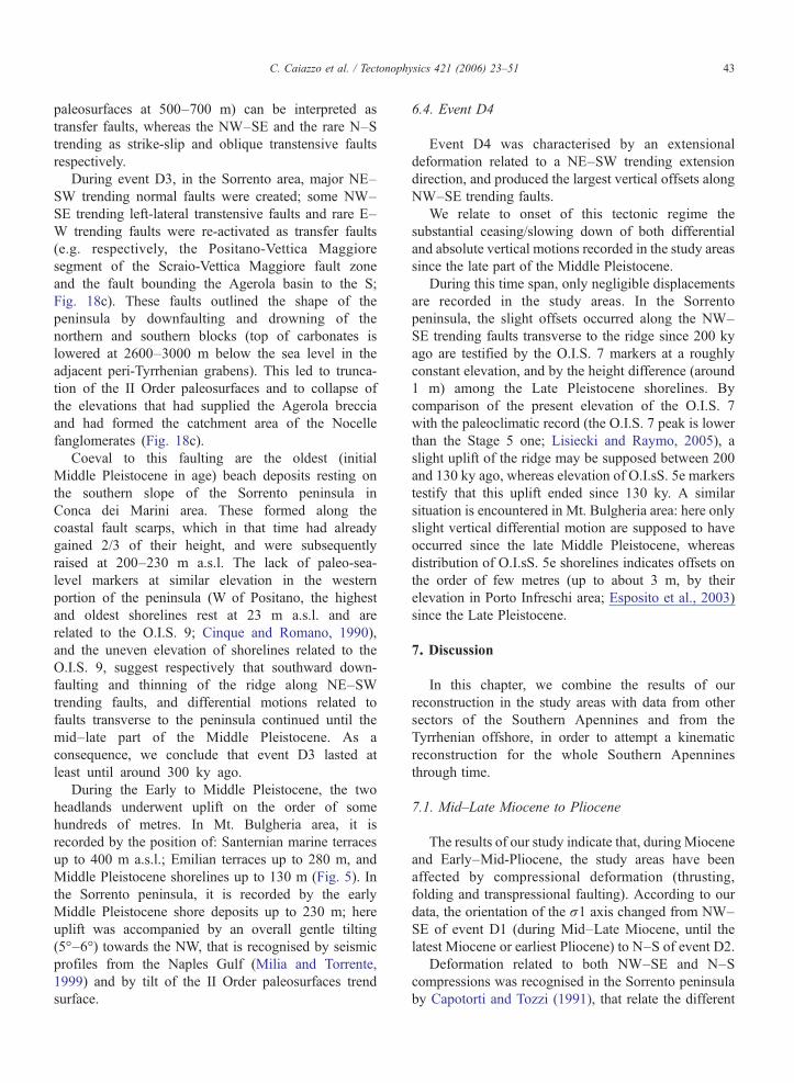
paleosurfaces at 500–700 m) can be interpreted astransfer faults, whereas the NW–SE and the rare N–Strending as strike-slip and oblique transtensive faultsrespectively.
During event D3, in the Sorrento area, major NE–SW trending normal faults were created; some NW–SE trending left-lateral transtensive faults and rare E–W trending faults were re-activated as transfer faults(e.g. respectively, the Positano-Vettica Maggioresegment of the Scraio-Vettica Maggiore fault zoneand the fault bounding the Agerola basin to the S;Fig. 18c). These faults outlined the shape of thepeninsula by downfaulting and drowning of thenorthern and southern blocks (top of carbonates islowered at 2600–3000 m below the sea level in theadjacent peri-Tyrrhenian grabens). This led to trunca-tion of the II Order paleosurfaces and to collapse ofthe elevations that had supplied the Agerola brecciaand had formed the catchment area of the Nocellefanglomerates (Fig. 18c).
Coeval to this faulting are the oldest (initialMiddle Pleistocene in age) beach deposits resting onthe southern slope of the Sorrento peninsula inConca dei Marini area. These formed along thecoastal fault scarps, which in that time had alreadygained 2/3 of their height, and were subsequentlyraised at 200–230 m a.s.l. The lack of paleo-sea-level markers at similar elevation in the westernportion of the peninsula (W of Positano, the highestand oldest shorelines rest at 23 m a.s.l. and arerelated to the O.I.S. 9; Cinque and Romano, 1990),and the uneven elevation of shorelines related to theO.I.S. 9, suggest respectively that southward down-faulting and thinning of the ridge along NE–SWtrending faults, and differential motions related tofaults transverse to the peninsula continued until themid–late part of the Middle Pleistocene. As aconsequence, we conclude that event D3 lasted atleast until around 300 ky ago.
During the Early to Middle Pleistocene, the twoheadlands underwent uplift on the order of somehundreds of metres. In Mt. Bulgheria area, it isrecorded by the position of: Santernian marine terracesup to 400 m a.s.l.; Emilian terraces up to 280 m, andMiddle Pleistocene shorelines up to 130 m (Fig. 5). Inthe Sorrento peninsula, it is recorded by the earlyMiddle Pleistocene shore deposits up to 230 m; hereuplift was accompanied by an overall gentle tilting(5°–6°) towards the NW, that is recognised by seismicprofiles from the Naples Gulf (Milia and Torrente,1999) and by tilt of the II Order paleosurfaces trendsurface.
6.4. Event D4
Event D4 was characterised by an extensionaldeformation related to a NE–SW trending extensiondirection, and produced the largest vertical offsets alongNW–SE trending faults.
We relate to onset of this tectonic regime thesubstantial ceasing/slowing down of both differentialand absolute vertical motions recorded in the study areassince the late part of the Middle Pleistocene.
During this time span, only negligible displacementsare recorded in the study areas. In the Sorrentopeninsula, the slight offsets occurred along the NW–SE trending faults transverse to the ridge since 200 kyago are testified by the O.I.S. 7 markers at a roughlyconstant elevation, and by the height difference (around1 m) among the Late Pleistocene shorelines. Bycomparison of the present elevation of the O.I.S. 7with the paleoclimatic record (the O.I.S. 7 peak is lowerthan the Stage 5 one; Lisiecki and Raymo, 2005), aslight uplift of the ridge may be supposed between 200and 130 ky ago, whereas elevation of O.I.sS. 5e markerstestify that this uplift ended since 130 ky. A similarsituation is encountered in Mt. Bulgheria area: here onlyslight vertical differential motion are supposed to haveoccurred since the late Middle Pleistocene, whereasdistribution of O.I.sS. 5e shorelines indicates offsets onthe order of few metres (up to about 3 m, by theirelevation in Porto Infreschi area; Esposito et al., 2003)since the Late Pleistocene.
7. Discussion
In this chapter, we combine the results of ourreconstruction in the study areas with data from othersectors of the Southern Apennines and from theTyrrhenian offshore, in order to attempt a kinematicreconstruction for the whole Southern Apenninesthrough time.
7.1. Mid–Late Miocene to Pliocene
The results of our study indicate that, duringMioceneand Early–Mid-Pliocene, the study areas have beenaffected by compressional deformation (thrusting,folding and transpressional faulting). According to ourdata, the orientation of the σ1 axis changed from NW–SE of event D1 (during Mid–Late Miocene, until thelatest Miocene or earliest Pliocene) to N–S of event D2.
Deformation related to both NW–SE and N–Scompressions was recognised in the Sorrento peninsulaby Capotorti and Tozzi (1991), that relate the different
44 C. Caiazzo et al. / Tectonophysics 421 (2006) 23–51
compression orientations to “block faulting rotation”,and within the whole inner-axial belt of the chain byHippolyte et al. (1994a) and Hippolyte et al. (1994c).These Authors relate the NW–SE trending compressionto minor and local folding and faulting, during a majorN–S trending compression active in the Late Miocene–Pliocene, whereas in our case the D1 NW–SE trendingcompression predates all other events. However, takinginto account the recognition by Gattacceca and Speranza(2002) of a 60° counterclockwise rotation in Mt.Bulgheria area during Middle–Late Miocene, we cannotexclude that the present orientation of D1 stress axesresulted from the earliest (pre-rotation) activity of theN–S trending compression of our D2. In the Sorrentopeninsula, Tortonian–Early Pliocene activity of a N–Strending compression was recognised also by Milia andTorrente (1999).
To the N–S trending compression, that in the studyareas was responsible for major thrust and strike-slipfaulting, may be related also the widespread N-vergingoverthrusts that occur both in the inner belt of theSouthern Apennines (Pescatore and Sgrosso, 1973;Ortolani, 1978; Renaud et al., 1990; Ferranti et al.,1996) and in the Tyrrhenian offshore (Bartole et al.,1984).
Event D2 was characterised by an E–W orientedσ3 which parallels the central Tyrrhenian basinstretching orientation (Vavilov basin; Sartori, 1990).Hippolyte et al. (1994a) point out the existence of arelation between extension in the Tyrrhenian basin andcompression in the chain, the orientation of themaximum horizontal stress remaining the same inboth domains. As a consequence, we interpret onset ofevent D2 as the response, within the SouthernApennines thrust belt, to the stretching that led toopening of the central Tyrrhenian basin. The E–Wstretching affected first, in Late Tortonian times, theSardinia margin to migrate eastwards (Sartori, 1990;Doglioni et al., 2004). Onset, in the study areas, of thedominant extensional deformation related to the latepart of event D2, indicates that the present Tyrrhenianmargin of the Southern Apennines entered theTyrrhenian extensional domain starting from the LatePliocene.
During the Late Pliocene, the thrust belt was stillsubject to the N–S trending compression (Hippolyte etal., 1994a,c). In our study areas, the ongoing N–Scompression is recorded by minor strike-slip deforma-tion coeval to the dominant homoaxial extensionalregime. At the same time, some minor E–W trendingextensional deformation coeval to the dominant homo-axial N–S oriented compression is recorded within the
axial portion of the chain (Ofanto basin; Hippolyte et al.,1994c).
We speculate that to event D2 can be related alsoseveral NW–SE trending faults with large horizontaland vertical offsets that are widespread within the wholeTyrrhenian slope of the southern Apennines, from theCampana plain to the Cilento headland (Sartori, 1990;Turco et al., 1990; Ascione et al., 1992a,b; Caiazzo etal., 1992; Cinque et al., 1993; Giordano et al., 1995;Berardi et al., 1996). These large offsets predateformation of widespread Pliocene age paleosurfacesresting at around 1000 m of elevation (Ascione andCinque, 1999). Within the whole region, there is strikingevidence that these paleosurfaces were formed when theinner side of the chain was less elevated and not yetfragmented by peri-Tyrrhenian grabens (Ascione andCinque, 1999).
7.2. Early to late Middle Pleistocene
Since the Early Pleistocene, is recorded activity of adominant extensional regime with a NW–SE trendingσ3 axis (event D3), which created major NE–SWtrending normal faults.
A deformational event with the same features of ourD3 (i.e. a NW–SE trending extension direction commonto a normal and a strike-slip regimes, interrelatedthrough σ1–σ2 axes permutation), affected also depos-its with radiometric age around 650 ky cropping out tothe N of the Campana Plain (Prata Sannita basin;Caiazzo et al., 2001). It was also reconstructed in theSele Plain area and in the axial portion of the SouthernApennines by Hippolyte et al. (1994b) and Hippolyte etal. (1995), who related it to the Early Pleistocene.Early–Middle Pleistocene age extensional tectonicswith axis NW–SE was recognised in the Sorrentopeninsula also by Milia and Torrente (1999), and to anextensional event responsible for NE–SW trendingnormal faults Giordano et al. (1995) relate thePleistocene subsidence of the Garigliano Plain (seeFig. 19 for location).
In the study areas, NW–SE trending left-lateraltranstensive faults were active during event D3, andsmall Early–Middle Pleistocene offsets along NW–SEtrending sinistral strike-slip faults are recorded also inCilento–northern Calabria (Cinque et al., 1993).
Event D3, that outlined the present Sorrentopeninsula and Mt. Bulgheria headlands, was alsoresponsible for formation of the series of coastalgrabens bounded to the N by major NE–SW trendingfaults, that characterises the Tyrrhenian margin of theSouthern Apennines. The offshore parts of this

Fig. 19. Elevation of the Lower and Middle Pleistocene shorelines and location of the deepest wells drilled within the peri-Tyrrhenian grabens. Logsare from Ippolito et al. (1973), Brancaccio et al. (1991), and Brocchini et al. (2001).
45C. Caiazzo et al. / Tectonophysics 421 (2006) 23–51
structure, which are characterised by asymmetric-northward thickening-infillings (Mina 1, Milena 1and Margherita Mare 1 wells in Sacchi et al., 1994;Fig. 19; seismic profiles in Bartole et al., 1984;Moussat et al., 1986; Mariani and Prato, 1988;Argnani et al., 1989; Bruno et al., 1998; Milia et al.,2003), are interpreted as resulting from NW–SEoriented stretching (Moussat et al., 1986; Rehault etal., 1987; Kastens et al., 1990).
In these peri-Tyrrhenian grabens, severe subsidence(from several hundreds to around 3000 m, with rates upto 2–3 mm/a) took place during the Early and Middle
Pleistocene. This is documented by several well datafrom the coastal plains (Ippolito et al., 1973; Brancaccioet al., 1991; Brocchini et al., 2001; Fig. 19), and in theSalerno graben, also from the offshore (Early Pleisto-cene age of marine deposits at the depth of around2000 m in Mina 1 well log; Aiello et al., 1997) and bythe sin-rift sediments on land: in the Sele Plain,subsidence was accompanied by deposition (at thetoes of the Picentini Mts.; see Fig. 4b for location) of thethick epiclastic Eboli Conglomerates, with radiometricages ranging from 1.5 to 0.9 Ma (Brancaccio et al.,1991).

46 C. Caiazzo et al. / Tectonophysics 421 (2006) 23–51
This subsidence was coeval to uplift of the interposedhorst blocks, as it is documented in the study areas(Section 6.3) and in the Picentini Mts. (Brancaccio et al.,1991) that bound to the N the on land portion of theSalerno Gulf–Sele Plain graben.
End of event D3 in the late Middle Pleistocene isinferred by the marked decrease in rates of activity of theNE–SW trending normal faults along the Tyrrhenianmargin. This is recorded by decreasing in both head-lands uplift rates (Sections 6.3 and 6.4), and peri-Tyrrhenian grabens subsidence rates, leading to fillingup of their present on land portions (Fig. 19). In northernCampana Plain, subsidence rates changed from 2/3 mm/a to 0.75 mm/a (Romano et al., 1994).
The NW–SE trending extension direction activealong the Tyrrhenian margin parallels, as alreadypointed out by Hippolyte et al. (1994a), the stretchingorientation which controlled the spreading and deepen-ing in the southeastern Tyrrhenian–Marsili basin —during the Pleistocene (Moussat et al., 1986; Rehault etal., 1987; Sartori, 1990; Savelli and Schreider, 1991).
During this time span, shortening was still ongoing inthe outer sectors of the Southern Apennines, wherethrusting episodes occurred until the early Middle
Fig. 20. Faults active in the late Quaternary in the Southern Apennines andModified after Cinque et al. (2000).
Pleistocene (around 650 ky; Patacca and Scandone,2001). This thrusting is referred by Hippolyte et al.(1994c) and Hippolyte et al. (1995) to a compressivetectonic event characterised by a ENE–WSW orientedσ1, homoaxial to the extension active in the Tyrrhenianbasin. The minor strike-slip regime recorded at theoutcrop scale in the study areas during this period maybe interpreted as the response to the coeval compressionactive in the outer portion of the chain.
7.3. Late Middle Pleistocene to Present
The late Quaternary faulting in the SouthernApennines is consistent with the D4 tectonic event,which is characterised by an extensional regime with aNE–SW trending σ3 axis. In fact, by the morphos-tructural, stratigraphic and tectonic data reported inCinque et al. (2000) (see also references therein), itresults that deformation affecting the region in the lateQuaternary is represented by mostly NW–SE, subordi-nately E–W and rarely NE–SW trending faults (Fig.20). These structures displace depositional landforms,e.g. the slopes of the Roccamonfina volcano and theterraces in the upper valleys of the Volturno and Agri
elevation of O.I.S. 5 shorelines, mapped onto the DEM of the region.

47C. Caiazzo et al. / Tectonophysics 421 (2006) 23–51
rivers, the Tanagro river valley and the Sele plain, thatare related to the Middle Pleistocene (Amato et al.,1991; Di Niro et al., 1992; De Rita and Giordano, 1996;Brancaccio et al., 1997).
Displacements associated with these faults aregenerally quite modest, not exceeding few tens ofmetres. Similar information is obtained from distribu-tion of the Upper Pleistocene to Holocene shoredeposits and lines (Fig. 20). These indicate that theGarigliano plain (Brancaccio et al., 1990) and theSorrento peninsula were substantially stable, whereas aslight uplift affected the northern Cilento headland andthe coast of the Policastro Gulf (O.I.S. 5 shorelinesrespectively ranging from 8 to 10 m a.s.l. and at 15 ma.s.l.; Brancaccio et al., 1990; Cinque et al., 1994),and the Sele Plain (O.I.sS. 5e shorelines at 25 m, andO.I.sS. 5c ones at 13 m a.s.l.; Brancaccio et al., 1987).On the order of few tens of metres is also thesubsidence of the Campana Plain, both in itssouthernmost sector (Brancaccio et al., 1994) and itthe northern one: here, the recentmost subsidence andthe 50 m uplift of O.I.S. 5 littoral deposits (Romano etal., 1994) is related to the NW–SE trending faultbounding the plain to the east.
Much stronger vertical motions, with average ratesup to some cm/yr, affected the central portion of theCampana Plain graben, both offshore (Naples Gulf;Cinque et al., 1997; Milia and Torrente, 1999) andinland (Somma–Vesuvius and Phlegrean Fields volca-nic areas; Orsi et al., 1996), and Ischia island (Cinque etal., 1997). However, the vertical motions in these areaswere probably related to reactivation of pre-existingfaults driven by volcano-tectonic phenomena (Cinque,1991; Orsi et al., 1996; Cinque et al., 1997).
In almost all cases, the late Quaternary displace-ments reactivate pre-existing faults. This was ob-served, for instance, in Mt. Marzano massif (Ascioneet al., 2003), where Pliocene age paleosurfacespostdating large fault offsets (both horizontal andvertical), are displaced by recent re-activations of thesame faults; among them, the Piano di Pecore one wasactivated also during the 1980 Irpinia earthquake(Westaway and Jackson, 1987; Pantosti and Valensise,1990).
Since the NE–SW direction of extension of event D4parallels to the one obtained, by means of structural andseismological data and by present-day stress measure-ments also for other sectors of southern Italy (Cello etal., 1982; Gasparini et al., 1985; Westaway and Jackson,1987; Montone, 1997; Vannucci et al., 2004), wesuggest in agreement to Hippolyte et al. (1994b) thatthis stress field is currently active.
8. Conclusion
The present structural setting of Tyrrhenian slope ofthe Southern Apennines results from a succession offirst compressional, and subsequently extensionaltectonic events, which took place from Mid–LateMiocene to the Present.
The compressional tectonics, first NW-verging(event D1) and subsequently N-verging (event D2),reflects the major convergence of Africa to Europe. Inthis frame, event D1 (active since Mid–Late Miocene)may be regarded as predating the late Tortonian onset ofthe Tyrrhenian extension, or/and as occurred when theeastwards migrating Tyrrhenian extension had not yetreached the present inner slope of the chain.
The N-vergent compression of event D2, whichstarted in late Miocene or earliest Pliocene and wascharacterised by an E–Woriented σ3 axis, was coeval tothe stretching in the central Tyrrhenian extensionalbasin. Subsequently (i.e. in the Late Pliocene), while theN-verging compression was still active in the SouthernApennines, the inner side of the chain entered theTyrrhenian extensional domain. In this side of the chain,event D2 was in this period dominated by an extensionalregime, the σ3 axis being oriented E–W, homoaxial tothe formerly dominating N–S compression.
Structures created by event D2 have undergonesevere erosion/planation during the Pliocene, whenseveral paleosurfaces developed in the region (Ascioneand Cinque, 1999). The elevations up to 800–1000 mhigh surrounding the Upper Pliocene Camerota basin(Section 4.1) testify that, during this period, the innerside of the chain had already suffered some uplift, mostprobably in response to thrusting.
In the Early Pleistocene (event D3), the minimumstress orientation changed to NW–SE both in theTyrrhenian basin and in the chain. During this period,shortening was active in the outer belt of the chain withan ENE–WSW trending compression, which is relatedby Hippolyte et al. (1994a) to the N–S convergence ofEurope and Africa in a complex pattern of blocks andarcs. The change in the basin extension direction may berelated, according to Doglioni et al. (1994), to theencroachment of the Adriatic thick continental litho-sphere E of the Southern Apennines, which slowed thatsegment of the subduction, whereas the roll-backconcentrated to the SE towards the Ionian oceaniclithosphere (Doglioni et al., 2004).
During this period, the Tyrrhenian margin of the chainwas affected by a dominant extension, that created amajor horst-and-graben structure with a NE–SW trend.While the peri-Tyrrhenian grabens suffered strong

48 C. Caiazzo et al. / Tectonophysics 421 (2006) 23–51
subsidence, the horst structures underwent uplift that maybe principally related to rift flank uplift. However, as inQuaternary times the whole chain was affected by someuplift (although with a less amount in the Tyrrhenian sidethan in the outer one; Cinque et al., 1993; Amato andCinque, 1999; Ascione and Cinque, 1999) the contribu-tion of a long-wavelength uplift component may beenvisaged. This component may be referred to isostaticrebound probably related, following Doglioni et al.(2003) and Doglioni et al. (2004), to the underlyingeastward transit of a depleted and less dense astenosphere.
In response to the Early–Middle Pleistocene verticalfaulting and uplift, but also to downcutting by riversflowing towards the newborn Tyrrhenian coast, a strongincrease in the local relief took place in the wholeTyrrhenian slope of the chain. Due to dissection, largevolumes of the widespread soft siliciclastic covers (e.g.Miocene flysch, internal nappes) were dismantled,leading to the development of several high fault linescarps along pre-existing fault planes, most of themcreated during event D2.
Since the late Middle Pleistocene, onset of theextensional event D4 is recorded. According toHippolyte et al. (1994b), the NE-trending extensionmarks a major geodynamical change with the cessationof the compression–extension couple of deformation inthe chain and in the southern Tyrrhenian basin.
Event D4, which is currently active, has only slightlymodified the morphotectonic signature (i.e. topographichighs and lows created by tectonic/erosional processes)developed during event D3. The moderate surfaceexpression of this recent faulting is not only due to itsyoung age, but also to the overall low rates of activity ofsingle faults (Cinque et al., 2000).
Acknowledgments
We wish to thank Prof. Giuseppe Cello, Dr. Jean-Claude Hippolyte, Dr. Liviu Matenco and an anony-mous referee for their constructive suggestions, whichhelped us to improve the manuscript.
References
Aiello, G., Budillon, F., de Alteris, G., Di Razza, O., De Lauro, M.,Ferraro, L., Marsella, E., Pelosi, N., Pepe, F., Sacchi, M., Tondelli,R., 1997. Seismic exploration of the peri-Tyrrhenian basins in theLatium–Campania offshore. 8th Workshop of the ILP Task Force“Origin of Sedimentary Basins”, Palermo (Italy), 7–13 June 1997,pp. 22–23.
Amato, A., Cinque, A., 1999. The erosional landsurfaces of theCampano–Lucano Apennines (S. Italy): genesis, evolution andtectonic implications. Tectonophysics 315, 251–267.
Amato, A., Robustelli, G., 2002. The Nocelle conglomerates: aproblematic outcrop highly suspended on the southern slope ofthe eastern Sorrento peninsula (Italy). Il Quaternario 15 (1),83–96.
Amato, A., Ascione, A., Cinque, A., Lama, A., 1991. Morfoevolu-zione, sedimentazione e tettonica recente dell'alta Piana del Sele edelle sue valli tributarie. Geogr. Fis. Din. Quat. 14, 5–16.
Amore, F.O., Bonardi, G., Ciampo, G., de Capoa, P., Perrone, V.,Sgrosso, I., 1988. Relazioni tra “flysch interni” e dominiappenninici: reinterpretazione delle formazioni di Pollica, SanMauro e Albidona e il problema dell'evoluzione inframiocenicadelle zone esterne appenniniche. Mem. Soc. Geol. Ital. 41,285–297.
Angelier, J., 1994. Fault slip analysis and paleostress reconstruction.In: Hancock, P.L. (Ed.), Continental Deformation. PergamonPress, Oxford, pp. 53–100.
Angelier, J., Bergerat, F., 1983. Systèmes de contrainte et extensionintracontinentale. Bull. Cent. Rech. Explor. Prod. Elf-Aquitaine 7,137–147.
Argnani, A., Bortoluzzi, G., Bozzani, A., Canepa, A., Ligi, M.,Palumbo, V., Serracca, P., Trincardi, F., 1989. Sedimentarydynamics on the Eastern Tyrrhenian Margin, Italy. PS/87 Cruisereport. G. Geol. III (51/1), 165–178.
Armijo, R., Cisternas, A., 1978. Un probléme inverse en micro-tectonique cassante. C. R. Acad. Sci. Paris, Terre 287, 595–598.
Ascione, A., Cinque, A., 1999. Tectonics and erosion in the long termrelief history of the Southern Apennines (Italy). Z. Geomorphol.,Suppl.Bd 118, 1–16.
Ascione, A., Romano, P., 1999. Vertical movements on the easternmargin of the Tyrrhenian extensional basin. New data from Mt.Bulgheria (Southern Apennines, Italy). Tectonophysics 315,337–356.
Ascione, A., Cinque, A., Santangelo, N., Tozzi, M., 1992a. Il bacinodel Vallo di Diano e la tettonica trascorrente plio-quaternaria:nuovi vincoli cronologici e cinematici. Studi Geolog. Camerti, Vol.Spec. 1992/1, 209–219.
Ascione, A., Cinque, A., Tozzi, M., 1992b. La Valle del Tanagro(Campania): una depressione strutturale ad evoluzione complessa.Studi Geolog. Camerti, Vol. Spec. 1992/1, 201–208.
Ascione, A., Caiazzo, C., Hippolyte, J.-C., Romano, P., 1997.Pliocene–Quaternary extensional tectonics and morphogenesis atthe eastern margin of the southern Tyrrhenian basin (Mt.Bulgheria, Campania region, Italy). Il Quaternario 10 (2),571–578.
Ascione, A., Cinque, A., Improta, L., Villani, F., 2003. LateQuaternary faulting within the Southern Apennines seismic belt:new data from Mt. Marzano area (Southern Apennines). Quat. Int.101–102, 27–41.
Bartole, R., Savelli, D., Tramontana, M., Wezel, F.C., 1984. Structuraland sedimentary features in the Tyrrhenian margin off Campania,southern Italy. Mar. Geol. 55 (2/2), 163–180.
Berardi, F., De Rosa, G., Tozzi, M., 1996. Vincoli strutturali disuperficie per una ricostruzione geometrica del massiccio deiMonti Alburni (Appennino meridionale). Mem. Soc. Geol. Ital. 11,201–216.
Bigi, G., Coli, M., Cosentino, D., Parotto, M., Praturlon, A., Sartori,R., Scandone, P., Turco, E. (Eds.), 1983. Structural Model of Italy.C.N.R., Progetto Finalizzato Geodinamica, Roma.
Bonaduce, G., Ruggieri, G., Russo, A., 1987. The ostracode genusMutulus and some so-called Mutulus from the MediterraneanMiocene–Pleistocene. Boll. Soc. Paleontol. Ital. 26 (3),251–268.

49C. Caiazzo et al. / Tectonophysics 421 (2006) 23–51
Borrelli, A., Ciampo, G., De Falco, M., Guida, D., Guida, M., 1988. Lamorfogenesi del M. Bulgheria (Campania) durante il Pleistoceneinferiore e medio. Mem. Soc. Geol. Ital. 41, 667–672.
Brancaccio, L., Capaldi, G., Cinque, A., Pece, R., Sgrosso, I., 1978.Th/U dating of corals from a Tyrrhenian beach in SorrentinePeninsula (southern Italy). Quaternaria 20, 175–183.
Brancaccio, L., Cinque, A., D'Angelo, G., Russo, F., Santangelo, N.,Sgrosso, I., 1987. Evoluzione tettonica e geomorfologica dellaPiana del Sele (Campania, Appennino meridionale). Geogr. Fis.Din. Quat. 10, 47–55.
Brancaccio, L., Cinque, A., Russo, F., Belluomini, G., Branca, M.,Delitala, L., 1990. Segnalazione e datazione di depositi marinitirreniani della costa campana. Boll. Soc. Geol. Ital. 109, 259–265.
Brancaccio, L., Cinque, A., Romano, P., Rosskopf, C., Russo, F.,Santangelo, N., Santo, A., 1991. Geomorphology and neotectonicevolution of a sector of the Tyrrhenian flank of the SouthernApennines (Region of Naples, Italy). Z. Geomorphol., Suppl.Bd82, 47–58.
Brancaccio, L., Fiume, G., Grimaldi, M., Rapolla, A., Romano, P.,1994. Analisi gravimetriche nella bassa valle del torrente Solofrana(SA) e considerazioni sulla sua evoluzione quaternaria. IlQuaternario 117 (2), 131–138.
Brancaccio, L., Cinque, A., Di Crescenzo, G., Santangelo, N.,Scarciglia, F., 1997. Alcune osservazioni sulla tettonica quater-naria nell'alta valle del F. Volturno. Il Quaternario 10 (2), 321–328.
Brocchini, D., Principe, C., Castradori, D., Laurenzi, M.A., Gorla, L.,2001. Quaternary evolution of the southern sector of the CampanaPlain and early Somma–Vesuvius activity: insight from theTrecase 1 well. Mineral. Petrol. 73, 67–91.
Bruno, P.P.G., Cippitelli, G., Rapolla, A., 1998. Seismic study of theMesozoic carbonate basement aroundMt. Somma–Vesuvius, Italy.J. Volcanol. Geotherm. Res. 84, 311–322.
Caiazzo, C., Giovine, G., Ortolani, F., Pagliuca, S., Schiattarella, M.,Vitale, C., 1992. Genesi ed evoluzione strutturale della depressionetettonica dell'alta valle del fiume Sele (Appennino campano-lucano). Studi Geolog. Camerti, Vol. Spec. 1992/1, 245–255.
Caiazzo, C., Cinque, A., Merola, D., 2000. Relative chronology andkinematics of the Apenninic and anti-Apenninic faults in theSorrento peninsula. Mem. Soc. Geol. Ital. 55, 165–174.
Caiazzo, C., Ruggieri, G., Morra, V., Santangelo, N., Villa, I., 2001.Quaternary evolution of the Prata Sannita basin (southern Italy):morphostructural, microtectonic and radiometric analysis. Int.Workshop “Uplift and Erosion: Driving Processes and ResultingLandforms”, Siena (Italy), 20–21 Sept. 2001, p. 23.
Capotorti, F., Tozzi, M., 1991. Tettonica trascorrente nella penisolasorrentina. Mem. Soc. Geol. Ital. 47, 235–249.
Cello, G., Mazzoli, S., 1999. Apennine tectonics in southern Italy: areview. J. Geodyn. 27, 191–211.
Cello, G., Guerra, I., Tortorici, L., Turco, E., Scarpa, R., 1982.Geometry of the neotectonic stress field in southern Italy:geological and seismological evidence. J. Struct. Geol. 4,385–393.
Cello, G., Lentini, F., Tortorici, L., 1990. La struttura del settore calabro-lucano e suo significato nel quadro dell'evoluzione tettonica delsistema a thrust sudappenninico. Studi Geol. Camerti 1990, 27–34.
Ciampo, G., 1976. Ostracodi pleistocenici di Cala Bianca (Marina diCamerota, Salerno). Boll. Soc. Paleontol. Ital. 15, 3–23.
Cinque, A., 1991. La trasgressione versiliana nella Piana del Samo(Campania). Geogr. Fis. Din. Quat. 14, 63–71.
Cinque, A., Romano, P., 1990. Segnalazione di nuove evidenze diantiche linee di riva in Penisola Sorrentina (Campania). Geogr. Fis.Din. Quat. 13 (1), 23–36.
Cinque, A., Patacca, E., Scandone, P., Tozzi, M., 1993. Quaternarykinematic evolution of the Southern Apennines. Relationshipbetween surface geological features and deep lithosphericstructures. Ann. Geofis. 36 (2), 249–260.
Cinque, A., Romano, P., Rosskopf, C., Santangelo, N., Santo, A.,1994. Morfologie costiere e depositi quaternari tra Agropoli eOgliastro Marina (Cilento, Italia meridionale). Il Quaternario 7 (1),3–16.
Cinque, A., Aucelli, P.P.C., Brancaccio, L., Mele, R., Milia, A.,Robustelli, G., Romano, P., Russo, F., Santangelo, N., Sgambati,D., 1997. Volcanism tectonics and recent geomorphologicalchange in the bay of Napoli. IV Int. Conf. on Geomorph. Geogr.Fis. Din. Quat., Suppl., vol. III-t.2, pp. 123–141. Guide forExcursion.
Cinque, A., Ascione, A., Caiazzo, C., 2000. Distribuzione spazio-temporale e caratterizzazione della fagliazione quaternaria inAppennino Meridionale. In: Galadini, F., Meletti, C., Rebez, A.(Eds.), Ricerche del GNDT nel campo della pericolosità sismica(1996–1999). CNR-GNDT Spec. Publ. Roma, pp. 203–218.
De Blasio, I., Lima, A., Perrone, V., Russo, M., 1981. Nuove vedutesui depositi miocenici della Penisola Sorrentina. Boll. Soc. Geol.Ital. 100, 57–70.
de Kaenel, E., Siesser, W.G., Murat, A., 1999. Pleistocenecalcareous nannofossils biostratigraphy and the western Medi-terranean sapropels, Sites 974 to 977 and 979. In: Zahn, R.,Comas, M.C., Klaus, A. (Eds.), Proceedings of ODP. ScientificResults, vol. 161. Ocean Drilling Program, College Station, TX,pp. 159–183.
De Rita, D., Giordano, G., 1996. Volcanological and structuralevolution of Roccamonfina volcano (southern Italy) and structuralorigin of the summit caldera. In: Mc Guire, W.J., Jones, A.P.,Neuberg, J. (Eds.), Volcano Instability on Earth and Other Planets.Geol. Soc. Am., Spec. Publ., vol. 110, pp. 209–224.
Di Niro, A., Giano, S.I., Santangelo, N., 1992. Primi datisull'evoluzione geomorfologica e sedimentaria del bacinodell'alta Val d'Agri. Studi Geolog. Camerti, Vol. Spec. 1992/1,257–263.
Doglioni, C., Mongelli, F., Pieri, P., 1994. The Puglia uplift (SE Italy):an anomaly in the foreland of Apenninic subduction due tobuckling of a thick continental lithosphere. Tectonics 13,1309–1321.
Doglioni, C., Carminati, E., Bonatti, E., 2003. Rift asymmetry andcontinental uplift. Tectonics 22 (3), 1024, doi:10.1029/2002TC001459.
Doglioni, C., Innocenti, F., Morellato, C., Procaccianti, D., Scrocca,D., 2004. On the Tyrrhenian sea opening. Mem. Descr. Carta Geol.Ital. 44, 147–164.
Esposito, C., Filocamo, F., Marciano, R., Romano, P., Santangelo, N.,Scarciglia, F., Tuccimei, P., 2003. Late Quaternary shorelines insouthern Cilento (Mt. Bulgheria): morphostratigraphy and chro-nology. Il Quaternario 16 (1), 3–14.
Etchecopard, A., Vasseur, G., Daignieres, M., 1981. An inverseproblem in microtectonics for the determination of stress tensorsfrom fault striation analysis. J. Struct. Geol. 3, 51–65.
Ferranti, L., Oldow, J.S., Sacchi, M., 1996. Pre-Quaternary orogen-parallel extension in Southern Apennines belt, Italy. Tectonophy-sics 260, 325–347.
Gasparini, C., Iannaccone, G., Scarpa, R., 1985. Fault-plane solutionand seismicity of the Italian Peninsula. Tectonophysics 117,59–78.
Gattacceca, J., Speranza, F., 2002. Paleomagnetism of Jurassic toMiocene sediments from the Apenninic carbonate platform

50 C. Caiazzo et al. / Tectonophysics 421 (2006) 23–51
(southern Apennines, Italy): evidence for a 60° counterclockwiseMiocene rotation. Earth Planet. Sci. Lett. 201, 19–34.
Giordano, G., Naso, G., Trigari, A., 1995. Evoluzione tettonica di unsettore particolare del margine tirrenico: l'area al confine tra Lazioe Campania, prime considerazioni. Studi Geolog. Camerti, Vol.spec. 1995/2, 269–278.
Hippolyte, J.-C., 2001. Paleostress and neotectonic analysis of shearedconglomerates: Southwest Alps and Southern Apennines. J. Struct.Geol. 23, 421–429.
Hippolyte, J.-C., Angelier, J., Roure, F., 1994a. Paleostress analysesand fold-and-thrust belt kinematics in the Southern Apennines.In: Roure, F., Ellouz, N., Shein, V.S., Skvortsov, I. (Eds.),Proceedings of The International Symposium “GeodynamicEvolution Of Sedimentary Basins”, Moscow, 1992. ÉditionsTechnip, Paris, pp. 157–169.
Hippolyte, J.-C., Angelier, J., Roure, F., 1994b. A major geodynamicchange revealed by Quaternary stress patterns in the SouthernApennines (Italy). Tectonophysics 230, 199–210.
Hippolyte, J.-C., Angelier, J., Roure, F., Casero, P., 1994c. Piggybackbasin development and thrust belt evolution: structural andpaleostress analyses of Plio-Quaternary basins in the SouthernApennines. J. Struct. Geol. 16, 159–173.
Hippolyte, J.-C., Angelier, J., Barrier, E., 1995. Compressional andextensional tectonics in an arc system: example of the SouthernApennines. J. Struct. Geol. 17 (12), 1725–1740.
Ippolito, F., Ortolani, F., Russo, M., 1973. Struttura marginaletirrenica dell'Appennino campano: reinterpretazione di dati diantiche ricerche di idrocarburi. Mem. Soc. Geol. Ital. 12,227–250.
Kastens, K., Mascle, J., ODP Leg 107 Scientific Party, 1990.Proceedings of Ocean Drilling Program, Scientific Results, vol.107. Ocean Drilling Program, College Station, TX.
Lambeck, K., Chappell, J., 2001. Sea level change during the LastGlacial cycle. Science 292, 679–686.
Lippmann-Provansal, M., 1987. L'Apennin Campanien Mèridional(Italie). Etude Geomorphologique. These de Doctorat, UniversitàAix-Marseille, Aix en Provence.
Lisiecki, L., Raymo, M., 2005. A Pliocene–Pleistocene stack of 57globally distributed benthic δ18O records. Paleoceanography 20,A1003, doi:10.1029/2004PA001071.
Malinverno, A., Ryan, W.B.F., 1986. Extension in the Tyrrheniansea and shortening in the Apennines as result of arc migrationdriven by sinking in the lithosphere. Tectonics 5 (2),227–245.
Mariani, M., Prato, R., 1988. I bacini neogenici costieri del marginetirrenico: approccio sismico-stratigrafico. Mem. Soc. Geol. Ital. 41,519–531.
Milia, A., Torrente, M.M., 1999. Tectonics and stratigraphicarchitecture of a peri-Tyrrhenian half-graben (Bay of Naples,Italy). Tectonophysics 315, 301–318.
Milia, A., Torrente, M.M., Russo, M., Zuppetta, A., 2003. Tectonicsand crustal structure of the Campania continental margin:relationships with volcanism. Mineral. Petrol. 79, 33–47.
Montone, P., 1997. The active crustal stress: methods and results inItaly. Il Quaternario 10 (2), 313–320.
Moussat, E., Rehault, J.P., Fabbri, A., 1986. Rifting et èvolutiontectono-sèdimentaire du Bassin Tyrrhènien au cours du Neogene etdu Quaternaire. G. Geol. ser. 3, 48 (1/2), 41–62.
Orsi, G., de Vita, S., Di Vivo, M., 1996. The restless, resurgentCampi Flegrei nested caldera (Italy): constraints on itsevolution and configuration. J. Volcanol. Geotherm. Res. 74,179–214.
Ortolani, F., 1978. Alcune considerazioni sulle fasi tettonichemioceniche e plioceniche dell'Appennino meridionale. Boll. Soc.Geol. Ital. 97, 609–616.
Pantosti, D., Valensise, G., 1990. Faulting mechanisms and complexity ofthe November 23, 1980, Campania — Lucania earthquake, inferredfrom surface observations. J. Geophys. Res. 95 (B10), 15.319–15.341.
Pasini, G., Colalongo, M.L., 1994. Proposal for the erection of theSanternian/Emilian boundary stratotype (lower Pleistocene) andnew data on the Pliocene/Pleistocene boundary stratotype. Boll.Soc. Paleontol. Ital. 33 (1), 101–120.
Patacca, E., Scandone, P., 2001. Late thrust propagation andsedimentary response in the thrust belt-foredeep system in theSouthern Apennines (Pliocene–Pleistocene). In: Vai, G.B.,Martini, I.P. (Eds.), Anatomy of an Orogen. Kluwer AcademicPublishers, London, pp. 401–440.
Patacca, E., Sartori, R., Scandone, P., 1990. Thyrrenian basin andApenninic arcs: kinematic relations since Late Tortonian times.Mem. Soc. Geol. Ital. 45, 425–451.
Pescatore, T., Sgrosso, I., 1973. I rapporti tra la piattaforma campano-lucana e la piattaforma abruzzese-campana nel casertano. Boll.Soc. Geol. Ital. 92, 597–608.
Rehault, P., Moussat, E., Fabbri, A., 1987. Structural evolution of theTyrrhenian back-arc basin. Mar. Geol. 74, 123–150.
Renaud, P., Billaud, Y., Clermontè, J., Lorenz, C., Pironon, B., 1990.Evolution paléogéographique le long de la bordure sud orientale dela plate-forme campano-abruzzaise (Italie) du Crétacea u Neogène.Boll. Soc. Geol. Fr. 8, 105–112.
Riccio, A., Riggio, F., Romano, P., 2001. Sea level fluctuations duringOxygen Isotope Stage 5: new data from fossil shorelines in theSorrento Peninsula (southern Italy). Z. Geomorphol. 45 (1), 121–137.
Romano, P., Santo, A., Voltaggio, M., 1994. L'evoluzione geomorfo-logica della piana del fiume Volturno (Campania) durante il tardoQuaternario (Pleistocene medio-superiore — Olocene). Il Qua-ternario 7 (1), 41–56.
Russo, F., 1994. Segnalazione di un livello fossilifero riferibile alTirreniano a Cala Bianca (Marina di Camerota, Salerno). Mem.Descr. Carta Geol. Ital. 52, 395–398.
Russo Ermolli, E., 1999. Vegetation dynamics and climate changes atCamerota (Campania, Italy) at the Plio-Pleistocene boundary. IlQuaternario 12 (2), 207–214.
Sacchi, M., Infuso, S., Marsella, E., 1994. Late Pliocene–EarlyPleistocene compressional tectonics in offshore Campania (EasternTyrrhenian Sea). Boll. Geofis. Teor. Appl. 36 (141/144), 469–482.
Sartori, R., 1990. The main results of ODP Leg 107 in the frame ofNeogene to Recent geology of the Peri-Tyrrhenian areas. In:Kastens, A., Mascle, K.J., et al. (Eds.), Proceedings of ODP,Scientific Results, vol. 107. Ocean Drilling Program, CollegeStation, TX, pp. 715–730.
Savelli, C., Schreider, A.A., 1991. The opening processes in the deepTyrrhenian basins of Marsili and Vavilov, as deduced frommagnetic and chronological evidence of their igneous crust.Tectonophysics 190, 119–131.
Scandone, P., Sgrosso, I., Bruno, F., 1963. Appunti di geologia sulMonte Bulgheria (Salerno). Boll. Soc. Nat. Napoli 72, 125–131.
Shackleton, N.J., Opdike, N.D., 1973. Oxygen isotope and paleomag-netic stratigraphy of the equatorial Pacific core V28-238: oxygenisotope temperatures and ice volumes on a 105 years and 106 yearsscale. Quat. Res. 3, 39–55.
Tozzi, M., Menconi, A., Sciamanna, S., 1996. Studio strutturale del M.Bulgheria (Cilento meridionale) e sue implicazioni per latettogenesi dell'Appennino campano. Boll. Soc. Geol. Ital. 115,249–278.

51C. Caiazzo et al. / Tectonophysics 421 (2006) 23–51
Turco, E., Maresca, R., Cappadona, P., 1990. La tettonica plio-pleistocenica del confine calabro-lucano: modello cinematico.Mem. Soc. Geol. Ital. 45, 519–529.
Ulzega, A., Hearty, P.J., 1986. Geomorphology, stratigraphy andgeochronology of Late Quaternary marine deposits in Sardinia. Z.Geomorphol. N.F. Suppl. 62, 119–129.
Vannucci, G., Pondrelli, S., Argnani, A., Morelli, A., Gasperini, P.,Boschi, E., 2004. An atlas of Mediterranean seismicity. Ann.Geophys. 47 (1), 247–306 (suppl. to Vol.).
Westaway, R., Jackson, J.A., 1987. The earthquake of 1980 November23 in Campania–Basilicata (southern Italy). Geophys. J. R. Astron.Soc. 90, 375–443.
Copyright © 2022 FDOKUMEN