Vascular Plant Inventory of Alaska's Arctic National Parklands
Upload
unitedstatesgeologicalsurveyCategory
view
2download
0
www.elsevier.com/locate/tecto
Tectonophysics 372 (2003) 23–40
Late Paleozoic orogeny in Alaska’s Farewell terrane
Dwight C. Bradleya,*, Julie Dumoulina, Paul Layerb, David Sunderlinc, Sarah Roesked,Bill McClellande, Anita G. Harrisf, Grant Abbottg, Tom Bundtzenh, Timothy Kuskyi
aU.S. Geological Survey, 4200 University Dr., Anchorage, AK 99508, USAbDepartment of Geology and Geophysics, University of Alaska, Fairbanks, AK 99775, USA
cDepartment of Geophysical Sciences, University of Chicago, Chicago, IL 60637, USAdDepartment of Geology, University of California, Davis, CA 95616, USAeDepartment of Geology, University of Idaho, Moscow, ID 82844, USA
fU.S. Geological Survey, Reston, VA 22092, USAgYukon Geological Survey, Department of Energy, Mines and Resources, Government of Yukon, Whitehorse, Yukon, Canada Y1A 2B5
hPacific Rim Geological Consulting, Inc., P.O. Box 81906, Fairbanks, AK 99708, USAiDepartment of Earth and Planetary Sciences, St. Louis University, St. Louis, MO 63103, USA
Received 5 June 2003
Abstract
Evidence is presented for a previously unrecognized late Paleozoic orogeny in two parts of Alaska’s Farewell terrane, an
event that has not entered into published scenarios for the assembly of Alaska. The Farewell terrane was long regarded as a
piece of the early Paleozoic passive margin of western Canada, but is now thought, instead, to have lain between the Siberian
and Laurentian (North American) cratons during the early Paleozoic. Evidence for a late Paleozoic orogeny comes from two
belts located 100–200 km apart. In the northern belt, metamorphic rocks dated at 284–285 Ma (three 40Ar/39Ar white-mica
plateau ages) provide the main evidence for orogeny. The metamorphic rocks are interpreted as part of the hinterland of a late
Paleozoic mountain belt, which we name the Browns Fork orogen. In the southern belt, thick accumulations of Pennsylvanian-
Permian conglomerate and sandstone provide the main evidence for orogeny. These strata are interpreted as the eroded and
deformed remnants of a late Paleozoic foreland basin, which we name the Dall Basin. We suggest that the Browns Fork orogen
and Dall Basin comprise a matched pair formed during collision between the Farewell terrane and rocks to the west. The
colliding object is largely buried beneath Late Cretaceous flysch to the west of the Farewell terrane, but may have included parts
of the so-called Innoko terrane. The late Paleozoic convergent plate boundary represented by the Browns Fork orogen likely
connected with other zones of plate convergence now located in Russia, elsewhere in Alaska, and in western Canada.
Published by Elsevier B.V.
Keywords: Cordilleran tectonics; Alaska; Permian; Orogeny; Foreland basin; Plate reconstructions
0040-1951/$ - see front matter. Published by Elsevier B.V.
doi:10.1016/S0040-1951(03)00238-5
* Corresponding author. Tel.: +1-907-786-7434; fax: +1-907-
786-7401.
E-mail address: [email protected] (D.C. Bradley).
1. Introduction
Alaska’s Farewell terrane was long regarded as
piece of the Paleozoic passive margin of western
Canada, dislodged from its original position but not
exotic to North America (e.g., locality 18 in Fig. 1)

D.C. Bradley et al. / Tectonophysics 372 (2003) 23–4024
(Coney et al., 1980; Box, 1985; Plafker and Berg,
1994). A growing body of fossil evidence now sug-
gests, however, that the Farewell terrane lay between
the Siberian and Laurentian (North American) cratons
during the early Paleozoic (Blodgett et al., 2002;
Dumoulin et al., 2002). Thus, we have to question
one of the foundations of most previous schemes for
the assembly of Alaska, in which the Farewell terrane

Fig. 1. Map of the Arctic identifying evidence of late Paleozoic plate convergence in northwestern North America and northeastern Asia.
Adapted from Sheet 19 of the Atlas Geologique du Monde (Johnson and Churkin, 1976), with modifications from Nokleberg et al. (2001).
Numbered locations: 1, Uralian foredeep; 2, Northern Urals; 3 and 4, Uralian foredeep and orogen in Novaya Zemlya; 5, South Taimyr Trough
(foredeep); 6, Taimyr orogen; 7, Verkhoyansk fold-thrust belt; 8, Okhotsk massif; 9, Alazeya terrane; 10, Oloy terrane; 11, Pennsylvanian
volcanics in Innoko ‘‘terrane’’; 12, Browns Fork orogen; 13, Permian siliciclastics in Innoko ‘‘terrane’’, Ruby Quadrangle; 14, Permian
siliciclastics in Livengood quadrangle; 15, Dall Basin; 16, Pennsylvanian–Permian Skolai Arc, northern Wrangellia; 17, Alexander terrane; 18,
original position of Farewell Terrane according to Plafker and Berg (1994); 19, Yukon–Tanana ‘‘terrane’’ in Ross Lake area; 20, Yukon–
Tanana ‘‘terrane’’ in Finlayson Lake area; 21, Selwyn Basin; 22, Stikinia terrane at Stikine River, British Columbia; 23, Vedder Complex; 24,
Garrison Schist.
Fig. 2. Geologic map of Farewell terrane and surrounding areas, Alaska. Letters in white boxes represent localities mentioned in text. Area-
proportional paleocurrent roses are based on imbricate clasts at localities G and J. Abbreviations for 1:250,000-scale quadrangle maps are: ID,
Iditarod; KR, Kantishna River; LH, Lime Hills; MD, Medfra; MM, Mount McKinley; OP, Ophir; RB, Ruby; SM, Sleetmute; TL, Talkeetna; and
TY, Tyonek.
D.C. Bradley et al. / Tectonophysics 372 (2003) 23–40 25

D.C. Bradley et al. / Tectonophysics 372 (2003) 23–4026
was part of the nucleus for continental growth along
North America’s Cordilleran margin. The new ques-
tion, then, is how and when did the Farewell terrane
come to rest in Alaska’s collage? The answer will
require an understanding of the interactions between
the Farewell terrane and each of its present neighbors
(Fig. 2): the Ruby, Innoko, Yukon-Tanana, and
Kahiltna, terranes, as well as other tracts buried by
younger sediments.
We hereby present evidence that the assembly of
this part of Alaska began with a previously unknown
orogeny that affected the Farewell terrane during the
Pennsylvanian and Permian. Evidence for late Paleo-
zoic orogeny comes from two belts of rocks located
100–200 km apart. In the northern belt, metamorphic
rocks provide the main evidence for orogeny; we
interpret them as a vestige of the hinterland of the
late Paleozoic orogen. In the southern belt, sedimen-
tary rocks provide the main evidence for orogeny; we
interpret these rocks as the eroded and deformed
remnants of a late Paleozoic foreland basin.
The Farewell terrane (Fig. 2) is remote, even by
Alaskan standards. It occupies an area about the size
of Switzerland but is utterly inaccessible by road; the
only practical access for most fieldwork is by heli-
copter. Parts of the Farewell terrane have been geo-
logically mapped at scales of 1:63,360 or 1:250,000,
although large areas—including the eastern half of the
Ruby quadrangle, where our reconnaissance work
disclosed the first evidence for the new orogeny—
have never been systematically mapped, even at
1:250,000 scale.
2. Farewell terrane and its biogeography
The Farewell terrane1 (Decker et al., 1994; Bundt-
zen et al., 1997a) is a continental fragment of Prote-
rozoic to Jurassic rocks. It encompasses what various
other workers have called the Nixon Fork, Dillinger,
Minchumina, and Mystic terranes (Jones et al., 1987;
Silberling et al., 1994; Patton et al., 1994). Decker et
1 We use the term terrane in the informal, pre-1980 sense. A
terrane is a tract of related rocks, with no other connotations. Where
the word is set in quotes, we use ‘‘terrane’’ in order to conform to
common usage, even though it likely includes two or more
unrelated tracts of rocks.
al. (1994) showed how these assemblages are strati-
graphically related (Fig. 3). These relationships have
given rise to the subterrane nomenclature shown in
Fig. 3, which is modified slightly from Bundtzen et al.
(1997a). (1) A metamorphic complex, described in the
next section, includes the oldest rocks of the terrane,
which are Proterozoic. (2) Latest Neoproterozoic(?)
through Middle Devonian platformal carbonate rocks
represent the best-known part of the Farewell terrane,
a passive-margin succession called the Nixon Fork
subterrane. (3) A Cambrian to Lower Devonian deep-
water succession of shale, chert, graywacke, and
limestone is called the Dillinger subterrane. Rocks
shown as Dillinger in Fig. 2 in western Mt. McKinley
and eastern Medfra quadrangles were previously
assigned to the Minchumina terrane (Jones et al.,
1987; Silberling et al., 1994; Patton et al., 1994).
Because the platformal (Nixon Fork) and deepwater
(Dillinger) successions interfinger, they are not, as
once believed, separate terranes (cf. Decker et al.,
1994 vs. Jones et al., 1987). Until at least Devonian
time, the platform lay generally west (present direc-
tion) of the deep-water basin. (4) Both the Dillinger
and Nixon Fork are depositionally overlain by the
Mystic subterrane (Bundtzen et al., 1997a). It includes
Devonian shallow-water limestone and lesser shale
and sandstone, Carboniferous to Permian sandstone,
conglomerate, and minor limestone, and Triassic to
Jurassic basalt and related siliciclastic rocks (Bundt-
zen et al., 1997a).
Shallow-water carbonate rocks of the Nixon Fork
and Mystic subterranes contain fossil assemblages of
mixed Siberian and Laurentian aspect (see summaries
by Dumoulin et al., 2002; Blodgett et al., 2002).
Cambrian trilobites, Ordovician conodonts, and De-
vonian brachiopods are among the fossil groups of
Siberian aspect. Distinctive aphrosalpingid sponges
from the Silurian of the Nixon Fork subterrane have
been reported elsewhere only in the Alexander terrane
of southeastern Alaska and in the Urals (Soja and
Antoshkina, 1997) (Fig. 1). While differences in
paleolatitude might explain some of the differences
between Laurentian and Siberian shallow-water
faunas, the two continents were at the same paleola-
titude during a time of marked faunal difference, the
Ordovician (Torsvik et al., 1995), suggesting that they
were then far apart. Early Permian plant fossils from
the Mystic subterrane (Mt. Dall conglomerate, dis-

Fig. 3. Subterranes of the Farewell terrane, showing schematic relationships among the various rock sequences, and the context of late Paleozoic
events discussed in this paper.
D.C. Bradley et al. / Tectonophysics 372 (2003) 23–40 27
cussed below) were assigned to the Angaran (‘‘Sibe-
rian’’) realm by Mamay and Reed (1984). The bio-
geographic significance of the Permian floras is
unclear, however, because there is no basis for com-
parison with northern Laurentia. In summary, the
fossil record suggests that the Farewell terrane lay
between the Laurentian and Siberian cratons (but
separated from both) from Cambrian to at least the
Devonian and possibly until after the Early Permian.
One line of evidence does support a link between the
Farewell terrane and western Canada: the lower Pa-
leozoic stratigraphic successions of the Dillinger sub-
terrane and Selwyn Basin (i.e., the off-shelf part of the
Canadian miogeocline in the Yukon; locality 21 in
Fig. 1) are similar (Bundtzen and Gilbert, 1983). If the
two deep-water areas did face the same ocean, the
differences between shallow-water faunas require a
wide ocean.
3. Late Paleozoic orogeny in the northern part of
the Farewell terrane (Kuskokwim Mountains)
Metasedimentary and metaigneous rocks that crop
out immediately northwest of the Nixon Fork platform
carbonates have been regarded as the basement of the
Farewell terrane (Patton and Dutro, 1979) (Fig. 4). We
present evidence for late Paleozoic metamorphism and
accompanying deformation in this region. The late
Paleozoic event affected both Neoproterozoic (and
possibly older) rocks and the carbonates of the Nixon
Fork subterrane. The U/Pb ages cited below are TIMS
ages on zircon reported by McClelland et al. (1999).
The new ages reported here are from single-crystal
laser step heating. The 40Ar/39Ar methodology and
data are presented in Appendices A and B. Published
K/Ar and U/Pb data from this region (Silberman et al.,
1979; Dillon et al., 1985) were based on methods that
are now outdated.
The Precambrian rocks include three assemblages,
from oldest to youngest: (1) metapelite and metabasite;
(2) metarhyolite (979 and 921 Ma), quartz-mica schist,
and quartzite; and (3) orthogneiss (850 Ma) (McClel-
land et al., 1999). Assemblage 1. The metapelite and
metabasite (locality A in Fig. 4), which have kyanite-
garnet-biotite-muscovite-quartz assemblages and
hornblende-andesine assemblages, respectively, are
interpreted to be the oldest rocks in this belt (pre-979
Ma). Assemblage 2. Metarhyolite, quartzite, and
quartz–muscovite schist occur within 10 km of the
kyanite schists but have not been metamorphosed
beyond low greenschist grade. U/Pb zircon dates of
979 and 921 Ma on metarhyolite have been obtained
from two places (localities C and D in Fig. 4). If the
rhyolites are as old as 979 Ma, the kyanite-grade
metamorphic event was older still. Assemblage 3. A
nearby orthogneiss, the Baker pluton, yielded a con-
cordant U/Pb age of 850 Ma (McClelland et al.,
1999). Its contact aureole overprints the kyanite-bear-
ing rocks. White mica from the aureole yielded40Ar/39Ar ages of 820 and 832 Ma (P. Layer, unpub-
lished data). The lithology, protolith ages, and meta-
morphic ages of Neoproterozoic rocks of the Farewell
terrane are unlike anything known from the western
Canadian margin, casting yet more doubt on an
original connection.
Fig. 4. Geologic map of northeastern Medfra and southeastern Ruby quadrangles, Alaska, adapted from the compilation by Wilson et al. (1998).
Letters in white boxes represent localities mentioned in text. Nixon Fork carbonate rocks in the vicinity of locality D were involved in the same
late Paleozoic metamorphic event as the surrounding rocks shown in purple. Insets show schematic cross-sectional relations based on
reconnaissance observations.
D.C. Bradley et al. / Tectonophysics 372 (2003) 23–4028
The younger (late Paleozoic) metamorphic event is
recognized on the basis of field relations, paleontolo-
gy, 40Ar/39Ar geochronology, and metamorphic tex-
tures. Our new data confirm, as Patton et al. (1980)
suspected, that some of the deformed and metamor-
phosed rocks immediately northwest of the main part
of the Nixon Fork platform are Paleozoic. At locality
D (Fig. 4), marble from one exposure yielded gastro-
pod steinkerns, indicating a Phanerozoic age; marble
from a second exposure yielded a single conodont of
Middle Ordovician to Middle Devonian age. This
marble unit is interlayered with pencil-cleaved phyl-
lite containing the assemblage quartz-chlorite-musco-
vite-chloritoid. Three white mica separate from pelitic
schist (localities B and I in Fig. 4) yielded Early
Permian 40Ar/39Ar plateau ages of 284, 285, and 285
Ma (Table 1; Fig. 6; Appendices A and B). Neo-
proterozic protoliths, among them an 852-Ma orthog-
neiss (locality B in Fig. 4), were also involved in the
late Paleozoic metamorphism. The metarhyolites

Table 140Ar/39Ar ages of metamorphic rocks in the Ruby and Medfra
quadrangles, Alaska
Sample
no. and
mineral
Lat/long Integrated
age (Ma)
Plateau
age (Ma)aPlateau
information
2-3-1C 154j07V15U 282.5F 5.5 285.4F 5.0 6 fractions
white
mica
63j44V00U 89% 39Ar
release
MSWD=0.5
3-3-1C 153j49V29U 286.1F 5.1 284.2F 3.4 4 fractions
white
mica
64j08V57U 69% 39Ar
release
MSWD=1.5
3-7-1C 153j48V42U 279.6F 2.4 285.2F 2.8 5 fractions
white
mica
64j07V06U 88% 39Ar
release
MSWD=2.4
Analytical methods and data are given in Appendices A and B.a Error in plateau ages includes scatter about the plateau
(MSWD error).
D.C. Bradley et al. / Tectonophysics 372 (2003) 23–40 29
(Fig. 5B) show a single metamorphic fabric that we
interpret as late Paleozoic in age.
The area affected by Pennsylvanian–Permian
metamorphism can only roughly be delineated. To
the north, a boundary with Late Jurassic to Early
Cretaceous blueschist-facies metamorphic rocks of
the Ruby terrane (Roeske et al., 1995) probably passes
somewhere through the unmapped northern part of
Fig. 4. To the east, we interpret the boundary as a
metamorphic front (rather than as a terrane boundary,
for example) for the following reasons: outcrops that
have yielded Pennsylvanian–Permian metamorphic
ages (locality B in Fig. 4) lie to the west of outcrops
yielding Neoproterozoic metamorphic ages (locality A
in Fig. 4). Coeval zircon dates from orthogneisses in
the two metamorphic tracts point to a common igne-
ous protolith. Thus, the simplest interpretation is that
the Pennsylvanian–Permian metamorphic belt was
superimposed on the Neoproterozoic metamorphic
belt. Accordingly, the fossiliferous marble described
in the previous paragraph can be seen as a metamor-
phosed part of the Nixon Fork platform. Still farther
east, the classic Nixon Fork carbonate succession has
been folded into a series of tight to open folds, and
conodonts show color alteration indices (CAI) ranging
from 2 to 4.5. Some folding here was Late Cretaceous
or younger (because the overlying Upper Cretaceous
Kuskokwim Group is itself folded), but some folding
of the Nixon Fork strata could be as old as late
Paleozoic.
The late Paleozoic metamorphic belt is flanked to
the southwest by outcrops of little-deformed conglom-
erate which is assigned, for lack of more formal
stratigraphic nomenclature, to the Mystic subterrane.
The conglomerate contains large angular blocks of
schist (locality H in Fig. 4) (Patton and Dutro, 1979)
and its calcareous sandstone matrix has yielded a
brachiopod fauna of Permian age (Patton et al.,
1980). About 20 km to the east (locality F in Fig.
4), finer-grained, laterally equivalent Permian strata
have been reported to depositionally overlie the Nixon
Fork platform (Patton and Dutro, 1979), thus linking
the Nixon Fork and the metamorphic complex by
Permian time.
These field relations together support the notion
that (1) the Nixon Fork platform was deposited on
Neoproterozoic metamorphic basement; (2) some of
the basement and some of its platformal cover were
deformed and metamorphosed during the late Paleo-
zoic; and (3) the intensity of late Paleozoic tectonism
diminished eastward. A more complex alternative is
that the Neoproterozoic metamorphic rocks and
Nixon Fork subterrane were originally unrelated,
and came together in the late Paleozoic. Either sce-
nario involves the Farewell terrane in a late Paleozoic
orogeny (Fig. 6).
4. Southern part of the Farewell terrane (Alaska
Range)
In the Alaska Range, 100–200 km to the south, the
main evidence of late Paleozoic tectonism is sedimen-
tary, from strata of the Mystic subterrane. A silici-
clastic basin can be traced at least 200 km along
regional strike and about 50 km across strike (Fig. 2,
localities J, K, L, M, and N). These strata have been
studied in detail at only one location, Mt. Dall (Fig. 2,
locality J), where a >1500-m succession of fluvial
boulder conglomerate and subordinate plant-bearing
siltstone and sandstone is exposed (Fig. 5C). The
conglomerate gradationally overlies a thick, Pennsyl-
vanian(?) turbidite succession (Reed and Nelson,
1980). The conglomerate occupies a broad, open
syncline, whereas the underlying, less competent
flysch below is isoclinally folded. The Mt. Dall

Fig. 5. (A) Outcrop of Phanerozoic marble within the late Paleozoic metamorphic belt, locality D in Fig. 4. (B) Photomicrograph of
metarhyolite, locality B in Fig. 4. White mica defining the foliation yielded an age of 285 Ma. (C) View of Mt. Dall, Alaska Range, showing
upper part of ~1500-m section of Lower Permian fluvial conglomerate and sandstone. (D) Outcrop of Mt. Dall conglomerate. The two largest
clasts, in the middle of the photo, are of resedimented conglomerate. (E) Close-up of Mt. Dall conglomerate showing light-colored clasts of
limestone from Mystic subterrane and smaller, dark clasts of chert from Dillinger subterrane.
D.C. Bradley et al. / Tectonophysics 372 (2003) 23–4030
conglomerate was assigned an Early Permian age
based on its flora of ferns, pteridosperms, and the
cordaite-like genus, Zamiopteris (Mamay and Reed,
1984). Clasts, the largest approaching 1 m in diameter,
are almost exclusively sedimentary rocks, derived
from the Mystic and Dillinger subterranes (Fig. 5D).
Boulders and cobbles include radiolarian chert (53%
of 501 clasts), limestone (40%), intraformational sand-
Fig. 6. 40Ar/39Ar age spectra from metamorphic white mica. The
two samples from location B are from outcrops about 3 km apart.
Analytical methods and data are given in Appendices A and B.
Fig. 7. Conodont age determinations on Pennsylvanian to possibly
earliest Permian clasts in Mt. Dall conglomerate. All clasts are
rounded limestone boulders, 20–30 cm in diameter. Limestones of
this age range have been reported from the Mystic subterrane about
200 km to the southwest of Mt. Dall (locality O in Fig. 2). Fossil
data are in Table 2.
D.C. Bradley et al. / Tectonophysics 372 (2003) 23–40 31
stone and conglomerate (7%), and igneous rocks
( < 1%); metamorphic clasts are absent (Sunderlin,
2002). The chert clasts were most likely derived from
Dillinger sources (Fig. 5E). Reed and Nelson (1980)
reported Middle Devonian(?) megafossils from lime-
stone clasts, which they linked to a limestone unit
(Blodgett and Boucot, 1999) within what is now
known as the Mystic subterrane. We processed three
limestone clasts for conodonts, all of which yielded
unexpectedly young, Pennsylvanian to earliest Perm-
ian ages (Morrowan to Atokan, Morrowan to Desmoi-
nesian, and Morrowan to earliest Permian) (Fig. 7 and
Table 2). These were likely derived from limestones
that locally comprise a minor part of the Upper
Paleozoic of the Mystic subterrane (e.g., locality O
in Fig. 2; Bundtzen et al., 1994).
Paleocurrents have been measured in two areas. At
Mt. Dall (Fig. 2, locality J), clast imbrications (82
clasts) reveal that paleocurrents flowed toward the
east, from a region underlain by outcrops of the
Dillinger and Mystic subterranes. In Medfra quadran-
gle (locality G in Figs. 2 and 3), clast imbrications (25
Table 2
Lithologic description and conodont-based age and depositional environment of carbonate clasts from the Dahl Conglomerate
Lithology Conodont fauna Age Conodont biofacies and
depositional environment
Remarks
Rounded carbonate clast
in conglomerate,
30� 20 cm in size.
1 juvenile, 2 subadult, and
1 adult fragment of
Idiognathodus sp. indet.
late Morrowan (early
Middle Pennsylvanian)-
very Early Permian
Indeterminate (too few
conodonts); the
concentration of
Sample weight:
4.5 kg. Heavy-
mineral concentrate:
Clast is medium-gray-
weathering, medium-gray
10 indeterminate bar and
blade fragments
phosphatic skeletal
elements suggests a lag
chiefly ichthyoliths,
indeterminate
limestone with articulated 25 ichthyoliths concentrate. phosphatic and
crinoid columnals that CAI: 4a phosphatized
have a maximum
dimension of 7 mm in
Field no.: 00AD100F;
USGS colln.
bioclasts, and lesser
phosphatized rock
diameter by several cm
long. Thin section is
well-sorted, overpacked
crinoid-bryozoan
packstone.
No. 33616-PC fragments.
Rounded clast about
30� 20 cm in size
consisting of medium-
to light-gray limestone
with floating bioclasts.
Thin section is
bioturbated skeletal
wackestone to packstone
with local peloids;
bioclasts are mainly
diverse bryozoan and
crinoid fragments,
with minor ostracodes,
gastropods, brachiopod
spines, calcareous
sponge spicules, and
calcispheres.
3 juvenile Pa elements
Declinognathodus noduliferus
(Ellison and Graves)
1 subadult incomplete
Pa element Idiognathodus sp.
indet. Idioprioniodus
conjunctus (Gunnell)
1 P and 1 S element fragments
1 Pa element Rhachistognathus
minutus declinatus Baesemann
and Lane
5 juvenile Pa elements
Rhachistognathus minutus
(Higgins and Bouckaert)
subsp. indet.
2 Pa element fragments
Rhachistognathus sp. indet.
late Morrowan–early
Atokan (early–middle
Middle Pennsylvanian).
This species association
is similar to that of the
upper half of the upper
member of the Wahoo
Limestone in the eastern
Saddlerochit Mountains
(see Krumhardt et al.,
1996).
Indeterminate (too few
conodonts); the conodonts
present indicate a shoal- or
near shoal-water
depositional setting and
the abundance of
phosphatic material
suggests a lag
concentrate.
Sample weight:
4.5 kg. Heavy-
mineral concentrate:
chiefly ichthyoliths
and indeterminate
phosphatic bioclasts,
with minor
phosphatic
brachiopod
fragments and
conodonts.
52 juvenile elements and
indeterminate bar and blade
fragments +60 ichthyoliths
CAI: 4-4.5
Field no.: 00AD100G;
USGS colln.
No. 33617-PC
Rounded clast 20� 20 cm
in size consisting of
medium- to medium-dark-
gray limestone with
scattered crinoid ossicles.
Thin section is skeletal-
ooid grainstone; bioclasts
are mainly crinoid and
bryozoan fragments.
2 Pa element fragments
Neognathodus? sp. indet.
6 Pa element fragments
Adetognathus sp. indet.
80 indeterminate bar, blade,
and platform fragments
1 ichthyolith
CAI: 4-4.5
Field no.: 00AD100H;
USGS colln.
No. 33618-PC
early, but not
earliest, Morrowan–
Desmoinesian (Early,
but not earliest – late
Middle Pennsylvanian)
Indeterminate (too few
generically determinate
conodonts); all conodonts
are incomplete and some
are considerably abraded,
suggesting post-mortem
transport within or from
a relatively high-energy,
shallow-water environment.
Sample weight:
3.3 kg. Heavy-
mineral concentrate:
phosphatized rock
fragments and
indeterminate
bioclasts.
Clasts from lat. 62j35V40UN., long. 152j10V05UW., Talkeetna C-5 quadrangle, Alaska.a CAI, conodont color alteration index; a CAI of 4 indicates the host rock reached at least 200 jC and a CAI of 4–4.5 indicates at least
230 jC (Epstein et al., 1997).
D.C. Bradley et al. / Tectonophysics 372 (2003) 23–4032
D.C. Bradley et al. / Tectonophysics 372 (2003) 23–40 33
clasts) in a limestone-cobble conglomerate of proba-
ble Permian age (Andrews and Rishel, 1982) show
paleoflow toward the southeast. Interestingly, lime-
stone is no longer exposed to the northwest of this
locality, only metamorphic rocks.
5. Discussion
5.1. The Browns Fork orogeny and Dall Basin
We here name the Pennsylvanian–Permian oro-
genic event in the northern Kuskokwim Mountains
the ‘‘Browns Fork orogeny’’, after the river in the
Medfra quadrangle (Fig. 4). Likewise, we here name
the Pennsylvanian–Permian siliciclastic basin in the
Alaska Range the ‘‘Dall Basin’’, after Mt. Dall. The
original basin was probably much more extensive than
the patchy present distribution of Pennsylvanian–
Permian sandstone and conglomerate.
A simple, though non-unique model links the
Browns Fork orogen and Dall Basin. A contractional
orogen will inevitably depress the lithosphere to form a
foreland basin. To our knowledge, the only Phanero-
zoic orogenic belts that entirely lack foreland basins
are those that have so been deeply exhumed that no
low-grade supracrustal rocks remain. According to this
model, the Pennsylvanian–Permian metamorphic belt
would be a vestige of the orogenic load, and the
Pennsylvanian–Permian clastic rocks of the Mystic
subterrane would represent the fill of the corres-
ponding foreland basin. The great thicknesses, upward
transition from flysch to molasse, and resedimented
conglomerates all are typical of foreland basins. A lack
of late Paleozoic volcanics in the Mystic subterrane
would argue against a rift setting, the most obvious
alternative. This lack of late Paleozoic magmatism in
the Farewell terrane also would seem to rule out the
possibility that tectonism was due to intra-arc short-
ening, and more likely due to collision.
Former continuity between the northern and south-
ern areas of late Paleozoic tectonism cannot be dem-
onstrated, but seems likely. The two places lie on
opposite limbs of what Johnston (2001) called the
Kulukbuk Hills orocline—a regional-scale bend in
the map pattern of the Farewell terrane (Fig. 2).
Although Johnston (2001) interpreted this to be a true
orocline, i.e., a bend in an originally straighter orogen,
it has not been studied extensively. The map pattern is
further complicated by regional NW–SE shortening,
and by dextral displacements along the NE–SW strik-
ing Denali and Iditarod strike–slip faults (Miller et al.,
2002). Although the late Paleozoic paleogeography is
blurred by these younger events, we surmise that
coeval areas of tectonism in the northern and southern
parts of the Farewell terrane lined up end to end.
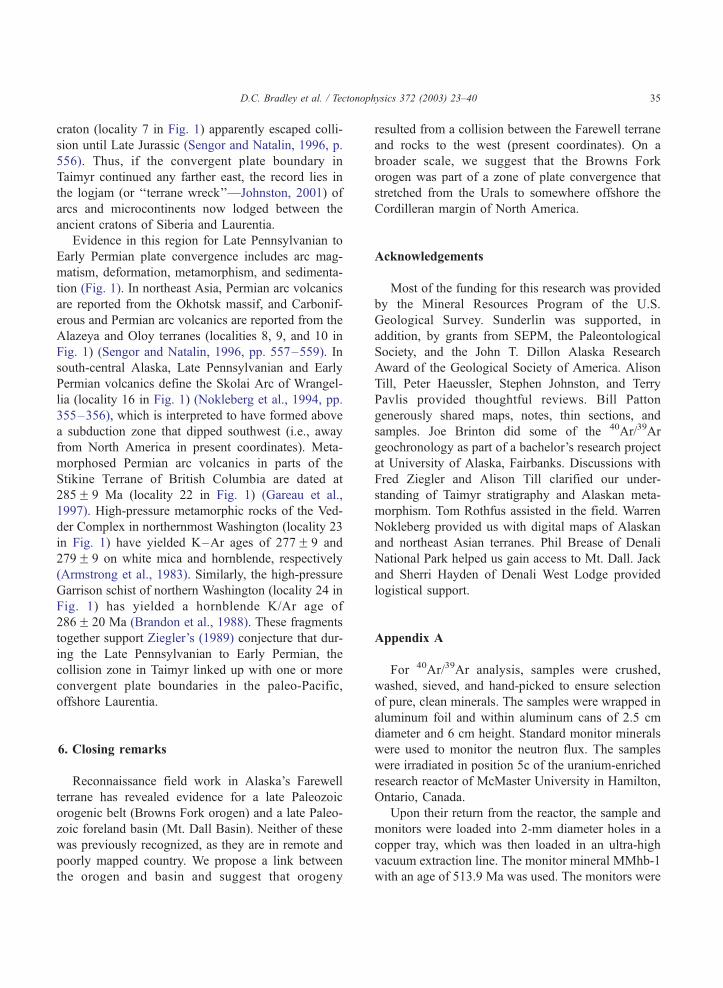
Thus, fragmentary evidence can be pieced together
for a previously unrecognized Phanerozoic orogeny in
Alaska, one that appears in none of the published
scenarios for the assembly of the northern Cordillera
(e.g., Plafker and Berg, 1994; Nokleberg et al., 2001).
From Cambrian through Devonian, the Farewell ter-
rane was a microcontinent with a passive margin that
lay somewhere within an ocean between the Siberian
and Laurentian cratons (Dumoulin et al., 2002)—a gap
that later came to be clogged by a 4500-km-long, 1000-
km-wide jumble of terranes (Johnston, 2001) (Fig. 1).
By the Late Cretaceous, the Farewell had ended up in
the midst of this jumble, part of a newly assembled
bridge between two ancient cratons. The Browns Fork
orogeny was an early event in this assembly.
5.2. Interactions between the Farewell terrane and its
immediate neighbors
The weight of evidence suggests that the Browns
Fork orogeny involved collision with something to the
west (in modern coordinates). Paleocurrent data from
late Paleozoic conglomerates (Fig. 2) show roughly
west-to-east paleoflow in two widely separated areas,
and the intensity of late Paleozoic metamorphism
diminished eastward. Unfortunately, little is known
about the late Paleozoic geology of the area immedi-
ately west of the Farewell terrane, because, except for
a few fault slivers, the relevant rocks lie beneath many
kilometers of turbidites of the Late Cretaceous Kus-
kokwim basin. About 75–100 km west of the Fare-
well terrane is a tract called the Innoko ‘‘terrane’’.
Patton et al. (1994) described this as a poorly exposed
belt of ocean-floor and arc rocks ranging in age from
Devonian to Early Cretaceous, which likely includes
two unrelated assemblages. Although some rocks in
the Innoko are too young to have participated in the
Browns Fork orogeny, others are the right age and
lithology to suggest, or at least permit, involvement.
Miller and Bundtzen (1994) reported a hornblende

D.C. Bradley et al. / Tectonophysics 372 (2003) 23–4034
porphyry from Iditarod quadrangle (locality R in Fig.
2 and locality 11 in Fig. 1) that yielded an age of
302F 9 Ma (K/Ar, hornblende). Permian graywacke
has been described from the Ruby, Ophir, and Liven-
good quadrangles (localities P and Q in Fig. 2 and
localities 13 and 14 in Fig. 1) (Chapman and Patton,
1979; Bundtzen et al., 1997b; Weber et al., 1992).
These volcanic and sedimentary rocks could represent
an arc and an associated forearc basin or trench related
to the Browns Fork orogeny.
The Yukon-Tanana ‘‘terrane’’ borders the Farewell
terrane to the east (Fig. 2). It has long been treated as a
single terrane (e.g., Coney et al., 1980), but in fact, it
includes an early Paleozoic continental margin assem-
blage, a Devonian arc, an obducted late Paleozoic to
Triassic ophiolite, metamorphic rocks of late Paleo-
zoic to Triassic, Jurassic, and Early Cretaceous ages,
and intrusives of Triassic, Jurassic, Cretaceous, and
Tertiary ages (Dusel-Bacon et al., 2002). Evidence for
late Paleozoic orogenesis is not known from the part
of the Yukon-Tanana nearest the Farewell terrane.
However, about 850 km to the east in Yukon Territory
(locality 19 in Fig. 1), blueschist and eclogite have
yielded 40Ar/39Ar cooling ages of 273F 34 and
274F 3 Ma (Erdmer et al., 1998). Still farther east
(locality 20 in Fig. 1), Murphy et al. (2002) recently
documented Late Pennsylvanian west-directed thrusts
that juxtapose different units within the Yukon-
Tanana. Thus, distant parts of the Yukon-Tanana
‘‘terrane’’ were deformed and metamorphosed at the
approximate time of the Browns Fork orogeny. How-
ever, the Jurassic and Early Cretaceous metamorphic
events that affected the Yukon-Tanana in interior
Alaska are unlike anything in the Farewell terrane.
Late Paleozoic interactions between the Farewell and
Yukon-Tanana cannot be demonstrated, and it is likely
that the two were juxtaposed later.
The two other terranes that flank the Farewell
terrane are also unlikely to have interacted with it
during the Browns Fork orogeny. To the south, the
Farewell is flanked by a Jurassic to mid-Cretaceous
flysch belt (Kahiltna ‘‘terrane’’) (Fig. 2), which marks
the thickly sedimented suture zone between the Fare-
well terrane and Wrangellia (locality 16 in Fig. 1).
Fossil ages in the flysch range from latest Jurassic to
mid-Cretaceous (Turonian) and folds in the flysch are
cross-cut by Late Cretaceous plutons. Collision be-
tween the Farewell terrane and Wrangellia is thus
inferred to have taken place during the Cretaceous,
perhaps 200 million years after the Browns Fork
orogeny. To the north, across an unmapped area of
poor outcrop, the Farewell terrane is flanked by the
Ruby terrane (Fig. 2), a Paleozoic continental margin
assemblage that includes vestiges of a Devonian arc.
The Ruby was metamorphosed to blueschist facies by
144 Ma and was intruded by granites at 118–109 Ma
(Roeske et al., 1995). The Ruby shows no signs of a
Permian orogeny, just as the Farewell terrane contains
no record of Jura-Cretaceous blueschist conditions.
5.3. Late Paleozoic plate mosaic
Modern and ancient convergent plate boundaries
connect to form belts that are thousands of kilometers
long (e.g., circum-Pacific, Alpine-Himalaya, Innui-
tian-Caledonian-Appalachian). Thus, we would not
expect the Browns Fork orogen to have existed in
isolation. In addition to those already discussed, other
areas of Late Pennsylvanian to Early Permian plate
convergence that might have somehow linked up with
the Browns Fork orogen are found in south-central
Alaska, northeast Asia, and western Canada (Fig. 1).
The Uralian orogen and its extensions in Novaya
Zemlya and Taimyr (localities 2, 4, and 6 in Fig. 1)
together form one of the great collisional systems in
Earth history, some 5500 km long. In that part of the
Urals within the area of Fig. 1, and in Novaya Zemlya,
the passive margin of Baltica collided with an out-
board arc system, above an east-dipping subduction
zone. The onset of collision is dated by the drowning
of the passive margin beneath orogenically derived
flysch, Late Pennsylvanian (Stephanian) in the north-
ern Urals (locality 1 in Fig. 1), Early Permian (Artin-
skian) in Novaya Zemlya (locality 3 in Fig. 1)
(Ziegler, 1989; Heafford, 1988). In Taimyr, the pas-
sive margin was on the Siberian side and the polarity
of tectonic transport was opposite that in the rest of
orogen. But the onset of orogeny was in the same age
range, as shown (1) by Late Pennsylvanian to Early
Permian thrusts and Permian granitic plutonism and
metamorphism in the central Taimyr zone (locality 6
in Fig. 1) (Zonenshain et al., 1990) and (2) by
foreland-basin sedimentation in the South Taimyr
Trough that had commenced by Middle to Late
Carboniferous (locality 5 in Fig. 1) (Posner, 1966).
The eastern (Verkhoyansk) margin of the Siberian
D.C. Bradley et al. / Tectonophysics 372 (2003) 23–40 35
craton (locality 7 in Fig. 1) apparently escaped colli-
sion until Late Jurassic (Sengor and Natalin, 1996, p.
556). Thus, if the convergent plate boundary in
Taimyr continued any farther east, the record lies in
the logjam (or ‘‘terrane wreck’’—Johnston, 2001) of
arcs and microcontinents now lodged between the
ancient cratons of Siberia and Laurentia.
Evidence in this region for Late Pennsylvanian to
Early Permian plate convergence includes arc mag-
matism, deformation, metamorphism, and sedimenta-
tion (Fig. 1). In northeast Asia, Permian arc volcanics
are reported from the Okhotsk massif, and Carbonif-
erous and Permian arc volcanics are reported from the
Alazeya and Oloy terranes (localities 8, 9, and 10 in
Fig. 1) (Sengor and Natalin, 1996, pp. 557–559). In
south-central Alaska, Late Pennsylvanian and Early
Permian volcanics define the Skolai Arc of Wrangel-
lia (locality 16 in Fig. 1) (Nokleberg et al., 1994, pp.
355–356), which is interpreted to have formed above
a subduction zone that dipped southwest (i.e., away
from North America in present coordinates). Meta-
morphosed Permian arc volcanics in parts of the
Stikine Terrane of British Columbia are dated at
285F 9 Ma (locality 22 in Fig. 1) (Gareau et al.,
1997). High-pressure metamorphic rocks of the Ved-
der Complex in northernmost Washington (locality 23
in Fig. 1) have yielded K–Ar ages of 277F 9 and
279F 9 on white mica and hornblende, respectively
(Armstrong et al., 1983). Similarly, the high-pressure
Garrison schist of northern Washington (locality 24 in
Fig. 1) has yielded a hornblende K/Ar age of
286F 20 Ma (Brandon et al., 1988). These fragments
together support Ziegler’s (1989) conjecture that dur-
ing the Late Pennsylvanian to Early Permian, the
collision zone in Taimyr linked up with one or more
convergent plate boundaries in the paleo-Pacific,
offshore Laurentia.
6. Closing remarks
Reconnaissance field work in Alaska’s Farewell
terrane has revealed evidence for a late Paleozoic
orogenic belt (Browns Fork orogen) and a late Paleo-
zoic foreland basin (Mt. Dall Basin). Neither of these
was previously recognized, as they are in remote and
poorly mapped country. We propose a link between
the orogen and basin and suggest that orogeny
resulted from a collision between the Farewell terrane
and rocks to the west (present coordinates). On a
broader scale, we suggest that the Browns Fork
orogen was part of a zone of plate convergence that
stretched from the Urals to somewhere offshore the
Cordilleran margin of North America.
Acknowledgements
Most of the funding for this research was provided
by the Mineral Resources Program of the U.S.
Geological Survey. Sunderlin was supported, in
addition, by grants from SEPM, the Paleontological
Society, and the John T. Dillon Alaska Research
Award of the Geological Society of America. Alison
Till, Peter Haeussler, Stephen Johnston, and Terry
Pavlis provided thoughtful reviews. Bill Patton
generously shared maps, notes, thin sections, and
samples. Joe Brinton did some of the 40Ar/39Ar
geochronology as part of a bachelor’s research project
at University of Alaska, Fairbanks. Discussions with
Fred Ziegler and Alison Till clarified our under-
standing of Taimyr stratigraphy and Alaskan meta-
morphism. Tom Rothfus assisted in the field. Warren
Nokleberg provided us with digital maps of Alaskan
and northeast Asian terranes. Phil Brease of Denali
National Park helped us gain access to Mt. Dall. Jack
and Sherri Hayden of Denali West Lodge provided
logistical support.
Appendix A
For 40Ar/39Ar analysis, samples were crushed,
washed, sieved, and hand-picked to ensure selection
of pure, clean minerals. The samples were wrapped in
aluminum foil and within aluminum cans of 2.5 cm
diameter and 6 cm height. Standard monitor minerals
were used to monitor the neutron flux. The samples
were irradiated in position 5c of the uranium-enriched
research reactor of McMaster University in Hamilton,
Ontario, Canada.
Upon their return from the reactor, the sample and
monitors were loaded into 2-mm diameter holes in a
copper tray, which was then loaded in an ultra-high
vacuum extraction line. The monitor mineral MMhb-1
with an age of 513.9 Ma was used. The monitors were

D.C. Bradley et al. / Tectonophysics 372 (2003) 23–4036
fused, and samples heated, using a 6 W argon-ion
laser following the technique described in York et al.
(1981) and Layer et al. (1987). Argon purification was
achieved using a liquid nitrogen cold trap and a SAES
Zr–Al getter at 400C. The samples were then ana-
lyzed in a VG-3600 mass spectrometer at the Geo-
physical Institute, University of Alaska Fairbanks
(Layer, 2000). The argon isotopes measured were
corrected for system blank and mass discrimination,
as well as calcium, potassium, and chlorine interfer-
ence reactions following procedures outlined in
McDougall and Harrison (1999).
A summary of all the 40Ar/39Ar results is given in
Table 1, with all ages quoted to the F 1 sigma level
and calculated using the constants of Steiger and
Jaeger (1977). Analytical results are tabulated in
Appendix B. Integrated age is the weighted average
of all gas fractions. This often includes fractions
where argon loss occurs and therefore may not repre-
sent an original age or a reset age. Plateau age is
determined from 3 or more consecutive fractions
whose ages are within 2 sigma of each other (MSWD
generally less than f 2) and total more than 50% of
gas release.
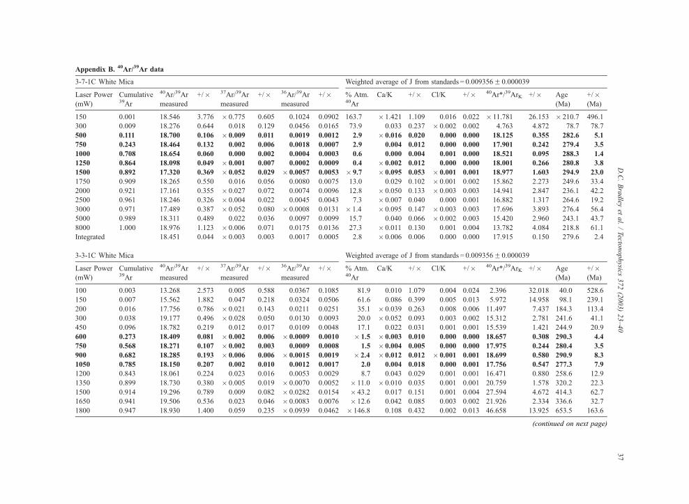
Appendix B. 40Ar/39Ar data
3-7-1C White Mica Weighted average of J from standards = 0.009356F 0.000039
Laser Power
(mW)
Cumulative39Ar
40Ar/39Ar
measured
+/� 37Ar/39Ar
measured
+/� 36Ar/39Ar
measured
+/� % Atm.40Ar
Ca/K +/� Cl/K +/� 40Ar*/39ArK +/� Age
(Ma)
+/�(Ma)
150 0.001 18.546 3.776 � 0.775 0.605 0.1024 0.0902 163.7 � 1.421 1.109 0.016 0.022 � 11.781 26.153 � 210.7 496.1
300 0.009 18.276 0.644 0.018 0.129 0.0456 0.0165 73.9 0.033 0.237 � 0.002 0.002 4.763 4.872 78.7 78.7
500 0.111 18.700 0.106 � 0.009 0.011 0.0019 0.0012 2.9 � 0.016 0.020 0.000 0.000 18.125 0.355 282.6 5.1
750 0.243 18.464 0.132 0.002 0.006 0.0018 0.0007 2.9 0.004 0.012 0.000 0.000 17.901 0.242 279.4 3.5
1000 0.708 18.654 0.060 0.000 0.002 0.0004 0.0003 0.6 0.000 0.004 0.001 0.000 18.521 0.095 288.3 1.4
1250 0.864 18.098 0.049 � 0.001 0.007 0.0002 0.0009 0.4 � 0.002 0.012 0.000 0.000 18.001 0.266 280.8 3.8
1500 0.892 17.320 0.369 � 0.052 0.029 � 0.0057 0.0053 � 9.7 � 0.095 0.053 � 0.001 0.001 18.977 1.603 294.9 23.0
1750 0.909 18.265 0.550 0.016 0.056 0.0080 0.0075 13.0 0.029 0.102 � 0.001 0.002 15.862 2.273 249.6 33.4
2000 0.921 17.161 0.355 � 0.027 0.072 0.0074 0.0096 12.8 � 0.050 0.133 � 0.003 0.003 14.941 2.847 236.1 42.2
2500 0.961 18.246 0.326 � 0.004 0.022 0.0045 0.0043 7.3 � 0.007 0.040 0.000 0.001 16.882 1.317 264.6 19.2
3000 0.971 17.489 0.387 � 0.052 0.080 � 0.0008 0.0131 � 1.4 � 0.095 0.147 � 0.003 0.003 17.696 3.893 276.4 56.4
5000 0.989 18.311 0.489 0.022 0.036 0.0097 0.0099 15.7 0.040 0.066 � 0.002 0.003 15.420 2.960 243.1 43.7
8000 1.000 18.976 1.123 � 0.006 0.071 0.0175 0.0136 27.3 � 0.011 0.130 0.001 0.004 13.782 4.084 218.8 61.1
Integrated 18.451 0.044 � 0.003 0.003 0.0017 0.0005 2.8 � 0.006 0.006 0.000 0.000 17.915 0.150 279.6 2.4
3-3-1C White Mica Weighted average of J from standards = 0.009356F 0.000039
Laser Power
(mW)
Cumulative39Ar
40Ar/39Ar
measured
+/� 37Ar/39Ar
measured
+/� 36Ar/39Ar
measured
+/� % Atm.40Ar
Ca/K +/� Cl/K +/� 40Ar*/39ArK +/� Age
(Ma)
+/�(Ma)
100 0.003 13.268 2.573 0.005 0.588 0.0367 0.1085 81.9 0.010 1.079 0.004 0.024 2.396 32.018 40.0 528.6
150 0.007 15.562 1.882 0.047 0.218 0.0324 0.0506 61.6 0.086 0.399 0.005 0.013 5.972 14.958 98.1 239.1
200 0.016 17.756 0.786 � 0.021 0.143 0.0211 0.0251 35.1 � 0.039 0.263 0.008 0.006 11.497 7.437 184.3 113.4
300 0.038 19.177 0.496 � 0.028 0.050 0.0130 0.0093 20.0 � 0.052 0.093 0.003 0.002 15.312 2.781 241.6 41.1
450 0.096 18.782 0.219 0.012 0.017 0.0109 0.0048 17.1 0.022 0.031 0.001 0.001 15.539 1.421 244.9 20.9
600 0.273 18.409 0.081 � 0.002 0.006 � 0.0009 0.0010 � 1.5 � 0.003 0.010 0.000 0.000 18.657 0.308 290.3 4.4
750 0.568 18.271 0.107 � 0.002 0.003 0.0009 0.0008 1.5 � 0.004 0.005 0.000 0.000 17.975 0.244 280.4 3.5
900 0.682 18.285 0.193 � 0.006 0.006 � 0.0015 0.0019 � 2.4 � 0.012 0.012 � 0.001 0.001 18.699 0.580 290.9 8.3
1050 0.785 18.150 0.207 0.002 0.010 0.0012 0.0017 2.0 0.004 0.018 0.000 0.001 17.756 0.547 277.3 7.9
1200 0.843 18.061 0.224 0.023 0.016 0.0053 0.0029 8.7 0.043 0.029 0.001 0.001 16.471 0.880 258.6 12.9
1350 0.899 18.730 0.380 � 0.005 0.019 � 0.0070 0.0052 � 11.0 � 0.010 0.035 0.001 0.001 20.759 1.578 320.2 22.3
1500 0.914 19.296 0.789 0.009 0.082 � 0.0282 0.0154 � 43.2 0.017 0.151 0.001 0.004 27.594 4.672 414.3 62.7
1650 0.941 19.506 0.536 0.023 0.046 � 0.0083 0.0076 � 12.6 0.042 0.085 0.003 0.002 21.926 2.334 336.6 32.7
1800 0.947 18.930 1.400 0.059 0.235 � 0.0939 0.0462 � 146.8 0.108 0.432 0.002 0.013 46.658 13.925 653.5 163.6
(continued on next page)
D.C.Bradley
etal./Tecto
nophysics
372(2003)23–40
37
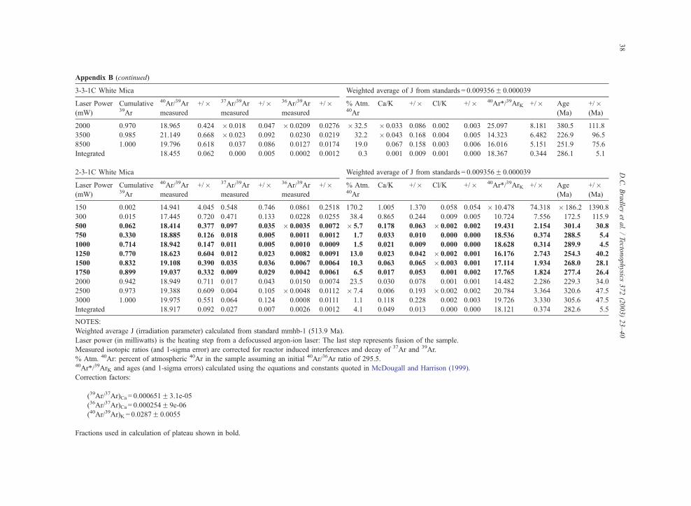
Appendix B (continued)
3-3-1C White Mica Weighted average of J from standards = 0.009356F 0.000039
Laser Power
(mW)
Cumulative39Ar
40Ar/39Ar
measured
+/� 37Ar/39Ar
measured
+/� 36Ar/39Ar
measured
+/� % Atm.40Ar
Ca/K +/� Cl/K +/� 40Ar*/39ArK +/� Age
(Ma)
+/�(Ma)
2000 0.970 18.965 0.424 � 0.018 0.047 � 0.0209 0.0276 � 32.5 � 0.033 0.086 0.002 0.003 25.097 8.181 380.5 111.8
3500 0.985 21.149 0.668 � 0.023 0.092 0.0230 0.0219 32.2 � 0.043 0.168 0.004 0.005 14.323 6.482 226.9 96.5
8500 1.000 19.796 0.618 0.037 0.086 0.0127 0.0174 19.0 0.067 0.158 0.003 0.006 16.016 5.151 251.9 75.6
Integrated 18.455 0.062 0.000 0.005 0.0002 0.0012 0.3 0.001 0.009 0.001 0.000 18.367 0.344 286.1 5.1
2-3-1C White Mica Weighted average of J from standards = 0.009356F 0.000039
Laser Power
(mW)
Cumulative39Ar
40Ar/39Ar
measured
+/� 37Ar/39Ar
measured
+/� 36Ar/39Ar
measured
+/� % Atm.40Ar
Ca/K +/� Cl/K +/� 40Ar*/39ArK +/� Age
(Ma)
+/�(Ma)
150 0.002 14.941 4.045 0.548 0.746 0.0861 0.2518 170.2 1.005 1.370 0.058 0.054 � 10.478 74.318 � 186.2 1390.8
300 0.015 17.445 0.720 0.471 0.133 0.0228 0.0255 38.4 0.865 0.244 0.009 0.005 10.724 7.556 172.5 115.9
500 0.062 18.414 0.377 0.097 0.035 � 0.0035 0.0072 � 5.7 0.178 0.063 � 0.002 0.002 19.431 2.154 301.4 30.8
750 0.330 18.885 0.126 0.018 0.005 0.0011 0.0012 1.7 0.033 0.010 0.000 0.000 18.536 0.374 288.5 5.4
1000 0.714 18.942 0.147 0.011 0.005 0.0010 0.0009 1.5 0.021 0.009 0.000 0.000 18.628 0.314 289.9 4.5
1250 0.770 18.623 0.604 0.012 0.023 0.0082 0.0091 13.0 0.023 0.042 � 0.002 0.001 16.176 2.743 254.3 40.2
1500 0.832 19.108 0.390 0.035 0.036 0.0067 0.0064 10.3 0.063 0.065 � 0.003 0.001 17.114 1.934 268.0 28.1
1750 0.899 19.037 0.332 0.009 0.029 0.0042 0.0061 6.5 0.017 0.053 0.001 0.002 17.765 1.824 277.4 26.4
2000 0.942 18.949 0.711 0.017 0.043 0.0150 0.0074 23.5 0.030 0.078 0.001 0.001 14.482 2.286 229.3 34.0
2500 0.973 19.388 0.609 0.004 0.105 � 0.0048 0.0112 � 7.4 0.006 0.193 � 0.002 0.002 20.784 3.364 320.6 47.5
3000 1.000 19.975 0.551 0.064 0.124 0.0008 0.0111 1.1 0.118 0.228 0.002 0.003 19.726 3.330 305.6 47.5
Integrated 18.917 0.092 0.027 0.007 0.0026 0.0012 4.1 0.049 0.013 0.000 0.000 18.121 0.374 282.6 5.5
NOTES:
Weighted average J (irradiation parameter) calculated from standard mmhb-1 (513.9 Ma).
Laser power (in milliwatts) is the heating step from a defocussed argon-ion laser: The last step represents fusion of the sample.
Measured isotopic ratios (and 1-sigma error) are corrected for reactor induced interferences and decay of 37Ar and 39Ar.
% Atm. 40Ar: percent of atmospheric 40Ar in the sample assuming an initial 40Ar/36Ar ratio of 295.5.40Ar*/39ArK and ages (and 1-sigma errors) calculated using the equations and constants quoted in McDougall and Harrison (1999).
Correction factors:
(39Ar/37Ar)Ca = 0.000651F 3.1e-05
(36Ar/37Ar)Ca = 0.000254F 9e-06
(40Ar/39Ar)K = 0.0287F 0.0055
Fractions used in calculation of plateau shown in bold.
D.C.Bradley
etal./Tecto
nophysics
372(2003)23–40
38
D.C. Bradley et al. / Tectonophysics 372 (2003) 23–40 39
References
Andrews, T., Rishel, J., 1982. Reef Ridge 1–13 project areas,
Kuskokwim Block. Anchorage, Alaska, Patino, Annual Report
(1981), vol. 1. 49 pp.
Armstrong, R.L., Harakal, J.E., Brown, E.H., Bernardi, M.L., Rady,
P.M., 1983. Late Paleozoic high-pressure metamorphic rocks in
northwestern Washington and southwestern British Columbia:
the Vedder Complex. Geological Society of America Bulletin
94, 451–458.
Blodgett, R.B., Boucot Jr., A.J., 1999. Late Early Devonian (late
Emsian) eospiriferinid brachiopods from Shellabarger Pass,
Talkeetna C-6 quadrangle, Denali National Park, Alaska and
their paleogeographic importance: further evidence for a Sibe-
rian origin of the Farewell and allied Alaskan accreted terranes.
Senckenbergiana Lethaea 79, 209–221.
Blodgett, R.B., Rohr, D.M., Boucot, A.J., 2002. Paleozoic links
among some Alaskan accreted terranes and Siberia based
on megafossils. In: Miller, E., et al. (Eds.), Tectonic Evolution
of the Bering Shelf-Chuckchi Sea-Arctic Margin and Adjacent
Landmasses. Geological Society of America, Boulder, CO,
Special Paper, vol. 360, pp. 273–280.
Box, S.E., 1985. Early Cretaceous orogenic belt in northwestern
Alaska: Internal organization, lateral extent and tectonic inter-
pretation. In: Howell, D.G. (Ed.), Tectonostratigraphic Terranes
of the Circum-Pacific Region. Circum-Pacific Council for En-
ergy and Mineral Resources. Earth Science Series, Houston, TX,
vol. 1, pp. 137–145.
Brandon, M.T., Cowan, D.S., Vance, J.A., 1988. The Late Creta-
ceous San Juan thrust system, San Juan Islands, Washington.
Geological Society of America, Boulder, CO, Special Paper,
vol. 221. 81 pp.
Bundtzen, T.K., Gilbert, W.G., 1983. Outline of geology and min-
eral resources of upper Kuskokwim region, Alaska. Journal of
the Alaska Geological Society 3, 101–117.
Bundtzen, T.K., Laird, G.M., Blodgett, R.B., Clautice, K.H., Harris,
E.E., 1994. Geologic map of the Gagaryah River area, Lime
Hills C-5 and C-6 quadrangles, southwestern Alaska. Alaska
Division of Geological and Geophysical Surveys Public-Data
File 94-40, 16 pp., scale 1:63,360.
Bundtzen, T.K., Harris, E.E., Gilbert, W.G., 1997a. Geologic map
of the eastern half of the McGrath quadrangle, Alaska. Alaska
Division of Geological and Geophysical Surveys Report of In-
vestigations 97-14a, 38 pp., scale 1:125,000.
Bundtzen, T.K., Pinney, D.A., Laird, G.M., 1997b. Preliminary
geologic map and data tables from the Ophir C-1 and western
Medfra C-6 quadrangles, Alaska. Alaska Division of Geological
and Geophysical Surveys Public-Data File 97-46.
Chapman, R.M., Patton Jr., W.W., 1979. Two upper Paleozoic sedi-
mentary rock units identified in the southwestern part of the
Ruby quadrangle. U.S. Geological Survey Circular 80-B,
B59–B61.
Coney, P.J., Jones, D.L., Monger, J.W.H., 1980. Cordilleran suspect
terranes. Nature 288, 29–33.
Decker, J., Bergman, S.C., Blodgett, R.B., Box, S.E., Bundtzen,
T.K., Clough, J.G., Coonrad, W.L., Gilbert, W.G., Miller, M.L.,
Murphy, J.M., Robinson, M.S., Wallace, W.K., 1994. Geology
of southwestern Alaska. In: Plafker, G., Berg, H.C. (Eds.), The
Geology of Alaska. Geological Society of America, Boulder,
CO, DNAG Series, vol. G-1, pp. 285–310.
Dillon, J.T., Patton Jr., W.W., Muksa, S.B., Tilton, G.R., Blum, J.,
Moll, E.T., 1985. New radiometric evidence for the age and
thermal history of the metamorphic rocks of the Ruby and Nix-
on Fork terranes, west-central Alaska. U.S. Geological Survey
Circular 945, 13–18.
Dumoulin, J.A., Harris, A.G., Gagiev, M., Bradley, D.C., Repetski,
J.E., 2002. Lithostratigraphic, conodont, and other faunal links
between lower Paleozoic strata in northern and central Alaska
and northeastern Russia. In: Miller, E., et al. (Eds.), Tectonic
Evolution of the Bering Shelf-Chuckchi Sea-Arctic Margin and
Adjacent Landmasses. Geological Society of America, Boulder,
CO, Special Paper, vol. 360, pp. 291–312.
Dusel-Bacon, C., Lanphere, M.A., Sharp, W.D., Layer, P.W., Han-
sen, V.L., 2002. Mesozoic thermal history and timing of struc-
tural events for the Yukon-Tanana Upland, east-central Alaska:40Ar/39Ar data for metamorphic and plutonic rocks. Canadian
Journal of Earth Science 39, 1013–1051.
Epstein, A.G., Epstein, J.B., Harris, L.D., 1977. Conodont color
alteration—an index to organic metamorphism. U.S. Geological
Survey Professional Paper 995. 27 pp.
Erdmer, P., Ghent, E.D., Archibald, D.A., Stout, M.Z., 1998. Pale-
ozoic and Mesozoic high-pressure metamorphism at the margin
of ancestral North America in central Yukon. Geological Society
of America Bulletin 110, 615–629.
Gareau, S.A., Friedman, R.M., Woodsworth, G.J., Childe, F., 1997.
U–Pb ages from the northeastern quadrant of terrace map-area,
west-central British Columbia. Geological Survey of Canada
97-1A, 31–40.
Heafford, A.P., 1988. Carboniferous through Triassic stratigraphy
of the Barents Shelf. In: Harland, W.B., Dowdeswell, E.K.
(Eds.), Geological Evolution of the Barents Shelf Region. Gra-
ham and Trotman, London, pp. 89–108.
Johnson, G.L., Churkin, M.J., 1976. Sheet 19, Arctic, in Chubert,
G., and Faure-Muret, A., co-ordinators, Atlas Geologique du
Monde. UNESCO, scale1:10,000,000.
Johnston, S.T., 2001. The great Alaskan terrane wreck: reconcilia-
tion of paleomagnetic and geologic data in the northern Cordil-
lera. Earth and Planetary Science Letters 193, 259–272.
Jones, D.L., Silberling, N.J. Coney, P.J., Plafker, G.W., 1987. Lith-
otectonic terrane map of Alaska, west of the 141st meridian.
U.S. Geological Survey Map MF-1874-A, scale 1:2,500,000.
Krumhardt, A.P., Harris, A.G., Watts, K.F., 1996. Lithostratigraphy,
microlithofacies, and conodont biostratigraphy and biofacies of
the Wahoo Limestone (Carboniferous), eastern Sadlerochit
Mountains, northeast Brooks Range, Alaska: U.S. Geological
Survey Professional Paper 1568. 71 pp.
Layer, P.W., 2000. Argon-40/argon-39 age of the Elıgygytgyn im-
pact event, Chukotka, Russia. Meteoritics & Planetary Science
35, 591–599.
Layer, P.W., Hall, C.M., York, D., 1987. The derivation of40Ar/39Ar age spectra of single grains of hornblende and bio-
tite by laser step heating. Geophysical Research Letters 14,
757–760.
Mamay, S.H., Reed, B.L., 1984. Permian plant megafossils from

D.C. Bradley et al. / Tectonophysics 372 (2003) 23–4040
the conglomerate of Mt. Dall, central Alaska Range. U.S. Geo-
logical Survey Circular 868, 98–102.
McClelland, W.C., Kusky, T., Bradley, D.C., Dumoulin, J., Harris,
A.G., 1999. The nature of Nixon Fork ‘‘basement’’, west-central
Alaska. Geological Society of America, Abstracts with Pro-
grams 31 (6), A-78.
McDougall, I., Harrison, T.M., 1999. Geochronology and Thermo-
chronology by the 40Ar/39Ar Method, 2nd ed. Oxford Univ.
Press, New York. 269 pp.
Miller, M.L., Bundtzen, T.K., 1994. Generalized geologic map of
the Iditarod quadrangle, Alaska, showing potassium-argon, ma-
jor oxide, trace element, fossil, paleocurrent, and archaeolog-
ical sample localities. U.S. Geological Survey Map MF-2219-
A, 48 p., scale 1:250,000.
Miller, M.L., Bradley, D.C., Bundtzen, T.K., McClelland, W., 2002.
Late Cretaceous through Cenozoic strike – slip tectonics of
southwestern Alaska. Journal of Geology 110, 247–270.
Murphy, D.C., Colpron, M., Roots, C., Gordey, S.P., Abbott, J.G.,
2002. Finlayson lake targeted geocience initiative (southeastern
Yukon), Part 1: Bedrock geology. In: Edmond, D.S., et al.
(Eds.), Yukon Exploration and Geology 2001. Exploration and
Geological Services Division, Indian and Northern Affairs Can-
ada, Whitehorse, Yukon, pp. 189–207.
Nokleberg, W.J., Plafker, G., Wilson, F.H., 1994. Geology of south-
central Alaska. In: Plafker, G., Berg, H.C. (Eds.), The Geology of
Alaska. Geological Society of America, Boulder, CO, DNAG
Series, vol. G-1, pp. 311–366.
Nokleberg, W.J., Parfenov, L.M., Monger, J.W.H., Norton, I.O.,
Khanchuk, A.I., Stone, D.B., Scotese, C.R., Scholl, D.W., Fujita,
K., 2001. Phanerozoic tectonic evolution of the circum-North
Pacific. U.S. Geological Survey Professional Paper, vol. 1626.
122 pp.
Patton Jr., W.W., Dutro Jr., J.T., 1979. Age of the metamorphic
complex in the northern Kuskokwim Mountains, west-central
Alaska. U.S. Geological Survey Circular 804-B, B61–B63.
Patton, W.W., Jr., Moll, E.J., Dutro, J.T., Jr., Silberman, M.L.,
Chapman, R.M., 1980. Preliminary geologic map of the Medfra
quadrangle, Alaska. U.S. Geological Survey Open-File Report
80-811A, scale 1:250,000.
Patton, W.W., Box, S.E., Moll-Stalcup, E.J., Miller, T.P., 1994.
Geology of west-central Alaska. In: Plafker, G., Berg, H.C.
(Eds.), The Geology of Alaska. Geological Society of America,
Boulder, CO, DNAG Series, vol. G-1, pp. 241–269.
Plafker, G., Berg, H.C., 1994. Overview of the geology and tectonic
evolution of Alaska. In: Plafker, G., Berg, H.C. (Eds.), The
Geology of Alaska. Geological Society of America, Boulder,
CO, DNAG Series, vol. G-1, pp. 989–1021.
Posner, V.M. (Ed.), 1966. Paleotectonic map of the USSR, Middle
and Late Carboniferous, in Vinogradov, A.P. (editor in chief),
1968. The Atlas of Lithological-Paleogeographical Maps of the
USSR, Ministry of Geology of the USSR, v. 2.
Reed, B.L., Nelson, S.W., 1980. Geologic map of the Talkeetna
quadrangle, Alaska. U.S. Geological Survey Map I-1174, 15 p.,
scale 1:250,000.
Roeske, S.M., Dusel-Bacon, C., Aleinikoff, J.N., Snee, L.W., Lan-
phere, M.A., 1995. Metamorphic and structural history of con-
tinental crust at a Mesozoic collisional margin, the Ruby terrane,
central Alaska. Journal of Metamorphic Geology 13, 5–40.
Sengor, A.M.C., Natalin, B.A., 1996. Paleotectonics of Asia: Frag-
ments of a synthesis. In: Yin, A. and Harrison, T.M.M. (Eds.),
The Tectonic Evolution of Asia. Cambridge, Cambridge Univ.
Press, Rubey Colloquium, pp. 486–640
Silberling, N.J., Jones, D.L., Monger, J.W.H., Coney, P.J., Berg,
H.C., Plafker, G., 1994. Lithotectonic terrane map of Alaska
and adjacent parts of Canada. In: Plafker, G., Berg, H.C.
(Eds.), The Geology of Alaska. Geological Society of America,
Boulder, CO, DNAG Series, vol. G-1. plate 3, scale 1:2,
500,000.
Silberman, M.L., Moll, E.J., Patton, W.W., Chapman, R.M., Con-
nor, C.L., 1979. Precambrian age of metamorphic rocks from
the Ruby province, Medfra and Ruby quadrangles; preliminary
evidence from radiometric age data. U.S. Geological Survey
Circular 804-B, B66–B67.
Soja, C.M., Antoshkina, A.I., 1997. Coeval development of Silurian
stromatolite reefs in Alaska and the Ural Mountians: implica-
tions for paleogeography of the Alexander terrane. Geology 25,
539–542.
Steiger, R.H., Jaeger, E., 1977. Subcommission on geochronology:
convention on the use of decay constants in geo and cosmo-
chronology. Earth and Planet Science Letters 36, 359–362.
Sunderlin, D., 2002. A sedimentary characterization of the Mt. Dall
Conglomerate, Farewell terrane, Alaska, and its paleoenviron-
mental implications. Geological Society of America, Abstracts
with Programs 34 (6), 282.
Torsvik, T.H., Tait, J., Moralev, V.M., McKerrow, W.S., Sturt,
B.A., 1995. Ordovician paleogeography of Siberia and adjacent
continents. Journal of the Geological Society of London 152,
279–287.
Weber, F.R., Wheeler, K.L., Rinehart, C.D., Chapman, R.M.,
Blodgett, R.B., 1992. Geologic map of the Livengood quadran-
gle, Alaska. U.S. Geological Survey Open-File Report 92-562,
20 pp., scale 1:250,000.
Wilson, F.H., Dover, J.H., Bradley, D.C., Weber, F.R., Bundtzen,
T.K., Haeussler, P.J., 1998. Geologic map of central (interior)
Alaska: U.S. Geological Survey Open-File Report 98–133, 64
p., 3 plates, scale 1:500,000 (also released as a CD-ROM).
York, D., Hall, C.M., Yanase, Y., Hanes, J.A., Kenyon, W.J., 1981.40Ar/39Ar dating of terrestrial minerals with a continuous laser.
Geophysical Research Letters 8, 1136–1138.
Ziegler, P.A., 1989. Evolution of Laurussia. Kluwer Academic Pub-
lishing, Dordrecht, the Netherlands. 102 pp.
Zonenshain, L.P., Kuzmin, M.I., Natapov, L.M., 1990. Geology of
the USSR: a platetectonic synthesis. American Geophysical
Union, Geodynamics Series 21. 242 pp.
Copyright © 2022 FDOKUMEN