Late Glacial–Holocene palaeoceanography of the Sea of Marmara: timing of connections with the...
16
Late Glacial–Holocene palaeoceanography of the Sea of Marmara: timing of connections with the Mediterranean and the Black Seas M.N. C ¸ ag ˘atay a , N. Go ¨ru ¨r a , O. Algan b , C. Eastoe c , A. Tchapalyga d , D. Ongan b , T. Kuhn e , I. Kus ¸cu f a Geology Department, School of Mines, Istanbul Technical University, Ayazaga 80626 Istanbul, Turkey b Institute of Marine Sciences, Istanbul University, Vefa 34470, Turkey c Department of Geosciences, University of Arizona, Tucson, AZ 85721, USA d Institute of Geography, Russian Academy of Sciences, 10917 Moscow, Russia e Berlin Free University, Malteser Str. 74-100, D-12249 Berlin, Germany f MTA General Directorate, 06520 Ankara, Turkey Received 8 April 1999; accepted 23 February 2000 Abstract Stratigraphic analysis of Late Quaternary sediments of the Sea of Marmara Basin (SMB) indicates that it was a freshwater lake during the late glacial to ca 12,000 yr BP, depositing sediments with a Neoeuxinian fauna characteristic of the Black Sea Basin. At ca 12,000 yr BP, it was inundated by the Mediterranean waters and gradually converted into a marine realm as indicated by the presence above the Neoeuxinian sediments of a mixed layer, containing both marine and freshwater fauna. A sapropelic sediment layer was deposited between 10,600 and 6400 yr BP under suboxic bottom water conditions. This layer roughly corresponds in time to S1 sapropel unit of the eastern Mediterranean, suggesting a common origin. Its presence in the SMB, therefore, supports the hypothesis that a large influx of freshwaters from the Black Sea was an important factor in sapropel formation in the eastern Mediterranean. A second sapropelic layer formed in the SMB during 4750 to 3200 yr BP. The earliest known record of Mediterranean water in the Bosphorus is at ca 5300 yr BP, suggesting a later marine inundation than the 7150 yr BP event suggested by Ryan and co-workers. An abrupt drowning of Black Sea shelf at 7.5 kyr BP, Geo-Eco- Marina, 2, Proc. Int. Workshop on Fluvial–Marine Interactions, Mainas, Romania, 1–7 October, 1997, pp. 115–125 and Ryan, W.B.F., Pitman III, W.C., Major, C.O., Shimkus, K., Moskalenko, V., Jones, J.A., Dimitrov, P., Go ¨ru ¨r, N., Sakinc ¸, M., Yu ¨ce, H., 1997b An abrupt drowning of Black Sea shelf, Mar. Geol. 138 (1997) 119–126). This implies that either earlier marine connections with the Black Sea were through a different waterway or the earlier marine record in the strait has been eroded. The present two-layer flow system was established at 4000 yr BP. q 2000 Elsevier Science B.V. All rights reserved. Keywords: Sea of Marmara; Bosphorus; Palaeoceanography; Sapropels; Water exchange 1. Introduction The Sea of Marmara Basin (SMB) is a 210-km long and 75-km wide intracontinental sea on a waterway between the Mediterranean and the Black Seas (Fig. 1). It has a relatively broad shelf in the south and a narrow one to the north with the shelf break located at a depth of about 2110 m. Between the shelves are three NE–SW trending basins (maximum 1265 m deep) separated from each other by interven- ing highs (600 m deep). The SMB is connected to the brackish S 18‰ Black Sea via the Bosphorus Marine Geology 167 (2000) 191–206 0025-3227/00/$ - see front matter q 2000 Elsevier Science B.V. All rights reserved. PII: S0025-3227(00)00031-1 www.elsevier.nl/locate/margeo E-mail address: [email protected] (M.N. C ¸ ag ˘atay).
-
Upload
independent -
Category
Documents
-
view
2 -
download
0
Transcript of Late Glacial–Holocene palaeoceanography of the Sea of Marmara: timing of connections with the...

Late Glacial–Holocene palaeoceanography of the Sea of Marmara:timing of connections with the Mediterranean and the Black Seas
M.N. Cagataya, N. Gorura, O. Alganb, C. Eastoec, A. Tchapalygad, D. Onganb, T. Kuhne,I. Kuscuf
aGeology Department, School of Mines, Istanbul Technical University, Ayazaga 80626 Istanbul, TurkeybInstitute of Marine Sciences, Istanbul University, Vefa 34470, Turkey
cDepartment of Geosciences, University of Arizona, Tucson, AZ 85721, USAdInstitute of Geography, Russian Academy of Sciences, 10917 Moscow, Russia
eBerlin Free University, Malteser Str. 74-100, D-12249 Berlin, GermanyfMTA General Directorate, 06520 Ankara, Turkey
Received 8 April 1999; accepted 23 February 2000
Abstract
Stratigraphic analysis of Late Quaternary sediments of the Sea of Marmara Basin (SMB) indicates that it was a freshwaterlake during the late glacial to ca 12,000 yr BP, depositing sediments with a Neoeuxinian fauna characteristic of the Black SeaBasin. At ca 12,000 yr BP, it was inundated by the Mediterranean waters and gradually converted into a marine realm asindicated by the presence above the Neoeuxinian sediments of a mixed layer, containing both marine and freshwater fauna. Asapropelic sediment layer was deposited between 10,600 and 6400 yr BP under suboxic bottom water conditions. This layerroughly corresponds in time to S1 sapropel unit of the eastern Mediterranean, suggesting a common origin. Its presence in theSMB, therefore, supports the hypothesis that a large influx of freshwaters from the Black Sea was an important factor insapropel formation in the eastern Mediterranean. A second sapropelic layer formed in the SMB during 4750 to 3200 yr BP.
The earliest known record of Mediterranean water in the Bosphorus is at ca 5300 yr BP, suggesting a later marine inundationthan the 7150 yr BP event suggested by Ryan and co-workers. An abrupt drowning of Black Sea shelf at 7.5 kyr BP, Geo-Eco-Marina, 2, Proc. Int. Workshop on Fluvial–Marine Interactions, Mainas, Romania, 1–7 October, 1997, pp. 115–125 and Ryan,W.B.F., Pitman III, W.C., Major, C.O., Shimkus, K., Moskalenko, V., Jones, J.A., Dimitrov, P., Go¨rur, N., Sakinc, M., Yuce,H., 1997b An abrupt drowning of Black Sea shelf, Mar. Geol. 138 (1997) 119–126). This implies that either earlier marineconnections with the Black Sea were through a different waterway or the earlier marine record in the strait has been eroded. Thepresent two-layer flow system was established at 4000 yr BP.q 2000 Elsevier Science B.V. All rights reserved.
Keywords: Sea of Marmara; Bosphorus; Palaeoceanography; Sapropels; Water exchange
1. Introduction
The Sea of Marmara Basin (SMB) is a 210-km longand 75-km wide intracontinental sea on a waterwaybetween the Mediterranean and the Black Seas
(Fig. 1). It has a relatively broad shelf in the southand a narrow one to the north with the shelf breaklocated at a depth of about2110 m. Between theshelves are three NE–SW trending basins (maximum1265 m deep) separated from each other by interven-ing highs (600 m deep). The SMB is connected to thebrackish �S� 18‰� Black Sea via the Bosphorus
Marine Geology 167 (2000) 191–206
0025-3227/00/$ - see front matterq 2000 Elsevier Science B.V. All rights reserved.PII: S0025-3227(00)00031-1
www.elsevier.nl/locate/margeo
E-mail address:[email protected] (M.N. C¸ agatay).

M.N
.C
aga
tay
et
al.
/M
arin
eG
eo
log
y1
67
(20
00
)1
91
–2
06
192
Fig. 1. Map showing location of studied cores and drainage network of the Sea of Marmara.

Strait and to the normal marine�S� 38:5‰� AegeanSea via the Dardanelles Strait; these two straits havesill depths of265 and235 m, respectively. The topo-graphic restriction of the straits results in a permanenttwo-layer flow system in the SMB, with a pycnoclineat a depth of220 to225 m and prevents the efficientcirculation of the sub-pycnocline layer (U¨ nluata et al.,1990). As a result, the dissolved oxygen content of thebottom waters decreases by microbial oxidation oforganic matter from 7 to 10 mg/l near the DardanellesStrait to about 1 mg/1 in the deep basins to the east.However, farther east, it increases again from 2.5 to5 mg/l near the Bosphorus Strait (U¨ nluata and O¨ zsoy,1986).
Major rivers flow into the SMB only from thesouth. These are the Biga, Go¨nen and Kocasu Rivers.These rivers discharge a total of 2:2 × 10⁶ t=yr ofsuspended sediment and 5.80 km3/yr freshwater tothe basin (EIE, 1993). The largest is the KocasuRiver that delivers about 90% of the total riverinesuspended sediment and 80% of the total riverinefreshwater discharges. The riverine freshwaterdischarge is much less than the low salinity surfacewater influx of 605 km3/yr from the Black Seathrough the Bosphorus Strait and the saline waterinflux of 376 km3/yr from the Aegean Sea throughthe Dardanelles Strait (U¨ nluata et al., 1990).
Quaternary palaeoceanographic studies on theSMB based on sedimentary core analyses are few(Stanley and Blanpied, 1980; Evans et al., 1989;Ergin et al., 1997; Go¨rur et al., 1997; C¸ agatay et al.,1999). Most lack the vital chronostratigraphic dataand therefore postulate the palaeoceanographichistory mainly on the basis of the global sea levelcurve. This paper is based upon stratigraphic analysesof sediment cores from various parts of the SMB andborehole cuttings from the Bosphorus Strait. Its mainaim is to investigate the palaeoceanographic condi-tions during the late Glacial–Holocene and provideevidence for the timing of the water exchangebetween the Mediterranean and the Black Seas duringthis time. In this paper we report for the first time inthe SMB the presence of a sapropelic1 layer that ispartly contemporaneous with the S1 sapropel of theEastern Mediterranean. We also present in the SMB
and Bosphorus the first detailed description of thelacustrine sediments with a freshwater Neoeuxinianfauna characteristic of the Black Sea basin, sincetheir first discovery in the SMB by Andrussov (1900).
2. Methods of study
Sediment gravity cores up to 2.90 m-long wereobtained during the cruises of R/VSeismicand R/VArar between 1995 and 1997 (Fig. 1). The boreholecuttings were obtained from three holes drilled in theBosphorus by the Turkish State Waterworks (DSI).The cores and the cuttings were lithologicallydescribed and subsampled. Parts of each samplewere washed and studied for mollusc and foraminiferapopulations, and the rest were used for carbonatecontent and radiocarbon analyses.
Total carbonate contents of the samples were deter-mined by a gasometric–volumetric method after a4 M HCl treatment (Loring and Rantala, 1992).Organic carbon (Corg) was analysed by the Walkey–Blake method which involves the titration withferrous aluminium sulphate of the dichromate leftafter a wet combustion of the sample with potassiumdichromate (Gaudette et al., 1974; Loring andRantala, 1992).
Conventional and AMS (accelerator mass spectro-metry) carbon dating was carried out at the Universityof Arizona. In the Sea of Marmara cores, mainly bulkCorg representing 2 cm-long sections were used for theconventional analysis. In addition to conventionaldating, foraminifera shells from a sample in CoreDM-13 and bulk Corg from a sample in Core 88were dated by AMS method. For the Bosphorus sedi-ment section, single oyster shells were sufficient forthe dating, except for the samples in lower part of thesection in which several shells ofDreissena rostrifor-mis from the same horizon had to be used to obtain asample of adequate size for conventional dating. Inaddition to conventional dating, one dreissena shellfrom a sample in the Bosphorus section was datedby AMS method. The shells were carefully cleaned toremove any surface coatings, and then studied underSEM to ensure that they were diagenetically unaltered.Ages were calculated as yr BP, corrected for13C, anderror is expressed as 1s. The 14C ages are notcorrected for the reservoir age, which is not known.
M.N. Cagatay et al. / Marine Geology 167 (2000) 191–206 193
1 The term used here for dark green to gray sediment units having.1.5% Corg (organic carbon).

M.N
.C
aga
tay
et
al.
/M
arin
eG
eo
log
y1
67
(20
00
)1
91
–2
06
194
Fig. 2. Lithological logs of Sea of Marmara of cores. Unit 1/Unit 2 boundary in gravity cores GM-7, DM-6 and DM-13 is based on the first appearance of the Mediterranean marinefauna (euryhaline mollusks and foraminifera). Numbers on top refer to the water depth and those along core length are radiocarbon datings. Accelerator mass spectrometry ages areindicated as AMS.
3. The Late Glacial to Holocene sediments of theSea of Marmara basin
3.1. Chronostratigraphy
On the basis of the fossil content, the Late Glacialto Holocene sediments in the SMB can be subdividedinto an upper marine (Unit 1) and a lower lacustrine(Unit 2) units (Fig. 2). Between these units on theouter shelf (e.g. Cores GM-6 and DM-6) is a mixedlayer with both marine and freshwater fossils. On theinner shelves, only the upper part of Unit 1 is cored(e.g. Cores GM-2, GM-4, 88, 22, 13). Unit 1 contains
two sapropelic layers that are distinguished from theenclosing sediments by their darker colours and.1.5% Corg. Unit 2 in Core DM-13 includes a rhyo-dacitic ash layer which is correlated with 18 kyr oldY-2 ash-layer of Santorini origin (Keller et al., 1978;see discussion below).
The Unit 1/Unit 2 boundary is based on the firstappearance of the Mediterranean moluscan andforaminiferal marine fauna in gravity Cores GM-7,DM-6 and DM-13. On the basis of two conventional14C dates from bulk Corg, this boundary is dated at12.0 and 12.2 kyr BP in Cores DM-13 and GM-7,respectively, assuming a uniform sedimentation rate
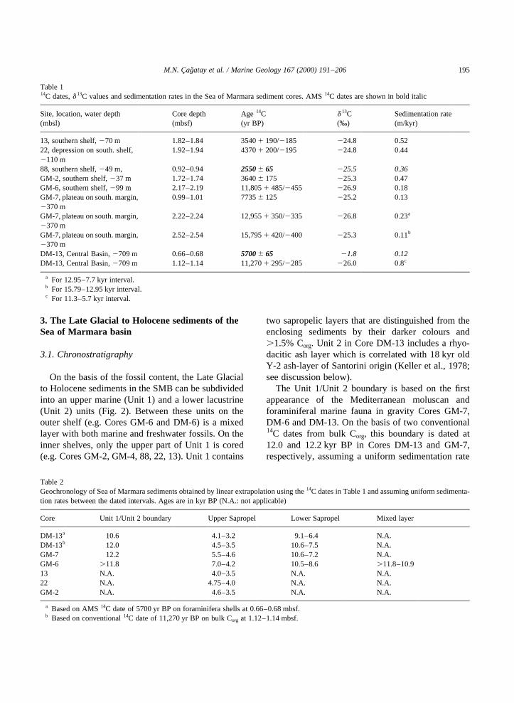
M.N. Cagatay et al. / Marine Geology 167 (2000) 191–206 195
Table 114C dates,d 13C values and sedimentation rates in the Sea of Marmara sediment cores. AMS14C dates are shown in bold italic
Site, location, water depth(mbsl)
Core depth(mbsf)
Age 14C(yr BP)
d 13C(‰)
Sedimentation rate(m/kyr)
13, southern shelf,270 m 1.82–1.84 35401 190/2185 224.8 0.5222, depression on south. shelf,2110 m
1.92–1.94 43701 200/2195 224.8 0.44
88, southern shelf,249 m, 0.92–0.94 2550^ 65 225.5 0.36GM-2, southern shelf,237 m 1.72–1.74 3640 175 225.3 0.47GM-6, southern shelf,299 m 2.17–2.19 11,8051 485/2455 226.9 0.18GM-7, plateau on south. margin,2370 m
0.99–1.01 7735 125 225.2 0.13
GM-7, plateau on south. margin,2370 m
2.22–2.24 12,9551 350/2335 226.8 0.23a
GM-7, plateau on south. margin,2370 m
2.52–2.54 15,7951 420/2400 225.3 0.11b
DM-13, Central Basin,2709 m 0.66–0.68 5700^ 65 21.8 0.12DM-13, Central Basin,2709 m 1.12–1.14 11,2701 295/2285 226.0 0.8c
a For 12.95–7.7 kyr interval.b For 15.79–12.95 kyr interval.c For 11.3–5.7 kyr interval.
Table 2Geochronology of Sea of Marmara sediments obtained by linear extrapolation using the14C dates in Table 1 and assuming uniform sedimenta-tion rates between the dated intervals. Ages are in kyr BP (N.A.: not applicable)
Core Unit 1/Unit 2 boundary Upper Sapropel Lower Sapropel Mixed layer
DM-13a 10.6 4.1–3.2 9.1–6.4 N.A.DM-13b 12.0 4.5–3.5 10.6–7.5 N.A.GM-7 12.2 5.5–4.6 10.6–7.2 N.A.GM-6 .11.8 7.0–4.2 10.5–8.6 .11.8–10.913 N.A. 4.0–3.5 N.A. N.A.22 N.A. 4.75–4.0 N.A. N.A.GM-2 N.A. 4.6–3.5 N.A. N.A.
a Based on AMS14C date of 5700 yr BP on foraminifera shells at 0.66–0.68 mbsf.b Based on conventional14C date of 11,270 yr BP on bulk Corg at 1.12–1.14 mbsf.

between dated intervals and a pene-contemporarycore top (Tables 1 and 2). However, the extrapolatedage of this boundary based on the AMS14C date fromforaminifera shells in Core DM-13 is 10.9 yr BP. Thisdiscrepancy may be either due to a non-uniform sedi-mentation rate in the dated interval between 0.66 and1.14 m or dating of two different materials (i.e. bulkCorg and shell materials). A difference in14C ages ofcoexisting shell and Corg in a sample may arise fromthe “reservoir effect” rather than the method ofmeasurement (i.e. AMS vs. conventional). In thecase of SMB samples, the older date obtained forUnit 1/Unit 2 boundary by extrapolation from thebulk Corg implies that it includes more “old” carbonthan the shell material. In marginal marine sediments,however, shells are commonly older than Corg. This isbecause the carbon in shells comes from dissolvedbicarbonate in water, which is more likely to contain“old” carbon, especially in areas of upwelling, thanthe sedimentary Corg having a significant terrestrialcomponent with a sole source of atmospheric carbon.In the SMB, the “reservoir effect” is not believed to bea significant problem because of two reasons. Firstly,the residence time of deep waters, especially duringperiods when the SMB is connected with the Blackand Mediterranean seas, would be short (the presentresidence time of the deep waters is only a few years;Unluata et al., 1990). Secondly, the organic matter insediments, including that in the sapropelic layers,contains a significant fraction of terrestrial organicmatter (Tolun et al., 1999). However, during someperiods of its lake phase (i.e. in Unit 2), when it wasnot receiving the Black Sea waters, some “old” carbonin SMB may have been present. It is therefore unlikelythat there would be any significant difference in theages of co-existing shells and bulk Corg in the SMBsediments. Considering that the AMS dated interval isrelatively far from the Unit 1/Unit 2 boundary, weaccept the ca 12 kyr BP age for the boundary,obtained from Cores DM-13 and GM-7. This age isin agreement with the global sea level curve (Fair-banks, 1989) which shows that by this time the sealevel had risen to about280 to285 m, just above thelevel of the bedrock–sill depth of the DardanellesStrait (285 m; Ryan et al., 1997b) to allow the flowof marine waters into the SMB.
Using linear extrapolation from a14C date in CoreGM-6 and considering that its base is delimited by the
Unit 1/Unit 2 boundary, the mixed layer on the outershelf was deposited between ca 12 and and 10.9 yr BP(Table 2). Similarly, on the basis of the AMS14C datein Core DM-13 close to the top of the lower sapropeliclayer, the top and bottom of this layer are dated at 6.4and 9.1 kyr BP, respectively. According to bulk Corg
dates in Cores GM-6, GM-7 and DM-13, however,this layer was deposited between 10.5 and 8.6, 10.6and 7.2 and 10.6 and 7.5 kyr BP, respectively. On aregional basis, the age of the lower sapropelic layercan, therefore, be bracketed between 10.6 and 6.4 kyrBP.
By linear extrapolation using the14C dates in CoresDM-13, 13, 22 and GM-2, the age of the upper sapro-pelic layer is delimited between 4750 and 3200 kyrBP (Table 2; Cagatay et al., 1999). This age isyounger than the the ages obtained for this layerfrom Cores GM-6 and GM-7 (Tables 1 and 2). Thediscrepancy shown by these two cores could beaccounted for by a decrease in sedimentation rateafter the deposition of the lower sapropelic layer.Such variation in sedimentation rate is especiallyevident in Core GM-7, where it is 23 cm/kyr between12.96 and 7.7 kyr BP, but drops to an average of11 cm/kyr for the last 7.7 kyr (Table 1).
3.2. Sedimentation rates in the Sea of Marmara
During the deposition of Unit 1 in the SMB, sedi-mentation rates on the southern shelf have varied from0.52 m/kyr on the inner shelf (Core 13) to 0.18 m/kyron the outer shelf (Core GM-6) (Table 1). On asubmarine plateau, north of the Armutlu Peninsula(Core GM-7), the rate has been 0.13 m/kyr since7700 yr BP, but almost double that rate between12,900 and 7700 yr BP. Assuming that the marineinundation on the northern shelf occurred at aboutthe same time as on the southern shelf, the sedimenta-tion rate for Unit 1 in Core DM-6 on the northern shelfis calculated to be about 0.1 m/kyr. This rate is muchless than that on the southern shelf (i.e. Core GM-6),where a higher sedimentation rate is expected becauseof a much larger fluvial sediment input from the south.
The sedimentation rate for Unit 1 in the basinal area(i.e. Core DM-13) is about 0.1 m/kyr. If the ash layerin this core is indeed the 18 kyr old Y-2 ash, the sedi-mentation rate for Unit 2 is 0.25 m/kyr, 2.5 timeshigher than that for Unit 1. Previous studies by
M.N. Cagatay et al. / Marine Geology 167 (2000) 191–206196

Stanley and Blanpied (1980); Evans et al. (1989) inthe Eastern Basin of the Sea of Marmara revealedvariable sedimentation rates in the basinal areas,ranging from 0.08 to 1 m/kyr. The variability ismainly due to turbidity currents in the deep basins.
3.3. Shelf sediments
Unit 1 is more than 1 m-thick, olive grey, clayey,and silty mud, grading down to shelly silt to sand atthe base. It is rich in Mediterranean marine molluscs,echinoderms, fish bones, and foraminifera. Themolluscs are represented byCorbula gibba, Mytilusgalloprovincialis, Timoclia ovata, Paphia discrepans,Donax trunculus, Cardium exiquum, Bittium reticu-
latum, Turritella sp., Vermetus sp., Patella sp.,Cyrcomphalussp.,Chlamys varia, Hydrobiasp., andDentaliumsp. The foraminifera include both plankticand benthic forms, such as Globigerinidae andBuli-mina aculeata, B. marginata, Brizalina spathulata, B.dilatata, Cassidulina carinata, C. crassa, Hyalineabaltica, Discorbinella berthelotiana, Gyroidinalamarcina, Nonion turgida, andChilostomella medi-terranensis. H. Baltica is common in the upper andmiddle parts, whereasN. turgida is present the lowerpart of the unit. Unit 1 contains 0.6–2.9% organiccarbon (Corg) and 7–20% total carbonate (asCaCO3). The carbonate is higher in the upper 1 m(deposited since ca 3500 yr BP) than in the lowerpart of the unit, and is mostly of biogenic origin (Fig. 3).
M.N. Cagatay et al. / Marine Geology 167 (2000) 191–206 197
Fig. 3. Downcore distribution of pelagic and benthic foraminiferal abundances, and Corg and carbonate percentages in Core GM-6.

The sapropelic layers in Unit 1 in the SMB differfrom the Mediterrenean sapropels in having a lightercolour and lower Corg content, because of the highersedimentation rate and detrital input in the SMB. Theupper sapropelic layer is 0.15–0.45 m-thick phos-phorescent green to grey mud, having up to 2.9%Corg in cores located on the shelf (C¸ agatay et al.,1999). On the shelf area this layer is better developedthan in the basinal area (Fig. 2). In Core GM-6, it isthicker and contains higherCorg than the lower sapro-pelic layer which is dark green grey mud with 0.35–0.45 m thickness. This indicates high organic andterrigeneous detritus inputs during the deposition ofthe upper sapropelic layer.
Both sapropelic layers generally have low to
intermediate benthic and planktic foraminiferalabundances (Fig. 3). In the lower sapropelic layerthe foraminiferal abundances increase upwards. Inthe upper sapropelic layer, foraminiferal abundancesdecrease upwards, probably because of highterrigeneous dilution. The benthic foraminifera inboth sapropelic layers are represented predominantlyby Bulimina aculeata, Brizalina spathulata,Brizalina dilatata and Cassidulina carinata, withlesser abundance ofCassidulina crassa, Chilosto-mella mediterranensisand Hyalinea baltica. Thisforaminiferal assemblage characterizes suboxicbottom water conditions.
Unit 2 in the outer shelves (Cores GM-6 and DM-6)is an olive black, well-sorted, rounded, and coarse to
M.N. Cagatay et al. / Marine Geology 167 (2000) 191–206198
Fig. 4. Downcore distribution of pelagic and benthic foraminiferal abundances, and Corg and carbonate percentages in Core GM-13.

medium sand, grading down into dark grey andlocally laminated silt. It contains a freshwater mollus-can fauna with “Caspian” affinities, characteristic ofthe Neoeuxinian Black Sea sediments (Nevesskaya,1965; Federov, 1971; Ross and Degens, 1974). Thefreshwater molluscs includeDreissena rostriformis,Pisidiumsp.,Theodoxussp.,Lithoglyphussp.,Caspiasp.,Micromelainasp.,Planorbarius, andValvatasp.
The mixed layer present on the outer shelf is a0.20–0.30 m-thick, dark green to grey, and locallypebbly sand to silt with a mixture of both marineand freshwater molluscs, ostracods, and some brack-ish benthic foraminifera, belonging to Elphidiidae andRotaliidae families (e.g.Elphidium crispum, E. pauci-loculum, Ammonia parkinsonia, andA. tepida) (Fig.2). Its carbonate content is dominated mainly by
calcareous skeletal parts and ranges between 11 and21.5%, higher than that of Units 1 and 2.
3.4. Basinal sediments
Basinal sediments show a stratigraphy similar tothat of the shelf, although the mixed layer and anyevidence of brackish water conditions appear to beabsent here (Figs. 2 and 4, Core DM-13). Unit 1 is1.25 m-thick, olive grey to dark grey, and locallylaminated mud with two sapropelic layers. Ina 2.85 m-long core (GM-7) taken from the400 m-deep submarine plateau, northeast of theArmutlu Peninsula (Fig. 1), the top of this unit ismarked by a 0.10 m-thick and yellowish brown oxiczone (Figs. 2 and 5). The upper sapropelic layer in this
M.N. Cagatay et al. / Marine Geology 167 (2000) 191–206 199
Fig. 5. Downcore distribution of pelagic and benthic foraminiferal abundances, and Corg and carbonate percentages in Core DM-7.

unit ranges in thickness from 0.10 to 0.15 m andcontains a maximum of about 2.2% Corg, whereasthe lower sapropelic layer ranges in thickness from0.35 to 0.75 m and contains up to 3.4% Corg (Figs. 4and 5). Relatively expanded thickness of the lowersapropelic layer in Core GM-7 is mainly due to ahigh sediment accumulation rate. Despite the higherterrigenous dilution in Core GM-7 than in Core DM-13, the Corg contents in the sapropelic layers in bothcores are similar. This implies that the site of theformer core has received a greater Corg input thanthe site of the latter. The total carbonate content inCore GM-7 increases in the lower part of the sapro-pelic layer. It shows no systematic variation in thesapropelic layers in Core DM-13.
Unit 1 is rich in marine fossils, such as molluscs,echinoderms, and foraminifera. The molluscs occur asjuvenile forms and includeNucula nucleus, Lucinasp.,Scrobiculariasp.,Cyrcomphalussp., andVerme-tus sp. The foraminifera are represented by bothplanktic and benthic types, including globigerinidae,Bulimina aculeata, B. inflata, Brizalina spathulata, B.dilatata, Cassidulina crassa, and Hyalinea baltica.Most of the benthic foraminifera are diagnostic ofsuboxic bottom conditions and high Corg flux (Jorissenet al., 1995; Schmiedl et al., 2000, submitted). In thelower sapropelic layer in Core GM-7 both the plankticand benthic abundances show a high downcore varia-tion (Fig. 5). The lower part of the sapropelic layer hashigh planktic and low benthic foraminiferal contents,whereas the upper part has intermediate planktic andlow to high benthic foraminiferal abundance. Thesevariations show no apparent correlation with varia-tions in the Corg and total carbonate profiles. In Core13, the lower sapropel shows high planktic andbenthic foraminiferal abundances. The upper saprope-lic layer in both cores has low to intermediate benthicand planktic foraminiferal contents. The intervalbetween the two sapropelic layers in Unit 1 containshigher benthic and planktic foraminifera than thesapropelic layers. In Core GM-7, the benthic to plank-tic foraminifera ratio is markedly higher than that inCore DM-13. The benthic foraminifera in both sapro-pelic layers include mainlyBulimina aculeata, B.inflata, Brizalina spathulata, Cassidulina crassataand Hyalinea baltica, with less frequent occurrenceof Chilostomella mediterranensis, Brizalina dilatataandB. alata.
Unit 2 is a light to dark greenish grey, laminated,and black iron monosulfide (FeS)-mottled mud withFeS reduction bands. Near the base of the Core GM-7it contains local pebbles having up to 7 mm indiameter. The Corg and total carbonate contents ofthis unit ranges up to about 2 and 32%, respectively,at or near its boundary with Unit 1 (Figs. 4 and 5).This unit is barely fossiliferous; few freshwater ostra-cods and juvenile molluscs, such asDreissena rostri-formis, D. (Pontodreissena) distincta, Micromelaniasp., andCaspiasp., are found in the lower and theupper parts.
The 30 mm-thick, brown ash layer between 2.78and 2.81 mbsf in Unit 2 in Core DM-13 consistsmainly of colourless, bubble-wall glass shards withminor plagioclase, hornblende and hypersthene. Thescanning electron microscope–energy dispersive X-ray (SEM–EDX) analysis of the glass shards indicatesthat the tephra is rhyodacitic�SiO2 � 68:7% Al2O3 �12:5%; Fe2O3�total� � 4:5%; MgO� 1:3%; CaO�1:64%; Na2O� 3:0%; K2O� 2:55%�: Consideringthis composition and the 11,270 yr BP date for1.12–1.14 mbsf interval in Core DM-13 (Figs. 2 and4), the tephra is correlated with the 18,000 yr old Y-2ash layer originating from Santorini and encounteredin the eastern Mediterranean Sea (Keller et al., 1978).The top of Unit 2 is marked by a probably turbiditicsand layer with typical Neoeuxinian molluscs (D.rostriformis Desh, D. (Pontodreissena) distinctaAndrussov) (Fig. 4).
4. Bosphorus sediments
4.1. Chronostratigraphy and sedimentation rates
In Hole BPMP-14 in the central Bosphorus betweenTarabya and Beykoz (Fig. 1), the sedimentary infillabove the Palaeozoic basement can be subdivided intofive units (Fig. 6). The basal part of the basal Unit 5containing fresh water Neoeuxinian Black Seamollusks above the Palaeozoic basement is dated atca 26,100 yr BP. The base of Unit 4 at 22 mbsf marksthe first appearance of the euryhaline marine molluscsin the central Bosphorus. On the basis of14C dating oftwo shell samples found immediately above andbelow this surface we assign to this boundary an ageof 5300 yr BP, the oldest14C date obtained at the base
M.N. Cagatay et al. / Marine Geology 167 (2000) 191–206200

M.N. Cagatay et al. / Marine Geology 167 (2000) 191–206 201
Fig. 6. Lithological logs of cores in central part of Bosphorus Strait. Numbers on top refer to the water depth and those along the core length areradiocarbon datings.
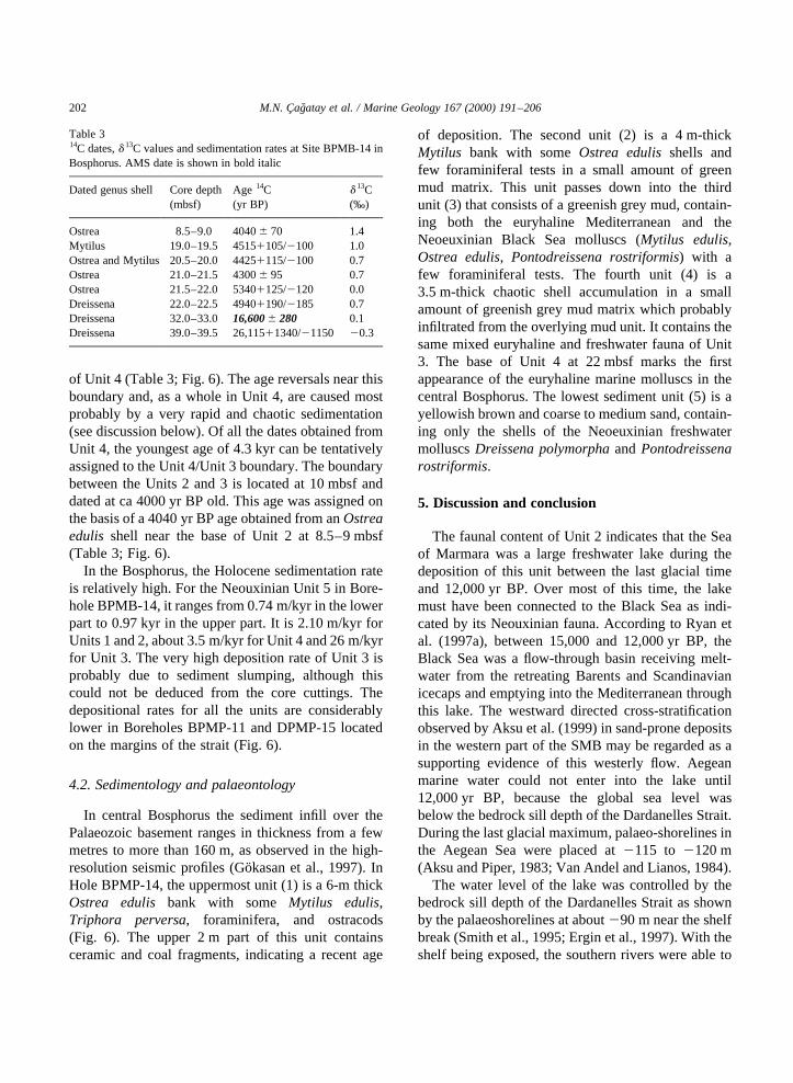
of Unit 4 (Table 3; Fig. 6). The age reversals near thisboundary and, as a whole in Unit 4, are caused mostprobably by a very rapid and chaotic sedimentation(see discussion below). Of all the dates obtained fromUnit 4, the youngest age of 4.3 kyr can be tentativelyassigned to the Unit 4/Unit 3 boundary. The boundarybetween the Units 2 and 3 is located at 10 mbsf anddated at ca 4000 yr BP old. This age was assigned onthe basis of a 4040 yr BP age obtained from anOstreaedulis shell near the base of Unit 2 at 8.5–9 mbsf(Table 3; Fig. 6).
In the Bosphorus, the Holocene sedimentation rateis relatively high. For the Neouxinian Unit 5 in Bore-hole BPMB-14, it ranges from 0.74 m/kyr in the lowerpart to 0.97 kyr in the upper part. It is 2.10 m/kyr forUnits 1 and 2, about 3.5 m/kyr for Unit 4 and 26 m/kyrfor Unit 3. The very high deposition rate of Unit 3 isprobably due to sediment slumping, although thiscould not be deduced from the core cuttings. Thedepositional rates for all the units are considerablylower in Boreholes BPMP-11 and DPMP-15 locatedon the margins of the strait (Fig. 6).
4.2. Sedimentology and palaeontology
In central Bosphorus the sediment infill over thePalaeozoic basement ranges in thickness from a fewmetres to more than 160 m, as observed in the high-resolution seismic profiles (Go¨kasan et al., 1997). InHole BPMP-14, the uppermost unit (1) is a 6-m thickOstrea edulis bank with some Mytilus edulis,Triphora perversa, foraminifera, and ostracods(Fig. 6). The upper 2 m part of this unit containsceramic and coal fragments, indicating a recent age
of deposition. The second unit (2) is a 4 m-thickMytilus bank with someOstrea edulisshells andfew foraminiferal tests in a small amount of greenmud matrix. This unit passes down into the thirdunit (3) that consists of a greenish grey mud, contain-ing both the euryhaline Mediterranean and theNeoeuxinian Black Sea molluscs (Mytilus edulis,Ostrea edulis, Pontodreissena rostriformis) with afew foraminiferal tests. The fourth unit (4) is a3.5 m-thick chaotic shell accumulation in a smallamount of greenish grey mud matrix which probablyinfiltrated from the overlying mud unit. It contains thesame mixed euryhaline and freshwater fauna of Unit3. The base of Unit 4 at 22 mbsf marks the firstappearance of the euryhaline marine molluscs in thecentral Bosphorus. The lowest sediment unit (5) is ayellowish brown and coarse to medium sand, contain-ing only the shells of the Neoeuxinian freshwatermolluscsDreissena polymorphaand Pontodreissenarostriformis.
5. Discussion and conclusion
The faunal content of Unit 2 indicates that the Seaof Marmara was a large freshwater lake during thedeposition of this unit between the last glacial timeand 12,000 yr BP. Over most of this time, the lakemust have been connected to the Black Sea as indi-cated by its Neouxinian fauna. According to Ryan etal. (1997a), between 15,000 and 12,000 yr BP, theBlack Sea was a flow-through basin receiving melt-water from the retreating Barents and Scandinavianicecaps and emptying into the Mediterranean throughthis lake. The westward directed cross-stratificationobserved by Aksu et al. (1999) in sand-prone depositsin the western part of the SMB may be regarded as asupporting evidence of this westerly flow. Aegeanmarine water could not enter into the lake until12,000 yr BP, because the global sea level wasbelow the bedrock sill depth of the Dardanelles Strait.During the last glacial maximum, palaeo-shorelines inthe Aegean Sea were placed at2115 to 2120 m(Aksu and Piper, 1983; Van Andel and Lianos, 1984).
The water level of the lake was controlled by thebedrock sill depth of the Dardanelles Strait as shownby the palaeoshorelines at about290 m near the shelfbreak (Smith et al., 1995; Ergin et al., 1997). With theshelf being exposed, the southern rivers were able to
M.N. Cagatay et al. / Marine Geology 167 (2000) 191–206202
Table 314C dates,d 13C values and sedimentation rates at Site BPMB-14 inBosphorus. AMS date is shown in bold italic
Dated genus shell Core depth Age14C d 13C(mbsf) (yr BP) (‰)
Ostrea 8.5–9.0 4040 70 1.4Mytilus 19.0–19.5 45151105/2100 1.0Ostrea and Mytilus 20.5–20.0 44251115/2100 0.7Ostrea 21.0–21.5 4300 95 0.7Ostrea 21.5–22.0 53401125/2120 0.0Dreissena 22.0–22.5 49401190/2185 0.7Dreissena 32.0–33.0 16,600 280 0.1Dreissena 39.0–39.5 26,11511340/21150 20.3
transport most of their sediment load to the deepbasinal areas, causing a high sedimentation rateduring deposition of Unit 2. Local lamination, darkcolour, and the FeS reduction bands of this unit indi-cate that the depositional conditions in the lake wereintermittently anoxic.
The mixed layer on the outer shelf is a reworkedsediment deposited during the inundation of theMarmara lake by the Mediterranean waters betweenca 12,000 and 10,900 yr BP. During this period, theMediterranean sea level had already risen abovethe Dardanelles bedrock sill depth (Chapell andShackleton, 1986; Fairbanks, 1989), whereas theBlack Sea lake level was drawn below the Bosphorussill because of the Younger Dryas event (Ryan et al.,1997a,b). As marine water from the Aegean Sea wasmixed with freshwater of the Marmara Lake, brackishmarine conditions were established and the mixedlayer sediments with their brackish water benthicforaminiferal assemblage were deposited.
As indicated by its foraminiferal and molluscanfauna, Unit 1 was deposited in a fully marine environ-ment. The foraminiferal abundances show large fluctua-tions that are not very systematic between the differentSMB cores (Figs. 3–5). These fluctuations may reflectvariations in salinity and bottom water oxygen condi-tions, although they may also be controlled in part by avariable terrigenous input. The last factor is probablyimportant in Cores GM-7 and DM-6 taken from shallowwater areas. However, little or no correlation betweenforaminiferal abundance and Corg profiles suggests thateven in these cores dilution by terrigeneous material isnot significant in determining the general trends offoraminiferal abundance. The non-systematic varia-tion in foraminiferal abundances in the correspondingsapropelic intervals between different cores appears tobe related to the sampling resolution used in the fora-miniferal analysis (one sample/10 cm) with respect tothe sedimentation rate determining the thickness ofthe layers. The resolution is sufficient to detect thesubtle variations if the sapropelic layers are expandedby a high sedimentation rate, as in the case of thelower sapropelic layer in Core GM-7 and the uppersapropelic layer in Core GM-6 (Figs. 3 and 5). On theother hand, the resolution is insufficient and givesseemingly smooth profiles if the layers are thin andcompressed as a result of a low sedimentation rate, asin Core DM-13 (Fig. 4).
We therefore consider that the sharp changes in theplanktic foraminiferal profiles detected in the rela-tively thick sections of sapropelic layers in CoresGM-6 and GM-7 as well as in the non-sapropelicintervals of Unit 1 are most probably related to sali-nity changes. The predominance in the sapropeliclayers of the benthic foraminiferal species, such asBulimina aculeata, Brizalina spathulata, Brizalinadilatata and Cassidulina carinata and Hyalineabaltica, indicates low oxygen conditions and highorganic flux. The low surface water salinities andlow bottom water oxygen levels resulted from ahigh freshwater input, most probably from the BlackSea. Vigorous westward flow from this major sourcebetween 9500 and 7000 yr BP was cited as an impor-tant factor in the formation of S1 sapropel in the east-ern Mediterranean (Ryan, 1972; Stanley, 1978; Aksuet al., 1995, 1999; Lane-Serff et al., 1997) and in theestablishment of the brackish marine conditions onthe Aegean shelf near the mouth of the DardanellesStrait (Yucesoy-Eryilmaz and C¸ agatay, 1998). Thisinterpretation conflicts with the suggestion of Ryanet al. (1997b) that the Black Sea water level at thattime was no higher than2120 m below the presentsea level. However, the nearly synchronous sapropeldeposition in the SMB (lower sapropelic layer) andthe Aegean Sea (S1 sapropel) may suggest a strongfreshwater outflow during that interval (see discussionbelow). This outflow, rather than the relatively minorriver water influx from the south, is more likely tohave provided organic material and caused water stra-tification to allow the deposition of the the sapropeliclayers in the SMB. Elemental C/N, Rock–Eval pyro-lysis and stable carbon isotope analyses indicate thatthe organic matter in the sapropelic layers is mainly ofterrestrial origin, with the marine fraction increasingtowards the top of Unit I (Tolun et al., 1999). Theorganic matter is perhaps ultimately derived fromthe circum-Black Sea regions.
The deposition of the lower sapropelic layer startedat ca 10,600 yr BP and ended at 6400 yr BP, after theestablishment of marine conditions in the SMB.Published ages of the onset and termination of deposi-tion of the S1 sapropel range from 13,000 to 8300 yrBP and 8000 to 6300 yr BP, respectively. Thesewidely varying estimates may have resulted mainlyfrom different materials used for dating. RecentAMS 14C dates mainly from foraminiferal shells
M.N. Cagatay et al. / Marine Geology 167 (2000) 191–206 203
indicate the onset between 9600 and 8300 yr BP andtermination at 6400 and 6300 yr BP (Perissoratis andPiper, 1992; Jorissen et al., 1993; Rohling, 1994;Aksu et al., 1995, 1999). Dates on bulk Corg rangedbetween 13,000 and 9000 yr BP (Anastasakis andStanley, 1986; Cramp et al., 1988), probably due to“old” carbon effect.
The present14C dates from the SMB sedimentssuggest, therefore, that the onset of the lower sapro-pelic sediment deposition in this basin is about a thou-sand14C years earlier than that of the S1 sapropel inthe eastern Mediterranean., whereas the terminationof both layers is essentially coeval. The difference inthe onset ages is most probably real, rather than due tothe “old” carbon effect, as discussed under “chronos-tratigraphy” of the SMB sediments.
The 5300 yr BP date for the oldest known euryha-line Mediterranean molluscs found immediatelyabove the Neoeuxinian unit (Unit 5) in the centralBosphorus is the earliest record of Mediterraneanwater in the Bosphorus. This finding apparentlycontradicts the observations of Ryan et al. (1997a,b)on the northern Black Sea shelf, where their numerous14C datings convincingly demonstrate the presence ofthe Mediterranean water at 7150 yr BP. Perhaps, thisinundation took place not through the Bosphorus asclaimed by Ryan et al. (1997a,b), but through a differ-ent waterway, such as the north of the Bu¨yukCekmece Lagoon or the Gulf of Izmit-SapancaLake-Sakarya Valley to the east (Pfannenstiel, 1944;Ardel and Inandik, 1957, Fig. 1). Alternatively, if theMediterranean water did pour through the Bosphorusprior to 5300 yr BP, it left no sedimentary record; adisconformity between Units 5 and 4 in the Bosphoruscan not be ruled out on basis of the chaotic sedi-mentological features and age reversals observed inUnit 4. This unit containining both freshwater andmarine molluscs was clearly deposited under highenergy conditions with a possible erosional lowerboundary.
Although the marine flooding of the Black Sea at7150 yr BP is indisputable in view of Ryan et al.’s(1997a,b) compelling14C data, their suggestion that itwas an abrupt drowning event is not supported by ourdata from the SMB. If dammed marine waters in theSMB broke abruptly through the Bosphorus or anyother possible passage at 7150 yr BP to catastrophi-cally flood the Black Sea, then one would expect an
intense flushing through the Dardanelles and theSMB. This in turn would have ended the suboxicconditions and the deposition of the lower sapro-pelic layer, which in fact continued until 6400 yrBP. Recent data from the southern coast of theBlack Sea also suggest that the “lake” level inthe Black Sea during the marine invasion at 7150 yrBP was only about218 m, well above the235 m silldepth of the Bosphorus (Go¨rur et al., 2000,submitted).
The only fully marine sedimentary recordpreserved in the central Bosphorus is theMytilusandOstreabanks (Units 2 and 1). These high-energydeposits started accumulating at ca 4000 yr BP, whenthe present dual flow regime was probably estab-lished. The upper sapropelic layer in the SMB formedbetween 4750 and 3200 yr BP during the establish-ment of this dual flow regime, when water stratifica-tion and bottom water stagnation would have beenmore strongly developed than at present.
Acknowledgements
This paper is part of the National Geology andGeophysics Programme (Coordinarator NaciGorur) supported by the Turkish Scientific andTechnical Research Council (TU¨ BITAK). ANATO Collaborative Research Grant (CRG 961073)for this study is gratefully acknowledged. Two of theMarmara cores (DM-6 and DM-13) were obtainedunder the auspices of the Turkish–German “DeepMarmara Research Project”. The Bosphorus corecuttings were kindly provided by General Directorateof Turkish State Waterworks (DSI). Dr Nuray Balkisand Erol Sari performed sample preparation, and Corg
and carbonate analyses. The scientists, technicians,captains and crews on board the R/VSismik-1of theGeneral Directorate of the Mineral Research andExploration (MTA) and R/V Arar of Institute ofMarine Sciences and Management, Istanbul Univer-sity are acknowledged for their expert assistanceduring the sediment sampling. The AMS datesperformed free of charge by the the University ofArizona is gratefully acknowledged. We are gratefulto Drs Eelco J. Rohling and Douglas F. Williams fortheir constructive criticisms that improved the manu-script considerably.
M.N. Cagatay et al. / Marine Geology 167 (2000) 191–206204

References
Aksu, A.E., Piper, D.J.W., 1983. Progradation of the late Quatern-ary Gediz delta, Turkey. Mar. Geol. 54, 1–25.
Aksu, A.E., Yasar, D., Mudie, P.J., 1995. Paleoclimatic and paleo-ceanographic conditions leading to development of sapropellayer S1 in the Aegean Sea: micropalaeontological and stableisotope evidence. Palaegeogr., Palaeoclimatol., Palaeoecol. 116,71–101.
Aksu, A.E., Hiscott, R.N., Yasar, D., 1999. Oscillating Quaternarywater levels of the Marmara Sea and vigorous outflow into theAegean Sea from the Marmara Sea–Black Sea drainage corri-dor. Mar. Geol. 153, 275–302.
Anastasakis, G.C., Stanley, D.J., 1986. Uppermost sapropel, EasternMediterranean: Paleoceanography and stagnation. Natl Geogr.Res. 2, 179–197.
Andrussov, N., 1900. Bosphorus and Dardanelles. AnnuariesGeologique et Mineralogique de la Russe 4, 3–10.
Ardel, A., Inandik, H., 1957. Marmara Denizi’nin tesekku¨l andtekamulu. Turk Cografya Dergisi 17, 1–14.
Cagatay, M.N., Algan, O., Sakinc¸, M., Eastoe, C., Egesel, L.,Balkis, N., Ongan, D., Caner, H., 1999. A Mid–Late Holocenesapropelic sediment unit from the southern Marmara shelf andits palaeoceanographic significance. Quat. Sci. Rev. 18, 531–540.
Chapell, J., Shackleton, N.J., 1986. Oxygen isotopes and sea level.Nature 324, 137–140.
Cramp, A., Collins, M.B., West, R., 1988. Late Pleistocene–Holo-cene sedimentation in the NW Aegean Sea: a palaeoclimatic andpaleoceanographic reconstruction. Paleogeogr., Paleoclimatol.,Paleoecol. 68, 61–77.
EIE (Elektrik Isleri Erud Idaresi Genel Mu¨durlugu), 1993. Turkiyeakarsularinda sediment go¨zlemlerive sediment tasinim miktar-lari. Publication No. 93-59, 615pp.
Ergin, M., Kazanci, N., Varol, B., Ileri, O¨ ., Karadenizli, L., 1997.Sea-level changes and related depositional environments on thesouthern Marmara shelf. Mar. Geol. 140, 391–403.
Evans, G., Erten, H., Alavi, S.N., Von Gunten, H.R., Ergin, M.,1989. Superficial deep-water sediments of the eastern Marmarabasin. Geo-Mar. Lett. 9, 27–36.
Fairbanks, R.G., 1989. A 17,000-year Glacio-Eustatic sea levelrecord: influence of glacial melting rates on the YoungerDryas event and deep-ocean circulation. Nature 342, 637–642.
Federov, P.V., 1971. Post-glacial transgression of the Black Sea.Int. Geol. Rev. 14, 160–164.
Gaudette, H., Flight, W., Tones, L., ve Folger, D., 1974. An inex-pensive titration method for the determination of organic carbonin recent sediments. J. Sediment. Petrol. 44, 249–253.
Gokasan, E., Demirbag, E., Oktay, F.Y., Ecevitoglu, B., Simsek,M., Yuce, H., 1997. On the origin of the Bosphorus. Mar. Geol.140, 183–199.
Gorur, N., Cagatay, M.N., Sakinc¸, M., Sumengen, M., Sentu¨rk, K.,Yaltirak, C., Tchpalyga, A., 1997. Origin of the Sea of Marmarafrom Neogene to Quaternary paleogeographic evolution of itsframe. Int. Geol. Rev. 39, 342–352.
Gorur, N., Cagatay, M.N, Emre, O¨ ., Alpar, B., Sakinc¸, M., Islamo-glu, Y., Algan, A., Kecer, M., Erkal, T. Akkok, R., 2000. Is the
abrupt drowning of the Black Sea shelf at 7150 yr BP a myth?Submitted for publication.
Jorissen, F.J., Assioli, A., Borsetti, A.M., Capotondi, L., De Visser,J.P., Hilgen, F.J., Rohling, E.J., Van der Borg, K., Vergnaud-Grazzini, C., Zachariasse, W.J., 1993. Late Quaternary centralMediterranean biochronology. Mar. Micropaleontol. 21, 169–189.
Jorissen, F.J., De Stigter, H.C., Widmark, J.G.V., 1995. A concep-tual model explaining benthic foraminiferal microhabitats. Mar.Micropaleontol. 26, 3–15.
Keller, J., Ryan, W.B.F., Ninkovich, D., Altherr, R., 1978. Explo-sive volcanic activity in the Mediterranean over the past200,000 yr as recorded in the deep sea sediment. Geol. Soc.Am. Bull. 89, 591–604.
Lane-Serff, G.F., Rohling, E.L., Bryden, H.L., Charnock, H., 1997.Postglacial connection of the Black Sea to the Mediterraneanand its relation to the timing of sapropel formation. Paleoceano-graphy 12, 169–174.
Loring, D.H., Rantala, R.T.T., 1992. Manual for the geochemicalanalyses of marine sediments and suspended particulate matter.Earth-Sci. Rev. 32, 235–283.
Nevesskaya, L.A., 1965. Late Quaternary bivalve mollusks of theBlack Sea: their systematics and ecology. Akad. Nauk S.S.S.R.Palaeontol. Inst. Tr. 105, 1–390.
Perissoratis, C., Piper, D.J.W., 1992. Age, regional variation, andshallowest occurrence of S1 sapropel in the northern AegeanSea. Geo-Mar. Lett. 12, 49–53.
Pfannenstiel, M., 1944. Die diluvialen entvicklungsstadien und dieUrgeschiccthe von Dardanellen. Marmarameer und Bosphorus.Diluvial, Geologie und Klima, Geologische Rundschau 3–4 (7–8), 324–434.
Rohling, E.J., 1994. Review and new aspects concerning the forma-tion of eastern Mediterranean sapropels. Mar. Geol. 122, 128.
Ross, D.A., Degens, E.T., 1974. Recent sediments of the Black Sea.In: Degens, E.T., Ross, D.A. (Eds.). The Black Sea—Geology,Chemistry and Biology, Am. Assoc. Petrol. Geol. Mem, vol. 20,pp. 183–199.
Ryan, W.B.F., 1972. The stratigraphy of late Quaternary sedimentsin the eastern Mediterranean. In: Stanley, D.J. (Ed.). The Medi-terranean Sea: a Natural Laboratory, Dowden, Hutchinson andRoss, Stroudsbourg, PA, pp. 149–169.
Ryan, W.B.F., Pitman III, W.C., Major, C.O., Shimkus, K., Moska-lenko, V., Jones, J.A., Dimitrov, P., Go¨rur, N., Sakinc, M.,Yuce, H., 1997a. An abrupt drowning of Black Sea shelf at7.5 kyr BP, Geo-Eco-Marina, 2, Proc. Int. Workshop onFluvial–Marine Interactions, Mainas, Romania, 1–7 October,1997, pp. 115–125.
Ryan, W.B.F., Pitman III, W.C., Major, C.O., Shimkus, K., Moska-lenko, V., Jones, J.A., Dimitrov, P., Go¨rur, N., Sakinc, M.,Yuce, H., 1997b. An abrupt drowning of Black Sea shelf.Mar. Geol. 138, 119–126.
Schmiedl, G., de Bove´e, F., Buscail, R., Charrie`re, B., Hemleben,C., Medernach, L., Picon, P., 2000. Trophic control of benthicforaminiferal abundance and microhabitat in the bathyal Gulf ofLions, western Mediterranean Sea. Submitted for publication.
Smith, A.D., Taymaz, T., Oktay, F., Yu¨ce, H., Alpar, B., Basaran,H., Jackson, J.A., Kara, S., Simsek, M., 1995. High resolution
M.N. Cagatay et al. / Marine Geology 167 (2000) 191–206 205

seismic reflection profiling in the Sea of Marmara (northwestTurkey): Late Quaternary sedimentation and sea-level changes.Bull. Geol. Soc. Am. 107, 923–936.
Stanley, D.J., 1978. Ionian Sea sapropel distribution and lateQuaternary paleoceanography in the eastern Mediterranean.Nature 274, 149–152.
Stanley, D.J., Blanpied, C., 1980. Late Quaternary water exchangebetween the eastern Mediterranean and the Black sea. Nature265, 537–541.
Tolun, T., Cagatay, M.N., Carrigan, W.J., Eastoe, C.J., Balkis, N.,Algan, O., 1999. Organic geochemistry and origin of Holocenesapropelic sediments from Sea of Marmara and Black Sea, 19thInternational Meeting on Organic Geochemistry, 6–10 Septem-ber 1999, Istanbul, Abstracts, Part 1, pp. 41–42.
Unluata, U., Ozsoy, E., 1986. Oceanography of Turkish Straits,
Health of Turkish Straits. In: Oxygen defficiency of Sea ofMarmara, METU—Institute of Marine Sciences Report,Erdemli-Icel, Turkey, 78 pp.
Unluata, U., Oguz, T., Latif, M.A., Ozsoy, E., 1990. On the physicaloceanography of the Turkish Straits. In: Pratt, L.J. (Ed.). ThePhysical Oceanography of Sea Straits, NATO/ASI SeriesK-luwer, Dordrecht, pp. 25–60.
Van Andel, T.H., Lianos, N., 1984. High resolution seismic reflec-tion profiles for the reconstruction of postglacial transgressiveshorelines: an example from Greece. Quat. Res. 22, 31–45.
Yucesoy-Eryilmaz, F., C¸ agatay, M.N., 1998. Stratigraphy and sedi-mentary environments of the Quaternary sediments on the NEAegean shelf. In: Workshop on Progress in Marine GeologicalStudies in Turkey, 14–15 May, 1998, Istanbul. ExtendedAbstracts Volume, pp. 48–53.
M.N. Cagatay et al. / Marine Geology 167 (2000) 191–206206