landscape archaeology and its approach to cultural heritage ...
117
LANDSCAPE ARCHAEOLOGY AND ITS APPROACH TO CULTURAL HERITAGE MANAGEMENT: THE TROAD AS A CASE STUDY GÜLSÜN KORU JANUARY 2010
-
Upload
khangminh22 -
Category
Documents
-
view
1 -
download
0
Transcript of landscape archaeology and its approach to cultural heritage ...

LANDSCAPE ARCHAEOLOGY AND ITS APPROACH TO CULTURAL
HERITAGE MANAGEMENT: THE TROAD AS A CASE STUDY
GÜLSÜN KORU
JANUARY 2010

LANDSCAPE ARCHAEOLOGY AND ITS APPROACH TO CULTURAL
HERITAGE MANAGEMENT: THE TROAD AS A CASE STUDY
A THESIS SUBMITTED TO THE GRADUATE SCHOOL OF SOCIAL
SCIENCES OF MIDDLE EAST TECHNICAL UNIVERSITY
BY
GÜLSÜN KORU
IN PARTIAL FULFILLMENT OF THE REQUIREMENTS
FOR
THE DEGREE OF MASTER OF SCIENCE
IN THE PROGRAM OF
SETTLEMENT ARCHAEOLOGY
JANUARY 2010

Approval of the Graduate School of Social Sciences
___________________
Prof. Dr. Sencer Ayata
Director
I certify that this thesis satisfies all the requirements as a thesis for the
degree of Master of Science.
__________________
Prof. Dr. Numan Tuna
Head of Department
This is to certify that we have read this thesis and that in our opinion it is
fully adequate, in scope and quality, as a thesis for the degree of Master of
Science.
__________________
Prof. Dr. Numan Tuna
Supervisor
Examining Committee Members
Prof. Dr. Numan TUNA (METU, SA) ________________
Prof. Dr. Vedat TOPRAK (METU, GEOE) _______________
Assist. Prof. Dr. Evangelia PİŞKİN (METU, SA) ________________

iii
I hereby declare that all information in this document has been obtained and presented in accordance with academic rules and ethical conduct. I also declare that, as required by these rules and conduct, I have fully cited and referenced all material and results that are not original to this work.
Name, Last name : Gülsün, KORU
Signature :

iv
ABSTRACT
LANDSCAPE ARCHAEOLOGY AND ITS APPROACH TO CULTURAL
HERITAGE MANAGEMENT: THE TROAD AS A CASE STUDY
Koru, Gülsün
M. Sc., Department of Settlement Archaeology
Supervisor: Prof. Dr. Numan Tuna
January 2010, 101 Pages
This thesis tries to define ‘landscape archaeology’ as a concept; it describes
and analyzes the key landscape archaeology types, dynamics, and
approaches. Then, it aims to define the landscape archaeological
characteristics of the Troad Region in this context.
The archaeological landscape character of the Troad Region shapes the
importance of the area, not only for the Anatolian culture, but also for the
European cultures and for archaeology discipline. Hence, the necessity of
conservation works for the area with the horizon of this concept gains
importance. Thesis defines what had been done for the area in terms of
conservation and reviews the Long Term Development Plan prepared for the
Troia Historical National Park Area. With a critical view of what has been
done and what has not been done, it tries to emphasize the importance of
grasping the landscape archaeological character of the area in conservation
and management plan works. It gives a general guideline to ensure a
sustainable future for the historic, cultural, social, economic and
environmental nature and qualities of these kinds of areas.
Keywords: Landscape archaeology, cultural landscape, cultural heritage
management, conservation master plan

v
ÖZ
PEYZAJ ARKEOLOJİSİ VE KÜLTÜREL MİRAS YÖNETİMİNDEKİ YERİ:
ÖRNEK ÇALIŞMA ALANI OLARAK TROAS BÖLGESİ
Koru, Gülsün
Yüksek Lisans, Yerleşim Arkeolojisi Bölümü
Tez Yöneticisi: Prof. Dr. Numan Tuna
Ocak 2010, 101 Sayfa
Bu tez çalışması kavram olarak ‘peyzaj arkeolojisi’ni tanımlamakta, temel
arkeolojik peyzaj tipleri, dinamikleri ve yaklaşımlarını sunmaktadır. Bu
çerçevede, Troas Bölgesini bir arkeolojik peyzaj alanı olarak incelemektedir.
Troas Bölgesinin arkeolojik peyzaj karakteri, buranın sadece Anadolu kültürü
için değil, Avrupa kültürleri ve arkeoloji disiplini için de önemini
şekillendirmektedir. Dolayısıyla, alanın bu yaklaşım ile korunması gerekliliği
önem kazanmaktadır. Tez çalışması ‘koruma’ anlamında alan için neler
yapıldığını anlatmakta ve Troia Tarihi Milli Parkı için hazırlanan Uzun Devreli
Gelişme Planı’nı incelemektedir. Burada nelerin yapılıp, nelerin yapılmadığı
eleştirisini yaparak, koruma ve yönetim plan çalışmalarında alanın arkeolojik
peyzaj karakterinin anlaşılmasının önemini vurgulamaya çalışmaktadır.
Ayrıca, tarihi, kültürel, sosyal, ekonomik ve çevresel değerlerin ve buna sahip
alanların kalitesinin sürdürülebilir bir şekilde korunması için bir genel ilkeler
klavuzu sunmaktadır.
Anahtar Kelimeler: Peyzaj arkeolojisi, kültürel peyzaj, kültürel miras yönetimi,
koruma master planı

vi
To My Family

vii
ACKNOWLEDGEMENTS
I express my deepest gratitude to my supervisor Prof. Dr. Numan Tuna for
his great support, encourage and understanding. He has been very kind,
wise and tolerant with me. He always inspired me from the very beginning of
the master programme till the end. Because of him, I could define my path
not only within my thesis but also in my whole career.
I want to express my sincere thanks to Assoc. Prof. Dr. Baykan Günay and
Instructor Erhan Acar from METU; Assist. Prof. Dr. Rüstem Aslan from
Çanakkale 18 Mart University; Necati Uyar and Hüseyin Yeldiren from
Egeplan Planlama Ltd. for their help and support in my research.
I would also like to thank my employer Cengiz Kabaoğlu and friends working
in KA.BA Ltd. for their support. They kindly endured my absence in the work
place.
Motivation and moral support of some close friends will also always be
remembered.
But most of all I would like to thank my parents, my sister and my brother,
who strongly believed that I was capable of successfully completing yet
another part of my academic career. Among them, my husband Aziz Koru
also deserves a special acknowledgement.

viii
TABLE OF CONTENTS
PLAGIARISM………………………………………………………………………iii ABSTRACT………………………………………………………………………...iv ÖZ…………………………………………………………………………………....v DEDICATION……………………………………………………………………....vi ACKNOWLEDGEMENTS…………………………………………………...…..vii TABLE OF CONTENTS……………………………………………………..….viii LIST OF TABLES…………………………………………………………..……xiii LIST OF FIGURES……………………………………………………………….xiv CHAPTER
1. INTRODUCTION…………………………………..…………………….1
2. LANDSCAPE ARCHAEOLOGY……………………………...……….3
2.1. Why It Is Necessary to Study the Landscape Archaeology.3
2.2. Definitions and Different Approaches to Landscape Archaeology…………………………………...……………….4
2.2.1. Archaeological Point of View………………...…..…8
2.3. Two Different Classification of Approaches to Landscape Archaeology………………………………..........9
2.3.1. Wilkinson’s Classification………………….……..…9
2.3.2. Preucel and Hodder’s Classification…………..…12

ix
2.3.3. An Integrated Approach to Archaeological Landscapes……………………………………………..… 13
2.4. Some Basic Issues of Landscape Archaeology…………..13
2.4.1. Landscape as Palimpsest (multi – layered feature)……………………………………….…....13
2.4.2. Signature Landscapes……..……………………...13
2.4.3. Persistent Places…………………………………..14
2.4.4. Landscape Taphonomy.......................................15
2.5. Landscape Dynamics........................................................16
2.6. History and the Development of the Concept Landscape Archaeology………............................................................17
2.7. Cultural Landscapes vs. Landscape Archaeology............20
2.7.1. What is Cultural Landscape?...............................20
2.7.2. UNESCO’s Point of View and Different Types of Landscape............................................22
2.7.3. Themes on Landscape........................................25
2.7.4. Historical Background of Linking Nature and Culture in Terms of UNESCO’s Perspective.......28
3. TROAD AND ITS ARCHAEOLOGICAL LANDSCAPE…………...32 3.1. Location and Geography…...............................................32
3.2. Significance of the Troad…...............................................34

x
3.3. Various Periods of its History….........................................35
3.4. Methodology used by Scholars for Archaeological Landscape Analysis of the Region....................................37
3.4.1. Techniques and Analysis.....................................37
3.4.2. Data Sources and Techniques............................37
3.4.3. Data Recovery by Fieldwork................................38
3.5. Troia and Troad Landscape Elements..............................41
3.5.1. Present Landscape Characteristics and Environmental Context........................................41
3.5.2. Strabo’s Definition of Geology and Geomorphology of the Troad..............................46
3.5.3. Geology, Geomorphology and the Formation Of The Black Meander (Scamander or Troia) Plain………………………………………..48
3.5.4. Homer’s Landmarks in Troia...............................53
3.5.5. The Coherence of the Scientific Informations With Topographical Indications in Homer’s Iliad.53
3.5.6. Ottoman Period....................................................54
3.5.7. The Coast Line and the Layers of Troia…………59
3.6. Archaeological Settlements in the Troad..........................62
3.6.1.Assos....................................................................64

xi
3.6.2. Neandria..............................................................65
3.6.3. Alexandria Troas..................................................65
3.6.4. Settlement and Houses in the Troad from Ottoman to Republican Era.........................66
3.6.5. The Troad’s Ethnic Richness...............................67
3.6.6. Constitution and Development of City of Çanakkale............................................................68
4. REVIEWING PREVIOUS PLANNING WORKS OF THE AREA IN TERMS OF LANDSCAPE ARCHAEOLOGY ISSUES AND DEFINING POSSIBLE MANAGEMENT STRATEGIES.......................................71
4.1. Management and Planning History of the Area................71
4.1.1. South Çanakkale Coastal Area Master Plan (1/25000)……………………………………..72
4.1.2. Troia Historical National Park Long Term Development Plan Decisions……….……75
4.2. Management of Archaeological Sites and Cultural
Landscapes.......................................................................78
4.2.1. The Character of the Management Plan..............78
4.2.2. Stages of Preparation of Management Plan........79
4.2.3. Cultural Landscape as a Concept within Management Plans.............................................82
4.2.4. Cultural Landscapes in International Documents.........................................................83

xii
4.2.5. European Landscape Convention and Its Efforts to Cultural Landscape Management.......84
4.2.6. Identifying the Most Important Landscape
Types..................................................................85
4.2.7. The Process of Cultural Landscape Conservation.......................................................87
4.2.8. Requirements for Management of Cultural Landscapes........................................................88
4.2.9. Guidance on Protected Landscapes and Organizational Responsibility.............................90
4.3. Conclusions…………………………………………………...92
REFERENCES…………………………………………………………………….96

xiii
LIST OF TABLES
TABLES Table 1. Geomorphologic Units, Soils and Vegetation…..............................46
Table 2. Layers of Troia………………………………………………………….61

xiv
LIST OF FIGURES
FIGURES Figure 1. Location in the Region...................................................................33
Figure 2. Satellite Image of the Region.........................................................34
Figure 3. Chronology of Troia.......................................................................36
Figure 4. Climatic Data: Wind.......................................................................42
Figure 5. Fault Lines of the Region...............................................................44
Figure 6. Gemorphologic Units, Soil Capability, Agricultural Land Use........45
Figure 7. Main Geomorphologic Units in the Vicinity of Troia and the Formation of the Estuary/Flood Plain of the Scamander Brook During the Holocene………………………………………………….49
Figure 8. Late Neolithic – Early Bronze Age (B.C. 3000 – 2500)……………50
Figure 9. Filling Process of the Troian Bay…………………………………….51
Figure 10. Geological Evolution and Geomorphologic Units of Troian Plain............................................................................................52
Figure 11. Map of Piri Reis; Bozcaada and the entrance of the Dardanelles Strait…………………………………………………………………..54
Figure 12. Dardanelles Strait in 1760…………………………………………..55
Figure 13. Kumkale Fortress…………………………………………………….56
Figure 14. Seddülbahir Fortress………………………………………………...56
Figure 15. Entrance of Dardanelles in 1800…………………………………...57
Figure 16. Geography During Schliemann’s Period…………………………..58
Figure 17. Layers of Troia……………………………………………………….62
Figure 18. Archaeological Settlements of Troad………………………………63

xv
Figure 19. Preservation Sites……………………………………………………64
Figure 20. Çanakkale Coastal Area Master Plan……………………………..74
Figure 21. Legal Constraints and Anthropogenic Pressures........................75
Figure 22. Troia Historical National Park Long Term Development Plan…..77
Figure 23. The Planning Process of Management........................................81 Figure 24. The Concept ‘Cultural Landscape Care’ as a Circle of
Discussions.................................................................................88 Figure 25. Proposed National Park Boundary of the Urban Design
Studio…………………………………………………………………93

1
CHAPTER I
INTRODUCTION
The term landscape and landscape archaeology has become increasingly
popular in the last twenty years, and so its meaning has become quite
complex. However, in Turkey we can say that it has been neglected;
emphasis has been placed on art history and cultural historical approaches.
Even when regional approaches to archaeology gained momentum during
the 1970s, emphasis continued to be upon either settlement patterns or the
physical landscape. (Wilkinson, 2003)
One of the aims of this thesis is to define the concept and its development,
main issues, types and dynamics. Then it tries to describe and analyze the
archaeological landscape of the Troad Region by use of key landscape
types, dynamics, and approaches in the context of prevailing social,
economic, and physical environments. We can see that this landscape can
be recognized from its characteristic signatures that comprise arrangements
of features such as field boundaries, artefact scatters, archaeological
settlement sites, roads, canals, temples, and inscriptions. In turn the
landscape itself changes through time as social, economic, political, social,
and environmental circumstances vary to include a complex range of
interaction between human factor and the environment.
However, there are some risks, because such studies can become so vague
or indeed so vacuous that their only advantage is that there is room enough
for all. “The current diversity of landscape approaches is now too great to be
encompassed in one definition or approach. “(Stoddart and Zubrow
1999:688) So, no attempt is made here to be comprehensive. Rather, this is
a preliminary attempt to demonstrate the richness and complexity of the
Troad landscape and to provide some insights into its development. Troad
itself has also many studies throughout the years; so, this thesis also

2
classifies these studies according to landscape archaeology issues
discussed in the study. To do so, it reveals the importance of archaeological
landscape role in the formation of ‘identity’.
.

3
CHAPTER II
LANDSCAPE ARCHAEOLOGY
2.1. Why It Is Necessary to Study the Landscape Archaeology
Before defining the ‘landscape archaeology’ concept, it is appropriate to state
its importance for the researchers and professionals from different
disciplines.
First of all, it provides depository records of environmental change and
contributes fundamental data concerning transformations of the earth’s land
surface. (Wilkinson, 2003:4) In our case, it reminds us to consider all of the
environmental changes and transformations including geological,
geomorphological, ecological, etc. changes of the Troad Region it had
throughout centuries.
Secondly, landscape provides the economic infrastructure and support
system for settlements and society. (Wilkinson, 2003:4) Thus, knowing the
land use pattern of the area and economic usage of the land itself today and
in the past, gives us the opportunity to understand settlements and society
better on that manner.
Thirdly, landscapes provide evidence for long – term changes in settlement,
economic patterning, and features that relate to social or religious changes.
In addition, landscape provides a fundamental context for features such as
religious monuments or many inscriptions, monumental or informal.
(Wilkinson, 2003:4)
It also provides people’s lives throughout history and therefore shapes their
perceptions and way of life. (Wilkinson, 2003:4)

4
Overall, landscape archaeology provides evidence for long term human
activity beyond the actual living areas themselves. (Wilkinson, 2003:4) So, it
can be concluded that, studying archaeologies of landscapes makes us
consider the area we focus in a wider perspective and integrates the works of
people from different disciplines. Such a grasp obviously will lead to a better
understanding of the ‘identity’ of the area, the threats it faced with, and the
opportunities it has to conserve and interpret its constructed and
conceptualized features and strengthen its identity.
2.2. Definitions and Different Approaches to Landscape Archaeology
Landscape archaeology is concerned and perceived in different ways by
many researchers. There is substantial amount of literature dealing with the
subject. (e.g. Ashmore and Knapp, 1999; Bernardi, 1992; Gillings et al.,
1999; Leveau et al. 1999; Lock and Stancic, 1995; Tilley, 1994; Ucko and
Layton, 1999; Wagstaff, 1987) Thus, there is not just one simple explanation
on what landscape archaeology is or how we can make use of it. As Stoddart
and Zubrow have mentioned “the current diversity of landscape approaches
is now too great to be encompassed in one definition or approach.”
(1999:688)
There are different understandings of the term itself. Generally speaking,
British and European scholars concentrate on the visual, physical
landscapes, while the North American researchers expand the meaning of
“landscape” and “landscape archaeology” to include conceptual and idealized
landscapes. (Grzymski, 2004:11)
In a comparatively simple explanation, we can define landscape archaeology
as;
(…..) the investigation of the long-term relationship between people and their environment at a regional scale. Such an approach must inevitably be multidisciplinary. (Barker, 1992:265).1
1 http://archeologiamedievale.unisi.it/NewPages/COLLANE/TESTIQDS/paesaggio/08.rtf

5
As Ashmore and Knapp emphasize, landscape everywhere in the world is a construct of human beings. It might be through human ascription to it of
mythological creation, or through physical actions by the human themselves.
(1999:1). However, landscape also must be seen as both actively influencing
the both of the inhabitants as well as being, in turn, influenced by the
activities of those inhabitants. (Wilkinson, 2003:6) So, it has a two sided
affect within the concept itself. So, it is both shapes and shaped by the
human experience.
From a wider aspect, scholars define landscape archaeology as;
“Through field surveys, documentary study, and cartographic analysis, as well as selective excavation, it has proved possible to prize apart the different phases of a landscape’s development ...... the end product of this kind of analysis is ‘a history of things that have been done to the land’ which often seems quite remote from the past human lives that were lived in these places.“ (Thomas, 2001:165, cited in Grzymski, 2004:11-12)
“Landscape archaeology studies the way people of the past shaped the land around them, consciously or unconsciously. In the most extreme, shaping the environment might mean moving earth, but it also involves gardens and pathways and buildings. Landscape archaeology could almost be described as a more holistic form of archaeological study than site-specific archaeology; and it often includes GIS mapping of the "anthropogenic" or human-built environment. “2
“The study of individual features including settlements seen as single components within the broader perspective of the patterning of human activity over a wide area. It is the recovery of the story of an area of countryside using all possible techniques - surface scatters, field and other boundaries, standing buildings, as well as excavation. This approach within archaeology emphasizes examination of the complete landscape, focusing on dispersed features and on areas between and surrounding traditional sites as well as on the sites themselves.“3 In minimalist terms, a landscape is the backdrop against which archaeological remains are plotted. From economic and political perspectives, landscapes provide resources, refuge and risks that both
2 http://archaeology.about.com/library/glossary/bldef_landscape.htm 3 http://www.reference-wordsmith.com/cgi-bin/lookup.cgi?exact=1&terms=landscape

6
impel and impact on human actions and situations. Today, however the most prominent notions of landscape is an entity that exists by virtue of its being perceived, experienced, and contextualized by people. (Ashmore and Knapp, 1999:1)
Landscape is also seen as a cultural phenomenon. So, it may be considered
as a cultural and conceptual entity which is a set of relationships between
people and places and the impact these relationships had on the social,
political, cultural, and indeed the daily lives of people. This kind of landscape
archaeology doesn’t treat the environment as the passive backdrop of
archaeological studies, usually presented as a “geographical introduction” to
the traditional culture historical works. (Grzymski, 2004:12) It was the
geographers who became involved with studying the meaningful constitution
of landscape.
The American geographer Carl Sauer (1925) first formulated the concept of a "cultural" landscape as fashioned from the "natural" landscape. Human geographers now seek the meaning in the landscape as a "repository of human striving" (Tuan 1971:184), and postmodernist perspectives visualize the landscape as a “cultural image" whose verbal or written representations provide images, or "texts" of its meaning, or "reading". Prominent among these studies are phenomenological approaches and linguistic perspectives, emphasizing "landscape" as constituted by humans' dwelling in it, a set potentials instantiated by human choice and action. Landscape is a "process" yielding a foregrounded, everyday social life from a background range of potential social existence. (Ashmore and Knapp, 1999:3)
Landscape is an "unstable" concept moving to and from along a natural -
cultural continuum (Tilley,1994:37)4 and Ashmore and Knapp claim that the
concept of space and place or other binary equivalencies cannot define,
alone or collectively the landscape because the relevance and relationships
of such pairs derive from specific historical or cultural contexts. (1999:6)
Stressing the interrelationships among people and traces, places and
features, in space and through time is necessary and important for
4 Asmore and Knapp, 1999:6

7
emphasizing the organic or functional relation between parts and the whole
of the landscape perspective.
(.....) landscape is a syncretic field. The space of landscape is at once cultural and natural, connecting values, modes of perception and representation, experiences, artefacts, histories, natural histories, dreams, identities, narratives, memories in networks of cultural ecology. (.....) landscape is a multitemporal and complicated, folded cultural topology. (Shanks, 2001: 293, cited in Grzymski, 2004:12)
Landscape is thus the entire surface over which people moved and within which they congregated. That surface was given meaning as people acted upon the world within the context of the various demands and obligations which acted upon them. Such actions took place within a certain tempo and at certain locales. Thus landscapes, its form constructed from natural and artificial features, became a culturally meaningful resource through its routine occupancy. (Ashmore and Knapp, 1999:7)5
As a result, landscape has some artistic and sociosymbolic dimension beside
its geographical and ecological meanings. In this context the term “sacred landscapes” refers to man-made structures such as temples and sacred
districts or the natural features such as sacred groves, caves, or mountains.
It highlights non-economic perspectives on human-land relations. Meaning in
a landscape is not directly related to the material, archaeologically detectible
ways, since it has a social meaning. Thus it is important to define the
potential districtions among conceptual, constructed and ideational qualities
of past landscapes. If we turn our attention to landscape as “scenery” we can
study the depiction and meaning of landscapes, or natural features in art.
Ideational aspects of landscapes do not simply constitute ritual and religion, and in much a quoted phase, Simon Schama (1995) has asserted that “landscape is the work of the mind. Its scenery is built up as much from strata of memory as from layers of rock.” (Wilkinson 2003:6)
5 This definition belong to John Barret (1991:8)

8
Social meaning of space as place mandates examination of what Western scholars often classify as 'natural' places of significance, such as caves, mountain peaks, woods, rivers and springs, or even physically 'empty' spaces. Ascribing significance to a specific configuration of natural or geographic features is never self-evident but rather culturally determined. (Asmore and Knapp, 1999:2)
This may lead us to quite disparate investigations such as, for example, the
study of ancient fauna or the study of the belief system.
Robert Johnston refuses to distinguish between real and perceived landscapes and maintains that there is still no answer to what landscape is; it is still a very much a case of 'what it can be' . Landscape is in the broader sense, "contextual". All these definitions offer clearly divergent perspectives, all recognise or imply the human, social nature of landscape. (Ashmore and Knapp, 1999:7)
So, all these various definitions of landscape show that the concept is quite
complex and that the word has different meanings, depending on the
scholars’ background and interests. It is a holistic term which links the
artefacts and the ecofacts to a specific place and deals with issues of interest
not only to historians, art historians, anthropologists and prehistorians, but
also geographers, sociologists, demographers, urban planners, folklorists
and others. (Grzymski, 2004:12; Ashmore and Knapp 1999:3) They all have
engaged concepts of memory, continuity, discontinuity and transformation.
Such an approach must inevitably be multi-disciplinary, using a combination
of both the human and natural sciences.
2.2.1. Archaeological Point of View Archaeologists studied the landscapes as something that not only shapes but shaped by human experience. One of the archaeological definition of
landscape archaeology is “the material manifestation of the relation between
humans and the environment.“ (Ashmore and Knapp, 1999:6) 6
6 Definiton belongs to Carole Crumley 1994: 6

9
Previously they tended to see the human landscape mainly in terms of
demography, social interaction, economic resources and risks. So they
focused on topography, technology, resources and land use – on what
people did to the land and how it aided or constrained them; rather than what
they thought or felt about it. (Ashmore and Knapp, 1999:7)
Tilley studies landscape as experience, and focuses on monuments rather
than ephemeral traces of human activity. In the same respect, Bender deals
with more structures and modern day urban centers than with archaeological
space and place. Monuments like "sites" more generally make up a real but
very limited part of the landscape. However significant a role they played in a
community's ceremonial or public life, a more nuanced analysis requires
more comprehensive understanding of the total landscape. (Asmore and
Knapp, 1999:4)
There is also a concept called ‘settlement archaeology’ showing that
archaeology has traditionally incorporated attention to space and landscape.
The terms like siteless archaeology, off-site archaeology and distributional
archaeology also falls under the landscape archaeology. These approaches
facilitate the study of diffuse human remains – such as field systems, farms,
industrial sites, roads and the generally more ephemeral traces of
nonsedentary peoples.- which show that how complicated the people's
interactions with the land can be. (Asmore and Knapp, 1999:2)
2.3. Two Different Classification of Approaches to Landscape Archaeology 2.3.1. Wilkinson’s Classification
As it may be understood from the definitions above, there are different
approaches to landscape archaeology according to the scholars’ background
and interest. This situation led to theoretical development in the concept itself
10
through a number of stages. At risk of oversimplification, Wilkinson gives
three broad strands of the landscape archaeology as follows (2003:5):
• The cultural - historical approach, or the school of landscape history
• Processual approaches: Archaeological survey, off site and
quantitative studies, catchment analysis, settlement archaeology, and
various ecosystem approaches.
• Post – processual approaches to phenomenological, ideational, and
symbolic/religious landscape.
2.3.1.1. The Cultural – Historical Approach As Wilkinson cited, this is well presented by the British school of landscape
history, which draws on historical documents, archaeology and the landscape
itself. (2003:4) In that respect, Cyril Fox’s book Archaeology of the
Cambridge Region (1923) brings geographical perspective to the settlement,
rather than artefact based or antiquarian and site – based approach, and set
the stage for the development of English landscape archaeology. The fields
of landscape history and historical geography gained more significance in
this approach through the study of field patterns, place names and historical
sources.
The landscape – history approach provides more data on medieval and post
medieval than for the prehistoric periods. So, this kind of approach can result
in a rather slender prehistoric record unless it seeks out areas that are rich in
prehistoric remains. (Wilkinson 2003:5)
The fine reconstructions of Ottoman land use and settlement of Göyünç is
showed as good example of this approach.

11
2.3.1.2. The Processual Approach This approach includes much more “scientific” methodology which
incorporates geological and ecological variables into the investigation of past
societies. The environment and ecology as well as factors such as population
pressure can be seen to drive research. The processual school follows the
methodological and theoretical approaches of the 1970s “New Archaeology”
with a resultant emphasis on environmental reconstructions as well as
several techniques of sample survey. The processual school of landscape
archaeology started to gain an enhanced definition with the introduction of
the concept of the continuous landscapes which developed during the 1970s.
As a result of intensive archaeological surveys in many parts of the world
archaeological features form an almost continuous spread across the terrain.
However, there is always a risk of tending to lose track of the broader sweep
of history for the practitioners focusing on the small areas in minute detail, as
emphasis is on the recovery of the more and more data. (Wilkinson 2003:5)
2.3.1.3. The Post – Processual Approach This school has emphasis on the purity of the space, the use of subsistence
models based upon the economically rational individual, and environmental
constitution. Subjective elements of the landscape such as memory, power,
identity, human agency, or ritual are considered of fundamental importance.
During and since the 1980s, a phenomenological school of landscape
archaeology has developed and achieved, particularly in parts of Europe and
increasingly in the United States. (Wilkinson, 2003:5)
In some cases, processual and post processual schools examine different aspects of the landscape. So, that whereas processual landscape archaeologists deal with settlement pattern, land use, environment, and subsistence, post processual approaches focus more on ideational landscapes and subjects such as ritual, power or identity. This said, however, when dealing with the same landscape, the two fields will usually have divergent approaches and results. (Wilkinson, 2003:5)

12
It can be considered as a fact that, an integrated approach is really essential
if we are really to understand landscape development.
2.3.2. Preucel and Hodder’s Classification Rather than seeing developmental stages such as cultural historical,
processual, and so on Preucel and Hodder (1996) perceive four different
approaches to landscape and culture that entail gradation from landscape as
a natural towards landscape as a cultural entity. These stages, to some
degree, also incorporate a change from a regional scale (natural approach)
to those that are grounded in the individual. The four approaches are:
(Wilkinson 2003:6)
• Landscape as environment: That entails landscape reconstructions
and palaeoeconomies. (A school of archaeological thought developed
in the 1960s by Eric Higgs, Eric and his colleagues based in
Cambridge which focused on the long-term determinants of human
behaviour resulting from the relationships between people and their
environment: ‘the study of man’s roles in the prehistoric ecosystems of
which he was a member', as Higgs and his colleague Michael Jarman
themselves put it.)7
• Landscape as a system: That refers to the need to place sites within a
pattern of off-site and settlement based activities. (off – site activity
means, Taking place or located away from the site, as of a particular
activity)8
• Landscape as power: That treats a landscape that is ideologically
manipulated. For example, studies of the Neo – Assyrian kings
exemplify this approach because of their attempts to conquer and
settle a vast territorial empire.
7 http://www.answers.com/topic/palaeoeconomy 8 www.answers.com/topic/off-site

13
• Landscape as experience: That takes into account the degree to which
the landscape was perceived by the original inhabitants and was
imbued with meaning.
2.3.3. An Integrated Approach to Archaeological Landscapes Approaches to landscape archaeology appear to be little to unite the field
except the term landscape itself. Although processual archaeologists often
appeal for the need for a scientific approach to landscape recording, one
major advantage of the landscape archaeology that it does and should
contain both cultural and physical components. Thus it should truly be an
integrated discipline.
In the following parts of the thesis, emphasis is upon the development of the
cultural landscape and its features in the light of the physical, cultural, and
historical context. It will be evident that geography and the physical
landscape have a considerable influence on landscape development in every
stage.
2.4. Some Basic Issues of Landscape Archaeology
2.4.1. Landscape as Palimpsest (multi – layered feature)
Most “cultural landscapes” has different levels of preservation and loss of
individual features through time. This resulted in a wide range of features in
any given landscape from different periods. Therefore there is a little chance
of achieving any form of total landscape archaeology. Thus as Wilkinson put
that, (2003:7) the notion of landscape as palimpsest (Stoddart and Zubrow
1999) is fundamental. This deals with the progressive superposition of one
landscape to another and sometimes the selective removal of parts of the
earlier landscapes by later landscapes. Each generation uses a property or
feature, changes it, adapts it to its new needs and demands, and then

14
passes it on to the next generation. As a result, the inherited landscape will
contain a mix of features of different dates.
2.4.2. Signature Landscapes
It refers to those landscapes that are sufficiently physically etched into the
land to remain in some way to the present day. In reality, however, there are
many landscapes in existence: some are lightly etched to the point of being
invisible, whereas others are heavily etched and are therefore visible to the
naked eye. We are therefore only able to see part of the ancient landscape,
for example, either those parts that were imposed by the heavy weight of
imperial power or alternatively those that persisted for a sufficient length of
time to leave a permanent record. This leads to the simple principle that a
feature will remain in the landscape either there is a force or process that is
strong enough to remove it. Therefore, in the landscape, the powerful hand of
emperors or caliphs or the continuous movement of numerous individuals
can leave a conspicuous imprint. Furthermore, if a feature is heavily etched
into the landscape, it may well be perpetuated through long periods of
subsequent use, although again this depends of the nature of the landscape
or social system that follows. In some cases, landscape features can remain
in the landscape, and their very persistence can dictate subsequent use of
the land. This “historical path dependence” is illustrated by roads that can
frequently attract future phases of settlement even though alternative, more
appropriate settlement locations may be available. (McGlade 1997:477, cited
in Wilkinson 2003:8)
2.4.3. Persistent Landscapes
A brief study of landscape record of any region will indicate that certain areas
are used more (or at least for different purposes) than others. Persistent
Places can therefore be defined as “places that were repeatedly used during
long – term occupations of regions.” (Schlanger 1992:97) Either these can be

15
zones such as valley – bottom lands that have unique qualities for particular
activities, or they can be smaller, more spatially defined places such as
springs or unique topographic situations. Even though persistent places may
not attract permanent settlement, they may attract long term episodic use.
For example; for the Bronze Age of the Near East, this concept refers to
alluvial lowlands, as opposed to fringing uplands of highlands.
Notwithstanding the above, fertile lowlands should not necessarily be
equated with cultivation, because, such areas also provide valuable pastoral
zones with land use and landscapes switching back and forth between
cultivation and pasture. Conversaly, the problem of “invisible” (or nearly so)
occupations of landscape becomes significant when we must deal with the
record of the remains of pastoral / nomatic communities (Wilkinson 2003:7-8)
2.4.5. Landscape taphonomy9
It deals with the processes by which elements of the landscape become
selectively removed by both physical and cultural processes, thereby leaving
us with a biased and misleading record of earlier landscapes. When
assessing the overall development of the landscape, it is therefore necessary
to conduct a three – stage investigation.
First, we must determine to what degree parts of the landscape may have
been lost, or obscured as a result of physical transformations. (Schiffer’s n-
transforms: Schiffer 1987, cited in Wilkinson 2003:8). Second, cultural
processes, which might have resulted in the selective loss of landscape
features (c-transforms: e.g., the robbing of stones from previous field walls to
build a dam) must be taken into account. Only after these two levels of
analysis have been conducted we can move to the third stage, namely
examining the influence of social, political, and economic factors on
landscape formation. Such analysis must not be seen as a simple
9 Taphonomy means “ the study of the fate of the remains of organisms after they die, especially the study of fossilization” (http://www.seslisozluk.com/?word=taphonomy&sbT=Search&ssQBy)

16
progression from one stage to another, because each process can also feed
back into the other stages, thereby causing further complications.
Wilkinson gives a concrete example to illustrate this third stage: (2003:8)
Social and political factors do not operate in isolation, but they can themselves contribute to the development of the physical landscape. For example, the deliberate act of diverting a river either to thwart an adversary in battle or to deprive an enemy community of essential water can then result in a complete change in the river channel pattern and perhaps even the hydrology, which itself can further obscure or expunge the archaeological record.
2.5. Landscape Dynamics
As Wilkinson summarized (2003: 8-9) Feinman (1999:685) provides three
tenets central to the landscape approach.
• Entails a dedicated effort to examine the physical environment using a diverse range of natural science techniques, but with explicit social science questions guiding the research;
• Recognizes human – environment interactions as historically contingent, dynamic, and accretionary, shaped by distinct cultural perceptions and past human actions; and
• Includes the realization that human environments are in themselves partly products or constructions of dynamic interactions with human behaviour.
Wilkinson interprets these tenets as an attempt to guard against an unduly
environmentally deterministic approach to the landscape, but by raising the
“environmental determinism” he thinks there is an unwitting tendency to
understate the significance of natural events. In reality in cases such as
extreme climatic event, the environment does have a major impact that may
have determined the fate of vulnerable communities.
In contrast to an environmentally driven approach, the relevance of different
cultural landscape signatures is evident in settlement ecology. The
importance of culture is particularly apparent in the ways in which different
communities or ethnic groups harness the productive capacity of the land.

17
Consequently, a switch from one land-use /settlement system to a
contrasting one may take place simply when a new community acquires land
from another. Thus, evidence for a marked change in the archaeological
landscape record does not necessarily imply that there has been a change in
either the environment or the economy.
Recent discussions on landscape archaeology focus on the dynamic nature
of landscape development. The need to view landscapes as the product of
long-term social – natural co-evaluation is argued by McGlade (1997:460)
who sees landscapes as being nonlinear dynamical systems that result in
occasional abrupt transitions between different stages of landscape
development. Known as complex adaptive systems, such systems are not
complex simply because they embody many components or behavioural
rules but because of the nature of the global response of the system.
Complex adaptive systems exhibit self organization, which is a process in
which the pattern at the global level of a system emerges solely from
interactions among the lower level components of that system. (Camazine et
al. 2001:8, cited in Wilkinson, 2003: 9) This process contrasts with pattern
formation in which order is imposed from above in the form of some sort of
blueprint. (Camazine et al. 2001: 12 cited in Wilkinson, 2003: 9) Both
concepts are applicable to the organization of the landscape some
organically evolved landscapes could well be evidence for self organization,
whereas many major irrigation systems show the hand of human design and
internationality. (Wilkinson, 2003: 9)
2.6. History and the Development of the Concept Landscape Archaeology The term landscape has become increasingly popular in the last twenty
years, and Landscape archaeology has a long and distinguished history in
Western Europe for much of the twentieth century.

18
The development of different landscapes is contingent upon both local
ecology and social or cultural factors. Antecedent conditions are especially
important to landscape history because very few landscapes developed upon
entirely virgin terrain. Moreover, landscape development also entails
interactions between various driving and feedback mechanisms such as
demographic growth, climatic fluctuations, human – induced degradation of
the landscape, and a wide range of social, historical, and political factors.
Finally change plays its hand in the development of settlement and
landscapes, and it is crucial to allow for occasional “surprise” events.
Grzymski, (2004:12) describes the development of the concept landscape
from ‘territory’ and ‘region’ as follows:
Territory is usually defined as a geographical area representing a political, administrative or natural unit. It is the concept of space that is the key element. In terms of archaeological research this spatial aspect has a long and distinguished history. It is perhaps best known from the British archaeological tradition where John Aubrey (b.1626) is seen as the founder of field archaeology meant as surficial, regional study, as opposed to excavations. Aubrey’s unpublished Monumental Britannica held in the Bodleian Library provided the detailed description of ancient sites in Britain and attempted at the reconstruction of past environments (Ashbee, 1972, p. 47). This British tradition of regional and spatial studies involving the nondestructive field surveys received a major boost through the novel approaches of O.G.S. Crawford who combined the purpose-made air photography with actual fieldwork (Ashbee, 1972, pp. 61–62). The regional-scale research was carried out in two different, but related, ways: by means of spatial studies (spatial archaeology) and as regional (or landscape) archaeology. The former, whose best known proponent was David Clarke (Clarke, 1977), was concerned predominantly with the use of spatial information in archaeology in general. This ranged from a spatial analysis on the microlevel, beginning with an individual structure such as a house or even a room, all the way to the macroscale involving urban landscape and regional study. A classic work involving this type of spatial analysis, drawing both on the British tradition and the American interest in settlement patterns, was Kent Flannery’s The Early Mesoamerican Village (Flannery, 1976). This kind of research was also heavily influenced by the New Archaeology and its emphasis on sampling techniques and statistical studies.

19
The second line of research, namely the regional study, was more oriented towards empirical analysis. Here the emphasis was placed on regional survey, extensive fieldwalking, study of the historical geography and the natural environment. From among many practitioners of this type of archaeology, a group of researchers from the University of Leicester became most influential and Graeme Barker, in particular, became the best known proponent of this approach, perhaps because of his many publications and the fact that he worked not only in Britain but also in Libya and Italy. Clarke, Flannery and Barker were, in turn, strongly influenced by Vita-Finzi and Higgs’s concept of the Site Catchment Analysis (SCA) (Vita-Finzi and Higgs, 1970). The site catchment analysis is primarily concerned with the study of the resource potential within a spatial context easily accessible to the occupants of the area. Higgs and Vita- Finzi’s work was inspired by both the new developments in geography exemplified in Haggett’s groundbreaking Locational Analysis in Human Geography (Haggett, 1965) and by Chisholm’s work on settlements and land use (Chisholm, 1968), although the ultimate roots of SCA go back to von Th¨unen’s law of diminishing returns with distance presented in his 1826 book Der isolierte Staat (see Hodges, 1987, p. 119; Clarke, 1977, pp. 21–22). In the 1990s these various types of territorial and spacial studies evolved into what is most commonly termed “landscape archaeology,” although the term “regional archaeology” is also occasionally used. Both the term and the technique are most commonly associated with Britain (d’Agostino, 1992, p. 19), although historically the application of geographical analysis to the study of ancient sites and regions was not, of course, a uniquely British phenomenon. One can be certain that practically everywhere in the world archaeologists have drawn evidence from the distribution maps, from the toponymical studies and from the study of the environment (e.g. Dufournet, 1978; Trawkowski, 1962). In fact, according to Roberts (1987, pp. 78–79), the roots of this kind of research lie in the 1895 study by the German scholar Meitzen (Siedlung und Agrarwesen der Westgermanen und Ostgermanen, der Kelten, R¨omer, Finnen und Slawen). Nevertheless, it is mainly through the work of the British and, in a somewhat different way, North American archaeologists that during the last decade “landscape archaeology” became perhaps the most interesting new development in archaeological theory and practice. It can be seen as a further development and a replacement of the study of settlement patterns, historical geography, regional and environmental archaeology, and cultural ecology. Global Positioning System [GPS], Global Information System [GIS], geophysical survey instruments, etc. offer new possibilities for the collection and interpretation of data. This leads to the formation of new

20
paradigms, offers new approaches, and allows the development of new perspectives on archaeology.
2.7. Cultural Landscapes vs. Landscape Archaeology
Landscape archaeology is concerned with the analysis of the cultural
landscape through time. This entails the recording and dating of cultural
factors that remain as well as their interpretation in terms of social, economic,
and environmental factors. It is assumed that the “natural landscapes” has
been recognized consciously or subconsciously for a variety of religious,
economic, social, political, environmental, or symbolic purposes. Evidence
includes traces of earth moving activities, patterns or sequences of
vegetation, traces of fields or gardens, settlements, and various types of
land-use practices. (Metheny 1996:384, cited in Wilkinson, 2003:4)
Landscape archaeology attempts to describe, interpret, and understand the
development of the cultural features that occur on the surface of the Earth.
This includes both human settlements as well as the land between and
beyond them.
In some part of the thesis the focus is on the cultural landscape and how it
relates to the natural environment, particularly how the cultural and
environmental spheres interact. Because landscape archaeology addresses
both the cultural and the physical record over large geographical areas,
landscape archaeology has the potential to be truly unifying. Hereby the
thesis attempt to achieve an integrated study of landscapes in which
ecological, geographical, cultural, symbolic features of Troad landscape
which treated to provide a broad and varied picture of cultural change
through time.
2.7.1. What is Cultural Landscape?
Cultural landscapes reflect the interactions between people and their natural
environment over space and time. Nature in this context is the counterpart to

21
human society; both are dynamic forces, shaping the landscapes.
A cultural landscape is a complex phenomenon with a tangible and intangible
identity. The tangible components arises from ideas interactions which have
an impact on the perceptions and shaping of a landscape, such as sacred
beliefs closely linked to the landscape and the way it has been perceived
over time. Cultural landscapes mirror the cultures which created them.
Sauer’s (1925) classic definition is: “The cultural landscape is fashioned from
a natural landscape by a culture group. Culture is the agent, the natural area
the medium, the cultural landscape the result.”
Many other definitions have been adumbrated over the last decade (collected
in Aitchison, 1995; Fowler, 2000, 2001, cited in Wilkinson 2003). Parks
Canada (2000) provides its own modern definition of a particular sort of
cultural landscape, one extremely relevant to World Heritage in subject and
close to the spirit of World Heritage itself:
An Aboriginal cultural landscape is a place valued by an Aboriginal group (or
groups) because of their long and complex relationship with that land. It
expresses their unity with the natural and spiritual environment. It embodies
their traditional knowledge of spirits places, land uses, and ecology.
By recognizing ‘cultural landscapes’, we have, almost for the first time, given
ourselves the opportunity to recognize places that may well look ordinary but
that can fill out in our appreciation to become extraordinary; and an ability of
some places to do that creates monuments to the faceless ones, the people
who lived and died unrecorded except unconsciously and collectively by the
landscape modified by their labours. A cultural landscape is a memorial to
the unknown labourer (Fowler, 2001: 77, cited in Wilkinson 2003).

22
2.7.2. UNESCO’s Point of View and Different Types of Landscape
UNESCO prefers to use the term ‘Cultural Landscapes’ as the covering term
of the ‘landscape archaeology’ and its approaches.
As it is mentioned before there is no single unified approach is currently
being applied to the landscape. However, the cultural resource manager or
archaeological administrator must be able to deal with entire cultural
landscapes rather than simply those parts that suit his or her mind set.
The definition of UNESCO provides some general guidelines by recognizing
three basic landscapes as follows: (From Wilkinson 2003:7; Ashmore and
Knapp 1999:9; Cleere 1995)
• “Clearly defined” landscapes that were “designed and created
intentionally.” These include gardens and parklands, often associated
with religious or other monumental structures, and Cleere (1995:65)
cites Versailles in France or the Garden Tomb of Humayun (India) as
examples.
• “Organically evolved” landscapes began as a particular socio –
economic, administrative or religious initiative which evolved
subsequently in association with and response to the natural
environment. Sub categories include relict (or fossil) archaeological
landscapes such as mines or quarries. (e.g., the “Gold Rush” land of
the USA or Australia) or ancient agricultural complexes and
continuing landscapes such as cultivation terraces in Southeast Asia.
• Finally, “associative cultural” landscapes are identified by such
features as sacred promontories, or “religious settlements in
outstanding landscapes” Examples include Uluru / Ayers Rock, or
Meteora and Mount Athos.
Although the UNESCO definition is useful, it is not universally accepted.

23
Ashmore and Knapp (1999) prefer (a) Constructed, (b) conceptualized, (c)
ideational landscapes. They also suggest that landscape is essentially all of
these things at all times: It is the arena in which and through which memory,
identity, social order and transformation are constructed, played out, re-
invented, and changed. (1999:9)
Item (b) more specifically refers to the features resulting from the action of
forestry and agriculture shaping the land, while the third item is more linked
to the intangible value created by man – nature relations. (M. Ahnoletti,
2006:xii cited in Wilkinson 2003:7)
In the landscape archaeology concept and the issues held in the
thesis, emphasis is placed on landscapes that fall within mainly the
second and third categories of the UNESCO definition.
2.7.2.1. Constructed Landscapes In general, mobile human groups create their landscapes by projecting ideas
and emotions onto the world as they find it - on trails, views, campsites or
other special places. Sedentary people, on the other hand structure their
landscapes more noticeable, physically constructing gardens, houses and
villages on the land, often by the notable natural landmarks. (Ashmore and
Knapp, 1999: 9)
Contemporary beliefs, visions and myths can and often do lead to
metaphorical and physical (re)construction of the archaeological record, and
constructed landscapes are particularly susceptible to such “freezing” of
meaning. That is modernization of landscapes often leads to truncation and
impoverishment of their living embodiment of memory, breaking off their
cultural biography. – The long interaction between people and their
environment. In considering the relationship between archaeology as past
discourse and archaeology as contemporary practice, Bender, Hamilton, and
Tilley (1997) maintain that excavation inspires alternative interpretative

24
constructions that may be perpetuated (immortalized), transformed or
abandoned. Archaeologists and heritage managers alike need to be aware
that physical and verbal (re)constructions invoke assumptions about a
particular site or region which may bear a little or no relationship to the
“traditional” value placed on the land by the various native or aboriginal
peoples who inhabit and utilize it. The pragmatics and realities that
archaeologists must confront in this ongoing conflict between science and
the arts, among humanism, cultural heritage and legislated regulation.
(Ashmore and Knapp, 1999: 11)
2.7.2.2. Conceptualized Landscapes Landscapes offer a variety of images, which are interpreted and given
meaning through localized social practices and experience. These
conceptualized landscapes are mediated through and to some extent
constitutive of social processes, which in turn are integral to their
reproduction as concepts. (Morphy 1995: 197 cited in Ashmore and Knapp,
1999: 11)
This notion of conceptualized landscapes comes closest to UNESCO’s
“associative cultural” landscapes. Such landscapes are characterized by
powerful religious, artistic or other cultural meanings invested in natural
features rather than in material culture or monuments, which are insignificant
or absent. In fact, the first property inscribed on the World Heritage List as a
cultural landscape was in the associative category the site of Tongariro in
New Zealand, a mountain sacred for the Maoris but one where they are
forbidden to venture. The most obvious examples of the conceptual
landscapes are Buddist cave temples and mountains (Barnes), Australian
Aboriginal Dreaming Tracks (Taçon), and the known but often physically
unmarked features of the Inka world (van de Guchte). (Ashmore and Knapp,
1999: 11)

25
2.7.2.3. Ideational Landscapes Within archaeological context, the term ‘Ideational’ considered as simple
equivalent of sacred and symbolic, or else – in a happy convergence of
metaphor – has been equated with ‘landscapes of the mind’ (Bintlif
1996:250). An ideational landscape is both “imaginative” (in the sense of
being a mental image of something) and emotional (in the sense of
cultivating or eliciting some spiritual value or ideal). The term is also meant
to elicit an insider’s perspective, but archaeologists clearly impose ideational
notions from the outside. “Ideational” should be regarded as distinct from
“ideological” and is intended to be broader than “sacred” or “symbolic”.
Ideational landscapes may provide moral messages, recount mythic
histories, and record genealogies, but we can’t assume that they always or
necessarily comprise the kind of unified, fully articulated doctrine commonly
implied by the term ”idealogy”. And concerning the “sacred” nature of
landscapes Bender, Hamilton, and Tilley (1997:148) suggest that all
societies centralize ritual in the reproduction of power and authority.
Every part of prehistoric landscape would have been mediated by peoples’
ideas about their world, by their social identities, and by their cognitive
understandings. (Ashmore and Knapp, 1999: 12-13)
2.7.3. Themes on Landscape These are four closely interrelated themes in the current archaeological study
of ideational, conceptual and constructed landscapes.
• Landscape as memory
• Landscape as identity
• Landscape as social order
• Landscape as transformation.

26
2.7.3.1. Landscape as Memory Landscape is often regarded as the materialization of memory, fixing social
and individual histories in space. Research in cognitive science suggests that
human memory constructs rather than retrieves, and that the past originates
from the elaboration of cultural memory, which is itself socially constituted.
(Holtorf 1997:48-50 cited in Ashmore and Knapp, 1999, 13) The outcome of
such a process maps mythic and moral principles for a society, reminders of
triumphs and catastrophes in the social past. The most frequently cited
embodiment of memory in land is the “Aboriginal Australians. In a more
recently recognized example, Dietler (1998) examines three “Celtic” (Iron
Age) hilltop settlements which in recent history have been converted into part
of the collective memory and national identity of Modern France.
Landscapes are also commonly thought to embody the cosmos in miniature,
wherein one’s own town, home and body occupy the symbolic center of the
universe. Each society tends to characterize and conceptualize the
landscape in its own way.
Memory stresses continuity in the landscape, often through re-use,
reinterpretation or restoration, and reconstruction. Researches and heritage
management seeks to reinscribe past meaning onto a present landscape by
demonstrating its social, sacred, or ceremonial values. With or without
tangible change in the physical reminders, meaning is reminded. Landscape
as memory linked in this sense to the identity of its inhabitants. (Ashmore and
Knapp,1999, 13)
2.7.3.2. Landscape as Identity People recognize, inscribe, and collectively maintain certain places or
regions in ritual, symbolic, or ceremonial terms; conversely, these places
create and express sociocultural identity. Landscape provides a focus by
which people engage with the world, and create and sustain a sense of their
social identity. The genesis of contemporary cultural and political identity is

27
indirectly reflected in landscape. Even in societies reliant on strong oral
traditions, landscape marking is often evident. Studies of rock art have
helped to break down the distinction between an economic archaeology
based on settlements and land use, and a social archaeology based on
monuments and material culture. So, “some of the images associated with
ceremonial centres also extended to natural places in the landscape.”
(Ashmore and Knapp,1999)
2.7.3.3. Landscape as Social Order Just as landscape maps memory and declares identity, it also offers a key to
interpreting society. More than being a metaphor for human actions taking
place at some independent level, the land itself, as socially constituted plays
a fundamental role in the ordering of cultural relations. And landscape may
become a key reference point for expressions of individual as well as group
identity.
Social roles, relations and identities too, are mapped on the land as
foreignness, chaos, and barbarism.
In constructing past landscapes, archaeologists must avoid imposing their
own, often hierarchical notions of social order. Gender – and other social –
distinctions do not always translate to spatial or landscape maps. (Ashmore
and Knapp,1999)
2.7.3.4. Landscape as Transformation In any society, individuals will, for their own reasons, locate themselves in
different places, hold different conceptions of the world and their place within
it, and make offering demands on that world: the result can be tension,
contestation or transformation. The transformation of the landscape is most
often linked interpretively with cyclical time, and with the perpetuation or
change of the social order.

28
Landscapes embody time at different scales as well. Philosopher Edward
Casey (1996:36) notes that, phenomenologically, “space and time come
together in place”; since landscapes embody multiple times and as well as
multiple places, they thereby materialize not only continuity and sequence,
but potentially change and transformation as well. (cited in Ashmore and
Knapp,1999:20)
Archaeologists tend to focus on the monuments when they were built and
while they remained in active use, but the after life of monuments remains
under-appreciated. We forget that seemingly abandoned monument is still
part of an active landscape. Ancient sites, monuments and even entire
landscapes may be transformed and re-used as people encounter and
interact with particular places, as they recreate the past. Monument afterlife
can have different sources and take different forms; even geological
formations may have been understood as ancestral monuments, maintained
and embellished by later generations living in the same place. Here, the
constructed and conceptualized landscapes merge in a complicated way.
“To polarize nature and culture, perception and interpretation, is
commonplace, but in fact hinders conceptualizing past landscapes. “
(Ashmore and Knapp,1999:20) The environment manifests itself as
landscape only when people create and experience space as a complex of
places. People’s sense of place, and their engagement with the world around
them, are invariably dependent on their own social, cultural, and historical
situations.
2.7.4. Historical Background of Linking Nature and Culture in Terms of UNESCO’s Perspective "At least since the beginning of the industrial revolution in the first half of the
nineteenth century, nature and culture was seen as the extreme opposites in
the western thought. Nature was seen not as the counterpart of the culture

29
but above all as an enemy to be controlled and dominated, with the
assistance of technology. Technological achievements were seen in the
industrial nations as a way of protecting and insulating people from
nature."(Droste, B. von, Plachter, H., Rössler, M.,1995: 15 ) The approach to
the nature, which is still reflected in many scientific disciplines, was like
something to be analyzed, used and altered as far as possible and
controllable. Due to the political and socio-economic developments this
approach was introduced to the other geo-cultural regions of the world and
this world today is dominated by the priority placed on technological
development, independent from natural conditions, the belief in progress
promoted by the technological development; so, there was a disconnection
and confrontation of nature and culture.
This thinking reached a peak in the early 1970's. As a response to that
approach, a major environmental movement held in the same year and this
was also the time of UNESCO established the International Convention for
the Protection of the World's Cultural and Natural Heritage. However a
substantive connection between nature and culture was not automatically
implied by the World Heritage Convention. (Droste, B. von, Plachter, H.,
Rössler, M.,1995: 15)
It is said in the book that in implementing the World Heritage Convention, the
World Heritage Committee tried to avoid the separation between nature and
culture but despite this efforts the gap could not entirely be bridged. There
was an evident distinction between art history and nature protection. "While
art historians took single monuments as their main focus, the natural
scientists did not recognize the immense cultural influences on nature."
(Droste, B. von, Plachter, H., Rössler, M.,1995: 16) For natural scientists;
nature modified by humans was beside to point to them, had a little value and
was not recognized as a primary problem for conservation. Thus, they
accepted the disconnection and contradiction between nature and culture.
Furthermore in the context of Industrial development, nature was often seen

30
as "dangerous" and in nature protection humans are viewed as “a nuisance"
(Droste, B. von, Plachter, H., Rössler, M.,1995: 16)
“While the value systems and strategies of cultural heritage and nature
conservation have been often opposed to each other, both used a dualistic,
static and conservative approach to protection. The aim is to preserve or
reconstruct single, unique objects at some clearly defined phase of their
existence. Single cultural objects are perceived independently of the cultural
context and the landscape environment which they developed; natural areas
are seen separated from their context, the surrounding biosphere, which
includes people and their activities.
The management goals in both fields tend to enshrine particular historical
stages; dynamic developments are rarely integrated into the management
and the protection of the sites.
Over the recent years, rapidly changing economic and social systems have
led to a new interest in the management of landscapes of all sorts, because
of increased environmental concern. As properties, cultural landscapes have
themselves come to be recognized as a separate category of sites, requiring
different and innovative conservation and management concepts. Thoughts
on the protection and development of the heritage have changed rapidly,
both in cultural and national sciences.
The recent definition of cultural landscapes by the World Heritage Committee
has created increasingly awareness of cultural landscapes and led to a
greater demand for recognition and protection of these landscapes. This has
become a preoccupation at the international as well as the national level.
2.7.4.1. The World Heritage Committee and Landscape UNESCO expressed an interest in and concern about landscape forty years
ago (UNESCO, 1962). Certain themes to do with landscape can then be
seen running consistently through the World Heritage Committee’s
deliberations from around 1980; most are still on its agenda (documented in

31
Fowler, 2003,). There are repeated cries, often more generally but
specifically in relation to cultural landscapes, for definitions, guidelines,
thematic studies; for regional and thematic frameworks for the application of
the Convention; for a more balanced and representative World Heritage List,
and for ways of achieving this; for better communications, management,
tentative lists; for co-operation, in the regions, on the ground, and between
the Advisory Bodies and other NGOs, not least the better to advise the
Committee; and for more from the Secretariat. Cultural landscapes tend to
become rather mixed up with Global Strategy issues in the 1990s and then
with the revision of the Operational Guidelines (von Droste et al., 1999;
UNESCO, 1999). But then most of the above issues have been mixed up
with revision of the Guidelines, proposed and actual, throughout the twenty
years since 1982.
Much of the Committee’s earlier and consistent interest in cultural
landscapes and their predecessors was expressed in the 1993 Action Plan
for the Future (Cultural Landscapes) (given in full in Fowler, 2003, Appendix
A). Major issues the Committee is still concerned with are specified there:
difficulties with tentative lists; the need to help States Parties in several ways,
and for better communication both with them and between them; the need
positively to promote cultural landscapes both generally and among States
Parties, not least by encouraging reassessment of existing inscribed sites in
the light of the new type of property; and the need for guidelines in the
management of cultural landscapes. Such issues keep appearing in
publications and at World Heritage meetings (e.g. Cleere, 1995; Hajós, 1999;
MacInnes, 1999; Mitchell and Buggey, 2000).

32
CHAPTER III
TROAD AND ITS ARCHAEOLOGICAL LANDSCAPE
3.1. Location and Geography Troia is situated in the northeast corner of Anatolia, the entrance to the
straights of Dardanelli, on the Hisarlık Hill. On this hill, H. Schliemann
believed the Homeric was hidden. From Neolithic times unto the present,
Troia and its surroundings within the ‘Troad’ have retained great geopolitical
significance. An unusual combination of winds and currents brought Troia
wealth and power.
Today, Troad region can be considered within the Troia Historical National
Park area. This area is located on the Biga Peninsula of the Marmara
Region. Administratively it is a part of Çanakkale province in the northwest of
Turkey. It is the western extension of the Biga Peninsula and incorporates
the Gallipoli Peninsula and Dardanelles. The area has been of great
importance from prehistoric times up until today because of its geopolitical
location-a meeting point of eastern and western cultures and the waterway that connects the Black Sea and Marmara with the Aegean, and Mediterranean.
Troad region is archeologically, historically and naturally rich environment.
Other well-known assets of the region in the broader context comprise
Gallipoli Peninsula Historical National Park established in memory of the
Gallipoli War on the north of Çanakkale Strait, Mount Ida (Seat of Zeus, very
often mentioned in Iliad as affecting the course of the Troian War) National
Park and Manyas Bird National Park. (Figure 1-2.)
Troia Historical National Park is in a suitable location for national and
international visitors. Beside tourism activity in the summer, both Troia and

33
Bird Paradise attract scientists and scholars as well as those interested in
culture and history. It is also known that a substantial amount of visitors from
the overseas convene in memory of the Gallipoli War, which is only two
nautical miles. Moreover, historically there is a lot of parallelism between the
two wars.
Figure 1. Location in the Region9
9 METU, Urban Design Studio, 2007

34
Figure 2. Satellite Image of the Region 10
3.2. Significance of the Troad
Troia and the Troad region have a great magnitude as means of many
different aspects. First of all, Hisarlık is one of the places where
“archaeology” began. It is also a place where pioneering experiments with
new methods have been conducted. (M. Korfmann, Troia and Troad,
2003;1)11
Then it is a place where it is believed that “Trojan War” actually happened.
So, the region became immortalized thanks to Homeros, through the epic
poems, the Iliad and Odyssey. It acts as a setting for a 10 year war between
heroic Trojan and Spartan warriors, which are supported by divine beings.
Although archaeologists have shown that the Iliad represents only one of the
10 http://earth.google.com 11 Wagner, Pernicka, Uerpmann, 2003

35
nine cities of Troia, spread over 3000 years of history, the history of Troia is
considered as the history of Homer and Western World.
Being historically on crossroads, the region has a long history of settlements.
Some of the settlements date back to 6000 BC, having been occupied
continuously from 3000 BC to the end of the second millennium. (Troia I-VII).
Settlement there continued, with interruptions, until the Byzantine Era (Troia
X) and thereafter was unoccupied. Troia became a rich city after 3000 BC
due to the wind and currents in the Dardanelles which made it difficult to
travel upstream. It was one of the most important cities in the Bronze Age
trading network, in particular during the time of Troia II (c.2500 BC) and Troia
VI (from c. 1600 BC).
Not only the site of Troia itself but also the surrounding terrain has played a
prominent role in the cultural history of mankind.
3.3. Various Periods of its History
On Troia mound there are fortified settlements built one upon another. In the
periods of Troia VI-VII (1700-1050), we can call it a citadel.
The excavations started in 1870 and were developed in various phases, the
archaeological knowledge of the site and of the Troad was widely developed
after Schliemann, thanks to the work of Dörpfeld, until 1894. With the
permission given in 1988 after the break of 50 years, Carl W. Blegen and
now Prof. Dr. Manfred Osman Korfmann continued the work with his team.
After the loss of Korfmann in 2005, excavation works are now being executed
by Ernst Pernicka and his team since then.

36
Figure 3. Chronology of Troia12
12Wagner, Pernicka, Uerpmann, 2003

37
3.4. Methodology used by Scholars for Archaeological Landscape Analysis of the Region 3.4.1. Techniques and Analysis As it is known, different archaeological methodologies result in different kinds
of archaeological data. According to Wilkinson (2003:33), landscape
prospection falls into three basic stages: first the analysis of maps, aerial
photographs, satellite images and other data sources prior to the fieldwork.
Second is the recovery of data in the field using various forms of
archaeological or geoarchaeological survey; ideally this part provide ground
control for the first stage. The third stage entails the analysis of the samples
taken in the field by various techniques such as geochemical analysis as well
as the process of combining data collected in the field with that from the initial
reconnaissance stage. Geographic Information Systems (GIS) have become
fundamental tool for manipulating spatial data sets as well as the
visualization of ideational landscapes and perception of the terrain.
In addition, however, it is vital for the landscape archaeologist to understand
the process of landscape formation that may have been in operation in the
chosen field area. Such, “taphonomic processes” do not necessarily provide
the field archaeologist with any dramatic new discoveries, but they do make it
possible for the field and remote – sensing records to be interpreted in a
more meaningful way. (Wilkinson, 2003: 33)
3.4.2. Data Sources and Techniques 3.4.2.1. Data Recovered Before Fieldwork Maps provide a fundamental data source for landscape analysis and should
not be underestimated because they show numerous features of relevance to
landscape archaeology. These include field terraces, mounds, ruins, water
reservoirs, dams, and wells. In addition some place names, supply

38
information on earlier phases of settlement and water supply before one even
sets foot in the field.
The availability of specialized project maps (such as maps for irrigation
schemes) can supply detailed topographic information that, in turn, can help
define mounded sites. The availability of maps in proper scales can help to
define not only the settlements, but also quarry pits, ancient routes and
canals. (Wilkinson, 2003:35)
Geographically corrected maps or satellite images provide a key base for
plotting landscape data and can be used for georectifying less geographically
precise aerial photographs or satellite images, can be warped onto a pre-
existing map base. These two are also very important inputs for the analysis
of the terrain and land use patterns. Most sites and landscape features such
as fields, ancient roads, canals, etc. might be visible in the high quality
satellite images. Emerging technique include radar images that generate a
pulse, which is then received by radar antenna to construct an image. By
detecting variations in surface roughness or by penetrating, for example dry
sand, radar can provide an image of subsurface terrain. (Wilkinson, 2003)
3.4.3. Data Recovery by Fieldwork 3.4.3.1. Archaeological Site Survey Archaeological survey, which aims to locate and analyze the distribution of
ancient settlements, usually according to the period, supplies the basic data
framework for the landscape archaeology of a region. Archaeological survey
does not always supply information on the landscape features themselves,
unless the survey is of the “siteless” variety that investigates both the sites as
well as the land in between.
In recent years, archaeological landscape has been perceived as forming an
almost continuous record, with off-site activity being represented by cultural

39
features such as quarries , roads, tracks, artefact scatters, irrigation systems,
fields, wine or olive presses, and threshing floors.
To obtain robust off-site data, surveys should be designed to supply a
continuous record of the landscape in the form of transects across the
terrain, or there should be a sample between sites by means of sample
squares. (Banning 2002)
With the advent of new GPS technology and geographically corrected
satellite images, it is now possible to recognize and target features on
images and employ the “go to” capability of the GPS to find precisely and
visit key features. (Wilkinson, 2003:37)
3.4.3.2. Geochemical Prospection Geochemical prospection provides a spatial record of human activity in the
form of a fixed anthropologenic signal superimposed over that of the soil
chemical environment. (Heron 2001:565) Soil samples are analyzed to
provide a spatial patterning of chemical properties that yield a signature of
both the original soil record as well as a signal of later human activities.
Geochemical indicators can then be related to patterns of off-site artefacts to
produce a composite interpretation of ancient activities in the region
(Wilkinson 1990, Bintliff et al. 1992)
3.4.3.3. Geoarchaeology Geoarchaeological studies form an essential part of landscape archaeology
and enable landscape surveys to be placed within a dynamic physical
context. Field surveys and application of earth science techniques allows the
landscape record to be assessed in terms of natural transformation process.
By undertaking geoarchaeological studies simultaneously with archaeological
surveys, it is possible to determine what proportion of sites and landscapes
have been lost through erosion, whether features may have been buried by

40
sedimentation, or whether sites lie on relatively stable terrain. In addition
geoarchaeological studies such as, soil micromorphology, particle size
analysis, and soil profile description provide essential information on the
development and dynamics of the landscape features such as buried land
surfaces, infilled quarry pits and terraced fields. (Groenmanvan Waateringe
and Robinson 1988, Miller and Gleason 1994)
Geoarchaeological techniques form a key element in the interpretation of
many landscape features. Besides many other benefits, it can be used to
assess the size, sorting and depositional environment of sediments
transported along the beds of irrigation canals. (Wilkinson, 2003:40)
Geomorphological processes either can erode parts of the landscape away
or can entomb landscape features beneath an obscuring blanket of sediment.
3.4.3.4. Geophysical Techniques
During the past 15 years geophysical prospection has been applied to
settlement sites in Turkey with impressive results. Proven techniques
includes resistivity survey, which measures the electrical resistance of the
soil, magnetometry survey, which measures variations in the earth’s
magnetic field or the magnetic susceptibility of the subsurfaces;
electromagnetic survey; ground penetrating radar; and seismic survey.
The combination of excavation with geophysical survey should provide a
basic signature for a verified feature. (Wilkinson, 2003:40)
3.4.3.5. Landscape Taphonomy
Knowing the fact that cultural landscape had suffered progressive attrition of
features through time, with some elements being added whereas some
others were lost. Christopher Tylor’s recognition of landscapes of destruction
and survival in Britain (Taylor 1972) is seen as a landmark statement
because this conceptual framework enabled archaeologists to take account
of the likelihood of feature survival when assessing the landscape record. For

41
example, above the limit of cultivation in the uplands, there was an increased
likelihood of landscape features or entire landscapes surviving whereas in
the lowlands where processes of settlement and cultivation had endured over
millennia, there was much greater chance of earlier landscapes being lost.
(Wilkinson, 2003:41)
3.5. Troia and Troad Landscape Elements
The elements of the landscape discussed in this chapter are those features
that form the fundamental components of the overall landscape. These
elements (ancient settlements, roads, fields, geographic features, canals,
and so on) when assembled together do not make the complete landscape,
but they do enable us to start to recognize a structure for the landscape for
certain periods.
Types of features that constitute the landscape can be subdivided into three
basic classes: first, those that correspond to features that were created to
satisfy the physical needs of the inhabitants; second those that were created
to satisfy their spiritual needs; a third class consists of features or “natural
places” that were used but not created, for spiritual, pleasure or elements of
war purposes. (Wilkinson, 2003:47)
3.5.1. Present Landscape Characteristics and Environmental Context 3.5.1.1. Climate The climate of the Troad Region and its environs is a cross-section between
the Marmara and Aegean regions. While the Aegean and Mediterranean
coasts have cool, rainy winters and hot, moderately dry summers with annual
precipitation varying from 580 to 1,300 millimeters, in the Marmara region the
climate is more moderate (winter 4°C and summer 27°C) which may well
drop below zero. Because of its location receiving high amount of winds,

42
precipitation around the national park is low as compared to the Aegean and
Marmara regions. This is an arid zone with scarce and vulnerable vegetation.
The most significant climatic element in the environs of Troia is the wind. The
wind rose depicted for the region (Çanakkale) shows a continuous northeast
direction frequency supported by a smaller amount of northerly winds.
(Figure 4.) The southwest and southerly winds, as far as their frequency is
concerned is considerably lower, however, their speeds are high. This
character of winds has historically affected marine transportation along the
Dardanelles (Çanakkale Strait). Until the use of inorganic energy in marine
vessels, it has always been a difficult journey to move from the Aegean into
the Marmara Sea. Under severe northeastern winds, the vessels had to wait
in Beşik or Troian bays for winds from the southeast. This point is significant
in the formation of Troia’s economic life and survival.
Figure 4. Climatic Data: Wind 13 13 METU, 1997;Gallipoli Peace Park Documents and Urban Design Studio Documents, 2007

43
3.5.1.2. Regional Geology As it is mentioned before, Troad is located on the northwest edge of the
larger geographic unit called Biga peninsula. On the southeast edge of the
peninsula are the Kaz (Ida) Mountain, the seat of Zeus and the main source
of Kara Menderes (Scamander) River
It is known that in the last period of the glacial age (Würm / 20-18 thousand
years ago), the sea level was some 100 m. lower than it is today. Under
those conditions, Marmara and Black Sea were lakes, and Istanbul and
Çanakkale Straits were river valleys. Kara Menderes (Scamander) is a
branch river draining its waters into Marmara. This is very visible in the drills
made around Troia where 30-40 m. below present land surface there are
gravel-sand alluvial layers (Kraft et al., 1980; cited in Kayan, 2005).
Towards the end of the glacial era, the sea level has rapidly ascended and
the marine formation, which also caused the genesis of Troia, has penetrated
inland to the environs of Pınarbaşı at the southern edge of today’s plain
(Kayan, 2005):
In the post-glacial era (Holocene), rapidly ascending sea level has first penetrated into the Çanakkale strait and advanced south into the land. Needless to say, when ascending, the sea has carried with it alluvial materials and deposited them as delta sediments at each level of its ascent... Approximately 7000 years ago, when the sea level was ascending rapidly, the shoreline at the mouth of Scamander has moved south, and covering the previous delta areas reached almost the present locality of Pınarbaşı.
Around 6000 years ago the ascent of sea level stabilized and reached its
present level. In this period substantial amount of alluvium carried from
Bayramiç-Ezine basin of Scamander, started to fill the bay with deposits; and
this time the shoreline started to retreat northwards. The results of drills
made, give clues that marshes covered extensive portions of land on the
south of Troia (Kayan, 2005).

44
3.5.1.3. Seismicity
With reference to Long Term Development Plan studies, some 25 km south
of Troia passes a fault rupture. The region in which Troia Historical National
Park is standing stays in the highest risk earthquake zone in the earthquake
map of Turkey enacted by Government decree (decision 8676) of 18 April
1999. (Figure 5)
Figure 5. Fault lines of the Region14
3.5.1.4. Geomorphologic Units and Soils Types The most significant element of the soil type in the area is the Scamander
plain, which was once a piece of land, later becoming a part of the sea and
than an alluvial plain again. The whole space of the national park found its
present form around the plain, whereby the geomorphologic units and soil
structure evolved in the same context.
In assessing the quality of soils, definitions made in the By-law pertaining to
the Protection and Use of Agricultural Lands published in August 2001 issue 14 Urban Design Studio, 2007
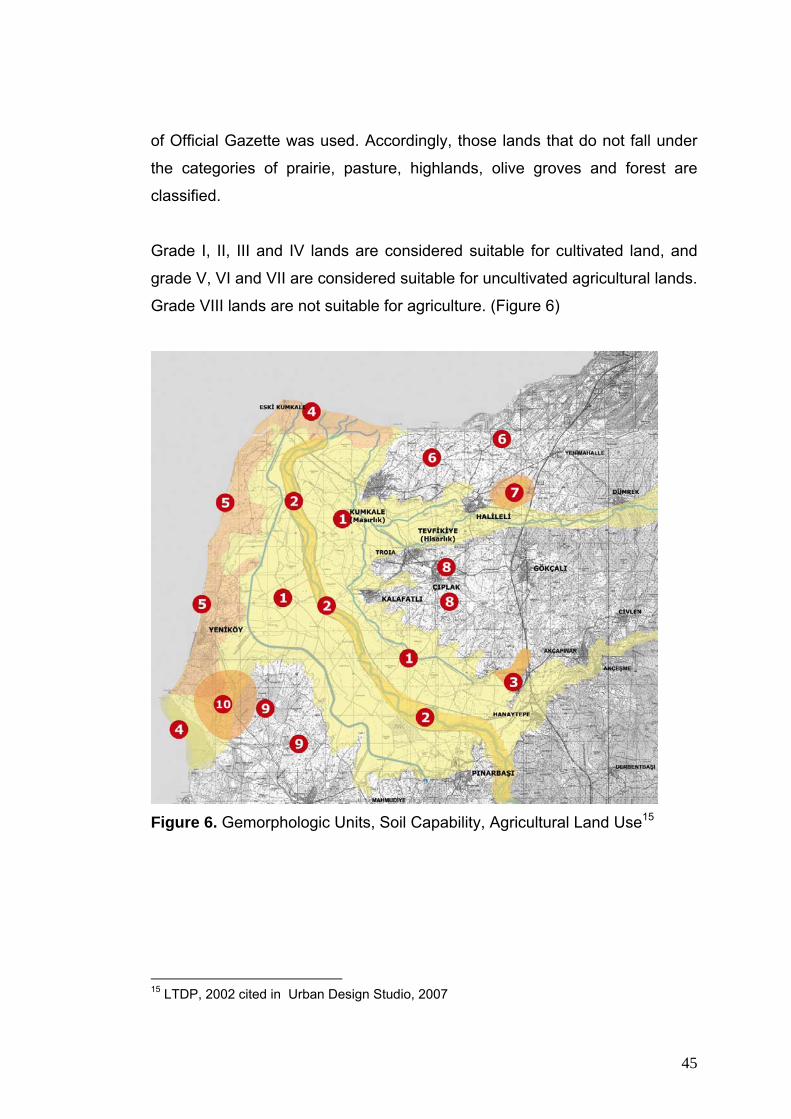
45
of Official Gazette was used. Accordingly, those lands that do not fall under
the categories of prairie, pasture, highlands, olive groves and forest are
classified.
Grade I, II, III and IV lands are considered suitable for cultivated land, and
grade V, VI and VII are considered suitable for uncultivated agricultural lands.
Grade VIII lands are not suitable for agriculture. (Figure 6)
Figure 6. Gemorphologic Units, Soil Capability, Agricultural Land Use15
15 LTDP, 2002 cited in Urban Design Studio, 2007

46
Geomorphologic Unit Soil
Quality
Soil Type Method of
Agriculture
Type of
Vegetation
1. Kara Menderes
Plain
I, II, III Alluvium Dry and
irrigated
farming
Cereals
2. Kara Menderes
Course
VIII Colluviums None Hydrophytes,
Trees and
Shrubs
3. Kumtepe Farm II, VI Alluvium Pasture Pasture,
Forestation
4. Kumkale and Beşik
Beaches and Dunes
VIII Alluvium None Dune plants
5. Yeniköy – Kumkale
Ridge
II, III, IV,
V
Rendzina Dry farming Cereals,
Vineyards,
Olive
6. Kumkale – Intepe
Ridge
III, IV,
VI
Rendzina Dry farming Cereals,
Orchards,
Heathers
7. Halileli West II Colluviums Dry farming Cereals
8. Gökçalı, Tevfikiye,
Çıplak and Kalafatlı
Plateau
II, III, IV,
VI
Rendzina Dry farming Cereals,
Heathers,
Frigana
9. Üvecik Plateau II, III Brown forest
soil
Dry farming Cereals, Oak-
woods
10. Yeniköy – Üvecik I Alluvium Heathers Heathers
Hydrophytes: Plants that have adapted to living in or on aquatic environments
Frigana: Distorted forms of maquis.
Rendzina: Dark, grayish-brown, humus-rich, thin soils with limited available water
capacity.
Brown forest soil: Available in temperate climates under deciduous trees, where
leaves of trees dissolve and feed the soil.
Colluviums: Younger soils deposited by sediments of rivers suitable for aquatic plts
Table 1. Geomorphologic Units, Soils and Vegetation

47
3.5.2. Strabo’s Definition of Geology and Geomorphology of the Troad According to Strabo’s Geography, Book XIII:
From the mountain range of Ida in this region, according to Demetrius, two spurs extend to the sea, one straight to Rhoeteium and the other straight to Sigeium, forming together a semicircular line, and they end in the plain at the same distance from the sea as the present Ilium; this Ilium, accordingly, lies between the ends of the two spurs mentioned, whereas the old settlement lies between their beginnings; and, he adds, the spurs include both the Simoeisian Plain, through which the Simoeis runs, and the Scamandrian Plain, through which the Scamander flows. This is called the Troian Plain in the special sense of the term; and here it is that the poet represents most of the fights as taking place, for it is wider; and here it is that we see pointed out the places named by the poet Erineus, the tomb of Aesyetes, Batieia, and the monument of Ilus. The Scamander and Simoeis Rivers, after running near to Sigeium and Rhoeteium respectively, meet a little in front of the present Ilium, and then issue towards Sigeium and form Stomalimne, as it is called. The two plains above mentioned are separated from each other by a great neck of land which runs in a straight line between the aforesaid spurs, starting from the present Ilium, with which it is connected, and stretches as far as Cebrenia and, along with the spur's on either side, forms a complete letter. (http://soltdm.com/sources/mss/strab/strab).
As told by Strabo, the alluvial plains formed by Kara Menderes (Scamander),
Kemer (Thymbrios) and Dümrek (Simoesis) rivers, and ridges running
parallel to the Scamander plain on the west, and perpendicular ridges as
extensions of lower plateaus on the east build up the geomorphology of the
site. Troia was built on one of such ridges parallel to the Simoesis valley and
perpendicular to the Scamander plain. In the contemporary era the
geomorphology of the site is as follows:
Between the ridges on the east, the Simoesis valley’s lower portion and its alluvial plain lies. Troia was located on the western tip of one of those eastern ridges on the south of the Simoesis valley. This ridge is approximately 20-30 m high and gradually ascends eastwards to heights of 100-120 m, to join higher plateaus. The northern slopes of Troia are faulty and steep, while the southern slopes incline moderately (Kayan, 2005).

48
Scamander River passes through the Araplar gorge. With the confluence
of Thymbrios and Simoesis the hydrogeology of the area is structured.
Other than the mentioned rivers, Kırkgözler spring west of Pınarbaşı end
the spring near Taş Köprü (Stone Bridge), have historically been main
sources of potable water.
As pointed out in the previous studies, there are many wells extracting under
ground water. In the case of excessive use of such waters, there is the risk of
salinity and desertification.
3.5.3. Geology, Geomorphology and the Formation of the Black Scamander Plain According to Kayan (2005):
“The Troian culture flourished to the south of the location where the Dardanelles Strait opens to the Aegean Sea, over alluvial valley bases located along depressions that are defined by low profile plateau ridges. In the late Miocene, this area was covered with a shallow sea over the base of which sedimentary layers of sand, clay and lime had already conglomerated. Starting with end of the Miocene, these layers broke into blocks and rose up to form the plateau ridges of our times. The rivers were then directed to the depressions in between these ridges to turn them in to valley bases. Accordingly, the main geomorphologic units near Troia comprise of three large plateau blocks separated by faults. To the west of the Scamander valley base is the Yeniköy Ridge which lies in the direction of south and north and which also separates it from the Aegean Sea. To the east are the Yeni Kumkale Ridge and the Troia Ridge which both stretch in the direction of east and south.” (Figure. 7) Two sources of water are worth mentioning when the geomorphologic formation of the Troian Plain is considered. While Scamander Brook enters the Troian Plain from the south-southeast direction, a smaller brook, Kemer (Thymbrios), joins the system from the east. In addition to these two and towards the Dardanelles Strait, there is yet the Dümrek Brook (Simoeis), which again comes from the east. All of them have contributed to the destiny of Troia, which is founded on a ridge where the Dümrek alluvial plain meets the Scamander Plain. “At

49
the eastern sections, this ridge’s altitude is 20-30 meters and it gradually becomes higher towards east to reach an altitude of 100-120 meters where it joins a higher relief. Northern slopes of the ridge are steep and involves faults, whereas the southern slopes show less steepness”
Figure 7. Main Geomorphologic Units in the Vicinity of Troia and the Formation of the Estuary/Flood Plain of the Scamander Brook During the Holocene16
It is very likely that Troia was located by the sea around 4000-3500 years
ago. Kraft et al (2003) have evaluated Kayan’s findings who performed drills
in the site starting from 1970s. They stated that the radiocarbon evaluations
of the findings from the drills pertaining to the vicinity of old Troia point to the
evidence of a sea life around Late Neolithic and Early Bronze ages.(Figure 8)
16 Kayan, 2005

50
Figure 8. Late Neolithic – Early Bronze Age (B.C. 3000 – 2500)17
In this period, the Troian Plain was actually the Troian Bay. Yet, from the
south Scamander and from the east Kemer (Thymbrios) and Dümrek
(Simoeis) were continuously filling up the sea. The first layer of Troia is
known to be founded 3000-2500 years ago. Now it is also known that by that
time the city had already started to lose its coastal character because of the
filling. Its shore was already a swamp. Kraft et al (2003) have commented
about the filling of the Troian Bay. Their comments are partly based on
Spratt’s (Thomas Abel Brimage, 1811-1888, the British captain who made
the cartography of the region in the 19th century) map of 1839 and give an
idea about both the heydays and the fall of Troia. While Scamander’s bed
17 Kraft et al, 2003

51
continuously changed, its eastern side had continuously remained as a
swamp. (Figure 9.)
Figure 9. Filling Process of the Troian Bay 18
The filling process of the Troian Bay reveals interesting findings and
therefore should be considered at length. According to recent data, the
eastern side of the plain remained as a swamp through the ages, the reason
of which can be partly stated as the Kırkgöz spring located at Pınarbaşı.
Another reason might be sought in the way the Scamander filled up the Bay
with the material it carried. It can be said that the filling has started and
developed at the eastern parts leaving the western part as a marsh up until
2000s. Kırkgözler marsh was dried up until very recently. This topic is
18 Kraft et al, 2003

52
significantly important in terms of understanding the Troian war. Kraft et al
(2003) claim that the Achaean navy and camp were located in a bay of the
time, between two hills which are now called Sivritepe and Ballıburuntepe in
the Scamander plain. This contradicts other views which locate the navy and
the camp at either Beşik Koyu or the Dardanelles Strait. It can also be
claimed that this location was filled by Scamander later on. (Figure 10)
Figure 10. Geological Evolution and Geomorphologic Units of Troian Plain 19
Today, Scamander passes through deep valleys before it reaches the Troian
Plain. Just to the north of the system of valleys where Scamander started
filling up the Troian Plain the altitude of the land is around 10-15 meters. The
filling of this portion has started around 6000-5500 years ago when the
location of Troia was by the sea. The flat land to the north and northeast of
Troia starts at an altitude of 10 meters. In other words, the city of Troia is 10
meters higher than the level of sea of that time. 19 Kayan, 2005 cited in Urban Design Sudio, 2007

53
The current land with 5 or 10 meters altitude reveals some clues as to the
foundation and life story of Troia. When the sea on three sides surrounded it,
Troia’s defense was much stronger, but the city gradually lost this advantage
due to the filling, and turned in to a disadvantage during war with the
Achaeans that was lost. Troia lost the war although it had its back to the
mainland.
3.5.4. Homer’s Landmarks in Troia
Intensive deep coring of the alluvial plain of the (Menderes) River in the
vicinity of Hisarlık (ancient Troia) has established the approximate position of
the shoreline in the Late Bronze Age (ca.1250 B.C.) At that date the
Scamender flowed into a marine embayment that extended northwards to the
Hellespont (Dardanelles) from or near the latitude of Troia. This
palaeogeographic reconstruction has removed the basis for Schliemann’s
and Leaf’s placing of the Greek Camp and Ship Station on the present
coastline, and revived former speculation about the significance of the Beşik
Bay anchorage to the south – west of Troia at the time of the Trojan War.
(Wagner, Pernicka, Uerpmann, 2003:9)
3.5.5. The Coherence of the Scientific Informations with Topographical Indications in Homer’s Iliad
These indicators presuppose an east – west, rather than a south – north, axis
for the fluctuating fighting that Homer pictures. Luce argues that this tends to
support the historicity of Homer’s ‘military topography’, and gives reasons
based on the Iliad, and Strabo’s account of the Troad, for placing the Greek
camp and ship station, not at Beşik Bay, but at a then existing salt lagoon
(now, known as the Lisgar swamp or Kesik plain) that formed a westward
extension of the Troia embayment in the neighbourhood of the ancient
Sigeion.

54
3.5.6. Ottoman Period
Troia has endured until the 5th century. Between 700 B.C. and 500 A.D., it
was Ilion. In the Byzantine era, the city became a small bishopric (Latacz, J.,
et al. 2001), to continue until 13-14th century. The German archaeolog
Heinrich Schliemann’s interpretation of Iliad in the 19th century enabled the
resurfacing of the city and then it became famous in the Western world. Piri
Reis (1470 – 1554) made a map of Troia and its surroundings in 1520.
(Figure 11). His comments (Kitab-I Bahriye, 2002) together with this map give
some clues about the condition of the city and the region at that time. The
region was not able to produce the urban culture, which the Troia of Antiquity
once did. It was largely an agricultural region:
Figure 11. Map of Piri Reis; Bozcaada and the entrance of the Dardanelles
Strait (Kitab-ı Bahriye, 2002)20
From the map we can see that the filling of the Bay was continuing.
Nevertheless, the plain had almost reached the current coastline of the
Dardanelles Strait. (Figure 12)
20 METU, UD, 2007

55
Figure 12. Dardanelles Strait in 1760 21
There are two fortresses on both sides of the Dardanelles Strait at the
entrance (or exit) of the Aegean Sea. One of them is Kumkale built on the
sandy shore to the northern tip of the ridge where the city of Sigeion (or what
remains from it) stands. At the opposite side of the Strait, at the southern tip
of the Gallipoli Peninsula there is another fortress facing the Kumkale
Fortress. This one is called Seddülbahir. (Figure 13 -14) They were built in
1658, under the auspices of Sultan Mehmet’s (IV Mehmet) mother, Hatice
Turhan Sultan, against the increasing Venetian attacks of the 17th century, to
defend, first, the Straits (Dardanelles and Bosporus) and second, Istanbul.
Their architect was Mimar Mustafa Ağa.
21 historic-cities.huji.ac.il/turkey/dardanelles

56
Figure 13. Kumkale Fortress22
Figure 14. Seddülbahir 23
It is seen that life over the Scamander Plain has began to vivify after the 18th
century. Plain’s coastal line started to take its final form during these years as
well. Dardanelles is not a waterway for battleships only. It is also a waterway
for international trade. While the fortresses were being built, there were
drastic transformations in the rural production. In this period there were new
22 Kültür Bakanlığı, 1996; L.J. Masquetier 23 Kültür Bakanlığı, 1996; J.P. De Tournefort “1656-1708”

57
settlements established all along the Aegean coast of the region in addition
to those at the periphery of the Scamander Plain (Figure 15).
Figure 15. Entrance of Dardanelles in 1800 24
Spratt’s map of 1839 which was examined by Schliemann in 1883 (Figure
14) gives clues about yet another issue. The marsh to the west of the
Scamander was continuing at that time and the Ottoman administration was
struggling to dry it with an infrastructure of canals.
24 historic-cities.huji.ac.il/turkey/dardanelles

58
Figure 16. Geography During Schliemann’s Period25
Another characteristic of those times is the transforming orders in the rural
and property structures. The central authority was gradually weakened in the
rural realm thereby causing large estate holders to emerge. As a result, the
treaty of Sened-i Ittifak was signed between these local property owners and 25 Schlimann: 1883 – c.1969

59
the center. The treaty acknowledged the absolute control of local powers
over property.
3.5.7. The Coast Line and the Layers of Troia
Briefly, Troia started, developed and declined in a process of geologic and
geomorphologic formations and finally ended when the city lost its
significance in terms of the functions that it once carried. This topic should be
discussed in depth in the Troian stories and the museum and its exhibitions.
There is a consensus among the scientists that Troia is formed of layers that
were created by various cultures the continuity of which were sometimes
interrupted and sometimes nested within each other.
It is also possible to reinterpret the emphasis on the layers via the
transformation of the coastline. During the period where the first three layers
flourished Troia is by the sea and with high probability its interaction with the
sea took place in the area between the city and the village which is now
called Kalafat.
It is stated that the Anatolian Culture was dominant in Troia IV and V. If this is
the case, then it can be claimed that the land between Troia and the sea
started to filling up in this period. Layers VI and VIIa are known to depict
Troia’s high culture period. It was this period that became subject to Homer’s
Iliad.
From Iliad one can follow that the clans from the Balkans as well as those
from Anatolia supported Troia in the war against the Greeks. This is also the
period when the Iron Age started. In this context, it is also told that the Balkan
clans were influential on the life of layers VIIb1, VIIb2 and VIIb3.
By the time when Homer’s Iliad (800 BC) and Strabon’s Geography (Troia
VIII and IX) were written the city was far from the sea. Simoeis and

60
Scamander had joined and a marshy land emerged between the sea and the
city. On the one hand, the city was transformed in to a gridiron pattern that
reflected the power of the Helen and Roman Empires. On the other, it was
embellished with artifacts (like the theater or the Odeon) which reflected this
power. Nevertheless, the Roman Empire was divided in to two and the
capital of the eastern Empire was Istanbul. In this sense, Troia (Ilion), which
gradually was cut off from the sea, would lose its prominence among
competing towns. It first turned in to a small Byzantine bishopric. Then it went
in to oblivion with the coming of the Muslim peoples (Piri Reis, 2002).
Troia Sea
Culture
3000 – 2200
Troia I 2920 –
2350
Early
Bronze
Troia II 2550 –
2250
Early
Bronze
Troia III 2250 –
2200
Early
Bronze
Troia
Anatolian
Culture
2200 – 1700
Troia IV 2200 -
1900
Mid
Bronze
Troia V 1900 -
1700
Mid
Bronze
Troia
High
Culture
1700 – 1200 Troia VI 1700 –
1300
Late
Bronze
Troia
VIIa
1300 –
1200
Homer’s
Troia
Late
Bronze

61
Troia
Balkan
Culture
1200 – 1000
Troia VII
b1
Iron
Troia VII
b2
Iron
Troia VII
b3
Iron
Dark
Ages
1000 - 0700 Iliad of Homer (730 – 710)
Helen
Illium
Culture
B.C. 0700 –
A.D. 0085
Troia VIII Iron
After
Christ
Geography of Strabon (B.C. 63 – A.D. 24)
Roman
Illium
Culture
0085 – 0500 Troia IX Iron
Byzantine
Illium
Culture
0500 - 1300 Troia X Iron
Table 2. Layers of Troia 26
26 Latacz, J., et al. 2001

62
Figure 17. Layers of Troia 27
3.6. Archaeological Settlements in the Troad
The Troad is rich in archaeological settlements, which began in the 6th
millennium BC (Neolithic Era) and continued without interruption up to the
Byzantine Era. These settlements played a significant role in the
morphological make-up of the region, in particular, those from the third
millennium BC, which as all over the region , were founded in locations with a
27 Latacz, J., et al. 2001 cited in METU, UD, 2007

63
natural harbour; on the coast or by rivers. This settlement pattern, with few
changes, has continued up to today.
Troia from the third millennium, up to the end of the second millennium,
retained its situation on the coast.
Geomorphologic changes in the feature, however, would lead to its losing
this important geopolitical advantage.
From the prehistoric period up to today, the most important aim has always
been control over the Dardanelles; the pattern of settlement in the Troad
developed to serve this objective. (Figure 18 -19)
Figure 18. Archaeological Settlements of Troad 28
28 Wagner, Pernicka, Uerpmann, 2003

64
Figure 19. Preservation Sites29
3.6.1. Assos
Assos is situated on a rocky headland between the River Tuzla to the North
of the Gulf of Edremit and the sea. It is not known for certain whether it was
first founded in the prehistoric era, but in the first millenium BC it possessed
the characteristics of a Greek city. It is accepted that it was a colony of Aolik
Methymna on Lesbos, according to Hellakinos of Lesbos, and was founded
by Aioll from the island in the 7th century BC. Excavations have been carried
out at Assos, with breaks, since the 19th century. So far, excavations have
unearthed the temple, necropolis, theatre, and suchlike. Little in the way of
29 LTDP, 2002 and documents of the Ministry of Culture and Tourism in Tablo 5 cited in Urban Design Studio, 2007

65
housing has come to light. In 1988, however, house fragments from different
phases were found on the eastern slope under the Acropolis.
3.6.2. Neandria
Neandria was founded on the slopes of Çığrı Dağı about 13 km. inland from
Alexandreia on the coast. The city is surrounded by a defence wall 3,200
metres long. In ancient sources it is said to have been founded by the Aioll
people. It is known that toward the end of the fourth century BC, they
migrated to Alexandreia Troas on the coast. The houses in Neandria
estimated to have been used for a period of about a century. Studies begun
in the 19th century were completed several years ago. According to these,
the houses of Neandria can be grouped into five types:
1. Houses with two courtyards,
2. houses with two or three residential courtyards
3. houses with right-angled courtyards
4. Asymmetrical houses with courtyards
5. houses with four residental pastas.
Particularly in the 4th and 5th centuries BC, many residential houses can be
seen of a type without a courtyard surrounded by columns. The front of these
houses is turned towards other buildings; however, the front courtyard is
obstructed with a wall to prevent anyone seeing inside the house.
3.6.3. Alexandria Troas
Alexandria Troas was founded opposite the island of Tenedos (Bozcaada) in
the late 4th century BC by Antigonus, a commander of Alexander the Great,
as ‘The Nation of Antigonus’. The name was changed to ‘Alexandria Troas’
by another of Alexander’s generals, Lymsimakhos, who ruled over Western
Anatolia. With the construction of an artificial harbour, the city soon became
rich. After Byzantium was chosen as the new capital, the city lost its
importance and many magnificent buildings fell into ruin. Stones from the city

66
were taken away to be used for buildings in Istanbul during Byzantine and
Ottoman times. That is why local people still refer to the city as ‘Old Istanbul’.
In recent studies, remains belonging to the Hellenistic Period have been
found, and also a tumulus belonging to the third millennium BC (Troia I
period) on the point where the harbour was. Because of the grand ruins,
European travellers for a long time thought that this city was Troia.
3.6.4. Settlements in the Troad from Ottoman to Republican Era
In the 13th century, the power centers in Anatolia began to change.
Principalities were formed on the coasts of Western Anatolia. The Karasi
Clan, who captured the Troad in 1302, connected the area to Bergama. In
1306, the Troad came under complete Turkish control. The Ottoman clan put
an end to the sovereignty of the Karasi Clan and during the time of Sultan
Orhan Gazi, took control of the Dardanelles. In 1463, Mehmet the conqueror
built castles at Çanakkale and Kilitbahir. In 1912 the Greeks occupied
Bozcaada and Gökçeada; however, control of the Straits remained with the
Ottomans. A few years later, in 1915, the Gallipolli Campaign took place and
left its mark on the area.
Despite all this, the old settlement pattern continued in the region and has
continued up to the present day.
Until the 16th century, the epic tale of the Trojan War was assumed to be a
real event that had influenced world history.
The place where the battles occurred became a place that scholars, writers,
architects, and entertainers insistent on seeing while en route from the
Mediterranean to Istanbul.
The Region was visited by a merchant and traveller Seawolf in 1103, Troia
was visited by the Russian Daniel in 1107, the French Robert de Clari in

67
1203, the Spaniard Clavio in 1403, and by the German Schliemann in 1868.
These visitors made maps of the region and documented important
architectural remains, studies which continued until te 1930s.
From the 18th century onwards, we can also see the architectural features of
the area in old prints and photographs, from the simple, flat-roofed stone and
adobe houses on the coast to mansions and other grand dwellings where the
ruling classes lived.
3.6.5. The Troad’s Ethnic Richness
The Troad is where East meets West. This is reflected in the region’s cultural
richness, arising from its ethnic composition. In particular, the Sephardic
Jews in 1492 and other waves of immigrants who followed enriched the
ethnic diversity of the Troad. From the beginning of the 19th century to the
20th century, there was large-scale Turkish migration to the region from
countries in the West such as Greece, Bulgaria, and Romania.
The study by the Frenchman Cuinet in 1980 shows what a colourful diversity
existed in the population of the Çanakkale region.
This ethnic composition of the region began to break up from the middle of
the 20th century onwards, though this ethnic richness can still be seen
among the nomads (Yörüks), Turcomans, and Greeks from the islands, a
diversity which is also reflected in their architecture.
The Bronze Age (c. 3500-1200 BC) is significant because it was when cities
and administrative systems first appeared and the use of metals became
widespread in this period. A trading network developed from Mesopotamia to
the Southeast and Eastern Anatolia which later expanded to Central Anatolia
and the coast of Western Anatolia. After 3000 BC, trade intensified especially
in the Black Sea, Aegean, and Mediterranean regions.

68
Troia was established at the mouth of the Dardanelles during this period with
city walls that were defensive in purpose.
The first settlement at Troia had walls with a stone base and sun-dried brick
above containing megaron houses parallel to each other. Structures in
conformity with the environment continued in the following period bearing
characteristic features of Anatolian architecture.
At Troia and in the Troad, the richness of the building reveals itself and we
can observe in the traditional housing architecture of today clear examples of
housing appropriate to the surroundings.
3.6.6. Constitution and Development of City of Çanakkale 3.6.6.1. Founding of City of Çanakkale: 1462-1463 Çimenlik Castle, built in 1462-1463 at the narrowest point (1450m.) along the
Dardanelles, formed the nucleus of the city of Çanakkale. After the Mehmet
the Conqueror had captured Istanbul, there was a need for a castle to
prevent continuing attacks from the Mediterranean. Soon after the castle had
been completed, settlement began and the city’s first neighbourhoods came
into being. (METU, UD, 2007)
3.6.6.2. A defence and Garrison City: 1463-1700 Çanakkale is one of those rare cities that was actually established at the wish
of the Ottomans. The city’s first inhabitants were the Moslem soldiers and
bureaucrats on duty at the castle’s construction. With the increase in the
number of Moslem Turks in the 1500s and 1600s, Greeks and Armenians
also settled in the city in the same period. As the population increased, the
Moslem Turks developed the city. (METU, UD, 2007)

69
3.6.6.3. A Trading City: 1700-1900
The trading mission that began in the 1700s continued up to the beginnig of
the 1900s. The Ottomans having consolidated control over the region in the
1700s and 180s, this was the period when the city’s character was formed
and it experienced enlargement. The Jewish community brought trade and
formed a Jewish quarter in the city. International trade was developed by
about 30 mercantile attaches who settled in the city. This commercial
richness and vitality is reflected in the buildings. (METU, UD, 2007)
3.6.6.4. War and Destruction: 1900-1950 From the early 1900s Çanakkale experienced many wars-The Balkan Wars,
Gallipoli Campaign, War of Independence, Second World War-and city life
was affected accordingly. Most of the minorities left the city and Moslem
migrants from the Balkans and islands came in their place. Despite the new
settlements and some new building amid the physical destruction that had
taken place, there was no enlargement of the city in this period. (METU, UD,
2007)
3.6.6.4. Change and Modernity in Çanakkale The first civic plan, produced in the 1940s, provided for change in the city in
keeping with the ideology of the Republic. As a result of this plan, main
roads, industrial estates, official buildings, and new housing estates were laid
out in the 1950s. The 1960s was a period of planned state investment with
aim of developing specific areas. (METU, UD, 2007)
3.6.6.4. Migration Brings Growth
Between the years 1970 – 1980 investment led to an increase in migration to
the city. Migrants settled in the city from various parts of Turkey together with
those from nearby towns and villages. The city grew quickly and multi-storey
apartments came to dominate the centre of the city. (METU, UD, 2007)

70
3.6.6.4. State-Administered Construction: 1980-1985 In the years following the military coup of 1980, many public buildings were
constructed on unused state-owned land. Structures from this period include:
the law courts, social security building, Anafartalar Hotel, Zafer Evler, the
new bus station, municipality offices, waterfront arts centre, and suchlike.
3.6.6.4. The Last Two Decades: 1985-2005 In 1985, with the handing over of civic planning authority to municipalities,
begins a time of measuring land and an increase in storeys and density.
Today and in the near future, cities have turned into centres of speculation.
The disappearance of local values and developments contrary to city
planning are the product of this period. From the 1990s onward, various
developmental issues- Dardanelles bridge, Regional Industrial Estate, port,
enlargement of airport, establishing a university-become topical.
Since 1994, ÇEYAP has aimed to preserve and revitalise the historical,
cultural, and architectural heritage of Çanakkale for the benefit of the
community. Related activities have included: preparation of a preservation
plan, documenting with drawings and photographs heritage buildings within
the city, formation of a local history group, active participation in the Historical
Cities Commission, archaeological meetings, civil activist group Gündem 21,
and restoration of shop facades. A change in the city has thus been affected
which is reflected in the architecture of new buildings, an increase in
buildings erected in accordance with local architectural styles, restoration of
listed buildings, and even new buildings outside the preservation area.
(METU, UD, 2007)

71
CHAPTER IV
REVIEWING PREVIOUS PLANNING WORKS OF THE AREA IN TERMS OF LANDSCAPE ARCHAEOLOGY ISSUES AND DEFINING POSSIBLE
MANAGEMENT STRATEGIES
4.1. Management and Planning History of the Area The process of recognition of the Troia as a listed cultural heritage and
conservation, management and presentation studies of the area within Troad
Region starts with listing of Troia in 1968. Some remarkable attempts are as
mentioned below:
• Troia archeological site was listed by Higher Council of Immovable
Historical and Monumental Heritage on 13th May 1968.
• The National Parks Department of the Ministry of Forests prepared a
plan for its preservation in 1971. This involved the creation of the Troia
Historical National Park, with the construction of a tour road and a
branch road to the site, a camping site, limited development on the
coast, and relocation of the existing villages of Tevfikiye and Kalafat.
• Higher Council of Immovable Historical and Monumental Heritage
decided on the expropriation of the parcels at the site and entrance
and exit of the Troia Archeological Site in addition to the fencing of the
area.
• The General Directorate of Cultural and Natural Heritage of the
Ministry of Culture published a development plan for the site in 1991.
This defines the boundaries of the site, those areas still to be taken
into State ownership, areas for public access, potential primary and
secondary excavation facilities, the locations of tourist facilities and

72
installations, the rerouting of roads, and the removal of a nearby
rubbish dump. This is not yet being implemented.
• South Çanakkale Coastal Area Master Plan, which was approved in
1992 by the Ministry of Public Works and Settlement, includes Troia
Historical National Park as well.
• The additional decision of the Edirne Regional Council for the
Preservation of the Cultural and Natural Heritage declares the Troia
Archaeological Site as a Grade 1 Archaeological Site (26th May 1995,
No: 2414)
• The region which also includes Troia (13350 ha) is declared as the
Troia Historical National Park by the decision of the Board of the
Ministers on the 30th September 1996 (No. 96/8676)
• A group of specialists from ICOMOS visited Troia in December 1997.
• Troia is included in the World Cultural Heritage List on 2nd December
1998 with the registration number 849.
• The Ministry of Environment and Forests approved Troia Long Term
Development Plan (LTDP) on the 9th June 2004.
4.1.1. South Çanakkale Coastal Area Master Plan (1/25000) South Çanakkale Coastal Area Master Plan was approved by the Ministry of
Public Works and Settlement in 1992. The plan’s coverage area runs along
the coast of the Aegean Sea and contains the site of Troia Historical National
Plan.

73
Upon the approval of Troia Long Term Development Plan by the Ministry of
Environment and Forests in 06 June 2004, the rules of the new plan became
valid within the territory of the National Park.
Çanakkale Coastal Area Master Plan protects agricultural uses and assigns
“special product zones” (olives or vineyards) towards the southern edge of
plan boundaries. A similar attitude prevails for forests and pastures, and
specifically concentrated on the northeast of the site, forestation zones tend
to sustain the natural environment. In conformity with the adopted approach,
bushes, heathers, pastures, rock formations, beaches and dunes, water
protection zones and Spas are all taken under preservation.
The strip of tourism and second-home development on the Çanakkale strait
coast is removed in the national park Long Term Development Plan;
unfortunately, however, the archeological and nature protection sites on the
ridges along the Aegean Sea are not indicated in the Long Term
Development Plan.
The area designated as military zone on the northwest edge stays out of the
boundaries of the national park. In this zone there is one archeological, one
historical (Gallipoli marine and land war site registered on 11 June 1999) site
and Kesik tumulus, which are not indicated in Long Term Development plan.
Moreover, the plan is indifferent to the restricted marine zones at the
entrance of Çanakkale Strait.
Kum Burnu beach 6-7 km south of the national park is preserved as a natural
site. Territory to the south of Kum Burnu beach is planned as a tourism
center to accommodate tourist facilities and second homes.
The most inappropriate use in the vicinity of the national park is the cement
factory just out of its boundaries, and its storage and shipping facilities on the
coast. In the Long Term Development Plan report, we are told that through

74
Figure 20. Çanakkale Coastal Area Master Plan30
investments made in 1999, the exhaust system was supported by filters to
reduce emission and that factory administration is particular in achieving
world standards. This point should be regarded as a natural consequence of
technology of the modern age. On the other hand, we are also informed that
leather factories in the city of Ezine further south are discharging their
wastewaters into the Scamander River.
As a result of the above discussion, the boundaries of Troia Historical
National Park should be reconsidered in the context of South Çanakkale 30 Egeplan Ltd.: 2004

75
Coastal Area Master Plan, to cover military zones on the northwestern, Beşik
bay and Üvecik tumulus on the southwestern, the tumuli on the southeastern
and Rhoteion on the northern edges of the present national park. (Egeplan
Ltd.; METU, UD, 2007) 4.1.2. Troia Historical National Park Long Term Development Plan Decisions
Figure 21. Legal Constraints and Anthropogenic Pressures 31
Troia archeological site and its environs was declared a Historical National
Park by a Government decree on 30 September 1996. The Ministry of
Environment and Forests approved Troia Historical National Park Long Term
Development Plan on 09 June 2004.
31 Egeplan Ltd; LTDP, 2002; cited in METU, UD, 2007

76
The fourth article of the National Parks Law stipulates that;
In designated national parks, taking into consideration the character and attributes of its location, long term development plans should be prepared by the Ministry of Environment and Forests in order to implement objectives of preservation and use, to contain a development plan concerning management of the park, upon positive views of related ministries and when necessary their actual contribution.
Considering the constraints and pressures mapped in Figure above, the main
goal of the Long Term Development Plan was formulated “to sustain existing
values of the park to be transferred to the coming generations” and
objectives were concluded accordingly (LTDP, 2002):
• Archeological values should be preserved and necessary support
provided to scientific excavations
• Ecological balance should be sustained
• Geomorphologic structure should be preserved to sustain the natural
environment
• Development demands of the existing settlements should be controlled
• Environmental pollution (air, soils, water and noise) should be
prevented
• Limits of agricultural production should be determined to sustain
archeological and geomorphologic formations
• The chaotic administrative structure should be coordinated by a
management plan
The planning decisions of the Long Term Development Plan have been
summarized as:
• Development of settlements within the park are restricted
• Agricultural production needs programming
• Pesticides used in agriculture are to be restricted

77
• A solid waste disposal site should be established out of the national
park
• The two fisherman’s havens should provide passenger transportation
to the Gallipoli Peninsula Historical National Park
• Ecological agricultural production needs to be supported
• Illicit hunting should be prevented
The consequent plan was developed to overcome the problems of the
designated national park. (METU, Urban Design Studio, 2007)
Figure 22. Troia Historical National Park Long Term Development Plan32
32 LTDP, 2002

78
As mentioned earlier, the genesis of the Troia Historical National Park is the
phenomenon of Troia with its settlements, transformation of its
geomorphology, tumuli, multi-layered town and the Trojan War. Deliberately
Troia is considered a phenomenon, rather than a town or an archeological
site, because it is a theater scene. Unfortunately, however, the visitors can
visit only the excavated Acropolis.
The Long Term Development Plan has conceived the archeological sites
merely as topics of excavation, concentrating more on the natural and
ecological facades of the park. This outlook has affected the plan and its
notes, where archeological sites only have boundaries and they are
preserved. No spatial or managerial model was developed to enhance the
setting of Troia.
The plan envisages landscape values as merely subjects of preservation
leaving their development patterns open-ended. The two routes and
viewpoints do not have any motive, and what they shall be exhibiting is
obscure. (METU, UD: 2007)
4.2. Management of Archaeological Sites and Cultural Landscapes 4.2.1. The Character of the Management Plans Management is defined as a process “which must be used in order to bring
‘ideas, people and things’ together to meet aims and objectives and to
analyze the various means of achieving these objectives” offering “means of
measuring how well objectives are being met and how best conflicting
information can be reconciled” (Bromley, 1996: 16 cited in Öz, 2002:34). One
of the founding elements of management is systematically working on
understanding the future and the possible changes so as to make
appropriate decisions today.

79
In other words, management is, to approach an aim within a systematic
framework, by understanding the resource, analyzing the data achieved from
the resource, to foresee the possible changes and reach the aim by skillfully
evaluating all of those aspects. (Öz, 2002:34)
Management is also a suitable method for conservation and sustainability of
archaeological sites and cultural landscapes According to Feilden and
Jokilehto, management, based on detailed analysis of the site’s significance,
has to include the following criteria (1993: 2):
• ensuring that all site staff understand the cultural values to be
preserved
• providing specific guidelines based upon the statement of significance
of the site
• making complete inventory of all the cultural resources within the site
• arranging for regular inspections and formal reports by the
professionals with suitable qualifications and experience
• drafting a strategic management plan leading to the formulation of
resource projects which are incorporated into an annual work
programme according to their priority
• respecting, in all work, the ethics of conservation, the established
international recommendations of UNESCO, and guidelines such as
the Venice Charter
4.2.2. Stages of Preparation of a Management Plan The basis of preparing the management plan is to thoroughly evaluate the
site with all its positive and negative sides and to understand its values. The
stages of preparation of a management plan concerning archaeological sites
are most clearly defined by Feilden and Jokilehto and S. Sullivan, as well as
in the Burra Charter. (Öz:2002.39)

80
In their guideline book on the management of World Heritage Sites, Feilden
and Jokilehto outline the process of preparation as follows (1993: 35):
• initial survey of the site
• site description and boundary definition
• identification of resources
• evaluation of resources
• formulation of objectives and consideration of constraints
• definition of projects
• work programme and annual plans
• execution of works
• recording, reporting and review of results
• storage of information and data
• revision of site description and re-evaluation
• formulation of revised objects and reconsideration of constraints
• definition of further projects
• revised work programme and next annual plan
An important issue that must be taken into consideration starting from the
beginning of the planning process is to gather information about the
national and local plans, forecasts of demographic growth and decline.
Similarly, S. Sullivan describes the preparation of a management plan with
the following outline (Sullivan, 1997: 17):
• identification of key interest groups:
• documentation of the site
• significance assessment
• management assessment
• definition of management policy
• definition of management strategies

81
According to the outlined processes, the preparation process involves a
clear understanding of the site which is accomplished by detailed
documentation and by locating and integrating the key interest groups, the
people or groups which value the site, have stakes in it or responsible
from its administration. This knowledge is then used to state the values
attributed to the site. Having defined the values, all data are collected
which will affect the management of the site. Finally, the policies are
defined followed by the statements of strategies for implementations of
those policies. (Öz,2002:41)
Figure 23. The Planning Process of Management (Sullivan, 1997:17)
Likewise, The Burra Charter (Truscott-Young, 2000), gives the following
sequence for preparing management plans:

82
• identify place and associations
• gather and record information about the place to understand
significance
• assess significance
• prepare a statement of significance
• identify obligations arising from significance
• gather information about other factors affecting the future of the place
• develop policy
• prepare a statement of policy
• manage place in accordance with policy
• monitor and review
4.2.3. Cultural Landscape as a Concept within Management Plans
Cultural landscapes are today a resource whose preservation represents a
most modern theme, relevant to a great number of sectors such as planning,
cultural heritage preservation, rural development, nature conservation and
forestry. The role of the landscape and therefore its perception has changed
through time; it is no longer just a ‘cultural’ aspect, but emerges as an
essential element in the interpretation of a modern approach to sustainable
development, far from paradigmatic views, but close to the needs of a large
part of society in the whole world.
The definition given by Carl Sauer in 1926 gives the core concept: “The
cultural landscape is fashioned from a natural landscape by a culture group.
Culture is the agent, the natural area the medium, the cultural landscapes
the result.” In those same years the Italian philosopher Benedetto Croce
promoted the first law protecting landscape in Italy, mostly based on the
concept of the preservation of aesthetic values, an interesting but very
different approach.

83
A more modern concept considers cultural landscapes to be the expression
of historical integration between social, economical and environmental
factors, influencing all aspects of development. According to the European
Landscape Convention, landscape constitutes a resource favourable to
economic activity, contributing to human well being and consolidation of
cultural identity. At world level there is an evident trend towards degradation
and the creation of less valuable landscapes, up to the point that cultural
landscapes are often more endangered than nature. (M. Agnoletti, 2006,xi)
4.2.4. Cultural Landscapes in International Documents
Until recently, international documents regarding sustainable development
said little about cultural landscapes. The Stockholm declaration of 1972 and
the Bruntland Report in 1987 did not refer to landscape. It has been
introduced to the World Heritage Convention in 1992. Before that time
convention was mainly protecting natural heritage and cultural heritage, the
latter concerning mostly monuments or architectural assets, with emphasis
placed on the aesthetic.
According to the WHC of UNESCO, cultural landscapes represent the
“combined work of nature and of man. They are illustrative of the evolution of
human society and settlements over time, under the influence of the physical
constraints or opportunities presented by their natural environment and of
successive social, economic and cultural forces, both external and internal.”
(M. Agnoletti, 2006,)
At a European level the European Landscape Convention (ELC) is the most
comprehensive proposal applying to the entire territory while the Pan –
European Biological and Landscape Diversity Strategy set up for the period
1996 - 2016 offers a more specific approach.

84
4.2.5. European Landscape Convention and its Efforts to Cultural Landscape Management
One milestone in European cultural landscape management has been set by
the European Landscape Convention. It is based on the ‘Carta del paisaje
mediterraneo’, which was signed in 1993 in Siena (Italy) by the regions from
Spain, France and Italy. About the same time, the Dobris Assessment
(Stanners and Bourdeau, 1995) and the World Conservation Union ( IUCN,
1993) in its publication Parks for Life: Actions for Protected Areas in Europe
recommend drawing up a ‘European Convention on Landscapes’ which
would involve the Council of Europe. After having set up an ad hoc (on the
purpose) working group composed of members of the Congress of Local and
Regional Authorities of Europe (CLRAE) and other institutional, national and
regional bodies, the draft European Landscape Convention is introduced by
the CLRAE. Its main objective is that ‘public authority concern for landscapes
will become a political authority issue, since landscape quality is a key factor
in the well being of European citizens and the strengthening of a European
sense of identity’ (Council of Europe and Congress of Local and Regional
Authorities of Europe, 1998).
On 20 October 2000 the European Landscape Convension was signed in
Florance by 18 countries, and entered into force on 1 March 2004.
Seventeen countries have ratified the convention so far (as of April 2005:
Armenia, Belgium, Bulgaria, Crotia, Czech Republic, Denmark, Ireland,
Lithuania, Moldova, Norway, Poland, Portugal, Romania, San Marino,
Slovenia, the former Yugoslav Republic of Macedonia and Turkey)
The convention’s objective is to enhance landscape protection, management
and planning and to organize a European cooperation on landscape issues.
Measures to be realized on national levels are:

85
• Awareness rising
• Training and education
• Identification and assessment of landscapes;
• Identification of landscape quality objectives and
• Implementation
The Landscape award has been included in the convention. The Council of
Europe Landscape Award is dedicated to local and regional authorities as
well as NGOs which have taken initiatives for the conservation, management
and/or development of landscape quality. The initiatives have to fall into one
of the following categories:
• Awareness, education and participation
• Scientific and technical activities; and
• Protection, management and planning.
4.2.6. Identifying the Most Important Landscape Types
The more valuable a cultural landscape, the more protection it deserves, but
as it is mentioned above, the question of how the value can be assessed in
an objective way proves to be difficult. The answer depends on the
objectives, which are followed by protection measures: to preserve the
cultural landscape in its actual state, or to permit further development.
Generally important characteristics of the cultural landscapes are diversity,
character and rarity. Time determines the value, often indirectly by
determining rarity: he older the cultural landscape and the elements within,
the more rarely this type of landscape is likely to be found. On the other
hand, the diversity of Europe’s landscapes could only develop through the
activities of man. If somebody had decided, in the 17th or 18th century to stop
landscapes from further development, today’s diversity could not ever have
been developed. This is why transformation of cultural landscape is

86
interpreted in different ways, namely as endangerment on the one hand, and
as desired further development on the other.
One single arrangement or solution that fits all the different cases and
regional specifications will not be found, but two questions are interesting:
• Who decides which cultural landscapes are valuable and which are
not?
• Who decides which objectives cultural landscape management is
following.
Different actors appear within the cultural landscape protection arena:
tourists, farmers, politicians, planners, scientists and others. They can be
grouped into the categories ‘landscape preservers’, ‘landscape exploiters’,
‘land labouring population’ and ‘landscape users’ (Schenk, 2001)
The institutions and organizations that develop and realize the different
management approaches play a crucial role. They act on different spatial
levels, within different thematic fields. (e.g. heritage protection, nature
protection, spatial planning), have a differing legal status and organizational
form. (e.g. governments, NGOs, foundations, research institutes) and they
follow more or less obligatory concepts.
National policies and international organizations also influence the European
cultural landscapes. Naturally those approaches with a broader spatial
context (global, Europe - wide) are less detailed than the ones applied to
smaller areas. (national, regional or local). Local and regional measures
rarely radiate on the European level, but in certain cases, they can serve as
best practice studies.
For identifying the most important landscape types, Meeus (1995) applies six
selection criteria:

87
• Main land forms that characterize the geological and climatic zones.
• Economic potential of land use and landscape
• Landscapes that are characterized by a combination of ecologically
sound processes and sustainable use of natural resources.
• Extensively managed areas (as substitute for the true wilderness
areas, which are absent in most part of the Europe.)
• Regionally specific settlement patterns, ancient field systems, old
trees, terraces and vernacular architecture.
• Scenic quality and visual characteristics. (Agnoletti, 2006: 186)
4.2.7. The Process of Cultural Landscape Conservation
Cultural landscape conservation can be understood as a concept
overwhelming the different approaches of planning and handling the cultural
heritage in our landscapes. It is based on reflections on what is important in
historical landscapes for the present and future societies. Figure 24 shows
the process of Cultural Landscape Care (CLC).
According to Agnoletti (2006), first of all, an overview of the present historical
structures and elements in our modern landscapes is needed.
Second, a broad discussion on the values of these structures and elements
necessary. That demands measures of values. The most important values in
the concept of Cultural Landscape Care are the age of landscape elements
or structures, their specificity and rarity relating to the regional context, their
aesthetic quality and their importance for the regional identity. These criteria
are a mixture of nature and monument conservation issues as well as
regional planning concerns. In the federal state of Saarland this approach
has been applied very successfully in a model project.
The third step is to bring together all the related institutions, societies and
persons to discuss strategies of landscape management. Once again, the

88
main idea is to use the heritage in our landscapes for regional development
not to put the landscape under a 'cheese cover'. It is very important to stress
that cultural landscape care expressly accepts the evolution of landscapes, if
historical assets, considered as potential for future development, are not
destroyed. (Agnoletti, 2006)
Figure 24. The concept ‘cultural landscape care’ as a circle of discussions33
4.2.8. Requirements for Management of Cultural Landscapes
It is necessary to distinguish between the requirements for effective
management and the principles of landscape management in cultural
landscapes. Although the challenge of managing cultural landscapes will be
difficult, there is much experience to draw on already, particularly in well
33 Schenk et al., (1997) cited in Agnoletti, M. (2006)

89
managed protected landscapes. (Agnoletti, 2006: 391) Requirements can be
listed as follows:
• Sound legal basis for the management of the area, based in national
law, but reflected also in site specific regulations.
• A national authority with expertise and resources to oversee policy and
implementation for the protection of cultural landscapes.
• A managing body at the local level, able to call on a range of
professional expertise.
• Ways of providing two-way communication between the people living
in, and / or working within the cultural landscapes; other interests such
as visitors and commercial concerns; and the managing body.
• A continuing monitoring and feed – back process which ensures that
policies are kept under review at the national land local levels – and
revised should this be required.
In addition to that, Agnoletti lists pprinciples to guide management of
organically – evolving cultural landscapes as follows: (Agnoletti, 2006: 391)
• Landscape protection requires the presence of a vital and sound local
economy. It is also true that landscape resources are needed to
ensure that development can be sustainable. Thus the management of
an organically – evolving cultural landscape is, in fact the management
of the local economy and of change.
• Landscape protection requires the support and involvement of the local
people. Thus protection must be seen to be in their interests, using
educational and financial incentives, and local powers of decision.
• The basic resources of the area (natural and cultural) should be
recorded, examined and protected.
• Planning and management in the area should involve the public
discussion of options.

90
• Regulatory measures are necessary, but they should be flexible and
respect he rights, interests and needs of local people.
• The traditional knowledge of local people in sustainable land use
should be respected and supported.
• No cultural landscape can survive in isolation from the areas around it.
According to Philipps (1995) landscape has three basic prerequisites: a
typology, methods of evaluation and ways of management. As landscapes
are distinct entities on a specific hierarchic level of biosphere, their
characterisation, evaluation and protection needs specific methodologies
which are different from those used for the protection of single monuments or
ecosystems. (Haber, 1995, cited in Agnoletti, 2006: 396 cited in Agnoletti
2006:396) This is especially obvious for cultural landscapes. In a broad
definition, all landscapes of the world can be viewed as “cultural landscapes”,
regarding the fact that man even in historic times has more or less influenced
all regions of the world. Therefore the simple alternative of presence or
absence of man’s influence on nature is not valid as a basic criterion for the
evaluation of landscapes. (Agnoletti, 2006: 396)
4.2.9. Guidance on Protected Landscapes and Organizational Responsibility
The general objectives on conservation of cultural landscape can be
summarized as follows:
• To maintain the harmonious interaction of nature and culture through the
protection of landscape and the continuation of traditional landuse,
building practices and social and cultural manifestations.
• To support lifestyles and economic activities which are in harmony with
nature and the preservation of the social and cultural fabric of the
communities concerned.

91
• To maintain the diversity of landscape and habitat, and of associated
species and ecosystems.
• To eliminate where necessary, and thereafter prevent, land uses and
activities which are inappropriate in scale and / or character
• To provide opportunities for public enjoyment through recreation and
tourism appropriate in type and scale to the essential qualities of the area
• To encourage scientific and educational activities which will contribute to
the long-term well being of resident populations and to the development of
public support for the environmental protection of such areas, and
• To bring benefits to, and to contribute to the welfare of, the local
community through the provision of natural products (such as forest and
fisheries products) and services (such as clean water or income derived
from sustainable forms of tourism)
As it is mentioned before, management defines the relationships between
the interest groups and the legal means and provisions under which the
process will be sustained. Successful management therefore, will involve
cooperation between the government and its related institutions, academics
and public.
The area may be owned by a public authority, but it is more likely to
comprise a mosaic of private and public ownerships operating a variety of
management regimes. These regimes should be subject to a degree of
planning or other control, and supported, where appropriate, by public
funding and other incentives, to ensure that the quality of the landscape and
the relevant local customs and beliefs are maintained in the long term.
(Droste, B. von, Plachter, H., Rössler, M.,1995: 386)

92
4.3. Conclusion
In conclusion, Troad Region as an archaeological landscape is tried to have
been defined by different geographers, archaeologists and some other
disciplines throughout the centuries. As Cook states (1973) “A study of the
topography of the Troad begins with Homer and Strabo.” In general, this land
covers a large area in the South – West part of the Anatolia. However, even
in the ancient times it had disagreements about the limits of the area.
Today, National Park Area of the region which is defined in 1970s, basically
aims to protect the area within its boundaries. It is understood that the
limitation of the area into this current boundaries has no concrete
archaeological, historical, geographical or any other logical reason in terms of
social or scientific studies. Basically, explicit geographical limitations on the
East part and current highway in the West which reaches Izmir in the South,
defines the main structure of the National Park boundaries. As a result, the
conservation plan which is legally built upon this strictly defined piece of land,
only considers the cultural and natural assets that exist inside of the National
Park area and it neglects its historical or current relations with cultural,
natural assets or other settlements at the outskirts. (Figure 25)
It can be said that the problem of the planning studies of the Troad Region
starts at this point. It tries to fulfil the to do list of the legal obligations defined
by the national law and technical regulations. Within a defined National Park
boundaries, it tries to answer the relevant requirements determined in the
outline given in the technical specifications which is same for all the
conservation areas. Basic characters are defined under these headings
without constructing any archaeological or historical relations between the
inputs given in the analysis part. So, in that manner, the dominant character
which gives the significance to the area might escape notice no matter how
good is the plan in its own structure. In that respect, the qualified
understanding, defining and evaluating of archaeological landscape

93
characteristics of the area gains importance since it reveals the overall
value and ‘identity’ of the region in a gradual grasp of each aspect of
archaeological landscape characteristics.
Figure 25. Proposed National Park Boundary of the Urban Design Studio34
As it is mentioned in the previous chapters, Troia and the Troad Region have
great magnitude as means of many different aspects. First of all, the area is
believed that “Trojan War” actually happened. It is an immortalized place
through epic poems thanks to Homeros. In these greatly esteemed literature
34 METU, UD, 2007
94
beings, Homeros describes the characteristics of the area which had been a
setting for a 10 year war between heroic Trojan and Spartan warriors. Thus,
having a Homeric geography for the area becomes one of the most important
archaeological landscape characteristic of the Region.
Then, various periods of its history end up with many archaeological
settlements and some other monumental heritage which are left us today.
Being historically on crossroads, the region has a long history of settlements.
Some of the settlements date back to 6000 BC, having been occupied
continuously from 3000 BC to the end of the second millennium. (Troia I-VII).
Some of these, Hisarlık itself mainly, are important places where
‘archaeology’ began together with the pioneering experiments with new
methods conducted.
Apart from these, Troad region has had significant geologic and
geomorphologic formation throughout the centuries which makes it worth of
studying on that manner. It also has fertile lands suitable for irrigated
agriculture and some unique ecological characteristics as well.
In addition, together with the things mentioned above, the ethnic richness it
had and still has makes the site of Troia and the surrounding terrain a
prominent phenomenon in the cultural history of mankind.
Troad Region has a wide range of archaeological landscape characteristics
offering so many study fields and techniques to the scholars from different
disciplines. People lived in the area in the past and living in the area today
also make it possible to stress the interrelationships among people and
traces, places and features, in space and through time which is an important
aspect for emphasizing the organic or functional relation between parts and
the whole of the landscape perspective.

95
When it comes to the different approaches according to the scholars’
background and interest, Troad Region proves its richness by offering a great
deal to each of the headings; which are, cultural – historical approach,
processual approaches (archaeological survey, off site and quantitative
studies, catchment analysis, settlement archaeology, and various ecosystem
approaches.), post – processual approaches to phenomenological,
ideational, and symbolic/religious landscape.
According to the Preucel and Hodder’s Classification, it is also a landscape as environment, which one can study the man’s roles roles in the prehistoric
ecosystems of which he was a member' and a landscape as a system
which has a pattern of off-site and settlement based activities, etc. as it is
described in detail in the previous chapter.
A Management plan study for the area should consider these aspects and
take Troad into consideration as an archaeological landscape accordingly. It
is a conceptualized and ideational according to the UNESCO’s description of
cultural landscape which is an important aspect in for the task of planning.
Within the plan decisions, it is also important to emphasize its palimpsest characteristics (multi – layered feature) in that it has different levels of
preservation and loss of individual features through time. As a result, the
inherited landscape has to contain a mix of features from different dates,
however, when it is necessary the emphasize can be stressed into one
specific layer especially when signature characteristics are obvious.
Examining landscape archaeology issues and approaches gives insightful
and comprehensive way of look to the Region and other possible
conservation and management plans in that respect. As it is discussed in the
previous chapters, studying archaeologies of landscapes makes us consider
the area we focus in a wider perspective and integrates the works of people
from different disciplines. Such a grasp obviously will lead to a better
understanding of the ‘identity’ of the area, the threats it faced with, and the

96
opportunities it has to conserve and interpret its constructed and
conceptualized features and strengthen its identity.

97
REFERENCES
Agnoletti, M. (Ed.) ( 2006). The Conservation of Cultural Landscapes. Wallingford, UK ; Cambridge, MA : CABI.
Ashmore, W. & Knapp, A.B. (Ed.). (1999). Archaeologies of Landscape: Contemporary Perspectives. Malden, Mass: Blackwell.
Barker, G. (1992). From bones to farmers: The contribution of archaeozoology to landscape archaeology. In Bernardi, M. (ed.), Archeologia del paesaggio, Volume 1, Firenze :pp. 265–285.
Bintliff, J. (1991). Troia Und seine Palaolandschaften. Bonn: Rudolf Hablet.
Brandau, B. (2002), Troya, Bir Kent ve Mitleri, Yeni Keşifler, Translation: Vedat Çorlu, İstanbul: Arkadaş Yayınevi.
Brandau, B., Schickert, H., Jablonka, P., (2004), Resimlerle Troya, Münih: Arkadaş.
Carman, J. (2002). Archaeology and Heritage : An Introduction. London ; New York : Continuum.
Cleere. H. (1984). Approaches to the Archeological Heritage, A Comperative Study of World Cultural Resource Management Systems, Cambridge; New York: Cambridge University Press.
Cleere, H. (1989). Archaeological Heritage Management in the Modern World. London: Unwin Hyman.
Cleere. H. (1996). Protecting the World’s Cultural Heritage. London: Butterworths.
Cook, J.M. (1973). The Troad. An Archaeological and Topographical Study. Oxford: Clarendon.
Council of Europe (2002). A Review of Polices and Practice. European Cultural Heritage, Volume II.

98
Droste, B. von, Plachter, H., Rössler, M. (Ed.). (1995). Cultural Landscapes of Universal Value: Components of a Global Strategy. Jena, New York : Gustav Fischer Verlag in cooperation with UNESCO.
Egeplan Planlama Ltd., UDGP (2002), Troya Tarihi Milli Parkı Uzun Devreli Gelişme Planı Raporu, Unpublished report.
Feilden, B.M. & Jokilehto, J. (1998). Management Guidelines For World Cultural Heritage Sites. Rome: ICCROM.
Fox, C. (1923). Archaeology of the Cambridge Region. Cambridge The University press.
Grzymski, K. (2004). Landscape Archaeology of Nubia and Central Sudan. African Archaeological Review, Volume 21, Number 1: pp 7-30: Springer Netherlands.<http://www.springerlink.com/content/k1511133j3416551> viewed May 20, 2009.
Homeros İlyada, Çeviri: Erhat, A. & Kadir, A. (2005), İstanbul: Can Yayınları.
Karpati, T.H. (2008). Management of world heritage sites: the management plan as an effective tool for the safeguarding of heritage. Saarbrzcken : VDM Verlag.
Kayan İ. (1995). The Troia bay and supposed harbour sites in the Bronze Age. Studia Troica, Band 5: p. 211-235.
Kayan, İ. (2005), Karamenderes Deltasının (Çanakkale) Holosen Stratigrafisi ve Troya Jeoarkeolojisi Bakımından Değerlendirmesi. Türkiye Kuvaterner Sempozyumu, TURQUA-V İTÜ Avrasya Yer Bilimleri Enstitüsü 77 2–5 Haziran 2005.
Korfmann, M. (1995). Troia: A Residential and Trading City at the Dardanelles. In R. Laffineur and W-D. Niemeier (Eds.), Politeia: Society and State in the Aegean Bronze Age [Aegaeum 12]: Liìge I: pp. 173-183.
Kraft, J. C., Rapp, G. R., Kayan İ., Luce, J. V. (2003), “Harbor areas at ancient Troy: Sedimentology and geomorphology complement Homer’s Iliad”, GEOLOGY, February 2003.

99
Kraft, J. C., Kayan İ., Brückner, H., Rapp, G., (2003), “Sedimentary Facies Patterns and the Interpretation of Paleogegraphies of Ancient Troia”, Troia and the Troad, Eds: G. Wagner, E. Pernicka, H. Uerpmann, Springer Verlag.
Kültür Bakanlığı (1996), Gravürlerle Türkiye, Anadolu, Kültür Bakanlığı Yayınları, Türk Tarih Kurumu Basımevi.
Latacz, J., et al. (2001), Troia: düş ve gerçek, Çeviri: Selma Bulgurlu Gün, Mercedes-Benz Türk A.Ş., İstanbul: Homer Kitabevi.
Luce, J.V. (c1998). Celebrating Homer’s: Troy and Ithaca revisited. New Haven : Yale University Press.
METU, Urban Design Studio. (2007) Troia Museum Preliminary Studies, Unpublished report.
Öz, N.B. (2002). Management of Archaeological Sites. Case Study : Magnesia ad Maeandrum. Unpublished Master Thesis for Restoration Programme, METU, Ankara. Phillips, Adrian. (1998). The nature of cultural landscapes—A nature conservation perspective. Landscape Research 23(1), 21-38.
Piri Reis (2002), Kitab-ı Bahriye, Republic of Turkey, Prime Ministry, Undersecretaryship of Navigation, Ankara: Nurol Matbaası.
Preucel, R. & Hodder, I. (Ed.). (1996). Contemporary Archaeology in Theory: A Reader. Oxford: Blackwell.
Sauer, C. (1925). The Morphology of Landscape. University of California Publications in Geography 2: pp.19-53.
Schlimann, H. (First published 1884, reissued 1967), Troja, Results of the Latest Researches and Discoveries on the Site of Homer’s Troy, 1882. New York: Benjamin Blom.
Stoddart S.K.F. & Zubrow E. (1999). Changing places. Antiquity, Volume 73, Number 281:pp. 686–688.
Strabon (1987), Coğrafya : Anadolu XII, XIII, XIV. Kitap, Çeviri : Prof.Dr. Adnan Pekman, Arkeoloji ve Sanat Yayınları.

100
Strabon (2006), Geography, <http://soltdm.com/sources/mss/strab/strabo.htm> viewed March 10, 2009.
Teutonico, J.M. & Palumbo, G. (Ed.).(c2002). Management Planning for Archaeological Sites : an international workshop organized by the Getty Conservation Institute and Loyola Marymount University, 19-22 May 2000, Corinth, Greece .Los Angeles: Getty Conservation Institute.
Tuan, Y.F. (1971). Geography, Phenomenology and the Study of Human Nature. Canadian Geographer, Volume 15: pp. 181-192.
Thomas, J. (2001). Archaeologies of Place and Landscape. In Archaeological Theory Today, edited by I. Hodder. pp. 163-186. Malden: Polity.
Tilley, C. (1994). A Phenomenology of Landscape. Oxford: Berg.
T.C. Orman Bakanlığı, Milli Parklar Dairesi (1971). Master Plan for Protection and Use Troy Historical National Park.
Wagner, G.A. & Pernica, E. & Uerpmann, H.P. (Ed.).(2003). Troia and the Troad : Scientific Approaches. Berlin ; New York : Springer.
Wilkinson, T. J. (2003). Archaeological landscapes of the Near East. Tucson, Arizona: University of Arizona Press.
<www.canakkaletravel.com/canakkale/ezine/index.htm> viewed March 19,2009
<http://www.uni-trier.de/fileadmin/organisation/Presse/andere_Publikationen/rede_ troia_korfmann-english.pdf> viewed June 11, 2009 <historic-cities.huji.ac.il/turkey/dardanelles> viewed July 10, 2009
<http://archeologiamedievale.unisi.it/NewPages/COLLANE/TESTIQDS/paesaggio/08.rtf> viewed June 11, 2009
<http://archaeology.about.com/library/glossary/bldef_landscape.htm>viewed March 19, 2009
<http://www.reference-wordsmith.com/cgi-bin/lookup.cgi?exact=1&terms =landscape> viewed June 20, 2009

101
<http://www.answers.com/topic/palaeoeconomy> viewed August 5, 2009
<http://www.answers.com/topic/off-site> viewed August 10, 2009
<http://www.seslisozluk.com/?word=taphonomy&sbT=Search&ssQBy> viewed August 20, 2009
<http://www.ub.uni-heidelberg.de/ebind/docs/schliemann1884/ schliemann1884515.jpg > viewed August 20, 2009
<www.uni-tuebingen.de/Troya/st/three/ab/english/ab7eng.html> viewed August 8, 2009
<www.galenfrysinger.com> viewed March 9, 2009
<http://erc.unesco.org> viewed December 22, 2009
<http://www.milliparklar.gov.tr> viewed May 7, 2009
<http://www.kultur.gov.tr> viewed December 23, 2009
<www.uni-tuebingen.de/troia/eng/> viewed June 6, 2009