Land subsidence of Jakarta (Indonesia) and its relation with urban development
19
ORIGINAL PAPER Land subsidence of Jakarta (Indonesia) and its relation with urban development Hasanuddin Z. Abidin • Heri Andreas • Irwan Gumilar • Yoichi Fukuda • Yusuf E. Pohan • T. Deguchi Received: 21 December 2009 / Accepted: 27 May 2011 / Published online: 11 June 2011 Ó Springer Science+Business Media B.V. 2011 Abstract Jakarta is the capital city of Indonesia with a population of about 9.6 million people, inhabiting an area of about 660 square-km. In the last three decades, urban development of Jakarta has grown very rapidly in the sectors of industry, trade, trans- portation, real estate, and many others. This exponentially increased urban development introduces several environmental problems. Land subsidence is one of them. The resulted land subsidence will also then affect the urban development plan and process. It has been reported for many years that several places in Jakarta are subsiding at different rates. The leveling surveys, GPS survey methods, and InSAR measurements have been used to study land subsidence in Jakarta, over the period of 1982–2010. In general, it was found that the land subsidence exhibits spatial and temporal variations, with the rates of about 1–15 cm/ year. A few locations can have the subsidence rates up to about 20–28 cm/year. There are four different types of land subsidence that can be expected to occur in the Jakarta basin, namely: subsidence due to groundwater extraction, subsidence induced by the load of constructions (i.e., settlement of high compressibility soil), subsidence caused by natural consolidation of alluvial soil, and tectonic subsidence. It was found that the spatial and temporal variations of land subsidence depend on the corresponding variations of groundwater extraction, coupled with the characteristics of sedimentary layers and building loads above it. In general, there is strong relation between land subsidence and urban development activities in Jakarta. Keywords Jakarta Land subsidence Urban development Leveling GPS InSAR H. Z. Abidin (&) H. Andreas I. Gumilar Geodesy Research Division, Institute of Technology Bandung, Jl. Ganesha 10, Bandung, Indonesia e-mail: [email protected] Y. Fukuda Graduate School of Science, Kyoto University, Kyoto, Japan Y. E. Pohan Jakarta Provincial Agency of Industry and Mining, Jl. MT Haryono, Jakarta 52–53, Indonesia T. Deguchi School of Engineering, University of Tokyo, Tokyo, Japan 123 Nat Hazards (2011) 59:1753–1771 DOI 10.1007/s11069-011-9866-9
-
Upload
independent -
Category
Documents
-
view
1 -
download
0
Transcript of Land subsidence of Jakarta (Indonesia) and its relation with urban development

ORI GIN AL PA PER
Land subsidence of Jakarta (Indonesia) and its relationwith urban development
Hasanuddin Z. Abidin • Heri Andreas • Irwan Gumilar •
Yoichi Fukuda • Yusuf E. Pohan • T. Deguchi
Received: 21 December 2009 / Accepted: 27 May 2011 / Published online: 11 June 2011� Springer Science+Business Media B.V. 2011
Abstract Jakarta is the capital city of Indonesia with a population of about 9.6 million
people, inhabiting an area of about 660 square-km. In the last three decades, urban
development of Jakarta has grown very rapidly in the sectors of industry, trade, trans-
portation, real estate, and many others. This exponentially increased urban development
introduces several environmental problems. Land subsidence is one of them. The resulted
land subsidence will also then affect the urban development plan and process. It has been
reported for many years that several places in Jakarta are subsiding at different rates. The
leveling surveys, GPS survey methods, and InSAR measurements have been used to study
land subsidence in Jakarta, over the period of 1982–2010. In general, it was found that the
land subsidence exhibits spatial and temporal variations, with the rates of about 1–15 cm/
year. A few locations can have the subsidence rates up to about 20–28 cm/year. There are
four different types of land subsidence that can be expected to occur in the Jakarta basin,
namely: subsidence due to groundwater extraction, subsidence induced by the load of
constructions (i.e., settlement of high compressibility soil), subsidence caused by natural
consolidation of alluvial soil, and tectonic subsidence. It was found that the spatial and
temporal variations of land subsidence depend on the corresponding variations of
groundwater extraction, coupled with the characteristics of sedimentary layers and building
loads above it. In general, there is strong relation between land subsidence and urban
development activities in Jakarta.
Keywords Jakarta � Land subsidence � Urban development � Leveling � GPS � InSAR
H. Z. Abidin (&) � H. Andreas � I. GumilarGeodesy Research Division, Institute of Technology Bandung, Jl. Ganesha 10, Bandung, Indonesiae-mail: [email protected]
Y. FukudaGraduate School of Science, Kyoto University, Kyoto, Japan
Y. E. PohanJakarta Provincial Agency of Industry and Mining, Jl. MT Haryono, Jakarta 52–53, Indonesia
T. DeguchiSchool of Engineering, University of Tokyo, Tokyo, Japan
123
Nat Hazards (2011) 59:1753–1771DOI 10.1007/s11069-011-9866-9

1 Introduction
The city of Jakarta has a population of about 9.6 million people in 2010 with total
households of about 2.2 million (BPS 2011), inhabiting an area of about 661.52 km2.
Jakarta is centered at the coordinates of about -6�150 (latitude) and ?106�500 (longitude)
and located on the lowland of the northern coast of the West Java province, as shown in
Fig. 1. Region consisting of Jakarta and its surrounding areas of Bogor, Tangerang, and
Bekasi are usually termed Jakarta Metropolitan Region (JMR), covering an area of
approximately 7,500 km2 with total population of 27.9 million people in 2010.
The area is relatively flat, with the topographical slopes ranging between 0� and 2� in the
northern and central parts and between 0� and 5� in the southern part. The southernmost
area of Jakarta has an altitude of about 50 m above mean sea level (MSL). Regionally
speaking, Jakarta is a lowland area which has five main landforms, namely (Rimbaman and
Suparan 1999; Sampurno 2001) : (1) volcanic alluvial fan landforms, which are located in
the southern part; (2) landforms of marine-origin, which are found in the northern part
adjacent to the coastline; (3) beach ridge landforms, which are located in the northwest and
northeast parts; (4) swamp and mangrove-swamp landforms, which are encountered in the
coastal fringe; and (5) former river channels, which run perpendicular to the coastline. It
should also be noted that there are about 13 natural and artificial rivers flowing through
Jakarta, of which the main rivers, such as Ciliwung, Sunter, Pesanggrahan, Grogol, and
their tributaries, form the main drainage system of Jakarta.
In the last three decades, urban development of Jakarta and its surrounding areas has
grown very rapidly in the sectors of industry, trade, transportation, real estate, and many
others. This exponentially increased urban development introduces several environmental
problems. According to (Firman and Dharmapatni 1994), this rapid urban development has
caused several negative externalities, namely : (1) extensive conversion of prime agri-
cultural areas into residential and industrial areas, (2) significant disturbance to main
ecological function of the upland of Jakarta area as a water recharge area for Jakarta city,
(3) increase in groundwater extraction due to development of industrial activities and the
high population increase, (4) high concentrations of BOD (Biochemical Oxygen Demand)
and COD (Chemical Oxygen Demand) in most of the rivers flowing through the Jakarta
District Boundary
Main Road
Boundary of Jakarta(Capital Special Area)
Fig. 1 Jakarta and its surrounding areas. Jakarta Metropolitan Region (JMR) shown on the right is adaptedfrom Firman (1999)
1754 Nat Hazards (2011) 59:1753–1771
123

area as a result of domestic, agricultural, and industrial waste disposal, (5) solid waste
disposal is now felt as a pressing problem, and (6) the air pollution in Jakarta city has
reached a critical point reflected in more evident acid rain. The first three negative impacts
will contribute to land subsidence phenomena in several places in Jakarta. The resulted
land subsidence will also then affect the urban development plan and process.
Land subsidence resulted as side effects of urban development have also been reported
for several cities, such as Bangkok (Phien-wej 2006), Calcutta (Chatterjeea et al. 2006),
Taipei (Chen et al. 2007), Shanghai (Xue et al. 2005), Semarang (Marfai and King 2007;
Abidin et al. 2010b), and Bandung (Abidin et al. 2008a). This paper presents and discusses
the characteristics of land subsidence in Jakarta as observed by the geodetics methods (i.e.,
leveling surveys, GPS survey methods, and InSAR measurements) and its relation to urban
development activities in Jakarta.
2 Measurements of land subsidence in Jakarta
Land subsidence is not a new phenomenon for Jakarta, the capital city of Indonesia. It has
been reported for many years that several places in Jakarta are subsiding at different rates
(Murdohardono and Tirtomihardjo 1993; Murdohardono and Sudarsono 1998; Rajiyo-
wiryono 1999). The impact of land subsidence in Jakarta could be seen in several forms,
such as cracking of permanent constructions and roads, changes in river canal and drain
flow systems, wider expansion of (inland and coastal) flooding areas, malfunction of
drainage system, and increased inland sea water.
Based on several studies (Murdohardono and Sudarsono 1998; Rismianto and Mak
1993; Harsolumakso 2001; Hutasoit 2001), there are four different types of land subsi-
dence that can be expected to occur in the Jakarta basin, namely: subsidence due to
groundwater extraction, subsidence induced by the load of constructions (i.e., settlement of
high compressibility soil), subsidence caused by natural consolidation of alluvium soil, and
geotectonic subsidence. The first three are thought to be the dominant types of land
subsidence in Jakarta basin.
In the case of Jakarta, the comprehensive information on the characteristics of land
subsidence is important for several tasks, such as spatial-based groundwater extraction
regulation, effective control of flood and seawater intrusion, conservation of environment,
design and construction of infrastructures, and spatial development planning. Considering
the importance of land subsidence information for supporting the development activities in
Jakarta area, monitoring and studying the characteristics of subsidence phenomena become
necessary. Since 1982, land subsidence in several places of Jakarta has been measured
using three geodetic techniques, e.g., leveling surveys, GPS surveys, and InSAR technique
(Abidin 2005; Abidin et al. 2001, 2004, 2008b). The prediction of ground subsidence,
based on certain models incorporating geological and hydrological parameters of Jakarta,
has also been investigated (Murdohardono and Tirtomihardjo 1993; Yong et al. 1995;
Purnomo et al. 1999).
The first reliable information about subsidence in Jakarta came from results of differ-
ential leveling surveys (Abidin et al. 2001). The systematic leveling surveys covering
much of the Jakarta area were conducted in 1978, 1982, 1991, 1993, and 1997. Except for
the last survey, which was performed by the Local Mines Agency of Jakarta, the leveling
surveys were done by the Local Surveying and Mapping Agency of Jakarta. The leveling
surveys were done using Wild N3, Zeiss Ni002, and Wild NAK precise leveling instru-
ments. Each leveling line was measured in double-standing (double-run) mode, and each
Nat Hazards (2011) 59:1753–1771 1755
123

leveling session was measured forward and backward to provide survey closure and to
verify accuracy (NGS 2011). The leveling line for each session is about 1 km in length.
The tolerance for the difference between the forward and backward height-difference
measurements is set to be 4HD mm, where D is the length of leveling line in km.
After applying quality assurance criteria related to the standards and requirements for
geodetic leveling (NGS 2011), only three surveys were considered sufficiently accurate for
investigating the land subsidence in Jakarta; those conducted in 1982, 1991, and 1997.
Moreover, only the results from specific leveling points in the network, which are con-
sidered the most reliable, are used for investigating land subsidence. In this case, repeat-
ability of the heights obtained from different surveys and different loops and stability of the
monument with respect to its local environment are used as the main criteria for selecting
the points. The magnitude of land subsidence was estimated using 45 selected points from
the leveling networks of 1982, 1991, and 1997 (see Fig. 2).
Besides using leveling surveys, land subsidence in Jakarta has also been studied using
GPS survey methods (Leick 2003). The GPS-based land-subsidence study has been con-
ducted by the Geodesy Research Division of ITB since December 1997. Up to now, 13
GPS surveys have been conducted, namely on: December 24–26, 1997, June 29–30, 1999,
May 31–June 3, 2000, June 14–19, 2001, October 26–31, 2001, July 2–7, 2002, December
21–26, 2002, September 21–25, 2005, July 10–14, 2006, September 3–7, 2007, August
22–31, 2008, July 15–20, 2009, and May 9–21, 2010.
The configuration of this GPS monitoring network is shown in Fig. 3. These surveys did
not always occupy the same stations. The first survey started with 13 stations, and the
network then expanded subsequently to 27 stations in 2008, 50 stations in 2009, and 65
stations in 2010. At certain observation period, some stations could not be observed due to
the destruction of monuments, or severe signal obstruction caused by growing trees and/or
new construction. Station BAKO is the southernmost point in the network and is also the
Indonesian zero order geodetic point. It is used as the reference point. In this case, the
Fig. 2 Leveling network inJakarta
1756 Nat Hazards (2011) 59:1753–1771
123

relative ellipsoidal heights of all stations are determined relative to BAKO station. BAKO
is an IGS station, operated by BAKOSURTANAL which is the Indonesian acronym for the
National Coordinating Agency for Survey and Mapping of Indonesia.
The GPS surveys exclusively used dual-frequency geodetic-type GPS receivers. The
length of surveying sessions was in general between 9 and 11 h. The data were collected
with a 30s interval using an elevation mask of 15�. The data were processed using the
software Bernese 4.2 and 5.0 (Beutler et al. 2001, 2007). Since we are mostly interested
with the relative heights with respect to a stable point, the radial processing mode was used
instead of network adjustment mode.
Considering the length of the baselines of 40–50 km, a precise ephemeris was used
instead of the broadcast ephemeris. The effects of tropospheric and ionospheric biases are
mainly reduced by the differencing process and the use of dual-frequency observations.
The residual tropospheric bias parameters for individual stations are estimated to further
reduce the tropospheric effects. In the case of the residual ionospheric delay reduction, a
local ionospheric modeling is implemented. The algorithms for the tropospheric parameter
estimation and local ionospheric modeling can be found in Beutler et al. (2001, 2007). In
processing baselines, most of the cycle ambiguities of the phase observations were suc-
cessfully resolved. The estimated standard deviations of GPS-derived relative ellipsoidal
heights from all surveys were in general better than 1 cm (Abidin et al. 2008b).
Since 2004, subsidence phenomena in Jakarta also have been studied using InSAR
(Interferometric Synthetic Aperture Radar) techniques (Schreier 1993; Massonnet and
Feigl 1998). The initial results are provided in Abidin et al. (2004). Recently, InSAR
techniques were applied to study land subsidence in the Jakarta area using data from the
ALOS/PALSAR satellite, which was launched in January 2006 as a successor of JERS-1/
SAR. The SAR data observed during June 2006 and February 2007 were used. They were
acquired in Fine Beam Single Polarization mode (HH polarization) with off-nadir angle of
41.5 degrees. InSAR processing has been performed using Level 1.1 products (SLC: Single
Look Complex) distributed to the public by ERSDAC (Earth Remote Sensing Data
Analysis Center) in Japan. The processing software for InSAR was developed by Deguchi
(2005) and Deguchi et al. (2006).
Fig. 3 GPS network for monitoring subsidence in Jakarta for 2008 (left) and 2010 (right)
Nat Hazards (2011) 59:1753–1771 1757
123

3 Characteristics of land subsidence in Jakarta
The results obtained from leveling surveys, GPS surveys, and InSAR technique over the
period between 1982 and 2010 show that land subsidence in Jakarta has spatial and temporal
variations. This indicates that the sources of land subsidence in Jakarta also differ spatially.
Land subsidence only affected several regions of Jakarta, and in general, the observed sub-
sidence rates are about 1–15 cm/year, and can be up to 20–28 cm/year at certain location and
certain period. The summary of subsidence rates in Jakarta is given in Table 1.
From leveling surveys, it was found that the maximum subsidence during the period of
1982–1991 is about 80 cm, while for the period of 1991–97 is about 160 cm (see Fig. 4).
In general, the subsidence rates in Jakarta area during this period are about 1–5 cm/year
and can reach 25 cm/year at several locations. During the period between 1982 and 1991,
the maximum rate of subsidence is about 9 cm/year, while during the period between 1991
and 1997 it is about 25 cm/year. More comprehensive results on leveling-based subsidence
in Jakarta can be seen in Abidin et al. (2001).
In general, the GPS observed subsidence rates during the period between December
1997 and May 2010 are about 1–28 cm/year. Examples of GPS-derived land subsidence at
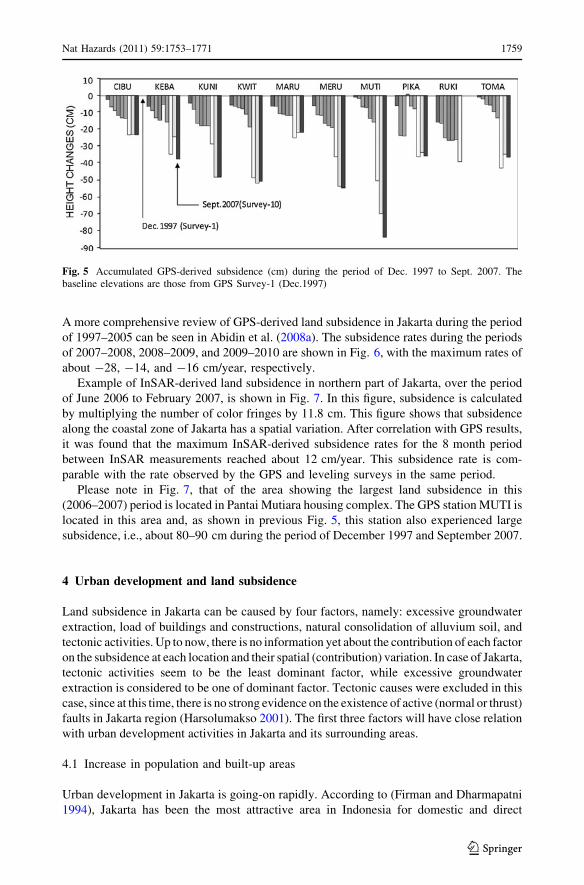
several observing stations are shown in Figs. 5 and 6. On Fig. 5, the first measurement at
each point established the baseline elevation for that site and, therefore, is shown as zero
elevation change. The different color codes for the individual bars in these figures indicate
that they were estimated from different GPS surveys. In about 10 years, i.e., Dec. 1997 to
Sept. 2007, the accumulated subsidence at several GPS stations can reach about 80–90 cm.
Table 1 Observed subsidencerates in Jakarta; the rates varyboth spatially and temporally
Method Period Subsidencerates (cm/year)
Leveling surveys 1982–1991 1–9
1991–1997 1–25
GPS surveys 1997–2010 1–28
InSAR 2006–2007 1–12
Fig. 4 Land subsidence in Jakarta measured from leveling surveys (in meters), over the periods of1982–1991 (left) and 1991–1997 (right); from Abidin et al. (2001). Kriging method was used forinterpolating the data
1758 Nat Hazards (2011) 59:1753–1771
123
A more comprehensive review of GPS-derived land subsidence in Jakarta during the period
of 1997–2005 can be seen in Abidin et al. (2008a). The subsidence rates during the periods
of 2007–2008, 2008–2009, and 2009–2010 are shown in Fig. 6, with the maximum rates of
about -28, -14, and -16 cm/year, respectively.
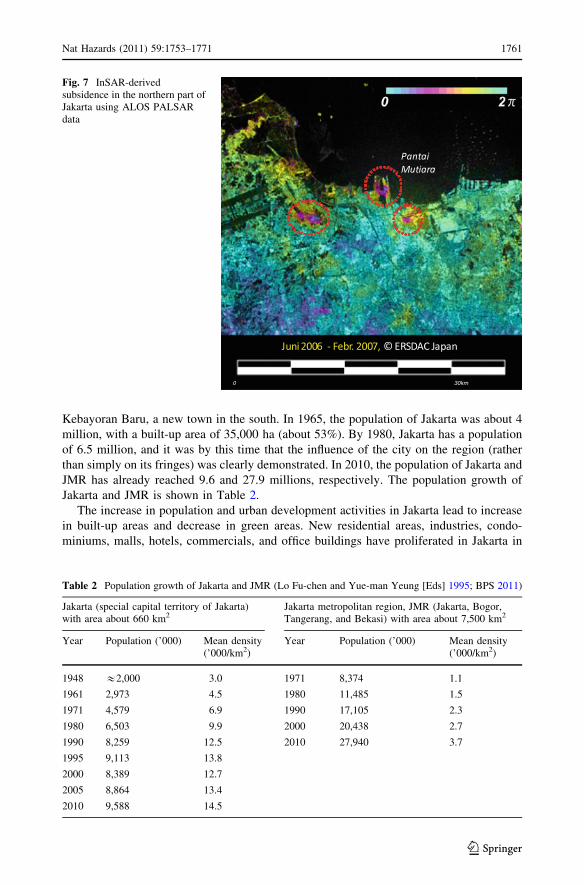
Example of InSAR-derived land subsidence in northern part of Jakarta, over the period
of June 2006 to February 2007, is shown in Fig. 7. In this figure, subsidence is calculated
by multiplying the number of color fringes by 11.8 cm. This figure shows that subsidence
along the coastal zone of Jakarta has a spatial variation. After correlation with GPS results,
it was found that the maximum InSAR-derived subsidence rates for the 8 month period
between InSAR measurements reached about 12 cm/year. This subsidence rate is com-
parable with the rate observed by the GPS and leveling surveys in the same period.
Please note in Fig. 7, that of the area showing the largest land subsidence in this
(2006–2007) period is located in Pantai Mutiara housing complex. The GPS station MUTI is
located in this area and, as shown in previous Fig. 5, this station also experienced large
subsidence, i.e., about 80–90 cm during the period of December 1997 and September 2007.
4 Urban development and land subsidence
Land subsidence in Jakarta can be caused by four factors, namely: excessive groundwater
extraction, load of buildings and constructions, natural consolidation of alluvium soil, and
tectonic activities. Up to now, there is no information yet about the contribution of each factor
on the subsidence at each location and their spatial (contribution) variation. In case of Jakarta,
tectonic activities seem to be the least dominant factor, while excessive groundwater
extraction is considered to be one of dominant factor. Tectonic causes were excluded in this
case, since at this time, there is no strong evidence on the existence of active (normal or thrust)
faults in Jakarta region (Harsolumakso 2001). The first three factors will have close relation
with urban development activities in Jakarta and its surrounding areas.
4.1 Increase in population and built-up areas
Urban development in Jakarta is going-on rapidly. According to (Firman and Dharmapatni
1994), Jakarta has been the most attractive area in Indonesia for domestic and direct
Fig. 5 Accumulated GPS-derived subsidence (cm) during the period of Dec. 1997 to Sept. 2007. Thebaseline elevations are those from GPS Survey-1 (Dec.1997)
Nat Hazards (2011) 59:1753–1771 1759
123

foreign investment because of its better infrastructure, high concentration and access to
mass markets, pool of skilled labor and entrepreneurs, and high access to the decision
makers. The economic activities in the region have grown very rapidly, especially in
industry, trade, transportation, real estate, and many other sectors and have also spilled
over into the adjacent areas of Jakarta Metropolitan Region (JMR), such as Bogor, Tan-
gerang, Depok, and Bekasi. Nowadays, JMR is the largest concentration of urban popu-
lation and economic activities in Indonesia, consisting of about 80% urban population and
20% rural population (Firman 2004). It then increases the urbanization rates into Jakarta
and surrounding areas and population of Jakarta growth rapidly. Consequently, coverage of
the built-up areas is increased and the green areas are decreased. Built-up areas of Jakarta
in 2008 cover about 90% of the region.
According to (Lo Fu-chen and Yue-man Yeung [Eds] 1995), in 1948, the population of
Jakarta was about 2 million, with a built-up area of 20,000 ha (about 30%), including
cm/year-28 -23 -17 -11 -6 0 -14 -11 -8 -6 -3 0
-16 -12 -9 -6 -2 0
cm/year
cm/year
2007-2008 2008-2009
Fig. 6 GPS-derived land subsidence rates in Jakarta, during the periods of 2007–2008 (upper left),2008–2009 (upper right), and 2009–2010 (lower left). Kriging method was used for interpolating the data
1760 Nat Hazards (2011) 59:1753–1771
123
Kebayoran Baru, a new town in the south. In 1965, the population of Jakarta was about 4
million, with a built-up area of 35,000 ha (about 53%). By 1980, Jakarta has a population
of 6.5 million, and it was by this time that the influence of the city on the region (rather
than simply on its fringes) was clearly demonstrated. In 2010, the population of Jakarta and
JMR has already reached 9.6 and 27.9 millions, respectively. The population growth of
Jakarta and JMR is shown in Table 2.
The increase in population and urban development activities in Jakarta lead to increase
in built-up areas and decrease in green areas. New residential areas, industries, condo-
miniums, malls, hotels, commercials, and office buildings have proliferated in Jakarta in
0 30km
Fig. 7 InSAR-derivedsubsidence in the northern part ofJakarta using ALOS PALSARdata
Table 2 Population growth of Jakarta and JMR (Lo Fu-chen and Yue-man Yeung [Eds] 1995; BPS 2011)
Jakarta (special capital territory of Jakarta)with area about 660 km2
Jakarta metropolitan region, JMR (Jakarta, Bogor,Tangerang, and Bekasi) with area about 7,500 km2
Year Population (’000) Mean density(’000/km2)
Year Population (’000) Mean density(’000/km2)
1948 &2,000 3.0 1971 8,374 1.1
1961 2,973 4.5 1980 11,485 1.5
1971 4,579 6.9 1990 17,105 2.3
1980 6,503 9.9 2000 20,438 2.7
1990 8,259 12.5 2010 27,940 3.7
1995 9,113 13.8
2000 8,389 12.7
2005 8,864 13.4
2010 9,588 14.5
Nat Hazards (2011) 59:1753–1771 1761
123

the last three decades. In 2006, there are already 306 hotels, in which 135 are star (clas-
sified) hotels, and 1955 large and medium manufacturing companies in Jakarta (BPS
Jakarta 2007). In 2004, Jakarta already had 73 large shopping malls, besides some 116
department stores, 125 super markets and 151 traditional markets (Steinberg 2007). The
areas of shopping malls in Jakarta have significantly increased from 1.4 million m2 in 2000
to 2.4 million m2 in 2005 (Firman 2009).
Unfortunately, these developments mostly occupied the available green areas in Jakarta.
In 1965, the green areas made up more than 35 percent of the Jakarta’s area and currently
account for only 9.3 percent of the area (Rukmana 2008). Several new towns have also
been developed along the perimeter of Jakarta and its surrounding areas which also
increase the coverage of built-up areas in the region. Figure 8 shows the sharp increase in
coverage of built-up areas in Jakarta since 1972–2005.
This increase in built-up areas directly affects the water recharge areas and recharge-
ability of withdrawn groundwater in Jakarta and its surrounding areas. Coupled with the
increase consumption of groundwater due to increase in population and economic and
industrial activities, the (ground and surface) water system in Jakarta and its surrounding
areas are severely affected. In turn, it will contribute to occurrence of land subsidence
phenomena in several locations inside Jakarta, as depicted by Fig. 9.
4.2 Excessive use of groundwater
The population growth and increase in economic activities in Jakarta and its surrounding
region lead to the increase in water need. Unfortunately, about 64% of water need in
Jakarta is fulfilled by groundwater extraction (Ali 2011), either because piped treated
surface water supplies were inadequate or because it was substantially cheaper to do so
(Colbran 2009). For the same reason, this over discharging of groundwater would deepen
Fig. 8 Expansion of built-up areas in Jakarta and its surrounding areas. (Djakapermana 2008). Red colorindicates the built-up areas
1762 Nat Hazards (2011) 59:1753–1771
123

the piezometric water level inside the aquifers and in turn would cause land subsidence
above it.
Three aquifers are recognized within the 250 m thick sequence of Quaternary sediment
of the Jakarta basin, namely: the Upper Aquifer, an unconfined aquifer, occurs at a depth of
less than 40 m; the Middle Aquifer, a confined aquifer, occurs at a depth between 40 and
140 m; and the Lower Aquifer, a confined aquifer, occurs at a depth between 140 and
250 m (Soetrisno et al. 1997; Hadipurwo 1999). The geologic materials confining these
aquifers are silt and clay. Inside those aquifers, the groundwater generally flows from south
to the north (Lubis et al. 2008). Below a depth of 250 m, an aquifer in the Tertiary
sediments also has been identified. But according to Murdohardono and Tirtomihardjo
(1993), it is less productive and its water quality is relatively poor.
The groundwater extraction in Jakarta could be categorized into shallow (\40 m) and
deep ([40 m) extraction. Shallow extraction is through dug wells or driven wells, operated
with buckets, hand pumps, or small electrical pumps; whereas the deep extraction is mostly
from drilled wells. Shallow extraction is mostly done by the population. It is well spread
over the area, but its extraction rate per well is relatively low. Deep extraction is usually
conducted by industry. It is usually more concentrated and has a relatively high extraction
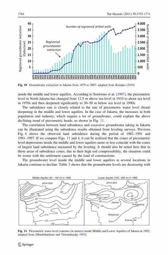
rate per well. The number of registered drilled wells in Jakarta was about 3,700 wells in
2007 (see Fig. 10). Based on the studies done by Murdohardono and Tirtomihardjo (1993),
from the sample of 197 drilled wells in Jakarta, out of 2,800 registered drilled wells at that
time, 156 wells (79%) are extracting groundwater from depths between 40 and 140 m, and
41 wells (21%) are extracting from depths between 140 and 250 m.
The registered groundwater extraction in Jakarta varies from just 3 Qabs (million m3) in
1,879 up to maximum of 34 Qabs in 1994, down to 17 Qabs in 1998 after the Indonesian
economic crisis of 1997, and then go up again to about 22 Qabs in 2007 (see Fig. 10). It
should be pointed out here that these numbers may not reflect the real groundwater
extraction in Jakarta basin. According to Soetrisno et al. (1997), the unregistered deep
groundwater extraction in Jakarta can be as high as 50% or even more. This excessive
groundwater pumping will usually lead to the deepening of the piezometric water level
Fig. 9 Relation between the increase in built-up areas and population with land subsidence
Nat Hazards (2011) 59:1753–1771 1763
123
inside the middle and lower aquifers. According to Soetrisno et al. (1997), the piezometric
level in North Jakarta has changed from 12.5 m above sea level in 1910 to about sea level
in 1970s and then deepened significantly to 30–50 m below sea level in 1990s.
The subsidence rate is closely related to the rate of piezometric water level (head)
deepening in the middle and lower aquifers. In the case of Jakarta, the increases in both
population and industry, which require a lot of groundwater, could explain the above
declining trend of piezometric heads, as shown in Fig. 11.
The correlation between land subsidence and excessive groundwater taking in Jakarta
can be illustrated using the subsidence results obtained from leveling surveys. Previous
Fig. 4 shows the observed land subsidence during the period of 1982–1991 and
1991–1997. If we compare Figs. 11 and 4, it can be realized that the cones of piezometric
level depressions inside the middle and lower aquifers more or less coincide with the cones
of largest land subsidence measured by the leveling. It should also be noted here that in
those areas of subsidence cones, due to their high soil compressibility, the situation could
be worse with the settlement caused by the load of constructions.
The groundwater level inside the middle and lower aquifers at several locations in
Jakarta continue to decline. Table 3 shows that the groundwater levels are decreasing with
Fig. 10 Groundwater extraction in Jakarta from 1879 to 2007; adapted from Kompas (2010)
-40-30 -20
-10
-10
-20-30 -40
0
0 mKramat Jati
JAVA SEA
Gambir Pulogadung
Tanjungpriok
Kalideres
Kebayoran
-10
-20
-25-30
-35-40-25
0
+10+20
0 m
JAVA SEA
Middle Aquifer (40 - 140 m) in 1992 Lower Aquifer (140 - 250 m) in 1992
Fig. 11 Piezometric water-level contours (in meters) inside Middle and Lower Aquifers of Jakarta in 1992;adapted from [Murdohardono and Tirtomihardjo 1993]
1764 Nat Hazards (2011) 59:1753–1771
123

rates of about 0.1–1.9 m/year over the period of 2002–2007. In comparison with GPS-
derived subsidences, it can be seen that the large subsidences are usually associated with
the relatively high rates of groundwater level change rates. However, the relation between
land subsidence and localized groundwater level decrease will not always be a direct and
simple relation. A more detail explanation on GPS-derived subsidence and its relation with
groundwater extraction is given in Abidin et al. (2010a).
It should be realized, however, that in the shorter time scale, the groundwater level
changes inside the Jakarta aquifers are quite dynamic (Abidin et al. 2010a). These
groundwater levels can go up and down up from several decimeters to a few meters in a
year. The effect of this short-term variation in groundwater level inside the aquifers on the
long-term subsidence phenomena in the Jakarta area and its spatial variations are not yet
fully understood. More research is needed to study and clarify this matter.
4.3 Coastal development
Coastal area of Jakarta has also experienced extensive urban development. Many estab-
lishments take place in this coastal region, such as sea port, coastal resort, golf course,
residential areas, industries, condominiums, malls, hotels, and commercial and office
buildings (see Fig. 12). Some areas have also been reclaimed to accommodate more
coastal development initiatives. It should be pointed out that the observed land subsidences
along the coastal areas of Jakarta are relatively have larger rates, as indicated in previous
Figs. 4 to 7.
GPS-derived subsidence rates for the coastal station of MUBA, MUTI, and
PIKA (shown in Fig. 12) in the period of 2008–2009 are -14, -10, and -11 cm/year,
respectively. In the period of 2007–2008, the rates are even larger, i.e., -28, -15, and
Table 3 Groundwater level changes and GPS-derived subsidences at several locations in Jakarta
Groundwater level changes GPS-derived subsidence
Location Aquifer Rates(m/year)
Period Closest station Rates(cm/year)
Period
Cilincing (KBN) Middle -0.57 2002–2007 MARU -4.8 2002–2005
Kamal muara Lower -0.71 2002–2005 KAMR -4.3 2001–2002
Kapuk Middle -0.75 2002–2007 PIKA -10.2 2002–2005
-11.7 2007–2010
Sunter–3 Middle -0.34 2002–2007 KLGD -5.3 2002–2007
Sunter–1 Lower -1.44 2002–2007 -10.1 2007–2010
Tegal Alur Middle -0.45 2002–2007 KLDR -5.3 2002–2005
Tongkol–5 Upper 0.13 2002–2006 RUKI -4.9 2002–2005
Tongkol–9 Middle 0.52 2002–2007 RUKI -4.5 2007–2010
Tongkol–8 Lower -0.87 2002–2007 TNKL -7.8 2009–2010
Joglo Middle -1.73 2002–2007 MERU -7.8 2002–2007
Parkir Gd. Jaya Lower -1.01 2002–2007 CKNI -5.4 2007–2010
Atrium, Senen Middle -1.26 2002–2007 KWIT -6.0 2002–2007
Bapedalda Kngn Upper -0.14 2002–2007 KUNI -6.8 2002–2007
Dharmawangsa Middle -0.31 2002–2007 KEBA -4.2 2002–2007
PT. Yamaha M-2 Middle -1.92 2002–2007 PLGD -12.3 2001–2002
Nat Hazards (2011) 59:1753–1771 1765
123

-18 cm/year, respectively. In the latest observation period of 2009-2010, the rates are -
15, -8, and -7 cm/year, respectively. Relatively large subsidence in the coastal areas will
certainly affect the coastal development of Jakarta.
Considering the sea-level rise phenomena, coastal subsidence in Jakarta will certainly
affect coastal development in Jakarta (Abidin et al. 2010a). Considering the relatively flat
nature (i.e., 0–2 m above MSL) of most coastal areas of Jakarta, this combined effect of
land subsidence and sea-level rise will certainly be have disastrous consequences for
habitation, industry, and fresh groundwater supplies from coastal aquifers. During high
tides, tidal flooding is already affecting some of these coastal areas, as shown in Fig. 13.
The extent and magnitude of subsidence-related flooding will worsen with the likely
continuation of sea-level rise along the coastal area of Jakarta, which has the rate of about
4–5 mm/year (Nurmaulia et al. 2010).
4.4 Impacts of subsidence to urban development
Impacts caused by land subsidence to urban development in Jakarta can be seen in several
forms. The differential subsidence nature in Jakarta basin may introduce the cracking and
damage in buildings and infrastructure and may change the flow pattern of surface water.
Subsidence may also enlarge the (tidal) flooding inundation areas, and in general will
deteriorate their environmental quality. Subsidence along several coastal areas of Jakarta
also makes them more vulnerable toward sea-level rise phenomena. Figure 14 shows
several indications of land subsidence phenomena in Jakarta.
In case of Jakarta, which is actually prone toward flooding, subsidence phenomena has
to be fully understood for flood management system. Land subsidence will decrease ele-
vation of the dikes and drainage system. It will reduce the function of city drainage system
in the subsidence affected areas and may introduce flooding during the rainy season.
During the period between 1993 and 2007, at least there are four big floods in Jakarta,
namely on January 9–10, 1993, February 1996, January 26–February 1, 2002, and February
Fig. 12 Part of coastal areas of Jakarta, courtesy of Google Earth. In this figure, MUBA, MUTI, and PIKAare GPS stations with relatively large subsidence rates
1766 Nat Hazards (2011) 59:1753–1771
123

4–14, 2007 (Texier 2008). Figure 15 shows in general the flood inundation areas of the
2002–2007 flooding.
If the flooding inundation areas in Fig. 15 are compared with the previous subsidence
information as derived by Leveling, GPS, and InSAR techniques; the correlation between
land subsidence and flooding inundation can be seen in the western and eastern parts of
North Jakarta region. In other areas, however, the correlation is quite weak, and in this
case, the inundation areas are mainly located along the flooded rivers.
5 Closing remarks
The results obtained from leveling surveys, GPS surveys, and InSAR technique over the
period between 1982 and 2010 show that land subsidence in Jakarta has spatial and
temporal variations. In the areas affected by land subsidence, in general, the observed
subsidence rates are about 1–15 cm/year and can be up to 20–28 cm/year at certain
location and certain period. There is a strong indication that land subsidence in Jakarta area
is governed by the excessive groundwater extraction from the middle and lower aquifers,
besides also by building/construction load and natural consolidation of sedimentary layers.
The excessive groundwater extraction causes the rapid decrease in groundwater level
inside the aquifers and in turn causes the land subsidence above it. However, the relation
between land subsidence and groundwater level decrease inside the aquifers in certain
location will not always be a direct and simple relation.
Fig. 13 Flooding in the coastal areas of Jakarta; around PIKA GPS station (above) and around MUBA GPSstation (below)
Nat Hazards (2011) 59:1753–1771 1767
123

Land subsidence in Jakarta has a strong linkage with urban development process. Urban
development in Jakarta causes increases in built-up areas, population, economic and
industrial activities, and also groundwater extraction. These increases can then lead to land
subsidence phenomena. In other side, the existing land subsidence phenomena will affect
and should be considered in urban development process itself. In this case, land use
Fig. 14 Several indication and impact of land subsidence in Jakarta (Wirakusumah 2008). a and b arelocations in Kamal Muara; c and d are locations along the highway to the airport (Cengkareng)
Inundated Areas
Inundated Areas
Flooding of 2002, courtesy of LAPAN Flooding of 2007, courtesy of Kompas (10 Feb. 2007)
Fig. 15 Flooding inundation areas in Jakarta
1768 Nat Hazards (2011) 59:1753–1771
123

planning, groundwater extraction regulation, building and infrastructure codes, flood
management and control, and seawater intrusion control are examples of several urban
development aspects that will be related with land subsidence phenomena. In general,
relation between urban development and land subsidence in Jakarta can be illustrated by
Fig. 16.
Finally, it can be concluded that more data and further investigation are required to
understand the detail and comprehensive relationship between land subsidence and urban
development in the Jakarta basin. Additional causes of subsidence, e.g., load of buildings
and construction, natural consolidation of alluvium soil, and tectonic movements, should
also investigated and taken into account. Further research on the impacts of land subsi-
dence in Jakarta should also be systematically conducted, especially in relation with the
flooding inundation areas and also with the coastal flooding in relation with sea-level rise
phenomena. Several areas along the coast of Jakarta already have experienced tidal
flooding during high tide periods. The adaptation measures to reduce the impacts of this
phenomenon, therefore, should be developed as soon as possible.
References
Abidin HZ (2005) Suitability of levelling, GPS and INSAR for monitoring land subsidence in urban areas ofIndonesia. GIM Int 19(7):12–15
Abidin HZ, Djaja R, Darmawan D, Hadi S, Akbar A, Rajiyowiryono H, Sudibyo Y, Meilano I, Kusuma MA,Kahar MA, Subarya C (2001) Land subsidence of Jakarta (Indonesia) and its geodetic-based moni-toring system. Natural Hazards. J Int Soc Prev Mitig Nat Hazards 23(2/3):365–387
Abidin HZ, Djaja R, Andreas H, Gamal M, Hirose K, Indonesia, Maruyama Y (2004) Capabilities andconstraints of geodetic techniques for monitoring land subsidence in the urban areas of Indonesia.Geomat Res Aust 81:45–58
Abidin HZ, Andreas H, Gamal M, Wirakusumah AD, Darmawan D, Deguchi T, Maruyama Y (2008a) Landsubsidence characteristics of the bandung basin, Indonesia, as estimated from GPS and InSAR. J ApplGeodesy 2(3):167–177. doi:10.1515/JAG.2008.019
Abidin HZ, Andreas H, Djaja R, Darmawan D, Gamal M (2008b) Land subsidence characteristics of Jakartabetween 1997 and 2005, as estimated using GPS surveys. GPS Solut 2(1):23–32
Abidin HZ, Andreas H, Gamal M, Gumilar I, Napitupulu M, Fukuda Y, Deguchi T, Maruyama Y, Riawan E(2010a) Land subsidence characteristics of the Jakarta basin (Indonesia) and its Relation withgroundwater extraction and sea level rise. In: Taniguchi M, Holman IP (eds) Groundwater response to
Fig. 16 Urban development and land subsidence relation in Jakarta
Nat Hazards (2011) 59:1753–1771 1769
123

changing climate, IAH selected papers on hydrogeology no 16, CRC Press, London, ISBN: 978-0-415-54493-1, chapter 10, pp 113–130
Abidin HZ, Andreas H, Gumilar I, Sidiq TP, Gamal M, Murdohardono D Supriyadi Fukuda Y (2010b)Studying land subsidence in semarang (Indonesia) using geodetic methods. In: Proceedings of the FIGcongress 2010, FS 4D—Landslide and subsidence monitoring II, Sydney, Australia, pp 11–16 April2010
Ali F (2011) Personal communication. Technical board member of Jakarta Water Supply Regulatory Body,Tuesday, 22 Feb
Beutler G, Bock H, Brockmann E, Dach R, Fridez P, Gurtner W, Hugentobler U, Ineichen D, Johnson J,Meindl M, Mervant L, Rothacher M, Schaer S, Springer T, Weber R (2001) Bernese GPS softwareversion 4.2. In: Hugentobler U, Schaer S, Fridez P (eds) Astronomical Institute, University of Berne,p 515
Beutler G, Bock H, Dach R, Fridez P, Gade A, Hugentobler U, Jaggi A, Meindl M, Mervant L, Prange L,Schaer S, Springer T, Urschl C, Walser P (2007) Bernese GPS Software version 5.0. In: Dach R,Hugentobler U, Fridez P, Meindl M (eds.) Astronomical Institute, University of Berne, p 612
BPS (2011). Website of the Indonesian Central Agency for Statistics (Badan Pusat Statistik). Address:http://www.bps.go.id/, Accessed: 27 Jan 2011
Colbran N (2009) Will Jakarta be the next atlantis? excessive groundwater use resulting from a failing pipedwater network Law, Environment and Development Journal, 5/1, p 18, available at http://www.lead-journal.org/content/09018.pdf
Deguchi T (2005) Automatic InSAR processing and introduction of its application studies. In: Proceedingsthe 26th Asian conference on remote sensing, Hanoi, Vietnam
Deguchi T, Kato M, Akcin H, Kutoglu HS (2006) Automatic processing of Interferometric SAR andaccuracy of surface deformation measurement. SPIE Europe Remote Sensing, Sweden
Djakapermana RD (2008) Kebijakan Penataan Ruang Jabodetabekjur, Paper dipresentasikan pada SeminarSehari Memperingati Hari Air Sedunia, Kelompok Keahlian Teknologi Pengelolaan Lingkungan,FTSL ITB, Bandung, 31 Maret 2008
Firman T (1999) From global city to city of crisis: jakarta metropolitan region under economic turmoil.Habitat Int 23(4):447–466
Firman T (2004) New town development in Jakarta Metropolitan Region: a perspective of spatial segre-gation. Habitat Int 28:349–368
Firman T (2009) The continuity and change inmega-urbanization in Indonesia: A survey of Jakarta–Ban-dung Region (JBR) development. Habitat Int 33:327–339
Firman T, Dharmapatni IAI (1994) The challenges to sustainable development in Jakarta metropolitanregion. Habitat Int 18(3):79–94
Hadipurwo S (1999) Groundwater. In: COASTPLAN JAKARTA BAY PROJECT, Coastal EnvironmentalGeology of the Jakarta Reclamation Project and Adjacent Areas, CCOP COASTPLAN case studyReport No. 2, Jakarta/Bangkok, pp 39–49
Harsolumakso AH (2001) Struktur geologi dan daerah genangan. Buletin Geol 33(1):29–45Hutasoit LM (2001) Kemungkinan hubungan antara kompaksi alamiah dengan daerah genangan air di DKI
Jakarta. Buletin Geol 33(1):21–28Kompas (2010) Article in the Indonesian national newspaper of kompas, internet address: http://
megapolitan.kompas.com/read/2010/10/02/17434474/DKI.Kurangi.Pengambilan.Air.TanahLeick A (2003) GPS satellite surveying, 3rd edn. Wiley, New York, ISBN 0471059307, p 435Lo Fu-chen, Yue-man Yeung [Eds] (1995) Emerging world cities in pacific Asia. United Nations University
Press, Tokyo, ISBN 92-808-0907-5, http://www.unu.edu/unupress/unupbooks/uu11ee/uu11ee15.htmLubis RF, Sakura Y, Delinom R (2008) Groundwater recharge and discharge processes in the Jakarta
groundwater basin, Indonesia. Hydrogeol J doi: 10.1007/s10040-008-0278-1Marfai MA, King L (2007) Monitoring land subsidence in Semarang, Indonesia. Environ Geol 53:651–659Massonnet D, Feigl KL (1998) Radar Interferometry and its Application to Changes in the Earth’s Surface.
Rev Geophys 36(4):441–500Murdohardono D, Tirtomihardjo H (1993) Penurunan tananh di Jakarta dan rencana pemantauannya. In:
Proceedings of the 22nd annual convention of the indonesian association of geologists, Bandung, 6–9December, pp 346–354
Murdohardono D, Sudarsono U (1998) Land subsidence monitoring system in Jakarta. In: Proceedings ofsymposium on Japan-Indonesia IDNDR Project : Volcanology, tectonics, flood and sediment hazards,Bandung, 21–23 September, pp 243–256
NGS (2011) Website of the national geodetic survey geodetic leveling, Address: http://www.ngs.noaa.gov/heightmod/Leveling/leveling_index.html, Accessed: 7 Feb 2011
1770 Nat Hazards (2011) 59:1753–1771
123

Nurmaulia SL, Fenoglio-Marc L, Becker M (2010) Long term sea level change from satellite altimetry andtide gauges in the indonesian region, paper presented at the EGU General Assembly 2010, 2–7 May.Vienna, Austria
Purnomo H, Murdohardono D, Pindratno H (1999) Land Subsidence Study in Jakarta. In: Proceedings ofindonesian association of geologists, vol IV : Development in engineering, environment, and numericalgeology, Jakarta, 30 Nov.-1 Dec., pp 53–72
Rajiyowiryono H (1999) Groundwater and Landsubsidence Monitoring along the North Coastal Plain ofJava Island. CCOP Newsl 24(3):19 July-September
Rimbaman, Suparan P (1999) Geomorphology. In: Proceeding of COASTPLAN JAKARTA BAY PRO-JECT, coastal environmental geology of the Jakarta reclamation project and adjacent areas, CCOPCOASTPLAN case study Report No. 2, Jakarta/Bangkok, pp 21–25
Rismianto D, Mak W (1993) Environmental aspects of groundwater extraction in DKI Jakarta: Changingviews. In: Proceedings of the 22nd annual convention of the indonesian association of geologists,bandung, 6–9 December, pp 327–345
Rukmana D (2008) Decreasing green areas in Jakarta, The Jakarta Post, March 17, 2008, http://www.thejakartapost.com/news/2008/03/16/decreasing-green-areas-jakarta.html
Sampurno (2001) Geomorfologi dan Daerah Genangan DKI Jakarta. Buletin Geol 33(1):1–12Schreier G (Ed.) (1993) SAR geocoding: data and systems. Wichmaann Verlag, Karlsruhe, ISBN 3-87907-
247-7, p 435Soetrisno S, Satrio H, Haryadi T (1997) To anticipate impacts of reclamation of jakarta bay, a groundwater
conservation’s perspective. Paper presented at workshop on coastal and nearshore geological/ocea-nographical assessment of Jakarta bay : A Basis for Coastal Zone Management and Development,Jakarta, pp 25–28 June
Steinberg F (2007) Jakarta: environmental problems and sustainability. Habitat Int 31:354–365Texier P (2008) Floods in Jakarta: when the extreme reveals daily structural constraints and mismanage-
ment. Disaster Prev Manag 17(3):358–372Wirakusumah AD (2008) Pemanfaatan Air Tanah di Perkotaan Paper dipresentasikan pada Seminar Sehari
Memperingati Hari Air Sedunia, Kelompok Keahlian Teknologi Pengelolaan Lingkungan, FTSL ITB,Bandung, 31 Maret 2008
Yong RN, Turcott E, Maathuis H (1995) Groundwater extraction-induced land subsidence prediction:bangkok and jakarta case studies. In: Proceedings of the Fifth international symposium on land sub-sidence, IAHS Publication no. 234, October, pp 89–97
Nat Hazards (2011) 59:1753–1771 1771
123