
Kourion's Hinterland in Late Antiquity and the Findings of the ...
704
Kourion’s Hinterland in Late Antiquity and the Findings of the Sotira Archaeological Project’s 1997 and 2004 Seasons By Christopher Mavromatis A thesis submitted to The University of Birmingham For the degree of DOCTOR OF PHILOSOPHY Department of Byzantine, Ottoman and Modern Greek Studies College of Arts and Law The University of Birmingham October 2009
-
Upload
khangminh22 -
Category
Documents
-
view
1 -
download
0
Transcript of Kourion's Hinterland in Late Antiquity and the Findings of the ...

Kourion’s Hinterland in Late Antiquity and the Findings of the
Sotira Archaeological Project’s 1997 and 2004 Seasons
By
Christopher Mavromatis
A thesis submitted to
The University of Birmingham
For the degree of
DOCTOR OF PHILOSOPHY
Department of Byzantine, Ottoman
and Modern Greek Studies
College of Arts and Law
The University of Birmingham
October 2009

University of Birmingham Research Archive
e-theses repository This unpublished thesis/dissertation is copyright of the author and/or third parties. The intellectual property rights of the author or third parties in respect of this work are as defined by The Copyright Designs and Patents Act 1988 or as modified by any successor legislation. Any use made of information contained in this thesis/dissertation must be in accordance with that legislation and must be properly acknowledged. Further distribution or reproduction in any format is prohibited without the permission of the copyright holder.

ABSTRACT
This dissertation presents a discussion on the Late Antique
(fifth to eighth centuries AD) landscapes of Cyprus based on
the archaeological, environmental, and historical records.
This dissertation argues that apart from being an economically
well-integrated province, Cyprus was also well-integrated into
the large social and strategic trajectories of the Late
Antique east Mediterranean. This study also uses
archaeological data generated by the Sotira Archaeological
Project (SAP) to examine the Late Antique landscapes in the
south coast urban settlement of Kourion’s hinterland.
Interestingly, the majority of the loci recorded by the SAP
are interpretable as either estate centres or farmsteads.
Analysis of these loci revealed the existence of a
comparatively complex Late Antique landscape that embodied
aspects of the manifold relationships between the productive,
commemorative, and authoritative landscapes of Kourion’s
hinterland during this period.

To My Parents Emanuel and Susan Mavromatis

ACKNOWLEDGEMENTS
First and foremost I would like to thank my advisor at the
University of Birmingham, Doctor Archibald Dunn, for his guidance,
encouragement, patience, and suggestions throughout the various
stages of this project. Thanks are also due to my internal assessor
at the University of Birmingham, Professor Vince Gaffney, and my
external assessor at the University of Edinburgh, Professor Jim
Crow. I am indebted to Professor Stuart Swiny (S.U.N.Y, Albany) for
allowing me to use the Sotira Archaeological Project’s data in this
thesis. I am also indebted to the late Doctor Danielle Parks (Brock
University) for inviting me to take part in the Kourion Mapping
Project and for providing me with access to that project’s spatial
data. Without the generosity of Professor Swiny and Doctor Parks,
this thesis would not have been possible in its present form. I
would also like to thank the Department of Antiquities and its
current director, Doctor Pavlos Flourentzos, for granting me a
permit to reinvestigate several of the Sotira Archaeological
Project’s sites in 2004 and the former Limassol District
archaeological officer, Doctor Eleni Prokopiou, for her interest in
the project and her instrumental role in insuring the preservation
of several of the more exposed sites reinvestigated in 2004.
Finally, I would like to express my deepest gratitude to my family
and friends, especially my parents, Emanuel and Susan Mavromatis,
and my, sister Gina Constantini, for their patience and unwavering
patronage of my interest in archaeology.

TABLE OF CONTENTS
Chapter 1 I ntroduction ......................................... 1 Chapter 2 Theoretical and historical framework 2.1 Chapter introduction ................................... 15 2.2 Social power and the built environment ................. 15 2.2.1 Power, ideology, and the built environment ......... 16 2.2.1.1 Force, coercion, and authority ................. 26 2.2.2 Space and place .................................... 31 2.2.2.1 The active role of the built environment ....... 39 2.2.2.2 Monumental architecture ........................ 43 2.2.3 Summary ............................................ 45 2.3 Cities and the central government ...................... 48 2.3.1 Aspects of administration .......................... 49 2.3.1.1 Civic administration ........................... 53 2.3.1.2 Late Roman elites .............................. 65 2.3.1.2.A Curial status .............................. 75 2.3.2 The changes to the physical fabric of the urban environment .............................. 81 2.3.2.1 Methodological trends .......................... 81 2.3.2.2 Spatial trends ................................. 92 2.3.3 Discussion: The urban environment as a power resource ............................... 100 2.4 Geographic information as a power resource ............ 109 2.5 Chapter summary ....................................... 114 Chapter 3 Environmental Framework 3.1 Chapter introduction .................................. 121 3.2 The Mediterranean environment ......................... 121 3.2.1 Physical environment .............................. 122 3.2.2 Climate ........................................... 128 3.2.3 Vegetation ........................................ 131 3.2.4 Environmental stability and instability ........... 134 3.2.4.1 Erosion and tectonics ......................... 134 3.2.4.2 Changes in climate ............................ 141 3.2.4.3 Changes in vegetation ......................... 146 3.2.5 The East Mediterranean climate during the 6 th – 8 th centuries AD .............................. 147 3.2.5.1 Other Eastern Mediterranean climatic proxy data for the 6 th – 8 th centuries AD ...... 151 3.2.5.2 Aerosol inputs and the 536 AD event ........... 153 3.2.5.3 Discussion .................................... 156 3.3 The Cypriot environment ............................... 161 3.3.1 The physical environment .......................... 161 3.3.1.1 Tectonics and erosion ......................... 169 3.3.2 The present vegetation of Cyprus .................. 179 3.3.3 The present climate of Cyprus ..................... 182 3.3.4 The Cypriot climate during the 6 th -8 th centuries AD ............................... 186 3.3.4.1 Other climatic data ........................... 188

3.3.5 The environment of the Kourion area ................ 191 3.3.5.1 Geology and soils ............................. 192 3.3.5.2 Hydrology ..................................... 194 3.3.5.3 Vegetation .................................... 196 3.3.5.3.A The 1997 Sotira Archaeological Project’s ecological study .......................... 199 3.4 Chapter summary ........................................ 205 Chapter 4 Late Roman Cyprus 4.1 Chapter introduction ................................... 218 4.2 Contexts ............................................... 219 4.2.1 Aspects of Roman, Late Roman, and Condominium administration ..................................... 220 4.2.1.1 Ecclesiastic authoritative landscapes ......... 233 4.2.1.2 Cypriot elites: Roman and Late Roman .......... 253 4.2.2 Strategic contexts ................................. 267 4.2.2.1 Roman and Late Roman .......................... 267 4.2.2.2 The 7 th century AD ............................. 274 4.2.3 Aspects of provincial infrastructure ............... 287 4.2.3.1 Transport and communication ................... 288 4.2.3.1.A Maritime .................................. 288 4.2.3.1.B Inland .................................... 292 4.2.3.1.C Fortifications ............................ 296 4.2.3.2 Productive .................................... 301 4.2.3.2.A Production: The archaeological evidence ... 311 4.2.4 Discussion: Strategic assessment ................... 322 4.3 The use of space at Kourion in Late Antiquity .......... 344 4.3.1 The archaeology of secondary occupation ............ 363 4.3.1.1 Fill contexts ................................. 367 4.3.1.2 Floor/surfaces ................................ 374 4.4 Chapter Summary ........................................ 386 Chapter 5 The Sotira Archaeological Project 5.1 Chapter introduction ................................... 406 5.2 Mediterranean survey: Aspects ......................... 406 5.2.1 Survey in Cyprus: Methodological approaches ........ 412 5.3 The Sotira Archaeological Project Survey I ............. 419 5.3.1 S.A.P field methodology ............................ 419 5.3.1.1 Objectives, limitations, and terminology ...... 427 5.3.1.1.A Terminology: Site, settlement, scatter, and chronological periods ................. 430 5.3.2 The S.A.P study area ............................... 434 5.3.3 Other projects in the vicinity of the S.A.P study area ........................................ 438 5.4 The Sotira Archaeological Project II: Data presentation ...................................... 448 5.4.1 Roman and Late Roman loci revisited in 2004 ........ 454 5.4.1.1 Locus 97-01 ................................... 454 5.4.1.2 Locus 97-02 ................................... 457 5.4.1.3 Locus 97-07 ................................... 460 5.4.1.4 Locus 97-22 ................................... 461 5.4.1.5 Locus 97-05 ................................... 463 5.4.1.6 Locus 97-06 ................................... 465

5.4.1.7 Locus 97-04 ................................... 467 5.4.1.8 Locus 97-03 ................................... 469 5.4.1.9 Locus 97-08 ................................... 471 5.4.1.10 Locus 97-09 .................................. 472 5.4.1.11 Discrete scatters reinvestigated in 2004 ..... 474 5.4.1.12 Loci 04-01, 04-02, and 04-03 ................. 475 5.4.2 Data analysis .................................... 479 5.4.2.1 General trends in loci location ............... 479 5.4.2.2 Late Roman loci ............................... 482 5.4.2.2.A Analytical Group-1 (AG-1) ................. 485 5.4.2.2.B Analytical Group-2 (AG-2) ................. 488 5.4.2.2.C Analytical Group-3 (AG-3) ................. 491 5.4.2.3 Discussion: Kourion’s multi-component hinterland .................................... 493 5.4.2.3.A The productive potential of the S.A.P Late Antique loci ......................... 498 5.4.2.3.B The S.A.P survey results compared to select Cypriot surveys ..................... 501 5.5 Chapter summary ....................................... 515 Chapter 6 Conclusion 6.1 Introduction .......................................... 559 6.2 Late Roman Cyprus: A well-integrated province? ........ 560 6.2.1 The Late Antique Cypriot elites ................... 563 6.2.2 Cyprus’ tactical value ............................ 567 6.2.3 Cypriot urban landscapes: Kourion in Late Antiquity .................................... 570 6.2.4 Rural expansion in Late Antique Cyprus ............ 575 6.2.4.1 A multi-component Late Antique Cypriot landscape ............................. 580 6.3 Recommendations for further work in Kourion’s chora ..................................... 590 Appendix I S.A.P 1997 environmental survey data (1) .......... 592 Appendix II S.A.P 1997 environmental survey data (2) ......... 616 Appendix III S.A.P 1997 loci catalogue ....................... 619 Appendix IV S.A.P 1997 loci field form ....................... 631 Bibliography ................................................. 632

TABLE OF FIGURES
Figure 1.1 Location map ....................................... 13 Figure 1.2 Major modern Cypriot settlements .................. 14 Figure 2.1 Plan of Zenobia ................................... 116 Figure 2.2 Plan of Resafa .................................... 117 Figure 2.3 Plan of Justiniana Prima ......................... 118 Figure 2.4 Plan of Scythopolis .............................. 119 Figure 2.5 Plan of the Byzantine shops at Sardis ............. 120 Figure 3.1 Major morphological zones ......................... 208 Figure 3.2 Terrain profiles for the S.A.P project and study areas ................................... 209 Figure 3.3 Vegetation types in the S.A.P study and project areas ..................... 210 Figure 3.4 Terrain agricultural suitability .................. 211 Figure 3.5 Plantation style agriculture in the Episkopi area .............................. 212 Figure 3.6 General landscape shot of the terrain surrounding the site of Sotira Teppes ............. 213 Figure 3.7 Terrain surrounding Sotira village ................ 214 Figure 3.8 General shot showing the terrain in the Paramali Gorge ............................. 215 Figure 3.9 General landscape shot looking towards The locality of Kajillen .......................... 216 Figure 3.10 Early modern limekiln in the foreground and agricultural retention pond in the background ................................ 217 Figure 4.1 Select Cypriot Roman and Late Roma settlements ............................. 389 Figure 4.2 Distribution of lead seals in relation to the Late Roman road system ..................... 390 Figure 4.3 Kourion’s urban and suburban armature elements ................................. 391 Figure 4.4 Kourion’s urban armature elements and select targets recoded by the Kourion Mapping Project .... 392 Figure 4.5 General shot across the Bath complex at Kourion ... 393 Figure 4.6 Quarried arcosolium chamber tomb from Area B of Kourion’s Amathous gate cemetery ........ 394 Figure 4.7 The so-called “Earthquake House” at Kourion ....... 395 Figure 4.8 Phase plan of the basilica complex at Maroni Petrera .................................... 396 Figure 4.9 Complex from Area I at Kalavasos Kopetra .......... 397 Figure 4.10 Basilica from Area II at Kalavasos Kopetra ....... 398 Figure 4.11 Basilica from Area V at Kalavasos Kopetra ........ 399 Figure 4.12 Structures from Area IV at Kalavasos Kopetra ..... 400 Figure 4.13 Structures from Area VI at Kalavasos Kopetra ..... 401

Figure 4.14 Ware weights expressed as a percentage of difference from lots I-28, 29, and 30 from Kalavasos Kopetra ................................ 402 Figure 4.15 Ware weights by area expressed as a percentage of difference from Area VI from Kalavasos Kopetra ................................ 403 Figure 4.16 Plan of the Episcopal Precinct at Kourion ........ 404 Figure 4.17 Secondary activity areas from atrium area of Kourion’s Episcopal Precinct .................. 405 Figure 5.1 Select survey projects on Cyprus .................. 517 Figure 5.2 Hectares surveyed and not surveyed in each S.A.P 1997 quadrat ................................ 518 Figure 5.3 Quadrat 11 overview ............................... 519 Figure 5.4 General view across locus 97-01 ................... 520 Figure 5.5 Sketch plan of locus 97-01 ........................ 521 Figure 5.6 Locus 97-01 wall alignments ....................... 522 Figure 5.7 Press weight from room A and eastern interior wall from locus 97-01 .................... 523 Figure 5.8 Threshold block in eastern wall alignment from locus 97-01 .................................. 524 Figure 5.9 Slotted bock and northern wall alignment from locus 97-01 .................................. 525 Figure 5.10 Grid units across locus 97-01 .................... 526 Figure 5.11 Terrain around locus 97-02 ....................... 527 Figure 5.12 East and west wall alignments from the rectangular structure at locus 97-02 ......... 528 Figure 5.13 Worked blocks in terrace wall at locus 97-22 ..... 529 Figure 5.14 Quadrat 05 overview .............................. 530 Figure 5.15 General view across locus 97-05 .................. 531 Figure 5.16 Selection of ceramic artefacts from locus 97-05 ................................. 532 Figure 5.17 Stone basin fragment from locus 97-05 ............ 533 Figure 5.18 General view to the north and east of locus 97-05 illustrating the extensive disturbances caused by mining in 2004 ............ 534 Figure 5.19 General view of locus 97-06 illustrating pre-1997 disturbances in the site’s central sector ................................... 535 Figure 5.20 Locus 97-06’s bisected north wall ................ 536 Figure 5.21 Selection of ceramic artefacts from locus 97-06 ................................. 537 Figure 5.22 Quadrat 06 overview .............................. 538 Figure 5.23 General view across locus 97-04 illustrating the disturbances caused by mining in 2004 ........ 539 Figure 5.24 Selection of ceramic artefacts from locus 97-04 ................................. 540 Figure 5.25 General view across locus 97-03 from lower field sector illustrating the location of the northern group of tombs and looters spoil ................................ 541 Figure 5.26 Selection of ceramic artefacts from locus 97-03’s northern and southern sectors ...... 542

Figure 5.27 Limestone lid from locus 97-03’s ridge sector .... 543 Figure 5.28 Architectural element from locus 97-03’s lower field sector ............................... 544 Figure 5.29 Monumental door or window mullion with battered inscription followed by vegetal motif from locus 97-03’s lower field sector ............ 545 Figure 5.30 Cist tomb from the southern end of Locus 97-03 ... 546 Figure 5.31 Quadrat 04 overview .............................. 547 Figure 5.32 Press block and architectural rubble from locus 97-09 ................................ 548 Figure 5.33 Analytical Group-1 ............................... 549 Figure 5.34 Analytical Group-2 ............................... 550 Figure 5.35 Analytical Group-3 ............................... 551 Figure 5.36 The DAP study area and select sites .............. 552 Figure 5.37 Late Antique sites in the Lower Maroni Valley ........................................... 553 Figure 5.38 Late Antique sites in the Vasilikos Valley ....... 554 Figure 5.39 Distribution of select sites identified in the CPSP study area ........................... 555 Figure 5.40 Sites in the AAP study area ...................... 556 Figure 5.41 Detail of the SCPS survey area, transects, and SIAs ......................................... 557 Figure 5.42 Hellenistic through Late Roman ceramics, PSOIs, and SIAs recorded by the SCPS ............. 558

1
CHAPTER 1
INTRODUCTION
O ver the last two and a half decades, intensive archaeological
field survey data has increasingly contributed to our understanding
of Late Antique multi-component settlement systems in the eastern
Mediterranean. Undoubtedly the emphasis on diachronic research
frameworks, among a host of other methodological developments,
adopted by many second generation or “New Wave” Mediterranean
archaeological field surveys have increasingly illuminated Late
Antique landscapes as well as those of other previously marginalized
periods (Alcock and Cherry 2004: 3). Arguably, Cyprus is one of the
most intensively surveyed areas in the eastern Mediterranean and, as
a whole, the large regional and the smaller period-specific
archaeological survey projects operating on the island have closely
followed contemporary survey methodologies as practiced in other
parts of the Mediterranean (figures 1.1 and 1.2) 1. However, to date,
wi th the notable exception of the Sydney Cyprus Survey Project ( e.g.
Given and Knapp 2003; Given 2004) and Manning and colleagues’
(Manning et al 2000; Manning et al 2002) work in the Maroni Valley,
very few of the larger interdisciplinary survey projects have
1 The literature on Mediterranean survey is voluminous; however, the volumes
edited by Athanassopoulos and Wandsnider (2004), Alcock and Cherry (2004), Francovich and Patterson (2000), and Papadopoulos and Leventhal (2003) provide the essential methodological and theoretical developments. The various contributions in the recent volume edited by Iacovou (2004) provide a succinct account of archaeological survey’s development on Cyprus.

2
produced complete final publications and even fewer have produced
reports specifically dealing with the Late Antique period in their
study areas.
While there are exceptions ( e.g. Kardulias and Yerkes 2004;
Given 2004; Given and Knapp 2003; Rautman 2000), Late Antique
Cypriot landscapes remain comparatively under-theorized in relation
to other more intensively studied periods, like the Bronze Age, for
example (e.g. Knapp 1990; Knapp 1999; Keswani 1993; Keswani 1997).
Nevertheless, the general trend identified by several of the larger
Cypriot surveys (e.g. Given and Knapp 2003; Rautman 2004; Ed. Fejfer
1995) for the Late Antique period in Cyprus is one characterized by
an increase in rural activity. The aggregate trend derived from both
excavation and survey data also indicates a general disruption of
the established exchange conduits starting in the mid-seventh
century AD. The appearance of handmade pottery at the south coast
urban site of Kourion (Hayes 2007) and at the village of Kalavasos
Kopetra (Rautman 1998; Rautman et al 2003) in deposits attributable
to the second half of the seventh century AD also supports this
general impression. However, while perspectives that have used
ceramic assemblages ( e.g. fine ware and amphora) as the main means
of measuring the vitality of the Cyprus’ rural sector have
contributed to our understanding of the province’s relationships
with the larger rhythms of Late Antique exchange in the east
Mediterranean, this class of material evidence is not without its
own set of problems. For example, based on stratified assemblages
from area three of the Paphos Theatre excavations, Rowe (2004) has

3
recently argued that several CRS forms, which scholars ( e.g. Hayes
1972; Catling 1972; Catling and Dikigoropoulos 1970) have
traditionally assigned to sixth and seventh centuries AD should be
reassigned to the fourth and fifth centuries AD 2. Additionally,
Ar mstrong (2009) has recently argued that the production of CRS form
9 and its variants along with Dhiorios cook pots and dimple bottom
jugs continued well into the eighth century AD. Both Rowe ( ibid) and
Armstrong’s (ibid ) research clearly illustrates that more work needs
to be done on refining CRS’ typology and chronology 3. Furthermore,
t heir ( ibid) work also illustrates the important role coarse wares
can play in identifying late seventh and eighth century AD activity
in the archaeological record. As a general point, most researchers
would agree that difficulties arise in the comparative analysis of
ceramic assemblages derived from surface survey projects (Given
2004; Terrentato 2004). Apart from the issues associated with the
quantitative comparison of ceramic data generated by archaeological
survey, time lag presents another, but often overlooked, problem in
the interpretation of ceramic assemblages derived from both
excavations and surveys (Adams 2003) 4. While some researchers ( e.g.
2 For example, Rowe’s (2004: 298-300) argues that the opening production
dates for CRS form 8 should be attributed to the fifth century AD rather than the mid to late sixth century; CRS forms 9 and 11, Rowe ( ibid) believes, should be reassigned to the fifth century AD.
3 Armstrong (2009: 174) states “There can be no doubt that the key to unlocking the 8 th century in the east Mediterranean lies with Cypriot Red Sl ip Ware, especially Hayes’s Form 9 and ‘Well form’”. Armstrong also notes that researchers working in Syria and Turkey have identified CRS from eight century AD contexts (Armstrong 2009: 178).
4 Although Adams’ (2003) discussion is geared for capitalist economic systems and new world historic sites, nearly all of the elements identified in his schematic model of the time lag process are equally valid to pre-capitalist societies. Thus, following Adams (2003: 41), time lag is best understood as
4
Rautman et al 2003; Hayes 2007) working on Cyprus have acknowledged
the potential distorting effect of this phenomenon on their data, it
remains largely unaccounted for in Late Antique Cypriot archaeology 5.
As Athanassopoulos and Wandsnider (2004: 9) have pointed out,
the dominant trend in Mediterranean survey has been the continuation
of “environmental functionalist” paradigms. One feature of this
trend is the continued preference for binary analytical frameworks
that have focused on the apparent dichotomy between dispersed and
nucleated settlement patterns for the analysis of post-prehistoric
periods (e.g. Alcock 1994; Bintliff et al 2007). One shortcoming of
frameworks based on the use of binaries is that they pay “little
attention to different land-use histories and impose uniformity in
interpretation at the expense of regional diversity”
(Athanassopoulos and Wandsnider 2004: 5) 6. In other words, binary
i nterpretive frameworks tend to homogenise the comparatively diverse
datasets generated by intensive archaeological survey. One
interesting development that has addressed this issue has been the
adoption of Phenomenological concepts for the theorization of
landscape. Such perspectives view the landscape as an active
the difference between an object’s manufacture date and the date of its di sposal an entrance into the archaeological record. In other words, time lag is the cumulative product of two main phases that include the time span between object’s manufacture and its arrival at its place of use and the object primary and secondary use life.
5 At Kalavasos Kopetra, for example, the excavators suggest “Since the site’s wi despread damage c.650 would have dampened local demand, many of the vessels assigned to the second half of the 7 th c…probably were used earlier as well” (Rautman et al 2003: 209).
6 For a discussion on the limitations of binary frameworks in geographic analysis, which are also equally valid for the analysis of archaeological survey data, see the various contributions in the volume edited by Cloke and Johnston (2005).

5
constituent in social mediation rather than as a passive backdrop or
simply as a “container for action” (Tilley 1994: 10).
Because many of the larger archaeological surveys in Cyprus
have not produced final publications, much of our present
understanding of rural conditions within the province predominantly
comes from several excavated sites. Thus, the results of the
excavations at Kalavasos Kopetra in the Vasilikos Valley (Rautman et
al 2003), the excavations at Maroni Petrera and the associated
limited survey in the lower Maroni valley (Manning et al 2002), the
excavations at Alassa in the upper Kouris Valley (Flourentzos 1996),
the survey and excavations at Ayios Kononas and survey in the Akamas
(Ed. Fejfer 1995) and to a lesser extent, the excavations at Panayia
Ematousa (Eds. Sorensen and Winther Jacobsen 2006) have provided the
best means of assessing the rural activity in the Late Antique
Cypriot countryside. Although the above mentioned excavations are in
non-urban village contexts, with the exception of Panayia Ematousa,
and to a lesser extent the wider excavations at Ayios Kononas, they
have predominantly focused on basilicas or other special-purpose
monumental edifices.
Turning to Kourion’s hinterland, although several projects have
operated in the greater Kourion area ( e.g. Swiny 1981; Held 2003) or
have examined aspects of the Roman and/or Late Antique landscape
( e.g. Hadjisavvas 1992; J. Leonard 2005; Parks 1999; Last 1975), the
detailed examination of the Roman and Late Roman landscapes were not
their main objectives. However, unlike those studies, the main aim
of the present study is to explore several interrelated aspects of
6
the Late Antique Cypriot provincial landscape, like the
authoritative and productive components of the landscape, as
represented in the south coast settlement of Kourion’s hinterland
and in the urban environment itself from a perspective that views
these phenomena as active constituents in social mediation. The
primary field data used in the present study comes from the Sotira
Archaeological Project’s (SAP) 1997 and 2004 seasons and the Kourion
Mapping Project. In relation to the wider trends in Mediterranean
field survey, the Sotira Archaeological Project’s field procedures
(see Chapter 5) occupy the methodological middle ground between
extensive and intensives survey. This study also includes a
discussion of contemporary environmental conditions within the
Sotira Archaeological Project’s study area (see Chapter 2). In 1997,
I was a field walker for the Sotira Archaeological Project. The
project’s principal investigator, Professor Stuart Swiny (S.U.N.Y,
Albany), granted me permission to access the 1997 archaeological and
environmental survey data ( i.e. notebooks, maps, project databases)
for the present study in 2001. In 2004, with the encouragement of
Professor Stuart Swiny, I initiated a small fieldwork programme that
focused on the reinvestigation of several Late Antique loci
identified by the Sotira Archaeological Project in 1997. Although
the 2004 season operated under a limited work permit and that
restricted the collection of surface materials, it did produce
usable data that refined aspects of the data recorded in 1997. The
reanalysis of the SAP 1997 field data and the data acquired in 2004
are presented and analyzed in Chapter 5. The Sotira Archaeological

7
Project’s findings augment the results of other Cypriot surveys and,
when taken in conjunction with those projects’ data, allow for the
partial modelling of Cyprus’ Late Antique multi-component landscape
(see Chapter 6).
Late Antique Cypriot urban landscapes also remain largely
under-theorized. Although there are exceptions ( e.g. Ed. Fejfer
1995; Sorensen and Jacobsen 2006; Kondoleon 1994), current research
directions in Cypriot Roman and Late Roman archaeology have
generally tended to favour monumental public and ecclesiastic
architecture at the expense of both domestic monumental and
vernacular architecture 7. However, this situation is not unique to
Cyprus. The changes in urban topography and in the civic corporate
establishment are two issues that have received considerable
attention in the literature dealing with Late Antique urbanism. In
general, researchers also have approached this topic from a binary
framework that has centred on decline and continuity ( e.g.
Liebeschuetz 1992, 2001; Jones 1964; Whittow 1990, 1996, 2001, 2003;
Rapp 2004, 2005). Such a rigid interpretative framework has not
escaped critique. Some researchers ( e.g. Cameron 2001; Dagron 2002)
have questioned the utility of such a value-laden term like
“decline” to clarify persistent historical questions while others
(Alston 2003) have questioned the explanatory power of frameworks
that focus the particularities of urban sites as the unit of
analysis rather than the “urban system” (see Chapter 2).
7 For example, the so-called Earthquake House, House of Eustolios, the House
of the Gladiators, and the Apsidal building at Kourion all await final publication.

8
Approaches to Late Antique architecture have been equally
problematic. Researchers have traditionally approached architecture,
arguably the main material expression of the Late Antique urban
landscape, largely from an art historical-typological perspective
( e.g. Buchwald 1999). In response to this, Lavan (2003a & 2003b) has
suggested that a shift to the analysis of “activity spaces” (which
consists of both a functional and material aspect) could serve as
“the basis for the general description of human space” which could
then form “components of a historical narrative of ancient
topography” (Lavan 2003a: 184). While Lavan’s ( ibid) “activity
settings” represent a break from the art historical-typological
approach, architecture’s role in social mediations still remains an
essentially static and passive one. Furthermore, poor excavation
techniques (i.e. clearance rather than controlled stratigraphic
excavation) and the underutilization of recovered data ( e.g. faunal
assemblages, publication of the main phase rather than full
occupational sequence) have also placed severe limitations on our
ability to model spatial relations in Late Antiquity 8.
On the other hand, the analysis presented in Chapter 4 (§4.3),
while still subject to the limitations imposed by the available
data, offers a less pessimistic interpretation of Kourion’s Late
Antique urban landscape than that argued by some scholars ( i.e.
Mitford 1971; 1980). The analysis of Kourion’s urban landscape,
while relying primarily on published materials, was supplemented by
8 Putzeys and colleagues’ (2004) work at Sagalassos provides a particularly
good example of the maximization of ceramic and macro-botanical data from domestic contexts.
9
data generated by the Kourion Mapping Project. In 2006, the Kourion
Mapping Project’s principal investigator, the late Doctor Danielle
Parks (Brock University), invited me to direct the final field
season of the total station survey portion of that project and to
contribute to the publication of that project’s results ( e.g. Buell
and Mavromatis forthcoming). Without the generosity of both
Professor Swiny and Doctor Parks, the present study on Kourion’s
hinterland and urban landscape would not have been possible in its
present form.
Like the archaeological data, the available historical data for
Late Antique Cyprus has its own particular set of difficulties. In
general, the Late Antique historical record contributes very little
to our understanding of the multifaceted and multi-component
landscapes of Late Antique Cyprus. As Cameron (1996) has pointed
out, the main sources for the period are devoid of explicit
information on local Cypriot conditions and only provide information
on major geo-political events ( e.g. invasions). However, even this
data tends to be of variable quality 9. For example, the Reconstituted
Chronicle of Dionysius of Tel-Mahre (Trans. Palmer 1993: 174-175)
provides a considerably more detailed account of Muawiyah’s invasion
of Cyprus in 649 AD than the minimalistic description found in
Theophanes (Trans. Turtledove 1982: 43). These problems, however,
are not unique to Cyprus and are a common feature of the Late
Antique historical record for many regions of the eastern
9 Cameron (1996) states that one major difficulty is the discrepancies that
ar ise between Arabic and Byzantine accounts of the same events.

10
Mediterranean (Athanassopoulos 2004; Cameron 1996). Unsurprisingly,
the majority of the historical research ( e.g. Jenkins 1953; Browning
1977-1979; Kyrris 1994-1998) dealing with Late Antique Cyprus had
focused on the chronology and implications of the geo-strategic and
political events of the mid-to-late seventh century AD. Some
researchers (e.g. Potter nd; Mitford 1980; Browning 1977-1979) have
argued that Cyprus only emerged out of comparative obscurity in the
mid-seventh century AD. However, the considerably more robust
archaeological record offers a different perspective on the period.
Arguably, because of the historical record’s paucity for Cyprus
during Late Antiquity, the comparatively diverse archaeological
record offers the best approach for examining this particular
period. The analysis presented in Chapter 4 argues that the Late
Antique provincial and central governments recognized Cyprus’
potential tactical importance as early as the sixth century AD.
From the preceding discussion, several interesting questions
emerge about Cyprus’ relationship and place in the larger social,
economic, strategic, and political trajectories of the Late Antique
eastern Mediterranean. This thesis will address the following
• To what extend does Cypriot provincial infrastructure and
the composition of the Cypriot elites support the notion
that the province was well integrated during Late Antiquity?
• To what extent did the central government recognise Cyprus’
tactical value during the sixth and seventh centuries AD?
• Based on the case study of Kourion, to what extent did this
urban landscape remain viable during Late Antiquity; is

11
Kourion’s development in Late Antiquity best characterised
as decline, continuation, or transformation?
• To what extent did Cyprus experience intensification in
rural production during Late Antiquity? To what extent, if
any, is this process detectable in Kourion’s hinterland?
In order to examine the questions mentioned above, this thesis is
divided into an additional five chapters. Chapters 2 and 3 provide
the theoretical framework for the discussion and analysis of Late
Roman Cyprus and the results of the Sotira Archaeological Project’s
investigations in Kourion’s hinterland and its urban landscape. The
first half of Chapter 2 (§2.1-§2.2.5) presents the particular
theoretical perspectives on power, space, and place used in the
analysis of both the cultural landscape and urban environment. The
discussion presented in the second half of Chapter 2 (§2.3-§2.4)
focuses on the shifting power relationships embodied in several
social constructs such as the ‘city’, the imperial/central
administrative apparatus and the administrative apparatus’ ability
to acquire, extrapolate and use geographic information for the
maintenance of imperial power during Late Antiquity. The first half
of Chapter 3 (§3.2) provides a general discussion of the past and
present Mediterranean environment which provides a point of
comparison for the more detailed presentation of the Cypriot
environmental proxy data (§3.3-§3.3.4.1). The second half of Chapter
3 (§3.3.5-§3.3.5.A) discusses the vegetational regime in the greater
Kourion area before presenting the results of the Sotira
Archaeological project’s ecological study.

12
Chapter 4 examines several interrelated topics that have
contributed to the formation of a contested Cypriot provincial
landscape during Late Antiquity. This chapter also explores themes
such as provincial administration, elite competition, the
colonization of various landscapes by authoritative institutions
( i.e. the Cypriot Church, the Late Roman state) and corporate groups
( i.e. senatorial elites) (§4.2-§4.2.4). Finally, the closing section
of Chapter 4 presents a discussion on the transformation and re-
conceptualization of urban space on Cyprus during Late Antiquity
based on an analysis of Kourion’s urban landscape (§4.3-§4.3.1.2).
Chapter 5 presents a detailed discussion of the field and data
capture methods used by the Sotira Archaeological Project. This
discussion also includes the results of several other projects in
close proximity to the SAP study area. The second half of Chapter 5
presents a detailed analysis and interpretation of the Late Antique
loci identified by that project based on the theoretical framework
developed in Chapters 2 and 4. Chapter 5 also compares the SAP
results with those of other select Cypriot surveys. While the
methodological problems presented by any attempt at the direct
comparison of various classes of archaeological survey data ( i.e.
sherd density) are well known ( e.g. Given 2004; Terrentato 2004),
the comparison of the SAP data with other projects’ results is
predominantly qualitative in character. Chapter 6 compares several
of the trends identified on Cyprus with other regions while
addressing the issues mentioned above. Finally, Chapter 6 provides
suggestions for future research directions in Kourion’s hinterland.

CYPRUSCrete
35°0'0"E
35°0'0"E
30°0'0"E
30°0'0"E
25°0'0"E
25°0'0"E
45°0'0"N 45°0'0"N
40°0'0"N 40°0'0"N
35°0'0"N 35°0'0"N
30°0'0"N 30°0'0"N
25°0'0"N 25°0'0"N
Figure 1.1 Location map (Source: ESRI World Imagery 2009; Datum WGS 84).
13
0 120 240 360 48060Kilometers

!(
!(
!(
!(
!(
!(
!(
!(
!(
!(
!(
!(
!(
!(
!(
!(
!(
!(
!(
!(
!(
!(
!(
!(
!(
!(
!(
!(
!(
!(
!(
!(
!(!(
!(
!(
Pyla
Lysi
Lakki
Drusa
Polis
Maroni
Sotira
Kellia
Paphos
Avdimou
Morphou
Mitsero
Limniti
Kyrenia
Larnaka
Kythrea
Anoyira
Alambra
Kouklia
Akanthou
Politiko
Limassol
Lefkosia
Lapithos
Episkopi
Galounia
Famagusta
Kalavasos
Ayia Napa
Lefkoniko
Athiaenou
Lagoudera
KhlorakasGeroskipou
Tremetousia
Rizokarpaso
34°0'0"E
34°0'0"E
33°0'0"E
33°0'0"E
35°0'0"N 35°0'0"N
Figure 1.2 Major modern Cypriot settlement (Source: ESRI World Imagery 2009; Datum WGS 84).
14
0 10 20 30 405Kilometers

15
CHAPTER 2
Theoretical and Historical Framework
2.1 Chapter introduction
This chapter’s main purpose is to provide the theoretical
underpinnings and the broad socio-historical context for the
analysis of various contexts of Late Roman Cyprus in Chapter 4 and
the Sotira Archaeological Project’s (SAP) survey data in Chapter 5.
Organizationally, this chapter is divisible into two main parts. The
first half, comprised of sections 2.2 to 2.2.5, discusses how select
elements of ‘power’ and its role in spatial relations, the formation
of place and architecture. Sections 2.3 and 2.4 provide a general
discussion of the shifting power relationships embodied in several
social constructs such as the ‘city’, imperial/central
administrative apparatus, as well as the administrative apparatus’s
ability to acquire, extrapolate, and use geographic information for
the maintenance of imperial power.
2.2 Social power and the built environment
Social researchers (Giddens 1984; Giddens 1979; Mann 1986) have
ar gued that power negotiations are fundamental components of all
social interaction 1. However, some researchers have presented and
1 Lukes’s (1986) edited volume provides essential papers on the theorization
of power in the social and political sciences. Several contributions are

16
theorized power in simple or commonsense ways, “but little more
about power is so simple” as Galbraith (1986: 212) notes. McGuire
(1992: 132) echoes the same sentiment: “scholars err in trying to
reduce all forms of power to a single tally or in trying to
understand history without talking about power”. This section
focuses on several approaches, theorizations and aspects of power,
which, in turn, contribute to the discussion on the interplay
between the Late Roman State, various socially definable groups and
power resources, as well as the interplay between power and the
built environment presented later in this chapter.
2.2.1 Power, ideology, and the built environment
Social and political theorists have provided a variety of
definitions for power that range from the comparatively general to
the specific and embrace the phenomena’s individual and collective
aspects 2. For example, although Weber’s (1964: 152) main interest was
authority, which is an aspect of power, he theorizes power in The
Theory of Social and Economic Organization as “the probability that
one actor within a social relationship will be in a position to
carry out his will despite resistance, regardless of the basis on
particularly useful: see Dahl’s contribution for a discussion of the di stributional aspect of power; for a discussion of power’s various aspects, see Arendt’s contribution; for a discussion of power as the ability of a given social class to achieve its interests, see Poulantzas’s contribution; for a discussion of domination and authority, see Simmel’s contribution; for a discussion of power as it is related to reproducing inequality in a given society, see Lenski’s contribution. Additionally, for a general review of the historical development of the theorization of power, see Lukes’s (1978) contribution in Bottomore & Nisbet’s (1978) edited volume entitled A History of Sociological Analysis .
2 See, for example, the various definitions in the works presented in Lukes’s (1 986) edited volume as well as Lukes’s (1986) introduction to that volume.

17
which this probability rests” 3 . In addressing the individual aspect
of power, Goldman (1986: 157) argues, the “central idea…is connected
with getting what one wants” (emphasis in the original); Russell
(1986: 19) defines power as “the production of intended effects” 4.
Al l three of the aforementioned theorizations of power essentially
propose a general, adaptable, and inclusive definition of power.
The analytical value of such an all-embracing approach to power -
like Weber’s- has not escaped criticism ( e. g. Dahl 1986). For
example, both Dahl (1986: 40) and Galbraith (1986: 211) criticize
these theorizations of power because they believe such approaches
are unable to capture adequately power’s situational/contextual
diversity. From this perspective, Dahl ( ibid ) argues “the great
variety and heterogeneity of these relations may, in fact, make it
impossible –or at any rate not very fruitful- to develop general
theories of power intended to cover them all”.
In discussing agency, structure and culture in archaeological
theory from a Marxist prospective, McGuire (1992: 132) builds on the
basic principle that all social actors “have the power to act”. He
further distinguishes between “power to” and “power over” in this
discussion. “Power to”, McGuire ( ibid ) states, is the ability of
social actors “to act or intervene” and, perhaps, more importantly,
“alter” a given social situation. “Power over”, in contrast, is
3 However, Dahl (1986: 39-40) notes Weber’s real interest was not in power
it self but, rather, in its legitimate exercise, or authority. 4 Russell’s (1986) selection presented in Lukes (1986) is drawn from
Russell’s (1975) Power: A New Social Analysis . Goldman (1986’s selection presented in Lukes (1986) is drawn from Goldman’s (1972) article ‘Towards a theory of social power’ published in Philosophical Studies 23.

18
chiefly concerned with the ability to engage in “negative action”
( ibid ). While accepting the basic assumptions inherent in both
‘power to’ and ‘power over’, Arendt (1986: 64-65) theorizes power as
the ability to act in concert with others 5. However, ‘action in
co ncert’ precludes individual social actors from possessing power.
Power, Arendt ( ibid ) believes, resides strictly with groups and
never with an individual 6. Thus, from Arendt’s ( i bid ) perspective,
when power is associated with an individual social actor it is
actually a metaphor for strength and hence an aspect of personal
character.
Though they differ in their precise definitions of “resources”,
several researchers ( e.g. Galbraith 1986; Russell 1986; Giddens
1979, 1984; Mann 1986) suggest that power is essentially a resource-
based social phenomenon. Galbraith (1986) identifies three
instruments and three sources of power 7. These consist of condign,
co mpensatory and conditioned power, which form the instruments of
power; personality, property/wealth and organization, serve as power
sources within this framework. Condign power exacts compliance
because those social actors under its influence deem the reproach
for noncompliance as too severe. Compensatory power exacts
5 The selection presented in Lukes (1986) is drawn from Arendt’s (1970) On
Violence . 6 “Power is never the property of an individual; it belongs to a group and
re mains in existence only so long as the group keeps together. When we say of somebody that he is ‘in power’ we actually refer to his being empowered by a certain number of people to act in their name. The moment the group, from which the power originated to begin with…,disappears, ‘his power’ also vanishes” (Arendt 1986: 64).
7 The selection presented in Lukes (1986) is drawn from Galbraith’s (1984) The Anatomy of Power .

19
compliance through positive reinforcements and rewards ( e.g . pay and
praise). Conditioned power, in contrast, operates on a more subtle
level because it seeks to change a social actor’s opinion in order
to achieve compliance. Galbraith (1986: 214) observes “submission
reflects the preferred course; the fact of submission is not
recognized.” Although Galbraith ( ibid ) does not explicitly link
conditioned power to ideology or authority, it seems reasonable to
suggest that conditioned power can also function like certain
aspects of ideology. Of the three sources of power, he links
organization (e . g. the state) closely with conditioned and, to a
lesser extent, condign power. Personality, in contrast, draws on a
social actor’s personal trait ( e.g. morals or auditory skill) and is
predominantly associated with condign and, in modern societies,
conditioned power. Wealth/property, in turn, “provides the
wherewithal to purchase submission” (Galbraith 1986: 214), and is
associated with compensatory power. In actuality, Galbraith (1986:
215) argues, social actors/ groups exercise power by using these
sources and instruments in various combinations and proportions.
Similarly, Russell (1986) also suggests that power operates through
three main channels: power exercised by social actors over other
social actors operates through physical means, rewards and
punishments as well as the influence of opinion. It seems acceptable
to approximate these three channels to Galbraith’s ( ibid ) condign,
compensatory and conditioned power forms (Russell 1986: 19-21;
Galbraith 1986: 211-215).

20
On the other hand, Giddens (1984: 15; 1979: 88) has rejected
power’s widely accepted definition as the capacity to bring about a
desired outcome 8. Rather, he (1984; 1979) theorizes power as
re source-based and an essential component of social reproduction.
However, resources in this context, Giddens (1979; 1984) argues, are
the conduits through which power flows and, perhaps more
importantly, knowledgeable social actors as well as institutions
utilize them in social reproduction. Thus, resources as such do not
represent power but are the means by which knowledgeable social
actors and institutions exercise power “via signification and
legitimation”, (Giddens 1984: 15) as well as “authorization and
allocation” (Giddens 1979: 93). Giddens (1984) also argues within
the theory of structuration that power does not necessarily equate
with the promotion of sectional interests. Both individual social
actors and groups within this framework, it is important to note,
are capable of negotiating power in the sense that even those groups
and/or actors with less power are capable of transforming those with
more.
Similarly, in formulating his I.E.M.P model of power, Mann
(1986: 6) accepts Giddens’ (1979; 1984) arguments dealing with the
relationship between power and resources. Power, Mann ( ibid ) argues,
operates through ideological, economic, military and political
resources. In his discussion of the economic component of his model,
8 See Lukes (1978: 636-638) for a discussion of power as asymmetrical
re lationship (securing compliance, relation of dependence and inequality) and as a collective concept. However, Mann (1986: 6-8), in his discussion of the aspects of organizational power, also provides an accessible critique of power as an asymmetrical resource.

21
Mann (1986: 24) uses the term class as a purely economic descriptive
concept that describes the social organization of the extraction,
transformation, distribution-exchange and consumption of “the
objects of nature”. The “circuits” of production, distribution,
exchange and consumption, in turn, form the economic organization,
or the “circuits of praxis”, of a given society ( ibid ). The military
component of I.E.M.P model uses violence, which Mann (1986: 24-25)
describes as “the bluntest instrument of human power” to achieve its
ends. Military power is socially dual, Mann (1986: 26) argues,
because it employs various coercive tactics to insure that a minimum
level of compliance is achieved, but it is unable to exact positive
control on its targets. The political modality of power is
centralized and radiates outward. Organizationally dual, political
power has both a domestic (internal) and an international (external)
aspect.
Additionally, Mann (1986: 7-8) considers several other bimodal
organizational aspects of power: collective-distributive, extensive-
intensive and authoritative-diffuse 9. The extensive-intensive aspect
essentially describes power’s spatial-geographic component. Thus,
extensive power is the organizational means by which great numbers
of social actors spread over a vast spatial extent and “engage in
minimally stable cooperation” (Mann 1986: 7-8). Intensive power, in
9 I have used the term bimodal rather than binary in this context because the
di stinctions are not clearly divisible into opposites but rather they capture the disproportionate and interrelated aspects of the phenomena in question. Consider, for example, in this context Mann’s (1986: 7) statement: “the primary structures of society combine extensive and intensive power, and so aid human beings in extensive and intensive cooperation to fulfill their goals- whatever they may be”.

22
contrast, is not limited to any particular spatial extent but
rather, Mann (1986: 7) suggests, is best understood in terms of the
“ability to organize tightly and command a high level of
mobilization or commitment from participants”. The ultimate
component of this modality centres on the distinction between
authoritative power, that is to say the power exercised by groups
and/or institutions, and those practices of power that result “in
similar social practices that embody power relations but are not
explicitly commanded” (Mann 1986: 7).
While accepting the premises that power negotiations are key
features of social reproduction and transformation, Shanks and
Tilley (1987) prefer to view power as
“…that aspect of human practice which brings
about effects, or permits the achievement or
attempted achievements of outcomes. These may
or may not be transformative in intent. Power
may usually be connected with the sectional
interests of individuals or groups involving
exploitation, domination and subjection, and
resistance to these practices, but this is the
usual effect rather than part of its
definition” (Shanks and Tilley 1987: 73,
emphasis in the original).
Like Giddens (1979; 1984), they ( ibid ) also suggest that power is
dialectically related to both material and non-material resources.
Perhaps, more importantly they ( ibid ), like Giddens and Mann, view

23
power as something that individuals cannot possess or exercise. They
(1987: 73) do argue, however, that power’s “…operation usually
results in a structured asymmetry of resources benefiting certain
individuals or groups as opposed to others” 10.
S ocial theorists have often linked ideology with the
negotiations of power within a given society 11. There is also
considerable debate surrounding ideology’s mechanisms, its role in
societal relations, and its exact aspects 12. For example, Gardner
(1 996: 98) has suggested ideology operates on three basic levels.
The first is when a belief “demands explanation in terms of its
social cause and effects on social relations rather than what (if
anything) makes it true” ( ibid ). The second element centres on the
belief’s social impact rather than the arguments constructed to
support it. Gardner’s (1996) third element, and perhaps the most
well know aspect of the phenomenon, is ideology as a representation
of certain group or groups interests as a universal interest and
representation of the established order as a natural state of
existence 13. Similarly, Giddens’ (1979: 193-196) also mentions that
t he presentation of sectional groups interests as universal, the
10 For Giddens (1979), “domination involves the asymmetries of resources
employed in the sustaining of power relations in and between systems of interaction” (emphasis in the original).
11 For a concise general introduction to ideology, see Eagleton (1991, especially chapter 1: 1-31) and for a detailed discussion of the philosophical/historical development of the term, see Giddens (1979, especially chapter 5: 165-184).
12 Also see Shanks and Tilley (1987), Hodder (1986), and Hodder and Hutson (2 003) for an example the use ideology in archaeological interpretation.
13 Shanks and Tilley (1987: 75) also reject ideology as purely false consciousness; they regard ideology as a representation of social actors’ lived experiences that seeks to maintain rather than transform society while simultaneously suppressing its own existence.

24
masking of contradictions, and the naturalization of the existing
order as among ideology’s more important aspects. On the other hand,
Eagleton (1991: 28-31) has emphasised different aspects of this
phenomenon. For Eagleton ( ibid ), ideology can symbolically represent
an important/dominant social group or groups’ true and/or false
ideas and beliefs; it can promote and legitimize this social
group(s) position or interests in a general way or in the face of
opposition from competing groups. Ideology can achieve this result
through the “distortion and dissimulation” (Eagleton 1990: 30) of
various forms of communicative media as well as through the material
structures of a given society as a whole 14. However, Giddens (1984:
33) argues
“...ideology is not a particular ‘type’ of symbolic
order or form of discourse. One cannot separate off
‘ideological discourse’ from ‘science’, for example.
‘Ideology’ refers only to those asymmetries to the
domination which connect signification to the
legitimating of sectional interests. We can see from
the case of ideology that structures of signification
are separable only analytically either from domination
and from legitimation.”
Additionally, Mann (1986) also identifies two additional ideological
modes: transcendent and immanent morale. Both modes operate by
imposing meaning upon sensory perception, monopolizing norms as well 14 “The most celebrated instance of this sense of ideology…is Marx’s theory
of the fetishism of commodities” (Eagleton 1991: 30).

25
as aesthetic-ritual practices; however, transcendent morale, Mann
(1986) argues, generates “a ‘sacred’ form of authority...set apart
from and above more secular authority structures”. Immanent morale,
in contrast, strengthens the “cohesion confidence, and, therefore,
the power of an already-established social group” (Mann 1986: 24).
Despite their differences, all of the above-mentioned theorizations
have linked ideology with power and its negations within society
(Hodder 1986: 66-70; Johnson 2001: 94-95; Giddens 1984: 30-33; Mann
1986: 24-32).
At this point it is useful to distinguish between a social
group and an individual social actor’s wants and interests. Giddens
(1979: 188-189) provides a useful distinction. He argues that
interests represent a “potential course of action” which aims at
fulfilling a want. Wants, then, are an aspect of interests, but are
not reducible to them. Individuals acquire interests through their
associations with a group ( e.g. social, economic, and political).
For the present purpose, I suggest it may be useful to consider a
want as initially operating at the individual level which can then
transform into an interest, as Giddens (ibid ) argues, when it takes
on a corporate/group dimension and becomes a means for a group to
achieve a desired outcome.

26
2.2.1.1 Force, coercion, and authority
Force, coercion and authority are three interrelated facets of
power 15. Force and coercion are power’s overt manifestations. Force
in its simplest form, Arendt (1986) argues, is a synonym for
violence 16. Dovey (1999) argues that force creates an environment
th at removes choice from its intended subject(s). This view
essentially presents forces as the ability to constrain and limit
action. However, as a facet of power, it seems reasonable to assume
that force can also facilitate action and compliance through the
removal of choice. Some researchers ( e.g. Lenski 1986) posit that
force is present in complex social constructs such as political
sovereignty as well as in basic social activities like the division
of surplus 17. Perhaps more importantly, social groups must eventually
convert force into authority in order to maintain their power in the
long term (Lenski 1986: 244-245) (see below).
In its common usage, coercion is often associated with the act
of compelling or bringing about a desired result or outcome through
force 18. Dovey (1999) suggests that force has two basic components:
domination and manipulation. It is possible to conceptualize the
15 Dahl (1986: 41) suggests that “for purposes of exposition it is convenient
to think of the analysis of power in terms of the familiar distinction between dependent and independent variables”. Thus, it seems that Dahl’s underlying premise also places emphasis on power’s distributive and asymmetrical characteristics.
16 For example, Webster’s collage dictionary (1999) defines force’s most common meaning as “physical power or strength” followed by “strength exerted upon an object; physical coercion; violence.”
17 The selection presented in Lukes (1986) is from Lenski’s (1966) Power and Privilege: A Theory of Social Stratification .
18 See Webster’s collage dictionary’s (1999) definitions one and two for coerce.

27
main distinction between domination and manipulation as one that
centres on the overt threat of force and latent use of force
respectively. As a latent expression of power, manipulation creates
a false environment of apparent free choice in which “power is made
invisible to its subject and the possibility of resistance is
thereby removed” (Dovey 1999: 11). Thus, manipulation’s fundamental
outcome is similar in its effect to Galbraith’s (1986)
conceptualization of conditioned power. Dovey (1999: 10) also
includes seduction as an aspect of manipulation. Seduction involves
the exploitation of the subject or subjects’ perceived interests
against their interests 19. In this capacity, it seems reasonable to
suggest that both seduction and manipulation can operate in an
analogous manner to at least one aspect of ideology, namely, the
creation and reproduction of a false reality.
At this point, it is useful to draw a comparison between the
way Dovey (1999) has theorized domination, force and coercion and
the way Giddens (1979; 1984) theorizes them in relation to
structuration theory. According to the theory of structuration,
domination depends on the effective use of allocative and
authoritative resources. The distinction between these types of
resources in structuration theory centres on the ability of those
groups utilizing them to exercise a transformative capability on
objects (e.g. raw materials) in the former case, and social actors
( e.g. persons) and objects in the latter. By using authoritative
19 Consider Dovey (1999: 12) comment that this “is a highly problematic
di stinction since it implies that the subject cannot judge their own interest”.

28
resources, one group is able to influence and produce an effect on
other social actors and/or groups. Additionally, it is interesting
to note that within the theory of structuration, force and coercion
are treated as an element of a ‘sanction’ which, in turn, is a facet
of power’s “constraining aspect” (Giddens 1984: 175; 1979: 93-94).
Researchers (Dovey 1996; Lenski 1986) have also linked the
concept of authority with a given society’s institutions and their
ability to enforce commands 20. Because authority is based “on
socially acknowledged rights and obligations”, Dovey (1996: 12)
believes that it “is the most pervasive, reliable, productive and
stable form of power”. On the other hand, Arendt (1986: 65) provides
a more inclusive definition and suggests that authority is not only
an institution’s ability to obtain unquestioned obedience and
compliance to its commands, but is also an individual’s ability to
do so. However, Weber’s (1964) theorization of authority provides
useful additions to this basic explanation. Weber (1964) identifies
three components of authority which consist of legal authority,
traditional authority, and charismatic authority 21. All three types
of authority essentially seek to legitimize their position within a
given society. However, these three aspects of authority differ from
one another in several ways. First, they differ in their internal
organization’s complexity level. The complexity level ranges from
20 Giddens (1984: 17) defines the term ‘institution’ as “those practices
which have the greatest time-space extension” within a given societal totality. For Lenski, “Authority is the enforceable right to command others” (Lenski 1986: 250).
21 Recently, Rapp (2005) has used a framework based on one aspect of Weber’s (1 964) theorization of authority (charismatic authority) to examine the rise of the Bishop in Late Antiquity.

29
the highly structured ( i.e. legal authority) to the loosely
structured (i.e. traditional authority), and the highly
individualistic but differentially structured ( i.e. charismatic
authority). Second, they differ in the way in which they induce
compliance or obedience. Legal authority seeks to divest individuals
–regardless of their office or position- from a role as the objects,
or focus, of obedience in favour of an impersonal abstraction of
authority embodied ( e.g. laws) 22. Traditional authority, in contrast,
seeks to foster personal loyalty to an individual or group of
individuals (e.g. elders) rather than to an impersonal abstraction.
This is not to say that abstract elements are not present in such
social structures, but it does suggest that less formally structured
groups define and use them in a different manner than their
counterparts who must negotiate legal authority. Weber (1964: 343)
notes:
“It is impossible in the pure type of
traditional authority for law or
administrative rules to be deliberately
created by legislation. What is actually new
is thus claimed to have always been in force
but only recently to have become known through
the wisdom of the promulgator. The only
document which can play a part in the
22 Weber (1964: 330) states: “…it is held that the members of the corporate
gr oup, in so far as they obey a person in authority, do not owe this obedience to him as an individual, but to the impersonal order”.

30
orientation of legal administration are the
documents of tradition; namely, precedents”.
Traditional authority also seeks to cast itself as a timeless entity
within a given society. Charismatic authority differs from both
legal and traditional authority in that charismatic authority rests
on an aspect, or aspects, of a social actor’s personal character.
Thus, the recognition of this characteristic by a group is essential
for the maintenance of this particular type of authority. Weber
(1964: 360) notes that if this characteristic(s) fails to meet the
group’s expectations, “it is likely that…charismatic authority will
disappear” (Weber 1964: 325, 329-340, 341-345, 358-361).
Third, although all three types of authority share an interest
in legitimizing their existences, they differ in the way they
manipulate what Weber (1964) calls the “every day routine” to
achieve this end. Because legal and traditional authority operate
through formal rules and precedents, both are specifically concerned
with the everyday routine. Charismatic authority, in contrast,
operates outside this setting because it embraces a set of
principles that neither support nor engage with the established
societal modes of legitimizing authority. In other words,
charismatic authority is “a claim to authority which is specifically
in conflict with the base of legitimacy of an established, fully
institutionalized order” (Parsons 1964: 64) 23. Further, Parsons
( 1964) points out that charismatic leaders embody revolutionary
23 Parsons’ (1964) comments are found in his introduction to Weber’s (1964)
The Theory of Social and Economic Organization .

31
elements because they often position themselves against some aspect
of their own society. However, Weber (1964) notes that as
charismatic authority expands and becomes a solidified, but
differentiated, feature within a given society it will eventually
transform itself into either legal, traditional, or a combination of
the two modes of authority in order to ensure its long-term
survival. This observation has led Weber (1964: 364) to conclude
that the pure form of “charismatic authority may be said to exist
only in the process of originating” (Parsons 1964: 63-64; Weber
1964: 329-340, 341-345, 362-365; Parsons 1964: 64-65). Thus, it is
reasonable to conclude that charismatic authority is a means to an
end but not an end in itself.
2.2.2 Space and place
Before discussing space, place and the built environment, it is
necessary to provide a brief discussion of the possible ways social
actors can directly acquire spatial knowledge about their
environment through their bodies and senses. Most researchers (e.g .
Parker-Pearson & Richards 1994; Taun 1977; Lefebvre 1991; Low &
Lawrence-Zúñiga 2003; Letesson & Vansteenhuyse 2006) would agree
that the human body and its senses are key elements in the social
mediation of space 24. Low and Lawrence-Zúñiga (2003: 2) note “the
24 The following excerpt from Taun (1977: 35) illustrates the human body’s
importance in spatial perception: “Among mammals the human body is unique in that it easily maintains an upright position. Upright man is ready to act. Space opens out before him and is immediately differentiable into front-back and right-left axes in conformity with the structure of his body. Vertical-horizontal, top-bottom, front-back and right left are positioned and coordinates of the body are extrapolated onto space”.

32
perception and experience of…space, contracts and expands in
relationship to a person’s emotions and state of mind, sense of
self, social relations, and cultural predispositions”. Social actors
can acquire spatial knowledge about their environment through two
main techniques referred to as the survey perspectives and the route
perspectives, respectively, in the relevant literature (Bugman et al
2007; Golledge et al 1995) 25. These two modes of spatial knowledge-
acquisition differ from one another in several ways. The survey, or
overview, perspective is a map-based technique that provides social
actors with a stable orientation and an allocentric (bird’s eye)
viewpoint that, in turn, allows them to discern and view
simultaneously the relationship between various locations and
landmarks within their given environment. On the other hand, the
route perspective utilizes an egocentric (first person) viewpoint
and a fluid orientation that results from “sequential procedural
learning…through navigation” (Bugmann et al 2007: 381) within a
given environment. It is important to note that the individual
social actor’s orientation while navigating directly affects the
visual field and, by extension, the range of environmental data
available to them. One aspect of a recent study (Bugmann et al 2007)
on the effects of contextual clues on information retrieval for
cognitive maps indicated that the way a social actor conceives of a
location, which in this study was based on either the frequency of
25 Various researchers, Golledge and colleagues (1995: 136) note, have
suggested that spatial data acquired through the survey perspective is the most advanced form of spatial knowledge because it “incorporates understandings of revealed and latent properties as well as of a range of visual, geometric, relational, perceptive, emotional, and descriptive information that are related to observed or otherwise sensed features”.

33
visits or the type(s) of actions performed at the given place,
directly affected the social actor’s verbal descriptions and ability
to judge distances. Additionally, a slightly older study (Golledge
et al 1995) suggested that a social actor’s ability to navigate a
given route does not depend on achieving a uniform level of
knowledge for all of the route’s segments. Locations where the
participants were required to make decisions became “important
organizing features” of the route (Golledge et al 1995: 240). This
study’s (Golledge et al 1995) results also indicated that a social
actor’s ability to derive various data sets from a given route and
use them in combination to form patterns constitutes a key component
in the process of acquiring spatial knowledge (Bugmann et al 2007:
381-382, 390-391; Golledge et al 1995: 135-137, 239-240; Parker-
Pearson & Richards 1994: 10-11; Taun 1977: 34-36; Lefebvre 1991: 40,
194-203; Low & Lawrence-Zúñiga 2003: 2-3; Letesson & Vansteenhuyse
2006: 92-96). Furthermore, as social actors combine and recombine
various datasets over time, they are also transforming space into
place.
In a review of the geographical literature on space and place,
Agnew (2005) has noted researchers have often described the
relationship between space and place as binary rather than as two
interrelated aspects of a manifold social phenomenon or as a proxy
for scale with space fulfilling the role of the global, and with
place fulfilling the role of the local 26. However, as Agnew (2005:
26 For a discussion on the re-thinking of various binaries in human
geography, see the volume edited by Cloke and Johnston (2005) and their (2005: 1-20) contribution in that volume. Apart from Agnew (2005: 81-96)
34
90) points out, Lefebvre’s (1991) neo-Marxist dialectical framework
for the analysis of space and place provides an alternative to the
general binary disjunction between space and place found in the
majority of the available literature 27. Although Lefebvre’s ( ib id )
main interest lies in the social production of space in modern
capitalist societies, elements of his theory provide a useful
framework for the analysis of spatial relations and practices in
pre-capitalist state-level societies 28. Space as theorized by
Lefebvre (1991: 38-41) consists of an interlinked triad comprised of
“spatial practice”, “representations of space” (abstract, or
conceptualized space) and “representational spaces” (lived space).
Within this framework, complex social constructs such as state,
political, military, economic, and strategic policies as well as
other authoritative institutions create and manipulate abstract, or
conceptualized, space (Lefebvre 1991: 285-290, 306-307). Abstract
space, Lefebvre (1991: 288, 308-310) argues, seeks to homogenize and
infiltrate representational space while simultaneously concealing
discussion on the space-place binary, Cox’s (2005: 175-198) contributions on the local- global binary and Crang’s (2005: 199-220) contribution on the time-space binary in Cloke and Johnston (2005) are also useful.
27 Lefebvre’s (1991: 218) view on the usefulness of binaries is clear: “S tructural distinctions between binary operations, levels and dimensions must not be allowed to obscure the great dialectical movements that traverse the world-as-totality and help define it”. See Agnew (2005: 89-92) for a brief review of those researchers who have attempted to treat space and place in a more holistic manner. For a general and concise discussion of the use of dialectics in geographical research, see Merrifield (1993: 517-518). For a critical review of Lefebvre’s (1991) spatial theories as well as a general critique of Marxist theorizations of space, see Sayer (1985: 58-61). On the other hand, for a positive review of Lefebvre’s ( ibid ) work and a general discussion of the French Marxist geographic tradition, see Soja (1985: 107- 110).
28 For a brief discussion of the differences between the spatial relations of capitalist and pre-capitalist societies, see Tilley (1994: 20-22).

35
its own heterogeneousness character. However, abstract space in
itself is “not the object of false consciousness, but rather the
locus and medium of the generation (or production) of false
consciousness” (Lefebvre 1991: 310). Representational space, in
contrast, comprises social actors’ lived and everyday space within
their given society: it is the space of the “inhabitants” and
“users” of these spaces 29 (Lefebvre 1991: 39, 60). The last element
i n Lefebvre’s (1991) analytical triad is spatial practice. Spatial
practice, Lefebvre (1991: 38, 358) suggests
“…regulates life –it does not create it. Space
has no power ‘in itself’, nor does space as
such determine spatial contradictions. These
are contradictions of society - contradictions
between one thing and another within society,
as for example between the forces and
relations of production – that simply emerge
in space, at the level of space, and so
engender the contradictions of space.”
Soja (1985: 91-93) has also stressed the active and reciprocal role
space plays in social life: “to be alive is to participate in the
social production of space, to shape and be shaped by a constantly
evolving spatiality which constitutes and concretises social action
and relationship”. He (1985: 93; 1996), like Lefebvre (1991), also
believes that the physical, cognitive and social aspects of various
29 Tilley’s (1994: 16-17) theorization and definition of perceptual space is
si milar in scope to Lefebvre’s (1991) definition of representational space.

36
spaces comprise an interrelated whole 30. Soja (1996: 68) states that
“B oth Thirdspace and Lefebvre’s most encompassing notion of social
space and comprised of all three spatialities – perceived,
conceived, and lived – with no one inherently privileged a priori ”.
Soja (1996: 68) also contends that “It is political choice, the
impetus of an explicit political project, that gives special
attention and particular contemporary relevance to the spaces of
representation, to lived space as a strategic location from which to
encompass, understand, and potentially transform all spaces
simultaneously”. Both Agnew (2003: 90-91) and Merrifield (1993: 525)
have interpreted Lefebvre’s (1991) representational space as a
cognate to place 31. Representational space, or place, Merrifield
( 1993: 520) proposes, “engenders the space of the whole” through its
various connections and links with other places 32. Thus, as space
becomes place, it can acquire complex relational meaning with other
places.
In discussing the processes that help create place, most
researchers (e.g. Taun 1977; Tilley 1994; Giddens 1984; Rodman 2003)
30 In defining Thirdspace, Soja’s (1996) modified Lefebvre’s (1991) theories.
The bulk of Soja’s (1996) reinterpretation of Lefebvre (1991) is presented in the 2 nd chapter of Thirdspace (‘The Trialectics of Spatiality’). Also, see the 5 th chapter of Thirdspace for the use of Foucault’s concept of ‘h eterotopias’ (Soja 1996).
31 On this topic, Merrifield’s (1993: 525) interpretation is worth quoting at le ngth: “Correspondingly, everyday life becomes a practical and sensual activity acted out in place. The battle becomes the moment of struggle between conceiving space through representation and living place through actual sensual experience and representational meaning. Place is synonymous with what is lived in the sense that daily life practice are embedded in particular places. Social practice is place-bound, political organization demands place organization ” (my emphasis).
32 This is similar to Taun’s (1977) observation that place can acquire meaning through its relation to other places.

37
would agree that habitual action orientated in both time and space
is an essential component in the transformation of space into
place 33. Habitual action allows various social actors and/or groups
to imbue space with meanings that both accrete and vary over time.
The accretion process is not bound to one linear temporal trajectory
because contemporary groups can and do instil the same place with
contradictory meanings. Places, Rodman (2003: 212) argues, can
simultaneously possess manifold meanings, or multilocality 34. In
st ructuraton theory, for example, Giddens (1984: 118-119) notes the
general importance of place, or locales , in social reproduction. He
contends that locales form the settings of various routine social
interactions that create the contexts where those interactions take
place. It is important to note that Giddens ( ibid ) theorizes locales
as zoned, or regionalized, not only in place but also in time.
However, as Tilley (1994) points out, locales , as theorized by
Giddens can simultaneously exist at multiple scales. Instead, Tilley
(1994: 19-20) believes that locales should be restricted to the
“small-scale and the specific” when the term is employed in an
archaeological context 35.
33 For example, Giddens (1984) modified aspects of time geography for
st ructuration theory. For the role of habitual action in social reproduction, see Bourdieu (1990).
34 Rodman (2003: 212) proposes researchers can uncover a given place’s multilocality by (1) examining place from the view points of others, (2) by considering the reflexive relationship and polysemic meanings a place can have for the various users of that space and (3) by considering the possibility that global phenomena can also shape local relations and spatial perceptions.
35 For Giddens (1984: 118), locales “may range from a room in a house, a st reet corner, the shop floor of a factory, towns and cities, to the territorially demarcated areas occupied by nation-states”.

38
Repeated habitual action is not the only means of transforming
space into place. For example, a social actor’s “intensity of
experience” (Taun 1977: 179) can hasten the transformation process.
Nevertheless, as mentioned above, it is important to note that these
accreted meanings can and, often do, vary over time: a social actor
or a group’s various temporal rhythms and trajectories actively
contribute to the formation of place. Places, Taun (1977: 179)
suggests, represent pauses in the flow of time, which, in turn, make
time visible within a given society and to various social actors.
Researchers (i.e. Agnew 2005; Rapoport 1990) have generally tended
to associate places with both past and present time and space, along
with the various processes involved in the transformation of space
into place, with future time. The phenomenological notion of
internal time-consciousness is also germane for understanding time’s
role in shaping place. Internal time-consciousness provides a social
actor with the means to link “the internal temporality of…conscience
life” with “the objective temporality of worldly events” (Sokolowski
2000: 134) 36. In other words, time-consciousness helps social actors
correlate their realms of personal experiences and memories with
their respective society’s larger temporal rhythms ( e.g. calendar
36 Apart from consciousness of internal time, the phenomenological
perspective theorizes time in two additional ways. These consist of objective time, internal time and consciousness of internal time (Sokolowski 2000: 130-131). World time, or transcendent time, Sokolowski (2000: 130) notes, is “public and verifiable” such as the twenty-four hour day. Internal time, or subjective / private time, consists of the sequences of memories and experiences as well as the feeling they may generate for the social actor in the present.

39
systems and religious festivals) 37. In sum, habitual routine
ac tivity, intensity of experience, as well as individual and
collective temporal rhythms all coalesce in the creation of place
from space; perhaps more importantly, place is also multilocal.
Thus, for the present study, it is useful to define multilocality as
the way a place acquires various meaning by individuals and groups
as well as the way these meanings accrete and compete over time. The
present study also retains the multi-scale aspect of locales by
recognizing that locales can also function as nodal spaces in their
own immediate landscapes.
2.2.2.1 The active role of the built environment
Recently, Moore (2003) and Leach (2002) have suggested that
contemporary architectural theory and criticism are ill-equipped to
theorize properly the relationship between built form and social
relations 38. One limiting factor, Leach (2002: 126) notes, is the
pr eoccupation and privileged position form occupies in current
architectural theory and criticism 39. Both Samsom (1990: 3) and Moore
( 2003: 236-237) believe that because aesthetics and form frame most
analytical and critical discussions within architectural theory and
criticism, and since these are essentially art-historical in focus,
they do not generally view a given monument in its larger social 37 “All locales and landscapes are therefore embedded in the social and
in dividual times of memory. Their pasts as much as their spaces are crucially constitutive of their presents”(Tilley 1994: 27).
38 Leach (2002: 126) argues that architectural theorists “have been pr eoccupied almost exclusively with questions of form, as though cultural identity is somehow constituted by form alone”.
39 For example, Buchwald (1982, 1984 and 1986) has advocated a form-based approach for the study of Byzantine architecture.

40
context. One particular aspect of the art-historical approach they
(Samson 1990: 3; Moore 2003: 237) have negatively commented on is
the persistent use of vague and unqualified language ( e.g . weight
and vitality) in discussions of the build/designed environment 40.
Samson (1990: 3) contends “the pretentious and often meaningless
vocabulary of the art critic that surrounds much of architectural
history only helps the reader to understand what it is that the
author likes about certain styles” 41. Buchwald’s (1999) approach to
t he study of Byzantine religious architecture, for example, typifies
the over emphasis of form in the analysis of architecture. Although
he acknowledges the utility of other approaches ( e.g. the socio-
economic, stylistic, individual studies, functional and symbolic-
iconographical), he suggests a stylistic classification of forms
based on general rather than specific characteristics that employs a
neutral nomenclature devoid of historic-chronological or typological
implications 42. Such an approach relegates the built environment,
40 Moore (2003: 237) points out that such criticisms are not new and cites an observation made several decades ago by Bruno Zevi (1957) in Architecture as space: “The average reader, leafing through books on the aesthetics and criticism of architecture, is horrified by the vagueness of the terms: truth , movement , force , vitality , sense of outline , harmony , grace , breadth , scale , balance , proportion , light and shade, eurhythmics , solids and voids , symmetry , rhythm , mass, volume , emphasis , character , personality , analogy ” (Zevi 1957: 21, cited in Moore 2003: 237). 41 Moore (2003: 239) suggests one possible way to move beyond the limitations
of the art historical and formal approach is for archaeological approaches to architecture should embrace and root itself in “anthropological holism”.
42 The 1999 publication of Form, Style and Meaning in Byzantine Church Architecture provides the essential elements of Buchwald’s theoretical approach to Byzantine church architecture. For an alternate approach to the study of Byzantine church architecture, see Mango (1986), who argues against the over reliance on formal abstraction. Mango (1986: 7) appears to be alluding to Buchwald’s primacy of forms approach when he states: “The typological method is that of the historian of art, whose primary concern is with forms. Its main weakness, it seems to me, lies in its abstraction from reality, where buildings are by definition concrete; indeed they are,

41
whether secular or religious, to a passive and disconnected neutral
backdrop because it fails to recognize architecture as a multilocal
social construct.
In contrast to a purely aesthetic approach to the designed and
built environment, various researchers (e.g. Taun 1977; Rapoport
1980; Rapoport 1990; Dovey 1998; Hiller & Hanson 1984) propose that
the relationship between built environments and larger social
mediations is bi-directional and dialectical. As an active component
in social relations, Rapoport (1980; 1990: 9-10, 300) asserts
architecture’s role in creating tangible metaphors for a social
group’s various beliefs and, perhaps more importantly, in creating
systems of settings for action as well as the cues for appropriate
behaviour 43. According to Rapoport (1990: 15; 1980: 291-292), such
systems of settings provide a means of non-verbal communication that
conveys various meanings ( e.g . ideological) and orders social
actors/groups activities and actions in time-space. Rapoport’s
(1990) system of settings is similar to Gidden’s (1984) use of time
geography as embodied by the concept of locales (as places, see
above) within the theory of structuration because both approaches
emphasize the important role time and various spaces play in
organizing social action and encounters. Similarly, Parker-Pearson
in the first instance, utilitarian”. Ousterhout (1998: 81), like Mango ( bi di ) also provides an offset to the exclusive use of form in the analysis of Byzantine church architecture and argues that “a building does not just house events: its form may amplify, sanctify, comment upon, and interact with the function it houses, and both form and function can be empowered by the interaction”.
43 Rapoport (1990: 12) defines a `setting’ as “a milieu which defines a si tuation, reminds occupants of the appropriate rules and hence of the ongoing behaviors appropriate to the situation defined by the setting, thereby making co-action possible”.

42
and Richards (1994: 5, 22) have also suggested that architecture is
a symbolic technology primarily because of its ability to
communicate concisely complex messages (as condensed metaphors, for
example) through re-occurring usage and purposeful activities. Along
similar lines, Hiller & Hanson (1984: 1) argue that buildings are
“not just objects”, but rather, they are the “transformations of
space through objects”. Like Rapoport (1990; 1980), they (1984: 2,
8-9) believe that architecture actively mediates social activity
through the configuration of various spatial systems 44. One possible
way that architecture accomplishes this goal, they suggest, is by
regulating social encounters through the control of access and
circulation/movement. This links the built environment to the wider
negotiations of power and inequality within a given society at both
the local and global as well as the spatial and trans-spatial.
Additionally, Hanson (1998: 47) believes that the analysis of
spatial configurations alone may not provide adequate information
about the various social processes at work within a given built
environment or spatial system. In response, Hanson suggests that
researchers should also “consider such features as orientation,
decorative styles, and regularities in the dispositions of furniture
and…artifacts” in order to gain a more nuanced understanding of the
spatial configuration (Rapoport 1990, 1980: 289-294; Parker-Pearson
and Richards 1994: 1-5, 20-25; Giddens 1984: 111-119; Hiller &
Hanson 1984: 8-9, 26-29, 39-42; Hanson 1998: 45-47).
44 Hiller and Hanson (1984: 9) argue that built environment “constitutes (not
merely represents) a form of order in itself: one which is created for social purposes, whether by design or accumulatively, and through which society is both constrained and recognizable”.

43
Although Hanson’s ( ibid ) observations are geared towards the
analysis of upstanding domestic architecture drawn from the recent
historic and ethnographic records, it seems reasonable to suggest
that they are equally valid for archaeological investigations of
architecture and the built environment. Detailed stratigraphic and
assemblage-based analyses used in conjunction with various context-
based stylistic analysis of decoration (aesthetics), configuration,
and typology are essential to the process and provide a more robust
interpretative platform than any one approach can achieve in
isolation. In sum, many of the processes presented in the preceding
discussion on the transformation of space into place are equally
applicable to the built environment.
2.2.2.2 Monumental architecture
Monumental architecture exemplifies many of the themes
mentioned in the preceding section. Trigger (1990: 119) provides a
succinct definition of monumental architecture with broad
applicability. Trigger ( ibid ) defines monumental architecture as
buildings whose scale and level of elaboration greatly exceed what
is required for them to perform their intended function adequately.
Trigger (1990:124-125, 128) also suggests monumental architecture
reinforces institutionalized and hence power relationships within a
given society through the control and conspicuous consumption of
both material resources and human resources such as labour ( e.g.
energy). In a recent study, based on a sample of modern and historic
buildings, Dovey (1999: 15-16) has identified several ways through

44
which monumental architecture can mediate power. Dovey ( ibid )
suggests the monumental built environment can orientate or
disorientate/intimidate, naturalize and authenticate existing social
inequalities and authoritative structures, provide illusions of
stability and/or change, as well as promote or differentiate group
identity. Dovey (ibid ), like Trigger (1990), also considers building
with large scale and large mass of volume as indicative of the
asymmetric control of various resources, and hence the asymmetric
distribution of power within a given society.
Like other types of architecture, monumental architecture can
orientate social actors by differentiating between public and
private as well as by controlling access to elements ( e.g. persons
or areas) within the building or complex. This is similar in
conception to Hiller and colleagues (Hiller and Hanson 1984; Hanson
1998) observations regarding architecture’s role in regulating
movement and social encounters, or access. Monumental architecture
can also help create place by fixing locations in both time and
space (see above). Lefebvre (1991) also touches upon many of these
aspects of monumental architecture in his theorization of space.
Monumental architecture, or monumental space, he argues (1991: 220),
possesses “a specific or indefinite multiplicity of meanings, a
shifting hierarchy in which now one, now another meaning comes
momentarily to the fore, by means of –and for the sake of- a
particular action”. It seems reasonable to interpret this particular
aspect of Lefebvre’s (1991) theorization of monumental
space/architecture as cognate to Rodman‘s (2003) concept of

45
multilocality as defined in the preceding section (Dovey 1999: 14-
16; Trigger 1990:119-122, 124-129; Lefebvre 1991: 220-223).
In sum, monumental architecture, like other aspects of the
designed and built environment, permeates social relations. Unlike
vernacular architecture, monumental architecture is the direct and
implicit product of the conspicuous consumption of material and
human resources and the asymmetrical distribution of power and
authority within a given society. Although monumental architecture
often seeks to project itself from a particular ideological ( e.g .
legitimizing) vantage, it is not a static social construct but,
rather, it has manifold and often contradictory and contested
meanings. In this respect, monumental architecture is a component of
what Lefebvre (1991) has identified as “abstract space”. Finally, as
a cognate to place and as a component within a large spatial
network, monumental architecture, like other types of architecture,
is multilocal.
2.2.3 Summary
Several useful points emerge from the brief review of power and
space and place discussed throughout section 2.2. First, and perhaps
most importantly, power and its various components (force, authority
and coercion in particular) are best understood as a manifold
construct that is not only present in all social relationships, but
is also a fundamental component of those relationships. However,
there is no clear consensus among the experts on whether power

46
resides in groups and/or institutions exclusively 45. Admittedly, all
so cial actors are able to act ( i.e . express “power over” and “power
to”) and engage in “social labour”, as McGuire (1992) contends, but
groups and institutions appear to exercise power in a qualitatively
different manner from the way individual social actors do. The scope
of available resources ( e.g. economic, political, geographical) and
the way individuals, groups, and institutions access, combine and
utilize these resources is perhaps the most important difference
between them. Thus, I suggest that apart from coercion based on
violence, social actors exercise individual power predominantly
through various combinations of authority-based resources (like
Weber’s (1964) legal, traditional and charismatic authority or
personality and property/wealth in Galbraith’s (1986) scheme). This
view does not preclude the possibility that an individual’s personal
resources may intersect with resources that are associated with the
institutions and/or groups to which the particular individual may
belong. Furthermore, it also reasonable to suggest that an
individual’s larger social identity is an inseparable component of
his individual identity and group affiliation(s) forms an important
component of an individual social actor’s basic resource set as well
as their personal authority. Resources are an integral component of
power’s successful implementation in any given set of social
relationships because they provide knowledgeable social groups and
institutions with the means to exercise power. However, it is
45 For example, Giddens (1979; 1984), Mann (1986) and Arendt (1986) believe
power resides in groups and institutions rather than individuals.

47
important to note, as both Giddens (1979; 1984), Mann (1986) and, to
a lesser extent, Galbraith (1986) have argued, that power is not
reducible to the resources through which it flows. Second, in order
for groups or institutions to maintain their power in the long-term,
they must convert power into authority (as Lenski (1986) suggests),
and then legitimize their authority (as Weber (1964) suggests) in
order to maintain their status.
Second, most researchers would agree that ideology plays an
important role in all types of power negotiations and therefore all
social relationships. However, in practice, it is often difficult
to disentangle completely one from the other during analysis.
Dovey’s (1999) discussion on manipulation and coercion, which are
both aspects of power, clearly illustrates the overlapping,
interrelated and often obscure relationship between power and
ideology. Some researchers have suggested that ideology is
inherently false and that it creates a false consciousness, however,
such a simple unidirectional definition often masks a much more
complex and nuanced interaction. Ideology, like power, is a complex
social construct that operates as both a means to as well as an
outcome of social interaction. Third, space and place are not
removed from or passive components of social practice. Space becomes
place as individuals and groups imbue them with manifold meanings
through interaction, the collection of data, and the processing of
those data gathered from these locations over time. The temporal
component of this process is variable as Taun (1979) notes and it is
linked to a given individual or group’s “intensity of experience”.

48
As space becomes place it also acquires nuanced relational meanings
with other places. This process is not necessarily bound to a single
linear temporal trajectory because contemporary groups can instil a
place with contradictory and competing meanings. Place is the
ongoing result of these processes. Multilocality, as Rodman (2003:
212) has pointed out, is place’s simultaneous possession of manifold
meanings. For the present study, multilocality is taken to mean the
way a place acquires meaning by individuals and groups and the way
these meanings accrete, intersect, and compete over time to produce
time-depth at a given place. Arguably, the same processes are
equally valid for understanding the built environment as an active
rather than a passive facet of social relations and it is from this
perspective that the present study views the built environment.
Monumental architecture, while it undoubtedly projects itself from
an ideological vantage, is both the direct and implicit product of
the conspicuous consumption of material and human resources and the
asymmetrical distribution of authority within a given society.
Monumental architecture provides a vivid material example of a
spectrum of societal asymmetries. As a cognate to place and as a
component of larger spatial network, monumental architecture, like
all architecture, is multilocal.
2.3 Cities and the central government
This section discusses the Roman and Late Roman
administration’s purposeful use of cites framed by the theorizations
of power provided throughout section 2.2. In order to isolate the

49
mechanisms involved, the discussion is restricted to general
comparisons between global-level imperial administration and the
local-level corporate city of the Principate and Dominate, the Late
Roman Elite in section 2.3.1.2 and 2.3.1.2.A, and the physical
changes to the fabric of the city in section 2.3.2. Section 2.3.2.1
also provides the aspects of the theoretical framework for the
analysis of the Cypriot case study presented in Chapter 4. Section
2.3.3 explores how cities formed a power resource for the imperial
government in relation to the theorizations of power discussed above
in section 2.2.
2.3.1 Aspects of administration
The Principate’s provincial administrative structure is
di visible into two types at the macro-level: the senatorial and the
imperial. The main distinction between these two provincial types
centred on those that required military defence and those that did
not. Imperial provinces received an equestrian governor because of
their military requirements 46. Senatorial provinces, in contrast, had
di stinctively non-military requirements within this dichotomous
system. Throughout the Principate, Garnsey and Saller (1987) argue,
the Roman state adopted a minimalist approach to governing its
territories 47. A more complex administrative system was
unsustainable, they suggest, because the government did not possess
46 Egypt, though not heavily militarized, is the most well known equestrian
pr ovince because of its role as a major grain-producing province. 47 Consider also Whittow’s (1990: 4) comment that the Romans “did not have an
administrative system that they could impose in the manner of some nineteenth-century colonial empire”.

50
a specially trained civil service at that time. They maintain that
during the Severan period, the Empire’s paid officials numbered
approximately 350 persons (Garnsey and Saller: 26). Kelly (2004:
111) has also suggested that in addition to this small paid corps,
an additional 10,000 persons (consisting of seconded soldiers and
imperial slaves) may have been actively involved in the
administration throughout the early and high empire. However, the
successful utilization, exploitation and manipulation of the
empire’s self-governing cities along with their accompanying
territories and dependent settlement types ( e.g. vicus) formed a
fundamental component of the imperial administrative strategy 48.
These basic administrative mechanisms remained stable until the mid
or late third century AD.
With the inception of the Dominate in the late third and early
fourth century AD, the central government actively pursued a policy
that formalized many of the ad hoc administrative measures enacted
during the politically unsettled period of the mid to late third
century. The Dominate’s administrative structures differed from the
Principate’s in two pronounced ways. First, the reforms that
Diocletian and Constantine either formalized or enacted introduced a
pronounced division between civilian and military components in
48 Jones’s (1964: 712) description of the Roman Empire as “an agglomeration
of cities” and “a mosaic of civic territories” highlights the cities’ importance to the Roman administrative apparatus. Scholars ( e.g. Whittow 1990: 8) often cite the fact that the imperial government allowed various cities to mint their own small bronze coinage to illustrate the relatively high level of autonomy –especially financial autonomy- cities possessed under the Principate (Whittow 1990: 8).

51
virtually all aspects of the empire’s administration 49. This policy
es sentially facilitated the creation of two parallel structures that
dealt with the military and civil aspects of administration
respectively 50. The civic component of this dichotomy is further
di visible into a legal-administrative branch and fiscal branch.
Secondly, their reforms created considerably more bureaucratic depth
in the system by the addition of the prefecture and dioceses as
intermediate administrative levels between the smallest
administrative unit and the palatine offices. Administratively, the
empire consisted of four prefectures each headed by a praetorian
prefect; each prefecture consisted of several dioceses each
administered by a vicarius and his associated staff. Each diocese,
in turn, consisted of several provinces, each administrated by their
own governors and staff.
Although the Notitia Dignitium lists the province as the basic
unit of civic government, the city (civitas/polis) and its dependent
territory continued to remain the smallest administrative unit
available to the state (Kelly 2004: 41; Kelly 1998: 166-168; Haldon
2005: 44). The above-mentioned administrative structures remained in
place until the Justinianic reforms of John the Cappadocian. The
objective of those reforms, Kelly (2004) notes, was to make
49 “The third vital element in Diocletian’s new system was the separation of
mi litary and civil authority all down the line” (Williams 1985: 107). 50 In addition to Jones (1964: 366-400), both Kelly (2004; 1999) and Haldon
(2 005) provide accessible and detailed discussions of the various infrastructures ( i.e. offices, departments) that comprised the civil administration. Recently, Slootjes (2006) provides a detailed account of the office of governor in Late Antiquity. Williams (1985) notes that the partitioning of civil and military responsibility now meant a usurper would have to make complex horizontal and vertical alliances to secure the necessary support to lead a successful rebellion.

52
government more transparent, accessible and efficient 51. Haldon
(2 005: 50-51) suggests that among John the Cappadocian’s more
important reforms were the elimination of several dioceses, the
recombination of both civil and military jurisdiction in several
provinces under the administration of a proconsul, and the creation
of a new military administrative block under a quaestor exercitus .
The quaestor exercitus shifted resources from several economically
stable provinces in the Aegean and eastern Mediterranean to several
economically exhausted and militarily active provinces along the
lower Danube 52. The post of quaestor linked the fiscal, judicial and
military departments of this administrative unit in one office.
Nevertheless, taken as a whole, these reforms addressed a wide range
of issues and they met with varying degrees of success. One
contemporary bureaucrat, John Lydus, viewed these reforms with
disdain and regarded them as harmful to the prefecture’s institution
integrity and, ultimately, the state’s well being 53. After John the
Cappadocian’s removal from office, Justinian or his immediate
successors reversed many of these reforms 54. However, administrative
in novations centring on the unification of civil and military
51 For a discussion of Justinian I’s views on the role of change in relation
to traditional values see Pazdernik’s (2005: 185-205, especially 192-202) contribution in Maas (2005).
52 Also, see the discussion in Jones (1964: 280-281). 53 Regarding John the Cappadocian’s reforms, Haldon (2005: 51) argues “The
administrative problems his reforms attempted to address could not be resolved by this rather piecemeal tinkering with the system”. Barnish et al (2001: 169) describe the criticisms of John the Cappodocian presented in John Lydus’ On Magistracies as “Procopian”.
54 For example, as Haldon (2005: 51) points out that the elimination of several dioceses in Anatolia made the administration in that region considerably less effective: “bandits and brigands could simply move across the border to avoid pursuit”.

53
continued throughout the remainder of the sixth century AD. The
creation of exarchates in Italy and Africa during the reign of
Maurice (582-602 AD), each headed by the office of exarch ,
illustrates the continuation of the earlier unification trend
started by the Jutinianic quaestor and proconsul (Haldon 2005: 43-
45, 47-52; Jones 1964: 279-285; Kelly 2004: 41-43; Williams 1985:
107-114; Barnish et al 2001: 168-170).
2.3.1.1 Civic administration
The greatly expanded and increasingly complex administrative
machinery of the Late Roman state required a comparatively vast
number of personnel to function in relation to its manifestation
under the Principate. Although the exact numbers are difficult to
determine, Kelly (2004: 110-111) estimates that the Dominate’s
administrative apparatus consisted of approximately 30,000-50,000
paid persons by sixth century AD. Kelly (2004: 105-111; 1999: 187)
also notes that the new administrative structure required
individuals with high levels of experience, specialized knowledge
and training to function effectively. Perhaps, more importantly, the
state became the principle consumer of human resources drawn from a
particular sub-stratum of the empire’s elite (see below § 2.3.1.2).
As mentioned above, the self-governing city, its dependant
territory, along with all the other settlement types ( e.g. vicus)
contained within that territory remained the empire’s fundamental
fiscal-administrative unit under both the Principate and Dominate.
From the standpoint of the Roman and Late Roman state, a city

54
(civitas/polis) was primarily a legal abstraction that could possess
a wide verity of physical manifestations, but performed specific
administrative tasks. An especially good example of this particular
perspective comes from the sixth century AD when Justinian I
upgraded the North African chōrion of Capatvada’s status to that of
city (see §2.3.2.2 for a discussion of the ‘administrative’ cities
of the sixth century). Thus, “by imperial decree alone, and by the
institution of a boul ē and some public buildings, rather than
through any economic logic, a tiny chōrion had become a polis”
(Ward-Perkins 1998: 373) 55. This is not to say all segments of
society adopted this particular legalistic view of the city.
Nevertheless, taken as a whole, such conceptions did frame the
internal power negotiations within the state’s administrative
apparatus and particularly those relations between the local and
central levels of administration. Unsurprisingly, the relationship
between the local and central government did not remain static
throughout the period in question.
During the Principate, these self-governing cities could and
did possess specific legal manifestations; all urban institutions
shared a common element in their reliance on one particular diverse
social group, the local landed elites, to fill the ranks of their
55 In the sixth book of the Buildings Procopius states the following about
Capatvada: “So the Emperor Justinian…conceived the desire to transform this place forthwith into a city which should be made strong by a wall and distinguished by its other appointments as worthy to be counted an impressive and prosperous city” (Procopius Buildings VI.vi. 13, Trans Dewing 1940: 237).

55
respective civic council, or curia 56. As Reinhold (2002), Rapp
(2 004: 170) and Boatwright (2000: 44) all note, only a small
proportion of the actual civic population of a given city met the
land qualifications for entrance into the ordo decurionum and
service in their city’s curia 57. Those relatively few citizens that
di d meet the requirement for entry into their city’s curia were
eligible to serve as magistrates, active civic councillors, or
decuriones (Boatwright 2000: 44) 58. The civic council’s
r esponsibilities included selecting candidates from the curial order
for the various magistracies and perhaps more importantly, for
selecting the officials that were responsible for collecting taxs
owed to the provincial authorities and ultimately the central
government 59. As the corporate embodiment of their city, the council
was directly liable for any tax shortfalls. However, the Constitutio
Antoniniana, which granted citizenship to all of the empire’s free
inhabitants, issued by Caracalla in 212 AD, removed the main legal
distinctions between the various types of self-governing cities
56 See Boatwright (2000: 43-44) for a brief discussion of the differences
between coloniae and municipia during the second century AD. Liebeschuetz (2001: 344-345) notes that individual city’s laws often treated their non-Roman citizens as Roman citizens as long as they remained within their home city’s territory.
57 As far as the size of the curia is concerned, Reinhold (2002: 42) suggests th e “ ordo decurionum (curiales)” usually consisted of the “top one hundred wealthiest men in each city”. Similarly, Rapp (2004: 44) accepts “the curiae of the Early Roman Empire usually had 100 members” but also suggests that larger cities “were known to have as many as 1000”. Additionally, apart from the “25 iugera ” (Rapp 2005: 281) of land, Garnsey and Saller (1987: 113) note that “respectable birth” was also a requirement for admission into the ordo decurionum.
58 Also, see Rapp’s (2004: 171, n83) comments on the identification of active councilors with decuriones .
59 Additionally, some larger and more important villages achieved an administrative privilege know as autopragia that allowed them to collect their own taxes (Liebeschuetz 2001: 66).

56
within the empire 60. This legislation homogenized the empire’s cities
by removing the linkage between city charter and citizenship (Carrié
2005: 270-271; Liebeschuetz 2001:63; Haldon 1990: 100-102; Jones
1964: 725; Rapp 2004: 171-172; Boatwright 2000:40-45; Lewin 1999:
397-398,401; Ward-Perkins 1998: 373-378).
During Late Antiquity the central government’s increased size,
complexity, and growing involvement in local government had specific
ramifications for the empire’s self-governing cities. Among the
various challenges cities faced during this period, Ward-Perkins
(1998: 375-376) has identified two main administrative developments
that produced negative outcomes for the civic institution over the
course of the mid-fourth to mid-fifth centuries AD. He ( ibid )
suggests that (1) the central government began to consume local
sources of wealth on an ever-increasing scale while (2)
simultaneously increasing the land tax. Similarly, Haldon (1990:96-
99) has identified the losses of civic revenue, the diminution of
cities’ role as the main means by which the state collected taxes,
and the general downgrading of civic administrative structures in
relation to the state, as key developments that also produced
negative outcomes for the city as an institution. For example, by
the fifth century AD, the posts of curator , defensor , sit ōnēs and
pat ēr t ēs pole ōs in large part overshadowed the traditional civic
60 Carrié (2005: 272) states “politically, the Constitutio Antoniniana marks
an important stage in the leveling of municipal statuses, by depriving of their meaning the old distinction of status between civitates, municipia and coloniae”.

57
magistrates 61. Additionally, a constitutionally ambiguous group with
st rong imperial links, which both Jones (1964) and Liebeschuetz
(1994; 2001) collectively referred to as “notables”, gradually
assumed and eclipsed the curia’s traditional responsibilities
throughout this period 62. These new civic notables essentially
consisted of the bishop and select clergy, ex-imperial officials
with various senatorial ranks and the more influential members of
the old civic council or, principales 63. Although various
configurations of these notables selected potential candidates from
their own ranks to fill these new civic posts as their curial
predecessors had done under the Principate, the central government
rather than the citizen body was ultimately responsible for
approving their formal appointment. Furthermore, these officials
reported to the provincial governor rather than the civic
administration. The central government’s reach – albeit through the
provincial governor- also regulated civic building projects
throughout his province. However, at the civic level, the notables
( i.e. the bishop, pater and possessores) remained in control of
61 See Frakes (1994) for a discussion on the offices of defensor and curator
under Constantine and Valentinian. It is important to note that in the early fourth century these offices complemented one another. However, both are concerned with monitoring and curtailing the local elites’ abuse of other citizens throughout their existence.
62 Liebeschuetz (2001:112) notes that the legal data describes these ‘n otables’ as “ proteuontes / primates and ktetores / possessores, but no longer principales ”.
63 Rapp (2004: 173) notes that by the fifth century “there is mounting ev idence that a small body of men, perhaps no more than a dozen or two, played the most active role in the governance of their cities”. For the role of Bishops, see the preface of Justinian’s I edict of 535 AD reproduced in Maas’s (2000: 14-15) sourcebook: “it shall be the duty…of all bishops to enforce these provisions and to inform us if the provincial governors violate any point, so that none of the laws that we have reverently and justly decreed may be alighted”.

58
enforcing the building codes as well as water rights in their own
city 64.
Based on the fourth century AD (Constantine I to Julian the
Apostate) epigraphic evidence, Lewin (2001: 33) proposes that the
growing role of governors in local civic building projects is
detectable as early as the reigns of Constantine I and Constantius.
However, taken as a whole, these various processes do not appear to
have been temporally or spatially uniform. Nevertheless, in Egypt,
for example, the remaining curiales became ‘insignificant’
components of the civic establishment in comparison to the various
senatorial honorati by the fifth century AD. By the seventh century
AD, a distinctively non-curial elite firmly controlled the civic
establishment (Haldon 1990: 94-101; Haldon 2004: 200; Holum 2005:
107-109; Liebeschuetz 2001: 104-109, 111-116; Liebeschuetz 1992: 30-
36; Jones 1964: 726-729, 456-459; Rapp 2005: 221-227; Rapp 2004:170-
178; Ward-Perkins 1998: 374-376).
Of the various administrative shifts that occurred in Late
Antiquity city, scholars have devoted considerable attention to the
bishop’s growing role in secular affairs and civic affairs in
particular. In a recent study on this topic, Rapp (2004 & 2005)
concluded that the office of bishop gradually assumed a series of
unofficial secular administrative responsibilities ( e.g. working
closely with the honorati and potentiores ) during the fifth century
AD. Rapp (2005) argues that although the bishop became an important
64 Lebeschuetz (2001: 111) notes that the local civic administrators could
re fuse building directives issued by the central government that conflict with their own prerogatives.

59
member of the Late Antique civic administrative structure, he was
not its leader. Rather, she (2004: 177) believes the bishops “stood
alongside the small body of leading citizens” that increasingly
dominated local civic government throughout Late Antiquity. As a
result, Rapp (2004: 178) maintains that the bishop’s increasing role
in secular affairs and civic affairs in particular is best
understood as the result of the “growing involvement of the
episcopate in performing valuable public functions for the benefit
of the community as a whole”, rather than the product of a
consciously targeted imperial legislative initiative or the greed of
individual bishops. Similarly, Holum (2005: 107) also believes that
the episcopal institution was “city-friendly” because it sponsored
and/or supervised major urban construction projects ( e.g.
construction of city walls), and it strengthened the ties between
the urban and rural by its building activities in the countryside
( e.g. rural churches). Additionally, the episcopalis audientia , or
bishop’s civic judicial court, not only strengthened the links
between the city and legal authority, but also the links between the
ecclesiastic institution and the city.
However, it is important to note that the institutional Church
provided an alternate authoritative power structure that could
potentially undermine as well as compete with the established
secular authoritative power structures of the state. In a recent
study on the provincial governor in Late Antiquity, Slootjes (2006:
44-45) identified several ways in which episcopal authority could
potentially undermine the provincial governor and, by extension, the

60
central government’s authority. The establishment of the bishop’s
episcopalis audientia , Slootjes ( ibid ) suggests, created one such
means. The episcopalis audientia essentially created an alternate
lower court system to that of the state. Legislation preserved in
the Theodosian code indicates that by the early fifth century AD,
litigants lost the right of appeal against the bishop’s verdict. The
bishop’s judgment, like that of the Praetorian Prefect, was final
while the provincial governor’s judgment, in contrast, remained open
to appeal. Perhaps more importantly, the provincials could also use
the episcopal court system as a court of appeal if their case met
with an unfavourable outcome in the secular provincial court.
Bishops, as opposed to provincial governors, occupied their office
for a considerably longer period. The bishop’s considerably longer
tenure in office, Slootjes (2006: 45) argues, placed them in a
unique position to address the “long-term problems” that faced the
communities in which they operated in a way the provincial governor
could not. In addition, it also seems reasonable to include the
management of long-term projects ( e.g . building) in the list of
potential advantages the bishop’s longer tenure brought to the
Episcopal office (Rapp 2005:221-227). Furthermore, by the sixth
century AD, Justinianic legislation required the bishop to take part
in their respective city’s annual audit of expenditures
(Liebeschuetz 2001: 111; Rapp 2005: 289) and perhaps more
importantly, report any maladministration by the provincial governor
directly to the Emperor (Slootjes 2006: 45; Rapp 2005: 227).

61
As mentioned above, the collection of tax revenues was perhaps
the most important task the imperial government expected the local
civic government to perform under the Principate. However, during
the Dominate the central government repeatedly attempted to reduce
the prominent position that cities occupied in the state’s revenue
collection system. This approach met with various degrees of success
throughout the forth and fifth centuries AD and by the late fifth
century AD (during Anastasius I’s reign), a new imperial official,
the vindex , assumed a leading role in the tax collection procedure.
As a result, the central government assigned a vindex to each city,
and the vindex , in turn, enlisted local curials to aid in process 65.
However, under Justinian I, the pater’s scope of responsibilities
came to include the collection of tax revenue, and it replaced the
vindex in this role. Nevertheless, as Liebeschuetz (1992: 27-28)
notes, the tax collection arrangements remained fluid and showed
considerable regional variations. During the second half of the
seventh century AD, the central government eliminated the city-based
tax collection system and replaced it with one based on the
village 66. Both Barnish colleagues (Barnish et al 2001: 203-205) and
Brandes and Haldon (2000: 148) posit that the state opted for a
system based on the village because of the widespread destruction of
65 This new situation now meant that the civic council was no longer
re sponsible for any shortfalls. 66 Liebechuetz (1992: 35) attributes this change to the inception of the
th ematic form of administration. He argues, “From the middle of the seventh century the theme organization broke the administrative link between city and territory and marked the end of the traditional institutions of urban self-government”. In this particular instance, Liebechuetz’s (1992) position complements that of Brandes and Haldon (2000).

62
cities during the Persian, Avar and then the Arab wars 67 (Barnish et
al 2001: 200-206; Liebeschuetz 2001: 105-110, 116-121; Liebeschuetz
2001b: 212-Liebeschuetz 1992: 26-28,30-36; Jones 1964: 726-729, 456-
459; Brandes and Haldon 2000: 147-148; Rapp 2005: 221-227; Rapp
2004).
Financially, both Duncan-Jones (1990: 176-178) and Jones (1964:
732) note that under the Principate, an individual city could
generate income for its various projects from several potential
sources: trade, taxation, rents generated from civic property and
the payments received from those local elites holding a civic
office 68. Jones (1964: 732) also includes the interest generated by
endowments (whether from interests on money and/or land) as an
additional potential revenue source 69. Although imperial benefactions
co uld provide funds for a verity of civic projects, civic
administrators could not count on them as a regular source of income
because they were difficult to obtain and were of limited duration 70.
On the other hand, based on the African evidence, Duncan-Jones
(1990: 178) has argued that the revenue generated by the payments
for offices ( summa honoraria) made by the local landed elites formed
67 The idea that the Persian and the Arab wars contributed to the decline of
ci ties is present in Haldon (1990: 123) also. On the other hand, Whittow (1996) attributes more weight to the role these conflicts had in the decline of the classical urbanism.
68 However, it is important to note that the central government discouraged ci ties from creating new taxes that could potentially impinge upon the flow of imperial taxation.
69 Jonston (1985) provides a useful discussion on the legal aspects of endowments and the process that cities used to accept or reject benefaction as well as the steps benefactors could take to “safeguard” their legacies.
70 For example, see Boatwright’s (2002) discussion of Hadrian’s interactions wi th cities.

63
a regular and significant proportion of most cities’ total revenue 71.
Additionally, once in office this system required the officeholder
to provide additional funds if the need arose 72. It seems probable
th at the funds derived from private munificence and the payment of
office accounted for a considerable percentage of a city’s financial
portfolio. However, the urban local landed elites were not the only
group that was required to perform unpaid services for the city.
Lower-status citizens and resident aliens were required to
contribute a fixed amount of unpaid labour ( munera personalia or
munera civilia) in support of various civic projects (construction
and general maintenance of buildings, roads, and walls, for example)
as well 73 (Duncan-Jones 1990: 39-40, 159-160, 175-178; Jones 1964:
732-733; Boatwright 2000: 43-44).
With the inception of the Dominate, the central government
actively pursued a policy that alienated the city from its economic
resource base through legislation that seriously curtailed the
city’s ability to generate income from its assets. Over the course
of the fourth century AD, the imperial government appropriated civic
funds at different rates before finally allowing cities to retain
one third of their overall revenues (Jones 1964: 732-733) 74. A
71 The dataset dates to the third century AD and consists of the summa
honoraria of Thubursicu Numidarum in Numidia. 72 The imperial government granted several professions such as philosophers,
rh etoricians, teachers and doctors’ immunity from these requirements (Duncan-Jones 1990: 160).
73 This corvée amounted to five days of unpaid labor (Duncan-Jones 1990: 160).
74 On the topic of confiscations, Liebeschuetz (2001: 176) states “…confiscation surely did not mean cities were deprived of all income from the estates that had been confiscated. It must however have meant that they henceforth would only receive a small portion of their former revenue, and

64
second area of potential conflict between the central ( res privatia
& sacrae largitiones ) and local civic government’s treasuries
centred on the former’s preference for perpetual and hereditary
leases on returned civic estates/lands, rather than the latter’s
desire to maximize the revenues generated from these properties
through competitive bidding. Nevertheless, although the civic
authorities regained a measure of autonomy in their financial
expenditures through the embodiment of the pat ēr t ēs pole ōs ,
Justinianic legislation indicates that each item of civic
expenditure had a distinct source of funding within the civic
revenue portfolio. As a result, Liebeschuetz (2001: 173) argues
“civic expenditure had been depoliticized and institutionalized”
(Jones 1964: 730-735; Liebeschuetz 2001: 170-178; Haldon 1990: 96-
99; Lewin 2001: 36-37).
In sum, the discussion presented in this subsection highlights
two main points. First, the civitas/polis through its legal linkage
to the state formed an indispensable component in the overall
administrative strategy of the Roman and Late Roman state, at least
up until the second half of the seventh century AD. It also draws
attention to the potentially contradictory and antagonistic internal
relationships that could exist within a spatially extensive and
socially differentiated and hierarchical authoritative institutional
organ of the state such as the Late Roman administrative system. In
this case, the internal tension resulted from the needs and wants,
that for definite and approved purpose, especially the building of fo rtifications. Before it was modified confiscation meant that the extent to which a city could maintain its services became totally dependent on the goodwill of imperial officials”.

65
whether perceived or actual, of the local level government on the
one hand and those of the central government on the other. However,
this is not to say that the various social groups ( e.g. senators and
curiales) that engaged with the urban environment, or were
associated with it at different governmental levels, shared a
monolithic view of the city.
2.3.1.2 Late Roman elites
Recently, several researchers ( i . e. Cameron 2004; Haldon 2004a;
2004b) have questioned the utility of approaches that employ a
generalized theorization of elites in Late Antiquity. They ( ibid )
have argued that the loose and often poorly defined use of the term
‘elite’ in Late Antique and Byzantine historiography and archaeology
is not only restrictive but also masks, rather than illuminates, a
complex social phenomenon 75. Any discussions or theorization of the
‘e lite’, they ( ibid ) suggest, must acknowledge the existence of
multiple ‘elites’. However, these Late Antique elites can possess
similar, intersecting and divergent interests 76. Furthermore, Haldon
( 2004a and 2004b) argues that researchers must also distinguish
75 Consider Cameron’s (2004: 91) comment on the descriptive use of the term
el ite: “in this descriptive sense (‘elite culture’, ‘elite values’), ‘elite’ is too blunt a term to be of much real use to historians, and that we need rather to recognize the existence of multiple elites, some overlapping, others not”.
76 For example, Haldon (2004a: 7) states: “We may thus talk about cultural el ites as being at least in part different from political elites, of ‘civil’ elites and ‘military’ elites, which may again overlap or represent different sides of the same social coin, each of which may appear in the sources as a clearly identifiable group under some circumstances, but which may equally dissolve when different circumstances prevail, or when its members find themselves fulfilling other social institutional roles. The bureaucratic elite of the administration at Constantinople is not the same as, even if it had a partially shared membership with the cultural elite”.

66
between the elite and “power elite”. Haldon (2004b: 181) suggests
that the power elites are identifiable by several general traits
such as their “political position, their immediate field of vested
interests, and they ways in which those interests could be protected
and preserved”. He ( ibid ) also suggests that the power elite “acted
in concert (and in competition) with those in a similar position,
whether explicitly or not” 77.
I n the closing article in a volume edited by Rapp & Salzman
(2000) dedicated specifically to elites in Late Antiquity, Matthews
(2000) reached a very similar conclusion to the one reached by
Haldon (2004a & 2004b) and Cameron (2004). Matthews (2000: 466)
argues that
“Elites are a multifaceted social construct
and a negotiable instrument for the
individual, and they have subjective value in
terms of human experience as well as analytic
value for the historian. They proliferate and,
in doing so, they resist simplification. They
come and they go, they evolve and they
transform, they look in and they look out.
They are meant to include or to exclude, to
define or to separate, as appropriate; they
function because they exact and are exposed to
77 Haldon (2004a: 5-8, and references cited within) provides a concise
di scussion of the various frameworks researchers have used to analyze elites. However, Haldon’s ( ibid ) particular distinctions are in part based on the framework developed by C. Wright Mills (1965) in The Power Elite .

67
the appraisal of others: they invite
participation and they need an audience”.
Thus, Matthews (2000), Cameron (2004) and Haldon (2004a; 2004b)
essentially suggest a paradigm shift that actively recognizes (1)
the ranked and stratified but pluralistic character of the Late
Antique elite as a social group as well as (2) their ability to
create complex inter and extra group alliances as well as conflicts
at various scales and intensities.
Under the Principate, among the empire’s non-servile
populations, two main social distinctions are discernable at the
global level: citizen/non-citizen. The empire’s citizen population,
in turn, is divisible into honestiores and humiliores. Honestiores
consist of senators, equestrians, decuriones as well as veterans.
Leaving veterans and military careers to the side, entry into the
one of the three orders allowed a social actor to engage in
public/civic life at their appropriate station and receive honour
and prestige 78. On the other hand, the humble free, or humiliores,
comprised the majority of the empire’s citizen population 79. The term
humiliores, Bradbury (1999: 497) notes, describes a segment of the
population that “could claim no special status deriving from high
birth, office, or wealth” regardless of their free birth. These
broad distinctions remained relatively consistent until the third
century AD. With the inception of Caracalla’s edict of universal
78 See Garnsey and Saller (1987:112-116) for a concise discussion of the
va rious requirements for each order. 79 See Scheidel (2006) for a discussion of the use of the term ‘class’ and
th e idea of a ‘middle class’ in Roman society.

68
citizenship (212 AD), the distinction between citizen and non-
citizen lost its weight as a viable means of social differentiation.
As a result, later Roman society, especially in the legal sphere,
polarized around the rather binary distinction between honestiores
and humiliores. Mousourakis (2003: 338) points out that from the
fourth century AD onward the clergy joined the honestiores while
displaced persons, prisoners of war, as well as monks and hermits
all ranked as humiliores. Additionally, from the mid-third century
to the mid-fourth centuries AD, the senatorial and equestrian orders
entered into a comparative state of flux and disequilibria in
relation to their respective roles in the state’s administrative
apparatus. Throughout the latter half of the third century AD, the
equestrian order gradually monopolized both civil and military posts
within the imperial administrative apparatus to the detriment of the
senatorial order 80. As a result, the equestrian order essentially
became an aristocracy based on imperial service, or militia 81.
However, during the early fourth century AD (starting with the reign
80 The reign of Gallienus (253-260 AD) represent a culmination of various
ci vil and military administrative trends that developed over the course of the late second and early to mid-third centuries AD. Recently, Campbell (2005: 117-118) argued that Gallienus’s reign set the precedent for several unofficial trends in military and civil administration that eroded the status of senators in the state service: these include the preference for equestrian military commanders and administrators ( e.g. legionary commanders, tribunes and duces) as well as the preference for equestrian governors. Campbell (2005: 118-119) further suggests that those senators that did receive governorships may not have been responsible for the military aspect of their province.
81 Jones (1964: 377) points out that although “the service of the emperor in al l its forms was often loosely styled militia , there was a clear distinction, both in form and substance, between militia in the narrower and technical sense of service as a common soldier or non-commissioned officer in the army or as an official in the civil service, and the higher military and administrative posts, the dignitates, honores or administrationes ”.

69
of Constantine I 312-337 AD), the trend reversed itself. The senate
expanded and absorbed the equestrian order slowly over the course of
the fourth century AD 82. The service ethos of the equestrian order
ca me to play an important role in this new hybrid and reoriented
senate. Throughout the fourth and fifth centuries, this considerably
enlarged body became highly differentiated. Additionally, the
hereditary component of the senate lost its prominence in defining
the body: “The new hierarchy effectively transformed the aristocracy
from one of birth into one of office” (Jones 1964: 529) (Lendon
2001: 32-42; Brown 1978: 31-34; Bradbury 1999: 497; Garnsey & Saller
1987: 112-115; Campbell 2005: 117-119; Jones 1964: 46-50, 377-380,
525-535; Mousourakis 2003: 321-338).
By the sixth century, the senatorial rank increasingly
polarized around the distinctions between illustres and the now
diminished grades of spectabilis and clarissimus. Illustres, Jones
(1964: 529) notes, now formed the most privileged group within the
senatorial order. During the fifth century, imperial legalization
required senators of the clarissimus grade to reside in their
respective provinces and by Justinian I’s reign, the senate at
Constantinople consisted exclusively of senators of illustris rank.
In general, it is important to note that among the elaborate
senatorial protocols, the distinction between titles awarded through
an active office (awarded as a personal dignity) and that of an
honorific office remained clearly demarcated with the former
82 The equestrian order also experienced an expansion in the fourth century
and a subsequent devaluation of its ranks before its absorption into the senate.

70
receiving a higher precedent over the latter. Nevertheless, during
the sixth century AD, the grade of illustris was awarded to such a
degree that the additional titles of gloriosus and gloriosissimus
came to identify the highest echelon of that grade 83. However, during
th e period from the seventh to mid-eighth centuries AD, the senate
underwent another considerable period of reorientation as titles
based on the palatine service gradually replaced the three
senatorial classes of clarissimus, spectabilis and illustris. Haldon
(2004a: 225-226) believes this produced several outcomes such as the
elimination of the clarissimate’s hereditary element and, perhaps
more importantly, the creation of a body that relied exclusively on
imperial appointments to sustain itself. As a result, Haldon (2004a:
226) believes the senate “no longer embodied the economic or
political interests of a broad stratum of landowners, an aristocracy
of privilege whose urban-based municipal culture was also the elite
culture of the late Roman world” (Lendon 2001: 32-42; Brown 1978:
31-34; Bradbury 1999: 497; Garnsey & Saller 1987: 112-115; Campbell
2005: 117-119; Jones 1964: 46-50, 377-380, 525-535; Haldon 2004a:
188-195, 221-225).
Late Roman society, like that of the Principate, remained
status driven as well as ranked and stratified. The continued desire
for honour, or philotimia, Brown (1978: 31) points out, “committed
members of the upper class to a blatant competitiveness on all
83 Additionally, special titles awarded by the emperor such as patrikios ,
nobilissimus and curopalates also conferred senatorial rank (Haldon 2004a: 222).
71
levels of social life” 84. Unsurprisingly, as a social phenomenon,
philotimia required social actors to engage constantly with their
peer group in order to validate themselves and their accomplishments
in the larger social arena 85. Although it deals specifically with the
si tuation at Antioch, lines 135-137 of Libanius’ Oration 11 of 360
AD illustrate the competitive nature of curial service while
simultaneously suggesting the possibility that many curiales from
other cities began to view their mandatory civic duty as an unwanted
burdensome imposition (especially line 137):
“135.For the feeling which elsewhere follows
upon gain is here joined instead with
spending, and a wealthy man would be more
ashamed of fleeing a liturgy than he would be
of diminishing his property through his
liturgies. As though they had some god as a
surety that whatever they lay out, double gain
will come from Good Fortune they spend
lavishly on horse races and gymnastic contests
some according to their means, others more
than is suitable for their means. 136.The
object which each of those engaged in the
liturgies strives for is to surpass his
84 Brown (1978: 31) describes philotimia as an “explosive substance” within
Roman society. 85 Brown (1978: 31) states that without reference to a peer group, philotimia
“would have been deprived of a large part of its meaning”. Similarly, Lendon (2001: 39) notes the important role the “opinion community” played in the recognition of honor and in the self-validation process of the upper class.

72
predecessor and to make rivalry impossible for
his successor, and to bring forth in fairer
fashion the things which are customarily
performed, while adding new features to those
which have been traditional. 137.Among us
alone is there more competition over the
undertaking of liturgies than there is among
other in escaping them, and many men have
often through expenditures sought to win their
way to honor, joining expense to expense, and
making their way to the second outlay by means
of the first, not purchasing, by means of
small expenditures, an escape from greater
ones, but by many outlays making their way to
spending more” (Trans. Downey 1959: 667; my
emphasis).
Additionally, Lendon (2001: 32) suggests that the Greco-Roman
conceptualization of honour acted as both a unifying social force by
fostering a sense of group solidarity and as a means by which social
actors differentiate themselves from their peers through auctoritas.
Researchers (e.g. Lendon 2001; Syme 1986; Harries 1999) have
generally defined auctoritas as a mixture of a social actor’s
various personal attributes (wealth, education, dignity, moral
standing and connections) that roughly corresponds to authority.
Syme (1986: 425) notes auctoritas is an aspect of “ potentia” and it
“enables ends to be achieved without recourse either to legal

73
authority or to violence”. In the political arena, Lendon (2001:
176) also notes that honour and prestige are “absolutely at the
heart of Greco-Roman perceptions of office holding”. Similarly,
Jones (1964: 383-384) as well as Barnish et al (2001: 176) argue
that Late Antique social actors viewed offices in much the same way
as their counterparts had during the Principate: as prizes to
compete over that once won, enhanced the social status of the
officeholder 86. Therefore, it seems acceptable to suggest that peer
competition and the pursuit of prestige and authority remained a
potentially dangerous social force throughout Late Antiquity
(Harries 1999: 56-57; Syme 1986: 423-425; Cameron 2004: 105-107).
It also seems reasonable to assume that the upwardly mobile
Late Antique social actors operated within a social environment that
exhibited a considerable amount of continuity with the preceding
period. However, those local landed elites that financially
qualified for curial status and possessed the necessary education
( paideia ) gained additional routes for social advancement and the
pursuit of honour besides the traditional mechanism offered by
participation in their local civic government 87. The greatly expanded
86 On this topic Jones (1964: 383) states: “It is not without significance
th at a post is normally called dignitas or honor , and very rarely administratio . To those who applied for them they were primarily distinctions to be won, not posts carrying duties, and the emperors who made the appointments regarded themselves as distributing prizes as much as choosing suitable persons to carry out administrative tasks”.
87 It is widely accepted ( e. g. Liebeschuetz 2001) that by the second century AD, while still regarded as an honor, curial service had become a legal obligation for the qualified rather than a voluntary act and membership in the curia became hereditary. However, while accepting the possibility that participating in the curia may have been becoming more costly to individual social actors in the second and third centuries, Carrié (2005: 302) suggests that curial status was not hereditary because each member had to

74
imperial administrative apparatus offered one such alternate outlet.
Service in the militia provided an ideal arena for the pursuit of
honour (philotimia), increased personal authority and financial gain
through the collection of fees ( sportulae) for services rendered
while in office. Serving the church as a member of the clergy or
through benefactions provided the status-minded Late Antique social
actor with yet another non-civic based outlet to convert their
wealth into social capital 88 (Jones 1964; Evans 1996: 46).
I n assessing Late Antique social actors’ perceptions of the
office of bishop, Rapp (2005: 164-171, 173-174) suggests that they
viewed the episcopate like other secular civic offices that could
contribute to their auctoritas and their pursuit of honour. At the
close of a successful career in the civil service, Rapp (2005: 186-
188) posits, social actors of both curial and senatorial backgrounds
viewed the Episcopal office as an honour, or reward, for their
service rather than a distinct career path. Although the Apostolic
Constitution places more emphasis on the personal characteristics of
those candidates seeking the Episcopal office than on their formal
education, those candidates of humble background that lacked the
sufficient paideia could have encountered a ‘glass ceiling’ in their
pursuit of higher office. It is important to note that there were no
formal requirements placed on the bishop to further secular or
demonstrate they were able to hold, execute and meet the office’s re quirements ( idoneitas ). Carrié ( ibid ) contends that the town council would have passed over or would have assigned less burdensome tasks to the sons of their poorer compatriots.
88 Liebeschuetz (2001: 173) states: “voluntary giving now overwhelmingly benefited the church”.

75
theological study once he achieved the office. However, by the late
eighth century (787 AD), the situation changed somewhat as
candidates for the office had to pass an examination that tested
their scriptural knowledge (Rapp 2005: 164-181, 186-187).
Nevertheless, with the reorientation of the senate during the
seventh and eighth centuries mentioned above, service in the church,
Haldon (2004a: 233) argues, may have provided the older displaced
senatorial elite with a “shelter and an environment within which
they could better preserve their traditions and cultural capital”.
2.3.1.2.A Curial status in Late Antiquity
As mentioned above, during the mid-third century AD, the
se natorial and equestrian orders experienced a role inversion that
ended with the former absorbing the latter. This juxtaposition
redefined the senate’s relationship with the imperial administration
and the imperial office. The curial order’s relationship within the
imperial administrative apparatus and, by extension, with the
senatorial order also experienced a reorientation because of the
large administrative changes mentioned above (§ 2.3.1.1). Reinhold
(2002: 42) argues that during the fourth and early fifth centuries
AD, “the principle arena of social flux all over the empire was in
the upper strata of the municipal aristocracy who constituted the
ordo decurionum (curiales)”. The growing realization among the
curiales, which at this point constituted the empire’s local landed
elites, that they could achieve prestige and wealth through extra-
civic channels is perhaps the most important aspect of this
76
development. Thus, as imperial service and, later, ecclesiastic
service, gained increasing currency among the socially mobile, the
curial order and civic service as a means to convert wealth into
social status appear to have become considerably less attractive.
The result of this development, Brown (1978: 32) believes, was that
“local families from the larger cities of the Greek East…were
drained upwards and away to the senate and court of Constantinople”
and, as they did so, they left behind “a rump of resentful and
vociferously impoverished colleagues” to fill the curia of the
empire’s cities 89. Undoubtedly, the more powerful curiales, or
pr incipales, attempted to consolidate and maximize their position in
this changing context as both Evans (1996: 46) and Liebeschuetz
(2001: 207) suggest, while others, as Ward-Perkins (1998: 378, 381)
posits, were prepared to safeguard their own interests at the
expense of their cities’ (Liebeschuetz 2001: 104; Liebeschuetz
2001b: 212; Liebeschuetz 1992: 8; Barnish et al 2001: 176; Ward-
Perkins 1998: 376, 378-381, 402; Maas 1992).
By the late fifth and early sixth centuries AD, Liebeschuetz
(2001: 108-109) argues, aspects of curial service, primarily
financial burdens, had become hereditary and linked to a curiale’s
properties. This shift in obligation from persons to land
undoubtedly decreased a curiales ability to liquidate land and, in
turn, escape the required services. The Theodosian Code (12.1)
89 Like Brown (1978), Maas (1992) also maintains imperial service provided an
al luring alternative to the upwardly mobile Late Antique social actor. He suggests “young men had left their provincial cities for carriers in the imperial offices at the capital as new routes to prestige gradually replaced the urban curial offices” (Maas 1992: 117).

77
preserves 192 laws that deal with decuriones and the performance of
their duties. In a discussion of the evidence for social mobility
preserved in the Theodosian Code, MacMullen (1964: 53) observes it
“certainly reveals what the emperors intended, but it should be used
with great caution by anyone seeking to describe the realities of
the times”. However, Barnish and colleagues (Barnish et al 2001:
166) have adopted a more optimistic view of the Theodosian Code’s
repeated legislation regarding the decurions. They (ibid) suggest
the curial system probably functioned in “a reasonably effective way
over much of the empire” and, they believe, the code’s redundant
legislation is best understood as “forcible reminding” by the state,
rather than as a symptom of the general decline of the curial
institution (Liebeschuetz 1992: 30-31; Liebeschuetz 2001;
Liebeschuetz 2001b: 212, 222; Evans 1996: 45-46; Arjava 1998: 253;
Barnish et al 2001: 166-167; Harries 1999: 83-88, 135-155).
Similarly, in a recent study on law in Late Antiquity, Harries
(1999:83-84, 87) argues that the numerous instances of repeat
legislation preserved in the surviving codes are not necessarily
symptomatic of the central government’s impotence or legislative
failures. Rather, Harries ( ibid ) suggests several alternate reasons
as to why the central government may have opted to repeat
legislation apart from noncompliance. She believes that (1) Late
Roman legislators generally believed that recent laws were
considerably easier to enforce than older laws, (2) various
provincials/groups requested numerous laws in order to forward their
own interests and (3) emperors realized the beneficial results of
78
providing a sense of social security and order to the empire’s
inhabitants through legislative reinforcement. Nevertheless,
Liebeschuetz (2001: 108) maintains that Justinianic legislation
ultimately aimed at keeping curial land in the civic council’s
service 90. However, the imperial administration’s concern with
ke eping curial lands at the council’s disposal stretched back into
the fourth and fifth centuries. For example, a late fourth century
(395 AD) law of Arcadius and Theodosius preserved in the Theodosian
Code vested the civic councils with the authority to confiscate any
decurions’ property if the owner remained absent for five years 91.
Additionally, Arjava (1988: 253) points out that various pieces of
fifth century AD legislation actively encouraged daughters of
decurions who had inherited their father’s land to marry a decurion.
Failure to comply initially resulted in the confiscation and
transfer of one quarter of the inherited land to the civic council;
later, the proportion increased to three quarters of the inherited
land. These two examples illustrate the central government’s concern
for maintaining the supply of curial land and, by extension, the
perceived importance such land and its owners held within the system
as an economic resource for cities. The latter of the two also
90 “Among the 68 laws of section 32 of the tenth book of Justinian’s Code ,
laws 33-4 and 35-53 are concerned to ensure that councilors, and if not the councilors then their descendants, and if not the men themselves that at least their property, remain at the council’s disposal to meet civic expenditure” (Liebeschuetz 2001: 108).
91 “12.1.44 In order that decurions may not wander abroad for a long time or jo in the imperial service, to the fraud of the municipalities, unless they return to their own municipalities within five years, their property shall be assigned to their municipal councils for performing the compulsory public service and bearing the burdens of their municipalities [Arcadius and Honorius 395]” (Maas 2000: 19).

79
provides a good example of the various types of ‘social engineering’
the central government attempted during Late Antiquity. On the other
hand, the curial order undoubtedly experienced a pronounced
devaluation in its overall social value. For example, by the mid-
fifth century AD, there is evidence to suggest curial status no
longer conferred immunity from corporal punishment 92. It is important
t o note that the curial class was not the only social group targeted
by this development; it was part of a much wider socio-legal
phenomenon in which previously immune groups, like the curiales,
increasingly lost their exempt status from this type of legal
sanction (Harries 1999: 135-140). There is evidence to suggest that
curial status declined appreciably by the mid-sixth century AD. For
example, Justinian I “ordered clergy caught taking part in an
illegal game of dice to be enrolled” (Liebeschuetz 2001b: 222) into
their respective city councils as punishment for their
transgression. Unsurprisingly, those curiales that could upgrade
their status by achieving senatorial rank, whether legitimately or
by dubious means, did so (Liebeschuetz 1992: 30-31; Liebeschuetz
2001; Liebeschuetz 2001b: 212, 222; Evans 1996: 45-46; Arjava 1998:
253; Barnish et al 2001: 166-167; Harries 1999: 83-88, 135-155).
At first, every senatorial grade brought their recipients the
much sought-after benefit of immunity from local ( i.e. curial)
92 On this topic, Evans (1996:46) notes: “A law of 436 conceded the privilege
to five principales from Alexandria so that they might defend the interests of the city without fear; presumably it was quite legal to flog the rest of Alexandria’s decurions”.

80
obligations 93. Justinian curbed this privilege to a certain extent
wi th legislation that limited this benefit to senators with
Illustrious grade. Throughout the course of the fourth and fifth
centuries AD, Liebeschuetz (2001: 105) contends, honestiores ( e.g.
ex-officials, active provincial officials) amassed considerable
wealth which, in turn, further eroded the social position of the
curiales within their own local communities. Ward-Perkins (1998:
375-376) argues that local government began to lose its autonomy to
the growing “network of imperial power” manifested at the provincial
administrative level as early as the fourth century AD. At the same
time, by the sixth century AD, the institutional character of civic
finances and expenditures created an environment where “there no
longer was any opportunity for individuals to build up a position of
power by conspicuous public expenditure” (Liebeschuetz 2001: 173).
Thus, it seems reasonable to conclude that from the perspective of
an upwardly mobile social actor, civic service through the curia no
longer possessed adequate mechanisms that would allow them to
successfully compete with the growing numbers of honestiores in the
provinces. It also seems reasonable to suggest that the civic
institution’s ability to provide an environment in which upwardly
mobile social actors could convert their wealth into the required
social capital for effective peer competition diminished as well
(Liebeschuetz 2001:104-105; Bradbury 1999: 497; Barnish et al 2001:
183-196; Evans 1996: 45-47; Ward-Perkins 1998: 373-376).
93 In the fourth century AD, equestrian rank also conferred immunity from
cu rial obligations (Jones 1964: 526).

81
2.3.2 The changes to the physical fabric of the urban environment
This sub-section discusses the spatial changes that occurred in
th e Late Antique urban environment. This discussion also presents
the main spatial trends within the Late Antique urban environment
such as the colonization of public space by private and economic
spaces and the growth of authoritative spaces ( e.g. religious
space). The themes developed in the current subsection and those
developed in §2.2.4 provide the framework for the analysis of
Cypriot case studies presented in Chapter 4 (§4.2.1.1 and 4.3).
2.3.2.1. Methodological trends
Recently, Cameron (2003) and Liebeschuetz (2001b) have
commented on the various agendas and scholarly trends present in
Late Antique studies, and they have drawn attention to the
prevalence of continuity models in the discipline 94. The fate of the
ci ty’s corporate embodiment, that is to say the curial class and the
civic council, and the changes in urban topography are two issues
that have received considerable attention in recent discussions of
the Late Antique city 95. In general, researchers have framed their
94 Cameron (2003) draws on many of the papers presented in Bowersock et al
(1999). Additionally, Whittow’s (2003: 408-418) summary of the fiscal and the intensification and abatement models and their applications for assessing long-term change in Late Antiquity is particularly useful. Additionally, see Liebeschuetz (2001) for a counter against the continuation paradigm in which he provides a reflexive and illuminating discussion on the concept of decline in ancient history and archaeology that attempts to provide the larger academic context that has contributed to the recent scholarly aversion to the use of decline-driven frameworks.
95 For example, see Liebeschuetz (2001), Holum (2005) and Whittow (1990) as well as the volumes edited by Rich (1992), Burnes and Eadie (2001), Lavan (2001), Lavan and Bowden (2003; especially part four) and Brogiolo et al (2000). The changing socio-economic conditions and fate of Late Roman

82
discussions of the Late Roman city in terms of either decline ( e. g.
Jones 1964; Liebeschuetz 2001, 1992) or transformation/continuity
( e. g. Whittow 1990, 1996, 2001, 2003; Rapp 2004, 2005) 96.
Nevertheless, researches have increasingly questioned the validity
of these binaries. For example, researchers ( i.e . Alston 2003: 406-
407; Cameron 2001: 238-239) have either questioned the utility of
what they consider value-laden terms such as ‘decline’ to clarify
persistent historical questions or an apparent return to a decline-
driven model as exemplified by Liebeschuetz (2001). Others have
questioned the effectiveness of frameworks that select “the
individual city as the unit of analysis” rather than focusing on the
“urban system” (Alston 2003: 406-407). Other scholars have
questioned either the explanatory power of frameworks that operate
within a continuity and discontinuity binary ( i.e. Dagron 2002), or
if the decline of the classical city and urbanism (corporate and
institutional) directly correlates with what is often viewed as the
general decline of Greco-Roman urban culture in the seventh century
(Haldon 1990) and the decline of the curial class in particular
(Whittow 1990; Cameron 1993) 97. On this topic, Dagron (2002: 400)
ar gues
elites is also a closely related subject; see the recent volume edited by Haldon and Conrad (2004), and especially the bibliography cited within Cameron, Rapp and Haldon’s contributions in that volume.
96 Cameron (2003: 5), like Alston (2003), regards Liebeschuetz’s (2001 and 2001a) work as a particularly good example of the “return to rupture and decline” model in recent scholarship.
97 Haldon (1990: 123) states: “ …the crux of the matter is, surely that the debate has wrongly assumed an intimate connection between the question of whether classical urban life continued or died and that of whether or not its sites were abandoned or deserted. The evidence…makes it clear that both questions are to a large extent misguided. Classical civic life was already

83
“Continuity? Discontinuity? It matters little.
Whether they survived or disappeared, cities
changed between the end of the sixth century
and the middle of the ninth century in
appearance, in function, and in definition. A
‘right’ or a hierarchical catalogue of cities
no longer existed, except to establish the
precedence of sees in ecclesiastical geography
that sustained the ancient provincial
demarcations”.
While the use of binary frameworks can place a specific
archaeological or historical question in sharp relief, it clearly
does so at the expense of the available data’s resolution.
Similarly, in addressing the use of decline-driven frameworks, Lavan
(2001: 244-245) suggests studies that focus on “regional divergence”
would better capture the complexity of the available data.
Several researchers ( e.g. Lavan 2003a, 2003b; Cantino-Wataghin
2006; Roskams 2006) have commented on the need for greater
methodological precision in the archaeological excavation of the
Late Antique urban environment in particular. In a recent review
article, Lavan (2003a) has identified several shortcomings in
current approaches to the study of the Late Antique monumental urban
on its death-bed before the seventh century; what was replacing it was pr ovincial town life of a very different character, on a very much less wealthy and less physically extensive basis. Hostile attack and harassment speeded up the former process and almost smothered the latter”. Whittow (1990: 12) takes a similar view and suggests that “To see the decline of the curiales as equivalent to the ruin of the cities and the impotence of their elites is…misleading”.

84
environment. The approaches he comments on include architectural
studies, topography and site syntheses. Of these, architectural
studies are the most inefficient because they produce poor quality
and redundant data in the form of “sterile architecture” (Lavan
2003: 179). Perhaps more importantly, with its reliance on
uncontrolled clearance excavation, this approach also precludes the
employment of a host of modern archaeological interpretive methods 98.
Thus, from the ‘architectural studies’ perspective, the depositional
contexts as well as their assemblages obscure the real target of
interest: the architecture for its own sake. On the other hand,
Lavan (2003: 178) argues that syntheses encourage “a human historic
space, which strongly conditions our perceptions of urban life but
exceeds the real limits of its methodology”. Additionally, Lavan
(2003a: 178-180) also argues that these approaches tend to
concentrate on the primary functions of these complexes without
adequately addressing the later phases and use-life of the
structure.
In response to these shortcomings, Lavan (2003a & 2004b)
suggests a framework based on prehistoric excavation methods that
incorporate texts. The main units of analysis in Lavan’s (2003a:
184) framework are the “activity spaces” that include the functional
98 Indeed, Lavan’s (2003a: 179) argument that “the continued clearance
excavation of Late Antique sites in the Lavant, in spite of rich destruction deposits containing objects in situ, is disastrous” is well founded particularly in light of the continued prevalence of such poorly designed excavation strategies in the Mediterranean. Similarly, Cantino-Wataghin (2003: 246) observes “A full exploitation of all the possibilities of current archaeological procedures requires the integration of stratigraphic excavation and masonry studies with scientific methods analysis; these have to be managed carefully within a strong interdisciplinary framework”.

85
descriptor as well as the material setting. Human activity is the
central concern of the “activity space”. Within this framework,
Lavan ( ibid ) notes, “activity settings” serve as the “basis for
general descriptions of human space, components of a historical
narrative of ancient topography”. Lavan also argues that because
this framework emphasizes “human action” it provides an ideal means
to identify what he calls “non-architectural activity spaces, such
as those which took place in the street rather than in buildings, or
in a variety of architectural settings”. In order to reconstruct the
activities taking place in these settings, Lavan ( ibid ) correctly
argues that the analyst must combine assemblage, in-situ
inscriptions and contemporary texts (sources other than the
rhetorical) in their interpretation. Additionally, apart from issues
based on the secular/religious binary, the use of “perceptual
pluralism”, Lavan (2003a: 189) believes, is not a useful approach
for the study of the Late Antique urban environment because “there
seems generally to have been little but consensus about the nature
of the everyday functions of political and social space; alternate
voices seem untraceable”.
At a lower analytical resolution, MacDonald (1986) has
developed an approach that centres on examining the interrelations
between the urban environment’s connective architecture ( e.g.
plazas, main streets and avenues), passage architecture ( e.g. gates,
arches, way stations) and the main civic buildings ( e.g. forum,
baths, curia, religious buildings) for the analysis of Roman
Imperial urban environments. These elements, MacDonald ( ibid )

86
suggests, formed the urban armatures of Roman cities. Armatures are
the products of long-term processes within a particular urban
environment: they are not the products of comprehensive planning
initiatives. The time span required for the creation of the most
basic of armatures could have been considerable. For example, based
on North African data, Duncan-Jones (1990: 178) suggests that an
average city with four temples, two baths, a theatre, square with
portico and a market would have required approximately 90 years
worth of budgeted civic funds. However, with the inclusion of
drains, street paving, walls/gates as well as aqueducts, the figure
substantially increases to approximately 120-140 years worth of
budgeted civic funds. Although these figures do not take into
account the accelerated building times that could result from
various benefactions ( i.e. imperial or private), they do provide a
rough estimate of the time spans required for average urban
armatures to form based on civic funding. Such armatures, MacDonald
(1986: 30) argues, are the response to a “universal urban need for
an architecture of connection and passage”. Perhaps more
importantly, armatures are key components of the urban spatial
system because they constituted the main organizing elements of
urban space. MacDonald (1986: 256-257) notes that the elements
comprising the armature coalesced to form a unified and visible town
rather than fragmented parts. Within this system, the forum often
forms the symbolic centre of the armature because of its unimpeded
connections with the main gates of the urban street alignments
(MacDonald 1986: 3-8, 10-20, 22-30, 255-257).

87
However, Perring (1991) notes that the pattern identified by
MacDonald’s (1986) research is perhaps better suited for the
Mediterranean urban environment than those urban environments in the
empire’s northwestern provinces. The forum’s role in these armatures
illustrates this point. While forum complexes remained focal points
within the street systems of the northwestern cities, through
traffic was generally discouraged. This stands in contrast to one
key aspect that MacDonald (1986) attributes to these armature
elements: the flow of movement. Perring (1991: 278) notes that the
curtailment of movement
“was usually achieved by directing the
decumanus across one of the ends of the forum
and by building a basilica, portico, or temple
complex to block the path of the cardo . This
frequently resulted in the cardo and decumanus
meeting in a T-junction at one end the forum
whilst the extension of the cardo from the
opposite end of the forum was often treated as
a minor road or even omitted altogether. Plans
broadly of this type can be found at Verona
and Milan”.
Thus, Perring (1991) suggests this indicates two spatial planning
trends in the Roman period.
Although Lynch’s (1960) focus is modern city form, his work
provides several broad insights that are equally useful for the

88
study of the Antique and Late Antique urban environment. Lynch
(1960) posits that any urban environment is comprised of various
images, or mental maps, that aid social actors and groups of social
actors in their negotiations of that particular environment. The
formation of such images results from a bi-directional process
between participant and environment 99. Lynch’s (1960: 6) discussion
of this process is worth quoting at length:
“The environment suggests distinctions and
relations, and the observer – with great
ability and in light of his own purpose –
selects, organizes, and endows with meaning
what he sees. The image so developed now
limits and emphasizes what is seen, while the
image itself is being tested against the
filtered perceptual input in a constant
interacting process. Thus the image of a given
reality may vary significantly between
different observers”.
Although each individual social actor’s image may differ from
others’ images, Lynch (1960: 7) argues that the common elements of
these individual images help form a group, or public image, for a
given environment. This approach to the urban designed environment
99 Consider Lynch’s (1960: 46) statements: “Such group images are necessary
if an individual is to operate successfully within his environment and to cooperate with his fellows”. “Each individual picture is unique, with some content that is rarely or never communicated, yet it approximates the public image, which, in different environments, is more or less compelling, more or less embracing”.
89
is similar to those in the general discussion of place and
architecture as a particular type of place in a larger socio-spatial
system presented above.
The urban environmental images, Lynch (1960: 47) suggests,
consist of five interrelated components: paths, edges, districts,
nodes and landmarks. These components essentially are linear (path
and edges), area (districts) and point (nodes and landmarks)
elements. The distinctions between the image components are
dependent on the “circumstances of viewing” and scale, or resolution
(Lynch 1960: 48). For example, although a district can contain
several nodes, paths and landmarks, it can function as a node when
the target emphasis shifts from the middle (district) to a larger
scale (civic region) of a particular urban environment 100. These
di stinctions can serve as a complement to MacDonald’s (1986)
framework by adding additional dimensions to the armature. For
example, because armatures tend to emphasize the flow of movement
rather than its restriction, the inclusion of edges can introduce a
more pronounced and nuanced sense of pause into a given armature
than the “way station” architecture MacDonald (1986: 105) suggests
does.
Approaches such as ‘architectural studies’ are a-contextual on
at least two resolutions because (1) they absolutely ignore both the
individual depositional contexts ( e.g. use-surfaces, destruction
100 Lynch (1960: 48) states “…a central area may be a district when a city is
or ganized on a medium scale, and a node when the entire metropolitan area is considered”. “But the categories seem to have stability for a given observer when he is operating at a given level”.

90
deposits and middens) as well as (2) remove the monuments from their
larger settings. Perhaps more importantly, clearing excavation not
only produces poor-quality data but also precludes other forms of
modern archaeological interpretation: particularly the interlinked
analytical procedures between stratigraphic, phasing and assemblage
interpretation. The continued emphasis on the ‘main phase’ rather
than adopting a multi-phase diachronic approach also precludes any
attempt at understanding a particular structure’s use-life. The
particular approaches mentioned by Lavan (2003a & 2003b) are, it
seems reasonable to suggest, liable to the same critique as any art-
historical based approach to architectural analysis mentioned above
(§2.2.4). In general, most scholars would agree that Late Antique
Archaeologists must embrace modern excavation methods if the
discipline is to use its rich archaeological data more effectively.
Arguably, although Lavan’s (2003a & 2003b) “activity settings”
approach represents a clear step in the right methodological
direction away from a-contextual frameworks, it fails to recognize
architecture as an active component in social reproduction and its
potential role in the mediations of power 101.
Based on the spatial framework developed above, I suggest that
the apparent consensus of the “everyday function” (Lavan 2003a) of
political and social spaces masks a complex set of relationships. It
is the ways in which social actors imbue places with various
meanings based on their experiences in relation to the accepted or
101 Lavan’s (2003a & 2003b) “activity settings” are a passive version of
Rapoport (1990) “system of settings”.

91
official functions, I believe, that form a fundamental aspect in
understanding a socio-spatial system. For example, Lavan (2003b:
315) points out that the civil praetoria not only served as the
provincial governors’ residence and administrative centre but could
also “include prisons, tax offices, archives and horrea”.
Additionally, Lavan ( ibid ) notes, the civil praetoria could serve as
“social centres” for provincial honorati . Within the spatial
framework established above, praetoria are monumental multilocal
authoritative social constructs. Thus, while it is probable that
Late Antique social actors had little difficulty recognizing
political space as such, it is equally probable that social actors
entering the praetoria as an honorati or humilitores would develop
differing conceptions of this particular environment as this
building accreted meanings over the course of their interactions at
that location. For those social actors that lacked the proper status
within society, the building could represent an authoritative space
that manifests itself through intimidation and/or oppression. On the
other hand, for honorati, who could often possess higher status than
the provincial governor whose audience they sought, the praetoria
could represent a contested place where local social trajectories
and interests compete with those of the state structure as embodied
in the office of governor 102.
102 See Slootjes’s (2006) study for examples.

92
2.3.2.2 Spatial trends
In assessing the connotations and use of the word “city”
( ci vitas /polis) in Late Antiquity and the sixth century AD in the
works of Procopius, Zanini (2003) has concluded that the term
civitas /polis did not have a fixed meaning but, rather, described a
spectrum of sites that varied in size, structure, economic power and
administrative function. However, Zanini (2003: 198-199) believes
that those urban environments that possessed aqueducts, churches,
palaces, porticos, various residences for magistrates, city walls
and baths collectively came to represent the idea of a polis in the
sixth century AD. It is important to note that these elements are
also important components in high imperial urban armatures (see
above). Additionally, Zanini (2003) suggests that the new sixth
century civic foundations in Serbia (Justiniana Prima), Mesopotamia
(Dara) and Syria (Resafia Sergiopolis and Zenobia Halebiyye)
exemplify the state’s ideal urban image (see figures 2.1, 2.2, 2.3,
and 2.4). These cities differed from their high imperial
predecessors in several ways. First, they are smaller in their
overall area and perform several functions such by serving as
components in the administrative, defensive and ecclesiastic
networks of their respective provinces. Second, they are imperial
foundations and, perhaps more importantly, they are the result of a
conscious and relatively standardized planning effort on the part of
the imperial government 103. Zanini (2003: 217) argues further that
103 Zanini (2003: 220) believes that “When the decision was taken in
Constantinople to build a new city in one of the provinces of the empire, a

93
these foundations illustrate the shift from city to defensive city
and finally to a city defending a territory, or a castrum.
Among the various processes that characterize the Late Antique
urban environment, the colonization of formally public space by
private and/or commercial space is a well-represented and spatially
extensive phenomenon in the archaeological record. As a result, the
following case studies serve only to highlight select aspects of
this particular phenomenon. Tsafrir and Foerster (1994: 105-106)
have observed that during the fifth and sixth centuries AD the city
of Scythopolis (modern Bet Shean, Israel), which was the metropolis
of Palaestina Secunda from the late fourth century AD onwards,
underwent a series of spatial reorientations that redefined several
districts within the city. For example, a substantial Roman
colonnade and its associated reflecting pool became an economic
space after the installation of shops as well as other
infrastructure elements (extended street paving, sidewalk and
portico) in that area of the city 104. These modifications, they note
( i bid ), transformed this particular sector of public space into a
new commercial district while the extension of the basalt
herringbone paved street also linked the city’s older Roman core
with a new southern suburb. Similarly, the space occupied by the
city’s large civic basilica became an area comprised of “rooms,
lanes and porticoes, probably for utilitarian or even industrial
perfectly defined conceptual model was referred to: this could be used as th e basis for a well-articulated overall plan, to be adapted to the specific needs of each settlement”.
104 For a discussion of a similar process at Carthage in Late Antiquity, See Leone (1999: 122) and the reference cited within.
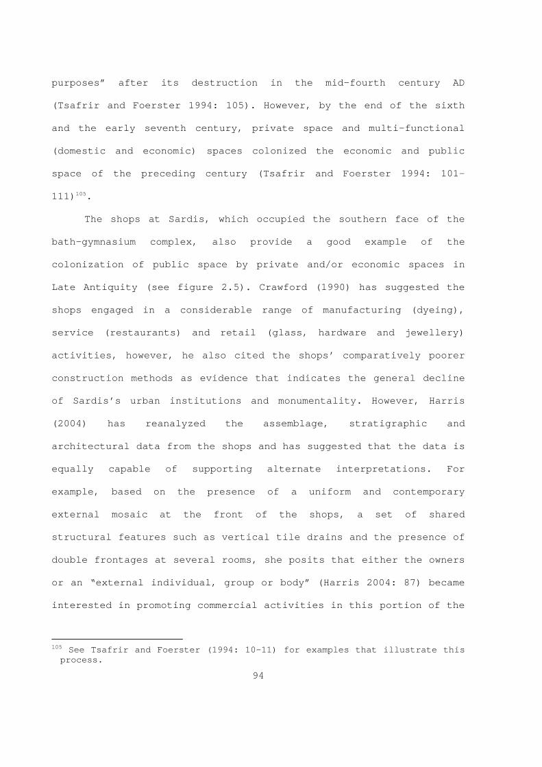
94
purposes” after its destruction in the mid-fourth century AD
(Tsafrir and Foerster 1994: 105). However, by the end of the sixth
and the early seventh century, private space and multi-functional
(domestic and economic) spaces colonized the economic and public
space of the preceding century (Tsafrir and Foerster 1994: 101-
111) 105.
The shops at Sardis, which occupied the southern face of the
bath-gymnasium complex, also provide a good example of the
colonization of public space by private and/or economic spaces in
Late Antiquity (see figure 2.5). Crawford (1990) has suggested the
shops engaged in a considerable range of manufacturing (dyeing),
service (restaurants) and retail (glass, hardware and jewellery)
activities, however, he also cited the shops’ comparatively poorer
construction methods as evidence that indicates the general decline
of Sardis’s urban institutions and monumentality. However, Harris
(2004) has reanalyzed the assemblage, stratigraphic and
architectural data from the shops and has suggested that the data is
equally capable of supporting alternate interpretations. For
example, based on the presence of a uniform and contemporary
external mosaic at the front of the shops, a set of shared
structural features such as vertical tile drains and the presence of
double frontages at several rooms, she posits that either the owners
or an “external individual, group or body” (Harris 2004: 87) became
interested in promoting commercial activities in this portion of the
105 See Tsafrir and Foerster (1994: 10-11) for examples that illustrate this
pr ocess.

95
town in the fifth century AD. Furthermore, she argues (2004: 91)
that during the shops’ initial phase, several rooms, which
previously have been interpreted as discrete units, may have been
involved in coordinated economic/productive activity based on dyeing
and/or the production of dyes. She also believes that the available
assemblage data indicates that the structures were workshops rather
than retail shops during their initial phase. However, during the
second phase, the occupants blocked doors, windows and drains as
well as re-laid floors. This development, Harris (2004: 91-92)
believes, signalled not only the end of coordinated economic
activities but a move to domestic activities or a period of craft
working activities followed by a final phase of domestic
activities 106. Regarding the retail function of these structures,
Harris (2004: 113, 120) posits that before their destruction in the
seventh century AD, the majority of these structures’ assemblages
indicate the prevalence of domestic activities rather than retail or
artisanal activities. However, aspects of the recovered assemblages
also suggested a certain degree of functional diversity. For
example, Harris (2004: 113) argues that building E8 and E13’s
assemblages provide evidence for contemporaneous non-domestic and
domestic activities that were spatially discrete (occurring on the
ground and first floors respectively) within these buildings.
A recent study conducted by Leone (2003) centring on various
“topographies of production” in Vandal and Byzantine North Africa
106 For example, Harris (2004: 112-113) mentions that building E3 appears to
have had 3 phases of activity; the final two consisted of semi-industrial activity followed by domestic activity.

96
(Tunisia and Tripolitania) provides additional examples of the
colonization of public space by economic spaces during Late
Antiquity 107. Leone’s ( ib id ) study examined the spatial trends in the
data relating to urban olive oil presses, pottery kilns and lime
kilns. Her research (2003: 275) suggests there is an association
between urban intramural olive oil production installations and
fortified complexes and churches 108. Pottery kilns were associated
wi th substantial structures and were located near the coast. For
example, the pottery production areas within the cities of Uthina
(located in the province of Zeugitania) and Leptiminus (located in
the province of Byzacena) were both situated in former bath
complexes 109. The solid construction of these types of structures
pr ovided Late Antique social actors with several options for reuse.
At Leptiminus, for example, apart from pottery production, the
former bath complex also accommodated activity areas for metal
working, glass working, and butchery. Limekilns, Leone (2003: 273-
274) notes, often occurred within the urban core or in inhabited
areas of cities. Late Antique social actors placed limekilns “close
to or in imposing buildings” that formerly constituted either public
or private spaces (Leone 2003: 274).
107 Leone (2003: 257) defines the term “topographies of production” as “the
spatial organization of production sites and their location within urban areas”.
108 However, there are exceptions. Leone (2003: 274) notes that at Uchi Maius th e forum became a scentre for olive oil production during the Vandal period.
109 Apart from the urban kilns, Leone (2003: 273) notes that Roman pottery ki lns also “ringed the fringes of Leptiminus”.

97
The increasing visibility and growing complexity of Christian
urban topography are another well-attested phenomenon in the Late
Antique archaeological record 110. In general, most researchers ( e. g.
Harries 1992; Catino-Wataghin 2003; Catino-Wataghin 2005) would
agree that ecclesiastic monumental architecture became important
focal points, or nodes, within the Late Antique urban environment.
The basic elements of Christian urban topography consist of an
episcopal complex (cathedral, baptistery and residences for bishop
and clergy), extra-mural churches ( e.g . for funerals and the
veneration of the martyrs), and cemeteries. According to Catino-
Wataghin (2003: 242-243), the location of the cathedral within the
walls was largely the result of pragmatic factors such as the
availability of an adequate building site to accommodate the
structure or complex. On the other hand, cemetery churches and
martyria tend to cluster in extra-mural locations because of their
associations with Roman necropoleis. Ecclesiastic monumental
architecture, like all types of monumental architecture, is also
indicative of the conspicuous consumption of both human and material
resources. Similarly, Catino-Wataghin (2006: 289, 295-296) has
suggested church building outwardly demonstrated the social standing
and economic resources of a given Christian community. This outward
architectural display of authority and prestige is also detectable
in the architecture associated with episcopal residences. Rapp
(2005: 209-210) believes that although the layouts of episcopal
110 This process is not restricted to the urban environment alone. For a
di scussion of the process in the countryside, see, for example, Kidner’s (2001) discussion on Christianizing the Syrian countryside in the volume edited by Burnes and Eadie (2001).

98
residences are heterogeneous, they utilized many of the same
architectural elements that contemporary secular monumental
residences employed ( e.g. governor’s residence and aristocratic
mansions) 111. The main difference, Rapp (2005: 210) believes, was in
th e level of elaboration: atrium courtyards with elaborate water
features as well as excessively expensive decorations like marble
revetments, for example, were absent from episcopal residences.
Several points emerge from the discussion presented above.
Researchers often cite the use of mundane spolia like brick
fragments, tile fragments and various types of architectural blocks
as general indicators of urban decline during Late Antiquity 112. For
ex ample, many of the spolia elements used in the construction of the
so-called shops at Sardis would not have been readily visible to the
social actors utilizing these structures because there is evidence
that indicates plaster and frescoes covered several wall surfaces
within the complex (Harris 2004). Ellis (2006: 422-423) also argues
that because of their location within the city, economic potential,
as well as their overall solid construction, these structures would
have made an attractive residence 113. Perhaps more importantly,
Harris’s (2004) careful reanalysis of the assemblage data from these
111 “The variations in the layout of the Episcopal residences throughout the
empire reflect both the universal aspects of the episcopal office and the concrete conditions of the individual sees” (Rapp 2005: 210).
112 On the topic of the reuse of building materials, see Coats-Stephens (2 003) for a concise review of the general arguments and several possible explanations for the phenomena; Saradi-Mendelovici (1990) for a discussion on the various Late Antique attitudes on reuse of pagan monuments for other purposes such as civic embellishment. See also Alchermes (1994).
113 For a general discussion on the attributes of buildings that combine domestic and economic activities, see Ellis (2000: 78-80, especially pg 80).

99
structures also indicates the social actors utilizing them had
attained a certain degree of material wealth, which in turn,
suggests they were among the middle class rather than the urban
poor 114.
As mentioned above, Procopius’s usage of the terms polis in
conjunction with the presence of various types of monumental
buildings suggest that at least some elements of the early imperial
urban armature remained culturally relevant to Late Antique social
actors. Thus, it seems reasonable to suggest that these elements
also contributed to the formation of a particular image of the urban
environment in Late Antiquity ( e.g . the official state image of
Justiniana Prima). Lavan’s (2006) recent study on fora/agorai in
Late Antiquity illustrates the continued use of one such armature
element. His ( ibid ) study indicates that although they display
divergent temporal trajectories based on their geographical
location, fora/agorai continued to be viable components of the urban
environments throughout Late Antiquity, with several new
constructions or substantial reconstructions occurring during the
fifth and sixth centuries, and some others continuing in use beyond
the mid-seventh century. Perhaps more importantly, apart from their
traditional social functions, these spaces, Lavan (2006: 210-214,
235-236; 2003: 317-318) argues, also became associated with
“political rituals” linked to the provincial governors ( e. g.
honorific statues of governors, public trials and executions, as
114 For a discussion of the archaeological evidence for the urban poor, see
Roskams (2006).

100
well as the preferred locations of civil praetoria in the provincial
metropolis) 115.
Al though most researchers would agree that Late Antique social
actors generally approached urban planning in a more pragmatic and
less structured manner than their Roman predecessors, there is
evidence to suggest that coordinated and planned urban development
projects were still possible 116. For example, the excavations at both
Scythopolis (Tsafrir and Foerster 1994) and Sardis ( e.g. Harris
2004) indicate that the new commercial districts appear to be the
result of a conscious and purposeful development rather than
disjointed and undirected development. Furthermore, at Scythopolis,
the urban armature expanded and incorporated a new southern suburb
through the extension of a main thoroughfare; the new commercial
district acted as a buffer between the southern suburb and urban
core. In Chapter 4 (§4.3), I explore several of these trends in
relation to the Cypriot evidence from the polis/civitas of Kourion.
2.3.3 Discussion: The urban environment as a power resource
Several points emerge from the various themes presented
t hroughout section 2.3. First, until at least the mid-seventh
115 Lavan (2003b: 316) notes that “the praetorium, with its prisons,
ce remonial courts, offices, archives and audience halls represents the most developed public building ever placed on the ancient agora”.
116 For example, Tsafrir and Foerster (1994: 106-109) note that within Scythopolis’s urban core, new building generally attempted to follow the existing urban framework while new constructions in the suburbs, in contrast, tended to be organic. Thus, they (1994: 109) argue, “It was the scale of priorities that changes, and gave way to new ideas in town planning and city life”.

101
century AD, the city constituted the main conduit through which the
state extracted wealth from and administered the territories under
its control. In this respect, the city formed a resource for the
replication and maintenance of imperial power. However, cities also
served a number of other important functions such as providing an
arena for local elites to compete with one another, as well as
providing administrative centres (both secular and ecclesiastic),
strategic centres and productive centres. In this respect, cities
are clearly multi-scalar and multilocal social constructs within the
larger landscape. However, the relative functions that a city
performed, or were expected to perform, varied according to
individual geographic, geo-political and temporal constraints. At
the level of the individual city, the interplay between abstract, or
official spaces, and lived spaces and the various urban images (both
theoretical and material) this process produced is also a useful
indicator of the changing patterns of authority in Late Antiquity.
The so-called new administrative cities of the sixth century
illustrate this point. From the available data, the urban image of
imperial cities like Justiniana Prima (Serbia), although they often
retained elements associated with high imperial urban armatures
(Zanini 2003: 209-210), also exhibit a pronounced decline in the
area devoted to residential domestic architecture. As Poulter (1992:
125) notes, “only a few buildings could qualify as civilian houses
and some of these presumably accommodated the clergy serving the
city’s churches” within the area enclosed by the main fortification
wall. Similarly, the area enclosed by an extension of the southern

102
fortification line does not appear to have enclosed an extramural
residential district; rather, it primarily enclosed churches.
Similar spatial phenomena are detectable in the archaeological
record of Nicopolis Ad Istrum (northern Bulgaria). The results of
several seasons of extensive geophysical survey and targeted
excavations at the site have identified the presence of a range of
structures interpreted as consisting of non-residential/domestic
buildings (e.g. workshops and churches). These investigations
revealed a substantial portion of the area enclosed by the city
fortifications (northeastern quarter and the west central) remained
undeveloped throughout Late Antiquity (Poulter 1992: 124-128) 117.
Ar guably, these particular cities represent one ideological and
material aspect of the process because they represent the triumph of
the abstract authoritative, and often monumental, spaces of the
state and institutional church over the lived, but also multilocal,
spaces of the everyday that characterized much of the traditional
classical urban environment. Thus, these cities exemplify one
particular facet of the Late Antique urban condition in which the
needs of the state have usurped both the material and ideological
image of the traditional classical urban ideal. The state chose to
display directly its own authority through a traditional medium, but
substantially streamlined conduit in which its own needs are
explicitly rather than implicitly stated within the urban
environment. In short, cities like Justiniana Prima represent nodes
117 Poulter (1992: 127) notes that the remains of mud-brick residential
ar chitecture “covered the ruins of the abandoned Roman city to the north”.

103
that overtly represented authoritative space within a larger multi-
component and multilocal landscape at several spatial scales.
Initially, the administrative apparatus relied on one
particular social group, the curial class, for the successful
execution of administrative directive at the civitas level.
Essentially the curial class formed a substantial corps of low-level
and unpaid civil servants. The central administration’s ability to
entice, coerce and manipulate this social group provided the
administrative apparatus with the human resources it required for
the effective exercise and reproduction of its own authority at the
local level. Because of the comparatively small number of
professional civil servants involved in government, researchers have
described the comparatively unobtrusive character of the
Principate’s administrative apparatus as “amateurish” (Garnsey and
Saller 1987: 26), or as “soft” government (Brown 1978: 48).
Nevertheless, as “amateurish” as imperial administration may have
been during the Principate, when viewed in terms of relative inputs
and outputs, the indirect approach generated a very high return
because it allowed the state to meets its administrative needs with
a minimum outlay of official human and material resources. At the
geo-political strategic level, the preference for indirect rule is
also discernable in the state’s extensive use of client kingdoms, or
hegemonic imperialism, during the late republic and early
Participate 118. Nevertheless, the situation changed appreciably over
118 Consider, for example, the various client states in the Near East of the
l ate first century BC and the first half of the first century AD. See Isaac
104
the course of the late third to fourth centuries AD with the steady
erosion of the autonomy of local civic government.
However, elements of the traditional civic urban ideology that
bound the members of the curial classes into costly forms of
competition (philotimia) with one another at the local level and
that the central government exploited ( e.g. Romanization) became
increasingly detached from its local focus and increasingly
refocused towards imperial service and the church. Paradoxically,
the central government exacerbated this situation through its
consumption of a large proportion of the human resources that
previously maintained local government. The resulting devaluation of
curial status as preserved in various laws and the rise of a new and
diverse social group with strong imperial links illustrate the
state’s indirect colonization of various types of local landscapes.
Correlate to this development, social actors with surplus wealth
increasingly engaged in conspicuous consumption patterns that
benefited the institutional church ( e.g . donations/benefactions) and
promoted a more explicitly egocentric form of self-aggrandizement
( e.g . investment in monumental rural and urban domestic
architecture) than patterns that benefited the civic institution.
Regarding the first component of this new pattern of
conspicuous consumption, Bowden (2003:151-154) has suggested the
(1990) for a discussion of the Roman Near East as well as Luttwak (1979) fo r a discussion on the use of clients.

105
prestige associated with church construction achieved a “cyclical
dimension” in Late Antique Epirus 119. He (2003: 151) believes
“N ew churches generated prestige for donors,
the community and the ecclesiastical
establishment. This encouraged donations from
within the community and perhaps from outside.
Often the larger donations and bequests were
specifically for the foundation of new
churches, while local bishops and prelates
also built churches to enhance their own
prestige and encourage donations (aside from
motives of genuine piety). The result was that
church construction became almost a self-
perpetuating activity, which may in part
account for the phenomena of multiple churches
in towns such as Nikopolis and Byllis in
Epirus Nova”.
Although the institutional church could return a proportion of these
resources to its host community ( e.g. through employment during
construction and, later, through charitable giving), it could
equally alienate wealth from its host community. Bowden (2003: 153)
argues that this occurred when the ecclesiastic authorities used
non-local workmen and materials and, perhaps more importantly, over
119 See Bowden’s (2003: 152-153) figure 6.30 for a flow model of the cyclical
pr ocess he attributes to church construction and figure 6.31 for a flow model of the process of resource withdrawal that church buildings drain from the community.

106
the course of time the resources required to maintain the clergy
within the episcopal see would have absorbed the majority of its
income. The situation undoubtedly became increasingly complex when
local and regional interests intersected and competed with such
projects.
As Garnsey and Saller (1987: 109) have pointed out, the
property system, the legal system and the occupation system
(division of labour) constituted three mechanisms that preserved and
reproduced social inequalities during the Principate. They argue
further that the “system of acquisitions and transmission of
property was the framework of social and economic inequality”
(Garnsey and Saller 1987: 110). This scheme is also useful for the
Late Antiquity because these three general mechanisms appear to have
continued to form a fundamental component of the social system
throughout the Dominate. With the reorientation and colonization of
the local civic political landscape by the quasi-imperial notables
and honestiores, the civic institution lost its ability to provide
an adequate medium for upwardly mobile social actors to convert
their material wealth into social capital. Thus, a key functional
aspect of the urban social environment had changed. Because the main
sources of prestige increasingly orientated upwardly mobile social
actors towards a decisively non-civic arena of competition, these
new imperial and semi-imperial based elites did not need to engage
with the civic institution in the same way as their curial
predecessors had done in the past ( e.g. through competitive
benefaction and civic politics). In short, it is reasonable to

107
suggest that these honestiores perceptions of the urban image
changed in relation to one particular facet of that image advocated
by the state.
Kelly (2004: 130) has argued that clout ( potentia) and
connections (gratia ) formed the “commonest and most effective
currencies of power” for Late Antique social actors 120. These two
constructs are also key components of the large social construct of
philotimia. Thus, based on the position advocated above (§2.2) in
which social actors exercise power predominantly through various
combinations of personal authority-based resources, it seems
reasonable to suggest that this shift also influenced the way that
social actors organized their individual resource sets in order to
maximize their personal authority’s potential scope in relation to
the growing ideology of imperial and ecclesiastic service. Those
social actors of appropriate means could also engage with the legal
system in a more efficient manner because of their ability to draw
upon their personal connections ( potentia and gratia ), as well as
pay for the array of official fees ( commoda), tips (sportulae) and
travel expenses that were often associated with litigation. Thus,
the cost of litigation is an institutionalized form of social
inequality between upper and lower class. It also seems reasonable
to suggest that over the long term, the declining status of the
curial class is symptomatic of one facet of a manifold phenomena
which arguably ended in the mid-eighth century after the senatorial
aristocracy’s position, as Haldon (2004a) notes, became based solely
120 See Harries’s (1999: 163-166) discussion of gr atia .

108
on palatine service and no longer represented the interests of a
diverse group of landowners.
Perhaps more importantly, the growing role of the state in
civic government laid bare the exploitive relationship that existed
between the state on one hand and the institutional city and the
curial class on the other. Although some researchers (Barnish et al
2001; Harries 1999) have interpreted the repeat legislation
preserved in imperial legislation as a relatively neutral
phenomenon, other aspects of the law clearly indicate the state’s
desire to keep curial land, if not the curiales themselves, securely
within the system in order to insure various civic expenditures were
met (Liebeschuetz 2001: 108; Arjava 1998: 253). The legal
constraints the state placed on the curiales also took on a spatio-
temporal dimension: their ability to reside away from their
municipal territory was limited to a maximum of five years
(Theodosian Code 12.1.44 in Maas 2000: 19), and they were expected
to live within the city rather than their country estates.
In sum, the city in Late Antiquity is best understood primarily
as a multifaceted social construct. As a component within a large
landscape, it is a nodal space where abstract and lived spaces
intersect and compete with one another: it is a contested and
ideological space, perhaps more importantly, it is a multilocal
space within the larger social landscape. The legal system is
another important authoritative resource that the state used in
conjunction with the institutional city to reproduce its authority.
Thus, the city, or rather, specific city types, remained a viable

109
authoritative resource for the state apparatus at least until the
mid- seventh century AD when the village replaced it.
2.4 Geographic information as a power resource
Most research on geographic knowledge’s role in imperial
pl anning essentially occupies different positions within a bi-axial
paradigm based on the oppositions between scientific and non-
scientific frontiers on one hand and the opposition between military
and social interpretations of what constitutes a frontier on the
other. Recently, Wheeler (1993a and 1993b) has argued against the
demilitarization of Roman frontier studies seen in reductionalist
(Isaac 1990) and Annaliste (Whittaker 1994) historic methodologies
and social archaeological frameworks 121. While accepting the argument
th at a certain amount of ‘demilitarization’ has taken place in
recent social interpretations of frontiers, it is still useful to
keep in mind Lightfoot and Martinez’s (1995: 487-488) discussion of
three common problems encountered in the archaeological and historic
investigations of frontiers in general. First, they observe, the
dominant tendency of core-periphery models is to privilege the
centre and reduce the periphery to a passive recipient of the
dominant centre’s culture 122. Secondly, they reject the global scale
l evel of analyses in favour of a multi-scale framework for both
121 Wheeler’s (1996a:17-21) criticisms of reductionism, and in particular the
re ductionalist underpinnings of several of Isaac’s (1990) claims is also useful in illustrating how limiting this approach can be.
122 For a discussion of the use of world-system theory in a Cypriot ar chaeological context by Kardulias and Yerkes (2004).

110
archaeology and historical research 123. Finally, they believe what
th ey term “Maginot Lines” may be quite rare in archaeological
contexts” (Lightfoot and Martinez 1995: 487-488).
Those researchers (Whittaker 1993 and Isaac 1990) who support a
non-scientific Roman frontier have emphasized the under-developed
and imperfect state of Roman geographical and cartographic
knowledge. The lack of modern geographical knowledge, and by
extension modern instruments, they argue, provided the Roman state
with an almost insurmountable hindrance in their attempt to
understand and use geographic knowledge effectively in a global
strategic context 124. However, while conceding that mapping projects
on the scale of continents would have been beyond the technical
abilities of the Roman state’s surveying and geographic abilities,
there is evidence to suggest that the Romans did possess a rather
sophisticated multi-tiered conceptualization of space ( e.g. the
Ptolemaic demi-Cartesian grid system and the linear abstracted space
of the itineraria) 125. However, both Lee (1993) and M. Graham (2006)
have pointed out there is scattered evidence that indicates maps and
itineraries were in circulation in the Late Roman period and some of
these itineraries appear to have been intended for use in
conjunction with abstract graphic representations of the itineraries
123 Herod (2003) introduces the use of scale and the use of the local-global
bi nary in geographical theory. Though concerned with the local-global binary in modern capitalist societies, Cox’s (2005) discussion of the development of this binary in geographic thought is useful as well. For a detailed study of the effect of scale on interpretation of distributional archaeological data, see Ebert (1992: especially chapter 8).
124 Isaac (1990: 374; 394-395; 401-402) and Mann (1979) are particularly good examples of this position.
125 See Lee (1993) and Graham (2006).

111
themselves. Ethnographic data, on the other hand, also supports the
notion that pre-modern societies can possess a developed and
informative concept of the world around them vis-à-vis their spatial
ability, spatial knowledge and through a developed sense of place.
The geospatial acumen of Eskimo, Polynesian and Micronesian
navigators, who are able to traverse great distances without the aid
of modern instruments such as maps and satellite navigation,
demonstrate this point (Tuan 1977). Undoubtedly, such skills do not
occur evenly across these societies but, it is reasonable to suggest
that the lack of modern instruments like detailed topographical maps
does not neatly correlate with a lack of and/or a misunderstanding
of geographical knowledge 126.
Additionally, it is important to note, as Wheeler (1996a: 25)
points out, “a geopolitical approach to military policy…first begins
to be formalized in Byzantine treatises” in late antiquity. By the
tenth century AD, the creation of various new commands and
territorial acquisitions that aimed at creating geographic depth
between the core provinces and the frontier zone indicates “that
Byzantine governments certainly possessed the geographic and
strategic understanding to defend what had been recovered and to
plan further expansion” (Haldon 1999: 39-41).
There is evidence that indicates the governments of the early
and late empire also possessed geographic and geostrategic
understanding. First, the case of the so-called Gallic Empire of the
126 The geographer Yi-Fu Tuan (Tuan 1977: especially chapters 4 and 5)
di scusses several generic and cross-cultural ways in which people understand and locate their relationship to the wider world.
112
third century AD illustrates the fact that Roman military planners
could extrapolate on several spatial scales and think in terms of
the security of populations. In response to the inadequate regional
security provided by the central government, self-help initiatives
undertaken by local military commanders, governors or opportunistic
client states commonly resulted in rebellion. Williams (1985: 20-21)
maintains that the central government’s failure to provide adequate
security at the provincial level provided the catalyst for the
Gallic Empire’s creation:
“The stripping of the Rhine defences had
opened the way for a great invasion of Franks,
occupying Eastern Gaul and North-Eastern
Spain; Gaul was also cut off from Italy by a
separate invasion of the Alemanni which
threatened Milan. With the support of the
civilian population the Rhine army commander
Postumus murdered the imperial heir, occupied
Cologne and had himself proclaimed Emperor,
not of the Roman world but of an independent
Gaul… …Needing the military support of Gaul,
the governors of Britian and Spain declared
allegiance to this new state”.
Secondly, the establishment of the Tetrarchy with its multi-nodal
political and command centres close to the empires main theatres of
war and/or potential theatres of conflict is perhaps the best
evidence for the important influence geography played in imperial

113
planning during late antiquity. The Dominate’s increased
governmental depth (§ 2.3.1) also created a richer spatial hierarchy
within the empire as the central government grouped provinces into
dioceses and dioceses into prefectures. Justinian’s quaestor
exercitus illustrates the continued importance of geographic
information in imperial strategic thinking. Administratively, the
quaestor exercitus extracted resources from several economically
prosperous and militarily stable provinces from the Aegean and the
Eastern Mediterranean, and redistributed them to less prosperous and
stable provinces in the Balkans. Additionally, the creation of the
quaestor exercitus also suggests that the central government
possessed enough geographic data to allow strategists to arrive at
and implement multiregional strategic plans.
Thus, based on their geo-spatial abilities, it is probable that
the imperial administration was able to access, though rather
crudely as Whittaker (1994) points out, the marginal costs of
imperialism. As a power resource, the state utilized various types
of geographic information for the maintenance of imperial authority
for both internal (domestic) and external (international) policies.
How these processes manifested themselves in Cyprus as it became a
contested frontier region and then a neutral condominium over the
course of the seventh and eight centuries AD is presented in Chapter
4 (§4.2.2.2 and 4.2.4).

114
2.5 Chapter summary
Several points emerge from the various themes discussed above.
Fi rst, individuals and institutions drawn on a varied set of what
can be loosely termed “resources” to maintain and expand their
scope of available resources ( e.g. economic, political,
geographical), and the way individuals and groups and institutions
access, combine and utilize these resources is perhaps the most
important difference between the two. Arguably, apart from coercion
based on violence, social actors exercise individual power
predominantly through various combinations of authority-based
resources (like Weber’s (1964) legal, traditional and charismatic
authority or personality and property/wealth in Galbraith’s (1986)
scheme). Thus, individual social actors and institutions employ
qualitatively different conduits in their power maintenance
strategies. Second, space, place and built environment are not
passive or static backdrops removed from larger social mediations.
Rather, the active multifaceted social constructs influence and are
influenced by larger social contexts. For example, this is
particularly true in the transformation of space to place (see above
§2.2.4 to §2.2.5). It is important to note that these processes do
not produce a monotone spatial texture, but rather it creates
nuanced layers of meaning that accrete over time. These processes
operate at multiple scales, which in turn, create nested meanings
within a particular landscape ( i.e. a rural hinterland or an urban
landscape).

115
Among the manifold authoritative landscapes of Late Antiquity,
the urban landscape provides a good example of the interplay between
the state, institutional church, groups and individuals. In Chapter
4 (§4.2.1.1) of this thesis, some of these facets are explored in a
Cypriot context. Nevertheless, the colonization of the urban image
by the authoritative spaces of the state was undoubtedly a nuanced
process. The so-called administrative cities of the sixth century AD
exemplify one particular facet of the Late Antique urban condition
in which the needs of the state have usurped both the material and
ideological image of the traditional classical urban ideal. In
short, cities like Justiniana Prima for example, came to represent
nodes in a landscape that overtly represented authoritative space
within a larger multi-component and multilocal landscape at several
spatial scales. Perhaps more importantly, the complexity and
multilocal character of the Late Antique urban environment is also
characteristic of ordinary provincial cites as well. This phenomenon
is well illustrated by the Cypriot case study presented in Chapter 4
(§4.3) of this thesis.

116
Figure 2.1 Plan of Zenobia (Zanini 2003: 205, figure 3).

117
Figure 2.2 Plan of Resafa (Zanini 2003: 207, figure
4).

118
Figure 2.3 Plan of Justiniana Prima (Zanini 2003: 208,
figure 5).

119
Figure 2.4 Plan of Scythopolis (Tsafrir and Foerster
1994: figure 15).

120
Figure 2.5 Plan of the Byzantine shops at Sardis (Harris
2004:83, figure 4.1).

121
CHAPTER 3
Environmental Framework: The East Mediterranean and Cypriot Environment
3.1 Chapter introduction
This chapter’s main purpose is to provide an environmental
context for the Sotira Archaeological Project’s (SAP) survey data
(presented in Chapter 5). As a result, this chapter explores several
eco-historical themes that operate at very different scales,
resolutions and trajectories. Although a detailed account of the
geology, geomorphology and historical ecology of the lands around
the Mediterranean basin is beyond the scope of the present work,
section 3.2 introduces several general characteristics of the
Mediterranean environment at the macro level. This information in
turn provides a broad comparative context with which to view the
regional manifestation of the Mediterranean environment on Cyprus
presented in section 3.3.
3.2 The Mediterranean environment
Mediterranean-type environments first appear during the
Pl eistocene and provide a transitional zone between dry and moist
environments. Strong seasonal contrasts typify the Mediterranean-
type environment: dry hot summers and wet cool winters. The
Mediterranean-type climate, with its pronounced seasonal contrasts
and low rainfall, is ideally suited for xerophytic vegetation like

122
“summer-dry evergreen forests, scrub and dry heath” (Roberts 1998:
186). Such Mediterranean-type environments, or Mediterranoid
environments, cover approximately one percent of the world’s surface
area and occur on the European, African, Australia, Asian and both
American continents. Despite this seemingly widespread distribution,
the lands around the Mediterranean basin contain nearly fifty
percent of the total global area. However, the circum Mediterranean
basin is far from uniform. Apart from the main east-west division,
the plethora of ecotones and terrain types exhibit considerable
diversity at both the micro and macro levels 1. Such diversity makes
wi de generalizations about geology, geomorphology, topography as
well as weather variables like rainfall and temperature exceedingly
difficult (Aschmann 1973: 11-19; Di Castri 1981: 1-6; Roberts 1998:
186-7; Roberts et al 2001: 631; Geyer 2002: 31-32).
3.2.1 Physical environment
The Mediterranean basin’s present configuration took shape
during a particularly diverse tectonically active period that
started in the late Mesozoic (Cretaceous 144-66.4 mya) and
terminated towards the end of the Tertiary (the Pliocene 5.3-1.6
mya) 2. Tectonic activity during this long period started the
pr ocesses that eventually transformed and created most of the
Mediterranean Basin’s first order relief features, or geotexture. As 1 Crete provides a good example because it possesses characteristics of a
mini continent (Moody, Rackham, and Rapp 1996). 2 Mya = million years ago. Geological time scale divisions are based on
Chernicoff (1999:232 fig. 8-33). For additional information relating to the Mediterranean Basin’s complex geological evolution, see various articles in Dixon and Robertson (1984) as well as the relevant chapters in Ager (1980).

123
the North Atlantic Sea formed and its floor started to spread, the
super continent Pangea broke apart; moreover, the African and
Eurasian plates began to collide and the Tethys Sea floor began to
be consumed 3. The African and European continental plates’ subsequent
co llisions (and possibly other macro and micro plates) created
islands (e.g. Crete and Rhodes), peninsulas (Italy and Greece) and
introduced a period of orogenesis that created the steep fold and
thrust mountain systems that characterize much of the basin today
( e.g. the Alps and Balkans) 4. Various micro plates (e .g. the
Anatolian micro plate, the Arabian and Sinai sub-plates), faults
(the East Anatolian), arcs ( e.g. the Cyprus and Cretan) and rifts
(the Dead Sea Rift) formed because of these collisions.
Additionally, activity along rift, subduction, suture zones and
various volcanic mechanisms produced islands as well ( e.g. Melos and
Thera). Although the mountain ranges surrounding the Mediterranean
basin might initially appear as monolithic units, various
topographic features ( e.g. corridors, basins and depressions)
puncture and subdivide them. Geyer (2000) draws attention to
disproportionate distribution of mountains to plains and notes the
importance of the latter in regions where they occur (Higgins and
3 The Atlantic Ocean began to form approximately 190 mya (Higgins and Higgins
1996: 16). The Tethys Sea, a distant ancestor of the modern Mediterranean Sea, was a vast shallow ocean that occupied the area between the super continents Laurasia and Gondwanaland. For more information on the geological contribution of the Tethys to the eastern Mediterranean, see various articles throughout the first four sections of Dixion and Robertson (1984).
4 The Aegean provides a particularly good representative sample of the geo-pr ocesses that has shaped and continues to shape the Mediterranean Basin. For more information, see Higgins and Higgins (1996). Bozkurt (2001) provides a synthesis for Turkey’s complex geological history.

124
Higgins 1996: 16-23; Geyer 2002: 32-33; Garfunkel 1998: 5-6; Bozkurt
2001: 3-6).
By the Miocene (23.7-5.3 mya), the Mediterranean began to
attain its current shape 5. Fabricius and colleagues (1 985: 293-298)
identify several events that had a basin wide effect; two of the
most important these are the Messinian salinity crisis in the late
Miocene and the Pliocene revolution. After a fall in overall sea
levels or a localized tectonic event which cut off inflow from the
Atlantic Ocean, the Mediterranean basin experienced a series of
evaporation and sedimentation phases known collectively as the
Messinian Salinity Crisis. This important period of sedimentation is
responsible for the deposition of poorly consolidated erosional
material and various evaporates like marl, limestone and gypsum
(Krijgsman et al 2001). However, by the Pliocene (5.3-1.6 mya) the
Mediterranean basin began to fill back up in an episode known as the
Zanclian Refill (Higgins and Higgins 1996: 22-23; Garfunkel 1998: 6-
7, 29-30).
The various tectonic and sedimentary phases mentioned above
have created a complex lithology across the circum Mediterranean.
Yaalon (1997) and Shiel (1999) have identified several common
Mediterranean soil types; they are luvisols (chromic, calcic and
vertic variants), cambisols, calcisols, vertisols and regosols 6.
5 For additional information on the sea floor basins of the eastern
Mediterranean, see Garfunkel (1998). 6 These soil types are base on the FAO system. Their equivalents in the USDA
sy stem are luvisols = alfisols, cambisols = inceptisols, calcisols = aridisol, vertisols = vertisols, and regosols = orthents/psammats (Gerrard 2000: 115 table 5.5). Shiel (1999), using the USDA classification system mentions entisols, inceptisols and alfisols as the main monocyclic

125
Additionally, Yaalon (ibid) and Shiel (ibid) point out the
importance variables like geology/parent material, topography,
climate, aeolian inputs (dust storms, see below), and various biotic
factors like long-term anthropogenic activity and vegetation cover
have in defining the character and development of Mediterranean
soils. A brief description of these important Mediterranean soils is
necessary at this point.
Luvisols/alfisols are usually associated with deciduous
(especially oak) and coniferous vegetation. They are largely a
product of the Holocene and develop on level to gently sloping
topography. Luvisols/alfisols commonly form in the transitional zone
between arid and humid environments. They range in color from brown
to dark brown and often occur over a greyish brown to strong brown
argillic B-horizon 7. Topographical conditions appear to dictate these
soils current usage in the Mediterranean region. According to the
FAO (2001), when luvisols/alfisols occur on lower slopes and they
are predominantly used for growing wheat; on upper slopes, however,
they are used for pastoral activities and planted tree crops
(Gerrard 2000: 139; USDA 1999: 163-164; FAO 2001: Luvisols; Fanning
and Fanning 1989: 267-269).
Mediterranean soil types. Of the three large USDA groupings Shiel (ibid) mentions, entisols equate to several soil types such as arenosols, regosols, leptosols and fluvisols in the FAO system (Gerrard 2000: 115 table 5.5). For a general review of the various taxonomies and their associated problems, see Gerrard (2000: 111-124); additionally, see Rogel et al (2001) for a specific Spanish case study in which the existing USDA and FAO classification schemes proved too rigid to be used effectively.
7 The leaching (eluviation) of clay from higher up the soil column and its accumulation in the lower portion (illuviation) creates argillic horizons within the soil profile (Gerrard 2000: 109, 66-69; Fanning and Fanning 1989: 42-46). For more information on the common terminology used for describing soil profiles, see Rapp and Hill (1998: 31-32).

126
Cambisols/inceptisols are often associated with deciduous
vegetation but they are also capable of supporting an array of
vegetation types. Cambisols are mainly a product of the Pleistocene
and Holocene periods. Although they occur under a range of
topographical conditions, cambisols/inceptisols are common on gentle
slopes, slope bases and in areas where developed soils, like
luvisols, have eroded away. Cambisols are usually brown in color and
have only slight horizon differentiation if any at all; where they
occur, B-horizons tend to be fine sands with little clay content.
Because soils in this class lack development, they frequently occur
in areas with active erosion and/or high deposition environments.
The FAO (2001) has classified cambisols as generally productive for
use as both agricultural and grazing lands (FAO 2001: cambisols;
USDA 1999: 489; Gerrard 2000: 112, 132).
Calcisols/aridisols develop in semi-arid to arid climates on
calcareous and evaporate parent materials where rainfall
superficially penetrates the soil profile 8. Soils of this class are
associated with xerophytic vegetation. Calcisols tend to be pale
brown in color and azonal like cambisols but often develop calcic or
petrocalcic horizons at about one meter below surface level. They
also have a very low percentage of organic material (1-2%) and can
have high salt content. In general, soils of this type are better
suited for grazing than for agriculture; however, with proper
irrigation, especially in the Mediterranean region, they can become
8 According to the FAO (2001) gypsisols, solonchaks, solonetzs and durisols
ar e common in semi arid and arid environments as well.

127
relatively productive (FAO 2001: calcisols; USDA 1999: 329; Gerrard
2000: 111).
Regosols/entisols share several characteristics with cambisols,
calcisols and vertisols. Like vertisols, regosols develop on
unconsolidated parent material. However, regosols do not possess any
diagnostic horizons and frequently occur in areas with high erosion
or deposition with other young poorly developed soils like calcisols
and cambisols (FAO 2001: regosols; Gerrard 2000: 145-46; USDA 1999:
389).
Vertisols/vertisols are dark colored heavy clay-rich soils that
expand and contract seasonally as their moisture content changes.
These soils mainly form through the chemical weathering of
unconsolidated or poorly consolidated erosion prone materials (like
shale, marl, basalt and certain kinds of limestone) on shallow
slopes of less than 8 degrees. They occur under a range of climates
with distinct wet and dry periods (tropical to Mediterranean) and
can support a variety of vegetation types (grass to woodland).
According to the FAO (2001), vertisols have limited agricultural
value without intensive management because their high clay content
makes them difficult to work under both wet winter and dry summer
conditions. Additionally, their characteristic seasonal expansions
and contractions severely restrict vertisols’ engineering potential
(USDA 1999: 783; FAO: vertisols; Gerrard 2000: 113).
Perhaps the most well-known and fertile soil in the
Mediterranean is terra rossa. Terra rossa soils roughly equate to
the various subtypes of cambisols, luvisols and regosols within the

128
FAO classification system and specifically to feriallitic red soils
in Duchaufour’s (1983) environmentally based classification system 9.
Terra rossa forms through the chemical weathering of limestone,
which produces the clay and iron oxides that provide its
characteristic color and texture. In general, the weathering process
under dry conditions can be considerably longer than under wet
conditions. Thus, terra rossa soils can vary considerably in age.
Some terra rossa soils, Duchaufour (1983: 381) points out, are “true
palaeosols going back to the early Quaternary or the Tertiary and
are distinguished from recent terra rossa by their desaturation and
great abundance of kaolinite” 10.
3.2.2 Climate
Four main atmospheric systems help create the dry summers and
wet winters that characterize the Mediterranean basin’s present
weather pattern 11. The Azores High and the Indo-Persian Low are
re sponsible for the hot and dry conditions that are prevalent
throughout the entire Mediterranean basin during summer months.
Variable-duration heat waves, ranging from an additional five to
fifteen degrees centigrade, are a common feature of summer weather
patterns. Such heat waves are particularly common during July and
August because of fluctuations in the Subtropical Jet Stream. During
9 For more information on the mechanics of this classification system, see
Duchaufour (1983: 175-181). 10 Kaolinite is aluminosilicte clay (Gerrard 2000: 204). 11 For more information on the complex atmospheric systems that contribute to
th e Mediterranean’s present weather and climate, see Wigley and Farmer (1982).

129
the winter, however, the North Atlantic Low replaces the Azores High
while high pressure over northern Europe pushes cool moist air
southward into the Mediterranean basin. This influx of cool moist
air creates eastward moving cyclonic depressions, which are
responsible for the characteristic winter rains that provide
approximately 65-70 percent of the total annual precipitation 12.
These winter rainstorms tend to fall as concentrated but erratic
bursts rather than as continuous precipitation events. Regional and
local topography have a pronounced impact on rainfall. As Grove and
Rackham (2000: 27) point out, “it is not easy to separate changes in
climate from ordinary fluctuations of weather”. Variation in
rainfall and moisture retention has lead Nahal (1981) to divide the
Mediterranean climate into six sub-classes ranging from the very
arid to the super humid 13. It is important to note that a single
re gion or country can have multiple climate types. Nahal (1981: 73-
78) points out that while summer drought conditions and winter peak
rainfall is the most common precipitation pattern throughout the
Mediterranean basin, it should not be regarded as a universal
condition 14. Similarly, Geyer (2002) divided the Mediterranean’s
c l imate into two main subgroups based on latitude. This division
essentially equates to a distinction between the northern and
12 Grove and Rackham (2000: 26) mention the Gulf of Genoa, the Northern
Adriatic, Gulf of Lions, the sea west of Crete and the sea west of Cyprus as regions of storm genesis within the Mediterranean basin.
13 Nahal’s (1981: 68) Mediterranean climate classes are (1) Saharan or very ar id, (2) arid, (3) semi-arid, (4) sub-humid, (5) Humid and (6) super Humid.
14 The variation centers on the main rainy season’s fluctuations between wi nter, spring and autumn (Nahal 1981: 73-74).

130
southern portions of the basin. The regions in the southern group
have one peak rainy season in winter; the northern group has two,
one in autumn and a second in spring (Aschmann 1973: 11-12; Di
Castri 1981: 1-3; Nahal 1981: 68-70; Grove 1996: 13; Grove and
Rackham 2000: 23-25; Shiel 1999: 69-70; Geyer 2002: 34-35).
Extreme storm events, or “meteorological bombs”, often occur
during the winter months in addition to the normal seasonal storm
activity 15. Very strong winds and intense precipitation are
characteristic of these extreme storms. A recent study by Conte and
colleagues (2002) has shown that this phenomenon is quite common in
the central Mediterranean but less so in the Aegean and the eastern
Mediterranean 16. Additionally, hot dry air from the Sahara known as
th e Sirocco wind can generate large dust storms in spring that are
capable of transporting sediment many thousands of kilometres 17.
Grove and Rackham (2000: 29) have estimated that dust storm deposit
approximately 0.1-1 ton of sediment per hectare annually on Crete
(Grove and Rackham 2000: 25-230; Conte et al 2002: 16-20 and fig
2.1; Shiel 1999: 69-70; Mc Neill 1992: 15-16).
15 A meteorological bomb is a depression characterized by a pressure fall-off
of 1hPAH -1 or more that lasts for more than twenty-four hours (Conte et al 2002: 16).
16 Of the 101 “bomb events” recorded between 1965 and 1995 studied by Conte et al (2002: especially fig 2.1), only four occurred in the eastern Mediterranean.
17 Dust storms have been a regular feature of the Mediterranean basin since th e Pleistocene (Grove and Rackham 2000: 29).

131
3.2.3 Vegetation
Apart from olive, carob, cultivated crops and other various
tr ee types, evergreen shrubs (maquis) and their tree forms,
succulents, various gray-green undershrubs (phrygania) and grasses
(steppe) are the basic components of the Mediterranean’s vegetation
profile 18. Most plants composing maquis formations have developed
physiological adaptations which have helped them deal with drought
stress like sclerophyll (hard) leaves with a small pore to leaf
ratio (reduceing transpiration), stiff upper branches and deep root
systems. Plants composing phrygania formations have adapted to the
same stresses differently, however. These plants tend to be
seasonally dimorphic (lose leave and branches seasonally in order to
reduce transpiration) and have shallow root systems. Annual grasses,
in contrast, tend to remain in seed form during the dry months
(Espigares and Peco 1995: 135). Some researchers (McNeil 1992; Shiel
1999; Quézel 1981) have drawn a distinction between Phrygania on
silicacious soils and Maquis on calcareous soils while others (Di
castri 1981; Grove and Rackham 2000) have noted that both vegetation
types often appear on either substratum. Grove and Rackham (2000:
48; 55) point out that without human influence, maquis shrubs will
become trees but phrygania undershrubs become grass steppe. However,
Rackham (1982: 189), using Boeotia as an example, suggests even
without grazing “the country would not turn into continuous forests
in the present climate” but rather a mosaic of steppe and forests
18 Common maquis are Holm oak, lentisk, cistus, juniper and kermes oak;
common phrygania are lavender, sage and rosemary (Mc Neill 1992: 17-18). For a detailed East Mediterranean regional case study, see Rackham (1983).

132
(Di Castri 1981: 1-3; Rackham 1982: 186-9; McNeil 1992: 17; Shiel
1999: 71-77; Quézel 1981: 115; Grove and Rackham 2000:48-55).
Quézel (1981: 115-16) mentions several visible changes in the
character of the vegetation when moving from the western to eastern
Mediterranean. Two of the more important changes centre on an
increase in evergreen nanophanerophyites and in the floristic
richness of maquis and phrygia. Grove and Rackham (2000: 57-58) also
draw a contrast between maquis, phrygia and steppe’s relatively
separate distributions in the western Mediterranean in contrast to
their mosaic-like pattern in the eastern Mediterranean (Grove and
Rackham 2000: 48-56; Rackham 1982: 183-189; Di Castri 1981: 1-3;
Quézel 1981: 115-117).
Fire also plays a prominent role in Mediterranean-type
vegetation ecosystems. Many plants commonly found throughout the
circum- Mediterranean are rich in essential oils and resins, which
make them naturally inflammable. Furthermore, these plants possess
certain adaptations that allow them to survive in such a fire prone
environment. Common adaptations among the various trees and their
associated maquis consist of thick insulating bark, the ability to
regenerate from the root and the use of fire as a reproductive
trigger. Nevertheless, periodic fires serve to curtail the
encroachment of non-fire resistant species as well as increase the
biodiversity in recently burned areas. Periodic fires also reduce a
given area’s fuel levels. Reduced fuel budgets lower fire intensity,
which in turn increases the local vegetation’s ability to survive
subsequent conflagrations. However, when it occurs too frequently in

133
one area, whether by anthropogenic or natural agencies, fire will
impair the local vegetation’s ability to regenerate as well as lower
biodiversity (Grove and Rackham 2000: 218-38; Núñez and Calvo 2000:
183-190).
The amount of precipitation along with the soil’s nutrient
content and moisture retention properties greatly influence any
region’s vegetation profile (Rackham 1982; Nahal 1981; Di Castri
1981; Shiel: 1999; Kooijman et al 2005). While acknowledging the
importance of soil nutrients, Nahal (1981) advocates a
classification system based on the climatic subdivisions mentioned
above for describing Mediterranean and Mediterranoid vegetation
ecosystems. A system based on climatic-precipitation characteristics
is necessary, according to Nahal (ibid), because moisture
availability is the main stress factor that limits vegetation
development 19. Pons and Quézel (1998: 756), however, suggest that the
way in which plants utilize the local soils’ summer moisture budget
is the main stress factor. However, Di Castri (1981:4) notes that
oligotropic (nutrient poor) soils tend to produce heath land and
eutrophic soils (nutrient rich) tend to allow greater vegetal
development. Nevertheless, the results of a recent study of
evergreen woodland in Catalonia’s coastal mountain region conducted
by Κοοijman and colleagues ( Κοοijman et al 2004) found that a soil’s
parent material and its nutrient content are key variables in
determining vegetation development. They (ibid) suggest that this
19 “…the origin of rain is of no concern to the life of plants; what
in fluences them is the amount of rainfall and its seasonal distribution” (Nahal 1981: 63).

134
indicates Mediterranean plant ecosystems operate under complex
conditions with multiple shifting stresses (Rackham 1982: 183-189;
Di Castri 1981: 1-3; Quézel 1981: 115-117; Nahal 1981: 68-78;
Kooijman et al 2005; Pons and Quézel 1998: 755-756).
3.2.4 Environmental stability and instability
Environmental stability and instability in the Mediterranean
r egion during the Holocene has been and continues to be an actively
debated topic 20. Several disciplines such as historical ecology,
geology, palynology and geomorphology, which are the most familiar
to archaeologists and historians, are actively contributing to the
subject’s refinement and have become regular components of many
modern interdisciplinary archaeological survey projects throughout
the Mediterranean 21. Additionally, archaeologists are beginning to
ex ploit proxy data derived from oceanography (isotope analysis and
deep sea coring, for example), seismology, and atmospheric and
planetary sciences for the reconstruction of past Mediterranean
environments. Advances in archeo-scientific techniques continue to
contribute new data and refine existing data on the subject as well.
3.2.4.1 Erosion and tectonics
The most common image of the Mediterranean is one of bare
mountains contrasted by valleys rich in alluvial and colluvial
20 See, for example, Bintliff and Van Zeist (1982), Bell and Boardman (1992)
and Bottema et al (1990). 21 Rapp and Hill (1998: 1-18(chapter 1)) introduce the history and uses of
earth science approaches in archaeological interpretation in a very concise manner.

135
deposits. This image is the product of erosion and environmental
instability 22. As mentioned above in section 3.2, two (Regosols and
Cambisols) of the five most frequently occurring Mediterranean soil
types are primarily associated with active erosion and deposition
contexts 23. However, this is not to suggest that erosion is a uniform
pr ocess throughout the Mediterranean. Erosion rates can vary
considerably at the intra and inter-regional scales because of
differences in cultural trajectories and physical characteristics
like geology and relief. An example from two locations in Greece,
the Argolid (southern Argolid and Argive plain) and Thessaly
(Larissa plain), clearly illustrate the first point. The Argive and
Larissa plains both have their highest erosion levels during the
Bronze Age in contrast to the southern Argolid’s peak in the
Hellenistic-Roman period 24. Brückner’s (1990: 131) work in southern
At tica and Roberts’s (1990: 63-64) work in southwest Turkey
illustrate the second point because in both cases the scale of
erosion varied along with the differences in geology and relief
within each study area (Brückner 1990: 127-128, 131-133; van Andel
22 Closely related to this topic are the formation processes of the
ar chaeological record. For more information relating to natural formation processes, see various chapters in part III of Schiffer (1987) as well as chapter 3 in Rapp and Hill (1998: 50-84).
23 See Cerdà (1998) for a specialized study that covers several Mediterranean countries and focuses on modern erosion rates in relation to sediments/soils on limestone parent material in which anthropogenic and climatic factors both contributed to the erosion process. See Thornes and Alcántara-Ayala (1998) for a study on mass failure in the Alpujarras region (Southeast Spain), which focuses on hydrological controls.
24 The Southern Argolid is a peninsula and the Argive plain is a coastal basin; both differ in their cultural trajectories and geomorphology despite their close proximity to one another. For a different interpretation of the evidence from the Southern Argolid, see Bintliff (1977) (van Andel and Zangger 1990: 141, 145, 151).

136
and Zangger 1990: 141-148,152; van Andel et al 1990: 380-381, 389-
390; Zangger 1993: 83-84; Roberts 1990: 62-64; 189-191).
Recently, several reviews (Bintliff 1992, 2002; van Andel et al
1990) have discussed the various frameworks used to model erosion in
the Mediterranean region over the last three decades. Bintliff
(1992) has divided the conceptual development of erosional studies
in the Mediterranean region into six stages, which start with
interpretations based on Vita-Finzi’s model and end with the wide
scale acceptance of Van Alden’s paradigm. In an attempt to establish
a Basin-wide synthesis and chronology, Vita-Finzi (1968) adopted a
generalized approach that rejected the idea of progressive landscape
degradation and reduced the valley sediments to either “Younger
Fill” or “Older Fill”. Vita-Finzi interpreted the “Younger Fill” as
largely the product of landscape instability in the post Roman
period, a period spanning approximately one thousand years, while
the “Older Fill” was the product of erosion episodes during the
Pleistocene and early Holocene 25. Within Vita-Finzi’s model, climatic
f l uctuations serve as the main catalysts for these erosional phases;
anthropogenic factors become passive components and a secondary
consideration within the model 26 (Bintliff 2002: 417-418; Bintliff
1992: 125-126; Van Andel and Zangger 1990: 140-141; Zangger 1992:
134-135; Wagstaff 1981: 253-255, 258-259).
25 The ‘Younger Fill’ consists of a well-bedded buff to grey silty fine sand
of ten with lenses of sub/rounded gravel lenses. The ‘Older Fill’, in contrast, is poorly bedded and red/reddish in color (Wagstaff 1981: 247-248).
26 For an early application of Vita-Finzi’s model, see Bintliff (1977). However, Wagstaff (1981) considers Bintliff (1977) to be an example of the uncritical acceptance of Vita-Finzi’s model.

137
Butzer (1969) highlighted a number of problems with Vita-
Finzi’s model. Butzer ( ibid) argued that the evidence did not have
the necessary quality to support the generalized conclusions Vita-
Finzi (1968) had reached about both the ‘Older fill’ and ‘Younger
fill’ in The Mediterranean Valleys. Butzer believes that Vita-
Finzi’s simplified sequence only masked a considerably more complex
deposition history. Similarly, Wagstaff (1981: 253) viewed the
chronological diversity as suggesting an “anthropogenic explanation
cannot be ruled out”. Additionally, Wagstaff (1981: 260) points out
that there is a lack of distinction between colluviums and alluviums
in some earlier works dealing with the sequence and chronology of
the ‘Younger Fills’ 27. However, during the 1980’s detailed
geomorphological research coupled with intensive archaeological
survey began to reveal that erosion in the Mediterranean was in fact
much more complex than Vita-Finzi’s model allowed (van Andel and
Zangger 1990: 141; van Andel et al 1990: 380; Zangger 1992: 133;
Butzer 1980: 137-138).
In the current, but not universally accepted model, which
Bintliff (2002) termed “van-Andel-ism” (as opposed to “Vita-Finzi-
ism”), human agency is the key factor in the erosional process 28.
Thus, the fundamental difference between what Bintliff (2002: 420)
has termed “Vita-Finzi-ism” and “van-Andel-ism” lies in the
artificial dichotomy between a natural (Vita-Finzi) and
anthropogenic impetus (van Andel) for the various Mediterranean
27 Wagstaff (1981) mentions Bintliff’s (1977) work in particular. 28 See for example, Grove and Rackham’s (2000) recent assertion of
cl imatically induced triggers for erosion.

138
Holocene erosion episodes. A second feature of this model is the
emphasis on linking the various erosion episodes in a given area
with a corresponding cultural period 29. Bintliff (2002: 420-421) has
cr iticized both ‘Vita-Finzi-ism’ and ‘Van Andel-ism’ for employing a
monocausal interpretative framework. Instead of a moncausal model,
Bintliff (ibid ) suggests adopting an approach that (1) allows for
the interplay of both anthropogenic and environmental variables in
the erosional process and (2) rebalances the concept of a pronounced
human dominance over nature in the late Holocene. However, the
concept of interplay between anthropogenic and natural variables is
not new. Wilkinson (1999) adopted this type of approach for a study
of Southern Turkey and Northwest Syria’s valley fills. Roberts
(1998: 191) has suggested “historical soil erosion was a combined
product of natural and cultural forces”; similarly, Zangger’s (1992:
135) work in the Berbati Valley has led him to conclude “human-
induced clearance of the natural vegetation on meta-stable slopes
represents the most likely trigger of soil erosion”. Additionally,
Bintliff (ibid ) takes issue with these erosion events’ timing and
duration by favoring a punctuated equilibrium model and by calling
into question what constitutes the natural erosion levels in the
circum Mediterranean. Bintliff’s ( ibid) punctuated equilibrium model
shares some characteristics with what Roberts (1990: 56-57), citing
Oldfield (1983), refers to as metastable steady states 30. Also
29 For a classic example of this approach, see Van Andel et al (1986).
Bintliff (2002) has criticized the proponents of the van Andel paradigm for constructing circular arguments.
30 Roberts’ (1990) uses Oldfield (1983) for the interpretation of vegetation hi story.

139
associated with this approach are the affects of small climate
shifts and their subsequent affect on anthropogenic landscapes
(Bintliff 2002: 419-420; Bintliff 1992: 127-128; Butzer 1969: 52-53;
Van Andel and Zangger 1990: 140-141; Zangger 1992: 135-136; Wagstaff
1981: 258-261; Roberts 1990: 56-57; Roberts 1998: 190-192).
As mentioned above in section 3.2.1, the Mediterranean basin’s
present configuration developed over the course of several million
years in a tectonically active era of the geologic past. The
collisions and splintering of the European, African and various
micro plates (like the Arabian and the Anatolian) created a network
of faults, rifts and arcs that crisscross the Mediterranean Sea’s
floor as well as the lands of the circum-Mediterranean. Although
often operating under different trigger mechanisms and on dissimilar
timescales from the erosion episodes, tectonic and seismic
activities have been an important source of environmental
instability in the Mediterranean region throughout the Holocene. Of
particular interest is a period of tectonic activity and instability
spanning the fourth to sixth centuries AD known as the Early
Byzantine Tectonic Paroxysm, or the EBTP (Pirazzoli 1986). The
tectonic activity that occurred during this period has left a series
of geomorphic and archaeological traces such as raised beaches, sea
notches, submerged shorelines, numerous literary references,
inscriptions, destroyed buildings and the evidence for the repair of

140
damaged buildings distributed across the eastern Mediterranean
(Pirazzoli et al 1996; Stiros 2001) 31.
The high frequency and distribution of these geomorphic
features has led some researchers ( i.e. Pirazzoli 1986) to conclude
they are the result of a major interrelated tectonic event during
the paroxysm period in which the main fault systems in the eastern
Mediterranean became active almost simultaneously. Others ( i.e.
Stiros 2001), after reviewing the evidence in conjunction with
archaeological and historical data for the period, believe that the
evidence does not fully support the interrelated fault reactivation
thesis but suggests a series of tectonic bursts throughout the
period instead. In relation to the apparent fluctuating cultural
trajectories recorded in the region during this period, Guidoboni
and colleagues (1994) have reasonably suggested that seismic
activity alone should not be attributed to large breaks in cultural
continuity.
31 The Cretan landscape has some of the most striking examples of these
geomorphic indicators; see Pirazzoli (1986: 33-35) along with Grove and Rackham (2000) for more information. Pirazzoli et al (1991)(Orontes Delta) and Leroy et al (2002)(Lake Manyas, northwest Turkey) provide more examples of coastal uplift because of seismic/tectonic activity. For a detailed discussion of the geomorphologic indicators of coastal uplift, see Pirazzoli et al (1996). More recently, Stiros (2001) provides a good introduction and a very useful compilation of the key available archaeological and textual sources on the Early Byzantine Tectonic Paroxysm. Additionally, Flemming and Webb (1986) provide a discussion and statistical analysis of tectonics and eustatic coastal changes in the Mediterranean. Hancock and Altunel (1997) explore the impact of faulting on Hierapolis’s (in Turkey) architectural remains. Additionally, various articles in Stiros and Jones (1996) provide detailed examples relating to archaeoseismology and geological disasters.

141
3.2.4.2 Changes in climate
A number of natural variables are capable of causing large
sc ale (global) and abrupt climatic changes. For example, influxes of
volcanic aerosols, fluctuations in North Atlantic Oscillation,
movements of the Inter Tropical Convergence Zone (ITCZ), the Croll-
Milankovitch Cycle (which causes variations in the earth’s albedo)
and sunspot activity all can contribute to climatic instability.
Changes in hydrological inputs such as the increased fresh water
entering the oceans from melting glaciers and increased river inflow
during periods of hight precipitation, as well as deforestation, can
have a direct impact on climate. However, the Holocene climate’s
general development is accessible through historical sources (when
t hey are available) and the analysis of various types of
environmental proxy data (Schilman et al 2001: 161-165, 168-169;
Roberts 1998: 88-93) 32.
Based on the analysis of data from fifty paleoclimate sites
distributed across the world, Mayewski and colleagues (Mayewski et
al 2004) have identified several major worldwide Holocene climatic
32 Some well-known sources of climatic proxy data come from the study of
ocean and lake sediments, soil types and their development, sapropels (organic rich marine deposits), speleothems (cave deposits), various types of isotopic analysis (from terrestrial, marine and ice core sources), fossil pollen, dendrochronological, and historical sources (particularly for the later Holocene). An introductory review of various dating, palaeoecological, geological techniques used in environmental reconstruction is available in Roberts (1998: 7-21, 21-30, 30-39 respectively (chapter 2)). McDermott (1999) provides a review dealing with the analysis of stable isotopes from speleothems. For a general review of dendrochronology in climate reconstruction, see Martinelli (2004). Although dealing with a much earlier period (the Neogene), Cramp and O’Sullivan (1999) provide basic information on the study and interpretation of sapropels; De Lange et al (1999: 371-373) provide useful information on sapropels also.

142
phases, which start at the end of the last glacial maximum (LGM) and
end with the inception of the modern climate in the mid-nineteenth
century AD. However, they (Mayewski et al 2004: 252, and 249 fig 5)
note these phases have produced both temporally and spatially
heterogeneous results 33. From a broad Euro-centric perspective, the
warm period that followed the last glacial maximum lasted for about
two thousand years. A thousand year long cold period known as
Younger Dryas followed this initial warm up. The colder climate of
the Younger Dryas began to warm gradually over the next several
thousand years and culminated in the mid-Holocene maximum (between
6000-5000 BP). Following the mid-Holocene maximum, the climate
underwent several fluctuations and during the classical Greek and
Roman periods (500BC-500AD approximately), despite the general
cooling trend, a second climatic optimum occurred. After several
centuries of fluctuating conditions along with episodes of glacial
advance and retreat, relatively warmer and moist conditions
prevailed again during the next phase known as the Mediaeval Warm
33 The calibrated dates in years before present (BP) for these events are
9000-8000, 6000-5000, 4200-3800, 3500-2500, 1200-1000 and 600-150 (Mayewski et al 2004). However, an older model (Blytt-Sernander model) based on peat stratigraphy has five main divisions for the Holocene; they are the Pre-Boreal (10000-9500), Boreal (9500-7000), Atlantic (7000-5000), Sub-Boreal (5000-2500) and the Sub-Atlantic (2500-present) (Roberts 1998: 88). Lamb (1977; 1995), though slightly dated, still provides very useful information and a good starting point for the climatic change, especially in pulling together the available historical information for the classical period through the mediaeval period. More recently, Roberts’ (1998) synthetic account of the Holocene’s environmental history introduces the subject at the global level in a manageable way. Apart from detailed data on the Little Ice Age, Grove (1988) also has valuable information on the possible causes of Holocene glacial cycles (chapter 10), which provide information on the climatic system as well.

143
Period or MWP (800–1200 AD approximately) 34. Hughes and Diaz (1994)
have provided a critical review of the historical and proxy data
relating to the Medieval Warm Period in which they conclude that the
available evidence is still not of a high enough resolution to
support the warming phenomena at the global scale. Rather, they
suggest that “the time interval known as the Medieval Warm Period
from the ninth to perhaps the mid-fifteenth century AD may have been
associated with warmer conditions than those prevailing over the
next five centuries (including the twentieth century), at least
during some seasons of the year in some regions”. By the fourteenth
century AD, however, the climate entered into a severe period known
as the Little Ice Age. Cold and moist conditions in conjunction with
episodes of glacial re-advance characterize this period 35. However,
t he modern climatic patterns began to emerge and replace the Little
Ice Age’s by around the mid-nineteenth century AD (Lamb 1977: 435,
Grove 1988; Roberts 1998: 88-92; Grove and Switsur 1994: 149-155).
It is important to note that these global changes were not
synchronous and often had differential manifestations within the
lands of the circum-Mediterranean. For example, although moisture
levels were higher in the eastern Mediterranean during the early and
middle Holocene, after the cold and aridity of the Younger Dryas,
some researchers ( e.g. Rossignol-Strick 1995; 1999) have suggested
34 Additional information on the evidence for climatic change during the
Medieval Warm Period see various articles in Hughes and Diaz (eds) (1994) and in particular Grove and Switsur (1994: 149-157) for information on the data derived from glaciers in Europe (the Swiss Alps especially).
35 For more recent information on the LIA, see various articles in Climatic Change 48(1)2001.

144
that dry summer conditions characterised the circum-Mediterranean’s
climatic regime while others ( i.e. Roberts et al 2001b) believe that
summer condition during this period were not dry, but were moist.
Interestingly, Jalut and colleagues’ (Jalut et al 1997; 2000)
research in the western Mediterranean has identified a pattern that
indicates the Mediterranean-type climate’s advance was a gradual
process that cycled between true Mediterranean and sub-Mediterranean
climates. Perhaps more importantly, their identification of six
aridification phases at 10900-9700 cal BP, 8400-7600 cal BP, 5300-
4200 cal BP, 4300-3400 cal BP, 2850-1730 cal BP and 1300-750 cal BP
clearly illustrate the climate’s unstable character during both the
early and late Holocene in this part of the circum-Mediterranean 36.
However, summer drought associated with Mediterranean climate
reached 41°30N-44°N by 2870 cal BP (920calBC)(Jalut et al 1997: 331-
333; Jalut et al 2000: 284-285; Rosiggnol–Strick 1995: 913-914;
Rossignol-Strick 1999: 528; Mangy et al 2002: 47-48)
Despite these discrepancies, several broad trends are
observable for the eastern Mediterranean. Throughout the early-mid
Holocene, the climate was less arid than at present and may have
lacked a pronounced summer dry period. A northern shift of the Inter
Tropical Convergences Zone (ITCZ) appears to have been responsible
for introducing increased moisture into the region during this
period. By the start of the late Holocene variations in the Croll-
Milankovitch cycle increased the northern hemisphere’s solar
36 We can convert these calibrated 14C dates into calendar BC/AD dates by
subtracting them from 1950 AD. Thus, we arrive at 8950-7750CalBC, 6450-5650calBC, 3350-2250calBC, 2350-1450CalBC, 900CalBC-220CalAD and 650-1200CalAD respectively.

145
radiation input by as much as eight percent which resulted in a
return to arid conditions (Roberts 1998: 90; Roberts et al 2001b:
734). Some researchers ( e.g. deMenocal 2001: 668) have suggested
that up to 40-60 percent of the temperature fluctuations over the
last one thousand years are the result of “solar irradiance and
volcanism”. For the late Holocene, several researchers (Lamb 1977,
1985; Geyer 2000; Reale and Dirmeyer 2000, Reale and Shukla 2000;
Issar 1998) have characterized the general climatic conditions in
the Mediterranean during the Classical and Roman periods as
considerably moister and benign in comparison to the present regime
(sub-Atlantic period in north west Europe). By the beginning of
Late Antiquity, however, the climate appears to have entered into a
phase of instability which is believed to have replaced the
preceding period’s milder climate with cool and wet conditions
(Geyer 2002: 42-42). There is, however, evidence to suggest that
these conditions were not universal (see section 3.2.5). This
situation lasted for approximately several centuries. Although some
regions may actually have become slightly more arid, relatively
“wetter regional conditions probably occurred all over the Middle
East region” during the Medieval climatic Optimum (Schilman et al
2001: 169) 37. Despite the general trend towards warmer temperatures,
Pf ister and colleagues (1998: 547-549) note that cold anomalies,
some as severe as the LIA, were also part of the climatic regime
during the MWP in Europe. On the one hand, Telelis (2000: 232)
37 Also, Hughes and Diaz (1994: 130-131) suggest that no warming occurred in
th e Mediterranean during the mid-fourteenth century.

146
believes that the MWP was “a phenomenon of northern and north-
western Europe rather than of southern Europe”. On the other hand,
the cold and wet conditions associated with the Little Ice Age in
Europe appear to have produced similar conditions in the
Mediterranean, which experienced an in increase in moisture, a drop
in temperature and oscillations before the modern climate’s
inception during the nineteenth century 38. Thus, in very broad terms
we can group the eastern Mediterranean’s Holocene climate into two
large phases: a moist early-mid phase and a relatively dryer and
perhaps less stable later phase (Schilman et al 2001: 168-169;
Roberts 1998: 89-90; Magny et al 2002: 52-53; Lamb 1985; Geyer 2001:
41-43; Real 2000a; Issar 1998: 125-126; Telelis 2000: 231-232; Grove
and Rackham 2000: 139-140).
3.2.4.3 Changes in vegetation
Unsurprisingly, there is a broad two-fold division between the
early-mid and late Holocene vegetation history in the circum
Mediterranean. The early Holocene vegetation pattern of sub-humid
forests primarily composed of broad-leaved deciduous trees and
conifers replaced the late Pleistocene pattern of herb-dominated
steppe at about 14000BP. The xeric vegetation that characterizes
the Mediterranean today, a rather small component of early-mid
Holocene woodlands and forests, only emerged as the main
vegetational type in the late Holocene at around 5000BP. These
transitions’ dates often vary regionally across the circum-
38 Issar (1998: 125) suggest that the around “500-100 BP, the climate was
co lder and probably more humid in the Mediterranean region”.

147
Mediterranean. However, much like the debate surrounding erosion in
the Mediterranean, researchers have presented models with strong
anthropogenic, climatic and combined components for the development
of the region’s vegetation. The main debate centres on the
mechanisms that triggered the transformation from the early/mid to
late vegetational pattern (Roberts 1998: 186-192; Roberts et al
2001: 632-633; Behre 1990: 219-221; Eastwood et al 1999: 671; Magney
et al 2002: 47-48; Wilkinson 2005: 15).
3.2.5 The East Mediterranean climate during the 6th-8th centuries AD
From the above cursory review, it is possible to conclude that
t he Mediterranean’s Holocene climate varied greatly over time and
space. Unfortunately, the sixth through eight centuries AD is an
opaque period in the east Mediterranean’s climatic history in
general and for Cyprus in particular (see §3.3.5). However, as
mentioned above, Geyer (2002) believes that the advance of European
glaciers points toward colder and possibly moist conditions in the
east Mediterranean until the start of the MWP in the ninth century
AD. Proxy data from the eastern Mediterranean, on the other hand,
suggest a certain degree of regional diversity.
Telelis’ (2004) recent analysis of the available Byzantine
narrative historical material, which discusses climatic fluctuations
from the fourth to the fifteenth centuries, has identified several
broad climatic trends in the historical data 39. According to Telelis
39 Also, see Telelis and Chrysos’ (1992: 19-21, 26-38) review and
cl assification of the Byzantine historical sources and their limitations. In their opinion, chronographers are the most useful source available for

148
(2004) the fourth to approximately the seventh century AD exhibited
a general trend toward arid conditions. Koder (1997: 275) reports
that famines often followed particularly cold and dry winters during
the early sixth century (515-520, 523-538, 542 and 545 AD) 40. These
co nditions stand in contrast to the preceding period’s mild and
humid climate, which some researchers have suggested characterize
the early Roman period. The latter part of our period of interest
(sixth to eighth centuries AD) overlaps slightly with a period
characterized by Telelis (2004) as relatively humid, cold and
interspersed with arid episodes, which lasted from the eighth to the
thirteenth century AD. It is during the earlier part of this period
(the eighth century AD), for example, that two main historical
sources (Theophanes and Patriarch Nicephoros) record an
exceptionally severe winter in 763/764AD in which both the Black Sea
and the Bosphorous froze over (Telelis 2004: 874-875; Telelis and
Chrysos 1992: 20-21, 28-29; Telelis 2000: 228-233) 41. Additionally,
St athakopoulos’s (2004: 54, table 3.2) analysis of the historical
sources, which discuss subsistence crises from the fourth to eight
climatic information followed by historians, church historians and saints’ li ves. Despite this, they have concluded that the Byzantine historical sources are better suited for a supporting role in the reconstruction of past climate. At this point, we can consider the cautionary points suggested by Bryson and Padoch (1981) for the use of historical sources in climatic reconstructions. The two main problems are “compound parameters” and what they have called the “data filter of human recollection” (Bryson and Padoch 1981: 5-6). Salvesen (1992: 226) also notes that often individuals will fail to recognize gradual climatic changes; more importantly, they can cognize and react to conditions which may be actual, potential, past or present occurrences in a variety of ways.
40 Koder (1997) uses the then-unpublished material from Telelis’ catalogue. 41 Pfister and colleagues (1998: 541-542) have described the period between
750-1000AD as one characterized by cold anomalies.

149
centuries, has found that 31 out of 81 surviving occurrences, or
roughly 37 percent, were the direct result of drought.
Several proxy environmental sites from Israel exemplify the
Late Roman-Early Byzantine climate’s diverse regional manifestation
in the eastern Mediterranean as well as the proxy data’s problematic
nature. Based on rises and falls of the Dead Sea, Issar (1998)
identified warmer and dry conditions in the third and fourth
centuries AD (17000-1800BP) and the eighth to eleventh centuries AD
( 1300-1000BP). Bookman and colleagues (Bookman et al 2004: 568; fig.
8A) provide an up to date synthetic curve for the Dead Sea’s Levels
over the past several thousand years that indicates the Dead Sea’s
level declined from the first through the fourth centuries AD.
However, the Dead Sea’s trend toward lower levels reversed after the
fourth century AD as indicated by a high level in the mid fifth
century AD. During the sixth, seventh and eighth centuries AD,
however, their curve indicates that the Dead Sea’s level was in a
state of decline which peaked in the ninth century AD. Both Enzel
and colleagues (Enzel et al 2003: 256, fig. 2A, 268) and Netser
(1998: 133, fig. 7.1) have accepted the interpretation of a steady
decline in the Dead Sea’s level during the period spanning the sixth
to ninth centuries AD. Thus, data derived from the fluctuations in
the Dead Sea’s level indicates that the Levant’s climate during the
Roman-Byzantine period was comparatively cool and moist but also,
perhaps more importantly, it was unstable. The subsequent Arab
period, in contrast, was a comparatively dry and arid one based on
these data.

150
On the other hand, Schilman and colleagues (Schilman et al
2001: 168-169,172) analysis of two sea cores from Israel’s southern
coast indicates that the region generally experienced humid
conditions between the first to eleventh centuries AD (2000-1000BP)
with a humidity peak in the seventh century AD (1400BP) 42. Bar-
Matthews and colleagues (1998: 206 fig. 9.2; 1999) isotopic analysis
of speleothems (stalagmites and stalactites) from the Soreq Cave has
produced contrary evidence which points to pronounced climatic
instability throughout the late Holocene. Additionally, their (1998:
206, fig.9.2 stage 3) analysis shows a trend toward moist conditions
between the 1 st -fourthcenturies AD (2000-1700BP). From the mid-fourth
t o sixth centuries, their isotopic data indicates that conditions
became progressively dry and that the region experienced relatively
moister conditions during the sixth to the ninth centuries AD.
Frumkin and colleagues (Frumkin et al 1999: 680) note that “during
the last 2500yr correlation between the proxies seems poor” for
their Nahal Cave speleothem data. Despite this, their data suggests
an overall trend toward moist conditions (increased negative δ18O
values) during the Roman and Byzantine periods which peaked around
the sixth century AD (Frumkin et al 1999: 681 fig 40). In addition,
Gvirtzman and Wieder’s (2001: 1848) analysis of sediment sequences
along Israel’s coastal plain has identified several alternating
moist-arid climatic periods, which started at the beginning of the
late Holocene and have continued into the present.
42 The part of the isotopic analysis centers on the δ18O values of the
pl ankton foraminifera G.ruber (Schilman et al 2001: 172).

151
3.2.5.1 Other Eastern Mediterranean climatic proxy data for the 6th-8th
centuries AD
Data from several other eastern Mediterranean proxy
environmental sites also suggest a diverse and fluctuating climate
during the sixth-eight centuries AD. Rösner and Schäbitz (1991)
suggest that the Syrian climate in the Hellenistic, Roman and
Byzantine periods may not have been substantially different from the
present climatic regime but they suggest that the region did exhibit
climatic variations. They argue that the sedimentological and
palynological data from the Khatouniye profile indicates that the
period between ca. 170BC-323AD may have been more humid than today.
Arid conditions replaced this humid regime, they believe (Rösner and
Schäbitz 1991: 85), around the first quarter of the fourth century
AD (323AD). Similarly, Vermoere and colleagues (2000) found that an
abrupt change from wet to dry conditions occurred at the Gravagaz
wetland in the territory of Sagalassos (southwestern Turkey) during
the early Byzantine period. Interestingly, this moist-dry transition
parallels the abandonment of arboriculture in the larger Sagalassos
territory. At the site of Gölhisar Gölü in southwestern Turkey,
Eastwood and colleagues (Eastwood et al 1999: 690) report an
increase of arboreal pollen and a disappearance of both primary and
secondary anthropogenic indicator species from the palynological
record after the Beyş ehir Occupation Phase (BO) ended in this region
between 665-783calAD 43. The regenerated woodland’s dominant arboreal
43 For a discussion of the primary and secondary anthropogenic indicators in
t he pollen record, see Behre (1990) and Bottema and Worlding (1990).

152
pollen at Gölhisar Gölü, and several other sites from southern
Turkey (Sö ğüt, Pinarbaş i and Bey şehir), is pinus; these regenerated
woodlands generally exhibit low species diversity in comparison to
their pre-BO counterparts 44. Evidence for a period of reforestation
beginning at the end of Late Antiquity is present in the data from
the White Mountains of Crete (Atherden 2000), the Peloponnese
(Atherden et al 1993) and Lake Kinnerate (Israel).
Recently, Reale and colleagues (Reale and Dirmeyer 2000; Reale
and Shukla 2000) have attempted to isolate and model the effect that
changes in the land surface process (LSP) through deforestation may
have had on Roman North Africa’s climate. Their research indicates
that changes in vegetational cover can influence the climate by
altering the albedo (the amount of heat absorbed) of the land
surface within the deforested or degraded region. Their finds,
perhaps more importantly, also indicate that these changes are
likely to have reduced the amount of rainfall/moisture in the
affected region enough to downgrade its potential climax vegetation
from forest to scrubland or shift the environment from semi-desert
to desert. For example, their model predicts that after the Roman-
period deforestation in North Africa, the Nile Valley would be
transform from a sub-arid to a the hyper-arid climate it possesses
today. Additionally, Oliver’s (1991) study of the historical
climatic data preserved in al-Biruni’s chronicle for Egypt
identified a pattern that suggests that the Nile region may have
44 Pinus and Quercus were the co-dominant arboreal pollen types before the BO
phase commenced at 1240BC cal at Gölhisar Gölü (Eastwood et al 1999: 692).

153
received more precipitation in the Hellenistic and Roman periods
(100BC-100 AD) than it does at present 45. One main difference between
th e Hellenistic-Roman and modern precipitation patterns is the
presence of a spring maximum in the earlier period (Oliver 1991:
446, fig. 4) (Reale and Dirmeyer 2000: 170-173, 175, 181-83; Reale
and Shukla 2000: 198-200, 211,212-213).
3.2.5.2 Aerosol inputs and the 536 AD event
At this point, it is necessary to consider what effect natural
aerosol inputs may have had on the eastern Mediterranean’s climatic
regime during Late Antiquity. Stothers and Rampino (1983: 6366-6367)
have identified four major eruptions from the historical records of
the late fifth through seventh centuries. Fallout from one alleged
eruption of Vesuvius in 472 AD appears to have reached as far as
Constantinople; a second series of eruptions occurred in 502 and 512
AD46. Nearly two decades later, a number of historical sources from
di fferent geographical locations within the circum-Mediterranean
recorded a dust-veil event that began in 536 AD and lasted between
six and eighteen months 47. The sources describe anomalies such as a
general dimming of the sun, diminished daylight hours, dry fogs,
45 Al-Biruni lived between 973 and 1054 AD (Oliver 1991: 438). 46 For a list and concise discussion of the source material, see Stothers and
Rampino (1983: 6361-6362). 47 The main sources for the Mediterranean are Prokopios, Cassiodorus, John
Lydus, John of Ephesos, Zacharias of Mytilene, Bar Hebraeus and Michael the Syrian (Stathakopoulos 2004: 266-267; Stothers and Rampino 1983: 6361-6362; Young 2000: 35-37; Farquharson (1996: 265-266). Also, see Farquharson (1996) for information on other atmospheric anomalies, which appear in historical sources from non-Mediterranean parts of Europe.

154
haze, unseasonably cold and arid weather, and crop failure.
Cassiodorus’s account of this event describes its core features:
“…we marveled at bodies which cast no mid-day
shadow, and at that strength of intense heat
reaching extreme and dull tepidity. And this
has not happened in the momentary loss of an
eclipse, but assuredly been going on equally
through the whole year…The seasons have
changed by failing to change; and what used to
be achieved by mingled rains cannot be gained
from dryness only” (Cassiodorus Book XII,
Letter XXV, cited in Young 2000: 35).
Interestingly, Stathakopolous (2004: 377) points out that Theophanes
mentions an atmospheric anomaly in 607-608 AD, which may suggest the
possibility of another dust veil event 48. Nearly two decades later
( ca.626 AD) a volcanic eruption or a series of eruptions AD may have
produced anomalies across the circum-Mediterranean and Europe
similar to those recorded for 536 AD event (Stothers 1999: 716-718;
Farquharson 1996: 264-266; Stothers and Rampino 1983a: 6363;
Stathakopolous 2004: 265-268, 337-339).
The 536 AD dust-veil event is perhaps the best known of the
above-mentioned atmospheric anomalies and is ideally suited to serve
as a model which can increase our understanding of the possible
48 Theophanes described 607-608 AD as a dark year (Stathakopoulos 2004: 339).

155
effects and causes of the 607-608 AD and ca 626 AD events 49. One of
th e debates surrounding the 536 AD event centres on its cause.
Unsurprisingly various researchers have suggested several alternate
scenarios as potential triggers capable of producing the results
observed in both the historical and environmental records. According
to Stothers (1999: 714), after a very large volcanic eruption, the
infusion of aerosols into the stratosphere can cause several
environmental reactions. These reactions, Stothers and Rampino
(1983a) have noted, can produce hemispheric-wide cooling for several
years after the initial aerosol influx, optical effects ( e.g. dim
sun, moon and abnormal twilight) and dry fogs in various
combinations and intensities. They argue (1983b) that a low latitude
stratospheric eruption might have been responsible for the dust
veil 50. On the other hand, Baillie (1994) has pointed out that the
536 AD event does not have a strong signal in the ice core record.
This suggests, according to Baillie ( ibid), that either an
interstellar cloud or a meteoric impact was responsible for the
climatic anomalies recorded in the historical and proxy data
records. Grattan and Payatt (1999), however, report that smaller low
atmospheric eruptions and/or gas venting episodes can produce
climatic disruptions analogous to larger stratospheric eruptions.
49 For a recent discussion of the far-reaching effects of the 536/7 dust-veil
outside of the circum-Mediterranean in Africa, the Americas and China, see various articles in Gunn (ed) (2000).
50 The aerosol fog is composed of “sulfuric acids nuclei in a water solution” (S tothers 1999: 714). For a review of the available historical sources mentioning volcanic eruptions from the Classical through the Late Roman period until 610 AD, see Stothers and Rampino (1983a) especially table 1, which provides a detailed list of the eruptions, their characteristics and the historical sources which they are recorded in throughout.

156
These low atmospheric eruptions, they note, would only affect a
limited or localized area 51. On the other hand, Stothers (1999: 717)
has reinterpreted the available evidence and now believes that a
high latitude volcanic eruption possibly of Icelandic origin was
responsible for the 536AD dry fog and concluded that “conjectures of
a meteoritic impact as a source of this dry fog seems unnecessary”.
Despite this, Gunn (2000) maintains that the present evidence is
equivocal and either solution is viable.
3.2.5.3 Discussion
At present, Mediterranean historical archaeologists are at a
marked disadvantage in comparison to pre- and proto-historical
archaeologists working in the eastern Mediterranean, and particular
Cyprus (see below) in relation to the amount and quality of
environmental data at their disposal. Future environmental research
undoubtedly will help clarify and refine our understanding of the
Near East’s Late Roman and early Byzantine climate and environment.
The selection of proxy data and synthetic environmental
reconstructions presented above in section 3.2.5 and 3.2.5.1 offer
several possible climates for the Levant and Anatolia during the
Roman and Early Byzantine periods. However, as Wilkinson (1999: 667)
has noted, the various proxy-data sites in the eastern Mediterranean
have produced conflicting evidence. Grove and Rackham (2000: 141)
believe that modelling climate via computer simulation “is of little
51 Grattan and Pyatt (1999: 178) reached their conclusion after reviewing the
fr equent occurrences of dry fogs in the Italian historical record and their lack of collaborative signals in the ice core records.
157
help” and “cannot cope with the towering coastal mountains of the
Mediterranean” 52. In this respect, the value of multi-proxy
(s cientific and historical) data from site and regions, when
available, becomes indispensable because it ultimately provides a
more complete dataset for any attempt at an environmental
reconstruction. Despite the inconsistencies and limitations noted by
Wilkinson (1999) as well as Grove and Rackham (2000), several basic
characteristics of the eastern Mediterranean climate and, more
specifically the Levantine region, in Late Antiquity nevertheless
begin to emerge from these data.
The majority of the isotopic and the Dead Sea data from Israel
presented above demonstrate fluctuations between moister-than-
present and arid conditions in the Levant. In general, these proxy
data (Bar-Matthews et al 1998; Issar 1998; Bookman et al 2004;
Frumkin et al 2001) contrast with Grove and Rackham’s (2000) view
that the climatic conditions bracketing ( i.e. Hellenistic, Roman,
and Mediaeval) Late Antiquity were not very different from those of
the present. Evidence from the western Mediterranean (Jalut et al
2000) also indicates a return to arid conditions in the mid-seventh
century, which appears to have lasted until approximately the
thirteenth century AD (650-1200 CalAD). This warm-dry period in the
Western Mediterranean overlaps with the warm-dry conditions that
Tinner and colleagues (Tinner et al 2003: 1455-1456, table 4) have
52 Grove and Rackham (2000: 141) consider the current computer modeling
pr ocedures too “course grained” but it is important to note that as technology advances, computer climatic modeling and simulation will undoubtedly become finer grained and considerably more powerful as an analytic tool.

158
identified for central Europe between the eighth and eleventh
centuries AD (700 AD - 1000 AD). Additionally, Telelis’s (2004)
analysis of the historical climate data and Stathakopoulos’s (2004)
analysis of subsistence crisis and epidemics provide a further point
of comparison and control. Telelis’s ( ibid) data for Palestine
during the sixth and seventh centuries AD suggests a trend toward
dry and arid conditions, which roughly correlates with the
reconstruction suggested by Issar (1998), Bookman and colleagues
(Bookman et al 2004) and Enzel and colleagues (Enzel et al 2003) for
the Levant at that time. Because both the historical and the
majority of the scientific data dealing with the Levant in Late
Antiquity have a broadly similar trajectory, it seems reasonable to
conclude that the Levant began experiencing a general shift towards
desiccating conditions as early as the sixth century AD that
continued for several centuries.
A second factor with the potential to exacerbate the unsettled
environmental conditions across the Eastern Mediterranean at this
time is the dust-veil events of the sixth and seventh centuries AD.
Despite the disagreement about the exact cause, the 536 AD event’s
effects appear to have been hemisphere-wide and some researchers
have viewed it a variable factor in large-scale cultural
disjunction. Because aerosols are capable of altering weather
patterns for at least several years after their introduction into
the upper atmosphere, they undoubtedly would have exacerbated and
compounded any fluctuating regional conditions across the
Mediterranean and Europe at the time of their introduction. These
159
aerosols may have amplified the unusually cold and dry conditions
mentioned by Koder (1997) for the years between 523-538 AD. After
placing these events into a wider historical context, Stothers
(1999) argues for a strong causal link between the dust-veil events
of 536 AD, 607-608 AD and 626 AD with outbreaks of plague. On the
other hand, Stathakopoulos (2004: 268) approaches this linkage
cautiously and concludes that such anomalies “constitute one factor
among many, and they are certainly not the most important one” 53. The
available historical climatological data (Telelis 2004:809) also
place the dust-veil events of 607-608 and 626 AD in a
meteorologically unsettled period with reports of cold and wet
winters in Anatolia and Mesopotamia as well as a period of storms,
droughts and aridity in Palestine (603-642 AD). Thus, although
aerosols may have been “ one factor among many”, as Stathakopoulos
( ibid) proposes, it also seems likely that their introduction into
the atmosphere would have amplified the pre-existing climatic
instability and exacerbated any famine or plague’s effects for at
least several years after their introduction 54.
Another point of consideration is the implications of the
climatic reconstruction presented by Geyer (2002) for the sixth to
ninth centuries AD in relation the data presented above in
subsections 3.2.5, 3.2.5.1 and 3.2.5.2. As mentioned above in
sections 3.2.4.2, Geyer (2002: 42) argues that in the late fifth
53 For a detailed discussion on the chronology of plague outbreaks for the
Late Roman and Early Byzantine period see Stathakopoulos (2004: 113-124). 54 For a discussion of the social response to the plague and famine outbreaks
and in particular the accounts of price gouging during these episodes, see Stathakopoulos (2004: 73-77,147-154).
160
century the climate changed to a colder (and possibly humid) regime,
which roughly equates to a period of glacial advance known as
Göschenen IIb 55. In general, Geyer’s ( ibid) reconstruction relies on
proxy data presented by Neumann (1991) for the Black Sea region, the
central Caucasus, the south European portion of the former Soviet
Union and the Swiss Alps 56. However, because these regions have
di fferent geographical configurations from the Eastern
Mediterranean, they may not be the best gauges of climatic change in
the Eastern Mediterranean in general and for the Levant and Cyprus
in particular. Proxy data from the Levant and the historical data
available for Mesopotamia, Syria, Anatolia and the Balkans show that
Geyer’s (2002) reconstruction is perhaps better suited for
characterizing conditions in the Balkans and some parts of Anatolia
rather than those in the Levant and Cyprus. Thus, the available
regional data tentatively suggest that the overall climatic trend in
the Late Roman and Early Byzantine Levant was one that progressively
moved away from the preceding Roman period’s humid and benign
climate towards a relatively unstable regime with frequent arid
periods.
55 The overall evidence form the Alps suggests periods of glacial advance at
1000-1500 year intervals throughout the Holocene (Grove 1988: 307). 56 It is important to note that Neumann (1991) has not calibrated the
ra diocarbon dates for the Caucasus and, as a result, we must treat these figures with caution because they do not neatly equate to calendar BC/AD years. The imprecision that can result from the use of such dates is often quite substantial. For example, consider the radiocarbon date 1930 ±70BP, which Neumann (1991: 456) interpreted as equating to approximately 20 ±70CE (1950-1930 ±70) or roughly 50BCE-90CE. However, when calibrated with the OXcal 3.10 program, this date’s range increases substantially to 100BCE-250CE (95.4% probability, 95.4%).

161
3.3 The Cypriot environment
This section deals with the Mediterranean environment’s sub-
re gional manifestation on the island of Cyprus. The discussion of
the Cypriot environment will operate on a higher resolution than
those presented in previous sections, which dealt with the
Mediterranean environment at the macro scale. I will present
Cyprus’s soils, geology, vegetation, relief and climate in broad
terms before examining these attributes in detail for the Kourion
area. Additionally, I will present the limited data, which deals
with the Cypriot climate in Late Antiquity. More importantly, this
discussion provides the larger environmental background for the
Sotira Archaeological Project’s Survey Universe discussed in Chapter
5.
3.3.1 The physical environment
Cyprus is the third largest island in the Mediterranean after
Si cily and Sardinia with an approximate area of 9251 square
kilometres (3,572 square miles). Cyprus is approximately 72
kilometres (45 miles) from southeastern Turkey, 96 kilometres (60
miles) west of Syria, 386 kilometres (240 miles) north of Egypt and
386 kilometres (240 miles) east of Rhodes (see figure 1.1). Some
researchers (Christodoulou 1959) have divided the island into over a
dozen morphological zones while other (Stow et al 1995; King 1987;
Greensmith 1994) have suggested fewer zones based on tectonics and

162
geologic stratigraphy 57. For the present purpose it is possible to
di vide the island into four larger physiographic zones: (1) the
Kyrenia Range and the Karpas Peninsula, (2) the Troodos Massif and
the Pillow Lavas, (3) the central lowlands, and (4) the coastal
lowlands 58. The highest peak on the island, Mount Olymbos, stands at
1951masl (6,401fasl) in the Troodos Massif which is considerably
higher than the Kyrenia Range’s highest peak, Kyparissovouno, at
1,024masl (3357fasl). According to Papadopoulous (1997), the
island’s main aquifers are located in the western Mesaoria, the
southeastern Mesaoria, Akrotiri, and the Kyrenia Range.
Papadpoulous (ibid ) also notes that the island’s 14 main rivers are
not presently perennial and all originate in the Troodos Mountains.
The Kouris River has the largest catchment on the island and a
recent study by Boronina and colleagues (2003) has shown that the
increased use of irrigation pumps and other water extractors has had
a negative impact on the catchment’s recharge rate. Similarly, Gomez
and colleagues (2004: 11) have also noted the negative impact over-
pumping has had in the Vasilikos Valley. In the mountainous uplands,
for example, there are a number of perennial springs in the Troodos
and the Kyrenia Range, which local communities have tapped into in
order to meet their increasing needs for domestic water. The over-
57 Stowe and colleagues (Stowe et al 1995: 245-246) suggest (1) Troodos
terrain, which consists mainly of the island’s ophiolites, (2) Mamonia terrain consisting of Palaeozoic to Cretaceous sedimentary, igneous and metamorphic rocks of the south and (3) the Palaezoic to recent sedimentary rocks of the Kyrenia terrain.
58 Christodoulou (1995: 12) points out that ‘plain’ or ‘Mesaoria’ are often used to describe the central low lands but are misleading because the area varies in relief between 30masl and 213masl and the majority of its area lies outside to the east of the point where the Troodos Massif recedes.

163
exploitation of groundwater resources continues to change the
island’s hydrological profile as springs dry out and sea water
intrusions into terrestrial aquifers become increasingly common
phenomena (Thirgood 1987: 17-18, 58-60; Christodoulou 1959: 5, 9-18;
Xenophontos 1996: 17-18; Zomenis and Afrodisis 1988: 154-158; Osmond
1954: 1-2; figure 3.1). Thus, these relatively recent changes in
water management and consumption patterns undoubtedly have altered
the island’s antique hydrological landscape to a considerable degree
(figure 3.1).
Cyprus originally started as two islands, the Kyrenia Range and
the Troodos Mountains, with a shallow sea, the future Mesaoria,
separating them. The island’s present physiographic arrangement is
largely a product of uplift processes that occurred in the Pliocene
and Pleistocene. A number of raised marine terraces associated with
these events are scattered across the island at various elevations
(Poole and Robertson 1991: 913-915; Rapp 2003: 461; King 1987: 9;
Vita-Finzi 1993:421-422). The Kyrenia Range varies in width from
approximately 3-10 kilometres along the island’s northern coast and
forms the Karpas Peninsula’s spine. The Kyrenia range is
predominantly composed of Miocene limestone and sandstone, which
overlay “Permian to Jurassic limestones, dolomites and marbles,
associated with Cretaceous chalks interbedded with basic pillow
lavas and acid volcanic tiffs, thick sequences of Palaeocene and
Eocene chalky limestones, recrystallised limestones and cherts”
(Greensmith 1994: 6). These in turn overlay lower parts of the

164
Troodos ophiolite complex 59. The Kyrenia range’s core, Osmond (1954:
6) points out, is approximately 96 kilometres (60 miles) long and 4
kilometres (2.5 miles) wide and is composed of Hilarion Limestone.
The Troodos Massif, in contrast, is a large dome-like ophiolite
complex composed of low silica plutonic igneous rocks and various
lavas, which occupies a substantial portion of the island’s south 60.
I n its larger geological context, Troodos is one of a series of
Cretaceous ophiolites spread across the eastern Mediterranean. The
Troodos formed because of tectonic and hydrothermal processes that
thrust masses of altered oceanic crust from the proto Mediterranean
and the upper mantle to the surface during the Upper Cretaceous. The
Troodos and its pillow lava foothills’ present topography is the
direct result of uplift episodes during the Pliocene and Pleistocene
when the younger igneous materials which overlaid the ophiolite
eroded into the surrounding coastal and central lowlands.
Additional ophiolite complex outcrops occur in the Limissol Forest,
Troulli region, the southern Akrotiri peninsula and the Akamas
peninsula (see Greensmith 1994: 7, figure 2). The pillow lava
foothills have been and continue to be economically important
because they contain substantial mineral deposits. Chief among the
pillow lava’s mineral resources are its large deposits of metallic
sulfides –especially copper- and smaller deposits of mineral
59 For a readable account of the geological development of the northern
ra nge, see Harrison et al (2004) and Robertson and Woodcock (1986). 60 For more information on the composition and formation of the Troodos
ophiolite, see Gass et al (1994) as well as Robertson and Xenophontos (1993) and the literature sited within.

165
pigments 61. Nearly 85 percent of the island’s copper deposits are
lo cated in four ore bodies in the Skouriotissa area (Constantinou
1982: 15). Pyrite, chalcopyrite and small amounts of spalerite as
well as various copper sulphates, copper oxides and copper sulphides
are common minerals associated with these deposits. Both the Central
Lowlands and Coastal Lowlands have some of the youngest geological
sediments on the island. In the central lowlands (Mesaoria), these
sediments overlay calcareous formations of upper Miocene to
Quaternary date; the south coast follows a similar geological
succession (see Greensmith 1994: 7, figure 2; Thirgood 1987: 23).
The island’s southwestern geological secession, in contrast, is
significantly more complex because of the juxtaposition of late
Cretaceous (Maminia and Moni complex), Cretaceous (ophiolite
complex), upper Miocene to Quaternary deposits (Christodoulou 1959:
9-19; Greensmith 1994: 5-17; Osmond 1954; Thigood 1987; FAO 1973:
161; Gass et al 1994: 7-9, 173-174, 206: Rapp 2003: 461;
Constantinou 1982: 15-17).
As mentioned above, the island’s geology is predominantly
composed of calcareous sediments and these sediments have greatly
influenced the distribution of soil types across the island. When
examined at low resolution, calcareous deposits make up nearly
eighty percent of the island; basic igneous rocks compose the
remaining twenty percent (Thirgood 1987). Secondary limestone, a
regular feature of Cypriot geology, consists of both a hard
61 For a discussion of the ophiolite’s mineral resources, see Gass et al
(1994: 175-200).
166
calcareous surface crust known locally as Kafkalla and a
comparatively soft limestone know as Havara62 (Thirgood 1987; Osmond
1954; Christodoulou 1959; Rapp 2003: 461-464). Based on the data
presented by Lüken and Grivas (1988: 22, table 2), moderately to
extremely calcareous soils cumulatively account for approximately 62
percent of the total soils on Cyprus. Calcareous soils are
characteristically low in organic material, have low available
nitrogen and have high pH values (alkaline). Because they have high
calcium carbonate levels, these soils often develop on hard water
resistant horizon, or caliche, that forms naturally over the course
of yearly rainfall or as a byproduct of agricultural irrigation.
Calcareous soils are often associated with sparse natural vegetation
primarily composed of ephemeral grasses and xerophytic shrubs. They
are agriculturally productive when irrigated (FAO,AGL 2000:
Calcareous Soil).
In addition to most of the common Mediterranean soil orders
mentioned in section 3.2.1, Hadjiparaskevas (2001) also includes
lithosols, rendzianas, solonchaks and solonetz for Cyprus 63.
Li thosols/Lithosols develop under diverse environmental conditions
but are typical thin, poorly developed (approximately 10cm in depth)
and overlie hard stone parent material. Rendzinas/Rendolls develop
on calcareous parent material; climate and topography are relatively
minor factors in their formation. These soils are characteristically
62 Often Kafkalla overlays the comparatively softer deposits of Havara. 63 See Markides (1988) and FAO (1973) for a list and discussion of the
suborders associated with these soil types.

167
thin, suffer from moisture stress and are associated with “lime-
loving” vegetation (Gerrard 2000: 146).
Solonchaks/Salorthids primarily develop under semi-arid to arid
climates on unconsolidated parent material during the Holocene 64.
Solonchaks are characteristically high in saline and commonly
develop salt crusts and horizons. Unsurprisingly solonchaks are
often associated with salt-tolerant (halophytic) shrub, herbs and
grasses that are also capable of enduring prolonged drought.
According to the FAO (2001), these soils are better suited for
grazing than agricultural activity because they require large
amounts of water and substantial drainage systems to control
effectively their tendency to produce excessive salt accumulation.
Solonetz, like Solonchaks, develop under semi-arid climatic
conditions with 500mm or less annual rainfall on unconsolidated
parent material. These soils tend to become increasingly saline with
depth. The presence of a clay rich natric B-horizon at approximately
100cm below surface level is also characteristic of this soil type.
Additionally, gypsic horizons frequently form under the initial
natric horizon. These horizons, especially the natric, tend to
restrict root penetration and water percolation within the profile.
Solonetz are erosion prone even on relatively level terrain, they
tend to become sticky when wet and hard when dry; they require a
substantial amount of humus for successful arable agriculture. As a
result, the FAO (2001) suggests that Solonetz make better
64 Gerrard (2000: 146) specifically mentions parent material consisting of
le oss and alluvium.

168
pastureland than agricultural land (FAO 2001: Solonchaks, Solonetz;
Gerrard 2000: 146-149).
Additionally, these nine main orders (Lithosols, fluvisols,
regosols, rendzianas, solonchaks, solonetz, vertisols, cambisols and
luvisols) have several variants on Cyprus. Lithosols, fluvisols and
regosols occur in both eutric (non calcareous) and calcaric sub-
types. Both Solonchaks and solonetz occur in gleyic (wetland or
poorly drained environments) and orthic varieties. Solonetz also
occur in a mollic (associated with an organic forest environment)
variety. Cambisols, the largest group on the island, occur in the
vertic (clay rich), calcic (calcium carbonate), eutric (volcanic)
and chromic (red to reddish brown colour) sub-types. Finally,
Luvisols have two varieties: calcic and chromic (Markides 1988: 53-
57).
As mentioned in section 3.2.1, terra rossa is perhaps the most
widely recognized Mediterranean soil. However, as Osmond (1954: 59-
60; 1957) points out, not all red colored soils on Cyprus are true
terra rossa. Siallitic terra rossa and plastosols, while red in
color, are not derived from limestone parent material. Osmond (ibid)
describes plastosols as
“…probably the most extensive of the red-
coloured soils in the island and are duller
than terra rossa which is well shown by
comparing dry specimens of the (B) horizons;
they are deep, stony dense when wet hard and
not friable when dry and are associated with

169
igneous conglomerate beds cemented with
carbonate in wider or narrower bands. They
occupy flat or gently sloping areas and do not
appear to be associated with limestone
formations. It may be that these soils have
developed on old alluvial and/or colluvial
deposits derived from soils formed originally
on the igneous rocks of the Troodos Range in
the past” (Osmond 1954: 59-61).
These igneous red soils appear to correspond roughly with eutric
lithosols and eutric cambisols within the FAO system (FAO 1973: 161-
165).
3.3.1.1 Tectonics and erosion
As mentioned above, the Eastern Mediterranean’s geological and
t ectonic evolution is complex and Cyprus encapsulates many of these
processes. Cyprus occupies a volatile tectonic position in the
Eastern Mediterranean because it lies between the African, Arabian
and Anatolian plates. At the macro scale, four large regional
Mediterranean seismic zones surround the island (The Dead Sea Rift
Zone, The Aegean and Cretan Arcs, the Cyprus Arc, and the East
Anatolian Fault). The Dead Sea Rift Zone (east) and the Aegean and
Cretan Arcs (west) frame Cyprus’s east-west seismic boundaries and
are the most distant of the four. The East Anatolian Fault comprises
the northern boundary and runs from southeast Turkey through north
Cyprus via the Kyrenia Range. Finally, the Cyprus Arc lies several

170
kilometres off of the island’s southern coast and forms the southern
boundary. Roberts and Xenophontos (1993: 87) identify three sub-
tectonic zones on the island: the Troodos Complex, the Mamonia
Complex and the Kyrenia Range. Within these zones are a series of
additional faults. The Kithrea and Ovgos faults are the main
tectonic fault features in the island’s north while the Southern
Troodos Transform Fault Zone, Arakapas Fault, Arcuate Fault and the
Yerasa Fold/Thrust Belt are the dominant features in the south.
Although the southern faults are comparatively less active than
their northern counterparts are, the Arcuate Fault in the southwest
is the more active of the southern faults. The Mamonia Complex’s
geology, which is among the least seismically stable strata on the
island, covers most of southwestern Cyprus and contributes to
seismic activity in that part of the island (Ambraseys 1965: 14)
(Greensmith 1994; Stiros 2001: 546, fig.1; Robertson and Xenophontos
1993: 86-67, fig. 1; Harrison et al 2004: 191-193, fig. 2). Thus,
the combination of geology and tectonics make southwestern Cyprus
particularly susceptible to seismic events and their affects.
Cyprus, unsurprisingly, has been and continues to be
seismically active because of this tectonic juxtaposition 65. As
mentioned above in section 3.2.4.1, the fourth through sixth
centuries AD were a particularly tectonically active period
throughout the Eastern Mediterranean. The Cyprus Arc and/or the East
Anatolian Fault, the main tectonic features to the island’s south
65 Guidoboni et al’s (1994) catalogue of earthquakes up to the tenth century
is a valuable resource but for the later quakes on Cyprus see, Ambraseys (1965).

171
and northeast, appear to have caused at least 18 earthquakes in the
eastern Mediterranean during the period 304-588 AD (Stiros 2001:
554, table 1). Several well-known historical sources (Gregory of
Nazianzus, John of Ephesus, Libanius, Malalas, Michael the Syrian,
Theophanes and the vita of St. Hilarion) attest to wide-scale
seismic destruction on the island during the fourth century AD
(Guidoboni et al 1994: 246, 247-248, 250, 277-278). The available
historical data describe the destruction in very similar ways. For
example, the account given in John Malalas’ Chronographia describes
the 342AD earthquake and associated sea wave as follows:
“In his (Constantius’) reign (337-361) the
city of Salamis in Cyprus suffered from the
wrath of God, and the greater part of the city
was plunged into the sea by an earthquake. The
remainder was leveled to the ground…”
(Pohlsander 1999: 56).
Theophanes’ Chronographia provides a less detailed account of the
332 AD earthquake:
“In the same year (332) a terrible earthquake
occurred in Cyprus and the City of Salamis
fell in ruins, killing a considerable number
(of people)” (Pohlsander 1999: 74).
Paphos’s ruinous state is illustrated further in Jerome’s Vita of
St. Hilarion: “…when he entered Paphos, a city of Cyprus made famous
by the songs of poets, which, destroyed by frequent earthquakes, has
now only ruins to show of what it once was…” (Roberts 2000: 48). The

172
destruction and disruption recorded in these accounts must also
represent contemporary conditions at a number of small but
historically invisible communities scattered across the island at
the time.
Perhaps the most compelling archaeological evidence for the
EBTP on Cyprus comes from the so-called “Earthquake House” on
Kourion’s Acropolis and the nearby temple of Apollo Hylates 66. Soren
and Davis (1985) believe a three-pulsed magnitude seven earthquake
(on the modified Mercalli scale), with its epicentre off the south
coast, destroyed the area in 365 AD. This, in turn, suggests that
activity along the Cyprus Arc may have been responsible for the
quake (Soren et al 1987; Soren 1988; Soren et al 1985; Butrion-
Oliver et al 1996; Soren et al 1986). Sitiros (2001: 552, table 1),
on the other hand, argues that the quake’s epicentre may lie in the
Aegean Arc rather than in the Cyprus Arc. In addition, Guidoboni and
colleagues (Guidoboni et al 1994: 277) have adopted a more cautious
attitude regarding the linkage of the Kourion earthquake with the
365 AD earthquake. They believe that the association of Kourion’s
destruction with the events of 365 AD “is no more than speculation,
based on coin finds” and they subsequently date this event to
approximately 370 AD in their catalogue.
66 Severe earthquakes have a long history in the Kourion area. For example, a
quake destroyed the Early Bronze Age site of Sotira Kaminoudhia (Rapp 2003: 466). The wall tumble in Area B of the site provides a particularly good example of the way buildings constructed with traditional materials react to seismic shock ( Pers. Obs. 2001; Swiny et al 2003: plate 14.1). Recently, an earthquake in 1999 was strong enough to crack the walls of the old Gymnasium’s walls in Lower Episkopi village and dislodge several boulders from Kourion’s Acropolis around the Amathous Gate ( Pers. Obs. 1999).
173
Additionally, several smaller sites preserve evidence of the
EBTP’s effects on Cyprus. At the north coast sites of Lambousa and
Kyrenia, for example, the upward displacement of several fishponds
attests to a rise in ground surface in excess of one meter between
the years 400 and 700 AD (Dreghorn 1981: 283; Pirazzoli 1986: 38;
Nicolaou and Flinder 1976) 67. Though less securely dated, the
partially submerged seaside Roman quarry site of Ayios Nikolaos in
the eastern Akamas peninsula (J. Leonard 1995: 148-149; Fejfer and
Mathiesen 1995: 59-60) clearly illustrates the ground surface’s
downward displacement; the same may be said of the partially
submerged Roman remains at Dreamer’s Bay on Akrotiri Peninsula 68.
Whelan and Kellatet (2002: 7, 16, table 2) have suggested the
possibility of a tsunami event in Akamas (and other locations, see
below) from geomorphologic data collected near Eremiti bay dating
between the early-mid seventh century and the early-mid eighth
century AD, which falls toward the end of the EBTP period.
It is possible to glean additional information about the
disruptions that the EBTP quakes may have caused on Cyprus from the
surviving historical accounts of later quakes recorded on the
island. Two sources, Neophytos Enkleistos and Marchisius the Scribe,
from the twelfth and thirteenth centuries AD respectively, provide
particularly useful information. Neophytos Enkleistos, in the Oratio
de Terrae Motibus, provides an eyewitness account of the destruction
67 Also, see Vita-Finzi (1993), Flemming (1978) and Flemming and Webb (1986)
fo r discussions on tectonic uplift and subsidence as well as eustatic sea level change in the eastern Mediterranean.
68 Pers. Obs. in 1998.

174
as well as information on the aftershocks generated by the 1159 AD
earthquake. His account is as follows:
“…I feel compelled in the present work also to
collect and report briefly the events which I
have seen with my own eyes or simply heard.
From early on in my confinement in the
Enkleistra, in the fourth hour of the night,
such a strong earthquake suddenly shook the
earth (ca. 1159) that I almost fell flat on my
face, from my bed to the ground. Such a quake
occurred up to seven times during the night,
and fourteen churches in the whole district of
Paphos collapsed, including the great church
of the Immaculate Theotokos, in the fortress
of Paphos, which the people call the
Limeniotissa” (Pohlsander 1999: 146).
The extensive aftershocks (seven in number) must have compounded the
initial destruction despite the fact that there is no mention of any
significant flooding following this particular event. However,
Marchisius the Scribe’s description of the 1221 AD quake in the
Gesta Episcoporum Halberstadensium does mention severe inundation
along the south coast:
“…the sad earth was moved by a divine miracle.
There was an earthquake on the island of
Cyprus and great destruction along the
shoreline followed. The ocean destroyed as

175
much as possible, and among the losses the
cities of Paphos and Limassol were nearly
submerged underwater” (Roberts 2000: 111).
Marchisius’ account appears to describe a sever tsunami event along
the island’s south coast because of this earthquake (Ambraseys 1965:
7). The 1221 AD quake also destroyed Saranda Kolones castle in
Paphos and caused a substantial upward displacement in Paphos
harbour. Additional evidence for mediaeval ground surface
displacement along the southern coast comes from Kition (Larnaca)
where Yon (1994) reports the presence of a marine terrace dated to
865±45BP one-meter above the present sea level. Recently, Whelan and
Kelletat (2000) have summarized what they believe are the
geomorphologic signatures of tsunami events on Cyprus from the
western/southwestern coast (between Petra tou Romiou and Cape
Akamas) and the southeastern coast (between Ayia Napa and Cape
Greco) 69. The geomorphologic evidence they cite from these locations
consist of displaced boulders, boulder ridges, cobble and boulder
terraces, destroyed and newly formed tafoni (honeycomb-like
weathering), damaged sea notches, as well as the presence of bare
rock platforms beyond the surf zone. Based on the analysis of these
data, they concluded that “high magnitude–low frequency tsunami
69 Whelan and Kelletat’s (2002) article is available electronically through
th e International Journal of the Tsunami Society. This journal is accessible at http://library.lanl.gov/tsunami/sth.htm and http://www.sthjournal.org/ .

176
events have had a significant impact on the coastal landscapes of
Cyprus” (Whelan and Kelletat 2002: 16) 70.
Another point of interest is the island’s erosional history
during the Late Holocene as represented by select valleys systems in
southern Cyprus. Deckers’s (2003) study of five valleys (Dhiarizos,
Ezousas, Kithasi, Stravros-tis-Psoka and the Xeropotamos) in
southwest Cyprus has identified limited evidence for Roman to Late
Roman erosion. The most secure evidence Deckers ( ibid) provides for
Roman to Late Roman erosion comes from the Ezousas, which has a 2-
meter stream flood deposit dating to 160± 160BC-300AD. A second
deposit from the Ezousas, dated 868±559 AD (309AD-1427 AD) consists
of 2.1-meters of stream flood material. Deckers (ibid) also
identified a 2.5-meter debris flow deposit dated to ±753 Stavros-
tis-Psokas as well as a 3.3-meter stream flood deposit dated to
894±250 AD (644AD-1144 AD). Between the mid-twelfth and the late
sixteenth century AD (1140±60, 1320±60 and ±1560), Deckers ( bid) has
identified three fill phases in the Dhiarizzos valley, which
deposited approximately 6 meters of sediment. Additional Mediaeval
to Ottoman horizons are present in both the Ezousas (1221±52.5 AD,
1.1-meter debris flow) and the Xeropotamos (1730±70 AD, 2.8 meter
stream flood sediment) valleys.
Gomez’s (1987; 1982; Gomez et al 2004) work in the lower
Vasilikos Valley around the vicinity of Kalavassos-Tenta has
identified at least 5.5 meters of overbank sedimentation. Sediment
70 For a list of samples which were dated using absolute dating techniques,
see Whelan and Kelletat (2002: 15, table 2).

177
deposition in the lower valley, Gomez ( ibid) proposes, began about
6330±100 BP and remained relatively constant until approximately the
fifteenth century AD. However, nearly 1.5 meters of alluvium have
accumulated in the valley since the fifteenth century AD. In the
Yialias valley, Devillers (2003) identified three river terraces (A,
B and C), which formed during the Bronze Age (A), between the Bronze
Age and the Hellenistic periods (B) and between the Byzantine and
the Ottoman periods (C). Two soil horizons dated to the ninth
century BC and eight century AD (745±145 AD 600-890 AD) are
associated with these terraces. Perhaps more importantly, the
younger palaeosol, associated with the ninth century AD, formed
during a period of landscape stability with an unstable climatic
regime, which appears to have alternated between arid and moist
conditions. For the Kryon Neron River valley in the Mitsero Basin in
the Troodos foothill region Whitehill (2003) has identified several
erosional phases, which date from 10,000BP to 100BP. This landscape
appears to have been stable from the Iron Age up to the Mediaeval
period (see Whitehill 2003: 148, fig. 4.46). On the other hand,
Whitehall (2003: 149) found that the “landscape during the Medieval
and Ottoman periods was characterized by brief periods of stability
( ≤ 50 years), separated by sedimentation during short-lived events
such as floods”.
A second point of consideration is the relationship that man-
made terracing may have had with the periods of increased erosion
identified in two (Vasilikos and Mitsero Basin) of the valley
systems mentioned above. The presence of check dams, also known as

178
cross channel dams and transverse terraces, in the landscape,
Wagstaff (1992: 158) argues, implies a desire to conserve soil and
water resources as well as to increase the amount of available
arable land. Unfortunately, establishing the Vasilikos terraces’
ages poses certain difficulties because there is no discernible
difference in the construction methods used in their creation.
Wagstaff (1992: 159) observes that often several phases of fill
consisting of fine silts as well as gravels have accumulated behind
many of the dams in his study area. Noller and Wells’s (2003: 190-
191) investigation of the damns across the Argaki Kokkinobamboula in
the Mitsero Basin, in contrast, have identified several discrete
phases of rebuilding which start as early as the ninth century AD.
The sediments trapped by these check dams are morphologically
similar to those identified by Wagstaff (1992) in the Vasilikos
Valley and consist of either silts or poorly sorted gravels.
Although tentative in nature, the data presented above suggests
that during the mediaeval to early modern periods the valley systems
across southern Cyprus experienced considerable alluvial deposition.
In all the studies cited above, the investigators consider the fill
to be anthropogenic rather than climatic in origin. From the
research conducted by Noller and Wells (2003) and to a lesser extent
Wagstaff (1992) it seems reasonable to suggest that past social
actors in these areas were aware of the practical value check dams
provide as both a means of soil and water conservation and arable
expansion. As future research projects embrace designs that include

179
substantial environmental components, the picture will undoubtedly
change.
3.3.2 The present vegetation of Cyprus
Cyprus’s indigenous flora consists of 1800 species of which
128, or seven percent, are endemic species 71. Nearly one third of
t hese endemics grow in the greater Troodos region (Tsintides and
Kourtellarides 1998). Apart from olive, carob, cultivated crops and
other various perennial crop tree types, the present Cypriot
vegetation is predominantly composed of xerophilic grasses (steppe),
garaigue, maquis and forests (Christodoulou 1959: 49) 72. According to
Thirgood’s (1987: 32-33, figure 2), forests represent about half of
the island’s reconstructed vegetation and are dominant in the higher
elevations. It also depicts two areas, the Mesaoria and the Larnaca
hills and plains, as hypothetically forested as well as representing
the island’s coastal climax vegetation as either maquis or
maquis/forest. Tsintides and Kourtellarides (1998: 11-19) divide
Cyprus’s present vegetation into pine forest, garaigue and maquis,
rocky areas, coastal areas and wetlands group. Cypriot pine forests
mainly consist of either Turkish Pine ( Pinus brutia) or Black Pine
( Pinus nigra) . Turkish Pine grows from sea level to approximately
71 The main reference for Cypriot flora is Mekiel’s (1977) two-volume set and
more recently Burnet’s (2004) study of the exploitation of bio resources in the Makheras Forest; more recently, Della’s (1999) flora checklist is also a useful field tool.
72 The other small plant societies are hydrophile and mesophile (moderate te mpature). For a brief discussion of the associated species associated with these classes, see Christodoulou (1959: 46-49).

180
1400masl and is lowland to midland forest tree in areas which
receive 450-800mm of rainfall annually. Black Pine grows at the
higher altitude of 1200-1900msal in the comparatively moist
environment of the Troodos (which receives 800-1000mm of annual
rainfall). Aleppo Pine (Pinus halepensis), Constantinou (1982: 18)
notes, grows comparatively quicker in gossans rich environments like
the Troodos foothills. Christoudoulou (1959: 50-51) also includes
forests composed of evergreen Cypriot oak ( Quercus alnifolia), wild
cypress ( Cupressus sempervirens) and cedar ( Cedrus libanotica ssp.
Brevifolia). Both Christodoulou (1959: 50-51) and Burnet (2004)
assert that at some time in the past, pine forests began to expand
and replace the island’s other forests 73. Palynological data derived
f r om cores in the Larnaca region (Gifford 1975, cited in Kypris
1996: 127) also support Christodoulou ( ibid) and Burnet’s ( ibid)
hypothesis and further suggest an abundance of oak in the area at
approximately 1456 BC. Additionally, using wood consumption
estimates derived solely from the production of copper, Constantinou
(1982: 22-23) suggests that past social actors cleared the island’s
forests at least sixteen times in the past.
Tsintides and Kourtellarides (1998: 12-14) have further
divided Cypriot garaigue into two subclasses: garrigue on dry eroded
soil and garrigue on moderately eroded soil. While these groups’
distributions across the island are not mutually exclusive,
Tsintides and Kourtellarides ( ibid) have identified several basic
73 “This oak occupies a prevalent place among the tree species which grow in
th e present-day pine forests; it seems probable that the pines, especially Aleppo pine, and to a less extant the cedar, in the past extended into areas of woods formed by this oak…” (Christodoulou 1959: 50).

181
environmental characteristics, which can aid in identifying each
vegetation class’s geographical range. Garrigue on dry eroded soil
is common in the Mesaoria, Nicosia district and Larnaca district’s
eastern sector. This grouping roughly corresponds to what
Christodoulou (1959: 49) calls “rock steppes”. Additionally,
Christodoulou (ibid ) points out that diffuse concentrations of
maquis shrubs often grow among the garrigue. According to Tsintides
and Kourtellarides ( ibid), garrigue on moderately eroded soil are
common in the coastal lowland up to the Troodos. They are widely
distributed in the Limassol, Paphos, and Larnaca districts as well
as in the northern range and in the Karpas Peninsula. Their ground
cover, in contrast, is often greater than fifty percent and they are
usually associated with maquis. This group roughly corresponds to
what Christodoulou ( ibid) has classified as “dwarf-shrub steppe”.
Tsintides and Kourtellarides (1998: 14) have also adopted a
two-fold division for categorizing the island’s maquis. Their
division centers on the geographical distinction between the
lowlands and uplands. Lowland maquis, or coastal maquis, is limited
to areas with over 450mm of annual rainfall and to areas below
1000msal like the Akamas and Karpas Peninsulas and the Episkopi and
Akrotiri Forests while upland maquis, in contrast, are common above
1000masl in areas like the Troodos. Lowland maquis formations are
predominantly composed of sage, rockrose, juniper, mastic, carob,
olive and pine. On the other hand, highland maquis are predominantly
composed of oak, mandrone, carob, mastic and pine. Christodoulou
(1959: 49-50), conversely, has adopted a three-fold division for

182
classifying the island’s maquis. Christodoulou’s (ibid) first group
is composed of rockrose ( Cistus) and is common in the both the
lowlands and mountains. The second is composed of mastic ( Pistacia
lentiscus), which he considers “the most widely distributed maquis
shrub of Cyprus” (Christodoulou 1959: 49). The third group consists
of Juniper maquis, which is common on the lowland limestone plateau
especially in Akamas, Limassol, Paphos area, Karpas and east Cyprus
(Christodoulou 1959: 48-50).
3.3.3 The present climate of Cyprus
The Cypriot climate is typically Mediterranean with cool wet
wi nters (October through March) and hot dry summers. Like other
areas in the eastern Mediterranean most of the island’s
precipitation comes from eastward moving cyclonic depressions, which
originate in the central Mediterranean around the Gulf of Genoa and
in the Adriatic. Mount Olymbos often is snow-covered during winter
from December to April. In the summer months, low pressure from the
Indian monsoon low is the dominant atmospheric system. Depressions
originating over North Africa from the Atlas Mountain, Tunisia and
Libya as well as the Siberian and Azores lows (anticyclone),
Pashardes and Christofides (1995: 405, 413) point out, affect
Cyprus’s climate. Several interesting characteristics emerge from
Thirgood’s (1987: 19-23, fig. 1) description of the island’s
climate. Chief among them is the distribution of rainfall. It is
important to note that modern rainfall distributions vary according
to the physiographic properties of the micro region in question. For

183
example, the average annual precipitation level in the Morphou
region is below 304.80mm compared to the 914mm that the Troodos
Mountains receive annually. The Troodos Mountains, and perhaps the
Kyrenia Range to a lesser extent, deprive the Mesaoria (which is the
island’s traditional agricultural centre) of a substantial amount of
the available cyclonic moisture. Xenophontos (1996) and Kypris
(1996) point out that the amount of precipitation declines
appreciably on the leeward side (eastern) of the Troodos Massif but
remains above the minimum level for dry cereal and sustainable
agriculture in the Mesaoria 74. The island’s coastal regions tend to
r eceive more rainfall than the Mesaoria on average. However,it is
important to note that the present Cypriot climate is comparatively
dryer than Syria, Lebanon and northern Israel’s are at present
(Kypris 1996). Additionally, a recent study by Price and colleagues
(Price et al 1999: 96-97) has shown that although diurnal
temperature variation is common on Cyprus, over the last one hundred
years Cyprus’s average temperature may have increased by as much as
1.5 degrees Celsius.
Poorly distributed rainfall is a serious and recurring problem
on the Cyprus; although severe droughts are less frequent, they are
considerably more destructive (Christodoulou 1959: 30) 75. Data
derived from the Lysi Chronicle (Lysi is located in the Mesaoria),
which covers most of the nineteenth century AD, suggests that
74 These are 240mm for dry cereal and 300mm for sustainable agriculture
(X enophontos 1996: 17). 75 Thirgood (1987: 59) mentions that the droughts of 1835, 1870, 1901-1902,
and 1931-1932 were particularly severe.

184
farmers in Cyprus dealt with crop failure and/or related
difficulties for as many as 20-29 years each century (Kypris 1996:
122; Gomez et al 2004: 11) 76. Additionally, Xentophontos (1996: 17)
notes that since 1901 AD “the average annual rainfall over Cyprus
has dropped only three times below 300mm and once below 250mm”.
Hailstorms are another common feature of the island’s winter
precipitation. William Turner, travelling in Cyprus during the early
nineteenth century (1815 AD), recorded both a late winter rainfall
and a severe hailstorm in his journal as follows:
“I found the climate of Cyprus delicious
during my two visits. But in summer the heat
is intolerable, and in winter generally is one
continued torrent of rain. The rainy seasons
are March and April (it is the rain of these
months which, by filling the marshes, causes
the fever) and November, December, and
January. Up to my departure, the rain had
hardly begun; we had only two days of it, in
Nicosia, and the inhabitants attribute this
unusual condition of dry weather (which
oppresses every one with colds and fevers) to
the early cold which is wafted here from the
snows on the mountains of Caramania. In winter
a sort of tornado is not unfrequent, and the
76 Kypris (1996: 122) suggests that information derived from the chronicle
fo r the years 1800-1876 is most useful and reliable while Gomez and colleagues (2004: 11) consider the period 1800-1897 as useful and reliable.

185
inhabitants have not yet forgotten one of
these which occurred in a night of February,
in the severe winter of 1812-1813, during
which hail-stones fell as big as walnuts that
beat in the mud roofs of many houses” (Martin
1998:189).
Several decades later, in 1890 AD, Lieutenant Donistorpe Donne
recorded a similar storm on Christmas Eve. His account is as
follows:
“On Christmas Eve the worst storm I ever
remember came over us. Coming up from the west
it continues for 3 hours with great fury in
huge hail stones, which literally darkened the
air and deluged the country. Had there been
any wind not a vestige of our camp could have
remained. The ground was so covered by inches
of hail and when it abated the country round
Limassol was a vast lake and the destruction
in the town tremendous. 10 lives were lost and
96 houses washed down. The river overflowed
and communication with the town was cut off.
In 3 hours 6 inches of rain was gauged!”
(Martin 1999: 179) 77.
77 We can add Mrs. Lewis’s account of winter flooding in Limassol in February
during the early 1890’s (Lewis 1894: 91). She states: “About the first week in February, Limassol rejoiced, if we did not, in a deluge of rain, which made havoc of the country thoroughfares, and the high-road between our

186
As mentioned in section 3.2.2 dust storms are common in the
Mediterranean during the spring months and Cyprus also experiences
these storms’ effects 78. A recent study of the sailing winds around
Cyprus by Murray (1995) has revealed that the modern patterns are
good approximations for the ancient ones. Murray (1995: 39-41)
points out that the wind direction in the Eastern Mediterranean
predominantly blows west to east and that from September to November
the wind conditions are at their best for travelling from Egypt and
the Levant to Cyprus. The interior and coastal wind patterns however
differ slightly from one another during the summer and winter months
(Pashardes and Christofides 1995: 413-414, figure 5).
3.3.4 The Cypriot climate during the 6th-8th centuries AD
The available historical source material from the sixth through
ei ght centuries AD that deal directly with meteorological phenomena
on Cyprus is practically nonexistent. The situation for the fourth
and fifth centuries AD is slightly better. Telelis’s (1995: 809)
meteorological catalogue mentions only one reference which directly
discusses meteorological phenomena on Cyprus during the sixth to
eight centuries. This reference, dated to approximately 650 AD,
mentions heavy rains in the Tremithous region. Anastasios Sinates,
writing during the mid to late seventh century AD, provides a
hotel and the town was actually intercepted by a river of water filling up th e paved hollow…” (Lewis 1894: 91).
78 For a modern account of these sand storms see Haglund’s (2001) article “T orrential rains clear sand cloud” in the May 15 2001 issue of the Cyprus Mail.

187
valuable indirect reference to the Cypriot climate at that time.
Sinates states:
“A short time ago I was in the Dead Sea, in
the area of Zoeri and Tetrapyria, where the
climate is pernicious, hot, and causing things
to rot, just as it is in Cyprus. And I found
all the prisoners on the state farm to be
Cypriots. When I was astonished and inquired
as to the reason, the men in charge gave me
this answer: the climate here does not accept
other bodies, only from Cyprus. And often,
they say, prisoners sent here from other
countries have fallen ill and died within a
short period of time” (Pohlsander 1999: 66).
In discussing the historical climatic data available between 300-600
AD, Chrysos (1993: 7) asserts that using the data available from
neighbouring regions may provide suitable indirect evidence for the
climatic situation in Cyprus during these centuries 79. Because
weather is an interrelated phenomenon, and the island is in close
geographic proximity and is subject to many of the same atmospheric
systems as the Levant, it seems probable that Cyprus did, at least
in part, experience some of the phenomena recorded in the proxy data
from surrounding regions. However, the exact degree to which Cyprus
experienced such conditions must remain open until more specifically
79 Chrysos (1993) utilizes data from Telelis’(1992) article The Great Climatic Risks of the Past: The Drought described by Byzantine Sources (4th-6th Centuries AD).

188
Cypriot proxy data are available. As mentioned in both section 3.2.5
and 3.2.5.3, data derived from the historical record (Telelis 1995),
isotopic record (Frumkin et al 1999) and fluctuations in the Dead
Sea’s level (Issar 1998; Bookman et al 2004) suggest that the
Levant’s climate was moving toward increasingly arid conditions
during this period. Anastasios Sinates indirect observations on
Cypriot weather further imply that the island experienced similar
conditions to the Levant’s at the time and provide further support
for Telelis’ (1995: 850) argument that the period between 500 and
750 AD was particularly dry for both Cyprus and the Levant.
Additionally, as mentioned above in section 3.3.1.1, pedological
data from the Yialias river valley indicates that climatic
conditions were fluctuating between periods of aridity and humidity
by at least the mid-eight century AD.
3.3.4.1 Other climatic data
In order to place the limited evidence from the Late Roman and
Early Byzantine periods into their wider Cypriot context, it is
necessary to expand beyond the chronological limits of the present
study and look at several select examples from both the preceding
and subsequent historical periods. Both Xenophontos (1996) and
Hadjioannou (1987) believe that apart from minor fluctuations the
Cypriot climate has remained essentially stable since the Neolithic.
Xenophontos (1996: 17) also questioned if the proxy data derived
from the Levant truly reflect Cypriot conditions and concluded:

189
“There is no evidence for equivalent much
drier periods in Cyprus but if there were,
then their effect was not sufficiently severe
to produce desertification or a distinct
change in the flora. We can therefore assume
that the climate during the Early Bronze Age
was not much different from now. The amount of
tree cover, however, may well have been much
greater”.
On the other hand, King (1987: 8) argues “in Cyprus there is also
the problem of the general insensitivity of the vegetation to
climate and other environmental changes”. Thus, the need to
correlate several proxies in order to create a more robust climatic
model clearly emerges from the shortcoming that King ( ibid) has
pointed out for Cyprus. Furthermore, projecting modern Cypriot
climate conditions back into the historic and proto-historic past
presents another set of problems because the present Cypriot climate
may actually be becoming warmer (Price et al 1999: 96-97).
The early fourth century AD drought recorded in St. Spyridon’s
Vita is perhaps the best-known Cypriot drought from the pre-Medieval
period. This drought allegedly lasted for forty-three years
(Stathakopoulos 2004: 177) and caused a severe famine, which the
saint’s miraculous intervention brought to an end. The fifteenth
century AD chronicler Leontios Makhairas also records a version of
this drought in which he reports that the island was uninhabited and
without water for thirty-six years until St. Helena, rather than St.
190
Spyridon, brought about its termination (Dawkins 1936: 7-9) 80.
Chrysos (1993: 7-8), while acknowledging that some type of climatic
disturbance may have taken place at the time, suggests that the
sources have exaggerated the drought’s duration and the island’s
severe depopulation. Rain miracles of this type, Stathakopoulos
(2004: 67) argues, serve as a literary device within the Vita
literary genre, and, as such, may not reflect actual historical
events. However, Telelis and Chrysos (1992: 21) believe that saints’
lives are often accurate in their descriptions of meteorological
phenomena but usually suffer from a lack of chronological precision.
If, on the other hand, we accept that a degree of exaggeration is
present in this account and view it as an extended period of
irregular rainfall and abnormally arid conditions rather than a
drought in the fullest sense, it is reasonable to interpret this
event as Kypris (1996: 124) suggest: “as a short duration climatic
change”. This modified interpretation still fits within the larger
climatic trend recorded by both the historical records (Telelis
1995: 854; Stathakopoulos 2004: 177-178) and the environmental proxy
data (Issar 1998; Bookman et al 2004) from the Levant for the early
fourth to seventh centuries AD.
Extreme meteorological phenomena preserved in Medieval, Turkish
and early modern historical record mention severe drought and
flooding events. For example, Telelis (2000: 236) lists two
droughts, 1134 and 1135 AD, for the twelfth century and Hadjioannou
80 Pohlsander (1995: 99-100) points out that there are no real facts to
support the authenticity of Helena’s visit to the island. Therefore, it is possible to conclude that the tradition was an attempt by the Cypriots to reconcile with the house of Constantine after their support for Licinius.

191
(1987: 7-8) mentions the droughts of 1469, 1510 and 1873 AD as being
particularly acute. Other sources record destructive floods for the
years 1330 and 1547 AD as well as the presence of snow throughout
the summer months on the Troodos in the late eighteenth century
(during the LIA) (Hadjioannou 1987: 8; King 1987: 13). Additionally,
evidence for the Phedieos River’s seasonal flow recorded during the
late fourteenth, sixteenth and late eighteenth centuries AD
suggested to Kypris (1996) that the climate was moving toward
increasingly arid conditions. For the nineteenth century AD, as
mentioned in section 3.3.2, evidence from the Lysi Chronicle
supports the idea that irregular rainfall patterns were common,
which ultimately led to poor or total crop failure for approximately
one quarter of that century.
3.3.5 The environment of the Kourion area
Morphologically the greater Kourion area is part of the
Li massol plateau and falls into the general pattern of chalk plateau
and discontinuous small river plain topography that characterize
much of southwestern Cyprus (see figures 3.2, 3.9). Present rainfall
patterns provide well over the 240mm and 300mm of rainfall required
for dry cereal and sustainable cultivation respectively (Xenophontos
1996: 17). Based on rainfall data collected from Limassol for the
years 1887-1989 AD, the greater Kourion area received approximately
452mm of annual rainfall on average 81. The region follows the common
81 This data is freely available for download via the World Wide Web at
ht tp://www.fao.org/waicent/faoinfo/agricult/agl/aglw/aquastat/countries/cyprus/index.stm
192
East Mediterranean rainfall pattern with approximately 77 percent of
the total annual precipitation falling between November and
February. This figure increases to 91 percent when October and March
are included in the calculation.
3.3.5.1 Geology and soils
The Kourion region’s dominant geological substrata date to the
Mi ocene (8-25mya) and are part of the Pakhna formation. The Pakhna
formation consists of well-bedded chalks and limestone with various
lenses in its upper layers as well as clastic facies with igneous
rock detritus derived from the Troodos. The upper layers, which form
the majority of the bedrock, consist of Episkopi chalk and various
chalky marls. These chalks overlay Kandou sandstone, which overlay
Khalassa sandstone and marls. These strata in turn overlay the
Lophos beds. Additionally, shale and gypsum outcrops occur less
frequently in the area 82 (Xenophontos 1996: 183-185; Rapp 2003: 463;
Gass et al 1994: 119-123; Swiny 1982: 2-3; Christodoulou 1959 fig.
2, 16-18; Rapp 2003: 462-163).
As a whole, the Kourion area’s soils fit comfortably within the
general island-wide pattern presented in section 3.3.1. Sheet 53,
Ypsonas, of 1:25,000 soil series maps, identifies calcaric lithosls,
calcaric fluvisols, calcaric regosols, chromic vertisols, calcaric
cambisols and calcic luvisols in the greater Kourion’s area.
Inspection of both the 1:50,000-pasture series map and the 1:25,000
82 Xenophontos (1996: 183) notes that Kandou sandstone is visible in the
va lley walls of the Kromya River area and Khalassa marl in the Symboulos River’s valley walls.

193
soil series map, shows that exposures of kafkallia and havara are
also common landscape features. Pockets of terra rossa, Rapp (2003:
463) notes, are often associated with such kafkallia and havara
exposures. On the other hand, aeolian and relatively young alluvial
sediments brought down by the Kouris River are the main components,
which make up the plain east of the Kourion bluff (Calacerous Soil
Map 1986; Pasture Map 1956; Xentophontos 1996: 183). Several
toponyms on the 1:50,000 topographical map (sheet LII/LIII) also
illustrates aspects of the past surface geological and geomorphic
conditions in the greater Kourion area 83. At present, for example,
carob, vine or citrus are grown at the localities of Kafkalla (UTMs
3844 4880 and 3840 4800) and Kafkarotopia (3837 4900) but their
meanings attest to a time when the locality may have been
comparatively barren (Goodwin 1978: 663, 665). Additionally, the
localities of Kokkatika (UTM 3838 4790) and Gonies (UTM 3839 4870)
suggest the presence of terra rossa, or a reddish soil, and
yellowish clay respectively (Goodwin 1978: 882, 621). Additionally,
Butzer and Harris’ (2007: 1947-1948)limited geoarchaeological
investigations at Episkopi Bamboula have identified several erosion
phases at that site which began after the collapse of the Archaic
wall (possibly during late fourth century AD) and ceased during the
early sixteenth century AD 84.
83 Typonyms’ UTMs are referenced by the southwest corner of the grid square
th ey occupy on the 1:50,000 topographic map. 84 Butzer and Harris (2007: 1948) conclude that “With only scattered surface
sherds, there is no firm dating for the Roman period” and they believe that “local soil erosion began only after the collapse of the Archaic wall”.

194
3.3.5.2 Hydrology
The two major river systems in Kourion’s hinterland are the
deeply incised Kouris gorge to the west and the Paramali gorge to
the east of Kourion (see figures 3.8 and 3.10). Between these major
gorges are the comparatively smaller Perdhika, Symboulos and Kromyas
valleys, which dissect the landscape further and provide several
springs and seepages(see figure 3.6, Map 1). The Kouris, however, is
among the island’s largest rivers and is undoubtedly the most
important fluvial system in the area. Although several geological
layers can produce substantial amounts of water, the Kandou
sandstones and the Khalassa marl are the main water bearing horizons
in the Kourion region. These layers have greatly influenced the
area’s hydrological resources. Other hydrological features like
springs and seepages are usually located in ravines and valleys
(Xenophontos 1996: 185). Apart from geological constraints, the
amount of forest cover is an equally important factor in determining
the area’s hydrological resources. Xenophontos ( ibid) argues that
any changes in the area’s vegetation cover would have directly
affected the presence of springs in the landscape. The increased
vegetation cover of the past, Burnet (2004: 76) also argues, would
have enable rivers/streams to maintain a perennial flow. On the
1:50,000 topographic map (sheet LII and LIII), several toponyms in
the Kourion’s hinterland have hydrological connotations associated
with them. These localities are Dhiplarkaka (large double stream,
northeast of Prastio, UTM 3845 4800), Stronjylakas (round well,
south of Episkopi, UTM 3835 4910) and Vathyronas (deep water, south

195
of Pano Kividhes, UTM 3844 4860) (Goodwin 1978: 797, 850; Goodwin
1985: 523).
Eighteenth and nineteenth century AD travelers’ accounts of the
Episkopi/Kourion area also provide useful data on water resources in
the vicinity. Giovanni Mariti, traveling in Cyprus during 1760-1776
AD, described the Kouris as a torrent and Episkopi as having
“abundant water” (Cobham 1895: 101). Nearly a century later, Lt.
Dinisthorpe Donne, during the years 1880-1882 AD, describes an event
in which he and his companion were “nearly washed down” crossing a
high river just outside Episkopi Village (Martin 1999: 180). Mrs.
Elizabeth Lewis, travelling in the early 1890’s, mentions a “clear
stream gushing through” Episkopi during her winter visit (Lewis
1894: 94). However, the stream Mrs. Lewis described in Episkopi
village may have actually been an irrigation channel 85.
On the other hand, Last (1975) believes that the springs
immediately around Kourion were not capable of providing enough
water to meet the city’s requirements during the Roman period. This
situation forced civic administrators to draw upon springs near
Sotira and Souni to meet Kourion’s growing water requirements 86.
Analogously, Last ( bid) observed that modern Episkopi, which had a
population of approximately 1500 persons during his field work,
needed to draw its water from a source further north near Sotira
village. This suggests a possible difference between the discharge
rates for lowland and upland springs and according to Xenophontos
85 Swiny ( Pers. Comm. 2005) 86 The plain below the acropolis, according to Last (1975) has potable water
in close proximity to the surface.
196
(1996: 185) the geology to the city’s north favours the presence of
more productive and regular springs because the water bearing strata
have considerably higher infiltration rates. Despite this, it is
important to note that over-pumping has recently caused several
springs in the Symboulos valley to migrate down slope (Held 2003:
472, figure 15.1), and has caused one of the springs Sotira village
draws on for its water to foul 87. Additionally, the Phassouri
Chiftlik’s groundwater consumption rates have considerably lowered
the water table around Erimi village (Bolger 1988: 18).
3.3.5.3 Vegetation
Nineteenth and early twentieth century AD travelers’
descriptions of the Kourion/Episkopi area’s vegetation provide a
useful point of comparison with information derived from modern
investigations. Giovanni Mariti commented on the abundance of
citrus and fruit trees around Episkopi during late eighteenth
century AD (Cobham 1895). Similarly, Lt. Donisthorpe Donne,
described Episkopi as “one of the prettiest villages in the island,
surrounded by orange gardens” in the late nineteenth century (Martin
1999: 180). Mrs. Elisabeth Lewis similarly described Episkopi as
“picturesque” and commented on the number of citrus groves
surrounding the village (Lewis 1894: 94). She also described the
area surrounding the temple of Apollo as one composed of brush and
marshy land in winter (Lewis 1894: 96-97). Two later accounts
provide additional information about the immediate vegetation around
87 Pers. Obs. during the 2000 Sotira Kaminoudhia field season.

197
Episkopi/Kourion as well. Sir Patrick Geddes, travelling in 1896 AD,
described the area around the temple of Apollo Hylates as “endless
pistacia-scrub” and full of wild carob and olive (Martin 1999: 289).
Conditions further west of the sanctuary, in Paphos district, differ
in Geddes account:
“…the forest region suddenly ends at a day’s
journey west of Limassol, and a new landscape
opens, that of historic Paphos, and long bare
perspectives of parallel hill slopes sweep
down into the goodly plain watered by at least
one perennial river” (Martin 1999: 289).
Four years later in 1900, Sir Henry Rider Haggard described the
landscape around Kourion’s stadium as a “bush-clad plain” and
expressed surprise at grazing goats and sheep because, at that
point, as a state forestland, the area was technically off limits
for grazing (Martin 1999: 315) 88. Presently the area lies within the
Akrotiri Sovereign Base Area and forms one of the island’s minor
state forests, the Episkopi Forest 89.
Kourion’s hinterland is part of the Limassol plateau, which
forms one of the main geomorphologic features of southern Cyprus:
the Chalk Plateau. Burnet (2004: 76) notes that the chalk plateau
region has two main vegetation associations, which are carob
( certonia silqua) and oak (quercus coffifera) with a lentisc
( pistacia lentiscus) understory and wild cypress ( cupress 88 For a history of the early forest service on Cyprus, see Thirgood (1986:
91-110) 89 To the west of the Episkopi forest is the Paramali forest.

198
sempervirens) and juniper ( juniper Phoenicia) with a similar
understory (see figures 3.6, 3.7, and 3.8). Similarly, Thirgood
(1986: 32-33, fig. 2) suggests that this area’s climax vegetation
consisted of forest or maquis predominantly composed of carob with a
lentisc understory (see figures 4.3 and 4.4).
Two small studies by Burnet (2004) and Van Warmelo (2003)
provide additional information on the characteristics of both
coastal and lowland vegetation in the Kourion area. Burnet’s (2004)
investigation around the Neolithic site of Kandou Koufovouaros,
located approximately 3km to Sotira village’s southeast, has
identified cypress ( cupressus sempervirens) and olive (olea
europaea) trees along with a lentisc ( pistcia lentiscus), thyme
( thymus capitatus) and prickly broom (calycotome villosia )
understory as the most common vegetation associations in the area.
This, Burnet (2004: 77) argues, “confirms the projected forest
composition of a Cupressus sempervirens – Juniperus phoenicia
association with an element of Olea europea and Pistacia lentiscus”.
Van Warmelo’s (2003: 477-478) study of the immediate vegetation
around Paramali village in the early 1980’s recorded an abundance of
carob trees and few olives 90. The surrounding fields were largely
uncultivated for nearly a decade and showed evidence of regeneration
at the time of the study. Van Warmelo ( ibid) also found that the
understory vegetation around Paramali consisted primarily of
lentisc, spiny burnet ( Sarcopoterium spinosum), thyme, gorse
( Genista sphacelata), prickly broom and various types of rockrose
90 Van Warmelo conducted this study in 1983.

199
( Cistus). Archaebotanical data from Kourion city fit within this
patter. Soren and colleagues (Soren et al 1986) have identified
laurel, carob, olive and rockrose charcoal in several flotation
samples from excavations within the city. Pine and oak, they point
out, are the major wood charcoal species recovered from the site and
they believe this is indicative of “the deliberate importation of
timber for construction” (Soren et al 1986: 206).
3.3.5.3.A The 1997 Sotira Archaeological Project’s ecological study
Additionally, the Sotira Archaeological Project’s 1997 (SAP)
survey season included a small ecological study. Alessandra Swiny
with the assistance of various SAP 1997 survey team members
collected data from twenty-six (A-Z) 30m x 30m environmental boxes
distributed throughout the SAP survey universe (Quad 001, 3 boxes;
Quad 002, 1 box; Quad 004, 4 boxes; Quad 009, 2 boxes; Quad 011, 3
boxes; Quad 012, 4 boxes; Quad 013, 4 boxes; Quad 015, 5 boxes) (see
figure 3.4, Map 1). The area intensively investigated amounts to
approximately 2.34ha, or roughly, 0.161 percent of the total SAP
project universe of 1445ha and 0.225 percent of the 1040ha area
actually surveyed. The field recording methods A. Swiny employed
during this study are largely adapted from the work undertake by
Burnet (2004) in the Makheras Forest, Cyprus 91. Information about the
contents of the sample unit was recorded with a standardized form,
which grouped the variables of interest into larger information
blocks that centred on topography, flora-fauna, weather, and 91 A. Swiny participated in this project and undoubtedly became familiar with
Burnet’s (2004) system.
200
disturbances as well as a section for descriptive and/or
observational notes. Because the environmental study’s focus was
restricted to identifying present patterns, A. Swiny did not attempt
to reconstruct past vegetational patterns in any detail. The
complete environmental database is present in Appendix I and II,
which list all of the observed fauna and flora from this study
(Appendix II) as well as the data recorded from each sample box
(Appendix I).
Based on the data presented in Appendix I, the sample boxes
were located on plateau, hillside, gully, riverbed and coastal plain
terrain-types. Cumulatively, nearly seventy percent ( n =18) of the
boxes were located on riverbeds, plateaus and hillsides. Nearly all
(with the exception of box A, 300-399masl) of the boxes ( n =25) were
located between the 0-299masl while over eighty percent ( n =22) are
located on flat to moderate sloping terrain with a southerly aspect
(south, southeast and southwest; n =15).
Twenty three percent ( n =6; Boxes A, k, M, N, Q and J) of the
sample boxes are on plateau terrain. Half of the plateau boxes had
moderate to dense surface vegetational cover (see, for example, box
K). Apart from pine, both domestic and wild olive and carob are the
common trees in these boxes (see figures 3.6 and 3.7). Shrubs and
understory vegetation in the plateau boxes consisted of lentisc,
thyme, spiny burnet, gorse, thistle as well as wild wheat and
barley. Rockrose and oleander occur infrequently, however.
Disturbances from fire, grazing or anthropogenic activities were
regular features and occurred singularly or in various combinations.

201
Box N, located near Sterakovou Village, provided particularly good
evidence for the types of damage goats can cause by trampling
(damaged understory growth) and feeding (wild and domestic olive
trees) on the vegetation. Several carob trees within the same box
showed signs of coppicing or other anthropogenic damage.
Hillside boxes ( n = 6; B, L, P, R, Y and Z) composed
approximately twenty three percent of the total sample(figure 3.8).
Like plateau boxes, fifty percent ( n = 3) of these boxes fall within
the moderate to dense surface vegetation range. Common hillside
trees are juniper, wild olive, domestic olive and carob. Common
shrubs and understory vegetation in the plateau boxes and hillside
boxes are similar and consist of lentisc, thyme, spiny burnet,
gorse, lavender, thistle along with scattered wild wheat and barley
while rockrose was less common. Both boxes L and Y preserved
evidence of a substantial burning event in the recent past but, by
1997, the vegetation had regenerated considerably. Grazing damage
was limited to boxes R and Y.
Gully boxes (G, H and I) composed approximately eleven percent
( n = 3) of the total sample. All gully boxes had moderate to total
ground surface vegetation densities. Frequently occurring gully
trees consisted of oak, carob and wild olive. Common shrubs within
gullies are lentisc, myrtle, rockrose, oleander and reeds. Wild
wheat and barley were less frequent (recorded in box H only). Damage
from goats was limited to paths and occurred in one box (box H)
only. The presence of seepages and a greater level of

202
inaccessibility may account for the higher vegetation densities
observed in these boxes.
River boxes (C, D, E, T, X and O) composed nineteen percent ( n
= 6) of the total sample. These boxes are located in close proximity
to the Kouris River (C, D and E), the Paramali River (T and O) and a
creek in Sterakovou Village near the village spring (x). Gravel
mining operations, bulldozer cut terracing and the introduction of
citrus groves along the Kouris River’s course have altered the
surrounding landscape and vegetation(figure 3.10). The remaining
natural vegetation recorded in boxes C, D and E consist primarily of
lentisc, gorse and reeds. On the other hand, the Paramali boxes show
evidence of higher species diversity and denser ground cover in
comparison to those boxes from the Kouris. Juniper, domestic carob,
wild carob, domestic olive and wild olive frequently occur in the
Paramali boxes. The shrubs and understory vegetation from Paramali
also shows a relatively high diversity level compared to the Kouris
and consist of reeds, fennel, thistle, gorse, wild garlic and spiny
burnet. Both lentisc and rockrose were less common, however. The
Sterakovou box (x), in contrast, consisted of only carob and olive
trees with an understory of lentisc.
The coastal plain boxes (V, W, U and S), like the Kouris River
boxes, contain citrus groves and were heavily modified by
anthropogenic agency. These boxes tended to have lower ground-cover
values, which range between sparse and moderate. Boxes U and W were
located within a vineyard and citrus plantation respectively. Apart
from citrus trees and other plantation trees, juniper and cypress

203
are the most common trees among the coastal plain boxes.
Nevertheless, the majority of the observed cypresses function as
windbreaks on the citrus plantation. The shrub and understory
vegetation for this terrain type exhibits a comparatively high level
of diversity and consists typically of mastic, rockrose, lentisc and
wild wheat and barley. In general, the vegetation within this
terrain class became increasingly dense as the distance to the sea
decreased.
Unfortunately the available 1:25,000 soil maps (sheets 53 and
58) do not provide full coverage for SAP survey universe. This
deficiency, however, only affects two sample locations, or 7.69
percent (n = 2; J and K in the western half of quadrate 1), of the
collection boxes. Approximately 3.85 percent ( n =1) of the sample
locations are located on built up terrain (box Y, which lies within
the Steracovou village). Two collection units (box D and C), or
approximately 7.69 percent of the sample locations, are located in
the now dry Kouris riverbed. The majority (53.85 percent, n = 14;
boxes A, B, N, P, X, Z, T, G, H, I, M, O, Q, V and F) of the sample
units are situated either on the very shallow (10-25cm) Sotira (SO)
series soils or exposed Tymbou (T) limestone 92. Boxes on very deep
( +100cm) Zyyi (ZY) series soil underlay 15.38 percent ( n = 4; boxes
S, T, U and W) of the sample locations 93. Zyyi soils tend to form on
parent materials comprised of alluvium. The remaining boxes (E, L
and R) are situated on either Alassa (ALc), Pakhna (PA 1) or Pissouri
92 Soil sheet 53 classifies Sotira series and Tymbou as calcaric regosols and
li thosols respectively (soil sheet 53). 93 Soil sheet 53 classifies Zyyi series soils are as calcaric cambisols.

204
(PL 2) soils. These soils range from between 10-100cm in depth and
fo rm on either alluvium or limestone parent materials 94.
The area’s toponymy also provides useful information on the
past and present vegetational pattern. Several localities on the
1:50,000 topographical map of the area (sheet LII and LIII) have
toponyms that support the vegetational types identified from the
above studies as well as types not observed such as cane and figs.
For example, carobs now dominate the localities of Kyparissovouno
(cypress hill, northeast of Prastio village, UTM 3844 4800) Kannies
(cane, northwest of Prastio, UTM 3844 4780), Sikouestia (place of
figs, southwest of Zanaja, UTM 3842 4890) and Arkolies (wild olive,
northwest of Sotira, UTM 3841 4860) rather than the species
referenced by the toponyms (Goodwin 1978:768; 1985: 229, 721, 890).
Toponyms derived from the Greek Cypriot dialect word for carob,
terratsi, attest to the widespread distribution of carobs within the
SAP project area ( e.g. Teratseros, east of Prastio, UTM 3843 4810;
Teratsokambos, southeast of Paramali, UTM 3838 4820) (Goodwin 1978:
812).
Thus, the findings from this small study suggest that a degree
of difference exists between costal lowland and the regular lowland
vegetation in the Kourion area. The non-coastal boxes broadly
conform to both Burnet (2004) and Van Warmelo’s (2003) findings.
Carob, juniper and olive with a lentisc understory are the common
associations within the area. Within the SAP survey universe, the
94 Soil sheet 53 classifies Alassa and Pissouri soils as calcaric cambisols
and Pakhna soils as calcaric regosols.

205
main difference between the present lowland and coastal lowland
vegetation is one of contemporary land use practices and appears to
be largely anthropogenic in origin (see figure 3.5). However, the
preference for citrus growing in the coastal regions has a long
history in the region, which extends back several centuries (see
above). Thus, it seems reasonable to conclude that the gross
characteristics of the present vegetational pattern closely resemble
the late nineteenth century pattern described in the historical
accounts of Kourion/Episkopi area mentioned above (see above,
§3.3.6.3).
3.4 Chapter summary
Several general points for both the larger east Mediterranean
Basin and Cyprus clearly emerge from the themes discussed in this
chapter. First, it is misleading to think of the Mediterranean
environment (climate, erosion and vegetation) as a uniform set of
condition with equal validity throughout the entire basin. Regional
and sub-regional diversity appears to be the rule rather than an
exception; this diversity, more importantly, ebbs and flows over
time and space. The differences between the two main models of
erosion in the Mediterranean (Van andel-ism and Vita-finzi-ism) have
emphasized the difficulty present in any attempt to disentangle
anthropogenic and natural effects from one another because they form
a closely linked system throughout the Mediterranean in general and
the eastern Mediterranean in particular where human activity has
been longest. The vegetation, climate, geomorphology, historical

206
geography and archaeology of the lands surrounding the Mediterranean
represent a complex series of interrelated phenomena, which in turn
are component parts of the region’s larger cultural-ecological
continuum.
The scientific and historical data for the Levant’s climatic
regime during the Early Roman Imperial period suggest moist
conditions. This contrasts with the Late Roman and Early Byzantine
periods, which appear to have been comparatively arid. These
conditions are representative, as noted in other environmental
contexts, of the regional nature of climate in the eastern
Mediterranean. The environmental data available for Cyprus during
the Late Roman and Early Byzantine periods are tenuous at best, but
what information is available suggests a certain degree of
similarity to the pattern observed in the Levant. However, as
Cyprus’s own environmental development comes into sharper focus
through the publication of more Cypriot specific proxy data, it will
become possible to compare critically the island’s trajectory with
those of neighbouring regions such as the Levant and southern
Turkey. Some researchers (mentioned in section 3.2.5.1) have
suggested vegetation cover, through albedo, can exert a pronounced
influence on rainfall levels and by extension climate in a given
region. The effect that variations in vegetation cover may have had
on the Cypriot climate in the past has not been explored nor
modelled in any detail to date. If, however, we accept that changes
in vegetational cover can affect climate and hydrological resources,
it becomes an important variable in our understanding of the Cypriot
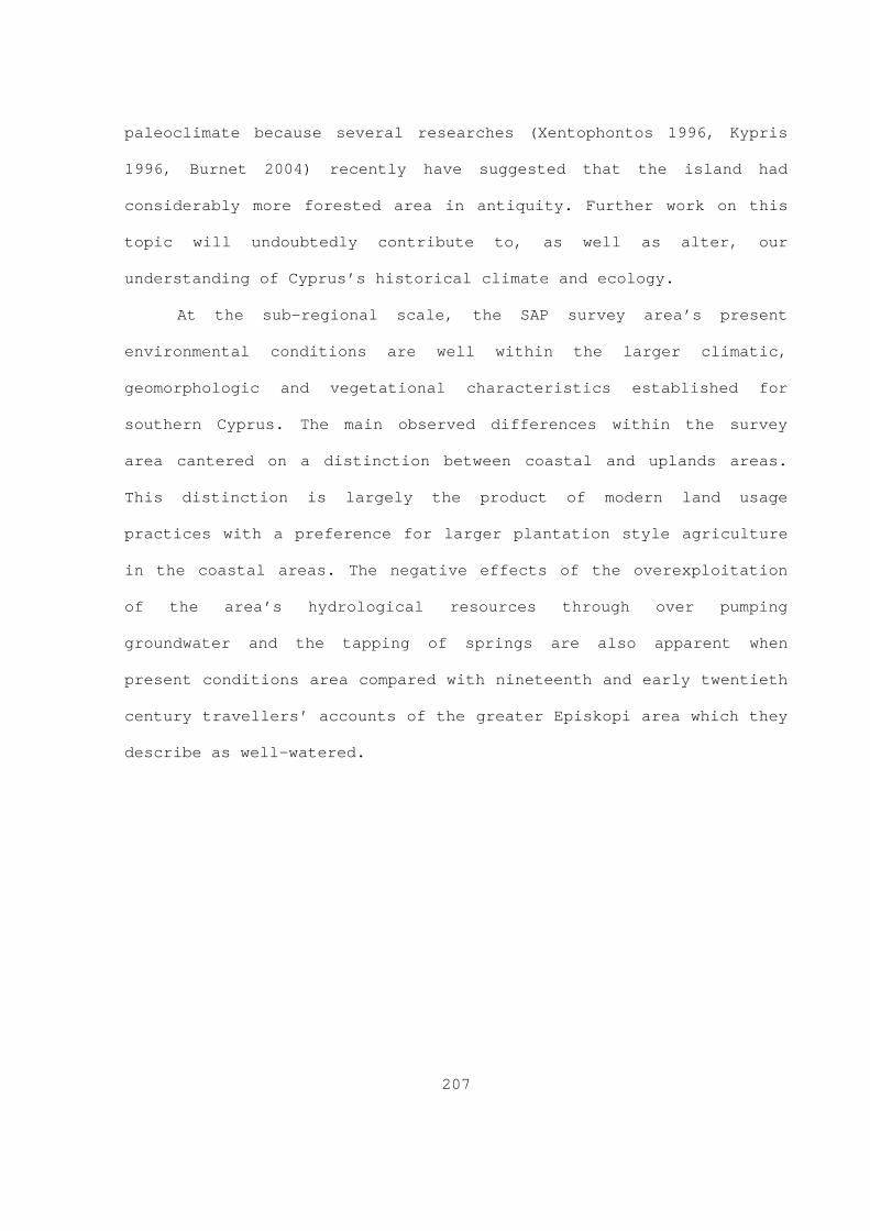
207
paleoclimate because several researches (Xentophontos 1996, Kypris
1996, Burnet 2004) recently have suggested that the island had
considerably more forested area in antiquity. Further work on this
topic will undoubtedly contribute to, as well as alter, our
understanding of Cyprus’s historical climate and ecology.
At the sub-regional scale, the SAP survey area’s present
environmental conditions are well within the larger climatic,
geomorphologic and vegetational characteristics established for
southern Cyprus. The main observed differences within the survey
area cantered on a distinction between coastal and uplands areas.
This distinction is largely the product of modern land usage
practices with a preference for larger plantation style agriculture
in the coastal areas. The negative effects of the overexploitation
of the area’s hydrological resources through over pumping
groundwater and the tapping of springs are also apparent when
present conditions area compared with nineteenth and early twentieth
century travellers’ accounts of the greater Episkopi area which they
describe as well-watered.

Text
MORPHOU BAY
KHRYSOKHOUBAY
EPISKOPIBAY
DREAMERS BAY
LARNACABAY
FAMAGUSTABAY
TROODOS
KYRENIA RANGE
MESAORIACAPE ARNAUTI
CAPE KORMAKITI
CAPE KITI
CAPE PYLACAPE GREKO
CAPE ANDREAS
CAPE GATA
KARPAS PENINSULA
AKROTIRI PENINSULA
AKAMAS PENINSULA
!(
!(
!(
!(
!(
!(
!(
!(
!(
!(
!(
!(
!(
!(
!(
!(
!(
!(
!(
!(
!(
!(
!(
!(
!(
!(
!(
!(
!(
!(
!(
!(
!(!(
!(
!(
Pyla
Lysi
Lakki
Drusa
Polis
Maroni
Sotira
Kellia
Paphos
Avdimou
Morphou
Mitsero
Limniti
Kyrenia
Larnaka
Kythrea
Anoyira
Alambra
Kouklia
Akanthou
Politiko
Limassol
Lefkosia
Lapithos
Episkopi
Galounia
Famagusta
Kalavasos
Ayia Napa
Lefkoniko
Athiaenou
Lagoudera
KhlorakasGeroskipou
Tremetousia
Rizokarpaso
34°0'0"E
34°0'0"E
33°0'0"E
33°0'0"E
35°0'0"N 35°0'0"N
Figure 3.1 Major morpological zones (Datum WGS 84).
208
0 10 20 30 405Kilometers
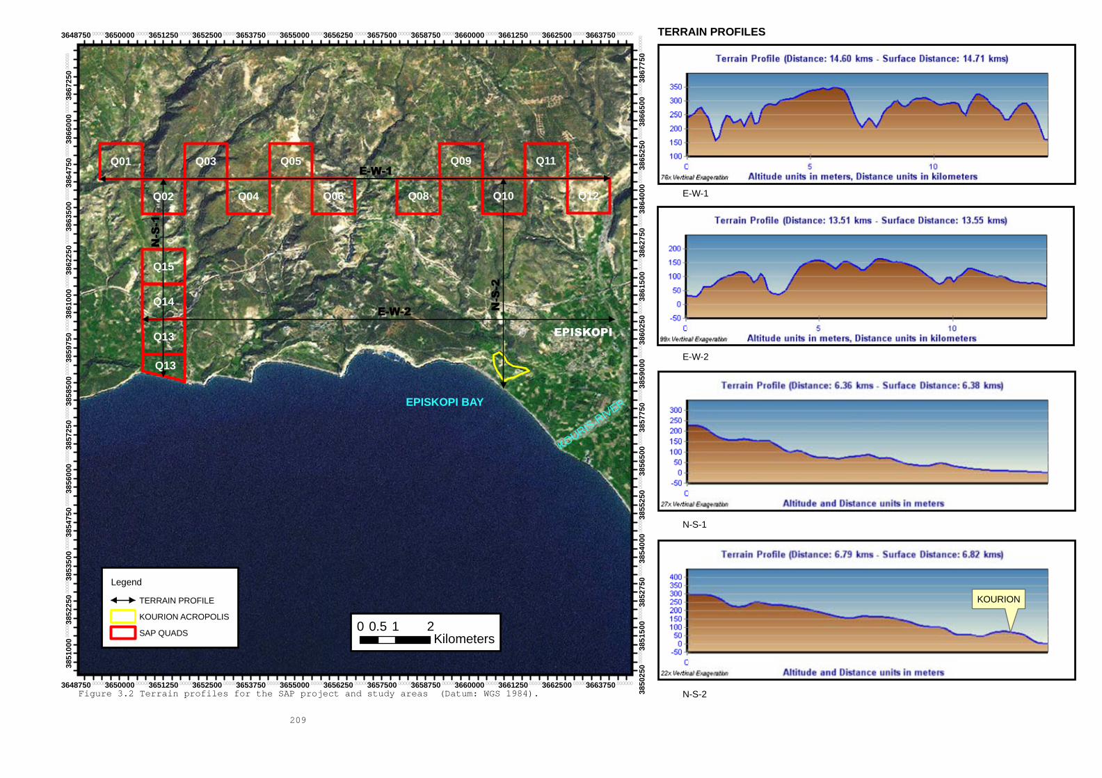
KOURIS RIVER
EPISKOPI
EPISKOPI BAY
Q11Q03 Q09Q05Q01
Q13
Q12Q10Q08Q06Q04Q02
Q14
Q15
Q13
E-W-1
E-W-2
N-S-2
N-S-1
3648750.000000
3648750.000000
3650000.000000
3650000.000000
3651250.000000
3651250.000000
3652500.000000
3652500.000000
3653750.000000
3653750.000000
3655000.000000
3655000.000000
3656250.000000
3656250.000000
3657500.000000
3657500.000000
3658750.000000
3658750.000000
3660000.000000
3660000.000000
3661250.000000
3661250.000000
3662500.000000
3662500.000000
3663750.000000
3663750.000000
3850
250.0
0000
0
3851
000.0
0000
0
3851
500.0
0000
0
3852
250.0
0000
0
3852
750.0
0000
0
3853
500.0
0000
0
3854
000.0
0000
0
3854
750.0
0000
0
3855
250.0
0000
0
3856
000.0
0000
0
3856
500.0
0000
0
3857
250.0
0000
0
3857
750.0
0000
0
3858
500.0
0000
0
3859
000.0
0000
0
3859
750.0
0000
0
3860
250.0
0000
0
3861
000.0
0000
0
3861
500.0
0000
0
3862
250.0
0000
0
3862
750.0
0000
0
3863
500.0
0000
0
3864
000.0
0000
0
3864
750.0
0000
0
3865
250.0
0000
0
3866
000.0
0000
0
3866
500.0
0000
0
3867
250.0
0000
0
3867
750.0
0000
0
Figure 3.2 Terrain profiles for the SAP project and study areas (Datum: WGS 1984).
209
0 1 20.5Kilometers
Legend
TERRAIN PROFILE
KOURION ACROPOLIS
SAP QUADS
E-W-1
E-W-2
N-S-1
N-S-2
TERRAIN PROFILES
KOURION

KOURIS R
IVER
PAR
AM
ALI
RIV
ER
EPISKOPI BAY
KOURION
Q05
Q13
Q13
Q14
Q15
Q12
Q11
Q10
Q09
Q08Q06Q02 Q04
Q03Q01
PARAMALI
EPISKOPI
KANDOU
STERAKOVOUSOTIRA
480000.000000
480000.000000
481000.000000
481000.000000
482000.000000
482000.000000
483000.000000
483000.000000
484000.000000
484000.000000
485000.000000
485000.000000
486000.000000
486000.000000
487000.000000
487000.000000
488000.000000
488000.000000
489000.000000
489000.000000
490000.000000
490000.000000
491000.000000
491000.000000
492000.000000
492000.0000003833
600.0
0000
0
3833
600.0
0000
0
3834
400.0
0000
0
3834
400.0
0000
0
3835
200.0
0000
0
3835
200.0
0000
0
3836
000.0
0000
0
3836
000.0
0000
0
3836
800.0
0000
0
3836
800.0
0000
0
3837
600.0
0000
0
3837
600.0
0000
0
3838
400.0
0000
0
3838
400.0
0000
0
3839
200.0
0000
0
3839
200.0
0000
0
3840
000.0
0000
0
3840
000.0
0000
0
3840
800.0
0000
0
3840
800.0
0000
0
3841
600.0
0000
0
3841
600.0
0000
0
3842
400.0
0000
0
3842
400.0
0000
0
Figure 3.3 Vegetation types present in the SAP study and project areas (modified from the University of Marlyand's IGBP-DIS 1km x 1km Land Cover data set) (Datum: Europe 1950).
210
Legend
DRAINAGE
SAPS QUADRATS
BUILTUP LAND
LAND COVER
GRIDCODE
CLOSED BRUSHLANDS
OPEN SHRUBLANDS
GRASSLANDS
CROPLAND
0 0.4 0.80.2Kilometers

))
)
))
)
)
)))
)
)
)
)
))
)
)
)
)
))
)
)
))
KOURIS R
IVER
PAR
AM
ALI
RIV
ER
EPISKOPI BAY
KOURION
FZ
YX
WV
U
TS
R
QP
O
N
ML
KJ I
H
G
EDC
BAQ05
Q13
Q13
Q14
Q15
Q12
Q11
Q10
Q09
Q08Q06Q02Q04
Q03Q01
PARAMALI
EPISKOPI
KANDOU
STERAKOVOUSOTIRA
480000.000000
480000.000000
481000.000000
481000.000000
482000.000000
482000.000000
483000.000000
483000.000000
484000.000000
484000.000000
485000.000000
485000.000000
486000.000000
486000.000000
487000.000000
487000.000000
488000.000000
488000.000000
489000.000000
489000.000000
490000.000000
490000.000000
491000.000000
491000.000000
492000.000000
492000.000000
3833
600.0
0000
0
3834
000.0
0000
0
3834
400.0
0000
0
3834
800.0
0000
0
3835
200.0
0000
0
3835
600.0
0000
0
3836
000.0
0000
0
3836
400.0
0000
0
3836
800.0
0000
0
3837
200.0
0000
0
3837
600.0
0000
0
3838
000.0
0000
0
3838
400.0
0000
0
3838
800.0
0000
0
3839
200.0
0000
0
3839
600.0
0000
0
3840
000.0
0000
0
3840
400.0
0000
0
3840
800.0
0000
0
3841
200.0
0000
0
3841
600.0
0000
0
3842
000.0
0000
0
3842
400.0
0000
0
Figure 3.4 Terrain suitable for (1) dry land crops (e.g. barley, wheat mixed with carob and/or olive trees), (2) terrain requiring little or no preliminary preperation for crops (CLASS I), terrain requiring prepreliminary preperation for crops (CLASS II); terrain requiring special treatmet (CLASS III) within the SAP project and study areas (Datum: Europe 1950).
211
Legend
SAPS QUADRATS
) SAP ENVIRONMENT COLLECTION UNITS
DRAINAGE
BUILTUP LAND
PASTURE/CROP TYPE
TYPE
CLASS II
CLASS III
DRY LAND CROPS
IRRIGATED AND DRY LAND CROPS
IRRIGATED CROPS
0 0.8 1.60.4Kilometers
KOURIS RIVER
EPISKOPI
3660500.000000
3660500.000000
3660750.000000
3660750.000000
3661000.000000
3661000.000000
3661250.000000
3661250.000000
3661500.000000
3661500.000000
3661750.000000
3661750.000000
3662000.000000
3662000.000000
3662250.000000
3662250.000000
3662500.000000
3662500.000000
3662750.000000
3662750.000000
3663000.000000
3663000.000000
3663250.000000
3663250.000000
3663500.000000
3663500.000000
3663750.000000
3663750.000000
3664000.000000
3664000.000000
3857
500.0
0000
0
3857
500.0
0000
0
3857
750.0
0000
0
3857
750.0
0000
0
3858
000.0
0000
0
3858
000.0
0000
0
3858
250.0
0000
0
3858
250.0
0000
0
3858
500.0
0000
0
3858
500.0
0000
0
3858
750.0
0000
0
3858
750.0
0000
0
3859
000.0
0000
0
3859
000.0
0000
0
3859
250.0
0000
0
3859
250.0
0000
0
3859
500.0
0000
0
3859
500.0
0000
0
Figure 3.5 Plantation style agriculture in the Episkopi area. (Datum: WGS 84)
212
0 0.25 0.50.125Kilometers
Legend
KOURION ACROPOLIS

213
Figure 3.6 View: NW. General landscape shot of terrain surrounding the site
of Sotira Teppes.

214
Figure 3.7 View: E, from Sotira Teppes. Terrain surrounding Sotira
village.

215
Figure 3.8 View: NE. General shot showing the terrain in the
Paramali Gorge in SAP Quadrat 01.
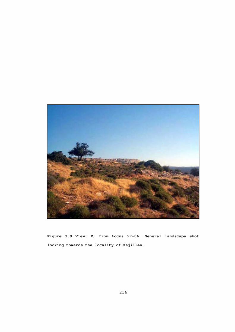
216
Figure 3.9 View: E, from Locus 97-06. General landscape shot
looking towards the locality of Kajillen.

217
Figure 3.10 View: SW. Terrain in the Kouris Gorge. Early modern
limekiln in the foreground and agricultural retention pond in
the background.
218
CHAPTER 4
Late Roman Cyprus
4.1 Chapter introduction
This chapter’s main objective is to create a historical context
f or the analysis of the Sotira Archaeological Project’s results. In
order to achieve this goal, Chapter 4 discusses several aspects of
the Roman and Late Roman administration’s engagement with Cyprus in
relation to the wider themes presented in Chapter 2. The discussion
is divisible into two main parts. Subsection 4.2 examines the
island’s administrative structures, and authoritative resources in
relation to the theorization of power, authority and their
relationship to the built and designed environment advocated in
Chapter 2 (§2.2). Because of the close relationship between
economic, military and geo-political resources, these themes are
discussed as component parts of an interrelated strategic whole in
subsection 4.2.4. However, because the available historical and
archaeological datasets for Roman and especially Late and Post Roman
Cyprus are fragmentary, it is necessary to examine several of these
various themes’ development from the early Roman period in order to
contextualize adequately their long term trajectories. Subsection
4.3 examines Kourion’s Late Antique urban landscape within the
framework established in Chapter 2 (§2.2.4 & 2.3.2), in which the
build environment is approached as a dynamic and multilocal social

219
construct. Subsection 4.3 also explores the archaeology of secondary
occupation at several Cypriot sites.
4.2 Contexts
Cyprus’ administrative history during the Later Roman and Early
Byzantine period is divisible into two broad periods. They are the
Roman-Late Roman/Late Antique of the first century BC to the mid-
seventh century AD and the subsequent condominium of the mid-seventh
to tenth centuries AD 1. It is during the latter of these two periods
t hat the island’s political status and administrative structures are
particularly obscure and open to debate (§4.2.2.1, 4.2.2.2 and
4.2.4). The specific manifestations of Roman, Late Roman/Early
Byzantine institutions and those of the condominium developed under
divergent contexts: the former (Roman and Late Roman/Early
Byzantine) developed within a clearly defined set of increasingly
authoritative structures, resources and conduits while the latter
(condominium) developed under a comparatively fluid and localized
set of structures. This, in turn, suggests a changing pattern of
power interactions that involved, among other things, the
relationships between individual social actors/groups and the
localized structures and those extensive structures of two competing
states ( i.e. the Byzantine and Caliphate). This subsection traces
aspects of this transformation in relation to the provincial
1 Mitford (1980) and more recently Potter (nd [forthcoming in the Makarios
Foundation’s History of Cyprus]) are essential works for the early Roman period.

220
administration and the changing patterns of elite authoritative
resources.
4.2.1 Aspects of Roman, Late Roman, and Condominium
administrations
Throughout all of the Hellenistic period, Cyprus was under
Pt olemaic Egypt’s control where it served as an outpost for that
dynasty in the eastern Mediterranean, and as a means of defense
against Selucid Syria. In this context, Cyprus was strategically
desirable for both powers. However, with Rome’s growing power and
influence in the Eastern Mediterranean during the first century BC,
it was only a matter of time before they too would become involved
in Cypriot affairs. Unsurprisingly, the Romans first became
interested and then exerted their influence on Cyprus through Egypt.
The Roman State, while serving as the Ptolemaic State’s protector,
forced Antiochus IV Epiphanes to withdraw from the territory he had
occupied: Cyprus was among these territories. In 58BC, the tribune
of that year, P.Clodius Pulcher, set into motion certain legal
measures that led to the island’s annexation by the Romans. Under
the administrative agency of M. Porcius Cato, the Roman government
extracted nearly 7000 talents that formed “a substantial aid to
Caesar in the impending civil war” (Mitford 1980: 1290). This brief
initial phase of direct Roman control and administration ended when
Caesar returned the island back to the Ptolemaic Kingdom and it

221
remained a Ptolamic possession throughout the Triumviral period 2.
Af ter Antony and Cleopatra’s defeat at the battle of Actium, the
Roman state assumed direct control over Cyprus again. Because
Octavian’s propaganda presented the conflict with Antony as a
foreign war rather than a civil war, he treated the Cypriots as
deditici 3. As a result, one of Octavian’s l egati administered the
island . Apart from the ideological dimension associated with this
particular administrative choice, the de facto direct imperial
control provided by a legatus served a practical strategic purpose.
First, Cyprus became a frontier province of sorts after the
administration abolished the province of Cilicia and entrusted that
territory’s administration to local client kings. The use of client
states and hegemonic imperialism became a defining characteristic
feature of the Julio-Claudian strategic policy (Luttwak 1976: 13-
49). In this context, the presence of a legatus provided the state
with a streamlined administrative channel on the island in the event
the geopolitical situation in either Cyprus or Cilicia developed in
a way the central administration did not approve of. However, after
the situation stabilized, Octavian Augustus transferred Cyprus to
the Senate’s jurisdiction in 22BC (Mitford 1980: 1289-1295;
Michaelides 1990: 110-115; Mommsen 1996 vol I: 223; vol II: 25;
Potter nd: 18-19).
2 For a general review of the Roman Near east in the late 1 st BC and the
benefits of ruling through client states, see Millar (1993, especially Chapter 2) and Luttwak (1976, in particular Chapter 2 Pp: 30-39).
3 For a discussion of the propaganda involved and its material manifestation in works of art, see Zanker (1990).
222
After Octavian Augustus returned Cyprus to the senate in 22 BC,
a proconsul draw from the senate possessing praetorian status headed
the island’s administrative apparatus from Paphos for a one-year
term 4. Apart from the proconsul’s immediate support personnel, a
quaestor pro praetore , a legatus pro praetor , imperial procurators,
curator civitatis (to monitor city expenditures) and port/harbour
inspectors (limenarcha cypri ) assisted the governor in administering
the province. In assessing the overall career paths of those
relatively few known governors of Cyprus, some researchers ( e.g.
Potter nd; Mitford 1980) have argued that this particular post did
not attract politically ambitious or well connected candidates 5. The
r ather limited administrative abilities and professional
inexperience of some of these governors undoubtedly would have
required the occasional intervention by the central administration 6.
For example, Cassius Dio (LXXIX 30.4, tans. Cary 1961: 409)
mentioned an instance from Caracalla’s reign (211-217 AD) in which
the imperial administration deemed it necessary to dispatch a former
governor of the province of Asia to Cyprus in order to advise the
island’s incumbent governor 7. Nevertheless, the posting would still
4 The governor’s term started in July and lasted for one year. 5 Thus, Potter (nd: 22) states that “men of future distinction did not often go to the island”. This position echoes that of Mitford (1980: 1305): “Cyprus was not welcomed by men of ambition or military ability”. Nevertheless, of the fifty proconsuls from 70-120 AD, less than one half dozen are mentioned as holding a commission in a military province (Mitford 1980: 1305). 6 The correspondence between Hadrian and Pliny provides a particularly good
example of the types of dialogue that could exist between the administrative centre and the provincial periphery.
7 Dio clearly states that Caracalla sent Avitus, a former governor of Asia, to Cyprus to act as an advisor for the island’s governor. However, Mitford (1980: 1298) believes that Avitus’s purpose on the island is unclear.
223
have provided the incumbent governor with opportunities for
enrichment through the collection of various fees for services,
gifts and bribes (Potter nd: 28-30; Mitford 1980: 1295-1296;
Michaelides 1990).
At the provincial administrative scale, the island was composed
of four districts that consisted of Salamis in the east, Lapithos in
the north, Paphos in the west and Amathus in the center. The regions
within these larger districts, in turn, were composed of the civic
territories attached to the island’s twelve major cities. The
province’s main Roman cities consist of Salamis (modern
Ammokhostos), Kition (modern Larnaca), Amathus (modern Limassol
area), Kourion (modern Episkopi area), Arsinoe (modern Polis Tis
Khrysokhou), Soloi (modern Morphou), Lapethos (modern Karavas-
Lampoussa), Chytroi (modern Kythrea), Karpasia (modern Rizokarpaso),
Kyrenia (modern Kyrenia) and Nea Paphos (modern Kato Paphos) 8.
Recently, Parks (1999: 121) has argued that Ledri continued into the
Roman period and should also be included as the thirteenth city. As
mentioned in Chapter 2, the early imperial Roman administrative
apparatus lacked a professional civil service and within this
system, the self-governing city formed the fundamental unit of
imperial administration. Researchers ( i.e. Mitford and Nicolaou
1974; Mitford 1980; Potter nd) have suggested that the Cypriot civic
councils of the Roman period were essentially oligarchies into which
8 See Michaelides (1990) and Mitford (1980) as well as Rupp’s (2000)
gazetteer for the modern associations of these cities.
224
a civic censor would enrol eligible members 9. As in other parts of
th e empire, the holders of civic office did so at their own expense.
Unsurprisingly, the civic offices of Gymnasiarch (official in charge
of the Gymnasium), agonothete (official in charge of athletic
events), archon (chief magistrate), grammateus of the boule (clerk
of the civic council), tamias (treasurer), archiereus (civic high
priest), sitonas (official in charge of the grain supply) and
agoranomos (official in charge of the market) are all well
represented in the Cypriot epigraphic record of the early Roman
period 10. The uniform administrative structures of each city
undoubtedly contributed to the island’s overall administrative
stability during this period. Curiously, as Mitford (1980: 1296)
points out, the imperial government did not deem it necessary to
establish colonies on the island. All Cypriot cities were taxpaying;
perhaps more importantly, no city received the full franchise or the
so-called Latin rights. Cyprus, like other regions of the Greek
East, had a developed Koinon , or provincial assembly, which also
undoubtedly contributed to the solidification of the island’s
provincial self-image and provided a much needed touch point with
the larger Roman provincial system (Potter nd: 28-30; Mitford 1980:
1295-1296; Michaelides 1990; Mitford & Nicolaou 1974: 26).
Additionally, it seems reasonable to assume that the Cypriot
provincial civic landscape remained relatively unaffected by the
9 The Ptolemaic administration also preferred oligarchic civic governments.
See Mitford and Nicolaou’s (1974: 24-26) inscription 11, for example, which provides epigraphic evidence for the presence of a Censor at Salamis.
10 For these and other examples of civic officials of the early Roman period, see Mitford (1971) for Kourion and Mitford and Nicolaou (1974) for Salamis.

225
“levelling of municipal statuses” (Carrié 2005: 272), and the
homogenization of the empire’s more diverse provincial civic
landscapes that resulted from Caracalla’s edict of universal
citizenship in 212 AD (see Chapter 2).
From an institutional standpoint, the Koinon Kypriō n, based in
the provincial metropolis of Paphos, performed a variety of
functions such as presiding over minor judicial and administrative
tasks, providing bronze coinage for small change (from the reigns of
Claudius to Caracalla, or slightly later), as well as administering
religious festivals 11. It also provided its member cities with a
self-contained medium for arbitration. More importantly, it formed a
conduit through which local civic governments could present their
collective interests in a uniform way to the central administrative
apparatus ( e.g. governor, senate or emperor) and engage with the
larger Roman world ( e.g. dedications to former governors in their
home cities) 12. However, the institution lacked the authority to
compel its members to act in concert or against their individual
interests for the greater good of the province if a given member
city did not wish to comply. On the other hand, the Koinon was not
obligated to aid individual cities with problems that resulted from
individual civic diplomacy or policy ( e.g. civic debts or individual
11 Paphos became the provincial metropolis in the early second century AD,
but that city served as the seat of the Koinon before it received that honor. This institution honored various deities and individuals. See, for example, the statue base inscription dedicated to Zeus Olympios by the Koinon found at the locality of Toumba tou Michaili in Famagusta district (Mitford 1980: n445).
12 For example, Servius Sulpicius Panacles Veranianus of Salamis, who had become a Roman citizen under Galba, led three embassies to Vespasian and his sons during his three tenures as provincial high priest and head of the Koinon (Mitford and Nicolaou 1974: 138).

226
negotiations) 13. Thus, for the first three centuries (first to the
la te third centuries AD) of imperial rule, the Koinon Kypriō n was
the most important and far reaching political institution on the
island (Potter nd: 45-46, 50-53; Mitford 1980: 1371; Michaelides
1990).
The provincial reorientation and administrative reorganization
of military and civil commands, which occurred during the late third
and early fourth centuries AD, appears to have had little to no
direct repercussions on Cyprus’ provincial administrative structures
because of the province’s non-military character. The city remained
the basic administrative unit on the island throughout Late
Antiquity 14. It seems reasonable to conclude that Cyprus experienced
many of the general administrative developments discussed in Chapter
2 albeit on a localized trajectory. Interestingly, the number of
official cities (i.e. settlements that performed secular and
ecclesiastic administrative functions and met specific legal
requirements) increased from twelve to fifteen over the course of
Late Antiquity with the addition of the cities of
Neapolis/Theodosiana (modern Limassol), Ledra/Leukotheon (modern
Lefkosia), and Trimithus (modern Tremetousia (Gregory 2001: 724) 15.
13 As Potter (nd: 13) notes, the provincial assembly did not intervene on
behalf of Salamis when that city encountered problems with one of its creditors, Scaptius, an agent of M. Iunius Brutus, during the late republic.
14 On this topic see Papageorghiou (1993) and Gregory (2001), as well as Rupp’s (2000: 1096-1101) gazetteer for Map 72, Cyprus, in Talbert and Bagnall’s (ed)(2000) Barrington Atlas of The Greek and Roman World .
15 Regarding Neapolis/Theodosias Gregory (2001: 723) states the following: “t here can be no doubt that Theodosiana/Theodosias was founded by Theodosius II (408-50), although we have no information as to why this took place. Then at some late date, the formal dynastic name was forgotten and

227
Additionally, based on their position within the Late Antique road
system (§4.2.3.1.B), it is also reasonable to suggest that the
settlements of Thronoi, located in the Pedalion promontory, and
Paleokastro, located in the Krommyakon promontory, would have been
important locales within their immediate and regional contexts (See
Bekker-Nielsen 2004: fig. 16; Papageorghiou 1993: 40)(see figure
4.1) 16.
I n general, most researchers would agree (Rautman 2000, 2001,
2003; Manning et al 2002) that Cyprus experienced a demographic
expansion and the creation of various complex social landscapes
throughout Late Antiquity. The expansion of the civitas/polis
administrative structure into the island’s interior during Late
Antiquity, as Gregory (2001: 724) notes, contradicts the generally
accepted paradigm ( e.g. Hill 1940; Mitford 1980) that emphasizes
coastal settlement in the Roman and Late Antique periods 17. The
in adequacy of the coastal model becomes even more apparent when the
analysis includes other settlement types. For example, the results
of the Sydney Cyprus Survey Project clearly indicate the existence
of complex multi-component Roman and Late Roman landscapes ( e.g.
the city was called by the more generic name Neapolis”. The modern names ar e derived from Rupp’s (2000) gazetteer.
16 Regarding Throni, Papageorghiou (1993: 40) states: “To the east of Larnaca th e town of Thronoi, although it lost its importance, survived until the beginning of the Middle Ages. This settlement is attested by the remains of a basilica on the coast at the locality of Ayia Thekla”.
17 Gregory (2001: 724) states: “The appearance of Trimithus and Lefkosia in th e centre of the island is particularly significant, since their appearance significantly modifies Hill’s argument (and common received wisdom) about the coastal emphasis of settlement in Cyprus under the Roman regime. Traditionally, we are supposed to wait until the difficulties of the seventh century for the collapse of the coastal urban system and withdrawal of cities into the interior”.

228
productive and consumptive) in the Troodos Mountain’s north-central
foothills (in the vicinity of the modern villages of Politiko,
ancient Tamassos, and Mitsero) (Knapp 2003:1) 18. Additionally, other
in land settlements with Late Antique phases, such as Anogyra (modern
Anoyira), Alampria (modern Alambra), Philoitos (modern Pyrogi),
Kelliake (modern Kellia) and Leukos Oikos (modern Lefkaniko), for
example, all have components that date back to the Roman or earlier
periods (see map 72 in Talbert and Bagnall (ed) 2000 and Rupp 2000’s
contribution in that volume). In general, apart from the island’s
main cities, approximately 79 percent ( n = 42) of approximately 53
loci (which in this case are settlements, villas and churches)
possessing Late Roman phases also possess occupation from either the
Roman or an earlier period(s) 19.
Under the new system, Cyprus fell under the jurisdiction of the
“Praetorian Prefect –later Vicar and after 331 Count- of the Orient”
(Mitford 1980: 1375) based at Antioch. After the seismic upheavals
of mid to late 4 th century (see Chapter 3 for a discussion of Cypriot
hi storic seismology), the provincial administration relocated from
Paphos to Salamis-Constantia, which became the new provincial
18 See the volume edited by Given and Knapp (2003) and their sites SIA 2
(K lirou Manastirka, Pp:75-82) SIA 6 (Politiko Ayios Mnason, Pp: 126-127) for examples of this multi-component landscape.
19 The sites in this example come from Rupp’s (2000) gazetteer (Ayios Georgios (Lagoudera), Ayios Georgios (Ayios Nikolaos), Ayios Kononas, Ayios Mavri, Ayios Nikolaos, Ayios Stephanos, Ayios Trias, Alampria, Alyki, Anogyra, Aphrodision, Ardana, Arsinoe, Dreamer’s Bay, Drepon, Drousham Galounia, Geronisos, Gy…,Kelliake, Khelones, Klirou, Knidos, Kopetra, Kourias, Lakki, Leukos Oikos, Limenetes, Lysi, Mitero, Panayia Ematousa, Peya, Kokkinovouno, Koutsopetria, Magounda, Makaria, Mandres, Mansoura, Mathiatis, Melandryna, Ourania, Petrera (modern Maroni), Petrera (Marathovounos), Philoitos, Platani, Sarka, Shyrvallos, Styllarka and Teratsia) with the addition of Panayia Ematousa (Sorensen and Jacobsen 2006).
229
metropolis 20. As in the preceding period, the overall social standing
and career of those who governed a province provides an indirect
measurement of the perceived importance that particular province
held within the greater administrative mechanism. The governor of
Cyprus usually received his post based on the recommendations of
senior members of the Prefecture’s administration (Kyrris 1985: 166-
169; Kyrris 1992: 101-102). As in other aspects of the Late Antique
administration, the office holder was required to pay a fee to the
imperial government upon receiving the insignia of office and its
corresponding rank. Those social actors that attained the
governorship of the island received the title of praeses and later
consularis (Kyrris 1996: 161), which conferred senatorial
( clarissimus grade) status on the office holder 21. It is probable
t hat some upwardly mobile social actors pursuing careers in the
civil service ( militia ) would have regarded Cyprus as a minor
posting in the same way as their early imperial predecessors would
have. However, based on the discussion of late Antique office
holding presented in Chapter 2, it seems reasonable to suggest that
20 As Michaelides (1990: 128) notes that it was strategic interests that
re sulted in the shift from Paphos to Salamis. 21 The Notitia Dignitatum and the Synecdemus of Hierocles identify the
governor of Cyprus as a consularis (Jones 1964: 1459, appendix III). For a discussion on the various titles and ranks associated with the governorship in Late Antiquity, see Slootjes (2006 [especially Chapter 1]). It is important to note that governors with the title of praesides are often associated with smaller provinces. The general empire-wide trend and the gradual absorption of the equestrian class over the course of the fourth century seem to indicate that a governor with the title of praeses ranked as a perfectissimus in the early fourth century AD and a clarissimus by the late fourth century AD (Slootjes 2006: 19). Perhaps more importantly, by the third century AD, the title of consularis had “become one the titles for governor, without his necessarily having been a consul” (Slootjes 2006: 20).

230
upwardly mobile Late Antique social actors would have viewed even a
minor postings, like Cyprus, as a dignitas and a potentially useful
step in their overall career path 22 (Chrysos 1993: 3).
Cyprus’ administrative linkage with Antioch remained in place
until the sixth century when Justinian I’s provincial reorientation
grouped Cyprus along with several other provinces (Scythia, Moesia
Secunda in the Balkans, Caria in Anatolia and the Cycladic Islands
in the Aegean) into a new administrative block, under the quaestor
exercitus. Several authorities (Mitford 1980; Lokin 1984; Jones
1964; Barnish et al 2001; Roueché 2001) suggest that the motivation
behind the selection of the exercitus’s component provinces centred
on grouping wealthy provinces, of which Cyprus was one, with those
that were experiencing disruption and/or were economically
exhausted 23. Therefore, the more wealthy provinces within this system
bore most of the economic burden for the defence of the Balkan
provinces of Moesia and Scythia (Haldon 2005: 50).
This new administrative construct required Cypriot social
actors to travel to Odessa in modern Bulgaria to voice their
judicial appeals. However, as Barnish and colleagues (2001: 183-184)
point out, soon after the creation of the exercitus, Justinian
issued an edict allowing the Cypriots access to Constantinople’s
courts where they could receive an audience with one of the
22 Slootjes (2006) has suggested that those pursuing a career in the civil
mi litia may have had to hold several minor posts before serving as the governor of a more important province or advancing into the upper echelons of the administrative apparatus ( e.g. vicar).
23 Chrysos (1993: 7) suggests the John Lydus’s comment regarding more wealthier of those provinces involved in this new administrative mechanism is “a description which of course applies to Cyprus much better than to either Caria or the Aegean islands”.

231
quaestor’s representatives 24. This edict, they suggest, reflects a
certain degree of sensitivity on behalf of the central
administration to the needs of those social actors engaging with the
system. On the other hand, those social actors engaging in minor
litigation could use the Episcopal courts. Given the distance and
cost of travel coupled with the mandatory court fees ( commoda) and
various tips (sportulae), it seems reasonable to suggest that those
Cypriot social actors that need to engage in litigation but lacked
in both material and social network ( e.g. a patron with connections
at court) resources would have opted for the local episcopal court
system whenever possible 25. It is also probable that the Episcopal
courts would have remained the preferred option even after the
abolition of the quaestor exercitus in the late sixth century AD.
The development of Cyprus’ Byzantine Dark Age administrative
structures between the establishment of the condominium in 688 AD
and Nicephoros II’s re-conquest and subsequent permanent annexation
of the island in 965 AD remains particularly obscure. Putting the
strategic dimension of this discussion to the side for the moment
(see below §4.2.4), the available data, the best of which is
predominantly derived from the island’s sigillographic record, does
identify, in a schematic way, the Byzantine administration’s
24 Approximately fifteen months elapsed between the creation of the exercitus
and the establishment of the edict, which allowed Constantinople as the alternative court (Barnish et al 2001: 184).
25 On this particular topic, Lokin (1984: 45-46) believes that “it is more th an probable that this Episcopal court was preferred to the official court of the counsularis , which was tainted with corruption, and notorious for high fees, long waiting times and long dangerous journeys in case of appeal”. For the possible cities where such an appeal might have taken place and a list of cities from the seventh century onwards that had a bishop, see Dikigoropoulos (1965-1966: 239) and Gregory (2001).
232
fundamental elements during this period. An Archon (a semi-military
governor, with the dignity of Spatharius) and a Dioiketes (a civil
and revenue official with the dignity of Hypatos) formed the basic
Byzantine administrative unit on the island. At some point during
the eighth, or possibly the ninth century AD, this administrative
core expanded with the addition of a lieutenant governor, or
Lieutenant general (Ek Prosopou) (Browning 1977-1979: 106; Kyrris
1984: 171; Jenkins 1953: 1008-1010) 26. Later, the Cypriot population
under Byzantine administration requested the presence of an
additional civil official, a Basilikos Anthropos, to bolster the
financial sector of their administration (Metcalf 2004: 71) 27.
Al though the seal of the Kleisourarch Theodoros (a commander of a
frontier pass or frontier region) does not have an exact provenance,
nor does it provide the location of Theodoros’s command, it does
suggest that the imperial strategic planners and administrators were
actively engaging with the island in some way during the middle
decades of the ninth century 28. The most probable location for the
Byzantine administrative presence on the island is along the
northern coast where, as Jenkins (1953: 1010) has pointed out, its
lines of communication with the maritime Theme located in southern
26 See Metcalf’s (2004) seal # 156 for the seal of the Ek Prosopou Merkourios
dated to the eighth or ninth century AD recovered from Klavidhia, Larnaca District.
27 Metcalf (2004) points out that these officials are associated with imperial kouratoreiai (imperial estates) and often held the dignity of protospatharius.
28 See Metcalf’s (2004) seal # 212 for the Kleisourarch Theodoros dated to th e ninth century AD.

233
Anatolia would have been shortest (Metcalf 2004: 69-72; Browning
1977-1979: 106-107; Megaw 1988: 145-146; Kyrris 1984: 171-172).
Even less is known about the Caliphate’s administrative
presence on the island after the removal of the Arab garrison from
Paphos in 688 AD. Three main officials, based in Paphos, constituted
the Caliphate’s administrative presence on the island. These
officials consist of an Emir, an Imam and a Hakem. The emir was the
chief official within this structure and his responsibilities,
undoubtedly executed through his agents, included collecting
tax/tribute, monitoring the status of the treaty and disarming
travelers (Megaw 1988: 145-146; Kyrris 1984: 171). Two officials,
the Imam, drawn from the local Cypriot Arabs, and a Hakem, or judge-
commissioner, aided the emir and were primarily responsible for
various aspects of the civil and domestic administration. The
presence of Islamic lead seals at Limassol, Lophou, Limnati and
Paphos suggest that this apparatus may have had representatives
dispersed across the southern half of the island 29 (Metcalf 2004: 69-
72; Browning 1977-1979: 106-107; Megaw 1988: 145-146; Kyrris 1984:
171-172).
4.2.1.1 Ecclesiastic authoritative landscapes
As mentioned in Chapter 2, the institutional church contributed
to one aspect of the manifold authoritative landscapes (as defined
in §2.2.4) of Late Antiquity. Although a detailed account of the
29 On this topic, Metcalf (2003: 400) states “…Islamic lead seals (which are
ve ry scarce in Cyprus), tend to come from the Limassol are (not, as one might have predicted, the Paphos area!)”. See Metcalf’s (2004) seal numbers I.1N, I.2N, I.3N and I.4N, respectively.

234
history of the Cypriot church is beyond the scope of the present
work, what follows is necessarily limited to highlighting select
aspects of the Cypriot church’s authoritative landscape(s) 30. By the
ti me of St. Helena’s alleged visit to Cyprus in 326-327 AD, which
was a stop on her pilgrimage to the Holy Land, the sees of Paphos,
Salamis and Tremithus already appear to have been established.
Cypriot tradition has linked Helena’s trip with the foundation of
Stavrovouni monastery and the equiping of that institution with a
relic: the Cross of the Penitent Thief 31. Tradition also credits her
wi th presenting a fragment of the True Cross to the Church of
Tokhni. Nevertheless, Pohlsander (1995: 99-101) has argued that the
main source for Helena’s Cypriot foray, Leontios Machairas, is
inconsistent and the evidence for her visit is at best equivocal.
Similarly, Kyrris (1996: 162) maintains that the Cypriot Church
either “invented or more probably elaborated” the details of
Helena’s visit in order to further their “effort to consolidate
their ecclesiastic autonomy” by gaining imperial favour 32. It is also
i mportant to note that the Cypriots had sided against Constantine I
30 For a complete, but increasingly dated, account of the history of the
Cypriot Orthodox Church up to the late 19 th century, see Hackett (1901). For the Condominium centuries, see Dikigoropoulos(1965-1966). More recently, see the relevant sections in Englezakis’s (1995) collected studies on the Church of Cyprus that cover the 4 th through 20 th centuries as well as Englezakis (1990). Gregory’s (2001) article is also germane in this context. Also, see Metcalf (2009: 301-318, 351-359) for a recent discussion of the church’s place in Late Antique Cypriot society.
31 See Metcalf’s (2004) for a seal of the monastery of Stavrovouni. Tradition al so attributes Helena with ending a serious drought that lasted for the improbable length of 36 years (Chrysos 1993: 7).
32 The Cypriots undoubtedly exploited the rift that had arisen between Constantine I and the Bishop of Antioch, Eutathius, because of an alleged incident involving Helena the bishop of Antioch during her travels in the East (Kyrris 1996: 162).

235
during the recent civil war. Therefore, it is likely that the
Cypriot tradition surrounding Helena is an opportunistic, but
calculated piece of public relations designed to reconcile the
Cypriots with Constantine I, and forward and protect their own
ecclesiastic authoritative landscape.
Throughout the fourth and most of the fifth centuries AD, the
Cypriot church focused its attention on securing independence from
the church of Antioch. The Cypriot Church largely charted a
divergent course by becoming an orthodox anomaly in a primarily un-
Nicean east during the dogmatic controversies of the fourth through
seventh centuries AD ( e.g. Monophysitism) 33. This is not to say that
Cyprus was free of heresies: Polybius of Rinococura records at least
six that achieved a modest level of recognition on the island with
the most popular being the Gnostic and the Marcionite heresies
because of their popularity among the province’s elites (Kyrris
1987: 104; Kyrris 1984). Nevertheless, the Cypriot Church
increasingly voted out of step with the other eastern metropoles.
For example, at the Council of Serdica (343-344 AD), the Cypriot
delegates were the only eastern contingent that endorsed “the letter
33 See Kyrris (1987) for a good synopsis of the activity and position of the
Cypriot church in relation to these events. The historical development of the Cypriot role in the debates surrounding Monophysitism is particularly useful, see Kyrris (1987: 104-108). The level of chaos these debates generated is clearly described by Ammianus Marcellinus in his description of Constantius’s involvement in theological matters: “The plain and simple religion of the Christians have obscured by a dotard’s superstition, and by subtle and involved discussions about dogma, rather than by seriously trying to make them agree, he aroused many controversies; and as these spread more and more, he fed them with contentious words. And since throngs of bishops hastened hither and thither on the public post-horses to the various synods, as they call them, while he sought to make the whole ritual conform to his own will, he cut the sinew of the courier service” (Ammianus Marcellinus XX.16-18, trans Rolfe 1935-1939).

236
of the Western Bishops at the Council to Constantius demanding him
to forbid all interventions of the civil authorities in church
affairs” (Kyrris 1996: 162). The Cypriot church continued to resist
established ecclesiastic protocols, and by the early fifth century
AD, the Patriarch of Antioch informed Pope Innocent I that the
Cypriots were openly electing their own bishops despite his
protests: the situation devolved even further after the Cypriot
bishops openly elected their own Archbishop. At the Council of
Ephesus in 431 AD, the Cypriot Church, through the skills of the
bishops of Kourion and Soli, won a strategic victory against
Antioch. In 488 AD, during the second reign of Zeno (476-491 AD),
the Cypriot Church achieved independence after the Archbishop of
Cyprus, Anthemius, provided the emperor with the necessary evidence
to support the claim that the Cypriot Church was an apostolic
foundation. On this topic, Kyrris (1996: 168) states
“…following a famous ‘vision’, according to
Cypriot tradition, Archbishop Anthemius
offered a manuscript of St. Mark’s or St.
Matthew’s (?) Gospel discovered in the tomb of
St. Barnabas to Emperor Zeno of Byzantium,
who, in return, conferred on him and his
successors everlasting imperial privileges –to
wear an imperial red cloak in ceremonies, to
carry an imperial sceptre and to sign in red
ink-, thus confirming the autocephaly based on
the apostolicity of the church of Cyprus. This

237
was a landmark in its history and one of the
cornerstones of its growing power and prestige
and its increasing role in political and
secular affairs. It is not clear how and why
Zeno…decided to obviously displease his
protégé Peter Knapheus (= the Fuller)
Patriarch of Antioch…a Monophysite monk who
accepted his Henotikon”.
Thus, the Cypriot Church was able to achieve a very high level of
independence by the late fifth century AD. Perhaps more importantly
“the independent and autonomous election of the leaders of the
apostolic Church of Cyprus meant that they were beholden to no-one
outside the island” (Metcalf 2009: 255).The next major adjustment to
the Cypriot church’s authoritative structure occurred during the
late seventh and early eighth century AD as a result of Justinian
II’s strategic use of the Cypriot population. Justinian II’s policy
resulted in the transfer of a substantial number of Cypriots as well
as the island’s Archbishop, John, to imperial territory (Thrace,
Hellespont and Pamphylia). Although Justinian II’s Cypriot project
may not have fulfilled its maximum strategic potential in the way
the emperor had originally envisaged, the Cypriot church did reap an
exceptional benefit from it: the Council in Troullos’s XXXIX Canon
unequivocally established the autocephaly of the Cypriot Church

238
(Runciman 1990: 136-143; Kyrris 1996: 167-169; Kyrris 1987: 104-
106; Dikigoropoulos 1965-1966: 253-255; Englezakis 1990: 12-18) 34.
Those settlements recognised as cities and that possessed the
appropriate ecclesiastic infrastructures comprised the extensive
nodal points within the Cypriot ecclesiastic landscape at the
provincial scale (see below for these cities) 35. However, as argued
i n the discussion of space and place presented in Chapter 2, the
components of such manifold landscapes can exist at multiple scales:
places that are nodal at the sub-regional scale may be locales at
the provincial or regional scales. The Late Antique village sites of
Kalavasos-Kopetra (Rautman et al 2003), Maroni-Petrera (Manning et
al 2002) and Ayios Kononas (Fejfer et al 1995) illustrate this
point. Of these, Kalavasos Kopetra is the most extensively
excavated. The settlement site of Kalavasos Kopetra comprises an
area of approximately 4ha and is situated on a ridge in the
Vasilikos valley (modern Larnaca district) at a distance of
approximately 2.5km from the coast. The site is also in close
proximity to the Roman coastal road linking Amathus to Kition
(Bekker-Nielsen 2004: 194-198; especially 197-198; Rautman 2001:
248), as well as the valley’s main north-south axis of
communication 36. Several smaller and diverse Roman-Late Roman sites
( settlement and productive sites) are within 4km of Kopetra. Two
34 The council also made provisions for other bishops who could reside in
th eir own sees because of barbarian invasion and occupation (Kyrris 1994-1998: 220-222; Cameron 1996: 30).
35 Cypriot Bishops are attested in the conciliar lists “of Council of Nicea (3 25), Serdica (343), Constantinople (381), Epesus (431) and Chalcedon (451)” (Metcalf 2009: 353).
36 For a discussion of the survey see Todd (2004 and forthcoming).

239
basilica churches located along the village’s northern (Area V) and
southern (Area II) outskirts frame the settlement: a third is
located in the extra-village monastic complex to the main
settlement’s south at Sirmata (Area I) (Rautman et al 2003: fig. 2.4
p 19) 37. Of these three churches, the south basilica (Area II) and
monastic complex (Area I Sirmata) comprise the most extensively
excavated areas of the site. The excavators have identified four
sub-phases at the southern church before its destruction in the late
seventh century AD. Both of the village basilicas and the monastic
complex undoubtedly formed important monumental nodal points within
the larger village landscape. Rautman and colleagues’ comments on
these structures are worth quoting at length. For the south church,
they state
“Standing on the S perimeter of the inhabited
site, the south church was a key landmark for
the Late Roman travelers approaching Kopetra
from either the lower river plain or the ridge
road. The rising mass of the nave was embraced
by lower spaces on at least three sides, and
other village buildings stood nearby. The
building is the largest structure known on
this part of the ridge and in late antiquity
constitutes a visual anchor for area
residents” (Rautman et al 2003: 118).
37 The excavators (Rautman et al 2003: 238) have described Kopetra’s layout
as “nucleated” and positioned in the landscape “with an eye to defense”.
240
For the monastic complex at Sirmata, they state
“The monastery as Sirmata was one of the most
conspicuous architectural features of the
Vasilikos valley at the turn of the 7 th c. The
ta ll plastered walls of the basilica would
have been familiar to travelers along nearby
roads as well as inhabitants of the area.
Opening to the west, the main doors of the
church looked towards the nearby village, even
as the lives of its occupants remained
centered within the complex” (Rautman et al
2003: 89).
Borrowing a term from the discussion of Roman urbanism presented in
Chapter 2, it seems reasonable to suggest that these monumental
edifices formed a key component of the village’s overall “armature”
and were nodal points not only within the settlement but, more
importantly, the surrounding landscape as well (Rautman 2003: 89,
118-119, 237-442, 254, figs. 2,4, 7.1; Rautman 2001: 252-254).
Additionally, based on the diversity of the fine ware and
transport amphora sub-assemblages, the excavators (Rautman et al
2003; Rautman 2001: 247) have suggested that Kalavasos-Kopetra also
served as a regional market centre. The sigillographic data from the
Kalavasos area also supports the site’s importance at the sub-
regional level 38. As a socially constructed place, it is reasonable
38 See the 7 th or 8 th -century seal of the Consul Palladios (Metcalf 2004:
seal # 736) and 6 th or 7 th -century seal of the Hypodektes (financial of ficial) Kosmas (Metcalf 2004: seal # 189).
241
to conclude that Kalavasos-Kopetra was a multilocal nodal point
within the sub-regional landscape and an important locale within the
large civic territory of Amathus (Rautman 2003: 89, 118-119, 237-
442, 254, figs. 2,4, 7.1; Rautman 2001: 252-254).
The settlement of Maroni-Petrera provides a similar example of
this pattern. Maroni Petrera occupies an area less than 1ha on a low
spur approximately 2km from the coast and is situated within the
lower Maroni valley (modern Larnaca District). The site is also in
close proximity to the southern Roman coastal road that links
Amathus to Kition (Bekker-Nielsen 2004: 194-198; especially 197-
198). Like Kalavasos Kopetra, several diverse Roman and Late Roman
sites ( e.g. LRA1 amphora production at Zygi Petrini and an anchorage
at Vrysoundhia) surround Maroni Petrera (Manning et al 2000; Manning
et al 2002). Based on the density of the surface scatters
surrounding the basilica, the excavators (Manning et al 2002: 78)
suggest the main settlement (which was not part of the salvage
excavation’s research design) was to the basilica’s west; they have
also identified an ancillary settlement located about 1km to the
south at the locality of Phouches (Manning et al 2002: 78). Based
on the diversity of the fine ware and transport amphora sub-
assemblages, the excavators have suggested that this site also
functioned as a market centre like Kalavassos-Kopetra in the
neighbouring valley. The results of the intensive field survey in
the lower Maroni valley indicate that Maroni-Petrera was one of the
few sites with a tile roof in this sector of the valley. Manning and

242
colleagues (Manning et al 2002) have commented on the complexity and
multilocality of this particular landscape:
“ Petrera basilica thus represented a number of
things to the local community, and to any
individual who might experience the church as
a feature of the landscape. It articulated the
Christian identity of the surrounding
settlement. It represented the power and
influence of the Christian law, and of the
clergy. It also expressed a ‘Romanness’ that
harked back to the pre-Christian buildings of
the earlier empire, and served to legitimize
the Church with back-reference to a strong
monumental past. The Basilica, covered inside
and out with thick white gypsum plaster, would
have dominated the local landscape visually,
catching light and gleaming across the valley”
(Manning et al 2002: 79).
Thus, Maroni Petrera, like Kalavasos Kopetra in the Vasilikos
valley, was a multilocal social construct and nodal point within the
lower Maroni valley’s landscape. Apart from serving as a nodal place
at the local level, it also seems reasonable to suggest that the
site would have been an important locale within Amathous’s
hinterland.
The settlement of Ayios Kononas provides an additional example
of this process. Ayios Kononas is situated on a ridge in the western

243
Akamas and is approximately 1.7km from the coast in modern Paphos
District. Apart from the project’s field survey component, limited
excavations were undertaken at the main site of Ayios Kononas in the
basilica, several houses and the quarry, in addition to several
“minor settlements which were considered of importance to the
general understanding of the main site” (Bekker-Nielsen et al 1995:
20). The excavators (Fejfer and Mathiesen 1995: 78) estimated the
settlement’s overall area at approximately 1.4ha 39. Like Koptera and
Petrera, several smaller sites ( i.e. an anchorage at Koni along with
the farmstead sites of Sergis, Osia Maria and Dhamalospilios)
surround Ayios Kononas (Bekker-Nielsen et al 1995: 16-20 and figure
3). The basilica at Ayios Kononas was the only edifice with a roof
comprised entirely of tile (Fejfer and Mathiesen 1995: 83). This
selective use of roofing tile for high status monumental edifices is
also observable at the settlement site of Petrera. In situating the
site of Ayios Kononas in the larger regional landscapes, the
excavators (Bekker-Nielsen et al 1995: 19) believe that the
settlement was “an important or possibly the most important site in
western Akamas” during Late Antiquity (Bekker-Nielsen et al 1995:
16-20; Fejfer and Mathiesen: 1995: 73-77, 80-86). Thus, although the
site was not a city, it seems reasonable to conclude that the
settlement of Ayios Kononas was an important nodal space within the
larger landscapes of the western Akamas.
39 Fejfer and Mathiesen (1995: 78) state “The maximum extent has been
ca lculated to about 14,000m 2 including open spaces, the quarry etc”.

244
Apart from the direct presence of ecclesiastic physical
infrastructure ( e.g. rural and urban churches, baptisteries, chapels
and rural and civic monasteries) in the landscape, the island’s
sigillographic record also provides a secondary index with which to
measure the growth of this particular authoritative landscape within
the province (as well as its external contacts/networks). Although
the provenanced sub-assemblage of various ecclesiastic seals ( e.g.
archbishops, bishops and those of churches) is modest, it can be
used in an exploratory way to examine aspects of this particular
institution’s spatial manifestations in both urban and rural
contexts. Among the urban find spots, the ecclesiastic seal
assemblages from both Amathus and Lampoussa/Kyrenia are particularly
diverse. Apart from the seals of the city’s own bishop or church
(Metcalf 2004: seal # 434 and 479), Amathus’s provenanced assemblage
consists of seals of the bishop of Constantia (= Salamis) (Metcalf
2004: seal # 413), and several examples that do not record the
bishop’s see (Metcalf 2004: seal # 430, 441 and 461). These examples
all date either to the sixth, seventh or eighth centuries AD. The
sub assemblage also includes three seals of the Archbishop of Cyprus
(Metcalf 2004: seal # 423, 452 and 454) that range in date to the
seventh and eighth centuries AD. Similarly, the find spot of
Lampoussa/Kyrenia’s sub-assemblage also includes seals of the
island’s Archbishops (Metcalf 2004 seal # 417, 421 and 453) that
date from seventh and eighth centuries AD. The sees of Soli and
Lapithos recovered from these find spots provide a limited but
suggestive view of the communication pattern among nodal spaces

245
within the same sub-region. The assemblage recovered from the
excavations at Kourion’s Episcopal complex include the seal of an
unknown bishop attributable to the period between 550 and 700 AD
(Dunn 2007: 527, catalogue # 1); the seal assemblage recovered from
the excavations at Saranda Colones, Paphos, also include a seal of
the Bishop Antonios (Dunn’s catalogue # FC 3812c/2, Dunn pers. comm.
2007) attributable to the period between 550 and 650 AD. Finally,
the small sub-assemblage consisting of five provenanced seventh-
century AD seals of Ioannes bishop of Lapithos (Modern Karavas)
(Metcalf 2004: seal #433) recovered from Constantia (1 seal), Kellia
(1 seal; ancient Kelliake), Troulloi (1 seal) and Lamboussa/Kyrenia
(2 seals), also provides a useful example of the intra-institutional
communication networks that could exist between nodal points within
this particular authoritative landscape.
Although the find spots of Khlorakas, Emba and Lemba (modern
Paphos District) are not known to have been Late Antique urban
centres, they have produced a surprisingly diverse sigillographic
assemblage 40. These find spots lay in close proximity to one another
as well as to the nodal space of the city of Nea Paphos and the
Roman coastal road that linked Nea Paphos with the nodal space of
the city of Marion (Goodwin 1978: 284-285, 406-407, 504; Bekker-
Nielsen 2004: 126-130, map 22). The ecclesiastic sub-assemblage from
these find spots consists of the seals of an unknown bishop of the
40 It is important to note that some fields surrounding the Khlorakas contain
“‘ imported soil’ which was spread over the normally-rocky terrain in the 1950’s” (Goodwin 1978: 406-407). One possible direction for future research could involve a geophysical and intensive field survey of the more productive fields at these find spots.
246
sixth or seventh century (Metcalf 2004: seal # 666), Bishop Sergios
dated to the fifth to seventh centuries (Metcalf 2004: seal # 352),
Bishop Paulos (Metcalf 2004: seal # 438) dated to the sixth or
seventh century, and Archbishop Epiphanios dated to approximately
680 AD (Metcalf 2004: seal # 423). Additionally, a seventh-century
seal of the Metropolitan of Tyre, Theodoros, recovered from
Khlorakas (Metcalf 2004: seal # 489) illustrates the spatially
extensive contacts some of these non-urban find spots could have
with nodal spaces from outside the province. Based on these find
spots’over-all sigillographic assemblage compositions ( i.e.
ecclesiastic seals coupled with the seals of various honorati and
functionaries) as well as their proximity to key infrastructure
elements (i.e. main roads and major urban settlement) it seems
reasonable to conclude that these find spots indicate the existence
of nodal spaces in the sub-regional landscape and important locales
within Nea Paphos’s civic territory 41.
Several points emerge from this discussion. As mentioned above
in Chapter 2, in a larger empire-wide context, researchers have
suggested that the Episcopal institution was generally “city-
friendly” (e.g. Holum 2005), and that the bishop was among the more
important members of the Late Antique civic administrative structure
rather than its leader ( e.g. Rapp 2004, 2005). Nevertheless the
41 Dignities and offices represented in the Khlorakas, Emba and Lemba sub
assemblage include Honorary Eparch (eighth century AD, Metcalf 2004: seal 841), an Illoustrios (seventh-eighth century AD, Metcalf 2004: seal 189), a Patricius (eighth century AD, Metcalf 2004: seal 236), a Scribon (sixth-seventh century AD, Metcalf 2004: seal # 833), a Primiscrinirios (sixth-seventh centuries AD, Metcalf 2004: seal # 327) and a Strator (sixth-eighth centuries AD, Metcalf 2004: seal # 328).
247
church’s growing institutional authority encroached on and could
also potentially undermine various civic and provincial
administrative protocols that had traditionally been the secular
administration’s responsibility ( e.g. Slootjes 2006). Although it is
probable that these developments occurred in Cyprus, they would have
undoubtedly done so on a localized spatial and temporal trajectory.
The complex and often hostile interactions between the church of
Antioch and the church of Cyprus, and the various heresies, suggest
that the Late Antique Cypriot ecclesiastic landscape was highly
contested at the regional and sub-regional scales. The conflict
between the Churches of Cyprus and Antioch also provides a
particularly good example of the types of intra-institutional
conflicts that could exist within a spatially extensive
authoritative organization like the church. Similarly, the various
heresies that are purported to have taken hold on the island (Kyrris
1984) indicate that this ecclesiastic landscape was also multilocal
(as defined in §2.2.4) as well as contested at the provincial level.
Based on the position that the Cypriot church adopted as a
collective and corporate institution vis-à-vis the Church of
Antioch, it also seems reasonable to suggest that the Cypriot church
was able to draw upon and efficiently utilize both extensive and
localized conduits and resources to resist its antagonist’s efforts
to colonize, that is to say infiltrate and subjugate at the abstract
institutional level, this particular contested Cypriot landscape.
It is likely that the Cypriot church’s authoritative landscape
operated simultaneously at several spatial scales during Late
248
Antiquity as the settlements of Kalavasos Kopetra, Maroni Petrera,
and Ayios Kononas as the provenanced seals indicate. It also seems
reasonable to describe one aspect of this diverse process as that of
a localized centre institutionally embodied by the urban bishop
infiltrating the lived, or every day, space of a periphery comprised
of those elements that constituted the civic and Episcopal see’s
hinterlands. In this context, the presence of institutional
functionaries like the chorepiskopoi (Bishops with a limited mandate
who operated as agents of the urban bishop that serviced rural and
village communities within a given see) and the periodeutai
(itinerant priests) in the landscape, I suggest, also represent a
component in the infiltration of everyday spaces by the abstract
authoritative institutional space embodied by the Episcopal
establishment 42. However, the process could act in considerably more
subtle ways. Bowden (2003: 151) has made the general observation
that “[t]he lower clergy, the presbyters and deacons, could be drawn
from all ranks” and that many still practiced their “secular trades”
after attaining their appointments within the church during Late
Antiquity. This development, I suggest, allowed the institution to
infiltrate, or colonize, the lived spaces of everyday life in both
urban and rural contexts to a very high degree while simultaneously
masking the intensity of this process.
42 Consider, for example, Rautman’s (2001: 255) statement “As in nearby
Kalavasos in recent times, the resident priests and lesser clergy probably came under the jurisdiction of nearby Amathus and helped administer village affairs”which illustrates, in my opinion, the human aspect of the process of colonization. For the chorepiskopoi in Cyprus see Gregory (2001: 719-721) in passing.

249
It is important to note that this particular colonization
process could also include other authoritative landscapes ( e.g.
administrative and military) and, in some cases, it was bi-
directional. For example, Kyrris (1994-1998: 209) suggests that
Cypriot bishops also performed military administrative functions
within the province during the seventh century 43. However, the
si tuation Kyrris ( ibid ) is referring to could be interpreted in two
broad ways: (1) as either the growing importance of the church in
relation to the central (both military and civil) administrative
apparatus’ weakening presence on the island or (2) as the central
administration’s co-option of various localized ecclesiastic
infrastructures ( e.g. communication, material and human) for their
use in regional geo-political strategic planning.
Heraclios’s failed theological policy of Monotheletism is
perhaps the most explicit example of the central government’s
strategic interests directly confronting the Cypriot Church’s
authoritative integrity. Most researchers ( e.g. Kyrris 1987; Kyrris
1996) would agree that the central government selected Cyprus
because of the comparatively peaceful relations that existed between
the province’s Orthodox and Monophysite populations, and the
emperor’s friendship with the province’s Orthodox archbishop,
Archadios. Despite the unfavourable reply from the island’s
Monophysites, Archadios accepted Monothelitism undoubtedly as a
result of his friendship with the emperor rather than on any solid
43 Kyrris (1994-1998: 209) states “Equally probable was the engagement
of …bishops with civil and/or military tasks as inferred from such cases as Epimachos bishop of Soli who was ex-consul …and Kyros of Soli, a stratelates (7 th c.).

250
theological grounds. Kyrris (1987: 105) states the following about
the strategic objective of this particular policy
“The possibility of success on a small scale
in Cyprus might lead to unity throughout the
empire as a whole, for which the example of
Cyprus would serve as ‘balm’. In that case the
Greek community together with the Monophysite
elements co-existing with it were expected to
act as the mediating factor in the imperial
policy of Constantinople: the reason of its
failure to do so falls within the general
conservative Orthodox attitude of the Cypriot
Church in religious matters, and this despite
the close relations of Heraclius with the
island…”
Apart from a “conservative attitude” (Kyrris ibid ), it seems
reasonable to suggest that the Cypriot Church’s ultimate rejection
of Monotheletism is also linked to the institution’s desire to
remain free of external interferences and/or the competing interests
and ensure the continued reproduction and legitimization of its own
particular authoritative landscapes within the province. The need
for the institutional Cypriot church to ensure the reproduction of
its authority undoubtedly gained importance with the influx of
various monophysite Christians into the province as a result of the
Persian and subsequent Arab occupations of the Levant and Egypt and
the establishment of state-sponsored Islamic communities on the

251
island from 653 AD onward 44. Thus, apart from being multilocal, it is
possible to conclude that this particular authoritative landscape
was also contested on several spatial scales during Late Antiquity.
Researchers (i.e. Randsborg 1991) have argued in general terms
that ecclesiastic building within a given region and socio-temporal
trajectory can serve as an index of the economic strength or
weakness of the host communities. On Cyprus, for example, Rautman
(2001: 250) has employed this approach in his interpretive framework
in the analysis of Kalavasos Koptera 45. Rather than providing an
al ternate model, I suggest that the approach to Cyprus’ ecclesiastic
landscapes presented above, which also includes the relationship
between abstract, lived and contested spaces in the landscape,
provides an additional but necessary dimension to the general view
that these edifices are indexes of rural economic strength ( e.g.
Rautman 2000, 2001, 2003) 46. Additionally, as noted in Chapter 2
(§ 2.3.3), Bowden (1991; 2003) has identified several ways in which
the institutional church could also remove wealth from communities.
At this point, it is useful to reiterate several of the processes
mentioned by Bowden(ibid ); these include the extraction of localized
wealth for the maintenance of clergy within the see and the use of
44 These include several thousand Armenians settled in the island by Tiberios
II in the late 570’s (Charanis 1959: 30; Kyrris 1987: 105; Kyrris 1970: 157)
45 Rautman (2001: 250) states “Farming, agricultural processing, and perhaps metalworking formed the base of Koptera’s economy, whose scale can best be judged by the three identified churches. These tangible expressions of wealth donated to pious ends constitute the most conspicuous feature of the site”. Clearly Rautman is arguing for direct correlation between monumental architecture and a given community’s economic dynamism.
46 For a general discussion of Cypriot Late Antique church architecture, see Megaw (1974) and Papageorghiou (1986).

252
non-local human and material resources in church construction. It is
also probable that land donations to the church by members of the
congregation would have also alienated productive land, and by
extension wealth, from localized economies and the central
administration.
Bowden’s (2003) observation on this process is worth quoting at
length. He believes “It does not necessarily follow that monumental
architecture itself is indicative of a greater production of surplus
per se, but rather that it is a sign of increasing control over
existing resources by an emerging elite; in this instance the
burgeoning hierarchy of the Christian Church” (Bowden 2003: 128).
However, it is possible to augment Bowden’s ( ibid ) model with the
spatial framework advocated in Chapter 2 and include the differences
between a given extensive authoritative institution’s ability to
control both localized and extensive surplus production, its ability
to control various resource (both human and material), and its
ability to direct their redistribution to various institutional
organs. Within this context, it seems reasonable to suggest that
this process is linked ultimately to the colonization of localized
spatial systems (in this case economic spaces and lived spaces) by
abstract institutionalized authoritative space (in this case the
Church). Even though the edifices that constitute the Cypriot case
studies mentioned above (Kalavasos Kopetra, Maroni Pertrera and
Ayios Kononas) may not be as elaborate as their urban counterparts
were, they do constitute monumental edifices within their own
particular contexts ( e.g. the village and surrounding valley

253
landscape) 47. As such, they are the products, like all monumental
ar chitecture (§2.2.4.2), of the institutionalization of differential
social relations, the control of both human and material resources,
as well as the disproportionate consumption and distribution of
these resources.
In sum, it is likely that the Cypriot ecclesiastic landscape
was highly contested and diverse throughout Late Antiquity. As an
authoritative institution, the Cypriot church efficiently
infiltrated the provincial rural landscape by embedding itself into
the fabric of Late Antique social actors’ everyday routines, whether
through environmental or direct interpersonal contact. It adopted
policies and utilized both extensive and localized conduits and
resources to resist effectively its various antagonists’ efforts to
challenge its spatial hegemony. It also seems reasonable to suggest
that it drew upon the same diverse resource base to legitimize its
presence and ensure the reproduction of its own structures in the
landscape.
4.2.1.2 Cypriot elites: Roman and Late Antique
The preceding discussion has focused on one aspect of a
manifold process involving institutional competition, however, such
institutions could compete with various social groups such as the
diverse stratum often identified as elites (see Chapter 2,
47 Similarly, Manning and colleagues (2002: 77) state “ The church/basilica
at Maroni Petrera , and the associated structures such as the Paved Building, may only be a modest monument, but within the local valley context it nonetheless does symbolize an ability to control surplus resources and to engage in conspicuous consumption well beyond strict need (for the requirements of the liturgy).

254
§2.3.1.2). In Late Antiquity, the often competitive relationships
between local landed elites, senatorial elites and abstract
institutions like the city and central government also exemplify
both the localized and extensive facet of this competition. Because
the data pertaining to Cypriot Roman and Late Roman elites is
disseminate, it is necessary to discuss these groups together. As
mentioned in Chapter 2, the property system (particularly the
transmission and acquisitions of property), the legal system and the
occupation system (division of labour) constituted three general
mechanisms that preserved and reproduced social inequalities during
the Principate (Garnsey and Saller 1987) and, it is reasonable to
suggest, during Late Antiquity as well. At the onset of direct Roman
rule after the battle of Actium, some of these mechanisms
undoubtedly continued along the trajectories established during the
last phase of Ptolemaic and republican rule on the island. However,
as the central government formalized Cyprus’ position within its
larger provincial geo-political landscape after 22 BC, it framed
levels of possible engagement between upwardly mobile social actors
and state level authoritative structures at the provincial level. In
other words, this relationship delineated at least some of the
channels of engagement between the various localized authoritative
resources and those dispersed and stratified resources at the global
scale that comprised the state’s administrative apparatus.
One particular area where these trajectories intersected was
in the state’s awarding of Roman citizenship to provincial elites.
Apart from the conventus of Roman citizens at Paphos and Salamis,

255
the available data (mostly epigraphic) suggests that very few
Cypriots received Roman citizenship. As mentioned above, the
imperial administration initially viewed the Cypriots in a
pejorative manner and over the long term, it showed little interest
in awarding the full or partial franchise to any of the island’s
cities, nor did it consider colonies in the province necessary or
advantageous. However, such a trajectory, whether the result of
implicit or explicit policy on the part of central government, would
have ultimately created an environment that eliminated certain
social resources and conduits from the various Cypriot elite
landscapes. Recently, Potter (nd: 22-23, 33) has argued that there
is a correlation between the limited overall career paths of the
island’s governors and the small number of socially mobile Cypriots
that were able to acquire Roman citizenship. The central premise of
his ( ibid ) argument is that those social actors that became
governors of Cyprus did not possess the necessary influence and
connections, or personal authoritative resource set (defined in
Chapter 2, §2.5.5), to act as efficient benefactors and patrons for
those Cypriot elites that, for example, wished to gain Roman
citizenship or embark on political careers outside of the island.
Thus, the senatorial social actors that became governors of Cyprus,
Potter ( ibid ) concludes, would have been mostly inefficient
“patrons” to the Cypriot elites. Although it is reasonable to
include weak gubernatorial patronage among the factors that could
potentially eliminate valuable social resources and pathways from
the Cypriot elite landscape, it is probable that this factor’s

256
overall importance would have diminished after the Caracalla’s edict
of universal citizenship in 212 AD, and would have experienced an
even greater decline in Late Antiquity (see below).
Because of the limited state-level career options available to
the Cypriots during the Principate, the relative importance of other
mechanisms, such as imperial appointment (either from the emperor or
a magistrate), marriage (Potter nd: 57) and to a lesser extent
military service gained in relative importance for those upwardly
mobile social actors that wished to acquire the franchise prior to
212 AD. Of these three, imperial appointment (whether directly by
the emperor or in his name by a magistrate) and marriage constitute
the two main mechanisms for disseminating the franchise on the
island during this time. As in other provinces, military service
provided a conduit for the dissemination of the franchise to social
actors from an array of backgrounds ( i.e. social actors that may be
identified as humiliores rather than landed elites of curial
status). However, the available evidence suggests Cypriot social
actors did not utilize this particular mechanism extensively (Potter
nd: 57-59; Mitford 1980). Nevertheless, by the mid first century AD
(reigns of Claudius and Nero), the Cypriot elites “begin to have
their prominence highlighted with grants of citizenship” (Potter nd:
58).
Although their access to the conduits that lead to social
mobility and career paths outside the island were limited, the
Cypriot elites successfully competed with one another on a

257
predominantly provincial-civic level 48. Apart from localized
co mpetition within the province at the civic level, the Koinon
Kypri ōn provided the socially mobile with a comparatively more
spatially extensive mechanism through which they could convert their
material wealth into social capital. Mitford (1980: 1370-1371) has
made the general observation that the Koinon increasingly honoured
important provincial men and women rather than members of the
central administration ( i.e. proconsuls and other provincial
officials, but it is important to note that the imperial family
always remained popular) from at least as early as the late first
century BC. This trend, he believes, is indicative of a growing
sense of “Cypriot nationalism” 49. Because Cyprus “had no Cypriarch to
match, for example, the Asiarch, Lyciarch, Ciliciarch and Syriarch
of the adjacent mainlands” (Mitford and Nicolaou 1974: 138), the
highest provincial-level honour available to upwardly mobile Cypriot
social actors was the provincial chief priesthood of the imperial
cult, which was combined with the position of principal officer of
the Koinon . This rotating annual post not only provided the office-
holder with recognition at the provincial level but it could also
provide possible routes of access to social actors engaged with the
larger imperial system through spatially extensive activities like
48 However, although imperial service was largely closed to them, several
Cypriots did achieve a level of recognition outside of the province; see Mitford (1980) for examples. Those wealthier members of the civic elites could afford to hold several civic offices at once. For example, at Salamis, Heracleides served as both gymnasiarch in 21/22 AD and held the post of civic high priest of Zeus Olympios and the Augusti for life (Mitford and Nicolaou 1974: 128-129).
49 Mitford (1980: 1372) states: “Something like a nationalism may then be detected, but of a gentle and a sentimental kind, far removed from the intensity of that other small people, the Jews”.

258
embassies 50. The career of Servius Sulpicius Pancles Veranianus, a
ci tizen of Salamis who also attained Roman citizenship, provides a
glimpse into the possibilities that existed at both the local ( i.e.
civic), provincial ( i.e. service in the provincial assembly) and
extra-provincial scales for the more prominent of the upwardly
mobile Cypriot social actors. Pancles held both the posts of
gymnasiarch and agonothete at his own expense and in perpetuity; he
served as provincial chief priest of the imperial cult on three
occasions and headed embassies to the Flavian Emperors while holding
this office 51. He also provided funds for the embellishment of
Salamis’s urban armature ( e.g. he is credited with building a
bathhouse and the theatre and erecting a number of statues in the
city)(Mitford 1980; Mitford and Nicolaou 1974: 130-138; Potter nd:
50-52). Thus, it seems probable that service and advancement in the
provincial assembly formed an important resource for the social
negotiation and the legitimization of authority for the Cypriot
elites: both of which were essential for the maintenance and
expansion of their personal authoritative resource sets (as defined
above in Chapter 2, §2.2.5).
The Cypriot provincial elites’ heightened internal competition
during the Principate is largely attributable to their position in
relation to larger global administrative mechanisms. It also seems
50 Potter (nd: 52) notes: “the fact that it changed hands every year reflects
th e fact that there was a demand for the chance to hold it (in theory- in practice a great individual such as Pankles might be priest whenever he wanted)”.
51 As Mitford and Nicolaou (1974: 135) note, Pancles would have to provide la nd and/or money to maintain the gymnasium’s oil supply and oil for the games.
259
reasonable to suggest that before the grant of universal citizenship
in the early third century AD, one facet of the Cypriot elite
consisted of three overlapping and interrelated groups. These three
consist of those social actors who possessed Roman citizenship,
those that held offices for life and/or served in the provincial
assembly, and those social actors of curial status. After the grant
of universal citizenship, the first group’s main means of
differentiation ( i.e. Roman citizenship) undoubtedly decreased in
relation to other factors. However, the indifferent stance the
Cypriots appear to have adopted when presented with Roman
citizenship 212 AD is not necessarily indicative of a closed or
introverted provincial worldview 52. Rather, it seems reasonable to
suggest that it is also indicative of the existence of a developed
set of mechanisms that allowed those social actors who engaged with
them to successfully pursue philotimia which, in turn, also suggests
they were able to maximize the potential of localized authoritative
resources for the conversion of material wealth into social capital
on the one hand and the legitimization of their social capital and
potentia (authority) on the other.
As discussed in Chapter 2 (§2.3.1.2 and 2.3.1.2.A) the
reorientation and expansion of the state’s administrative apparatus
during Late Antiquity altered many of the established conduits and
structures that framed the social practices of the empire’s elites.
At this point, it is useful to reiterate three of the more far-
52 Michaelides (1982: 120-121) states “It would seem though, judging by the
minimal reaction of the Cypriots, that, by AD 212, when Caracalla offered Roman citizenship to all free males living in the Empire, they had lost interest in obtaining it”.
260
reaching and interrelated developments that resulted from this
manifold process. The first is the central administrative
apparatus’s overall growth and increased demand for human resources
drawn from a particular social stratum that traditionally entered
into civic (local) service. The second is a transformation of civic
administration in which the so-called “notables” eclipsed the
constitutional mechanisms of civic government. The third
interrelated component centres on the proliferation of senatorial
honorati in the provinces. As noted above, it is possible to view
this proliferation in terms of the centre, or at least certain
aspects of the centre, colonizing the various landscapes of the
provincial periphery. This process is particularly interesting on
Cyprus precisely because of the predominantly localized character of
elite competition within the province up until this time.
These empire-wide developments undoubtedly altered the
established localized resource networks that had come to define
various Cypriot elite landscapes ( e.g. civic and provincial) during
the early Roman period. At the provincial scale, the Koinon Kypri ōn
was among the more important and extensive localized pathways that
lost its ability to provide upwardly mobile Cypriots with an
efficient medium for the conversion of material wealth into social
capital 53. Upwardly mobile Late Antique Cypriot social actors, like
t heir contemporaries in other provinces, could pursue careers in the
imperial civil service or in the church. Both of these spatially
53 As Mitford (1980) notes, the institution appears to trail off in the
fo urth century AD.

261
expansive institutions provided efficient mechanisms for both
philotimia and the conversion of material wealth into social capital
in ways that neither service in the curia nor the Koinon could
match. Nevertheless, some researchers ( e.g. Alastos 1976; Chrysos
1993) believe that the Cypriot church represents a social
reorientation and Christian re-expression of the provincial Koinon 54.
This position, I suggest, is only partially and superficially
true. Although the institutional church could and did consume human
and material resources drawn from the curial classes, it also
engaged with and consumed human resources drawn from other social
strata in order to fill the lower clergy and functionaries in a way
that the Koinon did not. However, unlike the Koinon , the
institutional church possessed a considerably more extensive and
diverse resource base and access to the state-level conduits through
which these resources flowed. The institutional church also differed
from the Koinon in its extensive hierarchical administration, its
manner of issuing sanctions against non-compliance, and the
mechanisms through which the institution legitimized itself. As a
hierarchical institution, it was not as overly dependent upon those
upwardly mobile social actors for its legitimization and
reproduction as the koinion was. Thus, it seems reasonable to
suggest that one pronounced difference between the Koinon and the
54 Chrysos (1993: 5) states “…the leading social group in the cities, who
tr aditionally were involved in local politics and in the activities of the koinon ton Kyprion , gradually – in greater numbers after the death of Julian in 363…associated themselves with the church”. Similarly, Alastos (1976: 115) believes that “The Autocephaly of the Cypriot Church is a historical continuation of the Koinon , and like the Koinon it helped to prevent the national identity of the island from being swamped in by the tumultuous catastrophes of the coming centuries”.

262
church centred on the distinction between a hierarchical
organization with a corporate identity and efficient ability to
pursue collective interests on one hand and the predominantly
personal authority of the Koinon, on the other. The church also
efficiently colonized the spaces of everyday life of a wider
spectrum of Cypriot social actors in a way that Koinon could not. In
sum, it seems reasonable to conclude that the common link between
these two institutions does not reside in the promotion of a general
Cypriot identity but in the corporate interests of select groups of
Cypriot social actors.
As a socio-spatial phenomenon, most researchers would agree
that the proliferation of various senatorial honorati in the
provinces is characteristic of the changing authoritative landscapes
of Late Antiquity. Although most of current available data for this
process in Cyprus is equivocal, the sigillographic record, despite
its limitations, provides the best evidence for this process within
the province 55. In a recent study, Metcalf (2004: 72, 76) has
observed that seals of illustres are the second most frequently
occurring seal type after those of Bishops within the province prior
to the 690’s AD. As mentioned above, although substantially inflated
during the sixth century AD, the dignity of illoustrios identifies
those social actors who attained it as members of the highest
senatorial grade (they either received this dignity either as a
result of holding or having held an office in the civil service or
55 For a general discussion of these limitations, see Metcalf (2003: 394-397,
400). The most important limitation from the perspective of the present study is the lack of good provenance information for the majority of the Cypriot seals.

263
by receiving an honorific office). By the late sixth century,
however, the title illoustrios could also indicate membership in
“one of the palatine regiments” (Dunn 2007: 528). At the provincial
level, it is important to note, those social actors who had achieved
this dignity represented one particular diverse social stratum
within a manifold landscape of elites. Their dignity, in addition to
their rank, provided them with access to both provincial and state
level authoritative resources that would have been beyond the
personal resource sets available to most of their predecessors
during the Early Imperial period.
Apart from the dignity of Illustris, the provincial
sigillographic record includes individuals with the dignities of
Consul (e.g. Metcalf 2004: seal #823, 736 and 619), Patricius
(Metcalf 2004: seal# 20), Lamprotatos and Honorary Eparch (Metcalf
2004: seal #174), Honorary Eparch (seal # 178) and Honorary Consul
(Metcalf 2004: seal #163), and Spatharios ( e.g. Metcalf 2004: seal
#832 & 837). Unfortunately, at present it is impossible to establish
the directionality or origins for the vast majority of the various
elites identified in the sigillographic record. However, based on a
comparison of a Cypriot sub-assemblage comprised of eagle seals
( i.e. a wide ranging class of lead seals with an obverse device that
consists of an eagle with raised wings) with a sub-assemblage of the
same type of seals from Constantinople, Metcalf (2003: 400) has made
the general observation that “pre-700 seals were not carried to
Constantinople in any significant quantity, as they were from 700

264
onwards”(see below) 56. This, coupled with the fact that approximately
85 percent of the total provincial level sigillographic assemblage
is comprised of pre-700 AD seals, indicates a comparatively high
level of intra-provincial communication, as Metcalf (2003: 399-400)
has argued 57.
The provenanced seals of two seventh-century AD Illustres,
Petros (Metcalf 2004: seal #190) and Stephanos (Metcalf 2004: seal
#192), as well as a sixth century AD seal of the Illustrios Petros
(Dunn 2007: catalogue # 1) provide a view, albeit a limited one, of
the potential scope of extensive intra-provincial (and potential
extra-provincial) communication patterns at this time 58. Of the six
seventh century AD provenanced examples attributable to Petros, five
seals are from Lambousa/Kyrenia and one seal is from Amathous; the
sixth century AD seal is from Kourion’s Episcopal prescient 59. Of the
fo ur provenanced examples attributable to Stephanos, two seals are
from Lambousa/Kyrenia, one is from Amathous and one from Salamis-
Constantia 60. The seals of the Consul Palladios and the Honorary
Consul Ioannes provide a further example of inter-provincial elite
communication patterns. As indicated by seal #736 and #163 of
Metcalf’s (2004) catalogue, Palladios had the need to undertake
56 There appears to be a concentration of eagle seals in the Lamboussa area
(Metcalf 2004: 100-101). Of the approximately 180 Cypriot eagle seals, nearly 140, or approximately 78 percent of the sub-assemblage, are stray finds ( ibid ).
57 “Roughly 1,100 out of the 1,300+ seals recorded from Cyprus are pre-700 in date” (Metcalf 2003: 399).
58 Metcalf (2004: 76) notes that of the 82 seals of Illustres only 22, or approximately 27 percent of the sub-assemblage have exact provenances.
59 The remaining 20 examples come from the Petrakides archive (Metcalf 2004). 60 The remaining 28 examples come from the Petrakides archive (Metcalf 2004).

265
correspondence with persons/institutions at both Kalavasos and
Amathous while Ioannes had the need to undertake correspondences
with individuals, groups or institutions at both Lythrankomi and
Lambousa-Kyrenia. These patterns show on a limited scale and in a
very simple way the interrelated and bi-directional relationship
that existed between both elite urban and elite rural landscapes. As
mentioned above, those seals of illustres attributable to the later
sixth century AD may also be associated with social actors with
links to the military.
It is probable that the reorientation and in some instances,
simplification, of Cypriot authoritative structures ( i.e. the
administrative apparatus and local networks) during the
jurisdictionally ambiguous condominium centuries would have created
an environment in which the administrative utility of the island’s
elites would have undoubtedly increased in value from the imperial
administration’s point of view. The best example of this process
comes from a context derived from the negotiations and diplomatic
manoeuvring undertaken by Justinian II and Caliph Abd-al-Malik
regarding the transfer and resettlement of the island’s population
during the first decade of the eighth century AD. During these
diplomatic engagements, members of a prominent Cypriot family, known
as the Phangoumeis, actively participated in the negotiations that
in 706 AD led not only to the reestablishment of the treaty of 688’s
terms but also the return of those Cypriots transferred to the
Hellespont by Justinian II and to Syria by Caliph Abd-al-Malik

266
(Browning 1977-1979: 107; Kyrris 1994-1998: 194-195) 61. Although the
Phangoumeis’s dignity and office, if any, is not mentioned by
Constantine Porphygenitus in De Administrando Imperio , it is very
likely that they were members of the top echelon of the Cypriot
elites who, as high-ranking honorati, would have had access to at
least some components of the Late Roman state’s extensive
authoritative resources, like good contact(s) in the palatine
service and undoubtedly close contacts with those imperial officials
on the island. As such, they would have been the equals of those
social actors like the honorary Eparchs Kosmas (Meatcalf 2004: seal
# 321 & 841) and Ioannes (Metcalf 2004: seal # 737) identified in
the Cypriot sigillographic record for the eighth century AD 62. Such
el ites, it also seems reasonable to suggest, would have become the
Cypriot “power elite” by exploiting the considerably more fluid
authoritative structures that characterize condominium government
and administration in general.
61 Constantine Porphyrogenitus ( De Administrando Imperio = DAI ) states “…the
emperor [Justinian II] was moved to populate Cyprus again, and he sent to the commander of the faithful of Bagdad [Damascus, see Kyrris 1994-1998: 195)] three of the illustrious Cypriots, natives of the same island, called Phangoumeis, in charge of an imperial agent both intelligent and illustrious, and wrote to the commander of the faithful asking him to dismiss the folk of the island of Cyprus that were in Syria to their own place. The commander of the faithful obeyed the emperor’s epistle, and sent illustrious Saracens to all the parts of Syria and gathered together all the Cypriots and carried them over to their own place. And the emperor, for his part, sent an imperial agent and carried over those who had settled in Romania, that is Cyzicus and in the Kibyrrhaiote and Thrakesian provinces, and the island was populated” (trans. Moravcsik and Jenkins 1967: 225). Based on the phrasing of the reLavant portion of the passage in the DAI , Kyrris (1994-1998: 195) argues that the “Phangoumeis were living in Cyprus at the time of dispatch of the delegation to Damascus”.
62 Metcalf (2004: 77) suggests that the dignity of Honorary Eparch may be more common on Cyprus during the first half of the eighth century. The Honorary Eparch Kosmas is well represented in the island’s post 700 AD sigillographic record with six eagle seal coming from the same boulloterion ( ibid ).

267
4.2.2 Strategic contexts
This sub-section presents an assessment of the potential role
Cyprus played in the Later Roman state’s larger strategic mediations
in the eastern Mediterranean. Because of the fragmentary and limited
data available for the Late Roman period, it is necessary to start
discussion in the Roman period and to trace the development of
several general social themes before broaching specific Late Antique
questions.
4.2.2.1 Roman and Late Roman
Apart from modifying the existing civic oligarchies to imperial
r equirements, the central administrative apparatus of the Principate
never fully exploited Cypriot human resources ( e.g. military service
and administrative posts) in the same way as it had done in other
provinces. Nevertheless, the epigraphic record provides clear
evidence for the existence of at least one Cypriot Cohort, IIII
Cohors Cypria, in the Roman army from at least the mid first century
AD. The IIII Cohors Cypria served with distinction in the Dacian
wars and received the franchise early as a reward at some point
during the first decade of the second century AD (as indicated by
the epitaph Civium Romanorum associated with this unit by 109 AD) 63.
On the other hand, Mitford (1980) believes that the presence of a
IIII Cohors Cypria implies the existence of at least three other
Cypriot cohorts. He suggests (1980: 1345-1347) that the initial
63 Bekker-Nielsen (2002: 321) suggests the cohort was formed before 85 AD.
Al so, see Bekker-Nielsen (2002: n10, n17, n19) for references for the relevant inscriptions.

268
call-up would have required approximately 2000 Cypriot nationals 64.
He also believes that these cohorts would have drawn upon Cypriot
human resources exclusively to maintain their strength. However,
Bekker-Nielsen (2002) has recently challenged this interpretation.
Based on the prevalent trend in legionary recruitment practices from
the end of the first century AD recorded in other provinces, Bekker-
Nielsen (2002) has reasonably argued that it is unlikely that the
fourth Cypriot cohort drew exclusively on Cypriot human resources to
replenish its ranks. He further suggests that the initial call-up
would have required approximately 500 social actors rather than the
2000 Mitford (1980) suggests. Based on what is known about the
naming conventions of contemporary legionary units, he believes the
available evidence that supports the argument for the existence of
additional Cypriot cohorts is ambiguous. Furthermore, he points out
that after the auxiliaries who had won the epithet Civium Romanorum
for the cohort retired, the epithet would have become part of its
official title regardless of the current status of those individuals
serving in it (Mitford 1980; Bekker-Nielsen 2002; Potter nd) .
It would appear that the Cypriot cohort would have become
increasingly less Cypriot in character throughout the course of its
active service life. Thus, if Bekker-Nielsen’s (2002) arguments are
accepted, it is possible to conclude that military service played a
minor role in the overall transmittal of Roman citizenship within
the province, and was an unattractive option for those upwardly
mobile Cypriot social actors, as it was for many others living in
64 Mitford (1980) based this figure on four full strength 500-man cohorts.

269
interior provinces, that wished to attain the franchise. The IIII
Cohors Cypria does not appear to have continued in service after the
military restructuring of the early fourth century AD.
Apart from the ever-present hazards and disjunctions caused by
seismic disturbances and climatic fluctuations like droughts (see
§3.2.5 and 3.3), the only serious disruption the provincial
administration had to deal with was the Jewish Revolt of 116-117 AD
(under Trajan) which spread to several provinces (Egypt and Cyrene)
in the Eastern Mediterranean. On Cyprus, which had a considerable
Jewish population since the Hellenistic period (Kyrris 1992: 137;
Potter nd: 38-39), the insurrection appears to have originated in or
around Salamis 65. Under its leader, Artemion, it focused its
at tention on undermining the province’s municipal elites 66. It is
im portant to note that during the late republic, the Koinon Kypriō n
had successfully shielded the province from the economic burden of
sustaining a garrison by paying 200 talents to the governor of
Cilicia (Potter nd: 46). The Cypriots continued to remain free from
the economic burden of a garrison throughout the Principate. Apart
from a small police force, the governor of Cyprus did not have
immediate access to military resources in the case of either
domestic or external threats, unlike the governors of frontier
provinces. However, Artemion’s revolt provides a particularly good
65 According to Kyrris (1992: 137), the provinces Jewish population was
pr imarily engaged in the “wine and copper trade”. He ( ibid ) also notes that a number of Jewish refugees settled near Salamis and Golgoi after Titus’s sack of Jerusalem in 70 AD.
66 As a social movement, the revolt’s main aim “was to annihilate or minimize th e Greek influence in the empire” (Kyrris 1992: 137). On Cyprus, the revolt attempted to undermine the most visible element of the system: the municipal aristocracy (Michaelides 1990).

270
example of the provincial administration’s inability to quell
widespread internal civil disobedience on the island at this time 67.
The situation stabilized only after a legionary detachment had
arrived on the island. The epigraphic record preserves both direct
and indirect evidence for the movement of troops to the island
during this conflict 68. The first is a dedicatory inscription of the
Cohors VII Breucorum discovered at the modern village of Knodara.
The inscription’s provenience, in turn, suggests that the VII
Breucorum established its base of operations in the northern
Mesaoria at the foot of the Kyrenia range. The second inscription
comes from Berytus (modern Beirut) and records the epitaph of a
military tribune of the VII Claudia who received a decoration for
his service on Cyprus (Smallwood 2001: 414; Birley 1997: 74;
Applebaum 1979: 299; Mitford 1980: 1345; Kyrris 1992: 137-139).
Although the account of large-scale destruction at Salamis and
the reported deaths of approximately 240,000 persons across the
whole island preserved in the documentary record ( e.g. Cassius Dio)
may be an exaggeration, several researchers ( i.e. Potter nd;
Michaelides 1990; Kyrris 1992) have argued that the historical data
may also be an exaggeration. The administration’s response, it also
67 Consider, for example Potter’s (nd: 40) observation that governors of
unarmed provinces, like Cyprus, had “to rely on the local police forces of the province, under the leadership of local dignitaries, to keep order”. This situation clearly illustrates the constant need for the central administrative apparatus to acquire regular and accurate information from the provinces.
68 Nikolaou (1966-1969: 50) mentions that excavations in Paphos recovered Legionary standards, an engraved gem as well as an inscription mentioning the XV Apollinarii legion. For other ambiguous quasi-military epigraphic data see, Mitford’s (1980: 1364 n283) comments on CIL III 12109 and CIL III 217.
271
seems reasonable to suggest, illustrates the revolt’s psychological
impact within an otherwise peaceful province 69. Although the
operations of 116-117 AD must have reduced the overall number of
Cyprus’ Jewish communities, there is epigraphic evidence that
indicates these communities continued to exist on the island after
the uprising 70. At Salamis, for example, Mitford (1980) suggests that
t wo inscriptions dated to the late second or early third century and
the third century AD respectively indicate the re-emergence, or the
possible continuation, of Salamis’s Jewish community 71. Nevertheless,
al though the earlier evidence is somewhat ambiguous, by the fourth
century AD, an inscription discovered at Lapethus associated with
the dedication of a marble column by a rabbi, Atticus, indicates the
greater visibility of the province’s Jewish communities at this
time 72. Apart from a questionable threat posed by a Gothic feet in
269 AD, the province did not experience the widespread disruptions
that engulfed most of the empire during the mid to late third
century AD directly 73. However, as Rautman (2003) has recently
ar gued, it is almost certain that the province would have
69 Hill (1940: 242-243) believes that because “Salamis was a very great city,
and it had been calculated that the ancient aqueduct would service some 120,000 inhabitants; so that double the number for the slain throughout the island is not incredible”. Mommsen (1996: 223), drawing upon Cassius Dio, states after the uprising “for Cyprus it is attested that henceforth no Jew might even set foot upon the island, and death there awaited even the shipwrecked”.
70 However, Birley (1997: 269) argues that campaign of 116-117 AD had “in ef fect wiped out” the Jewish populations of Cyprus, Egypt and Cyrenaica.
71 See the inscriptions mentioned by Mitford (1980: fn 514). 72 See the inscriptions mentioned by Mitford (1980: n143, n514 and n515). 73 This questionable episode relating to the Gothic fleet’s activity is
mentioned in the Scriptores Historiae Augustae Vita Claudii (Loeb Trans. By Magie 1953).
272
experienced at least some aspects of the general economic
dislocations that would have resulted from these disruptions
(Michaelides 1990: 110-124; Mitford 1980: 1298, 1380-1381).
During the civil war between Constantine the Great and
Licinius, the Cypriots supported the latter’s claim, however, upon
Licinius’s defeat, Constantine did not punish the Cypriots. However,
when the provincial governor, Calocaeros, who Constantine had
dispatched to the island in 330 AD, rebelled in 332 AD, Constantine
dispatched troops to the island under the command of his nephew,
Dalmatius, who conducted a short campaign on the island from 332-333
AD. It is likely that Cyprus continued to remain unarmed, except, it
seems reasonable to suggest, for a small provincial police force
similar to that which had been in place under the Principate.
Maurice, while still serving as Caesar, settled several thousand
Armenians across Cyprus in 578 (Kyrris 1970: 157-158; Metcalf 2009:
375). However, an episode from the late sixth century AD ( i.e.
Maurice’s reign) preserved in John of Nikiu’s chronicle illustrates
the continued dangers posed by the central government’s lack of a
military commitment on the island at this time and the degree to
which the provinces could be susceptible to quick raids. This
episode centres on civil disobedience in the Egyptian city of
Aikelah that directly produced a negative outcome on Cyprus in the
form of a raid. John’s chronicle (XCVII.9-10) states
“And when the inhabitants of the city of
Aikelâh heard what had befallen, and likewise
of the return of John to the city of

273
Alexandria, they stirred up disquiet and
strife throughout all the land of Egypt alike
on sea and land. 10. And they sent one of
their number, the daring Isaac with his
freebooters, and these went down to the sea,
and seized a large number of ships which were
on the sea and they broke (?) them up. And
they proceeded to Cyprus and captured much
booty” (trans. Charles 1916: 158) 74.
This episode also illustrates the lines of communication and close
ties between Cyprus and Egypt at this time. In the early seventh
century AD, Cyprus became a contested space in the civil war between
Heraclios and Phocas where the island occupied a strategic block
along with Egypt and the northern Levant (Chrysos 1993: 4-7; Jones
et al 1992: 719; Charles 1916: 157-159; Kaegi 2003: 46-49) 75.
Apart from the episodes preserved in the historical record
mentioned above, it is useful to reiterate two points from the
discussion of the Late Antique Cypriot ecosphere presented in
Chapter 3: the historical climatological record, the archaeological
record and the geoarchaeological record preserve data that indicate
that the earthquakes of the “Early Byzantine Tectonic Paroxysm”
(EBTP) caused extensive damage to the provincial infrastructure and
the proxy climate (historical and scientific) data also indicates a
74 The Prosopography of the Later Roman Empire III i dentifies Isaac as either
a topoteretes or tribunus (Jones et al 1992: 719). 75 For a recent discussion of the establishment of a min on Cyprus during
Heraclios’ revolt against Phocas, see Metcalf (2009: 375-378)

274
series of droughts that occurred on localized ( i.e. occurring on
Cyprus) and regional and super-regional scales ( e.g. the Levant) or
in combinations. It is reasonable to suggest that the droughts
represented the most serious threat. Arguably, the most important
point is that these phenomena could produce both spatially localized
and spatially expansive disruptions that could place excessive
strain on various aspects of the established social systems within a
given region. Although the documentary record does not directly
mention Cyprus in the sixth century AD accounts of the plague that
spread across the empire during Justinian I’s reign, and
intermittently thereafter ( e.g. 558, 573 and 592 AD), it is highly
probable that the epidemic spread to the island because of Cyprus’
nodal position within the communication network of the eastern
Mediterranean (Chrysos 1993: 8-9) 76.
4.2.2.2 The 7th century AD
The general chronological framework for the initial period of
t he Arab raids until the establishment of the condominium during
Justinian II’s reign is well known, and several authorities ( i.e.
Kyrris 1984; Kyrris 1994-1998; Cameron 1996; Browning 1977-1979;
Megaw 1986; Metcalf 2009) have discussed this period’s overall
issues in whole or in part. In assessing the quality of the
available historical data dealing with Cyprus in this period,
76 “Cyprus is not explicitly mentioned in the sources in relation to the
pl ague. However, Procopius leaves little doubt that the island was affected too” (Chyrsos 1993: 8). For a discussion of the spread of the plague as well as other diseases during the Late Roman and the Early Byzantine periods, see Stathakopoulos (2004) and, more recently, the volume edited by Little (2007) entitled The Plague and the End of Antiquity .

275
Cameron (1996: 41) identifies several inherent limitations present
in the material. Chief among them is the lack of direct references
to local, that is to say Cypriot, conditions at the time of the
events they are reporting. Perhaps an even larger hindrance to the
effective use of the available historical data stems from
discrepancies between the Arabic and Byzantine accounts that often
differ in fundamental ways when purporting to describe the same
event; this situation, however, is not unique to Cyprus ( ibid ) 77.
Despite these limitations, the main sequence of events leading up to
the condominium’s establishment is traceable in the available
historical record.
Several authorities ( e.g. Mitford 1980; Hill 1941) suggest that
the initial Muslim Arab raid of 649 AD ended a long period of
Cypriot security in which the sea provided an effective barrier
against the Persian and the initial phase of the subsequent Muslim
Arab invasions that threatened the Late Roman Near East during the
sixth and early seventh centuries AD. Although several researchers
(Hill 1941; Megaw 1986), and more recently Papageorghiou (1993:34),
Bekker-Nielsen (2004: 63-64), and Metcalf (2009: 384) have either
dismiss or expressed doubt about the possibility of an early seventh
century AD Persian naval raids and occupation of Cyprus, evidence
77 Cameron (1996: 41) points out that an analogous situation exists in the
source material for the island of Arados; for a detailed discussion of this topic, see Conrad (1989). Kyrris (1984) provides excerpts of the various Arabic sources that mention the political situation in Cyprus. In addition, Whitby (1992) and Cameron (1992) provide general comments on the Late Roman Historiographic tradition. Haldon (1990: xxi-xxviii) provides a more specific overview of the problems associated with the source materials relating to the seventh century as a whole, which are equally applicable to the Cypriot material in a general way.

276
for other Persian naval activities during this period are not
lacking (e.g. Foss 1975) 78. Both Chrysos (1993: 12-13) and Foss
(1 975: 724) have drawn on information found in the vita of St. John
the Almoner, which they believe supports the possibility that Cyprus
did experience at least one Persian foray in the early seventh
century. The two episodes cited as evidence by both Foss (1975) and
Chrysos (1993) in the vita lay along a continuum, which has its
poles fixed between direct and indirect reference. Regarding the
more direct episode in the vita , which describes general
Aspagourios’s siege of Constantia-Salamis, Foss (1975: 724) argues
“the narrative evidently describes a Persian attack on the island:
the name of the general is Persian and his actions were hostile” 79.
Apart from Aspagourios’s siege, Chrysos ( ibid ) also cites a second,
though less direct, episode from the vita to support this view
further 80. The second episode centres on the return of a Cypriot
78 Although Bekker-Nielsen (2004:64 n77) is unconvinced by Chrysos’ (1993)
ar guments he does concede that if a Persian occupation did occur, it “would have been short-lived and localized to the Salamis area”. Similarly, Metcalf (2009: 385) remains sceptical regarding the raid: “Possibly, but no more than possibly”.
79 The PLRE III ( Jones et al 1992: 137) is vague regarding Aspagourios: “His dispatch to Cyprus had presumably some connection with the war against Persia; since the Persians had no fleet, he was perhaps intending to mount attacks from Cyprus on the Levant”. Recently, Kaegi (2003) has presented Aspagourios as a Late Roman commander of Armenian extraction that was sent to Cyprus by Heraclios. He states “Unidentified dissidence on the key island of Cyprus at that time further exacerbated the defence of Egypt: Leontios speaks of the initial reluctance, assuaged by Patriarch John, of the local Cypriot population at the port capital of Constantia to receive Aspagourios, a Byzantine commander with an Armenian name, presumably dispatched by Heraclius to take control of it” (2003: 92-93).
80 Both instances are in the vita Chapter 13 and Chapter 25 of the supplement to the vita by Leontius of Neapolis respectively (electronic text accessed March 2006: http://www.fordham.edu/halsall/basis/john-almsgiver.html).

277
prisioner as well as others prisoners to the island after their
escape from the well-known Persian prison of Lēth ē (oblivion) 81.
It is important to note in this context that the data
concerning this particular episode in the Vita is unclear primarily
because it does not explicitly mention the geographic location where
the Persians allegedly captured this Cypriot. The implicit
assumption regarding the location of capture, however, appears to be
the island itself -perhaps the Salamis area as Bekker-Nielsen (2004:
64; n77) suggests. The lack of geographic precision in this
reference opens up the possibility that the Persians captured this
particular Cypriot outside of the island 82. Despite the historical
r ecord’s inherent ambiguities and limitations, when the episodes
from St. John the Almoner’s vita are viewed in conjunction with
other data relating to contemporaneous Persian naval activities, the
prospect for a raid on Cyprus would be neither unprecedented nor
totally out of the realm of possibility. Furthermore, from a
tactical perspective, a Persian occupation or neutralization of
Cyprus would have eventually been required to consolidate their
recently conquered territory in the Levant, southeastern Anatolia,
and Egypt and to deprive the Late Roman State of a convenient base
for the mounting of counter attacks in these areas. From this
perspective, it is reasonable to suggest that the Aspagourios
81 “A Persian invasion of Cyprus is indirectly confirmed by another episode
pr eserved in the Life of St. John. He describes how Cypriots, who had been taken captives to Persia, succeeded in escaping from their prison and returning to their homes” (Chrysos 1993: 13).
82 See Chapter 25 in the supplement to the vi ta by Leontius of Neapolis for this account. The text is available on line (electronic text accessed March 2006: http://www.fordham.edu/halsall/basis/john-almsgiver.html).

278
incident is better understood as a Persian intelligence gathering
raid/probe designed to test Cypriot defensive and offensive
capabilities.
A comparatively better class of historical data is available
for the initial Arab raids 83. The main raids of 649 and 653 AD along
wi th the treaties of the late seventh or early eighth century AD
(688 and 702 AD) represent a formative period in the development of
the Cypriots’ political identity that provided the foundation for
their mode of operation in relation to both the Byzantines and the
Caliphate after the official recognition of the island’s neutrality
and condominium government by both states in 688 AD. Unfortunately,
the historical record is unclear as to the political ramifications
that resulted from the initial 649 AD raid 84. However, what does seem
pr obable is that the Cypriot administrative apparatus (civil-
military, ecclesiastic, imperial agents on the island, and the
provincial power elites) did negotiate a set of terms with Muawiyah
before his departure from the island following intelligence reports
warning of a large imperial task force heading toward Cyprus 85. The
83 Kyrris (1984) and Kyrris (1994-1998) are indispensable resources for the
general chronological framework of the early raids. 84 Mango, Scott, and Greatrex (1997: 479, n1) state that “Two inscriptions
re cently discovered at Soli prove that the first invasion of Cyprus took place in 649 and the second the following year”.
85 For examples of the vague descriptions, see Theophanes’s entry for the year 6140 in the Annus Mundi [Sept. 1 648 – Aug. 31, 649] which states: “In this year Muawiyah attacked Cyprus with 1,700 ships. He took and devastated Constantia and the whole island. When he heard the cubicularius Kakorizos was moving against him with a large Roman force, he sailed across to Arados” (trans. Turtledove 1982: 43). Additionally, the reconstituted chronicle of Dionysius of Tel-Mahre (paragraphs 95-97) states that Muawiyah and a detachment of troops advanced up to and then occupied Constantia and set up his command centre at that city’s Episcopal palace while the remainder of his forces raided across the island (trans. Palmer 1993: 174-175). On the other hand, Al-Baladhuri (paragraph 153) states that the
279
historical record is equally unclear as to the raid of 653 AD’s
exact cause(s) 86. However, it is reasonable to assume that the
Caliphate considered the developments leading up to the 653 AD raid
as tactically important enough to warrant another expedition to
reassert its position on the island. One possible explanation is
that imperial strategic planners had begun a military build-up on
the island (see below, §4.2.3.1.C and 4.2.4). Muawiyah (mentioned by
Al-Baladhuri), or the governor of Jordan, Abu l-Awar (mentioned by
Dionysius of Tel-Mahre/Anonymous Syrian Chronicle), led the
expedition in which Constantia was occupied for approximately forty
days and Lapithus, or Paphos, was besieged and plundered 87. Al-
Baladhuri (paragraph 153, trans. Hitti 1916: 236) reported that the
raid was in response to the Cypriots having provided the empire with
ships for a naval expedition against the Arabs. In any event, some
island’s archon requested terms of capitulation from Muawiyah “which was considered unavoidable by the people”; the terms included an annual tribute of 7,200 dinars and the proviso that the Cypriots should keep the Arabs updated on Byzantine plans and remain neutral in the conflict (trans. Hitti 1916: 234-235)
86 For example, Browning (1977-1979: 104) suggests that the raid of 653 AD’s overall goal was to disrupt Byzantine operations between Cilicia and Syria rather than the breach of an earlier agreement.
87 See the reconstituted chronicle of Dionysius of Tel-Mahre (paragraphs 98), which states the following “As soon as the ships were ashore, the invaders filled all the mountains and the plains, intent on plunder and slaves. They winkled the natives out of the cracks in the ground, like eggs abandoned in the nest. The general, Ab ū ‘l-A war, went down to Constantia and stayed there for forty days, enslaving the population and eating the livestock head by head. At length, when they had had their way with the rest of the island, they all gathered against Lapethus. For several days they tried the effect of promises of peace, but finding the Cypriots unreceptive to these, they began eventually to bombard the city with catapults from all around. When the inhabitants saw that it was hopeless and that no help was on its way, they petitioned the general to proffer them his right hand in token of deliverance from death. He showed clemency readily and sent them the following instructions: ‘The gold and silver and other assets which are in the city are mine. To you I give an amnesty and a solemn pact that those of you who so wish may go to Roman territory, and that those who wish to stay will neither be killed nor enslave’” (Trans. Palmer 1993:176-177).

280
scholars (e.g. Megaw 1988) have argued that raid of 653 AD ended in
the installation of a garrison and the settlement of recently
converted Syrian colonists (from Ba’albek) in and around Paphos,
while others ( i.e. Metcalf 2009: 285-287, 411-414) have remained
sceptical of the presence of a garrison at this time 88. It is
im portant to note that this raid resulted in the Cypriots swearing
an oath of neutrality. Nevertheless, if the settlement of troops and
settlers in Paphos did occur, either during 653 AD or later, it is
reasonable to suggest that it indicated a substantive change in the
Caliphate’s tactical and ideological use of Cyprus.
The 653 AD raid’s affects produced differential levels of
disruption and recovery. For example, at Soli, an inscription from
that settlement’s basilica notes that the “repairs were complete
within two years” of the raid (Megaw 1986: 512). It seems reasonable
to suggest that the diplomatic wrangling (movement of populations by
both states and breaching the treaty of 680 AD) between Justinian II
and Caliph Abd-Al-Malik in the last decades of the seventh and early
88 Metcalf’s (2009: 287) has based his scepticism largely on the numismatic
data from Paphos. The key point of his argument is worth quoting at length: “Again, Megaw’s belief that the Christian inhabitants were exiled from Paphos (which is pure supposition) from 654 until the withdrawal of the garrison comes up against the plentiful and clear-cut evidence of coins of Constans II minted in the 650s, excavated at Saranda Kolones, and also at the Odeion (i.e. the Forum), where stray losses are scattered widely over the site. There is among them a little hoard of five coins, all countermarked plus a sixth, dating from 659/60 or later. Byzantine coins could, in principle, have been changing hands among Muslim users, but there are, at least, coins minted in Constantinople and consigned to Cyprus after the Arab raids. Those with countermarks are, arguably, testimony to Byzantine taxation in Cyprus during the 650s. It would be quixotic if an Arab garrison handled money for day-to-day needs in the form of Byzantine coins, whereas Islamic coins circulated in Paphos soon after the garrison was withdrawn. More to the point, if an Arab garrison was not installed in Cyprus until c. 663, the numismatic evidence takes on an entirely different complexion” (Metcalf 2009: 287).

281
eighth centuries AD represent a formative period in the development
of both states’ policies towards Cyprus. The treaties of the 680’s
(680-681, 688 AD) and 702 AD officially finalized what appear to
have been several unofficial policies (from both the imperial and
Caliphate’s viewpoints) that developed since the initial raid in 649
AD. Perhaps the most important of these developments was the
official recognition of Cyprus as a neutral buffer territory (along
with Armenia and Iberia) that was taxable by both states 89. Other
st ipulations included the repatriation of the Cypriots transferred
to Roman territory by Justinian II and those resettled within the
Caliphate by Yazid I (680-685 AD), as well as the withdrawal of
Paphos’ Arab garrison. Soon after, Abd-Al-Malik (685-707 AD)
requested that Justinian II remove 12,000 Mardaites from Lebanon 90
(K yrris 1994-1998: 189-190; Kyrris 1984: 115, 154-160; Browning
1977-1979: 103; Megaw 1988: 144-147; Metcalf 2009).
Regarding the reasons why both states were willing to accept
Cyprus as neutral territory, some researchers ( e.g. Browning 1977-
1979; Kyrris 1994-1998) have argued that pragmatic concerns
89 Theophanes AM 6178 [September 1 686 – August 31 687] states: “It was
arranged on these terms: the Emperor would keep the Mardaites’ troops out of Lebanon and their attacks, and Abd al-Malik would give the Romans 1,000 nomismata, a horse, and a slave each day. Also, both sides would share equally the tribute from Cyprus, Armenia, and Iberia” (trans. Turtledove 1982: 61).
90 The reconstituted chronicle of Dionysius of Tel-Mahre (paragraphs 128, 136, Trans. Palmer 1993: 200, 205) mentions several of these events. Megaw (1988: 145) argues that the figure of 12,000 troops mentioned by the Arabic sources for the Paphos garrison “maybe treated as a symbolic figure”. On the other hand, Kyrris (1994-1998) believes there is a correlation between the removal of the Paphos garrison by Yazid and the removal of 12,000 Mardaites from Lebanon, and their resettlement in the Kibyrraeotic theme by Justinian II. However, I suggest that the exact numbers are considerably less important than the fact that the garrison and the Mardaites were redeployed.

282
necessitated these states’ willingness to implement and ratify
policies that promoted Cyprus as a neutral territory. Browning
(1977-1979) suggests that neither the Caliphate nor the Late Roman
state wanted to incur the primary and secondary expenses that would
have resulted from directly occupying and administering the island
( e.g. garrisoning and associated naval support). Browning ( ibid )
also believes that both states recognized a strategic interest in
keeping Cyprus a neutral entity. At the larger geo-political scale,
Kyriss (1994-1998) has postulated that the unsuccessful siege of
Constantinople (674-678 AD), in addition to internal dissention and
the outbreak of plague within the Caliphate during the early years
of Abd-Al-Malik’s reign (685-705 AD), altered the balance of power
in the Eastern Mediterranean and shifted the initiative to the Late
Roman state. Based on the accounts preserved in both Theophanes AM
and the reconstituted chronicle of Dionysius of Tel-Mahre, it is
reasonable to suggest that Abd-Al-Malik’s most pressing issue would
have been the immediate problem of maintaining and insuring the
continued reproduction of his administration’s power base 91. In this
context, it is equally likely that a similar situation would have
confronted Justinian II during the early stages of his second reign.
91 Theophanes AM 6175 [September 1 683 – August 31 684], 6178 [September 1
686 – August 31 687] and 6181 [September 1 689 – August 690] reports the conflict that ensued after Yazid’s death, and various revolts Abd-Al-Malik contended with during the early years of his reign (Trans. Turtledove 1982: 59, 61 and 63). Similarly, the reconstituted chronicle of Dionysius of Tel-Mahre (paragraphs 127-130, Trans. Palmer 1993: 199-201) records these same events. Apart from these issues, Kyriss (1994-1998) also includes the outbreak of plague in Syria as well as the activity of Mardriates in Lebanon on the list of issues confronting Abd-Al-Malik.

283
It is reasonable to suggest that each state’s immediate
tactical interests and medium term strategic goals would have
influenced those social actors in the position to enact state level
policies. It is also probable that strategic planners within both
the Late Roman state and the Caliphate factored internal and broad
geo-strategic issues into their particular policies toward Cyprus.
Unfortunately, as mentioned above, the available historical sources
provide limited data on the perceived status of Cyprus between the
initial raid of 649 AD and empire, the caliph, and the Cypriot’s
full recognition of condominium status in the early eighth century.
Because of the historical record’s vagueness, scholars have
postulated several possible political scenarios for the island
during these decades. For example, Kyrris (1994-1998: 187-189)
argues that after the conclusion of the proto terms of 649 AD, the
Caliphate would have considered Cyprus at least partly under their
“orbit of influence”. Browning (1977-1979), in contrast, argues that
Cyprus remained a Byzantine province after the 649 AD raid. However,
there is a certain degree of scholarly consensus concerning the raid
of 653 AD’s outcome. Browning (1977-1979: 103-104) believes that the
Caliphate would have considered Cyprus a conquered territory after
the raid and terms of 653 AD, and particularly after the
installation of the garrison at Paphos. Similarly, Kyrris (1994-
1998: 160) believes that Muslim forces were in control of the
island, but they chose to present it as a neutral territory for
ideological reasons.

284
As mentioned above and in Chapter 2 (§2.4), the Late Roman
state employed a sophisticated set of conceptual and practical tools
for the extraction and processing of geographic data for use in its
own strategic planning. Late Antique strategic planners’ conceptions
of what constituted a frontier underwent a reorientation, and one of
the most important changes was the shift from territorial to
population rights. The transfer of populations by both Justinian and
Abd-al-Malik illustrates this shift from a Cypriot perspective. In
this respect, both Justinian II and Abd-al-Malik recognised the
tactical potential of Cypriot human resources, in addition to the
potential strategic benefits of making this resource unavailable to
their opponents. Apart from the general damage to the island’s
physical and human resources, the official removal of Cypriot
populations would have also adversely affected the island’s
administrative, economic and physical infrastructure. Although it is
beyond the present study’s chronological limits, Papadopoullos’
(1993: 17) recent discussion of the Arab-Byzantine frontier in
Cyprus during the condominium centuries is instructive. He argues
that the frontier did not constitute a clearly defined linear
boundary during the condominium centuries but, rather, existed as a
fluid but “operative” and “internal frontier of ethnic and religious
significance”. Papadopoullos’s ( ibid ) observations are worth quoting
at length. He states
“Such an internalized frontier is operative in the
every sense, invalidating the view, expressed by some
historians, which makes of the island a neutral space

285
between Byzantium and the Arabs. Let me remark that
this internal frontier is impenetrable on both sides.
The ethnic and, above all, the religious heterogeneity
is so sharp, as to prevent, under normal conditions,
ethnic amalgamation and religious assimilation. Yet
such amalgamation and assimilation would be possible
under conditions of prolonged and consolidated
colonization. Enslavement, compulsory conversion, and
intermarriage would certainly achieve partial, even
total assimilation. The fact that no such effects were
produced gives strength to the argument not only that
the Arab intervention in Cyprus was not of the nature
of a settled and permanent condition, but also that
the internal Byzantine-Arab frontier was fluid and
shifting, so that we cannot speak of an Arab
domination of Cyprus, but only of Arab invasion and
alternating and unstable political control”
Papadopoullos (1993: 17).
Although Papadopoullos’s assessment that Cyprus remained a contested
space for both states throughout the condominium centuries and that
Arab strategy did not include an intensive occupation and
colonization component is plausible, I believe it is necessary to
consider two additional components in any theorization of the
frontier process in Cyprus. First, I suggest, neutrality is a
purposeful multidimensional strategic practice and it is necessary
to draw a distinction between official and unofficial policies that

286
resulted from geo-political strategies that promoted neutrality.
Second, I suggest that the characterization of the internal frontier
as “impenetrable on both sides” is misleading. Although the frontier
as manifested on Cyprus during these centuries may not have fostered
directional acculturation, it was certainly information permeable 92.
For example, Theophanes mentions an episode in which the Empress
Irene dispatched a fleet to Cyprus in 789/790 AD after she had
received intelligence reports that Arab forces were massing a fleet
on the island 93. As mentioned above, the sigillographic record
i ndicates that although inter-and-extra island sealing activity may
have diminished in absolute terms from the eighth century AD
onwards, communications between Constantinople and Cyprus
intensified during this period. It is also important to note that
both inland and coastal contexts ( i.e. Limassol, Lophou, Limnati and
Paphos) have produced Arabic seals. Perhaps the best evidence that
illustrates both the porous nature of the frontier and the process
of strategic field intelligence gathering undertaken by the
Byzantine state is exemplified by the archon Leo Symbaticius’s
orders to dispatch “reliable agents, or spies, to the Gulf of
92 For more information on the complex topic of information transmission
ac ross frontiers in Late Antiquity, see Graham (2006) and Lee (1993). 93 Theophanes(AM 6282, September 1, 789 – August 31, 790)states that “An Arab
fleet had gone to Cyprus; as the Empress had foreknowledge of this, she assembled all the Roman naval forces and sent them against the Arabs. When they reached Myra, both Roman admirals doubled the cape of Khelidonion and entered the bay of Attaleia. The Arabs moved out from Cyprus and, since they had fair weather, turned about on the sea. When they reappeared, the Roman admirals saw them from land; mustering their forces, they made ready to attack. But Theophilos the general of the Kibyrhataiotai, a competent, powerful man, was overbold, and went out to engage them ahead of anyone else. They defeated him and brought him to Hauran…” (Trans. Turtledove 1982: 149).

287
Tarsus, Tripoli and Latakieh, in order to obtain naval intelligence”
in the early tenth century AD (Jenkins 1953: 1010). As Jenkins
(1953) notes, the passenger service between Cyprus and these ports
provided the perfect means of gathering the required naval
intelligence. Thus, it seems reasonable to conclude that the Cypriot
frontier during the initial raids period of 649 to 706 AD and the
subsequent condominium centuries was a multilocal and socially
constructed phenomenon that possessed multiple fluid points of
contact between the Cypriots, the Late Roman/Byzantine State, and
the Caliphate. More importantly, although both states officially
( i.e. by treaty) recognised Cyprus as a neutral entity, the island
remained a contested space in practice.
4.2.3 Aspects of provincial infrastructure
This subsection explores Cyprus’ Late Antique physical and
pr oductive infrastructure from a strategic prospective. In order to
accomplish this goal, this subsection focuses on select aspects of
the island’s physical infrastructure such as its harbour, road, and
defensive systems. Productive components of the infrastructure
centre on what, for lack of a better descriptive term, comprised the
provinces heavy industries such as ceramic production and mining.
Subsection 4.2.4 explores these themes in relation to the wider
geopolitical and strategic developments of the late sixth and
seventh centuries AD from a Cypriot perspective.

288
4.2.3.1 Transport and communication
The aim of this subsection is to provide a discussion that
hi ghlights aspects of the province’s transportation and
communication infrastructures. It is divisible into two subsections,
§4.2.3.1 and 4.2.3.2, that present data concerning the province’s
maritime and inland infrastructure and productive infrastructure
respectively.
4.2.3.1.A Maritime
During Late Antiquity, as in the proceeding Hellenistic and
Roman periods -contrary to Mitford’s (1980) pessimistic appraisal of
the Roman period- Cyprus straddled the major northern maritime trunk
route that connected the Levant and Southern Anatolia and Egypt with
the Aegean, Constantinople and beyond 94. This trunk route “ran from
Al exandria to Tyre or Beirut, then north to Antioch and west along
the coast of Lycia or else the south coast of Cyprus, thence to
Rhodes, Karpathos, and the south coast of Crete” (Pryor 1988: 7),
and from there to points further west 95. Researchers (i . e. Leonard
1995: 356; Bakirtzis 1995; Rautman 2000) have also suggested the
94 For The Hellenistic and Early Roman periods, see Lund’s (2006) figure 14.
Based on the distribution of Rhodian amphorae from the island, Lund (2006: 44-45) has identified several routes linking the eastern Mediterranean with the Aegean. These include a route connecting Alexandria with the Aegean through Nea Paphos, Israel with the Aegean through Nea Paphos, Amathous and Kourion, Syrian and a route connecting Phonicia with the Aegean through Nea Paphos and Kition or Salamis.
95 See McCormick’s (2001) figure 20.2 which lists the shipping routes in the Late Antique and Early Mediaeval Mediterranean. Trunk routes 18 and 17 are of particular importance to the present discussion because trunk route 18, which covered the southern and northern Levant, flanks eastern and southeastern Cyprus and trunk route 17, which connected southern Anatolia with southeastern Aegean, flanks northern and northwestern Cyprus.

289
possibility of an alternate northern route that ran from Alexandria
to western Cyprus and then to Rhodes. Based on the island’s coastal
wind patterns, Leonard (2005: 352-354; 361-364) has suggested that
in general, the eastern and southern coastal waters would have
provided mariners with a comparatively better environment in which
to conduct localized shipping activities in comparison to the
western and northern coasts where strong westerly, northwesterly and
northeasterly winds would have pushed vessels towards land. However,
Leonard (bid ) also points out that despite the western and northern
coasts’ difficult sailing conditions, their local sea lanes would
still have provided the most efficient means of linking these
regions into the island’s various networks ( e.g. communication and
economic). Sea transport, it is reasonable to suggest, was
especially important in pre-Roman Cyprus because the island lacked a
comprehensive road system to compliment this component of its
transportation system.
Recent archaeological investigations ( e.g. Leonard 1995;
Leonard 1995a; Leonard 2005; Manning et al 2000; Giangrande et al
1987) of Cypriot coastal contexts have revealed a complex maritime
infrastructure with roots that stretch back into the Iron Age and
prehistoric periods in some cases. The elements that comprised this
infrastructure’s Roman and Late Antique phases ranged from quite
simple anchorage complexes that served small ( e.g. Potamos tou
Liopetriou) and mid-sized settlements ( e.g. Dhrousha Kioni and
Maroni Vrysoudhia), to the more elaborate and extensive urban
harbour complexes like those at Paphos (Leonard 2005: 420-423). A

290
recent survey of the available historical and the rather limited
archaeological and geoarchaeological records supplemented by a
limited fieldwork program conducted by Leonard (2005) indicates that
by Late Antiquity, various natural and anthropogenic processes ( e.g.
silting and neglect) degraded many of the island’s Hellenistic and
early Roman period urban harbour facilities 96. At the southern coast
c i ty of Amathous, for example, Leonard (2005: 538-539) notes that
during the Roman period, the city’s Hellenistic harbour fell out of
use because of extensive silting and coastal uplift. Subsequently,
during Late Antiquity, Amathous’s reduced maritime facilities were
better suited to support local coasting and shallow draught vessels
rather than larger vessels engaging in long haul heavy shipping.
Leonard ( ibid ) also posits that because of the developed coastal
road system (see below), nearby Neapolis’s maritime infrastructure,
which was capable of handling larger ships, could have augmented
Amathous’s reduced Late Antique facilities. Researchers have also
identified a similar overall pattern of use for Kition’s maritime
infrastructure (e.g. Leonard 2005; Nicolaou 1976; Morhange 2000),
and it is probable that secondary settlements surrounding Kition
would have augmented that city’s maritime infrastructure.
For the non-urban components of the settlement system, the
complex of sites around Evdhmiou Bay provides a good example of
Cyprus’ multi-component Late Antique landscape. Evdhimou Bay is
located in the western half of Episkopi Bay and is approximately
96 See Leonard (2005: 162-203; 1997: 170-188, 192-194) for an in depth
di scussion on the terminology used in the sources and their possible manifestations in a Cypriot Context.

291
4.5km from the Evdhimou-Alektora segment of the coastal perimeter
road that linked Kourion with Paphos (Bekker-Nielsen 2004: road 1a).
However, the site is less than 1km from a known minor road, road
number 18 in Bekker-Nielsen’s (2004: 217-218) catalogue, that linked
the bay region with the main coastal perimeter road. The bay’s
maritime infrastructure consisted of either a small breakwater
(Leidwanger 2007) or a loading quae (Leonard 2005). Leonard’s (2005:
269-270) recent investigation at this location has identified a
substantial scatter of Later Roman sherds on a seaward facing scarp
in the western sector of the bay 97. Diagnostic Late Roman sherds from
t his scatter consist of both fine wares and coarse wares; amphorae
types included LRA1 (manufactured in the Eastern Mediterranean,
including Cyprus) and LRA3 (Western Asia Minor). Leonard (2005: 269)
suggests that this locus “may represent another LR1 production
center". The assemblage recovered from a Late Antique wreck in
Avdhimou Bay consisted primarily of LRA4 amphorae (Palestine) and
some LRA1 type amphora (Leidwanger 2007: 308-309; 311; 2005: 274-
275). Leidwanger (2007) also mentions a cluster of 3 Pompeian type
millstone just off shore and in close proximity to the wreck site.
Additionally, both Leidwanger (2007) and Leonard (2005) noted a
comparatively dense scatter of Late Roman ceramics approximately
500m to the maritime complex’s southwest on a flat headland at the
locality of Viklaes/Vournes. Leonard (2005: 572) mentions LRA3
97 Leonard (2005: 569) states: “At the far western end of the bay stands a
small Moslem shrine or mosque on the top of a seaward-sloping scarp. Eroding out of this sandy slope can be seen a dense scatter of Late Roman (4 th -7 th c. AD) ceramic material extending ca. 30 m east and ca. 100 m west of the shrine”.

292
sherds among the various Late Roman ceramics present at this
location, which he interpreted as a farmstead. Thus, it is
reasonable to suggest that the anchorage/small port and Late Antique
wreck at Evdhimou exemplify the symbiotic relationship between the
coastal segment of the road system, the maritime perimeter highway,
and at least one elements of the province’s productive heavy
industrial infrastructure.
4.2.3.1.B Inland
Roads formed the next major component of the province’s
i nfrastructure. Recently, Bekker-Nielsen (2004: 221) has identified
approximately 1,350km of Cyprus’ road system from both the historic
and archaeological records 98. Bekker-Nielsen’s (2004: 223) comments
on the completeness of his study are worth quoting at length
“…does this network correspond to the entire road
network of ancient Cyprus? The answer is no. Many
local roads have not been identified; even main routes
may have been overlooked. Studying the map of the
island’s roads in the late Roman period…we see a quite
close-meshed network in the eastern and southwestern
part of the island, with a large open area separating
them”
98 To date, the most comprehensive survey of the island’s road system is
Bekker-Nielsen (2004). Also, see Mitford (1980), Bekker-Nielsen (1993) and Bekker-Nielsen (1995).

293
The main obstacles that hinder any attempt to fill this gap are both
natural and anthropogenic: the forests of the Troodos massif and the
intensive cultivation Mesaoria 99.
Based on the available data, it is reasonable to suggest that
the Roman administration inherited a comparatively well developed
overland transport system that provided them and their Late Antique
counterparts with a highly adaptable and expandable base. Bekker-
Nielsen (2004) has identified three main phases in the development
of the island’s Roman and Late Antique road network. First, by
approximately 30 BC, the road system’s fundamental components were
already in place. These included the coastal perimeter road’s main
segments as well as several lateral roads that linked inland cities
like Tamassos and Chythroi into the coastal highway system ( β index
value of 1.29) (Bekker-Nielsen 2004: 108-109, 225 fig. 14) 100. By the
early second century AD, the construction of several additional
transverse roads greatly expanded the original late Hellenistic base
system and increased the provincial road system’s overall network
complexity (β index value 1.52) (Bekker-Nielsen 2004: 111-112, 225,
figs. 13 and 14) 101. Additions from this period of expansion included
new road alignments linking Kourion with Marion and with Laphithos,
99 “In the Mesaoria, there must have been numerous tracks and roads, but they
have not been recorded and cannot be identified in the field” (Bekker-Nielsen (2004: 223).
100 For a discussion of the use of the modified β i ndex, see Bekker-Nielsen (1993: 180-182; 2004: 224-225). In short, the index value calculated by dividing the number of edges (routes) by the number of vertices (intersections) less 1 [E/ (V-1)].
101 Bekker-Nielsen (2004: 111) states that “By the early second century…we can see how the road network inherited from the Ptolemaic period had been supplemented by transverse links across the island”.

294
the expansion of the Amathous-Tammasos road further north to
Kyrenia, and the construction of a road alignment linking Chythroi
to the road that linked Salamis with Trimithus. The Roman and Late
Antique administration continued to invest in overland transport
infrastructure, and by the mid-forth century AD, the island’s main
cities (in both coastal and inland contexts) “were connected to each
other and to the political and economic centre, Salamis” (Bekker-
Nielsen 2004: 112). This development resulted in an increase in the
system’s complexity ( β index value 1.68). Additionally, it is
important to note that during Late Antiquity, the provincial
administration also linked previously isolated areas, like the
Krommyakon and Pedalion promontories, into the provincial road
system with a series of secondary and minor roads (Bekker-Nielsen
2004: 111-112, 225, figs. 15 and especially 16; Catling 1972: 1-5,
fig. 1; Hadjisavvas 1997: 26-37, fig. 15). Thus, in its mature Late
Antique phase, the Cypriot road system consisted of four components
that included a perimeter coastal road, with a complex series of
lateral, secondary, and local roads (which provides an overall β
index value 1.42 for the full system). Bekker-Nielsen’s (2004: 225)
analysis also indicates that the main components of the island’s
Late Antique road system’s level of network complexity is comparable
to those of Syria and the Peloponnese.
Bekker-Nielsen (2004) further suggests that the number of
routes converging on the island’s major cities (nodes) also provides
additional information on those cities importance within the
network. It is possible to group the results of Bekker-Nielsen’s

295
(2004: 226) analysis into four subgroups 102. The first group consists
of Constantia and Palaipaphos with centrality values of 7 and 6
respectively. The second group consists of Soloi, Kition and Kourion
with centrality values of 5. The third group consists of Khythri,
Marion, Tamassos, Tremethousa and Nea Paphos with centrality values
of 4. The fourth group consists of Karpasia, Idalion, Lapethos and
Amathous with centrality values of 3. Based on Bekker-Nielsen’s
(2004) figure 16, it is possible to calculate centrality values for
the smaller settlements of Ledra in the Mesaoria with a centrality
value of 1, as well as the settlements of Thronoi and Paleokastro
(in the Pedalion and Krommyakon and promontories respectively) both
with centrality values of 3. For example, at Thronoi (modern Ayia
Napa-Tornos on the Pedalion promontory), researchers (Papageorghiou
1993: 40; Hadjisavvas 1997) have identified evidence for
substantial buildings at the main site along with a water
collection and distribution system, various secondary settlements,
and tombs in close proximity to the main settlement 103. Based on
t heir position within their sub-regional road network, and in
Thronoi’s case its substantial physical remains, it is probable that
these settlements would have functioned as nodal points within the
102 Bekker-Nielsen (2004: 226 n5) excluded “Localities which have a number of
converging routes because they represent road intersections”. 103 At the locality of Filina, which is approximately 1.5km northeast of
Thronoi, Hadjisavvas (1997: 36) has identified a large reservoir with an accompanying aqueduct run as well as wheel rutted road segments. He concludes: “it is probable that this site was the water source for the town of Thronoi ” (Hadjisavvas 1997: 36). At the locality of katalymata, which Hadjisavvas (1997: 31) identifies as a settlement, he mentions “great quantities of building material” and he identifies a basilica in the southeast of the settlement as well as an olive press at the settlement’s west end.

296
sub-regional landscape and important locales at the regional level
like the other Cypriot case studies presented above.
4.2.3.1.C Fortifications
Recently, Balandier (2002; 2004) has examined the development
of Cypriot fortifications from the third century BC to seventh
centuries AD. Her research indicates that although administrators
undertook several coastal defensive projects ( e.g. at Nea Paphos,
Soloi and Lapithos) at the onset of Roman rule, the island’s “dense
and hierarchic” Hellenistic defensive network, it is important to
note, “slackened” during the early Roman period (first century BC
to third century AD). Later projects, like the mid-second century AD
reconstruction of Lapithos’ walls by Claudius Leontichus Illyrius,
she argues, are the products of civic benefaction that would have
had symbolic rather than practical value. However, during Late
Antiquity (fourth to seventh centuries AD) her research (2004) has
identified a renewed phase of fortification construction on the
island. She believes that Cyprus did not benefit from Justinian I’s
refortification program and based on the “incessantly delayed or
unfinished restoration of the Constantia aqueduct” (Balandier 2004:
265, n18), she has argued that the island may have been generally
impoverished, possibly as a result of the plague, during the second
half of the sixth century AD (Balandier 2004: 265). Although it is
likely that Cyprus did experience an outbreak(s) of plague during
Justinian I’s reign as argued above, Balandier’s ( ibid ) general
characterization of the second half of the sixth century AD as a

297
time impoverishment may be an overstatement of the rather limited
evidence derived from one particular urban context, Constantia
(Balandier 2002: 335-337).
Conversely, Balandier (2004: 270) has argued that the Late
Antique fortifications at Constantia, Karpasia, Kyrenia, Amathous,
Laphitos and Paphos date to the four-year interval between the
initial raid of 649 AD and the raid 653 AD 104. However, Metcalf
( 2009: 276-279) has recently argued that the refortification of
Constantia started nearly two decades after the initial raid of 649
AD105. In the case of Kyrenia, based on his investigations in that
ci ty’s citadel, Megaw (1986: 513) plausibly suggests that the
pentagonal towers and rampart his investigation uncovered is
attributable to the reign of Heraclios. In any event, work at
Arsinoe-Polis (Najbjerg et al 2002: 146) has uncovered a rectangular
fortification/watch tower with a preferential alignment in relation
to the surrounding Late Antique structures to its south. This tower,
Najbjerg and colleagues ( ibid ) suggest, may have been part of a
“larger stretch of circuit walls or, perhaps more likely, watch
towers intended to enclose or defend the Late Antique settlement at
its northeast boundary”. It is important to note that these new Late
Antique Cypriot fortifications were similar to Late Antique urban
104 Balandier (2004: 270) believers that “The lifetime of these city-walls
was rather brief, since they do not seem to have survived the second Arab raid of 653, except perhaps at Amathous, which seems to have been definitively abandoned at the end of the seventh century AD. A few fortified locations, notably those on the Keryneia chain may have been used somewhat longer according to the surface finds, but no defensive work was carried out again on the island until at least two centuries later”.
105 Arguing mostly on the numismatic data, Metcalf (2009: 279) suggests “. ..the new walls were begun in c. 660 x 663, and took some years to complete”.

298
fortifications from other areas of the empire: they consisted of
either the refortification of existing defensible hard point areas
( e.g. like Amathous’s acropolis) or new limited areas that planners
selected to serve as hard point defences within the existing urban
topography (e.g. Paphos) 106. Apart from the urban fortifications,
re searchers (Balandier 2004; Leonard 2005) have identified a number
of extra urban defensive infrastructure elements such as watch
towers and refuge/hard points in both inland ( e.g. in the Kyrenia
range)and coastal contexts on the island.
At Kalavasos Kopetra, for example, Rautman and colleagues
(2003: 70-71) have identified a substantial square foundation (2.2m
x 2.2m and 0.35m thick) constructed of gypsum blocks and bonded with
gypsum mortar in the court yard area of Area 1. They plausibly
suggest that this feature was the foundation for a watchtower or
similar structure 107. Given Kopetra’s nodal position within the
surrounding landscape (see above), the presence of a watchtower at
the site, it is reasonable to suggest, indicates that those social
actors in positions of authority deemed it desirable to have the
106 Balandier (2004: 269-270) observes that “These new city-walls were
li mited to the most defensible part of the city (the acropolis of Amathous) or to a restricted area, easier to defend, of the ancient city (Constantia, Karpasia, Pafos)”. For a general treatment of this phenomena, see Foss and Winfield (1986). Regarding the Late Antique (seventh century AD) fortification wall at Paphos, Megaw (1988: 144) suggests that “it seems a reasonable hypothesis that they formed part of a shorter, seemingly defensible Land Wall thrown up by the Byzantines in expectation of an Arab incursion”. Alternately, Megaw (1988: 148) also suggests Paphos’ seventh century AD Land Wall may have been constructed “to protect the garrison that Abu’l-Awar left behind”. However, see Metcalf (2009: 285-288) for a detailed discussion where he argues against the notion of a garrison at Paphos following the raid of 653 AD.
107 “In its original form this may have resembled the more elaborate towers or lookouts known from 6th- and 7th-c” (Rautman et al 2003: 70).
299
facility to conduct surveillance within the landscape. It is
important to note in this context that towers can perform a variety
of activities such as monitoring for external threats in addition to
internal (disciplinary) surveillance. In the Malloura Valley,
Toumazou and colleagues (1998: 176) have identified several Roman
(or later) hilltop sites (5, 14, 23 and 24) which they believe could
have functioned as look out or observation posts. It is also
reasonable to suggest that these sites could have undertaken
domestic surveillance functions as well.
The Pyla Koustsopetria Archaeological Project (PKAP) (Caraher
et al 2007; 2008) has identified an elaborate Late Roman
fortification at the coastal height locality of Vigla 108. Intensive
f i eld survey identified considerable amounts of Late Roman material
on the slopes below Vigla (+10000 artifact/ha) and in the plain
(Koutsopetria) below. Caraher and colleagues ( ibid ) have also logged
approximately 125 meters of this fortification on the height. Nearly
60 percent of the identified alignments, or 80 meters, had both its
inner and outer face preserved. Based on those wall segments with
both inner and outer face preserved, they estimate the fortification
was approximately 2m thick. The wall’s faces are comprised of medium
sized stone (less than 1m) laid in irregular courses set around a
core comprised of gypsum mortar bonded cobbles. Additionally,
Caraher and colleagues ( ibid ) discovered a dry moat comprised of a
pair of parallel cuts within the bedrock in the site’s northern
108 The project as well as several other preliminary field reports are
available for download at www.pkap.org.

300
sector, as well as evidence for a semicircular tower in the
southeast corner. At several points, they also noted the presence of
a small segment of wall situated approximately 2 meters south of the
southern face of the cut. Geophysical surveys of the Vigla hill
also identified evidence for the presence of a substantial complex,
possibly a Late Antique basilica, associated with this
fortification. Given the Late Antique town of Koutsopetra’s nodal
position within its immediate landscape based on its relationship to
both maritime and inland transport infrastructure elements, it is
unlikely that the site would have been overlooked in strategic
planning initiatives on both the provincial and regional scales 109.
The presence of military lead seals at Pyla further supports the
hypothesis that imperial planners actively included this region in
their planning operations (see below, §4.2.4).
Thus, the presence of a verity of both inland and coastal
defensive infrastructure elements, I suggest, is the product of
state sanctioned and localized initiatives. It is likely that the
strategic planners for the Late Roman state, the Persians and then
the Caliphate, recognized the important tactical role Cyprus could
play in the Late Roman state’s long term strategic planning in the
Eastern Mediterranean –especially for the southeastern Anatolia and
the northern Levant (see below, §4.2.4).
109 Caraher and colleagues (2008: 88) state “The harbor at Koutsopetria,
taking advantage of its location along a major road running inland, may have acted as the principal point of interaction between local farmers and a broader landscape of exchange”.
301
4.2.3.2 Productive
Researchers (e. g. Leonard 2005; Winther-Jacobsen 2004; Rautman,
Neff and Glascock 2003; Metcalf 2003; Rautman and Neff 2002;
Papacostas 2001; Rautman 2000; Lund 1997; Raptou 1996; Michaelides
1996; Pitsillides and Metcalf 1995, 1997) have discussed aspects of
the Roman and Late Antique Cypriot economy and productive
infrastructure in varying degrees of detail. In general, it is
possible to divide the literature on this topic into three groups
that have adopted a specialist (based mostly on the archaeological
record), a generalist (based mostly on the documentary record with
limited use of archaeological data) or a combined perspective
(embracing both the archaeological and documentary record).
Recently, Raptou (1996) and Michaelides (1996) have examined the
relevant textual data concerning the island’s Hellenistic and Roman
period economy in detail. Apart from agricultural products ( e.g.
grain, olives, grapes, flax, almonds, various medical plants) and
their by-products, they also mention timber, copper, copper by-
products (e.g. used for dyes, cosmetic and pharmaceutical), ship
building (both commercial and military), ceramics, and various
minerals and semi-precious stones as contributing to the economy 110.
However, most researchers would agree (Raptou 1996: 256; Michaelides
1996: 144, 146) that metal production and shipbuilding constituted
110 For a distribution of these products by civic territory, see Leonard
(2 005: 945-950). Ammianus Marcellinus’ reference to the island’s ship building industry is well known. Michaelides (1996: 148 n91) suggests that Ammianus may have used an anonymous Greek author of the mid-fourth century A.D. whose work survives in a Latin translation as his source.

302
the island’s main heavy industries 111. The mines located within the
ci vic territories of Soloi, Tamassos and Amathous remained active
throughout antiquity. Apart from the mineshafts and galleries
themselves, the large slagheaps at Skouriotissa, Kalavasos, Mitsero
and Limni provide the most visible indicator of this component of
the island’s past industrial landscapes (Constantinou 1982: 19;
Raptou 1996: 252-253, 255-256; Michaelides 1996: 144-147).
Recent work undertaken by the Sydney Cyprus Survey Project (Van
Lokeren 2003: 223-226) in the vicinity of ancient Tamassos (modern
Politiko, e.g. at SCY021, SIA 3 Mitsero Kouloupakhis; SCY024 Mitsero
Sykamies) and excavations at Kalavasos Kopetra (Rautman et al 2003,
contexts I-1, I-5 and I-28) have confirmed the continued
exploitation of the island’s reserves of copper sulphide ores in
inland contexts during Late Antiquity. The chemical composition of
Late Antique Cypriot slag, van Lokeren (2003: 223-226) notes, differ
from those of earlier periods because they tend to have low levels
of iron oxide, few copper prills in addition to high levels of
manganese, which indicate the use of manganiferous ( i.e. umber) flux
during the smelting process 112. Regarding the low frequencies of
i dentified prills in those slag samples attributed to Late
Antiquity, Van Lokeren (2003: 227) suggests that they “may indicate
that even in the Late Roman period the final stages of smelting and
111 Raptou (1996: 256) states that “Metallurgy and shipbuilding made up the
‘h eavy industry’ of ancient Cyprus and the basis of its economy” and that “The production of copper and its by-products was the largest source of wealth for the island, and the most important export from prehistoric times to late antiquity”.
112 Constantinou (1982: 19) notes “The function of silica and manganese oxide in metallurgical operations, in lowering the melting point and regulating the viscosity of the melt, is well known”.
303
refining were done elsewhere”. At Kalavasos Kopetra, for example,
the excavators (Rautman 2000) have identified two slag fragments
(context I-28, courtyard collapse)with round bases from a mid-
seventh century AD destruction context recovered from the Sirmata
monastery complex’s courtyard (Area I). The slag’s round bases,
Rautman (2003: 81-82) points out, are “from ceramic crucibles”.
This, in turn, suggests that late stage metal refining contributed
to the settlement’s overall productive output 113. The slagheap at
Skouriotissa and the small mining settlement of Xyliatos Mavrovouni
(Winther-Jacobsen 2004: 146), both located in the Solea valley, and
sites in the Vasilikos valley (mines at the localities of Petra and
Spilios) and Amathous’ hinterland (Rautman et al 2003: 246-247;
Rautman 2001: 250), also provide evidence for the continued
exploitation of the island’s copper sulphide ores during Late
Antiquity 114.
It is important to note that Late Antique mining and smelting
operations could leave a long-term ecological footprint in the
immediate landscape surrounding these sites. Recent environmental
research at Limni’s metalliferous spoil tips in the Polis area
conducted by Pyatt (2001) provides clear evidence for the long-term
environmental effects generated by protohistoic and historic
exploitation of the island’s copper sulphide ores. Pyatt’s (2001:
62-63) study centred on examining the accumulation of carcinogens in
113 See Rautman (2000: 81-82, table 3.8) for associated artifacts and related
contexts, I-29 and I-30. 114 Winther-Jacobsen (2004: 146) has described the settlement of Xyliatos-
Mavrovouni as a smaller and less prosperous version of Kalavassos-Kopetra that “culminated in the sixth century AD”.
304
the soil, and their bioaccumulation levels in Acacia and Eucalyptus
plants growing on the spoil tips. This study’s results indicate that
the lead, manganese, copper and sulphur levels present in the
metalliferous spoil from Limni are considerably higher than those
from a control site located approximately 15km away. These elevated
levels are also present in the modern vegetation growing in this
environment 115. It is reasonable to suggest that those past social
actors who repeatedly engaged with this particular landscape would
have developed various physiological complications because of their
exposure to elevated levels of these carcinogens 116.
Undoubtedly, those institutions and social actors engaging with
the island’s metallurgical sector would have had to compete with the
other segments of what can be loosely termed the island’s heavy and
light industrial sector ( e.g. ceramic and shipbuilding) as well as
civic institutions, rural communities and individuals for access to
the island’s timber resources. This situation has led some
researchers (i.e. Papacostas 2001: 111) to hypothesize the existence
of some type of institution that regulated how and to what degree
various institutions/social actors had access to timber resources 117.
115 Pyatt (2001: 62) states, “The values for Cu, Pb, Mn, and S are massively
enhanced in the soil tip environment compared with the control site located some 15 km to the south of the Limni spoil tip”.
116 “Ongoing research work on ancient copper spoil tips in southern Jordan …has suggested that those slaves involved with the extracting and processing copper during the Nabatean, Roman, and Byzantine periods would have been similarly weakened physiologically ‘as a consequence of bioaccumulation of metals --- through trophic levels, together with the direct inhalation and ingestion of atmospherically transported pollutants” (Pyatt 2001: 62).
117 Papacostas (2001: 111) believes that Cyprus avoided deforestation “t hrough a policy of natural regeneration of forests (80-100 years) and presumably through a policy of careful forest management.”

305
The amount of timber by-product in the form of charcoal required for
the production of copper metal was considerable. Constantinou (1982:
22) has estimated that it would have required approximately 300kg of
charcoal to produce 1 kg of copper metal. He ( ibid ) also suggests
that primitive charcoal kilns would require approximately 20 cubic
meters of pinewood to produce 1 ton of charcoal. From these figures,
it is possible to conclude that one hectare of Cypriot pine forest
(approximately 80 cubic meters of wood) would have yielded
approximately 4 tons of charcoal that could have been used to
produce approximately 13.33kg of copper metal 118. These figures, I
suggest, indicate that even small-scale operations, like those
identified at Xyliatos Mavrovouni and at Ayios Kononas’ Roman phase
could drastically affect their sub-regional landscapes (see below,
§2.5.2.3). For example, at Ayios Kononas, Fejfer and Mathiesen
(1995: 80, fig. 10; 1995a: 65) have identified a Roman phase slag
deposit associated with a Roman villa rustica complex at the
northwestern end of the Late Antique settlement. The slag was high
in manganese (Fejfer and Mathiesen 1995: 86 n17), and recovered
charcoal samples provided an accelerated radiocarbon date of 220-390
AD for this complex. The excavators have estimated that this complex
produced between 500-600kg of copper for the contemporary villa
rustica also at the site. Based on the figures presented above, the
production of the estimated 600kg of copper metal would have
118 “For the production of 1 ton of charcoal, using sophisticated kilns, 12
cubic meters of wood are necessary, whereas, with primitive and less efficient kilns, 20 cubic meters of wood are required. The average production of a hectare of forest land in Cyprus is 80 cubic meters of pine wood” (Constantinou 1982: 22).
306
consumed approximately 45 hectares of pine forest or its equivalent
biomass from around the site.
Apart from shipbuilding and copper mining and copper metal
production, ceramic production formed another facet of the island’s
heavy industry. During the late Hellinistic and early Roman periods,
Cypriot ceramic workshops exported both fine ware ( i.e. Cypriot
Sigilata) and coarse ware ( e.g. copies of Mid-Roman 4 type III
amphora). With the notable exception of Crete, Cypriot Sigillata had
a limited distribution in the Aegean 119. However, it did have an
extensive distribution in the eastern Mediterranean ( i.e. the
Levant, Egypt and Rough Cilicia; see Lund 1997’s figs. 3, 4 and 5).
Unsurprisingly, researchers have identified imitation Cypriot
Sigillata at a number of sites in the eastern Mediterranean ( e.g.
at Kôme el-Hawaga in Egypt and a kiln at Oboda, Isreal). According
to Lund (1997: 207) and Hayes (1991: 38), Cypriot Sigillata exports
peaked during the first half of the first century AD and then
declined appreciably by the second half of the second century.
Researchers have suggested workshops producing Cypriot Sigillata
were located in western Cyprus (Polis area, Hayes 1967) or along the
island’s southern or eastern coasts (based on the clay compositional
analysis, see §4.2.3.2). Based on the high frequency of finds and
the chemical compositions of local clays, Lund (1997: 203) has
suggested the Nea Paphos area as the most likely location for the
workshops that produced Cypriot Sigillata (Lund 1997: 203-208; Hayes
119 For example, Forster (2005: 129-130) notes the high proportion of Cypriot
Si gillata at the Unexplored Mansion from Roman Knossos.

307
1967: 74-75; Hayes 1991: 37-39; Dark 2001: 118; Rautman 2004: 252-
253).
During Late Antiquity, Rautman and colleagues (1999) have
argued that the Cypriot ceramics industry was two tiered and centred
on localized production and centralized production for products like
fine wares and roof tiles. From the fifth century AD onwards,
Cypriot Red Slip (CRS), or Late Roman D, replaced Cypriot Sigillata
as the main fine ware produced by Cypriot workshops 120. Researchers
( e. g. Catling 1972; Manning et al 2000; Demesticha 2005; Demesticha
and Michaelides 2001) have identified kiln sites in both coastal
( e.g. Nea Paphos, Amathous, Zygi Petrini) and inland contexts ( e.g.
Dhiorios). Cypriot workshops also produced a series of coarse wares
like amphora, roof tiles, and thin walled cookwares for both local
consumption and export. At Anemurium in rough Cilicia, for example,
both Cypriot Red Slip and Cypriot thin walled cookwares constituted
a major component of the early Byzantine fine and common ware sub-
assemblages (Williams 1989; Russell 2002). At the inland village of
Sumaqa in modern Israel, Cypriot Red Slip wares comprised the
majority of the fine ware sub-assemblage as well (Kingsley 2003;
1999) 121. Investigations at the sites of Amathous, Kourion, Paphos
and Zygi Petrini have produced evidence for the production of Late
120 Researchers have not arrived at a consensus as to whether there is
pr oduction continuity (Williams 1991; Meyza 1995; Rowe 2004) or a production gap (Hayes 1991) of approximately two centuries between Cypriot Sigillata’s end of production and Cypriot Red Slip’s beginning of production. Apart from this issue, Armstrong (2009) has recently argued that CRS production and exportation continued well beyond the widely accepted terminal production date of 700.
121 Sumaqa is approximately 11Km from the coast (Kingsley 2003: 116). For Sumaqa in general, see Dar (1999).

308
Roman 1 and/or Late Roman 1A and the Aegean type Late Roman type 13
amphorae 122. To date, most researchers ( e. g. Winther-Jacobsen 2004:
144; Demesticha and Michaelides 2001: 292; Manning 2000: 235) would
agree that Late Roman 1 is the most frequently occurring amphora
type recovered from Late Antique sites on the island 123. Conversely,
th e available data suggests that Cypriot workshops produced far
fewer Aegean type LRA13 containers, and the type had a limited
distribution on the island which, in turn, suggests these containers
were exported rather than consumed within the province (Demesticha
2005: 176) 124.
Apart from the workshops mentioned above, it is reasonable to
include three potential amphora production sites identified by
Leonard and Demisticha (Leonard 2005; Leonard and Demisticha 2004)
at Evdhmiou Bay (discussed above), the Alaminos-Latourou Chiftlik,
and at Dreamer’s Bay. At the Alaminos-Latourou Chiftlik site, apart
from the villa rustica, Leonard and Demesticha’s (Leonard 2005;
Leonard and Demesticha 2004) investigations identified a seaside
scatter, which they suggest, based on high density of LRA1 amphora
122 To date, the majority of LRA1 production sites are located along the
southern coast on Anatolia with the greatest concentration of production sites situated around the Gulf of Iskenderon (Williams 2005: 160-161, fig. 5). Early versions of LRA1 have been recovered from Kourion (Williams 2005; 1987) and recovered from the kiln site at Paphos: “There can be no doubt that what the Paphos kiln produced was a type of amphora known as LRA1 and found on most sites of the late Roman period” (Demesticha and Michaelides 2001: 291). For a distribution map of LR13 and LRA13, see Demesticha’s (2003) fig. 1.
123 “Some patterns are on the other hand clear, such as the complete domination or LR1 amphora at all Late Roman sites in southern Cyprus” (Winther-Jacobsen 2004: 143).
124 Demesticha (2005: 176) states: “In Cyprus, it is clear that the potter made this vessel in small numbers for a specific purpose. It was not widely traded in the island”.

309
sherds, represents the villa’s storage facilities. Because of the
observed LRA1 assemblage’s uniform fabric, which is “not typical of
LR1 fabrics already known” (Leonard and Demesticha 2004: 200), they
(Leonard 2005) argue that it is likely that the villa also produced
its own LR1 amphora 125. The Dreamer’s Bay site complex located on the
so uthern tip of the Akrotiri Peninsula also produced evidence (in
the form of over fired sherds and a waster) for the production of
LRA1 amphora. The LRA1 fabrics observed at the Dreamer’s Bay
complex, like those identified at the Alaminos-Latourou Chiftlik,
differ from those observed from workshops at Paphos, the so called
ZA workshop, Zygi and Amathous (Leonard and Demesticha 2004:
199)(Williams 2005: 161; Manning et al 2000: 245-249; Demesticha and
Michaelides 2001: 290-291; Leonard 2005: 459-463; 569-572; Leonard
and Demesticha 2004: 195-197).
It is important to note, as Demesticha’s (2005) work on
LRA1/LRA13 production on Cyprus has shown, that Cypriot workshops
produced an array of LRA1 amphora of different qualities in several
fabrics. Workshops at Paphos and Amathous also produced Late Roman
13 amphorae in limited quantities. Regarding Late Roman 13 amphora,
Demesticha (2005: 169) states “…the main features of the type can be
traced on all examples: oval body with maximum diameter at the upper
part, conical (rarely cylindrical) neck, everted rim, and horizontal
lines or combed decoration around the shoulders”. This amphora
type’s overall distribution, Demesticha (2005: 175) also notes, is
125 “In addition to the warehouse, we should also consider the possibility of
one or more kilns having once been located somewhere nearby”(Leonard 2005: 461).
310
“difficult to establish” at present because it has often been
confused with LRA2. These kiln and potential kiln sites further
illuminate the manifold relationships between productive and
transport infrastructures (Demesticha 2005: 169-176; Williams 2005:
160-163, 166-167; Demesticha and Michaelides 2001: 292-293; Manning
et al 2000: 245-249; Rautman 1998: 84-89, 96-98; Williams 1989: 2-3,
26-27,61; Russell 2002: 226-227; Kingsley 1999: 263-330; Kingsley
2003: 116-120).
It is also important to note that handmade/ slow wheel made
utilitarian/cookware ceramics, often copying a few well know
cookware forms, appear at rural sites ( e.g. Kalavasos-Kopetra) prior
to the mid-seventh century AD and in some urban sites by the mid-
seventh to eighth century AD ( e.g. Kourion; Amathous). These locally
produced wares occur in association with both fine wares and thin
walled cooking wares 126. Rautman (1998) believes that the appearance
of handmade wares varied regionally across Cyprus and between rural
and urban contexts and was a response to fluctuations in supply
generated by the geo-political instability of seventh century AD.
Rautman’s (ibid ) view is worth quoting at length
“The consolidation of rural settlement and urban life,
decline of imported wares, and emergence of local
pottery traditions, first in the countryside and then
at coastal cities, appear as interrelated aspects of
126 In his discussion of Late Antique (sixth-seventh centuries AD)
handmade/slow wheel made ceramics from Cyprus, Rautman (1997: 89-90) mentions recovered examples from survey work in the Vasilikos Vallley, the settlement of Maroni Petera, the settlement of Ayios Konanas, the urban settlements of Salamis, Kourion, and Amathous.

311
the same broad cultural transition. In this light the
island’s handmade pottery can be understood as a
result of shifting economic concerns and narrowing
patterns of exchange. Such external factors as plague,
climate and foreign conflict helped destabilize the
status quo, but the rise of alternate pottery
traditions was ultimately an adaptive response offered
by local communities to the economic and social
realities of the day” (Rautman 1998:95).
In other words, individual components of the Cypriot settlement
system reacted to disequilibrium in localized exchange systems
caused by various multi-trajectory provincial and super-regional
instabilities predominantly through localized initiatives
(Demesticha 2005: 169-176; Williams 2005: 160-163, 166-167;
Demesticha and Michaelides 2001: 292-293; Manning et al 2000: 245-
249; Rautman 1998: 84-89, 96-98; Williams 1989: 2-3, 26-27,61;
Russell 2002: 226-227; Kingsley 1999: 263-330; Kingsley 2003: 116-
120).
4.2.3.2.A Production: The archaeological evidence
This subsection examines components of the province’s Late
Antique exchange systems. In order to accomplish this goal, the
discussion presents general data concerning long distance exchange
that predominantly draws on evidence provided by shipwrecks and the
archaeometrical investigations of various artefact material classes
recovered from inland and coastal contexts. Investigations in Dor’s

312
harbour (approximately 13km north of Caesarea in Israel) have
identified several Late Antique shipwrecks, Dor A, D, E, F, G and J,
that date to the sixth and seventh centuries AD (Kingsley 2001: 52,
table 3.2). For the present purposes, the most important wreck in
this group is the Dor D 127. The Dor D wreck dates to the last quarter
of the sixth century AD, and the recovered assemblage (749 sherds)
indicates that the ship was carrying a commercial cargo
predominantly comprised of LRA4 and LRA5 amphorae (Kingsley 2003:
87-88) 128. The wreck’s orientation, the large amount of ballast -
estimated at a minimum of 5.2 tons- and the assemblage’s
composition, Kingsley (2003: 88; 2002) argues, indicate that the Dor
D was returning to port, perhaps directly from Cyprus, with a cargo
of empty wine amphorae for resale in Palestine. Petrological
analysis of the ceramics indicated a Cypriot provenance for some of
the LR1 amphora sherds and the roof tiles recovered from the wreck;
petrological analysis of the ship’s ballast indicated that it
originated from sources in western Cyprus ( i.e. the Troodos Massif
and Ayia Varvara region of Paphos)(Kingsley 2003: 88; 2003a: 128) 129.
Al though researchers have not studied the Late Antique wrecks
in Cypriot coastal waters to the same degree as the Dor D wreck, the 127 For the site of Dor and the wreck of Dor D in general, see Kingsley and
Raveh (1996), Kingsley (2002) and Kingsley and Raveh (1991). Kingsley (2003) is a corrective to Kahanov and Royal’s (2001) discussion of the wreck.
128 Kahanov and Royal (2001) have suggested a date for the Dor D that is la ter than the Yassi Ada (approximately 625 AD) that Kingsley (2003) has refuted. The recovered LR5 occurred in a verity of fabrics indicating that they were the products of several workshops (Kingsley 2003: 88).
129 Leidwager’s (2007: 314) recent comparison of the Dor D wreck with two Cypriot Late Antique wrecks identified by the Episkopi Bay Survey does not utilize Kingsley’s more recent (2003) study that mentions the ballast’s Cypriot origin.

313
available data does provide general information about the types of
cargo that were in transit in Cypriot coastal waters during Late
Antiquity. Parker (1992) lists 7 wrecks dating to the fifth to
seventh centuries AD. These wrecks are located at Cape Kiti (1),
Cape Andreas (5) and Thalassines Spilies (north of Paphos) (1) 130.
Id entified artefacts from these wrecks include roof tiles,
sarcopogai, and amphorae (globular, LRA1, LRA1a and LRA13? types).
Recently, Leidwanger (2005; 2007) has identified two Late Antique
wreck sites that date to the fifth through seventh centuries AD at
Cape Zevgari (Akrotiri Peninsula) and in Evdhimou Bay. The
assemblage from the Cape Zevgari wreck consisted of LRA1 amphorae
(sixth-seventh century AD); the assemblage from the Avdhimou Bay
wreck consisted primarily of LRA4 amphorae (5 th -6 th century AD) and
some LRA1 type amphora (Leidwanger 2007: 308-309; 311; 2005: 274-
275) 131. Leidwanger (2007: 314) also mentions “examples of amphoras
fr om Sinope on the Black Sea as well as a spatheia from the western
Mediterranean” among the general Late Roman amphora types from
Episkopi Bay. However, Leonard (2005: 572) has questioned the
integrity of the Evdhimou wreck site and believes that the “amphora
evidence appears to represent typical anchorage refuse” rather than
a true wreck site. Additionally, Manning and colleagues (2002: 15)
also note a possible Late Roman wreck (MTSB site 3) about halfway
130 For Cape Kiti A, see Parker’s (1992) catalogue # 212; For Cape Andreas A,
B, C, E and F, see Parker’s (1992) catalogue # 202, 203, 204, 206 and 207; For Thallasines, see Parker’s (1992) catalogue # 1145.
131 Leidwanger (2007: 312-313; 2005: 275) also mentions 3 Pompeian style ro tary mills as well as several stone anchors from the immediate areas around the Evdhimou wreck site.

314
between Maroni Tsaroukkas and Maroni Vrysoundhia along Cyprus’ west
coast 132. This possible wreck site and a potential Roman period wreck
(MTSB 2) provide clear evidence for the exploitation of this
particular stretch of coastline during Late Antiquity.
Compositional analysis of various materials including ceramics
(Rautman and Neff 2002; Rautman et al 2003; Gomez et al 2002), glass
(Freestone et al 2002; Freestone et al 2002a), and stone (Williams-
Thorp and Webb 2002; Williams-Thorp et al 1991) have produced useful
data for the exploration of both localized production and exchange
within the province as well as exchange between the province and
other regions of the Late Antique world. Freestone and colleagues’
(2002; 2002a) compositional analysis (x-ray and inductively coupled
plasma mass spectrometry) of a small sample of 19 glass sherds from
Maroni Petrera’s glass assemblage has identified two compositional
reference groups for Petrera’s glass: Levantine I and HIMT 133.
Geographically, the Levantine I reference group is associated with
production centres in modern Israel and Lebanon, particularly at the
production sites of Apollonia, Bet Shean, Dor, and Jalame in Israel.
Chemically, “moderate soda…high lime and alumina” (Freestone et al
2002a: 64) characterize glasses derived from the Levantine I
reference group. Conversely, comparatively elevated levels of iron,
magnesium and titanium oxides characterize the chemical signature of
132 Manning and colleagues (Manning et al 2002: 15) state: “At MTSB site 2 a
number of stone anchors were noted, but also six amphora heads of Late Roman date were recovered. Accounts by local fisherman stated that a complete amphora had been recovered from the sea and there were many sherds of Roman date on the beach and in the surf zone”.
133 The acronym HIMT stands for high iron, manganese and titanium (Freestone et al 2002a: 265).

315
glasses associated with the HIMT reference group (Freestone 2002a).
Morphologically, HIMT glasses tend to be “typically pale yellow-
green to olive in colour and may thus be distinguished from
Palestinian sources, which appear to have produced pale blue glass”.
At Petrera, glasses from the HIMT reference group are not as
numerous as their Levantine I counterparts. As a general point, it
is important to note that at present, researchers have not been able
to identify the geographic provenance of the HIMT reference group 134.
Fr eestone and colleagues (2002a: 266) have also noted elevated
levels of copper, zinc and lead from some of Petrera’s glass, which
they suggest is indicative of recycled glass. It is likely that the
workshops producing this glass exported it in raw form rather than
as finished vessels 135 (Freestone et al 2002: 64; Freestone et al
2002a: 265-271). Several sites (Soli, Ayios Philon, Kourion and
Paphos) across the island have produced evidence for glass
production 136. At Kourion, excavations in the Episcopal complex have
pr oduced evidence for glass production ( i.e. wasters, pontil wad and
cullet) from several locations within the complex (Young 2007: 510-
511, e.g. units 29, 16, 38b and the northeast portico). Future trace
element analysis of the wasters, pontil wad and cullet recovered
from these excavations will undoubtedly contribute to the discussion
134 Freestone and colleagues (2002a: 269) note that in the eastern
Mediterranean, glass belonging to this reference group is concentrated in the north Sinai.
135 In general, Freestone and colleagues (2002: 270) argue the “a rchaeological evidence suggests a division of glass production between large primary factories and secondary fabrication workshops existed throughout Antiquity and into the early Islamic period”.
136 Young (2007: 511) provides a concise review.

316
on the origin (i.e. local Cypriot or imported) of the raw materials
used at these sites. The research potential offered by the chemical
analysis of glass cannot be underestimated because although it is
clear that Cyprus had a glass industry during late antiquity, the
island does not have deposits of pure silica required for the
production of raw glass 137.
Most researchers would agree that the importation of granite
columns in Cyprus reached a peak during the Roman period. Recently,
Williams-Thorpe and Webb (Williams-Thorpe and Webb 2002) undertook
a geochemical analysis (by a verity of techniques such as
Instrumental Neutron Activation Analysis, INAA; Wavelength-
Dispersive X-Ray Florescence Analysis, WDXRF; Magnetic
Susceptibility) of 95 granite columns from Cyprus 138. Their study
in dicates that the majority (97%, n = 93) of these columns
originated from several quarries in western Anatolia (Williams-
Thorpe et al 1991: 360). They propose that these columns would have
entered Cyprus through the province’s main Roman period ports,
Paphos and Salamis 139. Williams-Thrope and colleagues (1991 et al ;
Williams-Thrope et al 1993) undertook a geochemical analysis (Energy
137 “Any discussion of glass production on Cyprus must note the fact that the
is land has no deposits of pure silica sands and the sandstones that do exist have such high levels of iron that they are not suitable for producing glass. Since Cyprus lacks one of the basic ingredients of soda-lime-silica glass used throughout antiquity, any manufacture of transparent glass on the island depends on the import of material from elsewhere” (McClellan 2003: 217).
138 One sample comes from the Folk Art Museum at Nicosia (Williams-Thorpe 2002: 347, table 3).
139 “The major ports of Salamis and Nea Pafos would have contained the necessary infrastructure for the administration and practicalities of importing and unloading large volumes of granite, and are the obvious points of entry for the columns into Cyprus” (Williams-Thorpe and Webb 2002: 360).
317
Dispersive X-Ray Fluorescence) of igneous millstones from the
island. Their work indicates that during the Roman and Late Antique
periods, workshops located in the Levant, particularly from
Palestine, Jordan and Syria, exported Pompeian style mills to
Cyprus 140. Their work also indicates workshops at Nisyros also
ex ported hopper-rubber mills to Cyprus, albeit on a comparatively
lower level than exports from the Levant, during the Hellenistic and
Roman periods (Williams-Thrope et al 1991: 30-32, 36-37, 56;
Williams-Thrope et al 1993: 279-280, 294, 301, 303-304; Willimas-
Thrope and Webb 2002: 346, 357-360).
Unlike glass, which is likely to have arrived in raw form, the
workshops producing millstones appear to have exported finished
products to the island. Williams-Thrope and colleagues (1991: 56,
fig. 13) suggest that the Levantine Pompeian style mills, like the
granite columns mentioned above, would have entered Cyprus
predominantly through the ports of Salamis or Paphos. Although their
geochemical signature is not presently known, it is probable that
the 3 Pompeian millstones ( metae ) identified by Leidwanger (2007)
just off shore in Evdhimou Bay originated in the Levant (Williams-
Thrope et al 1991: 30-32, 36-37, 56; Williams-Thrope et al 1993:
279-280, 294, 301, 303-304; Willimas-Thrope and Webb 2002: 346, 357-
360).
Perhaps the most well-known and widespread use of geochemical
techniques (i.e. Neutron Activation Analysis) on Cyprus has been in
140 The most important workshop, Williams-Thorpe and colleagues (1991: 55)
suggest operated in the Lake Tiberias area.

318
ceramics analysis. Rautman and colleagues’ ( e.g. Rautman et al 2003;
Gomez et al 2002; Rautman et al 1993; Rautman et al 1999) research
focused on identifying the chemical compositions of a selection of
Late Bronze Age White Slip Ware II, Cypriot Sigillata, Cypriot Red
Slip and coarse wares (Laconian-style and Corinthian roof tiles,
amphora and handmade pottery) from various sites across the
island 141. Their research framework also included an investigation of
possible clay sources that could have provided past social actors
with suitable resources for the production of these wares. Their
work has identified locations in southwestern, south central, and
eastern Cyprus, with clays that have similar geochemical signatures
as these wares.
For the present discussion, it is important to note that their
research has shown that the clays used in the production of Cypriot
Sigillata and Cypriot Red Slip wares originated from sources
associated with southwestern and southern Cyprus. At the site of
Kalavasos Kopetra, red fabric Laconian-style roof tiles also share
this chemical signature. Rautman and colleagues (2003: 270-271)
have also identified a “varied yet distinctive composition” among
the YT reference group which included yellow fabric Corinthian-style
roof tiles as well as LRA1 amphora and unidentified amphora fabrics
(KAmp1 and KAmp2) from Kopetra. The YT group, which is characterized
by high calcium and low aluminium ( i.e. calcareous), consists of 5
141 The ceramic assemblage from the recent excavations at Kourion’s Amathous
gate cemetery is currently under study, and a sample of the coarse wares will be analyzed with Neutron Activation Analysis. The coarse wares are largely derived from a ceramic dump deposit (context 008) from Trench AI EE that was excavated by the present author in 1999 while he was an area supervisor for this excavation.

319
subgroups designated YT-1 through YT-5. Chemically, the YT-1, YT-3
and YT-4 are attributable to a clay sources in the lower Mesaoria
valley, the Mesaoria plain and south central Cyprus respectively.
The Corinthian-style tiles, KAmp1 fabric, and some LRA1 fabric
variants belong to these subgroups 142. However, subgroup YT-2 and YT-
5’ s chemical signature suggest a provenience along the Anatolian and
Syrian coasts. Sherds with this chemical signature include Late
Roman Amphora 1 (fabric variants 2 and 3) and the KAmp2 fabric.
Interestingly, the handmade cooking potsherds recovered from Kopetra
are chemically similar to Late Bronze Age White Slip II and likely
derive from a clay source in the Vasilikos valley. The chemical
analysis of a small sample of ceramics from the site of Maroni
Petrera produced comparable results to those of Kalavasos Kopetra
(Rautman et al 2003: 212-213, 268-271; Gomez et al 2002: 27, 31-34;
Rautman and Neff 2002: 55-56).
The south coast urban settlement of Kourion also provides a
particularly good case study that illustrates the external links of
a second order Cypriot polis. Unfortunately, the majority of the
excavations at Kourion await final publication, and although the
Episcopal complex is fully published, it is important to note that
it represents one very specific type of urban spatial context that
may not necessarily provide the most representative data for
Kourion’s general trajectory during Late Antiquity. With this
limitation in mind, the discussion that follows is necessarily
142 YT-1 = Late Roman Amphora 1 subgroup 1, LR1(1); YT-4 = Late Roman Amphora
1 subgroup 5, LR1(5); YT-3 and YT-2 = Late Roman Amphora 1 subgroup 3, LR1(3) (Rautman et al 2003: 170-171; 271).

320
preliminary. The ceramic, and to a lesser extent the glass, sub-
assemblages from the excavations in Kourion’s Episcopal complex
support the claim that Kourion was well integrated into the
province’s exchange networks. According to Young (2007), the glass
recovered from the Episcopal complex has strong Syro-Palestinian
characteristics. However, Young (2007: 511) has also noted several
ways in which the Kourion glass diverges from the Syro-Palestinian
paradigm. These include, for example, a sparing use of trailing
decoration and preference for simpler non-mould made vessel forms
without cutting and engraving. Young (2007: 511) suggests that most
of the glass was made either at Kourion or on Cyprus from local or
imported materials 143. As noted above, the compositional analysis of
gl ass recovered from Late Antique sites in Cyprus has the potential
to illuminate facts of the province’s Late Antique trade networks.
If the data presented above for Maroni Petrera is representative of
a large provincial pattern, it is reasonable to suggest that
Kourion’s glass industry drew upon cullet sources derived from the
“Levantine I” reference group and recycled sources.
Hayes’ (2007: 436-437) study of the ceramics indicates that
locally produced CRS constituted the majority of the fine ware
assemblage recovered from the Episcopal complex and to a
considerably lesser extent, PRS. CRS continued to appear at the site
143 “It is reasonable to suppose that much of glass discussed here was made
ei ther at Kourion or elsewhere in Cyprus, either from local materials or from imported cullet. The local production would have included vessels of quality as well as obvious ‘seconds’ as wineglasses…” (Young 2007: 511).

321
in reduced numbers up until approximately 700 AD 144. However, it is
al so important to note that the PRS component of the fine ware sub-
assemblage was quite diverse 145. ARS, in contrast, came “to the fore
in the seventh century” (Hayes 2007: 436), with the latest imports
dating to approximately the mid-seventh century AD. Hayes (2007)
also suggests that the presence of ERS (Egyptian Red Slip) at the
site indicates that Egyptian wares filled the void left by declining
ARS availability and competed with the last-phase of CRS production.
The presence of a comparatively small number of handmade ware sherds
within the plain ware sub-assemblage may also indicate that at some
point local demand may have outstripped available supply of wheel
made utilitarian wares. Researchers ( i.e. Rautman 1998) have
plausibly interpreted the presence of handmade wares of this type in
late seventh century AD contexts as symptomatic of the wider
disruptions in the established exchange networks that resulted from
the political reorientations of the seventh century AD. However, the
presence of White Ware and shoe-shaped lamps of the late seventh or
early eighth centuries AD also suggests that Kourion was still in
contact with those channels that tied the city to the larger world
and Constantinople. The presence of early Arab lamp forms executed
in Cypriot buff fabrics (Hayes 2007a: 477) in addition to standard
Arab lamp types associated with the final demolition phases, also
144 Hayes (2007: 436) states “This confirms the pattern seen on other sites;
continuity of production until close to AD 700 maybe indicated”. 145 Hayes (2007: 436) notes that the PRS sub-assemblage contained nearly all
of the sixth century-AD forms for that ware.

322
suggests continued contact up until final abandonment (see, Hayes
2007a: catalogue #’s 29-38).
Thus, from the short review presented above, it is clear that
the compositional analysis of a wide range of material classes
derived from both inland and maritime contexts has the potential to
make a considerable contribution to the study of multidimensional
exchange systems at both the intraregional and regional levels. At a
larger scale, the assemblages from the coastal wrecks and various
components of the island’s maritime infrastructure (like anchorages)
reinforce the image of Cyprus’ prominent position within the east
Mediterranean’s Late Antique exchange networks. The chemical
analysis of ballast, columns, millstones and select ceramics also
reinforces this general pattern. As the research frameworks at
Kalavasos Kopetra and Maroni Petrera have shown, the chemical
provenience of raw material procurement sites in conjunction with
analytical frameworks that utilize geochemical procedures in the
ceramic analysis can contribute greatly to the study of the
province’s internal and external exchange systems.
4.2.4 Discussion: Strategic assessment
The preceding subsections (§4.2 through 4.2.3.2.A) have
pr ovided data on a set of interrelated topics with which it is
possible to frame a discussion of what can be termed the province’s
tactical feasibility. First, it is important to note that the
province’s maritime, overland and defensive infrastructures followed
multiple trajectories that synchronized and diverged with one

323
another over time and space. From this perspective the concentration
and upkeep of major maritime installations at a few locations within
the province (i.e. Paphos and Constantia) during Late Antiquity may
not necessarily indicate a lack of resources or indifference on the
part of provincial administrators. Rather, it is very likely that
civic and provincial planners aimed to eliminate redundant and/or
outmoded infrastructure. This process has general parallels in urban
contexts where redundant and outmoded components of the civic
armature took on new and/or unrelated functions ( e.g. civic baths
converted to workshops) within an evolving late Antique urban image.
As Leonard’s (2005) research shows, Cyprus’ Roman maritime
infrastructure was multi-tiered. For the Late Antique period, it is
possible to divide the province’s maritime infrastructure into two
tiers comprised of a few major installations that could accommodate
heavy shipping and a series of secondary components capable of
accommodating medium and light shipping. The assemblages identified
and/or recovered through the survey and excavations of coastal and
maritime sites ( e.g. Leonard 2005; Parker 1992; Liedwanger 2005;
2007) that comprised this infrastructure support the view that the
island’s maritime installations not only provided the points of
contact between the province’s regional and interregional exchange
networks, but also between its localized and sub-regional exchange
networks (as evidenced by the Dor D wreck). Perhaps more importantly
the series of ports and anchorages formed a maritime perimeter
highway for the province.

324
It is reasonable to suggest that the maritime perimeter highway
provided a fast track for the movement of both material and human
resources that worked in tandem with a well-developed provincial
road system by Late Antiquity. Although some Cypriot roads did not
meet the official Roman standard (Bekker-Nielsen 2004: 80-100), the
expansion of the road system during Late Antiquity represents a
considerable investment in the province’s infrastructure.
Nevertheless, Bekker-Nielsen’s (2004: 225) analysis has shown that
Cyprus’ Late Antique road system exhibited a similar level of
network complexity as its militarized administrative superior,
Syria, with β values of 1.42 and 1.68 respectively 146. Another
i mportant aspect of this development is the expansion of the road
network into previously disconnected areas. Archaeological survey in
the Pedalion and Krommyakon promontories, two areas not directly
connected to the main road system in the Roman period, indicate an
increase of settlement density in these regions during Late
Antiquity (Catling and Dikigorpoulos 1970; Hadjisavvas 1997; Fejfer
et al 1995). Based on the limited archaeological data available from
these areas, it is very likely that this increase in relative
settlement density provided the catalyst for the road network’s
expansion into these areas during Late Antiquity. Future intensive
field survey projects in these areas will undoubtedly clarify the
strengths of this correlation. As mentioned above, the urban site of
Amathous and the anchorage site at Evdhmiou Bay provide particularly
good examples of the interrelated and symbiotic relationship that
146 See §4.2.3.1.B for a discussion of the Beta value.

325
could exist between maritime, roads, and productive infrastructure
components. Moreover, although the available data on Late Antique
kilns from both rural and urban contexts in Cyprus is rather
limited, their locations, which favour access to transport
infrastructure, I suggest, also exemplify the interplay between
maritime and inland transportation infrastructures and both urban
and rural productive infrastructure during Late Antiquity. At
Paphos, Demesticha and Michaelides (2001: 290) note that the LRA1
kiln they investigated was located outside the city walls, but close
to the seaside in a suburban area that served as a cemetery until
the third century AD. The kiln at Zyyi was positioned on the coast.
The preference for placing productive elements, like pottery kilns,
close to maritime infrastructure is a phenomenon observable in other
areas of the Late Antique Mediterranean. For example, the Late
Antique urban kilns at the North African cities of Leptiminus and
Carthage, like the kiln(s) at Amathous, were both located close to
the sea (Leone 2003: 270-272).
The detailed analysis of the Dor D wreck provides particularly
good evidence for small scale shipping (non annona), the lateral
cycling of amphorae, as well as the potential of other often-
overlooked artefacts, like the ship’s ballast, to contribute to the
analysis of Late Antique exchange systems. The LRA1 sherds, tile,
and ballast not only indicate Cyprus’ position within the regional
exchange networks of the eastern Mediterranean, but also suggest
the possibility that Cypriot exchange networks may have possessed a

326
lateral cycling mechanism for amphorae 147. Additionally, the concept
of time lag has not received adequate attention in Late Antique
archaeology in general and Cypriot Late Antique archaeology in
particular. Nevertheless, for the present discussion, the picture
that emerges from southern Cyprus, as Winther Jacobsen (2004: 144)
notes, is one that indicates “that the world around the island had
shrunk in the Late Roman period: apart from few fragments from the
west, particularly from Tunisia, imported amphorae arrived mostly
from the East”. This pattern stands in contrast to the patterns
identified by Lund (2006: 36, 46-49, figs. 5, 14 and 15) for the
Roman period in which the island was divided into two general zones
of circulation comprising western and southwestern Cyprus and
central and southeastern Cyprus. The evidence used in this model
indicates that Cypriot produced goods ( e.g. Cypriot Sigillata A) and
western imports tended to circulate in western and southwestern,
while goods of eastern manufacture ( e.g. Eastern Sigillata) tended
to circulate in the eastern and central portions of the island.
It is also important to note that Cyprus undoubtedly benefited
from the eastward shift in shipping that occurred in Late Antiquity
and researchers (e.g. Leonard 2005; Bakirtzis 1995) have suggested
that state subsidized shipping carrying the civilian annona ( annona
civica ) from Egypt and the Levant would have used Cypriot ports and
anchorages (e.g. Dreamer’s Bay and Agios Georgios Peyia) as way
147 Lateral cycling differs from recycling in that it “involves only a change
in an artefact’s user” (Schiffer 1987: 29) rather than a heavy modification or reduction of the artefact. For a recent discussion of the life cycle of Roman pottery in general and amphora in particular, see Peña’s (2007) study.
327
stations while in route to Constantinople 148. It is also reasonable
to suggest that vessels carrying the military annona ( annona
militaris) as well as vessels engaging in non-state related shipping
( e.g. private commercial and ferry services), which would have used
the same sea-lanes as their counterparts carrying the civilian
annona, would have used Cypriot maritime infrastructure also.
Additionally, the Late Roman state’s temporary loss of the
Levant and Egypt during the Persian wars of the late sixth century
AD followed by their permanent loss to the Caliphate during the
seventh century AD produced negative outcomes not only at
Constantinople but also in those regions that relied on the
secondary economic benefits derived from activities associated with
the annona system. Regarding the potential economic benefits sub-
regional economies could derive from their engagement with the
annona militaris system, Kingsley and Decker (2001: 8) have argued
that
“Even such an onus as the payment of the annona had a
potentially beneficial side. In peace time, the
military was expected to shoulder at least part of the
burden of transporting supplies using the imperial
post (the cursus publicus). For landowners living in
the interior of the Empire, the maintenance of this
system was clearly advantageous: the army’s presence
stimulated surplus production and the government
148 For a good general discussion of the possible reasons behind this eastern
sh ift during Late Antiquity, see McCormick (2001:103-114) as well as Laiou and Morrisson (2007: 33-35).
328
bought excess produce for which no other market
existed locally. While the state generally forced low
prices on cultivators’ goods, this was not always the
case…Furthermore, it is likely that some products that
were acceptable as tax would have been difficult to
market commercially…Following the conversion of the
annona primarily to cash payments, Byzantine
quartermasters spent their money locally, often
procuring supplies at the source of production in
exchange for coin, and undertaking the burdensome task
of transport”.
On Cyprus, for example, Bakirtzis (1995) believes that the west
coast settlement of Ayios Georgios Peyia’s decline and eventual
abandonment during the seventh century AD resulted from the loss of
maritime activity associated with the disruption of civilian annona
shipments from Egypt brought on by the Persian occupation and the
subsequent Arab conquest of Egypt 149. However, because of Cyprus’
general position within Late Antique trade networks, it is highly
probable that imperial strategists and commercial shippers operating
smaller ships, like the owners of the Dor D wreck, would have
continued to use the island’s maritime infrastructure. Returning to
the aforementioned example of Ayios Georgios Peyia, although the
site was a comparatively small settlement, it would have constituted
149 Bakirtzis (1995: 250-251) suggests that inscribed Proconnessian marble
ambo (“Most Blessed Sailors”) recovered from basilica A at Agios Geogrios-Peyia was a votive dedicated by the sailors working on the grain ships that carried the annona from Alexandria to Constantinople. For a discussion of the ambo, see Michaelides (2001: 43-53) in Eds. Herrin et al (2002).

329
a nodal point within its immediate environment as well as an
important locale in Paphos’s hinterland. In this respect, Ayios
Georgios Peyia could have functioned in a coastal context in much
the same way the settlement of Ayios Kononas did in an inland
context 150. While acknowledging the prominent role maritime activity
would have played in the Peyia’s economy, Papacostas (2001: 120) has
rightly questioned the strength of the relationship between the
annona system’s decline and Peyia’s overall decline 151. The civilian
gr ain shipments would have constituted only one facet of what would
have been a multidimensional economic/exchange system linking Peyia
with its surrounding landscapes and with Paphos. Perhaps the
reorientation of both localized and interregional exchange networks
over the course of the seventh century AD is better suited to
explain Peyia’s gradual abandonment.
Turning to the island’s productive infrastructure, although the
“scale of Cypriot copper-production in late antiquity is unclear”
(Rautman et al 2003: 246), in general, researchers ( e.g. Matschke
2002) have suggested that the Late Antique mining industry became
largely privatized. The state’s role in mining increasingly centred
on the collection of taxes based on the extraction and processing of
various ores rather than on direct extraction 152. However, the
150 Both sites are located in the Akamas peninsula. 151 Papacostas (2002: 120) argues: “That the settlement was indeed to a large
ex tent dependent on the sea is beyond doubt, but whether this dependence took this particular form remains to be seen”.
152 Matschke’s (2002: 117) comments are worth quoting at length: “…it seems cl ear that the tendency toward simpler organization forms, already evident in the early Byzantine period, intensified further and that mining was once again more closely linked to landownership and frequently was an activity that peasants pursued in the side. The state largely withdrew as a mining

330
decline of direct state level involvement in the production process
does not preclude the involvement of other authoritative
institutions such as the church and local government in the
production process. Although the excavations at Kalavassos Kopetra
have not revealed a specific metal/smelting workshop area within the
excavated area of the site, the small concentration of slag
recovered from the Sirmata monastic complex (contexts I-1, I-5 and
I-28) suggests the possibility of an institutional role in the final
stages of production if not in the actual procurement process 153.
Al though the exact mechanisms of production remain obscure, the
central government’s interest in Cypriot copper, it is reasonable to
suggest, came to the forefront on two occasions during the early
decades (609/610 AD; 626-627) of the seventh century AD (Kaegi 2003:
46-48, 86; Hendy 2007: 402). The province’s timber resources were
also an important part of the productive landscape. Nevertheless,
because other segments of society (institutional and individuals)
would have also required access to the island’s timber resources for
their own purposes, it is probable the island’s Late Antique
administrators would have had a rudimentary interest in engaging
with the potentially localized mechanisms that developed to insure
operator and limited itself essentially to controlling taxes and regulating th e trade in precious metals. This led to an inevitable decline in public interest in mining. We hear nothing more about military activities aimed at safeguarding and acquiring ore beds, even if such activities may well have continued on a smaller scale”.
153 The slags from this area were not registered in the site catalogue. The associated artefacts from context I-1, the top soil, date the deposit to the sixth and seventh centuries. Context I-5 is associated with the construction of the monastic complex’s basilica. The registered artefacts date this deposit to the late sixth century. Context I-28 is associated with a deposit of collapse form the complex’s courtyard. This deposit dates to the mid-seventh century AD (Rautman et al 2003: 64, 70-74, 77 and 81).
331
the successful exploitation of this strategic resource. Because of
the potential conflicts between various institutions and
individuals, it is also reasonable to suggest that this facet of the
Cypriot eco-industrial landscape was contested and operated at
several spatial scales within Late Antique Cypriot society.
Turning to the province’s larger strategic context, it has
been argued (in Chapter 2) that the Late Roman state possessed a
comparatively sophisticated set of geographic ‘tools’ through which
it extracted and processed various types of geographic knowledge for
use in its strategic planning. The linkage of Cyprus along with
other comparatively wealthy provinces (Caria in Anatolia and the
Cycladic Islands) with two Balkan provinces (Sythia and Moesia
Seconda), which the central government wanted to augment
economically, provides a particularly good example of the Late Roman
state’s ability to plan and execute strategic initiatives at an
interregional scale . Although the temporal duration of this
administrative structure remains obscure, it did strengthen Cypriot
contacts with the Aegean and Black Sea regions ( e.g. production of
Aegean type LRA13 on Cyprus and an Aegean influence in Cypriot
church architecture) that could have very well outlived this
particular administrative construct. In this respect, it is
reasonable to suggest that at least some facets of the world around
Cyprus actually expanded in the sixth century AD. Future
archaeometrical studies of amphorae ( e.g. LRA1, LRA2/13) from sites
in Scythia and Moesia Secunda have the potential to illuminate the

332
Cypriot contribution to these provinces’ supply 154. In all likelihood
th e establishment of Armenian refugees across the province by
Maurice in 578 AD represents an attempt to bolster the provinces
defensive human resources at this time.
Perhaps the most intensively studied aspect of Cypriot Late
Antique social relations and the province’s strategic value is the
establishment of the condominium. However, even though the basic
sequence of events leading up the establishment of the condominium
is accessible in the existing documentary record, they do not offer
particularly useful data on localized conditions in decades between
the initial raid in 649 AD and the final establishment of the
condominium in 702 AD. Conversely, the comparatively richer
archaeological record is capable of contributing to our
understanding of this complex period. Some researchers ( e.g. Kyrris
1994-1998) have suggested that the geo-strategic mediations that
were occurring between the Late Roman state and Caliphate would have
reduced the Cypriots to pawns in these larger negotiations. Such a
passive appraisal, I suggest, is only superficially true for the
period between 649 and 706 AD. The documentary record, as mentioned
above, indicates the Cypriots did have representatives, the
Phangoumeis, present at the negotiations of 706 AD, and all three
parties ( i.e. the Cypriot representatives, the Late Roman state and
the Caliph) agreed to the terms. More importantly, these
negotiations led not only to the reestablishment of the treaty of
154 For a good review of Eastern Mediterranean amphora in Scythia, see Opai Ń
(2 004). For a review of LRA2 on the Danube in a military context, see Karagiorgou (2001).

333
688’s terms but also the return of those Cypriots transferred from
the island and resettled in imperial territory and the Caliphate
during the political sparing between Justinian II and Abd-al-Malik.
Although this is the first time that Cyprus and its representatives
are explicitly mentioned in the documentary record dealing with
these events, it is equally probable that the island’s local
ecclesiastic and secular elites would have been particularly active
in the negotiations prior to those of 706 AD.
It is important to note that despite the central government’s
various efforts to curb localized negotiations, the prevailing trend
during the initial phases of the Islamic conquests was for
individual communities to negotiate directly with the
occupying/invading forces (Kaegi 1992: 251-254). The provincial
sigillographic record preserves ample evidence for the presence of
high-ranking honorati on Cyprus during the seventh century AD (see
above for examples). It is probable that at least some of these
Cypriot honorati would have had contact with those local imperial
officials on the island and they would have played a part in
formulating the various treaties established between the Cypriots
and the Caliphate. At a larger scale, the treaty of 649 AD, Kaegi
(1992: 253-254) argues, indicated that one important component of
Heraclios’s foreign policy, the probation of localized negotiations
not sanctioned by the state, was unsustainable 155.
155 Kagaei (1992: 253) states “The Cyprus agreement of 648/9 is genuine and
shows that (1) Heraclius did not succeed beyond his lifetime in imposing his policies of no unauthorized local negotiations, but also again shows (2) the perils of allowing local officials to make local special arrangements with the Muslims”.

334
The extent of direct military involvement ( e.g. troop
deployment on the island) in Cyprus during the late sixth and early
seventh centuries AD remains open to debate. Among the better
archaeological evidence for their presence within the province are
the military belt buckles and spear tips attributable to the seventh
century AD recovered from Amathous (Prokopiou 1995) and Arsinoe
Polis (Najbjerg et al 2002). Unfortunately, the historical record is
largely silent when it comes to the tactics employed by imperial
military planners for the province’s defence. However, the sources
do mention several useful pieces of data. During the late sixth
century AD(approximately 578), Theophylact Simocatta states that
Maurice, while commander of imperial forces in the east, settled
several thousand Armenian prisoners captured during campaigns in
Arzanenein across Cyprus with the intent that they would serve as
guards and troops (Kyrris 1970: 157-158) 156. Several decades later,
during Heraclios’ usurpation against Phocas, forces loyal to the
future emperor occupied Cyprus. This event provided a context in
which the island would have experienced an influx of human and
material military resources. During the Persian wars of the early
seventh century AD, the Aspagourios incident suggests some level of
156 Theophylact Simocatta states “(13) The Roman General Maurice, seeing that
th e barbarians had left Armenia and were engaged in ravaging on the eastern front, set out with his whole army and arrived in the land of the Persians; although his body was stricken by a fierce fever, he persisted in his labours in spite of his illness. (14) So the Romans invaded Arzanene and, since there was no resistance, they reduced the very strong fort whose name was Aphumon, razed some other forts, and administered great slaughter to the Persian state. (15) They took prisoners a total of one hundred thousand of the Persians, and men of the Army, by granting a third portion to Maurice the Roman general, made the wages of war incurable. And so the general signified the presence of the captives to the Caesar, but the Caesar distributed the booty on Cyprus” (Theophylact Simocatta iii.13-15, trans. Whitby and Whitby 1986).

335
military action on the island, however briefly it may have been. For
the present discussion, the important point is not whether
Aspagourios was a Roman or a Persian commander, but rather the fact
that strategic planners recognized a need to dispatch an
expeditionary force to the province to gain a tactical advantage. It
is very likely that imperial strategic planners in the early seventh
century AD would have regularly included Cyprus into their tactical
calculations involving operations in Egypt, the Levant, Syria and
southeastern Anatolia. Thus, contrary to Browning’s (1977-1979: 102)
assertion that Cyprus’ took on strategic value after the battle of
Yarmuk (638 AD) and surrender of Jerusalem, it is likely that
imperial planners would have realized Cyprus’ manifold strategic
value before the late 630’s AD 157.
Nevertheless, Browning (1977-1979: 102) mentions two events
which could have provided a plausible context and a catalyst for the
649 raid: the successful imperial amphibious assault on Alexandria
and continued imperial raiding along the Muslim occupied Levantine
coast. Cyprus, with its multi-tiered maritime infrastructure (see
above §4.2.3.1.A), would have provided the obvious base for these
raids. The historical record provides comparatively better strategic
and contextual data for the 653 AD raid. Paragraph 98 of the
Reconstituted Chronicle of Dionysius of Tel-Mahre mentions the
presence of Imperial forces in the province prior to and during the
157 Regarding the consequences of the battle of Yarmuk and the surrender of
Je rusalem to Caliph ‘Umar for Cyprus, Browning (1977-1979: 102) states “These epoch-making events transformed Cyprus from a peaceful and unimportant province in the interior of the Byzantine Empire into a disputed frontier zone”.

336
initial phases of the 653 AD raid. This passage is worth quoting at
length:
“They [the Arabs] had heard that it [Cyprus] was
already as full of people as ever and that a large
force of Romans had taken up residence there. The
vessels were ready, the Arab forces embarked, and
the journey began on a halcyon sea. Meanwhile, the
Roman force on the island encouraged the populace,
which had emerged from its hiding-places in the
caves and mountains, to have confidence. ‘Stay
where you are!’ they said, raising false hopes,
“Do not panic! There is no need to worry!’ But
when the Romans and the natives actually sighted
the Arab ships on the horizon and saw their
number, their courage deserted them and they took
to flight. Some, being rich, possessed sailing
vessels in which they escaped to Roman territory.
Others attempted to avoid death or slavery by
shutting themselves up in Lapethus [or Paphos],
one of the cities of Cyprus. As for the Romans, on
whom the islanders had depended, where they saw
their own lives were in danger,…they took to their
own ships and saved themselves from Arab
aggression” (Trans. Palmer 1993: 176), bracketed
comments my own.

337
Although this passage does not provide detailed logistical and
strategic information like the numbers of imperial troops comprising
the expeditionary force or their operational mandate, it does
provide, albeit in an implicit way, several pieces of particularly
interesting information for the present discussion. First, this
passage implies that Muslim strategic planners were actively
monitoring the flow of imperial human/material military resources
entering the island. It also suggests that this particular military
build-up occurred between 649 and 653 AD and consisted of a combined
naval and ground force. It is also probable that imperial forces
were involved with re-establishing internal security within the
province after the disruptions caused by the 649 AD raid. As
mentioned above (§4.2.3.1.C), Balandier (2004) believes that several
Cypriot cities were refortified during the period between 649 and
653 AD, undoubtedly in response to the growing threat posed by
expanding Muslim sea power. However, while it is reasonable to
suggest that strategic planners on Cyprus would have refortified
some urban centres following the initial raid, it is also very
likely, as Dunn (1998) and Megaw (1986) note in the case of
Kyrenia’s pentagonal fortifications and rampart, that the those
social actors responsible for the defence of the province may well
have recognized the need to bolster the province’s defences prior to
the Arab raids. Perhaps more importantly, as the fortifications at
Koutsopetria Vigla (Caraher et al 2007) and those identified in the
Kyrenia range and elsewhere (Balandier 2004; Leonard 2005) indicate
that the level of investment in security was spatially extensive and

338
not confined to the province’s cities or coastal locations. Thus,
while limited, the available data suggests two main points: (1) it
introduces the possibility that strategic planners had begun to
recognize and improve the island’s defensive infrastructure prior to
the 649 AD raid and (2) the level of investment was extensive and
not limited to urban locations. Other facets of the archaeological
record, such as the sigillographic and numismatic records also
support this general position.
Aspects of the Cypriot sigillographic and numismatic records
provide useful insights into the militarization processes on the
island during the sixth, seventh and eighth centuries AD (see figure
4. 2). For example, although the sub-assemblage is small, the 18
provenanced lead seals of Stratelatai, Drungarioi and Stratelatai-
Drungarioi from Cyprus can provide an indication -albeit an
undoubtedly limited one- of the extent of purposeful imperial
involvement in the island’s affairs at this time. Seals of
Stratelatai, Drungarioi and Stratelatai-Drungarioi constitute 77.8
( n =14), 16.7 ( n = 3) and 5.6 ( n = 1) percent of this sub-assemblage
respectively. Chronologically, approximately 72.2 percent ( n = 13)
of the seals in the sub-assemblage date to the sixth/seventh and
seventh centuries AD; the majority ( n =8), however, date to the
seventh century 158. Seals of Stratelatai, Drungarioi and Stratelatai-
Dr ungarioi dating to the seventh/eighth and eighth centuries AD
comprise approximately 27.8 percent ( n = 5) of the total sub-
158 Metcalf’s (2004) catalogue numbers 52, 53, 55, 150, 152, 153, 154, 276,
279, 280, 281, 282, 287 and 290. Dr. Archibald Dunn (Pers comm 2008) informed me of the VII/VIII century AD seal of the Stratelates Avr[a]mamios recovered from the excavations at Saranda Kolones.
339
assemblage. Geographically, these seals come from both coastal ( i.e.
Limassol-Neaplois, Amathous, Paphos, Constantia, Emba, Lamboussa and
Kyrenia) and inland contexts (Pyla, Kythrea-Chythroi and Politiko-
Tammassos). The majority (66.7%, n = 12), however, come from coastal
locations. Those seals from Amathous and Lamboussa-Kyrenia
cumulatively comprise 38.9 percent ( n = 7) of the coastal findspots.
On the other hand, seals from Pyla comprise approximately 66.7
percent (n = 4) of inland contexts. Perhaps, more importantly,
military officials were communicating with social actors at
Politiko-Tammassos (Stratelates, Kyros, VII century AD) in the
central lowlands (Mesaoria) and Kythrea-Cythroi (Stratelates-
Droungarios, unknown, VII/VIII century AD) in the southern foothills
of the Kyrenia Range 159. From a tactical perspective, these
settlements occupied key points within the fully developed Late
Antique road system: Politiko-Tammassos controlled the junction
between the north-south road linking Amathous to Kyrenia and the
east-west road linking Soli to Constantia (see figure. 4.2).
Similarly, Kythrea-Cythroi controlled the junction between the
north-south road linking Larnaca-Kittion to Lambousa-Kyrenia and the
northwest-southeast road linking Constantia to Lambousa-Kyrenia.
Kythrea-Cythroi also controlled the main east-west route between
Lefkosia–Ledra and Constantia. The strategic position within the
provincial overland transport system and in some cases, their close
proximity to the island’s most agriculturally productive area
(Lefkosia-Ledra) and copper resources (Politiko-Tammassos) would
159 Metcalf’s (2004) catalogue numbers 287 and 154.

340
have increased the tactical value of these inland settlements from
the central government’s perspective. Finally, almost all of the
above mentioned seal find spots from both coastal and inland
contexts are in close proximity to a segment of island’s Late
Antique road system. It is important to note as mentioned above
(§4.2.1.2), some of the seals of illustres may actually belong to
members of the palatine regiments. Those with known find spots come
from Lambousa/Kyreana, Amathous, Kourion, and Constantia; they could
reasonably augment the unambiguous military seals from these
locations.
Those military and administrative seals solidly attributable to
the eighth century are of particular importance to the present
discussion because they indicate that the Late Roman state continued
to perceive the island as tactically valuable during a period when
both states officially recognized it as neutral territory. Of
particular interest are the seals of Droungarios Lykastos recovered
from Amathous and the Droungarios of the Kibrrhaiotes, Nicetas,
recovered from Constantia 160. Two general provenance seals of
st ratelatai also attest to the military’s interests in the island at
this time. The general provenance seals of two Kommerkiarioi, both
dating to the eighth century AD, also attest to the presence of
imperial officials that undoubtedly concerned themselves with
monitoring and collecting duties and taxes from the island. It is
likely that these officials engaged with the other imperial
officials on the island (mentioned in §4.2) and worked with local
160 Metcalf’s (2004) catalogue numbers 152 and 150.
341
administrators and notables. As mentioned above, the number of
post-seventh century AD seals that appear in both Cyprus and
Constantinople indicates that communications between the island and
the capital intensified during the early years of the condominium
(Metcalf 2004).
Elements of the island’s numismatic record also provide useful
data on the militarization process. In general, researchers ( e.g.
Metcalf 2001; Metcalf 2003b; Pitsillides and Metcalf 1995; Hendy
2007) note that the majority of the stray coin finds dating from the
seventh century AD recovered on the island consist primarily of
issues attributable to Heraclios and Constans II. As mentioned
above, the provincial mints were active during the early decades of
the seventh century AD, but as Hendy (2007: 402) points out, the
“issues involved may well have gone more or less straight off the
island”. Conversely, the copper folles of Constans II (642/3 AD),
Metcalf (2003b: 31, 36) has argued, were shipped in bulk from
Constantinople to the provincial capital, Constania, and then
dispersed across the island. Most researchers ( e.g. Metcalf 2001;
Metcalf 2003b, Hendy 2007) would agree that the influxes of these
issues are associated with increased military activity of one kind
or another on the island 161. Possible military contexts that could
have contributed to the dispersal of these coins across the island,
161 Regarding the issues attributable to Heraclios, Metcalf (2001: 135)
st ates “Stray finds of coins of Heraclius are so plentiful, compared with those of Justinian and intervening reigns, as to suggest the hypothesis that the fall of Antioch to the Persians, followed by the loss of Cilicia and much else, gave the island a new strategic importance in the eyes of the central government, which led to the spending of (government) money in Cyprus, in other ways”.

342
I suggest, would have included infrastructure projects ( e.g.
fortifications and storage facilities), local troop pay/maintenance
and the acquisition of supplies for use by local troops and those in
other operational theatres. Metcalf (2003b: 34) believes that the
influx of coinage into the countryside would have been “quite
disruptive and probably inflationary”. It is probable that the
volume of coinage entering the island decreased sharply during
Constantine IV reign (668-685 AD). The countermarking of earlier
folles under Constantine IV on Cyprus, Rautman (Rautman et al 2003:
159) argues, “can be interpreted as one symptom of the sharply
reduced supply of coin to the island as well as continuing local
demand” 162. While the origin and production date of an imitation
half follis of Heraclios (issue date of origional 625/6 AD)
recovered from Panayia Ematousa (Destrooper-Georgiades 2006: 378,
cat# C14) in southeastern Cyprus is not know, its appearance at this
site seems to support the general theory that official issues were
in limited circulation 163. Thus, the provincial numismatic record for
t he seventh century AD is largely the product of the Late Roman
state’s larger geo-political mediations in the eastern
Mediterranean.
The numismatic assemblages from Kalavasos Kopetra ( n = 12;
Rautman et al 2003: 159-161) and Maroni Petrera ( n = 19; Ponting
162 For an introduction to the economic structures of the sixth and eighth
centuries AD, see Laiou and Morrisson (2007: 23-42), as well as Morrisson and Sodini (2002). For a discussion of economic and non-economic exchange, see Laiou (2002).
163 It is important to note that imitations do not have to be contemporaneous wi th the original. For a discussion of imitative seventh century AD copper coins from Syria, see Pillips and Goodwin (1997). Their discussion also includes a discussion of Cyprus (1997, especially Pp. 76-82).

343
2002: 60-63) provide two case studies for examining the general
trend mentioned above for nonurban contexts. In both cases, coins of
Heraclios and Constans II comprise over 60 percent of the total
assemblages 164. At Kalavasos Kopetra, the majority (62.50%, n = 5) of
the 8 coins securely attributable to Heraclios and Constans II were
minted at Constantinople; the mints of Cyzicus (follis of Heraclios,
612/613 AD) and Nicomedia (follis Heraclios, 611/612) are also
represented by one follis of Heraclios each 165. Similarly, at Maroni
Petrera, the majority (83.33%, n = 10) of the 12 securely
attributable coins of Heraclios and Constans II were minted at
Constantinople; issues attributable to Heraclios from unidentifiable
mints comprise the remainder (16.20%, n = 2). Over
struck/countermarked issues of Heraclios comprised approximately 33
percent ( n = 2) and 17 percent (n = 2) of those issues attributed to
that emperor at Kopetra and Petrera respectively 166. Regarding the
tw o counter marked issues of Heraclios recovered from Petrera,
Ponting (2002: 63) notes that one example (MP.044g)had two instances
of Heraclios’ monogram in an oval and one case (MP.044f) had “a ‘pie
slice’ shaped counter mark which may be of a type peculiar to
Cyprus”. Undoubtedly, future excavations at other Late Antique rural
sites will reveal how representative this pattern is of the larger
rural distripution.
164 For Kopetra, see Rautman’s (2003: 160-161) cat# C5, C6, C7, C8, C9, C10,
C11 and C12. For Petrera, See Ponting (2002: 60-62) cat# MP.004a, MP.004b, MP.004c, MP.038, MP.044a, MP.044b, MP.044c, MP.044d, MP.044e, MP.044f, MP.044g and MP.044h.
165 See Rautman’s (2003: 160) cat# C5 and C6. 166 For Kopetra, See Rautman’s (2003: 160) cat# C5 and C9. For Petrera, See
Ponting’s (2002: 62) cat# MP.044g and MP044f.

344
In conclusion, the orthodox view that “Cyprus was without
history” (Hill 1941) and existed in “tranquil obscurity” (Mitford
1980) up until the mid seventh century AD is at best misleading.
Perhaps the most important point derived from this discussion is
that Cyprus’ strategic value was manifold. The comparative richness
of the available archaeological ( e.g. numismatic, sigillographic,
architectural, ceramic, and small finds) data combined with the very
limited historical data suggests Cyprus was a well-integrated
province with a developed infrastructure that was comparable to
neighbouring provinces ( e.g. Syria). Arguably, imperial strategic
planners realized Cyprus’ tactical value as early as Justinian I’s
reign. The archaeological and historical records suggest elements of
the Cypriot administration were in close contact with the central
administration during the initial raids. The sigillographic record
also indicates that imperial strategic planners never lost sight of
the island’s tactical potential even when it was technically
neutral. However, Cyprus’ geographic position made it tactically
desirable for any power that wished to conduct operations in the
eastern Mediterranean in general and operations in western Syria and
southeastern Anatolia in particular.
4.3 The use of space at Kourion in Late Antiquity
This subsection provides a preliminary discussion of the use of
ur ban space at the settlement of Kourion during Late Antiquity based
on the analytical framework developed over several subsections
presented in Chapter 2 (i.e. §2.2.4, 2.3.2.1.A and 2.3.2.1.B). Thus,

345
the present subsection approaches the Late Antique urban environment
from a perspective that views it as a multifaceted social construct.
As a component within the large landscape, urban landscapes as
cohesive units, or cities, can represent a nodal space where
abstract and lived spaces (as defined §2.2.4) intersect and compete
with one another. They are also contested and ideological space and,
perhaps more importantly, they are multi-scalar and multilocal space
within the larger social landscape. Kourion would have been the most
important Late Roman settlement within the Sotira Archaeological
Project’s project area (see Chapter 5). With the notable exception
of Megaw and colleagues’ (2007) publication of Kourion’s Episcopal
precinct, the available data from excavations conducted on and
immediately around Kourion’s acropolis is rather limited and
preliminary ( e.g. Christou 1996; McFadden 1938; Soren and James
1988; Soren 1988; Soren et al 1986; Soren and Davis 1985; Parks et
al 1997; Parks et al 2000) 167 . Nevertheless, despite the available
data’s obvious limitations, it is still possible to explore and
identify, albeit on a very basic level, several Late Antique urban
spatial trends at Kourion. The multi-phase (Iron Age to Late
Antique) south coast settlement of Kourion occupies approximately
26.06 hectares of an irregular (northwest-southeast axis) natural
limestone hillock overlooking Episkopi Bay. Kourion is located
approximately 2.5km to the southwest of the modern village of
Episkopi. With a centrality value of 5, Kourion, along with Soloi
167 For a concise summary of the survey and excavation work on Kourion’s
ac ropolis, see Bulle and Mavromatis’ (forth coming) article in the RDAC.

346
and Kition, occupied a comparatively important position within the
province’s Late Antique road system (Bekker-Nielsen 2004). Several
major and minor roads converged in close proximity to Kourion (see
Map 1)(Bekker-Nielsen 2004: 201, 217-219, map 24, roads 1a, 18, 98,
99, 191), and these included routes running north to Soloi (road
98), southwest to Polis (99), east to Amathous and west to Paphos
(road 1a). Kourion’s civic territory extended north as least as far
as the modern villages of Sotira and Souni, where the city drew upon
fresh water springs at these locations, and as far west as Evdhimou
and at least as far east as the Akrotiri Peninsula 168.
The results of limited survey work to the northeast of the city
(A. Leonard 1987), around the locality of Yerokara, indentified
several scatters and evidence for at least one substantial
(monumental?) edifice in this area. Other important suburban
complexes include the sanctuary of Apollo Hylates as well as a
stadium, both of which fell out of use during the fourth and fifth
centuries AD (Butrion-Oliver 1996; Christou 1996). However, during
Late Antiquity, two extramural Basilicas, located in the harbour
below the acropolis’ southwestern sector and one on a prominent hill
(At-Meydan) located just under 1km west of the Paphos gate,
undoubtedly became important nodal points within the city’s suburban
landscape. Other important extensive urban infrastructure elements
that continued into Late Antiquity include the city’s aqueduct (Last
168 J. Leonard (2005: 553) suggests “Kourion’s bureaucratic reach appears
once to have extended eastward to Akrotiri Peninsula, called ‘Kourias’ by Strabo”. The limits of Kourion’s western jurisdiction is attested to epigraphically in the form of a milestone recovered from the Evdhimou area (Mitford 1971, 1980).

347
1957) and harbour installation (Christou 1996, 1997; J. Leonard
2005; J. Leonard 1997). Strabo described Kourion’s maritime
facilities as an hōrmos , a term that J. Leonard has argued indicated
the presence of “medium-sized or small harbours protected by
artificial breakwaters or natural headlands” (J. Leonard 1997: 174)
in Cypriot contexts. He (J. Leonard 1997: 178) believes that the
area enclosed by this installation included large portions of the
sandy flats and silt beach that extends from the base of the
acropolis’ southern slopes to the present shoreline. J. Leonard
( ibid ) suggests the acropolis’ concave southwestern slopes defined
the installation’s western extent. Conversely, the breakwater
remains that defined the eastern limits of the harbour consist of
two segments: the first is approximately 68m long by 12m wide; the
second is approximately 30m long with an irregular width. J.
Leonard’s (2005) investigation of this feature produced evidence
which suggested two phases of construction 169. This feature is
or ientated east/northeast – west/southwest and appears to have
continued shoreward where he notes additional evidence for harbour
side infrastructure 170. J. Leonard’s (2005: 563-564) research program
at Kourion’s harbour also included a small geological coring
169 J. Leonard (2005: 562) states “The construction of the mole appears to
consist of both squared and amorphous stones, possibly indicating two constructional phases: an initial phase in which the structure was founded with large ashlars, followed by a secondary phase on which rough stones of smaller dimensions were employed for repairs. The dates of these two possible phases remains unknown for the present”.
170 “…traces of an ancient wall of roughly squared stones were also observed in 1996, which appeared to have been founded directly on sand. This wall appears to belong to a structure that once stood on the inside of the alignment of the ancient breakwater (if one were to extend its present alignment inland) and probably represents a harborside support building such as a warehouse” (J. Leonard 2005: 564).

348
component 171. Coring within the silted harbour’s boundaries indicated
th at the shoreline had advanced approximately 25m from its Roman and
Late Roman location and would have “appeared much as it does today”
(in the late twentieth century) (J. Leonard 2005: 564)(see figure
4.3).
As mentioned above in Chapter 2, McDonald’s (1986) urban
armature approach, which includes connective and passage
architecture and the main repertoire of civic buildings, and Lynch’s
(1960) multi-scale urban image approach offer a useful mid-level
analytical procedure that provide a convenient starting point for
the spatial analysis of Kourion’s urban environment. Since modern
investigations on the acropolis started in the late nineteenth and
early twentieth centuries ( e.g. Cesnola 1877; British Museum
Expedition), various excavations ( e.g. the University of
Pennsylvania Museum, the British school at Athens, the Department of
Antiquities, Cyprus and the University of Missouri) and survey
projects ( i.e. the Kourion Mapping Project, KMP; A. Leonard 1986) on
the acropolis have explored/exposed several elements of what in the
present context formed the city’s Roman armature. These elements
include the city’s agora, baths-nymphaeum, fountain house,
basilica(s), theatre, gymnasium, and walls/gates 172 (figures 4.4 and
4. 5). However, there remains some debate as to whether the so-called
171 The coring was undertaken in 1996 (Leonard 2005: 563). 172 At present, the location of Kourion’s gymnasium is unknown but its
ex istence has been confirmed through epigraphic evidence (Mitford 1971: 172-173, inscription #92).
349
apsidal building and the extramural House of Achilles were private
or public edifices ( e.g. Christou 1996; See figure 4.4).
Regardless of the debate, these edifices would have formed
important nodes and landmarks that would have played an important
role in the formulation of Kourion’s urban environmental image for
those social actors actively engaging with this district of the
city. Although their work awaits final publication, Soren and
colleagues’ (e.g. Soren and James 1988: 118-123, 137-147)
excavations at and around the so-called Earthquake House in the
city’s southwestern sector have produced useful information (see
figure 4.7). Their work at the “Earthquake House” indicates that the
edifice was a middle class residence that was damaged at some point
before the 365 AD quake and then sold or abandoned by its original
residents. Similarly, they have also identified a substantial public
building with a Roman “Baroque” façade to the Earthquake House’s
north, which, they suggest, was functioning as a neighbourhood
market in the years before the 365 AD quake. It is reasonable to
suggest that this edifice would have formed an important landmark
and locale within this particular district of pre-365 AD Kourion.
Soren and colleagues ( ibid ) also identified mosaic fragments on the
surface to the north of the excavation and the KMP identified two
patches (features 014 and 015) of mosaic pavement to the Earthquake
House’s west.
The majority of the excavated edifices at Kourion consist of
armature elements and include the main repertoire of Roman civic
buildings concentrated in the civic core. Conversely, archaeological

350
investigations of Kourion’s connective and passage architecture are
practically non-existent. Excavations have revealed small sections
of street surfacing to the south of the “Apsidal Residence”
(Kondoleon 1982) in the city’s northwestern sector and around the
Earthquake House in the city’s southwestern sector. Excavations in
the civic core sector revealed a portion of an extensive paved area
(perhaps a plaza?) that predates the Episcopal basilica and
subsequently “was redeveloped in such a way as to provide access to
the church from the south via the east street” (Megaw et al 2007:
32-33). The exposed street surface at the “Apsidal House”, for
example, is 4.5 meters wide and consisted of “crushed stone set in
mortar” (Kondoleon 1982: 105); a “layer of stone grit” (Megaw 2007:
32) formed the surface of the redeveloped late Antique east street
near the Episcopal Basilica 173 . Undoubtedly, future excavations will
expose more components of Kourion’s connective and passage armature.
However, based on what is presently known about Kourion’s urban
topography, it is reasonable to suggest that the city’s connective
architecture included at least two thoroughfares that would have
linked the urban core with the Paphos and Amathous gates.
Fortification walls, as McDonald (1986) notes (see Chapter 2),
helped frame a given city’s armature. Apart from this, they also
formed, to borrow Lynch’s (1960) terms, landmarks and edges within a
given urban environment. This is particularly true in cases, like
Kourion, where the fortification walls regulated movement between
173 Soren and colleagues (Soren and James 1988: 123) mention that their
pr obes to the Earthquake House’s west revealed a street attributable to the late first or early second century AD.

351
intramural and extramural ( e.g. The House of Achilles) components
and defined the extent of intramural urban districts ( e.g. the
northwestern sector) (see figure 4.4). During Late Antiquity, the
latter aspect is particularly apparent, for example, at Amathous,
Paphos and Constantia where new fortifications effectively redefined
the relationships between the urban districts and their associated
nodes and armature elements 174 . Parks and colleagues’ (1996, 1997,
1998, 2000, 2001; Parks et al forthcoming) excavations in the
Amathous Gate Cemetery (KAGC) have uncovered a very limited section
(approximately 2.5m x 1.5m) of the settlement’s fortification wall
in Area A 175 . This particular section of wall had fallen out of use
by the third century when those social actors using this portion of
the site dumped a large amount of domestic refuse (including
pottery, particularly coarse wares with carbon build up) over this
feature 176 . Though partially excavated by the Department of
Antiquities, the most substantial stretch of urban fortification
wall discovered to date is located in the city’s northwest sector
(Kondoleon 1982: 101-102; Christou 1996: 55) 177 . This section of
174 Perhaps the most well known and documented example of this phenomenon is
th e Late Antique fortification of Athens’ agora (Frantz 1988). At Amathous, for example, the fortifications ran right thought the city’s agora; at Paphos, the fortifications enclose the immediate environs surrounding the harbour (Balandier 2002).
175 This small section of city wall was exposed in two excavation units in Ar ea A: TRA I and TRAI EE. These excavation units’ close proximity to the main road leading to the site precluded further exploration of this feature; see the present author’s contribution in Parks et al (forthcoming) as well as Parks et al (2001).
176 Apart from the general discussion of this particular context in Parks et al (2001), see the present author’s discussion of excavation unit AI EE in Parks et al (Forthcoming).
177 I had the opportunity to examine several exposed but overgrown sounding t r enches placed along the northern face and the centre of this section of

352
fortification, which the KMP re-recorded as feature 033, forms a
distinct ridge that runs on a northeast-southwest alignment for
approximately 120m from the tower between the so-called “House of
the Gladiators” and the “House of Achilles” to the so-called “North
Gate”, which the KMP re-recorded as feature 043. The exposed section
of casemate wall is approximately 5m wide with cut stone exterior
and interior faces with rubble fill between the faces and casemate
compartments (Kondoleon 1982: 102; Christou 1996: 55; Pers. Obs.
2007; see figure 4.4) 178 . KMP feature 043, the north gate ( i bid ),
consists of a series of preferentially aligned and coursed large
dressed blocks that are visible in the modern road cutting for the
old Limassol - Paphos highway 179 .
Ot her sections of fortification wall recoded by the KMP in the
city’s northwestern sector include features 37 and 38 (Sollars et al
2006). Conversely, the city’s eastern approach, A. Leonard (1987)
notes, would have been the more difficult to defend. It is likely
that a tower would have protected the raised ramp/roadway that leads
to the Amathous Gate from the plain below 180 . Several of the
fortification wall while taking part in the Kourion Mapping Project’s 2007 season. (ed) H.Swiny’s (1982) figure 77 provides a good aerial photo of this section of this section of the site. Additionally, this stretch of fortification wall shows up particularly well in Google Earth, however, the forthcoming DEM of the acropolis, captured by the Kourion Mapping Project at a 10m grid interval and supplemented at 5m grid interval when necessary, reveals considerably more detail in this area of the site.
178 For the Late Hellenistic period and early Roman period (first century BC to the third century AD), Balandier (2002: 336) states “nothing is known about the city-walls of Kition, Kourion, Soloi and Arsinoe”.
179 Christou (1996) suggests that this area is also the location of the ci ty’s Paphos gate.
180 A. Leonard’s (1987: 97, figs. 43-44) feature 29a and 29b, rock cut steps l eading to eastern approach to the city and a scatter of dressed block

353
acropolis’ faces preserved evidence for faceting and it is
particularly prominent in Area A of the KAGC as well as along the
eastern edge of the Acropolis ( Pers. Obs. 2000; see figure 4.6) 181 .
At least one phase of the faceting from the KAGC study area (Area A)
appears to be Late Antique because it bisected a Late Roman cist
grave (Pers. Obs. 2000) 182 . Additionally, the KMP identified a
potential tower foundation (feature 019) in the city’s southwestern
sector. It is important to note that this feature is not associated
with a curtain wall (Given et al 2005). Like the Late Antique
watchtower at Arsinoe Polis mentioned above (§4.2.3.1.C) (Najbjerg
et al 2002: 146), Kourion’s potential watchtower is located in a
prominent topographical position and does not appear to have been
associated with a curtain wall. As argued above (§4.2.4), Cyprus’
strategic value to the Late Roman state steadily increased over the
course of the late sixth and seventh centuries AD and this
development, it is reasonable to suggest, provides one plausible
context for the construction of an urban watchtower at Kourion at
this time. A watchtower positioned at this particular location on
the acropolis would have provided a convenient observation platform
for monitoring east and westward sea traffic entering Episkopi bay
as well as activity in the city’s harbour.
turned up through clandestine digging respectively, provide a likely lo cation for a tower.
181 For a brief discussion of Kourion’s geology, see Bullard’s (1987: 53-61) contribution in Soren (ed) (1987).
182 For a detailed discussion of the relative phasing of the cemetery, see Parks et al (forthcoming).
354
The Roman city’s monumental civic core ( i.e. baths, nymphaeum,
basilica, open squares/plaza, gymnasium(s) and agora complexes) is
located on the acropolis’ northwestern corner and formed a localized
concentration of armature elements within Kourion’s urban
landscape(see figures 4.4 and 4.5) 183 . In this respect, it formed a
di stinct district within Kourion’s urban environment. The civic core
essentially divided Kourion’s northwestern sector from the city’s
larger southwestern and southeastern sectors. As mentioned in
Chapter 2, it is important to note that in a given Roman urban
landscape, the monumental civic core formed the conceptual-symbolic
centre of an urban environment regardless of its absolute position
within that urban environment. One important armature element, the
civic theatre, was, for instance, located in the settlement’s
southeastern sector. Recent topographic survey work conducted by the
KMP indicates that the southwestern sector was densely built up
(numerous building terraces, exposed wall alignments and
cisterns)(Given et al 2005) 184 . In Kourion’s northeastern sector, the
KMP identified several features which include a 3- or 4-room complex
and an associated cistern (features 041 and 040), a built drainage
system (feature 042) in close proximity to the city wall, and a
183 At present, the location of Kourion’s gymnasium is unknown but its
ex istence during the late second century has been confirmed epigraphically (Mitford 1971: 172-173, inscription 92). Mitford’s (1971: 140-143) inscription # 76, which is Early Augustan in date, suggests that Kourion possessed several gymnasia and he notes that “It is of interest, however, to find that Kourion at this date was large enough to possess more than one gymnasium” (Mitford 1971: 143). Additional evidence for Kourion’s Hellenistic gymnasium was recovered from the Episcopal Basilica (Michaelidou-Nicolaou 2007: 368, inscription 2).
184 For example, KMP feature numbers: 007-009 (walls), 012 and 027 (walls) and 018 (cistern) (Given et al 2005).

355
series of walls (feature 051, 052 and 053) in close proximity to the
so called “Triclinium House” (see figure 4.4).
Previous survey work (A. Leonard 1987: 81-82, figs. 43 and 44)
along the acropolis’ southern slopes also found evidence for a
section of in situ mosaic flooring in association with mortar bonded
roughly worked blocks (Area F: features 16, fig. 45) in addition to
stretches of wall and associated roof tiles and pottery in several
other locations on the slope 185 . The results of the University of
Pennsylvania Museum’s (McFadden) and the University of Missouri’s
(Soren and colleagues) limited excavations at the Earthquake House
in the city’s southwestern sector did not identify any significant
indication of redevelopment in the immediate area following the 365
AD quake 186 . However, until more systematic subsurface sampling has
ta ken place within this sector, the extent to which the observations
at the Earthquake House hold true for the rest of the city’s
southwestern sector must remain open to debate. Similarly, the
sequence derived from the partially published excavations of the
House of Eustolios and theatre may not be completely representative
of the city’s southeastern sector.
As mentioned in Chapter 2, the re-allocation of space within
the urban landscape is a defining characteristic of Late Antique
urbanism. Among the various processes that characterize the Late
185 A.Leonard’s (1987: 92-96) survey Area C: wall segment features 6, 7, 8;
su rvey Area E: wall segment features 11 and 12; survey Area F: wall segment features 13, 14 and 15.
186 Soren and colleagues (Soren and James 1988: 121) have identified “patches of lightly compacted sandy earth and traces of small fires” in room 11. In turn, they suggest that this may have been “a temporary campsite for some survivor or survivors of the earthquake” (Soren and James 1988: 121).
356
Antique urban environment, the colonization of formally public space
by private and/or commercial space is a well-represented and
spatially extensive phenomenon in the archaeological record. At
Kourion, this process is apparent in both private and public
(armature) edifices such as the forum, bath-nymphaeum and basilica
and is divisible into two temporal components: those post-dating and
pre-dating the 365 AD earthquake. Soren and colleagues’ (Soren and
James 1988) excavations in Kourion’s southwestern sector at the so-
called Earthquake House and the nearby comparatively richly
decorated monumental public edifice, which they interpret as a
market, have identified evidence that indicates this process was
underway prior to the earthquake of 365 AD (see figure 4.7). Their
work shows that those social actors using this building prior to its
destruction modified some of the shop rooms to accommodate domestic
activities as well (rooms 28 and 30). At the Earthquake House, they
suggest that this comparatively middle to high-status Roman domestic
structure had suffered seismic damage prior to 365 AD and subsequent
spatial reorientation. Apart from the structural repairs, the most
apparent of these changes was the reuse of the grand hall (room 8)
as a workshop and the partitioning of a large room, possibly a
tablinum, into two smaller rooms that consisted of (room 1) a
bedroom and a stable (room 2) (Soren 1988: 43; Soren and James 1988:
88-98, 114-119, 137-150; Christou 1996; see figure 4.7).
As noted in Chapter 2, fully developed Roman period civic
armatures could take decades to develop and they tended to absorb a
considerable portion of a given city’s budget. At Kourion, the

357
city’s forum achieved its fully developed form during the mid-third
century AD under the Severan emperors. After the earthquake of 365
AD, “a complex of ordinary rooms constructed of rough stones and
pebbles” (Christou 1996: 45) replaced the forum during the early
fifth century AD. The shift from public space to productive space is
detectable in Kourion’s bath-nymphaeum complex. These edifices
followed similar use-life trajectories that included several phases
of expansion and reorganization prior to the 365 AD earthquake.
Following this quake, those social actors who appropriated the baths
and nymphaeum converted it into private housing and workshops
(including a bread oven in the baths). With the installation of
limekilns in these edifices during the eighth century AD, this
complex entered into the final stage of its Late Antique use-life as
a productive/industrial space where decorative architectural
elements from these and other edifices were recycled or underwent
lateral cycling (Christou 1996: 43-51; Soren and James 1988: 192).
As mentioned above, although excavations in the Episcopal prescient
did not produce direct evidence for glassworks at this complex, it
did produce indirect evidence for the manufacture of glass ( i.e.
wasters, a pontil wad and cullet) which, in turn, indicates that
glass production was taking place within Kourion’s civic core in
close proximity to that complex (Young 2007).
However, during the late fourth century or early fifth century
AD, the construction of the Eustolios complex, which was comprised
of a bath and a comparatively large house, in the city’s
southeastern sector provided a new nodal point in Kourion’s urban

358
environment and a landmark within that district. The complex
“continued to be used as a public centre for bathing and social
meetings until the mid-seventh century AD when it was destroyed
during the Arab raids and was then abandoned” (Christou 1996: 32).
It is interesting to note that the Eustolios complex represents an
inversion of the general Late Antique trend in which private and/or
productive spaces colonized public spaces. The Episcopal basilica
complex’s atrium also provides good evidence for the reuse of space
during Late Antiquity (see figures 4.16). Megaw (2007: 121-140)
suggests that the bread oven ( i.e. south portico) and the limited
repairs/shoring up of several rooms comprising the basilica’s atrium
along with their recovered floor assemblages ( e.g. west portico,
unit 6, unit 7, units 10-12), indicate a limited reoccupation of
this complex (by demolition/salvage teams?) in the late seventh and
eighth century AD (for more information see below, §4.3.1.2). Megaw
(2007: 174-175) suggests that the Episcopal complex was severely
damaged along with other elements of the city’s Late Antique
infrastructure/urban armature and suburban nodal points, like the
harbour basilica, in the late seventh century AD by an earthquake or
a series of earthquakes 187 .
The changing use of space is also detectable in other non-urban
contexts at Kourion. For example, Parks and colleagues’ (Parks et al
187 “There are signs of hesitation before Kourion was abandoned for a second
ti me, understandable if an initial shock was followed by a worse one. Particularly suggestive was the introduction a large marble basin just inside the north door of the narthex…, probably used with water remaining in cisterns when the aqueduct supply to the phiale in the atrium failed. The exodus of the surviving citizens to the nearby village, where water from wells and the Kouris river was available, would not have been delayed” (Megaw 2007: 175).

359
2000) excavations at the Amathous Gate Cemetery (KAGC) have
identified evidence for Late Antique quarrying and lime production.
The excavators suggest that the limekiln identified in the eastern
sector of Area A may be contemporary with similar operations
identified within the city’s urban core ( e.g. at the
baths/nymphaeum) 188 . For the present purpose, it is important to note
t hat the heat spall and discolouring of the acropolis limestone
incorporated into the limekiln’s north wall indicate that its
construction and use postdate the faceting and the mortuary phase in
this area (as indicated by a cist tomb bisected by the faceting in
Area A’s eastern sector). At this point, it is useful to draw a
comparison with the situation at Paphos (Demesticha and Michaelides
2001) in which a former Roman suburban funerary landscape was
redeveloped for pottery production and thus became part of that
city’s productive landscape during Late Antiquity (Parks et al 2000:
306-309; Parks et al forthcoming).
The increasing visibility and growing complexity of Christian
urban topography is another well-attested phenomenon in the Late
Antique archaeological record. Based on the discussion presented in
Chapter 2, it is reasonable to suggest that this process was not
limited to urban landscapes but operated on multiple scales and
trajectories. Earlier excavations ( e.g. McFadden and colleagues’
excavations in 1934-1935) at the complex had identified the
existence of a substantial Roman public building under the Episcopal
188 For a discussion on the quarrying at the site, see Given’s contribution
in Parks et al (forthcoming). Apart from the preliminary discussion of the kiln in Parks et al (2000), see the present author’s discussion in Parks et al (forthcoming).

360
complex 189 . Megaw and colleagues’ (2007) work at Kourion’s Episcopal
co mplex further clarified its extent and ground plan as well as its
relationship to the structure/complex it superseded. Megaw (2007)
concluded that the edifice the Episcopal complex replaced was a
Roman period basilica. As Kourion’s upwardly mobile inhabitants
began to utilize other channels (see Chapter 2, §2.3) to maximize
their personal authoritative resources (as defined in Chapter 2,
§2.2) and Roman armature elements like the baths, nymphaeum and
forum took on different use-life trajectories during Late Antiquity,
Kourion’s established localized authoritative conduits, it is
reasonable to suggest, became unbalanced. This resulted in the
transference of what had been important public urban space to the
private sector. One highly visible material outcome of this
authoritative reorientation was the construction of the Episcopal
basilica complex over the remains of the civic basilica. The
Episcopal complex’s design not only continued the monumental
building tradition within the former civic core, but also insured
its position as a nodal point within Kourion’s Late Antique urban
fabric and as an important landmark in that sector of the city. The
small silligoraphic assemblage recovered from the Episcopal complex
also reinforces the importance and multilocality (as defined in
Chapter 2 §2.2.4) of this particular authoritative space within
Kourion’s urban landscape 190. Of particular interest is the seal of
189 McFadden’s results are discussed by Megaw (2007) in detail. 190 The excavated seals include the seal of a bishop attributable to 550-700
AD (Dunn 2007: 527, inventory # 1), a seal of Petros the Illoustrios attributable to the sixth century AD (Dunn 2007: 527-528, inventory # 2), 3 seals with invocative monograms of Theotokos (Dunn 2007: 528, inventory

361
the Illoustrios Petros attributable to the sixth century AD, which
indicates, depending upon which half of the sixth century AD the
seal was in use, that either a member of the senatorial elite or a
member of the palatine regiments (Dunn 2007: 528) found it necessary
to correspond with Kourion’s Episcopal institution.
Setting aside the Christian inscriptions from the Episcopal
complex (Michaelidou-Nicolaou 2007: 381-383,385-386; inscription 23-
30, 39-40), Mitford (1971) attributes 11 inscriptions (inscription
numbers 201-208, 211-213) to the “early Christian period”. The late
fourth century AD inscriptions from the House/Annexe of Eustolios
are particularly germane to the present discussion. However, Bagnoll
and Drew-Bear (1973a; 1973b) have provided critical commentary on
the restoration and interpretation of these and other inscriptions
presented by Mitford ( ibid ). With the exception of Mitford’s (1971:
353-354) inscription 202, from the annexe, which explicitly declares
the “new faith”, they (1973b: 237- 243) have argued that there is
nothing particularly Christian about the inscriptions from the
Eustolios complex, the Achilles House and the sanctuary of Apollo 191 .
Bagnoll and Drew-Bear (1973b 240-241) are equally critical of
Mitford’s (1971: 356-358)’ reconstruction of Eustolios’
benefaction’s inscription in which “Eustolios, although he lived
#’s 3, 4, 5 and 6) attributable to 550-650 AD, and 2 damaged or illegible seals (Dunn 2007: 258-259, inventory #’s 7 and 8).
191 They (Bagnoll and Drew-Bear 1973b) are especially critical of Mitford’s (1 971: 366-367, inscription 211) restoration and interpretation of a very fragmentary inscription of four letters recovered from the Sanctuary of Apollo that Mitford believes provides evidence for the Christian rededication of the sanctuary. Rather, they argue “it seems both unnecessary and unwise to ascribe to these four letters such far-reaching religious importance and such a late date” (Bagnoll and Drew-Bear 1973b: 238).

362
abroad -and possibly had risen in Imperial service- when he saw the
miseries of Kourion, did not forget the city of his birth”(Mitford
1971: 357) and presented the city with the baths and annexe.
Regarding this inscription, they argue “there is no evidence that
Eustolios lived abroad or anywhere but at Kourion; his imperial
service is simply an invention; the miseries of Kourion are another
fiction” (Bagnoll and Drew-Bear 1973b: 241). Indeed, Mitford ( ibid )
implicitly suggests that Kourion’s local government was practically
non-existent at this time. Such a pessimistic interpretation is
unwarranted particularly if the urban landscape at Kourion is viewed
as a dynamic multilocal construct.
In sum, the spatial analysis presented in this subsection,
while preliminary in character, indicates that this particular
Cypriot urban environment/city experienced the same processes that
were actively transforming other cities’ urban images during Late
Antiquity. Mitford’s (1971; 1980) “miseries of Kourion”, it seems
reasonable to suggest, are at best applicable to the conditions
within the city immediately following the 365 AD quake. If the urban
imagery used by Leontius of Neapolis in St. Symeon the Fool’s vita
to describe Emesa (in Syria) is based on a composite model drawn
from Cypriot cities familiar to Leontius at the time he wrote (which
Krueger (1996: 5) dates to 642-649 AD), it suggests that the Cypriot
cities of the first half of the seventh century AD possessed very
active and textured urban landscapes. An array of citizens of
diverse social standings ( e.g. urban poor, slaves, rustics, village
leaders, prostitutes, jugglers, teachers, middle class shop

363
proprietors, upper class residents, notables, monks, merchants,
Cavalrymen, mule driver, and church officials) and religious
backgrounds (e.g. Orthodox Christians, Monophysite Christina, and
Jews) populate Leontius’ Emesa (Krueger 1996: 151-154, 155-156, 158,
160, 162, 164-167). The vita also describes a number of what were
undoubtedly common elements of Cypriot urban landscapes at the time
which contributed to the formation of a common urban image at the
time ( e.g. city gate, baths, school, theatre, tavern, glassblower’s
workshop, basilica, cake/food shops, market area, and upscale
residences)(Krueger 1996: 150-155, 160, 165-166). As argued above
(§2.3.1.2 and 2.3.1.2.A), although the Late Roman state became the
primary consumer of human resources that traditionally were
primarily available for localized, or civic, use, it is unlikely
that this process would have left Kourion completely without any
local landed elites. Bagnoll and Drew-Bear’s (1973b) arguments
concerning Eustolious’ status also supports this position. In short,
although post-quake Kourion may have contracted in absolute area
from its pre-quake incarnation, the city’s urban landscape remained
viable and created an environment that continued to accrete multiple
and competing meanings for its inhabitants.
4.3.1 The archaeology of secondary occupation
As discussed above in Chapter 2 (§2.3.2, 2.3.2.1.A and
2. 3.2.1.B), researchers have often approached the secondary
occupation of urban armature elements or elite residences, for
example, from a limited perspective. Most studies have focused on
364
the architectural ( i.e. the main occupation phase) and aesthetic
qualities of the subsequent phases of these edifices. However,
although there are exceptions, as a socio-spatial phenomenon,
secondary occupation has traditionally received limited
methodological and theoretical attention in Late Antique archaeology
and has often been dismissed as simple squatter occupation.
Similarly, deposits classified as ‘fill’ or ‘mixed contexts’ have
received even less theoretical and methodological attention.
Regarding the first issue, LaMotta and Schiffer’s (1999) discussion
and observations on the formation processes of household floor
(domestic) assemblages, I suggest, have wide reaching applicability
for the analysis of various types of floor deposits in general 192.
Fi rst, they (1999: 20) reasonably argue that floor deposits are
the result of not only accretion processes but also depletion
processes (see below). They have further identified 3 main processes
that contribute to the formation of floor contexts: primary
deposition (de facto refuse), secondary deposition, and provisional
discard. Artefacts from primary deposition contexts comprised of de
facto refuse, they suggest, “enter the archaeological record at
their location(s) of use, either through discard as ‘primary’ refuse
or through accidental deposition as ‘loss’ refuse”. They (1999: 21)
also note that social actors maintain activity areas and the removal
of refuse from a primary context and its transference to a
“spatially remote location” secondary context, like a dump or
midden, also form an important component in the overall maintenance
192 Also, see Schiffer (1987: 89-98)for a discussion of these processes.

365
program. Provisional discard is an interesting process that also
helps shape floor assemblages. Provisional discard, as defined by
LaMotta and Schiffer (1999: 21), consists of a process by which
worn-out, technologically obsolete and/or damaged objects are
retained/cached “with the expectation that they will serve a useful
purpose later”. This process has several affinities with other reuse
and recycling processes. They also suggest that under controlled
abandonment conditions de facto refuse is subject to depletion
processes through selective abandonment. Factors influencing the
selective abandonment of objects include the level of difficulty
associated with its transport and replacement as well as an object’s
overall utility. Conversely, although other activity and functional
contexts (e.g. ritual) can produce diverse and rich floor
assemblages, floor assemblages comprised of usable and/or valuable
objects with high portability may indicate less structured or
impromptu abandonment process (LaMotta and Schiffer 1999: 23).
Moreover, a variety of post-depositional processes can also alter
the composition of a given floor assemblage 193.
I n order to discern between occupation surfaces, use-surfaces,
and various fill contexts, one potential approach is to compare the
proportions of various components of the ceramic sub-assemblages
( i.e. fine, plain, cook and amphora) from within and between each
context, and their associations with other features and artefacts’
material classes. However, because sherd counts are heavily
193 See Schiffer (1987: 121-140) for a succinct discussion of some of these
pr ocesses.

366
influenced by the level of completeness and brokenness of a given
vessel form and ware, most researchers would consider sherd counts
as a biased measurement for the investigation of the proportions of
different wares. Orton (1993: 169) has pointed out that “sherd
counts are biased as measures of the proportion of types” for
comparisons within and between assemblages 194. However, although
weight is biased too and is unsuitable for the analysis of within-
assemblage proportions of types, it is suitable for between-
assemblage comparisons of the same ware type (Orton 1993: 168-170).
On the use of weights for this type of analysis, Orton (1993: 169)
points out that because “the relative weights of different types
stay the same”, the bias remains constant which, in turn, makes it
suitable for the analysis of multiple contexts.
This subsection explores this phenomenon from a Cypriot
perspective based on select evidence drawn from three recent
publications: the monastic complex at Kalavasos Kopetra, the church
of Maroni Petrera and Kourion’s Episcopal precinct. Because each
site report differs in its manner of data presentation ( e.g. the
Kourion excavation report does not provide quantified contexts,
while Kopetra and Maroni provide sherd frequencies and weights for
select contexts, but do not provide estimated vessel equivalents),
the following discussion attempts to maximize each report’s data
through employing several techniques. As a result, when feasible,
194 Consider the following observation by Rautman et al (2003: 168) made
about Kopetra’s amphora assemblage: “The quantified data are conditioned by the limits of excavation – especially at Area III-V, where the recovery of multiple fragments of individual vessels has a significant effect on the summary tables…”.

367
the analysis that follows uses weight as the main attribute for the
quantitative comparison of the ceramic sub-assemblages. Although
they are interrelated facets of larger site-level formation
processes, I have separated the discussion of fill contexts from
floor contexts for clarity’s sake.
4.3.1.1 Fill contexts
Manning and colleagues (2002) have published two quantified
gr oups, 1.4.1 and 1.4.2, from their excavations at the Late Roman
Church at Maroni Petrera (see figure 4.8). The assemblage from their
group 1.4.1, which they describe as “leveling deposits for the later
church, with shred linkages present between layers” (Manning et al
2002: 44), consists of 559 sherds with a weight of 6797 grams from 3
contexts (14, 32 and 33) in trench 25. By frequency, fine ware,
amphorae, pithos, cookware and table wares, and unclassified coarse
wares sherds comprise 6.3 percent ( n = 35), 33.6 percent ( n = 185),
5 percent (n = 28) 17 percent (n = 95), 22.4 percent ( n = 125) and
13.5 ( n = 76) percent respectively 195. Lamp fragments and
unclassified sherds comprise the remainder. They note that “Cypriot
Sigillata provides the form dating evidence for this group” (Manning
et al 2002: 22), and they suggest a date between 100-150 AD (CS form
P12) for this group. Based on the data presented by Manning and
colleagues (2002: 44, table 6.1), it is possible to calculate the
average sherd weight for the wares types in this group. Examination
of the average sherd weight by ware from this group indicates that
195 These are figures presented in Manning and colleagues’ (2002: 44, table
6. 1).
368
the fine wares, amphora and plainware sherds range between 10 and 15
grams 196. Unsurprisingly, the pithos sherds from this group have the
hi ghest average weight at 27.32g. It is reasonable to suggest that
the low overall weight and small number of the fine wares indicates
that at one point these sherds were part of active surfaces or high
traffic areas before joining their present context. The excavators
also note that the sherds’ “concreted surfaces” is suggestive “of
redeposition from other building contexts” (Manning et al 2002: 45).
Conversely, their group 1.4.2, demolition fill from the well,
consists of 128 sherds with a weight of 4855 grams from one context
(layer 4) in trench 4 197. By frequency, fine ware, amphorae, pithoi,
cooking wares, and unidentified coarseware comprise 12.5 percent ( n
= 16), 66.4 percent ( n = 85), 10.9 percent ( n = 14), 0.8 percent ( n
= 1), and 6.3 percent (n = 8) respectively 198. Unclassified wares
co mprise the remainder. They note that CRS form 1 is the predominant
fine ware form from this group; however, they were unable to assign
the recovered Gaza amphora sherds to a more precise age range
because of their very fragmentary state. As a result, they believe
“a date from the late 4 th through the first half of the 5 th century is
pr eferred for this fill” (Manning et al 2002: 47). In comparison to
group 1.4.1’s average sherd weights, the average sherd weights from
group 1.4.2 are considerably heavier. For example, on average, fine
ware sherds from group 1.4.2 are approximately 54.09 percent heavier
196 The average sherd weights are 10.31g for fine wares, 11.76g for amphora
and 10.24g for plainware. 197 For a discussion of this feature, see Manning and colleagues (2002: 29). 198 Based on the figures presented in Manning and colleagues’ (2002: 46)
ta ble 6.2.

369
than the fine wares from group 1.4.1. Similarly, group 1.4.2’s
amphorae sherds are approximately 40.91 percent heavier than their
counterparts from group 1.4.1; pithos sherds from group 1.4.2 are
nearly 75 percent (74.46%) heavier than those from group 1.4.1.
Although this deposit is a fill, because of the comparatively
heavier weight of the sherds from this group, it is likely that the
ceramic material from this deposit is derived from
materials/contexts that did not spend long periods on an active
surface before entering their present depositional context 199.
At Kopetra, Rautman and colleagues (Rautman et al 2003) have
identified several architectural phases at the Sirmata monastery
complex (Area I) (see figure 4.9). The Sirmata complex, they note
(Rautman et al 2003: 90), was “established as a single undertaking
near the end of the 6 th c., with some work continuing into the early
7th c”. The excavators ( ib id ) have identified several
mortuary/funerary spaces within the complex. Of these, the burial
crypt located at the southern end of the basilica’s narthex is the
most secure; other potential mortuary spaces identified by the
excavators include the south lateral space and the east lateral
room. Other features consist of a potential tower foundation (see
above §4.2.3.1.C) and a bottle cistern in the complex’s courtyard.
Rautman and colleagues’ (2003) excavations indicate that during the
first half of the seventh century AD those social actors utilizing
this complex modified its spatial and functional configuration.
199 Apart from weight and size, the level of sherd abrasion is also an
important characteristic for determining the formation processes of various deposits.

370
Apart from the conversion of the north isle into a separate chapel,
these modifications included the installation of several unmortared
partition walls (stone and mud brick) within spaces II, III, IV and
the basilica’s narthex as well as the blockage of several of the
complex’s doorways (e.g. space II). After the collapse of the
complex’s basilica in the mid to late seventh century AD, those
social actors still using the complex constructed a bread oven in
space IV and a series of troughs, bins and hearths in other areas of
the complex ( e.g. Space II, court). The bread oven and troughs/bins,
Rautman and colleagues (2003: 70-72) note, are attributable to the
final phase of activity at the complex after the basilica fell out
of use (Rautman et al 2003: 70-72).
Around the mid-seventh century AD, those social actors who were
still using the site constructed a mud brick partition wall in the
narthex’s south bay that created a vestibule-like space for the
crypt and a second tomb (with 3 internments) was also inserted into
the crypt. The excavators, it is important to note, have also
identified multiple individuals from the crypt’s original tomb.
Additionally, during the last phase of activity at the complex, the
occupants used the bottle-shaped cistern within the central court as
a tomb (Rautman et al 2003: 66-74, 90). The continued use of the
crypt and the narthex’s partial redevelopment as a vestibule for
this feature exemplifies the continued functional memory associated
with these particular spaces 200. Thus, there appears to have been a
200 Rautman and colleagues’ comments are worth quoting at length: “The
narthex crypt, clearly intended from the beginning but unparalleled on the island, recalls similar arrangements in Palestine and Syria, where burials

371
considerable amount of conceptual-functional continuity at this
particular locale within the villagescape even after the basilica,
which was a major component of the monastic complex, fell out of
use. The burials in the cistern, while at one level reference the
complex’s past funerary associations, also provide a good example of
the expedient reuse of features at this particular locale . The
expedient reuse of cisterns for burials is well represented in the
Cypriot Late Antique archaeological record and is paralleled at both
Amathous and Geronisos island (Connelly et al 2002), for example.
Before examining the material from Lots I-28, 29 and 30, it is
useful to present some general characteristics of Area I’s
assemblage. Area I’s ceramic fine ware sub-assemblage consists of
material drawn from 12 CRS, 13 LRC and 7 ARS forms, as well as
number of sherds only identifiable to a ware 201. The assemblage (Lots
I - 28, 29 and 30) from this complex’s courtyard, I suggest, provides
a good example of the secondary deposition of refuse at this
particular area of the site. Rautman and colleagues (2003: 81-83)
suggest a mid-seventh century AD TPQ for these deposits. Apart from
those sherds attributable only to a ware type, fine wares from Lots
I-28, I-29 and I-30 consisted of sherds attributable to 6 CRS forms
(50% of the identified CRS forms from Area I), 5 LRC forms (38% of
the identified LRC forms from Area I) and 1 ARS form (16.6% of the
often are associated with cults of saints and martyrs. The presence of a lo ng flanking space that may have been used as mortuary annex is well known in Cyprus. These burials, like others in the area, probably honoured members of the local community” (Rautman et al 2003: 90).
201 CRS forms 1, 2, 3, 5, 7, 8, 9, 9A, 9B, 9C, 10, and 11; LRC forms 2, 3, 3C, 3D, 3E, 3F, 3G, 3H, 5, 9, 10, 10A and 10C; ARS from 93, 97, 101, 104C, 105 and 107 (Rautman et al 2003: 75, table 3.4).
372
identified ARS forms) 202. The CRS, LRC and ARS from these contexts
co mprise just under 6 percent (5.86%, n = 714g) by weight of Area
I’s fine ware sub-assemblage 203. Amphorae from these contexts
co mprise approximately 9 percent (9.24%, n = 17075g) by weight of
Area I’s amphora sub-assemblage. Plain wares and cook wares from
this context comprise just over 4 (4.57%, n = 526g) and 8 percent
(8.25%, n = 1045g) by weight of Area I’s plainware and cookware sub-
assemblage respectively. Pithos from these contexts comprise
approximately 11 percent (11.29%, n = 7910g) of the pithos sub-
assemblage from Area I.
Rautman and colleagues (2003: 75, table 3.4) have calculated
the average sherd weights from Area I. They note that the average
fine ware and plainware sherd from Area I is less than 20g (15.99g
and 18.87g respectively) while the average amphora sherd from Area I
was 26.35g. Unsurprisingly, with an average sherd weight of 109.96g,
pithos sherds are nearly 5 times as heavy as fine ware and plainware
sherds. At 6.89g, cookware sherds, in contrast, have the smallest
average sherd weight. As mentioned above, low cookware sherd weights
were also noted at Maroni Petrera (Manning et al 2002). With the
exception of pithos (93.05g), the average sherds from Lots I-28, 29
and 30, are close to the average values for Area I with fine, plain,
cook and amphora average sherd weights of 12.98g, 11.43g, 7.26g, and
26.43g respectively. Figure 4.14 presents Lot I-28, 29 and 30’s
202 CRS forms 1, 2, 9A, 9C 10 and 11; LRC forms 3, 3C, 3F, 3G and 10A; ARS
fo rm 97 (Rautman et al 2003: 82, table 3.8). 203 These calculations are based on the values presented in Rautman and
co lleagues’ (2003: 75, 82) table 3.4 and table 3.8.

373
average sherd weight by ware in relation to the average sherd weight
by ware from Lots I-3, 6, 20 and 32 (expressed as a percent of
difference from Lots I-28, 29 and 30). This figure indicates that
the average sherd weights from Lots I-28, 29 and 30 differ
considerably from the other quantified contexts from Area I. As a
whole, the material from Lots I-28, 29 and 30 tends to be lighter
than the average from Area I. This, in turn, I suggest indicates
that the material from the courtyard fill derived from several types
of contexts including de facto and secondary refuse deposits that
originated from the spaces surrounding the activity areas. It is
also likely that these spaces were subject to ad hoc maintenance as
well.
At this point, it is useful to summarize some of the
characteristics of the fills discussed above. One common
characteristic between the fills from Kopetra and Petrera is low
cookware sherd weights. Several processes could account for this
phenomenon. Locally produced wheel-made Cypriot cookware during this
period tends to be thin-walled. Given that utilitarian wares, such
as cookwares, had high use frequencies, and thin-walled vessels are
comparatively fragile, it is reasonable to assume that cookwares had
a comparatively higher fragmentation rate and a comparatively high
attrition rate in comparison to other ware types ( e.g. pithos). The
courtyard fill (Lots I-28, 29 and 30) from Kopetra exhibits another
useful characteristic for identifying fills derived from (multiple?)
secondary refuse deposits: wide date range of fine ware, and/or
other wares. For example, the fine ware date range for the courtyard

374
fill lots is 250 years (CRS form 1 with an opening production date
of 375 AD and CRS form 10 with an opening production date of 625
AD)204.
4.3.1.2 Floor/surfaces
In Area VI of Kalavasos Kopetra, the excavators (Rautman et al
2003: 136-138) have identified several contexts that are
interpretable as various occupation surfaces or destruction deposits
(Lots VI-10,15; VI-5; VI-13, 14; VI-11; VI-12; VI-16) from 3 rooms
(Room 1, 2 and 3) and 2 spaces (space 4 and 5)(see figure 4.13) 205.
Their analysis also suggests that the complex collapsed towards the
middle of the seventh century AD (Rautman et al 2003: 138).
According to Rautman and colleagues’ (2003: 139, table 3.19)
calculations, the average sherd weights from Area VI are 23.53g for
fine ware, 29.81g for plainware, 33.73g for amphora, 21.64g for
cookware, and 155.38g for pithos. Figure 4.15 presents Area I, II,
IV, and V’s average sherd weights by ware in relation to the sherd
weight values from Area VI (expressed as a percent of
difference)(see figures 4.10, 4.11, 4.12). With the notable
exception of the average pithos sherd weight value from Areas II and
V, fine ware sherd weight value from Area IV, and the plainwares
from Areas IV and V, these figures indicate that Area VI’s average
sherd weights tend to be larger than the sherd weights from other
areas. Conversely, Area IV, VI, and VI’s fine ware sub-assemblages
204 (Rautman et al 2003: 181; 183, catalogue # 1 and 27). 205 The excavator (Rautman et al 2003) did not quantify these contexts in the
site report.

375
consist of a comparatively limited range of forms. For example,
Areas IV and VI’s fine ware sub-assemblage consists of 4 CRS and 1
ARS form and 6 CRS, 4 LRC, and 2 ARS forms respectively 206.
In terestingly, over half (51.08%, n = 4840g) of the handmade
cookwares by weight come from excavated contexts from Area VI. It is
also interesting to note that the distribution of LRA1(1), which the
excavators (Rautman et al 2003: 170) attribute to Cypriot
production, follows a slightly different trajectory than the general
LRA1 site-wide distributional trend. By weight, over half of LRA1(1)
from the excavated areas of the site comes from Area VI. It is also
important to note that the majority of LRA4 (44.59%, n = 8925g) and
LRA5/6 (50.67%, n = 5110g) by weight also comes from area VI.
Turning to those lots which may comprise floor assemblages from
Area VI (see figure 4.13), the present discussion uses data from
rooms 2 and 3 along with space 4 to explore the formation of
floor/use-surface deposits at this complex. The excavators have
estimated room 2’s interior area at approximately 30m 2 and based on
t he lack of roof tile, they suggest that it may have functioned as
an open courtyard. At a later stage, those social actors using this
space constructed a rubble wall directly on its gypsum floor. The
ceramic assemblage from Lot VI-5 (Rautman et al 2003: 141), a
destruction deposit consisting of architectural collapse, included
several sherds derived from a CRS form 9B, pithos, plainware jug/jar
and a LRA1 amphora. This deposit also contained material derived
206 Area IV’s CRS forms: 2, 9A, 9C and 10; LRC form 104 (Rautman et al 2003:
135, table 3.18). Area VI’s CRS forms: 3, 9, 9A, 9B, 9C, 11; LRC forms: 3, 3F, 3G and 10; ARS forms: 105 and 107 (Rautman et al 2003: 139, table 3.19).

376
from room 3’s first floor (see below), and the excavator (Rautman et
al 2003) has correlated it with Lot VI-6 from room 3. Recovered
metal objects consist of a coin of Heraclios (629/630 AD), 2 small
square iron nail fragments, a bronze handle, and a bronze handle
guard. Recovered glass consists of several fragments derived from a
glass flask, a stemmed goblet, and a hexagonal bottle. The
assemblage derived from Lot VI-10, a deposit of ashy sediment
overlaying the second phase use surface (Lot VI-15), consists of
fragments of a hexagonal bottle and plain ware sherds derived from a
basin and pitcher. The assemblage derived from Lot VI-15, which the
excavators (Rautman et al 2003: 138, 142) have identified as a
second-phase surface, consists of sherds derived from a CRS 9 vessel
and a corroded small iron loop 207.
Room 3 also produced comparable data. Room 3 is located to the
north of Room 2 and communicated with that space by a door located
in the south. Architecturally, room 3’s walls, the excavators
(Rautman et al 2003: 138) note, consist of mortared gypsum
fragments, which they suggest enclosed a ground floor area of
approximately 12m 2. The ground floor surface consists of uneven rows
of gypsum slabs positioned “at a level slightly above the surface of
room 2” (Rautman 2003: 138). They also note that the “upper levels
of architectural débris…included an uneven layer of gypsum slabs
apparently from an upper story; this also spread into the N part of
room 2 and is continuous Lot VI-5” (Rautman et al 2003: 138). It is
207 The excavators (Rautman et al 2003: 138, 142) do not provide a discussion
of the phase 1 surface or the materials recovered.

377
likely that those social actors using the upper storey above room 3
would have had a minimum of 12m 2 of activity space available to them.
Lot VI-6, the upper part of a destruction deposit consisting of
architectural collapse, also contained a coin of Heraclios (611-613
AD), vesicular basalt fragments, several sherds attributable to
vessels of handmade cookware (fabric C), LRA1, plainware
(mortarium), as well as glass fragments attributable to a hexagonal
bottle (also in room 2, e.g. Lot VI-5), a stemmed goblet and a
bottle. The excavators (Rautman et al 2003: 138) believe that the
artefacts from Lot VI-11, the lower collapse, originated from room
3208. The assemblage from this context include sherds attributable to
a plainware jar and bowl, LRA5/6, a cookware pot, a CRS 9C dish in
addition to glass fragments attributable to a flask, a bottle and a
stemmed lamp. Other objects include a bronze wick holder and a
pierced gypsum disk, a gypsum plaster token, and fragments of
vesicular basalt (Rautman et al 2003: 141). The excavators also
identified two potential use-related deposits (Lot VI-13; Lot VI-14)
below the lower collapse and overlying room 3’s paved surface.
However, the assemblage recovered from these contexts contained the
following items: a storage jar sherd and two glass fragments
attributable to a bottle and an unguentarium as well as a small
bronze fragment 209.
208 “The lower level of the ensuing collapse (Lot VI-11) includes objects
pr esumably coming from room 3 itself…” (Rautman et al 2003: 138). 209 This material comes from Lot VI-13, the excavators do not list the
material from Lot VI-14 but they do state that its date is inconclusive (Rautman et al 2003: 142).

378
Space 4, an alleyway, is located to room 3’s east. Space 4’s
surface consisted of irregular gypsum pavers. The excavators
(Rautman et al 2003: 238) identified a stratigraphic sequence from
this space that is similar to the sequence recorded in rooms 2 and
3: secondary occupation (Lot VI-16), lower collapse level (Lot VI-
12) and upper collapse level with material derived from the room
above space 3 (Lot VI-12). The assemblage recovered from Lot VI-16,
material interpreted as secondary occupation, consists of sherds
attributable to ARS forms 107 and 93 along with LRA1. The assemblage
recovered from Lot VI-12, the lower portion of collapse, consisted
of sherds from a CRS 9C vessel, an ARS 105 vessel, a plainware jug
and dish and two glass fragments attributable to a stemmed goblet.
The assemblage recovered from the upper portion of collapse, Lot VI-
7, consists of sherds attributable to CRS 9B and 9C as well as 2
sherds attributable to handmade cookware (ware C) (Rautman et al
2003: 137—140).
Several general characteristics of Area VI’s floor assemblages
emerge from the data presented above. First, it is reasonable to
suggest that (1) the small assemblages recovered from the surfaces
identified in room 2 are the residual derivatives of primary
activity refuse from the rooms/spaces surrounding it and (2) space 2
was also subject to periodic cleaning and refuse removal ( e.g.
during the construction of the rubble wall). It is likely that the
recovered assemblage from room 3’s potential use surface (Lots VI-
13, 14) is largely the result of the same formation processes as in
room 2. Low diversity and richness also characterize the assemblages

379
recovered from these surfaces. If the excavators’ (Rautman et al
2003) interpretation of Lot VI-11 and Lots VI-5, 6 and 7’s
assemblage is correct, it is possible to conclude that they
represent the final phase of activity within these rooms, and that
similar activities were taking place on both the ground and first
floors. The lack of joining sherds and reconstructable vessels from
Lot VI-11’s assemblage and the absence of features on the lower
interface of the deposit indicates that this material is best viewed
as the residual derivatives of primary activity refuse.
Alternately, the lower collapse from Room 3 may be part of the same
episode as the upper collapse. This, in turn, could indicate that
the material from VI-11 is associated with the floor assemblage from
the first floor and that the main living area of this complex was
located on the first floor rather than the ground floor. It also
suggests that the ground floor may have served as a more specialized
activity area that was subject to regular cleaning.
At Kourion, Megaw and colleagues’ (2007) excavations in that
city’s Episcopal precinct have identified good evidence for the
reuse of space and secondary occupation at that site. As mentioned
above (§4.3), the most apparent reuse of space, or perhaps better
the reorientation of space, was the colonization of civic
authoritative space by ecclesiastic authoritative space from the
fifth century AD onwards. However, by the late seventh century AD,
the excavator (Megaw et al 2007: 174-176) believes an earthquake
severely damaged this edifice rendering it unusable. However,
recently Metcalf (2009: 293-296) has argued, mostly on the
380
numismatic and sigillographic evidence, that earthquake may not have
been as destructive as Megaw believes 210. Nevertheless, the spaces
co mprising that complex’s West End provide good general evidence for
the dismantling/resue of this edifice and the secondary occupation
associated with the final phase of systematic activity within the
Episcopal Precinct (see figures 4.16, 4.17). The two architectural
blocks formed by units 10-12 and 25-27 that surround the complex’s
atrium provide particularly clear sequences of secondary use and
form the core of the discussion that follows. However, before
presenting the data from these two blocks, it is useful to mention
several other secondary activity areas from the units and spaces
surrounding the atrium.
The excavator notes (Megaw et al 2007: 121-124; fig. 1.X, 1.Z;
figure 4.17) that the south and west porticoes surrounding the
atrium served as workshop areas for the salvage crews during the
last phase of systematic activity at the complex. The installation
of a bread oven in the south portico’s west end is among the more
obvious spatial reorientations that took place during this last
phase of activity in this sector of the complex 211. Those social
actors using the west portico blocked several of its entrances and
210 Metcalf (2009: 296) states “Megaw clung to the view that all of this
could be accounted for in terms of the work of demolition men. But it became necessary to extend the hypothesis by speaking of ‘the continuation of salvage and demolition into Leo’s reign’ i.e. from c . 686 until c . 720, or 35 years – during which time Byzantine lead seals attest a Christian population, and Islamic coins and pottery attest Muslim trade, while clay lamps and a funerary inscription attest Muslim residence. The demolition men were a necessary hypothesis for Megaw, because he believed that the earthquake had destroyed Kourion”.
211 The excavators note that the oven’s floor was constructed from reused ro of tiles over a gravel packing (Megaw et al 2007: 121).

381
redefined its patterns of access; under this new spatial
arrangement, the west portico became two activity spaces. The
presence of a masonry workbench and a pithos-hearth, the excavators
(Megaw et al 2007: 123-124) believes, indicate that the south sector
functioned as a workshop. Other finds from close to the floor level
consisted of a cook pot and two lamps (Megaw et al 2007: 124). In
the south sector, excavation uncovered two stone mortars at what may
have been the room’s floor surface level. However, the majority of
the floor deposit, as Megaw and colleagues (Megaw et al 2007: 123)
note, would have been disturbed during the removal of the pavers
from that area. Although of unknown date, the limekiln located in
the reoriented west portico is the best evidence for the industrial-
productive use of this portion of the complex 212. Conversely, there
i s abundant evidence for non-industrial activities from the units
surrounding atrium. These include a kitchen in the northeastern
quadrant of unit 16, a shower in unit 9, a latrine in unit 10 (see
below) and a hearth in unit 25(see below) (see Megaw et al 2007:
fig.1.X; figure 4.17). Unit 6, which served as a guardroom for the
atrium in its main phase, the excavator (Megaw et al 2007: 128)
notes, became a storage area during its later phase incarnation 213.
Thus, the preferentially orientated sheets of marble revetment along
with a complete basalt table pedestal recovered from this space, I
212 “…at an unknown date, a lime kiln had been installed in the west portico,
fo r which a seemingly inexhaustible supply of marble was doubtless available” (Megaw et al 2007: 123).
213 Regarding unit 6, the excavators believe that “During the salvage operations, this seems to have been regarded as a safe storage place” (Megaw et al 2007: 128).

382
suggest, provides a good example of provisional discard practices in
this sector of the complex (see below for further examples of
provisional discard) 214.
T urning to the court and its central phiale, the excavators
(Megaw et al 2007: 125-126) note that the pavement to the phiale’s
north was removed prior to the final phase of occupation in this
part of the complex. Those social actors who were utilizing the
court installed troughs in the areas of the courtyard stripped of
pavers. “The troughs were probably collected by the salvagers for
their own use and then abandoned to those who later grazed their
flocks among the ruins” (Megaw et al 2007: 125). The installation of
troughs in the Episcopal precinct’s courtyard is a feature that is
not unique to Kourion. However, as noted above, the secondary
occupation at Kalavasos Kopetra’s Area I included the installation
of cut troughs into the floor surface of that complex’s courtyard
when that space became orientated towards agricultural activities.
The architectural block comprised of Units 10, 11 and 12
originally consisted of a 2 bayed room with stone pavers and masonry
benches and a partially covered drain. At a later stage in the
complex’s evolution, those social actors redesigning this
architectural block added a third bay. The excavators (Megaw et al
2007: 130) plausibly suggest that the additional bay may have
supported “a new partition in the upper story”. Later, unit 10
became a latrine and after the destruction and collapse of the
second storey, it served as an annex to the “workspace” in the west
214 See Loverance (2007: 328) for the pedestal.

383
portico before falling out of use. Unit 11, like Unit 6, served as a
storage area for provisionally discarded items (see figure 4.17).
The excavators (Megaw et al 2007: 131) have also suggested that Unit
12 served as a washroom. Features and finds from this unit’s floor
surface include a pithos set into the pavement, a grinding stone,
and pottery dating to the late seventh century AD. After the final
collapse of a substantial portion of this (possibly from a seismic
event?) architectural block’s superstructure, those social actors
still active in this portion of the complex levelled the rubble.
Artefacts recovered from this use surface consisted of handmade
cooking pot sherds, Umayyad amphora sherds, and coins attributable
to the reigns of Constans II and Tiberios III (Megaw et al 2007:
131).
The next analytical block from this portion of the complex
consists of Units 25, 26 and 27 and is located in the atrium’s
northern sector (see Megaw et al 2007: figure 1.X; see figure 4.17).
This block is in close proximity to the kitchen activity area in
Unit 16, which is located to this block’s west, and Unit 28, which
served as a main entrance to the Atrium area. Megaw and colleagues
(Megaw et al 2007: 133-136) believe that this block of architectural
units may have originally served as a waiting room and later served
as the headquarters for the demolition/salvage operations. In its
waiting room manifestation, they note these units were equipped with
stone pavers and benches and, at a later phase, a staircase (in Unit
25). At the start of salvage operations, those social actors using
this series of rooms stripped most of the stone pavers (with the

384
exception of Unit 27) and installed a hearth against Unit 25’s south
wall. Around this time, the excavators suggest that Unit 27 was
detached and separated from units 25 and 26 with a partition wall
and served “for the storage of salvaged materials such as timber”
(Megaw et al 2007: 134) 215. In Units 25 and 26, the eighth century
AD use-surface associated with the latest activity overlaid a
battered mosaic surface attributable to the 4 th century; in unit 27,
however, the correlated use-surface overlaid the original stone
pavers (Megaw 2007: 134) 216. Notable finds from this surface consist
of coins attributable to Justinian II (Unit 25), Umayyad post-reform
issue (Units 25 and 27), Leo III (Units 26 and 27), and Tiberios II
(Unit 27) 217. Other finds associated with this use-surface context
in clude a bell, a wick holder, an open work disk and a Kornos Cave
type lamp (Megaw 2007: 134). Apart from the material recovered from
this surface, Megaw (2007: 134) notes that finds associated with the
hearth from unit 25 consisted of “two lamps of the so-called Arab
type, which are not earlier than the late seventh century”.
Additional finds from Unit 27 consist of two bronze buckles, a lamp
and a coin of Justinian II as well as sherds dating to the mid-
seventh century AD. Under the eighth century AD use-surface in Unit
27, Megaw (2007: 135) argues that the coin of Constans II (655/6 AD)
215 Megaw states: “On reoccupation as a separate room the east bay (unit 27)
su ffered less than others, and the retention, here alone, of the greater part of the paving and of the masonry benches gives a good impression of the original state of the three-bay room” (Megaw 2007: 134).
216 This use-surface was excavated as Layer 4 in Units 25 and 26 (Megaw 2007: 134-135).
217 See Hendy’s (2007) catalogue #’s 80, 83, 85 and 86; For the Islamic co ins, see Brown’s (2007) catalogue #’s 6 and 7.

385
recovered from a joint in the original pavers represents “a relic of
the first reoccupation (following Abu’l-Awar’s incursion, which
probably lasted for thirty years)”.
In short, several points emerge from the contexts discussed
from this area of Kourion’s Episcopal precinct. First, these
contexts, like the contexts from Kopetra and Petrera, embody many of
the characteristics discussed by LaMotta and Schiffer (1999). The
troughs and mortars recovered at floor level from units around the
atrium and the courtyard provide a good example of selective
abandonment practices in this sector of the site. The installation
of various features, like pithos-hearths in unit 12, is indicative
of the reuse of space as well as a reorientation of the formation
process that contributed to these floor assemblages. The storage of
damaged items ( e.g. pedestal from unit 6) and architectural spolia
( e.g. marble revetment and timbers from unit 27) provide clear
evidence of preliminary discard, recycling, and secondary use
practices in this area of the site. The coins recovered from these
contexts, for example, provide good evidence for accidental loss in
these spaces during routine activities ( e.g. the coin recovered from
the pavement joint in Unit 27).
In general, one characteristic of these surfaces, as at
Kopetra, is moderate assemblage diversity. This, it is reasonable to
suggest, is the result of regular maintenance practices within these
activity spaces. The excavators (Megaw 2007: 137) also identified
additional evidence for maintenance activities near the complex.
Excavation to the atrium area’s north identified a late seventh
386
century AD dump of architectural debris, and fragmentary ceramic and
fragmentary glass in close proximity to the complex’s north gate.
The excavators attribute this dump to the clearing and maintenance
activities undertaken at the Episcopal precinct following a major
earthquake 218. Additional excavation also uncovered a ditch along the
pr ecinct north wall. “The approach was distinguishable as a broad U-
shaped ditch filled with loose stones and dark earth of organic
origin between banks of compact building debris on either side of
it” (Magaw 2007: 135) 219. It is reasonable to suggest that the
or ganic rich sediment from this ditch may be secondary refuse
derived from the activity spaces in the atrium.
4.4 Chapter summary
Several points emerge from the discussion presented above.
While it is reasonable to view Cyprus as a minor interior province
for most of the Roman period, it is misleading to think of Cyprus as
a backwater as some researchers believe ( i.e . Mitford 1980). Perhaps
more importantly, over the course of the Roman and Late Roman
periods, the provincial landscape was contested at several levels by
various institutions ( e.g. the corporate church), social groups and,
later, states (i.e. Late Roman, the Persians(?) and the Caliph).
Aspects of the provincial infrastructure, which had their origin in
the Roman or Hellenistic periods, particularly its road system and
218 “The dumping of this debris outside the north entrance late in the
seventh century is a clear indication that it was a severe earthquake that led to Kourion’s abandonment” (Megaw 2007: 137).
219 Unfortunately, Megaw (2007) does not provide a full discussion of these deposits.

387
maritime components, indicate that Cyprus had achieved a comparable
level of development to that of larger provinces ( i.e. Syria). The
archaeological evidence also indicates that Cyprus was well-
integrated into the larger regional systems of exchange and
production that characterize the Late Roman eastern Mediterranean.
Arguably, the Late Roman state recognised the province’s potential
tactical value in larger strategic mediations by the early sixth
century AD, when imperial planners created an administrative block
in which Cyprus contributed to the defence of various Balkan
provinces. Based on the available historical and archaeological
data, it is likely that by the seventh century AD both the local
provincial and central governments were actively involved in the
militarization of the island. In this context, it is important to
note that the fortification component of this build up was not
limited to the province’s cities, but also included hard points in
rural contexts like the one on the Vigla hill discovered by the PKAP
(Caraher et al 2008), and inland contexts like the Keryneia range
(Balandier 2004). Though it is preliminary, the distribution of
provenienced military lead seals also indicates that strategic
centres in the interior of the island, like Tamassos and Kythrea,
were also in contact with the military establishment and tied into
the province’s larger strategic and tactical trajectories.
Among the changes to the Late Antique urban environment
observed in other parts of the Empire, the re-allocation of space
within the urban landscape and the colonization of formally public
space by private and/or commercial space is a well-represented and
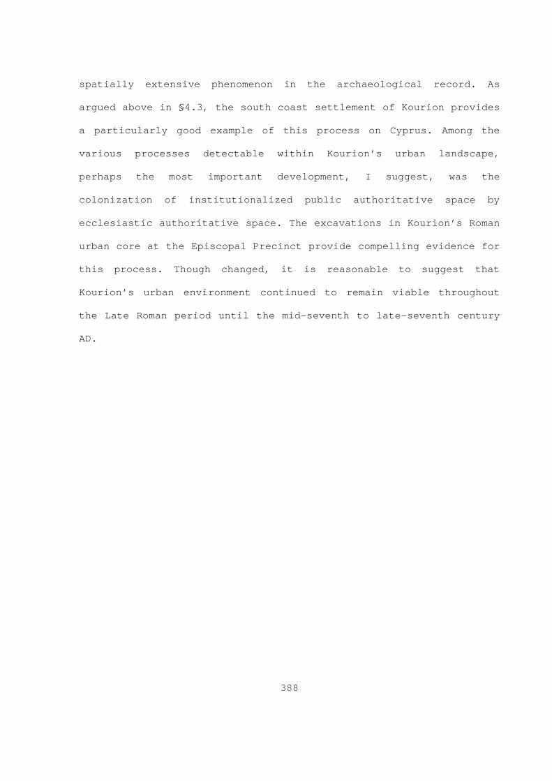
388
spatially extensive phenomenon in the archaeological record. As
argued above in §4.3, the south coast settlement of Kourion provides
a particularly good example of this process on Cyprus. Among the
various processes detectable within Kourion’s urban landscape,
perhaps the most important development, I suggest, was the
colonization of institutionalized public authoritative space by
ecclesiastic authoritative space. The excavations in Kourion’s Roman
urban core at the Episcopal Precinct provide compelling evidence for
this process. Though changed, it is reasonable to suggest that
Kourion’s urban environment continued to remain viable throughout
the Late Roman period until the mid-seventh to late-seventh century
AD.

Text
MORPHOU BAY
KHRYSOKHOUBAY
EPISKOPIBAY
DREAMERS BAY
LARNACABAY
FAMAGUSTABAY
TROODOS
KYRENIA RANGE
MESAORIACAPE ARNAUTI
CAPE KORMAKITI
CAPE KITI
CAPE PYLACAPE GREKO
CAPE ANDREAS
CAPE GATA
KARPAS PENINSULA
AKROTIRI PENINSULA
AKAMAS PENINSULA
Ì
Ì
Soloi
GY(?)
Alyki
Alaas
Throni
Ledroi
Knidos
Kition
Paphos
Golgoi
Akhini Tretous
Ourania
Makaria
Lysi(?)
Limenia
Kyrenia
Kourion
Arsinoe
Anogyra
Tamassos
Neapolis
Melabron
Lapithos
Khelones
Kelliake
Galounia
Drusa(?)
Chythroi
Amathous
Alampria
Thremitus
Ag. Trias
Petrini(?)Petrera(?)
Kopetra(?)
Mitsero(?)
Melandryna Mandres(?)
Konstantia
Phouches(?)
Malloura(?)
Aphrodision
Mathiatis(?)
Leukos Oikos
Geronisos(?)
Mavrovouni(?)
Vryshoudhia(?)
Ayios Georgios
Ag. EpiphaniosKoustopetria(?) Ammos tou Kampouri
Panagia Aimatousa(?)
34°0'0"E
34°0'0"E
33°0'0"E
33°0'0"E
35°0'0"N 35°0'0"N
Figure 4.1 Select Cypriot Roman and Late Roman settlements.(Datum: WGS 84).
389
0 10 20 30 405Kilometers
Legend
ROMAN - LATE ROMAN SETTLEMENTSTYPE
Ì MINE
SETTLEMENT
ROMAN ROADS

!C
!H
/
!C
)
!H
!C
/
!C
!( !(
TROODOS
KYRENIA RANGE
MESAORIA
Pyla
Emba
Polis
LofouLemba
TokhniPaphos
Kellia
Limnati
Larnaca
Kythrea
Anoyira
Aloupos
TroulloiPolitiko
Pissouri Limassol
Klavdhia
Dhekelia
Amathous
Alaminos
Kalokorio
Kalavasos
Soli-Lefke
Khalorakas
Constantia
Aradhippou
Parekklisha
Lythrankomi
Kourion-Episkopi
Lambousa-Kyrenia
Patmos Tou Kambou
34°0'0"E
34°0'0"E
33°0'0"E
33°0'0"E
35°0'0"N 35°0'0"N
Figure 4.2 Distribution of lead seals in relation to the Late Roman Road System (Datum: WGS 1984).
390
0 9 18 27 364.5Kilometers
Legend
Lead SealsSTRAT, ADMIN
No,No
) No, Yes
Unidentified, Unidentified
/ Unidentified, Yes
!H Yes, No
!( Yes, Unidentified
!C Yes, Yes
Late Roman Road System
5KM Buffer
!!
!!
!!
!!
!!
!!
!!
!!
!!
!!
!!
!!
!!
!!
!!
!
!
!!
!!
!!
! ! ! ! ! ! ! ! ! !!
!
!!
!!
!!
!
!! !
!
!!!!!!
EPISKOPI
EPISKOPI BAY
3659483.479120
3659483.479120
3659983.479120
3659983.479120
3660483.479120
3660483.479120
3660983.479120
3660983.479120
3661483.479120
3661483.479120
3661983.479120
3661983.479120
3662483.479120
3662483.479120
3857
951.4
0120
1
3858
451.4
0120
1
3858
451.4
0120
1
3858
951.4
0120
1
3858
951.4
0120
1
3859
451.4
0120
1
3859
451.4
0120
1
Figure 4.3 Kourion's urban and suburban armature elements (Datum: WGS 1984).
391
0 140 280 420 56070Meters
Legend
URBAN ARMATURE ELEMENTS MOLE
AMATHOUS GATE CEMETERY
APSIDAL HOUSE
BATHS-NYMPHAEUM
EARTHQUAKE HOUSE
EPISCOPAL BASILICA
EXTRAMURAL BASILICA
FORUM
HARBOUR BASILICA
HOUSE OF ACHILLES
HOUSE OF EUSTOLIOS
HOUSE OF THE GLADIATORS
STADIUM
SUBURBS(?)
THEATRE
CITY WALL
! ! CITY AQUEDUCT
ROMAN ROAD

!!
!!
!!
!!
!!
!!
!!
!!
!!
!!
!!
!!
!
!
!!!!!!!!!!!!!!!!!
6
#
:
::
:
3660500.000000
3660500.000000
3660750.000000
3660750.000000
3661000.000000
3661000.000000
3661250.000000
3661250.000000
3858
750.0
0000
0
3858
750.0
0000
0
3859
000.0
0000
0
3859
000.0
0000
0
3859
250.0
0000
0
3859
250.0
0000
0
Figure 4.4 Kourion's urban armature elements and select targets recorded by the Kourion Mapping Project (Datum WGS 1984).
392
0 40 80 120 16020Meters
Legend
KMP TARGETType
complex(?)
mosaic
# tomb
6 tower-gate
: wall segment(s)
URBAN ARMATURE ELEMENTSAMATHOUS GATE CEMETERY
APSIDAL HOUSE
BATHS-NYMPHAEUM
EARTHQUAKE HOUSE
EPISCOPAL BASILICA
FORUM
HARBOUR BASILICA
HOUSE OF ACHILLES
HOUSE OF EUSTOLIOS
HOUSE OF THE GLADIATORS
THEATRE
CITY WALL
! ! CITY AQUEDUCT
ROMAN ROAD

393
Figure 4.5. View NW. General shot across the Bath complex at
Kourion.

394
Figure 4.6. Quarried arcosolium chamber tomb from A rea B of
Kourion’s Amathous gate cemetery.

395
Figure 4.7. The so-called “The Earthquake House” at Kourion (adapted from
the Kourion Mapping Project’s 2007 revised plan of the edifice).

396
Figure 4.8. Phase plan of the basilica complex at Maroni
Petrera (Manning et al 2002: 18, figure 3.1).

397
Figure 4.9. Complex from Area I at Kalavasos Kopetra (Rautman et
al 2003: 57, figure 3.2).

398
Figure 4.10. Basilica from Area II at Kalavasos Kopetra (Rautman et al
2003: 92, figure 3.28).

399
Figure 4.11. Basilica from Area V at Kalavasos Kopetra (Rautman et al 2003:
92, figure 3.28).

400
Figure 4.12. Structures from Area IV at Kalavasos Kopetra (Rautman et al
2003: 132, figures 3.56, 3.57).

401
Figure 4.13. Structures from Area VI at Kalavasos Kopetra (Rautman et al
2003: 132, figures 3.61, 3.62).

402
Figure 4.14 . Ware weights expressed as a percentage of difference
from lots I-28, 29 and 30 from Kalavasos Kopetra.

403
Figure 4.15. Ware weights by areas expressed as a
percentage of difference from Area VI from Kalavasos
Kopetra.

404
Figure 4.16. Plan of the Episcopal Precinct at Kourion (Megaw et al 2007:
75, figure 1.Z).

405
3
3
3
$
Legend
Features
types
Bread Oven
Hearth
$ Limekiln
3 Pithos-Hearth
Activity Areas
activityBucket Shower
Kitchen
Storage
0 2 41Meters
µ
Figure 4.17. Secondary activity areas from the atrium area of Kourion’s
Episcopal Precinct (Modified from Megaw et al 2007: fig.1.X).

406
CHAPTER 5
The Sotira Archaeological Project
5.1 Chapter introduction
This chapter’s main purpose is to present the methodology and
t he results of the Sotira Archaeological Project’s (SAP) 1997 and
2004 seasons. In order to situate the SAP’s methodology and research
objective in a larger theoretical and methodological context,
section 5.2 presents a brief discussion of select current
archaeological field survey methodology on Cyprus. Section 5.3 and
its associated subsections in turn present the SAP’s field
methodology as well as aspects of the SAP’s project and study areas
and those research projects that have had their study areas in the
greater Kourion area or have explored select sites in Kourion’s
hinterland. Subsection 5.4 presents a general discussion of pre-
Roman loci and a detailed discussion and analysis of the Roman and
Late Roman loci identified by the SAP survey. Subsection 5.4 also
includes a general discussion of the SAP results in relation to
results of select Cypriot surveys. Finally, Chapter 5 concludes with
a summary (§5.5).
5.2 Mediterranean survey: Aspects
This subsection presents a general discussion of relevant
t r ends in archaeological field survey methodology from a Cypriot

407
perspective. The literature on Mediterranean “second wave” (Cherry
1994) archaeological surveys is voluminous, but the articles
presented in several edited volumes ( e.g. (eds) Athanassopoulos and
Wandsnider 2004; (eds) Alcock and Cherry 2004; (eds) Papadopoulos
and Leventhal 2003; (eds) Bintliff and Sbonias 1999; (eds) Gillings,
Mattingly and van Dalen 2000; (eds) Pasquinucci and Trément 2000;
(eds) Francovich and Patterson 2000) illustrate the main
methodological and theoretical trends that have influenced surface
survey strategy and interpretation over the last 20 to 30 years.
Recently, Alcock and Cherry (2004) have identified several
methodological procedures that have come to characterise intensive
and systematic field survey as practiced in the Mediterranean over
the last 30 years. Among the more important, they note (Alcock and
Cherry 2004: 3) that survey research frameworks have become
increasingly interdisciplinary ( e.g. ecological and geomorphologic
components), diachronic in scope ( i.e. increased archaeological
interest in previously marginalized post antique historical periods)
and regionally based. They ( ibid) also consider the widespread
adoption of statistical sampling techniques, systematic and
intensive field discovery methods ( i.e. the recognition of the value
of off-site archaeological record), as well as the use of
standardized data recording and analysis techniques ( e.g. recording
forms, relational databases and GIS) as among the more important
developments of the last several decades. However, most researchers
( e.g. Terrenato 2004: 37; Bintliff 2000) would agree that the shift
in emphasis from “site” based to “site-less” survey designs, which

408
“record the artefact as the basic unit of analysis” (Caraher et al
2006), and the resulting surge in intensity of coverage is the most
important, and perhaps most controversial, theoretical development
in Mediterranean survey archaeology in roughly the last two and a
half decades. Nevertheless, it is important to note that many
projects still take advantage of what may be termed “extensive” and
“intuitive” techniques to gather information on their respective
project areas during the elevation phase of fieldwork. Taken as a
whole, the relative importance of these “new wave” themes within a
given survey project’s research design is largely the result of the
project’s aims and available resources (human and financial). In
spite of the increasing popularity of systematic intensive
pedestrian survey-based archaeological projects and the growing
refinement of field methods (Cherry 2003; Alcock and Cherry 2004),
there is little scholarly consensus in the literature on key issues,
such as the level of compatibility between the results of various
survey projects ( e.g. Given 2004; Terrentato 2004), as well as the
formation (e.g. manuring, rubbish dumping, ploughing) and the value
of the off-site archaeological record within a given study area
( e.g. Bintliff and Snodgrass 1988, Bintliff et al 2000; Bintliff et
al 2007; Alcock et al 1994; Wilkison 1982, 1989; Fentress 2000;
Given 2004; Terrentato 2004) 1. Furthermore, researchers ( i.e.
Terrentato 2004; Fentress 2000) have also pointed out that one
1 See, for example, Given (2004a: 15-19) and Tarrento (2004: 40-42) for a
concise discussion of the various processes that can bias the surface record and hinder the accurate comparisons of sherd densities between survey projects. See Bintliff and colleagues (2007) for their most recent and up to date views on this phenomenon from their observations based on their work in Boeotia.

409
methodological trade-off for the increased level of intensity gained
by counting “off-site” material has been a pronounced reduction in
geographic coverage 2.
A series of articles by Bintliff and colleagues (1999; 2000;
2002) and Pettegrew (2001; 2002) provide a good example of the
diverse perspectives scholars have adopted regarding the
interpretation of variable sherd/artefact densities recovered by
intensive surface survey. Based on a critical discussion of their
work and experiences in Boeotia, Bintliff and colleagues (1999: 164-
165) argue that the prehistoric landscape is largely “hidden” within
the historic landscape. They believe that most prehistoric sites’
“vestigial ceramic traces” are so slight that they usually do not
produce noticeable density peeks in either larger historic surface
sites or in the diffuse off-site scatters because the material has
not survived and/or is not recognised as such during field
investigation (especially the prehistoric coarse wares). This, in
turn, they believe makes the prehistoric surface component of the
surface archaeological record easy to miss during standard intensive
pedestrian survey. They also suggest that “the majority of
prehistoric settlements were small sites of farm or hamlet
character, whose vestigial ceramic traces are usually not noted at
all in intensive survey; if they are, through the double action of
rare transect collection and indirect discovery within historical
2 For example, Fentress (2000: 44) illustrates this point by comparing the
la ndscape coverage from two intensive off-site surveys, Boeotia and Rieti surveys, which covered 45km and 22km in approximately 5 and 3 years respectively with the Albegna and Biferno surveys, which did not quantify off-site material and covered 220km and 400km in approximately 5 and 3 years respectively.

410
site collection, then numerically their contribution to surface
density is so slight that their one- or two-piece presence on the
surface as recorded attracts no special interest” (Bintliff et al
1999: 164-165). In order to compensate for this, they have
transformed their older survey data by applying various corrective
multipliers to their raw data; they also suggest that future
projects may be able to avoid this bias by increasing their level of
intensity. Although most researchers would agree ( e.g. Mee and
Cavanagh 2000) that some of the problems in the prehistoric
component of Boeotia’s surface record identified by Bintliff and
colleagues (1999) is applicable for some areas of Greece but not
others (Davis 2004), their use of various multipliers to increase
this landscape’s visibility has come under criticism ( e.g. Thompson
2000; Schon 2000; Davis 2004) 3. Nevertheless, Bintliff and
colleagues’ (1999) work alerts us to the possibility that the
surface archaeological record at large historic sites may contain
less obvious degraded evidence for the presence of prehistoric
components at those sites.
In assessing classical attitudes toward the abandonment,
recycling and discard behaviours from a wide perspective ( i.e. using
text, epigraphic and survey and excavation data), and the formation
processes that can influence the household floor assemblages ( i.e.
Lamotta and Schiffer 1999; Schiffer 1987) in relation to the
formation of their surface signature, Pettegrew (2001; 2002)
3 See Bintliff and colleagues (2000) rejoinder to these criticisms. In
particular, see their (2000) response to Schon (2000).

411
suggests that comparatively low-density (contra Bintliff et al 2002,
for example) scatter sites of classical date could also represent
the surface signatures of farmstead sites and is a comparable
phenomenon to Bintliff and colleagues’ (1999) “hidden landscapes” of
the prehistoric period 4. Perhaps more importantly, Pettegrew’s (2001,
2002) model explicitly recognises the role various “depletion
processes” can play during abandonment, post-abandonment and re-
occupation processes, and their subsequent role in the creation of
site assemblages and in the formation of these sites’ surface
signature 5. While fully acknowledging the role geomorphologic
pr ocesses can exert on surface scatters, he (2002: 271) also
suggests that the differences in scatter sizes and densities may
also reflect long-term (larger and dense scatters) and short-term
(smaller and diffuse scatters) investment strategies and “stability”
within a given landscape. Thus, Pettegrew argues that
“In this view, the crucial difference between lower
and higher density scatters would result from
qualitatively different investment thresholds - large
buildings, agricultural equipment (e.g. olive presses,
wells), and personal ties to the land (e.g. rural
cemeteries) among others - that created stronger bonds
to particular places on the landscape, thereby making
habitation exceedingly more stable and continuity (or
4 See Bintliff and colleagues (2002) for critical review of Pettegrew (2001). 5 See Schiffer (1987)’s Chapters 3 and 5 for a detailed discussion of these
pr ocesses.

412
reoccupation) of settlement increasingly more
probable. Developed land would continue to attract and
encourage investment, whereas land lightly invested
and settled would not outlast generational household
cycles or broader social and economic changes”
(Pettegrew 2002: 271).
This view, particularly the emphasis on the role of social actors’
personal ties with various components of a given landscape and its
subsequent link with settlement stability, it is reasonable to
suggest complements the particular theoretical perspective on space
and place advocated in Chapter 2, in which place is viewed primarily
as a multilocal and multi-scale socially constructed phenomenon.
Nevertheless, most researchers ( e.g. Cavanagh et al 2004; Pettegrew
2000; Bintliff et al 1999; Cherry 2004) would agree that many of the
problems and ambiguities that are commonly associated with the
interpretation of such small scatters could be resolved through
“multi-scalar research, combining intensive surface collection with
geophysical prospection, studies of soil phosphates and trace
metals, and, where possible test excavation” (Cherry 2004: 29).
5.2.1 Survey on Cyprus: Methodological approaches
Large scale regional archaeological survey in Cyprus developed
out of a different set of circumstances, for example, from those in
Greece: large scale regional survey in Cyprus has its origins in the
British-Colonial government’s desire to create a sites and monuments
register for the entire island (Iacovou 2004: 12-13; Cherry 2004:

413
27) 6. From 1955 and 1959, the survey branch of the Department of
Antiquities, the so-called Cyprus Survey, under Hector Catling,
investigated the regions around Cape Kormakiti, Morphou to Dikomo,
the coastal zone between Kyrenia and Liveras, as well as a section
of the Yialias River valley which amounted to approximately 5
percent of the island (Hadjisavvas 2004: 37-38)(see figure 5.1) 7.
Af ter independence, the Department of Antiquities continued to
sponsor sporadic survey initiatives with substantial projects along
north-northeast (between Akanthou, Komi and Ormedia), east (Ayia
Napa) and west (Paphos) coasts (Hadjisavvas 2004: 39, fig. 2.2).
However, apart from projects sponsored by governmental agencies,
numerous academic research projects have employed strategies that
have followed the dominant methodological and theoretical trends in
Mediterranean survey 8. This is particularly apparent in the evolving
su rvey strategies employed by two of the longer running projects on
the island, the Vasilikos Valley Project (VVP) (Todd 2004), which
began fieldwork in 1976 and concluded fieldwork in 1989, and the
Canadian Palaipaphos Survey Project (CPSP) (Rupp 2004), which began
fieldwork in 1979 and completed fieldwork in 1992 (figure 5.1).
Recent projects such as the Sydney Cyprus Survey Project(SCSP) 6 Cherry’s (2004: 27) observations are worth quoting at length: “...an
important element in colonial statecraft and imperialist strategies is the documentation, measurement, and registration of assets, whether natural or cultural, for purposes of simplifying administrative arrangements. Such impulses may to some extent lie behind the apparent interest in surveying and inventorying archaeological and cultural resources, so as to create regional or national sites-and-monuments registers...The point is worth mentioning here, of course, in light of Cyprus’s own colonial history...”.
7 Also, see Cadogan (2004)’s contribution in (ed) Iocavou (2004) for a di scussion on Hector Catling’s work with the Cyprus Survey.
8 For the gambit of current survey practices on Cyprus, see Iacovou (2004)’s edited volume.

414
(Given and Knapp 2003), the Troodos Archaeological and Environmental
Survey Project (TAESP) (Given et al 2001, 2002, 2003), and the Pyla
Koutsopetria Archaeological Project’s survey component provide
particularly good examples of contemporary large-scale regional and
urban interdisciplinary intensive survey projects on the island 9.
Apart from those projects with diachronic focuses, a number of
projects, like the Lemba Archaeological Project’s survey component
(Bolger et al 2004) with its interest in pre-Bronze Age
interregional exchange, and the Larnaca Hinterlands Project (A.
Leonard 2000), which although diachronic in scope, primarily focused
on various Bronze Age landscapes in that region, have investigated
select facets of a multi-component landscape. These projects have
also combined various intuitive-extensive and site-based intensive
collection strategies in their research frameworks.
Turning to the Vasilikos Valley Project (VVP), which initially
aimed at full survey coverage of the valley, combined both intuitive
and systematic methods to investigate a 20 percent sample of the
valley system (Todd 2004: 48)(figure 5.1). The VVP investigated its
study area with 100m wide and variable length (1.5km – 4.5km) east-
west (which cut across the valley) transects placed 400m apart from
one another; later, the VVP also surveyed several small seasonal
drainages with 100 percent coverage 10. Todd (2004: 48) estimates that
9 For the present purpose, the detailed unpublished reports for the TAESP
pr ovide a full account of the project’s methodology. A list of the published articles as well as links to a series of detailed unpublished report are available for review on line at www.gla.ac.uk/departments/archaeology/research/project s/taesp/publications .
10 Todd (2004: 48) states “While a transect system clearly does not reveal as many sites as total coverage of the area, it does provide a counterbalance

415
the combination of intuitive and systematic methods allowed the
project to cover approximately 60 percent of the main drainage
system. The project detected approximately 135 “sites” that ranged
in date from PPNB (Pre–Pottery Neolithic B) to the mediaeval
periods. However, Todd (2004: 48) notes that one of the most
important prehistoric sites, Kalavasos Tenta, would have been missed
by the transect survey “but the prominent position of that site
suggests that it would have been recorded during a routine
examination of outstanding geographical features”. This particular
situation also provides a very clear example of one major drawback
of the transect method (Bintliff 2000: 200-201) 11. Thus, the VVP
pr ovides a particularly good example of the advantages afforded by
combining intuitive, extensive and systematic methods.
Although the project’s final publication is not complete, Rupp
(Rupp 2004: especially 66-67, table 5.1) has recently provided a
detailed discussion of CPSP’s methodological development. The CPSP
study area initially started as an investigation of a catchment with
a radius of 7.5km (approximately 17671ha) centred on Kouklia in
western Cyprus. Later, the study area expanded to approximately
665km2 (approximately 66500ha) and covered four drainage systems
to the purely intuitive method which may well completely miss certain types of sites”.
11 See Bintliff (2000; 2001) for other examples in which transect sampling methods missed a substantial regional site previously known from extensive intuitive methods. Bintliff (2000: 201) uses these examples to argue for the use of contiguous survey blocks with intensive combined with an intensive off-site counting/collection strategy. Bintliff argues further, “Because we cannot begin a regional survey with a ‘control population’ to base a sampling strategy on, the urge to take a shortcut in methodology via some supposedly ‘representative sample’ must be resisted at every opportunity” (Bintliff 2000: 201).
416
(Ezousas, Xeros, Dhiarizos and Kha) of which the project surveyed
approximately 244km 2 (approximately 24400ha)(figure 5.1). Like the
VVP, the CPSP used extensive-intuitive methods during its initial
pilot investigation and later adopted a strategy based on a
stratified sampling strategy. The study area was divided into a
series of 1km 2 quadrats which, in turn, were divided into transects
t hat ranged in size from 100m in width and 1000m in length with
field surveyors walking at intervals of approximately 20-25m. Later,
they reduced some quadrats to 0.5km 2 and walked at a tighter interval
(1 0-15m). Rupp (2004: 69) notes that just over 10 percent of the
study area was resurveyed with this increased resolution but has
concluded that although “greater detail was achieved the overall
results were not significantly different from our previous less
intense approach” (Rupp 2004: 64-70).
The CPSP’s sampling procedures also evolved over the course of
the project (Rupp 2004: 66-67, table 5.1). For ceramics, these
consisted initially of “grab samples” but “from 1980 onward”, Rupp
(2004: 69) notes, the collection methodology “was to pick up where
possible a representative sample of 5-25 diagnostic sherds, a
selection of kitchen and coarse ware fabrics and all probable
imports” as well as more intensive collection strategies at known or
suspected prehistoric sites (Rupp 2004: 67) 12. The project identified
579 “sites” ranging from the Aceramic Neolithic to the mediaeval
periods.
12 For example, the procedures at known or suspected prehistoric sites
consisted of collecting an area of 2m 2 at 10 meters intervals (Rupp 2004: 67, table 5.1).

417
The Sydney Cyprus Survey Project (SCSP)(Given and Knapp 2003)
intensively investigated approximately 6.54km 2 (654ha) of a 65km 2
(6 500ha) study area in the vicinity of ancient Tamassos in central
Cyprus (figure 5.1). The project approached the landscape “as a
more-or-less continuous distribution of cultural material generated
by people in social space” (Meyer and Knapp 2003: 28) which could be
redistributed by combinations of human and natural processes; from
this vantage, sites are broadly interpreted and extrapolated from
the density peaks of both single and multiple artefact classes
within the landscape. Conversely, settlements are defined as sites
over 1ha in size that are associated with architectural feature(s).
For example, an isolated farmstead or industrial installation
qualifies as a site but not a settlement 13. Apart from settlements
and sites, the project also employed an additional analytical tier
that consisted of POSIs (Places of Special Interest) and SIAs
(Special Interest Areas). The main difference between these two
interpretative constructs, Meyer and Knapp (2003) note, is that SIAs
have a more diverse assemblage, are multifunctional and spatially
expansive (often extending more than 500m) in relation to POSIs
(Given and Meyer 2003: 32-36; Meyer and Knapp 2003: 26-30).
The SCSP used a series of transects to sample its study area.
In general, each transect was 50m wide and not longer than 100m and
13 On the definition of settlements, Meyer and Knapp (2003: 28) state that
“Whenever a dense scatter of sherds is accompanied by an equally dense spread of roofing tiles and building rubble that could indicate contemporary architectural remains, we tentatively regard such a combination of features as a settlement. This supposition, however, would have to be demonstrated by further field reconnaissance and more intensive sampling”.

418
was comprised of a series of survey units. Field walkers recorded
detailed information ( e.g. topography, geomorphology, modern land
use, slope, visibility) on standard forms. In uncultivated areas,
the survey units were 25m wide (or 5 field walkers at a 5 meter
interval) and their length was usually based on a natural division
in the landscape (e.g. break of slope, change in vegetation, soil
type). In cultivated fields, when the field was larger than the
standard 25m wide units, the units followed the shape of the
cultivated field 14. Strategies for the collection and counting of
ar tefacts were also tiered. For example, the collection strategy of
ceramics involved field walkers collecting “one sherd of each
discernible category of ceramics they found in their 5-m strip”;
filed walkers counted all other artefacts from within their strip
(Given and Meyer 2003: 34). One key objective of Meyer and Gregory
(2003: 49) was to collect as few sherds as possible while achieving
a representative sample of the visible material on the surface.
Analytical procedures for collected material included an adjustment
for field conditions ( e.g. Background confusion and visibility) and
the assignment of periods using the “chronotype” system and then
weighted against the counts of pottery from the survey units to
14 Given and Meyer (2003: 33-34) state “In cases where a field extended
beyond the normal 25-m-wide unit, the extra portion was included in the survey unit, with some team members walking an extra strip to maintain the 5-m spacing. This was done only when 50% or more of the entire survey unit lay within the original survey transect. In cases where the transect crossed the edge of a very large field (that is, one in which the survey unit was less than 50% of the field), the survey units were confined to 25 m”.

419
produce a “pottery index” 15. The project also used different
co llection strategies at POSIs and SIAs. These consisted of “iron
cross”, “fixed grid” and “gridded circles” for POSIs and “block
survey” for SIAs. In total, the project identified 11 SIAs, 142
POSIs (Gregory 2004: 15-28; Meyer and Gregory 2003: 48-52; Given and
Meyer 2003: 30-36).
5.3 The Sotira Archaeological Project Survey I
This section presents the results of the Sotira Archaeological
Pr oject Survey (SAP). It is divisible into four subsections. These
include (1) a discussion of the Sotira Archaeological Project’s 1997
and 2004 field methods and their limitations, (2) a discussion of
the physical characteristics of the SAP study and project areas, (3)
a discussion of other projects in both the SAP’s study and project
areas as well as these project’s main results and, finally, (4) a
discussion and analysis of the Late Antique loci identified by the
SAP.
5.3.1 S.A.P Field methodology and limitations
This subsection presents the field methodology used by the SAP
during its 1997 and 2004 field seasons as well as a discussion of
the various limitations and problems encountered during those two
seasons of fieldwork. The SAP’s 1997 season consisted of six weeks
15 These adjustments are complex, see Meyer and Gregory (2003: 48-52). For a
more accessible account of these adjustment factors, see Gregory (2004: 29-30). For a competing approach, which also employs complex adjustments, see Bintliff and colleagues’ (2007: 18-23) discussion of their method of quantification.

420
of pedestrian (in June and part of July) field survey and a limited
ecological survey sponsored by the University at Albany (Sate
University of New York) under the direction of Dr. Stuart Swiny. The
SAP employed a systematic survey strategy to investigate the 1997
study area, which consisted of approximately 15 (less quadrat 7) 1km
x 1km quadrats, which in turn comprised approximately 10 percent of
the 154 square kilometres that comprised the wider project area. The
project logged approximately 1880 person hours of fieldwork over the
course of the 1997 season. In total, field walkers investigated 88
transects of various lengths and widths (orientated either north-
south or east-west) distributed over the 15 (less quadrat 7)
quadrats that comprise the SAP’s 1997 study area (see below,
§5.3.2).
On average, the field crew consisted of a team of 10-12 field
walkers and a 2-person ecological survey team. In most cases (see
below for exceptions), field walkers were spaced at an interval of
approximately 10m from one another within each transect, and
assigned a swath number which corresponded to a subunit within the
transect. Filed walkers were also equipped with a standard military-
style lensatic sighting compass so that they could maintain their
vector within each transect. Upon the completion of each transect,
each field walker recorded a range of provenience, archaeological
and environmental data onto a standardized recording sheet. The
field recording forms contained sections for recording information
such as the quadrat, transect and swath numbers, time of day,
surface visibility conditions, topographical and physical setting,

421
modern land use, observed artefacts-features and interpretation(s)
(see Appendix IV). Scanned sections of the widely available 1:5,000
standard Cypriot topographical maps served as the main field base
maps for both the field walking and ecological teams. Apart from
recording survey information on these base maps, targets were also
logged with a 12 channel Magellan GPS receiver with ±10m accuracy,
which equates to an error of ±2mm on the Easting and Northing
coordinates for each target at the 1:5000 scale, and entered on to
these base maps 16. While not as accurate as DGPS (Differential Global
Positioning System) the precision and accuracy afforded by this GPS
unit in relation to the available base maps coupled with its ease of
use made it a useful field recording tool given the project’s
overall aims and desired recording resolution. At the end of each
fieldwork day, logged GPS data and survey forms were imported in the
project’s GIS and entered into the form databases respectively.
Although the SAP covered the study area in an intensive manner,
the survey design did not include a systematic collection strategy
from either the loci identified tentatively as settlements, sites or
discrete scatters, or from off-site locations within the study area.
Field sampling procedures were limited primarily to “grab samples”
from within each transect, site, or discrete scatter. When taken,
the samples collected from these transects primarily consisted of
one sample from each unique artefact type/class encountered by the
field walker from their particular swath within a given transect.
These materials, in turn, were counted, noted and either discarded
16 These targets were logged from their notional centre.

422
or retained for subsequent study. A similar sampling method was
employed at loci identified as sites or scatters. Grab samples from
sites and discrete scatters focused almost exclusively on
diagnostics. In most cases the material from those loci was noted
and discarded in the field. Boundaries for loci identified as sites
and discrete scatters during the 1997 season were established by the
following procedure: (1) field surveyors walked north-south and
east-west transects from the notional centre of the survey target at
a 5m interval, rather than the standard 10m, and (2) marked the
locations within each transect where the relative density of
artefacts (including building materials) noticeably fell off and (3)
the target’s perimeter was recorded with the GPS’s tracklog feature.
Most of the ceramic identification was undertaken by the project’s
principle investigator, Professor Swiny (see §5.3.1.1 for a
discussion of the limitations of the 1997 field methodology).
The 2004 season differed from the 1997 season in several ways.
First, the high pace of development throughout the island and the
then (in 2002) recent disturbances at a multi-period site with a
well-preserved Late Roman component (press block), Sotira Ambija, in
the SAP project area indicated that at the very least a
reinvestigation and intensive field collection of surface materials
from the more exposed sites was needed to ensure the continued
preservation of these cultural resources 17. Thus, one key objective
of the 2004 season was the reinvestigation of the loci (sites and
17 Professor Stuart Swiny informed me of the disturbance at Sotira Ambija in
2003. A subsequent visit to the site revealed that the looters had removed the highly visible remains of a large press block from the site.
423
scatters) identified during the SAP’s 1997 season, as well as
several previously recorded sites that were outside the SAP’s 1997
study area but were also under pressure from development. Pre-
fieldwork preparation for the 2004 field season involved several
main procedures. First, the present author redesigned the project’s
GIS database within the ArcGIS 8.0 desktop environment. In the new
GIS database, the sites, finds and scatters from the 1997 season
were re-coded and assigned new locus numbers. The locus numbers are
composed of two parts: the first two digits indicate the field
season and the digit(s) after the hyphen indicate the sequential
locus number for that year ( e.g. 97-1, 04-2). Apart from the
relevant sections of the 1:5,000 topographic and 1:50,000 maps, the
GIS also included data digitalized from relevant soil maps (at the
1:25000 scale), geological maps (at the 1:500000 scale) and the
modern land-use/ pasture map (at the 1:50000 scale) 18.
The data derived from these sources was grouped into thematic
layers which included modern infrastructure ( e.g. modern towns and
villages, paved roads and improved roads, reservoirs and toponyms),
basic topography (contours and hydrology), archaeology (1) (which
consists of the SAP’s study area, sites and features) and
archaeology (2) (which consists of other projects, sites and
features in the Kourion area such as the Roman roads and the civic
aqueduct 19. Later, in 2005, the topographic data derived from the
1: 5000 and 1:50000 topographic maps were augmented by the addition
18 The aerial photographs for the study area were prohibitively expensive. 19 Derived from Last (1975) and Bekker-Nielsen (2003) respectively.

424
of contours generated from remote sensing data captured by the
Shuttle Radar Topography Mission (SRTM)(see map 1) 20. Second, field
maps were prepared with a 100m UTM grid (European Datum 1950) and
printed out at a scale of 1:5,000. Additionally, each quadrat’s
boundaries and main topographical features ( i.e. roads and trails)
were converted to track logs and subsequently uploaded into a Garmin
GPX 12 receiver prior to the field investigation of a given
quadrat 21. This, in turn, allowed the present author to use
ef ficiently both the Garmin GPX 12 receiver, which was accurate to
±5 meters on average, in tandem with the prepared scaled base maps
during field reconnaissance with minimum effort. Because the project
did not have access to a survey grade DGPS or a total station, the
collection-counting grids were laid out with a Brunton Hand transit
(with 1º azimuth graduations) mounted on a non-magnetic tripod and
100 meter reinforced fibreglass tapes. Several control points within
the grid or transect were also logged with the GPS. In general, the
collection/counting grid was aligned with magnetic north and
assigned an arbitrary origin of E2000 N1000. In cases where this
proved impractical, grid north was based on an existing feature
( i.e. a road or terrace wall) and the grid or gridded transects were
laid out accordingly. Booked data was then entered by hand into
AutoCAD. Larger features, like the disturbances caused by strip
20 See the file reference: USGS (2004) Shuttle Radar Topography Mission 3 Arc
Second scene SRTM_u03_n034e032.tif.gz. This data is freely available from the University of Maryland’s Global Land Cover Facility’s webpage: http://glcfapp.umiacs.umd.edu .
21 This was accomplished through the freely available GPS utility program. See www.gpsu.co.uk/ for the newest version and release information for this program.

425
mining or field boundaries, for example, were recorded using the GPX
12’s track log feature, and first uploaded into AutoCAD and then
exported in the project’s GIS.
Third, in order to achieve a balance between the project’s
limited time and resources (both financial and human) and the
recognised need to gather further data on both site and off-site
artefact distribution within the SAP study area, the author designed
a two tiered supplementary sampling strategy. Given the 2004
season’s limited personnel, which consisted of the author and one
student, and the limited time available for fieldwork (12 work
days), a 0.005 percent sample, or approximately 5.2ha, of 1040ha
surveyed in 1997 was selected for off-site collection. The main
purpose of this strategy was to expand the sample of ceramics from
within the study area rather than record the artefact density across
large blocks of the study area’s landscape. On the ground, this
sampling fraction equated to approximately 44 5m-radius circular
collection units per 1km-by-1km quadrat. The intended distribution
of these units within each quadrat, in turn, was based on
distribution of soil types (Lithosols, Cambisols, Regosols and
Fluvisols) within each quadrat ( i.e. proportionally stratified
samples). The sampling procedures for loci identified as sites and
larger scatters during the 1997 season consisted of either a total
collection/counting grid comprised of 5m by 5m collection/counting
units or a series of circular collection/counting units laid out
along offset transects or transects in a cross pattern.

426
However, upon arrival in Cyprus, professor Swiny informed me
that the director of the Department of Antiquities, Dr. Pavlos
Flourentzos, had informed him that I was not able to operate under
the aegis of the Sotira Archaeological Project’s permit or under the
umbrella of the Sotira Kaminhoudhia excavation permit. As a result,
I submitted a proposal for a separate permit to reinvestigate and
surface collect the 1997 loci and perform off-site surface
collection from locations within the SAP study area from the
Department of Antiquities based on the field strategy presented
above. On June 18 2004, the Department of Antiquities granted the
author a limited survey permit that allowed site visits and
photographic documentation of the sites within and around the SAP
study area, but prohibited the collection of any surface materials
either from the sites or at off-site locations that I had requested
in my original survey permit proposal.
Because of these limitations, the 2004 field season’s research
objectives were modified and came to focus on 3 objectives. These
consist of (1) to assess and record any cultural and environmental
disturbances that may threaten each site’s integrity, and
immediately inform the then Limmasol District Archaeological Office
and schedule field visits to the sites; (2) re-record each site’s
UTM coordinates and create a site gazetteer with updated locations,
setting information, and provide a research potential and
development impact assessments to the Department of Antiquities; (3)
create a digital and photographic catalogue for those sites at risk
of being destroyed by development or natural processes. When

427
feasible, select sites were gridded and artefact frequencies from
each collection-counting unit were calculated (see §5.3.1.1 for a
discussion of the limitations of the 2004 field methodology). The
limiting factors (e.g. disturbances, poor visibility) at each locus
that may have precluded certain types and favoured other types of
collection-counting strategies are presented on an individual locus-
by-locus basis in subsection 5.4.1.
5.3.1.1 Objectives, limitations, and terminology
This subsection provides a discussion of SAP’s research
objectives in relation to methods it employed to achieve them. The
field methodology employed by the SAP survey provided a useful
snapshot of the more apparent/visible archaeological loci in the
study area. In terms of the ratio of person hours invested in the
field to discovered targets, the 1997 SAP project logged
approximately 65 person hours (total person hours/number of targets)
for the recovery of each identified target. However, the lack of an
intensive surface collection strategy for both site and off-site
materials limits the analytical potential of this particular dataset
in several ways. First, although there is little scholarly consensus
(Given 2004) on the best way to conduct quantitative comparisons of
survey data from different projects, most researchers would agree
that material recovered from “grab sample” collection strategies
produce data, particularly pottery assemblage data, that is
difficult, if not impossible, to compare meaningfully with other
sites from within a given survey area or sites from other surveys

428
with grab or intensive collection strategies. Regarding the use of
“grab samples”, Mattingly (2000: 9) succinctly states that “The
problem with such collections is that they are unquantifiable, being
impossible to amalgamate with material which was systematically
collected”. Although the use of “grab samples” precludes more
complex comparisons between the SAP loci, other classes of data
recorded by the survey, like location preferences ( e.g. slope,
aspect, soil, underlying geology), as Terrenato (2004: 45) notes,
are less biased than artefact densities 22. As a result, the present
st udy attempts to maximize this class of data in the analysis
present below in §5.4.2.
Secondly, the “grab samples” are unlikely to capture adequately
the range of diagnostic sherds present at a particular site and, I
suggest, such strategies favour the more visually prominent and
easily recognisable diagnostic sherds ( e.g. based on ground cover
conditions as well as individual sherd size, level of abrasion,
vessel part and colour). Third, the accurate delineation of site and
scatter boundaries is problematic in the absence of controlled
collection/counting. However, as mentioned above, although the
procedure used to estimate the area of those loci identified as
“sites” and “scatters” during the 1997 season produced usable
results, it is important to note that such a qualitative approach is
likely to have underestimated their actual areas at the time of
22 Terrenato (2004: 45) states the following “Even summary statistics of
lo cational preference…are not at a risk from macroscopic biases, since they do not require a complete sample, but simply a representative one. Even if only an unknown proportion of Hellenistic farms has been recovered, their locations are nonetheless informative of the productive and perceptive choices of the farmers”.

429
discovery. I suggest that the figures presented in the analysis
below (§5.4.2) that specifically deal with the variable locus area
are best interpreted conservatively as representing the minimum
rather than the maximum horizontal extent of these loci. Fourth,
most researchers would agree that the lack of a systematic “off-
site” sampling programme creates a recovery environment that
privileges the identification of those loci with architectural
remains at or above ground level, moderate to high building
materials, comparatively dense distributions of tile and ceramics on
the surface, but greatly diminishes the probability that small loci
will be identified as distinct elements within the study area and
disentangled from background “noise” during fieldwork. However,
within the SAP study area, in most cases those loci interpreted as
discrete scatters and sites noticeably contrasted with the low
density background sherd scatter. In this respect, it is important
to note that the SAP was able to identify several comparatively
small discrete loci (sites and discrete scatters), as well as small
individual sherd-sized off-site finds from within the diffuse
background scatter of reddish monochrome sherds which was present
across the majority of the study area and, in some cases, under fair
to poor visibility conditions. For example, the SAP was able to
detect an undated lithic scatter, locus 97-07, that was under 400m 2
( ≤ 0.04ha) and a small scatter of coarse ware sherd, locus 97-14,
t hat was under 300m 2 (294m 2, 0.029ha), as well as several off-site
and site finds (loci 97-23, 97-27 and 97-28).

430
Apart from its main objective of bolstering the sample of
ceramics from the study area, it is unlikely that the “off-site”
collection strategy proposed for the 2004 season, even if it was
implemented, would have contributed in a significant way to the
identification of additional small loci within the study area,
primarily because of the small size and dispersed collection
locations within each quadrat 23. From the discussion presented above,
i t is reasonable to conclude that in terms of method and research
objectives, the SAP survey complements the other small-scale
intuitive survey programmes in Kourion’s hinterland conducted by
Swiny (1979) and Held (2003) (see below, §5.3.3). In relation to
wider general Cypriot survey trends discussed above (§5.2), these
projects, as well as the SAP, occupy the methodological middle
ground between extensive/institutive and intensive survey. Arguably,
the field methods employed by projects like the SAP are best suited
to serve as a set of preliminary reconnaissance tactics within an
overall survey strategy based on intensive site and off-site
sampling.
5.3.1.1.A Terminology: Site, settlement, scatter, and chronological periods
Most researchers ( e.g. Mee and Forbes 1997; Rupp 2004 ) would
agree that defining obvious and substantial features like tombs,
cemeteries, oil presses, towers, threshing floors and cisterns as a
“site” is unproblematic; the identification of concentrations of
artefacts without associated features is in theory the more 23 Bintliff (1999), for example, advocates the intensive investigation of
bl ocks of terrain in order investigate off-site distributions.

431
difficult interpretive task 24. The present study has adopted the
co mparatively neutral term “locus” to describe a relatively wide
selection of observed material manifestations of the surface
archaeological record within the SAP study area. As used in this
study, a locus represents a portion of the SAP study area’s surface
archaeological record isolated for further analysis. During the next
level of analysis, each individual locus was designated as a site,
settlement, a discrete scatter, or an isolated find. The criteria
for identifying sites and settlements are similar to other
Mediterranean surveys’ working definition ( e.g. Given and Knapp
2003; Mee and Forbs 1997; Rupp 2004), but reflects the SAP’s
specific methodological limitations. Given the reality that the
modern landscape represents an array of surfaces comprised of
varying dates (Terrenato 2004) and because the SAP did not have a
geomorphological component to assess landscape stability within the
study area, I have adopted several basic criteria for interpreting a
locus as a “site”. I suggest that sites consist of loci with either
architectural features or comparatively discrete scatters of
24 For the CPSP’s procedure for defining sites, Rupp (2004) observed that
“I solated chamber tombs and plundered cemeteries, rock-cut features, Christian chapels, mining adits and slag piles, Medieval bridges or water mills and recent threshing floors ( alonia) or charcoal kilns ( Kaminia) do not represent the focus of these problems obviously. The identification of settlements ranging from isolated farmsteads and hamlets to large villages and towns is what is most problematic. The general absence on the surface of the walls of structures, of architectural members of roof tile (until the Medieval period in SW Cyprus) or of fortification walls meant that we had to rely primarily on such subjective and variable archaeological criteria as the presence, the extent, the physical discreteness and the relative density of a scatter as well as the functional homogeneity of the artifact classes within it”. Similarly, for the Methana Survey, Mee and Forbs (1997: 36) state “In identifying and defining sites, those which have ancient remains in situ presented the least problem”. They also note (1997: 36) that “When there is no architecture but only artifacts, identifying sites and defining boundaries in theory become more complex”.

432
artefacts which often, but not always, are found in association with
architectural debris ( e.g. roof tile, worked architectural elements,
bonded masonry, rubble building stone) or other architectural
features ( e.g. walls, cisterns, presses, tombs, industrial). In the
absence of multiple visible architectural features like walls, the
SAP distinguished settlements from sites primarily on spatial extent
( ≥1ha) and the relative density and composition of the observed
surface assemblage.
Discrete scatters, I suggest, represent density peaks of
artefacts without associated visible architectural features or
architecturally derived debris. For example, a dense concentration
of ceramic without visible associated architectural features or
architecturally derived debris is classified as a discrete scatter.
It is important to note that the lack of roof tile, bonded masonry,
and worked stone only suggests the absence of an edifice(s)
constructed of these particular type of materials and they in no way
serve as an accurate indicator of the presence of an edifice
constructed of less resilient composite materials like mud brick
for walls and sod for roofs or expedient structures constructed of
similar materials. Prehistoric ceramic scatters and lithic scatters
presented special cases where the reliance on the above mentioned
“site” indicators of architectural features and architectural debris
may prove too rigid. For example, locus 97-07, an undated discrete
lithic scatter ( ≤400m2, 0.04ha), consists of cores and various
debitage, but with no associated ceramics or architectural features;
the homogeneity of the surface assemblage implies that this location
433
was a special purpose activity area like a lithic retouch and/or
reduction station and in this context, I suggest, it is reasonable
to reinterpret the locus at the higher analytical resolution of site
rather than discrete scatter. However, additional fieldwork ( e.g.
test trenching, geophysical prospection, multiple intensive
collections) at those loci interpreted as scatters by the SAP could
generate additional data which could potentially result in the
upgrading of their status. Thus, it is also reasonable to interpret
discrete scatters as potential sites. Loci interpreted as isolated
finds (an artefact without an association with a site or discrete
scatter) did not readily lend themselves to higher levels of
interpretation beyond presence-absence. Finally, in the higher-level
analysis presented below (§5.4.2.2), several loci ( e.g. sites and
discrete scatters) were grouped together to form an additional
multifaceted analytical group or AGs ( e.g. AG-1).
The following conventions are used for the chronological
periodization presented in the analysis presented below in §5.4:
• CN = Cypriot Neolithic, 7000 BC – 3700 BC (Aceramic
Neolithic, 7000 BC – 5500 BC; Ceramic Neolithic 4000 BC –
3700 BC).
• CCH = Cypro-Chalcolithic, 3700 BC – 2300 BC;
• EC-MC = Early Cypriot – Middle Cypriot, 2400 BC – 1600 BC;
• LC= Late Cypriot, 1600 BC – 1050 BC;
• CG = Cypro-Geometric, 1050 BC – 750 BC;
• CA = Cypro-Archaic, 750 BC – 475 BC;
• CC = Cypro-Classical, 475 BC -325 BC;

434
• CH = Cypro-Hellenistic, 325 BC – 30 BC;
• ROM = Roman, 50 BC- 330 AD;
• LR-BYZ = Late Roman-Byzantine (Late Antique), 330 AD – 702
AD;
• Condominium (Middle Byzantine), 702 AD – 965 AD;
• MB, Middle Byzantine, 965 AD - 1191 AD;
• MED, Medieval, 1191 AD – 1571 AD, (Frankish, 1191 AD – 1489
AD; Venetian, 1489 AD – 1571);
• OTT, Ottoman, 1571 AD – 1878 AD;
• MOD, Modern, 1878 AD to present.
5.3.2 The S.A.P study area
The SAP survey universe is located in a naturally definable
ar ea of southern Cyprus. Morphologically the project area is located
on the Limassol Plateau. As noted in Chapter 3, discontinuous small
river plains characterize much of the Limassol Plateau’s
topography 25. Quadrats 01 through 12 are located between the Paramali
Ri ver in the west and the Kouris River valley in the east; quadrats
13-15 run south from old Paramali to the coast along the
Farkonas/Paramali River plain (see Map 1) 26. Quadrat 07 was excluded
25 Swiny and Mavromatis (2000: 433) state “The intensive, systematic survey
covered an area of approximately 154 square kilometers divided into one kilometer squares stretching from the Kouris river valley in the east to Paramali valley in the west. The location of the squares, or quadrats, was random in so far as the easternmost quadrat was located in what was judged to be a relatively undisturbed section of the Kouris valley. The remainder were placed in a non-probabilistic manner in relation to Quadrat 1”.
26 Quadrats 01-12 are located between easting coordinates (36s) 480000 – 492000 and northing coordinates (36s) 3840500 - 3842500. The quadrats south
435
from the 1997 SAP survey because it fell within both the bounds of
Sotira village and the Sotira Kaminoudhia Survey’s study area (see
below §5.3.3). Nearly all of the quadrats are 1km by 1km (100ha);
the only exception is quadrat 13, which is slightly larger due to a
southern extension that ran to the coast 27. The total 1997 study area
co nsisted of approximately 1445ha. Approximately 72 percent ( n =
1040.4ha) of the total study area was systematically field walked in
1997. The remainder was excluded from survey in 1997 because of
dense vegetation and/or steeply sloping terrain (Swiny & Mavromatis
2000: 435). Figure 5.2 presents the ratio of surveyed hectares to
excluded hectares for each SAP quadrat. Quadrats 02, 03, 06, 08 and
14 have the greatest amount of hectares excluded from the pedestrian
survey and the excluded hectares from these quads cumulatively
comprise approximately 85 percent ( n = 347ha) of the total excluded
hectares from the study area. However, given the interval between
field walkers and the average 2m field of view of each field walker
(Gregory 2004: 28), it is reasonable to estimate that between 20 and
22 percent of the ground surface (approximately 208-228ha) was
actually scanned during field walking 28.
The entire SAP study area is situated on terrain below 500masl
with the majority (approximately 92%, n = 1329ha) of the study
area’s terrain falling within the 0-399masl elevation range. Given
of old Paramali village are located between easting coordinates (36s) 481000 – 482000 and northing coordinates (36s) 3836000 - 3839500.
27 See, Swiny & Mavromatis (2000: 434 & fig 1). 28 This is a standard variable factored into archaeological surface survey in
Cultural Resource Management investigations in the Eastern United States ( Pers. Obs).

436
the Limassol Plateau’s morphology, it is not surprising that terrain
with southern, southeastern and southwestern aspects cumulatively
comprise over 65 percent (66.30%, n = 958ha) of the study area.
Terrain with a northern aspect, in contrast, comprise less than one
percent (0.42%, n = 6ha). Terrain with eastern or northeastern
aspects cumulatively comprise 18.75 percent ( n = 271ha) of the study
area’s terrain; terrain with western and northwestern aspects
cumulatively comprise 14.53 percent ( n = 210ha). Approximately 33
percent (n = 479.75 ha) of the project area is on slopes with a
grade range of 0-9.9%. Slopes with a grade range between 0-19.9%
cumulatively characterize well over half (67%, n = 986ha) of the
total slope variability within the project area.
As mentioned in Chapter 3 (§3.3.5.1), the project area’s
geological substrata are part of the Pakhna formation, which
consists of well-bedded chalks and limestone with various lenses in
its upper layers as well as clastic facies with igneous rock
detritus. The upper layers, which form the majority of the bedrock
within the study area, consist of Episkopi chalk and chalky marls;
surface exposures of gypsum are also common. Although other horizons
can produce substantial amounts of water, the Kandou and Khalassa
sandstones are the Pakhan formation’s main water bearing horizons.
Additionally, as mentioned in Chapter 3, it is important to note
that recent over-pumping has substantially altered the Episkopi
region’s hydrological profile and caused several springs surrounding
the study area to migrate down slope ( e.g. in the Symboulos gorge).

437
Like much of Cyprus and the Mediterranean in general, the SAP study
area has abundant seasonal drainages (see Map 1).
The soils within the project area tend to be gray or greyish-
brown in colour, thin, immature or raw, azonal, either neutral or
alkaline and have extremely low humus contents (below 5% on
average). Additionally, terra-rossa, secondary limestone and patches
of bare Kafkalla (secondary limestone) are common landscape features
in the project area and within the study area (Thirgood 1987: 24;
Swiny 1982: 2-3; Christodoulou 1959 fig. 2, 43-44; Rapp 2003: 463).
Unfortunately, the available 1:25,000 soils series sheets cover 93
percent (approximately 1345ha, excluding quadrat 01) of study area.
Based on the available data, lithosols comprise approximately 38
percent (38.92%, n = 523.29ha) of the soils within the study area.
Tymbou series lithosols, which consist of exposed limestone,
comprise approximately 95 percent (95.08%, n = 497.55ha) of the
lithosols within the study area; exposed kafkalla comprise the
remainder. Cumulatively quadrats 02, 03, 06 and 10 contain just over
50 percent (51.06%, n = 333.622ha) of the lithosols within the study
area. Regosols and cambisols comprise approximately 31 percent
(31.09%, n = 417.92ha) and 29 percent (29.74%, n = 399.76ha) of the
soils within the study area respectively. Cambisols are the dominant
soil types within quadrats 05, 13, and 15. Conversely, Fluvisols
comprise less than one percent of the study area’s soils and are
concentrated in quadrat 12. However, they comprise less than 5
percent (3.56%, n = 3.43ha) of that quadrat’s soils. As argued in
Chapter 3, the project area’s vegetational profile is largely the

438
product of early modern land use practices that favoured plantation
agriculture in the lowland and intercropped agriculture on the
upland plateaux (figures 3.3, 3.4).
5.3.3 Other projects in the vicinity of the S.A.P study area
Apart from the diverse set of sites from Kourion’s immediate
environs (e.g. (ed)H.W. Swiny 1982; Soren et al 1987), several
projects (e.g. Last 1975; Swiny 1981; Held 1988; Leidwanger 2005,
2007; Jasink, Bombardieri and Menozzi 2008) have investigated
aspects of Kourion’s hinterland at various degrees of intensity 29.
While some research projects ( e.g. Bekker-Nielsen 2004; Hadjisavvas
1992; Parks 1999; J. Leonard 2005) were not specifically concerned
with Kourion or its hinterland, they have produced useful
information on various facets of Kourion’s multi-component
hinterland. Their research, for example, has identified important
productive and transport infrastructure components such as segments
of the provincial Roman road system (Bekker-Nielsen 2004) as well as
maritime and productive installations in Kourion’s hinterland
(Leidwanger 2005, 2007; J. Leonard 2005). Other projects ( i.e. Last
1975) have investigated the presence of Kourion’s civic
infrastructure in its hinterland.
29 See Swiny (1981; 1982; 2004) for information on site distributions to the
south of both the SAP and SKS project areas and the sites in the immediate Kourion area. For additional survey information around Kourion, see Leonard (1987) in Soren (ed) The Temple of Apollo Hylates at Kourion, Cyprus. Tucson: University of Arizona Press and H.W. Swiny (ed) (1982) Ancient Kourion Area. Nicosia: Department of Antiquities, Cyprus. For Kourion city, see Chapter 4 §4.3. as well as Buell and Mavromatis (forthcoming). For environmental surveys in Kourion’s hinterland other than the SAP’s, which is presented in Chapter 3 §3.3.5.3.A of this thesis, see Burnet (2004) and van Warmelo (2003).

439
Last (1975)’s investigation of Kourion’s aqueduct provides a
good example of civic infrastructure penetrating into that city’s
hinterland. That research has identified two main conduits, a
western, or Sotira conduit at the Ypsimasikarka spring, and an
eastern, or Souni conduit, which lead to the main supply at the
Platania locality (see Map 1; see Last 1975: 40, Map 1). The
aqueduct’s eastern conduit passes through the SAP study area in
quadrat 11 and its western conduit passes through the western edge
of the Sotira Kaminoudhia Survey’s study area (Map 1). Last (1975:
54) has identified three successive pipes along the course of the
western conduit. He believes that in its earliest phase, this
conduit dates to approximately the second century AD and preceded
the construction of Kourion’s stadium. The eastern conduit, Last
(1975: 54-55) argues, was installed later and had approximately four
times the capacity of its western counterpart. It is important to
note, as Last ( ibid) points out, the eastern conduit incorporated
one of the walls of the so-called “House of the Achilles Mosaic”
into its course immediately before it entered Kourion 30. It is
r easonable to assume that the expedient use of this complex’s ruined
wall dates to some point after the earthquakes of the 360s AD; it is
also likely that the eastern conduit is a product of the general
rebuilding operations at Kourion following those quakes 31.
30 Regarding the eastern conduit’s date, Last (1975: 55) states “It is also
la ter than the best period of the House of the Achilles Mosaic ( i.e. the period of the Mosaic) since the aqueduct is built on top of one wall of this house. The mosaic is assigned to the third or fourth century A.D.”
31 Christou (1996: 58) believes that this complex’s destruction and final abandonment was cause by “the earthquakes of the second half of the 4 th century A.D.”.

440
Last (1975: 43) also identified several interesting
“settlements” along the route of the conduits. He notes ( ibid) that
these “settlements” tend to be located “at points along the routes
of the conduits as well as elsewhere, usually at the heads of
cultivable valleys”, and he argues further that they “appear to have
been farmhouses, but it may be surmised that the occupants helped in
inspecting, maintaining and guarding the conduit in return, perhaps,
for the privilege of drawing off water for domestic use”. Last
(1975: 44, 48) identified these sites at or around the localities of
Kapsalia (farm, unidentified material), Konnides (Archaic to Roman
material and a slotted press block), and Ayios Yeoryios (Roman
material, foundations) 32. A. Leonard (1986: 98)’s brief survey of the
Yerokarka locality to Kourion’s northwest identified several
discrete scatters, the largest of which included finewares and
architectural debris ( e.g. worked blocks, column drums, marble
veneering). His investigation also identified several rock-cut tombs
near that locality. Interestingly, Last (1975: 59) also identified a
chain of wells at this locality and notes “the remains of a
settlement” near the remains of an early church. Last ( ibid)
believes that this feature may post-date the failure of Kourion’s
water supply but A. Leonard’s (1986) survey indicates that this
locality was occupied during the Hellenistic and Roman periods and
this chain of wells may date to the Hellenistic period 33.
32 Hadjisavvas (1992) also mentions the press block at Konnides in his survey
of ancient olive oil production sites on Cyprus. 33 A. Leonard (1986) also mentions at least 12 tombs with what appeared “to
be very eroded inscriptions in Cypro-Syllabic” which pre-date the Hellenistic phase of activity.

441
As discussed in Chapter 4, Cyprus’ road system (§4.2.3.1.B) and
maritime facilities (§4.2.3.1.A) constituted a major interrelated
element of the province’s strategic infrastructure. Beckker-Nielsen
(2004)’s survey of the province’s Roman road system has identified 6
(catalogue #’s 1A, 19, 18, 98, 99, 191) road segments in the greater
Kourion area. Of these six, 3 pass directly through the SAP’s study
area (see Map 1). Road 19 is “the oldest route linking Kourion to
western Cyprus” (Bekker-Nielsen 2004: 201) and passes through
quadrat 13 34. Road 99, a main route that linked Kourion with Marion,
passes through quadrat 08 and appears to have been in place by the
second century AD. In the Sotira area, this road essentially follows
the modern north-south road running through the Krommya valley to
Sotira village 35. Road 99 also passes through the eastern sector of
th e Sotira Kaminoudhia Survey’s study area. It is likely that Road
98, a main route that linked Kourion with Lapethos, would have
passed directly through or closely by SAP quadrat 12(Bekker-Neilsen
2004: 201-217, catalogue #’s 19, 98 & 99) 36.
Several researchers ( e.g. Leidwanger 2005, 2007; Leonard 2005;
Christou 1996) have investigated various aspects of the maritime
infrastructure in Kourion’s hinterland 37. The Episkopi Bay Survey’s
34 At a later date, the road 1A replaced road 19 as the main westward route
fr om Kourion (Bekker-Nielsen 2004: 201 and figure 14). 35 Bekker-Nielsen (2004: 212) has identified chisel-marks and smoothed
bedrock at the northern segment of road 99 between Sotira and the locality of Laona.
36 Bekker-Nielsen (2004: 207) aptly points out that “It is not possible to id entify the route of the road between Kandou and Alassa (Khalassa), as the area is intensively farmed and the valley is now partly submerged under the water table of the Kouris reservoir”.
37 See §2.5.3 and the references cited within for Kourion city’s harbour i nfrastructure.

442
(Leidwanger 2005, 2007) Area I, which investigated the area from
Evdhimou bay in the west to the mouth of the Kouris River in the
east, produced interesting results. As argued in Chapter 4
(§4.2.3.1.A), Evdhimou bay provides a particularly good example of
an interrelated infrastructure such as the Roman Road and the
breakwater (Leidwanger 2005) or loading quay (J.Leonard 2005) and
productive components, and the possible LRA1 production site and
farmstead at the locality of Viklaes/Vournes (Leonard 2005;
Leidwanger 2007). Leidwanger’s (2005: 20) investigation also
recorded a rock-cut passage with “Byzantine graffiti on the walls”
leading down to a small anchorage at the coastal location designated
Bay 3 in Area I of his study area.
Researchers have also explored select elements of the Kourion
hinterland’s productive and funerary landscapes. In his survey of
Cypriot olive oil production in antiquity, Hadjisavvas (1992)
mentions various elements of this productive landscape in the
greater Kourion area. Hadjisavvas ( ibid) has identified press
features in and around the Sotira village (standing upright and
built into a field boundary wall near the Early Bronze Age site of
Sotira Kaminoudhia and at the locality of Kanjelin, see below,
§5.4.4), at Sterakovou Phrachti (see below, §5.4.4.4) and in
Episkopi at the localities of Agios Spyridon and Konnides (also
mentioned by Last (1975)). In her analysis of Cyprus’ Roman funerary
landscapes, Parks (1999: 55-57, 385, 391) mentions chamber tombs in
the vicinity at Kandou and Evdhimou. Perhaps, more importantly, she
(1999) mentions the presence of two necropolises, one identified as

443
Roman, the other identified as Hellenistic-Roman, in the vicinity of
Sotira village 38. One potential location for the Roman necropolis is
ar ound the locality of Mandra tou Markou. At this locality, which is
located about 1.5km to Sotira village’s southwest, Mitford (1971:
304, # 160) has identified a funerary inscription attributable to
the second century AD. Regarding the general presence of cemeteries
in the landscape, Parks argues, “Cities and villages maintained
their own cemeteries outside the settlement limits, while farmsteads
probably set aside small tracts” for that purpose (Parks 1999: 378).
Given the presence of these necropolises and the funerary
inscription, it is reasonable to suggest that a substantial, but
unidentified, Hellenistic-Roman settlement existed near Sotira.
Additionally, the then Limassol District Archaeological officer, Dr.
Eleni Prokopiou ( Pers. Comm. 2004), informed the present author of
several unpublished sites near the SAP’s study area. These included
tombs (possibly of Bronze Age date) and a small edifice (farmstead
or chapel?) near Zanaja village. Other sites mentioned by Prokopiou
( ibid) include a Late Roman ecclesiastical complex at the locality
of Dhyo Ekklishes (two ruined edifices and a spring, near quadrat
11), a substantial site (estate centre?) at the locality of Ayia
Napa (near SAP quadrat 12) and Roman period tombs at the locality of
Dhiplomata (in quadrat 06).
The Kent State University Episkopi Area Survey (Swiny 1979;
Swiny 1981; Swiny 1986; Swiny 2004) conducted an extensive
38 Parks (1999: 392) notes that the Sotira necropolises are not published but
ar e mentioned on the Cyprus Survey archive (unfortunately, no site number is provided).

444
pedestrian survey with a study area of approximately 85km 2 bounded by
th e Kouris River valley in the east and the Evdhimou valley in the
west and Sotira village in the north during the late 1970’s. Because
of various constraints, the project did not attempt to investigate
intensively the study area nor did it attempt “to establish a
diachronic and comprehensive regional settlement pattern with
nominal topographic information on each site” (Swiny 2004: 56).
Rather, Swiny (ibid ) notes that the “focus was on Early to Late
Cypriot sites and the methodical recording of archaeological
features, the collection of representative artefacts and pottery,
and finally the detailed mapping of site boundaries”. The project
identified 21 prehistoric sites, however, one site, Anoyra
Peralisithias, may actually be a Late Roman farmstead. The majority
of the sites identified by this project are located to the west of
the SAP’s study area. However, several of the identified Bronze Age
sites are in close proximity to the SAP quadrats 01 and 02 and
include the sites/settlements of Hadjina, Pharkonia, Mandra tou
Pouppou (Swiny 2004: 57; Swiny 1981). SAP Quadrats 13, 14 and 15
overlap with the Episkopi Area Survey’s study area.
The Sotira Kaminoudhia Survey (SKS) (Held 2003) systematically
and intensively investigated approximately 313ha surrounding Sotira
village in the early 1980s. The SKS project area roughly corresponds
to the location of what would have been SAP’s quadrat 07. Apart
from the Middle Cypriot (Bronze Age) settlement of Sotira Troulli
tou Nikola and Early Bronze Age settlement of Sotira Kaminoudhia,
Middle Cypriot, Late Cypriot and Cypro-Archaic ceramics are not

445
abundant in the SKS area. However, apart from discreet site
scatters, Held (ibid ) has noted the presence of a diffuse scatter of
red monochrome sherds throughout that project’s study area. The
discreet scatters fall within the range of approximately 0.04-
0.25ha. Nevertheless, the most important site in relation to the
present study is SKS S25, Sotira Sternes, and those sites with
Roman/Byzantine or later components (sites 18, 10, 04, 58, 85, 02,
and a press block near Sotira Kaminoudhia) in the localities of
Kaminoudhia, Arkolies , Plathkiastrata, Limnia and Arkappies. Sotira
Sternes, interpreted as a large Byzantine farmstead or settlement,
may be the precursor of the historically documented but
archaeologically elusive mediaeval estate of San Chitino (see
below). Sotira Sternes and the other sites with historical
components comprise roughly 43.75% of the SKS’s recorded sites. In
general, the later ( i.e. Roman-Mediaeval) sites are as close to the
area’s major springs as their prehistoric counterparts (Held 2003:
467-472, figure 15.1; see Map 1).
Recent work by the Italian Archaeological Mission (Jasink,
Bombardieri and Menozzi 2007, 2008) has initiated an
interdisciplinary intensive pedestrian survey (KVP) of the Kouris
Valley corridor from Episkopi Bay to the southern slopes of the
Troodos massif, as well as the western side of Limassol Harbour 39.
The KVP’s research questions centre on identifying settlement
39 A summary of the Italian Archaeological Mission in the Kouris valley’s
2007 season is available on the Department of Antiquities website as well as the Databases about Aegean Subjects website. The web sites are www.antiquity.ac.uk/projgall/jasinik/index.html , www.mcw.gov.cy/mcw/DA/DA.nsf/DMLexcavat_en/DMLexcavat_ en?OpenDocument and www.dbas.sciant.unifi.it/index.php?c=kouris .

446
patterns of all periods within the valley, as well as identifying
the borders of the Bronze Age city kingdom of Alašiya. To date,
their work has identified 14 sites on the Kouris’ eastern and
western banks. Along the western bank, they have identified two
Hellenistic/Roman sites (sites 12 and 13); their investigations
along the eastern bank have identified several Bronze Age sites (1,
2, 3 and 10) and necropolises with Bronze Age and later (Geometric,
Archaic and Roman) materials. They also note the presence of a
diffuse scatter of Classical, Hellenistic, Roman, Mediaeval and
Post-Mediaeval materials throughout their study area. Limited trial
excavations during the 2008 season at one site, Erimi Laonin tou
Porakou (site 10), has revealed both Bronze Age and
Hellenistic/Roman architecture. The southern portion of the KVP’s
study area overlaps with a small portion of the SAP study area in
quadrat 12.
Additionally, according to the Vita of St. Spyridon, the Moni
Symvolos was located in the Kourion area 40. If the historical memory
associated with both the location of the Apollo sanctuary and
various toponyms that reference relic/non-existent landscape
elements ( e.g. §3.3.5.1 – 3.3.5.3) are any indicator of this
phenomenon’s general trend in the greater Kourion area, one
potential location for this monastery that merits investigation is
the area surrounding the former Symvoulos Chiftlik 41. The area is
ju st over 6km to the west of Kourion via Bekker-Nielsen (2004)’s
40 The vita of St. Spyridon states that Theodore of Paphos was a monk at the
Moni Simvolos near Kourion (Dikigoropolos 1965-1966). 41 See UTM 3838 4830 on the 1:50,000 topographical map (sheet LII/LIII).

447
road 19 and is located in close proximity to the junction between
Bekker-Nielsen (2004)’s roads 1a and 19 (see Map 1). The area now
lies within the confines of Episkopi Garrison. The chiftlik area is
also in close proximity to the SAP’s quadrats 13 and 14. It is
important to note that in quadrat 13 the SAP identified a built
double cistern of Late Roman date (SAP locus 97-15) that is located
approximately 1.5km to the west of the Chiftlik area. According to
Goodwin (1978: 803), the Symvoulos Chiftlik formed the core of the
Frankish fief of Sinbali 42. J. Leonard (2005: 569) notes that in the
early 20 th century AD, the chiftlik’s owner operated “his own local
port at the bottom of the Symvoulos River Valley”. It is reasonable
to suggest that this small anchorage could have also operated in
Late Antiquity in the same way as Evdihmou Bay did for its immediate
area (see above § 2.5.2.2.A.i) 43. However, the SAP’s (Swiny and
Mavromatis 2000) investigations of the Symvoulos River outlet’s
eastern bank (quadrat 13) did not reveal any discrete loci
comparable to those observed at Evdihmou Bay by Leidwanger (2005,
2007) and J. Leonard (2005). Thus, although the presence of the
cistern indicates Late Roman activity in the area, the issue can
only be resolved through systematic investigation of the anchorage’s
surf zone as well as the Symvoulos River outlet’s western bank and
42 Goodwin (1978: 803) notes that the name Sinbali is a Frankish corruption
of Symvoulos. Goodwin ( ibid) states that the toponym means “one who gives advice”.
43 The CCS, J. Leonard (2005: 569) notes, did not investigate this area in See, J. Leonard (2005: 1002-1003) for a discussion of local shipping during the early 20 th century AD at this location associated with the chiftlick.

448
additional systematic survey work at the former Chiftlik and its
surroundings.
The historical record (text and cartographical) indicates that
several mediaeval estates are located in close proximity to the SAP
project area or are in the study area itself. In general, the
location of these estates tends to correlate with the distribution
of modern villages within the project area. Feudal estates from the
project area include Kandou (Cantu), Zanaja (Zabaca), Episkopi
(Piscopia), Paramali (Piramati), Evdhimou (Audimo), Khivides
(Chivida), Sotira (San Chitino?) and Sterakovou (Cata?) (Goodwin
1978: 237, 244, 290-291, 369, 420, 663-664, 782, 795, 889-890;
Stylianou and Stylianou 1980). This, in turn, suggests that the
modern pattern of settlement in the SAP project area has its origins
in the mediaeval period.
5.4. The Sotira Archaeological Project Survey II: Data
Presentation
This subsection presents the loci identified by the SAP survey.
I t is divisible into two main sections: the first presents select
data on the loci identified by the SAP, the second presents a
general analysis (§5.4.2) of the data followed by more in-depth
analysis of the Roman and Late Roman loci (§5.4.2.2). In 1997 the
SAP identified 34 loci which consisted of 3 settlements, 20 sites, 6
discrete scatters, and 5 isolated finds or finds (see Map 1). These
loci range in date from the Cypriot Neolithic to the modern periods.
Because the results of the SAP’s 1997 field season have been

449
published in a preliminary fashion by Swiny and Mavromatis (2000),
this subsection presents the pre-Roman and modern loci in a general
way but provides more detail on the Roman and Late Roman loci
reinvestigated in 2004. However, because of the limitations
mentioned above, the supplementary loci added during the 2004 season
are presented in a very cursory way. The complete 1997 SAP
settlement and site gazetteer is presented in appendix III.
The SAP identified 3 prehistoric settlements attributable to
the Neolithic (97-20) and Bronze Age (Early Cypriot – Middle
Cypriot) (97-13; 97-19), 1 discrete multi-phase Chalcolithic-Late
Roman scatter (97-10), 3 discrete Bronze Age (Early Cypriot - Middle
Cypriot) scatters (97-25; 97-26; 97-23), and 1 isolated Bronze Age
find. Locus 97-20, a Neolithic settlement, is situated on a hilltop
at approximately 46masl in quadrat 15. In 1997, field walkers first
identified materials from this settlement in the cultivated fields
below the hilltop. Subsequent investigation on the hilltop
identified several unconnected badly preserved wall alignments and
igneous quern fragments. This settlement is approximately 2.42ha and
is situated on very shallow (0.10-0.25m) Sotira (SO) and Pakhna
series (PA 1) soils. The nearest source of fresh water, the Paramali
Ri ver, is over 500m to the west. The SAP identified a discrete
scatter, locus 97-10, with Chalcolithic and Late Roman material in
quadrat 12. This scatter is situated on a river bench in the Kouris
River valley at approximately 108masl and is underlain by
comparatively deep ( ≥1.00m) Zyyi series soil. The discrete scatter
of ceramics covered an area of approximately 0.310ha across two (an

450
upper and lower) traditional agricultural terraces. Comparatively,
the Chalcolithic materials outnumbered the Late Roman materials
( i.e. a few sherds attributable to LRA1 and pithos); no roof tile or
building materials were present at this locus. Between 1997 and
2004, large sections of the traditional terrace walls collapsed and
deep rills developed across both terraces. Interestingly, at the
time of reinvestigation in 2004, 97-10 lost approximately 65
percent, or 0.201ha, of its 1997 area. However, Chalcolithic sherds
still comprised the majority of the surface assemblage in 2004;
later ceramics consisted mostly of non-descript monochrome reddish
brown wheel-made sherds.
The two Early Cypriot – Middle Cypriot (EC-MC, Bronze Age)
settlements, loci 97-13 and 97-19, are located in quadrats 01 and 02
respectively. At approximately 10ha, locus 97-13 is the larger of
the two EC-MC settlements and one of the largest loci discovered by
the SAP. Locus 97-13 is located on a river terrace overlooking the
Paramali River at approximately 184masl in quadrat 01. Tymbou (T)
exposed limestone and very shallow/shallow (0.10-0.50m) Pakhan (PA 1;
PA2) series soils underlay this settlement. Ground visibility at this
se ttlement was poor to moderate: dense scrub, and in some cases
thick pine needle litter, obscured most of the abandoned
agricultural terraces. The Paramali River is the closest source of
fresh water and is within 500m of the settlement. Apart from lithic
and ceramic scatters, investigation in the scrub revealed 3 looted
tombs and several large saddle querns that had been incorporated
into the traditional agricultural terraces in the settlement’s

451
northern sector. Perhaps the most important find from 97-13 is a
crucible fragment (locus 97-32) with residual copper prills adhering
to its surface. This crucible fragment, Swiny and Mavromatis (2000:
435) argue, indicates the presence of “metal working...in this
narrow but heavily populated valley”.
The second EC-MC settlement, locus 97-19, is situated on a
narrow ridge top at approximately 224masl overlooking the Paramali
River, and a seasonal drainage in quadrat 02. The site is
approximately 1.19ha; very shallow (0.10-0.25 m) Pakhna (PA1) series
soils underlie this site. Apart from Tymbou limestone, the soils
surrounding this settlement consist of shallow (0.10-0.50m) Sotira
and Pakhna series soils. Though considerably smaller than locus 97-
13, locus 97-19 produced a range of EC-MC fine wares and pithos,
architectural debris ( e.g. over 12 threshold blocks and rubble),
mortars, rubbing stones, Senet gaming stones, querns and several
fragmentary bridge spouted troughs (locus 97-33) 44. Surface
vi sibility at this settlement was fair; however, it is important to
note that areas of the ridge were badly eroded. Unfortunately,
already in 1997, stone miners were operating in this settlement’s
northern sector. The SAP also identified 3 EC-MC discrete scatters,
loci 97-25, 97-26 and 97-23, located in quadrats 06 and 04 (see map
1). Topographically, these loci are all located on southern sector
44 Regarding locus 97-19, Swiny and Mavromatis state that “The most striking
aspect of Paramali- Lochos is the truly phenomenal number of saddle querns and rubbing stones littering the surface of the ridge; all of those from three randomly chosen 30 x 30m square were counted, the average being 20 pieces per square. If this number is extrapolated for the site as whole, around 1500 querns would litter the surface alone”. For a discussion of Senet gaming stones, see Swiny (1981).

452
of the plateau formed by the Symbolos drainage and a tributary of
the Farkanas-Paramali drainages. Tymbou limestone ( i.e. 97-23) and
very shallow (0.10-0.25m) Sotira series soils ( i.e 97-25; 97-26)
underlie these discrete scatters. These discrete scatters range in
size from 0.0549ha to 0.4235ha. The assemblages from these loci are
predominately composed of coarse wares and comparatively few fine
wares. One possible interpretation is that these discrete scatters
may represent activity areas or special purpose sites possibly
associated with agriculture. Finally, the SAP identified one
isolated find, Locus 97-30 a gamming stone, attributable to the
Bronze Age, in quadrat 04 approximately 500m to the southeast of a
discrete scatter of EC-MC material (97-23).
The Archaic through the Hellenistic periods are poorly
represented within the 1997 SAP study area. Loci attributable to the
Archaic period are concentrated in quadrat 12 and consist of two
looted cemetery sites, Loci 97-11 and 97-12. Both of these sites are
located in the Kouris River Valley on moderately sloping river
terraces at approximately 135masl. Both were looted before 1997.
Their estimated area is 0.223ha and 0.813ha respectively. Tymobu (T)
and shallow (0.10-0.25m) Pakhna series soils (PA 1) underlie these
si tes. Apart from a Hellenistic horse and rider terracotta figurine
fragment from Locus 97-02, a Late Roman farmstead site, in quadrat
11 (see below §5.4.1.2) the SAP recovered two isolated sherds
loosely attributable to the Classical and Hellenistic periods in
quadrat 06 (see Map 1, figure 5.3).

453
The SAP also identified several modern loci in quadrats 01 and
02. Loci 97-18 and 97-31, two modern olive crushing installations,
are located in quadrat 01 and fall within the boundary area of the
EC-MC settlement, locus 97-13, noted above. At the time of discovery
in 1997, scrub covered these two activity area sites. In quadrat 02,
the SAP located the remains of a badly preserved monumental (early?)
modern threshing floor, locus 97-34, within the confines of the EC-
MC settlement, locus 97-19, which occupies the ridge top at the
locality of Lokhos. Recent (in 1997) stone quarrying along the ridge
destroyed most of the threshing floor (see Map 1).
In 2004, the author had the opportunity to visit briefly six
loci (04-01, 04-02, 04-03, 04-04, 04-05 and 04-06) outside the SAP
study area. Several of these are presented in more detail below
(§5.4.1.12). Among the more important of these are the multi-phase
(LR olive oil production site and a modern limekiln) site of Sotira
Ambelija (04-02), the multi-phase site (LR estate centre(?),
Mediaeval chapel) of Ayia Napa in the Kouris Valley just to the
south of quadrat 12, and the Late Antique farmstead/estate centre of
Sotira Sternes (04-01). Other loci consisted of a Roman(?) period
cemetery (04-05) and a potential farmstead (04-05) around Zanaja
village, as well as the Roman or Late Antique tombs in quadrat 06,
and the site complex at Dhyo Ekklishes just to the northwest of
quadrat 11 mentioned by Prokopiou ( Pers. Comm. 2004). However, due
to time and fieldwork permit constraint, I was unable to record
these loci in more detail ( i.e. intensive surface walkover and
photographs).

454
5.4.1 Roman and Late Roman loci revisited in 2004
For the reasons outlined above (§5.3), it was deemed necessary
to reinvestigate several of the more exposed Roman and Late Roman
loci discovered during the 1997 season. For clarity, the data is
presented in two parts. The first group, subsections §5.4.2.1-
5.4.2.10, present those loci interpreted as sites and the second
group, §5.4.2.11, presents those loci interpreted as discrete
scatters. SAP quadrats reinvestigated in 2004 included 01, 04, 05,
06, 11 and 15.
5.4.1.1 Locus 97-01
Locus: 97-01 Quadrat: 11 DLS 17: 53/XX & XXI Quadrat Cadastral plan: 36, 44, 37 and 45 Locality: Aspri Moutti UTM: 36s E490638 N3842358 MASL: 306 Soil: Tymbou (lithosol) Soils within 250m: Tymbou (T, lithosol), Sotira (SO, Regosol), Pakhna (PA 2, Regosol), Pissouri (PI 2, Cambisol) and Vasilia (VA;VA 2, Cambisol) series soils Topographical Setting: Plateau, uncultivated field w/trees 1HA Slope Grade: 1% Aspect: South Estimated Area: 1853m 2
Suggested Date & Function: Site, LR-BYZ, Farmstead complex Site condition: Excellent Architectural features: Yes Research potential: High Digital/Regular Photographs: Yes Status: Site visited by Limassol District officer on June 26 2004 and entered onto the Department’s cadastral plan.
Locus 97-01, a farmstead site, is located at approximately
306masl on gently south sloping terrain in quadrat 11 (see figure
5.3). The mound that constitutes the site core is a highly visible
455
and distinct topographical feature in its immediate landscape.
Apart from the Tymbou limestone that underlies this site, the
1:25,000 soils series map shows 4 additional soil types within a
250m radius of the site. These include Sotira, Pissouri, Pakhna and
Vasilia series soils. Since 1997, brushfire(s) had killed the
majority of the olive, carob and pine trees from the fields
surrounding Locus 97-01. At the time of reinvestigation in 2004,
several clusters of pine, carob and olive trees, scrub and grasses,
still covered the small rise that constitutes the site (see figure
5.4). Unsurprisingly, the grasses, scrub and pine needles covering
the architectural core produced poor ground visibility conditions at
this locus. Several SAP loci, 97-22, 97-02 and 97-07, are in close
proximity to locus 97-01. Additionally, this site is located
approximately 415m east of the Souni branch of Kourion’s aqueduct.
Locus 97-01’s visible architectural features consist of several
elements: a threshing floor on exposed rock, which is similar in
size to locus 97-02’s threshing floor, and the foundations of two
rectangular rooms (designated A and B on the plan), and a stretch of
irregular dry laid wall (see figure 5.5 and 5.6). As preserved, room
A is approximately 30 meters long by 40m wide (approximately 1200m 2).
Room B, located to the east of room A, is approximately 30 meters
long by 10m wide (300m 2). The complex’s interior area is 1500m 2. Room
A’ s interior ground surface slopes slightly to the southwest and
forms a depression within that room’s southwestern quadrant.
Approximately half of an ovoid (0.45m exposed width and 0.12m thick)
perforated (0.10m socket) stone weight is visible above the fist-

456
sized rubble within the interior depression in room A (see figure
5.7). The complex’s walls are composed of roughly worked blocks and
irregular stones. On average, they are approximately 0.50-0.60m wide
and stand to a preserved height of approximately 0.20m above the
present ground surface level. Inspection of the more exposed sectors
of the wall alignments in 1997 and 2004 did not reveal lime mortar
or clay-bonding agents. A large (1.50m length by 0.60 width)
threshold block (with a pivot?) is visible in room 2’s southern wall
(see figure 5.8). Although not in situ, a large grooved or slotted
block was also visible at the convergence of the edifice’s northern
and western walls (see figure 5.9) 45. In short, based on their
s i milar construction and the uniform bonding between the individual
wall alignment intersections, it is reasonable to suggest that both
rooms belong to the same phase of the structure’s use life.
The complex’s threshing floor (C) is similar to locus 97-02’s
and was composed of the exposed Tymbou limestone. This feature’s
northern half is its best-preserved sector. Additionally, a small
stretch (5m) of an irregular dry laid fieldstone wall (preserved
maximum height 0.40m and a preserved maximum width of 0.50-0.60m) is
also associated with the threshing floor. Unfortunately, at present,
it is not possible to say with any degree of certainty whether this
stretch of wall is contemporary with the 2-room complex to its
north. Swiny (1979: 301) has identified a similar but much smaller
45 The Department of Antiquities has removed this block from the site
(P rokopiou Perscom 2004).

457
structure (approximately 500m 2) at Anoyra Peralisithias without an
as sociated threshing floor.
In order to examine the distribution of surface materials at
this locus, a total of 132 5m x 5m surface counting units
distributed across 11 60m long transects were laid out across 97-
01’s architectural core (rooms A, B and the north half of the
threshing floor(C)). This surface counting grid was orientated 5
degrees east of magnetic north, and the southwestern corner of the
most southwestern unit was arbitrarily assigned a grid coordinate of
E2000 N1000 (see figure 5.5 and figure 5.10). The surface assemblage
consisted primarily of badly abraded dark reddish brown wheel-made
body sherds, several pithos rims and one large base from a plainware
vessel. Fine wares and roof tiles were not present within any of the
counting units. In general, the surface ceramic assemblage from this
locus is quite poor and diffuse. Similarly, chipped stone was not
present within or around the threshing floor area. In 2004, stone
scavengers/miners (as evidenced by the two bulldozer soundings to
the east and north of the architectural remains) and a proposed road
expansion project directly threatened this site’s integrity 46.
5.4.1.2 Locus 97-02
Locus: 97-2 Quadrat: 11 DLS 17: 53/XX & XXI Quadrat Cadastral plan: 36, 44 ,37 and 45
46 A large bulldozer swath is visible to the east of the site and several
ro bbed out hollows are visible along the southern portion of the threshing floor’s perimeter wall ( Pers. Obs. 2004). Eleni Prokopiou ( Pers. Comm. 2004) informed me of the now delayed roadwork project at the CARRI workshop (2004).

458
Locality: Aspri Moutti UTM: 36s E490782 N3841313 MASL: 224 Soil: Pissouri (PI 3, Calcaric Cambisol) Soils within 250m: Pissouri (PI 3, Calcaric Cambisol), Tymbou (T, li thosol), Sotira (SO, Regosol), Zyyi (ZY, Calcaric Cambisol) series soils Topographical Setting: Mid-slope bench 1HA Slope Grade: 20% Aspect: Southwest Estimated Area: 2401m 2
Suggested Date & Function: Site, LR-BYZ, Farmstead w/Hel–RO component? Site condition: Poor Architectural features: Yes Research potential: Low Digital/Regular Photographs: Yes Status: Site visited by Limassol District officer on June 26 2004 and entered onto cadastral plan.
Locus 97-02, a farmstead site, is located on a moderately
southwest sloping mid-slope bench at approximately 224masl in
quardat 11 (see figure 5.3). Apart from the moderately deep 0.50-
0.75m) Pissouri series soil that underlies this locus, the 1:25,000
soil series map shows 3 soils within a 250m radius of this locus.
These include Zyyi and Sotira series soils as well as Tymbou
limestone. In 2004, the area immediately surrounding this site
showed clear signs of recent mechanical disturbance. The landowner
informed the Limassol District officer that he had bulldozed the
remains of several edifices around locus 97-22 and 97-02 because he
believed that they were early “modern structures”. The landowner’s
activities also included the levelling of several traditional
terraces to the site’s north, as well as the in filling of several
gullies to the site’s west. As preserved in 2004, 97-02 still
consisted of several visible elements that included a small
concentration of ceramics, the remains of one circular threshing

459
floor and the disarticulated and heavily eroded remains of a
rectangular structure. It is important to note that the terrain
surrounding the site consisted of exposures of Tymbou limestone and
incised runoff channels and rills (see figure 5.11). Locus 97-02 is
in close proximity to loci 97-22 and locus 97-01 in quadrat 11.
Locus 97-02 is also located approximately 500m west of the Souni
branch of Kourion’s aqueduct.
The rectangular structure’s east wall is approximately 0.50m in
height and ranges in thickness from 0.80-1.00m; it has a preserved
maximum length of 4.40m (see figure 5.12). The southern wall is
0.45m in preserved height, ranges in thickness from 0.80-0.90m, and
has a preserved maximum length of 13.00m. The structure’s estimated
area is approximately (length 20m width 13m) 260m 2 and its interior
consists mostly of exposed Tymbou bedrock and small patches of
(recent?) colluvial sediment. The associated circular threshing
floor is located approximately 25m to the rectangular structure’s
north. The threshing floor’s associated southern wall segment stands
to a preserved height of 0.80m and is 0.70m wide. Its interior
surface consists of exposed Tymbou limestone in the east and a
moderate scatter of fist-sized rubble on top of a thin deposit of
colluvial sediment in the west.
Observed artefacts from within the confines of the threshing
floor consisted of 5 badly abraded reddish brown wheel-made body
sherds and two igneous stone fragments. Observed artefacts from
within the rectangular structure’s reconstructed bounds consisted of
one white chipped flint flake. Roof tiles or finewares were not

460
present within the reconstructed bounds of either the rectangular
structure or threshing floor. However, about 20m to the northwest of
the architectural remains, the frequency of visible ceramics began
to increase steadily around a small, but noticeable, rise in the
micro relief. Investigation of this area with 10 2m circular
counting units orientated along a north-south (magnetic north)
transect at an interval of 5m identified 20 coarse ware pithos and
non-diagnostic wheel-made thin walled brownish red body sherds and a
fragment of a terracotta horse and rider figurine attributable to
the Hellenistic or early Roman periods 47. It is important to note
t hat the mechanical disturbances mentioned above truncated this
scatter’s northern sector.
5.4.1.3 Locus 97-07
Locus: 97-07 Quadrat: 11 DLS 17: 53/XX & XXI Quadrat Cadastral plan: 36, 44, 37 and 45 Locality: Pefkeri/Aspri Moutti UTM: 36s E490553 N3842461 MASL: 314 Soil: Vasilia (VA 2, Cambisol) Soils within 250m: Tymbou (T, lithosol), Sotira (SO, Regosol), Pakhna (PA 1, Regosol), Pissouri (PI 2, Cambisol) and Vasilia (VA 2, Cambisol) series soils Topographical Setting: Plateau edge, uncultivated field 1HA Slope Grade: 9% Aspect: Southeast Estimated Area: less than 400m 2
Suggested Date & Function: Site, UNK (LR?), lithic reduction and/or retouch station Site condition: Destroyed before 2004 but after 1997 Research potential: None Digital/Regular Photographs: Yes Status: -
47 Eleni Prokopiou ( Pers. Comm. 2004) collected this item and brought it to
the Limassol museum.

461
Locus 97-07, a small-undated discrete lithic scatter site, is
located on a relatively flat plateau edge overlooking a seasonal
drainage at approximately 314masl in quadrat 11 (see figure 5.3).
Apart from the shallow (0.25-0.50m) Vasilia series soil that
underlies this site, the 1:25,000 soil series map shows 4 additional
soils within a 250m radius of this locus. These include Tymbou
limestone, shallow Sotira, and Pissouri series soils. The assemblage
consisted primarily of flakes attributable to secondary stage
reduction. Unfortunately, at some point prior to the 2004 season,
mechanical soil mining destroyed this locus in its entirety. It is
reasonable to suggest that this locus may have served as a lithic
retouch workstation. It is also possible that this locus is
contemporary and associated with loci 97-01, 97-02 and 97-22.
Alternately, 97-07 may represent modern activity within the
landscape such as the production of doukani blades, for example.
5.4.1.4 Locus 97-22
Locus: 97-22 Quadrat: 11 DLS 17: 53/XX & XXI Quadrat Cadastral plan: 36, 44,37 and 45 Locality: Aspri Moutti UTM: 36s E490910 N3841768 MASL: 288 Soil: Zyyi (ZY, Calcaric Cambisol) Soils within 250m: Pissouri (PI 3, PI 2 Calcaric Cambisol), Tymbou (T, li thosol), Sotira (SO, Regosol), Zyyi (ZY, Calcaric Cambisol) series soils Topographical Setting: Field 1HA Slope Grade: 7 Aspect: Southwest Estimated Area: 3404m 2
Suggested Date & Function: Site, LR-BYZ, structure/estate centre(?)

462
Site condition: Poor/bulldozed Research potential: Low Digital/Regular Photographs: Yes Status: Site visited by Limassol District officer on June 26 2004.
Locus 97-22, a probable estate centre, is located below a hill
in a slightly southwestern sloping field at approximately 288masl in
quadrat 11 (see figure 5.3). Apart from the Zyyi (ZY) series soil
that underlies the site, the 1:25,000 soil series map shows 3
additional soil types within a 250m radius of this site. These
include shallow (0.25-0.50m) and moderately deep (0.50-0.75m)
Pissouri and Sotira series soils as well as Tymbou limestone. In
1997, the moderately dense scatter of building material, ceramics,
and roof tile covered a comparatively large area. The field had a
high level of visibility in 1997 because the plot’s owner had
recently bulldozed this field. Investigations in 1997 identified
open form body sherds with a reddish-brown fabric with a deep red
slip and roulette decoration (CRS?), as well as open form sherds in
a light red fabric with a reddish slip (LRC?), which were not
attributable to a particular form. Other observed artefacts included
Corinthian-style roof tile fragments, a LRA4 flat bottom base and
pithos sherds 48. By 2004, the field containing 97-22 had very poor
surface visibility; grasses and scrub also covered the fields to the
north and south of locus 97-22. In 1997, 97-22’s surface area was
approximately 0.34ha; by 2004, it had lost nearly 90%, or 0.31ha, of
its 1997 area. As a result, no systematic counting of surface
artefacts was undertaken within the field. This locus also had a
48 The base is similar to Rautman and colleagues’ (2003) figure 5.11 #150.

463
large diffuse elliptical (the long axis orientated north-south) halo
that was primarily concentrated to the site’s north. Perhaps the
most surprising development in 2004 was the almost total
disappearance of this large diffuse halo scatter.
Additionally, inspection of the less overgrown sections of a
nearby northern terrace wall in 2004 revealed several ashlars and
roughly worked blocks incorporated into it (see figure 5.13). It is
likely that these blocks are reclaimed materials that originated
from the ruined structure (with architectural remains above the
plough zone) that occupied the field prior to bulldozing in 1997.
Other loci in close proximity to 97-22 are 97-01, 97-02 and 97-07
and the Souni branch of Kourion’s aqueduct.
5.4.1.5 Locus 97-05
LOCUS: 97-05 Quadrat: 05 DLS 17: 53/XVIII Quadrat Cadastral plan: 34 and 42 Locality: Drousha tou Lakkou UTM: 36s E484561 N3841720 MASL: 350 Soil: Vasilia (VA 2, Calcaric Cambisol) Soils within 250m: Vasilia (VA; VA 2, Calcaric Cambisol), Sotira (SO, Calcaric Regosol) Topographical Setting: Plateau, uncultivated field 1HA Slope Grade: 8% Aspect: South Estimated size: 6515m 2 Suggested Date & Function: Site, LR/BYZ, Farmstead/Estate centre complex Site condition: Excellent Research potential: High Digital/Regular Photographs: Yes Status: Immediate danger, site visited by Limassol District officer on June 26 2004 and entered onto cadastral plan.

464
Locus 97-05, a farmstead/estate centre site, is situated on a
slightly south-sloping uncultivated field with poor to moderate
visibility at approximately 350masl in quadrat 05 (see figure 5.14).
Like Locus 97-01, the mound that constitutes Locus 97-05’s core
forms a distinct topographical feature in its immediate landscape,
and is approximately 40m to the east of a north-south trail that
runs across the western portion of the plateau and into quadrat 06.
Apart from the shallow (0.25-0.50) Vasilia soil that underlies the
site, the 1:25,000 soil series map shows shallow Sotira and very
deep ( ≥1.00m) Vasilia series soils within a radius of 250m of the
site.
Grasses and several olive and carob trees covered the site’s
core in 1997; by 2004, low scrub also covered portions of the site
mound. In 1997, a distinct debris halo of sherds and small rubble
extended out about 100m from the mound’s centre (see figure 5.14).
However, in 2004, this halo was no longer fully discernable because
the fields surrounding the site mound were not cultivated. Perhaps
more importantly, the owner(s) of the fields to the site’s north and
east mechanically stripped off the top soil and began quarrying the
underlying bedrock 49. Five depressions, similar to those observed at
Sotira Sternes (Held 2003: SKS’s S25), and Sotira Ambelija, are
visible among the visible well-constructed wall alignment at the
site (see below, §5.4.1.11). A large square-like depression (10m x
12m) is also visible at the site’s north-western edge. Several large
49 I witnessed this activity first hand. Upon my approach, the JCB operator
tu rned off his machine, ran off to a nearby car, and departed the site before I could talk to him. Later, Eleni Prokopou informed me that the area is designated as a environmental preserve and that quarrying is forbidden.

465
blocks, possibly from a press, are located at the site’s northern
edge. Almost all of the visible surface artefacts were partially
imbedded in the sediment covering the mound. These consisted of a
limited amount of small sherds attributable to an open form vessel
with a reddish-brown fabric and a deep red slip (CRS?), roof tiles,
pithos rims, body sherds as well as coarse and plainware sherds 50.
The loose artefacts on the mound’s surface consisted of roof tile
and coarse and plainware sherds (see figure 5.16). Additionally,
investigations around the base of the site mound indentified a
bluish-grey igneous ground stone fragment attributable to a shallow
basin, which can reasonably be associated with olive oil prodcution
(see figures 5.17). However, at the time of reinvestigation in 2004,
stone miners from Khividhes directly threatened the site’s
integrity 51. These mining operations have differentially impacted the
si te’s eastern and northern edges (see figure 5.18). Undoubtedly,
these mining activities have destroyed the northern and eastern
portions of the site’s halo. Locus 97-05 is in close proximity to
Locus 97-06 and locus 97-24, both of which are in quadrat 05.
5.4.1.6 Locus 97-06
Locus: 97-06 Quadrat: 05 DLS 17: 53/XVIII Quadrat Cadastral plan: 34 and 42 Locality: Drousha tou Lakkou UTM: 36s E484926 N3841524 MASL: 362
50 One plainware rim sherd had a similar profile to a sherd from Kalavasos
Kopetra (Rautman et al 2003: 190, fig. 5.8 #97). 51 Prokopiou ( Pers. Com. 2004)
466
Soil: Vasilia (VA 2, Calcaric Cambisol) Soils within 250m: Vasilia (VA; VA 2, Calcaric Cambisol), Sotira (SO, Calcaric Regosol) Topographical Setting: Plateau , uncultivated field 1HA Slope Grade: 8% Aspect: South Estimated size: 1682m 2 Suggested Date & Function: Site, LR/BYZ, Farmstead Site condition: Poor Research potential: Low-moderate Digital/Regular Photographs: Yes Status: site visited by Limassol District officer on June 26 2004.
Locus 97-06, a farmstead site, is located in a slightly south
sloping uncultivated field at approximately 362masl in quadrat 05
(see figures 5.14, 5.19). Like locus 97-05, the mound that
constitutes locus 97-06’s core forms a distinct topographical
feature in its immediate landscape and is approximately 190m east of
the main unimproved road leading to Sterakovou village. Apart from
the shallow (0.25-0.50m) Vasilia series soil that underlies the
site, the 1:25,000 soil series map shows 2 additional soils types
within a 250m radius of the site. These soils consist of shallow
Sotira and very deep (≥ 1.00m) Vasilia series soils. Dense grass,
several trees and bushes covered the site mound during
investigations in 1997 and 2004 (see figure 5.19). Unfortunately,
bulldozing severely damaged the site’s central and southern sector
prior to 1997 and created a large “u” shaped depression in the site
mound’s centre. Inspection of an exposed and bisected section of the
edifice’s northern wall revealed a carefully constructed alignment
approximately 0.60m thick and preserved to a height of approximately
1.10m composed of roughly worked limestone and rubble bonded with a
pale yellowish mortar (see figure 5.20). The site’s north-eastern

467
sector is better preserved; a depression, like those found at loci
97-01, 97-05, and Sotira Sternes (Heald 1988), occupies this sector
of the site. It is reasonable to suggest that this depression is a
cistern. During walkovers of the site core in 1997 and 2004,
building rubble, a worked block, pithos, amphora, and a few fine
ware body sherds (light red fine grain fabric with a light red slip,
LRC?) were visible on the surface surrounding the bulldozed cut in
the structure’s centre (see figure 5.21). In 1997, investigations in
the field to this locus’s south identified an abundant elliptical
smear of building material (long axis orientation east-west) that
extended about 50-60m south from the site’s centre. It is likely
that this debris smear was the product of bulldozing at the site
prior to 1997. However, by 2004, a systematic walkover in the now
uncultivated field to the site’s south revealed that this debris
smear consisted of a small concentration of rubble. Because of the
very poor surface visibility conditions at this locus in 2004, no
further work was undertaken. Locus 97-06 is in close proximity to
loci 97-05 and 97-24, both of which are in quadrat 05.
5.4.1.7 Locus 97-04
Locus: 97-04 Quadrat: 06 DLS 17: 53/XVIII & XIX Quadrat Cadastral plan: 34, 35, 42 and 43 Locality: Vathkia Jilla UTM: 36s E484896 N3841081 MASL: 318 Soil: Sotira (SO, Calcaric Regosols) Soils within 250m: Kafkalla (K, Calcaric Lithosol), Tymbou (T, Calcaric Lithosol), Sotira (SO, Calcaric Regosol) Topographical Setting: Plateau edge, uncultivated field 1HA Slope Grade: 10%

468
Aspect: Southwest Estimated size: 3579m 2 Suggested Date & Function: Site, LR/BYZ, Farmstead/Estate centre Site condition: Fair Research potential: Moderate Digital/Regular Photographs: Yes Status: Immediate danger, site visited by Limassol District officer on June 26 2004 and entered on the cadastral plan.
Locus 97-04, a farmstead site, is located in an intercropped,
slightly sloping field at approximately 318masl in quadrat 06 (see
figure 5.22). The site is located at the transition between a
plateau to its north and a ridge to its south. Apart from the
shallow (0.25-0.50m) Vasilia series soil that underlies this locus,
the 1:25,000 soil series map also shows Sotira series soil and
exposed Kafkalla within a 250m radius of this locus. Unlike the
sites in quadrat 05, locus 97-04 did not have a central mound.
However, it is important to note that recent mining activities
around the site have altered its surrounding landscape to a very
high degree. In 2004, quarry spoil directly covered or obscured
approximately 90 percent (about 1513m 2) of 97-06’s surface area as
r ecorded in 1997. Additionally, the movement and parking of heavy
equipment (bulldozers, JCBs and dump trucks) at this locus also
truncated its surface signature (see figure 5.23). At the time of
investigation, heavy equipment occupied the spoil free section of
the locus. Because of these conditions, it was not possible to
reinvestigate this site in a more systematic manner. However,
limited investigations at the site’s more accessible portions
revealed concentrations of building and architectural debris,
including roof tile fragments and worked stone, as well as a few

469
coarse ware sherds (pithos sherds) (see figure 5.24). Locus 97-04 is
in close proximity to 97-05, 97-06 and 97-03 as well as the Roman
period tombs at the locality of Dhiplomata ( Pers. Comm. Eleni
Prokopou 2004) and a discrete scatter attributed to the Late Roman
period at the same locality.
5.4.1.8 Locus 97-03
Locus: 97-03 Quadrat: 06 DLS 17: 53/XVIII & XIX Quadrat Cadastral plan: 34, 35, 42, and 43 Locality: Kyparissovounos UTM: 36s E485135 N3840581 MASL: 282 Soil: Sotira (SO, Calcaric Regosol) and ridge of Kafkalla (K, Calcaric Lithosol) Soils within 250m: Sotira (SO, Calcaric Regosol), Kafkalla (K, Calcaric Lithosol) Topographical Setting: Ridge overlooking uncultivated field 1HA Slope Grade: 1% Aspect: Southwest Estimated size: 3303m 2 tombs along ridge; 13303m 2 with debris in fi eld to the west ridge Suggested Date & Function: Site, LR, Cemetery (complex?) Site condition: Poor, looted Research potential: Moderate Digital/Regular Photographs: Yes Status: site visited by Limassol District officer on June 26 2004 and entered onto cadastral plan.
Locus 97-03, an extensively looted (pre-1997) cemetery with 10-
12 visible cist tombs, is located on the western face of a small
(100m) north-south curving ridge at approximately 282masl in quadrat
06 (see figure 5.22). The cist tombs located along the ridge’s
comparatively steep western slope overlook an unploughed field (see
figure 5.25). Shallow Sotira series soil and exposures of Kafkalla
underlie this site and are the main soil types within a radius of

470
250m of the site. In general, visibility at the site was poor to
moderate in 2004; the movement of heavy machinery across the ridge
top caused moderate to heavy disturbances and subsequent erosion.
The ceramic assemblage from both the northern and southern
sectors of the ridge consisted of a few unidentifiable, badly
abraded reddish brown sherds as well as sherds attributable to a
plainware jug/pitcher; no diagnostic ceramics were observed (see
figure 5.26). The most notable find identified from the ridge sector
is a large intact limestone sarcophagus lid with a drafted medial
margin (length =2.20m, width= 0.95m, thickness= 0.25m, margin width=
0.10m) (see figure 5.27) 52. Because of the disturbances mentioned
above and the thick grasses-scrub that covered the field below the
ridge, the site was not systematically gridded. Examination of the
spoil that the looters piled up by the tombs and within the field
did not reveal human remains or any associated grave goods. However,
examination of the spoil and the terrace walls in the lower field’s
northern sector revealed architectural elements such as a column
capital and a sarcophagus lid fragment. Additionally, several other
fragmentary worked architectural blocks are visible in a field to
the site’s west (see figure 5.28). One trapezoidal limestone block
(mullion), also preserved the traces of a battered illegible
inscription followed by a vegetal motif (see figure 5.29). The site
terminates in the south with a rectangular cist tomb (length =3.50m,
width= 1m) orientated on an east-west axis. Based on what is
exposed, a small chamber appears to be opening off the tomb’s east
52 The Department of Antiquities removed this lid in 2004.

471
wall at approximately 0.90m below surface level (see figure 5.30).
The British military also used several of the southern tombs as
machinegun nests during their training exercises. Based on the
amount and quality of the architectural remains at the site, it is
reasonable to suggest that a funerary basilica or chapel was also
part of this site. Like locus 97-04, Locus 97-03 is in close
proximity to 97-05, 97-06 and 97-04, as well as the Roman period
tombs at the locality of Dhiplomata (Eleni Prokopou Pers. Comm.
2004) and a discrete scatter attributable to the Late Roman period
at the same locality.
5.4.1.9 Locus 97-08
Locus: 97-08 Quadrat: 04 DLS 17: 53/XVIII & XVII Quadrat Cadastral plan: 33, 34, 41 and 42 Locality: Sterakovou Village UTM: 36s E483352 N3841367 MASL: 290 Soil: Sotira (SO, Calcaric Regosol) Soils within 250m: Sotira (SO, Calcaric Regosol), Tymbou (T, Calcaric Lithosol), Vasilia (VA 2, Calcaric Cambisol) Topographical Setting: Mid-slope bench, field 1HA Slope Grade: 12% Aspect: South Distance to water: less than 500m to spring Estimated Area: 476m 2
Visible Feature(s): L ow wall Suggested Date & Function: Site, LR-BYZ, activity area (?) Site Condition: Poor Erosion: Moderate Research Potential: Low Surface Assemblage: Poor Digital/Regular Photographs: No Status: - Comment: - Associated scatter has eroded away

472
Locus 97-08, an activity area site, is located in a moderately
south sloping field situated on mid-slope bench at approximately
290masl overlooking Sterakovou village in quadrat 04 (see figure
5.31). Apart from the Sotira series soil that underlies this site,
the 1:25,000 soil map also indicates that shallow (0.25-0.50m)
Vasilia and Tymbou limestone are present within a 250m radius of the
site. Locus 97-08 is less than 500m to a source of freshwater. In
1997, Sterakovou village was still largely uninhabited and the
British military conducted training exercises in and around the
village. As recorded in 1997, locus 97-08 consisted of a small
discrete scatter of coarse wares concentrated around the remains of
what appeared to be a broken and battered press block built into a
dry-laid stonewall of an animal pen 53. However, by 2004, villagers
f r om Khividhes, who own the fields around Sterakovou, began to
cultivate and develop some of the plots surrounding the village
core. In 2004, the small scatter of material that constituted locus
97-08 was no longer visible and much of the ground surface consisted
of exposed Tymbou limestone. Thus, apart from a systematic walk
over, no further work was undertaken at this site in 2004.
5.4.1.10 Locus 97-09
Locus: 97-09 Quadrat: 04 DLS 17: 53/XVIII & XVII Quadrat Cadastral plan: 33, 34, 41 and 42 Locality: Dhiplojilaa UTM: 36s E483375 N3840510 MASL: 230 Soil: Sotira (SO, Calcaric Regosol)
53 The animal pen is visible on the 1:5,000 topographical map.

473
Soils within 250m: Sotira (SO, Calcaric Regosol), Tymbou (T, Calcaric Lithosol), Kafkala (K, Calcaric Lithosol), Vasilia (VA, Calcaric Cambisol) Topographical Setting: Plateau edge, cultivated intercropped field 1HA Slope Grade: 16% Aspect: South Distance to water: Over 500m to spring Estimated Area: 448m 2
Visible Feature(s): Walls & architectural blocks, press stones Suggested Date & Function: Site, LR/BYZ olive press complex Site Condition: Poor, bulldozed post 1997 Erosion: none Research Potential: Low Surface Assemblage: Moderate Digital/Regular Photographs: Yes Status: - Comments: Published by Hadjisavvas (1992), press stones are still visible in farmyard along with sherds and roof tiles fragments. Large architectural blocks are still visible in the bulldozed spoil immediately east and west of the farmyard ( Pers. Obs. 2004). Locus 97-09, a farmstead/olive oil press instillation site, is
situated at the intersection between two trails in a sloping field
at approximately 230masl in quadrat 04 (see figure 5.31). The site
is located approximately 650m south of Sterakovou village. Apart
from the Sotira series soil that underlies this site, the 1:25,000
soil series map shows Tymbou limestone, exposures of Kafkala and
Vasilia series soils within a 250m radius of the site. Like locus
97-01, locus 97-09 formed a distinct topographical feature within
its immediate micro landscape. However, in 1997, the debris halo
surrounding this locus was comparatively small and only extended
approximately 25-35m from the mound and press components that
constituted the site core. Reinvestigation in 2004 revealed that the
field’s owner had fenced in, bulldozed and levelled the low mound
that occupied the field. Examination of the fence line revealed a
smear of material consisting of disarticulated architectural
elements, lime bonded rubble and abundant roof tile. However, the

474
remains of two large press components were still visible within the
fenced in portion of the field (figure 5.32). Because of the lack of
access to the field, no further work was conducted at the site in
2004.
5.4.1.11 Discrete scatters reinvestigated in 2004
Apart from locus 97-10 mentioned above (§5.4), which had both
Chalcolithic and Late Roman ceramics, in 2004 an attempt was made to
relocate the discrete Late Roman scatters from quadrats 05 and 06.
In 1997, locus 97-24 in quadrat 05 consisted of a diffuse discrete
scatter that covered approximately 1.24ha (12428m 2). The surface
as semblage did not include building materials or roof tile. However,
by 2004, the scatter lost approximately 70 percent (8699.6m 2) of its
su rface area because of the same mining operations that directly
threatened locus 97-05’s integrity (see above §5.4.1.5).
Unfortunately, secondary mining activities associated with the main
mining and stripping operations at this locality ( i.e. ruts caused
by the movement of heavy equipment) impacted what remained of locus
97-23. It is reasonable to associate this scatter with locus 97-05,
an estate centre/farmstead site, which is located approximately 200
meters to the south. It is likely that this scatter represents that
site’s infield agricultural plots or an activity area. In this
context, it is important to note that roof tile and building
materials were not present in locus 97-05’s surface assemblage.
Locus 97-29, a discrete scatter attributable to the Late Roman
period in quadrat 06 (at the Dhiplomata locality), had a surface

475
area of approximately 0.38ha (3807m 2). In 1997, the scatter consisted
pr edominately of badly abraded wheel-made sherds and a few red
fabric thin-walled plainware sherds. Building materials, roof tile
and fine wares were not present on the surface in 1997 or 2004.
However, it is interesting to note that in 2004, this scatter
covered an area of approximately 0.23ha; this equates to a 40
percent (0.2284.2m 2) loss in area from its 1997 incarnation. It is
l i kely the decrease in area is the result of a decline in overall
surface visibility at this location. It is important to note that
this locus is in close proximity to Roman period tombs at the
locality of Dhiplomata (Prokopiou Pers. Comm. 2004). Aspects of the
Late Roman landscape are discussed in more detail below.
5.4.1.12 Loci 04-01, 04-02, and 04-03
As mentioned above, in 2004, the author had the opportunity to
vi sit several additional loci within the project area and record
several very basic pieces of information about them (see Map 1).
Locus 04-01, Sotira Sternes, which corresponds to SKS’s S25 2003),
is underlain by Sotira series soils and situated at approximately
334masl on moderately sloping terrain. This site is within 100m of
the second century AD Roman road that linked Kourion with Marion
(Bekker-Nielsen 2004’s Road 99). It is important to note that in the
Sotira area, this road essentially follows the modern north-south
road running through the Krommya valley to Sotira village. In
relation to modern infrastructure, the site is approximately 20m
east of the main road linking Sotira and Zanaja villages. This site
476
is like several of the Late Antique loci identified in the SAP study
area; the low mound that constitutes the site’s core formed a
distinct topographic feature in the localized landscape. The site
has an estimated area of approximately 0.5ha (5000m 2). At the time of
in vestigation in 2004, numerous pine trees, grasses and scrub
covered the low mound that formed the site’s architectural core.
Visible features consisted of a partially exposed plaster lined
cistern (approximately 1.5m x 2m) or a well (as Held (2003)
believes). The majority of the visible roof tile, ceramics and
architectural rubble did not consist of loose material on and around
the mound, but were partially protruding out of the mound’s surface.
The debris halo was quite small and extended approximately 30-50m
around the mound. These conditions are similar to those observed at
several of the Late Antique sites identified by the SAP in 1997 and
2004. The ceramics that were loose on the mound’s surface and were
within a 100m radius from the mound’s notional centre consisted
primarily of badly abraded wheel-made red monochrome sherds, a few
buff-coloured plainware body sherds, pithos fragments and coarse
ware sherds. Additional artefacts from around the mound included
several ground stone igneous quern fragments. Apart from Sotira
series soils, the 1:25,000 series soil map also shows deep (0.74-
1.00m) Pissouri, deep (0.74-1.00m) Vasilia and very deep ( ≥ 1.00m)
Zyyi series soils and exposed Tymbou limestone within a 250m radius
of the site’s notional centre. Apart from the cistern, the only
other source of freshwater is over 500m to the site’s west (near the
Aceramic Neolithic site of Sotira Teppes).
477
Locus 04-02, Sotira Ambelija, a multi-phase (Roman-Late Roman
and Modern) site is located at approximately 264masl on
comparatively flat terrain approximately 50m north of the modern
road that links Sotira and Kandou villages. Apart from the
moderately deep (0.50-0.75m) Pissouri series soil that underlies the
site, the 1:25,000 soil series map shows moderately deep (0.50-
0.75m) Vasilia and very shallow (0.10-0.25m) Sotira series soils, as
well as exposed Tymbou limestone within a 250m radius of the site’s
notional centre. The visible architectural elements at the site
consist of a large limestone press block attributable to the Roman
or Late Roman periods, and an early modern limekiln (similar
limekilns were noted in quadrat 01 and 12 and at Sotira village).
The site is more than 500m from a fresh water source. Unfortunately,
at some point prior to reinvestigation in 2004, looters extensively
disturbed the site. The most visible damage was the removal of the
large press block, which was clearly visible from the Sotira–Kandou
road, and a series of small robbers’ pits that crossed the site 54.
Locus 04-03, a multi-phase Late Roman and Mediaeval site, is
located at 124masl and spreads across two traditionally terraced and
cultivated field on a river terrace on the western bank of the
Kouris River. The site is underlain by deep (0.75m - 1.00m) Zyyi
series soils; the 1:25,000 soil series map shows very deep Alassa
and very deep ( ≥1.00m) Sinda series soils and exposed Tymbou
54 The author officially informed the then Limassol district archaeological
of ficer of this site’s condition in 2004.

478
limestone within a 250m radius of the site’s notional centre 55.
Quadrat 12, which is the closest SAP quadrat, is located
approximately 250m to the site’s north. This site is less than 500m
from its nearest source of freshwater, the Kouris River. In 2004,
the site covered an area of approximately 0.75ha (75158m 2). In the
east field, the visible phases consist of the upstanding mediaeval
chapel of Ayia Napa. Limited excavations around the chapel by the
Department of Antiquities revealed a substantial Late Antique
edifice (Prokopiou Pers. Comm. 2004; Pers. Obs. 2004). The surface
assemblage from around the chapel and the east field consisted of
abundant red fabric root tiles, buff fabric utility body sherds
(amphora), wheel-made open form body sherds in a reddish-brown
fabric with a deep red slip (CRS?), LRA1 rim/neck sherds and thin-
walled wheel-made reddish fabric plainware sherds from open ( i.e
cook pot) and closed vessels ( i.e. jug). Rubble building materials,
while comparably less frequently occurring than ceramics, were
concentrated within an 80m zone surrounding the upstanding chapel.
Unfortunately, just before the site visit in 2004, the owner of the
field that constituted the site’s western sector (traditional
terraced field) bulldozed it. Inspection of the spoil dumped at the
northern end of the field revealed the partially exposed remains of
a limestone press block (exposed dimensions: 0.65m x 0.85m x 0.40m).
Further inspection of the spoil revealed several ridged amphora body
sherds of probable seventh century date, several red slipped (CRS?)
55 The 1:25,000 soils series map does not provide a depth range for the
Al assa series soil (ALc). Alassa series soils develop on alluvium.

479
body sherds, two rim small sherds attributable to a CRS 9C or 10
form vessel and a red slipped rim sherd with roulette decoration
(PRS form 3E?).
5.4.2 Data analysis
Although quantifiable surface assemblage data from the SAP Loci
and off-site locations is not available for the reasons outlined
above (§5.3.1.1), the survey still produced useful location data.
However, in this context, it is important to note that Swiny and
Mavromatis (2000: 435) have estimated that “[i]n many areas an
average of three sherds may be recorded by each surveyor over a
distance of 500m., representing one sherd per 160m” within the SAP
study area. The analysis presented in this subsection is divisible
into two main parts. The first part focuses on exploring the general
trend of the SAP data, particularly the location data; the second
part (§ 5.4.2.2, 5.4.2.2.A, 5.4.2.2.B and 5.4.2.2.C) narrows down
the focus of the discussion and centres on the Late Antique
component of SAP landscape.
5.4.2.1 General trends in loci location
As mentioned above, over the course of two field seasons, the
SAP identified and recorded 34 loci in or immediately around the
1997 study area. Based on the 29 loci (settlements, sites and
discrete scatters) discovered in 1997 with area data, the mean
estimated locus area is approximately 0.73ha with a standard
deviation of 1.86ha ( n = 29, x 7343m 2, S.D. 18642.40m 2). However,

480
the three larger prehistoric settlements (97-10, 97-13 and 97-19),
which are obvious outliers, account for the subsample’s high
standard deviation. Recalculation excluding these outliers produces
a considerably lower mean value of approximately 0.30ha with a
standard deviation of approximately 0.36ha ( n = 26, x 2953.27m 2, SD
3578.26m 2). However, recalculation of the mean estimated area for
modern, historic and prehistoric loci (without the 3 prehistoric
settlements) indicates that modern loci have a mean area of
approximately 0.04ha ( n = 3, x 404.68m 2, SD 93.10), historic loci
have a mean surface area of approximately 0.35ha ( n = 19, x
3476.79m 2, SD 3987.31m 2) and prehistoric loci have a mean area of
0. 24ha (n = 4, x 2376.00m 2, SD 1621.65m 2).
Twenty-eight of the 29 loci identified as either settlements,
sites or discrete scatters fell within the area covered by the
available 1:25,000 soil series maps for the project area. Only locus
97-18, a modern olive oil crushing station, located in quadrat 01’s
western half fell outside the coverage provided by these maps. Just
over 42 percent ( n = 12, 42.86%) of the 28 loci that comprised this
subsample are underlain by soils classified on the 1:25,000 soil
series maps as Regosols ( i.e. Sotira and Pakhna series soils). Loci
underlain by soils classified as Lithosols ( i.e. Tymbou and
Kafkalla) and Cambisols ( i.e. Pissouri, Vasilia and Zyyi series
soils) comprise approximately 32 ( n = 9, 32.14%) and 25 percent ( n =
7, 25.0%) of the subsample respectively. Based on these figures, it
is hypothesized that the distribution of these settlements, sites
and discrete scatters is consistent with the proportion of Regosols,

481
Lithosols and Cambisols distributed across the SAP study area.
However, because the soil series maps did not provide complete
coverage for quadrat 01, it was excluded from the calculations of
soil types within the study area presented in subsection 5.3.1.
Therefore, in order to compare accurately the distribution of soil
types underlying sites, settlements and discrete scatter with the
overall proportions of these soil types within the study area, it is
necessary to exclude quadrat 01’s loci as well. The result of a Chi-
Squared goodness of fit test (DF= 2, α = 0.05, χ2= 1.49) supports the
general conclusion that the distribution of settlements, sites and
discrete scatters from the 1997 season is consistent with the
distribution of the main soil types found within the study area.
Cumulatively, approximately 72 percent ( n = 21, 72.41%) of the
29 loci identified as settlements, sites and discrete scatters in
1997 with aspect data are situated on terrain with either a
southeastern, a southern or southwestern aspect. Loci situated on
terrain with an eastern aspect comprise approximately 21 percent ( n
= 6, 20.69%) of the subsample. Loci situated on terrain with a
western and/or northwestern aspect comprise the subsample’s
remainder (n = 2). Topographically, 66 percent ( n = 4, 66.67%) of
the loci identified as discrete scatters occupied either plateau
sides or ridge sides. The remainder ( n = 2) occupied foot slopes or
hillsides. Conversely, 55 percent ( n = 16, 55.17%) of loci
identified as sites tended to occupy plateau, plateau edges or mid-
slope and mid-slope bench terrain. Nearly 60 percent ( n = 17,
58.62%) of the discrete scatters, sites and settlements discovered

482
in 1997 are over 500m away from a visible source of fresh water; the
remainder (n = 12) are less than 500m from a fresh water source.
However, as noted in Chapter 3 (§3.3.5.2), modern agricultural
practice and over pumping has taxed the project area’s hydrological
resources and it is unlikely that it can provide an accurate proxy
for the study area’s antique hydrological regime. Thus, the data
pertaining to this particular variable must be interpreted
cautiously. At the time of discovery in 1997, loci with low to
moderate levels of erosion cumulatively comprised nearly 90 percent
( n = 29, 89.66%) of the identified sites, settlements and discrete
scatters. Nearly 7 percent ( n = 2, 6.90%) exhibited no visible signs
of erosion and only one loci ( n =1, 3.45%) exhibited high levels of
erosion. All (n = 6) of the discrete scatters and 35 percent ( n = 7,
35%) of the sites exhibited moderate levels of erosion in 1997.
5.4.2.2 Late Roman loci
The majority ( n = 16) of the 29 loci discovered in 1997 are
attributable to the Roman and Late Roman/Early Byzantine periods.
These include 13 sites and 3 discrete scatters. It is important to
note that nearly all of the 13 sites had visible architectural
features at the time of discovery in 1997. Functionally, the
majority (n = 6, 46.15%) of these sites are interpretable as
farmsteads/estate-centres and include loci 97-01, 97-02, 97-04, 97-
05, 97-06 and 97-22. Other loci with productive functions identified
in the SAP study area included two activity areas associated with
olive oil production, loci 97-07 and 97-09 (both in quadrat 04) and

483
one potential outbuilding/field house, locus 97-14 (in quadrat 01).
While acknowledging the multifaceted character of these loci, it is
also reasonable to consider them in their productive and
exploitative capacities. Taken together, these productive sites
comprise just under 70 percent ( n = 9, 69.22%) of the Roman/Late
Antique sites discovered in the study area. On the other hand, two
quadrats illustrate the funerary/commemoration aspect of the Late
Antique landscape within the SAP study area. In quadrat 06, the
cemetery (97-03) and the tombs at the Dhipomata locality (not
recorded in 1997) (Prokopiou Pers. Comm.) provide the best example
of this particular landscape component within the SAP study area
(see below, §5.4.2.2.B). Another small cluster of tomb sites (97-16,
97-17) attributable to the Roman and Late Antique periods are
located in quadrats 04 within the bounds of Sterakovou village (see
below, §5.4.2.2.C). In this context, it is reasonable to include
locus 97-15, a small cluster of tombs of probable Roman or Late
Antique date, from quadrat 15 as part of the commemorative/funerary
landscape in the SAP study area.
The Roman/Late Antique subsample of sites and discrete scatters
have a mean estimated area of approximately 0.345ha ( n = 16, x
3425m2, SD 4111.14m 2). A comparison between the estimated area values
f or sites and discrete scatters produced the following results: the
13 sites have a mean estimated surface area of 0.27ha ( n = 13, x
2727.77m 2, SD 3718.19m 2), while the 3 scatters have a mean estimated
su rface area of 0.64ha ( n = 3, x 6446.33m 2, SD 5192.18m 2). The
smallest site, 97-14, an outbuilding from quadrat 01, is

484
approximately 0.0294ha while the largest site, locus 97-04 a
farmstead/estate centre, is approximately 1.36ha. In relation to
underlying soil types, the distribution of these loci follows the
general pattern identified above (§5.4.2.1). Leaving the discrete
scatters to the side for the moment, approximately 31 percent ( n =
4, 30.77%) of the sites are located on shallow (0.10-0.25m) Sotira
(SO) series soil; surprisingly, an equal number of sites are
underlain by lithosols ( i.e. Tymbou exposed limestone and Kafkalla).
Functionally, the sites underlain by lithosols include a cemetery
(97-03) and a farmstead (97-01). Approximately 15 percent ( n = 2,
15.38%) of these sites are underlain by moderately deep (0.50-0.75m)
Pissouri (PI 3) series soils or very deep ( ≥1. 00m) Zyyi (ZY) series
soils. The discrete scatters are distributed evenly among Sotira and
Zyyi series soils and the lithosols within the study area.
Approximately 85 percent ( n = 11, 84.62%) of the sites
comprising this subsample are located on terrain with a southerly
aspect; the remainder are located on terrain with either a
northwestern or eastern aspect. Topographically, just under 50
percent ( n = 6, 46.15%) of the sites are located in plateau or ridge
settings. In general, within the SAP study area those particular
topographic contexts were less favoured during other periods: for
example, of the 10 prehistoric, Archaic and modern sites and
settlements identified during 1997, only 3 were situated on either a
plateau or ridge. Finally, approximately 70 percent ( n = 9, 69.23%)
of these sites are over 500m from a freshwater source. Surprisingly,
two of the sites (97-16, 97-17) that are less than 500m to a source

485
of freshwater are the tombs from within the bounds of Sterakovou
village. For the most part, the 2004 Roman/Late Antique loci follow
similar trends in location preference as their 1997 counterparts.
5.4.2.2.A Analytical Group-1 (AG-1)
Analytical Group-1 (AG-1) consists of loci 97-01, 97-02, and
97-22 in quadrat 11 and locus 04-07, which is located just outside
the northwest boundary of quadrat 11, and a section of the Souni
branch of Kourion’s civic aqueduct (see figure 5.33 and Map 1). The
sites and features in this analytical group illustrate aspects of
both the authoritative and productive components of Kourion’s Late
Antique hinterland. Locus 04-07, a Late Antique ecclesiastic complex
(Prokopiou Pers. Comm. 2004) at the locality of Dhyo Ekklishes,
along with that segment of the civic aqueduct, which cuts across
quadrat 11’s western sector along a north-south axis, comprise AG-
1’s authoritative landscape components. The aqueduct is less than
500m from the loci comprising this analytical group (§5.3.3,
5.4.1.1, 5.4.1.2, 5.4.1.3, 5.4.1.4). The relatively loose
association between the sites (loci 97-01, 97-02, and 97-22)
situated in the relatively flat fields to the east of the
comparatively steep valley in which the aqueduct is located
complements Last’s (1975) general observation on the relationship
between the aqueduct and other elements of the settlement system
(see above §5.3.3). Last (1975) believes that the owners of those
sites that were in close proximity to the aqueduct may have been
involved with its maintenance in exchange for water rights. In this

486
context, it is also possible to view the aqueduct as an extension of
Kourion’s civic landscape into its rural hinterland. The Late
Antique ecclesiastic complex at the locality of Dhyo Ekklishes (04-
07) (Prokopiou Pers. Comm. 2004) represents AG-1’s second
authoritative component. This site complex provides a good example
of one type of authoritative multilocal site that was present in
Kourion’s Late Antique hinterland. On average, this authoritative
locale is 870m from the 4 sites in quadrat 11. It is likely that
this site complex would have formed a nodal point within its
immediate landscape, which would have also included the fields east
of the gorge, and an important locale within Kourion’s hinterland.
Perhaps more importantly, it is reasonable to suggest that the
aqueduct and the ecclesiastic complex would have provided those Late
Antique social actors that operated in this landscape with readily
identifiable landmarks to organize their mental maps of this
particular facet of the sub-regional landscape.
Loci 97-01, 97-02, and 97-22, I suggest, comprise the
productive, but equally multilocal, component of AG-1. Of these
sites, only 97-22 had roof tile, amphora and fine wares (CRS and
LRC?) as well as comparatively well worked ashlar blocks
(identified in a nearby traditional terrace wall, see above
§5.4.1.4). It is likely that this site was an estate centre and as
such, it would have formed an important nodal point in the sub-
regional landscape and in its immediate environment. On average, 97-
22 is 381m from the sites surrounding it. Conversely, the lack of
roof tile at 97-01 and 97-02 does not necessarily preclude the

487
possibility that these edifices were roofed with perishable ( e.g.
wood) materials like those still observable on the roofs of
traditional village houses. It is important to note that several
researchers (e.g. Manning et al 2003; Rupp 2004) working in other
parts of the island have commented on the lack of roof tile at sites
within their study areas. In the case of the sites in AG-1, I
suggest the lack of roof tile and the presence of threshing floors
at both 97-01 and 97-02, a press weight at 97-01 as well as the
coarse ware sherds and pithos sherds at 97-02 indicate that these
sites were part of a specialized productive agricultural landscape.
For example, it is also reasonable to suggest the presence of a
threshing floor and a press weight at 97-01 indicated that this
facility was equipped to process both olives and grain. Thus, given
their specialized functions, it is likely that 97-01 and 97-02
represent seasonally occupied/utilized facilities that were
associated with a more a permanent site or settlement, like 97-22.
The mean interval from 97-22, the estate centre(?), to 97-01 and 97-
02 is approximately 395m. Topographically, all of these sites
occupied the comparatively level terrain situated between the valley
in the west and the hilly relief to the east. Interestingly, one of
the deepest soils in the study area, Zyyi series soil, underlies the
estate centre, 97-22.
Undoubtedly, the relationship between these specialized
productive sites (97-01, 97-02), the estate centre (97-22), and the
ecclesiastic complex (04-07) is multifaceted. If, for example, the
1997 sites are contemporaries, and given the comparatively small
488
distances between the estate centre (97-22) and the specialized
sites (97-01, 612m; 97-02, 160m), one plausible interpretation is
that the specialized sites represent both infield and outfield
activity areas for the estate centre. However, equally plausible is
the interpretation that these edifices were the property of the Late
Antique ecclesiastic complex at the locality of Dhyo Ekklishes (04-
07). Unfortunately, at present, and with the current data, it is not
possible to model accurately the relationship between AG-1’s sites.
Thus, it is not possible to know if these sites were all
contemporary, overlapped with one another or represented a
succession of broadly contemporary sites that exploited a desirable
ecological patch. In order to do so, the chronology of these sites
needs to be refined further. Given the poor quality of the surface
assemblages from the 1997 loci, it is likely that limited test
excavations would be required at each of the 1997 loci in order to
clarify their occupational biographies.
5.4.2.2.B Analytical Group-2 (AG-2)
Analytical Group-2 (AG-2) consists of loci 97-05, 97-06 and 97-
24 from quadrat 05 and loci 97-04, 97-03 and 97-29 in quadrat 06
(see figures 5.34 and Map 1). AG-2 occupies the southeastern sector
of a plateau bounded by the Symbolos drainage in the east and a
tributary of the Paramali-Farkonas River in the west. The sites (97-
03, 97-04, 97-05 and 97-06), and discrete scatters (97-24 and 97-29)
that comprise this analytical group provide the best example of
commemorative/funerary and productive landscape components in
489
Kourion’s Late Antique hinterland. Loci 97-03, a Late Antique
cemetery, and the Roman period tombs at Dhiplomata (Prokopiou Pers.
Comm. 2004), both located in quadrat 06, comprise AG-2’s
commemorative component. Topographically, these sites are located on
similar terrain: a ridge/hill side comprised of exposed Tymbou hard
limestone (Dhiplomata tombs) or Kafakalla (97-03) with little or no
soil cover. This particular terrain setting is consistent with
Park’s (1999: 118-119) general observation regarding rural cemetery
locations during the Hellenistic and Roman periods: (1) a preference
for marginal lands “such as rocky outcrops with little soil cover”
and (2) tomb orientations tended to follow the overall orientation
of the hillside. The shift in focus from the Roman period cemetery
at Dhiplomata, which is located at approximately 250masl on the
northern slopes of a small ridge in a valley created by a seasonal
tributary of the Symvolos River, to a ridge located approximately
500m to the west and approximately 30m higher, increased the
visibility of this particular component. Based on the presence of
architectural remains (from a funerary chapel of basilica?) at this
site, the Late Antique cemetery would have had a considerably more
monumental material expression than its Roman forerunner in the
valley below and it is also likely that it would have formed a
locale and landmark within its immediate landscape. Perhaps more
importantly, the succession of commemorative/funerary sites, I
suggest, indicates that the communities that created them maintained
a relatively stable presence in the landscape during the Roman and
Late Antique periods. It is likely that this site serviced the
490
estate centre to the north and possibly an unidentified hamlet or
small settlement in the vicinity (possibly on the plateau to the
south?).
Comparatively, AG-2 provides a more nuanced example of the
productive component within Kourion’s hinterland. Each of the 3
sites had an array of architecture features (mostly wall alignments)
as well as abundant roof tile. At 0.65ha, the estimated area of the
larger site, 97-05, is nearly twice (approximately 1:1.82) as large
as 97-04 and nearly 4 times (approximately 1:3.87) as large as 97-
06. Because of its size and the presence of Late Antique finewares,
it is reasonable to suggest that 97-05 functioned as an estate
centre. The mean interval between 97-05 and the outlying sites (97-
04 and 97-06) is approximately 345m, slightly less than the value of
395m for AG-1’s estate centre to its outlying sites.
Topographically, 97-05 and 97-04 are located in the southern sector
of a comparatively large plateau that opens to the west and
northwest of these sites. These sites would have had immediate
access to comparatively flat terrain underlain by very shallow
(0.10-0.24m) Sotira as well as shallow (0.25-0.50m) and very deep
( ≥1.00m) Vasilia series soils. Given the relatively flat relief on
the plateau, it is likely that these sites would have been highly
visible features in their immediate environments. Locus 97-24, a
large discrete scatter (1.24ha) of Late Roman material, is located
approximately 175m to 97-05’s northwest. It is probable that this
discrete scatter represents repeated intensive infield activity
associated with the estate centre. Similarly, locus 97-29, a
491
considerably smaller discrete scatter (0.38ha) of Late Roman
material located in quadrat 06 (approximately 612m east of from 97-
04 and 800m southeast of 97-05), may represent an outfield building
constructed with perishable materials ( e.g. mud brick) or an
activity area associated with the sites on the plateau above ( i.e.
quadrat 05 and 06). Taken together, it is reasonable to suggest that
these sites and discrete scatters indicate the existence of a
developed productive landscape in this sector of Kourion’s
hinterland in Late Antiquity.
5.4.2.2.C Analytical Group-3 (AG-3)
Analytical Group-3 (AG-3) consists of loci 97-08, 97-09, 97-16
and 97-17 in quadrat 04 (see figure 5.35 and Map 1). The sites that
comprise this analytical group provide an additional but
qualitatively different example of the commemorative/funerary and
productive landscape components in Kourion’s Late Antique
hinterland. AG-3 occupies the southwestern sector of a plateau
bounded by the Symbolos drainage in the east and a tributary of the
Farkanas-Paramali River in the west. Loci 97-16 and 97-17, tombs
attributable to the Roman and Late Roman periods respectively from
within the bounds of Sterakovou village, form AG-3’s
commemorative/funerary component. These sites are approximately 140m
from one another and overlook a seasonal drainage and a spring. Like
AG-2, the succession of commemorative/funerary sites, I suggest,
indicates a comparative degree of occupational stability in the
landscape during the Roman and Late Roman periods. However, the

492
modest size of these tombs (2 and 3 visible interment units
respectively) suggests that these were family plots rather than a
cemetery servicing a hamlet or settlement 56. Undoubtedly, family
pl ots such as these would have been ubiquitous features of the
commemorative landscapes not only in Kourion’s hinterland but also
across Late Antique Cyprus in general because, as Parks (1999: 122)
notes, “working farms and villas” of the Roman period “possessed
their own burial grounds”. This general observation, I suggest, is
equally valid for the Late Antique period. In this context, it is
highly probable that these tombs are associated with a farmstead or
estate centre in the vicinity.
Loci 97-08 and 97-09, an activity area probably associated with
olive oil production and an olive press complex respectively,
constitute AG-3’s productive component. These loci, I suggest,
provide a particularly good example of small ( ≤0.05ha, 500m 2)
specialized sites/activity areas within Kourion’s Late Antique
hinterland. Locus 97-08 is located in fields directly to the north
of Sterakovou village while the press complex, locus 97-09, is
located approximately 650m to that village’s south; the interval
between these two sites is approximately 900m. Locus 97-09, like the
majority of the sites discussed in AG-1 and AG-2, formed a distinct
topographical feature in its immediate landscape. Abundant roof
tile, coarse wares and architectural debris suggests that this
edifice had both productive and storage capacity. Based on 97-08’s
56 In 1997 and 2004, these tombs were filled with modern rubbish and goat
ca rcasses ( Pers. Obs. 1997 and 2004).

493
low surface assemblage diversity, it is reasonable to suggest that
this site represents a specialized activity area like an olive
press. Given the presence of the spring, one reasonable location for
the farmstead/estate centre is within the bounds of Sterakovou
village. Interestingly, if Sterakovou village is used as the
location of a hypothetical farmstead/estate centre, it produces an
interval of 466m, which is comparable to the 395m interval for AG-1
and 345m for AG-2. Like AG-1 and AG-2, these sites occupy the edge
areas of AG-3’s sector of the plateau.
5.4.2.3 Discussion: Kourion’s multi-component hinterland
Several characteristics of Kourion’s Roman and Late Roman
hi nterland emerge from the discussion presented in subsection 5.4.2.
The three analytical groups captured not only facets of the
multilocal and multi-scale (as defined in Chapter 2) productive,
authoritative and commemorative landscapes in Kourion’s Roman and
Late Roman hinterland, but also aspects of their interrelatedness.
It appears likely that the spatial co-occurrence of Late Antique
productive sites with successive Roman and Late Antique
commemorative sites is the result of rural settlement stability
created by long-term investments in Kourion’s hinterland. This is
particularly apparent in the case of AG-2 and AG-3. At a larger
scale, AG-2 and AG-3 provide a limited window into Late Antique
activity on the southern end of the plateau defined by the Symbolos
drainage in the east and a tributary of the Frankanas River in the
west. As argued in Chapter 4 (§4.2.1, 4.2.1.1), the institutional
494
church’s expansion in both urban and rural contexts is a complex
phenomenon that contributed to the formation of the multidimensional
authoritative landscapes of Late Antiquity. In general, these
elements are not well represented in the SAP or the SKS study areas.
Apart from the archaeologically elusive Moni Simvolos (see below),
the complex at Dhyo Ekklishes provides the only secure example of
this institution’s presence near the SAP study area. Arguably, the
Late Roman cemetery in AG-2 may also represent this institution’s
presence in Kourion’s Late Antique hinterland.
Surprisingly, those quadrats that sampled the Kouris (quadrat
12) and the Paramali/Frankanas (quadrat 01, 13, 14 and 15) River
valleys produced comparatively limited evidence for Late Antique
activity at those locations. In quadrat 12, the presence of the Late
Roman scatter (97-10) on the Kouris’ eastern bank can be explained
by its close proximity (approximately 450m to the southwest) to
locus 04-03, the multiphase Late Roman and Mediaeval site on the
western bank of the Kouris River. In this context, it is likely that
the scatter in quadrat 12 is derived from outfield activity
(manuring?) associated with locus 04-03. Similarly, it is likely
that locus 97-14 in quadrat 01 also represents an outfield activity
area, from an out building(?), associated with an as of yet
unidentified farmstead or estate centre. A likely location for this
estate centre is on the comparatively flat terrain to Prastio
village’s east and immediately to quadrat 01’s north (see Map 1).
In the lower part of Paramali River valley, the SAP discovered
only one site, a double cistern (locus 97-15), attributable to the

495
Late Roman period. This is particularly surprising because one of
the oldest segments of the provincial coastal perimeter road
(Bekker-Nielsen 2004: 201, road 19) that linked Kourion to western
Cyprus passed directly through quadrat 13 57. As argued above
(§ 5.3.3), this cistern may be associated with the Moni Simvolos,
which is known to have existed in the greater Kourion area.
Furthermore, given the fact that Paramali village was a feudal
estate, the lack of discrete concentrations of material attributable
to that period in quadrats 13, 14 and 15 is also curious. However,
it is important to note that the SAP noted a similar lack of
artefacts attributable to the medieval period in quadrat 04 around
Sterakovou village (in AG-2), which was also the likely location of
a Mediaeval estate (see above §5.3.3).
Taken as a whole, the selection of Late Antique landscape
components identified by the SAP are considerably more diverse and
nuanced than the Late Antique landscape components identified by the
Sotira Kaminoudhia Survey (SKS)(Held 2003). The SKS securely
identified only one Late Antique estate centre site, Sotira Sternes
(SKS S.25; SAP 04-01), and 3 scatters with Late Roman or Roman
material (SKS #s 18, 9 and 4) within their 313ha study area. Like
the situation in the SAP’s quadrat 13, the SKS identified one site
near the Roman road that linked Kourion to Marion (Bekker-Nielsen
2004, road 99) that bisected their study area. On average, the SKS
scatters are approximately 1,123m from Sotira Sternes, which is
57 Locus 97-15 is approximately 250m south of Bekker-Nielsen (2004)’s road
19.

496
considerably larger than the average interval for the SAP AGs
mentioned above. Interestingly, the Roman-Late Antique press block
located near the Early Bronze Age site of Sotira Kaminoudhia is less
than 500m to the west of Sotira Sternes and the press complex at
Sotira Ambelija (SAP locus 04-02) is located approximately 1,300m to
Sotira Sternes’ southeast. These productive sites can reasonably be
attributable to the same localized productive landscape as the
Sternes estate centre. In this context, it is reasonable to suggest
that they may represent outfield activity areas associated with the
Sotira Sternes estate centre. The SAP’s investigation of the
relatively flat terrain with very shallow (0.10-0.25m) Sotira and
deep (0.75-1.00m) Vasilia series soils located to the east of Sotira
Sternes, which roughly corresponds to SAP quadrat 09, did not reveal
the existence of any Late Antique components either. Although the
Mediaeval estate of San Chitino was located in the Sotira area, the
SKS recorded only very slight secure evidence (Glazed sherds; SKS 4
and 11) for Mediaeval activity in its study area. The paucity of
Mediaeval material from around a known feudal estate is consistent
with the results of the SAP’s investigations around Sterakovou and
Paramali villages.
Nevertheless, taken together, the majority of the settlements,
sites and discrete scatters identified by both the SAP and SKS are
attributable to either the prehistoric or the Late Roman periods. In
contrast, the undoubtedly complex landscapes of the Archaic,
Classical, Hellenistic and Mediaeval periods remain largely hidden
in the SAP and SKS study areas. One possible explanation is that

497
those social actors engaging with Kourion’s hinterland adopted
dispersed and nucleated settlement strategies with comparative peaks
of intensity in the Bronze Age (EC-MC) and the Late Roman periods.
However, the lack of clear material signatures in the landscape does
not directly equate with a secession of activity in the landscape;
rather, I suggest, it can indicate a shift in intensity and strategy
( e.g. decrease in intensive agriculture with a corresponding rise of
transhumance and less intensive agricultural strategies).
Additionally, there are several potential methodological reasons
that could contribute to this situation. As mentioned in Chapter 3,
modern intensive plantation agriculture on the lower Paramali River
plain and to a lesser extent, the Kouris River, has altered these
landscapes to a considerable degree. The SAP lacked a geomorphologic
component and was unable to assess the effect of various
geomorphological processes, such as overbank sedimentation and
erosion, on the surface archaeological record of its study area.
Thus, until researchers model the histories of the fluvial systems
in Kourion’s hinterland, it is not possible to rule out
geomorphologic processes, particularly in those SAP quadrats that
included the portions of Paramali River plain, as a factor
contributing to the invisibility and poor delectability of these
periods in that particular topographic context. It is also important
to note that the SAP did not intensively record off-site material
within its study area. Thus, for example, one question raised by the
SAP and SKS data, that detailed off-site data could potentially
illuminate, is if the low-level background scatters of red

498
monochrome sherds that are ubiquitous throughout the SAP study area
have obscured diffuse Late Antique scatters in both study areas.
5.4.2.3.A The productive potential of the S.A.P Late Antique loci
In general, most researchers ( e.g. J. Leonard 2005; Given and
Knapp 2003; Michaelides 1996) agree that Cyprus produced a number of
agricultural and non-agricultural products during the Roman period.
In briefly discussing the productive component of Kourion’s
hinterland during the Roman period in a synthetic way, J. Leonard
(2005: 948) suggests that “Kourion’s hinterland produced primarily
wine and olive oil; nuts including almonds; some fruits and
vegetables; and some wool”. Regarding the productivity of Cypriot
calcareous soils, Lüken and Grivas (1988: 38) have observed that
under dry land conditions, calcareous soils on a verity of slopes
are the most suitable land for the cultivation of vines on Cyprus 58.
According to the FAO, the calcaric cambisols, which comprise
approximately 29 percent of the SAP study area, are good soils for
arable agriculture (see §5.3.2). The FAO classifies regosols, which
compromise approximately 31 percent of the SAP study area comprise,
as suitable for low volume grazing and irrigated farming. Lithosols,
which comprise nearly 40 percent of the soils in the SAP study area,
in contrast, are the least suitable for arable farming. For the
Roman and Late Antique periods, the archaeological record preserves
ample evidence for olive oil production ( e.g. press elements) in and
58 “…calcareous land with gentle to steep slopes…has been and will remain the
most suitable for vine growing under dryland conditions” (Lükens and Grivas 1988: 38).

499
around the Kourion area (J. Leonard 2005: 839-845; Hadjisavvas 1992;
SAP AG-2 and AG-3). Given the presence of press remains at several
estates and farmsteads within the SAP study area ( e.g. 97-01, 97-05,
97-08, 97-09 and 04-02) and project area ( e.g. in Sotira village) it
seems reasonable to suggest that olive oil production was an
important agricultural and economic activity in Kourion’s Late
Antique hinterland. Like their Bronze Age predecessors ( e.g. 97-19,
97-25 and 97-26), it is highly probable that the estates and
farmsteads that comprise SAP AG-2 (§5.4.2.2.B) and AG-3 (§5.4.2.2.C)
would have also cultivated various grains on the comparatively flat
terrain that formed a substantial portion of their immediate
landscape. Apart from olive remains, archaeobotanical investigations
of late fourth century AD deposits from Kourion city (Soren and
James 1988: 145), which have identified charred grains attributable
to “domesticated wheat, barley, rye and oats”, also support this
general hypothesis. The faunal remains recovered from late fourth
century AD urban deposits included “cattle, pigs, sheep and goats”
(Soren and James 1988: 147) as well as rabbit; these remains
preserved clear evidence that indicated they were butchered for
food.
If the present distribution of soils and vegetation types ( i.e.
regosols; see figure 3.4 and Map 2) in the SAP study area is
representative of their distribution in antiquity, it is also likely
that small-scale stock ( i.e. sheep and goats) breeding was an
important activity in Kourion’s hinterland. It is also likely that
those social actors living on the estates/farmsteads in Kourion’s
500
hinterland would have kept stock for both their primary and
secondary products ( e.g. wool). It is important to note, however,
that modern pasture and soil classification schemes may not parallel
late Roman/Early Byzantine views on land quality and productivity;
ethnographic evidence suggests that seemingly marginal lands can
produce an array of useful products 59. With this in mind, apart from
ol ives and grain, it is also reasonable to suggest that those Late
Antique social actors residing in Kourion’s hinterland would have
exploited several commonly occurring vegetation taxa for a variety
of primary and secondary products ( e.g. medical, dyes, perfumes,
resin/gums, timber, browsing and fruit) 60. Unfortunately, at present,
wi thout detailed excavation and scientific analysis ( e.g. phosphate
analysis and flotation), it is not possible to assess the
contribution each of these activities may have made to the overall
productive capacity of the estate centres/farmsteads identified by
the SAP. Additionally, as argued in Chapter 3 (3.3.4), the
environmental proxy data (historical and scientific) suggests that
climatic oscillations during Late Antiquity were common. The broad
trend indicates that the Levant began experiencing a general shift
towards desiccating conditions perhaps as early as the sixth century
AD that continued for several centuries. The impact this had on the
productive components of Kourion’s hinterland, and for Cyprus in
general, remains poorly studied and understood. It is reasonable to
59 See, for example, Dunn (1992: in particular section III and VI), Forbes
(1 976); Rackham (2001). 60 For a discussion of the various taxa present in the Kourion’s hinterland
see Chapter 3 (§3.3.5, especially 3.3.5.3.A) as well as Burnet (2004) and Van Warmelo (2003).

501
suggest that the unstable climatic regime coupled with the socio-
economic disruptions of the mid-seventh century AD created
conditions which may have caused Late Antique Cypriot social actors
to abandon intensive agricultural strategies for their marginal
agricultural lands in favour of less intensive ones.
5.4.2.3.B The S.A.P survey results compared to select Cypriot surveys
At this point, it is useful to compare the trends identified in
t he SAP survey data with the results of several select Cypriot
survey projects. For the reasons outlined earlier in this chapter
(§5.2, 5.3.1) it is not possible to compare the SAP’s results with
those of other projects directly. Consequently, the discussion
presented in this subsection will focus on comparing the qualitative
attributes and general trends identified by these surveys.
The preliminary results of survey work in the western Akamas by
the Danish Akamas Project (DAP)(Fejfer and Hayes 1995b: 66-67; Hayes
1995: 174-175, 183) have identified several periods of intensive
activity in their study area. These include the Chalcolithic,
Hellenistic, and Late Antique periods; less intensive periods
identified within the DAP study area consist of the Archaic, Roman,
Mediaeval and Modern periods. During Late Antiquity, the estate
centre or small hamlet of Ayios Kononas developed into a small
village that became one of the most important sites in the western
Akamas. By the early seventh century AD, the construction of a
basilica at Ayios Kononas, Bekker-Nielsen and colleagues (1995: 24)
argue, “confirms that it was already a flourishing community” by

502
that time. The DAP’s investigations have also identified three sites
interpretable as farmsteads ( i.e. Osia Maria, Sergis and
Dhamalospillos) attributable to the Late Antique period within
2.5km from Ayios Kononas (see figure 5.36). On average, these
farmsteads are approximately 1.50km from Ayios Kononas; they range
in distance from approximately 300m (Sergis) to 2.5km
(Dhamalospillos) 61. One characteristic of Late Antique agricultural
i ntensification in the DAP study area is the reclamation of areas of
moderately sloping terrain (approximately 4-7 degrees according to
the DAP classification scheme). Unsurprisingly, the more level
terrain within the study area, like that at locality of Aloupia for
example, provided evidence for intensive utilization. The DAP
identified roof tile at a limited number of locations within its
study area and the basilica at Ayios Kononas appears to have been
the only edifice within the study area equipped with a roof composed
entirely of tile. Fejfer and Hayes (1995; 1995b) believe that Ayios
Kononas’ abandonment was a gradual process which began as early as
the late seventh century AD and continued into the eighth century
AD. The abandonment process identified at the permanent settlements,
they suggest, also signalled a shift from intensive cultivation to a
“much less intensive system run by people living outside the
immediate are” (Fejfer and Hayes 1995: 68). Thus, according to the
DAP’s results, intensive agricultural production in this sector of
the Akamas began to decline by the mid-sixth century AD and ended by
61 Of the three farmsteas, Sergis and Osia Maria are located within a 2km of
Ayios Kononas.

503
approximately 700 AD (Bekker-Nielsen et al 1995: 24-25; Hayes 1995:
182-183; Fejfer and Mathiesn 1995: 77-83) 62.
While still preliminary, the Canadian Palaipaphos Survey
Project’s (CPSP) results provide useful data on the Late Antique
landscapes in southwestern Cyprus (Rupp et al 1986; Rupp et al 1984;
Rupp et al 1992; Soren and Rupp 1993). Lund’s (1993) analysis of the
recovered ceramics has identified a steady increase in activity that
started in the mid-fourth century AD and reached its zenith in the
mid-sixth century AD. As mentioned above, the DAP identified a
similar trend in their study area. Of the 577 sites listed by Rup
and colleagues (1986: 32, table 1), approximately 7.6 percent ( n =
44) are attributable to their “Later Roman” (approximately 250-400
AD), “Later Roman/Earlier Byzantine” (approximately 300-500 AD) or
“Early Byzantine” (approximately 400-900 AD) periods. Out of the
four drainages (Ezousas, Xeros, Dhiarizos and Khapotam) investigated
by the CPSP, the Ezousas drainage contained the highest proportion
of Late Antiques sites (32 of 319, or 10%); investigations in the
Dhiarizos drainage produced comparable results (12 of 157, or
7.64%)(see figure 5.39).
Similarly, the results of the Maroni Valley Archaeological
Survey Project (MVASP)(Manning and Conwell 1992; Manning et al 1994;
Manning et al 2002) have identified several periods of intense
activity within their study area. Intensive periods of activity in
the valley include the Neolithic, Chalcolithic, the Bronze Age ( i.e.
62 “Around 700, however, cultivation of the land seems to have been almost
to tally abandoned, and nothing suggests that the landscape was ever cultivated on a large scale again (Bekker-Nielsen et al 1995: 24).

504
LBA settlement and tombs), the Late Antique, and the Mediaeval
periods 63. In contrast, Hellenistic and Roman material, Manning and
co lleagues (Manning et al 2002: 11) note, “is thin on the ground in
the Maroni Valley”. The complex Late Antique landscape in the lower
Maroni Valley consisted of several terrestrial loci situated in
both upland and coastal topographical contexts (Moroni Petrera,
Phouches, Vrysoudhia/Limni, Aspres; Zyyi Petrini) and three probable
wreck (anchorage?) loci (MTSB sites 1-3) that lie immediately off
the coast (see Manning et al 2002: 13-15 figures 2.10, 2.11; see
figure 5.37).
Prior to the Late Roman period the multi-period (LBA, Iron Age,
and Roman) site of Aspres provides the best evidence for occupation
stability in this sector of the valley. Nevertheless, by the Late
Roman period, Manning and Colleagues’ (2002) research indicates that
the focus of the lower valley moved further inland to the site of
Petrera. Geophysical prospection combined with test trenching
identified in situ architectural remains at Aspres (walls and floor
surfaces) and Petrera (basilica complex). Pedestrian survey at the
coastal site of Vrysoudhia revealed the remains of walls, floors,
and a well/cistern eroding out of a coastal scarp (Manning et al
2002: 11-15). Given the presence of several wrecks along the coast
(MTSB sites 1-3), it is reasonable to suggest that the coastal sites
like Vrysoudhia formed support/transport nodes in the larger network
of coastal production/transport sites, like Zyyi Petrini slightly
63 Manning and colleagues (2002) do not provide a detailed discussion of the
Mediaeval data.

505
further down the coast to the west at the head of the Vasilikos
valley (see below).
The distribution of roof tiles within the project area
indicates that apart from the basilica complex at Petrera, very few
structures had tiled roofs. Unfortunately, bulldozing/development
activities severely truncated Petrera’s stratigraphy (as well as
several other MVASP sites). As a result, Manning and colleagues
(2002: 41) were able to identify only two closed ceramic groups,
which comprised approximately 10% ( n = 8,252.1g) of the total
recovered ceramics from Petrera. With this limitation in mind,
identifiable Late Roman fine wares recovered from the slavage
excavations at Petrera consist primarily of locally produced CRS
(43% of all fine wares by weigh). Imported Late fine wares consist
primarily of ARS (2.5% of all fine wars), PRS (4% of all fine wares
by weight) and Aswan Red-sipped ware (less than 1% of all fine wares
by weight) (Manning et al 2002: 41-44; also see §4.3.1.1).
Similarly, locally produced fine wares constitute the majority of
the early Roman fine ware assemblage as well. Cumulatively, Cypriot
Sigillata and CRS comprise 58% by weight of the total recovered fine
ware assemblage. While the Late Roman amphora assemblage recovered
from the site is comparatively more diverse (LRA1-7, Peacock and
Williams classes 52-3, 36-7) than the Late Roman fine wares, one
fabric, LRA1 (21% of the assemblage by weight), is the dominant
element in that assemblage; LRA4 (Gaza, 10% by weight) form the
second most important element. The excavated coarse ware and tile
assemblage exhibits a similar trajectory as the fine wares: a

506
preference for vessels in locally produced Cypriot fabrics (Manning
et al 2002: 41-44; Rautman and Neff 2002: 55). Thus, based on the
ceramic evidence from Petrera, it would appear that the lower Maroni
valley predominantly relied upon locally produced Cypriot goods
regardless of the access the region had to various transportation
infrastructure ( i.e. the Roman Road system and the anchorage).
Despite the difficulties in establishing the directionality of the
LRA1 recovered from within the MVAPS, Manning and colleagues
(2002:77) reasonably suggest that based on the amount of
“millstones, querns, mortars, basins” recovered from the vicinity of
Phouches and Petrera and elsewhere in the valley, it is possible
that locally produced amphora “were being filled before they left
the valley”. Finally, the presence of handmade cooking wares
attributable to the seventh century AD at Petrera also indicates
that the lower Maroni valley’s established Late Antique trade
networks experienced localized (sub-regional) and extensive
(regional) dislocation in the later seventh century AD 64.
Al though the results of the Vasilikos Valley Project (VVP)(Todd
2004; Rautman 2003; Rautman et al 2003) are partially published, the
data that is currently available ( e.g. Rautman et al 2003; Rautman
2003) indicates that the valley had a comparatively complex Late
Antique landscape (see figure 5.38). In discussing this landscape,
Rautman (Rautman 2003; Rautman et al 2003) has pointed out that over
half ( n = 23) of the 32 sites attributable to the first and second
64 See Manning and colleagues’ (2002: 52) catalogue numbers 92, 93, 94, and
95. For a detailed discussion of Late Antique handmade potter in Cyprus, see Rautman (1998).

507
centuries AD were also active in Late Antiquity. Perhaps more
importantly, Rautman (Rautman et al 2003: 237-242; Rautman 2003:
202-203) notes that of the 44 site attributable to the Late Roman
period identified by the VVP, nearly half ( n = 21) were new
establishments. The sites and settlements in the upper valley ( i.e.
above Kalavasos), Rautman (Rautman et al 2003: 237-240; Rautman
2003: 203-204) reasonably suggests, geared their productive
orchards, vineyards, and mining activities ( e.g. Spilios). Those in
the lower valley ( i.e. below Kalavasos), Rautman ( ibid) argues, were
primarily agricultural and contained at least two regional centres
( i.e. Kopetra and Sokopra) and a seasonal market centre ( i.e
Pamboules). The frequency of smaller sites and activity areas around
the main Late Antique settlements illustrates the intensive
utilization of valley during this period. For example, Rautman and
colleagues (2003: 239) note “over a dozen contemporary sites” are
within a 2km catchment surrounding Kopetra in the lower valley ( i.e.
17 sites: 7 within 1km and 10 sites within 2km). Interestingly, a
similar pattern is also detectable within a 2km catchment
surrounding the mining settlement of Spilios in the upper valley
( i.e. 16 sites: 5 sites within 1km and 11 sites within 2km)(see
figure 5.38). Turning to the coast, Manning and colleagues’ (2000)
comparatively non-invasive investigation of Zyyi Petrini has
produced suggestive evidence for the production of LRA1 and LRA1a at
the site 65. Their investigations along a wave eroded coastal scarp
65 Manning and colleagues (2000: 245) state “...the circumstances deny proof
th at this material was necessarily produced in the kiln (and it could be the result of subsequent dumping, or erosional deposition), however, it
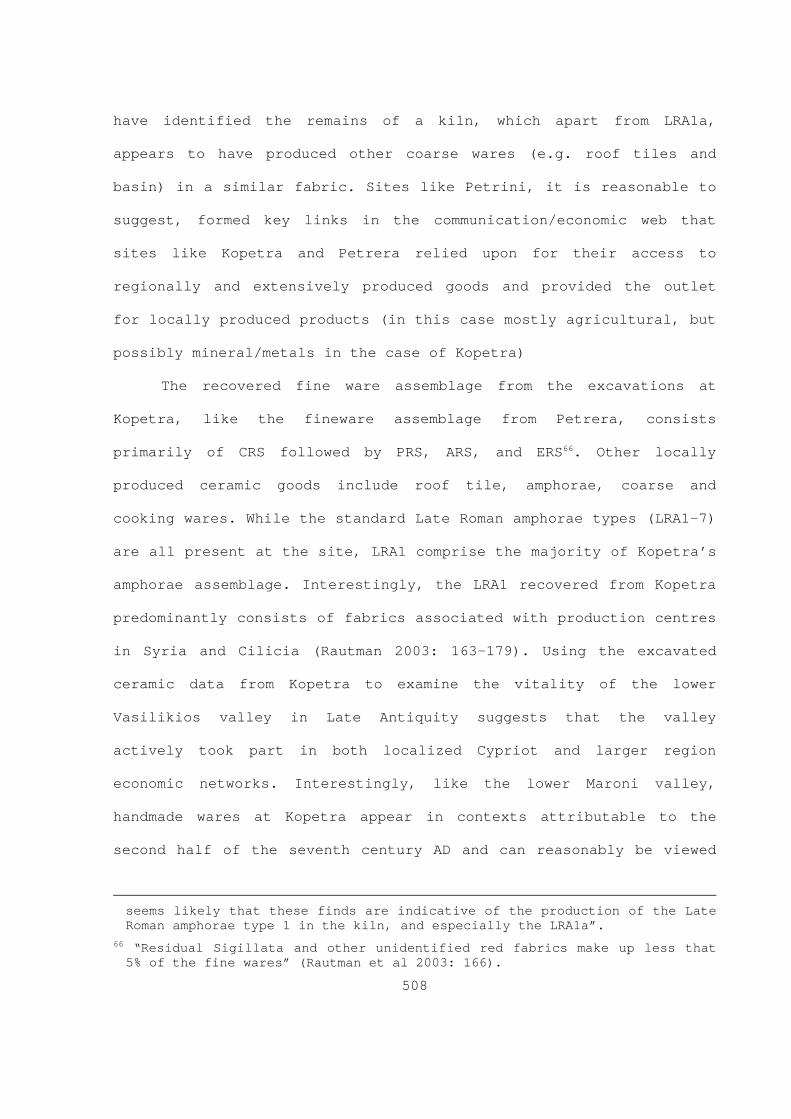
508
have identified the remains of a kiln, which apart from LRA1a,
appears to have produced other coarse wares ( e.g. roof tiles and
basin) in a similar fabric. Sites like Petrini, it is reasonable to
suggest, formed key links in the communication/economic web that
sites like Kopetra and Petrera relied upon for their access to
regionally and extensively produced goods and provided the outlet
for locally produced products (in this case mostly agricultural, but
possibly mineral/metals in the case of Kopetra)
The recovered fine ware assemblage from the excavations at
Kopetra, like the fineware assemblage from Petrera, consists
primarily of CRS followed by PRS, ARS, and ERS 66. Other locally
pr oduced ceramic goods include roof tile, amphorae, coarse and
cooking wares. While the standard Late Roman amphorae types (LRA1-7)
are all present at the site, LRA1 comprise the majority of Kopetra’s
amphorae assemblage. Interestingly, the LRA1 recovered from Kopetra
predominantly consists of fabrics associated with production centres
in Syria and Cilicia (Rautman 2003: 163-179). Using the excavated
ceramic data from Kopetra to examine the vitality of the lower
Vasilikios valley in Late Antiquity suggests that the valley
actively took part in both localized Cypriot and larger region
economic networks. Interestingly, like the lower Maroni valley,
handmade wares at Kopetra appear in contexts attributable to the
second half of the seventh century AD and can reasonably be viewed
seems likely that these finds are indicative of the production of the Late Roman amphorae type 1 in the kiln, and especially the LRA1a”.
66 “Residual Sigillata and other unidentified red fabrics make up less that 5% of the fine wares” (Rautman et al 2003: 166).

509
as an indicator of economic dislocation, or perhaps more
specifically a disruption of external and internal trade networks,
in the lower Vasilikios valley towards the end of Late Antiquity.
Moving to inland, the Athienou Archaeological Project’s (AAP)
survey component (Toumazou et al 1998; Kardulias and Yerkes 2004)
has also identified moderate Late Antique activity in the Malloura
valley, which is located on the south side of the Mesaoria in
central Cyprus (see figure 5.40). Over the course of two field
season in the early 1990s (1991 and 1992) the AAP systematically
investigated approximately 67.5 percent ( n = 13.5km 2) of a 20km 2
st udy area (Toumazou et al 1998: 170) 67 and identified 30 discrete
lo ci ranging in date from the prehistoric to modern periods
(Toumazou et al 1998: table 2 and table 3). During the Roman and
Late Antique periods (50BC-647AD), a “substantial rural settlement”
(Toumazou et al 1998: 175) occupied the site of Malloura (site 1).
Excavations by the AAP have identified the remains of two edifices
attributable to the Roman and Late Roman periods (in Excavation
Units 5 and 3). Recovered Roman and Late Roman fine wares from these
excavations consisted of Pompeian Redware, ARS and PRS. Toumazou and
colleagues (Toumazou et al 1998) suggest that Malloura’s Late
Antique inhabitants abandoned their settlement during the seventh
century AD, possibly because of Arab raids 68. Other traces of Roman
67 Regarding the AAP’s field methods, Toumazou and colleagues (1998: 170)
st ate that the survey employed variable length linear transects (40, 50 and 100m) and teams of 11 surveyors spaced at a 10m interval to cover the study area.
68 Regarding the edifice uncovered in EU 3, they suggest it “may have been burned in the mid-seventh century, early in the period of Arab-Byzantine conflict” (Toumazou et al 1998: 175).

510
and Late Antique activity consist of two scatters (sites 16 and 30)
in the project area’s northern and western sectors as well as
several scatters (14, 23 and 24) of probable Roman and/or post-Roman
data situated on hilltops and the lower elevation around these
locations (sites 22, 25 and 26) from the study area’s eastern
sector. Interestingly, Toumazou and colleagues (1998) have
interpreted several small hilltop scatters as the possible locations
of sentry posts. The results of a subsequent viewshed analysis by
Kardulias and Yerkes (Kardulias and Yerkes 2004: 156-159) confirmed
the prominent and commanding view these sites would have had of
their immediate landscape. Other Roman and Late Antique sites
include Roman period tombs (AAP site 2) as well as indirect evidence
( i.e. grave goods) for the presence of Late Antique (attributable to
the Late Roman and Early Byzantine periods in their chronological
divisions) tombs around the settlement of Malloura (Toumazou et al
1998: 167). In this context, it is reasonable to suggest that the
succession of commemorative components ( i.e. tombs) and sacred
components (i.e. the Archaic through Roman phases of the sanctuary)
indicates the presence of a comparatively stable social and
productive landscape in Malloura valley from the Archaic through the
Late Roman periods.
The Sydney Cyprus Survey Project’s (SCSP) (Given and Knapp
2003; Knapp and Given 2004; Given 2004) investigation of the
important inland settlement of Tamassos’s (modern Politiko)
hinterland has identified a complex Roman and Late Antique landscape
(see figures 5.41 and 5.42). As a whole, during the Early Roman

511
period (100BC-300AD as defined by the SCSP,) locally ( i.e. Cypriot)
produced cookwares formed the majority of the identified Roman
ceramics. Surprisingly, their investigations identified only six
diagnostic (Pseudo-Koan) amphora sherds attributable to this
period 69. On the other hand, Moore (2003: 279) notes that fine wares
co mprised the majority of the recovered Roman period ceramics and,
like the cookwares, were predominately of local ( i.e. Cypriot)
manufacture. Taken together, Moore (2003: 279) reasonably suggests,
“the Mitsero-Politiko area relied primarily upon local production to
meet most of its needs, with minimal import of bulk goods”. Perhaps
more importantly, Moore (2003: 279) notes that whatever province-
level commercial activity that did occur within the SCSP study area
appears to have been with “areas that had strong eastern and weak
western connections”.
During the Late Roman period (300-700 AD as defined by the
SCSP), Moore (2003: 280) notes that the majority of the identifiable
sherds consisted of coarse wares followed by amphora (LRA1) and the
usual range of Late Roman fine wares ( e.g. CRS, ARS, PRS, ERS). In
contrast to the preceding period, cook wares comprised the smallest
portion of the identifiable sherds. Moore ( ibid) notes that as in
the preceding period, the majority of the fine ware was locally
produced ( i.e. Cypriot) CRS. Locally produced fine wares, Knapp and
Given (2004: 83) note, “peaked somewhat later, in the 6 th century,
and declined slowly towards the 7 th century”. However, the level of
69 Moore (2003: 278) states, “field walking produced only six diagnostic
pi eces dated to the Early Roman period”.

512
imported fine wares increased steadily from the fifth century AD
before declining towards the seventh century AD. Apart from LRA1,
the SCPS identified very few imported amphora sherds and no examples
of LR2 sherds (Moore 2003: 279-282).
Around Tamassos, the SCSP has identified an intensive zone of
agricultural activity extending approximately 6km from the city.
Thus, apart from variable sized Roman sherd carpets from manuring on
the geomorphologically stable alluvial land, the SCSP has identified
a series of contemporary estates and farmsteads ( e.g. SCY101, SCY
132, SCY 214) that operated within this particular segment of the
landscape 70. Given and colleagues (Given 2004: 175; Knapp and Given
2003: 316-318; Moore 2003: 282) believe this indicates that these
estates would have traded any surplus they produced with Tamassos
for prestige goods like imported fine wares. However, the absence of
amphora sherds, Moore (2003: 282) believes, “weigh against the
theory of large-scale, organized support centers dedicated to
cultivating crops for the inhabitants of Tamassos”. Interestingly,
the SCSP has identified the fourth to sixth centuries AD as a period
in which copper production also reached a production peak (see
Chapter 4, §4.2.3.2, 4.2.3.2.A). Taken together, Given and
colleagues (ibid ) believe that these trajectories indicate that the
productive component of Tamassos’s hinterland was geared towards
mass production 71. Perhaps more importantly, the SCPS identified
70 Regarding these Roman period sherd carpets, Given (2004: 171, 172) notes
th at they usually had a density of approximately “0.5 sherds/m 2” and could be quite extensive (“anything up to 3 km across”).
71 Given (2004: 175) states “The landscape of the Roman period, and especially the Late Roman period, was devoted to mass production”.

513
minimal activity in the study area’s more remote areas outside of
the alluvial plains (Given 2004: 171-175; Knapp and Given 2003: 316;
Given et al 2003: 305-310; Moore 2003: 281-282).
Based on the short review of select Cypriot survey projects
presented above, it is reasonable to suggest several common
characteristics that they share with the SAP. Perhaps the most
significant commonality that all the above mentioned projects share
is the identification of a reduced material signatures in all of the
study areas for the periods that bracket the comparatively more
intensive Late Roman period ( i.e. roughly the Hellenistic/Early
Roman and Early Mediaeval periods). However, it is also important to
note that sub-regional variations are readily apparent.
Nevertheless, one characteristic of this intensive reutilization of
the landscape centres on the establishment of a nested webs of
nodal, productive, ritual/commemorative, and transport/storage sites
in the Cypriot countryside. The elements comprising this web, I
suggest, are multi-scalar. The Late Antique sites surrounding
Kopetra in the Vasilikos, Petrera in Maroni valleys, Agios Kononas
in the Akamas, and the SAP’s AGs (see above §5.4.2.A-5.4.2.2C)
provide a particularly good examples of multi-scalar landscapes in
which localized nodal sites can become important locales at middle
level scales. Rautman (2001: 235), adopting a slightly more rigid
landscape paradigm, has described Kopetra’s position in the
Vasilikios valley’s Late Antique settlement pattern “as a second-
order central place within a dendritic, sub-regional hierarchy”.
Furthermore, Rautman and colleagues (2003: 239-241) have observed

514
the 2.5km interval between two of the more important villages in the
Vasilikos valley, Kopetra and Sokopora, is comparable to the
interval between modern Cypriot villages. This pattern is also
detectable within the DAP survey area (see above); the extent to
which this observation is applicable to Kourion’s hinterland remains
to be proven as no loci interpretable as a village were identified
by the SAP. The SAP data on the other hand, does provide reasonable
insights on the next settlement level below that of the village and
indicates that outbuildings tended to be within 1km of an estate
centre. As mentioned above, the SCSP’s investigations in Tamassos’
hinterland have identified an intensive 6km zone on the alluvial
plains around that city. On average, the estate centres/farmsteads
identified by the SAP are approximately 7km from Kourion and are
predominantly located in upland contexts, rather than alluvial
plains, and are underlain by comparatively thin but productive soils
(one exception is 04-03 in the Kouris valley, for example). Although
investigations in Kourion’s immediate hinterland ( i.e. 3km radius)
have been limited, the estate centre (or possible suburban
settlement) identified by Last (1975) and A. Leonard (1986) at the
locality of Yerokarka, located approximately 1.5km to Kourion’s
east, mentioned in Chapter 5 (§5.3.3) suggests the possibility that
Kourion’s immediate hinterland may also follow the pattern
identified at Tamassos. However, additional focused field survey is
required to test the validity of this pattern for Kourion’s
hinterland. In short, the general pattern identified by the SAP in

515
Kourion’s hinterland is concurrent with the results of projects from
other regions of the island.
5.5 Chapter summary
It is reasonable to suggest that from a methodological
perspective, the SAP’s field procedures represent the middle ground
between extensive and intensive survey procedures. While this
methodology was able to identify comparatively small concentrations
of artefacts in the mostly uncultivated terrain that formed the
majority of the SAP study area, it was not sufficiently sensitive to
identify the less pronounced non-primary indicators of landscape
utilization identifiable through the analysis of off-site material.
Nevertheless, based on the results of the SKS and SAP, it is clear
that during the early/middle Bronze Age (EC-MC) and the Late Antique
periods, Kourion’s hinterland experienced comparatively elevated
levels of activity. The analysis of AG-1, AG-2 and AG-3 indentified
the presence of a multi-component, multi-scale, and multilocal Late
Antique landscape in Kourion’s hinterland. Arguably, AG-2 and AG-3,
both located on the southern edge of the plateau formed by the
Symbolos drainage and a tributary of the Farkanas-Paramali River in
the west, provide the best example of the interconnectedness of the
productive and commemorative components of the Landscape.
Furthermore, the pattern identified by the SAP and SKS in Kourion’s
hinterland is in general accordance with the larger provincial
trajectory characterized by (1) contraction in the Early Roman
followed by (2) a comparative boom of intensive occupation

516
strategies in the Late Antique period and (3) then a return to less
intensive occupation strategies towards the end of Late Antiquity
and the early Mediaeval period.

D.A.PA.A.P
S.A.P.S
C.D.A.S
V.V.S.P
C.D.A.S
A.S.C
M.V.S.P
S.C.S.P
C.P.S.P
T.A.E.S.P
409313.419498
409313.419498
429313.419498
429313.419498
449313.419498
449313.419498
469313.419498
469313.419498
489313.419498
489313.419498
509313.419498
509313.419498
529313.419498
529313.419498
549313.419498
549313.419498
569313.419498
569313.419498
589313.419498
589313.419498
609313.419498
609313.419498
629313.419498
629313.419498
649313.419498
649313.419498
669313.419498
669313.419498
3819
338.7
4467
0
3819
338.7
4467
0
3839
338.7
4467
0
3839
338.7
4467
0
3859
338.7
4467
0
3859
338.7
4467
0
3879
338.7
4467
0
3879
338.7
4467
0
3899
338.7
4467
0
3899
338.7
4467
0
3919
338.7
4467
0
3919
338.7
4467
0
3939
338.7
4467
0
3939
338.7
4467
0
3959
338.7
4467
0
3959
338.7
4467
0
Figure 5.1 Select survey projects on Cyprus (Datum: Europe 1950).
517
Legend
Survey Projects
0 7035Kilometers

518
Figure 5.2 . Hectares surveyed and not surveyed in each SAP 1997 q uadrat.
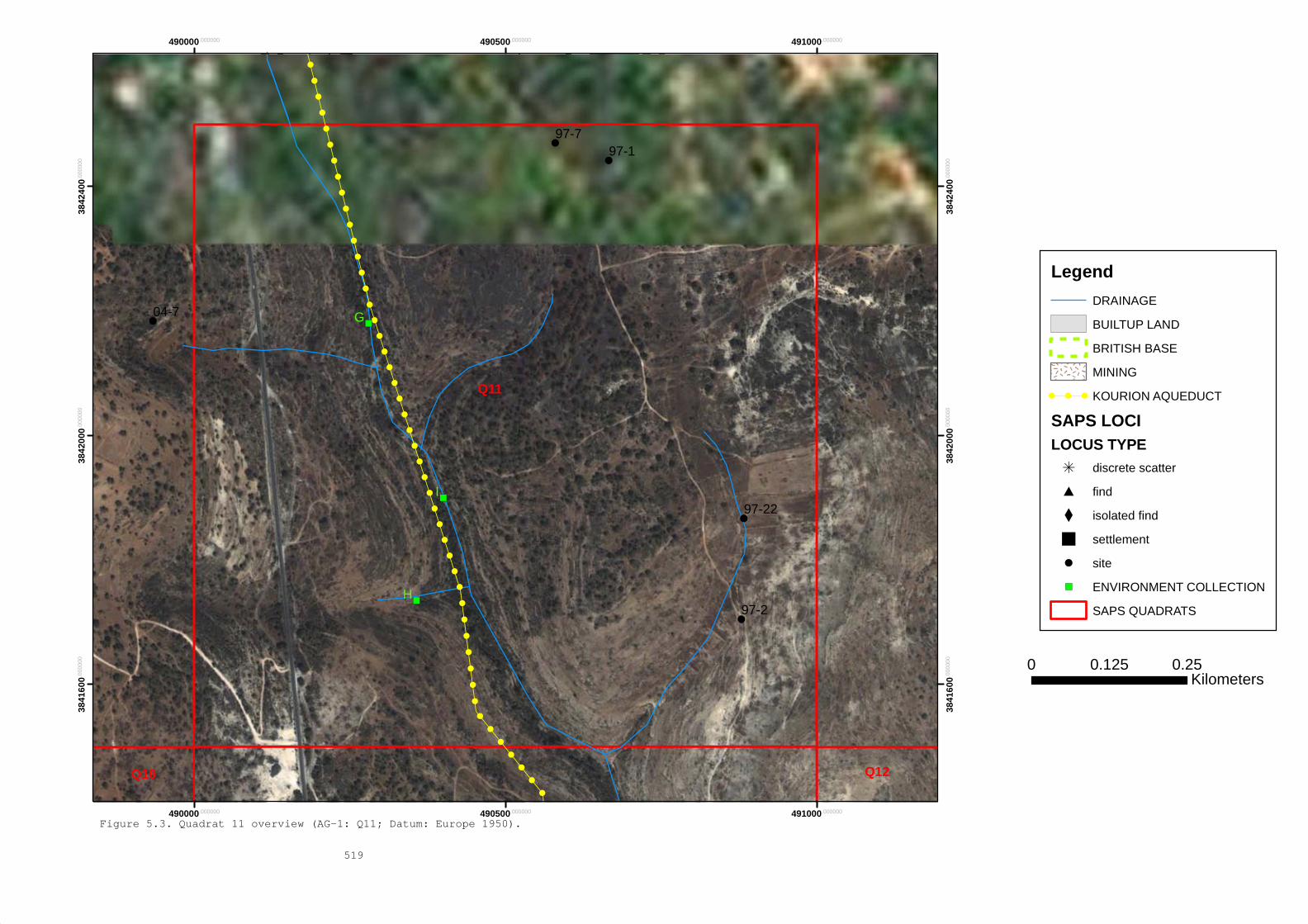
!!
!!
!!
!!
!!
!!
!!
!!
!!
!!
!!
!!
!!
!!
!!
!!
!!
!!
!!
!!
!!
!
!
!
!
!
!
!
!
!
!
! )
)
)I
H
G
Q12
Q11
Q10
04-7
97-22
97-7
97-2
97-1
490000.000000
490000.000000
490500.000000
490500.000000
491000.000000
491000.000000
3841
600.0
0000
0
3841
600.0
0000
0
3842
000.0
0000
0
3842
000.0
0000
0
3842
400.0
0000
0
3842
400.0
0000
0
Figure 5.3. Quadrat 11 overview (AG-1: Q11; Datum: Europe 1950).
519
Legend
DRAINAGE
BUILTUP LAND
BRITISH BASE
MINING
! ! ! KOURION AQUEDUCT
SAPS LOCILOCUS TYPE
i discrete scatter
# find
X isolated find
settlement
! site
) ENVIRONMENT COLLECTION
SAPS QUADRATS
0 0.250.125Kilometers

520
Figure 5.4 . View: SW. General view across locus 97 - 01.

521
Figure 5.5 . Sketch plan of locus 97 - 01.

522
Figure 5.6 . View: W. Scale: 1m. Locus 97 - 01 wall alignments.

523
Figure 5.7. View: SW. Press weight (B) in room A and eastern
interior wall (A) from locus 97-01.

524
Figure 5.8. View: S. Scale: 1m. Threshold block in eastern wall
alignment from locus 97-01.

525
Figure 5.9 . View: W. Scale: 1m. Slotted block and northern wall
alignment from locus 97-01.
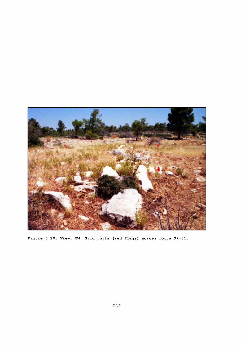
526
Figure 5.10 . View: SW. Grid units (red flags) across locus 97 - 01.
527
Figure 5.11. View: N. Terrain around locus 97-02.

528
Figure 5.12 . View: NW. Scale: 1m. East and west wall
alignments from the rectangular structure at locus 97 -
02.

529
Figure 5.13. View: N. Scale: 1m. Worked blocks in terrace wall
at locus 97-22.

!
!
!
i
i
i
ROPHESIA Q05
Q06Q04
97-25
97-24
97-23
97-5
97-6
97-4
484000.000000
484000.000000
484500.000000
484500.000000
485000.000000
485000.000000
3841
600.0
0000
0
3841
600.0
0000
0
3842
000.0
0000
0
3842
000.0
0000
0
3842
400.0
0000
0
3842
400.0
0000
0
Figure 5.14. Quadrat 05 overview (AG-2: Q05 and Q06; Datum: Europe 1950).
530
Legend
DRAINAGE
BUILTUP LAND
BRITISH BASE
MINING
SAPS LOCILOCUS TYPE
i discrete scatter
# find
X isolated find
settlement
! site
) ENVIRONMENT COLLECTION
SAPS QUADRATS
0 0.30.15Kilometers

531
Figure 5.15. View: S. General view across locus 97-05.
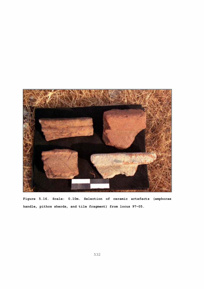
532
Figure 5.16. Scale: 0.10m. Selection of ceramic artefacts (amphorae
handle, pithos sherds, and tile fragment) from locus 97-05.

533
Figure 5.17. Scale: 0.25m. Stone basin fragment (for olive
crushing?) from locus 97-05.

534
Figure 5.18. View: NE. General view to the north and east of
locus 97-05 illustrating the extensive disturbances caused by
mining in 2004.

535
Figure 5.19. View N. General view of locus 97-06 illustrating pre -
1997 disturbances in the site’s central sector.

536
Figure 5.20. View: E. Scale: 1m. Locus 97- 06’s
bisected north wall.
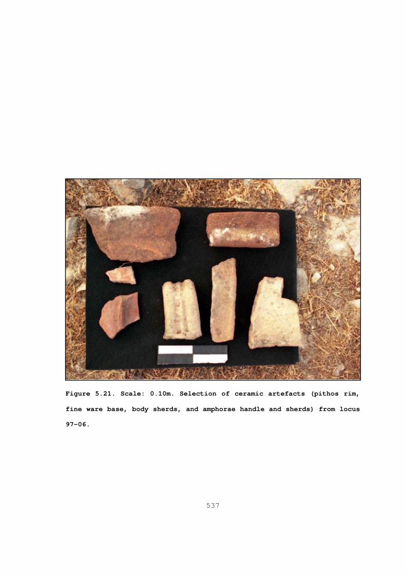
537
Figure 5.21. Scale: 0.10m. Selection of ceramic artefacts (pithos rim ,
fine ware base, body sherds, and amphorae handle and sherds) from locus
97-06.

!
!
i
i
XX
i
Q05
Q06
97-29
97-2897-27
97-26
97-25
97-4
97-3
485000.000000
485000.000000
485500.000000
485500.000000
486000.000000
486000.000000
3840
800.0
0000
0
3840
800.0
0000
0
3841
200.0
0000
0
3841
200.0
0000
0
3841
600.0
0000
0
3841
600.0
0000
0
Figure 5.22. Quadrat 06 overview (AG-2: Q05 and Q06; Datum: Europe 1950).
538
Legend
DRAINAGE
BUILTUP LAND
BRITISH BASE
MINING
SAPS LOCILOCUS TYPE
i discrete scatter
# find
X isolated find
settlement
! site
) ENVIRONMENT COLLECTION
SAPS QUADRATS
0 0.30.15Kilometers

539
Figure 5.23. View: NE. General view across locus 97- 04
illustrating the disturbances caused by mining in 2004.

540
Figure 5.24. Scale: 0.10m. Selection of ceramic artefacts
(pithos rim, tile fragment, and plain body sherds) from
locus 97-04.
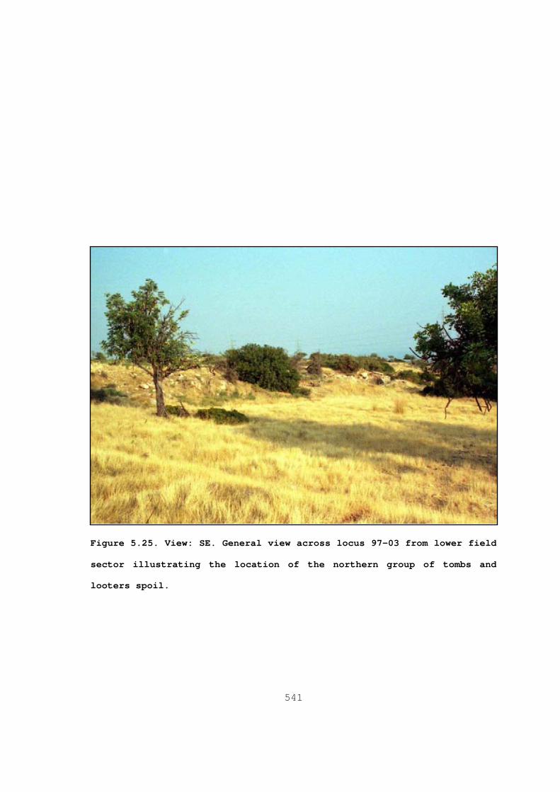
541
Figure 5.25. View: SE. General view across locus 97-03 from lower field
sector illustrating the location of the northern group of tombs and
looters spoil.
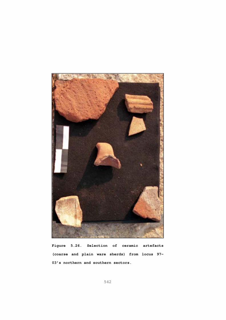
542
Figure 5.26 . Selection of ceramic artefacts
(coarse and plain ware sherds) from locus 97 -
03’s northern and southern sectors.

543
Figure 5.27. View: S. Scale: 1m. Limestone
sarcophagus lid from locus 97-03’s ridge sector.

544
Figure 5.28 . View: W. Scale: 1m. Architectural
element from locus 97-03’s lower field sector.

545
Figure 5.29. Scale 0.60m. Monumental door or window mullion with
battered inscription followed by vegetal motif from locus 97-03’s lower
field sector.
MAV
Line

546
Figure 5.30 . View: E. Scale: 1m. Cist tomb from
the southern end of Locus 97-03.

!
!
!
!
i
X
)
)
)
)
KARVOUNERI
Z
Y
X
N
Q05
Q04
Q03
STERAKOVOU
97-30
97-23
97-17
97-16
97-9
97-8
483000.000000
483000.000000
483500.000000
483500.000000
484000.000000
484000.000000
3840
800.0
0000
0
3840
800.0
0000
0
3841
200.0
0000
0
3841
200.0
0000
0
3841
600.0
0000
0
3841
600.0
0000
0
Figure 5.31. Quadrat 04 overview (Datum: Europe 1950).
547
Legend
DRAINAGE
BUILTUP LAND
BRITISH BASE
MINING
SAPS LOCILOCUS TYPE
i discrete scatter
# find
X isolated find
settlement
! site
) ENVIRONMENT COLLECTION
SAPS QUADRATS
0 0.30.15Kilometers

548
Figure 5.32. View: N. Press block and architectural
rubble from locus 97-09.

!!
!!
!!
!!
!!
!!
!!
!!
!!
!!
!!
!
!
!
!!
!
!
!
!
!
!
!
!
!
!
!!
!!
!!
!!
!!
!!
!
!
!
!
i
!
!
!
!
!
!
)
)
)
)
)
)
)
SIKOUESTIA
KALON TERATSOUDHIN
F
I
H
G
E
D
C
Q12
Q11
Q10
04-7
04-6
04-3
97-22
97-12
97-11
97-10
97-7
97-2
97-1
489500.000000
489500.000000
490000.000000
490000.000000
490500.000000
490500.000000
491000.000000
491000.000000
491500.000000
491500.000000
492000.000000
492000.000000
3840
400.0
0000
0
3840
400.0
0000
0
3840
800.0
0000
0
3840
800.0
0000
0
3841
200.0
0000
0
3841
200.0
0000
0
3841
600.0
0000
0
3841
600.0
0000
0
3842
000.0
0000
0
3842
000.0
0000
0
3842
400.0
0000
0
3842
400.0
0000
0
Figure 5.33. Analytical Group-1 (AG-1: Q11; Datum: Europe 1950).
549
Legend
DRAINAGE
BUILTUP LAND
BRITISH BASE
MINING
! ! ! KOURION AQUEDUCT
SAPS LOCILOCUS TYPE
i discrete scatter
# find
X isolated find
settlement
! site
) ENVIRONMENT COLLECTION
SAPS QUADRATS
0 0.50.25Kilometers

!
!
!
!
i
i
i
i
XX
i
X
ROPHESIA
KARVOUNERI
Q05
Q06Q0497-30
97-29
97-2897-27
97-26
97-25
97-24
97-23
97-5
97-6
97-4
97-3
484000.000000
484000.000000
484500.000000
484500.000000
485000.000000
485000.000000
485500.000000
485500.000000
486000.000000
486000.000000
3840
400.0
0000
0
3840
400.0
0000
0
3840
800.0
0000
0
3840
800.0
0000
0
3841
200.0
0000
0
3841
200.0
0000
0
3841
600.0
0000
0
3841
600.0
0000
0
3842
000.0
0000
0
3842
000.0
0000
0
3842
400.0
0000
0
3842
400.0
0000
0
Figure 5.34. Analytical Group-2 (AG-2: Q05 and Q06; Datum: Europe 1950).
550
Legend
DRAINAGE
BUILTUP LAND
BRITISH BASE
MINING
SAPS LOCILOCUS TYPE
i discrete scatter
# find
X isolated find
settlement
! site
) ENVIRONMENT COLLECTION
SAPS QUADRATS
0 0.60.3Kilometers

!
!
!
!
!
!
!
!
i
i
i
i
X
)
)
)
)
ROPHESIA
KARVOUNERI
Z
Y
X
N
Q05
Q06Q04
Q03
STERAKOVOU
97-30
97-26
97-25
97-24
97-23
97-17
97-16
97-9
97-8
97-5
97-6
97-4
97-3
483000.000000
483000.000000
483500.000000
483500.000000
484000.000000
484000.000000
484500.000000
484500.000000
485000.000000
485000.000000
3840
000.0
0000
0
3840
000.0
0000
0
3840
400.0
0000
0
3840
400.0
0000
0
3840
800.0
0000
0
3840
800.0
0000
0
3841
200.0
0000
0
3841
200.0
0000
0
3841
600.0
0000
0
3841
600.0
0000
0
3842
000.0
0000
0
3842
000.0
0000
0
Figure 5.35. Analytical Group-3 (AG-3: Q04; Datum: Europe 1950).
551
Legend
DRAINAGE
BUILTUP LAND
BRITISH BASE
MINING
SAPS LOCILOCUS TYPE
i discrete scatter
# find
X isolated find
settlement
! site
) ENVIRONMENT COLLECTION
SAPS QUADRATS
0 0.50.25Kilometers

552
Figure 5.36 . The DAP study area and select sites (adapted
from Fejfer(ed) 1995: 18, figure 3).

553
Figure 5.37. Late Antique sites in the Lower Maroni Valley (4 Petrera, 7
Phouches, 8 Kapsouloudhia, 9 Aspres, 10 Vournes, 11 Tsaroukkas, 13
Vrysoudhia)(Manning et al 2002:14, figure 2.11).

554
Figure 5.38. Late Antique sites in the Vasilikos Valley (ad apted from
Rautman et al 2003: 238, figure 7.1).

555
Figure 5.39. Distribution of select sites identified in the CPSP study area
(Rupp et al 1984: 137, figure 4).

556
Figure 5.40. Sites in the AAP study area (Toumazou et al 1998: 171, figure
4)

557
Figure 5.41. Detail of the SCPS survey area, transects, and SIAs (Given et
al 1999: 23, figure 2).
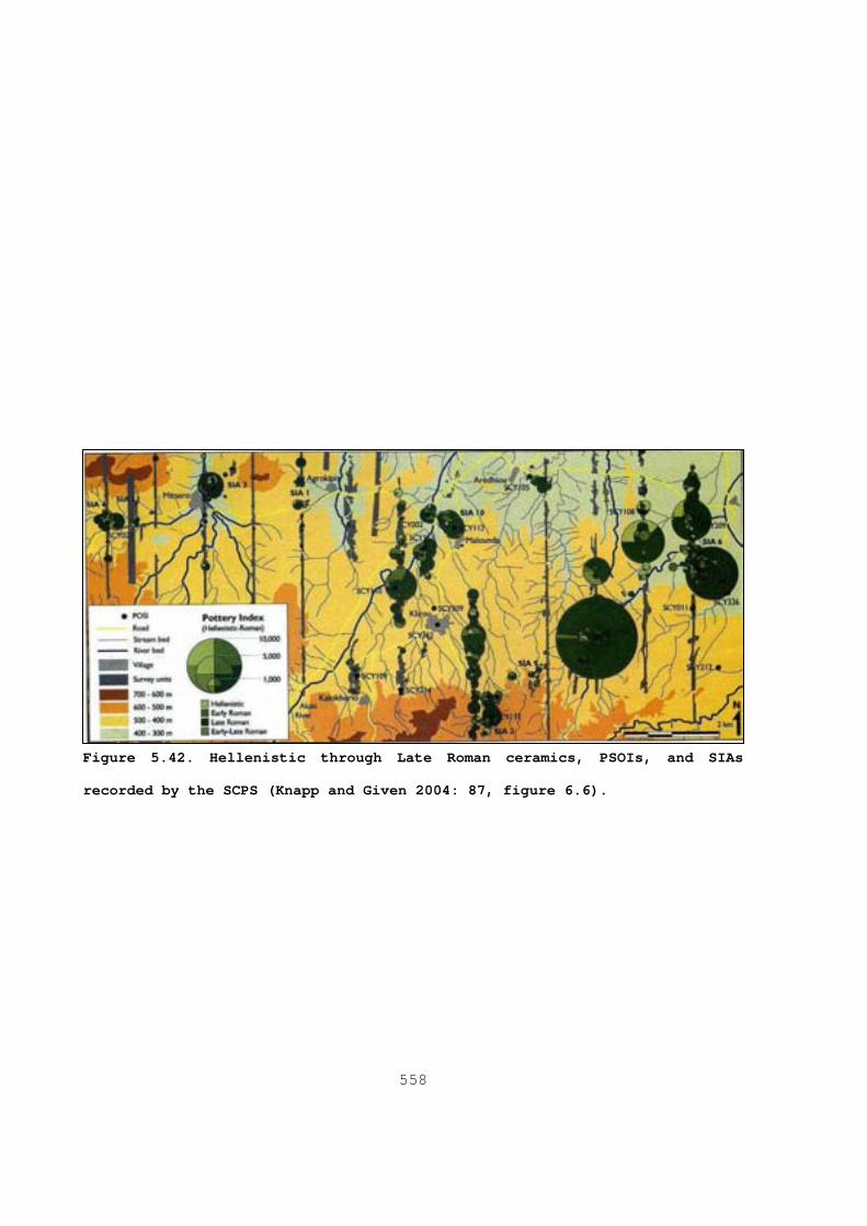
558
Figure 5.42. Hellenistic through Late Roman ceramics, PSOIs, and SIAs
recorded by the SCPS (Knapp and Given 2004: 87, figure 6.6).

559
CHAPTER 6
Conclusions
6.1 Introduction
This chapter’s main purpose is to provide possible answers to
t he general questions proposed in the introduction to this thesis by
drawing on the inferences developed in Chapters two through five.
These questions essentially centre on whether aspects of Cyprus’
provincial infrastructure ( e.g. transportation, productive) and
social makeup (e.g. provincial elites) indicate that it was either a
marginalized or a well integrated province in Late Antiquity. At
this point it is useful to reiterate several sub issues that
contribute to the more general question as to whether Cyprus was a
well integrated province in Late Antiquity. These include
• To what extent did the central government recognise Cyprus’
tactical value during the sixth and seventh centuries AD?
• Based on the case study of Kourion, to what extent did this
urban landscape remain viable during Late Antiquity; is the
development best characterised as decline, continuation, or
transformation?

560
• To what extent did Cyprus experience intensification in
rural production during Late Antiquity? To what extent, if
any, is this process detectable in Kourion’s hinterland?
Section 6.2 provides a contribution to the development of these
topics. Section 6.3 provides recommendations and objectives for
future targeted field survey in Kourion’s hinterland in relation to
the model of Cypriot Late Antique hinterlands presented in
subsection 6.2.4.1.
6.2 Late Roman Cyprus: A well-integrated province?
Over the last decade, researchers ( e.g. J. Leonard 2005; Parks
1999; Bekker-Nielsen 2004; Metcalf 2009) have successfully
challenged the long held view ( e.g. Hill 1949; Mitford 1980 and
Potter ND) that Roman Cyprus, and by extension, Late Antique Cyprus,
was a marginal and unimportant province within both the early and
Late Empire. This thesis is a contribution to this revisionist view.
Several interesting perspectives on Late Antique Cyprus emerge from
the discussions presented in the preceding chapters (especially
Chapters 4 and 5). Current archaeological research derived from an
array of sources such as the sigillographic record, regional surveys
as well as rural and urban excavations ( e.g. Metcalf 2004; Megaw et
al 2007; Rautman et al 2003; Rautman 2004; Rautman 2000; Given and
Knapp 2003) are increasingly producing data that indicates that
Cyprus was well-integrated into the larger social, economic and
strategic trajectories of the Late Antique eastern Mediterranean
561
(§4.2.3.2.A; §4.2.4). Cyprus, like other economically developed
provinces, possessed extensive maritime (Leonard 2005)
infrastructure (ports, harbours, and anchorages) and a developed
road system (Bekker-Nielsen 2004) which reached its zenith in Late
Antiquity. Interestingly, the Cypriot road system was comparable to
its eastern neighbour and administrative superior, Syria. The
complex of sites around Evdhimou bay (§4.2.3.1), for example,
clearly illustrates the symbiotic relationship between transport
infrastructure and the productive components of the Cypriot Late
Antique landscape. It is also likely that the expansion of the road
system into remote areas like the Akamas and Krommyakon promontories
reflect the increasing intensification of agricultural activity in
previously marginalized sectors of the landscape during Late
Antiquity.
The expansion of the province’s transportation infrastructure
during Late Antiquity, it is reasonable to suggest, contributed to
the continuation and expansion of several Roman period heavy
industries (e.g. pottery production and copper production: see
§4.2.3.2 and 4.2.3.2.A) and rural expansion during this period.
While the scale and organization of copper production on Cyprus
remains unknown during Late Antiquity, researchers have identified
continued Late Antique exploitation of this resource at several
locations ( e.g. Solea valley, Vasilikos valley, around Tamassos)
across the province (§4.2.3.2). For example, based on the slag
recovered from fill contexts in the monastery complex’s courtyard at
Kalavasos Kopetra (Area I) (Rautman 2003), it is reasonable to

562
suggest that at least in the lower Vasilikos valley, the
institutional church was involved in some stage(s) of the productive
process if not the procurement process as well. Based on the
discussion presented in Chapter 4 (§4.2.3.2), it is also likely that
even localized metallurgical processes would have produced
noticeable change in the landscape. A community’s access to timber
resources directly controlled that community’s ability to process
and produce copper. For example, based on the figures presented in
Chapter 4 (§4.2.3.2), the 500-600kg of copper produced at a Roman
period villa rustica near Ayios Kononas (Fejfer and Mathiesen 1995:
80, fig. 10; 1995a: 65) would have consumed approximately 45
hectares of pine forest, or an equivalent biomass, from the
immediate environment around this site. At more extensive and long-
lived copper mining and production sites, the environmental impacts
were undoubtedly greater.
Cypriot workshops also produced a series of coarse wares like
amphora (LRA1, LRA13), roof tiles, and thin walled cookwares for
both local consumption and export. At present, geochemical analysis
( e.g. Rautman et al 2003; Gomez et al 2002; Rautman et al 1993;
Rautman et al 1999) has identified likely clay sources for these
wares in southwestern, south central, and eastern Cyprus. Their
research also indicates the clay used for the production of CRS
originate in southwestern and southern Cyprus. Rautman and
colleagues’ (2003) analysis of tiles from Kopetra indicate that the
Cypriot tile industry used clays from derived from sources located
in the lower Mesaoria valley, the Mesaoria plain and south central
563
Cyprus. The distribution of Late Antiques Cypriot wares was
extensive. At Anemurium in rough Cilicia, for example, both CRS and
Cypriot thin walled cookwares constituted a major component of the
early Byzantine fine and common ware sub-assemblages (Williams 1989;
Russell 2002). At the inland village of Sumaqa in modern Israel,
Cypriot Red Slip wares comprised the majority of the fine ware sub-
assemblage as well (Kingsley 2003; 1999). The ceramic assemblage
from the Upper Zohar fort, which functioned as a lookout, in the
northern Negev contained CRS forms attributable to the late sixth
and seventh centuries AD (Harper 1995) suggests that Cypriot wares
also circulated widely in non-urban and village contexts 1.
6.2.1 The Late Antique Cypriot elites
I have suggested at several points in this thesis that various
social groups and institutions actively created a dynamic,
contested, multi-scale, and multilocal provincial landscape in
Cyprus during the Roman and the Late Antique periods. As a result
of the reorientations of the state’s administrative apparatus during
the fourth through the sixth centuries AD, Cyprus, like other
provinces (Chapter 2, §2.3.1.2; Chapter 4, §4.2.1.2) experienced a
proliferation of senatorial honorati which increased pressure on the
local mechanisms that insured the smooth operation of civic
government. At the localized level of the individual city, these
honorati increased their personal authoritative resource sets at the
expense of their former social equals, the curials, and their city’s
1 Identified CRS forms consist of 9A and 9B (Harper 1995: 23-24).

564
interests. Nevertheless, if repeat legislation is an accurate
indicator of curial services’ growing undesirability, it appears the
central government’s attempt at social engineering was poorly
received in the provinces (§2.3.1.2.A) 2. At a larger scale, it is
re asonable to interpret this process as one facet of a manifold
phenomenon in which aspects of the socio-political centre
increasingly penetrated the provincial periphery. This development
undoubtedly altered the established localized conduits and
structures that had define Cypriot elite competition during the
Roman period: service in local civic government and participation in
the provincial assembly. Extensive institutions, like the state and
church, now offered upwardly mobile Late Antique Cypriots a
considerably more robust means of transforming their material wealth
into social capital, which in turn, allowed them to increase their
personal authoritative resource sets well beyond the scope of their
Roman forerunners.
Some researchers (Alastos 1976; Chrysos 1993) have suggested
that the Cypriot Church provided the provincial elites with a
similar social conduit as the provincial Koinon had during the Roman
period. However, in Chapter 4 of this thesis (§4.2.1.2) I have
suggested this is only partially true because the Koinon and the
corporate church differed in the ways they reproduced and
legitimised their authority. The institutional church possessed a
considerably more extensive and diverse resource base and access to
2 See Harries (1999) and Barnish and colleagues (2001) for a more optimistic
in terpretation of repeat legislation; see Arjava (1988) for examples of social engineering.

565
the state-level conduits through which these resources flowed than
the Koinon. The church used an extensive hierarchical administration
and was capable of issuing sanctions against non-compliance. Perhaps
more importantly, unlike the Koinon, it was not as overly dependent
upon one particular social stratum for the legitimization and
reproduction of its position in Cypriot society. This social
plurality enabled the church to engage efficiently with the everyday
lives of a wider spectrum of Cypriots in a way that Koinon could
not. Based on these characteristics, it seems reasonable to suggest
that main difference between the Koinon and the church centred on
the distinction between a hierarchical organization with a corporate
identity and the ability to pursue collective interests and provide
sanctions for noncompliance on one hand and a loosely structured
organization that predominantly relied on personal authority, on the
other.
Arguably, as in other parts of the empire, the province’s
bishops became important civil functionaries from approximately the
late fourth century AD onwards (§2.3.1.1). In general, the Cypriot
bishops, like bishops across the empire, “were called on to defend
the secular interests of their flock” (Metcalf 2009: 355). There is
evidence to suggest that upwardly mobile Late Antique social actors
viewed the Episcopal office as any other office that could provide
social prestige. In relation to the limited tenure of a provincial
governor, researchers ( e.g. Slootjes 2006; Metcalf 2009; Rapp 2005)
have argued that a bishop’s lifetime appointment placed them in a
position which enabled them to plan and execute long term

566
initiatives (e.g. construction projects) in a more efficient manner
than the provincial governor. Apart from the practical advantages
lifetime appointments afforded bishops, Cypriot bishops, who more
often than not originated from within the province, undoubtedly had
a firmer understanding of the key players that constituted the
provincial power elites and local political priorities. The
institutional church also took on a number of civic-social
functions, particularly in the legal arena where Episcopal courts
served as an alternative lower court to the standard provincial
court system. On Cyprus during the sixth century AD, it is
reasonable to suggest that the Episcopal courts would have presented
an attractive option to those of the state 3. On the other hand, as
t he Episcopal office’s mandate overlapped with what traditionally
had been the domain of the secular authorities, it undoubtedly
created tensions between these institutions (Slootjes 2006) 4. As an
authoritative institution, the corporate Cypriot Church in its fully
developed Late Antique incarnation successfully defended its
corporate interests against external influences ( e.g. Antioch until
late fifth century AD; influx of various Monophysite Christian
refuges during the late sixth and seventh centuries AD) and with
state level policy (e.g. Monotheletism). These successes insured the
continued reproduction and maintenance of the corporate Cypriot
Church’s own prominent position within the multifaceted
3 For a recent discussion on the growing role of Cypriot bishops’ in
pr ovincial administration, see Metcalf (2009: 355-359). 4 As mentioned in §2.3.1.1, by the reign of Justinian I, the central
government also relied on the bishop to report any misadministration.
567
authoritative landscape of Late Antique Cyprus. Based on an analogy
with the Persian and the early stages of the Muslim occupation of
other eastern provinces, it may reasonably be assumed that Cypriot
church’s administrative apparatus, embodied by the distribution of
bishops across the province, would have augmented and possibly
superseded the importance of the provincial apparatus at the
localized level during periods of political-military dislocation 5.
Therefore, it is likely that the archbishop and provincial notables
(or those that remained in the province) and local bishops in
concert with local notables (or what remained of them) would have
taken over much of the day to day policy making decisions within a
province that was rapidly transforming into a contested territory,
from the late seventh century AD 6.
6.2.2 Cyprus’ tactical value
Although scholarly opinion remains divided, it is reasonable to
su ggest that the Roman state could process geographic data, however
crudely, from specific geographic areas and then devise specific
tactics to achieve its large strategic objectives (§2.4). From this
perspective it is probable that the Late Roman state recognised
Cyprus’ tactical value in economic terms as early as the mid-sixth
century AD (Justinian I’s reign) when the province, along with
5 “On many occasions the municipal council (together with the metropolitan or
lo cal bishops) apparently had to replace the central government of the past” (Tsafrir and Foerster 1994: 109-110). Also see, Mayerson (1963).
6 It is reasonable to assume the partnership between provincial notables and th e bishops of Cypriot origin remained relatively stable until the ninth century AD when imperial appointees from outside Cyprus increasingly take control of Cypriot Sees. Metcalf (2009: 306) suggests this development may be a result of “a shortage of well-qualified candidates locally”.

568
several other comparatively wealthy provinces, contributed material
resources for the defence of several Balkan provinces (§4.2.3). The
settlement of several thousand Armenians in 578 AD by Maurice (while
still serving as Caesar) across the island (Kyrris 1970; Metcalf
2009) indicates that, at least on a general level, the central
government was aware of the potential threat the Persian occupation
of the mainland posed to Cyprus’ security. However, if the
piratical-like raid recorded in John of Nikiu’s chronicle during
Maurice’s reign is accurate (trans. Charles 1916), it is reasonable
to assume that either the force at the governor’s disposal was still
inadequate and/or the raid’s speed outpaced the response speed of
the provincial defence force. Regarding the movement and exchange of
information, it is highly probable that refugees fleeing to Cyprus
from the Persian and then the Muslim occupation of the mainland
brought an array of valuable tactical information with them which
would have been useful to tactical planners in the provincial and
imperial governments. Thus, by the late sixth or early seventh
centuries AD, based on the limited historical evidence and the
comparatively richer archaeological evidence ( e.g. coins,
fortifications and sigillography), it is very likely that both the
provincial and central governments were actively taking steps to
bolster Cyprus’ defensive capabilities.
As incomplete as the distribution of military lead seals’ find
spots from the province is, what is available appears to indicate
that strategic planners were in contact with individuals and
institutions in coastal and, perhaps more importantly, inland

569
regions (figure 4.2). Regardless of whether the late phase of urban
fortifications identified at several cities, date to the interval
between the raids of 649 and 653 AD or after 653 AD ( i.e. Najbjerg
et al 2002; Balandier 2004; Metcalf 2009), what is important, I
suggest, is the level of investment in various types of
fortifications like hard point/refuges and lookouts that were not
restricted to urban contexts or the coastal zone. The refuge
fortifications at Vigla, hard points in the Keryina Range, and
lookouts at Kopetra(?) and in the Malloura valley clearly illustrate
this trend ( e.g. Caraher et al 2007, 2008; Balandier 2003; Rautman
et al 2003; Toumazou et al 1998). At the large geo-strategic level,
several researchers (Rautman 2003; Cameron 1992) have suggested that
after the loss of Arados, imperial planners abandoned the eastern
Mediterranean in favour of protecting the Aegean core 7. While this
st rategy is plausible, those military/administrative seals solidly
attributable to the eighth century AD (Metcalf 2004) indicated that
apart from the tactical withdrawal of troops, imperial planners
continued low-level and intelligence gathering operations on Cyprus
(§4.2.4). Such operations undoubtedly occurred in conjunction with
similar operations in southeastern Anatolia. In short, it is
unlikely that imperial strategic planners would have lost sight of
the island’s tactical potential even when it was technically
neutral.
7 “Following the loss of Arados (Arwad) in 650, Constantinople effectively
abandoned the region in order to concentrate its defenses in the Aegean” (Rautman 2003: 260-261).

570
6.2.3 Cypriot urban landscapes: Kourion in Late Antiquity
In general, while most scholars would agree that the material
and social expressions that defined the Roman urban environment
underwent significant changes during Late Antiquity, scholarly
consensus remains divided as to whether these changes constitute a
decline or transformation (§2.3.2). However, regardless of what
position is adopted regarding continuity, transformation, or
decline, what does remain constant is the “city” under both the
early and late empire continued to remain a highly abstract concept
in the sense that various social groups and authoritative
institutions approached and engaged with the urban environment from
differing, and often competing, perspectives. The accretion of
different meanings created multilocal spaces within the urban
landscape, which in turn, contributed to the creation of multiple
overlapping urban images for a given city. A comparison of a so-
called sixth century AD imperial “administrative city”, like
Justiniana Prima in Serbia, with cities like Kourion or Scythopolis,
for example, illustrates this phenomenon’s range of diversity.
Arguably, a city like Justiniana Prima also provides a very clear
example of the near total ascendancy of what Lefebvre (1991) has
termed “abstract” space, which in this instance equates to the
institutional authoritative space within this designed environment.
However, in the case of cities with developed Roman urban
armatures, it is also probable, given the considerable time cities
needed to acquire their armature components and their differing use
biographies in the urban landscape, that over several generations at

571
least some of these components would have become redundant and/or
would have lost their wider cultural relevance. The shops at Sardis
(Crawford 1990; Harris 2004), which used part of a bath-gymnasium
complex, as well as the installation of pottery and glass kilns in
the bath complex at Leptiminus (Leone 2003) provide a good example
of the way outmoded public space became productive spaces within
urban landscapes during Late Antiquity. Along similar lines, the
installation of a pottery factory (10 kilns and storerooms) in the
derelict theatre and the conversion of a derelict bath into a
textile factory at Scythopolis (Bet Shean) as well as the conversion
of the defunct Artemis temple complex at Jerash into an industrial
pottery factory indicate the growth of productive sector of the
urban landscapes during the seventh and eight centuries AD (Walmsley
2007: 348-349; Tsafrir and Foerster 1994: 113; Zeyadeh 1994: 120-
121). The growth of productive space is also detectable in the
residential component of Late Antique urban environments. For
example, the residents of the so-called House of the Olive Press at
Salamis Constantia, which researchers ( e.g. Ellis 2000: 125) have
described as “a regular peristyle house with an apsidal reception
chamber” installed a press in the former apsidal reception hall
during Late Antiquity. Similarly, the Late Antique residents of the
so-called “House of the Achilles Mosaic” at Kourion also installed
an olive press in that edifice ( Pers. Obs. 1997). The installation
of wine and oil presses in urban contexts also finds a parallel at
Ptolemais and Tocra in modern Libya (Wilson 2001). The process of
urban ruralisation is detectable in places like Apamea in Syria,
572
which increasingly began to resemble a large village during the
Islamic period (Foss 1997: 265-266). Often, researchers have viewed
these monumental public edifices redevelopment and expedient reuse
as productive or residential spaces during Late Antiquity as
evidence of urban decline rather than urban spatial reorientation
and economic diversification and expansion ( i.e. a paradigm shift
from a consumer to productive city). Conversely, the increasing
monumentality of villages is also a well attested and spatially
extensive phenomenon. For example, Varinlio ğlu (2007: 297-299) has
noted the presence of so-called “ komopolis” settlements that occupy
the middle ground between cities and villages in Rough Cilicia.
Turning to Cypriot urban landscapes, if the conditions
described in the Vita of Saint Symeon The Fool (trans. Krueger 1996)
accurately represent contemporary urban conditions on Cyprus during
the second quarter of the seventh century AD, it is reasonable to
suggest that the province’s urban landscapes were socially dynamic
during the first half of the seventh century AD. The epigraphic data
attributable to the fifth through seventh centuries AD from Korykos
in neighbouring Rough Cilicia (Trombley 1987) indicates the
existence of an economically active Late Antique citizenry that
engaged in an array of occupations. For example, citizens involved
in construction trades comprise approximately 6 percent of the 456
inscriptions (Varinlio ğlu (2007: 295-296); 40 percent of the
inscriptions attest to citizens working in “clothing manufacture and
minor handicrafts, in seafaring trades, wine import, pottery
manufacture and retail” (Kingsley 2003: 122). Unfortunately, to

573
date, there is no comparable database for Cyprus, but if the data
from Korykos’ necropolis is indicative of a larger trend in Late
Antique urban industries, it is reasonable to assume that Cypriot
cities were equally as economically diverse.
Nevertheless, the spatial analysis of Kourion presented in
Chapter 4, (§4.3), while preliminary, indicates that the larger
socio-economic currents that were transforming the urban images of
other cities across the eastern empire were equally active on Cyprus
during this period. The findings of this analysis offer an alternate
view to the pessimistic appraisal of Late Antique Kourion advocated
by Mitford (1971; 1980). Arguably, Mitford’s ( ibid) interpretation
and characterization of Late Antique Kourion is at best applicable
to conditions in the city immediately following the mid-fourth
century AD quake(s). Perhaps more importantly, although post-quake
Kourion may have contracted in relation to its pre-quake
incarnation, the analysis presented in Chapter 4 strongly suggests
that the city’s urban landscape remained viable and continued to
accrete multiple and competing meanings for its inhabitants at least
into the early eighth century AD. Kourion, like several other
coastal cities (e.g. Paphos, Constantia, Amathous), also provides
evidence, albeit limited in scope, for external contacts into the
eight century AD 8. The installation of a bread oven, domestic units,
and shops in several defunct public edifices in Kourion’s civic core
( e.g. the forum and bath-nymphaeum complex) captures important
8 For a discussion of continuity at various cities (mostly numismatic data)
fr om these sites, see Metcalf (2009: 269-298).

574
stages in the emergence of Kourion’s new Late Antique productive
urban image. It is also probable that Kourion’s glass industry,
based on evidence recovered during excavations in the Episcopal
complex, was close to, if not in, the civic core. Presently, at
Kourion, detailed published data is only available for the Episcopal
Basilica (Megaw 2007). Data derived from the atrium’s secondary
occupation sequence indicates that domestic activity in this sector
of the complex continued into the eight century AD. Megaw (2007) has
directly associated this occupation with the presence of salvage
workers at the complex. Arguably, based on the analysis presented in
chapter 4 (§4.3, 4.3.1.2) there is nothing explicit in the
assemblage that indicates what the occupants’ occupations were, but
recovered coins (including some Arabic issues) indicate that
activities requiring monetary exchanges also occurred in this area.
The selective provisional discard and curate behaviour observed in
this sector of the complex are at best equivocal on this topic. The
reuse of the complex’s structurally sound elements for domestic
and/or productive activities other than salvage operations would not
be out of step with the pragmatic approach to architectural reuse
identified at Kourion’s other monumental edifices ( e.g. baths,
forum) or the larger trend identified across the Late Empire.
Apart from the limited glimpse provided by the preliminary
publications derived from the excavations at the so-called
“Earthquake House” (§4.3), very little is known about the components
that comprised a typical neighbourhood at Kourion prior to the 365
AD quake and even less is known about this topic for the centuries

575
leading up the settlement’s apparent abandonment during the eight
century AD. Correlate to this, apart from the evidence from the so-
called “Earthquake House”, there is very little published
archaeological data available for Kourion’s middle class or
marginalized urban social groups, like the urban poor. This, of
course, raises an important general methodological question that
centres on the ability of sequences derived from special purpose
complexes, like Kourion’s Episcopal Precinct, or the basilicas and
monastery complexes at village sites, like Kalavasos Kopetra, to
provide reliable indicator of a settlement’s overall vitality and,
perhaps more importantly, accurately represent marginalize social
groups. The pejorative term “squatter” has often coloured
researchers’ interpretations of datasets derived secondary
occupation phases at monumental sites (both urban and rural). For
Kourion, future tightly controlled stratigraphic excavations that
preferably target the city’s residential districts will undoubtedly
provide a more balanced view of Kourion’s abandonment as well as
provide much need data on the social make-up of the city’s
inhabitants in Late Antiquity. The same critique is equally
applicable to other urban excavations on Cyprus 9.
6.2.4 Rural expansion in Late Antique Cyprus
The climatic proxy data (isotopic, geomorphological, and
hi storical) presented in Chapter 3 (especially §3.2.5, 3.3.4)
9 The excavations at Sagalassos are a particularly good example of a modern
ur ban excavation, see Sagalassos III (eds. Waelkens and Poblome 1995), IV (eds. Waelkens and Poblome 1997), and VI (eds. Degryse and Waelkens 2008).
576
indicates that by approximately the mid-sixth century AD conditions
in the eastern Mediterranean, especially in the Levant, began to
shift away from the relatively moist and stable climatic that had
characterized the Roman period to a comparatively unstable regime
that lasted for several centuries that was characterised by frequent
periods of aridity. The present dearth of climatic proxy data for
Cyprus in general, and Late Antiquity in particular, makes it
extremely difficult to gage accurately the extent to which models
developed for the Levant accurately represents Cypriot conditions at
this time (see §3.2.5, 3.3.4). Nevertheless, it is reasonable to
suggest that Cyprus would have experienced a similar climatic regime
as the Levant during Late Antiquity given their geographic proximity
and the interrelatedness of atmospheric systems. Thus, we may
reasonably assume that by the mid-sixth century AD the Cypriot
climate also began to degrade in a comparable way.
In contrast, the results of several regional archaeological
surveys on the island and rural excavations, including the SAP
presented in Chapter 5 (see §5.4.2.3), indicate that Cyprus
experienced an increase in rural production at this time 10.
I nterestingly, it is precisely during this period that many other
eastern provinces experienced rural expansion. This, in turn,
suggests that climatic oscillations, while an important factor,
could not solely account for the apparent recession of intensive
agricultural practices towards the end of Late Antiquity.
10 Rautman (2003: 247-255) provides a succinct summary of the major survey
pr ojects on Cyprus.

577
Nevertheless, the results of these surveys (see §5.4.2.3) also
suggest that the Cypriot countryside exhibited considerable sub-
regional variation. This is apparent in the trends identified by DAP
(ed. Fejfer 1995) and CPSP (Rupp et al 1986; Rupp et al 1984; Rupp
et al 1992; Soren and Rupp 1993) that indicate rural activity peaked
by approximately the mid-sixth century AD followed by a gradual
decline in the seventh century AD within their respective study
areas in Paphos’ hinterland (see figures 5.36, 5.39). This apparent
recession in western Cyprus is likely the result of several factors.
As mentioned in Chapter 3, the proxy data ( e.g. Telelis 2004; Issar
1998; Bookman et al 2004) for the Levant indicates erratic weather
patterns, including droughts, perhaps as early as the sixth century
AD, and a dust-veil event in 536 AD (Stothers 1999), which
undoubtedly would have exacerbated any climatic instability for
several years. While the historical record does not preserve any
data on the spread or affects the plague had on Cyprus, the island’s
prominent position in the communications network insured it would
not have remain unaffected for very long. It is reasonable to
suggest that the disruptions to agricultural productivity caused by
climatic fluctuations and a reduced labour force (from disease)
would have resulted in a shift in agricultural strategies on
marginal lands (like the Akamas), if not their outright abandonment.
The trend identified by the SCSP in Tamassos’ hinterland, in
contrast, indicates that the amount of Cypriot produced (CRS) fine
wares peaked in the in the second half of sixth century and slowly
declined towards the seventh while imported fine ware steadily

578
increased from the fifth century AD before declining in the seventh
century AD (Knapp and Given 2004; Moore 2003). Based on the
chronological distribution of fine wares, Moore (2003: 281) notes
the peak in the SCSP study area occurred approximately one
century(i.e. 550-650 AD) later than in the CPSP and DAP study areas.
Similarly, the fine ware data from Kopetra in the Vasilikios valley
indicates the settlement, and we may reasonably conclude in the
valley as well, peaked during the second half of the sixth to the
mid-seventh centuries AD (Rauman et al 2003: 209) 11. Data (i .e.
finewars) derived from the excavations at the rural site of Panayia
Ematousa (eds. Sorensen and Jacobsen 2006: 184-186) indicates that
after a period of low-level activity spanning the mid-second to mid
fourth centuries AD, the level of activity picked up again during
the late fourth century AD and reached its peaked in the early
seventh century AD. Activity at the site began to fall off again
towards the middle of the seventh century AD. In other words,
although the aggregate trend indicates agricultural intensification
during Late Antiquity, it is unlikely that the peak and recession of
this activity was a synchronous event across the island. Leaving
Cyprus for the moment, micro regional differences are also
detectable in the towns in the Negev, Cilicia, and parts of Roman
Arabia. For example, investigations at the Negev towns of Mampsis,
Elusa, and Avdat indicate that these settlements were abandoned
prior to the mid-seventh century AD while Nessana, Subeita, and
11 If Armstrong’s (2009: 166) extension of CRS’s production dates (form 9)
in to the eight century AD is correct, Kopetra and several sites in the valley may continue into the late seventh and eighth centuries AD.

579
Beer-Sheba continued to be occupied (Rosen 2000: 52-53). However,
the decline identified in the towns does not always have a rural
correlate. Rosen (2000: 53) has noted that during the Ummayad and
early Abassid periods, the Negev experienced “a rural florescence”.
The pastoral sector and segments of the agricultural settlement
system showed the greatest continuity 12. The survey conducted as part
of the Limes Arabicus Project (Smith et al 1997; Parker 1999; Clark
et al 2006), on the other hand, indicates that Roman port of Aila’s
hinterland experienced a general decline in activity which included
the abandonment of fortifications during their Late Byzantine period
(500 – 636 AD) but with a continued presence at several settlements
far from the desert fringe. The project also noted an increase in
the numbers of Late Byzantine sites in some areas, like Kerak (with
109 sites attributable to the fourth and fifth centuries and 133
sites attributed to the sixth and seventh centuries AD)(Clark et al
2006: 45-49). In western Cilicia, Blanton’s (2000) investigation of
Iotape, Selinus, Nephelion, Cestrus, and Antiochia’s hinterlands has
identified Roman period rural landscapes characterized by villages
but few farmsteads 13. Based on the transport amphora recovered from
wi thin the study area, Blanton (2000: 61) argues that during Late
Antiquity, “more goods were being imported” than in the preceding
Roman period 14.
12 “Whilst the late Byzantine period saw an urban decline in the Negev, the
early Islamic period seems by contrast to have seen a rural renaissance” (Rosen 2000: 54).
13 Blanton (2000: 70) states “Most rural population resided in nucleated vi llages as opposed to isolated residences”.
14 Blanton (2000: 61) notes that the densities of imported finewares and t r ansport area were greatest at Nephelion.

580
6.2.4.1 A multi-component Late Antique Cypriot landscape
Based on the discussion of Cypriot surveys presented in Chapter
5 and select data from outside Cyprus, it is possible to present a
generalized multi-scale model of the more apparent material aspects
of the agricultural productive components contributing to the
formation of Late Antiques Cypriot hinterlands. The adoption of a
multi-scale framework for the construction of this model, I suggest,
allows for the modular analysis of the often incomplete distribution
( e.g. the SAP did not identify village settlements within its study
area) of heterogeneous elements (though different, both Kopetra and
Ayios Kononas are villages), or components, that contribute to a
specific landscape or sector of that landscape. The preliminary
model consists of three main tiers: urban settlements, village
settlements and their associated secondary sites, and
estates/farmsteads along with their secondary sites.
Returning to the case of Tamassos, Given (2003) has argued that
the surplus derived from the estates identified by the SCPS would
have supported elites in Tamassos. In relation to the immediate
landscape surrounding urban settlements, it is interesting to note
that the SCSP has identified a 6km intensive zone composed of estate
centres/farmsteads surrounding Tamassos that exploited the alluvial
soils within this zone (see above). Similarly, Bintliff and
colleagues (Bintliff et al 2007: 159-164) work in Thespiai’s
hinterland (Boeotia) has also identified an intensive inner
agricultural zone of approximately 2.3km surrounding that city. They
suggest that those social actors residing in Thespiai cultivated
581
this “inner chora” while villas/estates occupied and exploited the
outer zone. Like the estates surrounding Tamassos, Bintliff and
colleagues’ (2007: 163) have suggested that Thespiai’s Late Roman
rural sites were positioned in the landscape to take advantage of
“the lowland alluvio-colluvial soils...which were ideal for legumes
and fodder crops”. Thus, it is reasonable to assume that farmers
residing in Cypriot urban centres predominantly cultivated the land
within a similar catchment surrounding their home city.
Based on the pattern identified above, it is likely that
village settlements would have become more common beyond the 6km
buffer surrounding urban settlements. Unfortunately, to date,
village excavations on Cyprus have suffered from the same biases as
their urban counterparts, that is to say, the excavators have
focused their attention on the monumental edifices at the expense of
the settlement’s residential sectors ( i.e. at Kopetra where only 3
rooms attributable to residential architecture were partially
excavated) 15. Nevertheless, with this limitation in mind, it is still
possible to sketch, however roughly, some aspects of village level
settlements and their associated support sites on Cyprus. Turning to
the Vasilikios Valley, Rautman and colleagues (Rautman et al 2003)
have commented on the frequency of smaller sites and activity areas
( i.e. Rautman et al 2003’s secondary Late Roman sites) surrounding
the nodal settlements of Koperta, Sokopra, and Spilios. They note
15 The DAP’s (Fejfer 1995) investigations at Ayios Kononas investigated
several houses around the basilica, but the final publication is still in preparation. While the excavations at Panayia Ematousa produced Late Antique architecture, it state of preservation was very poor and was amiable to higher level analysis (Sorensen and Jacobsen 2006).

582
“over a dozen contemporary sites” (Rautman et al 2003: 238, figure
7.1) within a 2km catchment surrounding Kopetra ( i.e. 17 sites: 7
sites within 1km and 10 sites within 2km, see figure 5.38). The same
pattern is also detectable with a 2km catchment surrounding the
mining settlement of Spilios in the upper valley ( i.e. 16 sites: 5
sites within 1km and 11 sites within 2km; see figure 5.38). Rautman
and colleagues (2003: 241) have also noted that the interval 2.5-5km
interval between Kopetra and Sokopra is similar to that of modern
Cypriot villages (3-5km) identified by Christodoulou (1959).
Similarly, the farmsteads (Osia Maria, Sergis and Dhamalospillos)
identified by the DAP are also within 2.5km of Ayios Kononas (see
figure 5.36). Interesting, the so-called dead villages which occupy
the hinterlands of both Antioch and Apamea are also located
approximately 3-5km from another with territories 3-10km 2(300 to
1, 000ha) (Foss 1997: 198-199) which contained an array of
installations. Thus, it reasonable to assume that on average Late
Antique Cypriot villages were distributed 3 to 5kms from one another
and controlled a corresponding territory of approximately 706.85 to
1,963.5ha.
Village settlements formed locales within the civic territory
within which they fell; they also provided the civic administration,
elites, and authoritative institutions with a conduit that allowed
them to engage with the rural sector and represent their interests
in this context. These institutions presence in villages insured
non-urban segments of the provincial populations recognized them in
the landscape. However, at the local level, villages comprised nodal

583
spaces in their own immediate settings and controlled satellite
activity sites and areas (e.g. presses, storehouses). Villages often
represented the monumental ( e.g. churches, monastery) in their own
localized environments. The growing monumentality of village level
settlements is another spatially extensive phenomenon ( e.g. Syria
(Foss 1997); Palestine (Hirschfeld 1997); Rough Cilicia (Varinlio ğlu
2007)) associated with rural expansion in Late Antiquity. Based on
what has been excavated at Kopetra and Ayios Kononas, they arguably
provide good examples of villages which gained their monumental
character from authoritative architecture associated with the church
( i.e. basilicas and monastery). Therefore, it is reasonable to
assume that at least some villages on Cyprus had comparatively
developed monumental armature-like elements and would have resembled
the “ komopolis” type villages identified in Rough Cilicia
(Varinlioğ lu 2007). In the Negev, Hirschfeld (1997: 63) has pointed
out that it is likely that village notables would have constructed
their dwellings in close proximity to churches or synagogues.
However, it is important to note that these large villages in the
Negev, Syria, Rough Cilicia, did not possesses clearly defined
monumental market areas. Rather researchers ( e.g. Hirschfeld 1997;
Varinlioğ lu 2007; Rautman 2003) have suggested commercial activity
was conducted in private village shops, at seasonal fair grounds,
and by travelling salesmen. Other villages in the Negev possessed
baths and meeting halls (Hirschfeld 1997: 64-65).
On the other hand, the village of Pyla Koustsopetria provides
an example of a qualitatively different type of Cypriot Late Antique

584
village in that the settlement has associated defensive features
(dry moat and circuit wall) located on the heights above it (Caraher
et al 2007; 2008). Geophysical prospection has identified a possible
basilica inside the upper fortifications ( ibid). The associated
fortifications in combination with the settlement’s proximity to the
sea and its position in the Late Antique road system indicate the
village had a pronounced strategic dimension that is not readily
detectable at Kopetra, Panayia Ematousa, or Ayios Kononas.
Koustsopetria, it is reasonable to suggest, provides a good example
of the way the state’s strategic interests could alter sub-regional
settlement dynamics below the urban tier. Arguably, a fortified
village like Koustsopetria occupied a shifting middle ground between
cities and villages like Kopetra, Ayios Kononas and Panayia
Ematousa.
At the next level down, the estate centres, activity sites, and
activity areas identified by the SAP and discussed in Chapter 5
(§5.4.2.2, 5.4.2.2.A-5.4.2.2.C) provide a useful case study for
constructing the sub-components that comprised this tier of the
model. In general, the Late Antique farmsteads/estate centres
identified by the SAP are approximately 7km from Kourion. The
analytical groups (AG’s) used in the interpretation of these sites,
I suggest, capture localized aspects of the intensification process.
Arguably, the sites and site-complexes comprising this tier of the
model provide the most pronounced material expression of intensive
landscape occupation during this period. Like the pattern suggested
for villages, estate centres/farmsteads required support sites and

585
activity areas (e.g. press, storage), which in turn, tended to be
located in close proximity to the main estate centre/farmstead. The
secondary activity areas and sites were located less than 1km from
the estate centres/farmsteads in the SAP AGs. Similarly, in the
Methana peninsula (Greece), Bowden and Gill (1997: 88) have also
noted an apparent linkage (less than 1km distance) between small and
medium sized sites in their study area during the Late Roman
period 16. Nearly all of the Roman and Late Roman farmsteads
i dentified on Methana had associated pressing equipment for olives
and grapes (Foxhall 1997: 262). The same holds true for the SAP AGs.
Nevertheless, at the micro level, the estate centre/farmstead formed
nodal spaces in their immediate landscape due to their topographic
locations. The SAP data also demonstrates the interconnectedness
between commemorative components of the landscape, like cemeteries
and tombs, with productive components ( i.e. AG-2 and AG-3). The
presence of successive commemorative components in the landscape
arguably provides a proxy for both landscape stability and, in the
case of small clusters of family tombs associated with farmsteads,
intensive occupation as well.
The extent and proportions to which the main Late Antique cash
crops ( e.g. olive, wine, and grain) dominated the Cypriot productive
landscape during this period remains open to debate. Data from
Methana in Greece, Kasserine in Tunisia, and Djebel near Lepcis
16 For example, site MS19, a Roman/Late Roman farmstead had a selection of
fi ne wares, amphora, and cook wares as well as wall segments and a press bed 200m to the site’s north; MS20, located approximately 500m to MS19’s east, also had fine wares, amphora and cook wares, as well as a trapetum base (Mee et al 1997: 131-132; Bowden and Gill 1997: 88-89).

586
Magna have produced olive press densities of one press per 3.2km 2,
one press per 2.75km 2, and one press per 2km 2 respectively (Foxhall
1997: 262). The scale of wine production in Palestine, for example,
was substantial. Kingsley (2001: 46-47) has suggested that
Palestine Prima, Secunda, and part of Tetria required “73 million
litre of undiluted wine” per annum to meet the dietary needs of
approximately 1 million persons. Investigations in the territory to
Jerusalem’s north have identified abundant evidence for wine
production attributable to the fourth to seventh centuries AD in the
form of presses; some of these presses’ collection vats are capable
of holding upwards of 26,000 litres. For example, Mayerson (1985:
77) has estimated the vat capacity of several press complexes from
the Gaza region as ranging between 2.60m 3 – 8.80m 3, or approximately
2600 – 8800 litres. Production output ranges at these levels equate
to approximately 98 - 332 large capacity (26.5 litre) LRA5 and
approximately 162 - 550 small capacity (16 litre) LRA5 amphorae 17. As
r udimentary as these figures are, they do illuminate the economic
links between agricultural production and amphora production.
The distribution of presses attributed to the Late Antique
period compiled by Hadjisavvas (1992) in conjunction with the
omnipresent distribution of LRA1, and to a lesser extent LRA1 kilns,
suggests that Cyprus had a relatively developed oil industry.
However, without more archaeometrical based studies of amphora
assemblages and specific types of amphora, like the LRA1, it is
difficult to establish the directionality of the flow of goods at
17 For the LRA5 capacities, see Kingsley (2001: 49-50).

587
any particular site or sub-region. The lateral cycling of amphora
within regions and at sites also complicates the picture. For fine
wares, it is also reasonable to include time lag as another bias,
which is capable of producing chronological distortions, that has
not received adequate attention in the interpretation of ceramic
assemblages. Nevertheless, with these limitations in mind, the
aggregate trend identified by the SAP, SCSP, DAP, and, to a lesser
extent, the VVAP, for example, suggest a provincial landscape geared
towards the generation of surplus agricultural commodities. The
presence of coastal amphora kilns, like Zyyi (VVAP; Manning et al
2000), that were located in close proximity to areas that exhibited
signs of intensive cultivation during Late Antiquity also suggest
that surplus commodities were shipped out of these areas to larger
urban centres within the province and beyond. Future survey work at
inland locations within Cyprus may also produce evidence of kiln
sites in close proximity to both agriculturally productive land and
transport infrastructure.
If the impression found in several Egyptian archives (Banaji
2001) captures a trend in landholding patterns that have general
applicability to the eastern provinces, it seems that by the seventh
century AD senatorial honorati, along with the church, had become
the main landholders across the province. It is reasonable to assume
that some of these elites’ large discontinuous estates would have
included property in provincial districts other than their own 18.
18 Banaji’s (2001: 128) comments are worth quoting at length: “The clear
implication of these figures is that by the seventh century the aristocracy had enormously tightened its grip over landholding and (by implication)

588
Taking Tamassos as an example, it is also reasonable to suggest that
the church and non-local members of the provincial power elite ( e.g.
senatorial honorati) could have owned some of these estates and
other productive ( e.g. mining related) sites around Tamassos. With
this in mind, it is also conceivable that while activity in the
productive sector of Tamassos’ landscape intensified, landlords
residing in other parts of the province could remove wealth in the
form of surplus from this host area and redistribute it in another
other spatial contexts. Thus, as components of both the productive
and authoritative Late Antique provincial landscape, estates, like
monasteries, could remove wealth from their local community. This,
in turn, suggests that the civic hinterlands could also be contested
spaces at multiple scales. Undoubtedly, these phenomena actively
contributed to the social dynamic in Kourion’s Late Antique
hinterland as well.
Several survey projects (DAP, SCSP, and VVP) have also
illuminated the link between the authoritative and productive
components of the Late Antique landscape. Settlements like Kalavasos
Kopetra in the lower Vasilikos valley and Ayios Kononas in the
Akamas not only served as sub-regional economic centres but also
served as nodes and locales within both the secular and ecclesiastic
over society as a whole. It is striking fact that the middle strata ( politeumenoi, bouleutai, middle and lower bureaucracy, etc.) have all but disappeared from the seventh-century landholding structure”. Banaji (2001: 128) continues “At a purely historical level, the crucial question this rises is whether the late empire saw established landowning families moving into imperial service or families essentially connected with imperial administration accumulating land to become powerful landed proprietors. It is my view that second of these possible evolutions is a truer reflection of the process which actually occurred...”.

589
provincial authoritative landscapes. Regarding the interplay between
the authoritative and productive landscape components in the western
Akamas, Bekker-Nielsen and colleagues (1995) believe that the growth
of the institutional church influenced the distribution of the
region’s agricultural surplus during Late Antiquity. They (1995: 24)
argue that what may have been an “outward looking society” became
essentially “insular and church-orientated” in focus 19. Arguably,
while the authoritative colonization of the western Akamas’s
agricultural productive landscape resulted in the intensification
( i.e. expansion in comparatively marginal zones) of that particular
landscape’s agricultural output, it also appears to have homogenised
it and limited exchange in this region. This, I suggest, also
provides a good example of the ways in which extensive authoritative
institutions can influence localized trajectories (in this case
productive/economic) at the sub-regional and individual settlement
levels. The presence of estates in the landscape could also
homogenize productivity by primarily focusing on cash crops for
export.
As this point it is useful to explore some possible causes that
could account for the apparent downturn of intensive agricultural
strategies in Cyprus at towards the end of Late Antiquity. First,
one outcome of rural intensification undoubtedly resulted in the
asymmetrical distributed of wealth across the spectrum of Cypriot
19 Bekker-Nielsen and colleagues’ (1995: 24) views on this topic are worth
quoting at length: “...it is also arguable that the growing social importance of the church led to a profound change in the use to which the territory’s agricultural surplus was put. Perhaps a formerly outward-looking society, orientated toward exports, through the harbour, became more insular and church-orientated”.

590
society. Second, we may reasonably assume that dislocations in the
political and economic spheres contributed to the downturn. It is
important to draw a distinction between Cyprus and the Levant in
that the former became a contested territory while the later region
was absorbed in the Caliphate. Third, it is probable that the
downturn was asynchronous across the island and it would have also
produced differentiated outcomes across the spectrum of Cypriot
society. It is likely that those Cypriots operating closest to
subsistence level would have experienced less disjunction over the
long term than those more reliant on complex economic networks.
Thus, it is reasonable to suggest that the continued investment in
maintaining the complex agricultural landscape which defined Late
Antique Cyprus would have resulted in diminishing marginal returns
as established trade networks across the eastern Mediterranean
faltered and entered into a state of flux. Arguably, the
reorientation and simplification of the administrative structures
and the abandonment of the majority of the island’s coastal urban
settlements was an appropriate response to Cyprus’ new role as a
buffer zone.
6.3 Recommendations for further work in Kourion’s chora
Given the comparatively high pace of development and the lack
of intensive survey projects over the last decade (1997-2007) in the
greater Kourion area, it is clear that additional intensive
archaeological survey is urgently needed to help manage the finite
cultural resources within the SAP study area and beyond. Ideally,
591
future projects should adopt a two-fold interdisciplinary research
strategy that uses methods employed by projects like the SAP as a
set of preliminary reconnaissance tactics within an overall survey
strategy based on intensive site and off-site sampling techniques.
For the Late Antique period, several very basic, but important,
questions still remain unanswered: (1) is the settlement pattern in
Kourion’s inner hinterland different from the pattern in its outer
hinterland like that observed at Tamassos, for example? (2) Is there
a pattern of village level settlements in Kourion’s outer hinterland
that conforms to the pattern identified in the Vasilikos Valley? (3)
Are there kiln sites within Kourion’s hinterland and, if so, are
they associated with intensively occupied sectors of the landscape
and transport infrastructure or nodal points, like villages and
estates? Thus, with these research questions in mind, it is
reasonable to suggest that future projects should examine Kourion’s
inner hinterland (5-6km radius from the city) and the plateaux to
the north of the SAP study area. Intensive off-site investigations
could also address an additional question raised by the SAP and
SKS’s results: could the low-level background scatters of red wheel-
made monochrome sherds that are ubiquitous throughout the both the
SAP and SKS study areas have obscured diffuse but discrete Late
Antique scatters. In short, Kourion’s hinterland remains a prime
case study for the investigation of an array of issues that could
contribute in a substantive way to the Cypriot Late Antique
archaeological record.
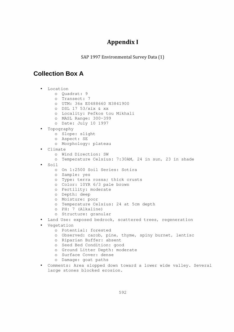
592
Appendix I
SAP 1997 Environmental Survey Data (1)
Collection Box A
• Location o Quadrat: 9 o Transect: 7 o UTM: 36s E0488660 N3841900 o DSL 17 53/xix & xx o Locality: Pefkos tou Mikhali o MASL Range: 300-399 o Date: July 10 1997
• Topography o Slope: slight o Aspect: SE o Morphology: plateau
• Climate o Wind Direction: SW o Temperature Celsius: 7:30AM, 24 in sun, 23 in shade
• Soil o On 1:2500 Soil Series: Sotira o Sample: yes o Type: terra rossa; thick crusts o Color: 10YR 6/3 pale brown o Fertility: moderate o Depth: deep o Moisture: poor o Temperature Celsius: 24 at 5cm depth o PH: 7 (Alkaline) o Structure: granular
• Land Use: exposed bedrock, scattered trees, regeneration • Vegetation
o Potential: forested o Observed: carob, pine, thyme, spiny burnet, lentisc o Riparian Buffer: absent o Seed Bed Condition: good o Ground Litter Depth: moderate o Surface Cover: dense o Damage: goat paths
• Comments: Area slopped down toward a lower wide valley. Several large stones blocked erosion.
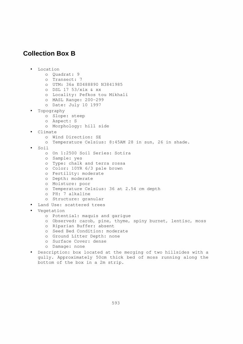
593
Collection Box B
• Location o Quadrat: 9 o Transect: 7 o UTM: 36s E0488890 N3841985 o DSL 17 53/xix & xx o Locality: Pefkos tou Mikhali o MASL Range: 200-299 o Date: July 10 1997
• Topography o Slope: steep o Aspect: S o Morphology: hill side
• Climate o Wind Direction: SE o Temperature Celsius: 8:45AM 28 in sun, 26 in shade.
• Soil o On 1:2500 Soil Series: Sotira o Sample: yes o Type: chalk and terra rossa o Color: 10YR 6/3 pale brown o Fertility: moderate o Depth: moderate o Moisture: poor o Temperature Celsius: 36 at 2.54 cm depth o PH: 7 alkaline o Structure: granular
• Land Use: scattered trees • Vegetation
o Potential: maquis and garigue o Observed: carob, pine, thyme, spiny burnet, lentisc, moss o Riparian Buffer: absent o Seed Bed Condition: moderate o Ground Litter Depth: none o Surface Cover: dense o Damage: none
• Description: box located at the merging of two hillsides with a gully. Approximately 50cm thick bed of moss running along the bottom of the box in a 2m strip.

594
Collection Box C
• Location o Quadrat: 12 o Transect: 1 o UTM: 36s E0491980 N3840650 o DSL 17 53/xxi o Locality: Kokkinospilios o MASL Range: 100-199 o Date: July 13 1997
• Topography o Slope: flat o Aspect: - o Morphology: riverbed
• Climate o Wind Direction: - o Temperature Celsius: 8:17AM, 28 in sun, 24 in shade
• Soil o On 1:2500 Soil Series: NA, Water o Sample: yes o Type: clayey sand o Color: 2.5YR 7/2 pale red o Fertility: moderate o Depth: shallow o Moisture: poor o Temperature Celsius: 23 at 5cm depth o PH: 7 (Alkaline) o Structure: not recorded
• Land Use: irrigated cultivation, gravel quarry • Vegetation
o Potential: regeneration o Observed: reeds, pistacia, gorse, reeds, oleander, moss o Riparian Buffer: present o Seed Bed Condition: - o Ground Litter Depth: - o Surface Cover: dense o Damage: pollution, human interference, quarrying
• Comments: Located in Kouris River bed are has been severely impacted by modern agricultural and quarry activity.
Collection Box D
• Location o Quadrat: 12 o Transect: 1

595
o UTM: 36s E0491980 N3840870 o DSL 17 53/xxi o Locality: Kokkinospilios o MASL Range: 100-199 o Date: July 15 1997
• Topography o Slope: slight o Aspect: SW o Morphology: riverbed
• Climate o Wind Direction: SW o Temperature Celsius: 9:10AM, 33 in sun, 32 in shade
• Soil o On 1:2500 Soil Series: NA, Water o Sample: no o Type: clayey sand o Color: - o Fertility: poor o Depth: denuded o Moisture: poor o Temperature Celsius: - o PH: 7 (Alkaline) o Structure: -
• Land Use: exposed bedrock • Vegetation
o Potential: secondary growth, regeneration o Observed: lentisc, pistiacia, gorse, reeds o Riparian Buffer: absent o Seed Bed Condition: ash o Ground Litter Depth: none o Surface Cover: bare o Damage: wildfires, pollution, quarrying
• Comments: Located in Kouris River Valley. Severely bulldozed and artificially raised. Large amount of bulldozed igneous stones quarried from the riverbed for gravel.
Collection Box E
• Location o Quadrat: 12 o Transect: 1 o UTM: 36s E0491850 N3840760 o DSL 17 53/xxi o Locality: Kokkinospilios o MASL Range: 100-199 o Date: July 13 1997
• Topography o Slope: flat

596
o Aspect: - o Morphology: riverbed
• Climate o Wind Direction: - o Temperature Celsius: 9:32AM, - in sun, 21 in shade
• Soil o On 1:2500 Soil Soil Series: Alassa o Sample: yes o Type: imported soils -terra rossa; loam o Color: 10YR 3/2 very dark grayish brown o Fertility: good o Depth: deep o Moisture: excellent o Temperature Celsius: 33 at 5cm depth o PH: 8 (Alkaline) o Structure: blocky
• Land Use: irrigated cultivation • Vegetation
o Potential: plantation o Observed: citrus grove, apple, fig, olive, peach, apricot o Riparian Buffer: absent o Seed Bed Condition: - o Ground Litter Depth: none o Surface Cover: bare o Damage: completely man made environment
• Comments: Located in Kouris River bed on an artificial raised cultivated field. Nearby spring tapped and pumped.
Collection Box F
• Location o Quadrat: 12 o Transect: 3 o UTM: 36s E0491210 N3840840 o DSL 17 53/xxi o Locality: Khortotpin o MASL Range: 200-299 o Date: July 13 1997
• Topography o Slope: slight o Aspect: SW o Morphology: plateau
• Climate o Wind Direction: SW o Temperature Celsius: 4:30PM, 36 in sun, 33 in shade
• Soil o On 1:2500 Soil Soil Series: Tymbou o Sample: no

597
o Type: mottled terra rossa o Color: - o Fertility: poor o Depth: denuded o Moisture: poor o Temperature Celsius: 45 at 5cm depth o PH: 7 (Alkaline) o Structure: granular
• Land Use: exposed rock; scattered trees olive, pine • Vegetation
o Potential: secondary growth o Observed: regeneration, pine, wild wheat, lentisc, gorse,
thyme o Riparian Buffer: absent o Seed Bed Condition: ash o Ground Litter Depth: none o Surface Cover: sparse o Damage: wild fire
• Comments: expose bedrock shelf eroded by flash flood. Plateau drops off steeply to north. Trees consist mostly of Turkish pine. Also observed a felled wild olive tree.
Collection Box G
• Location o Quadrat: 11 o Transect: 3 o UTM: 36s E0490280 N3842180 o DSL 17 53/xx & xxi o Locality: Aspri Moutti o MASL Range: 200-299 o Date: July 15 1997
• Topography o Slope: slight o Aspect: S o Morphology: gully
• Climate o Wind Direction: - o Temperature Celsius: 5:25PM, 35 in sun, 34 in shade
• Soil o On 1:2500 Soil Soil Series: Tymbou o Sample: no o Type: clay o Color: - o Fertility: - o Depth: denuded - o Moisture: excellent o Temperature Celsius: 31 at 5cm depth

598
o PH: 5 o Structure: -
• Land Use: exposed rock • Vegetation
o Potential: maquis o Observed: oleander, reeds, star reeds, lentisc, myrtle,
oak, wild olive o Riparian Buffer: dense o Seed Bed Condition: - o Ground Litter Depth: - o Surface Cover: moderate o Damage: -
• Comments: there is a large amount of observable evidence for wildlife such as frogs, tadpoles, dragonflies, and fox due to presence of water. The area was considerably dried out on second visit, however.
Collection Box H
• Location o Quadrat: 11 o Transect: 6 o UTM: 36s E0490351 N3841735 o DSL 17 53/xx & xxi o Locality: Aspri Moutti o MASL Range: 200-299 o Date: July 16 1997
• Topography o Slope: steep o Aspect: NE o Morphology: gully
• Climate o Wind Direction: SW o Temperature Celsius: 3:30PM, 45 in sun, 35 in shade
• Soil o On 1:2500 Soil Soil Series: Tymbou o Sample: no o Type: loam o Color: 5yr 3/3 dark reddish brown o Fertility: moderate o Depth: moderate o Moisture: poor o Temperature Celsius: 51 at 5cm depth o PH: 7 (Alkaline) o Structure: granular
• Land Use: exposed rock; scattered trees, olive • Vegetation
o Potential: natural, maquis, garigue

599
o Observed: rock rose, wild wheat, carob, gorse, garigue, maquis
o Riparian Buffer: absent o Seed Bed Condition: moderate o Ground Litter Depth: slight o Surface Cover: dense o Damage: goat, moderate erosion.
• Comments: this area is heavily damaged by goat paths.
Collection Box I
• Location o Quadrat: 11 o Transect: 6 o UTM: 36s E0490400 N3841900 o DSL 17 53/xx & xxi o Locality: Aspri Moutti o MASL Range: 200-299 o Date: July 16 1997
• Topography o Slope: very steep o Aspect: S o Morphology: gully
• Climate o Wind Direction: - o Temperature Celsius: 4:50PM, 35 in sun, 28 in shade
• Soil o On 1:2500 Soil Soil Series: Tymbou o Sample: no o Type: - o Color: - o Fertility: - o Depth: - o Moisture: - o Temperature Celsius: - o PH: - o Structure: -
• Land Use: exposed rock • Vegetation
o Potential: natural o Observed: carob, lentisc, oleander, oak, pistachio,
ferns, fig trees o Riparian Buffer: dense o Seed Bed Condition: - o Ground Litter Depth: - o Surface Cover: dense o Damage: -
• Comments: Most lush box visited in project area near small deep stream/gully. Detailed investigation of this Box was impossible

600
because of thick vegetation cover and steep terrain. Comparatively large trees in this area.
Collection Box J
• Location o Quadrat: 01 o Transect: 2 o UTM: 36s E0480462 N3841810 o DSL 17 52/xxiv o Locality: Khoglaka o MASL Range: 200-299 o Date: July 21 1997
• Topography o Slope: slight o Aspect: SW o Morphology: plateau
• Climate o Wind Direction: SW o Temperature Celsius: 9:00AM, 38 in sun, 31 in shade
• Soil o On 1:2500 Soil Soil Series: UNK o Sample: yes o Type: terra rossa with stones o Color: 5yr 3/4 dark reddish brown o Fertility: poor o Depth: shallow o Moisture: poor o Temperature Celsius: 32 at 4cm depth o PH: 7 (Alkaline) o Structure: granular
• Land Use: scattered trees olive, pine • Vegetation
o Potential: garigue and maquis o Observed: carob, lentisc, pistacia bushes, wild wheat,
olive thistle, gorse o Riparian Buffer: absent o Seed Bed Condition: poor o Ground Litter Depth: none o Surface Cover: sparse o Damage: wild fire, goat paths
• Comments: box located on a long flat plateau in the Paramali area. Evidence for wild fire approximately 2-4 years prior to visit. Close proximity to Box K
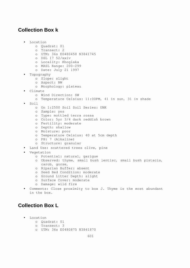
601
Collection Box k
• Location o Quadrat: 01 o Transect: 2 o UTM: 36s E0480458 N3841745 o DSL 17 52/xxiv o Locality: Khoglaka o MASL Range: 200-299 o Date: July 21 1997
• Topography o Slope: slight o Aspect: NW o Morphology: plateau
• Climate o Wind Direction: SW o Temperature Celsius: 11:00PM, 41 in sun, 31 in shade
• Soil o On 1:2500 Soil Soil Series: UNK o Sample: yes o Type: mottled terra rossa o Color: 5yr 3/4 dark reddish brown o Fertility: moderate o Depth: shallow o Moisture: poor o Temperature Celsius: 40 at 5cm depth o PH: 7 (Alkaline) o Structure: granular
• Land Use: scattered trees olive, pine • Vegetation
o Potential: natural, garigue o Observed: thyme, small bush lentisc, small bush pistacia,
carob, gorse, o Riparian Buffer: absent o Seed Bed Condition: moderate o Ground Litter Depth: slight o Surface Cover: moderate o Damage: wild fire
• Comments: Close proximity to box J. Thyme is the most abundant in the box.
Collection Box L
• Location o Quadrat: 01 o Transect: 3 o UTM: 36s E0480875 N3841870

602
o DSL 17 52/xxiv o Locality: Hajina o MASL Range: 100-199 o Date: July 24 1997
• Topography o Slope: moderate o Aspect: N o Morphology: hillside
• Climate o Wind Direction: - o Temperature Celsius: 7:30AM, 34 in sun, 30 in shade
• Soil o On 1:2500 Soil Soil Series: Pakhana o Sample: no o Type: chalky terra rossa o Color: - o Fertility: moderate o Depth: shallow o Moisture: poor o Temperature Celsius: 33 at 5cm depth o PH: 7 (Alkaline) o Structure: granular
• Land Use: exposed rock; scattered trees olive • Vegetation
o Potential: natural, maquis, wild wheat/barley o Observed: regeneration, gorse, thyme, wild olive, bush
carob, lentisc, wild wheat/barley o Riparian Buffer: absent o Seed Bed Condition: poor o Ground Litter Depth: none o Surface Cover: dense o Damage: wild fire, sever erosion
• Comments: old olive trees shows signs of old fires.
Collection Box M
• Location o Quadrat: 01 o Transect: 3 o UTM: 36s E0480980 N3842025 o DSL 17 52/xxiv o Locality: Hajina o MASL Range: 200-299 o Date: July 24 1997
• Topography o Slope: slight o Aspect: SE o Morphology: plateau
• Climate
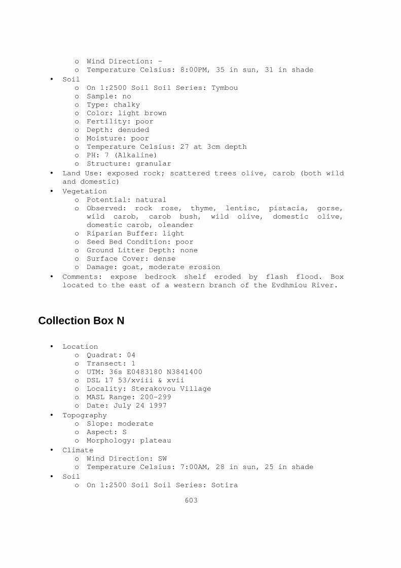
603
o Wind Direction: - o Temperature Celsius: 8:00PM, 35 in sun, 31 in shade
• Soil o On 1:2500 Soil Soil Series: Tymbou o Sample: no o Type: chalky o Color: light brown o Fertility: poor o Depth: denuded o Moisture: poor o Temperature Celsius: 27 at 3cm depth o PH: 7 (Alkaline) o Structure: granular
• Land Use: exposed rock; scattered trees olive, carob (both wild and domestic)
• Vegetation o Potential: natural o Observed: rock rose, thyme, lentisc, pistacia, gorse,
wild carob, carob bush, wild olive, domestic olive, domestic carob, oleander
o Riparian Buffer: light o Seed Bed Condition: poor o Ground Litter Depth: none o Surface Cover: dense o Damage: goat, moderate erosion
• Comments: expose bedrock shelf eroded by flash flood. Box located to the east of a western branch of the Evdhmiou River.
Collection Box N
• Location o Quadrat: 04 o Transect: 1 o UTM: 36s E0483180 N3841400 o DSL 17 53/xviii & xvii o Locality: Sterakovou Village o MASL Range: 200-299 o Date: July 24 1997
• Topography o Slope: moderate o Aspect: S o Morphology: plateau
• Climate o Wind Direction: SW o Temperature Celsius: 7:00AM, 28 in sun, 25 in shade
• Soil o On 1:2500 Soil Soil Series: Sotira

604
o Sample: no o Type: terra rossa o Color: - o Fertility: moderate o Depth: shallow o Moisture: poor o Temperature Celsius: 27 at 6cm depth o PH: 7 (Alkaline) o Structure: granular
• Land Use: exposed rock; scattered trees, olive, pine • Vegetation
o Potential: garigue, wild wheat/barley o Observed: stunted growth olives, lavender, rock rose,
thyme, pine, small gorse, coppiced carob, wild wheat/barley
o Riparian Buffer: absent o Seed Bed Condition: ash o Ground Litter Depth: none o Surface Cover: sparse o Damage: goat
• Comments: in Sterakovou village, goats trample and browsing damage, and coppicing. Much of the vegetation is stunted. Pine trees in cluster.
Collection Box O
• Location o Quadrat: 13 o Transect: 1 o UTM: 36s E0481400 N3837600 o DSL 17 53/xxv o Locality: Eliophorin o MASL Range: 0-99 o Date: July 31 1997
• Topography o Slope: slight o Aspect: E o Morphology: riverbed
• Climate o Wind Direction: - o Temperature Celsius: 7:00AM, 24 in sun, 21 in shade
• Soil o On 1:2500 Soil Soil Series: Tymbou o Sample: yes o Type: clay with surface crusts o Color: 10YR 7/2 light gray o Fertility: good o Depth: deep

605
o Moisture: poor o Temperature Celsius: 22 at 3cm depth o PH: 7 (Alkaline) o Structure: granular
• Land Use: grass pasture; fallow not ploughed; olive orchards; wild and cultivated olive and carob
• Vegetation o Potential: agricultural, regeneration o Observed: both domestic and wild olive and carob, wild
garlic, spiny burnet, pistacia, thistle, fennel, large carob and olive, regeneration vegetation
o Riparian Buffer: light o Seed Bed Condition: poor o Ground Litter Depth: none o Surface Cover: moderate o Damage: goat paths, limited erosion
• Comments: Paramali River area. Box is located in an extremely lush area with many old olives and carobs of considerable height
Collection Box P
• Location o Quadrat: 13 o Transect: 2 o UTM: 36s E0481250 N3837850 o DSL 17 53/xxv o Locality: Jelia o MASL Range: 0-99 o Date: July 31 1997
• Topography o Slope: moderate o Aspect: SE o Morphology: hillside
• Climate o Wind Direction: SW o Temperature Celsius: 8:00AM, 30 in sun, 28 in shade
• Soil o On 1:2500 Soil Soil Series: Sotira o Sample: no o Type: - o Color: light brown o Fertility: good o Depth: - o Moisture: poor o Temperature Celsius: 26 at 5cm depth o PH: 7 (Alkaline)

606
o Structure: granular • Land Use: exposed bedrock; olive orchards; wild and cultivated
olive and carob • Vegetation
o Potential: agricultural, maquis, garigue o Observed: both domestic and wild olive and carob,
regeneration vegetation, large juniper (approximately 3M), gorse, lentisc, lavender, broom, thistle, asparagus, thyme, wild wheat/ barley
o Riparian Buffer: absent o Seed Bed Condition: poor o Ground Litter Depth: slight o Surface Cover: dense o Damage: extensive goat or sheep paths
• Comments: Paramali area. Sheep have been grazing in area as attested to by the presence of wool clumps on several prickly bushes.
Collection Box Q
• Location o Quadrat: 13 o Transect: 4 o UTM: 36s E0481250 N3838000 o DSL 17 53/xxv o Locality: Jelia o MASL Range: 0-99 o Date: July 31 1997
• Topography o Slope: flat o Aspect: - o Morphology: plateau
• Climate o Wind Direction: SW o Temperature Celsius: 8:30AM, 34 in sun, 27 in shade
• Soil o On 1:2500 Soil Soil Series: Tymbou o Sample: yes o Type: loam o Color: 7.5YR 3/2 dark brown o Fertility: poor o Depth: denuded o Moisture: poor o Temperature Celsius: 30 at 2cm depth o PH: 7 (Alkaline) o Structure: granular
• Land Use: exposed bedrock; scattered trees

607
• Vegetation o Potential: pasture, agriculture o Observed: wild barley, carob o Riparian Buffer: absent o Seed Bed Condition: poor o Ground Litter Depth: none o Surface Cover: sparse o Damage: extensive goat paths, moderate erosion
• Comments: Paramali River area, Goats eating wild barley. Clasping terraces causing erosion.
Collection Box R
• Location o Quadrat: 13 o Transect: 7 o UTM: 36s E0481040 N3838113 o DSL 17 53/xxv o Locality: Jelia o MASL Range: 0-99 o Date: July 31 1997
• Topography o Slope: moderate o Aspect: W o Morphology: hillside
• Climate o Wind Direction: SW o Temperature Celsius: 9:30AM, 34 in sun, 29 in shade
• Soil o On 1:2500 Soil Soil Series: Pissouri o Sample: no o Type: - o Color: - o Fertility: poor o Depth: shallow o Moisture: poor o Temperature Celsius: 27 at 1cm depth o PH: 7 (Alkaline) o Structure: granular
• Land Use: exposed bedrock, scattered trees, wild olive and carob
• Vegetation o Potential: maquis, garigue, wild wheat/barley o Observed: thyme, large juniper (approximately 3m),
lentisc, pistacia, gorse, wild wheat/barley o Riparian Buffer: absent o Seed Bed Condition: poor

608
o Ground Litter Depth: slight o Surface Cover: dense o Damage: goat paths, limited erosion
• Comments: Paramali area, hillside not terraced. Thyme is abundant.
Collection Box S
• Location o Quadrat: 15 o Transect: 6 o UTM: 36s E0481579 N3835920 o DSL 17 53/xxv o Locality: Armirithkia o MASL Range: 0-99 o Date: August 6 1997
• Topography o Slope: moderate o Aspect: S o Morphology: coastal plain
• Climate o Wind Direction: - o Temperature Celsius: 7:30AM, 25 in sun, 22 in shade
• Soil o On 1:2500 Soil Soil Series: Zyyi o Sample: yes o Type: sand o Color: 10YR 6/4 light yellowish brown o Fertility: moderate o Depth: moderate o Moisture: poor o Temperature Celsius: 24 at 9cm depth o PH: 7 (Alkaline) o Structure: granular
• Land Use: river mouth • Vegetation
o Potential: natural coastal maquis o Observed: lentisc o Riparian Buffer: light o Seed Bed Condition: - o Ground Litter Depth: - o Surface Cover: moderate o Damage: goat paths, limited erosion
• Comments: Box Located at end of valley with soil outcrops in some scrub areas and seaweed ground cover.

609
Collection Box T
• Location o Quadrat: 13 o Transect: 1 o UTM: 36s E0481050 N3836050 o DSL 17 53/xxv o Locality: Prolimnos o MASL Range: 0-99 o Date: August 6 1997
• Topography o Slope: slight o Aspect: S o Morphology: river mouth, coastal plain
• Climate o Wind Direction: SW o Temperature Celsius: 8:30AM, 23 in sun, 22 in shade
• Soil o On 1:2500 Soil Soil Series: Zyyi o Sample: no o Type: sand o Color: red, blue. Black, green, yellow, gray o Fertility: poor o Depth: shallow o Moisture: poor o Temperature Celsius: 22 at 5cm depth o PH: 7 (Alkaline) o Structure: granular
• Land Use: grass pasture; fallow not ploughed; olive orchards; wild and cultivated olive and carob
• Vegetation o Potential: natural o Observed: reeds, bamboo, gorse, juniper, wild garlic,
fennel, shrubs o Riparian Buffer: dense o Seed Bed Condition: poor o Ground Litter Depth: slight o Surface Cover: dense o Damage: moderate erosion, slight human activity
• Comments: Pharkonias River mouth area, abundant wild life: lizards, birds, foxes, snakes, mouse and shrew.
Collection Box U
• Location o Quadrat: 15 o Transect: 6

610
o UTM: 36s E0481650 N3836425 o DSL 17 53/xxv o Locality: Vateri o MASL Range: 0-99 o Date: August 6 1997
• Topography o Slope: slight o Aspect: S o Morphology: coastal plain
• Climate o Wind Direction: SW o Temperature Celsius: 9:00AM, 30 in sun, 28 in shade
• Soil o On 1:2500 Soil Soil Series: Zyyi o Sample: yes o Type: loam o Color: 10YR 7/2 light gray o Fertility: good o Depth: deep o Moisture: poor o Temperature Celsius: 25 at 7cm depth o PH: 7 (Alkaline) o Structure: blocky and granular in some places
• Land Use: ploughed/ dry cultivation, irrigated cultivation, vineyard, citrus, alfalfa, plantation
• Vegetation o Potential: coastal maquis o Observed: vineyard, citrus, alfalfa, Cypress, reeds o Riparian Buffer: absent o Seed Bed Condition: moderate o Ground Litter Depth: none o Surface Cover: dense o Damage: -
• Comments: 84 vines are located within the 30m x 30m box. The vines are 2m apart on average. Cypress trees serve as a windbreak between the intercropped blocks.
Collection Box V
• Location o Quadrat: 15 o Transect: 9 o UTM: 36s E0481969 N3835797 o DSL 17 53/xxv o Locality: Mouzomena o MASL Range: 0-99 o Date: August 6 1997
• Topography
611
o Slope: steep o Aspect: SW o Morphology: coastal plain
• Climate o Wind Direction: - o Temperature Celsius: 9:40AM, 32 in sun, 26 in shade
• Soil o On 1:2500 Soil Soil Series: Tymbou o Sample: no o Type: exposed bedrock with very thin soil o Color: - o Fertility: - o Depth: - o Moisture: - o Temperature Celsius: - o PH: - o Structure: -
• Land Use: exposed bedrock, scattered scrub • Vegetation
o Potential: secondary growth, garigue o Observed: juniper, rock rose, thyme, gorse, lentisc, wild
carob o Riparian Buffer: absent o Seed Bed Condition: poor o Ground Litter Depth: none o Surface Cover: sparse o Damage: storm damage, erosion, wind damage
• Comments: Located on a small peninsula along coastal plain east of the Pharkonias River. This site lies just to the west of the WSBA. In general, the maquis is taller toward the sea.
Collection Box W
• Location o Quadrat: 15 o Transect: 5 o UTM: 36s E0481900 N3835900 o DSL 17 53/xxv o Locality: Armirithkia o MASL Range: 0-99 o Date: August 6 1997
• Topography o Slope: slight o Aspect: E o Morphology: coastal plain
• Climate o Wind Direction: - o Temperature Celsius: 7:00AM, 24 in sun, 23 in shade

612
• Soil o On 1:2500 Soil Soil Series: Zyyi o Sample: no o Type: mottled loam o Color: - o Fertility: good o Depth: deep o Moisture: poor o Temperature Celsius: 22 at 7cm depth o PH: 7 (Alkaline) o Structure: blocky
• Land Use: fallow, dry cultivation, citrus, plantation • Vegetation
o Potential: costal maquis o Observed: wild wheat o Riparian Buffer: absent o Seed Bed Condition: moderate o Ground Litter Depth: none o Surface Cover: sparse o Damage: limited erosion
• Comments: lemon citrus plantation.
Collection Box X
• Location o Quadrat: 04 o Transect: 1 o UTM: 36s E0483327 N3841095 o DSL 17 53/xviii & xvii o Locality: Sterakovou Village o MASL Range: 200-299 o Date: August 13 1997
• Topography o Slope: moderate o Aspect: S o Morphology: streambed, by spring head
• Climate o Wind Direction: SW o Temperature Celsius: 10:15AM, 29 in sun, 26 in shade
• Soil o On 1:2500 Soil Soil Series: Sotira o Sample: yes o Type: Chalky o Color: 10YR 6/3 pale brown o Fertility: - o Depth: denuded o Moisture: poor o Temperature Celsius: - o PH: 7 (Alkaline)
613
o Structure: granular • Land Use: scattered trees • Vegetation
o Potential: maquis o Observed: large carob, olive, lentisc o Riparian Buffer: absent o Seed Bed Condition: poor o Ground Litter Depth: none o Surface Cover: bare o Damage: goat, human use
• Comments: spring which supplies Sterakovou village.
Collection Box Y
• Location o Quadrat: 04 o Transect: 4 o UTM: 36s E0483425 N3841220 o DSL 17 53/xviii & xvii o Locality: Sterakovou Village o MASL Range: 200-299 o Date: August 13 1997
• Topography o Slope: moderate o Aspect: NW o Morphology: hillside
• Climate o Wind Direction: N o Temperature Celsius: 10:45AM, 33 in sun, 30 in shade
• Soil o On 1:2500 Soil Soil Series: Built up land o Sample: yes o Type: chalky o Color: 10YR 4/2 dark grayish brown o Fertility: poor o Depth: denuded o Moisture: poor o Temperature Celsius: 40 at 1cm depth o PH: 7 (Alkaline) o Structure: granular
• Land Use: exposed bedrock, scattered trees, low scrub • Vegetation
o Potential: agricultural, regeneration o Observed: carob, lentisc, rock rose, spiny burnet, o Riparian Buffer: absent o Seed Bed Condition: poor o Ground Litter Depth: none o Surface Cover: sparse
614
o Damage: goat, limited erosion, wild fire, human use • Comments: 30m from spring in collection box X.
Collection Box Z
• Location o Quadrat: 04 o Transect: 5 o UTM: 36s E0483490 N3840930 o DSL 17 53/xviii & xvii o Locality: Makries o MASL Range: 0-99 o Date: August 13 1997
• Topography o Slope: slight o Aspect: SW o Morphology: hillside
• Climate o Wind Direction: NW o Temperature Celsius: 11:15AM, 31 in sun, 29 in shade
• Soil o On 1:2500 Soil Soil Series: Sotira o Sample: yes o Type: chalky o Color: 7.5YR 5/2 brown o Fertility: poor o Depth: shallow o Moisture: poor o Temperature Celsius: 38 at 2cm depth o PH: 7 (Alkaline) o Structure: granular
• Land Use: grass pasture; olive; wild cultivated olive and carob, scrub
• Vegetation o Potential: regeneration, maquis o Observed: olive and carob, spiny burnet, lentisc, gorse o Riparian Buffer: absent o Seed Bed Condition: poor o Ground Litter Depth: none o Surface Cover: moderate o Damage: goat paths, limited erosion
• Comments: Sterakovou village.

615
616
Appendix II
SAP 1997 Environmental Survey Data (2)
Flora
1) Alkanna iehmanii Boraginaceae (dyer’s alkanet/alkanna asteria, vaphoriza)
2) Allium ampeloprasum (wild leek/agrioprasso)Ceratonia siliqua (carob tree/charoupia)
3) Calycotome villosa (prickly broom/raksi) 4) Capparis spinosa (caper/kapparka) 5) Cardopatium corymbosum (cardopatium/opyros) 6) Cistus
a. Cistus supp (rock rose/psistraks) b. Cistus monspeliensis L. cistaceae (rock rose/xystarka) c. Cistus villosus certicus (rock rose/xystarka)
7) Convolvulus althaeoides (mallow-leaved bindweed/potiraki) 8) Eryngium creticum (eryngo/pangallos) 9) Ficus carica (fig tree/sykia) 10) Genista sphacelata (gorse/raksi) 11) Helichrysum stoechas Compositae (everlasting sun gold/thakria
tis panagias) 12) Heliotrope europaeum (helitrope/heliotropia) 13) Juniperus phoenicea (Phoenician juniper/cupressaceae) 14) Lavendula stoechas (French lavender/myrofora) 15) Nerium oleander (oleander/arodaphne) 16) Olea europea (olive tree/elaia) 17) Origanum dubium (oregano/rigani) 18) Pinus Bruta (Aleppo or Calabrian pine/agriopevkos) 19) Pistacia lentiscus (lentisc/shinos) 20) Pistacia terebinthus (terebinth/kokkorevithia) 21) Polygonum aviculare L. (knotgrass/polygonatos) 22) Ptilostemon chamaepeuce (chamapeuce/kirsio) 23) Rhamnus oleoides (buckthorn/akoumeni) 24) Rubus Sanctus (bramble, blackberry/vatos, vramos) 25) Sarcopoterium spinosum (spiny burnet/mazi) 26) Scolymus hispanicus (Spanish oyster plant/chrisangatho) 27) Teucrium micropodiodes Labiatae (germander/miteres) 28) Thymus capitatus (thyme/throumbi) 29) Thymus integer (wild thyme/livanitis) 30) Trifolium purpureum Lois (purple clover/agrio triphylli) 31) Trifolium stellatum (star clover/triphylli)
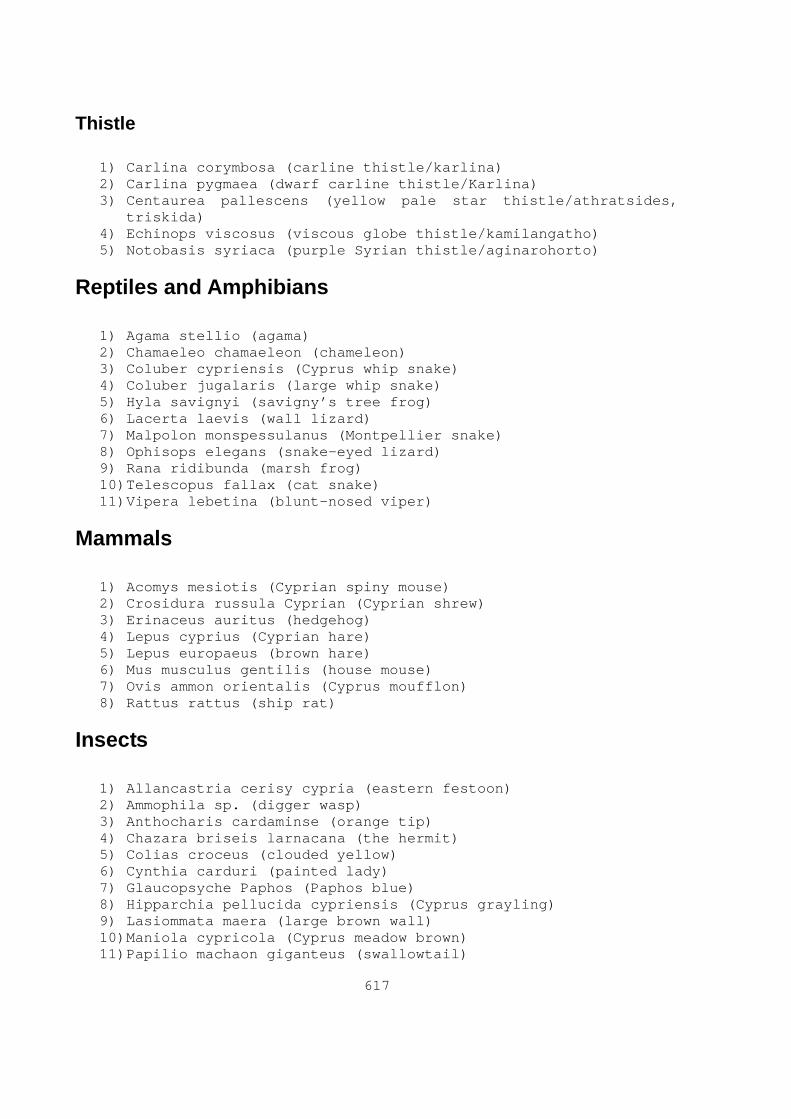
617
Thistle
1) Carlina corymbosa (carline thistle/karlina) 2) Carlina pygmaea (dwarf carline thistle/Karlina) 3) Centaurea pallescens (yellow pale star thistle/athratsides,
triskida) 4) Echinops viscosus (viscous globe thistle/kamilangatho) 5) Notobasis syriaca (purple Syrian thistle/aginarohorto)
Reptiles and Amphibians
1) Agama stellio (agama) 2) Chamaeleo chamaeleon (chameleon) 3) Coluber cypriensis (Cyprus whip snake) 4) Coluber jugalaris (large whip snake) 5) Hyla savignyi (savigny’s tree frog) 6) Lacerta laevis (wall lizard) 7) Malpolon monspessulanus (Montpellier snake) 8) Ophisops elegans (snake-eyed lizard) 9) Rana ridibunda (marsh frog) 10) Telescopus fallax (cat snake) 11) Vipera lebetina (blunt-nosed viper)
Mammals
1) Acomys mesiotis (Cyprian spiny mouse) 2) Crosidura russula Cyprian (Cyprian shrew) 3) Erinaceus auritus (hedgehog) 4) Lepus cyprius (Cyprian hare) 5) Lepus europaeus (brown hare) 6) Mus musculus gentilis (house mouse) 7) Ovis ammon orientalis (Cyprus moufflon) 8) Rattus rattus (ship rat)
Insects
1) Allancastria cerisy cypria (eastern festoon) 2) Ammophila sp. (digger wasp) 3) Anthocharis cardaminse (orange tip) 4) Chazara briseis larnacana (the hermit) 5) Colias croceus (clouded yellow) 6) Cynthia carduri (painted lady) 7) Glaucopsyche Paphos (Paphos blue) 8) Hipparchia pellucida cypriensis (Cyprus grayling) 9) Lasiommata maera (large brown wall) 10) Maniola cypricola (Cyprus meadow brown) 11) Papilio machaon giganteus (swallowtail)

618
12) Pararge aegeria (speckled wood) 13) Pieris brassicae (large white) 14) Polyommatus icarus (common blue) 15) Vanessa atalanta (red admiral)
Birds
1) Alectoris chukar (chukar) 2) Apus Apus (swift) 3) Buteo buteo (buzzard) 4) Columba livia (rock dove) 5) Columba palumbus (wood pigeon) 6) Falco eleonorae (eleonora’s falcon) 7) Falco tinnunculus (kestrels) 8) Hirundo daurica (red rumped swallow) 9) Hirundo rustica (swallow) 10) Oenanthe pleschanka (pied wheatears) 11) Pernis apivorus (honey buzzard) 12) Pica pica (magpie) 13) Streptopelia turtur (turtle dove) 14) Turdus merula (blackbird)

619
Appendix III
SAP 1997 Loci Catalogue
Locus: 97-01
Quadrat: 11 DLS 17: 53/XX & XXI Quadrat Cadastral plan: 36,44,37 and 45 Locality: Aspri Moutti UTM: 36s E490638 N3842358 MASL: 306 Topographic Setting: Plateau, uncultivated field w/trees 1HA Slope Grade: 1% Aspect: Southwest Distance to water: Over 500m to stream Estimated Area: 1853m 2
Visible Feature(s): Walls, architectural blocks and a mill stone Suggested Date & Function: LR-BYZ, Farmstead complex Site Condition: Excellent Erosion: none Research Potential: High Surface Assemblage: Poor Digital/Regular Photographs: Yes Status: Site visited by Limassol District officer on June 26 2004 and entered onto cadastral plan. Comments: -
Locus: 97-02
Quadrat: 11 DLS 17: 53/XX & XXI Quadrat Cadastral plan: 36,44,37 and 45 Locality: Aspri Moutti UTM: 36s E490782 N3841313 MASL: 224 Topographical Setting: Mid-slope bench 1HA Slope Grade: 40% Aspect: Southwest Distance to water: Over 500m to stream Estimated Area: 2401m 2
Visible Feature(s): Walls Suggested Date & Function: LR-BYZ, Farmstead w/Hell-ROM component? Site Condition: Poor Erosion: High

620
Research Potential: Low Surface Assemblage: Poor Digital/Regular Photographs: Yes Status: Site visited by Limassol District officer on June 26 2004 and entered onto cadastral plan. Comments: -
Locus: 97-03
Quadrat: 06 DLS 17: 53/xviii & xix Quadrat Cadastral plan: 34,35,42 and 45 Locality: Kyparissovounos UTM: 36s E485135 N3840581 MASL: 282 Topographical Setting: Ridge overlooking uncultivated field 1HA Slope Grade: 1% Aspect: Southwest Distance to water: Over 500m to spring Estimated Area: 3303m 2
Visible Feature(s): A rchitectural blocks Suggested Date & Function: LR-BYZ, Cemetery Site Condition: Looted Erosion: Low Research Potential: Low Surface Assemblage: Poor Digital/Regular Photographs: Yes Status: Site visited by Limassol District officer on June 26 2004 and entered onto cadastral plan. Comments: -
Locus: 97-04
Quadrat: 06 DLS 17: 53/xviii & xix Quadrat Cadastral plan: 34,35,42 and 43 Locality: Vathkia Jilla UTM: 36s E484896 N3841081 MASL: 318 Topographical Setting: Plateau edge, uncultivated field 1HA Slope Grade: 10% Aspect: Southwest Distance to water: Over 500m to spring Estimated Area: 3579m 2
Visible Feature(s): Walls & architectural blocks Suggested Date & Function: LR/BYZ, Farmstead Site Condition: Fair, in danger from stone miners

621
Erosion: Low Research Potential: Moderate Surface Assemblage: Moderate Digital/Regular Photographs: Yes Status: Site visited by Limassol District officer on June 26 2004 and entered onto cadastral plan. Comments: -
Locus: 97-05
Quadrat: 05 DLS 17: 53/xviii Quadrat Cadastral plan: 34 and 42 Locality: Drousha tou Lakkou UTM: 36s E484561 N3841720 MASL: 350 Topographical Setting: Plateau, uncultivated field 1HA Slope Grade: 8% Aspect: South Distance to water: Over 500m to spring Estimated Area: 6515m 2
Visible Feature(s): Walls & architectural blocks Suggested Date & Function: LR/BYZ, Farmstead Site Condition: Excellent, in danger from stone miners Erosion: low Research Potential: High Surface Assemblage: Excellent Digital/Regular Photographs: Yes Status: Site visited by Limassol District officer on June 26 2004 and entered onto cadastral plan. Comments: -
Locus: 97-06
Quadrat: 05 DLS 17: 53/xviii Quadrat Cadastral plan: 34 and 42 Locality: Drousha tou Lakkou UTM: 36s E484926 N3841524 MASL: 362 Topographical Setting: Plateau, Uncultivated field 1HA Slope Grade: 8% Aspect: South Distance to water: Over 500m to spring Estimated Area: 1682m 2
Visible Feature(s): Walls & architectural blocks Suggested Date & Function: LR/BYZ, Farmstead

622
Site Condition: Poor, bulldozed Erosion: low Research Potential: Low-moderate Surface Assemblage: Moderate Digital/Regular Photographs: Yes Status: Site visited by Limassol District officer on June 26 2004. Comments: -
Locus: 97-07
Quadrat: 11 DLS 17: 53/xx & xxi Quadrat Cadastral plan: 36, 44, 37 and 45 Locality: Pefkeri/Aspri Moutti UTM: 36s E490553 N3842461 MASL: 314 Topographical Setting: Plateau, uncultivated field 1HA Slope Grade: 9% Aspect: Southeast Distance to water: Over 500m to stream Estimated Area: Less than 400m 2
Visible Feature(s): - Suggested Date & Function: UNK, Lithic reduction and/or retouch station Site Condition: Destroyed, bulldozed Erosion: Low Research Potential: None Surface Assemblage: None Digital/Regular Photographs: No Status: - Comments: -
Locus: 97-08
Quadrat: 04 DLS 17: 53/xviii & xvii Quadrat Cadastral plan: 33, 34, 41 and 42 Locality: Sterakovou Village UTM: 36s E483352 N3841367 MASL: 290 Topographical Setting: Mid-slope bench, field 1HA Slope Grade: 12% Aspect: South Distance to water: Less than 500m to spring Estimated Area: 476m 2
Visible Feature(s): L ow wall Suggested Date & Function: LR/BYZ, Farmstead (?)

623
Site Condition: Poor Erosion: Moderate Research Potential: Low Surface Assemblage: Poor Digital/Regular Photographs: No Status: - Comment: - Associated scatter has eroded away
Locus: 97-09
Quadrat: 04 DLS 17: 53/xviii & xvii Quadrat Cadastral plan: 33, 34, 41 and 42 Locality: Dhiplojilaa UTM: 36s E483375 N3840510 MASL: 230 Topographical Setting: Plateau edge, cultivated intercropped field 1HA Slope Grade: 16% Aspect: South Distance to water: Over 500m to spring Estimated Area: 448m 2
Visible Feature(s): w alls & architectural blocks, press stones Suggested Date & Function: LR/BYZ, Farmstead with olive oil press installation Site Condition: Poor, bulldozed post 1997 Erosion: none Research Potential: Low Surface Assemblage: Moderate Digital/Regular Photographs: Yes Status: - Comments: Published by Hadjisavvas (1992), press stones are still visible in farmyard along with sherds and roof tiles fragments. Large architectural blocks are still visible in the bulldozed spoil immediately east and west of the farmyard ( Pers. Obs.).
Locus: 97-10
Quadrat: 12 DLS 17: 53/xxi Quadrat Cadastral plan: 37 & 45 Locality: Stayrolremmos UTM: 36s E492001 N3840304 MASL: 108 Topographical Setting: Foot slope above river terrace 1HA Slope Grade: 12% Aspect: West Distance to water: Less than 500m to Kouris River

624
Estimated Area: 3104m 2
Visible Feature(s): - Suggested Date & Function: Chalco settlement w/LR-BYZ component Site Condition: Poor Erosion: Moderate Research Potential: Low Surface Assemblage: Moderate Digital/Regular Photographs: Yes Status: - Comments: The Chalco material outnumbers the LR material approximately 4:1. Several terrace wall segments are visibly eroding out of the slope ( Pers. Obs.).
Locus: 97-11
Quadrat: 12 DLS 17: 53/xxi Quadrat Cadastral plan: 37 & 35 Locality: Khortotopin UTM: E491574 N3840590 MASL: 132 Topographical Setting: Mid-slope 1HA Slope Grade: 31% Aspect: East Distance to water: Less than 500m to Kouris River Estimated Area: 2238m 2
Visible Feature(s): T omb shafts Suggested Date & Function: CA, Cemetery Site Condition: Poor, looted Erosion: Moderate Research Potential: Low Surface Assemblage: Poor Digital/Regular Photographs: no Status: - Comments: -
Locus: 97-12
Quadrat: 12 DLS 17: 53/xxi Quadrat Cadastral plan: 37 & 35 Locality: Khortotopin UTM: E491673 N3840910 MASL: 140 Topographical Setting: Mid-slope 1HA Slope Grade: 12% Aspect: Southeast
625
Distance to water: Less than 500m to Kouris River Estimated Area: 8139m 2
Visible Feature(s): Tomb shafts Suggested Date & Function: CA, Cemetery Site Condition: Poor, looted Erosion: Moderate Research Potential: Low Surface Assemblage: Poor Digital/Regular Photographs: no Status: - Comments: -
Locus: 97-13
Quadrat: 01 DLS 17: 52/xxiv Quadrat Cadastral plan: 40 & 48 Locality: Pharkonia & Hajina UTM: E480919 N3841999 MASL: 184 Topographical Setting: Mid-slope, river terrace & man-made terraces 1HA Slope Grade: 21% Aspect: East Distance to water: Less than 500m to Paramali River Estimated Area: 99999m 2
Visible Feature(s): - Suggested Date & Function: EC-MC, Settlement and tombs Site Condition: Moderate, looted Erosion: Limited Research Potential: Low-moderate Surface Assemblage: Moderate Digital/Regular Photographs: No Status: - Comments: Several querns are visible in nearby terrace walls.
Locus: 97-14
Quadrat: 01 DLS 17: 52/xxiv Quadrat Cadastral plan: 40 & 48 Locality: Hajina UTM: E480917 N3842465 MASL: 208 Topographical Setting: Mid-slope, river terrace & man-made terraces 1HA Slope Grade: 14% Aspect: East Distance to water: Less than 500m to Paramali River
626
Estimated Area: 294m 2
Visible Feature(s): - Suggested Date & Function: LR-BYZ, Farmstead/outbuilding Site Condition: Poor Erosion: Moderate, abandoned dilapidated terraces Research Potential: Low Surface Assemblage: Moderate Digital/Regular Photographs: Yes Status: - Comments: Large scatter of coarse ware and large pithos body, base and rim sherds spread out across two terraces. Many sherds are eroding out from sections of the collapsed terraces ( pers obs).
Locus: 97-15
Quadrat: 15 DLS 17: 53/xxv Quadrat Cadastral plan: 49 & 57 Locality: Vathkia UTM: E481757 N3836719 MASL: 12 Topographical Setting: Foot slope, overlooking agricultural fields 1HA Slope Grade: 24% Aspect: South Distance to water: Over 500m to Frakonas River Estimated Area: 506m 2
Visible Feature(s): C istern construction material Suggested Date & Function: LR-BYZ, Cistern Site Condition: Poor Erosion: Low Research Potential: Low Surface Assemblage: Low Digital/Regular Photographs: No Status: - Comments: Large lintel or threshold block is built into nearby terrace wall. A small scatter of monochrome sherds around is visible around the cistern.
Locus: 97-16
Quadrat: 04 DLS 17: 53/xviii & xvii Quadrat Cadastral plan: 33, 34, 41 and 42 Locality: Sterakovou Village UTM: E483489 N3841310 MASL: 284 Topographical Setting: Mid-slope, field

627
1HA Slope Grade: 10% Aspect: Southwest Distance to water: Less than 500m from spring Estimated Area: 500m 2
Visible Feature(s): Loculi Suggested Date & Function: LR, Rock cut loculi Site Condition: Poor, partially quarried Erosion: Moderate Research Potential: Low Surface Assemblage: None Digital/Regular Photographs: No Status: - Comments: -
Locus: 97-17
Quadrat: 04 DLS 17: 53/xviii & xvii Quadrat Cadastral plan: 33, 34, 41 and 42 Locality: Sterakovou Village UTM: E483433 N3841184 MASL: 270 Topographical Setting: Mid-slope 1HA Slope Grade: 20% Aspect: Northwest Distance to water: Less than 500m from spring Estimated Area: less than 500m 2
Visible Feature(s): T omb Suggested Date & Function: ROM, Chamber tomb Site Condition: Moderate Erosion: None Research Potential: Moderate Surface Assemblage: None Digital/Regular Photographs: No Status: - Comments:-
Locus: 97-18
Quadrat: 01 DLS 17: 52/xv & xv Quadrat Cadastral plan: 40 & 48 Locality: Hajina UTM: E480708 N3842097 MASL: 360 Topographical Setting: Mid-slope, man-made terrace 1HA Slope Grade: 19%
628
Aspect: Southwest Distance to water: Less than 500m from Paramali River Estimated Area: Less than 500m 2
Visible Feature(s): Architectural blocks and crushing stone Suggested Date & Function: MOD, Olive oil installation Site Condition: Moderate Erosion: Moderate Research Potential: Moderate Surface Assemblage: Low Digital/Regular Photographs: No Status: - Comments: -
Locus: 97-19
Quadrat: 02 DLS 17: 53/xvii Quadrat Cadastral plan: 33 & 41 Locality: Lokhos UTM: E481658 N3841310 MASL: 224 Topographical Setting: Ridge top, narrow plateau 1HA Slope Grade: 10% Aspect: South Distance to water: Less than 500m from Paramali River Estimated Area: 119589m 2
Visible Feature(s): Walls & architectural blocks Suggested Date & Function: EC-MC, Settlement Site Condition: Moderate, partially quarried in north Erosion: Low Research Potential: Moderate Surface Assemblage: Excellent Digital/Regular Photographs: No Status: Visited by district officer in July 1997 Comment: See Swiny and Mavromatis (2000)
Locus: 97-20
Quadrat: 15 DLS 17: 53/xxv Quadrat Cadastral plan: 49 & 57 Locality: Moulla Oglou UTM: E481973 N3836145 MASL: 46 Topographical Setting: Hilltop, overlooking agricultural fields 1HA Slope Grade: 31% Aspect: Southwest

629
Distance to water: Over 500m to Frakonas River Estimated Area: 24218m 2
Visible Feature(s): - Suggested Date & Function: CN, Settlement Site Condition: Moderate Erosion: Low Research Potential: Moderate Surface Assemblage: Moderate Digital/Regular Photographs: No Status: - Comments: Moderate amounts of material eroding from slope crest down to slope foot.
Locus: 97-21
Quadrat: 13 DLS 17: 53/xxv Quadrat Cadastral plan: 49 & 57 Locality: Zalakas UTM: E481447 N3838121 MASL: 44 Topographical Setting: Mid-slope 1HA Slope Grade: 18% Aspect: Southeast Distance to water: Less than 500m to Frakonas River Estimated Area: 3586m 2
Visible Feature(s): - Suggested Date & Function: UNK, Tombs/cemetery Site Condition: Moderate Erosion: Low Research Potential: Moderate Surface Assemblage: Low Digital/Regular Photographs: No Status: - Comments: -
Locus: 97-22
Quadrat: 11 DLS 17: 53/XX & XXI Quadrat Cadastral plan: 36,44,37 and 45 Locality: Aspri Moutti UTM: 36s E490782 N3841313 MASL: 274 Topographical Setting: Field 1HA Slope Grade: 7%

630
Aspect: Southwest Distance to water: Over 500m to stream Visible Feature(s): Architectural blocks Estimated Area: 3404m 2
Suggested Date & Function: LR-BYZ, Farmstead Site Condition: Poor, bulldozed Erosion: low Research Potential: Low Surface Assemblage: Poor-Moderate Digital/Regular Photographs: Yes Status: Site visited by Limassol District officer on June 26 2004. Comments: Several worked ashlars built into nearby terrace and one still in the field.

631
Appendix IV
SAP 1997 Loci Field Form

632
Bibliography
ADAMS, W. 2003. Dating historical sites: The importance of understanding time lag in the acquisition, curation, use, and disposal of artifacts. Historical Archaeology . 37(2), pp.38-64.
ADOVASIO, J, G FRY, J GUNN, and R MASLOWSKI. 1975. Prehistoric and historic settlement patterns in western Cyprus. World Archaeology. 6(3), pp.339-364.
AGER, A. 1980. The geology of Europe . London: McGraw-Hill.
AGNEW, J. 2005. Space:Place. In : P CLOKE and R JOHNSTON, (eds). Spaces of geographical thought , London: Sage, pp.81-96.
ALASTOS, D. 1976. Cyprus in history: A survey of 5000 years . London: Zeno.
ALCHERMES, J. 1994. Spolia in Roman cities of the late empire: Legislative rationales and architectural re-use. Dumbarton Oaks Papers . 48 , pp.167-179.
ALCOCK, S. 1993. Graecia Capta. Cambridge: Cambridge University Press.
ALCOCK, S and J CHERRY. 2004. Introduction. In : S ALCOCK and J CHERRY, (eds). Side-by-side survey: Comparative regional studies in the Mediterranean world , Oxford: Oxbow Books, pp.1-12.
ALCOCK, S and CHERRY, J (eds). 2004. Side-by-side survey: Comparative regional studies in the Mediterranean world . Oxford: Oxbow Books.
ALLEN, P and E JEFFREYS, (eds). 1997. The sixth century: End or beginning. Brisbane: Asutralian Association for Byzantine Studies.
ALLISON, P (ed). 1999. The archaeology of household activities . New York: Routledge.
ALSTON, R. 2003. Decline and fall of the Roman city by J.H.W.G Liebeschuetz. The Journal of Roman Studies . 93 , pp.406-407.
AMBRASEYS, N. 1963. The seismic history of Cyprus . London: Imperial College of Science, University of London.
AMMIANUS MARCELLINUS. Ammianus Marcellinus . Translated by J ROLFE. 1935-1939. Cambridge: Harvard University Press.
633
ANGELAKIS, A and A ISSAR (eds). 1996. Diachronic climate impacts on water resources . New York: Springer.
APPLEBAUM, S. 1979. Jews and Greeks in ancient Cyrene . Leiden: Brill.
ARENDT, H. 1986. Communicative power. In : S LUKES, (ed). Power , New York: New York University Press, pp.59-74.
ARJAVA, A. 1998. Women and law in Late Antiquity . Oxford: Clarendon Press.
ASCHMANN, H. 1973. Distribution and perculiarity of Mediterranean ecosystems. In : F DI CASTRI and H MOONEY, (eds). Mediterranean type ecosystems: origin and structure , Berlin: Springer-Verlag, pp.11-19.
ASHMORE, W and W KNAPP (eds). 1999. Archaeologies of landscape: Contemporary perspectives . Oxford: Blackwell.
ATHANASSOPOULOS, E and L WANDSNIDER (eds). 2004. Mediterranean archaeological landscapes: Current issues , Philadelphia: University of Pennsylvania Museum of Archaeology and Anthropology.
ATHANASSOPOULOS, E and L WANDSNIDER. 2004. Mediterranean landscape archaeology past and present. In : E ATHANASSOPOULOS and L WANDSNIDER, (eds). Mediterranean archaeological landsacpes: Current issues, Philadelphia: University of Pennsylvania Museum of Archaeology and Anthropology, pp.1-14.
ATHERDEN, M. 2000. Human impact on the vegetation of southern Greece and problems of Palynological interpretation: A case study from Crete. In : P HALSTEAD and C FREDRICK, (eds). Landscape and land use in postglacial Greece , Sheffield: Sheffield Academic Press, pp.62-78.
ATHERDEN, M, J HALL, and J WRIGHT. 1993. A pollen diagram from the northeast Peloponnese, Greece: Implications for vegetation history and archaeology. The Holocene. 3(4), pp.351-356.
ATKINS, E and R OSBORNE (eds). 2006. Poverty in the Roman world . Cambridge: Cambridge University Press.
BAGNALL, R and T DREW-BEAR. 1973. Documents from Kourion: A review article part 1: principle and methods. Phoenix . 27(2), pp.99-117.

634
BAGNALL, R and T DREW-BEAR. 1973b. Documets from Kourion: A rewiev article part 2: individual inscriptions. Phoenix . 27(3), pp.213-244.
BAILLE, M. 1999. Putting abrupt environmantal change back into human history. In : P SLACK, (ed). Environments and historical change , Oxford: Oxford University Press, pp.46-75.
BAILLIE, M. 1994. Dendrochronology raises questions about the nature of the AD 536 dust-veil event. The Holocene. 4(2), pp.212-217.
BAKER, P, C FORCEY, S JUNDI, and R WITCHER (eds). 1999. TRAC 98 . London: Oxbow Books.
BAKIRTZIS, C. 1995. The role of Cyprus in the grain supply of Constantinople in the early christian period. In : V KARAGEORGHIS and D MICHAELIDES, (eds). Cyprus and the sea , Nicosia: University of Cyprus, pp.247-255.
BAKIRTZIS, C. 1996. Description and metrology of some clay vessels from Agios Georgis, Pegeia. In : V KARAGEORGHIS and D MICHAELIDES, (eds). The development of the Cypriot economy: From the prehistoric period to the present day , Nicosia, pp.153-162.
BALANDIER, C. 2000. The defensive organization of Cyprus at the time of the city-kingdoms (8th century B.C. to the end of the 4th century B.C). RDAC., pp.169-183.
BALANDIER, C. 2002. The defensive network of Cyprus of the Hellenistic period and during the first centuries of the Roman Empire (3rd century B.C. - 3rd century A.D.). RDAC, pp.323-338.
BALANDIER, C. 2004. The defensive works of Cyprus during the Late Antique and early Byzantine periods (4th -7th century AD). RDAC, pp.261-274.
BANAJII, J. 2001. Agarian change in Late Antiquity . New York: Oxford.
BARKER, G. 1995. A Mediterranean Valley: Landscape archaeology and Annales History in the Biferno valley . London: Leicester University Press.
BARKER, G and D GILBERTSON (eds). 2000. The archaeolgy of drylands: Living at the margin . New York: Routledge.

635
BAR-MATTHEWS, M, A AYALON, and A KAUFMAN. 1998. Middle to Late Holocene (6,500 Yr. period) paleoclimate in the Eastern Mediterranean region from stable isotopic composition of speleothems from Soreq cave, Israel. In : A ISSAR and N BROWN, (eds). Water, environment and society in times of climatic change , Dordrecht: Kluwer Academic Publishers, pp.203-214.
BAR-MATTHEWS, M, A YALON, A KAUFMAN, and G WASSERBURG. 1999. The eastern Mediterranean paleoclimate as a reflection of a regional event: Soreq cave, Israel. Earth and Planetary Letters . 166 , pp.85-89.
BARNISH, S, A LEE, and M WHITBY. 2001. Government and administration. In : A CAMERON, B WARD-PERKINS, and M WHITBY, (eds). Cambridge Ancient History: Late Antiquity , Oxford: Oxford University Press, pp.164-206.
BEHRE, K. 1990. Some reflections on anthropogenic indicators and the record of prehistoric occupation phases in pollen diagrams for the Near East. In : S BOTTEMA, G ENTJES-NIEBORG, and W VAN ZEIST, (eds). Man's role in the shaping of the eastern Mediterranean landscape , Rotterdam: Balkema, pp.219-229.
BEKKER-NIELSEN, T. 1993. Centres and road nerworks in Cyprus. In : P BILDE, T ENGBERG-PEDERSEN, L HANNESTAD et al., (eds). Centres and periphery in the Hellenistic world , Aarhus: Aarhus University Press, pp.176-191.
BEKKER-NIELSEN, T. 2002. Cypriots in the Roman army. RDAC., pp.317-321.
BEKKER-NIELSEN, T. 2004. The roads of ancient Cyprus . Copenhagen: Museum Tusculanum Press.
BEKKER-NIELSEN, T, P CRABB, J FEJFER et al. 1995. Introduction. In : J FEJFER, (ed). Ancient Akamas , Arrhus: Arrhus University Press, pp.15-25.
BELL, M and J BOARDMAN (eds). 1992. Past and present soil erosion: Archaeological and geographical perspectives . Oxbow: Oxbow Books.
BELL, M and S LIMBERLY (eds). 1982. Archaeological aspects of woodland ecology . Oxford: British Archaeological Reports.
BERGER, A. 1953. Encyclopedic dictionary of Roman law . Philadelphia: American Philosphical Society.

636
BILDE, P, T ENGBERG-PEDERSEN, L HANNESTAD et al., (eds). 1993. Centres and periphery in the Hellenistic world , Aarhus: Aarhus University Press
BINTLIFF, J. 1977. Natural environment and human settlement in prehistoric Greece . Oxford: British Archaeological Reports.
BINTLIFF, J. 1992. Erosion in the Mediterranean lands: A reconsideration of pattern, process and methodology. In : M BELL and J BOARDMAN, (eds). Past and present soil erosion: Archaeological and geographical perspectives , Oxford: Oxbow Books, pp.125-131.
BINTLIFF, J. 2000. The concept of 'site' and 'off-site' archaeology in surface artefacet survey. In : M PASQUINUCCI and F TREMENT, (eds). Non-destructive techniques applied to landscape archaeology, Oxford: Oxbow Books, pp.200-215.
BINTLIFF, J. 2002. Time, process and catastropism in the study of Mediterranean alluvial history: A review. World Archaeology . 33(3), pp.417-435.
BINTLIFF, J, D DAVIDSON, and E GRANT (eds). 1988. Conceptual issues in Environmental archaeology . Edinburgh: Edinburgh University Press.
BINTLIFF, J, E FARINETTI, P HOWARD et al. 2002. Classical farms, hidden prehistoric landscapes and Greek rural survey: A response and update. Journal of Mediterranean Archaeology . 15(2), pp.259-256.
BINTLIFF, J, P HOWARD, and A SNODGRASS. 1999. The hidden landscapes of prehistoric Greece. Journal of Mediterranean Archaeology . 12(2), pp.139-168.
BINTLIFF, J, P HOWARD, and A SNODGRASS. 2007. Testing the hinterland: The work of the Boeotian Survey (1989-1991) in the southern approaches to the city of Thespiai . Cambridge: McDonald institute for Archaeological Research.
BINTLIFF, J and A SNODGRASS. 1988. Off-site pottery distributions: A regional and interregional perspectives. Current Anthropology . 29(3), pp.506-513.
BINTLIFF, J and W VAN ZEIST (eds). 1982. Paleoclimates, paleoenvironments and human communities in the eastern Mediterranean region in later prehistory . Oxford: British Archaeological Reports.
BIRLEY, A. 1997. Hadrian: The restless emperor . New York: Routledge.

637
BLANTON, R. 2000. Hellenistic, Roman and Byzantine settlement patterns of the coast lands of western Rough Cilicia . Oxford: Archaeopress.
BOATWRIGHT, M. 2000. Hadrian and the cities of the Roman Empire . Princeton: Princeton University Press.
BOLGER, D. 1988. Erimi-Pamboula: A Chalcolithic settlement in Cyprus . Oxford: British Archaeological Reports.
BOLGER, D, C MCCARTNEY, and E PELTENBURG. 2004. Regional interaction in the prehistoric west: Lemba Archaeological Project Western Cyprus Survey. In : M IACOVOU, (ed). Archaeological field survey in Cyprus, London: British School at Athens, pp.125-138.
BOOKMAN, R, Y ENZEL, A AGNON, and M STEIN. 2004. Late Holocene lake levels of the Dead Sea. Geological Society of America . 116 (5/6), pp.555-571.
BORONIMA, A, P RENARD, and W BALDERER. 2003. Groundwatrer resources in the Kouris catchment (Cyprus): Data analysis and numerical modelling. Journal of Hydrology . 271 , pp.130-149.
BOTTEMA, S and H WOLDRING. 1990. Anthropogenic indicators in the pollen record of the eastern Mediterranean. In : S BOTTEMA, G ENTJES-NIEBORG, and W VAN ZEIST, (eds). Man's role in the shaping of the eastern Mediterranean landscape. Rotterdam: Balkema, pp.231-263.
BOTTEMA, S, G ENTJES-NIEBORG, and W VAN ZEIST, (eds). 1990. Man's role in the shaping of the eastern Mediterranean landscape , Rotterdam: Balkema.
BOTTOMORE, T and R NISBET (eds). 1978. A history of sociological analysis. New York: Basic Books.
BOWDEN, W. 2003. Epirus Vetus: The archaeology of a late antique province. London: Duckworth.
BOWDEN, A, A CUTTERIDGE, and C MACHADO (eds). 2006. Social and political life in Late Antiquity . Leiden: Brill.
BOWDEN, H and D GILL. 1997. Late Roman Methana. In : C MEE and H FORBES, (eds). A rough and rocky place: The landscape and settlement history of the Methana peninsula, Greece , Liverpool: Liverpool University Press, pp.84-91.
BOWDEN, W, L LAVAN, and MACHADO, C (eds). 2003. Recent research on the late antique countryside . Leiden: Brill.

638
BOWERSOCK, G, P BROWN, and O GRABER, (eds). 1999. Late Antiquity: A guide to the Postclassical world . Cambridge: The Belknap Press of Harvard University Press.
BOWMAN, A, GARNSEY, P, and CAMERON, A (eds). 2005. The Cambridge Ancient History: The ciris of empire, A.D. 193-337 . Cambridge: Cambridge University Press.
BOZKURT, E. 2001. Neotectonics of Turkey - a synthesis. Geodinamica Acta . 14(1-3) , pp.3-30.
BRADBURY, D. 1981. The physical geography of the Mediterrranean lands. In : F DI CASTRI, D GOODALL, and R SPECHT, (eds). Mediterranean-type shrublands , New York: Elsevier Scientific Publishing, pp.53-62.
BRADBURY, S. 1999. Honestiores/Humiliores. In : G.W BOWERSOCK, P BROWN, and O GRABER, (eds). Late Antiquity: A guide to the Postclassical world , Cambridge: The Belknap Press of Harvard University Press, p.497.
BRANDES, W and J HALDON. 2000. Towns, tax and transformation: State, cities and their hinterlands in the East Roman world, c. 500-800. In : G.P BROGIOLO, N GAUTHIER, and N CHRISTIE, (eds). Towns and their territories between late antiquity and the early Middle Ages, Leiden: Brill, pp.141-172.
BRANDT, C and J THORNES (eds). 1996. Mediterranean desertification and land use. New York: Wiley.
BRIESE, M and L VAAG (eds). 2005. Trade relations in the Eastern Mediterranean from the Late Hellenistic Period to Late Antiquity: The ceramic evidence . Odense: University Press of Southern Denmark.
BROGIOLO, G, N GAUTHIER, and N CHRISTIE (eds). 2000. Towns and their territories between late antiquity and the early Middle Ages . Leiden: Brill.
BROTHWELL, D and G DIMBLEBY (eds). 1981. Environmental aspects of coasts and islands . Oxford: British Archaeological Reports.
BROWN, P. 1978. The making of late antiquity . Cambridge: Harvard University Press.
BROWNING, R. 1977-1979. Byzantium and Islam in Cyprus in the early Middle Ages. Επετη í ς. IX , pp.101-116.

639
BRÜCKNER, H. 1990. Changes in the Mediterranean ecosystem during antiquity: A geomorphological approach as seen in two examples. In : S BOTTEMA, G ENTJES-NIEBORG, and W VAN ZEIST, (eds). Man's role in the shaping of the eastern Mediterranean landscape , Rotterdam: Balkema, pp.127-137.
BRYER, A and G.S. GEORGHALLIDES (eds). 1993. The sweet land of Cyprus . Nicosia: Cyprus Research Centre.
BRYSBAERT, A, N DE BRUIJN, E GIBSON et al., (eds). SOMA 2002 Symposium on Mediterranean Archaeology . Archaeopress.
BRYSON, R and C PADOCH. 1981. Measuring the impact of climate on history: The search for appropriate methodologies. In : R ROTHBERG and T RABB, (eds). Climate and history , Princeton: Princeton University Press, pp.3-17.
BUCHLI, B. 1995. Interpreting material culture: The trouble with text. In : I HODDER, M SHANKS, A ALEXANDRI et al., (eds). Interpreting archaeology , London: Routledge, pp.181-193.
BUCHWALD, H. 1999. Form, style and meaning in Byzantine church architecture. Aldershot.
BUGMANN, D, K COVENTRY, and S NEWSTEAD. 2007. Contextual cues and the retrieval of information from cognitive maps. Memory & Cognition. 35(3), pp.381-392.
BUITRON-OLIVER, D and B.C. DIETRICH. 1996. The sanctuary of Apollo Hylates at Kourion: Excavations in the archaic precinct. Jonsered: Paul Åströms Förlag.
BULLARD, R. 1987. Environmaental geology. In : The sanctuary of Hylates at Kourion, Cyprus , Tucson: University of Arizona Press, pp.53-71.
BURNET, J. 1997. Sowing the four winds: Targeting the Cypriot forest resources in antiquity. In : S SWINY, R HOHLFELDER, H SWINY, (eds). Res Maritimae: Cyprus and the Eastern Mediterranean from Prehistory to Late Antiquity , Atlanta: Scholaras Press, pp.59-70.
BURNET, J. 2004. Forest bioresource utilization in the eastern Mediterranean since antiquity: A case study of the Makheras, Cyprus . Oxford: Archaeopress.
BURNS, T and J EADIE (eds). 2001. Urban centers and rural contexts in Late Antiquity . East Lansing: Michigan State University Press.

640
BUTZER, K. 1969. Changes in the land. Science . 165 (3888), pp.52-53.
BUTZER, K. 1980. Holocene alluvial sequences: Problems of dating and correlation. In : A CULLINGOFRD, D DAVIDSON, and J LEWIN, (eds). Timesscales in gemomorphology , New York: Wiley, pp.131-142.
BUTZER, K and S HARRIS. 2007. Geoarchaeological approaches to the environmental history of Cyprus: Explication and critical evaluation. Journal of Archaeological Science . 34 , pp. 1932-1952.
CADOGAN, G. 2004. Hector Catling and the genseis of the Cyprus survey. In : M IACOVOU, (ed). Archaeological field survey in Cyprus , London: British School at Athens, pp.17-22.
CAMBELL, B. 2005. The army. In : A BOWMAN, P GARNSEY, and A CAMERON, (eds). The Cambridge Ancient History: The crisis of empire, A.D. 193-337, Cambridge: Cambridge University Press, pp.110-130.
CAMERON, A. 1992. New themes and styles in Greek literature: Seventh-eighth centuries. In : A CAMERON and L CONRAD, (eds). The Byzantine and early islamic Near East: Problems in the source material , Princeton: Darwin, pp.81-106.
CAMERON, A. 1993. The Mediterranean world in Late Antiquity . New York: Routledge.
CAMERON, A. 1996. Cyprus at the time of the Arab conquests. In : A CAMERON. Changing cultures in early Byantium , Hampshire: Aldershot, pp.27-49.
CAMERON, A. 2003. Ideologies and agendas in late antique studies. In : L LAVAN and W BOWDEN, (eds). Theory and practice in late antique archaeology , Leiden: Brill, pp.3-24.
CAMERON, A. 2004. Democratization revisited: Culture and late antique and early Byzantine elites. In : J HALDON and L CONRAD, (eds). The Byzantine and early Islamic Near East: Elites old and new in the Byzantine and early Islamic Near East , Princeton: Darwin Press, pp.91-109.
CAMERON, A and L CONRAD (eds). 1992. The Byzantine and early Islamic Near East: Problems in the source material . Princeton: Darwin.
CAMERON, A and P GARNSEY (eds). 1998. The Cambridge Ancient History: The late empire, A.D. 337-425 . Cambridge: Cambridge University Press.
641
CAMERON, A, B WARD-PERKINS, and M WHITBY (eds). 2001. The Cambridge Ancient History: Late Antiquity . Oxford: Oxford University Press.
CANTINO-WATAGHIN, G. 2003. Christian topography in the late antique town: Recent results and open questions. In : L LAVAN and W BOWDEN, (eds). Theory and practice in late antique archaeology , Leiden: Brill, pp.224-256.
CANTINO-WATAGHIN, G. 2006. Architecture and power: Churches in northern italy from the 4th to the 6th C. In : W BOWDEN, A GUTTERIDGE, and C MACHADO, (eds). Social and political life in Late Antiquity , Leiden: Brill, pp.287-309.
CARAHER, W, R MOORE, J NOLLER, and D PETTEGREW. 2005. The Pyla-Koutsopetria Archaeological Project: First preliminary report (2003-2004 Seasons). RDAC., pp.245-268.
CARAHER, W, S MOORE, and D PETTEGREW. 2007. Pyla-Koutsopertria Archaeological Project (PKAP) final report 2007 field and study season . [online]. Available from World Wide Web: < HYPERLINK "www.pkap.org/2007.pdf" www.pkap.org/2007.pdf >
CARAHER, W, S MOORE, and D PETTEGREW. 2008. Surveying Late Antique Cyprus. Near Eastern Archaeology . 71(1-2), pp.82-89.
CAREY, E (trans.) 1961. See CASSIUS DIO.
CARRIÉ, J. 2005. Development in provincial and local administration. In : A BOWMAN, P GARNSEY, and A CAMERON, (eds). The Cambridge Ancient History: The crisis of empire, A.D. 193-337 , Cambridge: Cambridge University Press, pp.269-312.
CASSIUS DIO. Roman history. Translated by E CAREY 1961. Cambridge: Harvard University Press.
CATLING, H. 1972. An early Byzintine pottery factory at Dhiorios in Cyprus. Levant . 4, pp.1-82.
CATLING, H and A DIKIGOROPOULOS. 1970. The Kornos Cave: An Early Byzantine site in Cyprus. Levant . 2, pp.37-62.
CAVANAGH, W, C MEE, and P JAMES (eds). 2004. The Laconia rural sites project . London: British School at Athens.
CERDÀ, A. 1998. Relationship between climate and soil hydrology and erosional characteristics along climatic gradients in Mediterranean limestone areas. Geomorphology. 25(1-2), pp.123-134.

642
CHARANIS, P. 1959. Ethnic changes in the Byzantine Empire in the seventh century. Dumbarton Oaks Papers . 13 , pp.23-44.
CHARLES, R (trans). 1916. See Jon Bishop of Nikiu.
CHERNICOFF, S. 1999. Geology: An introduction to physical geology . Boston: Houghton Mifflin.
CHERRY, J. 2003. Archeaology beyond the site: Reginal survey and the archaeological landscape. In : J PAPADOPOULOS and R LEVENTHAL, (eds). Theory and practice in Mediterranean archaeology: Old world and new world perspectives , Los Angeles: Cotsen Institute of Archaeology, University of California Press, pp.137-160.
CHERRY, J. 2004. Cyprus the Mediterranean, and survey: Current issues and future trends. In : M IACOVOU, (ed). Archaeological field survey in Cyprus , London: British School at Athens, pp.23-36.
CHRISTODOULOU, D. 1959. The evolution of the rural land use pattern in Cyprus. Bude: Geographical Publications Limited.
CHRISTOU, D. 1996. Kourion: Its monuments and local museum . Nicosia: Filokipros.
CHRISTOU, D. 1997. Appendix: Some brief thoughts on the ancient harbor of Kourion. In : S SWINY, R HOHLFELDER, and H SWINY, (eds). Res Maritimae: Cyprus and the Eastern Mediterranean from Prehistory to Late Antiquity , Atlanta: Scholars Press, pp.371-372.
CHRYSOS, E. 1993. Cyprus in early Byzantine times. In : A BRYER and G GEORGHALLIDES, (eds). The sweet land of Cyprus. Papers presented at the twenty-fifth jubilee spring symposium of Byzantine studies, Birmingham, March 1991 , Nicosia: Cyprus Research Centre, pp.3-14.
CHRYSOSTOMIDES, J (ed). 1988. Καθηγητρια. Essays presented to Joan Hussey for her 80th birthday . Athens: Porphyrogenitus.
CLARK, V, F KOUCKY, and S PARKER. 2006. The regional survey. In : S PARKER. The Roman frontier in central Jordan , Washington DC: Dumbarton Oaks, pp.25-53.
CLEINTUAR, M, G KNOX, and P EALEY. 1977. The geology of Cyprus and its place in the east-Mediterranean framework. Geologie en Mijnbouw. 56(1), pp.66-82.

643
CLOKE, P and R JOHNSTON. 2005. Deconstructing human geography's binaries. In : P CLOKE and R JOHNSTON, (eds). Spaces of geographical thought , London: Sage, pp.1-20.
CLOKE, P, and R JOHNSTON (eds). 2005. Spaces of geographical thought . London: Sage.
COATES-STEPHENS, R. 2003. Attitudes to spolia in some late antique texts. In : L LAVAN and W BOWDEN, (eds). Theory and practice in late antique archaeology , Leiden: Brill, pp.341-358.
COBHAM, C. 1895. Excerpta Cypria: Materials for a history of Cyprus . Cambridge: Cambridge University Press.
CONNELLY, J, A WILSON, and C DOHERTY. 2002. Hellenistic and Byzantine cisterns on Geronisos island. RDAC, pp.269-292.
CONRAD, L. 1992. The conquest of Arwad: A source-critical study in the histography of early medieval near East. In : A CAMERON and L CONRAD, (eds). The Byzantine and early Islamic Near East: Problems in the source material , Princeton: Darwin, pp.317-401.
CONSTANTINOU, G. 1982. Geological features and ancient exploitation of cupriferous sulphide orebodies of Cyprus. In : J MUHLY, R MADDIN, and V KARAGEORGHIS, (eds). Early Metallurgy in Cyprus 4000-500B.C, Larnaca: Pierides Foundation, pp.13-24.
CONTE, M, R SORANI, and E PIERVITALI. 2002. Extreme climatic events over the Mediterranean. In : N GEESON, C BRANDT, and J THORNES, (eds). Mediterranean desertification: A mosaic of processes and responses, Chichester: Wiley and Sons, pp.15-31.
COX, K. 2005. Local:Global. In : P CLOKE and R JOHNSTON, (eds). Spaces of geographical thought , London: Sage, pp.175-198.
CRAMP, A and G O'SULLIVAN. 1999. Neogene sapropels in the Mediterranean: a review. Marine Geology . 153 (1-2), pp.11-28.
CRANG, M. 2005. Time:Space. In : P CLOKE and R JOHNSTON, (eds). Spaces of geographical thought , London: Sage, pp.199-220.
CRAWFORD, J. 1990. The Byzantine shops at Sardis . Cambridge: Harvard University Press.
CULLINGFORD, R, D DAVIDSON, and J LEWIN (eds). 1989. Timescales in geomorphology. New York: Wiley.
DAGRON, G. 2002. The urban economy, seventh-twelfth centuries. In : A LAIOU, (ed). The Economic History of Byzantium , Washington D.C.: Dumbarton Oaks, pp.393-461.

644
DAHL, R. 1986. Power as the control of behavior. In : S LUKES, (ed). Power , New York: New York University Press, pp.37-58.
DARK, K. 2001. Byzantine Pottery . Stroud: Tempus.
DARK, K (ed). 2004. Secular buildings and the archaeology of everyday life in the Byzantine Empire . Oxford: Oxbow Books.
DAVIS, J. 2004. Are the landscapes of Greek prehistory hidden? A comparative approach. In : S ALCOCK and J CHERRY, (eds). Side-by-side survey: Comparative regional studies in the Mediterranean world , Oxford: Oxbow Books, pp. 22-35.
DAWKINS, R. 1936. Leontios Makairas. Recital concerning the sweet land of Cyprus entitled "Chronicle" . Oxford: Clarendon Press.
DE LANGE, G, P VAN SANTVOORT, C LANGEREIS et al. 1999. Palaeo-environmental variations in eastern Mediterranean sediments: A multidisciplinary approach in prehistoric setting. Progress in Oceanography. 44(1-3), pp.369-386.
DECKERS, K. 2003. The western Cyprus Geoarchaeological Survey: Some case studies. In : A BRYSBAERT, N DE BRUIJN, E GIBSON et al., (eds). SOMA 2002 Symposium on Mediterranean Archaeology , Archaeopress, pp.27-30.
DECKERS, K, D SANDERSON, and J SPENCER. 2005. Short contribution: Thermoluminesence screening of non-diagnostic sherds from stream sediments to obtain a prelimininary alluvial chronolgy: An example from Cyprus. Geoarchaeology . 20(1), pp.67-77.
DEGRYSE, P and M WAELKENS (eds). 2008. Sagalassos VI: Geo- and bio-archaeology at Sagalassos and its territory . Leuven: Leuven University Press.
DELLA, A. 1999. The Cyprus flora in checklist format: Native or naturalized-cultivated-endemics-rarities-additions. Rome: International Plant Resource Institute.
DEMENOCAL, P. 2001. Cultural responses to climate change during the late Holocene. Science . 292 , pp.667-673.
DEMESTICHA, S. 2005. Some thoughts on the production and presence of the Late Roman Amphora 13 on Cyprus. In : M BRIESE and L VAAG, (eds). Trade relations in the east Mediterranean from the Late Hellenistic period to Late Antiquity: The ceramic evidence , Odense: University Press of Southern Denmark, pp.169-178.

645
DEMESTICHA, S and D MICHAELIDES. 2001. The excavation of a Late Roman 1 amphora kiln in Paphos. In : E VILLENEUVE and P WATSON, (eds). La Ceramique Byzantine et Proto-Islamique en Syrie-Jordanie (IVe-VIIIe siecles apr. J.-C.). Actes du colloque tenu a Amman les 3,4 et 5 decembre 1994. Beyrouth: IFAPO, pp.289-296.
Department of Antiquites: Excavations . 2008. [online]. [Accessed 17 January 2008]. Available from World Wide Web: < HYPERLINK "http://www.mcw.gov.cy/mcw/DA/DA.nsf/DMLexcavat_en?OpenDocument" http://www.mcw.gov.cy/mcw/DA/DA.nsf/DMLexcavat_en?Ope nDocument >
DESTROOPER-GEORGIADES, A. 2006. Coins. In : L SORENSEN and K WINTHER JACOBSEN, (eds). Panayia Ematousa , Athens: Monographs of the Danish Institute at Athens, pp.369-386.
DEWING, H (trans). 1940. See Procopius.
DEVILLERS, B. 2003. Holocene morphogenesis and land use in eastern Mesaoria (Cyprus), preliminary results. In : E FOUACHE, (ed). The Mediterranean world environment and history , Paris: Elsevier, pp.363-370.
DI CASTRI, F. 1981. Mediterranean-type shrublands of the world. In : F DI CASTRI, D GOODALL, and R SPECHT, (eds). Mediterranean-type shrublands, New York: Elsevier Scientific Publishing, pp.1-43.
DI CASTRI, F, F GOODALL, and R SPECHT (eds). 1981. Mediterranean-type shrublands . New York: Elsevier Scientific Publishing.
DI CASTRI, F and H MOONEY (eds). 1973. Mediterranean type ecosystems: Origin and structure . Berlin: Springer Verlag.
DI CESNOLA, L. 1877. Cyprus: Its ancient cities, tombs and temples. A narrative of researches and excavations during ten years' residence in that island . New York: Harper & Btos.
DIKIGOROPOULOS, A and S RUNCIMAN. 1965-1966. The church of Cyprus during the period of Arab wars, A.D. 649-965. The Greek Orthodox Theological Review . 11, pp.237-279.
DIXON, J and A ROBERTSON (eds). 1984. The geological evolution of the east Mediterranean . Oxford: Blackwell.
DOVEY, K. 1999. Framing Places . London: Routledge.
646
DOWNEY, G. 1959. Libanius' Oration in praise of Antioch (Oration XI). Proceedings of the American Philosophical Society . 103 (5), pp.652-686.
DREGHORN, W. 1981. Recent uplift in northern Cyprus. Geologe en Mijnbouw. 60 , pp.281-284.
DUCHAUFOUR, P. 1983. Pedology: Pedogenesis and classification . London: Allen and Unwin.
DUNCAN-JONES, R. 1990. Structure and scale in the Roman economy . Cambridge: Cambridge University Press.
DUNN, A. 1992. The exploitation and control of woodland and scrubland in the Byzantine world. Byzantine and Modern Greek Studies . 16 , pp.235-298.
DUNN, A. 1998. ‘Heraclius’ reconstruction of cities’ and their sixth century Balkan antecedents. In Acta XIII Congressus Internationalis Archaeologiae Christianae. Studi di Antichità. Cristiana LIV. Città del Vaticano/Split. pp.795-806.
DUNN, A. 2007. Small finds. In : A.H.S MEGAW, R ANDERSON, S BOYD et al. Kourion: Excavations in the Episcopal Precinct , Washington D.C.: Dumbarton Oaks, pp.527-548.
EAGLETON, T. 1991. Ideology. London: Longman.
EASTWOOD, W, N ROBERTS, H LAMB, and J TIBBY. 1999. Holocene environmental change in southwest Turkey:Palaeoecological record of lake and catchment-related changes. Quaternary Science Reviews . 18(4-5), pp.671-695.
EBERT, J. 1992. Distributional archaeology . Albuquerque: University of New Mexico Press.
EIRING, J and J LUND,(eds.).2004. Transport amphora and trade in the Eastern Mediterranean . Aarhus: Aarhus University Press.
EL CHEIKH, N. 2004. Byzantium viewed by the Arabs . Cambridge: Harvard University Press.
ELLIS, S. 2000. Roman housing. London: Duckworth.
ELLIS, S. 2006. Middle class houses in Late Antiquity. In : W BOWDEN, A GUTTERIDGE, and C MACHADO, (eds). Social and political life in Late Antiquity , Leiden: Brill, pp.413-437.
ENGLEZAKIS, B. 1990. Cyprus, Nea Justinianoupolis . Nicosia: Bank of Cyprus Cultural Foundation.

647
ENGLEZAKIS, B. 1995. Studies on the history of the church of Cyprus . Hampshire: Aldershot.
ENZEL, Y, R BOOKMAN, D SHARON et al. 2003. Late Holocene climates of the Near East deduced from Dead Sea level variations and modern regional winter rainfall. Quaternary Research . 60(3), pp.263-273.
ESPIGARS, T and B PECO. 1995. Mediterranean annual pasture dynamics: Imapct of autumn drought. Journal of Ecology . 8, pp.135-142.
EVANS, J. 1996. The age of Justinian: The circumstances of imperial power . New York: Routledge.
FABRICIUS, F, K BRAUNE, G FUNK et al. 1985. Plio-Quaternary sedimentation and tectonics in the Ionian: Clues to the recent evolution of the Mediterranean. In : D STANLEY and F WEZEL, (eds). Geological evolution of the Mediterranean basin , New York: Spriger Verlag, pp.293-305.
FANNING, D and M FANNING. 1989. Soils: Morphology, genesis, and classification . New York: Wiley.
FAO. 1973. FAO Soils Bulletin 21 . [online]. [Accessed 12 September 2004]. Available from World Wide Web: < HYPERLINK "http://www.fao.org/docrep/x5868e/x5868e00.htm" http://www.fao.org/docrep/x5868e/x5868e00.htm >
FAO. 2001. Lecture notes on the major soils of the world . [online]. [Accessed 15 November 2004]. Available from World Wide Web: < HYPERLINK "http://www.fao.org/docrep/003/Y1899E/y1899e00.HYM" http://www.fao.org/docrep/003/Y1899E/y1899e00.HYM >
FARQUHARSON, P. 1997. Byzantium, planet Earth and the solar system. In : P ALLEN and E JEFFREYS, (eds). The sixth century: End or beginning, Brisbane: Asutralian Association for Byzantine Studies, pp.263-269.
FEJFER, J (ed). 1995. Ancient Akamas . Aarhus: Aarhus University Press.
FEJFER, J and P HAYES. 1995b. Ancient Akamas and the abandonment of sites in the 7th century A.D. Cyprus. In : P WALLACE, (ed). Visitors, immigrants and invaders in Cyprus , Albany: Institute of Cypriot Studies, University at Albany, State University of New York, pp.62-69.
FEJFER, J and H MATHIESEN. 1995. The site of Ayios Kononas. In : J FEJFER, (ed). Ancinet Akamas , Aarhus: Aarhus University Press, pp.73-86.

648
FENTRESS, E. 2000. What are we counting for. In : R FRANCOVICH and H PATTERNSON, (eds). Extracting meaning from ploughsoil assemblages, Oxford : Oxbowbooks, pp.44-52.
FLEMMING, N and C WEBB. 1986. Tectonic an eustatic coastal changes during the last 10,000 years derived from archaeological data. In : A OZER and C VITA-FINIZI, (eds). Dating Mediterranean shorelines, Berlin: Stuttgart, pp.1-29.
FLOURENTZOS, P. 1996. Excavations in the Kouris valley, II. The basilica of Alassa . Nicosia: Republic of Cyprus, Ministery of Communications and Works, Department of Antiquities.
FORSTER, G. 2005. The Roman city of Knossos, Colonia Julia Nobilis - the nature of the imported fine wares. In : H BRIESE and L VAAG, (eds). Trade relations in the east Mediterranean from the Late Hellenistic period to Late Antiquity: The ceramic evidence , Odense: University Press of Southern Denmark, pp.124-131.
FOSS, C. 1975. The Persians in Asia Minor and the end of antiquity. The English Historical Review . XC(CCCLVII), pp.721-747.
FOSS, C. 1997. Syria in transition A.D. 550-750: An archaeological Approach. Dumbarton Oaks Papers . 57 , pp.189-269.
FOSS, C and D WINFIELD. 1986. Byzantine fortifications. An introduction. Pretoria: University of South Africa.
FOUACHE, E (ed). 2003. The Mediterranean world environment and history . Paris: Elsevier.
FOUCAULT, M. 1984. The Foucault reader . New York: Pantheon Books.
FOXHALL, L. 1997. Appendix 1 Ancient farmsteads, other agricultural sites and equipment. In : C MEE and H FORBES, (eds). A rough and rocky place: The landscape and settlement history of the Methana peninsula, Greece , Liverpool: Liverpool University Press, pp.257-268.
FOXHALL, L. 2002. Colouring the countryside. Response to David K. Pettegrew, 'Chasing the Classical farmmstead', JMA 14.2 (December 2001). Journal of Mediterranean Archaeology . 15(2), pp.216-222.
FRAKES, R. 1994. Later Roman social justice and the origin of the defensor civitatis. The Classical Journal . 89(4), pp.337-348.
FRANCOVICH, R and H PATTERNSON (eds). 2000. Extracting meaning from ploughsoil assemblages . Oxford: Oxbow Books.

649
FRANKEL, D and J WEBB. 1996. Marki Alonia: An early and middle Bronze Age town in Cyprus . Jonsered: Paul Åströms Förlag.
FRANTZ, A. 1988. The Athenian Agora. Late Antiquity: A.D. 267-700 . Princeton: The American School of Classical Studies at Athens.
FREESTONE, C, M PONTING, and M HUGHES. 2002. Chemical analysis of the glass from Maroni Petrera. In : S MANNING, A MANNING, R TOMBER et al. The Late Roman church at Maroni Petrera: Survey and salvage excavations 1990-1997, and other traces of Roman remains in the lower Maroni Valley, Cyprus , Nicosia: A.G. Leventis Foundation, p.64.
FREESTONE, C, M PONTING, and M HUGHES. 2002a. The origins of glass from Maroni Petrera, Cyprus. Archaeometry. 44(2), pp.257-272.
FRENZEL, B, C PFISTER, and B GLASER (eds). 1992. European climate reconstructed from documentary data: Methods and results . Strabourg: European Science Foundation.
FRUMKIN, A, I CARMI, A GOPHER et al. 1999. A Holocene millennial-scale climatic cycle from a speleothem in Hahal Qanah cave, Israel. The Holocene. 9(6), pp.677-682.
GALBHRAITH, J. 1986. Power and organization. In : S LUKES, (ed). Power , New York: New York University Press, pp.211-228.
GARFUNKEL, Z. 1998. Constrains on the origin and history of the eastern Mediterranean basin. Tectonophysics . 298 (1-3), pp.5-35.
GARNSEY, P and R SALLER. 1987. The Roman Empire: Economy, society, and culture. Berkeley: University of California Press.
GASS, I, C MACLEOD, B MURTON et al. 1994. The geology of the southern Troodos Transform Fault Zone . Nicosia: Geological Survey Department.
GEESON, N, C BRANDT, and J THORNES, (eds). 2002. Mediterranean desertification: A mosaic of processes and responses . Chichester: Wiley and Sons.
GERRAD, J. 2000. Fundamentals of soils . New York: Routledge.
GEYER, B. 2002. Physical factors in the evolution of the landscape and land use. In : A LAIOU, (ed). The economic history of Byzantium, Washington D.C.: Dumbarton Oaks, pp.31-46.
GIANGRANDE, C, G RICHARDS, D KENNET, and J ADAMS. 1987. Cyprus Underwater Survey, 1983-1984. A preliminary report. RDAC., pp.185-197.

650
GIDDENS, A. 1979. Central problems in social theory . New York: Basic Books.
GIDDENS, A. 1984. The constitution of society . Cambridge: Polity Press.
GILLINGS, M, D MATTINGLY, and J VAN DALEN (eds). 2000. Geographical information systems and landscape archaeology . Oxford: Oxbow Books.
GIVEN, M and A KNAPP. 2003. The Sydney Cyprus Survey Project: Social approaches to regional archaeological survey . Los Angeles: Cotsen Institute of Archaeology, University of California.
GIVEN, M and N MEYER. 2003. 3.3 Mapping and fieldwalking procedures. In : M GIVEN and A KNAPP. The Sydney Cyprus Survey Project: Social approaches to regional archaeological survey , Los Angeles: The Costen Institute of Archaeology, University of California, pp.30-36.
GIVEN, M, D COLEMAN, R MOORE, and J NOLLER. 2003. 7.4 Agricultural landscapes. In: M GIVEN and A KNAPP. The Sydney Cyprus Survey Project: Social approaches to regional archaeological survey , Los Angeles: The Costen Institute of Archaeology, University of California, pp.305-310.
GIVEN, M. 2004. From density counts to ideational landscapes: Intensive survey, phenomenology, and the Sydney Cyprus survey project. In : E ATHANASSOPOULOS and L WANDSNIDER, (eds). Mediterranean archaeological landscapes: Current issues , Philadelphia: University of Pennsylvania Museum of Archaeology and Anthropology, pp.165-182.
GIVEN, M. 2004a. Mapping and manuring: Can we compare sherd density figures. In : S ALCOCK and J CHERRY, (eds). Side-by-side survey: Comparative regional studies in the Mediterranean world , Oxford: Oxbow Books, pp.13-21.
GIVEN, M, M BUELL, and D LIGHTBODY. 2005. Kourion Mapping Project pilot season 16-31 July 2005 . Nicosia: unpublished report on file at the Cyprus Department of Antiquities Archive.
GOLDMAN, A. 1986. Toward a theory of social power. In : S LUKES, (ed). Power , New York: New York University Press, pp.156-202.
GOLLEDGE, R, V DOUGHERTY, and S BELL. 1995. Acquiring spatial knowledge: survey versus route-based knowledge in unfamiliar environments. Annals of the Association of American Geographers. 85(1), pp.134-158.

651
GOMEZ, B. 1987. The alluvial terraces and fills of the lower Vasilikos valley, in the vicinity of Kalavasos, Cyprus. Transactions of the Institute of British Geographers . 12(3), pp.345-359.
GOMEZ, B and P PEASE. 1992. Early Holocene Cypriot coastal palaeogeography. RDAC., pp.1-8.
GOMEZ, B, H HEFF, M RAUTMAN et al. 2002. The source provenance of Bronze Age and Roman pottery from Cyprus. Archaeometry. 44(1), pp.23-36.
GOMEZ, B, J HANSEN, and M WAGSTAFF. 2004. The Vasilikos Valley. In : I TODD. Vailikos Valley Project 9: The field survey of the Vasilikos valley , Savedalen: Paul Åströms Förlag, pp.6-16.
GOODWIN, J. 1978. A historical toponymy of Cyprus . Nicosia: Jack C. Goodwin.
GOUNARIDES, P. 1996. The economy of Byzantine Cyprus: Cyprus, an ordinary Byzantine province. In : V KARAGEORGHIS and D MICHAELIDES, (eds). The development of the Cypriot economy: From the prehistoric period to the present day , Nicosia, pp.175-184.
GRAF, D. 2001. Town and countryside in Roman Arabia during Late Antiquity. In : T BURNS and J EADIE, (eds). Urban centers and rural contexts in Late Antiquity , East Lansing: Michigan State University Press, pp.219-240.
GRAHAM, M. 2006. News and frontier consciousness in the Late Roman Empire . Ann Arbor: University of Michigan Press.
GRATTAN, J and F PYATT. 1999. Volcanic eruptions dry fogs and the European palaeoenvironmental record: localised phenomena or hemispheric impacts. Global and Planetary Change . 21(1-3), pp.173-179.
GREENSMITH, T. 1994. Southern Cyprus . London: Geologists' Association.
GREGORY, T. 2001. Cities of Late Roman Cyprus: Preliminary thoughts of urban change. In : Πρακτικá του τρí του διεθνοúς Κυπριολογικοú συνεδρí ου. Λευκοσí α, pp.715-725.

652
GREGORY, T. 2004. Less is better: The quality of ceramic evidence from archaeological survey and practical proposlas for low-impact survey in a Mediterranean context. In : E ATHANASSOPOULOS and L WANDSNIDER, (eds). Mediterranean archaeological landscapes: Current issues , Philadelphia: University of Pennsylvania Museum of Archaeology and Anthropology, pp.15-36.
GREGORY, D and J URRY (eds). 1985. Social relations and spatial structures. London: MacMillian.
GROVE, A. 1988. The Little Ice Age . London: Methuen.
GROVE, A. 1996. The historical context: Before 1850. In : C BRANDT and J THORNES, (eds). Mediterranean Desertification and land use , New York: Wiley, pp.13-27.
GROVE, J and M SWITSUR. 1994. Glacial Geological evidence for the Medieval Warm Period. In : M HUGHES and H DIAZ, (eds). The Medieval Warm Period , Boston: Kleuwer Academic Publishers, pp.143-169.
GROVE, A and O RACKHAM. 2000. The nature of Mediterranean Europe: An ecological history . New Haven: Yale University Press.
GUIDOBONI, E, A COMASTRI, and G TRINA. 1994. Catalogue of ancient earthquakes in the Mediterranean area up to the 10th century . Rome: Instituto Nazionale di Geofisica.
GUNN, J. 2000. A.D. 536 and its 300-year aftermath. In : J GUNN, (ed). The Years without summer: Traceing A.D. 536 and its aftermath, Oxford: Archaeopress, pp.5-20.
GUNN, J (ed). 2000. The years without summer: Traceing A.D. 536 and its aftermath. Oxford: Archaeopress.
GVIRTZMAN, G and M WIEDER. 2001. Climate of the last 53,000 years in the eastern mediterranea, based on soil-sequence stratigraphy in the coastal plain of Israel. Quaternary Science Review . 20(18), pp.1827-1849.
HACKET, J. 1901. A history of the Orthodox church of Cyprus . London: Methuen.
HADJIOANNOU, L. 1987. The climate of Cyprus: Past and present . Nicosia: Ministry of Agriculture and Natural Resources Meteorological Services.

653
HAJIPARASKEVAS, C. 2001. Soil survey in Cyprus. In : P ZDRULI, P PSTEDUTO, C LACIRIGNOLA et al, (eds). Soil resources of southern and eastern Mediterranean countries . Bari: CIHEAM, pp. 101-113.
HADJISAVVAS, S. 1992. Olive oil processing in Cyprus: Form the Bronze Age to the Byzantine Period . Nicosia: Paul Åströms Förlag.
HADJISAVVAS, S. 1997. Agia Napa: Excavations at Makronisos and the archaeology of the region . Nicosia: Agia Napa Municipality and the Cyprus Department of Antiquities.
HADJISAVVAS, S. 2004. Surveying after Catling: The work of the Deparment of Antiquities Survey Branch since 1960. In : M IACOVOU, (ed). Archaeological field survey in Cyprus , London: British School at Athens, pp.37-42.
HALDON, J. 1990. Byzantium in the seventh century: The transfromation of a culture . Cambridge: Cambridge University Press.
HALDON, J. 1999. Warfare, state and society in the Byzantine world 565-1204. London: Routledge.
HALDON, J. 2004a. Elites old and new in the Byzantine and early Islamic Near East. In : J HALDON and L CONRAD, (eds). The Byzantine and early Islamic Near East: Elites old and new in the Byzantine and early Islamic Near East , Princeton: Darwin Press, pp.1-11.
HALDON, J. 2004b. The fate of the Late Roman senatorial elite: Extinction or transformation. In : J HALDON and L CONRAD, (eds). The Byzantine and early Islamic Near East: Elites old and new in the Byzantine and early Islamic Near East , Princeton: Darwin Press, pp.179-234.
HALDON, J and L CONRAD, (eds). 2004. The Byzantine and early Islamic Near East: Elites old and new in the Byzantine and early Islamic Near East , Princeton: Darwin Press.
HALDON, J. 2005. Economy and administration: How did the empire work? In : M MAAS, (ed). The Cambridge companion to the age of Justinian, Cambridge: Cambridge University Press, pp.28-59.
HALSTEAD, P and C FREDRICK, (eds). 2000. Landscape and land use in postglacial Greece , Sheffield: Sheffield Academic Press.

654
HANCOCK, P and E ALTUNEL. 1997. Faulted archaeological relics at Hierapolis (Pamukkale), Turkey. Journal of geodynamics . 24(1-4), pp.21-36.
HANSON, J. 1998. Decoding homes and houses . Cambridge: Cambridge University Press.
HARPER, R, G CLARK, T GREY et al. 1995. Upper Zohar: An Early Byzantine fort in Palaestina Tertia . Oxford: The British School of Archaeology in Jerusalem.
HARRIES, J. 1999. Law and empire in Late Antiquity . Cambridge: Cambridge university Press.
HARRIS, A. 2004. Shops, retailing and the local economy in the early Byzantine world. In : K DARK, (ed). Secular buildings and the archaeology of everyday life in the Byzantine Empire , Oxford: Oxbow Books, pp.82-122.
HARRISON, R, W NEWELL, H BATHANL et al. 2004. Tectonic framework and late Cenozoic tectonic history of the northern part of Cyprus: Implications for earthquake hazards and regional tectonics. Journal of Asian Sciences . 23 , pp.191-210.
HAYES, J. 1967. Cypriot Sigillata. RDAC., pp.65-77.
HAYES, J. 1972. Late Roman pottery . London: British School at Rome.
HAYES, J. 1991. Paphos III: The Hellenistic and Roman Pottery . Nicosia: The Department of Antiquities.
HAYES, J. 2007. Pottery. In : A.H.S MEGAW, R ANDERSON, S BOYD et al. Kourion: Excavations in the Episcopal Precinct , Washington D.C.: Dumbarton Oaks, pp.435-476.
HAYES, J. 2007a. Clay lamps. In : A.H.S MEGAW, R ANDERSON, S BOYD et al. Kourion: Excavations in the Episcopal Precinct , Washington D.C.: Dumbarton Oaks, pp.477-484.
HAYES, P. 1995. The field survey: Its role and methodology. In : J FEJFER, (ed). The ancient Akamas , Aarhus: Aarhus University Press, pp.171-188.
HELD, S. 2003. The regional archaeological survey. In : S SWINY, G RAPP, and E HERSCHER, (eds). Sotira Kaminoudhia: An early Bronze Age site in Cyprus , Boston: American Schools of Oriental Research, pp.467-474.

655
HENDY, M. 2007. The coins: Late Roman and early Byzantine. In : A.H.S MEGAW, R ANDERSON, S BOYD, et al. Kourion Excavations in the Episcopal Precinct , Washington D.C.: Dumbarton oaks, pp.400-421.
HEROD, A. 2003. Scale: The local and the global. In : S HOLLOWAY, S RICE, and G VALENTINE, (eds). Key concepts in geography , London: Sage, pp.229-248.
HERRIN, J, M MULLETT, and C OTTEN-FROUX (eds). 2001. Mosaic: festschrift for A.H.S. Megaw . London : The British School at Athens.
HIGGINS, M and R HIGGINS. 1996. A geological companion to Greece and the Aegean. New York: Cornell University Press.
HILL, G. 1940. A history of Cyprus I. To the conquest by Richard Lion Heart. Cambridge: Cambridge University Press.
HILLER, B and J HANSON. 1984. The social logic of space . Cambridge: Cambridge University Press.
HIRSCHFELD, Y. 1997. Farms and villages in Byzantine Palestine. Dumbarton Oaks Papers . 51 , pp.33-71.
HITTI, P (ed). 1996. The origins of the Islamic state/ Kitab Futuh AL-Buldan of al-imam abu-l Abbas Ahmad ibn-Jabir al-Babadhuri . New York: Columbia University.
HODDER, I. 1982. Symbols in action . Cambridge: Cambridge University Press.
HODDER, I. 1986. Reading the past . Cambridge: Cambridge University Press.
HODDER, I. 1999. The archaeological process . Oxford: Blackwell.
HODDER, I and S HUTSON. 2003. Reading the past . 3 rd edition. Cambridge: Cambridge University
HODDER, I, M SHANKS, A ALEXANDRI, et al. (eds). 1995. Interpreting archaeology. London: Routlegde.
HOLLOWAY, S, RICE, S, and VALENTINE, G (eds). 2003. Key concepts in geography. London: Sage.
HOLUM, K. 2005. The classical city in the sixth century: Survival and transformation. In : M MAAS, (ed). The Cambridge companion to the age of Justinian , Cambridge: Cambridge University Press, pp.87-112.

656
HUGHES, M and H DIAZ. 1994. Was their a 'Medieval Warm Period", and if so, when? In : M HUGHES and H DIAZ, (eds). The Medieval Warm period , Boston: Kluwer Academic Publishers, pp.109-142.
HUGHES, M and H DIAZ, (eds). 1994. The Medieval Warm period . Boston: Kleuwer Academic Publishers.
HUNT, D (ed). 1990. Foot prints in Cyprus . London: Trigraph.
IACOVOU, M. 2004. Editors preface. In: M IACOVOU, (ed). Archaeological field survey in Cyprus , London: British School at Athens, pp. 11-16.
IACOVOU, M (ed). 2004. Archaeological field survey in Cyprus , London: British School at Athens.
ISAAC, B. 1990. The limits of empire: The Roman army in the East . Oxford: clarendon Press.
ISSAR, A. 1998. Climate change and history during the Holocene in the Eastern mediterranean region. In : A ISSAR and N BROWN, (eds). Water, environment and society in times of climatic change , Dordrecht: Kluwer Academic Publishers, pp.113-128.
ISSAR, A and N BROWN, (eds). 1998. Water, environment and society in times of climatic change , Dordrecht: Kluwer Academic Publishers.
JALUT, G, A AMAT, L BONNET et al. 2000. Holocene climate changes in the western Mediterranean, from south-east France to south-east Spain. Paleogeography, Paleoclimatology, Paleoecology . 160 (3-4), pp.255-290.
JALUT, G, A AMAT, S MORA et al. 1997. holocene climate changes in the western Mediterranean: Installation of the Mediterranean climate. Earth and Planetary Science . 325 (5), pp.327-334.
JASINK, A.M, L BOMBARDIERI, and O MENOZZI. 2008. The Kouris River Valley survey project: A archaeological and historical researches in Cyprus . [online]. [Accessed 15 January 2008]. Available from World Wide Web: < HYPERLINK "http://antiquity.ac.uk/projgall/jasink/index,html" http://antiquity.ac.uk/projgall/jasink/index,html >
JENKINS, R.J.H. 1953. Cyprus between Byzantium and Islam, A.D. 688-965. In : G MYLONAS and D RAYMOND, (eds). Studies presentes to David M Robertson , St. Louis: Washington University Press, pp.1006-1014.

657
JENSEN, R. 1985. The Kourion earthquake: Some possible literary evidence. RDAC ., pp.307-311.
JOHN BISHOP OF NIKIU. The chronicle of John, Bishop of Nikiu . Translated by R CHARLES. 1916. Oxford: Text and Translation Society.
JOHNSON, M. 1999. Archaeological theory . Oxford: Blackwell.
JOHNSTON, D. 1985. Munificence and municipia: Bequests to towns in classical Roman law. The Journal of Roman Studies . 75 , pp.105-125.
JONES, A.M.H. 1964. The later Roman Empire, 284-602 . Baltimore: Johns Hopkins University Press.
JONES, A.M.H, J MARTINDALE, and J MORRIS. 1992. The Prosopography of the later Roman Empire . London: Cambridge University Press.
KAEGI, W. 1992. Byzantium and the early Islamic conquests . Cambridge: Cambridge University Press.
KAEGI, W. 2003. Heraclius, emperor of Byzantium . New York: Cambridge University Press.
KAHANOV, Y and J.G ROYAL. 2001. Analysis of hull remains of the Dor D Vessel, Tantura Lagoon, Israel. The International Journal of Nautical Archaeology . 30(2), pp.257-265.
KARAGEORGHIS, V (ed). 1986. Acts of the international archaeological symposium “Cyprus Between the orient and occident”. Nicosia, 8-14 September 1985 . Nicosia: Department of Antiquities, Cyprus.
KARAGEORGHIS, V and MICHAELIDES, D (eds). 1995. Proceedings of the international symposium Cyprus and the sea . Nicosia: University of Cyprus.
KARAGEORGHIS, V and MICHAELIDES, D (eds). 1996. The development of the Cypriot economy: From the prehistoric period to the present day . Nicosia.
KARAGIORGOU, O. 2001. LR2: a container for the military annona on the Danubian border. In : S KINGSLEY and M DECKER, (eds). Economy and exchange in the East Mediterranean during Late Antiquity, Oxford: Oxbow Books, pp.129-166.

658
KARDULIAS, N and R YERKES. 2004. World-Systems Theory and regional survey: The Malloura valley survey on Cyprus. In : E ATHANASSOPOULOS and L WANDSNIDER, (eds). Mediterranean archaeological landscapes: Current issues , Philadelphia: University of Pennsylvania Museum of Archaeology and Anthropology, pp.143-164.
KELLETAT, D (ed). 1996. Field methods and models to qunatify rapid coastal changes , Berlin: Gubruder Borntraeger.
KELLY, C. 1998. Emperors, government and bureaucracy. In : A CAMERON and P GARNSEY, (eds). Cambridge Ancient History: The late empire, A.D. 337-425 , Oxford: Oxford University Press, pp.139-183.
KELLY, C. 2004. Ruling the later Roman Empire . Cambridge: Belkin Press of Harvard University Press.
KENT, S (ed). 1990. Domestic architecture and the use of space: An interdisciplinary cross-cultural study . Cambridge: Cambridge University Press.
KIDNER, F. 2001. Christianizing the Syrian countryside: An archaeological and architectural approach. In : T BURNS and J EADIE, (eds). Urban centers and rural contexts in late antiquity, East Lansing: Michigan State University Press, pp.349-379.
KING, A.D. (ed). 1980. Buildings and society: Essays on the social development of the built environment . London: Routledge and Kegan Paul.
KING, R. 1987. Western Cyprus: The palaeoenvironment. In : D RUPP, (ed). Western Cyprus: Connections . Göteborg: Åströms Förlag, pp.7-17.
KING, G.R.D and CAMERON, A (eds). 1994. The Byzantine and early Islamic near east: Land use and settlement patterns . Princeton: Darwin Press.
KINGSLEY, S. 2001. The economic impact of the Palestinian wine trade in Late Antiquity. In : S KINGSLEY and M DECKER, (eds). Economy and exchange in the East Mediterranean during Late Antiquity , Oxford: Oxbow Books, pp.44-68.
KINGSLEY, S. 2002. A sixth-century AD shipwreck off the Carmel coast, Isreal. Dor D and Holy Land wine trade . Oxford: Archaeopress.

659
KINGSLEY, S. 2003. The Dor D shipwreck and Holy Land wine trade. The International Journal of Nautical Archaeology . 32(1), pp.85-90.
KINGSLEY, S. 2003. Late antique trade: Research methodologies and field practices. In : L LAVAN and W BOWDEN, (eds). Theory and practice in late antique archaeology , Leiden: Brill, pp.113-138.
KINGSLEY, S and M DECKER. 2001. New Rome, new theories on inter-regional exchange. In : S KINGSLEY and M DECKER, (eds). Economy and exchange in the East Mediterranean during Late Antiquity , Oxford: Oxbow Books, pp.1-27.
KINGSLEY, S and M DECKER (eds). 2001. Economy and exchange in the East Mediterranean during Late Antiquity . 2001. Oxford: Oxbow Books.
KINGSLEY, S and K RAVEH. 1991. The status of Dor in Late Antiquity: A maritime perspective. The Biblical Archaeologist . 54(4), pp.198-207.
KINGSLEY, S and K RAVEH. 1996. The ancient harbour and anchorage at Dor, Israel. Results of the underwater surveys, 1976-1991 . Oxford: Tempus.
KNAPP, A. 1999. Ideational and industrial landscape on prehistoric Cyprus. In : W ASHMORE and A KNAPP, (eds). Archaeologies of landscape, Oxford: Blackwell, pp.229-252.
KNAPP, A and W ASHMORE. 1999. Archaeological landscapes: Constructed, conceptualized, ideational. In : W ASHMORE and A KNAPP, (eds). Archaeologies of landscape: Contemporary perspectives, Oxford: Blackwell, pp.1-30.
KNAPP, A. 2003. 1.1 Introduction and overview. In : M GIVEN and A KNAPP. The Sydney Cyprus Survey Project: Social approaches to regional archaeological survey . Los Angeles: Cotsen Institute of Archaeology, University of California, pp. 1-3
KNAPP, B, and M GIVEN. 2003. 7.5 Conclusion. In : M GIVEN and A KNAPP. The Sydney Cyprus Survey Project: Social approaches to regional archaeological survey . Los Angeles: Cotsen Institute of Archaeology, University of California, pp. 315-320.
KNAPP, A and M GIVEN. 2004. Social Landscapes and social space: The Sydney Cyprus survey project. In : M IACOVOU, (ed). Archaeological field survey in Cyprus , London: The British School at Athens, pp.77-95.

660
KODER, J. 1997. Climate changes in the fifth and sixth centuries? In : P ALLEN and E JEFFREYS, (eds). The sixth century: End or beginning, Brisbane: Australian Association for Byzantine Studies, pp.270-285.
KONDOLEON, C. 1982. Kourion city: The mosaics -Areas I & II. In : H SWINY, (ed). Ancient Kourion area , Nicosia: Department of Antiquites, Cyprus, pp.98-105.
KOOIJMAN, A, J JONGEJANS, and J SEVINK. 2005. Parent material effects on Mediterranean woodland ecosystems in NE Spain. Catena , pp.55-58.
KRIJGSMAN, W, A FORTUIN, F HILGEN, and F SIERRO. 2001. Astrochronology for the Messinian Sorbas basin (SE Spain) and orbital (precessional) forcing for evaporite cyclicity. Sedimentary Geology . 140 (1-2), pp.43-60.
KRUEGER, D. 1996. Symeon the holy fool: Leontius's Life and the late antique city. Berkeley: University of California Press.
KYPRIS, C. 1996. Cyclic climate changes in Cyprus as evidenced from historical documents and one century's rainfall records. In : A ANGELAKIS and A ISSAR, (eds). Diachronic climate impacts on water resources , New York: Springer, pp.111-128.
KYRRIS, C. 1970. Military colonies in the Byzantine period: Thier character, purpose and extent. Byzantinoslavica . XXXI , pp.157-181.
KYRRIS, C. 1984. The nature of Arab-Byzantine relations in Cyprus from the middle of the 7th to the middle of the 10th century A.D. Graeco-Arabica . 3, pp.149-176.
KYRRIS, C. 1985. History of Cyprus: With an introduction to the geography of Cyprus . Nicosia: Proodos.
KYRRIS, C. 1987. Cypriot ascetics and the Christian orient. Βυζαντινος ∆οµος. 1, pp.95-108.
KYRRIS, C. 1992. Presence and activities of Jews and Moslems in Cyprus from the beginning of the Christian era down to the end of the Ottoman occupation. Βυζαντινος ∆οµος. 5-6 , pp.137-143.
KYRRIS, C. 1994-1998. Byzantium, Cyprus and the Arabs from the mid-7th to the early 8th century. Επετηρí ς. Μθ' , pp.185-236.
LAIOU, E. 2002. Economic and noneconomic exchange. In : A LAIOU, (ed). The economic history of Byzantium , Washington D.C.: Dumbarton Oaks, pp.682-696.

661
LAIOU, A, (ed). 2002. The Economic History of Byzantium , Washington D.C.: Dumbarton Oaks,
LAIOU, A and C MORRISSON. 2007. The Byzantine economy . Cambridge: Cambridge University Press.
LAMB, H. 1977. Climate: Present, past and future . London: Methuen.
LAMB, H. 1995. Climate, history and the modern world . London: Routledge.
LAMOTTA, V and M SCHIFFER. 1999. Formation processes of house floor assemblages. In : P ALLISON, (ed). The Archaeology of household activities, London: Routledge, pp.19-29.
LAST, J. 1975. Kourion: The ancient water supply. Proceedings of the American Philosophical Society . 119 (1), pp.39-60.
LAVAN, L (ed). 2001. Recent research in late antique urbanism . Portsmouth: Journal of Roman Archaeology.
LAVAN, L. 2003a. Late antique urban topography: from architecture to human space. In : L LAVAN and W BOWDEN, (eds). Theory and practice in late antique archaeology , Leiden: Brill, pp.171-195.
LAVAN, L. 2003b. The political topography of the late antique city: Activity spaces in practice. In : L LAVAN and W BOWDEN, (eds). Theory and practice in late antique archaeology , Leiden: Brill, pp.314-340.
LAVAN, L. 2006. Fora and agorai in Mediterranean cities during the 4th and 5th c.A.D. In : W BOWDEN, A GUTTERIDGE, and C MACHADO, (eds). Social and political life in late antiquity , Leiden: Brill, pp.195-250.
LAVAN, L and BOWDEN, W (eds). 2003. Theory and practice in late antique archaeology . Leiden: Brill.
LEACH, N. 2002. Belonging: Towards a theory of identification with place. Perspecta. 33 , pp.126-133.
LEE, A. 1993. Information and frontieres: Roman foreign relations in Late Antiquity . Cambridge: Cambridge University Press.
LEFEBVRE, H. 1991. The production of space . Translated by D NICHOLSON-SMITH. Oxford: Blackwell.
LEIDWANGER, J. 2005. The underwater survey at Episkopi bay: A preliminary report on the 2004 field season. RDAC., pp.269-277.
662
LEIDWANGER, J. 2007. Two Late Roman wrecks from southern Cyprus. The International Journal of Nautical Archaeology . 36(2), pp.308-316.
LENDON, J. 2001. Empire of honour . Oxford: Oxford University Press.
LENSKI, G. 1986. Power and privilege. In : LUKES, (ed). Power , New York: New York University Press, pp.243-252.
LEONARD, A. 1987. A brief survey. In : D SOREN. The sanctuary of Hylates at Kourion, Cyprus , Tucson: University of Arizona Press, pp.80-116.
LEONARD, A. 2000. The Larnaka hinterland project. A preliminary report on the 1997 and 1998 seasons. RDAC., pp.117-146.
LEONARD, J. 1995. The anchorage at Kioni. In : J FEJFER, (ed). Ancient Akamas , Aarhus: Aarhus University Press, pp.133-170.
LEONARD, J. 1995a. Evidence for Roman ports, harbours, and anchorages in Cyprus. In : V KARAGEORGHIS and D MICHAELIDES, (eds). Proceedings of the international symposium Cyprus and the sea , Nicosia: University of Cyprus, pp.227-245.
LEONARD, J. 1997. Harbor terminology in Roman Periploi. In : S SWINY, R HOHLFELDER, and H SWINY, (eds). Res Maritimae: Cyprus and the eastern Mediterranean from prehistory to late antiquity , Atlanta: Scholars Press, pp.163-200.
LEONARD, J, 2005. Roman Cyprus: Harbors, hinterlands, and ‘hidden powers’ . State University of New York at Buffalo: Unpublished Ph.D dissertation.
LEONARD, J and S DEMESTICHA. 2004. Fundamental links in the economic chain: Local ports and international trade in Roman and Early Christian Cyprus. In : J EIRING and J LUND, (eds). Transport amphorae and trade in the eastern Mediterranean . Aarhus: Aarhus University Press, pp.189-202.
LEONE, A. 1999. Change or no change? Revised perception of urban transformation in late antiquity. In : P BAKER, C FORCEY, S JUNDI, and R WITCHER, (eds). TRAC 98 , Oxford: Oxbow Books, pp.121-130.
LEONE, A. 2003. Topographies of production in North African cities during the Vandal and Byzantine periods. In : L LAVAN and W BOWDEN, (eds). Theory and practice in late antique archaeology , Leiden: Brill, pp.257-287.

663
LEROY, S, N KAZANCI, O ILERI et al. 2002. Abrupt environmental changes within a Holocene lacustrine sequence south of Marmara Sea (Lake Manyas, N-W Turkey): Possible links with Siesmic events. Marine Geology. 190 , pp.531-552.
LETESSON, Q and K VANSTEENHUYSE. 2006. Towards an archaeology of perception. Journal of Mediterranean Archaeology . 19(1), pp.91-119.
LEWIN, A. 1999. Curiales. In : G BOWERSOCK, P BROWN, and O GRABER, (eds). Late Antiquity: A guide to the Postclassical world , Cambridge: The Belknap Press of Harvard University Press, p.401.
LEWIN, A. 2001. Urban public building from Constantine to Julian: The epigraphic evidence. In : L LAVAN (ed), Recent research in Late Antique urbanism. Portsmouth: Journal of Roman Archaeology. pp.27-38.
LEWIS, E. 1894. A lady's impression of Cyprus in 1893 . London: Remington.
LIEBESCHUETZ, J.H.W.G. 1992. The end of the ancient city. In : J RICH, (ed). The city in late antiquity , London: Routledge, pp.1-49.
LIEBESCHUETZ, J.H.W.G. 2001. The decline and fall of the Roman city . Oxford: Oxford University Press.
LIEBESCHUETZ, J.H.W.G. 2001b. Was Gibbon politically incorrect? The use and abuse of the concepts of 'decline' in later Roman history. In : L LAVAN, (ed). Recent research in late antique urbanism, Portsmouth: Journal of Roman Archaeology, pp.238-245.
LIGHTFOOT, K and A MARTINEZ. 1995. Frontiers and boundaries in archaeolgical perspective. Annual Review of Anthropology . 24 , pp.471-492.
LITTLE, L (ed). 2007. Plague and the end of antiquity . Cambridge: Cambridge university Press.
LOKIN, J. 1984. Administration and jurisdiction in Cyprus in the 6th century AD. Subseciva Groningana. Groningae: Bouma's Boekhuis et Institutum cui nomen 'Het Groningsch Rechtshistorisch Fonds . 2, pp.35-46.
LOVERANCE, R. 2007. Ecclesiastical furnature and equipment. In : A.H.S MEGAW, R ANDERSON, S BOYD et al. Kourion Excavations in the Episcopal Precinct , Washington D.C.: Dumbarton Oaks, pp.321-344.

664
LOW, S and D LAWRENCE-ZÚNIGA (eds). 2003. The anthropology of space and place. Oxford: Blackwell.
LOW, S and D LAWRENCE-ZÚNIGA. 2003. Locating culture. In : S LOW and D LAWRENCE-ZÚNIGA, (eds). The anthropology of space and place , Oxford: Blackwell, pp.1-47.
LÜKEN, H and G GRIVAS. 1988. Agricultural evaluation of calcareous soils of Cyprus. In : S ZOMENIS, H LUKEN, and G GRIVAS, (eds). Workshop conservation and development of natural resources in Cyprus- case studies . Nicosia: Ministry of Agricultural and natural Resources, pp.17-49.
LUKES, S. 1978. Power and authority. In : T BOTTOMORE and R NISBET, (eds). A history of Sociological analysis , New York: Basic Books, pp.633-676.
LUKES, S. 1986. Introduction. In : S LUKES, (ed). Power . New York: New York University Press.
LUKES, S (ed). 1986. Power . New York: New York University Press.
LUND, J. 1997. The distribution of Cypriot Sigillata as evidence of sea-trade involving Cyprus. In : S SWINY, R HOHLFELDER, and H SWINY, (eds). Res Maritimae: Cyprus and the Eastern Mediterranean from Prehistory to Late Antiquity , Atlanta: Scholars Press, pp.201-216.
LUND, J. 2006. On the circulation of goods in Hellenistic and early Roman Cyprus: The ceramic evidence. In : L SORENSEN and K WINTHER JACOBSEN, (eds). Panayia Ematousa , Athens: Danish institute of Athens, pp.31-50.
LUND, J. 2006a. Ceramic fine wares from the 4th century BC to the 7th century AD. In : L SORENSEN and K WINTHER-JACOBSEN, (eds). Panayia Ematousa , Athens: Danish Institute at Athens, pp.182-230.
LUTTWAK, E. 1976. The grand strategy of the Roman Empire from the first century A.D. to the third . Baltimore: The Johns Hopkins University Press.
LYNCH, K. 1960. The image of the city . Cambridge: Technology Press.
MAAS, M. 1992. John Lydus and the Roman Past: Antiquarianism and politics in the age of Justinian . London: Routledge.
MAAS, M. 2000. Readings in late antiquity: A sourcebook . London: Routledge.

665
MAAS, M (ed). 2005. The Cambridge companion to the age of Justinian . Cambridge: Cambridge University Press.
MACADAM, H. 1994. Settlements and settlement patterns in northern and central Transjordania, ca 550-ca 750. In : G.D.R KING and A CAMERON, (eds). The Byzantine and early Islamic near east: Land use and settlement patterns , Princeton: Darwin Press, pp.49-94.
MACDONALD, W. 1986. The architecture of the Roman Empire: An urban appraisal. New Haven: Yale University Press.
MACMULLEN, R. 1964. Social mobility and the Theodosian Code. Journal of Roman Studies ., pp.49-53.
MAGIE, D (trans.). 1921-1932. See The Scriptores Historiae Augustae .
MAGNY, M, C MIRAMONT, and O SIVAN. 2002. Assessment of the impact of climate and anthropogenic factors on Holocene Mediterranean vegetation in Europe on the basis of paleohydrological records. Palaeogeography, Palaeoclimatology, Palaeoecology . 186 (1-2), pp.47-59.
MANGO, C. 1986. Byzantine architecture . London: Faber/Electa.
MANGO, C, R SCOTT, and G GREATREX. 1997. See THEOPHANES CONFESSSOR.
MANN, J. 1979. The grand strategy of the Roman Empire from the first century A.D. to the third by Edward N. Luttwak. The Journal of Roman Studies. 69 , pp.175-183.
MANN, M. 1986. The sources of social power . Cambridge: Cambridge University Press.
MANNING, S, and D CONWELL. 1992. Maroni valley archaeological survey project: Preliminary report on the 1990-1991 field seasons. RDAC., pp.271-283.
MANNING, S, D BOLGER, M PONTING et al. 1994. Maroni valley archaeological survey project: Preliminary report on the 1992-1993 field seasons. RDAC., pp.345-367.
MANNING, S, S MONKS, D SEWELL, and S DEMESTICHA. 2000. Late Roman Type 1a amphora production at the Late Roman site of Zygi-Petrini,Cyprus. RDAC., pp.233-257.
MANNING, S, R TOMBER, D SEWELL et al. 2002. The Late Roman church at Maroni Petrera: Survey and salvage excavations 1990-1997, and other traces of Roman remains in the lower Maroni Valley,Cyprus. Nicosia: Leventis Foundation.
666
MARKIDES, L. 1988. Soil classification systems used in Cyprus. In : S ZOMENIS, H LÜKENS, and G GRIVAS, (eds). Workshop Concervation and development of natural resources in Cyprus - case studies . Nicosia: Ministry of Agriculture and Natural resources, pp.50-57.
MARTIN, D (ed). 1998. English texts: Frankish and Turkish periods . Altomant: Greece and Cyprus Research Center.
MARTINELLI, N. 1994. Climate from dendrochronolgy: Latest developments and results. Global and Planetary Change . 40(1-2), pp.129-139.
MATSCHKE, K. 2002. Mining. In : A LAIOU, (ed). The economic history of Byzantium: From the seventh through the Fifteenth century , Washington D.C: Dumbarton Oaks, pp.115-120.
MATTHEWS, J. 2000. The Roman Empire and the proliferation of elites. Arethusa. 33(3), pp.429-446.
MATTINGLY, D. 2000. Methods of collection, recoding and quantifcation. In : R FRANCOVICH and H PATTERNSON, (eds). Extracting meaning from ploughsoil assemblages , Oxford: Oxbowbooks, pp.5-15.
MAYERSON, P. 1985. The wine and vineyards of Gaza in the Byzantine period. BASOR . 257 , pp.75-85.
MAYEWSKI, P, E ROHLING, J STAGER et al. 2004. Holocene climate variability. Quartenary Research . 62(3), pp.243-255.
MCCLELLAN, M. 2003. Glass. In : M Rautman. A Cypriot village of Late Antiquity: Kalavasos-Kopetra in the Vasilikos valley , Portsmouth: Journal of Roman Archaeology, pp.217-234.
MCCORMICK, M. 2001. Origins of the European economy: Communications and commerce, A.D. 300-900 . Cmabridge: Cambridge University Press.
MCDERMOTT, F. 2004. Palaeo-climate reconstruction from stable isotope variations in speleothems: A review. Quaternary Science Reviews . 23(7-8), pp.901-918.
MCFADDEN, G. 1935. The Cyprus expidetion. UMB. 5(4), pp.11-13.
MCFADDEN, G. 1938. Excavations at Kourion: The basilica. UMB. 7(2), pp.2-17.
MCGUIRE, R. 1992. A Marxist archaeology . New York: Percheron Press.

667
MCHOUL, A and W GRACE. 1993. A Foucault primer . New York: New York University Press.
MCNEIL, J. 1992. The mountains of the Mediterranean world . Cambridge: Cambridge University Press.
Medieval Sourcebook: The Life of St.John the Almsgiver . [online]. [Accessed 01 August 2005]. Available from World Wide Web: < HYPERLINK "http://www.fordham.edu/halsall/basis/john-almsgiver.html" http://www.fordham.edu/halsall/basis/john-almsgiver.html >
MEE, C and W CAVANAGH. 2000. The hidden landscape of Prehistoric Greece: A view from Laconia and Methana. Journal of Mediterranean Archaeology . 13(1), pp.102-107.
MEE, C and H FORBES. 1997. Survey methodology. In C MEE and H FORBES, (eds). A rough and rocky place: The landscape and settlement history of the Methena peninsula, Greece . Liverpool: Liverpool University Press, pp.33-41
MEE, C and H FORBES (eds). 1997. A rough and rocky place: The landscape and settlement history of the Methena peninsula, Greece . Liverpool: Liverpool University Press.
MEGAW, A.H.S. 1974. Byzantine architecture and decoration in Cyprus: Metropolitan or provincial? Dumbarton Oaks Papers . 28 , pp.59-88.
MEGAW, A.H.S. 1986. Betwixt Greek and Saracens. In: V KARAGEORGHIS,(ed). Acts of the international symposium ‘Cyprus between the Orient and Occident’. Nicosia: Department of Antiquities, Cyprus, pp.505-519.
MEGAW, A.H.S. 1988. Reflections on Byzantine Paphos. In : J CHRYSOSTOMIDES, (ed). Καθηγητρια. Essays presented to Joan Hussey for her 80th birthday , Athens: Porphyrogenitus, pp.135-150.
MEGAW, A.H.S. 1993. The Episcopal Precinct at Kourion and the evidence for re-location. In : A BRYER and G GEORGHALLIDES, (eds). The sweet land of Cyprus. Papers presented at the twenty-fifth jubilee spring symposium of Byzantine studies, Birmingham, March 1991 , Nicosia: Cyprus Research Centre, pp.53-68.
MEGAW, A.H.S. 2001. The Soli basilica reconsidered. In : Πρακτικá του τρí του διεθνοúς Κυπριολογικοú συνεδρí ου. Λευκοσí α, 2, pp.172-179.
668
MEGAW, A.H.S, with contributions by R ANDERSON, S BOYD, H BROWN et al. 2007. Kourion Excavations in the Episcopal Precinct . Washington D.C.: Dumbarton Oaks.
MEIKLE, R. 1977. Flora of Cyprus . Kew: Bentham Moxon Trust, Royal Botanic Gardens.
MERRIFIELD, A. 1993. Place and space: A Lefebvrian reconciliation. Transactions of the Institute of British Geographers . 18(4), pp.516-531.
METCALF, D. 2001. Monetary recession in the Middle Byzantine period: the numismatic evidence. The Numismatic Chronicle , 161 , pp.111-156.
METCALF, D. 2003. Byzantine lead seals. The other half of the story. In : Α Αβραµεα, Α Λαΐου, and Ε Χρυσος, (eds). ΒΥΖΑΝΤΙΟ ΚΡΑΤΟΣ ΚΑΙ ΚΟΙΝΩΝΙΑ ΜΝΗΜΗ ΝΙΚΟΥ ΟΙΚΟΝΟΜΙ∆Η, ΑΘΗΝΑ: ΙΝΣΤΙΤΟΥΤΟ ΒΥΖΑΝΤΙΩΝ ΕΡΕΥΝΩΝ, ΕΘΝΙΚΟ Ι∆ΡΥΜΑ ΕΠΕΥΝΩΝ, pp.393-402.
METCALF, D. 2003. Byzantine, Islamic, and Crusader coins from Saranda Kolones, Paphos. The Numismatic Chronicle . 163 , pp.205-226.
METCALF, D. 2003b. Coinage as evidence for the changing prosperity of Cyprus in Byzantine and Medieval times . Nicosia: Bank of Cyprus Cultural Foundation.
METCALF, D. 2004. Byzantine lead seals from Cyprus . Nicosia: Cyprus Research Centre.
METCALF, D. 2009. Byzantine Cyprus 491-1191 . Nicosia: Cyprus Research Centre.
MEYER, N and A KNAPP. 2003. Methodology and analytical procedures. In : M GIVEN and A KNAPP. The Sydney Cyprus Survey Project: Social approaches to regional archaeological survey , Los Angeles: The Cotsen Institute of Archaeology University of California, pp.25-59.
MEYZA, H. 1995. Cypriot red slip. Development of a ware (an attempt at refinement). In: H MEYZA and J MŁNARCZYK, (eds). Hellenistic and Roman pottery in the eastern Mediterranean –advances in scientific studies, Warsaw: Polish Academy of Sciences, pp. 179-202.
MEYZA, H and J MŁNARCZYK, (eds). 1995. Hellenistic and Roman pottery in the eastern Mediterranean –advances in scientific studies. Warsaw: Polish Academy of Sciences.

669
MICHAELIDES, D. 1990. The Roman Period. In : D HUNT, (ed). Footprints in Cyprus, London: Trigraph, pp.110-135.
MICHAELIDES, D. 1996. The economy of Cyprus during the Hellenisiic and Roman periods. In : V KARAGEORGHIS and D MICHAELIDES, (eds). The development of the Cypriot economy: From the prehistoric period to the present day , pp.139-152.
MICHAELIDES, D. 2001. The ambo of basilica A at Cape Drepanon. In : J HERRIN, M MULLETT, and C OTTEN-FROUX, (eds). Mosaic: Festschrift for A.H.S. Megaw , London: British School at Athens, pp.43-56.
MICHAELIDOU NICOLAOU, I. 2007. The inscriptions. In : A.H.S MEGAW, R ANDERSON, S BOYD et al. Kourion: Excavations in the Episcopal Precinct, Washington D.C.: Dumbarton Oaks, pp.367-392.
MICHAELIDOU-NICOLAOU, I. 2007. The coins: Hellenistic and Early Roman. In : A.H.S MEGAW, R ANDERSON, S BOYD et al. Kourion: Excavations in the Episcopal Precinct , Washington D.C.: Dumbarton Oaks, pp.393-399.
MILLAR, F. 1993. The Roman near east, 31 BC - AD 337 . Cambridge: Harvard University Press.
MILLETT, M. 2000. Dating, quantifying and utilizing pottery assemblages from surface survey. In : R FRANCOVICH and H PATTERNSON, (eds). Extracting meaning from ploughsoil assemblages, Oxford: Oxbowbooks, pp.53-59.
MITFORD, T.B. 1971. The inscriptions of Kourion . Philadelphia: American Philosophical Society.
MITFORD, T.B. 1980. Roman Cyprus. ANRW. II (7.2), pp.1285-1384.
MITFORD, T and I NICOLAOU. 1974. The Greek and Latin inscriptions from Salamis. Nicosia: Department of Antiquities, Cyprus.
MOMMSEN, T. 1996. The provinces of the Roman Empire . Translated by W DICKSON. New York: Barnes and Noble Books.
MOODY, J, O RACKHAM, and G RAPP. 1996. Environmental archaeology of prehistoric Crete. Journal of Field Archaeology . 23(3), pp. 273-297.

670
MOORE, J. 2003. Archaeology in search of architecture. In : J PAPADAPOULOS and R LEVENTHAL, (eds). Theory and practice in Mediterranean archaeology: Old world and new world perspectives, Los Angeles: Costen Institute of Archaeology University of California, pp.235-246.
MOORE, S. 2003. 6.3 Hellenistic to Roman Landscapes. In : M GIVEN and A KNAPP. The Sydney Cyprus survey project: Social approaches to regional archaeological survey , Los Angeles: The Cotsen Institute of Archaeology Unoversity of California, pp.277-282.
MORAVCSIK, G (ed). 1967. Constantine Porphyrogenitus De Administrando Imperio . Washington D.C.: Dumbarton oaks.
MORHANGE, C, J GOIRAN, M BOURCIER et al. 2000. Recent Halocene paleo-environmental evolution and coastline changes of Kition, Larnaca, Cyprus, Mediterranean Sea. Marine Geology . 170 (1-2), pp.205-230.
MOUSOURAKIS, G. 2003. The historical and institutional context of Roman law. Burlington: Dartmouth.
MUHLY, J, MADDIN, R, and KARAGEORGHIS, V (eds). 1982. Early Metallurgy in Cyprus, 4000-500B.C. Larnaca: Pierides Foundation.
MURRY, W. 1995. Ancient saling winds in the eastern Mediterranean: The case for Cyprus. In : V KARAGEORGHIS and D MICHAELIDES, (eds). Cyprus and the sea , Nocosia: University of Cyprus, pp.33-43.
MYLONAS, G and D RAYMOND, (eds). 1953. Studies presentes to David M Robertson, St. Louis: Washington University Press.
NAHAL, I. 1981. The Mediterranean climate form a biological viewpoint. In : F DI CASTRI, D GOODALL, and R SPECHT, (eds). Mediterranean-type shrublands , New York: Elsevier Scientific Publishing, pp.63-86.
NAJBJERG, T, C NICKLIES, and A PAPALEXANDROU. 2002. Princeton University excavations at Polis/Arsinoe: Preliminary report on the Roman and Medieval levels. RDAC., pp.139-154.
NETSER, M. 1998. Population growth and decline in the northern part of Eretz-Israel during the historical periods as related to climate changes. In : A ISSAR and N BROWN, (eds). Water, environment and society in times of climatic change , Dordrecht: Kluwer Academic Publishers, pp.129-145.

671
NEUMANN, J. 1991. Climate of the Black Sea region around 0 C.C. Climatic Change . 18(4), pp.453-465.
NICOLAOU, K. 1976. Ancient fish-tanks at Lapithos, Cyprus. International Journal of Nautical Archaeology . 5(2), pp.133-136.
NICOLAOU, K. 1976. The historical topogrpahy of Kition . Goteberg: Paul Åströms Förlag.
NIKOLAOU, K. 1968-1969. Archaeology in Cyprus, 1966-1969. Archaeological Reports . 0(15), pp. 40-54.
NOLLER, J and L WELLS. 2003. 4.16 SCY114: Mitsero Lambadhiotissa: Check Dams and Byzantine Church. In : M Given and A KNAPP. The Sydney Cyprus Survey Project: Social approaches to regional archaeological survey , Los Angeles: The Cotsen Instituted of Archaeology University of California, pp.187-192.
NÚÑEZ, M and L CALVO. 2000. Effects of high temperatures on seed germination of Pinus sylvestris and Pinus halepensis. Forest Ecology and Management . 131 (1-3), pp.183-190.
OLDFIELD, F. 1983. Man's impact on the environment: Some recent perspectives. Geography. 68(3), pp.245-255.
OLIVER, J. 1991. al-Biruni's chronology: A source for historical climatology. Climatic Change . 18(4), pp.437-452.
OPAIł, A. 2004. The eastern Mediterranean amphora in the province of Scythia. In : J EIRING and J LUND, (eds). Transport amphorae and trade in the Eastern Mediterranean. Aarhus: Aarhus university Press, pp.293-208.
ORTON, C. 2000. Sampling in archaeology . Cambridge: Cambridge University Press.
OSBORNE, R. 2001. Counting the cost. Comments on David K. Pettegrew, 'Chasing the Classical Farmstead', JMA 14.2 (December 2001). Journal of Mediterranean Archaeology . 14(2), pp.212-222.
OSMOND, D. 1954. Report on some Cyprus soils . London: Colonial Office.
OUSTERHOUT, R. 1998. Master builders of Byzantium . Princeton: Princeton University Press.
OZER, A and C VITA-FINZI, (eds). 1986. Dating Mediterranean shorelines, Berlin: Stuttgart, pp.31-49.

672
PALMER, A, with contributions by S BROCK, and R HOLYLAND. 1993. The seventh century in the West-Syrian Chronicles . Liverpool: Liverpool University Press.
PAPACOSTAS, T. 2001. The economy of late antique Cyprus. In : S KINGSLEY and M DECKER, (eds). Economy and exchange in the East Mediterranean during Late Antiquity . Oxford: Oxbow, pp.107-128.
PAPADOPOULOS, T. 1993. Frontier status and frontier processes in Cyprus. In : A BRYER and G GEORGHALLIDES, (eds). The sweet land of Cyprus. Papers presented at the twenty-fifth jubilee spring symposium of Byzantine studies, Birmingham, March 1991 , Nicosia: Cyprus Research Centre, pp.15-26.
PAPADOPOULOS, J and LEVENTHAL, R (eds). 2003. Theory and practice in Mediterranean archaeology: Old world and new world perspectives. Los Angeles: Costen Institute of Archaeology University of California.
PAPAGEORGHIOU, A. 1986. Foreign influences on the early Christian architecture of Cyprus. In : V KARAGEORGHIS, (ed). Acts of the international archaeological symposium “Cyprus Between the orient and occident”. Nicosia, 8-14 September 1985 . Nicosia: Department of Antiquities, Cyprus, pp.490-504.
PAPAGEORGHIOU, A. 1993. Cities and countryside at the end of antiquity and the beginning of the Middle Ages in Cyprus. In : A BRYER and G GEORGHALLIDES, (eds). The sweet land of Cyprus. Papers presented at the twenty-fifth jubilee spring symposium of Byzantine studies, Birmingham, March 1991 , Nicosia: Cyprus Research Centre, pp.27-52.
PARKER, A. 1992. Ancient shipwrecks of the Mediterranean and the Roman Provinces . Oxford: Tempus.
PARKER, S. 1999. An empire's new Holy Land: The Byzantine Period. Near Eastern Archaeology . 62(3), pp.134-180.
PARKER, S. 2006. The Roman frontier in central Jordan , Washington DC: Dumbarton Oaks
PARKER-PEARSON, M and C RICHARDS (eds). 1994. Architecture and order: Approaches to social space . London: Routledge.
PARKER-PEARSON, M and C RICHARDS. 1994. Ordering the world: Perceptions of architecture, space and time. In : M PARKER-PEARSON and C RICHARDS, (eds). Architecture and order: Approaches to social space , London: Routledge, pp.1-37.

673
PARKS, D. 1996. Excavations at Kourion's Amathus Gate Cemetery, 1995. RDAC., pp.126-133.
PARKS, D. 1997. Excavations at Kourion's Amathus gate cemetery, 1996. RDAC., pp.271-276.
PARKS, D. 1999. Burial customs of Roman Cyprus: Origins and development. University of Missouri Columbia: Unpublished Ph.D dissertation.
PARKS, D, CHAPMAN,N BUELL, S GABRIELI et al. forthcomming. Excavations at Kourion's Amathous Gate Cemetery, Cyprus .
PARKS, D and N CHAPMAN. 1999. Preliminary report of the excavations at Kourion's Amathus gate cemetery, 1988. RDAC., pp.259-267.
PARKS, D, M GIVEN, and N CHAPMAN. 1997. Excavations at Kourion's Amathus Gate Cemetery,1996. RDAC., pp.171-185.
PARKS, D, C MAVROMATIS, and N HARPER. 2000. Preliminary report of the excavations at Kourion's Amathus gate cemetery, 1999. RDAC., pp.305-316.
PARKS, D, C MAVROMATIS, and N HARPER. 2001. Preliminary report of excavations at Kourion's Amathus gate cemetery, 2000. RDAC., pp.233-245.
PARSONS, T. 1964. Introduction. In : M Weber. The theory of social and economic organization . Translated by A HENDERSON and T PARSONS. New York: The Free Press, pp.3-86.
PEÑA, J. 2007. Roman pottery in the archaeological record . Cambridge: Cambridge University Press.
PERRING, D. 1991. Spatial organisation and social change. In : J RICH and A WLALLACE-HANDRILL, (eds). City and country in the ancient world , London: Routledge, pp.273-294.
PETTEGREW, D. 2001. Chasing the Classical farmstead: Assesing the formation and signature of rural settlement in Greek landscape archaeology. Journal of Mediterrrean Archaeology . 14(2), pp.189-209.
PETTEGREW, D. 2002. Counting and coloring Classical farms: A response to Osborne, Foxhall and Bintliff et al. Journal of Mediterrranean Archaeology . 15(2), pp.267-273.

674
PFISTER, C, J LUTERBACHER, G SCHWARZ-ZANETTI, and M WEGMANN. 1998. Winter air temperature variations in western Europe during the early and high middle ages (AD 750-1300). The Holocene. 8(5), pp.535-552.
PHILLIPS, M and T GOODWIN. 1997. A seventh-century Syrian hoard of Byzantine and imitative copper coins. The Numismatic Chronicle . 157 , pp.61-88.
PIRAZZOLI, P. 1986. The early Byzantine tectonic paroxysm. In : A OZER and C VITA-FINZI, (eds). Dating Mediterranean shorelines , Berlin: Stuttgart, pp.31-49.
PIRAZZOLI, P, M BELLEVUE, J LABOREL et al. 1996. Coastal indicators of rapid uplift and subsidence: Examples from Crete and other Eastern Mediterranean sites. In : D KELLETAT, (ed). Field methods and models to qunatify rapid coastal changes , Berlin: Gubruder Borntraeger.
PITSILLIDES, A and D METCALF. 1995. Islamic and Byzantine coins in Cyprus during the Condominium centuries. Επετηρí ς. XXI , pp.1-13.
PITSILLIDES, A and D METCALF. 1997. Some more finds of Islamic and Byzantine coins form the Condominium Centuries. Επετηριδα. XXIII , pp.1-7.
POHLSANDER, H. 1995. Helena: Empress and saint . Chicago: Ares Publishers.
POHLSANDER, H (ed). 1999. Greek texts of the forth to fifteenth centuries. Altamont: Greece and Cyprus Research Center.
PONS, A and QUÉZEL. 1998. On the installation of the Mediterranean climate. Earth and Planetary Sciences . 327 (11), pp.755-760.
PONTING, M. 2002. Coins from Maroni Petrera. In : S MANNING, A MANNING, R TOMBER, et al. The Late Roman church at Maroni Petrera: Survey and slavage excavations 1990-1997, and other traces of Roman remains in the lower Maroni Valley, Cyprus , Nicosia: A.G. Leventis Foundation, pp.60-63.
POOLE, A and A ROBERTSON. 1991. Quaternary uplift and sea-level change at an active plate boundary, Cyprus. Journal of the Geological Society . 148 (5), pp.909-921.
POTTER, D. nd. Roman Cyprus. English manuscript on file at the Claude FA Schaffer Library, Cyprus American Archaeological Research Institute, Nicosia, Cyprus.
675
POULANTZAS, N. 1986. Class power. In : S LUKES, (ed). Power , New York: New York University Press, pp.144-155.
POULTER, A. 1992. The use and abuse of urbanism in the Danubian provinces during the later Roman Epire. In : J RICH, (ed). The city in late antiquity , London: Routledge, pp.99-135.
PRICE, C, S MICHARLIDES, PASHIARDIS, and P ALPERT. 1999. Long term changes in diurnal temperature range in Cyprus. Atmospheric Research. 51(2), pp.85-98.
PRICHARD, H, T ALABASTER, N HARRIS, and C NEARY, (eds). 1993. Magnetic Processes and Plate Tectonics . London: The Geological Society.
PROCOPIUS. Buildings. Translated by H DEWING. 1940. Cambridge: Harvard.
PROKOPIOU, E. 1995. Αµαθοuντα Αvατολικη νεκροπολη. Ταφος-οστεοφυλακιο του 7 ου µ. Χ. RDAC., pp.249-279.
PRYOR, J. 1988. Geography, technology, and war: Studies in the martime history of the Mediterranean 649-1571 . Cambridge: Cambridge University Press.
PYATT, F. 2001. Copper and lead bioaccumulation by Acacia retinoides and Eucalyptus torquata in site contaminated as consequence of extensive ancient mining activities in Cyprus. Ecotoxicology and Environmental Saftey . 50(1), pp.60-64.
QUEZÉL, P. 1981. Floristics composition and phytosociology structure of Scherophyllous matorral around the Mediterranean. In : F DI CASTRI, D GOODALL, and R SPECHT, (eds). Mediterranean-type shrublands, New York: Elvsevier Scientific Publishing, pp.107-119.
RACKHAM, O. 1982. Land-use and native vegetatin of Greece. In : M BELL and S LIMBERLY, (eds). Archaeological aspects of woodland ecology , Oxford: British Archaeological Reports, pp.177-198.
RACKHAM, O. 1990. The greening of Myrtos. In : S BOTTEMA, G ENTJES-NIEBORG, and W VAN ZEIST, (eds). Man's role in the shaping of the eastern Mediterranean landscape , Rotterdam: Balkema, pp.341-348.
RACKHAM, O. 2001. Trees, wood, and timber in Greek history . Oxford: Leopard's Head Press.
RACKHAM, O and J MOODY. 1996. The making of the Cretan landscape. Wiltshire: Cromwell.

676
RANDSBORG, K. 1991. The first millennium A.D. in Europe and the Mediterranean: An archaeological essay . Cambridge: Cambridge University Press.
RAPOPORT, A. 1980. Vernacular architecture and the cultural determinants of form. In : A KING, (ed). Buildings and society: Essays on the social development of the built environment , London: Routledge and Kegan Paul, pp.283-305.
RAPOPORT, A. 1990. Systems of activities and systems of settings. In : S KENT, (ed). Domestic architecture and the use of space: An interdisciplinary cross-cultural study , Cambridge: Cambridge University Press, pp.9-20.
RAPP, G. 2003. Geological and geomorphic setting and resources. In : S SWINY, G RAPP, and E HERSCHER, (eds). Sotira Kaminoudhia: An early Bronze Age site in Cyprus , Boston: American Schools of Oriental Research, pp.461-466.
RAPP, C. 2004. Bishops in late antiquity: A new social and urban elite? In : J HALDON and L CONRAD, (eds). The Byzantine and early Islamic near East: Elites old and new in the Byzantine and early Islamic near east , Princeton: Darwin Press, pp.149-178.
RAPP, C. 2005. Holy bishops in late antiquity: The nature of Christian leadership in the age of transition . Berkeley: University of California Press.
RAPP, C, and M SALZMAN (eds). 2000. Elites in late antiquity . Arethusa. 33(3).
RAPP, G and C HILL. 1998. Geoarchaeology: The earth-science approach to archaeological interpretation . New Haven: Yale University Press.
RAPTOU, E. 1996. Contribution to the study of the economy of ancient Cyprus: Copper-Timber. In : V KARAGEORGHIS and D MICHAELIDES, (eds). The development of the Cypriot economy: From the prehistoric period to the present day , Nicosia, pp.249-259.
RAUTMAN, M. 1998. Handmade Pottery and social change: The view from Late Roman Cyprus. Journal of Mediterranean Archaeology . 11(1), pp.81-104.
RAUTMAN, M. 2000. The busy countryside of Late Roman Cyprus. RDAC., pp.317-331.

677
RAUTMAN, M. 2001. Rural society and economy in Late Roman Cyprus. In : T BURNS and J EADIE, (eds). Urban centers and rural contexts in late Antiquity , East Lansing: Michigan State university Press, pp.241-264.
RAUTMAN, M. 2003. Valley and village in Late Roman Cyprus. In : W BOWDEN, L LAVAN, and C MACHADO, (eds). Recent research on the late antique countryside , Leiden: Brill, pp.189-218.
RAUTMAN, M and H NEFF. 2002. Compositional analysis of ceramics from Maroni Petera. In : S MANNING, A MANNING, R TOMBER et al. The Late Roman church at Maroni Petrera: Survey and salvage excavations 1990-1997, and the other traces of Roman remains in the lower Maroni Valley, Cyprus , Nicosia: A.G. Leventis Foundation, pp.55-57.
RAUTMAN, M, H NEFF, and M GLASSCOCK. 2003. Compositional analysis of Cypriot ceramics. In : M RAUTMAN, L BENSON, S FOX et al. A Cypriot village of Late Antiquity: Kalavasos-Kopetra in the Vasilikos valley , Portsmouth: Journal of Roman Archaeology, pp.267-271.
RAUTMAN, M, L BENSON, S FOX et al. 2003. A Cypriot village of Late Antiquity: Kalavasos-Kopetra in the Vasilikos valley , Portsmouth: Journal of Roman Archaeology.
RAUTMAN, M, H NEFF, B GOMEZ et al. 1999. Amphoras and rooftiles from Late Roman Cyprus: A compositional study of calcareous fabric ceramics from Kalavasos-Kopetra. Journal of Roman Archaeology . 12 , pp.377-391.
REALE, O and P DIRMEYER. 2000. Modeling the effects of vegetation on the Mediterranean climate during the Roman Classical period part I: Climate history and model sensitivity. Global and Planetary Change . 25 (3-4), pp.163-184.
REALE, O and J SHUKLA. 2000. Modeling the effects of vegetation on Mediterranean climate during the Roman Classical period: Part II. Model simulation. Global and Planetary Change . 25(3-4), pp.185-214.
REHAULT, J, G BOILLOT, and A MAUFFRET. 1985. The western Mediterranean basin. In : D STANLEY and F WEZEL, (eds). Geological evolution of the Mediterranean basin , New York: Springer Verlag, pp.101-129.
REINHOLD, M. 2002. Studies in classical history and society . Oxford: Oxford University Press.
RENFREW, C and P BAHN. 2001. Archaeology. London: Thames and Hudson.
678
RICH, J (ed). 1992. The city in late antiquity . London: Routledge.
RICH, J and A WALLACE-HANDRILL (eds). 1991. City and country in the ancient world. London: Routledge.
ROBERTS, N. 1998. The Holocene: An environmental history . Oxford: Blackwell.
ROBERTS, N. 1990. Human-induced landscape change in south and southwest Turkey during the later Holocene. In : S BOTTEMA, G ENTJES-NIEBORG, and W VAN ZEIST, (eds). Man's role in the shaping of the eastern Mediterranean landscape , Rotterdam: Balkema, pp.53-67.
ROBERTS, L (ed). 2000. Latin texts from the first century B.C. to the seventeenth century A.D . Altamont: Greece and Cyprus Research Center.
ROBERTS, N, M MEADOWS, and J DODSON. 2001. The history of Mediterranean-type environments: Climate, culture and landscape. The Holocene. 11(6), pp.631-634.
ROBERTS, N, J REED, M LENG et al. 2001b. The tempo of Holocene climatic change in the eastern Mediterraneanregion: New high-resolution crater-lake sediment data from central Turkey. The Holocene. 11(6), pp.721-736.
ROBERTSON, A and N WOODCOCK. 1986. The role of the Kyrenia range lineament, Cyprus, in the geological evolution of the eastern Mediterranean area. Philosophical Transactions of the Royal Society of London, Series A, Mathematical and Physical Sciences. 317 (1539), pp.141-177.
ROBERTSON, A and C XENOPHONTOS. 1993. Development of concepts concerning the Troodos ophiolite and adjacent units in Cyprus. In : H PRICHARD, T ALABASTER, N HARRIS, and C NEARY, (eds). Magnetic Processes and Plate Tectonics , London: The Geological Society, pp.85-120.
RODMAN, M. 2003. Empowering place: Multilocality and multivocality. In : S LOW and D LAWRENCE-ZÚNGIA, (eds). The anthropology of space and place , Oxford: Blackwell, pp.204-223.
ROGEL, J, R SILLA, N DE ORO, and F ARIZA. 2001. The application of the FAO and US soil taxonomy systems to saline soils in relation to halophytic vegetation in SE Spain. Catena . 45(1), pp.73-84.

679
ROSEN, S. 2000. The decline of desert agriculture: a view from the classical period Negev. In : G BARKER and D GILBERTSON, (eds). The archaeology of drylands: Living at the margin , New York: Routledge, pp.45-62.
ROSKAMS, S. 2006. The urban poor: Finding the marginalized. In : W BOWDEN, A GUTTERIDGE, and C MACHADO, (eds). Social and political life in Late Antiquity , Leiden: Brill.
RÖSNER, U and F SCHÄBITZ. 1991. Palynological and sedimentological evidence for the historic environment of Khatouniye, eastern Syrian Djezire. Paléorient. 71(1), pp.77-87.
ROSSIGNOL-STRICK, M. 1995. Seal-land correlations of pollen records in the eastern Mediterranean for the Glacial-Interglacial Transition: Biostratigraphy versus radiometric time-scale. Quaternary Science Reviews . 14(9), pp.893-915.
ROSSIGNOL-STRICK, M. 1999. The Holocene climatic optimum and pollen records of sapropel 1 in the eastern Mediterranean,9000-6000 BP. Quaternary Science Reviews . 18(4-5), pp.515-530.
ROTHBERG, R and RABB, T (eds). 1981. Climate and history . Princeton: Princeton University Press.
ROLFE, J (trans.). 1935-1939. See AMMIANUS MARCELLINUS.
ROUCHE, C. 2001. Asia Minor and Cyprus. In : A CAMERON, B WARD-PERKINS, and M WHITBY, (eds). Cambridge Ancient History: Late Antiquity, Cambridge: Cambridge University Press, pp.570-585.
ROWE, A. 2004. Reconsidering Late Roman Cyprus: Using new material from Nea Paphos to review current artefact typologies . University of Sydney: Unpublished Ph.D dissertation.
RUBIN, R. 1989. The debate over climatic change in the Negev, fourth-seventh centuries c.e. Palestine Exploration Quarterly . 121, pp.71-78.
RUPP, D. 1994/2000. Map 72 Cyprus. In : R TALBOT and R BAGNALL, (eds). Barrington atlas of the Greek and Roman world , Princeton: Princeton University Press, pp.1095-1107.
RUPP, D. 1982. Kourion city: The Roman Forum. In : H SWINY, (ed). Ancient Kourion area , Nicosia: Department of Antiquities, Cyprus, pp.110-113.
RUPP, D. 1986. Problems in Byzantine field reconnaissance: A non-specialists view. Byzantine studies . 13(2), pp.177-188.

680
RUPP, D (ed). 1987. Western Cyprus: Connections . Gotenborg: Paul Åströms Förlag.
RUPP, D. 2004. Evolving strategies for investigationg an extensive terra incognita in Paphos District by the Canadian Palaipaphos Survey Project and the Western Cyprus Project. In : M IACOVOU, (ed). Archaeological field survey in Cyprus , London: British School at Athens, pp.63-76.
RUPP, D, L SORENSEN, R KING, and W FOX. 1984. Canadian Palaipaphos (Cyprus) survey project: Second preliminary report, 1980-1982. Journal of Field Archaeology . 11(2), pp.133-154.
RUPP, D, L SORENSEN, J LUND et al. 1986. The Canadian Palaipaphos (Cyprus) survey project: Third preliminary report, 1983-1985. Acta Archaeologica . 57 , pp.27-45.
RUSSELL, J. 2002. Anemourion. In : A LAIOU, (ed). The economic history of Byzantium: From the seventh through the Fifteenth century , Washington D.C.: Dumbarton Oaks, pp.221-228.
RUSSELL, B. 1986. The forms of power. In : S LUKES, (ed). Power , New York: New York University Press, pp.19-27.
SALVESEN, H. 1992. The climate as a factor in historical causation. In : B FRENZEL, C PFISTER, and B GLASER, (eds). European climate reconstructed from documentary data: Methods and Results , Strasbourg: European Science Foundation, pp.219-233.
SAMSOM, R. 1990. Intoduction. In : R SAMSON, (ed). The social archaeology of houses , Edinburgh: Edinburgh University Press, pp.1-18.
SAMSON, R (ed). 1990. The social archaeology of houses . Edinburgh: Edinburgh University Press.
SARADI-MENDELOVICI, H. 1990. Christian attitudes towards pagan monuments in Late Antiquity and their legacy. Dumbarton Oaks Papers . 44 , pp.47-61.
SAYER, A. 1985. The differeance that space makes. In : D GREGORY and J URRY, (eds). Social relations and spatial structures , London: MacMillian, pp.49-65.
SCHEIDEL, W. 2006. Stratification, deprivation and quality of life. In : E.M ATKINS and R OSBORNE, (eds). Poverty in the Roman world , Cambridge: Cambridge University Press, pp.40-59.

681
SCHICK, R. 1994. The settlement patterns of southern Jordan: The nature of the evidence. In : G.R.D KING and A CAMERON, (eds). The Byzantine and early Islamic near east: Land use and settlement patterns , Princeton: Darwin Press, pp.133-154.
SCHIFFER, M. 1987. Formation processes of the archaeological record . Salt Lake City: University of Utah Press.
SCHILMAN, B, M BAR-MATTHEWS, A ALMOGI-LABIN, and B LUZ. 2001. Global climate instability reflected by Eastern Mediterranean marine records during the late Holocene. Palaeogeography, Palaeoclimatology, Palaeoecology . 176 (1-4), pp.157-176.
SCHON, R. 2000. On a site and out of sight: Where have our data gone. Journal of Mediterrean Archaeolgy . 13(1), pp.107-111.
The Scriptores Historiae Augustae . 1921-1932. Translated by D MAGIE. Cambridge: Harvard University Press.
SHANKS, M and C TILLEY. 1987. Social theory and archaeology . Cambridge: Polity Press.
SHAW, B. 1999. War and violence. In : G.W BOWERSOCK, P BROWN, and O GRABAR, (eds). Late Antiquity: A guide to the Postclassical world , Cambridge: The Belknap Press of Harvard University Press, pp.130-169.
SHIEL, R. 1999. Reconstructing past soil environments in the Mediterranean region. In : P LEVEAU, F TREMENT, K WALSH, and G BARKER, (eds). Environmantal reconstruction in Mediterranean landscape archaeology , Oxford: Oxbow Books, pp.67-84.
SIMMEL, G. 1986. Domination and freedom. In : LUKES, (ed). Power , New York: New York University Press, pp.203-210.
SLACK, P, (ed). 1999. Environments and historical change , Oxford: Oxford University Press,
SLOOTJES, D. 2006. The governor and his subjects in the later Roman empire . Leiden: Brill.
SMALLWOOD, E. 2001. The Jews under Roman rule: From Pompey to Diocletian. Leiden: Brill.
SMITH, A, M STEVENS, and T NIEMI. 1997. The Southeast Araba Archaeological Survey: A preliminary report of the 1994 season. BASOR., pp.45-71.

682
SODINI, J.P. 2003. Archaeology and late antique social structure. In : L LAVAN and W BOWDEN, (eds). Theory and practice in late antique archaeology , Leiden: Brill, pp.25-56.
SOIL SURVERY STAFF. 1999. soil taxonomy. [online]. [Accessed 18 October 2004]. Available from World Wide Web: < HYPERLINK "ftp://ftp-fc.sc.egov.usda.gov/NSSC/Soils_Taxonomy/Tax.pdf" ftp://ftp-fc.sc.egov.usda.gov/NSSC/Soils_Taxonomy/Tax. pdf >
SOJA, E. 1985. The spatiality of social life: Towards a transformative retheorization. In : D GREGORY and J URRY, (eds). Social relations and spatial structures , London: MacMillian, pp.90-127.
SOJA, E. 1996. Thirdspace. Massachusetts: Blackwell.
SOKOLOWSKI, R. 2000. Introduction to Phenomenology . Cambridge: Cambridge University Press.
SOLLARS, L, D LIGHTBODY, and D PARKS. 2006. Kourion Mapping Project second pilot season 14-28 July 2006 . Nicosia: Unpublished report on file at the Cyprus Department of Antiquites Archive.
SONNENFELD, P and I FINETTI. 1985. Evaporates in the Mediterranean: A model of continous inflow and outflow. In : D STANLEY and F WEZEL, (eds). Geological evolution of the Mediterranean basin , New York: Springer Verlag, pp.347-353.
SOREN, D. 1987. The sanctuary of Apollo Hylates at Kourion, Cyprus . Tucson: University of Arizona Press.
SOREN, D. 1988. The Day the world ended at Kourion: Reconstructing an Ancient Earthquake. National Geographic , July, pp.30-53.
SOREN, D and T DAVIS. 1985. Seismic archaeology at Kourion: The 1984 campaign. RDAC ., pp.293-306.
SOREN, D, R GARDINER, and T DAVIS. 1986. Archaeological excavations and analyses of earthquake-affected strata at Roman Kourion. RDAC., pp.202-211.
SOREN, D and J JAMES. 1988. Kourion: The search for a lost Roman city . New York; London: Anchor Press.
SOREN, D and E LANE. 1981. New ideas about the destruction of Paphos. RDAC ., pp.178-183.
SORENSEN, L and D RUPP (eds). 1993. The Canadian Palaipaphos survey project. Artifact and ecofactural studies . Goteborg: Paul Åströms Förlag.

683
SORENSEN, L and K WINTHER JACOBSEN, (eds). 2006. Panayia Ematousa . Athens: Danish Institute at Athens.
STANLEY, D and F WEZEL, (eds). Geological evolution of the Mediterranean basin . New York: Spriger Verlag.
STATHAKOPOULOS, D. 2004. Famine and pestilence in the Late Roman and early Byzantine empire: A systematic survey of subsistance cricis and epidemics . Burlington: Ashgate.
STIROS, S. 2001. The AD 365 Crete earthquake and possible seismic clustering during the fourth to sixth centuries AD in the eastern Mediterranean: a review of historical and archaeological data. Journal of Structural Geology . 23 , pp.545-562.
STIROS, S and R JONES (eds). 1996. Archaeoseismology . Athens: Institute of Geology and Mineral Exploration.
STIROS, S and P PIRAZZOLI. 1995. Paleoseismic studies in Greece: A review. Quaternary International . 25(2-3), pp.57-63.
STOTHERS, R. 1999. Volcanic dry fogs, climate cooling, and plague pandemics in Europe and the Middle East. Climatic Change . 42(4), pp.713-732.
STOTHERS, R and M RAMPINO. 1983. Volcanic eruptions in the Mediterranean before A.D. 630 from written and archaeolgical sources. Journal of Geophysical Research . 88(B8), pp.6357-6371.
STOTHERS, R and M RAMPINO. 1983a. Historic volcanism, European dry fogs, and Greenland acid precipitation, 1500 B.C. to A.D. 1500. Science . 222 (4622), pp. 411-413.
STOW, D, N BRAAKENBURG, and C XENOPONTOS. 1995. The Pissouri basin fan-delta complex, southwestern Cyprus. Sedimentary Geology . 98 , pp.245-262.
STYLIANOU, A and J STYLIANOU. 1980. The history of the cartography of Cyprus. Nicosia: Cyprus Research Centre.
SWINY, S. 1979. Southern Cyprus ca. 2000-1500 B.C. London: Unpublished Ph.D thesis, University of London, Institute of Archaeology.
SWINY, S. 1981. Bronze Age settlement patterns in southwest Cyprus. Levant . 13 , pp.51-87.
SWINY, H (ed). 1982. Ancient Kourion area . Nicosia: Department of Antiquities, Cyprus.

684
SWINY, S. 1982. The environment. In : H SWINY, (ed). Ancient Kourion area , Nicosia: Department of Antiquities, pp.1-5.
SWINY, H. 1982. Kourion city: The water supply Area II - Fountain House, Area III - Cisterns. In : H SWINY, (ed). Ancient Kourion area , Nicosia: Department of Antiquities, Cyprus, pp.106-109.
SWINY, S. 1986. The Kent State University excavations at Episkopi Phaneromeni. Nicosia: Paul Åströms Förlag.
SWINY, S. 2004. The role of intuitive and small scale surveys in landscape archaeology. In : M IACOVOU(ed). Archaeological field survey in Cyprus , London: British School at Athens, pp.55-62.
SWINY, S, R HOHLFELDER, and H SWINY, (eds). 1997. Res Maritimae: Cyprus and the Eastern Mediterranean from Prehistory to Late Antiquity. Atlanta: Scholars Press.
SWINY, S, G RAPP, and E HERSCHER (eds). 2003. Sotira Kaminoudhia: An Early Bronze Age site in Cyprus . Boston: American School of Oriental Research.
SYME, R. 1986. The Augustan aristocracy . Oxford: Clarendon Press.
TALBERT, R and R BAGNALL (eds). 2000. Barrington atlas of the Greek and Roman world . Princeton: Princeton University Press.
TAUN, Y. 1977. Space and Place . Minneapolis: University of Minnesota Press.
TELELIS, I. 1995. Meteorological phenomena and climate in Byzantium. Approach of documentary information and empirical indications concerning climatic flucuations in east Mediterranean and the Middle East (A.D. 300-1500) . Doctoral Thesis University of Ioannina (in Greek).
TELELIS, I. 2000. Medieval Warm Period and the beginning of the Little Ice Age in the Eastern Mediterranean: An approach of physical and anthropogenic evidence. In : K BELKE, F HILD, J KODER, and P SOUSTAL, (eds). Byzanz als Raum: Zu methoden und inhalten der historeschen geographie des ostlichen mittelmeerraumes , Wien: Verlag der Osterreichischen Akademie der Wissenschaten, pp.223-243.
TELELIS, I. 2004. Meteorological phenomena and climate in Byzantium . Ponimata #5. Athens: Academy of Athens. (in Greek with English summary).

685
TELELIS, I and E CHRYSOS. 1992. The Byzantine sources as documentary evidence for the reconstruction of historical climate. In : B FRENZEL, C PFISTER, and B GLASER, (eds). European climate reconstructed from documentary data: Methods and results , Strasbourg: European Science Foundation, pp.17-32.
TERRENATO, N. 2004. Sample size matters! The paradox of global trends and local surveys. In : S ALCOCK and J CHERRY, (eds). Side-by-side survey: Comparative regional studies in the Mediterranean world , Oxford: Oxbow books, pp.36-48.
THEOPHANES CONFESSOR. The chronical of Theophanes Confessor: Byzantine and Near East History, A.D. 284-814 . Translated by C MANGO, R SCOTT, and G GREATREX. 1997. Oxford: Oxford University Press.
THEOPHEANES CONFESSOR. The chronicle of Theophanes: Anni mindi 6095-6305(A.D. 602-813) . Translated by H TURTLEDOVE. 1982. Philadelphia: University of Pennsylvania.
THEOPHYLACT SIMOCATTA. The history of Theophylact Simocatta . Translated by M WHITBY and M WHITBY. 1986. Oxford: Oxford University Press.
THIRGOOD, J. 1987. Cyprus: A chronicle of its forests, land and people . Vancouver: University of British Columbia.
THOMPSON, S. 2000. The still hidden landscape. Journal of Mediterranean Archaeology . 13(1), pp.111-115.
THOMPSON, S. 2004. Side-by-side and back-to-front exploring intra-regional latitudinal and longitudal comparability in survey data. Three case studies from Metaponto, southern Italy. In : Side-by-side survey: Comparative regional studies in the Mediterranean world , Oxford: Oxbow Books, pp.65-85.
THORNES, J and I ALCÁNTARA-AYALA. 1998. Modelliing mass failure in a Mediterranean mountain environment: Climatic, geological, topographica and erosional controls. Geomorphology. 24(1), pp.87-100.
TILLEY, C. 1994. A phenomenology of landscape . Oxford: Berg.
TINNER, W, A LOTTER, B AMMAN et al. 2003. Climate change and contemporaneous land-use north and south of the Alps 2300 BC to 800 AD. Quaternary Science Reviews . 22(14), pp.1447-1460.
TODD, I. 2004. Field survey in the Vasilikos valley. In : M IACOVOU, (ed). Archaeological field survey in Cyprus , London: British School at Athens, pp.43-54.

686
TODD, I. 2004. Vasilikos Valley Project 9: Field survey of the Vasilikos valley . Savedalen: Åströms Förlag.
TOUMAZOU, M, P YERKES, and N KARDULIAS. 1998. Athienou Archaeological Project: Investigations in the Malloura valley, Cyprus, 1990-1995. Journal of Field Archaeology . 25(2), pp.163-182.
TRIGGER, B. 1990. Monumental architecture: a thermodynamic explanation of symbolic behaviour. World Archaeology . 22 , pp.119-132.
TROMBLEY, F. 1987. Korykos in Cilicia Trachis: The economy of a small coastal city in Late Antiquity. Ancient History Bulletin . 1/1 , pp.16-23.
TSAFRIR, Y and G FOERSTER. 1994. From Scythopolis to Baysan-changing concepts of urbanism. In : G.R.D KING and A CAMERON, (eds). The Byzantine and early Islamic Near East: land use and settlement patterns, Princeton: Darwin Press, pp.95-116.
TSINTIDES, T and L KOURTELLARIDES. 1998. The endemic plants of Cyprus . Nicosia: Bank of Cyprus Group.
TURNER, J (ed). 1996. The dictionary of art . New York: Grove.
TURTLEDOVE, H (trans.). 1982. see THEOPHEANES CONFESSOR.
VAN ANDEL, T and E ZANGGER. 1990. Landscape stability and destabilation in the prehistory of Greece. In : S BOTTEMA, G ENTJES-NIEBORG, and W VAN ZEIST, (eds). Man's role in the shaping of the eastern Mediterranean landscape , Rotterdam: Balkema, pp.139-157.
VAN ANDEL, T, E ZANGGER, and A DEMITRACK. 1990. Land use and soil erosion in prehistoric and historical Greece. Journal of Field Archaeology. 17 , pp.379-396.
VAN LEEUWEN, T. 2002. Semiotics and iconography. In : T VAN LEEUWEN and C JEWITT, (eds). Handbook of visual analysis , London: Sage, pp.92-118.
VAN LEEUWEN, T and C JEWITT (eds). 2002. Handbook of visual analysis. London: Sage.
VAN LOKEREN, S. 2003. Late Roman. In : M GIVEN and A KNAPP. The Sydney Cyprus survey project: Social approaches to regional archaeological survey , Los Angeles: The Cotsen Institute of Archaeology, University of California, pp.223-227.

687
VAN WARMELO, W. 2003. An environmental survey near Paramali village, Limassol. In : S SWINY, G RAPP, and E HERSCHER, (eds). Sotira Kaminoudhia: An early Bronze Age site in Cyprus , Boston: American School of Oriental Research, pp.475-491.
VARINLIOĞLU, G. 2007. Living in marginal environments: Rural habitat and landscape in southeastern Isuaria. Dumbarton Oaks Papers . 61 , pp.287-327.
VERMOERE, M, E SMETS, M MAELKENS et al. 2000. Late Holocene environmental change and the record of human impact at Gravgaz near Sagalassos, southwest Turkesy. Journal of Archaeological Science . 27(7), pp.571-595.
VILLENEUVE, E and P WATSON, (eds). 2001. La Ceramique Byzantine et Proto-Islamique en Syrie-Jordanie (IVe-VIIIe siecles apr. J.-C.). Actes du colloque tenu a Amman les 3,4 et 5 decembre 1994. Beyrouth: IFAPO.
VITA-FINZI, C. 1969. The Mediterranean valleys . Cambridge : Cambridge University.
VITA-FINZI, C. 1993. Evaluating Late Quaternary uplift in Greece and Cyprus. In : H.M PRICHARD, T ALABASTER, N HARRIS, and C NEARY, (eds). Magnetic processes and plate tectonics , London: The Geological Society, pp.417-424.
WAELKENS, M and POBLOME, J (eds). 1995. Sagalassos III: Report on the fourth excavation campaign of 1993 . Leuven: Leuven University.
WAELKENS, M and POBLOME, J (eds). 1997. Sagalassos IV: Report on the survey and excavation campaigns of 1994 and 1995 . Leuven: Leuven University Press.
WAGSTAFF, M. 1981. Buried assumptions: Some probelms in the interpretations of the "Younger Fill" raised by recent data from Greece. Journal of Archaeological Science . 8(3), pp.247-264.
WAGSTAFF, M. 1988. The Tenta catchment: resource exploitation in Neolithic cyprus. In : J BINTLIFF, D DAVIDSON, and E GRANT, (eds). Conceptual issues in Environmental archaeology , Edinburgh: Edinburgh University, pp.64-71.
WAGSTAFF, M. 1992. Agricultural terraces: The Vasilikos valley, Cyprus. In : M BELL and J BOARDMAN, (eds). Past and present soil erosion: Archaeological and geographical perspectives , Oxford: Oxbow Books, pp.155-161.

688
WALLACE, P (ed). 1995. Visitors, immigrants and invaders in Cyprus , Albany: Institute of Cypriot Studies, University at Albany, State University of New York.
WALMSLEY, A. 2007. Economic development and the nature of settlement in the towns and country of Syria-Palestine, ca. 565-800. Dumbarton Oaks Papers . 61 , pp.319-352.
WARD-PERKIND, B. 1998. The cities. In : A CAMERON and P GARNSEY, (eds). The Cambridge Ancient History: The late empire, A.D. 337-425 , Cambridge: Cambridge University Press, pp.371-410.
WEBER, M. 1964. The theory of social and economic organization . Translated by A HENDERSON and T PARSONS. New York: The Free Press.
WHEELER, E. 1993a. Methodological limits and the mirage of Roman strategy: Part I. The Journal of Military History . 57(1), pp.7-41.
WHEELER, E. 1993b. Methodological limits and the mirage of Roman strategy: part II. The Journal of Military History . 57(2), pp.215-240.
WHELAN, F and D KELLETAT. 2002. Geomorphic evidence and relative and absolute dating results for tsunami events on cyprus. The International Journal of The Tsunami Society . 29(1), pp.3-18.
WHITBY, M and M WHITBY (trans.). 1986. See THEOPHYLACT SIMOCATTA.
WHITBY, M. 1992. Greek historical writing after Procopius. In : A CAMERON and L CONRAD, (eds). The Byzantine and early islamic Near East: Problems in the source material , Princeton: Darwin, pp.25-80.
WHITEHILL, C. 2003. 4.8 SIA: Mitsero Basin. In : M GIVEN and A KNAPP. The Sydney Cyprus survey: Social approaches to regional archaeological survey , Los Angeles : The Cotsen Institute of Archaeology University of California, pp.146-153.
WHITTAKER, C. 1994. Frontiers of the Roman Empire: A social and economic study . Baltimore: The Johns Hopkins University Press.
WHITTOW, M. 1990. Ruling the Late Roman and early Byzantine city: A continuous history. Past and Present . 129 (1), pp.3-29.
WHITTOW, M. 1996. The making of Byzantium, 600-1025 . Berkley: University of California Press.
689
WHITTOW, M. 2001. Recent research on the late antique city in Asia Minor: The second half of the 6th c. revisited. In : L LAVAN, (ed). Recent research in late antique urbanis, Portsmouth: Journal of Roman Archaeology, pp.137-153.
WHITTOW, M. 2003. Decline and fall? Studying long-term change in the East. In : L LAVAN and W BOWDEN, (eds). Theory and practice in late antique archaeology , Leiden: Brill, pp.404-424.
WIGLEY, T, and G FARMER. 1982. Climate of the eastern Mediterranean and Near East. In : J BINTLIFF and W VANZEIST, (eds). Paleoclimates, Palaeoenvironments and human communities in the eastern Mediterranean region of later prehistory . Oxford: British Archaeological Reports. Pp.3-39.
WILD, A. 1879. Forests in the south and west of the island of Cyprus . London: Colonial Office.
WILKINSON, T. 1982. The definition of ancient manured zone by means of extensive sherd-sampling techniques. Journal of Field Archaeology. 9(3), pp.323-333.
WILKINSON, T. 1989. Extensive sherd scatters and land-use intensity: Some recent results. Journal of Field Archaeology . 16(1), pp.31-46.
WILKINSON, T. 1999. Holocene valley fills of southern Turkey and northwestern Syria: Recent geoarchaeological contributions. Quaternary Science Review . 18(4-5), pp.555-571.
WILKINSON, T. 2003. Archaeological landscapes of the Near East . Tucsin: The University of Arizona Press.
WILLIAMS, C. 1989. Anemurium: The Roman and Early Byzantine Pottery . Toronto: Pontificial Institute of Mediaeval Studies.
WILLIAMS, D. 1987. Roman amphorae from Kourion, Cyprus. RDAC., pp.235-238.
WILLIAMS, D. 2005. Late Roman amphora 1: A study of diversification. In : M BRIESE and L VAAG, (eds). Trade relations in the eastern Mediterranean from the Late Hellenistic period to Late Antiquity. Odense: University Press of Southern Denmark, pp.157-168.
WILLIAMS-THORPE, O, R THORPE, C ELLIOTT, and C XENOPHONTOS. 1991. Archaeology, geochemestry and trade of igneous rock millstones in Cyprus during the Late Brinze Age to the Roman Periods. Geoarchaeology . 6(1), pp.27-60.

690
WILLIAMS-THORPE, O and P WEBB. 2002. Provenancing of Roman granite columns in Cyprus using non-destructive field portable methods. RDAC, pp.339-364.
WILLIAMS, S. 1985. Diocletian and the Roman recovery . New York: Methurn.
WINTHER-JACOBSEN, K. 2004. Regional distribution of transport amphorae in Cyprus in the Late Roman period. In : J EIRING and J LUND, (eds). Transport amphorae and trade in the Eastern Mediterranean. Aarhus: Aarhus University Press, pp.143-147.
WINTHER-JACOBSEN, K. 2006. Why undecorated pottery matters. In : L SORENSEN and K WINTHER-JACOBSEN, (eds). Panayia Ematousa , Athens: Danish Institute at Athens, pp.51-60.
WINTHER-JACOBSEN, K. 2006a. Transport amphorae. In : L SORENSEN and K WINTHER-JACOBSEN, (eds). Panayia Ematousa , Athens: Danish Institute at Athens, pp.303-336.
XENOPHONTOS, C. 1996. The environmental setting A. Environment and Resources. In : D FRANKEL and J WEBB. Marki Alonia: An early and middle Bronze Age town in Cyprus , Jonsered: Paul Åströms Förlag, pp.16-18.
XENOPHONTOS, C. 1996. Geological notes. In : D BUITRON-OLIVER, B DIETRICH. The sanctuary of Apollo Hylates at Kourion: Excavations in the Archaic precinct , Jonsered: Paul Åströms Förlag, pp.183-185.
YAALON, D. 1997. Soils in the Mediterranean region: What makes them different? Catena . 28(3-4) , pp.157-169.
YON, M. 1994. Kition-Bamboula. IN: D CHRISTOU, (ed). Chronique des fouilles et décovertes archéologiques á Cypre en 1993. Bulletin de Correspondance Helléique . 118 (2), pp: 672-677.
YOUNG, B. 2000. Climate and crisis in sixth-century Italy and Gaul. In : J GUNN, (ed). The years without summer: Traceing A.D. 536 and its aftermath , Oxford: Archaeopress, pp.35-42.
YOUNG, S. 2007. Glass. In : A.H.S MEGAW, R ANDERSON, S BOYD et al Kourion: Excavations in the Episcopal Precinct , Washington D.C.: Dumbarton Oaks, pp.485-526.
ZANGGER, E. 1992. Neolithic to present soil erosion in Greece. In : M BELL and J BOARDMAN, (eds). Past and present soil erosion: Archaeological and geographical perspectives , Oxford: Oxbow Books, pp.133-147.

691
ZANGGER, E. 1993. The geoarchaeology of the Argolid . Berlin: Gebr. Mann Verlag.
ZDRULI, P, P PSTEDUTO, C LACIRIGNOLA et al, (eds). Soil resources of southern and eastern Mediterranean countries . Bari: CIHEAM.
ZANINI, E. 2003. The urban ideal and urban planning in Byzantine new cities of the sixth century AD. In : L LAVAN and W BOWDEN, (eds). Theory and practice in late antique archaeology , Leiden: Brill, pp.196-223.
ZANKER, P. 1990. The power of images in the age of Augustus . Ann Arbor: University of Michigan Press.
ZEYADEH, A. 1994. Settlement patterns, an archaeological perspectives. Case studies from northern Palestine and Jordan. In : King G.R.D and A CAMERON, (eds). The Byzantine and Early Islamic Near East , Pronceton, pp.117-132.
ZOMENIS, S and S AFRODISIS. 1988. Groundwater quality in Cyprus. In : S ZOMENIS, H LUKEN, and G GRIVAS, (eds). Workshop conservation and development of natural resources in Cyprus - case studies , Nicosia: Ministry of Agriculture and Natural Resources, pp.152-159.
ZOMENIS, S, H LUKEN, and G GRIVAS, (eds). 1988. Workshop conservation and development of natural resources in Cyprus - case studies. Nicosia: Ministry of Agriculture and Natural Resources.

!
!
!
!!
!!
!!
!!
!
!
!
!
!
!
!
!
!
!!
!
!
!
!
!
!!
!
!!
!!
!!
!!
!!
!!
!!
!!
!
!
!!
!
!
!
!
!!
!!
!!
!
!
!!
!!
!!
!
!!
!
!
!
!
!
!
!
!!
!!
!!
!!
!!
!!
!!
!!
!!
!!
!
!
!
!!
!!
!!
!!
!
!!
!
!
!
!
!
!
!
!
!!!
!!
!!
!!!
!!
!!
!
!
!
!
!!
!
!!
!!!
!!
!!
!!
!
!!
!
!
!
!
!!
!
!
!!
!!
!!
!
!
!!
!!
!!
!!
!!!
!!
!!
!
!!!
!
!!
!!
!
!
!
!
!
!!
!
!!
! ! !
!!
!
!
!
!
!
! !!
!
!
!
!
!
!!
!!
!
!
!
!
!
!
!
!
!
! i!
!
!
!
!
!
!
!
!
i
i
i
i
XX
i
X
!
#
#
!
!
!
!!
!
!
!
%2
%2
%2
%2
%2
%2
%2
%2
%2
%2
%2
%2
$+
%2
)
)
)
)
)
)
)
)
)
)
)
)
)
)
)
)
)
)
)
)
)
)
)
)
)
)
ARKOLES
KHISTRON VOUNON
ROPHESIA
AYIOS YEORYIOS
YIANNOU
TERATSOKAMBOSSYMVOULOS
CHIFTLIK
MNOUKHOS
YERAKIES
KOCHINOUDHIKIA
SIKOUESTIA
KALON TERATSOUDHIN
LASTRINGAS
KARVOUNERI
MANDRA TOU LAKHOOU
KLIOUPHAS
ALONIA
GONIES
VOUNON
EPISKOPI BAY
PHANEROMENI
BAMBOULA
KALORIZIKI
A. ERMOYENIS
STADIUM
SERAYIA
SANCTUARYOF APOLLO
EXTRA-MURAL
BASILICA
COASTALBASILICA
KOURIONMOLE
TEPPES
KAMINOUDHIA
KOURION
FZ
Y
X
W
V
U
T
S
R
Q
O
N
M
L
KJ
I
H
G
E
D
C
BA
140
160
180
120
200
100
240
220
280
80
300
260
320
60
340
360
40
380
400
20
420
4400
460
340
360380
420
20
400
440
40
480
480
60
160
140
460480
180
260
80
500
200
240
460 440
240
460
260
220
500
240
500
20
0
440
80
220
480
480
4
0
480
240
80
2 20
60
160
500
200
160
440
120
44046
0
220
220
120
180
200
300
60
60
200
460
260
10
0
460340
10
0
480
14
0
300
160
3 80
420
240
300
8
0
100
200
3 00
280
140
300
1
00
220
4
0
200
260
12
0
220
2
20
160
140
300
20 0
6 0
440
2
80
4
00
240
200
100
220
2
80
1
00
2
20
80
440
28
0
80
60
360
220
20
180
120
80
180
220
120
260
340
2
40
320
380
320
6
0
100
260
220
300
140
320
240
120
100
4
0
180
180
2
80
2
80
8
0
300
36052 0
260
120
200
Q05
Q13
Q13
Q14
Q15
Q12
Q11
Q10
Q09
Q08Q06Q02 Q04
Q03Q01
PL2
SO
SOT
PL2
T
T
VA2
ZY
T
ZY
T
VA2PL2
SOPL2
SO
PL2T
PL2
T
VA2
PL3PL2
T
TPL2
SO
PL3T
PA1
PA1
PL2
T
TT
T
TSO
ZY
SO
VA2 PA1
PL3 T
PA1
VA2
SO
PA1
BUILT
TPL2
PL2 PL3PL2
T
SO
PL4
ZY
VA2
VA
SOVAVA
SO
SO
SO
PA1T
TSO
T
T
T
T
VA2
SO SO
SO
SOSO
SOPL3
SO
SO
SOT
T
SOVA4
VA4 VA4VA4
VA4
BUILTZY
PLSO
VA3
VA3
SO
T
ZYZYPA1
SOPA1
T
T
T
T
T
TTT
SO
PL4TPL2
PL
PA1SO
VA2SO
PA1SO
T
T
PA1SO
PL2PL2
VA
T
PL3
PL2
ZYSO
VASO
PA1
T
T
T
T
PA1
SO
VA2
TT
K
PA1PA1
PA1
SO
SO
SO
T
VA2
SO
SO
SO
T
PA1
PL2
PA1K
SO
TSO
KWTR
T
T
ZYS2SI
ALc
ZY
PA1
SO
PARAMALI
ZANAJA
SOUNI
EPISKOPI
KANDOU
STERAKOVOUSOTIRA
18
17
15
14
13 1312
11
10
9
8
7
6
5
4
3
04-7
97-34
04-6
04-504-4
04-3
04-2
04-1
97-33
97-32
97-31
97-30
97-29
97-2897-27
97-26
97-25
97-24
97-23
97-22
97-21
97-20
97-19
97-18
97-17
97-16
97-15
97-14
97-13
97-12
97-1197-1097-9
97-8
97-7
97-5
97-6
97-4
97-3
97-2
97-1
MANDRA TOUPOUPPOU
PHARKONIA
KOUFOVOUNOS
PHINIJIN
479000.000000
479000.000000
480000.000000
480000.000000
481000.000000
481000.000000
482000.000000
482000.000000
483000.000000
483000.000000
484000.000000
484000.000000
485000.000000
485000.000000
486000.000000
486000.000000
487000.000000
487000.000000
488000.000000
488000.000000
489000.000000
489000.000000
490000.000000
490000.000000
491000.000000
491000.000000
492000.000000
492000.000000
3833
000.0
0000
0
3833
000.0
0000
0
3834
000.0
0000
0
3834
000.0
0000
0
3835
000.0
0000
0
3835
000.0
0000
0
3836
000.0
0000
0
3836
000.0
0000
0
3837
000.0
0000
0
3837
000.0
0000
0
3838
000.0
0000
0
3838
000.0
0000
0
3839
000.0
0000
0
3839
000.0
0000
0
3840
000.0
0000
0
3840
000.0
0000
0
3841
000.0
0000
0
3841
000.0
0000
0
3842
000.0
0000
0
3842
000.0
0000
0
3843
000.0
0000
0
3843
000.0
0000
0
3844
000.0
0000
0
3844
000.0
0000
0
SOTIRA ARCHAEOLOGICAL PROJECT SURVEY
[
ARCHAEOLOGY
LEONARD'S SURVEY AREA
) ENVIRONMENT COLLECTION
SKS LOCILOCUS TYPE$+ building
%2 scatter
settlement, cementery
terrace wall
SAPS LOCILOCUS_01
i discrete scatter
# find
X isolated find
settlement
! site
ROMAN ROAD
! ! KOURION AQUADUCT
SAPS QUADS
OTHER SITES (AREA)
OTHER SITES (POINT)
SKS PROJECT AREA
34°0'0"E
34°0'0"E
33°0'0"E
33°0'0"E
32°0'0"E
32°0'0"E
36°0'0"N
35°0'0"N 35°0'0"N
EUROPEAN DATUM 1950
TOPOGRAPHIC
TRAILS
DRAINAGE
BRITISH BASE
MINING
BUILTUP LAND
20m contours
940 0 940 1,880470 Meters
MAP 1
SOILSSoil Order,Soil Type
CAMBISOLS, ALc
CAMBISOLS, PL
CAMBISOLS, PL2
CAMBISOLS, PL3
CAMBISOLS, PL4
CAMBISOLS, VA
CAMBISOLS, VA2
CAMBISOLS, VA3
CAMBISOLS, VA4
CAMBISOLS, ZY
FLUVISOLS, S2
FLUVISOLS, SI
LITHISOLS, K
LITHISOLS, T
LUVISOLS, T
REGOSOLS, PA1
REGOSOLS, SO

!
!
!
!!
!!
!!
!!
!
!
!
!
!
!
!
!
!
!!
!
!
!
!
!
!!
!
!!
!!
!!
!!
!!
!!
!!
!!
!
!
!!
!
!
!
!
!!
!!
!!
!
!
!!
!!
!!
!
!!
!
!
!
!
!
!
!
!!
!!
!!
!!
!!
!!
!!
!!
!!
!!
!
!
!
!!
!!
!!
!!
!
!!
!
!
!
!
!
!
!
!
!!!
!!
!!
!!!
!!
!!
!
!
!
!
!!
!
!!
!!!
!!
!!
!!
!
!!
!
!
!
!
!!
!
!
!!
!!
!!
!
!
!!
!!
!!
!!
!!!
!!
!!
!
!!!
!
!!
!!
!
!
!
!
!
!!
!
!!
! ! !
!!
!
!
!
!
!
! !!
!
!
!
!
!
!!
!!
!
!
!
!
!
!
!
!
!
! i!
!
!
!
!
!
!
!
!
i
i
i
i
XX
i
X
!
#
#
!
!
!
!!
!
!
!
%2
%2
%2
%2
%2
%2
%2
%2
%2
%2
%2
%2
$+
%2
)
)
)
)
)
)
)
)
)
)
)
)
)
)
)
)
)
)
)
)
)
)
)
)
)
)
ARKOLES
KHISTRON VOUNON
ROPHESIA
AYIOS YEORYIOS
YIANNOU
TERATSOKAMBOSSYMVOULOS
CHIFTLIK
MNOUKHOS
YERAKIES
KOCHINOUDHIKIA
SIKOUESTIA
KALON TERATSOUDHIN
LASTRINGAS
KARVOUNERI
MANDRA TOU LAKHOOU
KLIOUPHAS
ALONIA
GONIES
VOUNON
EPISKOPI BAY
PHANEROMENI
BAMBOULA
KALORIZIKI
A. ERMOYENIS
STADIUM
SERAYIA
SANCTUARYOF APOLLO
EXTRA-MURAL
BASILICA
COASTALBASILICA
KOURIONMOLE
TEPPES
KAMINOUDHIA
KOURION
FZ
Y
X
W
V
U
T
S
R
Q
O
N
M
L
KJ
I
H
G
E
D
C
BA
140
160
180
120
200
100
240
220
280
80
300
260
320
60
340360
40
380
400
20
420
4400
460
340
360380
420
20
400
440
40
480
480
60
160
140
460480
180
260
80
500
200
240
460 440
240
460
260
220
500
240
500
20
0
440
80
220
480
480
40
480
240
80
2 20
60
160
500
200
160
440
120
44046
0
220
220
120
180
200
300
60
60
200
460
260
10
0
460340
10
0
480
14
0
300
160
3 80
420
240
300
8
0
100
200
3 00
280
140
300
1
00
220
4
0
200
260
12
0
2
20
2
20
160
140
300
20 0
6 0
440
2
80
4
00
240
200
100
220
2
80
1
00
220
80
440
28
0
80
60
360
220
20
180
120
80
180
220
120
260
340
2
40
320
380
320
6
0
100
260
220
300
140
320
240
120
100
4
0
180
180
2
80
2
80
8
0
300
36052 0
260
120
200
Q05
Q13
Q13
Q14
Q15
Q12
Q11
Q10
Q09
Q08Q06Q02 Q04
Q03Q01
PARAMALI
ZANAJA
SOUNI
EPISKOPI
KANDOU
STERAKOVOUSOTIRA
18
17
15
14
13 1312
11
10
9
8
7
6
5
4
3
04-7
97-34
04-6
04-504-4
04-3
04-2
04-1
97-33
97-32
97-31
97-30
97-29
97-2897-27
97-26
97-25
97-24
97-23
97-22
97-21
97-20
97-19
97-18
97-17
97-16
97-15
97-14
97-13
97-12
97-1197-1097-9
97-8
97-7
97-5
97-6
97-4
97-3
97-2
97-1
MANDRA TOUPOUPPOU
PHARKONIA
KOUFOVOUNOS
PHINIJIN
479000.000000
479000.000000
480000.000000
480000.000000
481000.000000
481000.000000
482000.000000
482000.000000
483000.000000
483000.000000
484000.000000
484000.000000
485000.000000
485000.000000
486000.000000
486000.000000
487000.000000
487000.000000
488000.000000
488000.000000
489000.000000
489000.000000
490000.000000
490000.000000
491000.000000
491000.000000
492000.000000
492000.000000
3833
000.0
0000
0
3833
000.0
0000
0
3834
000.0
0000
0
3834
000.0
0000
0
3835
000.0
0000
0
3835
000.0
0000
0
3836
000.0
0000
0
3836
000.0
0000
0
3837
000.0
0000
0
3837
000.0
0000
0
3838
000.0
0000
0
3838
000.0
0000
0
3839
000.0
0000
0
3839
000.0
0000
0
3840
000.0
0000
0
3840
000.0
0000
0
3841
000.0
0000
0
3841
000.0
0000
0
3842
000.0
0000
0
3842
000.0
0000
0
3843
000.0
0000
0
3843
000.0
0000
0
3844
000.0
0000
0
3844
000.0
0000
0
SOTIRA ARCHAEOLOGICAL PROJECT SURVEY
[
ARCHAEOLOGY
LEONARD'S SURVEY AREA
) ENVIRONMENT COLLECTION
SKS LOCILOCUS TYPE$+ building
%2 scatter
settlement, cementery
terrace wall
SAPS LOCILOCUS_01
i discrete scatter
# find
X isolated find
settlement
! site
ROMAN ROAD
! ! KOURION AQUADUCT
SAPS QUADS
OTHER SITES (AREA)
OTHER SITES (POINT)
SKS PROJECT AREA
34°0'0"E
34°0'0"E
33°0'0"E
33°0'0"E
32°0'0"E
32°0'0"E
36°0'0"N
35°0'0"N 35°0'0"N
EUROPEAN DATUM 1950
TOPOGRAPHIC
TRAILS
DRAINAGE
BRITISH BASE
MINING
BUILTUP LAND
20m contours
940 0 940 1,880470 Meters
MAP 2