Kittel P. 2014. Slope deposits as an indicator of anthropopressure in the light of research in...
22
Slope deposits as an indicator of anthropopressure in the light of research in Central Poland Piotr Kittel * Katedra Geomorfologii i Paleogeografii, Wydzial Nauk Geograficznych, Uniwersytet Lódzki, Poland article info Article history: Available online 17 August 2013 abstract Results of research on Neo-Holocene slope covers uncovered at archaeological sites in Central Poland are described in this paper. Geoarchaeological investigations have been undertaken in the Ner River basin. Distinctive archaeological relicts of human activity document periods of intensive activity of human societies. Artefacts included within deposits play a very important role in correct recognition of the chronology of covers and ecofacts for reconstructions of environmental evolution. The origin and development of slope covers have been correlated with anthropogenic changes of the natural environ- ment. Two main phases of acceleration of slope processes have been recognised, dated to the Middle Bronze Age and to the Late Roman Period. Slope deposits have been classified as deluvia (deluvial, slope wash deposits or colluvial deposits). Their features are most typical for “deluvial sands” and, if they contain more humic matter, for “soil deluvia”. The deluvial covers have been deposited as an effect of moderately intensive slope wash processes. Accumulation of slope deposits has resulted from natural processes initiated by human impact during periods of intensive settlement and economic activity. The slope cover sediments are the source for recognition of intensity of human impact and of economic activity of ancient societies, and for distinct phases of hiatuses of settlement development. The possibility of archaeological and palaeogeographical interpretations based on research on slope covers at archae- ological sites is presented. Ó 2013 Elsevier Ltd and INQUA. All rights reserved. 1. Introduction Slope deposits are often uncovered during geological and geomorphological (e.g. Dylik, 1969; Wieczorkowska, 1976; Stochlak, 1978; Klatkowa, 1989; Twardy, 2000, 2004; Turkowska and Dzieduszy nska, 2011; Twardy and Forysiak, 2012) as well as archaeological research in Central Poland (e.g. Kittel and Twardy, 2003; Twardy et al., 2004; Dziubek and Twardy, 2007; Kittel et al., 2011; Twardy and Forysiak, 2011). Processes relevant to slope erosion were potentially working on the unvegetated slopes, because inclined surfaces devoid of plant cover are very sensitive to slope wash and mass movement processes. Deforestation results from natural, mainly climate, changes and from human (land-use) impact, and phases of activity of slope processes are connected with cold climate periods and with periods of increases of human economic activity. Slope wash processes seem to be particularly active in periods of reduced vegetation cover, resulted from climate changes (cooling of climate) and environmental changes connected with human activity, and in some periods both factors are in coincidence (see: Starkel, 2002, 2005, 2011; Sinkiewicz, 1998; Teisseyre, 1991; Stochlak, 1996; Schulte and Stumböck, 2000; Zolitschka et al., 2003; Smolska, 2005; Leopold and Völkel, 2007; Dotterweich, 2008, 2012; Twardy, 2008, 2011; Szwarczewski, 2009; Dreibrodt et al., 2010, 2010a). Phases of climatic origin of intensive slope processes have been correlated with the termina- tion of the Late Weichselian and Early Holocene (Eo-Holocene) (e.g. Borówka, 1992; Andres et al., 2001; Leopold and Völkel, 2007; Dreibrodt et al., 2010a). Phases of human origin have been recog- nized for Middle and Late Holocene (Meso- and Neo-Holocene) and they are correlated with intensive settlement and economic activity since the Neolithic or the Bronze Age in Central Europe (e.g.: Stochlak, 1996; Sinkiewicz, 1998; Zolitschka et al., 2003; Dotterweich, 2008, 2012; Smolska, 2005; Starkel, 2005; Twardy, 2008, 2011; Dreibrodt et al., 2010, 2010a). It is necessary to underline the problem of terminology and ty- pology of slope processes and slope deposits. In Polish scientific literature, the slope sediments are divided into: “colluvia” as a result of mass movement, “deluvia” e deposits relative to slope wash processes, “proluvia” from gully erosion, and “tillage diamictons” as * Department of Geomorphology and Palaeogeography, Faculty of Geographical Sciences, University of Lodz, ul. Narutowicza 88, PL 90-139 qód z, Poland. E-mail addresses: [email protected], [email protected]. Contents lists available at ScienceDirect Quaternary International journal homepage: www.elsevier.com/locate/quaint 1040-6182/$ e see front matter Ó 2013 Elsevier Ltd and INQUA. All rights reserved. http://dx.doi.org/10.1016/j.quaint.2013.07.021 Quaternary International 324 (2014) 34e55
Transcript of Kittel P. 2014. Slope deposits as an indicator of anthropopressure in the light of research in...
lable at ScienceDirect
Quaternary International 324 (2014) 34e55
Contents lists avai
Quaternary International
journal homepage: www.elsevier .com/locate/quaint
Slope deposits as an indicator of anthropopressure in the light ofresearch in Central Poland
Piotr Kittel*
Katedra Geomorfologii i Paleogeografii, Wydział Nauk Geograficznych, Uniwersytet Łódzki, Poland
a r t i c l e i n f o
Article history:Available online 17 August 2013
* Department of Geomorphology and PalaeogeograSciences, University of Lodz, ul. Narutowicza 88, PL 9
E-mail addresses: [email protected], [email protected]
1040-6182/$ e see front matter � 2013 Elsevier Ltd ahttp://dx.doi.org/10.1016/j.quaint.2013.07.021
a b s t r a c t
Results of research on Neo-Holocene slope covers uncovered at archaeological sites in Central Poland aredescribed in this paper. Geoarchaeological investigations have been undertaken in the Ner River basin.Distinctive archaeological relicts of human activity document periods of intensive activity of humansocieties. Artefacts included within deposits play a very important role in correct recognition of thechronology of covers and ecofacts for reconstructions of environmental evolution. The origin anddevelopment of slope covers have been correlated with anthropogenic changes of the natural environ-ment. Two main phases of acceleration of slope processes have been recognised, dated to the MiddleBronze Age and to the Late Roman Period. Slope deposits have been classified as deluvia (deluvial, slopewash deposits or colluvial deposits). Their features are most typical for “deluvial sands” and, if theycontain more humic matter, for “soil deluvia”. The deluvial covers have been deposited as an effect ofmoderately intensive slope wash processes. Accumulation of slope deposits has resulted from naturalprocesses initiated by human impact during periods of intensive settlement and economic activity. Theslope cover sediments are the source for recognition of intensity of human impact and of economicactivity of ancient societies, and for distinct phases of hiatuses of settlement development. The possibilityof archaeological and palaeogeographical interpretations based on research on slope covers at archae-ological sites is presented.
� 2013 Elsevier Ltd and INQUA. All rights reserved.
1. Introduction
Slope deposits are often uncovered during geological andgeomorphological (e.g. Dylik, 1969; Wieczorkowska, 1976;Stochlak, 1978; Klatkowa, 1989; Twardy, 2000, 2004; Turkowskaand Dzieduszy�nska, 2011; Twardy and Forysiak, 2012) as well asarchaeological research in Central Poland (e.g. Kittel and Twardy,2003; Twardy et al., 2004; Dziubek and Twardy, 2007; Kittelet al., 2011; Twardy and Forysiak, 2011). Processes relevant toslope erosion were potentially working on the unvegetated slopes,because inclined surfaces devoid of plant cover are very sensitive toslope wash and mass movement processes. Deforestation resultsfrom natural, mainly climate, changes and from human (land-use)impact, and phases of activity of slope processes are connectedwith cold climate periods and with periods of increases of humaneconomic activity. Slope wash processes seem to be particularlyactive in periods of reduced vegetation cover, resulted from climate
phy, Faculty of Geographical0-139 qód�z, Poland.odz.pl.
nd INQUA. All rights reserved.
changes (cooling of climate) and environmental changes connectedwith human activity, and in some periods both factors are incoincidence (see: Starkel, 2002, 2005, 2011; Sinkiewicz, 1998;Teisseyre, 1991; Stochlak, 1996; Schulte and Stumböck, 2000;Zolitschka et al., 2003; Smolska, 2005; Leopold and Völkel, 2007;Dotterweich, 2008, 2012; Twardy, 2008, 2011; Szwarczewski,2009; Dreibrodt et al., 2010, 2010a). Phases of climatic origin ofintensive slope processes have been correlated with the termina-tion of the LateWeichselian and Early Holocene (Eo-Holocene) (e.g.Borówka, 1992; Andres et al., 2001; Leopold and Völkel, 2007;Dreibrodt et al., 2010a). Phases of human origin have been recog-nized for Middle and Late Holocene (Meso- and Neo-Holocene) andthey are correlatedwith intensive settlement and economic activitysince the Neolithic or the Bronze Age in Central Europe (e.g.:Stochlak, 1996; Sinkiewicz, 1998; Zolitschka et al., 2003;Dotterweich, 2008, 2012; Smolska, 2005; Starkel, 2005; Twardy,2008, 2011; Dreibrodt et al., 2010, 2010a).
It is necessary to underline the problem of terminology and ty-pology of slope processes and slope deposits. In Polish scientificliterature, the slope sediments are divided into: “colluvia” as a resultof mass movement, “deluvia” e deposits relative to slope washprocesses, “proluvia” from gully erosion, and “tillage diamictons” as
P. Kittel / Quaternary International 324 (2014) 34e55 35
an effect of anthropogenic denudation (Stochlak, 1978, 1996;Starkel, 1987; Teisseyre, 1991, 1994; Twardy, 2003, 2008; Smolska,2005). The term “deluvium” used in this paper was introduced byPavlov (1888) and is common in Polish science. Deluvium is asynonym of “slope wash deposit” or “slope alluvium”, “wash-outslope deposits” (Mycielska-Dowgia11o and Ludwikowska-Kedzia,2011) but it is also called “colluvium” (Leopold and Völkel, 2007;Dotterweich, 2008; James, 2013), “colluvial sediments” (Leopoldand Völkel, 2007), “colluvial deposits” (Zolitschka et al., 2003) or“colluvial layer” (Dreibrodt et al., 2010). The most typical texturaland structural and as well some geochemical features of deluvialdeposits have been characterized in detail by Stochlak (1978),Twardy (2008) and Smolska (2005, 2008) based on examples fromPolish Lowlands.
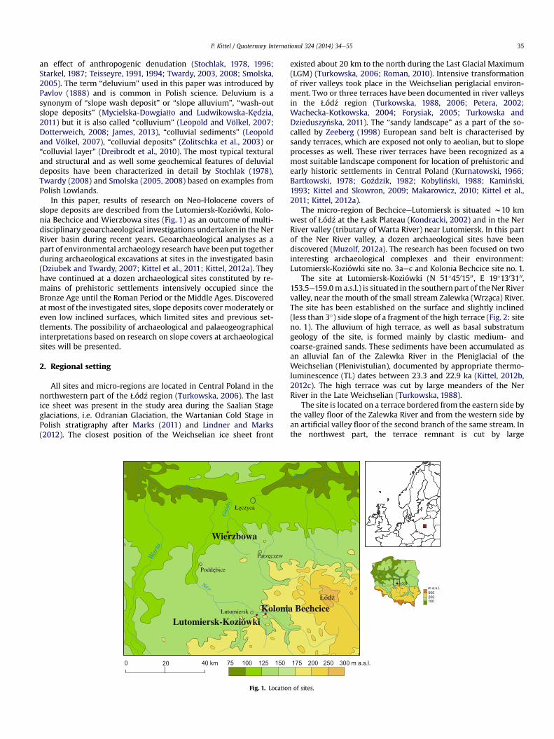
In this paper, results of research on Neo-Holocene covers ofslope deposits are described from the Lutomiersk-Koziówki, Kolo-nia Bechcice and Wierzbowa sites (Fig. 1) as an outcome of multi-disciplinary geoarchaeological investigations undertaken in the NerRiver basin during recent years. Geoarchaeological analyses as apart of environmental archaeology research have been put togetherduring archaeological excavations at sites in the investigated basin(Dziubek and Twardy, 2007; Kittel et al., 2011; Kittel, 2012a). Theyhave continued at a dozen archaeological sites constituted by re-mains of prehistoric settlements intensively occupied since theBronze Age until the Roman Period or the Middle Ages. Discoveredat most of the investigated sites, slope deposits cover moderately oreven low inclined surfaces, which limited sites and previous set-tlements. The possibility of archaeological and palaeogeographicalinterpretations based on research on slope covers at archaeologicalsites will be presented.
2. Regional setting
All sites and micro-regions are located in Central Poland in thenorthwestern part of the qód�z region (Turkowska, 2006). The lastice sheet was present in the study area during the Saalian Stageglaciations, i.e. Odranian Glaciation, the Wartanian Cold Stage inPolish stratigraphy after Marks (2011) and Lindner and Marks(2012). The closest position of the Weichselian ice sheet front
Ner
War
ta
Ner
Gni
da
Lutomiersk
75 100 125 1500 20 40 km
Koloni
Wierzbowa
Fig. 1. Location
existed about 20 km to the north during the Last Glacial Maximum(LGM) (Turkowska, 2006; Roman, 2010). Intensive transformationof river valleys took place in the Weichselian periglacial environ-ment. Two or three terraces have been documented in river valleysin the qód�z region (Turkowska, 1988, 2006; Petera, 2002;Wachecka-Kotkowska, 2004; Forysiak, 2005; Turkowska andDzieduszy�nska, 2011). The “sandy landscape” as a part of the so-called by Zeeberg (1998) European sand belt is characterised bysandy terraces, which are exposed not only to aeolian, but to slopeprocesses as well. These river terraces have been recognized as amost suitable landscape component for location of prehistoric andearly historic settlements in Central Poland (Kurnatowski, 1966;Bartkowski, 1978; Go�zdzik, 1982; Kobyli�nski, 1988; Kami�nski,1993; Kittel and Skowron, 2009; Makarowicz, 2010; Kittel et al.,2011; Kittel, 2012a).
The micro-region of BechciceeLutomiersk is situated w10 kmwest of qód�z at the qask Plateau (Kondracki, 2002) and in the NerRiver valley (tributary of Warta River) near Lutomiersk. In this partof the Ner River valley, a dozen archaeological sites have beendiscovered (Muzolf, 2012a). The research has been focused on twointeresting archaeological complexes and their environment:Lutomiersk-Koziówki site no. 3aec and Kolonia Bechcice site no. 1.
The site at Lutomiersk-Koziówki (N 51�4501500, E 19�1303100,153.5e159.0m a.s.l.) is situated in the southern part of the Ner Rivervalley, near the mouth of the small stream Zalewka (Wrzaca) River.The site has been established on the surface and slightly inclined(less than 3�) side slope of a fragment of the high terrace (Fig. 2: siteno. 1). The alluvium of high terrace, as well as basal substratumgeology of the site, is formed mainly by clastic medium- andcoarse-grained sands. These sediments have been accumulated asan alluvial fan of the Zalewka River in the Pleniglacial of theWeichselian (Plenivistulian), documented by appropriate thermo-luminescence (TL) dates between 23.3 and 22.9 ka (Kittel, 2012b,2012c). The high terrace was cut by large meanders of the NerRiver in the Late Weichselian (Turkowska, 1988).
The site is located on a terrace bordered from the eastern side bythe valley floor of the Zalewka River and from the western side byan artificial valley floor of the second branch of the same stream. Inthe northwest part, the terrace remnant is cut by large
Bzura
175 200 250 300 m a.s.l.
a Bechcice
of sites.

1 23
4
0 1 km7
8
9
11
10
1
2
3
5
4
6 12N
Ner R.
Ner R.
W
Fig. 2. Geomorphological map of the Lutomiersk area. 1 e till plain (Wartanian); 2 e highest terrace (decline of Wartanian); 3 e high terrace (Weichselian Pleniglacial, Plen-ivistulian); 4 e valley floor (Late Weichselian and Holocene); 5 e dunes and aeolian sands sheets (Late Weichselian and Eo-Holocene); 6 e peat lands; 7 e denudational dry valleys;8 e large palaeomeanders (Late Weichselian); 9 e small palaeomenders (Holocene); 10 e anthropogenic cuts (Neo-Holocene, Modern Period); 11 e long slops; 12 e location ofarchaeological sites: 1 e Lutomiersk-Koziówki site no. 3aec, 2 e Kolonia Bechcice site no. 1, 3 e Lutomiersk-Koziówki site no. 3d, 4 e Lutomiersk-Wrzaca.
P. Kittel / Quaternary International 324 (2014) 34e5536
palaeomeander filled by organic mud and peat covered withoverbank sands and silts. According to the results of pollen analysis(unpublished materials of M. Obremska and A. Wacnik) andradiocarbon dating (9030 � 160 BP (MKL-284), 8631e7715 BC, 2srange) (Table 1), the deposition of the palaeochannel fill wasinitiated in the decline of the Weichselian, continuing in the Ho-locene.
Table 1Radiocarbon data at sites presented
Profile Depthb.g.l. [cm]
Dated sediment orremains
Laboratory no. Age conv. 14C BP Age cal. 14C 1s range Age cal. 14C 2s range
Lutomiersk-Koziówki1 90e100 Charcoals MKL-481 2200 � 100 389e123 BC 505 BCe23 AD2 LK III 170e175 Organic mud (top) MKL-286 8210 � 90 7332e7082 BC 7483e7050 BC3 LK III 180e185 Organic mud (bottom) MKL-283 9240 � 120 8600e8310 BC 8782e8247 BC4 LK III 185e190 Decomposed peat (top) MKL-287 8670 � 70 7751e7593 BC 7940e7582 BC5 LK III 215e220 Peat MKL-284 9030 � 160 8452e7961 BC 8631e7715 BCKolonia Bechcice6 KBII 115e120 Organic mud IGSB-1383 7510 � 180 6588e6122 BC 6769e6004 BC7 125e130 Organic mud IGSB-1380 4270 � 130 3088e2635 BC 3338e2498 BC8 135e140 Decomposed peat (top) IGSB-1382 8250 � 150 7466e7083 BC 7585e6828 BC9 160e165 Peat (bottom) IGSB-1381 11 020 � 230 11 164e10 736 BC
(13 113e12 685 BP)11 418e10 600 BC(13 367e12 549 BP)
10 105e110 Plant macroremains POZ-36883 240 � 70 1522e1953 AD 1471e1954 AD11 140e145 Organic mud (bottom) LOD-1441 9020 � 80 8305e7993 BC 8446e7955 ADWierzbowa12 After Kittel and Twardy, 2003 Organic mud LOD-1182 3490 � 50 1881e1754 BC 1937e1690 BC13 90e95 Organic mud (top) LOD-1451 3750 � 50 2276e2043 BC 2336e1982 BC14 120e125 Organic mud interlaying
sandsLOD-1450 9270 � 80 8617e8350 BC 8707e8299 BC
Calibration OxCal v4.1.7 (Bronk Ramsey, 2009), atmospheric data (Reimer et al., 2009).
The geological and geomorphological location of the site atKolonia Bechcice (N 51�4501200, E 19�1402600, 153.5e154.5 m a.s.l.) issignificant because it has been established on the surface of isolatedremnants of a high terrace of the Ner River (Fig. 2: site no. 2).
Medium-grained and fine-grained sands of this terrace have beenaccumulated in the Middle Weichselian (Middle Plenivistulian),documented by TL dates of 26.6 � 4.0 ka and 23.6 � 3.5 ka (Kittel,2012b, 2012c). The high terrace was cut by a large meander in theLate Weichselian. The terrace remnant is isolated by a largepalaeomeander in the eastern side filled by gyttja and peat. Theaccumulation of the palaeochannel fill was initiated in the Late
Weichselian, continuing in the Holocene, documented by unpub-lished pollen analysis by M. Obremska and 14C dating of11 020 � 230 BP (Table 1). Southward and westward of the residualhillock, a Late Weichselian and Holocene flood plain small
P. Kittel / Quaternary International 324 (2014) 34e55 37
palaeomeanders has been recorded. Fill of one of them was 14Cdated to 9020 � 80 BP, 8446e7955 BC (2s range).
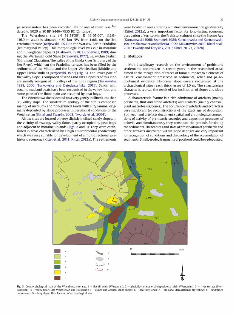
The Wierzbowa site (N 51�5803000, E 19�0500000, 112.0e116.0 m a.s.l.) is situated w30 km NW from qód�z on the 3rderosional terrace (Krajewski, 1977) in the Warsaw-Berlin Pradolina(ice marginal valley). This morphologic level was cut in morainicand fluvioglacial deposits (Klatkowa, 1978; Dutkiewicz, 1989) dur-ing the Wartanian Cold Stage (Krajewski, 1977), i.e. within Saalian(Odranian) Glaciation. The valley of the Gnida River (tributary of theNer River), which cut the Pradolina terrace, has been filled by thesediments of the Middle and the Upper Weichselian (Middle andUpper Plenivistulian) (Krajewski, 1977) (Fig. 3). The lower part ofthe valley slope is composed of sands and silts. Deposits of this kindare usually recognized in valleys of the qód�z region (Turkowska,1988, 2006; Turkowska and Dzieduszy�nska, 2011). Sands withorganic mud and peats have been recognised in the valley floor, andsome parts of the flood plain are occupied by peat bogs.
TheWierzbowa site is located on a very gently inclined (less than3�) valley slope. The substratum geology of the site is composedmainly of medium- and fine-grained sands with silty lamina, orig-inally deposited by slope processes in periglacial conditions of theWeichselian (Kittel and Twardy, 2003; Twardy et al., 2004).
All the sites are located on very slightly inclined sandy slopes, inthe vicinity of swampy valley floors, partly occupied by peat bogs,and adjacent to moraine uplands (Figs. 2 and 3). They were estab-lished in areas characterized by a high environmental geodiversity,which was very suitable for development of a multidirectional pre-historic economy (Kittel et al., 2011; Kittel, 2012a). The settlements
. 116,2
. 116,7
. 117,5
. 113,6. 115,1
7
8
9
10
1
2
3
5
4
6
Fig. 3. Geomorphological map of the Wierzbowa site area. 1 e flat till plain (Wartanian)ivistulian); 4 e valley floor (Late Weichselian and Holocene); 5 e dunes and aeolian sanddepressions; 9 e long slops; 10 e location of archaeological site.
were located in areas offering a distinct environmental geodiversity(Kittel, 2012a), a very important factor for long-lasting economicoccupation of territory in the Prehistory almost since the Bronze Age(Kurnatowski,1966; Szama1ek,1985;KurnatowskaandKurnatowski,1991;Makarowicz andMilecka,1999;Makarowicz, 2010; Kittel et al.,2011; Twardy and Forysiak, 2011; Kittel, 2012a, 2012b).
3. Methods
Multidisciplinary research on the environment of prehistoricsettlements undertaken in recent years in the researched areasaimed at the recognition of traces of human impact to elements ofnatural environment preserved in sediments, relief and palae-obotanical evidence. Holocene slope covers recognised at thearchaeological sites reach thicknesses of 1.5 m. The structurelesscharacter is typical, the result of low inclination of slopes and slopeprocesses.
A characteristic feature is a rich admixture of artefacts (mainlypotsherds, flint and stone artefacts) and ecofacts (mainly charcoal,plantmacrofossils, bones). The occurrence of artefacts and ecofacts isvery significant for reconstructions of the exact age of deposition.Both eco- and artefacts document spatial and chronological connec-tions of activity of prehistoric societies and deposition processes ofdeluvia, and simultaneously they constitute the grounds for datingthesediments. The featuresand stateofpreservationofpotsherdsandother artefacts uncovered within slope deposits are very importantfor recognition of conditions and chronology of the accumulation ofsediments. Small, eroded fragmentsofpotsherd couldbe redeposited,
. 119,3
. 113,7
. 112,5
. 112,8
. 111,7
. 113,3
. 112,8
0 1 km
N
Gnida R
.
Gnida
R.
; 2 e glaciofluvial erosional-depositional plain (Wartanian); 3 e river terrace (Plen-s sheets; 6 e peat bog lands; 7 e erosional-denudational dry valleys; 8 e undrained
P. Kittel / Quaternary International 324 (2014) 34e5538
and they document the terminus post quem of deposition. Largefragmentsofpotteryand/or large fragmentsof vesselsweredepositedsynchronically with or after deposition of underling sediments, anddocument the terminus ante quem of layer deposition. Observedarchaeological objectswithin slope covers document the stratigraphyof deposits, and they often indicate a strict chronological relationbetween deposition of deluvial cover and human activity at the site.They document long-lasting activity and in some periods strongimpact of prehistoric and early historic societies.
Charcoals and other plant macrofossils contained in particularlayers with defined chronology constitute a very important sourceof information about the spatial range of human activity andvegetation evolution (Dreibrodt et al., 2010a). A high quantity ofadmixture of charcoals is mainly the result of initiation andintensification of human impact, and the composition documentsthe range of anthropopressure, mainly vegetation cover clearance.
The researched deposits were investigated by means of standardmethods used in Quaternary geology and geomorphology: strati-graphical, structural, textural, micromorphology and geochemicalanalysis. Palaeobotanical analysis of organic deposits (i.e. pollen, plantmacrofossils, fossil wood and charcoals) was very helpful in achievingresults. Particle size compositions of the sediments have been exam-ined bymeans of sieve analysis (Rühle, 1973). The textural features ofthemineral material were complementedwith Folk andWard (1957)coefficients; the type of relation between themean grain size and thesorting index (co-ordinate system) after Mycielska-Dowgia11o (1995,2007); C-M pattern after Passega and Byramjee (Passega, 1964;Passega and Byramjee, 1969); and quartz-grain abrasion analysis inthe fraction of 0.63e0.8 mm, using the Cailleux (1942) method asmodified by Klatkowa (1991) and Manikowska (1993). Percentageconcentration of organic matter (Loss-on-Ignition, LI) and percentageorganic carbon (Corg), content of calcium carbonate (CaCO3), and pHindication of sediments were also estimated. To estimate Loss-on-Ignition (LI), samples were fired at 550 �C (Bengtsson and Enell,1986; Bednarek, 2004). Organic carbon content was measured usingthe wet oxidation Turin method (Turin, 1937). The calcium carbonatecontent was determined by the method of Scheibler.
Selected samples of organic materials have been dated byradiocarbon (14C) in Laboratory C-14 of Museum of Archaeologyand Ethnography in qód�z, Laboratory Radiocarbon Dating in Ska1aand C-14 Laboratory of the National Academy of Sciences of Belarus.For the calibration of radiocarbon data, the OxCal v4.1.7 programhas been used (Bronk Ramsey, 2009), atmospheric data fromReimer et al. (2009). Clastic sediments have been dated by ther-moluminescence (TL) dating in the laboratory of Pomeranian Uni-versity in S1upsk. Deposits have been also dated by archaeology.
Textural and geochemical analyses have been performed in theLaboratory of Faculty of Geographical Sciences, University of Lodzby Dr. J. Forysiak, Dr. P. Kittel, Dr. D. Okupny and Dr. W. To1oczko.Archaeopedological micromorphological studies were investigatedby Dr A. Budek (Institute of Geography and Spatial Organization,Polish Academy of Sciences) and whole palaeo- and archae-obotanical analyses by Msc. K. Cywa, Dr. A. Mueller-Bieniek, Dr. R.Stachowicz-Rybka, Dr. A. Wacnik (Institute of Botany PAS) and Dr.M. Obremska (Institute of Geology PAS). The age of artefacts hasbeen defined by Msc. B. Muzolf (Museum of Archaeology andEthnography in qód�z), Msc. P. Muzolf and Msc. J. B1aszczyk (Insti-tute of Archaeology, University of Lodz).
4. Materials and results
4.1. Lutomiersk-Koziówki site
In 1946 and 1948, the first archaeological works were conductedat the site (Gardawski, 1959), and later in 1954, 1960e1964, and in
1990 (Wiklak, 1963). From 2008 B. Muzolf has initiated, as a leader,the project of interdisciplinary research of archaeological complexat Lutomiersk-Koziówki site 3aec (Muzolf, 2012a). An area of2300 m2 has been excavated at the site, which covers about fourhectares. In this archaeological complex, numerous features andremains have been recognized. Twelve basic cultural-chronologicalhorizons have been distinguished:
I e Late Palaeolithic campsitesII e traces of Mesolithic campsites (?)III e the Corded Ware Culture settlement of the Younger
NeolithicIV e the Linin Group of the Neman Culture campsite of the Late
NeolithicV e the Trzciniec Culture (TC) settlement of the Older and
Middle Bronze AgeVI e the Lusatian Culture (LC) settlement of the Younger Bronze
AgeVII e the Pomeranian Culture (PC) settlement of the Early Pre-
Roman PeriodVIII e the Przeworsk Culture (PrzC) settlement of the Late Pre-
Roman PeriodIX e the Przeworsk Culture settlement of the Roman PeriodX e the EarlyMedieval (EM) settlement of the Slavs Period (7th/
8th e 10th century)XI e the Early Medieval settlement of the Early Polish State
Period (11th e 12th/13th century)XII e Modern settlement
Most of the artefacts found at the site belong to layers of the TC,the LC and the PC (Muzolf, 2012b).
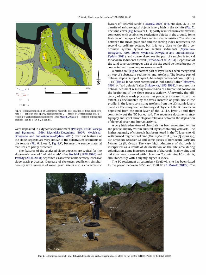
Very thick “cultural layers” have been documented during pre-vious work at Lutomiersk-Koziówki site no. 3aec (Gardawski, 1959;Wiklak, 1963) and at neighbouring Lutomiersk-Koziówki site no. 3d(Fig. 2: site no. 3) as well (Dziubek and Twardy, 2007; Twardy,2008). The presence of “cultural layers” has been documented atLutomiersk-Wrzaca (Fig. 2: site no. 4) (Zawilski, 1999; Czepas andOledzki, 2007) near Lutomiersk-Koziówki. The cultural depositsare represented by brown and dark grey humic sands with richadmixtures of charcoals and numerous fragments of potsherd andother artefacts. The thickness of the layer ranges to 1.6 m. Twardy(2008) has recognised slope processes at Lutomiersk-Koziówkisite no. 3d. During research in 2009e2011, slope cover depositshave been recorded both in the upper part of the site (close to theculmination area of the site) and at slopes and foot-slope of thehillocks (Fig. 4).
4.1.1. Profile LK IAt the upper part of the site (Fig. 5), slope deposits are repre-
sented by brown and dark grey partly humic sands with richadmixture of charcoals and very numerous fragments of potsherdand other artefacts of TC in the bottom and of LC in the higher level(Fig. 6: layers 1e3 and partly 4). The thickness of the preserved sandcover ranges to 0.7 m. About 80e90% of quartz-grain is representedby round matt grains (RM) and round intermediate matt (M),similar to the features of basal substratum sediments. Slope de-posits are typified by mean grain size of 0.33e0.36 mm, sortingindex 0.67e0.74 (moderately sorted) and skewness from �0.07to �0.01 (symmetrical or coarse skewed) (Fig. 6). The relationbetween the mean grain size and the sorting index is closeto the second co-ordinate system of Mycielska-Dowgia11o (Fig. 7A:sign. LK I), very characteristic for deluvial deposits (Twardy,2000, 2008; Smolska, 2005, 2008; Mycielska-Dowgia11o andLudwikowska-Kedzia, 2011). Charaterization within the I (1st)class of the C-M pattern (Fig. 7C: sign. LK I) shows the sediments
155
156
157
156
158
154
158
160
1
2
3
4I, II, III
I
II, III
m 0050
N
Fig. 4. Topographical map of Lutomiersk-Koziówki site. Location of lithological pro-files. 1 e contour lines (partly reconstructed), 2 e range of archaeological site, 3 e
location of archaeological excavations (after Muzolf, 2012a); 4 e location of lithologicprofiles: I (LK I), II (LK II), III (LK III).
P. Kittel / Quaternary International 324 (2014) 34e55 39
were deposited in a dynamic environment (Passega, 1964; Passegaand Byramjee, 1969; Mycielska-Dowgia11o, 2007; Mycielska-Dowgia11o and Ludwikowska-Kedzia, 2011). Textural features ofthe slope deposits are very similar to the substratum sediments ofthe terrace (Fig. 6: layer 5, Fig. 8A), because the source materialfeatures are partly preserved.
The features of the analysed slope deposits are typical for theslopewash cover of “deluvial sands” after Stochlak (1978,1996) andTwardy (2000, 2008) deposited as an effect of moderately intensiveslope wash processes. Decrease of skewness coefficient simulta-neously with increase of mean grain size is also a characteristic
Fig. 5. Lutomiersk-Koziówki site, deluvial deposits and archaeologic
feature of “deluvial sands” (Twardy, 2008) (Fig. 7B: sign. LK I). Thedensity of archaeological objects is very high in the vicinity (Fig. 5).The sand cover (Fig. 6: layers 1e3) partly resulted from earthworks,connected with established settlement objects in the ground. Somefeatures of the layers 1e3 have aeolian characteristics. The relationbetween the mean grain size and the sorting index represents thesecond co-ordinate system, but it is very close to the third co-ordinate system, typical for aeolian sediments (Mycielska-Dowgia11o, 1995, 2007; Mycielska-Dowgia11o and Ludwikowska-Kedzia, 2011), and coarse skewness for part of samples is typicalfor aeolian sediments as well (Szma�nda et al., 2004). Deposition ofthe sand cover at the upper part of the site could be therefore partlyconnected with aeolian processes as well.
A buried soil (Fig. 6: bottom part of layer 4) has been recognizedon top of substratum sediments and artefacts. The lowest part ofdeluvial deposits (top of layer 4) has a high content of humus (Corg.w1%) (Fig. 6). It has been recognised as “soil sands” (after Teisseyre,1994) or “soil deluvia” (after Sinkiewicz, 1995, 1998). It represents adeluvial sediment resulting from erosion of a humic soil horizon inthe beginning of the slope process activity. Afterwards, the effi-ciency of slope wash processes has probably increased to a littleextent, as documented by the weak increase of grain size in theprofile, in the layers consisting artefacts from the LC (mainly layers3 and 2). The recognised archaeological objects of the LC have beendeposited from the main layer of the LC (i.e. layer 2) and theycommonly cut the TC buried soil. The sequence documents stra-tigraphy and strict chronological relations between the depositionof deluvial cover and human activity.
A very high admixture of charcoals has been recognised withinthe profile, mainly within cultural layers containing artefacts. Thehighest quantity of charcoals has been noted in the TC layer (no. 4)with burned fragments of pine (Pinus sylvestris L.), oak (Quercus sp.),ash (Fraxinus excelsior L.) and some pieces of hornbeam (Carpinusbetulus L.) (K. Cywa). The very high admixture of charcoals isinterpreted as a result of deforestation of the site area duringcolonisation. Some increased content of charcoals (mainly pine andoak) has been observed within layer no. 2, containing LC artefacts,simultaneously with a slightly higher LI index.
The TC settlement at Lutomiersk-Koziówki site has been datedto the period between 1650 and 1350 BC (P. Muzolf, 2012e). The
al objects close to the profile I (LK I) (Photo by P. Kittel, 2010).
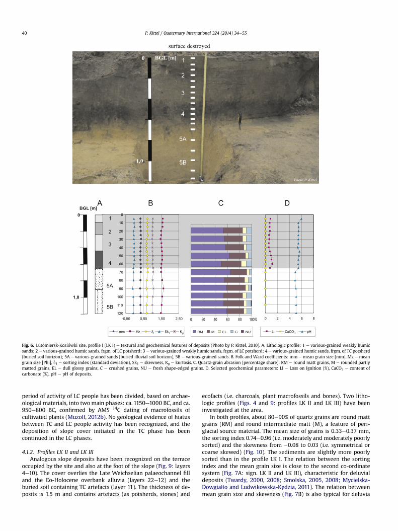
Fig. 6. Lutomiersk-Koziówki site, profile I (LK I) e textural and geochemical features of deposits (Photo by P. Kittel, 2010). A. Lithologic profile: 1 e various-grained weakly humicsands; 2 e various-grained humic sands, frgm. of LC potsherd; 3 e various-grained weakly humic sands, frgm. of LC potsherd; 4 e various-grained humic sands, frgm. of TC potsherd(buried soil horizon); 5A e various-grained sands (buried illuvial soil horizon), 5B e various-grained sands. B. Folk and Ward coefficients: mm e mean grain size [mm], Mz e meangrain size [Phi], d1 e sorting index (standard deviation), Sk1 e skewness, Kg e kurtosis. C. Quartz-grain abrasion (percentage share): RM e round matt grains, M e rounded partlymatted grains, EL e dull glossy grains, C e crushed grains, NU e fresh shape-edged grains. D. Selected geochemical parameters: LI e Loss on Ignition (%), CaCO3 e content ofcarbonate (%), pH e pH of deposits.
P. Kittel / Quaternary International 324 (2014) 34e5540
period of activity of LC people has been divided, based on archae-ological materials, into two main phases: ca. 1150e1000 BC, and ca.950e800 BC, confirmed by AMS 14C dating of macrofossils ofcultivated plants (Muzolf, 2012b). No geological evidence of hiatusbetween TC and LC people activity has been recognized, and thedeposition of slope cover initiated in the TC phase has beencontinued in the LC phases.
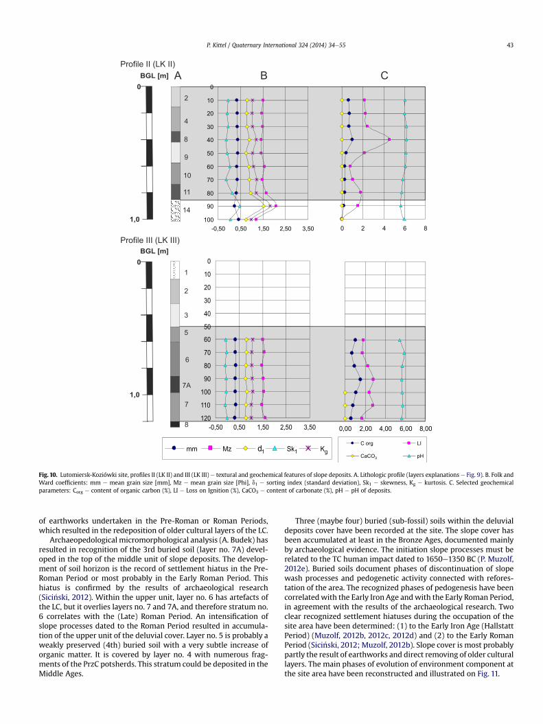
4.1.2. Profiles LK II and LK IIIAnalogous slope deposits have been recognized on the terrace
occupied by the site and also at the foot of the slope (Fig. 9: layers4e10). The cover overlies the Late Weichselian palaeochannel filland the Eo-Holocene overbank alluvia (layers 22e12) and theburied soil containing TC artefacts (layer 11). The thickness of de-posits is 1.5 m and contains artefacts (as potsherds, stones) and
ecofacts (i.e. charcoals, plant macrofossils and bones). Two litho-logic profiles (Figs. 4 and 9: profiles LK II and LK III) have beeninvestigated at the area.
In both profiles, about 80e90% of quartz grains are round mattgrains (RM) and round intermediate matt (M), a feature of peri-glacial source material. The mean size of grains is 0.33e0.37 mm,the sorting index 0.74e0.96 (i.e. moderately and moderately poorlysorted) and the skewness from �0.08 to 0.03 (i.e. symmetrical orcoarse skewed) (Fig. 10). The sediments are slightly more poorlysorted than in the profile LK I. The relation between the sortingindex and the mean grain size is close to the second co-ordinatesystem (Fig. 7A: sign. LK II and LK III), characteristic for deluvialdeposits (Twardy, 2000, 2008; Smolska, 2005, 2008; Mycielska-Dowgia11o and Ludwikowska-Kedzia, 2011). The relation betweenmean grain size and skewness (Fig. 7B) is also typical for deluvia
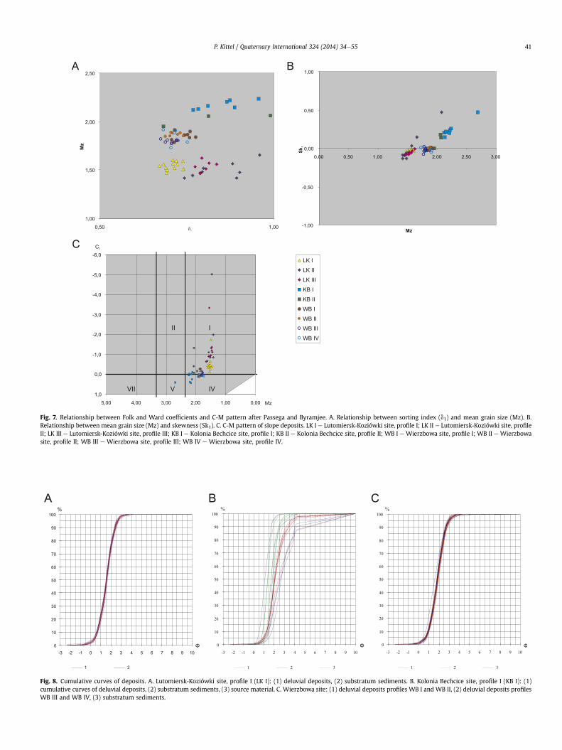
Fig. 7. Relationship between Folk and Ward coefficients and C-M pattern after Passega and Byramjee. A. Relationship between sorting index (d1) and mean grain size (Mz). B.Relationship between mean grain size (Mz) and skewness (Sk1). C. C-M pattern of slope deposits. LK I e Lutomiersk-Koziówki site, profile I; LK II e Lutomiersk-Koziówki site, profileII; LK III e Lutomiersk-Koziówki site, profile III; KB I e Kolonia Bechcice site, profile I; KB II e Kolonia Bechcice site, profile II; WB I e Wierzbowa site, profile I; WB II e Wierzbowasite, profile II; WB III e Wierzbowa site, profile III; WB IV e Wierzbowa site, profile IV.
Fig. 8. Cumulative curves of deposits. A. Lutomiersk-Koziówki site, profile I (LK I): (1) deluvial deposits, (2) substratum sediments. B. Kolonia Bechcice site, profile I (KB I): (1)cumulative curves of deluvial deposits, (2) substratum sediments, (3) source material. C. Wierzbowa site: (1) deluvial deposits profiles WB I and WB II, (2) deluvial deposits profilesWB III and WB IV, (3) substratum sediments.
P. Kittel / Quaternary International 324 (2014) 34e55 41

8210±90 BP
9240±120 BP8670±70 BP
9030±160 BP
2200±100 BP
Stones(artifical pavement)Large frgm. of TC potsherd
Samples:
lithological
14C date
with protected structures
III
palaeopedological analysis
palaeoecological analysis
5 m0
BGL [m]0
2
1
1 2
34
5
67
8
99A
9
1011
11
12
1313A
1415
16
1718
19
19
20
21
2122
22
7A 8
Profile II (LK II)
Profile III (LK III)
destroyed surface
I
II
1 2
3 4
56
8
1011
1113
7A
9
7
1214
embankment
Fig. 9. Lutomiersk-Koziówki site, profiles II and III (LK II, LK III). Cross-section of deluvial deposits (Photo by P. Kittel, 2010). 1 e yellow sands with weakly humic sands lamination(fill of overbank flow channel), frgm. of Middle Ages potsherd; 2 e brownish gray various-grained humic sands (slope deposits); 3 e various-grained sands with organic admixture(fill of overbank flow channel); 4 e brownish gray various-grained sands, frgm. of PrzC potsherd (slope deposits); 5 e brown various-grained humic sands with charcoals admixture(slope deposits); 6 e dark gray various-grained humic sands with charcoals admixture, frgm. of LC potsherd (slope deposits); 7A e dark gray various-grained humic sands (buriedsoil horizon); 7 e gray various-grained humic sands with charcoals admixture, frgm. of LC potsherd (embankment redeposited by slope processes); 8 e dark gray various-grainedhumic sands with charcoals admixture, frgm. of LC potsherd (buried soil horizon); 9 e gray various-grained weakly humic sands with charcoals admixture (9A e without organicadmixture), frgm. of LC potsherd (slope deposits); 10 e greyish brown various-grained humic sands with charcoals admixture, frgm. of LC potsherd (slope deposits); 11 e dark grayhumic silty sands with charcoals admixture, frgm. of TC potsherd (buried soil horizon); 12 e gray fine-grained sands and silts laminated (overbank deposits); 13 e gray fine-grainedsands and silts (13A fine-grained sands) with charcoals admixture (overbank deposits); 14 e yellowish gray medium- and coarse-grained sands with silt laminations (overbankdeposits and slope deposits); 15 e brown medium-grained laminated sands (overbank deposits); 16 e gray fine-grained sands (overbank deposits); 17 e dark gray mud and fine-grained sands (overbank deposits); 18 e greyish brown sands with ironic admixture (overbank deposits); 19 e dark gray organic mud with plant macrofossils admixture (overbankdeposits); 20 e peat (palaeochannel fill); 21 e organic mud and peat (palaeochannel fill); 22 e medium- and coarse-grained sands with plant macrofossils admixture (channeldeposits).
P. Kittel / Quaternary International 324 (2014) 34e5542
(Smolska, 2005), especially for deluvial sands (Twardy, 2008). TheC-M pattern shows that the deposits are connected with a dynamicdepositional environment, reflected by location within the I class(Fig. 7C: sign. LK II and LK III).
The slope cover overlies buried soil containing large TC artefacts(Fig. 9: layers 11). The soil has been developed on top of overbankalluvia and the horizon appearance has an elevated LI level (LI up to4.6%). Separate burned fragments of alder (Alnus sp.) have beenrecognized within the TC buried soil. The lower part of deluvialdeposits (layer 10) include high content of organic matter and thehighest in whole profile admixture of charcoals (Fig. 10). This layerrepresents soil deluvia and could be defined as “deforestationdeluvia” after Stochlak (1996). The quantity of charcoals is at thehighest level and composition of macrofossils is most diversifiedwithin the whole slope cover (K. Cywa). Numerous fragments ofburned wood of pine, oak and sporadically of alder, ash, and hazel(Corylus avellana L.) have been recognized (K. Cywa). Sediments oflayer no. 10 in the upper part of a profile gradually grade intocoarser deposits with less admixture of organicmatter, as a result ofincreased efficiency of slope wash processes. The lower unit of
deluvial cover reaches a thickness of 40 cm, thinning to the centralpart of the fossil palaeomeander. In the top of the unit, the buriedsoil horizon (layer no. 8) is clear. The younger buried soil horizoncontains LC potsherds and a rich organic admixture (LI: 4.6%),documenting the development of pedogenetic processes connectedwith reforestation of the area resulting from settlement hiatus, inagreement with the results of archaeological research. The periodof recorded human impact is correlated with the Bronze Age andthe activity of TC and LC people, because LC potsherds are commonwithin the layer no. 10. The colonisation area included both theterrace surface and the valley floor.
The middle unit of deluvial deposits, layer no. 7, overlies the 2ndburied soil. In the layer, high quantities of potsherds and stoneartefacts of the LC have been recorded. The 14C date of fragments ofcharcoals e 2200 � 100 BP, 389e123 BC (1s range), 505 BCe23 AD(2s range) e correlated with the Pre-Roman Period or, taking intoaccount the old wood effect, with the Roman Period. The unitconsists of a rich collection of charcoal fragments of: oak, pine andalder with hornbeam, birch, ash, poplar (Populus sp.) and linden(Tilia sp.) (K. Cywa). The layer no. 7 has been recognised as an effect
4
8
9
10
11
14
20
1,0
BGL [m]
0
10
20
30
40
50
60
70
80
90
100-0,50 0,50 1,50 2,50 3,50 0 2 4 6 8
C org LI
CaCO pH
0
10
20
30
40
50
60
70
80
90
100
110
120-0,50 0,50 1,50 2,50 3,50 0,00 2,00 4,00 6,00 8,00
mm Mz d1 Sk1 Kg
A B C
2
3
5
6
7A
10
1,0
BGL [m]
Profile II (LK II)
7
Profile III (LK III)
8
Fig. 10. Lutomiersk-Koziówki site, profiles II (LK II) and III (LK III) e textural and geochemical features of slope deposits. A. Lithologic profile (layers explanations e Fig. 9). B. Folk andWard coefficients: mm e mean grain size [mm], Mz e mean grain size [Phi], d1 e sorting index (standard deviation), Sk1 e skewness, Kg e kurtosis. C. Selected geochemicalparameters: Corg e content of organic carbon (%), LI e Loss on Ignition (%), CaCO3 e content of carbonate (%), pH e pH of deposits.
P. Kittel / Quaternary International 324 (2014) 34e55 43
of earthworks undertaken in the Pre-Roman or Roman Periods,which resulted in the redeposition of older cultural layers of the LC.
Archaeopedological micromorphological analysis (A. Budek) hasresulted in recognition of the 3rd buried soil (layer no. 7A) devel-oped in the top of the middle unit of slope deposits. The develop-ment of soil horizon is the record of settlement hiatus in the Pre-Roman Period or most probably in the Early Roman Period. Thishiatus is confirmed by the results of archaeological research(Sici�nski, 2012). Within the upper unit, layer no. 6 has artefacts ofthe LC, but it overlies layers no. 7 and 7A, and therefore stratum no.6 correlates with the (Late) Roman Period. An intensification ofslope processes dated to the Roman Period resulted in accumula-tion of the upper unit of the deluvial cover. Layer no. 5 is probably aweakly preserved (4th) buried soil with a very subtle increase oforganic matter. It is covered by layer no. 4 with numerous frag-ments of the PrzC potsherds. This stratum could be deposited in theMiddle Ages.
Three (maybe four) buried (sub-fossil) soils within the deluvialdeposits cover have been recorded at the site. The slope cover hasbeen accumulated at least in the Bronze Ages, documented mainlyby archaeological evidence. The initiation slope processes must berelated to the TC human impact dated to 1650e1350 BC (P. Muzolf,2012e). Buried soils document phases of discontinuation of slopewash processes and pedogenetic activity connected with refores-tation of the area. The recognized phases of pedogenesis have beencorrelatedwith the Early Iron Age andwith the Early Roman Period,in agreement with the results of the archaeological research. Twoclear recognized settlement hiatuses during the occupation of thesite area have been determined: (1) to the Early Iron Age (HallstattPeriod) (Muzolf, 2012b, 2012c, 2012d) and (2) to the Early RomanPeriod (Sici�nski, 2012; Muzolf, 2012b). Slope cover is most probablypartly the result of earthworks and direct removing of older culturallayers. The main phases of evolution of environment component atthe site area have been reconstructed and illustrated on Fig. 11.
P. Kittel / Quaternary International 324 (2014) 34e5544
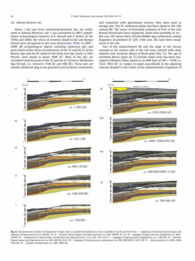
4.2. Kolonia Bechcice site
About 1 km east from Lutomiersk-Koziówki site, the settle-ment at Kolonia Bechcice, site 1 was uncovered in 2007 (unpub-lished archaeological research of B. Muzolf and P. Kittel). In the1950s and 1960s, the relicts of cemetery dated to the Late RomanPeriod were recognized at this area (Kmieci�nski, 1959). In 2007e2009, 80 archaeological objects including numerous pits andposts-holes of the relicts of settlements of the TC and the LC of theBronze Age and the PC dated to the Early Iron Age (Early La TènePeriod) were found in about 1000 m2. Most of the pits arecorrelated with horizons of the TC and the LC of 2nd to 4th BronzeAge Periods (i.e. between 1700 BC and 900 BC). Those pits aremainly cylindrical, dug in the ground to several dozen centimetres
5 m0
I
II
III
IV
V 0
2
1
0
2
1
0
2
1
0
2
1
0
2
1
BGL [m]
ca. 1500 BC
ca. 1500-800 BC
ca. 800-150 BC
ca. 150-1 BC
ca. 1-200 AD
Fig. 11. Reconstruction of phases of deposition of slope cover at Lutomiersk-Koziówki siteinitiation of slope processes (ca. 1500 BC, TC). II e intensive human impact and slope proces150 BC). IV e redeposition of cultural layers (earthworks) and slope processes (?) (ca. 150e1human impact and slope processes (ca. 200e400 AD, PrzC). VII e stoppage of slope process1650 AD). IX e episodic overbank flow (ca. 1650e1800 AD).
and connected with agricultural activity: they were used asstorage-pits. The PC settlement phase has been dated to 5the6thcentury BC. The traces of destroyed cemetery of PrzC of the LateRoman Period have been registered, dated most probably to 1ste4th cent. AD. Some relicts of Early Middle Ages settlement, mainlyfragments of potsherd of 12the13th cent. AD, have been recog-nized at the site.
Part of the palaeochannel fill and the slope of the terraceremnant in the eastern side of the site were covered with slopedeposits and overbank alluvia of flood plain (Fig. 12). The age ofoverbank alluvia (layer no. 5) overlain slope cover has been esti-mated to Modern Times, based on an AMS date of 240 � 70 BP, i.e.1522e1953 AD (1s range), on plant macrofossils in the adjoiningoutcrop situated in the centre of the palaeochannel. Fragments of
destroyed surface
5 m0
BGL [m]0
2
1
IX
VIII
VII
VI
0
2
1
0
2
1
0
2
1
ca. 200-400 AD
ca. 400-800/1000 (?) AD
ca. 1000-1500/1650 AD
ca. 1650-1800 AD
close to profiles II (LK II) and III (LK III). I e beginning of intensive human impact andses (ca. 1500e800 BC, TC, LC). III e stoppage of slope processes, pedogenesis (ca. 800eBC, PrzC). V e stoppage of slope processes, pedogenesis (ca. 1e200 AD). VI e intensivees, pedogenesis (ca. 400e800/1000 (?) AD). VIII (?) e slope processes (ca. 1000e1500/
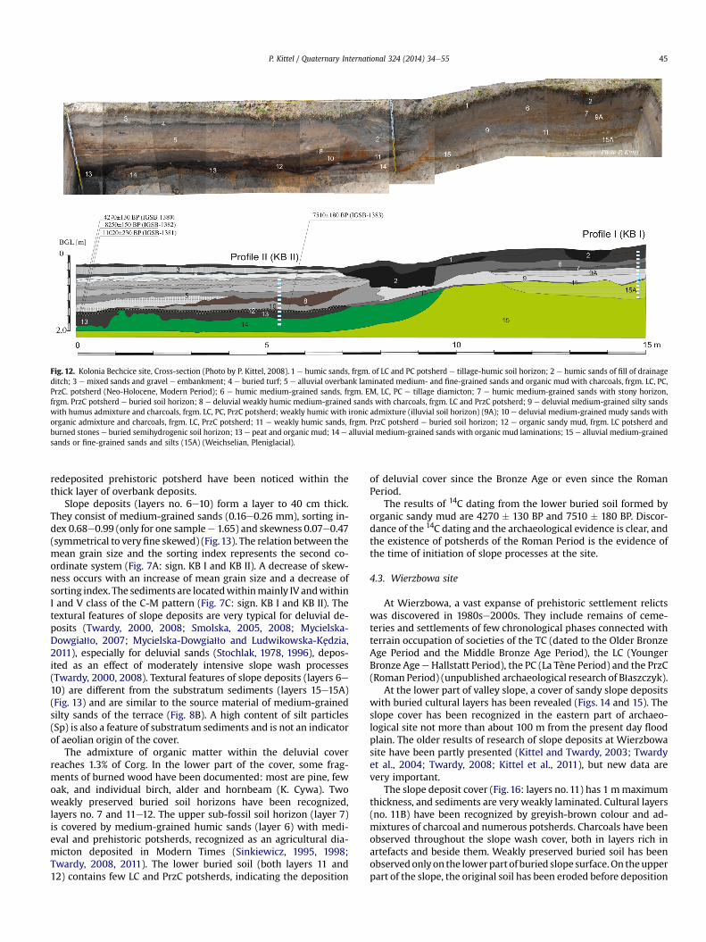
Fig. 12. Kolonia Bechcice site, Cross-section (Photo by P. Kittel, 2008). 1 e humic sands, frgm. of LC and PC potsherd e tillage-humic soil horizon; 2 e humic sands of fill of drainageditch; 3 e mixed sands and gravel e embankment; 4 e buried turf; 5 e alluvial overbank laminated medium- and fine-grained sands and organic mud with charcoals, frgm. LC, PC,PrzC. potsherd (Neo-Holocene, Modern Period); 6 e humic medium-grained sands, frgm. EM, LC, PC e tillage diamicton; 7 e humic medium-grained sands with stony horizon,frgm. PrzC potsherd e buried soil horizon; 8 e deluvial weakly humic medium-grained sands with charcoals, frgm. LC and PrzC potsherd; 9 e deluvial medium-grained silty sandswith humus admixture and charcoals, frgm. LC, PC, PrzC potsherd; weakly humic with ironic admixture (illuvial soil horizon) (9A); 10 e deluvial medium-grained mudy sands withorganic admixture and charcoals, frgm. LC, PrzC potsherd; 11 e weakly humic sands, frgm. PrzC potsherd e buried soil horizon; 12 e organic sandy mud, frgm. LC potsherd andburned stones e buried semihydrogenic soil horizon; 13 e peat and organic mud; 14 e alluvial medium-grained sands with organic mud laminations; 15 e alluvial medium-grainedsands or fine-grained sands and silts (15A) (Weichselian, Pleniglacial).
P. Kittel / Quaternary International 324 (2014) 34e55 45
redeposited prehistoric potsherd have been noticed within thethick layer of overbank deposits.
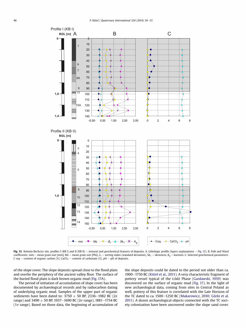
Slope deposits (layers no. 6e10) form a layer to 40 cm thick.They consist of medium-grained sands (0.16e0.26 mm), sorting in-dex 0.68e0.99 (only for one samplee 1.65) and skewness 0.07e0.47(symmetrical to veryfine skewed) (Fig.13). The relation between themean grain size and the sorting index represents the second co-ordinate system (Fig. 7A: sign. KB I and KB II). A decrease of skew-ness occurs with an increase of mean grain size and a decrease ofsorting index. The sediments are locatedwithinmainly IV andwithinI and V class of the C-M pattern (Fig. 7C: sign. KB I and KB II). Thetextural features of slope deposits are very typical for deluvial de-posits (Twardy, 2000, 2008; Smolska, 2005, 2008; Mycielska-Dowgia11o, 2007; Mycielska-Dowgia11o and Ludwikowska-Kedzia,2011), especially for deluvial sands (Stochlak, 1978, 1996), depos-ited as an effect of moderately intensive slope wash processes(Twardy, 2000, 2008). Textural features of slope deposits (layers 6e10) are different from the substratum sediments (layers 15e15A)(Fig. 13) and are similar to the source material of medium-grainedsilty sands of the terrace (Fig. 8B). A high content of silt particles(Sp) is also a feature of substratum sediments and is not an indicatorof aeolian origin of the cover.
The admixture of organic matter within the deluvial coverreaches 1.3% of Corg. In the lower part of the cover, some frag-ments of burned wood have been documented: most are pine, fewoak, and individual birch, alder and hornbeam (K. Cywa). Twoweakly preserved buried soil horizons have been recognized,layers no. 7 and 11e12. The upper sub-fossil soil horizon (layer 7)is covered by medium-grained humic sands (layer 6) with medi-eval and prehistoric potsherds, recognized as an agricultural dia-micton deposited in Modern Times (Sinkiewicz, 1995, 1998;Twardy, 2008, 2011). The lower buried soil (both layers 11 and12) contains few LC and PrzC potsherds, indicating the deposition
of deluvial cover since the Bronze Age or even since the RomanPeriod.
The results of 14C dating from the lower buried soil formed byorganic sandy mud are 4270 � 130 BP and 7510 � 180 BP. Discor-dance of the 14C dating and the archaeological evidence is clear, andthe existence of potsherds of the Roman Period is the evidence ofthe time of initiation of slope processes at the site.
4.3. Wierzbowa site
At Wierzbowa, a vast expanse of prehistoric settlement relictswas discovered in 1980se2000s. They include remains of ceme-teries and settlements of few chronological phases connected withterrain occupation of societies of the TC (dated to the Older BronzeAge Period and the Middle Bronze Age Period), the LC (YoungerBronze AgeeHallstatt Period), the PC (La Tène Period) and the PrzC(Roman Period) (unpublished archaeological research of B1aszczyk).
At the lower part of valley slope, a cover of sandy slope depositswith buried cultural layers has been revealed (Figs. 14 and 15). Theslope cover has been recognized in the eastern part of archaeo-logical site not more than about 100 m from the present day floodplain. The older results of research of slope deposits at Wierzbowasite have been partly presented (Kittel and Twardy, 2003; Twardyet al., 2004; Twardy, 2008; Kittel et al., 2011), but new data arevery important.
The slope deposit cover (Fig.16: layers no. 11) has 1 mmaximumthickness, and sediments are very weakly laminated. Cultural layers(no. 11B) have been recognized by greyish-brown colour and ad-mixtures of charcoal and numerous potsherds. Charcoals have beenobserved throughout the slope wash cover, both in layers rich inartefacts and beside them. Weakly preserved buried soil has beenobservedonlyon the lowerpartof buried slope surface.On theupperpart of the slope, the original soil has been eroded before deposition
6
7
9A
911
15A
1
0
1,0
BGL [m]
mm Mz d1 Sk1 Kg
A B C
4
5
8
10
3
0
1,0
BGL [m]
Profile I (KB I)
12
Profile II (KB II)
13
1,4
14
Corg. CaCO3 pH
0
10
20
30
40
50
60
70
80
90
100
110
120
130
140
150-0,50 0,50 1,50 2,50 3,50
0
10
20
30
40
50
60
70
80
90
100
110
120
130
140-0,50 0,50 1,50 2,50 3,50 0 2 4 6 8
0 2 4 6 8
Fig. 13. Kolonia Bechcice site, profiles I (KB I) and II (KB II) e textural and geochemical features of deposits. A. Lithologic profile (layers explanations e Fig. 12). B. Folk and Wardcoefficients: mm e mean grain size [mm], Mz e mean grain size [Phi], d1 e sorting index (standard deviation), Sk1 e skewness, Kg e kurtosis. C. Selected geochemical parameters:C org e content of organic carbon (%), CaCO3 e content of carbonate (%), pH e pH of deposits.
P. Kittel / Quaternary International 324 (2014) 34e5546
of the slope cover. The slope deposits spread close to the flood plainand overlie the periphery of the ancient valley floor. The surface ofthe buried flood plain is dark brown organic mud (Fig. 17A).
The period of initiation of accumulation of slope cover has beendocumented by archaeological records and by radiocarbon datingof underlying organic mud. Samples of the upper part of organicsediments have been dated to: 3750 � 50 BP, 2336e1982 BC (2srange) and 3490 � 50 BP, 1937e1690 BC (2s range), 1881e1754 BC(1s range). Based on those data, the beginning of accumulation of
the slope deposits could be dated to the period not older than ca.1900e1750 BC (Kittel et al., 2011). A very characteristic fragment ofpottery vessel typical of the qód�z Phase (Gardawski, 1959) wasdiscovered on the surface of organic mud (Fig. 17). In the light ofnew archaeological data, coming from sites in Central Poland aswell, pottery of this feature is correlated with the Late Horizon ofthe TC dated to ca. 1500e1250 BC (Makarowicz, 2010; Górki et al.2011). A dozen archaeological objects connected with the TC soci-ety colonisation have been uncovered under the slope sand cover.

Fig. 14. Wierzbowa site e deluvial deposits (Photo by P. Kittel, 2000, location see Fig. 15).
P. Kittel / Quaternary International 324 (2014) 34e55 47
Archaeological objects of younger cultural horizons have beenrecognised in upper layers, documenting stratigraphy and chro-nology of the deposits connected with phases of human occupationof the site.
The textural and geochemical properties of slope deposits havebeen determined for some profiles. Two profiles (WB III andWB IV)are located at foot-slope, in the area of existing buried flood plain,and two others about 40m away in themiddle part of the side slope(WB I andWB II) (Fig.15). Deposits of the slope cover are typified byFolk and Ward coefficients of mean grain size: 0.27e0.29 mm,
11311
4
115
116
116
234
56
89
1112
112
TC
10
LC (BA)LC (HP)PCPrzC
undefined
7
Fig. 15. Topographical map of Wierzbowa site. 1 e contour lines; 2 e reconstructed (for thee range of buried semihydrogenic soil at the former valley floor; 5 e location of lithologic(Fig. 14); 7 e location of cross-section (Fig. 16); 8 e location of excavation area in 2000e2002of archaeological objects.
sorting index: 0.68e0.78 (i.e. moderately sorted) and skewness:from �0.05 (only one sample �0.08) to 0.02 (i.e. symmetrical orcoarse skewed). Frequency of silt and clay particles fluctuates be-tween 0.84 and 3.92% (Fig.18). A relative increase of sorting index ofdeposits downslope has been recorded. The relation between themean grain size and the sorting index for whole samples of slopesands is close to the second co-ordinate system (Fig. 7A: sign. WBIeWB IV). Taking into account only the samples of the lower locatedprofiles (WB III and WB IV), this relation represents the first co-ordinate system. The second co-ordinate system is characteristic
m 050112
112
113
114
115
period before deluvial deposition) contour lines; 3 e range of deluvial deposits cover; 4al profiles I (WB I), II (WB II), III (WB III) and IV (WB IV); 6 e location of photograpy(after J. B1aszczyk); 9 e location of excavation area in 2007; 10 e cultural qualification
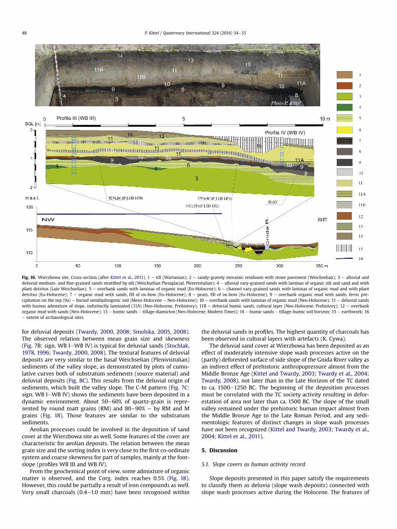
Fig. 16. Wierzbowa site, Cross-section (after Kittel et al., 2011). 1 e till (Wartanian); 2 e sandy-gravely morainic residuum with stone pavement (Weichselian); 3 e alluvial anddeluvial medium- and fine-grained sands stratified by silt (Weichselian Pleniglacial, Plenivistulian); 4 e alluvial vary-grained sands with laminas of organic silt and sand and withplant detritus (Late Weichselian); 5 e overbank sands with laminas of organic mud (Eo-Holocene); 6 e channel vary-grained sands with laminas of organic mud and with plantdetritus (Eo-Holocene); 7 e organic mud with sands, fill of ox-bow (Eo-Holocene); 8 e peats, fill of ox-bow (Eo-Holocene); 9 e overbank organic mud with sands, ferric pre-cipitation on the top (9a) e buried semihydrogenic soil (Meso-Holocene e Neo-Holocene); 10 e overbank sands with laminas of organic mud (Neo-Holocene); 11 e deluvial sandswith humus admixture of slope, indistinctly laminated (11A) (Neo-Holocene, Prehistory); 11B e deluvial humic sands, cultural layer (Neo-Holocene, Prehistory); 12 e overbankorganic mud with sands (Neo-Holocene); 13 e humic sands e tillage diamicton (Neo-Holocene, Modern Times); 14 e humic sands e tillage-humic soil horizon; 15 e earthwork; 16e extent of archaeological sites.
P. Kittel / Quaternary International 324 (2014) 34e5548
for deluvial deposits (Twardy, 2000, 2008; Smolska, 2005, 2008).The observed relation between mean grain size and skewness(Fig. 7B: sign. WB IeWB IV) is typical for deluvial sands (Stochlak,1978, 1996; Twardy, 2000, 2008). The textural features of deluvialdeposits are very similar to the basal Weichselian (Plenivistulian)sediments of the valley slope, as demonstrated by plots of cumu-lative curves both of substratum sediments (source material) anddeluvial deposits (Fig. 8C). This results from the deluvial origin ofsediments, which built the valley slope. The C-M pattern (Fig. 7C:sign. WB IeWB IV) shows the sediments have been deposited in adynamic environment. About 50e60% of quartz-grain is repre-sented by round matt grains (RM) and 80e90% e by RM and Mgrains (Fig. 18). Those features are similar to the substratumsediments.
Aeolian processes could be involved in the deposition of sandcover at the Wierzbowa site as well. Some features of the cover arecharacteristic for aeolian deposits. The relation between the meangrain size and the sorting index is very close to the first co-ordinatesystem and coarse skewness for part of samples, mainly at the foot-slope (profiles WB III and WB IV).
From the geochemical point of view, some admixture of organicmatter is observed, and the Corg. index reaches 0.5% (Fig. 18).However, this could be partially a result of iron compounds as well.Very small charcoals (0.4e1.0 mm) have been recognised within
the deluvial sands in profiles. The highest quantity of charcoals hasbeen observed in cultural layers with artefacts (K. Cywa).
The deluvial sand cover at Wierzbowa has been deposited as aneffect of moderately intensive slope wash processes active on the(partly) deforested surface of side slope of the Gnida River valley asan indirect effect of prehistoric anthropopressure almost from theMiddle Bronze Age (Kittel and Twardy, 2003; Twardy et al., 2004;Twardy, 2008), not later than in the Late Horizon of the TC datedto ca. 1500e1250 BC. The beginning of the deposition processesmust be correlated with the TC society activity resulting in defor-estation of area not later than ca. 1500 BC. The slope of the smallvalley remained under the prehistoric human impact almost fromthe Middle Bronze Age to the Late Roman Period, and any sedi-mentologic features of distinct changes in slope wash processeshave not been recognized (Kittel and Twardy, 2003; Twardy et al.,2004; Kittel et al., 2011).
5. Discussion
5.1. Slope covers as human activity record
Slope deposits presented in this paper satisfy the requirementsto classify them as deluvia (slope wash deposits) connected withslope wash processes active during the Holocene. The features of
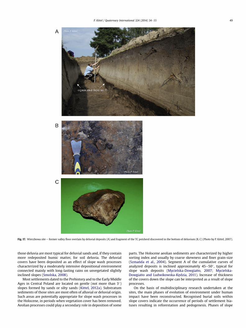
Fig. 17. Wierzbowa site e former valley floor overlain by deluvial deposits (A) and fragment of the TC potsherd discovered in the bottom of deluvium (B, C) (Photo by P. Kittel, 2007).
P. Kittel / Quaternary International 324 (2014) 34e55 49
those deluvia aremost typical for deluvial sands and, if they containmore redeposited humic matter, for soil deluvia. The deluvialcovers have been deposited as an effect of slope wash processescharacterized by a moderately intensive depositional environmentconnected mainly with long-lasting rains on unvegetated slightlyinclined slopes (Smolska, 2008).
Most settlements dated to the Prehistory and to the EarlyMiddleAges in Central Poland are located on gentle (not more than 3�)slopes formed by sands or silty sands (Kittel, 2012a). Substratumsediments of those sites are most often of alluvial or deluvial origin.Such areas are potentially appropriate for slope wash processes inthe Holocene, in periods when vegetation cover has been removed.Aeolian processes could play a secondary role in deposition of some
parts. The Holocene aeolian sediments are characterized by highersorting index and usually by coarse skewness and finer grain-size(Szma�nda et al., 2004). Segment A of the cumulative curves ofanalyzed deposits is inclined approximately 45e50�, typical forslope wash deposits (Mycielska-Dowgia11o, 2007; Mycielska-Dowgia11o and Ludwikowska-Kedzia, 2011). Increase of thicknessof the covers down the slope can be interpreted as a result of slopeprocesses.
On the basis of multidisciplinary research undertaken at thesites, the main phases of evolution of environment under humanimpact have been reconstructed. Recognised burial soils withinslope covers indicate the occurrence of periods of settlement hia-tuses resulting in reforestation and pedogenesis. Phases of slope
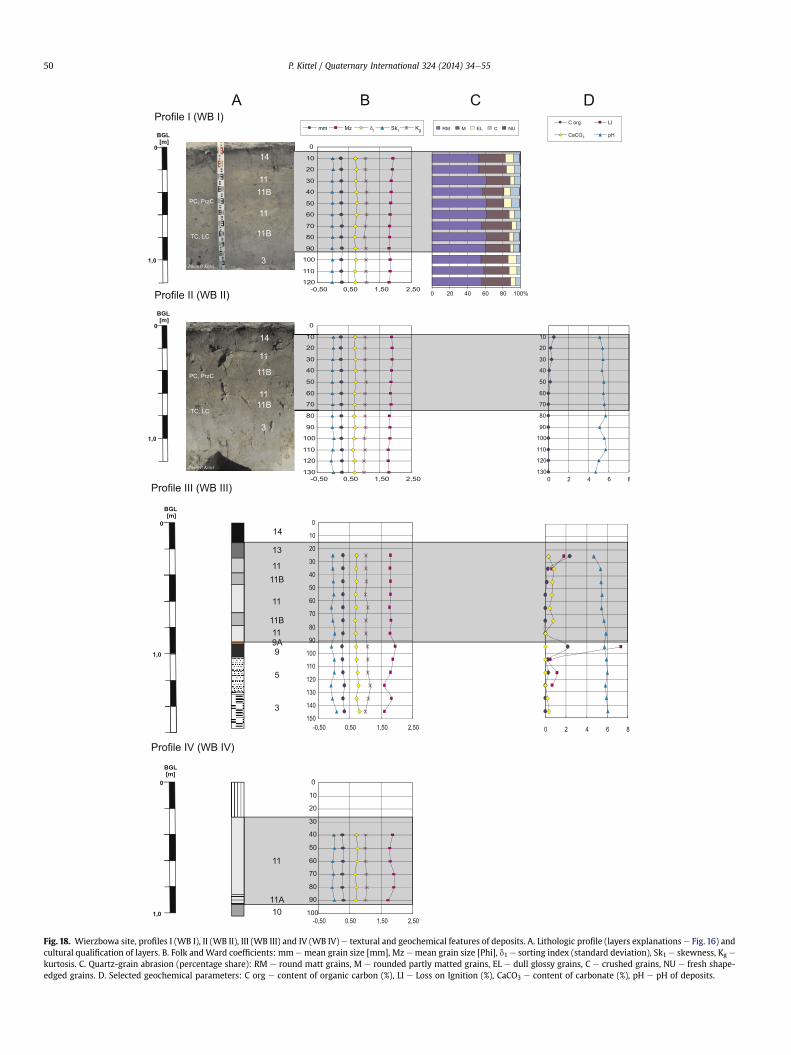
Fig. 18. Wierzbowa site, profiles I (WB I), II (WB II), III (WB III) and IV (WB IV) e textural and geochemical features of deposits. A. Lithologic profile (layers explanations e Fig. 16) andcultural qualification of layers. B. Folk andWard coefficients: mm emean grain size [mm], Mz emean grain size [Phi], d1 e sorting index (standard deviation), Sk1 e skewness, Kg e
kurtosis. C. Quartz-grain abrasion (percentage share): RM e round matt grains, M e rounded partly matted grains, EL e dull glossy grains, C e crushed grains, NU e fresh shape-edged grains. D. Selected geochemical parameters: C org e content of organic carbon (%), LI e Loss on Ignition (%), CaCO3 e content of carbonate (%), pH e pH of deposits.
P. Kittel / Quaternary International 324 (2014) 34e5550
P. Kittel / Quaternary International 324 (2014) 34e55 51
processes activity are in strict accordance with archaeologicalphases of occupation.
The beginning of slope processes at Lutomiersk-Koziówki star-ted ca. 1650e1350 BC, correlated with the initiation of the oldestdeposition phase and the TC people. Subsequently, the next twophases of more intensive slope cover deposition in the Pre-RomanPeriod and in the Late Roman period took place. The deluvial sandscover at Wierzbowa were deposited most probably not later thanca. 1500e1250 BC, continuing until the Late Roman Period. Thedocumentation of the beginning of slope wash processes at KoloniaBechcice site is not so clear, but archaeological dates show thatdeluvial sands cover were deposited most probably since the Ro-man Period.
The origin and development of slope covers correlate with hu-man factors and with anthropogenic changes of the natural envi-ronment. Distinctive archaeological relicts of human activity havebeen recognized, which documents periods of intensive impact ofhuman societies. Embankments resulted from establishment offeatures dug in the ground were also very sensitive to secondaryredeposition by slope wash processes. The human factor is aninitiator of important environmental changes, resulting in intensiveslope wash processes and in some cases in deposition of covers ofearthwork origin. Anthropogenic transformation of environmenthas to reach high intensity to initiate of changes of terrain relief andslope processes. Accumulation of deluvial deposits has been aneffect of natural processes initiated during periods of intensivesettlement and economic activity. Starkel (1988) and Twardy (2011)underline the necessity of long-term periods of human impactconnected with stable settlement for development of sedimento-logic records.
From the geomorphologic point of view, the occurrence ofdeluvial deposits records:
- local conditions (i.e. topographical, lithological) suitable forslope wash;
- deforestation of area (partly, periodically) resulted from natu-ral (climatic) changes or/and human impact;
- activity of slope wash.
From the geoarchaeological point of view, the occurrence ofslope deposits records:
- phases and chronology and intensity of settlement and eco-nomic activity, documented by archaeological dating (i.e. ar-tefacts and features or cultural layers);
- range of morphological and ecological zones occupied by hu-man groups and directions of economic activity, documentedby range of slope cover and additional ecofacts.
5.2. Age of anthropogenic initiation of slope processes in CentralPoland
The results show a high intensity of settlement activity andstrong anthropopressure almost since the Middle Bronze Age inCentral Poland. At the studied areas, it could be even stronger in theMiddle Bronze Age than in the Early Iron Age and in the RomanPeriod. This does not confirm the results presented by Twardy(2008, 2011) showing continuous increase of human impact inthe Prehistory. At Lutomiersk, efficiency of local human impact wasvery high in the Bronze Age, connected with bronze metallurgyconducted in the Ner River valley (Kittel et al., 2011;Muzolf, 2012d).
Evidence of a settlement hiatus between the TC and the early LCoccupation has not been recognized at the neighbouring siteLutomiersk-Koziówki 3d (Dziubek and Twardy, 2007; Twardy,
2008). Simultaneously, the buried soil has been recorded, indi-cating slope system stability in the Early Iron Age (Dziubek andTwardy, 2007; Twardy, 2008), similar to the results reached atLutomiersk-Koziówki 3aec site.
The so-called Phase I (1st) of transformation of relief of CentralPoland has been distinguished by Twardy (2008, 2011) based,among others, on the first results of research at Wierzbowa. In lightof the new investigation, the period of deposition of slope cover atthe site can be correlated with Phase II (2nd) dated to the MiddleBronze Age, i.e. to the period of transition between the TC and theLC. The oldest parts of deluvial sands at Wierzbowa and probablythe slope deposits at Lutomiersk-Koziówki are also the oldest slopecovers resulting from human impact recognized to this time in theqód�z region. Twardy and Forysiak (2012) have noted a cover ofdeluvial silts overlying peats dated by 14C to 4100 � 70 conv. BP inthe Warta River valley in Central Poland. This means that thatdeluvial cover might have been deposited even in the LateNeolithic, but the age of slope deposits is not confirmed by anyother method. Slope processes were active earlier than in CentralPoland and in southern Poland (Wasylikowa et al., 1985; Kruk et al.,1996; Starkel, 2005; Szwarczewski, 2009) and in Kuyavian Lakeland(Sinkiewicz, 1998), where Neolithic settlement were more inten-sive. The 1st phase of intensive gullying as a result of intensificationof slope processes has been dated to the Bronze Age in the Na1ec-zów Plateau in southeast Poland (Dotterweich et al., 2012).Nevertheless, intensive soil erosion is noted by Starkel (2005, 2011)in the Polish Uplands in the Bronze Age. Two colluvial depositscovers dated to Early Bronze Age and to the Late Bronze Age andEarly Iron Age have been recognised at the strongly transformedarea of the stronghold in Bruszczewo in Wielkopolska Lakeland(Czebreszuk and Hildebrandt-Radke, 2007; Hildebrandt-Radke,2011). Deluvial deposits in Lutomiersk and Wierzbowa are amongthe oldest anthropogenic slope covers in Central Poland.
In Germany, an initial maximum of deposition of slope sedi-ments (colluvial layers) documented by archaeological records hasbeen estimated to ca. 4300 BP, and the second prehistoricmaximum has been recorded ca. 2500e2000 BP (Dreibrodt et al.,2010). Dreibrodt et al. (2010) noted a decrease of slope depositionthroughout the Bronze Age and especially ca. 1500 BC, most char-acteristic for Central and Northern Germany. Simultaneously, aclear increase of records from Central and Northern Germany hasbeen recognized for the late Neolithic. Numerous deposits from theLate Bronze Age (ca. 3500e3000 BP) have been recognized insouthern Germany. Dotterweich (2008) noted higher soil erosionactivity in the Late Bronze Age. In Belarus, deposition of deluvia isrecorded ca. 3310 � 110 conv. BP (Kalicki et al., 1997; Kalicki, 2006).
5.3. Natural condition for anthropogenic slope wash processes inCentral Poland
It is always problematic to recognize the role of land-use orclimate change in the acceleration of slope processes (Zolitschkaet al., 2003; Dotterweich, 2008, 2012; Twardy, 2008; Starkel,2011). Dotterweich (2008) recognised a cool and wet phase in theLate Neolithic and in the Middle of the Bronze Age, based onanalysis of some reconstructions of climatic conditions in the Ho-locene in Europe. In contrast, Dotterweich (2012, p. 40) suggested a“prominently dry period in central Europe” in the Early and MiddleBronze Age (ca. 2000e1600 BC) in comparisonwith the Late BronzeAge. A wetter phase dated to 3.5e3.2 cal. (i.e. in the Middle BronzeAge) BP is fixed by Kalicki (1991, 2006) and has been designated as aphase of increased activity of processes controlled by both climateand human impact (Starkel, 2002, 2005, 2011). A wet and coolerperiod has been recognised by Kalicki (2006) in Belarus ca. 3200e2700 conv. BP.
P. Kittel / Quaternary International 324 (2014) 34e5552
In the qód�z region, only one palaeoecological profile at_Zabieniec has been described in detail that embraces the entireHolocene (Forysiak, 2012). In the _Zabieniec profile, the period ofincrease of water level in peat-bog has been recorded ca. 2970e2670 cal. BP (Forysiak et al., 2010). Phases with higher water levelare recognized in numerous lakes in Poland in the Bronze Age:Go�scia _z Lake e ca. 3500 conv. BP (Pazdur et al., 1995), Kórnik-Zaniemy�sl Lakes e 3800e3500 conv. BP (Wojciechowski, 2000),lakes in Bory Tucholskie e 3500e3000 conv. BP (Bogaczewicz-Adamczak, 1990) and in peat-bogs in Poland as well e 3700e3400 conv. BP ( _Zurek and Pazdur, 1999; _Zurek et al., 2002). The 6thphase of higher lake-lavel has been dated by Magny (2004) to3500e3100 cal. BP. An increase of fluvial activity is recorded for theperiod 3500e3000 conv. BP as well (Kalicki, 1991, 2006; Starkelet al., 1996; Starkel, 2002, 2011), and in that period dendrologicalrecords of frozen winters have been documented (Kalicki andKrapiec, 1991; Kalicki, 2006). Forysiak (2005) defines a higherfluvial activity and development of peat lands in the Warta Rivervalley between 3800 and 3200 conv. BP. The palaeochannel fill ofthe Ner River have been investigated at the Bechcice site situatedw2 km east from Lutomiersk. The results demonstrate, that thechannel was abandoned until 1370e1130 BC, 3000� 50 conv. BP, asalso recorded by archaeological artefacts (Kittel et al., 2011). Thevery gentle activity of aeolian processes in central Poland recordedby Twardy (2008) during the Phase III (3rd) of relief transformationin theMiddle Bronze Age was probably an effect of higher humidityof climate in the area. The first phase of deluvial depositionrecognized could be accelerated by increased humidity, butsimultaneously the role of humans cannot be overestimated.
The second more distinct phase of increase of slope processeshas been determined to the Late Roman Period, dated only byarchaeological records. It corresponds to the younger part of the IV(4th) Phase after Twardy (2008, 2011), although Twardy (2008,2011) stresses a distinctive increase of anthropogenic relief trans-formation. At the same time, intensive soil erosion of uplandssurfaces in southern Poland has not been recognized (Starkel, 2005,2011). Dreibrodt et al. (2010) record a clear decrease of slopedeposition in the whole Roman Period in Germany. In the LateRoman Period, climate is reconstructed by Starkel (2002, 2011) aswarm and dry, and it did not change until the Migration Period, ca.AD 450, when increased precipitation and humidity and decreaseof temperatures is noticed. Simultaneously, Dobrza�nska and Kalicki(2004) recorded the clustering of catastrophic events in the RomanPeriod (ca. 2.2e1.8 ka BP) resulting from a cold and wet climaticphase. Dotterweich (2008) reconstructs a rapid decrease of tem-peraturewithout any clear increase in precipitation during the DarkAges (Pessimum Dark Age). In the _Zabieniec profile, the wet periodhas been recorded in Roman Times, and about AD 400 probably arise in the water table occurred (Lamentowicz et al., 2009; Forysiaket al., 2010). A rapid rise of water level is recorded in Go�scia _z Lake inthe Roman Period and Migration Period transition (Pazdur et al.,1995). The “Dry phase” finished ca. 1700 conv. BP in mires ofEastern Poland ( _Zurek and Pazdur, 1999; _Zurek et al., 2002) and ca.1750 conv. BP in the Kórnik-Zaniemy�sl Lakes (Wojciechowski,2000). The very short 4th phase of higher lake-lavel has beendated by Magny (2004) to 1800e1700 cal. BP. Kalicki (2006) citesnumerous records of fluvial activity in Central Europe in the RomanPeriod and the Migration Period. In some river valleys of Lodz re-gion, records of floods have been dated to the Late Roman Period(Kami�nski, 1993; Kami�nski and Moszczy�nski, 1996; Twardy et al.,2004a), but probably they took place after the Roman Period.Turkowska (1990) documented development of peat lands in theflood plain of the Ner River close to qód�z since ca. 2000 conv. BP,recorded by a 14C date of 1780 � 120 BP from the bottom of peatcover (Turkowska, 1988). The spread of peat bogs in the Subatlantic
Period in the Ner River valley floor has not been confirmed inresearch undertaken in the Lutomiersk area (Kittel et al., 2011;Kittel, 2012a, 2012b).
It seems that climatic conditions in Central Poland in the LateRoman Period have not played a very important role in develop-ment of slope processes and the human impact was a necessaryindirect factor of initiation (see similar results of Zolitschka et al.,2003). The strict correlation of the deluvial deposits with arte-facts and ecofacts and rich remains of prehistoric settlement indi-cate human activity as an indirect factor of initiation andacceleration of slope processes in the area. The association of slopecovers with main settlement phases demonstrates that depositionof deluvia seems to be accelerated by land-use changes in thelandscape.
6. Conclusions
The origin and development of slope covers have been corre-lated with human activity and with anthropogenic changes of thenatural environment. Rich archaeological relicts of human activityhave been recorded, documenting periods of intensive activity ofhuman societies. The human factor is responsible for environ-mental changes resulting in creation of suitable conditions for theinitiation and development of slope processes. Accumulation ofdeluvial deposits has resulted from natural processes initiatedduring periods of intensive settlement and economic activity. Oneof the important features of anthropogenic deposits is the contentof artefacts and ecofacts.
The slope cover deposits are the source for recognition of in-tensity of land-use and of directions of palaeoeconomic activity ofancient societies and for distinguishing phases of hiatuses of set-tlement development. The chronology of slope deposits and slopeprocesses might be determined by standard methods used inQuaternary research. The archaeological method is important, andsimultaneously radiocarbon or dendrochronological dating ofidentified ecofacts must be undertaken (see Dreibrodt et al., 2010,2010a). From those reasons, geoarchaeological research must bealways organised in strict cooperation with archaeological inves-tigation at every stage of research and reconstruction of relief andevolution should be based on results of multidisciplinary geo-archaeological research (see also Zolitschka et al., 2003).
Acknowledgments
I want to thank the archaeologists I was working with: B. Muzolf(Museum of Archaeology and Ethnography in qód�z), P. Muzolf and J.B1aszczyk (Institute of Archaeology, University of Lodz). I also thankspecialists of: ksylology and antracology e K. Cywa (Institute ofBotany PAS, Krakow); plant macrofossils e R. Stachowicz-Rybkaand A. Mueller-Bieniek (Institute of Botany PAS, Krakow); paly-nology e A. Wacnik (Institute of Botany PAS, Krakow) and M.Obremska (Institute of Geology PAS, Warsaw); micromorphology e
A. Budek (Institute of Geography and Spatial Organization PAS,Krakow); sedimentology and geochemistry e J. Twardy, J. Forysiak,D., Okupny (Department of Geomorphology and PalaeogeographyUniversity of Lodz) and W. To1oczko (Department of Physical Ge-ography University of Lodz); radiocarbon dating e P. Trzeciak and I.Borowiec (Museum of Archaeology and Ethnography in qód�z) andM. Krapiec (Laboratory Radiocarbon Dating in Ska1a); thermolu-minescence dating e I. Olszak (Pomeranian University in S1upsk).Research has been supported by grants from The Ministry of Sci-ence and Higher Education No. 1 H01H 025 30 realized in 2006e2008 and from The Ministry of Culture and National Heritage(agreement no. 1080/11/FPK/NID). Fundacja Bada�n Arche-ologicznych im. Profesora Konrada Ja _zd _zewskiego in qód�z and
P. Kittel / Quaternary International 324 (2014) 34e55 53
Voivodship Monuments Protection Office have awarded additionalfinancing as well. I want to thank Prof. T. Kalicki and Prof. J. Twardyfor discussion during research and during preparing the paper. Ialso thank the reviewers for comments, which greatly improvedthe text.
References
Andres, W., Bos, J., Houben, P., Kalis, A., Nolte, S., Rittweger, H., Wunderlich, J., 2001.Environmental change and fluvial activity during the Younger Dryas in centralGermany. Quaternary International 79 (1), 89e100.
Bartkowski, T., 1978. �Srodowisko przyrodnicze grodu �sredniowiecznego w Ladzienad Warta �Srodkowa. In: B1aszczyk, W. (Ed.), Gród wczesno�sredniowieczny wLadzie nad �srodkowa Warta, Biblioteka Fontes Archaeologici Posnanienses, t. 4,pp. 13e31. Pozna�n.
Bednarek, R., 2004. Analiza podstawowych w1a�sciwo�sci gleb. In: Bednarek, R.,Dziadowiec, H., Pokojska, U., Prusinkiewicz, Z. (Eds.), Badania ekologiczno-gleboznawcze. PWN, Warszawa, pp. 53e112.
Bengtsson, L., Enell, M., 1986. Chemical analysis. In: Berglund, B.E. (Ed.), Handbookof Holocene Palaeoecology and Palaeohydrology. John Wiley and Sons, Chi-chester, England, UK, pp. 423e451.
Bogaczewicz-Adamczak, B., 1990. Paleolimnologia jezior Borów Tucholskich w�swietle bada�n kopalnych okrzemek. Zeszyty Naukowe Uniwersytetu Gda�n-skiego 150, 1e133.
Borówka, R.K., 1992. Przebieg i rozmiary denudacji w obrebie �sródwysoczyznowychbasenów sedymentacyjnych podczas pó�znego vistulianu i holocenu. SeriaGeografia 54, 1e177.
Bronk Ramsey, C., 2009. Bayesian analysis of radiocarbon dates. Radiocarbon 51 (1),337e360.
Cailleux, A., 1942. Les actions éoliennes périglaciaires en Europe. In: Mémoires de laSociété Géologique de France, vol. 46, pp. 1e176.
Czebreszuk, J., Hildebrandt-Radke, I., 2007. Man-made transformations of the reliefat the Bruszczewo archaeological site (Wielkopolska Lakeland). QuaestionesGeographicae 26 (A), 5e14.
Czepas, P., Oledzki, M., 2007. Osada ludno�sci kultury trzcinieckiej w Lutomiersku,Województwo qódzkie odkryta na stanowisku Wrzaca-Parcela 1. Prace iMateria1y Muzeum Archeologicznego i Etnograficznego w qodzi. Seria Arche-ologiczna 43, 63e72.
Dobrza�nska, H., Kalicki, T., 2004. Man and environment in the Vistula river valleynear Cracow from the 1st to the 7nd century AD. In: Dobrza�nska, H., Jerem, E.,Kalicki, T. (Eds.), The Geoarchaeology of River Valleys, Archaeolinqua, Ser. Mi-nor, vol. 18, pp. 105e141.
Dotterweich, M., 2008. The history of soil erosion and fluvial deposits in smallcatchments of central Europe: deciphering the long-term interaction betweenhumans and the environment. Geomorphology 101 (1e2), 192e208.
Dotterweich, M., 2012. Past soil erosion in central Europe: human impact andlong term effects. In: Bebermeier, W., Hebenstreit, R., Kaiser, E., Krause, J.(Eds.), 2012. Landscape Archaeology Conference (LAC 2012), Special vol. 3.eTopi, pp. 39e45.
Dotterweich, M., Rodzik, J., Zg1obicki, W., Schmitt, A., Schmidtchen, G., Bork, H.-R.,2012. High resolution gully erosion and sedimentation processes, and land usechanges since the Bronze Age and future trajectories in the Kazimierz Dolnyarea (Na1eczów Plateau, SE-Poland). Catena 95, 50e62. http://dx.doi.org/10.1016/j.catena.2012.03.001.
Dreibrodt, S., Lubos, C., Terhorst, B., Damm, B., Bork, H.-R., 2010. Historical soilerosion by water in Germany: scales and archives, chronology, research per-spectives. Quaternary International 222 (1e2), 80e95.
Dreibrodt, S., Lomax, J., Nelle, O., Lubos, C., Fischer, P., Mitusov, A., Reiss, S.,Radtke, U., Nadeau, M., Grootes, P., Bork, H.-R., 2010a. Are mid-latitude slopessensitive to climatic oscillations? Implications from an Early Holocene sequenceof slope deposits and buried soils from eastern Germany. Geomorphology 122(3e4), 351e369.
Dutkiewicz, L., 1989. Szczegó1owa Mapa Geologiczna Polski w skali 1: 50 000,Arkusz Parzeczew (589). Warszawa.
Dylik, J., 1969. Slope development under periglacial conditions in the qód�z region.Biuletyn Peryglacjalny 18, 381e410.
Dziubek, E., Twardy, J., 2007. Transformacja rze�zby wysokiego poziomu dolinnegoNeru wskutek wielowiekowego zasiedlenia i gospodarki w �swietle wykopalis-kowych bada�n archeologicznych na stanowisku 21 w Lutomiersku i Wrzacej-Parceli 1. In: Smolska, E., Szwarczewski, P. (Eds.), 2007. Zapis dzia1alno�scicz1owieka w �srodowisku przyrodniczym, t. III, pp. 31e37. Warszawa.
Folk, R., Ward, W., 1957. Brazos River bar: a study in the significance of grain sizeparameters. Journal of Sedimentary Petrology 27 (1), 3e26.
Forysiak, J., 2005. Ewolucja doliny Warty miedzy uj�sciem Widawki a uj�sciem Neru.Acta Geographica Lodziensia 90, 1e116.
Forysiak, J., 2012. Zapis zmian �srodowiska przyrodniczego pó�znego vistulianu iholocenu w osadach torfowisk regionu 1ódzkiego. Acta Geographica Lodziensia99, 1e164.
Forysiak, J., Borówka, R., Kittel, P., Kloss, M., Lamentowicz, M., Paw1owski, D.,P1óciennik, M., Twardy, J., _Zurek, S., 2010. Holoce�nski rozwój torfowiska_Zabieniec i jego znaczenie dla paleoekologii i paleogeografii. In: Twardy, J.,_Zurek, S., Forysiak, J. (Eds.), Torfowisko _Zabieniec: warunki naturalne, rozwój i
zapis zmian paleoekologicznych w jego osadach. Bogucki Wydawnictwo Nau-kowe, Pozna�n, pp. 203e214.
Gardawski, A., 1959. Plemiona kultury trzcinieckiej w Polsce. Materia1y Staro _zytne5, 7e189.
Górki, J., Makarowicz, P., Wawrusiewicz, A., 2011. Osady i cmentarzyska spo-1eczno�sci trzcinieckiego kregu kulturowego w Polesiu, stanowisko 1, woj.1ódzkie, Tom I. Tekst. qód�z.
Go�zdzik, J., 1982. �Srodowisko przyrodnicze osadnictwa �sredniowiecznego okolicRozprzy. Prace i Materia1y Muzeum Archeologicznego i Etnograficznego wqodzi. Seria Archeologiczna 29, 138e151.
Hildebrandt-Radke, I., 2011. Stratygrafia osadów fosy i strefy krawedziowej nastanowisku archeologicznym w Bruszczewie jako rezultat jego u _zytkowania wpradziejach. Landform Analysis 16, 81e86.
James, L.A., 2013. Legacy sediment: definitions and processes of episodically pro-duced anthropogenic sediment. Anthropocene. http://dx.doi.org/10.1016/j.ancene.2013.04.001.
Kalicki, T., 1991. The evolution of the Vistula river valley between Cracow andNiepo1omice in late Vistulian and Holocene times. In: Starkel, L. (Ed.), Evolutionof the Vistula River Valley During the Last 15 000 Years, Part IV, GeographicalStudies, Special Issue No. 6, pp. 11e37.
Kalicki, T., 2006. Zapis zmian klimatu oraz dzia1alno�sci cz1owieka i ich rola w hol-oce�nskiej ewolucji dolin �srodkowoeuropejskich. In: Prace Geograficzne IGiPZPAN 204, pp. 1e348.
Kalicki, T., Krapiec, M., 1991. Subboreal black oaks identified from the Vistula alluvia atGrabie near Cracow (South Poland). Kwartalnik AGH, Geologia 17 (1/2), 155e171.
Kalicki, T., San’ko, A.F., Litvinjuk, G.I., 1997. Zapis pó�znoglacjalnych i holoce�nskichzmian klimatu i dzia1alno�sci cz1owieka w osadach dna i zboczy doliny Ptyczyko1o Mi�nska. In: Kalicki, T. (Ed.), Badania ewolucji dolin rzecznych na Bia1orusie I, Dokumentacja Geograficzna, vol. 6, pp. 83e104.
Kami�nski, J., 1993. Pó�znoplejstoce�nska i holoce�nska transformacja doliny Moszc-zenicy jako rezultat zmian �srodowiska naturalnego oraz dzia1alno�sci cz1owieka.Acta Geographica Lodziensia 64, 1e104.
Kami�nski, J., Moszczy�nski, J., 1996. Wp1yw osadnictwa kultury przeworskiej nakszta1towanie doliny Moszczenicy w okolicach Woli Branickiej. Acta Geo-graphica Lodziensia 71, 55e66.
Kittel, P., 2012a. Wp1yw georó _znorodno�sci zlewni Neru (Polska �srodkowa) nalokalizacje osadnictwa pradziejowego. Landform Analysis 19, 33e50.
Kittel, P., 2012b. 2. Geomorfologia stanowiska 3a-c Lutomiersk-Koziówki. In:Muzolf, B. (Ed.), Lutomiersk e Koziówki stanowisko 3 a-c, pow. pabianicki, woj.1ódzkie. Wielokulturowy zespó1 osadniczy od schy1kowego paleolitu po okresnowo _zytny, Biblioteka Muzeum Archeologicznego i Etnograficznego w qodzi,vol. 39, pp. 27e37. qód�z.
Kittel, P., 2012c. Budowa i ewolucja doliny Neru w rejonie stanowiska Lutomiersk-Koziówki w �swietle bada�n geoarcheologicznych. Acta Geographica Lodziensia100, 113e133.
Kittel, P., Skowron, J., 2009. Geomorfologiczne uwarunkowania lokalizacji i rozwojuosadnictwa w rejonie Rawy Mazowieckiej (Polska �srodkowa) w okresie rzym-skim. �Srodowisko e Cz1owiek e Cywilizacja 2, 147e154.
Kittel, P., Twardy, J., 2003. Wp1yw pradziejowej aktywno�sci ludzkiej na funkcjo-nowanie stoku w Wierzbowej (pradolina warszawsko-berli�nska). In: Waga, J.,Kocel, K. (Eds.), Cz1owiek w �srodowisku przyrodniczym e zapis dzia1alno�sci,pp. 68e73. Sosnowiec.
Kittel, P., B1aszczyk, J., Cywa, K., Muzolf, B., Obremska, M., Wacnik, A., Tomczy�nska, Z.,2011. Traces of Prehistoric human impact on natural environment in the Ner RiverCatchment (Central Poland). In: Hildebrandt-Radke, I., Dörfler, W., Czebreszuk, J.,Müller, J. (Eds.), Anthropogenic Pressure in theNeolithic and the BronzeAge on theCentral European Lowlands, Studien zur Archäeologie in Ostmitteleuropa/Studianad Pradziejami Europy �Srodkowej, B. 8/T. 8. BoguckiWydawnictwo Naukowe, Dr.Rudolf Habelt GmbH, Pozna�n-Bonn, pp. 129e141.
Klatkowa, H., 1978. Mapa Geologiczna Polski 1: 200 000, A e Mapa UtworówPowierzchniowych (Mapa podstawowa 1: 50 000), arkusz Parzeczew (589).Warszawa.
Klatkowa, H., 1989. Postwarcia�nskie kszta1towanie górnych odcinków dolin.Przyk1ady z Wy _zyny qódzkiej. Acta Geographica Lodziensia 59, 61e74.
Klatkowa, H., 1991. Wyniki analizy morfoskopowej wybranych osadów czwar-torzedowych �srodkowej Polski. In: Geneza, litologia i stratygrafia utworówczwartorzedowych. Zeszyty Naukowe UAM, Geografia 50, pp. 277e287.
Kmieci�nski, J., 1959. Kurhan z pó�znego okresu rzymskiego w miejscowo�sci Bechcicee Bi1goraj, pow. qask. Wiadomo�sci Archeologiczne 24, 60e61.
Kobyli�nski, Z., 1988. Struktury osadnicze na ziemiach polskich u schy1ku star-o _zytno�sci i w poczatkach wczesnego �sredniowiecza. Ossolineum, Warszawa-Kraków-Gda�nsk-qód�z.
Kondracki, J., 2002. Geografia regionalna Polski. PWN, Warszawa.Krajewski, K., 1977. Poziomy terasowe w pradolinie Warszawsko-Berli�nskiej miedzy
Warta a Wzgórzami Domaniewickimi. In: Acta Universitatis Lodziensis, ZeszytyNaukowe Uq, Nauki Matematyczno-Przyrodnicze, vol. 5, pp. 99e108.
Kruk, J., Milisauskas, S., Alexandrowicz, S.W., �Snieszko, Z., 1996. Osadnictwo izmiany �srodowiska naturalnego wy _zyn lessowych. Studia archeologiczne ipaleogeograficzne nad neolitem w dorzeczu Nidzicy. IAiE PAN, Kraków.
Kurnatowska, Z., Kurnatowski, S., 1991. Zasiedlenie regionu Lednicy w pradziejach i�sredniowieczu w �swietle dotychczasowych bada�n. In: Tobolski, K. (Ed.), Wstepdo paleoekologii Lednickiego Parku Krajobrazowego, pp. 35e42. Pozna�n.
Kurnatowski, S., 1966. Przemiany techniki uprawy roli w czasach miedzy epokabrazowa i wczesnym �sredniowieczem a rozmieszczenie stref zasiedlenia. Studiaz Dziejów Gospodarstwa Wiejskiego 8, 92e99.
P. Kittel / Quaternary International 324 (2014) 34e5554
Lamentowicz, M., Balwierz, Z., Forysiak, J., P1óciennik, M., Kittel, P., Kloss, M.,Twardy, J., _Zurek, S., Pawlyta, J., 2009. Multiproxy study of anthropogenic andclimatic changes in the last two millennia from a small mire in central Poland.Hydrobiologia 631, 213e230. http://dx.doi.org/10.1007/s10750-009-9812-y.
Leopold, M., Völkel, J., 2007. Colluvium: definition, differentiation, and possiblesuitability for reconstructing Holocene climate. Quaternary International 162e163, 133e140.
Lindner, L., Marks, L., 2012. O podziale klimatostratygraficznym kompleksu�srodkowopolskiego w plejstocenie Polski. Przeglad Geologiczny 60 (1), 36e45.
Magny, M., 2004. Holocene climate variability as reflected by mid-European lake-level fluctuations and its probable impact on prehistoric human settlements.Quaternary International 113, 65e79.
Makarowicz, P., 2010. Trzciniecki krag kulturowy e wspólnota pogranicza Wschodui Zachodu Europy. Archaeologia Bimaris Monografie 3, 1e445.
Makarowicz, P., Milecka, K., 1999. Society and the Environment. A case of EarlyBronze Age settlements complex from Rybiny, Cuiavia, Poland. ArchaeologiaPolona 37, 49e70.
Manikowska, B., 1993. Mineralogy and abrasion of sand grains due to Vistula (latePleistocene) aeolian processes in Central Poland. Geologie en Mijnbouw 72,167e177.
Marks, L., 2011. Quaternary glaciations in Poland (Chapter 23). In: Ehlers, J.,Gibbard, P.L., Hughes, P.D. (Eds.), 2011. Developments in Quaternary Sciences,vol. 15, pp. 299e303.
Muzolf, B. (Ed.), 2012a. Lutomiersk e Koziówki stanowisko 3 a-c, pow. pabianicki,woj. 1ódzkie. Wielokulturowy zespó1 osadniczy od schy1kowego paleolitu pookres nowo _zytny. Biblioteka Muzeum Archeologicznego i Etnograficznego wqodzi, vol. 39. qód�z.
Muzolf, B., 2012b. 1. Wstep. In: Muzolf, B. (Ed.), Lutomiersk e Koziówki stanowisko3 a-c, pow. pabianicki, woj. 1ódzkie. Wielokulturowy zespó1 osadniczy odschy1kowego paleolitu po okres nowo _zytny, Biblioteka Muzeum Arche-ologicznego i Etnograficznego w qodzi, vol. 39, pp. 9e25. qód�z.
Muzolf, B., 2012c. 3.3. Osadnictwo epoki brazu e uwagi wstepne. In: Muzolf, B.(Ed.), Lutomiersk e Koziówki stanowisko 3 a-c, pow. pabianicki, woj. 1ódzkie.Wielokulturowy zespó1 osadniczy od schy1kowego paleolitu po okres now-o _zytny, Biblioteka Muzeum Archeologicznego i Etnograficznego w qodzi, vol.39, pp. 57e58. qód�z.
Muzolf, B., 2012d. 3.3.2. Osadnictwo �srodkowopolskiej grupy 1u _zyckich pólpopielnicowych. In: Muzolf, B. (Ed.), Lutomiersk e Koziówki stanowisko 3 a-c,pow. pabianicki, woj. 1ódzkie. Wielokulturowy zespó1 osadniczy odschy1kowego paleolitu po okres nowo _zytny, Biblioteka Muzeum Arche-ologicznego i Etnograficznego w qodzi, vol. 39, pp. 114e178. qód�z.
Muzolf, P., 2012e. 3.3.1. Osadnictwo kultury trzcinieckiej. In: Muzolf, B. (Ed.),Lutomiersk e Koziówki stanowisko 3 a-c, pow. pabianicki, woj. 1ódzkie. Wie-lokulturowy zespó1 osadniczy od schy1kowego paleolitu po okres nowo _zytny,Biblioteka Muzeum Archeologicznego i Etnograficznego w qodzi, vol. 39,pp. 58e113. qód�z.
Mycielska-Dowgia11o, E., 1995. Wybrane cechy teksturalne osadów i ich warto�s�cinterpretacyjna. In: Mycielska-Dowgia11o, E., Rutkowski, J. (Eds.), Badaniaosadów czwartorzedowych. WGiSR, UW, Warszawa, pp. 29e105.
Mycielska-Dowgia11o, E., 2007. Metody bada�n cech teksturalnych osadów klas-tycznych i warto�s�c interpretacyjna wyników. In: Mycielska-Dowgia11o, E.,Rutkowski, J. (Eds.), Badania cech teksturalnych osadów czwartorzedowych iwybrane metody oznaczania ich wieku. Wydawnictwo Szko1y Wy _zszej Przy-mierza Rodzin, Warszawa, pp. 95e180.
Mycielska-Dowgia11o, E., Ludwikowska-Kedzia, M., 2011. Alternative interpretationsof grain-size data from Quaternary deposits. Geologos 17 (4), 189e203.
Passega, R., 1964. Grain size representation by CM patterns as a geological tool.Journal of Sedimentary Petrology 34, 830e847.
Passega, R., Byramjee, R., 1969. Grain size image of clastic deposits. Sedimentology13, 830e847.
Pavlov, A.P., 1888. Geneticheskie tipy materikovykh obrazovanii lednikovoi iposleled-nikovoi epokhi, 7. Izvestiia Geologicheskogo komiteta (in Russian).
Pazdur, A., Fontugne, M., Goslar, T., Pazdur, M., 1995. Lateglacial and Holocene water-level changes of the Go�scia _z Lake, Central Poland, derived from carbon isotopesstudies of laminated sediments. Quaternary Science Reviews 14 (2), 125e135.
Petera, J., 2002. Vistulia�nskie osady dolinne w basenie uniejowskim i ich wymowapaleogeograficzna. Acta Geographica Lodziensia 83, 1e164.
Reimer, P.J., Baillie, M.G.L., Bard, E., Bayliss, A., Beck, J.W., Blackwell, P.G., BronkRamsey, C., Buck, C.E., Burr, G.S., Edwards, R.L., Friedrich, M., Grootes, P.M.,Guilderson, T.P., Hajdas, I., Heaton, T.J., Hogg, A.G., Hughen, K.A., Kaiser, K.F.,Kromer, B., McCormac, F.G., Manning, S.W., Reimer, R.W., Richards, D.A.,Southon, J.R., Talamo, S., Turney, C.S.M., van der Plicht, J., Weyhenmeyer, C.E.,2009. IntCal09 and Marine09 radiocarbon age calibration curves, 0-50,000years cal BP. Radiocarbon 51 (4), 1111e1150.
Roman, M., 2010. Rekonstrukcja lobu p1ockiego w czasie ostatniego zlodowacenia.Acta Geographica Lodziensia 96, 1e171.
Rühle, E., 1973. Metodyka bada�n osadów czwartorzedowych. Wydawnictwo Geo-logiczne, Warszawa.
Schulte, A., Stumböck, M., 2000. Late Glacial and Holocene Environmental Changesin the Hegau Region, Southwest Germany. Acta Universitatis Carolinae, Geo-graphica 25, 85e97 (Supplementum).
Sici�nski, W., 2012. Osadnictwo kultury przeworskiej w m1odszym okresie przedr-zymskim i okresie wp1ywów rzymskich, 3.5. In: Muzolf, B. (Ed.), Lutomiersk e
Koziówki stanowisko 3 a-c, pow. pabianicki, woj. 1ódzkie. Wielokulturowyzespó1 osadniczy od schy1kowego paleolitu po okres nowo _zytny, Biblioteka
Muzeum Archeologicznego i Etnograficznego w qodzi, vol. 39, pp. 187e221.qód�z.
Sinkiewicz, M., 1995. Przeobra _zenia rze�zby terenu i gleb w okolicy Biskupinawskutek denudacji antropogenicznej. In: Niewiarowski, W. (Ed.), Zarys zmian�srodowiska geograficznego okolic Biskupina pod wp1ywem czynników natu-ralnych i antropogenicznych w pó�znym glacjale i holocenie. Oficyna Wydaw-nicza “Turpress”, Toru�n, pp. 281e290.
Sinkiewicz, M., 1998. Rozwój denudacji antropogenicznej w �srodkowej cze�sci Polskipó1nocnej. Wydawnictwo UMK, Toru�n.
Smolska, E., 2005. Znaczenie sp1ukiwania w modelowaniu stoków m1odoglacjalnych(na przyk1adzie Pojezierza Suwalskiego). WGiSR UW, Warszawa.
Smolska, E., 2008. Badania sedymentologiczne wspó1czesnych osadów delu-wialnych i ich znaczenie w ocenie dynamiki procesów erozji gleby naprzyk1adzie Pojezierza Suwalskiego. Assesment of soil erosion processes basedon sedimentological analyses of contemporary deluvial sediments on theexample of the Suwa1ki Lakeland. Przeglad Naukowy In _zynierja i Kszta1towanie�Srodowiska 2 (40), 202e212.
Starkel, L., 1987. Man as cause of sedimentological changes in the Holocene. Striae26, 5e12.
Starkel, L., 1988. Dzia1alno�s�c cz1owieka jako przyczyna zmian procesów denudacji isedymentacji w holocenie. Przeglad Geograficzny 60, 251e265.
Starkel, L., 2002. Changes in the frequency of the extreme events as the indictor ofclimatic change in the Holocene (in fluvial system). Quaternary International 91,25e32.
Starkel, L., 2005. Anthropogenic soil erosion since the Neolithic in Poland. Zeits-chrift für Geomorphologie Suppl-Band 139, 189e201.
Starkel, L., 2011. Present-day events and the evaluation of Holocene palaeoclimaticproxy data. Quaternary International 229, 2e7.
Starkel, L., Kalicki, T., Krapiec, M., Soja, R., Gebica, P., Czy _zowska, E., 1996. Hydro-logical changes of valley floors in upper Vistula basin during late Vistulian andHolocene. In: Starkel, L., Kalicki, T. (Eds.), Evolution of the Vistula River ValleyDuring the Last 15,000 Years, Geographical Studies, Special Issue 9, pp. 7e128.Wroc1aw.
Stochlak, J., 1978. Struktury i tekstury m1odoplejstoce�nskich osadów deluwialnych.Biuletyn Instytutu Geologicznego 306, 115e174.
Stochlak, J., 1996. Osady deluwialne nieod1aczny efekt procesu sp1ukiwania i pro-pozycja ich podzia1u. In: Józefciuk, A. (Ed.), Ochrona agroekosystemów zagro-_zonych erozja: ogólnopolskie sympozjum naukowe, Pu1awy e Lublin eZwierzyniec, 11-13 wrze�snia 1996 r., Prace Naukowe, Cze�s�c 2, pp. 111e132.Pu1awy.
Szama1ek, K., 1985. Przemiany �srodowiska geograficznego w rejonie Kruszwicy naprze1omie epoki brazu i wczesnej epoki _zelaza oraz ich wp1yw na osadnictwo.Archeologia Polski 30, 329e366.
Szma�nda, J., Lankauf, K., Luc, M., 2004. Próba rekonstrukcji zmian rze�zby Góry �sw.Wawrzy�nca i fazy jej rozwoju. In: Chudziak, W. (Ed.), Wczesno�sredniowiecznyzespó1 osadniczy w Ka1dusie. Studia przyrodniczo-archeologiczne, Mons SanctiLaurentii, t. 2. Wydawnictwo Uniwersytetu Miko1aja Kopernika, Toru�n, pp. 177e183.
Szwarczewski, P., 2009. The formation of deluvial and alluvial cones as a conse-quence of human settlement on a Loess Plateau: an example from the ChroberzArea (Poland). Radiocarbon 51 (2), 445e455.
Teisseyre, A., 1991. The deluvial (slopewash) system: a proposal. Bulletin of thePolish Academy of Sciences, Earth Sciences 39, 381e388.
Teisseyre, A., 1994. Sp1yw stokowy i wspó1czesne osady deluwialne w lessowymrejonie Henrykowa na Dolnym �Slasku. In: Acta Universatis Wratislaviensis,Prace Geologiczno-Mineralogiczne, vol. 43, pp. 1e188.
Turin, I., 1937. Organic Substances of Soils. Moscow.Turkowska, K., 1988. Rozwój dolin rzecznych na Wy _zynie qódzkiej w pó�znym
czwartorzedzie. Acta Geographica Lodziensia 57, 1e157.Turkowska, K., 1990. Main fluvial episodes in the Ner Valley in the last 22 000 years;
a detailed study in Lublinek near qód�z, Central Poland. Quaternary Studies inPoland 9, 85e99.
Turkowska, K., 2006. Geomorfologia regionu 1ódzkiego. Wydawnictwo Uni-wersytetu qódzkiego, qód�z.
Turkowska, K., Dzieduszy�nska, D., 2011. Local evidence of landform evolution vs.global changes e a case of younger dryas study in the upper Ner valley system,Central Poland. Geographia Polonica 84 (Special Issue Part 1), 147e162.
Twardy, J., 2000. Deluwia neoholoce�nskie e przyk1ady z Wy _zyny qódzkiej. ActaGeographica Lodziensia 78, 135e173.
Twardy, J., 2003. Cechy sedymentologiczne neoholoce�nskich osadów stokowych naWy _zynie qódzkiej i ich warto�s�c interpretacyjna. Prace i Studia Geograficzne 33,25e44.
Twardy, J., 2004. Przebieg holoce�nskiej ewolucji stoków doliny Warty na obszarzepo1udniowej cze�sci Kotliny Sieradzkiej w �swietle analiz osadów stokowych.Acta Geographica Lodziensia 88, 49e84.
Twardy, J., 2008. Transformacja rze�zby centralnej cze�sci Polski �Srodkowej w war-unkach antropopresji. Wydawnictwo Uniwersytetu qódzkiego, qód�z.
Twardy, J., 2011. Influences of man and climate changes on relief and geologicalstructure transformation in Central Poland since the neolithic. GeographiaPolonica 84 (Special Issue Part 1), 163e178.
Twardy, J., Forysiak, J., 2011. Charakterystyka �srodowiska geograficznego okolicstanowiska archeologicznego Polesie 1 oraz neoholoce�nskie zmiany jego bud-owy geologicznej i rze�zby. In: Górski, J., Makarowicz, P., Wawrusiewicz, A.(Eds.), 2011. Osady i cmentarzyska spo1eczno�sci trzcinieckiego kregu kultur-owego w Polesiu, stanowisko 1, woj. 1ódzkie, Tom I, pp. 227e250. Tekst, qód�z.
P. Kittel / Quaternary International 324 (2014) 34e55 55
Twardy, J., Forysiak, J., 2012. Development of human-inducted geomorphologicalprocesses in the vivinity of peatlands of Central Poland. In: Forysiak, J.,Kucharski, L., Ziu1kiewicz, M. (Eds.), Peatland in semi-natural landscape e theirtransformation and possibility of protection. Bogucki Wydawnictwo Naukowe,Pozna�n, pp. 85e99.
Twardy, J., Forysiak, J., Kittel, P., 2004. Dynamika procesów morfogenetycznych uru-chomionych i zintensyfikowanych wskutek pradziejowej dzia1alno�sci ludzkiej wpradolinie warszawsko-berli�nskiej. Acta Geographica Lodziensia 88, 85e117.
Twardy, J., Kami�nski, J., Moszczy�nski, J., 2004a. Zapis gospodarczej dzia1alno�scicz1owieka z okresu late�nskiego i rzymskiego w formach i osadach Polski�srodkowej. In: Abramowicz, D., �Snieszko, Z. (Eds.), Zmiany �srodowiska geo-graficznego w dobie gospodarki rolno-hodowlanej, Studia z obszaru Polski,pp. 197e221. Katowice.
Wachecka-Kotkowska, L., 2004. Ewolucja doliny Lucia _zy e uwarunkowania kli-matyczna a lokalne. Acta Geographica Lodziensia 86, 1e161.
Wasylikowa, K., Starkel, L., Niedzia1kowska, E., Skiba, S., Stworzewicz, E., 1985.Environmental changes in the Vistula valley at Pleszów caused by Neolithicman. Przeglad Archeologiczny 33, 19e55.
Wieczorkowska, J., 1976. Rola zag1ebie�n bezodp1ywowych w rozwoju rze�zby okolicqodzi. Acta Geographica Lodziensia 37, 183e190.
Wiklak, H., 1963. Poczatki kultury 1u _zyckiej w Polsce �srodkowej. Acta ArchaeologicaLodziensia 12, 1e130.
Wojciechowski, A., 2000. Zmiany paleohydrologiczne w �srodkowej Wielkopolsce wciagu ostatnich 12 000 lat w �swietle bada�n osadów jeziornych rynny kórnicko-zaniemyskiej. UAM, Pozna�n.
Zawilski, P., 1999. Badania archeologiczne na stanowiskach Lutomiersk-Koziówki3D oraz Wrzaca-Parcela 1, gm. Lutomiersk, woj. 1ódzkie, przeprowadzone w1999 r. In: qódzkie Sprawozdania Archeologiczne, vol. 5, pp. 103e116.
Zeeberg, J., 1998. The European sand belt in eastern Europe e and comparisonof Late Glacial dune orientation with GCM simulation results. Boreas 27,127e139.
Zolitschka, B., Behre, K.-E., Schneider, J., 2003. Human and climatic impact on theenvironment as derived from colluvial, fluvial and lacustrine archi-vesdexamples from the Bronze Age to the migration period, Germany. Qua-ternary Science Reviews 22 (1), 81e100.
_Zurek, S., Pazdur, A., 1999. Zapis zmian paleohydrologicznychw rozwoju torfowiskPolski (Record of palaeohydrological changes in development of mires inPoland). In: Pazdur, A., Bluszcz, A., Stankowski, W., Starkel, L. (Eds.), Geo-chronologia górnego czwartorzedu Polski w �swietle datowania radio-weglowego i luminescencyjnego. Instytut Fizyki Politechniki �Slaskiej, Gliwice,pp. 215e228.
_Zurek, S., Michczy�nska, D., Pazdur, A., 2002. Time record of palaeohydrologicchanges in the development of mires during the Late Glacial and Holocene,North Podlasie Lowland and Holy Cross Mts. Geochronometria 21, 109e118.