Slope and river inorganic deposits as indicators of marked human impact, in the light of research in...
16
Archaeologia Polona, vol. 49 : 2011 (2013), 71 – 86 PL ISSN 0066 - 5924 Slope and river inorganic deposits as indicators of marked human impact, in the light of research in the Ner River basin (central Poland) Piotr Kittel a is paper presents the results of multidisciplinary research on Neo-Holocene alluvial and colluvial sediment covers undertaken in the Ner River basin in central Poland. is research environmental archaeology has been undertaken as part of archaeological investigations at the sites of Szynkielew, Lutomiersk-Koziówki and Wierzbowa. Overbank sands and silts cut by episodic channels filled with alluvium have been recognized in the Dobrzynka River valley at the Szynkielew site. ese sediments most probably accumulated in the 12 th century AD after the area became a property of the chapter of the Kraków bishop. An episodic channel at Lutomiersk-Koziówki site was formed by high flood flow most probably resulting from the draining of a pond between 16 th and 19 th century AD. At the archaeological settlement complex at Wierzbowa, fossil cultural layers have been uncovered which were deposited within sandy slope wash sediments accumulated on the surface of a valley slope. e initiation of the accumulation of the whole slope cover has been attributed to the period after c. 1900–1750 BC correlating with activity of people of the Trzciniec Culture. Only comprehensive multidisciplinary research can provide the data to correlate the accumula- tion of such inorganic sediment covers with past human activity. e character of discussed series indicates that the sediments arise from very intensive processes initiated indirectly by human activ- ity as evidenced by their geological context, archaeobotanical content, and absolute chronology. KEY-WORDS: geoarchaeology, anthropopressure, alluvium, slope cover, Neo-Holocene, Ner River basin INTRODUCTION Slope systems, as well as river systems, are very sensitive to the impact of climatic changes (mainly cooling) on the one hand, and intensive settlement and economic activity by human societies on the other hand (Starkel 1989, 2002, 2004, 2011; Brückner 1986; Sinkiewicz 1989, 1998; Teisseyre 1991; Stochlak 1996; Schulte and Stumböck 2000; Dotterweich et al. 2003; Fuchs et al. 2004; Smolska 2005; Twardy 2008, 2011; Kalicki a Department of Geomorphology and Palaeogeography, Faculty of Geographical Sciences, University of Łódź, 88 Narutowicza St., 90-139 Łódź, Poland; [email protected]
Transcript of Slope and river inorganic deposits as indicators of marked human impact, in the light of research in...
Archaeologia Polona, vol. 49 : 2011 (2013), 71 – 86PL ISSN 0066 - 5924
Slope and river inorganic depositsas indicators of marked human impact,in the light of researchin the Ner River basin (central Poland)
Piotr Kittela
This paper presents the results of multidisciplinary research on Neo-Holocene alluvial and colluvial sediment covers undertaken in the Ner River basin in central Poland. This research environmental archaeology has been undertaken as part of archaeological investigations at the sites of Szynkielew, Lutomiersk-Koziówki and Wierzbowa.
Overbank sands and silts cut by episodic channels filled with alluvium have been recognized in the Dobrzynka River valley at the Szynkielew site. These sediments most probably accumulated in the 12th century AD after the area became a property of the chapter of the Kraków bishop. An episodic channel at Lutomiersk-Koziówki site was formed by high flood flow most probably resulting from the draining of a pond between 16th and 19th century AD. At the archaeological settlement complex at Wierzbowa, fossil cultural layers have been uncovered which were deposited within sandy slope wash sediments accumulated on the surface of a valley slope. The initiation of the accumulation of the whole slope cover has been attributed to the period after c. 1900–1750 BC correlating with activity of people of the Trzciniec Culture.
Only comprehensive multidisciplinary research can provide the data to correlate the accumula-tion of such inorganic sediment covers with past human activity. The character of discussed series indicates that the sediments arise from very intensive processes initiated indirectly by human activ-ity as evidenced by their geological context, archaeobotanical content, and absolute chronology.
KEY-WORDS: geoarchaeology, anthropopressure, alluvium, slope cover, Neo-Holocene, Ner River basin
INTRODUCTION
Slope systems, as well as river systems, are very sensitive to the impact of climatic changes (mainly cooling) on the one hand, and intensive settlement and economic activity by human societies on the other hand (Starkel 1989, 2002, 2004, 2011; Brückner 1986; Sinkiewicz 1989, 1998; Teisseyre 1991; Stochlak 1996; Schulte and Stumböck 2000; Dotterweich et al. 2003; Fuchs et al. 2004; Smolska 2005; Twardy 2008, 2011; Kalicki a Department of Geomorphology and Palaeogeography, Faculty of Geographical Sciences, University of
Łódź, 88 Narutowicza St., 90-139 Łódź, Poland; [email protected]
72 | Kittel
2005; Klimek et al. 2006). Aeolian, lacustrine, swamp, and marine systems can also be affected. The evidences of natural changes and human impact are often preserved in the relevant sediments and/or erosion surfaces themselves. The transformation of relief and lithology of the morphological elements of slopes and valleys is caused by reactions of the systems in question. It is not always easy to recognize the distinction between climatic and anthropogenic factors responsible to the deposition of alluvial or colluvial covers and to erosion. The processes related to both factors might be chronologically correlated, if they are synchronically active, or might be stratigraphically correlated, if they are diachronically active. In my opinion comprehensive multidisciplinary research together with research into ancient settlement activity is appropriate for the recogni-tion and reconstruction of the climatic and/or anthropogenic factors that influenced on slope and river valley environments in the past. It is necessary to underline that river valley and slope environments, including valley slope sides, are usually the most favoured environments for settlement and economic activity by human societies.
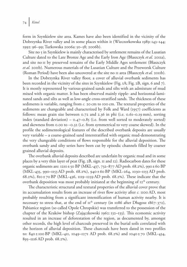
Multidisciplinary geoarchaeological research has been undertaken in the Ner River basin over the last few years at several prehistoric (mainly post-Neolithic) and medi-eval sites in the main valley or its tributaries. Sites are located on moderately inclined surfaces which are usually covered by colluvial sediments. Neo-Holocene slope covers have been identified at most of elaborated sites. Overbank alluvial deposits have been detailed recognized at few sites. The period of theirs depositions have been appropriate to the occupation phases. Discussed sediment covers are formed above all by sands, sometimes with organic mud interlaying (Fig. 1).
In the study areas we have undertaken specialized analysis including: stratigraphical, structural and textural analysis of sediments; palaeobotanical analysis (i.e. pollen, plant macrofossils, fossil wood and charcoals); palaeozoological analysis, and geochemical analysis. Some samples of organic material have been radiocarbon dated a few non-organic sediments – by thermoluminescence (TL). Calibration of the radiocarbon dates is by OxCal 4.1 (Bronk Ramsey 2009). Parts of the cultural layers have been dated by their contained archaeological artefacts. Comprehensive geomorphological and palaeogeographical research has been undertaken in the surroundings of the sites in order to recognize the human impact on slope and alluvial processes.
RESULTS
Szynkielew siteThe site at Szynkielew is situated close to the edge of Łódź in the eastern part of
the Łask Plateau (after Kondracki 2002) and in the Dobrzynka River tributary valley of the Ner River. Excavations at several sites in the area have been undertaken recently and most interesting are at Szynkielew no 5 and 11 (Błaszczyk et al. 2011a; 2011b; unpub-
Slope and river inorganic deposits as indicators of marked human impact | 73
lished). Site no 5 is situated on a small gravelly-sandy erosional hillock in the central part of the Dobrzynka River valley and site no 11 is west of it on the valley slope. The valley is very narrow and characterized by weakly developed morphological elements, mainly terraces (Wieczorkowska 1989: 143–144, 147; Fig. 2). The valley floor is covered by silts, organic mud and alluvial overbank sands with numerous sub-fossil channels of various ages. Some of these channels have been recognized on aerial photography.
Glacial and fluvioglacial elements of relief of the Wartanian Cold Stage (Saalian Stage Glaciation) are common near the Szynkielew site. One of these is a moraine hill characterized by the glacitectonic structures recognized in Gorzew-Petrykozy-Kudro-wice area (Wieczorkowska 1989: 144–147). It is the most distinctive morphological relief
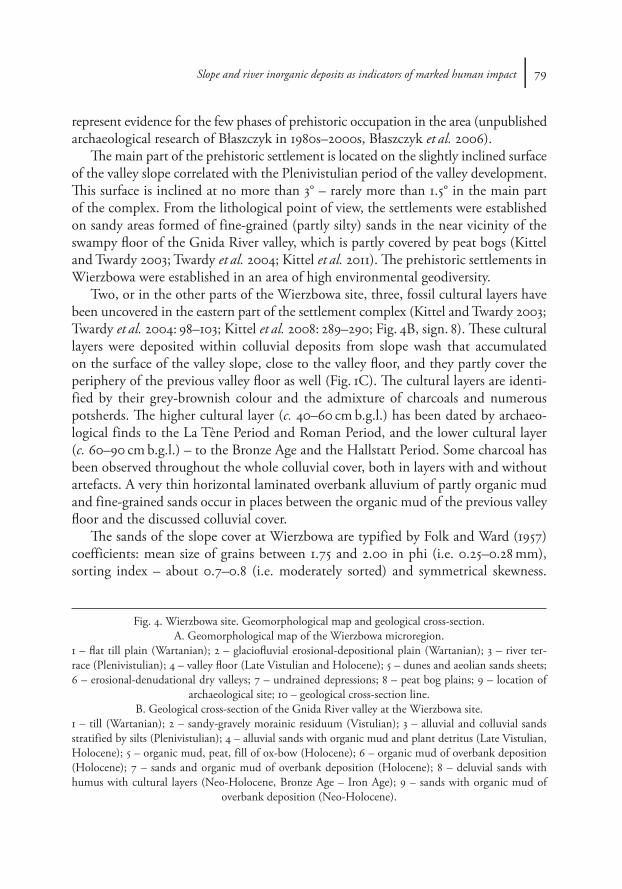
Fig. 1. Neo-Holocene inorganic sediments at the archaeological sites (Photo: P. Kittel).A – Szynkielew site. Alluvial sands and silts; B – Lutomiersk-Koziówki site. Alluvial sands;
C – Wierzbowa site. Deluvial sands.
74 | Kittel
form in Szynkielew site area. Kames have also been identified in the vicinity of the Dobrzynka River valley and in some places within it (Wieczorkowska 1989: 143–144; 1992: 96–99; Turkowska 2006a: 50–58; 2006b).
Site no 5 in Szynkielew is mainly characterised by settlement remains of the Lusatian Culture dated to the Late Bronze Age and the Early Iron Age (Błaszczyk et al. 2011a), and site no 11 by preserved remains of the Early Middle Ages settlement (Błaszczyk et al. 2011b). Numerous materials of the Lusatian Culture and the Przeworsk Culture (Roman Period) have been also uncovered at the site no 11 area (Błaszczyk et al. 2011b).
In the Dobrzynka River valley floor, a cover of alluvial overbank sediments has been recorded in the vicinity of the sites in Szynkielew (Fig. 1A; Fig. 2B, sign. 6 and 7). It is mostly represented by various-grained sands and silts with an admixture of mud mixed with organic matter. It has been observed mainly ripple- and horizontal-lami-nated sands and silts as well as low-angle cross-stratified sands. The thickness of these sediments is variable, ranging from c. 20 cm to 100 cm. The textural properties of the sediments are changeable and characterized by Folk and Ward (1957) coefficients as follows: mean grain size between 0.72 and 2.36 in phi (i.e. 0.61–0.19 mm), sorting index (standard deviation) – 0.47–0.85 (i.e. from well sorted to moderately sorted) and skewness from 0.00 to –0.32 (i.e. from symmetrical to very coarse skewed). In the profile the sedimentological features of the described overbank deposits are usually very variable – a coarse-grained sand interstratified with organic mud-demonstrating the very changeable conditions of flows responsible for the alluvial deposition. The overbank sandy and silty series have been cut by episodic channels filled by coarser grained alluvial deposits.
The overbank alluvial deposits described are underlain by organic mud and in some places by a very thin layer of peat (Fig. 2B, sign. 11 and 12). Radiocarbon dates for these organic sediments are: 1210 ± 50 BP (MKL-437, 732–877 AD prob. 68.2%), 990 ± 60 BP (MKL-435, 990–1153 AD prob. 68.2%), 940 ± 60 BP (MKL-264, 1030–1155 AD prob. 68.2%), 810 ± 70 BP (MKL-436, 1119–1259 AD prob. 68.2%). These indicate that the overbank deposition was most probably initiated at the beginning of 12th century.
The characteristic structural and textural properties of the alluvial cover prove that its accumulation results from an increase of river flow activity after c. 1100 AD, most probably resulting from a significant intensification of human activity nearby. It is necessary to stress that, at the end of 11th century (in 1086 after Długosz 1867: 372), Pabianice region (so called Opole Chropskie) was transferred to the possession of the chapter of the Kraków bishop (Zajączkowski 1962: 132–133). This economic activity resulted in an increase of deforestation of the region, as documented by, amongst other records, the high level of charcoals preserved in the burial soils correlated with the horizon of alluvial deposition. These charcoals have been dated in two profiles to: 840 ± 100 BP (MKL-411, 1049–1271 AD prob. 68.2%) and 1040 ± 70 (MKL-434, 895–1116 AD prob. 68.2%).
Slope and river inorganic deposits as indicators of marked human impact | 75
LUTOMIERSK-KOZIÓWKI SITE
The site at Lutomiersk-Koziówki is situated ca 10 km west of Łódź on the Łask Plateau (after Kondracki 2002) and in the southern part of the Ner River valley, very close to the mouth of the river Zalewka (or Wrząca). In the Ner River valley in the vicinity of Lutomiersk, a dozen very interesting archaeological sites have been dis-covered (see Jażdżewski 1951, 1952; Ząbkiewicz-Koszańska 1953: 299–308, 1956; 1957; Nadolski at al. 1959; Kmieciński 1959; Gardawski 1959: 85, 104; Wiklak 1963: 50–53, 56, 58, 114; 1972: 41–42, 115, 123, 135–136; 1975: 72–73, 80, 84–85, 95; Gąsior 1975: 102, 104, 114; Kaszewski 1975: 124–125, 127–128, 131–143; Jadczykowa 1975: 170–173, 177–178; Kaszewska 1975: 195, 198–202, 219; Łaszczewska 1975: 299, 304–305, 308–309, 311–312, 314–317; Chmielowska 1975: 332–336; Kufel-Dzierzgowska 1975: 373–374, 382; Zawilski 1999a: 103–115, 1999b: 66–67; Czepas and Olędzki 2003, 2007; Dziubek and Twardy 2007: 31–32). One of the most interesting of these is the complex of archaeological sites in Lutomiersk-Koziówki – i.e. site no 3a-c.
The first archaeological research was undertaken at the site called Lutomiersk- Koziówki no 3 during the 1940s–1960s (Gardawski 1959: 22, 85, 104; Wiklak 1963: 50–53, 114; Gąsior 1975: 104; Gedl 1975: 25; Kłosińska 1997: 154; Muzolf 2012: 11–14). This was later divided by Wiklak into sites no 3a, 3b, 3c and 3d beyond Zalewka River valley floor (Muzolf et al. 2010a: 2; Muzolf 2012: 11). From the 1990s until now, intensive excavations have continued (see Zawilski 1999a, 1999b; Czepas and Olędzki 2003; 2007; Dziubek and Twardy 2007: 32; Muzolf et al. 2010a, 2010b; Muzolf 2012). In this unique archaeological complex the following have been recognized: Late Palaeolithic and Mesolithic camps, traces of Neolithic Funnel Backer Culture episodic settlement, but mainly the settlements of people of the Trzciniec Culture (2nd and 3rd Bronze Age Periods), the Lusatian Culture (4th and 5th Bronze Age Peri-ods), the Pomeranian Culture (La Tène Period) and the Przeworsk Culture (Late Pre- Roman and Roman Period), and settlements of the Middle Ages (7th/8th–13th century) and remains Modern Times human activity (16th–20th century; Muzolf et al. 2010a, 2010b; Muzolf 2012: 16).
The site at Lutomiersk-Koziówki had been established on the surface and slightly inclined slopes of a hillock of fragment of high terrace located in the southern part of the Ner River valley (Kittel 2012a: 30–34, 2012b: 121, 128; Fig. 3). The terrace is divided by the valley floor of the Zalewka River: to the west is the Lutomiersk-Koziówki site complex no 3a-c (Muzolf et al. 2010a, 2010b; Muzolf 2012: 9), and to the east is the Lutomiersk-Koziówki site no 3d (Dziubek and Twardy 2007: 31–33). The high terrace was formed in the Plenivistulian, as documented by TL dating (Kittel 2012b: 121, 128). From a morphologic point of view, the high terrace was formed in the Late Vistulian, connected with the activity of the large palaeochannel of the Ner River (Turkowska 1988: 129; Twardy 2004: 114).
76 | Kittel
The hillock occupied by Lutomiersk-Koziówki site is limited on its north-eastern and north-western part by a huge Late Vistulian palaeomeander. The substratum sediments of the site are represented mainly by medium- and coarse-grained sands without any admixture of organic matter. The adjoining palaeomeander is filled by organic mud and peat at the base, covered by overbank sands and silts. The deposition of the palaeomeander fill was initiated in the Late Vistulian and continued into the Holocene. It is documented by the results of pollen analysis (two cores analysed by Obremska and Wacnik unpublished) and by 14C dating of the palaeomeander fills to: 9030 ± 230 BP (MKL-284; Kittel 2012a: 31–32; 2012b: 121–122).
The prehistoric and historic settlement complex was established in an area of high environmental geodiversity – which was a very important factor behind the long-lasting economic exploitation of the territory in Prehistory from almost the Bronze Age (Kurnatowska and Kurnatowski 1999: 35–37; Kurnatowski 2004: 403; Pelisiak 2004: 178–181; Kittel 2005: 86–87, 90; 2008: 205; 2010: 15; 2012c: 60–61).
A very thick cultural layer has been recorded at all the Lutomiersk-Koziówki sites and in the neighbouring Lutomiersk-Wrząca site as well (Gardawski 1959: 22; Wiklak 1963: 51, 114; Gąsior 1975: 104; Zawilski 1999a: 104; 1999b: 66; Czepas and Olędzki 2003: 63–66; 2007: 65; Muzolf et al. 2010a: 6; 2010b: 5; Kittel 2012b: 122–128; 2012d: 265–270). It is represented by brown and dark grey humic sands with high admixture of charcoal and numerous fragments of pottery and other artefacts. The layer ranges up to the 160 cm in thickness and results from the deposition of collu-vial sediments and/or partly from artificial earthwork origin. The colluvial deposits originating from surface erosion have also been recognized on slopes, which limit the hillocks occupied by sites. These slope covers, mainly represented deposits from slope-wash (deluvial deposits), have accumulated at least in the Bronze Ages, as documented by archaeological factors and 14C dates (Twardy 2008: 116–117; Kittel 2012b: 122–128; 2012d: 265–270). The occurrence of the sediments described proving the long-lasting activity and impact of prehistoric and early historic societies in the study area.
The presence of a thick layer of alluvial sands in the western part of the Lutomiersk-Koziówki site 3b is very interesting (Fig. 1B). It fills a fossil channel or ditch cut into the layers of the prehistoric slope deposits cover (Fig. 2B). The origin of this ditch was most probably artificial with its bottom filled by sediments mixed with organic matter including bunches of flax, and, at the very base, a sword dated to the beginning of the 16th century AD (Kittel et al. 2012; Rybka 2012: 259–261). The ditch with fragments of wooden constructions accumulated amongst the organic sediments probably represents the remains of equipment used for soaking flax in water – the rettery. A 14C date for one of these remains wooden elements is 170 ± 40 BP i.e. 1655–1950 AD (prob. 68.2%). The sands and mud with organic admixture that filled the original artificial rettery tank, as described, have been covered by various-grained sands, gravels and silts with diverse sedimentological structures. These inorganic sediments have been recognized
Slope and river inorganic deposits as indicators of marked human impact | 77
as channel and overbank alluvium. It has been observed trough cross-stratified sands with gravels, planar and low-angle cross-stratified sands and ripple- and horizontal-laminated sands and silts. The thickness of these sediments reaches 0.5 m and their sedimentological properties are characterized by Folk and Ward (1957) coefficients: mean size of grains between 0.08 up to 1.31 phi (i.e. 0.94–0.40 mm), sorting index – 0.64–1.16 (i.e. from moderately well sorted to poorly sorted) and negative skewness from –0.05 to –0.39 (i.e. from symmetrical to very coarse skewed). The most coarse-grained and simultaneously most poorly sorted sediments occur in the bottom of the series. They have been deposited in a very dynamic environment, as demonstrated by the relationship between the mean grain size and the sorting index represented by type I (1st; after Mycielska-Dowgiałło 1995) and location within the I (1st) class of the C-M pattern after Passega (Passega and Byramjee 1969).
The characteristic sedimentological and structural properties of the described alluvial sediments prove that their accumulation results from incidental high-energy overbank river flow connected with extremely high flood. The episodic overbank flow channel has been formed and filled very rapidly by alluvium. It most probably results from the draining of a water tank, likely to be a pond, as part of its reconstruction (renovation), deconstruction or degradation. This event occurred between the 17th and 19th centuries and most probably resulted from human activity in the near vicinity of Lutomiersk, at the site area.
WIERZBOWA SITE
The site at Wierzbowa is c. 30 km NW of Łódź in the Warszawa–Berlin ice-marginal valley, on the 3rd terrace of the Pradolina (after Krajewski 1977: 102–105). The site is on the Gnida River, a tributary of the Ner River. It is located on the slightly inclined surface of the Pradolina terrace and in the upper part of the Gnida River valley (Fig. 4). The surface of the plain is made up mainly of morainic and fluvioglacial sediments (Klatkowa 1978; Dutkiewicz 1989). This plain, a part of the 3rd terrace of the Warszawa–Berlin ice-marginal valley mentioned above, has been formed in the periglacial condi-tions of the Wartanian Cold Stage (Krajewski 1977: 104). The valley slope is formed by Plenivistulian sands and silts of the so-called high terrace (according to Turkowska 1988).
At Wierzbowa, a large (c. 30 ha) complex of prehistoric sites has been discovered, including: two cemeteries and the remains of a few settlements of people of the Trzciniec Culture, the Lusatian Culture, the Pomeranian Culture and the Przeworsk Culture. More than two thousands archaeological objects have been recovered during excavations undertaken at the Wierzbowa complex – mainly: pits, posts-holes, remains of huts, wells, concentrations of hearths, and the remains of ovens. All the excavated objects have been dated to the period from the Older Bronze Age to the Late Roman Period and
78 | Kittel
Slope and river inorganic deposits as indicators of marked human impact | 79
represent evidence for the few phases of prehistoric occupation in the area (unpublished archaeological research of Błaszczyk in 1980s–2000s, Błaszczyk et al. 2006).
The main part of the prehistoric settlement is located on the slightly inclined surface of the valley slope correlated with the Plenivistulian period of the valley development. This surface is inclined at no more than 3° – rarely more than 1.5° in the main part of the complex. From the lithological point of view, the settlements were established on sandy areas formed of fine-grained (partly silty) sands in the near vicinity of the swampy floor of the Gnida River valley, which is partly covered by peat bogs (Kittel and Twardy 2003; Twardy et al. 2004; Kittel et al. 2011). The prehistoric settlements in Wierzbowa were established in an area of high environmental geodiversity.
Two, or in the other parts of the Wierzbowa site, three, fossil cultural layers have been uncovered in the eastern part of the settlement complex (Kittel and Twardy 2003; Twardy et al. 2004: 98–103; Kittel et al. 2008: 289–290; Fig. 4B, sign. 8). These cultural layers were deposited within colluvial deposits from slope wash that accumulated on the surface of the valley slope, close to the valley floor, and they partly cover the periphery of the previous valley floor as well (Fig. 1C). The cultural layers are identi-fied by their grey-brownish colour and the admixture of charcoals and numerous potsherds. The higher cultural layer (c. 40–60 cm b.g.l.) has been dated by archaeo-logical finds to the La Tène Period and Roman Period, and the lower cultural layer (c. 60–90 cm b.g.l.) – to the Bronze Age and the Hallstatt Period. Some charcoal has been observed throughout the whole colluvial cover, both in layers with and without artefacts. A very thin horizontal laminated overbank alluvium of partly organic mud and fine-grained sands occur in places between the organic mud of the previous valley floor and the discussed colluvial cover.
The sands of the slope cover at Wierzbowa are typified by Folk and Ward (1957) coefficients: mean size of grains between 1.75 and 2.00 in phi (i.e. 0.25–0.28 mm), sorting index – about 0.7–0.8 (i.e. moderately sorted) and symmetrical skewness.
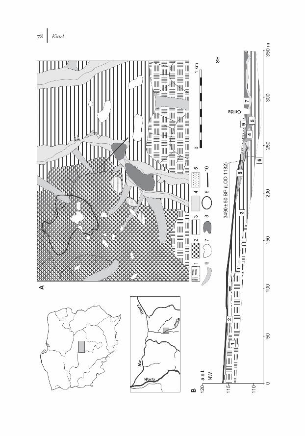
Fig. 4. Wierzbowa site. Geomorphological map and geological cross-section.A. Geomorphological map of the Wierzbowa microregion.
1 – flat till plain (Wartanian); 2 – glaciofluvial erosional-depositional plain (Wartanian); 3 – river ter-race (Plenivistulian); 4 – valley floor (Late Vistulian and Holocene); 5 – dunes and aeolian sands sheets; 6 – erosional-denudational dry valleys; 7 – undrained depressions; 8 – peat bog plains; 9 – location of
archaeological site; 10 – geological cross-section line.B. Geological cross-section of the Gnida River valley at the Wierzbowa site.
1 – till (Wartanian); 2 – sandy-gravely morainic residuum (Vistulian); 3 – alluvial and colluvial sands stratified by silts (Plenivistulian); 4 – alluvial sands with organic mud and plant detritus (Late Vistulian, Holocene); 5 – organic mud, peat, fill of ox-bow (Holocene); 6 – organic mud of overbank deposition (Holocene); 7 – sands and organic mud of overbank deposition (Holocene); 8 – deluvial sands with humus with cultural layers (Neo-Holocene, Bronze Age – Iron Age); 9 – sands with organic mud of
overbank deposition (Neo-Holocene).
80 | Kittel
The relationship between the mean grain size and the sorting index represents type II (2nd; after Mycielska-Dowgiałło 1995) characterized for deluvia (Smolska 2005: 100). The C-M pattern after Passega (Passega and Byramjee 1969) shows that the sedi-ments analysed have been deposited in a moderately dynamic environment. About 50–60% of the quartz-grains are represented by round mat grains (RM; after Cail-leux 1942, modified by Manikowska 1993). The characteristics of the colluvial cover at Wierzbowa seem to parallel the so-called deluvial sands of slope wash processes (after Twardy 2000: 160–162, 172–173; 2008: 230–233; Stochlak 1978: 116–117, 126–127, 130–141; 1996: 120–125; Teisseyre 1991: 381–387; Sinkiewicz 1998: 43–51, 77–79; Smolska 2005: 98–103, 139; Twardy and Forysiak 2011: 235–239). The cover of deluvial sands at Wierzbowa has been deposited as a result of moderately intensive slope wash processes active on the partly deforested surface of the valley slope (Kittel and Twardy 2003: 71; Twardy et al. 2004: 102; Twardy 2008: 68). The features of slope wash sediments are very similar to those of the basal substratum sediments of the valley slope, i.e. to the sedi-ments of Plenivistulian deposition, connected with the accumulation of the high terrace.
The beginning of the accumulation of the lower cultural layer and the whole col-luvial deposit has been recorded archaeologically and with the radiocarbon dating of the organic mud (Fig. 4B, sign. 6) of the valley floor, which are covered by the deluvial sands described and partly by the horizontal laminated fine-grained overbank alluvium mentioned above. The results of radiocarbon dating of those organic sediments are: 3490 ± 50 BP (LOD 1182, 1881–1754 BC prob. 68.2%; Kittel and Twardy 2003: 72) and 3750 ± 50 BP (LOD 1451, 2276–2043 BC prob. 68.2%) – and document the beginning of the accumulation of the fine-grained overbank alluvium and the whole colluvial (slope wash) sediment sequence, and the lower cultural layer, to the c. 1900–1750 BC. The date for the initiation of the accumulation of the deluvial cover has also been docu-mented archaeologically and is close to the radiocarbon dates for the top of the organic mud. The archaeological date is provided by a very characteristic fragment of pottery from directly on the surface of the organic mud level covered with the deluvial cover. This pottery is representative of the “Łódź Phase” so-called after Gardawski (1959: 139; Błaszczyk pers. inf.) dated to the 3rd Period of the Bronze Age and correlated nowadays with the late horizon of the Trzciniec Culture dated to c. 1500–1250 BC (Makarowicz 2010: 24–31). Some archaeological objects of the classic horizon of the Trzciniec Culture have been covered with the deluvial sands as well.
The slope occupied by prehistoric settlements at Wierzbowa site was under the prehistoric human impact almost from the Middle Bronze Age at least to the Late Roman Period (Błaszczyk et al. 2006: 1, 48). Any sedimentological factors record impor-tant changes of dynamic of slope wash processes in the Prehistory (Kittel and Twardy 2003: 70–72; Twardy et al. 2004: 102; Kittel et al. 2011: 134).
The deposits of the organic mud of ancient valley floor overlaid sands with lami-nae of organic mud radiocarbon dated to 9270 ± 80 BP LOD 1450 (8617–8350 BC,
Slope and river inorganic deposits as indicators of marked human impact | 81
prob. 68.2%) and peat dated by pollen analysis to the Preboreal and Boreal Periods (unpublished analysis of Obremska). These data show a stabilization of the fluvial pro-cesses of the Gnida River for a long period of the Holocene prior to the distinct impact resulting from prehistoric activity in the Wierzbowa region from c. 1900–1750 BC.
CONCLUSION
Archaeological artefacts and objects have been covered by colluvial and alluvial deposits covers of inorganic and/or partly organic deposits at the sites described in the Ner River basin in central Poland. The efficiency of processes accountable for the depo-sition of presented sediments achieved a high level, what is manifested by low organic admixture and high frequency of coarse-grained particles. Deposits characterized by such features are typical of the cold periods of the Quaternary as well. The accumula-tion of these deposits resulted from processes initiated by natural or anthropogenic factors during periods of more intense settlement and economic activity. The origin of the sediments discussed above might be connected with natural (climatic) or anthro-pogenic factors correlated with environmental change or with phases of human impact. This is a cause for which it is necessary to record the stratigraphy and chrono logy of inorganic sediments occurring at and around archaeological sites. These can be dated both by archaeological finds (if they occur) and by earth science methods. Acquiring the precise age, if possible, and recognizing the origin of the deposits during terrain works is essential for the correct interpretation of archaeological structures and their context.
In the valleys of the Ner River basin intensive deposition of material resulting from slope erosion (already occurring in the Prehistory) and alluvial activity (mainly in Middle Ages and Modern Times) is indicative of the anthropogenic factor as an initiator of environmental changes. It has been recognized, at all the sites described, very distinctive evidence for periods of human activity that can be correlated with periods of morphological activity and the accumulation of distinctive deposits. These processes have been initiated indirectly by distinct human impacts on environment, resulting in the deposition of covers of inorganic deposits. The identification of the correlation between human factors and environmental reactions has been made pos-sible only through complex multidisciplinary research inclusive of both archaeology and geoarchaeology as well as other environmental archaeology disciplines.
ACKNOWLEDGMENTSThis research was supported by grants from The Ministry of Science and Higher
Education No. 1 H01H 025 30 and from The Ministry of Culture and National Heritage (agreement no. 1080/11/FPK/NID). Fundacja Badań Archeologicznych im. Profesora
82 | Kittel
Konrada Jażdżewskiego in Łódź and Voivodship Monuments Protection Office have awarded additional financing as well.
I thank the archaeologists who have undertaken the research at the sites described – in alphabetical order: J. Błaszczyk (Institute of Archaeology, University of Łódź), K. Błaszczyk (“Artefakt” archaeological firm), M. Lewandowski (“AKA” archaeologi-cal firm), B. Muzolf (Museum of Archaeology and Ethnography in Łódź), P. Zawilski (“Archeograf” archaeological firm) – for their help during managed archaeological research. I also thank specialists in many branches of the natural sciences: K. Cywa, A. Mueller-Bieniek, R. Stachowicz-Rybka, A. Wacnik (Institute of Botany Polish Acad-emy of Sciences in Cracow), M. Obremska (Institute of Geology Polish Academy of Sciences in Warsaw), J. Forysiak and J. Twardy (Department of Geomorphology and Palaeogeography University of Łódź) and also P. Trzeciak and I. Borowiec (Museum of Archaeology and Ethnography in Łódź), M. Krąpiec (Radiocarbon Dating Labora-tory in Skała) for radiocarbon dating and I. Olszak (Department of Geomorphology and Quaternary Geology, Pomeranian University in Słupsk) for thermoluminscence dating of sediment samples.
I also thank the anonymous referees for their very valuable comments.
REFERENCES
Błaszczyk, J., Urbaniak, A., Papiernik, P. and Kittel, P. 2006. Wielokulturowa osada w Wierzbowej stano-wiska 1–7, gm. Wartkowice, pow. Poddębice. Wyniki badań archeologicznych prowadzonych na trasie autostrady A2 w latach 2000 i 2002. Łódź. (Archive of Archaeological Museum in Poznań).
Błaszczyk, K., Lewandowski, M. and Zawilski, P. 2011a. Ratownicze badania wykopaliskowe w ciągu planowanej obwodnicy Pabianic w rezerwowym korytarzu drogi 14 BIS (łącznik) i S 14 na odcinku Ksawerów–Dobroń, Szynkielew, stan. 5, gm. Pabianice, woj. łódzkie (AZP 68–51/28). Badania 2010. Łódz–Pabianice–Radomsko. (Archive of Voivodship Monuments Protection Office in Łódź).
– 2011b. Ratownicze badania wykopaliskowe w ciągu planowanej obwodnicy Pabianic w rezerwowym korytarzu drogi 14 BIS (łącznik) i S 14 na odcinku Ksawerów – Dobroń, Szynkielew, stan. 11, gm. Pabianice, woj. łódzkie (AZP 68–51/63). Badania 2010. Łódź–Pabianice–Radomsko. (Archive of Voivodship Monuments Protection Office in Łódź).
Bronk Ramsey, C. 2009. Bayesian analysis of radiocarbon dates. Radiocarbon 51(1): 337–360.Brückner, H. 1986. Man’s impact on the evolution of the physical environment in the Mediterranean
region in historical times. Geojournal 13(1): 7–17. Cailleux, A. 1942. Les actions eoliennes periglaciares en Europe. Mémoires de la Société Géologique de
France 46.Chmielowska, A. 1975. Osadnictwo w Polsce środkowej w okresie od połowy X do połowy XIII w.
Prace i Materiały Muzeum Archeologicznego i Etnograficznego w Łodzi, Seria Archeologiczna 2: 331–371.
Czepas, P. and Olędzki, M. 2003. Wyniki badań ratowniczych na osadzie ludności kultury trzcinieckiej w Lutomiersku, woj. łódzkie na stanowisku Wrząca-Parcela 1. Łódzkie Sprawozdania Archeolo-giczne 8: 63–72.
Slope and river inorganic deposits as indicators of marked human impact | 83
– 2007. Osada ludności kultury trzcinieckiej w Lutomiersku, Województwo Łódzkie odkryta na stano-w isku Wrząca-Parcela 1. Prace i Materiały Muzeum Archeologicznego i Etnograficznego w Łodzi, Seria Archeologiczna 43: 63–72.
Długosz, J. 1867. Jana Długosza dziejów polskich ksiąg dwanaście. Kraków.Dotterweich, M., Schmitt, A., Schmidtchen, G. and Bork, H.R. 2003. Quantifying historical gully ero-
sion in northern Bavaria. Catena 50: 135–150.Dutkiewicz, L. 1989. Szczegółowa Mapa Geologiczna Polski w skali 1:50000, arkusz Parzęczew (589). Warszawa.Dziubek, E. and Twardy, J. 2007. Transformacja rzeźby wysokiego poziomu dolinnego Neru wskutek
wielowiekowego zasiedlenia i gospodarki w świetle wykopaliskowych badań archeologicznych na stanowisku 21 w Lutomiersku i Wrzącej-Parceli 1, In E. Smolska and P. Szwarczewski (eds), Zapis działalności człowieka w środowisku przyrodniczym, 31–37. Warszawa.
Folk, R. and Ward, W. 1957. Brazos River bar: a study in the significance of grain size parameters. Journal of Sedimentary Petrology 27: 3–26.
Fuchs, M., Lang, A. and Wagner, G.A. 2004. The history of Holocene soil erosion in the Phlious Basin, NE Peloponnese, Greece, based on optical dating. The Holocene 14 (3): 334–345.
Gardawski, A. 1959. Plemiona kultury trzcinieckiej w Polsce. Materiały Starożytne 5: 7–189.Gąsior, I. 1975. Kultura trzciniecka na obszarze Polski Środkowej, Prace i Materiały Muzeum Archeologicz-
nego i Etnograficznego w Łodzi, Seria Archeologiczna 22: 101–121.Gedl, M. 1975. Kultura przedłużycka. Wrocław–Warszawa–Kraków–Gdańsk.Jadczykowa, I. 1975. Kultura wschodniopomorska i kultura grobów kloszowych w Polsce Środkowej. Prace
i Materiały Muzeum Archeologicznego i Etnograficznego w Łodzi, Seria Archeologiczna 22: 167–194.Jażdżewski, K. 1951. Cmentarzysko wczesnośredniowieczne w Lutomiersku pod Łodzią w świetle badań
z r. 1949. Materiały Wczesnośredniowieczne I: 91–191.– 1952. Sprawozdanie z badań archeologicznych na cmentarzysku wczesnośredniowiecznym w Lutomier-
sku w pow. łaskim /woj. łódzkie/ w r. 1950. Materiały Wczesnośredniowieczne II: 257–264.Kalicki, T. 2006. Zapis zmian klimatu oraz działalności człowieka i ich rola w holoceńskiej ewolucji dolin
środkowoeuropejskich. Prace Geograficzne IGiPZ PAN 204.Kaszewska, E. 1975. Kultura przeworska w Polsce Środkowej. Prace i Materiały Muzeum Archeologicznego
i Etnograficznego w Łodzi, Seria Archeologiczna 22: 194–252.Kaszewski, Z. 1975. Kultura łużycka w Polsce środkowej. Prace i Materiały Muzeum Archeologicznego
i Etnograficznego w Łodzi, Seria Archeologiczna 22: 123–166.Kłosińska, E. 1997. Starszy okres epoki brązu w dorzeczu Warty. Wrocław.Kittel, P. 2005. Uwarunkowania środowiskowe lokalizacji osadnictwa pradziejowego na Pojezierzu
Kaszubskim i w północnej części Borów Tucholskich. Monografie Instytutu Archeologii Uniwer-sytetu Łódzkiego 4.
– 2008. Geomorfologiczne cechy lokalizacji osadnictwa pradziejowego w mikroregionie leśnieńskim, In K. Walenta (ed.), Leśno i mikroregion w późnej epoce brązu i wczesnej epoce żelaza, 197–224. Chojnice.
– 2010. Cechy geomorfologiczne położenia stanowisk archeologicznych na obszarze BOT KWB „Bełcha-tów” Złoże „Szczerców”. In T. Makiewicz, A. Wójcik and M. Ignaczak (eds), Badania archeologiczne na terenie odkrywki „Szczerców” Kopalni Węgla Brunatnego „Bełchatów” S.A. 7, 11–32. Poznań.
– 2012a. Geomorfologia stanowiska 3a-c Lutomiersk-Koziówki. In B. Muzolf (ed.), Lutomiersk-Koziówki stanowisko 3 a-c, pow. pabianicki, woj. łódzkie. Wielokulturowy zespół osadniczy od schyłkowego paleolitu po okres nowożytny. Biblioteka Muzeum Archeologicznego i Etnograficznego w Łodzi 39, 27–37. Łódź.
– 2012b. Budowa i ewolucja doliny Neru w rejonie stanowiska Lutomiersk-Koziówki w świetle badań geoarcheologicznych. Acta Geographica Lodziensia 100: 113–133.
84 | Kittel
– 2012c. Wpływ georóżnorodności zlewni Neru (Polska środkowa) na lokalizację osadnictwa pradzie-jowego. Landform Analysis 19: 33–50.
– 2012d. Geomorfologiczne uwarunkowania rozwoju osadnictwa i przeobrażenia morfologii obszaru stanowiska 3a-c Lutomiersk-Koziówki w warunkach antropopresji. In B. Muzolf (ed.), Lutomiersk-Koziówki stanowisko 3 a-c, pow. pabianicki, woj. łódzkie. Wielokulturowy zespół osadniczy od schyłko-wego paleolitu po okres nowożytny. Biblioteka Muzeum Archeologicznego i Etnograficznego w Łodzi 39, 263–277. Łódź.
Kittel, P. and Twardy, J. 2003. Wpływ pradziejowej aktywności ludzkiej na funkcjonowanie stoku w Wierz-bo wej (pradolina warszawsko-berlińska), In J. Waga and K. Kocel (eds), Człowiek w środowisku przyrodniczym – zapis działalności, 68–73, Sosnowiec.
Kittel, P., Forysiak, J., Błaszczyk, J., Cywa, K., Wacnik, A., Tomczyńska, Z., Muzolf, B. and Obremska, M. 2008. Przykłady oddziaływań społeczności pradziejowych na środowisko naturalne w rejonie Bechcic i Wierzbowej (Polska Środkowa). Landform Analysis 9: 289–292.
Kittel, P., Błaszczyk, J., Muzolf, B., Cywa, K., Wacnik, A., Tomczyńska, Z. and Obremska, M. 2011. Traces of Prehistoric Human Impact on Natural Environment in the Ner River Catchment (Central Poland), In I. Hildebrandt-Radke, W. Dörfler, J. Czebreszuk and J. Müller (eds), Anthropogenic Pressure in the Neolithic and the Bronze Age on the Central European Lowlands. Studien zur Archäe-ologie in Ostmitteleuropa/Studia nad Pradziejami Europy Środkowej 8, 129–141. Poznań–Bonn.
Kittel, P., Elias, S., Mueller-Bieniek, A., Pawłowski, D., Płóciennik, M., Stachowicz-Rybka, R., Wacnik, A. and Okupny, D. 2012. Badania paleoekologiczne reliktów nowożytnego moczydła. In B. Muzolf (ed.), Lutomiersk – Koziówki stanowisko 3 a-c, pow. pabianicki, woj. łódzkie. Wielokulturowy zespół osadniczy od schyłkowego paleolitu po okres nowożytny. Biblioteka Muzeum Archeologicznego i Etno-graficznego w Łodzi 39. CD-rom, 1–4. Łódź.
Klatkowa, H. 1978. Mapa Geologiczna Polski 1: 200 000, A – Mapa Utworów Powierzchniowych (Mapa pod stawowa 1: 50 000), arkusz Parzęczew (589). Warszawa.
Klimek, K., Łanczont, M. and Nogaj-Chachaj, J. 2006. Historical deforestation as a cause of alluviation in small valleys, Subcarpathian loess plateau, Poland. Regional Environmental Change 6: 52–61.
Kmieciński, J. 1959. Kurhan z późnego okresu rzymskiego w miejscowości Bechcice–Biłgoraj, pow. Łask. Wiadomości Archeologiczne 24: 60–61.
Kondracki, J. 2002. Geografia regionalna Polski. Warszawa.Krajewski, K. 1977. Poziomy terasowe w pradolinie Warszawsko-Berlińskiej między Wartą a Wzgórzami
Domaniewickimi. Acta Universitatis Lodziensis, Zeszyty Naukowe UŁ, Nauki Matematyczno-Przy-rodnicze 5: 99–108.
Kufel-Dzierzgowska, A. 1975. Wczesnośredniowieczne cmentarzyska szkieletowe w Polsce środkowej. Prace i Materiały Muzeum Archeologicznego i Etnograficznego w Łodzi, Seria Archeologiczna 2: 372–390.
Kurnatowska, Z. and Kurnatowski, S. 1991. Zasiedlenie regionu Lednicy w pradziejach i średniowieczu w świetle dotychczasowych badań. In K. Tobolski (ed.), Wstęp do paleoekologii Lednickiego Parku Krajobrazowego, 35–42. Poznań.
Kurnatowski, S. 2004. Perspektywy dalszych wspólnych badań nad relacjami między społecznością ludzką a środowiskiem przyrodniczym, In D. Abramowicz and Z. Śnieszko (eds), Zmiany środowiska geograficznego w dobie gospodarki rolno-hodowlanej. Studia z obszaru Polski, 397–409. Katowice.
Łaszczewska, T. 1975. Polska Środkowa w okresie wędrówek ludów i w początkach wczesnego średnio-wiecza. Prace i Materiały Muzeum Archeologicznego i Etnograficznego w Łodzi, Seria Archeologiczna 22: 295–392.
Makarowicz, P. 2010. Trzciniecki krąg kulturowy – wspólnota pogranicza Wschodu i Zachodu Europy. Archaeologia Bimaris Monografie 3.
Manikowska, B. 1993. Mineralogy and abrasion of sand grains due to Vistula (late Pleistocene) aeolian processes in Central Poland. Geologie en Mijnbouw 72: 167–177.
Slope and river inorganic deposits as indicators of marked human impact | 85
Muzolf, B., 2012. Wstęp. In B. Muzolf (ed.), Lutomiersk – Koziówki stanowisko 3 a-c, pow. pabianicki, woj. łódzkie. Wielokulturowy zespół osadniczy od schyłkowego paleolitu po okres nowożytny. Biblioteka Muzeum Archeologicznego i Etnograficznego w Łodzi 39, 9–25. Łódź.
Muzolf, B., Muzolf, P. and Kittel, P. 2010a. Omówienie wyników badań archeologicznych przeprow adzonych na stanowisku Lutomiersk–Koziówki 3a, gm. Lutomiersk, pow. pabianicki, woj. łódzkie. Lutomiersk. (Archive of Voivodship Monuments Protection Office in Łódź).
– 2010b. Omówienie wyników badań archeologicznych przeprowadzonych na stanowisku Lutomiersk–Koziówki 3b, gm. Lutomiersk, pow. pabianicki, woj. łódzkie. Lutomiersk. (Archive of Voivodship Monuments Protection Office in Łódź).
Mycielska-Dowgiałło, E. 1995. Wybrane cechy teksturalne osadów i ich wartość interpretacyjna. In E. Myciel ska-Dowgiałło and J. Rutkowski (eds), Badania osadów czwartorzędowych, 29–105. Warszawa.
Nadolski, A., Abramowicz, A. and Poklewski, T. 1959. Cmentarzysko z XI w. w Lutomiersku pod Łodzią. Łódź.
Passega, R. and Byramjee, R. 1969. Grain size image of clastic deposits. Sedimentology 13: 830–847.Pelisiak, A. 2004. Osadnictwo kultury pucharów lejkowatych w dorzeczu Grabi (Polska środkowa).
Uwarunkowania środowiskowe, In D. Abramowicz and Z. Śnieszko (eds), Zmiany środowiska geograficznego w dobie gospodarki rolno-hodowlanej. Studia z obszaru Polski, 171–183. Katowice.
Rybka, K., 2012. Omówienie miecza znalezionego w moczydle, In B. Muzolf (ed.), Lutomiersk – Koziówki stanowisko 3 a-c, pow. pabianicki, woj. łódzkie. Wielokulturowy zespół osadniczy od schyłkowego paleolitu po okres nowożytny. Biblioteka Muzeum Archeologicznego i Etnograficznego w Łodzi 39, 259–261. Łódź.
Sinkiewicz, M. 1989. Zmiany rzeźby terenu Pojezierza Kujawskiego pod wpływem procesów stokowych. Studia Societatis Scientiarum Torunensis, Sectio C Geographia et Geologia 9.
– 1998. Rozwój denudacji antropogenicznej w środkowej części Polski północnej. Toruń.Smolska, E. 2005. Znaczenie spłukiwania w modelowaniu stoków młodoglacjalnych (na przykładzie Pojezierza
Suwalskiego). Warszawa.Starkel, L. 1989. Antropogeniczne zmiany denudacji i sedymentacji w holocenie na obszarze Europy
Środkowej. Przegląd Geograficzny 61: 33–49.– 2002. Changes in the frequency of the extreme events as the indictor of climatic change in the Holocene
(in fluvial system). Quaternary International 91: 25–32.– 2004. Klimatyczne czy antropogeniczne przyspieszenie obiegu wody i materii w ostatnich tysiącleciach
na obszarze Polski, In D. Abramowicz and Z. Śnieszko (eds), Zmiany środowiska geograficznego w dobie gospodarki rolno-hodowlanej. Studia z obszaru Polski, 29–35. Katowice.
– 2011. Present-day events and the evaluation of Holocene palaeoclimatic proxy data. Quaternary Inter-national 229: 2–7.
Stochlak, J. 1978. Struktury i tekstury młodoplejstoceńskich osadów deluwialnych. Biuletyn Instytutu Geologicznego 306: 115–174.
– 1996. Osady deluwialne nieodłączny efekt procesu spłukiwania i propozycja ich podziału. In A. Józe-faciuk (ed.), Ogólnopolskie Sympozjum Naukowe „Ochrona agroekosystemów zagrożonych erozją”. Prace naukowe 2, 111–132. Puławy.
Schulte, A. and Stumböck, M. 2000. Late Glacial and Holocene Environmental Changes in the Hegau Region, Southwest Germany. Acta Universitatis Carolinae, Geographica 25 (Supplementum): 85–97.
Teisseyre, A. 1991. The Deluvial (Slopewash) System: A Proposal. Bulletin of the Polish Academy of Sciences, Earth Sciences 39: 381–8.
Turkowska, K. 1988. Rozwój dolin rzecznych na Wyżynie Łódzkiej w późnym czwartorzędzie. Acta Geogra-phica Lodziensia 57.
– 2006a. Geomorfologia regionu łódzkiego. Łódź.
86 | Kittel
– 2006b. Mapa Geomorfologiczna Regionu Łódzkiego. Łódź.Twardy, J. 2000. Deluwia neoholoceńskie – przykłady z Wyżyny Łódzkiej. Acta Geographica Lodziensia
78: 135–173.– 2004. Odzwierciedlenie dynamiki podłoża mezozoicznego w morfologii i budowie geologicznej
doliny Neru w okolicach Lutomierska (Wysoczyzna Łaska). Prace Instytutu Geografii Akademii Świętokrzyskiej w Kielcach 13: 107–124.
– 2008. Transformacja rzeźby centralnej części Polski środkowej w warunkach antropopresji. Łódź.– 2011. Influences of man and climate changes on relief and geological structure transformation in Central
Poland since the neolithic. Geographia Polonica 84, Special Issue Part 1: 163–178.Twardy, J. and Forysiak, J. 2011. Charakterystyka środowiska geograficznego okolic stanowiska archeo-
logicznego Polesie 1 oraz neoholoceńskie zmiany jego budowy geologicznej i rzeźby. In J. Górski, P. Makarewicz and A. Wawrusiewicz (eds), Osady i cmentarzyska społeczności trzcinieckiego kręgu kulturowego w Polesiu, stanowisko 1, woj. łódzkie I. Tekst, 227–250. Łódź.
Twardy, J., Forysiak, J. and Kittel, P. 2004. Dynamika procesów morfogenetycznych uruchomionych i zin-tensyfikowanych wskutek pradziejowej działalności ludzkiej w pradolinie warszawsko-berlińskiej. Acta Geographica Lodziensia 88: 85–117.
Wieczorkowska, J. 1989. Wpływ rzeźby glacjalnej na rozwój doliny Dobrzynki. Acta Geographica Lodziensia 59: 135–154.
– 1992. Geneza i rozwój pradoliny Wolbórki. Acta Geographica Lodziensia 63: 95–105.Wiklak, H. 1963. Początki kultury łużyckiej w Polsce środkowej. Acta Archaeologica Lodziensis 12.– 1972. Późniejsze stadia rozwojowe środkowopolskiej grupy kultury łużyckiej. Prace i Materiały Muzeum
Archeologicznego i Etnograficznego w Łodzi, Seria Archeologiczna 19: 15–172.– 1975. Neolit w Polsce Środkowej. Prace i Materiały Muzeum Archeologicznego i Etnograficznego w Łodzi,
Seria Archeologiczna 22: 67–100.Zajączkowski, S. 1962. Opole chłopskie. Przyczynek do genezy dawnych dóbr kapituły krakowskiej.
Rocznik Łódzki 5 (8): 131–154.Zawilski, P. 1999a. Badania archeologiczne na stanowiskach Lutomiersk-Koziówki 3D oraz Wrząca-Parcela 1,
gm. Lutomiersk, woj. łódzkie, przeprowadzone w 1999 r. Łódzkie Sprawozdania Archeologiczne 5: 103–116.
– 1999b. Lutomiersk Koziówki, st. 3 d, gm. Lutomiersk, woj. łódzkie, AZP 66–49/31. Informator Archeo-logiczny. Badania 1999: 66–67.
Ząbkiewicz-Koszańska, A. 1953. Przyczynki do poznania wielkiej Łodzi i powiatu łódzkiego. Przegląd Archeologiczny 9: 296–308.
– 1956. Materiały z cmentarzyska kultury łużyckiej w Lutomiersku-Wrzącej, pow. Łask. Część I (1940 r.). Prace i Materiały Muzeum Archeologicznego i Etnograficznego w Łodzi, Seria Archeologiczna 1: 51–60.
– 1957. Materiały z cmentarzyska kultury łużyckiej w Lutomiersku-Wrzącej, pow. Łask. Część II (Dokoń-czenie). Prace i Materiały Muzeum Archeologicznego i Etnograficznego w Łodzi, Seria Archeologiczna 2: 13–25.