KITALE MUNICIPALITY INTEGRATED URBAN ...
255
KITALE MUNICIPALITY INTEGRATED URBAN DEVELOPMENT PLAN KITALE MUNICIPALITY IUDP (2016-2036) COUNTY GOVERNMENT OF TRANS NZOIA Department of Land, Housing, Physical Planning and Urban Development KITALE MUNICIPALITY INTEGRATED URBAN DEVELOPMENT PLAN FINAL DRAFT PLAN Prepared By: GEODEV (K) LTD Land & Engineering Surveyors, Mapping, Planning & Environmental Consultants All Bid House, Mombasa Road 2 nd Floor, P.O. Box 14066 00100, Nairobi. Tel. +254-020-2721696, Fax 2734779, Mob: 0721232708 E-Mail –[email protected] , Website- www.geodevkenya.com
-
Upload
khangminh22 -
Category
Documents
-
view
0 -
download
0
Transcript of KITALE MUNICIPALITY INTEGRATED URBAN ...

KITALE MUNICIPALITY INTEGRATED URBAN DEVELOPMENT PLAN
KITALE MUNICIPALITY IUDP (2016-2036)
Page |
COUNTY GOVERNMENT OF TRANS NZOIA
Department of Land, Housing, Physical Planning and Urban Development
KITALE MUNICIPALITY INTEGRATED URBAN
DEVELOPMENT PLAN
FINAL DRAFT PLAN
Prepared By:
GEODEV (K) LTD
Land & Engineering Surveyors, Mapping, Planning &
Environmental Consultants
All Bid House, Mombasa Road 2nd Floor,
P.O. Box 14066 00100, Nairobi.
Tel. +254-020-2721696,
Fax 2734779, Mob: 0721232708
E-Mail –[email protected] ,
Website- www.geodevkenya.com

KITALE MUNICIPALITY INTEGRATED URBAN DEVELOPMENT PLAN
KITALE MUNICIPALITY IUDP (2016-2036)
Page | i
Plan Approval
This Plan has been prepared, publicized and circulated as per the requirements of the Urban Areas and
Cities Act Cap 275 and the Physical Planning Act Cap 286 of the laws of Kenya. The plan has fulfilled
all the statutory requirements and is hereby approved.
CERTIFIED
County Director of Physical Planning
Date -----------------------------------------------------------------------------------------------------------------
APPROVED
County CECM for Land, Housing, Physical Planning and Urban Development
Date------------------------------------------------------------------------------------------------------------------
Approved Development Plan No. --------------------------------------------------------------------------

KITALE MUNICIPALITY INTEGRATED URBAN DEVELOPMENT PLAN
KITALE MUNICIPALITY IUDP (2016-2036)
Page | ii
Foreword
Kitale Integrated Urban Development Plan presents a major milestone in urban planning in Kenya. It
comes against the background of a myriad of urban challenges including: urban sprawl, urban decay,
inadequate housing, uncontrolled informal settlements and activities, inadequate services and
infrastructure and lack of an appropriate framework to guide urban growth. In response to these
demands on urban planning, the Integrated Urban Development Planning framework was adopted
as a tool for planning of Kitale Municipality among other urban areas in Kenya.
Integration therefore means to break away from a compartmentalized approach to territories, issues
and policies in order to promote a “holistic” approach that takes into consideration the physical,
economic and social dimensions of urban development. It also means to have vertical integration
among the various levels of government and bodies involved in territorial governance (local, regional,
national, private sector, civil, society, etc.) to horizontal integration, among the various sectors of
public action.
Urban means promotion of urbanism, quality urban places; engendering activity mix that promotes
urbanity/appropriate urban behavior, attitudes and growth; definition/delimitation of urban growth
limits as opposed to urban sprawl.
Development means improvement of urban places; transformative to livelihoods, people’s lives, the
environment, growing of the economy; creation of livable, choice neighborhoods; positive change
with equity; creation of synergy among sectors, actors and places; sustainable growth.
Planning means deliberate, systematic, purposeful futuristic actions; resource reality check; impact
assessment; result orientation; people driven process; visioning/targeted actions/ proposals.
This Plan was achieved through collaborative effort between the County Department of Land,
Housing, Physical Planning and Urban Development, the stakeholders and the consulting planning
team. It is essential that this collaboration be sustained in order to realize its successful implementation.
Equally, invaluable lessons learnt during the preparation of this plan should form stepping-stones to
improve on similar exercises that will be undertaken in other municipalities in Kenya.

KITALE MUNICIPALITY INTEGRATED URBAN DEVELOPMENT PLAN
KITALE MUNICIPALITY IUDP (2016-2036)
Page | iii
Beatrice Wamboyi
County Physical Planner,
Department of Land, Housing, Physical Planning and Urban Development

KITALE MUNICIPALITY INTEGRATED URBAN DEVELOPMENT PLAN
KITALE MUNICIPALITY IUDP (2016-2036)
Page | iv
Executive Summary
Kitale Integrated Urban Development Plan (2016-2036) has been prepared in line with the
Government’s Development Blue Print outlined in The Kenya Vision 2030, which aims at
transforming Kenya into a newly industrializing, middle-income country providing a high quality of
life to all its citizens in a clean, secure and sustainable environment. The Vision is anchored on three
pillars: Economic, Social and Political pillars. Under the economic pillar, The Vision acknowledges
that Kenya will be a predominantly urban country by 2030. It also appreciates the critical role that
urban centres play in development and therefore highlights the role of urban planning in achieving the
envisaged development. In order to achieve this vision, there is a need of initiating nationwide urban
planning and development campaigns, starting with Kenya’s major cities and municipalities.
Kitale Municipality is one of the major urban centres in the Western region of the country and the
headquarters of Trans Nzoia County. It was identified as one of the municipalities to be planned in the
first phase of planning the urban centres in the county by the Ministry of Land, Housing, Physical
Planning and Urban Development, and requiring urgent planning intervention due to its rapid
urbanization rate accompanied by other planning challenges. The main goal of this project is therefore
to prepare an Integrated Urban Development Plan for the proposed Kitale Municipality, which will
guide its development for a period of 20 years. The plan covers an area of 160 km2 for the proposed
Municipality and 226 km2 as the planning area covering the entire of Tuwani, Hospital, Matisi and
Bidii Ward as well as part of Waitaluk and Sirende Ward.
The preparation of Kitale Municipality Integrated Urban Development Plan embraced participatory
planning approach to rectify the inadequacies associated with the traditional planning process where
the recipient community was not given an opportunity to contribute to the planning process in order to
address the challenges facing them. In its undertakings, GEODEV (K) LTD engaged the County
Executive, County Assembly, all County Departments, relevant National Government Departments as
well as local stakeholders (drawn from various sectors and interest groups).
The planning team used both secondary and primary data in order to come up with a comprehensive,
all inclusive and up to date development plan. Secondary data was obtained from government
publications (population census reports, Statistical abstracts etc.), County publications and
development plans for the area etc. In order to feel the data gaps identified during the secondary data
collection, extensive primary survey was conducted within the study area. These included carrying out
of a Visioning workshop; conducting Focused Group Discussions (FGDs), structured interview
schedules, photography, urban transect surveys, detailed spatial and socio-economic surveys and direct
observations. To integrate the spatial aspect into the planning exercise, we obtained an aerial image of

KITALE MUNICIPALITY INTEGRATED URBAN DEVELOPMENT PLAN
KITALE MUNICIPALITY IUDP (2016-2036)
Page | v
the planning area and developed a base map for the municipality as well as representing the identified
issues spatially. An important aspect of this assignment was the preparation of digital topographical
maps for the entire study area.
Analysis of social, economic, environmental and spatial data was carried out with view to generate
information that informed the preparation of sectoral plans and strategies. The analysis was holistic
and multi-sectoral in order to establish data gaps and relationships.
The Plan identifies various development concept through scenario building and evaluation of a number
of future growth models to inform the future structure/layout of land use within the proposed
Municipality. The preparation of a Structure Plan was informed by various elements that define the
character of the Municipality. In addition to the broad structure plan, area action plans are one of the
outputs of this Plan. Area Action Plans are aimed at establishing a set of proposals and policies for the
development of a specific area (such as a municipality centre or an area of new development). Several
Area Action Plans were prepared depending on the needs of specific areas. The Plan further contains
development strategies that will form the basis for the implementation of the Structural and Area
Action Plans. The strategies outline the projects that will be put in place to achieve the objectives of
the plan, the actors, timeframe and the cost of implementation of the projects. The strategies formulated
include among others the Local Economic Development (Investment) Strategy, Housing Strategy,
Transportation Strategy, Trunk and Social Infrastructure Strategy.
Finally, the Plan contains an Implementation, Evaluation and Monitoring Framework, which includes
a Capital Investment Plan. The CIP identifies the capital/major projects that will act as the
Municipality’s growth impetus. These projects have been costed as well. The actors identified for the
implementation of this Plan include the County Government of Trans Nzoia, National Government,
Private Investors, Donors, NGOs, CBOs and the community in general. Adoption of the proposals
coupled with timely and coordinated implementation of the proposed strategies will act towards
reversing the current trend, improve the living conditions of the Kitale residents and above all help
achieve the Vision of Kitale people.

KITALE MUNICIPALITY INTEGRATED URBAN DEVELOPMENT PLAN
KITALE MUNICIPALITY IUDP (2016-2036)
Page | vi
Table of Contents
1 PLAN PRERPARATION BACKGROUND ............................................................................................. 1-1
1.1 THE PROJECT AND DEFINITION OF TERMS: ....................................................................................... 1-1
1.2 PREPARATION OF INTEGRATED URBAN DEVELOPMENT PLANS ..................................................... 1-1
1.3 TERMS OF REFERENCE ........................................................................................................................ 1-3
1.4 PURPOSE OF THE IUDP ....................................................................................................................... 1-4
1.5 VISION OF THE PLAN .......................................................................................................................... 1-4
1.5 APPRECIATION OF THE IUDP’S OBJECTIVES.................................................................................... 1-5
1.6 SCOPE OF WORK: TEMPORAL AND GEOGRAPHICAL ........................................................................ 1-7
1.7 APPROACH AND METHODOLOGY ...................................................................................................... 1-9
1.7.1 Preparatory Phase........................................................................................................ 1-10
1.7.2 Sensitization Phase...................................................................................................... 1-11
1.7.3 Investigative Phase...................................................................................................... 1-11
1.7.4 Plan Formulation Phase .............................................................................................. 1-11
1.7.5 Plan Approval Phase ................................................................................................... 1-12
1.8 CONSTITUTIONAL REFERENCE ......................................................................................................... 1-12
1.9 LEGAL AND POLICY FRAMEWORK ................................................................................................... 1-13
1.10 LOCATIONAL CONTEXT OF THE PLANNING AREA ........................................................................ 1-19
1.10.1 Kitale Municipality at the National Context ............................................................... 1-19
1.10.2 Kitale Municipality at the County and Regional Context ........................................... 1-19
1.10.3 Kitale Municipality at the Local Context.................................................................... 1-19
1.11 HISTORICAL CONTEXT OF THE MUNICIPALITY AND PREVIOUS PLANNING EFFORTS ................ 1-22
2. ANALYSIS AND SYNTHESIS OF PLANNING ISSUES ......................................................................... 2-1
2.1 URBAN CHARACTER AND ZONE CHARACTERISTICS ........................................................................ 2-1
2.2 SUMMARY OF PLANNING ISSUES ....................................................................................................... 2-7
2.3 SYNTHESIS OF PLANNING ISSUES ..................................................................................................... 2-11
3 DEVELOPMENT CONCEPT (TRENDS AND SCENARIOS) .............................................................. 3-1
3.1 CONCEPTUAL ANALYSIS OF THE PLANNING AREA .......................................................................... 3-1
3.2 CURRENT DEVELOPMENT SCENARIO ................................................................................................ 3-3
3.3 REVIEW OF THE VARIOUS PLANNING DEVELOPMENT CONCEPTS AND THE BEST PRACTICES .... 3-6
3.4 POSSIBLE LAND DEVELOPMENT OPTIONS (MODELS) ................................................................... 3-12
3.4.1 Development Option 1: Business As Usual……………………………………….3-12
3.4.2 Classical Monocentric Model……………………………………………………...3-12

KITALE MUNICIPALITY INTEGRATED URBAN DEVELOPMENT PLAN
KITALE MUNICIPALITY IUDP (2016-2036)
Page | vii
3.4.3 Alternative 3: Selective Dispersal (Composite Model)……………………………3-13
3.5 EVALUATION OF ALTERNATIVE SCENARIOS .................................................................................. 3-14
4 THE STRUCTURE PLAN: ................................................................................................................ 4-1
4.1 OVERVIEW............................................................................................................................................ 4-1
4.2 STRUCTURE PLAN’S SPATIAL DEVELOPMENT FRAMEWORK .......................................................... 4-4
4.3 DESCRIPTION OF THE STRUCTURE PLAN .......................................................................................... 4-20
4.4 LAND USE REQUIREMENT ANALYSIS ............................................................................................. 4-28
4.5 LAND USE PROPOSALS...................................................................................................................... 4-29
4.5.1 Residential...................................................................................................................4-29
4.5.2 Industrial .....................................................................................................................4-32
4.5.3 Educational .................................................................................................................4-34
4.5.4 Health ..........................................................................................................................4-35
4.5.5 Recreational ................................................................................................................4-35
4.5.6 Public Purpose ............................................................................................................4-37
4.5.7 Commercial .................................................................................................................4-38
4.5.8 Public Utilities ............................................................................................................4-41
4.5.9 Transportation .............................................................................................................4-42
4.5.10 Urban and Peri-Urban Agriculture..............................................................................4-49
4.6 ZONING PLAN………………………………………………………………………………………..4-50
4.6.1 Recommended Planning Standards .............................................................................4-60
5 ACTION AREA DEVELOPMENT PLANS ........................................................................................... 5-1
5.1 OVERVIEW ............................................................................................................................................. 5-1
5.2 ACTION AREA 1: KITALE MUNICIPALITY CBD ................................................................................. 5-1
5.3 ACTION AREA 2: RAILWAYS LAND ............................................................................................ 5-15
5.4 ACTION AREA 3: MEDIUM PRISONS LAND .............................................................................. 5-19
5.5 ACTION AREA 4: KIPSONGO INFORMAL SETTLEMENT………………………………..5-22
6 PLAN DEVELOPMENT STRATEGIES AND MEASURES ..................................................................... 6-1
6.1 OVERVIEW ............................................................................................................................................. 6-1
6.2 LOCAL ECONOMIC DEVELOPMENT (INVESTMENT) STRATEGY ....................................................... 6-1
6.3 TRANSPORTATION STRATEGY .......................................................................................................... 6-12
6.4 TRUNK INFRASTRUCTURE STRATEGY ............................................................................................. 6-19
6.4.1 Water ........................................................................................................................... 6-19
6.4.2 Sewer and Sanitation................................................................................................... 6-19

KITALE MUNICIPALITY INTEGRATED URBAN DEVELOPMENT PLAN
KITALE MUNICIPALITY IUDP (2016-2036)
Page | viii
6.4.3 Electricity and Energy................................................................................................. 6-20
6.4.4 Information Communication Technology (ICT) ........................................................ 6-20
6.5 SOCIAL INFRASTRUCTURE STRATEGY ............................................................................................. 6-21
6.5.1 Health .......................................................................................................................... 6-21
6.5.2 Education .................................................................................................................... 6-22
6.5.3 Other Community Facilities ........................................................................................ 6-23
6.6 HOUSING STRATEGY ......................................................................................................................... 6-28
6.7 ENVIRONMENTAL PROTECTION, CONSERVATION AND DISASTER MANAGEMENT STRATEGY .. 6-34
6.8 REVENUE ENHANCEMENT STRATEGY ............................................................................................. 6-40
6.9 INSTITUTIONAL DEVELOPMENT AND CAPACITY BUILDING STRATEGY ....................................... 6-42
7 PLAN IMPLEMENTATION, MONITORING AND EVALUATION FRAMEWORK ..................................... 7-1
7.1 OVERVIEW ............................................................................................................................................. 7-1
7.2 STRATEGIC PROJECTS .......................................................................................................................... 7-1
7.1.1 Facilitative Projects………………………………..……………………………………..7-1
7.1.2 Productive Projects……………………...………………………………………………..7-2
7.1.3 Perceptive Projects……………………………………………………………………...7-2
7.3 QUICK WINS .......................................................................................................................................... 7-3
7.4 CAPACITY BUILDING ............................................................................................................................ 7-3
7.5 IMPLEMENTATION PHASES .................................................................................................................. 7-4
7.6 COORDINATION FRAMEWORK ........................................................................................................... 7-15
7.7 COMMUNITY PARTICIPATION FRAMEWORK .................................................................................... 7-15
7.8 PROJECT OUTCOME BASED MONITORING AND EVALUATION ....................................................... 7-16

KITALE MUNICIPALITY INTEGRATED URBAN DEVELOPMENT PLAN
KITALE MUNICIPALITY IUDP (2016-2036)
Page | ix
LIST OF MAPS
Map 1-1: Geographical Scope ............................................................................................................ 1-8
Map 1-2: Kitale at the National, County and Local Context ............................................................ 1-20
Map 1-3: Kitale Municipality 1973 Development
Plan………………………………………………………….1-22
Map 4-1: Proposed Areas for Residential Use...………………………………………………..............4-31
Map 4-2: Proposed Areas for Industrial Use…………………………………………………………….4-33
Map 4-3: Proposed Commercial Areas…………………………………………………………………..4-40
Map 4-4: Existing and Proposed Transportation Network……………………………………………..4-47
Map 4-5: Proposed Municipal Public Transport Circulation System………………………………...4-48
LIST OF TABLES
Table 1-1: Administrative Boundaries Covered within the Proposed Municipality.................... ….1-19
Table 4-1: Detailed Description of the Structure Plan………………………………………………….4-20
Table 4-2: Principal Policies for the Municipality’s Land Use Plan…………………………………4-27
Table 4-3: Land Use Requirement Analysis……………………………………………………………..4-28
Table 4-4: Recommended Parking for Development Approval in the CBD………………………….4-44
Table 4-5: Development Control and Zoning Regulations…………………………………………….4-56
Table 4-6: Land Size for Various categories of Residential Densities. ............................................4-60
Table 4-7: Plot Ratios and Plot Coverage. .......................................................................................4-60
Table 4-8: Average Observed Land Use Allocation In Residential Neighborhood Development ...4-60
Table 4-9: Recommended Minimum Plot Sizes for Different Housing Schemes. .............................4-60
Table 4-10: Minimum setbacks of dwelling from plot lines. .............................................................4-61
Table 4-11: Minimum Street Width per given number of plots. .......................................................4-61
Table 4-12: Industrial Land Uses. ....................................................................................................4-62
Table 4-13: Land requirements for the various categories of industries. ........................................4-62
Table 4-14: Percentage allocation of land in an industrial area/estate ...........................................4-63
Table 4-15: Setback lines from centerlines of roads to property line. Source .................................4-63
Table 4-16: Road Reserves in industrial areas. ...............................................................................4-63
Table 4-17: Educational Facility Standards. Source…………………………………………………….4-64
Table 4-18: University Land Use Major Components ......................................................................4-65
Table 4-19: Health Facility Standards. ............................................................................................4-65
Table 4-20: Health Service Delivery System. ...................................................................................4-65
Table 4-21: Guideline for Recreation and Conservation in Urban Areas. ......................................4-66

KITALE MUNICIPALITY INTEGRATED URBAN DEVELOPMENT PLAN
KITALE MUNICIPALITY IUDP (2016-2036)
Page | x
Table 4-22: Guide for Recreation in Estates. ...................................................................................4-67
Table 4-23: Administrative Centers. .................................................................................................4-67
Table 4-24: Police stations. ..............................................................................................................4-68
Table 4-25: Law courts .....................................................................................................................4-68
Table 4-26: Prisons & Remand homes. ............................................................................................4-68
Table 4-27: Other Public Purpose Facilities....................................................................................4-68
Table 4-28: Categories of Centers…………………………………………………………………………4-69
Table 4-29: Market Categories…………………………………………………………………………….4-69
Table 4-30: Guide for Commercial Developments along Major Highways………………………….4-69
Table 4-31: Protection of water intakes…………………………………………………………………..4-70
Table 4-32: Sewerage collection & treatment……………………………………………………………4-70
Table 4-33: Storm Water Drainage Wayleave……………………………………………………………4-70
Table 4-34: Disposal System. Source……………………………………………………………………..4-70
Table 4-35: Urban Road Reserve Widths…………………………………………………………………4-71
Table 4-36: Carriage Way Widths. Source………………………………………………………………4-71
Table 4-37: Public Parking Space Requirement…………………………………………………………4-71
Table 4-38: Parking Area by Population…………………………………………………………………4-71
Table 4-39: Standards for Car Parking Requirement……………………………………………….…4-72
Table 4-40: Classification of Roads………………………………………………………………………4-72
Table 4-41: Classification of Roads……………………………………………………………………….4-72
Table 5-2: Action Plan for the Railways Land ................................................................................. 5-15
LIST OF FIGURES
Figure 1-1: A Section of the Aerial Image for Kitale Municipality .................................................. 1-21
Figure 3-1: Concentration of Development in Kitale Municipality Core Area
Scenario…………………..3-13
Figure 3-2: Main Centres and Sub-centres Development Scenario…………………………………...3-14
Figure 4-1: Development Rings ..........................................................................................................4-3
Figure 4-2: Proposed Strong Centres (Kitale Municipality Core Area and the Proposed Industrial
Zone) ...................................................................................................................................................4-6
Figure 4-3: Proposed Municipality’s Development Model ................................................................4-8
Figure 4-4: Kitale Municipality Core Area ........................................................................................4-9
Figure 4-5: Matisi Centre .................................................................................................................4-10

KITALE MUNICIPALITY INTEGRATED URBAN DEVELOPMENT PLAN
KITALE MUNICIPALITY IUDP (2016-2036)
Page | xi
Figure 4-6: Bikeke Centre ................................................................................................................4-11
Figure 4-7: Sirende Centre ...............................................................................................................4-12
Figure 4-8: Rafiki Centre ..................................................................................................................4-13
Figure 4-9: Kibomet Centre..............................................................................................................4-14
Figure 4-10: The Proposed Structure Plan ......................................................................................4-19
Figure 4-11: Zoning Plan .................................................................................................................4-51
Figure 4-12: Zone 1 (ADC Farm, KARI, Rafiki, Airstrip, Standard, Ex Prison and the Main Prison)
...........................................................................................................................................................4-52
Figure 4-13: Zone 2: Old Municipality………………………………………………………..………….4-53
Figure 4-14: Zone 3 (Tuwani, Matisi, Lessos, Bidii and Kibomet)……………………………………4-54
Figure 4-15: Zone 4: (Bikeke, Machungwa, Sirende, Kwa Gatua, Namgoi and Kibagenge)…..…4-55
Figure 5-1: Existing state of the Railways Land .............................................................................. 5-16
Figure 5-2: Existing Situation of the Medium Prisons Land ............................................................ 5-19
Figure 5-3: Proposed Land Use ....................................................................................................... 5-20
LIST OF PLATES
Plate 5-1: 3D Model of the Proposed CBD ........................................................................................ 5-2
Plate 5-2: Artistic impression of the envisioned Laini Moja Street. ................................................... 5-3
Plate 5-3: Examples of promoting pedestrianization ......................................................................... 5-4
Plate 5-4: The existing bus park proposed to serve the long distance travelers ................................ 5-6
Plate 5-5: Artistic impression of the proposed multi-storey business center ..................................... 5-9
Plate 5-6: Artistic illustration of the envisioned stadium status in the proposal.............................. 5-10
Plate 5-7: Artistic impression of the nature trail along the riparian as envisioned in the plan ....... 5-11
Plate 5-8: A model of the envisioned development on Railways Land ............................................. 5-18
Plate 5-10: Artistic illustration of front view of the Railways Land ................................................. 5-18
Plate 5-10: An impression of the proposed bus park, market stall and the business center on railways
land ................................................................................................................................................... 5-19
Plate 5-11: Illustration of the proposed residential and industrial parks ........................................ 5-21
Plate 5-12: Illustration of the proposed Urban Park on the Prisons Land………………...………5-21

KITALE MUNICIPALITY INTEGRATED URBAN DEVELOPMENT PLAN
KITALE MUNICIPALITY IUDP (2016-2036)
Page | xii
List of Abbreviations
AEZ: Agro-Ecological Zone
CBD: Central Business District
CBO: Community Based Organization
CIDP: County Integrated Development Plan
CIP: Capital Investment Plan
DCR: Development Control Regulations
FSI: Floor Space Index
GIS: Geographic Information System
GPS: Global Positioning System
IUDP: Integrated Urban Development Plan
JKUAT: Jomo Kenyatta University of Agriculture and Technology
KCB: Kenya Commercial Bank
KCC: Kenya Cooperative Creameries
KFA: Kenya Farmers Association
KMTC: Kenya Medical Training College
KNPHC: Kenya National Population and Housing Census
KNSDI: Kenya National Spatial Data Infrastructure
KWFT: Kenya Women Finance Trust
LIS: Land Information System
NCPB: National Cereals Produce Board
NGO: Non-Governmental Organization
NMT: Non-Motorized Transport
NZOWASCO: Nzoia Water Services Company
RIM: Registry Index Map
TOR: Terms of Reference
UM: Upper Midland
UON: University Of Nairobi
UTM: Universal Transverse Mercator

KITALE MUNICIPALITY INTEGRATED URBAN DEVELOPMENT PLAN
KITALE MUNICIPALITY IUDP (2016-2036)
Page | 1-1
- INTRODUCTION
PLAN PREPARATION BACKGROUND
1.1 THE PROJECT AND DEFINITION OF TERMS:
This project entails Digital Topographical Mapping and Preparation of an Integrated Urban
Development Plan for Kitale Municipality (2016-2036)
Digital Topographical Mapping
This is the Preparation of Digital (Computer Format) Maps from Aerial Image, Satellite Images,
existing Survey Plans and Cadastral Layers
Integrated Urban Development Plan
This is an urban plan, which will provide policies and development proposals to guide and control
development of Kitale Municipality for a period of 20 years.
1.2 PREPARATION OF INTEGRATED URBAN DEVELOPMENT PLANS
The Integrated Urban Development Plan is a planning approach that involves cities or urban areas
and their residents in finding the best solutions to achieve good long-term development. It also
gives an overall framework for development, which aims to coordinate the work of locals and other
spheres of government in a coherent plan to improve the quality of life for the people living in an
area.
Urbanization is a strong and potentially positive force in development throughout the world today.
However, the accelerating rate of urbanization in Kenya has often overtaken the capacity of national
and county governments in dealing with urban development challenges. These challenges and needs
include housing, infrastructure services, social and community facilities, local economic
development and environmental improvements and protection. One of the major problems and
challenges facing Kenya is the unsustainable urban growth and deterioration of urban environment.
Urban centres are experiencing rapid growth and development that is unplanned, uncoordinated and
uncontrolled.
Preparation of an Integrated Urban Development Plan is provided for under Section 36 of the Urban
Areas and Cities Act 2011 and its (Amendment) Act 2019. Integrated development planning for the
Municipality shall:
• Give effect to the development of the municipality as an urban area, in this case a municipality.

KITALE MUNICIPALITY INTEGRATED URBAN DEVELOPMENT PLAN
KITALE MUNICIPALITY IUDP (2016-2036)
Page | 1-2
• Strive to achieve the objects of devolved government as set out in Article 174 of the
Constitution.
• Promotion of social and economic development and provision of easily accessible services
throughout Kenya.
• Recognize the right of communities to manage their own affairs and to further their
development.
• Contribute to the protection and promotion of the fundamental rights and freedoms to the people
of Kitale as contained in Chapter 4 of the Constitution.
• Be the basis for development control in Kitale Municipality.
• Every county government is required to initiate an urban planning process for every settlement
with a population of at least 2,000 residents. Kitale Municipality population was 106,187
residents as of 2009.
In light of the above and the need for diagnosing the main planning issues in Kitale Municipality,
the County Government of Trans Nzoia embarked on Digital Topographical Mapping and the
Preparation of Integrated Urban Development Plan to guide development of the Municipality and
its environs for a period of 20 years as provided for in the County Governments Act, 2012. Some
of the planning challenges Kitale municipality faces include: inadequate land for the required urban
land uses, urban sprawl and inadequate urban development control, poor and narrow access roads,
limited social amenities -recreation, schools, bus parks, poor solid waste and storm water
management, inadequate sewerage system, informality in urban activities i.e. hawking, parking,
kiosks, housing development, traffic management, inadequate public facilities and utilities among
others.
This case scenario of Kitale Municipality is not in isolation going by its high population growth
rate of about 3.8% per year; Kenyan urban areas are rapidly growing (4.2% growth rate, World
Bank 2014) in haphazard manner and experiencing severe problems. These problems include but
not limited to land subdivisions into uneconomical sizes, mushrooming of informal settlements with
poor infrastructure and housing, growing informal markets and inadequate recreational facilities.
Other challenges include limited parking areas, traffic congestion with rising injuries and deaths
from accidents, severe environmental degradation and high rates of unemployment, crime and
social distress.
The Integrated Urban Development Plan for Kitale Municipality will identify priority programs that
support well-planned urban growth and development and working environment that attract
investments and enhanced revenue collection. The urban development plan will also lead to the full

KITALE MUNICIPALITY INTEGRATED URBAN DEVELOPMENT PLAN
KITALE MUNICIPALITY IUDP (2016-2036)
Page | 1-3
exploitation of opportunities for economic expansion, industrial development, and strengthening of
rural-urban linkages. The plan is also expected to guide development in the peri -urban areas,
support urban form and quality of life – accessibility to services, mix of functions, integrated social
strata and promote vibrant community organizations.
The Digital Topographical Mapping and the Preparation of Integrated Urban Development Plan for
the Municipality is intended to help achieve the Kenya’s Vision 2030. The Vision aims at
transforming Kenya into a newly industrializing, middle-income country providing a high quality
of life to all its citizens in a clean, secure and sustainable environment. The Vision is anchored on
three pillars: Economic Social and Political pillars. Under the economic pillar, The Vision
acknowledges that Kenya will be a predominantly urban country by 2030. It also appreciates the
critical role that urban centres play in development and therefore identifies urban planning as a
critical activity in achieving the envisaged development. It thus aims at initiating nationwide urban
planning and development campaigns, starting with Kenya’s major cities and municipalities.
In response to the above needs for addressing planning challenges and guiding the growth of the
Municipality in a proper and coordinated manner, County Government of Trans Nzoia contracted
GEODEV (K) LTD to undertake the exercise. This Final Draft Plan Report is one of the
requirements under the contract and the planning process.
CONTRACTUAL OBLIGATIONS
1.3 TERMS OF REFERENCE
The plan was prepared in response to the following terms of reference:
• Preparation of the Municipalities GIS based Urban Development Plan.
• Provide Strategic guidance in respect to the location and nature of development within
the municipality.
• Prepare and update digital cadastral layers in digital format.
• Preparation of a land information system (LIS) to give details of ownership, location
and state of all land in the Municipality;
• Set out basic guidelines for a land use management system in the municipality and
taking into account any guidelines, regulations or laws as provided for under Article
67 (2) (h) of the Constitution.
• Conduct participatory planning exercises in the municipality as a key input for
preparation and ownership of the plan.

KITALE MUNICIPALITY INTEGRATED URBAN DEVELOPMENT PLAN
KITALE MUNICIPALITY IUDP (2016-2036)
Page | 1-4
• Provide a framework for land banking and acquisition by the County Government for
public purposes, future development and strategic investments;
• Carry out an assessment of infrastructure and service levels and their distribution to
guide the County’s investment in infrastructure development;
• Provide Capital Investment Plans (CIP) for the Municipality to guide the County
Government and other investors;
• Build capacity within the department for effective maintenance and management of
the developed GIS
• Design appropriate development and implementation strategies for the plan
• Presentation of the final plan outputs (technical reports, maps) for recommendation
by relevant agencies and subsequent gazette and approval by the County Assembly of
Trans Nzoia.
1.4 PURPOSE OF THE IUDP
The purpose of the Integrated Urban Development Plan is to:
• Define a Vision for future growth and development of the Municipality over the next 20
years. The Vision as set was informed by the objectives stated in the TOR by the client;
the broad objectives defined the Vision 2030, the sustainable development goals,
aspirations of the local communities and any earlier planning materials among others.
• Provide an overall integrated physical framework for the Municipality’s urban growth.
An integrated physical framework prepared to fulfil the current and future requirements
• Provide a basis for coordinated programming of projects and budget, thereby serving as
a downstream management tool. A realistic implementation plan is to be prepared for all
identified projects along with capital investment plan.
1.5 VISION OF THE PLAN
Stakeholders during the visioning workshop envisioned Kitale Municipality as a commercial and
industrial hub with an efficient, effective and sustainable land, housing, infrastructural and
transport management systems. This Vision was reached at after consultations with the Executive,
Key Departments and a Visioning Exercise conducted on 12th May 2017 at KMTI
Visioning Exercise
Methods used to derive Kitale Municipality Visioning Process
Divided into thematic groups, with a chairman and a secretary

KITALE MUNICIPALITY INTEGRATED URBAN DEVELOPMENT PLAN
KITALE MUNICIPALITY IUDP (2016-2036)
Page | 1-5
Discussed challenges and the vision
Plenary (report back)
Create the Final Vision Statement.
Thematic groups
Economic Activities
Land and Housing
Social Infrastructure and Services
Physical Infrastructure
Transportation
Environment and Disaster
management
Urban Finance and Governance
1.5 APPRECIATION OF THE IUDP’S OBJECTIVES
The main objective of the assignment is to prepare Integrated Urban Development Plan for Kitale
Municipality, which will guide development of the municipality, and its environs for a period of 20
years as provided for in the County Government Act. The objectives of the existing Land Use
Planning Bill under review and the Urban Areas and Cities Acts are;
To produce accurate up-to-date digital topographic maps: Aerial photography which was
acquired from the client and used as the basis for all mapping. The cadastral maps of the
planning area have been updated based on the latest aerial photograph.
To prepare digital cadastral layers in the same system as the digital topo maps. All cadastral
maps showing extent and ownership within the planning area have been digitized and updated
by superimposing with the outputs of latest aerial photograph
To conduct participatory planning exercises in the planning area to identify citizens’
priorities. Stakeholder consultations have been conducted throughout the project duration. Five
workshops at different stages of the project have also been set as a part of participatory
planning. These interactive workshops have been and will be the main means of involving
citizens in the planning process, including identifying and prioritizing projects.
To prepare medium and long term plans to guide urban development, including action area
plans, subject plans, advisory or zoning plans and regulations and other reference materials.
There will be medium and long term plans for the municipality including action plans for
special areas (improvement, redevelopment, restoration, etc.), subject plans for a specific site
Plate 1-1: Members Participating during the Visioning Exercise

KITALE MUNICIPALITY INTEGRATED URBAN DEVELOPMENT PLAN
KITALE MUNICIPALITY IUDP (2016-2036)
Page | 1-6
or area in detail, zoning plan by dividing the municipality into various planning and use zones
and zoning regulations by defining the permitted and non-permitted uses for each zone.
To prepare strategic structure plans, showing current and proposed land use and
infrastructure (such as transport, water, drainage, power, etc.), housing settlements and
environmental assets (20years). The strategic structure plan has been prepared showing the
existing and proposed land uses including main infrastructure services.
To prepare an Integrated Urban Development Plan (IUDP). The final output of this exercise
is an IUDP covering all development sectors mentioned in the scope of work.
To prepare a Capital Investment Plan (CIP). After project identification, broad costing will
be done for each project to prepare a capital investment plan comprising possible sources of
funding and an implementation plan.
To provide hands-on training to key staff of the planning department on plan preparation
and implementation. Identified professionals from relevant departments will receive training
so that the client can handle downstream work easily.
To prepare a monitoring and evaluation strategy to assist the planning department to review
and update the plan in line with the ever-changing trends of the city. The IUDP will be
flexible enough, technically, to be updated in future with changing circumstances, as deemed
fit, subject to the provisions of the Physical Planning Act, Cap-286.
The Specific Objectives of the Assignment are:
• To define a vision for future growth and development of the municipality over the next
20 years.
• To set a base for the proposed new development and role of the municipality
• To set regulations, standards and guidelines for development control
• To provide a basis for provision of modern infrastructural services
• To formulate measures for environmental conservation /improvements and aesthetics
• To mitigate urban sprawl and fore stall emergence of informal settlements and slums
• To produce accurate up-to-date digital topographic maps.
• To produce digital cadastral layers in the same system as the digital topo maps
• To conduct participatory planning exercises in the municipality and identify citizens’
priorities
• To prepare short and medium term plans to guide urban development, including action
area plans, subject plans, advisory or zoning plans and development control regulations

KITALE MUNICIPALITY INTEGRATED URBAN DEVELOPMENT PLAN
KITALE MUNICIPALITY IUDP (2016-2036)
Page | 1-7
• To review and prepare strategic structure plans, showing current and proposed land use
and infrastructure (transport, water, drainage,) housing settlements and environmental
issues
• To provide hands-on training to technical staff of Land, Housing and Urban Development
Department on plan and map preparation, implementation and GIS environment.
• To prepare a capital investment plans to guide county and municipality investment
programs
• To prepare plan implementation, monitoring and evaluation strategy to assist the County
in reviewing and updating the plan in line with the ever-changing urbanization trends of
the municipality
1.6 SCOPE OF WORK: TEMPORAL AND GEOGRAPHICAL
The scope of work includes Digital Topographical Mapping and the Preparation of Integrated Urban
Development Plan for Kitale municipality for the next 20 years covering a total area of 160km2 as the
proposed Municipality and 226km2 as the municipality’s planning area covering Moi University
campus along Kapenguria Road, Kenya Seed Company along Endebess Road, Amagoro Park along
Eldoret Road, Kambi Miwa along Webuye road and Rafiki Centre for the purpose of development
control and regulation. The plan however covers in detail, the municipality and its environs hereby
referred to as the proposed municipality.
The main scope of work of the consultancy, which this report covers, is:
Digital Topographical Mapping
Preparation of an up-to-date accurate digital topographical map
Digitization of all cadastral maps of all registered parcels
Preparation of IUDP
Formulation of a Vision
A brief summary on the situational analysis of the current socio-economic, physical,
environmental and cultural characteristics of the city
Structure plan with detailed land use and zoning regulations
Strategic Sector Plans:
o Transportation Plan
o Local Economic Development Plan
o Housing and Settlement Upgrading Plan

KITALE MUNICIPALITY INTEGRATED URBAN DEVELOPMENT PLAN
KITALE MUNICIPALITY IUDP (2016-2036)
Page | 1-8
o Environmental Management Plan
o Disaster Management Plan
o Cultural Heritage Conservation Plan
Development of planning policies and zoning regulations
Capital Investment Plan
Training
It may be noted, that, though components of Digital Topographic Mapping and IUDP are mentioned
separately, these two components are not isolated from each other and are integrated in terms of the
analysis and outputs.
Map 1-1: Geographical Scope
Source: Consultants Edit, 2018
KITALE MUNICIPALITY INTEGRATED URBAN DEVELOPMENT PLAN
KITALE MUNICIPALITY IUDP (2016-2036)
Page | 1-9
PLANNING PROCESS
1.7 APPROACH AND METHODOLOGY
The consultant has focused primarily on a participatory approach for preparation of this IUDP. The
Constitution of Kenya and the various planning legislations amply provide for this. It aims at
promoting sustainable development based on local empowerment and the accountability of
individuals, groups and communities. It immensely offers the requisite opportunity to get a share and
a feel of the existing situation and challenges, priorities and objectives of the residents concerning
planning area and the welfare of local population. The approach seeks to familiarize the stakeholders
with the purpose, process, and expected outcomes of the IUDP, and build enthusiasm, understanding
and commitment to the IUDP. This therefore means that opinions and objectives of the citizens have
to be given a priority in preparing this plan for the sake of adoption and implementation.
Given the need for adopting this approach where citizens and other stakeholders take the centre stage
in preparation of this document, the consultant finds it necessary to review and integrate the
recommendations as raised by all the stakeholders to enable a smooth and effective process.
While the review itself of the concerns is undertaken by the consultant’s and department’s key experts,
the results needs to be discussed by all the stakeholders, taking advantage of the multilevel approach.
The review of the issues will also outline possible contradictions, gaps and missing links between
different initiatives. Indeed, the quality of the obtained information will be essential in order to realize
our tasks properly and promptly
Apart from the participatory approach as aforementioned, several other approaches were taken on
board to ensure a full approach and integration of every prerequisite in plan preparation. They are:
i. Integrated Approach
Consequent to the eclectic nature of municipality planning, the consultant has formed a consortium of
professionals to tackle each sector. This will involve a well-coordinated and interdisciplinary approach
whereby members of the team and project stakeholders will have to consult on a regular basis. The
physical, social and economic facets of development shall be treated with due consideration of their
interdependence. This will lead to the production of a seamless and harmonious output.
ii. Innovative Approach
Throughout the preparation of the IUDP, the consultant shall apply the latest tools and techniques in
data collection, recording, analysis and presentation. These will include both equipment and software
which will be chosen based on effectiveness and efficiency in past projects.
iii. Sustainable Approach

KITALE MUNICIPALITY INTEGRATED URBAN DEVELOPMENT PLAN
KITALE MUNICIPALITY IUDP (2016-2036)
Page | 1-10
Since population size and urbanization are steadily rising whereas resources are being constantly
depleted, the plan must factor in the needs of both present and future generations. The plan shall
therefore propose feasible implementation mechanisms primarily based on local resources. It will also
be formulated based on the existing and projected institutional capacity to span the proposed 20-year
period. Monitoring and evaluation structures shall also be put in place to mitigate any negative impacts
that may arise during and after plan implementation.
iv. Flexible Approach
The planning process shall be adaptable to allow for modifications and revisions whenever necessary
so as to avoid rigidity resultant to traditional planning approaches. This shall be necessary given the
dynamic nature of development. The planning process shall be subjected to constant review due to the
need for continuity, adaptability and the inaccuracy in projecting and forecasting.
As mentioned under scope of plan, the plan preparation process will comprise the following five
phases:
i. Preparatory phase
ii. Sensitization phase
iii. Investigative phase
iv. Plan formulation phase
v. Plan approval phase
1.7.1 Preparatory Phase
The preparatory phase involved:
Preparation of a preliminary base map which entailed acquisition of satellite images, acquisition
and digitization of PIDs and RIMs and the preparation of a map showing the existing situation.
Transect survey to appreciate the planning area, ground truth and prepare a final base map.
Digitized copy (digital format) of part of Bondeni Area
(Central Primary Sch, New Primary Sch, Muslim Cemetery)
Scanned RIM copy of part of Bondeni Area (Central Primary
Sch, New Primary Sch, Muslim Cemetery)

KITALE MUNICIPALITY INTEGRATED URBAN DEVELOPMENT PLAN
KITALE MUNICIPALITY IUDP (2016-2036)
Page | 1-11
Stakeholder identification and analysis to identify the right stakeholders that would be engaged
and develop a strategy for communication during the planning process.
Data needs assessment to identify the correct information that would be required and develop a
data acquisition, storage and analysis strategy.
1.7.2 Sensitization Phase
During this phase, identified stakeholders were engaged to provide information about the preparation
of the plan, and receive their feedback on the same. The stakeholders also provided additional
information required for planning.
Stakeholder engagement was undertaken through workshops, targeted consultative meetings and other
public fora as was found appropriate. The stakeholder workshops would be divided into three for;
presentation of visioning and objective setting, validation of data collected about the area and
validation of draft plan.
1.7.3 Investigative Phase
In this phase investigation was undertaken to enhance understanding of the area’s social, economic
and environmental dynamics through desktop and field studies. The outcome of the investigation as
well as the stakeholder engagement formed a basis for the formulation of intervention measures of the
plan.
Among the studies that were undertaken include;
Land use and land suitability analysis,
Infrastructure gap analysis,
Human settlement trends and patterns analysis,
Demographic analysis,
Needs analysis,
Environmental profiling, etc.
1.7.4 Plan Formulation Phase
Based on stakeholder concerns, feedback on concept plan and findings from investigation an Urban
Area Land Use Plan (comprehensive structure framework) was formulated.
Plate 1-2: Primary Data Collection

KITALE MUNICIPALITY INTEGRATED URBAN DEVELOPMENT PLAN
KITALE MUNICIPALITY IUDP (2016-2036)
Page | 1-12
1.7.5 Plan Approval Phase
The plan was amended accordingly to capture stakeholder concerns after validation process that
entailed presentation workshops for discussion of the draft plan followed by placement of notice of
completion of the plan in the local dailies and Kenya gazette and circulation of plan to stakeholders,.
The final plan was submitted to the County Executive Committee member for Lands, Physical
Planning, Housing and Urban Development through the office of the County Physical Planner and
subsequently to the County Assembly for approval.
CONSTITUTIONAL, LEGAL AND POLICY REFERENCE
1.8 CONSTITUTIONAL REFERENCE
The Constitution of Kenya 2010 is the supreme law in Kenya. It guarantees fundamental rights and
freedoms for the citizens. This plan shall promote the realization of the Constitution particularly with
respect to the following provisions:
Chapter 4
Article 43 (1) pertaining to economic and social rights which include the right to clean and
healthy environment, adequate and decent housing and to reasonable standards of sanitation,
right to education
Article 42 (1) states that every person has a right to a clean and healthy environment.
Chapter 5
Article 60. (1) Land in Kenya shall be held, used and managed in a manner that is equitable,
efficient, productive and sustainable, and in accordance with the land policy principles.
Article 66 (1) Gives the state the power to regulate the use of any land or any interest in or right
over any land in the interest of defense, public safety, public order, public morality, public
health or land use planning
Article 67 (1) provides for the establishment of the National Land Commission. (2) States the
functions of this Commission.
Article 69 provides for the management and protection of the environment. Thus, the Integrated
Urban Development Plan for Kitale Municipality will be fully anchored within the confines of
the Constitution.
Chapter 11
Article175 (1) states the principles of devolved government, that is the principles that the
County Government should reflect.
KITALE MUNICIPALITY INTEGRATED URBAN DEVELOPMENT PLAN
KITALE MUNICIPALITY IUDP (2016-2036)
Page | 1-13
Article187 (1) provides for the transfer of function between the two levels of government in
the cases where the function would be more effectively performed or where the transfer is not
prohibited by the legislation.
1.9 LEGAL AND POLICY FRAMEWORK
1.9.1 Physical Planning Act Cap 286 It forms the main legal framework, which guides the process, content, and the approval of the plans
both long term and short-term plans which include Action Plans and Zoning Plans among others. It
provides for matters to be dealt with in a urban area plan, which include-
Population growth, projection, distribution and movement.
Land potential including distribution of agricultural land potential, their values, population and
land imbalance and other natural resource endowment.
Employment, income, characteristics of employment, income distribution, the labour force and
potential of the informal sector.
Human settlements including distribution of existing services, growth and pattern of
urbanization, cause of primary and rural urban migration.
Under the Act, no land subdivision or development may take place without the approval of the
responsible authority. In the case of unauthorized development, the responsible authority may issue an
enforcement notice requiring that the developer restore the land to its original state. The Act makes
provision for conducting Environmental Impact Assessments in certain cases, and for the preservation
of buildings of special architectural value or historic interest.
Appeals in respect of the decision of a local authority must be made to the Local Planning Liaison
Committee. If not satisfied with that decision an applicant may appeal to the National Planning Liaison
Committee. Appeals against an adverse decision by the National Planning Liaison Committee may
then be made to the High Court.
1.9.2 Urban Areas and Cities (Amendment) Act, 2019 An Act of Parliament to give effect to Article 184 of the Constitution; to provide for the, classification,
governance and management of urban areas and cities; to provide for the criteria of establishing urban
areas, to provide for the principle of governance and participation of residents and for connected
purposes. The Act lays down the principles of governance and management of urban areas including:
institutionalized active participation by its residents in the management of the urban area and
city affairs;
efficient and effective service delivery
The Act guides the classification of areas as urban areas or cities based on population.

KITALE MUNICIPALITY INTEGRATED URBAN DEVELOPMENT PLAN
KITALE MUNICIPALITY IUDP (2016-2036)
Page | 1-14
Market Centre – at least 2,000
Municipality- at least 10,000
Municipality-at least 50,000
City-at least 250,000
This therefore puts Kitale under Municipality classification and the Act provides for its governance
and management ensuring participation of the residents in the governance of the municipality. In order
for any urban area to be so classified, it must first have an integrated urban development plan. This
IUDP therefore fulfills the requirement for Kitale to be classified as a municipality.
Among other provisions such as public participation the Act requires every city or municipality to
“operate within the framework of integrated development planning” which shall:
a) Give effect to the development of urban areas and cities as required by this Act and any other
written law;
b) Strive to achieve the objects of devolved government as set out in Article 174 of the
Constitution;
c) Contribute to the protection and promotion of the fundamental rights and freedoms contained
in Chapter Four of the Constitution and the progressive realization of the socio-economic
rights;
d) Be the basis for—
i. The preparation of environmental management plans;
ii. The preparation of valuation rolls for property taxation;
iii. Provision of physical and social infrastructure and transportation;
iv. Preparation of annual strategic plans for a city or municipality;
v. Disaster preparedness and response;
vi. Overall delivery of service including provision of water, electricity, health,
telecommunications and solid waste management; and
vii. The preparation of a geographic information system for a city or municipality;
e) Nurture and promote development of informal commercial activities in an orderly and
sustainable manner;
f) Provide a framework for regulated urban agriculture; and
g) Be the basis for development control.
1.9.3 The County Governments Act, 2012 Gives effect to the objects and principles of devolution as set out in Articles 174 and 175 of the
Constitution of Kenya. It provides for;

KITALE MUNICIPALITY INTEGRATED URBAN DEVELOPMENT PLAN
KITALE MUNICIPALITY IUDP (2016-2036)
Page | 1-15
Public participation in the conduct of the activities of the county assembly as required under
Article 196 of the Constitution.
Seeks to ensure that the community and cultural diversity of a county is reflected in its county
assembly and county executive committee as contemplated in Article 197 of the Constitution.
Mechanisms to protect minorities within counties according to Article 197 of the Constitution.
The powers, privileges and immunities of county assemblies, their committees and members
under Article 196 of the Constitution.
This Act establishes the detailed framework for implementing the provisions of Chapter 11 of the
Constitution with regard to the management of counties. Part XI of the Act concerns county planning
with a view to establishing a framework for investment by the county. Section 104 establishes the
nature and role of a county development plan:
1) A county government shall plan for the county and no public funds shall be appropriated
outside a planning framework developed by the county executive committee and approved by
the county assembly.
2) The county planning framework shall integrate economic, physical, social, environmental and
spatial planning.
3) The county government shall designate county departments, cities and urban areas, sub-
counties and Wards as planning authorities of the county.
4) To promote public participation, non-state actors shall be incorporated in the planning
processes by all authorities.
5) County plans shall be binding on all sub-county units for developmental activities within a
County
1.9.4 Other Legal References
1. The Land Act No 6 of 2012. The Act provides for equitable access to land, security of land
rights, sustainable and productive management of land resource, transparent and cost effective
administration of land, conservation and protection of ecologically sensitive areas, elimination
of gender discrimination in law, customs and practices related to land and property in land.
2. Environmental Management and Coordination Act, EMCA (2015). Under section 9(2) (c) and
(d) NEMA, in consultation with lead agencies, is tasked with the function of establishing and
reviewing land use guidelines and examining land use patterns to determine their impact on the
quality and quantity of natural resources.

KITALE MUNICIPALITY INTEGRATED URBAN DEVELOPMENT PLAN
KITALE MUNICIPALITY IUDP (2016-2036)
Page | 1-16
3. The Land Registration Act No.3 of 2012. The Act revises, consolidate and rationalize the
registration of Title to land, give effect to the principles and objects of devolved Government
in land registration and related purposes, compulsory land acquisition.
4. Agriculture, Fisheries and Food Authority Act No. 13 of 2013. It provides for promotion of
best practices in, and regulate, the production, processing, marketing, grading, storage,
collection, transportation and warehousing of agricultural and aquatic products excluding
livestock products as may be provided for under the Crops Act, and the Fisheries Act.
5. Public Health Act (Cap 242). The Act states that the duty of every health authority is to take
all lawful, necessary and reasonably practicable measures for preventing the occurrence or
dealing with any outbreak or prevalence of any infectious, communicable or preventable
disease, to safeguard and promote the public health and to exercise the powers and perform the
duties in respect of the public health conferred or imposed on it by this Act or by any other law.
6. The Survey Act (Cap 299). It was established to make provisions in relation to surveys, land
subdivisions, conversions, geographical names and the licensing of land surveyors, and for
connected purposes.
7. Intergovernmental Relations Act, No. 2 of 2012. The Act provides a framework for
consultation and co-operation between the national and County Governments; and among
County Governments.
8. Public Finance Management Act, 2012 The objectives of this Act are to ensure that;-
a. Public finances are managed at both the national and the county levels of government
in accordance with the principles set out in the Constitution.
b. Public officers who are given responsibility for managing the finances are accountable
to the public for the management of those finances through Parliament and County
Assemblies.
9. National Spatial Plan. The Plan was prepared within the framework of the Constitution. It seeks
to achieve promises Kenyans furnished themselves under the new Constitution like the right to
economy; the need for balanced development across the country, the right to a clean and healthy
environment and the right to property among others. It also lays a foundation on which Article
66, on regulation of land uses.
1.9.5 Policy References
1. Sessional Paper No. 10 of 2012: Vision 2030. Vision 2030 aims to transform Kenya into a newly
industrializing, middle-income country providing a high quality life to its citizens by the year 2030.
It is based on three pillars, which are economic, social and political.

KITALE MUNICIPALITY INTEGRATED URBAN DEVELOPMENT PLAN
KITALE MUNICIPALITY IUDP (2016-2036)
Page | 1-17
2. Sustainable Development Goals (SDGs). The Sustainable Development Goals (SDGs) are a new,
universal set of goals, targets and indicators that UN member states will be expected to use to frame
their agendas and political policies over the next 15 years. The SDGs follow and expand on the
millennium development goals (MDGs), which were agreed by governments in 2001 and expired
in 2015.
3. National Housing Policy for Kenya, 2004. The National Housing policy is intended to arrest the
deteriorating housing conditions and solve the problem of inadequate housing due to population
explosion, rapid urbanization, widespread poverty and escalating costs of providing housing,
which has manifested in poor housing, overcrowding, proliferation of slum and informal
settlements among others.
4. The National Land Policy, 2009. It was established under Sessional Paper No 3 of 2009 to guide
Kenya towards efficient, equitable and sustainable use of land. This was to be achieved by
addressing issues such as; deterioration of land quality, squatting and landlessness, urban squalor,
tenure conflict and insecurity
5. Urban Development Policy. The policy objectives include:
a) Ensuring the legal personality of cities to recognize cities as legitimate and legally empowered
entities with independent organizational and self-administration status. The policy will for the
first time, provide clear criteria of classifying municipality and of bestowing city and
metropolitan status to urban centres and regions.
b) Ensuring planned, inclusive and sustainable urban development that implies the recognition of
urban centres as entities that strive to harmonize physical planning with economic development
planning and are sensitive to stakeholders’ participation and environment.
c) Ensuring plan based administration of urban land under various land tenure arrangements and
systems thereby recognizing urban centres as entities that strive towards achieving effective
urban land management and administration.
d) Enhancing sustained improvement in the quality and coverage of infrastructure facilities along
with government’s key role, cities should strive to maximize the participation and contribution
of the private sector and the community sector in infrastructure provision
e) Ensuring a sustained improvement in the quality and coverage of service provision through a
partnership framework that acknowledges the key roles of all key actors.
f) Facilitating production and access to decent and affordable housing for all and eradicating
slums
g) Alleviating urban poverty through employment generation by maximizing local economic
development (LED) and adopting pro-growth policies and strategies.

KITALE MUNICIPALITY INTEGRATED URBAN DEVELOPMENT PLAN
KITALE MUNICIPALITY IUDP (2016-2036)
Page | 1-18
h) Ensuring sustainable environmental management, which entails the recognition of cities as
entities that strive to work towards the reduction of poverty and promotion of a sustainable
urban environment.
i) Ensuring the promotion of an effective financial management system.
j) Ensuring effective rural-urban and urban-urban linkages thereby promoting of the development
of urban centres as loci for enhancing sustainable development with linkages to their rural
counterparts
k) Ensuring the creation of effective coordination mechanisms for the roles and mandates of
different actors in urban development
6. The Integrated National Transport Policy of 2009. The policy advocates for development and
maintenance of an integrated and coordinated transport system to;
Foster national and regional economic integration and trade facilitation.
Integrate transport and land use planning and management systems.
Enhance investment in the transport system.
Incorporate environmental protection and resource conservation issues in transport sector
activities.
The plan will articulates the provisions and objectives of these laws and policies with the aim of
developing an integrated, balanced and environmentally sound urban plan in which all institutions and
sectors efficiently play their roles.

KITALE MUNICIPALITY INTEGRATED URBAN DEVELOPMENT PLAN
KITALE MUNICIPALITY IUDP (2016-2036)
Page | 1-19
1.10 LOCATIONAL CONTEXT OF THE PLANNING AREA
1.10.1 Kitale Municipality at the National Context
Kitale is an agricultural municipality in Western Kenya region situated between Mount Elgon and the
Cherangani Hills. Kitale is located at 1° 0′ 56” North, 35° 0′ 22” East, an elevation of around 1,897 m.
It is 62 km from Eldoret, 326 km from Nairobi and 766 km from Mombasa. Kitale is about 12 km
away from Mt. Elgon National Park, and Saiwa Swamp National Park is also nearby. National context
is as presented in map 1-1.
1.10.2 Kitale Municipality at the County and Regional Context
Kitale is the largest municipality and Trans Nzoia County’s administrative capital. It is found within
Saboti Sub County and touches Hospital Ward (Kwanza Sub-county), Tuwani Ward, Bidii Ward,
Matisi Ward and Waitaluk Ward (Kiminini Ward). Other Sub Counties in Trans Nzoia County are
Kwanza, Endebess, Kiminini and Cherangany. Other urban centres in the County include Kiminini,
Kachibora, Endebess, Gitwamba, Maili Saba and Sikhendu. Regional and County contexts of the
planning area are presented in map 1-2 and 1-3.
1.10.3 Kitale Municipality at the Local Context
The planning area for Kitale municipality is to be determined by the consultant in collaboration with
the client. However, aerial photography for the municipality has already been carried out spanning an
area of 209 Km2. It covers four Sub Counties i.e. Kwanza, Kiminini, Cherangany and Saboti. The
mapping area touches the following wards: Tuwani, Bidii, Kapomboi, Matisi, Kwanza, Sitatunga,
Hospital, Sirende, Waitaluk, Kiminini, Nabiswa, Kinyoro and Kaplamai. Current Planning area is
226km2 covering Tuwani, Bidii, Hospital, Matisi, Kapomboi, Sirende and Waitaluk Ward. Local
context is presented in map 1-3 and map 1-4.
Table 1-1: Administrative Boundaries Covered within the Proposed Municipality
Ward Area (km2)
Tuwani 5
Matisi 38
Sirende 14
Waitaluk 18
Bidii 32
Hospital Ward 34
Kinyoro Ward 19
Total 160
Old Municipality
Current Municipality
Proposed Municipality
Planning Area
18
92
160
226

KITALE MUNICIPALITY INTEGRATED URBAN DEVELOPMENT PLAN
KITALE MUNICIPALITY IUDP (2016-2036)
Page | 1-20
Source: Consultant’s Edit 2016
Map 1-2: Kitale at the National, County and Local Context
Local Context
Position of Kitale Municipality at the NATIONAL and REGIONAL Level
• Rich hinterland for agriculture and promotion of agro-based industries hence regarded as one
of the country’s Food Basket
• One of the main municipalitys in the Western Circuit after Kisumu and Eldoret
• Biggest municipality and headquarter of the County of Trans Nzoia.
• High intra and inter regional connectivity facilitated by the A1 & B2 roads, Railway line and
an airstrip
• Kitale is about 12 km away from Mt. Elgon National Park. Saiwa Swamp National Park is
also nearby
• The municipality has four natural forests within its boundaries which remain models for
ecosystem conservation in the country and the region.
LOCAL Level
o Biggest municipality and headquarter of the County of Trans Nzoia.
o It is a major commercial and agricultural municipality vibrant in trade and
commerce.
o Rich hinterland for agriculture and promotion of agro-based industries.
o Large youthful population providing both skilled and unskilled labour.
o High intra and inter regional connectivity facilitated by the A1 & B2 roads,
railway line and Kitale Airstrip
o The municipality has four natural forests within its boundaries which remain
models for local ecosystem conservation
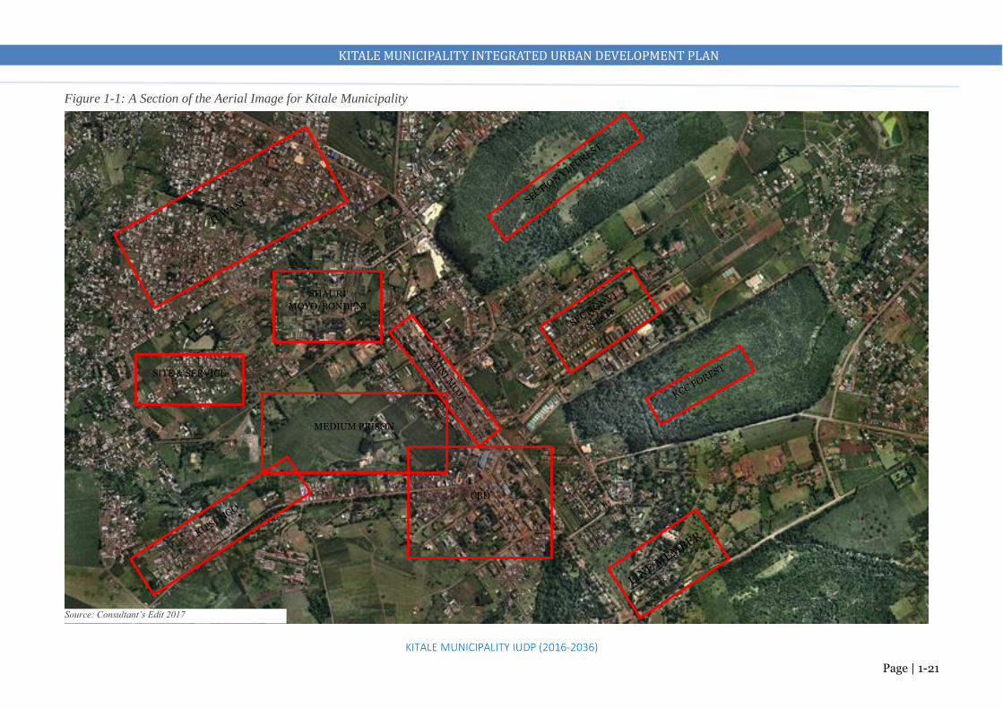
KITALE MUNICIPALITY INTEGRATED URBAN DEVELOPMENT PLAN
KITALE MUNICIPALITY IUDP (2016-2036)
Page | 1-21
CBD
MEDIUM PRISON
SITE & SERVICE
SHAURI
MOYO/BONDENI
Source: Consultant’s Edit 2017
Figure 1-1: A Section of the Aerial Image for Kitale Municipality

KITALE MUNICIPALITY INTEGRATED URBAN DEVELOPMENT PLAN
KITALE MUNICIPALITY IUDP (2016-2036)
Page | 1-22
1.11 HISTORICAL CONTEXT OF THE MUNICIPALITY AND PREVIOUS PLANNING EFFORTS The town was founded in 1908 by white settlers. Kitale started as a relay station on the slave route between
Uganda and Tanzania. Slaves were quartered at what is now the Kitale Club. The Municipality is one of
the chief townships in the Western part of Kenya. Railway line reached Kitale in 1925. A branch line from
Eldoret. The National Museum of Western Kenya is located at Kitale. It is a natural history museum and
was originally created by Lt Col. Hugh Stoneham in 1926. The present municipality was founded in 1920
and has grown enormously over the years. The first municipality covered 18km2 and the current one covers
92km2. The municipality is now the County Headquarters and a business hub with over 10 financial
institutions, industrial establishments, educational institutions, government agencies, and other
infrastructural facilities)
Milimani
Museum
Golf Course
Kitale School
Government
Offices
CBD
Forest
Residential and Hospital
Forest
Agricultural
Forest Reserve on what is now prison
land
Proposed Bus Park at Lion’s Centre
Map 1-3: Kitale Municipality 1973 Development Plan

KITALE MUNICIPALITY INTEGRATED URBAN DEVELOPMENT PLAN
KITALE MUNICIPALITY IUDP (2016-2036)
Page | 1-23
• The plan covered 18km2 only (old municipality boundary) which spanned from Trans Nzoia
County Stadium (formerly known as Kenyatta Stadium) to Milimani
• The plan requires a revision as the municipality has outgrown it. It has been overtaken by time and
events. Presence of residential use within where is now part of the CBD
• The municipality is now growing both vertically and horizontally extending into the areas which
were agricultural (in 1973).
• The municipality does not have a legal framework to guide its growth at the moment.
Notable differences in the Plan with the Existing Situation (What was not implemented)
• Land that belongs to the medium prison was planned for recreational, forest reserve and part of it as
residential
• Most road reserves have been encroached by other activities
• Land behind the Golf course was planned as recreational is now residential
Existing Situation
The current municipality has expanded to the areas outside the planned zone. These are areas where
most developments have taken place without development control or requisite infrastructure. Most
developments along the main trunk roads
Implementation of the 1973 Plan (Evaluation with the Current Land Use)

KITALE MUNICIPALITY INTEGRATED URBAN DEVELOPMENT PLAN
Page | 2-1 KITALE MUNICIPALITY IUDP (2016-2036)
- ANALYSIS AND SYNTHESIS OF PLANNING ISSUES
2.1 URBAN CHARACTER AND ZONE CHARACTERISTICS
Marked UF: Current Urban Fabric where most of the municipality’s activities and settlements are located. Forms a “bird
flying” like shape. Least developments on the tail end due to minimal land available for development as most land belong to
public institutions.
Population distribution tends to be a mix of low and medium density in the South (Milimani and along Webuye and Eldoret
Roads respectively), medium density in the North East along Kapenguria and Cherangany Roads and high density in the North
West (Tuwani and Matisi) along Endebess Road.
Marked EV: Places of Environmental Value (forest blocks). Conservation areas
Marked FG: Future Growth Areas. Peri-urban characteristic. The main land use is agriculture
Key:
UF: Current Urban Fabric
EV: Areas of Environmental Value
FG: Future Growth Areas

KITALE MUNICIPALITY INTEGRATED URBAN DEVELOPMENT PLAN
Page | 2-2 KITALE MUNICIPALITY IUDP (2016-2036)
Assessment of the Municipality’s Planning Issues
ZONE 2
• The municipality is experiencing rapid urban sprawl outside the previously planned zone (Kibomet, Rafiki,
Matisi, Namgoi and Bikeke).
• Spread of these uncoordinated urban developments come with their accompanying challenges e.g.
displacement of agricultural land by built up areas, high subdivisions of land into uneconomical sizes,
encroachment into the environmentally sensitive areas and high costs for provision of infrastructure.
Provision of infrastructural services such as water, sewer roads becomes more expensive
• No development control or requisite infrastructure to support and manage urbanization in these areas
• This sprawl also causes inefficient land utilization leading to lack of adequate space/land for provision of
facilities e.g. industries.
• Most settlements are along the main trunk roads i.e. Kitale-Kapenguria (A1), Kitale-Eldoret (B2), Kitale-
Cherangany (C48) and along Endebess Road. Presence of unsubdivided private farms has also affected
settlement patterns
• Pattern of growth is influenced by land ownership and the major roads which act as arteries on which most
activities are hooked

KITALE MUNICIPALITY INTEGRATED URBAN DEVELOPMENT PLAN
Page | 2-3 KITALE MUNICIPALITY IUDP (2016-2036)
Zone 1: (ADC Farm, KARI, Rafiki, Airstrip, Standard, Ex Prison and the Main Prison)
FACILITY OPEN/CLOSED MARKET. MEAN DISTANCE TO THE NEAREST
Block 1-3 Block 4-6
None. 2.3km (CBD) None. 3.7km (CBD)
FACILITY POLICE STATION/POST. MEAN DISTANCE TO THE NEAREST
Block 1-3 Block 4-6
None. 2.3km (CBD) and 3km (Matisi Post) None. 3.7km (CBD)
FACILITY COMMUNITY CENTRE OR SOCIAL HALL. MEAN DISTANCE TO THE NEAREST
Block 1-3 Block 4-6
None. 4.2km (Machinjoni) None. 3.5km (Machinjoni)
FACILITY FIRE STATION. MEAN DISTANCE TO THE NEAREST
Block 1-3 Block 4-6
None. 2.3km (CBD) None. 3.7km (CBD)
FACILITY STADIUM. MEAN DISTANCE TO THE NEAREST
Block 1-3 Block 4-6
None. 3km (CBD) None. 4.5km (CBD)
Block 1
Block 2
Block 3
Block 4
Block 5
Block 6
Block 1: Large parcels of institutional (ADC Farm and private agricultural land.
Block 2: Rafiki Centre. Emerging residential node where high subdivisions of land has taken place
Block 3: KARI. Parcels of extensive agricultural land for research purpose
Block 4: Kitale Airstrip. Other users around it include mix of low density residential and agriculture, St Joseph Schools and Standard Estate (Medium Density)
FACILITIES AVAILLABLE

KITALE MUNICIPALITY INTEGRATED URBAN DEVELOPMENT PLAN
Page | 2-4 KITALE MUNICIPALITY IUDP (2016-2036)
Zone 2: (Former Municipality)
Milimani
Facilities Available: Stadium, Social Hall, Police
Station, Level 4 and 5 hospitals, G.K Prison, Golf
Course, Government offices, cemeteries, water &
sewer facilities, a dumpsite, schools, museum and a
bus park
Land Use: commercial (CBD), residential, industrial,
forests, public purpose, public utilities, recreational,
educational, transport and agricultural
Issues
Narrow Roads due to presence of Informal activities in
many areas of the CBD taking over public spaces and
road reserves especially Laini Moja
Congestion (due to lack of facilities like markets and
bus parks leading to competition in use of little space
available), Jua kali activities and furniture making also
operate on road reserves
Inadequate parking facilities
Bodaboda menace due to lack of proper facilities
A considerable number of under-utilized and low-
density developments especially along Laini Moja and
Kipsongo Road.
Inadequate drainage facilities and solid waste
collection facilities
Encroachment of the Medium Prison and the forest
blocks
Informalities on road reserves
Inadequate parking spaces for
matatus, bodabodas, Lorries
and private vehicles
Congestion in the CBD especially along Laini Moja section

KITALE MUNICIPALITY INTEGRATED URBAN DEVELOPMENT PLAN
Page | 2-5 KITALE MUNICIPALITY IUDP (2016-2036)
Zone 3: (Tuwani, Matisi, Lessos, Bidii and Kibomet)
FACILITY OPEN/CLOSED
MARKET. MEAN
DISTANCE TO THE
NEAREST
Block 1
Block 2
Block 3
None. 1.9km (CBD)
None. 2.6km (CBD)
None. 2.8km (CBD)
FACILITY POLICE
STATION/POST.
MEAN DISTANCE TO
THE NEAREST
Block 1
Block 2
Block 3
Matisi police post.
None. None.
2.6Km(CBD)
None. 2.8km (CBD)
FACILITY COMMUINITY
CENTRE OR SOCIAL
HALL. MEAN
DISTANCE TO THE
NEAREST
Block 1
Block 2
Block 3
None. 1km
(Machinjoni)
None. 5km
(Machinjoni)
None. 5km
(Machinjoni)
FACILITY FIRE FIGHTING
FACILITY. MEAN
DISTANCE TO THE
NEAREST
Block 1
Block 2
Block 3
None. 1.9km (CBD)
None. 2.6km (CBD)
None. 2.8km (CBD)
FACILITY STADIUM. MEAN
DISTANCE TO THE
NEAREST
Block 1
Block 2
Block 3
None. 1.4km (CBD)
None. 2.3km (CBD)
None. 3.5km (CBD)
Block 1: Tuwani, Matisi and Lessos. Main use is high density residential. Presence of
commercial use (Matisi Shopping Centre). The area has educational institutions as well. Lack of adequate sewer, water supply and solid waste collection facilities. Poor roads. Rampant use of bodabodas to access the CBD and other areas
Block 2: Bidii. The main land use is agricultural. Presence of large farms. Presence of a sewer treatment facility, inadequate water, sewer and solid waste facilities
Block 3: Kibomet. Majorly a medium density residential area. Presence of significant commercial
land use (Aturukan hotel among other hotel and conference facilities). Lack of adequate sewer and solid waste collection facilities
Settlement Pattern: Most settlements are along the main trunk roads i.e. Kitale-Kapenguria (A1),
Block 2
Block 3
Hotel Facilities in Kibomet
Narrow A1 Road
Poor Roads in Tuwani
Broken Sewer Facilities in Tuwani
AVAILABILITY OF FACILITIES

KITALE MUNICIPALITY INTEGRATED URBAN DEVELOPMENT PLAN
Page | 2-6 KITALE MUNICIPALITY IUDP (2016-2036)
Zone 4: (Bikeke, Machungwa, Sirende, Kwa Gatua, Namgoi and Kibagenge)
FACILITY OPEN/CLOSED MARKET.
MEAN DISTANCE TO THE
NEAREST
Block 1
Block 2
At Bikeke
None. 5km (CBD)
FACILITY POLICE STATION/POST.
MEAN DISTANCE TO THE
NEAREST
Block 1
Block 2
Bikeke police post.
Sirende Police Post
Police Station (CBD)
FACILITY COMMUINITY CENTRE
OR SOCIAL HALL. MEAN
DISTANCE TO THE
NEAREST
Block 1
Block 2
None. 6km (Machinjoni)
None. 7km (Machinjoni)
FACILITY FIRE FIGHTING FACILITY.
MEAN DISTANCE TO THE
NEAREST
Block 1
Block 2
None. 6km (CBD)
None. 5km (CBD)
FACILITY STADIUM. MEAN
DISTANCE TO THE
NEAREST
Block 1
Block 2
None. 5.5km (CBD)
None. 4.5km (CBD)
FACILITY HEALTH FACILITY. MEAN
DISTANCE TO THE
NEAREST
Block 1
Block 2
Bikeke Health Centre.
None. 4.5km (CBD)
Block 2
Block 1
Sirende
Ward
Waitaluk
Ward
Block 1: Bikeke and Machungwa.
• Mainly agricultural but the high
subdivision rates has attracted a
considerable number of residential
and commercial
• Lack of sewer facilities
• Inadequate water supply facilities
• Narrow and poor access roads
• Presence of a health centre
• Presence of educational facilities
• A small open air market is also
present Block 2: Kwa Gatua, Namgoi and Kibagenge.
• Mainly agricultural but the high subdivision rates
has attracted a considerable number of residential
and commercial
• Presence of industrial (Commercial Grain Stores
Limited and Commercial (Kwa Gatua)
• Lack of sewer facilities
• Inadequate water supply facilities
• Narrow and poor access roads
• Presence of educational facilities

KITALE MUNICIPALITY INTEGRATED URBAN DEVELOPMENT PLAN
Page | 2-7 KITALE MUNICIPALITY IUDP (2016-2036)
2.2 SUMMARY OF PLANNING ISSUES
Theme Planning Issues Example
Land Under utilization of land in the CBD
Subdivision of land into uneconomical sizes
Irregular allocation of public land
Low skyline
Undeveloped spaces
Old Dilapidated commercial buildings in the CBD
Land parcel sizes in Rafiki area
KCC , Block 10, Main Prison Land
Environment Encroachment of the environmentally sensitive areas
Pollution
Indiscriminate Dumping of waste
Illegal subdivision of Forests,
Reduction of forest cover
River pollution
Economy Minimal value addition due to under utilization of the
industrial potential.
Inadequate market facilities
Inadequate industrial facilities (both light and Heavy)
Underutilized industrial and tourism sector
Sprawl of informal activities on streets
Congestion of trade and industrial activities along
Laini Moja

KITALE MUNICIPALITY INTEGRATED URBAN DEVELOPMENT PLAN
Page | 2-8 KITALE MUNICIPALITY IUDP (2016-2036)
Transportation Poor road surface conditions
Traffic congestion in the CBD
Encroachment of road reserves
Inadequate parking and terminal facilities
Lack of elaborate road and transport network
Dilapidated road surfaces
Vending, parking, along the streets
Physical
Infrastructure
Water
Inadequate provision of piped water supply (only 80km2)
Demand gap is 23,000m3/day.
Unreliable water supply.
Sewer and Sanitation
Inadequate provision of sewer facilities
Coverage is only 18km2
Estimated waste water 23,371m3/day against a treatment
capacity of 5,810m3/day
Solid Waste Management
Poor management of solid waste.
Lack of a sanitary landfill
Drainage
Inadequate storm water drainage infrastructure.
Presence of water kiosks in most estates
High use of pit latrines
Broken sewers in Tuwani
Littering of streets and proliferation of undesignated
dumping areas in the CBD and residential areas
There is only one fire engine that serves the entire
county

KITALE MUNICIPALITY INTEGRATED URBAN DEVELOPMENT PLAN
Page | 2-9 KITALE MUNICIPALITY IUDP (2016-2036)
Ineffective maintenance of the existing drainage
infrastructure.
Street Lighting
Inadequate street lighting facilities
Fire Fighting Facilities
Lack of a fire station
Inadequate firefighting facilities
Social
Infrastructure
Health
• Inadequate provision of health facilities especially health
centres and dispensaries.
Education
Inadequate provision of vocational and technical
institutions
Community facilities
Lack of a public cemetery. The existing one is full.
Inadequate open spaces
Lack of public library services
Inadequate social halls
There is only one social hall, health centres are not
adequate and a public library is yet to be developed
despite having land allocation

KITALE MUNICIPALITY INTEGRATED URBAN DEVELOPMENT PLAN
Page | 2-10 KITALE MUNICIPALITY IUDP (2016-2036)
Lack of a community centre
Housing
• Inadequate housing supply leading to increasing growth
of informal settlements.
• Lack of a land use plan to control housing development.
• Poor housing conditions.
• Dilapidated municipal housing
• Inadequate requisite services in the residential areas
Informal settlements e.g. Kipsongo, Tuwani,
Dilapidated County housing
Governance • Inadequate institutional capacity
• Poor coordination of departments
• Inadequate human and financial capital
• Challenges in optimization of revenue sources and
collection
• Weak development control capacity
Under capacitation of Physical Planning Unit
Unregulated building and uneconomical subdivision
of land

KITALE MUNICIPALITY INTEGRATED URBAN DEVELOPMENT PLAN
Page | 2-11 KITALE MUNICIPALITY IUDP (2016-2036)
2.3 SYNTHESIS OF PLANNING ISSUES
This section provides a systematic combination of different elements of the municipality and
emerging issues to form a coherent synthesis that will inform the plan of actions in formulating
the desired future for Kitale Municipality Integrated Urban Development Plan. Synthesis of
planning issues will help identify/form a number of development concepts and the best concept
to be chosen for development of a structure plan, policies and strategies. Synthesis of key issues
in Kitale provides the following main concerns:
Land Utilization. Inner urban activity centres like the CBD and the Civic area are ideally
suited to become compact locations where a large range of activities can be accessed in one
place. By clustering activities close together and combining housing and common destinations
such as shops and jobs, sustainable travel modes of walking and cycling can be encouraged.
Parts of the municipality could be more intensively developed to realize the benefits of a
compact centre and livable housing areas.
Variable quality of the public realm. The quality of the public realm varies across the
municipality and especially the core area. Disincentives to walking and cycling are very
apparent. Poor walking conditions such as inadequate and narrow footpaths, road crossings not
prioritizing pedestrians, and narrow roads that create poor pedestrian amenity and safety in
some areas. There is also an uneven provision of public open spaces across the municipality.
Retail and wholesale prosperity. The retail sector of the municipality is currently
overwhelmed by congestion, encroachment, and lack of adequate trading areas. A greater
diversity of jobs and working places in the municipality would broaden the customer base for
shops and services and create more economic opportunities.
Job Diversity. The municipality provides a number of areas for job diversity that need to be
exploited. Most people in the municipality rely on trade and agriculture for sustenance. Very
few people rely on formal employment and the self-reliance opportunities such as enhanced
small-scale industries are missing or underprovided. Lack of industries despite the rich
agricultural hinterland has largely affected job diversity and economic growth of the
municipality. The municipality is also strategically positioned to reap from the tourism sector
through eco-tourism, hotel and conference facilities and Mt Elgon
Transport and Movement constraints. The A1 Road plays an ongoing role as a main through
route for passenger vehicle and freight traffic. The road is however very narrow and congested.
The impacts include congestion of trading areas, conflict of road users, pedestrian and cycle

KITALE MUNICIPALITY INTEGRATED URBAN DEVELOPMENT PLAN
Page | 2-12 KITALE MUNICIPALITY IUDP (2016-2036)
safety concerns, inadequate space for expansion of the road, and environmental concerns such
as noise and air pollution. Regional and urban/local roads are narrow and in poor condition
Decay of the Centre (CBD). The A1 Road and the forest blocks are significant assets to Kitale
municipality. They have largely influenced the current development trends in the Centre. They
however suffer from encroachment and decay and very little has been done to revitalize them
and exploit the huge potential they possess in municipality’s growth and development.
Expansion of the A1 road and revitalization of the forests will largely improve the centre
together with associated compact development of the CBD.
Sustainability Challenges. Lack of controlled development presents the main challenge to
creating a more economically and environmentally sustainable municipality.
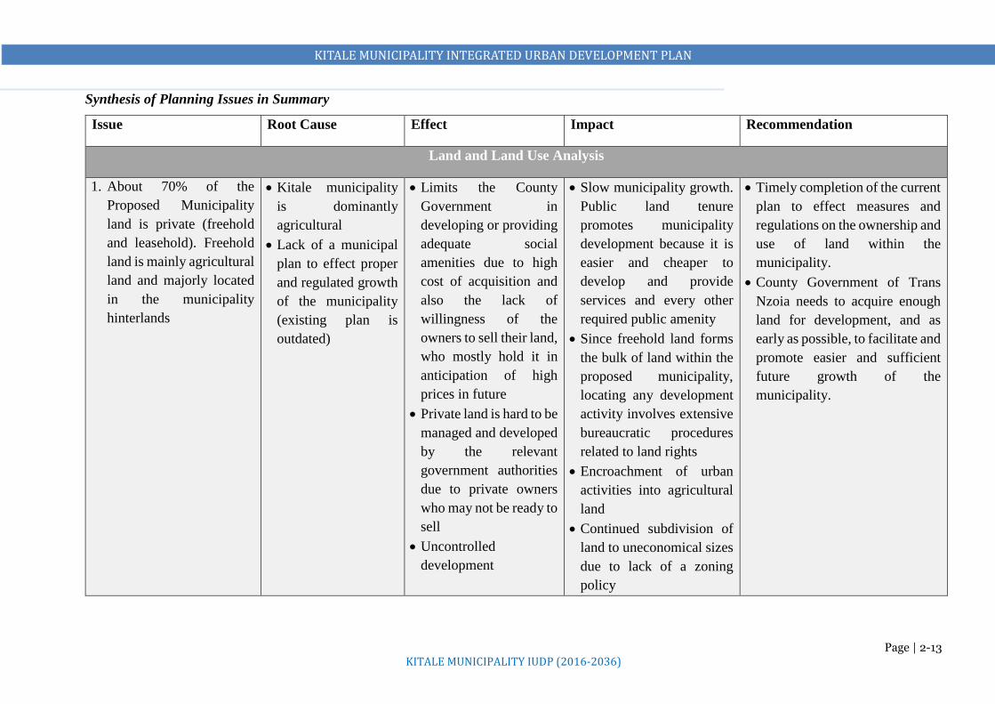
KITALE MUNICIPALITY INTEGRATED URBAN DEVELOPMENT PLAN
Page | 2-13 KITALE MUNICIPALITY IUDP (2016-2036)
Synthesis of Planning Issues in Summary
Issue Root Cause Effect Impact Recommendation
Land and Land Use Analysis
1. About 70% of the
Proposed Municipality
land is private (freehold
and leasehold). Freehold
land is mainly agricultural
land and majorly located
in the municipality
hinterlands
Kitale municipality
is dominantly
agricultural
Lack of a municipal
plan to effect proper
and regulated growth
of the municipality
(existing plan is
outdated)
Limits the County
Government in
developing or providing
adequate social
amenities due to high
cost of acquisition and
also the lack of
willingness of the
owners to sell their land,
who mostly hold it in
anticipation of high
prices in future
Private land is hard to be
managed and developed
by the relevant
government authorities
due to private owners
who may not be ready to
sell
Uncontrolled
development
Slow municipality growth.
Public land tenure
promotes municipality
development because it is
easier and cheaper to
develop and provide
services and every other
required public amenity
Since freehold land forms
the bulk of land within the
proposed municipality,
locating any development
activity involves extensive
bureaucratic procedures
related to land rights
Encroachment of urban
activities into agricultural
land
Continued subdivision of
land to uneconomical sizes
due to lack of a zoning
policy
Timely completion of the current
plan to effect measures and
regulations on the ownership and
use of land within the
municipality.
County Government of Trans
Nzoia needs to acquire enough
land for development, and as
early as possible, to facilitate and
promote easier and sufficient
future growth of the
municipality.
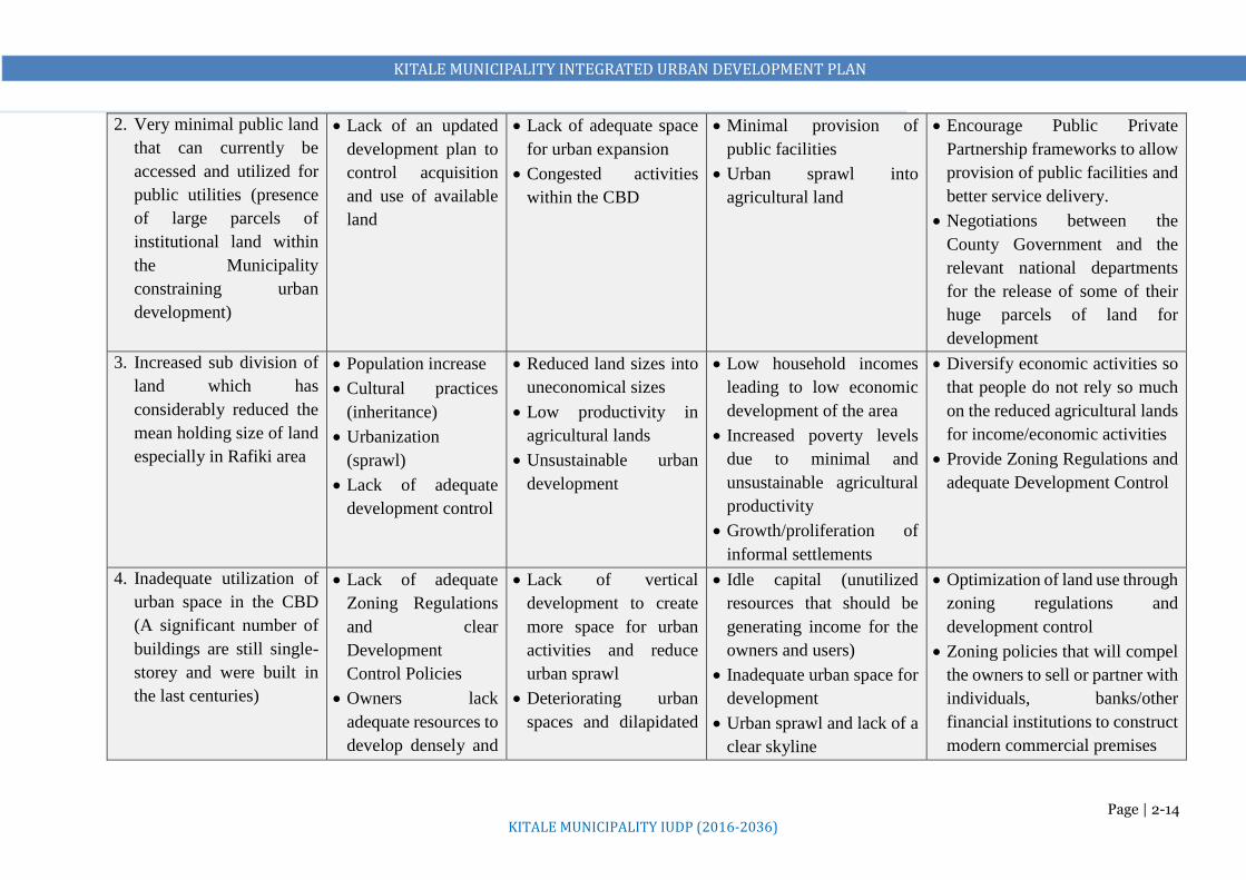
KITALE MUNICIPALITY INTEGRATED URBAN DEVELOPMENT PLAN
Page | 2-14 KITALE MUNICIPALITY IUDP (2016-2036)
2. Very minimal public land
that can currently be
accessed and utilized for
public utilities (presence
of large parcels of
institutional land within
the Municipality
constraining urban
development)
Lack of an updated
development plan to
control acquisition
and use of available
land
Lack of adequate space
for urban expansion
Congested activities
within the CBD
Minimal provision of
public facilities
Urban sprawl into
agricultural land
Encourage Public Private
Partnership frameworks to allow
provision of public facilities and
better service delivery.
Negotiations between the
County Government and the
relevant national departments
for the release of some of their
huge parcels of land for
development
3. Increased sub division of
land which has
considerably reduced the
mean holding size of land
especially in Rafiki area
Population increase
Cultural practices
(inheritance)
Urbanization
(sprawl)
Lack of adequate
development control
Reduced land sizes into
uneconomical sizes
Low productivity in
agricultural lands
Unsustainable urban
development
Low household incomes
leading to low economic
development of the area
Increased poverty levels
due to minimal and
unsustainable agricultural
productivity
Growth/proliferation of
informal settlements
Diversify economic activities so
that people do not rely so much
on the reduced agricultural lands
for income/economic activities
Provide Zoning Regulations and
adequate Development Control
4. Inadequate utilization of
urban space in the CBD
(A significant number of
buildings are still single-
storey and were built in
the last centuries)
Lack of adequate
Zoning Regulations
and clear
Development
Control Policies
Owners lack
adequate resources to
develop densely and
Lack of vertical
development to create
more space for urban
activities and reduce
urban sprawl
Deteriorating urban
spaces and dilapidated
Idle capital (unutilized
resources that should be
generating income for the
owners and users)
Inadequate urban space for
development
Urban sprawl and lack of a
clear skyline
Optimization of land use through
zoning regulations and
development control
Zoning policies that will compel
the owners to sell or partner with
individuals, banks/other
financial institutions to construct
modern commercial premises

KITALE MUNICIPALITY INTEGRATED URBAN DEVELOPMENT PLAN
Page | 2-15 KITALE MUNICIPALITY IUDP (2016-2036)
accommodate more
use
buildings that reduce
municipality aesthetics
Congestion due to lack
of adequate spaces to
host users that ideally
should be domesticated
e.g. parking spaces
Informal distribution of
activities due to lack of
adequate spaces, poor
organization of
activities et cetera
Urban decay
5. Illegal Subdivisions of
prison land and forest
blocks
Corruption
Lack of up to date
records
Poor coordination of
public authorities in
matters land
management
Diminishing public land Change in micro climate
Corruption is put on a
normal footing
Demarcate all the public land
and revoke all the illegal
subdivisions or acquisitions
6. Congested development
in the CBD without
observing plot setbacks
and building lines
High values of land
Lack of proper
development control
Congestion due to lack
of adequate spaces to
host users that ideally
should be domesticated
e.g. parking spaces
Informal distribution of
activities due to lack of
adequate spaces, poor
Reduced incomes
Increased poverty levels
Deteriorating urban spaces
and dilapidated buildings
that reduce municipality
aesthetics and economic
activities/spaces
Preparation of an Action Area
Plan for the CBD to regulate
development and provide order
Compulsory acquisition for
provision of infrastructure and
services.

KITALE MUNICIPALITY INTEGRATED URBAN DEVELOPMENT PLAN
Page | 2-16 KITALE MUNICIPALITY IUDP (2016-2036)
organization of
activities etc.
Housing
1. Rapid proliferation of
unplanned settlements
Lack of a
municipality plan to
guide and control
developments
including housing
provision zones
High growth and
uncontrolled
urbanization rates
Diminishing family
land in the rural areas
pushing people to
live in municipality
Demand for decent and
affordable housing
exceeds the supply
It grows into a challenge
laying basic
infrastructure and
providing basic
community facilities
due to congestion and
inadequate space
Emergence of social
challenges e.g. crime
rate, drug abuse, HIV
prevalence, teen
pregnancies etc.
Deterioration of urban
spaces hence low
economic growth of the
municipality
Environmental
degradation
Increase in social
challenges e.g. orphaned
children, street families,
unproductive youth due to
drug abuse
Push factor for residents
and investors to other
municipalities
Prepare a human settlement
strategy
Undertake land use planning
through zoning regulations and
development control
2. Inadequate provision of
basic infrastructure and
services i.e. poor access
roads, inadequate water
supply, poor liquid and
solid waste disposal,
inadequate public
facilities, inadequate
Rapid urbanization
with no matching
services and
infrastructure
Lack of zoning
regulations and
development control
Poor Sanitation
Environmental
degradation
Emergence of social
challenges e.g. crime
rates
Degeneration of
settlements
Deterioration of urban
spaces hence low
economic growth of the
municipality
Push factor for residents
and investors to other
municipalities
Undertake land use planning to
determine the need
Compulsory acquisition for
provision of infrastructure and
services.

KITALE MUNICIPALITY INTEGRATED URBAN DEVELOPMENT PLAN
Page | 2-17 KITALE MUNICIPALITY IUDP (2016-2036)
recreational facilities and
inadequate street
lights/high masts
to guide and control
development
Low investment into
provision of basic
infrastructure and
services by the
relevant authorities
due to lack of
resources or poor
planning.
3. Shortage of affordable
housing
High poverty levels
Low housing
investment by both
national and County
Governments in the
area
High interest rates
on borrowing from
financial institutions
discourage potential
clients from taking
housing finance.
Rapid proliferation of
informal settlements
and slums
Deterioration of formal
settlements to informal
settlements and slums
Increase in social
challenges e.g. crime
Relocation of residents to
other municipalities with
affordable housing
Re-development of areas like
Mitume and Shauri Moyo for
low cost housing
Slum upgrading programmes
Existence of locally available
building materials (bricks and
building stones) as an
opportunity for the above which
lessen the cost of housing
construction
Urban Economy
1. Inadequate space for trade
and industrial
development leading to
conflict of land uses
Lack of a plan to
guide zoning of land
uses and provision of
facilities
Congestion of activities
due to their competing
locational needs
Low revenues for the
county
Degeneration of urban
spaces
Prepare an Integrated Urban
Development Plan for the
municipality indicating areas for

KITALE MUNICIPALITY INTEGRATED URBAN DEVELOPMENT PLAN
Page | 2-18 KITALE MUNICIPALITY IUDP (2016-2036)
This inadequacy of
space gives the
operators very little area
for expansion
Emergence of informal
activities especially on
road reserves
High rates of
unemployment and
poverty levels due to lack
of adequate space for job
creation
each land use, zoning plans and
development control regulations
2. Inadequate provision of
infrastructure and basic
facilities
Inadequate resources
Lack of political
good will or
commitment
Prevalence of informal
commercial activities
that encroach onto road
reserves
Poor planning by the
relevant authorities
Low rate of investment
Degeneration of urban
spaces
Undertake land use planning and
provide adequate infrastructure
and services
3. Poor
access/transportation
link between
production zones and
the markets
Poor roads
Nonfunctional
railway line
Lack of enhanced
direct link to regional
and international
markets
Hindrances to the
marketing of
agricultural produce
Low prices of
agricultural products
due to
overwhelmed/flooded
local markets
High poverty levels due to
low economic
opportunities in the farm
areas and loss of related
jobs in urban areas
Plan for good infrastructure to
enable and facilitate easy
transport and access to local and
regional markets
4. Limited access to credit
facilities
Prohibitive
requirements in
accessing credit
facilities
Inadequate policy
interventions to
Hinders investment
especially among the
vulnerable groups
Lack of jobs for the
youth, women and other
vulnerable groups
High poverty levels
Slow economic growth
Increase in informal
activities which means low
revenues for the County
Promote policy interventions
that improve credit access
Educate the masses
vehemently on the available
financial opportunities through

KITALE MUNICIPALITY INTEGRATED URBAN DEVELOPMENT PLAN
Page | 2-19 KITALE MUNICIPALITY IUDP (2016-2036)
promote access to
credit
Lack of adequate
information
Emergence of informal
activities in every sector
digital and print media and
seminars/workshops
Encourage residents to engage
more in the informal saving
sectors like chamas
5. Diminishing rural and
peri-urban agricultural
lands
High urbanization
and growth rates of
the municipality
Increased sub
division of land
which has
considerably reduced
the land sizes
Reduced land
productivity
Subdivision of land into
uneconomical sizes
Slowed economic growth
of the area as most lands
remain uneconomical
Development of informal
areas that lack adequate
infrastructure and services
Conserve agricultural areas by
delineating urban limits
Regulate subdivisions through
zoning and development control
6. Underperforming
industrial and commercial
sector. Industrial sector
plays a relatively minor
role in the municipality’s
economy despite the huge
potential for agro-
processing industries and
the underutilized raw
materials
Mismanagement of
resources intended
for promoting the
industry at the county
level
Inadequate capital
for SMEs start ups
Reduced income in the
agricultural sector
Lack of jobs for the
youth, women and other
vulnerable groups
Emergence of informal
activities as an
alternative for income
earning
High poverty levels
Slow economic growth of
the area as most
agricultural produce lack
value addition and markets
Increase in informal
activities which means low
revenues for the County
A Municipal Plan that explores
and optimizes all the available
opportunities in the area to
promote a solid commercial and
industrial base anchored on the
readily available local raw
materials, abundant labour
force and the entrepreneurial
spirit of people living in the
Kitale municipality
The County Government to
place major emphasis on
agricultural inputs through

KITALE MUNICIPALITY INTEGRATED URBAN DEVELOPMENT PLAN
Page | 2-20 KITALE MUNICIPALITY IUDP (2016-2036)
marketing, value addition, and
agricultural extension services
7. Lack of appropriate
technology and skills to
produce, process,
preserve and market the
region’s agricultural
products with the
municipality set to
benefit the most
through forward and
backward linkages
Inadequate resources
Non-commitment of
the relevant
government
departments to
provide adequate
resources, enhance
capacity for
agricultural
development and
value addition
Poor coordination
between ADC and
the County
Government in
providing
information and
capacity to farmers
on farm
diversification, value
addition and
availability of
markets
Low mechanization of
agricultural production
to increase efficiency
Poor or lack of storage
facilities
Inadequate extension
services
Low diversification of
crops and livestock
farming
Low farm produce
Low farm incomes
Demoralization of
farmers
High poverty levels
Increased poverty levels
Rural-urban migration
Slow economic growth of
the municipality
Capacity enhancement to
farmers on farm diversification,
production, processing and
marketing of their produce.
Provide efficient and effective
support services for agricultural
programmes, allocate adequate
facilities like markets, conserve
agricultural areas, help develop
adequate policies for crop
development and management
and also plan for good
infrastructure to enable and
facilitate easy transport and
access to local and regional
markets

KITALE MUNICIPALITY INTEGRATED URBAN DEVELOPMENT PLAN
Page | 2-21 KITALE MUNICIPALITY IUDP (2016-2036)
8. Inadequate capacity in
terms of skills. Youth
skills enhancement as a
good opportunity for
self-reliance in terms of
income earning is still
low.
Only two technical
training institutions
(Kitale Technical
Training Institute
and Kipsongo
Training Centre)
Low technical skills
dominating the informal
sector
Low self-reliance
among the youth
pushing the spectrum of
unemployment higher
Increase in social
challenges e.g. crime
rates
High poverty levels
Slow economic growth of
the area as most
agricultural produce lack
value addition and markets
Increase in informal
activities which means low
revenues for the County
More institutions need to be
developed. Also, redevelop the
existing ones to modern
facilities.
More clear policy interventions
to increase and improve access
to procurement opportunities for
enterprises owned by the youth,
women and people with
disabilities as well as issuing
start-up funds for the youth
Physical Infrastructure
Water and Sanitation
High unaccounted-for
water at 65%
Old PVC pipe system
leading to high cases
of pipe bursts
Pipe damage during
road construction
Illegal water
connections
Low water supply
Reduced revenues for
the service provider
Sanitation related diseases
Dilapidated water supply
infrastructure
Slow economic growth of
the municipality due to
lack of water to support
trade and industries
Service provider might run
out of business
Depletion of water table
due to overreliance on
ground water
Mapping and digitizing of the
water supply system to detect
areas of leakages and illegal
connections
Enhance the capacity of the
service provider to undertake
proper monitoring of the system
Proper coordination between the
County Government and the
water company in project
identification and

KITALE MUNICIPALITY INTEGRATED URBAN DEVELOPMENT PLAN
Page | 2-22 KITALE MUNICIPALITY IUDP (2016-2036)
implementation as water
provision is a devolved function
Proper communication and
coordination by the County
Roads Department, County
Water Department and the water
company to prevent or repair
pipe damages during road
construction
Inadequate piped water
supply (about 50% of the
proposed municipality)
Lack of adequate
capacity to cover the
entire area
Illegal water
connections
High physical losses
due to old and
dilapidated
infrastructure
Frequent pipe
damage during road
construction
Use of water from
unsafe sources
Challenges to
businesses and
industries
Low trade and
industrialization
Sanitation challenges
For current and future demand,
there is a need to establish a
larger treatment plant to increase
water supply capacity in the
municipality to cater for the
growing population for the
planning period of 20 years
Inadequate sewer
coverage (about 20km2)
Lack of adequate
capacity to cover the
entire municipality
Inadequate housing
provision
Poor sanitation
Low investment in
municipality
Poor housing conditions
Increase in waterborne
diseases
Expansion and modernisation of
the sewer system, as the existing
system was set up in 1950 and
1983
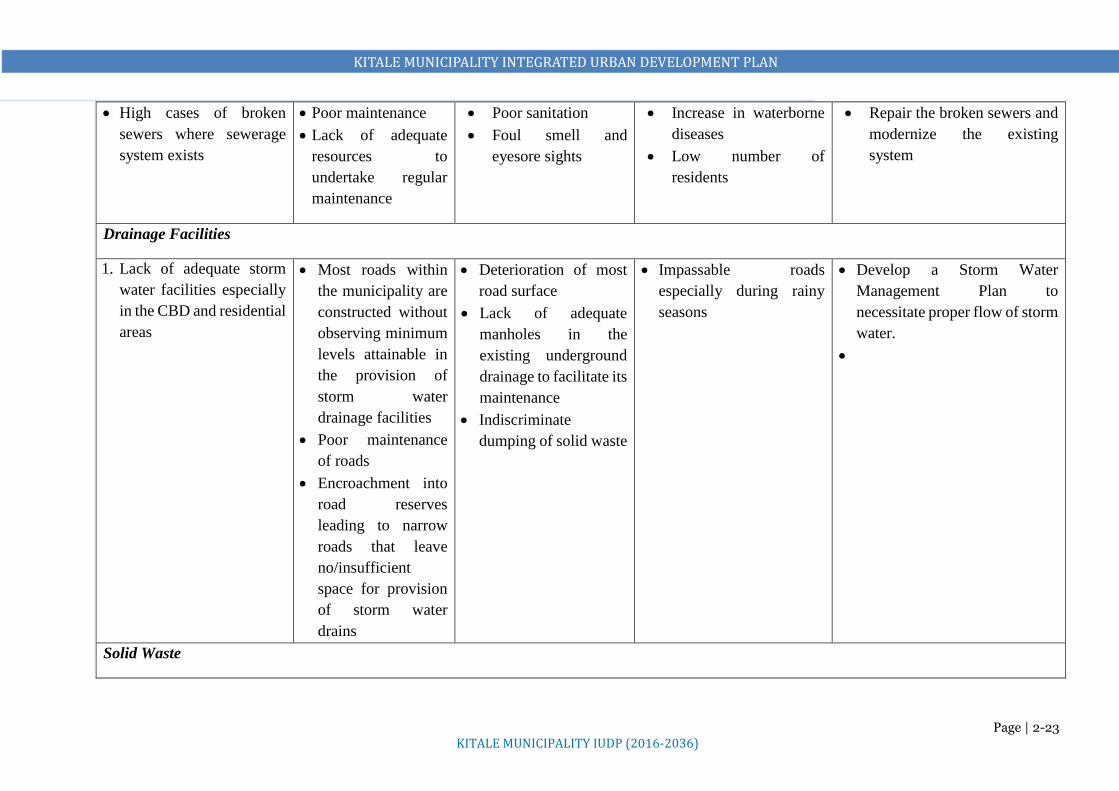
KITALE MUNICIPALITY INTEGRATED URBAN DEVELOPMENT PLAN
Page | 2-23 KITALE MUNICIPALITY IUDP (2016-2036)
High cases of broken
sewers where sewerage
system exists
Poor maintenance
Lack of adequate
resources to
undertake regular
maintenance
Poor sanitation
Foul smell and
eyesore sights
Increase in waterborne
diseases
Low number of
residents
Repair the broken sewers and
modernize the existing
system
Drainage Facilities
1. Lack of adequate storm
water facilities especially
in the CBD and residential
areas
Most roads within
the municipality are
constructed without
observing minimum
levels attainable in
the provision of
storm water
drainage facilities
Poor maintenance
of roads
Encroachment into
road reserves
leading to narrow
roads that leave
no/insufficient
space for provision
of storm water
drains
Deterioration of most
road surface
Lack of adequate
manholes in the
existing underground
drainage to facilitate its
maintenance
Indiscriminate
dumping of solid waste
Impassable roads
especially during rainy
seasons
Develop a Storm Water
Management Plan to
necessitate proper flow of storm
water.
Solid Waste

KITALE MUNICIPALITY INTEGRATED URBAN DEVELOPMENT PLAN
Page | 2-24 KITALE MUNICIPALITY IUDP (2016-2036)
1. Inadequate waste
collection and
transportation
Inadequate financial
resources
The municipality
lacks critical solid
waste management
equipment/facilities
including, transfer
stations, dustbins and
skips
High indiscriminate
dumping of waste by
households
Inefficient collection
leading to
undesignated dumping
sites within the urban
spaces that are an
eyesore
Environmental degradation Develop a Solid Waste
Management Plan
2. Lack of a solid waste
management site
Lack of a proper site
to relocate the
current dumpsite
Inadequate financial
resources
Emergence of
undesignated dumping
sites
Haphazard/indiscrimin
ate waste disposal
Environmental
degradation
Increase in water borne
diseases
Acquire land for a sanitary landfill
3. Inadequate waste
segregation at the source
and at the collection
points
No proper
mechanisms put in
place to promote this
County Government
still grapples with
financial, technical
and institutional
inadequacies thus
hindering service
delivery
Increased deficits in
waste recycling
Electronic waste
management is still a
challenge as there is no
existent recovery or
recycling facility
Poor solid waste
management
Community sensitization on waste
management and provide requisite
facilities

KITALE MUNICIPALITY INTEGRATED URBAN DEVELOPMENT PLAN
Page | 2-25 KITALE MUNICIPALITY IUDP (2016-2036)
Social Infrastructure
Education
1. Shortage/poor
infrastructure in public
schools
Inadequate capacity High school drop out
Low transition
Low education quality
Increased poverty levels
There is need to develop more
infrastructure in the existing
schools to hold more students
especially in boarding
2. Inadequate vocational
training centres
Inadequate capacity Low skilled capacity
especially among the
youth
High flow of the youth
into bodaboda business
which currently lacks
adequate
capacity/facilities
Increased social ills
Emigration
Reduced economic
opportunities
Increased poverty levels
Plan to incorporate proposals for
vocational training centres and
propose mechanisms to enhance
capacity of other tertiary
institutions
3. Inadequate staff in public
schools
Inadequate capacity Low education quality
High school drop out
Low transition
Proliferation of private
schools that most
residents cannot afford
Proliferation of private
schools that do not meet
the set standards
Increased poverty levels
National government to recruit
more teachers
4. Unregistered private
schools which
Inadequate capacity
for development
control
Proliferation of
private schools that
do not meet the set
standards
Low education quality
Increase in corruption
Provide adequate development
control
Provide an education policy that
improves education in public

KITALE MUNICIPALITY INTEGRATED URBAN DEVELOPMENT PLAN
Page | 2-26 KITALE MUNICIPALITY IUDP (2016-2036)
compromise education
quality
Neglect of public
schools
schools and that addresses the
need to join private schools
Health
1. Shortage/poor
infrastructure in most
public hospitals
Inadequate capacity
Lack of prioritization
in service delivery
Low health care quality
Frequent county health
workers
High cost of services (in
private facilities) that
most people in Kitale
cannot afford
Increased unhealthy
population
Proliferation of private
schools that do not meet
the set standards
Increased poverty levels
due to reduced
development
capabilities
Upgrading and modernization of
the existing facilities is
necessary to ensure provision of
quality health care
2. Inadequate health
facilities
Inadequate resources High cost of services (in
private facilities)
Increased unhealthy
population
Proliferation of private
hospitals which most
residents of Kitale
cannot afford to pay for
their services
Proliferation of private
hospitals that do not
meet the set standards
Increased poverty levels
due to reduced
Provide adequate distribution of
health facilities across the
proposed municipality

KITALE MUNICIPALITY INTEGRATED URBAN DEVELOPMENT PLAN
Page | 2-27 KITALE MUNICIPALITY IUDP (2016-2036)
development
capabilities
3. Inadequate healthcare
personnel
Low doctor/nurse-
population ratio
High cost of services (in
private facilities)
Frequent health workers
strike as recently
witnessed countrywide
resulting to seeking
medical services in
private hospitals
Increased unhealthy
population
Proliferation of private
hospitals which most
residents of Kitale
cannot afford to pay for
their services
Proliferation of private
hospitals that do not
meet the set standards
Allocate more funds to health
care
4. High cost of services.
(Unaffordable services)
Poor service delivery Inadequate access to
quality affordable
health care
Increased unhealthy
population
High poverty levels
Provide Universal Health Care
Social Care Facilities
1. Inadequate Rescue
Centres
Inadequate resources Increase in street
families
Increased poverty levels Provide more rescue centres to
provide social care and
education for street families and
orphans
Open/Recreational Spaces
1. Inadequate facilities Inadequate resources The area lacks adequate
parks and open spaces
both within the
municipality and their
neighborhoods
The inequitable provision
of parks and open spaces
harms the residents of the
municipality because, only
less individuals are likely
The proposed municipality
needs at least 25 hectares of land
for parks and in well-distributed
locations

KITALE MUNICIPALITY INTEGRATED URBAN DEVELOPMENT PLAN
Page | 2-28 KITALE MUNICIPALITY IUDP (2016-2036)
to engage in the regular
physical activity that is
crucial to good health
Poor maintenance of existing
facilities
Sporting Facilities
1. Lack of adequate funds to
refurbish the current
stadium to an ultra-
modern sports complex
Inadequate resources Deteriorating sports
facility
Undeveloped talent
Increase in social ills
The County Government to
consider sourcing funds or
engaging the private sector for
redevelopment of the stadium,
while providing facilities for in-
door games.
2. No other public sports
facilities except the
stadium and school play
grounds
Inadequate resources Overwhelmed
existing facilities
Increase in social ills
Provide funds for more sporting
facilities
Libraries
1. No public library but
land is available
Inadequate resources No access to public
library services
Inadequate access to
reading materials for
learners
The County Government to
consider sourcing funds to
construct a modern public library
Public Cemetery
1. The current cemetery is
full
Inadequate resources
to establish a new
facility
Limits the County
Government in
developing or providing
adequate social amenities
Environmental degradation Provide land for a public cemetery

KITALE MUNICIPALITY INTEGRATED URBAN DEVELOPMENT PLAN
Page | 2-29 KITALE MUNICIPALITY IUDP (2016-2036)
due to high cost of
acquisition
Energy and ICT
1. Low development of
infrastructure capacities
for green energy and ICT
Lack of enough
market to invest in
the sector
Inadequate
mechanisms and
resources put in place
to develop the sectors
Low diversification of
economic activities to
green energy,
technology and
knowledge sectors
especially for the youth
High rates of
unemployment
Environmental
degradation as majority of
the population continue to
use non-renewable energy
sources
Kitale municipality is the main
urban centre in Trans Nzoia
County and as the County
Headquarters, the municipality
is bound to reap the most from a
proper development of ICT and
ICT related services
2. Power supply is
characterized by frequent
blackouts
Incidences of
vandalism of power
transmitting
equipment. The
utility company loses
a transformer daily,
indicating that power
supply disruptions
occur frequently
Seriously affect day-to-
day businesses in the
municipality especially
medium and small-scale
enterprises.
This also affects the
water supply companies
in a major way as their
water distribution
largely relies on
pumping
Pushes away potential
investors
Availability of safe, reliable and
affordable energy will play a big
role in attracting industrial
investment and boosting
livelihood opportunities in the
municipality.
3.Inadequate street lighting
coverage
County Government
still grapples with
financial, technical
and institutional
inadequacies thus
Emergence of Social
challenges e.g. crime
Most people can’t
transact business after
darkness sets in
Increase in Social crimes
Lack of enhanced sense of
personal safety
Decline of business,
commerce, and the use of
Capacity enhancement
Increase coverage

KITALE MUNICIPALITY INTEGRATED URBAN DEVELOPMENT PLAN
Page | 2-30 KITALE MUNICIPALITY IUDP (2016-2036)
hindering service
delivery
public facilities during
night-time hours
Transportation
1. Most access roads are in
poor condition (very
narrow, muddy during the
rainy season, dusty during
the dry season)
Poor maintenance
due to inadequate
capacity
High and extensive
use exacerbated by
poor maintenance
Development of
potholes, and un-
uniformly levelled
roads
Inaccessibility in some
areas
Health implications
due to excess dust
Slow economic growth
due to low investment
rate, inadequate access to
markets etc.
Prepare an Integrated Transport
Management Plan
Provide proper and adequate roads
2. Encroachment on road
reserves especially within
the CBD and along the
main roads including the
A1 road, and interior
access roads causing
congestion and user
conflict
Narrow roads
Informalities due to
lack of adequate
space to host small-
scale trade and
industrial activities
Grabbing of road
reserves or illegal
occupation
Narrow roads
especially in the CBD
and the residential
areas
Unnecessary delays on
the roads especially
during peak hours
Road users conflict
A clogged up CBD
especially during peak
hours
High potential for
accidents especially boda-
boda operators
A1 road which is a
transnational highway
with a required minimum
Geometrical one width of
60m in less developed
areas and geometrical two
width of 40m in high
developed areas has
sections with less than
30m
Reacquire the reserves and
construct all roads to their
recommended standards

KITALE MUNICIPALITY INTEGRATED URBAN DEVELOPMENT PLAN
Page | 2-31 KITALE MUNICIPALITY IUDP (2016-2036)
3. Most roads lack the
required standards e.g.
traffic calming measures,
supportive facilities like
drainage facilities, street
lighting, road furniture
etc.
Narrow roads
Informalities due to
lack of adequate
space to host small-
scale trade and
industrial activities
Narrow roads
especially in the CBD
and the residential
areas
Unnecessary delays on
the roads especially
during peak hours
Road users conflict
High potential for
accidents
Fast deterioration of
roads
Provide requisite facilities in all
the roads
4. Inadequate bus parks and
parking facilities
Inadequate capacity
Poor management of
resources
Public and private
vehicles all share same
spaces, frontage of
commercial premises
Many public transport
operators park on the
roadside and this causes
traffic congestion
particularly during the
peak hours
Endemic traffic congestion
and subsequent
municipality’s
degeneration
Low revenue sources
Provide proper provision of bus
parks and parking spaces
5. Despite a booming boda-
boda business there is no
adequate infrastructural
provision in recognition
of the business, this
includes sheds, parking
and lanes
Poor management of
resources
Lack of proper
mechanisms for
coordination
between the county
government and the
bodaboda
owners/riders
There is no notable
provision of boda-boda
parking facilities. Most
park in undesignated
places that are
strategically positioned
causing heavy
congestion e.g. outside
the bus park,
Endemic traffic congestion
and subsequent
municipality’s
degeneration
The industry will
eventually become
chaotic, fail to thrive
leading to loss of
jobs/income
There is an urgent need for an
efficient transport management
plan
Political goodwill in
implementing the plan
Effective community
sensitization on the need to
embrace walking as an
alternative means

KITALE MUNICIPALITY INTEGRATED URBAN DEVELOPMENT PLAN
Page | 2-32 KITALE MUNICIPALITY IUDP (2016-2036)
Political interference
in any attempt by the
county government
to organize the
industry
trading/business
premises
Unnecessary delays on
the roads especially
during peak hours
Road users conflict
Diversification of economic
activities to reduce the number
of youths engaging in bodaboda
business
6. Both cargo and passenger
train operations are
dormant
Stalled Rail
operations
Lack of utilization of the
facility and the
opportunities it presents
Slow economic growth Revive the rail transport
7. Though there is one
airstrip, the municipality
lacks proper and adequate
air transport facilities
Inadequate capacity Poor utilization of the
facility and the
opportunities it presents
Low revenue collection as
compared to when the
facility can host commercial
flights.
Low tourism and economic
opportunities that come with
a fully functional airport
Upgrade the airstrip to a local
airport
8. Unorganised Public
transport (matatus, taxis
and bodabodas)
Lack of an Integrated
Transport
Management Plan
Lack of enough
facilities (inadequate
bus parks, boda boda
sheds, narrow roads
and lack of good
organization) to
Cause of traffic
congestion especially
(Laini-Moja section) in
the CBD as well as
increased number of
accidents
Chaotic and congested CBD
limiting proper exploitation
of the sector. The industry
will eventually become too
chaotic, fail to thrive leading
to loss of jobs/income
Prepare an Integrated Transport
Management Plan
Formulate local transport policies
and provide proper and adequate
facilities

KITALE MUNICIPALITY INTEGRATED URBAN DEVELOPMENT PLAN
Page | 2-33 KITALE MUNICIPALITY IUDP (2016-2036)
enhance smooth
operation
Bodaboda routes are
undefined thus
operate everywhere,
and the manner they
park or operate is
unregulated
9. Lack of lorry parks Lack of an Integrated
Transport
Management Plan
Most of them are parked
along the major roads
which are narrow and
congested
The county government
misses out in local
revenues which should be
collected from lorry parks
Acquire land for at least 2 lorry
parks

KITALE MUNICIPALITY INTEGRATED URBAN DEVELOPMENT PLAN
KITALE MUNICIPALITY IUDP (2016-2036)
Page | 3-1
- DEVELOPMENT CONCEPT
(Current Development Trends and Future Possible Growth Scenarios)
This chapter analyses the municipality’s current urban character and form, and the possible future
growth/development options. This helps to evaluate among others, the effectiveness and sustainability of
the current and future development trends in provision of infrastructure and services. The purpose
therefore is to consider and evaluate alternative development scenarios and select the best growth model
for the municipality during the plan period.
3.1 CONCEPTUAL ANALYSIS OF THE PLANNING AREA
From the analysis of the existing situation and for the purposes of development planning, the Planning
Area can be organized into the following:
i. Core urban area,
ii. Agricultural areas and
iii. Urban Nodes emerging in the planning area’s periphery
1) Core Urban has the following elements
i. Administrative
ii. Financial
iii. Industrial
iv. Transportation
v. Educational
vi. Recreational
vii. Residential
viii. Commercial
2) Emerging Nodes – They include Kibomet, Bikeke, Namanjalala, Rafiki and Sirende
Major elements:
i. Transportation
ii. Commercial
iii. Residential
iv. Educational
The plan will promote connectivity between the core urban area and these emerging nodes

KITALE MUNICIPALITY INTEGRATED URBAN DEVELOPMENT PLAN
KITALE MUNICIPALITY IUDP (2016-2036)
Page | 3-2
3) Agricultural Areas:
Largely to the East and West of the Planning Area. Agricultural land currently takes 60% of the total
planning area. Most people in the country, county depend on agriculture as their main economic activities
and Migori municipality is no exception. The agricultural potential that exists within the peri-urban areas
of the planning area must be exploited to the benefit of the residents.
CURRENT MUNICIPALITY’S URBAN CHARACTER
The Municipality’s urban character forms a bird flying shape with the centre (CBD) as the body and the
four growth directions as the head (Kitale-Webuye road), tail (Kitale-Kapenguria road) and wings (Kitale-
Eldoret Road to the South East and Kitale-Endebess Road to the North West). Development along these
roads takes a linear pattern. This is as presented in the figure below
Municipality growing very
fast towards Kibomet and
Moi University along
Kapenguria road (A1). Flat
terrain and prime land.
Municipality growing at a moderate pace along Webuye
road (A1). Flat terrain and prime land.
Presence of an airstrip and huge tracts of prison land which
are a major factor in determining the growth of this area
Very high growth potential
Municipality growing fast
towards Sirende area along the
busy Eldoret road. Gently
sloping terrain and prime land.
High growth potential
Municipality growing
moderately towards
Endebess. Gently sloping
terrain and prime land.
Presence of ADC farm. High
growth potential. Close
proximity to the CBD is also
a major factor

KITALE MUNICIPALITY INTEGRATED URBAN DEVELOPMENT PLAN
KITALE MUNICIPALITY IUDP (2016-2036)
Page | 3-3
3.2 CURRENT DEVELOPMENT SCENARIO
1. Shrinking agricultural land
a. Municipality growing at the expense of agricultural land.
2. Difficulty in service provision due to urban sprawl
a. Costly in service provision
3. Skewed development and growth of the urban area
a. Linear development along major transportation lines
4. Sprouting of urban nodes with undefined roles and functions
a. Emerging of new urban areas that lack services
b. Undefined urban growth limits. Unsustainable urban growth
Structuring Elements
The main factors that have contributed to the current pattern of development within the municipality
include: classified roads, ownership of land (institutional land), natural features (forests) and
physiographic factors such as topography (relatively flat terrain).
a) Classified Roads
The Kitale-Kapenguria (A1), Kitale-Eldoret (B2), Kitale-Webuye (A1), Kitale-Cherangany (C48) and
Kitale-Endebess (C13) Roads have contributed to a linear pattern of urban development. The development
is taking place along these roads, as they are the only highly accessible corridors. Most of the other roads
are narrow earth roads that are inaccessible during wet seasons.
The future growth of the municipality is also expected to be greatly influenced by the same corridors.
Considerable linear developments are expected in all the three roads duplicating similar issues of
overcrowding if no deliberate planning interventions are put in place. Such growth has the potential to
create chaos along these roads and creation of potential transportation bottlenecks. Linear growth also leads
to disparities in the provision of safe and efficient services. This also promotes a linear development of the
municipality thus preventing a compact and efficient agglomeration of key urban functions. These roads
run through the municipality and act as the spinal cord onto which various urban functions are hooked. This
growth presents the following possibilities:
1) Gives the municipality its structure, dictating the nature and direction of urban development
2) While facilitating the flow of vehicular through traffic, it acts as a means for disseminating
local traffic to various points, thus providing access to key urban functions.

KITALE MUNICIPALITY INTEGRATED URBAN DEVELOPMENT PLAN
KITALE MUNICIPALITY IUDP (2016-2036)
Page | 3-4
3) Allows the North-South differentiation of the urban fabrics, making it possible for diverse
elements to be in proximity to each other while retaining their distinct identity
4) Acts as an organizer, dictating the location of key urban functions and separating incompatible
ones.
5) Acts as a means through which the municipality is connected to its local and national regions
b) Physiographic Features
The proposed municipality is mostly flat terrain and River Koitobos that acts as the current municipal
boundary flowing South East dissect the upper side. Machinjoni River Basin is an urban river basin whose
source is at the centre of Kitale Municipality. It drains westwards from the municipality centre and carries
with it, loads of pollution from surface run-off from the CBD, neighboring residential areas and siltation
from farms and discharges these polluted waters into second order streams downstream.
Notable forest blocks within the municipality centre, which have also affected the development trends,
include Section 6, KCC Forest, Showground Forest and Block 1 Forest. These forests act as microclimate
regulators although Section 6 and KCC forest blocks are slowly turning into thick bushes and being
encroached into. Considering development and favorability of terrain, Kitale Municipality’s future growth
is bound to extend faster and much easier on all sides especially Kibomet area and along Kitale-Eldoret
road because land is available and the place is prime.
c) Land Ownership
Need for current and future land for development of public amenities in Kitale municipality is very limited
because huge chunks of land are owned by Kenya Forest Service, KARI, ADC, GK Prison and the Railway
Corporation who are reluctant to release it for provision of more public amenities. Most of it is currently
underutilized. If a considerable size of land is released for public use, it will provide an opportunity for
more public amenities.
Land availability is an imperative determinant for plan proposals and allocation of facilities in any
municipality. Suitable areas for the various land uses are identified based on the specific need, land
availability, land features and capability of sustaining dense urban growth among other factors.

KITALE MUNICIPALITY INTEGRATED URBAN DEVELOPMENT PLAN
KITALE MUNICIPALITY IUDP (2016-2036)
Page | 3-5
Conceptual Analysis of the Planning Area
Core Urban
Key
Urban Core
Emerging Nodes
Growth Directions

KITALE MUNICIPALITY INTEGRATED URBAN DEVELOPMENT PLAN
KITALE MUNICIPALITY IUDP (2016-2036)
Page | 3-6
3.3 REVIEW OF THE VARIOUS PLANNING DEVELOPMENT CONCEPTS AND THE BEST PRACTICES
Useful lessons for Structuring Kitale Municipality Development
Core Urban
Incase of Kitale Planning Area we borrow the following: Urban core, Residential zones (Urban Fringes), Urban nodes and Agricultural areas as Green belt
THE GARDEN CITY CONCEPT by Ebenezer Howard
1. Sought to solve urban overcrowding and
poor quality of life by creating smaller,
master-planned communities on the outskirts
of the larger city.
2. The city would be structured around
concentric circles of land use and include a
sizeable park and greenbelt.

KITALE MUNICIPALITY INTEGRATED URBAN DEVELOPMENT PLAN
KITALE MUNICIPALITY IUDP (2016-2036)
Page | 3-7
1. Central Business District (CBD)
A non-residential area where businesses are and possible area of
skyscrapers. This is our Kitale CBD
2. Zone of Transition
This zone can be equate to the zone immediately from the CBD i.e. Kipsongo,
Tuwani, Shauri Moyo, Section 6, Matisi
3. Zone of the working class.
This area contains modest older houses occupied by stable, working class
families. E.g. Kibomet, Lessos, Milimani, parts of Matisi, Grassland, and
Standard Estate
4. Zone of better residence
This zone contains newer and more spacious houses. Mostly families in the
middle-class live in this zone. E.g. Namgoi, Alakara, parts of Milimani etc.
5. Commuter’s Zone/Suburbs
This area is located beyond the build-up area of the city. Mostly upper class
residents live in this area.
THE BURGESS MODEL (THE BULL'S EYE MODEL) by Ernest Burgess
-Arrangement of Social groups in rings
Ring 2
Ring 3
Ring 2
Rin
g 5

KITALE MUNICIPALITY INTEGRATED URBAN DEVELOPMENT PLAN
KITALE MUNICIPALITY IUDP (2016-2036)
Page | 3-8
SECTOR MODEL by Homer Hoyt
Emerging urban nodes
along transportation
lines
Existing High
Density
(informal) areas
Agricultural land use with
Emerging Low and Medium
Density Residential areas
Agricultural land
use with Emerging
Low and Medium
Density Residential
areas
Main Core Urban Area
has developed along
the A1 Road
Emerging urban
nodes along
transportation line
Emerging Medium
Density Residential
areas
1. It is a model of the internal structure of cities.
2. Social groups are arranged around a series of
sectors, or wedges radiating out from the
central business district (CBD) and centered
on major transportation lines. Low-income
households to be near railroad lines, and
commercial establishments to be along
business thoroughfares.
3. This model is also relevant to urban form
exhibited by Kitale Municipality

KITALE MUNICIPALITY INTEGRATED URBAN DEVELOPMENT PLAN
KITALE MUNICIPALITY IUDP (2016-2036)
Page | 3-9
MULTIPLE NUCLEI MODEL
The model has four geographic principles
1) Certain activities require highly specialized facilities (Specialization)
Accessible transportation for a factory
Large areas of open land for a housing tract
2) Certain activities cluster because they profit from mutual association (Compatible Land Uses)
3) Certain activities repel each other and will not be found in the same area (Incompatible Land Uses)
4) Certain activities cannot make a profit if they paid the high rent of the most desirable locations (Dis-economies of Scale)
It stresses the importance of multiple nodes of activity, not a single CBD. A suitable model for Migori planning area to revitalize the
centre and distribute urban growth to the emerging nodes.

KITALE MUNICIPALITY INTEGRATED URBAN DEVELOPMENT PLAN
KITALE MUNICIPALITY IUDP (2016-2036)
Page | 3-10
IRREGULAR PATTERN MODEL (SUBSAHARAN AFRICAN CITY)
1. Zone of Colonial CBD, Traditional CBD and
Market areas
2. Urban Neighborhoods Zone (Milimani,
Tuwani, Lessos, Kibomet)
3. Peri-urban neighborhoods (Grassland,
Standard, Alakara, Kwa Gatua, Namgoi)
4. Zone of informal Satellite urban areas
(Bikeke, Sirende, Rafiki)
1
2
3
4
This model reflects Kitale core urban having colonial
and transitional central business district, market
zone, informal satellite municipalitys (nodes) and
the disorganized urban fringes.

KITALE MUNICIPALITY INTEGRATED URBAN DEVELOPMENT PLAN
KITALE MUNICIPALITY IUDP (2016-2036)
Page | 3-11
Convergence of the Models Principles and Lessons for Kitale Planning Exercise
1. Need for Land Optimization to enhance sustainable land use
2. Need for proper distribution of land use activities in an organized and controlled manner
3. Need for Coordinated land-use and efficient transportation systems between the activity zones
4. Compatibility of land uses
5. Need for Protection of environmentally sensitive areas and creation of green belts
6. Promotion of social cohesion in urban areas by creating neighborhoods zones with shared facilities
and activity areas
These principles focused on segregation of four major functions:
1. Living (the residential sectors)
2. Working (the commercial /institutional areas)
3. Care of Body and Spirit (the hills and rivers, open spaces and recreation areas) and
4. Circulation (the network of roads).
These Ideologies/Principles will inform the selection of the most suitable Development Option for
the Planning Area

KITALE MUNICIPALITY INTEGRATED URBAN DEVELOPMENT PLAN
KITALE MUNICIPALITY IUDP (2016-2036)
Page | 3-12
3.4 POSSIBLE LAND DEVELOPMENT OPTIONS (MODELS)
3.4.1 Development Option 1: Business As Usual
A scenario for future patterns of activity which assumes that there will be no significant change in
people's attitudes and priorities, or no major changes in technology, economics, or policies, so that
normal circumstances can be expected to continue unchanged. People will continue doing what they
normally do.
Advantages
1. There’s no defined direction of growth and development therefore takes a laissez-faire
approach
2. Less bureaucratic
Disadvantages
1. Organic development
2. Shrinking agricultural land
3. Difficulty in service provision due to urban sprawl.
4. Skewed development and growth of the urban area
5. Sprouting of urban nodes with undefined roles and functions.
6. Undefined urban growth limits
7. Incompatible land uses
8. Duplication efforts leading to wastage of resources
9. Costly in provision of urban services
10. Not easy to set priorities as people are acting variously.
11. Lack of collaboration
12. Environmentally unsustainability
3.4.2 Classical Monocentric Model
In this approach, development is concentrated in the core urban area leaving the other urban nodes to
grow with least intervention in terms of provision of infrastructure and services. This creates a
magnetic effect, which pulls people from other municipality areas where corresponding services are
lacking. In the short run, this scenario is justified, as it is cost effective, maximizes investments and
expedites development at the core. It also leads to compact urban form, which is desirable as it
conserves rich agricultural land. However, in the end the core area is likely to experience

KITALE MUNICIPALITY INTEGRATED URBAN DEVELOPMENT PLAN
KITALE MUNICIPALITY IUDP (2016-2036)
Page | 3-13
overwhelming population growth, resulting into increased demand for services and amenities. The
peripheral urban areas are likely, in this circumstance, to suffer urban decay.
3.4.3 Alternative 3: Selective Dispersal (Composite Model) In this approach, development will be concentrated in Kitale Municipality/core area while the
following centres will be enhanced to provide lower order services and be dependent on the larger
centre.
o Matisi centre along Endebess Road,
o Bikeke centre
o Sirende junction,
o Rafiki centre
This model is basically urban development oriented as it deals with the distribution of major urban and
industrial growth functions. In this approach, development will be concentrated in Kitale core area and
encourage development at the other centres in accordance to their comparative advantage, by
concentrating government and private investment selectively within the centres. With this approach,
balanced urban development is likely to occur within the proposed municipality. It has the advantage
of discouraging the spread of urbanization into agricultural areas.
Growth Node
Figure 3-1: Concentration of Development in Kitale Municipality Core Area Scenario
CBD
Matisi
Bikeke Rafiki
Kibomet

KITALE MUNICIPALITY INTEGRATED URBAN DEVELOPMENT PLAN
KITALE MUNICIPALITY IUDP (2016-2036)
Page | 3-14
3.5 EVALUATION OF ALTERNATIVE SCENARIOS
Of the four approaches discussed, the preferred approach is Selective Dispersed Concentration due to
the following advantages:
It is going to build on existing trends and patterns developing a more compact Kitale
municipality (core area), and more compact urban nodes.
Mitigating Urban sprawl into prime agricultural and ecologically fragile areas
Discouraging linear development along the major transportation corridors
Forestall the emergence of informal settlements
Mitigate cost of infrastructure and service provision
Developing several attractive, functional and sustainable urban places
Improving quality of livelihood for urban residents
Controlled development within the urban core and the nodes
Defined urban growth limits in both the core and the nodes.
Defined areas for future growth of the urban area.
Leveraging on vertical development and minimizing horizontal spread.
Conservation/Protection of high potential agricultural areas
Promoting specialization of nodes
Promoting functional urban form
Figure 3-2: Main Centres and Sub-centres Development Scenario
Wamuini
Core Urban To Cherangany
Proposed Industrial
Zone

KITALE MUNICIPALITY INTEGRATED URBAN DEVELOPMENT PLAN
KITALE MUNICIPALITY IUDP (2016-2036)
Page | 3-15
Optimization of existing/committed social facilities
Disadvantages of the Preferred Option
1. Likelihood of linear development along the major transport corridors
2. Difficulty in establishing urban growth limit if the growth is along transportation corridors
This Preferred Option will be the basis for The Structure Plan, which will subsequently inform the
Planning Area’s Land Use Proposals, Zoning Regulations, Action Area Plans and Development
Strategies
This option will require the following to be done
1) Restrict outward development in the urban core and in the nodes
2) Control outward development of urban core
3) Disallow strip/linear development along transportation corridors
4) Allow controlled development within the selected urban nodes
5) Define urban growth limits based on land demand estimation
6) Prepare – urban fringes / forging impending urbanization

KITALE MUNICIPALITY INTEGRATED URBAN DEVELOPMENT PLAN
KITALE MUNICIPALITY IUDP (2016-2036)
Page | 3-16
Evaluation of Land Development Options
Option Description Pros Cons Remarks
Option 1 Business as
Usual
A lot of freedom in development as it
takes a laissez-faire approach.
i. Skewed urban development.
ii. Urban sprawl resulting to the
Shrinking of agricultural land
iii. High cost of infrastructure
provision due to urban sprawl.
iv. Undefined urban growth limits
v. Land use conflicts due to lack of
order
vi. Not easy to set priorities as people
are acting variously.
vii. Environmentally unsustainable
Undesirable scenario.
Option 2 Classical
Monocentric
Model
i. Strong growth of the CBD.
ii. Enhances mobility
iii. Reduces urban sprawl.
iv. Provision of infrastructure is
cheaper
v. May result to domination of the
peripheral urban nodes by the core
vi. Over dependency on the urban core
vii. Prone to congestion,
viii. Environmentally unsustainable
The positive impacts of
the models may be
considered for
development of urban
nodes
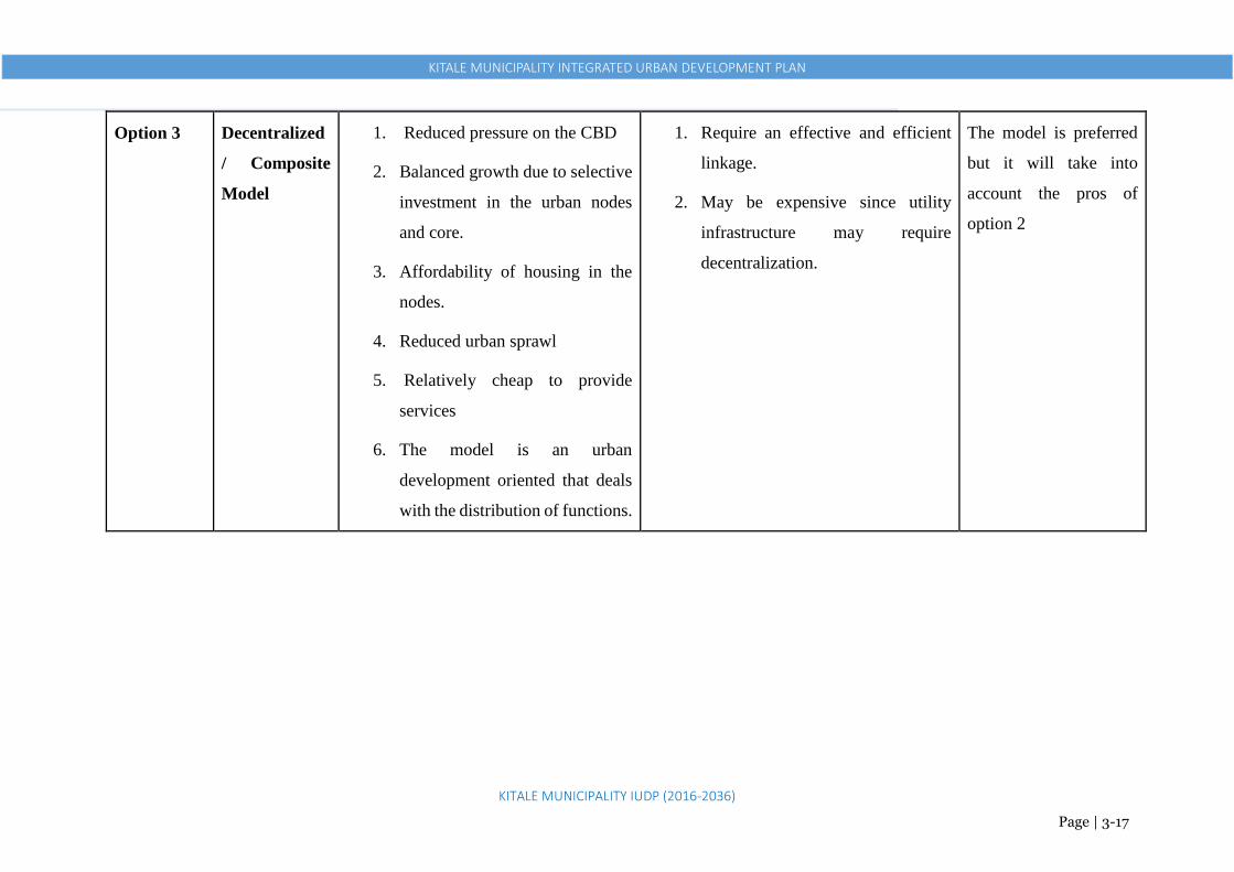
KITALE MUNICIPALITY INTEGRATED URBAN DEVELOPMENT PLAN
KITALE MUNICIPALITY IUDP (2016-2036)
Page | 3-17
Option 3 Decentralized
/ Composite
Model
1. Reduced pressure on the CBD
2. Balanced growth due to selective
investment in the urban nodes
and core.
3. Affordability of housing in the
nodes.
4. Reduced urban sprawl
5. Relatively cheap to provide
services
6. The model is an urban
development oriented that deals
with the distribution of functions.
1. Require an effective and efficient
linkage.
2. May be expensive since utility
infrastructure may require
decentralization.
The model is preferred
but it will take into
account the pros of
option 2

KITALE MUNICIPALITY INTEGRATED URBAN DEVELOPMENT PLAN
KITALE MUNICIPALITY IUDP (2016-2036)
Page | 4-1
- THE STRUCTURE PLAN:
4.1 OVERVIEW
The IUDP presents the long-term development framework for Kitale municipality. It indicates broad
land use classifications, transportation corridors in relation to land uses, location of utilities and
services. The plan in total shows the form, shape, urban development limits, trends and pattern in
developments that Kitale municipality will take. The potential for Kitale to expand/grow is
considerable. Its position as the County headquarters, favourable location relative to Western region
circuit suggests that it is likely to continue to grow, probably faster than in the recent past. In addition,
upgrade of transportation infrastructure i.e. the airstrip to a local or regional airport and the expansion
of the main trunk roads especially the A1 road will only mean faster and robust growth of the
municipality.
Among the main areas that the IUDP will address include but not limited to the following;
Infrastructure Availability and Cost
Roads, electricity and water supplies in Kitale are relatively good, so they are not likely to be a
disincentive for investment. There are, however, serious concerns about solid waste collection and
treatment, firefighting and inadequate sewers. However, these deficiencies are shared by most
municipalities in Kenya, and so are not likely to place the municipality at a disadvantage over other
municipalities. Lastly, the congestion in the municipality centre especially Laini Moja section is a
potential obstacle, which the IUDP will have to address.
Land – Price and Availability
There are few opportunities to obtain land in the municipality itself, and pressure on land is likely to
become an increasingly serious problem. Kitale municipality is today grappling with issues of land
availability while huge chunks of land within the municipality are owned by institutions such as
KARI, GK Prisons, ADC, Kenya Forest Service and the Railway Corporation and lie underutilized.
Availability and price are closely connected. One of the objectives of the IUDP will be to make
serviced land available for development in the quantities required. This can be an important factor in
attracting certain types of development. Although Kitale municipality has not fully attracted major
industries especially agro-based industries due to lack of adequate space, infrastructure among others,
many light industries, service industries and warehousing firms might be attracted to the municipality
even with the current minimal space that is available. On land availability, there is also the issue of
densification. Within the CBD, there is a considerable amount of under-utilized and low-density

KITALE MUNICIPALITY INTEGRATED URBAN DEVELOPMENT PLAN
KITALE MUNICIPALITY IUDP (2016-2036)
Page | 4-2
development. As the economy strengthens, land values will increase, and landowners will have the
incentive to redevelop (or sell to someone else who will redevelop) their land. This creates a compact
urban form where provision of infrastructure and services becomes easier and cheaper. It also
prevents urban sprawl and protects the rich agricultural hinterland, which is a vital economic base.
Population Growth and Needs
Population growth is not directly related to growth in demand for land. There are several factors, of
which the most important are:
How much land within the existing built-up area is unused?
Will densities increase or reduce in future?
Are any corrections required to the existing land use pattern, which will affect land
requirements?
One of the failures of past planning has been not to expand urban boundaries in advance of population
growth. This has resulted in unplanned and haphazard growth outside the boundaries, which not only
presents difficulties in subsequent servicing, but also prevents orderly planning of the urban area. It is
therefore important to expand boundaries in advance of projected urban growth and thereby enable
provision for essential infrastructure in an orderly fashion.
To that note, this IUDP has suggested extension of the current municipal area 91km2 to 160km2 to
stimulate provision of adequate space for the various required land uses and as a future prospect of the
municipality’s growth. As the County Government continues to hold talks with a number of the afore
mentioned institutions to release some of their large land parcels within the municipality for
development, it is also quite in order to extend the existing boundaries to create room for more land,
as the negotiations may take years or even decades to be achieved. This means therefore that, these
parcels of land could remain unutilized for a long time and thus hamper the municipality’s growth and
the future population needs. It also means high cost of land acquisition from private individuals.
This IUDP also provides for expansion of the planning area to 226km2 to cover areas of Moi University
along Kapenguria road, Maili Saba along Eldoret road, Wamuini B and Kambi Miwa to address issues
of high subdivisions of land as well as develop control measures to control and manage urbanization.
It has also suggested expansion of the proposed municipality on the East side to ADC farm to create
space for an industrial zone. This can also be extended further in future to acquire land for a full-
fledged university and an integrated sports centre.
All this will derive at provision of requisite infrastructure and services, creation of institutions,
programs and implementation mechanisms to enable achievement of this IUDP’s aspirations and the
aspirations of Kitale people.

KITALE MUNICIPALITY INTEGRATED URBAN DEVELOPMENT PLAN
KITALE MUNICIPALITY IUDP (2016-2036)
Page | 4-3
Urban Development Limits (Growth Rings), Trends and Developments Patterns that
will inform the Structure Plan
Outer Ring: (Current Municipality Expansion/Growth Areas) • Forms the outer most area of the Planning Area with the
least concentration of human settlements. • These are Low Density Residential areas with bungalows
as the leading House Typology. • High Agricultural activities are also present. • These include areas of Grassland, Sirende, Waitaluk,
parts of Kibomet and parts of Matisi
Middle Ring (Densification, Re-densification & Conservation Ring): • Forms the area with the moderate concentration of human
settlements. • A mixture of low and medium density residential areas with
bungalows and apartments forming dominant house typologies. • Presence of forests, agricultural areas, commercial and industrial
areas These include areas of Kibomet, Milimani, Section 6, Lessos,
Inner Concentration Ring: (Re-densification Ring. Highly Developed) • Forms the area with the peak concentration of human settlements. • High presence of Commercial, Service, Industrial functions and
Residential functions. Presence of GK Prison too • These include areas of CBD, Tuwan, Shauri Moyo, Bondeni and
Kipsongo
Future Planning/Expansion: • To be planned either as part of Kitale municipality or the neighboring growth
centres i.e. Maili Saba, Namanjalala, Kiungani among others • Large parcels of Agricultural Lands • Low density area/low population density
Figure 4-1: Development Rings

KITALE MUNICIPALITY INTEGRATED URBAN DEVELOPMENT PLAN
KITALE MUNICIPALITY IUDP (2016-2036)
Page | 4-4
4.2 STRUCTURE PLAN’S SPATIAL DEVELOPMENT FRAMEWORK
The Structure Plan for this IUDP sets out strategic planning policies and forms the basis for detailed
policies in local plans. From the stakeholders’ expectations and vision, the structure plan is
anticipated to decongest Kitale municipality CBD. The stakeholders envisioned Kitale municipality
as a commercial and industrial hub. To achieve this, Kitale municipality development will be guided
by ‘Commerce and Industrialization Development Model’.
This will be achieved by stimulating the following:
Overall
1. 2 Strong Centres (main CBD and the proposed Industrial Zone)
2. 5 Sub CBDs (Rafiki, Matisi, Kibomet, Bikeke and Sirende) to distribute economic growth
and development
3. Adequate Infrastructure in all the activity centres provided in point 1 and 2
4. Efficient and Comprehensive Transport Network. Improving the condition of the existing
roads and providing bypass routes for external traffic i.e. Eastern and Western Bypasses
5. Adequate Community Facilities. Land for a cemetery, sanitary landfill, fire station, health
facilities, educational facilities, open spaces social and cultural centres
6. Protection of Agricultural Areas and Curb Urban Sprawl. This is by creating Urban Areas
Growth Limit.
7. Environmental Conservation and Improvement (forests, rivers, arboretums and parks)
8. Densification and Re-densification areas (compact development to curb sprawl)
9. Improvement of informal areas (Kipsongo, Mitume) and dilapidated government housing in
Bondeni, Shauri Moyo and Cherangany estates
10. Acquisition of Land for markets, furniture workshops, jua kali areas, garages, bus parks and
other activities
11. Implementation Framework and Mechanisms for Continuous Stakeholders Consultations
Economy
1. Economically vibrant and a highly competitive Municipality
2. Investor-friendly environment, financial empowerment for county to deliver services, and
governance systems promote ease of business
3. Job opportunities for all
4. Better paying jobs
5. Planned environment
6. Resilient economy

KITALE MUNICIPALITY INTEGRATED URBAN DEVELOPMENT PLAN
KITALE MUNICIPALITY IUDP (2016-2036)
Page | 4-5
Living Conditions
1. Sustainability of built environment
2. Livability of the municipality, high standards of living
3. Decent and affordable housing for all
4. Reliable and safe public transport system
5. Pedestrian walkways to increase safety
6. Clean municipality
Governance
1. Equity in resource access
2. Well planned and functioning municipality/city for all
3. Inclusive and non-discriminatory, provide livelihood for all
4. Safe and secure, friendly and orderly municipality
5. Accommodating to diverse culture, religion, and robust governance structure
6. Fully engaged public in every governance matter
7. Efficient governance
To achieve the above, the municipality’s growth will be developed around the main activity centres
i.e. Strong Centres and Growth Nodes that will act as Commercial and Industrial hubs interlinked by
an efficient transport network (corridors).
Strong Centres –these will be the main/primary economic anchors of the municipality. They
will serve as the main commercial and industrial destination points. The plan proposes two
strong centres i.e. the Proposed Industrial Zone at ADC farm and the enhanced Kitale
Municipality Core Urban Area. Densification and Re-densification approach respectively.
Growth Nodes – these will be enhanced commercial nodes/growth centers at selected existing
market centers along activity corridors based on their strategic location and comparative
advantage. The plan proposes Rafiki, Matisi, Kibomet, Bikeke and Sirende as Growth
Centres, which will take a Densification approach
Activity Corridors – these will be the transport networks and their accompanying activities
linking strong centres and growth nodes.
Support Centres – these are existing smaller centres along the activity corridors, which will
mostly serve to compliment the proposed growth nodes. They will also seek to promote urban
agriculture. They include Misemwa, Machungwa, Wamuini, Namgoi, Sinendet, Naisambu,
Siuna, Kwa Muthoni and Gatua. The plan however, does not propose immediate planning
intervention. However, development here should be well controlled.

KITALE MUNICIPALITY INTEGRATED URBAN DEVELOPMENT PLAN
KITALE MUNICIPALITY IUDP (2016-2036)
Page | 4-6
• These will be the main/primary anchors of the Municipality’s Economic
Development
• They will serve as the main commercial and industrial destination points
• To be served by an elaborate transport network
Figure 4-2: Proposed Strong Centres (Enhanced Kitale Municipality Core Area and the Proposed Industrial Zone)

KITALE MUNICIPALITY INTEGRATED URBAN DEVELOPMENT PLAN
KITALE MUNICIPALITY IUDP (2016-2036)
Page | 4-7
Proposed Growth Nodes (Sub-CBDs)
These will be enhanced growth centers (Sub-CBDs) at selected existing market centers i.e. Kibomet, Rafiki, Matisi, Bikeke and Sirende based on
their strategic location and comparative advantage
They will majorly provide commercial and residential functions
County Government to prepare local physical development plans for each node
Every node to have piped water, sewer connection, proper tarmacked roads and be able to provide all the facilities as provided in below
Matisi
Kibomet
Rafiki Bikeke
Sirende
o A Sub-CBD/ Intermediate centre (1)
o A Community/ cultural centre (library/ resource centre,
social hall, VCT centre, Amphitheatre/Cultural dance
centre) (1)
o 1 Administration block
o A police station
o A park with football pitches and other recreational spaces
o Special school for special needs
o Youth polytechnic (1)
o Level 3/ Sub-District Hospital (1)
o Main receiving electricity sub-station (1)
o Main distribution electricity sub-station (1)
o A modern open and closed market
o Juakali Sheds
o Vocational Training Institute (2)
o University College
o Old age home
o Rehabilitation Centre
o Orphanage/children centre/destitute home
o Slaughterhouse (1)
o Waste management facilities
o Bus station and terminal (1)
o Fire sub-station (1)
By 2036, Each
Proposed
Growth Node
will be able to
provide:

KITALE MUNICIPALITY INTEGRATED URBAN DEVELOPMENT PLAN
KITALE MUNICIPALITY IUDP (2016-2036)
Page | 4-8
In this framework, proposed activity nodes are allocated roles and functions as follows:
1 Kitale Municipality
Kitale municipality CBD is the main urban core of the proposed municipality with an estimated
population of 105,968 people (core urban).
The proposed development model seeks to promote compact development/densification that is
already present.
The zone will offer higher-level services. It will be an economic hub hosting several businesses,
industries and services with a national and regional catchment and supported by the other
secondary commercial and dormitory nodes hence serving as a Strong Centre.
To achieve this, there is need to acquire and increase the current CBD area to cover prison’s
land, agricultural land behind the County Commissioner’s office, Line Member residential area,
Railways land, and the stadium. This will considerably aid in sufficient allocation and
distribution of land uses to ease congestion.
Figure 4-3: Proposed Municipality’s Development Model
Proposed Southern Bypass
Residential
Residential
Residential
Residential
Residential
KARI
Agriculture
Agriculture
Kibomet
Sirende
Machungwa
Pro
posed
Eastern
Byp
ass
To K
wan
za
Maili Saba
Main CBD
Proposed Industrial
Zone
Rafiki
Bikeke
Siuna Misemwa
Matisi
Nabiswa
Makunga
Act
ivit
y C
orr
idor
Agriculture
Agriculture

KITALE MUNICIPALITY INTEGRATED URBAN DEVELOPMENT PLAN
KITALE MUNICIPALITY IUDP (2016-2036)
Page | 4-9
Within the built-up area, there is a considerable amount of under-utilized and low-density
development. Owners of these spaces will have the incentive to redevelop (or sell to someone
else who will redevelop) their land into higher densities (vertical development). This the
County Government will develop as a policy to allow a uniform vertical development of the
CBD, which apart from increasing densities, will enable incorporation of other users that have
been conspicuously missing in the municipality e.g. domesticated parking. This will also reduce
costs related to provision of water and sewerage services.
2 Proposed Industrial Zone at ADC Farm
The farm is currently under agricultural use and owned by Agricultural Development
Corporation (ADC).
The plan proposes acquisition of at least 500Ha for development of an Industrial Zone to
promote the municipality as an agro industrial municipality.
An excellent national and international transport network, accessibility to labour,
communication routes, ample supply of power, water and sewerage disposal will serve this
zone. The elaborate transport network will interlink the zone to the main Kitale core area via
Endebess road and to the proposed airport via the proposed Western Bypass.
The area has sufficient land, conducive environment, away from people, easily accessible to
municipality and hence the rationale of proposing heavy industrial there.
The model proposes the zone as a Strong Centre
Figure 4-4: Kitale Municipality Core Area
Line
Member
Railway
s Land
CBD
Prison’s Land
Min of Agriculture
Existing Land Use
Proposed Land Use

KITALE MUNICIPALITY INTEGRATED URBAN DEVELOPMENT PLAN
KITALE MUNICIPALITY IUDP (2016-2036)
Page | 4-10
3 Matisi Centre
The centre is located about 3km from the municipality centre along Endebess road.
It forms the core area on the Eastern side of the municipality with a mix of both commercial
and residential.
It is well served with electricity, water and sewer supply. Hosts a police post, chief’s office, a
slaughter house, Kitale Main Millers, St Raphael Health Centre, clinic facilities, Matisi Friends
high school, Matisi primary school, St John primary school and Titan Academy,
Development trends indicate that this area is emerging as a vibrant zone that should be
enhanced through provision of improved infrastructure and services, proper planning and
development control. This will provide development of a well functional and sustainable zones
while reducing pressure/over reliance on the main municipality where residents will only visit
for higher-level services.
The centre will also provide both commercial and dormitory functions for the proposed
industrial zone.
4 Bikeke Centre
The centre is located approximately 9.8km from the municipality centre via Eldoret Road and
about 8km via Cherangany road.
It is predominantly agricultural with significant residential and commercial activities.
Figure 4-5: Matisi Centre
Proposed Land Use
Matisi Matisi
Existing Land Use

KITALE MUNICIPALITY INTEGRATED URBAN DEVELOPMENT PLAN
KITALE MUNICIPALITY IUDP (2016-2036)
Page | 4-11
The centre has a health centre, a market, Bikeke primary school, St Teresa Bikeke Boys high
school, St Teresa Bikeke Girls high school. There is electricity supply from the main power
grid. Only a small part of the centre has water supply. No sewer reticulation.
The area has a murram road connecting Eldoret Road from Sirende Primary school through
Machungwa, Misemwa, Bikeke to Cherangany road near Nabiswa centre. The plan proposes
expansion and upgrading of this road to bitumen standards (at least 30m wide) to open up the
area for growth and development. This will also act as a bypass (Eastern) connecting Eldoret
Road, Cherangany Road and A1 Road to Kapenguria at Makunga. This will enhance
connectivity of this area to Kitale municipality and other significant places e.g. markets in
addition to reducing unnecessary traffic in the main CBD.
The centre therefore needs to be supported by providing requisite infrastructure and services
and innovative planning. It needs be promoted to continue playing the role of commercial and
a dormitory centre and its role in urban agriculture.
5 Sirende Centre
The centre is located along Kitale-Eldoret Road (B2) about 9km from Kitale municipality.
It forms a small commercial node/centre at the Sirende junction with the intermediate lands
being predominantly agricultural and residential.
The centre has electricity and piped water supply but no sewer. It hosts a police station, office
of Sirende Ward Representative, Sirende primary school, Friends School Bikeke, St John’s
Girls High School and Prime Care Medical centre.
Figure 4-6: Bikeke Centre
Proposed Land Use
Existing Land Use

KITALE MUNICIPALITY INTEGRATED URBAN DEVELOPMENT PLAN
KITALE MUNICIPALITY IUDP (2016-2036)
Page | 4-12
If no deliberate planning interventions are put in place, considerable linear developments along
this road will create issues of overcrowding, potential to create chaos and transportation
bottlenecks.
Providing a functional spatial framework by enhancing and developing Sirende as a
commercial node will eliminate the existing uncoordinated developments and provide urban
functions that promote and provide vital and sustainable urban systems.
Adequate measures needs therefore to be put in place to control its urban limits to prevent
sprawl and also a retain considerable number and size of agricultural farms by creating a
compact urban form/node.
Figure 4-7: Sirende Centre
6 Rafiki Centre
The centre is located approximately 5.8km from the municipality centre via Kipsongo and
about 2.6km from Kitale Airstrip along Webuye road via Siuna centre.
The main activities are small-scale commercial activities. They have formed/developed around
residential and agricultural uses, which are the predominant land uses.
High subdivision rates with some people owning as small as one tenth of an acre, commonly
known as a point.
The centre hosts Rafiki health centre, Assistant Chief’s office, Rafiki Primary School, Rafiki
Secondary School. It lacks a tarmac road, piped water and sewer supply.
Proposed Land Use
Existing Land Use

KITALE MUNICIPALITY INTEGRATED URBAN DEVELOPMENT PLAN
KITALE MUNICIPALITY IUDP (2016-2036)
Page | 4-13
The plan proposes acquisition and construction of a bypass (at least 30m wide) from the A1
road near the airstrip at Siuna centre through Rafiki, to connect to the proposed industrial zone
and the main CBD via Kipsongo. This will by large extent improve the area and enhance
development of these centres into more compact urban forms. It will also serve to facilitate
connection to the upgraded airport from the CBD and the industrial zone.
7. Kibomet
Kibomet Centre is strategically within the precincts of the A1 road- C48 road junction and has a
moderately built-up area. Land use is mostly medium density residential, with a few commercial
establishments along the highways (presence of notable hotels) and agricultural lands within. It has
piped water supply with a few areas supplied with sewer supply. Well supplied with electricity. It is
expected that the centre will serve as a key growth centre on the Eastern side of Kitale Municipality
through the following interventions:
The designation of the centre as a commercial growth node will see it offer complimentary
commercial services to the main CBD through establishment of shopping malls, banking
services among other medium-scale commercial premises
The pristine environment and topography coupled with relatively expansive lands within
Kibomet area is ideal for development of tourism, hotel and conferencing facilities, and the
plan proposes its establishment as such
Figure 4-8: Rafiki Centre
Proposed Land Use
Existing Land Use

KITALE MUNICIPALITY INTEGRATED URBAN DEVELOPMENT PLAN
KITALE MUNICIPALITY IUDP (2016-2036)
Page | 4-14
The centre has been also been partially zoned as a medium-density residential area, with a
view to, among other things, utilize the planned commercial establishments without
compromising the growth node’s suitability to host tourism, hotel and conferencing facilities
Figure 4-9: Kibomet Centre
The plan proposes development or enhancement of these nodes with requisite infrastructure and
services to:
Act as organizers, dictating the location of key urban functions and separating incompatible
ones.
Act as a means through which the surrounding areas are easily accessible from municipality
and other local and national regions.
Provide an opportunity for promoting agriculture and access to markets in addition to prospects
for value addition.
4.2.1 Strategies to Support this Development Model
Strategy 1: Promote Development of Viable Nodes /Strategic Growth Centers
The plan as aforementioned proposes strategic growth centers in addition to promoting Kitale
municipality centre as an economic hub in the region. Most of these nodes have a distinct character,
significance and development rationale. Some require specific interventions to make them work in a
more efficient manner, whilst others are rapidly expanding and require management controls. This will
Proposed Land Use Existing Land Use

KITALE MUNICIPALITY INTEGRATED URBAN DEVELOPMENT PLAN
KITALE MUNICIPALITY IUDP (2016-2036)
Page | 4-15
also create a proper link between the central area and the growth nodes as well as acting as breather
points for the municipality.
These nodes form the priority intervention areas for infrastructure investment by the county and
national governments particularly to providing zones with well-planned areas for low cost housing and
other social amenities.
Actions to support the Nodes /Strategic Growth Centers
• Prepare strategic structure plans for each proposed growth center.
• Develop and improve infrastructural services in the growth centres
• Identify strategic economic activities to be located in these centers using the competitive
advantage principle
• Encourage partnership with the private sector in investment promotion and infrastructure
development
• Encourage location of employment, trade, living, recreation/ entertainment, higher education,
high level or specialized medical services in these centres through targeted incentives to
potential investors and service providers
Strategy 2: Promote Land Use and Transport Integration to form an Efficient Urban Network
The major elements of this Urban Network are the proposed Strong Centers, Growth Nodes and
Transport Corridors. This strategy is intended to optimize land use and transport linkages between the
proposed Strong Centers, Growth Nodes and Transport Corridors. This is to be supported by a range
of activities at the centers as well as the land use along the corridors linking the centers. Strong centers
at each end of the activity corridors will support an effective public transport system in both directions
along the corridor. This will be done by:
• Developing an integrated land use and transport network;
• Developing growth centers at selected existing market centers along activity corridors to
support the development of the public transport network with strong centers at the end of each
corridor; and
• Encouraging mixed-use development in activity centers
Actions to Support the Strategy
• Reinforce first the already well-established activity centers, to serve as incentives for
development i.e. CBD, Kibomet and Matisi centres. This is by preparation of local physical
development plans, expansion of the CBD and development and improvement of the existing
infrastructure in the CBD and all the identified growth centres.

KITALE MUNICIPALITY INTEGRATED URBAN DEVELOPMENT PLAN
KITALE MUNICIPALITY IUDP (2016-2036)
Page | 4-16
• Stimulate creation of the identified strategic activities in the less established activity centres
and selectively along activity corridors e.g. Industrial Zone, Rafiki, Sirende and Bikeke. This
is by acquiring land for development as well as provision of basic infrastructure and services
• Develop complementary land uses in the proposed growth nodes to capitalize on the
opportunity provided by their identified functions
• Encourage the application of best practice urban design principles in activity centers to
establish and maintain higher levels of amenity and functionality for center users, business
owners and operators
• Commence implementation of one of the proposed growth nodes e.g. Rafiki as a demonstration
project. From experience of this demonstration project, maintain or review further priorities for
the growth nodes and transport corridors
Strategy 3: Efficiently maximize on the use of existing urban land to support additional
developments
The existing urban centers have opportunities in terms of existing infrastructure for provision of
additional developments e.g. housing and these opportunities should be maximally exploited. Promote
compact development to efficiently use the existing urban space. For example, undertake a vertical
mixed-use development by providing commercial use on the first two floors and residential use on the
subsequent upper floors.
Key Actions to Support the Strategy
• In association with county government, community, major government and private landholders
and industry stakeholders, undertake a detailed appraisal of the extent of the opportunities for
providing additional developments.
• Undertake a detailed evaluation of existing infrastructure vis a vis existing developments to
identify any existing mismatch. Provide requisite infrastructure to sustain current and
additional developments.
Strategy 4: Manage Urban Growth to Curb Urban Sprawl
Outward growth of Kitale municipality needs to be managed appropriately for efficient use of land and
economy in infrastructure provision. Urban sprawl is evident in Kibomet, Matisi, Rafiki, Bikeke, and
Grassland positioned along the major transport arteries. The main techniques to be applied in
managing urban growth are as follows and need to be put into effect by County Government, industry
and the community.
• Prepare Local Physical Development Plans for all the identified growth centres

KITALE MUNICIPALITY INTEGRATED URBAN DEVELOPMENT PLAN
KITALE MUNICIPALITY IUDP (2016-2036)
Page | 4-17
• Undertake a technical assessment of land availability based on current municipality planning
schemes, structure plan commitments, development intentions and policy directions.
• Take planning decisions to create more housing in specified targeted locations
• Develop these urban areas using principles of livable neighborhoods to achieve sustainable
community development
• Undertake a technical assessment of the infrastructure requirements for available land.
Intensify the use of existing urban land through better use of existing infrastructure
• Develop the public transport network and complementary infrastructure as key elements in
supporting urban growth
• Use minimum density zoning to encourage efficient use of land, also set a certain level that
development densities should achieve without overwhelming the available infrastructure
• Develop a focused public investment plan to outline the location and timing of planned public
infrastructure. Conceptually this is designed to concentrate new public infrastructure
investment into those areas where growth is to be encouraged
Strategy 5: Promote Agro-Based Industries
Kitale municipality and its large hinterland has a lot of potential in industrial crops and livestock in
form of; maize, fruit and banana processing, avocado oil extraction, passion fruit juice production,
water bottling, ceramic tiles and clay roofing tiles, animal feeds etc. This potential needs to be
exploited to foster development in Kitale municipality and the hinterland.
Key Actions to support the strategy
• Enhance the existing industrial area by re-planning it and allocating adequate land for industries
• Acquire and develop an industrial zone at the ADC farm (at least 500ha)
• Create urban limits to protect agricultural land from urban sprawl
• Improve livestock husbandry and crop production through incentives and agricultural
extension services
• Improve marketing through value addition, provision of adequate markets and provision of
easier accessibility to markets
• Provide credit to farmers
• Developing and improve facilities such as slaughter houses and tanneries
• Diversify agriculture production to include horticulture, aquaculture and floriculture.

KITALE MUNICIPALITY INTEGRATED URBAN DEVELOPMENT PLAN
KITALE MUNICIPALITY IUDP (2016-2036)
Page | 4-18
Overall Economic Growth: This Plan will provide Accelerated and Inclusive Economic Growth
for the proposed Municipality generated by:
1. Job Creation: sufficient to absorb the emerging large workforce at the end of the planning
period. This will be done through: Creation of an Industrial Zone at ADC Farm, expanding the
Municipality’s CBD to accommodate more employment activities and creation of Sub CBDs
at Bikeke, Matisi, Kibomet,Rafiki and Sirende
2. Increased productivity in Agriculture: to feed the Municipality, raise rural incomes and
promote the municipality’s growth as agro-based industrial municipality through: Promotion
of an agro-based municipality, protection of agricultural areas by creating urban limits and
enhancing KALRO (former KARI) and ADC Farm productivity
3. Widespread rural non-farm activities: to provide jobs and good living standards outside the
core urban area. This is though: Expansion of the CBD, creation of Sub CBDs, creation of a
well enhanced transport network to connect activity areas
4. A dynamic informal sector: that creates jobs at low cost and caters for the needs of Kitale
people at all income levels (inclusivity). This is through expansion of the CBD to include the
Prison’s land and the Railways land where jua kali activities, markets, furniture workshops,
metal works and garages will be located. This will entail allocation of these activities (MSMEs)
on larger spaces with proper facilities
5. A Restructured Industrial Municipality: Capable of employing a high number of work force at
high productivity and also creating export markets to other counties and also outside the
country through: Creation of an Industrial Zone at ADC Farm, re-planning the existing
industrial area, promotion of well-structured small-scale industries, enhancing the transport
sector, promotion of technical skills through increase in technical colleges and vocational
training centres etc.
6. Provision of Habitable Living Areas: Adequate residential areas with habitable conditions,
proper development control and zoning regulations and adequate provision of infrastructural
facilities
7. Protection of Environmentally Sensitive Areas: Provision of adequate measures to protect and
preserve the environmentally sensitive areas such as proper surveying and demarcation and
redeveloping them for nature tourism and recreational purposes

KITALE MUNICIPALITY INTEGRATED URBAN DEVELOPMENT PLAN
KITALE MUNICIPALITY IUDP (2016-2036)
Page | 4-19
Figure 4-10: The Proposed Structure Plan

KITALE MUNICIPALITY INTEGRATED URBAN DEVELOPMENT PLAN
KITALE MUNICIPALITY IUDP (2016-2036)
Page | 4-20
4.3 DESCRIPTION OF THE STRUCTURE PLAN
The land use proposals in the structure plan are described in the table below, with the coding indicating possible land uses
Table 4-1: Detailed Description of the Structure Plan
LAND USE AREA LOCATION ISSUES/EXISTING
DEVELOPMENTS
PROPOSED /POSSIBLE ACTIONS AND
ACTIVITIES
Residential
01 Kibomet Located along Kitale-Kapenguria highway
Approximately 3km from the CBD
Mixed developments
(Residential and Commercial)
Constructions of high-rise
apartment are active. Has a
commercial character emerging
with a higher plot ratio- challenge
in parking (no facilities). Private
development encroaching on the
public way
Mixed developments
(Residential and Commercial).
Land readjustment required to accommodate the
emerging developments. The area needs
provision of parking. Enhance the plot ratio and
regulate new developments
02 Kipsongo Located between CBD and Kitale Training
Institute 1km from the CBD
Informal residential
developments. Lack of basic
infrastructural services. Poor
housing. Low income residents
Road network improvement required.
Land readjustment to enable high rise
with open spaces.
Urban renewal with enhanced plot ratio
Model example -Kibera
03 Tuwani Along Kitale-Endebess highway
Approximately 1km from the CBD
Mixed developments
(Residential and Commercial)
Current development trends
exceeding
allowed levels
Mixed developments
(Residential and Commercial)
Urban renewal in some sections with enhanced
plot ratio
04 Lessos Located on the right side along Kitale-
Endebess highway opposite Tuwan
Approximately 1km from the CBD
Mixed developments
(Residential and Commercial)
Current development trends will
exceed allowed levels if no
immediate attention and strict
development control
Mixed developments
(Residential and Commercial)

KITALE MUNICIPALITY INTEGRATED URBAN DEVELOPMENT PLAN
KITALE MUNICIPALITY IUDP (2016-2036)
Page | 4-21
05 Prison land, Bondeni,
Mitume, Site and
Service and
Machinjoni area
Located on the West side of the CBD
Approximately 1km from the CBD
Mixed developments
(Residential and Commercial)
Mixed developments
(Residential and Commercial)
Urban renewal with enhanced plot ratio
Road network improvement required.
Land readjustment to enable high rise
with open spaces
06 Grassland, Standard
and other areas along
Webuye Road
Located along Kitale-Webuye road Residential(Bungalows) Residential
Very diverse – mixed characteristics – needs
separation
07 Milimani, Lavington
and Alakara
Located on the Southern side of the CBD
Approximately 1km from the CBD
Residential(Bungalows and
Maisonettes)
Detached houses are converting
to mulri-family dwellings with no
matching infrastructural services.
To be Re-zoned into two – medium density
and low density development. Allow Residential
(Multiple plus single dwellings). Needs
separation to maintain medium
density mixed with low density
08 Bikeke, Machungwa
and Misemwa
Sirende Mixed developments
(Residential and Commercial
Residential (multiple plus single dwellings)
09 Rafiki Mixed developments
(Residential, Agricultural and
Commercial)
Mixed developments
(Residential and Commercial)
010
Umoja Farm Past Kipsongo Agricultural Residential (multiple plus single dwellings)
Commercial
011
Wamuini A and B Mixed developments (residential,
commercial and agricultural)
Residential
012
Kambi Miwa Located South West of municipality along
Kitale-Webuye road
Mixed developments (residential,
and agricultural)
Mixed developments (residential, and
agricultural)
013
Bondeni and Shauri
Moyo (Govt houses)
Degraded Residential
developments. Poor roads
condition.
Residential
Urban renewal with enhanced plot ratio
Road network improvement projects are
immediately needed

KITALE MUNICIPALITY INTEGRATED URBAN DEVELOPMENT PLAN
KITALE MUNICIPALITY IUDP (2016-2036)
Page | 4-22
014
Laini Member Near Lion’s Centre along Kapenguria Road Residential (Medium Density) Change the use to commercial as part of the CBD
015
Along Eldoret Road From Sirende to Amagoro Park Mixed developments (residential,
and agricultural)
Mixed developments (residential, and
agricultural)
016
Along Kapenguria
Road
Located past the municipality boundary
around Moi Universty Campus
Mixed developments (residential,
and agricultural)
Mixed developments (residential, and
commercial)
Industrial
11 ADC Farm Along Endebess Road Agricultural A Special Economic Zone, Public Utilities
(Cemetery, Sanitary Landfill)
12 Current Industrial area Next to Section 6 Estate Medium Industrial Medium and Light Industrial with requisite
infrastructure
13 Prison’s Land Behind the bus park Agricultural Light industrial, Workshops, garages, juakali
artisans
14 Other Light Industrials Residential and commercial Within residential and commercial zones areas
where best compatible
Educational
21 ADC Farm
Agricultural Full Fledged University
22 Next to County Referral
Hospital
Behind the Golf Course Agricultural and residential Kenya Medical Training College
23 Residential and
Commercial Areas
Residential Areas Mixed Developments Educational institutions
Recreational
31 Urban Parks Prison land and the current
dumpsite
Show Ground Forest
Acquire and develop an urban park.
Decommission the dumpsite and establish a
sanitary landfill (50ha) at ADC farm. Move the
prison to urban fringes or rural hinterland.
Establish a people’s Park at the Showground
forest
32 Trans Nzoia stadium Tuwani Stadium Acquire land next to the stadium and expand the
stadium to include parking and other amenities

KITALE MUNICIPALITY INTEGRATED URBAN DEVELOPMENT PLAN
KITALE MUNICIPALITY IUDP (2016-2036)
Page | 4-23
33 Integrated Sports Centre ADC Farm Agricultural Integrated Sports Complex with an international
stadium, 10-30m green belts and served by good
transport network including public transport
34 Posta and Kamukunji
Grounds
CBD (Laini Moja) Recreational/Parks Proper maintenance for relaxation and
Recreational purposes with at least adequate
furniture, drinking water and sanitation facilities.
35 Estates/Community level
parks
Estates and Neighborhoods Should be closely related to community centers,
social halls, health center, local shops, primary &
secondary schools. Facilities; 1-2 playing fields,
children equipped playing grounds, hard courts,
adventure play grounds & other special features
36 Kitale Museum Nature
Trail
Within the Municipality Kitale Museum Nature Trail Conservation and Urban Tourism. Develop Eco
Lodges
Public Purpose
41 County Offices Government offices (County) Public Purpose
42 Level 4 Hospital Along Kapenguria Road Level 4 Hospital Acquire more land next to it to expand the
hospital facilities
43 Kitale Municipality Social
Hall
Neighborhoods Social
Halls
Bondeni
Existing and proposed neighborhoods
Social Hall Social hall with support facilities including
ablution block, a shop, dispensary, swimming
pool, play area etc.
Social halls with a capacity of at least 300 people
and support facilities including an ablution block
44 Police Stations
Police Posts
Central Police Station
Bikeke, Kibomet, Matisi, Rafiki, Kambi
Miwa and Namgoi neighborhoods
Where required
CBD
Neighborhoods
Public Purpose.
Equip and Modernize Central Police Station
Acquire and develop police stations in each
neighborhood. Upgrade and improve services in
the existing police posts to police stations
45 Public Library Behind County Commissioner’s office Vacant land A Modern Public Library
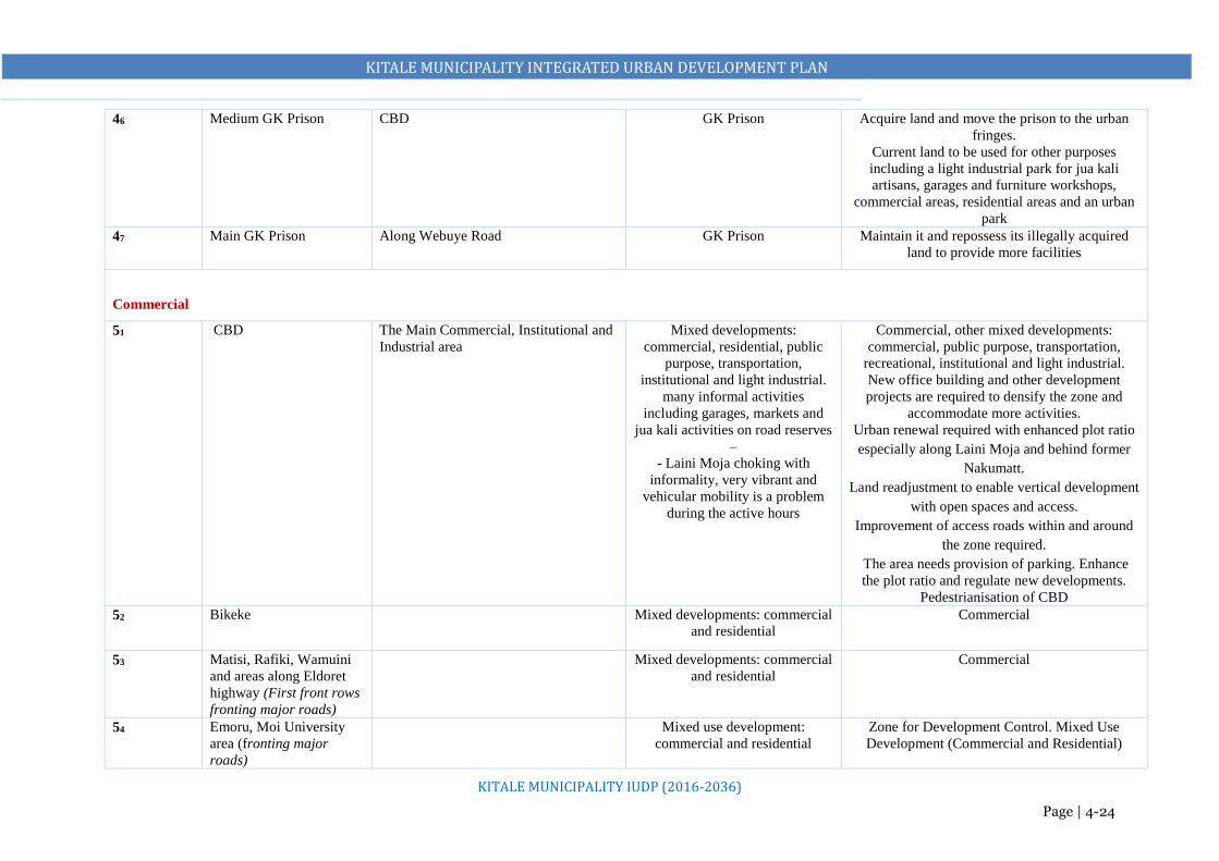
KITALE MUNICIPALITY INTEGRATED URBAN DEVELOPMENT PLAN
KITALE MUNICIPALITY IUDP (2016-2036)
Page | 4-24
46 Medium GK Prison CBD GK Prison Acquire land and move the prison to the urban
fringes.
Current land to be used for other purposes
including a light industrial park for jua kali
artisans, garages and furniture workshops,
commercial areas, residential areas and an urban
park
47 Main GK Prison Along Webuye Road GK Prison Maintain it and repossess its illegally acquired
land to provide more facilities
Commercial
51 CBD The Main Commercial, Institutional and
Industrial area
Mixed developments:
commercial, residential, public
purpose, transportation,
institutional and light industrial.
many informal activities
including garages, markets and
jua kali activities on road reserves
–
- Laini Moja choking with
informality, very vibrant and
vehicular mobility is a problem
during the active hours
Commercial, other mixed developments:
commercial, public purpose, transportation,
recreational, institutional and light industrial.
New office building and other development
projects are required to densify the zone and
accommodate more activities.
Urban renewal required with enhanced plot ratio
especially along Laini Moja and behind former
Nakumatt.
Land readjustment to enable vertical development
with open spaces and access.
Improvement of access roads within and around
the zone required.
The area needs provision of parking. Enhance
the plot ratio and regulate new developments.
Pedestrianisation of CBD
52 Bikeke Mixed developments: commercial
and residential
Commercial
53 Matisi, Rafiki, Wamuini
and areas along Eldoret
highway (First front rows
fronting major roads)
Mixed developments: commercial
and residential
Commercial
54 Emoru, Moi University
area (fronting major
roads)
Mixed use development:
commercial and residential
Zone for Development Control. Mixed Use
Development (Commercial and Residential)

KITALE MUNICIPALITY INTEGRATED URBAN DEVELOPMENT PLAN
KITALE MUNICIPALITY IUDP (2016-2036)
Page | 4-25
55 Along Cherangany Road Mixed developments: commercial
and residential
Mixed Use Development (Commercial and
Residential)
56 Kibomet and its environs Mixed developments: hotel and
residential
Mixed Use Development (Commercial and
Residential). Hotel and Conference facilities area)
57 Prison land Public purpose Commercial
Public Utility
61 Fire Station Undeveloped A modern Fire Station
62 Part of ADC farm Agricultural
Public Cemetery
63 Part of ADC farm Agricultural Solid Waste Management Site (Sanitary Landfill)
64 Water Supply Cover the entire area proposed for development
within the planning period.
Commercial water points should be provided for
informal settlements, at a distance of 500m from
one another.
65 Sewerage Cover the entire area proposed for development
within the planning period.
Acquire land near the existing sewerage treatment
facilities and expand them
Transportation
71 Bus park CBD Bus park Modern bus terminal facility
72 Tuwani bus park Tuwani Across Trans Nzoia Stadium next
to Section 6 forest
Proposed bus park
73 Lion’s Centre Bus park Proposed expansion of the bus park with
adequate modern facilities
74 Railways Land Undeveloped land Proposed bus park
76 Truck terminal facility ADC Farm Agricultural Proposed truck terminal facility and a logistics
centre
77 Truck terminal facility Section 6 Forest opposite the stadium
Sirende Centre
Undeveloped Proposed truck terminal facility and a logistics
centres

KITALE MUNICIPALITY INTEGRATED URBAN DEVELOPMENT PLAN
KITALE MUNICIPALITY IUDP (2016-2036)
Page | 4-26
78 Eastern Bypass Eldoret Road to Cherangany Road via
Machungwa, Misemwa and Bikeke;
Proposed expansion of the existing road to 60m
79 Western Bypass Webuye Road near the airstrip at Siunwa
through Rafiki, Umoja farm to Kipsongo
and through Rafiki to industrial area to
Endebess road
Proposed expansion of the existing road to 60m
710 Local Airport Kitale Airstrip Kitale Airstrip Upgrade to a local airport with requisite facilities
710 Road Reserves Along all roads Encroachments Recommended road reserves
Conservation
81 KCC forest, Showground
forest, Section 6 forest
and Block 10 forest
Within the Municipality KCC forest, Showground forest,
Block 10 forest
Proper demarcation to establish their reserves
Conservation and Urban Tourism. Develop an
arboretum and picnic sites at Section 6 forest,
develop a Nature Park (Haller Park) at KCC
Forest, develop Eco Lodges at Showground
Forest, Block 10 Forest
82 Kitale Nature
Conservancy
Within the Municipality Conservation
83 Existing Wetlands Proposed Municipal Boundary along
Kwanza road near Kapomboi
Grassland Area
Wetland
Swampy area
Conservation
84 Riparian Reserves Encroachment Proper demarcation to establish their reserves
Conservation
Agriculture
91 Peri-Urban Areas Wamuini A and B, Sirende, Bikeke,
Rafiki, Kambi Miwa
Mixed developments. Residential
and Agricultural
Mixed developments. Residential and
Agricultural
92 KALRO Agricultural Agricultural

KITALE MUNICIPALITY INTEGRATED URBAN DEVELOPMENT PLAN
KITALE MUNICIPALITY IUDP (2016-2036)
Page | 4-27
Table 4-2: Principal Policies for the Municipality’s Land Use Plan
1 Decentralize business, administrative and
commerce functions
Sub-centre system (corridor development) will be adopted with new urban transport
network to subdivide business functions.
Land use regulation for sub-centre areas will be revised to activate their function and
to accommodate growing population.
CBD should be re-developed to revitalise municipality centre.
2 Expand and renovate CBD New zones to be acquired for new urban core. Extend the CBD vertically (or higher in the skyline) to solve the low-utilisation issue
3 Supply appropriate housing for all Urban re-development from low-density residence to medium to high density
residence is necessary.
Appropriate housing scheme for low income is necessary as social services.
4 Marked Areas for Development Control outside
the proposed Municipality
Subject areas along Eldoret Road and along Kapenguria Road around Moi University
to development control
5 Preserve and restore green and water environment
to create ecological network
Existing forests and wet areas should be preserved and the former to be used for
recreational purposes and promotion of urban tourism.
River and riverbanks will be restored to open recreational space.
6 Conserve agricultural activities Agricultural activities should be conserved for diversification of the land use.
7 Develop new areas for industrial area New industrial areas will be allocated in western part of the municipality on ADC farm.
Existing industrial area should be re-developed for new urban function.
8 Beautify the municipality as the region’s pride Urban landscape regulation should be established to keep historical beauty for the
citizen.

KITALE MUNICIPALITY INTEGRATED URBAN DEVELOPMENT PLAN
KITALE MUNICIPALITY IUDP (2016-2036)
Page | 4-28
4.4 LAND USE REQUIREMENT ANALYSIS Space allocations for various facilities such as housing and health centres, schools and social halls
should be made, bearing in mind that one generation may contribute for substantial benefit of a
subsequent one. To work out the future spatial requirement for the various facilities and utilities, the
prediction of the magnitude and numbers of these facilities must be based upon planning standards.
Land allocation was arrived at after a review of the existing situation and planning standards as outlined
in the Physical Planning Handbook, 2008.
Table 4-3: Land Use Requirement Analysis
SECTOR STANDARD LAND REQUIREMENT (YEAR 2036)
RESIDENTIAL
Population Estimate =439,621 5 people per household Total No of H/H=87,924
Total No. of H/H 87,924 5% - Low Density – 4,396 25% - Medium Density -21,981 70% - High Density -61547
4396 x 0.4 = 1758 21981 x 0.2 =4396 61547 x 0.045 = 2770 Total= 8924 ha
EDUCATION
Pre-Primary 20 (0 – 4 yrs) Primary – Secondary – Polytechnics (Kitale Polytechnic) Colleges (KMTC) University
1 Nursery /3500 people @0.2Ha
=125 Nursery Schools
1 Primary /3500 people @3.9Ha
=125 Primary Schools
1 Secondary/8000 people @6.9Ha
=55 Secondary Schools
At least 2 polytechnics @10.2Ha
1 KMTC @10.2Ha
At least 1 university @50Ha
0.2 x 125 = 25 ha 3.9 x 125=487.5 ha 6.9 x 55=379.5 ha 2 * 10.2ha =20.4 ha 1 * 10.2ha =10.2 ha Approximately 1 at 50ha =50ha Total = 972.6 ha
RECREATION
1 ha. /10000 people in estates -44 ha.
Open space/parks Social halls ( At least 6) to be integrated Library ( At least 6) Golf course Sports clubs Stadium (1) Riparian reserve – 15m both sides of the rivers
44 ha 6 x 1ha = 6 ha 4 ha Total = 54 ha
HEALTH
County Referral Hospital Level 4 (Primary Hospital) Level 3 (Health Centre, Maternity Home, Nursing Home) Level 2 (Dispensary / Clinic)
8ha*1=8 ha 8ha*1=8ha 3ha*6=18ha 3ha*18= 54ha
8 8 18 54 Total = 88 ha
LAW AND ORDER
Law courts Administration – Police Post Police station
2 Ha 0.2 Ha * 2ha*7 =14ha
2 ha 14ha
PUBLIC UTILITY
Solid Waste Management Site Cemetery Fire station Sewer systems, water works, telecommunication, electricity reticulation)
8 ha 4.5 ha 0.4 ha 50ha
Total = 62.9 ha

KITALE MUNICIPALITY INTEGRATED URBAN DEVELOPMENT PLAN
KITALE MUNICIPALITY IUDP (2016-2036)
Page | 4-29
Total land required is at least 14,944ha. Available land in the proposed municipality is approximately
16,500 Ha. This should inform the type of proposals during planning.
4.5 LAND USE PROPOSALS
4.5.1 Residential
The proposed residential land use covers approximately 4894ha representing approximately 30.54%
of the proposed municipality. This takes into consideration the current residential land uses,
compatibility with neighboring land uses as well as to cater for the future housing demands. The
structure plan earmarks areas for different: high, medium and low-density housing areas in responding
to various housing needs of diverse socio-economic groups. Areas with non-residential developments
are also expected to be within each residential area. The diversity will be more apparent within the
high-density neighborhoods where the demand for socio-economic facilities is higher.
a) Land Allocation
Percentage allocation of land in various residential areas and densities as provided for in the physical
planning handbook, which will be used as a guide in planning for residential areas. Reasonable
variations may be permitted depending on local conditions.
b) Density of Development
Density is determined by availability of services such as water, sewerage, size of roads, etc. and the
zoning recommended. In recommending gross residential densities care should be taken that they
create in spatial and functional meaning, an independent system of the built-up area (both multi-family
and one family dwelling units) well provided with day-to-day services, recreation and communication
network. The section below gives a range of densities that can be adopted in planning for Kitale
municipality.
i. High Density Residential
Areas earmarked for high-density housing include proposed residential area on prison land, Tuwani,
Matisi, areas abutting Moi University, Section 6, Prisons land, parts of Kibomet, Cherangany Estate,
TRANSPORT Roads – 15%
1 2265 ha
INDUSTRIAL
Major industries Light industries
Heavy and medium = 1000 ha Light industries = 50 ha Total = 1050 ha
COMMERCIAL
Commercial nodes Market –Open Covered
5% of total planning area 0.3ha*8
755ha 2.4ha
URBAN AGRICULTURE
5% of the total area 755ha
TOTAL 14,944Ha

KITALE MUNICIPALITY INTEGRATED URBAN DEVELOPMENT PLAN
KITALE MUNICIPALITY IUDP (2016-2036)
Page | 4-30
Kipsongo, Machinjoni, Mitume and Bondeni areas. These are the areas already densely populated or
highly subdivided and informal settlements. They house or expected to house the bulk of the
population. This will consist of low cost housing developments that will house the relatively low-
income households. Population densities in the areas are expected to be 70 dwelling per hectare. This
will consist of mainly multiple residential developments. The total area earmarked for high-density
residential neighborhoods is approximately 1,138.2Ha.
ii. Medium Density Residential
Areas proposed for medium density housing include Kibomet, Grassland, Bikeke, Standard, Umoja
farm, and parts of Milimani Estate. The total area earmarked for medium density residential
neighborhoods is approximately 2,885.5ha. These areas are projected to have a combination of single
and multiple dwelling units with the latter being more dominant. Population densities in the areas are
expected to range from 32-60 dwellings per hectare.
iii. Low Density Residential
Proposed low density residential areas include areas such as Milimani, Lavington, Wamuini B, parts
of Kambi Miwa, Bikeke and Machungwa areas, Alakara and other outlying areas of growth centers
and along Kitale-Eldoret highway to include Amagoro Park. The total area earmarked for low-density
residential neighborhoods is approximately 874ha. The current low population levels significantly
influenced the delineation of parts of these areas into low housing areas. Low-density residential areas
have been proposed for the larger rural hinterland in order to encourage agriculture. Urban agriculture
is expected to take place given the large plot sizes. Population densities in these areas are expected to
range from 10-20 dwellings per hectare.

KITALE MUNICIPALITY INTEGRATED URBAN DEVELOPMENT PLAN
KITALE MUNICIPALITY IUDP (2016-2036)
Page | 4-31
Map 4-1: Proposed Areas for Residential Use

KITALE MUNICIPALITY INTEGRATED URBAN DEVELOPMENT PLAN
KITALE MUNICIPALITY IUDP (2016-2036)
Page | 4-32
4.5.2 Industrial
i. Light Industrial Areas/Jua Kali shade
Approximately 50ha of land have been earmarked for development of a light industrial park
behind the bus park on prison’s land, which is to be acquired. The plan proposes juakali areas
in other centres to be maintained depending on their location’s suitability and to be redeveloped
and allocated adequate space. Furniture workshops with adequate infrastructure and services
have been proposed on the acquired prison’s land behind the bus park to address the needs of
Chanuka furniture among others. The plan also proposes relocation of garages from their
current location, i.e. next to the fire station and along Kipsongo Road to the newly acquired
space on prison’s land.
Light Industrial uses to be permitted in residential areas too, for example non-noisy activities
such as tailoring and carpentry. Such measures stimulate the economy by reducing the barriers
to entry for small entrepreneurs, and minimizing the current tendency to flout regulations. The
activities expected are often non-offensive and can easily coexist harmoniously within or
adjacent to commercial and residential neighborhoods.
Relocate the existing abattoir to the proposed industrial zone. Acquire land at the proposed
industrial zone and develop two abattoirs, one for chicken and the one for livestock (cows,
goats and sheep)
ii. Medium Industrial
Medium industrial activities to be maintained at the current industrial area next to section 6
estate and the zone be re-planned with requisite infrastructure to accommodate more users and
mitigate land use conflicts. Others to be located within the proposed industrial zone at ADC
farm. With potential in industrial growth that has been alluded to above, at least ten industrial
establishments have been earmarked in this new zone. Medium industries proposed include,
fruit juices, flour milling, animal feeds, milk processing and cooling plant, plastic industries
(recycling) etc.
iii. Heavy Industrial
By the year 2036, it is anticipated that Kitale municipality will have at least five heavy
industries. A zone for heavy industries is at the proposed Special Economic Zone at ADC farm
(500Ha). This will attract the bulk of industrial investments i.e. assembling, manufacturing and
processing industries e.g. fertilizer industry, agro-chemicals industries etc. Already, the area
has sufficient land, conducive environment, away from people, easily accessible to
municipality and market routes hence the rationale of proposing heavy industrial.

KITALE MUNICIPALITY INTEGRATED URBAN DEVELOPMENT PLAN
KITALE MUNICIPALITY IUDP (2016-2036)
Page | 4-33
Map 4-2: Proposed Areas for Industrial Use

KITALE MUNICIPALITY INTEGRATED URBAN DEVELOPMENT PLAN
KITALE MUNICIPALITY IUDP (2016-2036)
Page | 4-34
4.5.3 Educational
Primary and Secondary Schools
- With a projected population of 439, 621 by the year 2036, approximately 126 primary schools
will be required (an additional 79 schools) and 55 secondary schools will be required (an
additional 27 schools).
- Distribution of these schools to be based on catchment population and the recommended
walking distances. At gross densities of 50 persons per hectare and above. Land requirement
for primary and secondary is 3.9ha and 6.9ha respectively as stipulated in the Physical Planning
Handbook.
- The land available especially for schools that do not meet this threshold should therefore be
used economically to leave room for future expansion. Storied buildings should therefore be
encouraged, wherever possible, for classes, offices and dormitories. This will help to efficiently
maximize on land use. Integrate primary and secondary schools where possible. National
Government to implement this.
Vocational Centres
- The plan proposes development of vocational training facilities in every ward to absorb school
dropouts and the population that does not progress to universities to impart low and medium
level technical skills. This will enhance job creation and self-employment.
- The plan also proposes development of Vocational, Industrial and Technical Training Centres
at the existing industrial area and the proposed industrial area. This will help realize the
commercial potential of Kitale municipality community and foster entrepreneurship. This can
be achieved through Kenya Industrial Estates and Kenya Industrial Research Development
Institute. This will also promote Vocational, Industrial and Technical Training Potential for
increased access to industry/market responsive skills and employability improved.
University and mid-level Colleges
- The municipality does not have a fully-fledged university; at least 50ha should be acquired for
this purpose at ADC farm by the year 2036.
- Upgrade Kitale Technical Training College to a National Polytechnic
- Acquire land for Kenya Medical Training College opposite the county referral hospital.
- Allocate land for accommodation facilities near the colleges (high density)
- For the numerous mid-level colleges in municipality, quality assurance and regulatory policy
must be put in place.

KITALE MUNICIPALITY INTEGRATED URBAN DEVELOPMENT PLAN
KITALE MUNICIPALITY IUDP (2016-2036)
Page | 4-35
All educational institutions especially primary and secondary schools be encouraged to densify
(build vertically) to achieve/gain more land for all the required facilities e.g. playgrounds. In all
cases, educational institutions should be integrated with major open spaces whenever possible to
encourage the sharing of the open spaces and playgrounds with members of the public
4.5.4 Health
Within the proposed municipality, there are 11 public health facilities and about 28 private health
facilities. From the field survey, the average distance to the nearest health facility is estimated at an
average of 3.3km. This is within WHO recommendation of 5km. They have however tended to
concentrate in the urban centers.
- The plan proposes upgrading and modernization of the existing facilities, which is necessary
to ensure provision of quality health care.
- The plan also proposes additional health facilities to match population increase by 2036. Their
location should be geographically, socially and economically accessible.
- Every proposed growth node to have at least a health centre accessible with basic infrastructural
services. County Government to acquire at least 3ha of land for the same.
- The plan proposes upgrading of level 4 hospital to a modern standard facility. Acquire more
land for this purpose
- Acquire land (at least 10.2ha) for Kenya Medical Training College at the land opposite the
County Referral Hospital. Relocate it from the current location
4.5.5 Recreational
There should be a small area of recreational space within walking distance of all areas with a
residential density above 50 persons per hectare.
It is recommended that 1-2 hectares of land be provided for open spaces per 10,000 populations
in areas with a population density of above 50 persons per hectare (Physical Planning
Handbook, 2008). Therefore, Kitale municipality and its environs are required to currently
(2018) have approximately 20Ha and 44Ha by 2036 if 1Ha of land is taken to be the minimum
land requirement.
These small parks, open spaces and playing fields are to be developed in every neighborhood
and estate level as guided above.
Regarding educational institutions, it is proposed that they will be encouraged to build
vertically and acquire more land for playgrounds. In all cases, educational institutions to be
integrated with major open spaces whenever possible to encourage the sharing of the open
spaces and playgrounds with members of the public

KITALE MUNICIPALITY INTEGRATED URBAN DEVELOPMENT PLAN
KITALE MUNICIPALITY IUDP (2016-2036)
Page | 4-36
For a public park, the plan proposes acquisition of at least 8Ha from prison land. This will also
seek to serve the purpose of conserving Machinjoni River riparian reserve in addition to acting
as the buffer between the proposed CBD and the residential areas of Site and Service and
Matisi.
The two small parks in the CBD (Posta ground and Kamukunji) sit on a road reserve, which
will be moved during road expansion. However, to provide for the current need for recreational
spaces, the plan proposes proper and immediate maintenance of these two parks in the CBD
with adequate provision of sanitation facilities, furniture and lighting.
Upgrade the current Trans Nzoia stadium to a modern status. Repossess land around it from
the current use to give more land for parking and training grounds. Acquire adequate road
reserves to develop a good transport network around it.
More land, least 50ha, to be acquired in future at the current ADC farm for construction of an
integrated sports centre. The activities in this centre would include; athletic tracks, indoor
games, hard courts, swimming pools - with spectator facilities, catering establishments, parking
etc. Develop a good public transport network around it linked to all major roads to serve the
sports centre.
As the municipality grows and densities increase, green space will become increasingly
important. It is therefore necessary to maintain and protect areas of natural beauty and
environmental sensitivity as an essential part of the planning process. These will include the
existing forests, Kitale Nature Conservancy, Museum Nature Trail, golf course, wetlands
among others.
Promote recreation and urban tourism in the four forest blocks. Develop Section 6 Forest as an
Arboretum with adequate facilities and good road connection. Develop a Nature Park (Haller
Park at the KCC Forest, develop Eco Lodges at Block 10 Forest and Showground Forest
The plan also proposes measures to integrate the ongoing project of transforming Showground
Forest into an Urban Park
Increase coverage of the Museum Nature Trail by repossessing grabbed land and rehabilitating
dilapidated sections. Promote urban tourism by developing Eco Lodges.
The plan proposes incorporation of urban agriculture within the Proposed Municipality as an
integral land use and as a measure to enhance green spaces too. This plan promotes urban
agriculture by maintaining major agricultural lands like KARI and the large private individual
parcels around ADC and Rafiki area at 30% of the total proposed land use. Any land use

KITALE MUNICIPALITY INTEGRATED URBAN DEVELOPMENT PLAN
KITALE MUNICIPALITY IUDP (2016-2036)
Page | 4-37
changes to these lands to be subjected to Development Control processes and developers to
bear the cost of providing infrastructure and services to service the land.
Reclaim and redevelop riverine sections to ensure that they are an integral part of the urban
landscape especially Machinjoni and Koitobos River. These rivers have been encroached into,
highly polluted and not regarded as integral parts of our urban system. There is an immense
need to link them with residential and commercial development as they can be incorporated as
space for recreation and development. This to include cycling paths, walking pavements etc.
Preserve 15m riverine sections on either side of the rivers. This will help to minimize soil
erosion within the riverine and the built up areas, minimize the natural environmental threats,
preserve the ecological values of rivers and the surrounding, control sewage form of waste
disposal and to provide access and service road to the river reserves.
4.5.6 Public Purpose
Development of land for public purposes is generally expected to be intertwined within the
major land uses and the core population zones.
Existing administrative centers are to be maintained including the law courts. Enhance their
compactness by providing for vertical developments within the same space to accommodate
more use.
Move all the county offices to one or multiple integrated office complexes where Ardhi House
and County Assembly are. Use the freed land for other purposes especially for open spaces
which are majorly lacking. County to acquire and develop these zones.
Acquire (3.5Ha) and develop a Municipality Level Integrated Community Centre (resource
centre, social hall/amphitheater/Cultural dance centre, commercial zone to serve the centre)
behind the County Commissioner’s office on a land next to the proposed library. County is to
acquire and develop that land.
Walkway Cycling Path River Indigenous Vegetation Developments

KITALE MUNICIPALITY INTEGRATED URBAN DEVELOPMENT PLAN
KITALE MUNICIPALITY IUDP (2016-2036)
Page | 4-38
Improve the current social hall by constructing a multi-storey building to include a community
centre and other support facilities like a health care facility, shops, a swimming pool etc.
Acquire and develop five social halls and libraries in the proposed growth nodes and areas where
a catchment population demands i.e. Kibomet and Namgoi/Wamuini. Land to be acquired
should be a minimum of 1.0ha for a social hall and 0.4ha for a library.
Move the medium GK prison in municipality from its current location and acquire equivalent
land size (or at least the recommended 16ha) in the urban fringes where its location will not
curtail necessary urban expansion. Use the current prison land for other urban development
purposes including:
- Commercial and residential use
- A public park,
- jua-kali sheds,
- garages,
- furniture workshops and
- additional land for expansion of the current bus park
Maintain the main prison and with the assistance of the National Land Commission, repossess the
grabbed land for construction of more facilities. Acquiring more land for the main prison can also
create space for accommodating the medium prison which is to be relocated as proposed above
Police stations to be located in the following areas:
o The proposed strong centres i.e. Proposed Industrial Zone and Kitale Core Urban and
o All the proposed growth nodes i.e. Sirende to serve areas of Gatua, Kwa Muthoni and
sections along Eldoret Road, Rafiki to serve Umoja farm, Siuna centre and neighboring
areas, Matisi to serve the centre, Tuwani, Lessos and surrounding neighborhoods.
o In addition, the plan proposes police stations at major neighborhoods i.e. Namgoi centre to
serve the area including Kibagenge and Wamuini and Kibomet area to serve up to Moi
University and along Cherangany Road within the municipality.
o Upgrading of existing ones is also recommended.
o Police posts are to be located within residential neighborhoods.
4.5.7 Commercial
Kitale CBD will be retained as the main commercial centre. In addition, there will be creation
of other commercial nodes within market centers to offer low order services and ease
congestion in the CBD. This includes Bikeke, Rafiki, Sirende and Matisi. Similarly,
KITALE MUNICIPALITY INTEGRATED URBAN DEVELOPMENT PLAN
KITALE MUNICIPALITY IUDP (2016-2036)
Page | 4-39
commercial uses will be permitted in residential areas, either as small shops opening onto the
street or as offices.
The plan proposes Kitale municipality CBD to be extended to Kitale Training Institute, the
stadium, Deep Sea Resort, cover the current railway land from the junction opposite the
museum, and right across the Museum Nature Trail to the prison’s land. There will be a
densification plan for the CBD to encourage high densities and subsequently a compact city.
High densities reduce the cost of infrastructure, facilitate the operation of a viable public
transport system, and reduce the environmental impact of urbanization. They are therefore, in
principle, highly desirable. Dense developments within the CBD promote vertical
development, which permit domesticated parking to ease congestion on the streets. The plan
stipulates that all new buildings within the CBD have to provide for underground parking or
on subsequent floors. To further sort out the issue of parking spaces in the CBD, a multi-storey
parking facility is to be developed where garages exist next to the fire station. Those garages
will be moved to a space allocated in the GK prisons’, upon relocation of the dumpsite and
subsequent reclamation and rehabilitation of the dumpsite.
The plan proposes that all the trading activities on road reserves and especially along Laini
Moja section be moved to the acquired space on the GK Prison’s land and Railways land.
Demarcate the land and apportion these activities proportionately.
Pedestrian friendly streets with adequate pedestrian facilities to be provided . in all commercial
areas
o Wide, well surfaced, footpaths can transform the experience of walking from a struggle
to a pleasure. Not only is commerce easier, but the environment is more pleasant. There
is no rule of thumb about the right width for a footpath, but history has shown that the
majority of footpaths in Kenya‘s municipalities are too narrow. This results in pushing
and shoving, difficulties for people carrying loads, and so on. Wide pavements allow
trees to be planted along the road, thus providing shade for pedestrians. They also
present opportunities for small businesses, such as kiosks, open-air restaurants and
cafes.

KITALE MUNICIPALITY INTEGRATED URBAN DEVELOPMENT PLAN
KITALE MUNICIPALITY IUDP (2016-2036)
Page | 4-40
Map 4-3: Proposed Commercial Areas

KITALE MUNICIPALITY INTEGRATED URBAN DEVELOPMENT PLAN
KITALE MUNICIPALITY IUDP (2016-2036)
Page | 4-41
4.5.8 Public Utilities
a) Public Cemetery
The existing public cemetery is full. The plan proposes acquisition of new land next to the
current cemetery on a land measuring 4.5ha and another land to be acquired at ADC Farm (5ha)
for provision of public cemeteries.
b) Fire Station
A modern fire station is to be developed at the Municipal yard and at least two new fire engines
purchased to serve the Municipality and its environs.
Fire hydrants to be increased and especially in all the areas of significance (CBD, high-density
areas, commercial nodes etc.) and with adequate supply of water.
Sub stations to be developed in every growth node with at least one fire land rover.
c) Solid Waste Management
The County Government to acquire and develop a solid waste management facility for the
municipality measuring at least 10ha at the ADC farm near the proposed industrial zone.
The current dumpsite at Machinjoni to be converted into a public park.
Adequate waste receptacles to be provided within the planning area and dustbins placed in all
the necessary locations.
County Government to purchase modern compactors for waste transportation and employ
adequate staff.
To improve efficiency in waste management especially collection, the county government to
venture into public private partnerships and employ benchmarks where this approach is
perfectly working.
d) Water Supply
Piped water covers only 80km2, which is 35% of the entire proposed municipality. Although 55% of
the municipality’s residents have access to piped water, a significant number of households do not
have their own tap, and many obtain water from boreholes and vendors – normally at a higher cost.
On the assumption that all households should have their own water supply, the theoretical demand for
2018 and for each ten-year phase of urban growth is as follows: Current water supplied in Kitale
municipality is 8,000m3/day. Using the current population size in Kitale municipality planning area,
the total estimated water demand for the year 2019 and 2036 is 30,673m3/day and 71,033m3/day
respectively. The current deficit is therefore estimated at about 23,000m3/day and 63,033m3/day by
2038.
For current and future demand, there is need to:

KITALE MUNICIPALITY INTEGRATED URBAN DEVELOPMENT PLAN
KITALE MUNICIPALITY IUDP (2016-2036)
Page | 4-42
Increase the water reticulation systems to fully cover all the activity areas i.e. strong and growth
centres as proposed. Increase household connections at reduced cost
Establish a larger treatment plant to increase water supply capacity in the municipality and
subsequently augment the reticulation system to cater for the growing population for the 20-
year planning period. Currently there is no rationing but due to the increasing demand supply
gap, NZOWASCO is working on a rationing programme. Rationing is most likely to be
effected during dry seasons when water demand is too high.
Reinforce the institutional capacity of NZOWASCO in order to strengthen its mandate in water
provision.
e) Sewer Supply
Sewer supply only covers 18km2. The old municipality
Expand and modernize the existing sewer system to increase supply
Acquire land where necessary and expand the existing sewer treatment facilities at Machinjoni
and Bidii area
Acquire land for construction of two new mini wastewater treatment plants. One in Rafiki area
to serve the proposed industrial zone, Rafiki area and areas along Webuye Road including the
airport. The other one to serve Bikeke area and areas along Cherang’any Road
f) Storm Water Drainage
All roads to have adequate drainage facilities. Acquire adequate wayleaves and construct
proper drainage facilities especially in the highly populated areas.
Establish proper storm water outfalls to prevent flooding and also to develop storm water
utilization in the future
4.5.9 Transportation
The plan proposes that approximately 15% of the land use in the proposed municipality be used for
transportation. This will mean improving some of the existing transportation facilities, acquisition of
land for expansion and construction of new ones e.g. roads, bus parks, airstrip among others.
UPGRADE THE AIRSTRIP TO A LOCAL AIRPORT
Acquire adequate land for construction of adequate and modern airport facilities
Compatibility of this land use with abutting land uses to be done through land use planning of
the area surrounding the airport, strict development control, proper design and siting of the
airport, and adequate control of flight risks generating sources. The aim is to provide the best
possible conditions for the needs of the airport, community in the surrounding area and the
ecology of the environment.

KITALE MUNICIPALITY INTEGRATED URBAN DEVELOPMENT PLAN
KITALE MUNICIPALITY IUDP (2016-2036)
Page | 4-43
There is need to control land in the vicinity of the airport in order to ensure that possible height
hazards or obstructions to flight into or out of airports are minimized
BUS PARKS
Develop the main bus park for national routes only (long distance). Acquire more land from
the prison’s land to expand this bus park.
Acquire and develop a bus park at the railways land to serve the county and regional routes.
Acquire land (5.6 acres) and develop a bus park at Section 6 forest opposite the stadium to
serve the surrounding areas and along Endebess and Kwanza routes within and around the
proposed municipality.
Acquire adequate land (3.8 acres) and develop a bus park at Lion’s Centre to serve the
surrounding areas and along Kapenguria and Cherangany routes within and around the
proposed municipality.
TRUCK TERMINALS
Long distance trucks require stopping for refuelling, repairing and resting of drivers. Road transport
and logistic centres are compatible businesses associated with truck terminals, which generate
employment. Most long distance trucks park along Laini Moja section, normally after six in the
evening or morning hours, causing too much traffic especially when turning. This also poses a parking
challenge to the guests who reside in the same guest lodges. The Plan proposes 3 truck terminals and
logistics centres to serve the Municipality. These will connect to the main trunk roads without
interfering with the CBD traffic. The logistic centres will facilitate easy movement of trade and
industrial goods, which will be produced in the planned industrial area and those from outside the
municipality too.
One truck terminal and logistic centre to be developed at the proposed industrial zone to
accommodate trucks serving the zone. It is to be connected directly to Webuye road through
the Western Bypass, Endebess road, Kwanza road and Kapenguria roads through Lessos area
Another main truck terminal and logistics centre (approx. 13Ha) to be developed at Sirende
Centre along the proposed Eastern Bypass. The movement of raw material and delivery of
finished products from this industrial area will be facilitated by this truck terminal. Trucks will
prefer to travel via the bypasses as higher road facilities without interfering with city traffic on
CBD roads
A smaller truck terminal (lay-by) to be integrated with the proposed bus park at the space next
to Section 6 Forest opposite the stadium

KITALE MUNICIPALITY INTEGRATED URBAN DEVELOPMENT PLAN
KITALE MUNICIPALITY IUDP (2016-2036)
Page | 4-44
Loading and offloading hours for Lorries within the central business district to be limited to
before 7am and after 8pm. This will ease congestion in the CBD significantly, especially the
section around Tuskys Supermarket.
PARKING
Parking can no longer be left to chance: if the CBD is to survive, it will be essential for
proactive steps be taken to identify viable parking space. The municipality lacks a multi-level
parking facilities, open air parking spaces and parking is only left to roadside parking.
Buildings too lack domesticated parking. This therefore means that there is need to make by
laws stipulating that for every 100m2 of land in the central business district a minimum of 1 ½
parking spaces must be provided for off-street parking except where basement parking is
provided. Recommended parking space for development approval in the CBD is:
Table 4-4: Recommended Parking for Development Approval in the CBD
Kenyan Standards
Land Use Floor Area for One Parking Space
Commercial 50 sqm
Office 25sqm
Residential and others 100 sqm
Acquire and develop a multi-storey parking facility next to the Municipal yard. Move all the
garages to the newly acquired space on prison’s land. County Government to undertake this
initiative or through a public private partnership
All the on-street parking spaces should have proper markings.
New buildings within the CBD to have underground parking or on subsequent floors. No new
building approvals will be given for the high user buildings without provisions for domesticated
parking.
Restrict Moi Avenue along the Governor’s office and the Kenyatta Avenue along Khetias,
Equity and Barclays Bank to one-way traffic to create more space for street parking facilities
which shall eventually boost revenue to the county.
Special parking facilities to be provided for taxis, bodabodas and tuktuks within the the
proposed bus parks. This will mean putting strict measures and developing a proper and
efficient enforcement department.
INTERVENTIONS TO CONTROL BODABODAS WITHIN THE CBD
1. Tarmac and improve conditions of all the roads in Tuwani to encourage walking and reduce
reliance on bodabodas

KITALE MUNICIPALITY INTEGRATED URBAN DEVELOPMENT PLAN
KITALE MUNICIPALITY IUDP (2016-2036)
Page | 4-45
2. Create a new road from Machinjoni through the prison land to the main bus park and the CBD
to encourage walking, save on time and reduce reliance on bodabodas.
3. Create designated routes and provide adequate and proper parking facilities/sheds at the
proposed bus parks
4. Allow bodabodas to only access the heart of the Central Business District only through
Kenyatta Avenue and Kipsongo Road. They should be restricted to operate along the CBD
edges and to connect the CBD to residential areas
PEDESTRIANIZATION
1. All roads to have adequate walkways with minimum width of 1.5m wide
2. Develop dedicated pedestrian walkways and footbridges along Laini Moja and other major
roads
3. Create a pedestrian route from the CBD to Machinjoni through the prison’s land
ROADS TO EXPAND AND UPGRADE IN THE SHORT-TERM (1-5YRS)
1. Expand and tarmac the road that links Webuye Road to Kipsongo Road through Lavington
Estate, County Referral Hospital and Kitale Polytechnic.
2. Upgrade to bitumen standards the road from the CBD at Oil Libya through the County
Government offices to Kitale National Polytechnic
3. Expand the road from Webuye junction into the CBD to reduce congestion
4. Clear Laini Moja road reserve, move all the trading activities to their proposed locations and
develop the section into a dual carriage way.
5. Upgrade roads within Tuwani Ward and other residential neighborhoods to murram status.
Tarmac the main connector roads within these neighborhoods
ROADS FOR UPGRADE AND EXPANSION IN THE LONG TERM (PLANNING PERIOD)
1. Acquire and expand Endebess Road, Eldoret Road and Cherangany Road to a minimum width
of 30m with requisite facilities.
2. Acquire and expand the A1 road to a minimum width of 40M in the built up areas and 60M in
the undeveloped areas with requisite facilities.
BYPASSES
The plan proposes development of two bypasses as follows:
A bypass (60m wide) linking Eldoret Road to Cherangany Road via Machungwa, Misemwa
and Bikeke and proceeding to the A1 road – Eastern Bypass
A bypass (60m wide) linking the proposed industrial zone to Webuye Road at Siuna and
Endebess Road through Rafiki – Western Bypass

KITALE MUNICIPALITY INTEGRATED URBAN DEVELOPMENT PLAN
KITALE MUNICIPALITY IUDP (2016-2036)
Page | 4-46
PROVISION OF USER-FRIENDLY ROADS IN THE MUNICIPALITY
All roads in commercial areas to be relatively narrow. This creates a form of traffic calming
measures and allows pedestrians to cross in relative safety.
The principle of traffic calming to be applied to commercial, industrial and residential streets
except for highways.
All streets to be adequately lit to enhance safety measures.
Provide appropriate sidewalks for pedestrians. Sidewalks to be provided on both sides of all
arterial and collector streets, unless there are physical limitations and land use characteristics
that render a sidewalk unsuitable on one side. In these situations, safe and convenient crossing
opportunities must be provided to allow pedestrians to proceed on the side with sidewalks.
Concept of wide pavements provides for street furniture as well as small food kiosks. Planting
strips are also desirable to buffer pedestrians from traffic, increasing their sense of comfort and
safety, and to provide better access for the disabled at driveways.
A comprehensive concept should be adopted in designing bikeway and walkway systems,
based on the premise that the public right-of-way should serve all users; people riding bicycles
or walking need to use the same facilities that provide access and mobility to motorists. Making
urban streets more inviting to bicyclists and pedestrians also requires that adjacent land use,
traffic speeds, transit access and street connectivity be considered in urban designs.
PROVISION OF ADEQUATE ROAD RESERVES
All the informal trading and parking activities on road reserves especially along Laini Moja
section to be moved to the acquired space on prison’s land.
The A1 road is among the major roads affected by challenges of inadequate road reserve. In
some areas, the geometrical width is less than 25m especially within municipality and in
Kibomet. This is way below the recommended geometrical width of 40m for an international
trunk road in the built up areas. Acquire adequate wayleave (at least 40m) and expand the road
The plan recommends clearing of all road reserves to the required standards and acquisition
where nonexistent or where there is a new road construction.

KITALE MUNICIPALITY INTEGRATED URBAN DEVELOPMENT PLAN
KITALE MUNICIPALITY IUDP (2016-2036)
Page | 4-47
Map 4-4: Existing and Proposed Transportation Network
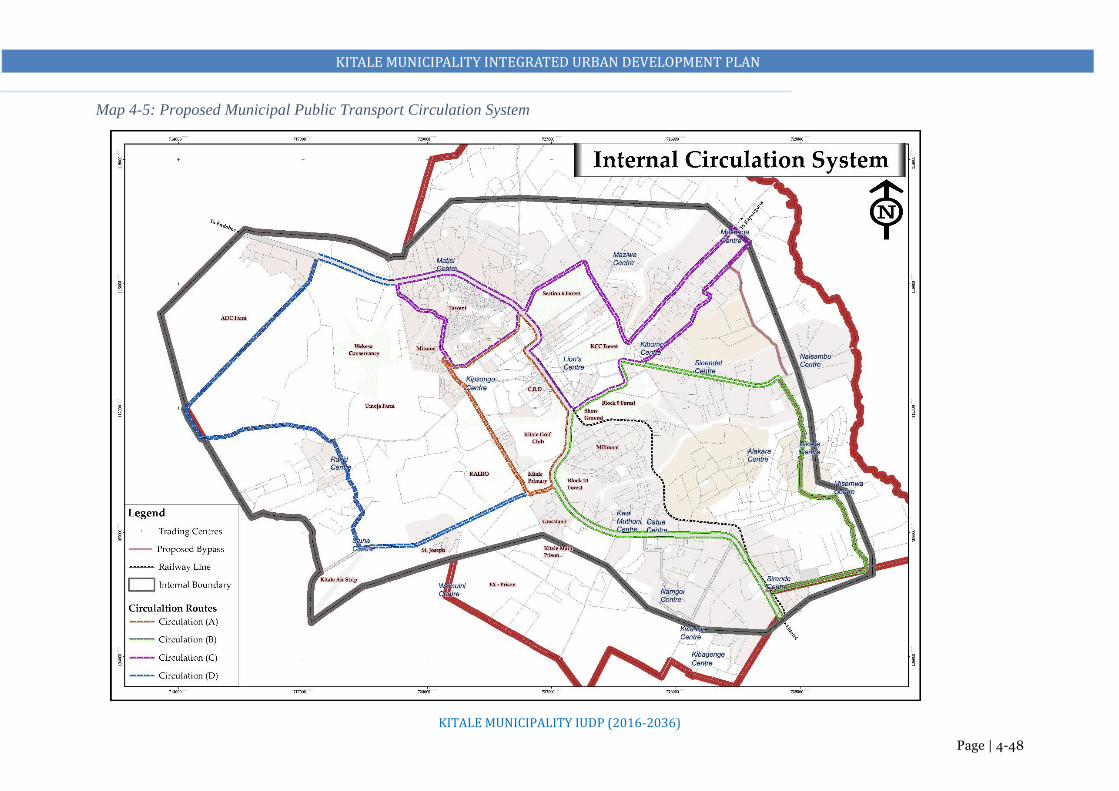
KITALE MUNICIPALITY INTEGRATED URBAN DEVELOPMENT PLAN
KITALE MUNICIPALITY IUDP (2016-2036)
Page | 4-48
Map 4-5: Proposed Municipal Public Transport Circulation System

KITALE MUNICIPALITY INTEGRATED URBAN DEVELOPMENT PLAN
KITALE MUNICIPALITY IUDP (2016-2036)
Page | 4-49
4.5.10 Urban and Peri-Urban Agriculture
The plan proposes about 5% of the municipality to be under urban and peri-urban agriculture.
Urban agriculture is important because it is a supplementary source of livelihood of food and
fuel for many households. Practice of agriculture should however be in harmony with aesthetics
of the municipality and should not be allowed to be a nuisance.
In order to promote urban agriculture in the area, there should be adequate provision of
infrastructural services to enhance easy access to the markets among other related factors. The
agricultural potential that exists within the peri-urban areas of the municipality ought to be
exploited to the benefit of the residents.
Benefits of Urban Agriculture
Management of solid and liquid wastes
Provision of food supplements. Generation of incomes and employment
Cleaning of environment through recycling.
Use of land of land not easily used for any other purposes e.g. land under electricity power
lines and land liable to flooding.
Makes use of vacant land.
Reduction of energy used to get food elsewhere by producing it within municipalities.
Compensation for agricultural land lost through urbanization.
Provision of fuel wood, fodder, fruits, timber etc. from urban forestry.
Provision of carbon sink, greening of municipalities and aesthetics.
Controls urban sprawl in the peri-urban areas

KITALE MUNICIPALITY INTEGRATED URBAN DEVELOPMENT PLAN
KITALE MUNICIPALITY IUDP (2016-2036)
Page | 4-50
4.6 ZONING PLAN
History has shown that urban planning has suffered from two main problems. The first is the fact that
statutory plans either do not exist, or are out of date. This project, with its emphasis on strategic
planning is intended to recognize the problem of plans going out of date: a strategic plan goes into
detail by phases, typically five years at a time, and therefore can respond to changing economic and
social circumstances. The second is that development control has been very weak. Political and
economic pressures to make a special case for specific developments have been addressed by preparing
Part Development Plans. These, by (essentially) planning piecemeal, make a mockery of the concept
of adhering to a single urban plan.
The table below details the various land use zones as described above. The land use zones have been
numbered systematically and the area in which they apply identified. The existing developments on
the proposed zones have also been pointed out in addition to the proposed type of development together
with the regulations and standards for the particular zone.

KITALE MUNICIPALITY INTEGRATED URBAN DEVELOPMENT PLAN
KITALE MUNICIPALITY IUDP (2016-2036)
Page | 4-51
Figure 4-11: Zoning Plan
Proposed and Existing Commercial Areas. Allow compact development and efficient provision
of infrastructure. County Government to provide
requisite infrastructure. To be connected to the
enhanced transport network. Expand the existing
CBD
Proposed and Existing Residential Areas. To be
developed as mixed use development to allow
compact development and efficient provision of
infrastructure. County Government to provide
requisite infrastructure. To be connected to the
enhanced transport network. Subdivisions to be
regulated to a minimum of 0.45Ha
Proposed Industrial Zone. A SEZ to be developed
with an integration of all the major uses. County
Government to acquire and develop the land with
requisite infrastructure. A Local Development Plan
for the Zone to be prepared. Acquire land for a
public cemetery and a solid waste management site
within the zone too
Urban Agricultural Areas. To be maintained as
so. Any development change to be subjected to a
Change of User. Developers to provide requisite
infrastructure before subjecting the area to new
developments. Developments to be subjected to the
proposed development and zoning regulations
including subdivisions to not less than 0.1Ha
Proposed Growth Nodes. To be developed as
mixed use centres. County Government to develop
a Local Development Plan for the Centres and
provide requisite infrastructure. To serve as
urbanization nodes to protect urban sprawl into the
agricultural lands. To be connected to the transport
network. Subdivisions to be regulated to a minimum
of 0.03Ha to allow compact and controlled
developments
1. Zone 1: (ADC Farm, KARI, Rafiki,
Airstrip, Standard, Ex Prison and the Main
prison)
2. Zone 2: (Old Municipality)
3. Zone 3: (Tuwani, Matisi, Lessos, Bidii and
Kibomet)
4. Zone 4: (Bikeke, Machungwa, Sirende,
Kwa Gatua, Namgoi and Kibagenge)
Low and Medium
Density Residential

KITALE MUNICIPALITY INTEGRATED URBAN DEVELOPMENT PLAN
KITALE MUNICIPALITY IUDP (2016-2036)
Page | 4-52
Figure 4-12: Zone 1 (ADC Farm, KARI, Rafiki, Airstrip, Standard, Ex Prison and the Main Prison)
Proposed Land Use
Zone 1
Existing Land Use
Proposed Industrial Zone. A SEZ to be developed with an integration of all the major uses.
County Government to acquire and develop the land with requisite infrastructure. A Local
Development Plan for the Zone to be prepared. Acquire land for a public cemetery and a solid
waste management site within the zone too.
Proposed Residential Zone. This will consist of low cost housing developments that will house
the relatively low-income households. Residential plots to be maintained at a minimum of an
eighth of an acre i.e. 0.045ha for medium density and 0.03ha for high-density residential
development. Maintain a maximum plot coverage of 65% and a plot ratio of 1:3 in medium
density residential development while maximum coverage and plot ratio is 70% and 1:4 for high-
density residential development
Proposed Agricultural Zone. Any changes on Agricultural land to be
subjected to Development Control and Regulations. Developers on
Agricultural lands to meet cost on provisional of infrastructure i.e.
roads, water and sewer facilities, open spaces, community facilities
among others. This block can be utilized partly for urban development,
transportation facilities, or public activities by way of redevelopment
or agglomeration.
Public Purpose Zone: Maintain this land for this public purpose. NLC
to facilitate reverting part of prison land that has been encroached into
Proposed Upgrade of the Airstrip to a Local Airport: Acquire adequate land for the same and restrict nearby
land uses as per the Kenya Airport Authority Standards. This includes house typologies among others

KITALE MUNICIPALITY INTEGRATED URBAN DEVELOPMENT PLAN
KITALE MUNICIPALITY IUDP (2016-2036)
Page | 4-53
Figure 4-13: Zone 2: Old Municipality
Proposed Commercial Use: Redevelop and densify the dilapidated structures along Kipsongo
road, along Laini Moja, behind Nakumatt, and areas occupied by garages. Develop and densify
all vacant plots to multi-storey structures in the core area to meet the demand for commercial
facilities. Expand the CBD to include the stadium, vacant agricultural land behind the County
Commissioner’s office to the stream next to museum’s nature trail, entire prison land and the
current dumpsite area
Markets: Expand and redevelop the Municipal Market into multi-storey modern market.
Acquire and develop a modern market on the acquired railway’s land. Clear Laini Moja.
Develop furniture workshops at the prison’s land. This will also include garages and jua kali
workshops
Bus Parks: In order to decongest the main municipality, a regional bus terminus should be at
the current bus park. Acquire more land from the prison’s land to expand this bus park. Acquire
part of the Railways land for construction of a county and regional bus park. Construct another
bus park at Lion’s Centre and opposite the stadium for the respective routes to serve areas within
and around the proposed municipality only
Recreational: Decommission the dumpsite and redevelop a public forest/park at the site.
Relocate the prison to provide part of it as a park/forest. Develop an arboretum (Section 6
Forest)
Social Facilities: Develop a Municipality Level Integrated Cultural Centre (library/ resource
centre, social hall/ municipality hall/ amphitheater/ Cultural dance centre) behind the County
Commissioner’s office on a land next to the existing library land.
Residential and Industrial: Change the use in Line Member Area and the Estate behind the
Medium Prison from residential to Commercial use. Maintain the rest as residential. Maintain
the Industrial Area and designate part of the Prison’s for Small Scale Industries

KITALE MUNICIPALITY INTEGRATED URBAN DEVELOPMENT PLAN
KITALE MUNICIPALITY IUDP (2016-2036)
Page | 4-54
Figure 4-14: Zone 3 (Tuwani, Matisi, Lessos, Bidii and Kibomet)
Proposed Land Use
Existing Land Use
Zone Proposals: Residential (Medium and High) and Agricultural with enhanced
Commercial Zones at Matisi and Kibomet
Zoning Regulations
1. Residential plots to be maintained at a minimum of an eighth of an acre i.e. 0.045ha
for medium density and 0.03ha for high density residential development
2. Maintain a maximum plot coverage of 65% and a plot ratio of 1:3 in medium
density residential development while maximum coverage and plot ratio is 70%
and 1:4 for high density residential development
3. County to identify suitable alternative areas within the zone for comprehensive
housing development. Prepare detailed action physical development plans for the
areas
4. Mainstream livable neighborhoods planning concepts, strategic planning and
environmental conservation to guide development in housing
5. Develop support services and amenities necessary for quality neighborhoods e.g.
shops/commercial areas, public offices, schools etc.
6. Provides basic plot layout and minimal infrastructure such connection to sewer,
electricity and water and access roads
7. Access roads to be not less than 9m in width
8. Within the commercial areas, provide a minimum of 1 parking space for every
500m2
9. Any changes on Agricultural land be subjected to Development Control and
Regulations. Developers on Agricultural lands to meet cost on provisional of
infrastructure i.e. roads, water and sewer facilities, open spaces, community
facilities among others

KITALE MUNICIPALITY INTEGRATED URBAN DEVELOPMENT PLAN
KITALE MUNICIPALITY IUDP (2016-2036)
Page | 4-55
Figure 4-15: Zone 4: (Bikeke, Machungwa, Sirende, Kwa Gatua, Namgoi and Kibagenge)
Existing Land Use
Proposed Land Use
Zone Proposals: Residential (Low, Medium and High) and Agricultural with enhanced
Commercial Zones at Bikeke and Sirende
Zoning Regulations
• Residential plots to be maintained at a minimum of an eighth of an acre i.e. 0.045ha
for medium density and 0.03ha for high density residential development
• Maintain a maximum plot coverage of 65% and a plot ratio of 1:3 in medium density
residential development while maximum coverage and plot ratio is 70% and 1:4 for
high density residential development
• County to identify suitable alternative areas within the zone for comprehensive
housing development. Prepare detailed action physical development plans for the
areas
• Mainstream livable neighborhoods planning concepts, strategic planning and
environmental conservation to guide development in housing
• Develop support services and amenities necessary for quality neighborhoods e.g.
shops/commercial areas, public offices, schools etc.
• Provides basic plot layout and minimal infrastructure such connection to sewer,
electricity and water and access roads
• Access roads to be not less than 9m in width
• Within the commercial areas, provide a minimum of 1 parking space for every 500m2
• Any changes on Agricultural land be subjected to Development Control and
Regulations. Developers on Agricultural lands to meet cost on provisional of
infrastructure i.e. roads, water and sewer facilities, open spaces, community facilities
among others

KITALE MUNICIPALITY INTEGRATED URBAN DEVELOPMENT PLAN
KITALE MUNICIPALITY IUDP (2016-2036)
Page | 4-56
Table 4-5: Development Control and Zoning Regulations
Zone Sub Zone Area covered G.C.
%
Setback (meters) P.R
%
Min Area
(Ha)
Type of Development Allowed and policy direction
Front Side Rear
1
1A
Special
Economic
zone
ADC Farm 60 3 1.5 1.5 200 0.25 Industrial development as a dominant land use
High density residential allowed within a radius of 0.25
Km from the industrial area boundary.
Commercial development.
Recreational
Loading and offloading zones have to be provided.
1B
Mixed use
development
Rafiki 65 3 1.5 1.5 250 0.045 Residential
Commerce
Light industry
Educational
Sewer connection necessary.
Recreational
1C
Low density
residential
development
Siuna Standard
Estate, and Airport
areas
50 5 1.5 5 150 0.045 Residential
Educational
Sound proof building materials recommended for
residential development.
Recreational
1D
Civic district
KALRO,
KEFRI/Prisons
- 5 1.5 3 - - Educational
Medium density development permitted with site
planning standard of medium density observed.
Public institutions and offices.
Recreation and conservation
1E
Agricultural
All the agricultural
areas within broader
zone 1
- - - - 0.2 Single dwelling units
10 dwelling units per hectare
Conservation
Educational development
Development control to be effected

KITALE MUNICIPALITY INTEGRATED URBAN DEVELOPMENT PLAN
KITALE MUNICIPALITY IUDP (2016-2036)
Page | 4-57
Zone Sub Zone Area covered G.C.
%
Setback (meters) P.R
%
Min Area
(Ha)
Type of Development Allowed and policy direction
Front Side Rear
2
2A
Central
Business
District
The old CBD, Prison
land, Museum, the
government district,
Railways land, the
dumpsite the
stadium, Member
residential, and ASK
Show ground areas
90 3 - - 500 0.045 High density development
1 ½ parking space for every 100m2 piece of land.
Sewer connection mandatory.
High-density residential development permitted.
Loading and offloading of lorries only permitted from
7.00 pm to 7.00am unless there is a back-lane provided.
Transportation functions
2B
Medium to
light industrial
zone
Section 6 area - 12 3 12 0.05 High-density residential development permitted.
Commercial premises permitted.
Mandatory connection to sewer system.
2C
Conservation
Section 6 Forest,
KCC Forest, Block 9
and Block 10
forests.
- - - - - - Recreational activities.
2D
Mixed use
district
Show Ground, St.
Antony School,
Kitale Primary
70 2 2 300 0.045 High to medium Low density Residential
Light industry
Public purpose
Public utility infrastructure
Commercial development
Recreation
Educational.
2E
Recreational
Golf course and the
Nature trail
- - - - - Recreation and conservation activities.
2F
Mixed use
development
Technical Training
Institute, Kipsongo
and Machinjoni
65 2.5 - 2.5 250 0.045 Medium to high density residential
Education
Commercial

KITALE MUNICIPALITY INTEGRATED URBAN DEVELOPMENT PLAN
KITALE MUNICIPALITY IUDP (2016-2036)
Page | 4-58
Zone Sub Zone Area covered G.C.
%
Setback (meters) P.R
%
Min Area
(Ha)
Type of Development Allowed and policy direction
Front Side Rear
Public purpose
Public Utility (except high impact)
Recreational.
2 G
Low to
medium
density
residential
development
Milimani
50
5
1.5
2.5
100
0.045
Residential
Recreational
Educational
Light industrial development.
Low impact commercial activities.
3
3A
Mixed use
development
Tuwani, Mitume and
Matisi
75 2 1.5 1.5 250 0.045 Residential
Light industrial
Educational
Commercial
Public utility
Sewer connection mandatory.
3B
Medium to
high density
residential
development
65 2 1.5 2 250 0.045 Commercial
Light industrial
Educational recreational
Public utilities
Public purpose
Sewer connection mandatory.
3C
Commercial
Kibomet 70 2 1.5 1.5 200 0.045 Any density of residential
Light industrial development
Educational
Recreational.
Sewer connection necessary or use of septic tanks.

KITALE MUNICIPALITY INTEGRATED URBAN DEVELOPMENT PLAN
KITALE MUNICIPALITY IUDP (2016-2036)
Page | 4-59
Zone Sub Zone Area covered G.C.
%
Setback (meters) P.R
%
Min Area
(Ha)
Type of Development Allowed and policy direction
Front Side Rear
3D
Agricultural
All the agricultural
area under the
broader zone 3
- - - - - 0.2 Single dwelling units
10 dwelling units per hectare
Conservation
Low density residential development Educational
development
Development control to be effected
3E
Mixed use
Namajalala 65 2 1.2 2 200 0.045 Mixed use development including light industry and
recreational activities.
Sewer septic tanks necessary for waste water
management.
3F
Future urban
growth (urban
fringe)
Naisambu - - - - - - Infrastructural development necessary.
Low density residential development permitted.
Development control to be initiated.
4
4A
Medium to
High density
Residential
Development
Sinendet, Naisambu,
Milimani
60 3 1.5 3 250 0.045 Commercial
Light industrial
Educational recreational
Public utilities
Public purpose
Sewer connection mandatory.
4B
Medium
Density
Residential
Meru Farm, Gatua,
Kwa Muthoni,
Naamgoi, Sirende
60 3 1.5 3 250 0.045 Commercial
Light industrial
Educational recreational
Public utilities
Public purpose
Sewer connection necessary
4C
Commercial
Sirende 65 2 1.5 2 250 0.045 Any density of residential
Light industrial development

KITALE MUNICIPALITY INTEGRATED URBAN DEVELOPMENT PLAN
KITALE MUNICIPALITY IUDP (2016-2036)
Page | 4-60
Zone Sub Zone Area covered G.C.
%
Setback (meters) P.R
%
Min Area
(Ha)
Type of Development Allowed and policy direction
Front Side Rear
Educational
Recreational.
Sewer connection necessary or use of septic tanks.
4 D
Mixed Use
Development
Bikeke 65 3 1.5 2 300 0.045 Mixed use development including light industry and
recreational activities.
4E
Future urban
growth (urban
fringe)
Naisambu and
Alakara Milimani
50 3 1.5 2 - Infrastructural development necessary.
Low density residential development permitted.
Development control to be initiated.
4F
Agricultural
All agricultural areas
in Bikeke and
Misemwa areas
- - - - 0.2 Single dwelling units
10 dwelling units per hectare
Conservation
Educational development
Development control to be effected.

KITALE MUNICIPALITY INTEGRATED URBAN DEVELOPMENT PLAN
KITALE MUNICIPALITY IUDP (2016-2036)
Page | 4-61
4.6.1 Recommended Planning Standards
Residential Zones
Recommended Standards for Residential Land Use:
1. Planning Standards for Residential Land Uses
Table 4-6: Land Size for Various categories of Residential Densities. Source. Physical Planning Handbook. pg.
57
Centre Low Density Medium density High Density Slums
Urban 12⁄ acre (0.2 Ha.) 1
8⁄ acre (0.045Ha.) Below 1 8⁄ acre or (0.03Ha.) 0.025Ha.
Table 4-7: Plot Ratios and Plot Coverage. Source: Physical Planning Handbook. pg. 58
Minimum Plot Size
(Ha)
Maximum Plot
Coverage%
Plot Ratio
Low Density
Bungalow
Masonneite
0.2
50%
50%
0.5
Medium density
Bungalow
Masonneitte
Multi family dwelling
0.045
65%
65%
65%
-
1.26
Depends on the house
size/number of floors
High density
Row housing
Detached
Semi- Detached
0.03
70%
70%
70%
3.5
2. Land allocation
Table 4-8: Average Observed Land Use Allocation in Residential Neighborhood Development. Source: Physical
Planning Handbook. Pg. 61
Type of Dwelling No. of Dwelling Per
Hectare
Space allocation per dwelling (M2)
(Includes built up area and circulation)
Bungalow/Detached
i. Low density
ii. Medium density
iii. High density
10
16
35
1000
500
285
Semi Detached and Row Housing
i. Low density
ii. Medium density
iii. High density
20
32
70
417
333
250
Multifamily dwellings
i. Low density
ii. Medium density
iii. High density
iv. Special density
50
60
70
133
200
167.6
142.8
75

KITALE MUNICIPALITY INTEGRATED URBAN DEVELOPMENT PLAN
KITALE MUNICIPALITY IUDP (2016-2036)
Page | 4-62
3. Site planning
Table 4-9: Recommended Minimum Plot Sizes for Different Housing Schemes. Source. Physical Planning
Handbook. pg. 64
Type of Housing Minimum Plot Sizes in Square Meters
Detached Semi Detached Row Housing
Slum rehabilitation and
upgrading schemes
223.2 148.8 111.6
Low cost housing 334.8 223.2 167.4
Normal housing development 465 309.7 232.5
4. Building Lines (set back lines)
Table 4-10: Minimum setbacks of dwelling from plot lines. Source: Physical Planning Handbook. pg. 67
Type of Residential
Development
Minimum Set Back in Meters
Front Side Rear
Slum rehabilitation and
upgrading schemes
2.5 1.5 3
Low cost housing 3 1.5 4.5
Normal housing 5 3 5
5. Street widths
Table 4-11: Minimum Street Width per given number of plots. Source: Physical Planning Handbook. pg. 68
Number of plots Street width
1-20 9m
21-50 12m
Activities allowed in Residential Zones
Permitted Uses o Residence – Bungalow, maisonette, multi-family dwelling (multi-storey flats/apartments), row
housing, detached, semi-detached, residential-cum-work,
o Hostels, renting houses, old age home, community hall, police post, guest houses (not exceeding
200m2 in floor area),
o Day care centre and kindergartens,
o Corner shops, small shopping centres, health facilities (dispensaries, nursing home, etc.),
o Educational buildings, religious premises, library, gymnasium, park, technical training centre,
exhibition and art gallery, clubs, banks/ ATM, matatus stop/boda boda stand (not exceeding 100m2
in floor area), post offices, hostels of non‐commercial nature, etc.

KITALE MUNICIPALITY INTEGRATED URBAN DEVELOPMENT PLAN
KITALE MUNICIPALITY IUDP (2016-2036)
Page | 4-63
Restricted Uses/Uses Permitted with Special Sanction of the Competent Authority
o Night shelters, petrol pumps, motor vehicle repairing workshop/garages, household industry,
bakeries and confectionaries, storage of LPG gas cylinders, burial‐grounds, restaurants and hotels
(not exceeding 200m2 in floor area), small butchery,
o Printing press, cinema hall, auditoriums, markets for retail goods, weekly markets (if not
obstructing traffic circulation and open during non‐working hours), informal markets,
multipurpose or junior technical shops, municipal, county and central government offices, police
stations,
o Public utility buildings like electrical distribution depot, water/sewerage pumping stations, water
works, fire stations, telephone exchanges/ mobile tower, matatus station/ boda boda stand
(occupying a floor area not exceeding 200m2)
Prohibited Uses
All uses not specifically permitted as above are prohibited in residential zones including the following:
o Heavy, large and extensive industries : noxious, obnoxious and hazardous industries,
o Warehousing, storage go‐downs of perishables, hazardous, inflammable goods,
o Workshops for matatus/ boda boda/buses etc.,
o Slaughterhouses, hospitals treating contagious diseases (TB)
o Wholesale market, sewage treatment plant/disposal work, water treatment plant, solid waste
dumping yards, outdoor games stadium, indoor games stadium, shooting range, international
conference centre, courts, sports training centre, reformatory, garrisons, etc.
Amendments to uses permitted: The competent authority may from time to time add to or amend the
above list by considering overall land use compatibility through notification.
Industrial Zones
Recommended Standards for Industrial Land Use
1. Industrial categories
Table 4-12: Industrial Land Uses. Source: Physical Planning Handbook. Pg. 69
Category Locational & Special Requirement Land Requirements Jobs
Major
Industrial
areas
Excellent national/international communication
network, accessibility to labour, communication
500-1200 acres for a
municipality with a
Between 20,000 and
50,000 at a density

KITALE MUNICIPALITY INTEGRATED URBAN DEVELOPMENT PLAN
KITALE MUNICIPALITY IUDP (2016-2036)
Page | 4-64
routes, & ample supply of; power, water, & sewerage
disposal. Separation buffer from residential
population of 200,000
and 500,000
of 40 workers per
acre
Light
Industries
areas/Jua
Kali
Compatible with residential areas, located on major
internal links with separated access from residential
feeder roads.
Approximately one estate per 30,000 populations.
10-50 Ha. One Estate
An area of 10-20 small
firms without creating
congestion in the
residential areas.
1500-7500 at a
density of 60
workers per acre.
Table 4-13: Land requirements for the various categories of industries. Physical Planning Handbook. pg. 72
Type of industry Land requirements in Ha. Catchment population Min Land Size in Ha
Light 4 30,000 0.05
Medium 10 100,000 to 500,000 2
Heavy none Over 1 million 20
2. Other industrial land allocation in percentage
Table 4-14: Percentage allocation of land in an industrial area/estate. Source: Physical Planning Handbook. pg.
70
Workshops 50-55%
Organized open space 10-15%
Utilities, services of facilities 20-25%
Roads, parking lots 15-20%
Others 5-10%
3. Site Planning
a. Plot areas and coverages
It is suggested that, no industrial unit other than a service industry should be allowed to locate on a site
less than 0.5acres. Plot coverages should not exceed 75 percent to allow for sufficient circulation, utilities,
services and facilities.
4. Building Lines in Industrial Areas
Recommended setback lines from centerlines of roads to property line in industrial areas.
Table 4-15: Setback lines from centerlines of roads to property line. Source: Physical Planning Handbook. pg. 70
Major communication routes (Highways) 25m-31m
Sine roads (Major roads) 18m-21m
Collector roads 15m-18m
Access roads 12m-15m

KITALE MUNICIPALITY INTEGRATED URBAN DEVELOPMENT PLAN
KITALE MUNICIPALITY IUDP (2016-2036)
Page | 4-65
5. Road Reserves in Industrial Areas
Table 4-16: Road Reserves in industrial areas. Source Physical Planning Handbook. pg. 71
Major communication routes (Highways) 13.5m-16m
Sine roads (Major roads) 11.5m-13.5m
Collector roads 9m-11.5m
Access roads 9m
Service Lanes 9m
Uses permitted in Industrial Zones
The following uses are normally permitted for the main purposes and accessory uses:
o All uses permissible in the Commercial Use Zone with the special sanction of the authority except
residential uses.
o Residential buildings for security and other essential staff required to be maintained in the
premises.
o Police posts or security company offices
o All kind of industries, public utilities, parking, loading, unloading spaces, warehousing, storage
and depot of non‐perishable and non‐inflammable commodities and incidental use, cold storage
and ice factory, gas go‐downs, cinema, workshop, wholesale business establishments, petrol filling
stations with garage and service stations, parks and playgrounds, medical centres, restaurants,
matatu station, etc.
Restricted uses or use permitted with special sanction of the authority: Some of the uses may be
permitted with special sanction of the competent authority. These may include noxious, obnoxious and
hazardous industries, storage of explosive and inflammable and dangerous materials, junkyards, electric
power plants, service stations, cemeteries, business offices, bank and financial institutions, helipads,
religious buildings, matatus/boda boda stands, gas installations and gas works, stone crushing, small
shopping centres, etc.
Uses Prohibited
All uses not specifically permitted as mentioned above shall be prohibited.

KITALE MUNICIPALITY INTEGRATED URBAN DEVELOPMENT PLAN
KITALE MUNICIPALITY IUDP (2016-2036)
Page | 4-66
Educational Zones
Recommended Standards for Educational Land Use
a. Primary and Secondary Schools
Table 4-17: Educational Facility Standards. Source; Physical Planning Handbook pg. 73
School (Category) No. Land Requirement
in Ha.
Catchment Population Age Locational Requirement
Daycare Centers 1 0.25 3500 in low income
3500 in high income
1-2 Within and integral to
residential areas
Kindergartens 1 0.25 3500 in low income
3500 in high income
2-5 Within and integral to
residential areas
Nursery/Pre
Primary School
1 Stream
2 Stream
3 Stream
1
1
1
0.15
0.20
0.30
3500
3500
3500
5-6
Within and integral to
residential areas
Primary School
1Stream
2Stream
3Stream
1
1
1
3.9
3.9
3.9
3500
6-13 At gross density of 50
ppha. & above should be
between 250-300 m.
Secondary School
1 Stream
2 Stream
3 Stream
1
1
1
6.9
6.9
6.9
8000
14-17
At gross density of 50
ppha. & above should be
between 500-600 m.
NB: Additional land would be required where the schools require other support facilities such as staff houses and
Agricultural land for demonstration as specified by the handbook.
b. Higher Education Facilities
The recommended minimum land requirement for colleges is 10.2 Ha.
c. University
The recommended land size for a university should be at least 50 ha.
Table 4-18: University Land Use Major Components. Source: Physical Planning Handbook. pg. 86
Land use composition Land Requirement in Ha.
Students demand 20
Main campus 10
Auxiliary services 2
Open spaces and car parking 2
Sewerage where local network is missing 2
Outdoor sports 5
Agricultural courses (as applicable) 10
Permitted uses within educational areas: All uses related to education, training and research as
mentioned above.

KITALE MUNICIPALITY INTEGRATED URBAN DEVELOPMENT PLAN
KITALE MUNICIPALITY IUDP (2016-2036)
Page | 4-67
Restricted uses: Some of the uses may be permitted with special sanction of the competent authority,
which are not proposed or mentioned here as educational facilities but related to education, training and
research.
Prohibited uses: All uses not specifically permitted as mentioned above shall be prohibited.
Health
Recommended Standards for Provision of Health Services
1. Health Facilities
Table 4-19: Health Facility Standards.
Facility Land Requirement in Ha. Locational Requirement
National Referral Hospital 20 Ha Accessible with basic infrastructural services
Provincial Hospital 8 Ha ’’
District Hospital 8 Ha ’’
Sub-District Hospital 4 Ha ’’
Health Centre 3 Ha ’’
Sub-Health Centre 2 Ha ’’
Nursing Homes 0.4 Ha ’’
Veterinary clinic 0.1 Ha ’’
NB: Public cemeteries should be conveniently located relative to the health facility, major open spaces and other
compatible public utilities.
Source; Physical Planning Handbook. pg.96
a. Organization of Health Service Delivery System
Table 4-20: Health Service Delivery System.
Coordination
Level
Organization of Health Services
National National referral services
Comprises of all tertiary (level 6) referral hospitals, National
reference laboratories and services, Government owned
entities, Blood transfusion services, Research and training
institutions providing highly specialized services . These include
1. General specialization
2. Discipline specialization, and
3. Geographical/regional specialization.
Focus is on:
Highly specialized healthcare, for area/region of specialization,
Training and research services on issues of cross-county importance
County County Referral Health Services
Comprise all level 4 (primary) and level 5 (secondary) hospitals and services in the count: forms the
County Health System together with those managed by non-state actors.
Provides:

KITALE MUNICIPALITY INTEGRATED URBAN DEVELOPMENT PLAN
KITALE MUNICIPALITY IUDP (2016-2036)
Page | 4-68
- Comprehensive in patient diagnostic, medical, surgical and rehabilitative care, including
reproductive health services;
- Specialized outpatient services; and
- Facilitate, and manage referrals from lower levels, and other
referral.
- Management of cemeteries, funeral parlors and crematoria
Sub County Primary care services
Comprise all dispensaries (level 2) and health centers (level 3), including those managed by non-state
actors. Are those constitutionally defined, including:
- Disease prevention and health promotion services;
- Basic outpatient diagnostic, medical surgical & rehabilitative
services;
- Ambulatory services
- Inpatient services for emergency clients awaiting referral, clients
for observation, and normal delivery services;
- Facilitate referral of clients from communities and to referral
facilities.
Community Health Services
Comprise community units (level 1) in the County. Those that are
constitutionally defined, and in community heath strategy,
including;
- Facilitate individuals, households and communities to embrace appropriate healthy
behaviors;
- Provide agreed health service;
- Recognize signs and symptoms of conditions requiring referral;
- Facilitate community diagnosis, management and referral.
Source; Kenya Health Policy 2014-2030
Recreational Zones
Recommended Standards for Recreational Land Use
a. Recreation and Conservation in Urban Areas
Table 4-21: Guideline for Recreation and Conservation in Urban Areas.
Type Land Requirement Locational requirement
Major parks Not specified but guided by
available opportunities in the
environment
Not specified
Buffer zones 10-30m green belts Either side of urban ring roads, bypasses &
green belts between incompatible uses
Major sports complex Not specified Served by good public transport
Entertainment such as; cinemas,
restaurants, nightclubs etc.
Central areas and subsidiary centers
Sports & social clubs Not specified Not specified

KITALE MUNICIPALITY INTEGRATED URBAN DEVELOPMENT PLAN
KITALE MUNICIPALITY IUDP (2016-2036)
Page | 4-69
Source; Physical Planning Handbook. pg. 90-92
b. Recreation in Estates/Community Level
Table 4-22: Guide for Recreation in Estates.
Type No. Land Requirements in Ha. Locational Requirement
Parks 1 1-2 Ha. per 10,000 populations in areas above 50 persons per
ha.
Facilities; 1-2 playing fields, children equipped playing
grounds, hard courts, adventure play grounds & other special
features
Should be closely related to
community centers, social halls,
health center, local shops, primary
& secondary schools
Source: Physical Planning Handbook. pg. 92-95
Permitted uses within recreational zones: parks, playgrounds, botanical/zoological gardens, clubs,
stadiums (indoor and outdoor), stadiums with/ without health centre for players and staff, picnic huts,
holiday resorts, shooting ranges, sports training centres, integrated sport centres, swimming pools, special
recreation, library, public utilities (for recreational uses) etc.
Restricted Uses: Building and structures ancillary to use permitted in open spaces and parks such as
stands for vehicles for hire, taxis, matatus, boda bodas, and passenger cars; facilities such as police posts,
fire posts, and post offices; commercial uses of a temporary nature like cinema and other shows; public
assembly halls; restaurants; open air cinemas; hostels for sportspersons, etc.
Prohibited Uses: Any building or structure which is not required for recreation, except for offices or
security personnel and uses not specifically permitted therein.
Public Purpose
Recommended Standards for Public Purpose Land Use
a. Administrative Centers
Table 4-23: Administrative Centers.
Level Land Requirement in Ha. Land Requirement
National 40 Municipality Centre; Considering centrality, spatial
compactness, public parking & accessibility
Provincial 20 ’’
District 20 ’’
Division 10 ’’
Environmentally
fragile/hazard/risk areas
30 M
Wetland conservation 30 M
Forest reserve 60 M
Flood prone areas 10M from the edge

KITALE MUNICIPALITY INTEGRATED URBAN DEVELOPMENT PLAN
KITALE MUNICIPALITY IUDP (2016-2036)
Page | 4-70
Location 1 ’’
Sub Location 0.2 ’’
Municipality
Halls
1.2 ’’
County Halls 1.2 Ha. ’’
Source Physical Planning Handbook. pg. 98
b. Police Stations
Table 4-24: Police stations.
Category Land Requirement in Ha. Locational Requirement
Police station 2 Neighborhood
Police post 0.2 Municipalitieship(2000 people)
Patrol base 0.1
Source: Physical Planning Handbook. pg.98
c. Law Courts
Table 4-25: Law courts
Category Land Requirement in Ha. Locational Requirement
High Court 2 Municipality center activities; location
depends on service level
Lower Court 1 Municipality center activities; location
depends on service level
District Magistrates Court 1.0
Source. Physical Planning Handbook. pg. 98
d. Prisons/Remand Homes
Table 4-26: Prisons & Remand homes.
Facility Land Requirement in Ha. Locational Requirement
Prison 16 Urban fringes
Remand/Juvenile Home 2.0 Urban fringes
Source: Physical Planning Handbook. pg. 99
Other Public Purpose Facilities
Table 4-27: Other Public Purpose Facilities.
Facility Land
Requirement
in Ha.
Locational Requirement
Community Centre
Includes: (Social Halls, Libraries
& Cultural Museums
1.0
Integral to residential neighborhood; close to sports center
& public swimming pool as applicable
Religious institutions. Include;
Churches, Mosques, Temples &
Shrines
0.1 Within residential areas, urban fridges for large institutions,
mosque &temple may be within CBD
Fire station 0.4 Highly accessible to major road network
Library 0.4 In relation to target population, Quiet areas, good light &
ample surrounding air space

KITALE MUNICIPALITY INTEGRATED URBAN DEVELOPMENT PLAN
KITALE MUNICIPALITY IUDP (2016-2036)
Page | 4-71
Post office
Sub post office
0.04
0.04
Rural Centre or estate with a resident population of 2,000-
10,000& rural pop of 40,000
Market center serving approx. 15,000 rural people resident
pop less than 2,000
Physical Planning Handbook. Pg.99-100
Commercial Zones
Recommended Standards for Commercial Land Use
Level of Centers
Table 4-28: Categories of Centers. Source: Physical Planning Handbook. pg. 102-105
Level of
municipalities
Minimum
plot size in
Ha.
Plot Length
vs width
Locational Requirement
Municipality centers 0.045 Not more
than 1:3
Geographical centrality, accessibility to vehicles and
pedestrians, ample parking space.
Local center Catchment population of 3500-5000, Adjacent and
interdependent activities, 10-12 parking spaces,
Intermediate center Population of 15,000- 50,000
Major Centre Population of 100,000- 150,000
Markets
Table 4-29: Market Categories. Source: Physical Planning Handbook. pg. 105-106
Market Category size Catchment
A 0.1-0.2 Ha. Per 2000 low income population
B 0.2-0.25 Ha.
C 0.2-0.28 Ha.
D 0.2-0.28 Ha.
E 0.25-0.3 Ha.
Commercial Developments along Major Highways
Table 4-30: Guide for Commercial Developments along Major Highways. Source: Physical Planning Handbook.
pg. 107
Length of
road in m
Building
line in m
Acceleration &
deceleration
lanes in m
Locational
guideline
Others
6-18 6 100m stretch No direct access Minimum plot size 4acres (2ha.); 25% plot
coverage & a minimum parking space of one
and half m car park for every 100sq.m plinth.
Above 18 18 100m stretch No direct access
Permitted uses in commercial areas: Shops, convenience/neighborhood shopping centre, local shopping
centres, cluster centre, sub-CBDs, professional offices, work places/offices, banks, stock
exchange/financial institutions, bakeries and confectionaries, cinema halls/theatres, malls, banqueting

KITALE MUNICIPALITY INTEGRATED URBAN DEVELOPMENT PLAN
KITALE MUNICIPALITY IUDP (2016-2036)
Page | 4-72
halls, guest houses, restaurants, hotels, petrol pumps, warehousing, general business, wholesale,
hostel/boarding housing, banks/ATM machines, auditoriums, commercial service
centres/garages/workshop, wedding halls, weekly/informal markets, libraries, parks/open space,
museums, police stations/posts, matatu stands, boda boda stands, parking sites, post offices, government/
institutional offices etc.
Restricted Uses: Non‐polluting, non‐obnoxious light industries, warehousing/storage go‐downs of
perishable, inflammable goods, coal, wood, timber yards, bus and truck depots, gas installation and gas
works, polytechnics and higher technical institutes, junk yards, railway stations, sports/stadium and public
utility installation, religious buildings, hospitals and nursing homes.
Prohibited Uses: All uses not specifically mentioned above are prohibited in this zone.
Public Utilities
Recommended Standards for Public Utilities
1. Water supply
a. Protection of water intakes
Table 4-31: Protection of water intakes. Source: Physical Planning Handbook. pg. 108-109
Protection Belt Direct (Radius) Protection in m Indirect (Radius) Protection
Borehole 10 50M
Well 10 50M
River 10-50 50M
Water treatment plant 300 Not specified
Bore holes should be located 80m apart to avoid drawdown
Commercial water points
Should be provided for informal settlements, at a distance of 500m from one another. Should occupy an area of
3x3 m.
Service Reservoir
The minimum space requirements are 0.1 Ha.
2. Sewerage system
a. Collection and treatment works
Table 4-32: Sewerage collection & treatment. Source: Physical Planning Handbook. pg. 109-110
Locational Requirement Buffer
Sewerage collection &
treatment plants
3000 Urban population & above; Urban layout 75 Sq. m for sewered
Septic tanks Where sewerage system is not provided 110. m for unsewered

KITALE MUNICIPALITY INTEGRATED URBAN DEVELOPMENT PLAN
KITALE MUNICIPALITY IUDP (2016-2036)
Page | 4-73
3. Storm water drainage
Table 4-33: Storm Water Drainage Wayleave. Source: Physical Planning Handbook. Pg. 110
Facility Preferred Wayleave
Drainage Wayleaves 3m-4.5m
Anti-Malarial Wayleaves 4m
Building Clearance 1.5, 2.5m, and 7.5m
Septic Tank Clearance 6m
Sewer line 3m
Requirements for Garbage Collection and Disposal
Table 4-34: Disposal System. Source: Physical Planning Handbook. pg. 111
Disposal No of inhabitants Location Protection area
Garbage collection and burial 5000 in one settlement or
more in a radius of 25 Km
Outside residential
settlement
No less than 1km for
urban areas
Incineration of hospitals and
slaughter houses, garbage
disposal
Same as above Outside settlement in
Industrial Zones
Industrial standards
adopted
Collection 1000 or more Same as above Same as above
It is proposed that garbage collection points be provided with 0.1 hectare while damping sites are provided with 2
hectares.
Transportation
Recommended Standards for Transportation Land Use
Urban Road Reserve Widths
Table 4-35: Urban Road Reserve Widths. Source: Physical Planning Handbook. Pg. 115-116
Urban road network Road reserve width
Primary distributor
a. Major communication routes
b. Important through routes
60m
30-36m
District distributors
a. Spine roads and roads in commercial or industrial area
b. Bus routes
25m
25m
Local distributor roads
a. With no direct vehicular access to individual plots
18m
Local distributors
Major access road exceeding 150m in length
Access road not exceeding 150m in length
15m
12m
Access roads
b. Cul-de-sacs or short connecting road not exceeding 60m
c. Service lanes d. Cyclist lanes
e. Footpaths
6m-9m
6m
3m
2m

KITALE MUNICIPALITY INTEGRATED URBAN DEVELOPMENT PLAN
KITALE MUNICIPALITY IUDP (2016-2036)
Page | 4-74
Carriageway and Parking Standards
i. Carriage widths
Table 4-36: Carriage Way Widths. Source: Physical Planning Handbook. Pg. 117
Carriage way Widths
Trunk and major roads 7.5m or more
Commercial and industrial streets 7.0 or more
Spine roads and bus routes 7.0
Access roads (in residential areas) 5.5
Cul-de-sac (not exceeding 60m) 5.0
For cul-de-sac serving less than 10 plots a single footway will suffice
Occasional obstructions shall nowhere reduce the footpath width below 1.2m
ii. Car parking space
Public Parking Space Requirement
Table 4-37: Public Parking Space Requirement. Source: Physical Planning Handbook. Pg. 117
Major urban center; For every
100m2 of land in CBD Minimum 1
1
2 parking space, except where basement parking is available
Small centers for every 500m2 Minimum 1 car park
Parking by Population
Table 4-38: Parking Area by Population. Source: Physical Planning Handbook. Pg.103
Catchment Parking Slots
3500-5000 10-12
15000 45-46
Standards for Car Parking
Table 4-39: Standards for Car Parking Requirement. Source: Physical Planning Handbook. Pg. 118
Usage One car space for every usage
Housing 2 houses or lodgings
Specialized market place 50 to 60 sq. m of covered area
Market 30 to 50 sq. of covered area
Office and administration 50 to 60 sq.m of covered area
Hotel 5 to 8 beds
School a. 0.5 classroom/secondary school and above
b. 1.0 classroom/below secondary school level
Restaurant cinema and theatre 12 seats
Mosque/churches 10 to 12 worshipers
Hospital 5 to 10 beds
Sports field 10-20 seats or spectators
Industrial establishment and worshipers 6 to 10 workers

KITALE MUNICIPALITY INTEGRATED URBAN DEVELOPMENT PLAN
KITALE MUNICIPALITY IUDP (2016-2036)
Page | 4-75
Road Classification
Table 4-40: Classification of Roads. Source. Physical Planning Handbook. pg. 29
Table 4-41: Classification of Roads. Source. Physical Planning Handbook. pg. 29
Classification
Rural road network
Desirable Reserve in
meters
Reduced
International trunk roads A 60 40
National trunk roads B 60 40
Primary roads C 40 40
Secondary road D 25 25
Minor roads & Special
Program Roads(SPR)
E 20 20
Other Classifications Reserve Buffer
International Trunk Roads 60-110m 10m
Reserve of main conventional sewer line 1.5m on either side
Oil pipeline 30m on either side 50m
Railway reserve 30m
Communication masts 60m
Electric wayleaves and Generating Plants
Power generating plant
National grid
Sub stations
2km
30m
50m

KITALE MUNICIPALITY INTEGRATED URBAN DEVELOPMENT PLAN
KITALE MUNICIPALITY IUDP (2016-2036)
Page | 5-1
- Action Area Development Plans
5.1 OVERVIEW
The strategies and measures have been stepped down to area specific plans. The area action plans are
aimed at making proposals and policies for the development of specific areas. These plans set down the
framework for the sustainable, phased and managed development of particular areas. Action areas
identified include the CBD, Railways Land, Prisons Land, Kipsongo Informal Settlement, Industrial Zone,
Shauri Moyo, Moi University College Area, Transportation Corridor Planning (the Bypasses and the A1
Road), and Riverine Corridor Planning. This plan has detailed out the CBD, Railways Land, Prisons Land,
and Kipsongo residential areas. These areas were selected as action areas because of their underlying
intensity of development challenges and opportunities.
5.2 ACTION AREA 1: KITALE MUNICIPALITY CBD
Expand and Enhance the Commercial Zone
The objective of the area action plan for CBD is to enhance the municipality as a compact regional
commercial and service hub.
Measures
Densification of the CBD to 20 floors with one parking space for every 50m2 floor space to meet the
demand for commercial facilities
Expand the CBD to include the vacant agricultural land behind the County Commissioner’s office to
the stream next to museum’s nature trail, entire prison land and the current dumpsite area which is to
be developed as an urban forest/park, the stadium, Deep Sea Resort, Railways land and Line Member
residential area up to the ASK Showground area
Redeveloping and increasing the density of all vacant plots, the dilapidated structures including the
single-storey buildings along Kipsongo road, Laini Moja, behind Nakumatt, and areas occupied by
garages and other jua kali activities to multi-storey structures.
Pull down old and dilapidated structures and put modern multi-storey structures. Owners of these
spaces will have the incentive to redevelop (or sell to someone else who will redevelop) their land into
higher densities

KITALE MUNICIPALITY INTEGRATED URBAN DEVELOPMENT PLAN
KITALE MUNICIPALITY IUDP (2016-2036)
Page | 5-2
Change the residential use areas to multi-storey commercial buildings i.e. behind Prisons and Laini
Member area including Lion’s Centre. Owners of these plots will change the use at their own will and
will not be subject to do a Change of User
Relocate jua kali activities and garages within the CBD to the proposed light industrial park on prisons
land to create space for other commercial activities and ease congestion that is exhibited along the
streets.
Approvals for new high user commercial buildings will not be made unless they have domesticated
parking and elevators.
Plate 5-1: 3D Model of the Proposed CBD
Widen and improve state of the CBD Roads to recommended standards
• Widening of all roads within the CBD by realigning them with the cadastral layer to at least 9m
for the service lanes. County to acquire the reserves.
• Extending, providing and improve drainage, street lighting, security cameras and street/ road
furniture in the CBD.
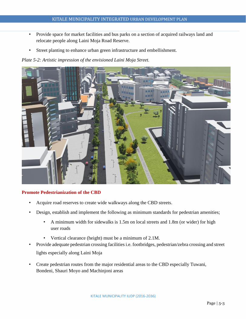
KITALE MUNICIPALITY INTEGRATED URBAN DEVELOPMENT PLAN
KITALE MUNICIPALITY IUDP (2016-2036)
Page | 5-3
• Provide space for market facilities and bus parks on a section of acquired railways land and
relocate people along Laini Moja Road Reserve.
• Street planting to enhance urban green infrastructure and embellishment.
Plate 5-2: Artistic impression of the envisioned Laini Moja Street.
Promote Pedestrianization of the CBD
• Acquire road reserves to create wide walkways along the CBD streets.
• Design, establish and implement the following as minimum standards for pedestrian amenities;
• A minimum width for sidewalks is 1.5m on local streets and 1.8m (or wider) for high
user roads
• Vertical clearance (height) must be a minimum of 2.1M.
• Provide adequate pedestrian crossing facilities i.e. footbridges, pedestrian/zebra crossing and street
lights especially along Laini Moja
• Create pedestrian routes from the major residential areas to the CBD especially Tuwani,
Bondeni, Shauri Moyo and Machinjoni areas

KITALE MUNICIPALITY INTEGRATED URBAN DEVELOPMENT PLAN
KITALE MUNICIPALITY IUDP (2016-2036)
Page | 5-4
LAINI MOJA PROPOSED INTERVENTIONS
Proposed Pedestrian Bridge at the
exit of the Main Bus Park to connect to
the proposed market on Railways Land
Proposed Market
on Railways Land Proposed Bus Park
Main Bus
Park
Proposed Pedestrian Bridge at the existing round about near Municipal
Market. This should allow smooth traffic flow at the roundabout and
keep pedestrians out of danger
Convert the existing carriage
way next to the municipal
market into a pedestrian street
Make this the main entry to the Bus Park and
close the one next to the Municipal Market to
enhance easy and smooth traffic flow. Convert
the linking road to one way to create enough
space for parking and smooth traffic flow
Proposed Market
on Railways Land

KITALE MUNICIPALITY INTEGRATED URBAN DEVELOPMENT PLAN
KITALE MUNICIPALITY IUDP (2016-2036)
Page | 5-5
Expand the Main Bus Park and develop new Bus Parks
• Restricting the use of the main bus park to serve national routes.
• Acquire more land from the prison and the railways to and establish the bus park.
• Acquire land to develop 3 bus parks to serve intra municipality routes and inter county routes as
follows:
o Kitale-Endebess and Kitale-Kwanza Route on the land opposite the stadium (5.2 acres)
o Kitale-Kapenguria and Kitale-Cherangany Routes at the land next to level 4 hospital staff
quarters (Lion Centre, 3.8 Acres)
o Kitale-Eldoret Route and Kitale-Webuye Route to terminate at the acquired bus park on
Railway’s land (6 acres).
Plate 5-3: The existing bus park proposed to serve the long distance travelers
BUS PARK

KITALE MUNICIPALITY INTEGRATED URBAN DEVELOPMENT PLAN
KITALE MUNICIPALITY IUDP (2016-2036)
Page | 5-6
Provide space for Lorry Parks
• Acquiring land opposite the stadium (5.2 acres) to develop an integrated bus and Lorry Park.
• Develop another lorry park at Sirende Centre
• Limit hours for lorries in the CBD to before 7am and after 6pm for loading and offloading
Proposed One-Way Streets
Provide Adequate Parking Facilities
• Make by laws stipulating that for every 100m2 of land in the central business district a minimum
of 1 ½ parking spaces must be provided for off-street parking except where basement parking is
provided. Recommended parking space for development approval in the CBD is:
Type of Development No. of Parking Spaces
Hotels Parking bay for 5-8 beds
Hospital Parking bay for 5-10 beds
Office space Parking bay per 1000 square ft
Governor’s Office

KITALE MUNICIPALITY INTEGRATED URBAN DEVELOPMENT PLAN
KITALE MUNICIPALITY IUDP (2016-2036)
Page | 5-7
• Make by-laws and zoning regulations stipulating that all multi-storey buildings or high user
buildings to have domesticated parking. New building approvals should not be provided for those
who don’t adhere to this
• Restrict Moi Avenue along the Governor’s office and the street along Khetias, Equity and Co-
operative Bank to one way control traffic and to create more space for parking which shall
eventually boost revenue to the county. Also along Khetia’s near the main bus park
Designate Motor Cycles free street and motor cycle routes
Areas proposed to be free of motor cycles
a. Along Moi avenue which hosts the Governor’s office and the law courts
b. Along Laini Moja section connecting to Eldoret road
Proposed designated routes for motor cycles within the CBD
To and from the proposed markets, furniture workshops and Jua Kali shades.
Along Tuskys connecting to Kipsongo road
From museum junction to the County Government offices
From museum junction to the industrial area and the proposed market area
Proposed routes to serve residential areas
All links to the main activity nodes and residential neighborhoods to be used by motor cycle operators to
carry passengers and goods. These links include-
Residential neighborhoods to the CBD and other main activity nodes
Within residential neighborhoods
All roads to have wide adequate reserves to accommodate motorcycles and minimize road user
conflicts
Informal Commercial Activities
Measures
Expand and redevelop the Municipal Market into multi-storey business center to accommodate more
commercial activities
Acquiring a section of land railways and developing a modern market on the acquired land.
Relocate informal commercial activities along Laini Moja to the acquired and developed market on
railway’s land and prison’s land to decongest the CBD.
Relocate all the garages from the CBD to the proposed industrial park on newly acquired land on
prisons land.

KITALE MUNICIPALITY INTEGRATED URBAN DEVELOPMENT PLAN
KITALE MUNICIPALITY IUDP (2016-2036)
Page | 5-8
Acquiring and develop part of the prison land into a modern multi storey SME park.
Relocate SMEs i.e. Furniture and panel beating activities to the modern multi storey SME park in
order to decongest the CBD.
Markets
Measures
Redevelop municipal market to a modern multi storey market to accommodate more commercial
activities.
Acquiring land on railway’s land for an open-air market and clothes market. Relocate traders along
Laini Moja.
Plate 5-4: Artistic impression of the proposed multi-storey business center
Recreation
Measures
Decommission the current dumpsite, relocate it to ADC and develop a public park at the site. Part
of the prison land to be developed as part of the proposed park as was planned in 1973.
Relocate the prison to provide part of it as a park/forest at least 5ha.
Upgrading the existing stadium to a modern status stadium to nature talent and promote sports tourism

KITALE MUNICIPALITY INTEGRATED URBAN DEVELOPMENT PLAN
KITALE MUNICIPALITY IUDP (2016-2036)
Page | 5-9
Redevelop the riparian reserve from behind the bus park to Kipsongo by providing cycling and walk
paths, furniture and other amenities. Also the same in along other rivers within the urban areas.
Repossess and redevelop the riparian reserve from behind the bus park to Kipsongo.
Maintain the existing parks along Laini Moja with requisite infrastructure until when the road reserve
will be acquired for road expansion. After the road expansion, maintain greenery areas along the
section.
Acquire and develop a public park next to the proposed library and integrated cultural centre behind
the County Commissioner’s office.
Maintaining the museum nature trail.
Redevelop the Golf course to international standards.
Plate 5-5: Artistic illustration of the envisioned stadium status in the proposal

KITALE MUNICIPALITY INTEGRATED URBAN DEVELOPMENT PLAN
KITALE MUNICIPALITY IUDP (2016-2036)
Page | 5-10
Plate 5-6: Artistic impression of the nature trail along the riparian as envisioned in the plan
Social Facilities
Measures
Develop a Municipality Level Integrated Cultural Centre (library/ resource centre, social hall/
municipality hall/ amphitheater/ Cultural dance centre). This is to be developed behind the County
Commissioner’s office on a land next to the existing library land. County is to acquire and develop
that land.
Construct a modern public library on the land already existing behind the County Commissioner’s
office.
County Headquarters
Measures
Redevelop the land around the County offices i.e. Governor’s office, Ardhi house, County Assembly
and County Commissioner’s offices to multi storey integrated complex county headquarters to
accommodate all administrative functions.
Relocate the scattered county offices to this area and release that land for greening or other uses.
Improvement of Aesthetics in Kitale CBD
Develop boulevards on major routes.
Design Statues in Kitale municipality at central points or common areas (street sculpture).
Provide for street furniture in the following areas.
Next to the proposed library after establishing a public park
Proposed county government offices area

KITALE MUNICIPALITY INTEGRATED URBAN DEVELOPMENT PLAN
KITALE MUNICIPALITY IUDP (2016-2036)
Page | 5-11
Along Laini Moja section
Initiate river front embellishment along the riverine sections with nature trail.
Landscaping and street trees and other vegetation
i. Develop and improve Laini Moja Section with adequate road reserve, street lighting, greenery
and street furniture.
ii. Plant street trees along all streets in the municipality in intervals of 6, 9, 12 or 15m according to
the road size.
iii. Install street lighting along all streets at the recommended pole heights and intervals.
Improve and Increase Street Lighting Coverage
Through public private partnerships, the following areas are proposed for lighting to improve their
security, aesthetic and accessibility at night.
1. Entire CBD
Implement Outdoor Advertising Policy
Objective of the policy is to provide guidelines to regulate outdoor advertising, introduce an efficient and
reliable advertising revenue collection method for the county.
Types of Advertisements
Facilities covered under the outdoor advertising policy include:
Billboards/ Wall wraps/ Sky signs/ City clocks/ Sign boards/ Suburb signs/Banners/Posters /Hand
bills/Fliers
Branded umbrella / Street displays/ Multi motion neon signs /LED screen advertisement
Guard Rail Advertisement /Construction site boards/ Wall/ Window branding
Advertisements on canvas/ canopy/Signs above /sitting on canopy ( Illuminated /Non Illuminated)
Sky signs/ Wall wrap 20 Ft above the ground and over properties
Advertisement by loudspeaker (P. A system ) per day
Advertisement on hoarding/Street light pole advertising
Business encroachment within street pavement/ shop corridors (Canopies).
Wall painting adverts on temporary premises (Kiosks.)

KITALE MUNICIPALITY INTEGRATED URBAN DEVELOPMENT PLAN
KITALE MUNICIPALITY IUDP (2016-2036)
Page | 5-12
Table 5-1: Advertising Planning Policy Proposals
ADVERT TYPE REQUIREMENTS
Billboards Billboards are not allowed on road reserves.
A distance of 150 m to be maintained between billboards.
Colors of billboards to conform to those of adjacent areas.
Billboards to have a height of 5 M above ground.
Standard billboards to have a size of 12 x 10 M
Big billboards (20 x 10 m and 10 x 30 m) to be put up in the outskirts of the
municipality.
Billboards not to hang on road reserves
Billboard applications be accompanied by structural drawings.
Sky signs To be 12 ft above the ground.
Structural integrity report of buildings to be mounted with the structures to be
submitted by registered engineers.
Structural drawings for the proposed advert be submitted to the county’s approval
authorities.
Wall wraps To be affixed on a wall.
Not to exceed the height of the wall.
Colors of advert to conform to color of the building on which structure is mounted.
Hoarding Hoarding to be undertaken along the perimeter fence of construction sites.
Advertising agencies to submit copies of approved building plans for construction
on site.
Other types of
advertisements
May not require a registered physical planner but should be presented to the county
for approval.

KITALE MUNICIPALITY INTEGRATED URBAN DEVELOPMENT PLAN
KITALE MUNICIPALITY IUDP (2016-2036)
Page | 5-13

KITALE MUNICIPALITY INTEGRATED URBAN DEVELOPMENT PLAN
KITALE MUNICIPALITY IUDP (2016-2036)
Page | 5-14
5.3 Action Area 2: Railways Land
Despite railways falling within the newly proposed CBD, it is an area that requires immediate action to
add value to the CBD based on the opportunity it presents to the entire municipality. Total land area minus
land for the water company is 46.2 acres, however, the county is in the process of acquiring 10 acres of
the land.
The actions that are requires are as summarized below:
Table 5-2: Action Plan for the Railways Land
Description (size
and character)
Justification Planning
issues
Actions
The existing land at
the edge of CBD
that is solely
performing a
terminal function
for the meter gauge
railway.
The railway is no
longer operational.
The land area that
is being negotiated
occupies an area of
15.26ha
The county
Government sought
to acquire the land
for urban
development.
The land is prime
and will increase
the supply of public
land for
commercial and
transportation
services which are
lacking in the CBD.
Underutilized
land
• Developing an open air market for
the mitumba and other activities that
find their way on the road reserve.
• Developing a bus terminal to serve
the county and the transport within
• Developing a business park to
provide additional investment
opportunity for the residents.
• Setting aside land fronting Laini
Moja for commercial development.
• Setting aside land for affordable low
cost housing development.
• Developing a modern railway station
and offices.

KITALE MUNICIPALITY INTEGRATED URBAN DEVELOPMENT PLAN
KITALE MUNICIPALITY IUDP (2016-2036)
Page | 5-15
Figure 5-1: Existing state of the Railways Land

KITALE MUNICIPALITY INTEGRATED URBAN DEVELOPMENT PLAN
KITALE MUNICIPALITY IUDP (2016-2036)
Page | 5-16
Proposed Land Uses
1. Market Facilities and a business center (7.78 acres)
2. Regional Bus Park (2.74 acres)
3. Low Cost Residential Housing (6.18 acres)
4. A commercial zone (6.70 acres)
5. A modern railway station (15 acres)
6. Existing Water and Sewerage Company (3.42 acres)
County Government will acquire 10 acres to
develop market facilities, business centre and a
bus park
Railways Corporation will develop a modern
railway station, low cost houses and commercial
premises

KITALE MUNICIPALITY INTEGRATED URBAN DEVELOPMENT PLAN
KITALE MUNICIPALITY IUDP (2016-2036)
Page | 5-17
Plate 5-7: A model of the envisioned development on Railways Land
Plate 5-8: Artistic illustration of front view of the Railways Land

KITALE MUNICIPALITY INTEGRATED URBAN DEVELOPMENT PLAN
KITALE MUNICIPALITY IUDP (2016-2036)
Page | 5-18
Plate 5-9: An impression of the proposed bus park, market stall and the business center on railways
land
5.4 Action Area 3: Medium Prisons Land
The Medium Prisons land is the third areas identified for action planning. The area also presents
opportunities for increasing supply for various land used that would improve the status of the CBD and
Kitale municipality as a whole. The land covers an area of 322.87 Ha. The detailed actions are as
prescribed as illustrated below.
Figure 5-2: Existing Situation of the Medium Prisons Land

KITALE MUNICIPALITY INTEGRATED URBAN DEVELOPMENT PLAN
KITALE MUNICIPALITY IUDP (2016-2036)
Page | 5-19
Figure 5-3: Proposed Land Use
Description
(size and
Character)
Justification Planning
issues
Actions
Currently
under
medium
prison
facilities and
agriculture
• Land Availability
• Presence of inter-
governmental
coordination
framework
• Need for provision
of public utilities,
low cost housing
and light industrial
park
• Non-
optimal
utilization
of land
• Inadequate
land for
provision
of public
facilities
1. Developing low cost affordable housing
scheme.
2. Developing a light industrial park for
juakali artisans and other industry
related activities
3. Developing a recreational park with
adequate facilities and mixed seizure
activities.
4. Extension of the main bus park
5. Development of a commercial zone
Commercial Area
Commercial
Area

KITALE MUNICIPALITY INTEGRATED URBAN DEVELOPMENT PLAN
KITALE MUNICIPALITY IUDP (2016-2036)
Page | 5-20
Plate 5-10: Illustration of the proposed residential and industrial parks
Plate 5-11: Illustration of the proposed Urban Park on the Prisons Land
Light
Industri
es
Resident
ial area

KITALE MUNICIPALITY INTEGRATED URBAN DEVELOPMENT PLAN
KITALE MUNICIPALITY IUDP (2016-2036)
Page | 5-21
5.5 Action Area 4: Kipsongo Informal Settlement
Major informal settlements within Kitale municipality are found in Kipsongo and Mitume. Kipsongo is
located 1km from the CBD next to Kitale Technical Training College. The informal settlement measures
approximately 16.4 Ha.
Challenges
Kipsongo housing is unplanned with encroachment on roads being common. The area is characterized by
housing units built with scrap corrugated iron sheets and mud as well as:
Unsecure land tenure
Degradation of the local ecosystem
Rapid, unstructured and unplanned developments
Undesignated road networks
Lack of basic services e.g. electricity, poor sanitation networks, lack of potable water
Objective
To upgrade the quality of housing structures, provide and improve services, community facilities and
enhance and improve transport networks systems.
Measures
Provide special planning rights for low income areas whose densities are higher than formal areas
Regularizing security of tenure
Acquire land for developing a play ground
Redevelop existing public toilets that are dilapidated
Widening and Improving of the roads to at least 9m murram roads
Acquire land for development of a market
Rehabilitating or constructing community facilities
Acquire land for developing a dispensary
Promotion of income-earning opportunities
Building institutional frameworks and social capital / assets to sustain improvements.

KITALE MUNICIPALITY INTEGRATED URBAN DEVELOPMENT PLAN
KITALE MUNICIPALITY IUDP (2016-2036)
Page | 5-22
Upgrading Kipsongo and Mitume Slums (provide livable houses with adequate basic facilities)
• The Participatory Slum Upgrading
Programme (PSUP) -a joint effort
of the African, Caribbean and
Pacific (ACP) Group of
States, the European Commission
(EC) and UN-Habitat.
• Kenya Slums Upgrading Project
(KENSUP)
• Kenya Informal Settlements
Improvement Programme (KISIP)
Available Opportunities
Community
Participation
Locally Available Raw Materials
To Do:
1. Provide practical local housing and infrastructure improvements
2. Provide livelihood generation initiatives to the affected residents
3. Facilitate dialogue at local and County levels that is necessary
for ‘mind-set change’
4. Equip County Government with key financing mechanisms for
slum upgrading including mechanisms to engage and empower
slum dwellers themselves
Practices Elsewhere
Kibera
Sao Paulo, Brazil

KITALE MUNICIPALITY INTEGRATED URBAN DEVELOPMENT PLAN
KITALE MUNICIPALITY IUDP (2016-2036)
Page | 6-1
- Plan Development Strategies and Measures
6.1 OVERVIEW
The purpose of this chapter is to provide for strategies and their specific measures/actions creating a
framework implementation. This is in addition to the overall structure plan and the action area plans.
Unlike the action area plans which deal with specific parts of the planning area, the strategies focus on
specific sectors.
6.2 LOCAL ECONOMIC DEVELOPMENT (INVESTMENT) STRATEGY
The objective of the local economic development policy for Kitale municipality is to unlock the local
economy and place it in tandem with the economic pillar of Kenya vision 2030. This economic
development strategy provides a framework for a collaborative partnership approach, which will seek to
improve the municipality’s regional competitiveness and the acceleration of economic growth, job
creation and poverty reduction.
Strategy 1: Promote Development of Viable Nodes /Strategic Growth Centers
The plan proposes strategic growth centers in addition to promoting Kitale municipality centre as an
economic hub in the region. Each of these nodes has a distinct character, significance and development
rationale. Some require specific interventions to make them work in a more efficient manner, whilst
others are rapidly expanding and require management controls. This will also create a proper link
between the central area and the growth nodes as well as acting as breather points for the municipality.
These will be the priority intervention or infrastructure investment and settlement areas by the local
authorities and the central government.
Kitale Municipality CBD
The plan intends to make Kitale municipality a compact economic hub hosting several businesses,
industrial, organizations, educational institutions and government agencies.
Kibomet and Moi University Area
The plan proposes that the area be developed as a high and medium residential area in addition to hosting
high and medium class hotel with conference tourism facilities. Kibomet is already a host to Aturukan and
Skynest hotels, which are modern hotel facilities. It also hosts KMTI, which offers conference facilities
and other related activities. Moi university campus is located just after Kibomet along Kapenguria road.

KITALE MUNICIPALITY INTEGRATED URBAN DEVELOPMENT PLAN
KITALE MUNICIPALITY IUDP (2016-2036)
Page | 6-2
The area is slowly emerging as a highly developed zone due to demand and need that comes with the
development of a university including need for housing and commercial facilities. Plan area around Moi
University as a university neighborhood with requisite facilities and space providing adequate space for
high density residential development, commercial area and adequate road reserves among others. Control
the high rate of plot subdivisions to not less than 0.125 acres
Bikeke
Bikeke area is located 8 kilometers from Kitale municipality and can be accessed from Eldoret Highway
via Machungwa and from Cherangany road near Nabiswa. It is proposed to be a commercial-cum-
residential centre. A bypass (30m wide) is also proposed to pass through Bikeke connecting Eldoret
highway and Cherangany road.
Rafiki
Rafiki centre is located 5 kilometers from Kitale municipality and can be accessed via Kipsongo and
Umoja farm and from Webuye Highway via Siuna centre. It is proposed to be a commercial-cum-
residential centre. A bypass (30m wide) is also proposed to pass through Rafiki connecting Webuye
highway and Endebess road through the proposed industrial area.
Projects/Measures
Prepare Local Development Plans for Bikeke, Rafiki, Matisi and Sirende growth nodes.
Develop and improve infrastructure services in the proposed growth nodes
Identify strategic economic activities to be located in these centers using the competitive advantage
principle
Encourage partnership with the private sector in investment promotion and infrastructure development
Encourage location of employment, trade, living, recreation/ entertainment, higher education, high
level or specialized medical services through targeted incentives to potential investor and service
providers
Strategy 2: Improve Business Environment
The county government will initiate reforms aimed at reducing the administrative barriers to private
sector development. A case in point is the license reforms to ensure that the business-licensing regime is
simple, more transparent and less costly to both the regulating agencies and businesses. Further, to
safeguard the gains made thus far, a Business Regulatory Reform Unit was established under the Ministry

KITALE MUNICIPALITY INTEGRATED URBAN DEVELOPMENT PLAN
KITALE MUNICIPALITY IUDP (2016-2036)
Page | 6-3
of Finance to liaise with regulators to put a halt to the mushrooming of licenses and permits after the
elimination process is completed.
Projects/Measures
Create Dialogue with the private sector
This component will be of an overarching nature, ensuring that the economic and social dialogue between
the county, national government and the private sector in Kitale municipality takes root.
Reduce the cost of starting and operating business;
Reduce time for registering business to at least two weeks in line with international best practice;
Ease the process of licensing, registration and taxation by eliminating lengthy processes and
procedures that emanate from multiplicity of institutions;
Improve coordination of MSE activities;
Encourage formation of business linkages;
Promote creativity and innovation among MSEs
Build partnerships between governments and the private sector
Activities will focus, partly on the capacity building needed in private sector business associations in
order for them both to be able to speak on behalf of the private sector and to effectively engage public
sector as equal partners
Information analysis and dissemination to facilitate and support the formalized dialogue between the
County, national government and the private sector.
Strategy 3: Investing in ICT
The objective of this economic investment is to make Kitale municipality a business development hub
and tech-savvy city; lead the way in utilizing local resources with the latest technology to improve daily
life. The County Business Development Center will be a key tool for implementing the Economic
Empowerment Programs, through advocacy and dissemination of information, and through support for
Micro and Small Sized Enterprises (MSEs), especially to the economically excluded and vulnerable
groups. The centre will offer access to Business Development Services through the County Biashara
Centres, which are a one-stop business development services and capacity-building centre for
entrepreneurs to incubate their businesses. It will also seek to promote inclusive economic growth and
job creation through supporting the implementation of MSE programs and in alignment with County

KITALE MUNICIPALITY INTEGRATED URBAN DEVELOPMENT PLAN
KITALE MUNICIPALITY IUDP (2016-2036)
Page | 6-4
Integrated Development Plans as well as county level and sector specific needs and priorities. The centre
will majorly provide:
Ease of registration of businesses (one stop shop),
Promotion of partnerships and building networks,
Registration of all youths that clear high school but do not qualify for a university degree,
Sensitization of youth and women groups on available economic opportunities through seminars,
publications and notices of all available economic and community development opportunities,
Setting up a county media centre (Tv and radio station, website management etc.), a movie
theatre, restaurants, commercial premises etc.
Projects/Measures
i. Land acquisition and construction of an ICT Park (0.4Ha) on Land behind County Commissioner’s
office next to the Proposed Integrated Community Centre.
ii. Connect whole of the municipality with the TEAMS(The East Africa Marine System) fibre optic
cable
iii. Invite the private sectors (locals) to develop the centre and provide an enabling environment
Strategy 4: Provide Adequate Markets
There is an imperative need to create business workspaces and environment for small-scale traders in the
municipality and its suburbs. This is in addition to creating an enabling and conducive environment for
businesses along the agricultural value chain.
Projects/Measures
i. Land acquisition on Railways land (3.15 Ha)
ii. Develop an open air market and a business centre at the designated space on railways land
iii. Development of markets at the satellite centres of Rafiki, Bikeke, Sirende, Matisi, Emoru, Maili
Saba and Wamuini
Strategy 5: Development of Retail trade/ Stalls/ Exhibitions
The objective of this strategy is to provide one stop shopping retail stalls. This will also go in hand with
reducing sprawl of informal activities in the municipality centre.
Projects/Measures
i. Acquire land at the Railways and Prisons land

KITALE MUNICIPALITY INTEGRATED URBAN DEVELOPMENT PLAN
KITALE MUNICIPALITY IUDP (2016-2036)
Page | 6-5
ii. Develop a business centre at the Railways land
iii. Develop a light industrial park at the acquired land on prison’s land
iv. Create zones for exhibitions/stalls around Khetia Supermarket, at the current bus park and the
designated site on railways land for the markets.
v. Convert residential developments behind Nakumatt into business stalls and other commercial
developments.
vi. County government to prepare detailed redevelopment plan of the areas and guide the private
sector in developing the stalls.
Strategy 6: Improve Business Skills and Entrepreneurial Training
The objective of this component is to improve the competitiveness of micro, small and medium
enterprises. These enterprises will be supported to improve access to new markets and to upgrade their
technology and processes through linkages with large enterprises and research institutions and to improve
access to financial services.
Projects/Measures
i. Develop incubation centres at the existing industrial area
i. Enhance and equip existing vocational centres
ii. Increase colleges and universities that train business related courses
Strategy 7: Tourism Promotion
Kitale municipality has advantages that can be tapped to promote tourism.
a) Strategic location within the western tourist circuit. Located along the international trunk road (A1)
b) Proximity to tourist areas e.g. Mt Elgon national park, Saiwa swamp park. Enhance road network to
easily access these areas
c) Cultural assets including the museum
d) Environmental assets. Good climatic conditions
e) Installed Tourist capacity e.g. hotels and conference facilities
Projects
i. Redevelop the stadium to a modern sports complex
ii. Develop riverine and riparian reserves as nature trails
iii. Develop Eco Lodges in the forests
iv. Develop arboretum facilities

KITALE MUNICIPALITY INTEGRATED URBAN DEVELOPMENT PLAN
KITALE MUNICIPALITY IUDP (2016-2036)
Page | 6-6
v. Develop an Integrated Cultural Centre at the Ministry of Agriculture land
Measures to support the Strategy
Proper maintenance of the existing museum and development of a cultural centre in Kitale
municipality
Proper maintenance of the current museum.
Collect and conserve more documents and display for current and future generations.
Hold annual cultural festivals to celebrate the rich cultural heritage
County government in liaison with the local community should build capacity for local people to be
more effectively engaged in tourism development
This measure will be implemented by the county government in conjunction with the local community
and supported by the National Museum of Kenya and Ministry of Tourism
Develop scenic and attractive areas in the CBD
The plan proposes development of more nature trails and camping sites. Take advantage of the existing
museum nature trail, forests, other green/conservation areas and Kitale Nature Park
Develop riverine and riparian reserves as nature trails,
Develop a system of pedestrian walkways and open spaces
Develop Hospitality Industry/Conference Tourism
Promote conservation tourism by developing eco lodges in the existing forest blocks
Improve the hotels to conform to tourist standards as classified and conferencing
Develop high quality hotels at Kibomet, near Amagoro Park, near the airstrip, along Endebess road
and along Cherangany road to attract high end tourists
Encourage development of training colleges for tourism for skills enhancement
Encourage attractive Architectural designs for tourist hotels to promote aesthetics, comfort and
convenience
Brand the municipality to promote and attract potential investors
Redevelopment of the stadium
The plan proposes redevelopment of the stadium to a modern sports complex to promote sports tourism
Retrofitting the forests to serve as arboretums
The plan proposes development of arboretum facilities in Section 6, KCC, Showground and Block 10
forests
KITALE MUNICIPALITY INTEGRATED URBAN DEVELOPMENT PLAN
KITALE MUNICIPALITY IUDP (2016-2036)
Page | 6-7
Strategy 8: Develop Special Economic Zones (SEZs)
The strategy of SEZ development in Kitale municipality is supported by the rich agricultural hinterland
that produces avocadoes, Bananas, passion, pineapples, guavas which can be value added. Other industrial
ventures include water bottling, clay roofing tiles, recycling plants, computer assembly. In addition,
location of Kitale municipality offers market accessibility due to linkage to both internal and external
areas and due to high internal and external population. The municipality also presents opportunity for
possibility of forward and backward linkages due to existing industries i.e. Kenya Seeds and Western
Seeds in addition to availability of agricultural land at ADC Farm.
Projects/Measures
i. Acquire land (500ha) for an industrial zone at the ADC Farm
ii. Prepare a Master Plan for the Industrial zone
iii. Provide roads, power, water and sewer infrastructural facilities
iv. Preposition of requisite infrastructure on the planned and designated site for SEZ
v. Establish partnerships with ADC and investors in industrial ventures
Strategy 9: Promote Agro-Based Industries
Kitale municipality and its large hinterland has a lot of potential in industrial crops and livestock in terms
of; fruit and banana processing, avocado oil extraction, passion fruit, animal feeds. This potential needs
to be exploited to foster industrial development in the municipality.
Projects/Measures
i. Develop a zone for agro-based industries at ADC farm
ii. Provision of requisite infrastructure on the planned and designated site for agro based industries
iii. Improve road, rail and air connectivity to enhance access to raw materials and marketing of
processed products
iv. Explore the prospects of establishing partnerships with ADC and investors in industrial ventures
Strategy 10: Increase accessibility and availability of financial services
Projects/Measures
i. Provide adequate financial institutions and services by also creating an enabling environment
ii. Zoning to create compatible users and enabling environment for the financial institutions
iii. Linkage to other enterprises
iv. Financial support and capacity building.

KITALE MUNICIPALITY INTEGRATED URBAN DEVELOPMENT PLAN
KITALE MUNICIPALITY IUDP (2016-2036)
Page | 6-8
Partnership in the agro-business support could play a role in promoting access to appropriate funding by
SMEs.
Strategy 11: Support the Formation, Retention and Expansion of business
Projects/Measures
It will be an important business and economic development strategy to support entrepreneurs to expand
small businesses, retain and expand existing businesses. Strategies include:
Access to business planning,
Provide increased access to business financing and other outside capital.
Maintain and increase revolving loan funds available for small businesses
Support industrial park development projects
Assist businesses to navigate land permitting and regulatory issues
Ensure access to appropriate and sufficient business planning assistance
Provide targeted assistance to youth to help them achieve economic opportunity
Summary of Strategies on Physical Infrastructure
Theme: Spurring Local Economic Development
Objectives Issues Strategies Projects
1. To
unlock
the local
economy
and place
it in
tandem
with the
economic
pillar of
Kenya
1. Lack of a plan
to guide
growth and
attract
investments
2. Underutilized
industrial and
tourism
potential
3. Lack of
adequate
facilities for
1. Provide
industrial parks
2. Promote
Development of
Viable Nodes
/Strategic
Growth Centers
3. Improvement of
Business
Environment
1. Acquire land at ADC Farm (850
acres) and develop a Special
Economic Zone to promote agro-
based industries and other industrial
opportunities
2. Acquire land (25acres) and construct
light industrial parks at the prisons
land
3. Acquire land and construct a business
park and market facilities at the
Railways land
KITALE MUNICIPALITY INTEGRATED URBAN DEVELOPMENT PLAN
KITALE MUNICIPALITY IUDP (2016-2036)
Page | 6-9
vision
2030
informal sector
such as market
facilities, jua
kali sites,
motor vehicle
repair,
furniture
workshops
4. Congested
commercial
areas
5. Unreliable
power supply
6. Inadequate
provision of
basic
infrastructure
and services
such as water
and sewer
hindering local
economic
growth
7. Lack of
elaborate
transport
network to
facilitate
economic
growth by
4. Development
Adequate Market
facilities
5. Development of
Business Centres
6. Foster
entrepreneurship,
skills
enhancement and
improve
employability
7. Provide
industrial parks
8. Promote
Development of
Viable Nodes
/Strategic
Growth Centers
9. Improvement of
Business
Environment
10. Development
Adequate Market
facilities
11. Development of
Business Centres
12. Foster
entrepreneurship,
skills
enhancement and
4. Expand the CBD to provide more
spaces for more commercial activities
5. Construct new bus parks to increase
local revenue and create job
opportunities
6. Prepare local development plans for
Bikeke, Sirende, Rafiki and
Namanjalala centres and provide
basic infrastructure and services
7. Upgrade the airstrip to a local airport
to enhance access to markets and
promote local tourism
8. Expand and rehabilitate local access
roads, water and sewerage facilities to
improve business environment and
attract more investors
9. Construct a multi-level parking
facilities to increase local revenue
10. Develop nature trails and arboretums
in Section 6 Forest, KCC Forests,
Showground Forest and Block 10
Forests to promote local tourism
11. Expand and upgrade the stadium to
promote talent and enhance local
revenue
12. Construct a technical training school
where KMTC is currently located
13. Upgrade Kipsongo Training Centre to
a modern facility with requisite
facilities

KITALE MUNICIPALITY INTEGRATED URBAN DEVELOPMENT PLAN
KITALE MUNICIPALITY IUDP (2016-2036)
Page | 6-10
providing
access to
markets
improve
employability
14. Upgrade Kitale Youth Polytechnic to
a national polytechnic with requisite
facilities
15. Construct training and vocational
centres in all the growth nodes
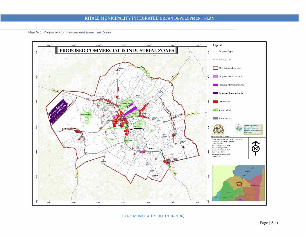
KITALE MUNICIPALITY INTEGRATED URBAN DEVELOPMENT PLAN
KITALE MUNICIPALITY IUDP (2016-2036)
Page | 6-11
Map 6-1: Proposed Commercial and Industrial Zones

KITALE MUNICIPALITY INTEGRATED URBAN DEVELOPMENT PLAN
KITALE MUNICIPALITY IUDP (2016-2036)
Page | 6-12
6.3 TRANSPORTATION STRATEGY
The transportation strategy purpose is to create an effective and efficient transport system in Kitale
municipality as an important prerequisite in facilitating local internal circulation within the municipality,
between the municipality and its immediate and wider hinterland as well as promoting trade, economic
growth, enhancing connectivity and accessibility. The theme is integrating the Urban Transport Network
Strategy 1: Promote Land Use and Transport Integration to form an efficient Urban Network
Objectives:
i. Promote connectivity between Kitale municipality, proposed industrial zone, proposed growth nodes
and its satellite commercial nodes including Kiminini, Endebess, Bikeke, Sirende, Maili Saba, Rafiki
Centre among others
ii. Improve connectivity and accessibility within the proposed municipality by improving the condition
of access roads especially within the CBD, acquiring adequate road reserves through the available
acquisition mechanisms and development of new roads where required.
Projects/Measures
i. Acquire and construct a Regional and County bus terminus for matatus plying county and inter-
county routes at the Railways land
ii. Construct a local bus terminals for matatus plying within the Proposed Municipality to terminate
at Section 6 Forest opposite the Stadium (Endebess route) and Lion’s Centre (Kibomet and along
Kapenguria and Cherangany routes)
iii. Acquire land to expand the Main bus park.
iv. Construct a modern multi-storey bus park with integrated features such as underground parking
bays, closed markets, business centre and car parks to increase the county revenue streams
v. Develop 3-truck termini cum logistics parks at.
a. The proposed industrial Zone at ADC,
b. Section 6 Forest opposite the Stadium next to the proposed matatu terminus and
c. Sirende Centre along the proposed bypass
vi. Acquire land and develop By-passes with dual carriage capacity and a road reserve of 60m: a
bypass linking Eldoret Road to Cherangany Road via Machungwa, Misemwa and Bikeke; bypass
linking the industrial zone to Webuye Road at Siuna and Endebess Road through Rafiki.
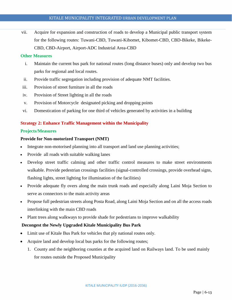
KITALE MUNICIPALITY INTEGRATED URBAN DEVELOPMENT PLAN
KITALE MUNICIPALITY IUDP (2016-2036)
Page | 6-13
vii. Acquire for expansion and construction of roads to develop a Municipal public transport system
for the following routes: Tuwani-CBD, Tuwani-Kibomet, Kibomet-CBD, CBD-Bikeke, Bikeke-
CBD, CBD-Airport, Airport-ADC Industrial Area-CBD
Other Measures
i. Maintain the current bus park for national routes (long distance buses) only and develop two bus
parks for regional and local routes.
ii. Provide traffic segregation including provision of adequate NMT facilities.
iii. Provision of street furniture in all the roads
iv. Provision of Street lighting in all the roads
v. Provision of Motorcycle designated picking and dropping points
vi. Domestication of parking for one third of vehicles generated by activities in a building
Strategy 2: Enhance Traffic Management within the Municipality
Projects/Measures
Provide for Non-motorized Transport (NMT)
Integrate non-motorised planning into all transport and land use planning activities;
Provide all roads with suitable walking lanes
Develop street traffic calming and other traffic control measures to make street environments
walkable. Provide pedestrian crossings facilities (signal-controlled crossings, provide overhead signs,
flashing lights, street lighting for illumination of the facilities)
Provide adequate fly overs along the main trunk roads and especially along Laini Moja Section to
serve as connectors to the main activity areas
Propose full pedestrian streets along Posta Road, along Laini Moja Section and on all the access roads
interlinking with the main CBD roads
Plant trees along walkways to provide shade for pedestrians to improve walkability
Decongest the Newly Upgraded Kitale Municipality Bus Park
Limit use of Kitale Bus Park for vehicles that ply national routes only.
Acquire land and develop local bus parks for the following routes;
1. County and the neighboring counties at the acquired land on Railways land. To be used mainly
for routes outside the Proposed Municipality

KITALE MUNICIPALITY INTEGRATED URBAN DEVELOPMENT PLAN
KITALE MUNICIPALITY IUDP (2016-2036)
Page | 6-14
2. Kitale-Kapenguria Road and Kitale-Cherangany Road (at Lion’s Centre) to serve areas within
and around the Proposed Municipality
3. Kitale-Endebess and Kitale-Kwanza Roads ( beside Section 6 forest opposite the stadium) to
serve areas within and around the Proposed Municipality
Proposed Areas to be free of motor cycles
1. Moi Avenue along Governor’s Office
2. Along Line Moja
Designate motor cycle Routes along Kenyatta Road to serve the CBD and other routes outside the CBD
Strategy 3: Improve Regional and National Connectivity
Projects/Measures
Widen and upgrade to dual carriage way the following roads
i. Acquire land for expansion and construction of Kitale-Kapenguria and Kitale-Webuye
International Trunk Road, Class A1, from existing 25m width in some areas to at least 40m road
reserve in high-developed areas and at least 60m road reserve in the less developed areas.
ii. Acquire land for expansion and construction of Kitale-Eldoret road, Class B2 from 25m to 40m
road reserve
iii. Acquire land for expansion and construction of Kitale-Endebess Road, Class C 17 from 18 to
40m road reserve
iv. Acquire land for expansion and construction of Kitale–Cherangany Road, Class C 21 from 18m
to 40m road reserve
Develop a Light Rail Transit (LRT) to Eldoret Municipality
i. Secure the railway reserve
ii. Repair the existing rail line
iii. Construct train stations in the different municipalities/centres along the rail route
iv. Purchase cargo and passenger wagons
Enhance Air Travel
1. Expand and Upgrade the existing Kitale Airstrip to a local/regional airport by:
i. Fencing and demarcating the current land belonging to the airstrip
ii. Acquire land for the expansion of the airstrip

KITALE MUNICIPALITY INTEGRATED URBAN DEVELOPMENT PLAN
KITALE MUNICIPALITY IUDP (2016-2036)
Page | 6-15
iii. Improve the airstrip to an airport with a runway of about 1.5 km. Rehabilitate the existing runway
iv. Improvement of roads leading to the airstrip/upgraded airport to bitumen standards including creation of bypasses to enhance
easier and quick access to the upgraded airport.
v. Construction of a terminal building with related amenities
THEME: INTEGRATING THE URBAN TRANSPORTATION NETWORK
Objectives Issues Strategies Projects
To integrate
transportation
and land use
activities in
an efficient,
economical
and
sustainable
manner
1. Lack of an
elaborate
road and
transport
network
2. Lack of
adequate
transport
facilities
3. Poor traffic
management
in the CBD
1. Promote Land
Use and
Transport
Integration to
form an
efficient
Urban
Network
2. Improve
Regional and
National
Connectivity
3. Enhance
Traffic
Management
in Kitale
Municipality
CBD
1. Identify and develop missing links by expanding and
upgrading to bitumen standards the existing local access roads
2. Acquire and develop two by-passes on the East and West of
the Municipality
3. Acquire and expand Kitale-Kapenguria and Kitale-Webuye
International Trunk Road, Class A1, from existing 25m width
in some areas to at least 40m road reserve in high-developed
areas and at least 60m road reserve in the less developed areas.
4. Acquire and expand Kitale-Eldoret road, Class B2 from 25m
to 40m road reserve
5. Acquire and expand Kitale-Endebess Road, Class C 17 from
18 to 40m road reserve
6. Acquire and expand Kitale–Cherangany Road, Class C 21
from 18m to 40m road reserve

KITALE MUNICIPALITY INTEGRATED URBAN DEVELOPMENT PLAN
KITALE MUNICIPALITY IUDP (2016-2036)
Page | 6-16
Objectives Issues Strategies Projects
7. Develop a public transport system for the following routes:
CBD-Bikeke, CBD-Wamuini, CBD-Rafiki and CBD-
Proposed Industrial Area at ADC farm
8. Proposed Bus Rapid Transit (BRT) routes are: Kitale-Eldoret,
Kitale-Kiminini, Kitale-Endebess, Kitale-Bikeke and along
Kapenguria and Cherangany Roads
9. Expand and Upgrade the existing Kitale Airstrip to a
local/regional airport by: Acquiring land for the expansion of
the airstrip and improvement of facilities
10. Integrate non-motorised planning into all transport and land
use planning activities;
11. Acquire and develop 3 new bus parks to serve local and
regional routes
12. Acquire and develop a multi-storey car park next to the
Municipal yard

KITALE MUNICIPALITY INTEGRATED URBAN DEVELOPMENT PLAN
KITALE MUNICIPALITY IUDP (2016-2036)
Page | 6-17
Map 6-2: Existing and Proposed Transportation Network

KITALE MUNICIPALITY INTEGRATED URBAN DEVELOPMENT PLAN
KITALE MUNICIPALITY IUDP (2016-2036)
Page | 6-18
PROPOSED MUNICIPAL PUBLIC TRANSPORT SYSTEM ROUTES

KITALE MUNICIPALITY INTEGRATED URBAN DEVELOPMENT PLAN
KITALE MUNICIPALITY IUDP (2016-2036)
Page | 6-19
6.4 TRUNK INFRASTRUCTURE STRATEGY
The purpose of the strategy is to improve quality of life by providing adequate water and proper sanitation,
energy and ICT infrastructure.
6.4.1 Water
Strategy: Improve water supply and coverage
Projects/Measures
NZOWASCo to extend piped water supply to cover the entire planning area
Expand the existing treatment works to 88,791m3/day with adequate low lift and high lift pumps
Drilling of boreholes in high ground water potential areas
Drilling of shallow boreholes through small decentralized schemes in the settlements
Develop and enforce a building code requiring all rental and commercial buildings to harvest and
store rainwater to reduce over-reliance on piped water.
6.4.2 Sewer and Sanitation
Strategy 1: Increase Sewer Reticulation
Projects/Measures
i. Acquire and extend sewer line to cover non-existing areas.
ii. Acquire land and expand the existing sewer treatment facilities at Matisi
iii. Expand the existing sewer treatment facilities at Bidii
iv. Acquire land (50Ha) and construct a new sewer treatment plant in Rafiki area to serve the proposed
Industrial Zone at ADC and its abutting areas, KALRO land, Umoja Farm, Rafiki area and areas
along Webuye Road including the proposed local airport.
v. Acquire land (20.62Ha) and construct a second mini sewer treatment plant in Naisambu/Bikeke
areas to serve Bikeke area, Milimani, Alakara and areas along Cherangany Road
vi. Establish G.I.S based mapping of the sewer reticulation system for efficient management
Strategy 2: Develop a proper Storm Water Drainage System
Projects
i. Conduct a storm water drainage feasibility study for the municipality

KITALE MUNICIPALITY INTEGRATED URBAN DEVELOPMENT PLAN
KITALE MUNICIPALITY IUDP (2016-2036)
Page | 6-20
ii. Provide open and covered paved storm water drains on all roads. Provide drainage way leaves of
1– 3m
iii. Construct storm water drainage outfalls to efficiently direct storm water from the built up areas
to the rivers
iv. Harvesting of rain water to reduce surface runoff
6.4.3 Electricity and Energy
Strategy: Improve coverage of electricity and encourage use of alternative energy sources
Projects/Measures
Exploitation of renewable energy sources from agricultural waste .e.g. biogas and solar.
Repair all the faulty security lights along the major roads and in the core areas.
Provide street lighting along the major roads, in the core areas and in public places
Explore possibilities of electricity generation from solid waste.
Redevelop buildings using appropriate building technologies to provide for self-sufficient (green)
energy systems in buildings
6.4.4 Information Communication Technology (ICT)
Strategy: Improve ICT and Communication Infrastructure
Projects/Measures
Develop an ICT Park at the Agricultural land behind the County Commissioner’s office next to the
proposed integrated cultural centre
Connect whole of the municipality with the TEAMS(The East Africa Marine System) fiber optic cable
Equip government institutions with modern IT equipment

KITALE MUNICIPALITY INTEGRATED URBAN DEVELOPMENT PLAN
KITALE MUNICIPALITY IUDP (2016-2036)
Page | 6-21
6.5 SOCIAL INFRASTRUCTURE STRATEGY
The purpose of this strategy is to improve access to health care and educational facilities geographically,
socially and economically, upgrade all the dilapidated social facilities and provide them with requisite
infrastructure and improve Kitale Municipality’s community well-being.
6.5.1 Health
Strategy 1: Enhance and improve access to health care facilities and services
Projects/Measures
i. Complete the proposed county referral hospital
ii. Every growth node to have a health centre with requisite infrastructure
iii. A dispensary to be established in each neighborhood with requisite infrastructure.
iv. Government decentralized funding such as the CDF to fund the rehabilitation and enhancing
capacities of existing health facilities
v. Each clinic is to serve a catchment population that is sustainable at a distance of 500m.
Strategy 2: Redevelop and Upgrade existing hospitals
Projects/Measures
i. In liaison with Central Government, the Kitale Level Four hospital to be upgraded to Level 5
hospital with requisite infrastructure.
ii. Every health facility to reserve adequate land for future expansion.
Strategy 3: Improve quality of health care
Projects/Measures
i. Provide adequate medical staff in every hospital to a recommended WHO doctor patient ratio of
1:600
ii. Every hospital to have a bed capacity that provides bed occupancy of not more than 100%
iii. Government to supply medicine at cheaper cost

KITALE MUNICIPALITY INTEGRATED URBAN DEVELOPMENT PLAN
KITALE MUNICIPALITY IUDP (2016-2036)
Page | 6-22
Strategy 4: Improve sanitation to prevent diseases
Projects/Measures
i. County Government to strictly enforce by laws that focus on health, hygiene and general sanitation
ii. Connect all households with sewer to reduce sanitation diseases
iii. Encourage community members to do proper placement of toilets/pit latrines vis- a –vis water
sources to reduce contamination.
iv. County Government and NZOWASCo to supply potable water to all households in order to
minimize effects of waterborne diseases
v. Put in place prevention of mother to child transmission services in all health centers.
vi. Every hospital to have an incinerator
6.5.2 Education
Strategy 1: Enhance and improve access to educational facilities and services
Projects/Measures
i. Plan area around Moi University as a university neighborhood with requisite facilities
ii. Construct one full-fledged public university by the year 2030 at the ADC farm
iii. Kitale Technical Training College to be upgraded to a university college
iv. Acquire land and develop Kenya Medical Training College opposite the County Referral hospital
(10Ha)
v. Each nursery school to be integrated to primary school to serve a catchment population of 3500 at
a distance of 500m.
vi. Schools are encouraged to develop vertically to save on space
vii. Special institutions to be provided within major primary schools
Strategy 2: Improve quality of education
Projects/Measures
i. Inspection of all schools in the planning area and immediate registration of all unregistered schools
ii. Government to deploy adequate staff in rural and peri-urban schools to a recommended teacher
pupil ratio of 1:40
iii. Community to employ teachers through PTA

KITALE MUNICIPALITY INTEGRATED URBAN DEVELOPMENT PLAN
KITALE MUNICIPALITY IUDP (2016-2036)
Page | 6-23
Every private investor wishing to develop educational facilities to adhere to the guides provided for in the
education policy
6.5.3 Other Community Facilities
Strategy: Provide Adequate Community Facilities
Projects/Measures
i. Acquire land and construct a Municipal Level Integrated Community Centre (resource centre,
social hall/ municipality hall/ amphitheater/ Cultural dance centre). This is to be developed behind
the County Commissioner’s office on a land next to the existing library land. County is to acquire
and develop that land.
ii. Construct a modern public library on the land already existing behind the County Commissioner’s
office.
iii. Acquire land and construct smaller public libraries at all the growth nodes
iv. Acquire land and construct police stations at the proposed industrial zone and the growth nodes
v. Acquire land at ADC Farm and develop a public cemetery (10Ha)
vi. Acquire land and develop municipality level urban park at the Prisons land where the current
dumpsite is located
vii. Redevelop existing forest blocks as arboretums and parks to promote urban tourism
viii. Revitalize riverine areas by promoting riverfront development such as nature trails

KITALE MUNICIPALITY INTEGRATED URBAN DEVELOPMENT PLAN
KITALE MUNICIPALITY IUDP (2016-2036)
Page | 6-24
Theme: Provision of appropriate Social and Physical Infrastructure
Objectives Issues Strategies Projects
1. To improve
quality of life
by providing
adequate
water and
sanitation,
energy and
ICT
infrastructure
2. To improve
access to
health care
and
educational
facilities,
upgrade all the
dilapidated
social
facilities and
provide them
Physical Infrastructure
1. Lack of adequate water
and sewer supply
2. Poor solid waste
management
3. Inadequate drainage
facilities
4. Inadequate street lighting
5. Inadequate firefighting
facilities
Social Infrastructure
1. Inadequate health
facilities
2. Inadequate vocational
and technical training
facilities
3. Inadequate community
facilities such as social
halls, libraries,
1. Improve water and sewerage
reliability and coverage
2. Improve Solid Waste
Management
3. Enhance Storm Water
management
4. Improve ICT and
communication
5. Increase street lighting
coverage
6. Enhance and improve access
to health care facilities and
services
7. Redevelop and Upgrade
existing hospitals
8. Improve quality of health
care
9. Enhance and improve access
to educational facilities and
services
1. Extend piped water supply to cover the entire
planning area. Expand the existing treatment
works capacity to 71,000m3/day
2. Rehabilitate the existing sewer reticulation
system
3. Expand sewer reticulation system to cover the
entire municipality and expand the capacity of
Bidii treatment plant to 30,000m3/day
4. Acquire land and construct two mini sewer
treatment plants at Bikeke and Rafiki with a
capacity of 10,000m3/day each
5. Upgrade Matisi waste stabilization ponds to a
capacity of 3,000m3/day
6. Acquire and develop a sanitary landfill facility
(at least 10ha) at the ADC farm in the proposed
industrial zone. Convert the current dumpsite at
Machinjoni into a public park.
7. Provide drainage way leaves of 3m – 4.5m on
all major roads and construct covered paved
drainage facilities.

KITALE MUNICIPALITY INTEGRATED URBAN DEVELOPMENT PLAN
KITALE MUNICIPALITY IUDP (2016-2036)
Page | 6-25
with requisite
infrastructure
community centres,
cultural centres, public
cemetery
8. Extend piped water supply to cover the entire
planning area. Expand the existing treatment
works capacity to 71,000m3/day
9. Rehabilitate the existing sewer reticulation
system
10. Expand sewer reticulation system to cover the
entire municipality and expand the capacity of
Bidii treatment plant to 30,000m3/day
11. Acquire land and construct two mini sewer
treatment plants at Bikeke and Rafiki with a
capacity of 10,000m3/day each
12. Upgrade Matisi waste stabilization ponds to a
capacity of 3,000m3/day
13. Acquire and develop a sanitary landfill facility
(at least 10ha) at the ADC farm in the proposed
industrial zone. Convert the current dumpsite at
Machinjoni into a public park.
14. Provide drainage way leaves of 3m – 4.5m on
all major roads and construct covered paved
drainage facilities
15. Acquire land (3.5Ha) for development of a
municipal level Integrated Community Centre,

KITALE MUNICIPALITY INTEGRATED URBAN DEVELOPMENT PLAN
KITALE MUNICIPALITY IUDP (2016-2036)
Page | 6-26
social hall/municipality
hall/amphitheater/cultural dance centre,
dispensary, gym among others, next to the
proposed library behind the County
Commissioner’s office.
16. Acquire and develop five more social halls and
libraries in the proposed growth nodes Land to
be acquired for a social hall should be a
minimum of 1.0ha and 0.4ha for a library
17. Acquire land and construct police stations at the
industrial park and the proposed Growth Nodes.
18. Acquire land (At least 10Ha) and develop
KMTC next to the County Referral hospital.
Develop a Technical Training Institute where
KMTC is currently located
19. Upgrade Level Four hospital to Level Five with
requisite facilities
20. Construct a polytechnic/vocational training
facility by the year 2036 in every ward
21. Acquire at least 50ha for a fully-fledged
university at ADC farm by the year 2036

KITALE MUNICIPALITY INTEGRATED URBAN DEVELOPMENT PLAN
KITALE MUNICIPALITY IUDP (2016-2036)
Page | 6-27
22. Construct a modern multi-storey library at the
land behind the County Commissioner’s office.
Acquire land from the Prison’s land for an urban
park. Current dumpsite to be relocated to ADC
Farm and develop the site as part of the urban
park (8Ha) -20acres
23. Acquire land and develop a park (2.9 acres)at
the junction of Webuye Road and Showground
Road
24. Develop Forests as Arboretums with proper
facilities
25. Expand the Museum Nature Trail and provide
adequate facilities
26. Upgrade the current Trans Nzoia stadium to a
modern status. Repossess grabbed land around
it to provide adequate land for parking and
training grounds.

KITALE MUNICIPALITY INTEGRATED URBAN DEVELOPMENT PLAN
KITALE MUNICIPALITY IUDP (2016-2036)
Page | 6-28
6.6 HOUSING STRATEGY
Housing development is strategically an important social-economic investment to Kitale municipality
residents. Adequate availability of quality and affordable shelter also reduces proliferation of slums and
informal settlements as well as prevent social unrest occasioned by depravity and frustrations of people
living in poor housing settlements. The overall objective of the Kitale municipality housing strategy is to
bridge the gap between demand and supply, improve shelter condition, forestall emergence of informal
settlements such as Kipsongo and Mitemu, upgrade informal settlements, provide quality housing,
improve competitiveness of the municipality and densification of residential zones to forestall urban
sprawl.
Strategy 1: Promote Land Use Planning by allocating sufficient land for new housing development
Projects/Measures
1. Development of low cost housing on Prisons land (14.5ha)
2. Development of low cost housing on Railways land (2.5ha).
3. Identify suitable alternative areas within the municipality and its hinterland for comprehensive
housing development.
4. Land banking by acquiring Prisons and Railways land, and repossessing illegally acquired land
5. Prepared detailed action physical development plans for areas identified for housing development.
6. Initiate dialogue and participatory planning activities among all the stakeholders in the housing
sector
7. Mainstream livable neighborhoods planning concepts, strategic planning and environmental
conservation to guide development in housing
8. Provide basic plot layout and minimal infrastructure such connection to sewer, electricity and
water and access roads etc. in advance of spontaneous development.
9. Prevent the growth of squatter areas by anticipating demand and planning for it appropriately.
10. Enhance easy access to land, especially for low income families through communal amalgamation
Strategy 2: Densification of existing residential neighborhoods
Projects/Measures
1. Preparation of a Local Physical Development Plan for Tuwani, Kaloleni and Mitume

KITALE MUNICIPALITY INTEGRATED URBAN DEVELOPMENT PLAN
KITALE MUNICIPALITY IUDP (2016-2036)
Page | 6-29
2. Re-zoning of Milimani to accommodate medium density, to maintain class and maximize land
use.
3. Redevelop Tuwani and Mitume to high density
4. Encourage affordable housing units throughout the municipality through new constructions that
utilize innovative building materials, technologies and services.
5. Seek new sources of housing subsidies that can enhance affordable housing supply.
6. Work with property owners to identify sites for low-income housing within public private
partnership frameworks.
7. Enforcement of urban planning and development control systems to prevent informality
Strategy 3: Initiate Urban Renewal (Redevelopment) Programmes
This targets the dilapidated and or under-utilized government and county housing and upgrading of
informal settlements. The approach to urban renewal and redevelopment for Kitale municipality will
need to be done in phases.
Projects/Measures
1. Redevelopment of Shauri Moyo to low cost housing (4.12 Ha)
2. Redevelopment of Bondeni area to a low cost housing (7.55Ha).
3. Upgrading of Kipsongo and Mitume informal settlements.
4. The county should enter into partnerships with developers to aid in the construction of shelter to
accommodate the rising population
5. Identify and zone new areas for housing that are more feasible in terms of accessibility to services,
proximity to working areas and proximity to recreational facilities.
6. Adopt Integrated Neighborhood Planning Approach where strategic services are provided within
reach of residents e.g. shops/commercial areas, public offices, schools etc.
7. Develop and support services and amenities necessary for quality neighborhoods as well as
assisting the maintenance and production of substantial, well designed, serviced and located
housing
8. Encourage use of building materials (stabilized blocks) that are accessible, affordable and
available in the locality.

KITALE MUNICIPALITY INTEGRATED URBAN DEVELOPMENT PLAN
KITALE MUNICIPALITY IUDP (2016-2036)
Page | 6-30
Strategy 4: Provide and Improve Infrastructure and Services
Projects/Measures
1. Upgrade main and access roads to residential neighborhoods
2. Provide piped water to residential areas
3. Extent sewer reticulation to include all residential neighborhoods areas
4. Enhance provision of solid waste collection services in residential neighborhoods. Provide adequate
transfer stations
5. Improve storm water drainage in residential neighborhood
Strategy 5: Promote role of County Government by Creating a Supportive Environment
Projects/Measures
1. Act as a “facilitator” and “enabler” with significant actionable steps being taken by the County
Governments, Parastatals and Private & Co-operative Sector and Non-Government Organizations.
2. Prepare Action Plans for creation of adequate infrastructure facilities relating to water, drainage,
sanitation, sewerage, power supply and transport connectivity.
Strategy 6: Establish a Legal & Regulatory Framework
Projects/Measures
1. Develop a county housing policy, county land policy
2. Adopt zoning development policy as provided by this Plan.
Strategy 7: Promote Housing Finance development
Projects/Measures
1. Devise macro-economic policies for enabling accelerated flow of resources to the housing and
infrastructure sector.
2. Encourage Foreign Direct Investment in the urban housing and infrastructure sectors.
3. Encourage formation of urban housing cooperatives

KITALE MUNICIPALITY INTEGRATED URBAN DEVELOPMENT PLAN
KITALE MUNICIPALITY IUDP (2016-2036)
Page | 6-31
Summary on the Housing Strategy
Theme: Provision of adequate and affordable Housing
Objectives Issues Strategies Projects
1. To bridge
the gap
between
demand
and supply,
2. To
improve
shelter
condition,
3. To
forestall
emergence
of informal
settlements
1. Shortage of
planned land for
housing
development
2. Development of
housing areas with
no matching
services and
infrastructure
3. Demand for
descent housing
that does not
commensurate
with housing
supply
4. Proliferation of
informal
settlements that
threaten fragile
ecosystems
1. Promote Land Use
Planning by
allocating sufficient
land for housing
development
2. Densification of
existing residential
neighborhoods
3. Provide and
Improve
Infrastructure and
Services
4. Initiate Urban
Renewal
(Redevelopment)
Programmes
5. Promote Housing
Finance
development
1. Acquire land and provide low
cost housing in the Railways
land and prisons land,
2. Redevelop the municipal
estates in Bondeni and Shauri
Moyo areas to modern low
cost housing.
3. Redevelop Kipsongo slum into
a modern low cost housing
area with requisite amenities
4. Redevelop Section 6 Estate
into a modern low cost
housing area with requisite
ammenities
5. Regularize Tuwani and
Mitume areas to provide basic
infrastructure and services
such as wide and adequate
roads, adequate water and
sewer supply, adequate open
spaces and supportive
community facilities

KITALE MUNICIPALITY INTEGRATED URBAN DEVELOPMENT PLAN
KITALE MUNICIPALITY IUDP (2016-2036)
Page | 6-32
Objectives Issues Strategies Projects
6. Re-zone Milimani to
accommodate medium density
and increase housing provision
7. Upgrade access roads to and
within residential
neighborhoods to motorable
standards with adequate
reserves
8. Increase water and sewer
reticulation system to all the
residential areas
9. Provide storm water drainage
facilities in residential areas
10. Install street lighting facilities
in residential areas

KITALE MUNICIPALITY INTEGRATED URBAN DEVELOPMENT PLAN
KITALE MUNICIPALITY IUDP (2016-2036)
Page | 6-33
Areas for low cost
housing:
1. Bondeni
2. Shauri Moyo
3. Prisons Land
4. Railways Land
5. Kipsongo
Areas for
Redevelopment:
1. Tuwani
2. Mitume
Area for Rezoning from
low to medium density:
1. Milimani
Areas for future residential
housing

KITALE MUNICIPALITY INTEGRATED URBAN DEVELOPMENT PLAN
KITALE MUNICIPALITY IUDP (2016-2036)
Page | 6-34
6.7 ENVIRONMENTAL PROTECTION, CONSERVATION AND DISASTER MANAGEMENT
STRATEGY
Purpose of the strategy is to minimize impacts of human and natural activities on the environment,
improve the aesthetic value of urban places, create a variety of recreation spaces, conserve hilltops,
wetlands, and riverine, and restrict human activities on disaster prone areas, climate change mitigation,
improve water and sanitation.
Strategy 1: Improve Solid Waste Management
Projects/Measures
1. Acquire land for a waste treatment plant at ADC farm
2. Decommission the current dumpsite for an urban park/forest.
3. Recording of waste deliveries and tipping, charging of service levies and disposal plan must be
followed.
4. Encourage waste separation at source, reduce, recycling, and re-use
5. Incinerate hospital and hazardous waste
6. Privatize waste collection in order to increase waste collection coverage and frequency
7. Encourage community groups to be involved in solid waste management
8. Provision of adequate and accessible skips in the municipality especially the markets,
9. Formulate and enforce by laws to discourage haphazard waste dumping
10. Install street bins in appropriate locations in municipality
11. Use enclosed and NEMA licensed waste collection vehicles (modern compactors)
Strategy 2: Conservation and Protection of Ecologically Sensitive Areas
They include: Section 6 forest, KCC Forest, Showground Forest, Milimani/Block 10 Forest, Museum
nature trail, Machinjoni River and wetland, Koitobos River, KCC Forest stream and wetland and Saiwa
Swamp, which is a major wetland near the planning area. Wildlife found in forested areas and wetlands
include monkeys, Sitatunga antelopes, cranes and snakes.
Projects/Measures
1. Conservation and Protection of Forests by revoking all the subdivisions within the forests and
promoting Section 6 forest as a picnic, camping and arboretum zone, KCC Forest as Nature Park (See

KITALE MUNICIPALITY INTEGRATED URBAN DEVELOPMENT PLAN
KITALE MUNICIPALITY IUDP (2016-2036)
Page | 6-35
Mombasa Haller Park) by introducing indigenous tree species and animals of various type,
Showground and Block 10 Forests for Eco Lodges to attract investors and increase county revenue
2. Provide a riparian reserve of 10- 30M for rivers and streams depending on the river/stream profile.
Provide 30M for River Koitobos
3. Promote community participation in conservation by establishing management committees and
initiating tree-planting projects in schools, market centres and the highway and planting indigenous
trees for forest conservation.
4. Enforcement of relevant legislations
5. Formulate detailed environmental management plan for the water resource areas.
6. Provide sewer or waterborne toilets to stop potential of underground water pollution
7. Proper sitting of pit latrines and toilets to curb ground water contamination
Strategy 3: Enhance Landscaping, Beautification and Greening
Projects/Measures
1. Establish urban parks at the Prisons land and Showground forest
2. Conserve forests and promote them as recreational areas to enhance greenery
3. Rehabilitate rest parks and lay down flowerbeds for beautification
4. Encourage planting of appropriate indigenous trees
5. All trees cut in the Municipality will require county permission, and all landowners will be required
to maintain well landscape conditions.
Strategy 4: Enhance coverage and efficiency in liquid Waste Disposal
Projects/Measures
1. Provide sewer in the unconnected /unsewered areas especially to cover all the proposed development
nodes.
Strategy 5: Reduce Air Pollution
Projects/Measures
1. Promote use of non-motorized transport, organize it and provide the necessary supporting
infrastructure such as cycling lanes and parking grounds
2. Control open burning of materials including solid waste especially in crowded areas

KITALE MUNICIPALITY INTEGRATED URBAN DEVELOPMENT PLAN
KITALE MUNICIPALITY IUDP (2016-2036)
Page | 6-36
3. Safely dispose rotting organic matter and improve hygiene standards in pit latrines, urinals and
waterborne toilets to kill the foul smells
4. Pave roads/footpaths and improve land vegetation cover to contain dust
5. Promote use of cleaner domestic energies such as electricity and liquefied Petroleum Gas to control
indoor air pollution.
Strategy 6: Enhance Aesthetics of Kitale Municipality
Projects/Measures
1. Sitting of outdoor advertisement billboards and signs boards to be approved and regulated by
county’s physical planning department
2. Control illegal structures and building materials
3. Enhance greenery and municipality beautification.
Strategy 7: Reduce Noise pollution
Projects/Measures
1. Relevant agencies should ensure that Noise and Excessive Vibration (Control) Regulations, 2009 is
adhered to
2. Ensure that buildings especially entertainment joints have put in place noise proof mechanisms.
3. Individuals/institutions/organizations that intend to make noise to normally seek permission from
NEMA as required by Noise and Excessive Vibration (Control) Regulations, 2009.
4. Use of acoustic materials from the noisy buildings and application of laws on noise pollution
5. The transportation policy of promoting public transport and reducing private vehicles on the road is
also a crucial strategy in lowering noise levels. In addition, the need to increase setback standards
between residential dwellings and major roads should be examined
6. Discourage heavy traffic from densely populated areas
Strategy 8: Enhance Disaster Preparedness and Management
Projects/Measures
1. Formulate a Disaster Preparedness and Management section within the county
2. Formulate Disaster Preparedness and Management by laws
3. Zoning shall ensure separation of conflicting land uses to reduce chances of disasters like fire.

KITALE MUNICIPALITY INTEGRATED URBAN DEVELOPMENT PLAN
KITALE MUNICIPALITY IUDP (2016-2036)
Page | 6-37
4. Acquire adequate land for firefighting facilities at the current site. Provide sub-stations in every
development node with at least two land rovers
5. Make and enforce laws that all buildings must have complete firefighting equipment to include the
firefighting horse reel, fire extinguishers and fire hydrants.
Strategy 9: Promote Stakeholder’s involvement in environmental management of the municipality
Projects/Measures
1. Strengthen and Enhance community participation structures for stakeholders participation in
environmental matters
2. Broaden and strengthen public/ private partnership
3. Work with the poor in improving their neighborhood environments
4. Channel the bulk of environmental resources and programs to the poor.
5. Promote community environmental awareness through electronic and print media (including poster),
publics meetings, organized sector forums, youth and women.
Strategy 10: Enhance Climate Change mitigation and adaptation
Cities can take a major step toward sound development and climate change resilience simply by instituting
and enforcing stronger management principles—a very substantial undertaking that does not lend itself to
consistently easy solutions.
Projects/Measures
The adaptation measures which the municipality requires to undertake to mitigate the potential climatic
impacts include:
1. Diversify sources of fresh water (e.g. ground water) and create water storage capacities such as
dams.
2. Increase vegetation cover to increase carbon sequestration capacity,
3. Encourage house design and building materials to cushion the increased temperatures.
4. Promote use of clean energy sources
5. Planning for green infrastructure

KITALE MUNICIPALITY INTEGRATED URBAN DEVELOPMENT PLAN
KITALE MUNICIPALITY IUDP (2016-2036)
Page | 6-38
PHASING OF ENVIRONMENTAL STRATEGY PROJECTS FOR EFFECTIVE
IMPLEMENTATION
Phase Project Implementation Procedure Timelines
I Provision of adequate and accessible
dustbins and skips in the to cover the
entire municipality and especially the
CBD
i. Conduct a needs assessment
ii. Provide bins and skips in
appropriate locations
1 year
Full demarcation of ecologically sensitive
areas
i. Undertake ground survey of the
ecologically sensitive areas and
demarcate them accordingly
ii. Produce survey plans
1 year
II
Acquisition of land for a waste treatment
plant at ADC farm
i. Undertake a feasibility study
ii. Prepare a site plan
iii. Lay down road, water, sewer and
power infrastructure
iv. Construct a waste treatment
facility
v. Decommission the current
dumpsite for an urban
park/forest.
2 years
Acquisition waste collection trucks i. Acquire at least three new
modern compactors for waste
transportation
2 years
Formulation of a Disaster Preparedness
and Management system within the
county
i. Formulate Disaster
Preparedness and Management
by laws
ii. Formulate Disaster
Preparedness and Management
section within the county
2 years

KITALE MUNICIPALITY INTEGRATED URBAN DEVELOPMENT PLAN
KITALE MUNICIPALITY IUDP (2016-2036)
Page | 6-39
iii. Hire skilled staff on disaster
management
iv. Conduct regular trainings and
drills
III Provision of adequate firefighting
facilities
i. Purchase at least two
10000liters fire engines to serve
the municipality
ii. Undertake a feasibility study for
new fire substations
iii. Prepare Site Plans
iv. Construct fire sub-stations in
every growth node
v. Purchase a mini fire engine for
each substation
vi. Lay down fire hydrants in all
the main activity areas
3-5 years
IV Community Sensitization i. Conduct community seminars
and workshops on
environmental protection and
conservation
Planning
Period

KITALE MUNICIPALITY INTEGRATED URBAN DEVELOPMENT PLAN
KITALE MUNICIPALITY IUDP (2016-2036)
Page | 6-40
6.8 REVENUE ENHANCEMENT STRATEGY
Strategy 1: Increase Reliance on Local Revenue Sources
Projects/Measures
1. The county should gradually reduce the dominance of grants revenue in its funding arrangements by
increasing own revenue yields of especially property taxes and user charges like markets and parking
fees to finance its operating and capital expenditure and to reverse deficit operations to financial
sustainability.
Strategy 2: Systems Computerization
Projects/Measures
1. Installation of a computerized accounting and financial reporting programme through adoption of the
Local Authority Integrated Financial Operational and Management System (LAIFOMS) and IFMIS
2. The County Government should ensure implementation of all accounting modules of the programmes.
Strategy 3: Review of the Property Tax System
Projects/Measures
1. The County Government to review its property tax system; it should adopt development rating and
thus increase the basis of charging rates.
Strategy 4: Linkage of Tax Registers to Geographical Information System (GIS)
Projects/Measures
1. The County Government to install systems that continuously up-dates the registers which provide data
for assessment, invoicing and collection of revenue due to the county. Such registers include listings
of land parcels in its area (with details as to their numbers, sizes, location, use, and details of owners)
and registers of businesses operating in the municipality.
2. The County Government needs to integrate its property taxation system with its survey and physical
planning databases so that changes in size, location, owner, usage and occupancy of all land parcels,
buildings and other features such as roads, rivers, schools, recreational grounds, etc. are captured and
up-dated in the tax registers simultaneously as they are recorded in the survey and other physical
planning databases of the county.

KITALE MUNICIPALITY INTEGRATED URBAN DEVELOPMENT PLAN
KITALE MUNICIPALITY IUDP (2016-2036)
Page | 6-41
Strategy 5: User Charge Services Cost Recovery
Projects/Measures
1. The County Government to ensure that revenue generated by user charge facilities such as markets,
ambulance service, and public conveniences, fully covers related staff, operating, and maintenance
expenses and realizes reasonable savings contribution towards a fund for expansion of the scale and
coverage of the service as well as for eventual renewal or replacement of the capital assets used. The
County should therefore:-
a) Regularly review its license and other fees and charges as well as stalls rental charges and open
air market fees to ensure sustained related costs recovery.
b) Enhance supervision of revenue collectors
c) Install built-in control mechanisms (e.g. spot checks, rotation of staff, etc.) to discourage
dishonesty and pilfering
d) Impose heavy penalties and severe punishment on traders and staff responsible for confirmed
cases of compromising county’s revenue collection effort.
Strategy 6: Grants and Donor Funds
Projects/Measures
1. The County Government should present its funds requirements to managers of devolved public funds
and to representatives of donor agencies based on a well prepared criteria of needs, prioritization of
projects and as per the implementation framework presented in this Plan.
Strategy 7: Privatization & Services Contracting Arrangements
Projects/Measures
1. County Government to contract services that it is not able to provide to private sector operators to
provide the service with such conditions as will ensure sustained availability of the service at an
affordable cost to all who need it. Services that can be privatized include water supply, solid waste
management, slaughterhouses, rental housing, nursery schools, markets, hotels, lodges and
restaurants.

KITALE MUNICIPALITY INTEGRATED URBAN DEVELOPMENT PLAN
KITALE MUNICIPALITY IUDP (2016-2036)
Page | 6-42
6.9 INSTITUTIONAL DEVELOPMENT AND CAPACITY BUILDING STRATEGY
This refers to the promotion and enhancing of the legal institutions that shall facilitate the preparation,
implementation and financing of Kitale Municipality Integrated Development Plan including measures to
provide proper and adequate community participation mechanisms. The strategy seeks to provide a stable
environment for the operations of all institutions of the county for proper implementation and monitoring
of this plan. It will also help to achieve transparency and accountability in governance and economic
management of the county.
Strategy 1: Development and establishment of key offices for management and governance of the
Municipality as required by law
Kitale Municipality is the administrative capital of Trans Nzoia County. Provision is made for urban
governance under the Urban Areas and Cities Amendment Act 2017, for Kitale to be classified as a
Municipality by the virtue of being the County Headquarters and having a population of 50,000-250,000.
This plan preparation therefore seeks to enhance classification of Kitale municipality as a Municipality.
Preparation of an Integrated Plan is one of the requirement for an urban area to be classified as a
Municipality.
The plan enhances and promotes good governance. The term is actually a quantitative term, which may
be difficult to achieve, but includes a number of characteristics that should be fulfilled:
Sustainable and Locally Responsive: It balances the economic, social, and environmental
needs of the present and future generations, and locates its service provision at the closest level
to citizens.
Legitimate and Equitable: It has been endorsed by society through democratic processes and
deals fairly and impartially with individuals and groups providing non-discriminatory access
to services.
Efficient, Effective and Competent: It formulates policy and implements it efficiently by
delivering services of high quality.
Transparent, Accountable, and Predictable: It is open and demonstrates stewardship by
responding to questions and providing decisions in accordance with rules and regulations.
Participatory and Providing Security and Stability: It enables citizens to participate in
government and provides security of livelihoods, freedom from crime and intolerance.

KITALE MUNICIPALITY INTEGRATED URBAN DEVELOPMENT PLAN
KITALE MUNICIPALITY IUDP (2016-2036)
Page | 6-43
Dedicated to Integrity: Officials perform their duties without bribe and give independent
advice and judgments, and respects confidentiality. There is a clear separation between private
interests of officials and politicians and the affairs of government.
The above factors underpin the functions of good governance. Therefore, sustainable development is not
attainable without sound County and Municipal’s administration and management.
Projects/Measures
1. Establish the office of the County Director in charge of planning. This office is responsible for
coordinating the preparation of integrated plans from the initial stage to the implementation and
overview stages. Directors in planning department in all the counties also act as the ground point men
in facilitating citizen participation.
2. Establish Municipal board to oversee and manage the affairs of the municipality. Section 12 (1) of the
Act states that the management of a city and municipality shall be vested in the county government
and administered on its behalf by:-
i. A board constituted in accordance with section 13 or 14 of this Act;
ii. A manager appointed pursuant to section 28
3. Establish office of a Municipal Manager and Municipal Engineer to manage provision of urban
services in urbanized areas of municipalities and to manage technical aspects of solid waste
management, storm water drainage and water supply and sanitation in the municipality respectively
4. Establish offices of the estate administrators. These offices shall coordinate, manage and supervise
the general administrative functions in the estates
5. This plan shall develop a system of governance that encourages participation by residents in its
affairs, and shall for that purpose; create appropriate conditions for participation in preparation,
implementation and review of this Integrated Urban Development Plan.
6. Address the following challenges which the County’s Department of Lands, Planning, Housing and
Urban Development faces:
i. Insufficient funding and delay of release of funds to enhance project initiation and completion.
Bureaucratic way of acquiring funds in the county
ii. Low staff levels especially planners, surveyors and GIS technicians at the county level, sub
county level and at the municipality level. The department has 6 planners only who operate
from the head office and none at the sub-county level. There are 4 Surveyors who all operate

KITALE MUNICIPALITY INTEGRATED URBAN DEVELOPMENT PLAN
KITALE MUNICIPALITY IUDP (2016-2036)
Page | 6-44
from Kitale Municipality and none at the sub-county level as well, the county has a lands
administration officer serving three counties and GIS technicians are non-existent, only one
cartographer
iii. Inadequate offices and office space, lack of office equipment (computers, printers, scanners,
plotters etc.) and lack of enough field vehicles (only one which is shared by every planning
officer except the CEC member) both at the county and sub county levels. The vehicle is also
in poor condition as it often breaks down.
iv. Lack of a strong and efficient Enforcement Department
7. Enhance digitization of registry, which is currently underway, personal growth of the staff by
recommending for relevant trainings on emerging issues, infrastructure networks upgrading, purchase
of vehicles to aid in survey and planning field works.

KITALE MUNICIPALITY INTEGRATED URBAN DEVELOPMENT PLAN
KITALE MUNICIPALITY IUDP (2016-2036)
Page | 7-1
- Plan Implementation Framework
7.1 OVERVIEW
This chapter provides a platform to ensure that all the proposals are implemented in the manner proposed
and within the period indicated in the strategies. It also proposes the prioritization of projects and provides
ways and means for easing of funds. The overall implementation of the integrated urban development plan
will be absorbed by the identified existing institutions, which will require strong leadership and
coordination.
A timeframe for each action has been given indicating the expected implementation time, i.e. immediate,
continuous, short term, medium term or long term. It identifies the relevant institutions that are crucial to
the implementation of the various action programmes.
7.2 STRATEGIC PROJECTS
Critical projects are transformative, have higher multiplier effects (forward and backward linkages) and
have the highest potential to kick-start the economy of Kitale municipality. These projects are categorized
into facilitative, productive and perceptive.
Facilitative are those projects/programmes which enable the productive sector to operate effectively and
efficiently. Productive projects are those which produce goods and services directly and lead to generation
of employment and income. Perceptive projects are those that improve the image and beauty of the
municipality, have the potential to attract investors and give the municipality unique identity.
7.2.1 Facilitative Projects
Water
NZOWASCo to expand sewer and water infrastructure to serve the whole of the proposed
municipality.
Transport
Ministry of Transport, KURA and the County Government to acquire and develop public transport
routes and bus stops between within the proposed Municipality to cover the two proposed Strong
Centres and all the Growth Nodes
Energy

KITALE MUNICIPALITY INTEGRATED URBAN DEVELOPMENT PLAN
KITALE MUNICIPALITY IUDP (2016-2036)
Page | 7-2
Kenya Power Kitale region to improve the Main Ring Circuit around Municipality to increase
electricity reliability.
7.2.2 Productive Projects
Industry
Develop Special Economic Zones (SEZs) for value addition of agricultural produce at KARI, or at the
ADC Farm
Commerce
Development of Business Incubation Centres at the existing industrial area by the Kenya industrial
Estates and Kenya Industrial Research Development Institute.
Redevelopment of Municipal market to a multi storey modern market through a PPP
County Government to acquire land at the Railways land and develop a modern open air market and
Mitumba Market. Relocate Chanuka market, BP Market and Soko Mjinga market to this newly
acquired market space. Provide requisite infrastructure
Tourism
Acquisition of land behind the County Commissioners land and develop an integrated
Community/Cultural Centre, redevelop Kitale golf course, and develop high-class hotels at Kibomet
area and other areas where environment is conducive. County Government to facilitate provision of
requisite infrastructure
7.2.3 Perceptive Projects
Design and Redevelopment
County government to redesign and redevelop the land around the County Government offices to a
compact multi storey development to accommodate all administrative functions to create a civic centre
and place of high aesthetic value.
Green spaces
Initiate river rejuvenation along Machinjoni stream and River Koitobos with a nature trail; relocate
dumpsite to ADC farm to provide space for development of an Urban Park. Conserve the existing
forest blocks, museum nature trail, Kitale Nature Conservancy and redevelop the Golf course to
international standards

KITALE MUNICIPALITY INTEGRATED URBAN DEVELOPMENT PLAN
KITALE MUNICIPALITY IUDP (2016-2036)
Page | 7-3
7.3 QUICK WINS
Projects enumerated below as quick wins are those projects that will be achieved immediately preferably
within a period of 100 days. These projects have high visibility and serve the purpose of rallying support
for subsequent planning activities. They also require low funding:
Motorbikes management. This will be implemented by the County Government, Bodaboda operators
and the traffic police
Formation of Community forum to ensure and monitor provisions of the Integrated Urban
Development Plan
County Government to provide waste skips at the main markets and all the proposed growth nodes
Waste sorting, and recycling
Fencing of the current dumpsite
Youth, CBOs and NGOs to participate in tree nurseries programmes and activities on riverine areas
Establish a system of scrutinizing development applications for approval, supervision and enforcement
of development
7.4 CAPACITY BUILDING
These are projects to be undertaken immediately and continuously for purposes of enhancing the ability
to implement projects during planning period. They include:
Training of staff in the use of the plan for decision making,
Establishment of spatial planning directorate,
Equipping of service departments
Periodic public education, sensitization and awareness creation.

KITALE MUNICIPALITY INTEGRATED URBAN DEVELOPMENT PLAN
KITALE MUNICIPALITY IUDP (2016-2036)
Page | 7-4
7.5 IMPLEMENTATION PHASES
Phase I
Projects Implementation Procedure Timelines
Construction of a Multi-Storey Business Centre
Construct a business centre where the Municipal Market
is located. This will be designed to host about 6,000
traders
i. Undertake a feasibility study
ii. Prepare a site plan.
iii. Lay down road, water, sewer and power infrastructure
iv. Construct an integrated business centre.
1-3 years
Provision of Market Facilities at Railways land
Acquire land and construct an open-air market for farm
products, a second hand clothes (mitumba) market, a
business centre (stalls and small enterprises) and a
wholesale market on a section of the Railways land.
i. Undertake a feasibility study
ii. Prepare a site plan
iii. Lay down road, water, sewer and power infrastructure
iv. Construct market facilities and a business centre
1-3 years
Construction of a Light Industrial Park
Acquire land at the Prisons land and construct a light
industrial park for jua-kali artisans (furniture workshops,
metal fabricators) and vehicle repair
i. Undertake a feasibility study
ii. Prepare a site plan
iii. Lay down road, water, sewer and power infrastructure
iv. Construct a light industrial park
1-3 years
Construction of new Bus Parks i. Acquire land for the proposed bus park at the railways
land

KITALE MUNICIPALITY INTEGRATED URBAN DEVELOPMENT PLAN
KITALE MUNICIPALITY IUDP (2016-2036)
Page | 7-5
Construction of new bus parks at the Railways land (2
acres), Lions Centre (3.8 acres) and Section 6 Forest (5.6
acres)
ii. Undertake a feasibility study for the bus parks
iii. Prepare designs for the bus parks
iv. Construct the bus parks in phases
1-3 years
Construction of 2 Lorry Parks
Construction of 2 lorry parks at Section 6 forest (the open
space opposite the stadium) and Sirende Centre
i. Acquire land for a lorry park at Sirende
ii. Undertake a feasibility study of the two lorry parks
iii. Prepare designs for the lorry parks
iv. Construct the lorry parks
1-3 years
Construction of a new State of the Art Stadium
Redevelop the stadium to a modern sports complex to
promote sports tourism and enhance County revenue.
i. Survey and demarcate the land properly to ascertain the
actual acreage of the stadium land.
ii. Repossess land around the stadium that is being used for
other activities other than sports activities.
iii. Undertake a feasibility study of the project.
iv. Undertake site design and planning.
v. Construct a modern stadium with requisite facilities
1-3 years
Upgrading of the Airstrip to a Local Airport
Upgrade Kitale Airstrip to a local airport to enhance
economic activities such as boost local tourism, facilitate
access to raw materials, facilitate access and marketing of
industrial goods and create more jobs.
i. Prepare designs and site plans for the proposed
airport.
ii. Undertake survey and prepare a survey plan for the
land
iii. Acquire land for the expansion and upgrading of the
airstrip.
iv. Construct the airport with requisite facilities.
1-3 years

KITALE MUNICIPALITY INTEGRATED URBAN DEVELOPMENT PLAN
KITALE MUNICIPALITY IUDP (2016-2036)
Page | 7-6
Expansion of Water Supply Facilities
i. Extension of the piped water supply to cover the
municipality
ii. Expansion of the existing treatment works
iii. Drilling of boreholes in high ground water
potential areas
i. Undertake a feasibility study of the water expansion
ii. Acquire land for way leaves and treatment facility
where necessary
iii. Prepare designs for the reticulation system
iv. Construct the water treatment plant
v. Construct the reticulation system
1-3 years
Expansion of Sewer Facilities
i. Extension of the sewer line to cover 2,000 new
households
ii. Expansion of the existing treatment works
(Machinjoni and Bidii)
iii. Construction of new sewer treatment plants at
Bikeke/Naisambu area and Rafiki/Airstrip area
i. Undertake a feasibility study of the sewer expansion
ii. Acquire land for way leaves and expansion of the
treatment plants where necessary
iii. Prepare designs for the reticulation system
iv. Construct the reticulation system in phases
v. Construct the sewer treatment plants in phases
1-3 years
Construction of a Municipal Level Public Library
Construction of a modern public library on the land
already existing behind the County Commissioner’s
office.
i. Prepare a design for the public library
ii. Construct the library
iii. Equip it with modern facilities
1-3 years
Construction of an Integrated Community Centre
Acquisition and construction of a Municipal Level
Integrated Community Centre behind the County
i. Acquire land from the Ministry of Agriculture.
ii. Undertake a feasibility study of the site.
iii. Prepare designs for the centre.
iv. Provide requisite infrastructure.
1-3 years

KITALE MUNICIPALITY INTEGRATED URBAN DEVELOPMENT PLAN
KITALE MUNICIPALITY IUDP (2016-2036)
Page | 7-7
Commissioner’s office on a land next to the existing
library land.
v. Construct the Park.
A new Public Cemetery
Provision of a public cemetery at ADC Farm (10ha)
i. Acquire land (10Ha) at ADC Farm.
ii. Provide requisite infrastructure.
1-3 years
Development of Low Cost Housing on Prisons Land
Development of low cost housing on Prisons land to pave
way for redevelopment of Shauri Moyo and Bondeni
Development of low cost housing on Railways land
i. Undertake a feasibility study
ii. Prepare a site plan
iii. Lay down road, water, sewer and power infrastructure
iv. Construct low cost houses
1-3 years
Re-Planning of Tuwani and Mitume
Preparation of a Local Physical Development Plan for
Tuwani, Kaloleni and Mitume
i. Conduct field studies.
ii. Prepare a draft Local Physical Development Plan.
iii. Approval of the Plan for implementation.
1-3 years
Redevelopment of Shauri Moyo and Bondeni and
Cherangany estates to construct Low Cost Housing
i. Undertake a feasibility study
ii. Prepare a Site Plan
iii. Prepare a Resettlement Action Plan
iv. Lay down road, water, sewer and power infrastructure
v. Construct low cost houses
1-3 years
Provision of Solid Waste Receptacles and Bins
Provision of adequate and accessible dustbins and skips in
iii. Conduct a needs assessment
iv. Provide bins and skips in appropriate locations

KITALE MUNICIPALITY INTEGRATED URBAN DEVELOPMENT PLAN
KITALE MUNICIPALITY IUDP (2016-2036)
Page | 7-8
the to cover the entire municipality and especially the
CBD
1-3 years
Surveying of Ecologically Sensitive Areas (forests,
rivers, nature trails, wetlands and swamps)
Full surveying and proper demarcation of ecologically
sensitive areas
iii. Undertake ground survey of the ecologically sensitive
areas and demarcate them accordingly
iv. Produce survey plans
1-3 years
Acquisition of Waste Transportation Trucks
Acquisition of 3 waste collection trucks (modern
compactors)
ii. Purchase at least three new modern compactors for waste
transportation
1-3 years
Provision of new Fire Fighting Facilities
Provision of adequate firefighting facilities (engines and
fire hydrants)
vii. Purchase at least two 10000liters fire engines to serve
the municipality
viii. Install new fire hydrants to cover the municipality
1-3 years
Picnic sites, camping areas and arboretum facilities at
Section 6 Forest (137.8ha)
Redevelop the forest for urban tourism to create jobs and
increase the county revenue
i. Undertake a feasibility study
ii. Site design and planning
iii. Construct the requisite facilities
1-3 years
Upgrading of all municipal roads and maintenance of
walkways
i. Conduct road and walkway inventory.

KITALE MUNICIPALITY INTEGRATED URBAN DEVELOPMENT PLAN
KITALE MUNICIPALITY IUDP (2016-2036)
Page | 7-9
ii. Identification of the roads that require upgrading and
the walkways that require maintenance.
iii. Include the projects in the municipality’s annual
budget.
iv. Undertake the construction works.
1-3 years
Phase II
Construction of Eco Lodges
Develop Eco Lodges at Showground forest (110ha), Block
10 forest (35ha) and the Museum Nature Trail (40ha) to
promote nature tourism that will create new jobs and
increase the county revenue
Development of a Nature Park (Haller Park)
Promote KCC forest as a nature park similar to Mombasa
Haller Park to promote nature tourism. This will attract
more people into the municipality creating more business
opportunities, new jobs for the park staff and increase the
county revenue
i. Undertake a feasibility study
ii. Site design and planning
iii. Lay down the necessary/basic infrastructure and
amenities
iv. Acquire the necessary permits from KFS, KWS, County
Government and the National Land Commission
v. Construct the facilities through PPPs
3-5 years

KITALE MUNICIPALITY INTEGRATED URBAN DEVELOPMENT PLAN
KITALE MUNICIPALITY IUDP (2016-2036)
Page | 7-10
Provision of Pedestrian Boulevards
Construct pedestrian boulevards along along Laini Moja
Section and on the prisons land to connect the
municipality centre near the main bus park and
Machinjoni area
i. Undertake a feasibility study
ii. Undertake designs
iii. Acquire land for the routes
iv. Construct the boulevards with adequate street
furniture
3-5 years
Construction of an Integrated Multi-Level Parking
Facility
Acquire a section of prisons land to expand the main bus
park and construct a modern multi-storey bus park with
integrated features such as underground parking bays,
closed markets, business centre and car parks
i. Undertake a feasibility study for the project.
ii. Prepare designs for the facility.
iii. Acquire a portion of land for the bus park from the
Prisons land
iv. Construct an integrated multi-level parking facility
with requisite facilities.
3-5 years
Construction of two By-passes
Acquire land and develop Eastern and Western By-passes
with dual carriage capacity and a road reserve of 60m: a
bypass linking Eldoret Road to Cherangany Road via
Machungwa, Misemwa and Bikeke; bypass linking the
industrial zone to Webuye Road at Siuna and Endebess
Road through Rafiki.
i. Prepare road designs.
ii. Undertake survey and prepare cadastral layers for the
by-passes.
iii. Acquire adequate road reserves (60m) as per the
Constitution and relevant laws
iv. Construct the by-passes.
3-5 years

KITALE MUNICIPALITY INTEGRATED URBAN DEVELOPMENT PLAN
KITALE MUNICIPALITY IUDP (2016-2036)
Page | 7-11
Development of ICT Facilities and Infrastructure
i. Construction of an ICT Park (0.4Ha) on Land
behind County Commissioner’s office next to the
Proposed Integrated Community Centre.
ii. Connection of the municipality with the
TEAMS(The East Africa Marine System) fiber
optic cable
i. Acquire land for construction of an ICT Park
ii. Undertake a feasibility study
iii. Undertake a design of the park
iv. Construct the Park
v. Connect the municipality with fiber optic cables
3-5 years
Construction of Smaller Public Libraries
Construction of smaller public libraries at all the growth
nodes
i. Prepare building and site plans
ii. Acquire land and construct the facilities
3-5 years
Provision of New Health Centres
Construction of health centres in every growth node
i. Prepare building and site plans
ii. Acquire land and construct the facilities
3-5 years
Construction of a Sanitary Landfill Site at ADC
Acquisition of land (10ha) and construction of a solid
waste treatment plant at ADC farm
vi. Undertake a feasibility study
vii. Prepare a site plan
viii. Lay down road, water, sewer and power infrastructure
ix. Construct a waste treatment facility
x. Decommission the current dumpsite for an urban
park/forest.
3-5 years

KITALE MUNICIPALITY INTEGRATED URBAN DEVELOPMENT PLAN
KITALE MUNICIPALITY IUDP (2016-2036)
Page | 7-12
Phase III
Business Incubation and Start-Up Centres
Develop business incubation and start-up centres at the
existing industrial area in partnership with the Kenya
Industrial Estates to increase employment opportunities
and county revenue
i. Acquire land (45ha)
ii. Prepare a Master Plan for the incubation centres
iii. Provide roads, power, water and sewer infrastructural
facilities
iv. Develop the incubation centres
5-10 years
Municipal Public Transport System
Acquire for expansion and construction of roads to
develop a Municipal public transport system for the
following routes: Tuwani-CBD, Tuwani-Kibomet,
Kibomet-CBD, CBD-Bikeke, Bikeke-CBD, CBD-
Airport, Airport-ADC Industrial Area-CBD
i. Acquire land for expansion of the roads
ii. Undertake a feasibility study
iii. Expand/Construct the roads
iv. Construct pick and drop off points
v. Provide bus rapid transit system along the routes
5-10 years
New KMTC
Construction of Kenya Medical Training College opposite
the County Referral hospital
i. Acquire land (10Ha)
ii. Prepare a Master Plan for the site
iii. Construct the College with requisite facilities
5-10 years
New Police Stations
Construction of police stations at the proposed industrial
zone and the growth nodes (Rafiki, Sirende, Bikeke and
Namanjalala)
i. Acquire land
ii. Prepare designs for the facilities
iii. Construct the facilities
5-10 years

KITALE MUNICIPALITY INTEGRATED URBAN DEVELOPMENT PLAN
KITALE MUNICIPALITY IUDP (2016-2036)
Page | 7-13
Construction new fire sub-stations
Construction of fire station in the proposed urban nodes
(Rafiki, Sirende, Bikeke and Namanjalala)
Provision of adequate firefighting facilities (engines and
fire hydrants)
i. Conducting a prefeasibility study.
ii. Identify suitable sites.
iii. Acquire land
ix. Construct fire sub-stations
x. Purchase a mini fire engine for each substation
xi. Lay down adequate fire hydrants
5-10 years
Upgrading of Kipsongo Slum to modern high density
Low Cost Houses
i. Sensitization of the residents
ii. Undertake a feasibility study
iii. Prepare a Site Plan
iv. Prepare a Resettlement Action Plan
v. Lay down road, water, sewer and power infrastructure
vi. Construct high density low cost houses
5-10 years
Phase IV
Industrial and Special Economic Zone
Enhance the current industrial zone by providing requisite
facilities and incentives to attract investors and also form
partnership with the private sectors for increased
investments
Develop a Special Economic Zone at the ADC Farm to
boost the economy of the Municipality and County at
i. Provide requisite facilities and incentives for the
current industrial zone
ii. Acquire land (500ha) from the ADC
iii. Prepare a Master Plan for the Special Economic Zone
iv. Lay down basic infrastructural facilities and amenities
such as roads, power, water, sewer, waste
management sites, fiber optic cables, security
apparatus et cetera
Planning
Period
(20 years)
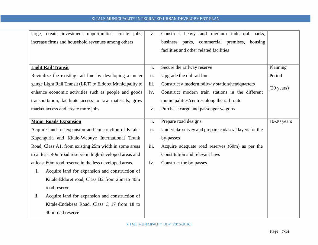
KITALE MUNICIPALITY INTEGRATED URBAN DEVELOPMENT PLAN
KITALE MUNICIPALITY IUDP (2016-2036)
Page | 7-14
large, create investment opportunities, create jobs,
increase firms and household revenues among others
v. Construct heavy and medium industrial parks,
business parks, commercial premises, housing
facilities and other related facilities
Light Rail Transit
Revitalize the existing rail line by developing a meter
gauge Light Rail Transit (LRT) to Eldoret Municipality to
enhance economic activities such as people and goods
transportation, facilitate access to raw materials, grow
market access and create more jobs
i. Secure the railway reserve
ii. Upgrade the old rail line
iii. Construct a modern railway station/headquarters
iv. Construct modern train stations in the different
municipalities/centres along the rail route
v. Purchase cargo and passenger wagons
Planning
Period
(20 years)
Major Roads Expansion
Acquire land for expansion and construction of Kitale-
Kapenguria and Kitale-Webuye International Trunk
Road, Class A1, from existing 25m width in some areas
to at least 40m road reserve in high-developed areas and
at least 60m road reserve in the less developed areas.
i. Acquire land for expansion and construction of
Kitale-Eldoret road, Class B2 from 25m to 40m
road reserve
ii. Acquire land for expansion and construction of
Kitale-Endebess Road, Class C 17 from 18 to
40m road reserve
i. Prepare road designs
ii. Undertake survey and prepare cadastral layers for the
by-passes
iii. Acquire adequate road reserves (60m) as per the
Constitution and relevant laws
iv. Construct the by-passes
10-20 years

KITALE MUNICIPALITY INTEGRATED URBAN DEVELOPMENT PLAN
KITALE MUNICIPALITY IUDP (2016-2036)
Page | 7-15
iii. Acquire land for expansion and construction of
Kitale–Cherangany Road, Class C 21 from 18m
to 40m road reserve
A Full Fledged University
Construction of a full-fledged public university at the
ADC farm
i. Acquire land (50Ha)
ii. Prepare a Master Plan for the University
iii. Construct a modern university with requisite facilities
Planning
period
NB: Community sensitization about the plan and the project in every phase.

KITALE MUNICIPALITY INTEGRATED URBAN DEVELOPMENT PLAN
KITALE MUNICIPALITY IUDP (2016-2036)
Page | 7-16
7.6 COORDINATION FRAMEWORK
At policy and institutional levels, the coordination focuses on facilitating:
The understanding and implementation of strategies and measures by the government and non-
government institutions;
Dialogue between all partners and the government to create conditions that favour the adoption
of the plan.
At an operational level, coordination is mainly concerned with improving efficiency of actions
through:
Information exchange;
Facilitating administrative procedures as much as possible;
Ensuring the financing of critical activities, directing resources to priority areas and avoiding
overlapping activities.
To enhance good coordination, it is recommended that:
People in the planning area to begin reinforcing the immediate and personal initiatives of this
plan
The quick wins and immediate interventions be cleared to pave way for the short term and
medium term strategies that will ultimately prepare a way for the long term objectives
7.7 COMMUNITY PARTICIPATION FRAMEWORK
The main aim is to improve the effectiveness and validity of implementation processes and to
increase the acceptability of plan proposals and decisions. This will fully involve the community
in investment choices and management decisions.
Formation of community based environmental management committees
Community members to set up community police areas in all the residential neighbourhoods.
Community members to form phone tree communication mechanisms.
The donor community through registered NGOs and CBOs to develop riverine and riparian
reserves as nature trails
Residents to comment on public notices informing them of proposed developments within their
neighborhoods and cooperate appropriately.

KITALE MUNICIPALITY INTEGRATED URBAN DEVELOPMENT PLAN
KITALE MUNICIPALITY IUDP (2016-2036)
Page | 7-17
7.8 PROJECT OUTCOME BASED MONITORING AND EVALUATION
OUTCOME PROJECT INDICATOR TARGET DATA SOURCE RESPONSIBLE REPORTING
A thriving
economy on a
conducive
business
environment
Increase
employment
opportunity.
An innovative
and creative
society
ECONOMY
Overall Strategy: Promotion of Local Economic Development
Construction of a
Multi-Storey Business
Centre
A site Master Plan Building
Number of trades domiciled in the
building
100% in 3
years
Department of Trade,
Commerce and
Industries
Director (s) in charge
of Trade and
commerce
County Annual
Reports
Provision of Market
Facilities at Railways
land
Feasibility study report
A site Master Plan
Number of stalls constructed.
Revenue obtained from the facilities.
100% in 3
years
Department of Trade,
Commerce and
Industries
Director (s) in charge
of Trade and
commerce
County Annual
Reports
Construction of a Light
Industrial Park
A feasibility study report
A site master plan
Number of building units put up in
the site
Number of units occupied.
100% in
3years
Department of Trade,
Commerce and
Industries
Kenya National
Chamber of
Commerce and
Industries.
Director (s) of Trade
and Industries.
NCCI County Director
County Annual
Reports.
NCCI annual
reports
and news web
page.
Business Incubation and
Start-Up Centres
Acres of land acquired.
A site master plan
length of roads laid
50% in 6
years
Department of Trade,
Commerce and
Industries
Director (s) in charge
of Trade and
Commerce
County Annual
Reports.
NCCI annual
reports

KITALE MUNICIPALITY INTEGRATED URBAN DEVELOPMENT PLAN
KITALE MUNICIPALITY IUDP (2016-2036)
Page | 7-18
OUTCOME PROJECT INDICATOR TARGET DATA SOURCE RESPONSIBLE REPORTING
Length of water pipes laid
Availability of power on the site.
Building units put up on the site
and news web
page.
Industrial and Special
Economic Zone
A feasibility study report.
Hectors of land acquired.
A site master plan
Length of roads constricted.
Length of water pipes laid.
Availability of power in the site.
Number of building units constructed
on the site.
50% in 10
years.
Department of
Finance and
Economic Planning
Department of Trade,
Commerce and
Industries
Directors in charge of
Finance and economic
planning.
Director of Trade and
Commerce and
Industries.
County Annual
Reports.
TRANSPORTATION
Overall Strategy: Integration of Land Uses through efficient Transport Network
Construction of new
terminal Facilities
- New bus parks
-Lions Centre
-Section 6 Forest
A feasibility study report.
Acres of land acquired.
Number of parking lots available.
Daily traffic volume in the terminal
facilities.
100% in 3
years
County Department
of Public works,
Transport and Energy
Director in charge of
transport
County Annual
Report.

KITALE MUNICIPALITY INTEGRATED URBAN DEVELOPMENT PLAN
KITALE MUNICIPALITY IUDP (2016-2036)
Page | 7-19
OUTCOME PROJECT INDICATOR TARGET DATA SOURCE RESPONSIBLE REPORTING
Efficiency
Convenience
Functionality
Connectivity
Safety
Increased
revenue.
Upgrading of the Airstrip
to a Local Airport
A site Master Plan.
Acres of land acquired.
Number of daily flights
Annual Passenger number.
100% in
3years.
Kenya Airports
Authority (KAA)
Department of Public
works, Transport and
Energy
Board chairman KAA KAA Annual
Report
Upgrading of all
municipal roads and
maintenance of
walkways
The amount allocated in the budget
for the project.
Kilometers of road upgraded.
100% in
3years.
County Department
of Public works,
Transport and
Energy.
Director of Roads.
County Annual
Report.
Provision of Pedestrian
Boulevards
The kilometers of pedestrian
walkway constructed.
100% in 5
years
County Department
of Public works,
Transport and
Energy.
Director of Roads.
County Annual
Report.
Construction of an
Integrated Multi-Level
Parking Facility
Building
Number of Parking spaces available.
50% in 3
years
County Department
of Public works,
Transport and
Energy.
Municipal Board
Director of Roads.
The chairperson of the
Municipal Board
County Annual
Report.
Construction of two By-
passes
Amount of money allocated for the
project.
Kilometers of roads done.
50% in 3
years
County Department
of Public works,
Transport and
Energy.
Director of Roads.
County Annual
Report.

KITALE MUNICIPALITY INTEGRATED URBAN DEVELOPMENT PLAN
KITALE MUNICIPALITY IUDP (2016-2036)
Page | 7-20
OUTCOME PROJECT INDICATOR TARGET DATA SOURCE RESPONSIBLE REPORTING
Municipal Public
Transport System
Acres of land acquired.
Feasibility Study Report.
Length of roads constructed.
60% in
8years
County Department
of Public works,
Transport and
Energy.
Director of Roads.
County Annual
Report.
Light Rail Transit
Development
Amount allocated in the budget.
An operational railway station.
Number of daily trips.
70% in 20
years.
KRC,
Ministry of
Transport,
Infrastructure,
Housing and Urban
Development
The Municipal Board
Chair of KRC Board
of Directors
County Director in
Charge of Roads,
Minister for Transport,
Infrastructure,
Housing and Urban
Development
Chairman of the
municipal board
KRC projects
webpage
MoTIH&UD
Annual Reports
County Annual
Report.
Major Roads
Expansion.
Acres of land acquired
Length of road expanded.
100% in 20
years.
County Department
of Public works,
Transport and
Energy.
Director of Roads.
County Annual
Report.
INFRASTRUCTURE AND UTILITY SERVICES
Overall Strategy: Provision of Adequate and Effective Infrastructure and Infrastructural Services
Expansion of Water
Supply Facilities
Feasibility study report
amount of money allocated for the
project
Kilometers of pipes laid.
Number of storage tanks
100% in 3
years
County Department
of Water and
Sanitation.
Nzoia Water Service
Company
(NZOWASCO)
County Director in
charge of water.
Chairperson of the
board of Directors
NZOWASCO.
County Annual
Reports.
NZOWASCO
Annual Reports.

KITALE MUNICIPALITY INTEGRATED URBAN DEVELOPMENT PLAN
KITALE MUNICIPALITY IUDP (2016-2036)
Page | 7-21
OUTCOME PROJECT INDICATOR TARGET DATA SOURCE RESPONSIBLE REPORTING
A healthy
society
Capacity of the treatment plan.
Number of households connected.
Expansion of Sewer
Facilities
Feasibility study report
Kilometers of sewer network done
Sewer reticulation plan
Number of households connected.
100% in 3
years
County Department
of Water and
Sanitation.
County Director in
charge of sewer and
sanitation.
County Annual
Reports
A clean and
healthy
environment
Provision of Solid Waste
Receptacles and Bins
Needs assessment report
Number of waste receptacles put in
place.
100% in 3
years.
County Department
of Environment
Director in charge of
environment
County Annual
Report
Acquisition of Waste
Transportation Trucks
Number of trucks purchased 100%in 3
years
County Department
of Environment
Director in charge of
environment.
County Annual
Report
Construction of a
Sanitary Landfill Site at
ADC
Feasibility study report
Site Master Plan
Amount of money set aside for the
project
Volume of waste disposed on the
facility.
70% in 3
years.
County Department
of Water
Environment and
Natural Resources.
Director in charge of
environment.
County Annual
Report.
An informed
society.
Development of ICT
Facilities and
Infrastructure
Site Master Plan.
Acres of land acquired for the center.
100% in 5
years
County Department
of ICT
Director in charge of
ICT
County Annual
Report

KITALE MUNICIPALITY INTEGRATED URBAN DEVELOPMENT PLAN
KITALE MUNICIPALITY IUDP (2016-2036)
Page | 7-22
OUTCOME PROJECT INDICATOR TARGET DATA SOURCE RESPONSIBLE REPORTING
Well utilized
urban land
A new public cemetery Amount of funds set aside for the
project
Acres of land acquired
Number of graves on the site.
100% in 3
years
County Department
of Health.
County Director in
charge of Public
Health.
County Annual
Report
Safe human
settlements
Construction new fire
sub-stations
Feasibility Study report
Amount set aside for the project in
the budget
Acres of land acquired
A building to host the facility.
60% in 7
years
County Department
of Public Works
Director in charge of
disaster preparedness
and emergency
responses.
County Annual
Report.
Provision of new Fire
Fighting Facilities
Funds set aside for the project in the
budget.
The number of fire engines
purchased.
Number of fire hydrants installed in
the municipality.
100% in 3
years
County Department
of Public Works
Director in charge of
disaster preparedness
and emergency
responses.
County Annual
Report.
Quality of life
that is based
on affordable
Development of Low
Cost Housing on Prisons
Land
Feasibility study report.
Housing master plan.
The amount of money set aside for
the project in the budget.
Length of roads constructed.
Length of water pipes installed.
90% in 3
years
The Presidency
County Department
of Housing.
Kenya Railways
Corporation
Ministry of
Transport,
Infrastructure,
County Director of
Housing.
Chair of KRC Board
Principle secretary
MoTIH&UD
County Annual
Report
KRC annual
report and projects
webpage

KITALE MUNICIPALITY INTEGRATED URBAN DEVELOPMENT PLAN
KITALE MUNICIPALITY IUDP (2016-2036)
Page | 7-23
OUTCOME PROJECT INDICATOR TARGET DATA SOURCE RESPONSIBLE REPORTING
and quality
housing.
Number of housing units constructed.
Number of households domiciled.
Housing, and Urban
Development
(MoTIH & UD)
MoTIH&UD
Annual Reports
Redevelopment of
Shauri Moyo and
Bondeni and
Cherangany estates to
construct Low Cost
Housing
90% in 3
years
The Presidency
MoTIH & UD
County Department
of Housing.
Principle secretary
MoTIH&UD
County Director of
Housing.
County Annual
Report
MoTIH&UD
Annual Reports
Big Four Agenda
Flagship projects
web page.
Upgrading of Kipsongo
Slum to modern high
density Low Cost
Houses
Housing master plan.
The amount of money set aside for
the project in the budget.
Length of roads constructed.
Number of housing units Upgraded.
Existing number of households.
60% in 7
years.
County Department
of Housing.
Director of Housing.
County Annual
Report
HEALTH
Overall Strategy: Enhance Access to Quality Health Care Services.
Increased
access to
Provision of New
Health Centres
A feasibility study report.
Amount of funds set aside for the
project.
Acres of land acquired.
100% in 5
years
County department of
Health
County Director of
Health.
County Annual
Report.

KITALE MUNICIPALITY INTEGRATED URBAN DEVELOPMENT PLAN
KITALE MUNICIPALITY IUDP (2016-2036)
Page | 7-24
OUTCOME PROJECT INDICATOR TARGET DATA SOURCE RESPONSIBLE REPORTING
health
services
Number of buildings put up to house
the facility.
Number of patients attended to
annually.
EDUCATION
Overall Strategy: Promoting Skill and Research Based Education and Training.
Local access
to quality
higher
education and
training.
New KMTC Acres of land acquired
A Site Master Plan
Number of building units put up for
the facility.
70% in 7
years
State Department of
Technical and
Vocational Training
Principal Secretary-
Technical and
Vocational Training.
The Ministry’s
Annual Report.
A Full Fledged
University
Acres of land acquired.
A Master Plan
100% in 20
years
Department of
University Education
and Research
Principal Secretary-
University Education
and Research.
The Ministry’s
Annual Report.
COMMUNITY FACILITIES
Overall Strategy: Enhancing Quality of Life by Providing Adequate Social Services
Construction of a
Municipal Level Public
Library
The amount of funds set aside for the
project.
The acres of land set aside for the
project.
A building for the project.
Number of Books purchased.
Number of visits recorded annually.
100% in 3
years
County department of
Social Development
Director in Charge of
Social Development.
County Annual
Report.
Department’s
Project website

KITALE MUNICIPALITY INTEGRATED URBAN DEVELOPMENT PLAN
KITALE MUNICIPALITY IUDP (2016-2036)
Page | 7-25
OUTCOME PROJECT INDICATOR TARGET DATA SOURCE RESPONSIBLE REPORTING
Improved
quality of life.
Construction of an
Integrated Community
Centre
The Amount of money set aside for
the project.
Acres of land set aside.
Building units put up.
Number of social activities and
services registered and offered.
100% in 3
years.
County department of
Social Development
Director in Charge of
Social Development.
County Annual
Report.
Department’s
Project website
Construction of
Smaller Public
Libraries
The amount of funds set aside for the
project.
The acres of land set aside for the
project.
A building for the project.
Number of Books purchased.
Number of visits to the facility
annually.
60% in 3
years.
County department of
Social Development
County department of
Social Development
County Annual
Report.
Department’s
Project website
New Police Stations
Funds set aside for the project.
Acres of land set aside.
Building units put up on the site.
Number of police offices posted to
the station.
100% in 10
years.
Office of the county
Commissioner.
County Commissioner
Annual Report.
National Police
Service Website.

KITALE MUNICIPALITY INTEGRATED URBAN DEVELOPMENT PLAN
KITALE MUNICIPALITY IUDP (2016-2036)
Page | 7-26
OUTCOME PROJECT INDICATOR TARGET DATA SOURCE RESPONSIBLE REPORTING
LEISURE AND RECREATION
Overall Strategy: Promotion of Urban Based Tourism
Increased
sources of
income to the
members of
the society.
Construction of a new
State of the Art
Stadium
Feasibility Study report
Amount of money included in the
budget for the project.
Size of land set aside for the project
Construction work on site.
Sporting activities registered on site
in a year.
90% in 3
years
County Department
of Sports
Director in charge of
Sports
County Annual
Report.
Department’s
Project website
Picnic sites, camping
areas and arboretum
facilities at Section 6
Forest (137.8ha)
Feasibility study report.
Length of nature trails constructed.
Number of recreational furniture put
on site.
Number of camping activities
registered.
Number of visitors recorded in a
year.
100% in 3
years
County department of
Tourism
Director of Tourism
County Annual
Report.
Department’s
Project website
Construction of Eco
Lodges
Feasibility study report.
Number of eco loges put up.
Number of visitors recorded
annually.
100% in 5
years.
County department of
Tourism
Director of Tourism County Annual
Report.
Department’s
Project website
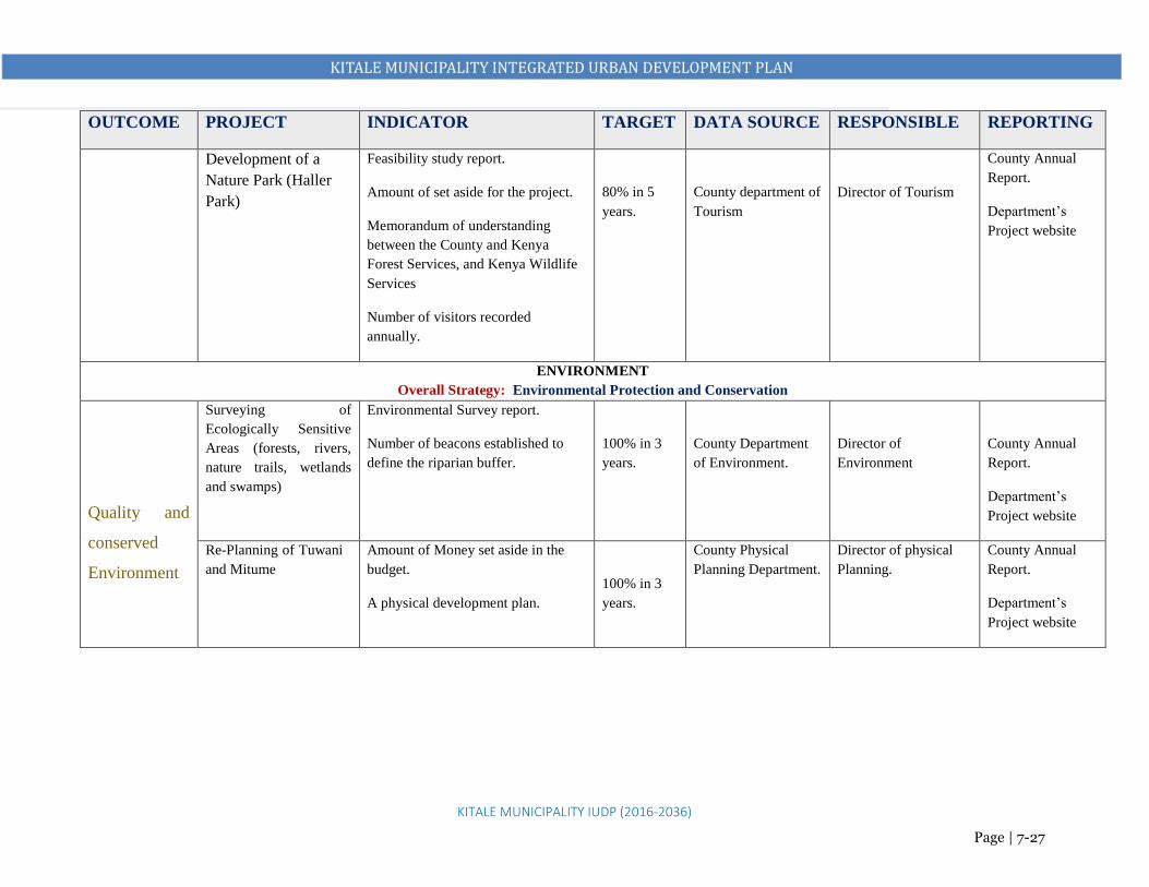
KITALE MUNICIPALITY INTEGRATED URBAN DEVELOPMENT PLAN
KITALE MUNICIPALITY IUDP (2016-2036)
Page | 7-27
OUTCOME PROJECT INDICATOR TARGET DATA SOURCE RESPONSIBLE REPORTING
Development of a
Nature Park (Haller
Park)
Feasibility study report.
Amount of set aside for the project.
Memorandum of understanding
between the County and Kenya
Forest Services, and Kenya Wildlife
Services
Number of visitors recorded
annually.
80% in 5
years.
County department of
Tourism
Director of Tourism
County Annual
Report.
Department’s
Project website
ENVIRONMENT
Overall Strategy: Environmental Protection and Conservation
Quality and
conserved
Environment
Surveying of
Ecologically Sensitive
Areas (forests, rivers,
nature trails, wetlands
and swamps)
Environmental Survey report.
Number of beacons established to
define the riparian buffer.
100% in 3
years.
County Department
of Environment.
Director of
Environment
County Annual
Report.
Department’s
Project website
Re-Planning of Tuwani
and Mitume
Amount of Money set aside in the
budget.
A physical development plan.
100% in 3
years.
County Physical
Planning Department.
Director of physical
Planning.
County Annual
Report.
Department’s
Project website

KITALE MUNICIPALITY INTEGRATED URBAN DEVELOPMENT PLAN
KITALE MUNICIPALITY IUDP (2016-2036)
Page | 7-28