Kathu Townlands: A High Density Earlier Stone Age Locality in the Interior of South Africa
11
Kathu Townlands: A High Density Earlier Stone Age Locality in the Interior of South Africa Steven J. H. Walker 1 , Vasa Lukich 2 , Michael Chazan 3 * 1 Department of Archaeology, University of Cape Town, Rondebosch, South Africa, 2 Department of Earth Sciences, University of Toronto, Toronto, Ontario, Canada, 3 Department of Anthropology, University of Toronto, Toronto, Ontario, Canada Abstract Kathu Townlands is a high density Earlier Stone Age locality in the Northern Cape Province, South Africa. Here we present the first detailed information on this locality based on analysis of a sample of lithic material from excavations by P. Beaumont and field observations made in the course of fieldwork in 2013. The results confirm the remarkably high artefact density at Kathu Townlands and do not provide evidence consistent with high energy transport as a mechanism of site formation, suggesting that Kathu Townlands was the site of intensive exploitation of highly siliceous outcroppings of banded iron formation. The results presented here provide a first step towards understanding this complex locality and point to the need for further research and the importance of preserving this locality in the face of intensive and rapid development. Citation: Walker SJH, Lukich V, Chazan M (2014) Kathu Townlands: A High Density Earlier Stone Age Locality in the Interior of South Africa. PLoS ONE 9(7): e103436. doi:10.1371/journal.pone.0103436 Editor: Michael D. Petraglia, University of Oxford, United Kingdom Received April 9, 2014; Accepted July 2, 2014; Published July 24, 2014 Copyright: ß 2014 Walker et al. This is an open-access article distributed under the terms of the Creative Commons Attribution License, which permits unrestricted use, distribution, and reproduction in any medium, provided the original author and source are credited. Data Availability: The authors confirm that all data underlying the findings are fully available without restriction. McGregor Museum, Kimberley is the repository for all collections described here as well as our data (inventory number 6512). Analysis can be arranged by permission from the McGregor Museum. Funding: PZK Beleggings, under the direction of Jaco Minnie of Leon Frank and Partners, funded field work. Support was also provided by Canadian Social Sciences and Humanities Research Council Grant 410-2010-722. The funders had no role in study design, data collection and analysis, decision to publish, or preparation of the manuscript. Competing Interests: The 2013 field work was carried out under the auspices of the Archaeology Department, McGregor Museum, for PZK Beleggings, under the direction of Jaco Minnie of Leon Frank and Partners. Although some of this project was funded commercially, this does not alter the authors’ adherence to PLOS ONE policies on sharing data and materials. * Email: [email protected] Introduction Early to Middle Pleistocene localities that incorporate extremely high numbers of lithic artefacts present a challenge to our understanding of early hominin behaviour. In some cases, such as Ma’ayan Baruch, Israel [1], the deposits are dominated by very large numbers of bifaces while other localities show characteristics consistent with quarrying or primary production [2,3,4,5]. There are also localities with a more ambiguous character such as the site of Canteen Kopje, South Africa [6,7] which includes high densities of both production debris and finished artefacts. Both the quarry sites and sites dominated by finished artefacts provide evidence of stone tool transport but these sites also raise questions about group size and organization of activity among early hominin groups. Here we present the first detailed description of a site located in the town of Kathu, Northern Cape Province, South Africa that shows high intensity of lithic production during the Earlier Stone Age (ESA). Kathu Townlands is a site situated between the Kuruman Hills to the east and the Langberge mountains to the west on a low hill and is covered with a dense surface of lithics interspersed with exposures of bedrock, calcrete, and sand (Figure 1–2). Dense and broadly distributed archaeological deposits pose methodological and management challenges. The town of Kathu is rapidly expanding and this development is directly threatening Kathu Townlands (Figure 1c). The site was designated a Grade 1 National Heritage site in 2013 however the threat to deposits beyond the declared area remain acute. Geological Setting The bedrock lithology is Precambrian, with exposures of banded iron formation (BIF), which belong to the Kuruman Formation within the late Archean to earliest Paleoproterozoic Transvaal Supergroup [8,9]. There is a wide degree of variability within the BIF in the Kuruman Formation both in terms of the scale of banding and the percentage of chert (SiO 2 ) relative to iron-rich minerals. The outcroppings at Kathu Townlands (sometimes designated as jaspellite) are dominated by chert and show no fine-scale banding. As a result the structure of these rocks is ideal for stone tool manufacture and it is likely that the availability of high quality raw material is a major reason for repeated exploitation of the resource and the high density of stone tool and knapping debris at Kathu Townlands. Circular white to grey fossil traces are characteristic of the raw material found at Kathu Townlands. Outcroppings of raw material with similar fossil traces have not been identified in the surrounding region. The Kuruman Hills are today drained by a series of ephemeral streams that flow northwest (Figure 1). None of these streams pass through the research area, the closest drainage is the Vermul- sleegte, to the north of the site. There is evidence for far more substantial drainage systems at some point in the geological past in the area around Kathu. At the Bestwood site the archaeological horizon is underlain by at least ten meters of river gravels and PLOS ONE | www.plosone.org 1 July 2014 | Volume 9 | Issue 7 | e103436
Transcript of Kathu Townlands: A High Density Earlier Stone Age Locality in the Interior of South Africa
Kathu Townlands: A High Density Earlier Stone AgeLocality in the Interior of South AfricaSteven J. H. Walker1, Vasa Lukich2, Michael Chazan3*
1 Department of Archaeology, University of Cape Town, Rondebosch, South Africa, 2 Department of Earth Sciences, University of Toronto, Toronto, Ontario, Canada,
3 Department of Anthropology, University of Toronto, Toronto, Ontario, Canada
Abstract
Kathu Townlands is a high density Earlier Stone Age locality in the Northern Cape Province, South Africa. Here we presentthe first detailed information on this locality based on analysis of a sample of lithic material from excavations by P.Beaumont and field observations made in the course of fieldwork in 2013. The results confirm the remarkably high artefactdensity at Kathu Townlands and do not provide evidence consistent with high energy transport as a mechanism of siteformation, suggesting that Kathu Townlands was the site of intensive exploitation of highly siliceous outcroppings ofbanded iron formation. The results presented here provide a first step towards understanding this complex locality andpoint to the need for further research and the importance of preserving this locality in the face of intensive and rapiddevelopment.
Citation: Walker SJH, Lukich V, Chazan M (2014) Kathu Townlands: A High Density Earlier Stone Age Locality in the Interior of South Africa. PLoS ONE 9(7):e103436. doi:10.1371/journal.pone.0103436
Editor: Michael D. Petraglia, University of Oxford, United Kingdom
Received April 9, 2014; Accepted July 2, 2014; Published July 24, 2014
Copyright: � 2014 Walker et al. This is an open-access article distributed under the terms of the Creative Commons Attribution License, which permitsunrestricted use, distribution, and reproduction in any medium, provided the original author and source are credited.
Data Availability: The authors confirm that all data underlying the findings are fully available without restriction. McGregor Museum, Kimberley is the repositoryfor all collections described here as well as our data (inventory number 6512). Analysis can be arranged by permission from the McGregor Museum.
Funding: PZK Beleggings, under the direction of Jaco Minnie of Leon Frank and Partners, funded field work. Support was also provided by Canadian SocialSciences and Humanities Research Council Grant 410-2010-722. The funders had no role in study design, data collection and analysis, decision to publish, orpreparation of the manuscript.
Competing Interests: The 2013 field work was carried out under the auspices of the Archaeology Department, McGregor Museum, for PZK Beleggings, underthe direction of Jaco Minnie of Leon Frank and Partners. Although some of this project was funded commercially, this does not alter the authors’ adherence toPLOS ONE policies on sharing data and materials.
* Email: [email protected]
Introduction
Early to Middle Pleistocene localities that incorporate extremely
high numbers of lithic artefacts present a challenge to our
understanding of early hominin behaviour. In some cases, such as
Ma’ayan Baruch, Israel [1], the deposits are dominated by very
large numbers of bifaces while other localities show characteristics
consistent with quarrying or primary production [2,3,4,5]. There
are also localities with a more ambiguous character such as the site
of Canteen Kopje, South Africa [6,7] which includes high densities
of both production debris and finished artefacts. Both the quarry
sites and sites dominated by finished artefacts provide evidence of
stone tool transport but these sites also raise questions about group
size and organization of activity among early hominin groups.
Here we present the first detailed description of a site located in
the town of Kathu, Northern Cape Province, South Africa that
shows high intensity of lithic production during the Earlier Stone
Age (ESA). Kathu Townlands is a site situated between the
Kuruman Hills to the east and the Langberge mountains to the
west on a low hill and is covered with a dense surface of lithics
interspersed with exposures of bedrock, calcrete, and sand
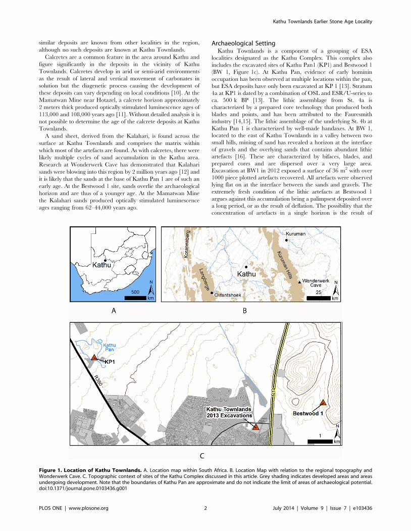
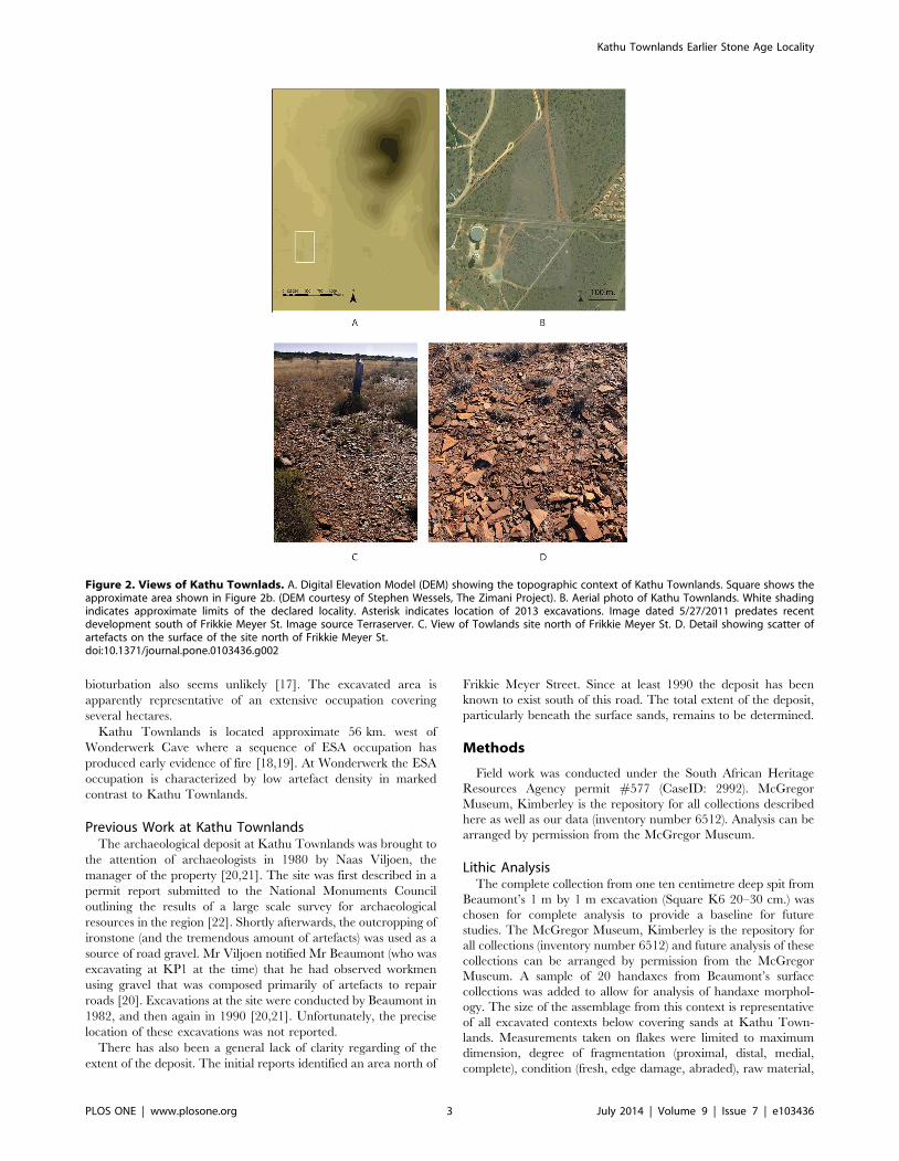
(Figure 1–2).
Dense and broadly distributed archaeological deposits pose
methodological and management challenges. The town of Kathu
is rapidly expanding and this development is directly threatening
Kathu Townlands (Figure 1c). The site was designated a Grade 1
National Heritage site in 2013 however the threat to deposits
beyond the declared area remain acute.
Geological SettingThe bedrock lithology is Precambrian, with exposures of
banded iron formation (BIF), which belong to the Kuruman
Formation within the late Archean to earliest Paleoproterozoic
Transvaal Supergroup [8,9]. There is a wide degree of variability
within the BIF in the Kuruman Formation both in terms of the
scale of banding and the percentage of chert (SiO2) relative to
iron-rich minerals. The outcroppings at Kathu Townlands
(sometimes designated as jaspellite) are dominated by chert and
show no fine-scale banding. As a result the structure of these rocks
is ideal for stone tool manufacture and it is likely that the
availability of high quality raw material is a major reason for
repeated exploitation of the resource and the high density of stone
tool and knapping debris at Kathu Townlands. Circular white to
grey fossil traces are characteristic of the raw material found at
Kathu Townlands. Outcroppings of raw material with similar
fossil traces have not been identified in the surrounding region.
The Kuruman Hills are today drained by a series of ephemeral
streams that flow northwest (Figure 1). None of these streams pass
through the research area, the closest drainage is the Vermul-
sleegte, to the north of the site. There is evidence for far more
substantial drainage systems at some point in the geological past in
the area around Kathu. At the Bestwood site the archaeological
horizon is underlain by at least ten meters of river gravels and
PLOS ONE | www.plosone.org 1 July 2014 | Volume 9 | Issue 7 | e103436
similar deposits are known from other localities in the region,
although no such deposits are known at Kathu Townlands.
Calcretes are a common feature in the area around Kathu and
figure significantly in the deposits in the vicinity of Kathu
Townlands. Calcretes develop in arid or semi-arid environments
as the result of lateral and vertical movement of carbonates in
solution but the diagenetic process causing the development of
these deposits can vary depending on local conditions [10]. At the
Mamatwan Mine near Hotazel, a calcrete horizon approximately
2 meters thick produced optically stimulated luminescence ages of
113,000 and 108,000 years ago [11]. Without detailed analysis it is
not possible to determine the age of the calcrete deposits at Kathu
Townlands.
A sand sheet, derived from the Kalahari, is found across the
surface at Kathu Townlands and comprises the matrix within
which most of the artefacts are found. As with calcretes, there were
likely multiple cycles of sand accumulation in the Kathu area.
Research at Wonderwerk Cave has demonstrated that Kalahari
sands were blowing into this region by 2 million years ago [12] and
it is likely that the sands at the base of Kathu Pan 1 are of such an
early age. At the Bestwood 1 site, sands overlie the archaeological
horizon and are thus of a younger age. At the Mamatwan Mine
the Kalahari sands produced optically stimulated luminescence
ages ranging from 62–44,000 years ago.
Archaeological SettingKathu Townlands is a component of a grouping of ESA
localities designated as the Kathu Complex. This complex also
includes the excavated sites of Kathu Pan1 (KP1) and Bestwood 1
(BW 1, Figure 1c). At Kathu Pan, evidence of early hominin
occupation has been observed at multiple locations within the pan,
but ESA deposits have only been excavated at KP 1 [13]. Stratum
4a at KP1 is dated by a combination of OSL and ESR/U-series to
ca. 500 k BP [13]. The lithic assemblage from St. 4a is
characterized by a prepared core technology that produced both
blades and points, and has been attributed to the Fauresmith
industry [14,15]. The lithic assemblage of the underlying St. 4b at
Kathu Pan 1 is characterized by well-made handaxes. At BW 1,
located to the east of Kathu Townlands in a valley between two
small hills, mining of sand has revealed a horizon at the interface
of gravels and the overlying sands that contains abundant lithic
artefacts [16]. These are characterized by bifaces, blades, and
prepared cores and are dispersed over a very large area.
Excavation at BW1 in 2012 exposed a surface of 36 m2 with over
1000 piece plotted artefacts recovered. All artefacts were observed
lying flat on at the interface between the sands and gravels. The
extremely fresh condition of the lithic artefacts at Bestwood 1
argues against this accumulation being a palimpsest deposited over
a long period, or as the result of deflation. The possibility that the
concentration of artefacts in a single horizon is the result of
Figure 1. Location of Kathu Townlands. A. Location map within South Africa. B. Location Map with relation to the regional topography andWonderwerk Cave. C. Topographic context of sites of the Kathu Complex discussed in this article. Grey shading indicates developed areas and areasundergoing development. Note that the boundaries of Kathu Pan are approximate and do not indicate the limit of areas of archaeological potential.doi:10.1371/journal.pone.0103436.g001
Kathu Townlands Earlier Stone Age Locality
PLOS ONE | www.plosone.org 2 July 2014 | Volume 9 | Issue 7 | e103436
bioturbation also seems unlikely [17]. The excavated area is
apparently representative of an extensive occupation covering
several hectares.
Kathu Townlands is located approximate 56 km. west of
Wonderwerk Cave where a sequence of ESA occupation has
produced early evidence of fire [18,19]. At Wonderwerk the ESA
occupation is characterized by low artefact density in marked
contrast to Kathu Townlands.
Previous Work at Kathu TownlandsThe archaeological deposit at Kathu Townlands was brought to
the attention of archaeologists in 1980 by Naas Viljoen, the
manager of the property [20,21]. The site was first described in a
permit report submitted to the National Monuments Council
outlining the results of a large scale survey for archaeological
resources in the region [22]. Shortly afterwards, the outcropping of
ironstone (and the tremendous amount of artefacts) was used as a
source of road gravel. Mr Viljoen notified Mr Beaumont (who was
excavating at KP1 at the time) that he had observed workmen
using gravel that was composed primarily of artefacts to repair
roads [20]. Excavations at the site were conducted by Beaumont in
1982, and then again in 1990 [20,21]. Unfortunately, the precise
location of these excavations was not reported.
There has also been a general lack of clarity regarding of the
extent of the deposit. The initial reports identified an area north of
Frikkie Meyer Street. Since at least 1990 the deposit has been
known to exist south of this road. The total extent of the deposit,
particularly beneath the surface sands, remains to be determined.
Methods
Field work was conducted under the South African Heritage
Resources Agency permit #577 (CaseID: 2992). McGregor
Museum, Kimberley is the repository for all collections described
here as well as our data (inventory number 6512). Analysis can be
arranged by permission from the McGregor Museum.
Lithic AnalysisThe complete collection from one ten centimetre deep spit from
Beaumont’s 1 m by 1 m excavation (Square K6 20–30 cm.) was
chosen for complete analysis to provide a baseline for future
studies. The McGregor Museum, Kimberley is the repository for
all collections (inventory number 6512) and future analysis of these
collections can be arranged by permission from the McGregor
Museum. A sample of 20 handaxes from Beaumont’s surface
collections was added to allow for analysis of handaxe morphol-
ogy. The size of the assemblage from this context is representative
of all excavated contexts below covering sands at Kathu Town-
lands. Measurements taken on flakes were limited to maximum
dimension, degree of fragmentation (proximal, distal, medial,
complete), condition (fresh, edge damage, abraded), raw material,
Figure 2. Views of Kathu Townlads. A. Digital Elevation Model (DEM) showing the topographic context of Kathu Townlands. Square shows theapproximate area shown in Figure 2b. (DEM courtesy of Stephen Wessels, The Zimani Project). B. Aerial photo of Kathu Townlands. White shadingindicates approximate limits of the declared locality. Asterisk indicates location of 2013 excavations. Image dated 5/27/2011 predates recentdevelopment south of Frikkie Meyer St. Image source Terraserver. C. View of Towlands site north of Frikkie Meyer St. D. Detail showing scatter ofartefacts on the surface of the site north of Frikkie Meyer St.doi:10.1371/journal.pone.0103436.g002
Kathu Townlands Earlier Stone Age Locality
PLOS ONE | www.plosone.org 3 July 2014 | Volume 9 | Issue 7 | e103436
weight, and flake type (primary: cortex .80%, secondary: cortex
,80%, non-cortical). For cores, measurements taken were limited
to description and weight. For bifaces, B1 (breadth 1/5 from the
tip) and B2 (breadth 1/5 from the base) were measured along with
length, maximum thickness, and weight. A subsample was selected
for photography. The sample from this single spit includes 1283
flakes, 10 cores, and 6 bifaces (See Table 1).
2013 ExcavationsIn August 2013 excavations were undertaken as part of a data
recovery project to mitigate the destruction being caused by a mall
being built on a small portion of the known deposit [23] (see
Figure 2b, 3). The primary objective of the project was to recover
samples from a controlled stratigraphic context distributed across
the area slated for destruction in the limited time available. We
aimed to obtain data useful for understanding both the horizontal
Table 1. Breakdown of the sample of flakes and flake fragments from the Beaumont excavation (n = 1283).
Fragment
n %
Complete 714 55.65%
Proximal 223 17.38%
Distal 191 14.89%
Medial 155 12.08%
Condition
n %
Fresh 297 23.15%
Edge damage 879 68.51%
Abraded 107 8.34%
Type
n %
Primary 72 5.61%
Secondary 222 17.30%
Non-cortical 989 77.08%
doi:10.1371/journal.pone.0103436.t001
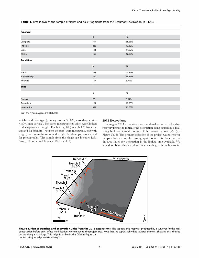
Figure 3. Plan of trenches and excavation units from the 2013 excavations. The topographic map was produced by a surveyor for the mallconstruction before any surface modifications were made to the project area. Note that the topography dips towards the west showing that the siteoccurs along a N-S ridge. This ridge is visible in the DEM in Figure 2a.doi:10.1371/journal.pone.0103436.g003
Kathu Townlands Earlier Stone Age Locality
PLOS ONE | www.plosone.org 4 July 2014 | Volume 9 | Issue 7 | e103436
and vertical distribution of the deposits over as wide an area as
possible.
The methods employed combined mechanical trenching to
obtain data regarding the geomorphology, followed by hand
excavations to obtain archaeological samples (Figure 3). Horizon-
tal control across the project was maintained with averaged GPS
waypoints. Vertical associations were able to be correlated using a
high resolution topographic map of the project area (20 cm
intervals; Figure 3).
Under archaeological supervision, ten trenches were mechan-
ically excavated across the property. The location of trenches was
chosen with the intent of providing a cross section of the
topography of the impacted area. Each of the ten trenches was
cleaned to bedrock by hand and profiles were cleaned, measured
and photographed. Additionally, a long trench dug by the
developer was documented in an area that had been considered
to be outside the site boundary.
From these ten trenches, five were selected for further
archaeological excavation to provide a horizontally distributed
sample from trenches that were archaeologically rich. The first
three units were 100 cm650 cm, however, due to the overwhelm-
ing amount of material being recovered, the last two were reduced
to 50650 cm (see Table 2). These units were dug in 10 cm levels
as measured from modern ground surface (MGS). Vertical control
was maintained utilizing a datum and line level. Each unit was dug
to bedrock, all material was screened through a 3 mm sieve, and
artefacts collected by level. All excavated material is curated in the
McGregor Museum, Kimberley.
Results
Lithic AnalysisThe breakdown of the analyzed lithic assemblage is presented in
Table 1. The flakes include 714 (55.65%) complete pieces, 223
(17.38%) proximal fragments, 191 distal fragments (14.89%), and
155 medial fragments (12.08%) (Figure 4). Only 297 pieces are
fresh (23.15%, sharp edges with little microfracture), 879 have
edge damage (68.51%, considerable microfracture, crushing, and/
or large scar damage along the edge), and 107 pieces are abraded
(8.34%, smoothing due to abrasion, with or without edge damage).
Maximum dimension for the large flakes has a mean of 4.6 cm
(SD 2.28), and the mean for weight is 31.6 g (SD 55.9). The
sample from the Beaumont excavation shows high fragmentation
and a high degree of edge damage indicating significant
mechanical damage. Flakes smaller than 2-cm. in maximum
dimension are underrepresented, possibly due to the mesh size
employed in sieving. However, there is no evidence for winnowing
of flakes greater than 2 cm. as would be expected under high
energy transport. Abrasion, although present, is not frequent.
The representation of all size classes in the flake assemblage
suggests that knapping took place on site and is consistent with the
identification of the site as a quarry locality (Figure 5: a–b).
However, the low frequency of primary flakes (n = 72, 5.61%) and
Table 2. Weight of lithic artefacts recovered in 2013 excavation by excavation unit broken down by arbitrary 10 cm. levels.
Trench A (square 1) Trench C (square 2) Trench E (square 3) Trench G (Square 4) Trench I (Square 5)
Opening Elevation 1232.9 m. asl 1233.1 m. asl 1232.1 m. asl 1233.3 m. asl 1231.9 m. asl
Cm. Below Surface Weight of artifacts (kg.)
0–10 13.4 0.1 0.1 0.1
10–20 20.4 20.2* 0.1 0.2 0.2
20–30 17.2 17.4 0.6 4.4 0.2
30–40 21 17 0.6 15.2 0.1
40–50 27.2 11.4 3.6 8.2 4.8
50–60 14.8 12.6 18.4 4.4 9.4
60–70 14.8 10.4 4 7.4 7.2
70–80 22.8 15.2 7.6 3.6 0.8
80–90 14.4 4.2 5.8 5.2 0.6
90–100 22 BEDROCK 2.8 10.8 0.1
100–110 9.4 3.2 7.4 BEDROCK
110–120 13.4 0.1 2.4
12– = 130 13.8 BEDROCK 0.1
130–140 7 BEDROCK
140–150 5.8
150–160 12
160–170 16.8
170–180 15.8
BEDROCK
Closing Elevation 1231.1 1232.2 1231.1 1232.0 1230.9
Area Excavated 100650 cm. 100650 cm. 100650 cm. 50650 cm. 50650 cm.
*Square 2: Levels 1 & 2 were dug as a single spit.doi:10.1371/journal.pone.0103436.t002
Kathu Townlands Earlier Stone Age Locality
PLOS ONE | www.plosone.org 5 July 2014 | Volume 9 | Issue 7 | e103436
secondary flakes (n = 222, 17.3%) and the high frequency of
noncortical flakes (n = 989, 77.08%) does not match expectation
for a quarry site where the initial stages of roughing out a block
would take place.
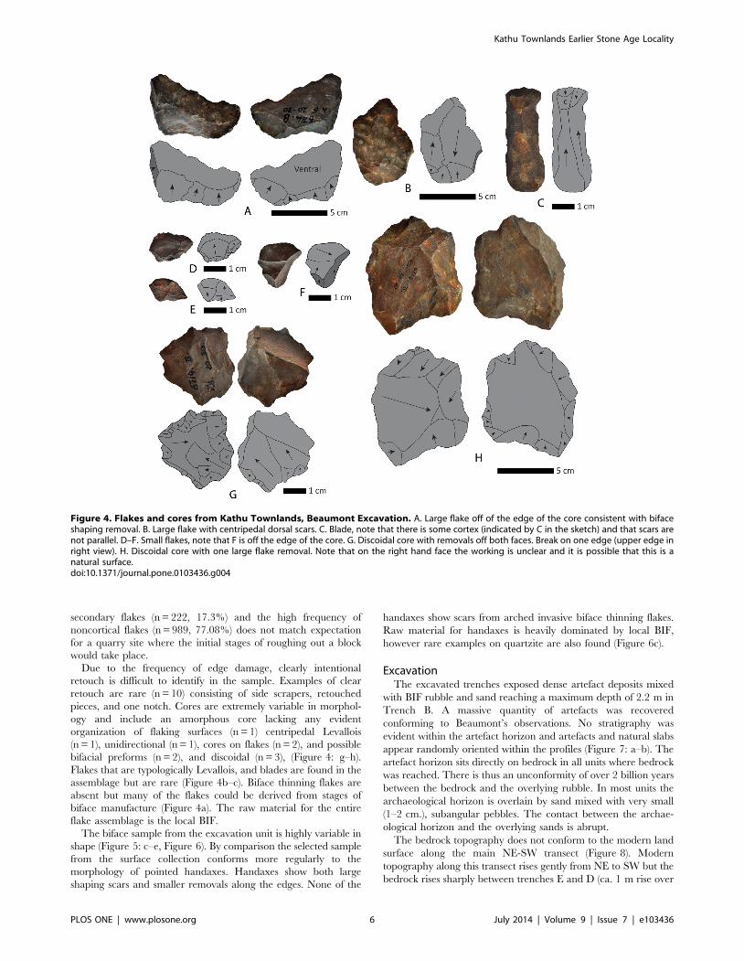
Due to the frequency of edge damage, clearly intentional
retouch is difficult to identify in the sample. Examples of clear
retouch are rare (n = 10) consisting of side scrapers, retouched
pieces, and one notch. Cores are extremely variable in morphol-
ogy and include an amorphous core lacking any evident
organization of flaking surfaces (n = 1) centripedal Levallois
(n = 1), unidirectional (n = 1), cores on flakes (n = 2), and possible
bifacial preforms (n = 2), and discoidal (n = 3), (Figure 4: g–h).
Flakes that are typologically Levallois, and blades are found in the
assemblage but are rare (Figure 4b–c). Biface thinning flakes are
absent but many of the flakes could be derived from stages of
biface manufacture (Figure 4a). The raw material for the entire
flake assemblage is the local BIF.
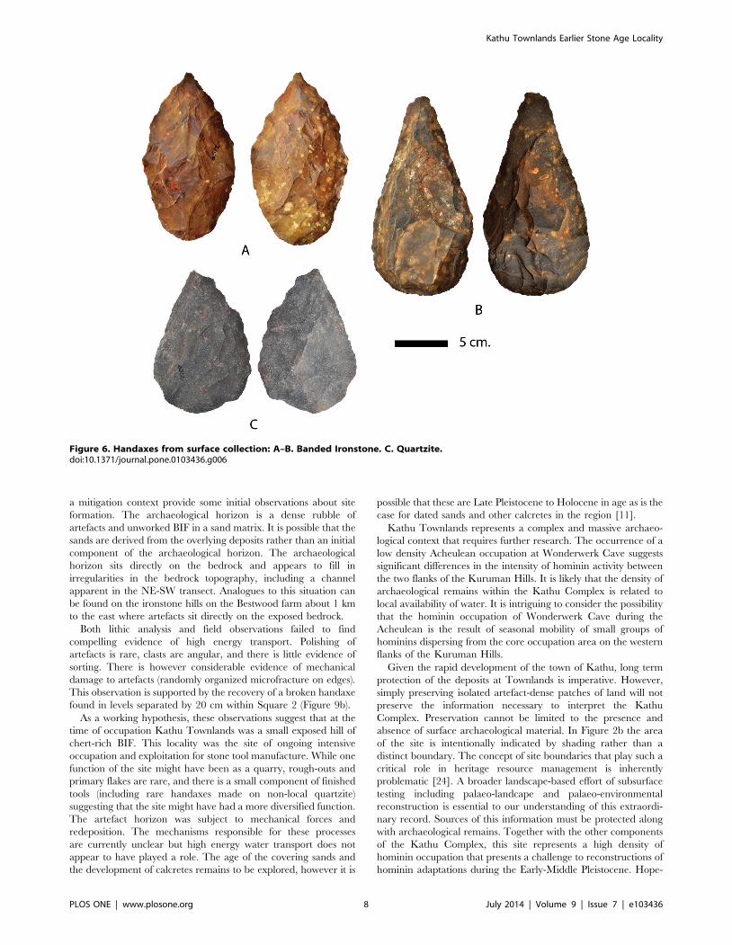
The biface sample from the excavation unit is highly variable in
shape (Figure 5: c–e, Figure 6). By comparison the selected sample
from the surface collection conforms more regularly to the
morphology of pointed handaxes. Handaxes show both large
shaping scars and smaller removals along the edges. None of the
handaxes show scars from arched invasive biface thinning flakes.
Raw material for handaxes is heavily dominated by local BIF,
however rare examples on quartzite are also found (Figure 6c).
ExcavationThe excavated trenches exposed dense artefact deposits mixed
with BIF rubble and sand reaching a maximum depth of 2.2 m in
Trench B. A massive quantity of artefacts was recovered
conforming to Beaumont’s observations. No stratigraphy was
evident within the artefact horizon and artefacts and natural slabs
appear randomly oriented within the profiles (Figure 7: a–b). The
artefact horizon sits directly on bedrock in all units where bedrock
was reached. There is thus an unconformity of over 2 billion years
between the bedrock and the overlying rubble. In most units the
archaeological horizon is overlain by sand mixed with very small
(1–2 cm.), subangular pebbles. The contact between the archae-
ological horizon and the overlying sands is abrupt.
The bedrock topography does not conform to the modern land
surface along the main NE-SW transect (Figure 8). Modern
topography along this transect rises gently from NE to SW but the
bedrock rises sharply between trenches E and D (ca. 1 m rise over
Figure 4. Flakes and cores from Kathu Townlands, Beaumont Excavation. A. Large flake off of the edge of the core consistent with bifaceshaping removal. B. Large flake with centripedal dorsal scars. C. Blade, note that there is some cortex (indicated by C in the sketch) and that scars arenot parallel. D–F. Small flakes, note that F is off the edge of the core. G. Discoidal core with removals off both faces. Break on one edge (upper edge inright view). H. Discoidal core with one large flake removal. Note that on the right hand face the working is unclear and it is possible that this is anatural surface.doi:10.1371/journal.pone.0103436.g004
Kathu Townlands Earlier Stone Age Locality
PLOS ONE | www.plosone.org 6 July 2014 | Volume 9 | Issue 7 | e103436
10 m). The bedrock topography then dips again into a channel
centred on Trench B before rising again in Trenches A and G.
The archaeological horizon appears to fill the irregularities in the
bedrock topography of the channel. Moving to the SE, where the
current topography drops rapidly, the archaeological horizon
thins.
Calcium carbonate concretions (calcretes) develop within the
archaeological horizon at lower elevations (Trenches E and I;
Figure 7: c–d). In trenches J/K and the developer’s trench
calcretes were prevalent although not consolidated into a
continuous horizon as has been documented in other contexts in
the region. The calcretes in these trenches develop within sands
however it appears that aspects of the archaeological horizon are
also incorporated into the calcretes.
Analysis of the archaeological assemblage recovered has not yet
been carried out however a number of field observations provide
insight into the formation of the archaeological horizon. All
artefacts recovered are consistent with an Acheulean age and are
similar to those found in Beaumont’s excavation. Included are a
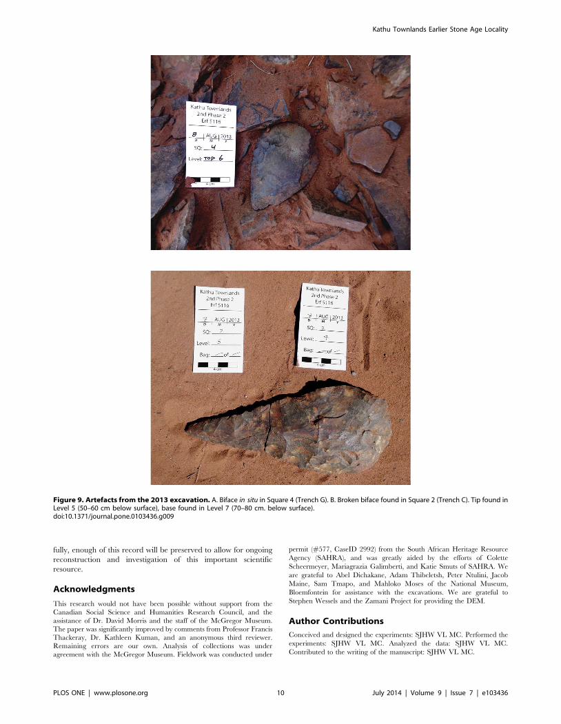
small number of well-made handaxes (Figure 9a). In Square 2 the
pieces of a refitting broken handaxe were recovered; the tip from
Level 5 and the base from Level 7 (Figure 9b). This observation
suggests redeposition of the sediments that make up the
archaeological horizon. During excavation of Square 1 a
prevalence of larger artefacts was noticed in the upper levels (to
a depth of ca. 70 cm), and an excess of smaller debitage in the
lower levels. In Square 2 a large slab of bedrock was encountered
within the artefact horizon, roughly 40 cm above actual bedrock.
Discussion
The Kathu Townlands site is, as previously reported, a massive
deposit of Acheulean artefacts likely the product of the exploitation
of local BIF. Preliminary analysis of lithic material and fieldwork in
Figure 5. Metric attributes of flakes from Beaumont Excavation and bifaces from Beaumont Excavation and Surface collection. A.Frequency of maximum dimension for flakes. B. Frequency of weight for flakes. C–E. Metric attributes of bifaces (based on [25]). Beaumont excavationindicated by solid dot, surface collection by outline dot.doi:10.1371/journal.pone.0103436.g005
Kathu Townlands Earlier Stone Age Locality
PLOS ONE | www.plosone.org 7 July 2014 | Volume 9 | Issue 7 | e103436
a mitigation context provide some initial observations about site
formation. The archaeological horizon is a dense rubble of
artefacts and unworked BIF in a sand matrix. It is possible that the
sands are derived from the overlying deposits rather than an initial
component of the archaeological horizon. The archaeological
horizon sits directly on the bedrock and appears to fill in
irregularities in the bedrock topography, including a channel
apparent in the NE-SW transect. Analogues to this situation can
be found on the ironstone hills on the Bestwood farm about 1 km
to the east where artefacts sit directly on the exposed bedrock.
Both lithic analysis and field observations failed to find
compelling evidence of high energy transport. Polishing of
artefacts is rare, clasts are angular, and there is little evidence of
sorting. There is however considerable evidence of mechanical
damage to artefacts (randomly organized microfracture on edges).
This observation is supported by the recovery of a broken handaxe
found in levels separated by 20 cm within Square 2 (Figure 9b).
As a working hypothesis, these observations suggest that at the
time of occupation Kathu Townlands was a small exposed hill of
chert-rich BIF. This locality was the site of ongoing intensive
occupation and exploitation for stone tool manufacture. While one
function of the site might have been as a quarry, rough-outs and
primary flakes are rare, and there is a small component of finished
tools (including rare handaxes made on non-local quartzite)
suggesting that the site might have had a more diversified function.
The artefact horizon was subject to mechanical forces and
redeposition. The mechanisms responsible for these processes
are currently unclear but high energy water transport does not
appear to have played a role. The age of the covering sands and
the development of calcretes remains to be explored, however it is
possible that these are Late Pleistocene to Holocene in age as is the
case for dated sands and other calcretes in the region [11].
Kathu Townlands represents a complex and massive archaeo-
logical context that requires further research. The occurrence of a
low density Acheulean occupation at Wonderwerk Cave suggests
significant differences in the intensity of hominin activity between
the two flanks of the Kuruman Hills. It is likely that the density of
archaeological remains within the Kathu Complex is related to
local availability of water. It is intriguing to consider the possibility
that the hominin occupation of Wonderwerk Cave during the
Acheulean is the result of seasonal mobility of small groups of
hominins dispersing from the core occupation area on the western
flanks of the Kuruman Hills.
Given the rapid development of the town of Kathu, long term
protection of the deposits at Townlands is imperative. However,
simply preserving isolated artefact-dense patches of land will not
preserve the information necessary to interpret the Kathu
Complex. Preservation cannot be limited to the presence and
absence of surface archaeological material. In Figure 2b the area
of the site is intentionally indicated by shading rather than a
distinct boundary. The concept of site boundaries that play such a
critical role in heritage resource management is inherently
problematic [24]. A broader landscape-based effort of subsurface
testing including palaeo-landcape and palaeo-environmental
reconstruction is essential to our understanding of this extraordi-
nary record. Sources of this information must be protected along
with archaeological remains. Together with the other components
of the Kathu Complex, this site represents a high density of
hominin occupation that presents a challenge to reconstructions of
hominin adaptations during the Early-Middle Pleistocene. Hope-
Figure 6. Handaxes from surface collection: A–B. Banded Ironstone. C. Quartzite.doi:10.1371/journal.pone.0103436.g006
Kathu Townlands Earlier Stone Age Locality
PLOS ONE | www.plosone.org 8 July 2014 | Volume 9 | Issue 7 | e103436
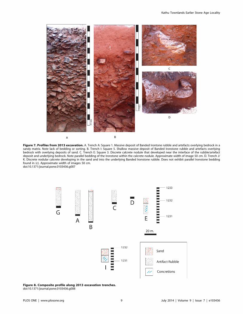
Figure 7. Profiles from 2013 excavation. A. Trench A: Square 1. Massive deposit of Banded Irontone rubble and artefacts overlying bedrock in asandy matrix. Note lack of bedding or sorting. B. Trench I: Square 5. Shallow massive deposit of Banded Ironstone rubble and artefacts overlyingbedrock with overlying deposits of sand. C. Trench E: Square 3. Discrete calcrete nodule that developed near the interface of the rubble/artefactdeposit and underlying bedrock. Note parallel bedding of the Ironstone within the calcrete nodule. Approximate width of image 50 cm. D. Trench J/K. Discrete nodular calcrete developing in the sand and into the underlying Banded Ironstone rubble. Does not exhibit parallel Ironstone beddingfound in (c). Approximate width of images 50 cm.doi:10.1371/journal.pone.0103436.g007
Figure 8. Composite profile along 2013 excavation trenches.doi:10.1371/journal.pone.0103436.g008
Kathu Townlands Earlier Stone Age Locality
PLOS ONE | www.plosone.org 9 July 2014 | Volume 9 | Issue 7 | e103436
fully, enough of this record will be preserved to allow for ongoing
reconstruction and investigation of this important scientific
resource.
Acknowledgments
This research would not have been possible without support from the
Canadian Social Science and Humanities Research Council, and the
assistance of Dr. David Morris and the staff of the McGregor Museum.
The paper was significantly improved by comments from Professor Francis
Thackeray, Dr. Kathleen Kuman, and an anonymous third reviewer.
Remaining errors are our own. Analysis of collections was under
agreement with the McGregor Museum. Fieldwork was conducted under
permit (#577, CaseID 2992) from the South African Heritage Resource
Agency (SAHRA), and was greatly aided by the efforts of Colette
Scheermeyer, Mariagrazia Galimberti, and Katie Smuts of SAHRA. We
are grateful to Abel Dichakane, Adam Thibeletsh, Peter Ntulini, Jacob
Maine, Sam Tmapo, and Mahloko Moses of the National Museum,
Bloemfontein for assistance with the excavations. We are grateful to
Stephen Wessels and the Zamani Project for providing the DEM.
Author Contributions
Conceived and designed the experiments: SJHW VL MC. Performed the
experiments: SJHW VL MC. Analyzed the data: SJHW VL MC.
Contributed to the writing of the manuscript: SJHW VL MC.
Figure 9. Artefacts from the 2013 excavation. A. Biface in situ in Square 4 (Trench G). B. Broken biface found in Square 2 (Trench C). Tip found inLevel 5 (50–60 cm below surface), base found in Level 7 (70–80 cm. below surface).doi:10.1371/journal.pone.0103436.g009
Kathu Townlands Earlier Stone Age Locality
PLOS ONE | www.plosone.org 10 July 2014 | Volume 9 | Issue 7 | e103436
References
1. Lister AM, Dirks W, Assaf A, Chazan M, Goldberg P, et al (2013) New fossil
remains of Elephas from the southern Levant: Implications for the evolutionaryhistory of the Asian elephant. Palaeogeogr Palaeoclimatol Palaeoecol 386: 119–
130.2. Stiles D, Hay R, O’Neil J (1974) The MNK chert factory site, Olduvai Gorge,
Tanzania. World Archaeol 5: 285–308.
3. Barkai R, Gopher A, La Porta PC (2002) Palaeolithic landscape of extraction:Flint surface quarries and workshops at Mt Pua, Israel. Antiquity 76: 672–680.
4. Petraglia M, LaPorta P, Paddayya K (1999) The first Acheulian quarry in India:stone tool manufacture, biface morphology, and behaviors. J Anthropol Res 55:
39–70.
5. Kuman K (2001) An Acheulean Factory Site with Prepared Core Technologynear Taung, South Africa. S Afr Archaeol Bull 56, 8–22.
6. McNabb J, Beaumont P (2011a) A Report on the Archaeological Assemblagesfrom Excavations by Peter Beaumont at Canteen Koppie, Northern Cape,
South Africa. In: University of Southampton Series in Archaeology 4. Oxford:Archaeopress. 86.
7. McNabb J, Beaumont P (2011b). Excavations in the Acheulean Levels of the
Earlier Stone Age Site of Canteen Koppie, Northern Cape Province, SouthAfrica. Proc. Prehist. Soc. 78: 51–71.
8. Knoll AH, Beukes NJ (2009) Introduction: Initial investigations of a Neoarcheanshelf margin-basin transition (Transvaal Supergroup, South Africa). Precambri-
an Res 169: 1–14.
9. Altermann W, Siegfried HP (1997) Sedimentology and facies development of anArchaean shelf: carbonate platform transition in the Kaapvaal Craton, as
deduced from a deep borehole at Kathu, South Africa. J Afr Earth Sci 24(3):391–410.
10. Nash DJ, McLaren SJ (2003) Kalahari valley calcretes: their nature, origins, andenvironmental significance. Quat Int 111: 3–22.
11. Bateman MD, Thomas DSG, Singhvi AK (2003) Extending the aridity record of
the Southwest Kalahari: current problems and future perspectives. Quat Int 111:37–49.
12. Matmon A, Ron H, Chazan M, Porat N, Horwitz LK (2012) Reconstructing thehistory of sediment deposition in caves: A case study from Wonderwerk Cave,
South Africa. Geol Soc Am Bull 124: 611–625.
13. Porat N, Chazan M, Grun R, Aubert M, Eisenmann V, et al (2010) Newradiometric ages for the Fauresmith industry from Kathu Pan, southern Africa:
Implications for the Earlier to Middle Stone Age transition. J Archaeol Sci 37:269–283.
14. Wilkins J, Chazan M (2012) Blade production ,500 thousand years ago at
Kathu Pan 1, South Africa: support for a multiple origins hypothesis for early
Middle Pleistocene blade technologies. J Archaeol Sci 39: 1883–1900.
15. Wilkins J, Schoville BJ, Brown KS, Chazan M (2012) Evidence for Early Hafted
Hunting Technology Science 338: 942–946.
16. Chazan M, Wilkins J, Morris D, Berna F (2012) Bestwood 1: a newly discovered
Earlier Stone Age living surface near Kathu, Northern Cape Province, South
Africa. Antiquity 86: 331.
17. Chazan M, Porat N, Sumner TA, Horwitz LK (2013) The use of OSL dating in
unstructured sands: The archaeology and chronology of the Hutton Sands at
Canteen Kopje (Northern Cape Province, South Africa). Archaeol Anthropol
Sci 5(4): 351–363.
18. Chazan M, Avery M, Bamford MK, Berna F, Brink J, et al (2012) The Oldowan
horizon in Wonderwerk Cave (South Africa): Archaeological, geological,
paleontological and paleoclimatic evidence. J Hum Evol 63 (6): 859–866.
19. Berna F, Goldberg P, Horwitz LK, Brink J, Holt S, et al (2012) Microstrati-
graphic evidence of in situ fire in the Acheulean strata of Wonderwerk Cave,
Northern Cape province, South Africa. Proc Natl Acad Sci 109 (20): E1215–
E1220.
20. Beaumont PB (1990) Kathu Townlands 1. In: Beaumont PB, Morris D, editors.
Guide to archaeological sites in the Northern Cape. Kimberley: McGregor
Museum. 96–97.
21. Beaumont PB (2004) Kathu Pan and Kathu Townlands/Uitkoms. In: Morris D,
Beaumont PB, editors. Archaeology in the Northern Cape: Some Key Sites.
Kimberley: McGregor Museum. 50–53.
22. Thackeray F, Thackeray A (1980) National Monuments Council Permit Per/1/
231: Report on an archaeological survey of the central northern Cape Province.
Permit Report on file at the South African Heritage Resources Agency.
23. Walker SJH, Chazan M, Lukich V, Morris D (2013) A second Phase 2
archaeological data recovery at the site of Kathu Townlands for Erf 5116:
Kathu, Northern Cape Province. A Permit report by the Archaeology
Department, McGregor Museum. Available at: http://www.sahra.org.za/
heritage-reports/kathu-townlands-erf-5116-second-phase-2-report.
24. Dunnell RC (1992) The Notion Site, in: Rossignol, J. & Wandsnider, L (Eds.),
Space, time, and archaeological landscapes: Interdisciplinary contributions to
archaeology. Plenum Press, New York, 21–41.
25. Roe DA (1964) The British Lower and Middle Palaeolithic: Some Problems,
Methods of Study and Preliminary Results. Proc. Prehist. Soc. 30: 245–267.
Kathu Townlands Earlier Stone Age Locality
PLOS ONE | www.plosone.org 11 July 2014 | Volume 9 | Issue 7 | e103436