Java Upwelling Variations Observation (JUVO) Plan for the Cruise in Mar. 2015
12
Java Upwelling Variations Observation (JUVO) Plan for the Cruise in Mar. 2015 Prepared by The First Institute of Oceanography, SOA, China Institute for Marine Research and Observation, AMFDR, Indonesia 10 March, 2015
-
Upload
independent -
Category
Documents
-
view
2 -
download
0
Transcript of Java Upwelling Variations Observation (JUVO) Plan for the Cruise in Mar. 2015

Java Upwelling Variations Observation (JUVO)
Plan for the Cruise in Mar. 2015
Prepared by
The First Institute of Oceanography, SOA, China Institute for Marine Research and Observation, AMFDR, Indonesia
10 March, 2015

Content 1. JUVO Background
1.1 Overview of the collaborative project JUVO
1.2 JUVO development in line with Indian Ocean Observing System (IndOOS)
2. Scope of work for the cruise in Mar. 2015
2.1 Cruise Outline
2.2 Equipment arrangement
2.3 Vessel arrangement
2.4 Visa arrangement

Cruise Dates : 28 March - 06 April 2015 Participant Scientists:
Tab. 1 List of participants from China
No. Name Nationality Passport
1 Huiwu Wang China P01674395
2 Wei Wu China P01674396
3 Qinglei Su China PE0575517
4 Kuiping Li China PE0022610
5 Yanliang Liu China P01639536
6 Sen Zhang China
Tab. 2 List of participants from Indonesia
No. Name Nationality Institution
1 Teguh Agustiadi Indonesia BPOL - KKP
2 Mukti Trenggono Indonesia BPOL - KKP
3 Bayu Priyono Indonesia BPOL - KKP
4 M. Arief Rahman Indonesia BPOL - KKP
5 Gusti Putu Sukadana Indonesia BPOL - KKP
6 I Nyoman Surana Indonesia BPOL - KKP
7 Irwan Djatmiko Indonesia LPPT - KKP
8 Andi Bahtiar Indonesia LPPT - KKP
9 Asep Priatna Indonesia BPPL - KKP
10 Muhammad Fadli Indonesia Mahasiswa ITB
11 Sugiarto Adi Wibowo Indonesia Mahasiswa UNSOED
12 Rizky Mahriza Utami Indonesia Mahasiswa UNPAD
13 Faeza Amella Adiany Indonesia Mahasiswa UNPAD
14 Security Officer Indonesia

1. JUVO Background
This program outlines an effort to measure the magnitude and variability of
the Java upwelling by deploying a subsurface ADCP mooring system location
(106.75E, 8.5S) and a surface buoy system at location (100E, 8S). The upwelling off
the coast of Java is hypothesized to play a major role in the Indian Ocean Dipole
(IOD), an anomalous climate event similarly to the El Niño in the tropical Pacific
Ocean. The Java upwelling controls the southeast tropical Indian Ocean (TIO) sea
surface temperature (SST) variations at seasonal and inter-annual time scales, which
further affects the local and remote climate.
Despite the importance of the Java upwelling to the regional ocean circulation and
climate, there has been no present field measurement of this upwelling. A strong
seasonal variability of the Java upwelling due to the summer monsoon forcing might
strongly affect the upper ocean conditions and the ocean-atmosphere interaction over
the eastern Indian Ocean. It was suggested that the Java upwelling variations could
cause a strong SST cooling in southeastern TIO in some years and it further develops
into the significant climate anomalies, i.e. IODs. IODs have profound climate and
social-economical impacts on both the Indian Ocean nearby countries and remote
areas through atmospheric tele-connection. These climate anomalies are extremely
important to Indonesia, especially in the dry/wet weather conditions. To understand
the role of Java upwelling on the ocean-atmosphere coupled anomalies and test the
above hypotheses, the long-term monitoring of the upwelling variations off the coast
of Java is essentially necessary.
Through this collaborative observation, FIO and AMFRD jointly contribute to
the ongoing international program “Indian Ocean Observing System (IndOOS)”,
which is under the coordination of CLIVAR1-GOOS2 Indian Ocean Panel. The
mooring and buoy under this implementation agreement are also part of RAMA buoy
array, which is the critical component of IndOOS.
1CLIVAR - Climate Variability and Predictability 2GOOS – Global Ocean Observing System

1.1 Overview of the collaborative project JUVO
Based on the common interests on the Java upwelling observation and research,
the First Institute of Oceanography (FIO), State Oceanic Administration (SOA),
China, and Agency of Marine and Fishery Research and Development (AMFRD),
Indonesia, agreed to jointly carry out the subsurface mooring observation in the Java
upwelling region and signed the implementation agreement for the research program
Java Upwelling Variations and impacts on seasonal fish migration (JUV), in
Haikou/China on Dec. 11, 2006. JUV project is amended to further include one
surface buoy observation at (100E, 8S) and this addendum is signed in Qingdao on
Sep. 3, 2008.
The purpose of JUVO is to develop the long-term in-situ observing capability
over the Java upwelling region, understand the impacts of the Java upwelling on
regional ecosystem, and identify the role of Java upwelling in the Indian Ocean
climate system.
Under the joint efforts of FIO and AMFRD, JUVO project runs successfully. Up
to now, 12 joint cruises have been conducted. The subsurface mooring started its work
from Dec. 2008 and the surface buoy is send back the real time meteorology and
oceanic date from May 30, 2010.
1.2 JUVO development in line with Indian Ocean Observing System (IndOOS)
Despite the important role of the Indian Ocean for African-Asian-Australian
monsoons, climate variability in regions surrounding the Indian Ocean, and its impact
on global climate change through atmospheric tele-connections, a long-term,
sustained observing system in the Indian Ocean had not been started as of about a
decade ago, leaving the Indian Ocean as the least observed ocean among the three
major basins. Recognizing this observation-gap, an enthusiastic spirit emerged after
the OceanObs99 meeting, resulting in the development of the Indian Ocean Observing
System (IndOOS) under the coordination of the CLIVAR/GOOS Indian Ocean Panel.
IndOOS is a multi-platform long-term observing system, which consists of Argo
floats, surface drifting buoys, tide gauges, a surface mooring buoy array, VOS based
XBT/XCTD sections, and satellite measurements as a backbone observation for sea
surface conditions (International CLIVAR Project Office, 2006). The main platform
for in situ observations in the tropical region is the surface and subsurface mooring
array, called as Research moored Array for African-Asian-Australian Monsoon

Analysis and prediction (RAMA) (McPhaden et al., 2009). The RAMA array consists
of a total of 46 moorings, of which 38 are ATLAS/TRITON-type surface moorings. In
addition to these surface buoys, there are 5 subsurface ADCP moorings along the
equator to observe current profiles in the upper equatorial ocean, and 3 deep current-
meter moorings with ADCPs in the central and eastern equatorial regions.
JUVO project maintains one subsurface mooring at (106.75E, 8.5S) and one
surface buoy at (100E, 8S), which are essential components of RAMA/IndOOS.
2. Scope of work for the cruise in Mar. 2015
Following the past 12 JUVO cruises, FIO and AMFRD now successfully maintain
the Java upwelling mooring at (JUV station = 106.75E, 8.5S) and southwest tropical
Indian Ocean buoy at (RAMA station = 100E, 8S). In order to continue the
operational service of the mooring and buoy, FIO and AMFRD will jointly carry out
the 13th cruise in Mar. 2015. The expected cruise time is 10 days. FIO and AMFRD
will share the ship time fees. AMFRD will cover 5 days of ship time fee and FIO will
cover 5 days of ship time fee.
2.1 Cruise Outline
The planned cruise in Mar. 2015 will focus on the following activities (Fig.1),
(1) Service the Java mooring at the location (JUV station = 8°30´S, 106°45´E) by
deploying a replace system;
(2) Recovery the buoy at the location (RAMA station = 8°S, 100°E) deployed in
Apr. 2015;
(3) Carry out the CTD casts to measure the temperature and salinity profile, water
sample, plankton and juvenile larvae at some specified stations (Tab.3) along
the cruise track.
(4) Carry out the glider cast to measure the temperature and salinity profiles of upper 300 m
at real-time mode. The glider will be deployed at the location (GS station = 8°30´S,
106°45´E) with its destination at the location (GF station = 7°06´S, 103°00´E),
and it will be recovered there.

Fig. 1 The planned cruise track and stations
Tab.3 List of the CTD, Biosonic, Water Sample, Plankton and Juvenile Larvae Station
Station
Number.
Latitude Longitude Water
Depth(m)
ST.01 8o30'S 106o45'E 1920
ST.02 8o15'S 103o00'E 5764
ST.03 8o00'S 100o00'E 5672
ST.04 7o51'S 100o30'E 5569
ST.05 7o42'S 101o00'E 5417
ST.06 7o33'S 101o30'E 5213
ST.07 7o24'S 102o00'E 5529
ST.08 7o15'S 102o30'E 6349
ST.09 7o06'S 103o00'E 3261
ST.10 7o00'S 103o20'E 2735
ST.11 6o54'S 103o40'E 2177
ST.12 6o48'S 104o00'E 1839
ST.13 6o42'S 104o20'E 1995
ST.14 6o36'S 104o40'E 1185
ST.15 6o30'S 105o00'E 467

2.2 Equipment arrangement
FIO will provide the mooring system to be deployed at location (JUV station =
106.75E, 8.5S) and glider. The mooring system includes the oceanography
instruments listed in Tab. 4 – Tab. 7. FIO will take care of the equipment
shipment from Qingdao to Jakarta and pay for the necessary clearance and
service fee occurred in Qingdao and in Jakarta. AMFRD will provide the
necessary local assistance on the clearance and transportation of the equipments. Tab.4 Meteorology sensors mounted on the Surface Buoy System (RAMA)
Name Number Parameters to measure
1 Gill Ultrasonic Wind Sensor 1 Wind speed and direction
2 RM Young Self-Siphoning Rain Gauge 1 Precipitation
3 Rotronic Relative Humidity and Air Temperature sensors
1 Relative Humidity and Air Temperature
4 Heise DXD Barometric Pressure 1 Sea surface pressure
5 Eppley PIR Long Wave sensor 1 Solar longwave radiation
6 Eppley PSR Short Wave sensor 1 Solar shortwave radiation
Tab.5 Oceanography instruments mounted on the taut-line of the Surface Buoy System
(RAMA)
Name Number Parameters to measure Nominal depth
1 SeaBird-37 CT 7 Temperature Salinity
0m, 10m, 20m, 40m, 60m, 80m, 100m
2 SeaBird-39 T 3 Temperature 120m, 140m, 500m
3 SeaBird-39 TD 3 Temperature Pressure
200m, 300m, 700m
4 RDI DVS 4 Current speed Current direction
10m, 20m, 40m, 100m
Tab.5 Satellite positioning and data transmission instruments
on the Surfce Buoy System (RAMA)
Name Number Function
1 Argos antenna 1 Positioning
2 Iridium antenna 2 Data transmission
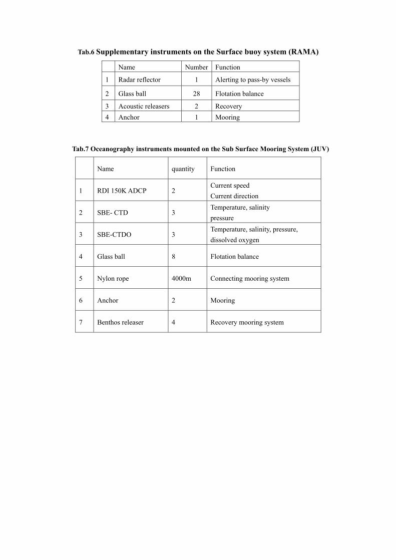
Tab.6 Supplementary instruments on the Surface buoy system (RAMA)
Name Number Function
1 Radar reflector 1 Alerting to pass-by vessels
2 Glass ball 28 Flotation balance
3 Acoustic releasers 2 Recovery 4 Anchor 1 Mooring
Tab.7 Oceanography instruments mounted on the Sub Surface Mooring System (JUV)
Name quantity Function
1 RDI 150K ADCP 2 Current speed Current direction
2 SBE- CTD 3 Temperature, salinity pressure
3 SBE-CTDO 3 Temperature, salinity, pressure, dissolved oxygen
4 Glass ball 8 Flotation balance
5 Nylon rope 4000m Connecting mooring system
6 Anchor 2 Mooring
7 Benthos releaser 4 Recovery mooring system

Fig 2. Configuration of subsurface mooring (JUV)

Fig 3. Configuration of surface buoy (RAMA)

2.3 V
FIO s
water
moor
and t
opera
AMF
proce
2.4 V
AMF
RIST
requir
Emba
Vessel arran
suggests th
r multi-beam
ing and buo
the CTD w
ation status b
RD will tak
edure.
Visa arrange
RD will pr
TEK Indones
red docume
assy in Beiji
ngement
hat R/V BJ-
m system on
oy deploym
winch onbo
before the c
ke care of th
ement
repare the i
sia for the C
ents to AM
ing.
-1 be used
nboard R/V
ment. FIO al
oard R/V B
cruise.
he vessel ar
invitation l
Chinese par
MFRD, and w
for the M
V BJ-3 is es
so suggests
BJ-1 be ch
rrangement
etters and
rticipants (T
will collect
ar. 2015 cr
ssentially im
s that the qu
hecked and
t through its
confirmatio
Tab. 3). FIO
t the Visas
Coordi
Teguh A
ruise. The d
mportant for
uarterdeck c
set into g
s administra
on documen
will submi
from Indon
inator
gustiadi
deep
r the
crane
good
ation
nt of
it the
nesia