
JAKARTA: a Resilient Asian Cosmopolitan City
28
JAKARTA: a Resilient Asian Cosmopolitan City By Johannes WIDODO National University of Singapore [email protected] Southeast Asian cities, which developed around the “Mediterranean of Asia” (coastal areas around South China Sea, Java Sea, and Malacca Strait) since the beginning of inter-insular and inter- continental trades from the 1 st century until today, are formed by complex layers of various cultures, ideologies, economics, and ecosystems, manifested in the hybridity of urban morphologies & architectural typologies, and complex social-cultural fusions. One of the important urban nodes in that context was Sunda Kelapa, a small port city at the north- western coast of Java, which later would develop into bigger emporium called Jayakarta. It was then colonized by the Dutch and named Batavia, and since 1950 it is called Jakarta. Jakarta has been growing rapidly from a small town into a megacity in a relatively short period of time since 1950s, and in parallel also the growing social and environmental problems. The article introduces the physical morphogenesis of this cosmopolitan city, and the complex problems it suffers today. It will also try to uncover the intangible sociological and cultural layers of the city, to understand the basic ingredients for its sustainability and resilience, which is needed for the survival of the city and its communities towards the future. Pre-Colonial Port City of Sunda Kelapa and Jayakarta (12 th century – 16 th century) The urban history of the city started since the twelfth century as one of the port cities of Hindu Pajajaran kingdom called Sunda Kelapa, located on the northern coast of western Java at the estuary of Ciliwung River. Although it was on the international trading routes but it could not compete with its rival, the older port city of Banten. When Melaka was conquered by the Portuguese in 1511, these port cities in Java benefited from increased patronage by Muslim traders who boycotted Melaka 1 . Banten was growing into a major emporium mainly because of the pepper trading. These port cities enjoyed a relative freedom from the weakening inland kingdom which attracted the rising Islamic power in Demak (central Java) to expand their hegemony westward on the 16 th century. In order to defend itself from the Muslims, Banten made a treaty with the Portuguese for protection in exchange of unlimited access to pepper trade and the right to construct a fortress on the coast near Tangerang eastward of Banten in 1552 2 . But in 1524, Nurullah (Fatahillah, Faletehan, Sunan Gunung Jati, or Syarif Hidayatullah) led the Demak army to defeat the inland power center at Banten Girang and to start the conversion of Pajajaran into Islam from there. In 1527 Fatahillah’s son Hasanuddin attacked and occupied the port cities of Banten and Sunda Kelapa. On June 22 nd , 1527 Fatahillah renamed the city Jayakarta (in Sanskrit, means “Victorious City”) 3 . In the early seventeenth century the population of Jayakarta was about 10,000 people 4 . The Chinese sugar industry has been established in Jayakarta since around 1602 5 . 1 Abeyasekere 1989: 5 2 Guillot, Ambary, Dumarcay 1990: 17 3 This date was officially declared as the birthday of Jakarta. [Surjomihardjo 1977: 10-11] in 1956. 4 Abeyasekere 1989: 6 5 Chang 1954: 208-209
Transcript of JAKARTA: a Resilient Asian Cosmopolitan City

JAKARTA: a Resilient Asian Cosmopolitan City By Johannes WIDODO National University of Singapore [email protected] Southeast Asian cities, which developed around the “Mediterranean of Asia” (coastal areas around South China Sea, Java Sea, and Malacca Strait) since the beginning of inter-insular and inter-continental trades from the 1st century until today, are formed by complex layers of various cultures, ideologies, economics, and ecosystems, manifested in the hybridity of urban morphologies & architectural typologies, and complex social-cultural fusions. One of the important urban nodes in that context was Sunda Kelapa, a small port city at the north-western coast of Java, which later would develop into bigger emporium called Jayakarta. It was then colonized by the Dutch and named Batavia, and since 1950 it is called Jakarta. Jakarta has been growing rapidly from a small town into a megacity in a relatively short period of time since 1950s, and in parallel also the growing social and environmental problems. The article introduces the physical morphogenesis of this cosmopolitan city, and the complex problems it suffers today. It will also try to uncover the intangible sociological and cultural layers of the city, to understand the basic ingredients for its sustainability and resilience, which is needed for the survival of the city and its communities towards the future. Pre-Colonial Port City of Sunda Kelapa and Jayakarta (12th century – 16th century) The urban history of the city started since the twelfth century as one of the port cities of Hindu Pajajaran kingdom called Sunda Kelapa, located on the northern coast of western Java at the estuary of Ciliwung River. Although it was on the international trading routes but it could not compete with its rival, the older port city of Banten. When Melaka was conquered by the Portuguese in 1511, these port cities in Java benefited from increased patronage by Muslim traders who boycotted Melaka1. Banten was growing into a major emporium mainly because of the pepper trading. These port cities enjoyed a relative freedom from the weakening inland kingdom which attracted the rising Islamic power in Demak (central Java) to expand their hegemony westward on the 16th century. In order to defend itself from the Muslims, Banten made a treaty with the Portuguese for protection in exchange of unlimited access to pepper trade and the right to construct a fortress on the coast near Tangerang eastward of Banten in 15522. But in 1524, Nurullah (Fatahillah, Faletehan, Sunan Gunung Jati, or Syarif Hidayatullah) led the Demak army to defeat the inland power center at Banten Girang and to start the conversion of Pajajaran into Islam from there. In 1527 Fatahillah’s son Hasanuddin attacked and occupied the port cities of Banten and Sunda Kelapa. On June 22nd, 1527 Fatahillah renamed the city Jayakarta (in Sanskrit, means “Victorious City”)3. In the early seventeenth century the population of Jayakarta was about 10,000 people4. The Chinese sugar industry has been established in Jayakarta since around 16025.
1 Abeyasekere 1989: 5 2 Guillot, Ambary, Dumarcay 1990: 17 3 This date was officially declared as the birthday of Jakarta. [Surjomihardjo 1977: 10-11] in 1956. 4 Abeyasekere 1989: 6 5 Chang 1954: 208-209

The Dutch arrived straight from Europe in a firm intention to take over control over spice trade from the Portuguese, the ally of the Sultanate of Banten6. In 1601 a big naval battle between the Dutch and the Portuguese erupted in the bay of Banten, and the Portuguese was defeated. In 1603 VOC (the Dutch East India Company) established its first trade office in Banten under contract with the local ruler. Around 1608-1610 the VOC's activity in Benten was growing7, and the company attempted to monopolize the trade and repeatedly tried to seize power from the local ruler, but they failed. Finally the Dutch left to Jayakarta in 1619, and Banten was gradually fading from history.
<Figure 1: Morphological model of Jayakarta> The city of Jayakarta had two main urban segments: a Chinese settlement on the east side of the river and the native town on the west bank of the river. The oldest8 Chinese temple “Anxu Dabogong Miao” (Dabogong temple of Ancol)9 is located to the east of the old Batavia near the current Tanjong Priok harbor. A stone inscription from 1923 noted that “It was founded at the end of the Ming dynasty”, but according to Teisseire (1792) the temple was constructed in 1650 “above the grave of a Muslim saint”. Three Islamic tombs: two under the main altar are of Sam Po Soei Soe’s (Zheng He follower) & his local wife (a Sundanese princess), and the other one is of the princess’ father (Embah
6 Guillot, Ambary, Dumarcay 1990: 26-27 7 Tjandrasasmita 1975: 357 8 Salmon & Lombard 1985, 16-17 9 Salmon, Claudine and Siu, Anthony K.K. (eds.), “Chinese Epigraphic Materials in Indonesia”, Vol. 1, pp. 23-35

Said Dato Kembang). Until today the temple is continuously used as the place of worship for both Chinese and Muslims. Pork is prohibited to be offered or consumed within the compound. At the town center on the west bank of the Ciliwung River the residence of the prince of Jayakarta (under the Sultanate of Banten) was located next to the town square ("Alun-Alun"). A mosque was located on the west side of the town square. The urban pattern of the native segment followed the Javanese town planning pattern10 based on Hindu Mandala principle. The native settlement was also extended across the east bank of the river southward of the Chinese settlement. The port of Jayakarta provided drinking water, timber for ship repair, and rice wine ("arak") produced by Chinese settlers to the visiting international traders. The town was surrounded by a wooden palisade with both canals and road as transportation means. The Dutch East-Indies (VOC) City of Batavia (1619-1799) In 1610, the Dutch under Jaques 1'Hermite was given permission by the prince of Jayakarta to open a trade post for the V.O.C11, and they were given a piece of land on the east bank of Ciliwung river near the pre-existed Chinese settlement12. The piece of land given to the Dutch was located right on the sea shore. The first building they constructed here was called "Nassau", a stone structure and used as warehouse and residence13. The settlement of Jayakarta where the native prince lived was located upstream on the western side of the river. The Dutch desperately needed to have a trade headquarter in the Indonesian archipelago, also a main port to build and to repair their ships, to rest and to get provisions, to store goods, and to place an administrative canter. The center should be closed enough to the main trading route near to Melaka and to the strait of Sunda14. They called Jayakarta as Jacatra. In 1615 the Dutch was permitted to build a two stories stone structure 1615, but later in 1618 it was converted into a fort without permission from the local prince15. In 1618 VOC’s headquarter was moved from Banten to Jayakarta, after their effort to monopolize Banten market had failed. The increasing cooperation between the VOC and the Chinese to monopolize the international trade had received negative responses from the native and the British. On May 30, 1619 the VOC army defeated the joint forces of the native and British. The VOC army completely razed the native town and court, an all indigenous inhabitants fled away16. A small Fort Jacatra was constructed, but soon it was considered as too small and a bigger castle was soon planned by Jan Pieterzoon Coen, the first Governor General of Batavia. The castle of Batavia17 was constructed on the east side of the mouth of Ciliwung River. The name “Stad Batavia” was officiated by the VOC on March 4th, 162118. The government offices, dwellings for VOC officials, army barracks, a small church, and some warehouses were built inside the castle. The Batavia’s harbor was located on the outer side of the wall, well protected by dots of small islands on the bay. The port facilities were also developed across the river on the western bank of the estuary. 10 Abeyasekere 1989: 6 11 Blusse 1988: 32 12 De Vries 1988: 8 13 Cobban 1976: 46 14 Abeyasekere 1989: 8 15 Reid 1988: 72 16 Abeyasekere 1989: 12 17 Batavia is the name of the legendary ancestor of the Dutch nation. 18 Abeyasekere 1989: 12

The new southward expansion of European fortified settlement was created on the east riverbank, with a town square (a market), a church, and a city hall. It was connected by a bridge to the newly re-developed settlement area on the west riverbank. The southern terrain outside the city walls was still covered by a thick jungle and some strong stream rivers19. The Chinese were permitted to settle down inside the city walls. From 1619 to 1740 the Chinese run the economic affairs of Batavia; it was a Chinese town under Dutch colonial protection20.
<Figure 2: Morphological transformation of Jayakarta (left) to Batavia in 1619 (right)> In 1628-1630 the army from central Javanese kingdom Mataram joined forces with the Banten army attacked Batavia. But their attempt to seize the city was failed, because the VOC armada managed to cut their sea logistic line. The harassment from Banten towards Batavia continued until fifty years later, even after the ceasefire in 1639. The Chinese planter who settled and worked around the outer side of the city wall was continuously attacked by native robbers. During these turbulent years the urban pattern of Batavia was rationalized. The eastern fortification was straightened and the west bank area was re-developed following the grid pattern. The built up area of Batavia remained to be concentrated on the east bank of the river, but the infrastructure for future development had been laid out throughout the planned area.
19 Blusse 1988: 33-34 20 Abeyasekere 1989: 24

<Figure 3: The morphological transformation of Batavia in 1628 (left) and 1650 (right)> By 1645, the fortification work had been completed f or the two halves of the town on the east and west banks of Ciliwung River. The VOC workshops were moved to the southeast corner of the town, and the main wharf building was erected on the opposite bank of the river21. The square city with a gridiron pattern of 2,250 meter long and 1,500 meter wide was built within the perimeter wall with 22 bastions and four gateways with lever bridges, which was completely finished in 1660. Batavia appeared as a Dutch canals city, similar to Amsterdam. The plan was based on Simon Stevin’s22 ideal city pattern inspired by Saint Augustine’s book, “De Civitate Dei” (the City of God) written in the 5th century. On the east side of the river the Dutch built their luxurious villas and the civic center, while the west side was for the Chinese and Portuguese settlements, market, warehouses, and industries. The native settlements and their farms were allocated outside the city wall.
21 Abeyasekere 1989: 15 22 Simon Stevin (1548-1620), a Flemish mathematician and military engineer

<Figure 4: Simon Stevin’s ideal city plan (left) and its projection to the Batavia city plan in 1650 (right)> The city was divided into two parts by Ciliwung River, and on each part two north south parallel canals were dug. The coast line was progressing towards the sea, caused by rapid sedimentation process. Ciliwung River was straightened and turned into the main canal intersecting the city center. Some smaller canals orthogonally crossed the main canals and the river. The roads, each of which was about nine meters wide, were built alongside these waterways, modeled after the morphology of Amsterdam. The empty lands on the west bank and southern tip of the city had also been developed. Towards the end of the seventeenth century the Chinese settlements had populated the southern and western suburbs, the areas containing many streets of small shop houses. In 1619 the numbers of Chinese in Batavia was about 400 people23, and in 1629 were raising five-folds to 2,00024. During that period several Chinese temples had already existed in Batavia. An official record from 1650 noted that a Chinese temple in the town was destroyed, and another one in outer side of the southern wall was converted into rampart, following a campaign against paganism. But soon afterwards four new temples were built; two of them still exist until today25. In 1648 Molenvliet canal with parallel roads on both sides was constructed by Pang Ming-yan, a Chinese Captain, in order to power the sugar mills southward the city26 and to be used for boats to
23 Cator 1936: 11-13 24 Chang 1954: 205 25 Jin De Yuan temple was the oldest temple in Batavia, founded in 1650 and completed in 1669. The temple was originally dedicated to Mazu (the goddess protector of sailors and immigrants) but then converted to Guanyin (the Buddhist Goddess of Mercy), and used as a monastery since the seventeenth century. 26 Salmon and Lombard 1985: 15

travel to southern hinterland, and to float timber from the woods near Fort Rijswijk27. Chinese immigrant workers were used for the construction of Batavia. The Chinese settlements continuously expanded to the south outside the city walls.
<Figure 5: Batavia (1650)> In 1656 a war with Banten was broke again. Ten sugar factories and 23 brick factories were destroyed by them. To prevent further destructions and troubles, the VOC built defensive walls to protect different settlement areas of non-European groups outside the city. Five fortifications were built within the distance of an hour walk from the city in Ancol eastward, in Angke westward, and in Jakarta, Wilgenburg, and Rijswijk southward. Rice and vegetables farms, and also sugar cane fields were planted alongside the interconnecting network of roads and canals from one fort to another28. Even though the peace treaty with Banten had been signed in 1659, peace was not achieved until 1670. From 1660 fast hinterland outside the city were divided into plots and sold to the Europeans, who employed slaves to cultivate it, or rented out their property to the Chinese. The more remote lands were reserved for the native elites. In 1680 the second stage of fortification networks were built in Tangerang westward, in Tanjungpura eastward, and in Meester Cornelis southward, to defend an area by 20 kilometers range from the old city. The new outstretched area was the cultivation land for sugar cane plantations29. Due to progressive sedimentation process, the coast line had already moved several hundred meters forward, and around 1672 an urban expansion plan on the new land was drawn and implemented by the Governor General Van der Parra. New jetties were constructed on the estuary, and new
27 Greig 1987: 172 28 Blusse 1988: 36 29 Blusse 1988: 36
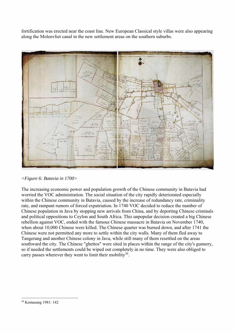
fortification was erected near the coast line. New European Classical style villas were also appearing along the Molenvliet canal in the new settlement areas on the southern suburbs.
<Figure 6: Batavia in 1700> The increasing economic power and population growth of the Chinese community in Batavia had worried the VOC administration. The social situation of the city rapidly deteriorated especially within the Chinese community in Batavia, caused by the increase of redundancy rate, criminality rate, and rampant rumors of forced expatriation. In 1740 VOC decided to reduce the number of Chinese population in Java by stopping new arrivals from China, and by deporting Chinese criminals and political oppositions to Ceylon and South Africa. This unpopular decision created a big Chinese rebellion against VOC, ended with the famous Chinese massacre in Batavia on November 1740, when about 10,000 Chinese were killed. The Chinese quarter was burned down, and after 1741 the Chinese were not permitted any more to settle within the city walls. Many of them fled away to Tangerang and another Chinese colony in Java, while still many of them resettled on the areas southward the city. The Chinese "ghettos" were sited in places within the range of the city's gunnery, so if needed the settlements could be wiped out completely in no time. They were also obliged to carry passes wherever they went to limit their mobility30.
30 Kemasang 1981: 142

<Figure 7: Chinese massacre in Batavia (1740)> During and after this chaotic period the economy of Batavia fell into chaos, but the Chinese community in Batavia remained steadfast. In 1799 a special area outside the city wall in Weltevreden area31 was specially provided for the Chinese community to build their new settlement. The new location was previously owned by a VOC landlord who rented his vast land to be cultivated by sugar cane, vegetable farms, and rice fields, by the expelled Chinese. In 1733 the property was sold to Justinus Vinck, who was granted permission by the VOC to build Tanah Abang and Senen markets there. An interesting phenomenon was occurred among the Chinese community during and after the oppression period that was a wave of conversion into Islam. From 1759 the converts were not considered as Chinese anymore and were regarded as native, and thus free from personal taxation. From 1770 until 1827 special Captains was appointed to control this special Chinese-Muslim community. A mosque, presently known as Mesjid Krukut was built by them, followed by two other mosques, Mesjid Kebun Jeruk and Mesjid Tambora. Moslem tombs with Chinese cenotaph can still be found in both Kebon Jeruk and Tambora mosques. The pulpit in Mesjid Krukut was made by a Chinese woodcarver in 179232. From 1650 until 1800 at least 13 Chinese temples were erected in Batavia and its surrounding areas33. By the end of eighteenth century the inner city of Batavia had been fully develop, filled with Dutch style buildings. In 1795 Dutch was formed an alliance with the French in the "Bataafsche Republiek", which was in continuous war with the British until 1815. In 1799 VOC was declared bankrupt and its authority was taken over by the Dutch central government from January 1st 1800.
31 Presently known as Gambir 32 Salmon and Lombard 1985: 20 33 ibid: 98

<Figure 8: Batavia by the end of VOC era in 1780> The New Batavia and Brief British Administration (1800-1816) At the beginning of the Dutch administration period, the old city of Batavia was badly deteriorated, and some parts of the perimeter walls were ruined. Some canals were filled in and turned into roads. The ecological condition of the old city of Batavia was deteriorating, caused by heavy pollution of the rivers, crisis in clean water supply, and the spread of endemic diseases.

This grave situation forced the Dutch to move their city center further south to a new location called Weltevreden34 in 1808. This move was carried out by the new Governor General Herman Willem Daendels35. Complete destruction of the perimeter wall and the filling in of canals by the order of Daendels were carried out in 180936. Almost all buildings in the old town were demolished and the materials were reused to build the new city southward. The old city was not rebuilt again until the early twentieth century, when the commercial center was redeveloped as a new layer on top of the old city ruins. Weltevreden became the new urban center, and because the government needed a lot of money to develop the new city, the Chinese and other foreigners were permitted to buy new properties in the new city and also were given the opportunity to buy deserted buildings in old Batavia. New Chinese quarters ("Pecinan") were emerged in the urban economic centers of the new city in Pasar Baru, Tanah Abang, and Senen37. Governor General Daendels was given a special mandate to organize the island defense against the possibility British naval attack. For this purpose he ordered the construction of the first inter-regional road along the northern coast of Java from Anyer at the western corner to Panarukan at the eastern tip of Java, known as the Great Post Road ("Groote-postweg"). This road became very important primary element at regional level to integrate the important urban centers along Java, which would promote a strong economic growth and the development of new cities38 in the next historical periods.
<Figure 9: The Great Post Road and British attack of Java (1811)> In 1811 Daendels was replaced by General Janssens. Just two months after Janssens took over the office as Governor General in Batavia, the British Navy attacked and defeated the Dutch force in Meester Cornelis, Batavia39 on August 27th, 1811. The remaining Dutch force retreated to Semarang by the post road, and finally surrendered unconditionally in Ungaran, a small town southward of 34 Presently known as Gambir area 35 Hamdan 1990: 16 36 Blusse 1988: 41-45, 51-52 37 Hamdan 1990: 16-18 38 New towns and cities would appear and develop at regular intervals around every posts along the road, where a station for resting, changing horses, and resting was located. 39 Presently known as Jatinegara

Semarang in central Java on September 11th, 1811. On October 19, 1811 Sir Thomas Stamford Raffles was appointed as the Lieutenant Governor General in Batavia under Lord Minto, the British Governor General in Calcutta. Java was under the British control until 1816. During this short British administration period, a Chinese temple called Li Tie-guai was erected in 181240. According to Crawfurd in 1814 the Chinese population was 11,854 or 25% of the total population of Batavia41. This conflict had given a good opportunity for the Chinese to regain their economic strength and dominance in Batavia and other urban areas, and also to gain control over vast plantation in the hinterland thanks to favorable British taxation policy.The British brief administration period was ended in 1816 as the result of the Dutch-British treaty in London, by which Dutch became an independent kingdom, and the previously known as Dutch East India would be called "Nederlandsch Indie". The rise of the Dutch Colonial city (1816 - 1900) In 1821 a travel restriction ("Passenstelsel") was applied to all including the Europeans, but in reality the tight control was merely applied to the Chinese group. Around 1841 until 1915 the settlement restriction ("Wijkenstelsel") was applied to the Chinese population. They had to settle in certain areas and every Chinese who lived outside these areas should move into the designated settlement quarters. Many Chinese who had already lived in rural areas declared themselves as native in order to avoid the regulation. In reality there were many poor Chinese had to settle down outside the designated Chinese quarters since they could not afford to buy or to rent property there. In 1848 a special court for Chinese population ("Politierol") was formed to punish the violators without necessarily following a proper justice procedure.42 The other non-European minority groups, such as the Arabs (Yemeni or Hadrami), were also living in specific quarters within the city and community leaders were appointed as the larger Chinese community. Since the British administration period, the Chinese in Java continuously and actively collaborated with the colonial authorities to collect various taxes from the native through the toll gates especially in inland central Java. The Java War led by Prince Diponegoro from Javanese court broke in Central Java from 1825 until 1830 as the consequence of this exploitation. The war had taken a lot of Chinese lives, because the Chinese sided with the Dutch. The mutual relationship between the Chinese and the native has been damaged and turned into racial distrust since then, and would continually be tarnished by frequent and violent racial conflicts. The taxation policy was modified after the war, and the Chinese was prohibited to interfere and to settle in the villages43. Starting from the mid nineteenth century, after the Dutch had managed to consolidate their power in Java, they began to expand their control towards other islands outside Java. A large number of Dutch emigrated from Europe to the Netherlands Indies and took over some large Chinese concessions44. On the meantime the southern China mainland had been troubled by the Taiping rebellion against the Manchu dynasty (1850-1865), instigated by exploitation and mass pauperization of the common people45. This disturbance in mainland China had prompted a large influx of poor Chinese refugees
40 Salmon and Lombard 1985: 98 41 ibid: 24 42 This unjust institution was finally abolished in 1915. 43 Carey 1985: 78-79 44 Salmon and Lombard 1985: 26 45 Tan 1986: 38-39. The Taiping rebellion erupted in the mid-19th century led by Hong Xiuquan who established a cult of Hakka Christianity. It swept across 16 provinces and destroyed more than 600 cities in Southern China. It was suppressed

and the defeated Hakka rebels to Nanyang (South Seas), including Java, to find a better life. In 1893 the number of Chinese in Batavia was 26,569 out of 110,669 total populations (about 25%), most od them were Fujianese and Hakka.
<Figure 10: General model of Batavia in 1885> By mid-19th century two main clusters of urban settlements were formed: the old town of Batavia and the new town of Weltevreden where the majority of European population settled. The built up area developed rapidly around the second nucleus. The Colonial Empire style was widely used for the new spacious mansions in the Weltevreden area: simple single story buildings with colonnaded galleries and minimal ornamentation, uniformly painted white. Vast rice fields and spots of forests encircled the urban fringe of Batavia. The swampy coastal land continually expanded due to sedimentation. The old harbor of Batavia had become too shallow and too small to accommodate the expanding trade. Small boats had to ferry goods from large vessels anchored further on the sea into the city through the shallow canals. To overcome this problem the new sea port of Tanjung Priok was built on the northeastward of the city. Batavia at the end of nineteenth century had become a cosmopolitan port city with large harbor facility. The city had a minority of Europeans (mostly Dutch) and a large numbers of Chinese foreign population, co-existed with the other foreign minorities and various ethnic communities coming from all parts of Indonesian archipelago living in urban “kampungs” (inner pockets, fringes, and rural hamlets).
by the Manchu imperial forces after 14 years, and during that chaotic period a large number of Chinese refugees created mass immigration to the South Seas.

Early Modernization of the city (1900-1942) The administrative area of Batavia in 1900 was 2,600 hectare, more than 400 times its area in 1621 which was then only 6.1 hectare. The total population of Batavia was about 100,000. On April 1st 1905 the city was officially named “Gemeente Batavia” following the implementation of the decentralization law in Netherlands Indies. In 1906 the first City Major of Batavia and members of the city council were appointed to administer the city. In 1916 the local parliament (or "Volksraad") was formed, to whom the Governor General should present his plans for approval. The aim of the implementation of the decentralization law was to obtain an autonomous province status under the Kingdom of Netherlands, but serious efforts to achieve this target had never been carried out46.
<Figure 11: Dual administrative system for semi-autonomous municipalities (early 20th
century)> This divisive city governance system had created a social and morphological segregation within the urban area. The municipality administration only took care the planning and service of the “formal” population (the European and Eastern Foreigners (and some native elites), such as Chinese and Arabs), while the “informal” native communities were not being taken care seriously by the Mayor. This disparity led into the “formal-informal” divide, social-cultural split, racial-religious conflicts, and economic inequality, which stays until today. 46 Hanna 1988: 199-200

Batavia’s built up area grew rapidly, fueled by the high economic growth. Thanks to the implementation of the socialism inspired Ethical policy by the colonial government, a large portion of investments was channeled for the provision of social services, new schools, and hospitals for the urban population. New housing areas were planned around the central square (Koningsplein) to accommodate the rapid population growth. Koningsplein became the civic center of Batavia, where all important buildings were located. It was the center of the political nerve of the Netherlands Indies government. Several new European residential suburbs (Gondangdia, Menteng) were developed by eviction and demolition of the native kampungs.
<Figure 12: Batavia in 1921>

By 1930s the reputation of Batavia as "the Queen of the East" was famous all over the world. The European and Chinese settlements were modern, clean, and green, with the wide main roads covered by asphalt. The increasing volume and diversity of vehicular traffic such as car, electrical trams, bicycle, and horse carts had not yet caused congestion problems. Poverty was rampant but in general the image of Batavia was a healthy, secure, and peaceful city47. Batavia Centrum, the beautifully renovated area of the old Batavia, and the area around Koningsplein became the places where modern civic and economic activities were concentrated. Even though the air quality of the old Batavia remained unhygienic, but this area grew into the prestigious business and commercial center. The administrative boundary of Batavia was extended outside Weltevreden to Gondangdia and Menteng housing areas, to include new dwelling areas with large and beautiful boulevards, where the prominent Dutch, Chinese and Indonesian lived in large mansions48. Batavia expanded further southward to Meester Cornelis (Jatinegara) town. The entire built up area of the city was bordered by eastern and western railway systems. Jatinegara was the point where south bound and east bound railways met, and from there branched into 3 routes: to the city center, to the harbor, and further to the west. The city was renamed “Stad Gemeente Batavia” in January 8th, 1935. According to the census in 1930 the total population of Batavia was 435,00049, of which 16.47% was the Chinese population50. The global economic depression around 1930s had affected the majority of urban population in Java, especially the Chinese and Indonesian who lived in the colonial cities in the small-scale or informal sectors of the economy51. The economic stagnation had also hit the industries, generated severe problems redundancy and its complications, made life in the cities more difficult for unskilled or low skilled labors. During this difficult period the urban built up area of Batavia had continuously grown southward, followed the triple parallel north-south inter-regional railway systems. In fact the modernization of Urban Batavia was only superficial; the kampungs were swelling both inside and around the city52. This over-densification process led into environmental disasters and degradation of public health conditions for the whole city. The deterioration of the urban environment had forced the colonial municipality governments to abandon their racial segregation policy and to launch infrastructure improvement programs in urban sanitation and utilities for the benefit of all community groups, such as the implementation of new building regulations and urban planning, Kampong Verbetering (improvement program) and the urban renewal plans in some Indonesian cities (e.g. Batavia, Semarang, Surabaya). The first round of kampung improvement programs were carried out in 1930s to improve the public health condition of the inner-city by improving and providing basic infrastructures. But this attempt had been stalled by the severe economic recession. Technological revolutions in many aspect of daily life such as electricity, gas, telephone and telegraph, newspapers, banks, post office, public transportation, had been transforming Batavia into modern multi-functional city in a very short span of time. A new international airport (Kemayoran) was opened on the northeastern corner of the city. The road network had been expanded, widened
47 Hanna 1988: 209-211 48 Hanna 1988: 211-212 49 Abeyasekere 1989: 88 50 Milone 1966: 108, 122 51 Ingleson 1988: 292-309 52 Abeyasekere 1989: 88-94

and upgraded, to accommodate the explosion of vehicular traffic (motorcars, bicycles, and becaks53). Harbors were enlarged or upgraded, some industrial estates were developed, and the central business districts in the city centers were rejuvenated. Trade fairs were organized to accommodate the rapid growth in local and international commerce and trade. Many fresh ideas from modern urban planners and architects were manifested into city plans, urban designs, and modern-functional-tropical Art Deco architectural styles. A lot of hopes and idealism were put into the transformation and the future of the cities in Southeast Asia, including Batavia, but the global economic recession and the two World Wars which raged in the first half of twentieth century terminated these dreams. New political movements for independence and urban riots against the colonial powers proliferated all over the region. The economic recession and social-political instability had stopped some urban development projects and had left many parts of the city in deteriorated and dilapidated condition. Japanese urban legacy (1942-1945) The Second World War and the invasions of the Japanese Imperial army into East Asia and Southeast Asia gave the final blow to end the colonialism history in Southeast Asia, and changed the course of urban history and morphology of this region. Under the Japanese occupation, the city was named “Jakarta Tokubetsu-shi” since August 8th, 1942. The short 3.5 years of Japanese administration has left a long lasting legacy on the urban management system, especially in Java. It was the implementation of the “Tonarigumi” system, which was introduced in Japan under the Tokugawa Shogunate as means of surveillance and control system. Under this system, some house units/numbers (“Go” -号) were organized as a neighbourhood block (“Ban” -番), and some neighbourhood blocks formed a district (“Chome” -丁目). This structure served the purpose as an effective administrative, organization, defence, control, and security system. After independence, the system has been adopted into the city administration system and remains until today. “Ban” is now called “Rukun Tetangga” (RT), and “Chome” is “Rukun Warga” (RW). These “RT/RW” units remain as the informal structure to connect with the official/formal city administration.
53 Pedicabs. Japanese called it “jin-riki-sha” (man-powered cart).

<Figure 13: Example of a neighborhood map in Jakarta (RT 004, RW 014, Kelurahan Pisangan Baru)54> Post-Independence Modernist City (1945-1967) Soon after the declaration of Indonesia independence on August 17th 1945, Jakarta was named “Pemerintah Nasional Kota Djakarta” (National Government of Jakarta City) in September 1945 by the new Republic of Indonesia government. But the Dutch did not recognize Indonesian independence and used military action in trying to regain control over its former colony after the defeat of the Japanese. The period of 1945 to 1949 was marred by guerrilla wars and urban battles. Soekarno, the first president of the Republic of Indonesia, had to temporarily move the capital to Yogyakarta in central Java on January 4th 1946. Jakarta survived this period with crumbling infrastructure, old building stocks, and worsening social-environmental conditions. For some time the urban development in Jakarta stagnated because of the political instabilities since Indonesia had to negotiate with Holland for full independence. The official transfer or sovereignty to the United States of Indonesia from the Kingdom of Netherlands was on December 27th 1949, following the Round Table Conference. Jakarta was called “Stad Gemeente Batavia” again from February 20th 1950 until it is changed again to “Kota Praja Jakarta” on March 24th 1950. Kebayoran Baru new-town, which has been developed since the Dutch administration period (1948), was completed in 1955 as the southwest expansion of Jakarta. The urban planning was influenced by the Garden City idea, and directed by a Dutch educated Indonesian architect and urban planner, Soesilo, who used to study and work under Thomas Karsten, an architect-engineer and protagonist of
54 Source: http://erteempat.files.wordpress.com/2010/03/peta-rt-004-ok-baru-banget-01.jpg?w=560&h=577 (accessed on June 21, 2014)

the tropical architecture and urban design based on local climate, culture, and architectural vocabularies in Indonesia he promoted in the 1930s.
<Figure 14: Jakarta in 1952. Kebayoran Baru is on the lower left corner, airport Kemayoran is the circular form on middle right side, and Tanjung Periuk harbor is on the upper right side corner >

The first architecture (building and urban planning) school in independent Indonesia was established in 1950s, when the Department of Building or Bouwkunde Afdeling was first opened as part of the Faculty of Engineering Sciences at the University of Indonesia in Bandung (pioneered by Jacob Thijsse, M. Soesilo, and F. Silaban), which was the precursor of ITB (Bandung Institute of Technology). Nine years later, the first generation of eighteen architectural engineers graduated from that school. Some Indonesian architects went for further study abroad, mostly to west- and east-European countries. They returned and introduced the ideology of modernism, functionalism and socialism to Indonesian urban planning and architecture. These new generation of Indonesian architects were active during the euphoria of nation-building period which was dominated by Soekarno’s nationalistic policy and mega-projects (hotels, department stores, offices, mosques, monuments, flyover, sport centre, recreation centre, etc.).
<Figure 15: Construction Senayan stadium (1962), designed by Russian architect and engineer, for the GANEFO (Games of New Emerging Forces)>
Some big projects were financed under the Japanese War Reparation scheme (1951-1966)55
in Jakarta were Hotel Indonesia (built by Kinoshita and Taisei corporations), Wisma Nusantara (by Kinoshita, Taisei, and Kajima), and Sarinah Department Store (by Itoh and Obayashigumi). These were among the first high-rise buildings constructed in soft and earthquake prone area, which benefitted those Japanese construction firms with valuable technical knowledge for their construction 55 Masashi Nishihara, The Japanese and Soekarno’s Indonesia: Tokyo-Jakarta Relations 1951-1966. Monographs of the Center for Southeast Asian Studies, Kyoto University (Honolulu: University Press of Hawaii, 1975).

of high-rise buildings in Tokyo and other Japanese cities afterwards. Jakarta contributed substantially in this experimentation.
<Figure 16: Hotel Indonesia (left) and Sarinah Department Store (right) (1969)> It was during the Cold War polarization, that an alternative political movement emerged. In 1955, the 1st Afro-Asian Conference (Bandung Declaration, forming the Non-Aligned movement) was held, a unique culmination of the anti-colonial agenda led by number newly independent nations. Indonesia, a key member of this new grouping soon translated its fiery spirit of independence and anti- colonialism into the hot spirit of nation building. This was an exciting period when architectural design and aesthetics gave way to tropical architectural concepts (sun-shading, projected eaves, cross-ventilation, etc.) by working with modern building materials such as stronger concrete, glass, and steel in rational and functional ways. The Spirit of the Age was firmly Rational-Socialistic Modernism: in its own way breaking away from colonialism & neo-colonialism by following a more contemporary identity through the International Style. Friedrich Silaban’s defined the tenets and purpose of Architectural Idealism: buildings had to be responsive to people’s needs, and the tropical climate. Architectural purism was needed for the sake of people and country. Good Architecture’s orthodoxy was about simplicity, efficiency, clarity, durability - all underpinned by low maintenance and low cost. This was a direct response to the economic difficulties and crisis faced by Indonesia. Amidst Soekarno’s anti western policies and speeches, especially against “American pop-culture” represented by Hollywood, science fiction, popular and sometimes anti-establishment movies (such as James Dean’s “Rebel Without a Cause”, “Batman”, “Flash Gordon”, etc.), music (“Rock-n-Roll”),

fashion (“Atom” - strangely associated to plastic accessories, blue-jeans, long hair) and design products (such as the Chevrolet Impala, bicycles, radios, etc) flourished. While some Asian governments like Indonesia and Singapore considered these cultural waves a threat and often tried to ban or to crush them, these modernist undercurrents persisted and gradually began to dominate the landscape of popular culture. Once aspect of counter culture was seen in modern architectural design; the so called Jengki style taken from the local terminology for Yankee, in reference to American pop-culture. This particular style gained rapid popularity among Indonesia’s spirited architects and builders as they began designing private and public building projects across Indonesia. Perhaps the combination of a diverse set of factors, such as conflicting ideologies, strong desire of freedom, hidden subversive spirits, the desire to look good despite the economic woes, and dreaming of private utopias, all landed on fertile ground that would allow the development of a Creative-Subversive culture that gave momentum to an unique but short lived modern Indonesian architectural style in the early 50s and 60s. On January 18th 1958 the municipal city was renamed “Kota Pradja Djakarta Raja” (or the municipality of greater Jakarta). The special capital administrative government of Jakarta was formed in 1961, and the city was then called “Daerah Khusus Ibukota Djakarta Raja” (the capital special region of greater Jakarta) on August 31st 1964.
The making of a megacity (1967-2000s)
The Soekarno’s era ended in 1966 and was called “Old Order” since then, and “New Order” under Soeharto began. The three decades of national development policy from 1966 to 1998 was energized by a boom in oil production and export sectors, facilitated by the institutionalization of five-year National Development Plans, free-market enterprise, and ersatz capitalism. These factors have invigorated the rapid development of infrastructure, building, and construction sectors. Socioeconomic divisions between the rich and the poor and between cities and villages grew wider and were often the source of conflict and spatial contestation.
Beginning in the early 1970s, large-scale urban development projects were constructed in the capital (such as Ancol, Krekot, Senen, Grogol), superimposing new functional blocks onto the old urban fabric, destroying many historic buildings and areas. National efforts to provide public housing could not keep up with the exploding demand, and the National Housing Corporation (Perumnas) only managed to build limited numbers of low-cost mass housing estates (featuring basic sites and services, core housing, walk-up apartments). To deal with worsening environmental conditions in inner-city dwelling enclaves, the government implemented the Kampung Improvement Program (KIP), but this mainly dealt with infrastructure improvements. Overpopulation in Java prompted the government to build new settlements in scarcely populated islands outside Java for migrants. Jakarta has been given status as a special province in 1999, and called “Provinsi DKI Jakarta” (the province of the capital special region of Jakarta) with 5 municipalities (Central-, North-, East-, South-, and West- Jakarta) and one administrative region (Kepulauan Seribu islands on the northern bay of Jakarta). Large scale housing and new-town projects are mushrooming west-, east- and southwards of Jakarta, fuelled the large scale speculative developments in the greater regional expansion area of JABOTABEK (Jakarta – Bogor – Tangerang – Bekasi). The growth of the city within the radius of 10 kilometres was in a relatively slow pace for 350 years (from 1619 to 1950s),

then accelerated to reach the radius of 15 kilometres in just 25 years (1950 to 1975), followed by the explosive growth into a megacity scale until today.
<Figure 17: New towns in JABOTABEK region in 199056> Unfortunately, the current rapid economic growth has accelerated the cultural and physical transformation process, often leading to the fragmentation and destruction of old urban fabrics and resulting in the loss of identity and cultural amnesia. The layers of urban history and shared heritages which kept the shared memory of the whole community for many generations and centuries have been forgotten, and in many cases these have been erased completely, to be replaced with new alien pathological forms and functions. ‘Corporate style’ high-rise architecture in concrete, steel and glass now dominates the skyline in the Jakarta central business district, back-to-back with the high-density, low-rise sprawl of urban kampongs, or slums settlements. The city has been overwhelmed by traffic jam, air pollution, persistent flooding, shortage of energy and clear water, over-densification, widening social-economic divisions, soaring crime rates, worsening living and environmental conditions, dysfunctional city administration and management, corruptions, etc., culminating in the worst and bloody urban riots which abruptly end the 32 years of Soeharto era in 1998. The period following the “New Order” era is known as “Reformation”, when the people reject authoritarian rules and prefer freedom of speech in a more democratic system. However the euphoria of reformation did not last long. Megacity Jakarta’s land area is only 0.03% of the total area of Java, while Java is only 7% of the total land area of Indonesia, but 50% of the total Indonesia population
56 Source: Cribb, Robert. Historical Atlas of Indonesia. London: Curson, 2000. Fig.2.69. p.68

of 238 million (2010)57 lived in Java. Jakarta remains as the economic and power centre of Indonesia, and has to carry the burden of the national economic growth and its consequences.
<Figure 18: Proportion of population in Java and outside Java (upper) and territorial proportion of Jakarta and Java (lower)> The most interesting latest development in Jakarta is the election of the new Governor in 2012, which is unprecedented in the city governance history and paradigms. The internet revolution followed by the wide-spread use of social media platforms (such as Facebook, Twitter, Youtube, Blogs, etc.) especially by the younger generation have been generating the wave of radical changes against the old establishments, and demanding social-economic justice, transparency, accountability, and radical improvement of urban living conditions. The elected Governor Joko Widodo (popularly known as “Jokowi”) and his deputy Basuki Tjahaya Purnama (“Ahok”), a combination of Muslim-Javanese and Christian Hakka Chinese leaders, have launched an unprecedented series of new policies to embrace e-governance and to eradicate corruption, speeding up the construction of 57 Indonesia has the 4th largest population in the world after China, India, and USA. The top four estimation for 2025: China 1,458,000,000, India 1,398,000,000, USA 352,000,000, and Indonesia 273,000,000.

multiple public transportation systems (busway, monorail, MRT), tackling the flooding problems (cleaning up rivers and lakes from garbage, sediments, and illegal constructions), relocating the illegal street markets and parking which caused traffic jam into proper facilities, organizing festivals and developing creative centers, etc. The hope to have a “New Jakarta” has been flaring up, providing enormous energy to launch Jakarta (and Indonesia) into a better and more livable cosmopolitan city.
<Figure 19: Two “after and before” examples of drastic transformation of Jakarta by Governor Joko Widodo: Tanah Abang market (left), and Pluit Reservoir (right) during his first year administration (Source: www.merdeka.com)> Postscript The city is a dynamic source of identities for a place where great civilizations met, collided, and blended. It is like a complex web made of different elements and colors, but yet integrated as a continuous and coherent fabric. This richness and complexity is formed in a historical continuum from past to present. Modernization process does not develop in a vacuum, but in different aspects of specific contexts – natural, environmental, social, cultural, physical, and historical. Modernization is a structural process in a formal, environmental and cultural sense. It is a continuous socio-cultural process of transplantation, adjustment, adaptation, accommodation, assimilation, hybridization, and materialization – manifested in the myriad forms of architectural and urban production and reproduction, in both tangible forms and intangible ways. Therefore an inter-disciplinary approach and strategic coalition of all stake holders are necessary in effectively dealing with the current issues and problems. To ensure continuity and sustainability we need to empower the ordinary members of the community through education and continuous engagement. Designers, academics, scholars, trainers, professionals have special role as facilitators in community education through various ways. They should help the community to respect and to be sensitive to their own legacy, to teach them in understanding the existing ordinary fabrics and artifacts, to train them in discovering their own history and traditions, and to maintain the values and to promote the contemporary appropriation of their own inheritance.

As has been demonstrated in the 500 years of Jakarta’s continuous urban evolution, layering processes and its ups-and-down, it is clear that the soul and energy that make the city alive, survive, and prosper is the spirit of cosmopolitanism and resilience of its people. By preserving and nurturing the city’s long tradition in cultural diversity and inclusive creativity, the city’s memory, identity, continuity, and prosperity are well assured – that will provide the people with creative energy and resilience to cope with the rapid changes and often unpredictable challenges for many generations forward. BIBLIOGRAPHY Abeyasekere, Susan. Jakarta: A History. Singapore: Oxford University Press, 1989 Akihary, Huib. Architectuur & Stedebouw in Indonesie 1870/1979. Zutphen: De Walburg Pers, 1988 Ali, R. Mohammad, and F. Bodmer. Djakarta through the Ages. Jakarta: The Government of the capital city
of Djakarta, 1969. Blusse, Leonard. Persekutuan Aneh: Pemukim Cina, Wanita Peranakan dan Belanda di Batavia VOC.
Jakarta: Pustaka Azet, 1988. Blusse, Leonard. Strange Company: Chinese settlers, Mestizo women and the Dutch in VOC Batavia.
Dordrecht: Foris Publications, 1988. Bogaers, Erica. Ir. Thomas Karsten en de Ontwikkeling van de Stedebouw in Nederlands Indie 1915-1940.
Amsterdam, 1983. Carey,Peter. Orang Jawa dan Masyarakat Cina,1755-1825. Jakarta: Pustaka Azet, 1985. Cator, W.L. The Economic Position of the Chinese in the Netherlands Indies. Chicago: 1936. Chang, Tsuen-Kung. Historical geography of Chinese settlement in the Malay Archipelago. Ann Arbor: Mich.
University, 1954. Cobban, James L. “Geographic notes on the first two centuries of Djakarta.” Chapter 5 in Y. M. Yeung and
C.P. Lo (eds.), Changing Southeast Asian Cities: Readings on Urbanization. Singapore: Oxford University Press, 1976.
Coppel, Charles A., Hugh Mabbett, and Ping-ching. The Chinese in Indonesia, the Philippines and Malaysia. Report No. 10 (revised edition). London: Minority Rights Group, 1982.
De Graaf, Hermanus Johannes and G.Th. Pigeaud. Chinese Muslims in Java in the 15th and 16th centuries: the Malay Annals of Semarang and Cerbon. Monash Papers on Southeast Asia No. 12. Edited by M. C. Ricklefs. Melbourne: Monash University, 1984.
De Vries, J. J. Jakarta tempo doeloe. 3rd ed. Abdul Hakim, ed. Jakarta: Pustaka Antarkota, 1988. Translation of sections from J. J. de Vries, Jaarboek van Batavia en omstreken (Weltevreden, 1927).
Djajadiningrat, Hussein. Tinjauan kritis sejarah Banten. Jakarta: Jambatan, 1983. Graaf, Hermanus Johannes de, and Theodore Gauthier Thomas Pigeaud. Kerajaan-kerajaan Islam pertama di
Jawa : kajian sejarah politik abad ke-15 dan ke16 / oleh H.J. de Graaf dan G.Th. Pigeaud ; dengan kata pengantar Soemarsaid Moertono. Jakarta : Grafitipers , 1989.
Graaf, Hermanus Johannes de, and G.Th. Pigeaud (translators), and M. Ricklefs (editor). Chinese Muslims in
Java in the 15th
and 16th
centuries: The Malay Annals of Semarang and Cerbon. Monash Papers on Southeast Asia No. 12. Monash: Monash University, 1984.
Greig, Doreen. The Reluctant Colonist: Netherlanders Abroad in the 17th and 18th Centuries. Assen/Maastricht: Van Gorcum, 1987.
Guillot, Claude, in association with Hasan M. Ambary and Jacques Dumarcay. The Sultanate of Banten. Jakarta: Gramedia Book Pub. Division , 1990.
Hall, Daniel George Edward. A History of South-East Asia. 4th edition. London: Macmillan, 1994. Hall, Daniel George Edward. History of South-East Asia. 4th edition. Basingstoke, Hants.: Macmillan , 1981. Hall, Kenneth R. Maritime Trade and State Development in Early Southeast Asia. Honolulu: University of
Hawaii Press, 1985. Hamdan, Zaidani (et.al.). Segitiga Senen: Sejarah dan Perubahan Sosial Orang-Orang Cina. Jakarta: Sarana

Jaya, 1990. Hamilton, Walter. The East India Gazetter. Volume I, 2nd edition, London, 1828. Heuken, Adolf. Historical Sites of Jakarta. Jakarta: Cipta Loka Caraka, 1982. Ingleson, John. “Urban Java during the Depression”. Journal of Southeast Asian Studies. Volume XIX, No. 2,
September 1988. Iskandar, Paul Livel. Pecinan di Jakarta: Studi Transformasi Karakteristik Lingkungan. Unpublished Seminar
of Architecture paper. Bandung: Department of Architecture, Parahyangan Catholic University, 1989. Keifitz, N. “The Ecology of Indonesian Cities”. American Journal of Sociology. No. 66. 1961. Kuryana, Wuryani. Sejarah Perkembangan Kawasan Pecinan Jakarta Kota Serta Kemungkinan
Pemugarannya. Unpublished Seminar on Architecture paper. Bandung: Department of Architecture, Parahyangan Catholic University, 1989.
Kusumawijaya, Marco. Thamrin – Sudirman Avenue, Jakarta: A Case Study in the Problems of Modernization in a Developing Metropolis. Unpublished Master of Architecture Thesis. Leuven: The Post Graduate Centre Human Settlements, KU Leuven, 1990.
Ma Huan. Ying-yai Sheng-lan – The Overall Survey of the Ocean’s Shores [1433]. Bangkok: White Lotus Press, 1997.
Yeung, Y.M. and Lo, C.P. (editors). Changing South-East Asian Cities: Readings on Urbanism. Singapore: Oxford University Press, 1976.
Michrob, Halwany. A Hypothetical Reconstruction of the Islamic City of Banten. Indonesia, 1987. Milone, Pauline Dublin. “Contemporary Urbanization in Indonesia”. Yeung Y.M. and Lo C.P. (editors).
Changing South-East Asian Cities: Readings on Urbanism. Singapore: Oxford University Press. 1966. Milone, Pauline Dublin. Urban Areas in Indonesia: Administrative and Census Concepts. Berkeley: Institute
of International Studies, University of California. 1966. Nas, Peter J.M., editor. “The Indonesian City: Studies in Urban Development and Planning”, Verhandelingen
van Het Koninklijk Instituut voor Taal-, Land- en Volkenkunde. No. 117. Dordrecht: Foris Publications. 1986.
Nas, Peter J.M. “The Early Indonesian Town – Rise and Decline of the City-State and Its Capital”. Nas, Peter J.M. (editor), The Indonesian City: Studies in Urban Development and Planning. Verhandelingen van Het Koninklijk Instituut voor Taal-, Land- en Volkenkunde. No. 117. Dordrecht: Foris Publications. 1986.
Nio Joe Lan. Riwayat 40 Taon dari Tiong Hoa Hwe Koan - Batavia 1900-1939. Batavia, 1940. Noguchi, Hideo. “Historical Cities and Architecture in Jakarta, Indonesia”. East Asian Cultural Studies.
Volume XXIX. No. 1-4. Kyoto: The Centre of East Asian Cultural Studies, March 1990. Purcell, Victor. The Chinese in Southeast Asia. Second edition. Kuala Lumpur: Oxford University Press, 1981. Raffles, Thomas Stamford, Sir. The history of Java. London: John Murray, 1830. Redfield, R. and M. Singer. “The Cultural Roles of Cities”. Economic Development and Cultural Change. No.
12. 1954. Reed, Robert R. “Indigenous Urbanism in South-East Asia”. Changing South-East Asian Cities: Readings on
Urbanization. Singapore: Oxford University Press, 1976. Reid, Anthony. Southeast Asia in the Age of Commerce 1450-1680. Volume one: The Lands Bellow the Winds.
New Haven: Yale University Press, 1988. Reid, Anthony. Southeast Asia in the Age of Commerce 1450 – 1680. Volume two: Expansion and Crisis.
New Haven: Yale University Press, 1993. Salmon, Claudine and Anthony K.K. Siu, editors. Chinese Epigraphic Materials in Indonesia. Vol I-II-III.
Singapore: South Seas Society, 1997. Salmon, Claude and D. Lombard (authors), Adolf Heuken (translator). Klenteng-Klenteng Masyarakat
Tionghoa di Jakarta. Jakarta: Yayasan Cipta Loka Caraka, 1985. Saputra, Ifa. Sejarah Arsitektur Kota Banten Lama, Suatu Kajian Arsitektural Kota Banten Lama Menjelang
Abad XVI sampai Abad XX. Unpublished Seminar on Architecture paper. Bandung: Department of Architecture, Parahyangan Catholic University, 1989.
Surjomihardjo, Abdurrachman. Pemekaran Kota Jakarta – The Growth of Jakarta. Jakarta: Penerbit Djambatan, 1977.
Suryadinata, Leo. Politik Tionghoa Peranakan di Jawa 1917-1942. Jakarta; Pustaka Sinar Harapan, 1986. Tjandrasasmita, Uka and Hasan M. Ambary. Banten Lama dan Peninggalannya Sebagai Pusat Kesultanan.

Jakarta: Direktorat Jenderal Kebudayaan, Departmen P&K, 1983/1984. Tjandrasasmita, Uka (et.al.), Sartono Kartodirdjo (et.al.) (editors). Sejarah National Indonesia III. Jakarta:
Department Pendidikan dan Kebudayaan, 1975. Van Diessen, J.R. and R.P.G.A. Voskuil. Stedenatlas Nederlands-Indie. Purmerend: Asia Maior, 1998 Van Goor, J. (editor). Trading Companies in Asia, 1600-1830. Utrecht: Hes Uitgevers, 1986. Voskuil, R. P. G. A. Batavia: beeld van een stad. Houten: Fibula/Unieboek bv., 1989. Weerzien Met Indie Nr. 7. Handel. Amsterdam: Waanders Uitgevers & Tropenmuseum, 1994 Weerzien Met Indie Nr. 14. Eten end Drinken. Amsterdam: Waanders Uitgevers & Tropenmuseum, 1994. Weerzien Met Indie Nr. 15. Kapers op de Koloniale Kust. Amsterdam: Waanders Uitgevers & Tropenmuseum,
1994. Widodo, Johannes. The Boat and The City – Chinese Diaspora and the Architecture of Southeast Asian
Coastal Cities. Singapore: Marshall Cavendish Academics. 2004 Widodo, Johannes. Modern Indonesian Architecture - Transplantation, Adaptation, Accommodation and
Hybridization. In The Past in the Present - Architecture in Indonesia, ed. Peter J.M. Nas, pp.17-23. Rotterdam: NAi Publishers, 2006
Widodo, Johannes. The Chinese Diaspora’s Urban Morphology and Architecture in Indonesia. In The Past in the Present - Architecture in Indonesia, ed. Peter J.M. Nas, 67-72. Rotterdam: NAi Publishers, 2006
Wijayanti, Kikky. Perbentengan: Tinjauan Perbentengan di Eropa dan Kaitannya dengan Perbentengan Zaman Kolonial di Indonesia. Unpublished Seminar on Architecture paper. Bandung: Department of Architecture, Parahyangan Catholic University, 1989.
Wright, Arnold and Oliver T. Breakspear (editors). Twentieth Century Impressions of Netherlands India – Its History, People, Commerce, Industries, and Resources. London: Lloyd’s Greater Britain Publishing Company, 1909.
Yorendra, Antonina Marleen. Perkembangan Tipikal Pola Permukiman Pecinan Jakarta. Unpublished Skripsi Arsitektur, Parahyangan Catholic University, 1999.
CV Dr Johannes Widodo is an Associate Professor at the National University of Singapore, School of Design and Environment, Department of Architecture. His current position is the Deputy Head Research and Executive Editor of JSEAA (Journal of Southeast Asian Architecture). He is also an Adjunct Professor at the Department of Urban Planning and Engineering, Yonsei University, Seoul, Korea; and Visiting Research Fellow at the Research Institute for Humanity and Nature (RIHN), Kyoto, Japan. His research areas include Architecture History and Theory, Urban & Cultural Studies, and Heritage Conservation & Management. He is the founder of mAAN (modern Asian Architecture Network), iNTA (International Network of Tropical Architecture), and DoCoMoMo Macau. He is serving as a jury member for UNESCO Asia Pacific Awards for Cultural Heritage Conservation, member of ICOMOS Scientific Committee and National Committee of Indonesia, founding member of ICOMOS National Committee of Singapore, and associate member of the Asian Academy for Heritage Management. He received his first professional degree in Architecture from Parahyangan Catholic University (Bandung, Indonesia, 1984), Master of Architectural Engineering degree from Katholieke Universiteit Leuven (Belgium, 1988), and PhD in Architecture from the University of Tokyo (Japan, 1996).