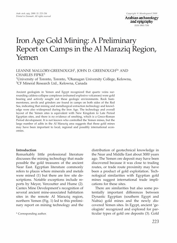
Iron Age Gold Mining: A Preliminary Report on Camps in the Al Maraziq Region, Yemen
14
Arab. arch. epig. 2000: 11: 223–236 Copyright C Munksgaard 2000 Printed in Denmark. All rights reserved ISSN 0905-7196 Iron Age Gold Mining: A Preliminary Report on Camps in the Al Maraziq Region, Yemen LEANNE MALLORY-GREENOUGH 1 , JOHN D. GREENOUGH 2 * AND CHARLES FIPKE 3 1 University of Toronto, Toronto, 2 Okanagan University College, Kelowna, 3 CF Mineral Research Ltd., Kelowna, Canada Ancient geologists in Yemen and Egypt recognized that quartz veins sur- rounding caldera-collapse complexes (exhumed explosive volcanoes) were gold bearing and actively sought out these geologic environments. Rock ham- merstones, anvils and grinders are found in camps on both sides of the Red Sea, indicating that mining and metallurgical extraction technology and knowl- edge were also widespread during the Iron Age. The technology and overall layout of the Yemen sites is equivalent with New Kingdom to Late Period Egyptian sites, and there is no evidence of smelting, which is a Greco-Roman Period development. It is not known who controlled the Yemen mines, but the large number of adits in the Al Maraziq area suggests that these gold mines may have been important to local, regional and possibly international econ- omies. Introduction Remarkably little professional literature discusses the mining technology that made possible the gold treasures of the ancient Near East. Egyptian literature commonly refers to places where minerals and metals were mined (1) but there are few site de- scriptions. Notable exceptions include re- ports by Meyer, Vercoutter and Hume (2). Cantex Mine Development’s recognition of several ancient mine-associated habitation sites in the remote Al Maraziq region, northern Yemen (Fig. 1) led to this prelimi- nary report on mining technology and the * Corresponding author. 223 distribution of geotechnical knowledge in the Near and Middle East about 3000 years ago. The Yemen ore deposit may have been discovered because it was close to trading routes, or trade route proximity may have been a product of gold exploitation. Tech- nological similarities with Egyptian gold mines suggest international trade impli- cations for these sites. There are similarities but also some po- tentially important differences between Dynastic Egyptian (southern Egypt and Nubia) gold mines and the newly dis- covered Yemen sites. In Egypt, ancient ‘ge- ologists’ recognized and explored for par- ticular types of gold ore deposits (3). Gold
-
Upload
independent -
Category
Documents
-
view
2 -
download
0
Transcript of Iron Age Gold Mining: A Preliminary Report on Camps in the Al Maraziq Region, Yemen
Arab. arch. epig. 2000: 11: 223–236 Copyright C Munksgaard 2000Printed in Denmark. All rights reserved
ISSN 0905-7196
Iron Age Gold Mining: A PreliminaryReport on Camps in the Al Maraziq Region,Yemen
LEANNE MALLORY-GREENOUGH1, JOHN D. GREENOUGH2* ANDCHARLES FIPKE3
1University of Toronto, Toronto, 2Okanagan University College, Kelowna,3CF Mineral Research Ltd., Kelowna, Canada
Ancient geologists in Yemen and Egypt recognized that quartz veins sur-rounding caldera-collapse complexes (exhumed explosive volcanoes) were goldbearing and actively sought out these geologic environments. Rock ham-merstones, anvils and grinders are found in camps on both sides of the RedSea, indicating that mining and metallurgical extraction technology and knowl-edge were also widespread during the Iron Age. The technology and overalllayout of the Yemen sites is equivalent with New Kingdom to Late PeriodEgyptian sites, and there is no evidence of smelting, which is a Greco-RomanPeriod development. It is not known who controlled the Yemen mines, but thelarge number of adits in the Al Maraziq area suggests that these gold minesmay have been important to local, regional and possibly international econ-omies.
IntroductionRemarkably little professional literaturediscusses the mining technology that madepossible the gold treasures of the ancientNear East. Egyptian literature commonlyrefers to places where minerals and metalswere mined (1) but there are few site de-scriptions. Notable exceptions include re-ports by Meyer, Vercoutter and Hume (2).Cantex Mine Development’s recognition ofseveral ancient mine-associated habitationsites in the remote Al Maraziq region,northern Yemen (Fig. 1) led to this prelimi-nary report on mining technology and the
* Corresponding author.
223
distribution of geotechnical knowledge inthe Near and Middle East about 3000 yearsago. The Yemen ore deposit may have beendiscovered because it was close to tradingroutes, or trade route proximity may havebeen a product of gold exploitation. Tech-nological similarities with Egyptian goldmines suggest international trade impli-cations for these sites.
There are similarities but also some po-tentially important differences betweenDynastic Egyptian (southern Egypt andNubia) gold mines and the newly dis-covered Yemen sites. In Egypt, ancient ‘ge-ologists’ recognized and explored for par-ticular types of gold ore deposits (3). Gold
LEANNE MALLORY-GREENOUGH ET AL.
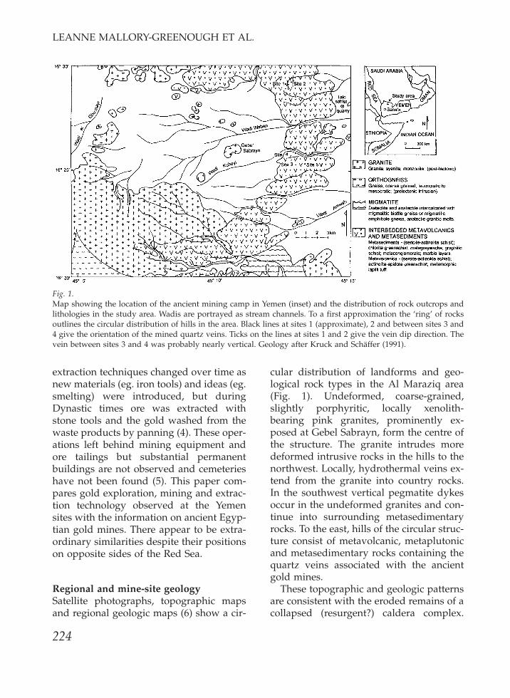
Fig. 1.Map showing the location of the ancient mining camp in Yemen (inset) and the distribution of rock outcrops andlithologies in the study area. Wadis are portrayed as stream channels. To a first approximation the ‘ring’ of rocksoutlines the circular distribution of hills in the area. Black lines at sites 1 (approximate), 2 and between sites 3 and4 give the orientation of the mined quartz veins. Ticks on the lines at sites 1 and 2 give the vein dip direction. Thevein between sites 3 and 4 was probably nearly vertical. Geology after Kruck and Schaffer (1991).
extraction techniques changed over time asnew materials (eg. iron tools) and ideas (eg.smelting) were introduced, but duringDynastic times ore was extracted withstone tools and the gold washed from thewaste products by panning (4). These oper-ations left behind mining equipment andore tailings but substantial permanentbuildings are not observed and cemeterieshave not been found (5). This paper com-pares gold exploration, mining and extrac-tion technology observed at the Yemensites with the information on ancient Egyp-tian gold mines. There appear to be extra-ordinary similarities despite their positionson opposite sides of the Red Sea.
Regional and mine-site geologySatellite photographs, topographic mapsand regional geologic maps (6) show a cir-
224
cular distribution of landforms and geo-logical rock types in the Al Maraziq area(Fig. 1). Undeformed, coarse-grained,slightly porphyritic, locally xenolith-bearing pink granites, prominently ex-posed at Gebel Sabrayn, form the centre ofthe structure. The granite intrudes moredeformed intrusive rocks in the hills to thenorthwest. Locally, hydrothermal veins ex-tend from the granite into country rocks.In the southwest vertical pegmatite dykesoccur in the undeformed granites and con-tinue into surrounding metasedimentaryrocks. To the east, hills of the circular struc-ture consist of metavolcanic, metaplutonicand metasedimentary rocks containing thequartz veins associated with the ancientgold mines.
These topographic and geologic patternsare consistent with the eroded remains of acollapsed (resurgent?) caldera complex.
IRON AGE GOLD MINING
Porphyritic, xenolithic and pegmatitic tex-tures indicate that the rocks formed nearthe roof of a high-level intrusion. The peg-matites and hydrothermal quartz veiningattest to a fluid-rich magma. Quartz veinorientations at sites 1, 2 and 3 parallel thelocal orientation of the wadis. Regionally,the wadis radiate from the central intrusion(Fig. 1). Quartz veins are locally slicken-sided and brecciated with gold mineraliza-tion predating and postdating brecciation.Country rocks associated with the ancientmine sites are primarily metamorphosedmafic to ultramafic rocks. These obser-vations suggest that gold mineralization re-sulted from hydrothermal fluids followinga radial fracture system produced by re-peated caldera collapse and resurgence.Gold originated in the mafic rocks and wasprecipitated from carbonate-rich hydro-thermal solutions as the quartz veinsformed. Reviews of similar gold deposits,referred to by geologists as epithermal gold
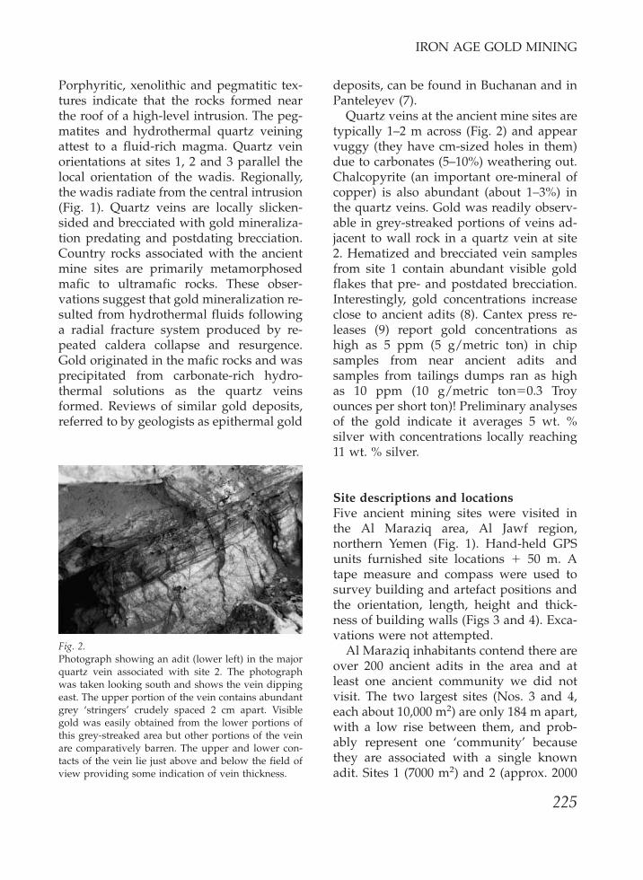
Fig. 2.Photograph showing an adit (lower left) in the majorquartz vein associated with site 2. The photographwas taken looking south and shows the vein dippingeast. The upper portion of the vein contains abundantgrey ‘stringers’ crudely spaced 2 cm apart. Visiblegold was easily obtained from the lower portions ofthis grey-streaked area but other portions of the veinare comparatively barren. The upper and lower con-tacts of the vein lie just above and below the field ofview providing some indication of vein thickness.
225
deposits, can be found in Buchanan and inPanteleyev (7).
Quartz veins at the ancient mine sites aretypically 1–2 m across (Fig. 2) and appearvuggy (they have cm-sized holes in them)due to carbonates (5–10%) weathering out.Chalcopyrite (an important ore-mineral ofcopper) is also abundant (about 1–3%) inthe quartz veins. Gold was readily observ-able in grey-streaked portions of veins ad-jacent to wall rock in a quartz vein at site2. Hematized and brecciated vein samplesfrom site 1 contain abundant visible goldflakes that pre- and postdated brecciation.Interestingly, gold concentrations increaseclose to ancient adits (8). Cantex press re-leases (9) report gold concentrations ashigh as 5 ppm (5 g/metric ton) in chipsamples from near ancient adits andsamples from tailings dumps ran as highas 10 ppm (10 g/metric tonΩ0.3 Troyounces per short ton)! Preliminary analysesof the gold indicate it averages 5 wt. %silver with concentrations locally reaching11 wt. % silver.
Site descriptions and locationsFive ancient mining sites were visited inthe Al Maraziq area, Al Jawf region,northern Yemen (Fig. 1). Hand-held GPSunits furnished site locations π 50 m. Atape measure and compass were used tosurvey building and artefact positions andthe orientation, length, height and thick-ness of building walls (Figs 3 and 4). Exca-vations were not attempted.
Al Maraziq inhabitants contend there areover 200 ancient adits in the area and atleast one ancient community we did notvisit. The two largest sites (Nos. 3 and 4,each about 10,000 m2) are only 184 m apart,with a low rise between them, and prob-ably represent one ‘community’ becausethey are associated with a single knownadit. Sites 1 (7000 m2) and 2 (approx. 2000
LEANNE MALLORY-GREENOUGH ET AL.
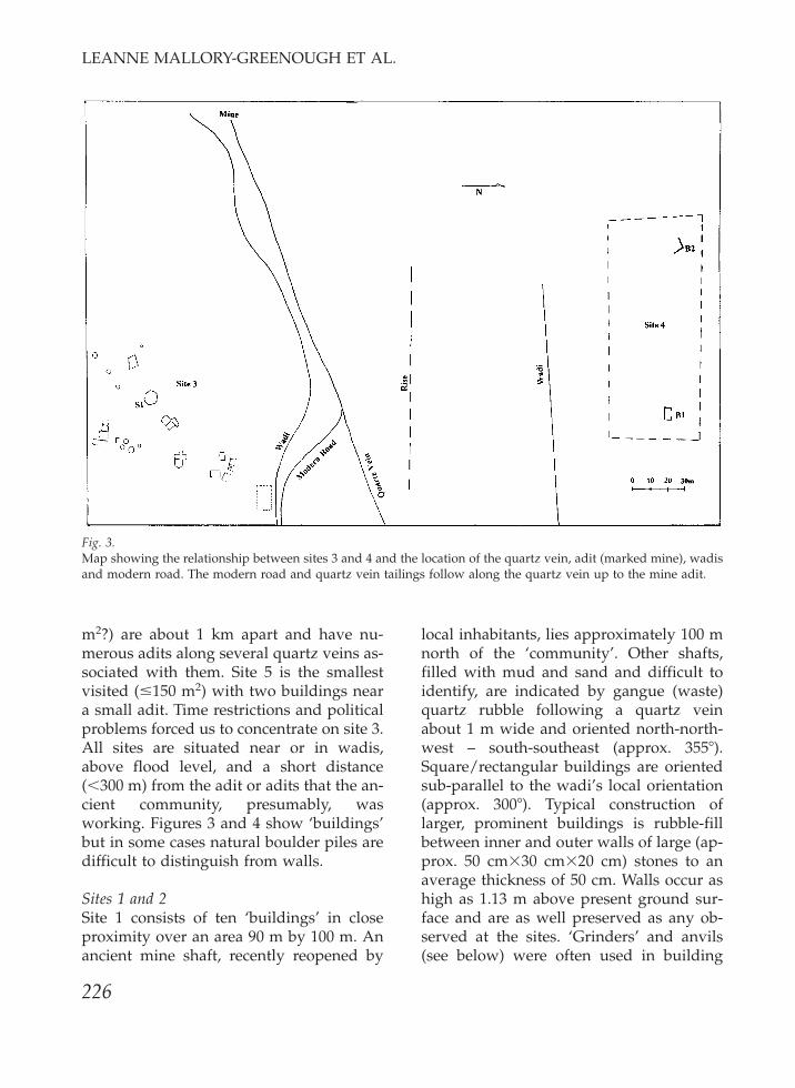
Fig. 3.Map showing the relationship between sites 3 and 4 and the location of the quartz vein, adit (marked mine), wadisand modern road. The modern road and quartz vein tailings follow along the quartz vein up to the mine adit.
m2?) are about 1 km apart and have nu-merous adits along several quartz veins as-sociated with them. Site 5 is the smallestvisited (Æ150 m2) with two buildings neara small adit. Time restrictions and politicalproblems forced us to concentrate on site 3.All sites are situated near or in wadis,above flood level, and a short distance(∞300 m) from the adit or adits that the an-cient community, presumably, wasworking. Figures 3 and 4 show ‘buildings’but in some cases natural boulder piles aredifficult to distinguish from walls.
Sites 1 and 2Site 1 consists of ten ‘buildings’ in closeproximity over an area 90 m by 100 m. Anancient mine shaft, recently reopened by
226
local inhabitants, lies approximately 100 mnorth of the ‘community’. Other shafts,filled with mud and sand and difficult toidentify, are indicated by gangue (waste)quartz rubble following a quartz veinabout 1 m wide and oriented north-north-west – south-southeast (approx. 355æ).Square/rectangular buildings are orientedsub-parallel to the wadi’s local orientation(approx. 300æ). Typical construction oflarger, prominent buildings is rubble-fillbetween inner and outer walls of large (ap-prox. 50 cm¿30 cm¿20 cm) stones to anaverage thickness of 50 cm. Walls occur ashigh as 1.13 m above present ground sur-face and are as well preserved as any ob-served at the sites. ‘Grinders’ and anvils(see below) were often used in building
IRON AGE GOLD MINING
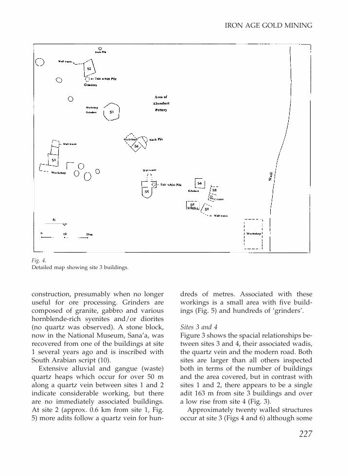
Fig. 4.Detailed map showing site 3 buildings.
construction, presumably when no longeruseful for ore processing. Grinders arecomposed of granite, gabbro and varioushornblende-rich syenites and/or diorites(no quartz was observed). A stone block,now in the National Museum, Sana’a, wasrecovered from one of the buildings at site1 several years ago and is inscribed withSouth Arabian script (10).
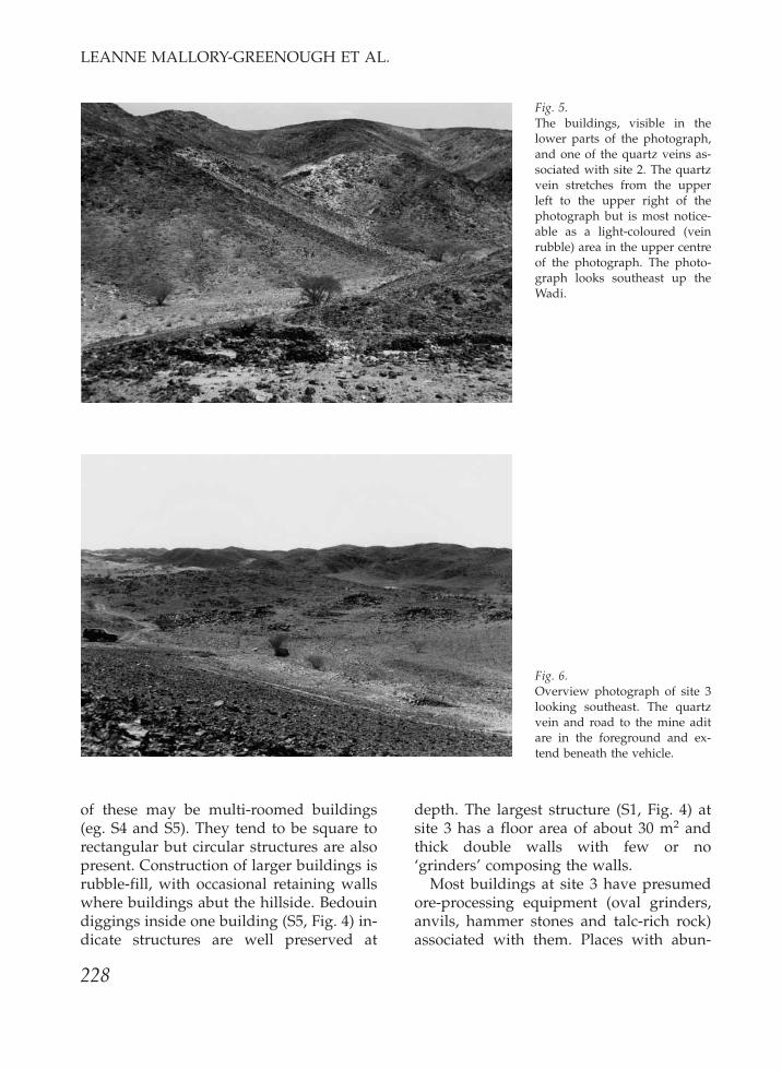
Extensive alluvial and gangue (waste)quartz heaps which occur for over 50 malong a quartz vein between sites 1 and 2indicate considerable working, but thereare no immediately associated buildings.At site 2 (approx. 0.6 km from site 1, Fig.5) more adits follow a quartz vein for hun-
227
dreds of metres. Associated with theseworkings is a small area with five build-ings (Fig. 5) and hundreds of ‘grinders’.
Sites 3 and 4Figure 3 shows the spacial relationships be-tween sites 3 and 4, their associated wadis,the quartz vein and the modern road. Bothsites are larger than all others inspectedboth in terms of the number of buildingsand the area covered, but in contrast withsites 1 and 2, there appears to be a singleadit 163 m from site 3 buildings and overa low rise from site 4 (Fig. 3).
Approximately twenty walled structuresoccur at site 3 (Figs 4 and 6) although some
LEANNE MALLORY-GREENOUGH ET AL.
Fig. 5.The buildings, visible in thelower parts of the photograph,and one of the quartz veins as-sociated with site 2. The quartzvein stretches from the upperleft to the upper right of thephotograph but is most notice-able as a light-coloured (veinrubble) area in the upper centreof the photograph. The photo-graph looks southeast up theWadi.
Fig. 6.Overview photograph of site 3looking southeast. The quartzvein and road to the mine aditare in the foreground and ex-tend beneath the vehicle.
of these may be multi-roomed buildings(eg. S4 and S5). They tend to be square torectangular but circular structures are alsopresent. Construction of larger buildings isrubble-fill, with occasional retaining wallswhere buildings abut the hillside. Bedouindiggings inside one building (S5, Fig. 4) in-dicate structures are well preserved at
228
depth. The largest structure (S1, Fig. 4) atsite 3 has a floor area of about 30 m2 andthick double walls with few or no‘grinders’ composing the walls.
Most buildings at site 3 have presumedore-processing equipment (oval grinders,anvils, hammer stones and talc-rich rock)associated with them. Places with abun-

IRON AGE GOLD MINING
Fig. 7.Dark (mafic) grinder showing two distinct, oval abra-sion surfaces, the smaller one overprinting the larger,earlier one. Abrasion striations are primarily visibleon the right-hand end of the grinder. The middle ofthe grinder contains dust washed into the centre byrain. The light brown rock on the end of the grinderand beside the knife is a piece of talc schist exhibitinggouge marks. The grinder occurs in the workshop as-sociated with S1 (Fig. 4). The knife is 9 cm long byapprox. 2 cm wide.
Fig. 8.Dark (mafic) grinder with striations up to 3 mm deep.These striations may have been used to pan gold inthe final stages of the extraction process. The photo-graph was taken at site 3 in the workshop closest tothe wadi (Fig. 4). The knife is 9 cm long by approx. 2cm wide.
dant grinders are marked in Figure 4whereas areas with both grinders, anvilsand hammer stones are labelled work-shops.
229
Fig. 9.An anvil with three wear surfaces in the workshopnearest the wadi at site 3 (Fig. 4). Note that the grinderis extremely thick and that wear surfaces tend to bepitted and somewhat round but lack a polished orstriated surface. Large, orangeish rounded feldsparsare visible along the top surface of the rock along theedge closest to the viewer. The knife is 9 cm long byapprox. 2 cm wide.
Oval grinders are typically 50 cm¿25cm¿20 cm thick with an oval depression inthe middle 5–10 cm deep (Figs 7 and 8).Some show smooth, semi-polished de-pressions with faint linear striations par-allel to the long dimension of the grindermore visible on one end than the other (Fig.7). Others have deeply incised (Æ3 mm)striations or gouge marks (Fig. 8). An un-determined percentage bear evidence ofseveral episodes of wear represented bynested abrasion surfaces with differentdepths, areas (Fig. 7), and, in some cases,striation orientations. Some have de-pressions on both sides and can be wornthrough. Grinders ring when tapped with ahammer, indicating a lack of internal joints,fractures, or weathering.
Anvils are larger than grinders and typ-ically 20–30 cm thick (Fig. 9). They havetwo or three somewhat circular de-pressions (Fig. 9) that lack the striationsand polishing typical of grinders. Hammerstones are roughly cube-shaped stones Æ20cm-wide, with a 3 cm-wide circular de-
LEANNE MALLORY-GREENOUGH ET AL.
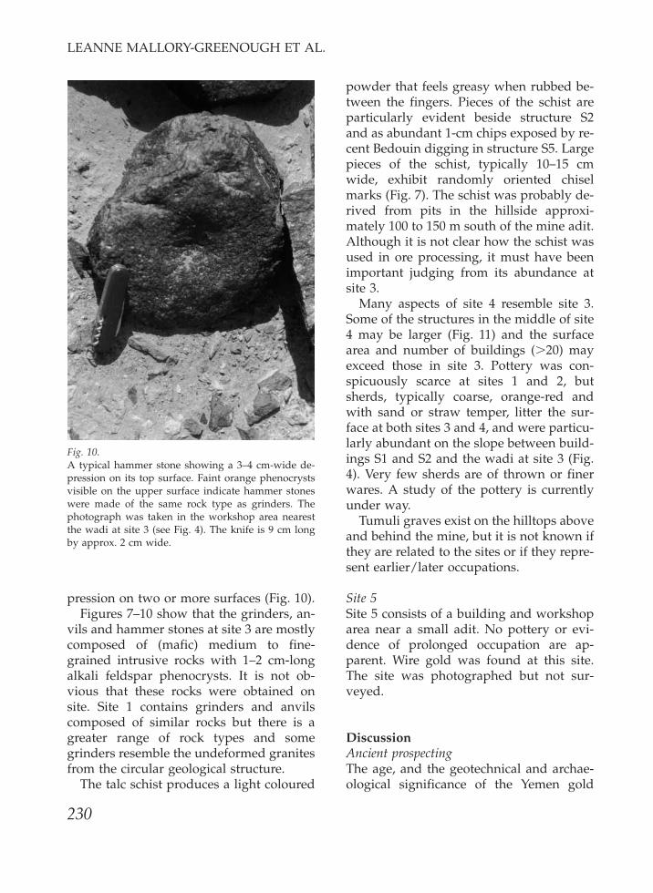
Fig. 10.A typical hammer stone showing a 3–4 cm-wide de-pression on its top surface. Faint orange phenocrystsvisible on the upper surface indicate hammer stoneswere made of the same rock type as grinders. Thephotograph was taken in the workshop area nearestthe wadi at site 3 (see Fig. 4). The knife is 9 cm longby approx. 2 cm wide.
pression on two or more surfaces (Fig. 10).Figures 7–10 show that the grinders, an-
vils and hammer stones at site 3 are mostlycomposed of (mafic) medium to fine-grained intrusive rocks with 1–2 cm-longalkali feldspar phenocrysts. It is not ob-vious that these rocks were obtained onsite. Site 1 contains grinders and anvilscomposed of similar rocks but there is agreater range of rock types and somegrinders resemble the undeformed granitesfrom the circular geological structure.
The talc schist produces a light coloured
230
powder that feels greasy when rubbed be-tween the fingers. Pieces of the schist areparticularly evident beside structure S2and as abundant 1-cm chips exposed by re-cent Bedouin digging in structure S5. Largepieces of the schist, typically 10–15 cmwide, exhibit randomly oriented chiselmarks (Fig. 7). The schist was probably de-rived from pits in the hillside approxi-mately 100 to 150 m south of the mine adit.Although it is not clear how the schist wasused in ore processing, it must have beenimportant judging from its abundance atsite 3.
Many aspects of site 4 resemble site 3.Some of the structures in the middle of site4 may be larger (Fig. 11) and the surfacearea and number of buildings (±20) mayexceed those in site 3. Pottery was con-spicuously scarce at sites 1 and 2, butsherds, typically coarse, orange-red andwith sand or straw temper, litter the sur-face at both sites 3 and 4, and were particu-larly abundant on the slope between build-ings S1 and S2 and the wadi at site 3 (Fig.4). Very few sherds are of thrown or finerwares. A study of the pottery is currentlyunder way.
Tumuli graves exist on the hilltops aboveand behind the mine, but it is not known ifthey are related to the sites or if they repre-sent earlier/later occupations.
Site 5Site 5 consists of a building and workshoparea near a small adit. No pottery or evi-dence of prolonged occupation are ap-parent. Wire gold was found at this site.The site was photographed but not sur-veyed.
DiscussionAncient prospectingThe age, and the geotechnical and archae-ological significance of the Yemen gold

IRON AGE GOLD MINING
Fig. 11.Site 4 looking northwest fromthe rise between sites 3 and 4.The stone piles are buildingsthat fall inside the dashed rec-tangle on Fig. 3.
mines are most apparent when comparedto Egyptian mines in southern Egypt andNubia. Ancient Egyptian geologists orprospectors only recognized two geologicenvironments – placer deposits and gold-bearing quartz veins associated withgranite or diorite (11). Gold also occurs insmall quartz veins in felsic dykes, but theancients did not mine this type of deposit,presumably because they did not know itcontained gold (12). It is probably signifi-cant that the Yemen deposits represent an-other location in the region where the an-cients recognized the granite-associatedquartz vein environment. Apparently pros-pecting knowledge was widespread.
The ‘geologists’ profession was im-portant enough for the Egyptians to have atitle, msn c3ty, for these people, which W.Ward (13) translates as ‘driller of stone’, theliteral meaning of the title. However, theterm was eventually applied to those witha technical/geological knowledge as well,and thus T.A. Rickard (14) gives the titlethe meaning ‘prospector’. The term ikywmay be translated as ‘miner’, but this title
231
is more often associated with stone quar-rying than mining (15).
These ancient prospectors may haveused several features for identifying thegranite-quartz vein gold deposit environ-ment. Rock colour is noted on the Turin pa-pyrus, the only surviving Egyptian geo-logical map (16), and must have been animportant tool in determining where theancients concentrated their searches.Quartz veins tend to be brilliant white andare easily spotted against a darker rock(Figs 2 and 5). In Nubia, reddish-coloured(hematite-rich) quartz was soon recognizedas being gold-bearing (17). Hematitecolouring is present in many of the quartzveins of the Yemen deposits. The ancientEgyptian prospectors proved so efficient atlocating the best gold deposits that modernmining companies have found it difficult tolocate other significant/economic sites thatwere missed (18).
Mining technologyNo metal tools were found at any of thesites and there are no metal tool marks ap-
LEANNE MALLORY-GREENOUGH ET AL.
parent at mine entrances. Although ironwas available by 1000 BCE, it was notwidely available in ancient Egypt untilpost-600 BCE (19), and therefore unlikelyto be used in extracting the quartz-vein ore.If iron was more readily available in Yemenit would still have been valuable and soworn-out tools would have been recycledrather than discarded. Thus, the absence ofiron tools is not surprising. Iron tools havenot been reported from Late Period Egyp-tian mines, but by Greco-Roman times theywere commonly used in mines (20). It ispossible that the stone hammers which areabundant at the Yemen mine sites were theprimary tools used to break up and extractore. By Greco-Roman times (second cen-tury BCE) fire was used to fracture rocks inEgyptian mines (21). When this technologywas first used is not known, but there isno evidence (soot) near the entrance to theYemen mines to indicate its use.
If it is considered safe, adits recently re-opened (out of curiosity) at sites 1 and 3need to be explored to help ascertain howore was extracted. Reportedly, the adit atsite 1 consists of a tunnel running at least100 m with branches into a number of ‘gal-leries’. Tunnels up to 85 m long have beenobserved in Egyptian mines (22), but veryfew ancient gold mines have been exca-vated to depth, so their actual extent is notknown.
Investigation around Yemen adits showsthat not all parts of the quartz veins wereequally rich in gold (Fig. 2). The veins werefollowed along the surface and test dig-gings performed to locate the richest areas.This left a trail of bright white, wastequartz along the vein which is still visibletoday (Fig. 5). Similar prospecting tech-niques were also used in Egypt (23). Oncethe quartz ore was removed from theground, it was probably sorted accordingto whether visible gold was present. Thisreduced the amount of ore to be milled to
232
the richest specimens and accounts for theheaps of coarse, ‘goldless’, waste quartzthat occurs at all the sites and is very con-spicuous along the trail from the mine aditto the community at site 3 (Fig. 3).
One can only guess at the grades the an-cients mined. Every thumb-nail chip re-moved from the grey-streaked portion ofthe quartz vein at an adit near site 2 con-tained visible gold. Assays for this materialindicate about 5 ppm (5 g/metric ton). Therichest parts of the veins would not havebeen left unmined, thus gold concen-trations in the mined parts of veins wereprobably at least 5 g/metric ton. AncientEgyptian mines had grades ranging from atypical 30 g/metric ton (1 ounce/short ton)to 300 g/metric ton (10 ounces/short ton)in small, very rich sections of the veins (24),suggesting that the ore mined in Yemen,from the same type of deposit, could havebeen much richer than the rejected ore weobserved with 5 g/metric ton. As inYemen, silver is a component (up to 16%)of the Egyptian ore (25).
The artefacts found at the Yemen sitessuggest ore processing along the followinglines: large pieces of ore may have beencrushed to coarse sand-sized particlesusing hammer stones and anvils (Figs 9and 10). Hammer stones are of sizes andweights that make them easy to lift withtwo hands. Their typical wear patternsconsist of hollowed areas in the centre oftheir faces where the ore was struck (Fig.10). Piles of hammer stones occur in work-shops and are also randomly scattered overthe sites. Anvils tend to be extremely thickand could withstand repeated blows fromhammer stones. Their wear surfaces tendto be pitted and somewhat round, a patternexpected if ore was simply being struck(Fig. 9).
Once initial crushing was complete, theore would have been progressively groundinto smaller pieces using the hard (eg.
IRON AGE GOLD MINING
granite, syenite) oval shaped ‘grinders’(Figs 7 and 8). The oval wear face on eachgrinder is about 50 cm long and 30 cmwide which reflects the distance an adult’soutstretched arms could reach. Striations inthe wear surfaces indicate that grindingwas a back and forth motion lengthwise.Large variations in the width and depth ofstriations on the wear surfaces indicate thatore was progressively reduced in size usingdifferent grinders (compare Figs 7 and 8).Alternatively the striations may have beenused to trap gold particles released fromthe ore if final separation involved panningin the grinders (26).
Water is often used as a lubricant andcoolant in rock tumblers, on laps and forrock saws. If water was scarce, the talc-richrock may have been used as a ‘lubricant’ tofacilitate the grinding process (Fig. 7). Al-ternatively, large pieces of talc rock mayhave been the pestle’ to the grinder’smortar’. The talc would hold pieces of thecrushed ore for abrasion against ore in thebottom of the grinder, a hypothesis con-sistent with markings on the talc in Fig. 7.The softness of the talc would ensure thatit did not contribute substantial resistanceduring the grinding process. A third possi-bility is that the ore was panned in thegrinders with the talc acting as a flotationmedium in place of water. Evidence for theimportance of this rock in ore processingcomes from an ancient quarry site 5 kmsoutheast of mine site 2 (Fig. 1). It has beena mystery what was mined at this site be-cause the piles of talc-rich rocks had noknown use or value. Recognition of abun-dant talc powder and artefacts in work-shops and a talc quarry on the corner ofsite 3 establishes that it was used in oreprocessing. Talc from the remote site mayhave been used for gold extraction atmining sites 1 or 2.
The ‘hard’ rocks used as grinders, anvilsand hammer stones were apparently im-
233
portant to ore processing because not justany rock would do. Similarities in lithologyindicate that some rocks at site 1 weighingbetween 50 and 100 kg were probablybeing brought from Gebel Sabrayn ap-proximately 8 km away. It is not knownwhere the grinders, anvils and hammerstones at sites 3 and 4 came from. However,in all cases jointed and soft (schistose)rocks were avoided. As grinders and anvilswere brought from some distance theywere used until worn through. Once wornout, discarded grinders were still used forconstructing building walls!
The ore processing technology found inYemen was widespread in the Near andMiddle East at about 1000 BCE, and can befound at Egyptian/Nubian sites ranging inage from the New Kingdom to Late Period,reaching a peak during the twenty-sixthDynasty (27). Descriptions of the size,shape and fracture-free nature (they ringwhen hit) of Egyptian New Kingdomgrinders show that extraction equipmentand tools were very similar (28). There arereports of grinders that are worn throughfrom both sides as observed in Yemen.Similarly, grinding slabs are ubiquitous atancient mining sites in Egypt and Nubiaand are sure indicators of nearby goldmines even if no other artefacts are present.Lucas and Harris (29) contend that the an-cient Egyptians (about 800 BCE) may havedone the final panning of the gold off site(along the Nile) where water was moreabundant. This is possible for Yemen aswell. Gold ore was first smelted in Greco-Roman Egypt (30) but it is unlikelysmelting occurred in Yemen because theclay crucibles used in the process were notobserved. Thus, the abundant silver dis-solved in the gold may not have been re-moved. The absence of smelting is signifi-cant for another reason – chalcopyrite,which is present in the Yemen ore, wassmelted for copper by 3000 BCE in Egypt
LEANNE MALLORY-GREENOUGH ET AL.
(31). It is not known whether the chalco-pyrite in the Yemen ore was used or dis-carded.
Based on the technological similaritieswith Egyptian gold mines, Yemen sitesmay range from Bronze to Iron Age. Pre-liminary thermoluminescence measure-ments on pottery from site 4 are consistentwith the presumed antiquity of the site(32). The stone block bearing South Ar-abian script (Sabaean) suggests site 1 wasoccupied at some time between 800 BCEand 600 CE (33) although mining may haveoccurred earlier. There is no informationabout how long mining went on at theYemen sites. Mines in southeast Egypt andNubia were mined for over two thousandyears with individual mines first openedduring the Middle Kingdom, re-opened inthe New Kingdom, Late Period and Greco-Roman times (34).
Social and trade implicationsThe buildings and layout of Yemen miningcommunities resemble those of ancientEgyptian mining communities. In Egyptbuildings are typically circular or rec-tangular stone huts built of a single thick-ness of undressed stones (35) with smallerstones stuffed into crevices. These smallbuildings (2.5 to 3.0 m in diameter) haveonly one entrance. Very rarely does a linteloccur. Crude stone windbreaks are alsofound scattered around mining sites (36).Buildings with rubble-fill walls are muchrarer and may have been the dwellings ofcamp supervisors. Plaster was not used inconstruction (37). Roof structures have notbeen found and may have consisted ofwoven mats placed over wooden beams.Walls can be preserved to a height of 2 m,but 1 m is more usual. Mining centres gen-erally consist of only a few huts locatedalong wadis or in tight clusters close to theworksite (38). Security and worker super-vision would be facilitated by keeping
234
dwellings close together. Records indicatethat Egyptian gold mines during the NewKingdom were worked by prisoners of warand criminals. Families were presentduring Greco-Roman times but they werealso prisoners of war, or related to con-demned criminals or slaves (39). Con-sidering the similarities between Egyptianand Yemen sites they may have beenworked by comparable populations.
Cemeteries can supply population infor-mation but, just as in Egypt, none wereidentified at Yemen sites. If the mines wereforced labour camps, high mortality rateswould be expected. Corpses of supervisorsmay have been returned home, but othersconsidered unworthy of burial could havebeen dumped in mined-out portions of theunderground workings. Excavation mayyield answers to these questions.
It appears that the Yemen mining campsare close to the frankincense trade route. Itis not known if the trade route existed be-cause of the gold or if the deposits werediscovered as a result of through traffic.Legend (Sheba’s gifts to Solomon) suggeststhe gold trade was internationally im-portant. Regardless of whether thesestories are true, processing and geological(prospecting) similarities between Iron Agegold mines in Yemen and Egypt suggestties and an exchange of technologicalknowledge between distant places in theNear and Middle East.
ConclusionsGeological similarities between the Yemenigold camp and New Kingdom Egyptianmine sites indicate that prospecting knowl-edge was widespread over the Near andMiddle East by 1000 BCE. Similarly, in bothregions underground mining only usedhand-held hammer stones with no evi-dence for the use of iron or fire-cracking.Ore processing involved crushing on thick
IRON AGE GOLD MINING
anvils and milling on oval grinders, bothcomposed of undeformed (unjointed),coarse-grained intrusive ‘granitoid’ rocks.Talc-rich rocks were used in the process,perhaps to hold the quartz ore whilegrinding. Final separation of the gold ore,probably requiring water, may have takenplace off site. There is no evidence forsmelting to remove copper also present inthe ore. It is not known if the Yemen siteswere populated by convicts, prisoners ofwar and/or slaves as in Egypt, but thelayout of the camps, and the size and pau-city of buildings and cemeteries suggestoperational similarities.
AcknowledgementsCantex Mine Development invited our in-vestigation of the mine sites. P. Ogryzlo, S.Shaw, D. Young, A. Mu’in, A. Razak andCantex (Canadian Mountain Minerals,Yemen) provided field support. Prof. Dr. Y.Abdulla (General Organization of Antiqui-ties, Yemen) and Prof. Dr. T. Maher (Dept.of Geology, University of Cairo) suppliedinformation on gold mining in Yemen andEgypt/Sudan, respectively. M. Lamothe(Departement des Sciences de la Terre, Uni-versite du Quebec a Montreal) providedpreliminary dating information.
References1. Lucas A & Harris JR. Ancient Egyptian Materials
and Industries. London: Edward Arnold Ltd., 1962:225–228.
2. Meyer C. Bir Umm Fawakhir: Insights into An-cient Egyptian Mining. JOM 49: 1997: 64–68. Ver-coutter J. The gold of Kush. Kush 7: 1959: 120–153.Hume WF. Geology of Egypt II: The FundamentalPre-Cambrian Rocks of Egypt and the Sudan; TheirDistribution, Age and Character, part III The Mineralsof Economic Value. Cairo: Egyptian GeologicalSurvey, 1937: 723–760.
3. Rickard TA. Copper and gold mines of the ancientEgyptians. Engineering and Mining Journal 119:1925: 1006. Hume, Geology of Egypt II: 805. Hussein
235
AAA. Mineral deposits. In: Said R, ed. The Geologyof Egypt. Rotterdam: Balkema, 1990: 511–566. Gi-veon R. Goldgewinnung. Lexikon der Agyptologie 2:1977: 735.
4. Vercoutter, The gold of Kush: 140–141, 151.5. Shaw I. Pharaonic quarrying and mining: settle-
ment and procurement in Egypt’s marginal re-gions. Antiquity 68: 1994: 108–119.
6. Kruck W & Schaffer U. Geologic Map of the Republicof Yemen. 1991.
7. Buchanan LJ. Precious metal deposits associatedwith volcanic environments in the southwest. In:Dickson WR & Payne WD, eds. Relations of Tec-tonics to Ore Deposits in the Southern Cordillera: Ari-zona Geological Society Digest 14: 1981: 237–262.Panteleyev A. A Canadian Cordillera model forepithermal gold-silver deposits. Geoscience Canada13: 1986: 101–111.
8. Mu’in A, Cantex (Canadian Mountain Minerals)Yemen. Pers. comm. 1998.
9. Cantex Mine Development Press Releases. Feb-ruary 2, 1999 and October 6, 1999.
10. Abdulla YM, General Organization of Antiquities,Yemen. Pers. comm. 1998.
11. Hume, Geology of Egypt II: 805. Whiteman AJ. Ge-ology of the Sudan Republic. Oxford: ClarendonPress 1971: 224–229.
12. Hussein, Mineral deposits: 511–566.13. Ward W. Index of Egyptian Administrative and Re-
ligious Titles of the Middle Kingdom. Beirut: Univer-sity of Beirut, Beirut 1982: 96, no. 801.
14. Rickard, Copper and gold mines: 1006.15. Vercoutter, The gold of Kush: 142.16. Harrell J & Brown VM. The world’s oldest sur-
viving geological map: The 1150 BC Turin pa-pyrus from Egypt. Geology 100: 1992: 3–18. Gard-iner AH. The map of the gold mines in a Rames-side papyrus at Turin. Cairo Scientific Journal 8:1914: 41–46.
17. Whiteman, Geology of the Sudan Republic: 229.18. Lucas & Harris, Ancient Egyptian Materials and In-
dustries: 225–226.19. Said R. The role of the desert in the rise and fall
of Ancient Egypt. Sahara 9: 1997: 18–20.20. Hume, Geology of Egypt II: 730.21. Agatharchides in Diodorus Siculus 3:12; Eide T,
Hagg T, Pierce RH & Torok L, eds. Fontes HistoraeNubiorum, vol. II. Bergen: Institutt for klassisk filo-logi, russisk og reliogionsvi tenskap, Bergen 1996:657–659.
22. Said, The role of the desert: 14.23. El Ramly MF & Al Far DM. Geology of the El-
Mueila-Dunqash District. Cairo: Egyptian Geo-logical Survey 1955: 43. Mansour MS, BussyuniFA & Al Far DM. Geology of the Umm Salatit-El-
LEANNE MALLORY-GREENOUGH ET AL.
Hisinat District. Cairo: Egyptian Geological Survey1956: 35–36.
24. Schweinfurth G. Die Wiederaufnahme des altenGodminen-betreibs in Aegypten und Nubien. An-nales du Service des Antiquites de l’Egypte 4: 1903:271–272, 274–275, 277, 279–280.
25. Lucas & Harris, Ancient Egyptian Materials and In-dustries: 226. Schweinfurth, Die Wiederaufnahme:279–280.
26. Ogryzlo P, Cantex (Canadian Mountain Minerals)Yemen. Pers. comm. 1998.
27. Vercoutter, The gold of Kush: 140–142, 151–152.Giveon, Goldgewinnung: 735–736.
28. Dunn SC. Ancient gold mining in the Sudan.Fourth Report of the Wellcome Tropical Research Lab-oratories, Volume B – General Science 1911: 207–215.Vercoutter, The gold of Kush: Plate XXXIV. MaherT, Dept. of Geology, University of Cairo. Pers.comm. 1998.
29. Lucas & Harris, Ancient Egyptian Materials and In-dustries: 228.
30. Dunn, Ancient gold mining in the Sudan: 214.Rickard, Copper and gold mines: 1010.
31. Emery WB. Archaic Egypt. Baltimore: PenguinBooks 1961: 224.
32. Lamothe M, Departement des Sciences de la Terre,Universite du Quebec a Montreal. Pers. comm.2000.
33. Abdulla YM, General Organization of Antiquities,Yemen. Pers. comm. 1998.
34. Vercoutter, The gold of Kush: 133–139. KlemmR & Klemm D. Chronologischer Abriss derantiken Goldgewinnung in der Ostwuste Agyp-tens. Mitteilungen des Deutschen Archaolog-ischen Institut abteilung Kairo 50: 1994: 189–222.Giveon R. Goldminen. Lexikon der Agyptologie 2:1977: 740–741.
236
35. Sidebotham SE. Newly discovered sites in theEastern Desert. Journal of Egyptian Archaeology 82:1996: 185.
36. Shaw, Pharaonic quarrying and mining: 111.37. Dunn, Ancient gold mining in the Sudan: 214–215.38. Fakhry A. The Inscriptions of the Amethyst Quarries
at Wadi el Hudi. Cairo, Government Press 1952: 9,18. Sidebotham, Newly discovered sites: 190.Mirsky A. Influence of geologic factors on ancientEgyptian civilization. Journal of Geoscience Edu-cation 45: 1997: 415–424.
39. Agatharchides in Diodorus Siculus 3:12; Eide etal, Fontes Historae Nubiorum: 657–659.
Address:Leanne Mallory-GreenoughDept. of Near and Middle Eastern CivilizationsUniversity of Toronto4 Bancroft AvenueToronto, ON, M4L 3P5Canada
John D. GreenoughDepartment of Earth and Environmental SciencesOkanagan University College3333 CollegeKelowna, BC, Canada V1V 1V7Tel: 250 762 5445 ext 7520Fax: 250 470 6005e-mail: jdgreeno/okanagan.bc.ca
Charles FipkeCF Mineral Research Ltd1677 Powick RoadKelowna, BCCanada V1X 4L1