iraq_aip_edition_59.pdf - Erbil International Airport
422
Iraq Civil Aviation Authority IRAQ AERONAUTICAL INFORMATION PUBLICATION (AIP) ARRANGEMENTS AND PROCEDURES FOR FLIGHT OPERATIONS IN IRAQ AIRSPACE 1. The Iraqi Civil Aviation Authority (ICAA) is the governing authority of the Baghdad FIR. All aircraft require ICAA approval to land at or depart from an aerodrome within, or to overfly, the Baghdad FIR. Such approval is to be obtained by contacting the ICAA Air Transportation Department via the procedures described in AIP GEN 1.2. 2. The Iraq AIP is formatted in accordance with Annex 15 to the Convention on International Civil Aviation. The procedures contained in this AIP are designed for the safety of all aircraft flying in the Baghdad FIR. Operators must review Notice to Airmen (NOTAMs) regularly for changes affecting the information in this document. 3. Operators organizing and/or conducting flights in the Baghdad FIR must comply with all regulations specified in Iraq AIP. Particular attention should be paid to the following AIP entries: BOOK 1 Baghdad Flight Information Region (FIR) Control Authority ........................ GEN 1.2 Risks to Flight and Compliance with These Procedure ............................... GEN 1.2.2.1 Transponder Codes ..................................................................................... GEN 1.2.2.2 Prior Permission Required (PPR) Procedures ............................................ GEN1.2.5 Required Navigation Performance Criteria .................................................. GEN 1.5.2 NOTAM Information .................................................................................... GEN 3.1.3.5.1 Meteorological Information .......................................................................... GEN 3.5.3 Emergencies and Search and Rescue (SAR) ............................................. GEN 3.6 BOOK 2 Flight Rules ................................................................................................ ENR 1.1.4.1 Restrictions to Civil Aircraft Operations ....................................................... ENR 1.1.4.5 Terminal Air Traffic Control.......................................................................... ENR 1.1.5 Airspace Classification ................................................................................ ENR 1.4 Radio and ATC Surveillance System Failure procedures ........................... ENR 1.6.3 Altimeter Setting Procedures ....................................................................... ENR 1.7 Separation ................................................................................................... ENR 1.8.2 International Agreements ............................................................................ ENR 1.8.3 Flight Planning............................................................................................. ENR 1.10 Intercept Procedures ................................................................................... ENR 1.12.1 Air Traffic Incidents ...................................................................................... ENR 1.14.1 Route Descriptions ...................................................................................... ENR 3.3 Preferred Routing ........................................................................................ ENR 3.5.1 Enroute Holding Procedures ....................................................................... ENR 3.6 Activities of a Dangerous Nature and Other Potential Hazards .................. ENR 5.3 BOOK 3 Airport Information ....................................................................................... AD 2.1
-
Upload
khangminh22 -
Category
Documents
-
view
0 -
download
0
Transcript of iraq_aip_edition_59.pdf - Erbil International Airport
Iraq Civil Aviation Authority
IRAQ AERONAUTICAL INFORMATION PUBLICATION (AIP) ARRANGEMENTS AND PROCEDURES FOR FLIGHT OPERATIONS IN IRAQ
AIRSPACE
1. The Iraqi Civil Aviation Authority (ICAA) is the governing authority of the Baghdad FIR. All aircraft require ICAA approval to land at or depart from an aerodrome within, or to overfly, the Baghdad FIR. Such approval is to be obtained by contacting the ICAA Air Transportation Department via the procedures described in AIP GEN 1.2. 2. The Iraq AIP is formatted in accordance with Annex 15 to the Convention on International Civil Aviation. The procedures contained in this AIP are designed for the safety of all aircraft flying in the Baghdad FIR. Operators must review Notice to Airmen (NOTAMs) regularly for changes affecting the information in this document.
3. Operators organizing and/or conducting flights in the Baghdad FIR must comply with all regulations specified in Iraq AIP. Particular attention should be paid to the following AIP entries:
BOOK 1
Baghdad Flight Information Region (FIR) Control Authority ........................ GEN 1.2
Risks to Flight and Compliance with These Procedure ............................... GEN 1.2.2.1
Transponder Codes..................................................................................... GEN 1.2.2.2
Prior Permission Required (PPR) Procedures ............................................ GEN1.2.5
Required Navigation Performance Criteria.................................................. GEN 1.5.2
NOTAM Information .................................................................................... GEN 3.1.3.5.1
Meteorological Information .......................................................................... GEN 3.5.3
Emergencies and Search and Rescue (SAR) ............................................. GEN 3.6
BOOK 2
Flight Rules ................................................................................................ ENR 1.1.4.1
Restrictions to Civil Aircraft Operations....................................................... ENR 1.1.4.5
Terminal Air Traffic Control.......................................................................... ENR 1.1.5
Airspace Classification ................................................................................ ENR 1.4
Radio and ATC Surveillance System Failure procedures ........................... ENR 1.6.3
Altimeter Setting Procedures....................................................................... ENR 1.7
Separation ................................................................................................... ENR 1.8.2
International Agreements ............................................................................ ENR 1.8.3
Flight Planning............................................................................................. ENR 1.10
Intercept Procedures ................................................................................... ENR 1.12.1
Air Traffic Incidents...................................................................................... ENR 1.14.1
Route Descriptions ...................................................................................... ENR 3.3
Preferred Routing ........................................................................................ ENR 3.5.1
Enroute Holding Procedures ....................................................................... ENR 3.6
Activities of a Dangerous Nature and Other Potential Hazards .................. ENR 5.3
BOOK 3 Airport Information....................................................................................... AD 2.1
IRAQ AERONAUTICAL INFORMATION PUBLICATION (AIP)
SUMMARY OF CHANGES
1. The following document provides a summary of notable or significant changes. Changes to correct spelling mistakes, syntax errors and formatting errors are not listed. Or without reference to the AIP. Moreover, this Summary of Changes is provided only to assist with the effective use and maintenance of the Iraq AIP and is not an authoritative document in its own right.
SUMMARY OF CHANGES – EFFECTIVE DATE: 28 June 2012
GEN ENR 2.1-1 2.1-3
AREA CONTROL CENTERS (ACC)
1.10-2 3.3-6 4.3-1
PASIP WAYPOINT – NEW COORDINATE
5.1-4 RESTRICTED AREA – OR/R401 – OR/R501 AD 2.1-2 (ORNI) AL NAJAF AIRPORT - AERODROME GEOGRAPHICAL AND ADMINISTRATIVE
DATA/AFS ADDRESS 2.1-24 2.1-25
(ORNI) AL NAJAF AIRPORT -INSTRUMENT APPROACH CHART
2.1-49 (ORBI) BAGHDAD AIRPORT- ATS COMMUNICATION FACILITIES 2.1-64 (ORMM) BASRAH AIRPORT- AIR TRAFFIC SERVICES COMMUNICATION FACILITIES 2.1-50 (ORSU) SULAYMANIA AIRPORT-HANDLING SERVICES AND FACILITIES

LIST OF NOTAMS INCORPORATED INTO THIS EDITION A0023/12 A0033/12 A0034/12 A0037/12 A0040/12 A0055/12 A0056/12 A0068/12
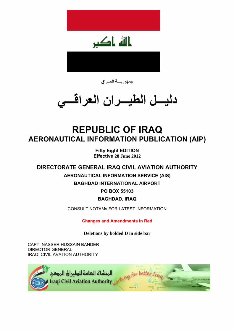
جمھوريــــة العـــراق
دليـــل الطيـــران العراقـــي
REPUBLIC OF IRAQ
AERONAUTICAL INFORMATION PUBLICATION (AIP)
Fifty Eight EDITION Effective 28 June 2012
DIRECTORATE GENERAL IRAQ CIVIL AVIATION AUTHORITY
AERONAUTICAL INFORMATION SERVICE (AIS)
BAGHDAD INTERNATIONAL AIRPORT
PO BOX 55103
BAGHDAD, IRAQ
CONSULT NOTAMs FOR LATEST INFORMATION
Changes and Amendments in Red
Deletions by bolded D in side bar CAPT. NASSER HUSSAIN BANDER DIRECTOR GENERAL IRAQI CIVIL AVATION AUTHORITY
AIP GEN 0.11
IRAQ 28 June 12
Iraq Civil Aviation Authority 1
BOOK 1 – GENERAL (GEN) GEN 0.1 PREFACE
0.1.1 Name of publishing authority. The Iraq AIP is published by the Iraq Civil Aviation Authority (ICAA).
0.1.2 Applicable ICAO documents. The AIP is prepared in accordance with the Standards and Recommended Practices (SARPS) of Annex 15 to the Convention on International Civil Aviation and the Aeronautical Information Services Manual (ICAO Doc 8126) and Annex 14 to the Convention on International Civil Aviation. Charts contained in the AIP are produced in accordance with Annex 4 to the Convention on International Civil Aviation and the Aeronautical Chart Manual (ICAO Doc 8697). Differences from ICAO Standards, Recommended Practices and Procedures are detailed in subsection GEN 1.7.
0.1.3 The AIP structure and amendment interval.
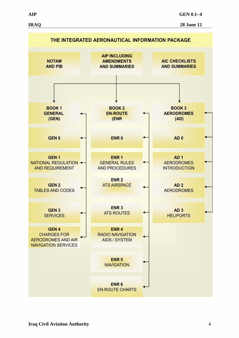
0.1.3.1The AIP forms part of the integrated Aeronautical Information Package, details of which are given in Subsection GEN 3.1. The principal AIP structure is shown in graphic form on page GEN 0.1-4. The AIP consists of one volume comprising of three books. Book 1 - General (GEN), Book 2 - En-route (ENR) and Book 3 - Aerodromes AD). Each book is divided into sections and subsections, as applicable.
Book 1 – General (GEN)
GEN consists of five sections containing information as briefly described below.
GEN 0 Preface; Record of AIP Amendments; Record of AIP Supplements; Checklist of AIP Pages; List of Hand Amendments to the AIP; and Table of Contents to Book 1.
GEN 1 National Regulations and Requirements - Designated authorities; Entry; Transit and Departure of Aircraft; Transit and Departure of Passengers and Crew; Entry, Transit and Departure of Cargo; Aircraft Instruments, Equipment and Flight Documents; Summary of National Regulations and International Agreements/Conventions; and Differences from ICAO Standards, Recommended Practices and Procedures.
GEN 2 Tables and Codes - Measuring System, Aircraft Markings and Holidays; Abbreviations used in AIP; Chart Symbols; Location Indicators; List of Radio Navigation Aids; Conversion Tables; and Sunrise/Sunset Tables.
GEN 3 Services – Aeronautical Information Services; Aeronautical Charts; Air Traffic Services; Communication Services; Meteorological Services; and Search and Rescue.
GEN 4 Fees and Charges.
AIP GEN 0.12
IRAQ 28 June 12
Iraq Civil Aviation Authority 2
Book 2 – En-route (ENR)
ENR consists of seven sections containing information as briefly describe below.
ENR 0 Preface; Record of AIP Amendment; Record of AIP Supplements; Checklist of AIP Pages; List of Hand Amendments to the AIP; and the Table of Contents to Part 2.
ENR 1 General Rules and Procedures - General Rules; Instrument Flight Rules; ATS Airspace Classification; Holding; Approach and Departure Procedures; ATC Surveillance Services and Procedures; Altimeter Setting Procedure; Regional Supplementary Procedures; Air Traffic Flow Management; Flight Planning; Addressing Of Flight Plan Message; Interception Of Civil Aircraft; Unlawful Interference and Air Traffic Incidents.
ENR 2 Air Traffic Services (ATS) Airspace - Detailed Description of Flight Information Regions (FIR) and Terminal Control Areas (TMA).
ENR 3 ATS Routes.
ENR 4 Radio Navigation Routes Aids/Systems - Radio Navigation Aids - En-Route; Name-Code Designators for Significant Points; and Aeronautical Ground Lights - En-Route.
ENR 5 Navigation Warnings - Prohibited, Restricted and Danger Areas.
ENR 6 En-Route Charts - En-Route Chart – ICAO and Index Charts.
Book 3 – Aerodromes (AD)
AD consists of three sections containing information as briefly described below.
AD 0 Preface; Record of AIP Amendments; Record of AIP Supplements; Checklist of AIP Pages; List of Hand Amendments to the AIP; and the table of Contents to Book 3.
AD 1 Introduction - Aerodrome Availability; Rescue and Fire Fighting Services; and Index to Aerodromes.
AD 2 Detailed Information about Aerodromes.
0.1.3.2 Amendment Interval. Regular amendments to the AIP will be issued every 56 days, providing 28 days notice before the re-issue of a full AIP.
AIP GEN 0.13
IRAQ 28 June 12
Iraq Civil Aviation Authority 3
0.1.3.3 Advice of AIP errors or omissions. The information in Iraq AIS publications is collected from a number of varied sources and is considered to be as reliable as possible at the time of publication. Airport Management is required to review each release of the AIP within 5 days of release. Inaccuracies that affect safety of flight must be updated immediately through NOTAM. Airport Management is responsible for providing corrected/updated information for the aerodrome under their responsibility. Updates must be submitted no later than 15 days prior to the next publication date to the following responsible authority annotated below:
Airspace and Aerodromes — Iraq AIP Development and Iraq AIS on e-mails:
ICAA/ AIS HQ: [email protected]
NOTAM Issue: [email protected]
AIP Issue: [email protected]
Aerodromes — Iraq Civil Aviation Authority (ICAA):
mail: [email protected]
Fax: + 964 1533-0764
P.O. Box: 55103
Mobile: + 964 790-1775-664
AFTN address: ORBIYDYX
Combined Military/Civil Aerodromes — Iraq AIP Development and Iraq Civil Aviation Authority (ICAA) on the e-mail addresses above.
0.1.3.4 Requests for additions or variations. In order to ensure that the information contained in the AIP is as accurate as possible, and that all procedures, facilities and services are duly certified and/or authorized, requests for amendments to the AIP will not be accepted directly from service providers or airport representatives. Requests for additions or variations should be forwarded to the appropriate address/es as per advice of errors and omissions. Service providers should make all requests through the relevant airport management.
0.1.3.5 Calling DSN phone numbers listed in the AIP. To call a military airfield that has a DSN number listed in the AD section call commercial +974-458-9555. You will hear “You have reached Al Udeid Airbase, at the tone, please enter the 7 digit extension of the party you wish to reach or 0.” You will hear a dial tone. At the dial tone, enter the seven digit number as listed in the AIP.
AIP GEN 0.14
IRAQ 28 June 12
Iraq Civil Aviation Authority 4
THE INTEGRATED AERONAUTICAL INFORMATION PACKAGE
NOTAMAND PIB
AIP INCLUDINGAMENDMENTS
AND SUMMARIESAIC CHECKLISTSAND SUMMARIES
GEN 4CHARGES FOR
AERODROMES AND AIRNAVIGATION SERVICES
GEN 3SERVICES
GEN 2TABLES AND CODES
GEN 1NATIONAL REGULATION
AND REQUIREMENT
GEN 0
BOOK 1GENERAL
(GEN)
ENR 6EN-ROUTE CHARTS
ENR 5NAVIGATION
ENR 4RADIO NAVIGATION
AIDS / SYSTEM
ENR 3ATS ROUTES
ENR 2ATS AIRSPACE
ENR 1GENERAL RULES
AND PROCEDURES
ENR 0
BOOK 2EN-ROUTE
(ENR
BOOK 3AERODROMES
(AD)
AD 0
AD 1AERODROMESINTRODUCTION
AD 2AERODROMES
AD 3HELIPORTS
AIP GEN 0.21
IRAQ 28 June 12
Iraq Civil Aviation Authority 1
GEN 0.2 RECORD OF AIP AMENDMENTS
No/Year Publication Date Effective Date Inserted by
AIP GEN 0.31
IRAQ 28 June 12
Iraq Civil Aviation Authority 1
GEN 0.3 RECORD OF AIP SUPPLEMENTS Serial No Subject
Section(s) affected
Period of validity Cancellation record
AIP GEN 0.41
IRAQ 28 June 12
Iraq Civil Aviation Authority 1
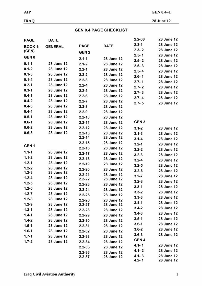
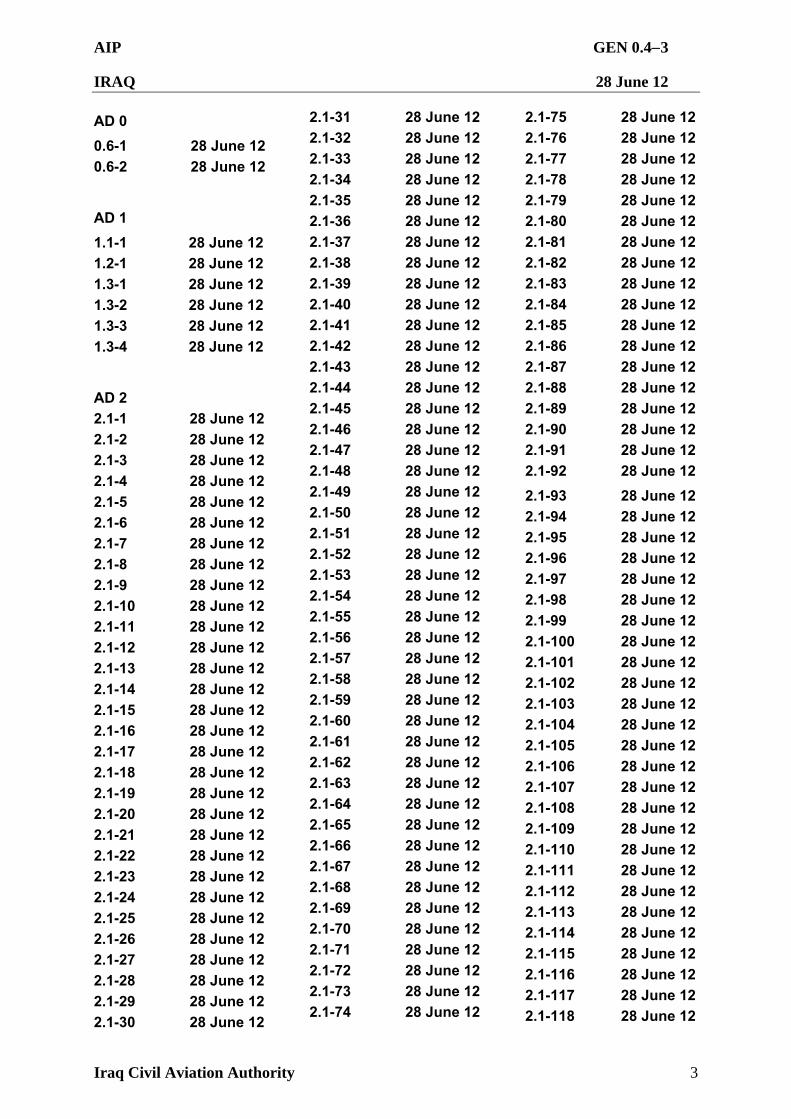
GEN 0.4 PAGE CHECKLIST PAGE DATE
BOOK 1: GENERAL (GEN)
GEN 0
0.1-1 28 June 12 0.1-2 28 June 12 0.1-3 28 June 12 0.1-4 28 June 12 0.2-1 28 June 12 0.3-1 28 June 12 0.4-1 28 June 12 0.4-2 28 June 12 0.4-3 28 June 12 0.4-4 28 June 12 0.5-1 28 June 12 0.6-1 28 June 12 0.6-2 28 June 12 0.6-3 28 June 12
GEN 1
1.1-1 28 June 12 1.1-2 28 June 12 1.2-1 28 June 12 1.2-2 28 June 12 1.2-3 28 June 12 1.2-4 28 June 12 1.2-5 28 June 12 1.2-6 28 June 12 1.2-7 28 June 12 1.2-8 28 June 12 1.2-9 28 June 12 1.3-1 28 June 12 1.4-1 28 June 12 1.4-2 28 June 12 1.5-1 28 June 12 1.6-1 28 June 12 1.7-1 28 June 12 1.7-2 28 June 12
PAGE DATE
GEN 2
2.1-1 28 June 12 2.1-2 28 June 12 2.2-1 28 June 12 2.2-2 28 June 12 2.2-3 28 June 12 2.2-4 28 June 12 2.2-5 28 June 12 2.2-6 28 June 12 2.2-7 28 June 12 2.2-8 28 June 12 2.2-9 28 June 12 2.2-10 28 June 12 2.2-11 28 June 12 2.2-12 28 June 12 2.2-13 28 June 12 2.2-14 28 June 12 2.2-15 28 June 12 2.2-16 28 June 12 2.2-17 28 June 12 2.2-18 28 June 12 2.2-19 28 June 12 2.2-20 28 June 12 2.2-21 28 June 12 2.2-22 28 June 12 2.2-23 28 June 12 2.2-24 28 June 12 2.2-25 28 June 12 2.2-26 28 June 12 2.2-27 28 June 12 2.2-28 28 June 12 2.2-29 28 June 12 2.2-30 28 June 12 2.2-31 28 June 12 2.2-32 28 June 12 2.2-33 28 June 12 2.2-34 28 June 12 2.2-35 28 June 12 2.2-36 28 June 12 2.2-37 28 June 12
2.2-38 28 June 12 2.3-1 28 June 12 2.3- 2 28 June 12 2.5- 1 28 June 12 2.5- 2 28 June 12 2.5- 3 28 June 12
2.5- 4 28 June 12
2.6- 1 28 June 12
2.7- 1 28 June 12 2.7- 2 28 June 12 2.7- 3 28 June 12 2.7- 4 28 June 12
2.7- 5 28 June 12
GEN 3
3.1-2 28 June 12 3.1-3 28 June 12 3.1-4 28 June 12 3.2-1 28 June 12 3.2-2 28 June 12 3.2-3 28 June 12 3.2-4 28 June 12 3.2-5 28 June 12 3.2-6 28 June 12 3.2-7 28 June 12 3.2-8 28 June 12 3.3-1 28 June 12 3.3-2 28 June 12 3.3-3 28 June 12 3.4-1 28 June 12 3.4-2 28 June 12 3.4-3 28 June 12 3.5-1 28 June 12 3.6-1 28 June 12 3.6-2 28 June 12 3.6-3 28 June 12 GEN 4 4.1- 1 28 June 12 4.1- 2 28 June 12 4.1- 3 28 June 12 4.2- 1 28 June 12
AIP GEN 0.42
IRAQ 28 June 12
Iraq Civil Aviation Authority 2
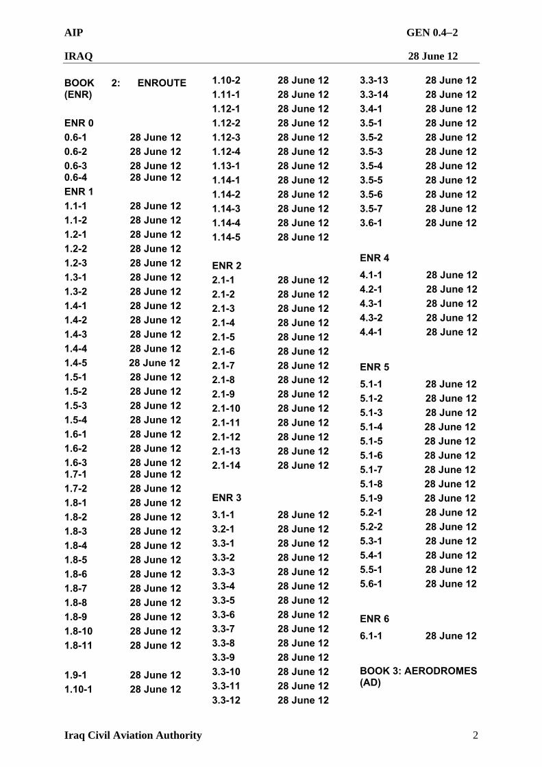
BOOK 2: ENROUTE (ENR)
ENR 0 0.6-1 28 June 12 0.6-2 28 June 12 0.6-3 28 June 12 0.6-4 28 June 12 ENR 1 1.1-1 28 June 12 1.1-2 28 June 12 1.2-1 28 June 12 1.2-2 28 June 12 1.2-3 28 June 12 1.3-1 28 June 12 1.3-2 28 June 12 1.4-1 28 June 12 1.4-2 28 June 12 1.4-3 28 June 12 1.4-4 28 June 12 1.4-5 28 June 12 1.5-1 28 June 12 1.5-2 28 June 12 1.5-3 28 June 12 1.5-4 28 June 12 1.6-1 28 June 12 1.6-2 28 June 12 1.6-3 28 June 12 1.7-1 28 June 12 1.7-2 28 June 12 1.8-1 28 June 12 1.8-2 28 June 12 1.8-3 28 June 12 1.8-4 28 June 12 1.8-5 28 June 12 1.8-6 28 June 12 1.8-7 28 June 12 1.8-8 28 June 12 1.8-9 28 June 12 1.8-10 28 June 12 1.8-11 28 June 12 1.9-1 28 June 12 1.10-1 28 June 12
1.10-2 28 June 12 1.11-1 28 June 12 1.12-1 28 June 12 1.12-2 28 June 12 1.12-3 28 June 12 1.12-4 28 June 12 1.13-1 28 June 12 1.14-1 28 June 12 1.14-2 28 June 12 1.14-3 28 June 12 1.14-4 28 June 12 1.14-5 28 June 12
ENR 2 2.1-1 28 June 12 2.1-2 28 June 12 2.1-3 28 June 12 2.1-4 28 June 12 2.1-5 28 June 12 2.1-6 28 June 12 2.1-7 28 June 12 2.1-8 28 June 12 2.1-9 28 June 12 2.1-10 28 June 12 2.1-11 28 June 12 2.1-12 28 June 12 2.1-13 28 June 12 2.1-14 28 June 12
ENR 3
3.1-1 28 June 12 3.2-1 28 June 12 3.3-1 28 June 12 3.3-2 28 June 12 3.3-3 28 June 12 3.3-4 28 June 12 3.3-5 28 June 12 3.3-6 28 June 12 3.3-7 28 June 12 3.3-8 28 June 12 3.3-9 28 June 12 3.3-10 28 June 12 3.3-11 28 June 12 3.3-12 28 June 12
3.3-13 28 June 12 3.3-14 28 June 12 3.4-1 28 June 12 3.5-1 28 June 12 3.5-2 28 June 12 3.5-3 28 June 12 3.5-4 28 June 12 3.5-5 28 June 12 3.5-6 28 June 12 3.5-7 28 June 12 3.6-1 28 June 12
ENR 4
4.1-1 28 June 12 4.2-1 28 June 12 4.3-1 28 June 12 4.3-2 28 June 12 4.4-1 28 June 12
ENR 5
5.1-1 28 June 12 5.1-2 28 June 12 5.1-3 28 June 12 5.1-4 28 June 12
5.1-5 28 June 12 5.1-6 28 June 12
5.1-7 28 June 12 5.1-8 28 June 12 5.1-9 28 June 12 5.2-1 28 June 12
5.2-2 28 June 12 5.3-1 28 June 12 5.4-1 28 June 12 5.5-1 28 June 12 5.6-1 28 June 12
ENR 6
6.1-1 28 June 12
BOOK 3: AERODROMES (AD)
AIP GEN 0.43
IRAQ 28 June 12
Iraq Civil Aviation Authority 3
AD 0
0.6-1 28 June 12 0.6-2 28 June 12
AD 1
1.1-1 28 June 12 1.2-1 28 June 12 1.3-1 28 June 12 1.3-2 28 June 12 1.3-3 28 June 12 1.3-4 28 June 12
AD 2 2.1-1 28 June 12 2.1-2 28 June 12 2.1-3 28 June 12 2.1-4 28 June 12 2.1-5 28 June 12 2.1-6 28 June 12 2.1-7 28 June 12 2.1-8 28 June 12 2.1-9 28 June 12 2.1-10 28 June 12 2.1-11 28 June 12 2.1-12 28 June 12 2.1-13 28 June 12 2.1-14 28 June 12 2.1-15 28 June 12 2.1-16 28 June 12 2.1-17 28 June 12 2.1-18 28 June 12 2.1-19 28 June 12 2.1-20 28 June 12 2.1-21 28 June 12 2.1-22 28 June 12 2.1-23 28 June 12 2.1-24 28 June 12 2.1-25 28 June 12 2.1-26 28 June 12 2.1-27 28 June 12 2.1-28 28 June 12 2.1-29 28 June 12 2.1-30 28 June 12
2.1-31 28 June 12 2.1-32 28 June 12 2.1-33 28 June 12 2.1-34 28 June 12 2.1-35 28 June 12 2.1-36 28 June 12 2.1-37 28 June 12 2.1-38 28 June 12 2.1-39 28 June 12 2.1-40 28 June 12 2.1-41 28 June 12 2.1-42 28 June 12 2.1-43 28 June 12 2.1-44 28 June 12 2.1-45 28 June 12 2.1-46 28 June 12 2.1-47 28 June 12 2.1-48 28 June 12 2.1-49 28 June 12 2.1-50 28 June 12 2.1-51 28 June 12 2.1-52 28 June 12 2.1-53 28 June 12 2.1-54 28 June 12 2.1-55 28 June 12 2.1-56 28 June 12 2.1-57 28 June 12 2.1-58 28 June 12 2.1-59 28 June 12 2.1-60 28 June 12 2.1-61 28 June 12 2.1-62 28 June 12 2.1-63 28 June 12 2.1-64 28 June 12 2.1-65 28 June 12 2.1-66 28 June 12 2.1-67 28 June 12 2.1-68 28 June 12 2.1-69 28 June 12 2.1-70 28 June 12 2.1-71 28 June 12 2.1-72 28 June 12 2.1-73 28 June 12 2.1-74 28 June 12
2.1-75 28 June 12 2.1-76 28 June 12 2.1-77 28 June 12 2.1-78 28 June 12 2.1-79 28 June 12 2.1-80 28 June 12 2.1-81 28 June 12 2.1-82 28 June 12 2.1-83 28 June 12 2.1-84 28 June 12 2.1-85 28 June 12 2.1-86 28 June 12 2.1-87 28 June 12 2.1-88 28 June 12 2.1-89 28 June 12 2.1-90 28 June 12 2.1-91 28 June 12 2.1-92 28 June 12
2.1-93 28 June 12 2.1-94 28 June 12 2.1-95 28 June 12 2.1-96 28 June 12 2.1-97 28 June 12 2.1-98 28 June 12 2.1-99 28 June 12 2.1-100 28 June 12 2.1-101 28 June 12 2.1-102 28 June 12 2.1-103 28 June 12 2.1-104 28 June 12 2.1-105 28 June 12 2.1-106 28 June 12 2.1-107 28 June 12 2.1-108 28 June 12 2.1-109 28 June 12 2.1-110 28 June 12 2.1-111 28 June 12 2.1-112 28 June 12 2.1-113 28 June 12 2.1-114 28 June 12 2.1-115 28 June 12 2.1-116 28 June 12 2.1-117 28 June 12 2.1-118 28 June 12
AIP GEN 0.44
IRAQ 28 June 12
Iraq Civil Aviation Authority 4
2.1-119 28 June 12 2.1-120 28 June 12 2.1-121 28 June 12 2.1-122 28 June 12 2.1-123 28 June 12 2.1-124 28 June 12 2.1-125 28 June 12 2.1-126 28 June 12 2.1-127 28 June 12 2.1-128 28 June 12 2.1-129 28 June 12 2.1-130 28 June 12 2.1-131 28 June 12 2.1-132 28 June 12 2.1-133 28 June 12 2.1-134 28 June 12 2.1-135 28 June 12 2.1-136 28 June 12 2.1-137 28 June 12 2.1-138 28 June 12 2.1-139 28 June 12 2.1-140 28 June 12 2.1-141 28 June 12 2.1-142 28 June 12 2.1-143 28 June 12 2.1-144 28 June 12 2.1-145 28 June 12 2.1-146 28 June 12 2.1-147 28 June 12 2.1-148 28 June 12 2.1-149 28 June 12 2.1-150 28 June 12 2.1-151 28 June 12 2.1-152 28 June 12 2.1-153 28 June 12 2.1-154 28 June 12 2.1-155 28 June 12 2.1-156 28 June 12 2.1-157 28 June 12 2.1-158 28 June 12 2.1-159 28 June 12 2.1-160 28 June 12 2.1-161 28 June 12 2.1-162 28 June 12
2.1-163 28 June 12 2.1-164 28 June 12 2.1-165 28 June 12 2.1-166 28 June 12 2.1-167 28 June 12 2.1-168 28 June 12 2.1-169 28 June 12 2.1-170 28 June 12 2.1-171 28 June 12 2.1-172 28 June 12 2.1-173 28 June 12 2.1-174 28 June 12 2.1-175 28 June 12 2.1-176 28 June 12
2.1-177 28 June 12 2.1-178 28 June 12 2.1-179 28 June 12 2.1-180 28 June 12 2.1-181 28 June 12 2.1-182 28 June 12 2.1-183 28 June 12 2.1-184 28 June 12 2.1-185 28 June 12 2.1-186 28 June 12 2.1-187 28 June 12
AD 3
3.1-1 28 June 12 3.1-2 28 June 12 3.1-3 28 June 12 3.1-4 28 June 12
AIP GEN 0.51
IRAQ 28 June 12
Iraq Civil Aviation Authority 1
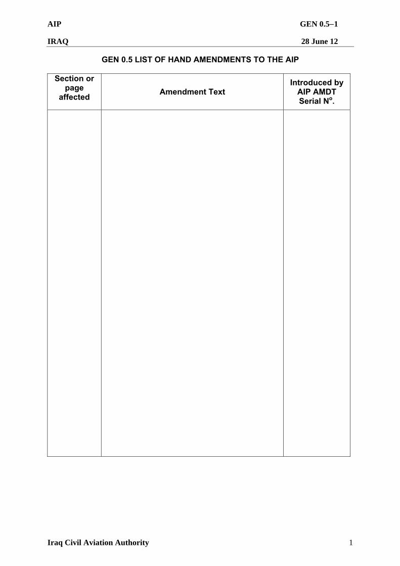
GEN 0.5 LIST OF HAND AMENDMENTS TO THE AIP
Section or page
affected Amendment Text
Introduced by AIP AMDT Serial No.
AIP GEN 0.61
IRAQ 28 June 12
Iraq Civil Aviation Authority 1
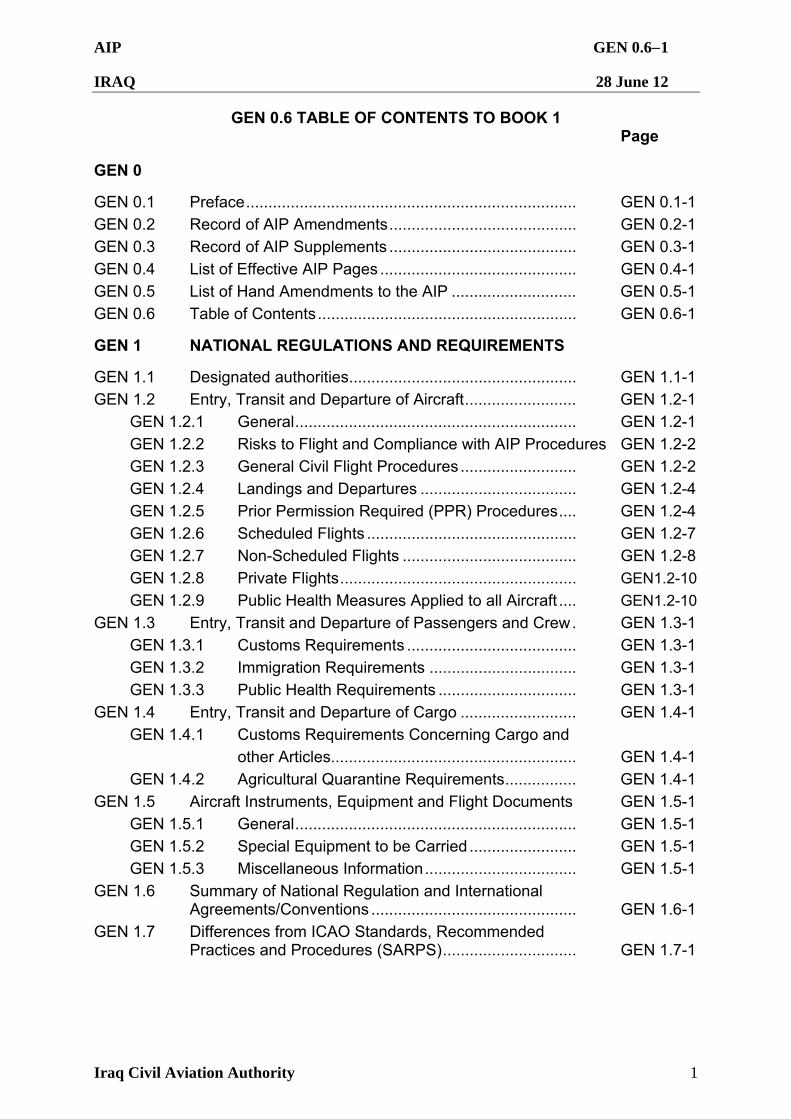
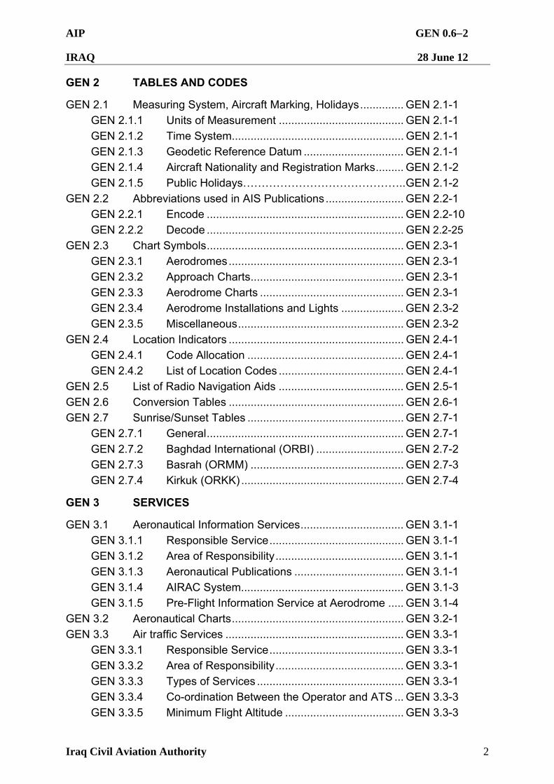
GEN 0.6 TABLE OF CONTENTS TO BOOK 1 Page
GEN 0
GEN 0.1 Preface.......................................................................... GEN 0.1-1
GEN 0.2 Record of AIP Amendments.......................................... GEN 0.2-1
GEN 0.3 Record of AIP Supplements .......................................... GEN 0.3-1
GEN 0.4 List of Effective AIP Pages ............................................ GEN 0.4-1
GEN 0.5 List of Hand Amendments to the AIP ............................ GEN 0.5-1
GEN 0.6 Table of Contents.......................................................... GEN 0.6-1
GEN 1 NATIONAL REGULATIONS AND REQUIREMENTS
GEN 1.1 Designated authorities................................................... GEN 1.1-1
GEN 1.2 Entry, Transit and Departure of Aircraft......................... GEN 1.2-1
GEN 1.2.1 General............................................................... GEN 1.2-1
GEN 1.2.2 Risks to Flight and Compliance with AIP Procedures GEN 1.2-2
GEN 1.2.3 General Civil Flight Procedures .......................... GEN 1.2-2
GEN 1.2.4 Landings and Departures ................................... GEN 1.2-4
GEN 1.2.5 Prior Permission Required (PPR) Procedures.... GEN 1.2-4
GEN 1.2.6 Scheduled Flights ............................................... GEN 1.2-7
GEN 1.2.7 Non-Scheduled Flights ....................................... GEN 1.2-8
GEN 1.2.8 Private Flights..................................................... GEN1.2-10
GEN 1.2.9 Public Health Measures Applied to all Aircraft .... GEN1.2-10
GEN 1.3 Entry, Transit and Departure of Passengers and Crew. GEN 1.3-1
GEN 1.3.1 Customs Requirements ...................................... GEN 1.3-1
GEN 1.3.2 Immigration Requirements ................................. GEN 1.3-1
GEN 1.3.3 Public Health Requirements ............................... GEN 1.3-1
GEN 1.4 Entry, Transit and Departure of Cargo .......................... GEN 1.4-1
GEN 1.4.1 Customs Requirements Concerning Cargo and
other Articles....................................................... GEN 1.4-1
GEN 1.4.2 Agricultural Quarantine Requirements................ GEN 1.4-1
GEN 1.5 Aircraft Instruments, Equipment and Flight Documents GEN 1.5-1
GEN 1.5.1 General............................................................... GEN 1.5-1
GEN 1.5.2 Special Equipment to be Carried ........................ GEN 1.5-1
GEN 1.5.3 Miscellaneous Information.................................. GEN 1.5-1
GEN 1.6 Summary of National Regulation and International Agreements/Conventions .............................................. GEN 1.6-1
GEN 1.7 Differences from ICAO Standards, Recommended Practices and Procedures (SARPS).............................. GEN 1.7-1
AIP GEN 0.62
IRAQ 28 June 12
Iraq Civil Aviation Authority 2
GEN 2 TABLES AND CODES
GEN 2.1 Measuring System, Aircraft Marking, Holidays.............. GEN 2.1-1
GEN 2.1.1 Units of Measurement ........................................ GEN 2.1-1
GEN 2.1.2 Time System....................................................... GEN 2.1-1
GEN 2.1.3 Geodetic Reference Datum ................................ GEN 2.1-1
GEN 2.1.4 Aircraft Nationality and Registration Marks......... GEN 2.1-2
GEN 2.1.5 Public Holidays……………………………………..GEN 2.1-2
GEN 2.2 Abbreviations used in AIS Publications......................... GEN 2.2-1
GEN 2.2.1 Encode ............................................................... GEN 2.2-10
GEN 2.2.2 Decode ............................................................... GEN 2.2-25
GEN 2.3 Chart Symbols............................................................... GEN 2.3-1
GEN 2.3.1 Aerodromes........................................................ GEN 2.3-1
GEN 2.3.2 Approach Charts................................................. GEN 2.3-1
GEN 2.3.3 Aerodrome Charts .............................................. GEN 2.3-1
GEN 2.3.4 Aerodrome Installations and Lights .................... GEN 2.3-2
GEN 2.3.5 Miscellaneous..................................................... GEN 2.3-2
GEN 2.4 Location Indicators ........................................................ GEN 2.4-1
GEN 2.4.1 Code Allocation .................................................. GEN 2.4-1
GEN 2.4.2 List of Location Codes ........................................ GEN 2.4-1
GEN 2.5 List of Radio Navigation Aids ........................................ GEN 2.5-1
GEN 2.6 Conversion Tables ........................................................ GEN 2.6-1
GEN 2.7 Sunrise/Sunset Tables .................................................. GEN 2.7-1
GEN 2.7.1 General............................................................... GEN 2.7-1
GEN 2.7.2 Baghdad International (ORBI) ............................ GEN 2.7-2
GEN 2.7.3 Basrah (ORMM) ................................................. GEN 2.7-3
GEN 2.7.4 Kirkuk (ORKK) .................................................... GEN 2.7-4
GEN 3 SERVICES
GEN 3.1 Aeronautical Information Services................................. GEN 3.1-1
GEN 3.1.1 Responsible Service........................................... GEN 3.1-1
GEN 3.1.2 Area of Responsibility......................................... GEN 3.1-1
GEN 3.1.3 Aeronautical Publications ................................... GEN 3.1-1
GEN 3.1.4 AIRAC System.................................................... GEN 3.1-3
GEN 3.1.5 Pre-Flight Information Service at Aerodrome ..... GEN 3.1-4
GEN 3.2 Aeronautical Charts....................................................... GEN 3.2-1
GEN 3.3 Air traffic Services ......................................................... GEN 3.3-1
GEN 3.3.1 Responsible Service........................................... GEN 3.3-1
GEN 3.3.2 Area of Responsibility......................................... GEN 3.3-1
GEN 3.3.3 Types of Services ............................................... GEN 3.3-1
GEN 3.3.4 Co-ordination Between the Operator and ATS ... GEN 3.3-3
GEN 3.3.5 Minimum Flight Altitude ...................................... GEN 3.3-3
AIP GEN 0.63
IRAQ 28 June 12
Iraq Civil Aviation Authority 3
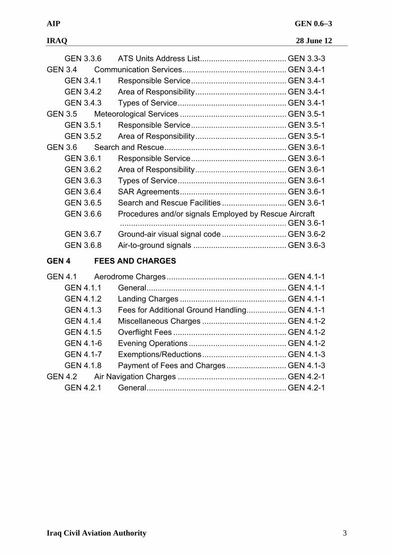
GEN 3.3.6 ATS Units Address List....................................... GEN 3.3-3 GEN 3.4 Communication Services............................................... GEN 3.4-1
GEN 3.4.1 Responsible Service........................................... GEN 3.4-1
GEN 3.4.2 Area of Responsibility......................................... GEN 3.4-1
GEN 3.4.3 Types of Service................................................. GEN 3.4-1
GEN 3.5 Meteorological Services ................................................ GEN 3.5-1
GEN 3.5.1 Responsible Service........................................... GEN 3.5-1
GEN 3.5.2 Area of Responsibility......................................... GEN 3.5-1
GEN 3.6 Search and Rescue....................................................... GEN 3.6-1
GEN 3.6.1 Responsible Service........................................... GEN 3.6-1
GEN 3.6.2 Area of Responsibility......................................... GEN 3.6-1
GEN 3.6.3 Types of Service................................................. GEN 3.6-1
GEN 3.6.4 SAR Agreements................................................ GEN 3.6-1
GEN 3.6.5 Search and Rescue Facilities ............................. GEN 3.6-1
GEN 3.6.6 Procedures and/or signals Employed by Rescue Aircraft ........................................................................... GEN 3.6-1
GEN 3.6.7 Ground-air visual signal code ............................. GEN 3.6-2
GEN 3.6.8 Air-to-ground signals .......................................... GEN 3.6-3
GEN 4 FEES AND CHARGES
GEN 4.1 Aerodrome Charges...................................................... GEN 4.1-1
GEN 4.1.1 General............................................................... GEN 4.1-1
GEN 4.1.2 Landing Charges ................................................ GEN 4.1-1
GEN 4.1.3 Fees for Additional Ground Handling.................. GEN 4.1-1
GEN 4.1.4 Miscellaneous Charges ...................................... GEN 4.1-2
GEN 4.1.5 Overflight Fees ................................................... GEN 4.1-2
GEN 4.1-6 Evening Operations ............................................ GEN 4.1-2
GEN 4.1-7 Exemptions/Reductions...................................... GEN 4.1-3
GEN 4.1.8 Payment of Fees and Charges........................... GEN 4.1-3
GEN 4.2 Air Navigation Charges ................................................. GEN 4.2-1
GEN 4.2.1 General............................................................... GEN 4.2-1
AIP GEN 1.11
IRAQ 28 June 12
Iraq Civil Aviation Authority 1
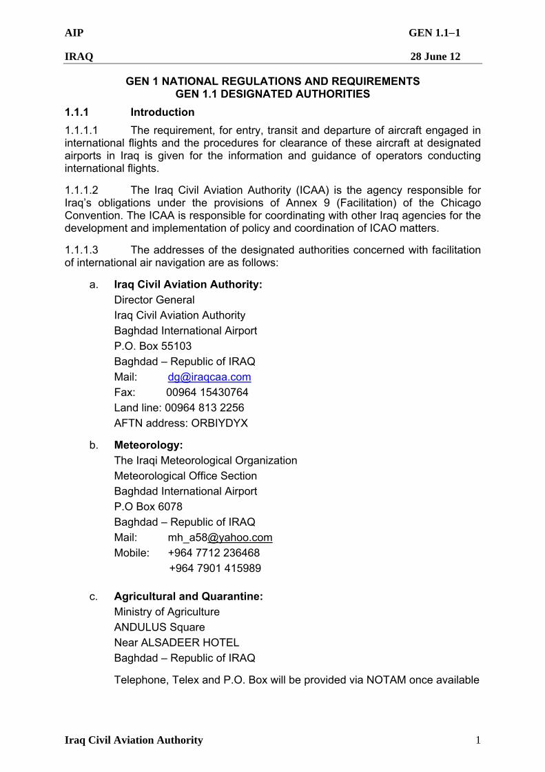
GEN 1 NATIONAL REGULATIONS AND REQUIREMENTS GEN 1.1 DESIGNATED AUTHORITIES
1.1.1 Introduction
1.1.1.1 The requirement, for entry, transit and departure of aircraft engaged in international flights and the procedures for clearance of these aircraft at designated airports in Iraq is given for the information and guidance of operators conducting international flights.
1.1.1.2 The Iraq Civil Aviation Authority (ICAA) is the agency responsible for Iraq’s obligations under the provisions of Annex 9 (Facilitation) of the Chicago Convention. The ICAA is responsible for coordinating with other Iraq agencies for the development and implementation of policy and coordination of ICAO matters.
1.1.1.3 The addresses of the designated authorities concerned with facilitation of international air navigation are as follows:
a. Iraq Civil Aviation Authority:
Director General
Iraq Civil Aviation Authority
Baghdad International Airport
P.O. Box 55103
Baghdad – Republic of IRAQ
Mail: [email protected]
Fax: 00964 15430764
Land line: 00964 813 2256
AFTN address: ORBIYDYX
b. Meteorology:
The Iraqi Meteorological Organization
Meteorological Office Section Baghdad International Airport
P.O Box 6078
Baghdad – Republic of IRAQ
Mail: [email protected]
Mobile: +964 7712 236468
+964 7901 415989
c. Agricultural and Quarantine:
Ministry of Agriculture
ANDULUS Square
Near ALSADEER HOTEL
Baghdad – Republic of IRAQ
Telephone, Telex and P.O. Box will be provided via NOTAM once available
AIP GEN 1.12
IRAQ 28 June 12
Iraq Civil Aviation Authority 2
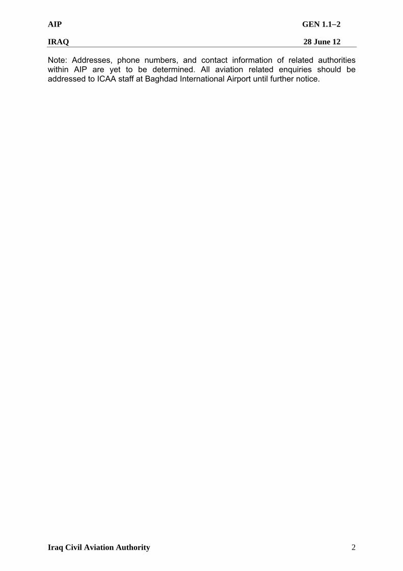
Note: Addresses, phone numbers, and contact information of related authorities within AIP are yet to be determined. All aviation related enquiries should be addressed to ICAA staff at Baghdad International Airport until further notice.
AIP GEN 1.21
IRAQ 28 June 12
Iraq Civil Aviation Authority 1
GEN 1.2 ENTRY, TRANSIT AND DEPARTURE OF AIRCRAFT
1.2.1 General
1.2.1.1 The procedures for flight operations detailed here are mandatory for all aircraft operators authorized to fly in the Baghdad FIR.
1.2.1.2 The ICAA has responsibility for all operational and safety matters relating to civil aviation into, within and from Iraqi territory. International flights into, from or over Iraqi territory shall be subject to the current Iraqi regulations relating to civil aviation. These regulations correspond in all essentials to the Standards and Recommended Practices (SARP) contained in ICAO Annexes to the Convention on International Civil Aviation. Under no circumstances should an aircraft attempt to overfly or enter Iraq without first having obtained the necessary permission except in the case of an aircraft emergency.
1.2.1.3 The ICAA is the approving authority for flights intending to operate within the Baghdad FIR. All aircraft require ICAA approval to land, depart, and overfly Iraq. To accomplish this, all carriers will contact the ICAA directly providing any documentation required by the ICAA. All company information shall be submitted to the ICAA at least seven days prior to the commencement of the first intended flight, or at least 15 days when such a request is submitted through diplomatic channels.
1.2.1.3.1 Request to overfly or operate inside Iraq is accomplished by submitting the proper form. There are two forms: Daily Overflight Request Form and Landing Slot Request Form. They can be found on the ICAA website: http://www.iraqcaa.com/. Requests for civil flights operating in the Baghdad FIR shall be submitted to ICAA no later than 1500Z on the day prior to flight giving details of the proposed flight, and if required will provide written proof of ICAA approval when submitting Overflight or Slot Request Forms.
1.2.1.3.2 Mode 3/A transponder codes are issued to aircraft by ATC.
1.2.1.3.3 As of 25 Aug 09, RAMCC is officially closed and all correspondence will be accomplished thru ICAA.
1.2.1.4 ICAA operates 24 hours a day. The ICAA will resolve all questions that may arise as to whether or not an operator is approved to operate in the Baghdad FIR. The contact numbers for ICAA representatives are:
ICAA Air Trans Dept (Landline) +964 1 813 2467 ICAA Air Trans Dept (cell 1) +964 790 531 9779 ICAA Air Trans Dept (cell 2) +964 771 134 3263 Fax +964 543 0689
E-mail (civil landing slots) [email protected]
Email (civil overflight requests) [email protected]
1.2.1.5 Coalition military aircraft and US TRANSCOM contracted aircraft flying on active legs contained in the Air Tasking Order (ATO) are exempt from ICAA requirements.
AIP GEN 1.22
IRAQ 28 June 12
Iraq Civil Aviation Authority 2
1.2.2 Risks to Flight and Compliance with These Procedures.
1.2.2.1 All aircraft operators shall comply strictly with the provisions of the permission granted for their aircraft and shall adhere to the international designated air routes. Failure to comply with the procedures in this AIP may result in interception by armed coalition fighter aircraft. Aircraft operators must be familiar with, and follow, international intercept procedures contained in Annex 2, Rules of the Air, to the Chicago Convention, paragraph 3.8 and Appendix 2, Sections 2 and 3. Pilots are to continuously monitor the VHF emergency FREQ (121.5 MHz) and operate their transponder at all times during flight. It is imperative that all civilian aircraft follow ATC instructions for mode 3 squawk immediately upon entering the Baghdad FIR. Aircraft within the Baghdad FIR may also be instructed to deviate from their flight planned route due to temporary flight restrictions imposed by military requirements.
1.2.3 General Civil Flight Procedures.
Note: Aircraft types B732, B721, B722, R721, R722, AN26, AN24, AN12, T154 are not allowed to operate in Baghdad FIR
1.2.3.1 Overflights
1.2.3.1.1 Only flights approved by the ICAA are authorized to overfly Iraqi airspace. The Daily Overflight Request Form can be found on the ICAA web site at http://www.iraqcaa.com
1.2.3.1.2 All companies must have ICAA approval to operate within Iraqi airspace prior to submitting an overflight request. All Daily overflight requests must be submitted to ICAA by 1500Z the day prior to the planned flight. Earlier submission is encouraged; however requests should not be submitted any earlier than 30 days prior to the planned overflight. Carriers will receive an approval email from ICAA that provides authorization for flight in the Baghdad FIR.
1.2.3.1.3. Carriers operating under the scheduled overflight procedures detailed in Iraq AIP GEN 1.2.6.-1.2.8 are to submit summer/winter schedules according to published instructions on the ICAA website.
1.2.3.1.4 Changes to overflight requests. Significant changes to a daily overflight request may be made at any time up to 1500Z the day prior to the planned flight by submitting an updated request form to ICAA by email. Changes received after 1500Z may not be accepted due to processing requirements. A significant change is defined as any changes to the following:
UTC date of flight,
Aircraft type,
Call sign,
Aircraft Registration, and
Departure and/or Arrival locations
1.2.3.1.5 Overflight Fee Generation. At 2100Z each evening, the ICAA will generate a final overflight list of the approved overflights of Iraq for the next UTC day. This list will be emailed to Baghdad, Kirkuk and Balad ACC each evening. Baghdad, Kirkuk and Balad ACC will use this list to document actual overflights of Iraqi airspace
AIP GEN 1.23
IRAQ 28 June 12
Iraq Civil Aviation Authority 3
and will forward the annotated list to the ICAA at [email protected] [email protected], and [email protected] by 1700Z the next day.
1.2.3.2 Landings and Departures (Slots)
1.2.3.2.1 Slot requests and changes must be submitted to ICAA no later than 1500Z the day prior to flight and no earlier than 24 hrs prior to the day of operation. Requests received after 1500Z may not be accepted. The Slot Request Form may be found on the ICAA website at http://www.iraqcaa.com. Civil carriers must annotate the correct Category of flight in order to be approved. Carriers will be notified via email from ICAA of approval to operate.
1.2.3.2.2 Changes to takeoff/landing slot time requests. Significant changes to a slot request may be made at any time up to 1500Z the day prior to the planned flight by submitting an updated request form to ICAA by email. Changes received after 1500Z may not be accepted. A significant change is defined as any changes to the following:
UTC date of flight,
Aircraft type,
Call sign,
Aircraft Registration, and
Departure and/or Arrival locations
1.2.3.2.3 Civil aircraft will need to coordinate any and all ground servicing, handling, other aircrew requirements, weather avoidance, air traffic control separation, or enroute and landing threat assessment. All civil aircrew must review all NOTAMS for respective airfields prior to flight. Aircrews should also consider adequate fuel for potential ground or air delays due to unforeseen events. ICAA approval to operate DOES NOT imply approval for any of these items.
1.2.4 Landings and Departures (Reserved)
1.2.5 Prior Permission Required (PPR) Procedures
1.2.5.1 In general, PPRs are required for transient military and civil aircraft including those on ATO’s operating at designated airfields. It is the responsibility of the operating agency to ensure PPR requirements are met prior to landing at the intended airfield. Aircraft that land without an approved PPR may be turned away or met by security forces. PPRs must be obtained before submitting a landing request to ICAA.
1.2.5.2 PPR times must be met +/- 30 (+/- 15 for ORMM) minutes from the approved time. Any changes to an arrival or departure time at an airfield that requires a PPR must be coordinated with the Senior Airfield Authority. Operators that do not coordinate changes to their PPR times may face delays and/or be prohibited from downloading their cargo or passengers. PPR’s issued with less than 6 hours notification will not be guaranteed priority handling and may be delayed. The Senior Airfield Authority is the arbiter for final approval of PPR’s.
1.2.5.3 All civil aircraft requiring flights to PPR designated airfields must contact the Senior Airfield Authority and receive a PPR prior to landing at that airfield.
AIP GEN 1.24
IRAQ 28 June 12
Iraq Civil Aviation Authority 4
Requirements for PPRs are defined with the respective airfield entry in BOOK 3: AERODROMES (AD). Civil carriers are also reminded to check current NOTAMS for changes/updates in PPR requirements.
1.2.5.4 Civilian aircraft flying into or departing from Iraqi territory shall:
a. Only be permitted to make their first landing and final departure from an approved International Airport in order to complete required Customs and Immigration clearance. The current ICAA approved International Airports are Baghdad International, Mosul International, Erbil International, Sulaymaniyah International, Basrah International and Al Najaf Al-Ashraf International.
b. Fly preferred routings and altitudes as described in sections ENR 1.8 and ENR 3.5 or as designated by ATC. If authorization has been obtained to land at airfields where no preferred routing has been specified, aircraft are to comply with the preferred routing of the nearest airport (where the routing is provided) and then indicate the airport of intended landing. In such cases, expect air traffic control to amend routings as required.
1.2.5.5 Fuel and other services may not be available at most airports. If fuel, ground handling or other services are required it must be coordinated through the airport.
(ORBI) For information on ground handling agencies including fuel:
Fuel:
Tel: + (964) 7901 983 453
Handling: [email protected]
Tel: + (964) 813-2012
(ORMM) For information on ground handling agencies including fuel; or email:
Fuel: [email protected]
Tel: + (964) 7901-909871
Handling [email protected]
Tel: + (964) 7801-000628
(ORER) For information on ground handling agencies including fuel; or email: [email protected]
1.2.5.6 All operators are to consult BOOK 3 AERODROMES (AD), for the specific airfield, and NOTAMs for updated information and contact numbers.
Contact information:
AL NAJAF AL-ASHRAF (ORNI)
Email: [email protected] Airfield Manager +964 770 802 4606
BASRAH (ORMM)
Email: [email protected]
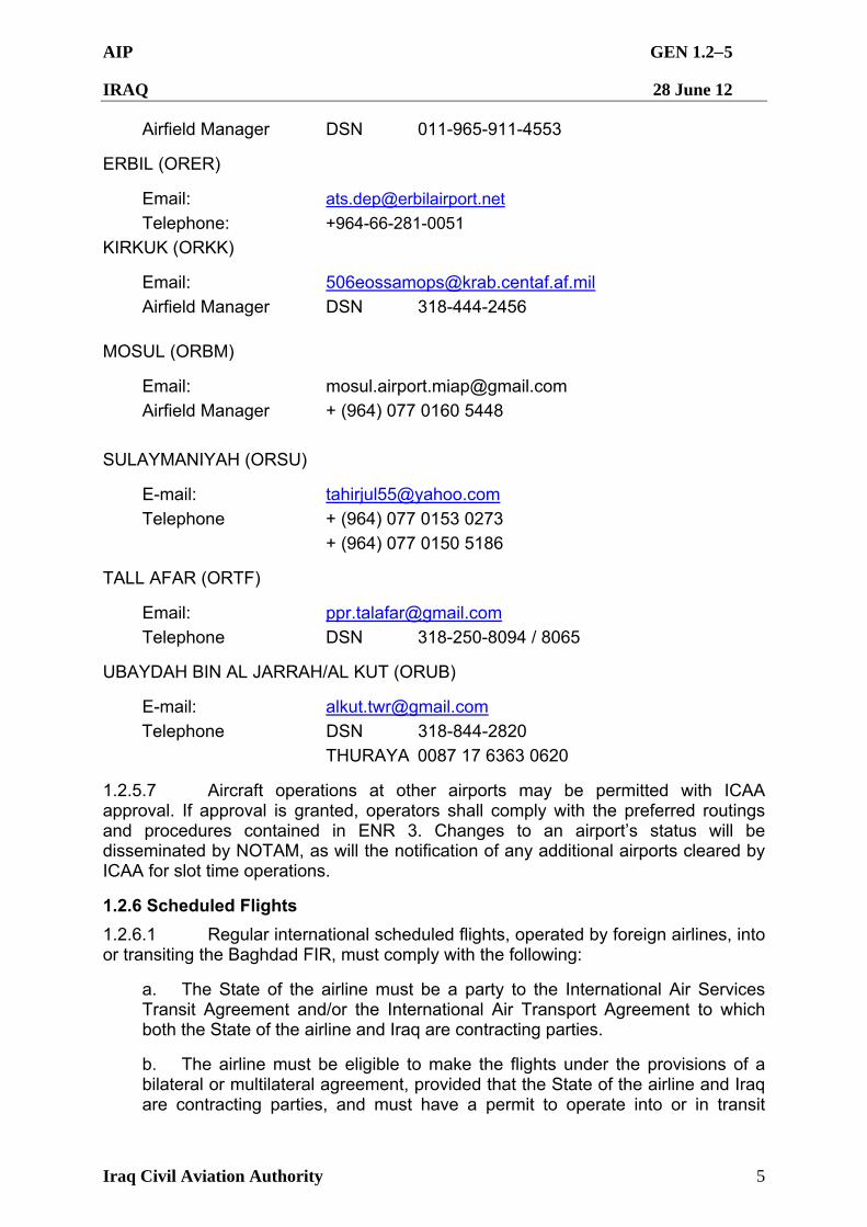
AIP GEN 1.25
IRAQ 28 June 12
Iraq Civil Aviation Authority 5
Airfield Manager DSN 011-965-911-4553
ERBIL (ORER)
Email: [email protected]
Telephone: +964-66-281-0051
KIRKUK (ORKK)
Email: [email protected]
Airfield Manager DSN 318-444-2456
MOSUL (ORBM)
Email: [email protected]
Airfield Manager + (964) 077 0160 5448
SULAYMANIYAH (ORSU)
E-mail: [email protected]
Telephone + (964) 077 0153 0273
+ (964) 077 0150 5186
TALL AFAR (ORTF)
Email: [email protected]
Telephone DSN 318-250-8094 / 8065
UBAYDAH BIN AL JARRAH/AL KUT (ORUB)
E-mail: [email protected]
Telephone DSN 318-844-2820
THURAYA 0087 17 6363 0620
1.2.5.7 Aircraft operations at other airports may be permitted with ICAA approval. If approval is granted, operators shall comply with the preferred routings and procedures contained in ENR 3. Changes to an airport’s status will be disseminated by NOTAM, as will the notification of any additional airports cleared by ICAA for slot time operations.
1.2.6 Scheduled Flights
1.2.6.1 Regular international scheduled flights, operated by foreign airlines, into or transiting the Baghdad FIR, must comply with the following:
a. The State of the airline must be a party to the International Air Services Transit Agreement and/or the International Air Transport Agreement to which both the State of the airline and Iraq are contracting parties.
b. The airline must be eligible to make the flights under the provisions of a bilateral or multilateral agreement, provided that the State of the airline and Iraq are contracting parties, and must have a permit to operate into or in transit
AIP GEN 1.26
IRAQ 28 June 12
Iraq Civil Aviation Authority 6
across Iraq. Applications for such permits shall be submitted to ICAA until further notice.
1.2.6.2 Applications for permission for aircraft engaged in scheduled International Air Services requesting to overfly Iraqi territory or land for non-traffic purposes shall be submitted with full details to ICAA at least seven days prior to the commencement of the flight.
1.2.6.3 Applications for timetable approval of scheduled International Air Services to operate into Iraq for commercial purposes, shall be submitted at least two months prior to the proposed date of the commencement of operation. For additional and non-scheduled flights, see GEN 1.2.7
1.2.6.4 Documentary Requirements for Clearance of Aircraft.
1.2.6.4.1 It is necessary that the under mentioned aircraft documents be submitted by airline operators for clearance on entry and departure of their aircraft to and from Iraq. All documents listed below must follow the ICAO standard format as set in the relevant appendices to ICAO Annex 9, completed in English and completed in legible handwriting. Visas are not required to accompany these documents.
AIP GEN 1.27
IRAQ 28 June 12
Iraq Civil Aviation Authority 7
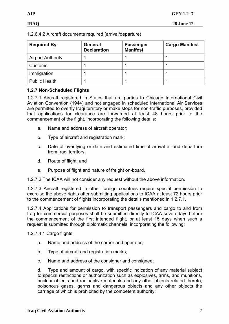
1.2.6.4.2 Aircraft documents required (arrival/departure)
Required By General Declaration
Passenger Manifest
Cargo Manifest
Airport Authority 1 1 1
Customs 1 1 1
Immigration 1 1 1
Public Health 1 1 1
1.2.7 Non-Scheduled Flights
1.2.7.1 Aircraft registered in States that are parties to Chicago International Civil Aviation Convention (1944) and not engaged in scheduled International Air Services are permitted to overfly Iraqi territory or make stops for non-traffic purposes, provided that applications for clearance are forwarded at least 48 hours prior to the commencement of the flight, incorporating the following details:
a. Name and address of aircraft operator;
b. Type of aircraft and registration mark;
c. Date of overflying or date and estimated time of arrival at and departure from Iraqi territory;
d. Route of flight; and
e. Purpose of flight and nature of freight on-board.
1.2.7.2 The ICAA will not consider any request without the above information.
1.2.7.3 Aircraft registered in other foreign countries require special permission to exercise the above rights after submitting applications to ICAA at least 72 hours prior to the commencement of flights incorporating the details mentioned in 1.2.7.1.
1.2.7.4 Applications for permission to transport passengers and cargo to and from Iraq for commercial purposes shall be submitted directly to ICAA seven days before the commencement of the first intended flight, or at least 15 days when such a request is submitted through diplomatic channels, incorporating the following:
1.2.7.4.1 Cargo flights:
a. Name and address of the carrier and operator;
b. Type of aircraft and registration marks;
c. Name and address of the consigner and consignee;
d. Type and amount of cargo, with specific indication of any material subject to special restrictions or authorization such as explosives, arms, and munitions, nuclear objects and radioactive materials and any other objects related thereto, poisonous gases, germs and dangerous objects and any other objects the carriage of which is prohibited by the competent authority;
AIP GEN 1.28
IRAQ 28 June 12
Iraq Civil Aviation Authority 8
e. Name and address of the designated agent in Iraq through whom landing and air navigation facilities charges are to be paid in respect of airlines which do not have offices or accredited agents in Iraq.
f. Place of embarkation or disembarkation abroad, with date and estimated time of arrival at and departure from Iraqi aerodromes.
1.2.7.4.2 Passenger flights:
a. As mentioned in 1.2.7.4.1 sub-paragraphs a, b, e and f above; and
b. Purpose of the flight.
1.2.7.5 Application for permission for aircraft equipped with air photographic apparatus to fly over or land within Iraqi territory should be submitted with full details at least 10 days before the intended day of operation.
1.2.7.6 Application for permission for foreign military aircraft to operate over or into Iraqi territory should be submitted through diplomatic channels at least 15 days prior to the commencement of flight. The application must include the items mentioned in paragraph GEN 1.2.7.1.
1.2.7.7 Non-scheduled flights delaying into the next UTC day must coordinate with the ICAA to confirm permission for flight.
1.2.7.8 Documentary Requirements for Clearance of Aircraft.
1.2.7.8.1 Those requirements defined at GEN 1.2.6.4 also apply to Non-scheduled flights.
1.2.8 Private Flights
1.2.8.1 Advance Notification of Arrival or Entry.
1.2.8.1.1 Prior permission shall be obtained for private aircraft overflying or landing at Iraqi aerodromes. The request must be submitted to ICAA at least 48 hours prior to the departure of the aircraft, or far enough in advance to ensure that the request can be approved by the ICAA, and a reply sent and received prior to scheduled departure. The application must contain information as stated in paragraph GEN1.2.7.1.
1.2.8.1.2 Private flights must submit a flight plan sufficiently early to ensure that the information will be received at least two hours in advance of the aircraft entering the Baghdad FIR. If landing in Iraq, the landing must be carried out at a designated international aerodrome as defined in GEN 1.2.5.4.
1.2.8.1.3 Private flights delaying into the next UTC day must recoordinate with the ICAA to confirm permission for flight.
1.2.8.2 Documentary Requirements for Clearance of Aircraft. Those requirements defined at GEN 1.2.6.6.1 and 1.2.6.6.3 apply to Private flights.
AIP GEN 1.29
IRAQ 28 June 12
Iraq Civil Aviation Authority 9
1.2.9 Public Health Measures Applied to all Aircraft
1.2.9.1 Evidence of protection against cholera, yellow fever or smallpox is required from crew and passengers coming from infected countries.
1.2.9.2 Airline operators, or the pilot for Non-scheduled and Private flights, must ascertain whether the point of departure of any flight to Iraq is contained in an area that has been declared an epidemic area for the purpose of the Iraqi Health Regulation and Orders. The airline or pilot, as applicable, should similarly acquaint themselves as to the status of any area through which the aircraft may transit prior to entering Iraq.
1.2.9.3 No health formalities are required on departure.
AIP GEN 1.31
IRAQ 28 June 12
Iraq Civil Aviation Authority 1
GEN 1.3 ENTRY, TRANSIT AND DEPARTURE OF PASSENGERS AND CREW
1.3.1 Customs Requirements
1.3.1.1 Baggage or articles belonging to disembarking passengers and crew are immediately released except for those selected by the customs authorities for inspection. Such baggage will be cleared on the basis of oral declaration.
1.3.1.2 For customs inspection, presentation of baggage is required from passengers departing Iraq.
1.3.2 Immigration Requirements
1.3.2.1 All foreign passengers must be in possession of a valid passport.
1.3.2.2 All foreign passengers entering Iraq must possess an entry visa.
1.3.2.3 All passengers remaining in Iraq for longer than 30 days and embarking to any point outside Iraq must be in possession of an exit visa.
1.3.2.4 All foreign transit passengers embarking in Iraq for 30 days or less, other than those proceeding on the same flight, must be in possession of a transit visa. No foreign passenger will be permitted to leave the confines of the airport without such a visa.
1.3.2.5 Entry visa is valid for three months from the date of issue, with the understanding that the duration of stay in Iraq is for a maximum of 30 days only.
1.3.2.6 A crew member travelling by service route must be in possession of a valid passport and obtain the necessary authorization.
1.3.2.7 Coalition military and their civilian components are exempt from the above requirements. All contractors are subject to the above requirements and must route through an international airport upon entry and exit to Iraq.
1.3.3 Public Health Requirements
1.3.3.1 Disembarking passengers are not required to present vaccination certificates unless arriving from an area infected with cholera, yellow fever or smallpox.
1.3.3.2 For crew and passengers intending to enter Iraq or in transit, see GEN 1.2.5. to 1.2.9.
AIP GEN 1.41
IRAQ 28 June 12
Iraq Civil Aviation Authority 1
GEN 1.4 ENTRY, TRANSIT AND DEPARTURE OF CARGO
1.4.1 Customs requirements concerning cargo and other articles
1.4.1.1 Application for permission to transport cargo to and from Iraq for commercial purposes shall be submitted directly to ICAA at least 7 days before commencement of the first intended flight, or at least 15 days when such request is submitted through diplomatic channels. Requests shall incorporate the following:
a. Name and address of the carrier and operator;
b. Type of aircraft and registration marks;
c. Name and address of consigner and consignee;
d. Type and amount of cargo, with specific indication of any material subject to special restrictions or authorization, such as explosives, arms and munitions, nuclear objects and radioactive materials, poisonous gases, germs and dangerous goods;
e. Name and address of the designated agent in Iraq through which landing and air navigation facilities charges are to be paid in respect of airlines which do not have offices or accredited agents in Iraq;
f. Place of embarkation or disembarkation abroad with date and estimated time of arrival at, and departure from, Iraqi aerodromes.
1.4.2 Agricultural Quarantine Requirements
1.4.2.1 Agricultural quarantine requirements are comprised of the following:
1.4.2.1.1 Passenger Inspection
1.4.2.1.1.1 Certain plants and plant materials are prohibited by law from entering Iraq such as:
a. Fruits: Mangoes, citrus, etc;
b. Plants: Palm, all green plants, plant cuttings, etc;
c. Others: Culture of bacteria and fungi;
d. Seeds: A permit must be obtained in advance from the Ministry of Agriculture in Iraq. A photo-sanitary certificate from the country of origin is also required. Seeds must pass laboratory inspection before they are released.
1.4.2.2 Imports
1.4.2.2.1 All regulations mentioned above must be observed. All airlines or representatives must present the required documentations and prepare the shipment for inspection.
1.4.2.3 Exports
1.4.2.3.1 The shipment must be examined by an official from the Agricultural Quarantine Administration. A certificate will be granted if the shipment passes
AIP GEN 1.42
IRAQ 28 June 12
Iraq Civil Aviation Authority 2
inspection. The certificate must accompany the shipment. Detailed information and the required forms are available from the Ministry of Agriculture at the address below:
MINISTRY OF AGRICULTURE
ANDULUS Square
Near ALSADER HOTEL
Baghdad – Republic of IRAQ
Fax and telephone numbers will be published via NOTAM when available.
AIP GEN 1.51
IRAQ 28 June 12
Iraq Civil Aviation Authority 1
GEN 1.5 AIRCRAFT INSTRUMENTS, EQUIPMENT AND FLIGHT DOCUMENTS
1.5.1 General:
1.5.1.1 Commercial air transport aircraft operating in Iraq must adhere to the provisions of ICAO Annex 6 – Operation of Aircraft, Part 1 – International Commercial Air Transport – Aeroplanes, Chapter 6 (Aeroplanes Instruments, Equipment and Flight Documents) and Chapter 7 (Aeroplane Communication and Navigation Equipment).
1.5.2 Special Equipment to be carried
1.5.2.1 All aircraft operating within the Baghdad FIR must be approved by the State of the operator or the State of Registry for RNAV5. RNAV5 Approved aircraft shall have the capability to maintain enroute lateral navigation accuracy along track position fixing of +/- 5NM or better, for 95% of the flight time in Iraqi airspace. Any aircraft unable to meet the navigation criteria will not be authorized to fly within Iraqi airspace.
1.5.2.2 Pilots of aircraft meeting RNAV5 standards must indicate R in field 10 of the ICAO flight plan. Operators are to ensure that all relevant procedures, publications and training are in accordance with RNAV5 standards. Pilots must advise ATC of any deterioration or failure of their navigation system by stating “Unable RNAV due to equipment”. ATC will then attempt to provide alternative separation standards and/or routings.
1.5.2.3 There may be insufficient ground-based navigation aids (NAVAIDs) suitable for RNAV or Inertial Navigation System updating along the Iraqi air routes. Therefore, operators whose aircraft navigation systems depend upon ground-based NAVAID updating to meet RNAV5 criteria shall conduct an analysis of the routes to be flown to ensure suitable NAVAID reception.
1.5.2.4 All aircraft operating in the Baghdad FIR shall be equipped with an operable Mode 3/A transponder.
1.5.3 Miscellaneous Information
1.5.3.1 Subject to the observance of the applicable rules, conditions and limitations set forth in this document and in legislation listed in GEN 1.6 and GEN 1.7, foreign civil aircraft registered in any foreign country that is a member of the ICAO may be navigated over Iraq.
1.5.3.2 Aircraft registered under the laws of foreign countries, that are not members of the ICAO, and which grant reciprocal treatment to Iraqi aircraft and airmen, may be navigated over Iraq subject to the observance of the same rules, conditions and limitations applicable as in the case of aircraft of ICAO member States.
1.5.3.3 Radiotelephony procedures and phraseology shall be in accordance with the ICAO Manual of Radiotelephony, Doc 9432 AN/925 and supporting sections of the current ICAO Doc 4444 ATM /501 Procedures for Air Navigation Services – Air Traffic Management.
AIP GEN 1.61
IRAQ 28 June 12
Iraq Civil Aviation Authority 1
GEN 1.6 SUMMARY OF NATIONAL REGULATIONS AND INTERNATIONAL AGREEMENTS/CONVENTIONS
1.6.1 It is essential that personnel engaged in air operations comply with the relevant laws and regulations. Copies of the relevant documents may be obtained from the Ministry of Justice, the address of which is stated below. The following is a list of civil aviation legislation and air navigation regulations, etc. in force in Iraq:
1.6.1.1 Civil Aviation Law No.148 of 1974 (modified issue), (attention is drawn to section 15 of the law, concerning the executive actions taken against persons and airline companies deviating from the articles of the law and incorporated instructions).
1.6.1.2 Regulation No.4 of 1975 concerning the Rules of the Air.
1.6.1.3 Regulation No.27 of 1940 for the control of aerial navigation.
1.6.1.4 Regulation No.26 of 1987 governing the fees and charges for using Iraqi Airports.
1.6.1.5 Laws of Agricultural Quarantine and Instructions 1973/1974.
MINISTRY OF JUSTICE
Salihiya
Baghdad – Republic of IRAQ
Telephone numbers and P.O. Box to be published via NOTAM once available
AIP GEN 1.71
IRAQ 28 June 12
Iraq Civil Aviation Authority 1
GEN 1.7 DIFFERENCES FROM ICAO STANDARDS RECOMMENDED PRACTICES AND PROCEDURES
ANNEX 1 PERSONNEL LICENSING, 10th edition: Nil
ANNEX 2 RULES OF THE AIR, 10th edition: Nil
ANNEX 3 METEOROLOGY, 16th edition: The Iraq AIP is at variance with Chapter 8, Section 8.3., airport climatological summaries for Iraq are not available
ANNEX 4 AERONAUTICAL CHARTS, 10th edition: The Iraq AIP is at variance with Chapter 4 Section 4.2. Aerodrome Obstacle Chart – ICAO Type B is not available for airports in Iraq.
ANNEX 5 UNITS OF MEASUREMENT TO BE USED IN AIR AND GROUND OPERATIONS, 4th edition:
Nil
ANNEX 6 OPERATION OF AIRCRAFT Part I 8th edition:
Part II 6th edition
Part III 5th edition
Nil
ANNEX 7 AIRCRAFT NATIONALITY AND REGISTRATION MARKS, 5th edition:
Nil
ANNEX 8 AIRWORTHINESS OF AIRCRAFT, 9 th edition: Nil
ANNEX 9 FACILITATION, 12th edition: Nil
ANNEX 10 AERONAUTICAL TELECOMMUNICATIONS Volume I 6th edition
Volume II 6th edition
Volume III Part I 2nd edition
Part II 2nd edition
Volume IV 4th edition
Volume V 2nd edition
Nil
ANNEX 11 AIR TRAFFIC SERVICES, 13th edition: Air traffic services within Iraq are being primarily provided by coalition air traffic controllers. Whilst services are in accordance with ICAO classifications of airspace, certain phraseology or procedures may vary at different locations. Class E airspace is non-standard in that VFR aircraft require a clearance and two way communications.
ANNEX 12 SEARCH AND RESCUE, 8th edition: Nil
ANNEX 13 AIRCRAFT ACCIDENT INVESTIGATION, 9th edition: Nil
ANNEX 14 AERODROMES: Some of the facilities and procedures described in AD 2 may not comply with Annex 14.
Volume I 4th edition
Volume II 2nd edition
AIP GEN 1.72
IRAQ 28 June 12
Iraq Civil Aviation Authority 2
ANNEX 15 AERONAUTICAL INFORMATION SERVICES, 12th edition: The Iraq AIP is at variance with Chapter 4, paragraph 4.1.3. Precision Approach Terrain Charts are not produced yet. Additionally, Iraq AIP is at a variance with Chapter 6 in that a mature Aeronautical Information Regulation and Control system has not been implemented in Iraq.
ANNEX 16 ENVIRONMENTAL PROTECTION:
Volume I 4th edition
Volume II 2nd edition
Nil
ANNEX 17 SECURITY – SAFEGUARDING INTERNATIONAL CIVIL AVIATION AGAINST ACTS OF UNLAWFUL INTERFERENCE, 8th edition:
Nil
ANNEX 18 THE SAFE TRANSPORT OF DANGEROUS GOODS BY AIR, 3rd edition:
Nil
AIP GEN 2.11
IRAQ 28 June 12
Iraq Civil Aviation Authority 1
GEN 2 TABLES AND CODES GEN 2.1 MEASURING SYSTEM, AIRCRAFT MARKINGS, HOLIDAYS
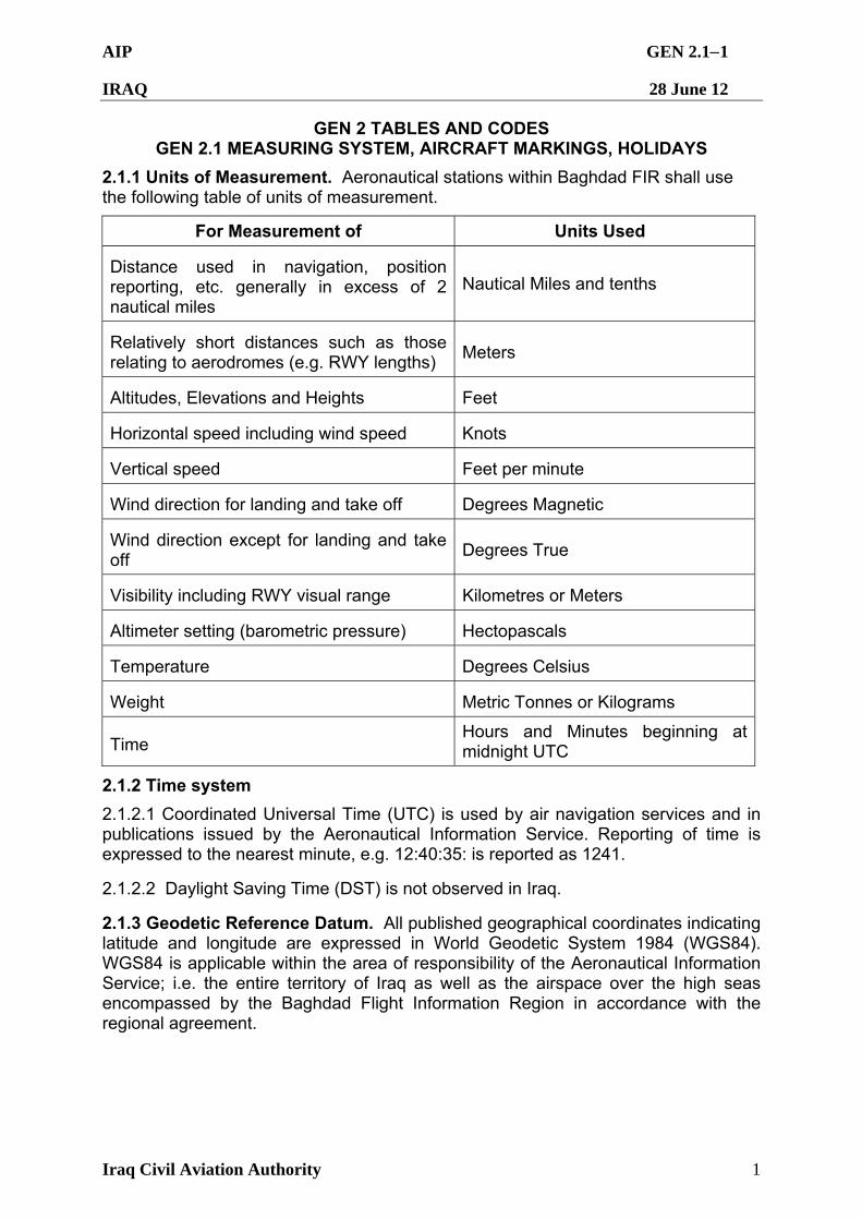
2.1.1 Units of Measurement. Aeronautical stations within Baghdad FIR shall use the following table of units of measurement.
For Measurement of Units Used
Distance used in navigation, position reporting, etc. generally in excess of 2 nautical miles
Nautical Miles and tenths
Relatively short distances such as those relating to aerodromes (e.g. RWY lengths)
Meters
Altitudes, Elevations and Heights Feet
Horizontal speed including wind speed Knots
Vertical speed Feet per minute
Wind direction for landing and take off Degrees Magnetic
Wind direction except for landing and take off
Degrees True
Visibility including RWY visual range Kilometres or Meters
Altimeter setting (barometric pressure) Hectopascals
Temperature Degrees Celsius
Weight Metric Tonnes or Kilograms
Time Hours and Minutes beginning at midnight UTC
2.1.2 Time system
2.1.2.1 Coordinated Universal Time (UTC) is used by air navigation services and in publications issued by the Aeronautical Information Service. Reporting of time is expressed to the nearest minute, e.g. 12:40:35: is reported as 1241.
2.1.2.2 Daylight Saving Time (DST) is not observed in Iraq.
2.1.3 Geodetic Reference Datum. All published geographical coordinates indicating latitude and longitude are expressed in World Geodetic System 1984 (WGS84). WGS84 is applicable within the area of responsibility of the Aeronautical Information Service; i.e. the entire territory of Iraq as well as the airspace over the high seas encompassed by the Baghdad Flight Information Region in accordance with the regional agreement.
AIP GEN 2.12
IRAQ 28 June 12
Iraq Civil Aviation Authority 2
2.1.4 Aircraft Nationality and Registration Marks. The nationality mark for aircraft registered in Iraq is the letters ‘YI’. The nationality mark is followed by a hyphen and a registration mark consisting of three letters, e.g. YI-ABC.
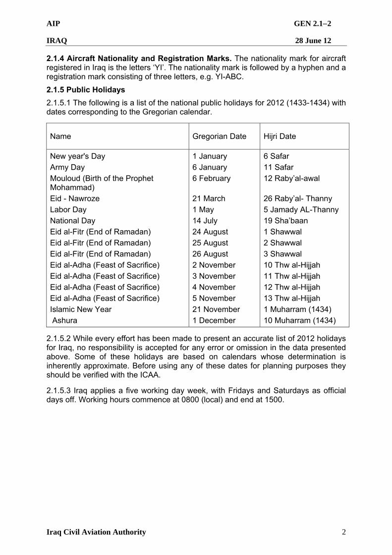
2.1.5 Public Holidays
2.1.5.1 The following is a list of the national public holidays for 2012 (1433-1434) with dates corresponding to the Gregorian calendar.
Name Gregorian Date Hijri Date
New year's Day
Army Day
Mouloud (Birth of the Prophet Mohammad)
Eid - Nawroze
Labor Day
National Day
Eid al-Fitr (End of Ramadan)
Eid al-Fitr (End of Ramadan)
Eid al-Fitr (End of Ramadan)
Eid al-Adha (Feast of Sacrifice)
Eid al-Adha (Feast of Sacrifice)
Eid al-Adha (Feast of Sacrifice)
Eid al-Adha (Feast of Sacrifice)
Islamic New Year
Ashura
1 January
6 January
6 February
21 March
1 May
14 July
24 August
25 August
26 August
2 November
3 November
4 November
5 November
21 November
1 December
6 Safar
11 Safar
12 Raby’al-awal
26 Raby’al- Thanny
5 Jamady AL-Thanny
19 Sha’baan
1 Shawwal
2 Shawwal
3 Shawwal
10 Thw al-Hijjah
11 Thw al-Hijjah
12 Thw al-Hijjah
13 Thw al-Hijjah
1 Muharram (1434)
10 Muharram (1434)
2.1.5.2 While every effort has been made to present an accurate list of 2012 holidays for Iraq, no responsibility is accepted for any error or omission in the data presented above. Some of these holidays are based on calendars whose determination is inherently approximate. Before using any of these dates for planning purposes they should be verified with the ICAA.
2.1.5.3 Iraq applies a five working day week, with Fridays and Saturdays as official days off. Working hours commence at 0800 (local) and end at 1500.
AIP GEN 2.2-1
IRAQ 28 June 12
Iraq Civil Aviation Authority 1
GEN 2.2 DEFINITIONS AND ABBREVIATIONS USED IN AIS PUBLICATIONS
2.2.1 Definitions
Aerodrome: A defined area of land or water (including any buildings, installations and equipment) intended to be used either wholly or in part for the arrival, departure and movement of aircraft. Aerodrome Beacon: An aeronautical beacon, used to indicate the location of an aerodrome from the air. Aerodrome Control Service: ATC service for aerodrome traffic. Aerodrome Control Tower: A unit established to provide ATC service to aerodrome traffic. Aerodrome Elevation: The elevation of the highest point of the landing area. Aerodrome Reference Point (ARP): The designated geographical location of an aerodrome. Aerodrome Traffic: All traffic on the manoeuvring area of an aerodrome and all aircraft flying in, entering, or leaving the traffic circuit. Aeronautical Beacon: An aeronautical ground light visible at all azimuths, either continuously or intermittently, to designate a particular point on the surface of the earth. Aeronautical Information Publication (AIP): A publication issued by or with the authority of a State and containing aeronautical information of a lasting character essential to air navigation. AIP Supplement (SUP): Temporary changes to the information contained in the AIP which are published by means of special pages. Air Tasking Order (ATO):, military aircraft movement approval generated by the coalition. Air Taxiing: Movement of a helicopter / VTOL above the surface of an aerodrome, normally in ground effect and at a speed normally less that 20KT. Air Traffic Control Clearance: Authorisation for aircraft to proceed under conditions specified by an Air Traffic Control unit. Note: For convenience, the term “Air Traffic Control Clearance” is normally abbreviated to “Clearance” when used in appropriate context. Air Traffic Control Instructions: Directives issued by air traffic control for the purpose of requiring a pilot to take a specific action. b. at or below 100FT above the surface; and c. at speeds greater than those used in air taxiing. Air Traffic Control Service: A service provided for the purpose of: a. preventing collisions: 1. between aircraft; and 2. on the manoeuvering area between aircraft and obstructions; and b. expediting and maintaining an orderly flow of air traffic. Air Traffic Service (ATS): A generic term meaning variously, flight information service, alerting service, air traffic advisory service, air traffic control service (area control service, approach control service, or aerodrome control service). Air Transit: The airborne movement of a helicopter that is: a. for the expeditious transit from one place within an aerodrome to another place within the aerodrome; Airways Clearance: A clearance, issued by ATC, to operate in controlled airspace along a designated track or route at a specified level to a specified point or flight planned destination. Alternate Aerodrome: An aerodrome to which an aircraft may proceed when it becomes either impossible or inadvisable to proceed to or to land at the aerodrome of intended landing. Altimeter Setting: A pressure datum which when set on the sub-scale of a sensitive altimeter causes the altimeter to indicate vertical displacement from that datum. A pressure-type altimeter calibrated in accordance with Standard Atmosphere may be used to indicate altitude, height or flight levels, as follows: a. when set to QNH or Area QNH it will indicate altitude; b. when set to Standard Pressure (1013.2 HPA) it may be used to indicate flight levels.
AIP GEN 2.2-2
IRAQ 28 June 12
Iraq Civil Aviation Authority 2
Altitude: The vertical distance of a level, a point or an object, considered as a point, measured from mean sea level. Approach Control Service: ATC service for arriving or departing flights. Apron: A defined area on a land aerodrome, intended to accommodate aircraft for purposes of loading or unloading passengers, mail, cargo, fuelling, parking or maintenance. Area Control Service: Air traffic control service for controlled flights in control areas. Area Navigation (RNAV): A method of navigation which permits aircraft operation on any desired flight path within the coverage of ground or space−based navigation aids, or within the limits of the capability of self-contained aids, or a combination of these. Area Navigation (RNAV) Route: An ATS route established for the use of aircraft capable of employing area navigation. Area QNH: A forecast altimeter setting which is representative of the QNH of any location within a particular area. ATS Route: A specified route designed for channelling the flow of traffic as necessary for the provision of air traffic services. Automatic Terminal Information Service (ATIS): The provision of current, routine information to arriving and departing aircraft by means of continuous and repetitive broadcasts during the hours when the unit responsible for the service is in operation. Briefing: The act of giving in advance, specific pre-flight instructions or information to aircrew. Broadcast: A transmission of information relating to air navigation for which an acknowledgement is not expected. Ceiling: The height above the ground or water of the base of the lowest layer of cloud below 20,000FT covering more than one-half of the sky. Center: A generic call-sign used in the en route and area environment which can include Air Traffic Control, Advisory, Flight Information and Alerting services, depending on the classification of airspace in which the service is provided. Collocated (Navigation) Aids: En route way-points or navigation aids that are within 600M of each other. Control Area (CTA): A controlled airspace extending upwards from a specified limit above the earth. Controlled Aerodrome: An aerodrome at which air traffic control service is provided to aerodrome traffic. Controlled Airspace: Airspace of defined dimensions within which air traffic control service is provided in accordance with the airspace classification. Controller: An air traffic controller, operating within an organisation approved under CASR Part 172 and qualified in accordance with CASR Part 65. Control Zone (CTR): A controlled airspace extending upwards from the surface of the earth to a specified upper limit. Danger Area: An airspace of defined dimensions within which activities dangerous to the flight of aircraft may exist at specified times. Day: That period of time from the beginning of morning civil twilight to the end of evening civil twilight. Dead Reckoning (DR) Navigation: The estimating or determining of position by advancing an earlier known position by the application of direction, time and speed data. Decision Altitude/Height (DA/H): A specified altitude or height in the precision approach at which a missed approach must be initiated if the required visual reference to continue the approach has not been established. Note 1: “Decision altitude (DA)” is referenced to mean sea level (MSL) and “decision height (DH)” is referenced to the threshold elevation. Distance Measuring Equipment (DME): Equipment which measures in nautical miles, the slant range of an aircraft from the selected DME ground station DME Distance: The slant range from the source of a DME signal to the
AIP GEN 2.2-3
IRAQ 28 June 12
Iraq Civil Aviation Authority 3
receiving antenna. Elevation: The vertical distance of a point or a level, on or affixed to the surface of the earth, measured from mean sea level. Emergency Phases: a. Uncertainty Phase: A situation wherein uncertainty exists as to the safety of an aircraft and its occupants. b. Alert Phase: A situation wherein apprehension exists as to the safety of an aircraft and its occupants. c. Distress Phase: A situation wherein there Is reasonable certainty that an aircraft and its occupants are threatened by grave and imminent danger or require immediate assistance. Estimate: The time at which it is estimated that an aircraft will be over a position reporting point or over the destination. Estimated Elapsed Time (EET): The estimated time required to proceed from one significant point to another. Estimated Off Block Time: The estimated time at which the aircraft will commence movement associated with departure. Estimated Time of Arrival (ETA): For IFR flights, the time at which it is estimated that the aircraft will arrive over that designated point, defined by reference to navigation aids, from which it is intended that an instrument approach procedure will be commenced, or, if no navigation aid is associated with the aerodrome, the time at which the aircraft will arrive over the aerodrome. For VFR flights, the time at which it is estimated that the aircraft will arrive over the aerodrome. Final Approach: That part of an instrument approach procedure which commences at the specified final approach fix or point, or where such a fix or point is not specified: a. at the end of the last procedure turn, base turn or inbound turn of a racetrack procedure, if specified; or b. at the point of interception of the last track specified in the approach procedure; and c. ends at a point in the vicinity of an aerodrome from which a landing can be made, or a missed approach is initiated. Final Approach Altitude: The specified altitude at which final approach is commenced. Final Approach Fix (FAF): A specified point on a non-precision instrument approach which identifies the commencement of the final segment. Final Approach Point (FAP): A specified point on the glide path of a precision instrument approach which identifies the commencement of the final segment. Note: The FAP is co-incident with the FAF of a localizer based non-precision approach. Final Approach Segment: That segment of an instrument approach procedure in which alignment and descent for landing are accomplished. Final Leg: The path of an aircraft in a straight line immediately preceding the landing (alighting) of the aircraft. Fix: A geographical position of an aircraft at a specific time determined by visual reference to the surface, or by navigational aids. Flight Information: Information useful for the safe and efficient conduct of flight, including information on air traffic, meteorological conditions, aerodrome conditions and airways facilities. Flight Information Region (FIR): An airspace of defined dimensions within which flight information service and SAR alerting service are provided. Flight Information Service (FIS): A service provided for the purpose of giving advice and information useful for the safe and efficient conduct of flights. Flight Level (FL): A surface of constant atmospheric pressure which is related to a specific pressure datum, 1013.2HPA, and is separated from other such surfaces by specific pressure intervals. Flight Visibility: The visibility forward from the cockpit of an aircraft in flight. Forecast: A statement of expected meteorological conditions for a specified period, and for a specified area or portion of airspace.
AIP GEN 2.2-4
IRAQ 28 June 12
Iraq Civil Aviation Authority 4
Formation: Two or more aircraft flown in close proximity to each other and operating as a single aircraft with regard to navigation, position reporting and control. Note: Refer to CAR 163AA for conditions under which formation flight may be undertaken. Glide Path (GP): A descent profile determined for vertical guidance during a final approach. Global Navigation Satellite System (GNSS): A satellite-based radio navigation system that uses signals from orbiting satellites to determine precise position and time. Global Positioning System (GPS): A GNSS constellation operated by the United States Government. Gross Weight: The weight of the aircraft together with the weight of all persons and goods (including fuel) on board the aircraft at that time. Ground Based Navigation Aid means NDB, VOR, DME. Ground Taxiing: The movement of a helicopter under its own power and on its undercarriage wheels. Ground Visibility: The visibility at an aerodrome, as reported by an accredited observer. Hazardous Conditions: Meteorological conditions which may endanger aircraft or adversely affect their safe operation, particularly those phenomena associated with volcanic ash cloud and thunderstorms − icing, hail and turbulence. Heading (HDG): The direction in which the longitudinal axis of an aircraft is pointed, usually expressed in degrees from North (true, magnetic, compass or grid). Height: The vertical distance of a level, a point or an object considered as a point measured from a specified datum. Height Above Aerodrome (non-precision approach or circling) (HAA): The height of the Minimum Descent Altitude above the published aerodrome elevation. Height Above Threshold (precision approach) (HAT): The height of the Decision Altitude above the threshold elevation. Helicopter Landing Site (HLS): A place that is used as an aerodrome for the purposes of the landing and taking-off of helicopters. Helicopter Lane: A lane, outside controlled airspace, designed for use by helicopters to facilitate traffic flow. Holding Bay: A defined area where aircraft can be held, or bypassed, to facilitate efficient surface movement of aircraft. Holding Fix: A specified location identified by visual or other means in the vicinity of which the position of an aircraft in flight is maintained in accordance with ATC Instructions. Holding Procedure: A predetermined manoeuvre which keeps an aircraft within a specified airspace whilst awaiting further clearance. Hospital Aircraft: A priority category for use by international aircraft when medical priority Is required (see also Medical). IFR Pick−up: A pilot procedure whereby a flight operating to the IFR in Class G airspace changes to VFR upon entering Class E airspace whilst awaiting an airways clearance. IFR Pick-up is limited to FL180 and below. Identification: The situation which exists when the position indication of a particular aircraft is seen on a situation display and positively identified by ATC. Inertial Navigation / Reference System (INS/IRS): A self-contained navigation system that continually measures the accelerations acting upon the vehicle of which it is part. Suitably integrated, these forces provide velocity and thence position information. Instrument Approach and Landing Operations: Instrument approach and landing operations are classified as follows: a. Non-precision Approach and Landing Operations: Instrument approaches and landings which do not utilise electronic glide path guidance.
AIP GEN 2.2-5
IRAQ 28 June 12
Iraq Civil Aviation Authority 5
b. Precision Approach and Landing Operations: Instrument approaches and landings using precision azimuth and glide path guidance with minima as determined by the category of operation. Categories of Precision Approach and Landing Operations are: (i) Category I (CAT I) operation. A precision instrument approach and landing with a decision height not lower than 200FT and a visibility not less than 800M, or a RVR not less than 550M. (ii) Category II (CAT II) operation: A precision instrument approach and landing with a decision height lower than 200FT but not lower than 100FT, and a runway visual range not less than 350M. (iii) Category IIIA (CAT IIIA) operation: A precision instrument approach and landing with a decision height lower than 100FT, or no decision height and a runway visual range not less than 200M. Instrument Approach Procedure: A series of predetermined manoeuvres by reference to flight instruments with specified protection from obstacles from the initial approach fix or where applicable, from the beginning of a defined arrival route to a point from which a landing can be completed and thereafter, if a landing is not completed, to a position at which holding or en route obstacle clearance criteria apply. Intermediate Fix (IF): A fix on an RNAV approach that marks the end of an initial segment and the beginning of the intermediate segment. In the Vicinity: An aircraft is in the vicinity of a non−towered aerodrome if it is within a horizontal distance of 10 miles; and within a height above the aerodrome reference point that could result in conflict with operations at the aerodrome. Initial Approach Fix (IAF): The fix at the commencement of an instrument approach. Initial Approach Segment: That segment of an instrument approach procedure between the initial approach fix and the intermediate approach fix or, where applicable, the final approach fix or point. Instrument Landing System (ILS): A precision instrument approach system which normally consists of the following electronic components: VHF Localiser, UHF Glideslope, VHF Marker Beacons. Instrument Runway: One of the following types of runways intended for the operation of aircraft using instrument approach procedures: a. Non-precision approach runway. An instrument runway served by visual aids and a non-visual aid providing at least directional guidance adequate for a straight-in approach. b. Precision approach runway, CAT I. An instrument runway served by lLS and visual aids intended for operations with a decision height not lower than 200FT and either a visibility not less than 800M, or a RVR not less than 550M. c. Precision approach runway, CAT Il. An instrument runway served by lLS and visual aids intended for operations with a decision height lower than 200FT, but not lower than 100FT and a RVR not less than 350M. d. Precision approach runway, CAT Ill. An instrument runway served by ILS to and along the surface of the runway and: (i) for CAT IIIA − intended for operations with a decision height lower than 100FT, or no decision height and a RVR not less than 200M; (ii) for CAT IIIB − intended for operations with a decision height lower than 50FT, or no decision height and a RVR less than 200M, but not less than 50M; (iii) for CAT IIIC − intended for operations with no decision height and no RVR limitations. Integrity: That quality which relates to the trust which can be placed in the correctness of information supplied by a system. It includes the ability of a system to provide timely warnings to users when the system should not be used for navigation. Landing Area: That part of the movement area intended for the landing or take-off of aircraft.
AIP GEN 2.2-6
IRAQ 28 June 12
Iraq Civil Aviation Authority 6
Level: A generic term relating to the vertical position of an aircraft in flight and meaning variously, height, altitude or flight level. Localizer (LOC): The component of an ILS which provides azimuth guidance to a runway. It may be used as part of an ILS or independently. Lowest Safe Altitude (LSALT): The lowest altitude which will provide safe terrain clearance at a given place. Manoeuvring Area: That part of an aerodrome to be used for the take-off, landing and taxiing of aircraft, excluding aprons. Maximum Take-off Weight (MTOW): The maximum take-off weight of an aircraft as specified in its Certificate of Airworthiness. Meteorological Information: Meteorological report, analysis, forecast, and any other statement relating to existing or expected meteorological conditions. Minimum Altitude: The minimum altitude for a particular instrument approach procedure is the altitude specified by AIP DAP at which an aircraft shall discontinue an instrument approach unless continual visual reference to the ground or water has been established and ground visibility is equal to or greater than that specified by the DAP for landing. Note: Applies to “old” type instrument approach charts. Minimum Descent Altitude (MDA): A specified altitude in a non-precision runway or circling approach below which descent may not be made without visual reference. Note: Applies to “new” type instrument approach charts. Minimum Fuel: The term used to describe a situation in which an aircraft’s fuel supply has reached a state where little or no delay can be accepted. Note: This is not an emergency situation but merely indicates that an emergency situation is possible, should any undue delay occur. Minimum Sector Altitude (MSA): The lowest altitude which may be used which will provide a minimum clearance of 1,000FT above all objects located in an area contained within a sector of a circle of 25NM or 10NM radius centred on a radio aid to navigation or, where there is no radio navigation aid, the Aerodrome Reference Point. Missed Approach Holding Fix (MAHF): A fix on an RNAV approach that marks the end of the missed approach segment and the point for the missed approach holding (where applicable). Missed Approach Point (MAPT): That point in an instrument approach procedure at or before which the prescribed missed approach procedure must be initiated in order to ensure that the minimum obstacle clearance is not infringed. Missed Approach Procedure (MAP): The procedure to be followed if the approach cannot be continued. Missed Approach Turning Fix (MATF): A fix on an RNAV approach that marks a turning point during the missed approach segment. Movement Area: That part of an aerodrome to be used for the take-off, landing and taxiing of aircraft, consisting of the manoeuvring area and the apron(s). Navigation Specification. A set of aircraft and flight crew requirements needed to support performance based navigation operations within a defined airspace. There are two kinds of navigation specifications: RNP Specification. A navigation specification based on area navigation that includes the requirement for performance monitoring and alerting, designated by the prefix RNP, e.g. RNP 4, RNP APCH. RNAV Specification. A navigation specification based on area navigation that does not include the requirement for performance monitoring and alerting, designated by the prefix RNAV, e.g. RNAV 5, RNAV 1. Note: The Performance−based Navigation Manual (Doc 9613), Volume II, contains detailed guidance on navigation specifications. Night: That period of time between the end of evening civil twilight and the beginning of morning civil twilight.
AIP GEN 2.2-7
IRAQ 28 June 12
Iraq Civil Aviation Authority 7
Non-Directional Beacon (NDB): A special radio station, the emissions of which are intended to enable a mobile station to determine its radio bearing or direction with reference to that special radio station. NOTAM: A notice distributed by means of telecommunication containing information concerning the establishment, condition or change in any aeronautical facility, service, procedure or hazard, the timely knowledge of which is essential to personnel concerned with flight operations. Operator: A person, organisation or enterprise engaged in or offering to engage in aircraft operation. Operations Manual: A manual provided by an operator for the use and guidance of its operations staff, containing instructions as to the conduct of flight operations, including the responsibilities of its operations staff (refer CAR 215). Overshoot Shear: A wind shear occurrence which produces an INITIAL effect of overshooting the desired approach path and/or increasing airspeed. Parking Area: A specially prepared or selected part of an aerodrome within which aircraft may be parked. Pavement Classification Number (PCN): A number expressing the bearing strength of a pavement for unrestricted operations. Preferred Runway: A runway nominated by ATC or listed in the AIP as the most suitable for the prevailing wind, surface conditions or noise sensitive areas in the proximity of the aerodrome. Primary Means Navigation System: A navigation system that, for a given operation or phase of flight, must meet accuracy and integrity requirements, but need not meet full availability and continuity of service requirements. Safety is achieved by either limiting flights to specific time periods, or through appropriate procedural restrictions and operational requirements. Procedural Service: Term used to indicate that information derived from an ATS surveillance system is not required for the provision of ATS. Procedure Altitude/Height: A specified altitude/height flown at or above the minimum altitude/height, and established to accommodate a stabilised descent at a prescribed descent gradient/angle in the intermediate/final approach segment. Prohibited Area: An airspace of defined dimensions, above the land areas or territorial waters of a State, within which the flight of aircraft is prohibited. Designation is appropriate only for reasons of defence. QNH Altimeter Setting: That pressure setting which, when placed on the pressure setting sub-scale of a sensitive altimeter of an aircraft located at the reference point of an aerodrome, will cause the altimeter to indicate the vertical displacement of the reference point above mean sea level. Reduced Vertical Separation Minimum (RVSM): The vertical separation minimum of 1000FT between FL 290 and FL 410 inclusive. Reporting Point: A specified geographical location in relation to which the position of an aircraft can be reported. Required Navigation Performance (RNP): A statement of the navigation performance necessary for operation within a defined airspace. RNP Type: A containment value expressed as a distance in nautical miles from the intended position within which flights would be for at least 95 per cent of the total flying time. Restricted Area: An airspace of defined dimensions above the land areas or territorial waters of a State, within which the flight of aircraft is restricted in accordance with certain specified conditions. Route: A way to be taken in flying from a departure to a destination aerodrome, specified in terms of track and distance for each route segment. Runway (RWY): A defined rectangular area on a land aerodrome prepared for the landing and take-off of aircraft. Runway-Holding Position: A designated position intended to protect a runway, an obstacle limitation surface, or an ILS critical/sensitive area at which taxiing aircraft and vehicles must stop and hold, unless otherwise authorised by the aerodrome control tower.
AIP GEN 2.2-8
IRAQ 28 June 12
Iraq Civil Aviation Authority 8
Note: In radiotelephony phraseologies, the expression “holding point” is used to designate the runway−holding position. Runway Number: The runway identification associated with the runway direction end. Runway Strip: The defined area, including the runway (and stopway if provided), intended both to reduce the risk of damage to aircraft inadvertently running off the runway and to protect aircraft flying over it during take-off, landing or missed approach. Search and Rescue (SAR): The act of finding and returning to safety, aircraft and persons involved in an emergency phase. Segment Minimum Safe Altitude: The lowest altitude at which the minimum obstacle clearance is provided. Significant Weather: Any weather phenomenon which might affect flight visibility or present a hazard to an aircraft. Sole Means Navigation System: A navigation system that, for a given phase of flight, must allow the aircraft to meet all four navigation system performance requirements − accuracy, integrity, availability and continuity of service. SSR Code: The number assigned to a particular multiple-pulse reply signal transmitted by a transponder in Mode A or Mode C. Standard Instrument Departure (SID): A designated IFR departure route linking the aerodrome or a specified runway of the aerodrome with a specified significant point, normally on a designated ATS route, at which the en route phase of a flight commences. Standard Pressure: The pressure of 1013.2 Hectopascals which, if set upon the pressure sub-scale of a sensitive altimeter, will cause the latter to read zero when at mean sea level in a standard atmosphere. Stopway: A defined rectangular area on the ground at the end of the take-off run available prepared as a suitable area in which an aircraft can be stopped in the case of an abandoned take-off. Tactical Air Navigation (TACAN): An ultra-high frequency navigation aid which provides a continuous indication of bearing and slant range, in nautical miles, to the selected ground station. Taxiway (TWY): A defined path on a land aerodrome established for the taxiing of aircraft and intended to provide a link between one part of the aerodrome and another. Terrain Clearance: The vertical displacement of an aircraft’s flight path from the terrain. Threshold: The beginning of that portion of the runway usable for landing. Threshold Crossing Height: The height of the ILS glide path at the threshold. Track: The projection on the earth’s surface of the path of an aircraft, the direction of which path at any point is usually expressed in degrees from North (true, magnetic or grid). Transition Altitude: The altitude at or below which the vertical position of an aircraft is controlled by reference to altitudes. Transition Layer: The airspace between the transition altitude and the transition level. Transition Level: The lowest flight level available for use above the transition altitude. Transitional Surface: An inclined plane associated with the runway strip and the approach surfaces. Transponder: A receiver/transmitter which will generate a reply signal upon proper interrogation; the interrogation and reply being on different frequencies. Undershoot Shear: A wind shear occurrence which produces an INITIAL effect of undershooting the desired approach path and/or decreasing air speed. Unserviceable Area: A portion of the movement area not available for use by aircraft because of the physical condition of the surface, or because of any obstruction on the area. Vectoring: Provision of navigational guidance to aircraft in the form of specific
AIP GEN 2.2-9
IRAQ 28 June 12
Iraq Civil Aviation Authority 9
headings, based on the use of an ATS surveillance system. VHF Omni-directional Radio Range (VOR): A VHF radio navigational aid which provides a continuous indication of bearing from the selected VOR ground station. Visibility: Visibility for aeronautical purposes is the greater of: a. the greatest distance at which a black object of suitable dimensions, situated near the ground, can be seen and recognised when observed against a bright background; or b. the greatest distance at which lights in the vicinity of 1,000 candelas can be seen and identified against an unlit background. Visual (ATC usage): Used by ATC to instruct a pilot to see and avoid obstacles while conducting flight below the MVA or MSA/LSALT. Visual (Pilot usage): Used by a pilot to indicate acceptance of responsibility to see and avoid obstacles while operating below the MVA or MSA/LSALT. Visual Approach Slope Indicator System (VASIS): A system of lights so arranged as to provide visual information to pilots on approach of their position in relation to the optimum approach slope for a particular runway. Vs1g means the one-g stall speed at which the aeroplane can develop a lift force (normal to the flight path) equal to its weight. Way-point: A specified geographical location used to define an area navigation route or the flight path of an aircraft employing area navigation. Way-points are identified as either: a. Fly-by Way-point: A way-point which requires turn anticipation to allow tangential interception of the next segment of a route or procedure, or b. Flyover Way-point: A way-point at which a turn is initiated in order to join the next segment of a route or procedure.
AIP GEN 2.2-10
IRAQ 28 June 12
Iraq Civil Aviation Authority 10
2.2.2 National and ICAO abbreviations - Encode
† When radiotelephony is used, the abbreviations and terms are transmitted as spoken words.
‡ When radiotelephony, is used, the abbreviations and terms are transmitted using the individual letters in non-phonetic form.
* Signal is also available for use in communicating with stations of the maritime mobile service.
# Signal for use in the teletypewriter service only.
± Variations from ICAO Doc
A
A Amber
A (A0-A5)± Amplitude modulation (AM)
AAA (or AAB, AAC . . . etc., in sequence) Amended meteorological message (message type designator)
A/A Air-to-air
AAD Assigned altitude deviation
AAIM Aircraft autonomous integrity monitoring
AAL Above aerodrome level
ABI Advance boundary information
ABM Abeam
ABN Aerodrome beacon
ABT About
ABV Above
AC Altocumulus
ACARS† (pronounced “AY-CARS”) Aircraft communication addressing and reporting system
ACAS† Airborne collision avoidance system
ACC‡ Area control centre or area control
ACCID Notification of an aircraft accident
ACFT Aircraft
ACK Acknowledge
ACL Altimeter check location
ACN Aircraft classification number
ACP Acceptance (message type designator)
ACPT Accept or accepted
ACT Active or activated or activity
AD Aerodrome
ADA Advisory area
ADC Aerodrome chart
ADDN Addition or additional
ADF‡ Automatic direction-finding equipment
ADIZ† (pronounced “AY-DIZ”) Air defence identification zone
ADJ Adjacent
ADO Aerodrome office (specify service)
ADR Advisory route
ADS* The address (when this abbreviation is used to request a repetition, the question mark (IMI) precedes the abbreviation, e.g. IMI ADS) (to be used in AFS as a procedure signal)
ADS-B‡ Automatic dependent surveillance — broadcast
ADS-C‡ Automatic dependent surveillance — contract
ADSU Automatic dependent surveillance unit
ADVS Advisory service
ADZ Advise
AES Aircraft earth station
AFIL Flight plan filed in the air
AFIS Aerodrome flight information service
AFM Yes or affirm or affirmative or that is correct
AFS Aeronautical fixed service
AFT After . . . (time or place)
AFTN‡ Aeronautical fixed telecommunication network
A/G Air-to-ground
AGA Aerodromes, air routes and ground aids
AGL Above ground level
AGN Again
AIC Aeronautical information circular
AIDC Air traffic services interfacility data communications
AIP Aeronautical information publication
AIRAC Aeronautical information regulation and control
AIREP† Air-report
AIRMET† Information concerning en-route weather phenomena which may affect the safety of low-level aircraft operations
AIS Aeronautical information services
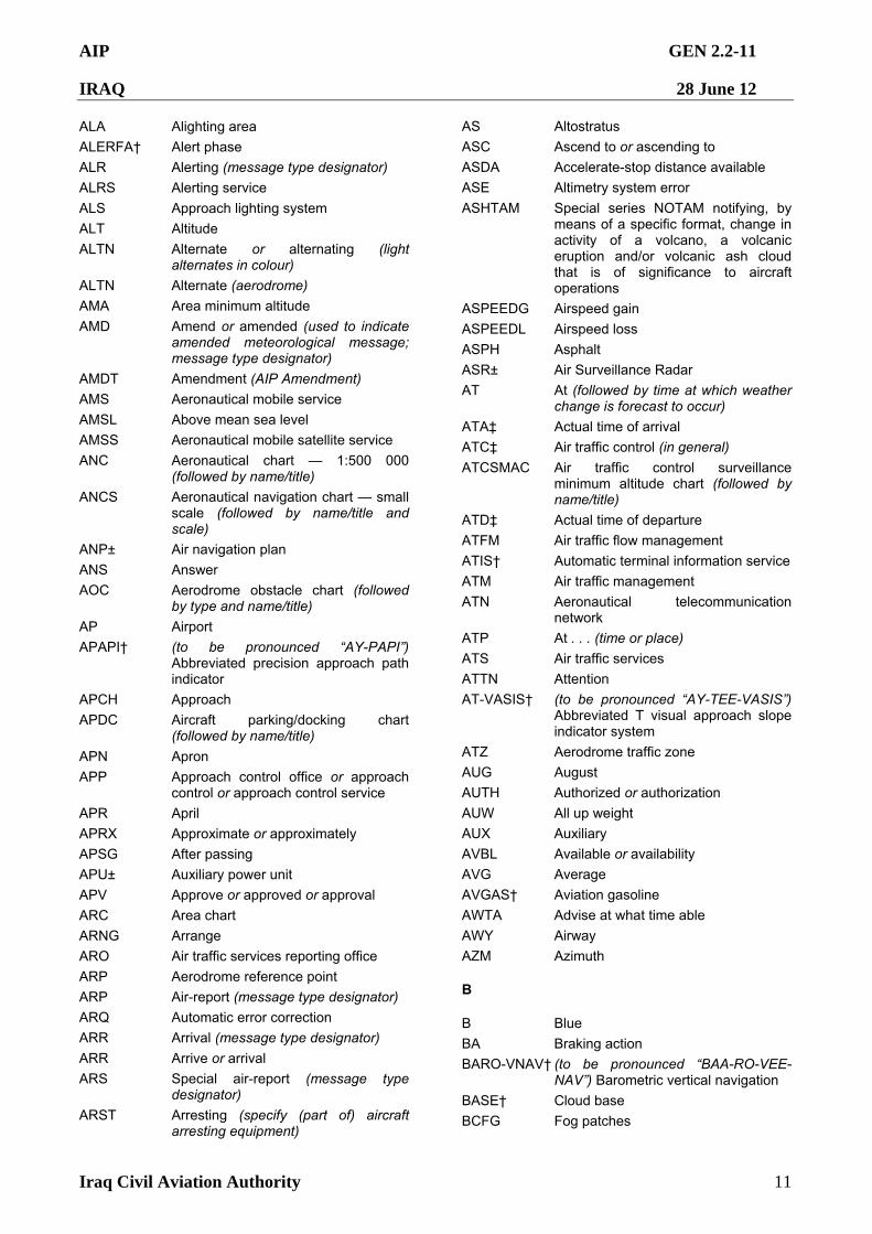
AIP GEN 2.2-11
IRAQ 28 June 12
Iraq Civil Aviation Authority 11
ALA Alighting area
ALERFA† Alert phase
ALR Alerting (message type designator)
ALRS Alerting service
ALS Approach lighting system
ALT Altitude ALTN Alternate or alternating (light
alternates in colour)
ALTN Alternate (aerodrome)
AMA Area minimum altitude
AMD Amend or amended (used to indicate amended meteorological message; message type designator)
AMDT Amendment (AIP Amendment)
AMS Aeronautical mobile service
AMSL Above mean sea level
AMSS Aeronautical mobile satellite service
ANC Aeronautical chart — 1:500 000 (followed by name/title)
ANCS Aeronautical navigation chart — small scale (followed by name/title and scale)
ANP± Air navigation plan
ANS Answer
AOC Aerodrome obstacle chart (followed by type and name/title)
AP Airport
APAPI† (to be pronounced “AY-PAPI”) Abbreviated precision approach path indicator
APCH Approach
APDC Aircraft parking/docking chart (followed by name/title)
APN Apron
APP Approach control office or approach control or approach control service
APR April
APRX Approximate or approximately
APSG After passing
APU± Auxiliary power unit
APV Approve or approved or approval
ARC Area chart
ARNG Arrange
ARO Air traffic services reporting office
ARP Aerodrome reference point
ARP Air-report (message type designator)
ARQ Automatic error correction
ARR Arrival (message type designator)
ARR Arrive or arrival
ARS Special air-report (message type designator)
ARST Arresting (specify (part of) aircraft arresting equipment)
AS Altostratus
ASC Ascend to or ascending to
ASDA Accelerate-stop distance available
ASE Altimetry system error
ASHTAM Special series NOTAM notifying, by means of a specific format, change in activity of a volcano, a volcanic eruption and/or volcanic ash cloud that is of significance to aircraft operations
ASPEEDG Airspeed gain
ASPEEDL Airspeed loss
ASPH Asphalt
ASR± Air Surveillance Radar
AT At (followed by time at which weather change is forecast to occur)
ATA‡ Actual time of arrival
ATC‡ Air traffic control (in general)
ATCSMAC Air traffic control surveillance minimum altitude chart (followed by name/title)
ATD‡ Actual time of departure
ATFM Air traffic flow management
ATIS† Automatic terminal information service
ATM Air traffic management
ATN Aeronautical telecommunication network
ATP At . . . (time or place)
ATS Air traffic services
ATTN Attention
AT-VASIS† (to be pronounced “AY-TEE-VASIS”) Abbreviated T visual approach slope indicator system
ATZ Aerodrome traffic zone
AUG August
AUTH Authorized or authorization
AUW All up weight
AUX Auxiliary
AVBL Available or availability
AVG Average
AVGAS† Aviation gasoline
AWTA Advise at what time able
AWY Airway
AZM Azimuth
B
B Blue
BA Braking action
BARO-VNAV† (to be pronounced “BAA-RO-VEE-NAV”) Barometric vertical navigation
BASE† Cloud base
BCFG Fog patches
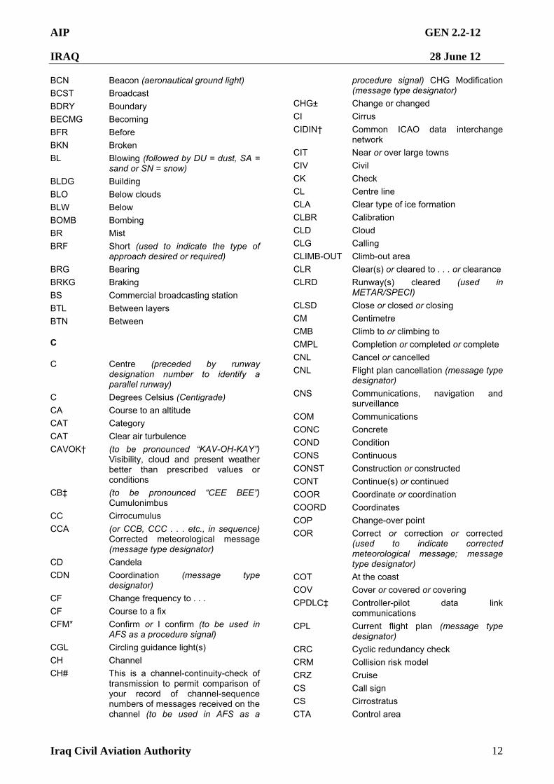
AIP GEN 2.2-12
IRAQ 28 June 12
Iraq Civil Aviation Authority 12
BCN Beacon (aeronautical ground light)
BCST Broadcast
BDRY Boundary
BECMG Becoming
BFR Before
BKN Broken
BL Blowing (followed by DU = dust, SA = sand or SN = snow)
BLDG Building
BLO Below clouds
BLW Below
BOMB Bombing
BR Mist
BRF Short (used to indicate the type of approach desired or required)
BRG Bearing
BRKG Braking
BS Commercial broadcasting station
BTL Between layers
BTN Between
C
C Centre (preceded by runway designation number to identify a parallel runway)
C Degrees Celsius (Centigrade)
CA Course to an altitude
CAT Category
CAT Clear air turbulence
CAVOK† (to be pronounced “KAV-OH-KAY”) Visibility, cloud and present weather better than prescribed values or conditions
CB‡ (to be pronounced “CEE BEE”) Cumulonimbus
CC Cirrocumulus
CCA (or CCB, CCC . . . etc., in sequence) Corrected meteorological message (message type designator)
CD Candela
CDN Coordination (message type designator)
CF Change frequency to . . .
CF Course to a fix
CFM* Confirm or I confirm (to be used in AFS as a procedure signal)
CGL Circling guidance light(s)
CH Channel
CH# This is a channel-continuity-check of transmission to permit comparison of your record of channel-sequence numbers of messages received on the channel (to be used in AFS as a
procedure signal) CHG Modification (message type designator)
CHG± Change or changed
CI Cirrus
CIDIN† Common ICAO data interchange network
CIT Near or over large towns
CIV Civil
CK Check
CL Centre line
CLA Clear type of ice formation
CLBR Calibration
CLD Cloud
CLG Calling
CLIMB-OUT Climb-out area
CLR Clear(s) or cleared to . . . or clearance
CLRD Runway(s) cleared (used in METAR/SPECI)
CLSD Close or closed or closing
CM Centimetre
CMB Climb to or climbing to
CMPL Completion or completed or complete
CNL Cancel or cancelled
CNL Flight plan cancellation (message type designator)
CNS Communications, navigation and surveillance
COM Communications
CONC Concrete
COND Condition
CONS Continuous
CONST Construction or constructed
CONT Continue(s) or continued
COOR Coordinate or coordination
COORD Coordinates
COP Change-over point
COR Correct or correction or corrected (used to indicate corrected meteorological message; message type designator)
COT At the coast
COV Cover or covered or covering
CPDLC‡ Controller-pilot data link communications
CPL Current flight plan (message type designator)
CRC Cyclic redundancy check
CRM Collision risk model
CRZ Cruise
CS Call sign
CS Cirrostratus
CTA Control area
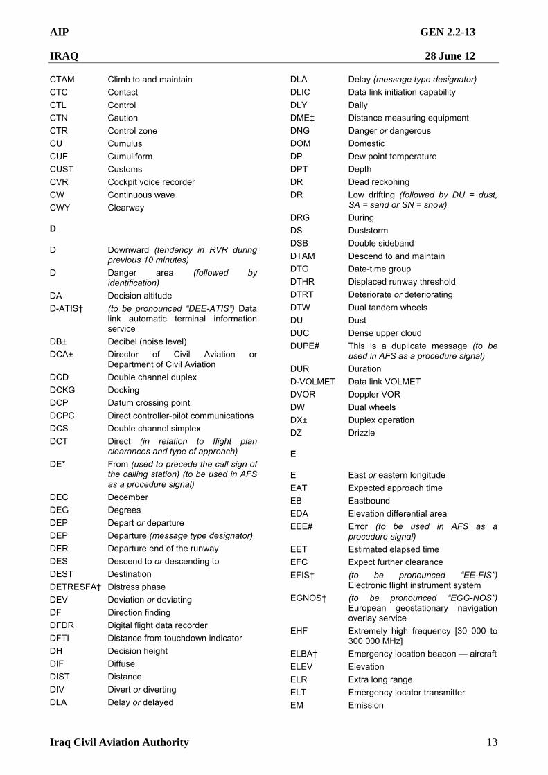
AIP GEN 2.2-13
IRAQ 28 June 12
Iraq Civil Aviation Authority 13
CTAM Climb to and maintain
CTC Contact
CTL Control
CTN Caution
CTR Control zone
CU Cumulus
CUF Cumuliform
CUST Customs
CVR Cockpit voice recorder
CW Continuous wave
CWY Clearway
D
D Downward (tendency in RVR during previous 10 minutes)
D Danger area (followed by identification)
DA Decision altitude
D-ATIS† (to be pronounced “DEE-ATIS”) Data link automatic terminal information service
DB± Decibel (noise level)
DCA± Director of Civil Aviation or Department of Civil Aviation
DCD Double channel duplex
DCKG Docking
DCP Datum crossing point
DCPC Direct controller-pilot communications
DCS Double channel simplex
DCT Direct (in relation to flight plan clearances and type of approach)
DE* From (used to precede the call sign of the calling station) (to be used in AFS as a procedure signal)
DEC December
DEG Degrees
DEP Depart or departure
DEP Departure (message type designator)
DER Departure end of the runway
DES Descend to or descending to
DEST Destination
DETRESFA† Distress phase
DEV Deviation or deviating
DF Direction finding
DFDR Digital flight data recorder
DFTI Distance from touchdown indicator
DH Decision height
DIF Diffuse
DIST Distance
DIV Divert or diverting
DLA Delay or delayed
DLA Delay (message type designator)
DLIC Data link initiation capability
DLY Daily
DME‡ Distance measuring equipment
DNG Danger or dangerous
DOM Domestic
DP Dew point temperature
DPT Depth
DR Dead reckoning
DR Low drifting (followed by DU = dust, SA = sand or SN = snow)
DRG During
DS Duststorm
DSB Double sideband
DTAM Descend to and maintain
DTG Date-time group
DTHR Displaced runway threshold
DTRT Deteriorate or deteriorating
DTW Dual tandem wheels
DU Dust
DUC Dense upper cloud
DUPE# This is a duplicate message (to be used in AFS as a procedure signal)
DUR Duration
D-VOLMET Data link VOLMET
DVOR Doppler VOR
DW Dual wheels
DX± Duplex operation
DZ Drizzle
E
E East or eastern longitude
EAT Expected approach time
EB Eastbound
EDA Elevation differential area
EEE# Error (to be used in AFS as a procedure signal)
EET Estimated elapsed time
EFC Expect further clearance EFIS† (to be pronounced “EE-FIS”)
Electronic flight instrument system
EGNOS† (to be pronounced “EGG-NOS”) European geostationary navigation overlay service
EHF Extremely high frequency [30 000 to 300 000 MHz]
ELBA† Emergency location beacon — aircraft
ELEV Elevation
ELR Extra long range
ELT Emergency locator transmitter
EM Emission
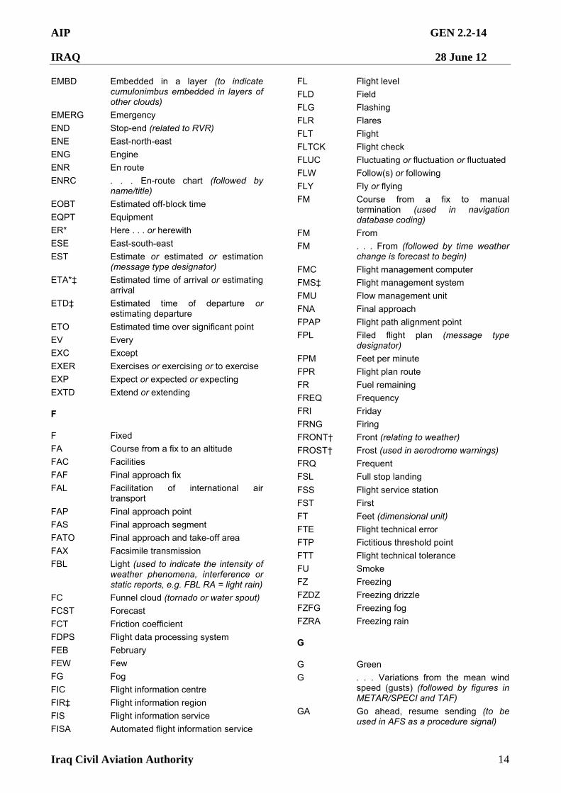
AIP GEN 2.2-14
IRAQ 28 June 12
Iraq Civil Aviation Authority 14
EMBD Embedded in a layer (to indicate cumulonimbus embedded in layers of other clouds)
EMERG Emergency
END Stop-end (related to RVR)
ENE East-north-east
ENG Engine
ENR En route
ENRC . . . En-route chart (followed by name/title)
EOBT Estimated off-block time
EQPT Equipment
ER* Here . . . or herewith
ESE East-south-east
EST Estimate or estimated or estimation (message type designator)
ETA*‡ Estimated time of arrival or estimating arrival
ETD‡ Estimated time of departure or estimating departure
ETO Estimated time over significant point
EV Every
EXC Except
EXER Exercises or exercising or to exercise
EXP Expect or expected or expecting
EXTD Extend or extending
F
F Fixed
FA Course from a fix to an altitude
FAC Facilities
FAF Final approach fix
FAL Facilitation of international air transport
FAP Final approach point
FAS Final approach segment
FATO Final approach and take-off area
FAX Facsimile transmission
FBL Light (used to indicate the intensity of weather phenomena, interference or static reports, e.g. FBL RA = light rain)
FC Funnel cloud (tornado or water spout)
FCST Forecast
FCT Friction coefficient
FDPS Flight data processing system
FEB February
FEW Few
FG Fog
FIC Flight information centre
FIR‡ Flight information region
FIS Flight information service
FISA Automated flight information service
FL Flight level
FLD Field
FLG Flashing
FLR Flares
FLT Flight
FLTCK Flight check
FLUC Fluctuating or fluctuation or fluctuated
FLW Follow(s) or following
FLY Fly or flying
FM Course from a fix to manual termination (used in navigation database coding)
FM From
FM . . . From (followed by time weather change is forecast to begin)
FMC Flight management computer
FMS‡ Flight management system
FMU Flow management unit
FNA Final approach
FPAP Flight path alignment point
FPL Filed flight plan (message type designator)
FPM Feet per minute
FPR Flight plan route
FR Fuel remaining
FREQ Frequency
FRI Friday
FRNG Firing
FRONT† Front (relating to weather)
FROST† Frost (used in aerodrome warnings)
FRQ Frequent
FSL Full stop landing FSS Flight service station
FST First
FT Feet (dimensional unit)
FTE Flight technical error
FTP Fictitious threshold point
FTT Flight technical tolerance
FU Smoke
FZ Freezing
FZDZ Freezing drizzle
FZFG Freezing fog
FZRA Freezing rain
G
G Green
G . . . Variations from the mean wind speed (gusts) (followed by figures in METAR/SPECI and TAF)
GA Go ahead, resume sending (to be used in AFS as a procedure signal)
AIP GEN 2.2-15
IRAQ 28 June 12
Iraq Civil Aviation Authority 15
G/A Ground-to-air
G/A/G Ground-to-air and air-to-ground
GAGAN† GPS and geostationary earth orbit augmented navigation
GAMET Area forecast for low-level flights
GARP GBAS azimuth reference point
GBAS† (to be pronounced “GEE-BAS”) Ground-based augmentation system
GCA‡ Ground controlled approach system or ground controlled approach
GEN General
GEO Geographic or true
GES Ground earth station
GLD Glider
GLONASS† (to be pronounced “GLO-NAS”) Global orbiting navigation satellite system
GMC . . . Ground movement chart (followed by name/title)
GND Ground
GNDCK Ground check
GNSS‡ Global navigation satellite system
GP Glide path
GPA Glide path angle
GPIP Glide path intercept point
GPS‡ Global positioning system
GPWS‡ Ground proximity warning system
GR Hail
GRAS† (to be pronounced “GRASS”) Ground-based regional augmentation system
GRASS Grass landing area
GRIB Processed meteorological data in the form of grid point values expressed in binary form (meteorological code)
GRVL Gravel
GS Ground speed
GS Small hail and/or snow pellets
GUND Geoid undulation
H
H High pressure area or the centre of high pressure
H24 Continuous day and night service
HA Holding/racetrack to an altitude
HAPI Helicopter approach path indicator
HBN Hazard beacon
HDF High frequency direction-finding station
HDG Heading
HEL Helicopter
HF‡ High frequency [3 000 to 30 000 kHz]
HF Holding/racetrack to a fix
HGT Height or height above
HJ Sunrise to sunset
HLDG Holding
HM Holding/racetrack to a manual termination
HN Sunset to sunrise
HO Service available to meet operational requirements
HOL Holiday
HOSP Hospital aircraft
HPA Hectopascal
HR Hours
HS Service available during hours of scheduled operations
HURCN Hurricane
HVDF High and very high frequency direction finding stations (at the same location)
HVY Heavy HVY Heavy (used to indicate the intensity
of weather phenomena, e.g. HVY RA = heavy
rain)
HX No specific working hours
HYR Higher
HZ Haze
HZ Hertz (cycle per second)
I
IAC . . . Instrument approach chart (followed by name/title)
IAF Initial approach fix
IAO In and out of clouds
IAP Instrument approach procedure
IAR Intersection of air routes
IAS Indicated airspeed
IBN Identification beacon
IC Ice crystals (very small ice crystals in suspension, also known as diamond dust)
ICAA± Iraq Civil Aviation Authority
ICE Icing
ID Identifier or identify
IDENT† Identification
IF Intermediate approach fix
IFF Identification friend/foe
IFR‡ Instrument flight rules
IGA International general aviation
ILS‡ Instrument landing system
IM Inner marker
IMC‡ Instrument meteorological conditions
IMG Immigration
AIP GEN 2.2-16
IRAQ 28 June 12
Iraq Civil Aviation Authority 16
IMI* Interrogation sign (question mark) (to be used in AFS as a procedure signal)
IMPR Improve or improving
IMT Immediate or immediately
INA Initial approach
INBD Inbound
INC In cloud
INCERFA† Uncertainty phase
INFO† Information
INOP Inoperative
INP If not possible
INPR In progress
INS Inertial navigation system
INSTL Install or installed or installation
INSTR Instrument
INT Intersection
INTL International
INTRG Interrogator
INTRP Interrupt or interruption or interrupted
INTSF Intensify or intensifying
INTST Intensity
IR Ice on runway
IRS Inertial reference system
ISA International standard atmosphere
ISB Independent sideband
ISOL Isolated
I/V± Instrument/visual
IWI± Illuminated wind indicator
J
JAN January
JTST Jet stream
JUL July
JUN June
K
KG Kilograms
KHZ Kilohertz
KIAS Knots indicated airspeed
KM Kilometres
KMH Kilometres per hour
KPA Kilopascal
KT Knots
KW Kilowatts
L
. . L Left (preceded by runway designation number to identify a parallel runway)
L Locator (see LM, LO)
L Low pressure area or the centre of low pressure
LAM Logical acknowledgement (message type designator)
LAN Inland
LAT Latitude LCA Local or locally or location or located
LDA Landing distance available
LDAH Landing distance available, helicopter
LDG Landing
LDI Landing direction indicator
LEN Length
LF Low frequency [30 to 300 kHz]
LGT Light or lighting
LGTD Lighted
LIH Light intensity high
LIL Light intensity low
LIM Light intensity medium
LINE Line (used in SIGMET)
LM Locator, middle
LMT Local mean time
LNAV† (to be pronounced “EL-NAV”) Lateral navigation
LNG Long (used to indicate the type of approach desired or required)
LO Locator, outer
LOC Localizer
LONG Longitude
LORAN† LORAN (long range air navigation system)
LPV Localizer performance with vertical guidance
LR The last message received by me was . . . (to be used in AFS as a procedure signal)
LRG Long range
LS The last message sent by me was . . . or Last message was . . . (to be used in AFS as a procedure signal)
LTD Limited
LTP Landing threshold point
LTT Landline teletypewriter
LV Light and variable (relating to wind)
LVE Leave or leaving
LVL Level
LVP Low visibility procedures
LYR Layer or layered
M
M Metres (preceded by figures)
M . . . Mach number (followed by figures)
AIP GEN 2.2-17
IRAQ 28 June 12
Iraq Civil Aviation Authority 17
M . . . Minimum value of runway visual range (followed by figures in METAR/SPECI)
MAA Maximum authorized altitude
MAG Magnetic
MAHF Missed approach holding fix
MAINT Maintenance
MAP Aeronautical maps and charts
MAPT Missed approach point
MAR At sea
MAR March
MAS Manual Al simplex
MATF Missed approach turning fix
MAX Maximum
MAY May
MBST Microburst
MCA Minimum crossing altitude
MCFI± Multinational Coalition Forces Iraq
MCW Modulated continuous wave
MDA Minimum descent altitude
MDF Medium frequency direction-finding station
MDH Minimum descent height
MEA Minimum en-route altitude
MEHT Minimum eye height over threshold (for visual approach slope indicator systems)
MET† Meteorological or meteorology
METAR† Aerodrome routine meteorological report (in meteorological code)
MET REPORT Local routine meteorological report (in abbreviated plain language)
MF Medium frequency [300 to 3 000 kHz]
MHDF Medium and high frequency direction-finding stations (at the same location)
MHVDF Medium, high and very high frequency direction-finding stations (at the same location)
MHZ Megahertz
MID Mid-point (related to RVR)
MIFG Shallow fog
MIL Military
MIN* Minutes
MIS Missing . . . (transmission identification) (to be used in AFS as a procedure signal)
MKR Marker radio beacon
MLS‡ Microwave landing system
MM Middle marker
MNM Minimum
MNPS Minimum navigation performance specifications
MNT Monitor or monitoring or monitored
MNTN Maintain
MOA Military operating area
MOC Minimum obstacle clearance (required)
MOCA Minimum obstacle clearance altitude
MOD Moderate (used to indicate the intensity of weather phenomena, interference or static reports, e.g. MODRA = moderate rain)
MON Above mountains
MON Monday
MOPS† Minimum operational performance standards
MOTNE Meteorological Operational Telecommunications Network Europe
MOV Move or moving or movement
MPS Metres per second
MRA Minimum reception altitude
MRG Medium range
MRP ATS/MET reporting point
MS Minus
MSA Minimum sector altitude
MSAS† (to be pronounced “EM-SAS”) Multifunctional transport satellite (MTSAT) satellite-based augmentation system
MSAW Minimum safe altitude warning
MSG Message
MSL Mean sea level
MSR# Message . . . (transmission identification) has been misrouted (to be used in AFS as a procedure signal)
MSSR Monopulse secondary surveillance radar
MT Mountain
MTU Metric units
MTW Mountain waves
MVDF Medium and very high frequency direction finding stations (at the same location)
MWO Meteorological watch office
MX Mixed type of ice formation (white and clear)
N
N No distinct tendency (in RVR during previous 10 minutes)
N North or northern latitude
N/A± Not applicable
NADP Noise abatement departure procedure
NASC† National AIS system centre
NAT North Atlantic
NAV Navigation
AIP GEN 2.2-18
IRAQ 28 June 12
Iraq Civil Aviation Authority 18
NB Northbound
NBFR Not before
NC No change
NCD No cloud detected (used in automated METAR/SPECI)
NDB‡ Non-directional radio beacon
NDV No directional variations available (used in automated METAR/SPECI)
NE North-east
NEB North-eastbound
NEG No or negative or permission not granted or that is not correct
NGO± Non-governmental organizations
NGT Night
NIL*† None or I have nothing to send to you
NM Nautical miles
NML Normal
NNE North-north-east
NNW North-north-west
NO No (negative) (to be used in AFS as a procedure signal)
NOF International NOTAM office
NOSIG† No significant change (used in trend-type landing forecasts)
NOTAM† A notice distributed by means of telecommunication containing information concerning the establishment, condition or change in any aeronautical facility, service, procedure or hazard, the timely knowledge of which is essential to personnel concerned with flight operations
NOV November
NOZ‡ Normal operating zone
NPA Non-precision approach
NR Number
NRH No reply heard
NS Nimbostratus
NSC Nil significant cloud
NSE Navigation system error
NSW Nil significant weather
NTL National
NTZ‡ No transgression zone
NW North-west
NWB North-westbound
NXT Next
O
OAC Oceanic area control centre
OAS Obstacle assessment surface
OBS Observe or observed or observation
OBSC Obscure or obscured or obscuring
OBST Obstacle
OCA Obstacle clearance altitude
OCA Oceanic control area
OCC Occulting (light)
OCH Obstacle clearance height
OCNL Occasional or occasionally
OCS Obstacle clearance surface
OCT October
OFZ Obstacle free zone
OGN Originate (to be used in AFS as a procedure signal)
OHD Overhead
OIS Obstacle identification surface
OK* We agree or It is correct (to be used in AFS as a procedure signal)
OLDI† On-line data interchange
OM Outer marker
OPA Opaque, white type of ice formation
OPC Control indicated is operational control
OPMET† Operational meteorological (information)
OPN Open or opening or opened
OPR Operator or operate or operative or operating or operational
OPS† Operations
O/R On request
ORD Order
OSV Ocean station vessel
OTLK Outlook (used in SIGMET messages for volcanic ash and tropical cyclones)
OTP On top
OTS Organized track system
OUBD Outbound
OVC Overcast
P
P . . . Maximum value of wind speed or runway visual range (followed by figures in METAR/SPECI and TAF)
P . . . Prohibited area (followed by identification)
PA Precision approach
PALS Precision approach lighting system (specify category)
PANS Procedures for air navigation services
PAPI† Precision approach path indicator
PAR‡ Precision approach radar
PARL Parallel
PATC . . . Precision approach terrain chart (followed by name/title)
PAX Passenger(s)
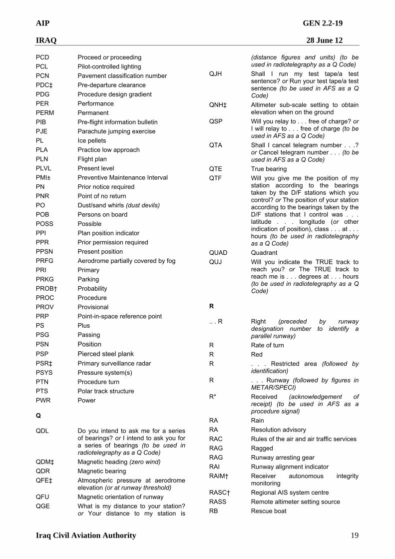
AIP GEN 2.2-19
IRAQ 28 June 12
Iraq Civil Aviation Authority 19
PCD Proceed or proceeding
PCL Pilot-controlled lighting
PCN Pavement classification number
PDC‡ Pre-departure clearance
PDG Procedure design gradient
PER Performance
PERM Permanent
PIB Pre-flight information bulletin
PJE Parachute jumping exercise
PL Ice pellets
PLA Practice low approach
PLN Flight plan
PLVL Present level
PMI± Preventive Maintenance Interval
PN Prior notice required
PNR Point of no return
PO Dust/sand whirls (dust devils)
POB Persons on board
POSS Possible
PPI Plan position indicator
PPR Prior permission required
PPSN Present position
PRFG Aerodrome partially covered by fog
PRI Primary
PRKG Parking
PROB† Probability
PROC Procedure
PROV Provisional
PRP Point-in-space reference point
PS Plus
PSG Passing
PSN Position
PSP Pierced steel plank
PSR‡ Primary surveillance radar
PSYS Pressure system(s)
PTN Procedure turn PTS Polar track structure
PWR Power
Q
QDL Do you intend to ask me for a series of bearings? or I intend to ask you for a series of bearings (to be used in radiotelegraphy as a Q Code)
QDM‡ Magnetic heading (zero wind)
QDR Magnetic bearing
QFE‡ Atmospheric pressure at aerodrome elevation (or at runway threshold)
QFU Magnetic orientation of runway
QGE What is my distance to your station? or Your distance to my station is
(distance figures and units) (to be used in radiotelegraphy as a Q Code)
QJH Shall I run my test tape/a test sentence? or Run your test tape/a test sentence (to be used in AFS as a Q Code)
QNH‡ Altimeter sub-scale setting to obtain elevation when on the ground
QSP Will you relay to . . . free of charge? or I will relay to . . . free of charge (to be used in AFS as a Q Code)
QTA Shall I cancel telegram number . . .? or Cancel telegram number . . . (to be used in AFS as a Q Code)
QTE True bearing
QTF Will you give me the position of my station according to the bearings taken by the D/F stations which you control? or The position of your station according to the bearings taken by the D/F stations that I control was . . . latitude . . . longitude (or other indication of position), class . . . at . . . hours (to be used in radiotelegraphy as a Q Code)
QUAD Quadrant
QUJ Will you indicate the TRUE track to reach you? or The TRUE track to reach me is . . . degrees at . . . hours (to be used in radiotelegraphy as a Q Code)
R
.. . R Right (preceded by runway designation number to identify a parallel runway)
R Rate of turn
R Red
R . . . Restricted area (followed by identification)
R . . . Runway (followed by figures in METAR/SPECI)
R* Received (acknowledgement of receipt) (to be used in AFS as a procedure signal)
RA Rain
RA Resolution advisory
RAC Rules of the air and air traffic services
RAG Ragged
RAG Runway arresting gear
RAI Runway alignment indicator
RAIM† Receiver autonomous integrity monitoring
RASC† Regional AIS system centre
RASS Remote altimeter setting source
RB Rescue boat
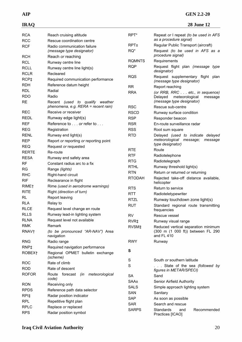
AIP GEN 2.2-20
IRAQ 28 June 12
Iraq Civil Aviation Authority 20
RCA Reach cruising altitude
RCC Rescue coordination centre
RCF Radio communication failure (message type designator)
RCH Reach or reaching
RCL Runway centre line
RCLL Runway centre line light(s)
RCLR Recleared
RCP‡ Required communication performance
RDH Reference datum height
RDL Radial
RDO Radio
RE Recent (used to qualify weather phenomena, e.g. RERA = recent rain)
REC Receive or receiver
REDL Runway edge light(s)
REF Reference to . . . or refer to . . .
REG Registration
RENL Runway end light(s)
REP Report or reporting or reporting point
REQ Request or requested
RERTE Re-route
RESA Runway end safety area
RF Constant radius arc to a fix RG Range (lights)
RHC Right-hand circuit
RIF Reclearance in flight
RIME† Rime (used in aerodrome warnings)
RITE Right (direction of turn)
RL Report leaving
RLA Relay to
RLCE Request level change en route
RLLS Runway lead-in lighting system
RLNA Request level not available
RMK Remark
RNAV† (to be pronounced “AR-NAV”) Area navigation
RNG Radio range
RNP‡ Required navigation performance
ROBEX† Regional OPMET bulletin exchange (scheme)
ROC Rate of climb
ROD Rate of descent
ROFOR Route forecast (in meteorological code)
RON Receiving only
RPDS Reference path data selector
RPI‡ Radar position indicator
RPL Repetitive flight plan
RPLC Replace or replaced
RPS Radar position symbol
RPT* Repeat or I repeat (to be used in AFS as a procedure signal)
RPT± Regular Public Transport (aircraft)
RQ* Request (to be used in AFS as a procedure signal)
RQMNTS Requirements
RQP Request flight plan (message type designator)
RQS Request supplementary flight plan (message type designator)
RR Report reaching
RRA (or RRB, RRC . . . etc., in sequence) Delayed meteorological message (message type designator)
RSC Rescue sub-centre
RSCD Runway surface condition
RSP Responder beacon
RSR En-route surveillance radar
RSS Root sum square
RTD Delayed (used to indicate delayed meteorological message; message type designator)
RTE Route
RTF Radiotelephone
RTG Radiotelegraph
RTHL Runway threshold light(s)
RTN Return or returned or returning
RTODAH Rejected take-off distance available, helicopter
RTS Return to service
RTT Radioteletypewriter
RTZL Runway touchdown zone light(s)
RUT Standard regional route transmitting frequencies
RV Rescue vessel
RVR‡ Runway visual range
RVSM‡ Reduced vertical separation minimum (300 m (1 000 ft)) between FL 290 and FL 410
RWY Runway
S
S South or southern latitude
S . . . State of the sea (followed by figures in METAR/SPECI)
SA Sand
SAA± Senior Airfield Authority
SALS Simple approach lighting system
SAN Sanitary
SAP As soon as possible
SAR Search and rescue
SARPS Standards and Recommended Practices [ICAO]
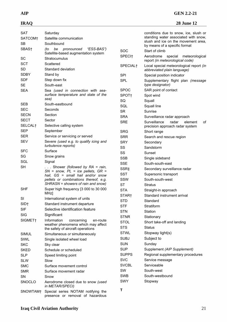
AIP GEN 2.2-21
IRAQ 28 June 12
Iraq Civil Aviation Authority 21
SAT Saturday
SATCOM† Satellite communication
SB Southbound
SBAS† (to be pronounced “ESS-BAS”) Satellite-based augmentation system
SC Stratocumulus
SCT Scattered
SD Standard deviation
SDBY Stand by
SDF Step down fix
SE South-east
SEA Sea (used in connection with sea-surface temperature and state of the sea)
SEB South-eastbound
SEC Seconds
SECN Section
SECT Sector
SELCAL† Selective calling system
SEP September
SER Service or servicing or served
SEV Severe (used e.g. to qualify icing and turbulence reports)
SFC Surface
SG Snow grains
SGL Signal
SH . . . Shower (followed by RA = rain, SN = snow, PL = ice pellets, GR = hail, GS = small hail and/or snow pellets or combinations thereof, e.g. SHRASN = showers of rain and snow)
SHF Super high frequency [3 000 to 30 000 MHz]
SI International system of units
SID† Standard instrument departure
SIF Selective identification feature
SIG Significant
SIGMET† Information concerning en-route weather phenomena which may affect the safety of aircraft operations
SIMUL Simultaneous or simultaneously
SIWL Single isolated wheel load
SKC Sky clear
SKED Schedule or scheduled
SLP Speed limiting point
SLW Slow
SMC Surface movement control
SMR Surface movement radar
SN Snow
SNOCLO Aerodrome closed due to snow (used in METAR/SPECI)
SNOWTAM† Special series NOTAM notifying the presence or removal of hazardous
conditions due to snow, ice, slush or standing water associated with snow, slush and ice on the movement area, by means of a specific format
SOC Start of climb
SPECI† Aerodrome special meteorological report (in meteorological code)
SPECIAL† Local special meteorological report (in abbreviated plain language)
SPI Special position indicator
SPL Supplementary flight plan (message type designator)
SPOC SAR point of contact
SPOT† Spot wind
SQ Squall
SQL Squall line
SR Sunrise
SRA Surveillance radar approach
SRE Surveillance radar element of precision approach radar system
SRG Short range
SRR Search and rescue region
SRY Secondary
SS Sandstorm
SS Sunset
SSB Single sideband
SSE South-south-east
SSR‡ Secondary surveillance radar
SST Supersonic transport
SSW South-south-west
ST Stratus
STA Straight-in approach
STAR† Standard instrument arrival
STD Standard
STF Stratiform
STN Station
STNR Stationary
STOL Short take-off and landing
STS Status
STWL Stopway light(s)
SUBJ Subject to
SUN Sunday
SUP Supplement (AIP Supplement)
SUPPS Regional supplementary procedures
SVC Service message
SVCBL Serviceable
SW South-west
SWB South-westbound
SWY Stopway
T
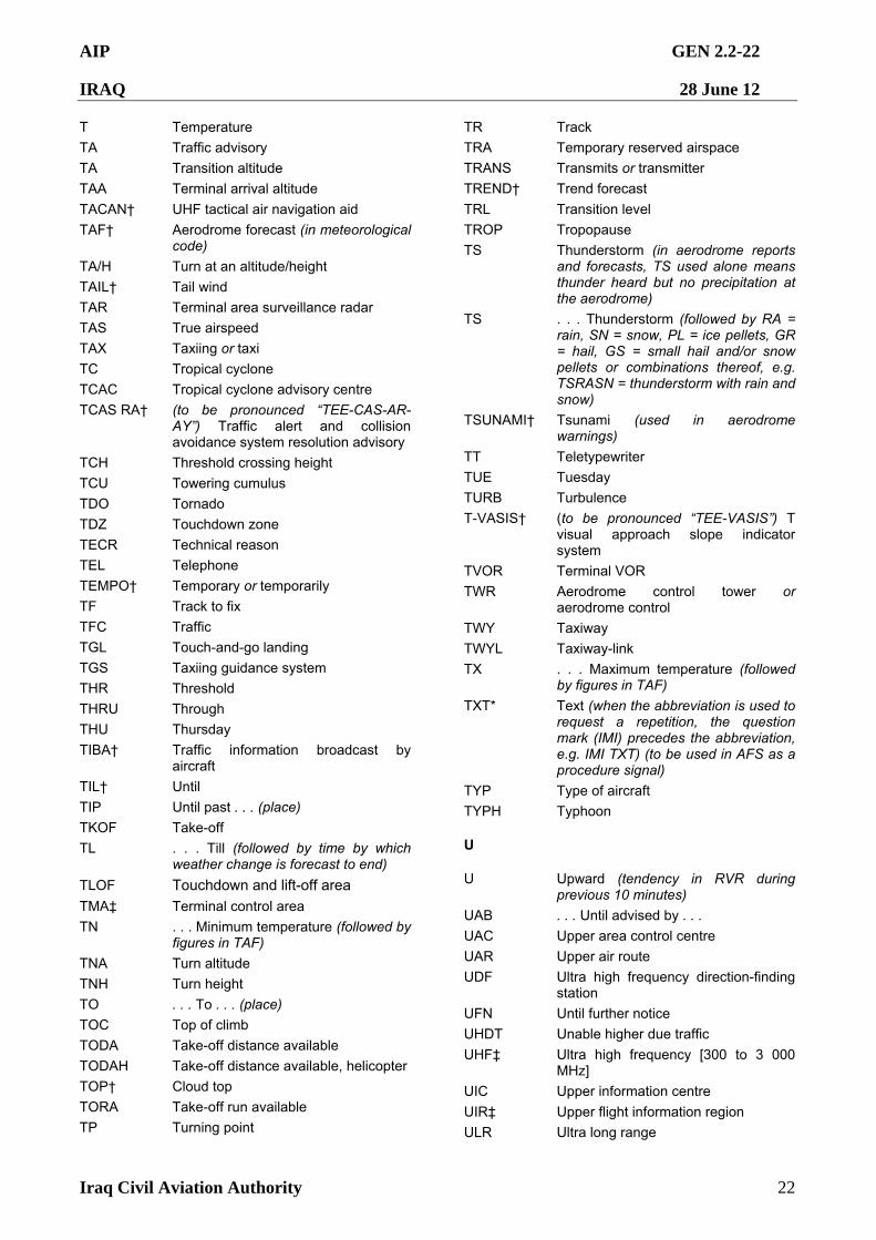
AIP GEN 2.2-22
IRAQ 28 June 12
Iraq Civil Aviation Authority 22
T Temperature
TA Traffic advisory
TA Transition altitude
TAA Terminal arrival altitude
TACAN† UHF tactical air navigation aid TAF† Aerodrome forecast (in meteorological
code)
TA/H Turn at an altitude/height
TAIL† Tail wind
TAR Terminal area surveillance radar
TAS True airspeed
TAX Taxiing or taxi
TC Tropical cyclone
TCAC Tropical cyclone advisory centre
TCAS RA† (to be pronounced “TEE-CAS-AR-AY”) Traffic alert and collision avoidance system resolution advisory
TCH Threshold crossing height
TCU Towering cumulus
TDO Tornado
TDZ Touchdown zone
TECR Technical reason
TEL Telephone
TEMPO† Temporary or temporarily
TF Track to fix
TFC Traffic
TGL Touch-and-go landing
TGS Taxiing guidance system
THR Threshold
THRU Through
THU Thursday
TIBA† Traffic information broadcast by aircraft
TIL† Until
TIP Until past . . . (place)
TKOF Take-off
TL . . . Till (followed by time by which weather change is forecast to end)
TLOF Touchdown and lift-off area
TMA‡ Terminal control area
TN . . . Minimum temperature (followed by figures in TAF)
TNA Turn altitude
TNH Turn height
TO . . . To . . . (place)
TOC Top of climb
TODA Take-off distance available
TODAH Take-off distance available, helicopter
TOP† Cloud top
TORA Take-off run available
TP Turning point
TR Track
TRA Temporary reserved airspace
TRANS Transmits or transmitter
TREND† Trend forecast
TRL Transition level
TROP Tropopause
TS Thunderstorm (in aerodrome reports and forecasts, TS used alone means thunder heard but no precipitation at the aerodrome)
TS . . . Thunderstorm (followed by RA = rain, SN = snow, PL = ice pellets, GR = hail, GS = small hail and/or snow pellets or combinations thereof, e.g. TSRASN = thunderstorm with rain and snow)
TSUNAMI† Tsunami (used in aerodrome warnings)
TT Teletypewriter
TUE Tuesday
TURB Turbulence
T-VASIS† (to be pronounced “TEE-VASIS”) T visual approach slope indicator system
TVOR Terminal VOR
TWR Aerodrome control tower or aerodrome control
TWY Taxiway
TWYL Taxiway-link
TX . . . Maximum temperature (followed by figures in TAF)
TXT* Text (when the abbreviation is used to request a repetition, the question mark (IMI) precedes the abbreviation, e.g. IMI TXT) (to be used in AFS as a procedure signal)
TYP Type of aircraft
TYPH Typhoon
U
U Upward (tendency in RVR during previous 10 minutes)
UAB . . . Until advised by . . .
UAC Upper area control centre
UAR Upper air route
UDF Ultra high frequency direction-finding station
UFN Until further notice
UHDT Unable higher due traffic
UHF‡ Ultra high frequency [300 to 3 000 MHz]
UIC Upper information centre UIR‡ Upper flight information region
ULR Ultra long range
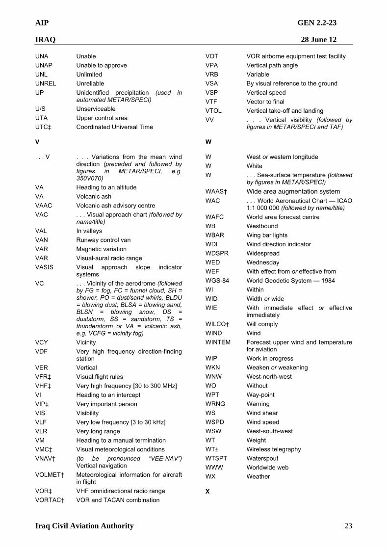
AIP GEN 2.2-23
IRAQ 28 June 12
Iraq Civil Aviation Authority 23
UNA Unable
UNAP Unable to approve
UNL Unlimited
UNREL Unreliable
UP Unidentified precipitation (used in automated METAR/SPECI)
U/S Unserviceable
UTA Upper control area
UTC‡ Coordinated Universal Time
V
. . . V . . . Variations from the mean wind direction (preceded and followed by figures in METAR/SPECI, e.g. 350V070)
VA Heading to an altitude
VA Volcanic ash
VAAC Volcanic ash advisory centre
VAC . . . Visual approach chart (followed by name/title)
VAL In valleys
VAN Runway control van
VAR Magnetic variation
VAR Visual-aural radio range
VASIS Visual approach slope indicator systems
VC . . . Vicinity of the aerodrome (followed by FG = fog, FC = funnel cloud, SH = shower, PO = dust/sand whirls, BLDU = blowing dust, BLSA = blowing sand, BLSN = blowing snow, DS = duststorm, SS = sandstorm, TS = thunderstorm or VA = volcanic ash, e.g. VCFG = vicinity fog)
VCY Vicinity
VDF Very high frequency direction-finding station
VER Vertical
VFR‡ Visual flight rules
VHF‡ Very high frequency [30 to 300 MHz]
VI Heading to an intercept
VIP‡ Very important person
VIS Visibility
VLF Very low frequency [3 to 30 kHz]
VLR Very long range
VM Heading to a manual termination
VMC‡ Visual meteorological conditions
VNAV† (to be pronounced “VEE-NAV”) Vertical navigation
VOLMET† Meteorological information for aircraft in flight
VOR‡ VHF omnidirectional radio range
VORTAC† VOR and TACAN combination
VOT VOR airborne equipment test facility
VPA Vertical path angle
VRB Variable
VSA By visual reference to the ground
VSP Vertical speed
VTF Vector to final
VTOL Vertical take-off and landing
VV . . . Vertical visibility (followed by figures in METAR/SPECI and TAF)
W
W West or western longitude
W White
W . . . Sea-surface temperature (followed by figures in METAR/SPECI)
WAAS† Wide area augmentation system
WAC . . . World Aeronautical Chart — ICAO 1:1 000 000 (followed by name/title)
WAFC World area forecast centre
WB Westbound
WBAR Wing bar lights
WDI Wind direction indicator
WDSPR Widespread
WED Wednesday
WEF With effect from or effective from
WGS-84 World Geodetic System — 1984
WI Within
WID Width or wide
WIE With immediate effect or effective immediately
WILCO† Will comply
WIND Wind
WINTEM Forecast upper wind and temperature for aviation
WIP Work in progress
WKN Weaken or weakening WNW West-north-west
WO Without
WPT Way-point
WRNG Warning
WS Wind shear
WSPD Wind speed
WSW West-south-west
WT Weight
WT± Wireless telegraphy
WTSPT Waterspout
WWW Worldwide web
WX Weather
X
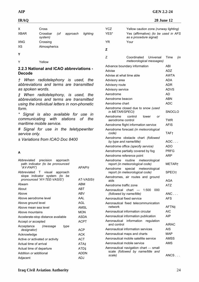
AIP GEN 2.2-24
IRAQ 28 June 12
Iraq Civil Aviation Authority 24
X Cross
XBAR Crossbar (of approach lighting system)
XNG Crossing
XS Atmospherics
Y
Y Yellow
YCZ Yellow caution zone (runway lighting)
YES* Yes (affirmative) (to be used in AFS as a procedure signal)
YR Your
Z
Z Coordinated Universal Time (in meteorological messages)
2.2.3 National and ICAO abbreviations - Decode
† When radiotelephony is used, the abbreviations and terms are transmitted as spoken words.
‡ When radiotelephony, is used, the abbreviations and terms are transmitted using the individual letters in non-phonetic form.
* Signal is also available for use in communicating with stations of the maritime mobile service.
# Signal for use in the teletypewriter service only. ± Variations from ICAO Doc 8400
A
Abbreviated precision approach path indicator (to be pronounced “AY-PAPI”) APAPI†
Abbreviated T visual approach slope indicator system (to be pronounced “AY-TEE-VASIS”) AT-VASIS†
Abeam ABM
About ABT
Above ABV
Above aerodrome level AAL
Above ground level AGL
Above mean sea level AMSL
Above mountains MON
Accelerate-stop distance available ASDA
Accept or accepted ACPT
Acceptance (message type designator) ACP
Acknowledge ACK
Active or activated or activity ACT
Actual time of arrival ATA‡
Actual time of departure ATD‡
Addition or additional ADDN
Adjacent ADJ
Advance boundary information ABI
Advise ADZ
Advise at what time able AWTA
Advisory area ADA
Advisory route ADR
Advisory service ADVS
Aerodrome AD
Aerodrome beacon ABN
Aerodrome chart ADC
Aerodrome closed due to snow (used in METAR/SPECI) SNOCLO
Aerodrome control tower or aerodrome control TWR
Aerodrome flight information service AFIS
Aerodrome forecast (in meteorological code) TAF†
Aerodrome obstacle chart (followed by type and name/title) AOC . . .
Aerodrome office (specify service) ADO
Aerodrome partially covered by fog PRFG
Aerodrome reference point ARP
Aerodrome routine meteorological report (in meteorological code) METAR†
Aerodrome special meteorological report (in meteorological code) SPECI†
Aerodromes, air routes and ground aids AGA
Aerodrome traffic zone ATZ
Aeronautical chart — 1:500 000 (followed by name/title) ANC . . .
Aeronautical fixed service AFS
Aeronautical fixed telecommunication network AFTN‡
Aeronautical information circular AIC
Aeronautical information publication AIP
Aeronautical information regulation and control AIRAC
Aeronautical information services AIS
Aeronautical maps and charts MAP
Aeronautical mobile satellite service AMSS
Aeronautical mobile service AMS
Aeronautical navigation chart — small scale (followed by name/title and scale) ANCS . . .
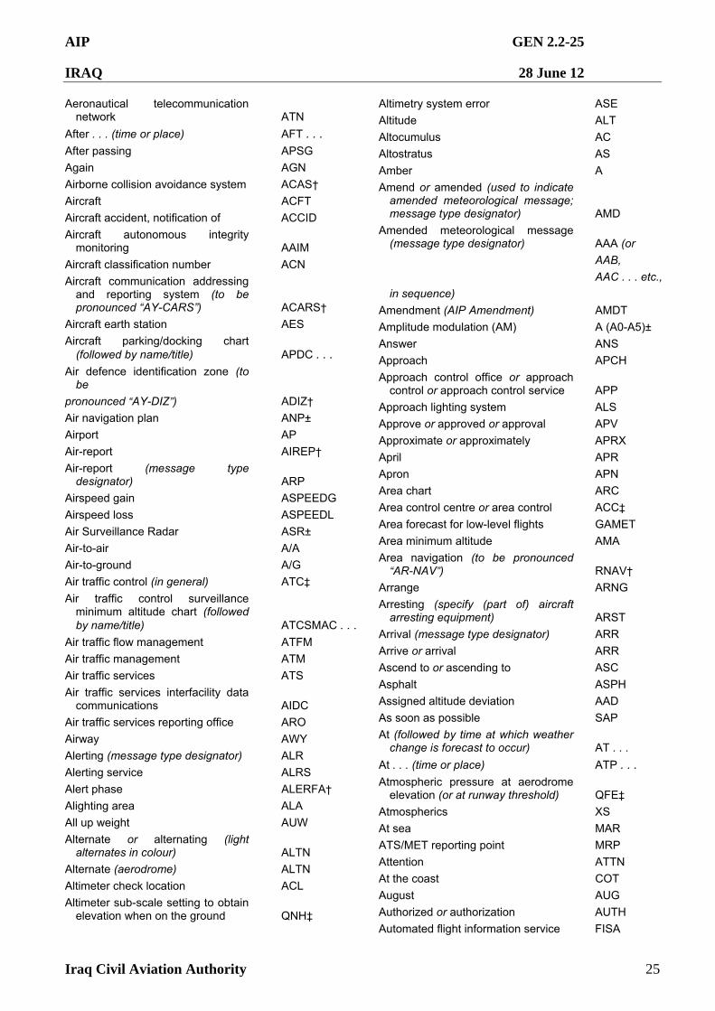
AIP GEN 2.2-25
IRAQ 28 June 12
Iraq Civil Aviation Authority 25
Aeronautical telecommunication network ATN
After . . . (time or place) AFT . . .
After passing APSG
Again AGN
Airborne collision avoidance system ACAS†
Aircraft ACFT
Aircraft accident, notification of ACCID
Aircraft autonomous integrity monitoring AAIM
Aircraft classification number ACN
Aircraft communication addressing and reporting system (to be pronounced “AY-CARS”) ACARS†
Aircraft earth station AES Aircraft parking/docking chart
(followed by name/title) APDC . . .
Air defence identification zone (to be
pronounced “AY-DIZ”) ADIZ†
Air navigation plan ANP±
Airport AP
Air-report AIREP†
Air-report (message type designator) ARP
Airspeed gain ASPEEDG
Airspeed loss ASPEEDL
Air Surveillance Radar ASR±
Air-to-air A/A
Air-to-ground A/G
Air traffic control (in general) ATC‡
Air traffic control surveillance minimum altitude chart (followed by name/title) ATCSMAC . . .
Air traffic flow management ATFM
Air traffic management ATM
Air traffic services ATS
Air traffic services interfacility data communications AIDC
Air traffic services reporting office ARO
Airway AWY
Alerting (message type designator) ALR
Alerting service ALRS
Alert phase ALERFA†
Alighting area ALA
All up weight AUW
Alternate or alternating (light alternates in colour) ALTN
Alternate (aerodrome) ALTN
Altimeter check location ACL
Altimeter sub-scale setting to obtain elevation when on the ground QNH‡
Altimetry system error ASE
Altitude ALT
Altocumulus AC
Altostratus AS
Amber A
Amend or amended (used to indicate amended meteorological message; message type designator) AMD
Amended meteorological message (message type designator) AAA (or
AAB,
AAC . . . etc.,
in sequence)
Amendment (AIP Amendment) AMDT
Amplitude modulation (AM) A (A0-A5)±
Answer ANS
Approach APCH
Approach control office or approach control or approach control service APP
Approach lighting system ALS
Approve or approved or approval APV
Approximate or approximately APRX
April APR
Apron APN
Area chart ARC
Area control centre or area control ACC‡
Area forecast for low-level flights GAMET
Area minimum altitude AMA
Area navigation (to be pronounced “AR-NAV”) RNAV†
Arrange ARNG
Arresting (specify (part of) aircraft arresting equipment) ARST
Arrival (message type designator) ARR
Arrive or arrival ARR
Ascend to or ascending to ASC
Asphalt ASPH
Assigned altitude deviation AAD
As soon as possible SAP
At (followed by time at which weather change is forecast to occur) AT . . .
At . . . (time or place) ATP . . .
Atmospheric pressure at aerodrome elevation (or at runway threshold) QFE‡
Atmospherics XS
At sea MAR
ATS/MET reporting point MRP
Attention ATTN
At the coast COT
August AUG
Authorized or authorization AUTH
Automated flight information service FISA
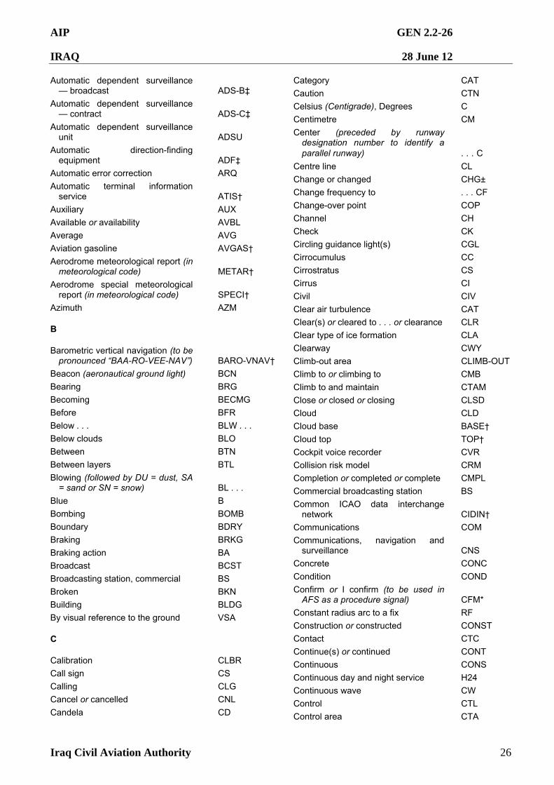
AIP GEN 2.2-26
IRAQ 28 June 12
Iraq Civil Aviation Authority 26
Automatic dependent surveillance — broadcast ADS-B‡
Automatic dependent surveillance — contract ADS-C‡
Automatic dependent surveillance unit ADSU
Automatic direction-finding equipment ADF‡
Automatic error correction ARQ
Automatic terminal information service ATIS†
Auxiliary AUX Available or availability AVBL
Average AVG
Aviation gasoline AVGAS†
Aerodrome meteorological report (in meteorological code) METAR†
Aerodrome special meteorological report (in meteorological code) SPECI†
Azimuth AZM
B
Barometric vertical navigation (to be pronounced “BAA-RO-VEE-NAV”) BARO-VNAV†
Beacon (aeronautical ground light) BCN
Bearing BRG
Becoming BECMG
Before BFR
Below . . . BLW . . .
Below clouds BLO
Between BTN
Between layers BTL
Blowing (followed by DU = dust, SA = sand or SN = snow) BL . . .
Blue B
Bombing BOMB
Boundary BDRY
Braking BRKG
Braking action BA
Broadcast BCST
Broadcasting station, commercial BS
Broken BKN
Building BLDG
By visual reference to the ground VSA
C
Calibration CLBR
Call sign CS
Calling CLG
Cancel or cancelled CNL
Candela CD
Category CAT
Caution CTN
Celsius (Centigrade), Degrees C
Centimetre CM
Center (preceded by runway designation number to identify a parallel runway) . . . C
Centre line CL
Change or changed CHG±
Change frequency to . . . CF
Change-over point COP
Channel CH
Check CK
Circling guidance light(s) CGL
Cirrocumulus CC
Cirrostratus CS
Cirrus CI
Civil CIV
Clear air turbulence CAT
Clear(s) or cleared to . . . or clearance CLR
Clear type of ice formation CLA
Clearway CWY
Climb-out area CLIMB-OUT
Climb to or climbing to CMB
Climb to and maintain CTAM
Close or closed or closing CLSD
Cloud CLD
Cloud base BASE†
Cloud top TOP†
Cockpit voice recorder CVR
Collision risk model CRM
Completion or completed or complete CMPL
Commercial broadcasting station BS
Common ICAO data interchange network CIDIN†
Communications COM
Communications, navigation and surveillance CNS
Concrete CONC
Condition COND
Confirm or I confirm (to be used in AFS as a procedure signal) CFM*
Constant radius arc to a fix RF
Construction or constructed CONST
Contact CTC
Continue(s) or continued CONT
Continuous CONS
Continuous day and night service H24
Continuous wave CW
Control CTL
Control area CTA
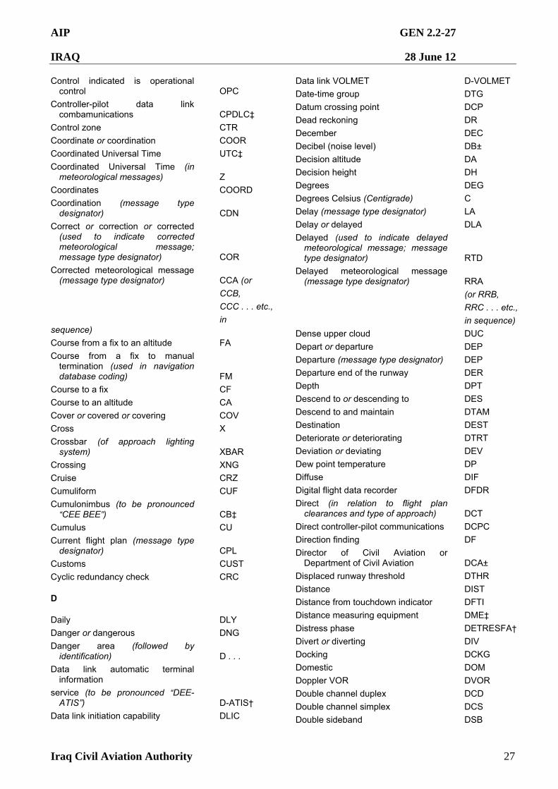
AIP GEN 2.2-27
IRAQ 28 June 12
Iraq Civil Aviation Authority 27
Control indicated is operational control OPC
Controller-pilot data link combamunications CPDLC‡
Control zone CTR
Coordinate or coordination COOR
Coordinated Universal Time UTC‡
Coordinated Universal Time (in meteorological messages) Z
Coordinates COORD
Coordination (message type designator) CDN
Correct or correction or corrected (used to indicate corrected meteorological message; message type designator) COR
Corrected meteorological message (message type designator) CCA (or
CCB,
CCC . . . etc.,
in sequence)
Course from a fix to an altitude FA
Course from a fix to manual termination (used in navigation database coding) FM
Course to a fix CF
Course to an altitude CA
Cover or covered or covering COV
Cross X
Crossbar (of approach lighting system) XBAR
Crossing XNG
Cruise CRZ
Cumuliform CUF
Cumulonimbus (to be pronounced “CEE BEE”) CB‡
Cumulus CU
Current flight plan (message type designator) CPL
Customs CUST
Cyclic redundancy check CRC
D
Daily DLY
Danger or dangerous DNG
Danger area (followed by identification) D . . .
Data link automatic terminal information
service (to be pronounced “DEE-ATIS”) D-ATIS†
Data link initiation capability DLIC
Data link VOLMET D-VOLMET
Date-time group DTG
Datum crossing point DCP
Dead reckoning DR
December DEC
Decibel (noise level) DB±
Decision altitude DA
Decision height DH
Degrees DEG
Degrees Celsius (Centigrade) C
Delay (message type designator) LA
Delay or delayed DLA
Delayed (used to indicate delayed meteorological message; message type designator) RTD
Delayed meteorological message (message type designator) RRA
(or RRB,
RRC . . . etc.,
in sequence)
Dense upper cloud DUC
Depart or departure DEP
Departure (message type designator) DEP
Departure end of the runway DER
Depth DPT
Descend to or descending to DES
Descend to and maintain DTAM
Destination DEST
Deteriorate or deteriorating DTRT
Deviation or deviating DEV
Dew point temperature DP
Diffuse DIF
Digital flight data recorder DFDR
Direct (in relation to flight plan clearances and type of approach) DCT
Direct controller-pilot communications DCPC
Direction finding DF
Director of Civil Aviation or Department of Civil Aviation DCA±
Displaced runway threshold DTHR
Distance DIST
Distance from touchdown indicator DFTI
Distance measuring equipment DME‡
Distress phase DETRESFA†
Divert or diverting DIV
Docking DCKG
Domestic DOM
Doppler VOR DVOR
Double channel duplex DCD
Double channel simplex DCS
Double sideband DSB
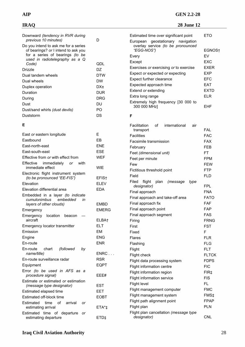
AIP GEN 2.2-28
IRAQ 28 June 12
Iraq Civil Aviation Authority 28
Downward (tendency in RVR during previous 10 minutes) D
Do you intend to ask me for a series of bearings? or I intend to ask you for a series of bearings (to be used in radiotelegraphy as a Q Code) QDL
Drizzle DZ
Dual tandem wheels DTW
Dual wheels DW
Duplex operation DX±
Duration DUR
During DRG
Dust DU
Dust/sand whirls (dust devils) PO
Duststorm DS
E
East or eastern longitude E
Eastbound EB
East-north-east ENE
East-south-east ESE
Effective from or with effect from WEF
Effective immediately or with immediate effect WIE
Electronic flight instrument system (to be pronounced “EE-FIS”) EFIS†
Elevation ELEV
Elevation differential area EDA
Embedded in a layer (to indicate cumulonimbus embedded in layers of other clouds) EMBD
Emergency EMERG
Emergency location beacon — aircraft ELBA†
Emergency locator transmitter ELT
Emission EM
Engine ENG
En-route ENR
En-route chart (followed by name/title) ENRC . . .
En-route surveillance radar RSR
Equipment EQPT
Error (to be used in AFS as a procedure signal) EEE#
Estimate or estimated or estimation (message type designator) EST
Estimated elapsed time EET
Estimated off-block time EOBT
Estimated time of arrival or estimating arrival ETA*‡
Estimated time of departure or estimating departure ETD‡
Estimated time over significant point ETO
European geostationary navigation overlay service (to be pronounced “EGG-NOS”) EGNOS†
Every EV
Except EXC
Exercises or exercising or to exercise EXER
Expect or expected or expecting EXP
Expect further clearance EFC
Expected approach time EAT
Extend or extending EXTD
Extra long range ELR
Extremely high frequency [30 000 to 300 000 MHz] EHF
F
Facilitation of international air transport FAL
Facilities FAC
Facsimile transmission FAX
February FEB
Feet (dimensional unit) FT
Feet per minute FPM
Few FEW
Fictitious threshold point FTP
Field FLD
Filed flight plan (message type designator) FPL
Final approach FNA
Final approach and take-off area FATO
Final approach fix FAF
Final approach point FAP
Final approach segment FAS
Firing FRNG
First FST
Fixed F
Flares FLR
Flashing FLG
Flight FLT
Flight check FLTCK
Flight data processing system FDPS Flight information centre FIC
Flight information region FIR‡
Flight information service FIS
Flight level FL
Flight management computer FMC
Flight management system FMS‡
Flight path alignment point FPAP
Flight plan PLN
Flight plan cancellation (message type designator) CNL
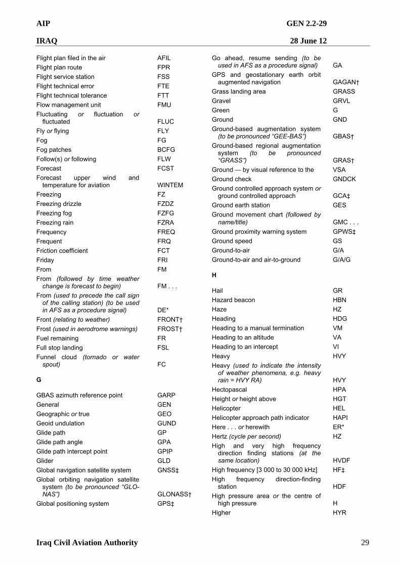
AIP GEN 2.2-29
IRAQ 28 June 12
Iraq Civil Aviation Authority 29
Flight plan filed in the air AFIL
Flight plan route FPR
Flight service station FSS
Flight technical error FTE
Flight technical tolerance FTT
Flow management unit FMU
Fluctuating or fluctuation or fluctuated FLUC
Fly or flying FLY
Fog FG
Fog patches BCFG
Follow(s) or following FLW
Forecast FCST
Forecast upper wind and temperature for aviation WINTEM
Freezing FZ
Freezing drizzle FZDZ
Freezing fog FZFG
Freezing rain FZRA
Frequency FREQ
Frequent FRQ
Friction coefficient FCT
Friday FRI
From FM
From (followed by time weather change is forecast to begin) FM . . .
From (used to precede the call sign of the calling station) (to be used in AFS as a procedure signal) DE*
Front (relating to weather) FRONT†
Frost (used in aerodrome warnings) FROST†
Fuel remaining FR
Full stop landing FSL
Funnel cloud (tornado or water spout) FC
G
GBAS azimuth reference point GARP
General GEN
Geographic or true GEO
Geoid undulation GUND
Glide path GP
Glide path angle GPA
Glide path intercept point GPIP
Glider GLD
Global navigation satellite system GNSS‡
Global orbiting navigation satellite system (to be pronounced “GLO-NAS”) GLONASS†
Global positioning system GPS‡
Go ahead, resume sending (to be used in AFS as a procedure signal) GA
GPS and geostationary earth orbit augmented navigation GAGAN†
Grass landing area GRASS
Gravel GRVL
Green G
Ground GND
Ground-based augmentation system (to be pronounced “GEE-BAS”) GBAS†
Ground-based regional augmentation system (to be pronounced “GRASS”) GRAS†
Ground — by visual reference to the VSA
Ground check GNDCK
Ground controlled approach system or ground controlled approach GCA‡
Ground earth station GES
Ground movement chart (followed by name/title) GMC . . .
Ground proximity warning system GPWS‡
Ground speed GS
Ground-to-air G/A
Ground-to-air and air-to-ground G/A/G
H
Hail GR
Hazard beacon HBN
Haze HZ
Heading HDG Heading to a manual termination VM
Heading to an altitude VA
Heading to an intercept VI
Heavy HVY
Heavy (used to indicate the intensity of weather phenomena, e.g. heavy rain = HVY RA) HVY
Hectopascal HPA
Height or height above HGT
Helicopter HEL
Helicopter approach path indicator HAPI
Here . . . or herewith ER*
Hertz (cycle per second) HZ
High and very high frequency direction finding stations (at the same location) HVDF
High frequency [3 000 to 30 000 kHz] HF‡
High frequency direction-finding station HDF
High pressure area or the centre of high pressure H
Higher HYR
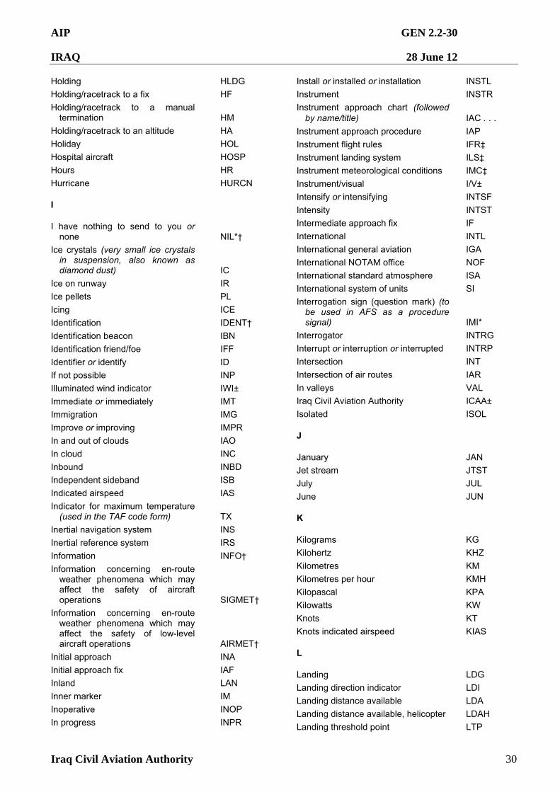
AIP GEN 2.2-30
IRAQ 28 June 12
Iraq Civil Aviation Authority 30
Holding HLDG
Holding/racetrack to a fix HF
Holding/racetrack to a manual termination HM
Holding/racetrack to an altitude HA
Holiday HOL
Hospital aircraft HOSP
Hours HR
Hurricane HURCN
I
I have nothing to send to you or none NIL*†
Ice crystals (very small ice crystals in suspension, also known as diamond dust) IC
Ice on runway IR
Ice pellets PL
Icing ICE
Identification IDENT†
Identification beacon IBN
Identification friend/foe IFF
Identifier or identify ID
If not possible INP
Illuminated wind indicator IWI±
Immediate or immediately IMT
Immigration IMG
Improve or improving IMPR
In and out of clouds IAO
In cloud INC
Inbound INBD
Independent sideband ISB
Indicated airspeed IAS
Indicator for maximum temperature (used in the TAF code form) TX
Inertial navigation system INS
Inertial reference system IRS
Information INFO†
Information concerning en-route weather phenomena which may affect the safety of aircraft operations SIGMET†
Information concerning en-route weather phenomena which may affect the safety of low-level aircraft operations AIRMET†
Initial approach INA
Initial approach fix IAF
Inland LAN
Inner marker IM
Inoperative INOP
In progress INPR
Install or installed or installation INSTL
Instrument INSTR
Instrument approach chart (followed by name/title) IAC . . .
Instrument approach procedure IAP
Instrument flight rules IFR‡
Instrument landing system ILS‡
Instrument meteorological conditions IMC‡
Instrument/visual I/V±
Intensify or intensifying INTSF
Intensity INTST
Intermediate approach fix IF
International INTL
International general aviation IGA
International NOTAM office NOF
International standard atmosphere ISA
International system of units SI
Interrogation sign (question mark) (to be used in AFS as a procedure signal) IMI*
Interrogator INTRG
Interrupt or interruption or interrupted INTRP
Intersection INT
Intersection of air routes IAR
In valleys VAL
Iraq Civil Aviation Authority ICAA±
Isolated ISOL
J
January JAN
Jet stream JTST
July JUL
June JUN
K
Kilograms KG
Kilohertz KHZ
Kilometres KM
Kilometres per hour KMH
Kilopascal KPA
Kilowatts KW
Knots KT
Knots indicated airspeed KIAS
L
Landing LDG
Landing direction indicator LDI
Landing distance available LDA
Landing distance available, helicopter LDAH
Landing threshold point LTP
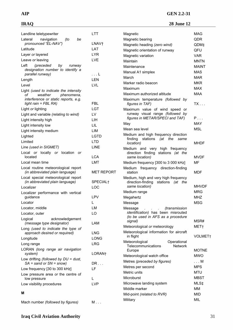
AIP GEN 2.2-31
IRAQ 28 June 12
Iraq Civil Aviation Authority 31
Landline teletypewriter LTT
Lateral navigation (to be pronounced “EL-NAV”) LNAV†
Latitude LAT
Layer or layered LYR
Leave or leaving LVE
Left (preceded by runway designation number to identify a parallel runway) . . . L
Length LEN
Level LVL
Light (used to indicate the intensity of weather phenomena, interference or static reports, e.g. light rain = FBL RA) FBL
Light or lighting LGT
Light and variable (relating to wind) LV
Light intensity high LIH
Light intensity low LIL
Light intensity medium LIM
Lighted LGTD
Limited LTD
Line (used in SIGMET) LINE
Local or locally or location or located LCA
Local mean time LMT
Local routine meteorological report (in abbreviated plain language) MET REPORT
Local special meteorological report (in abbreviated plain language) SPECIAL†
Localizer LOC
Localizer performance with vertical guidance LPV
Locator L
Locator, middle LM
Locator, outer LO
Logical acknowledgement (message type designator) LAM
Long (used to indicate the type of approach desired or required) LNG
Longitude LONG
Long range LRG
LORAN (long range air navigation system) LORAN†
Low drifting (followed by DU = dust, SA = sand or SN = snow) DR . . .
Low frequency [30 to 300 kHz] LF
Low pressure area or the centre of low pressure L
Low visibility procedures LVP
M
Mach number (followed by figures) M . . .
Magnetic MAG
Magnetic bearing QDR
Magnetic heading (zero wind) QDM‡
Magnetic orientation of runway QFU
Magnetic variation VAR
Maintain MNTN
Maintenance MAINT
Manual A1 simplex MAS
March MAR
Marker radio beacon MKR Maximum MAX
Maximum authorized altitude MAA
Maximum temperature (followed by figures in TAF) TX . . .
Maximum value of wind speed or runway visual range (followed by figures in METAR/SPECI and TAF) P . . .
May MAY
Mean sea level MSL
Medium and high frequency direction finding stations (at the same location) MHDF
Medium and very high frequency direction finding stations (at the same location) MVDF
Medium frequency [300 to 3 000 kHz] MF
Medium frequency direction-finding station MDF
Medium, high and very high frequency direction-finding stations (at the same location) MHVDF
Medium range MRG
Megahertz MHZ
Message MSG
Message . . . (transmission identification) has been misrouted (to be used in AFS as a procedure signal) MSR#
Meteorological or meteorology MET†
Meteorological information for aircraft in flight VOLMET†
Meteorological Operational Telecommunications Network Europe MOTNE
Meteorological watch office MWO
Metres (preceded by figures) . . . M
Metres per second MPS
Metric units MTU
Microburst MBST
Microwave landing system MLS‡
Middle marker MM
Mid-point (related to RVR) MID
Military MIL
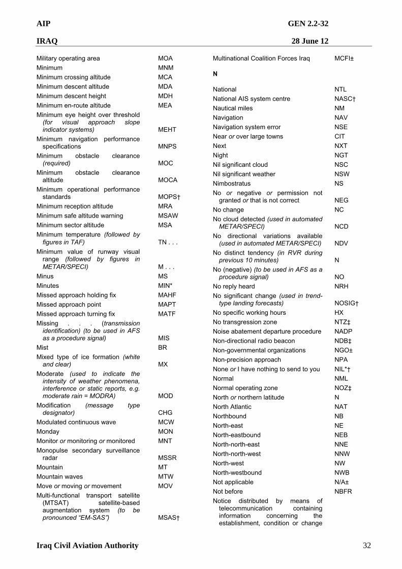
AIP GEN 2.2-32
IRAQ 28 June 12
Iraq Civil Aviation Authority 32
Military operating area MOA
Minimum MNM
Minimum crossing altitude MCA
Minimum descent altitude MDA
Minimum descent height MDH
Minimum en-route altitude MEA
Minimum eye height over threshold (for visual approach slope indicator systems) MEHT
Minimum navigation performance specifications MNPS
Minimum obstacle clearance (required) MOC
Minimum obstacle clearance altitude MOCA
Minimum operational performance standards MOPS†
Minimum reception altitude MRA
Minimum safe altitude warning MSAW
Minimum sector altitude MSA
Minimum temperature (followed by figures in TAF) TN . . .
Minimum value of runway visual range (followed by figures in METAR/SPECI) M . . .
Minus MS
Minutes MIN*
Missed approach holding fix MAHF
Missed approach point MAPT
Missed approach turning fix MATF
Missing . . . (transmission identification) (to be used in AFS as a procedure signal) MIS
Mist BR
Mixed type of ice formation (white and clear) MX
Moderate (used to indicate the intensity of weather phenomena, interference or static reports, e.g. moderate rain = MODRA) MOD
Modification (message type designator) CHG
Modulated continuous wave MCW
Monday MON
Monitor or monitoring or monitored MNT
Monopulse secondary surveillance radar MSSR
Mountain MT
Mountain waves MTW
Move or moving or movement MOV
Multi-functional transport satellite (MTSAT) satellite-based augmentation system (to be pronounced “EM-SAS”) MSAS†
Multinational Coalition Forces Iraq MCFI±
N
National NTL
National AIS system centre NASC†
Nautical miles NM Navigation NAV
Navigation system error NSE
Near or over large towns CIT
Next NXT
Night NGT
Nil significant cloud NSC
Nil significant weather NSW
Nimbostratus NS
No or negative or permission not granted or that is not correct NEG
No change NC
No cloud detected (used in automated METAR/SPECI) NCD
No directional variations available (used in automated METAR/SPECI) NDV
No distinct tendency (in RVR during previous 10 minutes) N
No (negative) (to be used in AFS as a procedure signal) NO
No reply heard NRH
No significant change (used in trend-type landing forecasts) NOSIG†
No specific working hours HX
No transgression zone NTZ‡
Noise abatement departure procedure NADP
Non-directional radio beacon NDB‡
Non-governmental organizations NGO±
Non-precision approach NPA
None or I have nothing to send to you NIL*†
Normal NML
Normal operating zone NOZ‡
North or northern latitude N
North Atlantic NAT
Northbound NB
North-east NE
North-eastbound NEB
North-north-east NNE
North-north-west NNW
North-west NW
North-westbound NWB
Not applicable N/A±
Not before NBFR
Notice distributed by means of telecommunication containing information concerning the establishment, condition or change
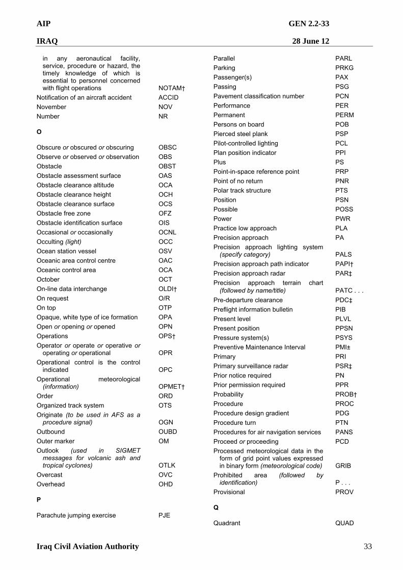
AIP GEN 2.2-33
IRAQ 28 June 12
Iraq Civil Aviation Authority 33
in any aeronautical facility, service, procedure or hazard, the timely knowledge of which is essential to personnel concerned with flight operations NOTAM†
Notification of an aircraft accident ACCID
November NOV
Number NR
O
Obscure or obscured or obscuring OBSC
Observe or observed or observation OBS
Obstacle OBST
Obstacle assessment surface OAS
Obstacle clearance altitude OCA
Obstacle clearance height OCH
Obstacle clearance surface OCS
Obstacle free zone OFZ
Obstacle identification surface OIS
Occasional or occasionally OCNL
Occulting (light) OCC
Ocean station vessel OSV
Oceanic area control centre OAC
Oceanic control area OCA
October OCT
On-line data interchange OLDI†
On request O/R
On top OTP
Opaque, white type of ice formation OPA
Open or opening or opened OPN
Operations OPS†
Operator or operate or operative or operating or operational OPR
Operational control is the control indicated OPC
Operational meteorological (information) OPMET†
Order ORD
Organized track system OTS
Originate (to be used in AFS as a procedure signal) OGN
Outbound OUBD Outer marker OM
Outlook (used in SIGMET messages for volcanic ash and tropical cyclones) OTLK
Overcast OVC
Overhead OHD
P
Parachute jumping exercise PJE
Parallel PARL
Parking PRKG
Passenger(s) PAX
Passing PSG
Pavement classification number PCN
Performance PER
Permanent PERM
Persons on board POB
Pierced steel plank PSP
Pilot-controlled lighting PCL
Plan position indicator PPI
Plus PS
Point-in-space reference point PRP
Point of no return PNR
Polar track structure PTS
Position PSN
Possible POSS
Power PWR
Practice low approach PLA
Precision approach PA
Precision approach lighting system (specify category) PALS
Precision approach path indicator PAPI†
Precision approach radar PAR‡
Precision approach terrain chart (followed by name/title) PATC . . .
Pre-departure clearance PDC‡
Preflight information bulletin PIB
Present level PLVL
Present position PPSN
Pressure system(s) PSYS
Preventive Maintenance Interval PMI±
Primary PRI
Primary surveillance radar PSR‡
Prior notice required PN
Prior permission required PPR
Probability PROB†
Procedure PROC
Procedure design gradient PDG
Procedure turn PTN
Procedures for air navigation services PANS
Proceed or proceeding PCD
Processed meteorological data in the form of grid point values expressed in binary form (meteorological code) GRIB
Prohibited area (followed by identification) P . . .
Provisional PROV
Q
Quadrant QUAD
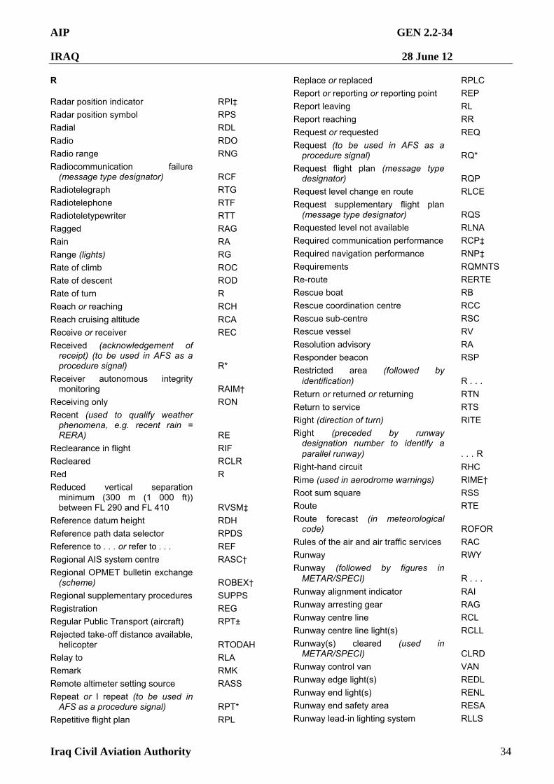
AIP GEN 2.2-34
IRAQ 28 June 12
Iraq Civil Aviation Authority 34
R
Radar position indicator RPI‡
Radar position symbol RPS
Radial RDL
Radio RDO
Radio range RNG
Radiocommunication failure (message type designator) RCF
Radiotelegraph RTG
Radiotelephone RTF
Radioteletypewriter RTT
Ragged RAG
Rain RA
Range (lights) RG
Rate of climb ROC
Rate of descent ROD
Rate of turn R
Reach or reaching RCH
Reach cruising altitude RCA
Receive or receiver REC
Received (acknowledgement of receipt) (to be used in AFS as a procedure signal) R*
Receiver autonomous integrity monitoring RAIM†
Receiving only RON
Recent (used to qualify weather phenomena, e.g. recent rain = RERA) RE
Reclearance in flight RIF
Recleared RCLR Red R
Reduced vertical separation minimum (300 m (1 000 ft)) between FL 290 and FL 410 RVSM‡
Reference datum height RDH
Reference path data selector RPDS
Reference to . . . or refer to . . . REF
Regional AIS system centre RASC†
Regional OPMET bulletin exchange (scheme) ROBEX†
Regional supplementary procedures SUPPS
Registration REG
Regular Public Transport (aircraft) RPT±
Rejected take-off distance available, helicopter RTODAH
Relay to RLA
Remark RMK
Remote altimeter setting source RASS
Repeat or I repeat (to be used in AFS as a procedure signal) RPT*
Repetitive flight plan RPL
Replace or replaced RPLC
Report or reporting or reporting point REP
Report leaving RL
Report reaching RR
Request or requested REQ
Request (to be used in AFS as a procedure signal) RQ*
Request flight plan (message type designator) RQP
Request level change en route RLCE
Request supplementary flight plan (message type designator) RQS
Requested level not available RLNA
Required communication performance RCP‡
Required navigation performance RNP‡
Requirements RQMNTS
Re-route RERTE
Rescue boat RB
Rescue coordination centre RCC
Rescue sub-centre RSC
Rescue vessel RV
Resolution advisory RA
Responder beacon RSP
Restricted area (followed by identification) R . . .
Return or returned or returning RTN
Return to service RTS
Right (direction of turn) RITE
Right (preceded by runway designation number to identify a parallel runway) . . . R
Right-hand circuit RHC
Rime (used in aerodrome warnings) RIME†
Root sum square RSS
Route RTE
Route forecast (in meteorological code) ROFOR
Rules of the air and air traffic services RAC
Runway RWY
Runway (followed by figures in METAR/SPECI) R . . .
Runway alignment indicator RAI
Runway arresting gear RAG
Runway centre line RCL
Runway centre line light(s) RCLL
Runway(s) cleared (used in METAR/SPECI) CLRD
Runway control van VAN
Runway edge light(s) REDL
Runway end light(s) RENL
Runway end safety area RESA
Runway lead-in lighting system RLLS
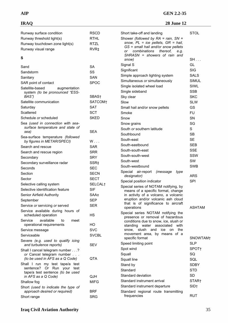
AIP GEN 2.2-35
IRAQ 28 June 12
Iraq Civil Aviation Authority 35
Runway surface condition RSCD
Runway threshold light(s) RTHL
Runway touchdown zone light(s) RTZL
Runway visual range RVR‡
S
Sand SA
Sandstorm SS
Sanitary SAN
SAR point of contact SPOC
Satellite-based augmentation system (to be pronounced “ESS-BAS”) SBAS†
Satellite communication SATCOM†
Saturday SAT
Scattered SCT
Schedule or scheduled SKED
Sea (used in connection with sea-surface temperature and state of sea) SEA
Sea-surface temperature (followed by figures in METAR/SPECI) W . . .
Search and rescue SAR Search and rescue region SRR
Secondary SRY
Secondary surveillance radar SSR‡
Seconds SEC
Section SECN
Sector SECT
Selective calling system SELCAL†
Selective identification feature SIF
Senior Airfield Authority SAA±
September SEP
Service or servicing or served SER
Service available during hours of scheduled operation HS
Service available to meet operational requirements HO
Service message SVC
Serviceable SVCBL
Severe (e.g. used to qualify icing and turbulence reports) SEV
Shall I cancel telegram number . . .? or Cancel telegram number . . . (to be used in AFS as a Q Code) QTA
Shall I run my test tape/a test sentence? Or Run your test tape/a test sentence (to be used in AFS as a Q Code) QJH
Shallow fog MIFG
Short (used to indicate the type of approach desired or required) BRF
Short range SRG
Short take-off and landing STOL
Shower (followed by RA = rain, SN = snow, PL = ice pellets, GR = hail, GS = small hail and/or snow pellets or combinations thereof, e.g. SHRASN = showers of rain and snow) SH . . .
Signal S GL
Significant SIG
Simple approach lighting system SALS
Simultaneous or simultaneously SIMUL
Single isolated wheel load SIWL
Single sideband SSB
Sky clear SKC
Slow SLW
Small hail and/or snow pellets GS
Smoke FU
Snow SN
Snow grains SG
South or southern latitude S
Southbound SB
South-east SE
South-eastbound SEB
South-south-east SSE
South-south-west SSW
South-west SW
South-westbound SWB
Special air-report (message type designator) ARS
Special position indicator SPI
Special series of NOTAM notifying, by means of a specific format, change in activity of a volcano, a volcanic eruption and/or volcanic ash cloud that is of significance to aircraft operations ASHTAM
Special series NOTAM notifying the presence or removal of hazardous conditions due to snow, ice, slush or standing water associated with snow, slush and ice on the movement area, by means of a specific format SNOWTAM†
Speed limiting point SLP
Spot wind SPOT†
Squall SQ
Squall line SQL
Stand by SDBY
Standard STD
Standard deviation SD
Standard instrument arrival STAR†
Standard instrument departure SID†
Standard regional route transmitting frequencies RUT
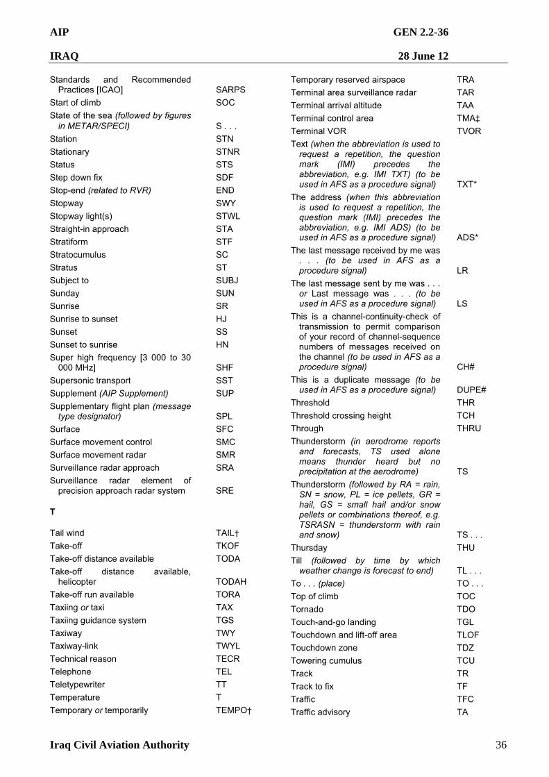
AIP GEN 2.2-36
IRAQ 28 June 12
Iraq Civil Aviation Authority 36
Standards and Recommended Practices [ICAO] SARPS
Start of climb SOC
State of the sea (followed by figures in METAR/SPECI) S . . .
Station STN
Stationary STNR
Status STS
Step down fix SDF
Stop-end (related to RVR) END
Stopway SWY
Stopway light(s) STWL
Straight-in approach STA Stratiform STF
Stratocumulus SC
Stratus ST
Subject to SUBJ
Sunday SUN
Sunrise SR
Sunrise to sunset HJ
Sunset SS
Sunset to sunrise HN
Super high frequency [3 000 to 30 000 MHz] SHF
Supersonic transport SST
Supplement (AIP Supplement) SUP
Supplementary flight plan (message type designator) SPL
Surface SFC
Surface movement control SMC
Surface movement radar SMR
Surveillance radar approach SRA
Surveillance radar element of precision approach radar system SRE
T
Tail wind TAIL†
Take-off TKOF
Take-off distance available TODA
Take-off distance available, helicopter TODAH
Take-off run available TORA
Taxiing or taxi TAX
Taxiing guidance system TGS
Taxiway TWY
Taxiway-link TWYL
Technical reason TECR
Telephone TEL
Teletypewriter TT
Temperature T
Temporary or temporarily TEMPO†
Temporary reserved airspace TRA
Terminal area surveillance radar TAR
Terminal arrival altitude TAA
Terminal control area TMA‡
Terminal VOR TVOR
Text (when the abbreviation is used to request a repetition, the question mark (IMI) precedes the abbreviation, e.g. IMI TXT) (to be used in AFS as a procedure signal) TXT*
The address (when this abbreviation is used to request a repetition, the question mark (IMI) precedes the abbreviation, e.g. IMI ADS) (to be used in AFS as a procedure signal) ADS*
The last message received by me was . . . (to be used in AFS as a procedure signal) LR
The last message sent by me was . . . or Last message was . . . (to be used in AFS as a procedure signal) LS
This is a channel-continuity-check of transmission to permit comparison of your record of channel-sequence numbers of messages received on the channel (to be used in AFS as a procedure signal) CH#
This is a duplicate message (to be used in AFS as a procedure signal) DUPE#
Threshold THR
Threshold crossing height TCH
Through THRU
Thunderstorm (in aerodrome reports and forecasts, TS used alone means thunder heard but no precipitation at the aerodrome) TS
Thunderstorm (followed by RA = rain, SN = snow, PL = ice pellets, GR = hail, GS = small hail and/or snow pellets or combinations thereof, e.g. TSRASN = thunderstorm with rain and snow) TS . . .
Thursday THU
Till (followed by time by which weather change is forecast to end) TL . . .
To . . . (place) TO . . .
Top of climb TOC
Tornado TDO
Touch-and-go landing TGL
Touchdown and lift-off area TLOF
Touchdown zone TDZ
Towering cumulus TCU Track TR
Track to fix TF
Traffic TFC
Traffic advisory TA
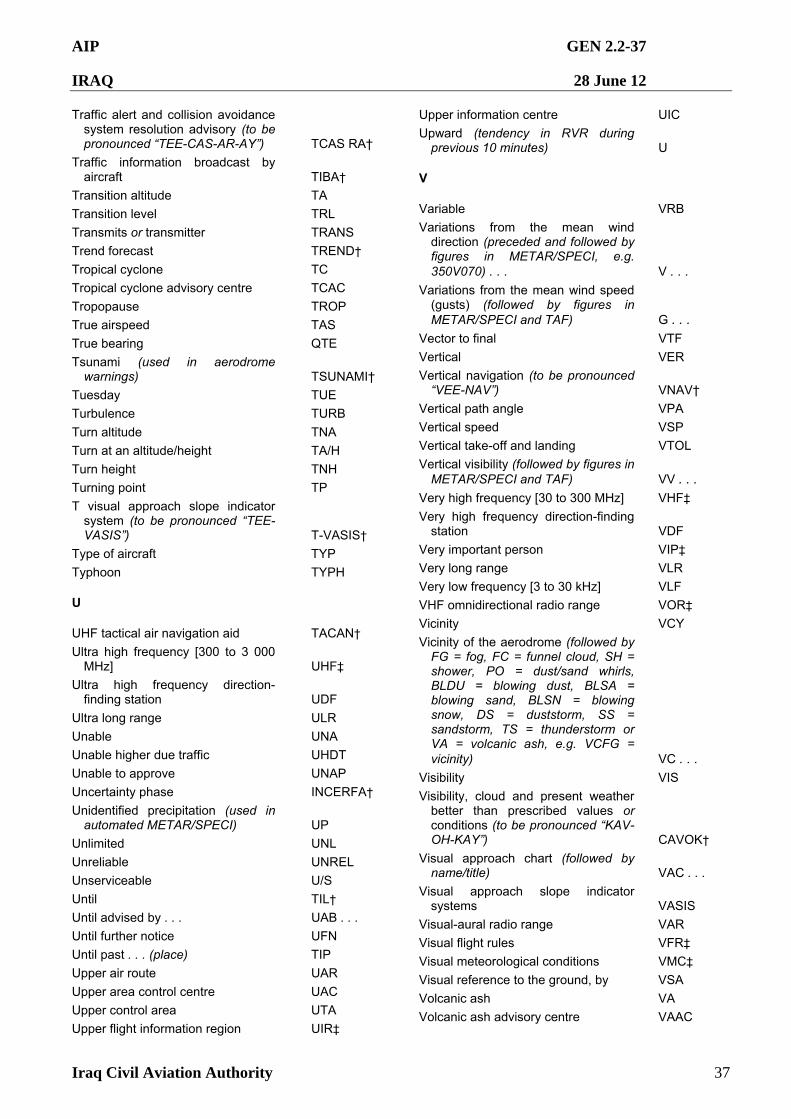
AIP GEN 2.2-37
IRAQ 28 June 12
Iraq Civil Aviation Authority 37
Traffic alert and collision avoidance system resolution advisory (to be pronounced “TEE-CAS-AR-AY”) TCAS RA†
Traffic information broadcast by aircraft TIBA†
Transition altitude TA
Transition level TRL
Transmits or transmitter TRANS
Trend forecast TREND†
Tropical cyclone TC
Tropical cyclone advisory centre TCAC
Tropopause TROP
True airspeed TAS
True bearing QTE
Tsunami (used in aerodrome warnings) TSUNAMI†
Tuesday TUE
Turbulence TURB
Turn altitude TNA
Turn at an altitude/height TA/H
Turn height TNH
Turning point TP
T visual approach slope indicator system (to be pronounced “TEE-VASIS”) T-VASIS†
Type of aircraft TYP
Typhoon TYPH
U
UHF tactical air navigation aid TACAN†
Ultra high frequency [300 to 3 000 MHz] UHF‡
Ultra high frequency direction-finding station UDF
Ultra long range ULR
Unable UNA
Unable higher due traffic UHDT
Unable to approve UNAP
Uncertainty phase INCERFA†
Unidentified precipitation (used in automated METAR/SPECI) UP
Unlimited UNL
Unreliable UNREL
Unserviceable U/S
Until TIL†
Until advised by . . . UAB . . .
Until further notice UFN
Until past . . . (place) TIP
Upper air route UAR
Upper area control centre UAC
Upper control area UTA
Upper flight information region UIR‡
Upper information centre UIC
Upward (tendency in RVR during previous 10 minutes) U
V
Variable VRB
Variations from the mean wind direction (preceded and followed by figures in METAR/SPECI, e.g. 350V070) . . . V . . .
Variations from the mean wind speed (gusts) (followed by figures in METAR/SPECI and TAF) G . . .
Vector to final VTF
Vertical VER
Vertical navigation (to be pronounced “VEE-NAV”) VNAV†
Vertical path angle VPA
Vertical speed VSP
Vertical take-off and landing VTOL
Vertical visibility (followed by figures in METAR/SPECI and TAF) VV . . .
Very high frequency [30 to 300 MHz] VHF‡
Very high frequency direction-finding station VDF
Very important person VIP‡
Very long range VLR
Very low frequency [3 to 30 kHz] VLF
VHF omnidirectional radio range VOR‡
Vicinity VCY
Vicinity of the aerodrome (followed by FG = fog, FC = funnel cloud, SH = shower, PO = dust/sand whirls, BLDU = blowing dust, BLSA = blowing sand, BLSN = blowing snow, DS = duststorm, SS = sandstorm, TS = thunderstorm or VA = volcanic ash, e.g. VCFG = vicinity) VC . . .
Visibility VIS
Visibility, cloud and present weather better than prescribed values or conditions (to be pronounced “KAV-OH-KAY”) CAVOK†
Visual approach chart (followed by name/title) VAC . . .
Visual approach slope indicator systems VASIS
Visual-aural radio range VAR
Visual flight rules VFR‡
Visual meteorological conditions VMC‡
Visual reference to the ground, by VSA
Volcanic ash VA
Volcanic ash advisory centre VAAC
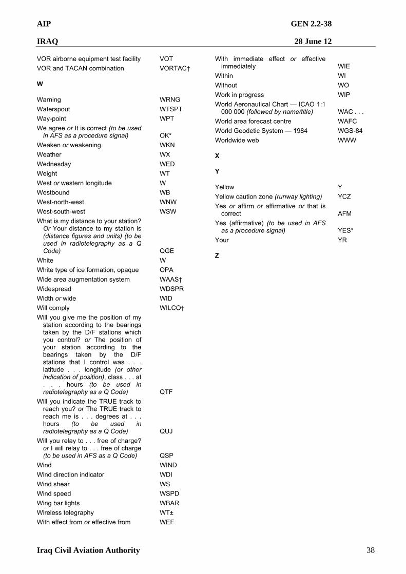
AIP GEN 2.2-38
IRAQ 28 June 12
Iraq Civil Aviation Authority 38
VOR airborne equipment test facility VOT
VOR and TACAN combination VORTAC†
W
Warning WRNG
Waterspout WTSPT
Way-point WPT
We agree or It is correct (to be used in AFS as a procedure signal) OK*
Weaken or weakening WKN
Weather WX
Wednesday WED
Weight WT
West or western longitude W
Westbound WB
West-north-west WNW
West-south-west WSW
What is my distance to your station? Or Your distance to my station is (distance figures and units) (to be used in radiotelegraphy as a Q Code) QGE
White W
White type of ice formation, opaque OPA
Wide area augmentation system WAAS†
Widespread WDSPR
Width or wide WID
Will comply WILCO†
Will you give me the position of my station according to the bearings taken by the D/F stations which you control? or The position of your station according to the bearings taken by the D/F stations that I control was . . . latitude . . . longitude (or other indication of position), class . . . at . . . hours (to be used in radiotelegraphy as a Q Code) QTF
Will you indicate the TRUE track to reach you? or The TRUE track to reach me is . . . degrees at . . . hours (to be used in radiotelegraphy as a Q Code) QUJ
Will you relay to . . . free of charge? or I will relay to . . . free of charge (to be used in AFS as a Q Code) QSP
Wind WIND
Wind direction indicator WDI
Wind shear WS
Wind speed WSPD
Wing bar lights WBAR
Wireless telegraphy WT±
With effect from or effective from WEF
With immediate effect or effective immediately WIE
Within WI
Without WO
Work in progress WIP
World Aeronautical Chart — ICAO 1:1 000 000 (followed by name/title) WAC . . .
World area forecast centre WAFC
World Geodetic System — 1984 WGS-84
Worldwide web WWW
X
Y
Yellow Y
Yellow caution zone (runway lighting) YCZ
Yes or affirm or affirmative or that is correct AFM
Yes (affirmative) (to be used in AFS as a procedure signal) YES*
Your YR
Z
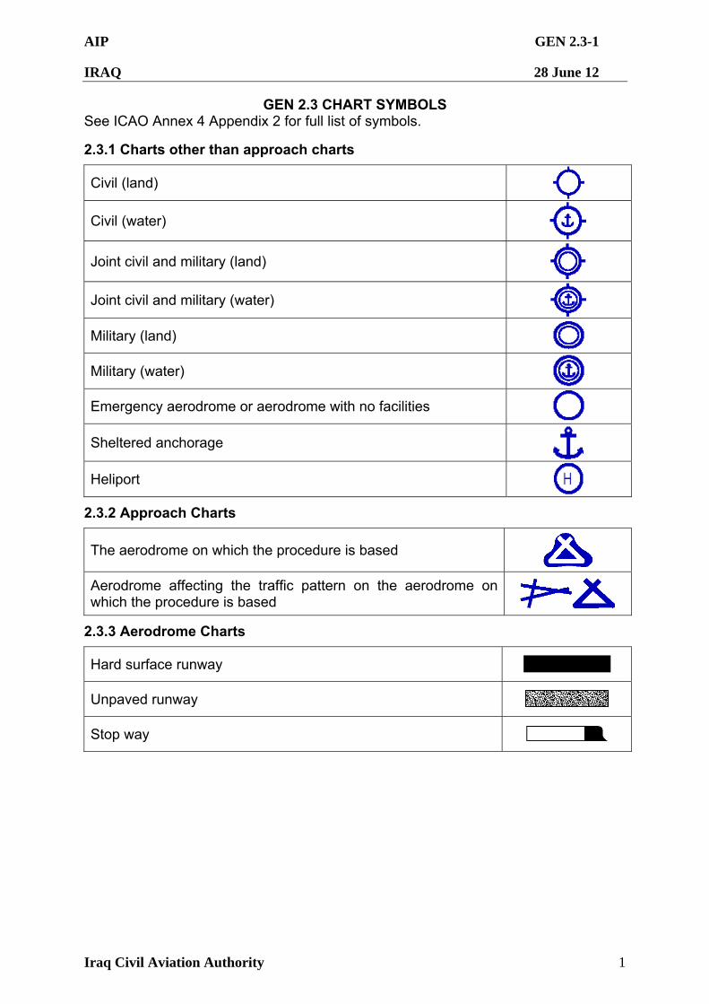
AIP GEN 2.3-1
IRAQ 28 June 12
Iraq Civil Aviation Authority 1
GEN 2.3 CHART SYMBOLS See ICAO Annex 4 Appendix 2 for full list of symbols.
2.3.1 Charts other than approach charts
Civil (land)
Civil (water)
Joint civil and military (land)
Joint civil and military (water)
Military (land)
Military (water)
Emergency aerodrome or aerodrome with no facilities
Sheltered anchorage
Heliport
2.3.2 Approach Charts
The aerodrome on which the procedure is based
Aerodrome affecting the traffic pattern on the aerodrome on which the procedure is based
2.3.3 Aerodrome Charts
Hard surface runway
Unpaved runway
Stop way
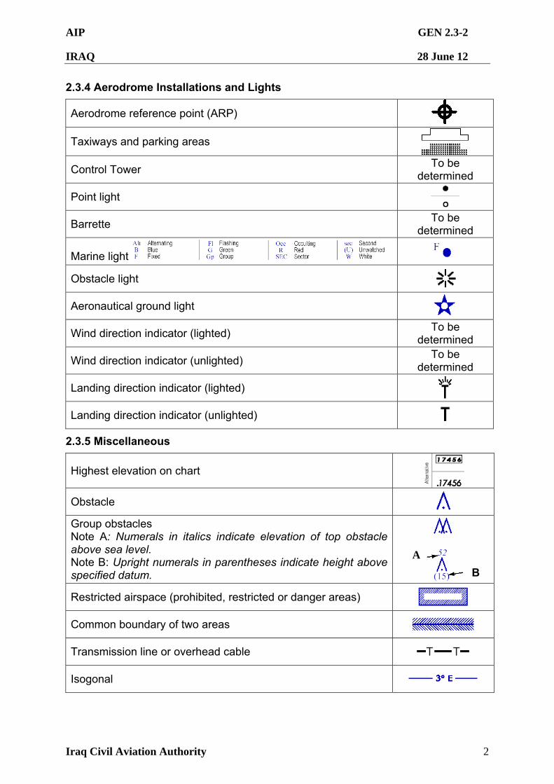
AIP GEN 2.3-2
IRAQ 28 June 12
Iraq Civil Aviation Authority 2
2.3.4 Aerodrome Installations and Lights
Aerodrome reference point (ARP)
Taxiways and parking areas
Control Tower To be
determined
Point light
Barrette To be
determined
Marine light
Obstacle light
Aeronautical ground light
Wind direction indicator (lighted) To be
determined
Wind direction indicator (unlighted) To be
determined
Landing direction indicator (lighted)
Landing direction indicator (unlighted)
2.3.5 Miscellaneous
Highest elevation on chart
Obstacle
Group obstacles Note A: Numerals in italics indicate elevation of top obstacle above sea level. Note B: Upright numerals in parentheses indicate height above specified datum.
Restricted airspace (prohibited, restricted or danger areas)
Common boundary of two areas
Transmission line or overhead cable
Isogonal
A
B
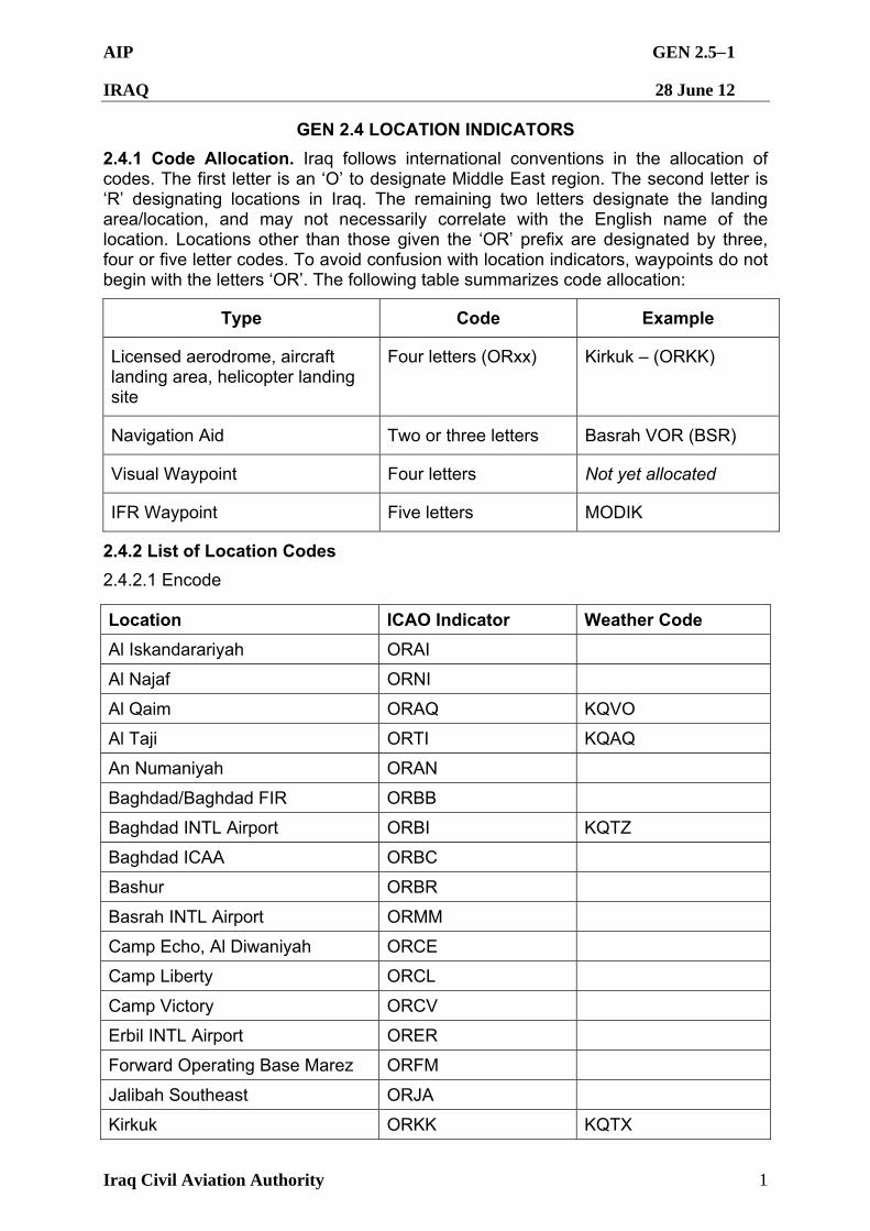
AIP GEN 2.51
IRAQ 28 June 12
Iraq Civil Aviation Authority 1
GEN 2.4 LOCATION INDICATORS
2.4.1 Code Allocation. Iraq follows international conventions in the allocation of codes. The first letter is an ‘O’ to designate Middle East region. The second letter is ‘R’ designating locations in Iraq. The remaining two letters designate the landing area/location, and may not necessarily correlate with the English name of the location. Locations other than those given the ‘OR’ prefix are designated by three, four or five letter codes. To avoid confusion with location indicators, waypoints do not begin with the letters ‘OR’. The following table summarizes code allocation:
Type Code Example
Licensed aerodrome, aircraft landing area, helicopter landing site
Four letters (ORxx) Kirkuk – (ORKK)
Navigation Aid Two or three letters Basrah VOR (BSR)
Visual Waypoint Four letters Not yet allocated
IFR Waypoint Five letters MODIK
2.4.2 List of Location Codes
2.4.2.1 Encode
Location ICAO Indicator Weather Code
Al Iskandarariyah ORAI
Al Najaf ORNI
Al Qaim ORAQ KQVO
Al Taji ORTI KQAQ
An Numaniyah ORAN
Baghdad/Baghdad FIR ORBB
Baghdad INTL Airport ORBI KQTZ
Baghdad ICAA ORBC
Bashur ORBR
Basrah INTL Airport ORMM
Camp Echo, Al Diwaniyah ORCE
Camp Liberty ORCL
Camp Victory ORCV
Erbil INTL Airport ORER
Forward Operating Base Marez ORFM
Jalibah Southeast ORJA
Kirkuk ORKK KQTX
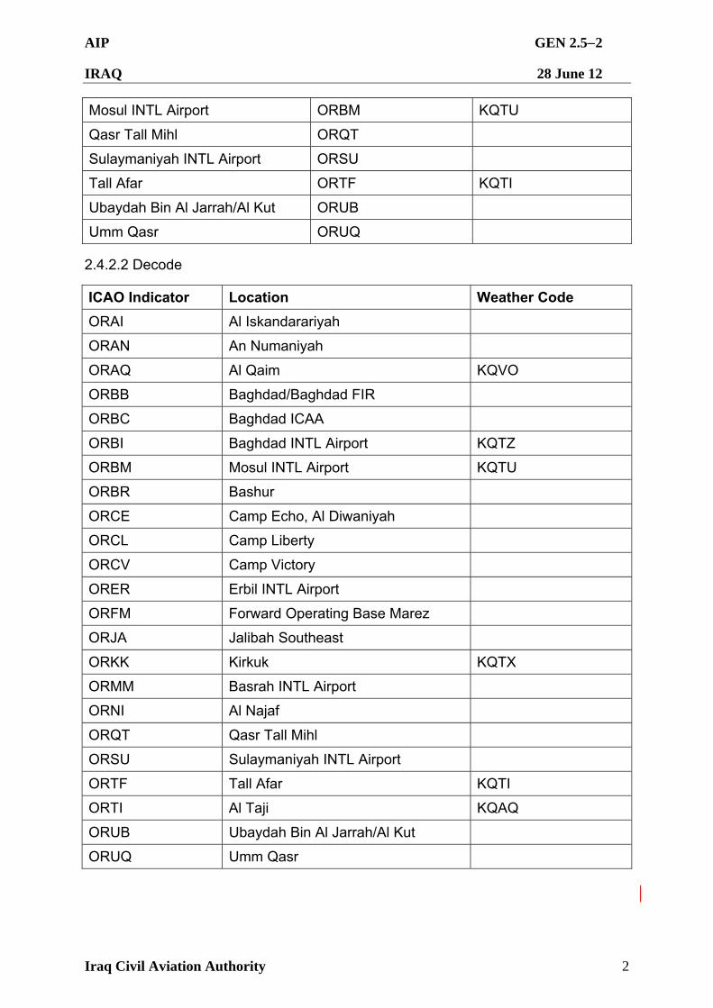
AIP GEN 2.52
IRAQ 28 June 12
Iraq Civil Aviation Authority 2
Mosul INTL Airport ORBM KQTU
Qasr Tall Mihl ORQT
Sulaymaniyah INTL Airport ORSU
Tall Afar ORTF KQTI
Ubaydah Bin Al Jarrah/Al Kut ORUB
Umm Qasr ORUQ
2.4.2.2 Decode
ICAO Indicator Location Weather Code
ORAI Al Iskandarariyah
ORAN An Numaniyah
ORAQ Al Qaim KQVO
ORBB Baghdad/Baghdad FIR
ORBC Baghdad ICAA
ORBI Baghdad INTL Airport KQTZ
ORBM Mosul INTL Airport KQTU
ORBR Bashur
ORCE Camp Echo, Al Diwaniyah
ORCL Camp Liberty
ORCV Camp Victory
ORER Erbil INTL Airport
ORFM Forward Operating Base Marez
ORJA Jalibah Southeast
ORKK Kirkuk KQTX
ORMM Basrah INTL Airport
ORNI Al Najaf
ORQT Qasr Tall Mihl
ORSU Sulaymaniyah INTL Airport
ORTF Tall Afar KQTI
ORTI Al Taji KQAQ
ORUB Ubaydah Bin Al Jarrah/Al Kut
ORUQ Umm Qasr
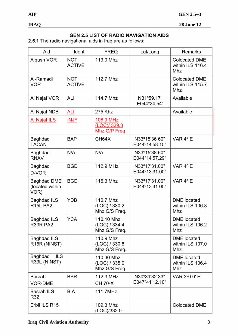
AIP GEN 2.53
IRAQ 28 June 12
Iraq Civil Aviation Authority 3
GEN 2.5 LIST OF RADIO NAVIGATION AIDS 2.5.1 The radio navigational aids in Iraq are as follows:
Aid Ident FREQ Lat/Long Remarks
Alqush VOR NOT ACTIVE
113.0 Mhz Colocated DME within ILS 116.4 Mhz
Al-Ramadi VOR
NOT ACTIVE
112.7 Mhz Colocated DME within ILS 115.7 Mhz
Al Najaf VOR ALI 114.7 Mhz N31º59.17' E044º24.54'
Available
Al Najaf NDB ALI 275 Khz Available
Al Najaf ILS INJF 108.9 MHz (LOC)/ 329.3 Mhz G/P Freq
Baghdad TACAN
BAP CH64X N33º15'36 60" E044º14'58.10"
VAR 4º E
Baghdad RNAV
N/A N/A N33º15'38.60" E044º14'57.29"
Baghdad
D-VOR
BGD 112.9 MHz N33º17'31.00" E044º13'31.00"
VAR 4º E
Baghdad DME (located within VOR)
BGD 116.3 Mhz N33º17'31.00" E044º13'31.00"
VAR 4º E
Baghdad ILS R15L PA2
YDB 110.7 Mhz (LOC) / 330.2 Mhz G/S Freq.
DME located within ILS 106.8 Mhz
Baghdad ILS R33R PA2
YCA 110.10 Mhz (LOC) / 334.4 Mhz G/S Freq.
DME located within ILS 106.2 Mhz
Baghdad ILS R15R (NINST)
110.9 Mhz (LOC) / 330.8 Mhz G/S Freq.
DME located within ILS 107.0 Mhz
Baghdad ILS R33L (NINST)
110.30 Mhz (LOC) / 335.0 Mhz G/S Freq.
DME located within ILS 106.4 Mhz
Basrah
VOR-DME
BSR 112.3 MHz
CH 70-X
N30º31'32.33" E047º41'12.10"
VAR 3º0.0' E
Basrah ILS R32
BIA 111.7MHz
Erbil ILS R15 109.3 Mhz (LOC)/332.0
Colocated DME
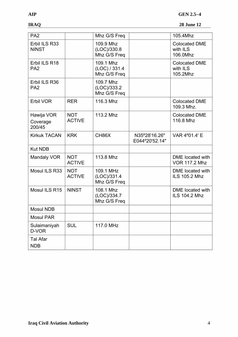
AIP GEN 2.54
IRAQ 28 June 12
Iraq Civil Aviation Authority 4
PA2 Mhz G/S Freq 105.4Mhz
Erbil ILS R33 NINST
109.9 Mhz (LOC)/330.8 Mhz G/S Freq
Colocated DME with ILS 106.0Mhz
Erbil ILS R18 PA2
109.1 Mhz (LOC) / 331.4 Mhz G/S Freq
Colocated DME with ILS 105.2Mhz
Erbil ILS R36 PA2
109.7 Mhz (LOC)/333.2 Mhz G/S Freq
Erbil VOR RER 116.3 Mhz Colocated DME 109.3 Mhz.
Hawija VOR
Coverage 200/45
NOT ACTIVE
113.2 Mhz Colocated DME 116.8 Mhz
Kirkuk TACAN KRK CH86X N35º28'16.26" E044º20'52.14"
VAR 4º01.4' E
Kut NDB
Mandaly VOR NOT ACTIVE
113.8 Mhz DME located with VOR 117.2 Mhz
Mosul ILS R33 NOT ACTIVE
109.1 MHz (LOC)/331.4 Mhz G/S Freq
DME located with ILS 105.2 Mhz
Mosul ILS R15 NINST 108.1 Mhz (LOC)/334.7 Mhz G/S Freq
DME located with ILS 104.2 Mhz
Mosul NDB
Mosul PAR
Sulaimaniyah D-VOR
SUL 117.0 MHz
Tal Afar
NDB
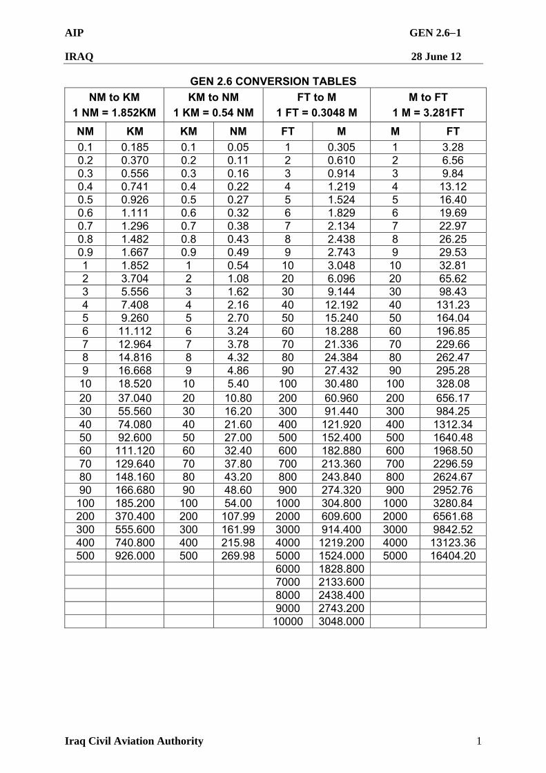
AIP GEN 2.61
IRAQ 28 June 12
Iraq Civil Aviation Authority 1
GEN 2.6 CONVERSION TABLES
NM to KM
1 NM = 1.852KM
KM to NM
1 KM = 0.54 NM
FT to M
1 FT = 0.3048 M
M to FT
1 M = 3.281FT
NM KM KM NM FT M M FT
0.1 0.185 0.1 0.05 1 0.305 1 3.28 0.2 0.370 0.2 0.11 2 0.610 2 6.56 0.3 0.556 0.3 0.16 3 0.914 3 9.84 0.4 0.741 0.4 0.22 4 1.219 4 13.12 0.5 0.926 0.5 0.27 5 1.524 5 16.40 0.6 1.111 0.6 0.32 6 1.829 6 19.69 0.7 1.296 0.7 0.38 7 2.134 7 22.97 0.8 1.482 0.8 0.43 8 2.438 8 26.25 0.9 1.667 0.9 0.49 9 2.743 9 29.53 1 1.852 1 0.54 10 3.048 10 32.81 2 3.704 2 1.08 20 6.096 20 65.62 3 5.556 3 1.62 30 9.144 30 98.43 4 7.408 4 2.16 40 12.192 40 131.23 5 9.260 5 2.70 50 15.240 50 164.04 6 11.112 6 3.24 60 18.288 60 196.85 7 12.964 7 3.78 70 21.336 70 229.66 8 14.816 8 4.32 80 24.384 80 262.47 9 16.668 9 4.86 90 27.432 90 295.28 10 18.520 10 5.40 100 30.480 100 328.08 20 37.040 20 10.80 200 60.960 200 656.17 30 55.560 30 16.20 300 91.440 300 984.25 40 74.080 40 21.60 400 121.920 400 1312.34 50 92.600 50 27.00 500 152.400 500 1640.48 60 111.120 60 32.40 600 182.880 600 1968.50 70 129.640 70 37.80 700 213.360 700 2296.59 80 148.160 80 43.20 800 243.840 800 2624.67 90 166.680 90 48.60 900 274.320 900 2952.76
100 185.200 100 54.00 1000 304.800 1000 3280.84 200 370.400 200 107.99 2000 609.600 2000 6561.68 300 555.600 300 161.99 3000 914.400 3000 9842.52 400 740.800 400 215.98 4000 1219.200 4000 13123.36 500 926.000 500 269.98 5000 1524.000 5000 16404.20
6000 1828.800 7000 2133.600 8000 2438.400 9000 2743.200 10000 3048.000
AIP GEN 2.71
IRAQ 28 June 12
Iraq Civil Aviation Authority 1
GEN 2.7 SUNRISE/SUNSET TABLES
2.7.1. General
2.7.1.1. The tables on the following pages have been prepared using data from the United States Naval Observatory website. The tables provide data for selected airports. Data on other locations, or accurate times for dates falling between those listed below, may be obtained from: http://www.usno.navy.mil/
Select ‘Data Services’ and enter appropriate year, latitude and longitude.
2.7.1.2. The times in the tables below are given in UTC for the beginning of the civil morning twilight (TWIL FM), sunrise (SR), sunset (SS), and the end of the civil evening twilight (TWIL TO).

AIP GEN 2.72
IRAQ 28 June 12
Iraq Civil Aviation Authority 2
2.7.2 Sunrise-Sunset Table for Baghdad International Airport (ORBI) (2012). Based on the ARP (N3315'45.140" E04414'04.476") the official times are as follows (GMT):
MTH Day TWIL FM
SR SS TWIL TO
MTH Day TWIL FM
SR SS TWIL TO
Jan 5 0406 1409 Jul 5 0159 1615 10 0407 1413 10 0201 1614 15 0407 1417 15 0204 1612 20 0405 1422 20 0207 1610 25 0403 1427 25 0211 1607 30 0400 1432 30 0214 1603 0406 1409
Feb 5 0356 1437 Aug 5 0218 1558 10 0352 1442 10 0222 1553 15 0347 1447 15 0226 1548 20 0342 1451 20 0229 1542 25 0336 1455 25 0232 1536 29 0332 1459 30 0236 1529
Mar 1 0331 1500 5 0326 1503 Sep 5 0240 1522 10 0319 1507 10 0243 1515 15 0313 1511 15 0246 1509 20 0306 1514 20 0250 1500 25 0259 1518 25 0253 1455 30 0253 1522 30 0256 1448
Apr 5 0245 1526 Oct 5 0300 1442 10 0238 1530 10 0303 1435 15 0232 1534 15 0307 1429 20 0226 1537 20 0311 1423 25 0221 1541 25 0315 1418 30 0216 1544 30 0319 1413
May 5 0211 1548 Nov 5 0325 1407 10 0206 1552 10 0329 1403 15 0203 1556 15 0334 1400 20 0159 1559 20 0338 1358 25 0157 1603 25 0343 1356 30 0155 1606 30 0347 1356
Jun 5 0153 1609 Dec 5 0351 1355 10 0153 1612 10 0355 1356 15 0153 1614 15 0359 1357 20 0154 1615 20 0402 1359 25 0155 1616 25 0404 1402 30 0157 1617 30 0406 1405
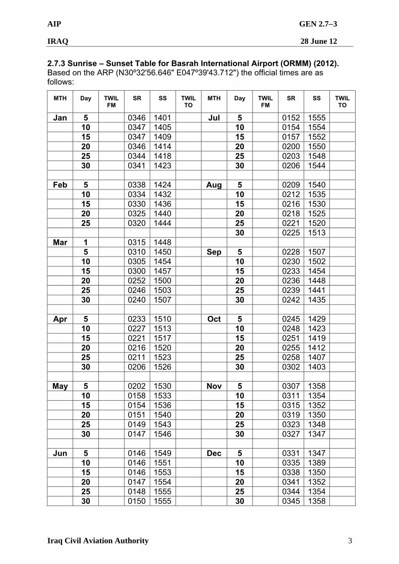
AIP GEN 2.73
IRAQ 28 June 12
Iraq Civil Aviation Authority 3
2.7.3 Sunrise – Sunset Table for Basrah International Airport (ORMM) (2012). Based on the ARP (N30º32'56.646" E047º39'43.712") the official times are as follows:
MTH Day TWIL FM
SR SS TWIL TO
MTH Day TWIL FM
SR SS TWIL TO
Jan 5 0346 1401 Jul 5 0152 1555 10 0347 1405 10 0154 1554 15 0347 1409 15 0157 1552 20 0346 1414 20 0200 1550 25 0344 1418 25 0203 1548 30 0341 1423 30 0206 1544
Feb 5 0338 1424 Aug 5 0209 1540 10 0334 1432 10 0212 1535 15 0330 1436 15 0216 1530 20 0325 1440 20 0218 1525 25 0320 1444 25 0221 1520 30 0225 1513
Mar 1 0315 1448 5 0310 1450 Sep 5 0228 1507 10 0305 1454 10 0230 1502 15 0300 1457 15 0233 1454 20 0252 1500 20 0236 1448 25 0246 1503 25 0239 1441 30 0240 1507 30 0242 1435
Apr 5 0233 1510 Oct 5 0245 1429 10 0227 1513 10 0248 1423 15 0221 1517 15 0251 1419 20 0216 1520 20 0255 1412 25 0211 1523 25 0258 1407 30 0206 1526 30 0302 1403
May 5 0202 1530 Nov 5 0307 1358 10 0158 1533 10 0311 1354 15 0154 1536 15 0315 1352 20 0151 1540 20 0319 1350 25 0149 1543 25 0323 1348 30 0147 1546 30 0327 1347
Jun 5 0146 1549 Dec 5 0331 1347 10 0146 1551 10 0335 1389 15 0146 1553 15 0338 1350 20 0147 1554 20 0341 1352 25 0148 1555 25 0344 1354 30 0150 1555 30 0345 1358
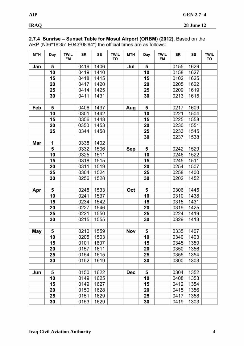
AIP GEN 2.74
IRAQ 28 June 12
Iraq Civil Aviation Authority 4
2.7.4 Sunrise – Sunset Table for Mosul Airport (ORBM) (2012). Based on the ARP (N36º18'35" E043º08'84") the official times are as follows:
MTH Day TWIL FM
SR SS TWIL TO
MTH Day TWIL FM
SR SS TWIL TO
Jan 5 0419 1406 Jul 5 0155 1629 10 0419 1410 10 0158 1627 15 0418 1415 15 0102 1625 20 0417 1420 20 0205 1622 25 0414 1425 25 0209 1619 30 0411 1431 30 0213 1615
Feb 5 0406 1437 Aug 5 0217 1609 10 0301 1442 10 0221 1504 15 0356 1448 15 0225 1558 20 0350 1453 20 0230 1551 25 0344 1458 25 0233 1545 30 0237 1538
Mar 1 0338 1402 5 0332 1506 Sep 5 0242 1529 10 0325 1511 10 0246 1522 15 0318 1515 15 0245 1511 20 0311 1519 20 0254 1507 25 0304 1524 25 0258 1400 30 0256 1528 30 0202 1452
Apr 5 0248 1533 Oct 5 0306 1445 10 0241 1537 10 0310 1438 15 0234 1542 15 0315 1431 20 0227 1546 20 0319 1425 25 0221 1550 25 0224 1419 30 0215 1555 30 0329 1413
May 5 0210 1559 Nov 5 0335 1407 10 0205 1503 10 0340 1403 15 0101 1607 15 0345 1359 20 0157 1611 20 0350 1356 25 0154 1615 25 0355 1354 30 0152 1619 30 0300 1303
Jun 5 0150 1622 Dec 5 0304 1352 10 0149 1625 10 0408 1353 15 0149 1627 15 0412 1354 20 0150 1628 20 0415 1356 25 0151 1629 25 0417 1358 30 0153 1629 30 0419 1303

AIP GEN 2.75
IRAQ 28 June 12
Iraq Civil Aviation Authority 5
GEN 3 SERVICES GEN 3.1 AERONAUTICAL INFORMATION SERVICES
3.1.1 Responsible Service
3.1.1.1 The Aeronautical Information Service (AIS), which forms part of the ICAA, ensures the flow of information necessary for the safety and regularity of international and domestic air navigation within the area of its responsibility as indicated under GEN 3.1.2 below. It consists of AIS Department, International NOTAM Office (NOF) and AIS units established at the aerodromes as listed under GEN 3.1.5 below. The service is provided in accordance with the provisions contained in ICAO Annex 15 – Aeronautical Information Services.
3.1.1.2 Iraq AIS Headquarters:
Postal Address: Aeronautical Information Services Department Iraq Civil Aviation Authority Baghdad International Airport PO Box 55103 Baghdad-IRAQ AFS: ORBIYOYX Telephone: (+9641) 8132122
(+9641) 8132419 Email: [email protected];
3.1.1.3 International NOTAM Officer:
Postal Address: Aeronautical Information Services Headquarters Iraq Civil Aviation Authority Baghdad International Airport PO Box 55103 Baghdad-IRAQ AFS: ORBIYOYX Telephone: (+9641) 8132122
(+9641) 8132419 Email: [email protected];
3.1.2 Area of Responsibility. The Aeronautical Information Service is responsible for the collection and dissemination of information for Iraq and for the airspace over the high seas encompassed by the Baghdad FIR.
3.1.3 Aeronautical Publications
3.1.3.1 The aeronautical information is provided in the form of the Integrated Information Package consisting of the following elements:
3.1.3.1.1 Aeronautical Information Publication (AIP)
3.1.3.1.2 Supplement to the AIP (AIP SUP);
AIP GEN 3.12
IRAQ 28 June 12
Iraq Civil Aviation Authority 2
3.1.3.1.3 Aeronautical Information Circular (AIC):
3.1.3.1.4 NOTAM and Pre-flight Information Bulletin (PIB); and
3.1.3.1.5 Checklists and summaries.
3.1.3.2 Aeronautical Information Publication (AIP)
3.1.3.2.1 The AIP is the overarching aviation document intended primarily to satisfy international requirements for the exchange of permanent aeronautical information and long duration temporary changes essential for safe and efficient air navigation. The Iraq AIP is published in one volume, comprising of 3 books. The AIP is published in an electronic format as a portable document format (.pdf) file, in English only, for use in international and domestic operation, whether the flight is a commercial, military or private one.
3.1.3.2.2 Amendments to the AIP are published every 56 days, providing 28 days notification before the re-publication of the full, updated AIP. The timelines for amendments and AIP publication and effective dates are in accordance with the 56 day AIRAC cycle. A checklist of AIP pages containing page number/chart title and the publication or effective date (day, month by name, and year) of the information is reissued with each edition.
3.1.3.3 Supplement to the AIP (AIP SUP)
3.1.3.3.1 Temporary changes of long duration and information of short duration that consists of extensive text and/or text supplementing the permanent information contained in the AIP are published as AIP Supplements (AIP SUP). Due to the newly established AIP and AIP AMDT cycle it is unlikely that the use of AIP SUP will be common. However, the following paragraph describes their use.
3.1.3.3.2 AIP SUP is separated by information subject (General – GEN, En-route – ENR and Aerodromes – AD) and, when issued, are to be placed at the beginning of each relevant AIP part. Each AIP Supplement is allocated a consecutive serial number, based on the calendar year, e.g. AIP SUP 01/06. Each AIP SUP is to remain in the AIP as long as all or some of its contents remain valid. The period of validity of the information contained in the AIP SUP will normally be given in the supplement itself. Alternatively, a NOTAM may be used to indicate changes to the period of validity or cancellation of the AIP SUP. Any AIP SUP will, for the short term, be published on the ICAA Iraq webpage co-located with the full edition AIP. Notification of AIP SUP release will be via a Baghdad FIR NOTAM.
3.1.3.4 Aeronautical Information Circular (AIC)
3.1.3.4.1 Aeronautical Information Circulars (AIC) contain information on the long-term forecast of any major change in legislation, regulation, procedures or facilities. The information contained within the AIC is to be considered advance notice. While unlikely to change significantly information within the AIC is provided as advisory only until formally promulgated within the AIP, AIP AMDT, and AIP SUP or via NOTAM. Information likely to be contained in an AIC may include:
3.1.3.4.1.1 Information of a purely explanatory or advisory nature liable to affect flight safety; and,
AIP GEN 3.13
IRAQ 28 June 12
Iraq Civil Aviation Authority 3
3.1.3.4.1.2 Information or notification of an explanatory or advisory nature concerning technical, legislative or purely administrative matters.
3.1.3.4.2 Each AIC is allocated a consecutive serial number, based on the calendar year, e.g. AIC 01/06. Any AIC released will be published on the ICAA webpage co-located with the full edition AIP. Notification of AIC release will be via a Baghdad FIR NOTAM. Notification of AIC cancellation will be via NOTAM.
3.1.3.5 NOTAM and Pre-flight Information Bulletins (PIB)
3 1.3.5.1 NOTAMs contain information concerning the establishment, condition or change in any aeronautical facility, service, procedure or hazard, the timely knowledge of which is essential for personnel concerned with flight operations. The text of each NOTAM contains the information in the order shown in the ICAO NOTAM Format and is composed of the significations/uniform abbreviated phraseology assigned to the ICAO NOTAM Code. This is complemented by ICAO abbreviations, indicators, identifiers, designators, callsigns, frequencies, figures and plain language. NOTAMs are issued and published via several means. Each pilot in command, Civil Air Carrier/Operator is responsible for ensuring current NOTAMs are reviewed.
3.1.3.6 Sale of Publications. (Printed copy not available at this time) AIP is available for free online at ICAA web site.
Price for a complete copy Publication
In Iraq Outside Iraq
AIP – IRAQ Not currently available
ANNUAL subscription including
NOTAM/AIC services Not currently available
AIP ring binder Not currently available
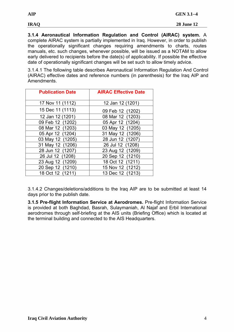
AIP GEN 3.14
IRAQ 28 June 12
Iraq Civil Aviation Authority 4
3.1.4 Aeronautical Information Regulation and Control (AIRAC) system. A complete AIRAC system is partially implemented in Iraq. However, in order to publish the operationally significant changes requiring amendments to charts, routes manuals, etc. such changes, whenever possible, will be issued as a NOTAM to allow early delivered to recipients before the date(s) of applicability. If possible the effective date of operationally significant changes will be set such to allow timely advice.
3.1.4.1 The following table describes Aeronautical Information Regulation And Control (AIRAC) effective dates and reference numbers (in parenthesis) for the Iraq AIP and Amendments.
Publication Date
AIRAC Effective Date
17 Nov 11 (1112) 12 Jan 12 (1201)
15 Dec 11 (1113) 09 Feb 12 (1202) 12 Jan 12 (1201) 08 Mar 12 (1203) 09 Feb 12 (1202) 05 Apr 12 (1204) 08 Mar 12 (1203) 03 May 12 (1205) 05 Apr 12 (1204) 31 May 12 (1206) 03 May 12 (1205) 28 Jun 12 (1207) 31 May 12 (1206) 26 Jul 12 (1208) 28 Jun 12 (1207) 23 Aug 12 (1209) 26 Jul 12 (1208) 20 Sep 12 (1210) 23 Aug 12 (1209) 18 Oct 12 (1211) 20 Sep 12 (1210) 15 Nov 12 (1212) 18 Oct 12 (1211) 13 Dec 12 (1213)
3.1.4.2 Changes/deletions/additions to the Iraq AIP are to be submitted at least 14 days prior to the publish date.
3.1.5 Pre-flight Information Service at Aerodromes. Pre-flight Information Service is provided at both Baghdad, Basrah, Sulaymaniah, Al Najaf and Erbil International aerodromes through self-briefing at the AIS units (Briefing Office) which is located at the terminal building and connected to the AIS Headquarters.
AIP GEN 3.21
IRAQ 28 June 12
Iraq Civil Aviation Authority 1
GEN 3.2 AERONAUTICAL CHARTS
1. RESPONSIBLE SERVICES
1.1 The civil aviation authority in Iraq provides ring of Aeronautical charts for use by all types of civil aviation. The Aeronautical Information Services produces the charts which are part of the AIP. Charts can be obtain from the charts are produced in accordance with the provisions contained in annex 4 – Aeronautical.
2. MAINTENANCE OF CHARTS
2.1 The Aeronautical charts included in the AIP are kept up to date by amendment by AIP. Information concerning the planning for or issuance of new maps and charts are notified by Aeronautical Information Circular. 2.2 Incorrect information detected on published charts are corrected by NOTAM if they are of operational significance. 2.3 The authority responsible for the charts maintenance is Aeronautical Information Services in coordination with Jeppesen Company.
3. PURCHASE ARRANGEMENTS
3.1 The charts listed under point 5 of this section may be obtained from this address: Postal Address REPUBLIC OF IRAQ
Iraq Civil Aviation Authority AIS – Headquarters
P.O.Box : 55103 – BAGHDAD AFS : ORBIYJYX Telephone Number : ++964 8132419 Fax : Nil e-mail : [email protected]
4. AERONAUTICAL CHART SERIES AVAILABLE
4.1 The following series or aeronautical charts are produced:
a. Aerodrome Chart - ICAO b. Aerodrome lay out chart c. Aerodrome Ground Movement Chart - ICAO d. Aircraft Parking Docking Chart -ICAO e. Aerodrome Obstacle Chart – ICAO type (A) f. Aerodrome Obstacle Chart – ICAO Type (B)
AIP GEN 3.22
IRAQ 28 June 12
Iraq Civil Aviation Authority 2
g. Instrument Approach Chart - ICAO h. Visual Approach Chart - ICAO i. Precision Approach Terrain Chart - ICAO j. Standard Departure Chart Instrument (SID) - ICAO k. Standard Arrival Chart Instrument (STAR) - ICAO l. En-Route Chart – ICAO
AIP GEN 3.23
IRAQ 28 June 12
Iraq Civil Aviation Authority 3
4.2 General Description of each series:
a) Aerodrome Chart - ICAO is available for: BAGHDAD/Baghdad Intl, BASRAH/Basrah Intl, ERBIL/Erbil Intl and SULAIMANIYAH/Sulaimaniyah Intl, and are included in AD section. The charts provide flight crews with information that will facilitate ground movement to and from the runway and apron and portrays the major flight operation facilities at the Aerodrome.
b) Aerodrome Lay Out Chart is available for: AL-NAJAF/Al-najaf Intl and
SULAIMANIYAH/Sulaimaniyah Intl.
c) Aerodrome Ground Movement Chart - ICAO: These charts are available for BAGHDAD/Baghdad Intl, BASRAH/Basrah Intl and ERBIL/Erbil Intl.
d) Aircraft Parking / Docking Chart – ICAO: This chart is available for
BAGHDAD/Baghdad Intl, BASRAH/Basrah Intl and ERBIL/Erbil Intl. e) Aerodrome obstacle Chart - ICAO Type A: Aerodrome obstacle Chart
ICAO-Type A (operating limitation) are available AL-NAJAF/Al-najaf Intl ,ERBIL/Erbil Intl and SULAIMANIYAH/Sulaimaniyah Intl, and are included in AD section.
f) Aerodrome obstacle Chart - ICAO Type B: Aerodrome obstacle Chart
ICAO-Type B are available for ERBIL/Erbil Intl, and are included in AD section. g) Instrument Approach Chart: Instrument Approach Charts conforming to the
specifications of Annex 4 are available for BAGHDAD/Baghdad Intl, BASRAH/Basrah Intl, AL-NAJAF/Al-najaf Intl, ERBIL/Erbil Intl and SULAIMANIYAH/Sulaimaniyah Intl Aerodromes where instrument approach procedures have been established. Separate charts are available for each procedure established for the aerodrome. These charts are included in Aerodrome section.
h) Visual Approach Chart: Visual Approach Chart is available for SULAIMANIYAH/Sulaimaniyah Intl and is included in AD section. The chart provides a graphic presentation of the approach to the aerodrome by visual reference.
i) Precision Approach Terrain Chart – ICAO. This chart is available for
ERBIL/Erbil Intl. this chart provides detailed terrain profile information within a defined portion of the final approach so as to enable aircraft operating agencies to assess the effect of the terrain on decision height determination by the use of radio altimeters.
j) Standard Departure Chart (SID): These charts are available for
BAGHDAD/Baghdad Intl, ERBIL/Erbil Intl and SULAIMANIYAH/Sulaimaniyah Intl.
k) Standard Arrival Chart (STAR): These charts are available for ERBIL/Erbil
Intl and SULAIMANIYAH/Sulaimaniyah Intl.
l) En-route Chart – ICAO: This chart is produced for the entire AMMAN FIR. Provide information on radio navigation aids with appropriate symbols
AIP GEN 3.24
IRAQ 28 June 12
Iraq Civil Aviation Authority 4
identification, FREQ, and geographical coordinates, and an indication of all designated airspace, including lateral and vertical limits, and the appropriate class of airspace.
AIP GEN 3.25
IRAQ 28 June 12
Iraq Civil Aviation Authority 5
5. LIST OF AERONAUTICAL CHARTS AVAILABLE
The following Aeronautical charts available and part of the AIP :
Title of series scale Chart name and or number Price (ID) OUTSIDE /INSIDE IRAQ
date
En-Route
Chart ICAO (ERC)
Not to scale
1 July 2011
Aerodrome Chart ICAO (ADC)
1:30 000 1:20 000 1:25 000 1:20 000
BAGHDAD/Baghdad Intl
BASRAH/Basrah Intl
ERBIL/Erbil Intl
SULAIMANIYAH/Sulaimaniyah
Intl
28 July 2011 28 July 2011 6 May 2010 7 April 2007
AERODROME LAY OUT CHART
1:12 000 Not to Scale
AL-NAJAF/Al-Najaf Intl
SULAIMANIYAH/Sulaimaniyah
Intl
1 April 2007
Aerodrome Ground Movement Chart (GMC)
1:11 100 1:11 100 1:25 000
BAGHDAD/Baghdad Intl
BASRAH/Basrah Intl
ERBIL/Erbil Intl
28 July 2011 6 May 2010
Aircraft Parking Docking Chart
1:10 700 1:13 400 1:10 000 Not to Scale
BAGHDAD/Baghdad Intl
BAGHDAD/Baghdad Intl
BASRAH/Basrah Intl
ERBIL/Erbil Intl
28 July 2011 28 July 2011 28 July 2011 6 May 2010
Aerodrome obstacle chart –ICAO type (A)
1:20 000 1:20 000 1:20 000
AL-NAJAF /Al-Najaf Intl
RWY 10 RWY 28
ERBIL/Erbil Intl RWY18
ERBIL/Erbil Intl
6 May 2010 6 May 2010
AIP GEN 3.26
IRAQ 28 June 12
Iraq Civil Aviation Authority 6
1:20 000 1:50 000
RWY36 ERBIL/Erbil Intl
RWY15/33 SULAIMANIYAH/Sulaimaniyah
Intl RWY 13/31
6 May 2010 1 NOV 2007
Aerodrome Obstacle Chart – ICAO Type (B)
1:40 000
ERBIL/Erbil Intl
6 May 2010
Instrument Approach Chart (IAC)
1:250 000 1:250 000 1:250 000 1:250 000 1:300 000 1:300 000 1:250 000 1:625 000 1:625 000 1:500 000 1:500 000
AL-NAJAF /Al-Najaf Intl
VOR RWY 28
BAGHDAD/Baghdad Intl ILS or LOC/DME
RWY 15L BAGHDAD/Baghdad Intl
ILS or LOC/DME RWY 33R
BAGHDAD/Baghdad Intl VOR/DME RWY 33R
BAGHDAD/Baghdad Intl VOR/DME RWY 15L
BASRAH/Basrah Intl ILS or LOC/DME
RWY 32 BASRAH/Basrah Intl VOR/DME RWY 32
BASRAH/Basrah Intl VOR/DME RWY 14
ERBIL/Erbil Intl ILS/DME Z RWY18
ERBIL/Erbil Intl ILS/DME Z RWY36
ERBIL/Erbil Intl ILS/DME Y RWY18
ERBIL/Erbil Intl ILS/DME Y RWY36
SULAIMANIYAH/Sulaimaniyah Intl
ILS/DME–RWY 13 SULAIMANIYAH/Sulaimaniyah
Intl ILS/DME–RWY 31
17 Dec 2009 17 Dec 2009 17 Dec 2009 17 Dec 2009 5 Mar 2009 5 Mar 2009 5 Mar 2009 6 May 2010 6 May 2010 6 May 2010 6 May 2010 1 April 2007 1 April 2007
AIP GEN 3.27
IRAQ 28 June 12
Iraq Civil Aviation Authority 7
SULAIMANIYAH/Sulaimaniyah Intl
VOR RWY 13 SULAIMANIYAH/Sulaimaniyah
Intl VOR RWY 31
1 April 2007 1 April 2007
Visual Approach Chart (VAC)
SULAIMANIYAH/Sulaimaniyah
Intl RWY 13/31
1 April 2007
Precision Approach Terrain Chart
1:2 500
ERBIL/Erbil Intl
RWY18
6 May 2010
Standard Departure Chart Instrument (SID)
1:2 000 000 1:400 000 1:400 000 1:500 000 1:400 000 1:400 000 1:500 000 Not to scale Not to scale
BAGHDAD/Baghdad Intl BAGHDAD ONE DEPARTURE
PROCEDURE ERBIL/Erbil Intl
RWY18 UMESA IA
ERBIL/Erbil Intl RWY36
UMESA 2B ERBIL/Erbil Intl
RWY18 SEVKO 1A
ERBIL/Erbil Intl RWY18
OTALO 1A ERBIL/Erbil Intl
RWY36 OTALO 2B
ERBIL/Erbil Intl RWY36
EMIDO 1A SULAIMANIYAH/Sulaimaniyah
Intl RWY 13
SULAIMANIYAH/Sulaimaniyah Intl
RWY 31
26 August 2010 6 May 2010 6 May 2010 6 May 2010 6 May 2010 6 May 2010 6 May 2010 1 Nov 2007 1 Nov 2007
Standard Arrival Chart Instrument
1:500 000
ERBIL/Erbil Intl RWY18
LAVEN 2B
6 May 2010
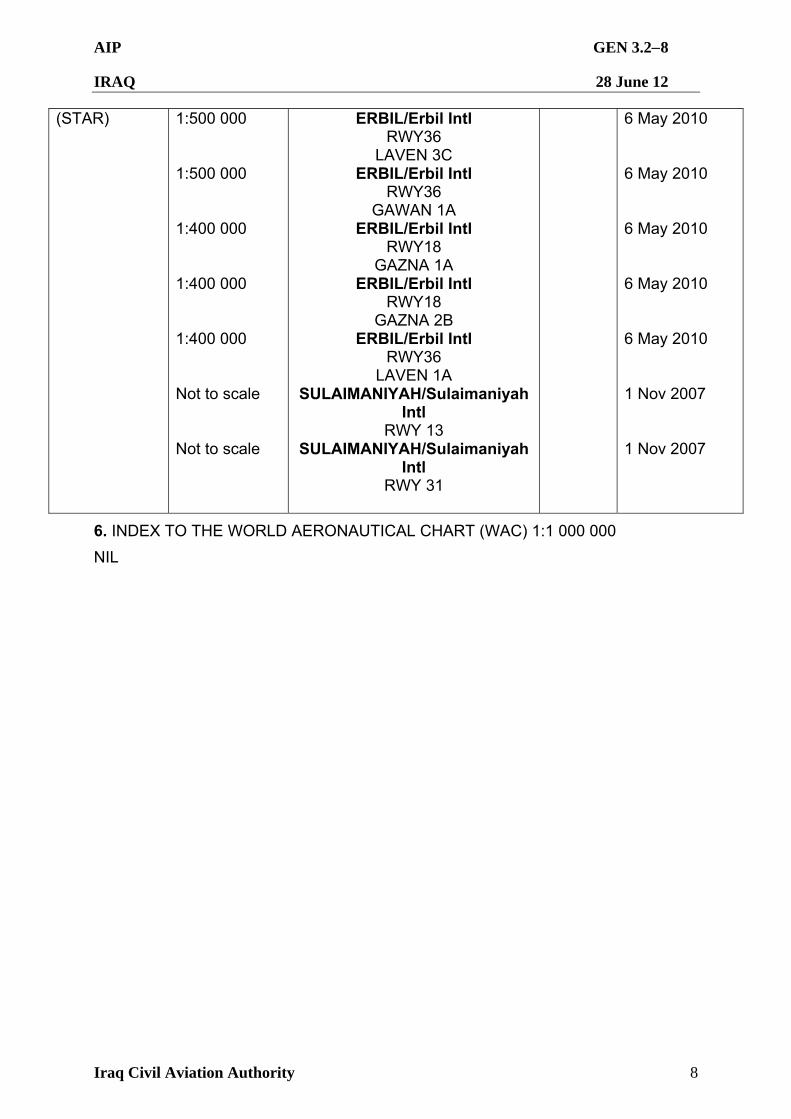
AIP GEN 3.28
IRAQ 28 June 12
Iraq Civil Aviation Authority 8
(STAR) 1:500 000 1:500 000 1:400 000 1:400 000 1:400 000 Not to scale Not to scale
ERBIL/Erbil Intl RWY36
LAVEN 3C ERBIL/Erbil Intl
RWY36 GAWAN 1A
ERBIL/Erbil Intl RWY18
GAZNA 1A ERBIL/Erbil Intl
RWY18 GAZNA 2B
ERBIL/Erbil Intl RWY36
LAVEN 1A SULAIMANIYAH/Sulaimaniyah
Intl RWY 13
SULAIMANIYAH/Sulaimaniyah Intl
RWY 31
6 May 2010 6 May 2010 6 May 2010 6 May 2010 6 May 2010 1 Nov 2007 1 Nov 2007
6. INDEX TO THE WORLD AERONAUTICAL CHART (WAC) 1:1 000 000
NIL
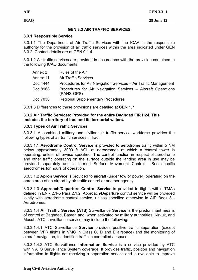
AIP GEN 3.31
IRAQ 28 June 12
Iraq Civil Aviation Authority 1
GEN 3.3 AIR TRAFFIC SERVICES
3.3.1 Responsible Service
3.3.1.1 The Department of Air Traffic Services with the ICAA is the responsible authority for the provision of air traffic services within the area indicated under GEN 3.3.2. Contact details are at GEN 0.1.4.
3.3.1.2 Air traffic services are provided in accordance with the provision contained in the following ICAO documents:
Annex 2 Rules of the Air
Annex 11 Air Traffic Services Doc 4444 Procedures for Air Navigation Services – Air Traffic Management
Doc 8168 Procedures for Air Navigation Services – Aircraft Operations (PANS-OPS)
Doc 7030 Regional Supplementary Procedures
3.3.1.3 Differences to these provisions are detailed at GEN 1.7.
3.3.2 Air Traffic Services: Provided for the entire Baghdad FIR H24. This includes the territory of Iraq and its territorial waters.
3.3.3 Types of Air Traffic Services
3.3.3.1 A combined military and civilian air traffic service workforce provides the following types of air traffic services in Iraq:
3.3.3.1.1 Aerodrome Control Service is provided to aerodrome traffic within 5 NM below approximately 3000 ft AGL at aerodromes at which a control tower is operating, unless otherwise specified. The control function in respect of aerodrome and other traffic operating on the surface outside the landing area in use may be provided separately and is termed Surface Movement Control. See specific aerodromes for hours of operation.
3.3.3.1.2 Apron Service is provided to aircraft (under tow or power) operating on the apron area of an airport by air traffic control or another agency.
3.3.3.1.3 Approach/Departure Control Service is provided to flights within TMAs defined in ENR 2.1-5 Para 2.1.2. Approach/Departure control service will be provided jointly with aerodrome control service, unless specified otherwise in AIP Book 3 - Aerodromes.
3.3.3.1.4 Air Traffic Service (ATS) Surveillance Service is the predominant means of control at Baghdad, Basrah and, when activated by military authorities, Kirkuk, and Mosul . ATC surveillance service may include the following:
3.3.3.1.4.1 ATC Surveillance Service provides positive traffic separation (except between VFR flights in VMC in Class C, D and E airspace) and the monitoring of aircraft navigation, to identified traffic in controlled airspace.
3.3.3.1.4.2 ATC Surveillance Information Service is a service provided by ATC within ATS Surveillance System coverage. It provides traffic, position and navigation information to flights not receiving a separation service and is available to improve
AIP GEN 3.32
IRAQ 28 June 12
Iraq Civil Aviation Authority 2
situational awareness and assist pilots in avoiding collisions with other aircraft. At pilot request, and, if possible, a controller providing ATC surveillance services will suggest a course of action to avoid other aircraft. Ultimate responsibility for aircraft and terrain avoidance rests with the pilot in command. This service may be provided in Class G airspace to IFR flights in relation to other IFR flights and, unless impracticable, in relation to observed VFR flights. It may also be provided to VFR flights in Class E and G airspace.
3.3.3.1.4.3 Final Approach Service provides a precision or surveillance radar service for final approach.
3.3.3.1.4.4 Emergency Service provides navigation assistance to aircraft in distress or experiencing navigational difficulties.
3.3.3.1.5 Flight Information and SAR Alerting Services are provided concurrently with the services shown above. In areas where air traffic control services are not provided, flight information and SAR alerting services are not provided by ATS units.
3.3.3.2 In some circumstances a number of services may operate under a common callsign and can be on a common or separate frequency:
3.3.3.2.1 Clearance Delivery: used by the Airways Clearance Delivery (ACD) service when established on a discrete frequency.
3.3.3.2.2 Ground: used by Surface Movement Control and Apron Service (if provided by ATC) when established on a discrete frequency. At some locations, this service also provides the Airways Clearance Delivery service on the same frequency.
3.3.3.2.3 Tower: used by Aerodrome Control and occasionally Aerodrome/Approach Control when these services are combined and provided by one agency.
3.3.3.2.4 Approach: used by Approach Control (APP) service when established on a discrete frequency and Approach/Departure Control when combined on the same frequency.
3.3.3.2.5 Departure: used by Departure Control (DEP) service when established on a discrete frequency.
3.3.3.2.6 Center: used for Area Control Center (ACC) service.
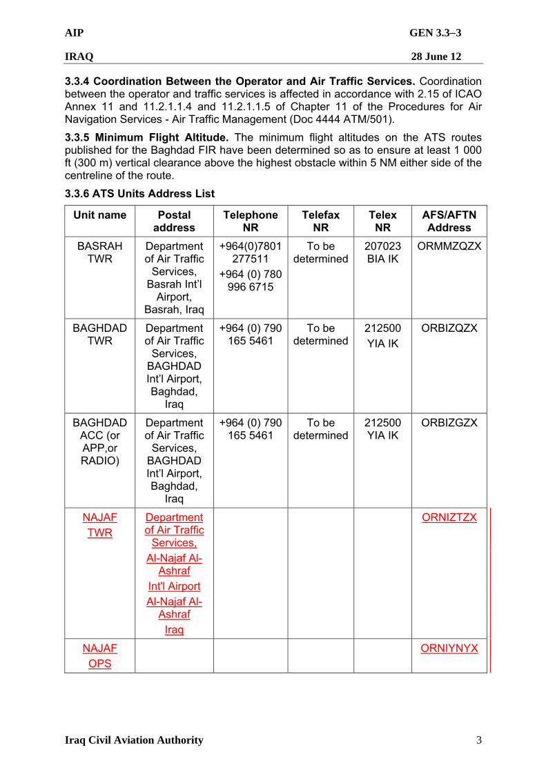
AIP GEN 3.33
IRAQ 28 June 12
Iraq Civil Aviation Authority 3
3.3.4 Coordination Between the Operator and Air Traffic Services. Coordination between the operator and traffic services is affected in accordance with 2.15 of ICAO Annex 11 and 11.2.1.1.4 and 11.2.1.1.5 of Chapter 11 of the Procedures for Air Navigation Services - Air Traffic Management (Doc 4444 ATM/501).
3.3.5 Minimum Flight Altitude. The minimum flight altitudes on the ATS routes published for the Baghdad FIR have been determined so as to ensure at least 1 000 ft (300 m) vertical clearance above the highest obstacle within 5 NM either side of the centreline of the route.
3.3.6 ATS Units Address List
Unit name Postal address
Telephone NR
Telefax NR
Telex NR
AFS/AFTN Address
BASRAH TWR
Department of Air Traffic
Services, Basrah Int’l
Airport, Basrah, Iraq
+964(0)7801 277511
+964 (0) 780 996 6715
To be determined
207023 BIA IK
ORMMZQZX
BAGHDAD TWR
Department of Air Traffic
Services, BAGHDAD Int’l Airport, Baghdad,
Iraq
+964 (0) 790 165 5461
To be determined
212500
YIA IK
ORBIZQZX
BAGHDAD ACC (or APP,or RADIO)
Department of Air Traffic
Services, BAGHDAD Int’l Airport, Baghdad,
Iraq
+964 (0) 790 165 5461
To be determined
212500 YIA IK
ORBIZGZX
NAJAF
TWR
Department of Air Traffic
Services,
Al-Najaf Al-Ashraf
Int'l Airport
Al-Najaf Al-Ashraf
Iraq
ORNIZTZX
NAJAF
OPS
ORNIYNYX
AIP GEN 3.41
IRAQ 28 June 12
Iraq Civil Aviation Authority 1
GEN 3.4 COMMUNICATION SERVICES
3.4.1 Responsible Service
3.4.1.1 The responsible service for the provision of telecommunication and navigation facility services in Iraq is The ICAA The address and contact details are listed at GEN 0.1.4.
3.4.1.2 The service is provided in accordance with provisions contained in the following ICAO documents:
Annex 10 - Aeronautical Telecommunications
Doc 8400- Procedures for Air Navigation Services – ICAO Abbreviations and Codes (PANS-ABC)
Doc8585- Designators for Aircraft Operating Agencies, Aeronautical Authorities and Services
Doc7030- Regional Supplementary Procedures
Doc7910- Location Indicators
3.4.2 Area of Responsibility. Communication services are provided for the entire Baghdad FIR. Arrangements for such services on a continuing basis should be made with the Director of Communication Services. Responsibility for the day-to-day operation of these services is vested in Station Communication Officers located at Basrah and Baghdad International Aerodromes. Inquiries, suggestions or complaints regarding any telecommunication service should be referred to the relevant communication officer or to the Director of Communication Services, as appropriate.
3.4.3 Types of Services
3.4.3.1 Radio Navigation Services.
The following types of radio aids to navigation are available:
VHF Omni-directional Radio Range (VOR)
Distance Measuring Equipment (DME) Tactical Air Navigation (TACAN) Non Directional Radio Beacons (NDB)
Instrument Landing System (ILS)
3.4.3.2 Mobile Service. The aeronautical stations maintain a continuous watch on their stated frequencies during the published hours of service unless otherwise notified. An aircraft should normally communicate with the air-ground agency that exercises control in the area in which the aircraft is flying. Aircraft should maintain a continuous watch on the appropriate frequency of the control station and should not abandon watch, except in an emergency, without informing the control station.
3.4.3.3 Fixed Service. The messages to be transmitted over the Aeronautical Fixed Service/Aeronautical Fixed Telecommunication Network (AFS/AFTN) are accepted only if they satisfy the requirements of ICAO Annex 10, Vol. II Chapter 3.3; they are prepared in the form specified in ICAO Annex 10; and the text on an individual message does not exceed 200 groups. General aircraft operating agency messages
AIP GEN 3.42
IRAQ 28 June 12
Iraq Civil Aviation Authority 2
are only accepted for transmission to countries that have agreed to a accept Class B traffic.
AIP GEN 3.43
IRAQ 28 June 12
Iraq Civil Aviation Authority 3
3.4.3.4 Broadcasting Services
3.4.3.4.1 Sub-area meteorological broadcasts (VOLMET radio telegraphy broadcasts) are available for the use by aircraft in flight. Full details are given at GEN 3.5.
3.4.3.4.2 Automatic Broadcast Services in the form of Automatic Terminal Information Service (ATIS) is established at select airports. The normal operational information required by aircraft prior to take-off or landing is broadcast automatically and continuously either on a discrete frequency or on the voice channel of one or more radio-navigation aids. The broadcast may be pre-recorded or computerized.
3.4.3.4.3 The following information is transmitted on the ATIS:
Any available information on significant meteorological phenomena in the approach and climb-out areas including wind shear, and information on recent weather of operational significance;
ON FIRST CONTACT WITH [TERMINAL CONTROL FUNCTION] [GROUND, TOWER OR APPROACH], NOTIFY RECEIPT OF ATIS INFORMATION CODE
3.4.3.5 Language used is English.
3.4.3.6 Communication facilities are under reconstruction. Details of the various communication agencies available for enroute traffic can be found at ENR 2.1 and ENR 3.3.1. Details of the facilities available at individual aerodromes can be found in the relevant sections of Book 3 (AD). In the case where a facility is serving both the enroute traffic and the aerodromes, details are given in the relevant sections of Book 2 (ENR) and Book 3 (AD).
AIP GEN 3.51
IRAQ 28 June 12
Iraq Civil Aviation Authority 1
GEN 3.5 METEOROLOGICAL SERVICES
3.5.1 Responsible Service. Aircraft operators are responsible for obtaining meteorological information from available airport authorities, where available or via commercial services as specified by the operating company or individual. Site specific weather information is available to civil operators from the following websites: http://adds.aviationweather.noaa.gov/ or http://www.baseops.net/metro.html. Military organizations may derive information from the following websites: https://weather.afwa.af.mil or https://ows.shaw.af.mil/. The appropriate weather station identifier/designator is listed in the relevant AERODROME entry at AD 2.1. Meteorological Service obtained from United States military sources is provided for the entire Baghdad FIR and may be obtained by those organizations authorized military access to electronic media, those operators with access to the World Wide Web or at airports where limited meteorological services are provided.
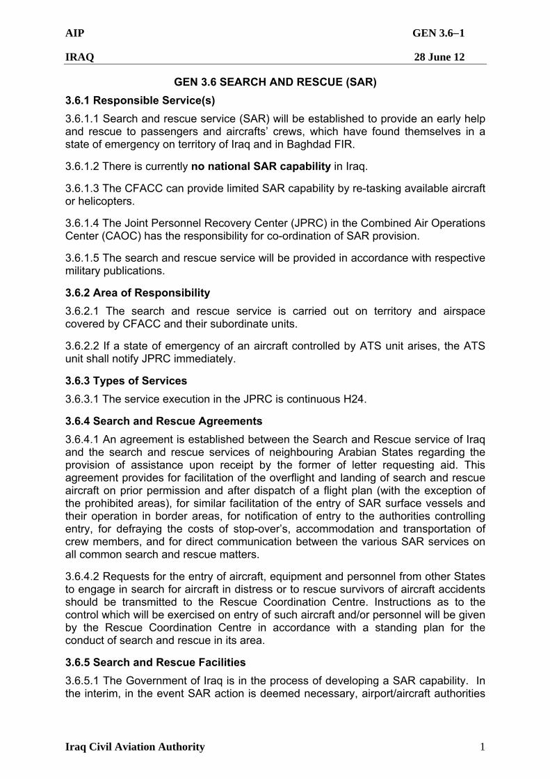
AIP GEN 3.61
IRAQ 28 June 12
Iraq Civil Aviation Authority 1
GEN 3.6 SEARCH AND RESCUE (SAR)
3.6.1 Responsible Service(s)
3.6.1.1 Search and rescue service (SAR) will be established to provide an early help and rescue to passengers and aircrafts’ crews, which have found themselves in a state of emergency on territory of Iraq and in Baghdad FIR.
3.6.1.2 There is currently no national SAR capability in Iraq.
3.6.1.3 The CFACC can provide limited SAR capability by re-tasking available aircraft or helicopters.
3.6.1.4 The Joint Personnel Recovery Center (JPRC) in the Combined Air Operations Center (CAOC) has the responsibility for co-ordination of SAR provision.
3.6.1.5 The search and rescue service will be provided in accordance with respective military publications.
3.6.2 Area of Responsibility
3.6.2.1 The search and rescue service is carried out on territory and airspace covered by CFACC and their subordinate units.
3.6.2.2 If a state of emergency of an aircraft controlled by ATS unit arises, the ATS unit shall notify JPRC immediately.
3.6.3 Types of Services
3.6.3.1 The service execution in the JPRC is continuous H24.
3.6.4 Search and Rescue Agreements
3.6.4.1 An agreement is established between the Search and Rescue service of Iraq and the search and rescue services of neighbouring Arabian States regarding the provision of assistance upon receipt by the former of letter requesting aid. This agreement provides for facilitation of the overflight and landing of search and rescue aircraft on prior permission and after dispatch of a flight plan (with the exception of the prohibited areas), for similar facilitation of the entry of SAR surface vessels and their operation in border areas, for notification of entry to the authorities controlling entry, for defraying the costs of stop-over’s, accommodation and transportation of crew members, and for direct communication between the various SAR services on all common search and rescue matters.
3.6.4.2 Requests for the entry of aircraft, equipment and personnel from other States to engage in search for aircraft in distress or to rescue survivors of aircraft accidents should be transmitted to the Rescue Coordination Centre. Instructions as to the control which will be exercised on entry of such aircraft and/or personnel will be given by the Rescue Coordination Centre in accordance with a standing plan for the conduct of search and rescue in its area.
3.6.5 Search and Rescue Facilities
3.6.5.1 The Government of Iraq is in the process of developing a SAR capability. In the interim, in the event SAR action is deemed necessary, airport/aircraft authorities
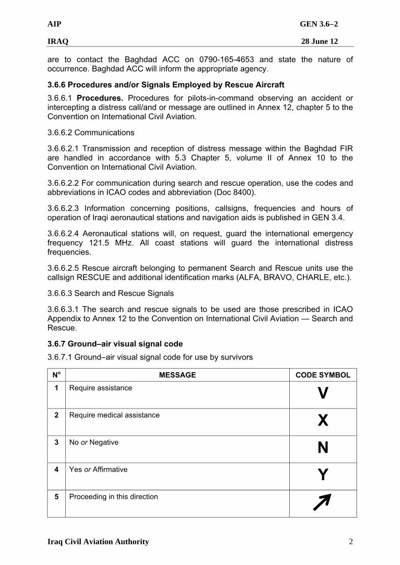
AIP GEN 3.62
IRAQ 28 June 12
Iraq Civil Aviation Authority 2
are to contact the Baghdad ACC on 0790-165-4653 and state the nature of occurrence. Baghdad ACC will inform the appropriate agency.
3.6.6 Procedures and/or Signals Employed by Rescue Aircraft
3.6.6.1 Procedures. Procedures for pilots-in-command observing an accident or intercepting a distress call/and or message are outlined in Annex 12, chapter 5 to the Convention on International Civil Aviation.
3.6.6.2 Communications
3.6.6.2.1 Transmission and reception of distress message within the Baghdad FIR are handled in accordance with 5.3 Chapter 5, volume II of Annex 10 to the Convention on International Civil Aviation.
3.6.6.2.2 For communication during search and rescue operation, use the codes and abbreviations in ICAO codes and abbreviation (Doc 8400).
3.6.6.2.3 Information concerning positions, callsigns, frequencies and hours of operation of Iraqi aeronautical stations and navigation aids is published in GEN 3.4.
3.6.6.2.4 Aeronautical stations will, on request, guard the international emergency frequency 121.5 MHz. All coast stations will guard the international distress frequencies.
3.6.6.2.5 Rescue aircraft belonging to permanent Search and Rescue units use the callsign RESCUE and additional identification marks (ALFA, BRAVO, CHARLE, etc.).
3.6.6.3 Search and Rescue Signals
3.6.6.3.1 The search and rescue signals to be used are those prescribed in ICAO Appendix to Annex 12 to the Convention on International Civil Aviation — Search and Rescue.
3.6.7 Ground–air visual signal code
3.6.7.1 Ground–air visual signal code for use by survivors
No MESSAGE CODE SYMBOL
1 Require assistance V 2 Require medical assistance X 3 No or Negative N 4 Yes or Affirmative Y 5 Proceeding in this direction
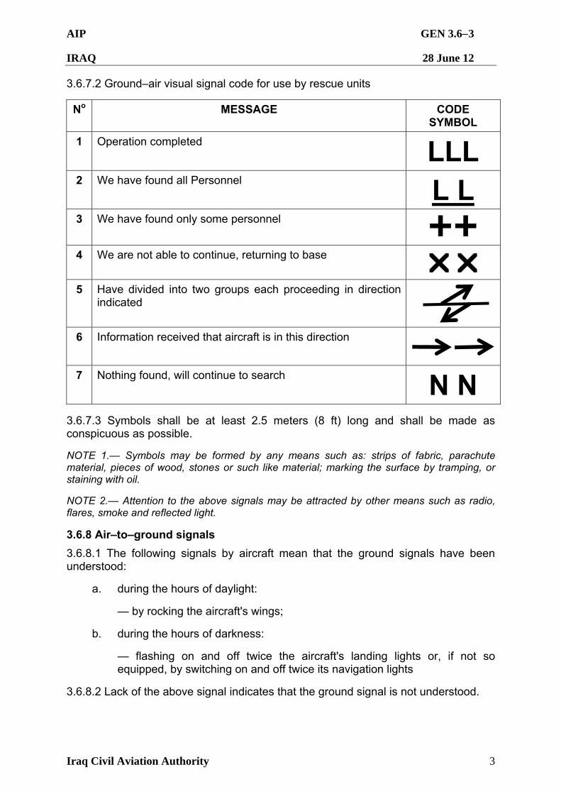
AIP GEN 3.63
IRAQ 28 June 12
Iraq Civil Aviation Authority 3
3.6.7.2 Ground–air visual signal code for use by rescue units
No MESSAGE CODE SYMBOL
1 Operation completed
LLL
2 We have found all Personnel
L L
3 We have found only some personnel
4 We are not able to continue, returning to base
5 Have divided into two groups each proceeding in direction indicated
6 Information received that aircraft is in this direction
7 Nothing found, will continue to search
N N
3.6.7.3 Symbols shall be at least 2.5 meters (8 ft) long and shall be made as conspicuous as possible.
NOTE 1.— Symbols may be formed by any means such as: strips of fabric, parachute material, pieces of wood, stones or such like material; marking the surface by tramping, or staining with oil.
NOTE 2.— Attention to the above signals may be attracted by other means such as radio, flares, smoke and reflected light.
3.6.8 Air–to–ground signals
3.6.8.1 The following signals by aircraft mean that the ground signals have been understood:
a. during the hours of daylight:
— by rocking the aircraft's wings;
b. during the hours of darkness:
— flashing on and off twice the aircraft's landing lights or, if not so equipped, by switching on and off twice its navigation lights
3.6.8.2 Lack of the above signal indicates that the ground signal is not understood.
AIP GEN 4.11
IRAQ 28 June 12
Iraq Civil Aviation Authority 1
GEN 4 FEES AND CHARGES GEN 4.1 AERODROME CHARGES
4.1.1 General The charges set out hereunder apply to all government aerodromes administrated by the Iraq Civil Aviation Authority. Unless an alternative arrangement has been made, all charges for use of the aerodrome are payable by the pilot of the aircraft before the aircraft departs from the aerodrome.
4.1.2 Landing Fees and Charges ($US)
4.1.2.1 Landing fees and charges are based on aircraft types grouped according to GEN 4.1.2.2 below. Fees shall be paid to the Department of Accountancy through the ICAA. Landing fees for fixed wing aircraft will not be less than $350.
4.1.2.2 Fees are structured as follows:
4.1.2.2.1 C560, Learjet, Jetstream, DH6 will be levied $350;
4.1.2.2.2 CL60, C750, F50, F27, ATR42, HS748, HS125, DA90, and YAK40 will be levied $450;
4.1.2.2.3 G2, G3, G4, G5, BE2, TU124, TU134, F28, CRJ, EM4, CV580, ATR72, and BAC111 will be levied $500;
4.1.2.2.4 AN8, B717, B737 (series 100, 200, 500, 600), DC9, IL18, MD82, F70, F100, YAK42 will be levied $900;
4.1.2.2.5 A320, A321, B727, B737 (series 300, 400, 700, 800), C130, MD83/87/88/90, TU104, TU154 will be levied $1150;
4.1.2.2.6 B757, TU204 will be levied $1500;
4.1.2.2.7 B707, C160 will be levied $1900;
4.1.2.2.8 A310, B767, IL62, IL76, DC8 will be levied $2200;
4.1.2.2.9 A300, A330, A340, B777, DC10, IL86, IL96, MD11, and L1011 will be levied $2500;
4.1.2.2.10 AN124, B747 will be levied $3150.
4.1.2.2.11. Aircraft larger than those listed above will be levied $3350.
4.1.2.2.12. Helicopters will be levied $175.
4.1.3 Fees for Additional Ground Handling. Additional fees for services will be levied as follows:
4.1.3.1 Wheelchair service will be levied at $35 per wheelchair passenger;
4.1.3.2 Meet and assist service will be levied $28 per passenger per hour or part thereof;
4.1.3.3 Ground power (100KVA) service will be levied at $155 per hour of part thereof;
4.1.3.4 Air starter unit service will be levied at $190 per start cycle per unit;
AIP GEN 4.12
IRAQ 28 June 12
Iraq Civil Aviation Authority 2
4.1.3.5 Pushback service will be levied at $160 per service;
4.1.3.6 Towing service will be levied at $310 per hour;
4.1.3.7 Air-conditioning unit (106 cooling tons) service will be levied at $150 per hour or part thereof.
4.1.3.8. Waiting fees apply upon shutdown of aircraft engines.
4.1.3.8.1. No charge for first two hours.
4.1.3.8.2. Two hours and one minute to four hours, additional surcharge of 15% of applicable landing fee in accordance with section 4.1.2.
4.1.3.8.3. Four hours and one minute to six hours, additional surcharge of 25% of applicable landing fee in accordance with section 4.1.2.
4.1.3.8.4. Six hours and one minute to eight hours, additional surcharge of 35% of applicable landing fee in accordance with section 4.1.2.
4.1.3.8.5. In excess of eight hours to 24 hours, additional surcharge of 50% of applicable landing fee in accordance with section 4.1.2.
4.1.3.8.6. Additional surcharge of 30% of the waiting fee from 2400 to 0600 local time.
4.1.3.8.7. Additional towing premium. A $200 surcharge will be levied in those cases in which towing services are required from the runway to the parking area.
4.1.4. Miscellaneous Charges.
4.1.4.1. Security/guarding of aircraft. An additional surcharge of $100 will be levied for the first three hours following aircraft engine shutdown. An additional surcharge of $10 per hour will apply after the first three hours.
4.1.4.2. Security X-ray fee. In those cases in which screening of baggage and/or cargo is required, a 10% surcharge based on the landing fee identified in 4.1.2 will be applied.
4.1.5. Overflight fees.
4.1.5.1. A fee of $375 will be levied for overflying Iraqi territory.
4.1.6. Evening Operations. Evening operations are those hours that fall within the hours of legal sunset and sunrise.
4.1.6.1. Evening landing fee premium. In addition to Landing Fees in section 4.1.2., an additional surcharge of $200 will apply.
4.1.6.2. Additional evening parking surcharge of 30% of applicable landing fee in accordance with section 4.1.2.
4.1.7 Exemptions/Reductions. According to Regulation No. 26 of 1987, the following aircraft are exempt from the levy of the fees and charges:
4.1.7.1. Aircraft belonging to the United Nations and its specialized agencies and the aircraft belonging to the Red Crescent and Red Cross societies.
AIP GEN 4.13
IRAQ 28 June 12
Iraq Civil Aviation Authority 3
4.1.7.2. Non-commercial Iraqi government aircraft including aircraft belonging to the Youth Training Organizations.
4.1.7.3. Aircraft belonging to the Arab League and its specialized agencies.
4.1.7.4. Aircraft on official delegations to Iraq provided that the exemption is made either on a reciprocal basis, or by prior approval/recommendation of the Ministry of Foreign Affairs or concerned Iraqi Minster.
4.1.7.5. Aircraft engaged in search and rescue operations free of charge.
4.1.7.6. Aircraft on test flights will be exempted, provided that the relevant air traffic control agency is informed in advance.
4.1.7.7. Aircraft conducting an emergency landing at the aerodrome of departure provided that it will not land thereafter at an aerodrome other than the planned destination aerodrome.
4.1.7.8. Aircraft transporting, free of charge, catering materials for disaster relief and/or humanitarian aid.
4.1.8 Payment of Fees and Charges. Landing fees and charges will be levied directly to the pilot in command of the aircraft or whoever represents him/her (in the case of airlines with offices in Iraq). Operators without representatives in Iraq must pay all fees and charges prior to departure of each flight. Where operators are invoiced, the payment for charges, services and landing fees should be made within 30 days of the date the fees and charges were incurred. Otherwise, an additional fee for ‘delay interest’ shall be charged at the rate of 7% of the total invoice per day until the entire debt is paid.
4.1.9 Airport Tax Fee should be as follows:
4.1.9.1 For Passengers on International Fligt (15000) Iraqi Dinars. 4.1.9.2 For Passengers on Domestic Flight (1000) Iraqi Dinars.
AIP GEN 4.2–1
IRAQ 28 June 12
Iraq Civil Aviation Authority 4
GEN 4.2 AIR NAVIGATION SERVICES CHARGES 4.2.1. General. Aircraft that transit the Baghdad FIR without landing will be levied $375. All air navigation charges of Iraq will be billed and collected by the International Air Transport Association (IATA) on behalf of the State of Iraq as represented by the ICAA. IATA can be contacted via:
International Air Transport Association
Route De L’Aeroport 33
P.O. Box 416
CH-1215 Geneva 15 Airport
Switzerland
AFTN address: LSGGIATA
SITA address: GVALDXB
Commercial Fax: +41 (22) 770 2654
Commercial Phone (Mr. Bo Bleeg) +41 (22) 770 2644
Overflight approval must be granted by ICAA before overflying the Baghdad FIR. See procedures in GEN 1.2.3. to receive approval
Approvals are managed by the MoT on behalf of ICAA.
AIP ENR 0.61
IRAQ 28 June 12
Iraq Civil Aviation Authority 1
BOOK 2 – EN-ROUTE (ENR) Page
ENR 0.6 TABLE OF CONTENTS TO BOOK 2 ENR 0
ENR 0.1 PREFACE………………………………………………... . Not applicable
ENR 0.2 RECORD OF AIR AMENDMENT………………………. Not applicable
ENR 0.3 RECORD OF AIR SUPPLEMENTS……………………. Not applicable
ENR 0.4 CHECKIST OF AIP……………………………………... . Not applicable
ENR 0.5 LIST OF HAND AMENDMENT TO THE AIP……….... . Not applicable ENR 0.6 TABLE OF CONTENTS TO BOOK 2…………………... ENR 0.6-1
ENR 1 GENERAL RULES AND PROCEDURES
ENR 1.1 General Rules………………………………………......... ENR 1.1-1
ENR 1.1.1 Minimum Safe Height…………………………..... ENR 1.1-1
ENR 1.1.2 Flight Restrictions..………………………………… ENR 1.1-1
ENR 1.1.3 Flight Rules – General……………………………... ENR 1.1-1
ENR 1.1.4 Terminal Areas and Non-Controlled Aerodromes... ENR 1.1-2
ENR 1.1.5 Restrictions to Civil Aircraft Operations .......... ENR 1.1-2
ENR 1.2 Visual Flight Rules………………………………………... ENR 1.2-1
ENR 1.2.1 Visual Meteorological Conditions………………... ENR 1.2-1
ENR 1.2.2 Altitude and Airspace Restrictions………………... ENR 1.2-1
ENR 1.2.3 Air Traffic Services……….................................. ENR 1.2-2
ENR 1.2.4 VFR Flights at Night .......................................... ENR 1.2-2
ENR 1.2.5 Special VFR..……………………………………... ENR 1.2-2
ENR 1.2.6 Change to Instrument Flight Rules…………….. ENR 1.2-3
ENR 1.3 Instrument Flight Rules…………………………………… ENR 1.3-1 ENR 1.3.1 IFR Departure… ................................................ ENR 1.3-1
ENR 1.3.2 Rules Applicable to all IFR Flights………………. ENR 1.3-1
ENR 1.3.3 Rules Applicable to IFR Flights in Controlled
Airspace ............................................................ ENR 1.3-1
ENR 1.3.4 Rules Applicable to IFR Flights Outside Controlled Airspace…………………………………………… ENR 1.3-1
ENR 1.3.5 Change From IFR Flight to VFR Flight………… ENR 1.3-2
ENR 1.4 ATS Airspace Classification…...................................... ENR 1.4-1
ENR 1.4.1 Description of Airspace in Baghdad FIR..………… ENR 1.4-1
ENR 1.4.2 ATS Airspace Classes, Services Provided and Flight Requirements…………………………………….. ENR 1.4-2
ENR 1.4.3 Depiction of Airspace Structure Within Baghdad FIR ENR 1.4-4
ENR 1.4.4 Division of Responsibility Between ATS units and
Class E TMA……………………………………… ENR 1.4-5
AIP ENR 0.62
IRAQ 28 June 12
Iraq Civil Aviation Authority 2
ENR 1.5 Holding, Approach and Departure Procedures… ......... ENR 1.5-1
ENR 1.5.1 General.…………………………………….……... ENR 1.5-1
ENR 1.5.2 Arriving Flights… ............................................... ENR 1.5-1
ENR 1.5.3 Departing Flights……………………….…….…… ENR 1.5-3
ENR 1.5.4 Night/ Low Light Military Airlift Operations………………………….......................................................................... ENR 1.5-3
ENR 1.5.5 Signals to Aircraft……………………….………... ENR 1.5-4
ENR 1.6 ATC Surveillance Services and Procedures …… ........ ENR 1.6-1
ENR 1.6.1 Services and Coverage ………………….……… ENR 1.6-1
ENR 1.6.2 Application of ATC Surveillance Service………… ENR 1.6-1
ENR 1.6.3 ATC Surveillance System and Radio Failure Procedures…..……………................................. ENR 1.6-1
ENR 1.6.4 Diagram of ATC Radar Coverage…….………...………. ......................... ENR 1.6-2
ENR 1.7 Altimeter Setting Procedures........................................ ENR 1.7-1
ENR 1.7.1 General….………………………………………… ENR 1.7-1
ENR 1.7.2 Provision of Altimeter Setting Information………. ENR 1.7-1
ENR 1.7.3 Cruising levels Within the Baghdad FIR. ........... ENR 1.7-2
ENR 1.8 Regional Supplementary Procedures…………..……… ENR 1.8-1
ENR 1.8.1 Overflights………………………………………… ENR 1.8-1
ENR 1.8.2 Separation………………………………………….. ENR 1.8-1
ENR 1.8.3 International Agreements………………………….. ENR 1.8-1
ENR 1.8.3.1 Baghdad/Ankara FIR Boundary Procedures ENR 1.8-1
ENR 1.8.3.2 Baghdad/Amman FIR Boundary Procedures ENR 1.8-2
ENR 1.8.3.3 Baghdad/Damascus FIR Boundary Procedures ENR 1.8-2
ENR 1.8.3.4 Baghdad/Kuwait FIR Boundary Procedures ENR 1.8-3
ENR 1.8.3.5 Baghdad/Jeddah FIR Boundary Procedures ENR 1.8-4
ENR 1.8.3.6 Baghdad/Tehran FIR Boundary Procedures ENR 1.8-5
ENR 1.9 Air Traffic Flow Management (ATFM)…………………... ENR 1.9-1
ENR 1.10 Flight Planning…………………………………………….. ENR1.10-1
ENR.1.10.1 General…………………………………………….. ENR1.10-1
ENR 1.10.2 Mandatory Timings for Flight Plans………………. ENR1.10-1
ENR 1.10.3 Flight Plan Messages……………………………… ENR1.10-1
ENR 1.10.4 Procedures Applicable to Operators (Including Pilots) ENR1.10-1
ENR 1.11 Addressing of Flight Plan Messages ……………………… ENR1.11-1
ENR.1.11.1 General…………………………………………….. ENR1.11-1
ENR.1.11.2 Addressee Indicators for Messages within Baghdad
FIR..................................................................... ENR1.11-1
ENR 1.12 Interception of Civil Aircraft …………………………….. ENR1.12-1
ENR 1.12.1 Interception Procedures…………………………… ENR1.12-1
ENR 1.12.2 Phraseology During Interception………………….. ENR1.12-1
ENR 1.12.3 Signals for use in the Event of Interception……….. ENR1.12-2
AIP ENR 0.63
IRAQ 28 June 12
Iraq Civil Aviation Authority 3
ENR 1.13 Unlawful Interference ……………………………………. ENR1.13-1
ENR 1.13.1 General……………………………………………. ENR1.13-1
ENR 1.13.2 Procedures………………………………………… ENR1.13-1
ENR 1.14 Air Traffic Incidents ……………………………………… ENR1.14-1
ENR 1.14.1 Definitions for Aircraft Proximity (AIRPROX)…… ENR1.14-1
ENR 1.14.2 Definition of Air Traffic Incidents………………… ENR1.14-1
ENR 1.14.3 Designation of Air Traffic Incidents………………. ENR1.14-1
ENR 1.14.4 Use of the Air Traffic Incident Report Form……… ENR1.14-2
ENR 1.14.5 Reporting Procedures (Including In-Flight
Procedures). ...................................................... ENR1.14-2
ENR 1.14.6 Purpose of Reporting and Handling of the Form… ENR1.14-3
ENR 1.14.7 Air Traffic Incident Report Form…………………. ENR1.14-3
ENR 2 AIR TRAFFIC SERVICES AIRSPACE
ENR 2.1 Flight Information Regions (FIR) and Terminal Control Areas (TMA)………………………………………………. ENR 2.1-1
ENR 2.1.1 Area Control Centers (ACC)……………………… ENR 2.1-1
ENR 2.1.2 Terminal Control Areas (TMA)………………….. ENR 2.1-4
ENR 2.1.3 Control Zones……………………………………… ENR2.1-12
ENR 3 ATS ROUTES
ENR 3.1 Lower ATS Routes.……………………….……………… ENR 3.1-1
ENR 3.2 Upper ATS Routes.………………………………………. ENR 3.2-1
ENR 3.3 Area Navigation Routes..………………………………… ENR 3.3-1
ENR 3.3.1 Rules applicable to air routes in Baghdad FIR…….. ENR 3.3-1
ENR 3.3.2 Approved ATS routes entry/exit points for Baghdad
FIR .................................................................... ENR 3.3-9
ENR 3.4 Helicopter Routes.………………………………….…….. ENR 3.4-1 ENR 3.5 Other Routes… ............................................................ ENR 3.5-1
ENR 3.5.1 Preferred Routing..……………………….……................ ENR 3.5-1
ENR 3.6 Enroute Holding..…………………………………….…… ENR 3.6-1
ENR 4 RADIO NAVIGATION AIDS/SYSTEMS
ENR 4.1 Radio Navigation Aids- Enroute………………….……… ENR 4.1-1
ENR 4.2 Special Navigation Systems……………………….……… ENR 4.2-1
ENR 4.3 Name – Code Designators for Significant Points……..….. ENR 4.3-1
ENR 4.4 Aeronautical Ground Lights – Enroute ………….………... ENR 4.4-1
ENR 5 NAVIGATION WARNINGS
ENR 5.1 Prohibited, Restricted and Danger Areas………………… ENR 5.1-1
ENR 5.1.1 Introduction……....……………………….………. ENR 5.1-1
ENR 5.1.2 Definitions..……....……………………….………. ENR 5.1-1
AIP ENR 0.64
IRAQ 28 June 12
Iraq Civil Aviation Authority 4
ENR 5.1.3 Designations……....……………………….……… ENR 5.1-1
ENR 5.1.4 Prohibited Areas……....……………………….…. ENR 5.1-2
ENR 5.1.5 Restricted Areas…....……………………….……. ENR 5.1-2
ENR 5.1.6 Danger Areas…....…………………………….…. ENR 5.1-3
ENR 5.2 Military Exercise and Training Areas and ADIZ……….. ENR 5.2-1
ENR 5.2.1 Military Operations Areas…………………….…… ENR 5.2-1
ENR 5.3 Other Activities of a Dangerous Nature and Other Potential Hazards…………………………………………………… ENR 5.3-1
ENR 5.4 Air Navigation Obstacles – Enroute…………………….. ENR 5.4-1
ENR 5.5 Aerial Sporting and Recreational Activities……………… ENR 5.5-1
ENR 5.6 Bird Migration and Areas with Sensitive Fauna…………. ENR 5.6-1
ENR 6 ENROUTE CHART – ICAO
ENR 6.1 Enroute Chart……………………………………………… ENR 6.1-1
AIP ENR 1.11
IRAQ 28 June 12
Iraq Civil Aviation Authority 1
ENR 1 GENERAL RULES AND PROCEDURES ENR 1.1 GENERAL RULES
The rules and procedures applicable to air traffic control in the Baghdad FIR conform to Annexes 2 and 11 to the Convention on International Civil Aviation and to those portions of the ICAO Doc 4444 Procedures for Air Navigation Services – Rules of the Air and Air Traffic Services applicable to aircraft and of the Letters of Agreement.
1.1.1 Minimum Safe Height
1.1.1.1 Civilian aircraft shall not be flown below the minimum safe height except when necessary for take-off and landing. The minimum safe height is the height at which neither an unnecessary noise disturbance nor unnecessary hazards to persons and property in the event of an emergency landing are to be feared. However, over cities, other densely populated areas and assemblies of persons, this height shall be at least 1 000 ft (300 m) above the highest obstacle within a radius of 600 m of the aircraft. Elsewhere, this height shall be at least 500 ft (150 m) above ground or water. 1.1.1.2 Gliders and balloons may be operated below a height of 500 ft (150 m) if necessary for the kind of operation and if danger to persons and property is not to be feared. Aircraft shall not be flown below bridges and similar constructions nor below overhead lines and antennas. For flights conducted for special purposes, the local aeronautical authority may grant exemptions.
1.1.2 Flight Restrictions. All aircraft flying in Iraqi airspace are required to communicate with ATC unless authorized under a letter of agreement with the ICAA.
1.1.3 Flight Rules – General
1.1.3.1 Within Class A airspace all civil aircraft must operate in accordance with Instrument Flight Rules (IFR) and be in two-way communication with the appropriate air traffic service unit at all times.
1.1.3.2 Within Class E airspace all civil aircraft must plan to and operate IFR within the Baghdad FIR, including the requirement to carry IFR fuel reserves. However, civil aircraft are required to operate VFR below 12 000 ft AMSL whenever possible. Civil aircraft must notify ATC if unable to operate VFR, i.e. VMC does not exist, when below 12 000 ft using the phrase “UNABLE VFR”. Civil aircraft are to adopt VFR operations as soon as they do obtain VMC using the phrase “callsign CANCELLING MY IFR FLIGHT”.
1.1.3.2.1 Effective June 8, 2010: Civil aircraft are required to operate VFR below 12,000 ft AMSL, except for arrivals and departures on IFR flight plans into and out of the following airports: ORBI, ORMM, ORER, ORKK,and ORSU.
1.1.3.3 Except as specified above, in airspace where VFR operations are approved, flights should be carried out in accordance with VFR as specified in ICAO Annexes 2 and 11. Compliance with these procedures does not relieve pilots of their responsibility to see and avoid other aircraft, or to maintain safe terrain/obstacle clearance at all times when operating VFR.
1.1.3.4 Civil aircraft are advised that military aircraft may cross and/or temporarily enter Class A airspace, with an ATC clearance to do so, but shall monitor the appropriate frequencies.
AIP ENR 1.12
IRAQ 28 June 12
Iraq Civil Aviation Authority 2
.
1.1.4 Terminal Areas and Non-Controlled Aerodromes
1.1.4.1 Radio contact with ATC on the designated frequency is mandatory within terminal airspace. If unable to maintain contact with Approach Control, or in case of communications failure, arrivals shall attempt to contact Tower prior to entering Class D airspace. Departing aircraft shall squawk the appropriate Mode 3/A prior to departure. For airports without an approach control service, contact relevant ATC facility as soon as possible.
1.1.5 Restrictions to Civil Aircraft Operations.
1.1.5.1 Civil aircraft are approved in general to operate 24 hours a day but are to receive approval from the airport prior to doing so.
AIP ENR 1.21
IRAQ 28 June 12
Iraq Civil Aviation Authority 1
ENR 1.2 VISUAL FLIGHT RULES
1.2.1 Visual Meteorological Conditions
1.2.1.1 Limitations of weather service preclude civil VFR flight plans or flights conducted entirely in VMC. Pilots must be qualified and capable of conducting flight under IFR. Except when operating as a special VFR flight in Class D airspace, VFR flights within Terminal Control Areas shall be conducted so that the aircraft is flown in conditions of visibility and distance from cloud equal to or greater than those specified in the following table:
* VFR flight not permitted in Class A airspace.
1.2.1.2 Except when a clearance for Special VFR flight is obtained from an air traffic control unit, VFR flights shall not take off or land at an aerodrome within a control zone, or enter the aerodrome traffic zone or traffic pattern:
a. When the cloud ceiling is less than 1 500 ft (450 m); and/or
b. When the ground visibility is less than 5 km.
1.2.2 Altitude and Airspace Restrictions
1.2.2.1 Unless authorized by the appropriate ATS authority, VFR flights shall not be operated:
a. Within Class A airspace;
b. At transonic and supersonic speeds.
1.2.2.2 Except when necessary for take-off or landing, or by permission from the appropriate authority, a VFR flight shall not be flown:
a. Over the congested areas of cities, towns or settlements or over an open-air assembly of persons at a height less than 1 000 ft (300 m) above the highest obstacle within a radius of 600 m of the aircraft;
b. Elsewhere, at a height less than 500 ft (150 m) above the ground or water.
Airspace Classification
A*, C, D, E G
Above 3 000 ft AMSL or 1 000 ft AGL
whichever is higher
At and below 3 000 ft or 1 000 ft AGL
whichever is higher
Distance from cloud
1 500 m horizontal
1 000 ft vertical
Clear of cloud and in sight of ground or
water
Visibility 8 km above 10 000 ft AMSL
5 km at and below 10 000 ft AMSL
5 km
AIP ENR 1.22
IRAQ 28 June 12
Iraq Civil Aviation Authority 2
1.2.2.3 Except when otherwise instructed in air traffic control clearances VFR flights in level cruising flight when operated above 3 000 ft (900 m) from the ground or water shall be conducted at a flight level appropriate to the track as specified in the Tables of Cruising Levels in Appendix 3 to Annex 2 to the Convention on International Civil Aviation.
1.2.3 Air Traffic Services
1.2.3.1 VFR flights shall comply with the provisions of air traffic control instructions:
a. When operating within Class C and D airspace;
b. When forming part of aerodrome traffic at controlled aerodromes; or
c. When operated as Special VFR flights.
1.2.3.2 A VFR flight operating within or into designated controlled airspace, shall maintain continuous air-ground voice communication watch on the appropriate communication channel of, and report its position as necessary to, the air traffic services unit providing air traffic services.
1.2.3.3 In accordance with Annex 11 to the Convention on International Civil Aviation, VFR flights transiting Class E or G airspace are not compelled to maintain continuous communications with the air traffic services unit (Iraq exception crossing a Class E air route (see ENR 1.4-2).
1.2.3.4 Instrument flight rules flights arriving at all Airports that have notified the air traffic services unit “callsign CANCELLING MY IFR FLIGHT” in accordance with ENR 1.3.5 (ENR 1.1.3.2), shall maintain continuous air-ground voice communication watch on the appropriate channels, throughout the flight.
1.2.4 VFR Flights at Night. In addition to previously stated rules for VFR, VFR flights at night must be conducted at or above an altitude that ensures at least 1 000 ft (300 m) vertical clearance above the highest obstacle with 10 NM either side of the aircraft’s track, except:
a. During takeoff and landing;
b. When operating in the immediate vicinity of the departure or destination aerodrome while climbing to or descending from the minimum safe altitude; and
c. For military operations requiring low level VFR flight at night
1.2.5 Special VFR. At pilot request, when visual meteorological conditions do not exist, ATC may issue a clearance for special VFR flights to enter a control zone for the purpose of landing, take off and departure from a control zone, to cross a control zone, or to operate locally within a control zone, provided:
1.2.5.1 The special VFR flight will not unduly delay an IFR flight;
1.2.5.2 Special VFR flight remains clear of cloud;
1.2.5.3 In-flight visibility:
For all aircraft is not less than 1 500 m, and
AIP ENR 1.23
IRAQ 28 June 12
Iraq Civil Aviation Authority 3
Military Rotary Wing aircraft may operate with a flight and ground visibility less than 1 500 m with strict adherence to para 1.2.5.4 and 1.2.5.5.
1.2.5.4 The Special VFR flight is operated at speeds that, in the prevailing visibility, will give adequate opportunity to observe other traffic or any obstacles in time to avoid collision.
1.2.5.5 When operating Special VFR, it is the responsibility of the aircraft captain to ensure the safety of the aircraft and its occupants are not jeopardized under any circumstances. If any doubt exists, the Special VFR flight will not be undertaken.
1.2.5.6 In accordance with ICAO Doc 4444 PANS ATM Chapter 5 paragraph 5.2.1, IFR aircraft shall be separated from Special VFR aircraft, using the separation standards prescribed in Chapters 5 and 6. ATS Surveillance System separation may be applied between IFR and Special VFR aircraft, however, Special VFR flights shall not be radar vectored unless special circumstances, such as emergencies, dictate otherwise. Special VFR aircraft shall receive traffic information on other Special VFR aircraft in Class C and D airspace and, unless it is impracticable, a suggested course of avoiding action. If practicable and requested by the pilot, Special VFR may be separated from other Special VFR aircraft by the application of the standards described in ICAO Doc 4444 PANS ATM Chapter 5 and 6.
Note: Special VFR at night should only be requested by aircraft on operationally critical flights.
1.2.6 Change to Instrument Flight Rules
1.2.6.1 An aircraft operated in accordance with the visual flight rules that wishes to change to compliance with the instrument flight rules shall:
a. If a flight plan was submitted, communicate the necessary changes to be effected to its current flight plan, or
b. Submit a flight plan to the appropriate air traffic services unit and obtain a clearance prior to proceeding IFR when in controlled airspace.
1.2.6.2 Aircraft departing satellite airports are VFR and will remain VFR until air traffic control issues a clearance. If air traffic control is unable to issue a clearance immediately, the controller will advise the pilot when or where to expect a clearance.
AIP ENR 1.31
IRAQ 28 June 12
Iraq Civil Aviation Authority 1
ENR 1.3 INSTRUMENT FLIGHT RULES (IFR)
1.3.1 IFR Departure: Traffic departing all Iraqi airports for air route flights shall follow the normal Standard Instrument Departure (SID) procedure or, otherwise, follow ATC instructions.
1.3.2 Rules Applicable to all IFR flights
1.3.2.1 All civil aircraft operating in the Baghdad FIR shall operate IFR in Class A airspace. Aircraft shall be equipped with suitable instruments and navigation equipment appropriate to the route to be flown. Aircraft intending to operate on Iraq’s air routes shall be suitably equipped to comply with RNAV5 as detailed at GEN 1.5.2.
1.3.2.2 Except when necessary for take-off or landing, or when specifically authorized by the appropriate authority, an IFR flight shall be flown at or above the minimum flight altitude established by the state whose territory is overflown, or, where no such minimum flight altitude is established:
a. Over high terrain or in mountainous areas, at a level which is at least 2 000 ft (600 m) above the highest obstacle located within 5 NM of the estimated position of the aircraft; otherwise,
b. At a level which is at least 1 000 ft (300 m) above the highest obstacle located within 5 NM of the estimated position of the aircraft.
1.3.2.3 An IFR flight operating in cruising flight shall be flown at a cruising level, or, if authorized to employ cruise climb techniques, between two levels or above a level, selected from the Table of Cruising Levels in Appendix C to Annex 2 to the Convention on International Civil Aviation. However, IFR flights may cruise at a level other than that described in the table of cruising levels, when otherwise instructed by air traffic control or when operating outside controlled airspace and cruising at or below 3 000 ft (900 m) AMSL.
1.3.2.4 Unless an ATS surveillance service is provided an IFR flight shall report, to the appropriate air traffic services unit, as soon as possible, the time and level of passing each designated compulsory reporting point. Position reports shall similarly be made in relation to additional points when requested by the appropriate air traffic services unit.
1.3.3 Rules Applicable to IFR Flights in Controlled Airspace. IFR flights shall comply with the provision of sub-section 3.6 of Annex 2 to the Convention of International Civil Aviation when operated in controlled airspace. This refers to the requirements for flights to submit and adhere to a flight plan, to comply with air traffic control instructions, and to maintain listening watch on the appropriate radio frequency.
1.3.4 Rules Applicable to IFR Flights Outside Controlled Airspace. IFR flights operating outside controlled airspace within the Baghdad FIR shall maintain a listening watch on the appropriate radio frequency and establish two-way communication, as necessary, with the air traffic services unit providing flight information service.
AIP ENR 1.32
IRAQ 28 June 12
Iraq Civil Aviation Authority 2
1.3.5 Change from IFR Flight to VFR Flight
1.3.5.1 Civil aircraft may request VFR operations between 12 000 ft AMSL and FL 240 provided it is anticipated, and intended, that the remainder of the flight to the destination aerodrome will be conducted in uninterrupted visual meteorological conditions. In this case, the pilot shall report to the appropriate air traffic service unit “callsign CANCELLING MY IFR FLIGHT”.
1.3.5.2 Military aircraft that are IFR and established on the airway or established within Class E airspace and are requesting to land at airports that are outside of these areas shall, if applicable, advise and receive acknowledgement from air traffic control when able to proceed tactical. Air traffic control shall acknowledge and terminate ATC surveillance services. Aircraft that are tactical shall cancel IFR and comply with applicable military directives. Aircraft that cannot proceed tactical will not be descended below the airway’s minimum enroute altitude or be permitted to exit the ATS route or Class E airspace.
AIP ENR 1.41
IRAQ 28 June 12
Iraq Civil Aviation Authority 1
ENR 1.4 ATS AIRSPACE CLASSIFICATION
1.4.1 Description of airspace in Baghdad FIR
1.4.1.1 The Baghdad FIR is classified into Class A, C, D, E and G airspace. Class B and F airspace is not used in the Baghdad FIR. A diagram of the airspace structure is at ENR 1.4-3. Air traffic services are provided in all controlled airspace, by the controlling ATC Unit, based on an ATS Surveillance System (supplemented by procedural non-ATS Surveilllance System procedures) or MRU where authorized based on Procedural (non- ATC Surveillance System) procedures and supplemented by ATC Surveillance System where possible. A diagram of the divisions of responsibility between ATC facilities is at ENR 1.4-3.
1.4.1.2 Class A airspace in the Baghdad FIR is established from FL240 – FL460 throughout the whole Baghdad FIR. Refer to ENR 3.3 and current ORBB NOTAMs for updated airspace information.
1.4.1.3 Class C The only Class C airspace in the Baghdad FIR is established at Al Asad. Refer to ENR 2.1.2.
1.4.1.4 Class D airspace in the Baghdad FIR is established in conjunction with airports that have operating control towers. Class D airspace is a normally a 5 NM radius (13 NM for ORER) from the aerodrome reference point (ARP), from SFC to 3 000 ft AMSL but does change for specific aerodromes (for a full description refer to AIP ENR 2.1.3).
1.4.1.5 Class E airspace in the Baghdad FIR is established at Baghdad, Basrah, Kirkuk, and Mosul TMAs. Refer to ENR 2.1.2. Class E airspace is also established along the air route structure. Refer to ENR 3.3 for full details.
1.4.1.6 Class G airspace is established for all areas that are not classified as A, D or E. This airspace is primarily used by military VFR aircraft. A Common Traffic Advisory Frequency (CTAF) is established for aircraft self deconfliction. Aircraft operating in Class G airspace should broadcast intentions on CTAF VHF 122.0.
1.4.1.7 ATS Provision of Service. ATS services across the Baghdad FIR are provided by a composite of Iraqi Civilian and US military assets.
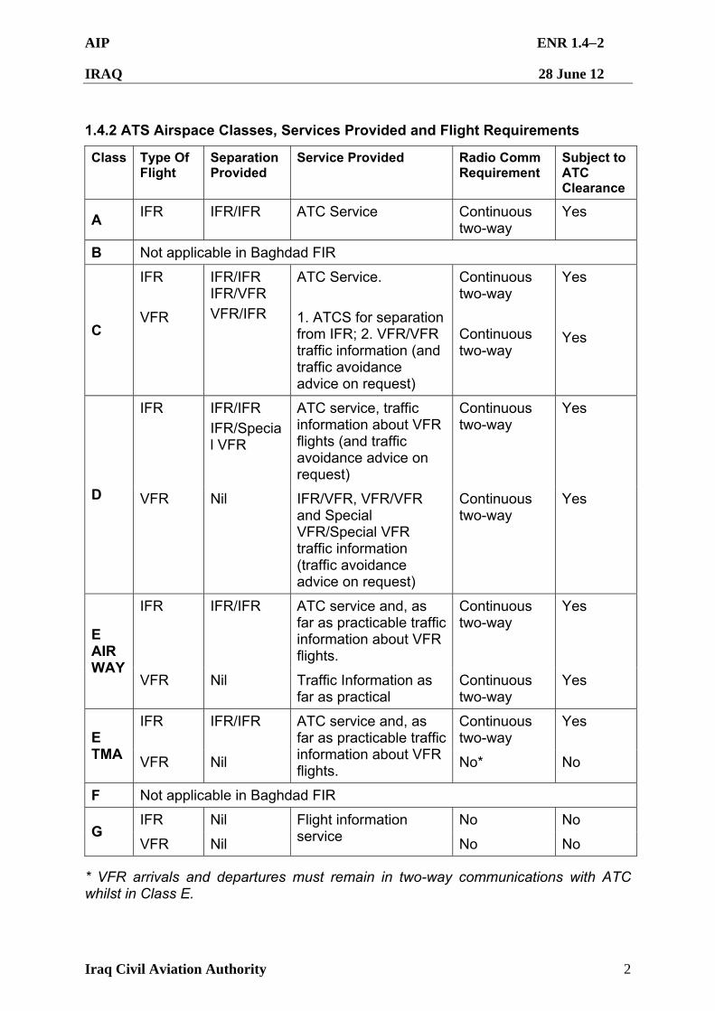
AIP ENR 1.42
IRAQ 28 June 12
Iraq Civil Aviation Authority 2
1.4.2 ATS Airspace Classes, Services Provided and Flight Requirements
Class Type Of Flight
Separation Provided
Service Provided Radio Comm Requirement
Subject to ATC Clearance
A IFR IFR/IFR ATC Service Continuous
two-way Yes
B Not applicable in Baghdad FIR
C
IFR
VFR
IFR/IFR IFR/VFR
VFR/IFR
ATC Service.
1. ATCS for separation from IFR; 2. VFR/VFR traffic information (and traffic avoidance advice on request)
Continuous two-way
Continuous two-way
Yes
Yes
IFR IFR/IFR
IFR/Special VFR
ATC service, traffic information about VFR flights (and traffic avoidance advice on request)
Continuous two-way
Yes
D VFR Nil IFR/VFR, VFR/VFR and Special VFR/Special VFR traffic information (traffic avoidance advice on request)
Continuous two-way
Yes
IFR IFR/IFR ATC service and, as far as practicable traffic information about VFR flights.
Continuous two-way
Yes
E AIRWAY
VFR Nil Traffic Information as far as practical
Continuous two-way
Yes
IFR IFR/IFR Continuous two-way
Yes E TMA VFR Nil
ATC service and, as far as practicable traffic information about VFR flights.
No* No
F Not applicable in Baghdad FIR
IFR Nil No No G
VFR Nil
Flight information service No No
* VFR arrivals and departures must remain in two-way communications with ATC whilst in Class E.
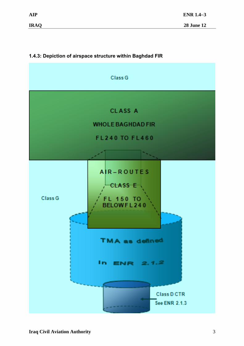
AIP ENR 1.43
IRAQ 28 June 12
Iraq Civil Aviation Authority 3
1.4.3: Depiction of airspace structure within Baghdad FIR
AIP ENR 1.44
IRAQ 28 June 12
Iraq Civil Aviation Authority 4
Refer to AIP ENR 1.4.1 and current Baghdad FIR (ORBB) NOTAMs for actual airspace descriptions.
NOTES:
1. As per ICAO Doc 4444, Annex 2, where ATS airspaces adjoin vertically, flights at a common level would comply with, and be given services applicable to, the less restrictive class of airspace. In applying these criteria Class E airspace is therefore considered less restrictive than Class A airspace.
2. Due to equipment limitations, two-way communications may not be available in western Iraq. In the event of an emergency requiring descent in an area of poor radio coverage, pilots are to attempt to contact any air traffic agency via emergency frequencies.
AIP ENR 1.45
IRAQ 28 June 12
Iraq Civil Aviation Authority 5
1.4.4: Division of responsibility between ATS units and Class E TMA
AIP ENR 1.51
IRAQ 28 June 12
Iraq Civil Aviation Authority 1
ENR 1.5 HOLDING, APPROACH AND DEPARTURE PROCEDURES
1.5.1 General
1.5.1.1 The holding, approach and departure procedures published in this AIP are based on ICAO PANS-OPS.
1.5.1.2 The holding, approach and departure procedures in the Baghdad FIR are based on Part III and IV of Vol.1 of the PANS-OPS or United States Terminal Instrument Procedures (TERPS). The holding patterns shall be entered and flown as indicated below.
1.5.1.3 If necessary, such as, in case of congestion, inbound aircraft may be instructed to hold at one of the designated En-route reporting points. Additional holding points may be specified by ATC depending on traffic density and conditions. The holding procedures shall be a standard 180 degree right turn to fly outbound on the reciprocal track for one minute then conduct a standard 180 degree right turn to intercept the inbound track to overhead the holding point. ICAO Doc 8168-PAN-OPS refers.
1.5.1.4 Due to limited airspace available, it is imperative that the approaches to the holding patterns and procedures are carried out as exactly as possible. Pilots should inform ATC if the approach and/or holding procedures cannot be performed as required.
1.5.2 Arriving Flights
1.5.2.1 IFR flights entering and landing within a terminal control area shall be cleared to the specified holding point and instructed to contact approach control at a specified time, level or position. The terms of this clearance shall be adhered to until further instructions are received from approach control. If the clearance limit is reached before further instructions have been received, holding procedures shall be carried out at the level last authorized. Holding is unnecessary provided the aircraft is in receipt of onwards clearance.
1.5.2.2 Civil aircraft are to expect instructions from ATC for approaches into airfields within the Baghdad FIR.
1.5.2.3 No manoeuvres involving flight to the east of the circuit of Baghdad International Airport should be made unless specifically cleared by ATC units.
1.5.2.4 Except when complying with the requirements for a visual approach, when conforming to a published GPS arrival procedure, or when in receipt of an ATC surveillance service, an IFR aircraft approaching an aerodrome must not descend below the lowest safe altitude (LSALT) or the MSA for the route segment being flown until it has arrived over the IAF or facility.
1.5.2.5 25 NM and 10 NM MSA provide at least 1 000 ft obstacle clearance. In instances where the 25 NM MSA has been divided into sectors, and the appropriate Sector MSA is lower than the 10 NM MSA, the Sector MSA may be used for tracking to the aid provided aircraft tracking can be maintained within the sector.
AIP ENR 1.52
IRAQ 28 June 12
Iraq Civil Aviation Authority 2
1.5.2.6 Visual Approach
1.5.2.6.1 An arriving flight may be cleared by ATC to execute a visual approach provided:
a. The pilot has established, and can continue flight to the aerodrome with, continuous visual reference to the ground or water; and
b. At night, the pilot reports the aerodrome in sight; and
c. Visual meteorological conditions exist at the destination aerodrome; or
(i) The pilot reports at the initial approach level or at any time during the instrument approach procedure that the meteorological conditions are such that a visual approach and landing can be completed.
NOTE: Local weather phenomena sometimes cause surface visibility to appear greater from the air than it is at the airfield. In these conditions ATC may deny clearance for Visual Approach.
1.5.2.6.2 Unless otherwise instructed by ATC, aircraft cleared to execute a visual approach shall maintain the assigned track until within five nautical miles of the destination aerodrome, or by night within the prescribed circling area, and then manoeuvre via the shortest route to base or final for the assigned RWY.
1.5.2.6.3 An aircraft executing a visual approach may descend when ready from its previously assigned level and must remain at least 500 ft above the base of the control area and, by day, shall comply with ENR 1.2.2 regarding altitude restrictions above terrain and built up areas. An aircraft executing a visual approach at night shall comply with these instructions and maintain the last assigned altitude or minimum safe altitude if lower, until established within the circling area, then remain within the circling area and manoeuvre via the shortest route to base or final for the assigned RWY.
1.5.2.6.4 At night, international HEAVY wake turbulence category aircraft shall be processed via a straight-in instrument approach, such as ILS or VOR/DME approach. When a straight-in instrument approach is not available or is unsuitable in prevailing conditions, international HEAVY aircraft are to conduct a straight-in visual approach via 10 NM final.
1.5.2.6.5 Separation shall be provided between IFR aircraft cleared to execute a visual approach and other IFR aircraft.
1.5.2.6.6 For successive visual approaches by IFR aircraft, ATC Surveillance System or Procedural (non- ATC surveillance system) separation shall be maintained until the pilot of a succeeding aircraft reports having the preceding aircraft in sight. The aircraft shall then be instructed to follow and maintain own separation from the preceding aircraft. When the preceding aircraft is a heavier wake turbulence category than the following, and the distance between the aircraft is less than the appropriate wake turbulence minimum, the controller shall issue a caution of possible wake turbulence. The pilot-in-command of the aircraft concerned shall be responsible for ensuring that the spacing from a preceding aircraft of a heavier wake turbulence category is
AIP ENR 1.53
IRAQ 28 June 12
Iraq Civil Aviation Authority 3
acceptable. If it is determined that additional spacing is required, the flight crew shall inform the ATC unit accordingly, stating their requirements.
1.5.3 Departing Flights
1.5.3.1 IFR flights departing from controlled aerodromes shall receive an ATC clearance from the control tower. The clearance limit will normally be the aerodrome of destination. IFR flights departing from non-controlled aerodromes must make arrangements with the appropriate ATC facility prior to take-off.
1.5.3.2 Detailed instructions with regard to routes, turns, etc. will be issued after take-off as required.
1.5.3.3 Standard Instrument Departure (SID) Routes
1.5.3.3.1 When it is necessary to issue clearances that do not conform to SID routes, the clearances will be prefixed by the phrase “CANCEL SID”. ATC shall not cancel a SID whilst the aircraft is below minimum safe altitude except, by day in visual meteorological conditions, when the aircraft is instructed to maintain visual terrain clearance by ATC appending “VISUAL” to the track/level instruction.
1.5.3.3.2 When considered necessary by ATC or when requested by the pilot-in-command the SID will be described in full.
1.5.3.3.3 Each SID indicates by its name the waypoint via which the aircraft will exit the terminal area.
1.5.3.3.4 Each SID route will be supplemented by an altitude or flight level instruction. Such altitude instructions shall not restrict an aircraft to a level below the minimum safe altitude. In that case, the SID should be cancelled and the aircraft shall be instructed to “REMAIN VISUAL UNTIL ABOVE MSA”.
1.5.3.3.5 No manoeuvres involving flight to the east of the circuit of Baghdad International Airport should be made unless specifically cleared by ATC units.
1.5.4 Night / Low Light Military Airlift Operations
1.5.4.1 Military & Civil aircraft will operate with all lights and strobes on when at or above FL150 in Baghdad FIR.
1.5.4.2 Military airlift aircraft may turn off all external lighting when descending below FL150 and Civil aircraft with approval may operate with positioning lights only below FL150.
Note: Locally defined rules may stipulate alternative practice which must be adhered to.
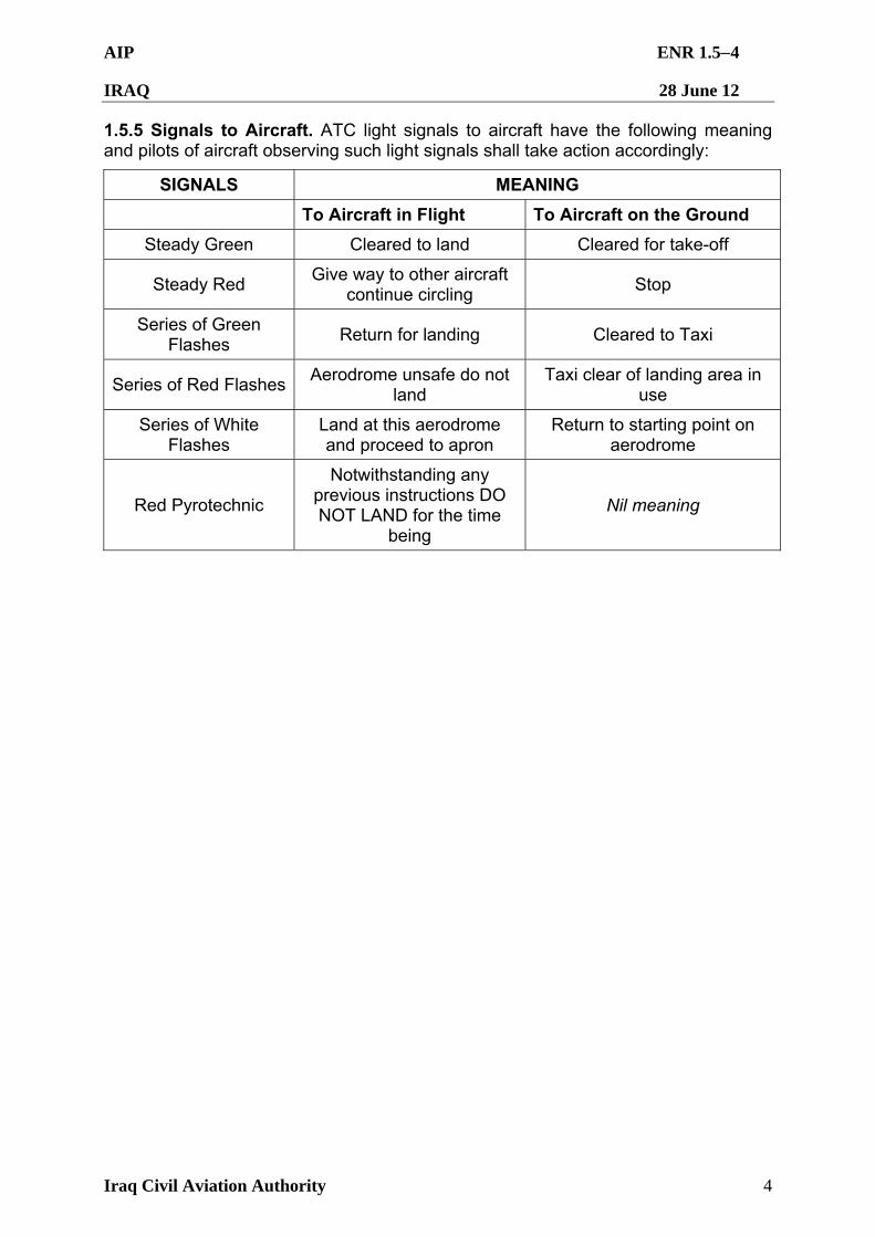
AIP ENR 1.54
IRAQ 28 June 12
Iraq Civil Aviation Authority 4
1.5.5 Signals to Aircraft. ATC light signals to aircraft have the following meaning and pilots of aircraft observing such light signals shall take action accordingly:
SIGNALS MEANING
To Aircraft in Flight To Aircraft on the Ground
Steady Green Cleared to land Cleared for take-off
Steady Red Give way to other aircraft
continue circling Stop
Series of Green Flashes
Return for landing Cleared to Taxi
Series of Red Flashes Aerodrome unsafe do not
land Taxi clear of landing area in
use
Series of White Flashes
Land at this aerodrome and proceed to apron
Return to starting point on aerodrome
Red Pyrotechnic
Notwithstanding any previous instructions DO NOT LAND for the time
being
Nil meaning
AIP ENR 1.61
IRAQ 28 June 12
Iraq Civil Aviation Authority 1
ENR 1.6 ATC SURVEILLANCE SYSTEM SERVICES AND PROCEDURES
1.6.1 Services and Coverage. ATC Radar Units operate as integral part of the system and provide ATS Surveillance Services for the Baghdad FIR. However, due to gaps in radar coverage, particularly near the boundaries of the Baghdad FIR, air traffic control applies procedural (non- ATS surveillance system) separation standards, supplemented by ATS Surveillance System, to en-route aircraft. The diagram on page ENR 1.6-3 depicts approximate radar coverage and the division of responsibility between air traffic control units in Iraq. Pilots are to continuously monitor the VHF emergency FREQ (121.5 MHz) and operate their transponder at all times during flight. Pilots will ensure that the transponder is set on the correct discrete code assigned by ATC. Failure to operate transponder correctly may result in a delay.
1.6.2 Application of ATS Surveillance Control Service
1.6.2.1 ATS surveillance system is used for the provision of Air Traffic Services in accordance with ICAO Doc 4444 – Procedures for Air Navigation Services- Air Traffic Management.
1.6.2.2 An aircraft may consider that ATC is providing an ATS Surveillance Service from the time ATC advises the aircraft that identification is established until the time when ATC advises the aircraft that identification is lost and or that ATS Surveillance Service is terminated. Unless otherwise requested by ATC, aircraft position reporting may be omitted when receiving an ATS Surveillance Service.
1.6.2.3 The minimum horizontal ATS surveillance separation standard within the Baghdad FIR, prescribed for use at locations where ATS Surveillance Services are provided is 5 NM.
1.6.2.4 Levels assigned by the ATS Surveillance System controller shall ensure terrain clearance in accordance with minimum vector altitude, minimum safe altitude or lowest safe altitude, as appropriate to the phase of flight.
1.6.3 ATS Surveillance System and Radio Failure Procedures
1.6.3.1 In the event of ATS surveillance system failure, the radar controller shall take all steps necessary to ensure terrain clearance and establish procedural (non- ATS surveillance system) separation standards as soon as possible. Aircraft subject to ATS Surveillance Services shall be advised of an ATS surveillance system failure as soon as possible.
1.6.3.2 If two-way communication is lost with an aircraft, the radar controller shall attempt to determine whether or not the aircraft’s receiver is functioning by:
1.6.3.2.1 Instructing the aircraft to “SQUAWK IDENT” or change transponder mode/code; or
1.6.3.2.2 Instructing the aircraft to acknowledge by executing a turn or series of turns and by observing the movements of the aircraft’s ATC surveillance system track.
1.6.3.3 If the action prescribed in paragraph ENR 1.6.3.2.1/2 is unsuccessful, air traffic control shall attempt to contact the aircraft in the same manner on alternative frequencies and, when available, on voice monitored navigation aids.
AIP ENR 1.62
IRAQ 28 June 12
Iraq Civil Aviation Authority 2
1.6.3.4 Air traffic control shall ensure such instructions maintain terrain clearance, do not inadvertently carry the aircraft beyond ATC surveillance system coverage and are such that the aircraft can regain its cleared track after having complied with the instructions. ATC surveillance system separation may continue to be applied provided ATC surveillance system identification is maintained.
1.6.3.5 Pilots shall continue to attempt to acknowledge instructions and broadcast intentions on normal air-ground radio frequencies.
1.6.3.6 Complete Aircraft Communication Failure. Aircraft experiencing radio failure in the departure phase within the terminal area will climb to the level specified in the clearance, or to the minimum safe altitude, whichever is higher. If no time or geographical limit was included in the clearance, maintain assigned level for seven minutes then continue climb to the flight level specified in the current flight plan. If assigned a radar heading, maintain the vector for two minutes, and then proceed in the most direct manner possible to rejoin the flight planed route. Continue to make routine reports.
1.6.3.7 When a controlled aircraft experiencing complete communication failure is operating or expected to operate in an area and at flight levels where ATC surveillance system separation is applied, such separation may continue to be used. However, if the aircraft experiencing radio failure is not identified, ATC surveillance system separation shall be applied between aircraft in receipt of an ATC surveillance service and the procedural (non-ATC surveillance system) navigation tolerances of the unidentified radio fail aircraft.
1.6.4 Diagram of ATC Surveillance System Coverage. Aircraft will be advised "RADAR CONTACT" when operating in areas where sufficient ATC surveillance system capabilities are available. The level of services shall be in accordance with the AIP. ATC surveillance system coverage in Iraq is presently provided using a combination of fixed Iraqi radar systems and fixed/deployable US military systems. US military systems may be relocated/removed on short-notice. Consequently, pilots-in-command are responsible for reviewing applicable NOTAM information on the availability of ATC surveillance.
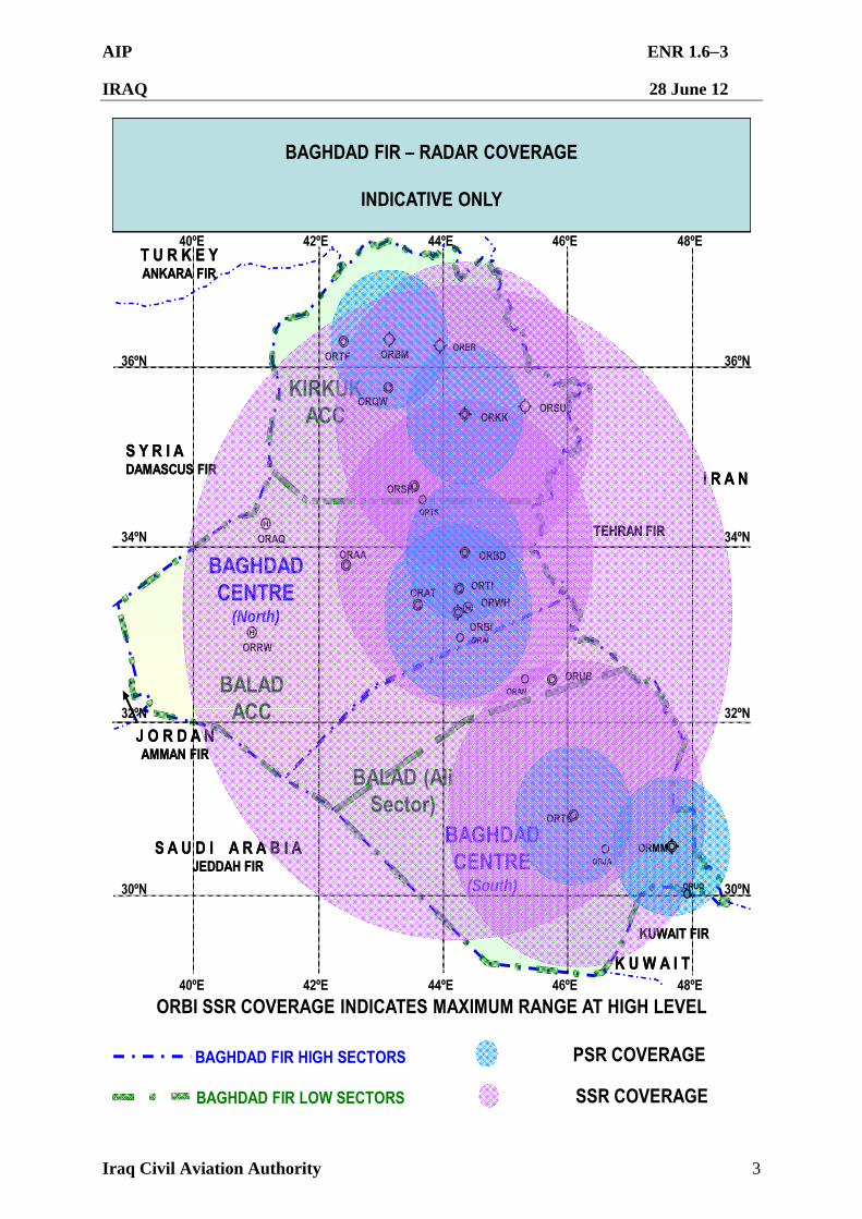
AIP ENR 1.63
IRAQ 28 June 12
Iraq Civil Aviation Authority 3
BALADACC
KIRKUK ACC
BALAD (Ali Sector)
BAGHDADCENTRE
(North)
BAGHDAD CENTRE
(South)
TEHRAN FIR
S Y R I ADAMASCUS FIR
T U R K E YANKARA FIR
J O R D A NAMMAN FIR
S A U D I A R A B I AJEDDAH FIR
K U W A I T
KUWAIT FIR
I R A N
TEHRAN FIR
S Y R I ADAMASCUS FIR
T U R K E YANKARA FIR
J O R D A NAMMAN FIR
S A U D I A R A B I AJEDDAH FIR
K U W A I T
KUWAIT FIR
I R A N
40ºE 44ºE 46ºE 48ºE42ºE
30ºN
32ºN
34ºN
36ºN 36ºN
34ºN
32ºN
30ºN
40ºE 42ºE 44ºE 46ºE 48ºE
BAGHDAD FIR – RADAR COVERAGE
INDICATIVE ONLY
PSR COVERAGE
SSR COVERAGE
ORBI SSR COVERAGE INDICATES MAXIMUM RANGE AT HIGH LEVEL
ORRW
ORAA
ORJA
ORUQ
ORSH
ORBM
ORKK
ORTI
ORAI
ORAT
ORAN
ORBI
ORBD
ORMM
ORER
ORSU
ORTF
ORTL
ORTS
ORUB
ORAQ
ORWH
ORQW
BAGHDAD FIR HIGH SECTORS
BAGHDAD FIR LOW SECTORS
AIP ENR 1.71
IRAQ 28 June 12
Iraq Civil Aviation Authority 1
ENR 1.7 ALTIMETER SETTING PROCEDURES
1.7.1 General
1.7.1.1 The altimeter setting procedures in use generally conform to those contained in ICAO Doc 8168-OPS/611 and are given in full below. Transition altitude for all aerodromes in the Baghdad FIR is described below and detailed in the tabulation in AD 2. In addition, transition altitudes are given on instrument approach charts.
1.7.1.2 QNH reports for use in determining adequate terrain clearance is provided in meteorological broadcasts and is available on request from air traffic service units. QNH values are given in whole Hectopascals (fractions are rounded down) or, on request, in inches of mercury.
1.7.1.3 The following standard definitions shall apply in the Baghdad FIR:
1.7.1.3.1 Transition Altitude. The altitude at or below which the vertical position of an aircraft is controlled by reference to altitudes. The transition altitude for Baghdad FIR is 14 000 ft AMSL.
1.7.1.3.2 Transition Layer. The airspace between the transition altitude and the transition level. Aircraft shall not cruise within the transition layer.
1.7.1.3.3 Transition Level. The lowest flight level available for use above the transition altitude. The transition level for Baghdad FIR is established at FL 150.
1.7.1.4 The altimeter pressure setting at and above the transition level is the international standard altimeter pressure setting of 1013 Hectopascals or 29.92 inches. The altimeter setting at and below the transition altitude shall be the relevant QNH.
1.7.1.5 Vertical positioning of aircraft at or below the transition altitude is expressed in terms of altitude, whereas levels at or above the transition level are expressed in terms of flight level. Aircraft shall set standard pressure when passing through the transition altitude on climb, and regional QNH when passing through the transition level on descent. While passing through the transition layer, vertical position shall be expressed in terms of flight levels when climbing and in terms of altitudes when descending.
1.7.1.6 To retain a minimum buffer of 1 000 ft above the transition altitude, FL 150 must not be used for cruising when the QNH is less than 1013 Hectopascals (29.92 inches). With a progressive decrease in the value of the QNH, FL 155 must not be used when the QNH is below 997 Hectopascals (29.42 inches) and FL 160 must not be used when the Area QNH is below 980 Hectopascals (28.94 inches).
1.7.2 Provision of Altimeter Setting Information
1.7.2.1 ATC units shall have current QNH available for transmission to aircraft on request, both for their own and adjacent areas of responsibility. For arriving and enroute aircraft, the QNH altimeter setting shall be included in the first assignment of an altitude below the transition level. Unless the aircraft notifies receipt of the ATIS or the QNH is passed as part of a previous transmission, QNH shall be appended to the airways clearance for aircraft intending to cruise below the transition level, approach
AIP ENR 1.72
IRAQ 28 June 12
Iraq Civil Aviation Authority 2
clearances or clearances to enter the traffic pattern, and with the taxi clearance for departing aircraft. ATC shall advise aircraft of subsequent QNH changes.
AIP ENR 1.81
IRAQ 28 June 12
Iraq Civil Aviation Authority 1
ENR 1.8 REGIONAL SUPPLEMENTARY PROCEDURES
1.8.1 Overflight Levels. Overflights of Iraq must be conducted above FL 200, except when lower levels are issued by ATC to comply with FIR boundary crossing procedures as per ENR1.8.3.
1.8.2 RVSM application
1.8.2.1 Identification Of RVSM airspace
1.8.2.1.1 RVSM shall be applicable in that volume of airspace between FL290 and
FL410 inclusive in the Baghdad FIR and this volume of airspace shall be referred to as the Baghdad FIR RVSM airspace. The Baghdad FIR RVSM airspace shall be exclusionary, only aircraft approved for RVSM and appropriately trained crews shall be authorized to operate in RVSM airspace.
1.8.2.1.2 Aircraft transiting through the Baghdad FIR can expect to be assigned RVSM levels subject to traffic, by 0030 UTC.
1.8.2.2 Airworthiness and operational approval and monitoring 1.8.2.2.1 Approval process.( source document : Iraq CAA Civil Aviation Publication
1, RVSM) operators must obtain airworthiness and operational approval from the state of registry or state of operator, as appropriate, to conduct RVSM operations. All Iraqi registered aircraft planning to operate in RVSM airspace shall be required to obtain an approval from the Iraqi CAA before the commencement of operations.
1.8.2.2.2 Aircraft monitoring. Once the aircraft has successfully conducted an over flight assessment, there is no requirement for further assessment assessments unless there is a change to the required aircraft equipment. A successful over flight assessment conducted by a Regional Monitoring Agency (RMA) is acceptable for all RMAs. An over flight assessment may not be a prerequisite for “group aircraft” but it is for”non group aircraft” (refer to notes 1 and 2). After the Iraqi CAA has granted airworthiness approval, operators of non group aircraft should take steps to overfly the Height Monitoring Unit (HMU) near the following locations:
(a) Stumble, UK
(b) Linz, Austria
(c) Nattenheim, Germany
(d) Geneva, Switzerland
1.8.2.2.3 Alternatively, operators may arrange for the carriage of a global positioning system (GPS) Monitoring unit (GMU). If monitoring occurs before the Iraqi CAA has informed the appropriate RMA, the accrued data may still be used provided that it is dated after the modification/ inspection was completed. In this case of aircraft added to an operators fleet of the same type, after initial application for RVSM operating authority, the appropriate RMA will determine whether any further monitoring is required and will inform the Iraqi CAA, which in turn will inform the operator. Any monitoring conducted by a RMA is acceptable to the Iraqi CAA and to other RMAs.
AIP ENR 1.82
IRAQ 28 June 12
Iraq Civil Aviation Authority 2
Operators can consult the MID RMA to ascertain if its aircraft have been monitored and acceptable performance has been demonstrated.
Note: “Non-group aircraft” operators of these aircraft (e.g GIV, LR 60,etc) must apply on an individual aircraft basis, and monitoring by an HMU or GMU is a prerequisite to obtain RVSM (operational) approval unless flight test evidence can be provided to the Iraqi CAA to show that each airframe is compliant with Altimetry System Error (ASE) targets. 1.8.2.3 Exceptions to RVSM exclusivity 1.8.2.3.1 State aircraft (those aircraft used in military, custom and police services) for
whom there is no RVSM equipment upgrade, but yet for mission still requires access to RVSM airspace, shall be afforded an exception to RVAM exclusionary rule.
1.8.2.3.2 Aircraft operating on Humanitarian Missions or Lifeguard Flights may at the controllers discretion be afforded an exception to the RVSM exclusionary rule.
1.8.2.3.3 Manufacturer aircraft and aircraft in a maintenance status may require access to RVSM altitudes without a current RVSM approval. Aircraft operators must make their request for this exclusion at least 12 hours in advance of flight plan filing with the Baghdad ACC ATS Director.
1.8.2.3.4 Non-approved RVSM aircraft capable of flying at FL430 and above may be allowed to transition through and over fly RVSM airspace .while transitioning through RVSM airspace, 2000 ft vertical separation shall be provided between this aircraft and all other aircraft .During the transition, the non-approved aircraft may only level off in RVSM airspace if required by air traffic control ( ATC ) for separation purposes . The non-approved RVSM aircraft must be able to climb through the RVSM airspace without leveling off for needs other than those directed by ATC.
1.8.2.3.5 All of these exceptions shall be handled on an individual basis and shall be accommodated based on controller workload. These aircraft shall be separated by 2000 ft from all other aircraft within RVSM airspace.
1.8.2.4 ACAS II equipage 1.8.2.4.1 ACAS Version II (TCAS VERSION 7.0) has improved compatibility with
RVSM and ICAO Annex 6 has implemented the carriage of ACAS in turbine-engine aero planes above 15,000 kg and certified for more than 30 passengers as a Standard from 01 January, 2003. The ICAO Standard will apply for all turbine engine aero planes above 5700 kg or certified for more than 19 passengers. It is expected that RVSM operations throughout the MID region will require ACAS II.
1.8.2.4.2 Before entering RVSM airspace, the pilot should review the status of required equipment. The following equipment should be operating normally:
(a) Two primary altitude measurement systems; (b) One automatic altitude-control system; (c) One altitude-alerting device; (d) Operating transponder.
AIP ENR 1.83
IRAQ 28 June 12
Iraq Civil Aviation Authority 3
Note: Should any of the required equipment fail prior to the aircraft entering RVSM airspace, the pilot should request a new clearance to avoid entering this airspace.
1.8.2.5 Procedures prior to RVSM airspace entry 1.8.2.5.1 Flight crews are expected to be familiar with the following prior to operation
in RVSM airspace. (a) Standard ATC phraseology used in each area of operations. (b) Importance of crew members cross checking to ensure that ATC clearances
are promptly and correctly complied with; (c) Use and limitations in terms of accuracy of standby altimeters in
contingencies. Where applicable, the pilot should review the application of static source error and pressure error correction through the use of correction cards;
(d) Problems of visual perception of other aircraft at 1,000 ft (300m) planned separation during darkness, when encountering local phenomena such as northern lights, for opposite and same direction traffic, and during turns;
(e) Characteristics of aircraft altitude capture systems, which may lead to flight level overshoots;
(f) The relationship between the aircraft's altimetry, automatic altitude control and transponder systems in normal and abnormal conditions;
(g) Any airframe operating restrictions, if required for the specific aircraft group, related to RVSM airworthiness approval;
(h) Use of TCAS in RVSM airspace; and (i) The effect of wake turbulence.
1.8.2.6 In-flight procedures for flight crews
1.8.2.6.1 Flight crews must comply with any aircraft operating restrictions, if required for the specific aircraft group, given in the RVSM airworthiness approval.
1.8.2.6.2 Emphasis should be placed on promptly setting the sub-scale on all primary and standby altimeters to 1013.2 (hPa) when passing the transition altitude, and rechecking for proper altimeter setting when reaching the initial cleared flight level.
1.8.2.6.3 In level cruise it is essential that the aircraft is flown at the cleared flight level. This requires that particular care is taken to ensure that ATC clearances are fully understood and followed. The aircraft should not intentionally depart from the cleared flight level without a positive clearance from ATC unless the crew is conducting contingency or emergency maneuvers.
1.8.2.6.4 When changing levels, the aircraft should not be allowed to overshoot or undershoot the cleared flight level by more than 150 ft (45 m).
AIP ENR 1.84
IRAQ 28 June 12
Iraq Civil Aviation Authority 4
Note: It is recommended that the level off be accomplished using the altitude capture feature of the automatic altitude-control system, if installed.
1.8.2.6.5 An automatic altitude-control system should be operative and engaged during level cruise, except when circumstances such as the need to re-trim the aircraft or turbulence require disengagement. In any event, adherence to cruise altitude should be done by reference to one of the two primary altimeters.
1.8.2.6.6 Ensure that the altitude-alerting system is operative.
1.8.2.6.7 At intervals of approximately one hour, cross-checks between the primary altimeters should be made. A minimum of two must agree within +_200 ft (+_60m). Failure to meet this condition will require that the altimetry system be reported as defective and notified to ATC.
(a) The usual scan of flight deck instruments should suffice for altimeter cross-checking on most flights.
(b) Before entering oceanic RVSM airspace, the initial altimeter cross check of primary and standby altimeters should be recorded.
Note: Future systems may make use of automatic altimeter omparators.
1.8.2.6.8 In normal operations, the altimetry system being used to control the aircraft should be selected for the input altitude reporting transponder transmitting information to ATC.
1.8.2.6.9 If the pilot is advised in real time that the aircraft has been identified by a height-monitoring system as exhibiting a total vertical error (TVE) greater than +_ 300 ft (+_90m) and/or an altimetry system error (ASE) greater than +_245 ft (+_75m) then the pilot should follow established regional procedures to protect the safe operation of the aircraft. This assumes that the monitoring system will identify the TVE or ASE within the set limits for accuracy.
1.8.2.6.10 If the pilot notified by ATC of an assigned altitude deviation (AAD) error which exceeds +_300 ft (+_90m) then the pilot should take action to return to the cleared flight level as quickly as possible.
1.8.2.7 Contingency procedures after entering RVSM airspace
1.8.2.7.1 An in-flight contingency in RVSM airspace pertains to unforeseen circumstances which directly impact the ability of one or more aircraft to operate in accordance with the vertical navigation performance requirements of RVSM.
1.8.2.7.2 The pilot should notify ATC of contingencies, such as equipment failure, system inaccuracies and sever turbulence, which affect the ability to maintain the cleared flight level and co-ordinate a plan of action. If unable to contact ATC and obtain an ATC clearance prior to deviating form the
AIP ENR 1.85
IRAQ 28 June 12
Iraq Civil Aviation Authority 5
cleared flight level, the pilot should follow established contingency procedures as defined by the region of operation and obtain ATC clearance as soon as possible.
1.8.2.7.3 The typed of equipment failures which should be notified to ATC are:
(a) Failure of all automatic altitude-keeping devices;
(b) Loss of redundancy of all, or part of, altimetry systems;
(c) Failure of all altitude reporting transponders;
(d) Loss of thrust on an engine necessitating descent; or
(e) Any other equipment failure affecting the ability to maintain the cleared flight level.
1.8.2.7.4 Degradation of aircraft equipment or turbulent atmospheric conditions could impact an aircrafts ability to maintain the strict vertical navigation performance requirements of RVSM.
1.8.2.7.5 The pilot shall inform ATC as soon as possible of any circumstances where the aircraft can no longer maintain RVSM vertical navigation performance. In such cases, the pilot shall obtain a revised ATC clearance prior to deviating from the cleared route and/or flight level. Where a revised ATC clearance could not be obtained prior to such deviation, the pilot shall obtain a revised clearance as soon as possible thereafter.
1.8.2.7.6 ATC shall provide all possible assistance to a pilot experience an in-flight contingency. Subsequent ATC actions will be based on pilot intentions, the overall air traffic situation and real time dynamics of the contingency.
1.8.2.7.7 If the aircraft will be unable to meet RVSM vertical navigation performance, the aircraft will be required to descent below RVSM altitudes until such time as it can meet RVSM requirements.
1.8.2.8 Severe Turbulence or Greater in RVSM Airspace
1.8.2.8.1 When a pilot reports "unable to maintain RVSM due turbulence", ATC shall establish either an appropriate horizontal separation minimum or an increased vertical separation minimum of at least 2000 feet. To the extent possible, ATC shall accommodate pilot requests for flight level and/or route changes.
1.8.2.8.2 ATC shall solicit reports from other aircraft in the vicinity to determine whether RVSM should be suspended, either entirely or within a specific
AIP ENR 1.86
IRAQ 28 June 12
Iraq Civil Aviation Authority 6
flight level band and/or area. The specific actions to be taken by ATC will be dictated by the actual weather related circumstances and the traffic situation existing at the time. ATC is expected to use best judgment to safeguard separation between aircraft in such circumstances. An aircraft experiencing severe turbulence while operating within RVSM airspace need not be cleared out of RVSM airspace.
1.8.2.8.3 When ATC receives multiple pilot reports of severe turbulence which could impact multiple aircraft with regards to their ability to maintain cleared flight level within RVSM airspace, ATC shall provide an increased vertical separation minimum or an appropriate horizontal separation minimum.
1.8.2.8.4 Where meteorological forecasts is predicting severe turbulence, ATC shall determine whether RVSM should be suspended, and, if so, the period of time, and specific flight level(s) and/or area.
AIP ENR 1.87
IRAQ 28 June 12
Iraq Civil Aviation Authority 7
1.8.3 Separation. Separation will be applied as provided by ICAO Doc 4444- procedures for Air navigation or as defined by LOA
1.8.4 International Agreements. There are six Letters of Agreement (LOAs) finalized between Iraq and adjacent countries – Turkey, Jordan, Syria, Kuwait, Saudi Arabia and Iran. These LOAs authorize Iraq Civil Aviation Authority approved aircraft to travel between aforementioned countries (through the Baghdad FIR) in accordance with agreed procedures. The pertinent points from each LOA are detailed in ENR 1.8.3.1 to ENR 1.8.3.5.
1.8.4.1 Baghdad/Ankara FIR Boundary Procedures
1.8.4.1.1 All northbound aircraft shall track between the Baghdad and Ankara FIRs via KABAN, on UM860/UR21/UT37/R21/T37. All aircraft shall be maintaining level flight prior to reaching KABAN for northbound flights. All southbound aircraft shall track between Baghdad and Ankara FIRs via NINVA on UM688. All aircraft shall be maintaining level flight prior to reaching NINVA for southbound flights.
1.8.4.1.2 All aircraft shall operate in accordance with the following transit levels:
Exiting the Baghdad FIR
Tracking Flight Levels
Northbound FL160, FL180, FL200, FL220, FL240, FL260, FL280, FL300, FL320, FL340,
FL360, FL380, FL400, FL430
Entering the Baghdad FIR
Tracking Flight Levels
Southbound FL250, FL270, FL290, FL310, FL330, FL350, FL 370, FL390, FL410, FL450
1.8.4.1.3 Aircraft operating at the same altitude shall anticipate a minimum 20NM radar separation using Mach number technique or 10 minutes spacing from other aircraft.
1.8.4.1.4 All aircraft should be prepared to provide their estimated time (in minutes) to KABAN and NINVA upon ATC request.
1.8.4.2 Baghdad/Amman FIR Boundary Procedures
1.8.4.2.1 The only entry/exit route for aircraft between the Amman and Baghdad FIRs is PASIP on L200. All aircraft shall maintain assigned flight level, at least 10 NM prior to PASIP unless verbally coordinated otherwise.
1.8.4.2.2 All aircraft shall operate in accordance with the following transit levels:
Exiting the Baghdad FIR
Tracking Flight Levels
Aircraft tracking via L200 FL160, FL180, FL200, FL220
AIP ENR 1.88
IRAQ 28 June 12
Iraq Civil Aviation Authority 8
Entering the Baghdad FIR
Tracking Flight Levels
Aircraft tracking via L200 for landing within the Baghdad FIR
FL170, FL190, FL210, FL230
Aircraft tracking via L200 for Overflying the Baghdad FIR
FL330, FL350, FL390, FL410, FL430, FL450
1.8.4.2.3 Aircraft are advised that radio coverage is limited along the western edge of Iraq on L200.
1.8.4.2.3.1 Aircraft transiting westbound on L200 are to establish communications with Amman ACC on 128.5 at least 10 minutes flying time east of PASIP. Once contact with Amman ACC is established, aircraft are to advise the previous controlling authority and continue with Amman ACC.
1.8.4.2.3.2 Aircraft transiting eastbound should not expect radio contact with Baghdad ACC until approximately GIBUX.
1.8.4.2.3.3 In the event of an emergency requiring descent in an area of poor radio coverage, aircraft are to attempt contact with any ATC unit on a published frequency and/or emergency frequencies.
1.8.4.2.4 Aircraft operating at the same altitude on the same route shall anticipate a minimum of 10 minutes spacing from other aircraft.
1.8.4.2.5 All aircraft should be prepared to provide their estimated time (in minutes) to PASIP upon ATC request, in either direction of flight.
1.8.4.2.6 West bound traffic Entering Amman FIR FL 220. FL240 via prior co-ordination.
1.8.4.2.7 East bound traffic Entering Baghdad FIR FL 210, and FL230 to contact Baghdad low at freq. 122.4 FL250 via prior co-ordination, to contact Baghdad high of freq. 129.1
1.8.4.3 Baghdad/Damascus FIR Boundary Procedures
1.8.4.3.1 All aircraft shall track between the Baghdad and Damascus FIRs via ELEXI on UL602 (Suspended), SIDNA on UP975 or MODIK on G202. All aircraft shall be maintaining level flight prior to reaching ELEXI, SIDNA or MODIK unless cleared otherwise by ATC.
1.8.4.3.2 Traffic Proceeds via UP975 will be vectored from TUBEN Direct UKMUG by follow: SIDNA – TUBEN – UKMUG – PAPUS – KATUT – ILMAP – PEBAD – SIDAD.
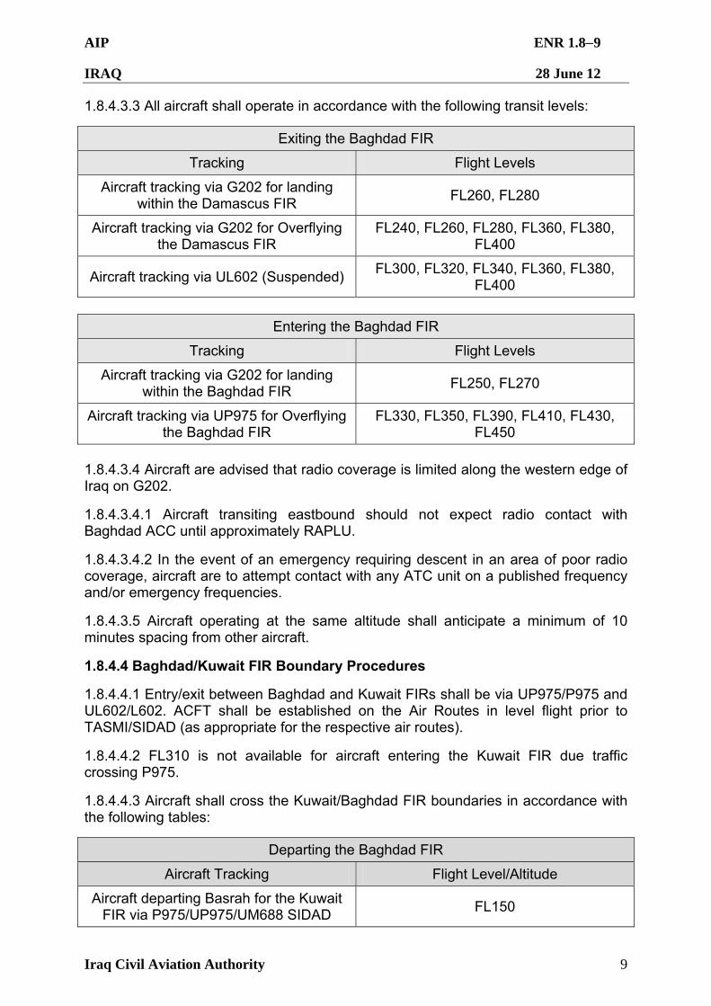
AIP ENR 1.89
IRAQ 28 June 12
Iraq Civil Aviation Authority 9
1.8.4.3.3 All aircraft shall operate in accordance with the following transit levels:
Exiting the Baghdad FIR
Tracking Flight Levels
Aircraft tracking via G202 for landing within the Damascus FIR
FL260, FL280
Aircraft tracking via G202 for Overflying the Damascus FIR
FL240, FL260, FL280, FL360, FL380, FL400
Aircraft tracking via UL602 (Suspended) FL300, FL320, FL340, FL360, FL380,
FL400
Entering the Baghdad FIR
Tracking Flight Levels
Aircraft tracking via G202 for landing within the Baghdad FIR
FL250, FL270
Aircraft tracking via UP975 for Overflying the Baghdad FIR
FL330, FL350, FL390, FL410, FL430, FL450
1.8.4.3.4 Aircraft are advised that radio coverage is limited along the western edge of Iraq on G202.
1.8.4.3.4.1 Aircraft transiting eastbound should not expect radio contact with Baghdad ACC until approximately RAPLU.
1.8.4.3.4.2 In the event of an emergency requiring descent in an area of poor radio coverage, aircraft are to attempt contact with any ATC unit on a published frequency and/or emergency frequencies.
1.8.4.3.5 Aircraft operating at the same altitude shall anticipate a minimum of 10 minutes spacing from other aircraft.
1.8.4.4 Baghdad/Kuwait FIR Boundary Procedures
1.8.4.4.1 Entry/exit between Baghdad and Kuwait FIRs shall be via UP975/P975 and UL602/L602. ACFT shall be established on the Air Routes in level flight prior to TASMI/SIDAD (as appropriate for the respective air routes).
1.8.4.4.2 FL310 is not available for aircraft entering the Kuwait FIR due traffic crossing P975.
1.8.4.4.3 Aircraft shall cross the Kuwait/Baghdad FIR boundaries in accordance with the following tables:
Departing the Baghdad FIR
Aircraft Tracking Flight Level/Altitude
Aircraft departing Basrah for the Kuwait FIR via P975/UP975/UM688 SIDAD
FL150
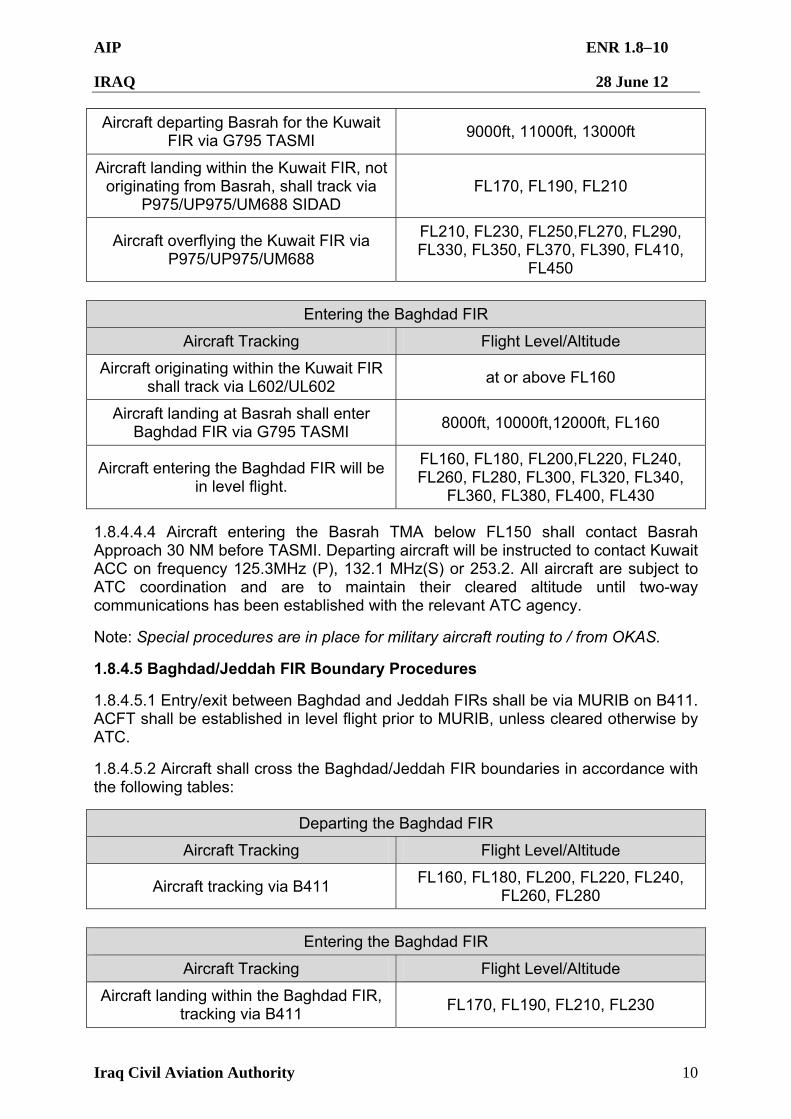
AIP ENR 1.810
IRAQ 28 June 12
Iraq Civil Aviation Authority 10
Aircraft departing Basrah for the Kuwait FIR via G795 TASMI
9000ft, 11000ft, 13000ft
Aircraft landing within the Kuwait FIR, not originating from Basrah, shall track via
P975/UP975/UM688 SIDAD FL170, FL190, FL210
Aircraft overflying the Kuwait FIR via P975/UP975/UM688
FL210, FL230, FL250,FL270, FL290, FL330, FL350, FL370, FL390, FL410,
FL450
Entering the Baghdad FIR
Aircraft Tracking Flight Level/Altitude
Aircraft originating within the Kuwait FIR shall track via L602/UL602
at or above FL160
Aircraft landing at Basrah shall enter Baghdad FIR via G795 TASMI
8000ft, 10000ft,12000ft, FL160
Aircraft entering the Baghdad FIR will be in level flight.
FL160, FL180, FL200,FL220, FL240, FL260, FL280, FL300, FL320, FL340,
FL360, FL380, FL400, FL430
1.8.4.4.4 Aircraft entering the Basrah TMA below FL150 shall contact Basrah Approach 30 NM before TASMI. Departing aircraft will be instructed to contact Kuwait ACC on frequency 125.3MHz (P), 132.1 MHz(S) or 253.2. All aircraft are subject to ATC coordination and are to maintain their cleared altitude until two-way communications has been established with the relevant ATC agency.
Note: Special procedures are in place for military aircraft routing to / from OKAS.
1.8.4.5 Baghdad/Jeddah FIR Boundary Procedures
1.8.4.5.1 Entry/exit between Baghdad and Jeddah FIRs shall be via MURIB on B411. ACFT shall be established in level flight prior to MURIB, unless cleared otherwise by ATC.
1.8.4.5.2 Aircraft shall cross the Baghdad/Jeddah FIR boundaries in accordance with the following tables:
Departing the Baghdad FIR
Aircraft Tracking Flight Level/Altitude
Aircraft tracking via B411 FL160, FL180, FL200, FL220, FL240,
FL260, FL280
Entering the Baghdad FIR
Aircraft Tracking Flight Level/Altitude
Aircraft landing within the Baghdad FIR, tracking via B411
FL170, FL190, FL210, FL230
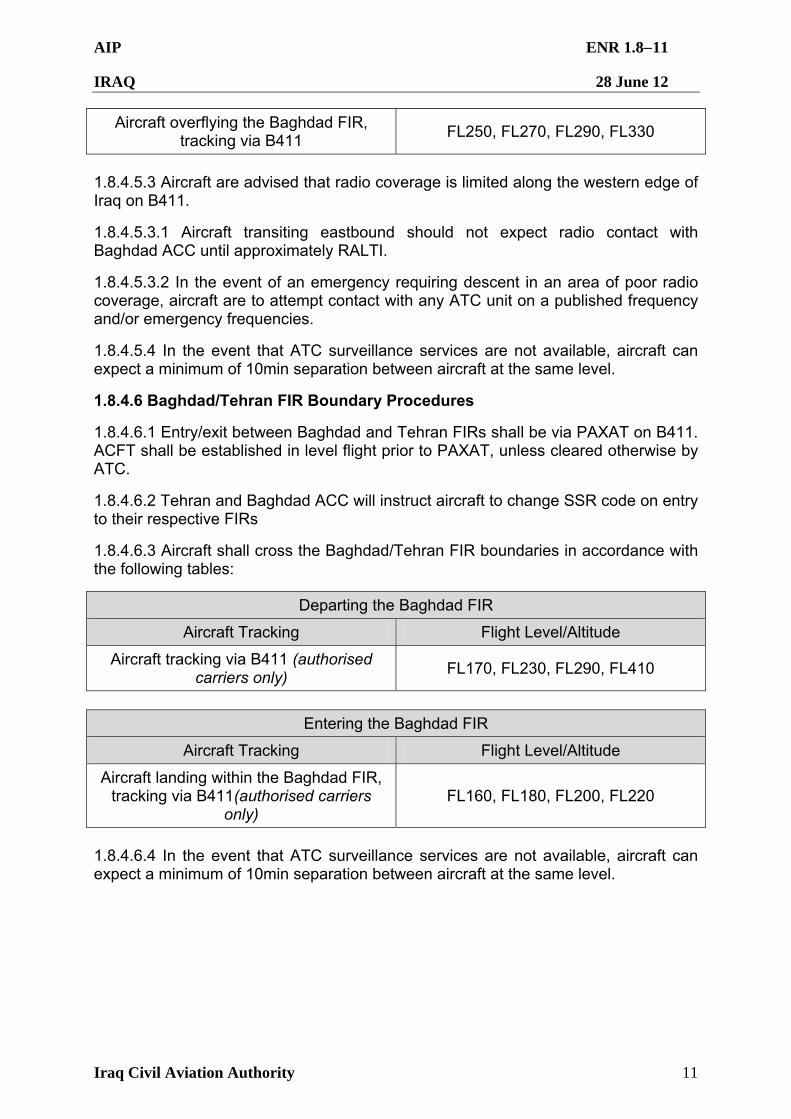
AIP ENR 1.811
IRAQ 28 June 12
Iraq Civil Aviation Authority 11
Aircraft overflying the Baghdad FIR, tracking via B411
FL250, FL270, FL290, FL330
1.8.4.5.3 Aircraft are advised that radio coverage is limited along the western edge of Iraq on B411.
1.8.4.5.3.1 Aircraft transiting eastbound should not expect radio contact with Baghdad ACC until approximately RALTI.
1.8.4.5.3.2 In the event of an emergency requiring descent in an area of poor radio coverage, aircraft are to attempt contact with any ATC unit on a published frequency and/or emergency frequencies.
1.8.4.5.4 In the event that ATC surveillance services are not available, aircraft can expect a minimum of 10min separation between aircraft at the same level.
1.8.4.6 Baghdad/Tehran FIR Boundary Procedures
1.8.4.6.1 Entry/exit between Baghdad and Tehran FIRs shall be via PAXAT on B411. ACFT shall be established in level flight prior to PAXAT, unless cleared otherwise by ATC.
1.8.4.6.2 Tehran and Baghdad ACC will instruct aircraft to change SSR code on entry to their respective FIRs
1.8.4.6.3 Aircraft shall cross the Baghdad/Tehran FIR boundaries in accordance with the following tables:
Departing the Baghdad FIR
Aircraft Tracking Flight Level/Altitude
Aircraft tracking via B411 (authorised carriers only)
FL170, FL230, FL290, FL410
Entering the Baghdad FIR
Aircraft Tracking Flight Level/Altitude
Aircraft landing within the Baghdad FIR, tracking via B411(authorised carriers
only) FL160, FL180, FL200, FL220
1.8.4.6.4 In the event that ATC surveillance services are not available, aircraft can expect a minimum of 10min separation between aircraft at the same level.
AIP ENR 1.91
IRAQ 28 June 12
Iraq Civil Aviation Authority 1
ENR 1.9 AIR TRAFFIC FLOW MANAGEMENT (ATFM) 1.9.1 Slot time allocation procedures for civil overflight and landing aircraft. Aircraft overflights and landings at designated airports in the Baghdad FIR are controlled by a slot time allocation scheme. Refer to section GEN 1.2 for civil aircraft slot procedures.
AIP ENR 1.101
IRAQ 28 June 12
Iraq Civil Aviation Authority 1
ENR 1.10 FLIGHT PLANNING
1.10.1 General. The air traffic rules and procedures applicable to air traffic in the Baghdad FIR conform with Annexes 2 and 11 to the Convention on International Civil Aviation and to those portions applicable to aircraft of ICAO Doc 4444 Procedures for Air Navigation Services – Air Traffic Management, and Regional Supplementary Procedures applicable to the EUR/MID/ASIA region.
1.10.2 Mandatory Timings for Flight Plans
1.10.2.1 The Baghdad Air Traffic Services Reporting Office is open. However, as a backup operators are advised to submit flight plan details through other means. Operators of flights originating outside, but landing at an aerodrome within, the Baghdad FIR are to submit flight plans for the round trip. Flight plans shall be submitted sufficiently early to ensure it is received by the relevant Air Traffic Control agencies at least 60 minutes prior to estimated off block time (EOBT) for departures from within Iraq, or at least 60 minutes prior to the aircraft reaching the Baghdad FIR boundary for inbound or over flight aircraft.
1.10.3 Flight Plan Messages.
1.10.3.1. Aircraft operating within the Iraq FIR shall use the ICAO model flight plan contained in PANS ATM DOC 4444/ATM501. Complete all entries including registration/type of aircraft, boundary estimates to/from the Baghdad FIR, and airport of intended landing.
1.10.4 Procedures Applicable to Operators (Including Pilots)
1.10.4.1 The levels at which a flight is to be conducted shall be specified in a flight plan as follows:
1.10.4.1.1 In terms of flight levels if the flight is to be conducted at or above the transition level, and
1.10.4.1.2 In terms of altitudes if the flight is to be conducted at or below the transition altitude.
1.10.4.2 Flight levels and altitudes selected for a flight shall ensure adequate terrain clearance along the route to be flown. Flight levels are specified in a flight plan by number and not in terms of feet or meters as in the case with altitudes. Selected flight levels shall be compatible with Appendix 3 Annex 2 to the Convention on International Civil Aviation, Table of Cruising Levels and comply with the cruising levels specified in ENR 1.8.3.
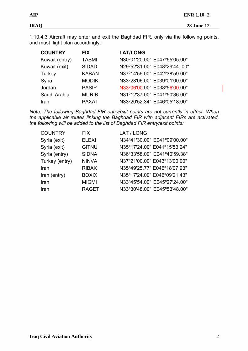
AIP ENR 1.102
IRAQ 28 June 12
Iraq Civil Aviation Authority 2
1.10.4.3 Aircraft may enter and exit the Baghdad FIR, only via the following points, and must flight plan accordingly:
COUNTRY FIX LAT/LONG Kuwait (entry) TASMI N30º01'20.00" E047º55'05.00"
Kuwait (exit) SIDAD N29º52'31.00" E048º29'44. 00"
Turkey KABAN N37º14'56.00" E042º38'59.00"
Syria MODIK N33º28'06.00" E039º01'00.00"
Jordan PASIP N33º06'00.00" E038º56'00.00"
Saudi Arabia MURIB N31º12'37.00" E041º50'36.00"
Iran PAXAT N33º20'52.34" E046º05'18.00"
Note: The following Baghdad FIR entry/exit points are not currently in effect. When the applicable air routes linking the Baghdad FIR with adjacent FIRs are activated, the following will be added to the list of Baghdad FIR entry/exit points:
COUNTRY FIX LAT / LONG
Syria (exit) ELEXI N34º41'30.00" E041º09'00.00"
Syria (exit) GITNU N35º17'24.00" E041º15'53.24"
Syria (entry) SIDNA N36º33'58.00" E041º40'59.38"
Turkey (entry) NINVA N37º21'00.00" E043º13'00.00"
Iran RIBAK N35º49'25.77" E046º18'07.93"
Iran (entry) BOXIX N35º17'24.00" E046º09'21.43"
Iran MIGMI N33º45'54.00" E045º27'24.00"
Iran RAGET N33º30'48.00" E045º53'48.00"
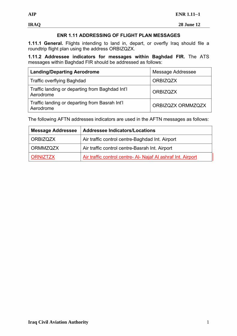
AIP ENR 1.111
IRAQ 28 June 12
Iraq Civil Aviation Authority 1
ENR 1.11 ADDRESSING OF FLIGHT PLAN MESSAGES
1.11.1 General. Flights intending to land in, depart, or overfly Iraq should file a roundtrip flight plan using the address ORBIZQZX.
1.11.2 Addressee indicators for messages within Baghdad FIR. The ATS messages within Baghdad FIR should be addressed as follows:
Landing/Departing Aerodrome Message Addressee
Traffic overflying Baghdad ORBIZQZX
Traffic landing or departing from Baghdad Int’l Aerodrome
ORBIZQZX
Traffic landing or departing from Basrah Int’l Aerodrome
ORBIZQZX ORMMZQZX
The following AFTN addresses indicators are used in the AFTN messages as follows:
Message Addressee Addressee Indicators/Locations
ORBIZQZX Air traffic control centre-Baghdad Int. Airport
ORMMZQZX Air traffic control centre-Basrah Int. Airport
ORNIZTZX Air traffic control centre- Al- Najaf Al ashraf Int. Airport
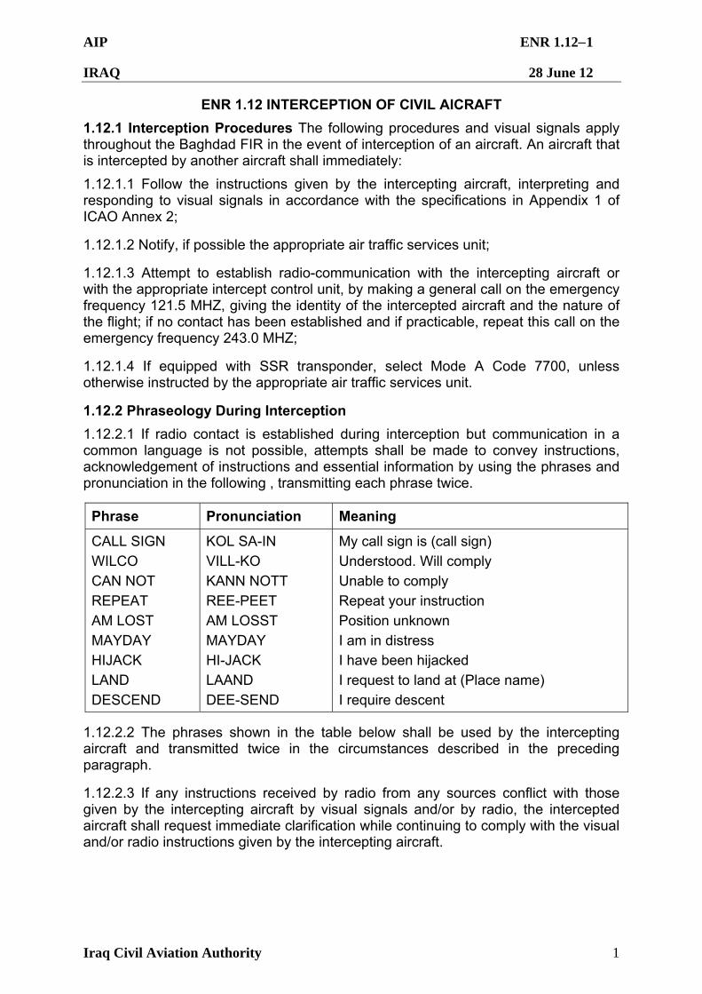
AIP ENR 1.121
IRAQ 28 June 12
Iraq Civil Aviation Authority 1
ENR 1.12 INTERCEPTION OF CIVIL AICRAFT
1.12.1 Interception Procedures The following procedures and visual signals apply throughout the Baghdad FIR in the event of interception of an aircraft. An aircraft that is intercepted by another aircraft shall immediately:
1.12.1.1 Follow the instructions given by the intercepting aircraft, interpreting and responding to visual signals in accordance with the specifications in Appendix 1 of ICAO Annex 2;
1.12.1.2 Notify, if possible the appropriate air traffic services unit;
1.12.1.3 Attempt to establish radio-communication with the intercepting aircraft or with the appropriate intercept control unit, by making a general call on the emergency frequency 121.5 MHZ, giving the identity of the intercepted aircraft and the nature of the flight; if no contact has been established and if practicable, repeat this call on the emergency frequency 243.0 MHZ;
1.12.1.4 If equipped with SSR transponder, select Mode A Code 7700, unless otherwise instructed by the appropriate air traffic services unit.
1.12.2 Phraseology During Interception
1.12.2.1 If radio contact is established during interception but communication in a common language is not possible, attempts shall be made to convey instructions, acknowledgement of instructions and essential information by using the phrases and pronunciation in the following , transmitting each phrase twice.
Phrase Pronunciation Meaning
CALL SIGN
WILCO
CAN NOT
REPEAT
AM LOST
MAYDAY HIJACK
LAND
DESCEND
KOL SA-IN
VILL-KO
KANN NOTT
REE-PEET
AM LOSST
MAYDAY HI-JACK
LAAND
DEE-SEND
My call sign is (call sign)
Understood. Will comply
Unable to comply
Repeat your instruction
Position unknown
I am in distress I have been hijacked
I request to land at (Place name)
I require descent
1.12.2.2 The phrases shown in the table below shall be used by the intercepting aircraft and transmitted twice in the circumstances described in the preceding paragraph.
1.12.2.3 If any instructions received by radio from any sources conflict with those given by the intercepting aircraft by visual signals and/or by radio, the intercepted aircraft shall request immediate clarification while continuing to comply with the visual and/or radio instructions given by the intercepting aircraft.
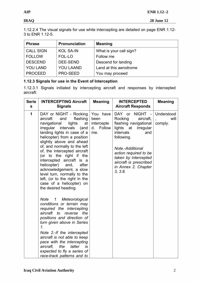
AIP ENR 1.122
IRAQ 28 June 12
Iraq Civil Aviation Authority 2
1.12.2.4 The visual signals for use while intercepting are detailed on page ENR 1.12-3 to ENR 1.12-5.
Phrase Pronunciation Meaning
CALL SIGN
FOLLOW
DESCEND
YOU LAND
PROCEED
KOL SA-IN
FOL-LO
DEE-SEND
YOU LAAND
PRO-SEED
What is your call sign?
Follow me
Descend for landing
Land at this aerodrome
You may proceed
1.12.3 Signals for use in the Event of Interception
1.12.3.1 Signals initiated by intercepting aircraft and responses by intercepted aircraft:
Series
INTERCEPTING Aircraft Signals
Meaning INTERCEPTED Aircraft Responds
Meaning
1 DAY or NIGHT - Rocking aircraft and flashing navigational lights at irregular intervals (and landing lights in case of a helicopter) from a position slightly above and ahead of, and normally to the left of, the intercepted aircraft (or to the right if the intercepted aircraft is a helicopter) and, after acknowledgement, a slow level turn, normally to the left, (or to the right in the case of a helicopter) on the desired heading.
Note 1 Meteorological conditions or terrain may required the intercepting aircraft to reverse the positions and direction of turn given above in Series 1.
Note 2.-If the intercepted aircraft is not able to keep pace with the intercepting aircraft, the latter is expected to fly a series of race-track patterns and to
You have been intercepted. Follow me.
DAY or NIGHT - Rocking aircraft, flashing navigational lights at irregular intervals and following.
Note.-Additional action required to be taken by intercepted aircraft is prescribed in Annex 2. Chapter 3, 3.8.
Understood, will comply.
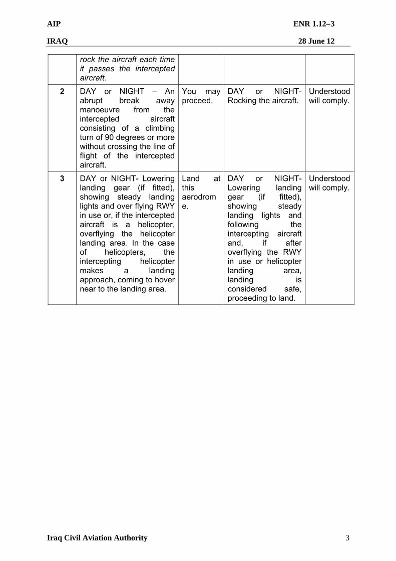
AIP ENR 1.123
IRAQ 28 June 12
Iraq Civil Aviation Authority 3
rock the aircraft each time it passes the intercepted aircraft.
2 DAY or NIGHT – An abrupt break away manoeuvre from the intercepted aircraft consisting of a climbing turn of 90 degrees or more without crossing the line of flight of the intercepted aircraft.
You may proceed.
DAY or NIGHT- Rocking the aircraft.
Understood will comply.
3 DAY or NIGHT- Lowering landing gear (if fitted), showing steady landing lights and over flying RWY in use or, if the intercepted aircraft is a helicopter, overflying the helicopter landing area. In the case of helicopters, the intercepting helicopter makes a landing approach, coming to hover near to the landing area.
Land at this aerodrome.
DAY or NIGHT-Lowering landing gear (if fitted), showing steady landing lights and following the intercepting aircraft and, if after overflying the RWY in use or helicopter landing area, landing is considered safe, proceeding to land.
Understood will comply.
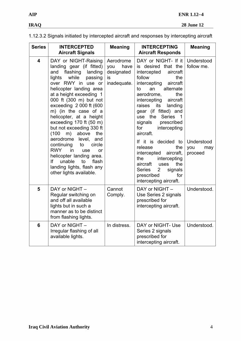
AIP ENR 1.124
IRAQ 28 June 12
Iraq Civil Aviation Authority 4
1.12.3.2 Signals initiated by intercepted aircraft and responses by intercepting aircraft
Series INTERCEPTED Aircraft Signals
Meaning INTERCEPTING Aircraft Responds
Meaning
DAY or NIGHT- If it is desired that the intercepted aircraft follow the intercepting aircraft to an alternate aerodrome, the intercepting aircraft raises its landing gear (if fitted) and use the Series 1 signals prescribed for intercepting aircraft.
Understood follow me.
4 DAY or NIGHT-Raising landing gear (if fitted) and flashing landing lights while passing over RWY in use or helicopter landing area at a height exceeding 1 000 ft (300 m) but not exceeding 2 000 ft (600 m) (in the case of a helicopter, at a height exceeding 170 ft (50 m) but not exceeding 330 ft (100 m) above the aerodrome level, and continuing to circle RWY in use or helicopter landing area. If unable to flash landing lights, flash any other lights available.
Aerodrome you have designated is inadequate.
If it is decided to release the intercepted aircraft, the intercepting aircraft uses the Series 2 signals prescribed for intercepting aircraft.
Understood you may proceed
5 DAY or NIGHT – Regular switching on and off all available lights but in such a manner as to be distinct from flashing lights.
Cannot Comply.
DAY or NIGHT – Use Series 2 signals prescribed for intercepting aircraft.
Understood.
6 DAY or NIGHT – Irregular flashing of all available lights.
In distress. DAY or NIGHT- Use Series 2 signals prescribed for intercepting aircraft.
Understood.
AIP ENR 1.131
IRAQ 28 June 12
Iraq Civil Aviation Authority 1
ENR 1.13 UNLAWFUL INTERFERENCE
1.13.1 General
1.13.1.1 An aircraft which is being subjected to unlawful interference shall endeavour to notify the appropriate ATS unit of this fact, any significant circumstances associated therewith and any deviation from the current flight plan necessitated by the circumstances, in order to enable the ATS unit to give priority to the aircraft and to minimize conflict with other aircraft.
1.13.1.2 The following procedures are intended for use by aircraft when unlawful interference occurs and the aircraft is unable to notify an ATS unit of this fact via normal air-ground voice communications.
1.13.2 Procedures
1.13.2.1 Unless considerations aboard the aircraft dictate otherwise, the pilot-in-command should attempt to continue flying on the assigned track and at the assigned cruising level at least until notification to an ATS unit is possible or the aircraft is within ATC surveillance system coverage.
1.13.2.2 When an aircraft subjected to an act of unlawful interference must depart from its assigned track or its assigned cruising level without being able to make radiotelephony contact with ATS, the pilot-in-command should, whenever possible:
1.13.2.2.1 Attempt to broadcast warnings on the VHF emergency frequency and other appropriate frequencies, unless considerations aboard the aircraft dictate otherwise. Other equipment such as onboard transponders, data links, etc. should also be used when it is advantageous to do so and circumstances permit; and
1.13.2.2.2 Proceed in accordance with applicable special procedures for in-flight contingencies, where such procedures have been established and promulgated in Doc 7030 – Regional Supplementary Procedures; or
1.13.2.2.3 If no applicable regional procedures have been established, proceed at a level which differs from the cruising levels normally used for IFR flight in the area by 2 000 ft (600 m) if above FL 290 or by 1 000 ft (300 m) if below FL 290.
1.13.2.3 An aircraft equipped with an SSR transponder is expected to operate the transponder on Mode A Code 7500 to indicate specifically that it is the subject of unlawful interference. The aircraft may operate the transponder on Mode A Code 7700, to indicate that it is threatened by grave and imminent danger, and requires immediate assistance.
1.13.2.4 Action to be taken by SSR-equipped aircraft which are being subjected to unlawful interference is contained in Annex 11, the PANS-ATM (Doc 4444) and the PANS-OPS (Doc 8168). Action to be taken by CPDLC-equipped aircraft which are being subjected to unlawful interference is contained in Annex 11, the PANS-ATM (Doc 4444), and guidance material on the subject is contained in the Manual of Air Traffic Services Data Link Applications (Doc 9694).
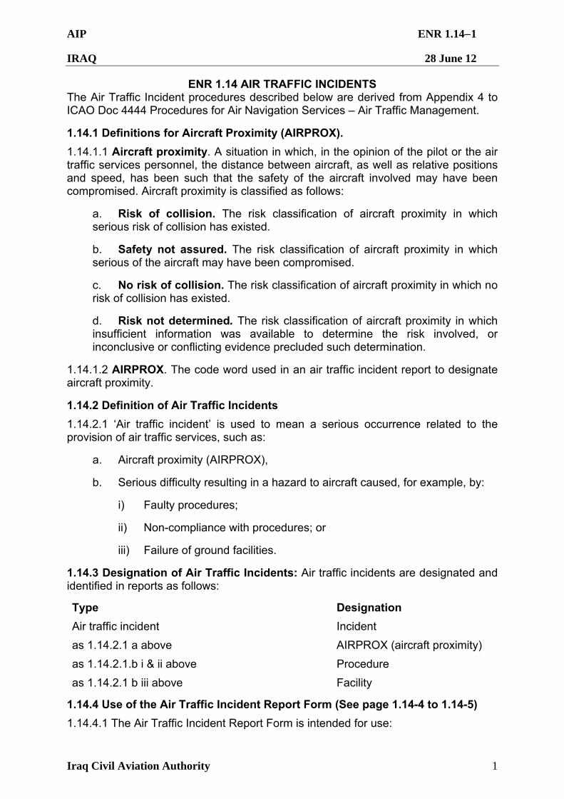
AIP ENR 1.141
IRAQ 28 June 12
Iraq Civil Aviation Authority 1
ENR 1.14 AIR TRAFFIC INCIDENTS The Air Traffic Incident procedures described below are derived from Appendix 4 to ICAO Doc 4444 Procedures for Air Navigation Services – Air Traffic Management.
1.14.1 Definitions for Aircraft Proximity (AIRPROX).
1.14.1.1 Aircraft proximity. A situation in which, in the opinion of the pilot or the air traffic services personnel, the distance between aircraft, as well as relative positions and speed, has been such that the safety of the aircraft involved may have been compromised. Aircraft proximity is classified as follows:
a. Risk of collision. The risk classification of aircraft proximity in which serious risk of collision has existed.
b. Safety not assured. The risk classification of aircraft proximity in which serious of the aircraft may have been compromised.
c. No risk of collision. The risk classification of aircraft proximity in which no risk of collision has existed.
d. Risk not determined. The risk classification of aircraft proximity in which insufficient information was available to determine the risk involved, or inconclusive or conflicting evidence precluded such determination.
1.14.1.2 AIRPROX. The code word used in an air traffic incident report to designate aircraft proximity.
1.14.2 Definition of Air Traffic Incidents
1.14.2.1 ‘Air traffic incident’ is used to mean a serious occurrence related to the provision of air traffic services, such as:
a. Aircraft proximity (AIRPROX),
b. Serious difficulty resulting in a hazard to aircraft caused, for example, by:
i) Faulty procedures;
ii) Non-compliance with procedures; or
iii) Failure of ground facilities.
1.14.3 Designation of Air Traffic Incidents: Air traffic incidents are designated and identified in reports as follows:
Type Designation
Air traffic incident Incident
as 1.14.2.1 a above AIRPROX (aircraft proximity)
as 1.14.2.1.b i & ii above Procedure
as 1.14.2.1 b iii above Facility
1.14.4 Use of the Air Traffic Incident Report Form (See page 1.14-4 to 1.14-5)
1.14.4.1 The Air Traffic Incident Report Form is intended for use:
AIP ENR 1.142
IRAQ 28 June 12
Iraq Civil Aviation Authority 2
a. By a pilot for filing a report on an air traffic incident after arrival or for confirming a report made initially by radio during flight.
Note: The form, if available on board, may also be of use in providing a template for making the initial report in flight.
b. By an ATS unit for recording an air traffic incident report received by radio, telephone or teleprinter.
c. By an ATS Unit for reporting an air traffic incident,
Note: The form may be used as a template for the text of a message to be transmitted over the AFS network.
1.14.5 Reporting Procedures (Including In-Flight Procedures)
1.14.5.1 The following are the procedures to be followed by a pilot who is or has been involved in an incident:
1.14.5.1.1 During flight, use the appropriate air/ground frequency for reporting an incident of major significance, particularly if it involves other aircraft, so as to permit the facts to be ascertained immediately. Inform air traffic control immediately of intentions to file a report to facilitate a timely investigation.
1.14.5.1.2 As promptly as possible after landing, submit a completed Air Traffic Incident Report Form:
1.14.5.1.2.1 For confirming a report of an incident made initially as in 1.14.5.1.1 above, or for making the initial report on such an incident if it had not been possible to report it by radio; or
1.14.5.1.2.2 For reporting an incident which did not require immediate notification at the time of occurrence.
1.14.5.2 An initial report made by radio should contain the following information;
1.14.5.2.1 Aircraft identification;
1.14.5.2.2 Type of incident, e.g. aircraft proximity; and
1.14.5.2.3 The incident details of A, F, I. J, K, L, M, N and O.
1.14.5.3 The confirmatory report on an incident of major significance initially reported by radio or the initial report on any other incident should be submitted to:
Director, Flight Safety, ICAA, E-mail: [email protected]
Director, Air Traffic Services, ICAA, E-mail: [email protected]
Director General, ICAA, E-mail: [email protected]
AIP ENR 1.143
IRAQ 28 June 12
Iraq Civil Aviation Authority 3
1.14.6 Purpose of Reporting and Handling of the Form
1.14.6.1 The purpose of the reporting of aircraft proximity incidents and their investigation is to promote the safety of aircraft. The degree of risk involved in an aircraft proximity incident should be determined in the incident investigation and classified as ‘risk of collision’, ‘safety not assured’, ‘no risk of collision’ or ‘risk not determined’.
1.14.6.2 The purpose of the form is to provide investigation authorities with as complete information on an air traffic incident as soon as possible and to enable them to report back, with the least possible delay to the pilot, operator concerned or ATS Unit, the result of the investigation of the incident and, if appropriate, the remedial action taken.
1.14.7 Air Traffic Incident Report Form.
1.14.7.1 The Air Traffic Incident Report form (ATIRF) is to be used when submitting or receiving a report on an incident involving a civilian aircraft. Shaded boxes contain items to be included in an initial report. The ATIRF number will be assigned by the ICAA Flight Safety agency. Incidents involving military ATC procedures and separation, airfield operations or facilities will be internally reported, investigated and resolved using established Coalition Forces reporting programs. Final report shall be copied to addresses in 1.14.5.3.
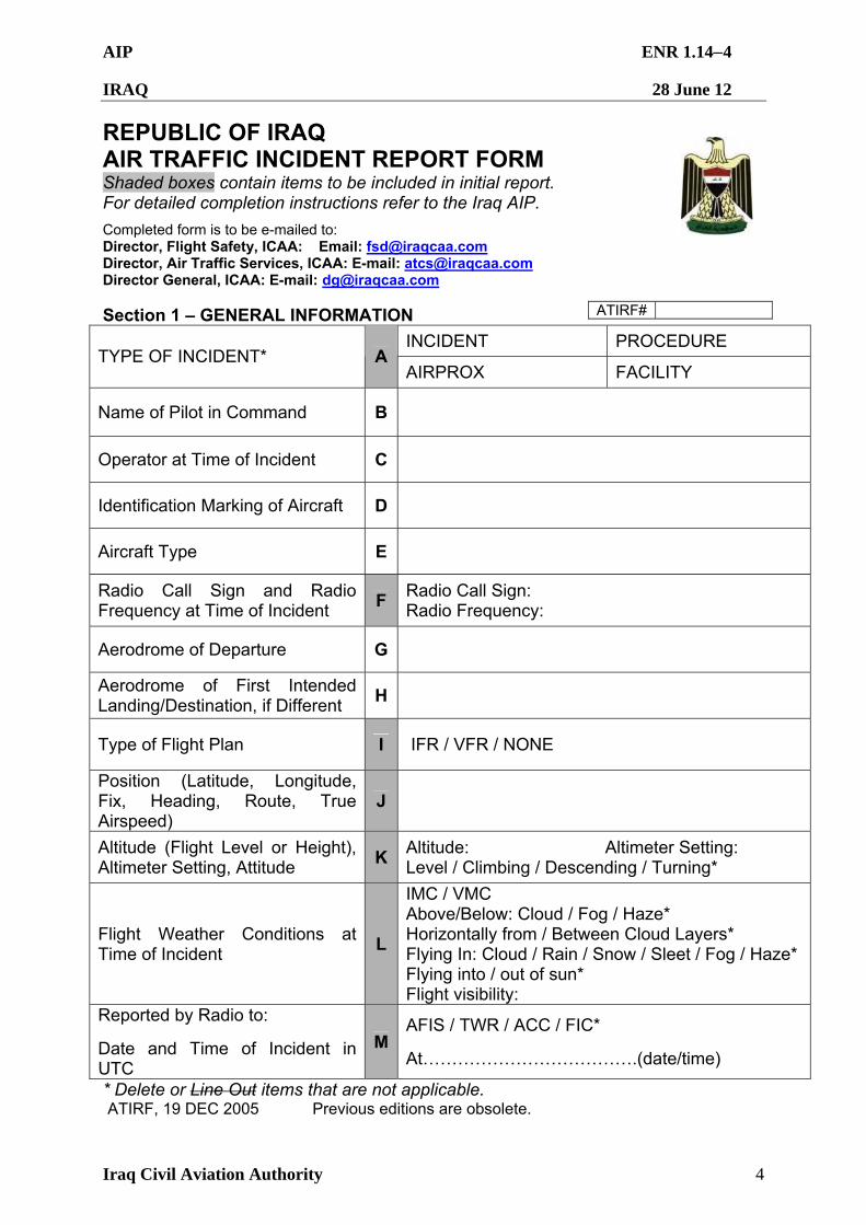
AIP ENR 1.144
IRAQ 28 June 12
Iraq Civil Aviation Authority 4
REPUBLIC OF IRAQ AIR TRAFFIC INCIDENT REPORT FORM Shaded boxes contain items to be included in initial report. For detailed completion instructions refer to the Iraq AIP.
Completed form is to be e-mailed to: Director, Flight Safety, ICAA: Email: [email protected] Director, Air Traffic Services, ICAA: E-mail: [email protected] Director General, ICAA: E-mail: [email protected] Section 1 – GENERAL INFORMATION
INCIDENT PROCEDURE TYPE OF INCIDENT* A
AIRPROX FACILITY
Name of Pilot in Command B
Operator at Time of Incident C
Identification Marking of Aircraft D
Aircraft Type E
Radio Call Sign and Radio Frequency at Time of Incident
F Radio Call Sign: Radio Frequency:
Aerodrome of Departure G
Aerodrome of First Intended Landing/Destination, if Different
H
Type of Flight Plan I IFR / VFR / NONE
Position (Latitude, Longitude, Fix, Heading, Route, True Airspeed)
J
Altitude (Flight Level or Height), Altimeter Setting, Attitude
K Altitude: Altimeter Setting: Level / Climbing / Descending / Turning*
Flight Weather Conditions at Time of Incident
L
IMC / VMC Above/Below: Cloud / Fog / Haze* Horizontally from / Between Cloud Layers* Flying In: Cloud / Rain / Snow / Sleet / Fog / Haze* Flying into / out of sun* Flight visibility:
Reported by Radio to:
Date and Time of Incident in UTC
MAFIS / TWR / ACC / FIC*
At……………………………….(date/time)
* Delete or Line Out items that are not applicable. ATIRF, 19 DEC 2005 Previous editions are obsolete.
ATIRF#
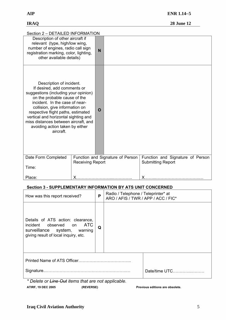
AIP ENR 1.145
IRAQ 28 June 12
Iraq Civil Aviation Authority 5
Section 2 – DETAILED INFORMATION Description of other aircraft if relevant (type, high/low wing,
number of engines, radio call sign registration marking, color, lighting,
other available details)
N
Description of incident. If desired, add comments or
suggestions (including your opinion) on the probable cause of the incident. In the case of near-collision, give information on
respective flight paths, estimated vertical and horizontal sighting and
miss distances between aircraft, and avoiding action taken by either
aircraft.
O
Date Form Completed Time: Place:
Function and Signature of Person Receiving Report X……………………...…………..
Function and Signature of Person Submitting Report X……...………………………….…
Section 3 - SUPPLEMENTARY INFORMATION BY ATS UNIT CONCERNED
How was this report received? P Radio / Telephone / Teleprinter* at ARO / AFIS / TWR / APP / ACC / FIC*
Details of ATS action: clearance, incident observed on ATC surveillance system, warning giving result of local inquiry, etc.
Q
Printed Name of ATS Officer……………………………….. Signature..………………………………………………….…
Date/time UTC…………..………
* Delete or Line Out items that are not applicable.
ATIRF, 19 DEC 2005 (REVERSE) Previous editions are obsolete.
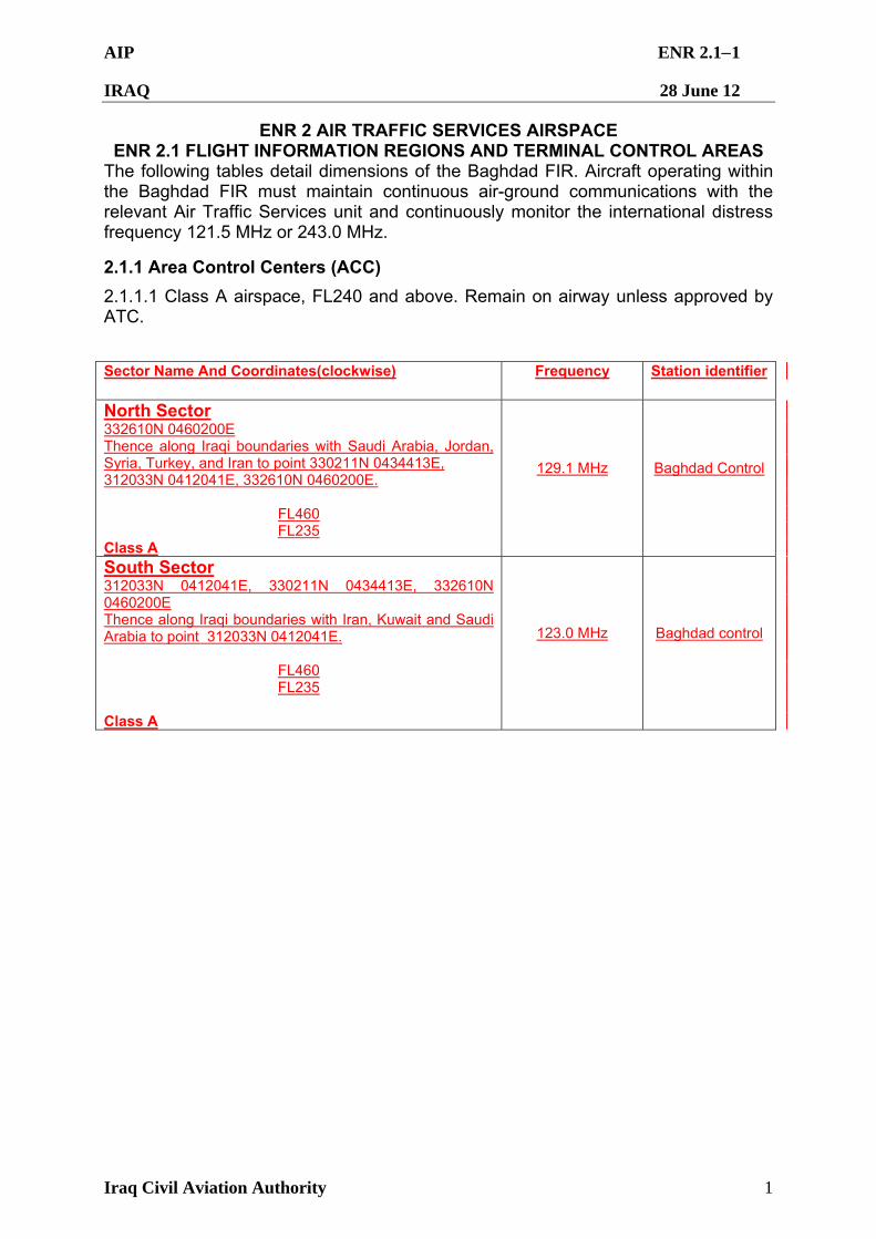
AIP ENR 2.11
IRAQ 28 June 12
Iraq Civil Aviation Authority 1
ENR 2 AIR TRAFFIC SERVICES AIRSPACE ENR 2.1 FLIGHT INFORMATION REGIONS AND TERMINAL CONTROL AREAS
The following tables detail dimensions of the Baghdad FIR. Aircraft operating within the Baghdad FIR must maintain continuous air-ground communications with the relevant Air Traffic Services unit and continuously monitor the international distress frequency 121.5 MHz or 243.0 MHz.
2.1.1 Area Control Centers (ACC)
2.1.1.1 Class A airspace, FL240 and above. Remain on airway unless approved by ATC.
Sector Name And Coordinates(clockwise)
Frequency
Station identifier
North Sector 332610N 0460200E Thence along Iraqi boundaries with Saudi Arabia, Jordan, Syria, Turkey, and Iran to point 330211N 0434413E, 312033N 0412041E, 332610N 0460200E.
FL460 FL235
Class A
129.1 MHz
Baghdad Control
South Sector 312033N 0412041E, 330211N 0434413E, 332610N 0460200E Thence along Iraqi boundaries with Iran, Kuwait and Saudi Arabia to point 312033N 0412041E.
FL460 FL235
Class A
123.0 MHz
Baghdad control

AIP ENR 2.12
IRAQ 28 June 12
Iraq Civil Aviation Authority 2
Baghdad FIR – High-Altitude Sectors (FL 235-FL460)
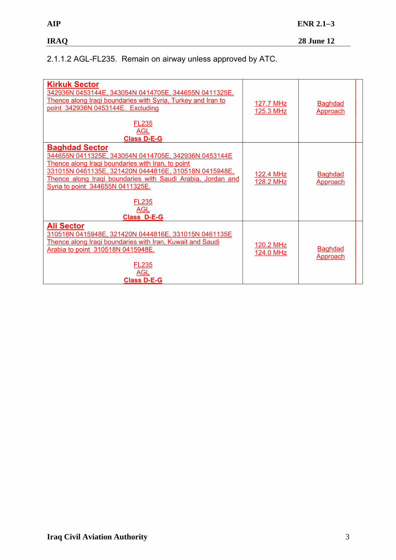
AIP ENR 2.13
IRAQ 28 June 12
Iraq Civil Aviation Authority 3
2.1.1.2 AGL-FL235. Remain on airway unless approved by ATC.
Kirkuk Sector 342936N 0453144E, 343054N 0414705E, 344655N 0411325E, Thence along Iraqi boundaries with Syria, Turkey and Iran to point 342936N 0453144E. Excluding
FL235 AGL
Class D-E-G
127.7 MHz 125.3 MHz
Baghdad Approach
Baghdad Sector 344655N 0411325E, 343054N 0414705E, 342936N 0453144E Thence along Iraqi boundaries with Iran, to point 331015N 0461135E, 321420N 0444816E, 310518N 0415948E, Thence along Iraqi boundaries with Saudi Arabia, Jordan and Syria to point 344655N 0411325E.
FL235 AGL
Class D-E-G
122.4 MHz 128.2 MHz
Baghdad Approach
Ali Sector 310518N 0415948E, 321420N 0444816E, 331015N 0461135E Thence along Iraqi boundaries with Iran, Kuwait and Saudi Arabia to point 310518N 0415948E.
FL235 AGL
Class D-E-G
120.2 MHz 124.0 MHz
Baghdad Approach
AIP ENR 2.14
IRAQ 28 June 12
Iraq Civil Aviation Authority 4
Baghdad FIR – Low Level Sectors AGL- FL 235
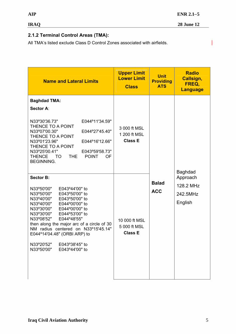
AIP ENR 2.15
IRAQ 28 June 12
Iraq Civil Aviation Authority 5
2.1.2 Terminal Control Areas (TMA):
All TMA’s listed exclude Class D Control Zones associated with airfields.
Name and Lateral Limits
Upper Limit Lower Limit
Class
Unit Providing
ATS
Radio Callsign, FREQ,
Language
Baghdad TMA:
Sector A: N33º30'36.73" E044º11'34.59" THENCE TO A POINT N33º07'00.30" E044º27'45.40" THENCE TO A POINT N33º01'23.96" E044º16'12.66" THENCE TO A POINT N33º25'00.41" E043º59'58.73" THENCE TO THE POINT OF BEGINNING.
3 000 ft MSL 1 200 ft MSL
Class E
Sector B: N33º50'00" E043º44'00" to N33º50'00" E043º50'00" to N33º40'00" E043º50'00" to N33º40'00" E044º00'00" to N33º30'00" E044º00'00" to N33º30'00" E044º53'00" to N33º08'52" E044º48'55" then along the major arc of a circle of 30 NM radius centered on N33º15'45.14" E044º14'04.48" (ORBI ARP) to N33º20'52" E043º38'45" to N33º50'00" E043º44'00" to
10 000 ft MSL 5 000 ft MSL
Class E
Balad
ACC
Baghdad Approach
128.2 MHz
242.5MHz
English
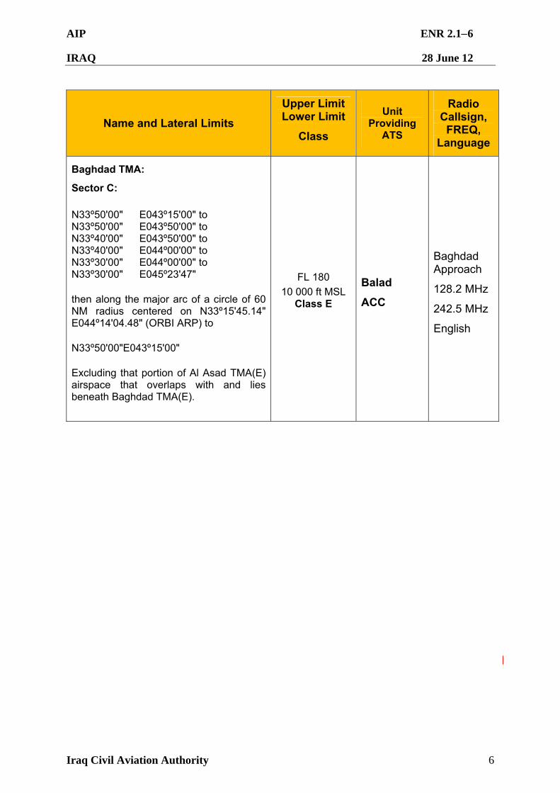
AIP ENR 2.16
IRAQ 28 June 12
Iraq Civil Aviation Authority 6
Name and Lateral Limits
Upper Limit Lower Limit
Class
Unit Providing
ATS
Radio Callsign, FREQ,
Language
Baghdad TMA:
Sector C: N33º50'00" E043º15'00" to N33º50'00" E043º50'00" to N33º40'00" E043º50'00" to N33º40'00" E044º00'00" to N33º30'00" E044º00'00" to N33º30'00" E045º23'47" then along the major arc of a circle of 60 NM radius centered on N33º15'45.14" E044º14'04.48" (ORBI ARP) to N33º50'00"E043º15'00" Excluding that portion of Al Asad TMA(E) airspace that overlaps with and lies beneath Baghdad TMA(E).
FL 180 10 000 ft MSL
Class E
Balad
ACC
Baghdad Approach
128.2 MHz
242.5 MHz
English
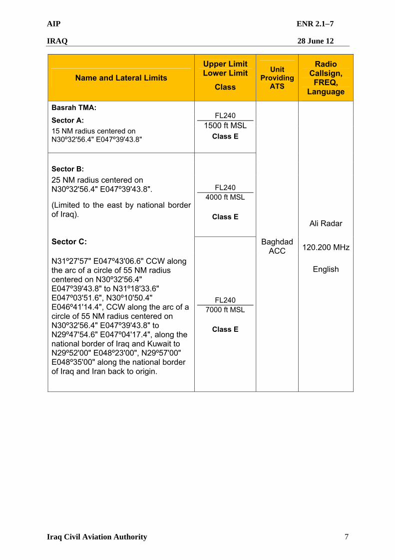
AIP ENR 2.17
IRAQ 28 June 12
Iraq Civil Aviation Authority 7
Name and Lateral Limits
Upper Limit Lower Limit
Class
Unit Providing
ATS
Radio Callsign, FREQ,
Language
Basrah TMA:
Sector A: 15 NM radius centered on N30º32'56.4" E047º39'43.8"
FL240 1500 ft MSL
Class E
Sector B:
25 NM radius centered on N30º32'56.4" E047º39'43.8".
(Limited to the east by national border of Iraq).
FL240 4000 ft MSL
Class E
Sector C:
N31º27'57" E047º43'06.6" CCW along the arc of a circle of 55 NM radius centered on N30º32'56.4" E047º39'43.8" to N31º18'33.6" E047º03'51.6", N30º10'50.4" E046º41'14.4", CCW along the arc of a circle of 55 NM radius centered on N30º32'56.4" E047º39'43.8" to N29º47'54.6" E047º04'17.4", along the national border of Iraq and Kuwait to N29º52'00" E048º23'00", N29º57'00" E048º35'00" along the national border of Iraq and Iran back to origin.
FL240 7000 ft MSL
Class E
Baghdad ACC
Ali Radar
120.200 MHz
English
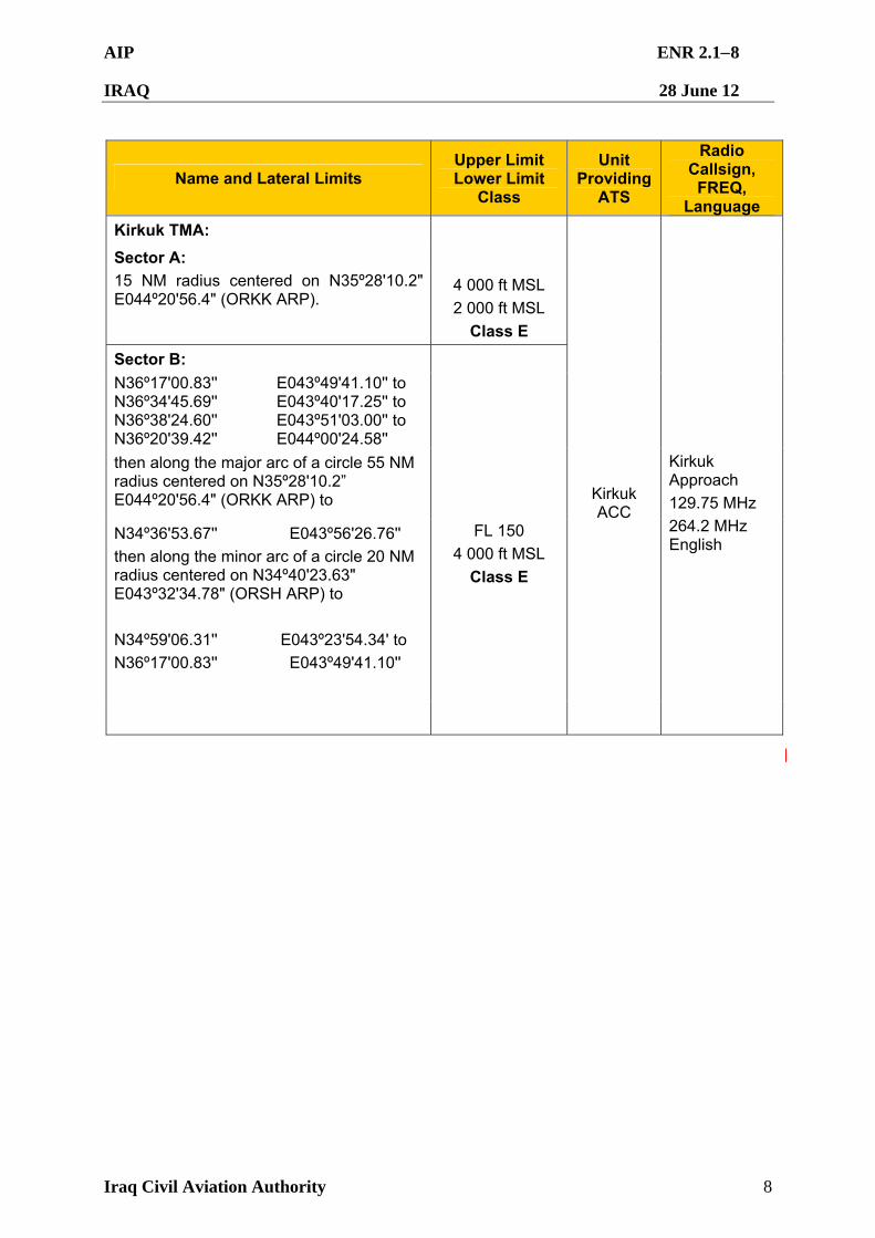
AIP ENR 2.18
IRAQ 28 June 12
Iraq Civil Aviation Authority 8
Name and Lateral Limits Upper Limit Lower Limit
Class
Unit Providing
ATS
Radio Callsign,
FREQ, Language
Kirkuk TMA:
Sector A: 15 NM radius centered on N35º28'10.2" E044º20'56.4" (ORKK ARP).
4 000 ft MSL 2 000 ft MSL
Class E
Sector B: N36º17'00.83'' N36º34'45.69'' N36º38'24.60'' N36º20'39.42''
E043º49'41.10'' to E043º40'17.25'' to E043º51'03.00'' to E044º00'24.58''
then along the major arc of a circle 55 NM radius centered on N35º28'10.2” E044º20'56.4" (ORKK ARP) to
N34º36'53.67'' E043º56'26.76''
then along the minor arc of a circle 20 NM radius centered on N34º40'23.63" E043º32'34.78" (ORSH ARP) to
N34º59'06.31'' E043º23'54.34' to
N36º17'00.83'' E043º49'41.10''
FL 150 4 000 ft MSL
Class E
Kirkuk ACC
Kirkuk Approach 129.75 MHz 264.2 MHz English
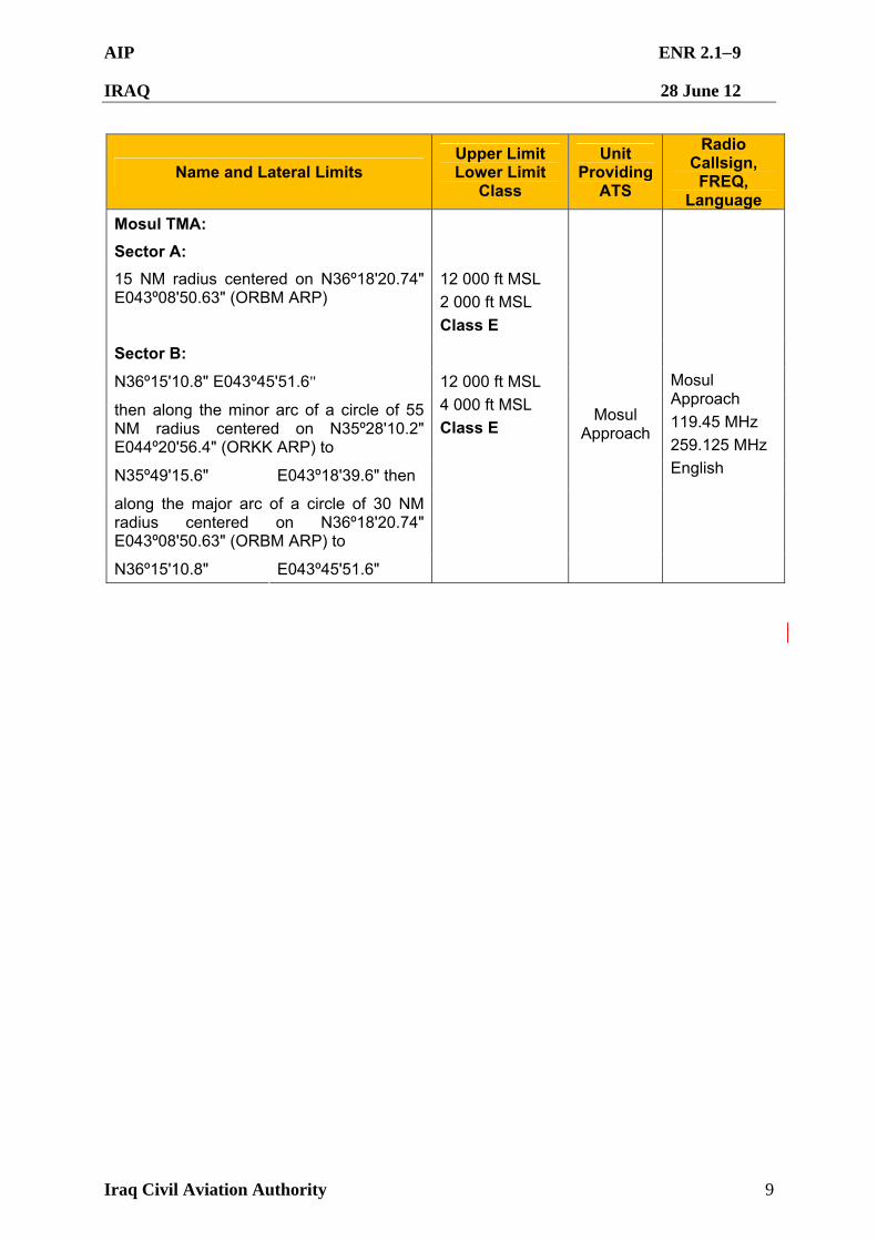
AIP ENR 2.19
IRAQ 28 June 12
Iraq Civil Aviation Authority 9
Name and Lateral Limits Upper Limit Lower Limit
Class
Unit Providing
ATS
Radio Callsign,
FREQ, Language
Mosul TMA:
Sector A:
15 NM radius centered on N36º18'20.74" E043º08'50.63" (ORBM ARP)
12 000 ft MSL 2 000 ft MSL Class E
Sector B:
N36º15'10.8" E043º45'51.6"
then along the minor arc of a circle of 55 NM radius centered on N35º28'10.2" E044º20'56.4" (ORKK ARP) to
N35º49'15.6" E043º18'39.6" then
along the major arc of a circle of 30 NM radius centered on N36º18'20.74" E043º08'50.63" (ORBM ARP) to
N36º15'10.8" E043º45'51.6"
12 000 ft MSL 4 000 ft MSL Class E
Mosul Approach
Mosul Approach 119.45 MHz 259.125 MHz English
AIP ENR 2.110
IRAQ 28 June 12
Iraq Civil Aviation Authority 10
Baghdad FIR – Terminal Control Areas (TMA)
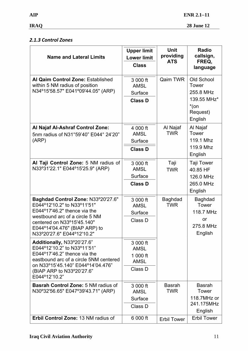
AIP ENR 2.111
IRAQ 28 June 12
Iraq Civil Aviation Authority 11
2.1.3 Control Zones
Name and Lateral Limits
Upper limit
Lower limit
Class
Unit providing
ATS
Radio callsign, FREQ,
language
Al Qaim Control Zone: Established within 5 NM radius of position N34º15'58.57" E041º09'44.05" (ARP)
3 000 ft AMSL
Surface
Class D
Qaim TWR Old School Tower
255.8 MHz
139.55 MHz*
*(on Request)
English
Al Najaf Al-Ashraf Control Zone: 5nm radius of N31°59’40” E044° 24’20” (ARP)
4 000 ft AMSL
Surface
Class D
Al Najaf TWR
Al Najaf Tower
119.1 Mhz
119.9 Mhz
English
Al Taji Control Zone: 5 NM radius of N33º31'22.1" E044º15'25.9" (ARP)
3 000 ft AMSL
Surface
Class D
Taji TWR
Taji Tower 40.85 HF
126.0 MHz
265.0 MHz
English
Baghdad Control Zone: N33º20'27.6" E044º12'10.2" to N33º11'51" E044º17'46.2" thence via the westbound arc of a circle 5 NM centered on N33º15'45.140" E044º14'04.476" (BIAP ARP) to N33º20'27.6" E044º12'10.2"
3 000 ft AMSL
Surface
Class D
Additionally, N33º20’27.6” E044º12’10.2” to N33º11’51” E044º17’46.2” thence via the eastbound arc of a circle 5NM centered on N33º15’45.140” E044º14’04.476” (BIAP ARP to N33º20’27.6” E044º12’10.2”
3 000 ft AMSL
1 000 ft AMSL
Class D
Baghdad TWR
Baghdad Tower
118.7 MHz
or
275.8 MHz
English
Basrah Control Zone: 5 NM radius of N30º32'56.65" E047º39'43.71" (ARP)
3 000 ft AMSL
Surface
Class D
Basrah TWR
Basrah Tower
118.7MHz or 241.175MHz
English
Erbil Control Zone: 13 NM radius of 6 000 ft Erbil Tower Erbil Tower
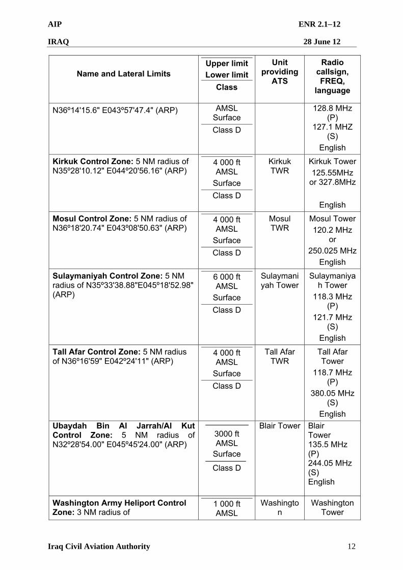
AIP ENR 2.112
IRAQ 28 June 12
Iraq Civil Aviation Authority 12
Name and Lateral Limits
Upper limit
Lower limit
Class
Unit providing
ATS
Radio callsign, FREQ,
language
N36º14'15.6" E043º57'47.4" (ARP) AMSL Surface
Class D
128.8 MHz (P)
127.1 MHZ (S)
English
Kirkuk Control Zone: 5 NM radius of N35º28'10.12" E044º20'56.16" (ARP)
4 000 ft AMSL
Surface
Class D
Kirkuk TWR
Kirkuk Tower
125.55MHz or 327.8MHz
English
Mosul Control Zone: 5 NM radius of N36º18'20.74" E043º08'50.63" (ARP)
4 000 ft AMSL
Surface
Class D
Mosul TWR
Mosul Tower
120.2 MHz or
250.025 MHz
English
Sulaymaniyah Control Zone: 5 NM radius of N35º33'38.88"E045º18'52.98" (ARP)
6 000 ft AMSL
Surface
Class D
Sulaymaniyah Tower
Sulaymaniyah Tower
118.3 MHz (P)
121.7 MHz (S)
English
Tall Afar Control Zone: 5 NM radius of N36º16'59" E042º24'11" (ARP)
4 000 ft AMSL
Surface
Class D
Tall Afar TWR
Tall Afar Tower
118.7 MHz (P)
380.05 MHz (S)
English
Ubaydah Bin Al Jarrah/Al Kut Control Zone: 5 NM radius of N32º28'54.00" E045º45'24.00" (ARP)
3000 ft AMSL
Surface
Class D
Blair Tower
Blair Tower 135.5 MHz (P) 244.05 MHz (S) English
Washington Army Heliport Control Zone: 3 NM radius of
1 000 ft AMSL
Washington
Washington Tower
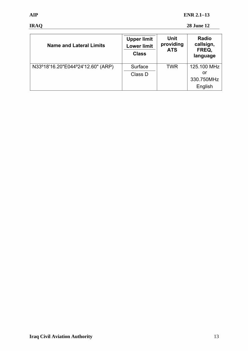
AIP ENR 2.113
IRAQ 28 June 12
Iraq Civil Aviation Authority 13
Name and Lateral Limits
Upper limit
Lower limit
Class
Unit providing
ATS
Radio callsign, FREQ,
language
N33º18'16.20"E044º24'12.60" (ARP) Surface
Class D
TWR 125.100 MHz or
330.750MHz
English
AIP ENR 2.114
IRAQ 28 June 12
Iraq Civil Aviation Authority 14
Baghdad FIR – Control Zones
AIP ENR 3.11
IRAQ 28 June 12
Iraq Civil Aviation Authority
ENR 3 ATS ROUTES
ENR 3.1 LOWER ATS ROUTES Baghdad FIR does not have a separate lower ATS route structure. See descriptions at ENR 3.3.1 and map at ENR 3.3.2.
AIP ENR 3.2-1
IRAQ 28 June 12
Iraq Civil Aviation Authority
ENR 3.2 UPPER ATS ROUTES Baghdad FIR does not have a separate upper ATS route structure. See descriptions at ENR 3.3.1 and map at ENR 3.3.2
AIP ENR 3.31
IRAQ 28 June 12
Iraq Civil Aviation Authority 1
ENR 3.3 AREA NAVIGATION ROUTES
3.3.1 Rules Applicable to Air Routes in Baghdad FIR
3.3.1.1 A diagram of the ATS routes within the Baghdad FIR is at ENR 3.3.2. All ATS routes in the Baghdad FIR are area navigation routes (RNAV) designated for aircraft approved for RNAV5 operations. Aircraft must be capable of maintaining RNAV5 without reliance on ground based navigation aid updates in the Baghdad FIR.
3.3.1.2 The communications procedures for entering Baghdad FIR are as follows:
3.3.1.2.1 Entering from Turkey:
a. At or below FL 230 and prior to entering the Baghdad FIR contact Kirkuk Center on 127.7 VHF or 237.325 UHF. If no response, proceed on last assigned routing and altitude while attempting contact every 10 NM.
b. At or above FL 240 and prior to entering the Baghdad FIR contact Baghdad Center (North) on 129.1 MHz VHF. If no response, proceed on last assigned routing and altitude while attempting contact every 10 NM.
3.3.1.2.2 Entering from Jordan or Syria:
a. At or below FL 230 and prior to entering the Baghdad FIR contact Balad Center 128.2 VHF or 242.5 UHF. If no response, proceed on last assigned routing and altitude while attempting contact every 10 NM.
b. At or above FL 240 and prior to entering the Baghdad FIR contact Baghdad Center (North) 129.1 MHz VHF. If no response, proceed on last assigned routing and altitude while attempting contact every 10 NM.
3.3.1.2.3 Entering from Saudi Arabia or Iran:
a. At or below FL 230 and prior to entering the Baghdad FIR contact Balad Center 128.2 VHF or 274.575 UHF. If no response, proceed on last assigned routing and altitude while attempting contact every 10 NM.
b. At or above FL 240 and prior to entering the Baghdad FIR contact Baghdad Center (South) 123.0 or 127.1 MHz VHF. If no response, proceed on last assigned routing and altitude while attempting contact every 10 NM.
3.3.1.2.4 Entering from Kuwait:
a. FL230 and below: Prior to entering Baghdad FIR contact Ali Radar on 120.2 MHz. If radio contact can not be established successfully, proceed on last assigned routing and altitude while attempting contact every 10 NM.
b. FL240 and above: Prior to entering Baghdad FIR contact Baghdad Control on 123.0 MHz. If radio contact can not be established successfully, proceed on last assigned routing and altitude while attempting contact every 10 NM.
Note: Eastbound flights should not expect radio contact with Baghdad ACC until passing RAPLU, GIBUX or RALTI unless above FL 180. In the event of an emergency requiring descent in an area of poor radio coverage, pilots are to attempt
AIP ENR 3.32
IRAQ 28 June 12
Iraq Civil Aviation Authority 2
to contact any air traffic unit on a published frequency and/or the emergency frequencies.
3.3.1.3 Area Navigation Route descriptions.
Reporting/ Waypoint ID/ Coordinates
Compulsory
As Requested
Magnetic Track
(↑/↓)
Distance (NM)
Levels MAA
MEA
MOCA’s
Airspace Class
Route Width (NM)
Remarks
ATS Route G795 Entire Airway Uni-Directional (Northbound)
TASMI N30º01'20.00" E047º55'05.00" 14000 ft
335 32 8000 ft
1600 ft 8000 ft
BSR N30º31'32.40" E047º41'12.00" 8000 ft
Ali Radar
120.200 MHz
below
ATS Route M203
Class A
Entire Airway Uni-Directional (East bound)
PUSTO N33º21'00.00" E042º45'00.00"
117 43
15000 ft
1700 ft
SILBO N32º59'00.00" E043º29'00.00"
118 70 15000 ft
1700 ft
LOVEK N32º22'08.40" E044º40'01.20"
FL 460
FL 240
Baghdad Center
129.1 MHz
123.0 MHz
114 80.3 15000 ft
1500 ft Class E
SETSA N31º45'00.00" E046º04'00.00"
114 50.9 15000 ft
1500 ft
ILMAP N31º21'33.00" E046º57'02.00"
Below FL 240
FL 150
10
Ali Radar
120.200 MHz
Reporting/ Waypoint ID/Coordinates
Compulsory
As Requested
Magnetic Track
(↑/↓)
Distance (NM)
Levels MAA
MEA
MOCA’s
Airspace Class
Route Width (NM)
Remarks
AIP ENR 3.33
IRAQ 28 June 12
Iraq Civil Aviation Authority 3
ATS Route B411 Class A/E Entire Airway Bi-
Directional
MURIB N31º12'37.00" E041º50'36.00" 15000 ft
240/60 66.2 2500 ft Class A
FL460 to FL240
RALTI N31º42'08.40" E043º00'00.60
15000 ft
241/61 48.4 2100 ft
ELODI N32º02'56.28" E043º51'25.96
15000 ft
242/62 45.4 2100 ft
LOVEK N32º22'08.40" E044º40'01.20"
15000 ft
229/49 26.7 2300 ft
Baghdad Center
123.0 MHz
LONOR N32º38'38.63" E045º04'58.48"
229/49 17.7 15000 ft Class E
NOLDO N32º49'32.40" E045º21'29.40" 2300 ft Below
FL 240
FL 150
226/46 6.2
New Segment
PAPUS N32º53'34.06" E045º27'06.55"
PAXAT N33º20'52.34" E046º05'18.00" 226/46 42.1
New Segment
10
Reporting/ Waypoint ID/ Coordinates
Compulsory
As Requested
Magnetic Track
(↑/↓)
Distance (NM)
Levels MAA
MEA
MOCA’s
Airspace Class
Route Width (NM)
Remarks
ATS Route UM860 Class A
KABAN N37º14'56.00" E042º38'59.00"
FL 460
FL 240
151/331 31.4 15000ft 8000 ft
Uni-Directional
(Northbound)
EMIDO N36º46'12.29" E042º54'53.53"
151/331 44.2 15000ft 8000 ft
Uni –Directional
(Northbound)
SEVKU N36º05'48.02" E043º17'15.84"
152/332 52.5 15000ft 3900 ft
10
Uni-Directional
(Northbound)
AIP ENR 3.34
IRAQ 28 June 12
Iraq Civil Aviation Authority 4
UMESA N35º17'41.49" E043º43'06.89"
332
52.0
15000ft 2200 ft
Uni-Directional (Northbound)
TAGRU N34º29'58.95" E044º08'16.67"
334 62.7 15000ft 2200 ft
PUTSI N33º32'00.00" E044º37'00.00"
Uni-Directional (Northbound)
338 12.7 15000ft 2300 ft
Uni-Directional (Northbound)
ITOVA N33º19'50.91" E044º41'28.97"
339 7.2 15000ft 2300 ft
Uni-Directional (Northbound)
SEPTU N33º13'.00" E044º44'00.00"
329 38.6 15000ft 1500 ft
Uni-Directional (Northbound)
LONOR N32º38'38.63" E045º04'58.48"
335 25.4 15000 ft Uni-Directional (Northbound)
ULIMA N32º15'00.00" E045º16'00.00"
334 29.6 15000 ft Class E Uni-Directional (Northbound)
ITBIT N31º47'35.20" E045º29'16.57" Below FL 240
FL 150
153/333 81.5 New Segment
Bi-Directional
RUGIR N30º32'19.06" E046º06'18.20"
ATS Route L126 Class E Entire Airway Bi-Directional
ILM N33º34'42.30" E046º24'55.40"
280/100 48.9 13000 ft
Class E Below FL240 to FL 150
Balad Center
123.525 MHz
MIGMI N33º45'54.00" E045º27'24.00"
287/107 40.3 New Segment
SIGNI N34º00'07.80" E044º42'01.20"
284/104 40.8 15000 ft 1 600 ft
10
.
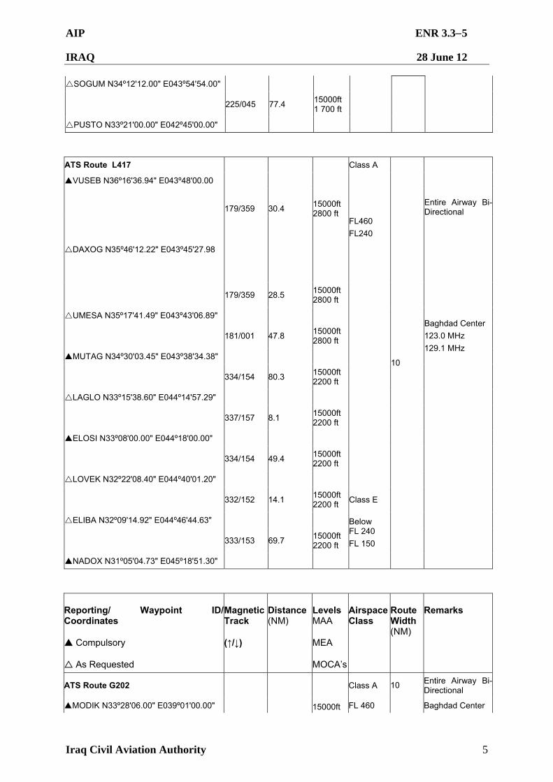
AIP ENR 3.35
IRAQ 28 June 12
Iraq Civil Aviation Authority 5
SOGUM N34º12'12.00" E043º54'54.00"
225/045 77.4 15000ft 1 700 ft
PUSTO N33º21'00.00" E042º45'00.00"
ATS Route L417 Class A
VUSEB N36º16'36.94" E043º48'00.00
179/359
30.4
DAXOG N35º46'12.22" E043º45'27.98
15000ft 2800 ft
FL460
FL240
Entire Airway Bi-Directional
179/359 28.5 15000ft 2800 ft
UMESA N35º17'41.49" E043º43'06.89"
181/001 47.8 15000ft 2800 ft
MUTAG N34º30'03.45" E043º38'34.38"
Baghdad Center
123.0 MHz
129.1 MHz
334/154 80.3 15000ft 2200 ft
LAGLO N33º15'38.60" E044º14'57.29"
337/157 8.1 15000ft 2200 ft
ELOSI N33º08'00.00" E044º18'00.00"
334/154 49.4 15000ft 2200 ft
LOVEK N32º22'08.40" E044º40'01.20"
332/152 14.1 15000ft 2200 ft
Class E
ELIBA N32º09'14.92" E044º46'44.63"
333/153 69.7 15000ft 2200 ft
Below FL 240
FL 150
NADOX N31º05'04.73" E045º18'51.30"
10
Reporting/ Waypoint ID/Coordinates
Compulsory
As Requested
Magnetic Track
(↑/↓)
Distance (NM)
Levels MAA
MEA
MOCA’s
Airspace Class
Route Width (NM)
Remarks
ATS Route G202 Class A Entire Airway Bi-Directional
MODIK N33º28'06.00" E039º01'00.00" 15000ft FL 460
10
Baghdad Center
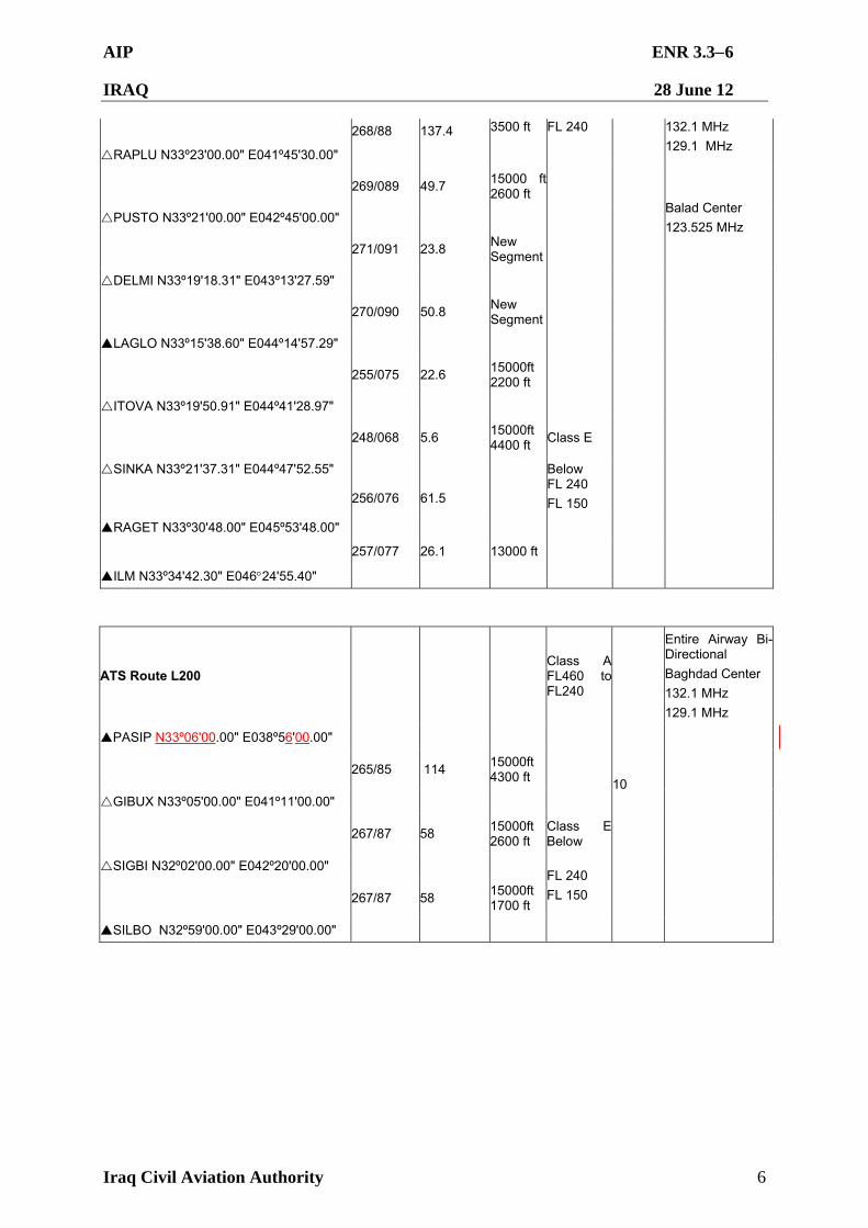
AIP ENR 3.36
IRAQ 28 June 12
Iraq Civil Aviation Authority 6
268/88 137.4 3500 ft FL 240
RAPLU N33º23'00.00" E041º45'30.00"
132.1 MHz
129.1 MHz
269/089 49.7 15000 ft 2600 ft
PUSTO N33º21'00.00" E042º45'00.00"
271/091 23.8 New Segment
Balad Center
123.525 MHz
DELMI N33º19'18.31" E043º13'27.59"
270/090 50.8 New Segment
LAGLO N33º15'38.60" E044º14'57.29"
255/075 22.6 15000ft 2200 ft
ITOVA N33º19'50.91" E044º41'28.97"
248/068 5.6 15000ft 4400 ft
Class E
SINKA N33º21'37.31" E044º47'52.55"
256/076 61.5
Below FL 240
FL 150
RAGET N33º30'48.00" E045º53'48.00"
257/077 26.1 13000 ft
ILM N33º34'42.30" E04624'55.40"
ATS Route L200 Class A FL460 to FL240
Entire Airway Bi-Directional
Baghdad Center
132.1 MHz
129.1 MHz
PASIP N33º06'00.00" E038º56'00.00"
265/85 114 15000ft 4300 ft
GIBUX N33º05'00.00" E041º11'00.00"
267/87 58 15000ft 2600 ft
Class E Below
SIGBI N32º02'00.00" E042º20'00.00"
267/87 58 15000ft 1700 ft
FL 240
FL 150
SILBO N32º59'00.00" E043º29'00.00"
10
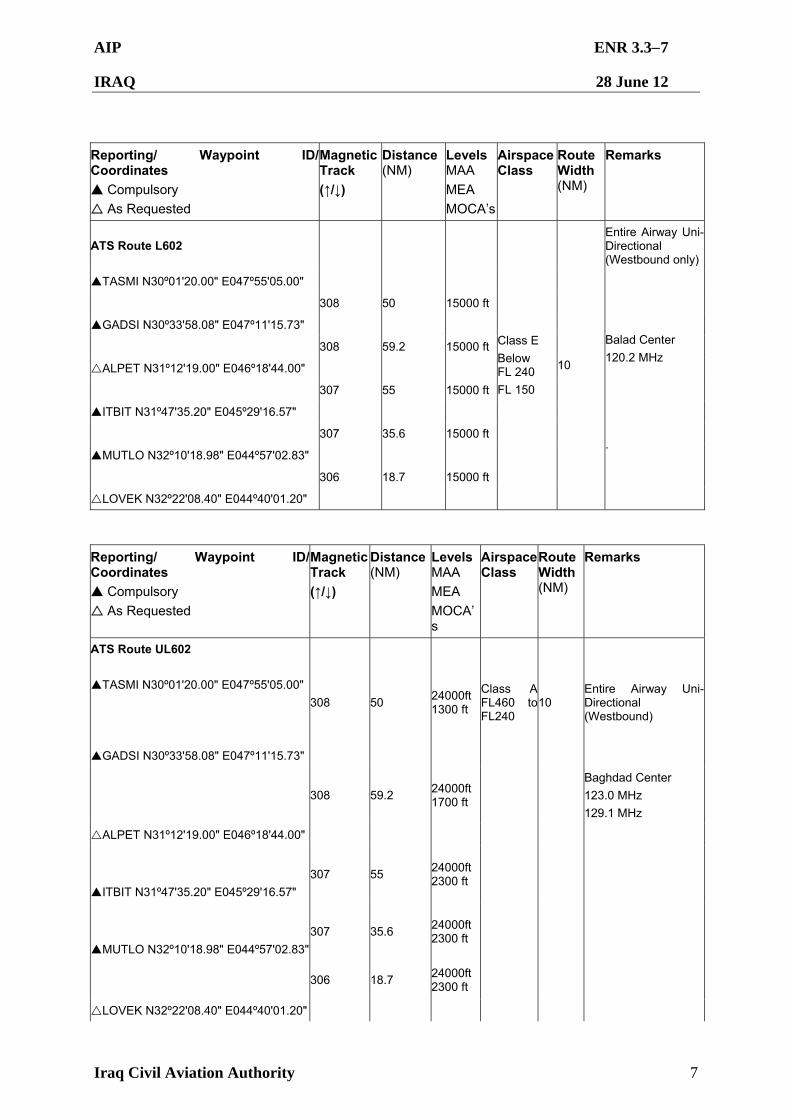
AIP ENR 3.37
IRAQ 28 June 12
Iraq Civil Aviation Authority 7
Reporting/ Waypoint ID/Coordinates
Compulsory
As Requested
Magnetic Track
(↑/↓)
Distance (NM)
Levels MAA
MEA
MOCA’s
Airspace Class
Route Width (NM)
Remarks
ATS Route L602 Entire Airway Uni-Directional (Westbound only)
TASMI N30º01'20.00" E047º55'05.00"
308 50 15000 ft
GADSI N30º33'58.08" E047º11'15.73"
308 59.2 15000 ft
ALPET N31º12'19.00" E046º18'44.00"
307 55 15000 ft
Balad Center
120.2 MHz
ITBIT N31º47'35.20" E045º29'16.57"
307 35.6 15000 ft
MUTLO N32º10'18.98" E044º57'02.83"
306 18.7 15000 ft
.
LOVEK N32º22'08.40" E044º40'01.20"
Class E
Below FL 240
FL 150
10
Reporting/ Waypoint ID/ Coordinates
Compulsory
As Requested
Magnetic Track
(↑/↓)
Distance (NM)
Levels MAA
MEA
MOCA’s
Airspace Class
Route Width (NM)
Remarks
ATS Route UL602
TASMI N30º01'20.00" E047º55'05.00"
GADSI N30º33'58.08" E047º11'15.73"
308 50 24000ft 1300 ft
Class A FL460 to FL240
10 Entire Airway Uni-Directional (Westbound)
308 59.2 24000ft 1700 ft
Baghdad Center
123.0 MHz
129.1 MHz
ALPET N31º12'19.00" E046º18'44.00"
ITBIT N31º47'35.20" E045º29'16.57"
307 55 24000ft 2300 ft
MUTLO N32º10'18.98" E044º57'02.83"
307 35.6 24000ft 2300 ft
306 18.7
24000ft 2300 ft
LOVEK N32º22'08.40" E044º40'01.20"
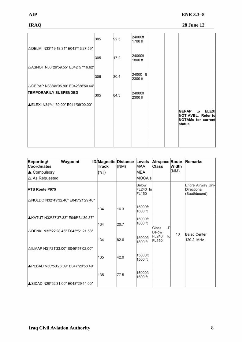
AIP ENR 3.38
IRAQ 28 June 12
Iraq Civil Aviation Authority 8
305 92.5
24000ft 1700 ft
DELMI N33º19'18.31" E043º13'27.59"
305 17.2
24000ft 1800 ft
ASNOT N33º29'59.55" E042º57'16.62"
306 30.4
24000 ft 2300 ft
GEPAP N33º49'05.80" E042º28'50.64"
TEMPORARILY SUSPENDED
305 84.3
24000ft 2300 ft
ELEXI N34º41'30.00" E041º09'00.00"
GEPAP to ELEXI NOT AVBL. Refer to NOTAMs for current status.
Reporting/ Waypoint ID/Coordinates
Compulsory
As Requested
Magnetic Track
(↑/↓)
Distance (NM)
Levels MAA
MEA
MOCA’s
Airspace Class
Route Width (NM)
Remarks
ATS Route P975 Below FL240 to FL150
Entire Airway Uni-Directional (Southbound)
NOLDO N32º49'32.40" E045º21'29.40"
134 16.3 15000ft 1800 ft
KATUT N32º37'37.33" E045º34'39.37"
134 20.7
15000ft 1800 ft
DENKI N32º22'28.46" E045º51'21.58"
134 82.6 15000ft 1800 ft
ILMAP N31º21'33.00" E046º57'02.00"
Balad Center
120.2 MHz
135 42.0 15000ft 1500 ft
PEBAD N30º50'23.09" E047º29'58.49"
135 77.5 15000ft 1500 ft
SIDAD N29º52'31.00" E048º29'44.00"
Class E Below FL240 to FL150
10
AIP ENR 3.39
IRAQ 28 June 12
Iraq Civil Aviation Authority 9
ATS Route UP975 Entire Airway Uni-Directional
(Southbound)
SIDNA N36º33'58.00" E041º40'59.38"
138 97 24000ft 5700 ft
TUBEN N35º17'24.00" E042º54'34.30"
139 59.5 24000ft 5700 ft
MUTAG N34º30'03.45" E043º38'34.38"
139 22.4 24000ft 5700 ft
SOGUM N34º12'12.00" E043º54'54.00"
135 53.3 24000ft 2300 ft
PUTSI N33º32'00.00" E044º37'00.00"
135 13.8 24000ft 2300 ft
SINKA N33º21'37.31" E044º47'52.55"
135 42.7 24000ft 1500 ft
NOLDO N32º49'32.40" E045º21'29.40"
134 16.3 24000ft 1800 ft
KATUT N32º37'37.33" E045º34'39.37"
Baghdad Center
129.1 MHz North
123.0 MHz South
134 20.7 24000ft 1800 ft
DENKI N32º22'28.46" E045º51'21.58"
134 82.6 24000ft 1800 ft
ILMAP N31º21'33.00" E046º57'02.00"
135 42 24000ft 1500 ft
PEBAD N30º50'23.09" E047º29'58.49"
135 77.5 24000 ft 1500 ft
SIDAD N29º52'31.00" E048º29'44.00"
Class A
FL 460
FL 240
10
AIP ENR 3.310
IRAQ 28 June 12
Iraq Civil Aviation Authority 10
Reporting/ Waypoint ID/Coordinates
Compulsory
As Requested
Magnetic Track
(↑/↓)
Distance (NM)
Levels MAA
MEA
MOCA’s
Airspace Class
Route Width (NM)
Remarks
ATS Route Y886 Class A Entire Airway Bi-Directional
UMESA N35º17'41.49" E043º43'06.89"
321/141 58.4
15000ft 2200 ft
FL 460
FL 240
DASUR N34º30'05.62" E044º24'17.35"
Baghdad Center
129.1 MHz
123.0 MHz
322/142 57.2 15000ft 2200 ft
UKMUG N33º43'00.35" E045º03'28.80"
335/155 26.8 15000ft 2200 ft
VAXEN N33º18'00.00" E045º15'00.00"
333/153 26.4 15000ft 2300 ft
PAPUS N32º53'34.06" E045º27'06.55"
335/155 17.2 15000ft 1800 ft
KATUT N32º37'37.33" E045º34'39.37"
331/151 58.2 15000 ft
SETSA N31º45'00.00" E046º04'00.00"
336/156 35.0 15000 ft
ALPET N31º12'19.00" E04618'44.00"
10
Reporting/ Waypoint ID/Coordinates
Compulsory
As Requested
Magnetic Track
(↑/↓)
Distance (NM)
Levels MAA
MEA
MOCA’s
Airspace Class
Route Width (NM)
Remarks
ATS Route T887 Entire Airway Bi-Directional
OTALO N35º17'00.00" E044º19'00.00"
351/171 47.1
DASUR N34º30'05.62" E044º24'17.35"
346/166 59.0
PUTSI N33º32'00.00" E044º37'00.00"
Baghdad Center
129.1 MHz
Waypoints OTALO and PUTSI not flight checked for position confirmation.
Class A Below FL460 to FL240
10
AIP ENR 3.311
IRAQ 28 June 12
Iraq Civil Aviation Authority 11
Reporting/ Waypoint ID/ Coordinates
Compulsory
As Requested
Magnetic Track
(↑/↓)
Distance (NM)
Levels MAA
MEA
MOCA’s
Airspace Class
Route Width (NM)
Remarks
ATS Route UM688
NINVA N37º21'00.00" E043º13'00.00"
ROXOP N36º44'45.47" E043º33'22.18"
152 39.7
Class A FL460 to FL240
Entire Airway Uni-Directional (Southbound)
152 30.5
VUSEB N36º16'36.94" E043º48'00.00"
152
30
TOMSI N35º48'57.60" E044º02'29.32"
OTALO N35º17'00.00" E044º19'00.00"
152 34.6
RIDIP N34º30'12.09" E044º40'27.24"
156 50
154 50.9
UKMUG N33º43'00.35" E045º03'28.80"
155 26.8
VAXEN N33º18'00.00" E045º15'00.00"
153 26.4 10
PAPUS N32º53'34.06" E045º27'06.55"
155 17.2
KATUT N32º37'37.33" E045º34'39.37"
134 20.7
15000ft 1800 ft
DENKI N32º22'28.46" E045º51'21.58" .
134 82.6 15000ft 1800 ft
ILMAP N31º21'33.00" E046º57'02.00"
135 42.0 15000ft 1500 ft
AIP ENR 3.312
IRAQ 28 June 12
Iraq Civil Aviation Authority 12
PEBAD N30º50'23.09" E047º29'58.49"
15000ft 1500 ft
135 77.5
SIDAD N29º52'31.00" E048º29'44.00"
Reporting/ Waypoint ID/Coordinates
Compulsory
As Requested
Magnetic Track
(↑/↓)
Distance (NM)
Levels MAA
MEA
MOCA’s
Airspace Class
Route Width (NM)
Remarks
ATS Route R652 Class A Entire Airway Bi-Directional
DAXAN N32º05'12.16" E039º37'19.13"
TEMPORARILY SUSPENDED 230/50 99.0
New Segment
FL 460
FL 240
GIBUX N33º05'00.00" E041º11'00.00"
Baghdad Center
129.1 MHz
132.1 MHz
234/54 34.0 New Segment
RAPLU N33º23'00.00" E041º45'30.00"
231/51 44.5 New Segment
GEPAP N33º49'05.80" E042º28'50.64"
231/51 70.8 New Segment
MUTAG N34º30'03.45" E043º38'34.38"
234/54 90.5 New Segment
Waypoints DAXAN, GIBUX, GEPAP, IVANO, and RIBAX not flight checked for position confirmation.
IVANO N35º17'24.00" E045º12'34.66"
TEMPORARILY SUSPENDED 235/55 62.2 New Segment
RIBAK N35º49'25.77" E046º18'07.93"
DAXAN to GIBUX and IVANO to RIBAX NOT AVBL. Refer to NOTAMs for current status
10
AIP ENR 3.313
IRAQ 28 June 12
Iraq Civil Aviation Authority 13
Reporting/ Waypoint ID/Coordinates
Compulsory
As Requested
Magnetic Track
(↑/↓)
Distance (NM)
Levels MAA
MEA
MOCA’s
Airspace Class
Route Width (NM)
Remarks
ATS Route M320 Class A Entire Airway Bi-Directional
GADSI N30º33'58.08" E047º11'15.73"
TEMPORARILY SUSPENDED 264/84 56
New Segment
FL 460
FL 240
RUGIR N30º32'19.06" E046º06'18.20"
Baghdad Center
129.1 MHz
123.0 MHz
305/125 52.3 New Segment
NADOX N31º05'04.73" E045º18'51.30"
305/125 94.3 New Segment
ELODI N32º02'56.28" E043º51'25.96"
Waypoint RUGIR, not flight checked for position confirmation.
305/125 57.1 New Segment
LOPAM N32º37'57.19" E042º58'05.98"
304/124 40 New Segment
SIGBI N33º02'00.00" E042º20'00.00"
303/123 36 New Segment
RAPLU N33º23'00.00" E041º45'30.00"
10
Reporting/ Waypoint ID/Coordinates
Compulsory
As Requested
Magnetic Track
(↑/↓)
Distance (NM)
Levels MAA
MEA
MOCA’s
Airspace Class
Route Width (NM)
Remarks
*MOCA is only used for VFR charts
AIP ENR 3.314
IRAQ 28 June 12
Iraq Civil Aviation Authority 14
3.3.2 Approved ATS routes and Entry/Exit Points for Baghdad FIR
AIP ENR 3.41
IRAQ 28 June 12
Iraq Civil Aviation Authority 1
ENR 3.4 HELICOPTER ROUTES 3.4.1 There are no designated helicopter routes in the Baghdad FIR.
AIP ENR 3.51
IRAQ 28 June 12
Iraq Civil Aviation Authority 1
ENR 3.5 OTHER ROUTES
3.5.1 Preferred Routing:
3.5.1.1. Flights originating and landing within the Baghdad FIR will plan their routing based on the current ATS route structure advising ATC of their intended clearance. ATC will approve or amend these clearances as required. Aircraft operators intending to land in Iraq are to flight plan to and from the airports via the preferred routes listed below. All aircraft shall navigate on the route centerline. No offset tracking is allowed. Deviations shall not be made without the prior approval of the controlling ATC facility. Levels shall be as instructed by ATC.
3.5.2 The preferred routings are as detailed below:
3.5.2.1 Preferred Departure routes (for Latitudes/Longitudes see ENR 4.3): From Baghdad (ORBI) to: From Sulaymaniyah (ORSU) to:
To Ankara FIR: ORBI TAGRU UMESA SEVKU EMIDO KABAN To Damascus FIR: ORBI PUSTO RAPLU MODIK To Amman FIR: ORBI SIGBI GIBUX PASIP To Jeddah FIR: ORBI DIRECT RALTI MURIB To Kuwait FIR: ORBI NOLDO KATUT DENKI ILMAP PEBAD SIDAD IMDOX To Tehran FIR: ORBI NOLDO PAPUS PAXAT
To Ankara FIR: ORSU IVANO OTALO UMESA SEVKU EMIDO KABAN
To Damascus FIR: ORSU IVANO MUTAG GEPAP RAPLU MODIK To Amman FIR: ORSU IVANO MUTAG GEPAP GIBUX PASIP To Jeddah FIR: ORSU IVANO MUTAG ELODI RALTI MURIB To Kuwait FIR: ORSU IVANO RIDIP UKMUG VAXEN PAPUS
KATUT DENKI ILMAP PEBAD SIDAD To Tehran FIR: ORSU IVANO RIDIP UKMUG VAXEN PAPUS
PAXAT
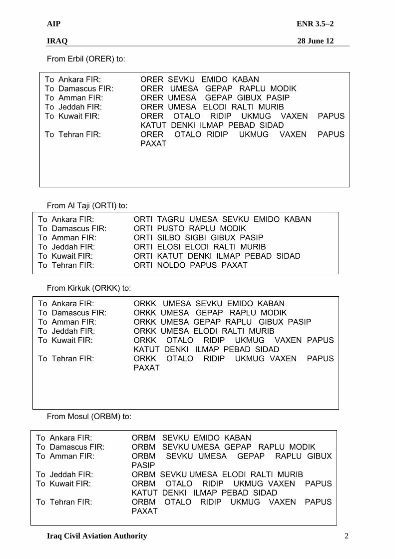
AIP ENR 3.52
IRAQ 28 June 12
Iraq Civil Aviation Authority 2
From Erbil (ORER) to: From Al Taji (ORTI) to: From Kirkuk (ORKK) to: From Mosul (ORBM) to: From Mosul (ORBM) to:
To Ankara FIR: ORER SEVKU EMIDO KABAN To Damascus FIR: ORER UMESA GEPAP RAPLU MODIK To Amman FIR: ORER UMESA GEPAP GIBUX PASIP To Jeddah FIR: ORER UMESA ELODI RALTI MURIB To Kuwait FIR: ORER OTALO RIDIP UKMUG VAXEN PAPUS
KATUT DENKI ILMAP PEBAD SIDAD To Tehran FIR: ORER OTALO RIDIP UKMUG VAXEN PAPUS
PAXAT
To Ankara FIR: ORTI TAGRU UMESA SEVKU EMIDO KABAN To Damascus FIR: ORTI PUSTO RAPLU MODIK To Amman FIR: ORTI SILBO SIGBI GIBUX PASIP To Jeddah FIR: ORTI ELOSI ELODI RALTI MURIB To Kuwait FIR: ORTI KATUT DENKI ILMAP PEBAD SIDAD To Tehran FIR: ORTI NOLDO PAPUS PAXAT
To Ankara FIR: ORKK UMESA SEVKU EMIDO KABAN To Damascus FIR: ORKK UMESA GEPAP RAPLU MODIK To Amman FIR: ORKK UMESA GEPAP RAPLU GIBUX PASIP To Jeddah FIR: ORKK UMESA ELODI RALTI MURIB To Kuwait FIR: ORKK OTALO RIDIP UKMUG VAXEN PAPUS
KATUT DENKI ILMAP PEBAD SIDAD To Tehran FIR: ORKK OTALO RIDIP UKMUG VAXEN PAPUS
PAXAT
To Ankara FIR: ORBM SEVKU EMIDO KABAN To Damascus FIR: ORBM SEVKU UMESA GEPAP RAPLU MODIK To Amman FIR: ORBM SEVKU UMESA GEPAP RAPLU GIBUX
PASIP To Jeddah FIR: ORBM SEVKU UMESA ELODI RALTI MURIB To Kuwait FIR: ORBM OTALO RIDIP UKMUG VAXEN PAPUS
KATUT DENKI ILMAP PEBAD SIDAD To Tehran FIR: ORBM OTALO RIDIP UKMUG VAXEN PAPUS
PAXAT
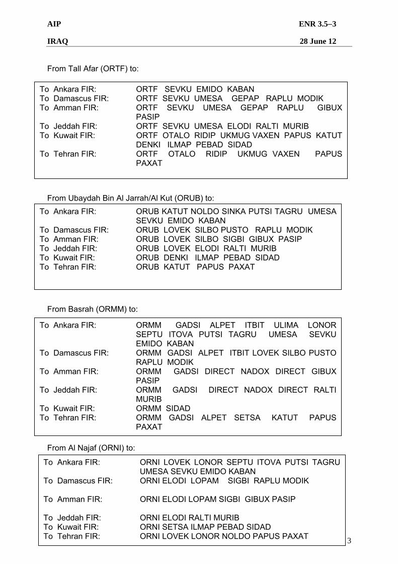
AIP ENR 3.53
IRAQ 28 June 12
Iraq Civil Aviation Authority 3
From Tall Afar (ORTF) to: From Ubaydah Bin Al Jarrah/Al Kut (ORUB) to: From Basrah (ORMM) to: From Al Najaf (ORNI) to:
To Ankara FIR: ORTF SEVKU EMIDO KABAN To Damascus FIR: ORTF SEVKU UMESA GEPAP RAPLU MODIK To Amman FIR: ORTF SEVKU UMESA GEPAP RAPLU GIBUX
PASIP To Jeddah FIR: ORTF SEVKU UMESA ELODI RALTI MURIB To Kuwait FIR: ORTF OTALO RIDIP UKMUG VAXEN PAPUS KATUT
DENKI ILMAP PEBAD SIDAD To Tehran FIR: ORTF OTALO RIDIP UKMUG VAXEN PAPUS
PAXAT
To Ankara FIR: ORUB KATUT NOLDO SINKA PUTSI TAGRU UMESA SEVKU EMIDO KABAN
To Damascus FIR: ORUB LOVEK SILBO PUSTO RAPLU MODIK To Amman FIR: ORUB LOVEK SILBO SIGBI GIBUX PASIP To Jeddah FIR: ORUB LOVEK ELODI RALTI MURIB To Kuwait FIR: ORUB DENKI ILMAP PEBAD SIDAD To Tehran FIR: ORUB KATUT PAPUS PAXAT
To Ankara FIR: ORMM GADSI ALPET ITBIT ULIMA LONOR SEPTU ITOVA PUTSI TAGRU UMESA SEVKU EMIDO KABAN
To Damascus FIR: ORMM GADSI ALPET ITBIT LOVEK SILBO PUSTO RAPLU MODIK
To Amman FIR: ORMM GADSI DIRECT NADOX DIRECT GIBUX PASIP
To Jeddah FIR: ORMM GADSI DIRECT NADOX DIRECT RALTI MURIB
To Kuwait FIR: ORMM SIDAD To Tehran FIR: ORMM GADSI ALPET SETSA KATUT PAPUS
PAXAT
To Ankara FIR: ORNI LOVEK LONOR SEPTU ITOVA PUTSI TAGRU UMESA SEVKU EMIDO KABAN
To Damascus FIR: ORNI ELODI LOPAM SIGBI RAPLU MODIK To Amman FIR: ORNI ELODI LOPAM SIGBI GIBUX PASIP
To Jeddah FIR: ORNI ELODI RALTI MURIB To Kuwait FIR: ORNI SETSA ILMAP PEBAD SIDAD To Tehran FIR: ORNI LOVEK LONOR NOLDO PAPUS PAXAT
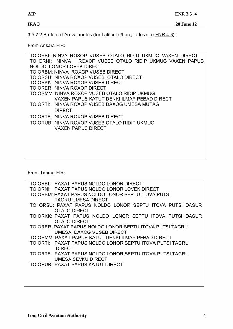
AIP ENR 3.54
IRAQ 28 June 12
Iraq Civil Aviation Authority 4
3.5.2.2 Preferred Arrival routes (for Latitudes/Longitudes see ENR 4.3): From Ankara FIR:
TO ORBI: NINVA ROXOP VUSEB OTALO RIPID UKMUG VAXEN DIRECT TO ORNI: NINVA ROXOP VUSEB OTALO RIDIP UKMUG VAXEN PAPUS NOLDO LONOR LOVEK DIRECT TO ORBM: NINVA ROXOP VUSEB DIRECT TO ORSU: NINVA ROXOP VUSEB OTALO DIRECT TO ORKK: NINVA ROXOP VUSEB DIRECT TO ORER: NINVA ROXOP DIRECT TO ORMM: NINVA ROXOP VUSEB OTALO RIDIP UKMUG VAXEN PAPUS KATUT DENKI ILMAP PEBAD DIRECT TO ORTI: NINVA ROXOP VUSEB DAXOG UMESA MUTAG DIRECT TO ORTF: NINVA ROXOP VUSEB DIRECT TO ORUB: NINVA ROXOP VUSEB OTALO RIDIP UKMUG VAXEN PAPUS DIRECT
From Tehran FIR: TO ORBI: PAXAT PAPUS NOLDO LONOR DIRECT TO ORNI: PAXAT PAPUS NOLDO LONOR LOVEK DIRECT TO ORBM: PAXAT PAPUS NOLDO LONOR SEPTU ITOVA PUTSI TAGRU UMESA DIRECT TO ORSU: PAXAT PAPUS NOLDO LONOR SEPTU ITOVA PUTSI DASUR OTALO DIRECT TO ORKK: PAXAT PAPUS NOLDO LONOR SEPTU ITOVA PUTSI DASUR OTALO DIRECT TO ORER: PAXAT PAPUS NOLDO LONOR SEPTU ITOVA PUTSI TAGRU UMESA DAXOG VUSEB DIRECT TO ORMM: PAXAT PAPUS KATUT DENKI ILMAP PEBAD DIRECT TO ORTI: PAXAT PAPUS NOLDO LONOR SEPTU ITOVA PUTSI TAGRU DIRECT TO ORTF: PAXAT PAPUS NOLDO LONOR SEPTU ITOVA PUTSI TAGRU UMESA SEVKU DIRECT TO ORUB: PAXAT PAPUS KATUT DIRECT
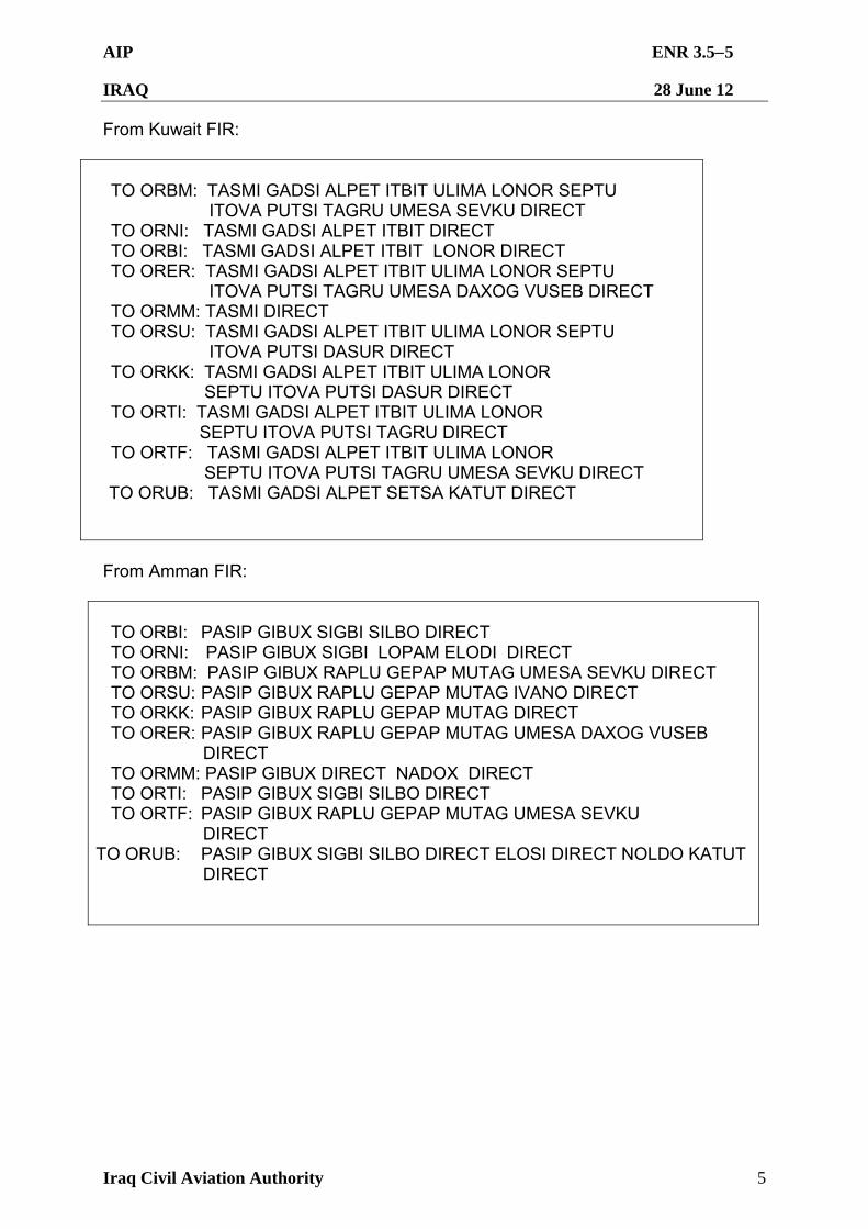
AIP ENR 3.55
IRAQ 28 June 12
Iraq Civil Aviation Authority 5
From Kuwait FIR: TO ORBM: TASMI GADSI ALPET ITBIT ULIMA LONOR SEPTU
ITOVA PUTSI TAGRU UMESA SEVKU DIRECT TO ORNI: TASMI GADSI ALPET ITBIT DIRECT TO ORBI: TASMI GADSI ALPET ITBIT LONOR DIRECT TO ORER: TASMI GADSI ALPET ITBIT ULIMA LONOR SEPTU
ITOVA PUTSI TAGRU UMESA DAXOG VUSEB DIRECT TO ORMM: TASMI DIRECT TO ORSU: TASMI GADSI ALPET ITBIT ULIMA LONOR SEPTU
ITOVA PUTSI DASUR DIRECT TO ORKK: TASMI GADSI ALPET ITBIT ULIMA LONOR
SEPTU ITOVA PUTSI DASUR DIRECT TO ORTI: TASMI GADSI ALPET ITBIT ULIMA LONOR
SEPTU ITOVA PUTSI TAGRU DIRECT TO ORTF: TASMI GADSI ALPET ITBIT ULIMA LONOR
SEPTU ITOVA PUTSI TAGRU UMESA SEVKU DIRECT TO ORUB: TASMI GADSI ALPET SETSA KATUT DIRECT
From Amman FIR: TO ORBI: PASIP GIBUX SIGBI SILBO DIRECT TO ORNI: PASIP GIBUX SIGBI LOPAM ELODI DIRECT TO ORBM: PASIP GIBUX RAPLU GEPAP MUTAG UMESA SEVKU DIRECT TO ORSU: PASIP GIBUX RAPLU GEPAP MUTAG IVANO DIRECT TO ORKK: PASIP GIBUX RAPLU GEPAP MUTAG DIRECT TO ORER: PASIP GIBUX RAPLU GEPAP MUTAG UMESA DAXOG VUSEB
DIRECT TO ORMM: PASIP GIBUX DIRECT NADOX DIRECT TO ORTI: PASIP GIBUX SIGBI SILBO DIRECT TO ORTF: PASIP GIBUX RAPLU GEPAP MUTAG UMESA SEVKU
DIRECT TO ORUB: PASIP GIBUX SIGBI SILBO DIRECT ELOSI DIRECT NOLDO KATUT DIRECT
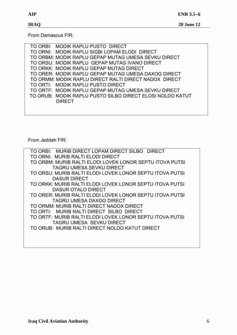
AIP ENR 3.56
IRAQ 28 June 12
Iraq Civil Aviation Authority 6
From Damascus FIR: TO ORBI: MODIK RAPLU PUSTO DIRECT TO ORNI: MODIK RAPLU SIGBI LOPAM ELODI DIRECT TO ORBM: MODIK RAPLU GEPAP MUTAG UMESA SEVKU DIRECT TO ORSU: MODIK RAPLU GEPAP MUTAG IVANO DIRECT TO ORKK: MODIK RAPLU GEPAP MUTAG DIRECT TO ORER: MODIK RAPLU GEPAP MUTAG UMESA DAXOG DIRECT TO ORMM: MODIK RAPLU DIRECT RALTI DIRECT NADOX DIRECT TO ORTI: MODIK RAPLU PUSTO DIRECT TO ORTF: MODIK RAPLU GEPAP MUTAG UMESA SEVKU DIRECT
TO ORUB: MODIK RAPLU PUSTO SILBO DIRECT ELOSI NOLDO KATUT DIRECT
From Jeddah FIR: TO ORBI: MURIB DIRECT LOPAM DIRECT SILBO DIRECT TO ORNI: MURIB RALTI ELODI DIRECT TO ORBM: MURIB RALTI ELODI LOVEK LONOR SEPTU ITOVA PUTSI
TAGRU UMESA SEVKU DIRECT TO ORSU: MURIB RALTI ELODI LOVEK LONOR SEPTU ITOVA PUTSI
DASUR DIRECT TO ORKK: MURIB RALTI ELODI LOVEK LONOR SEPTU ITOVA PUTSI
DASUR OTALO DIRECT TO ORER: MURIB RALTI ELODI LOVEK LONOR SEPTU ITOVA PUTSI
TAGRU UMESA DAXOG DIRECT TO ORMM: MURIB RALTI DIRECT NADOX DIRECT TO ORTI: MURIB RALTI DIRECT SILBO DIRECT TO ORTF: MURIB RALTI ELODI LOVEK LONOR SEPTU ITOVA PUTSI
TAGRU UMESA SEVKU DIRECT TO ORUB: MURIB RALTI DIRECT NOLDO KATUT DIRECT
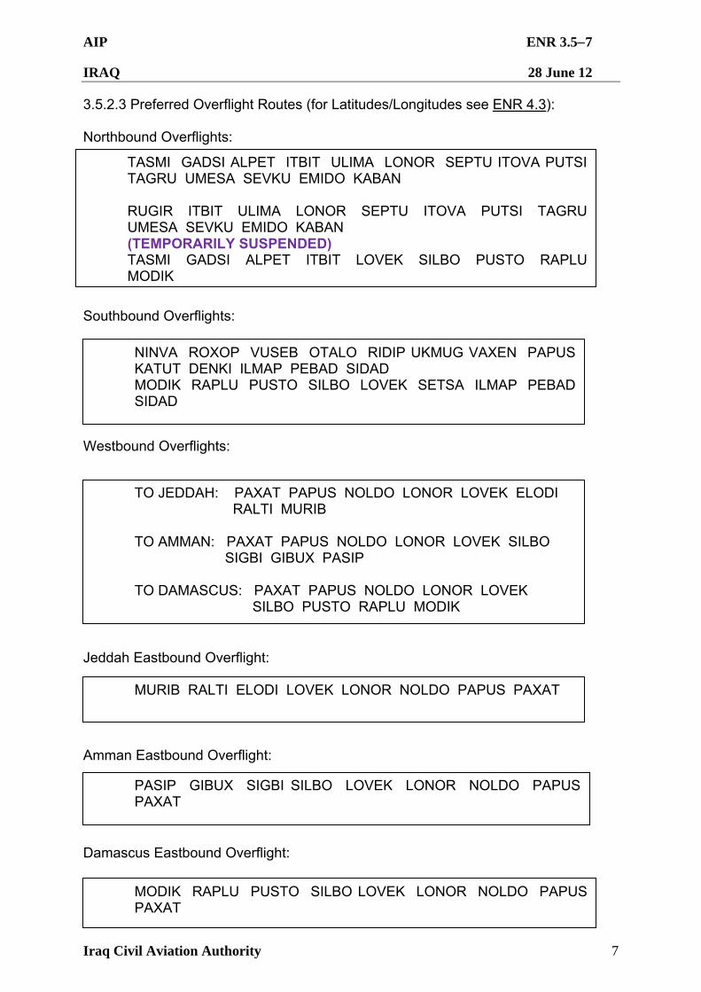
AIP ENR 3.57
IRAQ 28 June 12
Iraq Civil Aviation Authority 7
3.5.2.3 Preferred Overflight Routes (for Latitudes/Longitudes see ENR 4.3): Northbound Overflights: Southbound Overflights: Westbound Overflights: Jeddah Eastbound Overflight: Amman Eastbound Overflight: Damascus Eastbound Overflight:
TASMI GADSI ALPET ITBIT ULIMA LONOR SEPTU ITOVA PUTSI TAGRU UMESA SEVKU EMIDO KABAN RUGIR ITBIT ULIMA LONOR SEPTU ITOVA PUTSI TAGRU UMESA SEVKU EMIDO KABAN (TEMPORARILY SUSPENDED) TASMI GADSI ALPET ITBIT LOVEK SILBO PUSTO RAPLU MODIK
NINVA ROXOP VUSEB OTALO RIDIP UKMUG VAXEN PAPUS KATUT DENKI ILMAP PEBAD SIDAD MODIK RAPLU PUSTO SILBO LOVEK SETSA ILMAP PEBAD SIDAD
TO JEDDAH: PAXAT PAPUS NOLDO LONOR LOVEK ELODI RALTI MURIB TO AMMAN: PAXAT PAPUS NOLDO LONOR LOVEK SILBO SIGBI GIBUX PASIP TO DAMASCUS: PAXAT PAPUS NOLDO LONOR LOVEK SILBO PUSTO RAPLU MODIK
MURIB RALTI ELODI LOVEK LONOR NOLDO PAPUS PAXAT
PASIP GIBUX SIGBI SILBO LOVEK LONOR NOLDO PAPUS PAXAT
MODIK RAPLU PUSTO SILBO LOVEK LONOR NOLDO PAPUS PAXAT
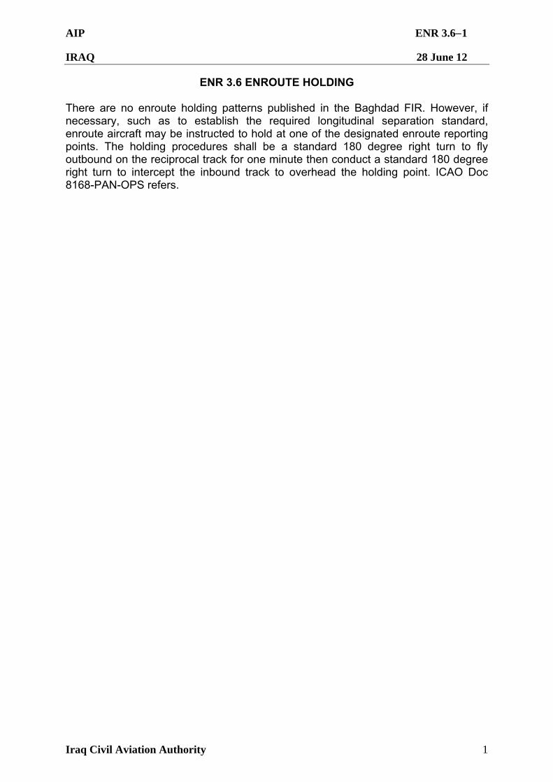
AIP ENR 3.61
IRAQ 28 June 12
Iraq Civil Aviation Authority 1
ENR 3.6 ENROUTE HOLDING There are no enroute holding patterns published in the Baghdad FIR. However, if necessary, such as to establish the required longitudinal separation standard, enroute aircraft may be instructed to hold at one of the designated enroute reporting points. The holding procedures shall be a standard 180 degree right turn to fly outbound on the reciprocal track for one minute then conduct a standard 180 degree right turn to intercept the inbound track to overhead the holding point. ICAO Doc 8168-PAN-OPS refers.
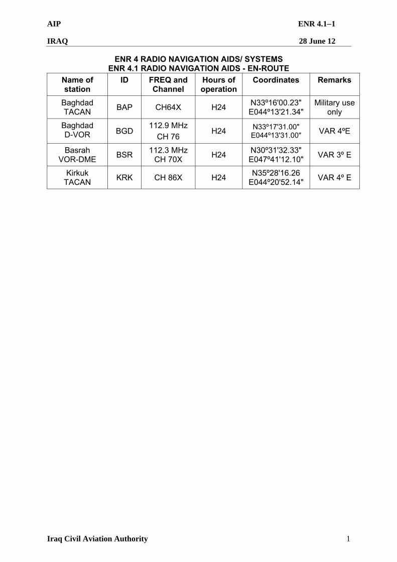
AIP ENR 4.11
IRAQ 28 June 12
Iraq Civil Aviation Authority 1
ENR 4 RADIO NAVIGATION AIDS/ SYSTEMS ENR 4.1 RADIO NAVIGATION AIDS - EN-ROUTE
Name of station
ID FREQ and Channel
Hours of operation
Coordinates Remarks
Baghdad TACAN
BAP CH64X H24 N33º16'00.23" E044º13'21.34"
Military use only
Baghdad D-VOR BGD
112.9 MHz
CH 76 H24 N33º17'31.00"
E044º13'31.00" VAR 4ºE
Basrah VOR-DME
BSR 112.3 MHz
CH 70X H24
N30º31'32.33" E047º41'12.10"
VAR 3º E
Kirkuk TACAN
KRK CH 86X H24 N35º28'16.26
E044º20'52.14" VAR 4º E
AIP ENR 4.21
IRAQ 28 June 12
Iraq Civil Aviation Authority 1
ENR 4.2 SPECIAL NAVIGATION SYSTEM 4.2.1 There are no special navigation system facilities established in the Baghdad FIR. Note the RNAV5 requirements described at GEN 1.5.2.
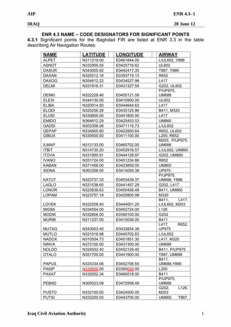
AIP ENR 4.31
IRAQ 28 June 12
Iraq Civil Aviation Authority 1
ENR 4.3 NAME – CODE DESIGNATORS FOR SIGNIFICANT POINTS 4.3.1 Significant points for the Baghdad FIR are listed at ENR 3.3 in the table describing Air Navigation Routes.
NAME LATITUDE LONGITUDE AIRWAY ALPET N311219.00 E0461844.00 L/UL602, Y886 ASNOT N332959.55 E0425716.62 UL602 DASUR N343005.62 E0442417.35 T887, Y886 DAXAN N320512.16 E0393719.13 R652 DAXOG N354612.22 E0434527.98 L417 DELMI N331918.31 E0431327.59 G202, UL602
DENKI N322228.46 E0455121.58 P/UP975, UM688
ELEXI N344130.00 E0410900.00 UL602 ELIBA N320914.92 E0444644.63 L417 ELODI N320256.28 E0435125.96 B411, M320 ELOSI N330800.00 E0441800.00 L417 EMIDO N364612.29 E0425453.53 UM860 GADSI N303358.08 E0471115.73 L/UL602 GEPAP N334905.80 E0422850.64 R652, UL602 GIBUX N330500.00 E0411100.00 L200, R652
ILMAP N312133.00 E0465702.00 M203, P/UP975, UM688
ITBIT N314735.20 E0452916.57 L/UL602, UM860 ITOVA N331950.91 E0444128.97 G202, UM860 IVANO N351724.00 E0451234.66 R652 KABAN N371456.00 E0423859.00 UM860 SIDNA N363358.00 E0414059.38 UP975
KATUT N323737.33 E0453439.37 P/UP975, UM688, Y886
LAGLO N331538.60 E0441457.29 G202, L417 LONOR N323838.63 E0450458.48 B411, UM860 LOPAM N323757.19 E0425805.98 M320
LOVEK N322208.40 E0444001.20 B411, L417, L/UL602, M203
MIGMI N334554.00 E0452724.00 L126 MODIK N332806.00 E0390100.00 G202 MURIB N311237.00 E0415036.00 B411
MUTAG N343003.45 E0433834.38 L417, R652, UP975
MUTLO N321018.98 E0445702.83 L/UL602 NADOX N310504.73 E0451851.30 L417, M320 NINVA N372100.00 E0431300.00 UM688 NOLDO N324932.40 E0452129.40 B411, P/UP975 OTALO N351700.00 E0441900.00 T887, UM688
PAPUS N325334.06 E0452706.55 B411, UM688,Y866
PASIP N330600.00 E0385600.00 L200 PAXAT N332052.34 E0460518.00 B411
PEBAD N305023.09 E0472958.49 P/UP975, UM688
PUSTO N332100.00 E0424500.00 G202, L126, M203
PUTSI N333200.00 E0443700.00 UM860, T887,
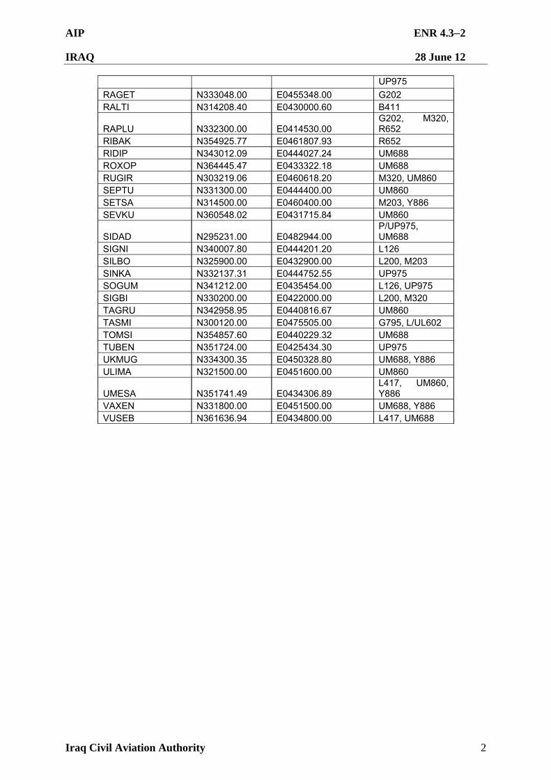
AIP ENR 4.32
IRAQ 28 June 12
Iraq Civil Aviation Authority 2
UP975
RAGET N333048.00 E0455348.00 G202 RALTI N314208.40 E0430000.60 B411
RAPLU N332300.00 E0414530.00 G202, M320, R652
RIBAK N354925.77 E0461807.93 R652 RIDIP N343012.09 E0444027.24 UM688 ROXOP N364445.47 E0433322.18 UM688 RUGIR N303219.06 E0460618.20 M320, UM860 SEPTU N331300.00 E0444400.00 UM860 SETSA N314500.00 E0460400.00 M203, Y886 SEVKU N360548.02 E0431715.84 UM860
SIDAD N295231.00 E0482944.00 P/UP975, UM688
SIGNI N340007.80 E0444201.20 L126 SILBO N325900.00 E0432900.00 L200, M203 SINKA N332137.31 E0444752.55 UP975 SOGUM N341212.00 E0435454.00 L126, UP975 SIGBI N330200.00 E0422000.00 L200, M320 TAGRU N342958.95 E0440816.67 UM860 TASMI N300120.00 E0475505.00 G795, L/UL602 TOMSI N354857.60 E0440229.32 UM688 TUBEN N351724.00 E0425434.30 UP975 UKMUG N334300.35 E0450328.80 UM688, Y886 ULIMA N321500.00 E0451600.00 UM860
UMESA N351741.49 E0434306.89 L417, UM860, Y886
VAXEN N331800.00 E0451500.00 UM688, Y886 VUSEB N361636.94 E0434800.00 L417, UM688
AIP ENR 4.41
IRAQ 28 June 12
Iraq Civil Aviation Authority 1
ENR 4.4 AERONAUTICAL GROUND LIGHTS—ENROUTE 4.4.1 There are no aeronautical ground lights - en-route in the Baghdad FIR.
AIP ENR 5.11
IRAQ 28 June 12
Iraq Civil Aviation Authority 1
ENR 5 NAVIGATION WARNINGS ENR 5.1 PROHIBITED, RESTRICTED AND DANGER AREAS
5.1.1 Introduction
5.1.1.1 All airspace in which a potential hazard to aircraft operations may exist and all areas over which the operation of civil aircraft may, for one reason or another, be restricted either temporarily or permanently, are classified according to the following three types of areas as defined by ICAO.
5.1.2 Definitions
5.1.2.1 Prohibited Area. An airspace of defined dimensions, above the land areas or territorial waters of the State of Iraq, within which the flight of aircraft is prohibited. This term is used only when the flight of civil aircraft within the designated airspace is not permitted at any time under any circumstances.
5.1.2.2 Restricted Area. An airspace of defined dimensions, above the land areas or territorial waters of the State of Iraq, within which the flight of aircraft is restricted in accordance with certain specified conditions. This term is used whenever the flight of civil aircraft within the designated airspace is not absolutely prohibited but may be made only if specified conditions are complied with. Thus, prohibition of flight, except at certain specified times, leads to the designation of the airspace as a restricted area as would prohibition except in certain meteorological conditions. Similarly, prohibition of flight, unless special permission had been obtained, leads to the designation of a restricted area. However, conditions of flight imposed as a result of application of rules of the air or air traffic service practices or procedures (for example, compliance with minimum safe heights or with rules stemming from the establishment of controlled airspace) do not constitute conditions calling for designation as a restricted area.
5.1.2.3 Danger Area. An airspace of defined dimensions within which activities dangerous to the flight of aircraft may exist at specified times. This term is used only when the potential danger to aircraft has not led to the designation of the airspace as restricted or prohibited. The effect of the creation of the danger area is to caution operators or pilots of aircraft that it is necessary for them to assess the dangers in relation to their responsibility for the safety of their aircraft.
5.1.3 Designations
5.1.3.1 The type of area involved is indicated by the nationality letters OR, then a slash (/), followed by the letter -P- for Prohibited, -R- for Restricted and -D- for Danger. Each area is numbered and a single series of numbers is used for all areas, regardless to type, to ensure that a number is never duplicated. Each number has three digits, the first digit indicates the last digit of the area’s latitude, from 29° N to 38° N, the remaining two being a sequence number.
For example, areas are assigned letter and numbers in the following manner – OR/P 401, OR/R 402, OR/D 403, OR/D 404, OR/R 405, OR/D 406, etc are all in the band of 34° N. OR/R 912 would be the 12th area established in the band of 29° N.
5.1.3.2 General. All airspace outside the air routes and terminal areas described in this AIP are to be regarded as restricted areas. Failure to comply with the procedures in this AIP may result in interception by armed coalition fighter aircraft.
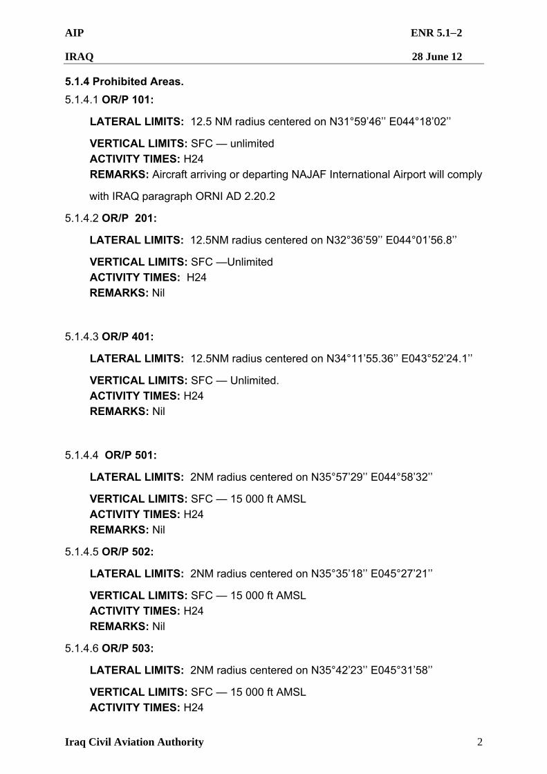
AIP ENR 5.12
IRAQ 28 June 12
Iraq Civil Aviation Authority 2
5.1.4 Prohibited Areas.
5.1.4.1 OR/P 101:
LATERAL LIMITS: 12.5 NM radius centered on N31°59’46’’ E044°18’02’’
VERTICAL LIMITS: SFC — unlimited
ACTIVITY TIMES: H24
REMARKS: Aircraft arriving or departing NAJAF International Airport will comply
with IRAQ paragraph ORNI AD 2.20.2
5.1.4.2 OR/P 201:
LATERAL LIMITS: 12.5NM radius centered on N32°36’59’’ E044°01’56.8’’
VERTICAL LIMITS: SFC —Unlimited
ACTIVITY TIMES: H24
REMARKS: Nil
5.1.4.3 OR/P 401:
LATERAL LIMITS: 12.5NM radius centered on N34°11’55.36’’ E043°52’24.1’’
VERTICAL LIMITS: SFC — Unlimited.
ACTIVITY TIMES: H24
REMARKS: Nil
5.1.4.4 OR/P 501:
LATERAL LIMITS: 2NM radius centered on N35°57’29’’ E044°58’32’’
VERTICAL LIMITS: SFC — 15 000 ft AMSL
ACTIVITY TIMES: H24
REMARKS: Nil
5.1.4.5 OR/P 502:
LATERAL LIMITS: 2NM radius centered on N35°35’18’’ E045°27’21’’
VERTICAL LIMITS: SFC — 15 000 ft AMSL
ACTIVITY TIMES: H24
REMARKS: Nil
5.1.4.6 OR/P 503:
LATERAL LIMITS: 2NM radius centered on N35°42’23’’ E045°31’58’’
VERTICAL LIMITS: SFC — 15 000 ft AMSL
ACTIVITY TIMES: H24
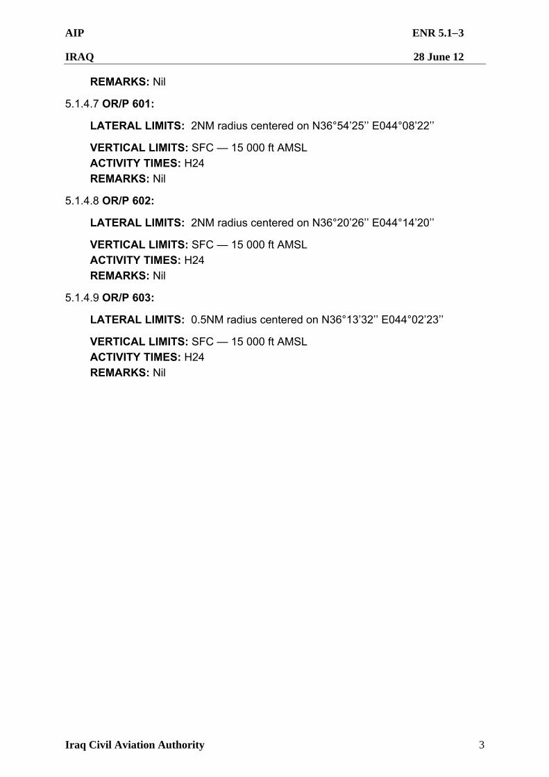
AIP ENR 5.13
IRAQ 28 June 12
Iraq Civil Aviation Authority 3
REMARKS: Nil
5.1.4.7 OR/P 601:
LATERAL LIMITS: 2NM radius centered on N36°54’25’’ E044°08’22’’
VERTICAL LIMITS: SFC — 15 000 ft AMSL
ACTIVITY TIMES: H24
REMARKS: Nil
5.1.4.8 OR/P 602:
LATERAL LIMITS: 2NM radius centered on N36°20’26’’ E044°14’20’’
VERTICAL LIMITS: SFC — 15 000 ft AMSL
ACTIVITY TIMES: H24
REMARKS: Nil
5.1.4.9 OR/P 603:
LATERAL LIMITS: 0.5NM radius centered on N36°13’32’’ E044°02’23’’
VERTICAL LIMITS: SFC — 15 000 ft AMSL
ACTIVITY TIMES: H24
REMARKS: Nil
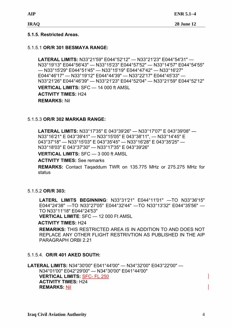
AIP ENR 5.14
IRAQ 28 June 12
Iraq Civil Aviation Authority 4
5.1.5. Restricted Areas.
5.1.5.1 OR/R 301 BESMAYA RANGE:
LATERAL LIMITS: N33°21'59" E044°52'12" — N33°21'23" E044°54'31" — N33°19'13" E044°56'43" — N33°15'23" E044°57'52" — N33°14'57" E044°54'55" — N33°15'29" E044°51'45" — N33°15'19" E044°47'42" — N33°16'27" E044°46'17" — N33°19'12" E044°44'39" — N33°22'17" E044°45'33" — N33°21'26" E044°46'39" — N33°21'23" E044°52'04" — N33°21'59" E044°52'12"
VERTICAL LIMITS: SFC — 14 000 ft AMSL
ACTIVITY TIMES: H24
REMARKS: Nil
5.1.5.3 OR/R 302 MARKAB RANGE:
LATERAL LIMITS: N33°17'35" E 043°39'26" — N33°17'07" E 043°39'08" — N33°16'21" E 043°39'41" — N33°15'05" E 043°38'11", — N33°14'45" E 043°37'18" — N33°15'03" E 043°35'45" — N33°16'28" E 043°35'25" — N33°18'03" E 043°37'30" — N33°17'35" E 043°39'26"
VERTICAL LIMITS: SFC — 3 000 ft AMSL
ACTIVITY TIMES: See remarks
REMARKS: Contact Taqaddum TWR on 135.775 MHz or 275.275 MHz for status
5.1.5.2 OR/R 303:
LATERL LIMITS BEGINNING: N33°31'21" E044°11'01" —TO N33°36'15" E044°24'38" —TO N33°27'05" E044°32'44" —TO N33°13'32" E044°35'56" —TO N33°11'18" E044°24'53" VERTICAL LIMITE: SFC — 12 000 Ft AMSL
ACTIVITY TIMES: H24
REMARIKS: THIS RESTRICTED AREA IS IN ADDITION TO AND DOES NOT REPLACE ANY OTHER FLIGHT RESTRIVTION AS PUBLISHED IN THE AIP PARAGRAPH ORBI 2.21
5.1.5.4. OR/R 401 AKED SOUTH: LATERAL LIMITS: N34°30'00" E041°44'00" — N34°32'00" E043°22'00" — N34°01'00" E042°29'00" — N34°30'00" E041°44'00" VERTICAL LIMITS: SFC- FL 250 ACTIVITY TIMES: H24 REMARKS: Nil
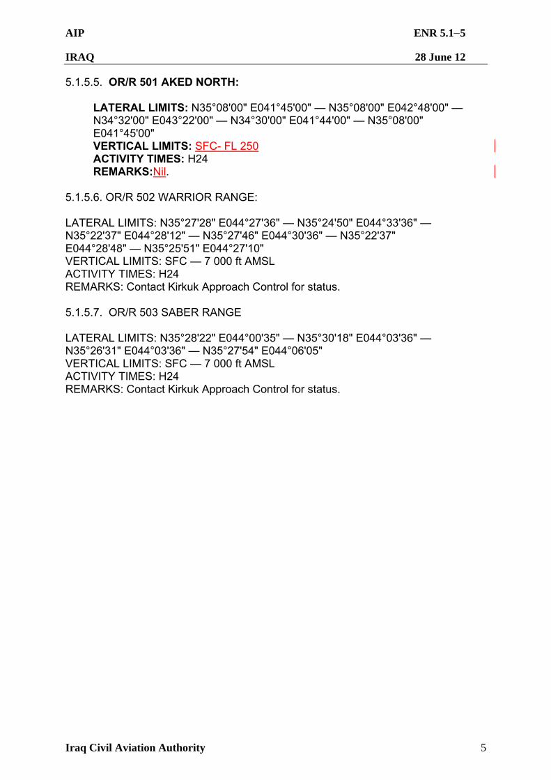
AIP ENR 5.15
IRAQ 28 June 12
Iraq Civil Aviation Authority 5
5.1.5.5. OR/R 501 AKED NORTH: LATERAL LIMITS: N35°08'00" E041°45'00" — N35°08'00" E042°48'00" — N34°32'00" E043°22'00" — N34°30'00" E041°44'00" — N35°08'00" E041°45'00" VERTICAL LIMITS: SFC- FL 250 ACTIVITY TIMES: H24 REMARKS:Nil. 5.1.5.6. OR/R 502 WARRIOR RANGE: LATERAL LIMITS: N35°27'28" E044°27'36" — N35°24'50" E044°33'36" — N35°22'37" E044°28'12" — N35°27'46" E044°30'36" — N35°22'37" E044°28'48" — N35°25'51" E044°27'10" VERTICAL LIMITS: SFC — 7 000 ft AMSL ACTIVITY TIMES: H24 REMARKS: Contact Kirkuk Approach Control for status. 5.1.5.7. OR/R 503 SABER RANGE LATERAL LIMITS: N35°28'22" E044°00'35" — N35°30'18" E044°03'36" — N35°26'31" E044°03'36" — N35°27'54" E044°06'05" VERTICAL LIMITS: SFC — 7 000 ft AMSL ACTIVITY TIMES: H24 REMARKS: Contact Kirkuk Approach Control for status.
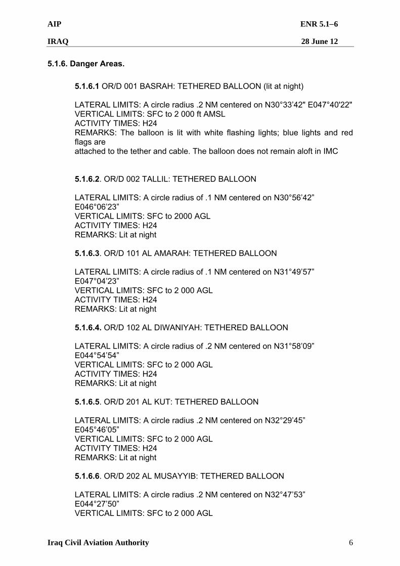
AIP ENR 5.16
IRAQ 28 June 12
Iraq Civil Aviation Authority 6
5.1.6. Danger Areas.
5.1.6.1 OR/D 001 BASRAH: TETHERED BALLOON (lit at night) LATERAL LIMITS: A circle radius .2 NM centered on N30°33’42" E047°40'22" VERTICAL LIMITS: SFC to 2 000 ft AMSL ACTIVITY TIMES: H24 REMARKS: The balloon is lit with white flashing lights; blue lights and red flags are attached to the tether and cable. The balloon does not remain aloft in IMC 5.1.6.2. OR/D 002 TALLIL: TETHERED BALLOON LATERAL LIMITS: A circle radius of .1 NM centered on N30°56’42” E046°06’23” VERTICAL LIMITS: SFC to 2000 AGL ACTIVITY TIMES: H24 REMARKS: Lit at night 5.1.6.3. OR/D 101 AL AMARAH: TETHERED BALLOON LATERAL LIMITS: A circle radius of .1 NM centered on N31°49’57” E047°04’23” VERTICAL LIMITS: SFC to 2 000 AGL ACTIVITY TIMES: H24 REMARKS: Lit at night 5.1.6.4. OR/D 102 AL DIWANIYAH: TETHERED BALLOON LATERAL LIMITS: A circle radius of .2 NM centered on N31°58’09” E044°54’54” VERTICAL LIMITS: SFC to 2 000 AGL ACTIVITY TIMES: H24 REMARKS: Lit at night 5.1.6.5. OR/D 201 AL KUT: TETHERED BALLOON LATERAL LIMITS: A circle radius .2 NM centered on N32°29’45” E045°46’05” VERTICAL LIMITS: SFC to 2 000 AGL ACTIVITY TIMES: H24 REMARKS: Lit at night 5.1.6.6. OR/D 202 AL MUSAYYIB: TETHERED BALLOON LATERAL LIMITS: A circle radius .2 NM centered on N32°47’53” E044°27’50” VERTICAL LIMITS: SFC to 2 000 AGL
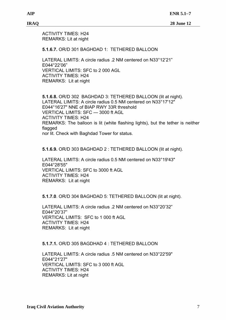
AIP ENR 5.17
IRAQ 28 June 12
Iraq Civil Aviation Authority 7
ACTIVITY TIMES: H24 REMARKS: Lit at night 5.1.6.7. OR/D 301 BAGHDAD 1: TETHERED BALLOON LATERAL LIMITS: A circle radius .2 NM centered on N33°12’21” E044°22’06” VERTICAL LIMITS: SFC to 2 000 AGL ACTIVITY TIMES: H24 REMARKS: Lit at night 5.1.6.8. OR/D 302 BAGHDAD 3: TETHERED BALLOON (lit at night). LATERAL LIMITS: A circle radius 0.5 NM centered on N33°17'12" E044°16'27" NNE of BIAP RWY 33R threshold VERTICAL LIMITS: SFC — 3000 ft AGL ACTIVITY TIMES: H24 REMARKS: The balloon is lit (white flashing lights), but the tether is neither flagged nor lit. Check with Baghdad Tower for status. 5.1.6.9. OR/D 303 BAGHDAD 2 : TETHERED BALLOON (lit at night). LATERAL LIMITS: A circle radius 0.5 NM centered on N33°19'43" E044°28'55" VERTICAL LIMITS: SFC to 3000 ft AGL ACTIVITY TIMES: H24 REMARKS: Lit at night 5.1.7.0. OR/D 304 BAGHDAD 5: TETHERED BALLOON (lit at night). LATERAL LIMITS: A circle radius .2 NM centered on N33°20’32” E044°20’37” VERTICAL LIMITS: SFC to 1 000 ft AGL ACTIVITY TIMES: H24 REMARKS: Lit at night 5.1.7.1. OR/D 305 BAGDHAD 4 : TETHERED BALLOON LATERAL LIMITS: A circle radius .5 NM centered on N33°22'59" E044°21'27" VERTICAL LIMITS: SFC to 3 000 ft AGL ACTIVITY TIMES: H24 REMARKS: Lit at night
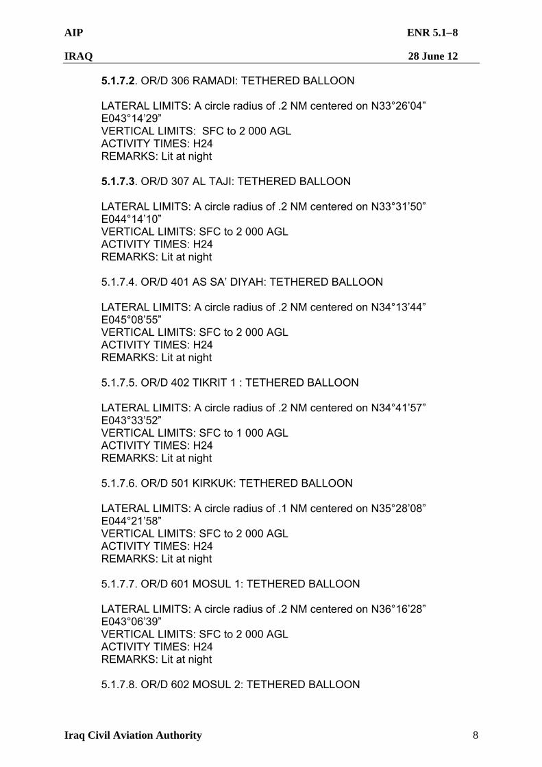
AIP ENR 5.18
IRAQ 28 June 12
Iraq Civil Aviation Authority 8
5.1.7.2. OR/D 306 RAMADI: TETHERED BALLOON LATERAL LIMITS: A circle radius of .2 NM centered on N33°26’04” E043°14’29” VERTICAL LIMITS: SFC to 2 000 AGL ACTIVITY TIMES: H24 REMARKS: Lit at night 5.1.7.3. OR/D 307 AL TAJI: TETHERED BALLOON LATERAL LIMITS: A circle radius of .2 NM centered on N33°31’50” E044°14’10” VERTICAL LIMITS: SFC to 2 000 AGL ACTIVITY TIMES: H24 REMARKS: Lit at night 5.1.7.4. OR/D 401 AS SA’ DIYAH: TETHERED BALLOON LATERAL LIMITS: A circle radius of .2 NM centered on N34°13’44” E045°08’55” VERTICAL LIMITS: SFC to 2 000 AGL ACTIVITY TIMES: H24 REMARKS: Lit at night 5.1.7.5. OR/D 402 TIKRIT 1 : TETHERED BALLOON LATERAL LIMITS: A circle radius of .2 NM centered on N34°41’57” E043°33’52” VERTICAL LIMITS: SFC to 1 000 AGL ACTIVITY TIMES: H24 REMARKS: Lit at night 5.1.7.6. OR/D 501 KIRKUK: TETHERED BALLOON LATERAL LIMITS: A circle radius of .1 NM centered on N35°28’08” E044°21’58” VERTICAL LIMITS: SFC to 2 000 AGL ACTIVITY TIMES: H24 REMARKS: Lit at night 5.1.7.7. OR/D 601 MOSUL 1: TETHERED BALLOON LATERAL LIMITS: A circle radius of .2 NM centered on N36°16’28” E043°06’39” VERTICAL LIMITS: SFC to 2 000 AGL ACTIVITY TIMES: H24 REMARKS: Lit at night 5.1.7.8. OR/D 602 MOSUL 2: TETHERED BALLOON
AIP ENR 5.19
IRAQ 28 June 12
Iraq Civil Aviation Authority 9
LATERAL LIMITS: A circle radius of .2 NM centered on N36°18’45” E043°09’16” VERTICAL LIMITS: SFC to 2 000 AGL ACTIVITY TIMES: H24 REMARKS: Lit at night 5.1.7.9. OR/D 603 MOSUL 3: TETHERED BALLOON LATERAL LIMITS: A circle radius of .2 NM centered on N36°24’20” E043°07’51” VERTICAL LIMITS: SFC to 2 000 AGL ACTIVITY TIMES: H24 REMARKS: Lit at night
AIP ENR 5.21
IRAQ 28 June 12
Iraq Civil Aviation Authority 1
ENR 5.2 MILITARY EXERCISE AND TRAINING AREAS AND AIR DEFENCE IDENTIFICATION ZONE
5.2.1 Military Operating Areas (MOA).
5.2.1.1. Iraq AF MOA AL SALAM: LATERAL LIMITS: N35°52'08.00" E044°16'32.00" — N35°57'27.13" E044°24'19.70" — N35°45'55.94" E044°44'07.10" — N35°24'48.29" E044°58'26.71" — N35°18'22.00" E044°49'02.00" — N35°39'29.94" E044°34'39.63" — N35°52'08.00" — E044°16'32.00
VERTICAL LIMITS: SFC – FL210
ACTIVITY TIMES: Sunrise-Sunset; Other times via NOTAM
REMARKS: Airspace is for Iraqi Air Force training. Airborne, contact Kirkuk CERAP for current status. For use of airspace normal lead time is 10 days to coordinate with Coalition Forces and the Iraqi Government. Coalition and Iraqi military airspace use is in accordance with the Coalition Air Operations Center Airspace Control Order and Air Tasking Order through 31 Dec 2011 coordinated with the Iraqi Master Air Tasking Order with immediate effect until further notice. Contact the Iraqi Air Operations Center at IDN: 549-0330/0347, commercial: 01-549-0330/0347 or e-mail: [email protected]; if unable IAOC, attempt the Iraqi AOC Advisors (USAF) at DSN: 318-485-4930 or e-mail: [email protected].
5.2.1.2. Iraq AF MOA KIRKUK SOUTH: LATERAL LIMITS: N35º13'08.80" E044º20'56.40", then along the minor arc of a circle of 15 NM radius centered on N35º28'10.2" E044º20'56.4" (ORKK ARP) to N35º28'08.80" E044º02'34.55" to N35º28'10.04" E044º14'49.12", then along the minor arc of a circle of 5 NM radius centered on N35º28'10.2" E044º20'56.4" (ORKK ARP) to N35º23'09.74" E044º20'56.40" to N35º13'08.80" E044º20'56.40". VERTICAL LIMITS: LOW 5 000 – 7 000 ft AMSL; HIGH 8 000 – 10 000 ft AMSL ACTIVITY TIMES: Sunrise-Sunset; Other times via NOTAM REMARKS: Airspace is for Iraqi Air Force training. Airborne, contact Kirkuk CERAP for current status. For use of airspace normal lead time is 10 days to coordinate with Coalition Forces and the Iraqi Government. Coalition and Iraqi military airspace use is in accordance with the Coalition Air Operations Center Airspace Control Order and Air Tasking Order through 31 Dec 2011 coordinated with the Iraqi Master Air Tasking Order with immediate effect until further notice. Contact the Iraqi Air Operations Center at IDN: 549-0330/0347, commercial: 01-549-0330/0347 or e-mail: [email protected]; if unable IAOC, attempt the Iraqi AOC Advisors (USAF) at DSN: 318-485-4930 or e-mail: [email protected].
AIP ENR 5.22
IRAQ 28 June 12
Iraq Civil Aviation Authority 2
5.2.1.3. Iraq AF MOA KIRKUK NORTH: LATERAL LIMITS: N35º43'11.57" E044º20'56.40", then along the minor arc of a circle of 15 NM radius centered on N35º28'10.2" E044º20'56.4" (ORKK ARP) to N35º28'08.80" E044º39'18.25" to N35º28'10.04" E044º27'03.68", then along the minor arc of a circle of 5 NM radius centered on N35º28'10.2" E044º20'56.4" (ORKK ARP) to N35º33'10.66" E044º20'56.40" to N35º43'11.57" E044º20'56.40". VERTICAL LIMITS: LOW 5 000 – 7 000 ft AMSL; HIGH 8 000 – 10 000 ft AMSL ACTIVITY TIMES: Sunrise-Sunset; Other times via NOTAM REMARKS: Airspace is for Iraqi Air Force training. Airborne, contact Kirkuk CERAP for current status. For use of airspace normal lead time is 10 days to coordinate with Coalition Forces and the Iraqi Government. Coalition and Iraqi military airspace use is in accordance with the Coalition Air Operations Center Airspace Control Order and Air Tasking Order through 31 Dec 2011 coordinated with the Iraqi Master Air Tasking Order with immediate effect until further notice. Contact the Iraqi Air Operations Center at IDN: 549-0330/0347, commercial: 01-549-0330/0347 or e-mail: [email protected]; if unable IAOC, attempt the Iraqi AOC Advisors (USAF) at DSN: 318-485-4930 or e-mail: [email protected]. 5.2.1.4. Iraq AF MOA SUMER: LATERAL LIMITS: N35°08'00" E042°48'00" — N35°08'00" E043°33'00" — N34°34'00" E043°52'00" — N34°32'00" E043°22'00" — N35°08'00" E042°48'00" VERTICAL LIMITS: 4 000 – 13 000 ft AMSL ACTIVITY TIMES: Sunrise-Sunset; Other times via NOTAM REMARKS: Airspace is for Iraqi Air Force training. Airborne, contact Kirkuk CERAP or Speicher Approach Control for current status. For use of airspace normal lead time is 10 days to coordinate with Coalition Forces and the Iraqi Government. Coalition and Iraqi military airspace use is in accordance with the Coalition Air Operations Center Airspace Control Order and Air Tasking Order through 31 Dec 2011 coordinated with the Iraqi Master Air Tasking Order with immediate effect until further notice. Contact the Iraqi Air Operations Center at IDN: 549-0330/0347, commercial: 01-549-0330/0347 or e-mail: [email protected]; if unable IAOC, attempt the Iraqi AOC Advisors (USAF) at DSN: 318-485-4930 or e-mail: [email protected].
AIP ENR 5.31
IRAQ 28 June 12
Iraq Civil Aviation Authority 1
ENR 5.3 OTHER ACTIVITIES OF A DANGEROUS NATURE AND OTHER POTENTIAL HAZARDS
5.3.1 All operators are advised that military operations continue to be conducted in Iraq. Compliance with AIP procedures is mandatory; safety of aircraft operating in the Baghdad FIR requires strict adherence to AIP procedures.
5.3.2 Caution: Many airfields still have tethered aerostats within their Control Zones.
AIP ENR 5.41
IRAQ 28 June 12
Iraq Civil Aviation Authority 1
ENR 5.4 AIR NAVIGATION OBSTACLES - ENROUTE 5.4.1 Air navigational obstacles – Obstruction owners are responsible for lighting obstacles with the appropriate air navigation obstruction lighting.
AIP ENR 5.51
IRAQ 28 June 12
Iraq Civil Aviation Authority 1
ENR 5.5 AERIAL SPORTING AND RECREATIONAL ACTIVITIES There are no known aerial sporting or recreational activities affecting the Baghdad FIR.
AIP ENR 5.61
IRAQ 28 June 12
Iraq Civil Aviation Authority 1
ENR 5.6 BIRD MIGRATION AND AREAS WITH SENSITIVE FAUNA 5.6.1 Historical bird/wildlife activity and migration data is not available. However, an increase in bird and wildlife activity has been observed near RWYs at Baghdad (ORBI), Kirkuk (ORKK), Mosul (ORBM), and Sulaymaniyah (ORSU) within +/- one hour of sunrise and sunset. Exercise caution when arriving and departing during these periods.
AIP ENR 6.11
IRAQ 28 June 12
Iraq Civil Aviation Authority 1
ENR 6 ENROUTE CHART – ICAO 6.1. Enroute Chart – ICAO is not yet established for the Baghdad FIR. Operators should refer to the airspace dimensions described at ENR 2.1 and the routes described at ENR 3.3 and ENR 3.5 for guidance.
AIP AD 0.6-1
IRAQ 28 June 12
Iraq Civil Aviation Authority 1
BOOK 3 – AERODROMES (AD) Civil airfield information contained in this AIP is reviewed and certified by the ICAA. Please direct any questions or updates directly to ICAA AIS at:
Telephone: + 964 813 2122
E-mail: [email protected]
AD 0.6 TABLE OF CONTENTS TO BOOK 3
AD 0
AD 0.1 PREFACE .................................................................... Not applicable
AD 0.2 RECORD OF AIP AMENDMENT................................. Not applicable
AD 0.3 RECORD OF SUPPLEMENTS .................................... Not applicable
AD 0.4 CHECKLIST OF AIP PAGES ....................................... Not applicable
AD 0.5 LIST OF HAND AMENDMENT TO THE AIP................ Not applicable
AD 0.6 TABLE OF CONTENTS TO AERODROMES .............. AD 0.6-1
Page
AD 1 AERODROMES – INTRODUCTION
AD 1.1 Aerodrome/Heliport Availability .................................... AD 1.1-1
AD 1.2 Rescue and Fire Fighting Service ................................ AD 1.2-1
AD 1.3 Index to Aerodromes and Heliports .............................. AD 1.3-1
AD 1.3.1 Index to Airports ................................................ AD 1.3-1
AD 1.3.2 Index to Heliports............................................... AD 1.3-3
AD 2 AERODROMES
ORAI Al Iskandarariyah Airport......................................... AD 2.1-12 ORNI Al Najaf Al-Ashraf International Airport ................... AD 2.1-13
ORTI Al Taji Airport .......................................................... AD 2.1-22
ORAN An Numaniyah Airport............................................. AD 2.1-31
ORBI Baghdad International Airport ................................. AD 2.1-32
ORBR Bashur Airport ......................................................... AD 2.1-70
ORMM Basrah International Airport .................................... AD 2.1-71
ORER Erbil International Airport ........................................ AD 2.1-87
ORJA Jalibah Southeast Airport........................................ AD 2.1-140
ORKK Kirkuk Airport .......................................................... AD 2.1-141
ORBM Mosul International Airport ...................................... AD2.1-154
ORQT Qasr Tall Mihl Airport .............................................. AD 2.1-164
ORSU Sulaymaniyah International Airport ......................... AD 2.1-175
ORTF Tall Afar Airport ....................................................... AD 2.1-200
ORUB Ubaydah Bin Al Jarrah/Al Kut Airport ...................... AD 2.1-222
AIP AD 0.6-2
IRAQ 28 June 12
Iraq Civil Aviation Authority 2
ORUQ Umm Qasr Airport ................................................... AD 2.1-225
AD 3 HELIPORTS
ORAQ Al Qaim Landing Zone ............................................ AD 3.1-1
ORWH Washington Army Heliport ...................................... AD 3.1-3
AIP AD 1.1-1
IRAQ 28 June 12
Iraq Civil Aviation Authority 1
AD 1 AERODROMES - INTRODUCTION AD 1.1 AERODROME/HELIPORT AVAILABILITY
1.1.1 The Iraq Ministry of Transportation is responsible for the administration of civil aerodromes within Iraq. Except in an emergency, civil aircraft are only permitted to use those aerodromes designated for civil use. Other aerodromes may be used only after prior permission has been obtained from the ICAA and local airport authorities. 1.1.2 The services described herein are based on Annex 14 to the Convention on International Civil Aviation.
AIP AD 1.2-1
IRAQ 28 June 12
Iraq Civil Aviation Authority 1
AD 1.2 RESCUE AND FIRE FIGHTING SERVICES 1.2.1 Availability of rescue and fire fighting services at airports are listed within the relevant Aerodrome entry.
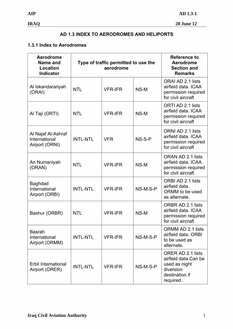
AIP AD 1.3-1
IRAQ 28 June 12
Iraq Civil Aviation Authority 1
AD 1.3 INDEX TO AERODROMES AND HELIPORTS 1.3.1 Index to Aerodromes
Aerodrome Name and Location Indicator
Type of traffic permitted to use the aerodrome
Reference to Aerodrome Section and
Remarks
Al Iskandarariyah (ORAI)
NTL VFR-IFR NS-M
ORAI AD 2.1 lists airfield data. ICAA permission required for civil aircraft
Al Taji (ORTI) NTL VFR-IFR NS-M
ORTI AD 2.1 lists airfield data. ICAA permission required for civil aircraft
Al Najaf Al-Ashraf International Airport (ORNI)
INTL-NTL VFR NS-S-P
ORNI AD 2.1 lists airfield data. ICAA permission required for civil aircraft
An Numaniyah (ORAN)
NTL VFR-IFR NS-M
ORAN AD 2.1 lists airfield data. ICAA permission required for civil aircraft
Baghdad International Airport (ORBI)
INTL-NTL VFR-IFR NS-M-S-P
ORBI AD 2.1 lists airfield data. ORMM to be used as alternate.
Bashur (ORBR) NTL VFR-IFR NS-M
ORBR AD 2.1 lists airfield data. ICAA permission required for civil aircraft
Basrah International Airport (ORMM)
INTL-NTL VFR-IFR NS-M-S-P
ORMM AD 2.1 lists airfield data. ORBI to be used as alternate.
Erbil International Airport (ORER)
INTL-NTL VFR-IFR NS-M-S-P
ORER AD 2.1 lists airfield data.Can be used as night diversion destination if required.
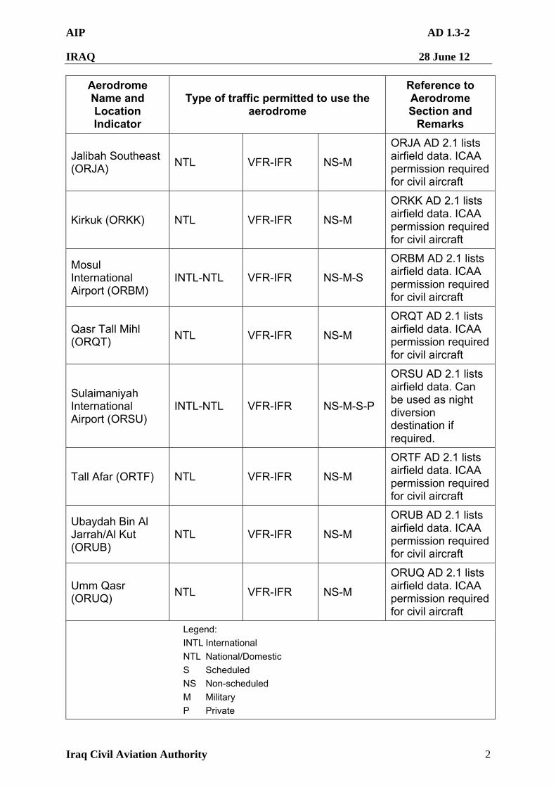
AIP AD 1.3-2
IRAQ 28 June 12
Iraq Civil Aviation Authority 2
Aerodrome Name and Location Indicator
Type of traffic permitted to use the aerodrome
Reference to Aerodrome Section and
Remarks
Jalibah Southeast (ORJA)
NTL VFR-IFR NS-M
ORJA AD 2.1 lists airfield data. ICAA permission required for civil aircraft
Kirkuk (ORKK) NTL VFR-IFR NS-M
ORKK AD 2.1 lists airfield data. ICAA permission required for civil aircraft
Mosul International Airport (ORBM)
INTL-NTL VFR-IFR NS-M-S
ORBM AD 2.1 lists airfield data. ICAA permission required for civil aircraft
Qasr Tall Mihl (ORQT)
NTL VFR-IFR NS-M
ORQT AD 2.1 lists airfield data. ICAA permission required for civil aircraft
Sulaimaniyah International Airport (ORSU)
INTL-NTL VFR-IFR NS-M-S-P
ORSU AD 2.1 lists airfield data. Can be used as night diversion destination if required.
Tall Afar (ORTF) NTL VFR-IFR NS-M
ORTF AD 2.1 lists airfield data. ICAA permission required for civil aircraft
Ubaydah Bin Al Jarrah/Al Kut (ORUB)
NTL VFR-IFR NS-M
ORUB AD 2.1 lists airfield data. ICAA permission required for civil aircraft
Umm Qasr (ORUQ)
NTL VFR-IFR NS-M
ORUQ AD 2.1 lists airfield data. ICAA permission required for civil aircraft
Legend:
INTL International
NTL National/Domestic
S Scheduled
NS Non-scheduled
M Military
P Private
AIP AD 1.3-3
IRAQ 28 June 12
Iraq Civil Aviation Authority 3
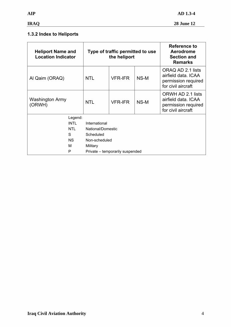
AIP AD 1.3-4
IRAQ 28 June 12
Iraq Civil Aviation Authority 4
1.3.2 Index to Heliports
Heliport Name and Location Indicator
Type of traffic permitted to use the heliport
Reference to Aerodrome Section and
Remarks
Al Qaim (ORAQ) NTL VFR-IFR NS-M
ORAQ AD 2.1 lists airfield data. ICAA permission required for civil aircraft
Washington Army (ORWH)
NTL VFR-IFR NS-M
ORWH AD 2.1 lists airfield data. ICAA permission required for civil aircraft
Legend:
INTL International
NTL National/Domestic
S Scheduled
NS Non-scheduled
M Military
P Private – temporarily suspended
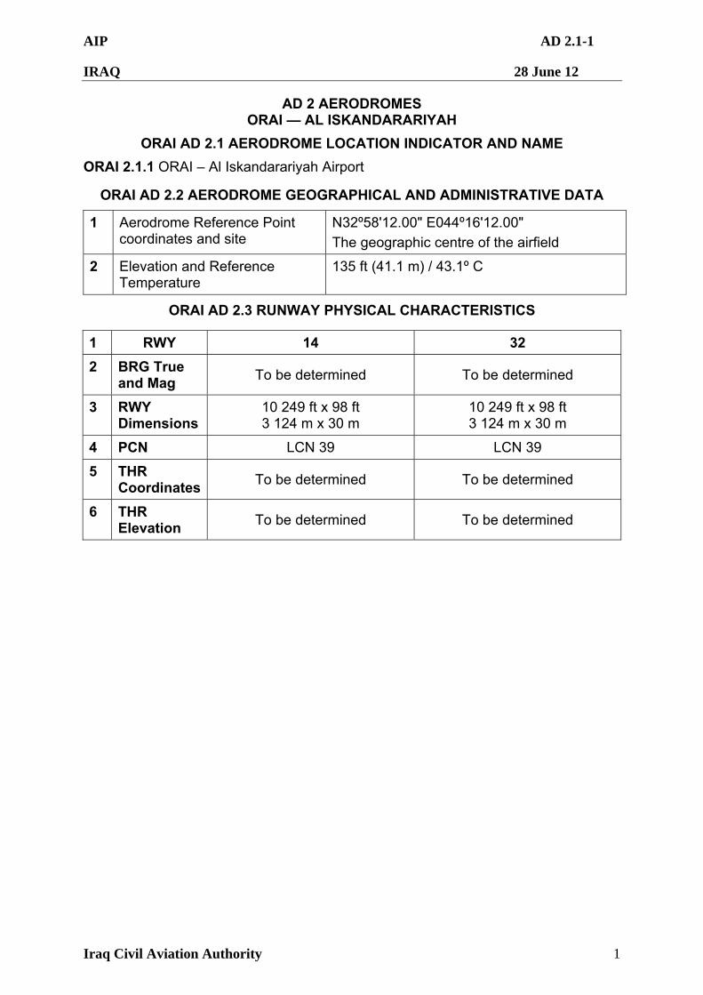
AIP AD 2.1-1
IRAQ 28 June 12
Iraq Civil Aviation Authority 1
AD 2 AERODROMES ORAI — AL ISKANDARARIYAH
ORAI AD 2.1 AERODROME LOCATION INDICATOR AND NAME
ORAI 2.1.1 ORAI – Al Iskandarariyah Airport
ORAI AD 2.2 AERODROME GEOGRAPHICAL AND ADMINISTRATIVE DATA
1 Aerodrome Reference Point coordinates and site
N32º58'12.00" E044º16'12.00"
The geographic centre of the airfield
2 Elevation and Reference Temperature
135 ft (41.1 m) / 43.1º C
ORAI AD 2.3 RUNWAY PHYSICAL CHARACTERISTICS
1 RWY 14 32
2 BRG True and Mag
To be determined To be determined
3 RWY Dimensions
10 249 ft x 98 ft 3 124 m x 30 m
10 249 ft x 98 ft 3 124 m x 30 m
4 PCN LCN 39 LCN 39
5 THR Coordinates
To be determined To be determined
6 THR Elevation
To be determined To be determined
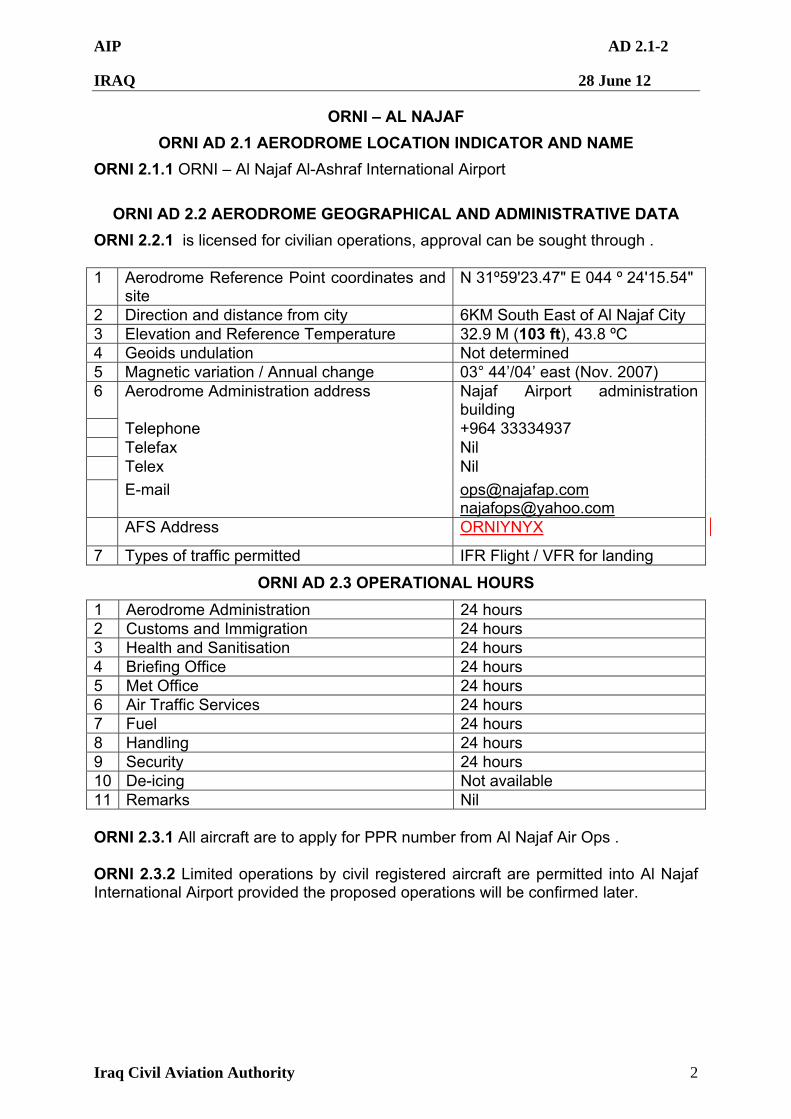
AIP AD 2.1-2
IRAQ 28 June 12
Iraq Civil Aviation Authority 2
ORNI – AL NAJAF
ORNI AD 2.1 AERODROME LOCATION INDICATOR AND NAME
ORNI 2.1.1 ORNI – Al Najaf Al-Ashraf International Airport
ORNI AD 2.2 AERODROME GEOGRAPHICAL AND ADMINISTRATIVE DATA
ORNI 2.2.1 is licensed for civilian operations, approval can be sought through . 1 Aerodrome Reference Point coordinates and
site N 31º59'23.47" E 044 º 24'15.54"
2 Direction and distance from city 6KM South East of Al Najaf City 3 Elevation and Reference Temperature 32.9 M (103 ft), 43.8 ºC 4 Geoids undulation Not determined 5 Magnetic variation / Annual change 03° 44’/04’ east (Nov. 2007) 6 Aerodrome Administration address
Najaf Airport administration building
Telephone +964 33334937 Telefax Nil Telex Nil
E-mail [email protected] [email protected]
AFS Address ORNIYNYX
7 Types of traffic permitted IFR Flight / VFR for landing
ORNI AD 2.3 OPERATIONAL HOURS
1 Aerodrome Administration 24 hours 2 Customs and Immigration 24 hours 3 Health and Sanitisation 24 hours 4 Briefing Office 24 hours 5 Met Office 24 hours 6 Air Traffic Services 24 hours 7 Fuel 24 hours 8 Handling 24 hours 9 Security 24 hours 10 De-icing Not available 11 Remarks Nil ORNI 2.3.1 All aircraft are to apply for PPR number from Al Najaf Air Ops . ORNI 2.3.2 Limited operations by civil registered aircraft are permitted into Al Najaf International Airport provided the proposed operations will be confirmed later.
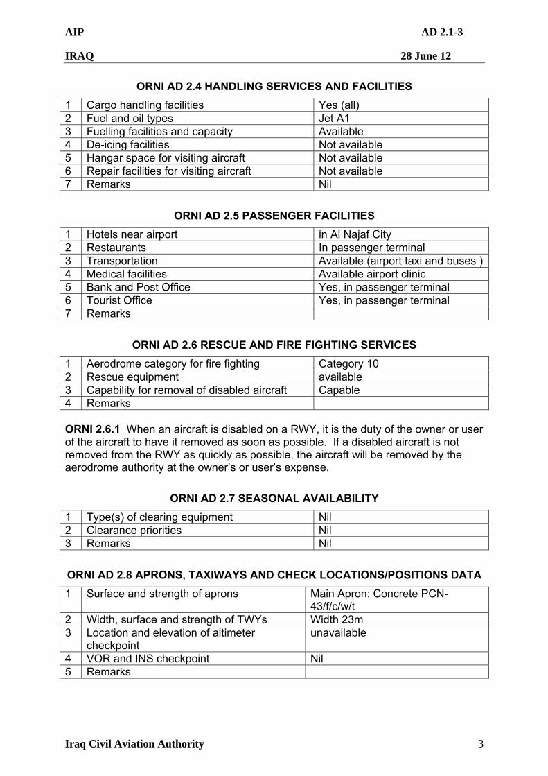
AIP AD 2.1-3
IRAQ 28 June 12
Iraq Civil Aviation Authority 3
ORNI AD 2.4 HANDLING SERVICES AND FACILITIES
1 Cargo handling facilities Yes (all) 2 Fuel and oil types Jet A1 3 Fuelling facilities and capacity Available 4 De-icing facilities Not available 5 Hangar space for visiting aircraft Not available 6 Repair facilities for visiting aircraft Not available 7 Remarks Nil
ORNI AD 2.5 PASSENGER FACILITIES
1 Hotels near airport in Al Najaf City 2 Restaurants In passenger terminal 3 Transportation Available (airport taxi and buses ) 4 Medical facilities Available airport clinic 5 Bank and Post Office Yes, in passenger terminal 6 Tourist Office Yes, in passenger terminal 7 Remarks
ORNI AD 2.6 RESCUE AND FIRE FIGHTING SERVICES
1 Aerodrome category for fire fighting Category 10 2 Rescue equipment available 3 Capability for removal of disabled aircraft Capable 4 Remarks ORNI 2.6.1 When an aircraft is disabled on a RWY, it is the duty of the owner or user of the aircraft to have it removed as soon as possible. If a disabled aircraft is not removed from the RWY as quickly as possible, the aircraft will be removed by the aerodrome authority at the owner’s or user’s expense.
ORNI AD 2.7 SEASONAL AVAILABILITY
1 Type(s) of clearing equipment Nil 2 Clearance priorities Nil 3 Remarks Nil
ORNI AD 2.8 APRONS, TAXIWAYS AND CHECK LOCATIONS/POSITIONS DATA
1 Surface and strength of aprons Main Apron: Concrete PCN-43/f/c/w/t
2 Width, surface and strength of TWYs Width 23m 3 Location and elevation of altimeter
checkpoint unavailable
4 VOR and INS checkpoint Nil 5 Remarks
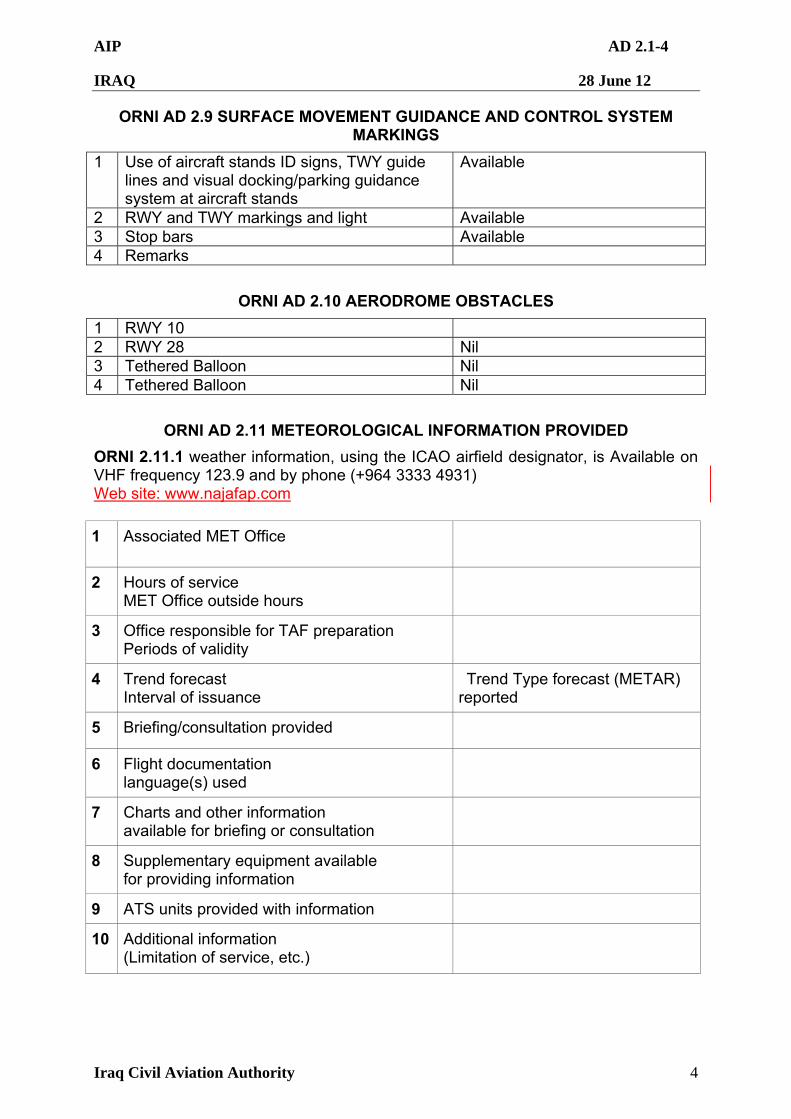
AIP AD 2.1-4
IRAQ 28 June 12
Iraq Civil Aviation Authority 4
ORNI AD 2.9 SURFACE MOVEMENT GUIDANCE AND CONTROL SYSTEM MARKINGS
1 Use of aircraft stands ID signs, TWY guide lines and visual docking/parking guidance system at aircraft stands
Available
2 RWY and TWY markings and light Available 3 Stop bars Available 4 Remarks
ORNI AD 2.10 AERODROME OBSTACLES
1 RWY 10 2 RWY 28 Nil 3 Tethered Balloon Nil 4 Tethered Balloon Nil
ORNI AD 2.11 METEOROLOGICAL INFORMATION PROVIDED
ORNI 2.11.1 weather information, using the ICAO airfield designator, is Available on VHF frequency 123.9 and by phone (+964 3333 4931) Web site: www.najafap.com
1 Associated MET Office
2 Hours of service MET Office outside hours
3 Office responsible for TAF preparation Periods of validity
4 Trend forecast Interval of issuance
Trend Type forecast (METAR) reported
5 Briefing/consultation provided
6 Flight documentation language(s) used
7 Charts and other information available for briefing or consultation
8 Supplementary equipment available for providing information
9 ATS units provided with information
10 Additional information (Limitation of service, etc.)
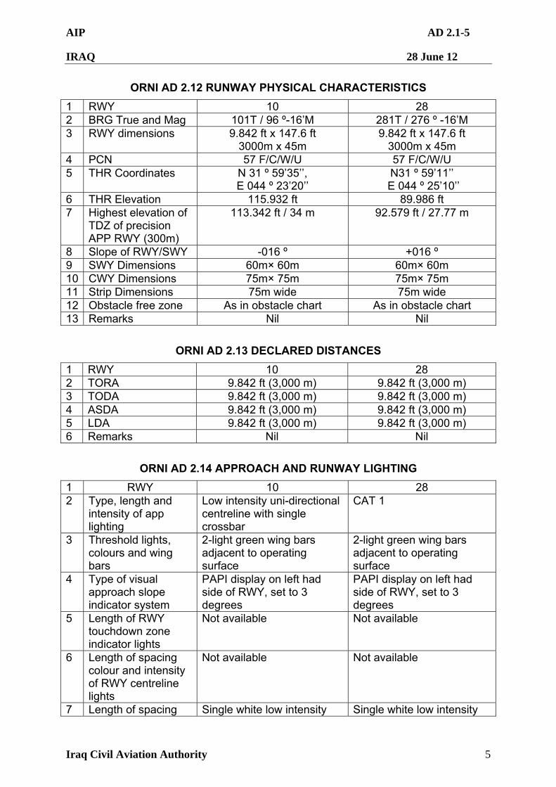
AIP AD 2.1-5
IRAQ 28 June 12
Iraq Civil Aviation Authority 5
ORNI AD 2.12 RUNWAY PHYSICAL CHARACTERISTICS
1 RWY 10 28 2 BRG True and Mag 101T / 96 º-16’M 281T / 276 º -16’M 3 RWY dimensions 9.842 ft x 147.6 ft
3000m x 45m 9.842 ft x 147.6 ft
3000m x 45m 4 PCN 57 F/C/W/U 57 F/C/W/U 5 THR Coordinates N 31 º 59’35’’,
E 044 º 23’20’’ N31 º 59’11’’
E 044 º 25’10’’ 6 THR Elevation 115.932 ft 89.986 ft 7 Highest elevation of
TDZ of precision APP RWY (300m)
113.342 ft / 34 m 92.579 ft / 27.77 m
8 Slope of RWY/SWY -016 º +016 º 9 SWY Dimensions 60m× 60m 60m× 60m 10 CWY Dimensions 75m× 75m 75m× 75m 11 Strip Dimensions 75m wide 75m wide 12 Obstacle free zone As in obstacle chart As in obstacle chart 13 Remarks Nil Nil
ORNI AD 2.13 DECLARED DISTANCES
1 RWY 10 28 2 TORA 9.842 ft (3,000 m) 9.842 ft (3,000 m) 3 TODA 9.842 ft (3,000 m) 9.842 ft (3,000 m) 4 ASDA 9.842 ft (3,000 m) 9.842 ft (3,000 m) 5 LDA 9.842 ft (3,000 m) 9.842 ft (3,000 m) 6 Remarks Nil Nil
ORNI AD 2.14 APPROACH AND RUNWAY LIGHTING
1 RWY 10 28 2 Type, length and
intensity of app lighting
Low intensity uni-directional centreline with single crossbar
CAT 1
3 Threshold lights, colours and wing bars
2-light green wing bars adjacent to operating surface
2-light green wing bars adjacent to operating surface
4 Type of visual approach slope indicator system
PAPI display on left had side of RWY, set to 3 degrees
PAPI display on left had side of RWY, set to 3 degrees
5 Length of RWY touchdown zone indicator lights
Not available Not available
6 Length of spacing colour and intensity of RWY centreline lights
Not available Not available
7 Length of spacing Single white low intensity Single white low intensity
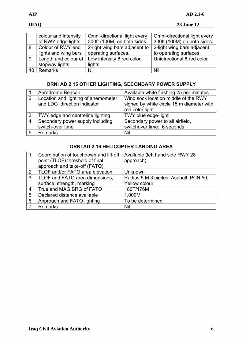
AIP AD 2.1-6
IRAQ 28 June 12
Iraq Civil Aviation Authority 6
colour and intensity of RWY edge lights
Omni-directional light every 300ft (100M) on both sides.
Omni-directional light every 300ft (100M) on both sides.
8 Colour of RWY end lights and wing bars
2-light wing bars adjacent to operating surfaces.
2-light wing bars adjacent to operating surfaces.
9 Length and colour of stopway lights
Low intensity 8 red color lights
Unidirectional 8 red color
10 Remarks Nil Nil
ORNI AD 2.15 OTHER LIGHTING, SECONDARY POWER SUPPLY
1 Aerodrome Beacon Available white flashing 25 per minutes 2 Location and lighting of anemometer
and LDG direction indicator Wind sock location middle of the RWY signed by white circle 15 m diameter with red color light
3 TWY edge and centreline lighting TWY blue edge-light 4 Secondary power supply including
switch-over time Secondary power to all airfield, switchover time: 6 seconds
5 Remarks Nil
ORNI AD 2.16 HELICOPTER LANDING AREA
1 Coordination of touchdown and lift-off point (TLOF) threshold of final approach and take-off (FATO)
Available (left hand side RWY 28 approach)
2 TLOF and/or FATO area elevation Unknown 3 TLOF and FATO area dimensions,
surface, strength, marking Radius 5 M 3 circles, Asphalt, PCN 50, Yellow colour
4 True and MAG BRG of FATO 180T/176M 5 Declared distance available 1,000M 6 Approach and FATO lighting To be determined 7 Remarks Nil
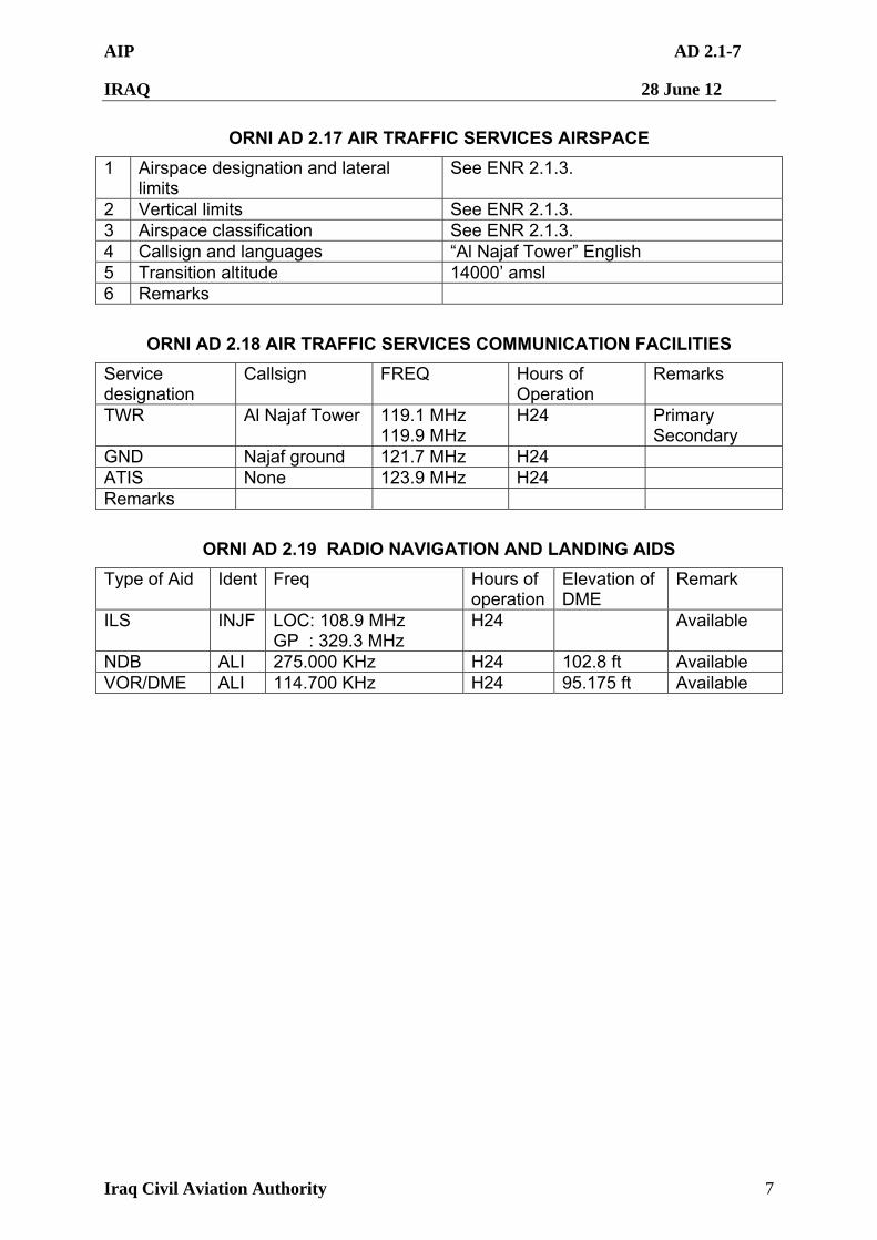
AIP AD 2.1-7
IRAQ 28 June 12
Iraq Civil Aviation Authority 7
ORNI AD 2.17 AIR TRAFFIC SERVICES AIRSPACE
1 Airspace designation and lateral limits
See ENR 2.1.3.
2 Vertical limits See ENR 2.1.3. 3 Airspace classification See ENR 2.1.3. 4 Callsign and languages “Al Najaf Tower” English 5 Transition altitude 14000’ amsl 6 Remarks
ORNI AD 2.18 AIR TRAFFIC SERVICES COMMUNICATION FACILITIES
Service designation
Callsign FREQ Hours of Operation
Remarks
TWR Al Najaf Tower 119.1 MHz 119.9 MHz
H24 Primary Secondary
GND Najaf ground 121.7 MHz H24 ATIS None 123.9 MHz H24 Remarks
ORNI AD 2.19 RADIO NAVIGATION AND LANDING AIDS
Type of Aid Ident Freq Hours of operation
Elevation of DME
Remark
ILS INJF LOC: 108.9 MHz GP : 329.3 MHz
H24 Available
NDB ALI 275.000 KHz H24 102.8 ft Available VOR/DME ALI 114.700 KHz H24 95.175 ft Available
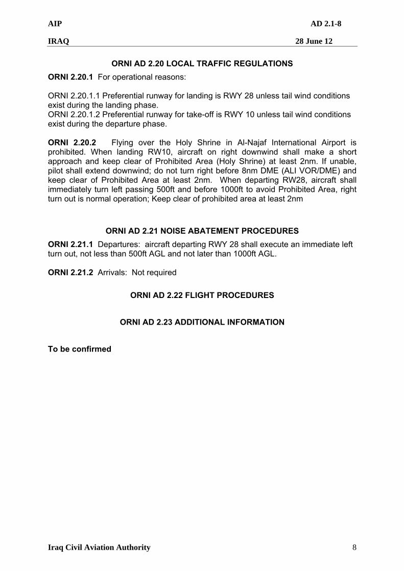
AIP AD 2.1-8
IRAQ 28 June 12
Iraq Civil Aviation Authority 8
ORNI AD 2.20 LOCAL TRAFFIC REGULATIONS
ORNI 2.20.1 For operational reasons: ORNI 2.20.1.1 Preferential runway for landing is RWY 28 unless tail wind conditions exist during the landing phase. ORNI 2.20.1.2 Preferential runway for take-off is RWY 10 unless tail wind conditions exist during the departure phase. ORNI 2.20.2 Flying over the Holy Shrine in Al-Najaf International Airport is prohibited. When landing RW10, aircraft on right downwind shall make a short approach and keep clear of Prohibited Area (Holy Shrine) at least 2nm. If unable, pilot shall extend downwind; do not turn right before 8nm DME (ALI VOR/DME) and keep clear of Prohibited Area at least 2nm. When departing RW28, aircraft shall immediately turn left passing 500ft and before 1000ft to avoid Prohibited Area, right turn out is normal operation; Keep clear of prohibited area at least 2nm
ORNI AD 2.21 NOISE ABATEMENT PROCEDURES
ORNI 2.21.1 Departures: aircraft departing RWY 28 shall execute an immediate left turn out, not less than 500ft AGL and not later than 1000ft AGL. ORNI 2.21.2 Arrivals: Not required
ORNI AD 2.22 FLIGHT PROCEDURES
ORNI AD 2.23 ADDITIONAL INFORMATION
To be confirmed
AIP AD 2.1-9
IRAQ 28 June 12
Iraq Civil Aviation Authority 9
ORNI AD 2.24 CHARTS RELATED TO AN AERODROME
1 Aerodrome Chart – ICAO ORNI AD 2.24.1
2 Aerodrome Lay-Out Chart – ICAO ORNI AD 2.24.2
3 Aerodrome Obctacle Chart ICAO Type A– ICAO ORNI AD 2.24.3
4 VOR RWY 28 ORNI AD 2.24.4
5 Instrument Approach Chart – ICAO (ILS OR LOC Y RWY 28)
ORNI AD 2.24.5
6 Instrument Approach Chart – ICAO (ILS OR LOC Z RWY 28)
ORNI AD 2.24.6
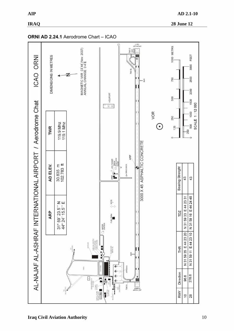
AIP AD 2.1-10
IRAQ 28 June 12
Iraq Civil Aviation Authority 10
ORNI AD 2.24.1 Aerodrome Chart – ICAO
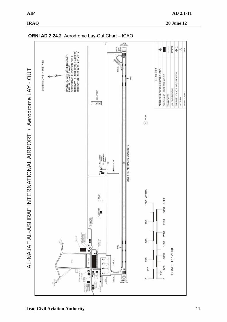
AIP AD 2.1-11
IRAQ 28 June 12
Iraq Civil Aviation Authority 11
ORNI AD 2.24.2 Aerodrome Lay-Out Chart – ICAO
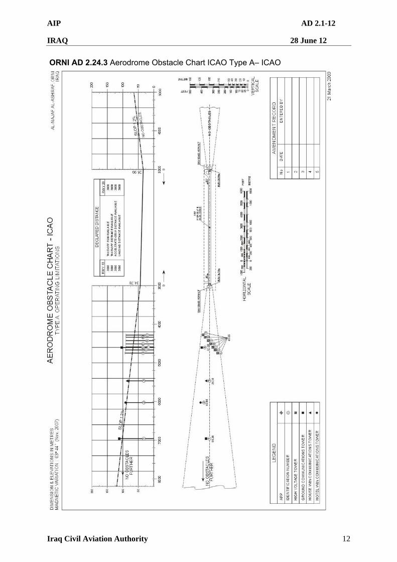
AIP AD 2.1-12
IRAQ 28 June 12
Iraq Civil Aviation Authority 12
ORNI AD 2.24.3 Aerodrome Obstacle Chart ICAO Type A– ICAO
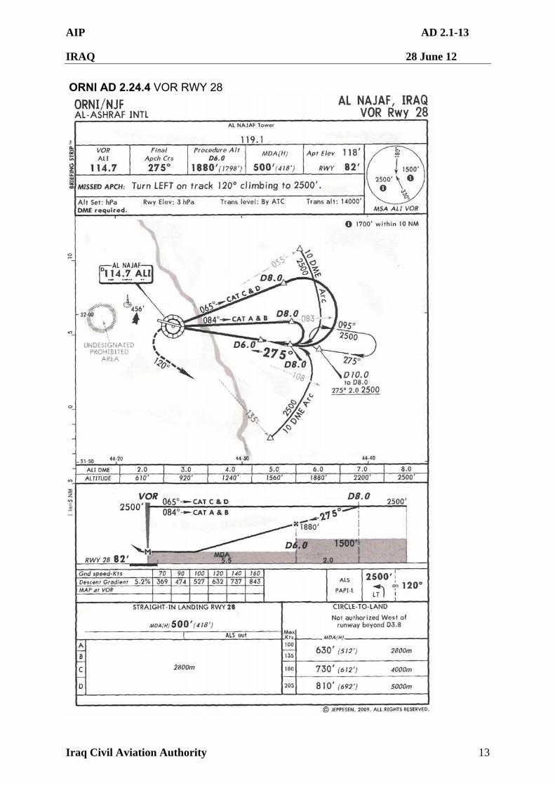
AIP AD 2.1-13
IRAQ 28 June 12
Iraq Civil Aviation Authority 13
ORNI AD 2.24.4 VOR RWY 28
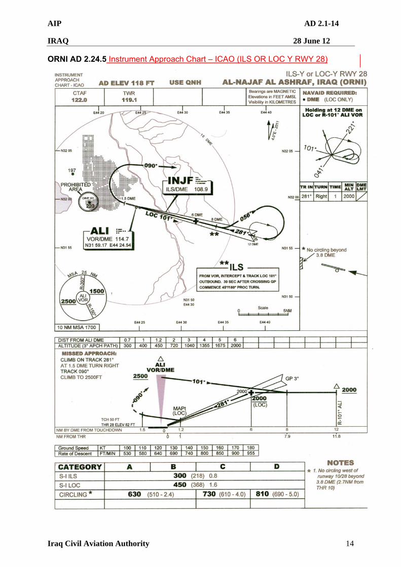
AIP AD 2.1-14
IRAQ 28 June 12
Iraq Civil Aviation Authority 14
ORNI AD 2.24.5 Instrument Approach Chart – ICAO (ILS OR LOC Y RWY 28)
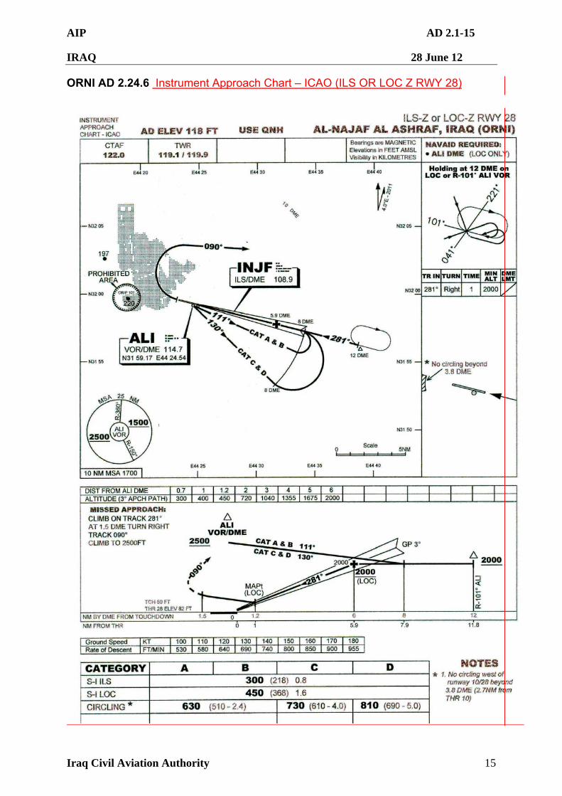
AIP AD 2.1-15
IRAQ 28 June 12
Iraq Civil Aviation Authority 15
ORNI AD 2.24.6 Instrument Approach Chart – ICAO (ILS OR LOC Z RWY 28)
AIP AD 2.1-16
IRAQ 28 June 12
Iraq Civil Aviation Authority 16
ORTI — AL TAJI
ORTI AD 2.1 AERODROME LOCATION INDICATOR AND NAME
ORTI 2.1.1 ORTI – Al Taji Airfield
ORTI AD 2.2 AERODROME GEOGRAPHICAL AND ADMINISTRATIVE DATA
ORTI 2.2.1 The facilities and procedures listed below do not necessarily comply with, or adhere to, the requirements of ICAO Annex 14.
1 Aerodrome Reference Point coordinates and site
N33º31'22.1" E044º15'25.9"
Located at centre of RWY
2 Direction and distance from city Generally N/NW, approx. 14 NM
3 Elevation and Reference Temperature
121 ft, 44º C
4 Geoid undulation Not determined
5 Magnetic variation/Annual change
4º7'43.8"
Aerodrome Administration Address
F Co 7/101st Unit 6070
APO AE 09378
Telephone DSN: 318-834-3199
Telefax Nil
Telex Nil
E-mail Nil
6
AFS Address Nil
7 Types of traffic permitted IFR and VFR
8 Transition altitude and level 14 000 ft
ORTI AD 2.3 OPERATIONAL HOURS
1 Aerodrome Administration 24 hours
2 Customs and Immigration Nil
3 Health and Sanitization Nil
4 AIS Briefing Office Nil
5 ATS Reporting Office Nil
6 Met Office 24 hrs
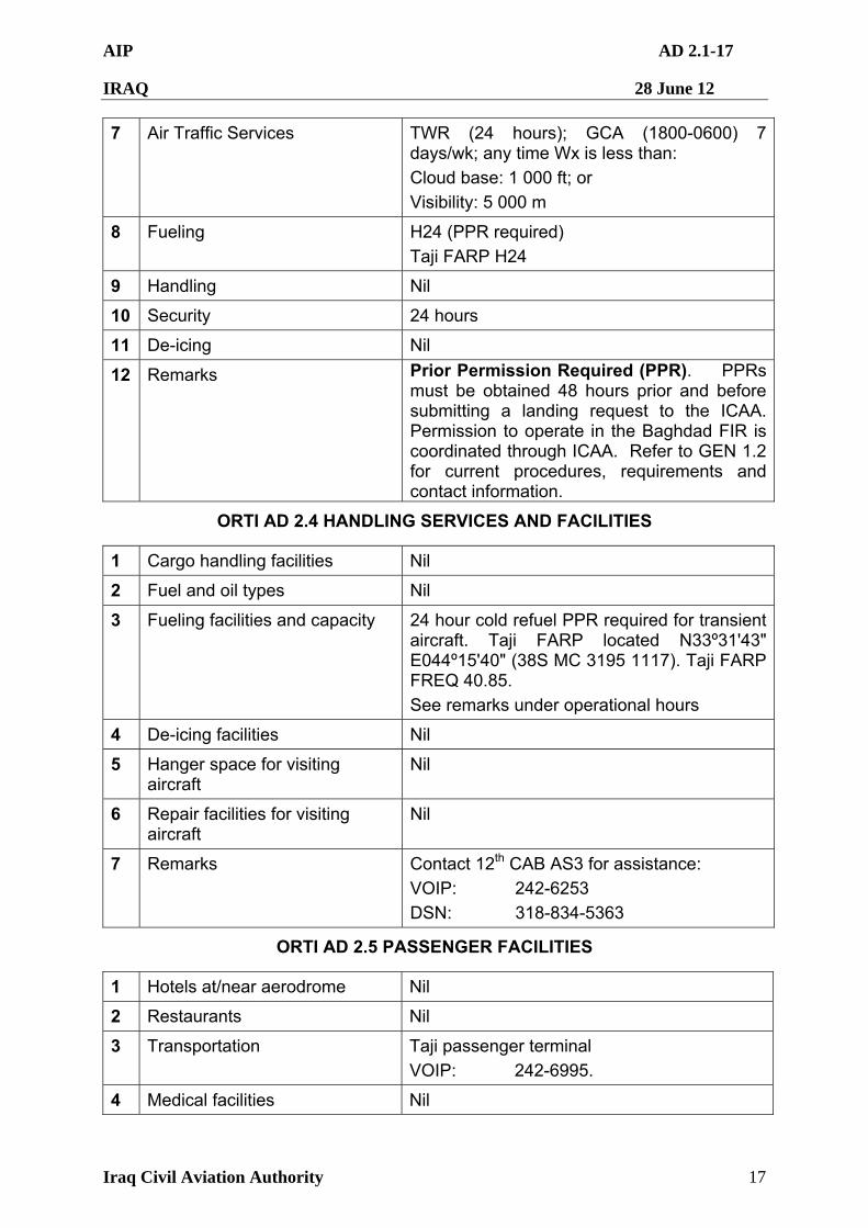
AIP AD 2.1-17
IRAQ 28 June 12
Iraq Civil Aviation Authority 17
7 Air Traffic Services TWR (24 hours); GCA (1800-0600) 7 days/wk; any time Wx is less than:
Cloud base: 1 000 ft; or
Visibility: 5 000 m
8 Fueling H24 (PPR required)
Taji FARP H24
9 Handling Nil
10 Security 24 hours
11 De-icing Nil
12 Remarks Prior Permission Required (PPR). PPRs must be obtained 48 hours prior and before submitting a landing request to the ICAA. Permission to operate in the Baghdad FIR is coordinated through ICAA. Refer to GEN 1.2 for current procedures, requirements and contact information.
ORTI AD 2.4 HANDLING SERVICES AND FACILITIES
1 Cargo handling facilities Nil
2 Fuel and oil types Nil
3 Fueling facilities and capacity 24 hour cold refuel PPR required for transient aircraft. Taji FARP located N33º31'43" E044º15'40" (38S MC 3195 1117). Taji FARP FREQ 40.85.
See remarks under operational hours
4 De-icing facilities Nil
5 Hanger space for visiting aircraft
Nil
6 Repair facilities for visiting aircraft
Nil
7 Remarks Contact 12th CAB AS3 for assistance:
VOIP: 242-6253
DSN: 318-834-5363
ORTI AD 2.5 PASSENGER FACILITIES
1 Hotels at/near aerodrome Nil
2 Restaurants Nil
3 Transportation Taji passenger terminal
VOIP: 242-6995.
4 Medical facilities Nil
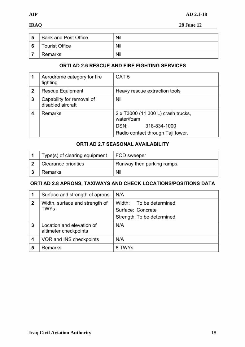
AIP AD 2.1-18
IRAQ 28 June 12
Iraq Civil Aviation Authority 18
5 Bank and Post Office Nil
6 Tourist Office Nil
7 Remarks Nil
ORTI AD 2.6 RESCUE AND FIRE FIGHTING SERVICES
1 Aerodrome category for fire fighting
CAT 5
2 Rescue Equipment Heavy rescue extraction tools
3 Capability for removal of disabled aircraft
Nil
4 Remarks 2 x T3000 (11 300 L) crash trucks, water/foam
DSN: 318-834-1000
Radio contact through Taji tower.
ORTI AD 2.7 SEASONAL AVAILABILITY
1 Type(s) of clearing equipment FOD sweeper
2 Clearance priorities Runway then parking ramps.
3 Remarks Nil
ORTI AD 2.8 APRONS, TAXIWAYS AND CHECK LOCATIONS/POSITIONS DATA
1 Surface and strength of aprons N/A
2 Width, surface and strength of TWYs
Width: To be determined
Surface: Concrete
Strength: To be determined
3 Location and elevation of altimeter checkpoints
N/A
4 VOR and INS checkpoints N/A
5 Remarks 8 TWYs
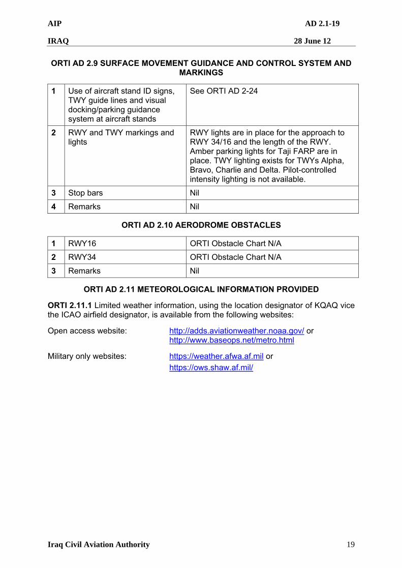
AIP AD 2.1-19
IRAQ 28 June 12
Iraq Civil Aviation Authority 19
ORTI AD 2.9 SURFACE MOVEMENT GUIDANCE AND CONTROL SYSTEM AND MARKINGS
1 Use of aircraft stand ID signs, TWY guide lines and visual docking/parking guidance system at aircraft stands
See ORTI AD 2-24
2 RWY and TWY markings and lights
RWY lights are in place for the approach to RWY 34/16 and the length of the RWY. Amber parking lights for Taji FARP are in place. TWY lighting exists for TWYs Alpha, Bravo, Charlie and Delta. Pilot-controlled intensity lighting is not available.
3 Stop bars Nil
4 Remarks Nil
ORTI AD 2.10 AERODROME OBSTACLES
1 RWY16 ORTI Obstacle Chart N/A
2 RWY34 ORTI Obstacle Chart N/A
3 Remarks Nil
ORTI AD 2.11 METEOROLOGICAL INFORMATION PROVIDED
ORTI 2.11.1 Limited weather information, using the location designator of KQAQ vice the ICAO airfield designator, is available from the following websites:
Open access website: http://adds.aviationweather.noaa.gov/ or http://www.baseops.net/metro.html
Military only websites: https://weather.afwa.af.mil or https://ows.shaw.af.mil/
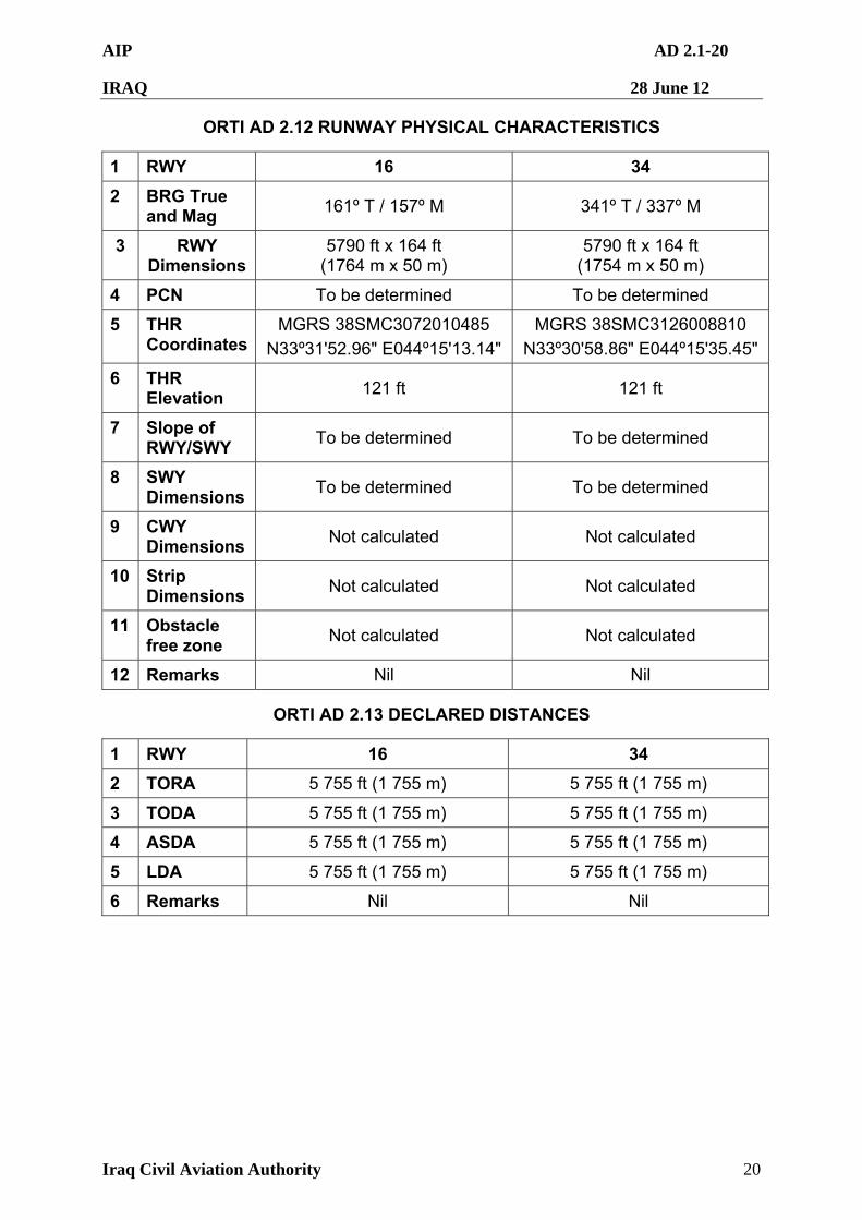
AIP AD 2.1-20
IRAQ 28 June 12
Iraq Civil Aviation Authority 20
ORTI AD 2.12 RUNWAY PHYSICAL CHARACTERISTICS
1 RWY 16 34
2 BRG True and Mag
161º T / 157º M 341º T / 337º M
3 RWY Dimensions
5790 ft x 164 ft (1764 m x 50 m)
5790 ft x 164 ft (1754 m x 50 m)
4 PCN To be determined To be determined
5 THR Coordinates
MGRS 38SMC3072010485
N33º31'52.96" E044º15'13.14"
MGRS 38SMC3126008810
N33º30'58.86" E044º15'35.45"
6 THR Elevation
121 ft 121 ft
7 Slope of RWY/SWY
To be determined To be determined
8 SWY Dimensions
To be determined To be determined
9 CWY Dimensions
Not calculated Not calculated
10 Strip Dimensions
Not calculated Not calculated
11 Obstacle free zone
Not calculated Not calculated
12 Remarks Nil Nil
ORTI AD 2.13 DECLARED DISTANCES
1 RWY 16 34
2 TORA 5 755 ft (1 755 m) 5 755 ft (1 755 m)
3 TODA 5 755 ft (1 755 m) 5 755 ft (1 755 m)
4 ASDA 5 755 ft (1 755 m) 5 755 ft (1 755 m)
5 LDA 5 755 ft (1 755 m) 5 755 ft (1 755 m)
6 Remarks Nil Nil
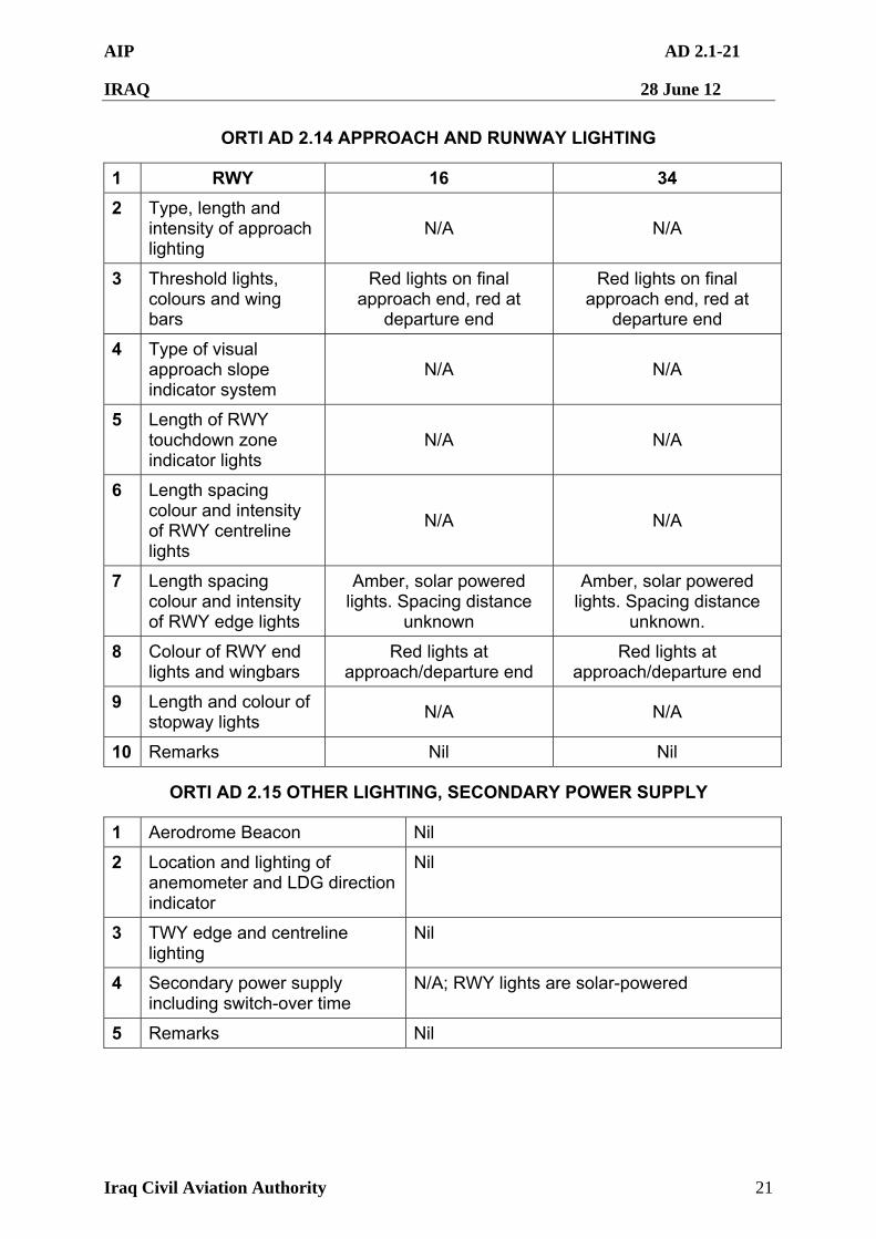
AIP AD 2.1-21
IRAQ 28 June 12
Iraq Civil Aviation Authority 21
ORTI AD 2.14 APPROACH AND RUNWAY LIGHTING
1 RWY 16 34
2 Type, length and intensity of approach lighting
N/A N/A
3 Threshold lights, colours and wing bars
Red lights on final approach end, red at
departure end
Red lights on final approach end, red at
departure end
4 Type of visual approach slope indicator system
N/A N/A
5 Length of RWY touchdown zone indicator lights
N/A N/A
6 Length spacing colour and intensity of RWY centreline lights
N/A N/A
7 Length spacing colour and intensity of RWY edge lights
Amber, solar powered lights. Spacing distance
unknown
Amber, solar powered lights. Spacing distance
unknown.
8 Colour of RWY end lights and wingbars
Red lights at approach/departure end
Red lights at approach/departure end
9 Length and colour of stopway lights
N/A N/A
10 Remarks Nil Nil
ORTI AD 2.15 OTHER LIGHTING, SECONDARY POWER SUPPLY
1 Aerodrome Beacon Nil
2 Location and lighting of anemometer and LDG direction indicator
Nil
3 TWY edge and centreline lighting
Nil
4 Secondary power supply including switch-over time
N/A; RWY lights are solar-powered
5 Remarks Nil
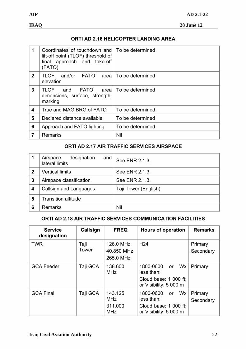
AIP AD 2.1-22
IRAQ 28 June 12
Iraq Civil Aviation Authority 22
ORTI AD 2.16 HELICOPTER LANDING AREA
1 Coordinates of touchdown and lift-off point (TLOF) threshold of final approach and take-off (FATO)
To be determined
2 TLOF and/or FATO area elevation
To be determined
3 TLOF and FATO area dimensions, surface, strength, marking
To be determined
4 True and MAG BRG of FATO To be determined
5 Declared distance available To be determined
6 Approach and FATO lighting To be determined
7 Remarks Nil
ORTI AD 2.17 AIR TRAFFIC SERVICES AIRSPACE
1 Airspace designation and lateral limits
See ENR 2.1.3.
2 Vertical limits See ENR 2.1.3.
3 Airspace classification See ENR 2.1.3.
4 Callsign and Languages Taji Tower (English)
5 Transition altitude
6 Remarks Nil
ORTI AD 2.18 AIR TRAFFIC SERVICES COMMUNICATION FACILITIES
Service designation
Callsign FREQ Hours of operation Remarks
TWR Taji Tower
126.0 MHz
40.850 MHz
265.0 MHz
H24 Primary
Secondary
GCA Feeder Taji GCA 138.600 MHz
1800-0600 or Wx less than:
Cloud base: 1 000 ft; or Visibility: 5 000 m
Primary
GCA Final Taji GCA 143.125 MHz
311.000 MHz
1800-0600 or Wx less than:
Cloud base: 1 000 ft; or Visibility: 5 000 m
Primary
Secondary
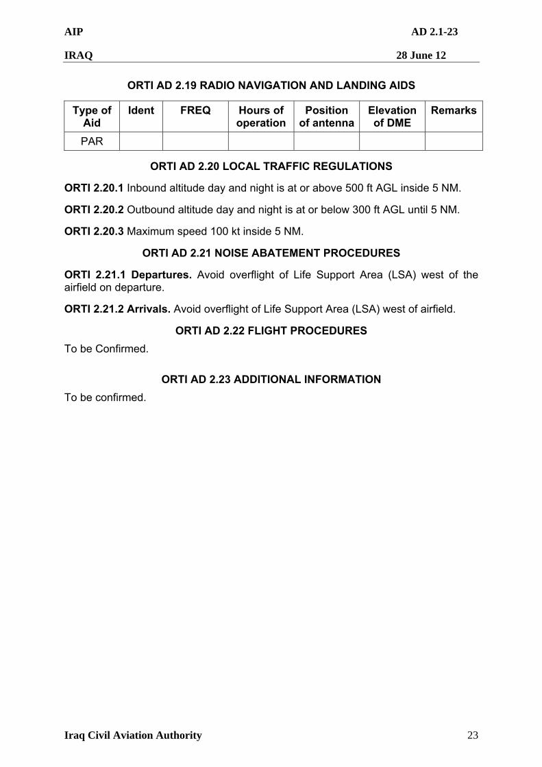
AIP AD 2.1-23
IRAQ 28 June 12
Iraq Civil Aviation Authority 23
ORTI AD 2.19 RADIO NAVIGATION AND LANDING AIDS
Type of Aid
Ident FREQ Hours of operation
Position of antenna
Elevation of DME
Remarks
PAR
ORTI AD 2.20 LOCAL TRAFFIC REGULATIONS
ORTI 2.20.1 Inbound altitude day and night is at or above 500 ft AGL inside 5 NM.
ORTI 2.20.2 Outbound altitude day and night is at or below 300 ft AGL until 5 NM.
ORTI 2.20.3 Maximum speed 100 kt inside 5 NM.
ORTI AD 2.21 NOISE ABATEMENT PROCEDURES
ORTI 2.21.1 Departures. Avoid overflight of Life Support Area (LSA) west of the airfield on departure.
ORTI 2.21.2 Arrivals. Avoid overflight of Life Support Area (LSA) west of airfield.
ORTI AD 2.22 FLIGHT PROCEDURES
To be Confirmed.
ORTI AD 2.23 ADDITIONAL INFORMATION
To be confirmed.
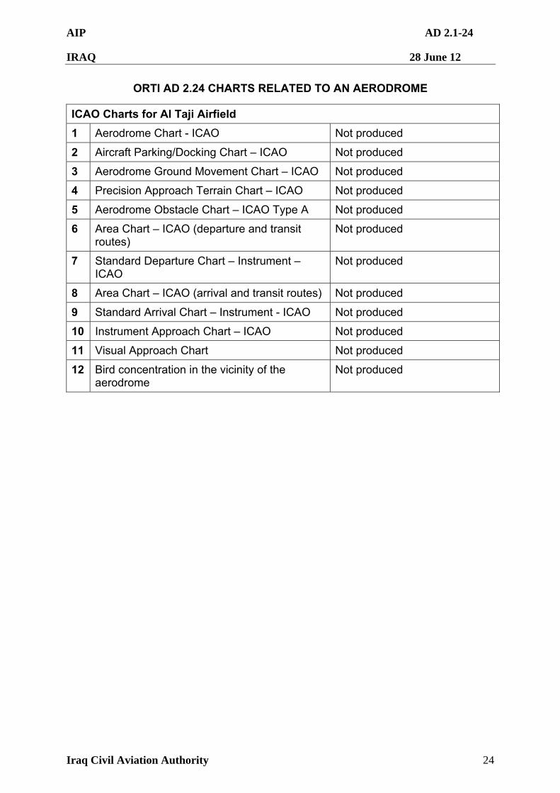
AIP AD 2.1-24
IRAQ 28 June 12
Iraq Civil Aviation Authority 24
ORTI AD 2.24 CHARTS RELATED TO AN AERODROME
ICAO Charts for Al Taji Airfield
1 Aerodrome Chart - ICAO Not produced
2 Aircraft Parking/Docking Chart – ICAO Not produced
3 Aerodrome Ground Movement Chart – ICAO Not produced
4 Precision Approach Terrain Chart – ICAO Not produced
5 Aerodrome Obstacle Chart – ICAO Type A Not produced
6 Area Chart – ICAO (departure and transit routes)
Not produced
7 Standard Departure Chart – Instrument – ICAO
Not produced
8 Area Chart – ICAO (arrival and transit routes) Not produced
9 Standard Arrival Chart – Instrument - ICAO Not produced
10 Instrument Approach Chart – ICAO Not produced
11 Visual Approach Chart Not produced
12 Bird concentration in the vicinity of the aerodrome
Not produced
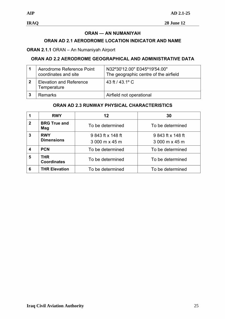
AIP AD 2.1-25
IRAQ 28 June 12
Iraq Civil Aviation Authority 25
ORAN — AN NUMANIYAH
ORAN AD 2.1 AERODROME LOCATION INDICATOR AND NAME
ORAN 2.1.1 ORAN – An Numaniyah Airport
ORAN AD 2.2 AERODROME GEOGRAPHICAL AND ADMINISTRATIVE DATA
1 Aerodrome Reference Point coordinates and site
N32º30'12.00" E045º19'54.00" The geographic centre of the airfield
2 Elevation and Reference Temperature
43 ft / 43.1º C
3 Remarks Airfield not operational
ORAN AD 2.3 RUNWAY PHYSICAL CHARACTERISTICS
1 RWY 12 30
2 BRG True and Mag To be determined To be determined
3 RWY Dimensions
9 843 ft x 148 ft
3 000 m x 45 m
9 843 ft x 148 ft
3 000 m x 45 m
4 PCN To be determined To be determined
5 THR Coordinates To be determined To be determined
6 THR Elevation To be determined To be determined
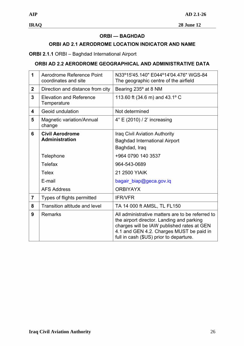
AIP AD 2.1-26
IRAQ 28 June 12
Iraq Civil Aviation Authority 26
ORBI — BAGHDAD
ORBI AD 2.1 AERODROME LOCATION INDICATOR AND NAME
ORBI 2.1.1 ORBI – Baghdad International Airport
ORBI AD 2.2 AERODROME GEOGRAPHICAL AND ADMINISTRATIVE DATA
1 Aerodrome Reference Point coordinates and site
N33º15'45.140" E044º14'04.476" WGS-84 The geographic centre of the airfield
2 Direction and distance from city Bearing 235º at 8 NM
3 Elevation and Reference Temperature
113.60 ft (34.6 m) and 43.1º C
4 Geoid undulation Not determined
5 Magnetic variation/Annual change
4° E (2010) / 2’ increasing
Civil Aerodrome Administration
Iraq Civil Aviation Authority
Baghdad International Airport
Baghdad, Iraq
Telephone +964 0790 140 3537
Telefax 964-543-0689
Telex 21 2500 YIAIK
E-mail [email protected]
6
AFS Address ORBIYAYX
7 Types of flights permitted IFR/VFR
8 Transition altitude and level TA 14 000 ft AMSL, TL FL150
9 Remarks All administrative matters are to be referred to the airport director. Landing and parking charges will be IAW published rates at GEN 4.1 and GEN 4.2. Charges MUST be paid in full in cash ($US) prior to departure.
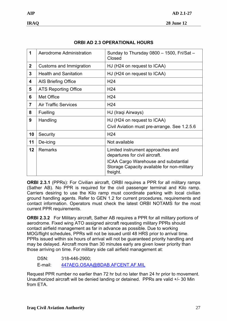
AIP AD 2.1-27
IRAQ 28 June 12
Iraq Civil Aviation Authority 27
ORBI AD 2.3 OPERATIONAL HOURS
1 Aerodrome Administration Sunday to Thursday 0800 – 1500, Fri/Sat – Closed
2 Customs and Immigration HJ (H24 on request to ICAA)
3 Health and Sanitation HJ (H24 on request to ICAA)
4 AIS Briefing Office H24
5 ATS Reporting Office H24
6 Met Office H24
7 Air Traffic Services H24
8 Fuelling HJ (Iraqi Airways)
9 Handling HJ (H24 on request to ICAA)
Civil Aviation must pre-arrange. See 1.2.5.6
10 Security H24
11 De-icing Not available
12 Remarks Limited instrument approaches and departures for civil aircraft.
ICAA Cargo Warehouse and substantial Storage Capacity available for non-military freight.
ORBI 2.3.1 (PPRs): For Civilian aircraft, ORBI requires a PPR for all military ramps (Sather AB). No PPR is required for the civil passenger terminal and Kilo ramp. Carriers desiring to use the Kilo ramp must coordinate parking with local civilian ground handling agents. Refer to GEN 1.2 for current procedures, requirements and contact information. Operators must check the latest ORBI NOTAMS for the most current PPR requirements.
ORBI 2.3.2 For Military aircraft, Sather AB requires a PPR for all military portions of aerodrome. Fixed wing ATO assigned aircraft requesting military PPRs should contact airfield management as far in advance as possible. Due to working MOG/flight schedules, PPRs will not be issued until 48 HRS prior to arrival time. PPRs issued within six hours of arrival will not be guaranteed priority handling and may be delayed. Aircraft more than 30 minutes early are given lower priority than those arriving on time. For military side call airfield management at:
DSN: 318-446-2900;
E-mail: [email protected]
Request PPR number no earlier than 72 hr but no later than 24 hr prior to movement. Unauthorized aircraft will be denied landing or detained. PPRs are valid +/- 30 Min from ETA.
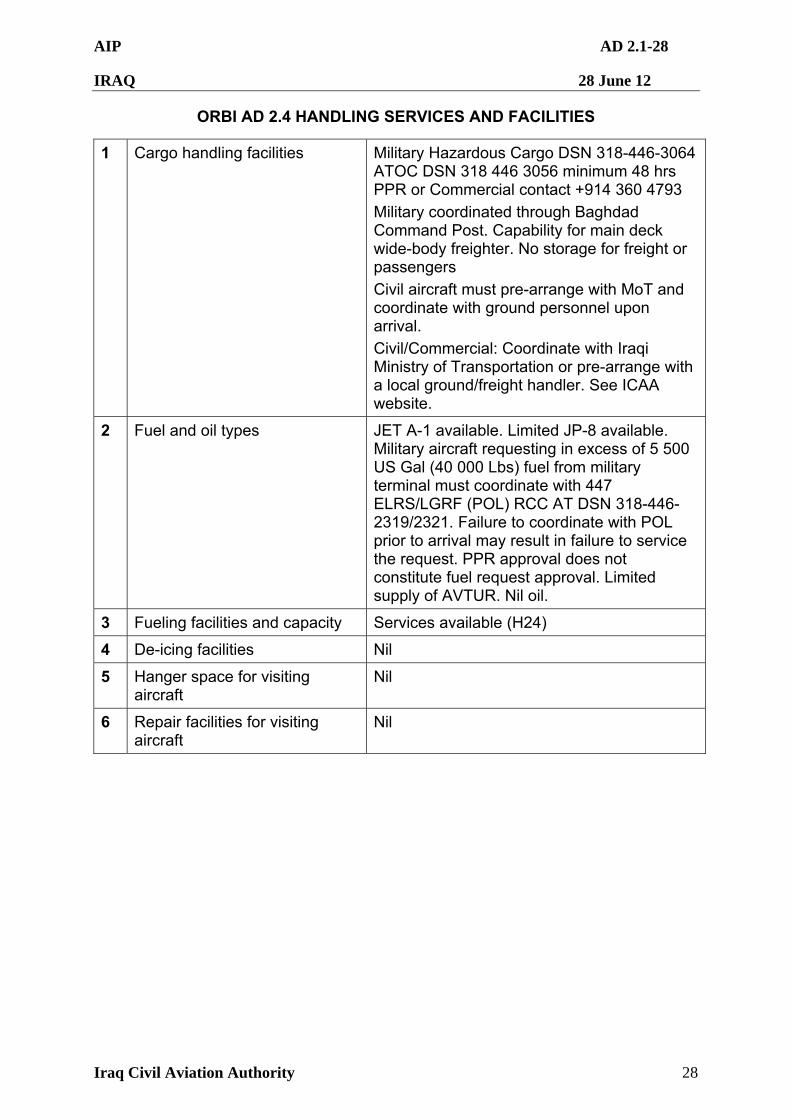
AIP AD 2.1-28
IRAQ 28 June 12
Iraq Civil Aviation Authority 28
ORBI AD 2.4 HANDLING SERVICES AND FACILITIES
1 Cargo handling facilities Military Hazardous Cargo DSN 318-446-3064 ATOC DSN 318 446 3056 minimum 48 hrs PPR or Commercial contact +914 360 4793
Military coordinated through Baghdad Command Post. Capability for main deck wide-body freighter. No storage for freight or passengers
Civil aircraft must pre-arrange with MoT and coordinate with ground personnel upon arrival.
Civil/Commercial: Coordinate with Iraqi Ministry of Transportation or pre-arrange with a local ground/freight handler. See ICAA website.
2 Fuel and oil types JET A-1 available. Limited JP-8 available. Military aircraft requesting in excess of 5 500 US Gal (40 000 Lbs) fuel from military terminal must coordinate with 447 ELRS/LGRF (POL) RCC AT DSN 318-446-2319/2321. Failure to coordinate with POL prior to arrival may result in failure to service the request. PPR approval does not constitute fuel request approval. Limited supply of AVTUR. Nil oil.
3 Fueling facilities and capacity Services available (H24)
4 De-icing facilities Nil
5 Hanger space for visiting aircraft
Nil
6 Repair facilities for visiting aircraft
Nil
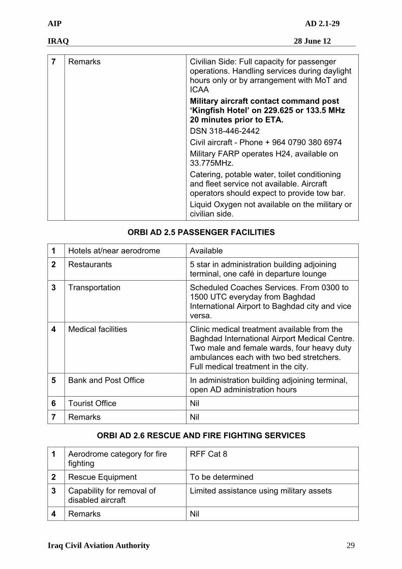
AIP AD 2.1-29
IRAQ 28 June 12
Iraq Civil Aviation Authority 29
7 Remarks Civilian Side: Full capacity for passenger operations. Handling services during daylight hours only or by arrangement with MoT and ICAA
Military aircraft contact command post ‘Kingfish Hotel’ on 229.625 or 133.5 MHz 20 minutes prior to ETA. DSN 318-446-2442
Civil aircraft - Phone + 964 0790 380 6974
Military FARP operates H24, available on 33.775MHz.
Catering, potable water, toilet conditioning and fleet service not available. Aircraft operators should expect to provide tow bar.
Liquid Oxygen not available on the military or civilian side.
ORBI AD 2.5 PASSENGER FACILITIES
1 Hotels at/near aerodrome Available
2 Restaurants 5 star in administration building adjoining terminal, one café in departure lounge
3 Transportation Scheduled Coaches Services. From 0300 to 1500 UTC everyday from Baghdad International Airport to Baghdad city and vice versa.
4 Medical facilities Clinic medical treatment available from the Baghdad International Airport Medical Centre. Two male and female wards, four heavy duty ambulances each with two bed stretchers. Full medical treatment in the city.
5 Bank and Post Office In administration building adjoining terminal, open AD administration hours
6 Tourist Office Nil
7 Remarks Nil
ORBI AD 2.6 RESCUE AND FIRE FIGHTING SERVICES
1 Aerodrome category for fire fighting
RFF Cat 8
2 Rescue Equipment To be determined
3 Capability for removal of disabled aircraft
Limited assistance using military assets
4 Remarks Nil
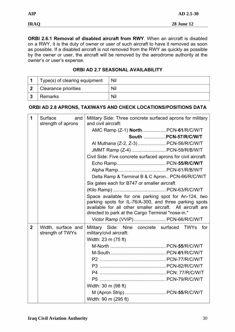
AIP AD 2.1-30
IRAQ 28 June 12
Iraq Civil Aviation Authority 30
ORBI 2.6.1 Removal of disabled aircraft from RWY. When an aircraft is disabled on a RWY, it is the duty of owner or user of such aircraft to have it removed as soon as possible. If a disabled aircraft is not removed from the RWY as quickly as possible by the owner or user, the aircraft will be removed by the aerodrome authority at the owner’s or user’s expense.
ORBI AD 2.7 SEASONAL AVAILABILITY
1 Type(s) of clearing equipment Nil
2 Clearance priorities Nil
3 Remarks Nil
ORBI AD 2.8 APRONS, TAXIWAYS AND CHECK LOCATIONS/POSITIONS DATA
1 Surface and strength of aprons
Military Side: Three concrete surfaced aprons for military and civil aircraft:
AMC Ramp (Z-1) North..................PCN-61/R/C/W/T
South .................PCN-57/R/C/W/T
Al Muthana (Z-2, Z-3) .....................PCN-56/R/C/W/T
JMMT Ramp (Z-4) ..........................PCN-59/R/B/W/T
Civil Side: Five concrete surfaced aprons for civil aircraft:
Echo Ramp.....................................PCN-55/R/C/W/T
Alpha Ramp....................................PCN-61/R/B/W/T
Delta Ramp & Terminal B & C Apron.. PCN-66/R/C/W/T
Six gates each for B747 or smaller aircraft
(Kilo Ramp) ........................................PCN-63/R/C/W/T
Space available for one parking spot for An-124, two parking spots for IL-76/A-300, and three parking spots available for all other smaller aircraft. All aircraft are directed to park at the Cargo Terminal "nose-in."
Victor Ramp (VVIP) ........................PCN-66/R/C/W/T
2 Width, surface and strength of TWYs
Military Side: Nine concrete surfaced TWYs for military/civil aircraft:
Width: 23 m (75 ft)
M-North ..........................................PCN-55/R/C/W/T
M-South..........................................PCN-61/R/C/W/T
P2 ..................................................PCN-77/R/C/W/T
P3 ..................................................PCN-82/R/C/W/T
P4 ..................................................PCN: 77/R/C/W/T
P5 ..................................................PCN-79/R/C/W/T
Width: 30 m (98 ft)
M (Apron Strip) ...............................PCN-55/R/C/W/T
Width: 90 m (295 ft)
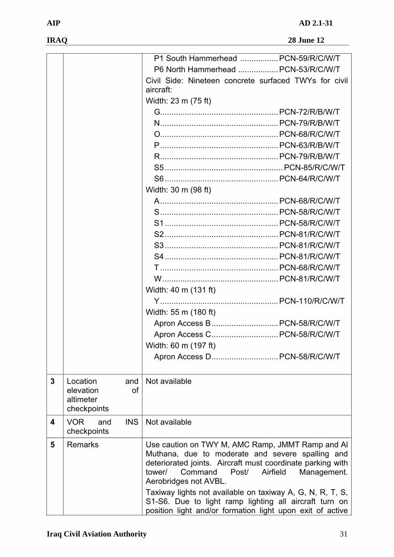
AIP AD 2.1-31
IRAQ 28 June 12
Iraq Civil Aviation Authority 31
P1 South Hammerhead .................PCN-59/R/C/W/T
P6 North Hammerhead ..................PCN-53/R/C/W/T
Civil Side: Nineteen concrete surfaced TWYs for civil aircraft:
Width: 23 m (75 ft)
G.....................................................PCN-72/R/B/W/T
N.....................................................PCN-79/R/B/W/T
O.....................................................PCN-68/R/C/W/T
P.....................................................PCN-63/R/B/W/T
R.....................................................PCN-79/R/B/W/T
S5..................................................... PCN-85/R/C/W/T
S6...................................................PCN-64/R/C/W/T
Width: 30 m (98 ft)
A.....................................................PCN-68/R/C/W/T
S.....................................................PCN-58/R/C/W/T
S1...................................................PCN-58/R/C/W/T
S2...................................................PCN-81/R/C/W/T
S3...................................................PCN-81/R/C/W/T
S4...................................................PCN-81/R/C/W/T
T .....................................................PCN-68/R/C/W/T
W....................................................PCN-81/R/C/W/T
Width: 40 m (131 ft)
Y.....................................................PCN-110/R/C/W/T
Width: 55 m (180 ft)
Apron Access B..............................PCN-58/R/C/W/T
Apron Access C..............................PCN-58/R/C/W/T
Width: 60 m (197 ft)
Apron Access D..............................PCN-58/R/C/W/T
3 Location and elevation of altimeter checkpoints
Not available
4 VOR and INS checkpoints
Not available
5 Remarks Use caution on TWY M, AMC Ramp, JMMT Ramp and Al Muthana, due to moderate and severe spalling and deteriorated joints. Aircraft must coordinate parking with tower/ Command Post/ Airfield Management. Aerobridges not AVBL.
Taxiway lights not available on taxiway A, G, N, R, T, S, S1-S6. Due to light ramp lighting all aircraft turn on position light and/or formation light upon exit of active
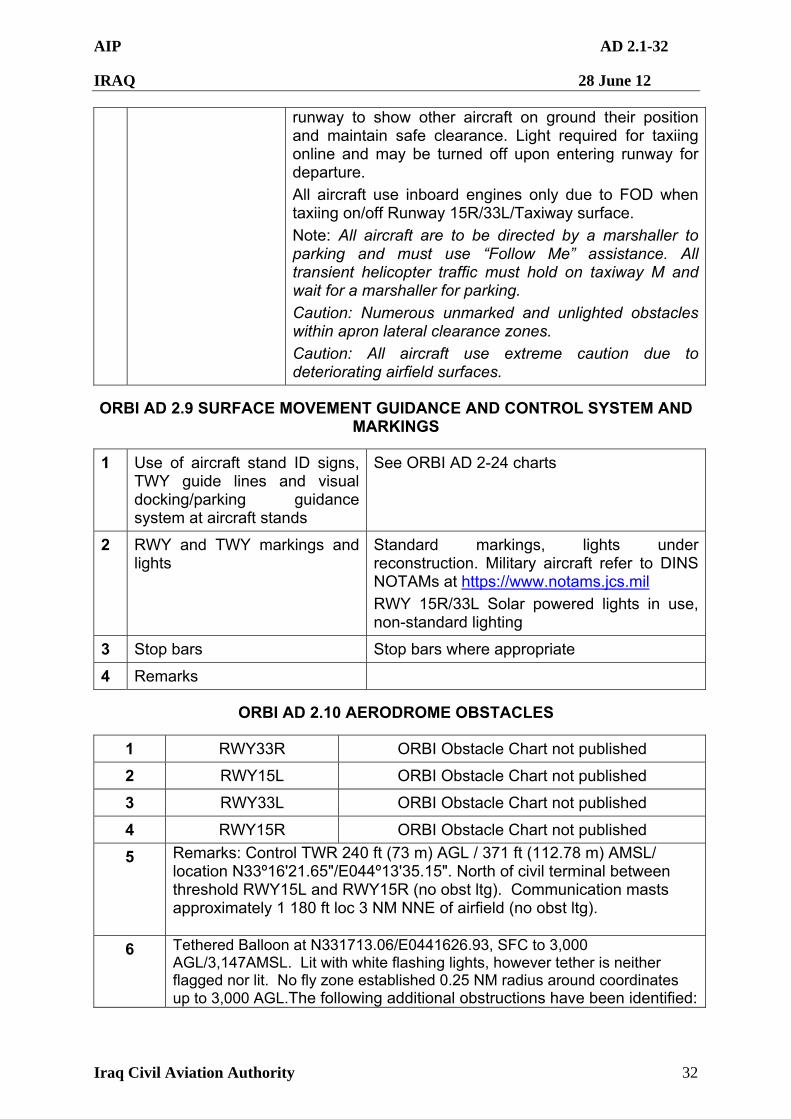
AIP AD 2.1-32
IRAQ 28 June 12
Iraq Civil Aviation Authority 32
runway to show other aircraft on ground their position and maintain safe clearance. Light required for taxiing online and may be turned off upon entering runway for departure.
All aircraft use inboard engines only due to FOD when taxiing on/off Runway 15R/33L/Taxiway surface.
Note: All aircraft are to be directed by a marshaller to parking and must use “Follow Me” assistance. All transient helicopter traffic must hold on taxiway M and wait for a marshaller for parking.
Caution: Numerous unmarked and unlighted obstacles within apron lateral clearance zones.
Caution: All aircraft use extreme caution due to deteriorating airfield surfaces.
ORBI AD 2.9 SURFACE MOVEMENT GUIDANCE AND CONTROL SYSTEM AND MARKINGS
1 Use of aircraft stand ID signs, TWY guide lines and visual docking/parking guidance system at aircraft stands
See ORBI AD 2-24 charts
2 RWY and TWY markings and lights
Standard markings, lights under reconstruction. Military aircraft refer to DINS NOTAMs at https://www.notams.jcs.mil
RWY 15R/33L Solar powered lights in use, non-standard lighting
3 Stop bars Stop bars where appropriate
4 Remarks
ORBI AD 2.10 AERODROME OBSTACLES
1 RWY33R ORBI Obstacle Chart not published
2 RWY15L ORBI Obstacle Chart not published
3 RWY33L ORBI Obstacle Chart not published
4 RWY15R ORBI Obstacle Chart not published
5 Remarks: Control TWR 240 ft (73 m) AGL / 371 ft (112.78 m) AMSL/ location N33º16'21.65"/E044º13'35.15". North of civil terminal between threshold RWY15L and RWY15R (no obst ltg). Communication masts approximately 1 180 ft loc 3 NM NNE of airfield (no obst ltg).
6 Tethered Balloon at N331713.06/E0441626.93, SFC to 3,000 AGL/3,147AMSL. Lit with white flashing lights, however tether is neither flagged nor lit. No fly zone established 0.25 NM radius around coordinates up to 3,000 AGL.The following additional obstructions have been identified:
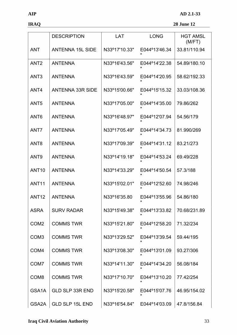
AIP AD 2.1-33
IRAQ 28 June 12
Iraq Civil Aviation Authority 33
DESCRIPTION LAT LONG HGT AMSL (M/FT)
ANT ANTENNA 15L SIDE N33º17'10.33" E044º13'46.34"
33.81/110.94
ANT2 ANTENNA N33º16'43.56" E044º14'22.38"
54.89/180.10
ANT3 ANTENNA N33º16'43.59" E044º14'20.95"
58.62/192.33
ANT4 ANTENNA 33R SIDE N33º15'00.66" E044º15'15.32"
33.03/108.36
ANT5 ANTENNA N33º17'05.00" E044º14'35.00"
79.86/262
ANT6 ANTENNA N33º16'48.97" E044º12'07.94"
54.56/179
ANT7 ANTENNA N33º17'05.49" E044º14'34.73"
81.990/269
ANT8 ANTENNA N33º17'09.39" E044º14'31.12"
83.21/273
ANT9 ANTENNA N33º14'19.18" E044º14'53.24"
69.49/228
ANT10 ANTENNA N33º14'33.29" E044º14'50.54"
57.3/188
ANT11 ANTENNA N33º15'02.01" E044º12'52.60"
74.98/246
ANT12 ANTENNA N33º16'35.80 E044º13'55.96"
54.86/180
ASRA SURV RADAR N33º15'49.38" E044º13'33.82"
70.68/231.89
COM2 COMMS TWR N33º15'21.80" E044º12'58.20"
71.32/234
COM3 COMMS TWR N33º13'29.52" E044º13'39.54"
59.44/195
COM4 COMMS TWR N33º13'08.30" E044º13'01.09"
93.27/306
COM7 COMMS TWR N33º14'11.30" E044º14'34.20"
56.08/184
COM8 COMMS TWR N33º17'10.70" E044º13'10.20"
77.42/254
GSA1A GLD SLP 33R END N33º15'20.58" E044º15'07.76"
46.95/154.02
GSA2A GLD SLP 15L END N33º16'54.84" E044º14'03.09 47.8/156.84
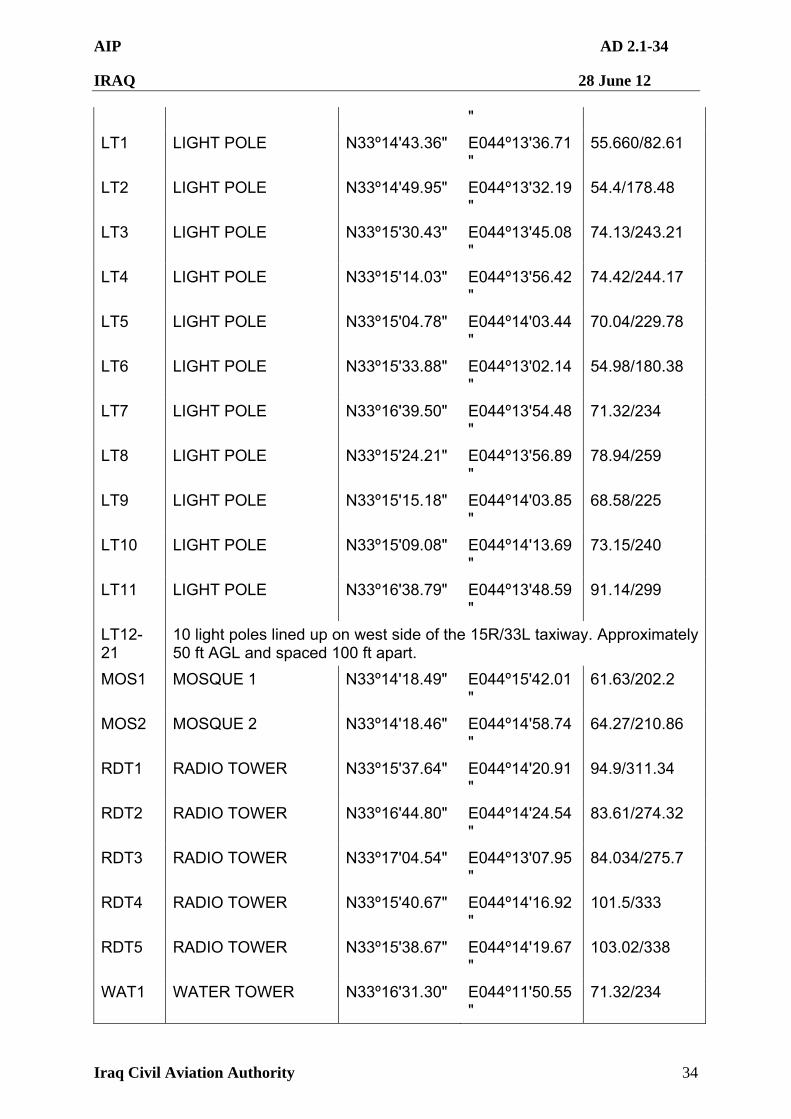
AIP AD 2.1-34
IRAQ 28 June 12
Iraq Civil Aviation Authority 34
"
LT1 LIGHT POLE N33º14'43.36" E044º13'36.71"
55.660/82.61
LT2 LIGHT POLE N33º14'49.95" E044º13'32.19"
54.4/178.48
LT3 LIGHT POLE N33º15'30.43" E044º13'45.08"
74.13/243.21
LT4 LIGHT POLE N33º15'14.03" E044º13'56.42"
74.42/244.17
LT5 LIGHT POLE N33º15'04.78" E044º14'03.44"
70.04/229.78
LT6 LIGHT POLE N33º15'33.88" E044º13'02.14"
54.98/180.38
LT7 LIGHT POLE N33º16'39.50" E044º13'54.48"
71.32/234
LT8 LIGHT POLE N33º15'24.21" E044º13'56.89"
78.94/259
LT9 LIGHT POLE N33º15'15.18" E044º14'03.85"
68.58/225
LT10 LIGHT POLE N33º15'09.08" E044º14'13.69"
73.15/240
LT11 LIGHT POLE N33º16'38.79" E044º13'48.59"
91.14/299
LT12-21
10 light poles lined up on west side of the 15R/33L taxiway. Approximately 50 ft AGL and spaced 100 ft apart.
MOS1 MOSQUE 1 N33º14'18.49" E044º15'42.01"
61.63/202.2
MOS2 MOSQUE 2 N33º14'18.46" E044º14'58.74"
64.27/210.86
RDT1 RADIO TOWER N33º15'37.64" E044º14'20.91"
94.9/311.34
RDT2 RADIO TOWER N33º16'44.80" E044º14'24.54"
83.61/274.32
RDT3 RADIO TOWER N33º17'04.54" E044º13'07.95"
84.034/275.7
RDT4 RADIO TOWER N33º15'40.67" E044º14'16.92"
101.5/333
RDT5 RADIO TOWER N33º15'38.67" E044º14'19.67"
103.02/338
WAT1 WATER TOWER N33º16'31.30" E044º11'50.55"
71.32/234
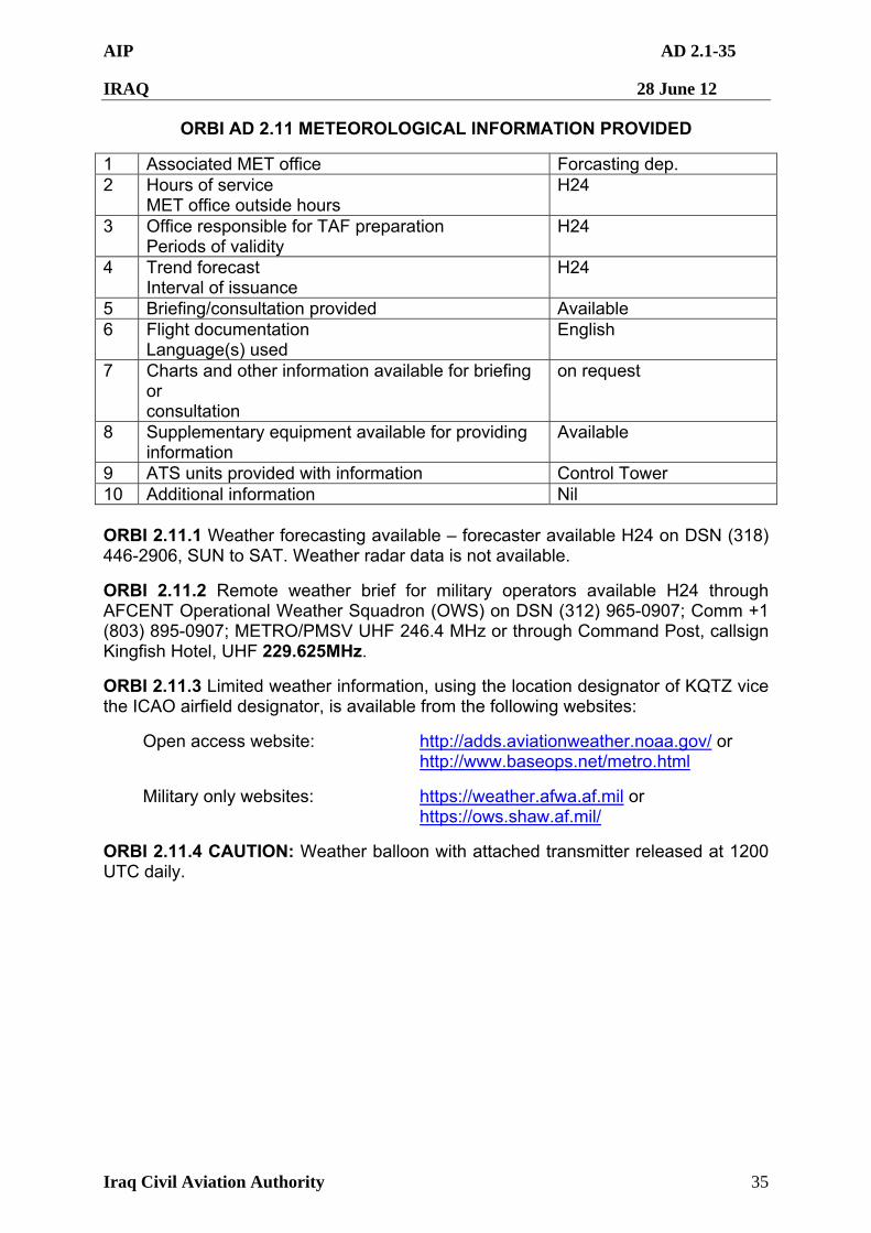
AIP AD 2.1-35
IRAQ 28 June 12
Iraq Civil Aviation Authority 35
ORBI AD 2.11 METEOROLOGICAL INFORMATION PROVIDED
1 Associated MET office Forcasting dep. 2 Hours of service
MET office outside hours H24
3 Office responsible for TAF preparation Periods of validity
H24
4 Trend forecast Interval of issuance
H24
5 Briefing/consultation provided Available 6 Flight documentation
Language(s) used English
7 Charts and other information available for briefing or consultation
on request
8 Supplementary equipment available for providing information
Available
9 ATS units provided with information Control Tower 10 Additional information Nil ORBI 2.11.1 Weather forecasting available – forecaster available H24 on DSN (318) 446-2906, SUN to SAT. Weather radar data is not available.
ORBI 2.11.2 Remote weather brief for military operators available H24 through AFCENT Operational Weather Squadron (OWS) on DSN (312) 965-0907; Comm +1 (803) 895-0907; METRO/PMSV UHF 246.4 MHz or through Command Post, callsign Kingfish Hotel, UHF 229.625MHz.
ORBI 2.11.3 Limited weather information, using the location designator of KQTZ vice the ICAO airfield designator, is available from the following websites:
Open access website: http://adds.aviationweather.noaa.gov/ or http://www.baseops.net/metro.html
Military only websites: https://weather.afwa.af.mil or https://ows.shaw.af.mil/
ORBI 2.11.4 CAUTION: Weather balloon with attached transmitter released at 1200 UTC daily.
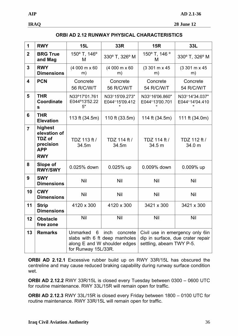
AIP AD 2.1-36
IRAQ 28 June 12
Iraq Civil Aviation Authority 36
ORBI AD 2.12 RUNWAY PHYSICAL CHARACTERISTICS
1 RWY 15L 33R 15R 33L
2 BRG True and Mag
150º T, 146º M
330º T, 326º M150º T, 146 º
M 330º T, 326º M
3 RWY Dimensions
(4 000 m x 60 m)
(4 000 m x 60 m)
(3 301 m x 45 m)
(3 301 m x 45 m)
4 PCN Concrete
56 R/C/W/T
Concrete
56 R/C/W/T
Concrete
54 R/C/W/T
Concrete
54 R/C/W/T
5 THR Coordinates
N33º17'01.761 E044º13'52.22
5"
N3315'09.273" E04415'09.412
"
N3316'06.860" E04413'00.701
"
N3314'34.037" E04414'04.410
"
6 THR Elevation
113 ft (34.5m) 110 ft (33.5m) 114 ft (34.5m) 111 ft (34.0m)
7 highest elevation of TDZ of precision APP
RWY
TDZ 113 ft / 34.5m
TDZ 114 ft / 34.5m
TDZ 114 ft / 34.5 m
TDZ 112 ft / 34.0 m
8 Slope of RWY/SWY
0.025% down 0.025% up 0.009% down 0.009% up
9 SWY Dimensions
Nil Nil Nil Nil
10 CWY Dimensions
Nil Nil Nil Nil
11 Strip Dimensions
4120 x 300 4120 x 300 3421 x 300 3421 x 300
12 Obstacle free zone
Nil Nil Nil Nil
13 Remarks Unmarked 6 inch concrete slabs with 6 ft deep manholes along E and W shoulder edges for Runway 15L/33R.
Civil use in emergency only 6in dip in surface, due crater repair settling, abeam TWY P-5.
ORBI AD 2.12.1 Excessive rubber build up on RWY 33R/15L has obscured the centreline and may cause reduced braking capability during runway surface condition wet.
ORBI AD 2.12.2 RWY 33R/15L is closed every Tuesday between 0300 – 0600 UTC for routine maintenance. RWY 33L/15R will remain open for traffic.
ORBI AD 2.12.3 RWY 33L/15R is closed every Friday between 1800 – 0100 UTC for routine maintenance. RWY 33R/15L will remain open for traffic.
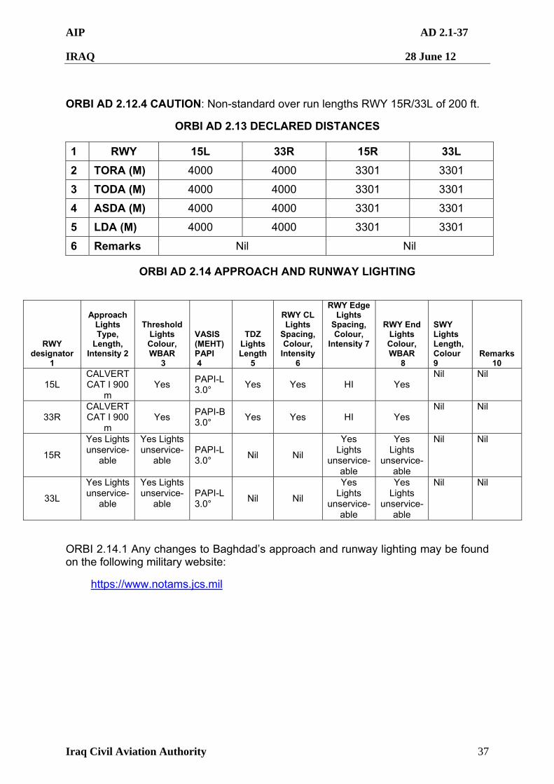
AIP AD 2.1-37
IRAQ 28 June 12
Iraq Civil Aviation Authority 37
ORBI AD 2.12.4 CAUTION: Non-standard over run lengths RWY 15R/33L of 200 ft.
ORBI AD 2.13 DECLARED DISTANCES
1 RWY 15L 33R 15R 33L
2 TORA (M) 4000 4000 3301 3301
3 TODA (M) 4000 4000 3301 3301
4 ASDA (M) 4000 4000 3301 3301
5 LDA (M) 4000 4000 3301 3301
6 Remarks Nil Nil
ORBI AD 2.14 APPROACH AND RUNWAY LIGHTING
RWY designator
1
Approach
Lights Type,
Length, Intensity 2
Threshold Lights Colour, WBAR
3
VASIS (MEHT) PAPI 4
TDZ Lights Length
5
RWY CL Lights
Spacing, Colour,
Intensity 6
RWY Edge Lights
Spacing, Colour,
Intensity 7
RWY End Lights Colour, WBAR
8
SWY Lights Length, Colour 9
Remarks 10
15L CALVERT CAT I 900
m Yes
PAPI-L 3.0°
Yes Yes HI Yes Nil Nil
33R CALVERT CAT I 900
m Yes
PAPI-B 3.0°
Yes Yes HI Yes Nil Nil
15R
Yes Lights unservice-
able
Yes Lights unservice-
able PAPI-L 3.0°
Nil Nil
Yes Lights
unservice-able
Yes Lights
unservice-able
Nil Nil
33L
Yes Lights unservice-
able
Yes Lights unservice-
able PAPI-L 3.0°
Nil Nil
Yes Lights
unservice-able
Yes Lights
unservice-able
Nil Nil
ORBI 2.14.1 Any changes to Baghdad’s approach and runway lighting may be found on the following military website:
https://www.notams.jcs.mil
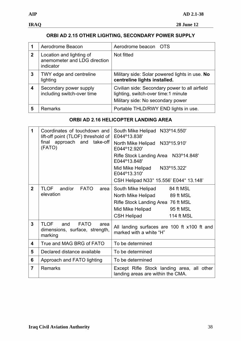
AIP AD 2.1-38
IRAQ 28 June 12
Iraq Civil Aviation Authority 38
ORBI AD 2.15 OTHER LIGHTING, SECONDARY POWER SUPPLY
1 Aerodrome Beacon Aerodrome beacon OTS
2 Location and lighting of anemometer and LDG direction indicator
Not fitted
3 TWY edge and centreline lighting
Military side: Solar powered lights in use. No centreline lights installed.
4 Secondary power supply including switch-over time
Civilian side: Secondary power to all airfield lighting, switch-over time:1 minute
Military side: No secondary power
5 Remarks Portable THLD/RWY END lights in use.
ORBI AD 2.16 HELICOPTER LANDING AREA
1 Coordinates of touchdown and lift-off point (TLOF) threshold of final approach and take-off (FATO)
South Mike Helipad N33º14.550' E044º13.838'
North Mike Helipad N33º15.910' E044º12.920'
Rifle Stock Landing Area N33º14.848' E044º13.848'
Mid Mike Helipad N33º15.322' E044º13.310'
CSH Helipad N33° 15.556’ E044° 13.148’
2 TLOF and/or FATO area elevation
South Mike Helipad 84 ft MSL
North Mike Helipad 89 ft MSL
Rifle Stock Landing Area 76 ft MSL
Mid Mike Helipad 95 ft MSL
CSH Helipad 114 ft MSL
3 TLOF and FATO area dimensions, surface, strength, marking
All landing surfaces are 100 ft x100 ft and marked with a white “H”
4 True and MAG BRG of FATO To be determined
5 Declared distance available To be determined
6 Approach and FATO lighting To be determined
7 Remarks Except Rifle Stock landing area, all other landing areas are within the CMA.
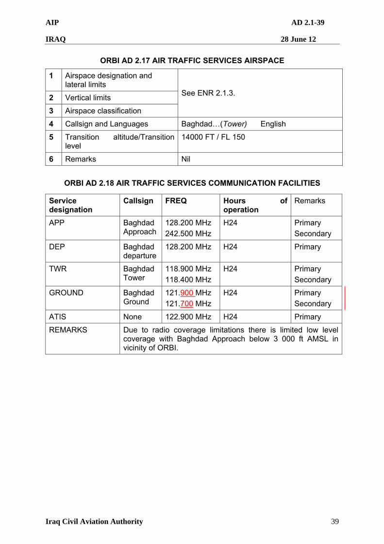
AIP AD 2.1-39
IRAQ 28 June 12
Iraq Civil Aviation Authority 39
ORBI AD 2.17 AIR TRAFFIC SERVICES AIRSPACE
1 Airspace designation and lateral limits
2 Vertical limits
3 Airspace classification
See ENR 2.1.3.
4 Callsign and Languages Baghdad…(Tower) English
5 Transition altitude/Transition level
14000 FT / FL 150
6 Remarks Nil
ORBI AD 2.18 AIR TRAFFIC SERVICES COMMUNICATION FACILITIES
Service designation
Callsign FREQ Hours of operation
Remarks
APP Baghdad Approach
128.200 MHz
242.500 MHz
H24 Primary
Secondary
DEP Baghdad departure
128.200 MHz H24 Primary
TWR Baghdad Tower
118.900 MHz
118.400 MHz
H24 Primary
Secondary
GROUND Baghdad Ground
121.900 MHz
121.700 MHz
H24
Primary
Secondary
ATIS None 122.900 MHz H24 Primary
REMARKS Due to radio coverage limitations there is limited low level coverage with Baghdad Approach below 3 000 ft AMSL in vicinity of ORBI.
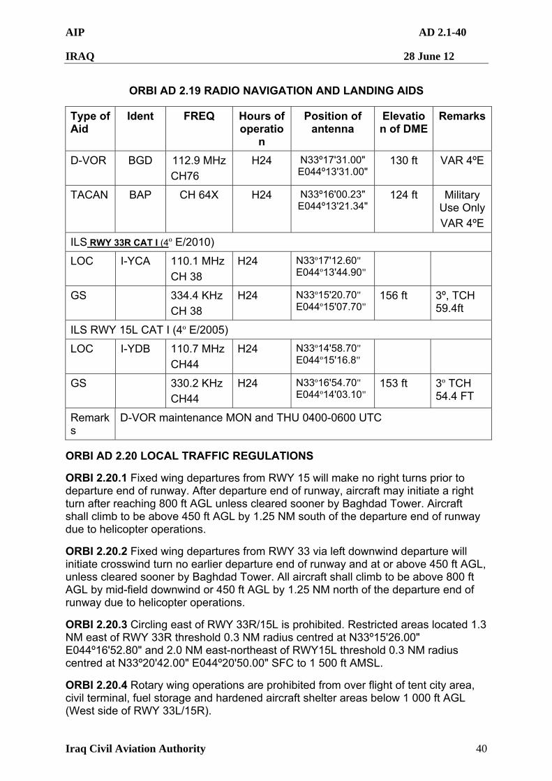
AIP AD 2.1-40
IRAQ 28 June 12
Iraq Civil Aviation Authority 40
ORBI AD 2.19 RADIO NAVIGATION AND LANDING AIDS
Type of Aid
Ident FREQ Hours of operatio
n
Position of antenna
Elevation of DME
Remarks
D-VOR BGD 112.9 MHz
CH76
H24 N33º17'31.00" E044º13'31.00"
130 ft VAR 4ºE
TACAN BAP CH 64X H24 N33º16'00.23" E044º13'21.34"
124 ft Military Use Only
VAR 4ºE
ILS RWY 33R CAT I (4º E/2010)
LOC I-YCA 110.1 MHz
CH 38
H24 N33º17'12.60" E044º13'44.90"
GS 334.4 KHz
CH 38
H24 N33º15'20.70" E044º15'07.70"
156 ft 3º, TCH 59.4ft
ILS RWY 15L CAT I (4º E/2005)
LOC I-YDB 110.7 MHz
CH44
H24 N33º14'58.70" E044º15'16.8"
GS 330.2 KHz
CH44
H24 N33º16'54.70" E044º14'03.10"
153 ft 3º TCH 54.4 FT
Remarks
D-VOR maintenance MON and THU 0400-0600 UTC
ORBI AD 2.20 LOCAL TRAFFIC REGULATIONS
ORBI 2.20.1 Fixed wing departures from RWY 15 will make no right turns prior to departure end of runway. After departure end of runway, aircraft may initiate a right turn after reaching 800 ft AGL unless cleared sooner by Baghdad Tower. Aircraft shall climb to be above 450 ft AGL by 1.25 NM south of the departure end of runway due to helicopter operations.
ORBI 2.20.2 Fixed wing departures from RWY 33 via left downwind departure will initiate crosswind turn no earlier departure end of runway and at or above 450 ft AGL, unless cleared sooner by Baghdad Tower. All aircraft shall climb to be above 800 ft AGL by mid-field downwind or 450 ft AGL by 1.25 NM north of the departure end of runway due to helicopter operations.
ORBI 2.20.3 Circling east of RWY 33R/15L is prohibited. Restricted areas located 1.3 NM east of RWY 33R threshold 0.3 NM radius centred at N33º15'26.00" E044º16'52.80" and 2.0 NM east-northeast of RWY15L threshold 0.3 NM radius centred at N33º20'42.00" E044º20'50.00" SFC to 1 500 ft AMSL.
ORBI 2.20.4 Rotary wing operations are prohibited from over flight of tent city area, civil terminal, fuel storage and hardened aircraft shelter areas below 1 000 ft AGL (West side of RWY 33L/15R).
AIP AD 2.1-41
IRAQ 28 June 12
Iraq Civil Aviation Authority 41
ORBI 2.20.5 Rotary wing aircraft must use extreme caution landing and transitioning South Mike taxiway due to unlit obstructions.
ORBI 2.20.6 Rotary wing aircraft must land North helipad, South helipad, CSH helipad or Mid Mike Helipad unless otherwise directed by ATC.
ORBI 2.20.7 Rotary wing aircraft intending to shut down at BIAP must report landing assured to Baghdad Radio or home unit.
ORBI 2.20.8 Marshaller assistance on the military ramp is required and further information can be obtained from the TWR or “Kingfish”. When a local regulation is of importance for the safe operation of aircraft on the apron, the information shall be given to each aircraft by the TWR or broadcast on the ATIS.
ORBI 2.20.9 Local Traffic Regulations may be requested, in writing, from the Iraq Civil Aviation Authority at the address detailed in GEN 0.1.
ORBI 2.20.10 Except during emergency situations, aerodrome not available for fighter aircraft use.
ORBI 2.20.11 Use caution when advised of weather balloon launch. Balloon has transmitter attached.
ORBI 2.20.12 All fixed wing aircraft shall display covert lighting within Baghdad airspace. All aircraft shall display overt lighting whilst over runways, on taxiways and the ramp area.
ORBI 2.20.13 All rotary wing aircraft shall display overt lighting whilst travelling to and from ORBI from Austin, Dakota, Tusk and Warthog fixes.
ORBI 2.20.14 Civilian Night Operations for RWY 15L/33R: All aircraft arrivals/departures after sunset are authorised with the following stipulations:
1. Arrivals/departures may be delayed due to military operations in the vicinity of Baghdad International Airport.
2. Departures must confirm slot time with TWR prior to taxi.
ORBI AD 2.21 NOISE ABATEMENT PROCEDURES
ORBI 2.21.1 Departures
To be determined
ORBI 2.21.2 Arrivals
To be determined
ORBI 2.21.3 General Limit engine run up operations to a minimum unless mission requires. Must be coordinated 15 min prior to arrival. Command Post DSN 318-446-2442.
ORBI AD 2.22 FLIGHT PROCEDURES
ORBI 2.22.1 General
AIP AD 2.1-42
IRAQ 28 June 12
Iraq Civil Aviation Authority 42
ORBI 2.22.1.1 IFR and VFR flight are permitted in ORBI class (D) control zone.
ORBI 2.22.1.2 Where VFR operations are mandated, flights should be carried out in accordance with VFR as specified in ENR 1.2 and ICAO Annexes 2 and 11 (particularly regarding visibility and clearance from cloud). Compliance with these procedures does not relieve pilots of their responsibility to see and avoid other aircraft, or to maintain safe terrain/obstacle clearance at all times when operating VFR.
ORBI 2.22.1.3 Civil aircraft are not permitted to arrive or depart when the cloud base is less than 200 feet and/or visibility is less than 800 meters.
ORBI 2.22.1.4 Due to high volume of helicopter traffic in the area around ORBI (BIAP), fixed wing aircraft operating within 10NM of BIAP should maintain 1000 feet AGL or above until required for landing. Departures should climb to 1000 feet AGL or above as soon as practical.
ORBI 2.22.2 Procedures within Baghdad TMA. Practice approaches are subject to approval by ATC.
ORBI 2.22.2.1 The inbound, transit and out bound routes on charts may be varied at the direction of ATS. If necessary, in case of congestion, inbound aircraft may also be instructed to hold at one of the designated airways reporting points.
ORBI AD 2.23 ADDITIONAL INFORMATION
ORBI 2.23.1 Any aircraft reporting first to the civil side will be searched by USAF Security Forces prior to repositioning to the military side.
ORBI 2.23.2 All Distance remaining markers are not reflective.
ORBI 2.23.3 Engine run offload for fix wing aircraft: C-17 and C-130 only.
ORBI 2.23.4 Nose-in parking procedures for civilian terminal.
AIP AD 2.1-43
IRAQ 28 June 12
Iraq Civil Aviation Authority 43
ORBI AD 2.24 CHARTS RELATED TO AN AERODROME
ICAO Charts for Baghdad International Airport
1 Aerodrome Chart – ICAO ORBI AD 2.1-49
2 Aerodrome Ground Movement Chart – ICAO ORBI AD 2.1-50
3 Aircraft Parking/Docking Chart – ICAO ORBI AD 2.1-51
4 Aircraft Parking/Docking Chart – ICAO ORBI AD 2.1-52
5 ILS or LOC/DME RWY 15L ORBI AD 2.1-53
6 ILS or LOC/DME RWY 33R ORBI AD 2.1-54
7 VOR/DME RWY 33R ORBI AD 2.1-55
8 VOR/DME RWY 15L ORBI AD 2.1-56
9 BAGHDAD ONE DEPARTURE PROCEDURE ORBI AD 2.1-57
10 TAKEOFF MINIMUMS/OBSTACLE DEPARTURE PROCEDURES
ORBI AD 2.1-58
11 Not produced
12 Precision Approach Terrain Chart – ICAO Not produced
13 Aerodrome Obstacle Chart – ICAO Type A Not produced
14 Area Chart – ICAO (departure and transit routes) Not produced
15 Standard Departure Chart – Instrument – ICAO Not produced
16 Area Chart – ICAO (arrival and transit routes) Not produced
17 Standard Arrival Chart – Instrument - ICAO Not produced
18 Instrument Approach Charts – (FAA)
19 Visual Approach Chart Not produced
20 Bird concentration in the vicinity of the aerodrome Not produced
21 Instrument Departure Procedures (Jeppesen)
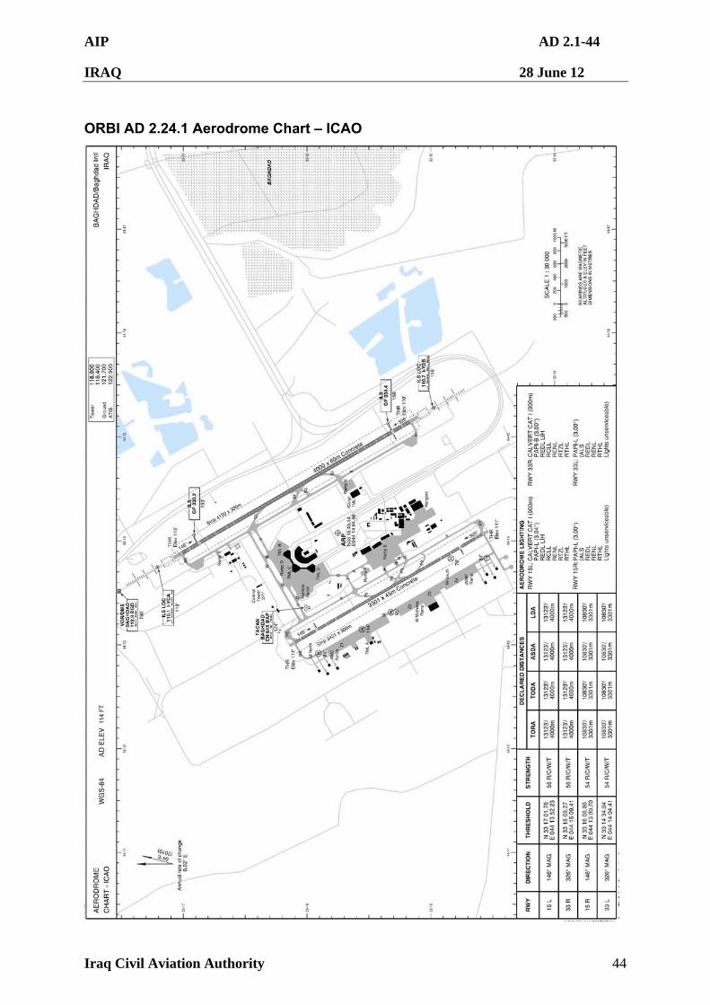
AIP AD 2.1-44
IRAQ 28 June 12
Iraq Civil Aviation Authority 44
ORBI AD 2.24.1 Aerodrome Chart – ICAO
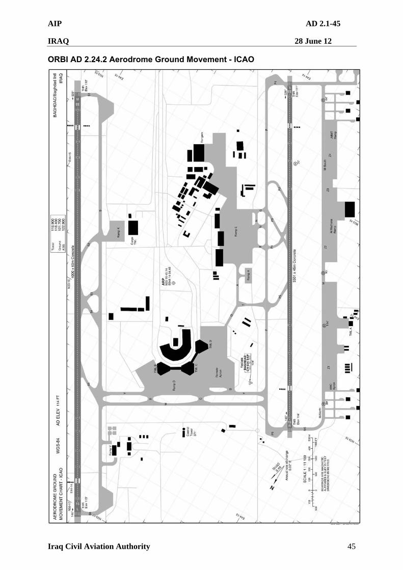
AIP AD 2.1-45
IRAQ 28 June 12
Iraq Civil Aviation Authority 45
ORBI AD 2.24.2 Aerodrome Ground Movement - ICAO
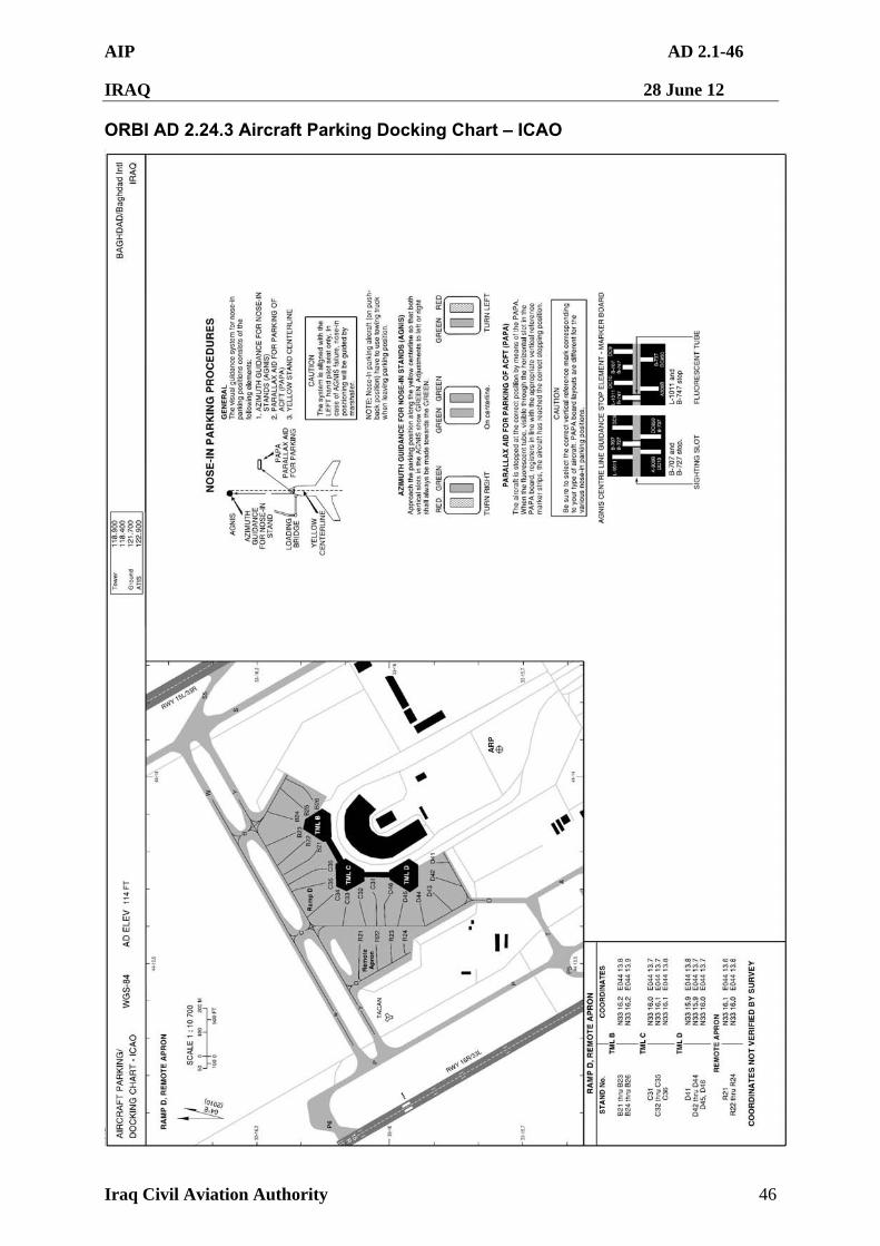
AIP AD 2.1-46
IRAQ 28 June 12
Iraq Civil Aviation Authority 46
ORBI AD 2.24.3 Aircraft Parking Docking Chart – ICAO
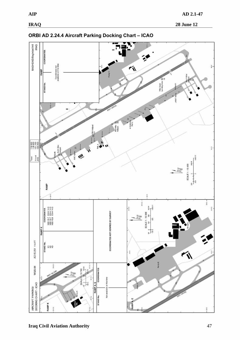
AIP AD 2.1-47
IRAQ 28 June 12
Iraq Civil Aviation Authority 47
ORBI AD 2.24.4 Aircraft Parking Docking Chart – ICAO
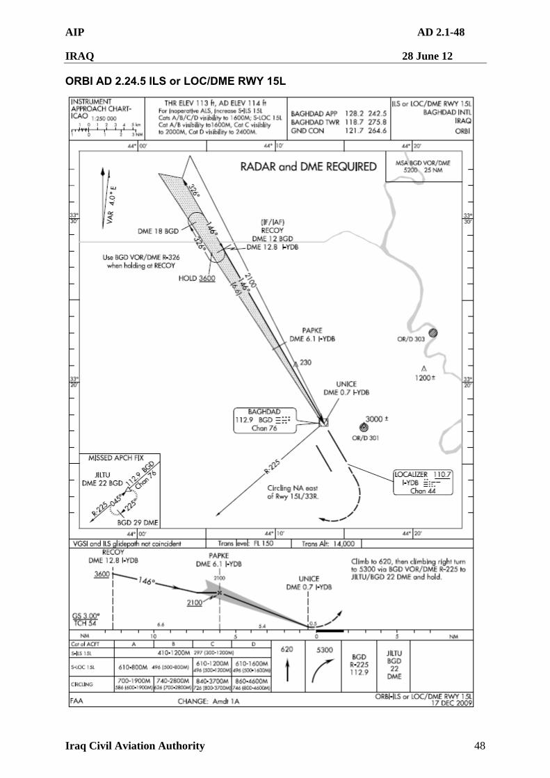
AIP AD 2.1-48
IRAQ 28 June 12
Iraq Civil Aviation Authority 48
ORBI AD 2.24.5 ILS or LOC/DME RWY 15L
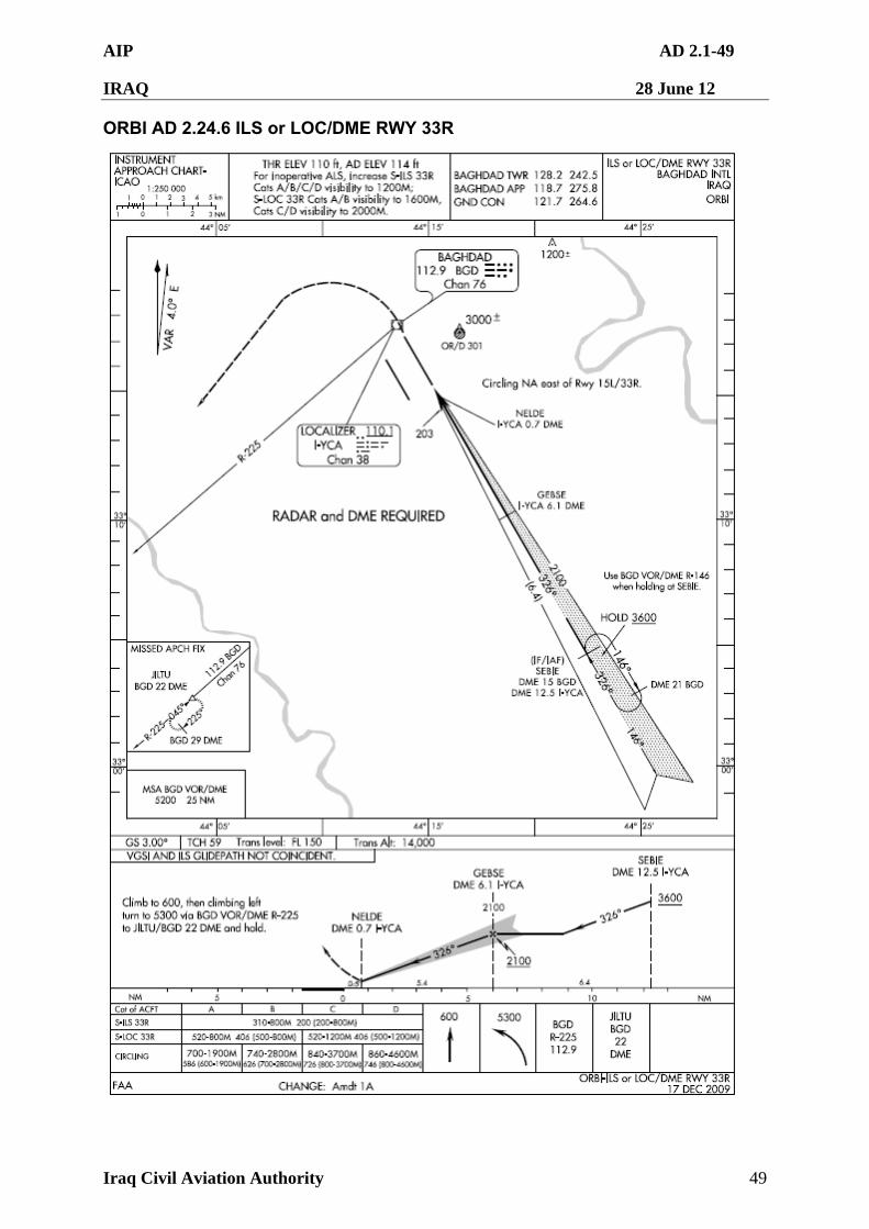
AIP AD 2.1-49
IRAQ 28 June 12
Iraq Civil Aviation Authority 49
ORBI AD 2.24.6 ILS or LOC/DME RWY 33R
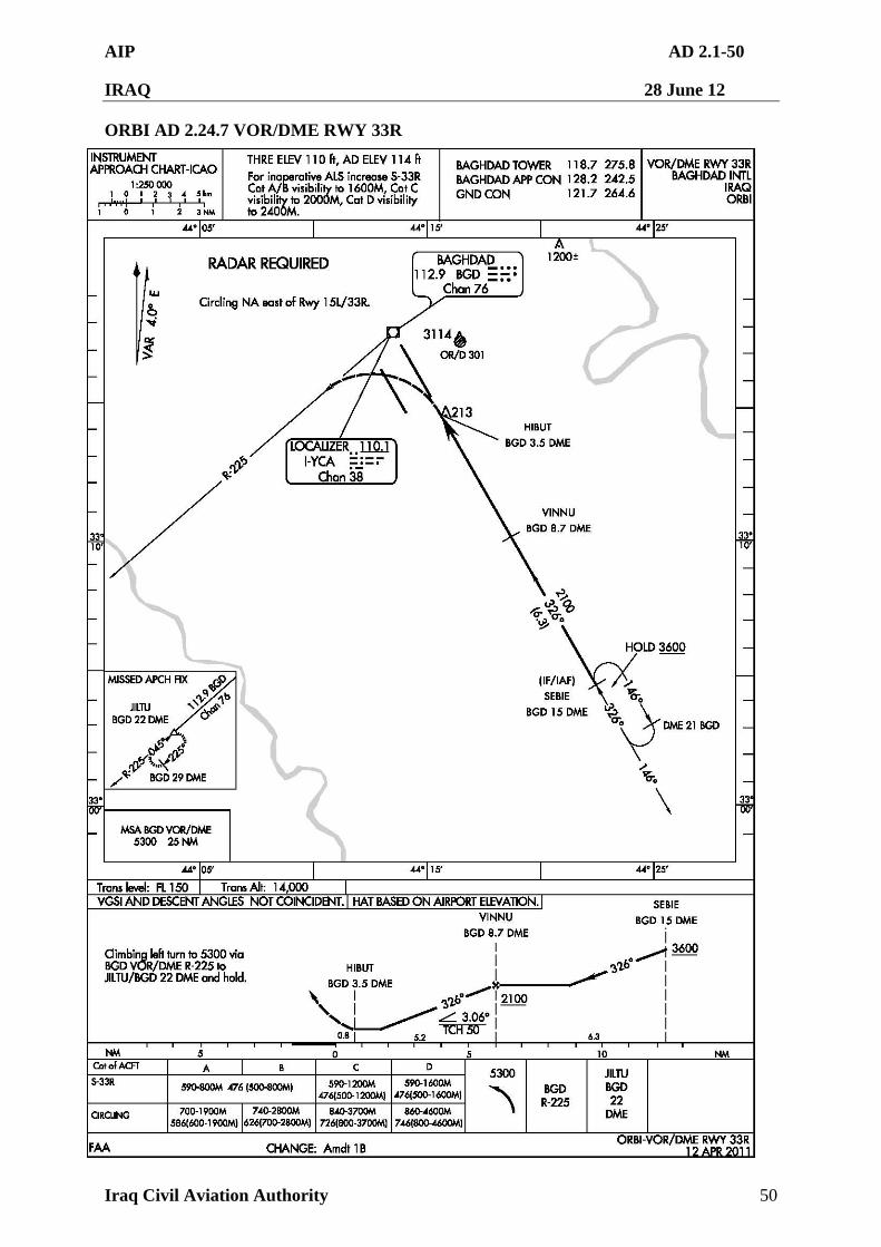
AIP AD 2.1-50
IRAQ 28 June 12
Iraq Civil Aviation Authority 50
ORBI AD 2.24.7 VOR/DME RWY 33R
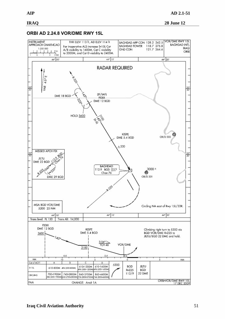
AIP AD 2.1-51
IRAQ 28 June 12
Iraq Civil Aviation Authority 51
ORBI AD 2.24.8 VOR/DME RWY 15L
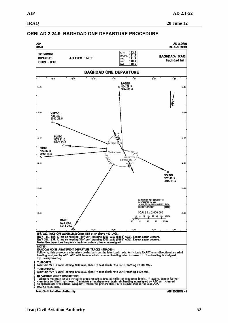
AIP AD 2.1-52
IRAQ 28 June 12
Iraq Civil Aviation Authority 52
ORBI AD 2.24.9 BAGHDAD ONE DEPARTURE PROCEDURE
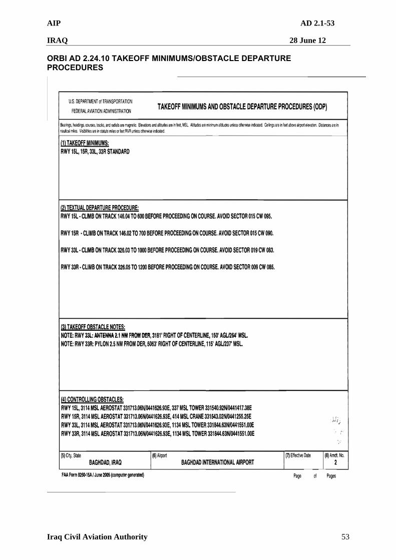
AIP AD 2.1-53
IRAQ 28 June 12
Iraq Civil Aviation Authority 53
ORBI AD 2.24.10 TAKEOFF MINIMUMS/OBSTACLE DEPARTURE PROCEDURES
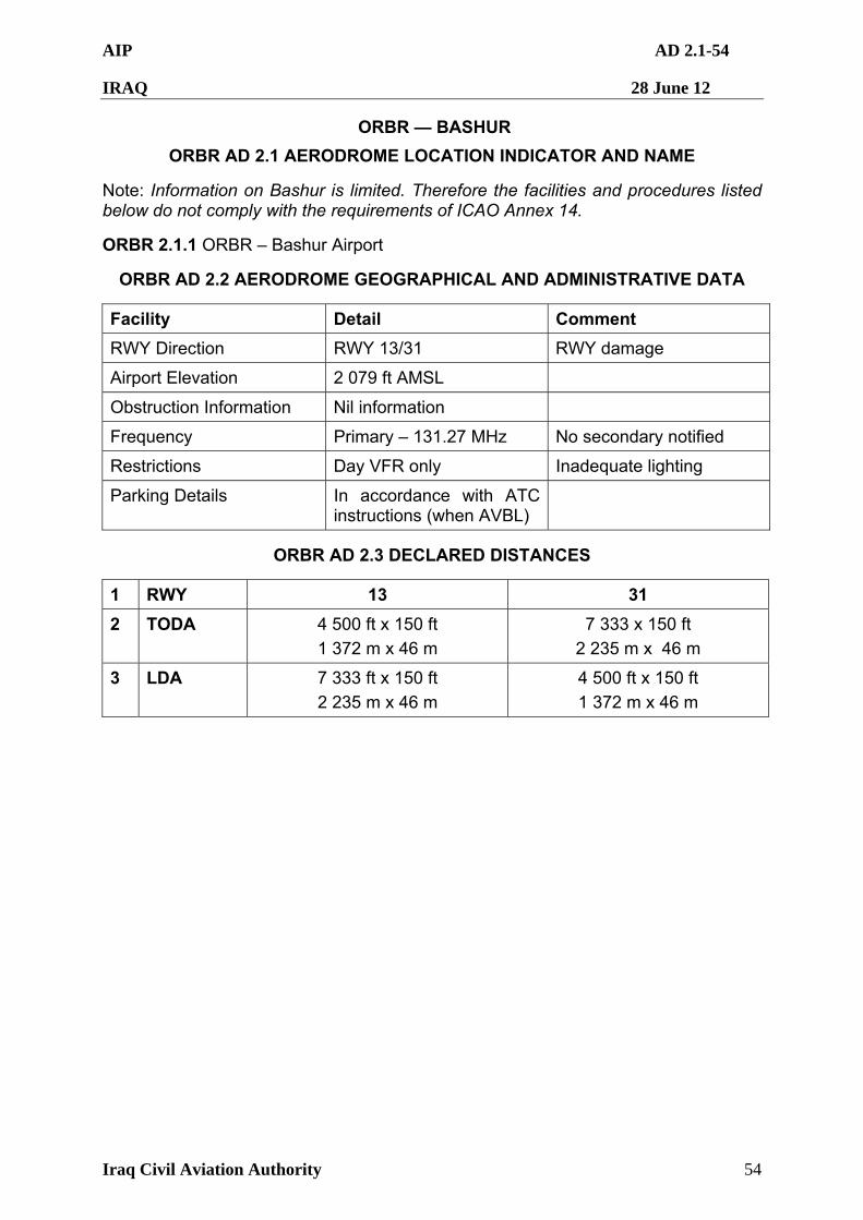
AIP AD 2.1-54
IRAQ 28 June 12
Iraq Civil Aviation Authority 54
ORBR — BASHUR
ORBR AD 2.1 AERODROME LOCATION INDICATOR AND NAME
Note: Information on Bashur is limited. Therefore the facilities and procedures listed below do not comply with the requirements of ICAO Annex 14.
ORBR 2.1.1 ORBR – Bashur Airport
ORBR AD 2.2 AERODROME GEOGRAPHICAL AND ADMINISTRATIVE DATA
Facility Detail Comment
RWY Direction RWY 13/31 RWY damage
Airport Elevation 2 079 ft AMSL
Obstruction Information Nil information
Frequency Primary – 131.27 MHz No secondary notified
Restrictions Day VFR only Inadequate lighting
Parking Details In accordance with ATC instructions (when AVBL)
ORBR AD 2.3 DECLARED DISTANCES
1 RWY 13 31
2 TODA 4 500 ft x 150 ft
1 372 m x 46 m
7 333 x 150 ft
2 235 m x 46 m
3 LDA 7 333 ft x 150 ft
2 235 m x 46 m
4 500 ft x 150 ft
1 372 m x 46 m
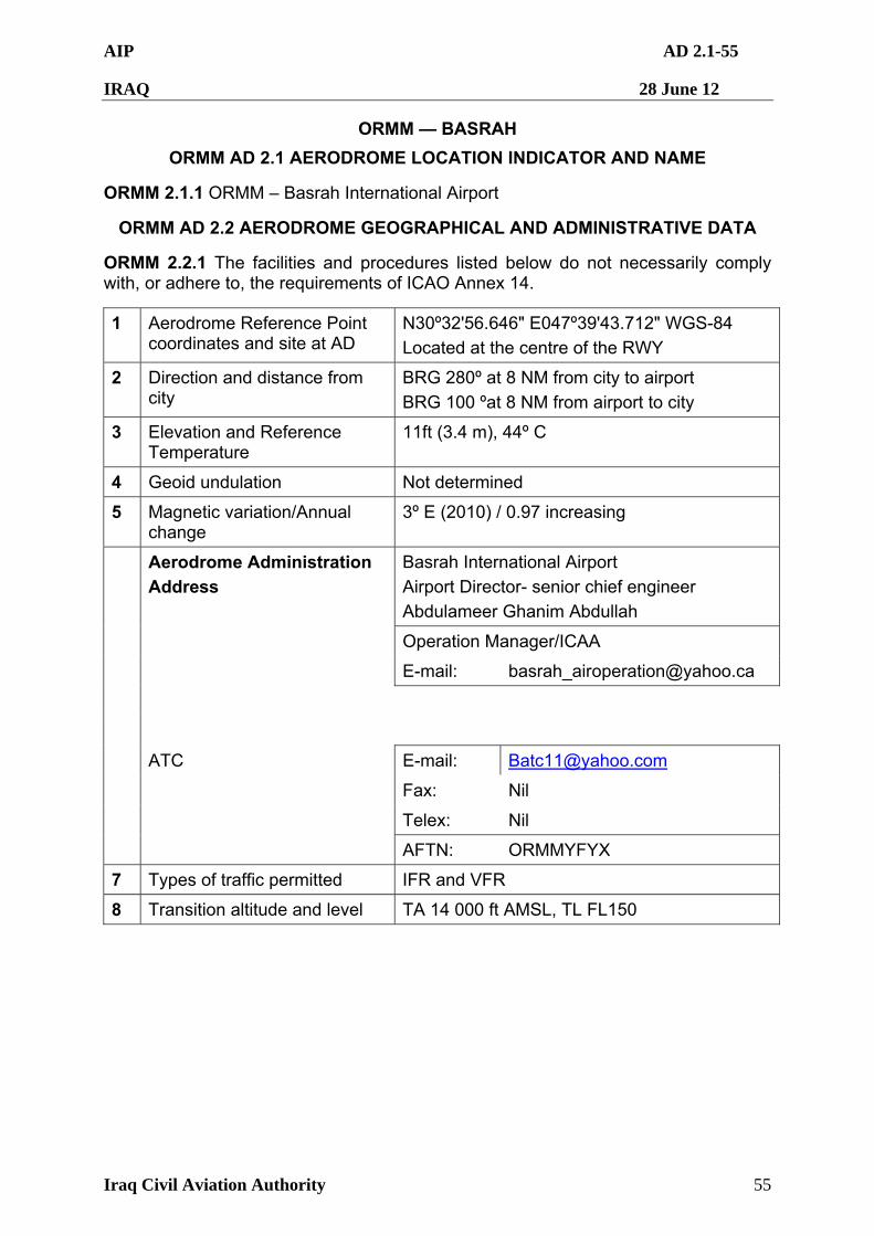
AIP AD 2.1-55
IRAQ 28 June 12
Iraq Civil Aviation Authority 55
ORMM — BASRAH
ORMM AD 2.1 AERODROME LOCATION INDICATOR AND NAME
ORMM 2.1.1 ORMM – Basrah International Airport
ORMM AD 2.2 AERODROME GEOGRAPHICAL AND ADMINISTRATIVE DATA
ORMM 2.2.1 The facilities and procedures listed below do not necessarily comply with, or adhere to, the requirements of ICAO Annex 14.
1 Aerodrome Reference Point coordinates and site at AD
N30º32'56.646" E047º39'43.712" WGS-84
Located at the centre of the RWY
2 Direction and distance from city
BRG 280º at 8 NM from city to airport
BRG 100 ºat 8 NM from airport to city
3 Elevation and Reference Temperature
11ft (3.4 m), 44º C
4 Geoid undulation Not determined
5 Magnetic variation/Annual change
3º E (2010) / 0.97 increasing
Basrah International Airport
Airport Director- senior chief engineer
Abdulameer Ghanim Abdullah
Aerodrome Administration
Address
Operation Manager/ICAA
E-mail: [email protected]
ATC E-mail: [email protected]
Fax: Nil
Telex: Nil
AFTN: ORMMYFYX
7 Types of traffic permitted IFR and VFR
8 Transition altitude and level TA 14 000 ft AMSL, TL FL150
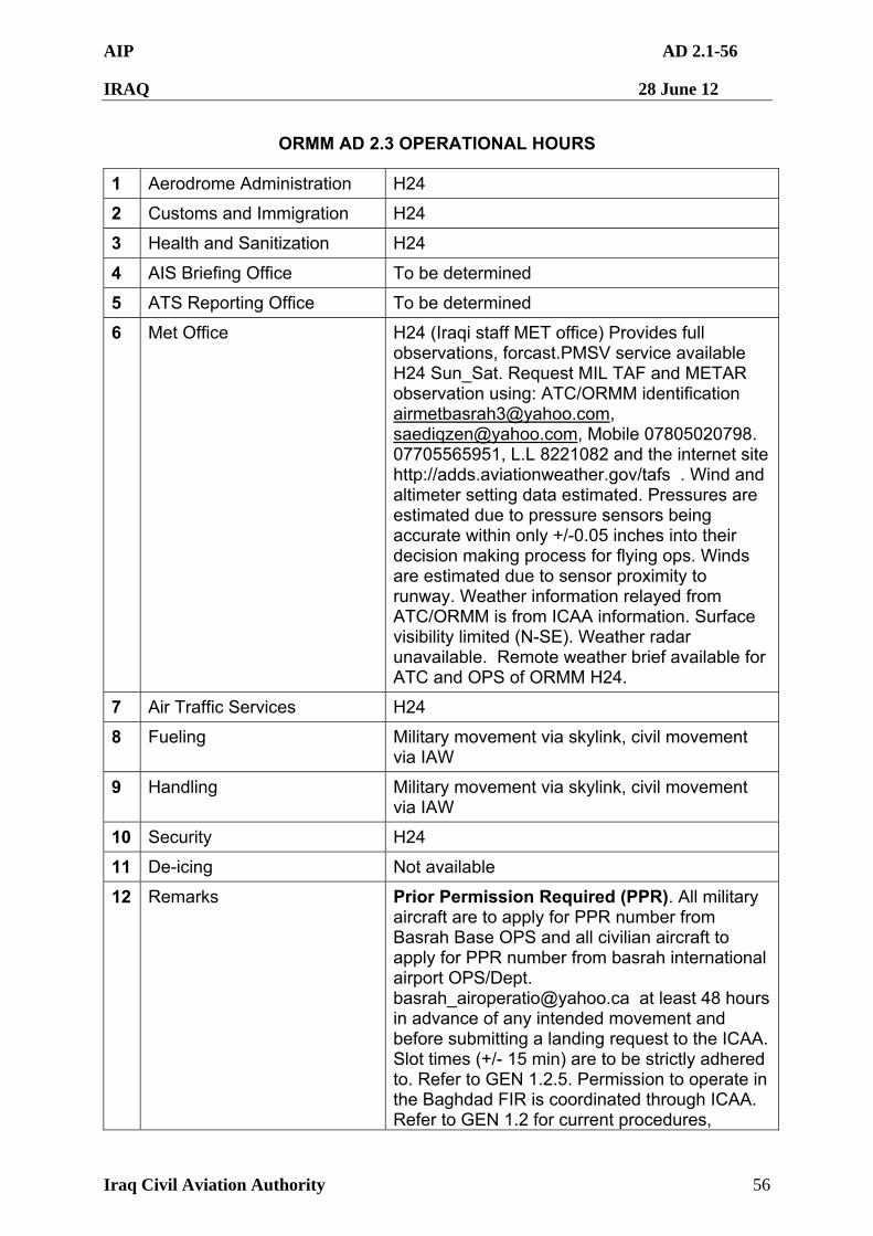
AIP AD 2.1-56
IRAQ 28 June 12
Iraq Civil Aviation Authority 56
ORMM AD 2.3 OPERATIONAL HOURS
1 Aerodrome Administration H24
2 Customs and Immigration H24
3 Health and Sanitization H24
4 AIS Briefing Office To be determined
5 ATS Reporting Office To be determined
6 Met Office H24 (Iraqi staff MET office) Provides full observations, forcast.PMSV service available H24 Sun_Sat. Request MIL TAF and METAR observation using: ATC/ORMM identification [email protected], [email protected], Mobile 07805020798. 07705565951, L.L 8221082 and the internet site http://adds.aviationweather.gov/tafs . Wind and altimeter setting data estimated. Pressures are estimated due to pressure sensors being accurate within only +/-0.05 inches into their decision making process for flying ops. Winds are estimated due to sensor proximity to runway. Weather information relayed from ATC/ORMM is from ICAA information. Surface visibility limited (N-SE). Weather radar unavailable. Remote weather brief available for ATC and OPS of ORMM H24.
7 Air Traffic Services H24
8 Fueling Military movement via skylink, civil movement via IAW
9 Handling Military movement via skylink, civil movement via IAW
10 Security H24
11 De-icing Not available
12 Remarks Prior Permission Required (PPR). All military aircraft are to apply for PPR number from Basrah Base OPS and all civilian aircraft to apply for PPR number from basrah international airport OPS/Dept. [email protected] at least 48 hours in advance of any intended movement and before submitting a landing request to the ICAA. Slot times (+/- 15 min) are to be strictly adhered to. Refer to GEN 1.2.5. Permission to operate in the Baghdad FIR is coordinated through ICAA. Refer to GEN 1.2 for current procedures,
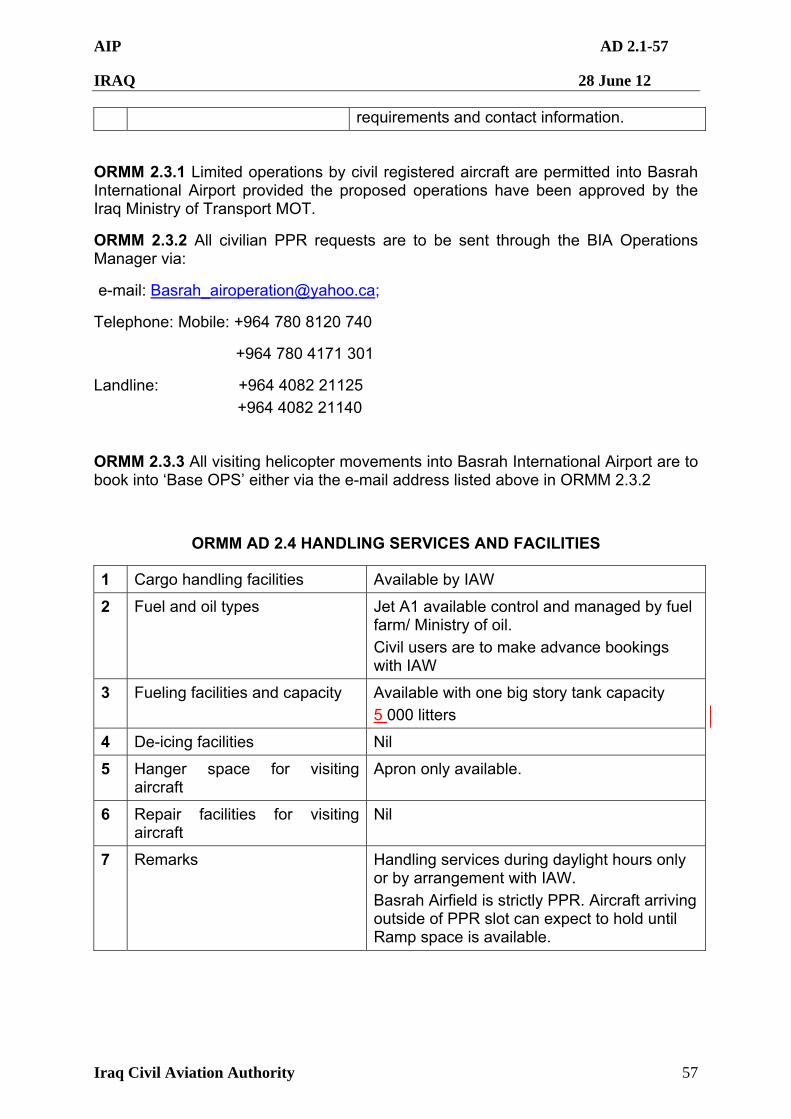
AIP AD 2.1-57
IRAQ 28 June 12
Iraq Civil Aviation Authority 57
requirements and contact information.
ORMM 2.3.1 Limited operations by civil registered aircraft are permitted into Basrah International Airport provided the proposed operations have been approved by the Iraq Ministry of Transport MOT.
ORMM 2.3.2 All civilian PPR requests are to be sent through the BIA Operations Manager via:
e-mail: [email protected];
Telephone: Mobile: +964 780 8120 740
+964 780 4171 301
Landline: +964 4082 21125
+964 4082 21140
ORMM 2.3.3 All visiting helicopter movements into Basrah International Airport are to book into ‘Base OPS’ either via the e-mail address listed above in ORMM 2.3.2
ORMM AD 2.4 HANDLING SERVICES AND FACILITIES
1 Cargo handling facilities Available by IAW
2 Fuel and oil types Jet A1 available control and managed by fuel farm/ Ministry of oil.
Civil users are to make advance bookings with IAW
3 Fueling facilities and capacity Available with one big story tank capacity
5 000 litters
4 De-icing facilities Nil
5 Hanger space for visiting aircraft
Apron only available.
6 Repair facilities for visiting aircraft
Nil
7 Remarks Handling services during daylight hours only or by arrangement with IAW.
Basrah Airfield is strictly PPR. Aircraft arriving outside of PPR slot can expect to hold until Ramp space is available.
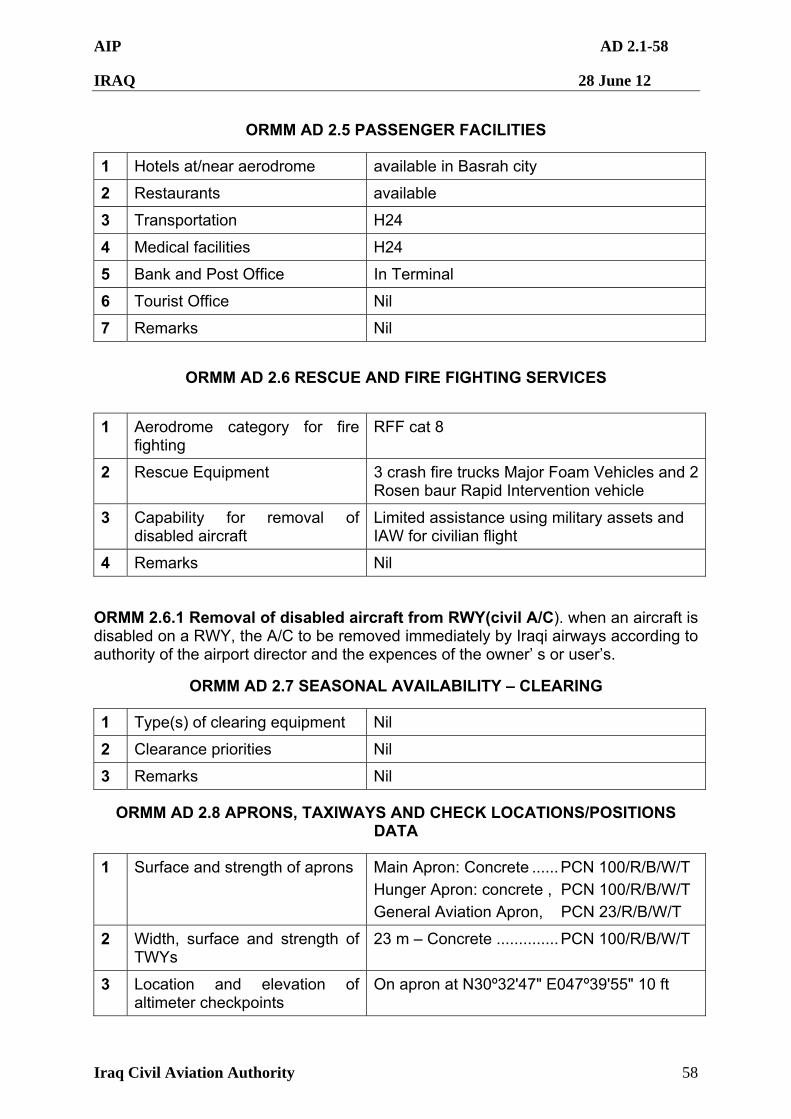
AIP AD 2.1-58
IRAQ 28 June 12
Iraq Civil Aviation Authority 58
ORMM AD 2.5 PASSENGER FACILITIES
1 Hotels at/near aerodrome available in Basrah city
2 Restaurants available
3 Transportation H24
4 Medical facilities H24
5 Bank and Post Office In Terminal
6 Tourist Office Nil
7 Remarks Nil
ORMM AD 2.6 RESCUE AND FIRE FIGHTING SERVICES
1 Aerodrome category for fire fighting
RFF cat 8
2 Rescue Equipment 3 crash fire trucks Major Foam Vehicles and 2 Rosen baur Rapid Intervention vehicle
3 Capability for removal of disabled aircraft
Limited assistance using military assets and IAW for civilian flight
4 Remarks Nil
ORMM 2.6.1 Removal of disabled aircraft from RWY(civil A/C). when an aircraft is disabled on a RWY, the A/C to be removed immediately by Iraqi airways according to authority of the airport director and the expences of the owner’ s or user’s.
ORMM AD 2.7 SEASONAL AVAILABILITY – CLEARING
1 Type(s) of clearing equipment Nil
2 Clearance priorities Nil
3 Remarks Nil
ORMM AD 2.8 APRONS, TAXIWAYS AND CHECK LOCATIONS/POSITIONS DATA
1 Surface and strength of aprons Main Apron: Concrete ......PCN 100/R/B/W/T
Hunger Apron: concrete , PCN 100/R/B/W/T
General Aviation Apron, PCN 23/R/B/W/T
2 Width, surface and strength of TWYs
23 m – Concrete ..............PCN 100/R/B/W/T
3 Location and elevation of altimeter checkpoints
On apron at N30º32'47" E047º39'55" 10 ft
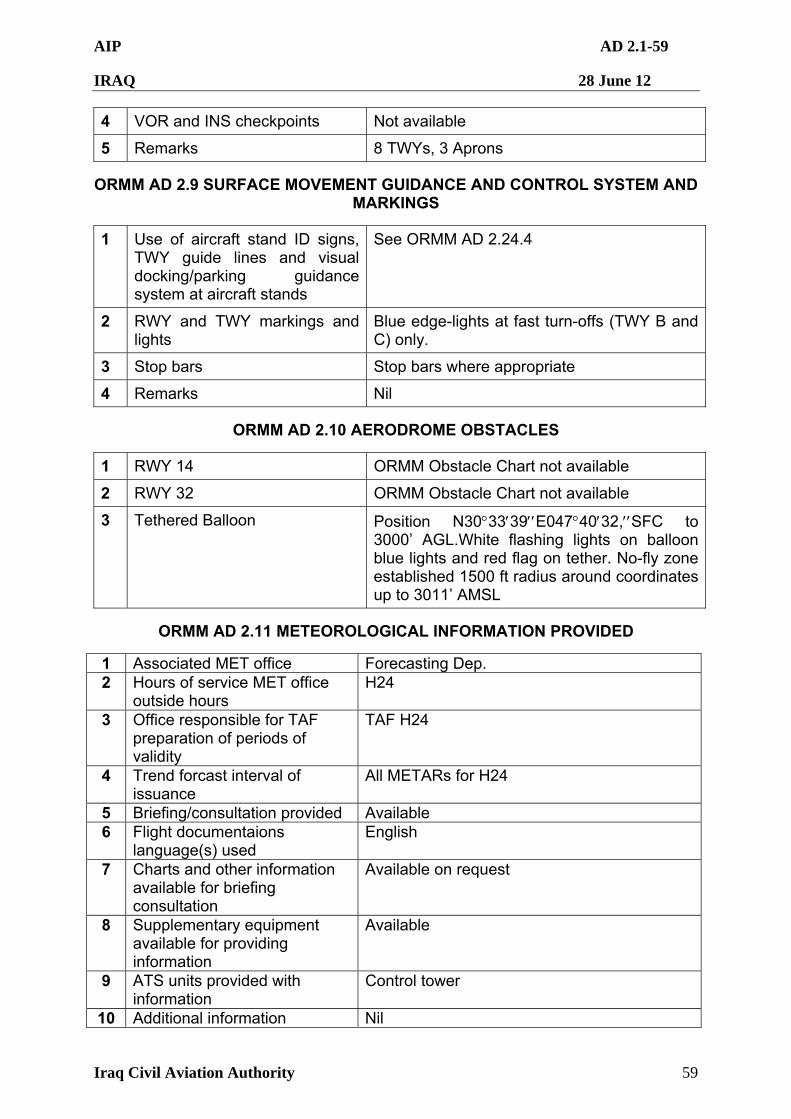
AIP AD 2.1-59
IRAQ 28 June 12
Iraq Civil Aviation Authority 59
4 VOR and INS checkpoints Not available
5 Remarks 8 TWYs, 3 Aprons
ORMM AD 2.9 SURFACE MOVEMENT GUIDANCE AND CONTROL SYSTEM AND MARKINGS
1 Use of aircraft stand ID signs, TWY guide lines and visual docking/parking guidance system at aircraft stands
See ORMM AD 2.24.4
2 RWY and TWY markings and lights
Blue edge-lights at fast turn-offs (TWY B and C) only.
3 Stop bars Stop bars where appropriate
4 Remarks Nil
ORMM AD 2.10 AERODROME OBSTACLES
1 RWY 14 ORMM Obstacle Chart not available
2 RWY 32 ORMM Obstacle Chart not available
3 Tethered Balloon Position N303339E0474032,SFC to 3000’ AGL.White flashing lights on balloon blue lights and red flag on tether. No-fly zone established 1500 ft radius around coordinates up to 3011’ AMSL
ORMM AD 2.11 METEOROLOGICAL INFORMATION PROVIDED
1 Associated MET office Forecasting Dep. 2 Hours of service MET office
outside hours H24
3 Office responsible for TAF preparation of periods of validity
TAF H24
4 Trend forcast interval of issuance
All METARs for H24
5 Briefing/consultation provided Available 6 Flight documentaions
language(s) used English
7 Charts and other information available for briefing consultation
Available on request
8 Supplementary equipment available for providing information
Available
9 ATS units provided with information
Control tower
10 Additional information Nil
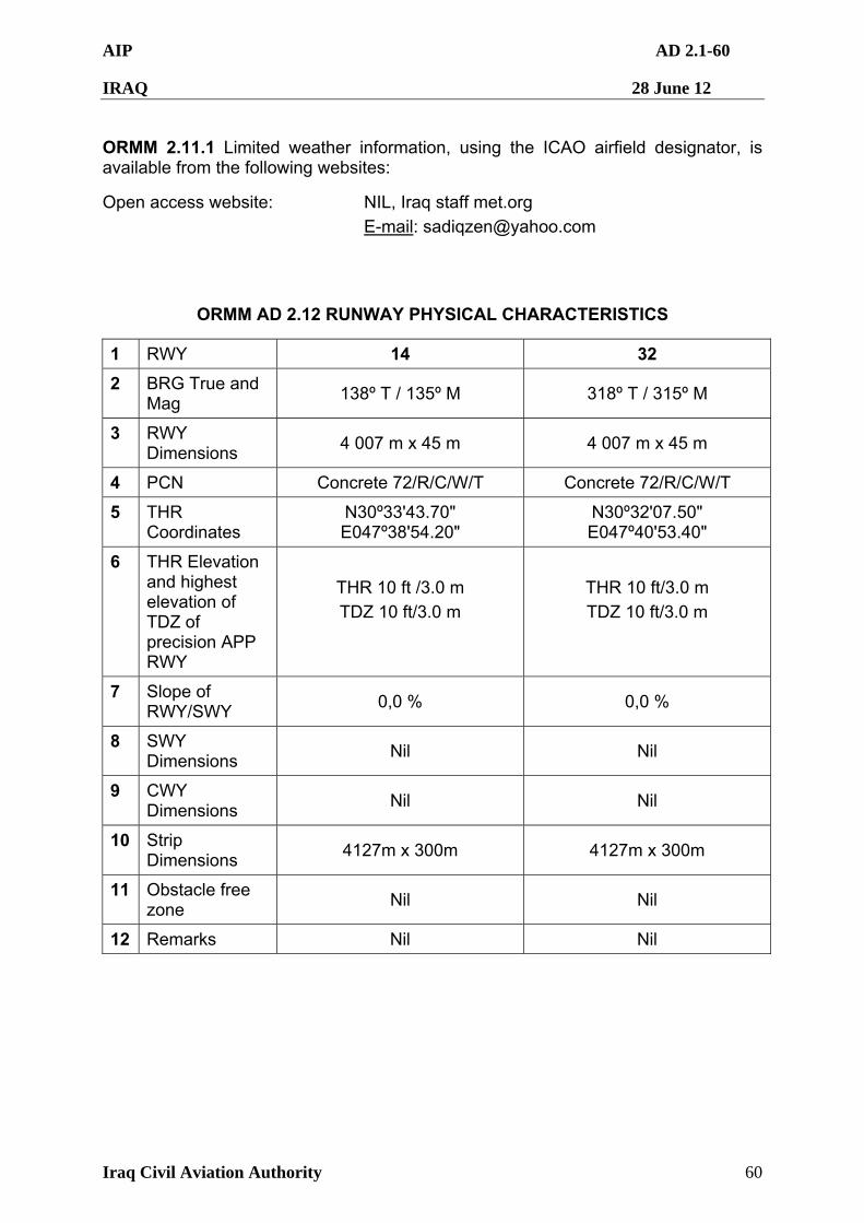
AIP AD 2.1-60
IRAQ 28 June 12
Iraq Civil Aviation Authority 60
ORMM 2.11.1 Limited weather information, using the ICAO airfield designator, is available from the following websites:
Open access website: NIL, Iraq staff met.org
E-mail: [email protected]
ORMM AD 2.12 RUNWAY PHYSICAL CHARACTERISTICS
1 RWY 14 32
2 BRG True and Mag
138º T / 135º M 318º T / 315º M
3 RWY Dimensions
4 007 m x 45 m 4 007 m x 45 m
4 PCN Concrete 72/R/C/W/T Concrete 72/R/C/W/T
5 THR Coordinates
N30º33'43.70" E047º38'54.20"
N30º32'07.50" E047º40'53.40"
6 THR Elevation and highest elevation of TDZ of precision APP RWY
THR 10 ft /3.0 m
TDZ 10 ft/3.0 m
THR 10 ft/3.0 m
TDZ 10 ft/3.0 m
7 Slope of RWY/SWY
0,0 % 0,0 %
8 SWY Dimensions
Nil Nil
9 CWY Dimensions
Nil Nil
10 Strip Dimensions
4127m x 300m 4127m x 300m
11 Obstacle free zone
Nil Nil
12 Remarks Nil Nil
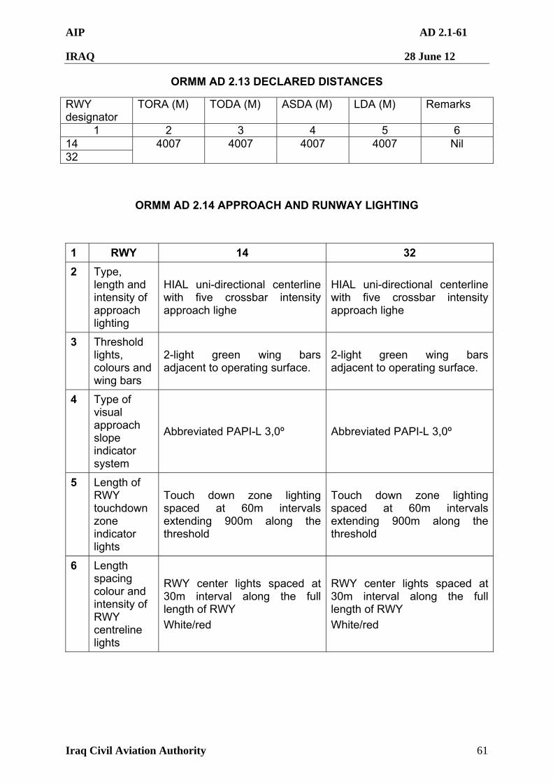
AIP AD 2.1-61
IRAQ 28 June 12
Iraq Civil Aviation Authority 61
ORMM AD 2.13 DECLARED DISTANCES
RWY designator
TORA (M) TODA (M) ASDA (M) LDA (M) Remarks
1 2 3 4 5 6 14 32
4007 4007 4007 4007 Nil
ORMM AD 2.14 APPROACH AND RUNWAY LIGHTING
1 RWY 14 32
2 Type, length and intensity of approach lighting
HIAL uni-directional centerline with five crossbar intensity approach lighe
HIAL uni-directional centerline with five crossbar intensity approach lighe
3 Threshold lights, colours and wing bars
2-light green wing bars adjacent to operating surface.
2-light green wing bars adjacent to operating surface.
4 Type of visual approach slope indicator system
Abbreviated PAPI-L 3,0º Abbreviated PAPI-L 3,0º
5 Length of RWY touchdown zone indicator lights
Touch down zone lighting spaced at 60m intervals extending 900m along the threshold
Touch down zone lighting spaced at 60m intervals extending 900m along the threshold
6 Length spacing colour and intensity of RWY centreline lights
RWY center lights spaced at 30m interval along the full length of RWY
White/red
RWY center lights spaced at 30m interval along the full length of RWY
White/red
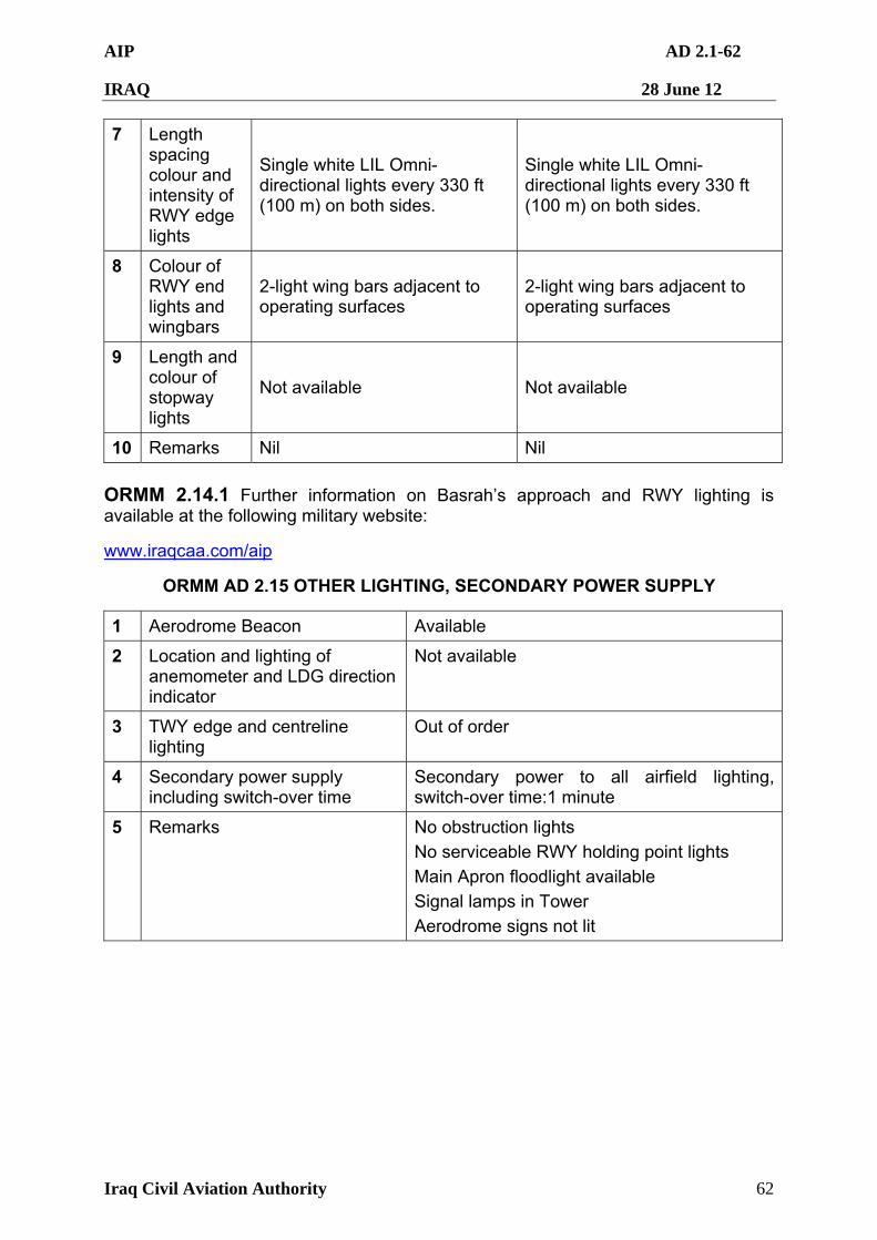
AIP AD 2.1-62
IRAQ 28 June 12
Iraq Civil Aviation Authority 62
7 Length spacing colour and intensity of RWY edge lights
Single white LIL Omni-directional lights every 330 ft (100 m) on both sides.
Single white LIL Omni-directional lights every 330 ft (100 m) on both sides.
8 Colour of RWY end lights and wingbars
2-light wing bars adjacent to operating surfaces
2-light wing bars adjacent to operating surfaces
9 Length and colour of stopway lights
Not available Not available
10 Remarks Nil Nil
ORMM 2.14.1 Further information on Basrah’s approach and RWY lighting is available at the following military website:
www.iraqcaa.com/aip
ORMM AD 2.15 OTHER LIGHTING, SECONDARY POWER SUPPLY
1 Aerodrome Beacon Available
2 Location and lighting of anemometer and LDG direction indicator
Not available
3 TWY edge and centreline lighting
Out of order
4 Secondary power supply including switch-over time
Secondary power to all airfield lighting, switch-over time:1 minute
5 Remarks No obstruction lights
No serviceable RWY holding point lights
Main Apron floodlight available
Signal lamps in Tower
Aerodrome signs not lit
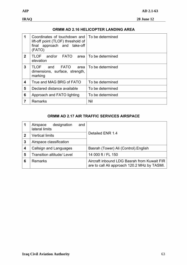
AIP AD 2.1-63
IRAQ 28 June 12
Iraq Civil Aviation Authority 63
ORMM AD 2.16 HELICOPTER LANDING AREA
1 Coordinates of touchdown and lift-off point (TLOF) threshold of final approach and take-off (FATO)
To be determined
2 TLOF and/or FATO area elevation
To be determined
3 TLOF and FATO area dimensions, surface, strength, marking
To be determined
4 True and MAG BRG of FATO To be determined
5 Declared distance available To be determined
6 Approach and FATO lighting To be determined
7 Remarks Nil
ORMM AD 2.17 AIR TRAFFIC SERVICES AIRSPACE
1 Airspace designation and lateral limits
2 Vertical limits
3 Airspace classification
Detailed ENR 1.4
4 Callsign and Languages Basrah (Tower) Ali (Control).English
5 Transition altitude/ Level 14 000 ft / FL 150
6 Remarks Aircraft inbound LDG Basrah from Kuwait FIR are to call Ali approach 120.2 MHz by TASMI.
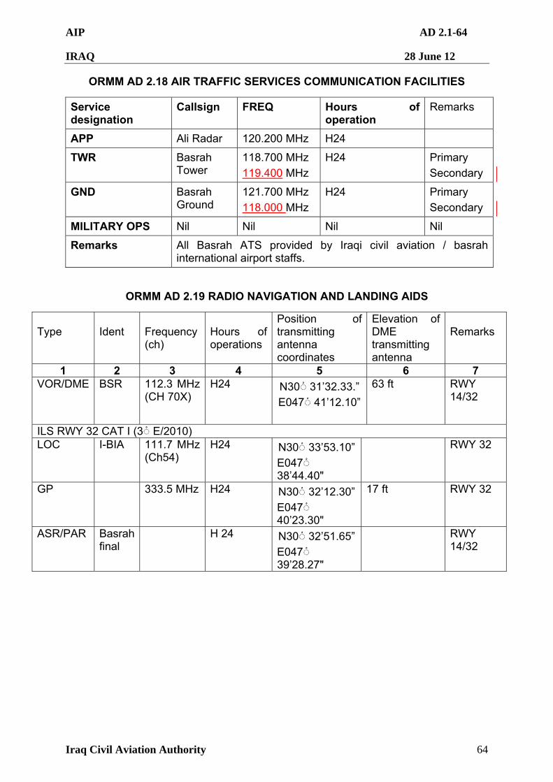
AIP AD 2.1-64
IRAQ 28 June 12
Iraq Civil Aviation Authority 64
ORMM AD 2.18 AIR TRAFFIC SERVICES COMMUNICATION FACILITIES
Service designation
Callsign FREQ Hours of operation
Remarks
APP Ali Radar 120.200 MHz H24
TWR Basrah Tower
118.700 MHz
119.400 MHz
H24 Primary
Secondary
GND Basrah Ground
121.700 MHz
118.000 MHz
H24 Primary
Secondary
MILITARY OPS Nil Nil Nil Nil
Remarks All Basrah ATS provided by Iraqi civil aviation / basrah international airport staffs.
ORMM AD 2.19 RADIO NAVIGATION AND LANDING AIDS
Type
Ident
Frequency (ch)
Hours of operations
Position of transmitting antenna coordinates
Elevation of DME transmitting antenna
Remarks
1 2 3 4 5 6 7 VOR/DME BSR 112.3 MHz
(CH 70X) H24 N30 ْ◌ 31’32.33.”
E047 ْ◌ 41’12.10”
63 ft RWY 14/32
ILS RWY 32 CAT I (3 ْ◌ E/2010) LOC I-BIA 111.7 MHz
(Ch54) H24 N30 ْ◌ 33’53.10”
E047 ْ◌ 38’44.40"
RWY 32
GP 333.5 MHz H24 N30 ْ◌ 32’12.30”
E047 ْ◌ 40’23.30"
17 ft RWY 32
ASR/PAR Basrah final
H 24 N30 ْ◌ 32’51.65”
E047 ْ◌ 39’28.27"
RWY 14/32
AIP AD 2.1-65
IRAQ 28 June 12
Iraq Civil Aviation Authority 65
ORMM AD 2.20 LOCAL TRAFFIC REGULATIONS
ORMM 2.20.1 For operational reasons ATC may require approach to RWY 14 for LDG RWY 32.
ORMM 2.20.2 Circuit Heights:
Light Aircraft circuit height: 1 000 ft
Normal circuit height: 1 500 ft
ORMM 2.20.3 Home-based rotary aircraft will be instructed to contact monitor ctaf 122.0 VHF and to maintain situational awareness of air traffic. All Aircraft shall remain outside the class D airspace until transferred to Basrah Tower. ORMM 2.20.4 Aircraft wishing to fly within the class G airspace, under the Basrah TMA, beyond 25NM from the airfield will monitor CTAF 122.0 MHz.
ORMM AD 2.21 NOISE ABATEMENT PROCEDURES
ORMM 2.21.1 Omni Directional Departures
Take –Off Minimums: RWY 14/32 Standard
RWY 14: Climb Gradient 3.3% Climb on Track 134.68 to 600’ before proceeding on course.
RWY 32: Climb Gradient 3.3% Climb on Track 314.69 to 600’ before proceeding on course.
ORMM 2.21.2 Arrivals
To be determined
ORMM AD 2.22 FLIGHT PROCEDURES
ORMM 2.22.1 Traffic Information. Pass to Aircraft according with ICAO procedures.
ORMM 2.22.2 Spiral climbs and descents not permitted.
ORMM 2.22.3 No more aerostat available.
ORMM AD 2.23 ADDITIONAL INFORMATION
ORMM 2.23.1 Radios/balloons released for met observation purposes at four hour intervals throughout the day. There are no set times, however Basrah Tower will broadcast a traffic warning prior to release. Balloons ascend to 30 000 ft AMSL
ORMM 2.23.2 Light Signals: Lamp Signal issued to a/c at ORMM will be in accordance with ICAO 4444.
AIP AD 2.1-66
IRAQ 28 June 12
Iraq Civil Aviation Authority 66
ORMM AD 2.24 CHARTS RELATED TO AN AERODROME
AD 2.24.1 Remove all references to "Basrah Approach", replace with "Ali Radar" 120.200 MHz which is included in the following charts
2.24.2.4/ 2.24.2.5/ 2.24.2.6
AD 2.24.2
ICAO Charts
1 Aerodrome Chart – ICAO ORMM AD 2.1-88
2 Aerodrome Ground Movement Chart - ICAO ORMM AD 2.1-89
3 Aircraft Parking Docking Chart - ICAO ORMM AD 2.1-90
4 ILS or LOC/DME RWY 32 ORMM AD 2.1-91
5 VOR/DME RWY32 ORMM AD 2.1-92
6 VOR/DME RWY 14 ORMM AD 2.1-93
AIP AD 2.1-67
IRAQ 28 June 12
Iraq Civil Aviation Authority 67
ORMM 2.24.2.1 AERODROME CHART
AIP AD 2.1-68
IRAQ 28 June 12
Iraq Civil Aviation Authority 68
ORMM 2.24.2.2 Aerodrome Ground Movement Chart - ICAO
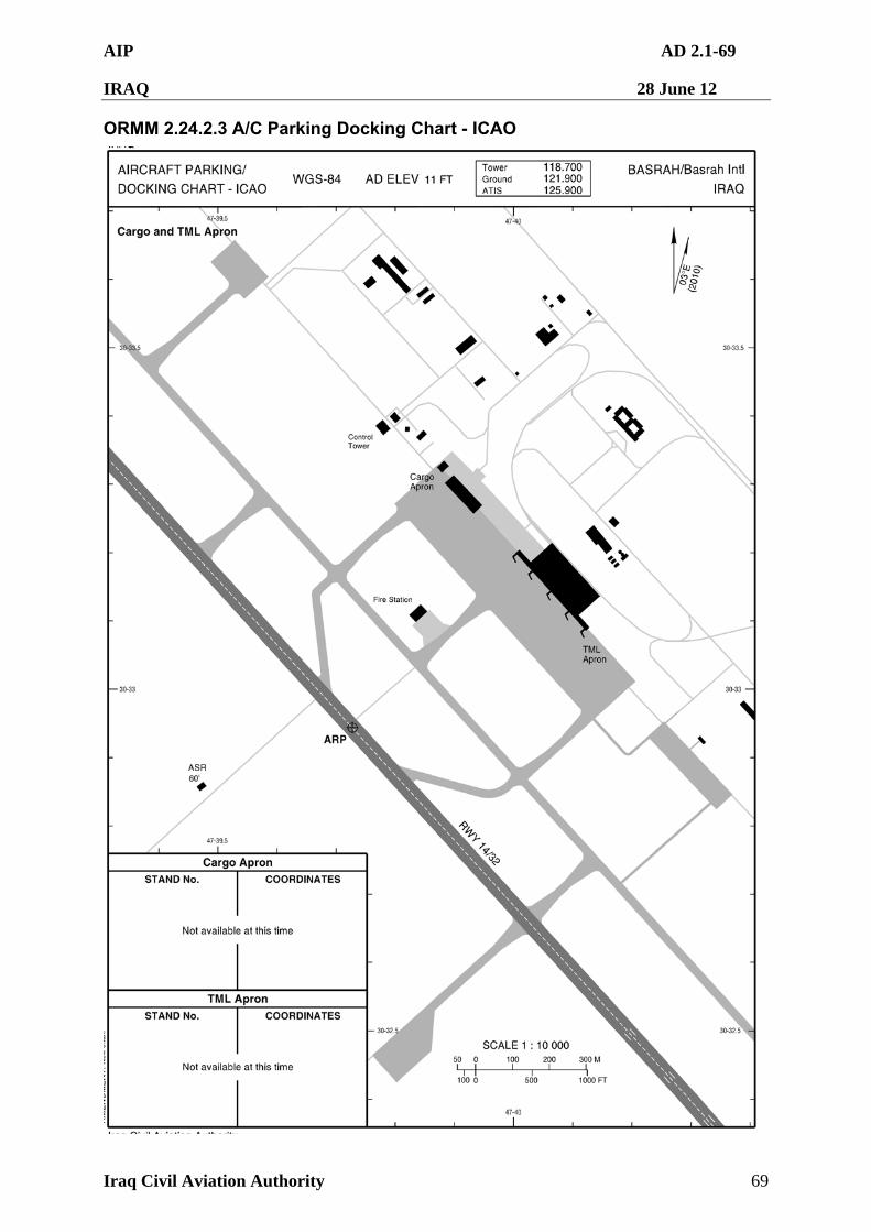
AIP AD 2.1-69
IRAQ 28 June 12
Iraq Civil Aviation Authority 69
ORMM 2.24.2.3 A/C Parking Docking Chart - ICAO
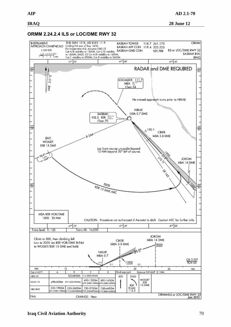
AIP AD 2.1-70
IRAQ 28 June 12
Iraq Civil Aviation Authority 70
ORMM 2.24.2.4 ILS or LOC/DME RWY 32
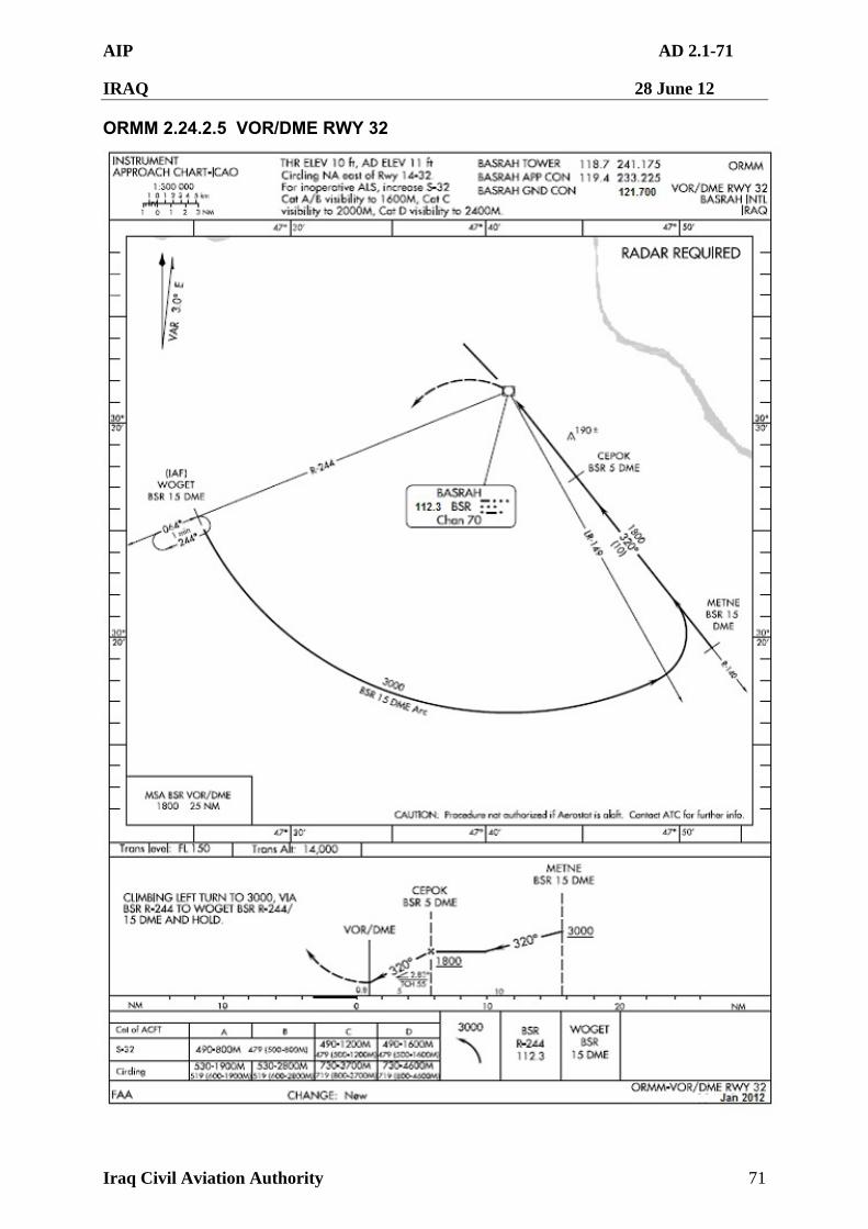
AIP AD 2.1-71
IRAQ 28 June 12
Iraq Civil Aviation Authority 71
ORMM 2.24.2.5 VOR/DME RWY 32

AIP AD 2.1-72
IRAQ 28 June 12
Iraq Civil Aviation Authority 72
ORMM 2.24.2.6 VOR/DME RWY 14
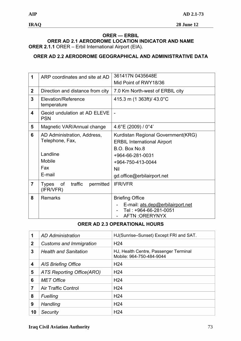
AIP AD 2.1-73
IRAQ 28 June 12
Iraq Civil Aviation Authority 73
ORER — ERBIL ORER AD 2.1 AERODROME LOCATION INDICATOR AND NAME
ORER 2.1.1 ORER – Erbil International Airport (EIA).
ORER AD 2.2 AERODROME GEOGRAPHICAL AND ADMINISTRATIVE DATA
1 ARP coordinates and site at AD 361417N 0435648E
Mid Point of RWY18/36
2 Direction and distance from city 7.0 Km North-west of ERBIL city
3 Elevation/Reference temperature
415.3 m (1 363ft)/ 43.0°C
4 Geoid undulation at AD ELEVE PSN
-
5 Magnetic VAR/Annual change 4.6°E (2009) / 0°4’
6 AD Administration, Address, Telephone, Fax,
Landline
Mobile
Fax
Kurdistan Regional Government(KRG)
ERBIL International Airport
B.O. Box No.8
+964-66-281-0031
+964-750-413-0044
Nil
7 Types of traffic permitted (IFR/VFR)
IFR/VFR
8 Remarks Briefing Office
- E-mail: [email protected] - Tel : +964-66-281-0051 - AFTN :ORERYNYX
ORER AD 2.3 OPERATIONAL HOURS
1 AD Administration HJ(Sunrise–Sunset) Except FRI and SAT.
2 Customs and Immigration H24
3 Health and Sanitation HJ, Health Centre, Passenger Terminal Mobile: 964-750-484-9044
4 AIS Briefing Office H24
5 ATS Reporting Office(ARO) H24
6 MET Office H24
7 Air Traffic Control H24
8 Fuelling H24
9 Handling H24
10 Security H24
AIP AD 2.1-74
IRAQ 28 June 12
Iraq Civil Aviation Authority 74
11 De-icing Available
12 Remarks Prior Permission Required(PPR). All aircraft must have PPR. Operators must contact Briefing Office for a PPR before submitting a landing request to the ICAA. Refer to GEN1.2.5.
ORER AD 2.4 HANDLING SERVICES AND FACILITIES
1 Cargo handling facilities All modern facilities handling weights up to 10 000 kg
2 Fuel/oil types Fuel : Jet A-1 Oil : Nil
3 Fuelling facilities/capacity a. Jet A-1 available by hydrant refueling on air-bridge gates. 6 aircraft can be fueled simultaneously, total amount of storage is 3 000 000 liters
b.Tank lorries are available 24H
4 De-icing facilities Available : Every aircraft stand
5 Hanger space for visiting aircraft
Not Available
6 Repair facilities for visiting aircraft
Minor repairs without hangar
7 Remarks Nil
ORER AD 2.5 PASSENGER FACILITIES
1 Hotels In ERBIL city
2 Restaurants At AD and in the city
3 Transportation Buses, Taxis and Rental cars
4
Medical facilities
a. First aid emergency medical center in airport. b. Ambulance service available. c. Hospitals in ERBIL city, 7.0 km away.
5 Bank and Post Office Available at airport and ERBIL city
6 Tourist Office Available at airport and ERBIL city
7 Remarks Nil
ORER AD 2.6 RESCUE AND FIRE FIGHTING SERVICES
1 AD Category for fire fighting
AD Category for fire fighting : CAT 9
AIP AD 2.1-75
IRAQ 28 June 12
Iraq Civil Aviation Authority 75
a. 1 ARFF vehicles
12 500 liter water(each), 1 500 liter foam(each), Foam discharge rate 6 000 l/min(each), Dry chemical powders 225 kg (each).
b. 1 ARFF vehicle
12 000 liter water, 1 500 liter foam, Foam discharge rate 6 000 l/min, Dry chemical powders 225kg.
c. 3 ARFF vehicles
9 000 liter water(each), 1 200 liter foam(each), Foam discharge rate 6 000 l/min, Dry chemical powders 500 kg (each).
d. 1 ARFF vehicle
10 000 liter water, 1 000 liter foam
e. 2 Rescue truck
2 Rescue equipment
f. 1 Aerial Ladder
3 Capability for removal of disabled aircraft
Nil
4 Remarks Nil
ORER AD 2.7 SEASONAL AVAILABILITY
1 Type of clearing equipment 1 Snow removal sweeper
2 Clearance priorities a. RWY b. TWY c. Aprons and other area
3 Remarks Nil
ORER AD 2.8 APRONS, TAXIWAYS AND CHECK LOCATIONS/POSITIONS DATA
1 Apron(Ramp) surface and strength:
a. Surface: Concrete b. Strength: PCN 80/R/B/W/T
2 Taxiway width, surface and strength:
Taxiway (A,B,C,D,E,A1~A5) width, surface and strength: a. Width : 25 m - Shoulder of TWY : 17.5 m b. Surface : Asphalt c. Strength : PCN 79/F/B/X/T d. T1: Width 21 m (69 ft) – Asphalt: PCN 65 e. T2: Width 21 m (69 ft) – Asphalt: PCN 65 f. T3: Width 24 m (78 ft) – Concrete: PCN 76 g. T4: Width 23 m (75 ft) – Concrete: PCN 76 h. T5: Width 23 m (75 ft) – Asphalt: PCN 76
AIP AD 2.1-76
IRAQ 28 June 12
Iraq Civil Aviation Authority 76
3 Altimeter check location and elevation:
Every specified stands (Refer to Aircraft Parking & Docking Chart)
4 VOR check point Nil
5 INS check points INS Checkpoints : Every specified stand (Refer to Aircraft Parking & Docking Chart)
6 Remarks Nil
ORER AD 2.9 SURFACE MOVEMENT GUIDANCE AND CONTROL SYSTEM AND MARKINGS
1 Use of aircraft stand ID signs, TWY guide lines and visual docking/ parking guidance system of aircraft stands
a. Guide lines at apron. b. Visual docking guidance system at air-bridge
gates on passenger apron.
2 RWY and TWY marking and LGT
a. Runway 1) Lights
- Edge lights are installed at 60 m intervals on RWY 18/36
- Centerline lights are installed at 15 m intervals on 18/36
2) Markings Runway Edges, Touchdown Zones, Aiming
Points and Center line. b. Taxiway 1) Lights - Edge lights are installed at 45 m intervals on only apron areas
- Centerline Lights are installed at 7.5 m~15 m intervals on all TWY curved areas and 30 m intervals in the rest of areas.
2) Markings
- TWY & taxilane centerline markings are marked with a yellow solid line on the black base on all specified taxiways designated as the LVP (Low Visibility Procedure) taxiway routes
- Intermediate holding position markings are displayed all intersection of TWY.
- RWY holding position markings are marked to protect ILS sensitive area in the form of trapezoid as recommended by ICAO(Annex 14) on taxiway A1, A2, A3, A4, and A5.
15/33 is marked with yellow X and is permanently closed
AIP AD 2.1-77
IRAQ 28 June 12
Iraq Civil Aviation Authority 77
3) Signs - ILS Taxi-Holding Position Signs are displayed as "CAT II”
- Runway designation and category II holding position Signs are installed on taxiways A1, A2, A3, A4, A5 substitute for the ILS sensitive area taxi-holding position.
3 Stop Bars : a. Stop Bar Lights are installed at the runway holding positions.
b. Stop Bar Lights consist of in-pavement red unidirectional fixtures and are installed at 3m intervals.
c. Stop Bars are controlled by ATC and include a system of in-pavement green taxiway centerline lights, lead-on/off lights at the locations where aircraft enter runway.
4 Intermediate Holding Position Lights:
Nil
5 VDGS VDGS installed air-bridge gates at passenger apron.
6 Remarks Runway side strip marking does not meet criteria in ANNEX 14. - 34.5 m From RWY centerline
Taxiway T1~T5 : No Taxiway Centerline Lights Taxiway T5 : No position sign
ORER AD 2.10 AERODROME OBSTACLES
In approach/TKOF area In circling area and at AD Remarks
1 2 3
RWY/area affected
Obstacle type Elevation Markings/LGT
Coordinates
Obstacles typeElevation Markings/LGT
Coordinates
a b c a b
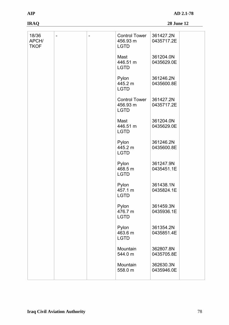
AIP AD 2.1-78
IRAQ 28 June 12
Iraq Civil Aviation Authority 78
18/36 APCH/ TKOF
- - Control Tower 456.93 m LGTD Mast 446.51 m LGTD Pylon 445.2 m LGTD Control Tower 456.93 m LGTD Mast 446.51 m LGTD Pylon 445.2 m LGTD Pylon 468.5 m LGTD Pylon 457.1 m LGTD Pylon 476.7 m LGTD Pylon 463.6 m LGTD Mountain 544.0 m Mountain 558.0 m
361427.2N 0435717.2E 361204.0N 0435629.0E 361246.2N 0435600.8E 361427.2N 0435717.2E 361204.0N 0435629.0E 361246.2N 0435600.8E 361247.9N 0435451.1E 361438.1N 0435824.1E 361459.3N 0435936.1E 361354.2N 0435851.4E 362807.8N 0435705.8E 362630.3N 0435946.0E
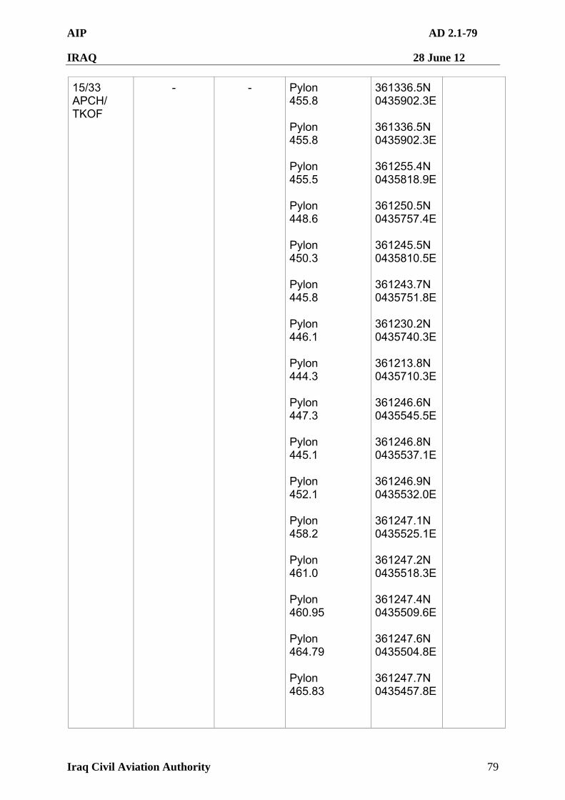
AIP AD 2.1-79
IRAQ 28 June 12
Iraq Civil Aviation Authority 79
15/33 APCH/ TKOF
- - Pylon 455.8 Pylon 455.8 Pylon 455.5 Pylon 448.6 Pylon 450.3 Pylon 445.8 Pylon 446.1 Pylon 444.3 Pylon 447.3 Pylon 445.1 Pylon 452.1 Pylon 458.2 Pylon 461.0 Pylon 460.95 Pylon 464.79 Pylon 465.83
361336.5N 0435902.3E 361336.5N 0435902.3E 361255.4N 0435818.9E 361250.5N 0435757.4E 361245.5N 0435810.5E 361243.7N 0435751.8E 361230.2N 0435740.3E 361213.8N 0435710.3E 361246.6N 0435545.5E 361246.8N 0435537.1E 361246.9N 0435532.0E 361247.1N 0435525.1E 361247.2N 0435518.3E 361247.4N 0435509.6E 361247.6N 0435504.8E 361247.7N 0435457.8E
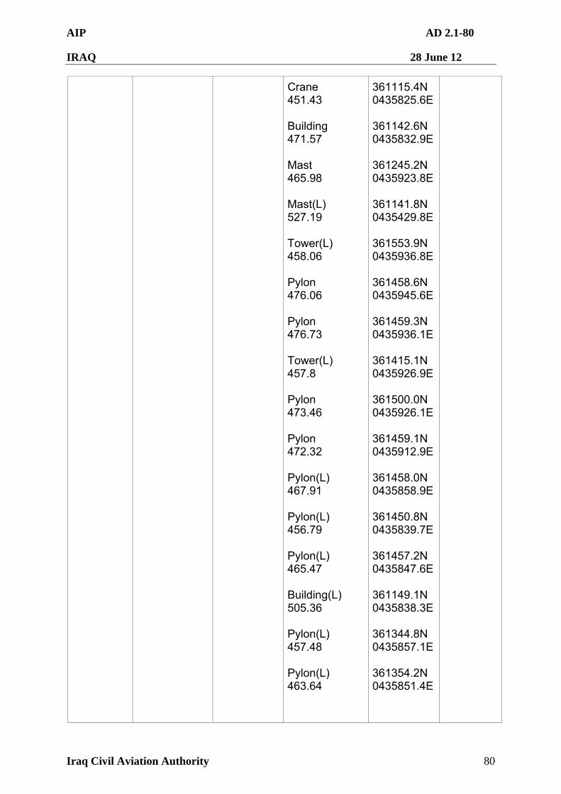
AIP AD 2.1-80
IRAQ 28 June 12
Iraq Civil Aviation Authority 80
Crane 451.43 Building 471.57 Mast 465.98 Mast(L) 527.19 Tower(L) 458.06 Pylon 476.06 Pylon 476.73 Tower(L) 457.8 Pylon 473.46 Pylon 472.32 Pylon(L) 467.91 Pylon(L) 456.79 Pylon(L) 465.47 Building(L) 505.36 Pylon(L) 457.48 Pylon(L) 463.64
361115.4N 0435825.6E 361142.6N 0435832.9E 361245.2N 0435923.8E 361141.8N 0435429.8E 361553.9N 0435936.8E 361458.6N 0435945.6E 361459.3N 0435936.1E 361415.1N 0435926.9E 361500.0N 0435926.1E 361459.1N 0435912.9E 361458.0N 0435858.9E 361450.8N 0435839.7E 361457.2N 0435847.6E 361149.1N 0435838.3E 361344.8N 0435857.1E 361354.2N 0435851.4E
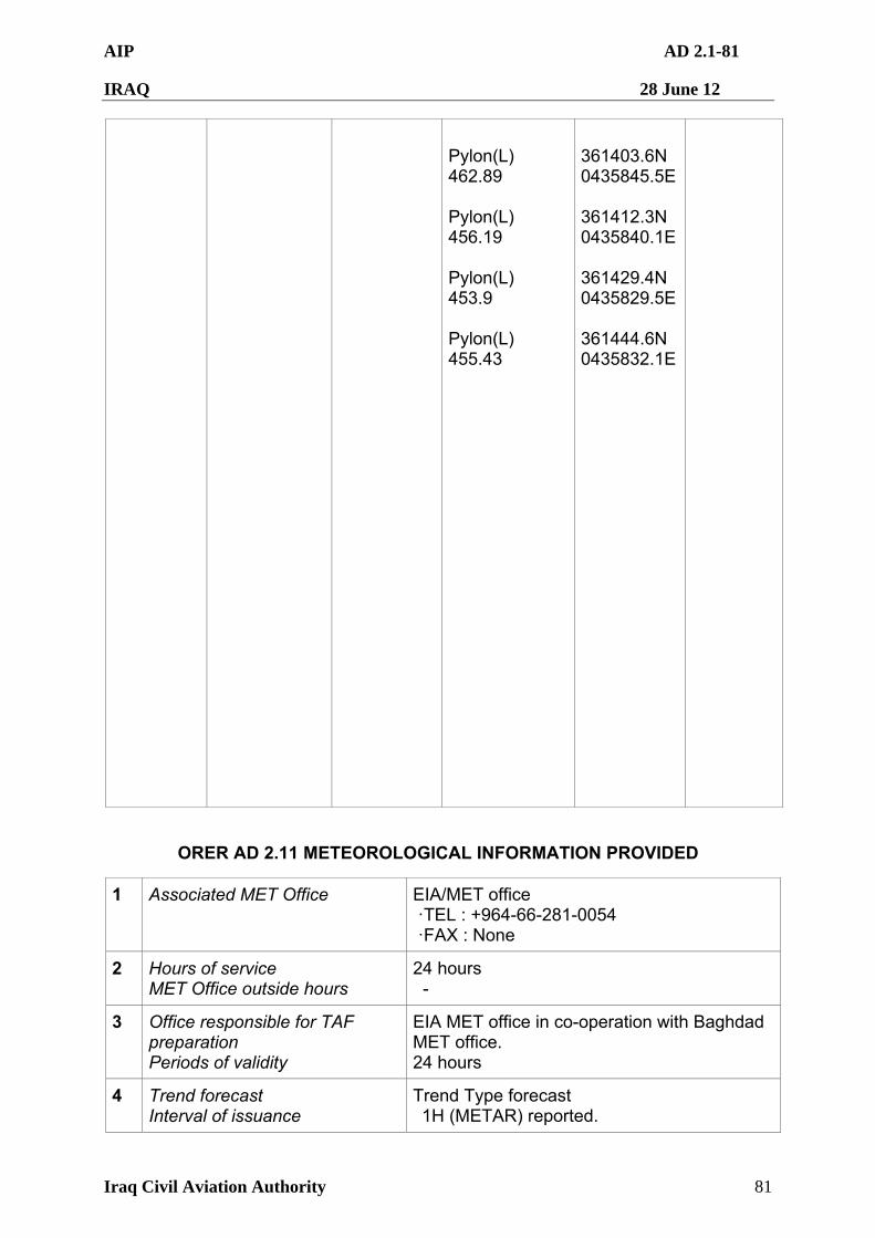
AIP AD 2.1-81
IRAQ 28 June 12
Iraq Civil Aviation Authority 81
Pylon(L) 462.89 Pylon(L) 456.19 Pylon(L) 453.9 Pylon(L) 455.43
361403.6N 0435845.5E 361412.3N 0435840.1E 361429.4N 0435829.5E 361444.6N 0435832.1E
ORER AD 2.11 METEOROLOGICAL INFORMATION PROVIDED
1 Associated MET Office EIA/MET office ·TEL : +964-66-281-0054 ·FAX : None
2 Hours of service MET Office outside hours
24 hours -
3 Office responsible for TAF preparation Periods of validity
EIA MET office in co-operation with Baghdad MET office. 24 hours
4 Trend forecast Interval of issuance
Trend Type forecast 1H (METAR) reported.
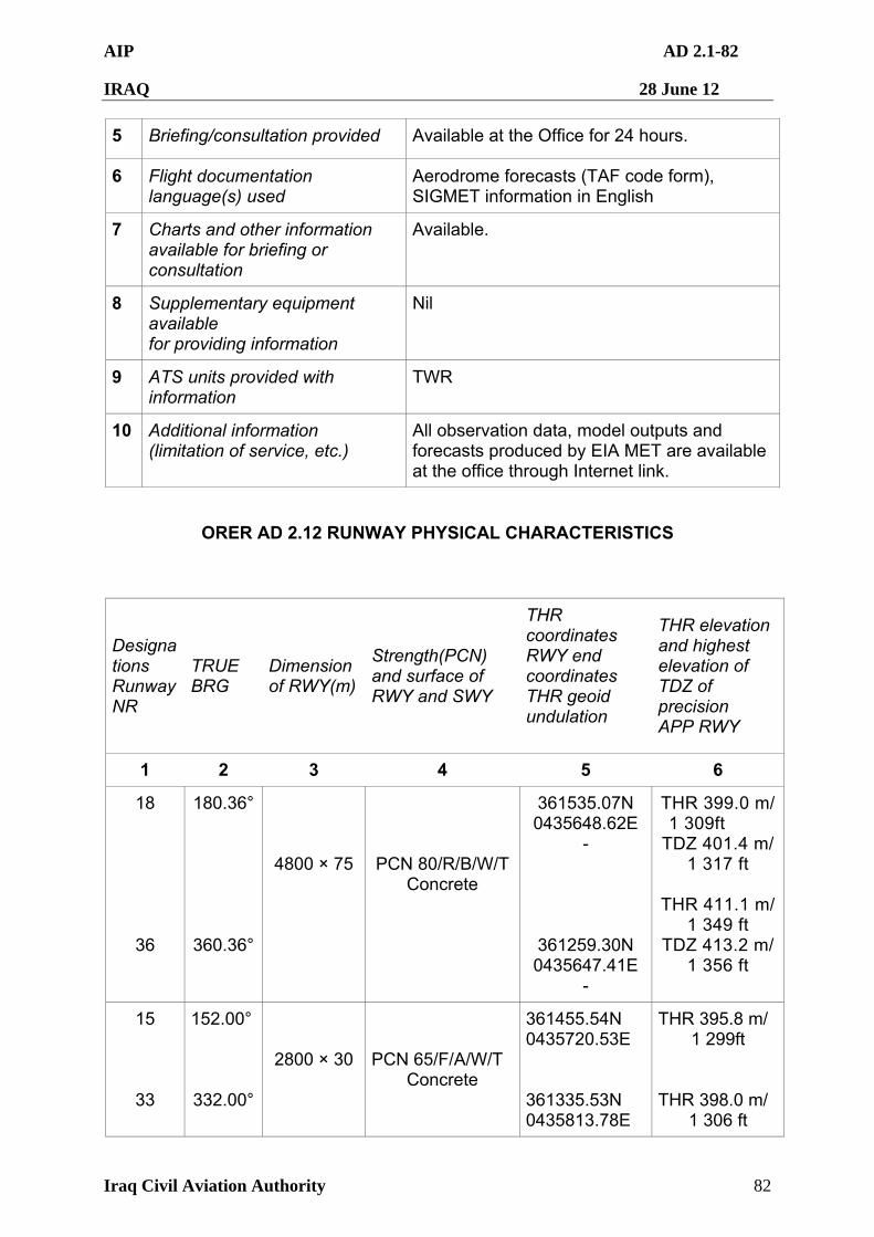
AIP AD 2.1-82
IRAQ 28 June 12
Iraq Civil Aviation Authority 82
5 Briefing/consultation provided Available at the Office for 24 hours.
6 Flight documentation language(s) used
Aerodrome forecasts (TAF code form), SIGMET information in English
7 Charts and other information available for briefing or consultation
Available.
8 Supplementary equipment available for providing information
Nil
9 ATS units provided with information
TWR
10 Additional information (limitation of service, etc.)
All observation data, model outputs and forecasts produced by EIA MET are available at the office through Internet link.
ORER AD 2.12 RUNWAY PHYSICAL CHARACTERISTICS
Designations Runway NR
TRUE BRG
Dimension of RWY(m)
Strength(PCN) and surface of RWY and SWY
THR coordinates RWY end coordinates THR geoid undulation
THR elevation and highest elevation of TDZ of precision APP RWY
1 2 3 4 5 6
18
36
180.36°
360.36°
4800 × 75
PCN 80/R/B/W/T Concrete
361535.07N 0435648.62E
-
361259.30N 0435647.41E
-
THR 399.0 m/ 1 309ft TDZ 401.4 m/
1 317 ft
THR 411.1 m/ 1 349 ft
TDZ 413.2 m/ 1 356 ft
15
33
152.00° 332.00°
2800 × 30
PCN 65/F/A/W/T Concrete
361455.54N 0435720.53E 361335.53N 0435813.78E
THR 395.8 m/ 1 299ft
THR 398.0 m/ 1 306 ft
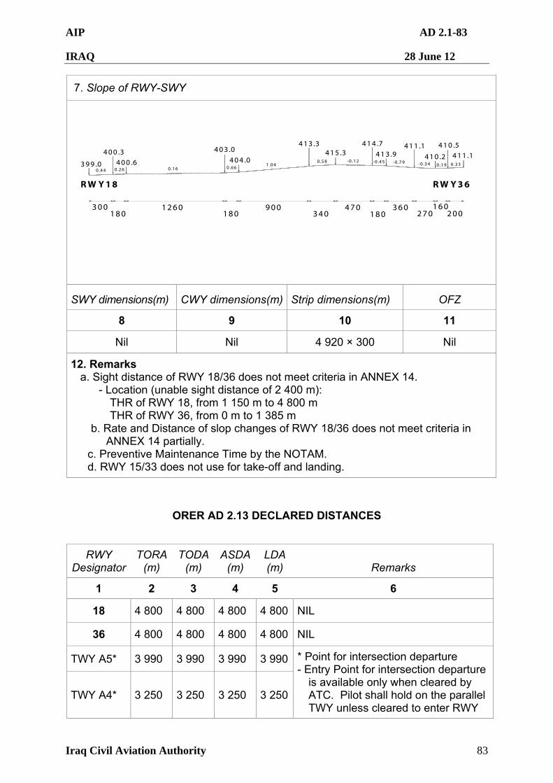
AIP AD 2.1-83
IRAQ 28 June 12
Iraq Civil Aviation Authority 83
7. Slope of RWY-SWY
400 .3400 .6399 .0
403 .0
404 .0
413 .3415 .3
414 .7
413 .9411 .1
410 .2
410 .5411 .1
RW Y18 RW Y36
300180
1260 900340
470200
360270180 180160
0.160 .44 0 .26 0 .661 .04
0 .58 -0 .12 -0 .45 -0 .79 -0 .34 0 .19 0 .33
SWY dimensions(m) CWY dimensions(m) Strip dimensions(m) OFZ
8 9 10 11
Nil Nil 4 920 × 300 Nil
12. Remarks a. Sight distance of RWY 18/36 does not meet criteria in ANNEX 14.
- Location (unable sight distance of 2 400 m): THR of RWY 18, from 1 150 m to 4 800 m THR of RWY 36, from 0 m to 1 385 m
b. Rate and Distance of slop changes of RWY 18/36 does not meet criteria in ANNEX 14 partially.
c. Preventive Maintenance Time by the NOTAM. d. RWY 15/33 does not use for take-off and landing.
ORER AD 2.13 DECLARED DISTANCES
RWY Designator
TORA(m)
TODA (m)
ASDA(m)
LDA (m) Remarks
1 2 3 4 5 6
18 4 800 4 800 4 800 4 800 NIL
36 4 800 4 800 4 800 4 800 NIL
TWY A5* 3 990 3 990 3 990 3 990
TWY A4* 3 250 3 250 3 250 3 250
* Point for intersection departure - Entry Point for intersection departure
is available only when cleared by ATC. Pilot shall hold on the parallel TWY unless cleared to enter RWY
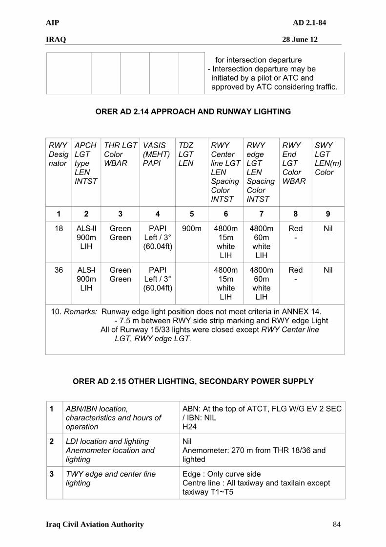
AIP AD 2.1-84
IRAQ 28 June 12
Iraq Civil Aviation Authority 84
for intersection departure - Intersection departure may be initiated by a pilot or ATC and approved by ATC considering traffic.
ORER AD 2.14 APPROACH AND RUNWAY LIGHTING
RWY Designator
APCH LGT type LEN INTST
THR LGT Color WBAR
VASIS (MEHT) PAPI
TDZ LGT LEN
RWY Center line LGTLEN Spacing Color INTST
RWY edge LGT LEN Spacing Color INTST
RWY End LGT Color WBAR
SWY LGT LEN(m)Color
1 2 3 4 5 6 7 8 9
18 ALS-II 900m LIH
Green Green
PAPI Left / 3° (60.04ft)
900m 4800m 15m white LIH
4800m 60m white LIH
Red -
Nil
36 ALS-I 900m LIH
Green Green
PAPI Left / 3° (60.04ft)
4800m 15m white LIH
4800m 60m white LIH
Red -
Nil
10. Remarks: Runway edge light position does not meet criteria in ANNEX 14. - 7.5 m between RWY side strip marking and RWY edge Light
All of Runway 15/33 lights were closed except RWY Center line LGT, RWY edge LGT.
ORER AD 2.15 OTHER LIGHTING, SECONDARY POWER SUPPLY
1
ABN/IBN location, characteristics and hours of operation
ABN: At the top of ATCT, FLG W/G EV 2 SEC / IBN: NIL H24
2 LDI location and lighting Anemometer location and lighting
Nil Anemometer: 270 m from THR 18/36 and lighted
3 TWY edge and center line lighting
Edge : Only curve side Centre line : All taxiway and taxilain except taxiway T1~T5
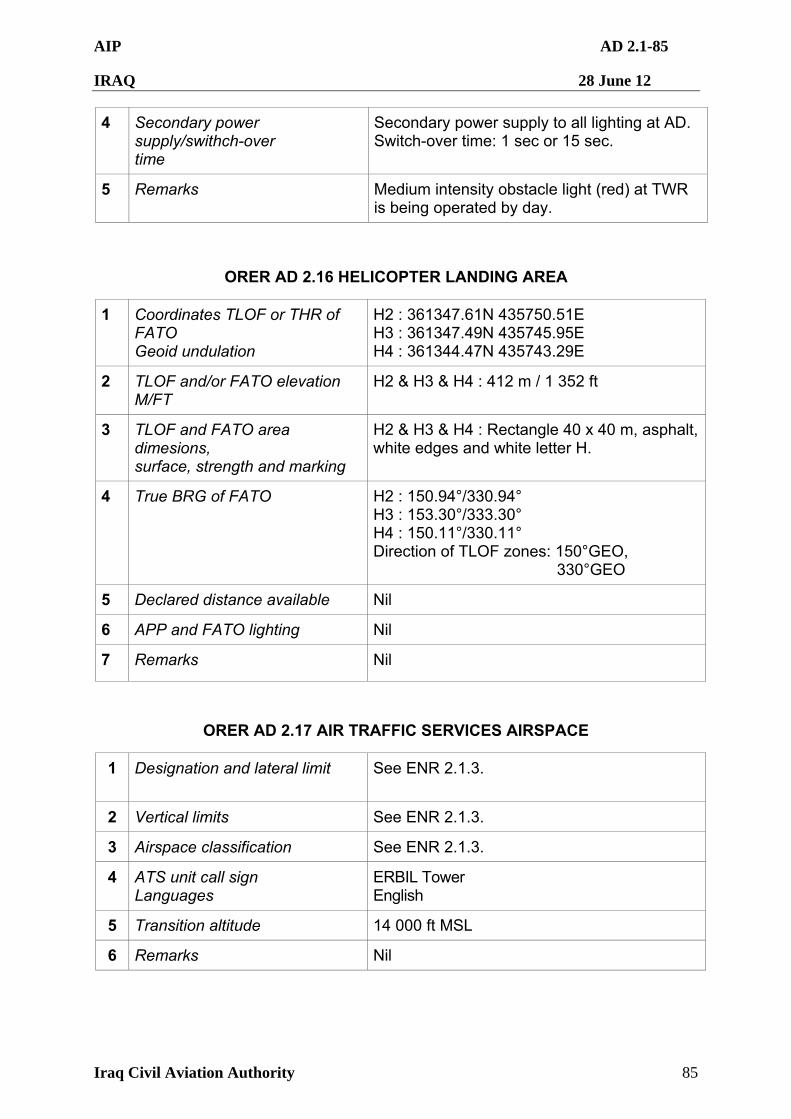
AIP AD 2.1-85
IRAQ 28 June 12
Iraq Civil Aviation Authority 85
4 Secondary power supply/swithch-over time
Secondary power supply to all lighting at AD. Switch-over time: 1 sec or 15 sec.
5 Remarks Medium intensity obstacle light (red) at TWR is being operated by day.
ORER AD 2.16 HELICOPTER LANDING AREA
1 Coordinates TLOF or THR of FATO Geoid undulation
H2 : 361347.61N 435750.51E H3 : 361347.49N 435745.95E H4 : 361344.47N 435743.29E
2 TLOF and/or FATO elevation M/FT
H2 & H3 & H4 : 412 m / 1 352 ft
3 TLOF and FATO area dimesions, surface, strength and marking
H2 & H3 & H4 : Rectangle 40 x 40 m, asphalt, white edges and white letter H.
4 True BRG of FATO H2 : 150.94°/330.94° H3 : 153.30°/333.30° H4 : 150.11°/330.11° Direction of TLOF zones: 150°GEO,
330°GEO
5 Declared distance available Nil
6 APP and FATO lighting Nil
7 Remarks Nil
ORER AD 2.17 AIR TRAFFIC SERVICES AIRSPACE
1 Designation and lateral limit See ENR 2.1.3.
2 Vertical limits See ENR 2.1.3.
3 Airspace classification See ENR 2.1.3.
4 ATS unit call sign Languages
ERBIL Tower English
5 Transition altitude 14 000 ft MSL
6 Remarks Nil
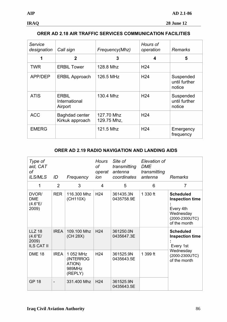
AIP AD 2.1-86
IRAQ 28 June 12
Iraq Civil Aviation Authority 86
ORER AD 2.18 AIR TRAFFIC SERVICES COMMUNICATION FACILITIES
Service designation Call sign Frequency(Mhz)
Hours of operation Remarks
1 2 3 4 5
TWR ERBIL Tower 128.8 Mhz H24
APP/DEP ERBIL Approach 126.5 MHz H24 Suspended until further notice
ATIS ERBIL International Airport
130.4 Mhz H24 Suspended until further notice
ACC Baghdad center Kirkuk approach
127.70 Mhz 129.75 Mhz,
H24
EMERG 121.5 Mhz H24 Emergency frequency
ORER AD 2.19 RADIO NAVIGATION AND LANDING AIDS
Type of aid, CAT of ILS/MLS ID Frequency
Hours of operation
Site of transmitting antenna coordinates
Elevation of DME transmitting antenna Remarks
1 2 3 4 5 6 7
DVOR/ DME (4.6°E/ 2009)
RER
116.300 Mhz (CH110X)
H24
361435.3N 0435758.9E
1 330 ft Scheduled Inspection time : Every 4th Wednesday (2000-2300UTC) of the month
LLZ 18 (4.6°E/ 2009) ILS CAT II
IREA 109.100 Mhz (CH 28X)
H24 361250.0N 0435647.3E
DME 18 IREA 1 052 MHz (INTERROGATION) 989MHz (REPLY)
H24 361525.9N 0435643.5E
1 399 ft
GP 18 - 331.400 Mhz H24 361525.9N 0435643.5E
Scheduled Inspection time : Every 1st Wednesday (2000-2300UTC) of the month
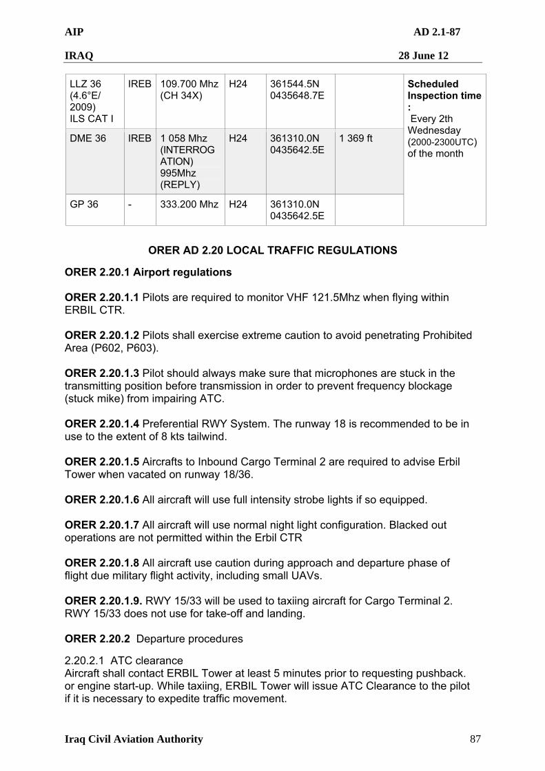
AIP AD 2.1-87
IRAQ 28 June 12
Iraq Civil Aviation Authority 87
LLZ 36 (4.6°E/ 2009) ILS CAT I
IREB 109.700 Mhz (CH 34X)
H24 361544.5N 0435648.7E
DME 36 IREB 1 058 Mhz (INTERROGATION) 995Mhz (REPLY)
H24 361310.0N 0435642.5E
1 369 ft
GP 36 - 333.200 Mhz H24 361310.0N 0435642.5E
Scheduled Inspection time : Every 2th Wednesday (2000-2300UTC) of the month
ORER AD 2.20 LOCAL TRAFFIC REGULATIONS
ORER 2.20.1 Airport regulations ORER 2.20.1.1 Pilots are required to monitor VHF 121.5Mhz when flying within ERBIL CTR. ORER 2.20.1.2 Pilots shall exercise extreme caution to avoid penetrating Prohibited Area (P602, P603). ORER 2.20.1.3 Pilot should always make sure that microphones are stuck in the transmitting position before transmission in order to prevent frequency blockage (stuck mike) from impairing ATC. ORER 2.20.1.4 Preferential RWY System. The runway 18 is recommended to be in use to the extent of 8 kts tailwind. ORER 2.20.1.5 Aircrafts to Inbound Cargo Terminal 2 are required to advise Erbil Tower when vacated on runway 18/36. ORER 2.20.1.6 All aircraft will use full intensity strobe lights if so equipped. ORER 2.20.1.7 All aircraft will use normal night light configuration. Blacked out operations are not permitted within the Erbil CTR ORER 2.20.1.8 All aircraft use caution during approach and departure phase of flight due military flight activity, including small UAVs. ORER 2.20.1.9. RWY 15/33 will be used to taxiing aircraft for Cargo Terminal 2. RWY 15/33 does not use for take-off and landing. ORER 2.20.2 Departure procedures
2.20.2.1 ATC clearance Aircraft shall contact ERBIL Tower at least 5 minutes prior to requesting pushback. or engine start-up. While taxiing, ERBIL Tower will issue ATC Clearance to the pilot if it is necessary to expedite traffic movement.
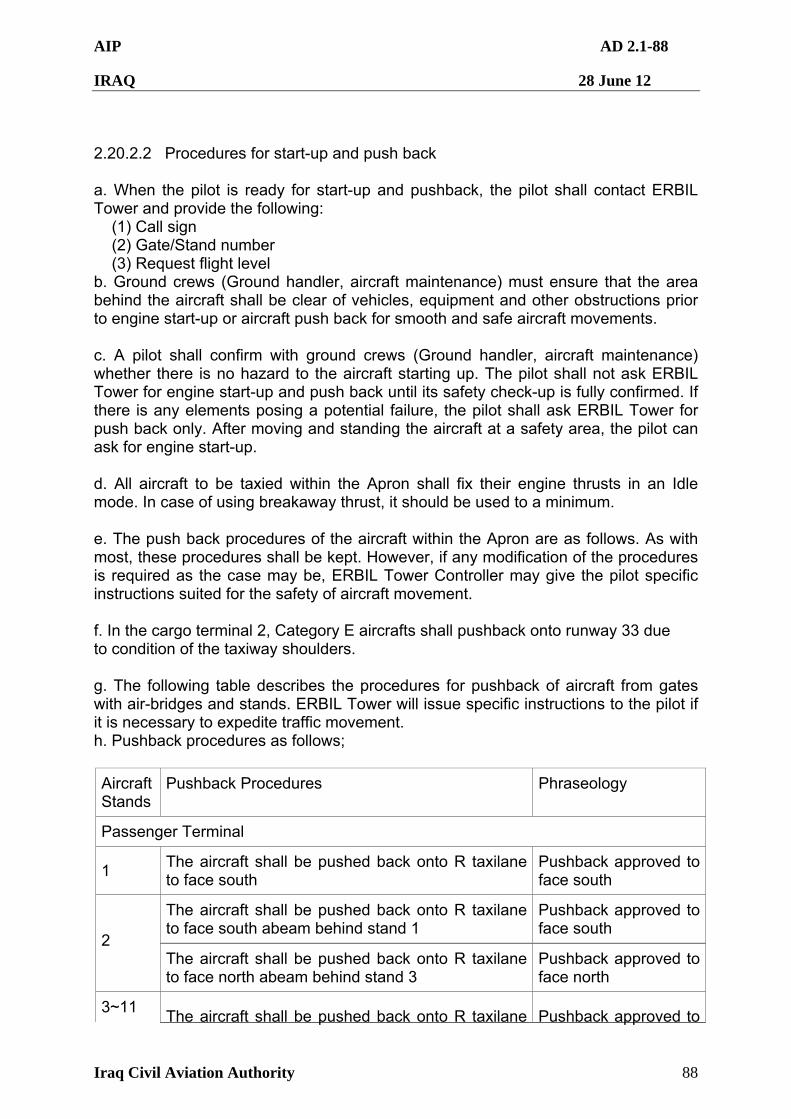
AIP AD 2.1-88
IRAQ 28 June 12
Iraq Civil Aviation Authority 88
2.20.2.2 Procedures for start-up and push back a. When the pilot is ready for start-up and pushback, the pilot shall contact ERBIL Tower and provide the following: (1) Call sign (2) Gate/Stand number (3) Request flight level b. Ground crews (Ground handler, aircraft maintenance) must ensure that the area behind the aircraft shall be clear of vehicles, equipment and other obstructions prior to engine start-up or aircraft push back for smooth and safe aircraft movements. c. A pilot shall confirm with ground crews (Ground handler, aircraft maintenance) whether there is no hazard to the aircraft starting up. The pilot shall not ask ERBIL Tower for engine start-up and push back until its safety check-up is fully confirmed. If there is any elements posing a potential failure, the pilot shall ask ERBIL Tower for push back only. After moving and standing the aircraft at a safety area, the pilot can ask for engine start-up. d. All aircraft to be taxied within the Apron shall fix their engine thrusts in an Idle mode. In case of using breakaway thrust, it should be used to a minimum. e. The push back procedures of the aircraft within the Apron are as follows. As with most, these procedures shall be kept. However, if any modification of the procedures is required as the case may be, ERBIL Tower Controller may give the pilot specific instructions suited for the safety of aircraft movement. f. In the cargo terminal 2, Category E aircrafts shall pushback onto runway 33 due to condition of the taxiway shoulders. g. The following table describes the procedures for pushback of aircraft from gates with air-bridges and stands. ERBIL Tower will issue specific instructions to the pilot if it is necessary to expedite traffic movement. h. Pushback procedures as follows;
Aircraft Stands
Pushback Procedures Phraseology
Passenger Terminal
1 The aircraft shall be pushed back onto R taxilane to face south
Pushback approved to face south
The aircraft shall be pushed back onto R taxilane to face south abeam behind stand 1
Pushback approved to face south
2 The aircraft shall be pushed back onto R taxilane to face north abeam behind stand 3
Pushback approved to face north
3~11 The aircraft shall be pushed back onto R taxilane Pushback approved to
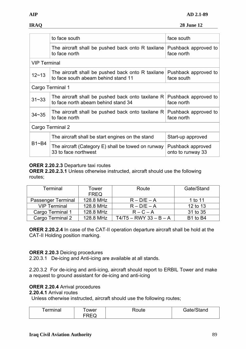
AIP AD 2.1-89
IRAQ 28 June 12
Iraq Civil Aviation Authority 89
to face south face south
The aircraft shall be pushed back onto R taxilane to face north
Pushback approved to face north
VIP Terminal
12~13 The aircraft shall be pushed back onto R taxilane to face south abeam behind stand 11
Pushback approved to face south
Cargo Terminal 1
31~33 The aircraft shall be pushed back onto taxilane R to face north abeam behind stand 34
Pushback approved to face north
34~35 The aircraft shall be pushed back onto taxilane R to face north
Pushback approved to face north
Cargo Terminal 2
The aircraft shall be start engines on the stand Start-up approved B1~B4
The aircraft (Category E) shall be towed on runway33 to face northwest
Pushback approved onto to runway 33
ORER 2.20.2.3 Departure taxi routes ORER 2.20.2.3.1 Unless otherwise instructed, aircraft should use the following routes;
Terminal Tower FREQ
Route Gate/Stand
Passenger Terminal 128.8 MHz R – D/E – A 1 to 11 VIP Terminal 128.8 MHz R – D/E – A 12 to 13
Cargo Terminal 1 128.8 MHz R – C – A 31 to 35 Cargo Terminal 2 128.8 MHz T4/T5 – RWY 33 – B – A B1 to B4
ORER 2.20.2.4 In case of the CAT-II operation departure aircraft shall be hold at the CAT-II Holding position marking. ORER 2.20.3 Deicing procedures 2.20.3.1 De-icing and Anti-icing are available at all stands. 2.20.3.2 For de-icing and anti-icing, aircraft should report to ERBIL Tower and make a request to ground assistant for de-icing and anti-icing ORER 2.20.4 Arrival procedures 2.20.4.1 Arrival routes Unless otherwise instructed, aircraft should use the following routes;
Terminal Tower FREQ
Route Gate/Stand
AIP AD 2.1-90
IRAQ 28 June 12
Iraq Civil Aviation Authority 90
Passenger Terminal
128.8 Mhz A – D/E – R 1 to 11
VIP Terminal 128.8 Mhz A – D/E – R 12 to 13 Cargo Terminal 1 128.8 Mhz A – C – R 31 to 35 Cargo Terminal 2 128.8 Mhz A – B – RWY 15 – T4/T5
A – B – RWY 15 – Tow B1 to B4
2.20.4.2. Follow-me car service a. Follow-me service is available to arriving aircraft. Pilots should make the request to ERBIL Tower. b. Aircraft shall monitor the appropriate ERBIL Tower frequencies while taxiing. ORER 2.20.5 Ground engine check procedures Pilots or authorized engineers requiring engine ground runs shall contact ERBIL Tower and provide the following: a. Call sign or registration number b. Gate/Stand number c. Type of ground engine run, engine start or performance check ERBIL Tower should sbe advised on its completion. 2.20.5.1 Engine starts Engine starts are permitted in the apron areas. However, the power setting(s) shall not exceed idle thrust. 2.20.5.2 Engine performance check Engine performance checks are permitted at a designated position by ERBIL Tower depending on wind condition. The frequency of ERBIL Tower shall be monitored. ORER 2.20.6 Taxiing Limitation ORER 2.20.6.1 Taxiway T1~ T5 is unable to taxi aircrafts of Category E. Only tow is approved. ORER 2.20.7 CAT II Operations 2.20.7.1 General ERBIL International Airport RWY 18 has ILS CAT II equipment. Low Visibility Procedures are established for operation in a visibility of less than RVR 550m or a cloud ceiling of less than 60 m(200 ft). a. Low visibility operations will be initiated by broadcasting "ATC LOW VISIBILITY PROCEDURES ARE IN OPERATION" via ATIS and/or appropriate radio frequencies. b. Low visibility operations will be terminated by deleting the above mentioned message from ATIS and/or broadcasting "ATC LOW VISIBILITY OPERATIONS ARE TERMINATED" via appropriate frequencies.
AIP AD 2.1-91
IRAQ 28 June 12
Iraq Civil Aviation Authority 91
2.20.7.2 Aircraft operators must obtain approval from ICAA prior to conducting any low visibility operations at ERBIL International Airport. a. Aircraft operators and pilots who wish to conduct ILS CAT II operations at ERBIL International Airport shall conform with certain requirements. b. Foreign operators may obtain the approval from ICAA by providing the following information to ICAA. 1) Aircraft type and register number 2) The CAT II minima to which they intend to operate 3) A copy of the CAT II certification issued by their own category authority. 2.20.7.3 Pilots shall be informed when a. Meteorological reports preclude ILS CAT I operations b. Low Visibility Procedures are in operation c. There is any unserviceable in a promulgated facility so that they may amend their minima 2.20.7.4 Pilots who wish to carry out an ILS CAT II approach shall inform to Approach control on initial contact. 2.20.7.5 Special Procedures and Safeguards Special procedures and ground safeguards will be applied during CAT II operations to protect aircraft from abnormal operation in low visibility and to avoid interference with the ILS signals in accordance with the provisions of ICAO Doc. 9365 - Manual of All Weather Operations 2.20.7.5.1 During low visibility operations, taxiway centerline lights will be used in conjunction with the stop bar lights as follows a. If the stop bar lights are turned on, the centerline lights beyond the stop bar will be turned off. b. If the stop bar lights are turned off, the centerline lights beyond the stop bar will be turned on. 2.20.7.5.2 Aircraft shall hold at CAT-II holding positions signs and marking of the TWY A1 2.20.7.5.3 Arriving Aircraft a. Aircraft shall vacate the runway via the designated exit taxiways as follows ; Other exit taxiways will not be lit RWY 18 - A3 or A4 or A5 TWY – A TWY- C or D TWY Refer to ORER 2.1-106 Pages. b. When long distance is required for landing, aircraft can maneuver by the end of runway, and shall vacate the runway via A5 exit taxiway after a 180-degree turn at the end of runway 18.
AIP AD 2.1-92
IRAQ 28 June 12
Iraq Civil Aviation Authority 92
c. All runway exits have taxiway center-line lead off lights ( color coded : green/yellow) to indicate that portions of the taxiway are within the ILS sensitive area. d. Pilots are required to make a 'runway vacated' call giving due allowance for the size of the aircraft to ensure that the entire aircraft have vacated the ILS critical sensitive area. 2.20.7.5.4 Departing Aircraft Departing aircraft shall normally enter the runway via the designated taxiways as follows; C or E TWY – A TWY- A1 - RWY 18 Refer to ORER 2.20.2.3 Departure taxi routes. 2.20.7.6 Practice Approaches Pilots may carry out a practice ILS CAT II approach at any time with a prior approval of ATC, but the full safeguarding ground procedures shall not be applied, and pilots should foretell the possibility of ILS signal interference. ORER 2.20.8 Apron Safety Management 2.20.8.1 All GSE (Ground Service Equipment) vehicle roadways crossing taxiways or taxilanes are marked in the form of zipper. 2.20.8.2 Pilots shall pay special caution to vehicles while taxiing in apron areas.
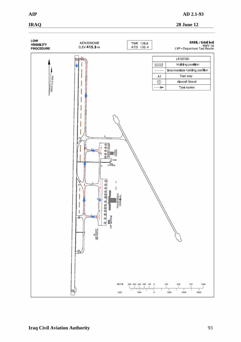
AIP AD 2.1-93
IRAQ 28 June 12
Iraq Civil Aviation Authority 93
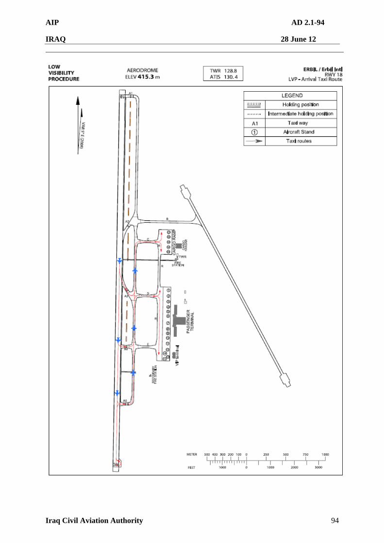
AIP AD 2.1-94
IRAQ 28 June 12
Iraq Civil Aviation Authority 94
AIP AD 2.1-95
IRAQ 28 June 12
Iraq Civil Aviation Authority 95
ORER AD 2.21 NOISE ABATEMENT PROCEDURES
ORER 2.21.1 Aircraft are to avoid over flying the airport buildings, construction sites, other aircraft, or fuel point/trucks below 1 000 ft AGL whenever possible.
ORER AD 2.22 FLIGHT PROCEDURES
ORER AD 2.22.1. IFR Procedure
2.22.1.1 IFR ATC Clearance
The following procedures are established for all departures from ERBIL International Airport.
a. Aircraft shall contact ERBIL Tower and provide the following information 5
minutes prior to startup or push-back. 1) Aircraft Identification 2) Type of aircraft 3) Destination 4) Proposed and alternate flight level 5) Gate or stand number 6) ATIS code
b. ATC clearance issued by ERBIL Tower may be cancelled without notification to pilot if aircraft fails to push back or taxi within 10 minutes after receipt, and other aircraft are requesting the same altitude/route assignment with push-back or start-up ready. And after 10minutes of receipt of ATC clearance, pilot shall contact ERBIL Tower to verify the status of clearance prior to calling for start-up or push-back except when 1) Start-up or push-back is delayed due to traffic on the ground; or 2) Aircraft departure is restricted by means of release time.
2.22.1.2 Speed control There is no speed control restriction for now. 2.22.1.3 Visual approach and separation
a. Visual approach may be initiated by ATC or approved upon pilot’s request on a traffic permitting basis when the weather condition is as follows; 1) Ceiling : at or above 3 000 ft 2) Visibility : not less than 5 km
b. Visual separation may be applied as follows; 1) Traffic between arrivals or departures or arrival and departure on the
runway or near the airport. 2) Weather condition
- Ceiling : at or above 3 000 ft - Visibility : not less than 5 km 2.22.1.4 Assignment of STAR or SID
The following tables are to help aircraft get STAR or SID information to be used by aircraft for preflight planning purposes.
AIP AD 2.1-96
IRAQ 28 June 12
Iraq Civil Aviation Authority 96
a. Assignment of Standard Terminal Arrival(STAR) Unless otherwise instructed by ATC, expected arrival procedures are as follows;
Runway in use Airway STAR Remarks L417(UMESA) LAVEN 2B Via DAXOG
UM860(EMIDO) GAZNA 1A
18
UM688(ROXOP) GAZNA 2B
L417 (UMESA) GAWAN 1A Via DAXOG UM860 (SEVKU) LAVEN 3C
36
UM688(ROXOP) LAVEN 1A
b. Assignment of Standard Instrument Departure(SID)
Unless otherwise instructed by ATC, expected departure procedures are as follows:
Runway in use Airway SID Remarks
L417 (UMESA) UMESA 1A Via DOXOG
UM860 (SEVKU) SEVKU 1A
18
UM688 (TOMSI) OTALO 1A
L417(UMESA) UMESA 2B Via DOXOG
UM860 (EMIDO) EMIDO 1A
36
UM688 (TOMSI) OTALO 2B
c. Pilots shall be cautious about the following things.
1) If an aircraft is unable to follow any instrument flight procedure after considering requirements for aircraft equipments, restrictions (climb rate, altitude restrictions and so on) on STAR or SID, pilot shall request alternative procedures (before departure for SID) to ATC. 2) Altitude restrictions are established based on obstacle clearance, airspace, letter of agreement between air traffic control facilities including ones in adjacent FIRs. If pilots report it can not follow some restrictions after airborne, it may create a significantly negative impact on aviation safety. In case that aircraft can not meet any requirement or follow restrictions after airborne, it may be considered to be violation of regulations.
3) Compliance with level/altitude restrictions on SID or STAR includes level/altitude
restrictions - Pilot must always comply with the level/altitude restrictions as
published unless such restrictions are explicitly cancelled by ATC. - After ATC clears intermediate level/altitude with SID or STAR
designator and ATC re-clears higher or lower than initially cleared level/altitude, pilots must comply with all level/altitude restrictions on SID or STAR (including minimum altitudes based on terrain
AIP AD 2.1-97
IRAQ 28 June 12
Iraq Civil Aviation Authority 97
clearance) unless ATC cancels such restrictions explicitly. 2.22.1.5 Read-back of ATC clearance
Pilots shall always read back to ATC safety-related parts of ATC clearances for at least the following items; a. ATC route clearances b. Clearances and instructions to enter, land on, take off from, hold short of,
cross, taxi and backtrack on any runway c. Runway-in-use, altimeter settings, SSR codes, level instructions, heading
and speed instructions
ORER AD 2.22.2. VFR Procedure
2.22.2.1 VFR PROCEDURE
a. VFR Weather minimum : VFR flight will be permitted under the condition as below
1) Ground Visibility : Not less than 5 km(3 SM) 2) Ceiling : at or above 900 m(3 000 ft)
b. VFR Reporting points : Refer to Page ORER AD 2.1-122 . c. VFR Traffic circuits : Refer to Page ORER AD 2.1-121 . d. VFR Pattern Altitude
1) Helicopter : 2000 ft MSL 2) Fixed wing : 3000 ft MSL
e. VFR Flight procedure 1) VFR aircraft shall maintain two-way radio communications and get
permission to enter Class D airspace - When landing and departing within ERBIL Control Zone via VFR
reporting points. - to transit through ERBIL Control Zone. 2) When landing on or taking off from H2, H3, H4 helicopter shall use
caution for separation from IFR traffic. 3) Helicopter shall contact ERBIL Tower prior to departure, and delay may
be possible for separation between IFR and VFR traffic. 4) As practical as possible, pilot should avoid congested areas, hospital,
school, institute and so on.
ORER AD 2.22.3. RADIO COMMUNICATION FAILURE PROCEDURE
2.22.3.1 IFR
a. General 1) No aircraft may take off unless two-way radio communications can be
maintained with the Air Traffic Control. 2) On recognition of communication failure during flight, squawk 7600 and if
necessary to ensure safe altitude, pilots shall climb to Minimum Safe
AIP AD 2.1-98
IRAQ 28 June 12
Iraq Civil Aviation Authority 98
Altitude or above to maintain obstacle clearance, then comply with following procedure.
b. VFR condition
If the failure occurs in VFR conditions, or if VFR conditions are encountered after the failure, each pilot shall continue the flight under VFR and land as soon as practicable.
c. IFR condition
If the failure occurs in IFR conditions, or if paragraph 3.1.b of this section cannot be complied with, each pilot shall continue the flight according to the following :
A. DEPARTURE
a. Under Pilot Navigation 1) Runway 18 in use - UMESA 1 A Climb on track 176 until RER D6,then turn right direct to DAXOG at 11000ft Then direct to UMESA and as directed by ATC - SEVKU 1A Climb on track 176 until RER D6,then turn right direct to SEVKU at or above FL150, Cross RER D18 at or below 7000ft - OTALO 1A Climb on track 176 until RER D6,then turn left direct to TOMSI at 10,000ft Then direct to OTALO and as directed by ATC. 2) Runway 36 in use - UMESA 2 B Climb on track 356 until RER D6, then turn left direct to DAXOG at or above FL150. Cross RER R235 at or above 9000ft. Then direct to UMESA and as directed by ATC - OTALO 2B Climb on track 356 until RER D6, then turn left direct to TOMSI at FL150. Then direct to OTALO and as directed by ATC. - EMIDO 1A Climb on track 356 until RER D6, then turn left direct to EMIDO at or above
FL150. Cross RER D30 at or below 10,000ft. b. Under Radar vectoring (KIRKUK ACC)
1) Proceed by the direct route from the point of radio failure to the fix, route, or airway specified in the vector clearance;
2) In the absence of an assigned route, proceed by the route that ATC has advised may be expected in a further clearance; or
3) In the absence of an assigned route or a route that ATC has advised may be expected in a further clearance, proceed by the route filed in the flight plan; and
AIP AD 2.1-99
IRAQ 28 June 12
Iraq Civil Aviation Authority 99
4) Maintain minimum en-route altitude(MEA) or the altitude/flight level cleared in the last ATC clearance received, whichever is higher, for 5 minutes
5) Continue the flight with altitude/flight level filed in the flight plan.
B. ARRIVAL Unless received information of runway-in-use by ATC, a. Runway 18 in use
1) Proceed to GAZNA IAF(ILS/DME Runway 18) or LAVEN IAF(ILS/DME Runway 36) as advised or instructed by ATC and commence descent and approach as close as possible to the expected further clearance time(EFC) issued by ATC or estimated time of arrival(ETA) filed in the flight plan; and
2) Land, if possible, within 30 minutes after ETA or the last acknowledged EFC or ETA, whichever is later.
b. Runway 36 in use
1) Proceed to GAWAN IAF(ILS/DME Runway 36) or LAVEN IAF(ILS/DME Runway 36) as advised or instructed by ATC and commence descent and approach as close as possible to the expected further clearance time(EFC) issued by ATC or estimated time of arrival(ETA) filed in the flight plan; and
2) Land, if possible, within 30 minutes after ETA or the last acknowledged EFC or ETA, whichever is later.
2.22.3.2 VFR
VFR flight which has experienced radio communication failure shall follow the procedures
a. Helicopter 1) Squawk 7600, and 2) When able to see light gun signal of control tower, follow that instruction 3) If unable to see light gun signal of control tower, hold over downwind
until ETA or for 10 minutes, whichever is longer, then 4) land on runway in use or H2, H3, H4 as appropriate and as filed, and
pilot shall use caution traffic landing and departing from/to runways or H2, H3,H4.
b. Conventional flight
1) Squawk 7600, and 2) When able to see light gun signal of ERBIL Tower, follow that instruction 3) If unable to see light gun signal of ERBIL Tower, hold on downwind until
ETA or for 10 minutes, whichever is longer, then 4) Aircraft on west pattern should land on runway 18/36, whichever is in
use 5) Pilot shall use caution traffic landing and takeoff from/to runways.
AIP AD 2.1-100
IRAQ 28 June 12
Iraq Civil Aviation Authority 100
ORER AD 2.22.4. Take-off Weather Minima
ALL RWY
STD Others HIRL & RCLL
or RCL HIRL, RCLL, RCL &
3 RVR REQ 1 600 m 1 or 2 ENG
800 m 3 or 4 ENG
RVR/VIS 500m
350m 2 or more ENG
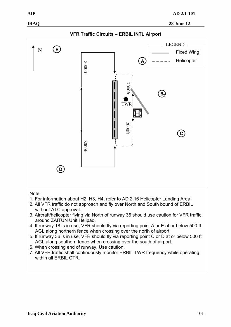
AIP AD 2.1-101
IRAQ 28 June 12
Iraq Civil Aviation Authority 101
VFR Traffic Circuits – ERBIL INTL Airport
Note: 1. For information about H2, H3, H4, refer to AD 2.16 Helicopter Landing Area 2. All VFR traffic do not approach and fly over North and South bound of ERBIL
without ATC approval. 3. Aircraft/helicopter flying via North of runway 36 should use caution for VFR traffic
around ZAITUN Unit Helipad. 4. If runway 18 is in use, VFR should fly via reporting point A or E at or below 500 ft
AGL along northern fence when crossing over the north of airport. 5. If runway 36 is in use, VFR should fly via reporting point C or D at or below 500 ft
AGL along southern fence when crossing over the south of airport. 6. When crossing end of runway, Use caution. 7. All VFR traffic shall continuously monitor ERBIL TWR frequency while operating
within all ERBIL CTR.
TWR
N Fixed Wing
Helicopter
LEGEND
3000ft3000ft
2000ft2000ft
D
E
C
B ㅠ
A
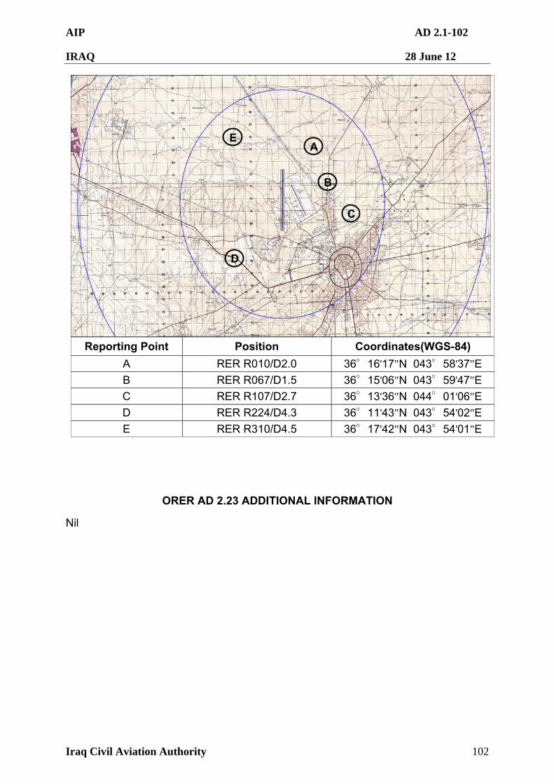
AIP AD 2.1-102
IRAQ 28 June 12
Iraq Civil Aviation Authority 102
Reporting Point Position Coordinates(WGS-84)
A RER R010/D2.0 36°16'17"N 043°58'37"E
B RER R067/D1.5 36°15'06"N 043°59'47"E
C RER R107/D2.7 36°13'36"N 044°01'06"E
D RER R224/D4.3 36°11'43"N 043°54'02"E
E RER R310/D4.5 36°17'42"N 043°54'01"E
ORER AD 2.23 ADDITIONAL INFORMATION
Nil
D
E
C
B ㅠ
A
AIP AD 2.1-103
IRAQ 28 June 12
Iraq Civil Aviation Authority 103
ORER AD 2.24 CHARTS RELATED TO AN AERODROME
Aerodrome Chart – ICAO ························································ORER AD 2.24.1 Aircraft Parking/Docking Chart – ICAO ·······································ORER AD 2.24.2 Aerodrome Ground Movement Chart–ICAO ································ORER AD 2.24.3
Aerodrome Obstacle Chart – ICAO Type A (RWY18) ····················ORER AD 2.24.4 Aerodrome Obstacle Chart – ICAO Type A (RWY36) ····················ORER AD 2.24.5 Aerodrome Obstacle Chart – ICAO Type B ·································ORER AD 2.24.6
Precision Approach Terrain Chart – ICAO (RWY 18) ·····················ORER AD 2.24.7 Standard Departure Chart Instrument – ICAO·······························ORER AD 2.24.8 Standard Departure Chart Instrument – ICAO ······························ORER AD 2.24.9 Standard Departure Chart Instrument – ICAO ···························ORER AD 2.24.10 Standard Departure Chart Instrument – ICAO····························ORER AD 2.24.11 Standard Departure Chart Instrument – ICAO·····························ORER AD 2.24.12 Standard Departure Chart Instrument – ICAO·····························ORER AD 2.24.13 Standard Arrival Chart Instrument – ICAO ·································ORER AD 2.24.14 Standard Arrival Chart Instrument – ICAO ·································ORER AD 2.24.15 Standard Arrival Chart Instrument – ICAO ·································ORER AD 2.24.16 Standard Arrival Chart Instrument – ICAO ·································ORER AD 2.24.17 Standard Arrival Chart Instrument – ICAO ·································ORER AD 2.24.18 Standard Arrival Chart Instrument – ICAO ·································ORER AD 2.24.19
Instrument Approach Chart – ICAO (ILS/DME Z RWY 18) ············ORER AD 2.24.20 Instrument Approach Chart – ICAO (ILS/DME Z RWY 36) ············ORER AD 2.24.21 Instrument Approach Chart – ICAO (ILS/DME Y RWY 18) ············ORER AD 2.24.22 Instrument Approach Chart – ICAO (ILS/DME Y RWY 36) ············ORER AD 2.24.23
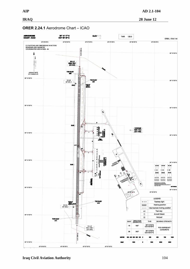
AIP AD 2.1-104
IRAQ 28 June 12
Iraq Civil Aviation Authority 104
ORER 2.24.1 Aerodrome Chart – ICAO
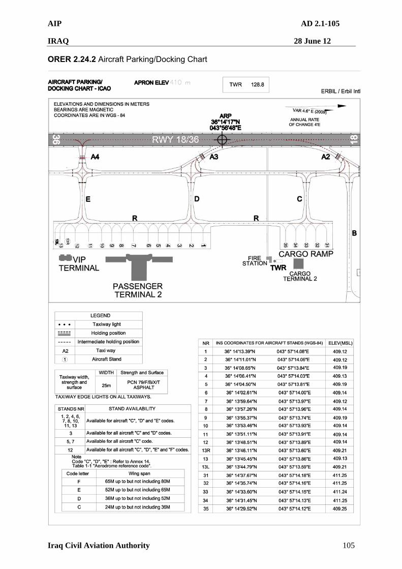
AIP AD 2.1-105
IRAQ 28 June 12
Iraq Civil Aviation Authority 105
ORER 2.24.2 Aircraft Parking/Docking Chart
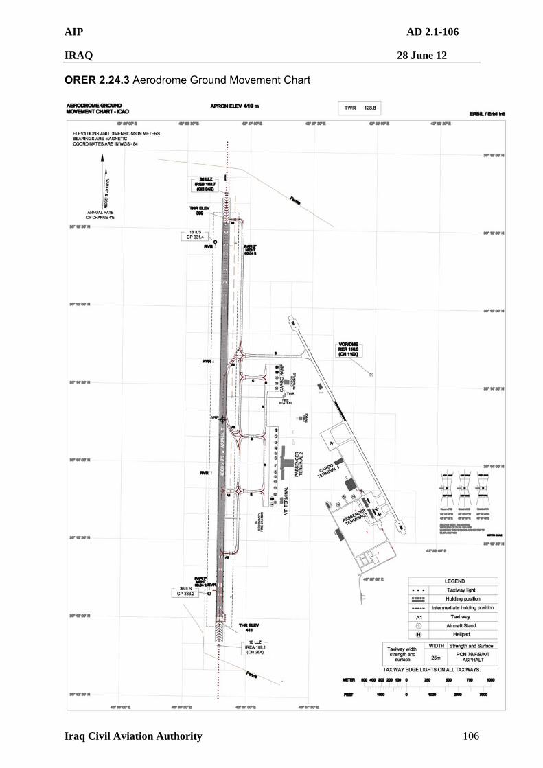
AIP AD 2.1-106
IRAQ 28 June 12
Iraq Civil Aviation Authority 106
ORER 2.24.3 Aerodrome Ground Movement Chart
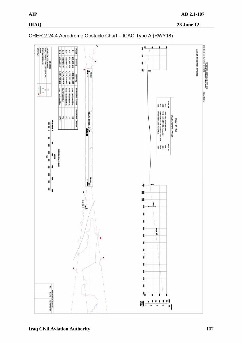
AIP AD 2.1-107
IRAQ 28 June 12
Iraq Civil Aviation Authority 107
ORER 2.24.4 Aerodrome Obstacle Chart – ICAO Type A (RWY18)
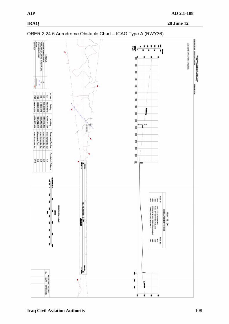
AIP AD 2.1-108
IRAQ 28 June 12
Iraq Civil Aviation Authority 108
ORER 2.24.5 Aerodrome Obstacle Chart – ICAO Type A (RWY36)
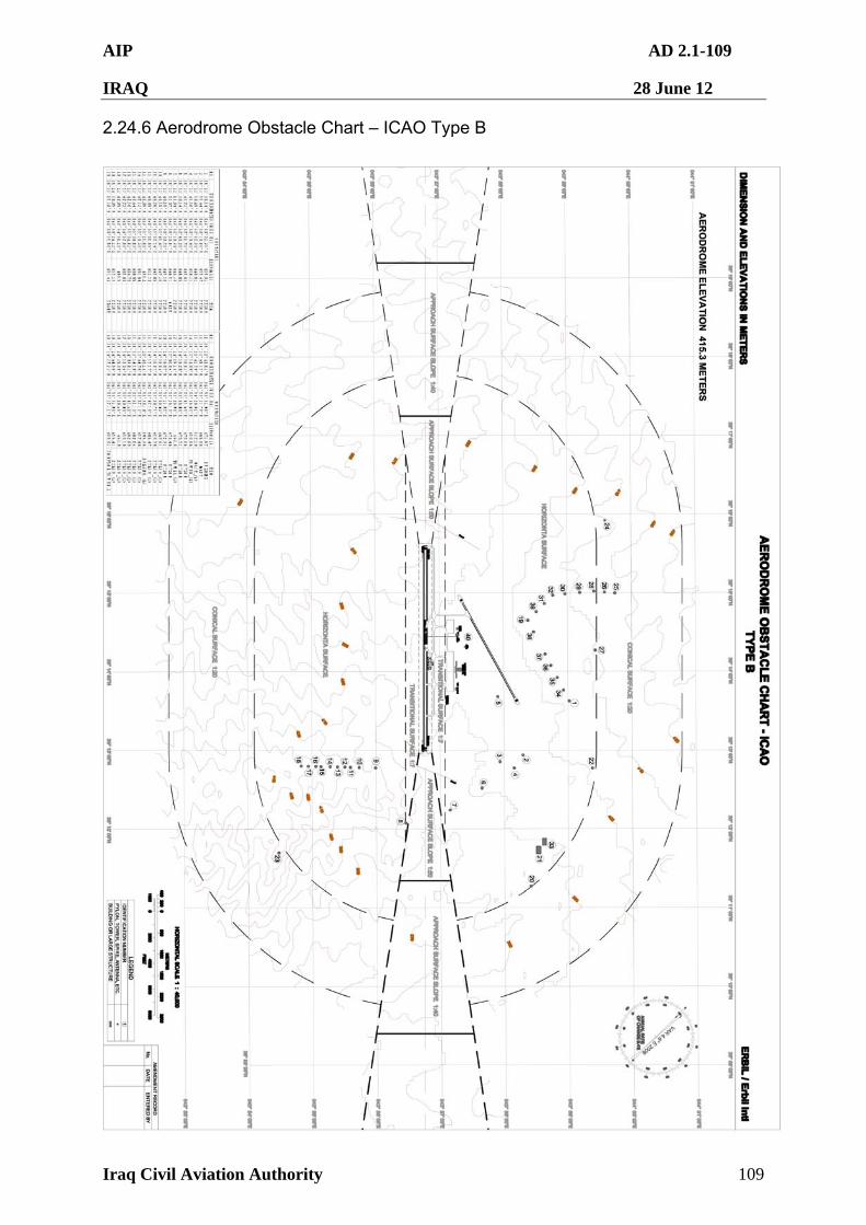
AIP AD 2.1-109
IRAQ 28 June 12
Iraq Civil Aviation Authority 109
2.24.6 Aerodrome Obstacle Chart – ICAO Type B
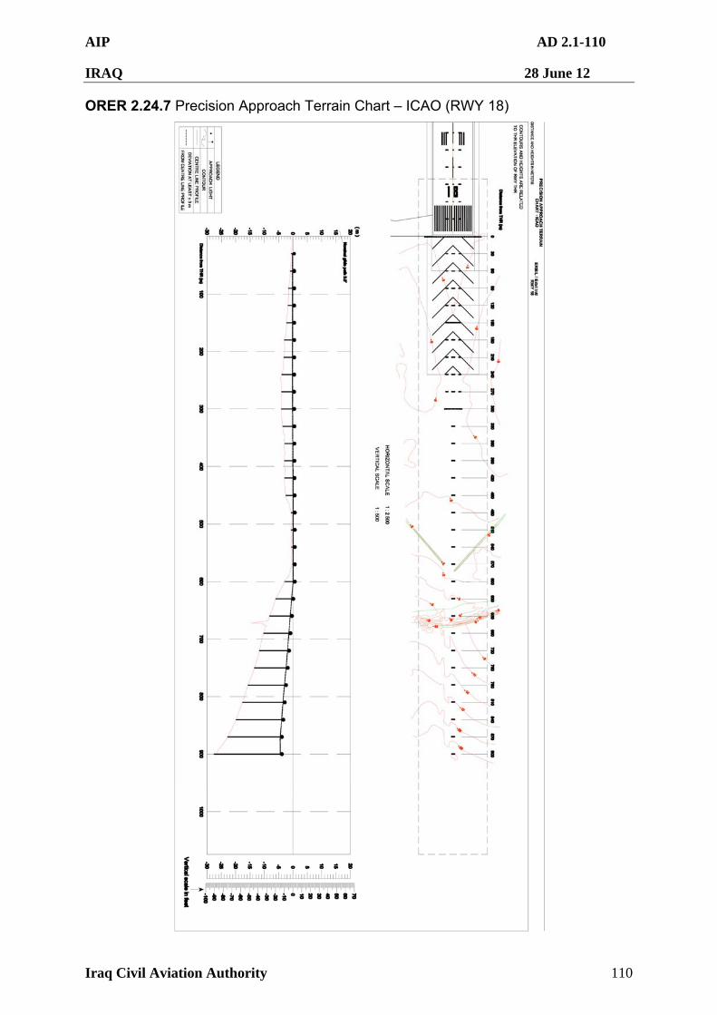
AIP AD 2.1-110
IRAQ 28 June 12
Iraq Civil Aviation Authority 110
ORER 2.24.7 Precision Approach Terrain Chart – ICAO (RWY 18)
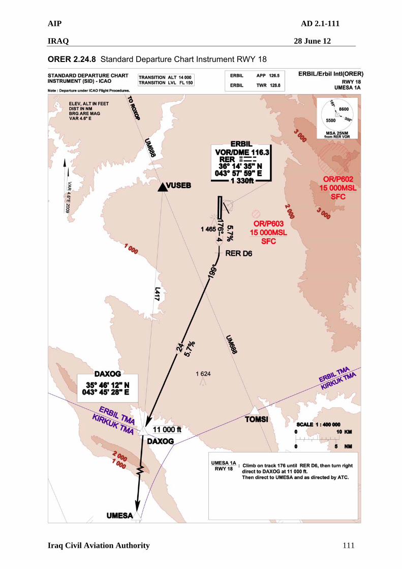
AIP AD 2.1-111
IRAQ 28 June 12
Iraq Civil Aviation Authority 111
ORER 2.24.8 Standard Departure Chart Instrument RWY 18
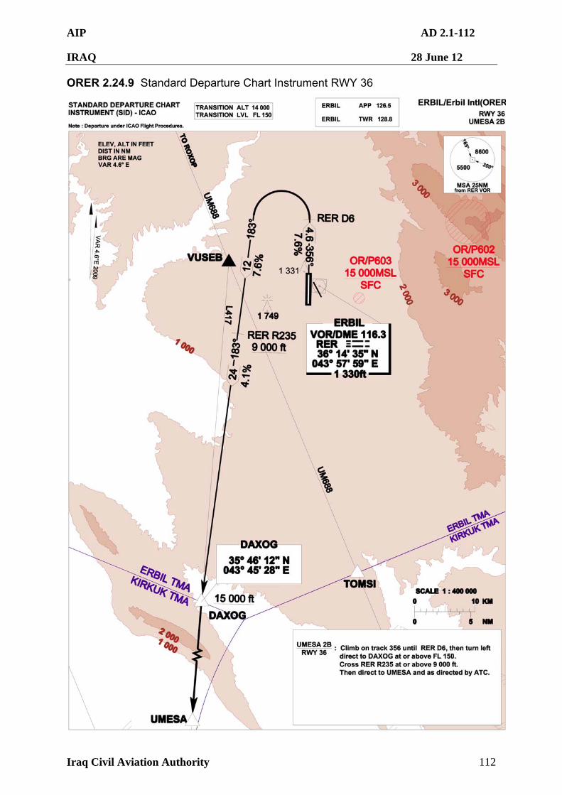
AIP AD 2.1-112
IRAQ 28 June 12
Iraq Civil Aviation Authority 112
ORER 2.24.9 Standard Departure Chart Instrument RWY 36
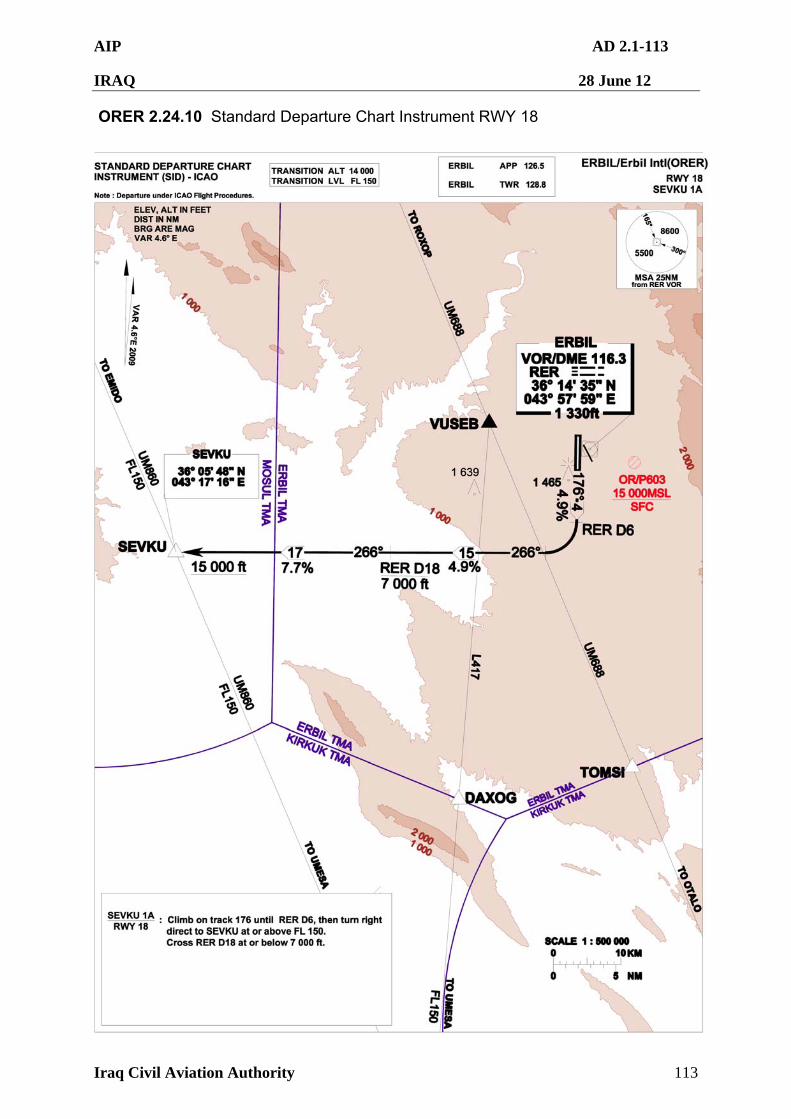
AIP AD 2.1-113
IRAQ 28 June 12
Iraq Civil Aviation Authority 113
ORER 2.24.10 Standard Departure Chart Instrument RWY 18
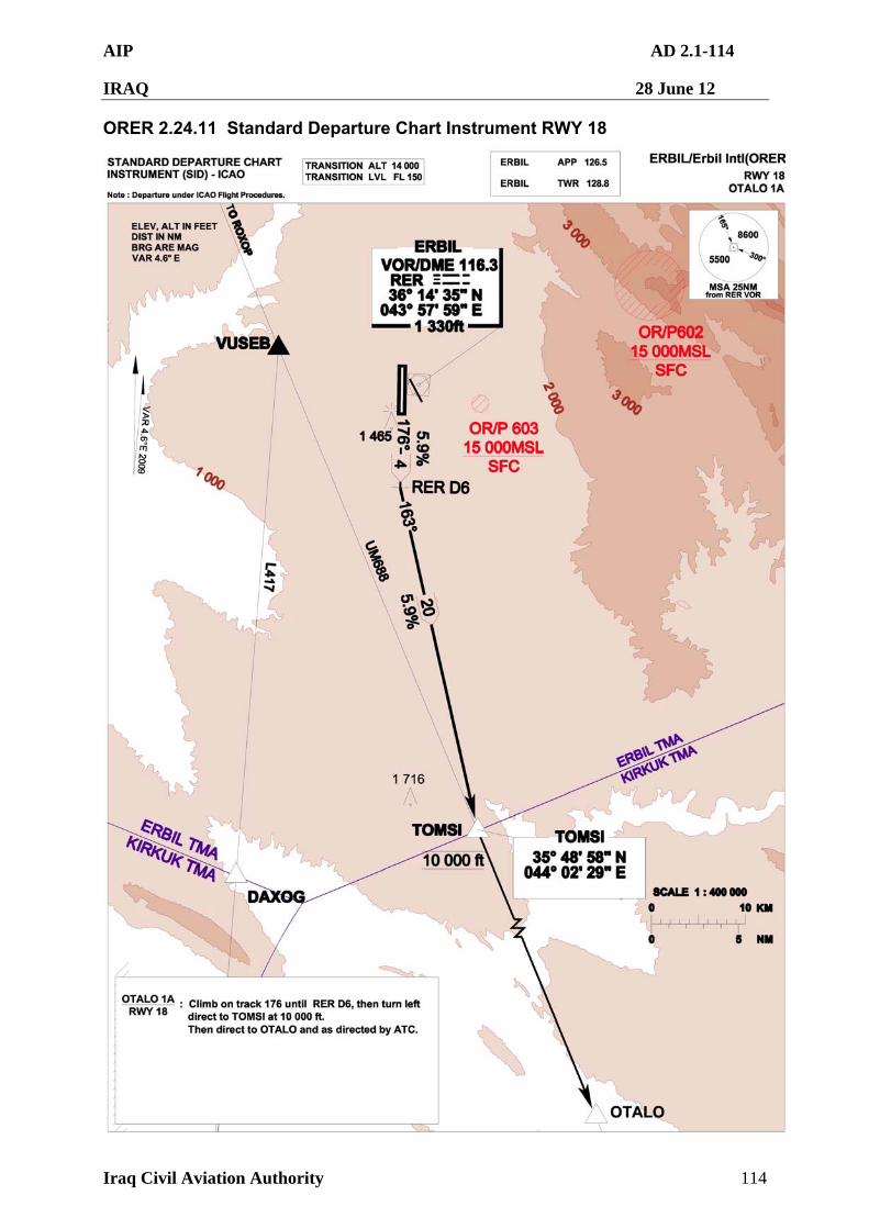
AIP AD 2.1-114
IRAQ 28 June 12
Iraq Civil Aviation Authority 114
ORER 2.24.11 Standard Departure Chart Instrument RWY 18
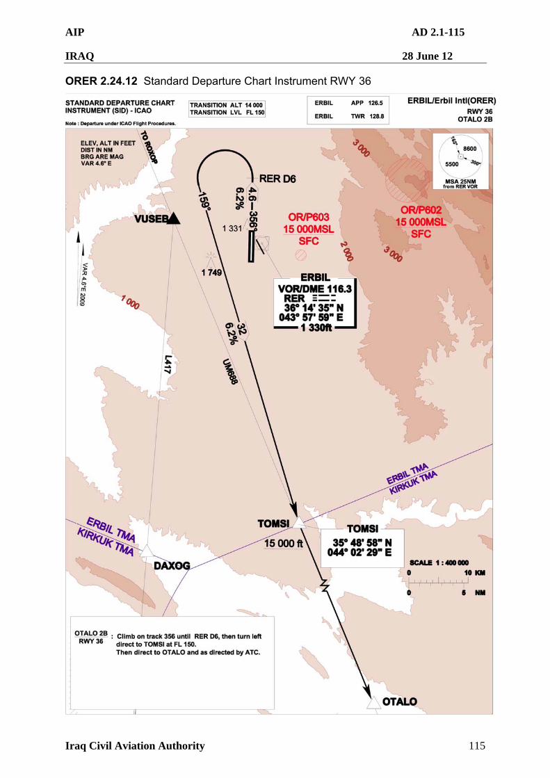
AIP AD 2.1-115
IRAQ 28 June 12
Iraq Civil Aviation Authority 115
ORER 2.24.12 Standard Departure Chart Instrument RWY 36
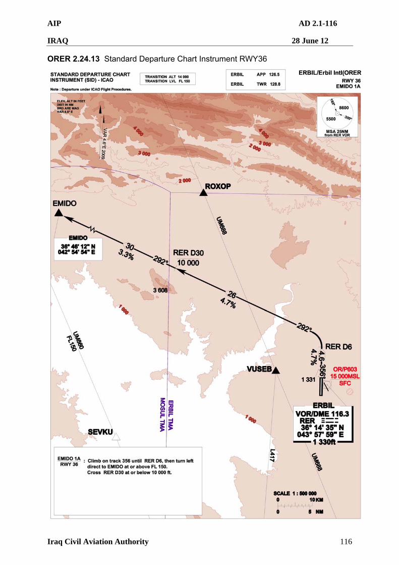
AIP AD 2.1-116
IRAQ 28 June 12
Iraq Civil Aviation Authority 116
ORER 2.24.13 Standard Departure Chart Instrument RWY36
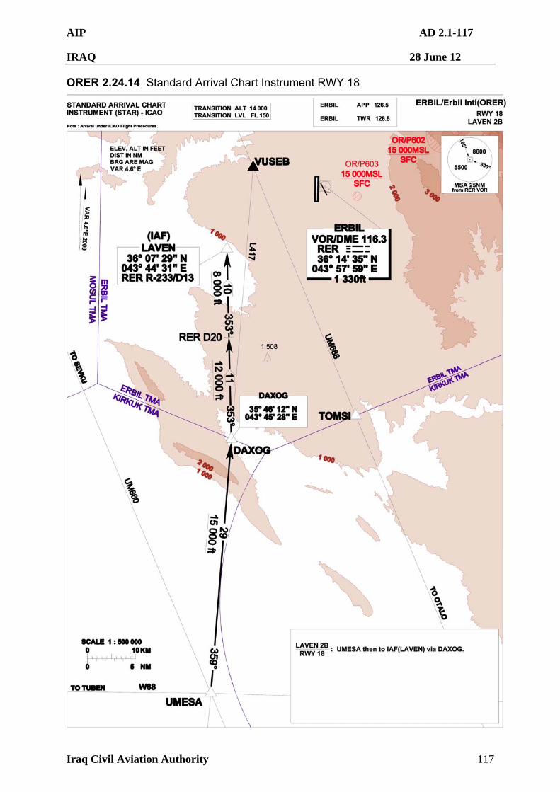
AIP AD 2.1-117
IRAQ 28 June 12
Iraq Civil Aviation Authority 117
ORER 2.24.14 Standard Arrival Chart Instrument RWY 18
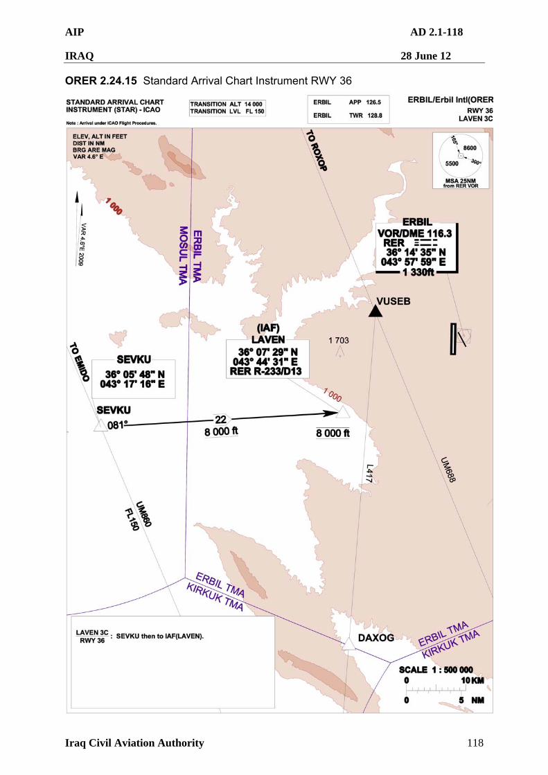
AIP AD 2.1-118
IRAQ 28 June 12
Iraq Civil Aviation Authority 118
ORER 2.24.15 Standard Arrival Chart Instrument RWY 36
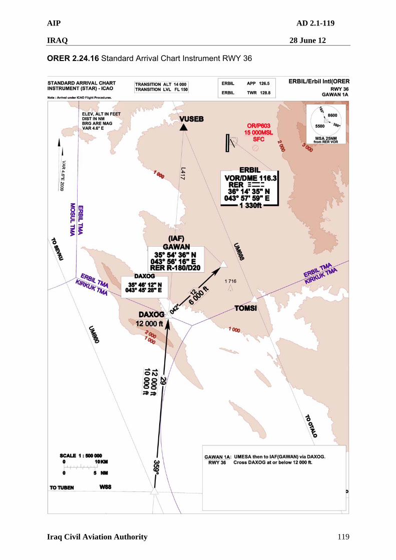
AIP AD 2.1-119
IRAQ 28 June 12
Iraq Civil Aviation Authority 119
ORER 2.24.16 Standard Arrival Chart Instrument RWY 36
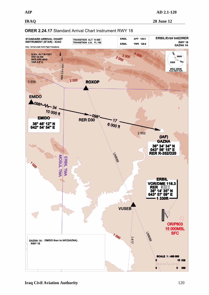
AIP AD 2.1-120
IRAQ 28 June 12
Iraq Civil Aviation Authority 120
ORER 2.24.17 Standard Arrival Chart Instrument RWY 18
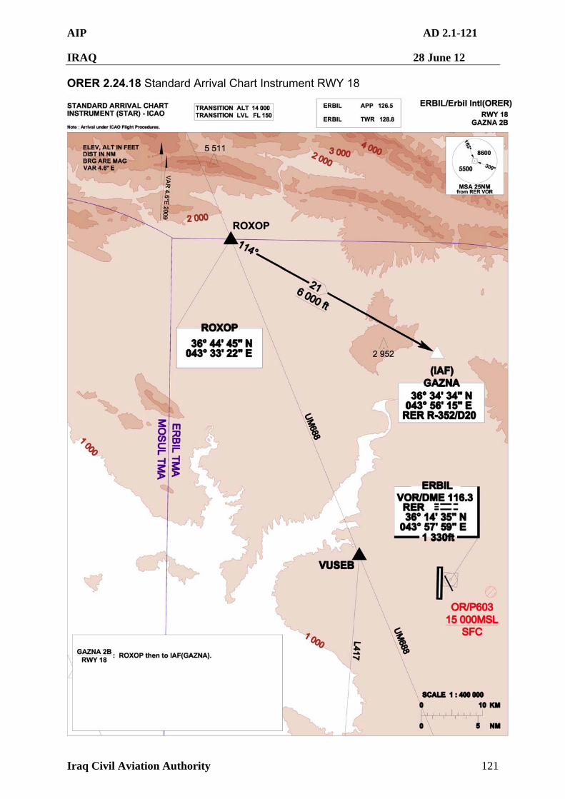
AIP AD 2.1-121
IRAQ 28 June 12
Iraq Civil Aviation Authority 121
ORER 2.24.18 Standard Arrival Chart Instrument RWY 18
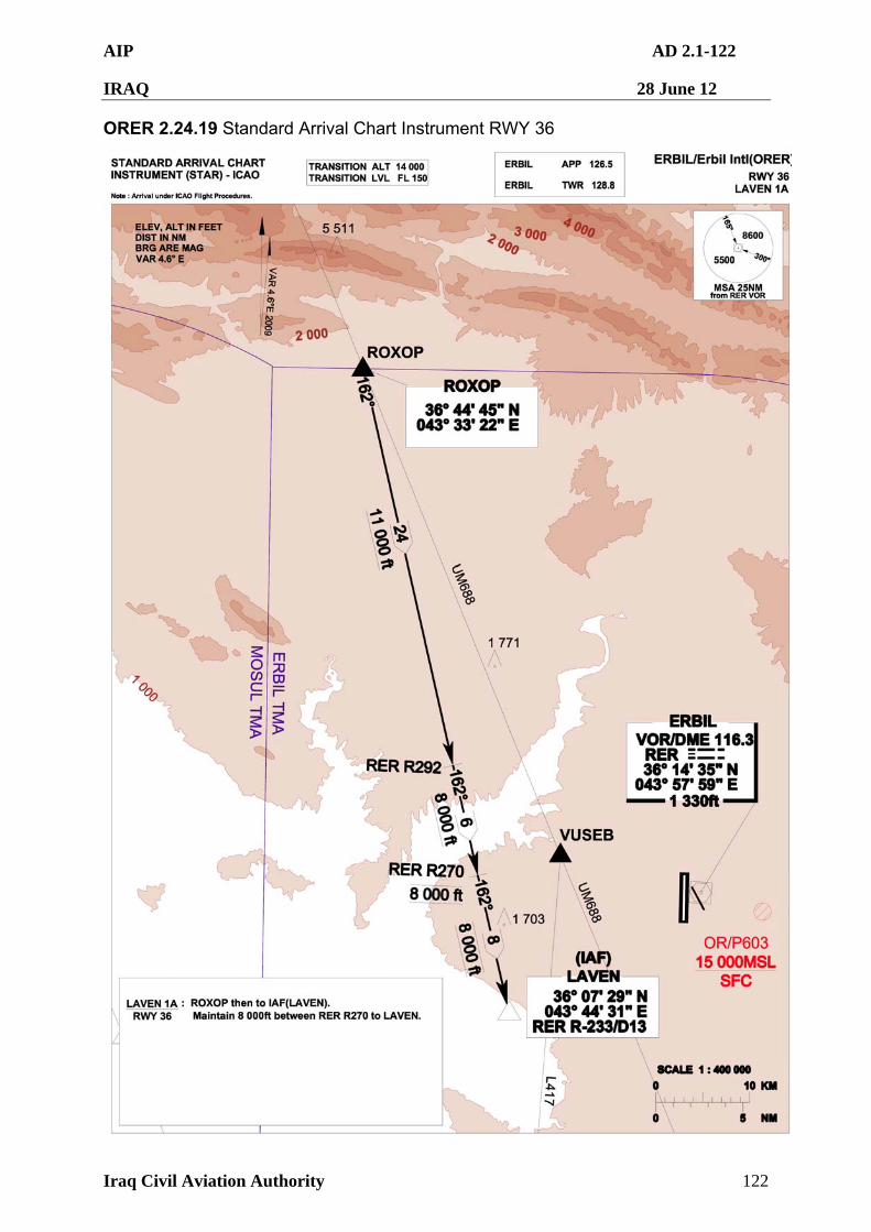
AIP AD 2.1-122
IRAQ 28 June 12
Iraq Civil Aviation Authority 122
ORER 2.24.19 Standard Arrival Chart Instrument RWY 36
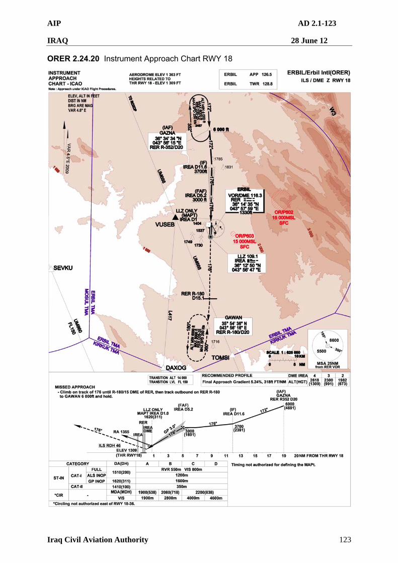
AIP AD 2.1-123
IRAQ 28 June 12
Iraq Civil Aviation Authority 123
ORER 2.24.20 Instrument Approach Chart RWY 18
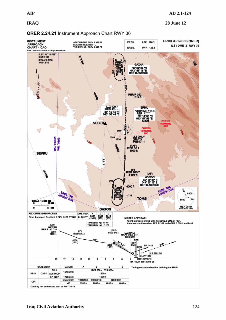
AIP AD 2.1-124
IRAQ 28 June 12
Iraq Civil Aviation Authority 124
ORER 2.24.21 Instrument Approach Chart RWY 36
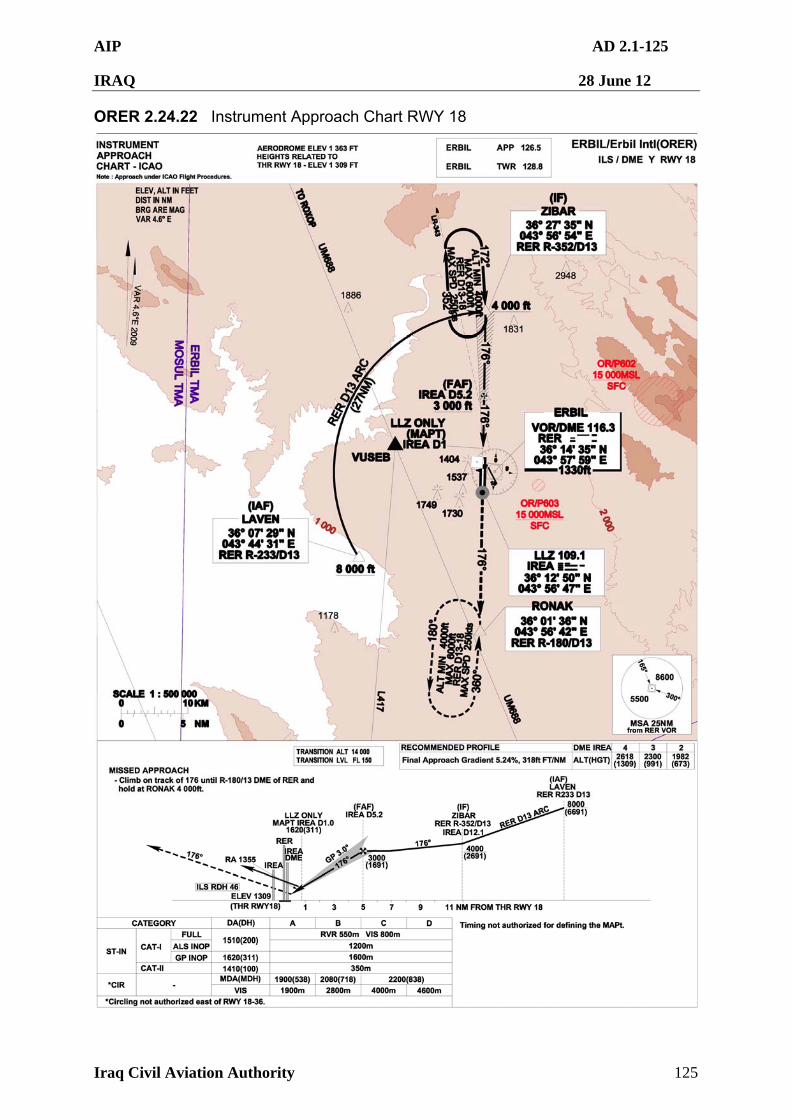
AIP AD 2.1-125
IRAQ 28 June 12
Iraq Civil Aviation Authority 125
ORER 2.24.22 Instrument Approach Chart RWY 18
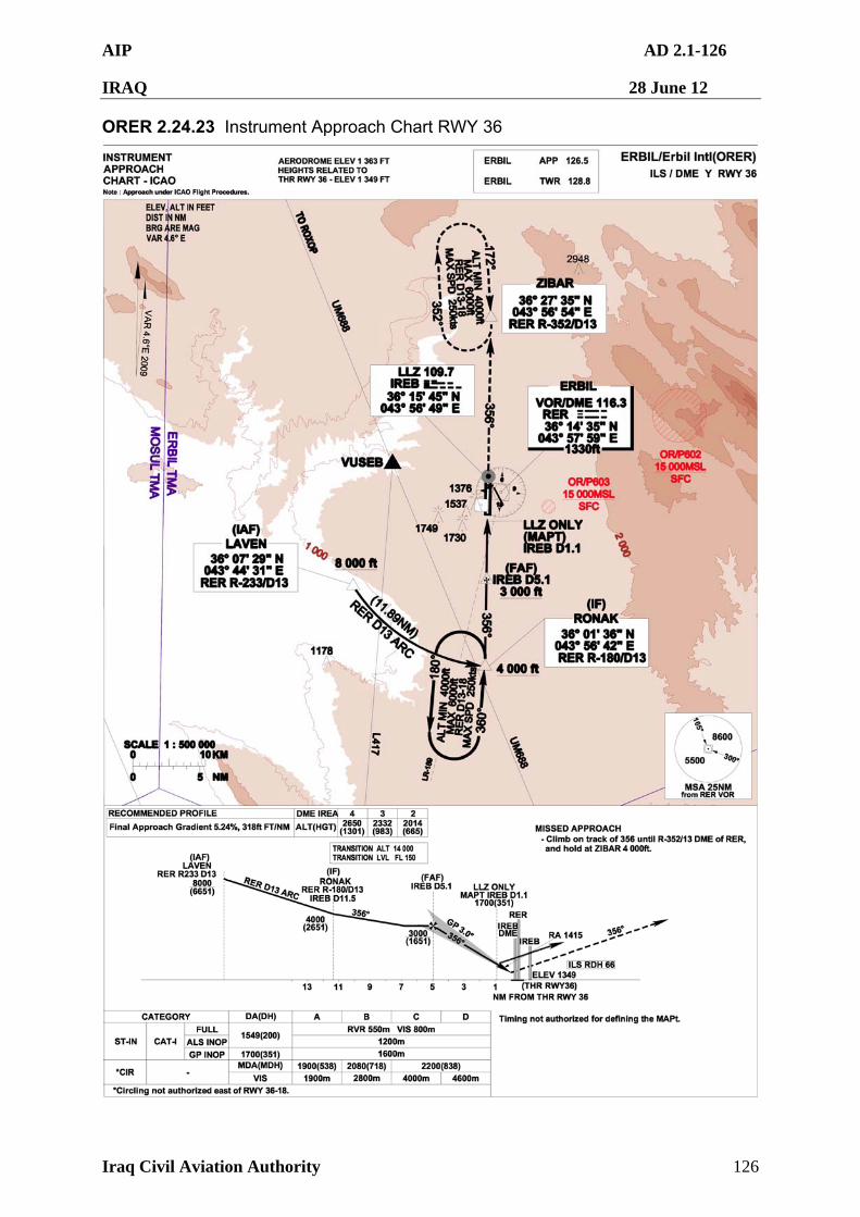
AIP AD 2.1-126
IRAQ 28 June 12
Iraq Civil Aviation Authority 126
ORER 2.24.23 Instrument Approach Chart RWY 36
AIP AD 2.1-127
IRAQ 28 June 12
Iraq Civil Aviation Authority 127
ORJA — JALIBAH SOUTHEAST
ORJA AD 2.1 AERODROME LOCATION INDICATOR AND NAME
ORJA 2.1.1 ORJA – Jalibah Southeast Airport
ORJA AD 2.2 AERODROME GEOGRAPHICAL AND ADMINISTRATIVE DATA
1 Aerodrome Reference Point coordinates and site
N30º32'42.00" E046º36'12.00"
The geographic centre of the airfield
2 Elevation and Reference Temperature
105 ft (32 m) / 43.1ºC
ORJA AD 2.3 RUNWAY PHYSICAL CHARACTERISTICS
1 RWY 12L/30R 12R/30L 12C/30C
2 BRG True and Mag
To be determined To be determined To be determined
3 RWY Dimensions
DELETED PRIOR TO EDITION 30 PUBLICATION DUE TO INACCURATE AND UNVERIFIED INFORMATION
4 PCN To be determined To be determined To be determined
5 THR Coordinates
To be determined To be determined To be determined
6 THR Elevation
To be determined To be determined To be determined
AIP AD 2.1-128
IRAQ 28 June 12
Iraq Civil Aviation Authority 128
ORKK — KIRKUK
ORKK AD 2.1 AERODROME LOCATION INDICATOR AND NAME
ORKK 2.1.1 ORKK – Kirkuk Regional Air Base
ORKK AD 2.2 AERODROME GEOGRAPHICAL AND ADMINISTRATIVE DATA
1 Aerodrome Reference Point coordinates and site
N35º28'10.12" E044º20'56.16"
The geographic centre of the airfield
2 Direction and distance from city Bearing 277º at 2 NM
3 Elevation and Reference Temperature
1 061 ft (323.4 m) / 43.1º C
4 Magnetic variation/Annual change
4º E as of Jan 2004
Annual change E000º01'22.16"
Aerodrome Administration Address
Iraq Civil Aviation Authority
Baghdad International Airport
Baghdad
Telephone DSN: 318 444 2456
318 444 2457
Telefax Nil
Telex Nil
E-mail 506EOSS/[email protected]
5
AFS Address Nil
6 Types of traffic permitted IFR, VFR and SVFR (civil and RW only)
7 Transition altitude and level TA 14 000 ft AMSL, TL FL 150
8 Remarks Abandoned Airfield (K-1) at KRK R307/004 located in close proximity to ORKK. Helicopter training in progress at/in vicinity of K-1 using FM frequency 32.7 as UNICOM, contact for de-confliction; all aircraft must still contact and monitor ORKK tower in ORKK’s class delta airspace.
All administrative matters are to be referred to the airport director. LDG, parking and fuel charges will be IAW published rates at GEN 4.1 and GEN 4.2. Charges MUST be paid in full in cash ($US) prior to departure.
ORKK AD 2.3 OPERATIONAL HOURS
1 Aerodrome Administration H24
AIP AD 2.1-129
IRAQ 28 June 12
Iraq Civil Aviation Authority 129
2 Customs and Immigration Nil
3 Health and Sanitation Nil
4 ATS Reporting Office H24
5 Met Office DSN: 318 444 2460
6 Air Traffic Services H24
7 Fueling H24
8 Handling H24
9 Security H24
0 De-icing Nil
11 Remarks
ORKK 2.3.1 Aircraft must have Prior Permission Required (PPR) for Kirkuk except for military rotary wing aircraft landing at the FARP. No PPRs 0300 – 0900 zulu. DV6 and higher are excempt. Transient arrivals/departures must avoid these times due to local training. Civil operators must receive a PPR before submitting a landing request to the ICAA. Permission to operate in the Baghdad FIR is coordinated through ICAA. Refer GEN 1.2 for current procedures, requirements and contact information. ORKK 2.3.2 Civilian/contract aircraft are restricted from landing and taking off during hours of darkness. Mission critical aircraft must coordinate a PPR with Airfield Management Operations at least 24 hours prior to arrival. ORKK 2.3.3 Approval is required from MNC-I for all Humanitarian Aid flights, except for military, ICRC and UN sponsored flights.
ORKK AD 2.4 HANDLING SERVICES AND FACILITIES
1 Cargo handling facilities Military coordinated through Kirkuk Command Post. Capability for main deck wide-body freighter. No storage for freight or passengers. Civil acft must pre-arrange with MOT and coord with ground personnel upon arrival.
2 Fuel and oil types JP8
3 Fueling facilities and capacity Limited. Plan flight without fuel from ORKK
Use of position lights is mandatory for all helicopters using the North ramp FARP from sunset to sunrise.
4 De-icing facilities Nil
5 Hanger space for visiting aircraft
Nil
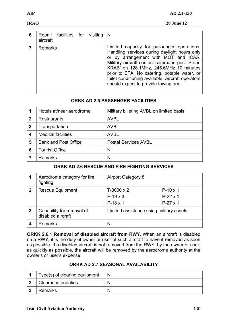
AIP AD 2.1-130
IRAQ 28 June 12
Iraq Civil Aviation Authority 130
6 Repair facilities for visiting aircraft
Nil
7 Remarks Limited capacity for passenger operations. Handling services during daylight hours only or by arrangement with MOT and ICAA. Military aircraft contact command post ‘Stone KRAB’ on 128.1MHz, 245.6MHz 10 minutes prior to ETA. No catering, potable water, or toilet conditioning available. Aircraft operators should expect to provide towing arm.
ORKK AD 2.5 PASSENGER FACILITIES
1 Hotels at/near aerodrome Military billeting AVBL on limited basis.
2 Restaurants AVBL
3 Transportation AVBL
4 Medical facilities AVBL
5 Bank and Post Office Postal Services AVBL
6 Tourist Office Nil
7 Remarks Nil
ORKK AD 2.6 RESCUE AND FIRE FIGHTING SERVICES
1 Aerodrome category for fire fighting
Airport Category 8
2 Rescue Equipment T-3000 x 2 P-10 x 1
P-19 x 3 P-22 x 1
P-18 x 1 P-27 x 1
3 Capability for removal of disabled aircraft
Limited assistance using military assets
4 Remarks Nil
ORKK 2.6.1 Removal of disabled aircraft from RWY. When an aircraft is disabled on a RWY, it is the duty of owner or user of such aircraft to have it removed as soon as possible. If a disabled aircraft is not removed from the RWY, by the owner or user, as quickly as possible, the aircraft will be removed by the aerodrome authority at the owner’s or user’s expense.
ORKK AD 2.7 SEASONAL AVAILABILITY
1 Type(s) of clearing equipment Nil
2 Clearance priorities Nil
3 Remarks Nil
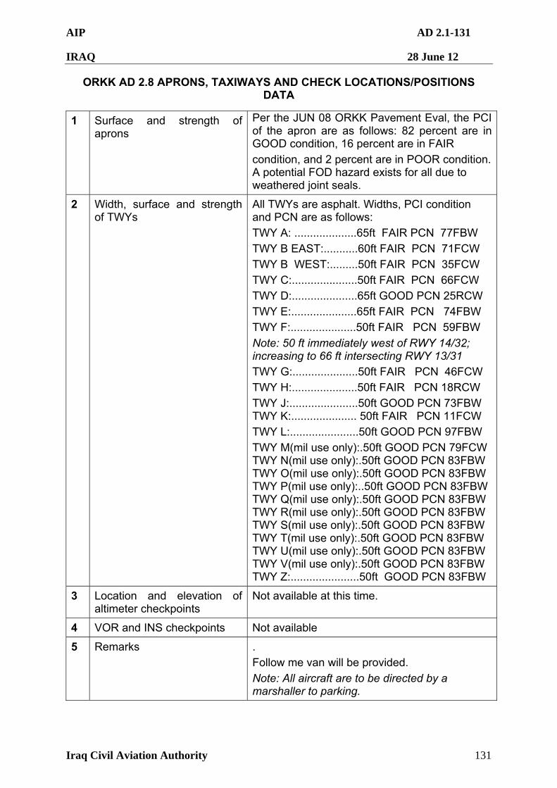
AIP AD 2.1-131
IRAQ 28 June 12
Iraq Civil Aviation Authority 131
ORKK AD 2.8 APRONS, TAXIWAYS AND CHECK LOCATIONS/POSITIONS DATA
1 Surface and strength of aprons
Per the JUN 08 ORKK Pavement Eval, the PCI of the apron are as follows: 82 percent are in GOOD condition, 16 percent are in FAIR
condition, and 2 percent are in POOR condition. A potential FOD hazard exists for all due to weathered joint seals.
2 Width, surface and strength of TWYs
All TWYs are asphalt. Widths, PCI condition and PCN are as follows:
TWY A: ....................65ft FAIR PCN 77FBW
TWY B EAST:...........60ft FAIR PCN 71FCW
TWY B WEST:.........50ft FAIR PCN 35FCW
TWY C:.....................50ft FAIR PCN 66FCW
TWY D:.....................65ft GOOD PCN 25RCW
TWY E:.....................65ft FAIR PCN 74FBW
TWY F:.....................50ft FAIR PCN 59FBW
Note: 50 ft immediately west of RWY 14/32; increasing to 66 ft intersecting RWY 13/31 TWY G:.....................50ft FAIR PCN 46FCW
TWY H:.....................50ft FAIR PCN 18RCW
TWY J:......................50ft GOOD PCN 73FBW TWY K:..................... 50ft FAIR PCN 11FCW
TWY L:......................50ft GOOD PCN 97FBW
TWY M(mil use only):.50ft GOOD PCN 79FCW TWY N(mil use only):.50ft GOOD PCN 83FBW TWY O(mil use only):.50ft GOOD PCN 83FBW TWY P(mil use only):..50ft GOOD PCN 83FBW TWY Q(mil use only):.50ft GOOD PCN 83FBW TWY R(mil use only):.50ft GOOD PCN 83FBW TWY S(mil use only):.50ft GOOD PCN 83FBW TWY T(mil use only):.50ft GOOD PCN 83FBW TWY U(mil use only):.50ft GOOD PCN 83FBW TWY V(mil use only):.50ft GOOD PCN 83FBW TWY Z:......................50ft GOOD PCN 83FBW
3 Location and elevation of altimeter checkpoints
Not available at this time.
4 VOR and INS checkpoints Not available
5 Remarks .
Follow me van will be provided.
Note: All aircraft are to be directed by a marshaller to parking.
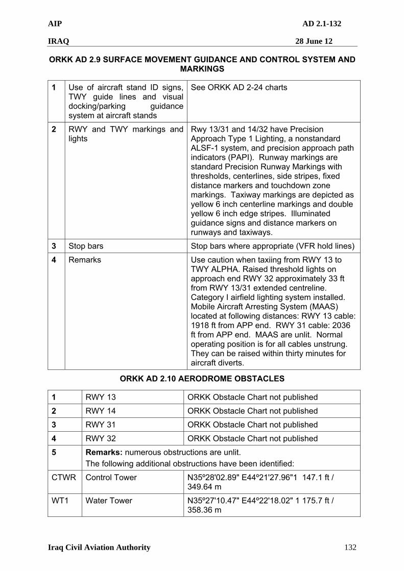
AIP AD 2.1-132
IRAQ 28 June 12
Iraq Civil Aviation Authority 132
ORKK AD 2.9 SURFACE MOVEMENT GUIDANCE AND CONTROL SYSTEM AND MARKINGS
1 Use of aircraft stand ID signs, TWY guide lines and visual docking/parking guidance system at aircraft stands
See ORKK AD 2-24 charts
2 RWY and TWY markings and lights
Rwy 13/31 and 14/32 have Precision Approach Type 1 Lighting, a nonstandard ALSF-1 system, and precision approach path indicators (PAPI). Runway markings are standard Precision Runway Markings with thresholds, centerlines, side stripes, fixed distance markers and touchdown zone markings. Taxiway markings are depicted as yellow 6 inch centerline markings and double yellow 6 inch edge stripes. Illuminated guidance signs and distance markers on runways and taxiways.
3 Stop bars Stop bars where appropriate (VFR hold lines)
4 Remarks Use caution when taxiing from RWY 13 to TWY ALPHA. Raised threshold lights on approach end RWY 32 approximately 33 ft from RWY 13/31 extended centreline. Category I airfield lighting system installed. Mobile Aircraft Arresting System (MAAS) located at following distances: RWY 13 cable: 1918 ft from APP end. RWY 31 cable: 2036 ft from APP end. MAAS are unlit. Normal operating position is for all cables unstrung. They can be raised within thirty minutes for aircraft diverts.
ORKK AD 2.10 AERODROME OBSTACLES
1 RWY 13 ORKK Obstacle Chart not published
2 RWY 14 ORKK Obstacle Chart not published
3 RWY 31 ORKK Obstacle Chart not published
4 RWY 32 ORKK Obstacle Chart not published
5 Remarks: numerous obstructions are unlit.
The following additional obstructions have been identified:
CTWR Control Tower N35º28'02.89" E44º21'27.96"1 147.1 ft / 349.64 m
WT1 Water Tower N35º27'10.47" E44º22'18.02" 1 175.7 ft / 358.36 m
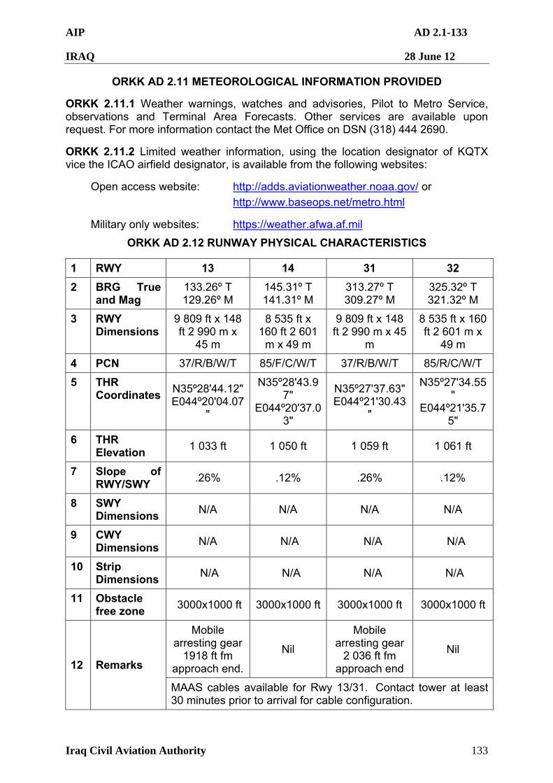
AIP AD 2.1-133
IRAQ 28 June 12
Iraq Civil Aviation Authority 133
ORKK AD 2.11 METEOROLOGICAL INFORMATION PROVIDED
ORKK 2.11.1 Weather warnings, watches and advisories, Pilot to Metro Service, observations and Terminal Area Forecasts. Other services are available upon request. For more information contact the Met Office on DSN (318) 444 2690.
ORKK 2.11.2 Limited weather information, using the location designator of KQTX vice the ICAO airfield designator, is available from the following websites:
Open access website: http://adds.aviationweather.noaa.gov/ or
http://www.baseops.net/metro.html
Military only websites: https://weather.afwa.af.mil
ORKK AD 2.12 RUNWAY PHYSICAL CHARACTERISTICS
1 RWY 13 14 31 32
2 BRG True and Mag
133.26º T 129.26º M
145.31º T 141.31º M
313.27º T 309.27º M
325.32º T 321.32º M
3 RWY Dimensions
9 809 ft x 148 ft 2 990 m x
45 m
8 535 ft x 160 ft 2 601
m x 49 m
9 809 ft x 148 ft 2 990 m x 45
m
8 535 ft x 160 ft 2 601 m x
49 m
4 PCN 37/R/B/W/T 85/F/C/W/T 37/R/B/W/T 85/R/C/W/T
5 THR Coordinates
N35º28'44.12" E044º20'04.07
"
N35º28'43.97"
E044º20'37.03"
N35º27'37.63" E044º21'30.43
"
N35º27'34.55"
E044º21'35.75"
6 THR Elevation
1 033 ft 1 050 ft 1 059 ft 1 061 ft
7 Slope of RWY/SWY
.26% .12% .26% .12%
8 SWY Dimensions
N/A N/A N/A N/A
9 CWY Dimensions
N/A N/A N/A N/A
10 Strip Dimensions
N/A N/A N/A N/A
11 Obstacle free zone
3000x1000 ft 3000x1000 ft 3000x1000 ft 3000x1000 ft
Mobile arresting gear
1918 ft fm approach end.
Nil
Mobile arresting gear
2 036 ft fm approach end
Nil
12 Remarks
MAAS cables available for Rwy 13/31. Contact tower at least 30 minutes prior to arrival for cable configuration.

AIP AD 2.1-134
IRAQ 28 June 12
Iraq Civil Aviation Authority 134
ORKK AD 2.13 DECLARED DISTANCES
1 RWY 13 14 31 32
2 TORA 9 809 ft
(2 990 m)
8 535 ft
(2 601 m)
9 809 ft
(2 990 m)
8 535 ft
(2 601 m)
3 TODA 9 809 ft
(2 990 m)
8 535 ft
(2 601 m)
9 809 ft
(2 990 m)
8 535 ft
(2 601 m)
4 ASDA 9 809 ft
(2 990 m)
8 535 ft
(2 601 m)
9 809 ft
(2 990 m)
8 535 ft
(2 601 m)
5 LDA 9 809 ft
(2 990 m)
8 535 ft
(2 601 m)
9 809 ft
(2 990 m)
8 535 ft
(2 601 m)
6 Remarks Nil Nil Nil Nil
ORKK AD 2.14 APPROACH AND RUNWAY LIGHTING
1 RWY 13 14 31 32
2 Type, length and intensity of approach lighting
Precision Type 1,
290m, Level 5 intensity.
Modified SFL
Precision Type 1,
804m, Level 5 intensity.
Modified SFL
Precision Type 1,
688m, Level 5 intensity.
Modified SFL
Precision Type 1, 533.5m, Level 5
intensity. Modified SFL
3 Threshold lights, colours and wing bars
Inset, green lighting,
EALS raised
Inset, green lighting,
EALS raised
Inset, green lighting,
EALS raised
Inset, green lighting,
EALS raised
4 Type of visual approach slope indicator system
PAPI PAPI PAPI PAPI
5 Length of RWY touchdown zone indicator lights
NONE NONE NONE NONE
6 Length spacing colour and intensity of RWY centreline lights
NONE NONE NONE NONE
7 Length spacing colour and intensity of RWY edge lights
White, level 5 intensity every 60m, last 600m
yellow” for all runways
White, level 5 intensity every 60m, last 600m
yellow” for all runways
White, level 5 intensity every 60m, last 600m
yellow” for all runways
White, level 5 intensity every 60m, last 600m
yellow” for all runways
8 Colour of RWY end lights and wingbars
Red every 6m
Red every 6m
Red every 6m
Red every 6m
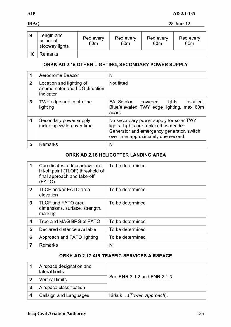
AIP AD 2.1-135
IRAQ 28 June 12
Iraq Civil Aviation Authority 135
9 Length and colour of stopway lights
Red every 60m
Red every 60m
Red every 60m
Red every 60m
10 Remarks
ORKK AD 2.15 OTHER LIGHTING, SECONDARY POWER SUPPLY
1 Aerodrome Beacon Nil
2 Location and lighting of anemometer and LDG direction indicator
Not fitted
3 TWY edge and centreline lighting
EALS/solar powered lights installed. Blue/elevated TWY edge lighting, max 60m apart.
4 Secondary power supply including switch-over time
No secondary power supply for solar TWY lights. Lights are replaced as needed. Generator and emergency generator, switch over time approximately one second.
5 Remarks Nil
ORKK AD 2.16 HELICOPTER LANDING AREA
1 Coordinates of touchdown and lift-off point (TLOF) threshold of final approach and take-off (FATO)
To be determined
2 TLOF and/or FATO area elevation
To be determined
3 TLOF and FATO area dimensions, surface, strength, marking
To be determined
4 True and MAG BRG of FATO To be determined
5 Declared distance available To be determined
6 Approach and FATO lighting To be determined
7 Remarks Nil
ORKK AD 2.17 AIR TRAFFIC SERVICES AIRSPACE
1 Airspace designation and lateral limits
2 Vertical limits
3 Airspace classification
See ENR 2.1.2 and ENR 2.1.3.
4 Callsign and Languages Kirkuk …(Tower, Approach),
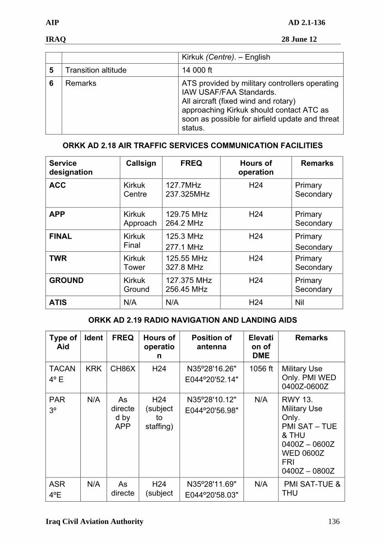
AIP AD 2.1-136
IRAQ 28 June 12
Iraq Civil Aviation Authority 136
Kirkuk (Centre). – English
5 Transition altitude 14 000 ft
6 Remarks ATS provided by military controllers operating IAW USAF/FAA Standards. All aircraft (fixed wind and rotary) approaching Kirkuk should contact ATC as soon as possible for airfield update and threat status.
ORKK AD 2.18 AIR TRAFFIC SERVICES COMMUNICATION FACILITIES
Service designation
Callsign FREQ Hours of operation
Remarks
ACC Kirkuk Centre
127.7MHz 237.325MHz
H24 Primary Secondary
APP Kirkuk Approach
129.75 MHz 264.2 MHz
H24 Primary Secondary
FINAL Kirkuk Final
125.3 MHz
277.1 MHz
H24 Primary
Secondary
TWR Kirkuk Tower
125.55 MHz 327.8 MHz
H24 Primary Secondary
GROUND Kirkuk Ground
127.375 MHz 256.45 MHz
H24 Primary Secondary
ATIS N/A N/A H24 Nil
ORKK AD 2.19 RADIO NAVIGATION AND LANDING AIDS
Type of Aid
Ident FREQ Hours of operatio
n
Position of antenna
Elevation of DME
Remarks
TACAN
4º E
KRK CH86X H24 N35º28'16.26"
E044º20'52.14"
1056 ft Military Use Only. PMI WED 0400Z-0600Z
PAR
3º
N/A As directed by APP
H24 (subject
to staffing)
N35º28'10.12"
E044º20'56.98"
N/A RWY 13. Military Use Only. PMI SAT – TUE & THU 0400Z – 0600Z WED 0600Z FRI 0400Z – 0800Z
ASR
4ºE
N/A As directe
H24 (subject
N35º28'11.69"
E044º20'58.03"
N/A PMI SAT-TUE & THU
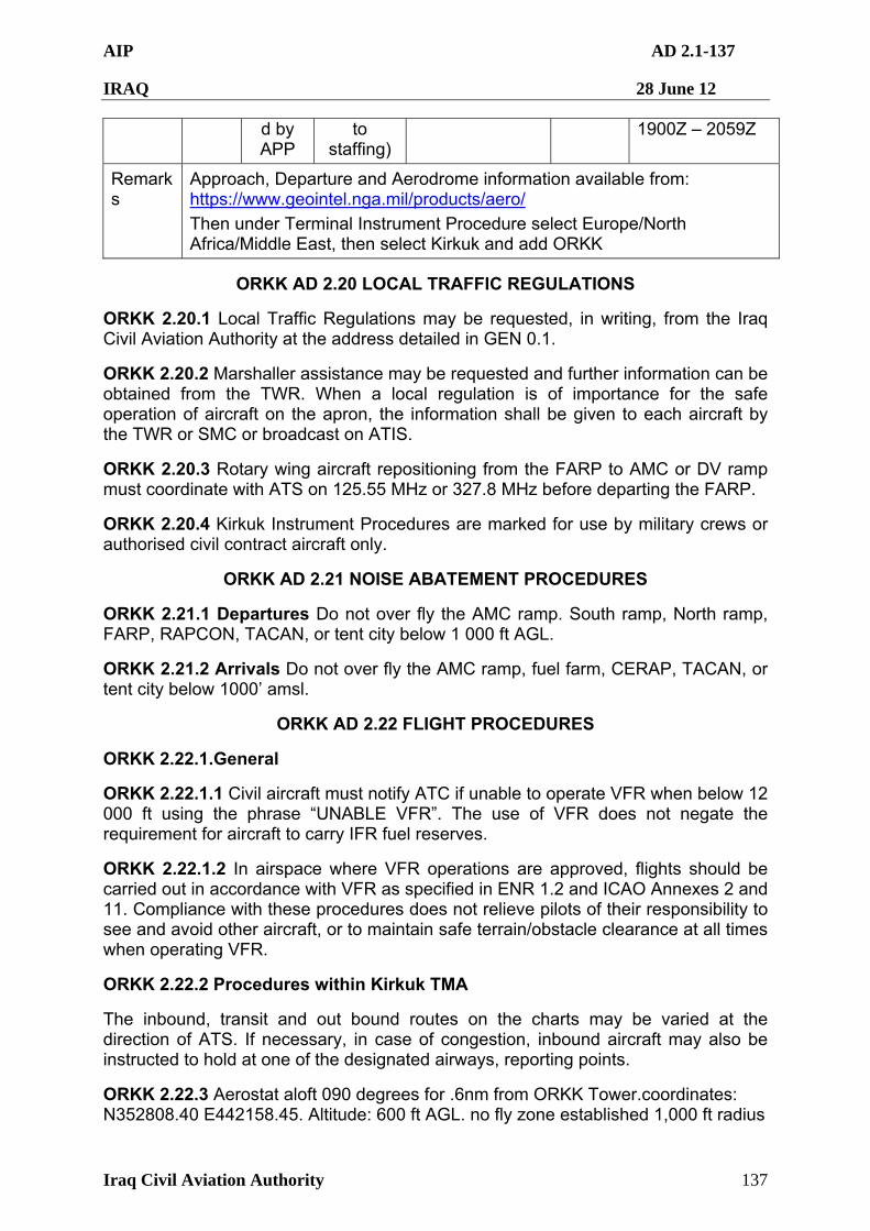
AIP AD 2.1-137
IRAQ 28 June 12
Iraq Civil Aviation Authority 137
d by APP
to staffing)
1900Z – 2059Z
Remarks
Approach, Departure and Aerodrome information available from: https://www.geointel.nga.mil/products/aero/
Then under Terminal Instrument Procedure select Europe/North Africa/Middle East, then select Kirkuk and add ORKK
ORKK AD 2.20 LOCAL TRAFFIC REGULATIONS
ORKK 2.20.1 Local Traffic Regulations may be requested, in writing, from the Iraq Civil Aviation Authority at the address detailed in GEN 0.1.
ORKK 2.20.2 Marshaller assistance may be requested and further information can be obtained from the TWR. When a local regulation is of importance for the safe operation of aircraft on the apron, the information shall be given to each aircraft by the TWR or SMC or broadcast on ATIS.
ORKK 2.20.3 Rotary wing aircraft repositioning from the FARP to AMC or DV ramp must coordinate with ATS on 125.55 MHz or 327.8 MHz before departing the FARP.
ORKK 2.20.4 Kirkuk Instrument Procedures are marked for use by military crews or authorised civil contract aircraft only.
ORKK AD 2.21 NOISE ABATEMENT PROCEDURES
ORKK 2.21.1 Departures Do not over fly the AMC ramp. South ramp, North ramp, FARP, RAPCON, TACAN, or tent city below 1 000 ft AGL.
ORKK 2.21.2 Arrivals Do not over fly the AMC ramp, fuel farm, CERAP, TACAN, or tent city below 1000’ amsl.
ORKK AD 2.22 FLIGHT PROCEDURES
ORKK 2.22.1.General
ORKK 2.22.1.1 Civil aircraft must notify ATC if unable to operate VFR when below 12 000 ft using the phrase “UNABLE VFR”. The use of VFR does not negate the requirement for aircraft to carry IFR fuel reserves.
ORKK 2.22.1.2 In airspace where VFR operations are approved, flights should be carried out in accordance with VFR as specified in ENR 1.2 and ICAO Annexes 2 and 11. Compliance with these procedures does not relieve pilots of their responsibility to see and avoid other aircraft, or to maintain safe terrain/obstacle clearance at all times when operating VFR.
ORKK 2.22.2 Procedures within Kirkuk TMA
The inbound, transit and out bound routes on the charts may be varied at the direction of ATS. If necessary, in case of congestion, inbound aircraft may also be instructed to hold at one of the designated airways, reporting points.
ORKK 2.22.3 Aerostat aloft 090 degrees for .6nm from ORKK Tower.coordinates: N352808.40 E442158.45. Altitude: 600 ft AGL. no fly zone established 1,000 ft radius
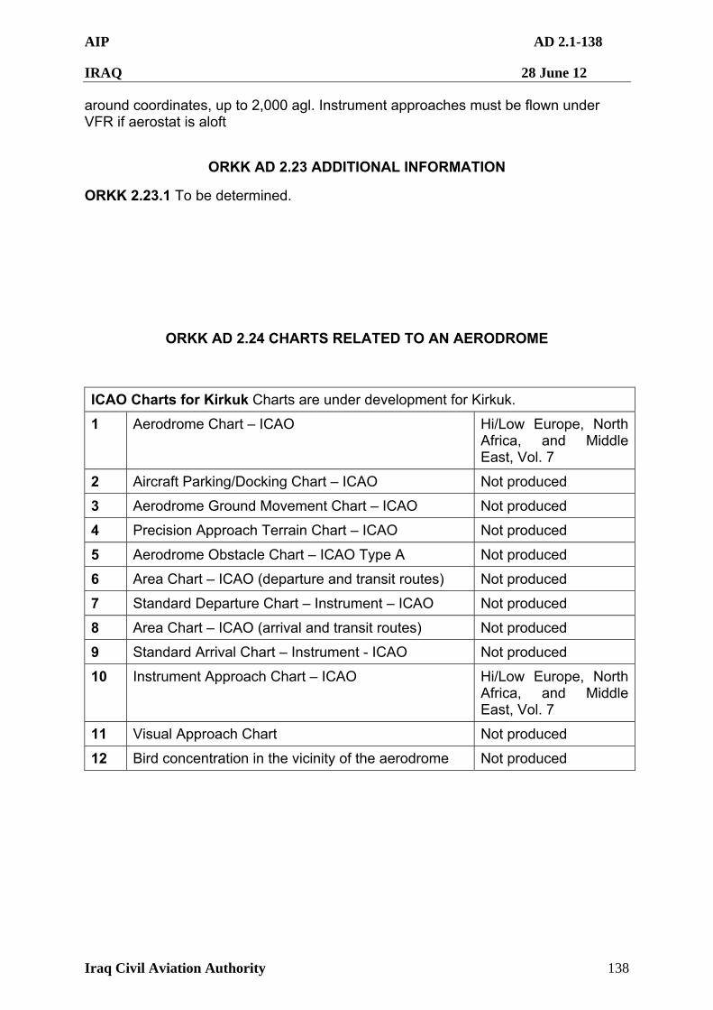
AIP AD 2.1-138
IRAQ 28 June 12
Iraq Civil Aviation Authority 138
around coordinates, up to 2,000 agl. Instrument approaches must be flown under VFR if aerostat is aloft
ORKK AD 2.23 ADDITIONAL INFORMATION
ORKK 2.23.1 To be determined.
ORKK AD 2.24 CHARTS RELATED TO AN AERODROME
ICAO Charts for Kirkuk Charts are under development for Kirkuk.
1 Aerodrome Chart – ICAO Hi/Low Europe, North Africa, and Middle East, Vol. 7
2 Aircraft Parking/Docking Chart – ICAO Not produced
3 Aerodrome Ground Movement Chart – ICAO Not produced
4 Precision Approach Terrain Chart – ICAO Not produced
5 Aerodrome Obstacle Chart – ICAO Type A Not produced
6 Area Chart – ICAO (departure and transit routes) Not produced
7 Standard Departure Chart – Instrument – ICAO Not produced
8 Area Chart – ICAO (arrival and transit routes) Not produced
9 Standard Arrival Chart – Instrument - ICAO Not produced
10 Instrument Approach Chart – ICAO Hi/Low Europe, North Africa, and Middle East, Vol. 7
11 Visual Approach Chart Not produced
12 Bird concentration in the vicinity of the aerodrome Not produced
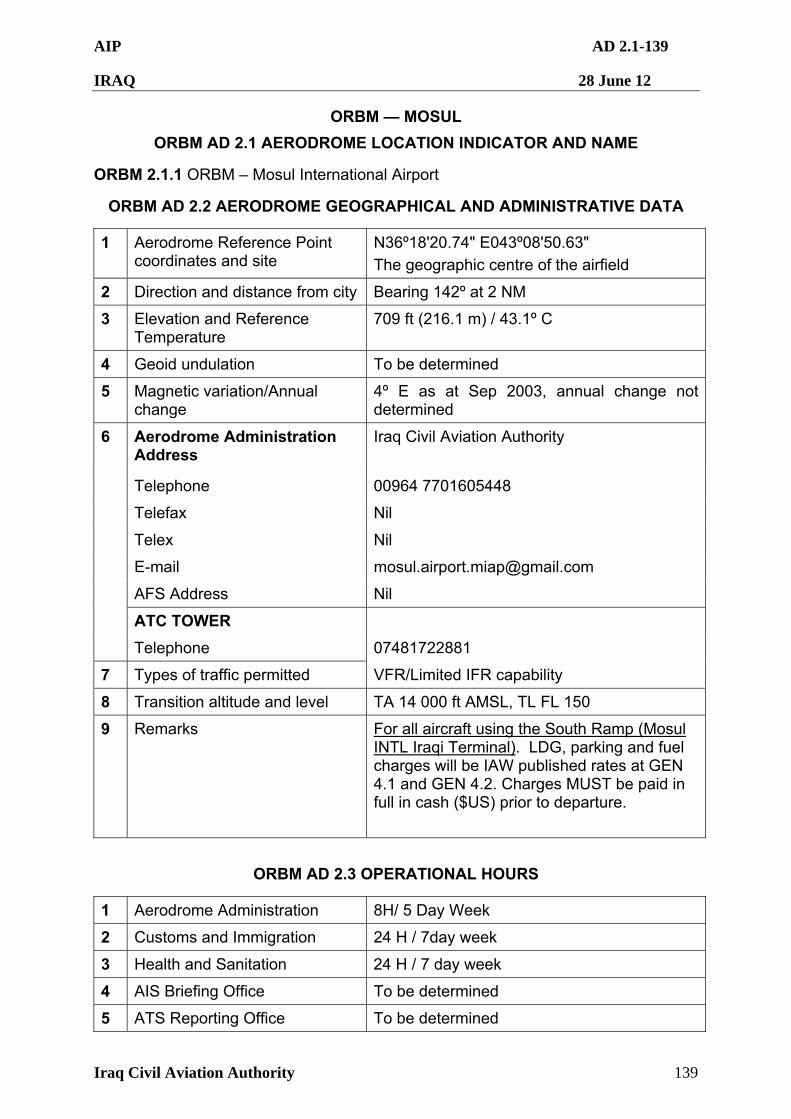
AIP AD 2.1-139
IRAQ 28 June 12
Iraq Civil Aviation Authority 139
ORBM — MOSUL
ORBM AD 2.1 AERODROME LOCATION INDICATOR AND NAME
ORBM 2.1.1 ORBM – Mosul International Airport
ORBM AD 2.2 AERODROME GEOGRAPHICAL AND ADMINISTRATIVE DATA
1 Aerodrome Reference Point coordinates and site
N36º18'20.74" E043º08'50.63"
The geographic centre of the airfield
2 Direction and distance from city Bearing 142º at 2 NM
3 Elevation and Reference Temperature
709 ft (216.1 m) / 43.1º C
4 Geoid undulation To be determined
5 Magnetic variation/Annual change
4º E as at Sep 2003, annual change not determined
Aerodrome Administration Address
Iraq Civil Aviation Authority
Telephone 00964 7701605448
Telefax Nil
Telex Nil
E-mail [email protected]
AFS Address Nil
ATC TOWER
6
Telephone 07481722881
7 Types of traffic permitted VFR/Limited IFR capability
8 Transition altitude and level TA 14 000 ft AMSL, TL FL 150
9 Remarks For all aircraft using the South Ramp (Mosul INTL Iraqi Terminal). LDG, parking and fuel charges will be IAW published rates at GEN 4.1 and GEN 4.2. Charges MUST be paid in full in cash ($US) prior to departure.
ORBM AD 2.3 OPERATIONAL HOURS
1 Aerodrome Administration 8H/ 5 Day Week
2 Customs and Immigration 24 H / 7day week
3 Health and Sanitation 24 H / 7 day week
4 AIS Briefing Office To be determined
5 ATS Reporting Office To be determined
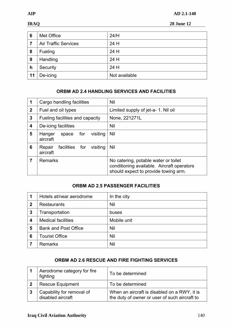
AIP AD 2.1-140
IRAQ 28 June 12
Iraq Civil Aviation Authority 140
6 Met Office 24/H
7 Air Traffic Services 24 H
8 Fueling 24 H
9 Handling 24 H
h Security 24 H
11 De-icing Not available
ORBM AD 2.4 HANDLING SERVICES AND FACILITIES
1 Cargo handling facilities Nil
2 Fuel and oil types Limited supply of jet-a- 1. Nil oil
3 Fueling facilities and capacity None, 221271L
4 De-icing facilities Nil
5 Hanger space for visiting aircraft
Nil
6 Repair facilities for visiting aircraft
Nil
7 Remarks No catering, potable water or toilet conditioning available. Aircraft operators should expect to provide towing arm.
ORBM AD 2.5 PASSENGER FACILITIES
1 Hotels at/near aerodrome In the city
2 Restaurants Nil
3 Transportation buses
4 Medical facilities Mobile unit
5 Bank and Post Office Nil
6 Tourist Office Nil
7 Remarks Nil
ORBM AD 2.6 RESCUE AND FIRE FIGHTING SERVICES
1 Aerodrome category for fire fighting
To be determined
2 Rescue Equipment To be determined
3 Capability for removal of disabled aircraft
When an aircraft is disabled on a RWY, it is the duty of owner or user of such aircraft to
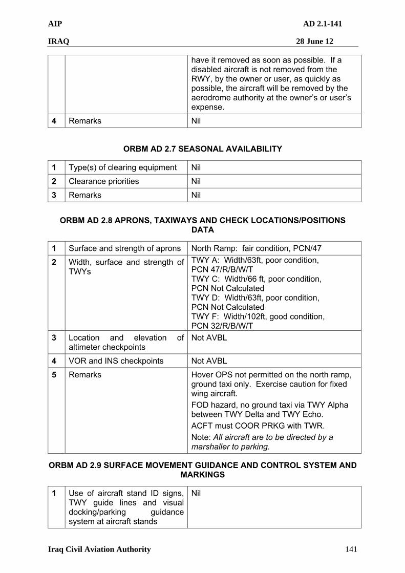
AIP AD 2.1-141
IRAQ 28 June 12
Iraq Civil Aviation Authority 141
have it removed as soon as possible. If a disabled aircraft is not removed from the RWY, by the owner or user, as quickly as possible, the aircraft will be removed by the aerodrome authority at the owner’s or user’s expense.
4 Remarks Nil
ORBM AD 2.7 SEASONAL AVAILABILITY
1 Type(s) of clearing equipment Nil
2 Clearance priorities Nil
3 Remarks Nil
ORBM AD 2.8 APRONS, TAXIWAYS AND CHECK LOCATIONS/POSITIONS DATA
1 Surface and strength of aprons North Ramp: fair condition, PCN/47
2 Width, surface and strength of TWYs
TWY A: Width/63ft, poor condition, PCN 47/R/B/W/T TWY C: Width/66 ft, poor condition, PCN Not Calculated TWY D: Width/63ft, poor condition, PCN Not Calculated TWY F: Width/102ft, good condition, PCN 32/R/B/W/T
3 Location and elevation of altimeter checkpoints
Not AVBL
4 VOR and INS checkpoints Not AVBL
5 Remarks Hover OPS not permitted on the north ramp, ground taxi only. Exercise caution for fixed wing aircraft.
FOD hazard, no ground taxi via TWY Alpha between TWY Delta and TWY Echo.
ACFT must COOR PRKG with TWR.
Note: All aircraft are to be directed by a marshaller to parking.
ORBM AD 2.9 SURFACE MOVEMENT GUIDANCE AND CONTROL SYSTEM AND MARKINGS
1 Use of aircraft stand ID signs, TWY guide lines and visual docking/parking guidance system at aircraft stands
Nil

AIP AD 2.1-142
IRAQ 28 June 12
Iraq Civil Aviation Authority 142
2 RWY and TWY markings and lights
Markings are not retro-reflective.
3 Stop bars
4 Remarks Nil
ORBM AD 2.10 AERODROME OBSTACLES
1 RWY15 ORBM Obstacle Chart not published
2 RWY33 ORBM Obstacle Chart not published
3 Remarks: The following additional obstructions have been identified:
COMTW Control Tower N36º18'33.87" E043º08'56.20" 769.8 ft/234.63 m
BLDG Building N36º17'05.37" E043º09'11.99" 800.8 ft/244.08 m
BLUET2 Tower N36º17'38.91" E043º08'45.65" 841.3 ft/256.43 m
HNGR Hanger N36º18'59.11" E043º08'48.59" 760.4 ft/231.77 m
WT4 Water Tower N36º18'59.71" E043º08'08.23" 832.9 ft/253.86 m
Radio Tower N36º21'13.00" E043º13'53.40" 1000ft/304.8 m
Tower N36º19'51.35" E043º07'24.5" 949ft/289 m
ORBM AD 2.11 METEOROLOGICAL INFORMATION PROVIDED
1 Associated MET office Nil 2 Hours of service
MET office outside hours H24
3 Office responsible for TAF preparation Periods of validity
To be determined
4 Trend forecast Interval of issuance
Nil
5 Briefing/consultation provided Nil 6 Flight documentation
Language(s) used Nil
7 Charts and other information available for briefing or consultation
Nil
8 Supplementary equipment available for providing information
To be determined
9 ATS units provided with information Available 10 Additional information Nil
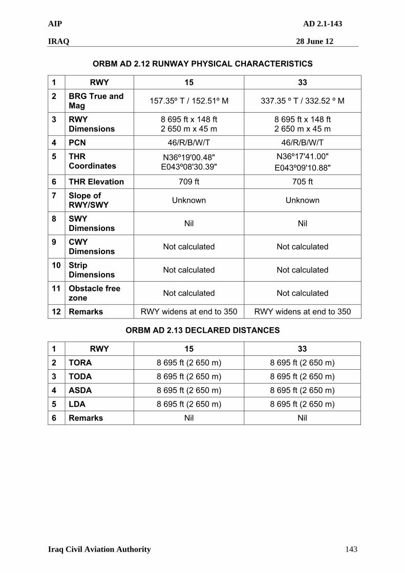
AIP AD 2.1-143
IRAQ 28 June 12
Iraq Civil Aviation Authority 143
ORBM AD 2.12 RUNWAY PHYSICAL CHARACTERISTICS
1 RWY 15 33
2 BRG True and Mag
157.35º T / 152.51º M 337.35 º T / 332.52 º M
3 RWY Dimensions
8 695 ft x 148 ft 2 650 m x 45 m
8 695 ft x 148 ft 2 650 m x 45 m
4 PCN 46/R/B/W/T 46/R/B/W/T
5 THR Coordinates
N36º19'00.48" E043º08'30.39"
N36º17'41.00"
E043º09'10.88"
6 THR Elevation 709 ft 705 ft
7 Slope of RWY/SWY
Unknown Unknown
8 SWY Dimensions
Nil Nil
9 CWY Dimensions
Not calculated Not calculated
10 Strip Dimensions
Not calculated Not calculated
11 Obstacle free zone
Not calculated Not calculated
12 Remarks RWY widens at end to 350 RWY widens at end to 350
ORBM AD 2.13 DECLARED DISTANCES
1 RWY 15 33
2 TORA 8 695 ft (2 650 m) 8 695 ft (2 650 m)
3 TODA 8 695 ft (2 650 m) 8 695 ft (2 650 m)
4 ASDA 8 695 ft (2 650 m) 8 695 ft (2 650 m)
5 LDA 8 695 ft (2 650 m) 8 695 ft (2 650 m)
6 Remarks Nil Nil
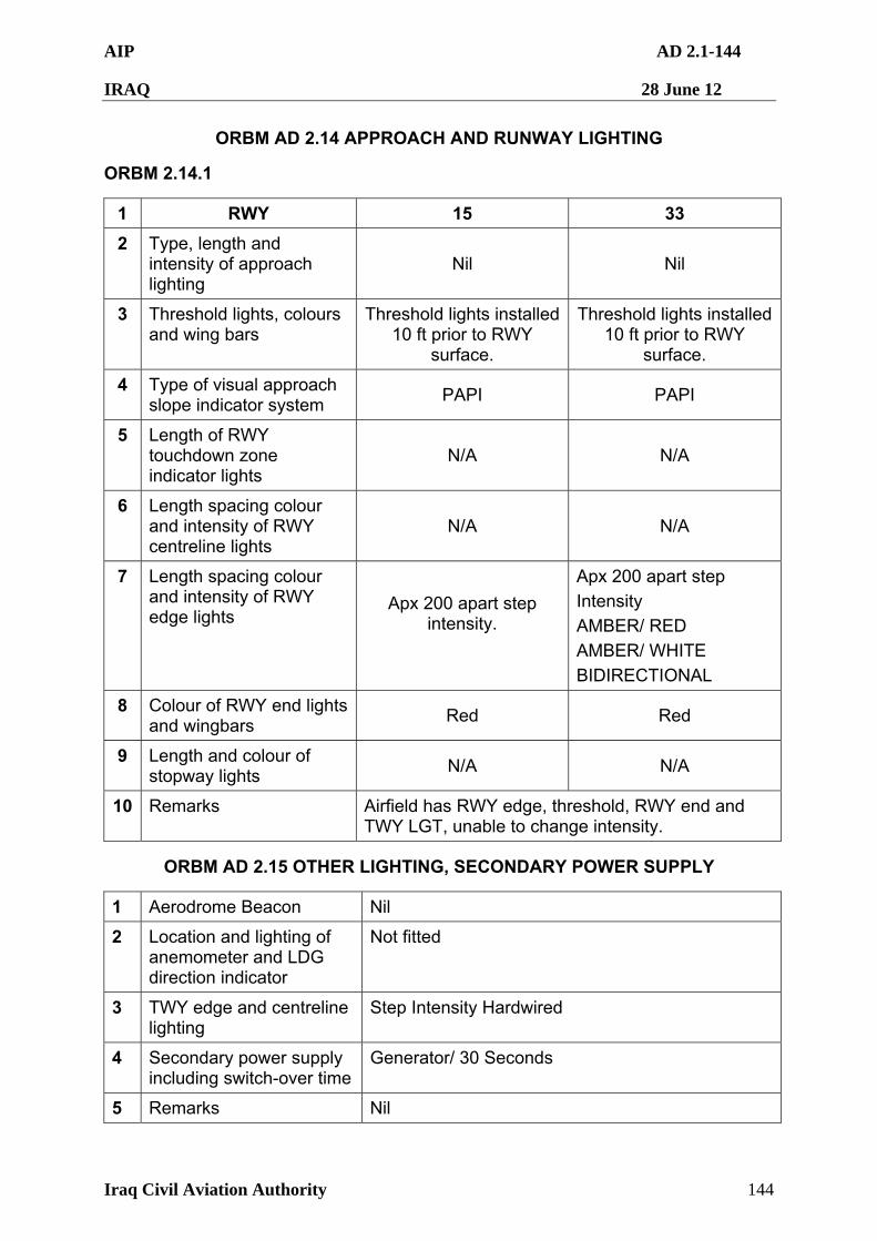
AIP AD 2.1-144
IRAQ 28 June 12
Iraq Civil Aviation Authority 144
ORBM AD 2.14 APPROACH AND RUNWAY LIGHTING
ORBM 2.14.1
1 RWY 15 33
2 Type, length and intensity of approach lighting
Nil Nil
3 Threshold lights, colours and wing bars
Threshold lights installed 10 ft prior to RWY
surface.
Threshold lights installed 10 ft prior to RWY
surface.
4 Type of visual approach slope indicator system
PAPI PAPI
5 Length of RWY touchdown zone indicator lights
N/A N/A
6 Length spacing colour and intensity of RWY centreline lights
N/A N/A
7 Length spacing colour and intensity of RWY edge lights
Apx 200 apart step intensity.
Apx 200 apart step
Intensity
AMBER/ RED
AMBER/ WHITE
BIDIRECTIONAL
8 Colour of RWY end lights and wingbars
Red Red
9 Length and colour of stopway lights
N/A N/A
10 Remarks Airfield has RWY edge, threshold, RWY end and TWY LGT, unable to change intensity.
ORBM AD 2.15 OTHER LIGHTING, SECONDARY POWER SUPPLY
1 Aerodrome Beacon Nil
2 Location and lighting of anemometer and LDG direction indicator
Not fitted
3 TWY edge and centreline lighting
Step Intensity Hardwired
4 Secondary power supply including switch-over time
Generator/ 30 Seconds
5 Remarks Nil
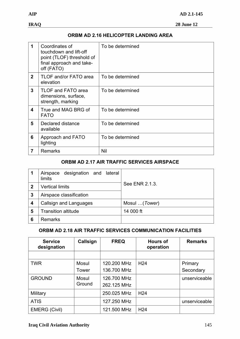
AIP AD 2.1-145
IRAQ 28 June 12
Iraq Civil Aviation Authority 145
ORBM AD 2.16 HELICOPTER LANDING AREA
1 Coordinates of touchdown and lift-off point (TLOF) threshold of final approach and take-off (FATO)
To be determined
2 TLOF and/or FATO area elevation
To be determined
3 TLOF and FATO area dimensions, surface, strength, marking
To be determined
4 True and MAG BRG of FATO
To be determined
5 Declared distance available
To be determined
6 Approach and FATO lighting
To be determined
7 Remarks Nil
ORBM AD 2.17 AIR TRAFFIC SERVICES AIRSPACE
1 Airspace designation and lateral limits
2 Vertical limits
3 Airspace classification
See ENR 2.1.3.
4 Callsign and Languages Mosul …(Tower)
5 Transition altitude 14 000 ft
6 Remarks
ORBM AD 2.18 AIR TRAFFIC SERVICES COMMUNICATION FACILITIES
Service designation
Callsign FREQ Hours of operation
Remarks
TWR Mosul
Tower
120.200 MHz
136.700 MHz
H24 Primary
Secondary
GROUND Mosul Ground
126.700 MHz
262.125 MHz
unserviceable
Military 250.025 MHz H24
ATIS 127.250 MHz unserviceable
EMERG (Civil) 121.500 MHz H24
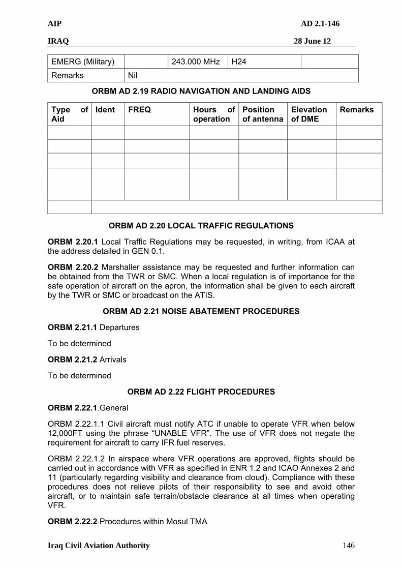
AIP AD 2.1-146
IRAQ 28 June 12
Iraq Civil Aviation Authority 146
EMERG (Military) 243.000 MHz H24
Remarks Nil
ORBM AD 2.19 RADIO NAVIGATION AND LANDING AIDS
Type of Aid
Ident FREQ Hours of operation
Position of antenna
Elevation of DME
Remarks
ORBM AD 2.20 LOCAL TRAFFIC REGULATIONS
ORBM 2.20.1 Local Traffic Regulations may be requested, in writing, from ICAA at the address detailed in GEN 0.1.
ORBM 2.20.2 Marshaller assistance may be requested and further information can be obtained from the TWR or SMC. When a local regulation is of importance for the safe operation of aircraft on the apron, the information shall be given to each aircraft by the TWR or SMC or broadcast on the ATIS.
ORBM AD 2.21 NOISE ABATEMENT PROCEDURES
ORBM 2.21.1 Departures
To be determined
ORBM 2.21.2 Arrivals
To be determined
ORBM AD 2.22 FLIGHT PROCEDURES
ORBM 2.22.1.General
ORBM 2.22.1.1 Civil aircraft must notify ATC if unable to operate VFR when below 12,000FT using the phrase “UNABLE VFR”. The use of VFR does not negate the requirement for aircraft to carry IFR fuel reserves.
ORBM 2.22.1.2 In airspace where VFR operations are approved, flights should be carried out in accordance with VFR as specified in ENR 1.2 and ICAO Annexes 2 and 11 (particularly regarding visibility and clearance from cloud). Compliance with these procedures does not relieve pilots of their responsibility to see and avoid other aircraft, or to maintain safe terrain/obstacle clearance at all times when operating VFR.
ORBM 2.22.2 Procedures within Mosul TMA
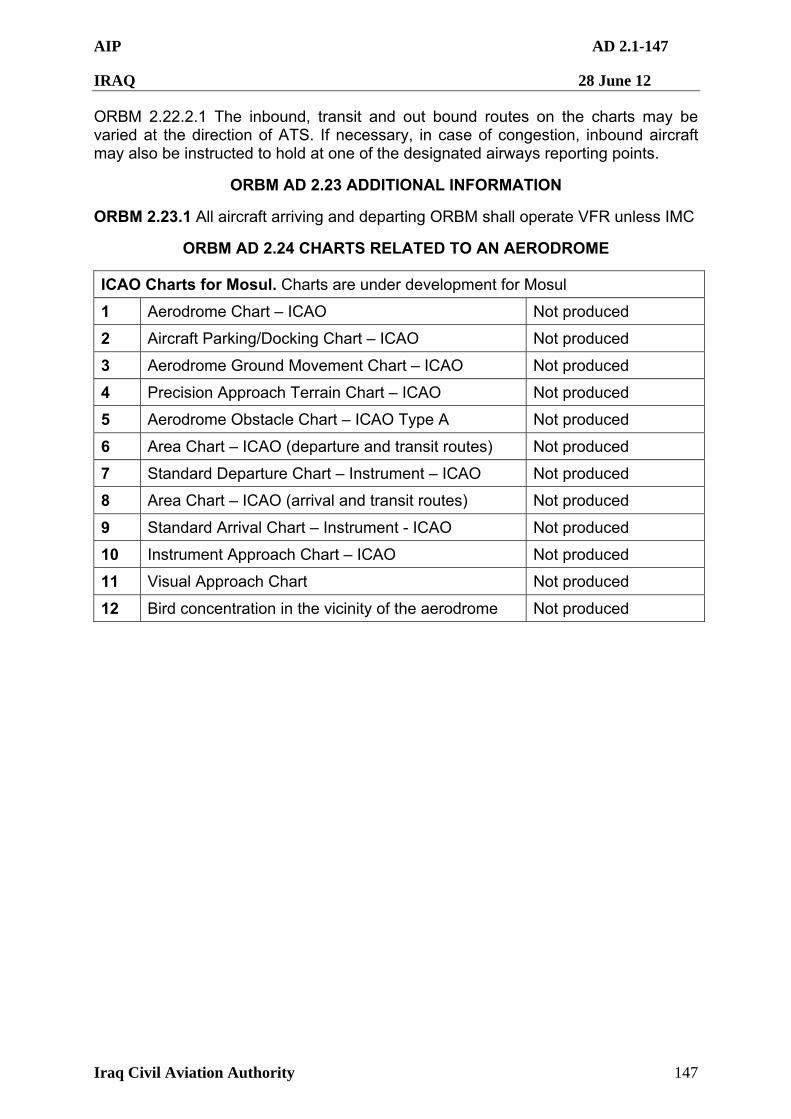
AIP AD 2.1-147
IRAQ 28 June 12
Iraq Civil Aviation Authority 147
ORBM 2.22.2.1 The inbound, transit and out bound routes on the charts may be varied at the direction of ATS. If necessary, in case of congestion, inbound aircraft may also be instructed to hold at one of the designated airways reporting points.
ORBM AD 2.23 ADDITIONAL INFORMATION
ORBM 2.23.1 All aircraft arriving and departing ORBM shall operate VFR unless IMC
ORBM AD 2.24 CHARTS RELATED TO AN AERODROME
ICAO Charts for Mosul. Charts are under development for Mosul
1 Aerodrome Chart – ICAO Not produced
2 Aircraft Parking/Docking Chart – ICAO Not produced
3 Aerodrome Ground Movement Chart – ICAO Not produced
4 Precision Approach Terrain Chart – ICAO Not produced
5 Aerodrome Obstacle Chart – ICAO Type A Not produced
6 Area Chart – ICAO (departure and transit routes) Not produced
7 Standard Departure Chart – Instrument – ICAO Not produced
8 Area Chart – ICAO (arrival and transit routes) Not produced
9 Standard Arrival Chart – Instrument - ICAO Not produced
10 Instrument Approach Chart – ICAO Not produced
11 Visual Approach Chart Not produced
12 Bird concentration in the vicinity of the aerodrome Not produced

AIP AD 2.1-148
IRAQ 28 June 12
Iraq Civil Aviation Authority 148
ORQT — QASR TALL MIHL
ORQT AD 2.1 AERODROME LOCATION INDICATOR AND NAME
ORQT 2.1.1 ORQT – Qasr Tall Mihl Airport
ORQT AD 2.2 AERODROME GEOGRAPHICAL AND ADMINISTRATIVE DATA
1 Aerodrome Reference Point coordinates and site
N33º18'24.00" E044º14'30.00"
The geographic centre of the airfield
2 Elevation and Reference Temperature
114 ft (34.7 m) and 43.1º C
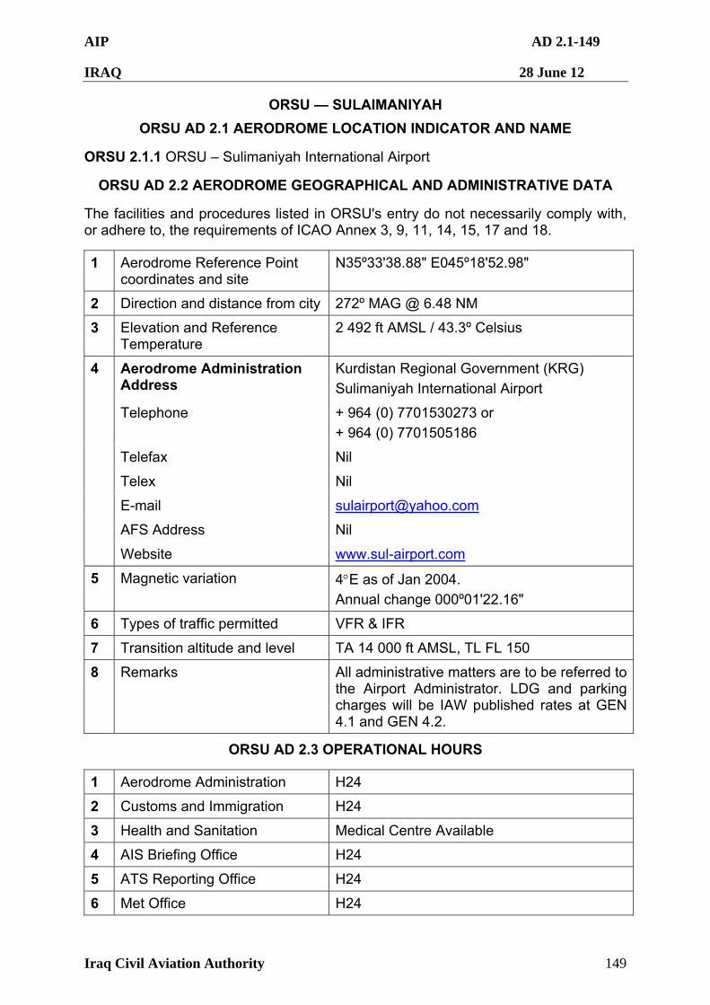
AIP AD 2.1-149
IRAQ 28 June 12
Iraq Civil Aviation Authority 149
ORSU — SULAIMANIYAH
ORSU AD 2.1 AERODROME LOCATION INDICATOR AND NAME
ORSU 2.1.1 ORSU – Sulimaniyah International Airport
ORSU AD 2.2 AERODROME GEOGRAPHICAL AND ADMINISTRATIVE DATA
The facilities and procedures listed in ORSU's entry do not necessarily comply with, or adhere to, the requirements of ICAO Annex 3, 9, 11, 14, 15, 17 and 18.
1 Aerodrome Reference Point coordinates and site
N35º33'38.88" E045º18'52.98"
2 Direction and distance from city 272º MAG @ 6.48 NM
3 Elevation and Reference Temperature
2 492 ft AMSL / 43.3º Celsius
Aerodrome Administration Address
Kurdistan Regional Government (KRG)
Sulimaniyah International Airport
Telephone + 964 (0) 7701530273 or
+ 964 (0) 7701505186
Telefax Nil
Telex Nil
E-mail [email protected]
AFS Address Nil
4
Website www.sul-airport.com
5 Magnetic variation 4E as of Jan 2004. Annual change 000º01'22.16"
6 Types of traffic permitted VFR & IFR
7 Transition altitude and level TA 14 000 ft AMSL, TL FL 150
8 Remarks All administrative matters are to be referred to the Airport Administrator. LDG and parking charges will be IAW published rates at GEN 4.1 and GEN 4.2.
ORSU AD 2.3 OPERATIONAL HOURS
1 Aerodrome Administration H24
2 Customs and Immigration H24
3 Health and Sanitation Medical Centre Available
4 AIS Briefing Office H24
5 ATS Reporting Office H24
6 Met Office H24
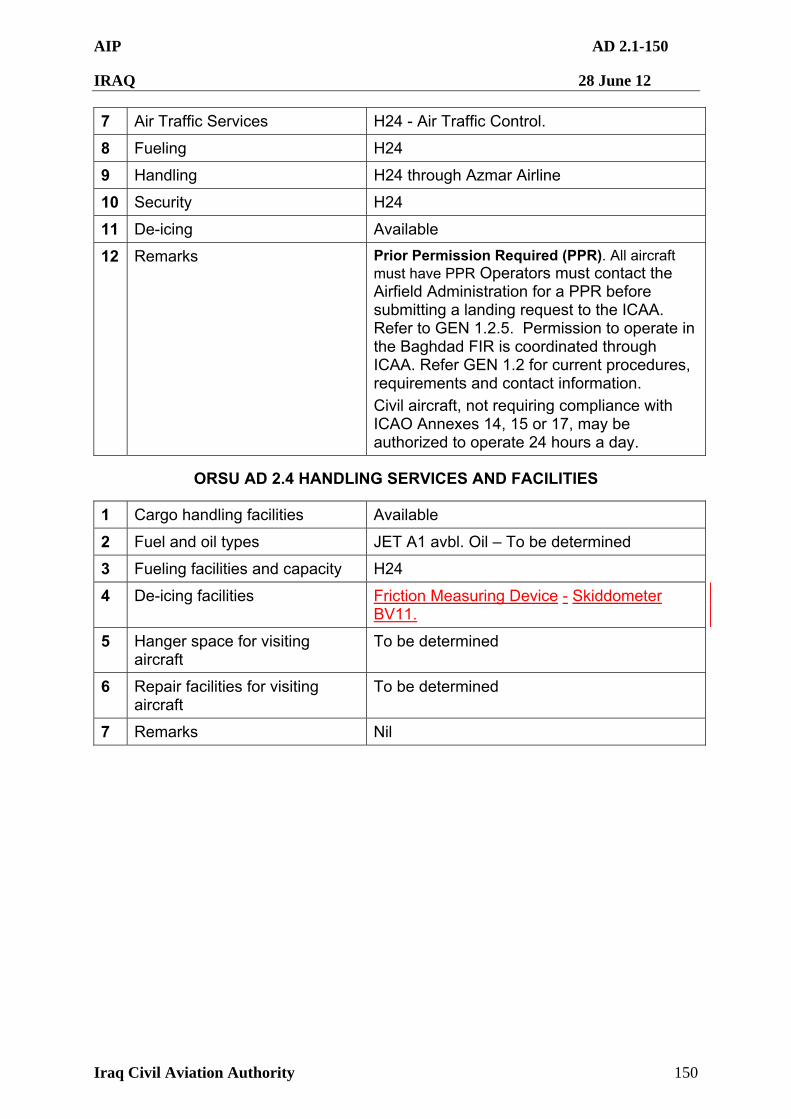
AIP AD 2.1-150
IRAQ 28 June 12
Iraq Civil Aviation Authority 150
7 Air Traffic Services H24 - Air Traffic Control.
8 Fueling H24
9 Handling H24 through Azmar Airline
10 Security H24
11 De-icing Available
12 Remarks Prior Permission Required (PPR). All aircraft must have PPR Operators must contact the Airfield Administration for a PPR before submitting a landing request to the ICAA. Refer to GEN 1.2.5. Permission to operate in the Baghdad FIR is coordinated through ICAA. Refer GEN 1.2 for current procedures, requirements and contact information.
Civil aircraft, not requiring compliance with ICAO Annexes 14, 15 or 17, may be authorized to operate 24 hours a day.
ORSU AD 2.4 HANDLING SERVICES AND FACILITIES
1 Cargo handling facilities Available
2 Fuel and oil types JET A1 avbl. Oil – To be determined
3 Fueling facilities and capacity H24
4 De-icing facilities Friction Measuring Device - Skiddometer BV11.
5 Hanger space for visiting aircraft
To be determined
6 Repair facilities for visiting aircraft
To be determined
7 Remarks Nil
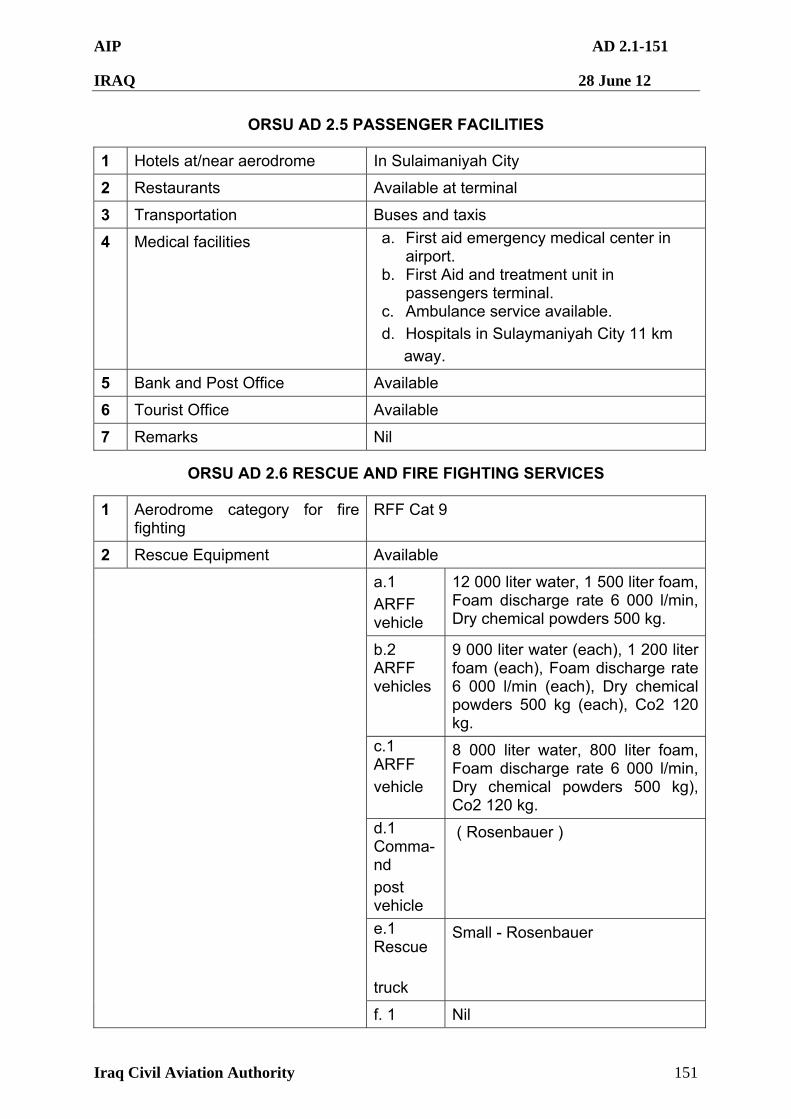
AIP AD 2.1-151
IRAQ 28 June 12
Iraq Civil Aviation Authority 151
ORSU AD 2.5 PASSENGER FACILITIES
1 Hotels at/near aerodrome In Sulaimaniyah City
2 Restaurants Available at terminal
3 Transportation Buses and taxis
4 Medical facilities a. First aid emergency medical center in airport.
b. First Aid and treatment unit in passengers terminal.
c. Ambulance service available.
d. Hospitals in Sulaymaniyah City 11 km
away.
5 Bank and Post Office Available
6 Tourist Office Available
7 Remarks Nil
ORSU AD 2.6 RESCUE AND FIRE FIGHTING SERVICES
1 Aerodrome category for fire fighting
RFF Cat 9
2 Rescue Equipment Available
a.1
ARFF vehicle
12 000 liter water, 1 500 liter foam, Foam discharge rate 6 000 l/min, Dry chemical powders 500 kg.
b.2 ARFF vehicles
9 000 liter water (each), 1 200 liter foam (each), Foam discharge rate 6 000 l/min (each), Dry chemical powders 500 kg (each), Co2 120 kg.
c.1 ARFF
vehicle
8 000 liter water, 800 liter foam, Foam discharge rate 6 000 l/min, Dry chemical powders 500 kg), Co2 120 kg.
d.1 Comma-nd
post vehicle
( Rosenbauer )
e.1 Rescue
truck
Small - Rosenbauer
f. 1 Nil
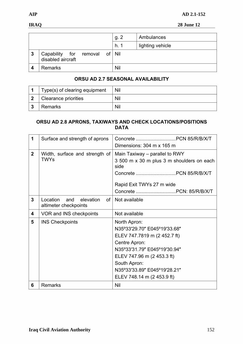
AIP AD 2.1-152
IRAQ 28 June 12
Iraq Civil Aviation Authority 152
g. 2 Ambulances
h. 1 lighting vehicle
3 Capability for removal of disabled aircraft
Nil
4 Remarks Nil
ORSU AD 2.7 SEASONAL AVAILABILITY
1 Type(s) of clearing equipment Nil
2 Clearance priorities Nil
3 Remarks Nil
ORSU AD 2.8 APRONS, TAXIWAYS AND CHECK LOCATIONS/POSITIONS DATA
1 Surface and strength of aprons Concrete .............................PCN 85/R/B/X/T
Dimensions: 304 m x 165 m
2 Width, surface and strength of TWYs
Main Taxiway – parallel to RWY
3 500 m x 30 m plus 3 m shoulders on each side
Concrete .............................PCN 85/R/B/X/T Rapid Exit TWYs 27 m wide
Concrete .............................PCN: 85/R/B/X/T
3 Location and elevation of altimeter checkpoints
Not available
4 VOR and INS checkpoints Not available
5 INS Checkpoints North Apron:
N35º33'29.70″ E045º19′33.68″
ELEV 747.7819 m (2 452.7 ft)
Centre Apron:
N35º33′31.79″ E045º19′30.94″
ELEV 747.96 m (2 453.3 ft)
South Apron:
N35º33′33.89″ E045º19′28.21″
ELEV 748.14 m (2 453.9 ft)
6 Remarks Nil
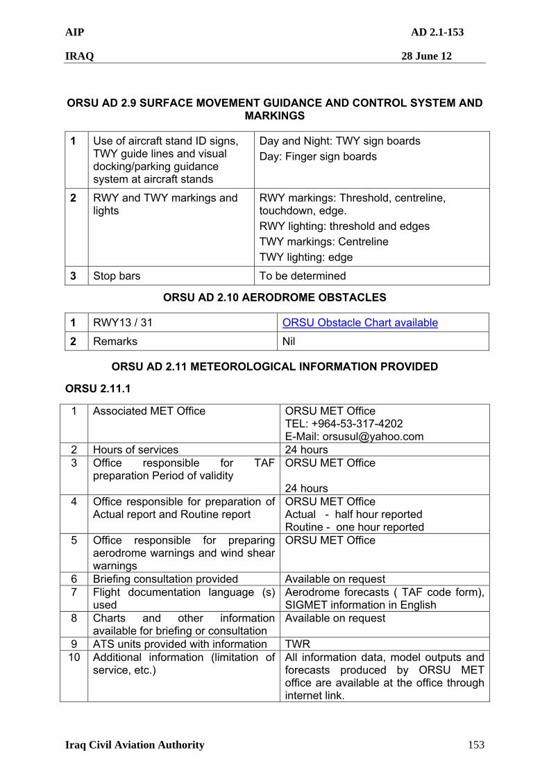
AIP AD 2.1-153
IRAQ 28 June 12
Iraq Civil Aviation Authority 153
ORSU AD 2.9 SURFACE MOVEMENT GUIDANCE AND CONTROL SYSTEM AND MARKINGS
1 Use of aircraft stand ID signs, TWY guide lines and visual docking/parking guidance system at aircraft stands
Day and Night: TWY sign boards
Day: Finger sign boards
2 RWY and TWY markings and lights
RWY markings: Threshold, centreline, touchdown, edge.
RWY lighting: threshold and edges
TWY markings: Centreline
TWY lighting: edge
3 Stop bars To be determined
ORSU AD 2.10 AERODROME OBSTACLES
1 RWY13 / 31 ORSU Obstacle Chart available
2 Remarks Nil
ORSU AD 2.11 METEOROLOGICAL INFORMATION PROVIDED
ORSU 2.11.1
1 Associated MET Office ORSU MET Office TEL: +964-53-317-4202 E-Mail: [email protected]
2 Hours of services 24 hours 3 Office responsible for TAF
preparation Period of validity ORSU MET Office 24 hours
4 Office responsible for preparation of Actual report and Routine report
ORSU MET Office Actual - half hour reported Routine - one hour reported
5 Office responsible for preparing aerodrome warnings and wind shear warnings
ORSU MET Office
6 Briefing consultation provided Available on request 7 Flight documentation language (s)
used Aerodrome forecasts ( TAF code form), SIGMET information in English
8 Charts and other information available for briefing or consultation
Available on request
9 ATS units provided with information TWR 10 Additional information (limitation of
service, etc.) All information data, model outputs and forecasts produced by ORSU MET office are available at the office through internet link.
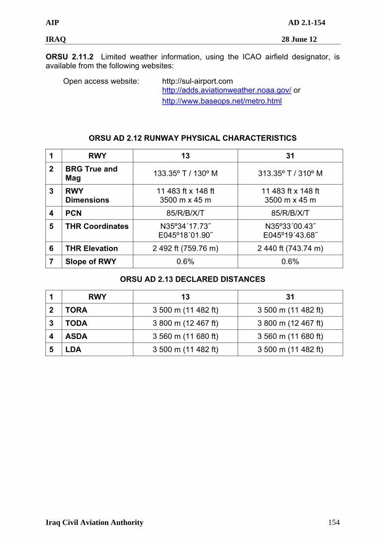
AIP AD 2.1-154
IRAQ 28 June 12
Iraq Civil Aviation Authority 154
ORSU 2.11.2 Limited weather information, using the ICAO airfield designator, is available from the following websites:
Open access website: http://sul-airport.com http://adds.aviationweather.noaa.gov/ or
http://www.baseops.net/metro.html
ORSU AD 2.12 RUNWAY PHYSICAL CHARACTERISTICS
1 RWY 13 31
2 BRG True and Mag
133.35º T / 130º M 313.35º T / 310º M
3 RWY Dimensions
11 483 ft x 148 ft 3500 m x 45 m
11 483 ft x 148 ft 3500 m x 45 m
4 PCN 85/R/B/X/T 85/R/B/X/T
5 THR Coordinates N35º34´17.73˝ E045º18´01.90˝
N35º33´00.43˝ E045º19´43.68˝
6 THR Elevation 2 492 ft (759.76 m) 2 440 ft (743.74 m)
7 Slope of RWY 0.6% 0.6%
ORSU AD 2.13 DECLARED DISTANCES
1 RWY 13 31
2 TORA 3 500 m (11 482 ft) 3 500 m (11 482 ft)
3 TODA 3 800 m (12 467 ft) 3 800 m (12 467 ft)
4 ASDA 3 560 m (11 680 ft) 3 560 m (11 680 ft)
5 LDA 3 500 m (11 482 ft) 3 500 m (11 482 ft)
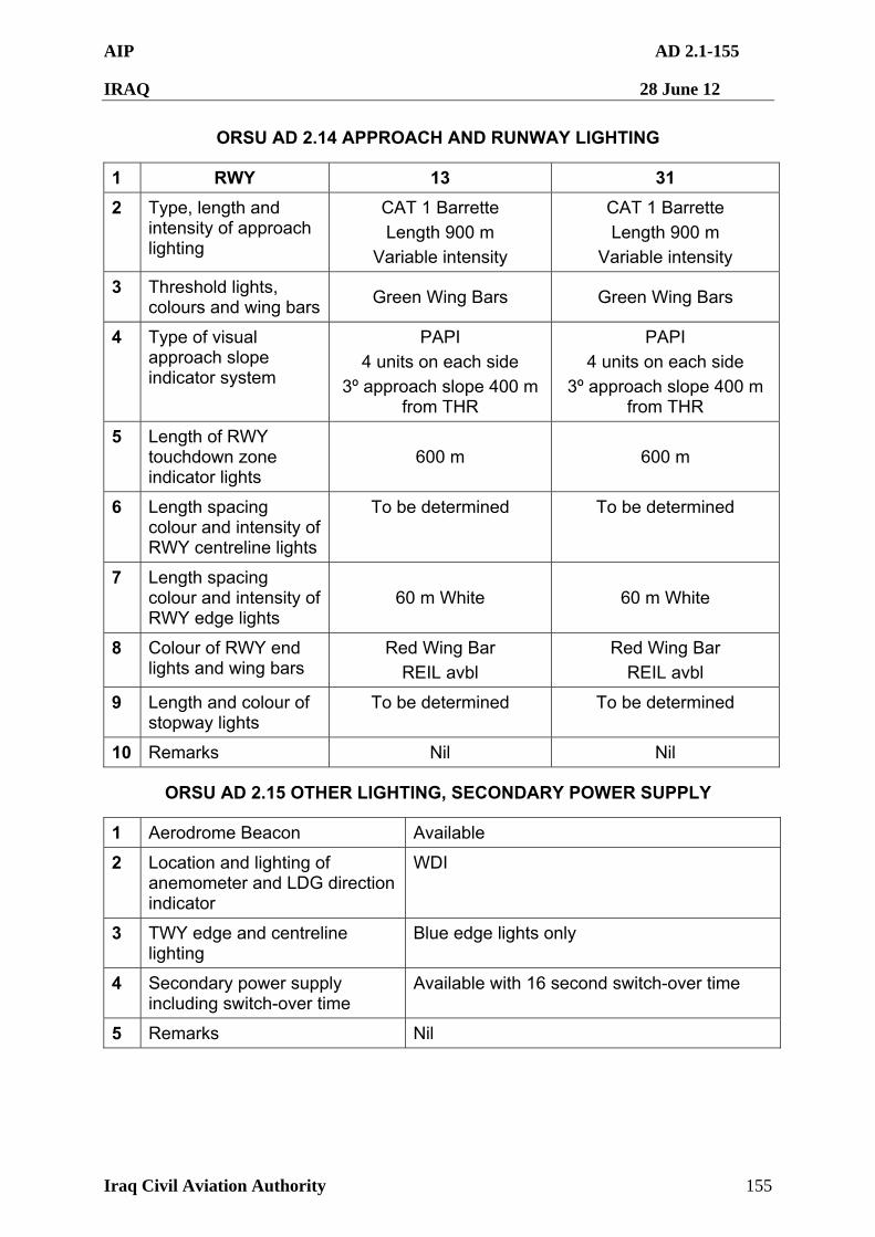
AIP AD 2.1-155
IRAQ 28 June 12
Iraq Civil Aviation Authority 155
ORSU AD 2.14 APPROACH AND RUNWAY LIGHTING
1 RWY 13 31
2 Type, length and intensity of approach lighting
CAT 1 Barrette
Length 900 m
Variable intensity
CAT 1 Barrette
Length 900 m
Variable intensity
3 Threshold lights, colours and wing bars
Green Wing Bars Green Wing Bars
4 Type of visual approach slope indicator system
PAPI
4 units on each side
3º approach slope 400 m from THR
PAPI
4 units on each side
3º approach slope 400 m from THR
5 Length of RWY touchdown zone indicator lights
600 m 600 m
6 Length spacing colour and intensity of RWY centreline lights
To be determined To be determined
7 Length spacing colour and intensity of RWY edge lights
60 m White 60 m White
8 Colour of RWY end lights and wing bars
Red Wing Bar
REIL avbl
Red Wing Bar
REIL avbl
9 Length and colour of stopway lights
To be determined To be determined
10 Remarks Nil Nil
ORSU AD 2.15 OTHER LIGHTING, SECONDARY POWER SUPPLY
1 Aerodrome Beacon Available
2 Location and lighting of anemometer and LDG direction indicator
WDI
3 TWY edge and centreline lighting
Blue edge lights only
4 Secondary power supply including switch-over time
Available with 16 second switch-over time
5 Remarks Nil
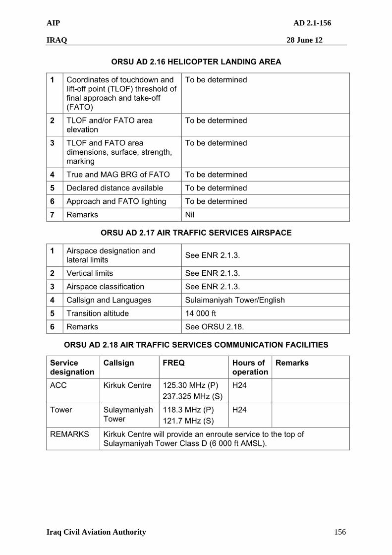
AIP AD 2.1-156
IRAQ 28 June 12
Iraq Civil Aviation Authority 156
ORSU AD 2.16 HELICOPTER LANDING AREA
1 Coordinates of touchdown and lift-off point (TLOF) threshold of final approach and take-off (FATO)
To be determined
2 TLOF and/or FATO area elevation
To be determined
3 TLOF and FATO area dimensions, surface, strength, marking
To be determined
4 True and MAG BRG of FATO To be determined
5 Declared distance available To be determined
6 Approach and FATO lighting To be determined
7 Remarks Nil
ORSU AD 2.17 AIR TRAFFIC SERVICES AIRSPACE
1 Airspace designation and lateral limits
See ENR 2.1.3.
2 Vertical limits See ENR 2.1.3.
3 Airspace classification See ENR 2.1.3.
4 Callsign and Languages Sulaimaniyah Tower/English
5 Transition altitude 14 000 ft
6 Remarks See ORSU 2.18.
ORSU AD 2.18 AIR TRAFFIC SERVICES COMMUNICATION FACILITIES
Service designation
Callsign FREQ Hours of operation
Remarks
ACC Kirkuk Centre 125.30 MHz (P)
237.325 MHz (S)
H24
Tower Sulaymaniyah Tower
118.3 MHz (P)
121.7 MHz (S)
H24
REMARKS Kirkuk Centre will provide an enroute service to the top of Sulaymaniyah Tower Class D (6 000 ft AMSL).
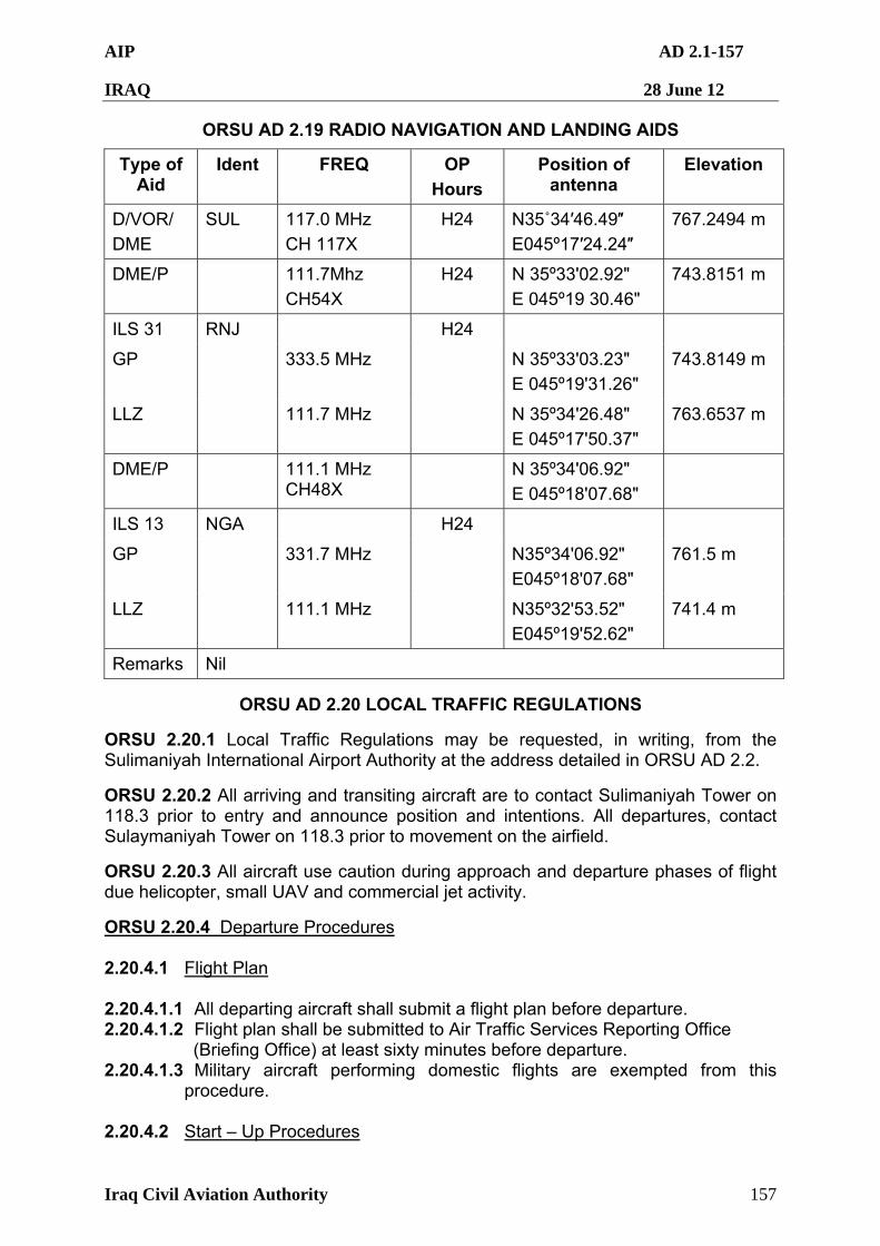
AIP AD 2.1-157
IRAQ 28 June 12
Iraq Civil Aviation Authority 157
ORSU AD 2.19 RADIO NAVIGATION AND LANDING AIDS
Type of Aid
Ident FREQ OP
Hours
Position of antenna
Elevation
D/VOR/
DME
SUL 117.0 MHz
CH 117X
H24 N35˚34′46.49″
E045º17′24.24″
767.2494 m
DME/P 111.7Mhz
CH54X
H24 N 35º33'02.92"
E 045º19 30.46"
743.8151 m
ILS 31 RNJ
GP 333.5 MHz N 35º33'03.23"
E 045º19'31.26"
743.8149 m
LLZ 111.7 MHz
H24
N 35º34'26.48"
E 045º17'50.37"
763.6537 m
DME/P 111.1 MHz CH48X
N 35º34'06.92"
E 045º18'07.68"
ILS 13 NGA
GP 331.7 MHz N35º34'06.92"
E045º18'07.68"
761.5 m
LLZ 111.1 MHz
H24
N35º32'53.52"
E045º19'52.62"
741.4 m
Remarks Nil
ORSU AD 2.20 LOCAL TRAFFIC REGULATIONS
ORSU 2.20.1 Local Traffic Regulations may be requested, in writing, from the Sulimaniyah International Airport Authority at the address detailed in ORSU AD 2.2.
ORSU 2.20.2 All arriving and transiting aircraft are to contact Sulimaniyah Tower on 118.3 prior to entry and announce position and intentions. All departures, contact Sulaymaniyah Tower on 118.3 prior to movement on the airfield.
ORSU 2.20.3 All aircraft use caution during approach and departure phases of flight due helicopter, small UAV and commercial jet activity.
ORSU 2.20.4 Departure Procedures 2.20.4.1 Flight Plan 2.20.4.1.1 All departing aircraft shall submit a flight plan before departure. 2.20.4.1.2 Flight plan shall be submitted to Air Traffic Services Reporting Office (Briefing Office) at least sixty minutes before departure. 2.20.4.1.3 Military aircraft performing domestic flights are exempted from this
procedure. 2.20.4.2 Start – Up Procedures
AIP AD 2.1-158
IRAQ 28 June 12
Iraq Civil Aviation Authority 158
2.20.4.2.1 For safe aircraft movement, ground crews (Ground handler, aircraft
maintenance) shall ensure that area around the aircraft is clear of persons, vehicles, equipment and other obstructions prior to engine start.
2.20.4.2.2 Before requesting start-up clearance, pilot shall confirm with ground crews (Ground handler, aircraft maintenance) whether there is no hazard to the aircraft starting –up.
2.20.4.2.3 Pilot shall not request start-up from Sulaymaniyah Tower until he is sure that safety check-up is fully confirmed.
2.20.4.2.4 When aircraft is ready for start-up, pilot shall contact Sulaymaniyah Tower and request start-up clearance.
2.20.4.2.5 Delay may be expected due to traffic and/or weather conditions.
2.20.4.3 Follow-Me car Service 2.20.4.3.1 Follow-Me service is available for departing aircraft. 2.20.4.3.2 Pilot shall keep listing watch on Sulaymaniyah Tower frequency while
taxiing.
2.20.4.4 ATC Clearance ATC clearance (En-route and Departure Clearance) shall be received and acknowledged by IFR departing aircraft before issuing take-off clearance.
ORSU 2.20.5 Arrival Procedures 2.20.5.1 Follow-Me car Service 2.20.4.5.1.1 Follow-Me service is available for arriving aircraft. 2.20.4.5.1.2 Pilot shall keep listing watch on Sulaymaniyah Tower frequency while
taxiing.
ORSU AD 2.21 NOISE ABATEMENT PROCEDURES
Nil.
ORSU AD 2.22 FLIGHT PROCEDURES
ORSU 2.22.1 Departure Procedures 2.22.1.1 Standard Instrument Departure Routes (SIDs) 2.22.1.1.1 Unless otherwise instructed by Sulaymaniyah Tower, all IFR departing
aircraft using Runway 31 shall follow SID Kirkuk One ( Kirkuk One Departure), except aircraft proceeding to Erbil International Airport shall follow SID Erbil One ( Erbil One Departure).
2.22.1.1.2 Unless otherwise instructed by Sulaymaniyah Tower, all IFR departing aircraft using Runway 13 shall follow SID Kirkuk Two ( Kirkuk Two Departure), except aircraft proceeding to Erbil International Airport shall follow SID Erbil Two ( Erbil Two Departure).
AIP AD 2.1-159
IRAQ 28 June 12
Iraq Civil Aviation Authority 159
2.22.1.2 Flying east of Runway 31/13 is prohibited. 2.22.1.3 Air-Ground Radio Communication Failure Procedures
2.22.1.3.1 Departing aircraft experiencing radio communication failure immediately
after departure shall maintain last assigned altitude for a period of 20 minutes and thereafter adjust level and speed in accordance with the field flight plan.
2.22.1.3.2 Sulaymaniyah Tower shall inform Kirkuk approach and aircraft operator, or their designated representative about the situation and action taken.
ORSU 2.22.2 Arrival Procedures 2.22.2.1 Standard Arrival Routes (STARs) 2.22.2.1.1 Unless otherwise instructed by Kirkuk Approach, all IFR arriving aircraft
using Runway 31 shall follow STAR Kirkuk One ( Kirkuk One Arrival), except aircraft from Erbil International Airport shall follow STAR Erbil One ( Erbil One Arrival).
2.22.2.1.2 Unless otherwise instructed by Kirkuk Approach, all IFR arriving aircraft using Runway 13 shall follow STAR Kirkuk Two ( Kirkuk Two Arrival), except aircraft from Erbil International Airport shall follow STAR Erbil Two ( Erbil Two Arrival).
2.22.2.2 Minimum Altitudes
a. Minimum En-Route altitude is 11 000 Feet. Aircraft shall not descend bellow this altitude before reaching 10NM from SUL VOR. b. Minimum Sector Altitude is 8000 Feet. c. Minimum Holding Altitude is 8000 Feet. d. Minimum Circuit Altitude is 6500 Feet.
2.22.2.3 Instrument Approach Procedures 2.22.2.3.1 Only one aircraft shall be cleared for ILS/DME or VOR approach. 2.22.2.3.2 Succeeding aircraft may be cleared for approach when:
a. the preceding aircraft has reported that it is able to complete its approach without encountering Instrument Meteorological Conditions; or
b. the preceding aircraft is in communication with and sighted by Tower Controller and reasonable assurance exists that a normal landing can be accomplished; or
c. the preceding aircraft has landed. 2.22.2.4 Missed Approach Procedures 2.22.2.4.1 Aircraft making Instrument Approach or Visual Approach executing a
missed approach for any reason may be cleared for another approach for landing.
2.22.2.4.2 Aircraft making ILS/DME approach or VOR approach executing a missed approach shall follow the following Missed Approach Procedures:
AIP AD 2.1-160
IRAQ 28 June 12
Iraq Civil Aviation Authority 160
a. Runway 31: Maintain runway heading until passing 6500 Feet altitude, then turn LEFT to rejoin SUL VOR 8000 Feet Altitude.
b. Runway 13: Maintain runway heading until passing 6500 Feet altitude, then turn RIGHT to rejoin SUL VOR 8000 Feet Altitude.
2.22.2.5 Flying east of Runway 31/13 is prohibited. 2.22.2.6 Air-Ground Radio Communication Failure Procedures 2.22.2.6.1 Arriving aircraft experiencing radio communication failure shall comply
with the following procedures : a. Continue VFR, IFR and complete approach for landing; and b. Proceed according to the current flight plan route to SUL VOR; and c. Maintain the last assigned altitude until reaching SUL VOR and
complete approach according to the weather conditions and published procedures; and
d. Land within 30 minutes after the Estimated Time of Arrival or Last Acknowledged Expected Approach Time, whichever is later.
2.22.2.6.2 If the aircraft experiencing radio communication failure has not reported within thirty minutes after :
a. the estimated time of arrival reported by the pilot; or b. the estimated time of arrival calculated by Control Tower; or c. the last acknowledged Expected Approach Time.
Whichever is latest, normal control may be resumed if so desired.
ORSU 2.22.3 Aerodrome and Weather
2.22.3.1 Sulaymaniyah Control Zone is considered IMC when
a. ground visibility is less than 5 Km; and/or b. the ceiling is less than 3 000 Feet (900 Meters) above aerodrome
elevation.
2.22.3.2 The minimum RVR and ground visibility required for landing and take-off at Sulaymaniyah International Airport for all aircraft categories are :
a. RVR 400 Meters b. Ground visibility 1000 Meters
2.22.3.3 VFR Operation
Except when a clearance for Special VFR is obtained from an Air Traffic Control Unit, VFR flights shall not take-off or land at Sulaymaniyah International Airport, or enter the aerodrome traffic zone or traffic pattern a. when the cloud ceiling is less than 3 000 Feet ( 900 Meters) above
aerodrome elevation; and/or b. when ground visibility is less that 5 Km. c. at night, if a civil aircraft.
AIP AD 2.1-161
IRAQ 28 June 12
Iraq Civil Aviation Authority 161
2.22.3.4 Special VFR 2.22.3.4.1 All VFR flights shall operate as S.VFR in Sulaymaniyah Control Zone
when the prevailing weather is IMC. 2.22.3.4.2 S.VFR flights shall not be operated in Sulaymaniyah Control Zone when
ground visibility is less than 1500 Meters . 2.22.3.4.3 Only one departing S.VFR aircraft or one arriving S.VFR aircraft is
permitted at a time. 2.22.3.5 Procedures For Low Visibility Operations 2.22.3.5.1 Low visibility Operations shall be applied when:
a. Ground visibility is less than 1500 Meters; and/or b. RVR is less than 550 Meters.
2.22.3.5.2 The initiation and cancellation of Low Visibility Operations is the responsibility of the controller at Control Tower.
2.22.3.5.3 When the Ground Visibility is less than 1500m and/or the RVR is less than 550m, the following Low Visibility Procedures shall be applied :
2.22.3.5.3.1 At the intersection of taxiways, an aircraft or vehicle on a
taxiway shall not be permitted to hold closer to the other taxiway than the holding position limit defined by a taxiway intersection marking according to the specifications in ICAO Annex 14, Volume I, Chapter 5.
2.22.3.5.3.2 Minimum intervals between taxiing aircraft shall not be less than THREE minutes.
2.22.3.5.3.3 Opposite direction for take-offs, landings or take-off and landing shall not be used for any reason except in case of emergency.
2.22.3.5.3.4 Minimum Separation on final approach shall not be less than 15 NM.
2.22.3.5.3.5 No clearance shall be issued to departing aircraft to use Runway Intersection for take-off.
2.22.3.5.3.6 All traffic operating on the manoeuvring area shall be monitored and close coordination shall be kept between Tower Controller and Ground Operations.
2.22.3.5.3.7 All departing and arriving aircraft shall be guided by Follow Me Car.
2.22.3.5.3.8 All aircraft and Vehicles shall be requested to report Runway Vacated.
2.22.3.5.3.9 When an aircraft is landing or taking off, vehicles shall not be permitted to hold closer to the runway-in - use than:
a. at a taxiway/runway intersection — at a runway holding
position; and b. at a location other than a taxiway/runway intersection — at a
distance equal to the separation distance of the runway-holding position.
AIP AD 2.1-162
IRAQ 28 June 12
Iraq Civil Aviation Authority 162
ORSU AD 2.23 ADDITIONAL INFORMATION
Nil.
ORSU AD 2.24 CHARTS RELATED TO AN AERODROME
Aerodrome Chart – ICAO ··········································· ORSU AD 2.24.1 Aerodrome Layout and Signs – ICAO ··························· ORSU AD 2.24.2 Aerodrome Obstacle Chart – ICAO Type A ···················· ORSU AD2.24.3 Standard Departure Chart Instrument – ICAO (RWY 13) ··· ORSU AD2.24.4 Standard Departure Chart Instrument – ICAO (RWY 31) ··· ORSU AD 2.24.5 Standard Arrival Chart Instrument – ICAO (RWY 13) ········ ORSU AD 2.24.6 Standard Arrival Chart Instrument – ICAO (RWY 31) ········ ORSU AD 2.24.7 Instrument Approach Chart – ICAO RWY 13 ILS/DME ····· ORSU AD 2.24.8 Instrument Approach Chart – ICAO RWY 31 ILS/DME ····· ORSU AD 2.24.9 Instrument Approach Chart – ICAO RWY 13 VOR ··········· ORSU AD2.24.10 Instrument Approach Chart – ICAO RWY 31 VOR ··········· ORSU AD 2.24.11 Visual Approach Chart –ICAO RWY 13/31 ····················· ORSU AD 2.24.12
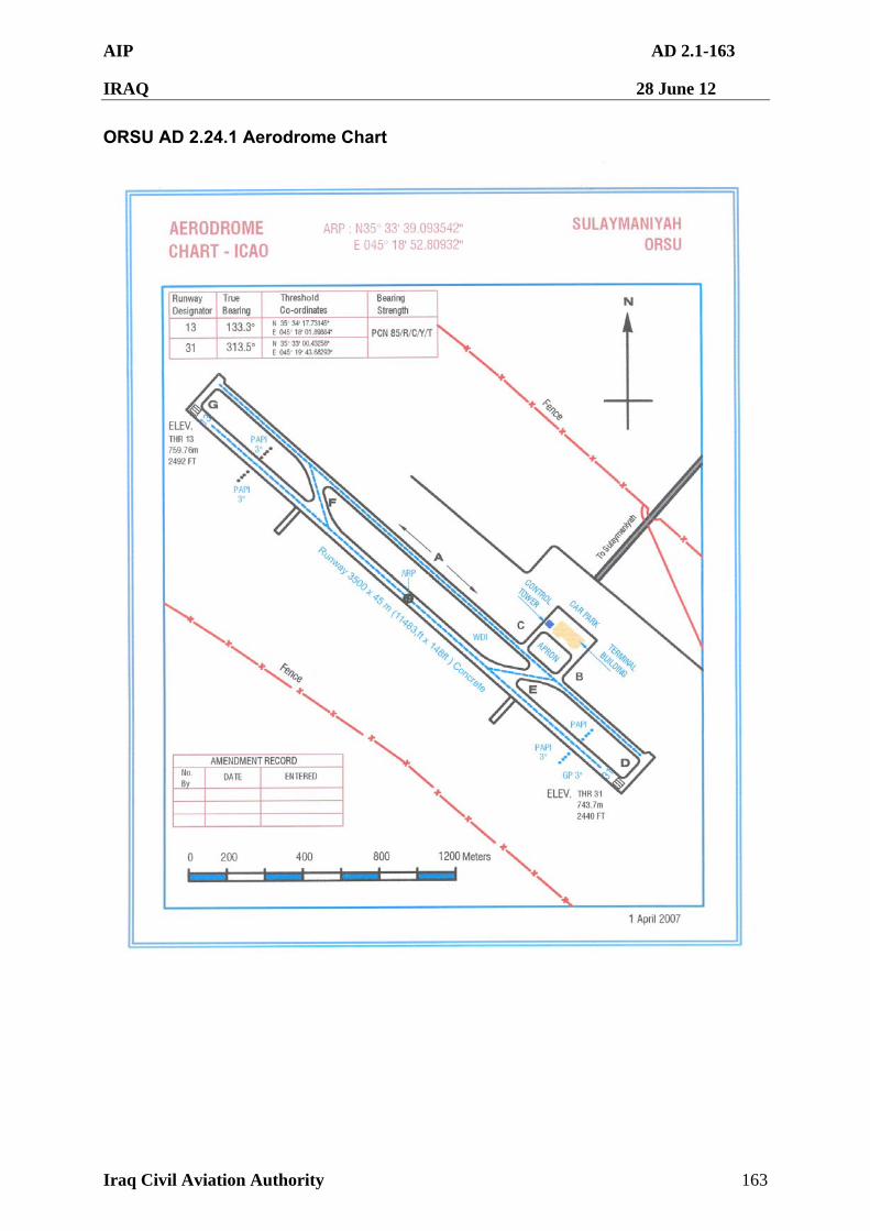
AIP AD 2.1-163
IRAQ 28 June 12
Iraq Civil Aviation Authority 163
ORSU AD 2.24.1 Aerodrome Chart
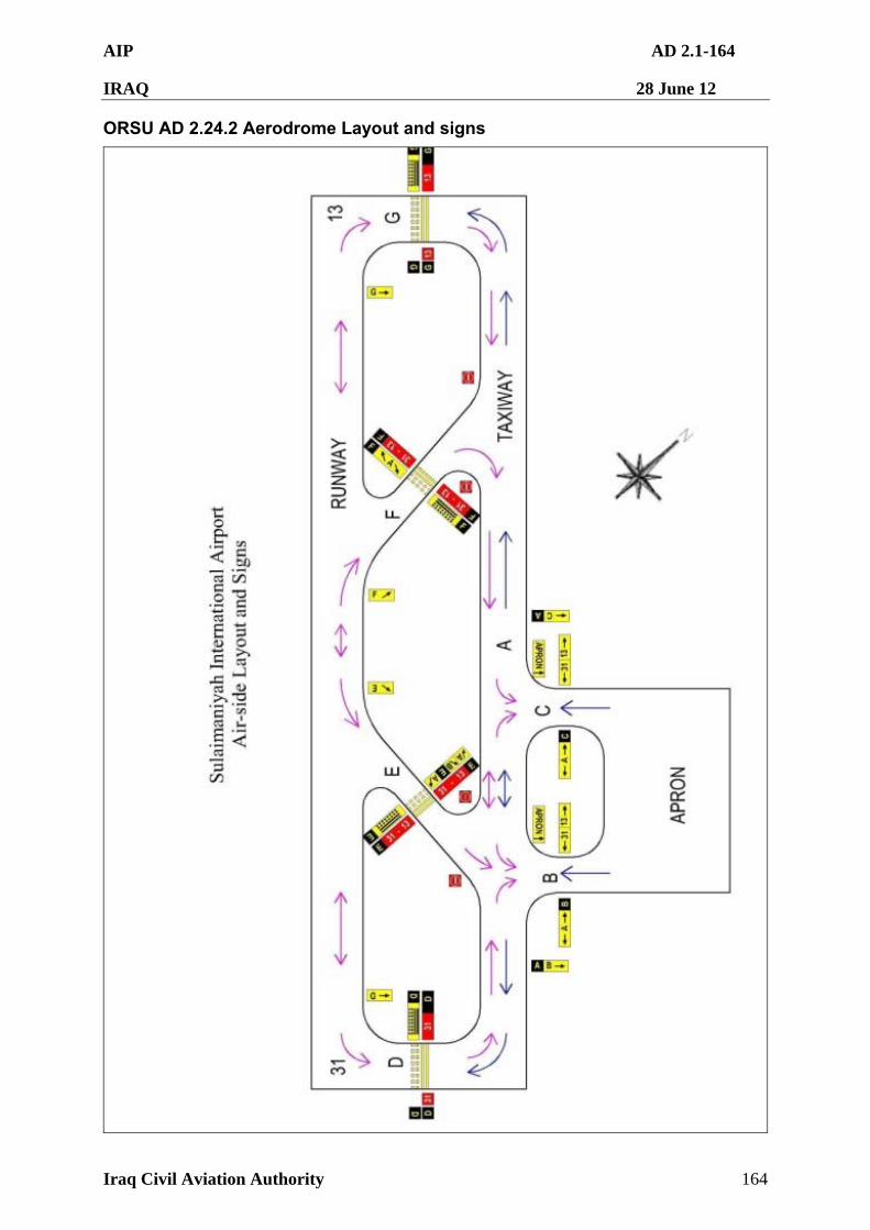
AIP AD 2.1-164
IRAQ 28 June 12
Iraq Civil Aviation Authority 164
ORSU AD 2.24.2 Aerodrome Layout and signs
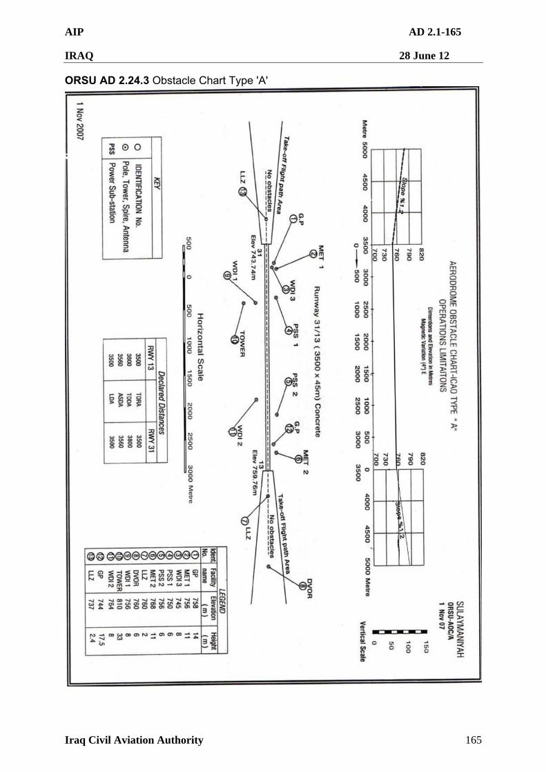
AIP AD 2.1-165
IRAQ 28 June 12
Iraq Civil Aviation Authority 165
ORSU AD 2.24.3 Obstacle Chart Type 'A'
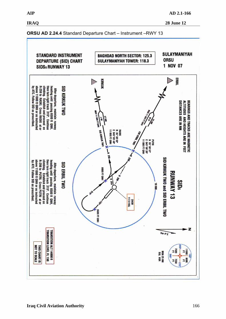
AIP AD 2.1-166
IRAQ 28 June 12
Iraq Civil Aviation Authority 166
ORSU AD 2.24.4 Standard Departure Chart – Instrument –RWY 13
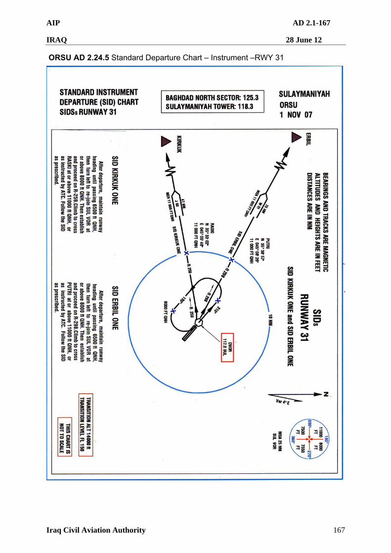
AIP AD 2.1-167
IRAQ 28 June 12
Iraq Civil Aviation Authority 167
ORSU AD 2.24.5 Standard Departure Chart – Instrument –RWY 31
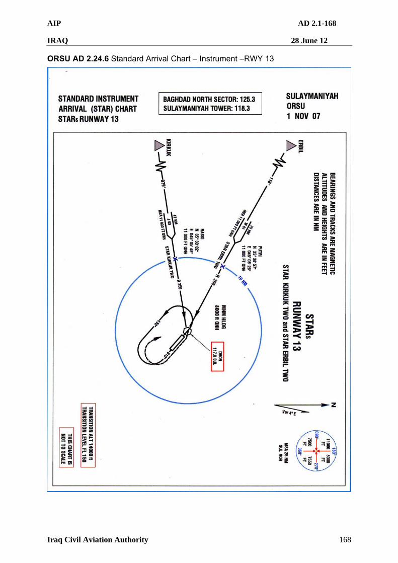
AIP AD 2.1-168
IRAQ 28 June 12
Iraq Civil Aviation Authority 168
ORSU AD 2.24.6 Standard Arrival Chart – Instrument –RWY 13
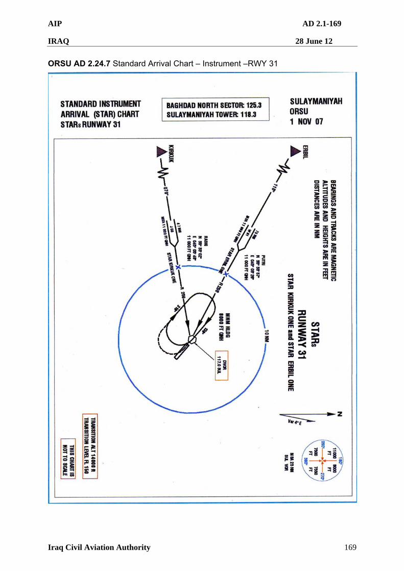
AIP AD 2.1-169
IRAQ 28 June 12
Iraq Civil Aviation Authority 169
ORSU AD 2.24.7 Standard Arrival Chart – Instrument –RWY 31
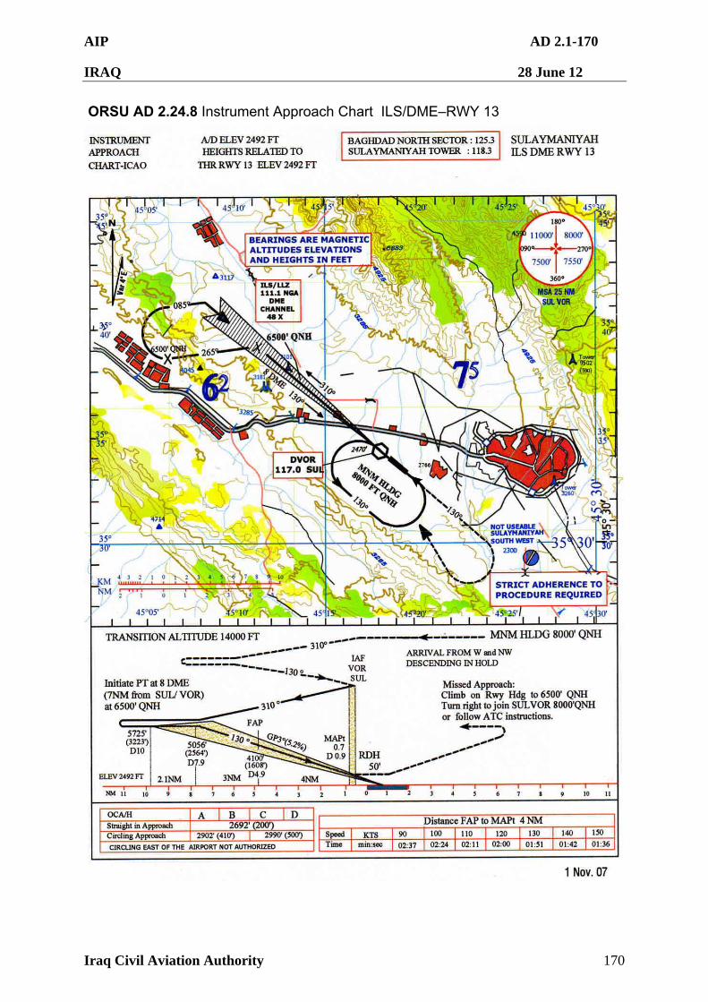
AIP AD 2.1-170
IRAQ 28 June 12
Iraq Civil Aviation Authority 170
ORSU AD 2.24.8 Instrument Approach Chart ILS/DME–RWY 13
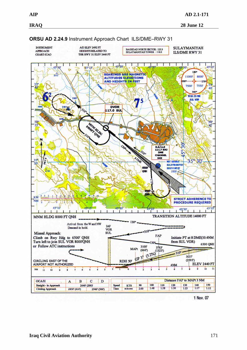
AIP AD 2.1-171
IRAQ 28 June 12
Iraq Civil Aviation Authority 171
ORSU AD 2.24.9 Instrument Approach Chart ILS/DME–RWY 31
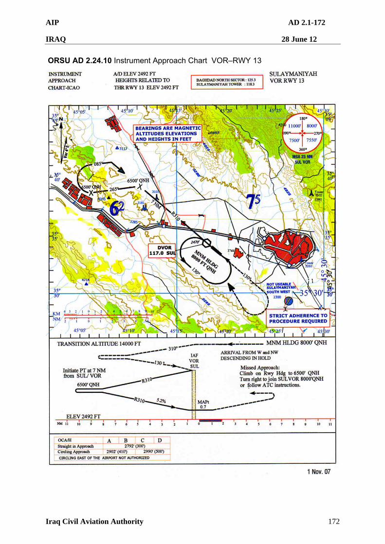
AIP AD 2.1-172
IRAQ 28 June 12
Iraq Civil Aviation Authority 172
ORSU AD 2.24.10 Instrument Approach Chart VOR–RWY 13
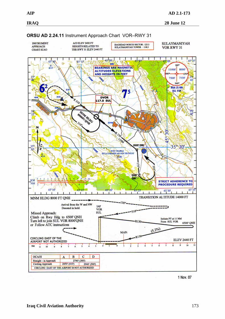
AIP AD 2.1-173
IRAQ 28 June 12
Iraq Civil Aviation Authority 173
ORSU AD 2.24.11 Instrument Approach Chart VOR–RWY 31
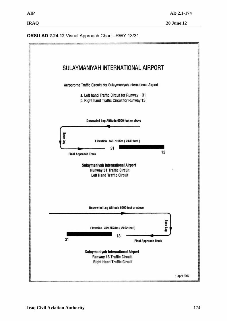
AIP AD 2.1-174
IRAQ 28 June 12
Iraq Civil Aviation Authority 174
ORSU AD 2.24.12 Visual Approach Chart –RWY 13/31
AIP AD 2.1-175
IRAQ 28 June 12
Iraq Civil Aviation Authority 175
ORTF — TALL AFAR
ORTF AD 2.1 AERODROME LOCATION INDICATOR AND NAME
ORTF 2.1.1 ORTF – Tall Afar Airfield
ORTF AD 2.2 AERODROME GEOGRAPHICAL AND ADMINISTRATIVE DATA
The facilities and procedures listed below do not necessarily comply with, or adhere to, the requirements of ICAO Annex 14.
1 Aerodrome Reference Point coordinates and site
N36º16'59" E042º24'11" Located at the centre of the runway
2 Direction and distance from city 015 deg @ 6 NM
3 Elevation and Reference Temperature
996 ft
4 Geoid undulation To be determined
5 Magnetic variation/Annual change
3º E as of Jan 2004, Annual change E000º00'58.36"
Aerodrome Administration Address
US ARMY
All administrative matters to Air Operations.
Telephone Nil
Telefax Nil
Telex Nil
E-mail Nil
AFS Address Nil
AD Manager
Telephone DSN: 318-485-1604
SVOIP 318-243-3851
Airport Safety
6
Telephone
7 Types of traffic permitted VFR
8 Transition altitude and level TA 14 000 ft AMSL, TL FL 150
AIP AD 2.1-176
IRAQ 28 June 12
Iraq Civil Aviation Authority 176
ORTF AD 2.3 OPERATIONAL HOURS
1 Aerodrome Administration H24
2 Customs and Immigration NA
3 Health and Sanitization NA
4 AIS Briefing Office To be determined
5 ATS Reporting Office H24
6 Met Office H24
7 Air Traffic Services H24
8 Fueling H24 (not avbl to fixed wing aircraft)
9 Handling H24 limited MHE
10 Security H24
11 De-icing Not available
12 Remarks Prior Permission Required (PPR). All aircraft must have PPR except C130 and C17. Operators must contact the airfield management for a PPR before submitting a landing request to the ICAA. Refer to GEN 1.2.5. Permission to operate in the Baghdad FIR is coordinated through ICAA. Refer to GEN 1.2 for current procedures, requirements and contact information. Civil aircraft in VMC by day only.
ORTF AD 2.4 HANDLING SERVICES AND FACILITIES
1 Cargo handling facilities Limited MHE on site.
2 Fuel and oil types JP8
Limited Mil oil.
3 Fueling facilities and capacity Four point FARP for Rotary Wing aircraft
Fuel, maintenance and AGE not available for fixed wing aircraft, except C-23 Sherpa.
Fixed wing aircraft must carry round-trip fuel.
4 De-icing facilities Nil
5 Hanger space for visiting aircraft
Nil
6 Repair facilities for visiting aircraft
Nil
7 Remarks Handling services only for Rotary Wing.
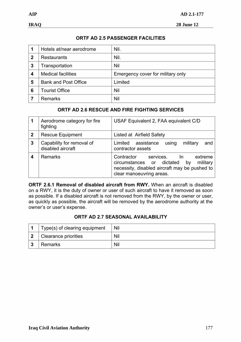
AIP AD 2.1-177
IRAQ 28 June 12
Iraq Civil Aviation Authority 177
ORTF AD 2.5 PASSENGER FACILITIES
1 Hotels at/near aerodrome Nil.
2 Restaurants Nil.
3 Transportation Nil
4 Medical facilities Emergency cover for military only
5 Bank and Post Office Limited
6 Tourist Office Nil
7 Remarks Nil
ORTF AD 2.6 RESCUE AND FIRE FIGHTING SERVICES
1 Aerodrome category for fire fighting
USAF Equivalent 2, FAA equivalent C/D
2 Rescue Equipment Listed at Airfield Safety
3 Capability for removal of disabled aircraft
Limited assistance using military and contractor assets
4 Remarks Contractor services. In extreme circumstances or dictated by military necessity, disabled aircraft may be pushed to clear manoeuvring areas.
ORTF 2.6.1 Removal of disabled aircraft from RWY. When an aircraft is disabled on a RWY, it is the duty of owner or user of such aircraft to have it removed as soon as possible. If a disabled aircraft is not removed from the RWY, by the owner or user, as quickly as possible, the aircraft will be removed by the aerodrome authority at the owner’s or user’s expense.
ORTF AD 2.7 SEASONAL AVAILABILITY
1 Type(s) of clearing equipment Nil
2 Clearance priorities Nil
3 Remarks Nil
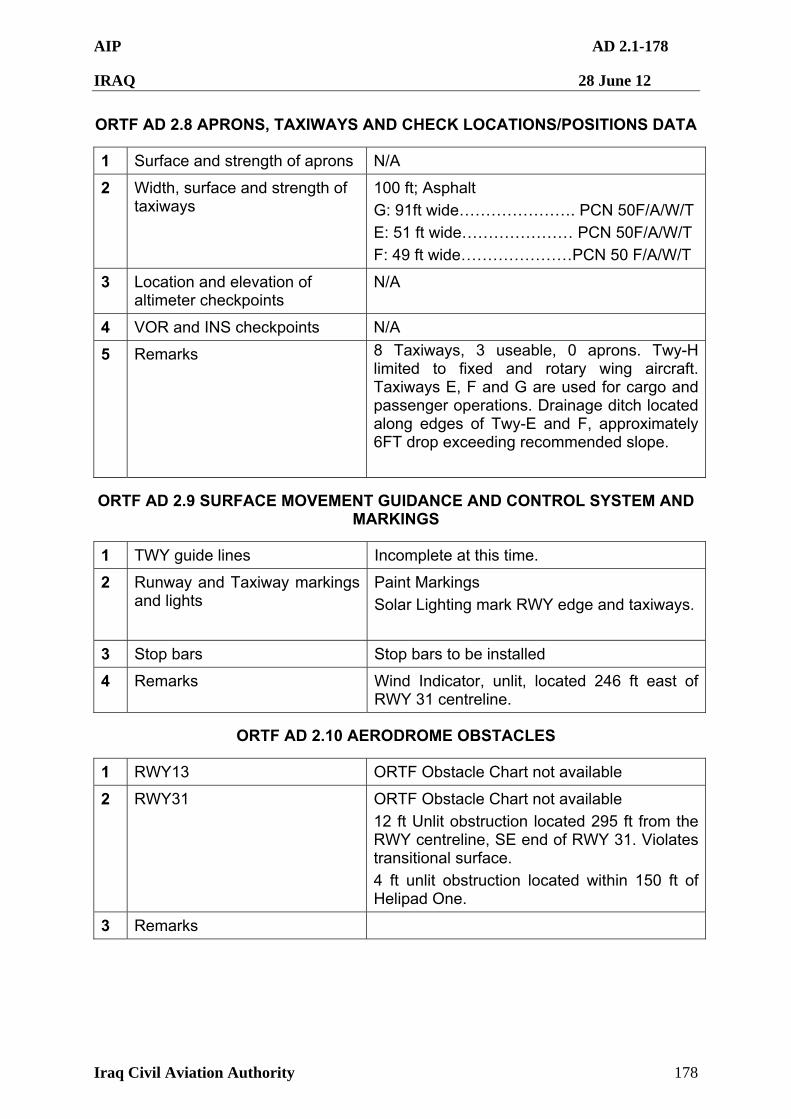
AIP AD 2.1-178
IRAQ 28 June 12
Iraq Civil Aviation Authority 178
ORTF AD 2.8 APRONS, TAXIWAYS AND CHECK LOCATIONS/POSITIONS DATA
1 Surface and strength of aprons N/A
2 Width, surface and strength of taxiways
100 ft; Asphalt
G: 91ft wide…………………. PCN 50F/A/W/T
E: 51 ft wide………………… PCN 50F/A/W/T
F: 49 ft wide…………………PCN 50 F/A/W/T
3 Location and elevation of altimeter checkpoints
N/A
4 VOR and INS checkpoints N/A
5 Remarks 8 Taxiways, 3 useable, 0 aprons. Twy-H limited to fixed and rotary wing aircraft. Taxiways E, F and G are used for cargo and passenger operations. Drainage ditch located along edges of Twy-E and F, approximately 6FT drop exceeding recommended slope.
ORTF AD 2.9 SURFACE MOVEMENT GUIDANCE AND CONTROL SYSTEM AND MARKINGS
1 TWY guide lines Incomplete at this time.
2 Runway and Taxiway markings and lights
Paint Markings
Solar Lighting mark RWY edge and taxiways.
3 Stop bars Stop bars to be installed
4 Remarks Wind Indicator, unlit, located 246 ft east of RWY 31 centreline.
ORTF AD 2.10 AERODROME OBSTACLES
1 RWY13 ORTF Obstacle Chart not available
2 RWY31 ORTF Obstacle Chart not available
12 ft Unlit obstruction located 295 ft from the RWY centreline, SE end of RWY 31. Violates transitional surface.
4 ft unlit obstruction located within 150 ft of Helipad One.
3 Remarks
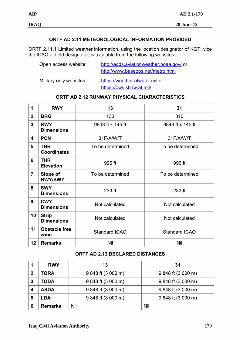
AIP AD 2.1-179
IRAQ 28 June 12
Iraq Civil Aviation Authority 179
ORTF AD 2.11 METEOROLOGICAL INFORMATION PROVIDED
ORTF 2.11.1 Limited weather information, using the location designator of KQTI vice the ICAO airfield designator, is available from the following websites:
Open access website: http://adds.aviationweather.noaa.gov/ or
http://www.baseops.net/metro.html
Military only websites: https://weather.afwa.af.mil or
https://ows.shaw.af.mil/
ORTF AD 2.12 RUNWAY PHYSICAL CHARACTERISTICS
1 RWY 13 31
2 BRG 130 310
3 RWY Dimensions
9848 ft x 145 ft
9848 ft x 145 ft
4 PCN 31F/A/W/T 31F/A/W/T
5 THR Coordinates
To be determined To be determined
6 THR Elevation
996 ft 996 ft
7 Slope of RWY/SWY
To be determined To be determined
8 SWY Dimensions
233 ft 233 ft
9 CWY Dimensions
Not calculated Not calculated
10 Strip Dimensions
Not calculated Not calculated
11 Obstacle free zone
Standard ICAO Standard ICAO
12 Remarks Nil Nil
ORTF AD 2.13 DECLARED DISTANCES
1 RWY 13 31
2 TORA 9 848 ft (3 000 m) 9 848 ft (3 000 m)
3 TODA 9 848 ft (3 000 m) 9 848 ft (3 000 m)
4 ASDA 9 848 ft (3 000 m) 9 848 ft (3 000 m)
5 LDA 9 848 ft (3 000 m) 9 848 ft (3 000 m)
6 Remarks Nil Nil
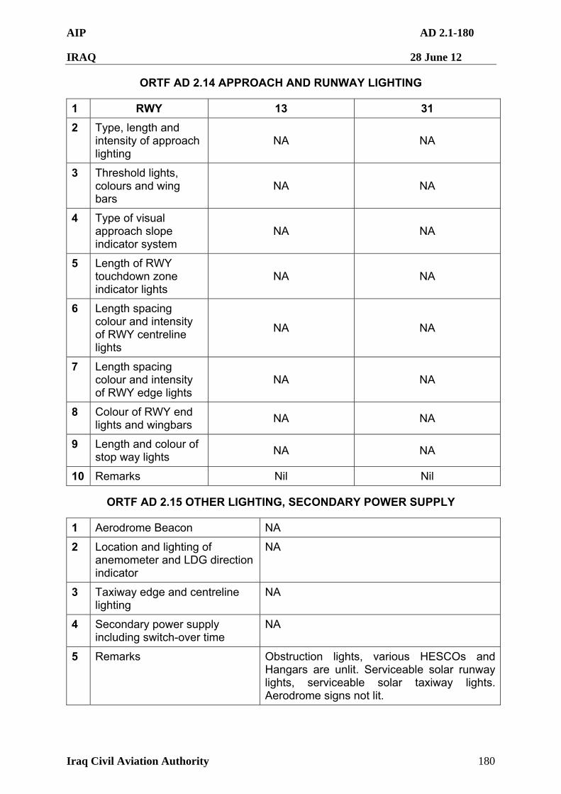
AIP AD 2.1-180
IRAQ 28 June 12
Iraq Civil Aviation Authority 180
ORTF AD 2.14 APPROACH AND RUNWAY LIGHTING
1 RWY 13 31
2 Type, length and intensity of approach lighting
NA NA
3 Threshold lights, colours and wing bars
NA NA
4 Type of visual approach slope indicator system
NA NA
5 Length of RWY touchdown zone indicator lights
NA NA
6 Length spacing colour and intensity of RWY centreline lights
NA NA
7 Length spacing colour and intensity of RWY edge lights
NA NA
8 Colour of RWY end lights and wingbars
NA NA
9 Length and colour of stop way lights
NA NA
10 Remarks Nil Nil
ORTF AD 2.15 OTHER LIGHTING, SECONDARY POWER SUPPLY
1 Aerodrome Beacon NA
2 Location and lighting of anemometer and LDG direction indicator
NA
3 Taxiway edge and centreline lighting
NA
4 Secondary power supply including switch-over time
NA
5 Remarks Obstruction lights, various HESCOs and Hangars are unlit. Serviceable solar runway lights, serviceable solar taxiway lights. Aerodrome signs not lit.
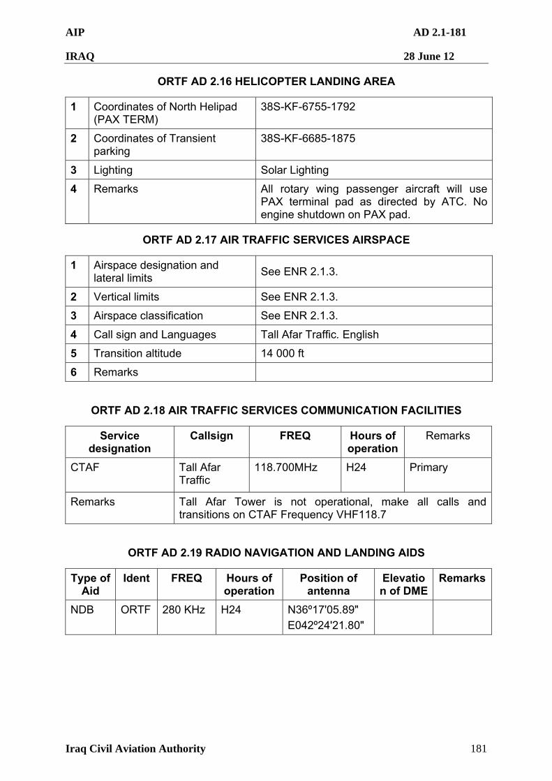
AIP AD 2.1-181
IRAQ 28 June 12
Iraq Civil Aviation Authority 181
ORTF AD 2.16 HELICOPTER LANDING AREA
1 Coordinates of North Helipad (PAX TERM)
38S-KF-6755-1792
2 Coordinates of Transient parking
38S-KF-6685-1875
3 Lighting Solar Lighting
4 Remarks All rotary wing passenger aircraft will use PAX terminal pad as directed by ATC. No engine shutdown on PAX pad.
ORTF AD 2.17 AIR TRAFFIC SERVICES AIRSPACE
1 Airspace designation and lateral limits
See ENR 2.1.3.
2 Vertical limits See ENR 2.1.3.
3 Airspace classification See ENR 2.1.3.
4 Call sign and Languages Tall Afar Traffic. English
5 Transition altitude 14 000 ft
6 Remarks
ORTF AD 2.18 AIR TRAFFIC SERVICES COMMUNICATION FACILITIES
Service designation
Callsign FREQ Hours of operation
Remarks
CTAF Tall Afar Traffic
118.700MHz
H24 Primary
Remarks Tall Afar Tower is not operational, make all calls and transitions on CTAF Frequency VHF118.7
ORTF AD 2.19 RADIO NAVIGATION AND LANDING AIDS
Type of Aid
Ident FREQ Hours of operation
Position of antenna
Elevation of DME
Remarks
NDB ORTF 280 KHz H24 N36º17'05.89"
E042º24'21.80"
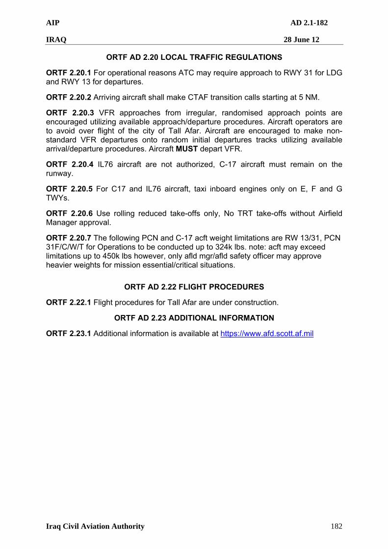
AIP AD 2.1-182
IRAQ 28 June 12
Iraq Civil Aviation Authority 182
ORTF AD 2.20 LOCAL TRAFFIC REGULATIONS
ORTF 2.20.1 For operational reasons ATC may require approach to RWY 31 for LDG and RWY 13 for departures.
ORTF 2.20.2 Arriving aircraft shall make CTAF transition calls starting at 5 NM.
ORTF 2.20.3 VFR approaches from irregular, randomised approach points are encouraged utilizing available approach/departure procedures. Aircraft operators are to avoid over flight of the city of Tall Afar. Aircraft are encouraged to make non-standard VFR departures onto random initial departures tracks utilizing available arrival/departure procedures. Aircraft MUST depart VFR.
ORTF 2.20.4 IL76 aircraft are not authorized, C-17 aircraft must remain on the runway.
ORTF 2.20.5 For C17 and IL76 aircraft, taxi inboard engines only on E, F and G TWYs.
ORTF 2.20.6 Use rolling reduced take-offs only, No TRT take-offs without Airfield Manager approval.
ORTF 2.20.7 The following PCN and C-17 acft weight limitations are RW 13/31, PCN 31F/C/W/T for Operations to be conducted up to 324k lbs. note: acft may exceed limitations up to 450k lbs however, only afld mgr/afld safety officer may approve heavier weights for mission essential/critical situations.
ORTF AD 2.22 FLIGHT PROCEDURES
ORTF 2.22.1 Flight procedures for Tall Afar are under construction.
ORTF AD 2.23 ADDITIONAL INFORMATION
ORTF 2.23.1 Additional information is available at https://www.afd.scott.af.mil
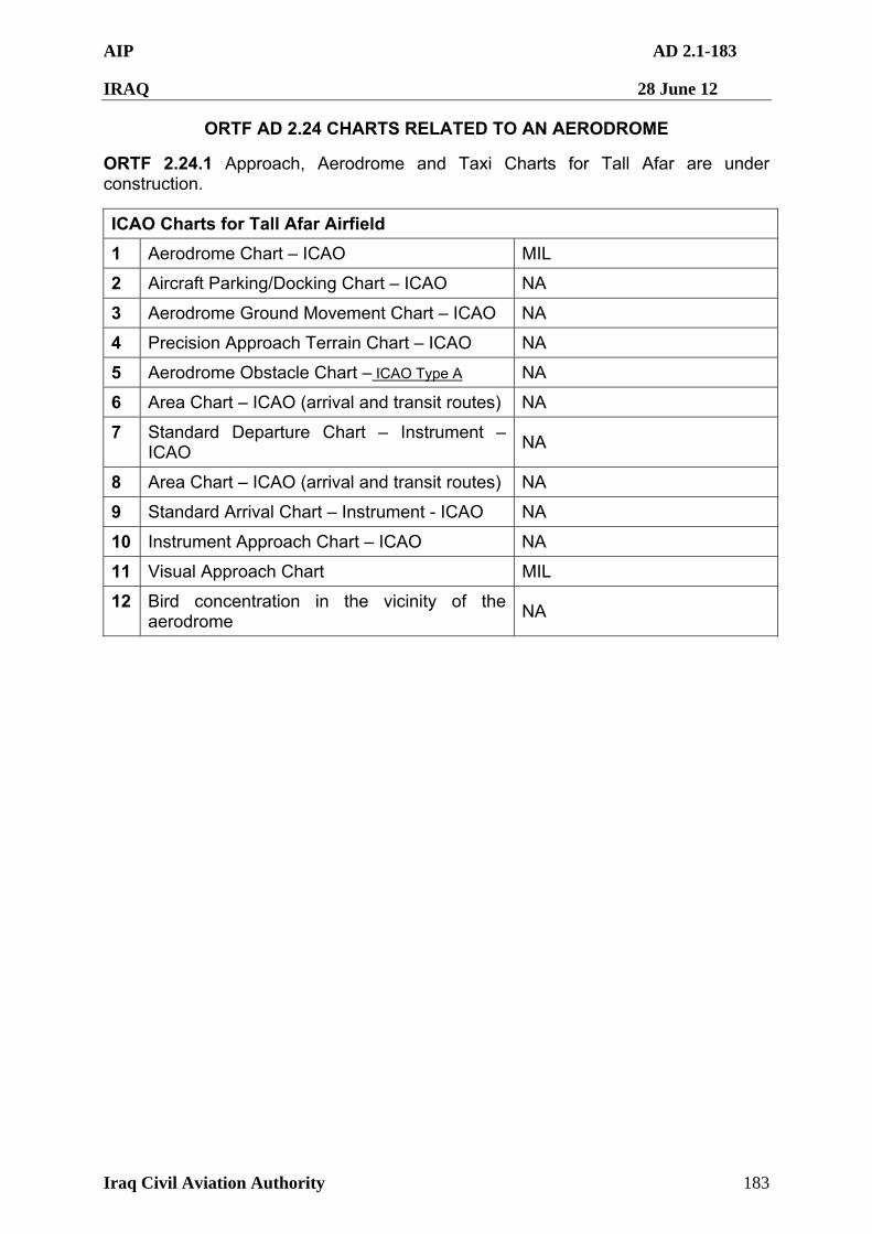
AIP AD 2.1-183
IRAQ 28 June 12
Iraq Civil Aviation Authority 183
ORTF AD 2.24 CHARTS RELATED TO AN AERODROME
ORTF 2.24.1 Approach, Aerodrome and Taxi Charts for Tall Afar are under construction.
ICAO Charts for Tall Afar Airfield
1 Aerodrome Chart – ICAO MIL
2 Aircraft Parking/Docking Chart – ICAO NA
3 Aerodrome Ground Movement Chart – ICAO NA
4 Precision Approach Terrain Chart – ICAO NA
5 Aerodrome Obstacle Chart – ICAO Type A NA
6 Area Chart – ICAO (arrival and transit routes) NA
7 Standard Departure Chart – Instrument – ICAO
NA
8 Area Chart – ICAO (arrival and transit routes) NA
9 Standard Arrival Chart – Instrument - ICAO NA
10 Instrument Approach Chart – ICAO NA
11 Visual Approach Chart MIL
12 Bird concentration in the vicinity of the aerodrome
NA
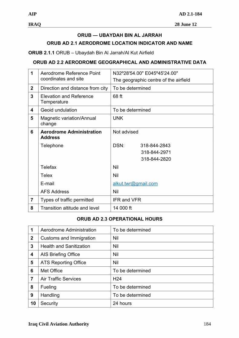
AIP AD 2.1-184
IRAQ 28 June 12
Iraq Civil Aviation Authority 184
ORUB — UBAYDAH BIN AL JARRAH
ORUB AD 2.1 AERODROME LOCATION INDICATOR AND NAME
ORUB 2.1.1 ORUB – Ubaydah Bin Al Jarrah/Al Kut Airfield
ORUB AD 2.2 AERODROME GEOGRAPHICAL AND ADMINISTRATIVE DATA
1 Aerodrome Reference Point coordinates and site
N32º28'54.00" E045º45'24.00"
The geographic centre of the airfield
2 Direction and distance from city To be determined
3 Elevation and Reference Temperature
68 ft
4 Geoid undulation To be determined
5 Magnetic variation/Annual change
UNK
Aerodrome Administration Address
Not advised
Telephone DSN: 318-844-2843
318-844-2971
318-844-2820
Telefax Nil
Telex Nil
E-mail [email protected]
6
AFS Address Nil
7 Types of traffic permitted IFR and VFR
8 Transition altitude and level 14 000 ft
ORUB AD 2.3 OPERATIONAL HOURS
1 Aerodrome Administration To be determined
2 Customs and Immigration Nil
3 Health and Sanitization Nil
4 AIS Briefing Office Nil
5 ATS Reporting Office Nil
6 Met Office To be determined
7 Air Traffic Services H24
8 Fueling To be determined
9 Handling To be determined
10 Security 24 hours
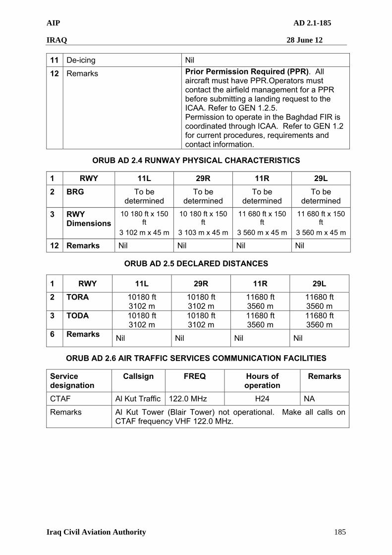
AIP AD 2.1-185
IRAQ 28 June 12
Iraq Civil Aviation Authority 185
11 De-icing Nil
12 Remarks Prior Permission Required (PPR). All aircraft must have PPR.Operators must contact the airfield management for a PPR before submitting a landing request to the ICAA. Refer to GEN 1.2.5. Permission to operate in the Baghdad FIR is coordinated through ICAA. Refer to GEN 1.2 for current procedures, requirements and contact information.
ORUB AD 2.4 RUNWAY PHYSICAL CHARACTERISTICS
1 RWY 11L 29R 11R 29L
2 BRG To be determined
To be determined
To be determined
To be determined
3 RWY Dimensions
10 180 ft x 150 ft
3 102 m x 45 m
10 180 ft x 150 ft
3 103 m x 45 m
11 680 ft x 150 ft
3 560 m x 45 m
11 680 ft x 150 ft
3 560 m x 45 m
12 Remarks Nil Nil Nil Nil
ORUB AD 2.5 DECLARED DISTANCES
1 RWY 11L 29R 11R 29L
2 TORA 10180 ft 3102 m
10180 ft 3102 m
11680 ft 3560 m
11680 ft 3560 m
3 TODA 10180 ft 3102 m
10180 ft 3102 m
11680 ft 3560 m
11680 ft 3560 m
6 Remarks Nil Nil Nil Nil
ORUB AD 2.6 AIR TRAFFIC SERVICES COMMUNICATION FACILITIES
Service designation
Callsign FREQ Hours of operation
Remarks
CTAF Al Kut Traffic 122.0 MHz H24 NA
Remarks Al Kut Tower (Blair Tower) not operational. Make all calls on CTAF frequency VHF 122.0 MHz.
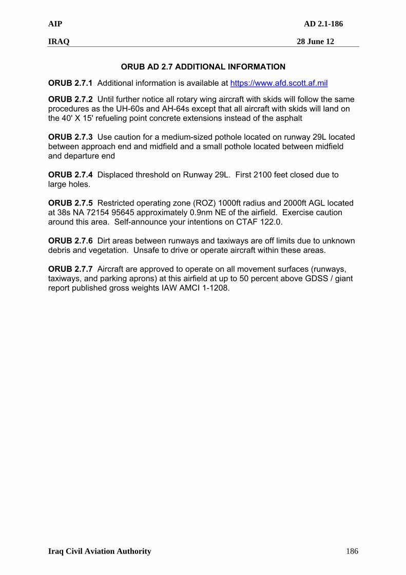
AIP AD 2.1-186
IRAQ 28 June 12
Iraq Civil Aviation Authority 186
ORUB AD 2.7 ADDITIONAL INFORMATION
ORUB 2.7.1 Additional information is available at https://www.afd.scott.af.mil
ORUB 2.7.2 Until further notice all rotary wing aircraft with skids will follow the same procedures as the UH-60s and AH-64s except that all aircraft with skids will land on the 40' X 15' refueling point concrete extensions instead of the asphalt ORUB 2.7.3 Use caution for a medium-sized pothole located on runway 29L located between approach end and midfield and a small pothole located between midfield and departure end ORUB 2.7.4 Displaced threshold on Runway 29L. First 2100 feet closed due to large holes. ORUB 2.7.5 Restricted operating zone (ROZ) 1000ft radius and 2000ft AGL located at 38s NA 72154 95645 approximately 0.9nm NE of the airfield. Exercise caution around this area. Self-announce your intentions on CTAF 122.0. ORUB 2.7.6 Dirt areas between runways and taxiways are off limits due to unknown debris and vegetation. Unsafe to drive or operate aircraft within these areas. ORUB 2.7.7 Aircraft are approved to operate on all movement surfaces (runways, taxiways, and parking aprons) at this airfield at up to 50 percent above GDSS / giant report published gross weights IAW AMCI 1-1208.
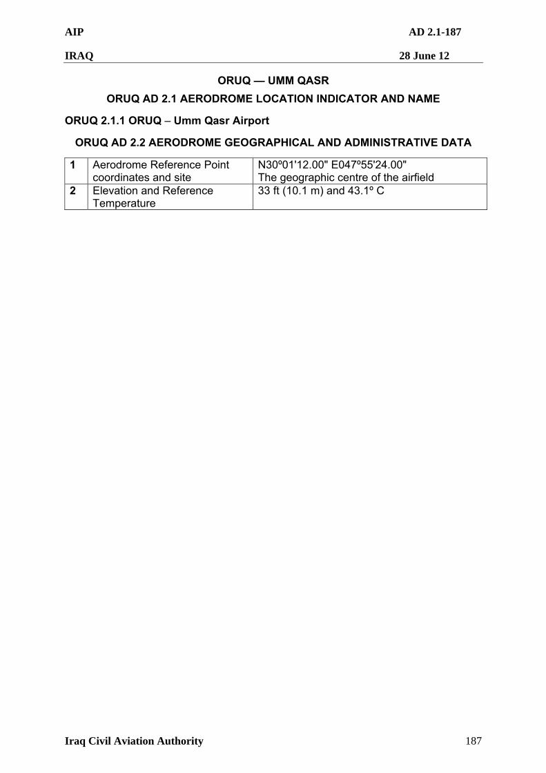
AIP AD 2.1-187
IRAQ 28 June 12
Iraq Civil Aviation Authority 187
ORUQ — UMM QASR
ORUQ AD 2.1 AERODROME LOCATION INDICATOR AND NAME
ORUQ 2.1.1 ORUQ – Umm Qasr Airport
ORUQ AD 2.2 AERODROME GEOGRAPHICAL AND ADMINISTRATIVE DATA
1 Aerodrome Reference Point coordinates and site
N30º01'12.00" E047º55'24.00" The geographic centre of the airfield
2 Elevation and Reference Temperature
33 ft (10.1 m) and 43.1º C
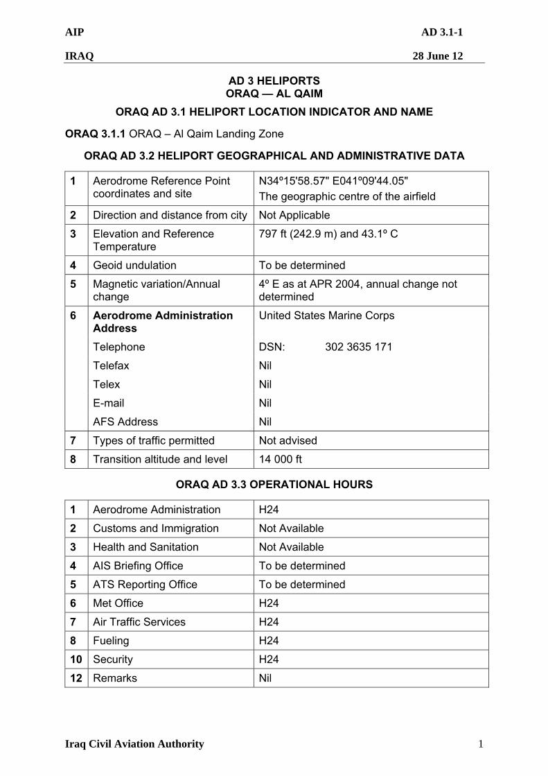
AIP AD 3.1-1
IRAQ 28 June 12
Iraq Civil Aviation Authority 1
AD 3 HELIPORTS ORAQ — AL QAIM
ORAQ AD 3.1 HELIPORT LOCATION INDICATOR AND NAME
ORAQ 3.1.1 ORAQ – Al Qaim Landing Zone
ORAQ AD 3.2 HELIPORT GEOGRAPHICAL AND ADMINISTRATIVE DATA
1 Aerodrome Reference Point coordinates and site
N34º15'58.57" E041º09'44.05"
The geographic centre of the airfield
2 Direction and distance from city Not Applicable
3 Elevation and Reference Temperature
797 ft (242.9 m) and 43.1º C
4 Geoid undulation To be determined
5 Magnetic variation/Annual change
4º E as at APR 2004, annual change not determined
Aerodrome Administration Address
United States Marine Corps
Telephone DSN: 302 3635 171
Telefax Nil
Telex Nil
E-mail Nil
6
AFS Address Nil
7 Types of traffic permitted Not advised
8 Transition altitude and level 14 000 ft
ORAQ AD 3.3 OPERATIONAL HOURS
1 Aerodrome Administration H24
2 Customs and Immigration Not Available
3 Health and Sanitation Not Available
4 AIS Briefing Office To be determined
5 ATS Reporting Office To be determined
6 Met Office H24
7 Air Traffic Services H24
8 Fueling H24
10 Security H24
12 Remarks Nil
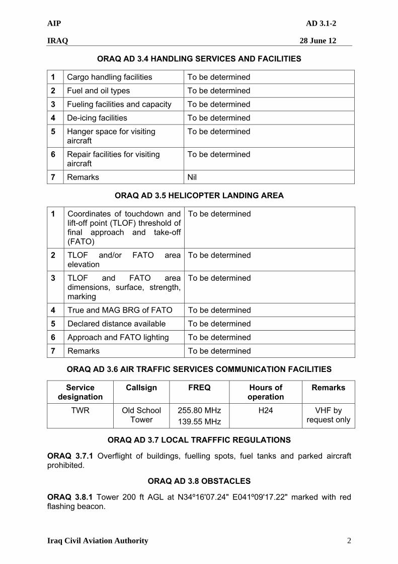
AIP AD 3.1-2
IRAQ 28 June 12
Iraq Civil Aviation Authority 2
ORAQ AD 3.4 HANDLING SERVICES AND FACILITIES
1 Cargo handling facilities To be determined
2 Fuel and oil types To be determined
3 Fueling facilities and capacity To be determined
4 De-icing facilities To be determined
5 Hanger space for visiting aircraft
To be determined
6 Repair facilities for visiting aircraft
To be determined
7 Remarks Nil
ORAQ AD 3.5 HELICOPTER LANDING AREA
1 Coordinates of touchdown and lift-off point (TLOF) threshold of final approach and take-off (FATO)
To be determined
2 TLOF and/or FATO area elevation
To be determined
3 TLOF and FATO area dimensions, surface, strength, marking
To be determined
4 True and MAG BRG of FATO To be determined
5 Declared distance available To be determined
6 Approach and FATO lighting To be determined
7 Remarks To be determined
ORAQ AD 3.6 AIR TRAFFIC SERVICES COMMUNICATION FACILITIES
Service designation
Callsign FREQ Hours of operation
Remarks
TWR Old School Tower
255.80 MHz
139.55 MHz
H24 VHF by request only
ORAQ AD 3.7 LOCAL TRAFFFIC REGULATIONS
ORAQ 3.7.1 Overflight of buildings, fuelling spots, fuel tanks and parked aircraft prohibited.
ORAQ AD 3.8 OBSTACLES
ORAQ 3.8.1 Tower 200 ft AGL at N34º16'07.24" E041º09'17.22" marked with red flashing beacon.
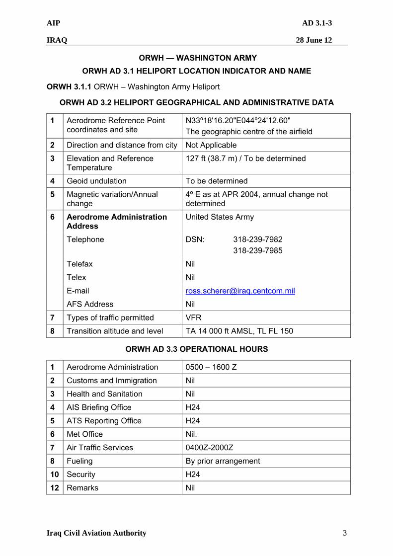
AIP AD 3.1-3
IRAQ 28 June 12
Iraq Civil Aviation Authority 3
ORWH — WASHINGTON ARMY
ORWH AD 3.1 HELIPORT LOCATION INDICATOR AND NAME
ORWH 3.1.1 ORWH – Washington Army Heliport
ORWH AD 3.2 HELIPORT GEOGRAPHICAL AND ADMINISTRATIVE DATA
1 Aerodrome Reference Point coordinates and site
N33º18'16.20"E044º24'12.60"
The geographic centre of the airfield
2 Direction and distance from city Not Applicable
3 Elevation and Reference Temperature
127 ft (38.7 m) / To be determined
4 Geoid undulation To be determined
5 Magnetic variation/Annual change
4º E as at APR 2004, annual change not determined
Aerodrome Administration Address
United States Army
Telephone DSN: 318-239-7982
318-239-7985
Telefax Nil
Telex Nil
E-mail [email protected]
6
AFS Address Nil
7 Types of traffic permitted VFR
8 Transition altitude and level TA 14 000 ft AMSL, TL FL 150
ORWH AD 3.3 OPERATIONAL HOURS
1 Aerodrome Administration 0500 – 1600 Z
2 Customs and Immigration Nil
3 Health and Sanitation Nil
4 AIS Briefing Office H24
5 ATS Reporting Office H24
6 Met Office Nil.
7 Air Traffic Services 0400Z-2000Z
8 Fueling By prior arrangement
10 Security H24
12 Remarks Nil
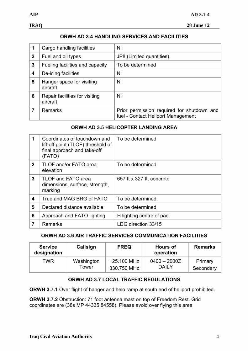
AIP AD 3.1-4
IRAQ 28 June 12
Iraq Civil Aviation Authority 4
ORWH AD 3.4 HANDLING SERVICES AND FACILITIES
1 Cargo handling facilities Nil
2 Fuel and oil types JP8 (Limited quantities)
3 Fueling facilities and capacity To be determined
4 De-icing facilities Nil
5 Hanger space for visiting aircraft
Nil
6 Repair facilities for visiting aircraft
Nil
7 Remarks Prior permission required for shutdown and fuel - Contact Heliport Management
ORWH AD 3.5 HELICOPTER LANDING AREA
1 Coordinates of touchdown and lift-off point (TLOF) threshold of final approach and take-off (FATO)
To be determined
2 TLOF and/or FATO area elevation
To be determined
3 TLOF and FATO area dimensions, surface, strength, marking
657 ft x 327 ft, concrete
4 True and MAG BRG of FATO To be determined
5 Declared distance available To be determined
6 Approach and FATO lighting H lighting centre of pad
7 Remarks LDG direction 33/15
ORWH AD 3.6 AIR TRAFFIC SERVICES COMMUNICATION FACILITIES
Service designation
Callsign FREQ Hours of operation
Remarks
TWR Washington Tower
125.100 MHz
330.750 MHz
0400 – 2000Z DAILY
Primary
Secondary
ORWH AD 3.7 LOCAL TRAFFIC REGULATIONS
ORWH 3.7.1 Over flight of hanger and helo ramp at south end of heliport prohibited.
ORWH 3.7.2 Obstruction: 71 foot antenna mast on top of Freedom Rest. Grid coordinates are (38s MP 44335 84558). Please avoid over flying this area