Integrating Ecological, Social and Cultural Dimensions in the Implementation of the Landscape...
12
This article was downloaded by: [Malgorzata Blicharska] On: 07 March 2012, At: 12:38 Publisher: Routledge Informa Ltd Registered in England and Wales Registered Number: 1072954 Registered office: Mortimer House, 37-41 Mortimer Street, London W1T 3JH, UK Landscape Research Publication details, including instructions for authors and subscription information: http://www.tandfonline.com/loi/clar20 Integrating Ecological, Social and Cultural Dimensions in the Implementation of the Landscape Convention Grzegorz Mikusiński a b , Malgorzata Blicharska a , Hans Antonson c , Marianne Henningsson d , Görgen Göransson e , Per Angelstam a & Andreas Seiler b a School for Forest Management, Swedish University of Agricultural Sciences, Sweden b Grimsö Wildlife Research Station, Department of Ecology, Swedish University of Agricultural Sciences, Sweden c Swedish National Road and Transport Research Institute, Linköping, Sweden d School of Education Psychology and Sports Science, Linnaeus University, Sweden e Department of Natural Sciences, Linnaeus University, Sweden Available online: 28 Feb 2012 To cite this article: Grzegorz Mikusiński, Malgorzata Blicharska, Hans Antonson, Marianne Henningsson, Görgen Göransson, Per Angelstam & Andreas Seiler (2012): Integrating Ecological, Social and Cultural Dimensions in the Implementation of the Landscape Convention, Landscape Research, DOI:10.1080/01426397.2011.650629 To link to this article: http://dx.doi.org/10.1080/01426397.2011.650629 PLEASE SCROLL DOWN FOR ARTICLE Full terms and conditions of use: http://www.tandfonline.com/page/terms-and- conditions
-
Upload
independent -
Category
Documents
-
view
0 -
download
0
Transcript of Integrating Ecological, Social and Cultural Dimensions in the Implementation of the Landscape...

This article was downloaded by: [Malgorzata Blicharska]On: 07 March 2012, At: 12:38Publisher: RoutledgeInforma Ltd Registered in England and Wales Registered Number: 1072954 Registeredoffice: Mortimer House, 37-41 Mortimer Street, London W1T 3JH, UK
Landscape ResearchPublication details, including instructions for authors andsubscription information:http://www.tandfonline.com/loi/clar20
Integrating Ecological, Socialand Cultural Dimensions in theImplementation of the LandscapeConventionGrzegorz Mikusiński a b , Malgorzata Blicharska a , Hans Antonsonc , Marianne Henningsson d , Görgen Göransson e , Per Angelstam a
& Andreas Seiler ba School for Forest Management, Swedish University ofAgricultural Sciences, Swedenb Grimsö Wildlife Research Station, Department of Ecology,Swedish University of Agricultural Sciences, Swedenc Swedish National Road and Transport Research Institute,Linköping, Swedend School of Education Psychology and Sports Science, LinnaeusUniversity, Swedene Department of Natural Sciences, Linnaeus University, Sweden
Available online: 28 Feb 2012
To cite this article: Grzegorz Mikusiński, Malgorzata Blicharska, Hans Antonson, MarianneHenningsson, Görgen Göransson, Per Angelstam & Andreas Seiler (2012): Integrating Ecological,Social and Cultural Dimensions in the Implementation of the Landscape Convention, LandscapeResearch, DOI:10.1080/01426397.2011.650629
To link to this article: http://dx.doi.org/10.1080/01426397.2011.650629
PLEASE SCROLL DOWN FOR ARTICLE
Full terms and conditions of use: http://www.tandfonline.com/page/terms-and-conditions

This article may be used for research, teaching, and private study purposes. Anysubstantial or systematic reproduction, redistribution, reselling, loan, sub-licensing,systematic supply, or distribution in any form to anyone is expressly forbidden.
The publisher does not give any warranty express or implied or make any representationthat the contents will be complete or accurate or up to date. The accuracy of anyinstructions, formulae, and drug doses should be independently verified with primarysources. The publisher shall not be liable for any loss, actions, claims, proceedings,demand, or costs or damages whatsoever or howsoever caused arising directly orindirectly in connection with or arising out of the use of this material.
Dow
nloa
ded
by [
Mal
gorz
ata
Blic
hars
ka]
at 1
2:38
07
Mar
ch 2
012

Integrating Ecological, Social andCultural Dimensions in theImplementation of the LandscapeConvention
GRZEGORZ MIKUSINSKI*,**, MALGORZATA BLICHARSKA*,HANS ANTONSON{, MARIANNE HENNINGSSON{, GORGENGORANSSONx, PER ANGELSTAM* & ANDREAS SEILER***School for Forest Management, Swedish University of Agricultural Sciences, Sweden **Grimso Wildlife
Research Station, Department of Ecology, Swedish University of Agricultural Sciences, Sweden {SwedishNational Road and Transport Research Institute, Linkoping, Sweden {School of Education Psychology
and Sports Science, Linnaeus University, Sweden xDepartment of Natural Sciences, Linnaeus University,
Sweden
ABSTRACT Implementation of the European Landscape Convention requires new tools that linkecological, social and cultural dimensions in practical planning. Here, we propose connectivity asa conceptual tool to include different dimensions into landscape and spatial planning. We presenta short review of the connectivity concept in relation to ecological, social and cultural dimensionsand illustrate it by examples from a real landscape planning case.
KEY WORDS: European Landscape Convention, landscape connectivity, landscape planning,multifunctionality
Introduction
The European Landscape Convention (ELC) defines a landscape as an area,perceived by people, evolving through time due to both natural forces and humanfactors (Council of Europe, 2000), thereby reflecting the idea of landscape as anintegrated social-ecological system (Matthews & Selman, 2006). The ELC calls forinstruments to incorporate the landscape concept into national policies, and in thepractical work of planners in order to enable successful protection, management andplanning of landscapes. The ELC stresses that ‘‘. . . landscape has an importantpublic interest role in the cultural, ecological, environmental and social fields, andconstitutes a resource favourable to economic activity and whose protection,management and planning can contribute to job creation’’. However, integration ofneither ecological nor social and cultural components is sufficiently incorporated in
Correspondence Address: Grzegorz Mikusinski, School for Forest Management, Faculty of Forest
Sciences, Swedish University of Agricultural Sciences, SE-739 21 Skinnskatteberg, Sweden.
Email: [email protected]
Landscape Research,2012, 1–10, iFirst article
ISSN 0142-6397 Print/1469-9710 Online/12/000001-10 � 2012 Landscape Research Group Ltd
http://dx.doi.org/10.1080/01426397.2011.650629
Dow
nloa
ded
by [
Mal
gorz
ata
Blic
hars
ka]
at 1
2:38
07
Mar
ch 2
012

practical planning (Brunetta & Voghera, 2008), and is still not fully developed inresearch. Scientists often focus on landscape assessment and description of particularvalues (Mander & Uuemaa, 2010), but rarely provide simple practical planning toolsthat link different dimensions (Antonson, 2009a, 2009b).
Recent developments in landscape ecology, linking landscape characteristics anddynamics with occurrence and movements of different species, have provided toolsand concepts that are gradually being used by planners (Opdam et al., 2001). Weargue that some concepts derived from ecological sciences could also be used inrelation to humans, and simultaneously support the integration of ecological, socialand cultural dimensions in spatial planning.
The aim of this short communication is to suggest the use of the connectivityconcept in practical implementation of the ELC. We first review the concept ofconnectivity in relation to different dimensions. Then, we present an example ofecological connectivity in a landscape in central Sweden, and demonstrate prospectsfor applying similar concept to spatial considerations for human dimensions of thelandscape, in relation to two aspects: present human movement and culturalheritage values in the same area. Finally, we discuss possibilities of applying theconnectivity concept as a tool to include different dimensions into landscapeand spatial planning, thereby assisting a successful implementation of the ELC.The ELC has just been ratified by the Swedish government but has been mentionedin the Swedish Road Administration’s EIA handbooks since 2004 (Antonson,2011).
Connectivity
In ecology, the connectivity concept has been used to characterise a landscape fromthe perspective of organisms’ habitat, and to deal with the problems of habitat lossand fragmentation, the major causes of biodiversity decline (Taylor et al., 1993).From an ecological perspective, connectivity thus refers to the functional relation-ship among habitat patches and the movement responses of organisms to landscapestructure (With et al., 1997). Connectivity may be defined as the degree to which thelandscape facilitates or impedes organisms’ movement among resource patches(Taylor et al., 1993). A measure of overall landscape connectivity is not feasible(Kindlmann & Burel, 2008) as any landscape must be analysed for particular speciesor habitat features in relation to a specific management problem (e.g. Pascual-Hortal& Saura, 2008).
The connectivity concept is also applicable to humans who move across thelandscape as part of their activity pattern, in order to access resources like living,working or recreational spaces (e.g. Hayden, 2002; Perry, 1995), and recognise asense of place linked to cultural heritage (Tuan, 1977). From a social perspective,high connectivity would thus mean that people have good access to necessaryresources. However, human-related connectivity is a complex issue. For example,the same landscape may be very suitable for short distance movements, linked toeveryday activities, but at the same time perceived as poorly connected to moreremote places that may also be important for people from the area. Thus, as fordifferent species, the definition of what is a ‘necessary resource’ depends on theparticular context and the scale at which we consider connectivity. Due to
2 G. Mikusinski et al.
Dow
nloa
ded
by [
Mal
gorz
ata
Blic
hars
ka]
at 1
2:38
07
Mar
ch 2
012

infrastructure developments in human societies, the spatial distribution of resources,the distance among them, and the level of human needs that define the degree ofconnectivity in a landscape, are changing. Moreover, connectivity may be considerednot only from the point of view of present human needs but also in relation to‘‘historical connections that still remain’’ (Antonson et al., 2010). The knowledgeconcerning the historical connectivity including the distribution of various landscapeelements influencing this connectivity may be perceived as ancient landscape linkagesworthy of being acknowledged, and if essential, preserved as part of the culturalheritage. However, it is important to stress that cultural heritage connectivity (CHC)does not deal only with ancient features such as avenues lined with trees betweena manor house and the crofters’ houses. Connectivity can be of one or severalsubsidiary types of functional connections. Cultural heritage is not just defined asobjects and sites of historic interest, but encompasses entire landscapes, saleablecommodities (i.e. tourist attractions), and inhabitant perceptions (Ashworth &Larkham, 1994). A bottom-up approach, viewing cultural heritage outside thetraditional antiquarian box, is in line with the ELC focus on public participation.
Connectivity in Infrastructure Planning: An Example
We visualised examples of ecological, social and cultural dimensions of theconnectivity concept in a 10 x10 km area with a newly established corridor locatedwest of Orebro, southern Sweden, for road E18 between Stockholm and Oslo(Figure 1). The area is rural with scattered farms.
Ecological Connectivity
To illustrate ecological connectivity we used data on the spatial distribution of twomajor and distinctive vegetation types, deciduous forest and grassland (pastures),and created maps illustrating allocation of the habitat networks (sensu Bani et al.,2002) based on these vegetation types. Both deciduous forests and open grasslandsare considered in Scandinavia as habitats of special conservation interest andharbour large numbers of threatened species (Berg et al., 1994; Ihse, 1995).Moreover, both habitat types are usually highly fragmented in contemporarylandscapes and many dependent species have to move between habitat patches inorder to satisfy their needs at individual and population levels (Angelstam et al.,2004). We used two different maximum inter-patch distances, 100 m and 400 m,thereby illustrating landscape connectivity for two virtual species (Mikusinski &Edenius, 2006) with different mobility levels for each habitat type. As a source ofinformation on the distribution of deciduous forest and grassland in the study areawe used the Swedish CORINE Land Cover Data (GSD-Marktackedata), obtainedfrom the Swedish Land Surveying Authority (www.lantmateriet.se).
A connected network of deciduous forest patches was located from north-east tosouth-west in the study area (Figure 2a). Open grasslands formed the largest habitatnetwork in the southern part of the study area (Figure 2b). The use of maximum400 m inter-patch distance yielded a high degree of connectivity for both habitattypes, whereas the 100 m distance produced a generally lower degree of connectivity,especially for open grasslands. The new four-lane motorway that crosses the study in
Implementation of the Landscape Convention 3
Dow
nloa
ded
by [
Mal
gorz
ata
Blic
hars
ka]
at 1
2:38
07
Mar
ch 2
012

east–west direction divides the largest network of deciduous forest (Figure 2a), andmay cause impediment for movement of species dependent on this habitat type.It also divides the largest concentration of deciduous forest located in the middle ofthe study area. At the same time, the motorway omits the largest network ofopen grassland, but still intersects some smaller habitat linkages in several places(Figure 2b).
Social Dimension
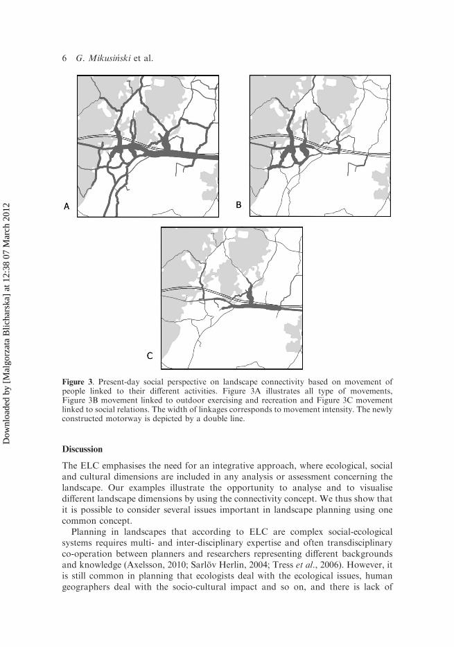
To visualise the present human movements in the 10 x 10 km study area we useddata from 84 responses from people in the area to a questionnaire carried out in 2008(Henningsson et al., unpubl.). The respondents were asked to mark the location oftheir houses on a map, as well as the places they usually visited, for what purpose,how often, and what road they used to get there. The visits were categorisedaccording to the reported visit frequencies:42 times per month (1), 2–4 times permonth (2), 2–4 times per week (3), 5–7 times per week (4), and the frequencies weresummed. As a result, maps illustrating the respondents’ movements relating toparticular activities in the area were created (Figure 3). Movements related to out-door exercise and recreation were concentrated to the western part of the study area,
Figure 1. Aerial photo of the mixed forest and agricultural landscape in the study area. The oldE18 goes from east to west on the right, while construction of a new road is visible in the upperleft corner of the picture. Deciduous forest is located mostly in vicinity of settlements, in forestedges and as woodlots in agricultural landscape. Photo: G. Mikusinski.
4 G. Mikusinski et al.
Dow
nloa
ded
by [
Mal
gorz
ata
Blic
hars
ka]
at 1
2:38
07
Mar
ch 2
012

around the village of Lanna (Figure 3b). On the other hand, mobility related tosocial relations was observed to concentrate to the eastern part of the study area(Figure 3c). It is noteworthy that, according to our analysis, the respondents did notcross the new road much. The main movement patterns were concentrated northfrom the road and most crossings were located in the western part. The map suggeststherefore that the new E18 motorway does not constitute any major barrier for dailymovements of people in the area. However, people perceived some difficulties toaccess recreation areas (Henningsson et al., unpubl.).
Cultural Heritage Connectivity
To illustrate CHC we used existing data in the form of a small-scale historic map, theso-called stomkarta, that is, the groundwork for the hundred (harad) map (Jansson,1993). Two settlement categories were used to model past human movement: a) oldhamlet sites before they were split up and moved to other places as single farmsteadsduring the Statutory Partition1, and b) crofts that belonged to a certain hamlet.These two settlement categories represent one of many daily movements in the pastlandscape where the crofters, who did not own the croft, got the duties of the day atthe hamlet as a form of rent. In order to illustrate the CHC, lines representingmovements of people were drawn between the crofts and the hamlets on the thematicmap (Figure 4). According to our spatial model, most crofters had to travel relativelylong distances to get to the hamlet; the longest were about 3.8 kilometres as the crowflies (Figure 4). The newly constructed road seems not to interfere to a large degreewith the historical connections, expressed by the CHC.
Figure 2. Maps illustrating ecological connectivity in the study area from the perspective of anorganism being dependent on deciduous forests (A) and an organism being dependent on opengrasslands (B). The darkest shading depicts actual habitat patches (i.e. deciduous forest andopen grassland), intermediate shading illustrates their connectivity based on physicalproximity (i.e. interpatch distance) of 100 m, and finally light shading delineates theirconnectivity based on physical proximity of 400 m. In addition, the newly constructedmotorway is depicted by a line.
Implementation of the Landscape Convention 5
Dow
nloa
ded
by [
Mal
gorz
ata
Blic
hars
ka]
at 1
2:38
07
Mar
ch 2
012
Discussion
The ELC emphasises the need for an integrative approach, where ecological, socialand cultural dimensions are included in any analysis or assessment concerning thelandscape. Our examples illustrate the opportunity to analyse and to visualisedifferent landscape dimensions by using the connectivity concept. We thus show thatit is possible to consider several issues important in landscape planning using onecommon concept.
Planning in landscapes that according to ELC are complex social-ecologicalsystems requires multi- and inter-disciplinary expertise and often transdisciplinaryco-operation between planners and researchers representing different backgroundsand knowledge (Axelsson, 2010; Sarlov Herlin, 2004; Tress et al., 2006). However, itis still common in planning that ecologists deal with the ecological issues, humangeographers deal with the socio-cultural impact and so on, and there is lack of
Figure 3. Present-day social perspective on landscape connectivity based on movement ofpeople linked to their different activities. Figure 3A illustrates all type of movements,Figure 3B movement linked to outdoor exercising and recreation and Figure 3C movementlinked to social relations. The width of linkages corresponds to movement intensity. The newlyconstructed motorway is depicted by a double line.
6 G. Mikusinski et al.
Dow
nloa
ded
by [
Mal
gorz
ata
Blic
hars
ka]
at 1
2:38
07
Mar
ch 2
012

integration of different landscape aspects (Antonson, 2011). A common conceptualplatform, such as the concept of connectivity, may be helpful for integration ofdifferent dimensions and different disciplines in practical planning. The concept can beused both in the assessment of actual landscape values, and to facilitate communica-tion between different actors within the planning processes, for example, professionalsand lay men. It can also be a useful tool for educating planners and the general publicon diverse landscape dimensions. The ELC stresses the need for proper assessment oflandscapes, raising awareness of the general public, and enhancing knowledge amongplanners on landscapes as social-ecological systems. The ELC implementation work inEuropean countries has by now focused on the identification and assessment ofdifferent landscape types, and dissemination of information concerning particularvalues (Brunetta & Voghera, 2008). Simple analyses, such as presented in this shortcommunication, resulting in maps that in a simple way visualise issues important forlandscape planning may also assist planners, decision-makers and the general public inthinking about landscape in a comprehensive way.
It is especially important to encourage learning in relation to some landscapesissues that are neglected in assessment and planning. For example, Antonson et al.(2010) has pointed out that cultural heritage aspects were underrepresented in
Figure 4. Map illustrating cultural heritage perspective on the landscape connectivity. Linesdepict deduced movement of people between their houses and work at the farms based on the‘stomkarta’. The newly constructed motorway is depicted by a double line.
Implementation of the Landscape Convention 7
Dow
nloa
ded
by [
Mal
gorz
ata
Blic
hars
ka]
at 1
2:38
07
Mar
ch 2
012

Swedish EIA reports, when compared to the ecological dimension. A fundamentalproblem is the lack of a comprehensive assessment of cultural heritage values, causedby both ambiguities in their interpretation, and lack of tools to identify them, as wellas by the lack of clear guidance in relation to these issues (Antonson et al., 2010).Compared with ecological features, intangible social and cultural heritage values aredifficult to measure and to communicate to both planners and the general public(English & Lee, 2004). Additionally, in other European countries, landscape issuesare not treated in a comprehensive way in planning. For example, Byron et al. (2000)found many deficiencies in the EIA reports concerning road projects, and Bond et al.(2004) provided evidence for inadequate consideration of cultural heritage in theEIA in chosen development projects within the EU.
Our approach is, of course, a gross simplification of such a complex issue aslandscape. We focused only on three aspects of landscape connectivity (ecological,social and cultural) in the case study area (i.e. a new road corridor). This approachmay be seen as ‘top-down’ and expert-oriented. However, in the future developmentsof the use of connectivity concept in practical planning, landscape perceptions ofpeople inhabiting the area of interest could also be included. Ecological, social andcultural aspects of landscape connectivity do not exhaust the list of aspectsimportant for landscape planning (Grazuleviciute-Vileniskea & Matijosaitiene,2010). Additionally, visual/aesthetic/perceived dimensions of landscape, an issuetackled by many landscape researchers, could also be linked to considerations oflandscape connectivity (Kaplan & Kaplan, 1989; Kaplan et al., 1998). Fry et al.(2009) described a common conceptual ground of different visual and ecologicallandscape indicators, in search for tools improving an integrated landscape planning.For example, they relate ecological connectivity to the concept of landscapeconnectedness, a degree of physical connection between patches. Connectedness,enhanced by corridors and hindered by barriers, impacts both the aesthetics and theecological function of the landscape. The overview of visual and ecologicalindicators presented by Fry et al. (2009) constitute an important theoretical basisfor understanding particular indicators relating to both ecological and socialdimensions of landscape and their potential for use in planning. However, suchrepresentation of theoretical assumptions seems to be complicated, and there are stillmany challenges in the interpretation of indicators and possible overlap betweenthem. Thus, we argue that for practical planning and education there is a need forsimple tools that capture the multitude of issues without going into deepertheoretical considerations.
In our example of a highway corridor we illustrate landscape functions that relateto wild organisms, to current and historic movement of people, and show howconnectivity can be incorporated into the planning issue of building a new majorroad. We argue that simple maps, that in a comparable way illustrate ecological,social and cultural dimensions of landscapes, may work better in grasping themultifunctionality of the landscapes than elaborated and complex models do. Toassist the implementation of ELC across Europe we hope that more effort will bemade among different disciplines involved in multifunctional landscape spatialplanning to propose simple methods for the analysis and assessment of differentlandscape functions, and to propose practical tools for communication andeducation.
8 G. Mikusinski et al.
Dow
nloa
ded
by [
Mal
gorz
ata
Blic
hars
ka]
at 1
2:38
07
Mar
ch 2
012

Acknowledgements
The present paper was developed within TransportMistra’s sub-program Includefunded by MISTRA, Swedish Road Administration, Swedish National RailAdministration, Swedish Environmental Protection Agency and Swedish NationalHeritage Board. We are grateful to Anna Danell and two anonymous referees fortheir comments on the earlier version of this manuscript.
Note
1. The Statutory Partition (in Swedish, Laga skifte) was a Swedish agricultural reform (1827–1928) with a
very radical aim. Not only should each farm get a few large holdings, the farms were also to move from
the hamlet/village toft community and become single farmsteads on the respectively holding.
References
Angelstam, P., Roberge, J.-M., Lohmus, A., Bergmanis, M., Brazaitis, G., Donz-Breuss, M., Edenius, L.,
Kosinski, Z., Kurlavicius, P., L�armanis, V., L�ukins, M., Mikusinski, G., Ra�cinskis, E., Strazds, M. &
Tryjanowski, P. (2004) Habitat modelling as a tool for landscape-scale conservation—a review of
parameters for focal forest birds, Ecological Bulletins, 51, pp. 427–453.
Antonson, H. (2009a) Bridging the gap between research and planning practice concerning landscape in
Swedish infrastructural planning, Land Use Policy, 26, pp. 169–177.
Antonson, H. (2009b) Landscapes with history: Addressing shortcomings in Swedish EIAs, Land Use
Policy, 26, pp. 704–714.
Antonson, H. (2011) The treatment of landscape in a Swedish EIA process, Environmental Impact
Assessment Review, 31, pp. 195–205.
Antonson, H., Gustafsson, M. & Angelstam, P. (2010) Cultural Heritage Connectivity in the landscape: A
tool for EIA in infrastructure planning, Transportation Research D, 15, pp. 463–472.
Ashworth, G. J. & Larkham, P. J. (1994) A heritage for Europe, in: G. J. Ashworth & P. J. Larkham (Eds)
Building a New Heritage, pp. 1–9 (London: Routledge).
Axelsson, R. (2010) Integrative research and transdisciplinary knowledge production: A review of barriers
and bridges, Journal of Landscape Ecology, 4, pp. 14–40.
Bani, L., Baietto, M., Bottoni, L. & Massa, R. (2002) The use of focal species in designing a habitat
network for a lowland area of Lombardy, Italy, Conservation Biology, 16, pp. 826–831.
Berg, A., Ehnstrom, B., Gustafsson, L., Hallingback, T., Jonsell, M. & Weslien, J. (1994) Threatened
plant, animal, and fungus species in Swedish forests: Distribution and habitat associations, Conservation
Biology, 8, pp. 718–731.
Bond, A., Langstaff, L., Baxter, R., Wallentinus, H.-G., Kofoed, J., Lisitzin, K. & Lundstrom, S. (2004)
Dealing with the cultural heritage aspect of environmental impact assessment in Europe, Impact
Assessment and Project Appraisal, 22, pp. 37–45.
Brunetta, G. & Voghera, A. (2008) Evaluating landscape for shared values: tools, principles, and methods,
Landscape Research, 33, pp. 71–87.
Byron, H. J., Treweek, J. R., Sheate, W. R. & Thompson, S. (2000) Road developments in the UK: An
analysis of ecological assessment in environmental impact statements produced between 1993 and 1997,
Journal of Environmental Planning and Management, 43, pp. 71–97.
Council of Europe (2000) European Landscape Convention. European Treaty Series No. 176. Florence.
English, A. J., & Lee, E. (2004) Managing the intangible, The George Wright FORUM, 21, pp. 23–33.
Fry, G., Tveit, M. S., Ode, A. & Velarde, M. D. (2009) The ecology of visual landscapes: Exploring the
conceptual common ground of visual and ecological landscape indicators, Ecological Indicators, 9,
pp. 933–947.
Grazuleviciute-Vileniskea, I. & Matijosaitiene, I. (2010) Cultural heritage of roads and road landscapes:
Classification and insights on valuation, Landscape Research, 35, pp. 391–413.
Hayden, D. (2002) Redesigning the American Dream: The Future of Housing Work and Family Life, rev.
exp. edn (New York: W. W. Norton & Company).
Implementation of the Landscape Convention 9
Dow
nloa
ded
by [
Mal
gorz
ata
Blic
hars
ka]
at 1
2:38
07
Mar
ch 2
012

Henningsson, M., Mikusinski, M., Antonson, H., Folkesson, L., Goransson, G. & Jonsson, S.
(Unpublished) Landscape values and outdoor recreation in road planning—a case study on a new
Swedish highway.
Ihse, M. (1995) Swedish agricultural landscapes: Patterns and changes during the last 50 years, studied by
aerial photos, Landscape and Urban Planning, 31, pp. 21–37.
Jansson, U. (1993) Ekonomiska kartor 1800–1934. En studie av smaskaliga kartor med information om
markanvandning (Stockholm: Riksantikvarieambetet).
Kaplan, R. & Kaplan, S. (1989) The Experience of Nature (Cambridge: Cambridge University Press).
Kaplan, R., Kaplan, A. & Ryan, R. L. (1998) With People in Mind: Design and Management of Everyday
Nature (Washington, DC: Island Press).
Kindlmann, P. & Burel, F. (2008) Connectivity measures: A review, Landscape Ecology, 23, pp. 879–890.
Mander, U. & Uuemaa, E. (2010) Landscape assessment for sustainable planning, Ecological Indicators,
10, pp. 1–3.
Matthews, R. & Selman, P. (2006) Landscape as a focus for integrating human and environmental
processes, Journal of Agricultural Economics, 57, pp. 199–212.
Mikusinski, G. & Edenius, L. (2006) Assessment of spatial functionality of old forest in Sweden as habitat
for virtual species, Scandinavian Journal of Forest Research, 21 (Suppl. 7), pp. 73–83.
Opdam, P., Foppen, R. & Vos, C. (2001) Bridging the gap between ecology and spatial planning in
landscape ecology, Landscape Ecology, 16, pp. 767–779.
Pascual-Hortal, L. & Saura, S. (2008) Integrating landscape connectivity in broad-scale forest planning
through a new graph-based habitat availability methodology: Application to capercaillie (Tetrao
urogallus) in Catalonia (NE Spain), European Journal of Forest Research, 127, pp. 23–31.
Perry, D. C. (1995) Making space: Planning as a mode of thought, in: H. Liggett & D. C. Perry (Eds)
Spatial Practices: Critical Explorations in Social/Spatial Theory, pp. 209–242 (London: SAGE).
Sarlov Herlin, I. (2004) New challenges in the field of spatial planning: Landscapes, Landscape Research,
29, pp. 399–411.
Taylor, P. D., Fahrig, L., Henein, K. & Merriam, G. (1993) Connectivity is a vital element of landscape
structure, Oikos, 68, pp. 571–573.
Tress, B., Tress, G., Fry, G. & Opdam, P. (2006) From Landscape Research to Landscape Planning. Aspects
of Integration, Education and Application (Dordrecht, The Netherlands: Springer).
Tuan, Y. F. (1977) Space and Place: The Perspective of Experience (Minneapolis: University of Minnesota
Press).
With, K. A., Gardner, R. H. & Turner, M. G. (1997) Landscape connectivity and population distributions
in heterogeneous environments, Oikos, 78, pp. 151–169.
10 G. Mikusinski et al.
Dow
nloa
ded
by [
Mal
gorz
ata
Blic
hars
ka]
at 1
2:38
07
Mar
ch 2
012