Institutional Adaptation to Climate Change and Flooding in ...
111
Institutional Adaptation to Climate Change and Flooding in Accra, Ghana A thesis presented to the faculty of the Voinovich School of Leadership & Public Affairs In partial fulfillment of the requirements for the degree Master of Science Audrey N. K. Komey August 2015 © 2015 Audrey N. K. Komey. All Rights Reserved.
-
Upload
khangminh22 -
Category
Documents
-
view
5 -
download
0
Transcript of Institutional Adaptation to Climate Change and Flooding in ...

Institutional Adaptation to Climate Change and Flooding in Accra,
Ghana
A thesis presented to
the faculty of
the Voinovich School of Leadership & Public Affairs
In partial fulfillment
of the requirements for the degree
Master of Science
Audrey N. K. Komey
August 2015
© 2015 Audrey N. K. Komey. All Rights Reserved.

2
This thesis titled
Institutional Adaptation to Climate Change and Flooding in Accra,
Ghana
by
AUDREY N. K. KOMEY
has been approved for
the Program of Environmental Studies
and the Voinovich School of Leadership & Public Affairs by
Elizabeth E. Wangui
Assistant Professor of Geography
Mark Weinberg
Director, Voinovich School of Leadership & Public Affairs

3
ABSTRACT
KOMEY, AUDREY N. K., M.S., August 2015, Environmental Studies
Institutional Adaptation to Climate Change and Flooding in Accra, Ghana
Director of Thesis: Elizabeth E. Wangui
In the wake of climate change and flood severity in Ghana, the government of
Ghana has developed a ten year adaptation strategy document (National Climate Change
Adaptation Strategy) to assist institutions and stakeholders in addressing the impact of
climate change in various sectors of the country. Institutional role has become necessary
in tackling flood simply because the success of any adaptation strategies in part depend on
the institutional arrangement in place and studies have been conducted to affirm this
argument (Agrawal, McSweeney & Perrin, 2008; IPCC 2013). This thesis focuses on an
analysis of the document and how it addresses flooding in the wake of climate change.
Flooding forms a major disaster that the country as a whole faces annually but focus is on
the Greater Accra region specifically the Accra Metropolitan Assembly (AMA). The study
documents the strengths and weaknesses of the document as a national adaptation
document. It establishes that though the document exists, it is not available to the
institutions and the assembly members for implementation of the strategies. Further, in
relation to local institutions, the research finds that assembly members are more committed
to addressing flood problems and taking the initiatives to undertake minor projects in their
communities to minimize the effects of flooding. These minor projects such as de-siltation
and clean ups are in themselves adaptation strategies (Linham & Nicholls 2010). The study
also finds that lack of communication among institutions, limited resources, lack of

4 institutional leadership and social connection in accessing resources were barriers to
successful planning and implementation of adaptation strategies.

5
ACKNOWLEDGMENTS
The successful completion of this thesis was made possible by the guidance and
immerse support of a lot of people and acknowledging them individually will just be
impossible. It is however my hope that the few names I mention will cover for all of them.
My first and utmost thank is to God Almighty, who for His guidance and abundant
grace has seen me through this work. I offer my sincerest gratitude to Dr Edna Wangui for
accepting to be the chair of my thesis committee. She has supported me throughout my
thesis with her patience and knowledge. I attribute the level of my Master’s degree to her
encouragement and effort. One simply could not wish for a better advisor. I also like to
thank the other committee members, Dr Geoffrey Dabelko and Dr Harold Perkins for their
inputs in the work.
To all selected officials and assembly members, thank you for making time out of
your busy schedule to allow me interview you and provide me with important information.
To Carl Sena Afenu, thank you for developing the drainage map of Accra. To my parents
and siblings, thank you for supporting me through all these years of education. Your
encouragement has seen me through difficult times.
Finally, I like to thank my husband Paa Kwesi for his support through this work
and to my daughter Nana Adowa for her love.

6
TABLE OF CONTENTS
Page
Abstract ................................................................................................................................3
Acknowledgments................................................................................................................5
List of Tables .......................................................................................................................9
List of Figures ....................................................................................................................10
List of Abbreviations .........................................................................................................11
Chapter One: Introduction .................................................................................................13
1.1 Background………………………………………………………………………..13
1.2 Significance of the Study………………………………………………………….15
1.3 Research Question………………………………………………………………...16
1.4 Presentation of Research…………………………………………………………..17
Chapter Two: Review of Literature ...................................................................................18
2.1 Introduction………………………………………………………………………..18
2.2 Conceptual Framework……………………………………………………………18
2.2.1 Institutions and Their Importance .....................................................................19
2.2.2 Institutional Barriers .........................................................................................21
2.2.3 Key Features of Adaptive Institutions ..............................................................24
2.2.3.1 Leadership………………………………………………………………..24
2.2.3.2 Resource…….…..………………………………………………………..25
2.2.3.3 Fair Governance…..………..…………………………………………….26
2.2.3.4 Variety……...…………………………………………………………….26
2.2.3.5 Learning Capacity…...………..…………...……………………………..26
2.2.3.6 Ability to Adapt...……………………………..………………………….27
2.2.4 Practical Assessment of the Key Features of Adaptive Institutions .................27
2.3 Climate Change Adaptation and Flooding………………………………………...30
2.3.1 Climate Change Adaptation ..............................................................................30
2.3.1.1 Planned Adaptation and Coastal Flooding……………………………….32
2.3.2 Definition of Flooding and Causes………………………………....………...34

7 Chapter Three: Study Area in Context ...............................................................................37
3.1 Introduction………………………………………………………………………..37
3.2 Climate Change Context in Ghana………………………………………………..37
3.3 Accra Metropolitan Assembly Context…………………………………………...38
3.3.1 History and Geographic Characteristics of AMA .............................................38
3.3.1.1 Geographic Location and Climate Variability…………………...…….…39
3.3.1.2 Geology…………..………………………………………………….…...42
3.3.1.3 Vegetation………..…….…………………………………………….......43
3.3.1.4 Drainage System in the Metropolis………………………………....……44
3.3.1.5 Demographic Characteristics……………….………..…………....……..45
3.3.1.6 Economic Infrastructure……………………………………………….....46
3.3.2 Flooding in Accra, Causes and Effects……………………………………….52
3.3.2.1 Causes of Flooding ………………………………………..…..….……..53
3.3.2.2 Effects of Accra Floods…………….……………….…………………...60
3.4 Institutional Profiling……………………………………………………………...62
3.4.1 Ministry of Environment, Science Technology and Innovation .......................62
3.4.2 Town and Country Planning Department .........................................................62
3.4.3 Accra Metropolitan Department .......................................................................63
3.4.4 National Disaster Management Organization ...................................................63
3.4.5 Hydrological Service of Ghana .........................................................................63
Chapter Four: Research Methodology ...............................................................................65
4.1 Data Needs and Sources…………………………………………………………..65
4.2 Data Collection……………………………………………………………………68
4.2.1 Key Informant Interviews .................................................................................68
4.2.2 Secondary Data .................................................................................................70
4.3 Data Analysis……………………………………………………………………...70
4.3.1 Key Informant Interview ...................................................................................70
4.3.2 Document Analysis ...........................................................................................71
4.4 Research Limitation……………………………………………………………….71
Chapter Five: Data Presentation and Analysis...................................................................72
5.1 Flooding as Addressed in the NCCAS……………………………………………72
8
5.2 Flood Control Practices Implemented by the Institutions………………………...78
5.2.1 Current Practices/Planned Adaptation Measures ..............................................79
5.2.2 Proposed Adaptation Measures .........................................................................82
5.3 Adaptive Capacity at Constituency Level…...…………………………………....86
Chapter Six: Recommendation and Conclusion ................................................................90
6.1 Introduction………………………………………………………………………..90
6.2 Lessons from Mozambique’s NAPA……………………………………………...90
6.3 Recommendations………………………………………………………………....92
6.4 Opportunities for Further Research……………...………………………………..95
6.5 Conclusion………………………………………………………………………...96
References ..........................................................................................................................98
Appendix A: Interview Guide…………………………………….…………..………...105

9
LIST OF TABLES
Page
Table 3.1: Demographic Figures of Accra Metropolitan Assembly by Sub Metros ......46
Table 3. 2: Stratification of Accra in Four Zones ...........................................................48
Table 3. 3: Flood Disaster in Ghana and the Number of People Affected .....................61
Table 3.4: Number of People Killed by Flood during the Period of 1995-2010 ............61
Table 4.1: Data Sources and Data Needs ........................................................................67

10
LIST OF FIGURES
Page
Figure 3.1: Map of Ghana showing the ten regions ........................................................40
Figure 3.2: Map of the districts of Greater Accra Region ..............................................41
Figure 3.3: Map of AMA showing the 11 sub metros ....................................................42
Figure 3.4: Drainage map showing major water bodies in Accra...................................45
Figure 3.5: 1st Class house located at East Legon ...........................................................49
Figure 3.6: 2nd Class house located at Kanda Estate .......................................................50
Figure 3.7: 3rd Class houses located at Jamestown .........................................................51
Figure 3.8: 4th Class settlement at Chorkor .....................................................................52
Figure 3.9: Houses obstructing the free flow of rain water ............................................57
Figure 3.10: A flooded street in Accra (Kwame Nkrumah Circle) .................................58
Figure 3.11: Open storm drainage carrying waste dumped by residents ........................58
Figure 3.12: An open drain choked with waste………………………………………...59 Figure 3.13: Poorly constructed open drain that is likely to serve as a dumping ground
for waste…………………………………………………………………..59
Figure 5.1: Dredging of the Korle Lagoon .....................................................................81

11
LIST OF ABBREVIATIONS
AMA Accra Metropolitan Area ASP Accra Sustainable Project CC DARE Climate Change and Development – Adapting by REducing
Vulnerability EXIM BANK Export Import Bank IHDP International Human Dimensions Program IMF International Monetary Fund IPCC Intergovernmental Panel on Climate Change IWMI International Water Management Institute ILGS Institute of Local Government Studies KLERP Korle Lagoon Ecological Restoration Project LEKMA Ledzokuku-Krowor Municipal Assembly MMDAs Metropolitan, Municipal and District Assemblies MESTI Ministry of Environment, Science, Technology and Innovation NAS National Adaptation Strategy NCCAS National Climate Change Adaptation Strategy NADMO National Disaster Management Organization NAPA National Adaptation Program of Action OPEC Organization of the Petroleum Exporting Countries PNDC Provisional National Defense Council SAP Structural Adjustment Program

12 TCPD Town and Country Planning Department UNDP United Nations Development Program UNEP United Nations Environment Program UGEC Urbanization and Global Environmental Change UNFCCC United Nations Framework Convention on Climate Change

13
CHAPTER ONE: INTRODUCTION
1.1 Background
The Intergovernmental Panel on Climate Change (2013) defines adaptation in the
human system as a process that seeks to moderate or avoid harm and exploit beneficial
opportunities. Human intervention may also facilitate adjustment to expected climate and
its effects in some natural systems. In short, adaptation is “the process of adjustment to
actual or expected climate and its effects” (p. 5). With the ultimate aim of adjusting or
making changes to current or expected events, climate change adaptation also aims at
reducing individuals or communities’ vulnerability and increasing its adaptive capacity.
Research has shown that developing countries stand a higher risk than more developed
countries of being affected severely by climate change (Gross 2002; Winkler 2005; Adger,
Huq, Brown, Conway & Hulme, 2003) and as such the need to adapt to climate change has
become a necessity.
With programs such as National Adaptation Programs of Action (NAPAs)
established under United Nations Framework Convention on Climate Change (UFCCC)
and Climate Change and Development – Adapting by REducing Vulnerability (CC DARE)
which is a joint program of United Nations Environment Program (UNEP) and United
Nations Development Program (UNDP), many developing countries have prepared a
national climate change adaptation document that outlines programs, plans and activities
to be undertaken.
Ghana developed a ten year (2010-2020) National Climate Change Adaptation
Strategy (NCCAS) under the initiative of CC DARE to address climate related issues in

14 the country. The basic goal of the document is to increase the country’s resilience to climate
change impacts now and in the future by building capacity in the area of infrastructure and
knowledge to deal with climate change impacts and reduce vulnerability in key sectors,
ecosystems, districts and regions of the country (NCCAS, 2010). With mounting evidence
indicating that Ghana stands the risk of been affected by the impact of climate change, the
preparation of the document appears to be a step in the right direction in terms of
adaptation.
According to a report by British Broadcasting Corporation World Service Trust
(2010), the country is likely to be affected by rising sea level and approximately 25 percent
of coastal area population will be the most affected. Additionally, at the current rate of sea
level rise, more than 100 square km of land area will be lost by 2050 and 132,000 people
displaced. Flooding, a major disaster in Accra is also expected to increase in frequency and
intensity. In addition to the climatic effects of flooding, other anthropogenic causes such
as urbanization, poor maintenance of drainage systems, inadequate storm drainages and
haphazard development also affect the severity of floods in the city (Karley, 2009; Afeku,
2005; Rain, Engstrom, Ludlow & Antos, 2011; Sam, 2009). In 2001 for example, 11 people
were killed and 100,000 people displaced when torrential rains hit Ghana. As institutions
recognize that immediate causes of flooding in the city must be addressed, they must also
think of future adaptation strategies and incorporate them into their current programs.
Institutions affect the social distribution of vulnerability, as well as determine the
management of climate-sensitive aspects of society and, in turn, the capacity to adapt
successfully (Næss, Bang, Eriksen & Vevatne, 2005). Studies have been carried out in

15 Ghana about flooding and climate change but very little has been done in relation to
institutions adapting to climate change as they also address the issue of flooding.
1.2 Significance of the Study
Climate change adaptation is fairly new to many institutions in Ghana and as such
not much has been done to include adaptation strategies into programs and plans. The
success of adaptation strategies in part depends on how institutions play a role in
implementing them. Therefore, establishing the main argument for this research that
institutions play an important role in adaptation planning and implementation will help
develop subsequent chapters and put the whole study in context.
This research will add to the small but growing literature on the significance of both
top-down and bottom up approaches to adaptation strategies. Top-down adaptation
approach as defined by Urwin & Jordan (2008), “assumes that legislation and policies set
explicit aims and objectives, providing a blueprint that is then translated into action on the
ground” (p. 183). Elmore (1978) on the other hand explained that bottom-up approach
begins at the last possible stage where administrative actions and private choices intersect
and recognizes the involvement or importance of other actors.
Combining the two approaches in policies and strategies is viewed as having
potential to strengthen local adaptation planning and implementation (Urwin & Jordan,
2008) and also open opportunities in the direction of reducing social vulnerability as top-
down actions alone do not necessarily respond to individual’s needs (Rodriguez, 2009).
This research demonstrates the degree to which national policies on climate change
adaptation are translated into practices at the local level and carried out by local assembly

16 members. It also shows the extent to which adaptation practices are either planned or
spontaneous.
Further, this research has potential to contribute to policy related to flooding. The
research has potential use by the Urbanization and Global Environmental Change (UGEC),
a core project of the International Human Dimensions Program (IHDP) which aims to
foster collaboration between academics, political decision-makers and practitioners to
adapt to the negative environmental impacts. The mission of UGEC is to better our
understanding of the global and regional “implications of urbanization and the complex
dynamic systems of urban areas that affect and are affected by global environmental
change” (UGEC, 2014 para. 1). Accra, being an urban city is faced with many problems
therefore understanding the implications that come with urbanization helps with adaptation
in this time of climate change.
Additionally, this project is aimed at contributing to the growing literature in the
field of coastal flooding and adaptation therefore based on recommendations that will be
presented later on in this project, further research can be conducted.
1.3 Research Question
Adaptation is about how countries adjust or make changes to current or expected
events which are aimed at reducing individuals or communities’ vulnerability and
increasing its adaptive capacity. The overarching objective of this research is to examine
one aspect of how institutions adapt to climate change by dealing specifically with flooding
in the city of Accra. The objective was realized through the following three research
questions;

17 1. How is flooding addressed in the National Climate Change Adaptation Strategy
(NCCAS) document?
2. How are the strategies in Ghana’s NCCAS document reflected in the practices of flood
control implemented by the institutions responsible for addressing flooding in the city?
3. In what ways, if any, do flood control practices of the institutions enhance adaptive
capacity at constituency level as perceived by assembly members?
1.4 Presentation of Research
The paper is organized in five chapters. Chapter two starts with a discussion of the
role of institutions, institutional barriers to successful planning and implementation of
adaptation strategies. The chapter ends with review of literature on climate change
adaptation and flooding. Chapter three focuses on the description of the study area, causes
and effects of flooding in Accra as well as the profiling of the institutions included in this
research. Chapter four provides the methods used to collect data and how the data was
interpreted. Data presentation and discussion is presented in chapter five and chapter six
provides recommendation, opportunities for further study and conclusion.

18
CHAPTER TWO: REVIEW OF LITERATURE
2.1 Introduction
This chapter examines existing literature that pertains to climate change adaptation
and how institutions play significant role in ensuring successful implementation of
adaptation strategies. The conceptual framework advances the main argument of this
research by discussing the role of institutions, institutional barriers to planning and
implementing adaptation strategies and the key qualities of adaptive institutions. The
literature review addresses climate change adaptation with focus on planned adaptation and
coastal flooding. The literature review is intended to provide an in-depth understanding of
the topic and identify the gap in research that will lead to further studies.
2.2 Conceptual Framework
This section outlines the conceptual framework which will be used as a guideline
for further discussion and analysis. To understand the role that institutions play in
successfully adapting to climate change, this section first explores the definition and
importance of institution. It further discusses some barriers that hinder institutions’ ability
to successfully plan and implement adaptation strategies. The next section examines the
key features of adaptive institution and finally a practical assessment of the key features in
four European countries. The study on the European countries is used in this research as a
practical example of Gupta et al’s (2008) theoretical framework because the study focused
on how institutions in these selected countries are able to adapt to climate change.

19
2.2.1 Institutions and their Importance
The simplest definition of institution is given by Hodgson (2006), “systems of
established and prevalent social rules that structure social interactions” (p. 2). Vatn (2005)
explains that, the definition of institution must emphasize on what they do. He defines
institutions as the legal rules of a society that regularize life, support values and protect and
produce interests. They also provide expectations, stability and meaning which are
essential to the existence and coordination of humans. Institutions can therefore determine
the success or failure of any societal project.
According to Agrawal, McSweeney, & Perrin (2008), since adaptation is local, it
is important to understand how local institutions shape adaptation and improve adaptive
capacity of the most vulnerable in society. The authors define local institutions as,
mechanisms that will translate the impact of future external interventions to facilitate
climate change adaptation. Additionally, local institutions shape the livelihood impacts of
hazards related to climate change through a wide range of functions such as resource
mobilization and allocation, information gathering and dissemination, providing
leadership, skills development and capacity building among others. Still on the discussion
of local institutions and adaptation, Agrawal, McSweeney & Perrin (2008) differentiated
between three types of local institutions relevant to adaptation. These institutions are civic,
public and private. Examples of civic society institutions include rural producer
organizations, cooperatives and savings and loans groups. In terms of public institutions,
extension services and other arms of higher levels of government operating at local levels
all form local government institutions and agencies. Private institutions on the other hand

20 comprise of Nongovernmental organizations, private businesses, charities and other private
insurance or loan companies.
Institutions are important to the adaptation of climate change because institutions
affect the social distribution of vulnerability, as well as determine the management of
climate-sensitive aspects of society and, in turn, the capacity to adapt successfully (Næss,
Bang, Eriksen & Vevatne 2005). The IPCC Fifth Assessment Report (2013) points out that,
government at all levels play important roles in enhancing the adaptive capacity and
advancing adaptation. In the case of developing countries, national governments are often
the point of contact and initial recipient of international adaptation funding.
Many researchers acknowledge that local institutions play a key role in shaping the
extent to which communities became vulnerable and respond to environmental risks
(Agrawal et al.2009; Khatri, Bista, &. Gurung 2013; Amaru & Chhetri 2013). Among the
many roles that institutions play, Agrawal, McSweeney & Perrin (2008) identify three
major functions of local institutions.
Local institutions according to the authors shape the impact of climate change on
communities, shape the way communities respond to climate change and finally serve as
the intermediaries for external support to adaptation. The nature of local governance as
well as the institutional arrangement in place greatly determines the impact of climate
change on communities. With regards to community responses, local institutions provide
the framework within which households choose adaptation practices and also link
individuals with collectives. An example cited by the authors is a community that may lack
access to capital and infrastructure because of the inability of local institutions to provide

21 access to market. Such community may be unable to use storage or exchange to cope with
the environmental risks. Aside the local funding that a community may receive from the
local institutions, there are a number of external agencies or institutions interested in
assisting various communities to adapt to climate change. Accessing such external funding
is partly dependent on how functional the local institutions are. Agrawal, McSweeney &
Perrin (2008) explained that,
Institutions are the media through which external interventions reinforce or
undermine existing adaptation practices….indeed, all external interventions, to be
effective, need local institutional collaborations to leverage the impact of
interventions. Willing involvement of local institutional partners greatly
strengthens the effectiveness of external interventions. (p. 3)
2.2.2 Institutional Barriers
As stated in section 2.2.1, institutions play an important role in climate change
adaptation and its success depend partly on the institutional arrangement put in place.
According to IPCC (2013), there are however certain institutional barriers to successful
adaptation of climate change. Barriers as used in this instance are defined by IPCC (2013)
as being dynamic and context dependent across sectoral, spatial and temporal scales. The
IPCC identified five main barriers of institutional change. It must also be noted that these
barriers can also be described as enablers of institutional change (IPCC, 2013).
First and foremost, several studies have reported on unclear roles and
responsibilities between levels and actors inhibiting climate adaptation both in developing
and developed countries (IPCC, 2013). Anguelovskin & Carmin (2011) opines that the

22 development of regulations, policies, codes and support programs are central to the
institutionalization of climate action. Such institution according to the authors provide
formal guidelines that establish order and enhance predictability. In one particular study
conducted in Norway, the authors concluded that large scale flood events are outside the
responsibility of municipalities but fall within the roles of national government (Næss,
Bang, Eriksen & Vevatne 2004). Such restricted power or undefined roles hinders
successful implementation of adaptation program. The authors however suggested that
measures addressing barriers need to target power structure in order to allow for a much
wider set of local interests and be more flexible (Næss, Bang, Eriksen & Vevatne 2004).
Addressing such barrier of unclear responsibility and restricted power, Urwin and Jordon
(2008) proposed a combination of top-down and bottom-up approach of adaptation as such
approaches combine proactive agenda set by the national actors and implemented at sub
national level.
Another institutional barrier to climate change adaptation is the absence of key
actors. In the absence of strong national levels, key actors can be particularly important
(Dannevig, Rauken & Hovelsrud, 2012). In a study conducted in Norway, the researchers
examined how the implementation of climate adaptation measures have proceeded in eight
municipalities. By using a set of indicators, they were able to measure the degree of
implementation. The findings from the study revealed that adaptation implementation were
contingent upon a number of factors of which the use of key actors was one of them. Using
the set of indicators, it was also revealed that, for municipalities that have reached the final
steps, the involvement of the researcher had an impact. They concluded that salient factors

23 such as use of external expertise or key actors, network participation, access to resources
and previous experience with extreme weather events determine implementation of
adaptation (Dannevig, Rauken & Hovelsrud, 2012).
According to IPCC (2013), “the horizontal interplay between actors and policies
operating at similar administrative levels is seen as key in institutionalizing climate
adaptation” (p. 19). In instances where cross-sectoral coordination is not achieved,
particularly in practice, there is a challenge in transitioning from planning to
implementation of climate change adaptation strategies and this can serve as an
institutional barrier to adaptation (IPCC, 2013).
The fourth institutional barrier to adaptation is the absence of political dimensions
in planning and implementation. Studies have shown that politicians have not recognized
climate adaptation as being politically urgent to move up the policy agenda ladder (IPCC,
2013). In a study conducted by Tribbia & Moser (2008), they found out that coastal
managers would be more willing to address climate change impacts when financial and
technical assistance are made available from other agencies at the state and federal level.
The fifth institutional barrier of climate change adaptation is the absence of
coordination between formal governmental and administrative agencies and private
stakeholders. Stakeholders are more likely to buy-in to climate change and be empowered
to respond effectively when they are given the opportunity to actively participate and make
decisions equitably and democratically. They are also more likely to observe diverse
interests of non-humans and future generations (Engle and Lemos, 2009). In line with
encouraging private stakeholders in adaptation strategies, (Tompkins and Eakin, 2012)

24 stated that, the benefits from private actions accrue to anyone living in or near the area
where the adaptation outcomes are realized thus they are non-excludable.
2.2.3 Key Features of Adaptive Institutions
As explained above, institutional barriers can also serve as enablers of adaptation
but to understand what key features constitute adaptive institutions, the theoretical
framework by Gupta et al (2008) will be looked at since the capacity of institutions to adapt
to climate change is very crucial to this study. In Gupta et al (2008) discussion of theoretical
framework, they identified three integral qualities (variety, learning capacity and ability to
adapt) of adaptive capacity and three main contextual variables (leadership, resources and
fair governance) as qualities of institutions that can adapt to climate change. Although the
main focus is on the three main contextual variables and will form part of the discussion
of the results, the three qualities will be highlighted.
2.2.3.1 Leadership
According to Gupta et al (2008), society is often unable to respond to long-term,
large scale challenges when institutions lack the leadership skills to confront such
challenges. Leadership is a driver of change that promotes conformity to a certain path of
development. With the uncertainty of climate change, institutions need to encourage
leadership that promotes variety and creativity, dialogue and understanding. Institutions
with such leadership will be able to confront such uncertainty and deal with it.
Additionally, institutions must encourage the rise of visionary, collaborative and
entrepreneurial leadership.

25
With visionary leadership, the authors explained that institutions should be flexible
to encourage creative, visionary leaders with the cognitive skills and charm to convince
society to respond to climate change in different ways. Collaborative leadership on the
other hand looks at institutions that include mechanisms that allow for the development of
coalitions and networks; the provision of training that optimizes coalition and network
participation; and the creation of access to resources and support to implement ideas. For
entrepreneurial leadership, institutions should encourage entrepreneurial leadership by
including mechanisms that allow actors demonstrate leadership through the creation of
public/ private initiatives focused at meeting public goals and encouraging rapid access to
resources (Gupta et al, 2008).
2.2.3.2 Resources
Resource forms a major part of implementing climate change adaptation strategies.
From the construction of sea defense walls to the amendment of city regulation plans to
incorporate adaptation strategies, resource must be made available in order to ensure
successful completion of projects. “Institutional rules and norms should call for the
generation of resources in order that social actors implementing these rules are able to do
so” (Gupta et al, 2008). The absence of resources such as finances, technical knowledge
and expertise, human capital and authority may pose of problem for institutions to adapt to
climate change as well as aid communities to also adapt (Termeer, Biesbroek, & van den
Brink Ma 2009).

26 2.2.3.3 Fair Governance
The sub criteria developed to evaluate the fairness of institutions include; legitimate
policy processes, participatory public policy processes, protection of basic rights and
equity, accountability and responsiveness and transparency. Fair governance determines
the room given to social actors to participate creatively in the problem solving process
(Gupta et al, 2008). Termeer, Biesbroek, & van den Brink Ma, (2009) also stated that
adaptive institutions emerge from and promote systems of fair governance that ensure
justice, equity, the rule of law and general social stability.
2.2.3.4 Variety
According to Gupta et al (2008), variety as a concept means there is no single
appropriate ideological framework or set of mutually consistent solutions but rather there
are a number of policy strategies. It acknowledges the notion of multi-level governance,
which emphasizes the decentralized nature of governance. Citing the work of Nooteboom
(2006) in Gupta et al (2008), Variety also implies, “the capability of a system to envisage
future expected and unexpected climate impacts through having a range of adaptive or
proactive strategies, measures and instruments at its disposition, limiting lock-in into a
development that precludes future adaptations” (p. 11).
2.2.3.5 Learning Capacity
According to Gupta et al (2008), this quality results from observing changes in the
environment that does not necessarily lead to change in behavior and the process. The
learning capacity of adaptive capacity can be studies at individual, organizational and
societal level. Additionally, learning capacity is about how institutions can encourage

27 actors to learn or discourage actors from learning and also how institutions permit society
to question the underlying ideologies that govern them. Learning capacity is all about how
flexible institutions are in allowing actors to investigate socially embedded meanings,
roles, rules, procedures and assumptions that are usually taken for granted.
2.2.3.6 Ability to Adapt
Due to the unpredictable nature of climate change effects, it is important to make
room for autonomous change. Room for autonomous change is indicated by instances such
as,
continuous monitoring and interpretation of potential climate change impacts; a
culture in which improvising is not only allowed but also valued; the capacity of
self-organization by the actors involved; and a government system in which the
central authorities are not solely responsible for the issue of climate adaptation and
the potential climate risks (public-private divide) (Termeer, Biesbroek, & van den
Brink Ma 2009, p. 5).
2.2.4 Practical Assessment of the Key Features of Adaptive Institutions
Using Gupta et al (2008) theoretical framework of the three key features of adaptive
institutions, Termeer, Biesbroek, & van den Brink Ma, (2009) applied the features to
adaptation strategies of four European countries: Netherlands, United Kingdom, Finland
and Sweden. As stated earlier in this chapter, the contextual variables (leadership, resources
and fair governance) are the main qualities that will form the discussion of results therefore
only these three qualities will be looked at as applied in the European study.

28
Netherland, being very vulnerable to the impacts of climate change particularly
through the water dimension, have conducted a number of researches about this
phenomenon as well as developed policy strategies to address the issue. Climate changes
Spatial Planning program (2005-2011) and the ‘Knowledge for Climate’ program (2008-
2012) are two large national research programs on climate change focusing on both
mitigation and adaptation that have set the scene with regards to climate change impacts,
vulnerability and adaptation (Termeer, Biesbroek, & van den Brink Ma 2009).
By developing a statutory framework in which governments were obligated to
develop risk and impact assessment and appropriate adaptation program, the United
Kingdom became the first country to include climate change adaptation as part of its
national law. The Adaptation to Climate Change program (2008-2011) plays a prominent
role in impact assessment, awareness creations and development of climate change
adaptation indicators. In the case of Finland, the final version of the National Adaptation
Strategy (NAS) was published in January 2005 with key focus on conducting more research
on climate change adaptation. In Sweden, though the commission organized under the
Ministry of Environment concluded that the country needed no National Adaptation
Strategy as long as the right information is made available to local and regional
governments; it proposed that The Swedish Environmental Protection Agency should be
given responsibility for monitoring the climate adaptation work (Termeer, Biesbroek, &
van den Brink Ma 2009).
Based on the information provided about the state of climate change adaptation in
these countries, the authors proceeded to assess the key features of adaptive institutions.

29 From the research conducted, it was found that although the environmental ministries take
the lead in climate change adaptation in all three countries, their leadership was not as
strong as could have been. There was also the absence of leaders that are renowned for
their active contribution to climate change adaptation. Additionally, all the three NASs
emphasize the need for cooperation between stakeholders that suffer the consequences of
climate change (Termeer, Biesbroek, & van den Brink Ma 2009).
Resource as a key feature of adaptive institutions is recognized in the NAS
document but doesn’t state when and how the funds should be arranged. The research
revealed that as compared to UK and Netherlands, Finland had minor human resources.
Finally, in terms of fair governance, “the process in which the NASs were created has
primarily taken place behind closed doors” (p. 16) and during public hearings in the case
of Finland and the Netherlands, only a few people interested and aware of the process
reacted (Termeer, Biesbroek, & van den Brink Ma, 2009). The NAS calls for collective
action to make the Netherlands climate proof since responsibility isn’t well arranged.
The authors concluded by clarifying that although the National Adaptations are not
institutions, “the NASs have been developed and are being implemented within the
framework of existing institutions therefore they can inform us of the capacity of
institutions to deal with climate change” (p. 16). Understanding what constitute institutions
and how important their roles are in adapting helps minimize the impact associated climate
change. An institution that exhibits the key features of adaptation has the potential of
enhancing adaptive capacity and reducing vulnerability of individuals.

30
2.3 Climate Change Adaptation and Flooding
2.3.1 Climate Change Adaptation
Many definitions have been given for the meaning of adaptation and each definition
has the core element of proposing an adjustment or coping with the current effects of
climate change. The Intergovernmental Panel on Climate Change (IPCC) defines
adaptation as “the process of adjustment to actual or expected climate and its effects”
(IPCC, 2013 p. 5). Adger, Arnell & Tompkins (2005) define adaptation quite similar to the
definition by IPCC as;
An adjustment in ecological, social or economic systems in response to observed
or expected changes in climatic stimuli and their effects and impacts in order to
alleviate adverse impacts of change or take advantage of new opportunities.
Adaptation can involve both building adaptive capacity thereby increasing the
ability of individuals, groups, or organizations to adapt to changes, and
implementing adaptation decisions, i.e. transforming that capacity into action (p.
78).
These definitions propose an adjustment in response to expected or observed change and
also take advantage of any opportunities that may result from this change. Other definitions
of adaptation include the following:
Adaptation involves adjustments to enhance the viability of social and
economic activities and to reduce their vulnerability to climate, including its
current viability and extreme events as well as longer term climate change
(Smit, 1993 as quoted in Smit, Burton, Klein, & Wandel 2000 p. 228).

31
Adaptation refers to the degree to which adjustments are possible in practices,
processes or structures of system to projected or actual changes to climate.
Adaptation can be spontaneous or planned and can be carried out in response to
or anticipation of change in conditions (Watson et al, 1996 as quoted in Smit,
Burton, Klein, & Wandel 2000 p. 228).
The ultimate aim of climate change adaptation is to adjust or make changes to
current or expected climate in order to reduce an individual or a system’s vulnerability and
increase adaptive capacity. Vulnerability as used in this instance and with reference to
IPCC Fifth Assessment Report is defined as “the propensity or predisposition to be
adversely affected. Vulnerability encompasses a variety of concepts and elements
including sensitivity or susceptibility to harm and lack of capacity to cope and adapt”
(IPCC, 2013 p. 4). Adaptive capacity on the other hand is defined as “the potential or ability
of a system, region, or community to adapt to the effects or impacts of climate change”
(Smit & Pilifosova, 2001 p. 881).
The working definition of climate change adaptation for this research is the ability
for a system to adjust or cope in response to current or expected changes in climatic
conditions in order to reduce vulnerability and enhance adaptive capacity.
There are basically two forms of adaptation namely spontaneous or autonomous
adaptation and planned adaptation (Smit & Pilifosova, 2001; Malik, Qin & Smith, 2010;
IPCC, 2013). IPCC (2013) defines autonomous adaptation as “adaptation in response to
experienced climate and its effects, without planning explicitly or consciously focused on
addressing climate change” (p. 3). Smit & Pilifosova (2001) also defines spontaneous

32 adaptation as actions that take place invariably in reactive response to climatic stimuli
without the directed intervention of a public agency.
Planned adaptation, the main focus for this research is defined by Malik, Qin &
Smith (2010), as adaptation that is the result of a deliberative policy decision which is based
on awareness that certain conditions have changed or about to change and that necessary
actions is required to achieve the desired state. According to Smit & Pilifosova’s (2001),
planned adaptation can be either reactive or anticipatory and undertaken before impacts are
apparent. Planned adaptation is the chosen type of adaptation because it involves
institutions’ role in dealing or adjusting to climate change.
2.3.1.1 Planned Adaptation and Coastal Flooding
The effectiveness of adaptation regardless of the type according to Adger, Arnell
& Tompkins (2005), relates to the capacity of an adaptation action to achieve its expected
objective, however the individual uptake of adaptation is uncertain and this therefore brings
in the argument of using planned adaptation as opposed to spontaneous adaptation. As
stated in the definition of planned adaptation, there are deliberate policy decisions by public
agencies that effect change. According to Næss, Bang, Eriksen & Vevatne (2005),
institutions affect the social distribution of vulnerability, as well as determine the
management of climate-sensitive aspects of society and, in turn, the capacity to adapt
successfully. Adaptation measures put in place by institutions can either be termed hard or
soft adaptation. Hard adaptation measures or paths usually involves large-scale
disturbances to local communities and rely heavily on artificial human-built infrastructure.
Such measures are also often capital intensive and relatively rigid and dependent on large

33 technological systems (Sovacool, 2011). Soft adaptation path on the other hand includes
empowering local communities, building institutional capacity and community assets. It
usually does not require large outlays of capital and human resources and are relatively
easy to understand (Sovacool, 2011). Understanding the different paths or measures of
adaptation helps institutions make the right choice of which path is appropriate and which
particular situation require a combination of the two adaptation paths.
An example of a planned adaptation and institutional role in addressing coastal
flooding is the case of Mumbai, India. Combining both paths of adaptations (hard and soft),
the state has put in measures such as improving the city’s drainage systems, evacuating
encroachers, creating an urban hydrology authority and installing automatic rain gauges
for early warning to deal with the immediate causes (Hallegatte et al, 2010). Two main
adaptation strategies proposed to deal with flooding in the city are provision of flood
insurance and increasing flexibility in the construction sector to speed up reconstruction.
Increasing flexibility in the construction sector simply means repairing or replacing
damaged buildings and infrastructure more quickly following a disaster like flood. Flood
insurance on the other hand allows individuals to share risks in the sense that they receive
a payout if they experience damage therefore they do not absorb all their reconstruction
costs and have fast access to capital in the aftermath of a disaster (Hallegatte et al, 2010).
Additionally, Linham & Nicholls (2010) identifies a number of flood management
techniques that are considered adaptation strategies of climate change in coastal regions.
The first strategy is termed the retreat approach and it involves proactive or planned
withdrawal from the coast. The two approaches under the retreat approach are managed

34 realignment and coastal setback. Managed realignment involves setting back the line of
actively maintained defenses to a new line, inland of the original or preferably, to rising
ground and coastal setback involves creating a buffer to prevent development on flood
prone area. The government’s role in this approach includes acquiring land along the coast,
restricting land use development and prohibiting reconstruction of damaged property.
Other adaptation strategies for coastal regions are creating a flood hazard map to assist land
use planners easily identify risk areas that need immediate intervention and also developing
a flood warning system for early detection and forecast of threatening flood events (Linham
& Nicholls, 2010).
2.3.2 Definition of Flooding and Causes
This section helps in contextualizing planned adaptation in the context of flooding
by discussing flooding in general and certain factors that cause flooding. Flooding, a
weather-related hazard is defined as the overflow of water onto land that is usually dry and
often thought to be the result of heavy rainfall (Doswell, 2003). Doswell (2003) further
explains that though flooding is thought to be a result of heavy rainfall, it can also arise in
a number of ways that is not directly associated with weather conditions such as increased
paved surfaces in urban areas and blocked drainages. Accordingly, a complete description
of flooding must include processes that have little or nothing to do with meteorological
events. Nishat (1998) also defines flooding as a situation where destruction is caused to
property, crops, flora and fauna and harmful effects to humans as a result of inundation.
Another definition of flooding given by Lawford et al (1995) is, natural hazards that have
anthropogenic components that exacerbate their severity. Additionally, floods develop

35 suddenly, affect large areas and historically have caused great human tragedy and extensive
property damage.
The causes of floods can be broadly classified into two, namely natural and
anthropogenic (Oppong, 2011). The natural cause of flooding can be directly associated
with precipitation (Doswell, 2003; Trenberth, 2005). Doswell (2003), explains that the
natural cause of flooding occurs when rainfall exceed the average amount that a land can
hold. Accordingly, rainfall amount that causes flooding cannot be defined in absolute terms
because a precipitation event that is normal or doesn’t cause flooding in one location may
cause flooding in another based on the ability of the land to retain water. Additionally,
heavy rainfall also causes the water level of streams, river and other water bodies to rise
exceeding the carrying capacity of the channels. The result is overflow of the excess water
onto its surroundings leading to flooding (Oppong, 2011).
Due to rapid urbanization, there is change in the land use pattern which adversely
affects the hydrological processes in the catchment leading to a deteriorating water
environment (Suriya & Mudgal, 2012). Accordingly, the increase in impervious surfaces
disrupts the natural water balance, reduces infiltration and increases runoff which leads to
higher flood peaks and volumes. Another cause of flooding that is caused by human activity
is the restriction of water flow by the constructions of dams or building. Citing the example
of Johnstown, Pennsylvania in 1889, Doswell (2003), states that when flowing water is
impounded by dam construction there is some risk of the dam failing leading to flooding
of its surrounding areas.

36
Flooding poses great threat to human lives and destroys infrastructure and
properties that causes financial loss to a state as well as individuals. The magnitude of
repairs and cost involved goes beyond the scale of individual to national. It is therefore the
responsibility of government institutions and other relevant agencies to address the issue
on such large scale. In the context of flooding and climate change, institutions have been
recognized as key actors in successful planning and implementation of adaptation strategies
but there is the need for effective institutions to identify, develop and seek climate resilient
pathways for sustainable development (IPCC, 2013).

37
CHAPTER THREE: STUDY AREA IN CONTEXT
3.1 Introduction
This chapter elaborates on the study area specifically in the context of climate
change and flooding. The section first discusses how climate change affects Ghana by
focusing on studies and evidence that confirm these changes. In the next section, Accra
Metropolitan Assembly (AMA) is discussed in details with focus on the history, the
physiographic conditions, the demographic characteristics and flooding. The final section
discusses the profile and roles of the five selected institutions.
3.2 Climate Change Context in Ghana
The continent of Africa is one of the most vulnerable in the world to climate change
and it is as a result of its high exposure and low adaptive capacity (IPCC, 2013) and also
worsened by developmental challenges like governance failures, poverty, livelihood
fragility, limited capital access and complex humanitarian crises (Rain, Engstrom, Ludlow
& Antos, 2011). Seneviratne et al., (2012) as cited in IPCC (2013) explains that as a result
of lack of data, literature and inconsistency of reported patterns in literature, there is low
to medium confidence in historical extreme and heavy rainfall in most part of Africa.
However in regions of Africa where data is available there is recorded evidence of an
increase in extreme temperature.
Data availability on historical climate in Ghana as observed by the Meteorological
Agency of Ghana between 1960 and 2000 shows noticeable rise in temperature and
variability in rainfall. Also climate models predict a temperature rise on average by
2°Celsuis by 2050 and rainfall decrease by an average of 11 percent. The country as a

38 whole is likely to be affected by rising sea level and approximately 25 percent of coastal
area population will be the most affected. Even with the current rate of sea level rise, more
than 100 square kilometers of land area will be lost by 2050 and 132,000 displaced (BBC
World Service Trust, 2010). It is also estimated that approximately 400 kilometers and
137,000 people will be in direct risk from storm surges and coastal inundation (Rain,
Engstrom, Ludlow & Antos, 2011). For coastal cities south of the Sahara, impacts such as
sea level rise, increased storm surges, drought and consequent flooding are understood to
be associated with climate change. It is evident that climate change is indeed affecting the
severity of flooding in the city and the need for institutions to incorporate climate change
adaptation strategies has become a priority.
3.3 Accra Metropolitan Assembly Context
3.3.1 History and Geographic Characteristics of AMA
The Accra Metropolitan Assembly (AMA) is one of the One Hundred and Seventy
Metropolitan, Municipal and District Assemblies (MMDAs) in Ghana. In the Greater
Accra Region, it is one of the ten MMDAs and has eleven sub-metropolitan assemblies
under its administration. The metro first began as a Town Council and was established by
the Town Council Ordinance of 1894. After changing from Town Council to Accra City
Council in 1961 then to Accra Tema City Council In 1964, it was finally changed to the
Accra Metropolitan Assembly which was established by the Provisional National Defense
Council (PNDC) Law 207 (http://ama.gov.gh/). The Local Government Act of 1993 (Act
462) and the Legislative Instrument 1615 first established the assembly with six sub metros
and later increased to thirteen by the Legislative Instrument 1718. The creation of the

39 Ledzokuku-Krowor Municipal Assembly (LEKMA) in 2008 reduced the sub-metros under
AMA administration from thirteen to eleven. The AMA now operates under a new
Legislative Instrument which is the L.I 1926 (AMA Planning Unit, n.d).
3.3.1.1 Geographic Location and Climate Variability
The study area has a total coverage of 173 square kilometers and a projected
population of 4,337,525 as at 2010 based on census figures of 2000. The Metropolis is
located on Longitude 05°35'N and Latitude 00°06'W. The boundary to the south of the
metro is the Gulf of Guinea stretching from Gbegbeyese to the Kpeshie Lagoon, on the
north by Ga East and Ga West. Ga South District is to the West of the metropolis and
Ledzokuku-Krowor to the east (http://ama.gov.gh/). AMA is a low-lying coastal area
surrounded by highlands such as Akwapim Range and high-lying areas like Weija and
McCarthy Hills (ILGS & IWMI, 2012).
The metropolis has a mean temperature varying between 24°C in August and 28°C
in March and an annual rainfall averaging 810mm distributed over 80 days (Agodzo et al,
2003; Obuobie et al 2006). Due to the city’s closeness to the equator, the daylight hours
are practically uniform throughout the year and relative humidity is high varying from 60
percent in the mid-afternoon to 95 percent at night (AMA Planning Unit, n.d). The city has
a bimodal rainfall pattern meaning it has two raining seasons in a year. The major rainfall
is between March and June with the minor season starting around October (Obuobie et al
2006). Figures 4.1 shows the map of Ghana with the ten regions and figure 4.2 shows the
ten MMDAs of the Greater Accra region. Figure 4.3 is the map of AMA and its eleven sub
metros.

40
Figure 3.1: Map of Ghana Showing the Ten Regions
Source:https://en.wikipedia.org/wiki/Ghana_Police_Service#/media/File:Regions_of_Gh
ana_en.svg

41
Figure 3.2: Map of the districts of Greater Accra Region
Source: (http://en.wikipedia.org/wiki/Districts_of_Ghana)
NB: The yellow section is the study area (AMA).

42
Figure 3.3: Map of AMA showing the 11 sub metros.
Source: The World Bank: City Of Accra, Ghana Consultative Citizens’ Report Card
3.3.1.2 Geology
The geological formations found within the Metropolis consist of Precambrian
Dahomeyan Schists, Granodiorites, Granites Gneiss, Amphibolites, Palaeozoic Accraian
Sediments - Sandstone, Shales and Interbedded Sandstone-Shale with Gypsum Lenses. The
soils found in the area can be grouped into four: drift materials resulting from deposits from
windblown erosion; residual clays and gravels derived from weathered quartzites, gneiss,

43 schist rocks; alluvial and marine motted clay derived from underlying shales and lateritic
sandy clay derived from weathered Accraian sandstone bedrock formation. Pockets of
alluvial black cotton soils are found in low lying areas which are poorly drained. This type
of soil causes major problems to building foundations and footings because of its heavy
organic content which expands and contracts easily. The poorly drained nature of the soil
is also a concern as such soil has low infiltration which can lead to flooding during heavy
downpour (AMA Planning Unit, n.d). Twumasi & Asomani-Boateng (2002) also stated
that, one cause of flooding in the city is the clayish nature of its soil. Clay soils are not
easily infiltrated making the ground very saturated which can rapidly lead to flash floods.
The coastline of Accra has a series of resistant rock outcrops and platforms and
sandy beaches near the mouth of the lagoons. The coastline is exposed and because of the
close proximity of the continental shelf and strong coastal wind action, it is subject to
severe erosion (AMA Planning Unit, n.d).
3.3.1.3 Vegetation
The Metropolis was believed to have been once covered by dense forest of which
only a few remnant trees remain. There are however three broad vegetation zones in the
area; coastal lands, grassland and shrub land. The coastal land comprises of two vegetation
types namely wetland and dunes. The wetland coastal is an important habitat for marine
and terrestrial (bird life) and also very productive. The shrub land is found mostly in the
western outskirts and in the north towards the Aburi Hills. Grassland and shrub species
play a very important role in stabilizing dunes. Coconuts and palm which grow well in this
zone are also important economic crop. A number of trees and shrubs have also been
44 introduced in the area. These include neems, cassias, bougainvillea, avocados and
mangoes. The only forest reserve in the area is the Achimota Forest but due to residential
encroachment, bush fires and illegal tree cutting, the forest is losing its value. Other
practices like annual burning and the use of fertilizer and insecticide have altered the
vegetation and depleted the fertility of the soil in the metropolis (AMA Planning Unit, n.d).
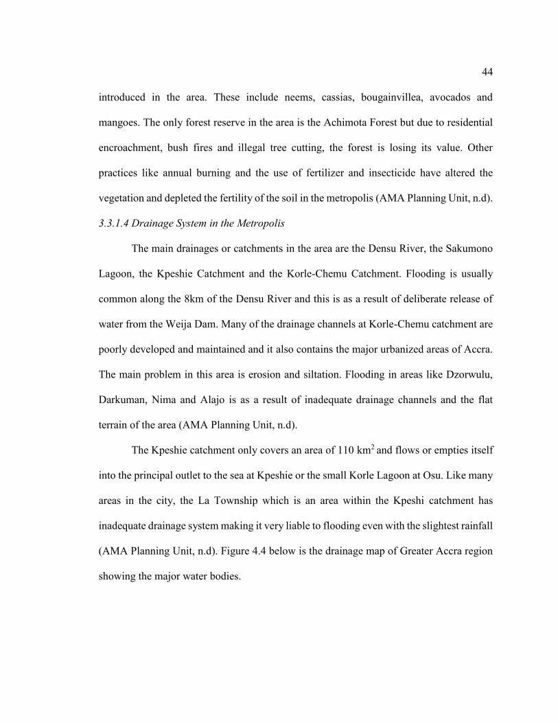
3.3.1.4 Drainage System in the Metropolis
The main drainages or catchments in the area are the Densu River, the Sakumono
Lagoon, the Kpeshie Catchment and the Korle-Chemu Catchment. Flooding is usually
common along the 8km of the Densu River and this is as a result of deliberate release of
water from the Weija Dam. Many of the drainage channels at Korle-Chemu catchment are
poorly developed and maintained and it also contains the major urbanized areas of Accra.
The main problem in this area is erosion and siltation. Flooding in areas like Dzorwulu,
Darkuman, Nima and Alajo is as a result of inadequate drainage channels and the flat
terrain of the area (AMA Planning Unit, n.d).
The Kpeshie catchment only covers an area of 110 km2 and flows or empties itself
into the principal outlet to the sea at Kpeshie or the small Korle Lagoon at Osu. Like many
areas in the city, the La Township which is an area within the Kpeshi catchment has
inadequate drainage system making it very liable to flooding even with the slightest rainfall
(AMA Planning Unit, n.d). Figure 4.4 below is the drainage map of Greater Accra region
showing the major water bodies.

45
Figure 3.4 Drainage map showing major water bodies in Accra
Map prepared by Carl Afenu, 2014.
3.3.1.5 Demographic Characteristics
As discussed earlier, the Accra Metropolitan Assembly is subdivided into eleven
sub metros and based on the 2000 population and housing census figures, it was estimated
that, as at 2010 the total population of the metropolis was approximately 4.3 million. For
2013, the projected population figure for the metropolis was 5,060,313 (AMA Planning
Unit, n.d). The table below shows the population of the 11 sub metros as at 2000, the
estimated population for 2010, 2013 and the area size of each sub metro.

46 Table 3.1: Demographic Figures of Accra Metropolitan Assembly by Sub-Metros NO SUB METRO AREA
(KM2) 2000 POP
*EST. 2010 POP
*EST 2013 POP
1. Ablekuma Central 11.5 181541 619554 827950
2. Ablekuma North 13.6 140063 483253 295200
3. Ablekuma South 15.1 211493 729712 494679
4. Ashiedu Keteke 4.4 88717 260174 408060
5. Ayawaso Central 6.0 155947 435984 159661
6. Ayawaso East 5.8 128641 359643 424173
7. Ayawaso West 35.2 50334 140717 447534
8. La 36.0 133721 373844 306424
9. Okaikoi North 21.1 141085 394433 476533
10. Okaikoi South 12.0 96600 270066 392149
11. Osu Klottey 12.0 96634 270162 827950
TOTAL 173 1424776 4337542 5060313 Source: 2000 P&HC (Ghana Statistical Service), UMLIS and Accra Metropolitan
Authority
3.3.1.6 Economic Infrastructure
The Accra Metropolitan Assembly together with the other 9 Metropolitan,
Municipal and District Assemblies (MMDAs) contribute to the economic development of
the capital city, Accra. In terms of economic development, the study area (AMA) cannot
be discussed alone but in totality with the other MMDAs which make up Accra. According
to the 2000 National Population Census, the daily influx of people to the city for economic
purposes is approximately 1,000,000 and thus estimated to host about 25% of the nation’s
population. The establishment of manufacturing industries, financial institutions, health
institutions, oil companies, telecommunications companies among many others in the

47 region creates employment opportunities for residents. High unemployment rates still exist
in the city in spite of seemingly economic boom. The unemployment rate recorded in the
year 2005/2006 was 10.6 percent (AMA Planning Unit, n.d).
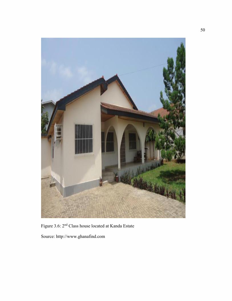
The city of Accra is also stratified into four income zones based on housing
characteristics and environmental conditions. The stratification of the city was adopted
from the block valuation system of the City Authority of Accra which was used for the
purposes of collecting property rates. The first class residential zone is characterized well-
defined sector layouts, average annual income of about $4,000 and high taxable property
values. The second class residential zone has the largest proportion of Accra resident and
annual average income of $1,100 - $3,999. It is also predominately occupied by businesses,
administrative and professional families. Though the areas are better planned, it is in need
of some infrastructure services. For the third class, the average income level is between
$793 - $1,099 and fourth class residential zone’s average annual income is $792 and below.
Areas within the third and fourth zones are largely unplanned, densely populated with
limited infrastructure and poor quality construction (AMA Planning Unit, n.d). The table
3.2 below shows the four class zone in the city of Accra, the income level and the areas
within each zone and Figure 3.5 to Figure 3.9 show examples of houses located in these
zones.

48 Table 3.2 Stratification of Accra in Four Zones
CLASSIFICATION ANNUAL INCOME LEVEL
COMMUNITIES
1st Class $4,000 & Above Achimota Forest Residential, Roman Ridge, Airport West Residential, Airport Residential, East Legon, Ambassadorial Enclave, Ridge, La Hotels Area, Switch Back Rangoon, Cantoments,
Zoti, Abelenkpe, Dzorwulu, North Dzorwulu, East Legon Extension, West Legon, Ringway Estates, Nyaniba Ako Adjei Area, Labone Estates, Golf Hill, North Labone Estates, Airport Hills, Martey Tsuru, Manet Estate, Tesano No.1
2nd Class $1,100 - $3,999 South Odorkor, Dansoman Ssnit, Adogon, New Dansoman Estates, Laiteybiokorshie, Candle Factory, Mamprobi, Kanda Estates, Dansoman Estate, Nima Akuffo Addo, Asylum Down, Naaflajo, Okpoi Gonno, Greda Estates, Beach Front, New Achimota Kwashieman North, Sakaman-Busia, Abofu, New Dansoman, Mataheko, Osofo Dadzie, West Abosey Okai, Dansoman Exhibition, Dansoman Sahara, North Alajo, Adabraka, South La Estate, Palm Wine Area, Tesano No.2, Agblesaa, Kaneshie, Borabora Estates, Awudome Estates, North Kaneshie, Abeka, Fadama, Apenkwa, North Kaneshie Estates-Cfc, Akweteman
3rd Class $793 - $1,099 Kwashibu, Kwashieman, North Odorkor, Odorkor Old Town, Kwashieman Old Town, Odorkor, Stanley Owusu, Banana Inn, Korle Gonno, Kotobabi Police Station, Kpehe, Alajo, Kotobabi, James Town, La/Labone, Manhean, Agblogbloshie, Bubiashie/Cable And Wireless, New Fadama, Kisseman, Christian Village Abossey Okai, Sukura, Russia, Sabon Zongo, Town Council Line, Mampoanse, Tunga, Nima, Accra New Town, Shiashie Village, Darkuman, Bawaleshie, Mempeasem, North Abeka, Old Bubuashie, Nii Boyeman, Achimota,
4th Class $792 & Below Chorkor, Mpoase, Gbegbeyise, Shiabu, Luga, Osu Amanfo/Alata, La Inshorna Slum, CBD And CBD Extended
Source: TCPD, Accra Metropolitan Assembly
NB: Highlighted names are the selected areas for this research.

49
Figure 3.5: 1st Class house located at East Legon
Source: http://www.myjoymarket.com/ads/view/16127
50
Figure 3.6: 2nd Class house located at Kanda Estate
Source: http://www.ghanafind.com

51
Figure 3.7: 3rd Class houses located at Jamestown
Source: http://www.galenfrysinger.com/ghana_jamestown.htm

52
Figure 3.8: 4th Class settlement at Chorkor
Source: http://www.basicsinternational.org/?page_id=22
3.3.2 Flooding in Accra, Causes and Effects
Flooding is not a new phenomenon in the city of Accra. Karley (2009), explains
that the problem of flooding in Accra dates back to the late 1930 when the city began to
expand. The development of new housing to accommodate victims of the 1938 earthquake
led to the development of unauthorized structures on waterways since the houses provided

53 by the government were inadequate. Another historical factor of flooding in the city was
the relocation of the capital of Ghana from Cape Coast to Accra. The relocation was
coupled with trade increase, economic activities and migration from other regions to Accra.
Although the Town and Country Planning Department was charged with the responsibility
of developing basic drainage and other infrastructure prior to residential building, many
areas still lacked adequate drainage systems owing to the fact that lands were vested in the
hands of clans or head of families (Karley, 2009).
3.3.2.1 Causes of Flooding
A number of factors that cause flooding in Accra have been identified in research.
One natural cause of flooding is the low lying nature of the city (Aboagye, 2012). The low
lying nature of the city coupled with factors like soil type (Okyere, Yacouba & Gilgenbach,
2012) and inadequate drainage systems (Sam, 2009) contribute to flooding. According to
Okyere, Yacouba & Gilgenbach (2012), topography is the first element that determines the
direction of infiltration excess overland flow and as such determines its exposure to flash
flood. Infiltration rate also depends on the soil characteristics of the area. Therefore the
clayish nature of some part of the city makes it liable to flooding. Additionally, Sam, (2009)
also states that the lateritic soil groups found in Accra which are easily erodible and provide
a source of sediment for drains serve as an impediment for the free flow of storm water
during rainy seasons. The inadequate construction of drains in the city and the infrequent
de-silting of the drains all contribute to flooding.
Another cause of flooding is the tidal variations on streams and rivers. Citing
McGuire et al (2004), in the work of Oppong (2011), river flooding occurs when factors

54 such as climatic conditions, the form of catchment and other human activities like
deforestation and urbanization increase “the surface runoff leading to the modification of
a river’s hydrograph – which is the curve of discharge over time” (pp. 24-25). The increase
in discharge arising from prolonged rainfall and impediments caused by debris,
sedimentation and waste disposal in the river lead to flooding in surrounding areas.
According to Karley (2009), among the many rivers that channel water to Accra, the Densu
River which is the largest tend to cause flooding during heavy rainfall. The Densu River is
a dammed river which supplies half of the portable water for residents in Accra and is also
used for agricultural purposes. In addition to the heavy rains causing overflow of the river,
spill ways from the river also cause flooding. In order to prevent overflow of the dam,
occasionally the dam is open to allow excess runoff which leads to flooding because of the
fast rate and large volume discharged (p. 30).
The anthropogenic or human induced causes of flooding in Accra include
urbanization, poor sanitation, inadequate and choked drains, haphazard development and
ineffective enforcement of planning regulation (Karley, 2009; Afeku, 2005; Rain,
Engstrom, Ludlow & Antos, 2011; Sam, 2009). City authorities battle constantly with the
issue of urbanization and how it contributes to yearly flooding in Accra. Although several
economic factors changed the spatial configuration of Accra since independence in 1957,
many researchers have paid particular attention to the introduction of the Structural
Adjustment Program (SAP) and how it influenced urbanization and now leads to flooding
in the city. The program which was introduced by the World Bank and International
Monetary Fund (IMF) imposes on countries that are in debt pre-conditions for debt relief

55 and acquiring more loans in order to attract investment (Afeku, 2005). Additionally, the
introduction of SAP in Ghana in 1983 led to physical expansion and economic growth of
Accra because of the interaction of global and local trade forces, investment and foreign
currency liberalization (Yeboah, 2000; Grant and Yankson, 2003). Yeboah (2000) explains
that, the population of the metropolis grew at an annual rate of 4 percent between 1984 and
2000 due to the increase economic opportunities and migration from other regions in the
country. As rural-urban migration accelerated, the demand for houses also increased as
well as expansion of Accra in the peri-urban zone. As the provision of housing structures,
infrastructure, drainage systems and other basic amenities could not match the growing
population, many migrants settled in areas that were unauthorized for development and
prone to floods. The author further explains that building projects in Accra more often than
not start in anticipation of infrastructure services like drainage, water, electricity and road.
This therefore creates a conducive environment for flooding simply because of the lack of
drains and other amenities.
As explained above, the introduction of SAP was matched with increased
population in the city of Accra and unauthorized development springing up in every corner.
During the period of SAP implementation in 1983, the government of Ghana started
tackling land use planning but land management had not yet received the needed attention
to control development (Larbi, 1996). Informal land ownership wasn’t part and still isn’t
part of the spatial planning or land management of Ghana because approximately 70
percent of total land (informal) belongs to individuals or clan heads and this has resulted
in unauthorized development (Afeku, 2005). Accordingly, the two forms of land ownership

56 (formal and informal) that exist contribute a great deal to the haphazard development.
Karley (2009) also elaborates on the issue of physical planning and flooding in Accra. In
his opinion though there is a master plan designed by the Town and Country Planning
Department, implementation becomes difficult due to factors such as logistic support,
bureaucracy and land ownership.
Improper disposal of waste is another major cause of flooding in Accra. The
mismanagement of waste particularly solid waste that ends up in drains and open spaces
impede the free flow of water during the rainy season. In addition to impeding the free flow
of water and causing flooding, most clogged drains are a public health hazard (Alhassan,
Gabbay, Arguello & Boakye-Boaten, n.d). Records from the Accra Metropolitan Assembly
indicate that, approximately 2000 metric tons of waste is generated daily and out of this,
only about 1,200-1,300 tons are collected properly. The uncollected waste is either
disposed of in storm drains, gutters, streets or unauthorized dumping sites (Alhassan,
Gabbay, Arguello & Boakye-Boaten, n.d). Adank et al (2011), also state that the current
capacity of drains in the city is not sufficient to handle storm water and it is limited in its
capacity because of erosion, siltation and waste dumped in these drains. It is clear that
human induced causes of flooding in the city are interrelated because for example as
population growth accelerates due to rural-urban migration or other economic factors,
indiscriminate disposal of waste also increases if not managed. Inadequate drains may
therefore be the dumping grounds for the waste and this can impede free flow of water.
Furthermore, unauthorized development on waterways may also result from urbanization

57 and ineffective enforcement of planning regulation and if it goes unchecked would increase
the risk of flooding. Figure 3.9 to Figure 3.13 shows pictures of flooding in Accra.
Figure 3.9: Houses obstructing the free flow of rain water

58
Figure 3.10: A flooded street in Accra (Kwame Nkrumah Circle)
Figure 3.11: Open storm drainage carrying waste dumped by residents
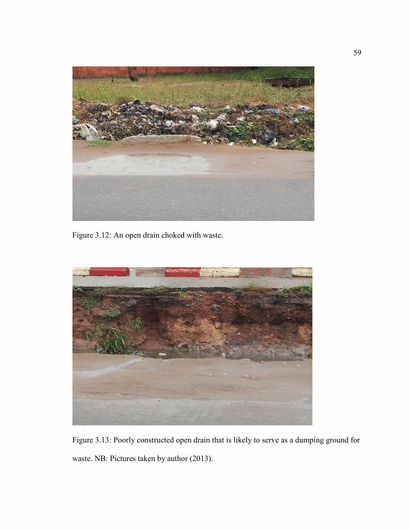
59
Figure 3.12: An open drain choked with waste.
Figure 3.13: Poorly constructed open drain that is likely to serve as a dumping ground for
waste. NB: Pictures taken by author (2013).

60 3.3.2.2 Effects of Accra Floods
The main effects of Accra flooding are destruction to property, economic loss and
loss of lives. Flooding is often associated with huge financial costs since economic
activities in the capital city come to a halt whenever there is flooding because most roads
are rendered inaccessible and telecommunication infrastructure is submerged in water
(Karley, 2009). In the summer of 2007, half a million dollars was spent to clean up the city
after flooding (Karley, 2009) and in 2009, the government of Ghana allocated $25 million
to combat flooding in some parts of Accra (Dankwa, 2009). In a news report by Joy Fm,
the national coordinator of National Disaster Management Organization (NADMO)
lamented that the organization is unable to deal with flood victims because of its debt now
amounting to $83,000,000 and the frustration from international humanitarian agencies
who are dissatisfied with the country’s inability to deal with perennial flooding especially
in Accra (Appiah, 2013).
One tragic event of flooding is the loss of lives. The city faces yearly loss of lives
and displacement of people (Afeku, 2005; Karley 2009; Aboagye, 2012). Karley (2009),
explains that in the month of June 2001, torrential rain displaced 100,000 people and killed
11 people. In 2005 also, the country was said to have experienced the worst flooding in
western Africa. The effect of flooding cuts across regions as the country as a whole
experiences the loss associated with it. The tables below show flood periods and the
number of people affected (Table 3.3) and killed (Table 3.4).

61 Table 3.3: Flood disaster in Ghana and the number of people affected
Source: (CRED (2012), EM-DAT: The OFDA/CRED International Disaster Database)
Table 3.4: Number of people killed by flood during the period of 1995-2010
Date Number of people killed 5/7/1995 145 9/1999 52 10/8/2007 56 20/6/2010 45
Source: (CRED (2012), EM-DAT: The OFDA/CRED International Disaster Database)
A closer look at the dates in Table 3.3 shows a pattern of flood frequency. In the
first two years of data recording, there is a gap of 23 years (1968-1991) which could be
attributed to lack of information or no major flood event. However as the years progress,
there are events recorded in a span of 8 years, 4 years, 2 years and just a year. This increase
in flood frequency may be a result of a changing climate. In Conway’s (2008) opinion,
Central and West Africa rainfalls are expected to increase even as Northern and southern
Africa will become much hotter (as much as 4-6ºC). This increasing rainfall variability is
already apparent as inter-annual rainfall is large over most of Africa with greater frequency
Date Number of people affected 7/1968 25,000 14/7/1991 2,000,000 5/7/1995 700,000 9/1999 324,602 27/6/2001 144.025 10/8/2007 332,600 7/2008 58,000 17/9/2009 139,790 26/10/2011 81,473

62 and intensity. Such information has necessitated the development of adaptation strategies
in many countries to deal with the effects of climate change.
3.4 Institutional Profiling
3.4.1 Ministry of Environment, Science Technology and Innovation (MESTI)
The ministry was established to create a strong national scientific and technological
base for accelerated sustainable development of the country and also to enhance the quality
of life for all. Its main objective is to “ensure accelerated socio-economic development of
the nation through the formulation of sound policies and a regulatory frame work to
promote the use of appropriate environmentally friend, scientific and technological
practices and techniques” (MESTI, 2013 para 1). Some of the ministry medium term
objectives include; (i)The encouragement and strengthening of compliance of human
settlements standards in communities; (ii) The strengthening of linkages with local and
international collaborating agencies; and (iii) The promotion, co-ordination and evaluation
of research and development activities (MESTI, 2013).
3.4.2 Town and Country Planning Department (TCPD)
The department is a government agency under the Ministry of Environment,
Science and Technology. It is responsible for the preparation of detailed land use planning
schemes, development and redevelopment of cities and general planning administration.
Through its land use planning schemes, the department recommends for the protection of
water courses to allow free flow of rain water. It also embarks on public education;
sensitization programs and serves on the NADMO board responsible for flood
management. The department is mandated to promoted human settlements development

63 based on the principles of healthy growth, safety, orderliness and efficiency (ILGS &
IWMI, 2012).
3.4.3 Accra Metropolitan Department (AMA)
The Assembly is the highest political and administrative arm of the Government at
the local level. Its function includes provision of public safety and comfort, planning and
development control of all infrastructures within the city and maintenance of peace and
security. There are sub departments under the Assembly such as Internal Audit Unit, Works
Department, Department for Food and Agriculture, Waste Management among others. The
Works Department is responsible design and maintenance of all building projects of the
Assembly, demolition of unauthorized development, granting of building permits and
certification of true copy of approval of building plans (http://ama.gov.gh/).
3.4.4 National Disaster Management Organization (NADMO)
The organization was established by Act 517 of 1996 to manage disasters and
similar emergencies in the country. It has the responsibility of coordinating the material
and human resources of various institutions and agencies to ensure effective response to
disaster emergency. Other functions include rehabilitation of people affected by disaster,
enforce laws to prevent and mitigate disasters and awareness creation through intensive
public education (ILGS & IWMI, 2012).
3.4.5 Hydrological Service of Ghana
The hydrological department is an implementing agency under the Ministry of
Water Resources, Works and Housing. The main function of the ministry as a whole is the
64 “formulation and co-ordination of policies and programs for the systematic development
of the country's infrastructure requirements in respect of Works, Housing, Water Supply
and Sanitation and Hydrology”. The department is responsible for “programming and co-
ordination of coastal protection and major drainage works and the monitoring and
evaluation of surface water bodies in respect of floods” (Ghana.gov.gh).

65
CHAPTER FOUR: RESEARCH METHODOLOGY
This chapter explains the methods that were used to conduct the study. The main
form of qualitative methods that was employed for the research was key informant
interview and document analysis. The first section of this chapter discusses data needed
and the necessary sources to obtain the data to answer the three research question. The next
section describes the data collection used to obtain information from the key informants.
Under the data analysis section, key informant interview and document analysis are
presented. The research limitation is described in the last section.
4.1 Data Needs and Sources
A data need and data source was developed to assist with narrowing down specific
sources or information that will be relevant to the study. The data need and source is
intended to specifically answer each research question and help present the methodology.
The National Climate Change Adaptation Strategy document was the main data source
required to answer the first research question [How is flooding addressed in the National
Climate Change Adaptation Strategy (NCCAS) document]. The second research question
[How are the strategies in Ghana’s NCCAS document reflected in the practices of flood
control implemented by the institutions responsible for addressing flooding in the city]
required information on the current practices that are carried out by the institutions to
address flooding in the city, as well as physical evidence of these practices at the flood
areas. Key informant interviews and document review served as the data source for the
second question. For the third research question [In what ways, if any, do flood control
practices of the institutions enhance adaptive capacity as perceived by the assembly

66 members], the main data needs was information from the assembly members of selected
constituencies. The information was gathered through interview. Table 4.1 below presents
a summary of data needs, sources and methods.
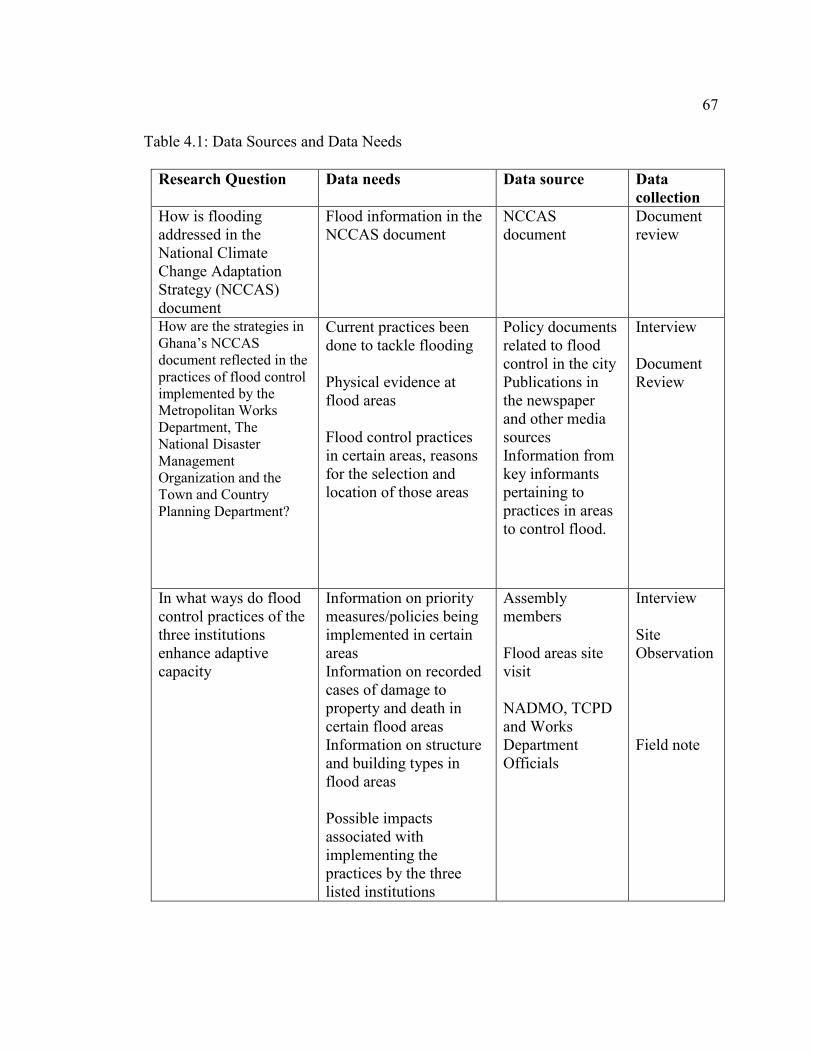
67 Table 4.1: Data Sources and Data Needs
Research Question Data needs Data source Data collection
How is flooding addressed in the National Climate Change Adaptation Strategy (NCCAS) document
Flood information in the NCCAS document
NCCAS document
Document review
How are the strategies in Ghana’s NCCAS document reflected in the practices of flood control implemented by the Metropolitan Works Department, The National Disaster Management Organization and the Town and Country Planning Department?
Current practices been done to tackle flooding Physical evidence at flood areas Flood control practices in certain areas, reasons for the selection and location of those areas
Policy documents related to flood control in the city Publications in the newspaper and other media sources Information from key informants pertaining to practices in areas to control flood.
Interview Document Review
In what ways do flood control practices of the three institutions enhance adaptive capacity
Information on priority measures/policies being implemented in certain areas Information on recorded cases of damage to property and death in certain flood areas Information on structure and building types in flood areas Possible impacts associated with implementing the practices by the three listed institutions
Assembly members Flood areas site visit NADMO, TCPD and Works Department Officials
Interview Site Observation Field note

68
4.2 Data Collection
4.2.1 Key Informant Interviews
Key informant interviewing according to Kumar (1989), is a type of qualitative
research which involves small number of people called informants of key informants and
they are selected because they possess information or ideas that are important to the
research. The interview process involving the key informants is conducted with the aid of
interview guides that list the topic to be covered during the session. One main advantage
of key informant interviews is that, they provide data and insight that cannot be obtained
with other methods thus they offer confidential information that may not be obtainable in
other settings or with other research methods.
Selection of key informants was based on their formal role in society or their
organization and also their ability and willingness to provide information needed by the
researcher (Marshall, 1996; Tremblay, 2009). An interview guide was developed to assist
in the interview process. The interview questions (attached as Appendix A), were open
ended and intended to solicit information on current flood practices, knowledge on the
national document on climate change adaptation and incorporation of adaptation strategies
into policies or practices. Six key informants were interviewed from the five institutions
selected and five assembly members from the five selected constituencies. The institutions
were Town and Country Planning Department (1 official); Accra Metropolitan Assembly
(2 officials); National Disaster Management Organization (1 official); Hydrological
Service of Ghana (1 official) and Ministry of Environment, Science, Technology and
Innovation (1 official). The sub metros of the assembly members were Ablekuma South (2

69 members), Ayawaso West (2 members) and Osu Klotey (1 member) Sub metros. The
assembly members served as key informants because of the influence they hold at the
community level and also the significant role they play in adaptation and socio-economic
development within their respective communities. They usually spearhead development
projects such as drainage system clean up, rural and urban electrification among others
(ghanadistricts.com). Each institutional interviews lasted about an hour and was conducted
in the offices of the respective informant. For the assembly members’ interview, each lasted
approximately thirty minutes and were conducted in the office of the Accra Metropolitan
Assembly.
The interview with the head of climate change and sustainable development in the
unit at the Ministry of Environment, Science, Technology and Innovation obtained data on
climate change as a developmental issue, the reasons for the introduction of the National
Climate Change Adaptation Strategy (NCCAS), likely challenges to be faced with the
introduction and implementing agencies that will be responsible for the successful
execution of the strategies. This interview together with the analysis of NCCAS contributed
to answering the first research question. Interviews with TCPD, AMA, NADMO and the
Hydrological Service were conducted to investigate current practices being carried out to
address flooding in the city of Accra and adaptation strategies that the institutions are
currently undertaking or have proposed to undertake. The responses gathered from the
interviews helped answer research question two.
In order to effectively answer research question three, assembly members were
selected from areas considered to be liable to flooding. Two out of the five selected areas

70 are classified as first class residential area, one from a second class residential area and the
remaining two areas classified as third class residential area. The classification of the zones
as stated in chapter three was adopted from the block valuation system of the City Authority
of Accra. The assembly members provided information on projects or programs being
carried out by any of the institutions, causes of flood in the areas and performance rating
for the various institutions. As community leaders, they also provided information on how
they mobilize community members to undertake activities to reduce the incidence of
flooding in their area.
4.2.2 Secondary Data
The main secondary data for this research was the National Climate Change
Adaptation Strategy document. It is considered a secondary data because the information
needed has already been collected and is usually available in an electronic or published
form (Curtis, n.d). An advantage of using a government document like the NCCAS is that,
it is readily available and mostly free of charge (Curtis, n.d). Other secondary data collected
during the field research were the final draft buffer zone policy for managing river basins
in Ghana and literature on the profile of Accra.
4.3 Data Analysis
4.3.1 Key Informant Interview
All recorded interviews were transcribed onto a personal computer and coded. All
the coding was done manually. The initial stage of data analysis was to read through each
transcribed interview and identify sections of the data that answers each specific research
question. Elements or codes such as sanitation, drainage systems, haphazard development,

71 planned adaptation and spontaneous adaptation were identified in the transcribed
interview.
4.3.2 Document Analysis
Document analysis is a systematic procedure for reviewing or evaluating
documents and it involves skimming, reading and interpretation. As a qualitative research
method, document analysis is less time consuming and therefore more efficient than other
research methods (Bowen, 2009). Similar to the interview transcripts, the NCCAS
document was read thoroughly and sections that mentioned or addressed flooding were
identified.
4.4 Research Limitation
Time was a major challenge for the researcher. Conducting research in the month
of July and August meant the main rainy season of the city was almost over. Information
collected may have been different if assembly members were interviewed during the rainy
season as they were dealing with flooding in the city. The researcher would have been able
to carry out participant observation and hence confirm statements made in relation to
organizing members of the community to undertake minor projects targeted at minimizing
flood. The researcher would have also observed how officials perform their duties in the
wake of flooding.

72
CHAPTER FIVE: DATA PRESENTATION AND ANALYSIS
Diving directly into answering the research questions, the section begins with
discussion of the first research question, [How is flooding addressed in the National
Climate Change Adaptation Strategy document]. Shifting attention to current practices
carried out by the institutions, section 5.2 addresses the second research question [How are
the strategies in Ghana’s NCCAS document reflected in the practices of flood control
implemented by the institutions responsible for addressing flooding in the city]. To answer
the third research question [In what ways, if any, do flood control practices of the
institutions enhance adaptive capacity at constituency level as perceived by assembly
members], responses gathered mainly from assembly members are analyzed and discussed
in section 5.3.
5.1 Flooding as Addressed in the NCCAS
The National Climate Change Adaptation Strategy is a comprehensive document
that outlines clearly defined mechanisms for enhancing Ghana’s capacity in terms of
‘infrastructure and knowledge required, to deal with the impact of climate change and to
reduce vulnerability in key sectors, ecosystems, districts and regions of the country’
(UNEP, 2013 para.10). The development of NCCAS was an initiative by Climate Change
and Development – Adapting by REducing Vulnerability (CC DARE) which is a joint
United Nations Environment Program (UNEP) and United Nations Development Program
(UNDP) program funded by the Danish Ministry of Foreign Affairs. The program was
designed to strengthen ongoing and planned nationally based climate change adaptation
and risk management in sub-Saharan Africa (UNEP, 2008).
73
Using outputs of sectoral vulnerability and adaptation assessment since 2006, the
creation of the NCCAS has been driven by a participatory approach carried out by national
experts and a wide range of stakeholders from national to districts levels. The scope of the
document is intended to cover a period of 10 years (2010-2020) and anticipated to be
reviewed and used by all stakeholders (NCCAS, n.d). Some of the key principles that
guided the formulation of the document and shall guide its implementation include:
Stakeholder participation to ensure ownership
Promotion of sustainable development and poverty reduction
Gender sensitivity and vulnerability reduction
Flexibility and iterative
Cross sectoral and integrative
Flooding is addressed in the document as a national problem that can occur
everywhere and not only in Accra. The issue is seen as a developmental, health and
environmental problem since it affects sectors like infrastructure, land use and health. In
terms of development, road infrastructure is an integral component of a country’s economic
system. As explained in the NCCAS:
Disasters such as floods, rainstorms and strong winds are becoming more frequent
than before. Over the years, provision of infrastructure facilities such as roads,
bridges, and housing in Ghana have not taken into consideration additional climate-
risk especially at the design stage. The ultimate effect is that in times of intense
climatic impacts such as flooding, infrastructure facilities are not able to withstand
the shocks. In recent times, the northern and urban floods have had consequences
74
beyond local coping and government capacities. This obviously calls for better
improved infrastructure facilities to withstand the impacts of climate change. (p.
12).
Mathew & Rao (2006), explained that economics involves production, distribution
and consumption of goods and services therefore there is the need for effective
transportations system to boost the economy of a country. The existence of open drains
serving as dumping grounds for rubbish and indiscriminate disposal of waste creates both
health and environmental problems.
In the NCCAS, the impact of flooding is captured under social and infrastructure
sectors and also identified as one of the challenges that must be tackled to minimize the
impacts of climate change. As outlined in the document, the human generated factors of
flooding include siltation of river beds, location of settlements and farms in flood plains,
land degradation along river banks, improper farming methods leading to compaction of
the soil which restricts infiltration, absence of proper flood management systems and
improper disposal of solid waste. The document identifies only one non-human or weather
related factor of flooding which is the high incidence of rainfall in short period generating
excessive run-offs.
Urban sanitation is also identified as a major problem that contributes to increased
incidence of flood in the city. According to the NCCAS, poor sanitation and urban flooding
will increase the incidence of malaria and cholera of which the multi health risks will lead
to budgetary problems with concomitant impacts on the National Health Insurance
Scheme. In terms of infrastructure provision in Ghana, the sector hasn’t taken into

75 consideration additional climate-risk especially with its design. With regards to the impact
of flooding on infrastructure, the NCCAS document explained, in the events of intense
climatic impacts, the infrastructure facilities in Accra and the country as a whole will not
be able to withstand the shock. Although infrastructure falls within the ‘hard’ adaptation
measures and requires high cost intervention, if ignored coastal erosion aided by rising sea
level and heavy downpour will destroy substantial portion of the east coast and multiple
road networks.
In order to address the issue of flooding, the document outlined a number of broad
strategies under health and land use. These broad strategies are intended to serve as
guidelines for the various institutions, departments, agencies and organizations to
formulate specific measures. Under health, the main focus is on the improvement of
environmental sanitation by strengthening institutions, enforcing laws and bye laws as well
as the improvement of existing waste management infrastructure and provision of new and
affordable technologies for environmental sanitation. Reduction in the incidence of water
and air-borne diseases associated with the aftermath of flooding is another strategy area
that must be addressed. The last broad strategy under health is to enhance and strengthen
policies and bye laws in relation to spatial distribution of residential, commercial, industrial
and recreational areas. In the area of land use, the document requires institutions, agencies
and stakeholders to identify gaps in existing land-use regulations and review policies to
deal with land management issues. It also requires the implementation and enforcement of
land use regulations for sustainable development and the development of strategies to
implement climate change adaptation options.

76
Analysis of the document shows some strength as well as a number of short falls.
First and foremost, Ghana as a country recognizes the need to have a climate change
adaptation strategy document that addresses climate related issues. The United Nations
Framework Convention on Climate Change (UNFCCC) explained that adapting to climate
change is becoming ‘a routine and necessary component of planning at all levels’ therefore
the need for less developed countries to have a national document is of urgency (UNFCCC,
2012). With guidelines provided by CC DARE and similar to National Adaptation
Programs of Action (NAPAs), the preparation of the NCCAS was guided by elements such
as a participatory process involving stakeholders, national experts and local communities
and multidisciplinary approach. Starting by clearly defining what adaptation is, the
NCCAS confirms literature on the definition of adaptation and what it entails. The
document also makes emphasis on the need for proactive and targeted approach which is
more effective and cost efficient as against reactive approach to climate change.
According to the theoretical framework used in this study (Gupta et al, 2008),
resources form a major part of implementing climate change strategy therefore it is
essential for national climate change adaptation documents to have funding arrangements.
The NCCAS thus makes provision for funding for the implementation of its strategies. The
NCCAS explains that,
Adaptation cost is the additional cost of measures taken strictly in response to
climate change. This does not include cost already included in programs and
projects in the development plans and budget. A draft estimate of the strategy
indicates that the annual cost of the strategy is between $300 million and $700

77
million at the initial stage and it is expected to grow to about $1000 million over
the ten years plan period (p. 37).
Potential funding sources include the Government of Ghana, Adaptation Fund (proposals
to be routed through the approved channel), multilateral, bilateral, other donors and all
other sources related to climate change. Proposals on other sources of securing funding are
also welcomed from all implementing agencies. There is however no indication from the
study of monies flowing to various institutions for strategies implementation because the
NCCAS is yet to be made available.
Although the NCCAS meets certain requirement of a national climate change
adaptation strategy, it falls short in certain areas. Prior to reading the document,
expectations such as specific steps to achieve each broad strategy and clear definition of
certain terms were expected. The document however falls short in these areas. As a strategy
document and a national document intended to be distributed and used by all stakeholders,
the broad guidelines for implementing adaptation strategies seem rather ill-defined and
unclear. For example, the document states that by strengthening institutions, environmental
sanitation will improve and this will reduce the impact of flooding. It does not go further
to explain or state how institutions can be strengthened and which specific institutions
should be responsible. Additionally, stating that sustainable development requires
implementation and enforcement of land use regulations does not imply anything.
Sustainable development as a concept is open to many definitions therefore if such terms
are not clearly defined, it stands the chance of being interpreted differently.

78
Issues of flooding more often than not cut across sectors and though the NCCAS
covers flooding under health, development and land use, it fails to explicitly explain or
consider the relationship of the issue among the various sectors. The document does not
consider interactions of the sectors in a satisfactory way and appears not to be inter-sectoral
therefore making it difficult to draw a link between sectors.
Another concern about the document is, its distribution and use. During the
interview session with the head of climate change at the Ministry of Environment, Science,
Technology and Innovation, he revealed that the document had just been approved by
cabinet and but was yet to be made available to the all institutions. In his words he stated
that, “The policy document was just approved so it will be made available to all institutions
in Ghana and not only these agencies mentioned above. We have identified over 200
institutions including research institutions”.
5.2 Flood Control Practices Implemented by the Institutions
The second research question sought to examine the specific measures that are
being implemented by the various institutions as a reflection of the broad strategies outlined
in the National Climate Change Adaptation Strategy document. However in an interview
discussion with the chair of the climate change unit of the Ministry of Environment,
Science and Technology, he explained that the NCCAS document is not yet available to
the identified institutions and stakeholders. This means that there was no guiding principle
to aid the institutions in the formulations of specific adaptation strategies. During the
interview sessions with the various institutions, there were similarities in responses with
regard to what causes flooding in the city, flood areas and knowledge about a government

79 document on climate change adaptation but were unclear as to the content. This however
goes to show how issues of flooding cut across institutions.
Although the institutions did not have the NCCAS as a guide, there were a number
of proposed measures that they intend to undertake as part of adaptation strategy to control
flooding in the city. These proposed strategies overlap with the broad strategies outlined in
the NCCAS in the sense that, the main focus is on infrastructure development and
improvement. The infrastructure sector is the main area of focus because it is the most
affected sector in terms of flooding. Although these measures are not specifically
adaptation strategies, Linham & Nicholls (2010) explained that there are a number of flood
management techniques that are also regarded as adaptation strategies. Therefore with the
proposed measures outlined to be carried out by the various institutions to control flooding,
they are also directly and indirectly adapting to climate change and carrying out some of
the strategies outlined in the NCCAS.
5.2.1 Current Practices/Planned Adaptation Measures
Out of the five institutions (TCPD, MESTI, NADMO, Hydrological Services,
AMA), only one institution (Planning Department of AMA) mentioned current projects
being carried out to address the problem of flooding. According to the AMA official, the
Korle Lagoon is currently being dredged to make way for excess storm water. Dredging
according to Ciwen (2014), is the removal of materials from the bed and sides of river
channels to improve flood protection and/or for navigational purposes. Dredging of the
Lagoon means storm water can be ‘reserved’ before it gradually makes its way into the sea
instead of storm water flooding neighboring communities because the Lagoon is choked

80 with waste. The project is the Accra Sewer and Storm Water Drainage Alleviation Project.
Under this project, the government of Ghana on behalf of the AMA is receiving funding to
the tune of $660m from Export Import (EXIM) Bank, USA to construct storm drainages
and dredge the Korle Lagoon.
It must be noted that, although the Planning department of AMA identified the
dredging of the Korle Lagoon as its current adaptation project, literature shows that the
project is not being carried out necessarily as a climate change adaptation strategy.
According to Boadi & Kuitunen (2002), the dredging of the lagoon was started in March
2000 with funding from the Organization of the Petroleum Exporting Countries (OPEC)
Fund for International Development, the Arab Bank for Economic Development in Africa,
the Kuwait Fund for Arab Development, and the Ghanaian government. The project which
is named Korle Lagoon Ecological Restoration Project (KLERP) aims at restoring the
ecology of the lagoon and improve the city’s drainage, flooding and sanitation problems.
Additionally, the Korle Lagoon also features in the Accra Sustainable Project (ASP) signed
between the Government of Ghana and the United Center for Human Settlement in 1994.
The ASP aimed at “supporting an environmentally sustainable development and the growth
of Accra by strengthening the capacity of the Accra Metropolitan Authority to plan, co-
ordinate and manage the environment/development interactions” (Boadi & Kuitunen, 2002
p. 308).
Dredging does not necessarily prevent all flooding but rather reduce fluvial flood
frequency in the immediate area. Literature on dredging related to flooding has shown both
the positive and negative sides With the dredging of the Lagoon currently on going, Ciwen

81 (2014), recommends that the volume of water to be contained in the Lagoon must not
exceed its capacity in the events of extreme rainfall and must also be able to channel water
into the sea without causing spill over into neighboring communities. Although literature
does not specifically identify dredging of lagoon as an adaptation strategy, studies indicate
that the process reduces flooding when carried out correctly (Ciwen, 2014). Figure 5.1
shows dredging being carried out at the Korle Lagoon.
Figure 5.1: Dredging of the Korle Lagoon
Source: Project Management International. (2009). Korle lagoon ecological restoration
project.

82
5.2.2 Proposed Adaptation Measures
In the absence of the National Climate Change Adaptation Strategy document in
the various institutions, proposed adaptation measures were outlined in their plans as a
means of tackling flooding in the city. The Hydrological Service explained that as part of
its measure to adapt to climate change, the department has proposed the construction of sea
defense walls in coastal areas to protect it against the problem of sea level rise. Sea defense
walls according to Leung (2010), are structural measures that include any built alteration
to the natural environment. Although they effectively provide a degree of protection and
make cities more resilient to climate change, they also require large amounts of capital for
construction and maintenance. This therefore makes them out of reach for low-income
countries with highly vulnerable coastal populations. Resource as a quality of adaptive
institution therefore plays a significant role in undertaking this project. Funds must
therefore be made available to ensure that this adaptation strategy is implemented since
study has shown the importance of sea defense walls against the impacts of climate change.
There is however the possibility that the Government of Ghana can secure funding from
external sources as it secured 68 million Euro loan to construct 30 kilometer stretch of sea
defense wall in the Dangbe East District of Greater Accra Region (GNA, 2011).
In line with area protection, the Town and Country Planning Department have
proposed an amended plan that ensures increased buffer zones and reservation of
shorelines. A buffer zone is a land area that is adjacent to a shoreline feature that is or will
be covered with native shoreline species to serve as a natural transition zone between the
coast and the adjacent upland development. By reducing the velocity of runoff and

83 speeding up infiltrations of precipitation, literature confirms the use of buffer zones as a
means to aid in flood control (Desbonnet, 1995). The official explained, “what we are doing
specifically is to ensure that reservations are expanded or increased so if we have a
shoreline or buffer of 200ft or 60m then we increase it in certain section to 300ft or 90m”.
A buffer zone policy document obtained from the department explained that one of the
guiding principles underlying the policy is to “prevent, mitigate and manage water-related
events associated with the potential effects of climate variability, viz. floods and droughts”
(Water Resources Commission 2008 p. 5).
With regards to the issue of improper disposal of solid waste especially into drains,
the Planning Department of AMA has proposed the construction of covered drains in the
city. This is intended to deter people from dumping waste into the drains. Coupled with the
construction of covered drains, authorities must embark on public education on proper
waste disposal since constructions of covered drains do not automatically change the
attitude of people. Additionally, the department under the Conti project will be constructing
land fill sites in neighboring communities of Accra as well as transfer station. The planning
officer explained that due to long travel time to land fill sites, wastes are not collected from
individual homes on regular basis. With the construction of the transfer station within the
city, wastes collected in the city will be disposed off there and transferred later at night to
the main land fill that will be located outside the city. He elaborates,
And as part of the project that has been mentioned (Conti Project), we are going to
do an engineered land fill site. It may not be within Accra itself but it may be in one
of the adjoining districts….. We are also going to build transfer stations. We are

84
going to earmark places within the city (Accra) where all the garbage will be taken
to, then at night large trucks will now carry from that place to the landfill site.
Actually we are not going to have only one but four (transfer stations), scattered
within the city but closer to the landfill site.
For a non-engineering adaptation to climate change, NADMO proposed public
education. The public must be made aware of the potential ways that climate change may
impact the economy, their livelihoods, natural resources and must be engaged in discussion
of how to adapt (Gregg, Feifel, Kershner, & Hitt, 2012). The authors also explained that
gaining public ‘buy-in’ has the potential of increasing political and social capital to support
adaptation strategies at all levels.
One may argue that the institutions have taken the initiative (leadership) to propose
adaptation strategies to control flooding in the city that even overlap with the broad
strategies in the NCCAS but with adaptation measures occurring at the constituency levels,
the assembly members should be more involved. Agrawal, McSweeney & Perrin (2008)
explained that in the past, local institutions have shaped how rural residents responded to
environmental challenges. Presenting, they also serve as the means of translating the
impact of future external interventions to facilitate climate change adaptation. The role of
local institutions (assembly members) therefore is crucial in the successful implementation
of any adaptation strategies in the country.
Communication is seen as one of the tools for planning in adapting to climate
change (IPCC, 2014). Tools such as bulletins, policy briefs, television and radio broadcast,
internets are some of the means that can be employed to carry out multi-way participatory

85 dialogues. For a more effective tool of communication with policy makers at local and
national level presentations and workshops should be encouraged (IPCC, 2014). However,
the lack of communication among the various institutions was evident in the study and was
confirmed in an interview with three assembly members. One stated:
The Town and Country Planning Department don’t help the assembly members
who are in the community. Before you (assembly member) realize, the building is
up. There is no communication, you can be here and they will be there doing their
thing and when there is a problem, then you the assembly man will be in trouble.
The other assembly member expressed the need to include assembly members as well as
residents in projects they intend to undertake. She explained; “higher authorities should
consult with us (assembly member) and the residents whenever they want to undertake any
project in this community”.
In the same frustration of no involvement and communication, another assembly
member stated;
I think when assembly members are being involved in such decision I think it will
help the situation because I live in the area and I know best. At times they (officials)
can just sit at the office and past anything. When they get the assembly members
involved things will be better.
Communication goes in hand with resource allocation because lack of
communication therefore means strategies that are to be carried out at the institutional and
community level stand the chance of not been implemented under NCCAS because funds
wouldn’t be available although they are similar to the broad strategies outlined in the

86 document. The proposed measures stated above all require funds to ensure successful
implementation but with the NCCAS not explicit on undertaking such projects, securing
funds from the allocated fund becomes a problem.
As cited in the 2014 IPCC report, the World Bank defined adaptation funding as
“resources that are deployed to support climate-resilient development” and studies have
also indicated that several tens of billions of dollars will be needed annually by 2030 to
fund adaptation strategies in developing countries (UNFCCC, 2007; World Bank, 2010a;
Smith et al., 2013). Institutions in Ghana must therefore make provision in their plans as
to how to secure funding for adaptation purposes. Although the Green Climate Fund is yet
to be operational, it is a key potential source of future public financing for adaptation
therefore institutions can submit proposals to secure a share.
5.3 Adaptive Capacity at Constituency Level
At the constituency level, the assembly members serve as the link between the local
people and various authorities. The assembly member representing Korle Gonno
confirmed the dredging of the Korle Lagoon as the only project being undertaken by the
AMA in the area. The four other assembly members however explained that there were no
specific project by the various institutions that may enhance adaptive capacity of residents.
However, an assembly member at Legon explained that de-siltation work that was once
carried out by the Ministry of Roads in the area has reduced the severe effect of rainfall
that lead to flooding. Literature confirms siltation as a cause of flooding in Accra. Adank
et al (2011) explained that, the current capacity of drains in the city is not sufficient to
handle storm water and it is limited in its capacity because of erosion, siltation and waste

87 dumped in these drains. Legon, a first class residential zone makes it a target area for many
developmental projects therefore undertaking de siltation to control flooding thus becomes
a priority. The Opete Kwei assembly man also explained that since he has ‘contact’ with
the mayor of the city, there has been construction of new drains and dredging of old ones
in his community which has drastically reduced the impact of flooding. He stated:
Since I’m with AMA, I’m always on the mayor’s neck to come. That is why we
have a lot of drainage projects going on in the community….. at first because there
were no drains, when it rains it gets stuck. But now that we have channeled it into
the river, about 80 percent goes off so this year we didn’t experience much flooding
like previous. I believe that if we continue with the rest of the projects it’s going to
help.
The above statement by the assembly member shows how certain projects are
carried out when one has “connections” with top official. Social networks and connections
are very important in accessing adaptation asserts and resources. The absence of fair
governance only means certain areas become a priority over others and resources are more
likely to be channeled to these areas where assembly members have close contact with
officials. The ability of the assembly member to take the initiative of ensuring that projects
are carried out in his constituency can be termed as taking leadership roles and securing
resources for project. But with the focus being on institutions, the absence of fair
governance in the distribution of resources makes it difficult to ensure successful
implementation of adaptation strategies across all areas.

88
In areas like North Adabraka and Korle Gonno, the assembly members explained
that encroachment was still a major problems since existing lay out plans are not been
enforced. Lack of enforcement is an issue that many studies have identified as a problem
in the city. Factors such as lack of logistics, bureaucracy and land ownership makes it
difficult to enforce existing lay out plans (Karley, 2009 & Afetu, 2005). The development
of squatter settlements contributes to flooding in these areas because they don’t conform
to lay out plans designed by the Town and Country Planning Department. Although not
much has been done at the regional level to reflect in the various constituencies, some
assembly members interviewed revealed that they are currently undertaking minor projects
within their areas to control flooding. For example, routine exercises like drain de-siltation
and cleanup are being carried out to rid the communities of filth which seems to be a major
contributor of flooding in the city.
From the data presented, it is obvious adaptation happens at the constituency and
spearheaded by the assembly members. The assembly members have demonstrated
leadership in the constituency by taking the initiatives to carry out minor projects with
resources from their own pockets. One assembly member explained that if they wait on
higher officials to disburse money to them, no project will be carried out therefore they use
their own funds to undertake minor projects and then request refund which also takes a
long time to receive.
The NCCAS as a national document has its strength and weakness but for it to be
successful, issues such as communication among institutions, clearly defined terms,
specific adaptation strategies and fair governance must be addressed at the national level.

89 Additionally, with adaptation occurring at constituency levels, attention should be given to
the assembly members and resources made available to them.
90
CHAPTER SIX: RECOMMENDATION AND CONCLUSION
6.1 Introduction
This chapter outlines the concluding part of the research and it is sub divided into
four sections. The first section details lessons that can be learnt from Mozambique’s
National Adaptation Program of Action (NAPA) and proceed to outline recommendations
based on the findings from the study. The third section gives areas with opportunities for
further study and the final section concludes the research.
6.2 Lessons from Mozambique’s NAPA
Mozambique, also known as the Republic of Mozambique is a southeastern African
country bordering the Mozambique Channel between South Africa and Tanzania. As at
2014, the country’s population was approximately 24 million. (CIA, 2014). Mozambique
gained its independence in 1975 after almost five centuries of Portuguese colonial rule.
The country was one of the poorest nations in the world because of prolonged civil war
and severe drought which was also exacerbated by socialist mismanagement (CIA, 2014).
The country’s terrain is mostly coastal lowlands, uplands in center, high plateaus
in northwest, mountains in n country in west (CIA, 2014) and like many African countries,
Mozambique is no stranger to climate change and adaptation (Blythe, 2012). The country
ranks third amongst African countries at risk from multiple hazards related to weather and
vulnerable to climate change due to its geographic location (Macaringue, 2010).
To address climate change and adaptation, Mozambique created its National
Adaptation Program of Action (NAPA) which was based on interviews at the national level
representing individuals from government, Non-Governmental Organization (NGOs) and
91 community leaders and members. The respondents identified drought, floods and tropical
cyclones as the main events affecting the country (Macaringue, 2010).
Mozambique completed its NAPA in July 2008 and according to Blythe (2012) one
main strength of the process is that, it emphasized on participatory bottom-up approach.
The NAPA process made use of existing local coping strategies and identified context-
specific priorities. Participation in the process cut across sectors as participants were sought
from local levels up to the national level. The different forms of knowledge also contributed
to the identification of practical techniques of adaptation which led to the creation of the
document that reflects the priorities of every representative involved (Blythe, 2012).
As Ghana learns from the success of Mozambique’s NAPA, it must also take into
consideration the shortfalls of the process. According to Macaringue (2010), weak
coordination and lack of cooperation between different ministries on environmental and
climate issues need to be resolved. Additionally, the large number of partners involved in
the process undermined the clarity of the document as it created tensions in terms of
leadership roles on climate change issues.
The issue of funding is another major shortfall of the program. Although
Mozambique has four prioritized adaptation strategies, only one project has been approved
for funding (Blythe, 2012). Osman-Elasha & Downing (2007) stated that the inability of
countries to secure necessary funding can be a major gap between planning and
implementation of adaptation strategies. Huq (2011), further explained that in cases where
funds have been secured, the receiving countries have had very little control on how to
disburse or spend the funds. In the case of Mozambique, the United Nation Development

92 Program (UNDP) which serves as the intermediary agency manages the funds.
Mozambique’s NAPA offers countries like Ghana the opportunity to learn from the
shortfalls and capitalize on their successes.
6.3 Recommendations
Ghana recognizes that climate change will greatly impact many of its sectors if
action is not taken immediately to make changes or adjust to current or expected events.
Climate forecast and climate change scenarios for the country predict a more severe and
frequent pattern of such drought and flood events (NCCAS, 2010). By establishing the
main argument that institutions play a vital role in climate change adaptation, this research
examined how institutions adapt to climate change while focusing on flooding in the Accra.
It also evaluated how the National Climate Change Adaptation Strategy document
addresses flooding. From the findings, it was evident that there are a number of issues that
must be addressed in order to fully institutionalized climate change adaptation strategies as
well as address flooding in the city of Accra.
First and foremost, local institutions particularly assembly members must be fully
involved in the process of climate change adaptation. The involvement of local institutions
have been proven to be very crucial in adaptation. As explained by Agrawal, McSweeney
& Perrin (2008), local institutions shape the way communities respond to the impact of
climate change. Therefore the success of any adaptation strategies and flood control
measures depend on how involved assembly members are. Being directly involved with
communities members, the assembly members serve as the mouth piece of the people as
well as the higher institutions. Additionally, the involvement of assembly members in the
93 process of planning adaptation strategies is sure to increase the success rate of
implementation and reduce negative impact of climate change because of the infusion of
local knowledge and technical know-how or scientific knowledge.
Another area of concern that must be addressed is the availability and flow of
resources. Resource can hamper the successful implementation of adaptation strategies
(Gupta et al, 2008) as was in the case of some of the assembly members undertaking minor
projects in the community with their personal funds because funds were not disbursed on
time. Fiscal budget for various constituencies must include funds for climate change
adaptation strategies and such funds should be made readily available for these projects.
Yearly assessment must also be put in place to ensure that adaptation projects are
completed and the resources are used specifically for such projects. As an incentive for
carrying out adaptation strategies, additional resources in the form of money, equipment,
logistics or anything of importance to a constituency should be set aside for any assembly
that completes its climate change project on time or records less impacts of flood related
disasters.
In terms of fair governance, it was evident that social network and connection
played a role in how asserts or resources are accessed. Assembly members who were in
close connection with officials at the higher level had projects executed in their
communities. Fair governance must be evident in the dealings of climate related issues as
every communities stands the risk of being affected. Social network and connection should
not be a factor in accessing resource but rather equality and equity should form the basis
of accessing adaptation funds.

94
Institutional leadership wasn’t demonstrated at the institutional level as compared
to the constituency level where assembly members were taking initiatives to address
flooding. Institutions must spearhead adaptation because they are in the position to propose
and draw up plans. Combining to-down and bottom-up approaches mean that institutions
must take up the initiative and leadership role for local government to emulate. Clearly
defined adaptation plans and flood control measures must be designed by these institutions
and passed on to the local government for implementation. When such structures are in
place, there is a smooth flow from planning to implementation. In line with leadership,
there should be communication between institutions and assembly members as well as
communication among institutions. Adaptation plans should be clearly communicated to
all stakeholders as this ensures successful implementation of strategies.
The NCCAS document served the purpose of an adaptation strategy that will assist
the country address climate related issues but the ill-defined terms and over generalized
strategies make it very ambiguous. This document is similar to many documents initiated
by the international community. More often than not, the developing countries are given
outlines to prepare one policy after the other with little or no say from these developing
countries as to what will actually work in their countries as against what is perceive to work
by the international community. Although the NCCAS isn’t available to the various
agencies and stakeholders, a revised version should be considered before distribution. The
document should have well defined terms and concepts as well as draw the link of flooding
across sectors. Flooding is inter sectoral therefore the document should further explain how
flooding in one sector affects the other. By drawing this link or connection, anyone reading

95 the document will understand the severity of the problem and the need to urgently address
it.
Although the main argument of this research centers on the importance of
institutions in adapting to climate change, the role of community members is equally
important. The success of any plan implementation in part depends on how citizen get
involve and welcome such projects. Officials expressed concern about the attitude of
people in relation to the causes of flood. People should be made aware of their actions and
how it contributes to flood and also made to understand that these actions in the long run
negatively affect them. Community education should be embarked on at least four times a
year to inform people about the reality of climate change and ways to adapt.
As discussed in Chapter 2, certain adaptation plans adopted in Mumbai, India can
also be implemented in Ghana. To deal with the immediate cause of flooding, measures
such as evacuating encroachers, improving the drainage systems and installing automatic
rain gauges for early warning can be adopted. Provision of flood insurance and flexibility
in the construction sector can also be considered. Flood insurance allows for shared risk
and flexibility in the construction makes it possible for individuals to repair damaged
building more quickly after a flood.
6.4 Opportunities for Further Research
From the findings, it was evident that the NCCAS document has ill-defined terms
and concepts and wasn’t available to the various institutions. A study investigating the
outcome of implementing the strategies outline is the document will go a long way in
examining how effective the document is and also point out areas that need to be improved,

96 maintained or changed totally. After the document has been distributed to the institutions,
the study can investigate how the adaptation strategies are translated into actions.
By using Gupta et al’s theoretical framework, it would be important to investigate
how the key features of adaptive institutions translate in the Ghanaian setting. A developed
checklist can be used to rate how the various institutions perform in the wake of climate
change and flooding in Accra. It will be significant to also establish which institution
exhibits such qualities and which does not.
Another dimension for further research would be to examine the involvement of
local government (assembly members) in adapting to climate change and spontaneous
adaptation. This would provide insight into how assembly members mobilize community
members to undertake projects. Such projects may directly or indirectly be linked to
climate change adaptation and be may unknown to them.
6.5 Conclusion
Ghana acknowledges the existence and reality of climate change as current flood
issues have intensified over the years (BBC World Service Trust 2010). In order to address
climate related issues, the country has developed a ten year adaptation document to assist
institutions and stakeholders. This research evaluated the extent to which institutions and
assembly members are adapting to climate change while addressing flooding in the city of
Accra.
Using the adaptive institution conceptual framework was useful as it allowed an
examination of the core elements that make institutions adaptive in the wake of climate
change. The use of key informant interviews also permitted the emergence of issues related
97 to who actually carries out adaptation strategies within the study area. It was revealed that
at the institutional level, many of the adaptation strategies were proposed measures and the
absence of the NCCAS at the institutions showed lack of communication between the
various institutions.
Overall the research not only highlighted the core elements of adaptive institutions,
but also discussed the importance of including local government (assembly members) at
all levels of adaptation. The projects calls for a collective effort in addressing climate
related issues specifically flooding in the case of Accra.
This research contributes to the growing literature on institutional adaptation to
climate change and the use of national adaptation document as a guide to addressing
climate change. By answering the three research questions, it is clear that there is a long
way to go for a successful implementation of adaptation strategies. Resources must be
made available; institutions must take on leadership roles as well as encourage leadership
from the assembly members. Asserts and resources must be distributed fairly to ensure fair
governance. Flooding in the city of Accra and the country as a whole will continue to
intensity as the climate changes but the involvement of institutions and other stakeholders
will determine the country’s ability to adapt successfully and reduce the vulnerability of its
citizens.

98
REFERENCES
Agodzo, S., Huibers, F., Chenini, F., van Leir, J., & Duran, A. (2003). Use of waste water in irrigated agriculture. Country studies from Bolivia, Ghana and Tunisia. (Vol. 2). Wageningen: WUR.
Aboagye, D. (2012). Living with familiar hazards: Flood experiences and human
vulnerability in Accra, Ghana. Articulo - Journal of Urban Research. Afeku, K. (2005) Urbanization and Flooding in Accra, Ghana, Master’s Thesis,
Department of Geography, Miami University.
AMA Planning Unit. (n.d) Profile of AMA. Unpublished Working Paper.
Alhassan, A. R., Gabbay, O., Arguello, J. E. M., & Boakye-Boaten, N. A. The Millennium Cities Initiative (MCI), (n.d.). Report on findings of the waste composition study for the Aryee Diki electoral area of Accra new town, Accra. Retrieved from website: http://mci.ei.columbia.edu/files/2013/03/Accra-MCI-solid-waste-report-FINAL-DRAFT-2010.pdf
Adank, M., Darteh, B., Moriarty, P., Osei-Tutu, H., Assan, D., & van Rooijen, D.
(2011). Towards integrated urban water management in the greater Accra metropolitan area current status and strategic directions for the future. Accra, Ghana: Combert Impressions.
Appiah, E. (2013, April 12). Incoming floods: NADMO in GH¢186m debt, international
donors fed up. Joy Fm News. Retrieved from GhanalMyjoyonline.com Adger, W. N., Arnell, N. W., & Tompkins, E. L. (2005). Successful adaptation to climate
change across scales. Global Environmental Change, 15(2005), 77–86. Adger, W. N., Huq, S., Brown, K., Conway, D., & Hulme, M. (2003). Adaptation to
climate change in the developing world. Progress in Development Studies, 3(3), 179–195.
Agrawal, A., McSweeney, C., & Perrin, N. (2008). Local Institutions and Climate
Change Adaptation. The Social Dimensions of Climate Change, 113. Agrawal, A., Perrin, N., Chhatre, A., Benson, C. & Kononen, M. (2009). Climate Policy
Processes, Local Institutions, and Adaptation Actions: Mechanisms of Translation and Influence. Washington, DC: The World Bank. (https://openknowledge.worldbank.org/handle/10986/11111

99 Amaru, S. & Chhetri, N.B. (2013). Climate Adaptation: Institutional Response to
Environmental Constraints, and the Need for Increased Flexibility, Participation and Integration of Approaches. Applied Geography, 39,128-139.
Anguelovski, I., & Carmin, J. (2011). Something borrowed, everything new: Innovation
and institutionalization in urban climate governance. Current Opinion in Environmental Sustainability, 3, 169-175.
Bowen, G. A. (2009). Document analysis as a qualitative research method. Qualitative Research Journal, 9(2), 27-40.
Blythe, J. (2012). Hits and Misses in Mozambique’s Climate Change Action Plans.
Center for International Governance Innovation. African Portal Backgrounder, 27. Boadi, K., & Kuitunen, M. (2002). Urban waste pollution in the Korle Lagoon, Accra,
Ghana. The Environmentalist, 22, 301-309. British Broadcasting Corporation World Service Trust. (2010). Ghana Talks Climate The
public understanding of climate change. 1-31. Retrieved May 20, 2015. Retrieved from http://www.wcl.org.uk/docs/Floods_and_Dredging_a_reality_check.pdf
Centre for Research on the Epidemiology of Disasters (CRED) (2012). EM-DAT: The
OFDA/CRED International Disaster Database. Available at www.em-dat.net - Université Catholique de Louvain - Brussels - Belgium, Created on: Oct-27.
Conway, G. (2008). The science of climate change in Africa: impacts and adaptation.
Retrieved from http://www.elsenburg.com/trd/globalwarm/downloads/science.pdf CIWEM. (2014). Flooding and dredging: A reality check. Retrieved from
http://www.wcl.org.uk/docs/Floods_and_Dredging_a_reality_check.pdf Curtis, K. R. (n.d.). Conducting market research using primary data. CIA (2014). Africa: Mozambique. Retrieved 2015, from
https://www.cia.gov/library/publications/the-world-factbook/geos/mz.html Carter, T.R. and Mäkinen, K. 2011. Approaches to climate change impact, adaptation and
vulnerability assessment: towards a classification framework to serve decision-making. MEDIATION Technical Report No. 2.1, Finnish Environment Institute (SYKE), Helsinki, Finland, 70 pp.
Dannevig, H., Rauken, T., & Hovelsrud, G. (2012). Implementing adaptation to climate
change at the local level. Local Environment, 17(6-7), 597-611.

100 Desbonnet, A., Lee, V., Pogue, P., Reis, D., Reis, D., Boyd, J., Willis, J., & Imperial, M.
(1995). Development of coastal vegetated buffer programs. Coastal Management, 23, 91-109.
Doswell III, C. A. (2003). Flooding. Encyclopedia of Atmospheric Sciences, 769-776.
Danquah, E. (2009, August 04). Accra will flood again next year. Retrieved from
http://ebdanquah.blogspot.com/2009/08/accra-will-flood-again-next-year.html Elmore, R. (1979). Backward Mapping: Implementation Research and Policy Decisions.
Political Science Quarterly, 94(4), 601-616. Engle, N., & Lemos, M. (2009). Unpacking governance: Building adaptive capacity to
climate change of river basins in Brazil. Global Environmental Change, 20, 4-13. Gross, J. (2002). The severe impact of climate change on developing countries. Medicine
& Global Survival, 7(2), 96-100.
Grant, R. & Yankson, P. (2003) City Profile Accra. Cities. 20(2), pp. 65-74.
Gregg, R. M., K. M. Feifel, J. M. Kershner, and J. L. Hitt. (2012). The State of Climate Change Adaptation in the Great Lakes Region. EcoAdapt, Bainbridge Island, WA.
GNA. (2011, August 7). Government secures 68m Euro for Ada sea defense wall - Veep.
Retrieved, from http://www.ghanaweb.com/GhanaHomePage/NewsArchive/artikel.php?ID=215804
Gupta, J., Termeer, C., Klostermann, J., Meijerink, S., Van den Brink, M., Jong, P., et al.
(2008). Institutions for climate change: A method to assess the inherent characteristics of institutions to enable the adaptive capacity of society. IVM: IC-12 Working Document 2.
Hallegatte, S. et al. (2010), “Flood Risks, Climate Change Impacts and Adaptation
Benefits in Mumbai: An Initial Assessment of Socio-Economic Consequences of Present and Climate Change Induced Flood Risks and of Possible Adaptation Options”, OECD Environment Working Papers, No. 27, OECD Publishing. http://dx.doi.org/10.1787/5km4hv6wb434-en
Holsti, O.R. (1968), Content Analysis. In G. Lindzey & E. Aaronson (Eds), The
Handbook of Social Psychology. Readings, MA: Addison-Wesley. Hodgson, G. (2006). What are institutions? Journal of Economic Issues, XL (1), 1-25.

101 Huq, S. (2011). Adaptation: Resources Now to Plan and Implement. London, UK:
International Institute for Environment and Development. Institute of Local Government Studies and International Water Management Institute
(ILGS & IWMI), (2012). Community adaptation to flooding risk and vulnerability. Retrieved from website: http://www.urban-backup.com/downloads/Flooding Research Report Update.pdf
IPCC. (2013). Climate change 2014: Impacts, adaptation, and vulnerability summary for
policymakers In Retrieved from http://ipcc-wg2.gov/AR5/images/uploads/IPCC_WG2AR5_SPM_Approved.pdf
Karley, N. (2009). Flooding and physical planning in urban areas in West Africa:
Situational analysis of Accra, Ghana. Theoretical and Empirical Researches in Urban Management, 4(13), 25-41.
Kumar, K. (1989). Conducting key informant interviews in developing countries. Know more about the AMA. (2006). Retrieved from http://ama.ghanadistricts.gov.gh/ Khatri, D., Bista, R., &. Gurung, N. (2013). Climate change Adaptation and Local
Institutions: How to Connect Community Groups with Local Government for Adaptation Planning. Journal of Forest and Livelihood, 11(1).
R.G. Lawford , T.D. Prowse , W.D. Hogg , A.A. Warkentin & P.J. Pilon (1995)
Hydrometeorological aspects of flood hazards in Canada, Atmosphere-Ocean, 33:2, 303-328, DOI: 10.1080/07055900.1995.9649535
Larbi, O.W. (1996) Spatial Planning and Urban Fragmentation in Accra. TWPR, Vol.
18(2), 193-214. Linham, M. M., & Nicholls, R. J. (2010). Technologies for climate change adaptation –
coastal erosion and flooding –. New Delhi: Magnum Custom Publishing. Leung, K. L. (2010). Adapting to flooding in Georgetown: An investigation of climate
change, sea level rise, state policy and community practices. (Master's thesis).
Marshall, M.N. (1996). The key informant techniques. Family Practice, 13(1), 92-97.
Mathew, T. V., & Rao, K. V. K. (2006). Role of transportation in society. In Introduction to Transportation Engineering.
Macaringue, J. (2010). “Mozambique: Country Level Literature Review.” Africa Climate Change Resilience Alliance.

102 Mozambique. (2015, January 26). Retrieved from United States Government, Central
Intelligence Agency: https://www.cia.gov/library/publications/the-world-factbook/geos/mz.html
Malik, A., Qin, X., & Smith, S. C. (2010). Autonomous adaptation to climate change: A
literature review. Working Paper, Elliott School of International Affairs, George Washington University.
MEST. (2013). Ministry of environment, science and technology [MEST]. Retrieved from
website: http://www.ndpc.gov.gh/GPRS/Dist and Sec APR 2012/SECTOR 2012 APRs/Ministry of Environment, Science & Technology & Innovation.pdf
Næss, L. O., Bang, G., Eriksen, S., & Vevatne, J. (2005). Institutional adaptation to
climate change: flood responses at the municipal level in Norway. Global Environmental Change, 15, 125–138.
Nishat, A. (1998). A Review of flood management in bangladesh: A Case study of 2004
Flood. Obuobie, E., Keraita, B., Danso, G., Amoah, P., Cofie, O., Raschid-Sally, L., & Drechsel,
P. (2006). Irrigated urban vegetable production in Ghana characteristics, benefits and risks. Accra, Ghana: CSIR-INSTI.
Osman-Elasha, B. and T.E. Downing. (2007). Lessons Learned in Preparing National
Adaptation Programmes of Action in Eastern and Southern Africa. Oxford: European Capacity Building Initiative.
Opoong, B.K. (2011). Environmental Hazards in Ghanaian Cities: The Incidence of
Annual Floods along the Aboabo River in the Kumasi Metropolitan Area (KMA) of the Ashanti Region of Ghana (Unpublished master’s thesis) Kwame Nkrumah University of Science and Technology, Kumasi.
Okyere, C. A., Yacouba, Y., & Gilgenbach, D. (2012).The problem of annual
occurrences of floods in Accra - an integration of hydrological, economic and political perspective. Center for research development.
Rodriguez, R. S. (2009). Understanding and improving urban responses to climate
change. Reflection for an operational approach for adaptation in low and middle-income countries.
Rain, D., Engstrom, R., Ludlow, C., & Antos, S. (2011). Accra Ghana: A city vulnerable
to flooding and drought-induced migration. Retrieved from http://www.unhabitat.org/downloads/docs/GRHS2011/GRHS2011CaseStudyChapter04Accra.pdf

103 Sam Jr, P. A. (2009). Flooding in Accra research report. Modern Ghana. Retrieved from
http://www.modernghana.com/news/223780/1/flooding-in-accra-research-report.html
Smit, B., Burton I., Klein R., & Wandel J. (2000). “An Anatomy of Adaptation to
Climate Change and Variability.” Climatic Change (45), 223-251. Smit, B., & Pilifosova, O. (2001). Adaptation to climate change in the context of
sustainable development and equity. In J. McCarthy, O. Canziani, N. Leary, D. Dokken & K. White (Eds.),Working Group II: Impacts, Adaptation and Vulnerability.
Suriya, S., & Mudgal, B. V. (2012). Impact of urbanization on flooding: The thirusoolam
sub watershed – a case study. Journal of Hydrology, 412-413, 210–219. Sovacool, B. K. (2011). Hard and soft paths for climate change adaptation. Climate
Policy, 11, 1177-1183. Tompkins, E. and H. Eakin, 2012: Managing private and public adaptation to climate
change. Global Environmental Change, 22, 3-11. Tribbia, J. and S. Moser, 2008: More than information: What coastal managers need to
plan for climate change. Environmental Science and Policy, 11(4), 315–328.
Tremblay, M. A. (2009). The key informant technique: A nonethnographic application. American Anthropologist, 59(4), 688-701.
Trenberth, K. E. (2005). The impact of climate change and variability on heavy precipitation, floods, and droughts. Encyclopedia of Hydrological Sciences.
Twumasi, Y. A., & Asomani-Boateng, R. (2002). Mapping seasonal hazards for flood
management in Accra, Ghana using GIS. Geoscience and Remote Sensing Symposium, 2002. IGARSS '02. 2002 IEEE International, 5, 2874- 2876. DOI: 10.1109/IGARSS.2002.1026807
Termeer, K., Biesbroek, R., & van den Brink Ma, M. (2009). Institutions for adaptation
to climate change comparing national adaptation strategies in Europe. Tompkins, E., & Eakin, H. (2011). Managing private and public adaptation to climate
change. Global Environmental Change, 22, 3-11. Tribbia, J., & Moser, S. (2008). More than information: What coastal managers need to
plan for climate change. Environmental Science & Policy, 315-328.
104 UNEP, (2013). Ghana’s pathway to a green economy. Retrieved from
http://www.unep.org/greeneconomy/AdvisoryServices/Ghana/tabid/56355/Default.aspx
UNEP, (2008). CC DARE: Climate Change and Development – Adapting by REducing
Vulnerability. (2008). Retrieved, from http://www.unep.org/roa/amcen/Projects_Programme/climate_change/PreCop15/Proceedings/Gender-and-climate-change/cc-dare%20brochure.pdf
UNFCCC (2012). The National Adaptation Plan Process: a brief overview. Retrieved,
from http://unfccc.int/files/adaptation/application/pdf/nap_overview.pdf UGEC. (2014). Urbanization and global environmental change. Retrieved from
https://ugec.org/about/mission-objectives/ Urwin, K., & Jordan, A. (2008). Does public policy support or undermine climate change
adaptation? Exploring policy interplay across different scales of governance. Global Environmental Change, 18, 180-191.
Vatn, A. (2005). Institutions and the environment. Northampton, Mass.: Edward Elgar
Pub. Water Resources Commission. (2008). Buffer Zone Policy for Managing River Basins in
Ghana. Winkler, H. (2005). Climate change and developing countries. South African Journal of
Science, South African Journal of Science (101), 355-364. Yeboah, I. (2000) Structural Adjustment and emerging urban forms in Accra. Africa
Today Vol. 47(2), pp. 58-89.

105
APPENDIX A: INTERVIEW GUIDE
Biographical information
Interview Number:
Department:
Name of respondent (Officer)
Position of Officer:
Town and Country Planning Department
1. How frequent does Accra flood and how long does it last. What about the number
of times it flood in a year.
2. What are some factors that contribute to floods in Accra
3. Which areas are the most affected during floods and why is it so.
4. Tell me how these areas are affected.
5. What building types are located in the most affected areas?
6. How has flooding been controlled in Accra. What specific policy/policies are in
place or being implemented to tackle it?
7. Are certain areas given priority when addressing floods and which areas are they.
8. Tell me why they are given priority.
9. What specifically is being done in those areas as against other flood prone areas?
10. Which agency/sub department has been responsible for the implementation?
11. Tell me about the challenges faced in implementing such policies.
12. Does the department have any new policy yet to be implemented or in its initial
stage of implementation

106
13. Are you/the department aware of any government policy on climate change
adaptation
14. Tell me about any of the strategies being implemented under NCCAS that
addresses flooding and what stage of implementation are you at.
15. Tell me about progress made in terms of adapting to climate change and
addressing floods
16. Who/what agency do you suggest I interview about climate change adaptation and
flooding in Accra. Why is the person/agency the best fit?
The National Disaster Management Organization (NADMO)
1. Tell me about the common disaster you deal with in Accra
2. Is the organization responsible for addressing floods in Accra
3. Which areas are most affected by floods and which areas aren’t
4. How is the problem addressed?
5. Are certain flood prone areas given priority in terms of assistance
6. What are some of the challenges in dealing with floods in Accra
7. Who gives assistance to this organization and what kind of assistance.
8. Are you/the department aware of any government policy on climate change
adaptation
9. Does the department include any climate change adaptation strategies in its
policies and plans
10. If yes, which strategy and which specifically addresses flooding in Accra.
11. Tell me how these strategies are included and where in Accra are the target areas.

107
12. Tell me about progress made in terms of adapting to climate change and
addressing floods
13. Who/what agency do you suggest I interview about climate change adaptation
and flooding in Accra. Why is the person/agency the best fit?
Metropolitan Works Department
1. Which areas are flood prone
2. Why are they affected/what are the factors that contribute to flooding in these
areas
3. Which areas are your primary focuses when dealing with floods in the city? Why
those areas?
4. Are the people informed or warned about impending floods and how is it done
5. Tell me about some challenges involved in managing floods
6. What difficulties do you face with people living in flood prone areas
7. Tell me how the department controls flood in Accra
8. Does the department have a specific policy or plan that addresses flooding in
Accra
9. What has been the impact of implementing such a policy/plan
10. During demolition exercise, which areas are most affected and what type of
structures are the target
11. Are you/the department aware of any government policy on climate change
adaptation

108
12. Tell me about any of the strategies being implemented under NCCAS that
addresses flooding and what stage of implementation are you at.
13. Tell me about progress made in terms of adapting to climate change and
addressing floods
14. Who/what agency do you suggest I interview about climate change adaptation and
flooding in Accra. Why is the person/agency the best fit?
Ministry of Environment, Science, Technology and Innovation
1. Why has climate change become a development issue?
2. What areas/ sectors are you most concerned of?
3. Under what sector is flooding captured?
4. Is there a national policy that addresses climate change adaptation?
5. What is the specific aim of this document (climate change policy)?
6. Any specific section that targets flooding in Accra?
7. What are the implementing agencies for this specific area?
8. Is this document made available to them?
9. What has been the success of incorporating climate change into the developmental
agenda of Ghana?
10. Likely challenges to be faced in incorporating climate change issues into
development agenda
11. What are some measures been taken to address these challenges?
12. Recommendations for the inclusion of climate change adaptation in dealing with
Accra flooding

109 Hydrological Service Department of Ghana
1. Could please talk about flooding in Accra
2. flood areas of Accra
3. Some contributing factors to flooding in these areas
4. Why do we have a lot of open drains serving as dumping grounds for waste
disposal
5. What role do you play as a department in dealing with Accra floods?
6. Which areas are your primary focuses?
7. Challenges involved in dealing with Accra floods through the constructions of
drains
8. Inclusion of climate change adaptation into the department’s projects, plans
9. Aware of any government policy on climate change adaptation
10. Progress made so far
11. Recommendation
Biographical information
Interview Number:
Name of respondent:
Local area:
Assembly Member
1. Tell me about the factors that contribute to flooding in this area.
2. Are the residents informed about impending flood? Who does it, when it is done
and how is it done?

110
3. Tell me how the people in this area prepare themselves for rainy season
4. After the floods, which institution/organization assists the affected people and
what form of assistance do they give.
5. What specific steps has the Town and Country Planning or Works Department
taken to control flood
6. Has the action taken by the Town and Country Planning or Works Department
reduced the impact of flooding in this area? In what way?
7. On a performance scale (preparedness to deal with flood) how would you rate:
TOWN AND COUNTRY PLANNING DEPARTMENT:
NADMO:
Works Department of Accra:
Very Poor [ ] Poor [ ] Average [ ] Good [ ] Very Good [ ] Excellent [ ]
8. Any suggestions on what should be done to control flooding and who should be
responsible

!!!!!!!!!!!!!!!!!!!!!!!!!!!!!!!!!!!!!!!
!!
Thesis and Dissertation Services