India: ReNew Clean Energy Project - Asian Development Bank
61
Draft Initial Environmental Examination of Proposed 100.8 MW Veerbhandra Wind Farm Project (Part 4 to 5) Project Number: 50195-001 January 2018 IND: ReNew Clean Energy Projects Prepared by ARCADIS India Pvt. Ltd for Helios Infratech Pvt. Ltd. and the Asian Development Bank. This Initial Environment Examination is a document of the borrower. The views expressed herein do not necessarily represent those of ADB's Board of Directors, Management, or staff, and may be preliminary in nature. In preparing any country program or strategy, financing any project, or by making any designation of or reference to a particular territory or geographic area in this document, the Asian Development Bank does not intend to make any judgments as to the legal or other status of any territory or area.
-
Upload
khangminh22 -
Category
Documents
-
view
2 -
download
0
Transcript of India: ReNew Clean Energy Project - Asian Development Bank
Draft Initial Environmental Examination of Proposed 100.8 MW Veerbhandra Wind Farm Project (Part 4 to 5)
Project Number: 50195-001 January 2018
IND: ReNew Clean Energy Projects
Prepared by ARCADIS India Pvt. Ltd for Helios Infratech Pvt. Ltd. and the Asian Development
Bank.
This Initial Environment Examination is a document of the borrower. The views expressed herein do not necessarily represent those of ADB's Board of Directors, Management, or staff, and may be preliminary in nature. In preparing any country program or strategy, financing any project, or by making any designation of or reference to a particular territory or geographic area in this document, the Asian Development Bank does not intend to make any judgments as to the legal or other status of any territory or area.

Draft ESIA of 100.8 MW Veerbhandra Wind Farm Project
51
4 Description of Environment
This chapter describes the existing environmental settings of the project site and its immediate
surroundings. This includes physical environment comprising air, water and land components,
biological environment and socio-economic environment. Attributes of the physical environment like air,
water, soil and noise quality in all blocks and surrounding area were assessed primarily through
monitoring and analysis of samples collected from the area. Primary monitoring was conducted by a
NABL certified laboratory during November 2016.
Secondary information on geology, hydrology, prevailing natural hazards like floods, earthquakes etc.
have been collected from literature reviews and authenticated information made available by
government departments. Primary surveys were carried out to understand and record the biological
environment prevailing in the area and the same was verified by the forest officials and against
published information and literature. The socioeconomic environment has been studied through
consultations with various stakeholders within the site. Additionally, socioeconomic data have been
obtained from the Census of India, 2011 report.
4.1 Study area
The project site that is WTG location, pooling substation, WTG location connecting internal roads, 22kV
& 220kV transmission line and 500m around them is considered as the core of the study area or the
area that might have direct impact from the project activity. 5 km around the above-mentioned project
components were considered as the buffer of the study area. As there is no emission from Wind Power
project, study area is limited to 5km from the project site.
4.2 Physical Environment
4.2.1 Climate & Meteorology
The climate of Anantapur district is semi-arid climate, with hot and dry conditions for most of the year.
A dry and mild winter starts in late November and lasts until early February with little humidity. The
nearest IMD monitoring station is Anantapur.
Temperature
Summers start in late February and peak in May with average high temperatures around the 37 °C
(99 °F) range. A dry and mild winter starts in late November and lasts until early February with little
humidity and average temperatures in the 22–23 °C (72–73 °F) range.
Rainfall
The average annual rainfall of the district is 535 mm, which ranges from no rainfall in the month of
February and March to 129 mm in September. September and October are the wettest months of the
year. The mean seasonal rainfall distribution is about 316 mm during southwest monsoon (June-
September) & 146 mm during northeast monsoon (Oct-Dec), 1 mm rainfall during winter (Jan-Feb) and
72 mm during summer (March-May). As per official district profile of Anantapur, the percentage
distribution of rainfall season wise is 58.7% in southwest monsoon, 27.6% in northeast monsoon, 0.21
percentages in winter and 13.5% in summer. The rainfall analysis for the period of 30 years (1961-
1990) reveals that the monthly rainfall in the study area varies from 0.3 mm – 135.1 mm. According to
30 years of IMD data, annual rainfall in the study area has been recorded as 551.3 mm.
Draft ESIA of 100.8 MW Veerbhandra Wind Farm Project
52
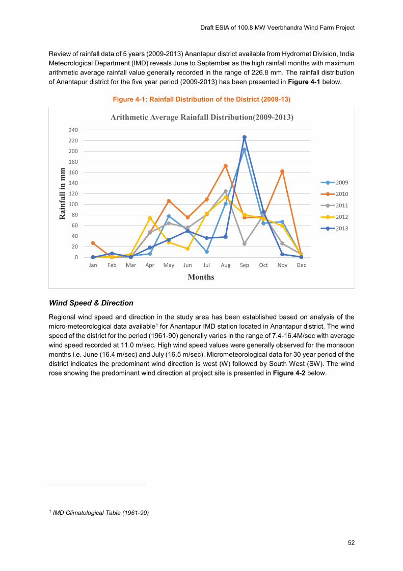
Review of rainfall data of 5 years (2009-2013) Anantapur district available from Hydromet Division, India
Meteorological Department (IMD) reveals June to September as the high rainfall months with maximum
arithmetic average rainfall value generally recorded in the range of 226.8 mm. The rainfall distribution
of Anantapur district for the five year period (2009-2013) has been presented in Figure 4-1 below.
Figure 4-1: Rainfall Distribution of the District (2009-13)
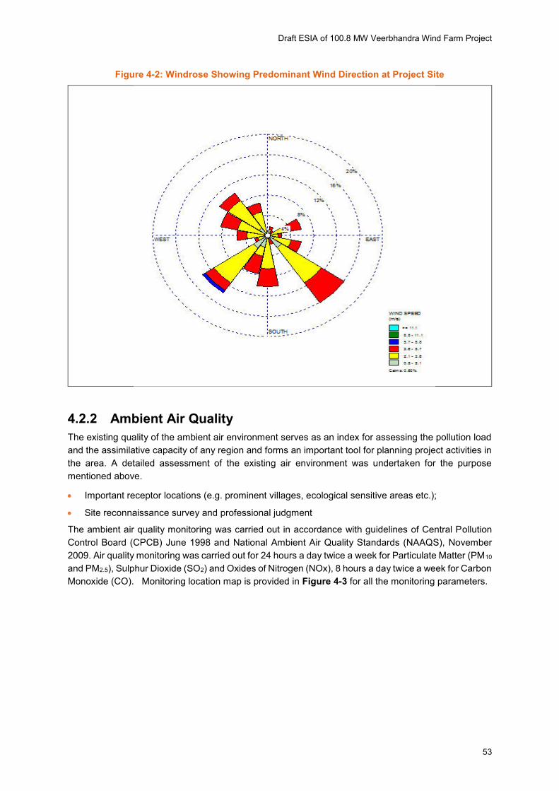
Wind Speed & Direction
Regional wind speed and direction in the study area has been established based on analysis of the
micro-meteorological data available1 for Anantapur IMD station located in Anantapur district. The wind
speed of the district for the period (1961-90) generally varies in the range of 7.4-16.4M/sec with average
wind speed recorded at 11.0 m/sec. High wind speed values were generally observed for the monsoon
months i.e. June (16.4 m/sec) and July (16.5 m/sec). Micrometeorological data for 30 year period of the
district indicates the predominant wind direction is west (W) followed by South West (SW). The wind
rose showing the predominant wind direction at project site is presented in Figure 4-2 below.
1 IMD Climatological Table (1961-90)
0
20
40
60
80
100
120
140
160
180
200
220
240
Jan Feb Mar Apr May Jun Jul Aug Sep Oct Nov Dec
Rain
fall
in
mm
Months
Arithmetic Average Rainfall Distribution(2009-2013)
2009
2010
2011
2012
2013
Draft ESIA of 100.8 MW Veerbhandra Wind Farm Project
53
Figure 4-2: Windrose Showing Predominant Wind Direction at Project Site
4.2.2 Ambient Air Quality
The existing quality of the ambient air environment serves as an index for assessing the pollution load
and the assimilative capacity of any region and forms an important tool for planning project activities in
the area. A detailed assessment of the existing air environment was undertaken for the purpose
mentioned above.
Important receptor locations (e.g. prominent villages, ecological sensitive areas etc.);
Site reconnaissance survey and professional judgment
The ambient air quality monitoring was carried out in accordance with guidelines of Central Pollution
Control Board (CPCB) June 1998 and National Ambient Air Quality Standards (NAAQS), November
2009. Air quality monitoring was carried out for 24 hours a day twice a week for Particulate Matter (PM10
and PM2.5), Sulphur Dioxide (SO2) and Oxides of Nitrogen (NOx), 8 hours a day twice a week for Carbon
Monoxide (CO). Monitoring location map is provided in Figure 4-3 for all the monitoring parameters.

Draft ESIA of 100.8 MW Veerbhandra Wind Farm Project
54
Figure 4-3: Monitoring Location Map of the Study Area
Draft ESIA of 100.8 MW Veerbhandra Wind Farm Project
55
Interpretation of Air Quality Results
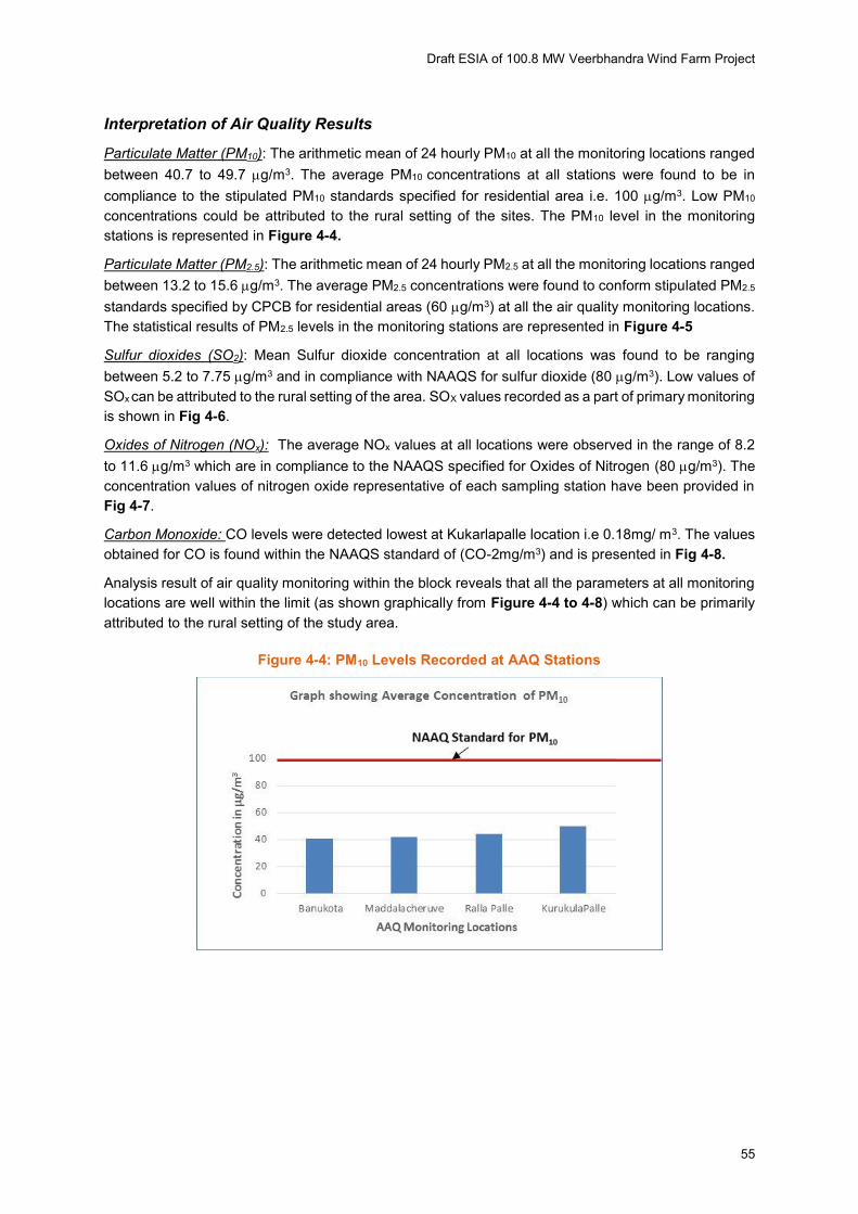
Particulate Matter (PM10): The arithmetic mean of 24 hourly PM10 at all the monitoring locations ranged
between 40.7 to 49.7 g/m3. The average PM10 concentrations at all stations were found to be in
compliance to the stipulated PM10 standards specified for residential area i.e. 100 g/m3. Low PM10
concentrations could be attributed to the rural setting of the sites. The PM10 level in the monitoring
stations is represented in Figure 4-4.
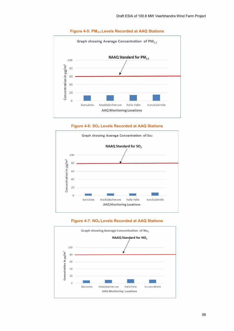
Particulate Matter (PM2.5): The arithmetic mean of 24 hourly PM2.5 at all the monitoring locations ranged
between 13.2 to 15.6 g/m3. The average PM2.5 concentrations were found to conform stipulated PM2.5
standards specified by CPCB for residential areas (60 g/m3) at all the air quality monitoring locations.
The statistical results of PM2.5 levels in the monitoring stations are represented in Figure 4-5
Sulfur dioxides (SO2): Mean Sulfur dioxide concentration at all locations was found to be ranging
between 5.2 to 7.75 g/m3 and in compliance with NAAQS for sulfur dioxide (80 g/m3). Low values of
SOx can be attributed to the rural setting of the area. SOX values recorded as a part of primary monitoring
is shown in Fig 4-6.
Oxides of Nitrogen (NOx): The average NOx values at all locations were observed in the range of 8.2
to 11.6 g/m3 which are in compliance to the NAAQS specified for Oxides of Nitrogen (80 g/m3). The
concentration values of nitrogen oxide representative of each sampling station have been provided in
Fig 4-7.
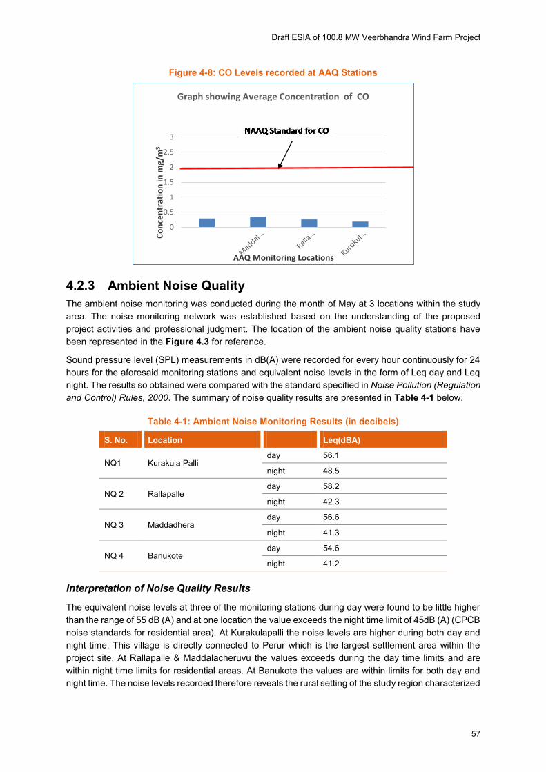
Carbon Monoxide: CO levels were detected lowest at Kukarlapalle location i.e 0.18mg/ m3. The values
obtained for CO is found within the NAAQS standard of (CO-2mg/m3) and is presented in Fig 4-8.
Analysis result of air quality monitoring within the block reveals that all the parameters at all monitoring
locations are well within the limit (as shown graphically from Figure 4-4 to 4-8) which can be primarily
attributed to the rural setting of the study area.
Figure 4-4: PM10 Levels Recorded at AAQ Stations
Draft ESIA of 100.8 MW Veerbhandra Wind Farm Project
56
Figure 4-5: PM2.5 Levels Recorded at AAQ Stations
Figure 4-6: SO2 Levels Recorded at AAQ Stations
Figure 4-7: NOX Levels Recorded at AAQ Stations
Draft ESIA of 100.8 MW Veerbhandra Wind Farm Project
57
Figure 4-8: CO Levels recorded at AAQ Stations
4.2.3 Ambient Noise Quality
The ambient noise monitoring was conducted during the month of May at 3 locations within the study
area. The noise monitoring network was established based on the understanding of the proposed
project activities and professional judgment. The location of the ambient noise quality stations have
been represented in the Figure 4.3 for reference.
Sound pressure level (SPL) measurements in dB(A) were recorded for every hour continuously for 24
hours for the aforesaid monitoring stations and equivalent noise levels in the form of Leq day and Leq
night. The results so obtained were compared with the standard specified in Noise Pollution (Regulation
and Control) Rules, 2000. The summary of noise quality results are presented in Table 4-1 below.
Table 4-1: Ambient Noise Monitoring Results (in decibels)
S. No. Location Leq(dBA)
NQ1 Kurakula Palli day 56.1
night 48.5
NQ 2 Rallapalle day 58.2
night 42.3
NQ 3 Maddadhera day 56.6
night 41.3
NQ 4 Banukote day 54.6
night 41.2
Interpretation of Noise Quality Results
The equivalent noise levels at three of the monitoring stations during day were found to be little higher
than the range of 55 dB (A) and at one location the value exceeds the night time limit of 45dB (A) (CPCB
noise standards for residential area). At Kurakulapalli the noise levels are higher during both day and
night time. This village is directly connected to Perur which is the largest settlement area within the
project site. At Rallapalle & Maddalacheruvu the values exceeds during the day time limits and are
within night time limits for residential areas. At Banukote the values are within limits for both day and
night time. The noise levels recorded therefore reveals the rural setting of the study region characterized
0
0.5
1
1.5
2
2.5
3
Co
nce
ntr
ati
on
in
mg
/m3
AAQ Monitoring Locations
Graph showing Average Concentration of CO
Draft ESIA of 100.8 MW Veerbhandra Wind Farm Project
58
by little higher vehicular movement which are generally identified as potential noise sources during the
day time.
4.2.4 Soil Quality
The soils of Anantapur originated from both the granite and granite-gneisss land forms, as wells as the
Dharwar landforms. Both these land forms are characterized by hills and ridges having undulating and
gently-sloping lands. As per the study of Anantapur district, carried out by M S Swaminathan Research
Foundation, Chennai for the Government of India, there are about thirty four soil families in the district
of Anantapur, and among these, the Anantapur and Penukonda soil families are the most predominant.
4.2.5 Natural Drainage & Surface Water Quality
There are no perennial river system in the study area. It has its origins in the Nandi Hills of the state of
Karnataka and enters the Anantapur district from the extreme south of Hindupur mandal and flows
through 12 mandals. Pennar River flows through south and west of the study area. Penna River dries
up during the dry months. Though most of the villages in the study area has some water body, (locally
called Cherevu) close to them, most of the water bodies dries up during the drier season.
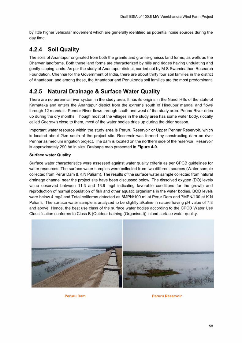
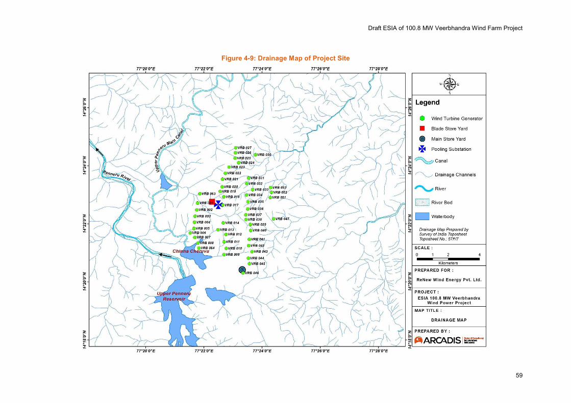
Important water resource within the study area is Peruru Reservoir or Upper Pennar Reservoir, which
is located about 2km south of the project site. Reservoir was formed by constructing dam on river
Pennar as medium irrigation project. The dam is located on the northern side of the reservoir. Reservoir
is approximately 290 ha in size. Drainage map presented in Figure 4-9.
Surface water Quality
Surface water characteristics were assessed against water quality criteria as per CPCB guidelines for
water resources. The surface water samples were collected from two different sources (Water sample
collected from Perur Dam & K.N Paliam). The results of the surface water sample collected from natural
drainage channel near the project site have been discussed below. The dissolved oxygen (DO) levels
value observed between 11.3 and 13.9 mg/l indicating favorable conditions for the growth and
reproduction of normal population of fish and other aquatic organisms in the water bodies. BOD levels
were below 4 mg/l and Total coliforms detected as 8MPN/100 ml at Perur Dam and 7MPN/100 at K.N
Paliam. The surface water sample is analyzed to be slightly alkaline in nature having pH value of 7.8
and above. Hence, the best use class of the surface water bodies according to the CPCB Water Use
Classification conforms to Class B (Outdoor bathing (Organised)) inland surface water quality.
Peruru Dam Peruru Reservoir
Draft ESIA of 100.8 MW Veerbhandra Wind Farm Project
59
Figure 4-9: Drainage Map of Project Site
Draft ESIA of 100.8 MW Veerbhandra Wind Farm Project
60
4.2.6 Ground Water Quality
Andhra Pradesh is characterized by various geological formations ranging in age from Archaean to
Recent. Nearly 67 percent of the State is underlain by hard rock formations consisting of granites,
gneisses, metamorphics and intrusives (Archaeans), Precambrian quartzites, shales and limestones
(Cuddapahs & Kurnools), Mesozoic Deccan Trap basalts etc., while the remaining area is underlain by
Gondwana, Tertiary sedimentaries and Sub Recent-Recent alluvium. The occurrence and movement
of ground water in hard rocks is chiefly controlled by thickness of weathering and structural features like
fractures and solution cavities. In general, the depth of weathering varies from 5 to 20 m and
occasionally upto 40 m. Ground water in the proposed project site is found at a depth of about 15-20
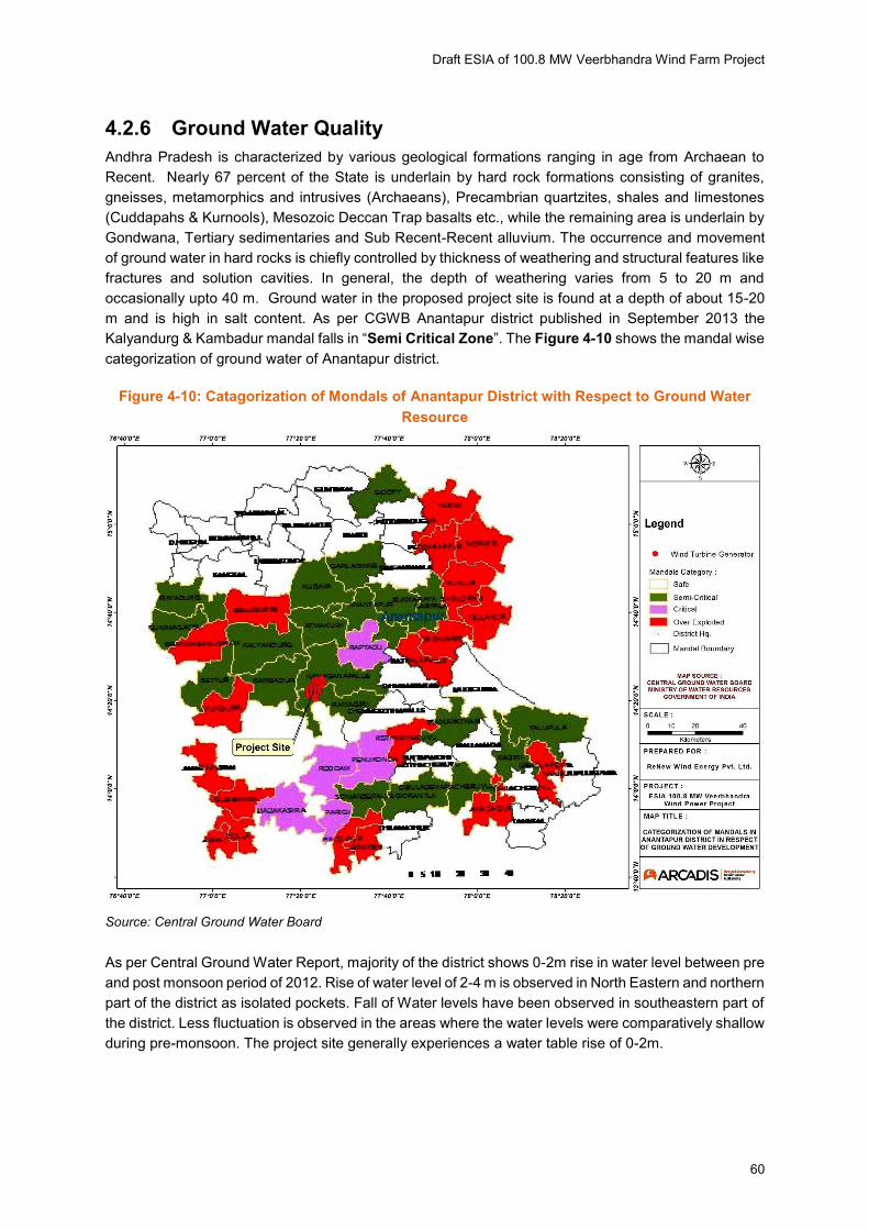
m and is high in salt content. As per CGWB Anantapur district published in September 2013 the
Kalyandurg & Kambadur mandal falls in “Semi Critical Zone”. The Figure 4-10 shows the mandal wise
categorization of ground water of Anantapur district.
Figure 4-10: Catagorization of Mondals of Anantapur District with Respect to Ground Water
Resource
Source: Central Ground Water Board
As per Central Ground Water Report, majority of the district shows 0-2m rise in water level between pre
and post monsoon period of 2012. Rise of water level of 2-4 m is observed in North Eastern and northern
part of the district as isolated pockets. Fall of Water levels have been observed in southeastern part of
the district. Less fluctuation is observed in the areas where the water levels were comparatively shallow
during pre-monsoon. The project site generally experiences a water table rise of 0-2m.

Draft ESIA of 100.8 MW Veerbhandra Wind Farm Project
61
Figure 4-11: Water Level Fluctuation Map of Anantapur District
Source: Central Ground Water Board
Interpretation of Ground Water Quality Results
A total of 2 no. ground water samples were collected from Perur and Maddelacheruvu villages
respectively within the project site. The samples were analyzed for physicochemical and bacteriological
parameters and results compared with IS: 10500 (2012) drinking water standards to identify and
interpret any deviation in the statutory limits set for parameters under this standard. The results for
relevant drinking water quality parameters have been discussed below.
pH and Turbidity
The pH and turbidity values of water sample collected were within the desirable limit of IS: 10500
drinking water standard thereby establishing its potable use. The pH varied in the range of 7.79 to 7.85.
Total Dissolved Solids
The concentration of total dissolved solids (TDS) in ground water is a measure of its suitability for
domestic use. In general, TDS values at 500 mg/l or below is considered to be most desirable for such
purpose being specified under IS: 10500 drinking water standard. The TDS values for the ground water
samples analyzed were found to be Perur (2516 mg/l) and Maddelacheruvu (1362mg/l) thereby
conforming to the permissible limit but not the desirable limit as per ground water standard (IS: 10500).
This is probably due to no or limited recharge of ground water as the area is devoid of good rainfall.
Chlorides
With respect to IS: 10500 standards, the desirable limit of chloride is 250 mg/l while the permissible
limit of the said parameter (in absence of an alternate source) is 1000 mg/l. At concentration above 250
mg/l chlorides renders a salty taste to water which may be considered to be objectionable in terms of
Draft ESIA of 100.8 MW Veerbhandra Wind Farm Project
62
human consumption. The chloride concentration in the ground water samples were found to be Perur
(318.59mg/l ) and Maddelacheruvu (138.9mg/l) which is well within the desirable limit specified for
domestic consumption except for Perur where the TDS value is higher than the specified desirable
limit.
Total Hardness
Hardness of water is considered to be an important parameter in determining the suitability of water for
domestic uses particularly washing. Hardness of water is correlated to the presence of bivalent metallic
ions viz. calcium and magnesium. Total hardness values for the ground water sample analyzed and
were found as (Perur- 813.4 mg/l), and (Maddelacheruvu -715.4 mg/l) which is not within the stipulated
standard of 200 mg/l specified under IS: 10500 but higher than the standard at Perur &
Maddelacheruvu.
Iron and Fluoride
Iron is considered to be an important ground water parameter since at higher concentration it interferes
with laundering operations and imparts objectionable stains. The concentration of iron in ground water
sample was observed to be below detection limits of 0.3mg/l for Perur locations & 1.37mg/l for
Maddelacheruvu. Fluoride content in the ground water samples was found to lie within the desirable
limit of the potable drinking water standard of 1.0 mg/l at Perur & Maddelacheruvu
Heavy Metals
The presence of heavy metals like mercury, arsenic and copper in the ground water samples is below
detectable level.
Coliforms and E. coli
Coliforms, as an indicator of contamination from sewage and fecal matter were reported to be present
in the ground water samples analyzed for two locations. Total coliform analyzed to be 4 MPN per 100
ml of ground water samples at Perur while Total coliform is found absent in ground water sample of
Maddelacheruvu. Faecal coliform is absent in Perur and Maddelacheruvu.
4.2.7 Geology
As per CGWB report, the geological formations in Anantapur district can broadly be categorized into
two distinct groups (i) an older group of archaean rocks and (ii) an younger one of sedimentary rocks
equivalent in age relation to Kadapa and Kurnool Systems of Kadapa Basin. Rocks belonging to the
later formations are pre-cambrian in age and covers the area of Yadiki, Peddapappapuru, Tadipatri,
Putlur, Yellanur mandals and the eastern parts of Peddavadugur, Gooty, Pamidi, Guntakal, Vajrakarur,
Vidapanakal, Narpala, Singanamala, Garladinne, and Kuderu mandals. The remaining parts of the
district comprise the older arch can group of rocks which include schists, gneisses and granites.
4.2.8 Land Use
Land use of the proposed project site is mainly a mix of scrub land, stony hillock and agricultural land
cultivated once a year only during the monsoon season. A 5 km land use map surrounding all WTGs is
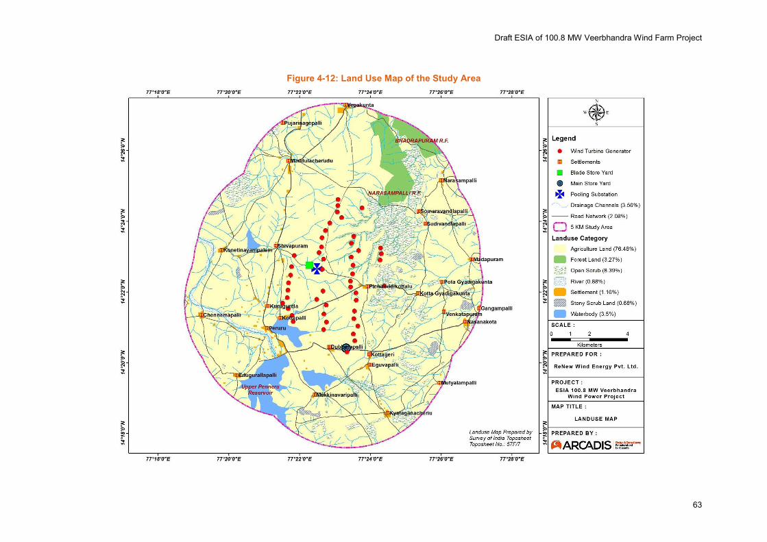
provided in Figure 4-12 showing the land use pattern of the proposed project site. The land use at the
project site comprises mostly of agricultural land (73.82%). Other land use in the project study area is
characterized by i) open scrub (7.73%) ii) Forest land (6.3%) iii) Water body (4%) iv) Settlement (1.04).
Draft ESIA of 100.8 MW Veerbhandra Wind Farm Project
63
Figure 4-12: Land Use Map of the Study Area
Draft ESIA of 100.8 MW Veerbhandra Wind Farm Project
64
4.3 Biological Environment
Study was conducted during November 2016 with the aim to understand and establish the ecological
baseline of the study area and to understand impacts of the Project on the species and habitats in
surrounding areas. The ecological study were conducted with following objectives:
To assess the vegetation types
To identify common flora & fauna in the study area
To find out rare and endangered floral and faunal species
To evaluate wildlife habitat of the area and assess impact of the proposed project on wildlife & their
habitats.
To assess impact of the proposed project on agriculture and domestic livestock.
Methodologies for Ecological Surveys:
Desktop Review:
A desktop review (published document) was conducted to determine the land use and land cover
(Toposheet, Satellite imagery and map of Anantapur Forest Division), vegetation type (Champion and
Seth, 1962), floral and faunal assemblage in the study area (Working Plan of Aanatapur Division). A
site reconnaissance visit was conducted during November 2016 to identify different ecological habitats,
sensitive ecological habitat and also to identify the targeted study area for baseline survey.
Baseline Survey
Baseline survey was carried out to determine the existing ecological conditions and was designed to fill
any data gaps, and to facilitate an adequate assessment of the project’s impacts upon ecology and the development of appropriate mitigation measures. Baseline survey was conducted in November 2016
for habitat survey, flora & faunal assemblage, in the study area. Baseline survey has two parts-
(i) Secondary data collection and (ii) Primary Survey.
Secondary Data Collection
Secondary baseline data regarding sensitive ecological habitat (National Park, Sanctuary, Ecological
Sensitive Area, Migratory Corridor, habitat of endangered, vulnerable and range restricted species etc.),
flora & fauna in the study area, forest cover was collected for Forest Department; and other published
and unpublished documents. Stakeholder consultations (Forest Department, Local People etc.) were
also carried out to understand the major flora & fauna in the study area, pressure on forest resources,
presence of any Schedule I species.
Primary Survey
Flora Survey
The primary floral survey was conducted to record site specific floral species and its diversity. A walk
through of the project area was carried out covering each WTG location and transmission route.
Nearby area around the WTG, proposed access roads and surrounding area was also covered to
understand the floral diversity. At the time of the survey, woody/small trees and ephemeral layer of
ground flora consisting of seasonal or annuals were recorded. Further seasonal species data were
gathered from secondary sources like governmental department records, forest officials and local
residents. None of the species recorded falls in the IUCN red list category.
Faunal Survey
To assess the presence of fauna in the project site, a walk through survey area was carried out.
Draft ESIA of 100.8 MW Veerbhandra Wind Farm Project
65
Each WTG locations were visited to find out the presence of faunal species near the project site.
The faunal survey focused mainly on three groups viz. mammals, avifauna and herpeto fauna of the
study area. Special emphasis was given on Avian fauna, as birds have a potential vulnerability of
getting hit by rotating blade.
Secondary sources like published books and reports, government departmental records, interviews
with forest department and information from local residents were further used to gather information
and support primary observations.
4.3.1 Habitat Survey
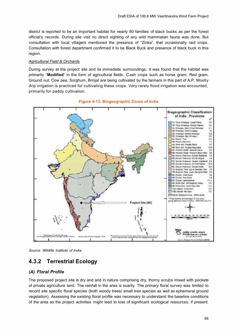
According to the Biogeographic provinces of India published by Wildlife Institute of India (Rodgers,
Panwar and Mathur, 2002), the project site falls under the Biogeographic Province – 6E-Deccan
Peninsula-Deccan South. The Biogeographic zones of India is shown in Figure 4-13.
The site survey also included understanding of important habitats in the area. A “Habitat” according
to IFC is defined as a terrestrial, freshwater or marine geographical unit or airway that supports
assemblage of living organisms and their interactions with the non-living environment. As per IFC,
habitats are divided into - Natural, Modified or Critical2 the purpose of implementation of IFC
Performance Standard-6 (Biodiversity Conservation and Sustainable Management of Living Natural
Resources). Critical habitats are subsets of Natural habitats.
Types of Habitat in the Study area
Open Scrub
Open scrublands are mostly distributed within the reserve forestlands within the study area. Two
reserve forest falls within the northern side of the study area namely Bahadurpuram RF and
Narsampalley RF.
Apart from forest land open scrubs are also found in lands that not used for cultivation like stony
outcrops and hillocks. Presently the natural vegetation of the study area is represented by these open
scrublands. According to Champion and Seth (1968), natural vegetation in the study area can be
classified as “6A/DS 1- Southern Thorn Scrub”. This type of vegetation is the result of maltreatment and
the consequent degradation of the climatic climax dry deciduous forest. This is a biotic type which is in
a state of retrogression and is a type of “Modified” habitat. The crop consist of thorny shrubs of 1m
height and ground covered by dry grass bed. This types of habitat are good for Black buck. Anantapur
2 Natural Habitats- These are the areas composed of viable assemblages of plant and/or animal species of
largely native origin, and/or where human activity has not essentially modified an area’s primary ecological functions and species composition.
Modified Habitats- These are the areas that may contain large proportion of plant and/or animal species of
non- native origin and/or where human activity has substantially modified an area’s primary ecological
functions and species composition. It may include areas omanaged for agriculture,, forest plantations,
reclaimed coastal zones and reclaimed wetlands.
Critical Habitats- These are the areas with high biodiversity value, including (i) habitat of significant
importance to critically endangered and/or endangered species; (ii) habitat of significant importance to
endemic and/or restricted range species; (iii) habitat supporting globally significant concentra tions of
migratory species and/or congregatory species; (iv) highly threatened and/or unique ecosystems; and/or
(v) areas associated with key evolutionary processes.
Draft ESIA of 100.8 MW Veerbhandra Wind Farm Project
66
district is reported to be an important habitat for nearly 80 families of black bucks as per the forest
official’s records. During site visit no direct sighting of any wild mammalian fauna was done. But
consultation with local villagers mentioned the presence of “Zinka”, that occasionally raid crops. Consultation with forest department confirmed it to be Black Buck and presence of black buck in this
region.
Agricultural Field & Orchards
During survey at the project site and its immediate surroundings, it was found that the habitat was
primarily “Modified” in the form of agricultural fields. Cash crops such as horse gram, Red gram,
Ground nut, Cow pea, Sorghum, Brinjal are being cultivated by the farmers in this part of A.P. Mostly
drip irrigation is practiced for cultivating these crops. Very rarely flood irrigation was encounted,
primarily for paddy cultivation.
Figure 4-13: Biogeographic Zones of India
Source: Wildlife Institute of India
4.3.2 Terrestrial Ecology
(A) Floral Profile
The proposed project site is dry and arid in nature comprising dry, thorny scrubs mixed with pockets
of private agriculture land. The rainfall in the area is scanty. The primary floral survey was limited to
record site specific floral species (both woody trees/ small tree species as well as ephemeral ground
vegetation). Assessing the existing floral profile was necessary to understand the baseline conditions
of the area as the project activities might lead to loss of significant ecological resources, if present.
Draft ESIA of 100.8 MW Veerbhandra Wind Farm Project
67
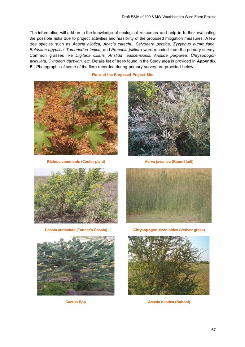
The information will add on to the knowledge of ecological resources and help in further evaluating
the possible risks due to project activities and feasibility of the proposed mitigation measures. A few
tree species such as Acacia nilotica, Acacia catechu, Salvodara persica, Zyzyphus nummularia,
Balanites agyptica, Tamarindus indica, and Prosopis juliflora were recoded from the primary survey.
Common grasses like Digitaria ciliaris, Aristida adscensionis, Aristida purpurea, Chrysopogon
aciculata, Cynodon dactylon, etc. Details list of trees found in the Study area is provided in Appendix
E. Photographs of some of the flora recorded during primary survey are provided below:
Flora of the Proposed Project Site
Ricinus communis (Castor plant) Aerva javanica (Kapuri jadi)
Cassia auriculata (Tanner's Cassia) Chrysopogon zizanioides (Vetiver grass)
Cactus Spp. Acacia nilotica (Babool)
Draft ESIA of 100.8 MW Veerbhandra Wind Farm Project
68
(A) Faunal Profile
Mammal
During site visit wild animals like Black Buck was recorded by direct observation on multiple occation.
consultation with local villagers mentioned the presence of “Zinka”, that occasionally raid crops. Consultation with forest department confirmed it to be Black Buck and presence of black buck in this
region. The Jayamangali Black Buck reserve is approximately 72 Km from the project site and is
located in Tumkur district in Karnataka, neighboring Karnataka- Andhra Pradesh border. Locations
were Blcak buck were recorded during the site visit are marked in the Ecological Sensitivity map. Indian
Hare was also recorded during site visit. Consultation with local villagers and record of forest
department confirmed the presence of the following mammals in the forests of study area.
Table 4-2: Mammals found in the Forest within the Study Area
Sl.
No
Common
Name Telegu Name
Scientific
Name
Schedule
WPA 1972 IUCN Status
Occurrence in
the Study
Area
1. Blackbuck Krishna Zinka
Antilope cervicapra
I Near Threatened
Common
2. Wild Boar Adavi pandi Sus scrofa cristatus
III Least Concern Common
3. Blacknaped Hare
Kundelu Lepus nigricollis
III Least Concern Common
4. Jackal Nakka Canis aureus II Least Concern Frequent
5. Bonnet Macaque
Kothi Macaca radiata
II Least Concern Frequent
6. Common Fox
Guntanakka Vulpes bengalensis
II Least Concern Rare
7. Sloth Bear Yelugubanti Melursus ursinus
I Vulnerable Rare
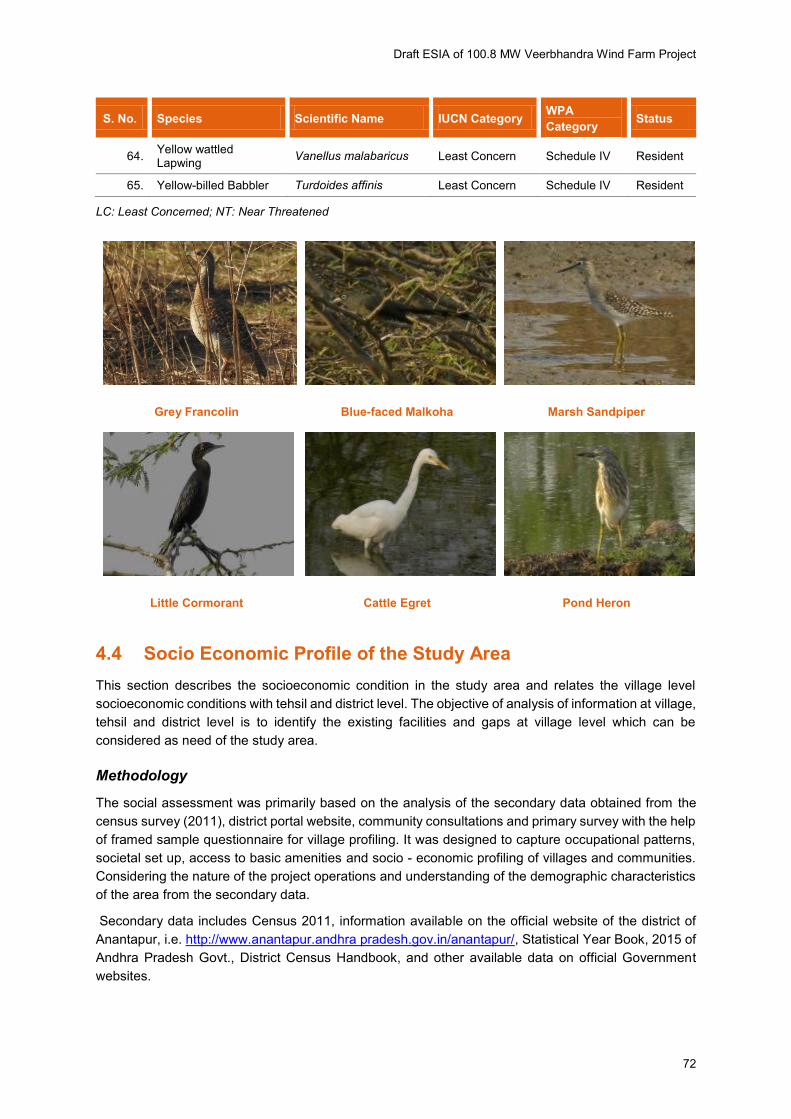
Avifauna
During one week avian fauna survey period, total 65 species of birds were sighted and recorded in the
study area. Bird species such as egrets, black drongo, red vented bulbul, green bee eater, barn
swallow, ashy crowned sparrow, hoopoe, common myna, paddy field pipit, laughing dove were found
in large numbers from the survey. The species of birds recorded in the project area during site visit is
listed in the Table 4-3.
Detail list of fauna that can be found in the study are has been provided in Appendix F.

Draft ESIA of 100.8 MW Veerbhandra Wind Farm Project
69
Figure 4-14: Ecological Sensitivity Map
Draft ESIA of 100.8 MW Veerbhandra Wind Farm Project
70
Table 4-3: List of Avifauna Sighted During Visit
S. No. Species Scientific Name IUCN Category WPA
Category Status
1. Ashy crowned Sparrow Lark
Eremopterix griseus Least Concern Schedule IV Resident
2. Ashy Prinia Prinia socialis Least Concern Schedule IV Resident
3. Asian Koel Eudynamys scolopaceus
Least Concern Schedule IV Resident
4. Black Drongo Dicrurus macrocercus Least Concern Schedule IV Resident
5. Black Kite Milvus migrans Least Concern Schedule I Resident
6. Black winged Kite Elanus caeruleus Least Concern Schedule I Resident
7. Black-hooded Oriole Oriolus xanthornus Least Concern Schedule IV Resident
8. Black-winged Stilt Himantopus himantopus Least Concern Schedule IV Resident/ Local migratory
9. Blue-faced Malkoha Phaenicophaeus viridirostris
Least Concern Schedule IV Resident
10. Blyth's Reed Warbler Acrocephalus dumetorum
Least Concern Schedule IV WV
11. Brahminy Starling Sturnus pagodarum Least Concern Schedule IV Resident
12. Cattle Egret Bubulcus ibis Least Concern Schedule IV Resident
13. Chestnut bellied Sandgrouse
Pterocles exustus Least Concern Schedule IV Resident
14. Common Hoopoe Upupa epops Least Concern Schedule IV Resident
15. Common Iora Aegithina tiphia Least Concern Schedule IV Resident
16. Common Moorhen Gallinula chloropus Least Concern Schedule IV Resident
17. Common Myna Acridotheres tristis Least Concern Schedule IV Not migratory
18. Coppersmith Barbet Psilopogon haemacephalus
Least Concern Schedule-IV
19. Dusky Crag Martin Hirundo concolor Least Concern Schedule IV
20. Eurasian Collared Dove
Streptopelia decaocto Least Concern Schedule-IV Resident
21. Eurasian Coot Fulica atra Least Concern Schedule-IV Resident
22. Garganey Spatula querquedula Least Concern Schedule IV
23. Great Tit Parus major Least Concern Schedule-IV Resident
24. Green Bee Eater Merops orientalis Least Concern Schedule IV Not migratory
25. Grey Francolin Francolinus pondicerianus
Least Concern Schedule IV Resident
26. Grey-breasted Prinia Prinia hodgsonii Least Concern Schedule IV Resident
27. House Crow Corvus splendens Least Concern Schedule IV Resident
28. House Sparrow Passer domesticus Least Concern Schedule IV Resident
29. Indian Black Robin Saxicoloides fulicatus Least Concern Schedule IV Resident
30. Indian Bushlark Mirafra erythroptera Least Concern Schedule IV

Draft ESIA of 100.8 MW Veerbhandra Wind Farm Project
71
S. No. Species Scientific Name IUCN Category WPA
Category Status
31. Indian Peafowl Pavo cristatus Least Concern Schedule I Resident
32. Indian Pond Heron Ardeola grayii Least Concern Schedule IV Resident
33. Indian Roller Coracias benghalensis Least Concern Schedule IV Resident
34. Indian Silverbill Lonchura malabarica Least Concern Schedule IV
35. Intermediate egret Ardea intermedia Least Concern Schedule IV Resident
36. Large Grey Babbler Turdoides malcolmi Least Concern Schedule IV Resident
37. Laughing Dove Spilopelia senegalensis Least Concern Schedule IV Resident
38. Lesser Whistling Duck Dendrocygna javanica Least Concern Schedule IV
39. Little Cormorant Microcarbo niger Least Concern Schedule IV Resident
40. Little Egret Egretta garzetta Least Concern Schedule-IV Resident
41. Little Grebe Tachybaptus ruficollis Least Concern Schedule-IV Resident
42. Little Swift Apus affinis Least Concern Schedule IV
43. Marsh Sandpiper Tringa stagatilis Least Concern Schedule IV WV
44. Paddyfiled Pipit Anthus rufulus Least Concern Schedule-IV Not migratory
45. Purple Sunbird Nectarinia asiatica Least Concern Schedule IV Resident
46. Purple Swamphen Porphyrio porphyrio Least Concern Schedule IV
47. Red vented Bulbul Pycnonotus cafer Least Concern Schedule IV Not migratory
48. Red wattled Lapwing Vanellus indicus Least Concern Schedule-IV Resident
49. Rock Pigeon Petrophassa albipennis Least Concern Schedule IV Not migratory
50. Rose-ringed Parakeet Psittacula krameri Least Concern Schedule IV Not migratory
51. Rufous Treepie Dendrocitta vagabunda Least Concern Schedule IV Resident
52. Scaly-breasted Munia Lonchura punctulata Least Concern Schedule IV Resident
53. Shikra Accipiter badius Least Concern Schedule I Resident
54. Short toed Snake Eagle
Circaetus gallicus Least Concern Schedule I Resident
55. Small Minivet Pericrocotus cinnamomeus
Least Concern Schedule-IV Resident
56. Southern Coucal Centropus sinensis Least Concern Schedule IV Resident
57. Spot-billed Duck Anas poecilorhyncha Least Concern Schedule IV Resident
58. Spotted Owlet Athene brama Least Concern Schedule IV Resident
59. Tawny Eagle Aquila rapax Least Concern Schedule I Resident
60. White-browed Bulbul Pycnonotus luteolus Least Concern Schedule-IV Resident
61. White-browed Wagtail Motacilla madaraspatensis
Least Concern Schedule IV Resident
62. White-throated Kingfisher
Halcyon gularis Least Concern Schedule IV Resident
63. Yellow Wagtail Motacilla flava Least Concern Schedule IV
Draft ESIA of 100.8 MW Veerbhandra Wind Farm Project
72
S. No. Species Scientific Name IUCN Category WPA
Category Status
64. Yellow wattled Lapwing
Vanellus malabaricus Least Concern Schedule IV Resident
65. Yellow-billed Babbler Turdoides affinis Least Concern Schedule IV Resident
LC: Least Concerned; NT: Near Threatened
Grey Francolin Blue-faced Malkoha Marsh Sandpiper
Little Cormorant Cattle Egret Pond Heron
4.4 Socio Economic Profile of the Study Area
This section describes the socioeconomic condition in the study area and relates the village level
socioeconomic conditions with tehsil and district level. The objective of analysis of information at village,
tehsil and district level is to identify the existing facilities and gaps at village level which can be
considered as need of the study area.
Methodology
The social assessment was primarily based on the analysis of the secondary data obtained from the
census survey (2011), district portal website, community consultations and primary survey with the help
of framed sample questionnaire for village profiling. It was designed to capture occupational patterns,
societal set up, access to basic amenities and socio - economic profiling of villages and communities.
Considering the nature of the project operations and understanding of the demographic characteristics
of the area from the secondary data.
Secondary data includes Census 2011, information available on the official website of the district of
Anantapur, i.e. http://www.anantapur.andhra pradesh.gov.in/anantapur/, Statistical Year Book, 2015 of
Andhra Pradesh Govt., District Census Handbook, and other available data on official Government
websites.
Draft ESIA of 100.8 MW Veerbhandra Wind Farm Project
73
Site visit was undertaken along with primary and secondary data collection from various sources.
Primary data includes consultation with land aggregator and some land sellers who have sold land or
have sale agreement. Interviews were also undertaken with Project Proponent – ReNew, local villagers
and government officials. Information and Documents were collected from ReNew, project site and land
details as per requirements. The assessment of socio-economic environment was carried out based on
the primary survey with the help of framed questionnaire to conduct community consultation.
Study Area
As information provided by ReNew, the proposed 48 WTG location is spread over in three villages
namely Peruru, Nasanakota Panchayats under Ramagiri Mandal, Narasampalle Panchayats
respectively Kanaganapalle Mandal in Anantapur district as presented in Table 4-4.
Table 4-4: List of Study Area Villages
Sl.
No. State District Mandal/ Tehsil
Gram
Panchayat Village
1
Andhra Pradesh Anantapur Ramagiri
Peruru Peruru
2 Nasanakota Nasanakota
3 Kanaganapalle Narasampalle Narasampalle
Source: ReNew
4.4.1 Demographic Profile of District and Study Area Villages
Demographic Profile
The demographic profile in terms of total population, number of households, household size and sex-
ratio of the selected villages surveyed in study area are discussed in the section below.
Population & Sex ratio3
State: As per details from Census 2011 and also given in Statistical Year Book, 2015 of Directorate of
Economics and Statistics, Government of Andhra Pradesh, the total population of Andhra Pradesh is
84,580,777 which includes 42,442,146 male and 42,138,631 female. Sex Ratio in Andhra Pradesh is
9934 female per 1000 male, which is above the national average of 940 as per census 2011. As
enumerated in Census, 2011 Literacy rate in Andhra Pradesh is 67.66% of that, Male literacy and
female literacy are 75.56% and 59.74%, respectively. The overall growth of total population during the
decade 2001 to 2011 is 13.58%, whereas it was 18.77% in the preceding decade.5
3 http://www.andhrapradesh.gov.in/About/State-Profile and Census, 2011
Draft ESIA of 100.8 MW Veerbhandra Wind Farm Project
74
Anantapur District1:
As per census 2011, respect to the district level, Anantapur has population of 4,081,148 of which male
and female are 2,064,495 and 2,016,653 respectively. With regards to sex ratio in Anantapur, it stood
at 977 per 1000 male which is below state average of 993.
Ramagiri Mandal1: The 2 study area villages of the present 100.8 MW Wind Power Plant, namely
Peruru and Nasanakota are located in Ramagiri Mandal. As per census 2011, the total population of
Ramagiri Mandal is 34001 of which male and female are 17,364 and 16,637 respectively. The sex ratio
of Ramagiri Mandal is 958, much lower than state (988) as well as higher than the national (940) ratio.
Kanaganapalle Mandal 1: The 1 study area village of the present 100.8 MW Wind Power Plant, namely
Narasampalle is located in Kanaganapalle Mandal. As per census 2011, the total population of
Kanaganapalle Mandal is 39673 of which male and female are 20,529 and 19 144 respectively. The
sex ratio of Kanaganapalle Mandal is 933, much lower than state (988) as well as the national (940)
ratio.
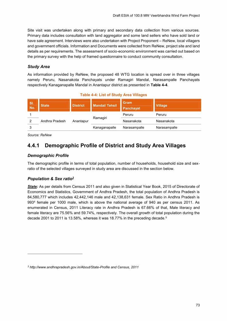
Study area villages (Peruruu, Nasanakota and Narasampalle): Hence, referring Census 2011 and
data gathered from Primary Consultation the cumulative total population of the mentioned study area
villages Peruru, Nasanakota and Narasampalle is 15,278 out of which 7,735 are male and 7,543 are
female. The average sex ratio in these 3 study area villages is 975. The details are presented in
Appendix L and shown in Figure 4-15.
Household Size: According to the district level household survey (2007, 2008), an average of 4.5
people lived in a single household during that period in Andhra Pradesh. Whereas, average household
size of district Anantapur is 4.2 which is below the average of the state (4.5).
Considering the Census 2011 data of the villages, field visit observations and consultations with the
community reveals that average HH size of the 3 study area villages is around 5-7.
Figure 4-15: Gender Ratio in Study Area
Source: Census 2011
958
981
979
933
933
Draft ESIA of 100.8 MW Veerbhandra Wind Farm Project
75
4.4.2 Schedule Caste (SC) & Scheduled Tribe (ST)
Anantapur District
The scheduled caste and schedule tribes constitutes 16.19% and 5.3% of the total population of Andhra
Pradesh as per census 2011. With respect to Anantapur district SC and ST population constitutes 14.29
percent and 3.78 % which is below the average of state as stated in Census 2011. As reported by the
land team of Suzlon, none of the land sellers are from SC/ ST Community.
Hence ADB Safeguard Policy of IP is not applicable.
A Social Safeguard Compliance Audit was undertaken, which confirms that no lands has been resumed
or taken from any ST community. It ensures that ADB Safeguard Policy of IP is not triggered.
Ramagiri:
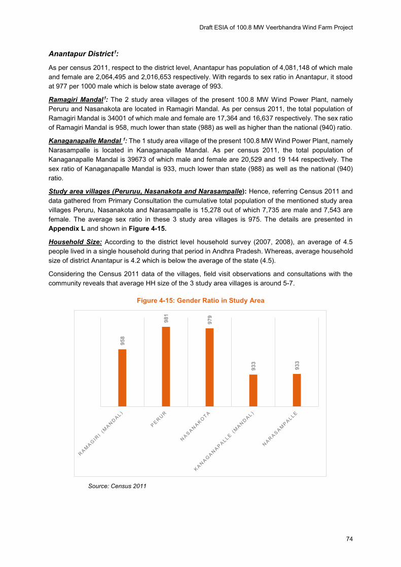
As per Census 2011, 20.43% and 3.08% percent of the total population of Ramagiri Mandal constitutes
SC and ST population more than average of the district, shown in Figure 4-16.
Kanaganapalle:
As per Census 2011, 17.43 and 4.25 percent of the total population of Kanaganapalle Mandal
constitutes SC and ST part as shown in Figure 4-16. Error! Reference source not found.
Study area villages (Peruruu, Nasanakota and Narasampalle): As observed from Primary
Consultation as well as census 2011, the SCs of constitute 16.66%, 32.81% and 20.74% of the total
population of Peruru, Nasanakota and Narasampalle villages respectively. The percentage is either
close to or higher than average of both the Mandal and District. The STs of constitute 0.43%, 1.87%
and 0.26% of the total population of Peruru, Nasanakota and Narasampalle villages respectively. The
percentage is either close to or higher than average of both the Mandal and District. Population in the
study area villages. This also testified during the consultation with the villagers. Details of SC population
in the study area is given in Appendix L and shown in Figure 4-16.
Figure 4-16: Study Area Scheduled Caste Population
Source: Census, 2011
0.00
5.00
10.00
15.00
20.00
25.00
30.00
35.00
40.00
Ramagiri(Mandal)
Perur Nasanakota Kanaganapalle(Mandal)
Narasampalle
SC Populaion ST Population

Draft ESIA of 100.8 MW Veerbhandra Wind Farm Project
76
4.4.3 Literacy
Anantapur District
According to Census, 2011 Literacy rate in Andhra Pradesh has seen upward trend during the last
census period i.e. 67.66 % of the total state population. The male literacy rate in the state stands at
75.56 percent while female literacy is at 59.74 percent. Literacy rates pertain to the population aged 6
years above.
According to Census 2011, average literacy rate of Anantapur district has gone up to 63.57% from
56.13% of 2001. Of that, male and female literacy is seen at 73.02% and 53.97% respectively.
Ramagiri Mandal and Kanaganapalle Mandal:
As given in Census, 2011 the Literate Male and Female Population of Ramagiri Mandal are 10740 and
7351 respectively. As per Census, 2011 around 63.57% of the total population above the age of 6 years
in Anantapur District and 89.28% of the same in Ramagiri Mandal are literate.
As given in Census, 2011 the Literate Male and Female Population of Kanaganapalle Mandal are 12605
and 8525 respectively. 89.27% of the same in Kanaganapalle Mandal are literate.
Study area villages (Peruruu, Nasanakota and Narasampalle): As information retrieved during
primary consultation at the study area villages and referring to Census 2011, the 88.31% of the total
population above the age of 6 years, 50.31% of total male and 49.69% of total female of the same are
literate at Peruru village; 89.63% of the total population who are above 6 years age, 50.40% of total
male and 49.60% of total female are literate at Nasanakota village and 88.60% of the total population,
51.30% of total male and 48.70% of total female are literate at Narasampalle village. The details are
shown in Figure 4-17.
Figure 4-17: Literacy Scenario in Study Area
Source: Census, 2011
In average all the 3 study area villages have more than 88.85% literate population. The male literacy
rate stands around 51% and female around 49%, much lower than the Andhra Pradesh State average,
which is 74.95% and 57.92% for male and female respectively. The village wise literacy rate provided
in Appendix L and shown in Figure 4-17.
0102030405060708090
100
Total Literate
Literate (Male) Literate (Female)
Draft ESIA of 100.8 MW Veerbhandra Wind Farm Project
77
4.4.4 Workers and Occupation
As published in the ‘Report on District Level Estimates for the State of Andhra Pradesh (2013-14)
Government of India’ by Ministry of Labour & Employment Labour Bureau, Anantapur, Work Force
Participation Rate (WFPR) of age15 Years and above for Andhra Pradesh State is 64% of the total
population. The percentage of workers among the total male population of the state is 76.3% and among
the female population 51.3%.
Anantapur District:
As per Census, 2011 total working population of Anantapur district is 20, 36,166 and non-working
population is 20, 44,982. Out of 20, 36,166 working population 4, 13,253 people are dependent on
agriculture. This implies that about.30 20 % of the total working population in Anantapur district are
involved directly on cultivation an allied activities.
Ramagiri Mandal and Kanaganapalle Mandal:
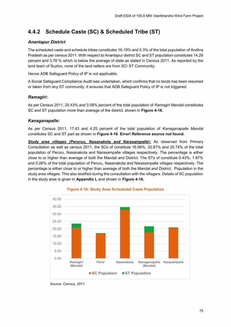
As per Census, 2011 the average WFPR of Ramagiri Mandal is about 53.30%. The percentage of
cultivators and agriculture labours stands at 29.30% and 36.22% of the total working population
respectively. Other work force participation rates stands at 12.33% and the average WFPR of
Kanaganapalle Mandal is about 55.25%. The percentage of cultivators and agriculture labours stands
at 30.09% and 35.32% of the total working population respectively of both the mandal. Other work force
participation rates stands out at 10.63%.
Study area villages (Peruru, Nasanakota and Narasampalle):
According to Census 2011 as well as from the information gathered during field visit the average
percentage of cultivators of the three study area villages (Peruru, Nasanakota and Narasampalle)
stands out to at 36.65%, 54.59% and 40.73% of the total working population respectively. Comparative
analysis of workforce participation data shows that major livelihood resource in the study area is
agriculture. Majority of the population in the study area villages sustains on agriculture and allied
activities. The distinct village wise percentage of the workforce distribution is given in Appendix L and
shown in Figure 4-18.
Figure 4-18: Work Force Participation Rate in The Study Area Villages
Source: Census, 2011
0.00
10.00
20.00
30.00
40.00
50.00
60.00
70.00
80.00
TotalCultivators
TotalAgriculturalLabourers
Total OtherWorkers
Houshold
Perur Nasanakota Narasampalle

Draft ESIA of 100.8 MW Veerbhandra Wind Farm Project
78
Females Workforce participation: As stated in the Report on District Level Estimates for Andhra
Pradesh State, 2015- 16 by Ministry of Labour and Employment, Govt. of India the Female workforce
participation rate in Andhra Pradesh State is 53.50%. Census 2011 reports that the female work
participation rate in Anantapur is 49.89%. And at Ramagiri Mandal the female workforce participation
is 45.91% and at Kanaganapalle Mandal it is 42.75%. With regards to study area villages an average
female work participation rate is 47.53% altogether, which is lower to the average of state (53.5%).
Details of Female WFPR is given in Appendix L and shown in Figure 4-19.
Figure 4-19: Female Work Force Participation in Study Area Villages
Source: Census, 2011
4.4.5 Wages
According to Andhra Pradesh Minimum Wage rule with April 1, 2015 to September 30, 2015, the
minimum wage for Contract Labours in all sector is Rs. 387.65 and Rs. 310.73 for Highly Skilled and
Skilled labourers respectively.
Scheduled Employment Basic Wage (INR)
CONTRACT LABOUR
CATEGORY
Highly Skilled 387.65
Skilled 310.73
Source: http://www.paycheck.in/main/salary/minimumwages/andhra-pradesh
4.4.6 Livelihood source
Agriculture and cropping pattern: As per Census, 2011, about 24.49% and 39.60% of the working
population is directly dependent on agriculture, as Cultivators and Agricultural Labourers respectively
in Anantapur district. The scenario for the same in Ramagiri Mandal is 29.30% and 36.22% and
Kanaganapalle Mandal is 30.09% and 35.32% stands for Cultivators and Agricultural Labourers
respectively. Thus, Agriculture continued to play an important role in the economic growth of the region
of the proposed Wind Power Project.
As mentioned in State Agriculture Portal http://www.andhra pradesh.gov.in/Departments/Agriculture-
and-Co-operation Andhra Pradesh grows 27 important crops in Kharif and Rabi seasons put together
0
5000
10000
15000
20000
25000
Ramagiri(Mandal)
Perur Nasanakota Kanaganapalle(Mandal)
Narasampalle
TotalWorking Population
TotalFemale Population
Draft ESIA of 100.8 MW Veerbhandra Wind Farm Project
79
covering an area of about 53.51 lakh ha. The important crops grown are Rice (14.19) lakh ha, Maize
(6.63) lakh ha, Pulses (6.11) lakh ha, Groundnut (1.89) lakh ha, Cotton (18.13) lakh ha, Chillies (0.83)
lakh ha and Sugarcane (0.41) lakh ha. 78.76% of the area is grown in Kharif and the remaining 21.24%
is cultivated in Rabi.
Cropping Pattern
During consultation it was confirmed that, cultivation here is majorly dependent on irrigation, more
specifically, the dripped irrigation pattern. Farmers are engaged during this period after that they works
under NRGES and other govt. programmes which are running in the area and many persons migrates
to other city like Bangalore, Hyderabad and other state.
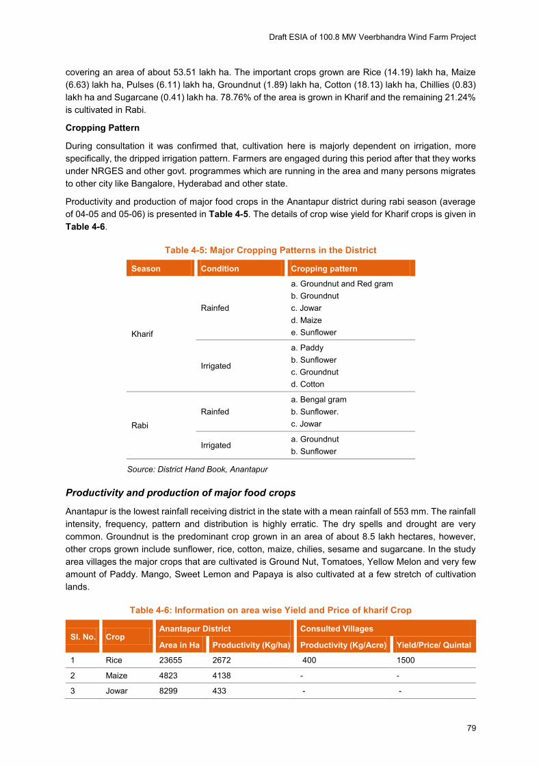
Productivity and production of major food crops in the Anantapur district during rabi season (average
of 04-05 and 05-06) is presented in Table 4-5. The details of crop wise yield for Kharif crops is given in
Table 4-6.
Table 4-5: Major Cropping Patterns in the District
Season Condition Cropping pattern
Kharif
Rainfed
a. Groundnut and Red gram
b. Groundnut
c. Jowar
d. Maize
e. Sunflower
Irrigated
a. Paddy
b. Sunflower
c. Groundnut
d. Cotton
Rabi
Rainfed
a. Bengal gram
b. Sunflower.
c. Jowar
Irrigated a. Groundnut
b. Sunflower
Source: District Hand Book, Anantapur
Productivity and production of major food crops
Anantapur is the lowest rainfall receiving district in the state with a mean rainfall of 553 mm. The rainfall
intensity, frequency, pattern and distribution is highly erratic. The dry spells and drought are very
common. Groundnut is the predominant crop grown in an area of about 8.5 lakh hectares, however,
other crops grown include sunflower, rice, cotton, maize, chilies, sesame and sugarcane. In the study
area villages the major crops that are cultivated is Ground Nut, Tomatoes, Yellow Melon and very few
amount of Paddy. Mango, Sweet Lemon and Papaya is also cultivated at a few stretch of cultivation
lands.
Table 4-6: Information on area wise Yield and Price of kharif Crop
Sl. No. Crop Anantapur District Consulted Villages
Area in Ha Productivity (Kg/ha) Productivity (Kg/Acre) Yield/Price/ Quintal
1 Rice 23655 2672 400 1500
2 Maize 4823 4138 - -
3 Jowar 8299 433 - -

Draft ESIA of 100.8 MW Veerbhandra Wind Farm Project
80
Sl. No. Crop Anantapur District Consulted Villages
Area in Ha Productivity (Kg/ha) Productivity (Kg/Acre) Yield/Price/ Quintal
4 Bajra 1368 806 - -
5 Ragi 3203 1854 - -
6 Red gram 33728 365 600 6000
7 Green gram 1139 394 - -
8 Groundnut 801889 516 400 5000
9 Sunflower 21000 305 - -
10 Cotton 5055 178 800 5500
11 Castor 2800 505 300 3000
Source: Comprehensive District Agricultural Plan, Anantapur district and community consultation
Rice, Maize, Tur Dal (Bengal Gram) and Jowar are normally grown crops in the project area villages.
Among these, Maize, Jowar, Tur Dal, Jowar, Sunflower and Ground Nut are Rabi Crops, i.e. harvested
during or close to winter season. While another type of Paddy and Sugar Cane are Kharif crops. In all
the study area villages almost contiguous fields are seen, with little intervals of fallow lands. Though not
cultivated properly scattered Neem Trees surrounding the cropping fields at few places area are seen.
It was informed during that Sugarcane used to be a cultivated commercial crop in the area, but due to
concurrent closure in Sugar Producing Units in near and far places, that was reduced and presently
cultivated only at a limited scale in the study area villages. Crop wise productivity of Rabi Crops is given
in Table 4-7.
Table 4-7: Information on Area, Yield and Price of Rabi Crop
Sl. No. Crop Rabi
Area in Ha Productivity (Kg/ha)
1 Rice 19890 2821
2 Maize 1581 4200
3 Jowar 14808 619
4 Bengal gram 48963 528
5 Groundnut 22203 1296
6 Sunflower 29073 1044
Source: Primary Consultation in the Study Area Villages
Irrigation
During 2010-11, tube wells constituted 70% of the total irrigation source, followed by 20% through
canals, 8% through tanks and 2% through other sources. Through other sources in the respect to the
study area villages, major source of irrigation is tube well. During consultation it was observed that,
agriculture is dependent on rain and tube wells are the main source of irrigation in the project area
villages. In the consulted villages adequate irrigation facilities were not available. Limited number of
farmers have their own tube wells and rest are only dependent on rainfall for cropping.
During consultation it was observed that, the basic source of water for cultivation is through irrigation.
Most of the irrigation pattern is either Dripped Irrigation or Sprinkling Irrigation. It was interacted during
consultation that continuous use of these types of irrigation may cost ground water reserve in future.
The distribution of source of irrigation of the district is enumerated in Figure 4-20.
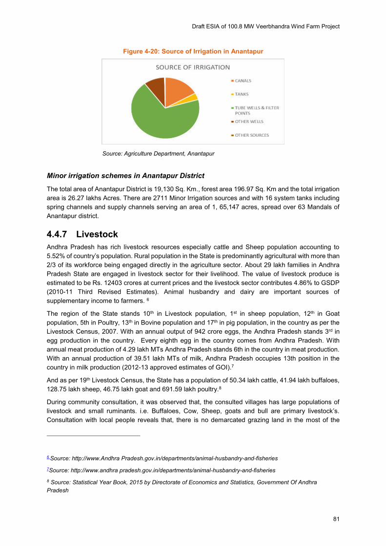
Draft ESIA of 100.8 MW Veerbhandra Wind Farm Project
81
Figure 4-20: Source of Irrigation in Anantapur
Source: Agriculture Department, Anantapur
Minor irrigation schemes in Anantapur District
The total area of Anantapur District is 19,130 Sq. Km., forest area 196.97 Sq. Km and the total irrigation
area is 26.27 lakhs Acres. There are 2711 Minor Irrigation sources and with 16 system tanks including
spring channels and supply channels serving an area of 1, 65,147 acres, spread over 63 Mandals of
Anantapur district.
4.4.7 Livestock
Andhra Pradesh has rich livestock resources especially cattle and Sheep population accounting to
5.52% of country’s population. Rural population in the State is predominantly agricultural with more than
2/3 of its workforce being engaged directly in the agriculture sector. About 29 lakh families in Andhra
Pradesh State are engaged in livestock sector for their livelihood. The value of livestock produce is
estimated to be Rs. 12403 crores at current prices and the livestock sector contributes 4.86% to GSDP
(2010-11 Third Revised Estimates). Animal husbandry and dairy are important sources of
supplementary income to farmers. 6
The region of the State stands 10th in Livestock population, 1st in sheep population, 12th in Goat
population, 5th in Poultry, 13th in Bovine population and 17th in pig population, in the country as per the
Livestock Census, 2007. With an annual output of 942 crore eggs, the Andhra Pradesh stands 3rd in
egg production in the country. Every eighth egg in the country comes from Andhra Pradesh. With
annual meat production of 4.29 lakh MTs Andhra Pradesh stands 6th in the country in meat production.
With an annual production of 39.51 lakh MTs of milk, Andhra Pradesh occupies 13th position in the
country in milk production (2012-13 approved estimates of GOI).7
And as per 19th Livestock Census, the State has a population of 50.34 lakh cattle, 41.94 lakh buffaloes,
128.75 lakh sheep, 46.75 lakh goat and 691.59 lakh poultry.8
During community consultation, it was observed that, the consulted villages has large populations of
livestock and small ruminants. i.e. Buffaloes, Cow, Sheep, goats and bull are primary livestock’s. Consultation with local people reveals that, there is no demarcated grazing land in the most of the
6 Source: http://www.Andhra Pradesh.gov.in/departments/animal-husbandry-and-fisheries
7Source: http://www.andhra pradesh.gov.in/departments/animal-husbandry-and-fisheries
8 Source: Statistical Year Book, 2015 by Directorate of Economics and Statistics, Government Of Andhra
Pradesh
Draft ESIA of 100.8 MW Veerbhandra Wind Farm Project
82
villages. Open shrub field use as a grazing and paddy gross collected for long time as a fodder for
animal. Milk produced for mainly self - consumption purpose.
4.4.8 Local Employment and Migration
During consultation it was observed that, labour in agriculture and labour in other sectors (as porter)
are important source of livelihood in study area villages. Also the same has been testified by the Census
2011. There is no big industry in the region.
Though most of the people rely on Cultivation as their primary source of Livelihood. Hence, migration
is very less in this region. Only a handful people go to nearby towns like Kalyandurg, Anantapur or in
bigger cities like Bangalore to work as Mason or daily wage carpenters etc.
Gender Empowerment Status
The female work participation in Andhra Pradesh is lower than that of male but is the highest amongst
all the states in India. However, the women workers in the state are still not better placed, specifically
by financial status because the workforce is concentrated in activities which are unorganized, informal,
seasonal, insecure, menial and poorly paid. There is also significant wage disparity between the male
and female workforce.
In Anantapur district, female workforce participation is around 49.89%. In the study area villages Peruru,
Nasanakota and Narasampalle the average female work participation is 58.27%, 43.86% and 40.46%
respectively. Additionally, female labourers are engaged in sowing, weeding, plant protection, grading,
kitchen gardening, cleaning of grains, harvesting, feeding the cattle, irrigating fields, taking care of
livestock, growing vegetables and partially engaged with SHGs under Development of Women and
Children in Rural Areas (DWCRA).
Following the Census, 2011, the average literacy rate of female both at District and Mandal level is
found much lower than the male. The scenario is almost the same at the study area villages. The
average difference between the rate of literate between male and female is about 20%. The details in
given in Appendix L.
More, the situation is neither very bright on social status of the women. During consultation with the
women participant it was observed that, early marriage and child marriage, minimal participation of
women in household or economic decision making and lesser economic freedom is common in the
area. The women are entirely responsible for household chores and additionally engaged as agriculture
labour, harvesting, feeding the cattle, and taking care of livestock.
4.4.9 Self Help Groups (SHGs)
“According to the National Bank for Agriculture and Rural Development (NABARD), a self-help group is
a small economically homogeneous and affinity group of rural poor voluntarily coming together: to save
small amounts regularly; to mutually agree to contribute to a common fund; to meet their emergency
needs; to have collective decision making; to solve conflicts through collective leadership and mutual
discussion”
According to the website portal of “Mission for Elimination of Poverty in Municipal Areas” https://www.efms.serp.andhrapradesh.gov.in/MEPMATG/View/Reports/SLF_SHGBasicCoverageRep
ort.aspx Anantapur District has 24,432 SHGs in the FY- 2015-16.
There are schemes under State govt. support to empower women both financially and socially through
Self Help Groups in Andhra Pradesh.

Draft ESIA of 100.8 MW Veerbhandra Wind Farm Project
83
a) Development of Women and Children in Rural Areas (DWCRA)9
In September 1982, the Government of India (GOI) launched the DWCRA programme10 under the
Integrated Rural Development Program (IRDP)11. The program was started in 50 districts (all over India)
on a pilot basis. This was the first rural development program which focused entirely on the development
of women and children. The Development of women and children in Rural Areas or DWCRA is a
government sponsored anti-poverty programme of the Ministry of Rural Development. Each
DWCRA group consists of 15 to 20 women from below poverty line rural families.
The scheme - DWCRA was aimed to improve the socio-economic status of the poor women in the rural
areas through creation of groups of women for income-generating activities on a self-sustaining basis.
The main strategy adopted under the programme was to facilitate access for poor women to
employment, skill upgradation, training credit and other support services so that the DWCRA women
as a group could take up income-generating activities for supplementing their incomes. It sought to
encourage collective action in the form of group activities which were known to work better and were
more sustainable than the individual effort. It encouraged the habit of thrift and credit among poor rural
women to make them self-reliant.
Every group choose a leader, called the organizer, who conducted group meetings and maintained the
group's accounts. Initially, the focus of the groups was on saving money. Most of the groups started
with the motto - 'save a rupee per day.' Every month, the savings were deposited at the post office or
in the banks. The groups also extended credit to needy members from their savings. While in general,
DWCRA groups met once a month, some groups got together more often. Based on their skills, the
group members collectively decided on the income generation activity that they would undertake. At the
monthly meetings, these women also discussed their problems and tried to find solutions. The state
government deployed a Gram Sevika (village coordinator) for every village to oversee the
implementation of the DWCRA program.
In the study area villages a few DWCRA group is found to be existed.
b) Stree Nidhi
As stated in the Andhra Pradesh State Government Website https://www.streenidhi.Andhra
Pradesh.gov.in/SNTG/UI/Home.aspx there is a scheme under govt. aide namely Sthree Nidhi, which
provides credit to the poorer SHG members in times of need and for growth and sustained development.
It is stated in the website, “Sthree Nidhi credit cooperative Federation Ltd., is promoted by the
Government and the Mandal Samkahyas to supplement credit flow from banking sector and is a flagship
programme of the Government. Sthree Nidhi provides timely and affordable credit to the poor SHG
members as a part of the overall strategy of SERP for poverty alleviation.” It is also stated in the
website, “SHGs are comfortable to access hassle free credit from Sthree Nidhi as and when required
using their mobile and therefore do not see any need to borrow from other sources at usurious rates of
interest. Sthree Nidhi is in a position to extend credit to the SHGs even in far flung areas of the state in
48 hours to meet credit needs for exigencies like health, education and other income generation needs
like agriculture, dairy and other activities. As credit availability is linked to grading of MS and VOs,
9 Source: http://www.icmrindia.org/
10 Initially UNICEF provided assistance to the program. But it suspended its assistance w.e.f 1.1.1996.
11 The IRDP program was initiated by government of India in 1978-79 to bring about integrated rural development
by providing credit and training assistance to the families below the poverty line to create income generating
activities.
Draft ESIA of 100.8 MW Veerbhandra Wind Farm Project
84
community is keen to improve functioning of the same to access higher amount of credit limits from
Sthree Nidhi. ”
Samruddi deposit by SHGs was made compulsory to access loans from Sthree Nidhi.
SHG has to contribute Samruddi deposit amount @ Rs.100/- per month from November 2012 till
last month before accessing loans from Stree Nidhi. Further, 80% of SHGs in the VO have to
contribute Samruddi deposits.
The loan requests for income generating activities should be made during SHG/VO meetings only
with proper record in the minutes of the meeting.
In a recent declaration the Andhra Pradesh IT minister K.T. Rama Rao announced, that a centre of
excellence for promotion and replication of best practices in women‘s empowerment through Self
Help Groups will be set up by the Andhra Pradesh state government.
Besides, for the following reasons SHGs are also active in some places as follows:
Swarna Jayanti Gram Swa-Rozgar Yojana (SGSY) - The program focus is on using the SHG
approach for poverty reduction through channeling of bank loans and government subsidies. Budget is
provided for training and working capital support to SHGs but efficiency of use varies with implementers.
SHGs promoted by Regional Rural Banks- Focus is on building up priority sector clientele for SHG-
Bank linkage. Budgets for SHG capacity building vary from bank to bank. Efficiency of budget use can
even vary from branch to branch of the same bank.
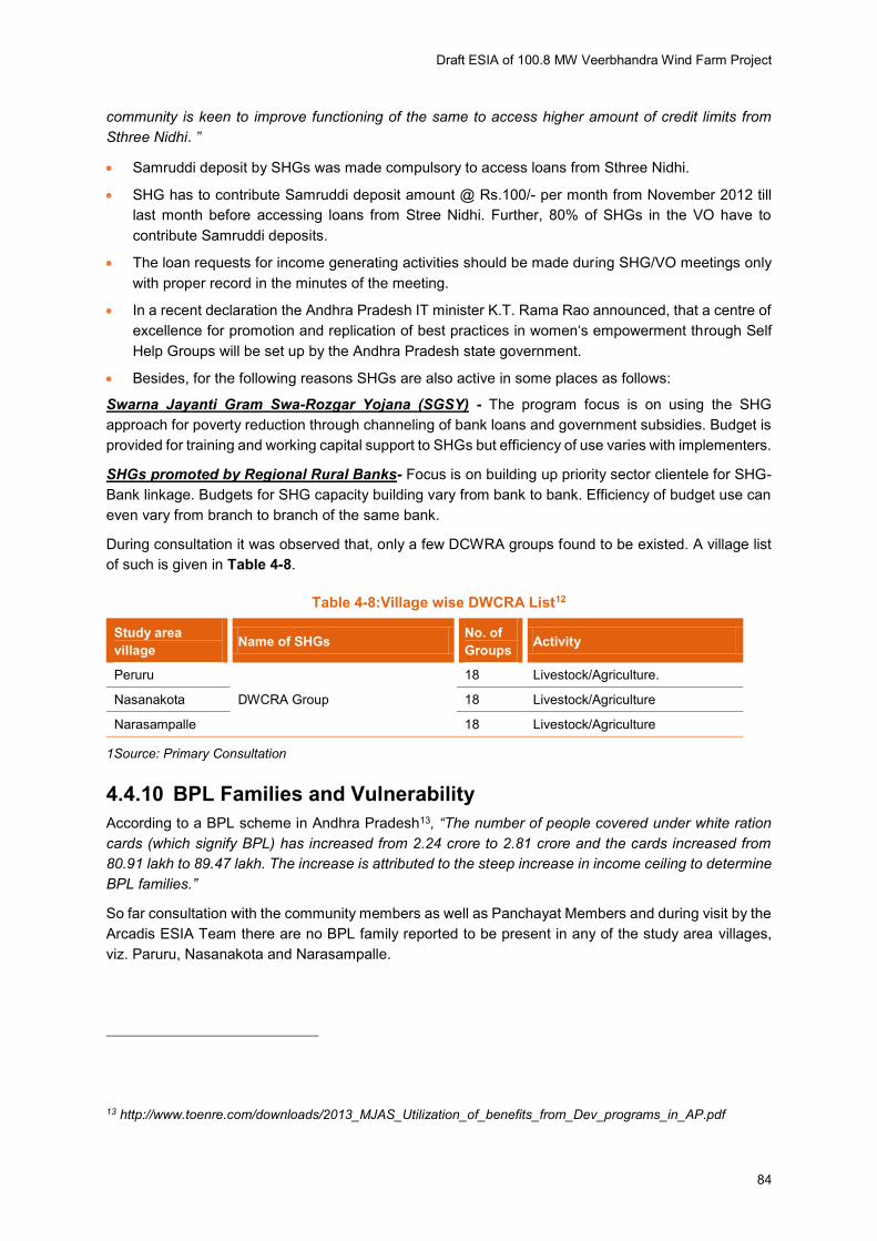
During consultation it was observed that, only a few DCWRA groups found to be existed. A village list
of such is given in Table 4-8.
Table 4-8:Village wise DWCRA List12
Study area
village Name of SHGs
No. of
Groups Activity
Peruru
DWCRA Group
18 Livestock/Agriculture.
Nasanakota 18 Livestock/Agriculture
Narasampalle 18 Livestock/Agriculture
1Source: Primary Consultation
4.4.10 BPL Families and Vulnerability
According to a BPL scheme in Andhra Pradesh13, “The number of people covered under white ration cards (which signify BPL) has increased from 2.24 crore to 2.81 crore and the cards increased from
80.91 lakh to 89.47 lakh. The increase is attributed to the steep increase in income ceiling to determine
BPL families.”
So far consultation with the community members as well as Panchayat Members and during visit by the
Arcadis ESIA Team there are no BPL family reported to be present in any of the study area villages,
viz. Paruru, Nasanakota and Narasampalle.
13 http://www.toenre.com/downloads/2013_MJAS_Utilization_of_benefits_from_Dev_programs_in_AP.pdf
Draft ESIA of 100.8 MW Veerbhandra Wind Farm Project
85
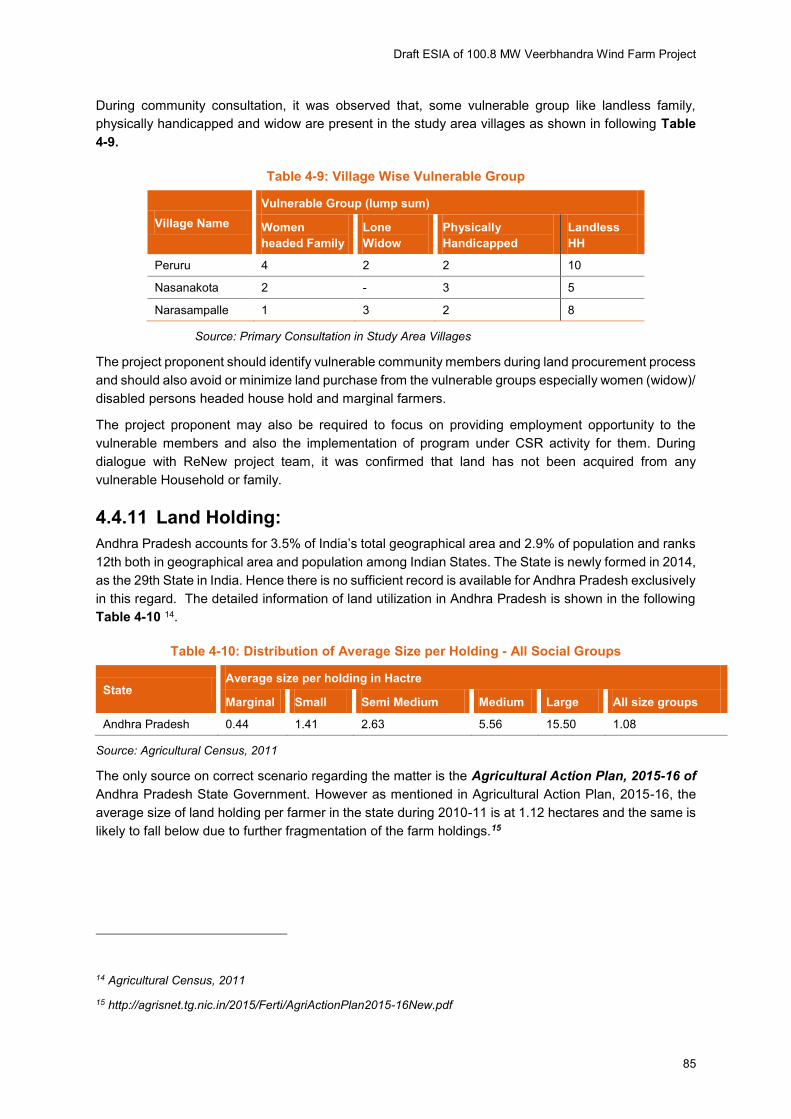
During community consultation, it was observed that, some vulnerable group like landless family,
physically handicapped and widow are present in the study area villages as shown in following Table
4-9.
Table 4-9: Village Wise Vulnerable Group
Village Name
Vulnerable Group (lump sum)
Women
headed Family
Lone
Widow
Physically
Handicapped
Landless
HH
Peruru 4 2 2 10
Nasanakota 2 - 3 5
Narasampalle 1 3 2 8
Source: Primary Consultation in Study Area Villages
The project proponent should identify vulnerable community members during land procurement process
and should also avoid or minimize land purchase from the vulnerable groups especially women (widow)/
disabled persons headed house hold and marginal farmers.
The project proponent may also be required to focus on providing employment opportunity to the
vulnerable members and also the implementation of program under CSR activity for them. During
dialogue with ReNew project team, it was confirmed that land has not been acquired from any
vulnerable Household or family.
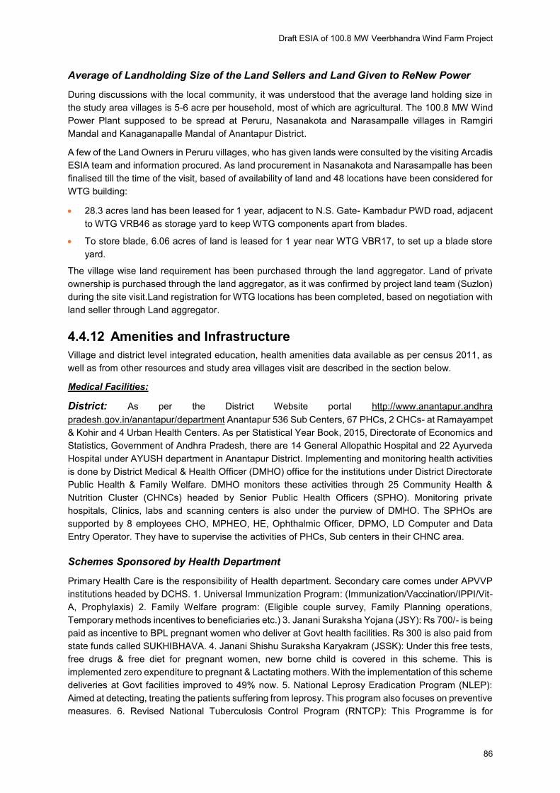
4.4.11 Land Holding:
Andhra Pradesh accounts for 3.5% of India’s total geographical area and 2.9% of population and ranks 12th both in geographical area and population among Indian States. The State is newly formed in 2014,
as the 29th State in India. Hence there is no sufficient record is available for Andhra Pradesh exclusively
in this regard. The detailed information of land utilization in Andhra Pradesh is shown in the following
Table 4-10 14.
Table 4-10: Distribution of Average Size per Holding - All Social Groups
State Average size per holding in Hactre
Marginal Small Semi Medium Medium Large All size groups
Andhra Pradesh 0.44 1.41 2.63 5.56 15.50 1.08
Source: Agricultural Census, 2011
The only source on correct scenario regarding the matter is the Agricultural Action Plan, 2015-16 of
Andhra Pradesh State Government. However as mentioned in Agricultural Action Plan, 2015-16, the
average size of land holding per farmer in the state during 2010-11 is at 1.12 hectares and the same is
likely to fall below due to further fragmentation of the farm holdings.15
14 Agricultural Census, 2011
15 http://agrisnet.tg.nic.in/2015/Ferti/AgriActionPlan2015-16New.pdf
Draft ESIA of 100.8 MW Veerbhandra Wind Farm Project
86
Average of Landholding Size of the Land Sellers and Land Given to ReNew Power
During discussions with the local community, it was understood that the average land holding size in
the study area villages is 5-6 acre per household, most of which are agricultural. The 100.8 MW Wind
Power Plant supposed to be spread at Peruru, Nasanakota and Narasampalle villages in Ramgiri
Mandal and Kanaganapalle Mandal of Anantapur District.
A few of the Land Owners in Peruru villages, who has given lands were consulted by the visiting Arcadis
ESIA team and information procured. As land procurement in Nasanakota and Narasampalle has been
finalised till the time of the visit, based of availability of land and 48 locations have been considered for
WTG building:
28.3 acres land has been leased for 1 year, adjacent to N.S. Gate- Kambadur PWD road, adjacent
to WTG VRB46 as storage yard to keep WTG components apart from blades.
To store blade, 6.06 acres of land is leased for 1 year near WTG VBR17, to set up a blade store
yard.
The village wise land requirement has been purchased through the land aggregator. Land of private
ownership is purchased through the land aggregator, as it was confirmed by project land team (Suzlon)
during the site visit.Land registration for WTG locations has been completed, based on negotiation with
land seller through Land aggregator.
4.4.12 Amenities and Infrastructure
Village and district level integrated education, health amenities data available as per census 2011, as
well as from other resources and study area villages visit are described in the section below.
Medical Facilities:
District: As per the District Website portal http://www.anantapur.andhra
pradesh.gov.in/anantapur/department Anantapur 536 Sub Centers, 67 PHCs, 2 CHCs- at Ramayampet
& Kohir and 4 Urban Health Centers. As per Statistical Year Book, 2015, Directorate of Economics and
Statistics, Government of Andhra Pradesh, there are 14 General Allopathic Hospital and 22 Ayurveda
Hospital under AYUSH department in Anantapur District. Implementing and monitoring health activities
is done by District Medical & Health Officer (DMHO) office for the institutions under District Directorate
Public Health & Family Welfare. DMHO monitors these activities through 25 Community Health &
Nutrition Cluster (CHNCs) headed by Senior Public Health Officers (SPHO). Monitoring private
hospitals, Clinics, labs and scanning centers is also under the purview of DMHO. The SPHOs are
supported by 8 employees CHO, MPHEO, HE, Ophthalmic Officer, DPMO, LD Computer and Data
Entry Operator. They have to supervise the activities of PHCs, Sub centers in their CHNC area.
Schemes Sponsored by Health Department
Primary Health Care is the responsibility of Health department. Secondary care comes under APVVP
institutions headed by DCHS. 1. Universal Immunization Program: (Immunization/Vaccination/IPPI/Vit-
A, Prophylaxis) 2. Family Welfare program: (Eligible couple survey, Family Planning operations,
Temporary methods incentives to beneficiaries etc.) 3. Janani Suraksha Yojana (JSY): Rs 700/- is being
paid as incentive to BPL pregnant women who deliver at Govt health facilities. Rs 300 is also paid from
state funds called SUKHIBHAVA. 4. Janani Shishu Suraksha Karyakram (JSSK): Under this free tests,
free drugs & free diet for pregnant women, new borne child is covered in this scheme. This is
implemented zero expenditure to pregnant & Lactating mothers. With the implementation of this scheme
deliveries at Govt facilities improved to 49% now. 5. National Leprosy Eradication Program (NLEP):
Aimed at detecting, treating the patients suffering from leprosy. This program also focuses on preventive
measures. 6. Revised National Tuberculosis Control Program (RNTCP): This Programme is for
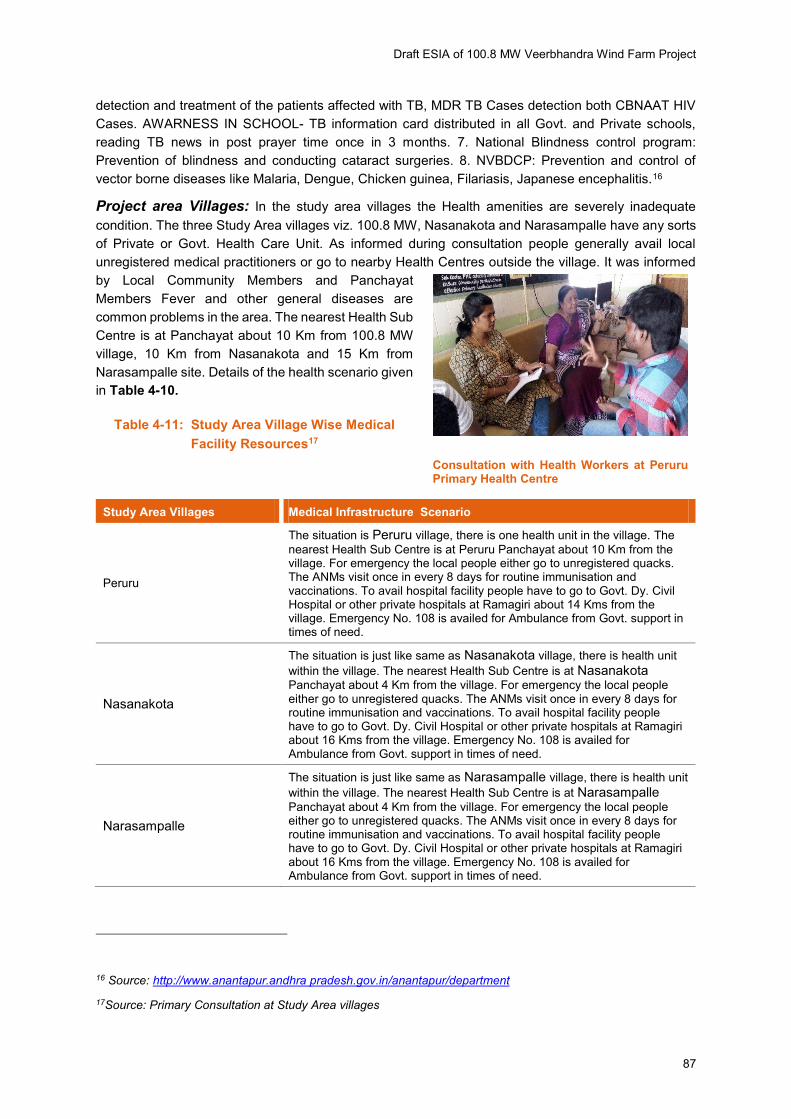
Draft ESIA of 100.8 MW Veerbhandra Wind Farm Project
87
detection and treatment of the patients affected with TB, MDR TB Cases detection both CBNAAT HIV
Cases. AWARNESS IN SCHOOL- TB information card distributed in all Govt. and Private schools,
reading TB news in post prayer time once in 3 months. 7. National Blindness control program:
Prevention of blindness and conducting cataract surgeries. 8. NVBDCP: Prevention and control of
vector borne diseases like Malaria, Dengue, Chicken guinea, Filariasis, Japanese encephalitis.16
Project area Villages: In the study area villages the Health amenities are severely inadequate
condition. The three Study Area villages viz. 100.8 MW, Nasanakota and Narasampalle have any sorts
of Private or Govt. Health Care Unit. As informed during consultation people generally avail local
unregistered medical practitioners or go to nearby Health Centres outside the village. It was informed
by Local Community Members and Panchayat
Members Fever and other general diseases are
common problems in the area. The nearest Health Sub
Centre is at Panchayat about 10 Km from 100.8 MW
village, 10 Km from Nasanakota and 15 Km from
Narasampalle site. Details of the health scenario given
in Table 4-10.
Table 4-11: Study Area Village Wise Medical
Facility Resources17
Study Area Villages Medical Infrastructure Scenario
Peruru
The situation is Peruru village, there is one health unit in the village. The
nearest Health Sub Centre is at Peruru Panchayat about 10 Km from the village. For emergency the local people either go to unregistered quacks. The ANMs visit once in every 8 days for routine immunisation and vaccinations. To avail hospital facility people have to go to Govt. Dy. Civil Hospital or other private hospitals at Ramagiri about 14 Kms from the village. Emergency No. 108 is availed for Ambulance from Govt. support in times of need.
Nasanakota
The situation is just like same as Nasanakota village, there is health unit
within the village. The nearest Health Sub Centre is at Nasanakota Panchayat about 4 Km from the village. For emergency the local people either go to unregistered quacks. The ANMs visit once in every 8 days for routine immunisation and vaccinations. To avail hospital facility people have to go to Govt. Dy. Civil Hospital or other private hospitals at Ramagiri about 16 Kms from the village. Emergency No. 108 is availed for Ambulance from Govt. support in times of need.
Narasampalle
The situation is just like same as Narasampalle village, there is health unit
within the village. The nearest Health Sub Centre is at Narasampalle
Panchayat about 4 Km from the village. For emergency the local people either go to unregistered quacks. The ANMs visit once in every 8 days for routine immunisation and vaccinations. To avail hospital facility people have to go to Govt. Dy. Civil Hospital or other private hospitals at Ramagiri about 16 Kms from the village. Emergency No. 108 is availed for Ambulance from Govt. support in times of need.
16 Source: http://www.anantapur.andhra pradesh.gov.in/anantapur/department
17Source: Primary Consultation at Study Area villages
Consultation with Health Workers at Peruru Primary Health Centre
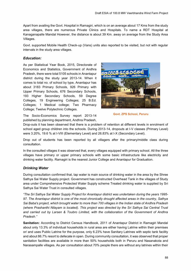
Draft ESIA of 100.8 MW Veerbhandra Wind Farm Project
88
Apart from availing the Govt. Hospital in Ramagiri, which is on an average about 17 Kms from the study
area villages, there are numerous Private Clinics and Hospitals. To name a RDT Hospital at
Kanaganapalle Mandal However, the distance is about 39 Km. away on average from the Study Area
Villages.
Govt. supported Mobile Health Check-up (Vans) units also reported to be visited, but not with regular
intervals in the study area villages.
Education:
As per Statistical Year Book, 2015, Directorate of
Economics and Statistics, Government of Andhra
Pradesh, there were total 5105 schools in Anantapur
district during the study year 2013-14. When it
comes to total no. of school by type, Anantapur has
about 3183 Primary Schools, 926 Primary with
Upper Primary Schools, 676 Secondary Schools,
193 Higher Secondary Schools, 59 Degree
Colleges, 19 Engineering Colleges; 25 B.Ed.
Colleges; 1 Medical college; Two Pharmacy
College; Twelve Polytechnic Colleges.
The Socio-Economics Survey report 2013-14
published by planning department, Andhra Pradesh,
Drop-outs it has been observed that there is a problem of retention at different levels in enrolment of
school aged group children into the schools. During 2013-14, dropouts at I-V classes (Primary Level)
were 3.20%, 19.6 % at I-VIII (Elementary Level) and 26.83% at I-X (Secondary Level).
Drop out of students has been reported by all villagers after the primary/middle class during
consultation.
In the consulted villages it was observed that, every villages equipped with primary school. All the three
villages have primary or upper primary schools with some basic infrastructure like electricity and
drinking water facility. Ramagiri is the nearest Junior College and Anantapur for Graduation.
Drinking Water
During consultation confirmed that, tap water is main source of drinking water in the area by the Shree
Sathya Sai Water Supply project. Government has constructed Overhead Tank in the villages of Study
area under Comprehensive Protected Water Supply scheme Treated drinking water is supplied by Sri
Sathya Sai Water Trust in consulted villages.
“The Sri Sathya Sai Water Supply Project for Anantapur district was undertaken during the years 1995-
97. The Anantapur district is one of the most chronically drought affected areas in the country, Sathya
Sai Baba's project, which brought water to more than 700 villages in the Indian state of Andhra Pradesh
(where Prashanthi Nilayam is located). This project was directed by the Sri Sathya Sai Central Trust
and carried out by Larsen & Toubro Limited, with the collaboration of the Government of Andhra
Pradesh.”
Sanitation: According to District Census Handbook, 2011 of Anantapur District in Ramagiri Mandal
about only 13.3% of individual households in rural area are either having Latrine within their premises
or/ and uses Public Latrine for the purpose, only 6.23% have Sanitary Latrines with septic tank facility
and about 86.7% resort to defecate in open. During community consultation, it was observed that proper
sanitation facilities are available in more than 50% households both in Peruru and Nasanakota and
Narasampalle villages. As per consultation about 70% people there are without any latrines within their
Govt. ZPS School, Peruru
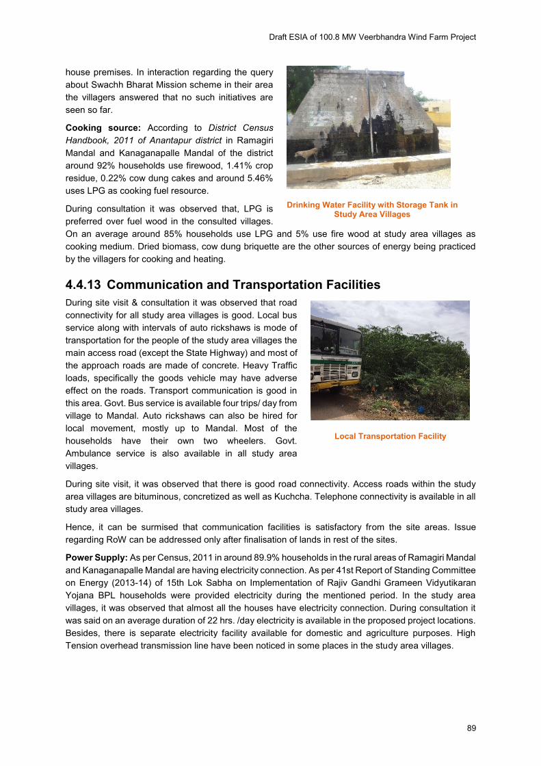
Draft ESIA of 100.8 MW Veerbhandra Wind Farm Project
89
house premises. In interaction regarding the query
about Swachh Bharat Mission scheme in their area
the villagers answered that no such initiatives are
seen so far.
Cooking source: According to District Census
Handbook, 2011 of Anantapur district in Ramagiri
Mandal and Kanaganapalle Mandal of the district
around 92% households use firewood, 1.41% crop
residue, 0.22% cow dung cakes and around 5.46%
uses LPG as cooking fuel resource.
During consultation it was observed that, LPG is
preferred over fuel wood in the consulted villages.
On an average around 85% households use LPG and 5% use fire wood at study area villages as
cooking medium. Dried biomass, cow dung briquette are the other sources of energy being practiced
by the villagers for cooking and heating.
4.4.13 Communication and Transportation Facilities
During site visit & consultation it was observed that road
connectivity for all study area villages is good. Local bus
service along with intervals of auto rickshaws is mode of
transportation for the people of the study area villages the
main access road (except the State Highway) and most of
the approach roads are made of concrete. Heavy Traffic
loads, specifically the goods vehicle may have adverse
effect on the roads. Transport communication is good in
this area. Govt. Bus service is available four trips/ day from
village to Mandal. Auto rickshaws can also be hired for
local movement, mostly up to Mandal. Most of the
households have their own two wheelers. Govt.
Ambulance service is also available in all study area
villages.
During site visit, it was observed that there is good road connectivity. Access roads within the study
area villages are bituminous, concretized as well as Kuchcha. Telephone connectivity is available in all
study area villages.
Hence, it can be surmised that communication facilities is satisfactory from the site areas. Issue
regarding RoW can be addressed only after finalisation of lands in rest of the sites.
Power Supply: As per Census, 2011 in around 89.9% households in the rural areas of Ramagiri Mandal
and Kanaganapalle Mandal are having electricity connection. As per 41st Report of Standing Committee
on Energy (2013-14) of 15th Lok Sabha on Implementation of Rajiv Gandhi Grameen Vidyutikaran
Yojana BPL households were provided electricity during the mentioned period. In the study area
villages, it was observed that almost all the houses have electricity connection. During consultation it
was said on an average duration of 22 hrs. /day electricity is available in the proposed project locations.
Besides, there is separate electricity facility available for domestic and agriculture purposes. High
Tension overhead transmission line have been noticed in some places in the study area villages.
Drinking Water Facility with Storage Tank in Study Area Villages
Local Transportation Facility

Draft ESIA of 100.8 MW Veerbhandra Wind Farm Project
90
4.4.14 Common Property Resources (CPR)
During consultation with Panchayat members and villagers, it was noted that all the study area villages
have some sort of Common Property Resource (CPR) like Community Ponds, Community Halls,
Cremation Ground etc.as presented in Table 4-12. In terms of CPR, the likely impact from the project
development was also discussed with the villagers.
Table 4-12: Village Wise Common Property Resources18
Study Area Villages
Common Property Resources (CPR)
Community
Ponds
Cremation
Ground
Community
Hall
Peruru 2 2 1
Nasanakota 1 - 1
Narasampalle - 1 1
Source: Primary Consultation
Non- Government Organisation (NGO)
Father Vincent Ferrer and Anna Ferrer founded Rural Development Trust (RDT) in 1969 with
Ananthapuram in Rayalaseema region. It is a non-governmental organization registered under the
Indian Registration Act of 1908. Since then, RDT has implemented welfare and comprehensive
development programs for marginalized and underprivileged communities, namely Scheduled Castes
(SC), Scheduled Tribes (ST), Backward Castes (BC), and people with disabilities.
The area covered by RDT is divided into 7 regions: Bukkarayasaumdram (BKS), Bathalapalli, Kadiri,
Srisailam, Uravakonda, Kalyandurg, and Madakasira. RDT works in 3.200 villages from 88 Revenue
Mandals: 63 in Anantapur District, 11 in Kurnool, 7 in Mahaboobnagar, and 7 in Prakasam District of
Andhra Pradesh.
The organization's programs address major issues such as Education, Women's Rights and Progress,
Community Healthcare, HIV/AIDS, Hospitals, Community Habitat, Community-Based Rehabilitation,
and Ecology. Besides, the organisation also organises Sports and cultural programs for the growth,
self-esteem, and confidence of rural children.
Works of RDT has been noticed in different villages of Kalyandurg Mandal, where different WTG sites
are located. RDT made houses for poor people are noticed in Peruru, Nasanakota and Narasampalle
villages of Borampally Wind Power Project site. Besides, they have also contribute in Education, Public
Health & Hygiene, Micro Finance and Sanitation of these villages. Bore wells, Hand Pumps etc.,
installed by RDT, have been noticed in different places to address the severe drinking water problem
of the area.
Archaeological Sites in the District
As per archaeology department, Anantapur, total 46 protected monuments sites identified in the district
has been provided in Appendix G. It was ensured by the Community, Panchayat members, ReNew
Representatives and also by the Panchayat member that none such archaeological sites are located at
close proximity (20 Km radius) of proposed WTG sites.
18 Source: Primary Consultation at Study Area Villages

Draft ESIA of 100.8 MW Veerbhandra Wind Farm Project
91
4.4.15 Some important Schemes
A few Govt. schemes that are on ground as per Andhra Pradesh Govt. Schemes’ website https://www.andhrapradeshstateinfo.com/Andhra Pradesh-govt-schemes/ are appended here below.
a) Grama Jyothi programme 19
The objective of the Grama Jyothi programme was to strengthen the panchayat raj system, making
gram panchayats active participants in development schemes and preparation of plans at village-level
on their own
b) Badiki Vastha
Badiki Vastha, a new scheme has been announced by the state government of Andhra Pradesh to
encourage girl child education in the state. Under the Badiki Vastha scheme, the state government
would provide free bicycles to every girl child studying in class 9th in the state.
Free bicycle would be provided to the girl students of 9th class studying in government, aided, ZPP,
Municipal and other model schools in the state. The state government has allocated Rs. 74.92 crores
for the implementation of the scheme.
c) Chandranna Bima Yojana in Andhra Pradesh for Labourers
A new insurance scheme for labourers in the unorganised sector is all set to be launched by the state
government of Andhra Pradesh. The scheme will be launched from August 1 to benefit 1.5 crore such
labourers.
Named as “Chandranna Bima Yojana”, will be launched on August 1 to benefit labourors in unorganized
sectors such as agricultural labourers, artisans, small self-employed people, petty traders, vendors,
hamals and shop employees and similar people.
d) Pradhan Mantri Fasal Bima Yojana in Andhra Pradesh as Pilot Project
A crop insurance scheme is all set to be started in Andhra Pradesh as pilot project. The scheme will be
implemented to provide financial help to the farmers in the state.
PMFBY, the central government scheme was launched in January 2016 to provide financial help to the
farmers at low premium. The financial help under the PM Fasal Bima Yojana is provided in case of
damage of crops due to natural calamities.
a. Mahatma Gandhi National Rural Employment Guarantee Scheme-
At least one hundred days of guaranteed wage employment in every financial year to every
household whose adult members volunteer to do unskilled manual work are being ensured with
this scheme.
The National Rural Employment Guarantee Act (NREGA) was passed by Parliament in
September 2005. Under this scheme 20021 Job Cards were issued and about 325 individuals
are working under this scheme since inception till August, 2016 in Medak District.20 As per the
website portal http://www.nrega.Andhra Pradesh.gov.in/Nregs/ the Average Wage rate per day
per person is Rs. 129.51 in present financial year (FY 2016-17). But no evidence for MGNREGA
19 Source: http://www. tspri.cgg.gov.in/
20 Source: http://www.nrega.telangana.gov.in/Nregs/
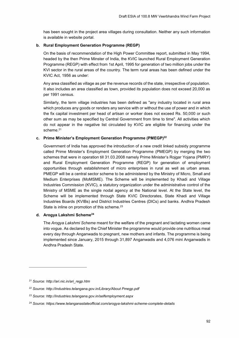
Draft ESIA of 100.8 MW Veerbhandra Wind Farm Project
92
has been sought in the project area villages during consultation. Neither any such information
is available in website portal.
b. Rural Employment Generation Programme (REGP)
On the basis of recommendation of the High Power Committee report, submitted in May 1994,
headed by the then Prime Minster of India, the KVIC launched Rural Employment Generation
Programme (REGP) with effect from 1st April, 1995 for generation of two million jobs under the
KVI sector in the rural areas of the country. The term rural areas has been defined under the
KVIC Act, 1956 as under:
Any area classified as village as per the revenue records of the state, irrespective of population.
It also includes an area classified as town, provided its population does not exceed 20,000 as
per 1991 census.
Similarly, the term village industries has been defined as "any industry located in rural area
which produces any goods or renders any service with or without the use of power and in which
the fix capital investment per head of artisan or worker does not exceed Rs. 50,000 or such
other sum as may be specified by Central Government from time to time". All activities which
do not appear in the negative list circulated by KVIC are eligible for financing under the
scheme.21
c. Prime Minister’s Employment Generation Programme (PMEGP)22
Government of India has approved the introduction of a new credit linked subsidy programme
called Prime Minister’s Employment Generation Programme (PMEGP) by merging the two schemes that were in operation till 31.03.2008 namely Prime Minister’s Rojgar Yojana (PMRY)
and Rural Employment Generation Programme (REGP) for generation of employment
opportunities through establishment of micro enterprises in rural as well as urban areas.
PMEGP will be a central sector scheme to be administered by the Ministry of Micro, Small and
Medium Enterprises (MoMSME). The Scheme will be implemented by Khadi and Village
Industries Commission (KVIC), a statutory organization under the administrative control of the
Ministry of MSME as the single nodal agency at the National level. At the State level, the
Scheme will be implemented through State KVIC Directorates, State Khadi and Village
Industries Boards (KVIBs) and District Industries Centres (DICs) and banks. Andhra Pradesh
State is inline on promotion of this scheme.23
d. Arogya Lakshmi Scheme24
The Arogya Lakshmi Scheme meant for the welfare of the pregnant and lactating women came
into vogue. As declared by the Chief Minister the programme would provide one nutritious meal
every day through Anganwadis to pregnant, new mothers and infants. The programme is being
implemented since January, 2015 through 31,897 Anganwadis and 4,076 mini Anganwadis in
Andhra Pradesh State.
21 Source: http://ari.nic.in/ari_regp.htm
22 Source: http://industries.telangana.gov.in/Library/About Pmegp.pdf
23 Source: http://industries.telangana.gov.in/selfemployment.aspx
24 Source: https://www.telanganastateofficial.com/arogya-lakshmi-scheme-complete-details

Draft ESIA of 100.8 MW Veerbhandra Wind Farm Project
93
Arogya Lakshmi Scheme Details
1. Eligible Persons: Pregnant women, Lactating mother, Children below 6 yrs
2. Nutritious meal per day through Anganwadi and mini Anganwadi
3. Women: 1 egg + 1 meal for 25 days every month
4. 7 months to 3 yrs. child: 16 eggs + 2.5 kg food packet (wheat, chanadal, milk powder, sugar
and oil)
5. 3 to7 yrs. child: (rice, dal, vegetables and snacks) + 1 egg/day
6. Under the programme 16 eggs, instead of 8 eggs per month would be provided to the
children in the age group of seven months to three years. Along with eggs wheat, milk
powder, red gram, sugar and oil would be provided every month.
7. Children between the age group of three years to six years would be provided daily one
egg instead of 16 eggs per month and would also be given rice, dal, curries and snacks.
8. The pregnant would be given full meals for 25 days, with eggs and 200 ml milk in place of
the present three kg rice, one kg dal, half kg oil and 16 eggs. This programme would provide
nutritious food to 5.90 lakh pregnant and lactating women apart from 18.20 lakh children.
e. Child Development Schemes
Immunization of Children under National Rural Health Mission (NRHM) launched in the
year 2005, Immunization programme is a separate component ‘C’. BCG, DPT and Polio are part of this component. This programme is being monitored by the Health Department
at individual household level in the project area villages.
Integrated Child Development Services is a 100% Centrally Sponsored scheme under
which six services i.e. supplementary nutrition, pre-school education, immunization, Health
Checkup, Health and Nutrition Education and referral services are provided to the Children
in the age group of 0-6 years, pregnant women & lactating mothers. Anganwadi Centres
has been seen and interaction with Anganwadi Workers have been made on this scheme
at the Project area villages.
f. Government Initiatives - Social Security Schemes
Andhra Pradesh Aasara Pension Scheme25 :
Eligibility of Andhra Pradesh Aasara Pension Scheme is common to all Pension
Schemes offered by the Govt.
i. The proposed beneficiary shall be from BPL family.
ii. He/she shall be a local resident of the district.
iii. He/she are not covered under any other Pension Scheme.
The Groups covered under the Scheme with the amount paid on monthly basis:
Old Age: Rs. 1000/ month (65 years age and above with evidential proof for age)
Widow: Rs. 1000/ month (Widows irrespective of age limit.)
25 Source: http://www.aasara.telangana.gov.in/SSPTG/userinterface/portal/
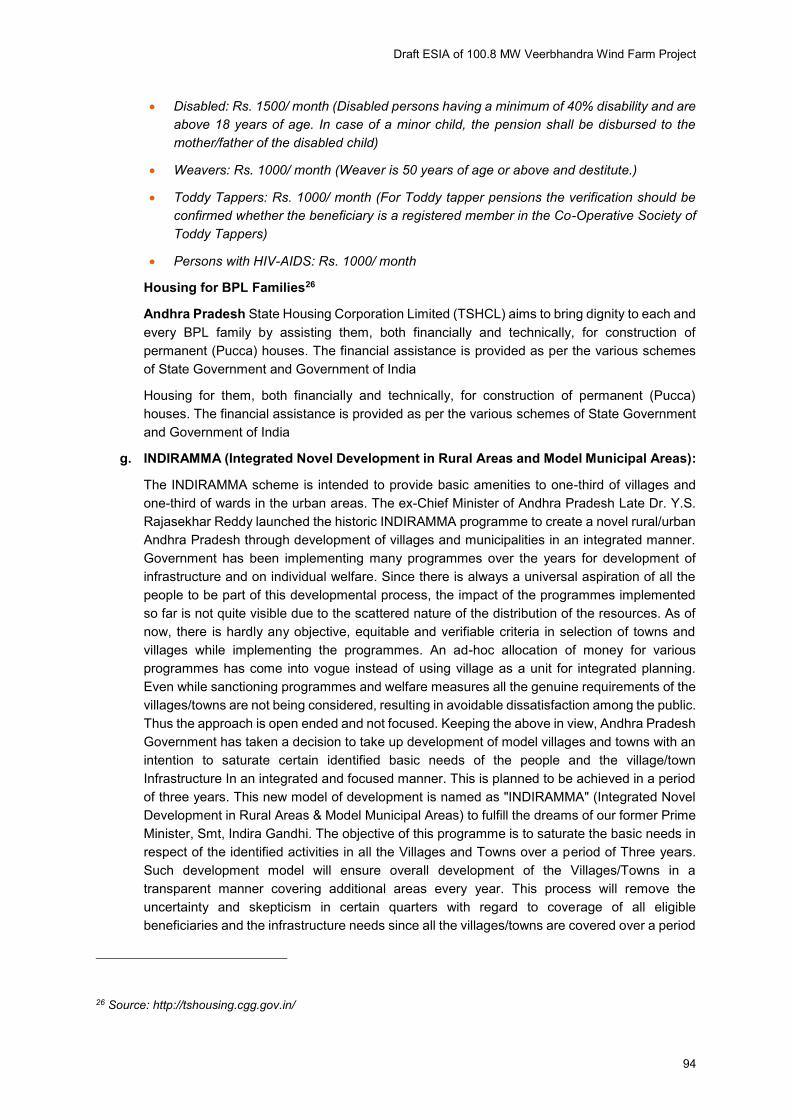
Draft ESIA of 100.8 MW Veerbhandra Wind Farm Project
94
Disabled: Rs. 1500/ month (Disabled persons having a minimum of 40% disability and are
above 18 years of age. In case of a minor child, the pension shall be disbursed to the
mother/father of the disabled child)
Weavers: Rs. 1000/ month (Weaver is 50 years of age or above and destitute.)
Toddy Tappers: Rs. 1000/ month (For Toddy tapper pensions the verification should be
confirmed whether the beneficiary is a registered member in the Co-Operative Society of
Toddy Tappers)
Persons with HIV-AIDS: Rs. 1000/ month
Housing for BPL Families26
Andhra Pradesh State Housing Corporation Limited (TSHCL) aims to bring dignity to each and
every BPL family by assisting them, both financially and technically, for construction of
permanent (Pucca) houses. The financial assistance is provided as per the various schemes
of State Government and Government of India
Housing for them, both financially and technically, for construction of permanent (Pucca)
houses. The financial assistance is provided as per the various schemes of State Government
and Government of India
g. INDIRAMMA (Integrated Novel Development in Rural Areas and Model Municipal Areas):
The INDIRAMMA scheme is intended to provide basic amenities to one-third of villages and
one-third of wards in the urban areas. The ex-Chief Minister of Andhra Pradesh Late Dr. Y.S.
Rajasekhar Reddy launched the historic INDIRAMMA programme to create a novel rural/urban
Andhra Pradesh through development of villages and municipalities in an integrated manner.
Government has been implementing many programmes over the years for development of
infrastructure and on individual welfare. Since there is always a universal aspiration of all the
people to be part of this developmental process, the impact of the programmes implemented
so far is not quite visible due to the scattered nature of the distribution of the resources. As of
now, there is hardly any objective, equitable and verifiable criteria in selection of towns and
villages while implementing the programmes. An ad-hoc allocation of money for various
programmes has come into vogue instead of using village as a unit for integrated planning.
Even while sanctioning programmes and welfare measures all the genuine requirements of the
villages/towns are not being considered, resulting in avoidable dissatisfaction among the public.
Thus the approach is open ended and not focused. Keeping the above in view, Andhra Pradesh
Government has taken a decision to take up development of model villages and towns with an
intention to saturate certain identified basic needs of the people and the village/town
Infrastructure In an integrated and focused manner. This is planned to be achieved in a period
of three years. This new model of development is named as "INDIRAMMA" (Integrated Novel
Development in Rural Areas & Model Municipal Areas) to fulfill the dreams of our former Prime
Minister, Smt, Indira Gandhi. The objective of this programme is to saturate the basic needs in
respect of the identified activities in all the Villages and Towns over a period of Three years.
Such development model will ensure overall development of the Villages/Towns in a
transparent manner covering additional areas every year. This process will remove the
uncertainty and skepticism in certain quarters with regard to coverage of all eligible
beneficiaries and the infrastructure needs since all the villages/towns are covered over a period
26 Source: http://tshousing.cgg.gov.in/
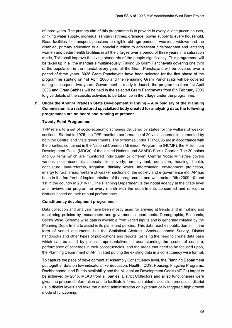
Draft ESIA of 100.8 MW Veerbhandra Wind Farm Project
95
of three years. The primary aim of this programme is to provide in every village pucca houses,
drinking water supply, individual sanitary latrines, drainage, power supply to every household,
Road facilities for transport, pensions to eligible old age persons, weavers, widows and the
disabled, primary education to all, special nutrition to adolescent girls/pregnant and lactating
women and better health facilities in all the villages over a period of three years in a saturation
mode, This shall improve the living standards of the people significantly. This programme will
be taken up in all the mandals simultaneously. Taking up Gram Panchayats covering one third
of the population in the mandal every year, all the Gram Panchayats will be covered over a
period of three years. 8026 Gram Panchayats have been selected for the first phase of the
programme starting on 1st April 2006 and the remaining Gram Panchayats will be covered
during subsequent two years. Government is ready to launch the programme from 1st April
2006 and Gram Sabhas will be held in the selected Gram Panchayats from 6th February 2006
to give details of the specific activities to be taken up in the village under the programme.
h. Under the Andhra Pradesh State Development Planning – A subsidiary of the Planning
Commission is a restructured specialized body created for analyzing data, the following
programmes are on board and running at present
Twenty Point Programme:–
TPP refers to a set of socio-economic schemes delivered by states for the welfare of weaker
sections. Started in 1975, the TPP monitors performance of 20 vital schemes implemented by
both the Central and State governments. The schemes under TPP-2006 are in accordance with
the priorities contained in the National Common Minimum Programme (NCMP), the Millennium
Development Goals (MDGs) of the United Nations and SAARC Social Charter. The 20 points
and 66 items which are monitored individually by different Central Nodal Ministries covers
various socio-economic aspects like poverty, employment, education, housing, health,
agriculture, land-reforms, irrigation, drinking water, afforestation, environment protection,
energy to rural areas, welfare of weaker sections of the society and e-governance etc. AP has
been in the forefront of implementation of the programme, and was ranked 9th (2009-10) and
1st in the country in 2010-11. The Planning Department is the nodal agency at the State level
and reviews the programme every month with the departments concerned and ranks the
districts based on their annual performance.
Constituency development programme:-
Data collection and analysis have been mostly used for arriving at trends and in making and
monitoring policies by researchers and government departments. Demographic, Economic,
Sector Wise, Scheme wise data is available from varied inputs and is generally collated by the
Planning Department to assist in its plans and policies. This data reaches public domain in the
form of varied documents like the Statistical Abstract, Socio-economic Survey, District
handbooks and other types of publications and reports. Sensing the need to create data base
which can be used by political representatives in understanding the issues of concern,
performance of schemes in their constituencies, and the areas that need to be focused upon,
the Planning Department of AP initiated putting the existing data in a constituency wise format.
To capture the pace of development at Assembly Constituency level, the Planning Department
put together data on few indicators like Education, Health, ICDS, Housing, Flagship Programs,
Rachhabanda, and Funds availability and the Millennium Development Goals (MDGs) target to
be achieved by 2015. MLAS from all parties, District Collectors and allied functionaries were
given the prepared information and to facilitate information aided discussion process at district
/ sub district levels and take the district administration on systematically triggered high growth
mode of functioning.
Draft ESIA of 100.8 MW Veerbhandra Wind Farm Project
96
Member of Parliament Local Area Development Scheme (MPLADS):
In 1993-94, MPLAD Scheme was launched, an amount of Rs. 5 lakh per Member of Parliament
was allotted which became Rupees one crore per annum per MP constituency from 1994-95.
This was stepped up to Rs. 2 crore from 1998-99 and now it has been increased to Rs.5 crore
from the financial year 2011-12.
Under this scheme, each MP has the choice to suggest to the District Collector for, works to
the tune of Rs.5 Crores per annum to be taken up in his/her constituency. The Rajya Sabha
Member of Parliament can recommend works in one or more districts in the State from where
he/she has been elected. The Nominated Members of the Lok Sabha and Rajya Sabha may
select any Districts from any State in the Country for implementation of their choice of work
under the scheme.
The objective of the scheme is to enable MPs to recommend works of developmental nature
with emphasis on the creation of durable community assets based on the locally felt needs to
be taken up in their Constituencies. Right from inception of the Scheme, durable assets of
national priorities viz. drinking water, primary education, public health, sanitation and roads, etc.
are being created.
Flagship programme:-
Government has initiated a number of welfare programmes to translate its promises to the
people for socially just and inclusive growth. Certain ongoing programmes were consolidated
or altered to increase their efficiency and certain new programmes were initiated in important
areas like employment, health, education, rural infrastructure, urban renewal and providing
people a legal framework for the Right to Information.
1. Sarva Shiksha Abhiyan: It is an ongoing programme for universalisation of elementary
education, was consolidated by providing additional financial allocations and creation of a
dedicated Prathmik Shiksha Kosh through a 2% cess introduced for the first time. The
provision of cooked mid-day meal was universalised.
2. National Rural Health Mission: This mission is to move from vertical disease
management programmes to comprehensive healthcare. This has been achieved through
an intersectoral district health plan, which provides for a community health activist in each
village, untied funds to all sub-health centres and improvement of infrastructure and
standards in rural hospitals.
3. Jawaharlal Nehru National Urban ReNewal Mission: This represents the first effort of its
kind where Government of India is intervening in a major way to improving the quality of
living in the cities. It focuses on improving urban infrastructure, governance and services
to the urban poor. Comprehensive city development plans are prepared and funded under
this Mission.
4. Bharat Nirman has been a major initiative conceived as a time-bound plan for rural
infrastructure. It seeks to provide electricity to all remaining villages, drinking water supply
to all uncovered and slipped-back habitations, connect all habitations with a population of
1000 (500 in hilly and tribal areas) with an all-weather road, create additional irrigation
capacity of 1 crore hectares, build 60 lakh houses for the rural poor and cover every village
with a telephone.
5. NREGA provides a legal guarantee for 100 days of work to rural households. The
programme now covers all rural districts of the country. It is the first such effort in the world
to provide legal guarantee for a Right to Work and the programme is being keenly watched
by development observers all over the world.
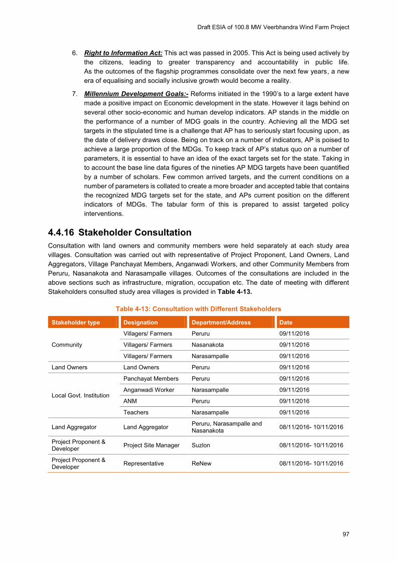
Draft ESIA of 100.8 MW Veerbhandra Wind Farm Project
97
6. Right to Information Act: This act was passed in 2005. This Act is being used actively by
the citizens, leading to greater transparency and accountability in public life.
As the outcomes of the flagship programmes consolidate over the next few years, a new
era of equalising and socially inclusive growth would become a reality.
7. Millennium Development Goals:- Reforms initiated in the 1990’s to a large extent have made a positive impact on Economic development in the state. However it lags behind on
several other socio-economic and human develop indicators. AP stands in the middle on
the performance of a number of MDG goals in the country. Achieving all the MDG set
targets in the stipulated time is a challenge that AP has to seriously start focusing upon, as
the date of delivery draws close. Being on track on a number of indicators, AP is poised to
achieve a large proportion of the MDGs. To keep track of AP’s status quo on a number of parameters, it is essential to have an idea of the exact targets set for the state. Taking in
to account the base line data figures of the nineties AP MDG targets have been quantified
by a number of scholars. Few common arrived targets, and the current conditions on a
number of parameters is collated to create a more broader and accepted table that contains
the recognized MDG targets set for the state, and APs current position on the different
indicators of MDGs. The tabular form of this is prepared to assist targeted policy
interventions.
4.4.16 Stakeholder Consultation
Consultation with land owners and community members were held separately at each study area
villages. Consultation was carried out with representative of Project Proponent, Land Owners, Land
Aggregators, Village Panchayat Members, Anganwadi Workers, and other Community Members from
Peruru, Nasanakota and Narasampalle villages. Outcomes of the consultations are included in the
above sections such as infrastructure, migration, occupation etc. The date of meeting with different
Stakeholders consulted study area villages is provided in Table 4-13.
Table 4-13: Consultation with Different Stakeholders
Stakeholder type Designation Department/Address Date
Community
Villagers/ Farmers Peruru 09/11/2016
Villagers/ Farmers Nasanakota 09/11/2016
Villagers/ Farmers Narasampalle 09/11/2016
Land Owners Land Owners Peruru 09/11/2016
Local Govt. Institution
Panchayat Members Peruru 09/11/2016
Anganwadi Worker Narasampalle 09/11/2016
ANM Peruru 09/11/2016
Teachers Narasampalle 09/11/2016
Land Aggregator Land Aggregator Peruru, Narasampalle and Nasanakota
08/11/2016- 10/11/2016
Project Proponent & Developer
Project Site Manager Suzlon 08/11/2016- 10/11/2016
Project Proponent & Developer
Representative ReNew 08/11/2016- 10/11/2016

Draft ESIA of 100.8 MW Veerbhandra Wind Farm Project
98
Consultation with Project Site Manager (ReNew)
The Project Site Manager of the project proponent has informed the visiting ESIA Team that 48 location
has already been procured by Suzlon. He also informed that NOC the respective Village Panchayats is
also to be procured at respective villages.
Consultation with Land Aggregator for Peruru, Narasampalle and Nasanakota
During ESIA site visit as informed by the project proponent that total 48 WTG locations were developed.
Private and assigned lands were taken through proper negotiation and procedure respectively. As
informed by the Land Aggregator, they have individually approached to land owners during land
procurement process. Land for 48 location has already been procured by Suzlon.
Agriculture is dependent on both rain and Irrigation systems through bore wells mostly. As informed
due to the escalating cost for cultivation and rising labour cost, profit from Agriculture is gradually
declining. There are also emergency needs of Finance for different personal purpose like Children’s Education, Marriage etc. Hence, the farmers and land owners were trying to look for more ensured
profiting and supporting resource options.
Consultation with Panchayat President at his Office at Peruru
As informed by the Panchayat member, and also during consultation it was revealed the land owners
and land aggregators at the site area that the land sold by landowners are at higher price than the circle
rate. The circle rate details in the proposed project area is provided in Table 4-14.
Table 4-14: Govt. Circle Rates of Land
Sl. No. Village Name Circle rate/Acre (INR)
Dry Land Fertised Land
1 Peruru Rs. 75000.00 Rs. 1,00000.00
2 Nasanakota Rs. 75000.00 Rs. 1,00000.00
3 Narasampalle Rs. 75000.00 Rs. 1,00000.00
Source: Consultation with Panchayat Office at his office in Peruru
Consultation with Community, Panchayat President Peruru Village
As informed during consultation, Peruruu village has population of around 8,000 (as per Census, 2011
it was 7234). As informed by the community and panchayat members 15% of whom are SC (As per
Census, 2011 it was 16.66%). As informed the around 90% of the total population are involved in
cultivation activities either as cultivators or agricultural labourers. But the Census, 2011 states that
around 24.96% are involved in agricultural activities directly. 10% are either having small business like
grocery, small shops etc. or work as masons and carpenters etc. in the nearby urban areas and work
seasonally. Only a very few go in the Service Sector. Livestock rearing also another source of livelihood
for some. The main crop cultivation are of Rice, Maize, Tur (Bengal Gram), Jowar etc. It was informed
that though Cotton was cultivated previously in large scale, but since the closely located spinning mill
units are gradually closing down, the cultivation also got declined. Agriculture is both rain fed and
irrigated. People of this village avails water from Rain during Monsoon, Bore wells. There is a centrally
located Overhead Water Tank maintained by the Panchayat under Comprehensive Protected Water
Supply Scheme and distributed through piped line at individual household level. It is the main source of
drinking water but the ground water depth is more than 60 ft. The village has only one Elementary
School. For higher education students either go to nearby Ramagiri and further to Anantapur to pursue
and continue education. Sanitation is at a serious state. In this village only 50 % of the households have
Draft ESIA of 100.8 MW Veerbhandra Wind Farm Project
99
Sanitary Latrines at their households. Rest of the population resort to open defecation. There is health
care facility in the village. People normally go to Ramagiri Mandal to avail one Public Health Centre
there, which is more than a Km from the village. About 14 Km from the area, to avail hospital facilities.
A few unregistered quack doctors are also availed by the villagers in times of emergency. Health
workers visit the village twice/ month for health related monitoring, routine immunization and
vaccination. Emergency No. 104 and Ambulance Service No. 108 is also availed during the times of
need. Average land holding size is about 5-7 acre per household in the village. A very few of the villagers
have technical skills or training.
It was informed by the Panchayat Members that they are aware of the 100.8 MW Wind Power project
to be started in the village. As informed earlier land procurement is still on process, NOC from the
Village Panchayat has not been procured at respective villages. The community also is aware of the
upcoming Wind Power Project and expecting betterment in their livelihood with the initiation of the same.
Nasanakota Village
As informed by the community members at Nasanakota village has population of around 7000, whereas
in Census, 2011 the number was 6,482. As informed by the community and panchayat members
32.81% of whom are SC. There are also a handful Muslim and Christian families. As informed the
around 90% of the total population are involved in cultivation activities either as cultivators or agricultural
labourers. But the Census, 2011 states that around 23.85% are involved in agricultural activities directly.
As informed, around 10% are either having small business like grocery, small shops etc. or work as
masons and carpenters etc. in the nearby urban areas and work seasonally. Only a few (around 10%)
go in the Service Sector. Livestock rearing also another source of livelihood for some. The main crop
cultivation are of Rice, Moong, Tur (Bengal Gram), Sugar Cane, Jowar, Corn etc. It was informed that
though Cotton was cultivated previously in large scale, but since the closely located spinning mill units
are gradually closing down, the cultivation also got declined. Agriculture is both rain fed and irrigated.
People of this village avails water from Rain during Monsoon, Bore wells. There is a centrally located
Overhead Water Tank maintained by the Panchayat under Comprehensive Protected Water Supply
Scheme and distributed through piped line at individual household level. It is the main source of drinking
water but the ground water depth is more than 100 ft. The village has only one FPS School and a High
School up to standard 10th. For further higher education students either go to nearby Ramagiri and
further to Anantapur to pursue and continue education. Sanitation is at a serious state. In this village
only 50 % of the households have Sanitary Latrines at their households. Rest of the population resort
to open defecation. There is no health care facility in the village. People normally go to Ramagiri to avail
Public Health Centre there, which is more than a Km from the village or at Ramagiri, about 17 Km from
the area, to avail hospital facilities. A few unregistered quack doctors are also availed by the villagers
in times of emergency. Health workers visit the village once/ 8 days for health related monitoring, routine
immunisation and vaccination. Emergency No. 104 and Ambulance Service No. 108 is also availed
during the times of need. Average land holding size is about 5-7 acre per household in the village. A
very few of the villagers have pursued for higher education and have technical skills or training.
It was informed by the Panchayat Members that they are aware of the 100.8 MW Wind Power project
to be started in the village. As informed earlier land procurement is still on process, NOC from the
Village Panchayat has not been procured at respective villages. The community also is aware of the
upcoming Wind Power Project and expecting betterment in their livelihood with the initiation of the same.
Narasampalle Village
No information regarding Narasampalle village is available in the Census, 2011. As informed during
consultation Narasampalle has population of around 800. As informed by the community around
20.74% of the total population is SC. Also there are a few Muslim (about 2%) and Christian families
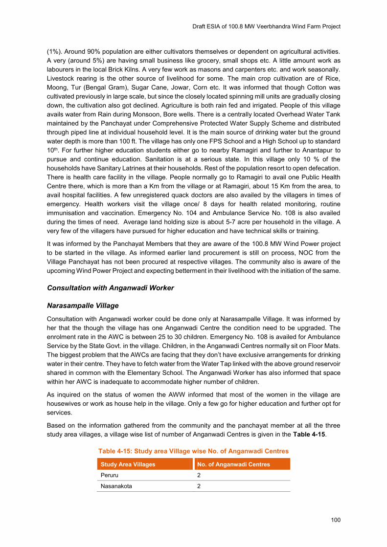
Draft ESIA of 100.8 MW Veerbhandra Wind Farm Project
100
(1%). Around 90% population are either cultivators themselves or dependent on agricultural activities.
A very (around 5%) are having small business like grocery, small shops etc. A little amount work as
labourers in the local Brick Kilns. A very few work as masons and carpenters etc. and work seasonally.
Livestock rearing is the other source of livelihood for some. The main crop cultivation are of Rice,
Moong, Tur (Bengal Gram), Sugar Cane, Jowar, Corn etc. It was informed that though Cotton was
cultivated previously in large scale, but since the closely located spinning mill units are gradually closing
down, the cultivation also got declined. Agriculture is both rain fed and irrigated. People of this village
avails water from Rain during Monsoon, Bore wells. There is a centrally located Overhead Water Tank
maintained by the Panchayat under Comprehensive Protected Water Supply Scheme and distributed
through piped line at individual household level. It is the main source of drinking water but the ground
water depth is more than 100 ft. The village has only one FPS School and a High School up to standard
10th. For further higher education students either go to nearby Ramagiri and further to Anantapur to
pursue and continue education. Sanitation is at a serious state. In this village only 10 % of the
households have Sanitary Latrines at their households. Rest of the population resort to open defecation.
There is health care facility in the village. People normally go to Ramagiri to avail one Public Health
Centre there, which is more than a Km from the village or at Ramagiri, about 15 Km from the area, to
avail hospital facilities. A few unregistered quack doctors are also availed by the villagers in times of
emergency. Health workers visit the village once/ 8 days for health related monitoring, routine
immunisation and vaccination. Emergency No. 104 and Ambulance Service No. 108 is also availed
during the times of need. Average land holding size is about 5-7 acre per household in the village. A
very few of the villagers have pursued for higher education and have technical skills or training.
It was informed by the Panchayat Members that they are aware of the 100.8 MW Wind Power project
to be started in the village. As informed earlier land procurement is still on process, NOC from the
Village Panchayat has not been procured at respective villages. The community also is aware of the
upcoming Wind Power Project and expecting betterment in their livelihood with the initiation of the same.
Consultation with Anganwadi Worker
Narasampalle Village
Consultation with Anganwadi worker could be done only at Narasampalle Village. It was informed by
her that the though the village has one Anganwadi Centre the condition need to be upgraded. The
enrolment rate in the AWC is between 25 to 30 children. Emergency No. 108 is availed for Ambulance
Service by the State Govt. in the village. Children, in the Anganwadi Centres normally sit on Floor Mats.
The biggest problem that the AWCs are facing that they don’t have exclusive arrangements for drinking water in their centre. They have to fetch water from the Water Tap linked with the above ground reservoir
shared in common with the Elementary School. The Anganwadi Worker has also informed that space
within her AWC is inadequate to accommodate higher number of children.
As inquired on the status of women the AWW informed that most of the women in the village are
housewives or work as house help in the village. Only a few go for higher education and further opt for
services.
Based on the information gathered from the community and the panchayat member at all the three
study area villages, a village wise list of number of Anganwadi Centres is given in the Table 4-15.
Table 4-15: Study area Village wise No. of Anganwadi Centres
Study Area Villages No. of Anganwadi Centres
Peruru 2
Nasanakota 2
Draft ESIA of 100.8 MW Veerbhandra Wind Farm Project
101
Narasampalle 1
Source: Primary Consultation and Site Visit
Consultation with Land Owners
During ESIA site visit as informed by the land owner that private and assigned lands were taken through
proper negotiation and procedure respectively. So far as reported till date land registration has been
finalised. Hence consultation with Land Owners was done at Peruru village, Nasanakota and
Narsampalli villages.
During consultation it was revealed, that the rates of the lands were finalised after negotiation and
agreed by both the selling and buying parties. The study team confirmed through stakeholder
consultation with land assignees that the market rate of non-irrigated land is like the one paid as ex-
gratia for assigned lands i.e. INR 75,000 & INR 100,000 per acre. It is also confirmed that private land
was paid an ex-gratia amount equivalent to market rate of cultivable land. Therefore, it can be concluded
that the ex-gratia amount against the land acquired/resumed is more than the replacement cost.
As a consequence, the land acquired/resumed has remained uncultivated. Many people from rural
areas of the project area have migrated to bigger cities in search of employment, also in some cases
leaving behind their children. It was also informed by the community members that some families have
migrated permanently due to long spell of continuous drought in the area and lack of employment
opportunities
Peruruu village
As informed Suzlon land team as well as the land owners, entire land was procured through Agreement
on willing to sale and willing to buy basis. As articulated by land owners the rates given to them are
higher than the circle rates of lands of the area. It has been testified by the land aggregator and the sub
registrar of lands of the local office. As informed by the land owners due to the escalating cost for
cultivation and rising labour cost, profit from Agriculture is gradually declining. Moreover, as informed
by the land owner, they also face financial crisis during the time of dire needs like children’s higher education or marriage or even for some other graver cause. Hence, the farmers and land owners were
trying to look for more ensured profiting and supporting options.
It was informed by them that, the Land aggregator has individually approached to land owners during
land procurement process. The land owners also have some aspirations of betterment in their livelihood
with the initiation of the 100.8 MW Wind Power Project in the village
Details of Stakeholders consultation has been provided in Appendix K.
Key Findings of Consultation
Land is on process of procurement for the proposed 100.8 MW Wind Power Project in all the Project
area villages, viz. Peruru, Nasanakota and Narasampalle, till the time of the visit of the ESIA Team. It
is to mention here, that all the proposed project are villages are located at a close proximity in Ramagiri
Mandal of Anantapur District. Some notable key findings of different level stakeholder consultation is
append below:
Agriculture is the major livelihood resource of the study area villages and also of the surrounding
area. Quiet a notable amount of population is involved in agriculture, a major part of which are
labourers.
The main crops are Paddy, Maize, Tur Dal and Jowar.
Rain-fed as well as Irrigated agriculture pattern both are practiced in project area.

Draft ESIA of 100.8 MW Veerbhandra Wind Farm Project
102
The main source for Irrigation in agriculture are bore wells and the existing natural canals, linked
with the Bore Wells.
Female literacy rate is much lower than male literacy rate in all the study area villages.
Sanitation facilities are inadequate in the villages and some of households practice open defecation.
Scarcity of water is a serious issue in the study area villages. In general there are scarcity of water,
especially potable water. The groundwater depth is more than 100 ft.
Drinking water facility is not adequate in the project area villages. Bore wells, tanks are the main
source of drinking water. At all the study area villages a centrally located above ground Tank of
10000 Litres. A few scattered hand pumps are also located in a few locations.
There is no health facility within the study area villages and has to rely on local quacks. To avail
one minimum health support one has to travel at Ramagiri Mandal Apart from these for availing the
Govt. Hospital in Ramagiri, which is on an average about 17 Kms from the study area villages, there
are numerous Private Clinics and Hospitals. Govt. supported Mobile Health Check-up (Vans) units
also reported to be visited, but not with regular intervals in the study area villages.
Though elementary schools are there at villages’ each, there are needs of basic amenities like Benches, running water facility etc. in some of the schools. The project proponent may contribute
substantially through their CSR activities.
Fever, Dental problem, joint pain and other general diseases are common problem in the area.
As informed by the only land owner that compensation has been paid to him is much more than
Govt. circle rate based on willing to sale willing to buy basis.
Assigned lands were also resumed for the project thorugh appropriate govt. authority following all
the rules, procedures and regulations.
It was found in Safeguards Compliance Audit study there is no adverse impact on livelihood of the
assignees of the land resumed from the assignees land.
NOC has been procoured from Gram Panchayats in all the study area villages.
Land is being procured through land aggregator directly appointed by Suzlon.
Though local Gram Panchayat, Community and the Land Sellers are aware of the 100.8 MW Wind
Power no formal Public Disclosure has been made by the project proponent till the time of the visit
of the ESIA Team.
4.4.17 Grievance Redressal Mechanism (GRM)
As the land procurement was in progress for grievance redressal mechanism and no grievance register
is made yet. ReNew assured that such register will be made properly in due course of time. ReNew has
their own Community Grievance Redressal under their Integrated Management Systems.
For now, there is no GRM is activated for this specific project. ReNew has informed the Consultant
Team, the Grievance Register and all other relevant mechanism will be in place once the Land
Purchase and Acquisition process completes.
It is to be ensured that ReNew must place the Grievance Redressal Register and proper mechanism
for the project.
4.4.18 Community Development Plan under CSR
Companies Act, 2013 has introduced mandatory Corporate Social Responsibility Regulations which are
effective from 1st April, 2014. Section 135 of the Companies Act, 2013 (‘the Act’), read with Companies (Corporate Social Responsibility Policy) Rules, 2014 (‘CSR Rules’) requires every company having:
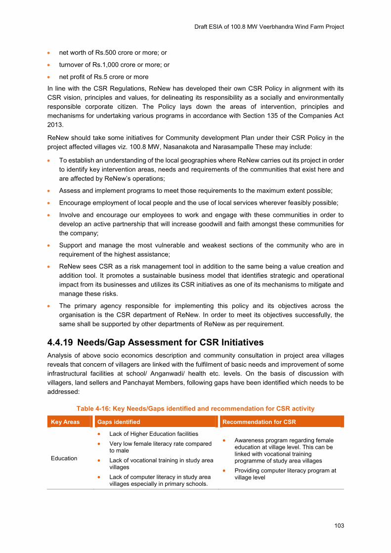
Draft ESIA of 100.8 MW Veerbhandra Wind Farm Project
103
net worth of Rs.500 crore or more; or
turnover of Rs.1,000 crore or more; or
net profit of Rs.5 crore or more
In line with the CSR Regulations, ReNew has developed their own CSR Policy in alignment with its
CSR vision, principles and values, for delineating its responsibility as a socially and environmentally
responsible corporate citizen. The Policy lays down the areas of intervention, principles and
mechanisms for undertaking various programs in accordance with Section 135 of the Companies Act
2013.
ReNew should take some initiatives for Community development Plan under their CSR Policy in the
project affected villages viz. 100.8 MW, Nasanakota and Narasampalle These may include:
To establish an understanding of the local geographies where ReNew carries out its project in order
to identify key intervention areas, needs and requirements of the communities that exist here and
are affected by ReNew’s operations;
Assess and implement programs to meet those requirements to the maximum extent possible;
Encourage employment of local people and the use of local services wherever feasibly possible;
Involve and encourage our employees to work and engage with these communities in order to
develop an active partnership that will increase goodwill and faith amongst these communities for
the company;
Support and manage the most vulnerable and weakest sections of the community who are in
requirement of the highest assistance;
ReNew sees CSR as a risk management tool in addition to the same being a value creation and
addition tool. It promotes a sustainable business model that identifies strategic and operational
impact from its businesses and utilizes its CSR initiatives as one of its mechanisms to mitigate and
manage these risks.
The primary agency responsible for implementing this policy and its objectives across the
organisation is the CSR department of ReNew. In order to meet its objectives successfully, the
same shall be supported by other departments of ReNew as per requirement.
4.4.19 Needs/Gap Assessment for CSR Initiatives
Analysis of above socio economics description and community consultation in project area villages
reveals that concern of villagers are linked with the fulfilment of basic needs and improvement of some
infrastructural facilities at school/ Anganwadi/ health etc. levels. On the basis of discussion with
villagers, land sellers and Panchayat Members, following gaps have been identified which needs to be
addressed:
Table 4-16: Key Needs/Gaps identified and recommendation for CSR activity
Key Areas Gaps identified Recommendation for CSR
Education
Lack of Higher Education facilities
Very low female literacy rate compared to male
Lack of vocational training in study area villages
Lack of computer literacy in study area villages especially in primary schools.
Awareness program regarding female education at village level. This can be linked with vocational training programme of study area villages
Providing computer literacy program at village level
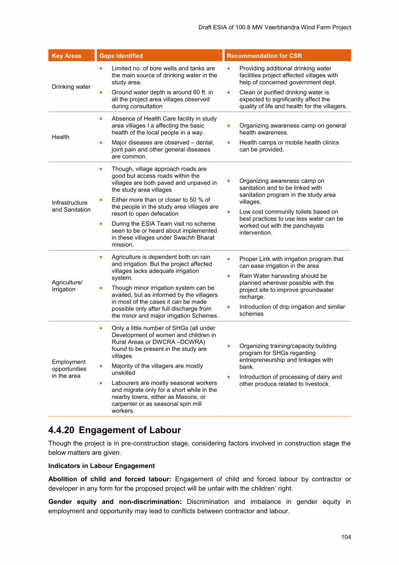
Draft ESIA of 100.8 MW Veerbhandra Wind Farm Project
104
Key Areas Gaps identified Recommendation for CSR
Drinking water
Limited no. of bore wells and tanks are the main source of drinking water in the study area.
Ground water depth is around 60 ft. in all the project area villages observed during consultation
Providing additional drinking water facilities project affected villages with help of concerned government dept.
Clean or purified drinking water is expected to significantly affect the quality of life and health for the villagers.
Health
Absence of Health Care facility in study area villages I a affecting the basic health of the local people in a way.
Major diseases are observed – dental, joint pain and other general diseases are common.
Organizing awareness camp on general health awareness.
Health camps or mobile health clinics can be provided.
Infrastructure and Sanitation
Though, village approach roads are good but access roads within the villages are both paved and unpaved in the study area villages
Either more than or closer to 50 % of the people in the study area villages are resort to open defecation
During the ESIA Team visit no scheme seen to be or heard about implemented in these villages under Swachh Bharat mission.
Organizing awareness camp on sanitation and to be linked with sanitation program in the study area villages.
Low cost community toilets based on best practices to use less water can be worked out with the panchayats intervention.
Agriculture/ Irrigation
Agriculture is dependent both on rain and irrigation. But the project affected villages lacks adequate irrigation system.
Though minor irrigation system can be availed, but as informed by the villagers in most of the cases it can be made possible only after full discharge from the minor and major irrigation Schemes.
Proper Link with irrigation program that can ease irrigation in the area
Rain Water harvesting should be planned wherever possible with the project site to improve groundwater recharge.
Introduction of drip irrigation and similar schemes
Employment opportunities in the area
Only a little number of SHGs (all under Development of women and children in Rural Areas or DWCRA –DCWRA) found to be present in the study are villages
Majority of the villagers are mostly unskilled
Labourers are mostly seasonal workers and migrate only for a short while in the nearby towns, either as Masons, or carpenter or as seasonal spin mill workers.
Organizing training/capacity building program for SHGs regarding entrepreneurship and linkages with bank.
Introduction of processing of dairy and other produce related to livestock.
4.4.20 Engagement of Labour
Though the project is in pre-construction stage, considering factors involved in construction stage the
below matters are given.
Indicators in Labour Engagement
Abolition of child and forced labour: Engagement of child and forced labour by contractor or
developer in any form for the proposed project will be unfair with the children’ right.
Gender equity and non-discrimination: Discrimination and imbalance in gender equity in
employment and opportunity may lead to conflicts between contractor and labour.

Draft ESIA of 100.8 MW Veerbhandra Wind Farm Project
105
Freedom of association and right to collective bargaining: Not giving freedom to labour to express
their views and form association may cause conflicts between labour and contractor but this is not
applicable for Wind power plant as the labour requirement is of short duration restricted to construction
phase only and number of labour employed is not very large for the same phase.
Draft ESIA of 100.8 MW Veerbhandra Wind Farm Project
106
5 Analysis of Alternatives & Site Selection
The section gives analysis of alternatives with respect to the proposed project. The following scenarios
have been considered:
Current or No project Scenario
Alternate methods of power generation;
Alternate Location for the proposed project; and
5.1 Current or No project scenario
There is a need to bridge the gap between the demand and supply, renewable/non-conventional
sources of power to supplement the conventional sources. The proposed project intends to contribute
towards bridging this demand supply gap being a non-conventional source of power generation. In
Andhra Pradesh, existing renewable capacity commissioned is about 1,815 MW of which wind power
contributes to 1119MW, solar power contributes to 146MW (State as well as GoI) and others (like hydro,
biomass, solid waste) contributes to 550MW as on October 2015 (Status of Renewable Energy Power
Projects Commissioned in Andhra Pradesh State, NREDCAP)
About 2,846.12 MW capacity wind power projects have been sanctioned by the Non-conventional
Energy Development Corporation of Andhra Pradesh Limited (NREDCAP), the sanctioning authority in
the state, out of which projects of about 103.00 MW have been commissioned till October 31 during
2015-16. The proposed project presents an opportunity to utilize the potential for wind power
generation. A “No Project Scenario” will not address the issue of power shortage. An alternative without the project is undesirable, as it would worsen the power supply-demand scenario, which would be a
constraint on economic growth of the surrounding region.
The Project being a wind power project will not lead to CO2 and SO2 emissions during the operation
phase. It does not deplete the natural resource except a small part of land will be occupied by the
turbines, ancillary facilities and access roads. Project has a life cycle of 25 years.
5.1.1 Energy Security
In 2007 the Ministry of Environment Forests and Climate Change (MoEFCC), Ministry of Power (MoP)
and the Bureau of Energy Efficiency (BEE) issued a paper entitled ‘India: Addressing Energy Security and Climate Change’. In India the need for expanding the role of domestic Renewable Energy (RE)
sources is a logical next step. Wind power is already in a position to provide a significant portion of
India’s planned capacity addition up to 2030, with simple regulatory and grid modernization initiatives.
Unlike oil, coal or LNG, wind power is not subject to fluctuating fuel prices which drain India’s limited foreign reserves, and in addition, wind power helps in reducing the carbon footprint of the economy. In
the Figure 5-1, India’s projected power requirement until 2030 has been indicated.

Draft ESIA of 100.8 MW Veerbhandra Wind Farm Project
107
Figure 5-1: India’s Projected Power Requirement
Source: Central Electricity Authority
5.2 Alternate Methods of Power Generation
There are various non-renewable and renewable energy sources which can be utilized for power
generation. Each option has its own advantages and disadvantages. Based on the site conditions,
availability of resources, environmental & social concerns and project cost suitable option for power
generation need to be selected. Comparison of advantages and disadvantages of various non-
renewable and renewable energy is represented in table given below.
Source of Energy Advantages Disadvantages
Coal
Relatively cheap form of energy availability in large scale worldwide
Coal Easily transported to power stations
Non-renewable energy source
Large water requirement
High emission and generation of fly ash
When burned, coal releases lots of greenhouse gases
Mining of coal causes impacts on land and surrounding environment.
Oil & Gas
Declining Oil Price
Oil and gas can be easily transported by pipes or ships.
Natural gas is the “cleanest” of the fossil fuels
Non-renewable energy source
Working environment risks to staff and environment
Burning oil and gas releases can cause pollution & health impacts
Source of GHG Emission and hence climate change
Nuclear
Nuclear fuel does Produce greenhouse gases
Expensive, especially in capital
costs, maintenance costs
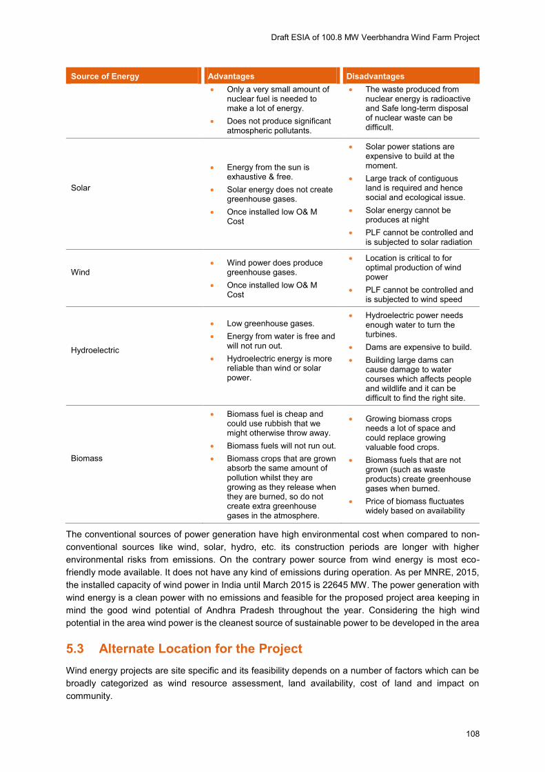
Draft ESIA of 100.8 MW Veerbhandra Wind Farm Project
108
Source of Energy Advantages Disadvantages
Only a very small amount of nuclear fuel is needed to make a lot of energy.
Does not produce significant atmospheric pollutants.
The waste produced from nuclear energy is radioactive and Safe long-term disposal of nuclear waste can be difficult.
Solar
Energy from the sun is exhaustive & free.
Solar energy does not create greenhouse gases.
Once installed low O& M Cost
Solar power stations are expensive to build at the moment.
Large track of contiguous land is required and hence social and ecological issue.
Solar energy cannot be produces at night
PLF cannot be controlled and is subjected to solar radiation
Wind
Wind power does produce greenhouse gases.
Once installed low O& M Cost
Location is critical to for optimal production of wind power
PLF cannot be controlled and is subjected to wind speed
Hydroelectric
Low greenhouse gases.
Energy from water is free and will not run out.
Hydroelectric energy is more reliable than wind or solar power.
Hydroelectric power needs enough water to turn the turbines.
Dams are expensive to build.
Building large dams can cause damage to water courses which affects people and wildlife and it can be difficult to find the right site.
Biomass
Biomass fuel is cheap and could use rubbish that we might otherwise throw away.
Biomass fuels will not run out.
Biomass crops that are grown absorb the same amount of pollution whilst they are growing as they release when they are burned, so do not create extra greenhouse gases in the atmosphere.
Growing biomass crops needs a lot of space and could replace growing valuable food crops.
Biomass fuels that are not grown (such as waste products) create greenhouse gases when burned.
Price of biomass fluctuates widely based on availability
The conventional sources of power generation have high environmental cost when compared to non-
conventional sources like wind, solar, hydro, etc. its construction periods are longer with higher
environmental risks from emissions. On the contrary power source from wind energy is most eco-
friendly mode available. It does not have any kind of emissions during operation. As per MNRE, 2015,
the installed capacity of wind power in India until March 2015 is 22645 MW. The power generation with
wind energy is a clean power with no emissions and feasible for the proposed project area keeping in
mind the good wind potential of Andhra Pradesh throughout the year. Considering the high wind
potential in the area wind power is the cleanest source of sustainable power to be developed in the area
5.3 Alternate Location for the Project
Wind energy projects are site specific and its feasibility depends on a number of factors which can be
broadly categorized as wind resource assessment, land availability, cost of land and impact on
community.

Draft ESIA of 100.8 MW Veerbhandra Wind Farm Project
109
5.3.1 Identification of sites for WTG’s
According to National Institute of Wind Energy (NIWE), Andhra Pradesh has estimated installable wind
power potential of 14,497 MW at 80m hub height for wind turbines. The southern region of Andhra
Pradesh comprising of Anantapur, Kadapa, Kurnool and Chittoor districts have good wind power
potential. Approximately 1000 MW of wind projects will be developed in the 1st phase while in the
second & third phases, the capacity planned is 1500 MW & 1650 MW respectively.
Total 48 potential WTG locations are appraised for setting up 100.8 MW wind power project. Based on
availability and considering environmental and social sensitivity 48 location will be finalised out of 68,
to set up the project.
The key factors considered for the final selection of WTG sites included the following:
Privately owned and assigned lands is selected for WTG sites, creating access routes and erecting
transmission towers.
The WTG locations were selected keeping in mind the distance from settlements. The proposed
sites for WTGs are located away from major settlements. Care has been taken find location that
fulfils the minimum distance requirement and cause minimal inconvenience in terms of visual
intrusions, noise, and shadow flicker.
Forest land will be avoided and emphasis will be given on non-forest land to select 48 locations.
Absence of any ecologically sensitive area such as national park, wildlife sanctuary within 10 km
radius of the entire project site makes it a suitable choice for having wind farm.
The distance of the wind mill turbines from the highways, village habitation shall be at a safe
distance, and in normal course, a distance of 300 m would be considered safe.
In consideration of the above any other site location would not enjoy similar advantage.
5.3.2 Alternate routes for transmission lines
Laying of transmission line comprises of 220 KV moose DC line up to upcoming 400/200 KV Borampalli
substation from the proposed pooling substation on site. ReNew to construct the 200 KVA pooling
substation that will directly connect to 400/200KV substation.
The route for the transmission line has been selected keeping in mind the following factors:
Transmission line route is planned to avoid any habitations along the route;
No house or community structures are located under the transmission line;
Areas requiring extensive clearing of vegetation have been avoided;
Selection of the transmission route avoids any environmental sensitive site like schools, health
centers, etc.;
Right of way/access roads will be shared with the common user of the substation.
The shortest possible route after considering the above factors has been selected for laying the
transmission lines to reduce the environmental and social footprint of the transmission lines.
5.4 Conclusion
Various factors are considered such as wind resource potential at the project site, favorable
environmental and social settings, lowest GHG emissions in the project life cycle, availability of land
and other resources. Considering these factors it is concluded that the proposed site is the best location
for development of wind power project. There are about three more wind power projects of other
developers that are in operation in the same district. This is due to availability and suitability of wind

Draft ESIA of 100.8 MW Veerbhandra Wind Farm Project
110
power generation potential. Besides, one of the ReNew’s wind power project is operational about 10km
from the site and another project is in early construction phase about 30km North West from the project
site in the same district at a distance of approximately 50 kms.
The proposed wind power project site has following locational advantages and is the most suitable for
wind power project:
Approved C-WET site for wind energy production
The locations selected for wind turbine erections mostly fall on arid & rain fed agricultural land
which is cultivated once depending on the monsoon.
Privately owned land is selected for WTG sites, creating access routes and erection of
transmission towers. The land being purchased is on the basis of willing to sell and willing to buy
method which does not involve forceful acquisition of land.
The route for transmission line designed for the proposed project is the shortest route possible to
evacuate power generated from WTGs to the pooling substation and then the grid substation.
The WTG locations were selected keeping in mind the distance from settlements. The proposed
sites for WTGs are located away from major settlements. The nearest settlement located close to
any of the WTG locations is at a distance of 300 m away.
Care has been taken find location that fulfils the minimum distance requirement and cause minimal
inconvenience in terms of visual intrusions, noise, and shadow flicker.
The distance of the wind mill turbines from the highways, settlement/ habitation is located at a safe
distance, and in normal course, a distance of 300 m is considered to be safe.
Absence of any ecologically sensitive area such as national park, wildlife sanctuary within 5 km
radius of the entire project site makes it a suitable choice for having the wind farm.
No cultural property of archaeological importance located within the project site