
eHealth in Switzerland - building consensus, awareness and architecture
Upload
khangminh22Category
view
1download
0
TIMINGis KEYin building a NationalPNT Architecture
Securing PNT needs action on a global scale
Volume XVII, Issue 9, September 2021 THE MONTHLY MAGAZINE ON POSITIONING, NAVIGATION AND BEYOND
RNI: DELENG/2005/15153RNI: DELENG/2005/15153 No: DL(E)-01/5079/2020-22No: DL(E)-01/5079/2020-22 Publication: 15Publication: 15thth of every month of every month Licensed to post without pre-paymentLicensed to post without pre-payment U(E) 28/2020-22U(E) 28/2020-22Posting: 27Posting: 27thth/28/28thth of every month at DPSO of every month at DPSO Rs.150Rs.150
ISSN
0973-2
136
ISSN
0973-2
136

NEW ELLIPSE-D
Visit our website: www.sbg-systems.com
0.05°ATTITUDE POSITION
1 cmHEADING0.02°
» RTK Centimetric Position
» Quad Constellations
» Post-processing Software
The Smallest Dual Frequency & Dual Antenna INS/GNSS
Ellipse-DRTK Dual Antenna
Ellipse-NRTK Single Antenna
OEMRTK Best-in-class SWaP-C
IFEN Inc.IFEN Inc.IFEN Inc.IFEN [email protected]@[email protected]@ifen.com
For AmericasFor AmericasFor AmericasFor AmericasIFEN GmbHIFEN GmbHIFEN GmbHIFEN GmbH+49 8121 2238 20+49 8121 2238 20+49 8121 2238 20+49 8121 2238 [email protected]@[email protected]@ifen.com
For EMEA & APACFor EMEA & APACFor EMEA & APACFor EMEA & APAC����GNSS Simulators����
www.ifen.com
NCS NOVA - Our solution for your GNSS simulation needs!Multi-Frequency|Multi-GNSS|Multi-RF
Full Support of new Galileo OS ICD v2.0.Galileo E1B OS-NMA and E6B HAS coming soon.
The fl exible and fully upgradable software-defi ned GNSS simulator.
NCS NOVA Constellation Simulator
Full support ofNAVIC L5 and S-band signals

CoordinatesCoordinates September 2021 | 3
IFEN Inc.IFEN Inc.IFEN Inc.IFEN [email protected]@[email protected]@ifen.com
For AmericasFor AmericasFor AmericasFor AmericasIFEN GmbHIFEN GmbHIFEN GmbHIFEN GmbH+49 8121 2238 20+49 8121 2238 20+49 8121 2238 20+49 8121 2238 [email protected]@[email protected]@ifen.com
For EMEA & APACFor EMEA & APACFor EMEA & APACFor EMEA & APAC����GNSS Simulators����
www.ifen.com
NCS NOVA - Our solution for your GNSS simulation needs!Multi-Frequency|Multi-GNSS|Multi-RF
Full Support of new Galileo OS ICD v2.0.Galileo E1B OS-NMA and E6B HAS coming soon.
The fl exible and fully upgradable software-defi ned GNSS simulator.
NCS NOVA Constellation Simulator
Full support ofNAVIC L5 and S-band signals

ArticlesSecuring PNT needs action on a global scale Guy Buesnel 6 A resilient national timing architecture Marc Weiss, Patrick DiaMonD anD Dana a GoWarD 9 Systematic land registration in Georgia – Design and implementation elene GriGolia anD teiMuraz GaBriaDze 20 Humorous science: Workplace office mysteries
Volker Janssen 28
This issue has been made possible by the support and good wishes of the following individuals and companies Dana A Goward, Elene Grigolia, Guy Buesnel, Marc Weiss, Guenter Heinrichs, Patrick Diamond, Teimuraz Gabriadze and Volker Janssen; GPS Satsys, IFEN, Labsat, SBG System, and many others.
x COLOPHON AND CONTENTS
In this issueCoordinates Coordinates Volume 17, Issue 9, September 2021
ColumnsMy Coordinates eDitorial 5 His Coordinates Guenter HeinricHs 33 News Gis 34 Gnss 35 uaV 35 iMaGinG 36
inDustry 37 Mark Your Calendar 38
Mailing Address
A 002, Mansara Apartments
C 9, Vasundhara Enclave
Delhi 110 096, India.
Phones +91 11 42153861, 98102 33422, 98107 24567
[information] [email protected]
[editorial] [email protected]
[advertising] [email protected]
[subscriptions] [email protected]
Web www.mycoordinates.org
Coordinates is an initiative of CMPL that aims to broaden the
scope of positioning, navigation and related technologies.
CMPL does not neccesarily subscribe to the views expressed
by the authors in this magazine and may not be held liable for
any losses caused directly or indirectly due to the information
provided herein. © CMPL, 2021. Reprinting with permission is
encouraged; contact the editor for details.
Annual subscription (12 issues)
[India] Rs.1,800 [Overseas] US$100
Printed and published by Sanjay Malaviya on behalf of
Coordinates Media Pvt Ltd
Published at A 002 Mansara Apartments, Vasundhara
Enclave, Delhi 110096, India.
Printed at Thomson Press (India) Ltd, Mathura Road,
Faridabad, India
Editor Bal Krishna
Owner Coordinates Media Pvt Ltd (CMPL)
This issue of Coordinates is of 40 pages, including cover.
4 | CoordinatesCoordinates September 2021

ADVISORS Naser El-Sheimy PEng, CRC Professor, Department of Geomatics Engineering, The University of Calgary Canada, George
Cho Professor in GIS and the Law, University of Canberra, Australia, Professor Abbas Rajabifard Director, Centre for SDI and Land
Administration, University of Melbourne, Australia, Luiz Paulo Souto Fortes PhD Associate Professor, University of State of Rio Janeiro
(UERJ), Brazil, John Hannah Professor, School of Surveying, University of Otago, New Zealand
x MYCOORDINATES
A new draft policy by Department of Space (DoS), Government of India.
Recognizes that Space based navigation /augmentation system is essentially a public good which has to be accessible to all users.
It plans for continuity of NavIC and GAGAN services, ensuring compatibility and interoperability with other GNSS/SBAS signals.
It intends to work towards expanding the coverage from regional to global to ensure availability of the NavIC standalone signal in any part of the world.
The DoS will continue to work with ITU for frequency allocation.
It will also take part in the United Nations Committee on Peaceful Uses of Outer Space (UNCOPUOS), International Civil Aviation Organisation (ICAO) and International Maritime Organization (IMO).
Indian Space Research Organisation will provide technical support for academic institutions in GNSS research and applications.
It endeavors to align the NavIC and GAGAN Services with Government of India’s Atmanirbhar Bharat (Self Reliant India) initiative.
Self-reliance in the context of GNSS will no doubt be a big achievement,
With Indians relying on NaVIC as they do on GPS!
Bal Krishna, Editor [email protected]
Satnav Policy 2021
CoordinatesCoordinates September 2021 | 5

How the world became dependent on GNSS for PNT
The arrival of GPS kick-started a revolution. Using GPS was a cheap and reliable method of obtaining precise time and accurate position fixes globally. This revolution really accelerated when the US government disabled Selective Availability (SA), which had added 50 meters of error horizontally and 100 meters vertically to unencrypted GPS signals, in 2000. The availability of GPS and the development of alternative global navigation satellite systems (GNSS) meant that the use of precise timing and positioning data quickly became ubiquitous. Global availability, free access, and the proven reliability of GNSS signals has led to a state where many systems now have built-in dependencies on GNSS data that are not readily understood or, in some cases, even recognised.
Unfortunately, whilst GNSS signals are generally very reliable, the low power level of received GNSS signals on Earth means that they are particularly vulnerable to RF interference, multipath and atmospheric events.
GNSS disruption incidents are on the increase globally
We have become used to seeing and hearing about incidents of RF interference affecting GNSS dependent systems around the world – often in or near regions of conflict. It has recently been reported that GNSS outages are now almost standard occurrences on commercial flight routes between the US, Europe and the Middle East.
Eurocontrol, the pan-European, civil-military aviation organisation, says it received 3,500 reports of GPS disruption in 2019. Commercial aviation has also experienced widespread GNSS interference events in the US.
GNSS disruption in the maritime domain continues – US Maritime Industry Advisory 2021-04 states that “Multiple instances of significant GPS interference have been reported worldwide in the maritime domain. This interference is resulting in lost or inaccurate GPS signals affecting bridge navigation, GPS-based timing, and communications equipment.” The advisory also states that multiple incidents of GPS interference have been reported near the eastern and central Mediterranean Sea, the Persian Gulf, and in the vicinity of the Suez Canal.”
Two recent user reports really brought home to me the scale of the problem we are facing.
In 2019 one flight crew reported that they were so used to experiencing GPS interference from a nearby military installation that when they experienced a course error, they assumed it was due to an intermittent GPS-generated error message, when in fact it was caused by a data entry mistake. (NASA ASRS Report 1706814, December 2019)
The other report was from a maritime user to the USCG/DHS Navigation Center. https://navcen.uscg.gov/?Do=GPSReportStatus
x GNSS
Securing PNT needs action on a global scaleA number of challenges lie ahead when it comes to developing international standards for resilience
Guy BuesnelPNT Security Technologist, Spirent
Whilst GNSS signals are
generally very reliable,
the low power level of
received GNSS signals on
Earth means that they are
particularly vulnerable to
RF interference, multipath
and atmospheric events
6 | CoordinatesCoordinates September 2021


The user states that because they had experienced GPS jamming on this vessel several times before, in Port Said and in the Suez Canal, they proactively made the SAAB GPS/Glonass receiver the Primary ECDIS position sensor, to help defeat any GPS jamming. The outcome was good: “It worked -- we never received alarms, or lost our ECDIS picture.”
Both of these reports are worth highlighting as they focus on users who are so familiar with experiencing RF interference to their systems during operations that it has become an expected part of their day. In the first case, the user made an incorrect assumption based on previous experiences - in the second, the user implemented a solution that increased the resilience of their system.
The need for a common approach to mitigation
This need to secure Critical National Infrastructure has driven much-needed initiatives in several countries to provide assured and resilient PNT services to these user groups.
There is a risk, though, that in developing strategies focused on securing critical infrastructure, nationally driven standards and guidance will dominate. This could make it difficult for industry to provide equipment, and difficult for operators to implement, as in some cases they could require different systems to operate in different countries. For major global businesses and operations this could become a near-impossible task, so it seems important that there should be some level of commonality.
Standardising resilience
The first issue of the US Department of Homeland Security, Science and Technology Directorate’s Resilient PNT Conformance Framework was released in December 2020; https://www.dhs.gov/sites/default/files/publications/2020_12_resilient_pnt_conformance_framework.pdf
The goal behind the framework is to promote a common approach to defining resilience levels, so that systems or equipment can be compared using GNSS resilience as a metric - alongside the usual GNSS performance metrics. The DHS framework is designed to allow PNT security to be fully integrated into an over-arching cyber-security framework, helping to ensure that resilience is built into the system at the earliest stage, and also to ensure that GNSS security is always considered as part of any cyber-security assessment.
The Resilient PNT Framework defines five levels of resilience, from 0 (no resilience at all) to 4 (most resilient), and describes expected system behaviours for each resilience level. The framework includes the definition of resilience as defined by a presidential policy directive (PPD-21). https://whatis.techtarget.com/definition/Presidential-Policy-Directive-21-PPD-21
The directive defines resilience as ”the ability to prepare for and adapt to changing conditions and disruptions. Resilience includes the ability to withstand and recover from deliberate attacks, accidents, or naturally occurring threats or incidents.”
Challenges
A number of challenges lie ahead when it comes to developing international standards for resilience.
Many nations are focusing on the dependence of their CNI on GNSS data and this national approach could lead to diverging definitions and standards, which might result in increased complexity for civilian users. This is especially true in maritime and commercial aviation, which, in many countries, are components of Critical National Infrastructure - yet need to be able to operate internationally. I believe that to achieve the most successful outcomes, any resilient PNT framework has to be adopted internationally, not just by national bodies – a global consensus on key aspects would be preferable.
GNSS is also an easy target for nation states in time of conflict – or for terrorists who have the resources. Effective GPS jammers are cheap to build and easy to use, and the consequence of a well-coordinated attack using high powered jammers could be massive disruption to advanced economies where GNSS usage has become an integrated part of life.
The primary consideration must be redundancy. Even the most highly resilient GNSS receivers will struggle if a jammer has high enough power, so augmenting GNSS with complementary or back-up systems is an essential component of resilient PNT. The wide range of technologies available that can improve resilience or augment GNSS effectively mean this is not a simple task to undertake, especially as it is very difficult to compare resilience levels in a like-for-like manner.
Increased resilience costs money and it can be difficult to persuade users, who have benefitted from the free services provided by today’s GNSS constellations, to invest in increased levels of system protection - or even to carry out system tests to characterize the performance of their equipment when GNSS signals are disrupted or degraded. This can be a difficult barrier to overcome, especially since many users have not experienced any significant disruption to or denial of services. Testing is the vital component of increasing resilience that can help to overcome these challenges – it can highlight problem areas and allow for low cost, quick win improvements to be deployed.
For testing to be viable for many of these users, guidance and standards need to be effective and easy to understand. The “Protect, Toughen, Augment” framework for GPS, a layered approach to risk reduction formulated by Dr. Bradford Parkinson, is an excellent starting point. From there, emerging standards and guidance for users must also be complemented by initiatives and training that concentrate on raising user awareness of the issues, along with the tools and methodologies that can help to mitigate the risks. x
8 | CoordinatesCoordinates September 2021
Executive Summary
Timing is essential to our economic and national security. It is needed to synchronize networks, for digital broadcast, to efficiently use spectrum, for properly ordering a wide variety of transactions, and to optimize power grids. It is also the underpinning of wireless positioning and navigation systems.
America’s over-reliance for timing on vulnerable Global Positioning System (GPS) signals is a disaster waiting to happen. Solar flares, cyberattacks, military or terrorist action – all could permanently disable space systems such as GPS, or disrupt them for significant periods of time.
Fortunately, America already has the technology and components for a reliable and resilient national timing architecture that will include space-based assets. This system-of-systems architecture is essential to underpin
today’s technology and support development of tomorrow’s systems.
This paper discusses the need and rationale for a federally sponsored National Timing Architecture. It proposes a phased implementation using Global Navigation Satellite Systems (GNSS) such as GPS, eLoran, and fiber-based technologies. These were selected because they:• Provide maximum diversity of sources
and least common failure modes,• Are mature, have repeatedly been
demonstrated to perform at the required levels, and are ready to deploy,
• Have the potential for further development to increase accuracy, resilience, and cyber security,
• Are already supported, to varying degrees, by existing infrastructure, and
• Require relatively modest investments.
Timing is essential to maintaining our economy and national security. Today’s over-reliance on vulnerable GPS satellite signals is a disaster waiting to happen. America already has the technology and components for a reliable and resilient national timing architecture to underpin today’s technology, and support development of tomorrow’s systems. All that is needed is to bring all the parts together.
Imperatives
PNT Essential, GPS Users Threatened
The last ten years have seen ever more sophisticated ways of disrupting satellite-based positioning, navigation, and timing (PNT) services, as well as sharp yearly increases in the number
x TIMING
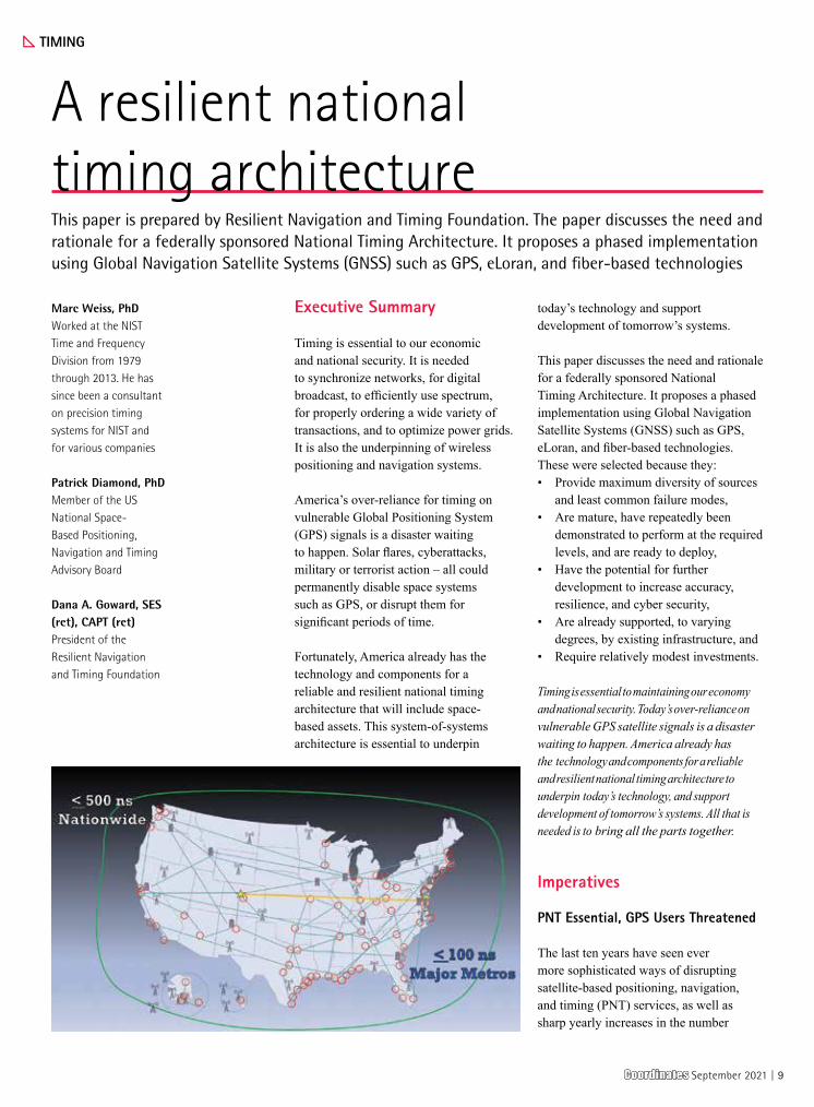
A resilient national timing architectureThis paper is prepared by Resilient Navigation and Timing Foundation. The paper discusses the need and rationale for a federally sponsored National Timing Architecture. It proposes a phased implementation using Global Navigation Satellite Systems (GNSS) such as GPS, eLoran, and fiber-based technologies
Marc Weiss, PhDWorked at the NIST Time and Frequency Division from 1979 through 2013. He has since been a consultant on precision timing systems for NIST and for various companies
Patrick Diamond, PhDMember of the US National Space-Based Positioning, Navigation and Timing Advisory Board
Dana A. Goward, SES (ret), CAPT (ret)President of the Resilient Navigation and Timing Foundation
CoordinatesCoordinates September 2021 | 9

of disruptions reported. Compounding this, the U.S. Federal Communications Commission has recently permitted an operation forecast to interfere with space based PNT for many users.
At the same time thousands of business models are built upon the assumption of continuously available, wide-area, wireless PNT. More and more lives depend upon uninterrupted PNT services. More and more new technologies - aerial drones, autonomous vehicles, intelligent transportation systems - are advancing, often just assuming PNT will be available.
The National PNT Architecture1 is
America’s plan for sufficiently robust PNT to ensure national and economic security. Of P, N and T, the “T” is unquestionably foundational. GPS satellites, Loran transmitters, and other wide-area systems are just radios broadcasting time signals from known locations.
Thus, in building a National PNT Architecture, the first and most important step is Timing.
Important and Urgent
Establishing a National Timing Architecture that serves the entire nation has become an increasingly important and urgent task.
Current Dependence, Support to New Technology - While GPS signals were never intended to be the nation’s time standard, their low barrier to entry, precision, and wide availability have made them the de facto national reference. At the same time, such wide adoption means their vulnerabilities pose a near-existential threat.
These vulnerabilities are problematic for existing systems and can limit development of PNT-dependent technologies. The following are examples of particularly dependent sectors:• 5G telecommunications - While many
systems appear to have alternate and diverse timing sources and pathways, such as use of the IEEE 1588-2019
banking) depend upon GPS’ PNT for timestamping transactions and for network synchronization. Financial services regulated by the Security and Exchange Commission use GPS for some applications, but typically also maintain their own internal time “epochs” with suites of clocks to create timestamped event records, fiber, microwave links, etc. While they may be less vulnerable to disruption as a result, the large amounts of money involved make them a more tempting target for malicious PNT disruption.
• Digital Broadcast & Land Mobile Radios – GPS’ precise timing is used to enable greatly increased use of fixed spectrum in digital radio and television broadcasts, as well as mobile radio networks, over what was available with earlier analog systems. As an example, in their analog form handheld and mobile radios used by security, first responder, military and others were able to support only one transmitter to be on-air at a time, and one conversation on a frequency. Users had to be careful to push their radio key to talk and say “over” to indicate they were done before releasing the key and freeing up the frequency for a reply. With digital systems leveraging GPS’ precise time signals to divide up the conversations into packets, multiple conversations can be had simultaneously on the same frequency.
Existential Contingency – Timing is an essential function for a wide variety of critical infrastructure. No developed nation can afford to risk losing timing.
This has led to many nations beginning to establish more robust and resilient terrestrial timing architectures to complement and backup GNSS. As examples:• Europe has a well-developed 1588
PTP network infrastructure linking national timing clock suites.
• The United Kingdom is establishing a virtual National Timing Centre with distributed suites of atomic clocks at
Precision Time Protocol (PTP),2 many, if not most, of these trace back to GPS as the primary reference. Thus, while 5G is moving forward, it is doing so with GPS time being a critical single point of failure.
• Autonomy – As remarked by a senior U.S. Department of Transportation official, “No one is going to accept autonomous vehicles without a rock-solid foundation of location and navigation.” Drones losing GPS signals and crashing as they are captured by the wind, autonomous vessels being set on the rocks, demonstrations of cars in self-drive mode being forced off the highway by white-hat hackers – all reinforce the notion that reliable and robust PNT is on the critical path to further significant advances in autonomy.
• Transportation – Wireless PNT from GPS has been incorporated into every mode of transportation. Without it, every mode would slow, have less capacity, and be more accident prone.
• Intelligent Transportation Systems (ITS) – Traffic routing applications such as Waze,TM ride share services like UberTM and Lyft,TM train/bus arrival notifications, optimized delivery service programs, traffic signal phase and timing coordination - all are early implementations of ITS. In the absence of GPS’ wireless PNT none of these would be possible. Many businesses would either cease to exist or require massive retooling and capital investment. Implementation of future ITS features will likewise require robust, resilient, reliable PNT as part of their foundation.
• Electric Power - Smart grid technology using synchrophasers for real time control will bring greatly increased safety and efficiency to electrical power distribution. This is unable to move forward, though, without multiple, differently routed Coordinated Universal Time (UTC) time signals to ensure system reliability.
• Financial Services – Consumer financial services (ATMs, checking,
10 | CoordinatesCoordinates September 2021

critical nodes throughout the nation. They are also transmitting precise time from a single eLoran source and appear to be contemplating additional transmitters.
• China has an exceptionally precise 1588 PTP network linking atomic clocks, and a
• robust Loran time network. Its stated goal of “comprehensive PNT” represents the world’s most complete PNT architecture. China has mentioned in a recent publicly available paper that they will be constructing at least three new Loran transmission sites and advancing the capability of their system.3
• No information is immediately available about Russian 1588 PTP implementation, though it is clear from their Radionavigation Plan4 that the Russian variant of Loran will continue to play an important role in national PNT.
Progress in the United States does not appear to be nearly as advanced. Several government departments and labs have distributed clock systems, though they do not appear to be linked in any way to provide national timing resilience. These might, however, have the potential to be incorporated into and benefit the National Timing Architecture. See “Technologies” section below.
Legislation – While progress on system coordination and implementation does not appear well advanced in the U.S. as in some nations, general awareness of the importance of timing resilience has increased. This has resulted in congressional interest and action. The National Timing Resilience and Security Act of 2018,5 mandates the Department of Transportation establish at least one terrestrial timing system to backup GPS services by December of 2020.
This legislation both documents the existential imperative of ensuring non-space-based sources of timing and is a legal imperative in its own right.
Considerations
Architectural Considerations
Timing Architecture Goals
Establishment of a National Timing Architecture must:• Increase time resilience and
redundancy across 100% U.S. land area & maritime Exclusive Economic Zone (EEZ),
• Provide trusted time via multiple authenticated, cybersecure sources that can also validate each other,
• Support critical infrastructure and be a basis for commercial enhancement services,
• Provide a solid timing infrastructure upon which new technologies, research, and scientific applications can build,
• Ensure wireless access everywhere across 50 states and the EEZ to 500 nanoseconds or better accuracy relative to UTC,
• Ensure wireless access everywhere in major metro areas to 100 nanoseconds or better accuracy relative to UTC,
• Provide Network Access Points (NAPs) in metro areas with 100 nanoseconds or better accuracy relative to UTC for further network distribution/use,
• Ensure critical users have access to a minimum of three sources of timing (for redundancy & voting) relative to their required accuracies, and
• Ensure operational reliability is maintained to a “five 9’s” level of performance.
Characteristics
Redundancy - One of the more important principles of systems engineering and architecture is redundancy of critical systems. And the more critical the system, the more important redundancy. In the most important instances triplication is required.
From a concise on-line discussion:
In many safety-critical6 systems, such as fly-by-wire and hydraulic systems in aircraft, some parts of the control system
may be triplicated7 which is formally termed triple modular redundancy (TMR). An error in one component may then be out-voted by the other two. In a triply redundant system, the system has three sub-components, all three of which must fail before the system fails. Since each one rarely fails, and the sub components are expected to fail independently, the probability of all three failing is calculated to be extraordinarily small; often outweighed by other risk factors, such as human error. Redundancy may also be known by the terms “majority voting systems”8 or “voting logic”.9
The safety-critical nature of timing services means that the National Timing Architecture must be a hybrid network, or system of systems.
Diversity – Ensuring that the major timing sources in the architecture are as different from each other as possible will help avoid common vulnerabilities, threats, and failure modes. It will also help safety-critical users maximize triple modular redundancy.
Coordinated Universal Time (UTC) – Relative time is often sufficient for synchronization of networks and in many other applications. However, UTC with the government’s imprimatur (by the National Institute of Standards and Technology (NIST) and the United States Naval Observatory (USNO)) must be the basis from which the National Timing Architecture provides absolute time across the nation.
Responsibility for Sources – The architecture must provide multiple diverse pathways for users to access and maintain time. Responsibility for providing these sources will vary. For example, the responsibility to establish and maintain UTC, as well as the GPS satellite constellation, is clearly that of the federal government. Holdover clocks, when needed or appropriate, are clearly the responsibility of users. Responsibility for other portions of the architecture will be the subject of policy decisions.
CoordinatesCoordinates September 2021 | 11

Requirements
Current Dependence, Support to New Tech – Available literature10
indicates that the following are representative of national requirements:• 5G telecommunications - Requires
1.1 microseconds accuracy relative to UTC for Radio Synchronization and overall network latency.11
• Autonomy – Still in development and expected to vary by platform. Requirements for lane keeping in vehicles are expected to range from 5 to 10 centimeters. This will likely exceed what can be reliably provided by infrastructure and require on-vehicle sensors/ augmentation. Establishment of the national timing architecture will still be key to provide a solid foundation upon which innovators can build.
• Transportation – Requirements vary by application. For consumer-level applications, 100 nanoseconds timing and ten meters location accuracy appear to be sufficient.
• Intelligent Transportation Systems (ITS) – Same as telecommunications requirements above.
• Electric Power - Synchrophasers for real time control require multiple differently routed UTC time signals at the 1 microsecond level or better.12 13
• Financial Services – Individual firms frequently employ sufficient fiber and clock suites to maintain internal synchronization within their own epoch to very demanding limits, sometimes within a nanosecond. However, federal regulations only require firms to maintain 100 microseconds accuracy relative to UTC.
Technologies
UTC Access – Coordinated Universal Time (UTC) for the United States is maintained by the US Naval Observatory (USNO) in Washington, DC, and the National Institute of Standards and Technology (NIST) in Boulder, CO. To use and distribute UTC, a technology must synchronize with one of these two sources. Depending on the desired
level of accuracy, this can be done in a variety of ways including Two Way Satellite Time Transfer (TWSTT), fiber connection, microwave link, GPS Common View, or from a GPS receiver.
It is even possible to “physically” transfer time. Before the digital and communications revolution, entities would bring suites of atomic clocks to USNO to synchronize, and then transport those clocks to sites like Loran and Omega transmitting stations as a way of distributing UTC.
Global Navigation Satellite Systems (GNSS)/GPS – The cornerstone of the National Timing Architecture will be GPS which has a U.S. government supported 78 ns accuracy. Approval by the Federal Communications Commission (FCC) of Europe’s Galileo to be used within the United States allows this second GNSS to also be included. This gives added resilience to the space-based portion of the architecture. - Note that GPS actual performance is almost always better than nominal. Accuracies of < 10 ns for timing and < 10 ft for location are typical (1 ns ≈ 1 foot).
LEO PNT – Numerous government and commercial endeavors are examining the viability and benefits of providing PNT services from satellites in low earth orbit (LEO). This could be inferred from signals of non-PNT constellations. LEO PNT systems could also be created by sharing payloads with other missions, or with purpose-built and deployed constellations. We note that at least one vendor already offers time as a subscription service from LEO satellites.
Networks / Fiber – Various levels of timing accuracy are available by networks and fiber ranging from about tens of milliseconds for NTP, to about 1 ns for dedicated bi- directional wavelengths, each pair in a single fiber. Commercial providers have technology available to provide users with localized, point, and autonomous timing to meet requirements for better than 100 ns accuracy.14 A newly released update to IEEE 1588-
2019, also known as PTP, contains a “High-Accuracy Option.”15 This is a generalization for wide area usage of the White Rabbit standard developed at CERN for sub-nanosecond synchronization accuracy of more than 1,000 nodes via connections up to 10 km of length.
Wide Area Broadcast – Demonstrations in the United States and United Kingdom have shown that eLoran technology broadcasting at 100 kHz is capable of providing better than 1 microsecond accuracy over distances up to 1,600 km from the transmitter, and better than 100ns within 55 km of a differential reference station.16
Note that WWVB broadcasting at 60 kHz could conceivably be developed for this purpose also. DARPA’s STOIC program also envisions a wide area time service using Very Low Frequencies (VLF).
eLoran – eLoran is a form of wide area broadcast using 100 kHz. It is at TRL 9, requiring no development, and is compatible with other Loran systems in operation around the world. This provides significant technology synergies as well as the potential for positive and beneficial engagement with other national operators.
eLoran performance as a timing signal has been demonstrated to the U.S. Department of Homeland Security as part of a Cooperative Research and Development Agreement,17 and by research in the United Kingdom.18 A national eLoran timing system is also among the most recent recommendations of the US National Space-based PNT Advisory Board.19 In 2015 the US President’s National Space-based PNT Executive Committee committed to establishment of an eLoran-based timing system.20
Local Area Broadcast – Local broadcasts can provide timing, along with positioning and navigation information. The accuracy and geographic coverages of these local systems vary with the technology, density of transmitters, and other factors. Systems have been demonstrated to have pico-second level accuracy in some instantiations.
12 | CoordinatesCoordinates September 2021

Distributed Clocks – The federal government maintains various federal clock suites for its own purposes that appear to be able to independently maintain a 1 microsecond level of accuracy relative to UTC indefinitely.• The Department of Defense, in addition
to maintaining UTC at the US Naval Observatory, Washington, DC, has a backup capability at Schriever AFB. Synchronization is maintained via two way satellite time transfer (TWSTT). DoD also maintains a Defense Regional Clock Program.
• The Department of Commerce also maintains UTC at NIST Boulder, CO, with a backup at Ft Collins, CO. Synchronization is maintained by GPS Common-View Time Transfer. NIST Gaithersburg, MD also maintains a clock suite using GPS Common View for synchronization. NIST is exploring synchronizing these sites with fiber networks, potentially at the 1 nanosecond level.
• The Department of Energy maintains suites of clocks at Oakridge, Sandia, and Lawrence Livermore.
Network Access Points NAPs – NAPs are physical locations, usually in major cities, where Interexchange carriers, Independent Local Exchange Carriers, Competitive Local Exchange Carriers, National Carriers, Local Fiber Carriers, etc. “interconnect” with each other’s services. All participating operators contribute to the cost. The national network is made up of hundreds of these NAPs.
The fiber component of the National Timing Architecture will have these interconnect “touch points” at its heart. All monitoring probes, testing, configurations, and connections for further, more localized distribution will occur at these locations.
Network Control & Performance Assurance – Coherent networks require management and control systems to ensure their operation and performance. These involve geographically distributed sensors, testing, performance and fault reporting. Such a control system requires its own redundancy and resilience. GPS,
Loran-C and similar systems have ensured that full network monitoring and control is available at two or more geographical locations remote from each other.
Cybersecurity – While not a technology in and of itself, authentication, access controls, system and user cybersecurity must be considered throughout. The ability of users to trust the timing they receive is paramount. If, as has been seen around the world with positioning, timing is not trustworthy, it may not be used. Worse, it could provide potentially hazardously misleading information.
Policy Considerations
Federal Leadership - The first duty of government is to afford protection to its citizens.21
Timing’s criticality and essentiality to such a broad spectrum of the public and critical infrastructure means that government has a responsibility to ensure such an architecture is established, and quickly.22
The essentiality of time to a nation’s economy and security has been recognized since at least 1714. The British “Longitude Act” of that year might have been better titled “The Time Keeping Act.” It led to development of Harrison’s chronometer and untold immediate benefits to the Royal Navy and merchant fleets. In the United States, USNO has been dropping a time ball since 1845 to mark mean solar noon. Since then, the U.S. government has been communicating time across increasingly large sections of the nation at increasing levels of accuracy.
The federal role is also essential as the government’s imprimatur is required for a time signal to be credible, nationally interchangeable and as useful as possible. Any sufficiently stable time source is adequate for “relative time” to synchronize interconnected sources and other applications that require events to be coordinated only with each other, but not the world at large. Macro, national enterprise synchronization and interoperability, though, is only possible
with a widely communicated time signal endorsed by the sovereign.
As discussed earlier, while the National Timing Architecture must provide multiple diverse pathways for delivery of authoritative time, responsibility for providing these sources will vary. Direct federal involvement (leadership, funding, etc.) must ensure all citizens have reasonable access to more than one path to UTC to prevent time being a single point of failure. Other aspects of the architecture such as augmentations that increase accuracy, hold-over time in the event no external sources are available, and supplemental space-based signals may be the responsibility of users.
The federal government’s role in establishment and communication of national time is a critically important one. Yet it need not be onerous. Experience with similar efforts such as FirstNet and the FAA’s ADS-B system has shown that often the least cost and quickest path to system implementation is a partnership between the government and the commercial sector.
Further reducing the burden on government is a recent technology demonstration done by the Department of Transportation. It showed that sufficient systems exist today to complete a robust National Timing Architecture.
Costs - There are risks and costs to action. But they are far less than the long -range risks of comfortable inaction. – Attributed to President John F. Kennedy
No discussion of a proposed federal investment would be complete without at least a general consideration of costs to both the federal government and users. These costs will be relatively modest, yet absolutely necessary.
Relatively Modest – By leveraging public-private-partnerships, service-agreements, and the like, government can encourage and establish the infrastructure described herein at
CoordinatesCoordinates September 2021 | 13

a cost measured in tens of millions of dollars per year. This is relatively modest when compared to annual expenditures on GPS which exceed $1B.
The cost of end-user equipment will undoubtedly decline as more and more users access the fiber-based and wireless signals. As was the case with GPS and most other technologies, early user equipment will likely be larger and more expensive than in later receiver models. An early pallet-sized GPS receiver, complete with two operator chairs, was budgeted for hundreds of thousands of dollars. Miniaturization, technological advances, and mass production have enabled production of the cheapest GPS for several dollars each.
User costs will also be offset by the need to recapitalize equipment and improvements in utility.
After implementation of the National Timing Architecture there will be little incentive for production of GPS/GNSS-only timing receivers. Just as manufacturers have incorporated other GNSS systems alongside GPS in almost all new receiver models, so too will they almost certainly include over time the ability to use the architecture’s terrestrial systems. Thus, the additional cost for new builds and recapitalized equipment will be only marginally greater than it would have been otherwise in these cases.
More resilient and reliable time will also provide many users increased functionality by virtually eliminating disruptions and providing a higher guaranteed accuracy. As one example of increased utility, this could allow reduced error margins in multiplexing wireless signals, enabling greater use of existing spectrum allocations.
Absolutely Necessary – Often lost in calculating the cost of doing something are the costs of doing nothing. When GPS fails, transportation-related systems immediately suffer. They become less efficient/ more costly, can carry less capacity, and are more accident
prone. Land- mobile radio systems and digital broadcasts degrade or fail. In prolonged outages, two-thirds of U.S. wireless networks are projected to fail after about 24 hours. Then, as backup clocks de- synchronize, more network and other failures will ensue, including the loss of consumer financial services and impacts to utilities. One Air Force-sponsored academic paper projected civil unrest within 72 hours.
Quantitative analyses of the impact of GPS outages have always struggled. Most openly admit their inability to gauge the overall impact to the national economy and limit themselves to specific applications or sectors. Notable studies have estimated prolonged disruption of GPS signals costing the US economy across a wide range of $1B23 to $82B24per day.
It is perhaps not possible to capture GPS’ true economic value and the impact of its potential loss or prolonged outage. Dollar numbers may not have sufficient meaning in this context. As one writer replied when asked about the value of GPS – “What’s the value of oxygen?”25
PNT services, especially timing services, are an existential necessity for life in the United States as we know it. Not ensuring they will always be available poses unthinkable risks and costs.
Adoption
Wide adoption and use of the National Timing Architecture’s terrestrial systems is key to its success. Merely making them available will not increase national and economic security a whit.
Fortunately, America’s experience with implementation and adoption of GPS and other GNSS provides some lessons in this regard. And the government has a variety of tools available to encourage this process
The GPS Experience – While there were a number of technical and historical factors in the unparalleled wide adoption of GPS, the following were key:
• No cost access – GPS is free to access for anyone who can afford a receiver.26 Access to the basic terrestrial services in the National Timing Architecture should be without charge also. This does not preclude the government, one of its partners, or another entity from providing fee-based services. But, in the interest of national and economic security, the service levels outlined herein must be without charge, to encourage wide use.
• Broad availability – GPS is available to anyone with a view of the sky. This means that it is not location dependent. Something developed for use with GPS in New York also works in California and Alaska. The architecture’s terrestrial systems must be available to all users in the United States, regardless of location. The entire nation and its coastal waters will have an accuracy of <500 ns, with densely populated areas having <100 ns relative to UTC. However, after implementation of Phase III, any 70-mile wide area can be upgraded to <100 ns with the installation of a (<$75,000) differential reference station. This is relatively inexpensive when compared to the $400,000+ cost of a Differential GPS site.
• Open source – This has been a dual edged sword for GPS and other GNSS. While it allows for easy (and wide) adoption, use, and integration of signals into myriad applications, it has also made the system much easier to jam and spoof. America’s terrestrial systems must walk a fine line between encouraging wide and wise use and doing as much as possible to prevent interference. There are many methods for doing this, including having parallel services (perhaps an open system for free public use and a closed, more secure one for government and fee-based use). Encryption, authentication and other security measures will be important aspects of development and operation.
• Government agencies leading the way – The initial goal of GPS was for the Air Force to
14 | CoordinatesCoordinates September 2021

• “…put five bombs in the same hole.”27 Early in its implementation, though, many military leaders saw no need for the system and actively opposed it. In fact, at the end of the first Gulf War there was no plan to install GPS in military aircraft. Congress had to insist on it. Adoption and use of GPS by the government was key to its broader adoption across society. This led to a virtuous cycle of improved performance and usability with decreasing costs. The current administration’s Executive Order on responsible use of PNT28
already mandates federal leadership by mandating future federal contracts include a requirement for use of resilient PNT equipment and systems.
Every agency at every level of government has ample reasons to adopt terrestrial services from the National Timing Architecture. Dispatch, asset coordination, land mobile radios, networks – all are degraded or disabled in GPS-denied environments. Imagine the National Guard responding to a disaster without the ability to navigate easily or use their handheld radios. Government agencies and forces will need to use these terrestrial systems, if for no other reason than to ensure continuity of government.
The GNSS Experience
GPS was the world’s first satellite navigation system available to consumers. As Russian and European systems became available, receiver manufacturers began incorporating the capability to use them on most of their products. This is happening again with inclusion of signals from the recently completed
Chinese Bei Dou system. For years most receivers in the United States, for example, have included the ability to access Russia’s GLONASS satnav system, despite federal prohibitions on its use. Many manufacturers ensure this feature is disabled while the equipment is within the U.S. but include it nonetheless. This is because:• The additional cost is
minimal due to decades of technological advancement,
• Building receivers to be as capable as possible is a competitive advantage, or at least prevents a competitive disadvantage,
• Making different receivers for different markets is not cost effective, and
• Users don’t want their equipment restricted by geography and expect it to operate at maximum efficiency everywhere.
We can expect that as receiver technology develops and improves in the critical areas of size, weight, power and cost, more and more receivers
will include the ability to use the terrestrial components of the National Timing Architecture as part of their timing and navigation solutions.
Incorporation of eLoran will be especially incentivized as compatible signals are already available across a significant portion of the globe (see graphic).
Government Encouragement & Requirements
Officials truly concerned about the impact of timing resilience on the nation’s security and economy have multiple tools at their disposal to encourage adoption of better systems and practices.
The February 2020 Presidential Executive Order on Responsible Use of PNT29 outlined the administration’s plan to use educational efforts and government contracting requirements to stimulate increased PNT resilience across critical infrastructure and industries.
Should these efforts not sufficiently protect the nation, greater incentives and requirements should be considered and implemented. In the past these have included things like tax credits for installing new equipment and performance-based regulations.
Putting Together the Pieces
Put simply, we find time transfer by eLoran and fiber are mature technologies
America’s over-reliance for timing on vulnerable Global
Positioning System (GPS) signals is a disaster waiting to
happen. Solar flares, cyberattacks, military or terrorist
action – all could permanently disable space systems such
as GPS, or disrupt them for significant periods of time
CoordinatesCoordinates September 2021 | 15

easily capable of spanning the nation. When combined with GNSS, users will have three independent pathways for authoritative Coordinated Universal Time.
Maintaining and reinforcing America’s network and IT infrastructure is more important now than ever.
Cyber security needs are increasing. Demands on telecommunications service providers are increasing. Space is more and more crowded. GNSS intentional or unintentional interference is increasing.
The COVID pandemic has greatly increased our reliance on networks and distributed work. The number of people who must work remotely, often in locations outside of major metropolitan network nodes has grown significantly. A failure or even temporary outage in any part of our far-flung networks will have much greater impact that it would have had even a year ago.
Adding to domestic concerns, we must also maintain the nation’s competitiveness and standing in the world. Europe, China, and others have and are establishing foundational timing systems, sometimes as part of coherent architectures, to provide innovators and engineers needed infrastructure for current and yet-to-be-developed systems.
While the technologies we propose are mature, and the structure fairly uncomplicated, bringing a National Timing Architecture into reality will have its difficulties. Network design, implementation, contract and project management, ongoing operation – all will be challenges. The experiences of projects like FirstNet and ADS-B, though, will be good guides.
Most important and fundamental will be fostering and maintaining the political understanding and imperative for action outlined in the National Timing Resilience and Security Act of 2018.
The task is a relatively straight forward one. We can ill afford to do less.
Proposed Architecture
Structure & Implementation
Recognizing the differences in readiness levels of various solutions, and the differences in cost and ease of implementation, this proposal takes a phased approach to implementing the National Timing Architecture.
Implementing by increments also provides opportunities for user feedback before the entire system is built out. If solutions are not adopted or prove difficult, the architecture and the systems it includes can be modified or changed completely without incurring major costs.
This proposal also:• Recognizes the higher demand for
timing services and concurrently higher return on investment in geographic centers of population and infrastructure,
• Conforms to the National PNT Architecture final report,
• Uses the layered principled outlined in the US Department of Defense PNT Strategy.30
Technologies
GNSS, eLoran, and fiber-based timing were selected as the primary sources for the National Timing Architecture because they:• Provide maximum diversity of sources
and least common failure modes,• Are mature and ready to deploy,• Have the potential for further
development to increase accuracy, resilience, and cyber security, and
• Are already supported, to varying degrees, by existing infrastructure ▪ GNSS is clearly fully
deployed and in use ▪ eLoran primary transmitter
sites are already owned by the US government
Phase I National Timing Architecture
Global Layer Continental Layer Local Layer
GNSS78ns LEO PNT
eLoran<1 µs
6 sites
N. Clock Ntwk
<100 ns
Df eLoran<100 ns
NAP<100 ns
User Clocks
Fixed Usersw/ntwk access
Everywhere(50 states, EEZ)
Major Metro Selected Selected
Fixed Users w/No ntwk access
Everywhere(50 states, EEZ)
Major metro Selected
Mobile Users
Everywhere(50 states, EEZ)
*
Major Metro * *Selected
Govt sponsored/PPP, No/low barrier to entry Available, commercial, fee based
Recognizing the differences in readiness levels of
various solutions, and the differences in cost and ease of
implementation, this proposal takes a phased approach
to implementing the National Timing Architecture.
16 | CoordinatesCoordinates September 2021

Phase II National Timing Architecture
Global Layer Continental Layer Local Layer
GNSS78ns LEO PNT
eLoran<500 ns12 sites
N. Clock Ntwk
<100 ns
Df eLoran<100 ns75 sites
NAP<100 ns
User Clocks
Fixed Usersw/ntwk access
Everywhere(50 states, EEZ)
Major Metro
Fixed Users w/No ntwk access
Everywhere(50 states, EEZ)
Major metro
Mobile Users
Everywhere(50 states, EEZ)
*
Major Metro * * *
Govt sponsored/PPP, No/low barrier to entry Available, commercial, fee based
▪ Fiber networks and government distributed clock suites are extant and continue to grow.
And while a comparative cost analysis is not part of this paper, prima facia, the terrestrial systems listed above are of modest cost relative to GNSS and other terrestrial systems.
The selection of eLoran over other mature broadcast technologies is also based upon extensive research in the U.S. and U.K. showing its effectiveness (see previous references). Also, alternative analyses performed by the U.S. government show it as the only technology that combines wide area coverage with sufficient accuracy.31
Network Control & Performance
Operational performance integrity will be key to acceptance and use of the National Timing Architecture. Critical users will demand “always on” performance, the ability to view the operational stability in real time, an automated failover capability, centralized reporting, and management in the event of a fault. Just as the Air Force commits to and publishes a performance standard for the broadcast of GPS signals, so too the government must commit to a performance standard for the terrestrial portions of the National Timing Architecture.
Notional Phases
The following notional implementation phases are suggested to progressively support critical infrastructure, technology development and maximize the practical use for citizens.
Phase I Notes:
National Clock Network (N. Clock Ntwk) - Fiber: Connect• NIST Boulder with USNO
to establish <10 ns sync.• Selected (TBD) major metros, eLoran
differential transmitters, and eLoran primary transmitters <100 ns sync
32
CoordinatesCoordinates September 2021 | 17

eLoran: Establish 6 primary transmitter sites (4 in CONUS, 1 each in AK & HI)
Differential (Df) eLoran: Establish differential sites in selected (TBD) metro areas *If GNSS location information is
available to a mobile receiver, eLoran time info will be usable and, if properly integrated, can make receivers much less susceptible to GNSS disruption.
Phase II Notes:
N. Clock Ntwk - National Clock Network (Fiber) Connect:
• National Laboratories & other federally endorsed clock suites. Maintain accuracy at the 100ns level or better (to be determined) relative to UTC.
• Connect to Network Access Points and differential eLoran sites in major metro areas at
• <100 ns level relative to UTC for possible further distribution by govt/ commercial services.
eLoran: Establish 6 additional primary transmitter sites in CONUS (system total of 10 in CONUS, 1 ea AK & HI) for <500 ns relative UTC (exception are remote areas of AK <1 µs)
Differential (Df) eLoran: Establish total of 75 differential sites to serve the 50 largest metro areas, 50 busiest airports, 50 busiest seaports in CONUS, 3 locations in AK and 1 in HI. *If GNSS location information
is available to a mobile receiver, eLoran time broadcast info will be usable. If properly integrated, eLoran signals can make receivers much less susceptible to GNSS disruption.
Phase III Notes:
National Clock Network: Link in-development and future optical clocks for scientific and research. Frequency accuracies pushing the boundaries of science and human imagination.
eLoran: Establish ≈13 additional primary transmitter sites (total of ≈16 CONUS, 6 in AK, 3 in HI)
GPS/GNSS-Independent Positioning, Navigation, and Timing – Accessing terrestrial wireless time for mobile users requires their locations be known. Sufficient primary eLoran transmitters are deployed in Phase III to provide that information without regard to signals from space. This also enables positioning and navigation based solely on eLoran, in the event that signals from space become unavailable. Continuous synchronization with UTC by fiber or other means to one or more points in the primary eLoran transmitter network and the ability of the network to self-synchronize enables it to operate indefinitely providing PNT in the event of a prolonged GPS/GNSS outage.
Endnotes
1 https://www.transportation.gov/pnt/national-positioning-navigation-and-timing-pnt-architecture
2 IEEE Standard 1588-2019, Standard for a Precision Clock Synchronization Protocol for
Phase III National Timing Architecture
Global Layer Continental Layer Local LayerGNSS78ns LEO PNT
eLoran<500 ns
≈25 sites
N. Clock Ntwk<100ns
Df eLoran<100 ns75 sites
NAP<100 ns
User Clocks
Fixed Usersw/ntwk access
Everywhere(50 states, EEZ)
Major Metro
Fixed Users w/No ntwk access
Everywhere(50 states, EEZ)
Major metro
Mobile UsersEverywhere
(50 states, EEZ)Major Metro
Govt sponsored/PPP, No/low barrier to entry Available, commercial, fee based
18 | CoordinatesCoordinates September 2021

Network Measurement and Control Systems https://standards.ieee.org/standard/1588-2019.html
3 “High Accuracy Positioning Based on Psuedo-Ranges: Integrated Difference and Performance Analysis of the Loran System” Sensors 2020, 20(16), 4436; https://doi.org/10.3390/s20164436
4 https://rntfnd.org/wp-content/uploads/CIS-Russia-Radionav-Plan-2019-2024.pdf
5 Sec 514, S140 “Frank LoBiondo Coast Guard Authorization Act of 2018 https://www.congress.gov/115/bills/s140/BILLS-115s140eas.pdf
6 A safety-critical system (SCS) or life-critical system is a system whose failure or malfunction may result in one of the following outcomes:
▪ death or serious injury to people ▪ loss or severe damage to
equipment/property ▪ environmental harm
7 Redundancy Management Technique for Space Shuttle Computers, IBM Research
8 R. Jayapal (2003-12-04). “Analog Voting Circuit Is More Flexible Than Its Digital Version”. elecdesign.com. Archived from the original
9 “The Aerospace Corporation | Assuring Space Mission Success”. Aero.org. 2014-05-20
10 See for example 2019 Federal Radionavigation Plan - https://www.navcen.uscg.gov/pdf/FederalRadioNavigationPlan2019.pdf
11 ATIS Standard 0900005 GPS Vulnerability https://access.atis.org/apps/group_public/download.php/36304/ATIS- 0900005.pdf
12 M.A. Weiss, A. Silverstein, F. Tuffner, Y. Li-Baboud, “The Use and Challenges of Precise Time in Electric Power Synchrophasor Systems,” Proc. 2017 PTTI and ITM of ION, Jan 30, 2017, available from: https://
www.nist.gov/publications/use-and-challenges-precise-time-electric-power-synchrophasor-systems
13 Consolidated Audit Trail (CAT) Reporting Technical Specifications for Plan Participants, available from the Consolidated Audit Trail National Market System (CAT NMS) Plan website: https://www.catnmsplan.com/
14 M. Weiss, L. Cosart, J. Yao, J. Hanssen, “Ethernet Time Transfer through a U.S. Commercial Optical Telecommunications Network, Part 2,” in Proc. Precise Time and Time Interval Meeting, Monterrey, 2016, available from https://tf.nist.gov/general/pdf/2813.pdf
15 IEEE Standard 1588-2019, Standard for a Precision Clock Synchronization Protocol for Network Measurement and Control Systems https://standards.ieee.org/standard/1588-2019.html
16 G. Offermans, S. Bartlett, C. Schue, “Providing a Resilient Timing and UTC Service Using eLoran In the United States” in ION Journal of Navigation Vol 64, Number 3 (Fall 2017) available from https://www.ion.org/publications/abstract.cfm?articleID=102722
17 ibid
18 See for example C. Curry “Delivering a National Time Scale Using eLoran” 7 June 2014 https://rntfnd.org/wp- content/uploads/Delivering-a-National-Timescale-Using-eLoran-Ver1-0.pdf
19 https://www.gps.gov/governance/advisory/recommendations/2018-09-topic-papers.pdf
20 Letter 8 Dec 2015 from PNT Executive Committee Co-chairs DoD Dep Sec Work and DoT Dep Sec Mendez to several members of Congress. See: https://rntfnd.org/wp-content/uploads/DSD-and-Dep-DOT-reply-to-Mr.- Garamendi.pdf
21 Cong. Globe, 39th Congress 2nd Sess. 101 (1867) (remarks of Rep. Farnsworth debating Reconstruction Act of 1867)
See also Preamble to the Constitution: “…in Order to form a more perfect Union, establish Justice, insure domestic Tranquility, provide for the common defence, promote the general Welfare, and secure the Blessings of Liberty to ourselves and our Posterity…”
22 As noted earlier, the responsibility to establish at least part of the timing architecture is required by the National Timing Resilience and Security Act of 2018.
23 https://www.nist.gov/document/economic-benefits-global-positioning-system-gps-final-report
24 https://mkt-bcg-com-public-images.s3.amazonaws.com/public-pdfs/legacy-documents/file109372.pdf
25 “Pinpoint – How GPS is Changing our World and our Minds” – Greg Milner, Norton, 2016
26 Early versions of the internet failed, in the opinion of many because administrators sought a small fee to cover overhead costs.
27 Dr. Bradford Parkinson, Chief Architect of GPS, speaking at Smithsonian Air and Space seminar March 21, 2013
28 Executive Order on Strengthening National Resilience through Responsible Use of Positioning, Navigation, and Timing Services – Issued February 12, 2020
29 Ibid
30 https://rntfnd.org/wp-content/uploads/DoD-PNT-Strategy.pdf
31 See for example “GPS Dependencies in the Transportation Sector” August 2016, U.S. Department of Transportation, Volpe Center, pg 45
32 Graphics adapted with permission from UrsaNav presentations
© RNT Foundation x
CoordinatesCoordinates September 2021 | 19
x LAND ADMINISTRATION
Systematic land registration in Georgia – Design and implementationThe paper analyzes the implementation process, provides an overview of the preexisting problems and discusses the means on how the Pilot Project has addressed the shortcomings
Elene GrigoliaBlockchain Consultant LMD Component Manager World Bank Funded Project “ILMD” National Agency of Public Registry, Georgia
Teimuraz GabriadzeSenior Legal ConsultantIrrigation and Land Market Development Project National Agency of Public Registry, Georgia
Abstract
The paper seeks to provide overview of the Pilot Project on Systematic Land Registration which was implemented in Georgia by the National Agency of Public Registry of Georgia through the funding allocated by the World Bank (IDA). The paper analyzes the implementation process, provides an overview of the pre-existing problems and discusses the means Pilot Project has addressed the shortcomings.
It also provides the overview of findings and recommendations set forth by the project to the Georgian Government based on the project baseline data.
Circumstances leading to implementation
Following the breakup of the Soviet Union, Georgia embarked on the mission to transform itself into a market based economy, which most importantly started with the implementation of the Land Reform. The 1992 land privatization program, which was mainly complete by 1998, transferred 60 percent of the arable land and perennials to about one million Georgian households. However due to the complications in the distribution of the land, as well as ensuing chaos that followed the internal conflicts, resulted into registration of only 20% of the agricultural land plots.
The registration began in 1999, with assistance from USAID, KfW,
UNDP, GTZ and WB. The projects encompassing almost the entire territory of Georgia carried out land survey and registration activities using different technologies and procedures. That resulted in collection of heterogeneous cadastral and registration information. The reason was in part the inadequate coordination of donor activities by the donors and by relevant state agencies. One impeding circumstance was the duplication of functions of the State Department for Land Management recording information about land and the Bureau of Technical Inventory recording information building construction. In 2004, SLDM and BTI were succeeded by the National Agency for Property Registration, which is highly efficient by international standards. The land privatization and evolving requirements for registration however, resulted in a situation whereby the majority of land ownership rights are not registered in NAPR. The MOA estimates that between 15-20% of agricultural land plots are registered. The main reason for the low registration coverage is the diverse range of methods and poorly coordinated projects through which land ownership rights were issued during privatization.
This in combination with other factors, served as a catalyst for the Georgian government to initiate a land reform in 2016 which aimed and increased number of registered land plots by subsidizing the land measurement procedures and cutting the red tapes hindering the registration
20 | CoordinatesCoordinates September 2021

process. This was made possible due to enactment by the Parliament of Georgia, on June 3, 2016, of the groundbreaking Law on Special Procedures for Systematic and Sporadic Registration of Land Plots and Improvement of Cadastral Data under State Project. From the beginning, the reform laid ground for two separate directions, free sporadic registration, based on the applications of the interested parties and the pilot project on systematic land registration. While the sporadic registration of the land reform was a major breakthrough for the government as it resulted in 700 000 successful registration applications, it will not be subject of the present paper. We will focus on the Pilot Project on Systematic Land Registration and its results.
Design of the Pilot
Georgia and International Development Association signed in 2014 a $50 million loan agreement for improvement of delivery of irrigation and drainage services in selected areas and development of improved policies and procedures as a basis for a national program of land registration. The resulting Irrigation and Land Market Development Project (ILMDP) consists of three components: Component 1 - Irrigation and Drainage Improvement implemented by the Ministry of Agriculture of Georgia ($45.65 million), Component 2 - Land Market Development implemented by the Ministry of Justice through the National Agency for Public Registry ($2.25 million) and Component 3 - Project Management ($2.10 million). The Project became effective in March 13, 2015 with a closing date on July 31 2021.
Under Component 2, ILMDP financed the pilot phase of a land registration program designed to redefine and test the policies and procedures for registration of agricultural land that would allow the majority of existing land ownership rights to be registered. The pilot included three key elements:• Policy and Procedural Development,
including government’s guidelines
for land registration by the project, that would develop the methodology for land registration, define policies, procedures and dispute resolution mechanisms for different land possession scenarios to be dealt with under the pilot, and improving the guidelines based on lessons from the pilot as a basis for a national program.
• Pilot Project of about 48,000 parcels in 11 pilot areas consisting of 12 settlements across Georgia (Figure 1) selected to represent the geographic variety and land tenure situations in the country. Piloting involved training of staff and surveyors, social mobilization of landowners, collection of land title document, surveying of land plots, updating maps and registration documents, dispute resolution, registration and issue of electronic certificates.
• Development of a Land Registration Monitoring System, to assess the effectiveness of policies and procedures for pilot land registration including the quantitative impact of land registration (on land transactions, land disputes, investment in land, farm productivity and profitability) and progress in implementation of nationwide land registration in future.
The implementing agency of the project is Ministry of Justice of Georgia (MoJ) through the National Agency of Public
Registry of Georgia (NAPR), a legal entity of public law under the MOJ.
Implementation of the Pilot
NAPR launched the pilot project on land systematic registration in two phases in 2017. Phase I of the project concentrated on i) Development of the Guidelines on Systematic Land registration (Guidelines) through involvement of the international consultant ii) Hiring and of staff and creating the Pilot Project Core Team and iii) Carrying out systematic land registration in Manglisi Pilot Area by using newly adopted Guidelines. After the completion of the Phase I, NAPR would launch the systematic registration in remaining pilot areas thus beginning the Phase II of the project.
The pilot was aimed at resolving the data inconsistencies caused by missing or incorrect cadastral information and unspecified cadastral data, and provide NAPR with information in order to: 1) ascertain compliance of the cadastral data with the actual location of the land plots; 2) ensure compliance of the unspecified land plot cadastral data registered in the public registry with the requirements of the laws in Georgia; 3) ensure compliance of the specified land plot cadastral data registered in the public registry with the actual location
Figure 1. Location of Pilot Areas
CoordinatesCoordinates September 2021 | 21

of the land plots and make relevant correction in line with the procedures prescribed by the laws in Georgia.
The implementation process for systematic registration was conducted in six phases: 1) Preparation activities; 2) Public awareness 3) Technical fieldwork 4) Public display 5) Verification of survey results 6) Registration.
The registration was based on the Law on Systematic and Sporadic Registration of 2016 and included full cadastral survey and creation of a database of all privately owned land, land owned by the GOG, and land owned by the municipalities.
Phase I
Guidelines on Systematic Land Registration were sent to the World Bank for review on March 1, 2017 and based on comments from the Bank which mainly aimed at increasing degree of the property rights protection, Guidelines were adopted following receiving the No Objection from the World Bank on May 15, 2017. Simultaneously, NAPR began the formation of the Project core team and procurement of the field and office equipment. With support of the of the German Society for International Cooperation (GIZ) under the EU-funded Project “Support to the Development of Private and Administrative Law System in Georgia” NAPR trained municipality
representatives and members of Local Property Rights Recognition Commissions in the new procedures set out by the Law and the Guidelines. Additional funds were distributed to support the social mobilization campaigns in the Pilot Areas.
The initial idea behind the Guidelines was that the registration fieldwork should be done by private companies authorized through contracts with NAPR to perform cadastral survey and collect documents for registration in the public registry. The contractor was required to combine the registration documents into registration packages and uploading them to the NAPR electronic land registration system. After passing internal quality control, the packages were reviewed by Pilot Project Cores Staff (PPCT), which also performed field checks of the survey work. Based on the results, PPCT recommended approval or rejection. If rejected, the data was returned for correction. If accepted it was considered ready for registration. Then the survey data went to NAPR where the Geodesy and Geoinformation Department conducted final quality control (QC) and entered it into the cadastral database. On its end, the Property Registration Department performed QC on the registration documents collected by the contractor and made registrations in the public registry.
NAPR tested three different approaches during the registration process. The
approach to the implementation of the pilot project has passed through several stages in search of the most effective technical and financial solution. Comparison between the approaches is presented in Table 1.
i. Fully Outsourced Approach
The first contract for systematic registration in the pilot areas was awarded for Manglisi Pilot Area. The work included surveying and preparation of cadastral plans, collection of data and documents necessary for registration in the public register, participation in public display, involvement in dispute resolution, correction of errors and gaps, participation in public awareness and information activities.
The contractor was required to perform the fieldwork for the entire pilot area based on an analysis of the existing title documents, ortho and mapping data, and according to the procedures established by law and the Guidelines.
The contractor implemented a flawed methodology without preliminary analysis of the available title documents. It deployed inadequately trained and insufficient personnel5 and inadequately supervised the project. Most human and technological resources were spent on the cadastral survey, while the legal analysis was paid little attention. The staff lacked
Fully Outsourced Hybrid I Hybrid II Hybrid III In House
Cadastral survey Contractor Contractor Contractor Contractor NAPR
Preparation of cadastral plans Contractor Contractor NAPR NAPR NAPR
Collection of ownership information in the field
Contractor NAPR NAPR Contractor NAPR
Collection of document for registration in the field
Contractor NAPR NAPR NAPR NAPR
Legal review Contractor/NAPR NAPR NAPR NAPR NAPR
Preparation of public display NAPR NAPR NAPR NAPR NAPR
Verification of survey results Contractor/NAPR NAPR NAPR NAPR NAPR
Registration in the public registry NAPR NAPR NAPR NAPR NAPR
Table 1. Comparison between the approaches implemented by NAPR
22 | CoordinatesCoordinates September 2021

familiarity with the Guidelines. The company had no internal quality control and quality assurance mechanisms.
As a result, NAPR received incomplete registration packages. Despite the regular communication, meetings and weekly reminders, the contractor failed to provide the registration data required by the contract. On November 3, 2017, three and a half months after signing, the contract was terminated. NAPR still made payments for the GPS points and cadastral drawings that were used in subsequent registration at the significantly reduced price.
Phase II
After the failure of the first contract for Manglisi, NAPR decided to test two alternative implementation approaches – hybrid and in-house.
Hybrid approach was designed to split the legal and technical part of the project between the NAPR and the contractor, surveys are conducted by the private company selected through a tender and legal side of the project is sorted by the NAPR team;. APR successfully tested this approach in first pilot area after which it was further refined and simplified, whereas the GIS works were transferred to the NAPR and the contractor conducted only the fieldworks. This approach was than successfully tested in other Pilot Areas.
In-House Approach was designed to conduct the systematic registration entirely with the in-house team, NAPR transformed to the sole responsible party for fieldworks as well as the legal aspect of the registration. This approach was introduced right after first unsuccessful attempt of the outsourcing the entire process to the private companies and it was also successfully tested.
i. Hybrid approach
Hybrid Approach divided the tasks between the NAPR and the private contractors. With the hybrid approach, the survey fieldwork was contracted
to the survey companies, while the legal aspects of the systematic land registration were done entirely by NAPR. The contractor was required to perform boundary measurements under the close guidance of the NAPR Regional Facilitators who collected and analyzed registration documents provided by the interested parties. The contractor was also required to set up an office in the pilot area, participate in public awareness and information activities, Public Displays and dispute resolution process. It was also obliged to correct errors and perform verification of survey results.
Prior to entering the pilot area, NAPR would divide the area into registration blocks and their boundaries would be approved by the local municipality (This was the standard practice for all pilot areas). Contractor submitted survey data and registration packages NAPR on a block-by-block basis. Each delivery passed quality control. The registration documents were checked in accordance with the ISO 2859-1 Standard Sampling Procedures for Inspection. The boundary surveys were controlled by field checks of no less than ten percent of delivered data.
In order to ease off the fieldwork management, NAPR removed GIS work from the contractor obligations and began to outsource only the cadastral surveys. Contractor’s sole responsibility was to make measurements while all GIS and registration works were taken over by NAPR (Hybrid II). This simplification was expected to lower the costs, improve the quality and break the monopoly of several expensive companies, which dominated the survey market. Finally NAPR improved the Hybrid approach
further by requesting the contractor to collect also ownership information and work closely with the RF (Hybrid III). The modifications in the Hybrid approach are presented in Table 1.
Hybrid I approach was implemented in Salkhino area. The contractor underwent trainings prior to beginning of the fieldwork. The initial quality control however, revealed discrepancies in the produced data and NAPR provided additional trainings related to TOR. The PPCT QC specialists spent 14 calendar days in the field to share their experience and provide practical advices. It was revealed that the preparation of cadastral plans poses the main problem because takes considerable time. Therefore, NAPR developed a computer application that considerably shortened it and enhanced the quality of the produced drawings.
Hybrid II approach was implemented in Zaridzeebi area. Based on the experience from Salkhino, NAPR removed cadastral plan preparation (GIS Works) from the contractor requirements. Contractor delivered all field measurements to the required quality and standard. The NAPR involvement in the survey work was considerably less in comparison with Hybrid I approach.
Hybrid III approach was implemented in Vedidkari area. In contrast with Hybrid I and Hybrid II, the contractor was requested to collect ownership information. The RF worked in parallel with the surveyors to collect the necessary documents. Afterwards the information was combined and processed submitted to NAPR for review. This approach almost eliminated the need of RF and decreased their related expenses incurred by NAPR.
NAPR tested three different approaches during
the registration process. The approach to the
implementation of the pilot project has passed
through several stages in search of the most
effective technical and financial solution
CoordinatesCoordinates September 2021 | 23

The hybrid approach with its modifications proved that it is possible to outsource the fieldwork to private companies. To be effective, the contractors should be released from responsibility to analyze registration documents and prepare cadastral plans. One of the findings of the hybrid approach was the need to appoint a Contract Manager for each area to keep track of the contractor delivery dates, monitor its work plan and establish communication between the contractor and NAPR units.
ii. In-house Approach
With the in-house approach, all technical and legal fieldwork was carried out by the NAPR. This fully eliminated the need of contractors in the systematic registration process. In order to facilitate the application of the in-house approach, NAPR received a “No Objection” from the World Bank to: i) purchase additional equipment and contract an In-house team; and ii) incur project support costs for a technical staff to perform legal fieldwork and help survey teams.
The in house approach was implemented in 8 pilot areas including Jimiti, Mzisguli, Arboshiki, Arkhiloskalo, Saguramo, Lakhamula, Shuakhevi, Karaleti and partially Manglisi. In these areas NAPR utilized all available resources. With their specific knowledge in land registration, the in house teams performed well in extremely tight schedules. However the downside was the logistical strain on NAPR. The pilot areas were far and without facilities for long time accommodation. The teams
had to return home periodically, which negatively affected the project costs.
Changes in workflow
During the Phase II of the project several major changes were introduced to the workflow, substantially changing the existing workflow under the guidelines.
According to the original process description, the field teams were required to deliver documents and data to NAPR on a weekly basis. The survey data was periodically controlled by the QC Team and then entered (after topology checks) into the cadastral database by the Geodesy and Geoinformation Department. On their side, the registration packages were reviewed by PPCT. After collecting all data for the pilot area, it was presented in a Public Display where the interested persons could perform control and make contests. If not contested, the data was considered approved and legally valid. In case of problems, interested persons might request verifications according to the procedures established by law. Finally, the registration data went to the Property Registration Department for final QC and recording into the public registry. In case of illegally occupied land, PRD submitted an application to LPRRC and performed registration after their decision.
According to the new implemented workflow, the field teams composed by surveyors and Regional Facilitators deliver survey and registration data after the completion of each registration block. Then the registration packages go to the Technical Support Staff, which performs
an initial quality control to discover technical discrepancies before sending to Public Display. TSS checks the data against the records in other governmental databases and contacts interested persons to validate the information and make corrections. Once compliance is ensured, GGD integrates the survey data into the electronic cadastral database and together with TSS prepares survey plans and a plan of the registration block. Together with other documents and after passing QC by TSS and GGD, these plans are presented in Public Display and signed by the owners. After Public Display and if necessary after verification of the survey results, PRD performs registration according to the law. In case of illegally occupied land, PRD submits an application to LPRRC and performs registration after their decision.
The responsibilities of the Regional Facilitators were changed and the new position of a Local Regional Facilitator was created. The changes were aimed at improving the performance and facilitate implementation of the hybrid and in-house approaches. The original responsibilities of the Regional Facilitators were to assist the registration work on site and ensure good communication with local authorities and citizens. The RF still retain their previous functions to provide public awareness and information; organize events in the pilot areas together with PRU, introduce normative acts to the population; collect questions, comments and complaints; participate in Public Displays; keep connection with administrative units, city councils, NAPR and/or other administrative
NAPR developed a computer application to automate and standardize the systematic
registrations process. It allows for processing of field data, researching ownership
data, archiving parcel related documents, cadastral survey plans and registration
blocks in a completely automated way. This saves time and unifies the data format
and storage in a single database. The application can produce hard copies of survey
plans, layouts of changes and overlaps, plans of sets of parcels or registration blocks.
24 | CoordinatesCoordinates September 2021

bodies; assist in dispute resolution. These functions were extended and the RF are now also responsible for coordination of the Public Display process, collection and keeping record of applications for verification of survey results.
The most significant change however, is that the RFs are now part of the field teams together with surveyors. While the surveyors perform boundary surveys in accordance with the predetermined schedule, the RF verify, collect and analyze registration documents provided by the owners. They are also responsible for the coordination of the field teams (except for the survey teams) and provision of technical assistance. Some previous responsibilities of the RF are transferred to the new created position of the Local Regional Facilitator. They are employed from the local population to know well the territory and land issues over it and work under the direction of the RF. Main responsibility of the LRF is to communicate with the population and representatives of the municipalities. They also collect information on interested parties during the cadastral surveys, participate in Public Display and resolve logistical issues related to the fieldwork.
NAPR introduced a new computer application designed to speed up the information exchange. It provides the RF with tools for collection of field data, which automatically is uploaded into the servers of NAPR. Once processed by the TSS, the data is uploaded back into the servers. The application also facilitates the communication between the Property Registration Department and GIS operators.
Other project related activities
Systematic land registration in the pilot areas produced interesting results in all aspects of land registration. Pilot project financed number of activities aimed at improving the land registration process as well as activities aimed at better understanding the overall problems faced by the project in the registration process.
i. Baseline research in the pilot areas
The Pilot Project conducted a baseline assessment in four pilot areas to: i) evaluate among others the importance of land registration to the local populations, ii) identify challenges faced by the households in the registration process and iii) provide a basis for better assessment of the project outcomes. The survey involved 800 households in Karaleti, Vedidkari, Zaridzeebi and Shuakhevi to obtain information on land ownership, land use, perceptions of tenure security, land transactions, types of land use, investments, sources of information in the areas, people’s trust in government agencies, the importance and outcomes of land registration reforms. The main results show that:• 17% of households registered their
land over the past five years. The reasons for not attempting to register vary according to settlements. In Zaridzeebi, it is the expensiveness of the procedure (40%). In Vedidkari and Shuakhevi 36% and 48%, do not deem registration necessary. In Karaleti 68% of the households, give as a main reason the prolonged procedure.
• The main reasons why the residents could not to register their land are the absence of documents, expensiveness and lack of knowledge on the procedure.
• Absolute majority of the households in all target areas do not expect to lose the right of ownership or use on residential or arable land parcel within the nearest 5 years, whether they have ownership documents completely in order or not.
• 38% of households recognize the right to sell or assign residential land parcels and 31% in case of arable land parcels. These numbers are significantly lower in Karaleti where the main document for ownership is the systematic registration card (so-called Shevardnadze document) but not a record from the Public Registry, which is the case in the other communities.
• Main sources of community-related information on municipal/district issues are the fellow villagers (77%) and local TV/radio (39%).
This is not a comprehensive review of the baseline research, but a small demonstration. The outcomes of the Baseline research warrant a separate paper in itself.
ii. Web portal and software application for the systematic land registration
NAPR developed a computer application to automate and standardize the systematic registrations process. It allows for processing of field data, researching ownership data, archiving parcel related documents, cadastral survey plans and registration blocks in a completely automated way. This saves time and unifies the data format and storage in a single database. The application can produce hard copies of survey plans, layouts of changes and overlaps, plans of sets of parcels or registration blocks.
The new application improves the efficiency of the registrars and GIS managers. Prioir to adoption of the software, 2h and 50m was needed to process a block in a settlement while with the new application this is reduced to 1h and 10m. Similarly, the time to process an agricultural block was reduced from 2h 12m to 1h and 20m. The samples used for testing include 15 plots in residential (settlements) and 18 plots in agricultural land.
The major outcomes from using the application are reduced number of defects, unification of data storage, increased accountability and economy of time and resources.
The PP created a web portal to improve the provision of electronic services and provide comprehensive information on the registration process. It presents regularly updated information on the project status, results, findings and conducted public displays. The portal is a powerful tool for increasing public awareness and promoting the project and NAPR.
CoordinatesCoordinates September 2021 | 25
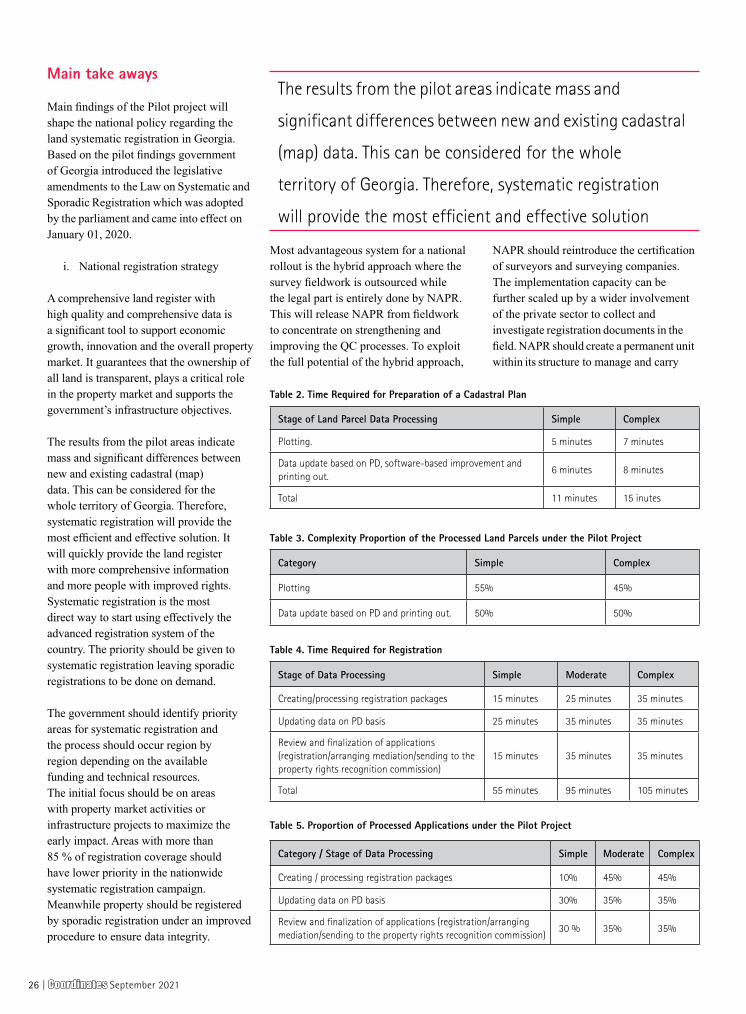
Main take aways
Main findings of the Pilot project will shape the national policy regarding the land systematic registration in Georgia. Based on the pilot findings government of Georgia introduced the legislative amendments to the Law on Systematic and Sporadic Registration which was adopted by the parliament and came into effect on January 01, 2020.
i. National registration strategy
A comprehensive land register with high quality and comprehensive data is a significant tool to support economic growth, innovation and the overall property market. It guarantees that the ownership of all land is transparent, plays a critical role in the property market and supports the government’s infrastructure objectives.
The results from the pilot areas indicate mass and significant differences between new and existing cadastral (map) data. This can be considered for the whole territory of Georgia. Therefore, systematic registration will provide the most efficient and effective solution. It will quickly provide the land register with more comprehensive information and more people with improved rights. Systematic registration is the most direct way to start using effectively the advanced registration system of the country. The priority should be given to systematic registration leaving sporadic registrations to be done on demand.
The government should identify priority areas for systematic registration and the process should occur region by region depending on the available funding and technical resources. The initial focus should be on areas with property market activities or infrastructure projects to maximize the early impact. Areas with more than 85 % of registration coverage should have lower priority in the nationwide systematic registration campaign. Meanwhile property should be registered by sporadic registration under an improved procedure to ensure data integrity.
Most advantageous system for a national rollout is the hybrid approach where the survey fieldwork is outsourced while the legal part is entirely done by NAPR. This will release NAPR from fieldwork to concentrate on strengthening and improving the QC processes. To exploit the full potential of the hybrid approach,
NAPR should reintroduce the certification of surveyors and surveying companies. The implementation capacity can be further scaled up by a wider involvement of the private sector to collect and investigate registration documents in the field. NAPR should create a permanent unit within its structure to manage and carry
Stage of Land Parcel Data Processing Simple Complex
Plotting. 5 minutes 7 minutes
Data update based on PD, software-based improvement and printing out.
6 minutes 8 minutes
Total 11 minutes 15 inutes
Category Simple Complex
Plotting 55% 45%
Data update based on PD and printing out. 50% 50%
Stage of Data Processing Simple Moderate Complex
Creating/processing registration packages 15 minutes 25 minutes 35 minutes
Updating data on PD basis 25 minutes 35 minutes 35 minutes
Review and finalization of applications (registration/arranging mediation/sending to the property rights recognition commission)
15 minutes 35 minutes 35 minutes
Total 55 minutes 95 minutes 105 minutes
Category / Stage of Data Processing Simple Moderate Complex
Creating / processing registration packages 10% 45% 45%
Updating data on PD basis 30% 35% 35%
Review and finalization of applications (registration/arranging mediation/sending to the property rights recognition commission)
30 % 35% 35%
Table 2. Time Required for Preparation of a Cadastral Plan
Table 3. Complexity Proportion of the Processed Land Parcels under the Pilot Project
Table 4. Time Required for Registration
Table 5. Proportion of Processed Applications under the Pilot Project
The results from the pilot areas indicate mass and
significant differences between new and existing cadastral
(map) data. This can be considered for the whole
territory of Georgia. Therefore, systematic registration
will provide the most efficient and effective solution
26 | CoordinatesCoordinates September 2021

out systematic land registration across the country. The unit should take over the functions of the present Pilot Project Core Team. It’s main responsibilities should be to: supervise the SLR process, prepare ownership data for each area before initiation of fieldwork; organize trainings for their staff, municipality representatives, members of LPRRC and mediators; prepare with PRU public awareness; organize, prepare and participate in public awareness and information activities, public display and dispute resolution, perform analysis and QC of registration documents provided by owners and communicate with the Registration Department at NAPR.
NAPR should create a permanent unit for quality control of the cadastral survey work for systematic and sporadic registration. Its main functions should be to: manage and conduct QC and verification of survey results across the country; develop documentation necessary for employment of contractors; organize trainings for their staff and contractors; prepare survey data before initiation of cadastral fieldwork; approve cadastral survey/measurement plans. The unit should employ surveyors
and GIS specialists. The private contractors currently do not have capacity to conduct a comprehensive legal review of the data obtained during fieldwork. This work and the following registration after considering all facts for the particular case can be done only by the Property Registration Department at NAPR.
ii. Baseline data on complexity and time required for GIS and registration works
One of the most significant findings of the pilot project was to identify and pinpoint the complexity of the registration sages and the times needed for their completion. It encompassed time needed both for the GIS and the back office registration works.
Systematic land registration is a one-time effort. The government sector alone rarely has the capacity to do work on a national scale. It is common to involve the private sector in data capture, surveying and mapping.
In many cases, this includes also the adjudication and drawing up the title documents, leaving the state agencies to
register the documents and monitor the process. The state responsibility is to ensure the accuracy and reliability of the data. Such arrangements require standards, guidelines, which are in place in Georgia.
Pilot project is nearing its life cycle as all the activities are completed and the registration process in nearing its end. From the outset, there were project progress indicators against which the success of the project would be measured: i) number of land titles registered in project pilot areas; (ii) female beneficiaries. As of writing this paper, Pilot Project managed to achieve 125.2% completion rate on in the first indicator and 160% on the second indicator. Upon completion of the registration process, all indicators will be met.
Besides meeting the indicators, Pilot Project i) prepared the draft National Systematic Land Registration Strategy based on the findings of the project; ii) developed, tested and evaluated three different approaches to the systematic land registration; iii) calculated the time and cost of systematic land registration; iv) identified basic human and technical resources required to implement the systematic registration activities; and vi) developed and submitted for approval the legislative package designed to improve land registration system and facilitate the implementation of national rollout.
Paper prepared for presentation at the “2020 World Bank Conference On Land And Poverty” The World Bank - Washington DC, Copyright 2020 by author(s). x
Indicator Baseline TargetCurrent Status(incl. baseline)
Attributable toproject
Performance(%)
(1) (2) (3) (4)=(3)-(1) (4)/[(2)-(1)]
Number of land titles registered
14,000 48,000 56,813 42,813 125.2 %
Female Beneficiaries 0 5,000 8,000 8,000 160 %
Submitting Legislative Package to the Government
0Created and submitted to
the GovernmentSubmitted to the
GovernmentCompleted
Table 6. Pilot Project Indicators
NAPR should create a permanent unit for quality control
of the cadastral survey work for systematic and sporadic
registration. Its main functions should be to: manage and
conduct QC and verification of survey results across the
country ; develop documentation necessary for employment
of contractors; organize trainings for their staff
CoordinatesCoordinates September 2021 | 27
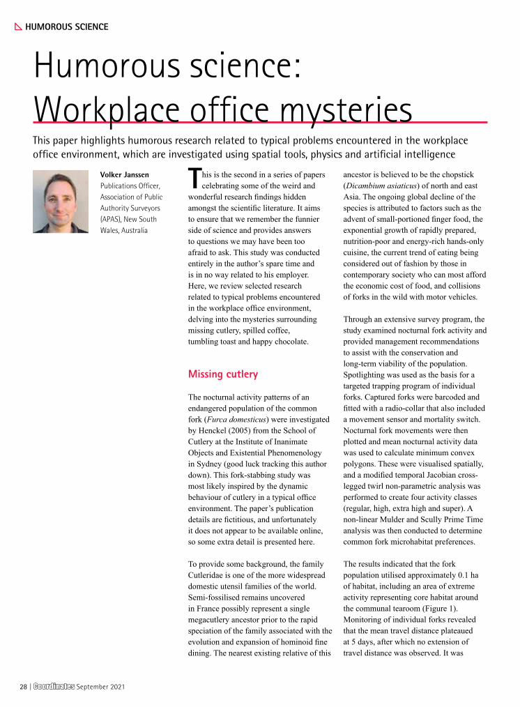
x HUMOROUS SCIENCE
Humorous science: Workplace office mysteriesThis paper highlights humorous research related to typical problems encountered in the workplace office environment, which are investigated using spatial tools, physics and artificial intelligence
Volker JanssenPublications Officer, Association of Public Authority Surveyors (APAS), New South Wales, Australia
This is the second in a series of papers celebrating some of the weird and
wonderful research findings hidden amongst the scientific literature. It aims to ensure that we remember the funnier side of science and provides answers to questions we may have been too afraid to ask. This study was conducted entirely in the author’s spare time and is in no way related to his employer. Here, we review selected research related to typical problems encountered in the workplace office environment, delving into the mysteries surrounding missing cutlery, spilled coffee, tumbling toast and happy chocolate.
Missing cutlery
The nocturnal activity patterns of an endangered population of the common fork (Furca domesticus) were investigated by Henckel (2005) from the School of Cutlery at the Institute of Inanimate Objects and Existential Phenomenology in Sydney (good luck tracking this author down). This fork-stabbing study was most likely inspired by the dynamic behaviour of cutlery in a typical office environment. The paper’s publication details are fictitious, and unfortunately it does not appear to be available online, so some extra detail is presented here.
To provide some background, the family Cutleridae is one of the more widespread domestic utensil families of the world. Semi-fossilised remains uncovered in France possibly represent a single megacutlery ancestor prior to the rapid speciation of the family associated with the evolution and expansion of hominoid fine dining. The nearest existing relative of this
ancestor is believed to be the chopstick (Dicambium asiaticus) of north and east Asia. The ongoing global decline of the species is attributed to factors such as the advent of small-portioned finger food, the exponential growth of rapidly prepared, nutrition-poor and energy-rich hands-only cuisine, the current trend of eating being considered out of fashion by those in contemporary society who can most afford the economic cost of food, and collisions of forks in the wild with motor vehicles.
Through an extensive survey program, the study examined nocturnal fork activity and provided management recommendations to assist with the conservation and long-term viability of the population. Spotlighting was used as the basis for a targeted trapping program of individual forks. Captured forks were barcoded and fitted with a radio-collar that also included a movement sensor and mortality switch. Nocturnal fork movements were then plotted and mean nocturnal activity data was used to calculate minimum convex polygons. These were visualised spatially, and a modified temporal Jacobian cross-legged twirl non-parametric analysis was performed to create four activity classes (regular, high, extra high and super). A non-linear Mulder and Scully Prime Time analysis was then conducted to determine common fork microhabitat preferences.
The results indicated that the fork population utilised approximately 0.1 ha of habitat, including an area of extreme activity representing core habitat around the communal tearoom (Figure 1). Monitoring of individual forks revealed that the mean travel distance plateaued at 5 days, after which no extension of travel distance was observed. It was
28 | CoordinatesCoordinates September 2021
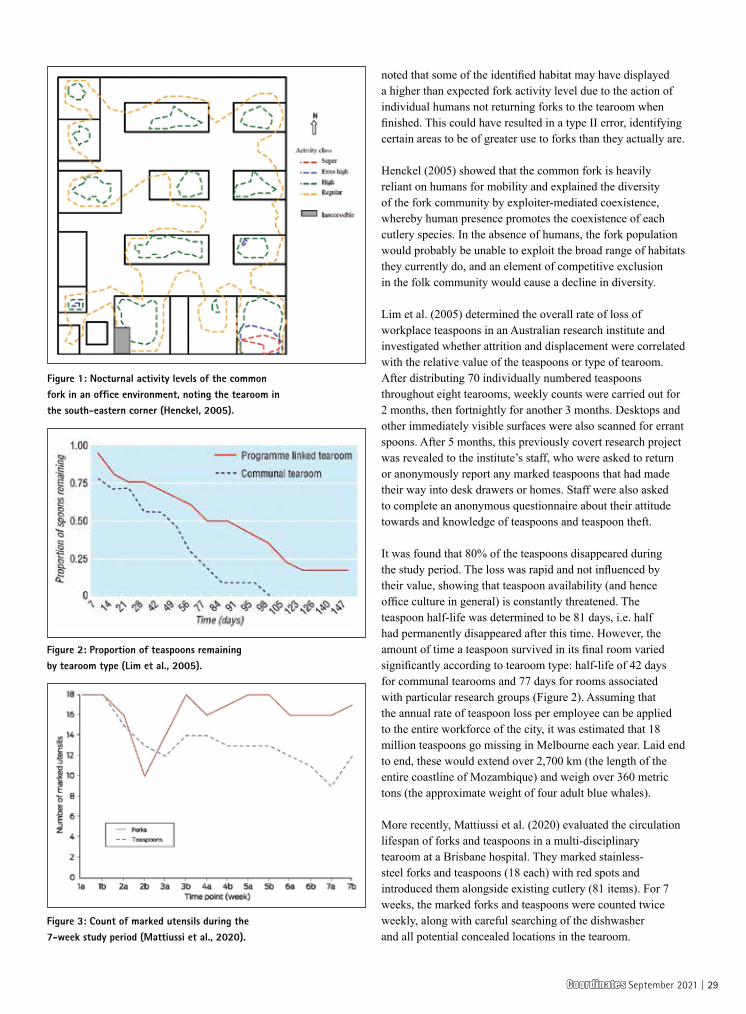
noted that some of the identified habitat may have displayed a higher than expected fork activity level due to the action of individual humans not returning forks to the tearoom when finished. This could have resulted in a type II error, identifying certain areas to be of greater use to forks than they actually are.
Henckel (2005) showed that the common fork is heavily reliant on humans for mobility and explained the diversity of the fork community by exploiter-mediated coexistence, whereby human presence promotes the coexistence of each cutlery species. In the absence of humans, the fork population would probably be unable to exploit the broad range of habitats they currently do, and an element of competitive exclusion in the folk community would cause a decline in diversity.
Lim et al. (2005) determined the overall rate of loss of workplace teaspoons in an Australian research institute and investigated whether attrition and displacement were correlated with the relative value of the teaspoons or type of tearoom. After distributing 70 individually numbered teaspoons throughout eight tearooms, weekly counts were carried out for 2 months, then fortnightly for another 3 months. Desktops and other immediately visible surfaces were also scanned for errant spoons. After 5 months, this previously covert research project was revealed to the institute’s staff, who were asked to return or anonymously report any marked teaspoons that had made their way into desk drawers or homes. Staff were also asked to complete an anonymous questionnaire about their attitude towards and knowledge of teaspoons and teaspoon theft.
It was found that 80% of the teaspoons disappeared during the study period. The loss was rapid and not influenced by their value, showing that teaspoon availability (and hence office culture in general) is constantly threatened. The teaspoon half-life was determined to be 81 days, i.e. half had permanently disappeared after this time. However, the amount of time a teaspoon survived in its final room varied significantly according to tearoom type: half-life of 42 days for communal tearooms and 77 days for rooms associated with particular research groups (Figure 2). Assuming that the annual rate of teaspoon loss per employee can be applied to the entire workforce of the city, it was estimated that 18 million teaspoons go missing in Melbourne each year. Laid end to end, these would extend over 2,700 km (the length of the entire coastline of Mozambique) and weigh over 360 metric tons (the approximate weight of four adult blue whales).
More recently, Mattiussi et al. (2020) evaluated the circulation lifespan of forks and teaspoons in a multi-disciplinary tearoom at a Brisbane hospital. They marked stainless-steel forks and teaspoons (18 each) with red spots and introduced them alongside existing cutlery (81 items). For 7 weeks, the marked forks and teaspoons were counted twice weekly, along with careful searching of the dishwasher and all potential concealed locations in the tearoom.
Figure 1: Nocturnal activity levels of the common fork in an office environment, noting the tearoom in the south-eastern corner (Henckel, 2005).
Figure 2: Proportion of teaspoons remaining by tearoom type (Lim et al., 2005).
Figure 3: Count of marked utensils during the 7-week study period (Mattiussi et al., 2020).
CoordinatesCoordinates September 2021 | 29

It was discovered that significantly more marked teaspoons (6) were lost than forks (1). In stark contrast, unmarked cutlery showed increases for both teaspoons (5) and forks (2). This led the authors to contemplate whether introducing new utensils had an attractive effect on unmarked utensils, or whether it would have been better to conduct the study during Easter, when resurrection is a recognised and documented phenomenon.
The time series for the marked utensils revealed that the count of marked forks had dropped substantially at the second week 2 time point, but rapidly recovered during week 3. This pattern also applied, albeit less clearly, to the marked teaspoons (Figure 3). These utensils may have been victims of kleptomania, individual expropriation or used for a morning or afternoon tea celebration and not returned until thoroughly cleaned by an obsessive staff member.
In regard to where the missing cutlery could have gone, Lim et al. (2005) speculated that teaspoons may be escaping through space to a world inhabited entirely by spoon life-forms, although workplace kleptomania and laziness may provide a more likely answer.
Spilled coffee
Other studies focused on drinks and food routinely consumed in the workplace. Mayer and Krechetnikov (2012) investigated the annoying habit of coffee spilling out of its cup while the coffee drinker is walking, which is obviously a work health and safety concern. Using experimental physics, they studied the conditions under which coffee spills for various walking speeds and initial liquid levels in the cup (Figure 4). The motion was examined using an image analysis program written in MATLAB, while the instant of a spill was determined with a light-emitting diode (LED) signal triggered by a sensor monitoring the coffee level in the cup. It was shown that the particularities of the common coffee cup sizes, the coffee properties and the biomechanics of walking are responsible for the spilling phenomenon.
Examining methods to reduce such spillage, Han (2016) suggested walking backwards (acknowledging associated work health and safety issues) or using the ‘claw-hand’ method of carrying the coffee cup (around the rim) to suppress the higher-frequency components of the driving force and thus stabilise liquid oscillation.
Figure 4: Definition and extraction of the cup dimensions and coordinates in the coffee spill experiments: (a) walking path as viewed from above, (b) plane cup coordinates (x, y) with pitching angle Ɵ and gravity ḡ, (c) spill angle α and equivalent acceleration ẍα, and (d) MATLAB image analysis (Mayer and Krechetnikov, 2012).
Figure 5: Initial orientation of the rotating toast of mass m and length 2a with angular velocity ω, falling from a table of height h as its centre of gravity overhangs the table by a distance δ (Matthews, 1995).
Mayer and Krechetnikov (2012) investigated the annoying habit of coffee spilling
out of its cup while the coffee drinker is walking, which is obviously a work health
and safety concern. Using experimental physics, they studied the conditions under
which coffee spills for various walking speeds and initial liquid levels in the cup
30 | CoordinatesCoordinates September 2021
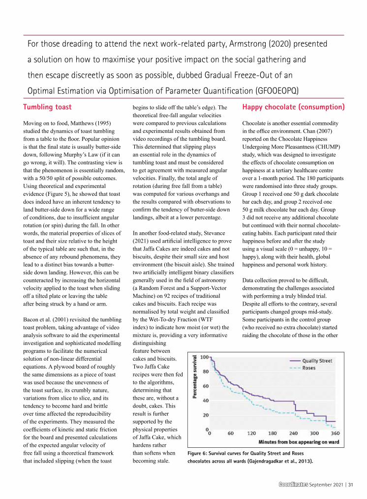
Tumbling toast
Moving on to food, Matthews (1995) studied the dynamics of toast tumbling from a table to the floor. Popular opinion is that the final state is usually butter-side down, following Murphy’s Law (if it can go wrong, it will). The contrasting view is that the phenomenon is essentially random, with a 50/50 split of possible outcomes. Using theoretical and experimental evidence (Figure 5), he showed that toast does indeed have an inherent tendency to land butter-side down for a wide range of conditions, due to insufficient angular rotation (or spin) during the fall. In other words, the material properties of slices of toast and their size relative to the height of the typical table are such that, in the absence of any rebound phenomena, they lead to a distinct bias towards a butter-side down landing. However, this can be counteracted by increasing the horizontal velocity applied to the toast when sliding off a tilted plate or leaving the table after being struck by a hand or arm.
Bacon et al. (2001) revisited the tumbling toast problem, taking advantage of video analysis software to aid the experimental investigation and sophisticated modelling programs to facilitate the numerical solution of non-linear differential equations. A plywood board of roughly the same dimensions as a piece of toast was used because the unevenness of the toast surface, its crumbly nature, variations from slice to slice, and its tendency to become hard and brittle over time affected the reproducibility of the experiments. They measured the coefficients of kinetic and static friction for the board and presented calculations of the expected angular velocity of free fall using a theoretical framework that included slipping (when the toast
begins to slide off the table’s edge). The theoretical free-fall angular velocities were compared to previous calculations and experimental results obtained from video recordings of the tumbling board. This determined that slipping plays an essential role in the dynamics of tumbling toast and must be considered to get agreement with measured angular velocities. Finally, the total angle of rotation (during free fall from a table) was computed for various overhangs and the results compared with observations to confirm the tendency of butter-side down landings, albeit at a lower percentage.
In another food-related study, Stevance (2021) used artificial intelligence to prove that Jaffa Cakes are indeed cakes and not biscuits, despite their small size and host environment (the biscuit aisle). She trained two artificially intelligent binary classifiers generally used in the field of astronomy (a Random Forest and a Support-Vector Machine) on 92 recipes of traditional cakes and biscuits. Each recipe was normalised by total weight and classified by the Wet-To-dry Fraction (WTF index) to indicate how moist (or wet) the mixture is, providing a very informative distinguishing feature between cakes and biscuits. Two Jaffa Cake recipes were then fed to the algorithms, determining that these are, without a doubt, cakes. This result is further supported by the physical properties of Jaffa Cake, which hardens rather than softens when becoming stale.
Happy chocolate (consumption)
Chocolate is another essential commodity in the office environment. Chan (2007) reported on the Chocolate Happiness Undergoing More Pleasantness (CHUMP) study, which was designed to investigate the effects of chocolate consumption on happiness at a tertiary healthcare centre over a 1-month period. The 180 participants were randomised into three study groups. Group 1 received one 50 g dark chocolate bar each day, and group 2 received one 50 g milk chocolate bar each day. Group 3 did not receive any additional chocolate but continued with their normal chocolate-eating habits. Each participant rated their happiness before and after the study using a visual scale (0 = unhappy, 10 = happy), along with their health, global happiness and personal work history.
Data collection proved to be difficult, demonstrating the challenges associated with performing a truly blinded trial. Despite all efforts to the contrary, several participants changed groups mid-study. Some participants in the control group (who received no extra chocolate) started raiding the chocolate of those in the other
Figure 6: Survival curves for Quality Street and Roses chocolates across all wards (Gajendragadkar et al., 2013).
For those dreading to attend the next work-related party, Armstrong (2020) presented
a solution on how to maximise your positive impact on the social gathering and
then escape discreetly as soon as possible, dubbed Gradual Freeze-Out of an
Optimal Estimation via Optimisation of Parameter Quantification (GFOOEOPQ)
CoordinatesCoordinates September 2021 | 31

two groups, while others in the dark and milk chocolate groups traded chocolate based on their individual preferences. The milk chocolate group was the most popular, with the number of participants increasing from 60 at inception to 82 at completion. Furthermore, the occurrence of Halloween may have resulted in crossover contamination as some participants increased their chocolate intake after Halloween by eating extra chocolate that was intended to be distributed to children or by raiding their children’s loot bags. Not surprisingly, under these conditions, data analysis failed to prove the strong belief that chocolate consumption leads to more happiness. A far more important indicator of happiness in the CHUMP study appeared to be getting what you want when you want it.
Gajendragadkar et al. (2013) quantified chocolate consumption in a hospital environment by determining its median survival time. Two 350 g boxes of Quality Street and Roses chocolates were covertly placed on four wards at three hospitals in the UK, i.e. the study used a total of 8 boxes containing 258 individual chocolates. These boxes were kept under continuous covert surveillance, with the time recorded when each chocolate was eaten. On average, it took 12 minutes for a box to be opened after appearing. Chocolate survival was relatively low (median survival time of 51 minutes) and modelled well by an exponential decay model (initial rapid consumption rate that slowed over time), with a survival half-life (time taken for 50% of chocolates to be eaten) of 99 minutes (Figure 6). Chocolates were consumed primarily by healthcare assistants and nurses (28% each), followed by doctors (15%), and Roses chocolates were preferred to Quality Street chocolates. There was a trend that healthcare assistants and nurses preferred Roses chocolates, whereas doctors preferred Quality Street chocolates. However, examination by staff role showed preference for one type of chocolate to be statistically insignificant.
Conclusion
The selected studies have analysed some of the shenanigans occurring in
the office environment and answered some intriguing questions related to the workplace. It is hoped that highlighting these issues will contribute to increased happiness and harmony. Substituting your next birthday cake for a new bunch of forks or teaspoons may go a long way towards achieving this goal.
Finally, for those dreading to attend the next work-related party, Armstrong (2020) presented a solution on how to maximise your positive impact on the social gathering and then escape discreetly as soon as possible. The procedure, dubbed Gradual Freeze-Out of an Optimal Estimation via Optimisation of Parameter Quantification (GFOOEOPQ), employs artificial intelligence and is based on Bayes’ Theorem where the probability of a future model state depends on current knowledge of the model. First, the user completes the necessary interactions for making favourable impressions, or at least ensuring that these people later remember seeing them at the event, and identifies possible exits (including the density of people at these locations and the general flow rate between regions). Once enough data is collected, GFOOEOPQ (pronounced g˄fui:ᴐ:p˄kw) identifies the exit that minimises the chance that anyone notices how early the user sneaked out. To achieve this, GFOOEOPQ employs a tempering procedure that iteratively arrives at the global optimum of a dynamic model, which remains valid only for a limited time due to the dynamic nature of the situation (i.e. “glance at the solution, glance over your shoulder, and then go for it or abort”). Tips for optimal interactions were also given, noting that the procedure can be generalised to corporate events and family gatherings if required.
References
Armstrong E. (2020) An artificially-intelligent means to escape discreetly from the departmental holiday party: Guide for the socially awkward, https://arxiv.org/abs/2003.14169 (accessed Aug 2021).
Bacon M.E., Heald G. and James M. (2001) A closer look at tumbling toast, American Journal of Physics, 69(1), 38-43.
Chan K. (2007) A clinical trial gone awry: The Chocolate Happiness Undergoing More Pleasantness (CHUMP) study, CMAJ, 177(12), 1539-1541.
Gajendragadkar P.R., Moualed D.J., Nicolson P.L.R., Adjei F.D., Cakebread H.E., Duehmke R.M. and Martin C.A. (2013) The survival time of chocolates on hospital wards: Covert observational study, BMJ, 347(f7198), 7pp.
Han J. (2016) A study on the coffee spilling phenomena in the low impulse regime, Achievements in the Life Sciences, 10(1), 87-101.
Henckel J.A. (2005) Nocturnal activity patterns of an endangered population of the common fork (Furca domesticus), Applied Cutlery Conservation, 7(4), 235-241.
Lim M.S.C., Hellard M.E. and Aitken C.K. (2005) The case of the disappearing teaspoons: Longitudinal cohort study of the displacement of teaspoons in an Australian research institute, BMJ, 331(7531), 1498-1500.
Matthews R.A.J. (1995) Tumbling toast, Murphy’s law and the fundamental constants, European Journal of Physics, 16(4), 172-176.
Mattiussi M., Livermore A., Levido A., Starr T., Lassig-Smith M., Stuart J., Fourie C. and Dulhunty J. (2020) What the forks? A longitudinal quality improvement study tracking cutlery numbers in a public teaching and research hospital staff tearoom, Medical Journal of Australia, 213(11), 521-523.
Mayer H.C. and Krechetnikov R. (2012) Walking with coffee: Why does it spill? Physical Review, 85(4), 046117.
Stevance H.F. (2021) Using artificial intelligence to shed light on the star of biscuits: The Jaffa Cake, https://arxiv.org/abs/2103.16575 (accessed Aug 2021). x
32 | CoordinatesCoordinates September 2021
Please mention few key features of NCS NOVA GNSS simulator that set it apart from the other GNSS simulators in the market?
Almost all GNSS simulators in the market today use the classic FPGA-based design approach on the hardware side. In contrast, IFEN GmbH, with its 3rd generation GNSS RF Navigation Constellation Simulator (NCS) product, is pursuing a much more modern, innovative and flexible design approach. The hardware platform of the NCS NOVA GNSS Simulator is based on a completely new Software Defined Radio (SDR) design approach.
The modular SDR architecture allows the simultaneous simulation of up to 16 different GNSS signals by using up to 128 channels, with additional, software definable embedded multipath channels per Line-of-Sight (LoS) signal, on up to two independent RF outputs in one RF signal generation chassis.
Due to the exceptional flexibility provided by the SDR design approach of this simulator the testing requirements of our customers are met with the minimum of equipment, facilitating logistics and reducing both the initial purchase price and the cost of ownership. As test requirements change the NOVA may be easily updated, without the need to return hardware to the factory, ensuring the Simulator is able to meet all current and future test needs.
What is the significance of release timing of NCS NOVA GNSS simulator?
Customer service is very important at IFEN GmbH and the satisfaction of our
customers is therefore our top priority. We feel it as our obligation to constantly improve and further develop our products for the benefit of our valued customers. It is therefore particularly important to us to keep our GNSS products constantly up to date and to make the respective innovations and improvements available to our customers as soon as possible, after the publication of new GNSS ICD versions. Thanks to the scalability and flexibility of the modern SDRbased approach, our NCS NOVA GNSS simulator can easily be upgraded by customers with appropriate software / firmware updates, without any hardware changes being necessary.
Does NCS NOVA GNSS simulator support all the GNSS constellations? Please give few examples of different GNSS applications it supports.
Yes, the IFEN NCS NOVA GNSS Simulator supports all GNSS constellations, such as GPS L1/L1C, L2/L2C, L5 ǀ GLONASS L1, L2 ǀ Galileo E1, E5ab, E6 ǀ BeiDou B1I, B1C, B2I, B2a, B2b, B3I ǀ NavIC L5, S-band ǀ QZSS L1/L1C, L2C, L5 and SBAS L1, L5. Multiple constellations and frequencies may be simulated simultaneously. The NCS NOVA GNSS Simulator is also capable of simulating signals at multiple antenna locations simultaneously. These capabilities allow the NOVA to provide test capability for virtually any GNSS application including Space, Aviation, Automotive (including autonomous driving testing) Maritime, Railway, Survey, Machine Control and many others, within one single Simulator. x
x HIS COORDINATES
“It is important for us to keep our GNSS products constantly up to date”says Dr. Guenter Heinrichs, Head of Client Solutions, Business Development, IFEN GmbH in an interview with Coordinates magazine
"With IFEN’s NCS NOVA GNSS simulator customers can automatically generate the new Galileo signal capabilities” - Please elaborate.
The NCS NOVA GNSS Simulator is a highly capable, powerful and easy to use satellite navigation testing and R&D device. A recent key enhancement to the NCS NOVA GNSS Simulator is comprehensive support of new Galileo OS signal message improvements on E1B. These Galileo improvements are aimed at reducing the cold-start Time-To-First-Fix (TTFF) of a GNSS receiver by reduced clock and ephemeris data (redCED) transmission. By enabling real-time simulation of the Galileo OS message improvements, the NCS NOVA GNSS Simulator expands a user’s Galileo signal test capability.
Once the relevant Galileo Interface Control Documents (ICD’s) are available the NCS NOVA GNSS Simulator’s signal capability will be enhanced to fully support the new Galileo E1B OS-Navigation Message Authentication (OS-NMA) and Galileo E6B High Accuracy Service (HAS) capabilities.
Dr. Guenter Heinrichs
CoordinatesCoordinates September 2021 | 33

x NEWS - GIS
3D Imagery software report released
DAT/EM Systems International has released a report detailing the features of Summit Evolution 8, its latest photogrammetric workstation, which has been designed to be user-friendly, interact with graphical applications and systems such as CAD and GIS. The report details updates that include support for new versions of ArcMap, ArcGIS Pro, AutoCAD, Global Mapper, and other CAD and GIS software. www.datem.com
Aerial photography project to create 3D map of Dubai
The Dubai Municipality has set new standards of technological excellence with its advanced aerial photography project currently being implemented using specialised survey aircraft. The project, which covers all regions of Dubai, including Hatta, is aligned with the directives of Sheikh Hamdan bin Mohammed bin Rashid Al Maktoum, Dubai Crown Prince and Chairman of The Executive Council, to transform Dubai into one of the world’s leading smart cities.
The aerial photography survey that has a high accuracy of 10 centimetres is one of the most important strategic projects being implemented by Dubai Municipality’s GIS Center as part of its GeoDubai initiative. The project will generate a twin 3D geospatial model to update the base map and inventory of the assets of government agencies in Dubai. www.khaleejtimes.com
Esri India to skill 2 lakh students in GIS tech
Esri India will launch a drive to skill over 2 lakh students in GIS technologies in India over the next three years. Esri India has been working with academia for more than two decades and over 800 colleges and universities have established GIS labs for Core GIS Courses and Research Projects.
The centre will provide an opportunity in various streams to students, researchers, and professors will have
access to e-learning content available at MyEsri Learning portal and guided lessons through Esri’’s Learn Hub. As part of this programme, Esri India will also offer faculty training and student engagement programmes.
KDA to use RS application to check illegal constructions
Kanpur Development Authority (KDA), India will use remote sensing applications to check illegal constructions and to verify properties. Scientist Alok Saini at a meeting officials discussed the remote sensing application which will use images collected by Indian Cartosat satellite. The object of the meeting was to apprise the officials of the use of technology to identify KDA’s assets and bring the layout in digital imaging. www.timesofindia.com
Teledyne Marine launches new SeaBat multibeam echosounder
Teledyne Marine has introduced 800 kHz technology with the new SeaBat T51-R Multibeam echosounder from Teledyne RESON. The new multibeam echosounder is designed to provide surveyors with the most accurate details of seabed topography.
The 800 kHz technology offers high-frequency resolution without compromising swath coverage, giving up to 150 degrees full swath width allowing for superior efficiency and short survey turn-around time.
Animal feed and fodder facility mapping study
Funded by USAID, iMMAP’s Information Management Resource Center project conducted a mapping study of animal feed and fodder facilities across northwest Syria. The study took place during the first quarter of 2021.
In partnership with the Whole of Syria Food Security Sector, the study was initiated to unearth insights and develop a more comprehensive understanding of
the animal feed and fodder manufacturing market in the region. The study highlights the overall functionality and capacity of animal feed and fodder facilities, and current practices and challenges of primary business actors involved within the value chain. A total of 171 animal feed market actors were interviewed.
The study also provides recommendations for engaged humanitarian partners to increase the effectiveness of their endeavors in support of the animal feed and fodder value chain. https://immap.org
Bentley’s Seequent Acquisition of Imago
Bentley Systems’ Seequent business unit has acquired Imago Inc, a developer of cloud-based software for the capture and management of geoscientific imagery. The acquisition will expand Seequent’s technology solutions portfolio while boosting cloud capabilities to help geoscientists and engineers solve earth, environment, and energy challenges.
Imago’s cloud-based platform enables the capture, cataloguing, and reviewof drilling core and chip images from any source, to support every aspect of the geological process from exploration to grade control. Continued development of Imago’s machine learning will lead to a step function in the interpretation of geological data.www.seequent.com
µMA-X nadir imaging sonar
The μMA-X is a highly scalable, modular system which integrates easily to most AUV/ROV vehicles. The system utilizes Klein’s next-generation µEngine which is a robust, compact, low-power architecture which uses Klein BLUE technology to provide superior imaging performance.
The µMA-X, when paired with conventional side scan, eliminates the need for overlapping survey lines to achieve 100% coverage. For AUV’s, this translates into extended mission durations, or shorter times to cover the same area. https://geo-matching.com x
34 | CoordinatesCoordinates September 2021

x NEWS - UAV
DroneShield releases CompassOne
DroneShield Ltd. has released CompassOne, a self-contained navigation solution for fixed site, vehicle and marine applications. The device provides real-time military-grade location, orientation and direction sensing for deployed static and on-the-go assets. The device can be used both in counter UAS systems and general situations requiring satellite navigation. CompassOne can operate stand alone or integrate with DroneShield’s DroneSentry system. www.droneshield.com
Agisoft monitors for 3D-stereo photogrammetry
Where classic surveying reaches its productivity limits today, the 3D photogrammetry application Agisoft Metashape Pro is being used, often in a combination with so-called ‘drones’ or ‘Unmanned Aerial Systems’ (UAS). As part of the analysis and processing of geospatial data, Metashape Pro creates detailed, fully textured 3D models from digital recordings with the highest-possible level of accuracy and detailing. Together with the 3D PluraView monitors from Schneider Digital, such cutting-edge software technology extends to excellent quality 3D-stereo visualization. www.3d-pluraview.com
Integration of Casia with VECTOR autopilots
UAV Navigation is integrating Iris Automation’s Casia software into its advanced autopilot solution, VECTOR. UAVs equipped with VECTOR and Casia Detect and Avoid now have the ability to detect uncooperative crewed aircraft in their airspace and autonomously or manually take corrective action, avoiding potential collisions. The integration comes as Iris Automation releases Casia Software v2.2. The release also includes improvements to performance; track fusion and flight data uploads. www.irisonboard.com
x NEWS - GNSS
Three GPS III space vehicles “Available for Launch”
The U.S. Space Force’s Space Systems Command recently declared the eighth GPS III satellite as “Available for Launch.” This significant accomplishment officially marks the third space vehicle within the GPS III program to be declared available for launch in the past three months.
GPS III SV06, SV07, and SV08 are now awaiting official call up for launch in Lockheed Martin’s GPS III Processing Facility in Waterton, Colorado.
GPS III satellites deliver enhanced performance and accuracy through a variety of improvements, including increased signal protection and improved accuracy. GPS III also expands the civilian L5 signal, dubbed the “safety-of-life” signal, currently broadcast by the 12 GPS IIF satellites, but not yet operational, and delivers a new L1C signal designed to grant interoperability to similar international space-based position, navigation and timing systems around the world. www.ssc.spaceforce.mil
Research project to advance military engineering
Mississippi State University is leading a $7.8 million U.S. Department of Defense project to advance military engineering capabilities.
The multidisciplinary project is led by MSU’s Center for Advanced Vehicular Systems and funded through the U.S. Army Engineer Research and Development Center in Vicksburg. Utilizing a wide-range of university research expertise, the three-year project focuses on remote sensing, developing the next generation of materials for force protection, force projection technologies and mobility modeling and simulation.
The research conducted at MSU aims to develop new technologies to enhance ERDC’s military engineering
and force protection capabilities in support of national defense. Technical focus areas include sensor analytics and remote sensing, as well as the use of geo-materials, advanced, high-strength steels and future technologies for force protection and projection. MSU researchers will develop advanced materials and systems, garnering new insights into the protection capabilities of next generation materials used in military efforts. They also will conduct autonomous vehicle modeling and simulation for navigation in cold environments. www.cavs.msstate.edu
Topnet Live GNSS network
Topcon Positioning Group announces an expansion of the Topnet Live Global Navigation Satellite Systems (GNSS) network of correction solutions to support today’s work environments. The newly expanded global network now has more types of correction services and subscription options. The flexible service options include Realpoint, the Real-Time Kinematic (RTK) service, and Starpoint, a Precise Point Positioning (PPP) service. The different services have varying delivery methods, coverage, and reliable centimeter-level accuracy. topconpositioning.com
M-code military GPS receiver by BAE Systems
BAE Systems, Inc. unveiled its ultra-small MicroGRAM-M GPS receiver compatible with next-generation M-Code military GPS signals that are resistant to jamming and spoofing. About the size of a postage stamp, it is the world’s smallest, lightest, and most power-efficient M-Code embedded GPS receiver – delivering assured positioning, navigation, and timing (PNT) for size-constrained and other micro-applications.
MicroGRAM-M features rapid secure GPS signal acquisition, enhanced security and resiliency, anti-jamming and anti-spoofing capabilities, and the industry’s lowest power consumption for an M-Code device. www.baesystems.com x
CoordinatesCoordinates September 2021 | 35

x NEWS - IMAGING
BRICS to set up remote-sensing satellite network
China will work with Russia, India, Brazil and South Africa to establish a network of remote-sensing satellites to help to deal with global challenges such as climate change, major disasters and environmental deterioration.
The heads of national space agencies in BRICS countries met recently via video link and signed the Agreement on the Cooperation on BRICS Remote Sensing Satellite Constellation. The agreement enables cooperation among BRICS space agencies to build a network of remote sensing satellites as a data-sharing mechanism.
China National Space Administration proposed the space-based network’s establishment in 2015 and worked with its counterparts in other BRICS nations to realize it. The network will consist of several operational satellites, including China’s CBERS 4 and Gaofen 6, as well as India’s Resourcesat-2.
Ground stations in Brazil’s Cuiaba, India’s Shadnagar–Hyderabad, China’s Sany, South Africa’s Hartebeesthoek and Moscow will receive data from the satellites. The network will become the first joint effort by BRICS countries in space-based infrastructure. www.ecns.cn
RS observations to find potential unexplored archeological sites in UAE
Khalifa University of Science and Technology has announced that researchers at its Environmental and Geophysical Sciences (ENGEOS) Lab have used satellite remote sensing observations to detect buried objects in already known archaeological sites and to identify potentially unexplored archaeological sites in the UAE by applying machine learning techniques to satellite data.
The novel method, which combines satellite data and machine learning, was developed at Khalifa University and can be applied to similar desert environments
in the UAE and elsewhere. With this technology, the researchers were able to find a new potential area, unexplored yet by classic methods. This area is buried under the ground and is located on the opposite side of the current excavations.
Results from the ENGEOS research project led by Dr. Diana Francis, head of ENGEOS Lab, show that radar imaging allows direct detection and characterization of known as well as potentially novel buried archaeological sites. Researchers use satellite-borne Synthetic Aperture Radar (SAR) at very high resolution that can detect features of the size of one meter that might be buried in the subsurface (less than two meters) under optimum conditions, that is, dry and bare soils such as the soil at Saruq Al Hadid site. Moreover, remotely sensed data are well-suited for supporting regional archaeology, as well as tracking of environmental factors that influence archaeology.
Based on the machine learning techniques and deep learning analyses conducted during this work, the ENGEOS Lab was able to find potential areas for further on-site investigation. http://wam.ae
Second Pléiades Neo remote sensing satellite
Pléiades Neo 4, the second satellite of the Pléiades Neo Earth observation constellation, was successfully launched by Arianespace’s European launcher Vega from French Guiana.
The satellite will be phased 180° with Pléiades Neo 3 on the same orbit to start forming a constellation. This will enable daily imaging of any place on Earth at 30cm native resolution, and between two and four times a day when the four-satellite constellation is complete.
Comprising four identical satellites, the 100% Airbus manufactured, owned and operated Pléiades Neo constellation offers a native resolution of 30cm with an imaging swath of 14km, the widest in its category. www.airbus.com x
Wingtra launches WingtraOne GEN II
WingtraOne GEN II is a next-generation VTOL drone that offers industrial reliability and mapping versatility with a new oblique camera configuration for high-quality 3D drone mapping data capture. The drone’s oblique mapping solution is backed by signed partnership agreements with industry leaders Bentley Systems and Esri. The Wingtra team mapped the city of Zurich, Switzerland, in just six flight hours, producing an impressive 3D model, processed with both Bentley Context Capture and Esri’s Site Scan for ArcGIS. wingtra.com
PLI scheme by government of India for drone industry
Government of India recently cleared a production-linked incentive (PLI) scheme to make India a drone hub by 2030. The PLI scheme will provide up to 20 per cent incentive to manufacturers of drones and drone components. It comes close on the heels of the recent liberalisation of rules, which has made owning and operating drones easier. The government has allocated Rs 120 crore for the scheme and it will be spread over three years. This amount is nearly double the combined turnover of all domestic drone manufacturers in FY21, the ministry of civil aviation said in a press release.
Drone photogrammetry of Odisha’s Lingaraj temple
Ministry of Civil Aviation (MoCA) and Directorate General of Civil Aviation (DGCA), Government of India have granted conditional exemption from Unmanned Aircraft System (UAS) Rules, 2021 to the National Institute of Science Education and Research (NISER), Bhubaneswar allowing the aerial survey and photogrammetry of centrally protected monuments in collaboration with the Archaeological Survey of India (ASI) using drones. The approved locations for drone operations for the NISER include Raja-Rani Temple, Bhubaneswar and Lingaraj Temple, Bhubaneswar. https://sambadenglish.com x
36 | CoordinatesCoordinates September 2021

x NEWS - INDUSTRY
Mali™-G68 GPU that boasts improved CPU performance around 20-percent and ten times better graphics performance than its predecessor. With upgraded cores and improved performance, it enables faster application launches and more interactive eye-catching 3D graphical user interface (GUI) on a device’s qHD (960×540) display. www.samsung.com
ThinKom Solutions and Telesat sign agreement
ThinKom Solutions and Telesat have announced a teaming agreement to collaborate on integrating ThinKom’s Ka2517 aeronautical antennas with the advanced Telesat Lightspeed™ LEO satellite broadband network.
The two companies will work together to facilitate operations of the Ka2517 antennas on the fully integrated 298 satellite and ground network, which is expected to begin services in 2023. The efforts under the agreement will include integration of the Ka2517 as a complete aeronautical User Terminal solution, followed by formal type approval of the Ka2517 on the Telesat Lightspeed network. www.telesat.com
NorSat-4 maritime tracking microsatellite
The Norwegian Space Agency (NOSA) has awarded a contract to Space Flight Laboratory (SFL) to build the NorSat-4 maritime tracking microsatellite. It will be the eighth satellite developed by SFL for Norway, including NorSat-3 launched in April 2021 and the NorSat Technology Demonstrator (NorSat-TD) now under construction.
Similar to NorSat-1, -2 and -3, NorSat-4 will be built on SFL’s DEFIANT microsatellite platform (a variant of the NEMO platform that uses a separation system and not a dispenser) and carry an Automatic Identification System (AIS) ship tracking receiver developed by Kongsberg Seatex. An important new addition on NorSat-4 will be a low-light imaging camera.
IFEN GmbH appoints V3 Novus its distributor for India
iFEN Gmbh, Germany have appointed V3 Novus Pvt. Ltd. as its distributor for India for range of GNSS test equipment, including simulators capable of simulating all GNSS constellations and frequencies and a multi-GNSS software receiver.
V3 Novus is based in Bangaluru, India is an ISO 9001:2008 certified company involved in design and manufacture of products for the Industrial, Defence and Railway industry by following quality Design, manufacturing standards and by using skilled and trained resources. www.ifen.com
New simulator to BroadSim product line
Orolia Defense & Security has released the latest addition to its GNSS simulator family, BroadSim Solo. The Solo joins the BroadSim line of Skydel-powered GNSS simulators, which includes models suited for Hardware-In-The-Loop and Multi-Element Antenna/CRPA testing. BroadSim Solo shares the same Skydel Simulation Engine that runs on a standard BroadSim, BroadSim Anechoic and BroadSim Wavefront. It supports advanced scenario creation features and the benefits provided by a software-defined architecture such as high-dynamics, 1000Hz iteration update rate and ultra-low latency of 5ms. Nearly all civilian GNSS signals can be generated through its single RF output (one frequency band at a time), along with GPS AES M-Code, jamming or spoofing signals. www.oroliads.com
Bedrock launches ocean exploration and survey platform
Bedrock, a vertically-integrated sea-floor data platform and service has launched its full-service offering: autonomous ocean surveys powered by the company’s proprietary, 100% electric autonomous underwater vehicle (AUV) and Mosaic, a universal cloud-based survey data platform for managing, accessing and sharing any marine survey data from any ongoing or historical survey, which is now open for beta sign-ups. www.bedrockocean.com
New CSAC from Microchip Technology
Chip Scale Atomic Clocks (CSACs) ensure stable and accurate timing even when GNSS time signals are unavailable. Helping industrial and military system designers to meet this requirement, Microchip Technology Inc. has announced its new SA65 CSAC, providing precise timing accuracy and stability in extreme environments.
Microchip’s SA65 CSAC is an embedded timing solution with improved environmental ruggedness, delivering higher performance than the previous SA.45s CSAC, including double the frequency stability over a wider temperature range and faster warm-up at cold temperatures. www.microchip.com
Spirent Federal Systems and Northrop Grumman partnership
Spirent Federal Systems announces plans to fully validate the inertial interface between Spirent GNSS simulators and both Northrop Grumman legacy and modernized inertial systems under the EGI-M program.
Northrop Grumman’s Embedded GPS / INS-Modernization, or EGI-M, program is developing state-of-the-art airborne navigation capabilities with a government-owned open architecture. The fully modernized system integrates new M-Code capable GPS receivers, provides interoperability with civil controlled air space, and implements a new resilient time capability. www.spirent.com
Samsung introduces 5nm processor
Samsung Electronics has announced its new wearable processor, the Exynos W920. The new processor integrates an LTE modem and is the first in the industry to be built with an advanced 5-nanometer (nm) extreme ultra-violet (EUV) process node, offering powerful yet efficient performance demanded by next-generation wearable devices. The Exynos W920 packs two Arm® Cortex®-A55 cores for high-performing yet power-efficient processing and an Arm
CoordinatesCoordinates September 2021 | 37

First name .........................................................................
Last name ..........................................................................
Designation .......................................................................
Organization .....................................................................
Address ...............................................................................
...............................................................................................
City ................................... Pincode .................................
State ................................ Country .................................
Phone .................................................................................
Fax .......................................................................................
Email ...................................................................................
I enclose cheque no. ......................................................
drawn on ...........................................................................
date .................................. towards subscription
charges for Coordinates magazine
in favour of ‘Coordinates Media Pvt. Ltd.’
Sign .................................. Date .......................................
Mail this form with payment to:
CoordinatesA 002, Mansara Apartments
C 9, Vasundhara Enclave
Delhi 110 096, India.
If you’d like an invoice before sending your
payment, you may either send us this completed
subscription form or send us a request for
an invoice at [email protected]
YES! I want my
I would like to subscribe for (tick one)
Rs.1800/US$100 Rs.3000/US$170 Rs.4300/US$240
x MARK YOUR CALENDAR
October 2021GGOS Days 2021 (virtual)
October 11, 2021|1:00 pm - October 13, 2021|3:00 pm UTC+0https://ggos.org/event/ggos-days-2021
Fifteenth Meeting of the ICG27 September - 1 October 2021 Vienna, Austriawww.unoosa.org/oosa/en/ourwork/icg/meetings/icg-15/icg15.html
November 2021Navigation 2021
15-18 Novemberhttps://rin.org.uk
Digital Construction Week24-25, NovemberLondon, UKwww.digitalconstructionweek.com
GEO Business 24-25 NovemberLondon, UKwww.geobusinessshow.com
December 2021SIRGAS2021 (virtual)
Nov 29 to Dec 1www.sirgas.org/en/sirgas-symposia/symp_2021www.geobusinessshow.com
March 2022Munich Satellite Navigation Summit 2022
7-9 MarchMunich, Germanymunich-satellite-navigation-summit.org
IGRSM 20228-9 MarchVirtual ConferenceKuala Lumpur Malaysiawww.igrsm.org
To develop the miniature low-light imaging camera, the Norwegian Defence Research Establishment (FFI) has contracted Safran Reosc of France. This powerful device will detect vessels larger than 30 meters in length in Arctic waters, which are shrouded by darkness much of the year. www.utias-sfl.net
Fugro wins contract to build new pavement management system
The Province of Manitoba in Canada has awarded Fugro a 4-year contract to develop a new pavement management system that will guide strategic selection of road maintenance projects for optimized use of transportation budgets. Joining Fugro on the contract is AgileAssets, a software company specializing in infrastructure asset management.
Features of the new pavement management system include pavement decision trees, calculation of pavement condition indices, segment– and networklevel performance models, and multi–year networklevel analyses examining pavement condition data within the context of site and budget constraints. www.fugro.com
Leidos gets $600 million contract
Leidos has been awarded with a prime contract by the US Army to support the Army Geospatial Center’s (AGC) high-resolution three dimensional (HR3D) geospatial information operation and technology integration program. The contract is valued at $600 million. Work will be performed predominately in Virginia and various CONUS and OCONUS locations.
Under the contract, Leidos will continue to support AGC’s BuckEye mission. The BuckEye program provides high resolution color imagery and digital 3D terrain over all operationally relevant areas of the world. www.leidos.com
Fugro helps NOAA update nautical charts
Fugro has completed fieldwork on a hydrographic survey project for the
US National Oceanic and Atmospheric Administration (NOAA) to update nautical charts off the northern coast of Unimak Island, Alaska. Located in the Bering Sea, the island supports multiple fisheries, a major transit route, and at-sea cargo transfers. Existing charts in the region do not meet current navigational needs, with data in some cases predating the 1940s. Fugro is helping NOAA address these data deficiencies with new, high-resolution bathymetry over five sites totaling approximately 1700 km2. These Geo-data will be used to produce new nautical charts, making marine navigation safer and more efficient. www.fugro.com x
38 | CoordinatesCoordinates September 2021
CoordinatesCoordinates September 2021 | 39
Surveying education inC vid times
RNI: DELENG/2005/15153 No: DL(E)-01/5079/20-22 Publication: 15th of every month Licensed to post without pre-payment U(E) 28/2020-22Posting: 19th/20th of every month at NDPSO Rs.150
Volume XVI, Issue 10, October 2020 THE MONTHLY MAGAZINE ON POSITIONING, NAVIGATION AND BEYOND
ISSN
0973-2
136
The cost-effectiveness of controlling dengue in Indonesia
Volume XVI, Issue 12, December 2020 THE MONTHLY MAGAZINE ON POSITIONING, NAVIGATION AND BEYOND
UAV technology for formulation of GIS based master plans
RNI: DELENG/2005/15153 No: DL(E)-01/5079/20-22 Publication: 15th of every month Licensed to post without pre-payment U(E) 28/2020-22Posting: 19th/20th of every month at NDPSO Rs.150
ISSN
0973-2
136
GNSS for pest detection and
control in GREENHOUSES
Volume XVI, Issue 11, November 2020 THE MONTHLY MAGAZINE ON POSITIONING, NAVIGATION AND BEYOND
Data is Gold. Make it Ornament!
Galileo Green Lane
Exploiting GNSS in Covid times
RNI: DELENG/2005/15153 No: DL(E)-01/5079/20-22 Publication: 15th of every month Licensed to post without pre-payment U(E) 28/2020-22Posting: 19th/20th of every month at NDPSO Rs.150
ISSN
0973-2
136
LANDADMINISTRATION ANDCLIMATERESILIENCY
A Map is a Living Structure with the Recurring Notion of far more Smalls than Larges
Decision support system for engineering structure supervision
RNI: DELENG/2005/15153 No: DL(E)-01/5079/20-22 Publication: 15th of every month Licensed to post without pre-payment U(E) 28/2020-22Posting: 19th/20th of every month at NDPSO Rs.150
Volume XVI, Issue 8, August 2020 THE MONTHLY MAGAZINE ON POSITIONING, NAVIGATION AND BEYOND
ISSN
0973-2
136
An ideal GNSS system is one
that is impossible to
spoof and difficult to jam
Y Jade Morton
BIM, can be a solution for property disputes?
Volume XVI, Issue 9, September 2020 THE MONTHLY MAGAZINE ON POSITIONING, NAVIGATION AND BEYOND
ISSN
0973-2
136
RNI: DELENG/2005/15153 No: DL(E)-01/5079/20-22 Publication: 15th of every month Licensed to post without pre-payment U(E) 28/2020-22Posting: 19th/20th of every month at NDPSO Rs.150
Volume XVI, Issue 4, April 2020 THE MONTHLY MAGAZINE ON POSITIONING, NAVIGATION AND BEYOND
ISSN
0973-2
136
A report on GNSS performance standards
Also:Living Structure Down to Earth and Up to Heaven: Christopher Alexander
Long-range single baseline RTK GNSS positioning
Covid-19 lockdown 1.0 and air pollution in north-western India using Sentinel 5P
RNI: DELENG/2005/15153 No: DL(E)-01/5079/20-22 Publication: 15th of every month Licensed to post without pre-payment U(E) 28/2020-22Posting: 19th/20th of every month at NDPSO Rs.150

RAC1213_LS-Coord-WorkAnywhere-fp-may21-p.indd 1RAC1213_LS-Coord-WorkAnywhere-fp-may21-p.indd 1 26/05/2021 11:4126/05/2021 11:41
Copyright © 2022 FDOKUMEN