BJP yet to decide on Prez candidate: Amit Shah - Millennium ...
Upload
khangminh22Category
view
1download
0
mm
mmkh


b

THE
IMPERIAL GAZETTEER
OF INDIA
VOL. VII
BAREILLY lu BERASiA
NEW EDITION
rUBLISHED LNDIiK THE AUTJIORIIV Ol' HIS iMAJESlY'S
SECRETARY OE SIATE EOR hXULV IX COLNCH.
OXFORDAT THE CLARENDON PRESS
1908

HENRY FkOWDE, M.A.
FUBLISHER TO THE UNIVERSITY OF OXFORD
LONDON, EDINBURGHNEW YORK AND TORONTO

INTRODUCTORY NOTES
Notes on Transliteration
a has the sound of a in ' woman.'
a has the sound of a in ' fiither.'
c has the vowel-sound in 'grey.'
i has the sound of / in ' pin.'
i has the sound of / in ' police.'
o has the sound of o in ' bone.'
u has the sound of u in ' bull.'
u has the sound of ti in ' flute.'
ai has the vowel-sound in ' mine.'
au has the vowel-sound in ' house.'
It should be slated that no attempt has been made to distinguish
between the long and short sounds of e and o in the Dravidian
languages, which possess the vowel-sounds in ' bet ' and ' hot ' in
addition to those given above. Nor has it been thought necessary
to mark vowels as long in cases where mistakes in pronunciation
were not likely to be made.
Co^isonants
Most Indian languages have different forms for a number of con-
sonants, such as d, /, ;-, cScc, marked in scientific works by the use
of dots or italics. As the European ear distinguishes these with
difficulty in ordinary pronunciation, it has been considered undesir-
able to embarrass the reader with them; and only two notes are
required. In the first place, the Arabic k, a strong guttural, has
been represented by ^ instead of tj, which is often used. Secondly,
it should be remarked that aspirated consonants are common ; and,
in particular, d/i and f/i (except in Burma) never have the sound of
^/i in ' this ' or 'thin,' but should be pronounced as in ' woodhouse
'
and 'boathook.'
503060

iv INTRODUCTORY NOTES
Burmese Words
Burmese and some of the languages on the frontier of China have
the following special sounds :
—
aw has the vowel-sound in ' law.'
6 and ii are pronounced as in German,
gy is pronounced almost like J in ' jewel.'
ky is pronounced almost like ch in ' church.'
th is pronounced in some cases as in ' this,' in some cases as in
• thin.'
w after a consonant has the force of itw. Thus, yiva and pive
are disyllables, pronounced as \{ wniien yiiwa 2indpinve.
It should also be noted that, whereas in Indian words the accent
or stress is distributed almost equally on each syllable, in Burmese
there is a tendency to throw special stress on the last syllable.
General
The names of some places—e.g. Calcutta, Bombay, Lucknow,
Cawnpore—have obtained a popular fixity of spelling, while special
forms have been officially prescribed for others. Names of persons
are often spelt and pronounced differently in different parts of India :
but the variations have been made as few as possible by assimilating
forms almost alike, especially where a particular spelling has been
generally adopted in English books.
Notes on Money, Prices, Weights and Measures
As the currency of India is based upon the rupee, all statements
with regard to money throughout the Gar^etteer have necessarily been
expressed in rupees, nor has it been found possible to add generally
a conversion into sterling. Down to about 1873 the gold value of
the rupee (containing 165 grains of pure silver) was approximately
equal to 2s., or one-tenth of a £ ; and for that period it is easy to
convert rupees into sterling by striking off the final cipher (Rs. 1,000
= £100). But after 1873, owing to the depreciation of silver as
compared with gold throughout the world, there came a serious and
progressive fall in the exchange, until at one time the gold \alue of
llie rupee dropped as low as \s. In order to provide a remedy for
the heavy loss caused to the Covernment of India in respect of its
gold payments to 1)C made in England, and also to relieve foreign
trade and finance from the inconvenience due to constant and
unforeseen fluctuations in exchange, it was resolved in 1893 to close
the mints to the free coinage of silver, and thus force up the value of
the rupee by restricting the circulation. The intention was to raise

INTRODUCTORY NOTES v
the exchange value of the rupee to i^. \d., and then introduce a gold
standard (though not necessarily a gold currency) at the rate of Rs. 1
5
= £1. This policy has been completely successful. From 1899 ^'^'
wards the value of the rupee has been maintained, with insignificant
fluctuations, at the proposed rate of 15-. \d. ; and consequently since
that date three rupees have been equivalent to two rupees before 1873.
For the intermediate period, between 1873 and 1899, it is manifestly
impossible to adopt any fixed sterling value for a constantly changing
rupee. But since 1899, if it is desired to convert rupees into sterling,
not only must the final cipher be struck off (as before 1873), but
also one-third must be subtracted from the result. Thus Rs. 1,000
= £100— § = (about) £67.
Another matter in connexion with the expression of money state-
ments in terms of rupees requires to be explained. The method of
numerical notation in India differs from that which prevails through-
out Europe. Large numbers are not punctuated in hundreds of thou-
sands and millions, but in lakhs and crores. A lakh is one hundred
thousand (written out as r, 00,000), and a crore is one hundred lakhs
or ten millions (written out as 1,00,00,000). Consequently, accord-
ing to the exchange value of the rupee, a lakh of rupees (Rs. 1,00,000)
may be read as the equivalent of £10,000 before 1873, and as the
equivalent of (about) £6,667 after 1899 ; while a crore of rupees
(Rs. 1,00,00,000) may similarly be read as the equivalent of
£1,000,000 before 1873, and as the equivalent of (about) £666,667after 1899.
Finally, it should be mentioned that the rupee is divided into
16 annas, a fraction commonly used for many purposes by both
natives and Europeans. The anna was formerly reckoned as \\d.
;
it may now be considered as exactly corresponding to \d. Theanna is again subdivided into 12 pies.
The various systems of weights used in India combine uniformity
of scale with immense variations in the weight of units. The scale
used generally throughout Northern India, and less commonly in
Madras and Bombay, may be thus expressed : one maund = 40 seers;
one seer = 16 chittaks or 80 tolas. The actual weight of a seer
varies greatly from District to District, and even from village to
village; but in the standard system the tola is 180 grains Troy
(the exact weight of the rupee), and the seer thus weighs 2-057 lb.,
and the maund 82-28 lb. This standard is used in official reports
and throughout the Gazetteer.
For calculating retail prices, the universal custom in India is to
express them in terms of seers to the rupee. Thus, when prices
change, what varies is not the amount of money to be paid for the
vu \

vi INTRODUCTORY NOTES
same quantity, but the quantity to be obtained for the same amount
of money. In other words, prices in India are quantity prices, not
money prices. When the figure of quantity goes up, this of course
means that the price has gone down, which is at first sight perplexing
to an English reader. It may, however, be mentioned that quantity
prices are not altogether unknown in England, especially at small
shops, where pennyworths of many groceries can be bought. Eggs,
likewise, are commonly sold at a varying number for the shiUing.
If it be desired to convert quantity prices from Indian into English
denominations without having recourse to money prices (which would
often be misleading), the following scale may be adopted—based
upon the assumptions that a seer is exactly 2 lb., and that the value
of the rupee remains constant at \s. ^d. : i seer per rupee = (about)
3 lb. for 2S. ; 2 seers per rupee = (about) 6 lb. for 2s. ; and so on.
The name of the unit for square measurement in India generally
is the bJgha, which varies greatly in different parts of the country.
But areas have always been expressed throughout the Gazetteer either
in square miles or in acres.
MAPS
Baroda to face p. 64
Bengal . ",, 336
Berar at end

IMPERIAL GAZETTEEROF INDIA
VOLUME VII
Bareilly Division.— North-central Division of the United Provinces^
lying below the Himalayas between 27° 35' and 29° 58' N. and 78°
and 80° 27' E. It is bounded on the north by the sub-Himalayan
tract of the Kumaun Division and by Nepal ; on the west and south by
the Ganges, which divides it from the Meerut and Agra Divisions ; and
on the east by the Lucknow Division of Oudh. The Rampur State
forms a wedge of territory between the Districts of Moradabad and
Bareilly, and political control is exercised by the Commissioner of this
Division, whose head-quarters are at Bareilly city. Population decreased
between 1872 and 1881, but has increased considerably since. Thenumbers at the last four enumerations were as follows : (1872) 5,252,325,
(1881) 5,122,557, (1891) 5,344,054, and (1901) 5,479,688. The total
area is 10,720 square miles, and the density of population 511 persons
per square mile, compared with 445 for the Provinces as a whole. TheDivision is the sixth largest in area and the sixth in population in the
United Provinces. In 1901 Hindus formed nearly 75 per cent, of
the total, and Musalmans 24 per cent., while the other religions most
largely represented were Christians (24,459, of whom 21,421 were
natives), Aryas (14,993), Sikhs (3,334), and Jains (2,016). The
Division includes six Districts, as shown below :
—
District.

2 BAREILL Y DIVISION
generally is a fertile tract, especially noted for the production of sugar-
cane. There are 65 towns and 11,403 villages. The largest towns are
Bareilly (131,208, with cantonments), Shahjahanpur (76,458, with
cantonments), Moradabad (75,128), Amroha (40,077), Sambhal
(39,715), BuDAUN (39,031), PIlIbhit (33,490). Chandaus! (25,711),
and NagIna (21,412). The chief places of commercial importance are
Bareilly, Shahjahanpur, Moradabad, Pilibhit, Chandausi, and Tilhar.
Sugar and grain are dealt with also in many smaller places. Although
ancient sites occur in many parts of the Division, Ramnagar is the
only one which has been even partially explored. Budaun and
Sambhal were early seats of Muhammadan governors; and Bareilly,
PilibhIt, Rampur, and Aonla were important centres during the
Rohilla rule in the eighteenth century. See Rohilkhand.Bareilly District (^a;r//).— District in the Bareilly or Rohilkhand
Division, United Provinces, lying between 28° \' and 28° 54' N.
and 78° 58' and 79° 47' E., with an area of 1,580 square miles.
It is bounded on the north by NainI Tal ; on the east by Pilibhit and
Shahjahanpur ; on the south by Shahjahanpur and Budaun ; and on
the west by Budaun and the State of Rampur. The District of Bareilly,
though lying not far from the outer ranges of theysica
Himalayas, is a gently sloping plain, with no greater
variety of surface than is caused by the shifting
channels of its numerous streams. Water lies almost everywhere near
the surface, giving it a verdure that recalls the rice-fields of Bengal.
The most prominent physical feature is the Ramganga River, which
traverses the south-western portion. Its channel has a well-defined
bank at first on the south, and later on the north ; but except where
the stream is thus confined, the khadar or lowland merges imper-
ceptibly into the upland, and the river varies its course capriciously
through a valley 4 or 5 miles wide, occasionally wandering to a still
greater distance. North of the Ramganga are numerous streams
running south to meet that river. The chief of these (from west to
east) are the Dojora, which receives the Kichha or West Bahgul, the
Deoranian, the Nakatia, and the East Bahgul, which receives the
Pangaili. The Deoha forms the eastern boundary for some distance.
The gentle slope of the country makes it possible to use these rivers for
irrigation in the upper part of their courses. Lower down, and more
especially in the east of the District, they flow below the general level
and are divided by elevated watersheds of sandy plains.
The District exposes nothing but alluvium, in which even kankai\ or
calcareous limestone, is scarce.
The flora resembles that of the Gangetic plain generally. In the
north a few forest trees are found, the setnal or cotton-tree {Bomlmx
malabaricuni) towering above all others. The rest of the District is

BAREILL V DISTRICT 3
dotted with fine groves of mangoes, while ihiija/nun {EugeniaJambolaiui),
shlsham {Daibergia Sissoo), tamarind, and various figs {Ficus glomeraia,
reiigiosa, infectoria, and indica) are also common. Groves and villages
are often surrounded by bamboos, which flourish luxuriantly. Thearea under trees, which is increasing, amounts to about 32 square
miles.
Leopards are frequently found in the north of the District, and
wolves are common in the east. Antelope are seen in some localities,
and/Jr//a or hog deer haunt the beds of rivers. The ordinary game-
birds are found abundantly, and fish are plentiful. Snakes are also
very numerous.
The climate of the District is largely influenced by its proximity to
the hills, Bareilly city and all the northern parganas lying within the
limits of the heavier storms. The rainy season begins earlier and
continues later than in the south, and the cold season lasts longer.
The north of the District is unhealthy, on account of excessive moisture
and bad drinking-water. The mean temperature varies from 54° to 60°
in January, and from 85° to 93° in May, the hottest month.
The annual rainfall in the whole District averages nearly 44 inches
;
but while the south-west receives only 39, the fall amounts to nearly
47 inches in the north and exceeds 48 in the north-east. Fluctuations
from year to year are considerable; in 1883 less than 19 inches was
received, and in 1894 nearly 65 inches.
Before the Christian era the District was included in the kingdom of
Northern Panchala ; and the names are known, from coins found at
Ramnagar, of a number of kings who probably
reigned in the second century b.c. These kings
were connected by marriage with a dynasty ruling in the south of
Allahabad, and it has been suggested they were the Sunga kings of the
Puranas\ A kingdom called Ahlchhattra, in or near this District, was
visited by Hiuen Tsiang in the seventh century a.d., and is described
as flanked by mountain crags. It produced wheat and contained manywoods and fountains, and the climate was soft and agreeable.
In the early Muhammadan period the tract now known as Rohilkhand
was called Katehr, and the Rajputs who inhabited it gave continual
trouble. Shahab-ud-din, or his general Kutb-ud-din, captured Bangarh
in Budaun District about the year 1194 ; but nothing more is heard of
the Muhammadans in this neighbourhood till Mahmud II made his
way along the foot of the hills to the Ramganga in 1252. Fourteen
years later, Balban, who succeeded him, marched to Kampil, put all
the Hindus to the sword, and utterly crushed the Katehriyas, who had
hitherto lived by violence and plunder. In 1290 Sultan Plroz invaded
"^Journal, Asiatic Society of Bengal, 1897, p. 303; A. Cunningham, Coins ofAncient India.
B 2

4 BAREILL V DISTRICT
Katehr again, and brought the country into final subjection to Musalmanrule, which was not afterwards disputed except by the usual local revolts.
Under the various dynasties which preceded the Mughal empire, the
history of Katehr consists of the common events which make up the
annals of that period : constant attempts at independence on the part
of the district governors, followed by barbarous suppression on the
part of the central authority. The city of Bareilly itself was founded in
1527 by Bas Deo and Barel Deo, from the latter of whom it takes its
name. It was, however, of small importance till the reign of Shah
Jahan, when it took the place of Budaun. In 1628 All Kuli Khanwas governor of Bareilly, which had grown into a considerable
place. In 1657 Raja Makrand Rai founded the new city of Bareilly,
cut down the forest to the west of the old town, and expelled all the
Katehriyas from the neighbourhood. A succession of regular governors
followed during the palmy days of the great Mughal emperors; but after
the death of Aurangzeb, in 1707, when the unwieldy organization began
to break asunder, the Hindus of Bareilly threw off the imperial yoke,
refused their tribute, and commenced a series of anarchic quarrels
among themselves for supremacy.
Their dissensions only afforded an opportunity for the rise of a newMuhammadan power. All Muhammad Khan, a leader of Rohilla
Pathans, defeated the governors of Bareilly and Moradabad, and madehimself supreme throughout the whole Katehr region. In 1744 the
Rohilla chieftain conquered Kumaun right up to Almora ; but two
years later the emperor Muhammad Shah marched against him, and
All Muhammad was taken a prisoner to Delhi. However, the empire
was too much in need of vigorous generals to make his captivity a long
one, and in 1748 he was restored to his old post in Katehr. Next year
he died, and a mausoleum at Aonla, in this District, still marks his
burial-place. Hafiz Rahmat Khan, guardian to his sons, succeeded to
the governorship of Rohilkhand, in spite of the crafty designs of Safdar
Jang of Oudh, who dispatched the Nawab of Farrukhabad against him
without effect. Hafiz Rahmat Khan defeated and slew the Nawab,
after which he marched northward and conquered Pilibhlt and the
tarai. The Oudh Wazir, Safdar Jang, plundered the property of
the Farrukhabad Nawab after his death, and this led to a union
of the Rohilla Afghans with those of Farrukhabad. Ahmad Khan of
Farrukhabad defeated Nawal Rai, the deputy of Safdar Jang, besieged
Allahabad, and took part of Oudh ; but the ^^'azlr called in the aid of
the Marathas, and with them defeated Ahmad Khan and the Rohillas
at Fatehgarh and at Bisauli, near Aonla. He then besieged them for
four months at the foot of the hills ; but owing to the invasion of
Ahmad Shah Durrani terms were arranged, and Rahmat Khan becamethe defacto ruler of Rohilkhand.

HISTOR Y '
5
After the accession of Shuja-ud-daula as Nawab of Oudh, Rahmat
Khan joined the imperial troops in their attack upon that prince, but
the Nawab bought them off with a subsidy of 5 lakhs, Rahmat Khan
took advantage of the victory at Panipat in 1761 to make himself master
of Etawah, and during the eventful years in which Shuja-ud-daula was
engaged in his struggle with the British power, he continually strengthened
himself by fortifying his towns and founding new strongholds. In 1770
Najrb-ud-daula advanced with the Maratha army under Sindhia and
Holkar, defeated Rahmat Khan, and forced the Rohillas to ask the aid
of the Wazir. Shuja-ud-daula became surety for a bond of 40 lakhs,
by which the Marathas were induced to evacuate Rohilkhand. This
bond the Rohillas were unable to meet, whereupon Shuja-ud-daula,
after getting rid of the Marathas, attacked Rohilkhand with the help
of a British force lent by Warren Hastings, and subjugated it by a
desolating war. Rahmat Khan was slain, but Faiz-ullah, the son of
All Muhammad, escaped to the north-west and became the leader of the
Rohillas. After many negotiations he effected a treaty with Shuja-ud-
daula in 1774, by which he accepted nine parganas worth 15 lakhs
a year, giving up all the remainder of Rohilkhand to the Wazir {see
Ram PUR State). Saadat Ali was appointed governor of Bareilly under
the Oudh government. In 1794 a revolution in Rampur State led to
the dispatch of British troops, who fought the insurgents at Bhitaura or
Fatehganj (West), where an obelisk still commemorates the slain. TheDistrict remained in the hands of the Wazir until 1801, when Rohilkhand,
with Allahabad and Kora, was ceded to the British in lieu of tribute.
Mr. Henry ^^'ellesley, brother of the Governor-General, was appointed
President of the Board of Commissioners sitting at Bareilly, and after-
wards at Farrukhabad. In 1805 Amir Khan, the Pindari, made an
inroad into Rohilkhand, but was driven off. Disturbances occurred in
1816, in 1837, and in 1842 ; but the peace of the District was not
seriously endangered until the Mutiny of 1857.
In that year the troops at Bareilly rose on May 31. The European
officers, except three, escaped to NainI Tal ; and Khan Bahadur, Hafiz
Rahmat Khan's grandson, was proclaimed Nawab Nazim of Rohilkhand.
On June 1 1 the mutinous soldiery went off to Delhi, and Khan Bahadur
organized a government in July. Three expeditions attempted to attack
NainI Tal, but without success. In September came news of the fall
of Delhi. Walidad Khan, the rebel leader in Bulandshahr, and the
Nawab of Fatehgarh then took refuge at Bareilly. A fourth expedition
against NainI Tal met with no greater success than the earlier attempts.
On March 25, 1858, the Nana Sahib arrived at Bareilly on his flight
from Oudh, and remained till the end of April ; but the rebellion at
Bareilly had been a revival of Muhammadan rule, and when the com-
mander-in-chief marched on Jalalabad, the Nana Sahib fled back again

BAREILL V DISTRICT
into Oudh. On the fall of Lucknow, Firoz Shah retired to Bareilly, and
took Moradabad on April 22, but was compelled to give it up at once.
The Nawab of Najibabad, leader of the Bijnor rebels, joined him in the
city, so that the principal insurgents were congregated together in
Bareilly when the English army arrived on May 5. The city was taken
on May 7, and all the chiefs fled with Khan Bahadur into Oudh.
AhTchhattra or Ramnagar is the only one of many ancient mounds
in the District which has been explored. It yielded numerous coins
and some Buddhist sculptures. It is still a sacred place of the Jains.
The period of Rohilla rule has left few buildings of importance ; but
some tombs and mosques are standing at Aonla and Bareilly.
There are 12 towns and 1,924 villages. Population has risen steadily
during the last thirty years. The numbers at the last four enumera-
tions were as follows: (1872) 1,015,041, (1881)
1,030,936, (1891) 1,040,949, and (1901) 1,090,117.
The District is divided into six tahsils—Faridpur, Bareilly, Aonla,
MiRGANj, Baheri, and Nawabganj— the head-quarters of each being
at a place of the same name. The principal towns are the municipality
of Bareilly and Aonla. The following table gives the chief statistics
of area and population in 1901 :
—
Population.

AGRICULTURE 7
Ahirs of the rest of the Provinces, number 46,000. Daleras {1,724),
who are nominally basket-makers but in reality thieves, are not found
outside this District. Among Muhammadans, Shaikhs number 54,000 ;
Julahas (weavers), 41,0005 and Pathans, 41,000. The MewatTs, whonumber 9,000, came from Mewat in the eighteenth century, owing to
famine. Banjaras, who were formerly army sutlers and are still grain-
carriers, have now settled down to agriculture, chiefly in the submontane
Districts, and number 9,000 here. About 66 per cent, of the popula-
tion are supported by agriculture, 6 per cent, by personal services, and
4 per cent, by general labour. Cotton-weaving by hand supports 3-5
per cent. Rajputs, Pathans, Brahmans, Kayasths, and Banias are the
largest landholders. Kurmis occupy nearly a quarter of the total area
as cultivators, while Ahars, Kisans, and Brahmans each cultivate about
7 or 8 per cent.
There were 4,600 native Christians in 1901, of whom 4,488 were
Methodists. The American Methodist Episcopal Mission was opened
here in 1859, and has ten stations in the District, besides a theological
college at Bareilly city.
The north of the District contains a damp unhealthy tract, where
rent rates are low and population is sparse, while cultivation depends
largely on the season. The central portion is extremely
fertile, consisting chiefly of loam, with a considerable
proportion of clay in the Mirganj and Nawabganj tahsils. In the
south, watersheds of sandy soil divide the rivers; but these sandy strips
are regularly cultivated in the Bareilly and Aonla tahsils, while in
Faridpur much of the light soil is very poor and liable to be thrown
out of cultivation after heavy rain. The alluvial strip along the
Ramganga is generally rich, but is occasionally ruined by a deposit
of sand. Excluding garden cultivation, manure is applied only whenthe turn comes round for sugar-cane to be grown, at intervals of from
3 to 8 years.
The tenures are those common to the United Provinces. Zaminddri
or joint zannudari tenures prevail in 5,547 mahals, 503 are perfect or
imperfect pattiddri, and 36 are bhaiydchdrd. The District is thus
chiefly held by large proprietors. The main agricultural statistics for
1903-4 are shown in the table on the next page, in square miles.
The principal food-crops, with their areas in square miles in 1903-4,
are : rice (237), wheat (368), gram (201), bajra (166), and maize (115).
Sugar-cane covers 71 square miles, and is one of the most important
products; while poppy (23), oilseeds (27), cotton (13), and xa/;-hemp
(10) are also valuable crops.
The total cultivated area has not varied much during the last thirty
years ; but there has been a permanent increase to the west of Aonla
and north of Faridpur tahsils, which is counterbalanced by a temporary

8 BAREILL Y DISTRICT
decrease in the north of the District owing to vicissitudes of the seasons.
The principal changes in cultivation have been directed towards the sub-
stitution of more valuable crops for inferior staples. The area under
bdjra has decreased, while sugar-cane, rice, and maize are more largely
grown. Poppy has been reintroduced recently, and the area sown with
it is increasing. A rise in the area producing barley and gram points to
an increase in the area double cropped. Very few loans are taken
under the Land Improvement Loans Act; between 1890 and 1903 the
total amounted to Rs. 41,000, of which Rs. 38,000 was advanced in
the famine year, 1896-7. Nearly \\ lakhs was lent under the Agricul-
turists' Loans Act, of which Rs. 63,000 was advanced in 1896-7. In
good seasons the advances are small.
TahsU.

FAMINE 9
&c., like the regular canals of the Doab. The others are small channels,
into which water is turned from the rivers by earthen dams, renewed
annually. Masonry wells are not constructed for irrigation, except
by the Court of Wards. In most parts of the District the wells are
temporary excavations worked by pulley, or by a lever, as the spring-
level is high ; but in some tracts to the south water is raised in a
leathern bucket by a rope pulled by bullocks or by men.
Kankar or nodular limestone is scarce and of poor quality. A little
lime is made by burning the ooze formed of lacustrine shells.
The most important industry of the District is sugar-refining. This
is carried on after native methods, which are now being examined by
the Agricultural department in the hope of eliminating
waste. Coarse cotton cloth and cotton carpets or ^ • ,,•^ communications.darts are woven largely, and Bareilly city is noted for
the production of furniture. A little country glass is also manufactured.
The Rohilkhand and Kumaun Railway workshops employed 8i hands
in 1903, and a brewery in connexion with that at Naini Tal is under
construction. The indigo industry is declining.
Grain and pulse, sugar, hides, hemp, and oilseeds are the chief
exports, while salt, piece-goods, metals, and stone and lime are imported.
The grain is exported to Calcutta, and sugar is sent to the Punjab,
Rajputana, and Central India. Bareilly city and Aonla are the chief
centres of trade.
The main line of the Oudh and Rohilkhand Railway passes through
the south of the District, with a branch from Bareilly city through Aonla
to AlTgarh. The north is served by the Rohilkhand and Kumaun Rail-
way, which is the only route to the hill-station of NainI Tal, and by a
line through Pilibhit and Sitapur to Lucknow, which leaves the Rohil-
khand and Kumaun Railway at Bhojupura, a few miles north of Bareilly
city. Another metre-gauge line, recently opened, leads from Bareilly
south-west through Budaun to Soron in Etah District.
The total length of metalled roads is 139 miles and of unmetalled
roads 186 miles. Of the former, 125 miles are in charge of the Public
Works department, but the cost of all but 88 miles is met by Local
funds. There are avenues of trees along 254 miles. The District is
not well supplied with roads. Those which are metalled follow roughly
the alignment of the railways, and there are no others, except the road
from Aonla to Budaun. In the north communication is almost im-
possible during the rains ; but the streams can easily be forded in the
hot and cold seasons.
Bareilly is not liable to severe famine, owing to the natural moisture
of the soil and the rarity of so complete failure of the, , ^ . \ ,, i , ,
Famine,rams as occurs elsewhere. It is also well served by
railways, and a considerable portion can be irrigated. Ample grazing-
lo BAREILL V DISTRICT
grounds for cattle are within easy reach. In 1803-4 distress was felt,
and the spring crops were grazed by the cattle as no grain had formed.
In 1 819 and 1825-6 there was scarcity. The famine of 1837-8 followed
a succession of bad years, and its effects were felt, but not so severely
as in the Doab. ^\'hile famine raged elsewhere in r86o-i, Bareilly
suffered only from slight scarcity, owing to the failure of the autumn
harvest ; and relief works, which were opened for the first time, alleviated
distress. Relief works were also necessary in 1868-9, i877~8, and
1896-7, but the numbers attracted to them never rose very high.
The Collector is usually assisted by a member of the Indian Civil
Service, and by four Deputy-Collectors recruited in India. There is a
. , . . . tahs'dddr at the head-quarters of each tahsil. TheAdministration. ^ t- • V 1 t-. 1 -n 1 t i- • •
Executive Engmeer of the Rohilkhand division
(Roads and Buildings) and the Executive Engineer of the Rohilkhand
Canals are stationed at Bareilly city.
There are three regular District Munsifs and a Subordinate Judge,
and the appointment of Village Munsifs commenced recently. TheDistrict and Sessions Judge of Bareilly has civil and criminal jurisdic-
tion in both Bareilly and Pillbhit Districts. Crime is very heavy,
especially offences affecting life and grievous hurt. Religious feeling
runs high, and quarrels between Hindus and Muhammadans, accom-
panied by serious rioting, are not infrequent. The thieving caste of
Daleras has already been mentioned. Female infanticide is now very
rarely suspected, and in 1904 only 130 names remained on the registers
of proclaimed families.
Under the Rohillas proprietary rights did not exist, and villages were
farmed to the highest bidder. After annexation in 1801 Rohilkhand
was divided into two Districts, Moradabad and Bareilly. Shah-
jahanpur District was formed in 18 13-4; Budaun was carved out of
both the original Districts in 1824 ; the south of Naini Tal District was
taken away in 1858, and sixty-four villages were given, as a reward for
loyalty, to the Naw9,b of Rampur. Pilibhlt was made a separate Dis-
trict in 1879. In the early short-term settlements the Rohilla system
of farming was maintained till 181 2, when proprietary rights were con-
ferred on persons who seemed best entitled to them. The demandthen fixed was so high that heavy balances were frequent, and manyestates were abandoned. A more enlightened method of settlement
based on a survey was commenced under Regulation VII of 1822, and
the first regular settlement followed under Regulation IX of 1833.
Different methods were adopted by the officers who carried this out.
Some divided each village into circles according to soil and situation,
while others classified villages according to their general condition as a
whole. Rent rates were sometimes assumed for the various soils, while
in other ca.ses general revenue rates were deduced from the collections

ADMINISTRATION
in previous years. The revenue fixed amounted to ii lakhs on the
present area. Another settlement was made in 1867-70. The rental
' assets ' were calculated from rent rates selected after careful inquiry. Alarge area was grain-rented ; and the rent rates for this tract were
selected after an examination of the reputed average share of the land-
lord, and after experiments in the out-turn of various crops, the average
prices for twenty years being applied to ascertain the cash value. Theresult was an assessment of 13-5 lakhs ; but this was reduced by about
Rs. 4,000 in 1874-6, owing to the assessment of too large an area in
the north of the District, where cultivation fluctuates. The latest
revision was carried out in 1 898-1 902. Cash rents were then found to
be paid on about two-thirds of the total cultivated area, and the actual
rent-roll formed the basis of assessment. Rents of occupancy tenants
had remained for the most part unaltered since the previous settlement,
and enhancements were given where these were inadequate. Grain rents,
chiefly found in the north of the District, were largely commuted to
cash rates. The demand fixed amounts to 15 lakhs, representing 45 per
cent, of the net 'assets,' and the incidence falls at Rs. 1-7 per acre,
varying from Rs. 1-3 to Rs. 2 in different parts.
Collections on account of land revenue and total revenue have been,
in thousands of rupees :
—

12 BAREILL V DISTRICT
6,675. I" i9°3~4 there were 196 such institutions, with 9,636 pupils,
of whom 996 were girls, besides 163 private schools with 2,479 pupils.
Of the total, 3 were managed by Government, and 136 by the District
and municipal boards, while 55 were aided. There is an Arts college
at Bareilly city. In 1903-4 the expenditure on education was a lakh,
of which Rs. 53,000 was derived from Local and municipal funds,
Rs. 23,000 from fees, and Rs. 12,000 from Provincial revenues.
There are 13 hospitals and dispensaries, with accommodation for
287 in-patients. In 1903 the number of cases treated was 114,000,
of whom 3,068 were in-patients, and 2,815 operations were performed.
The expenditure was Rs. 30,000, most of which was met from Local
and municipal funds. There is a lunatic asylum at Bareilly city with
about 400 inmates.
In 1903-4 the number of persons successfully vaccinated was 36,000,
representing a proportion of 2sZ P^^ 1,000 of the population. Vaccina-
tion is compulsory only in Bareilly city.
[District Gazetteer (1879, under revision); S. H. Fremantle, Settle-
ment Report (1903).]
Bareilly Tahsil.— Central tahsil of Bareilly District, United Pro-
vinces, conterminous with the pargana of Karor or Bareilly, lying
between 28° 13' and 28° 37' N. and 79° 14' and 79° 38' E., with an
area of 310 square miles. Population increased from 298,482 in 1891
to 325,650 in 1901. There are 414 villages and one town, Bareilly
(population, 131,208), the District and tahsil head-quarters. Thedemand for land revenue in 1903-4 was Rs. 2,71,000, and for cesses
Rs. 48,000. The high density of population, 1,050 persons per square
mile, is due to the inclusion of a large city. There is some poor soil,
but the tract across which the Ramganga flows in a constantly varying
channel is generally fertile. Five smaller streams flow from north to
south and are used for irrigation. Sugar-cane is the most valuable
crop, and is largely grown, while sugar is refined at many places,
especially in Bareilly city. In 1903-4 the area under cultivation
was 240 square miles, of which 50 were irrigated. Small canals
drawn from the East Bahgul river irrigate 6 or 7 square miles, and
wells 15 or 20. Tanks ox jhils and rivers supply the remainder.
Bareilly City {Bareli).— Administrative head-quarters of the Bareilly
Division and District, United Provinces, with a cantonment, situated in
28° 22' N. and 79° 24' E., 812 miles by rail from Calcutta and 1,031
from Bombay. It lies at the junction of a branch of the Oudh and
Rohilkhand Railway from AlTgarh with the main line ; and these are
met by the narrow-gauge railways from Lucknow through Sitapur, from
Kathgodam at the foot of the hills, and from Soron through Budaun.
Population has increased steadily. The numbers at the last four
enumerations were as follows: (1872) 102,982, (1881) 113,417, (1891)

BAREILLY CITY 13
121,039, and (1901) 131,208. These figures include the inhabitants (jf
the cantonment, who numbered 13,828 in 1901. There are 67,000
Hindus, 59,000 Musalmans, and 3,000 Christians.
Tradition relates that the old city was founded in 1537, and derived
its name of Bans Barell from Bas, a Barhela by caste, or from Bas and
Barel, Katehriya Rajputs. The prefix is now usually interpreted as
being the word bans or ' bamboo,' and is still used by the inhabitants.
About 1573 a subordinate post was established here, to check the
turbulent Katehriyas of Rohilkhand, and a small town gradually grew
up round the fort. By the close of Akbar's reign, in 1596, Bareilly
had become the head-quarters of a mahdl or parga?ia. In 1657 it
was made the capital of Katehr (see Rohilkhand), and a new city
was founded by Makrand Rai, who was appointed governor. As the
Mughal empire decayed in the eighteenth century, the Rohilla power
was consolidated by All Muhammad, who established his capital at
Aonla, and Bareilly was for a time of small importance. Hafiz RahmatKhan, who virtually succeeded All Muhammad, though nominally
guardian to his sons, lived alternately at Pllibhit and at Bareilly,
which again rose into prominence. The place fell, with the sur-
rounding country, into the possession of the Nawab of Oudh after
the defeat of the Rohillas by the combined British and Oudh forces
in 1774, and passed to the British by cession in 1801, when it became
the head-quarters of a District and of a provincial court. In 1816
an insurrection took place in consequence of the imposition of a house
tax, and in 1837 and 1842 serious religious disturbances occurred
between Hindus and Musalmans.
During the Mutiny of 1857 Bareilly was an important centre of
disaffection. The sepoys rebelled on May 31, and Khan Bahadur
Khan, grandson of Hafiz Rahmat Khan, was proclaimed governor.
Most of the Europeans escaped to Nairn Tal. The rebel ruler found
government no easy task, and the annals of his brief term relate manydissensions and difficulties. As British troops recovered ground to
the south and west, the Nawab of Farrukhabad, the Nana Sahib from
Cawnpore, Firoz Shah from Lucknow, and other leading rebels
took refuge here. On May 5, 1858, a British army arrived before the
city, and two days later the rebels fled into Oudh, and the British
occupied Bareilly. In 1871 the peace of the city was again dis-
turbed by serious religious riots, and since then religious differences
have occasionally threatened to develop into actual fighting.
Bareilly stands on a plateau slightly elevated above the basin of the
Ramganga, a branch of which now runs under the city. The native
quarter is traversed by a long, well-kept street, widening at intervals into
markets. The houses are usually of brick coated with white plaster,
which is sometimes adorned with tracery, but few have any pretensions

14 BAREILLY CITY
to architectural beauty. The oldest building of any importance is the
tomb of Hafiz Rahmat Khan, close to the city on the Aonla road,
which is an elegant building of plastered brick with gilded finials.
It was built by his son in 1775 and repaired by his daughter in 1839,
and was again repaired in 189 1-2 at the cost of Government. The
finest public buildings are the dispensary and Dufferin Hospitals,
the tahsill and chief police station, and a triangular building con-
taining the municipal hall, a literary institute, and the honorary
magistrates' courthouse. The Central jail is situated north of the
city on the Naini Tal road. South of the city lies the civil station,
which contains the high school, the American Methodist Orphanage
and Theological Seminary, the District offices and District jail, and
several churches. The cantonment lies south of the civil station,
and contains a small fort built after the disturbance of 18 16. Theusual garrison consists of British artillery, British and Native infantry,
and Native cavalry. Bareilly is the head-quarters of the Commis-sioner of the Division, and of the Executive Engineers of the
Rohilkhand Canals and Rohilkhand division (Roads and Buildings).
A municipality was constituted in 1858, which in 1901 had a popula-
tion of 117,380. During the ten years ending 1901 the income and
expenditure averaged 1-2 lakhs. In 1903-4 the income was 2-1 lakhs,
chiefly from octroi (1-5 lakhs). The expenditure of 2-2 lakhs included
public works (Rs. 42,000), conservancy (Rs. 33,000), public safety
(Rs. 31,000), and administration and collection (Rs. 19,000). Anexcellent water-supply is drawn from wells. In 1903-4 the income of
the cantonment fund was Rs. 48,000, and the expenditure Rs. 49,000.
The chief industry of the city is sugar-refining, and about 20,000 tons
of raw sugar are imported annually, while 10,000 tons of sugar are ex-
ported by rail alone. Bareilly is also noted for its furniture, made both
of bamboo and of the ordinary timbers in use for this purpose. Cloth
is woven and brass vessels are made ; but these industries are not very
important. The Rohilkhand and Kumaun Railway workshops employabout 80 hands, and there is a dairy farm in connexion with the
lunatic asylum. The principal educational institution is the college,
which contains 104 students. A new building for this institution will
be erected shortly on a site in the civil station presented by the Nawabof Rampur. The District school has about 450 pupils and the tahsill
school 370. The municipality maintains 21 schools and aids 3 others,
with a total attendance in 1904 of 2,321. There are also three
orphanages, maintained by the Arya Samaj, the American Methodist
Mission, and a Muhammadan Association.
Barel.— Hill range in Cachar District, Eastern Bengal and Assam.See Barail.
Barendra.—Ancient name given to the part of Eastern Bengal lying
BARH TOWN 15
between the Mahananda and Karatoya rivers, and corresponding with
the old kingdom of Pundra, and with the western portion of the
modern Rajshahi Division. The name is said to have been conferred
by king Ballal Sen in the eleventh century ; and it still survives in the
Barind, an elevated tract on the confines of Dinajpur, Malda, Rajshahi,
and Bogra Districts.
Bargarh.—Western faksi/ of Sambalpur District, Bengal, lying
between 20° 45' and 21° 44' N. and 82° 38' and 83° 54' E., with an
area, in 1901, of 3,126 square miles. The population in that year was
467,076, compared with 452,022 in 1891. In 1905 the Phuljhar
zamtnddri, with an area of 842 square miles and a population of
102,135 persons, was transferred to the Raipur District of the Central
Provinces, and the adjusted figures of area and population of the tahsil
are 2,284 square miles and 364,941 persons. The density is 160 persons
per square mile. The tahsil contains 1,172 inhabited villages. Bargarh,
the head-quarters, is a village of 3,609 inhabitants, 29 miles distant
from Sambalpur town on the Raipur road. Excluding 206 square miles
of Government forest, 69 per cent, of the available area is occupied for
cultivation. The cultivated area in 1903-4 was 1,403 square miles.
The demand for land revenue in the same year was Rs. 1,06,000, and
for cesses Rs. 21,000. The tahsil comprises an open tract along the
right bank of the Mahanadl, flanked by hill and forest country to
the west and north. It contains nine zam'indari estates, with a total
area of 1,204 square miles.
Barh Subdivision.—North-eastern subdivision of Patna District,
Bengal, lying between 25° 10' and 25° 35' N. and 85° 11' and 86° 4' E.,
with an area of 526 square miles. Owing to plague, its recorded
population in 1901 was only 365,327, compared with 408,256 in 1891,
the density being 695 persons per square mile. The subdivision consists
of a long and somewhat narrow strip of country intersected by tributaries
of the Ganges, and bordering that river. It contains tw^o towns, Barh(population, 12,164), its head-quarters, and Mokameh (13,861), an
important railway junction ; and 1,075 villages.
Barh Town.—Head-quarters of the subdivision of the same namein Patna District, Bengal, situated in 25"^ 29' N. and 85° 43' E., on the
Ganges. Population (1901), 12,164. Barh is a station on the East
Indian Railway, 299 miles from Calcutta, and has a considerable trade
in country produce. Jessamine oil {chameli) of a superior quality is
manufactured. Barh was constituted a municipahty in 1870. Theincome during the decade ending 190 1-2 averaged Rs. 6,700, and the
expenditure Rs. 6,500. In 1903-4 the income was Rs. 10,400, mainly
from a tax on persons (or property tax) ; and the expenditure was
Rs. 9,500. The town contains the usual subdivisional offices, a sub-jail
with accommodation for 28 prisoners, and an English cemetery.

i6 BARHAJ
Barhaj.—Town in the Deoria tahsll of Gorakhpur District, United
Provinces, situated in 26° 17' N. and 83° 45' E., at the terminus of
a branch of the Bengal and North-Western Raihvay, and near the con-
fluence of the Rapti and Gogra. Population (1901), 10,054. The
town is said to have been founded about 1770, but only rose into
importance with the introduction of sugar cultivation in the neighbour-
hood. It is now the most important trade centre in the District, and
is also remarkable for its filthiness. Grain, oilseeds, and sugar are
largely exported by rail and river, and the insurance of the river traffic
is part of the business of the town. Sugar is manufactured in about
forty factories. The banks of the RaptI are covered with immense
piles of timber—part for re-exportation, part for boat-building, and
part for fuel in the factories. The town is administered together
with Gaura under Act XX of 1856, with an income of about
Rs. 3,400. The Raja of Majhaull collects octroi duties and bazar dues
under (United Provinces) Act III of 1901, and pays Rs. 3,500 annually
to the town fund. Barhaj contains a flourishing town school with
183 pupils, a girls' school with 26, and a dispensary.
Barhalganj.—Town in the Bansgaon tahsll of Gorakhpur District,
United Provinces, situated in 26° 17' N. and 83° 30' E., on the north
bank of the Gogra, and on the road from Gorakhpur to Azamgarh.
Population (1901), 5,181. It is composed of a street of masonry shops
lining the sides of the road, with a fine metalled market-place. Thetrade consists chiefly in the export of grain, and in the distribution
of imported goods, but there is also some manufacture of sugar.
Barhalganj is a port of call for the river steamers. It is adminis-
tered under Act XX of 1856, with an income of about Rs. r,ioo. It
contains a town school with 113 pupils, a girls' school with 14, and
a dispensary.
Barhampur.—Subdivision and town of Murshidabad District,
Bengal. See Berhampore.
Bari Town.—Head-quarters of the district of the same name in the
State of Dholpur, Rajputana, situated in 26° 39' N. and 77° 37' E.,
about 19 miles almost due west of Dholpur railway station and 45 miles
south-west of Agra. Population (1901), 11,603. A strong masonry
fort here is supposed to have been built in the fifteenth century, but the
oldest building is a mosque which bears an inscription recording that
it was constructed between 1346 and 1351. Three miles to the south-
east are the remains of a palace, built about 16 17 for prince Shah
Jahan as a shooting lodge. In the vicinity of the town are sandstone
quarries, which are being connected with the railway at Dholpur by
a light steam tramway. The town possesses a post office, a primary
vernacular school attended by 60 boys, and a dispensary.
Bari Doab.—A doab or 'tract between two rivers' (the Beas

BARI DOAB CANAL 17
and Ravi) in the Punjab, lying between 29° 22' and 32° 30' N. and
71° 6' and 75° 58' E., and comprising Amritsar District and portions
of Gurdaspur, Lahore, Montgomery, and Multan. The name was
formed by the Mughal emperor Akbar, by combining the first syllables
of the names of the two rivers.
Bari Doab Canal.—A perennial irrigation canal in the Punjab,
taking off from the left bank of the Ravi, and watering the Districts
of Gurdaspur, Amritsar, and Lahore in the Bari Doab or tract of
country between the Beas and Ravi. The present undertaking
originated in a project for the improvement of an older work, the Hasli
canal, constructed about the year 1633 by All Mardan Khan, the
famous engineer of the emperor Shah Jahan. After the occupation
of Lahore in 1846, Major Napier (afterwards Lord Napier of Magdala)
turned his attention at once to this project, and set on foot the necessary
surveys. The progress of the work was interrupted by the outbreak
of war. After annexation the work was pressed on, because the
immediate construction of the canal was regarded as almost a matter
of political necessity to provide employment for the disbanded Sikh
soldiers, who, having their homes in the centre of the tract, would
otherwise have had little encouragement to turn to agriculture. The
alignment of the Hasli canal proved on examination to be so defective
that the ofificers in charge decided upon the adoption of an entirely
independent line, parts only of the original channel being utilized as
distributaries. Irrigation began in 1 860-1, but the present permanent
weir and other regulating head-works were not completed till after 1875.
The head-works are at the village of Madhopur in Gurdaspur District,
where the river is crossed by a weir 2,700 feet long. The canal is
capable of carrying 6,500 cubic feet per second : the highest average
supply in the hot season is 4,850, while in the cold season it varies from
1,270 to 2,170 cubic feet per second. The main line terminates at its
31st mile, there separating into the Kasur and main branches. The
Kasur branch 7 miles lower down gives off the Sobraon branch, and
the main branch after 25 miles gives off the Lahore branch, the four
branches following the crests of the ridges into which the tract is divided
by its natural drainage. The total length of the main and branch
canals is 369 miles, and there are 1,591 miles of distributaries, from
which water is brought upon the fields by means of watercourses con-
structed and maintained by the cultivators. The canal is not navigable.
The rainfall is heaviest in the upper part of the system, which has
necessitated a special system of irrigation in Gurdaspur District and in
the portion of Amritsar District north of the North-Western Railway on
the Kasur and Sobraon branches. In that tract the distributaries are
closed during the cold season after a watering has been given for sowing
the spring crops, the winter rains with some help from wells being
VOL. VII. c

1
8
BARI DOAB CANAL
sufficient to mature those crops. The water thus set free has been
utilized in extending irrigation in the driest part of Lahore District,
where it borders on Montgomery—a tract for which it would otherwise
have been impossible to provide a perennial supply. The gross area
commanded by the canal is 2,710 square miles in Gurdaspur, Amritsar,
and Lahore Districts. The lower portion of the Doab in Montgomery
and Multan is not irrigated, as there is not sufficient water avail-
able in the Ravi during the winter. The area irrigated was 297 square
miles in i860, 677 square miles in 1880-1, 1,346 square miles in
1900-1, and 1,464 square miles in 1903-4. The total capital expendi-
ture (exclusive of interest) up to the end of 1903-4 was 197 lakhs.
The gross income for that year was about 2)Z lakhs, or, inclusive of the
increase of land revenue due to irrigation (which is credited to the canal
in the accounts), 36 lakhs. The working expenses amounted to 1 1 lakhs,
leaving a net profit of 25 lakhs, or 12-68 per cent, on the capital outlay.
Barind.—Elevated tract in Eastern Bengal and Assam, occupying
a considerable area on the confines of the Districts of Dinajpur, Malda,
Rajshahi, and Bogra. It derives its name from the old Hindu kingdom
of Barendra. It belongs to an older alluvial formation than the sur-
rounding country, and is composed of argillaceous beds of a rather pale
reddish-brown hue, often weathering yellowish, in which kankar and
pisolitic ferruginous concretions frequently occur. It is covered in
many places with a scrub jungle, the predominant tree being the sal
{Shorea robustd). It is now being reclaimed by the Santals, Mundas,
and Oraons, large numbers of whom have immigrated into this tract,
attracted by the prospect of holding their new clearances rent-free for
a few years. As soon as rent is demanded, they move on, leaving the
fields they have cleared to be occupied by the less hardy Hinducultivators, who have not the energy to clear land for themselves.
Baripada.—Capital of Mayurbhanj, one of the Orissa Tributary
States, Bengal, situated in 21° 56' N. and 86° 44' E., on the Burhabalang
river. Population (1901), 5,613. Baripada is connected by a light
railway (2 feet 6 inch gauge) with Rupsa junction on the Bengal-Nagpur
Railway, and by metalled roads with Bahalda and Karanjia, the head-
quarters of the Bamanghati and Panchpir subdivisions, and with the
towns of Balasore and Midnapore ; several fair-weather roads run from
it to other parts of the State. It is the seat of the administration,
and contains the residence of the chief, a good dispensary, and a high
school, besides criminal and civil courts, and a jail.
Bari Sadri.—Principal town of an estate of the same name in the
State of Udaipur, Rajputana, situated in 24° 25' N. and 74° 29' E.,
about 50 miles east by south-east of Udaipur city. Population (1901),
4,063. On a hill to the south is a small fort, now almost in ruins. Theestate, which is held by the senior noble of Mewar, who is styled Raj,

BARISAL TOWN 19
consists of 91 villages. The income is about Rs. 48,000, and a tribute
of Rs. 820 is paid to the Darbar. The chiefs of Sadri are Jhala Rajputs.
In the beginning of the sixteenth century, one Ajja came to Mewar
from Halwad in Kathiawar, and fought in 1527 on the side of Rana
Sangram Singh I against the emperor Babar in the famous battle of
Khanu.'X. When the Rana was wounded and was being carried off
the field, Ajja took his place on his elephant and drew on himself the
brunt of the battle. He did not survive the day ; but his son received
the fief of Sadri, the title of Raj, the seat of honour next to the Rana,
and the right of carrying the ensigns of Mewar and of beating his kettle-
drums as far as the gate of the palace. These privileges are still enjoyed
by his successors. Of the latter, one was killed at Chitor fighting
against Bahadur Shah in 1534, another at the same place fighting against
Akbar in 1567, and a third at the battle of Haldighat in 1576.
Barisal Subdivision.—Head-quarters subdivision of Backergunge
District, Eastern Bengal and Assam, situated at its north-east corner,
between 22° 28' and 23° 5' N. and 90° \' and 90° 41' E., with an area
of 1,110 square miles. The population in 1901 was 945,367, compared
with 879,177 in 1891. It contains three towns, Barisal (population,
18,978), the head-quarters, and the important marts of Jhalakati
(5,234) and Nalchiti (2,240); and 2,048 villages. It is the most
densely populated subdivision in the District, having 852 persons to the
square mile. It is a deltaic tract, intersected by numerous rivers and
water-channels. The level sinks to the north-west, and parts of this
portion are covered with deep morasses.
Barisal To"wn.—Head-quarters of Backergunge District, Eastern
Bengal and Assam, situated in 22° 42' N. and 90° 22' E., on the west
bank of the Barisal river. Population (1901), 18^978, In the middle
of the eighteenth century Barisal was an important salt chauk't, or place
where salt tax was paid. The head-quarters of the District, formerly
at Backergunge, were transferred here in 1801. The Barisal river is
navigable by steamers all the year round ; and daily steamers ply to
Khulna and Narayanganj, establishing communication with Calcutta
and Dacca respectively, the journey to the former occupying twenty-four
hours and to the latter twelve hours. It has also steamer communica-
tion with Patuakhali in the District and Ichakhali and Bhawaniganj in
Noakhali. Barisal was constituted a municipality in 1876. The income
during the decade ending 1901-2 averaged Rs. 31,000, and the
expenditure Rs. 29,000. In 1903-4 the income was Rs. 47,000, of
which Rs. 10,000 was derived from a tax on persons (or property tax),
and Rs. 12,000 from a conservancy rate ; the income was also augmented
by contributions of Rs. 4,000 for medical purposes and Rs. 10,000 for
general purposes from Local funds and other sources. The expenditure
in the same year was Rs. 35,000. The town has wide, straight, and
c 2

20 BARISAL TOWN
well-kept streets, the river-side road to Sagardi being bordered by fine
avenues ; and it is intersected by numerous creeks, which are flushed
twice a day at flood tide, and add much to the healthiness of the town.
There are numerous tanks, of which four, unconnected with the river,
are reserved for drinking purposes ; a scheme to supply filtered water
is under consideration.
In addition to the usual public offices and the jail, the town contains
three churches belonging to the Anglican, Roman Catholic, and Baptist
denominations, and a public library founded in 1855. The District jail
has accommodation for 580 prisoners, who are employed on oil-pressing,
brick-pounding, brick-making, carpet and mat-making, weaving, and
bamboo work. A first-grade college teaches up to the B.A. standard.
A District school is controlled by a joint committee of the municipality
and District board, and two girls' schools are maintained respectively by
the Baptist Zanana Mission and by subscriptions ; a technical school
is affiliated to the District school. There are five printing presses,
and three vernacular newspapers are published in the town.
Bariya State {Deogarh Bdriya).—Tributary State in Rewa Kantha,
Bombay, lying between 22° 21^ and 22° 58' N. and 73° 41'and 74° 18' E.,
with an estimated area of 813 square miles. It is bounded on the
east and west by the British District of the Panch Mahals ; on the north
by the State of Sanjeli ; and on the south by the State of Chota Udaipur.
The extreme length, from north to south, is 39 miles. The country is
hilly in the south and east, but flat in the west, and is divided into
seven subdivisions—Randhikpur, Dudhia, Umaria, Haveli, Kakadkhila,
Sagtala, and Rajgarh. Much of it is covered with forest. The climate
is damp and unhealthy, fever being the prevailing disease.
The chiefs of Bariya are Chauhan Rajputs, who are said to have been
driven south by the advance of the Musalmans about the year 1244, and
to have taken possession of the city and fort of Champaner. Here they
ruled till defeated by Mahmud Begara in 1484, and forced to retire to
the wilder parts of their dominions. Of two branches of the family, one
founded the house of Chota Udaipur and the other the house of Bariya.
The connexion of this State with the British dates from 1803, when, in
consequence of the help given by the chief to the British army in their
operations against Sindhia, the Government subsidized a detachment of
Bariya Bhils at a monthly cost of Rs. 1,800. The State formed part of
the Central India Agency up to 1825, when it was transferred to Bombay.
The title of the chief is Maharawal of Deogarh Bariya, and he is entitled
to a salute of 9 guns. He holds a sanad authorizing adoption. Suc-
cession follows the rule of primogeniture.
The Census of 1901 showed a population of 81,579, or 100 persons
per square mile, living in 483 villages. Hindus numbered 79,149, and
Mu.salmans 2,301. The chief castes are Bhils, Kolis, and Naikdas

BARKHAN 21
Of the total area, only 20 per cent, is cultivated. The principal products
are timber, maize, pulse, gram, and wheat. The State contains no
mines and no manufactures. The chief has power to try his own
subjects for capital offences.
The revenue in 1903-4 was 2 lakhs, of which Rs. 56,000 was derived
from land and Rs. 18,000 from forests. The State maintains a quasi-
military police force of 180 men. Of the public works constructed
before 1876 under British management, the chief are the portion
(21 miles in length) of the high road between Malwa and Gujarat lying
within the limits of the State, and a branch 7 miles long connecting the
village of Bariya with the main road. Since 1892 the Anand-Godhra
Railway has been extended to Ratlam, passing through Bariya territory.
The State supports a dispensary, which treated 4,331 patients in 1903-4,
and 12 schools for boys, with an average attendance of 427 pupils.
There is also one girls' school, with an average attendance of 48.
Bariya Village {Deogarh Bariya).— Chief town of the State of
the same name in the Rewa Kantha Agency, Bombay, situated in
22° 42' N. and 73° 51' E., 50 miles north-east of Baroda, about 5 miles
from Limkheda on the Godhra-Ratlam branch of the Bombay, Baroda,
and Central India Railway. Population (1901), 3,717. It lies almost
in the centre of the State, about half a mile from the Panam river, in an
angle formed by two lines of hills. The third side is enclosed by a wall
built by Raja Prithwiraj. About the end of the eighteenth century the
town seems to have been of considerable importance. It was on a much-
frequented route between Gujarat and Malwa, the tolls levied at its
gates generally exceeding Rs, 20,000 a year. Partly on the Deogarh
hill and partly in the plain stands the Bariya fort, with walls about
10 feet high in the plain and 6 feet on the hill slopes. On the top of
the hill a small white building contains the tutelary deity of the Bariya
house. The story is that three generations after the fall of Champaner,
when Dungar Singh was looking for a site for his capital, one of his
Bhils, cutting wood on a hill, struck his axe against two round stones,
blood gushed out, and the axe was shivered. Hearing his story, Dungar
Singh visited the spot, called it Deogarh or ' God's fort,' installed the
stones as the tutelary deity of the hill, and founded his capital at its
foot. The stones are still visited with great pomp by the Raja every
twelfth year.
Barkal.—Mart in the Chittagong Hill Tracts, Eastern Bengal and
Assam, situated in 22° 43'' N. and 92^ 25' E., on the right bank of the
Karnaphuli river. Population (1901), 2,194. It gives its name to the
hills in the vicinity. The river here forms rapids, and a tramway has
been constructed by which passengers and goods are transhipped.
Barkhan.— Tahsll in the south-east of Loralai District, Baluchi-
stan, lying between 29° 37' and 30° 21' N. and 69° 3' and 70° 4' E.,

22 BARKHAN
and bordering the Punjab, with an area of 1,317 square miles. The
population in 1901 was 14,922, an increase of 4,276 on the rough
estimate made in 1891. The head-quarters station, which bears the
same name as the tahsll, is about 3,650 feet above sea-level. The
number of villages is 114. The land revenue in 1903-4 amounted to
Rs. 47,000. The frequent existence of occupancy rights is a special
feature of the tenures of the tahs'il. In the Leghari-Barkhan circle,
one-third of the revenue levied is paid to the Leghari chief as sujjerior
proprietor of the soil, and he holds a revenue-free grant up to 1907.
Barkhan rugs are well-known, but have recently deteriorated in quality.
Barkhera.—^The name of four Thakiirdts in Central India : two in
the Bhopawar Agency, distinguished as Mota and Chhota, and two in
the IMalwa Agency, known as Deo Dungri and Panth.
Barkur.—Village in the Udipi tCiluk of South Kanara District,
Madras, situated in 13° 29' N. and 74° 48' E. The traditional capital
of Tuluva, the country of Tulu-speaking people, it was long the local
seat of the representatives of the Hoysala Ballalas of Dorasamudra, who
were Jains by religion. The local rulers attained practical independence
during the twelfth and thirteenth centuries, the most powerful of them
being named Bhutal Pandya {circa a. d. 1250), confounded by some with
the Bhutal Pandya to whom is ascribed the Aliya Santana law of inheri-
tance peculiar to the west coast, the origin of which is really much earlier.
When the Vijayanagar kingdom was founded in 1336, Harihara, its first
ruler, stationed a viceroy called the Rayaru here and built a fort,
remains of which are still to be seen. On the fall of Vijayanagar the
Bednur kings asserted their authority ; and in the ensuing struggle the
Jains were almost extirpated and Barkur was destroyed. Ruined tanks
and Jain shrines and sculptures still abound, but its importance has
vanished and not one Jain house remains.
Barliyar.—Village in the Coonoor idluk of the Nllgiri District,
Madras, situated in 11° 20' N. and 76° 50' E., 6^ miles from Coonoor,
and half-way down the ghat road from Coonoor to Mettupalaiyam.
Population (1901), 2,234. Mr. E. B. Thomas, a former Collector of the
District, started a private garden here in 1857, which was afterwards
taken over by Government. Experiments in tea cultivation and in the
growth of medicinal plants, camphor, rubbers, &c., which like a warm,
damp climate at a moderate elevation, have been made. The garden,
which is the only one of its kind in the Presidency, is in charge of the
Curator of the Government Gardens at Ootacamund.Barmanda.—Petty State in Mahi Kantha, Bombay.Barmer.— Head-quarters of the Mallani district in the State of
Jodhpur, Rajputana, situated in 25° 45' N. and 71° 23' E., on the
Jodhpur-Bikaner Railway. Population (1901), 6,064. The present
town is said to have been founded in the thirteenth century by a

BARNALA 23
Raja Bahada, and to have l)een called after him Bahadamer (the tneru
or ' hill-fort ' of Bahada), since contracted to Barmer. It is substantially
built on the side of a rocky hill, on the summit of which are the remains
of an old fort ; and it possesses a post and telegraph office, a vernacular
school, and a hospital. Millstones constructed here are largely exported,
and fuller's earth (used as a hair-wash) is found at Kapuri and other
places in the neighbourhood. Barmer is also the name of one of the
principal estates in Mallani, consisting of sixty-six villages held by five
different families, who pay between them a tribute of about Rs. r,ooo
to the Darbar.
Barnadi.—A river of Assam which rises in the Himalayas and enters
the valley of the Brahmaputra at 26° 13' N. and 91° 48' E. From this
point it once formed the boundary between the Districts of Kamrupand Darrang, but the river has so ' often changed its channel that its
present course is no longer recognized as the boundary. Near the hills
the Barnadi flows through forest and grass jungle, but farther south vil-
lages appear on the banks. The most important places are Sonarikhal,
where two small fairs are held, and Magamuri market in the Tamulpur
tahsii, which is situated about 4 miles from the Barnadi, but is a con-
siderable centre of river-borne trade. A ferry plies throughout the year
at Dumunichaki on the trunk road. The river is largely used as a trade
route, and boats of 4 tons burthen can proceed as far as Sonarikhal
throughout the year, and to Malmuragaon in the rainy season. It has
a total length of about 100 miles.
Barnagar {Nolai).—Town in the Ujjain district of Gwalior State,
Central India, situated in 23° 4' N. and 75° 23** E., on the west bank of
the Chamla, a tributary of the Chambal river, and on the Khandwa-
Ajmer branch of the Rajputana-Malwa Railway. Population (1901),
10,856. The town grew rapidly between 1881 and 1891, owing to the
opening of the railway, and in spite of the famine of 1 899-1 900 is still
increasing. It belonged formerly to the Bahram Loth family of Raj-
puts, who still hold a rent-free village in the neighbourhood ; but in the
eighteenth century it fell to Sindhia. Barnagar is managed by a muni-
cipality, constituted in 1901, which controls the lighting and sanitation,
having an income of about Rs. 1,200 a year, chiefly derived from local
taxes. A considerable trade in grain and opium has arisen since the
opening of the railway. A State post office, a dispensary, a school, and
a resthouse are situated in the town. Close to the railway station there
is a British combined post and telegraph office.
Barnagar.—Ancient site in Gwalior State, Central India See
Baro.
Barnagore.—Town in the Twenty-four Parganas District, Bengal.
See Baranagar.
Barnala (or Anahadgarh).—Head-quarters of the Anahadgarh

24 BARNALA
mzdniaf, Patiala State, Punjab, situated in 32° 23'' N. and 75° 37' E.,
52 miles west of Patiala, on the Rajpura-Bhatinda branch of the North-
western Railway. Population (1901), 6,905. Rebuilt in 1722 by Ala
Singh, Raja of Patiala, it remained the capital of the State until the
foundation of the town of Patiala in 1763, and the hearths of its founder
are still revered by the people. It is built in the form of a circle, and
surrounded by a wall of masonry, within which is a fort. Lying in the
centre of th'e Jangal tract, it is a mart for the export of grain, and the
State has constructed a large market to foster its development. The
town contains a dispensary, an Anglo-vernacular middle school, and a
police station.
Baro (or Barnagar).—Village and ancient site in the Gwalior State,
Central India, lying in 23° 56' N. and 78° 14' E. Baro is now only
a small village, with a population (1901) of 533; but the neighbour-
hood is covered with the remains of an ancient city of considerable
size, the ruins extending to the neighbouring town of Pathari. Theprincipal remains consist of Hindu and Jain temples, chiefly situated
close to a large tank, the waters of which are held up by a fine old
stone dam. The village stands at the foot of the Gayanath hill, a part
of the arm of the Vindhyas which strikes north from Bhilsa, Thesandstone and shales of the Vindhya series are well exposed here, and
the former has been employed in constructing the temples and houses
of Baro. The finest building is the Gadarmal temple, on the western
bank of the tank ; and though the existing structure is a restoration of
the original shrine, as the heterogeneous nature of its spire shows, it is
still a magnificent example of mediaeval Hindu architecture. Theshape of the sanctuary is interesting, being oblong instead of square,
and within it is an unusually fine sculptured figure. The temple
formerly stood in a spacious courtyard and was surrounded by seven
smaller shrines, now mere heaps of bricks. The entrance to the court-
yard lay through a lofty gate of which one richly carved pillar is still
standing. The temples in this group are all Saivite, there being no
Jain sculptures, as Cunningham has erroneously stated. The other
large temple is called the Jain Mandir, and has evidently been restored
by Jains from the remains of a Hindu building. It is entirely enclosed
by a high wall, in the centre of which there is a samadhi or ascetic's
tomb. A gallery runs round all four sides, the shrines, which numbereighteen in all and are of various sizes, lying behind it. Six spires and
several domes surmount the building, and have been made up of the
remains of Hindu and Jain temples, carved with images peculiar to
each religion. The cells, however, contain only Jain images. Tradition
relates that Baro was once a large and wealthy city, but was destroyed
at the end of the seventeenth century by Chhatarsal, the chief of Panna,
who sacked the town. It is, however, impossible that a Hindu should

BARODA STATE 25
have injured the temples, which show evident signs of Muhammadanviolence.
[A. Cunningham, Archaeological Si/?-z<eY Reports, vol. x, p. 71.]
Baroda State (or Territories of the Gaikwar).—An important Native
State in direct relations with the Government of India, but geographically
in intimate connexion with the Presidency of Bombay. The territories
of the State are situated in Gujarat and in Kathiawar, but are so inter-
laced with British Districts that it is impossible, without reference
to a detailed map, to realize accurately their position, extent, and
boundaries.
Roughly speaking, it may be said that the State lies between 20° 45'
and 24° 9' N. and 70° 42'' and 73° 59' E., with the exception of the
Okhamandal tract, which lies between 22° 5' and 22° 35' N. and
69° 5' and 69° 20' E.
The name by which the natives recognize the territories of Baroda
and the capital town is Wadodara, which according to tradition is
a corrupt form of the Sanskrit word vatodar ('in the heart of the
banyan-trees'). At any rate, this name well describes the capital of
Baroda, inasmuch as in the vicinity of the city banyan-trees exist in
great numbers. But the capital had also another name, namely,
Virakshetra or Virawati ('a land of warriors')
; and this name deserves
special notice, as it is mentioned (along with Wadodara) by the Gujarat
poet Premanand, who was a native of Baroda and flourished in the
seventeenth century. Moreover, it is stated that the ancient name of
the city was Chandanavati, and that it was so called after Raja Chandan
of the Dor tribe of Rajputs, who wrested it from the Jains. It is nowalmost impossible to ascertain when the various changes in the namewere made ; but early English travellers and merchants mention the
town as Brodera, and it is from this that the name Baroda is derived.
The Gujarat portion of the State is divided into three great divisions
or prdnts : namely, the Kadi prdnt to the north, the Baroda prant in
the centre, and the Navsari prdnt to the south ; while the Kathiawar
portion is usually known as the Amreli prdtit.
A consideration of the boundaries of these four administrative
divisions will make clearer the geographical position of the scattered
territories of the State. The most northerly talukas of the Kadi prdnt
are bounded on the north and north-west by the Palanpur and Rad-
hanpur States, while the southern half is bounded on the west by
Ahmadabad District, and on the south by Ahmadabad and Kaira.
The eastern portion of the prdnt has for its boundary the Mahi Kantha
States. The Baroda prdnt has on its northern side Kaira District,
which juts in between the Petlad and Savli tdlukas. The western side
is bounded by a portion of Kaira, by Cambay, and by Broach District.
To the south it is bounded by the river Narbada, a portion of Broach

26 BARODA STATE
District, and a portion of the Rewa Kantha States, and on the east by
the Panch Mahals District and the Rewa Kantha States. The Navsari
prant is nearly split into two by a portion ot^ Surat District which
almost crosses it from north to south. Bearing this in mind, it may be
said with tolerable accuracy that this prdfit is bounded on the north by
Broach and the Rewa Kantha States, on the west by Surat District and
the sea, on the south by Surat, the State of Bansda, and the Dangs,
and on the east by Khandesh District. The chief portion of the
scattered Amreli prant is surrounded by Junagarh and other Kathiawar
States, while the outlying Okhamandal subdivision adjoins the Arabian
Sea and the Gulf of Cutch, and is bounded on the land side by the
State of Navanagar.
The area of the State is now estimated at 8,099 square miles, made
up as follows : (i) Kadi, 3,015 square miles; (2) Baroda, 1,887 square
miles; (3) Navsari, 1,952 square miles; (4) Amreli, 1,245 square miles.
These figures differ from previous estimates by reason of the progress
of a survey which is now almost completed.
The greater part of the State lies within the area of the coastal band
of alluvium which has been formed by the encroachment on the shallow
Gulf of Cambay of the detrital deposits brought down^^^^^ by the many rivers, large and small, which drain the
Aspects* , y^^ • _ 1 i _ 1
provmce of Gujarat, the western slopes of Malwa, and
the southern parts of Rajputana. The upward slope of this alluyial
band is very gradual, so that, as a general rule, the face of the country
appears to be a dead level, and it is only when the eastern side of the
alluvial flat is approached that low hills begin to make their appearance.
In the Kadi/rJ;// the only eminences that diversify the general flat
surface of the country are hillocks and ridges of blown sandy loam,
which rise, on an average, not more than 50 or 60 feet above the
general level, and only occasionally attain a height of 100 feet or a little
more. In the Baroda prd/it the number of eminences deserving the
name of hills is also very small, and the only ones claiming attention
are in the Sankheda tdluka in the east. Here is the Achali ridge, of
which the highest point rises 888 feet above sea-level, and the Lach-
haras hill (508 feet). The Navsari /r^'w/ is much more diversified than
the other divisions ; and here the height of the hills ranges from about
400 feet to about 2,000, with the exception of the fortified peak of
Salher, which attains a height of 5,263 feet, and is the third highest
point in the northern section of the Western Ghats. The greater part
of the Amreli /rJ;// is occupied by rolling plains which, as a rule, are
very treeless and cheerless in their aspect, and it is only in the Dhari
tdluka that we meet with hills worthy the name. This tCibika includes a
great part of the well-known Gir forest, a tract zoologically interesting as
being the last refuge of the Gujarat lion. In the Baroda section of the Gir

PHYSICAL ASPECTS 27
there are four groups of hills increasing in height from east to west : the
Sarkala group, lying to the west and containing Sarkala peak (2,128
feet above sea-level) ; the Rajmal group, of which the highest point
attains an elevation of 1,623 f^^^ ; the Nandivela group (highest point
1,741 feet); the Lapala group, with a culminating point of 1,547 feet.
Across the northern ridge of this taluka runs a small range of muchlower hills, which near its western end is cut through by the Shatranji
river, 2\ miles north-east of Dhuri. Its highest point is Dharitor (893
feet above sea-level). The extreme northern part of the Kodinar taluka
is also hilly, but on a much smaller scale, while in Okhamandal the
highest elevation does not exceed 150 feet. The hills are mostly flat-
topped, and form small plateaux which in most cases are more or less
scarped round their summits.
The drainage of the Gujarat portion of the State falls westwards into
the Gulf of Cambay, excepting that of the most northerly tdliikas, which
are drained by the Banas and Saraswati rivers into the Rann of Cutch.
The four principal rivers falling into the Gulf are the Sabarmati, the
Mahl, the Narbada, and the Tapti, all passing in some parts of their
courses through the Baroda State. Of much smaller size are the
Dhadhar, between the Mahi and the Narbada ; the Kim, between the
Narbada and the Tapti ; and the Mindhola, the Purna, and the
Ambika to the south of the Tapti. The Sabarmati first touches
Baroda territory at Virpur in the Kheralu taluka, and then flows
through it for about 18 miles, thereafter entering Ahmadabad District.
It receives no affluent of any size in Baroda ; but farther down it is
joined by the Khari, the Meshwa, and the Vatrak, which drain outlying
patches of the State. The Mahi only skirts the northern extremity of
the Salvi taluka, and receives the waters of the Mesri, and a little lower
down the united Goma and Karad, which flow for a few miles through
part of Savli. The central part of the Savli taluka discharges its
superfluous rain-water through the Meni, which falls into the Mahi,
8 miles west of Baroda. The Narbada itself only skirts portions of
the State ; but its northern tributary, the Orsang or Or, after being
joined by the Unchh and Hiran, which drain the eastern part of the
Sankheda taluka, brings it an important accession of water. The
Tapti flows for a distance of 43 miles through and past Baroda territory
in the Songarh and Vyara tdlukas. Farther down it flows for 23 miles
through the Kamrej taluka, and to the north of Surat skirts the out-
lying Baroda township of Variav for 2\ miles. The only river of im-
portance in the Kxi\x€i\ prdtit is the Shatranji, which rises in the highest
part of the Gir forest and drains the central portion of the division.
The Baroda /n?«/ presents a great diversity of aspect, the reason for
this being that south of the city of Baroda black soil extends for a
distance of 40 miles to the Narbada, while all the country to the north

28 . BARODA STATE
of it is red soil. The black soil, although very fertile, is remarkable for
the desert-like appearance it gives to the country where it predominates,
while where the surface soil becomes red, there is a complete change.
The latter is cultivated from one end to the other, there are high
hedges between the fields, and the view is shut in on every side by
lofty trees such as abound in the neighbourhood of the capital. It is
for this reason that the country between Baroda and Ahmadabad has
often been said to present the appearance of an English park. TheKadi prant, consisting of an uninterrupted plain sloping gently from
north-east to south-west, has a much more uniform and conse-
quently less picturesque aspect. The western portion of the division is
especially monotonous. The Navsari prdnt is the most variegated of
the four divisions of the State, affording within a small compass the
scenery of cultivated land, hills, rivers, forests, and seaboard. All the
country to the north and north-east of Navsari is thickly wooded, and
these woods run for some distance down into the more level plains of
Gujarat along the Piirna and Ambika rivers. The most hilly portion of
the country is in the Songarh tdluka. The inland tdlukas to the south-
east of Navsari, and the country adjoining the Bansda State, are more
level, but not so rich or well cultivated as the coast subdivisions. Still
here and there clumps of forest appear, which become larger and bolder
as an approach is made to the Dangs, where the wood is very thick.
The Amreli/rJ«/, being, with the exception of the Gir, devoid of hills
and containing no rivers of any importance, is decidedly unpicturesque.
The Okhamandal division is, however, attractive, as it is on the sea-
coast, and contains the important harbour of Dwarka.
There are no large natural lakes worthy of the name ; but in the
Kadi prdnt artificial tanks of more than ordinary dimensions exist, of
which the Sarmishta at Vadnagar and the tanks in Visnagar and near
Patan may be specially mentioned. The Baroda /n?/^/ contains several
large tanks, the most extensive being that f)f Maval in the Savli tdluka.
The most important is, however, the great reservoir, almost deserving
the name of lake, which has been constructed at Ajwa during the rule
of the present Gaikwar, for the purpose of supplying the inhabitants of
Baroda city with potable water.
Our knowledge of the geology of the State is mainly due to Mr. R.
Bruce Foote of the Geological Survey of India, who, in the years 1892-4,
visited and carefully examined all the regions containing important
minerals. The results arrived at by him were published in a memoir,
entitled The Geology of Baroda State.
In the Gujarat portion, recent subaerial formations, consisting mainly
of the great loess or blown-loam deposit, cover by far the greater part
of the country. They are underlaid by the old alluvium of the great
rivers, which is nearly coextensive with them in the same area.

II. Tertiary \( Ga
PHYSICAL ASPECTS 29
but is, as a rule, exposed only in the deep-cut river valleys. To the
south of Baroda city the loess itself is largely obscured by extensive
sheets of black soil. The Deccan trap rocks stand second in respect
of the area they occupy, and are followed, but at a long distance, by the
eocene (Nummulitic) rocks. Archaean granites and gneisses, and the
lower Cretaceous rocks, occupy about equal areas of small extent, while
the Chanipaner quartzites, «S;c., are exposed over an area of only about
3 square miles, in about twenty different small patches. The succession
of the geological formations met with in the Kathiawar part of the
State is shown in order in the following schedule :
—
y rj^
f Alluvium and subaerial deposits.
1 Miliolite.
Dwarka beds,
laj beds.
III. Cretaceous— Deccan trap series.
Of these the Deccan trap series is much the most important formation
in every way, being in many parts of great thickness. The Tertiary
Gaj and Dwarka beds are met with only in the Okhamandal tdluka.
The vegetation of the greater part of Baroda territory is characteristic
of a highly cultivated country, so that beyond the regular crops the
plants consist mainly of field-weeds, water or marsh plants growing in
or fringing rivers, and species generally met with in hedges. The hilly
portions of the State have a flora that is more or less characteristic of
the Western Ghats generally. Among the weeds of cultivation the
species are chiefly referable to the natural families Gramineae, about
thirty species ; Legufnhiosae, about twenty species ; Compositae, Lalnatae,
and Cyperaceae, about ten each ; Malvaceae^ Scrophuiarmeae, Convol-
vulaceae, Acanthaceae, Amarantaceae, and Enphorbiaceae, from six to
eight each. Aquatic or marsh plants include Jussiaea repens, Trapa
bispinosa, Caesulia axillaris, Ipomoea aquaiica, Hygrophila spinosa,
Herpestis Monnieria, Polygonum glabrutn, Hydrilla verticillata, Vallis-
Jieria spiralis, Ottelia alismoides, Aeluropus villosus, Nyniphaea Lotus,
Nelumbium speciosum (both confined to ponds), and various Cyperaceae.
In waste places and by road-sides are found Tridax procumbens,
Achyranthes aspera, Coldefiia procumbens, Evolvulus alsinoides, Tephrosia
purpurea, Heylandia latebrosa, Waltheria indica, various species of Sida
and Hibiscus, Hypoxis aurea, Chrozophora plicata, Jatropha gossypifolia,
Argenione fnexicatia, Tribulus terrestris, Calotropis gigantea, Echinops
echinatus, Solanum xanthocarpum, Datura fastuosa, Adhaioda Vasica,
Clerodendron phlomoides, Leonotis nepetaefolia, and various grasses such
as species of Andropogon, Polytoca, and Aphida. Shrubs met with in
waste places include Woodfordia floribunda. Cassia auriculata, and
species of Capparis and Zizyphus. The more characteristic hedge-
plants include species oiMaerua, Cadaba, Capparis, Zizyphus, Alangium,

30 BARODA STATE
Cordia, Vitex Negundo, one or two of the cactus-like Euphorbias,
species of Phy//afithns, Fiueggea, Jatropha, and at times Streblus asper.
Mixed with the shrubs in these hedges are often various trees, the
most characteristic being Boinbax malabarician. CHmbing in hedges
are many Leginniiiosae, Menisperviaceae^ Convolvulaceae, and Asclepia-
daceae. Among planted trees and shrubs, or sometimes semi-wild in
the neighbourhood of villages, may be mentioned Michelia Champaca,
Artabotrys odoratissimus, Polyalthia longifo/ia, Anona sqimmosa, Thes-
pesia popuhiea^ Grewia asiatica, Aegle Marmelos, Zizyphus Jujiiba,
Mangifera indica, Spondias mangifera, Moringa pterygosperma, Dal-
bergia Sissoo, Potigainia glabra, Poinciana data, Pai-kinsonia aculeata,
Tamarindus indica, Bauhmia variegata, Albizzia Lebbek, Acacia arabica,
Psidiuvi Guyava, Piinica Granatutn, Opuntia nigricans, Cordia Myxa,
Bassia latifolia, Mimusops Elengi, Millingtonia hortensis, several species
of Ficus, Artocarpus integrifolia, Holoptelia integrifolia, Phoenix sylves-
tris, and Borassus flabellifer.
The wild animals to be found in the Baroda State are the same as
those of Gujarat : namely, tiger, leopard, bear, hog, wolf, hyena, jackal,
fox, sdmbar, spotted deer, barking-deer, chinkdra, nilgai, antelope.
Monkeys abound. Under game-birds may be noticed : the spur-
winged goose, the common grey goose, wild duck, teal, peafowl, sand-
grouse, partridge, quail, snipe, bustard, florican, plover, &c. Fish are
to be found in great abundance in the Mahi and the Narbada. Inland
in the Navsari division fishing is carried on in the Puma, Mindhola,
and Ambika rivers.
In the Baroda /r^«/ the hottest months are May and June, when the
maximum temperature is about 105°, though occasionally it rises to
107° or even to no". The minimum temperature during this period is
about 80''. The rainy season usually sets in about the middle or latter
part of June, and ends in October. During this period the climate is
hot, moist, and very relaxing, with a maximum temperature of about
86° and a minimum of 78°. The cold season, which commences in
November and lasts for about four months, is dry and cool, the average
maximum being about 90° and the minimum 50°. The coldest months
are generally December and January, while the most unhealthy are
September and October. The Kadi prdnt is the healthiest division of
the State. In the hot season the temperature here is high, the average
maximum being about 100° and the minimum 72°; but the rainy
season is pleasantly moist and cool, forming a great contrast to the
Baroda division. Moreover, Kadi enjoys a moderately good cold
season, lasting from November till the middle of February, with a
maximum temperature of about 90° and a minimum of 51"^. In the
Navsari prdnt a distinction must be drawn between the rani or forest
viahdls of Mahuva, Vyara, Songarh, and part of Velachha, which are

HISTOR V 31
unhealthy, and the rasfi mahdis of Navsari, Palsana, Kamrej, and
Gandevi, where the climate is good. The rdtii mahdis are at all times
insalubrious. In the rdsti mahdis, the healthiest tracts during the hot
season are Navsari, Gandevi, and Bilimora. Here the close proximity
of the sea maintains a moist and temperate climate ; and though the
early part of the hot season is somewhat heavy and close, the regular
sea-breezes, which set in towards the end of April, produce a most
agreeable change. The maximum temperature during the hot season
is 101° and the minimum 74°. In the rainy season the corresponding
figures are 91° and 70°, and in the cold season 87° and 60°. In the
Amreli prCmt the climate, except in the Dhari and Kodinar idhikas,
which are malarious and enervating, may be described as dry and
salubrious. The hot season, which lasts from March to June, has an
average maximum of 98° and a minimum of 84°. During this portion
of the year fresh and cool breezes nearly always set in at evening. In
the rainy season the maximum is 88° and the minimum 77°, while in
the cold season the corresponding figures are 88° and 60°.
In 1 88 1 it was calculated, probably on very imperfect data, that the
average rainfall of the State amounted to 58 inches in Navsari, 37-3 in
Baroda, 32 in Kadi, and 21-4 in Amreli. The similar averages arrived
at for the decades 1882-1891 and 1892-1901 give the following
result :
—

32 BARODA STATE
Gujarat. Khande Rao was some time afterwards present at the battle
of Balapur, where his troops behaved with great bravery; and it was on
this occasion that one of his officers, Damaji Gaikwar, distinguished
himself so much that he obtained the title of Shamsher Bahadur, or
the ' illustrious swordsman,' a title which has been borne by the
Gaikwars ever since. In 1721 Khande Rao and Damaji both died,
the former being succeeded by his son Trimbak Rao, and the latter
by his nephew, Pilaji.
Pilaji Gaikwar, who may be considered as the founder of the present
ruling family, obtained the command of a paga, and thereafter dis-
tinguished himself by his incursions into Gujarat. But in consequence
of internal dissensions he was obliged to remove to Songarh, and it was
from here that he conducted his future raids. Not only was Songarh,
therefore, the cradle of the Gaikwar house, but it continued to be their
head-quarters till 1766. For several years Pilaji, aided by other
Maratha chiefs, invaded and exacted tribute from the Surat atthavisi
or 'twenty-eight subdivisions.' In 1723 he marched on Surat itself,
defeated the governor, and from that time began regularly to levy
tribute in Gujarat. Help was afterwards afforded him by the Desais
of Padra, Chhani, and Bhayali, by whose assistance he was enabled to
direct his ravages as far as the Mahi river. In 1725, after establishing
his claim to the districts south of the Mahi—namely, Baroda, Nandod,
Champaner, Broach, and Surat—he returned to his stronghold of
Songarh, while at about the same time his superior, the Senapati,
established himself at Dabhoi, not far from Baroda, making this place,
which had been captured by Pilaji, his regular head-quarters. Reverses
now began to befall the Marathas, and for a time they almost lost the
hold they had gained over Gujarat. Pilaji himself was forced to fly to
Cambay, and thereafter to Sorath. But the Muhammadan viceroy,
Sarbuland Khan, owing to want of succour from Delhi, rapidly lost
ground in his turn, and was obliged to cede to Pilaji a share in the
chauth of the districts south of the Mahi. On the other hand, as Pilaji
was the agent of the Peshwa's rival the Senapati, the Peshwa directed
his own adherent, the Ponwar, to drive Pilaji out, Sarbuland Khannow came to terms with Peshwa Bajl Rao, and promised him the
chauth and sardeshmukhi (an additional tenth), on condition that the
Peshwa should support him against Pilaji and other Maratha leaders.
Notwithstanding this, in 1727 Pilaji succeeded in capturing both
Baroda and Dabhoi. The next event that happened was that Sarbu-
land Khan's grants to the Peshwa were not ratified at the Delhi court,
and he was replaced as viceroy in 1730 by Abhai Singh, Raja of
Jodhpur. As soon as the latter was in power, BajT Rao concerted with
him to oppose Pilaji, and, if possible, to turn him out of Baroda. For
this purpose the Peshwa advanced to lay siege to that town in 1731,
HISTORY 33
but was called away by the news that Nizani-ul-mulk's army was
preparing to attack him. During his march he met the main army of
the Senapati, who was supported by the Gaikwar, and utterly routed it.
This was the celebrated battle of Bhilapur, which took place in 1731.
Pilaji, who was grievously wounded, had again to retire to Songarh;
but, fortunately for him, the Peshwa did not deem it politic to crush
completely the other Maratha chiefs, and so he nominated Pilaji as
7nutalik of the new Senapati, Jaswant Rao Dabhade (appointed in the
place of his father, who had been slain in the battle). At the same
time he conferred on Pilaji the title of Sena Khas Khel ('leader of
the sovereign band '). Pilaji, as fuutdlik, had now all the resources
of the Senapati at his disposal ; but his energetic career was put a stop
to in 1732, when he was assassinated at Dakor by the agents of Abhai
Singh.
Pilaji was succeeded by his son Damaji, who at the beginning of his
career had many troubles to contend with. Abhai Singh, taking
advantage of the confusion into which the death of Pilaji had thrown
the Marathas, marched rapidly on Baroda, and captured both the fort
and the town. Damaji thereupon fell back upon Dabhoi, and busied
himself with preparations for reprisals in the direction of Ahmadabad.
This raid met with partial success, and he was also fortunate in other
expeditions, the result being that Baroda was recaptured in 1734, since
which date it has always been in the hands of the Gaikwars. After this
event the Gaikwar's power began to develop rapidly, and Abhai Singh
was consequently constrained in 1737 to abandon Gujarat altogether.
Thereafter Momin Khan, who had succeeded Abhai Singh as Mughal
viceroy, but found it difficult to maintain his position at Ahmadabad,
summoned Rangoji, Damaji's general, to his assistance, promising that
he would, with certain exceptions, grant the Gaikwar one-half of the
revenue of Gujarat. This viceroy remained the ally of the Gaikwar
until his death, in 1742.
About this period Damaji's power increased very rapidly, in both
Gujarat and Kathiawar. This may be inferred from his capture 'of
Bansah, near Ahmadabad, and from his demonstration against Broach,
which was held by an agent for the Nizam, upon which occasion
it is said that he succeeded in obtaining a share in the customs of the
city. Moreover as the Senapati, Jaswant Rao Dabhade, had proved
utterly incompetent for his situation, Damaji held the real power as
agent for the late Senapati's widow ; so much so, that when she died
in 1747, he was nominated deputy of the Peshwa in Gujarat. It was
while his power was thus increasing that Damaji was incited to make
an inroad into Malwa, which was very successful. After Momin Khan's
death, Fida-ud-dln was appointed viceroy. He began proceedings
by vigorously attacking and defeating Rangoji ; but on the return
VOL. VII. D

34 BARODA STATE
of Daniaji from Mahva, matters took a turn in favour of the Marathas.
Fida-ud-din fled the country, Rangoji captured Petlad, and Damaji's
brother, Khande Rao, estabUshed the rights of his family to share in the
city of Ahmadabad. Meanwhile, there had been dissensions at Surat,
which resulted, in 1751, in a share of the revenue of that city being
granted to* Damaji, an equal share being subsequently allotted to the
Peshwa. In 1751 Damaji was called upon by Tarabai of Satara to
rescue her grandson, the representative of Sivajl, from the Brahmans.
In response to this request, he at once left Songarh with an army
of 15,000 men, and attacked and defeated at Nimb a much stronger
force which opposed his march. But disaster afterwards befell him, and
he was finally hemmed in by the Peshwa's army. Damaji then offered
to come to terms with the Peshwa ; but the latter, pretending to
consider the matter, enticed him into his neighbourhood, and then
suddenly seized him and imprisoned him at Poona. The Peshwa now
made great efforts to wrest Gujarat from the Mughal and the Gaikwar
party ; but failing in his attempts, he resolved to come to terms with
Damaji, and the latter found himself obliged to accept the Peshwa's
conditions, which involved the cession of half of Gujarat and of all
future conquests. He was also to maintain 10,000 horse, to assist the
Peshwa in time of need, and to pay 5^- lakhs as tribute. The next event
of importance which took place was the campaign of Damaji and other
powerful Maratha chiefs in 1753, which resulted in the fall of Ahmad-
abad. From this time the Mughal authority in Gujarat practically
came to an end, and the country was divided between the Peshwa
and the Gaikwar, according to the terms previously settled.
Damaji Gaikwar was one of the many great Maratha chiefs whomarched to fight Ahmad Shah Durrani, and in the fatal struggle which
took place on the plain of Panlpat (1761) he and his troops distin-
guished themselves highly. He was fortunate enough to escape death,
and to make an honourable return to Gujarat. There he continued with
undiminished vigour to crush the combined efforts of the Musalmans,
who had hoped to win something by the great disaster which had
befallen the Marathas. It was shortly after this that Damaji transferred
his capital from Songarh to Patan (the ancient Anhilvada). Between
1763 and 1766 he took possession of almost the whole of what is nowthe Kadi prd>ii, and thereafter added very considerably to his power
and revenue by conquests in Kathiawar. He also levied tribute on
the States of Idar and Rajpipla. The disaster at Panlpat was shortly
followed by the death of the Peshwa Balaji, when the rule passed to the
youthful Madhava Rao, who was soon thwarted by his ambitious uncle,
Raghunath Rao (Raghuba), with whom Damaji elected to make a close
alliance. But in i 768 Madhava Rao defeated the allies at Dhodap, and
captured Raghunath Rao and Damaji's son, Govind Rao. The most

HISTOR V 35
onerous terms were again exacted from the Gaikwar by the Peshwa;
and as Damaji himself died soon after the battle, it appeared as if the
prosperity of his house had come to an end.
Damaji left behind him six sons, of whom the eldest, Sayaji Rao,
an idiot, and the second, Govind Rao, a weak and vacillating character,
at once claimed the gaddi. These rivals were under the necessity
of abiding by the arbitration of the Peshwa, who thereupon released
Govind Rao from his imprisonment at Poona, and confirmed himin the title, but only after he had agreed to pay a very large sum.
In the meantime, Fateh Singh, the youngest son of Damaji, occupied
the city of Baroda on behalf of Sayaji Rao. In 1771 Fateh Singh
proceeded to Poona, and there obtained a revision of the Peshwa's
decision. Sayaji Rao, whose position, however, was always merely
nominal, was now declared Sena Khas Khel, and Fateh Singh was
appointed his vuitdlik. These arrangements had, however, scarcely
been completed, when Khande Rao, a younger son of Pilaji Gaikwar,
on whom his father had bestowed the governorship of Kadi, began to
disturb the country, first assisting one nephew and then the other, just
as his policy dictated. Fateh Singh, being under the apprehension that
in this disturbed state of affairs the Poona court would have little
difficulty in acquiring Gujarat, returned from Poona to Baroda, and
made overtures to the East India Company. In 1772, when Broach
was taken by assault by the British, he entered into a treaty with the
Bombay Government for a mutual participation in the revenues of the
conquered districts. But further proposals of Fateh Singh being
refused, he and Govind Rao were left for some time to fight out their
quarrel by themselves. In the meanwhile, Raghuba, who had madehimself Peshwa, reversed the decision given in favour of Sayaji Rao and
recognized his old ally, Govind Rao, as Sena Khas Khel. Raghubahimself was soon after ousted from Poona by a Regency established on
behalf of his infant grand-nephew (Madhava Rao II) ; but in March,
1775) he obtained the support of the Bombay Government by the
Treaty of Surat, under the sixth article of which he engaged himself to
' procure from the Gaikwar a grant to the Company for ever of his share
in the revenues of the town and pargana of Broach.' On this treaty
being disallowed by the Supreme Government and replaced by the
Treaty of Purandhar with the Poona Regency, the rival Gaikwars, whohad been in continuous conflict, were again left to settle their owndisputes. What followed is not accurately known ; but the upshot was
that in February, 1778, Fateh Singh obtained from Poona the title of
Sena Khas Khel, and Govind Rao had to be content with a jdgtr
of 2 lakhs.
Fateh Singh devoted the first part of his undisturbed rule to an
attempt to get back from the Company Broach and the districts

36 BARODA STATE
adjoining, which had been handed over by the Marathas in virtue of the
Treaty of Purandhar (1776); but his efforts were unsuccessful. In
1779 a second war broke out between the Poona Regency and the
British, and Fateh Singh entered into an aUiance with the latter. This
was ratified by a treaty made at Kandila (Dabhoi) in January, 1780, by
the terms of which Fateh Singh was to become independent of the
Peshwa, and was to retain his own share of Gujarat, while the British
took the Peshwa's portion. This arrangement was afterwards virtually
cancelled by the Treaty of Salbai. In February, 1780, Holkar and
Sindhia, as the Peshwa's allies, crossed the Narbada and attacked
Dabhoi, a town which was bravely defended by Mr. James Forbes
(well-known as the author of the Oriental Memoirs). The war after-
wards dragged on without any decided results, P'ateh Singh remaining
faithful to the British, notwithstanding the efforts of Sindhia to win
him over. It was concluded by the Treaty of Salbai (May, 1782), the
general effect of which was to leave the Gaikwar in his old position.
He retained what he had before the commencement of the war, but he
was for the future to pay tribute to Poona as usual. Fateh Singh died
in December, 1789,
In spite of the remonstrances of Govind Rao, another brother,
Manaji, at once assumed the reins of government, and paid a large sumto Poona as nazar. Sindhia, however, supported the cause of Govind
Rao, and the rivalry between the brothers was kept alive until Manaji's
death, which occurred in August, 1793. The imbecile Sayaji Rao had
died in the previous year. Govind Rao was now allowed to assume, or
rather to purchase, the title of Sena Khas Khel. The demands madeby the Poona court were so heavy that the Company was compelled to
interfere in order to prevent the dismemberment of the Baroda State.
Before entering his capital, Govind Rao had one more struggle, for
a rebellion was raised against him by his own illegitimate son, Kanhoji.
The latter was, however, betrayed by his own forces, and was obliged to
surrender to his father. Afterwards he escaped and was joined in a fresh
insurrection by Malhar Rao, the son of Khande Rao, previously men-
tioned, who had died in 1 785. But the two quarrelled, Kanhoji was again
betrayed and imprisoned, and Malhar Rao was forced to purchase peace.
The matter of greatest interest which occurred during the rule of Govind
Rao was his campaign against Aba Shelukar, who had been entrusted
with the revenue management of the Ahmadabad district on behalf of
the Peshwa. Several engagements took place, and finally Shelukar was
betrayed by his own troops and imprisoned at Baroda. Hostilities nowceased, and the Peshwa in 1799, for the first time, leased the Ahmad-abad territory to the Gaikwar. Shortly afterwards, in September, 1800,
Govind Rao died.
Anand Rao, the eldest legitimate son of Govind Rao, succeeded
;

HISTORY 37
but he was of weak mind, and his position was soon disputed by his
illegitimate brother KanhojT and the latter's old ally Malhar Rao. Both
parties appealed to the Bombay Government, which decided in favour
of Anand Rao ; and in April, 1802, a force from Cambay entered Kadi
and established Anand Rao's authority. This was the first of manyservices rendered to the Baroda State by the Bombay Government, and
the latter was not slow to claim an ample reward. A treaty was signed in
July, 1802, by which considerable territories were ceded to the Company,
and the right of British interference in the case of anything improper
or unjust being done by Anand Rao or his successors was acknowledged.
From this time the authority of the British Resident at Baroda was
paramount. It was at the same period that Holkar and Sindhia, whowere at war with each other, covered Central India with their armies
and threw covetous eyes on Gujarat. Holkar's attempt was at once
frustrated ; but Sindhia's designs were more alarming, as he sent an
army of 12,000 or 14,000 men in the direction of the northern dis-
tricts. He was, however, pacified when, with the assistance of the
British, he received 10 lakhs which he claimed to be due to him.
In 1804 the Peshwa again renewed the lease of the Ahmadabadterritory to the Gaikwar, for a term of ten years, at the rental of
4^ lakhs per annum.
In April, 1805, a definitive treaty was concluded between the British
Government and the State of Baroda, by which the establishment of
a Subsidiary force and the cession of certain districts for its maintenance
were settled. This treaty also contained articles to the effect that the
foreign policy of the State should be conducted by the British, and
that all differences with the Peshwa .should be similarly arranged.
Fateh Singh, a younger brother of Anand Rao, became a member of
the State council in 1807, and gradually exercised increased powers.
In 181 2 the celebrated Gangadhar Sastri became Minister. The rest-
less intriguer, Kanhoji, again endeavoured to subvert his brother's
administration ; but the plot was discovered in good time, and KanhojT
was arrested and promptly deported to Madras. The long-pending
claims of the Peshwa on the Gaikwar now came up for settlement
;
and, as the political relations between the States were anything but
friendly, it was feared that the lease of Ahmadabad would not be
renewed. Gangadhar Sastri was accordingly deputed to negotiate at
Poona. As a result of intrigues, set on foot by Sitaram, a dismissed
Minister of Baroda, the Peshwa refused to listen to the terms offered
by the Sastri, assigned the Ahmadabad farm to Trimbakji Danglia,
and left all other points unsettled. While negotiations were still
being carried on, Gangadhar Sastri was murdered. An attempt at
a revolution in Sitaram's favour followed, but it proved abortive, and
finally in 1816 the ex-Minister was deported to Navsari.

38 BARODA STATE
A confederacy of the great Maralha chiefs had now been formed,
and the Peshwa was tampering with Fateh Singh, while liis agents were
causing disturbances in Kathiawar. The question of the Peshwa's
claims on the Gaikwar was opened afresh, and matters proceeded so
far that every preparation for war between the British and the Peshwa
had been made, when the latter suddenly gave way, the result being
that a treaty was signed at Poona in 1817. Under this the Gaikwar
became independent of the Peshwa, who surrendered all past claims
for an annual payment of 4 lakhs, the tribute of Kathiawar was ceded
to the British, and Ahmadabad was farmed in perpetuity to the Gaikwar
for 4^ lakhs per annum. In November of the same year a supple-
mental treaty was entered into with the Gaikwar, by which the latter
consented to make additions to the Subsidiary force, ceded his share of
Ahmadabad on payment of its estimated value, and obtained the
province of Okhamandal and the island of Beyt, &c. It is unnecessary
to describe here the wars which ensued almost immediately with Baji
Rao Peshwa, the Raja of Nagpur, the Pindari hordes, and Holkar,
during which Fateh Singh behaved as a stanch ally of the British.
The reward for his valuable aid was the remission of the tribute of
4 lakhs, due to the Peshwa, whose power was now destroyed. Shortly
afterwards, in 1818, Fateh Singh died, and was succeeded in the
regency by his younger brother, Sayaji Rao. Anand Rao himself died
in 1 819, and Sayaji Rao ruled in his own name.
In 1820 the commission, which, with the Resident at its head, had
carried on the administration during the reign of Anand Rao, was
abolished, and the Gaikwar appointed two Ministers, but, as he trusted
neither, employed Mir Sarfaraz All to watch them both. The State
was, however, in great pecuniary embarrassment ; and as the Gaikwar
refused to follow the advice of the Resident, affairs, both financial and
political, rapidly grew worse. After much delay Sayaji Rao consented
to the issue of septennial leases of the inahah to respectable men,
instead of annual leases to persons of doubtful means and position.
The intrigues which followed the adoption of this reform led to the
dismissal of one of the Ministers and the appointment of two joint
Diwans. In 1828 Sir John Malcolm, Governor of Bombay, issued
a proclamation announcing the temporary sequestration of Petlad,
Dabhoi, Kadi, Amreli, (S:c., the annual value of which was estimated
at 10 lakhs. And again in 1830, districts to the annual value of about
10 lakhs were attached, in order to provide for the reorganization of
the Contingent of 3,000 horse ; but this second sequestration was
disapproved by the Court of Directors in 1832, and the territory was
restored. In 1831 Sir John Malcolm was succeeded by Lord Clare,
who attempted by conciliatory measures to undo the consequences of
his predecessor's severity. Steps were taken to satisfy the creditors

HISTOR V 39
of the State, and the Gaikwar pledged himself to keep the Contingent
in an etificient condition. Unfortunately, however, a period of mis-
government again began, and all remonstrances were unheeded. Thedeposition of Sayaji Rao was contemplated in 1838, but in 1839 he
made a complete submission and expressed his desire to conform to
the wishes of the Government. A better system of administration was
introduced into that portion of Kathiawar which belonged to the
Gaikwar, and compensation was paid for robberies committed by
Baroda subjects. But corrupt practices still prevailed at Baroda, not
only in and about the court, but also in the Resident's office, and
intrigues were rampant.
In 1847 Sayaji was succeeded by his eldest son, Ganpat Rao, whointroduced many reforms into the State. Influenced by the Resident,
he built roads, bridges, and sarais, planted wayside trees, prohibited
infanticide and the sale of children, settled claims for robberies com-
mitted in the State, and generally pursued a path of progress. In 1854
the political supervision of Baroda was transferred from t-he Govern-
ment of Bombay to the Supreme Government. The last year of
Ganpat Rao's life (1856) was marked by his cession of land required
for the construction of the Bombay, Baroda, and Central India
Railway.
As Ganpat Rao left no legitimate male issue, he was succeeded by
the eldest of his surviving brothers, Khande Rao. During the Mutiny
the young Gaikwar stood stanchly by the British, and assisted in
maintaining peace and security in Gujarat. In 1862 he received the
right of adoption. He was also created a G.C.S.I. Khande Rao,
especially at the beginning of his reign, desired to improve the adminis-
tration of the State, and introduced some beneficial changes ; but his
fondness for the chase, jewels, displays, and buildings left him no
money to spend on useful public > works. However, he constructed the
branch railway from Miyagam to Dabhoi, attempted to improve the
land revenue system, and commenced a revenue survey.
At the time of Khande Rao's death in 1870, his brother Malhar Rao,
who had been engaged in a plot for his deposition, was a prisoner at
Padra. But as he was the undisputed heir in default of legitimate
sons, he was at once released and proclaimed Maharaja. From the
outset Malhar Rao determined to take revenge for the sufferings he had
endured at Padra, and consequently ill-treated Khande Rao's servants
and dependents. The administration rapidly deteriorated, the weight
of taxation was increased, and folly, extravagance, and cruelty prevailed.
The Bombay Government, to which the direction of affairs in Baroda
had been restored in i860, appointed Colonel Phayre as Resident, who
devoted all his energies to exposing abuses. As a result of Colonel
Phayre's strong representations, the Government of India appointed

40 BARODA STATE
a Commission of inquiry, which reported that the charge of general
maladministration was proved. Malhar Rao was warned that he would
be held responsible, and called upon to effect thorough reforms before
the end of 1875. In consequence of the strained relations between the
Resident and the Maharaja, it was determined to appoint Colonel Sir
Lewis Pelly, in place of Colonel Phayre, as Special Commissioner and
Agent to the Governor-General. Meanwhile, in November, 1874, an
attempt to poison Colonel Phayre was reported. Sir Lewis Pelly
arrived in December and assumed the virtual direction of the adminis-
tration. Inquiries were made into the poisoning case ; and the
Government of India issued a proclamation in January, 1875, notifying
that the Gaikwar had been arrested, and that, pending the result of an
investigation by a Commission, they had assumed the administration
of the State. The Commission, which was presided over by Sir
Richard Couch, Chief Justice of Bengal, was not unanimous in its
finding. The three English members came to the conclusion that an
attempt to poison Colonel Phayre had been instigated by Malhar Rao,
while the three native members did not consider him guilty. It was
finally decided, as stated in a proclamation issued in 1875, that the
Maharaja must be deposed, ' not because the British Government have
assumed that the result of the inquiry has been to prove the truth of
the imputation against His Highness, but because, having regard to all
the circumstances relating to the affairs of Baroda from the accession
of His Highness Malhar Rao, his notorious misconduct, his gross
misgovernment of the State, and his evident incapacity to carry into
effect necessary reforms,' the step was imperatively called for. In
accordance with this resolution, Malhar Rao was at once deported to
Madras, where he resided under the surveillance of a British officer
until his death in 1893.
Jamnabai, widow of Khande Rao, returned to Baroda, and, with the
consent of the Government of India, formally adopted as the son and
heir of Khande Rao, with the name of Sayaji Rao, a boy of thirteen
years of age, who was descended from a distant branch of the family.
During his minority the administration was conducted by Raja
Sir T. Madhava Rao as Dlwan, and great reforms were inaugurated in
every branch of the service. The finances were restored to a healthy
condition, an efficient revenue system was introduced, vexatious taxes
were swept away, the judicial, police, medical, and educational depart-
ments were reorganized, the system of railways was widely extended,
and public buildings were erected in all parts of the State. In 1881
Sayaji Rao, whose education had been carefully supervised by a
European tutor, was formally installed and invested with full powers.
He immediately commenced his career by entering vigorously into
every detail of the administration, as will be described below. He

POPULATION 41
bears the hereditary title of Maharaja, and is entitled to a salute of
2 1 guns.
The style of architecture, as in the rest of Gujarat, is that sometimes
called Jain, though many of the finest temples are Hindu. It is
remarkable that the art is still living, and has not been replaced by
inferior work in brick and plaster, as in some parts of India. Thetemples are distinguished by tapering spires or sikharas, ornamented
gateways, halls or inandapas^ and ornamental archways in front of the
main buildings. The earliest buildings were probably of brick; but
later the sandstone of northern Kathiawar came into use, while white
marble was also employed, though the latter material has been carried
away and burnt for lime. Many temples were destroyed by the
Muhammadans. The chief remains now existing are at Patan,
SiDHPUR, MoDHERA, Dabhoi, and Vadnagar ; but a number of places
still await examination.
The table on p. 77 shows the chief statistics of population in 1901.
The density of population for the whole State is 229 persons per square
mile, ranging from 147 in Amreli to 288 in the Baroda
prdnt, excluding the city. In the small island of
Beyt and in the city of Baroda the density is far greater, rising to
1,153 ^"d 11,532 persons per square mile. The rural population is
about three times as great as that of the towns.
In 1872 the population was estimated at 2,004,442, while in 1881 it
was 2,185,005, an increase of 9 per cent. In 1891 the number further
rose to 2,415,396, or by 10-7 percent. Ten years later the population
was only 1,952,692, a decrease of 19 per cent. This diminution, chiefly
due to the effects of plague and famine, was not uniform for all parts
of the State ; for while in Amreli and Navsari the decrease was 3-7 per
cent, and 5-9 per cent, respectively, in Baroda it was 22-8 per cent, and
in Kadi 24 per cent. The city of Baroda lost io-8 per cent, of its
population in the same period.
Of the total population in 1901, 1,546,992 were returned as Hindus,
176,250 as Animists, 165,014 as Musalmans, 48,290 as Jains, 8,409 as
Parsis, 7,691 as Christians, 38 as Sikhs, and 8 as Jews. Taking the
three main sects of Hindus, Saivas numbered 276,489, Saktas 260,096,
and Vaishnavas 1,010,351. The Jains are divided into three sects :
the Swetambari with 34,410 adherents, the Digambari with 9,599,
and the Dhundhia with 4,281. Musalmans have two main sects:
the Sunnis, 129,508, and the Shiahs, 35,506. The ParsTs may also
be divided into two sects: the Shahanshahis {or Shenshais), 6,010
in number, and the Kadlmis, 2,399. Animists include all membersof the forest tribes who are neither Hindus, Musalmans, nor Chris-
tians.
The age statistics, as elsewhere, are unreliable, and only a few

42 BARODA STATE
general conclusions can be drawn from the results of the Census. Of
the total population, children under the age of 5 formed only 10 per
cent., those from 5 to 15 formed 25 per cent., adults between 15 and 40
formed 45 per cent., and those above 40 formed 20 per cent. These
figures point to the effects of famine, and a comparison between the
statistics of 1891 and 1901 shows still more clearly the disastrous nature
of the decade. While the decrease in population at all ages was
i9'2 per cent., the number of children under 10 fell by 35-6 per cent.,
and the number of persons over 60 by 40'6 per cent. The mean age
for males is 23-56, and for females 23-76.
Except in the city of Baroda, no rules are in force requiring the
registration of births or deaths, but it has been the custom for the
police and pateh to make monthly reports through the taliika officers
to the Sanitary Commissioner. More effective regulations have, how-
ever, been made for the future. In 1 899-1900 the recorded birth-rate
was 13 per thousand, and the death-rate 54-5. That year was, how-
ever, one of great distress, and during the previous five years mortality
had averaged only 17-7 per thousand. In 1904-5 the births reported
were 22-3 per thousand and the deaths 24-7. More than half the
deaths are ascribed to fever, but the diagnosis, as usual, is faulty.
Guinea-worm is common in Okhamandal and Kodinar. Epidemics
of cholera and small-pox are not uncommon, and 39,300 deaths from
the former and 6,300 from the latter disease were recorded in the
decade ending 1 900-1.
Plague made its first appearance in the latter part of 1897, and since
that time has caused considerable ravages. By the end of 1904-5 the
number of deaths due to this cause alone was 44,251, but here again
the statistics are not very trustworthy. The worst year was 1903-4, in
which nearly 15,000 deaths were recorded. In the beginning of the
plague epidemic the measures resorted to by the State were much the
same as those adopted in British territory. A great portion of the city
of Baroda was evacuated, and the people were located in sheds erected
in fields outside. Persons coming from other affected parts were quar-
antined for a minimum period of ten days. All houses were white-
washed, and disinfectants were freely used. A similar course was adopted
at Petlad, Navsari, and other towns. But as forcible segregation and
other coercive proceedings led to no appreciable benefit, the only
preventive measures now in force are thorough cleansing, disinfection,
and the distribution of medicine.
Males exceed females by 64,576, the former numbering 1,008,634
and the latter 944,058. This deficiency of females is a characteristic
of Gujarat generally. Taking the different religions, it appears that
among the Hindus there are 929 females to every 1,000 males, amongthe Jains 951, among the Musalmans 956, among the Christians 819,

POPULATION 43
and among the Aniniists 971. The Parsls form an exception, the rates
for this community being 1,265 females per 1,000 males.
Of the whole population, 35-2 per cent, of both sexes are unmarried,
50-1 per cent, married, and 14-7 per cent, widowed. The following
table compares the actual numbers of either sex in 1891 and 1901:
—

44 BARODA STATE
At the Census of 1901 castes were classified, according to the tra-
ditional arrangement, in four groups. Brahmans number 145,000, or
9 per cent, of the total Hindu population. The principal class is that
of Gujarat! Brahmans, who number 128,000. Maratha Brahmans are
comparatively numerous (14,000). The representatives of the Kshat-
triyas (106,200) were arranged according to their traditional occupations
as warriors (90,500), traders (11,500), and writers (4,200), the first class
containing 59,000 Rajputs. Similarly the Vaisyas (459,000) may be
divided into Banias or traders (48,000), and Kunbis (411^000), who are
agriculturists. The Siidras are divided into ' clean ' castes and ' un-
clean.' Among the former are found a large number of occupational
groups, none of which is singly of great importance except the Kolis
(325,000). More than half the unclean classes are included in the
Dheds (94,000). Most of the Jains are Banias (39,500). The Animists
differ in physical type from the Hindus and Jains, being short in stature,
with broad flat noses and faces, and much darker in colour. Themost numerous of these tribes are the Gamits (38,200), Bhils (37,700),
Dublas (28,500), and Chodhras (23,300). Among Musalmans the most
numerous groups are Arabs (29,700) and Shaikhs (56,700), the latter
being largely descended from Hindu ancestors.
The Girasias, Kathis, Marathas, and ^^^1ghers, whose traditional
occupation is military service, have maintained this to some extent,
but nowadays many have taken to agricultural or other pursuits. Thecultivators, who are generally Kunbis, Kolis, or Malis, scarcely ever
follow any other occupation. The Rabaris, again, who are graziers and
cultivators, remain almost constant to their hereditary employment,
only 10 per cent, resorting to other occupations. With the Brahmans
the case is different, as many of the caste have taken largely to agricul-
ture. Most of the Prabhus or writers are employed in service, while
about one-third of the Banias still follow their traditional occupation
of trade and commerce, the remainder devoting themselves to service
and agriculture.
Of the total population, the number of actual workers of both sexes
is about 47 per cent., and of these nearly 68 per cent, are males. Agri-
culture and pasture support 54 per cent, of the people, the preparation
and supply of material substances 14 per cent., unskilled labour 13 per
cent., personal services 5 per cent., and commerce 4 per cent.
The staple food of the higher-class Hindus consists generally of rice,
wheat, pulse, and bdjra. Vegetables of all kinds are freely used, cooked
with ght., salt, spices, turmeric, &c. Cakes made from bdjra and wheat-
flour are partaken of with milk, for both dinner and supper. Amongagriculturists, however, the usual food is khichri (a spiced mixture of
rice and tiiver) and curry. The poorer classes use Jonnrr as their chief
food-grain, and also kodrn, bav/o, and banfi.

• AGRICULTURE 45
Dhotars or waistcloths form the common dress of Hindus. Theupper garments worn by males of the better class are badans and
bandis reaching from the neck to the waist, and angarkhas extending
as far as the knees. Many educated Hindus, however, now wear shirts,
coats, and pantaloons. Females wear chanios or petticoat sdllds, and
cholls or bodices with sleeves as far as the elbows. The poorer classes
do not use cholls.
In large towns the dwelling-houses are often situated in court-yards
with one entrance only, called khadkis. This was necessitated by the
want of safety in former days. The houses of the rich are built of
brick, and have usually two storeys and an average of seven rooms.
The poor live in mud huts with one floor only, and usually two
rooms.
The chief outdoor games played by the young are gil/i-dando, attiso.
7natttso, amla-pipH, &c. These all involve running and ca,tching, and
are very popular. In towns indoor amusements, such as cards, chess,
&c., are more resorted to.
The Dewali holidays, which occur during October or November, are
the most noteworthy of the Hindu festivals. The temples are filled
with devotees, the people put on their best attire, and the streets and
houses are illuminated with lamps. At this time merchants and shop-
keepers worship their account-books and open new ones. The Holi
takes place in February or March, the Makar Sankranti in January.
Other festivals are the Maha Sivaratri, the Rama Navami, and the
Janma Ashtami. In the city of Baroda the Muhammadan festival of
the Muharram is patronized by the Gaikwar, and many Hindus join
in the procession. But the greatest of all attractions to the people
is probably the Dasara procession, which generally takes place in
October.
The soils are mainly alluvial, except in the hilly parts of the Navsari
and Amreli prdnts, and in the south-east corner of the Baroda prdnt,
where they are mostly formed by the disintegration
of the underlying rocks. These alluvial soils mayroughly be divided into gordt or light red (sand and sandy loams), besdr
or mixed (loams), and kdli or black. The land is generally, flat, here
and there relieved by small hills, and in consequence the ground is easy
to work. This, however, is not the case in the rdfii mahdls of the
Navsari prdnt, which are mountainous, or in the eastern parts of the
Baroda prdnt^ which are hilly and wooded. The rainfall in different
parts has already been referred to.
Crops are mainly divided into the 'rains' or kharlf cro^s and the
' dry ' or rabi crops. The former are sown in June or July, and reaped
in October or November ; the latter are sown in October or November,
and reaped in March or April. In the Navsari prdnt the gordt lands

46 BARODA STATE
produce all kinds oijardyat or ' dry ' and bdgdyat or garden crops, while
the crops raised on black soil are rice, coiton, jowdr, wheat, iuver, bdjra,
and adad. Of these, rice and cotton flourish best, the remaining crops
being deficient in out-turn and of inferior quality. In the Baroda prdnt,
Kahnam is famous for its superior black soil, which produces cotton
and rice in abundance. This soil requires no manure, and is not irri-
gated, so that garden cultivation does not exist. The gorat soil is
generally irrigated, and wherever this is possible it yields large returns.
It is specially utilized for the growth of bdjra. The best kind of gordt
is found near Petlad, in Charotar, and is especially suited to tobacco.
In the Kadi prdnt the soil is well adapted for the cultivation of poppy
for opium, and in Amreli for the cultivation of cotton. The agricultural
implements used in different parts of the State are of simple construc-
tion. They include the mattock {koddii), the hoe {kharpi), the small
plough (//<?/), the large plough (fidgar), and the sickle (ddfardu). The
small plough serves only to scratch up the surface of the soil. The
ndgar, which resembles the hoi in construction but is much heavier,
is employed mostly in the cultivation of sugar-cane.
In the whole State 1,014,027 persons, or 52 per cent, of the total, are
supported by agriculture, of whom 45 per cent, are actual workers and
55 per cent, are dependents. The proportion is lowest in the Amreli
prdnt (40-7 per cent.), as the soil here is difficult to work. It rises to
66-2 per cent, in Navsari, because the only pursuit followed by the
forest tribes, who are numerous there, is agriculture.
The principal crops are rice {Oryza sativa), bdjra {Pennisetum
typhoideum), Jowdr {Sorghum vulgare), wheat {Triticum sativum), math
{Phaseolus aconitifolius), gram {Cicer arietinum), adad [Phaseolus
radiatus), tuver {Cajanus indicus), vdl {Dolichos Lablab), chola {Vigna
Catiang), kodra {Paspahwi scrobiculafum), ndgli {Eleusine coracana),
bdvto {Patiicumfrumentaceum), banti {Panicum spicatum), vatana {Pisufn
sativum), mag (Phaseo/us Mungo), castor-oil {Ricinus conimunis), til
(Sesamum indicum), rapeseed [Brassica campestris), poppy {Papaver
somniferum), cotton {Gossypium herbaceum), i'a/z-hemp {Crotalaria
juncea), tobacco {Nicotiana Tabacum), sugar-cane {Saccharum officina-
rum), maize {Zea Mays), and kasumbo {Carthamus tinctorius).
Rice is generally manured with from five to ten cartloads of cattle-
dung per blgha ^ When available, tank mud is used as manure at the
rate of ten to fifteen cartloads per bigha. With this treatment, it is
calculated that from the best rice soils a return of 1 2 cwt. per acre may
be expected. The crop is sown in June and July, and harvested in
November.
Bdjra, which is the staple food of the people, is generally sown as
a mixed crop, except in Amreli. The land is manured either every
' Seven blghas are equal to 4 acres.
AGRICULTURE 4 7
year, or every alternate year, with farm-yard manure, at the rate
of five or six cartloads per bigha. The average yield per acre is from
5 to 9 cwt. It is sown in June and July, and harvesting begins in
October.
For the growth o'i jowar, another staple food, five to eight cartloads
of cattle manure are applied to each blgha, and the yield varies from
4 to 9 cwt. per acre. It is usually sown in July and harvested from
November.
In Navsari wheat is grown without irrigation, while in Baroda, Kadi,
and Amreli irrigation is necessary. In Amreli farm-yard manure is
directly applied to the land set apart for wheat, but in other parts
manure is used only for the kharlf crops sown before the wheat. Of
this grain there are about five kinds, and the yield varies from 4 to
1 1 cwt. per acre. It is sown in October and November, and reaped in
March.
Gram is usually sown after the rice has been harvested, and gives an
out-turn of from 7 to 1 1 cwt. per acre. It is sown in November and
harvested in March.
Tuver is generally grown in gorat soil, the average yield being about
5 cwt. per acre. It is sown in June and July, and harvesting begins in
January.
The best kind of rapeseed is grown in Kadi, on land which has been
left fallow for four months. It is a crop which does not require any
watering, and gives a yield of from 400 to 600 lb. per acre. It is sown
in November and reaped in March.
It is a general rule when cotton is grown on black soil that the field
remains fallow for one year, so that every year in cotton-producing
tracts half the cultivable land remains untilled. It is generally sown
mixed with rice in Baroda, and after the latter has been harvested the
cotton grows rapidly. No manure is required, and the yield is from
4 to 6 cwt. per acre. Rojl or indigenous cotton is also grown on gordt
soil, and in this case farm-yard manure is applied. It is sown in June
and July, and picking takes place in February and March, sometimes
as early as December, and sometimes as late as April, according to the
rainfall.
In the growth of sugar-cane a rotation is always observed. Its pro-
duction so impoverishes the soil that it is not planted again in the same
field for at least four or five years. In the Baroda prdnt .ya«-hemp or
jo7var is sown as a green manure in the monsoon, and in winter the fields
are ploughed and prepared for sugar-cane. In Navsari and Amreli the
method followed is much the same, though the green crops previously
sown are different. The juice of the cane is turned into molasses,
a product widely exported to all parts of Gujarat. In Navsari the
canes are cut in November or December after a year's growth.

48 BARODA STATE
Tobacco is a staple produce of Petlad and the vicinity. It is grown
in gorat soil and requires frequent irrigation, as well as from twelve to
fifteen cartloads of farm-yard manure per blgJia. In Petlad the crop
can be grown continuously on the same field for some years ; and then
an interval of two years, during which rice or bdjra is planted, must
elapse before tobacco can again be sown. The yield is from 7 to
10 cwt. per acre. It is sown in nurseries in June, transplanted in about
a couple of months, and cut in February or March.
Poppy is grown in Kadi. Land intended for this crop is generally
left fallow for about four months and ploughed several times before the
seed is sown. In some places, however, it is usual to take a crop
of bajra before utilizing the land for poppy. Manure is applied at the
rate of twelve to fifteen cartloads per bigha every third year, and
irrigation is necessary. The average yield is estimated at 1 2 lb. of crude
opium per acre ; but the out-turn is always a matter of uncertainty, as
this crop is easily influenced by changes of weather. Poppy is sown in
October or November, and the collection of the juice takes place
in February and March.
During the rainy season various species of Cucurbitaceae, suran or
elephant-foot, sweet potatoes, &c., are grown ; but most garden crops
mature in the cold season or early summer. Potatoes are planted in
small patches near the large towns. They require manure in the form
of cattle-dung, oilcake, and night-soil, and also irrigation. Brinjdls
and chillies are cultivated wherever irrigation is available, the brinjals
of Kathor being especially famous. Onions are abundant, a white
variety being largely cultivated in the Amreli prdnt at Kodinar. Garlic
and radishes are plentiful everywhere. Ginger is largely grown in
Baroda and Navsari. For this crop it is found that bundles of rotten
hemp form an excellent manure. Carrots are cultivated everywhere,
and in some parts, chiefly in Amreli, are used exclusively for fodder.
Various native vegetables are grown in abundance, and of late years
tomatoes have been introduced. Among the chief fruits are the mango,
plantain, pomegranate, pummelo, guava, pineapple, lime, custard-apple,
fig, and melon.
A table attached to this article (p. 77) gives statistics of cultivation
for a series of years. In 1904-5 the total cultivated area was 3,751
square miles, of which cotton occupied 24 per cent., and bdjra and
Jozvdr about 20 per cent. each.
A State Agricultural department has been established, under a Director,
to give assistance to the cultivators in all possible ways. A large farm,
with a school attached, has been founded at Baroda, where assistant
masters of vernacular schools are trained as agricultural teachers in
village schools, a few officials are instructed in the principles of ento-
mological research, and agriculture is taught to ordinary students,

AGRICULTUKE 49
At Songarh also a school has been opened, and the farm attached to it
is entirely worked by the students. A class for sericulture was opened
in 1904. The department also concerns itself with cattle-breeding, and
the establishment of seed and manure depots. Travelling instructors
have been appointed who lecture to cultivators, and endeavour to
introduce new crops and improved methods and implements. Themost successful innovation so far has been the introduction of the
potato, but selected seed of crops already grown is also in demand. AState entomologist was appointed in 1905.
Experiments in agriculture are carried on at the Baroda and Songarh
model farms, and occasionally in the fields of intelligent cultivators.
At the Baroda farm attention is chiefly paid to the improved growth
of the principal crops of the vicinity, and also to the curing of tobacco
leaf, while at Songarh joivar, rice, and cotton are mostly experimented
on. The cultivators take much interest in these farms, and have begun
to imitate some of the improved processes follow^ed there.
Advances are regularly made for agricultural improvements, especially
the construction of wells. In ordinary years from i to 2 lakhs are pro-
vided for this purpose, the loans being repayable in thirty years, and no
interest being charged for advances of less than Rs. 500. Advances
are also made, at easy rates, for the purchase of seed and bullocks,
amounting to about 2^ lakhs in 1902-3 and 1903-4. Owing to the
unfavourable season larger amounts w^ere advanced in 1904—5, the
total being 4-8 lakhs.
Agricultural banks have been opened at Songarh (1899) and Harij
(1900), which are practically financed and managed by the State.
Advances in cash or kind are made to cultivators at the rate of 6^ per
cent, interest, and the State profits are limited to 3 per cent., the surplus
being credited to a reserve or distributed as a bonus. The banks also
buy and sell produce and agricultural requisites. About Rs. 18,000
was advanced in 1904-5. An Act to regulate the formation of
co-operative credit societies has recently been passed.
The indebtedness of the cultivators is considerable, and few menwith average holdings do not owe something to the money-lender.
Money is borrowed by the poorer ryots not merely for marriage and
other festivals, but also for the purchase of grain and manure. The
ordinary rate of interest varies from 9 to 15 per cent. As in British
India, the cultivators still deal largely with money-lenders, instead of
applying for loans from the State. Advances are regularly given to
cultivators of poppy.
The horses and ponies of the country are very indifferent. The best
breeds are to be found in Kathiawar. Two breeds of cattle may
be mentioned, the Desi and the Kankreji. The former are found in all
parts of the Baroda and Navsari prdnts. They are of small size, the
VOL. VII. E

50 BARODA STATE
cows give little milk, and the bullocks, though fast, are unfit for heavy
draught. The Kankreji breed is well-known throughout Gujarat, and
is much esteemed for the size of the bullocks. These large and powerful
animals are suited for ploughing and other heavy work. Good bullocks
of this breed sometimes sell for Rs. 200 to Rs. 250 a pair. In the
Amreli prant the Gir cattle are the most celebrated. They are smaller
than the Kankreji kind, but the milch cows give a rich and abundant
supply of milk. Buffaloes, goats, and sheep are kept everywhere, but
there is nothing special to be noted about them. An attempt has been
made to improve the breed of buffaloes.
In many villages pasture land is set apart for cattle. Bullocks
employed in heavy work are fed on hay, millet stalks, and sometimes
gram. Cotton-seed is given to buffaloes to increase the supply of milk.
Grass is generally abundant in all parts of the State ; but in the recent
famines it failed, and many cattle were lost. Fairs are held in a few
places for the sale of cattle. The most important is the weekly fair
at Baroda.
The two most prominent cattle epidemics are rinderpest and foot-and-
mouth disease. The former proves fatal in nearly all cases, while the
latter is not so dangerous. There are two veterinary dispensaries, at
Baroda city and Mehsana. The surgeons in charge are required to tour
when cattle-disease breaks out, and give their advice and assistance.
In 1904-5 the total number of animals treated in the dispensaries
was 2,049.
With the exception of the black cotton soil, all the cultivable lands
can be irrigated. The chief crops which require irrigation are tobacco,
sugar-cane, poppy, and vegetables. Even the black cotton soil repays
irrigation if water can be had at moderate depths.
The irrigation works constructed by the State include a number of
tanks, with small distributing channels. Some of the larger works have
not been successful, owing to deficient rainfall or the need for further
storage reservoirs and other subsidiary works. The most important
is a reservoir at Kadarpur in the Kadi /rr?///, which cost 3-8 lakhs, and
will irrigate about 1,500 acres. The largest project is the Orsang weir
in the Sankheda tdluka, which supplies a canal 6 miles long, and is
designed to irrigate 20,000 acres. It has cost 5-2 lakhs up to the
present, and the completed works will cost about 20 lakhs. Indigenous
irrigation is chiefly carried on by means of wells, as very few tanks hold
a considerable supply of water after the close of the cold season. Thecountry is not wanting in streams ; but most of them either run dry in
the summer months, or fall so low that water cannot be conveyed by
canals to the land. The usual water-lift is a large leathern bag con-
taining about 16 gallons of water, which is drawn up by a pair of
bullocks moving down an incline. . Two men are required, one to drive
RENTS, WAGES, AND PRICES 51
the bullocks, and the other to empty the bag when it has arrived at the
top of the well. The Persian wheel is also occasionally used. Where
water is near the surface, it is raised in a siipde or charaidu. The former
is a rectangular vessel with a rope on each side, worked by two men,
who simply scoop the water up. The charaidu is a vessel with its
length greater than its breadth, and having one end broader than the
other. It is fixed on a pivot, and the broad end is lowered into the
water and then raised, so that the water flows down. The average cost
of a masonry well varies from Rs. 200 to Rs. 2,000, while that of an
unbricked well varies from Rs. 10 to Rs. 35, according to the depth
of spring-level. The total irrigated area is estimated at 184,283 acres.
In addition to the land revenue, a cess is levied on irrigation. This
takes different forms. In some tracts the cess is levied at varying rates
according to the depth of subsoil water. In others all land round
a well is charged, while sometimes the rate is paid on the well itself as
long as it is used for irrigation. The nominal demand is about 2-7 lakhs,
but scarcely half this sum is recovered.
The greater part of the State is held on ryotwdri tenure, and the
payments made by the cultivators are thus revenue rather than rent.
Holders of large areas, however, being unable or
unwilling to cultivate the whole of their land them- ^^^ prices'
selves, sublet to others at the highest rates they can
obtain. In prosperous years the rents thus paid are sometimes double
or treble the State assessment on the land. Persons holding on the
narva, bhdgddr, or hhdrkhali tenures, described below under Land
Revenue (p. 64), also collect rent from the actual cultivators. In all these
cases rent is sometimes paid in kind, at the rate of one-third or one-
half of the crop grown.
Among skilled labourers the carpenter earns the highest wages. At
Baroda his daily pay varies from 10 annas to a rupee or more, while
elsewhere he receives from 8 to 12 annas. A blacksmith gets from
10 to 13 annas a day at Baroda, and 6 to 9 annas in other parts of
the State. A mason can earn daily at Baroda from 10 to 14 annas,
or from 8 to 12 annas outside the city. The rates for other classes
of skilled labour vary from 4 to 6 annas. The wages of agricultural
labour are fairly uniform throughout the State, varying from 3 to
4 annas a day. Labourers who work as porters earn similar amounts,
but at Baroda and other important places which have railway stations
their earnings often exceed 8 annas. The wages of other labourers
vary from 2 to 3 annas a day.
Payment of wages in kind still prevails, especially in villages. Agri-
cultural labourers who are permanent servants are provided by their
masters with food, clothing, &c., and a small annual cash payment.
Casual labour, at the time of weeding and harvest, is in some places
E 2

52 BARODA STATE
remunerated by cooked food once a day in addition to a small cash
payment. Again, at marriages or on other occasions villagers often
secure the services of artisans and labourers in return for their food
and a small money allowance.
Statistics of prices for a series of years are not available. There
is little variation in different parts of the State. The following table
gives average prices for the whole State, in seers per rupee :
—

FORESTS 53
and 15 depot keepers. The forests are administered under an Act
passed in 1891, and have been completely demarcated and settled.
Working-plans have been prepared for a large area, and others are
being drawn up. The unreserved forests are managed by revenue
officials, but the price of certain kinds of trees is credited to the
Forest department. Up to 1901 no special steps had been taken
for the prevention of forest fires ; and though regulations are now in
force, little has been done beyond clearing the lines of demarcation
and the main forest roads. Artificial reproduction is being tried in
a few places ; and along the sea-coast at Umrath, in the Navsari pnint,
various trees have been planted to check the spread of sand-dunes
inland.
' Major ' forest produce in areas outside the Reserves is sold by
contract, while ' minor ' forest products, such as lac, gum, resin, colouring
bark, honey, wax, inahud flowers, &:c., are collected by lessees. At the
several depots which have been established permits are issued at fixed
rates for the extraction of dry fuel, grass, reeds, bamboos, and other
'minor' produce which is not leased. Grazing is permitted in most
of the Reserves, and fees are realized by levying certain rates per head
of cattle grazed.
Under the rules at present in force every family in forest tracts
is entitled to receive annually inferior timber worth Rs. 5 for repairs,
and also timber worth Rs. 20 every ten years for reconstruction of huts.
The villagers are also allowed fuel, grass, leaves, and thatching materials
for their bona fide use, and minor produce for their own consumption,
nothing being granted for sale or barter. In return for these concessions,
the villagers are bound to help the subordinate officials in protecting
the forests. Owing to the reckless damage done to the forests in
former days, the value of the free grants has been reduced from about
Rs. 25,000 to Rs. 8,000.
In the famine of 1 899-1 goo, when there was no grass available
in nearly the whole of Gujarat and Kathiawar, the Songarh and Vyara
Reserves were freely thrown open, and enormous quantities of fodder
were supplied to the Baroda and Kadi prdnts, as well as to Kathiawar.
In addition to this, about 55,000 cattle were sent from all parts of the
State, and even from portions of Rajputana, to these Reserves for
grazing purposes. Similar assistance was given in the bad seasons
which followed.
The average revenue realized from the forests during the decade
ending i8go was Rs. 70,200, while the expenditure was Rs. 29,500,
giving an average surplus of Rs. 40,700. During the next ten years the
revenue averaged Rs. 93,400, and the expenditure Rs. 59,600, the
surplus decreasing to Rs. 33,800. In 1904-5 the income was 1-2 lakhs,
the chief items being produce of clearing and improvement fellings

54 BARODA STATE
(Rs. 33,400), and bamboos (Rs. 32,100), while the expenditure was
Rs. 64,000.
Rich magnetic iron-sand is brought down in large quantities by the
Tapti when in flood, and the alluvium deposited on the bank of the
river is full of it. The ore seems to have beenines an
worked to some extent formerly, but the introduction
of cheap iron from Europe has destroyed the industry.
The establishment of smelting works in the Songarh tdluka has been
considered. Traces of gold have been found in the river-beds.
Good sandstone is quarried at Songir on the left bank of the Hiran
river, in the Sankheda tdluka. The work is carried on by a private
company, which pays 2 annas for every large and i anna for every small
hand-mill stone removed from the quarry, and 12 annas for each
cartload of building material. Other kinds of stone are common, but
are not worked. Granite of a very handsome variety is found at Virpur
in the Kadi prdnt, and at Bhulwan and Bodeli in the Baroda prdtit.
Crystalline limestone of many colours occurs at Motipura, Harikua,
and Wadeli, in the same prdnt. The green marble of Motipura, when
cut and polished, has been described, on competent authority, as the
most beautiful marble in India. In Amreli there are practically
unlimited supplies of common building stone, such as basalt and
miliolite, some of the latter being equal in quality to the best stone
obtained in the famed Porbandar quarries.
As in other parts of Gujarat, the hand-loom weavers are generally
Dheds and Musalmans, though Khattris, Tais, and Vanjhas also practise
the same handicraft. Coarse cotton cloth known asArts and ^^^- ^^^^/ qj- chophal, is woven in all parts, the
manufactures. ' ' ,,.-,,. , ,1products of the Amreli prant bemg perhaps the best.
They are chiefly disposed of locally, as the erection of steam weaving-
mills has almost destroyed the export trade in such material. Efforts
are being made to introduce the use of looms of improved patterns.
The Khattris of Baroda city turn out a rough woollen cloth which
is often used for blankets. In the Kadi prdfit a large number of
Musalman and Hindu women spin cotton thread, which is afterwards
woven by Dheds. A more valuable industry is carried on at Patan,
where weavers manufacture tnashru, which is exported to Ahmadabad
and other places. Silk is also brought to Patan from Ahmadabad and
Bombay, and there woven into gajis, p'ltdmbars, and the highly appre-
ciated patolas. The sacred threads worn by Parsis are largely made at
Navsari by women of the priestly class, and exported to Bombay.
At Baroda embroidery with gold and silver thread is undertaken
by a few artisans, and the work in both pattern and execution is
of a superior description. The Kharadis of Patan also turn out very
good embroidery, while more simple work is prepared at Navsari.

ARTS AND MANUFACTURES 55<.
Carpets are made at the Baroda Central jail, and are purchased locally
or exported to Ahmadabad, Bombay, and Poona.
There is nothing out of the common in the jewellery made in the
State. Goldsmiths are found in every town, and in the marriage season
their business thrives greatly. They manufacture ornaments of gold or
silver, pearls being freely used in the case of gold ornaments.
The village blacksmith makes and repairs rude agricultural imple-
ments, and the wandering Pomalas visit every village to make native
weights and the minor cooking utensils. At Atarsumba, in the Kadi
prdnt, knives and frying-pans of good workmanship are produced, and
a sword-making industry on a small scale exists at Dehgam in the same
division. At Patan good betel-nut cutters are prepared, which find
a ready sale through all parts of Gujarat. In the Baroda prdnt, at
Sojitra, Vaso, and Petlad, locks are manufactured.
Brass and copper pots for the daily use of the people are manu-
factured throughout the State, but there is little else worthy of notice.
Uabhoi is well-known for the elegance and finish of the articles turned
out, and a similar remark may be made of the Kadi brass and copper
work. Visnagar also is famous for the excellence of its brass-ware,
much of which is exported to Ahmadabad and Kathiawar.
Earthen jars for holding water or for storing grain, pipe-bowls, and
clay toys are manufactured in great quantities for domestic use. Theonly ornamental pottery is made at Patan, and this, though thin, light,
and fragile, is often pretty. Here are manufactured toys, hukkas,
water-goglets, pipe-bowls, water-coolers, and similar articles.
The art of sculpture has almost died out, but specimens of stone-
carving still existing prove how great was once the excellence attained
in this direction. Splendid examples may be seen at Dabhoi, Chandod,
Patan, Sidhpur, Modhera, and many other places. Though the art has
decayed enormously, the stone-carvers of the country have done excellent
work in the new palace and other buildings at Baroda.
Ornamental wood-carving is chiefly confined to the Baroda and
Kadi prdnts. In the former excellent workmen reside at Dabhoi and
Sankheda, and fine specimens of their art may be seen on the doors
and verandas of the houses. Similar examples may be found at Vaso,
Sojitra, and Petlad. In the palace at Baroda there is much wood-
carving which displays the same skill. In Kadi the best wood-carving
is found at Patan, Sidhpur, and Vadnagar. Good turning is also done
at Patan. Work in ivory is carried on to some extent at Baroda and
Patan.
A spinning and weaving-mill was established by the State at Baroda
in 1883 at a cost of 6-4 lakhs. It contains nearly 15,000 spindles,
260 looms, and 40 gins. As signs of private enterprise had become
apparent, the mill was sold for 5 lakhs in 1905 to a firm which has

56 BARODA STATE
floated a company to work it. Another mill is approaching completion,
and others are projected. Ginning factories number 49 and cotton
presses 4, while there is a single mill for each of the following
industries : flour, dyeing, rice, oil, rope, and timber. Chocolate and
matches are prepared in private factories, A sugar refinery was worked
for some time without success, and was closed in 1894, but has recently
been reopened. The total number of hands employed in the mills
averaged about 730 during the last decade.
The export trade of the State consists mainly of agricultural produce,
such as cotton, grain, oilseeds, opium, tobacco, and raw sugar, Bombay
being the chief market. Brass and copper vesselsCommerce
^^^ exported from Visnagar and Kadi to Ahmadabadand trade. ^ ,,.,,-,. . _,_
and Kathiawar, and the silk fabrics of Patan are 111
wider demand. The imports consist of rice and other grains, refined
sugar, metals, salt, piece-goods, spices, and kerosene oil. Goods are
largely carried by rail, but there is some traffic by sea from the ports
of Dwarka, Navsari, and Bilimora. The harbours at the two last are
being improved, and the formation of a harbour at Velam is under
consideration.
As traders, petty shop-keepers, money-lenders, and bankers, the
Banias occupy a prominent position. Some of them also trade in
cloth, but in this respect the Bhavsars (or Chhlpas) perhaps excel
them. Brass and copper vessels are dealt in by the Kansaras. The
Gandhis, who are in general Jains, trade in groceries, spices, articles of
common use as drugs, and medicines prepared according to native
fashion. The sale of vegetables is almost exclusively appropriated by
the Kachhis, while the Ghanchis are dealers in vegetable oil and
kerosene. They also sell milk and gh'i. The Bohras have a special
trade in iron vessels, such as frying-pans, buckets, &c., and in ropes of
various kinds, while the petty Bohras sell every kind of small article.
Confectionery is dealt in by the Kandois, and the Tambolis sell betel-
leaves, betel-nuts, and tobacco. Corn is sold by Banias or Ghanchis.
They purchase wholesale from the cultivators and then sell by retail in
the markets. For molasses and sugar there are always special shops
in large centres, but elsewhere as a general rule they are sold by the
Gandhis.
Most of the important towns in Baroda territory are either on the
railway, or are connected by fair roads with stations at no very great
distance. No railway passes through the AmreliCommunications. _ , .... ... , -,
pratJt, but part of it lies within easy reach of the
Bhavnagar-Gondal-Junagad-Porbandar Railway. One of the main lines
from Bombay to Northern India passes through the State. The
southern portion is the broad-gauge Bombay, Baroda, and Central
India Railway, which crosses parts of the Navsari and Ba.rodsi prd^ifs.

COMMUNICA TIONS 5 7
From Ahmadabad in British territory this hne is continued northwards
by the metre-gauge Rajputana-Malwa Railway, passing through the
Kadi pydnf. The value to the State of this through route has been
greatly increased by the efficient system of branch lines, most of which
have been built by the Darbar, though worked by the Bombay, Baroda,
and Central India Railway. Exceptions are the Tapti Valley Railway,
constructed by a company, which crosses portions of Navsari from west
to east, and the Baroda-Godhra chord line, which is part of the Bombay,
Baroda, and Central India system. The Baroda prant is well served
by the Gaikwar's Dabhoi Railway (2^ feet gauge), which branches
south to Chandod, east to Bodeli, west to Miyagam, and north-west to
Vishwamitri, the two last places being on the Bombay, Baroda, and
Central India main line. Another branch passes south-west from
Vishwamitri to Masor Road. The total length of this system is
95 miles, and its cost to June, 1905, was 24-4 lakhs. The net earnings
yielded 5 per cent, on the capital cost in 1904. The outlying tdluka
of Petlad is crossed by the broad-gauge line from Anand to Cambay,
22 miles of which belong to the State, and yielded a profit of nearly
6 per cent, on the capital cost of ii'5 lakhs in 1904. In the Kadi
prdnt the Gaikwar's Mehsana Railway radiates from Mehsana north-
west to Patan, north-east to Kheralu, and south-west to Viramgam,
with a total length of 93 miles. The capital cost of this system was
34'2 lakhs to June, 1905, and in 1904 the net profit was 6 per cent.
Another metre-gauge line, 41 miles long, passes south-west from Vijapur
to Kalol on the Rajputana-Malwa Railway, and then west to Kadi. It
has cost more than 13 lakhs, and yielded a net profit of 3 per cent,
in 1904.
The railways constructed by the Darbar have increased in length
from 113 miles in 1891 to 185 in 1900 and 250 in 1905. The total
capital cost has been 83 lakhs, giving an average of Rs. 33,000 per
mile, and the net profit in 1904 was 5-3 per cent.. Cotton, grain,
salt, oilseeds, and sugar are the principal commodities carried.
Good roads are not numerous in Baroda, owing to the great expense
involved in construction and up-keep, and it is probably cheaper, and
certainly more effective, to make narrow-gauge railways. The main
roads are the Bombay-Ahmadabad or old trunk road, passing through
the Gandevi, Navsari, and Velachha tdliikas, and the Bardoli-Surat
road. Feeders connect important towns with railway stations, and a
few miles of metalled road have been made in and around the capital.
The up-keep of village roads has recently been entrusted to local
boards.
The usual conveyance, as throughout Gujarat, is a large wagon called
gadi/, the general pattern of which is everywhere the same. It is simply
a long cart with a yoke in front, movable sides, and two wheels, usually

58 BARODA STATE
but not always tired. Another type, called a dainania, is about half the
length of the gadu, and is chiefly used for passengers, of whom it can
convey four or five. It is usually drawn by two bullocks, but some-
times one only is used, and then the conveyance is called an ekka.
Closed carriages, called shigrams, are used by wealthy people in large
towns.
In connexion with the chief lines of traffic through the country, there
are ferry-boats in many places in Baroda territory, some belonging to
private owners, others to the State. The Mindhola river is crossed by
four ferries, and the Ambika by three. The Tapti has eight, the
Narbada thirteen, the Mahl seven, the Vishwamitri two, the Sabarmati
one, while in Okhamandal there are ten.
Postal arrangements are entirely under British jurisdiction, the State
forming part of the Bombay circle. Telegraph offices have been opened
in all the large towns. The following statistics show the postal business
in the State for the year 1904-5 :
—
Number of post offices ...... 203
Number of letter-boxes ...... 563
Number of miles of postal communication . . . 967!Total number of postal articles delivered :
—
Letters 2,222,928
I'ost-cards 5>450>545
Packets (including unregistered newspapers) . . 235,738
Newspapers (registered as such in the Post Office) . 338,225
Parcels 23,021
Rs.
Value of stamps sold to the public .... 1,33,416
Value of money orders issued ..... 16,26,490
When there is scarcity of rain, the liability to famine varies in
different parts according to the means of irrigation. Thus the rdtii
inahdls of Navsari, with a stony and inferior soil,
suffer as there is no possible way of irrigating the
land. In the Kahnam and Chorasi tracts of Baroda wells can only be
made with great difficulty, owing to the prevalence of black soil. Most
of the Kadi prdnt is suitable for the sinking of wells, the exceptions
being portions of the Patan and Sidhpur td/ukas, the peta mahCil of
Harij, and the neighbouring parts of the Kadi and Vadavli tdlukas,
a part of the Kalol td/uka, the peta mahdl of Atarsumba, and the tract
of country through which the Sabarmati flows. In Amreli the country
bordering on the Gir, the southern portion of the Dhari tdhika, and
the northern part of the KodinSr tdliika have few wells, while on the
sandy and almost rainless promontory of Okhamandal both soil and
climate seem to combine to forbid cultivation.
The records of early famines are very scanty. There was certainly
a great famine in 1791, and another in 1812-3, which prevailed most

FAMINE 59
severely in Kadi and Anireli. In 1819, 1834, 1838, 1877, and 1896
scarcity was experienced in jjortions of Baroda territory.
In consequence of the failure of the monsoon in 1899, the whole (jf
(iujarat fell a prey to the most terrible famine within the memory
of living men. In June the usual showers of rain fell in all parts of the
State, and the first agricultural operations were carried out. But three
months followed without rain, and all hopes for the year disappeared in
October ; numbers of cattle died in that month, prices rose very high,
and a period of disaster set in. The total rainfall varied from 13 to 34
per cent, of the normal in most parts of the State. Up to February,
1900, the Navsari /^ra«/, which had received about 34 per cent, of the
normal rain, was considered free from famine ; but an area of 6,245
square miles, with a population of 2,095,953, was severely affected
from the beginning of the year.
The crops failed entirely in every part, and fodder was soon
exhausted except in the forest tracts of the Navsari prant. The
prevalence of famine in the Deccan, Rajputana, Central India, and
other parts added to the distress, for the prices of bajra and jotvdr
doubled. Wheat rose by only 60 per cent., and the price of rice was
in some measure kept down by large importations from Rangoon.
Extensive relief measures were undertaken by the State. Gratuitous
relief was granted to those unable to work, 64 million units being aided
at a cost of 2-6 lakhs. In addition, 4-6 million units were relieved by
private charity at a cost of 2-5 lakhs. Cheap grain-shops were also
opened and poorhouses established. Relief works were opened in
many places, some of which were large protective irrigational works,
such as the Kadarpur reservoir, the Orsang irrigation scheme, a new
feeder for the Ajvva reservoir, tanks at Karachia and Haripura, and
drainage works at Sandesar and Karamsad. Roads and railway earth-
works were also used to provide relief. The number of units on works
was 19-2 millions, and the expenditure was i9'4 lakhs. Advances were
freely made to agriculturists, amounting to i5'2 lakhs. The preserva-
tion of cattle was effected to some extent by giving free grazing wherever
it was available, by the stoppage of the sale of grass on pasture lands,
by the removal of duties on cattle-food, by the encouragement of the
growth of fodder-crops, and by the direct supply of grass. The total
quantity of grass so supplied amounted to 3,255 tons, and the cost was
a lakh. Wells were sunk, specially in the Kadi division, at a total
expenditure of 12-2 lakhs, and with the water so obtained fodder-crops
were raised. The total expenditure during 1 899-- 1900 on account of
this great famine was 46 lakhs.
In the next three years the rainfall was unsatisfactory, and the whole
country was infested with rats, which destroyed the crops wholesale.
Considerable expenditure was required, amounting to 60 lakhs, of

6o BARODA STATE
which 26 lakhs was spent on works and 16 lakhs on advances. In
1904-5 scarcity was again felt, and relief measures were required at
a cost of 10 lakhs, including advances of 7 lakhs.
As the registration of births and deaths has only recently been
organized, statistics of the effect on population are not very reliable.
During the famine year the number of deaths recorded was 131,261,
while the average mortality of the previous five years was only 42,723.
The deaths are attributed to the following causes: cholera, 21,986;
fever, 73,294; dysentery and diarrhoea, 8,560; other causes, 27,421,
According to the famine report for the year 1899- 1900, the number of
deaths due to famine causes alone, to the end of July, 1900, was
68,674.
The State is in direct political relation with the Government of
. . . India, all communications passing through theAdministration. ^ ,
Resident.
The administration is carried on by an executive council, subject to
the control of the Maharaja, who is assisted by a Dlwan and other
officers. A number of departments have been formed, which are
presided over by officials corresponding to those in British India, the
principal heads of departments being members of the council. Therevenue, financial, and settlement departments are at present con-
trolled by Mr. R. C. Dutt, a retired Indian Civilian. Other depart-
ments deal with pubHc works, medical, education, police and jails,
judicial, military, records, and palace.
The State is divided into iowr prdnfs, corresponding to the Districts
of British territory, and each prdnt is subdivided into mahals or tdlukas,
which number thirty-three, besides a few peta mahals or '~,x^-talukas.
A Subah or Collector is in charge of esich. prdfil, with an Assistant
called the naih-subah. A vahivdtddr or tahsilddr is in charge of each
tdluka. Corresponding to the Commissioner in British India is a Sar-
subah, who supervises the work of the Subahs, and is subordinate to the
Revenue Minister. For some years attempts have been made to restore
village autonomy, and since 1902 d, panchdyat has been formally con-
stituted for each village with a population exceeding 1,000, smaller
hamlets being grouped together. The number of members varies from
five to nine, half being appointed by the district officials and half
selected. The pdtel or headman is president, and the accountant and
schoolmaster are members ^.v officio. These bodies are in charge of
various details connected with the administration, and form part of the
scheme for local self-government, which is described below.
Before the administration of the present Maharaja there were few
published codes in force, and these dealt chiefly with civil and criminal
procedure, stamps, and registration. In 1883 a law committee was
constituted, consisting of the Naib Diwan and the three Judges of
LEGISLATION AND JUSTICE 6i
the High Court. The committee was replaced in 1904 by a legislative
department, under a Legal Remembrancer. Bills are published in
the official Gazette^ and after consideration of the
criticisms made by the public and officers of the State and Justicebecome law under the orders of the Maharaja.
The chief measures passed since 1884 are: Acts dealing with Police
(1884 and 1898), Registration (1885 and 1902), Excise (1886 and 1900),
Stamps (1889 and 1904), Small Cause Courts (1890), Municipalities
(1892), Law relating to Possession (1895 and 1897), Court Fees (1896
and 1904), Civil Procedure (1896, 1902, and 1904), Easements (1896^
Limitation (1896 and 1903), Penal Code (1896 and 1904), Criminal
Procedure (1896 and 1904), Literest (1898), Inspection of Boilers
(1898), Contracts (1898), Guardians and Wards (1898), Lunatic
Asylums (1899), Arms (1900), Transfer of Property (1901 and 1902),
Hindu Widow Marriages (1902), Opium (1902), Village Munsifs
(1902), Primary Education (1904), Infant Marriage Prevention (1904),
Local Boards (1904-5), Co-operative Credit Societies (1904-5),
Religious Endowments (1904-5), Charitable Estates (1904-5), and
Customs (1904-5).
Till recently the subordinate revenue officials exercised magisterial
powers, resembling those of a magistrate of the second or third class
in British India, Since 1904, however, the vahivatddrs have been
relieved of criminal work in almost every tdluka, and cases are nowtried by the Munsifs or subordinate civil officers. Naib-subahs or
Subahs have first-class powers, and the latter can transfer cases from
one subordinate court to another.
The lowest civil courts of first instance are those of the mahdl
Munsifs, who can usually hear suits up to Rs. 7,000, and Small Cause
suits up to Rs. 100 when sitting alone, and up to Rs. 300 when forming
a bench with another Joint Munsif or a panchdyat. A few Village
Munsifs have also been appointed. The Munsifs have criminal juris-
diction as magistrates of the first class.
The prdnt Judges try original civil suits up to any amount, hear
appeals from the Munsifs' decisions, and try Small Cause suits up
to Rs. 750 when alone, and up to Rs. 2,250 when forming a bench
with another Judge or with a panchdyat. In criminal cases they can
sentence to imprisonment for life, subject to the sanction of the High
Court, and to death, subject to the sanction of the Maharaja. In
certain classes of criminal cases the trial is conducted with the aid of
assessors, and the adoption of a jury system is under consideration.
A separate /raw/ Judge was appointed for Baroda city in 1905.
The chief tribunal is called the Varishth or High Court, and sits at
Baroda. It possesses jurisdiction over the whole of the State, andhears all final appeals in civil and criminal cases. The Judges of this

62 BARODA STATE
court, who are three in number, besides the Chief Justice, have also
extraordinary powers to try an original case. Sentences of death,
however, are subject to confirmation by the Maharaja, who can also
modify any order passed by the court.
A special court, for the trial of civil and criminal cases affecting
certain privileged persons, such as sarddrs and darakddrs, sits at
Baroda, and is known as the Sardars' Court.
Minor offences with regard to sanitation, petty quarrels, &c., are
disposed of by the village /^/^/r, who can fine up to Rs. 5, and inflict
48 hours' imprisonment in the village lock-up.
Cases of theft and robbery are more frequent than any others, and
offences against the person rank next, although murders and other cases
of grievous hurt are not prevalent. Offences against public tranquillity
are comparatively rare. The following table gives statistics of crime
and litigation for a series of years :
—
Criminal and Civil Justice

FINANCE 63
The following table shows the revenue and expenditure for a series
of years, in thousands of rupees :
—
State Revenue and Expenditure

64 BARODA STATE
stituted. Great inconvenience was caused by fluctuations in exchange,
and British currency was introduced everywhere in 1901. The only
trace still left of the old currency is in the Baroda pran/, where Baroda
pice are still in use.
A large proportion of the land has been alienated. These alienations
extend not only to portions of the khalsa or State villages, but also
include whole villages, of which about 8 per cent,
have been alienated. A general term applied to such
lands is bhdrkhali, the expression meaning those of which the produce
is not brought into the State khala or ' grain-yard.' Prominent among
the holders of such land are the Girasias, whose ancestors held estates
under the Mughals, or rose to power subsequently. Some Girasias
are entitled to cash payments only, while others hold land and receive
allowances as well. Land which is exempted from assessment is called
nakari, and includes dharmadaya, devasthdn, and pirasthdn, or lands for
the support of charitable institutions or to maintain religious establish-
ments. Chdkaryat lands are those granted in lieu of cash for services
rendered to the State, and the occupants have no power to sell, mort-
gage, or otherwise dispose of them. Pasaita lands are free grants to
the different orders of village servants in Gujarat. There are also indmi
grants and alienations given as rewards for services, military or civil, and
many less important classes of tenure. Since 1880 alienations have
been more carefully supervised than was usual in the past.
The principal tenure in the khalsa area is ryotwdri, under \vhich
the State collects the revenue directly from each cultivator without the
intervention of a third party. The land revenue is usually assessed in
cash on the area of the land occupied, but in a small and backward
tract it is still levied on the number of mattocks used. This tract is
now confined to one corner of the State and is mostly forest land. The
cultivators have full rights of sale and mortgage ; but if a holding is
sold in execution of a decree, sufficient land is reserved for the sub-
sistence of the cultivator and his family.
Two tenures, which resemble to some extent the zaminddri tenure of
Northern India, are called narvaddri and bhdgddri. The latter has
practically disappeared. In the former a lump assessment is made on
a whole village, on general considerations, and the narvaddrs are left to
make their own terms with the actual cultivators. As a rule, they set
aside a portion of the village the produce of which meets the State
demand. While nominally allowed to alienate their rights, they. remain
responsible for the full assessment. Under the ankadaba?idi and
ekatikadi tenures a lump sum is assessed on a whole village, and the
cultivators are left to distribute the demand among themselves. The
assessment is subject to revision in the case of the former, and is
permanently fixed in the latter class.

MISCELLANEOUS REVENUE 65
Under the Marathas tracts of land were leased to farmers, whoextorted as much as they could from the cultivators. In 1864 KhandeRao commenced a scheme for settlement resembling that in the
adjacent parts of Bombay. He also substituted payments in cash for
division of the produce, and established a State service for the collec-
tion of revenue. The system was hardly successful, as the survey was
incorrect, and the assessment was largely guess-work, while the tendency
to pitch it too high was increased by the temporary demand for Indian
cotton during the American Civil War. About ten years later, Sir T.
Madhava Rao reduced the demand by 12 lakhs ; and in 1883 a newsurvey and settlement were commenced under an officer of the Indian
Civil Service. Operations were modelled on those followed in Bombay.
The demand for a whole tCiluka was fixed on consideration of the fiscal
history of the tract, and was then distributed after careful classification
of the land according to its capabilities. The total demand was still
further reduced by 8 lakhs, and the assessment was fixed for a period
of fifteen years. A number of taxes on agriculturists were at the same
time abolished. In 1904 the revision of this settlement commenced,
also under the control of an officer of the Indian Civil Service, and it
has been decided to fix the term of assessment at thirty years.
Trade in opium is a monopoly of the State, and no cultivator is
permitted to grow poppy without a licence. A special agency is main-
tained for supervising and regulating the growth of
the plant, and the subsequent manufacture of opium.
At present cultivation is confined to the Kadi prdnt.
Licences are issued by the vahivatddrs or the opium superintendent to
cultivators, who send their applications through the village accountants.
Opium is collected from the cultivators at fixed places from April to
June, and they receive payment immediately, at a rate fixed beforehand,
which was Rs. 6 per seer in 1904-5. A sufficient quantity is reserved
for use in the State, and the balance is sent to Bombay for sale in
China. The latter is packed in chests containing 140^ lb. or half-
chests of 70^ lb., and is subject to a transit duty at present amountingto Rs. 600 per chest, collected by the British Government at Ahmad-abad. Retail sale within the State is effected by licensed vendors. In
Navsari and Amreli the contract for sale throughout the whole /n?«/ is
disposed of by auction, while in Baroda shops are let separately. In
Kadi a selected licensee receives the contract. The area under poppyaveraged 8,166 acres during the decade ending 1890, 6,223 acres during
the following ten years, and was 6,973 acres in 1901 and 12,262 acres
in 1904-5. The net revenue averaged 3-3 lakhs from 1881 to 1890,
and 4-1 lakhs during the next decade. In 1904-5 sales within the
State realized a net profit of 2-5 lakhs, and 800 chests were exported
at a profit of 3-2 lakhs. Many causes affect the popularity of the cultiva-
VOL. VII. F
66 BARODA STATE
tion. The poppy is a difficult plant to bring under culture. It requires
constant care and attention, and all the processes connected with it
entail much labour. Rapeseed, wheat, and other crops compete with
poppy. The price to be offered by the State is notified before issuing
licences, and the people make a choice according to the conditions of
the season.
The manufacture of salt is carried on only in Amreli. The product
is sold in this prdnt, and cannot be exported to other parts of
Baroda or to British India. Salt made at Kodinar is a State monopoly;
but no restrictions are in force at Okhamandal, except the levy of an
export duty on salt exported to Zanzibar and other foreign ports. In
the rest of the State salt may not be manufactured. In 1904-5 the
State realized Rs. 573 from export duty, and Rs. 348 from the
monopoly, while it spent Rs. 230 on the latter and Rs. 864 on preven-
tive establishment.
The principal sources of excise revenue are the manufacture and
sale of country liquors and toddy, bhang, gdnja, and other intoxicating
drugs, and fees for licences for the sale of imported foreign liquors.
In Amreli the out-still system is in force, under which the rights to
manufacture and sell liquor are sold together. In other prdnts liquor
is manufactured at a central distillery, still-head duty being levied at
rates varying from 6 annas a gallon for liquor at 60° under proof, to
Rs. 2-8 for liquor 15° under proof. Licences for retail vend are sold
by auction. Toddy is sold in shops which are let singly or in groups
of licensed vendors, and in addition a tree tax is levied. It is important
only in Baroda and Navsari. Licences for the sale of imported liquors
are given at fixed annual rates, varying from Rs. 75 to Rs. 125. Theexcise revenue during the decade ending 1890 averaged 5-44 lakhs,
and during the next ten years 8-5 lakhs. In 1901 the revenue was
5-8 lakhs, and in 1904-5, 6-8 lakhs. The chief heads of receipts in
the last year were 5-8 lakhs from liquors and Rs. 93,000 from toddy.
The incidence of receipts per head of the population was R. 0-1-9 '"^
1881, R. 0-5-5 i" 1891? R- 0-4-8 in 1901, and R. 0-5-6 in 1904-5.
The Marathas, Kolis, and labouring Hindus, the Parsis, and some of
the Muhammadans consume country liquor ; but as usual the greatest
demand is in the capital and chief centres. In Navsari there is a large
consumption of toddy, because of the numerous palms that grow there,
and the superior nature of the manufactured drink. Bhang, gdnja, &c.,
are not used nearly so freely as liquor. The higher classes are as a rule
strongly averse to the use of liquor, though some educated persons take
a stimulant in case of illness. The wealthier part of the community, as for
instance the Parsis, prefer imported spirits to the coarser country brands.
The Stamp department is conducted on methods analogous to those
obtaining in British territory. Various kinds of stamps and stamped

LOCAL AND MUNLCLPAL 67
paper are supplied to selected vendors, who sell by retail to the people,
and obtain a commission from the State. The revenue derived from
stamps during the decade ending 1890 averaged 3 lakhs, and during
the next ten years 5-8 lakhs. In 1901 it was 5-9 lakhs, and in
1904-5, 4-1 lakhs.
Till recently a number of vexatious taxes were levied on professions
and castes, forming 214 classes in 1905. They yielded only about
Rs. 85,000, and have been replaced by an income tax, first levied,
in part of the State, in 1901-2. This is assessed at about r per cent.,
incomes of less than Rs. 300 per annum being exempted. The
revenue in 1904-5 was Rs. 99,000. An income of about a lakh is
derived from rents paid for homestead land by non-agriculturists,
licences to collect valuable shells, and taxes on pilgrims.
Important reforms have recently been made in the customs adminis-
tration, which were formerly compHcated and harassing to trade. In
1904 the frontier duties hitherto imposed in the Baroda and Kadi
prdnts on 28 articles were abolished, leaving 8 on the schedule, and a
similar reduction was made in the duties levied in towns, while export
duties were remitted, except in the case of cotton and inahiid. At
the same time the assessment was simplified by levying it by weight,
instead of ad valorem. A year later similar reforms were introduced in
the Navsari and Amreli /rrt?//x, and in addition octroi was completely
abolished in several small towns. The customs revenue during the
decade ending 1890 averaged 10-3 lakhs, and during the next decade
7-6 lakhs ; in 1904-5 it amounted to 5-4 lakhs. In the last year the
expenditure on establishment was Rs. 80,000.
A scheme for local self-government came into force in 1905, when a
taluka board was constituted in each tdluka and a District board in
each prdtit. Groups of villages and each munici-
pality return a member to the tdhika board, half themuniciDal
members of which are thus elected, the other half
being nominated by the State. Half the members of the District
board are similarly elected by taluka boards and large municipalities.
Alienated villages are also represented on both District and tdluka
boards. The Subah presides over the former, and the naid-subah over
the latter. A local cess is levied at the rate of one anna in the rupee
on land revenue, but has not yet been extended to the whole State.
From the proceeds a quarter is set apart for famine and other unfore-
seen expenditure, and the balance is placed at the disposal of the
boards, amounting to 2-8 lakhs in 1905-6. Further grants are madefor public works, vaccination, and village schools, the total income
being 4-5 lakhs. The boards' functions resemble those entrusted to
similar institutions in British India, such as public works, schools,
temporary dispensaries, vaccination, sanitation, and arboriculture.
F 2

68 BARODA STATE
In 1877 municipalities were established in all towns containing
a population of 10,000 persons and over, excepting Dwarka, and grants
were made by the State at the rate of 4 annas per head of population.
The grants sufficed only for a limited attention to conservancy, lighting,
watering, &c., and were subsequently raised to 8 annas per head for all
towns where the population is more than 7,000, and 6 annas per head
in other cases. Municipalities were subsequently established in twenty-
two other towns with a population of less than xo,ooo. From 1899-
1900 (famine year) the grants were reduced to 4 annas, except in
Patan. In 1905 separate sources of income were assigned to some
municipalities. Thus Baroda city received a grant of 1-3 lakhs and the
net receipts from octroi, while custom duties, tolls, local cess, and
a proportion of the excise revenue raised in them were handed over to
seven other towns, the ordinary grant being reduced or abolished. In
1905 there were altogether 35 municipal towns : Baroda city, with
a population exceeding 100,000; 10 with more than 10,000 and less
than 100,000 ; and 24 with less than 10,000. The total population
within municipal limits was 412,626.
With the exception of Baroda city and seven other towns, the Subah
appoints no less than half the members, who are from eight to sixteen
in number, and hold office for three years. In making his nominations
the Subah is expected to take into consideration the different castes of
the inhabitants, and the nature of the trade carried on in the town.
He can also appoint State servants, such as members of the medical
and educational departments. In the more important towns, naib-
subahs help in the administration, and in the tdluka towns the vahivat-
dars. In 1905 a scheme was introduced by which half the members are
elected in the seven towns referred to above. The principle of election
has been introduced to a certain extent in other municipalities also.
The following table shows the expenditure of the municipalities,
excluding Baroda city :
—

ARMY 69
In Baroda city the expenditure was 3-4 lakhs in 1889-go and 1 900-1,
and 2'4 lakhs in,i904-5.
The public works department, which came into existence in 1875,
is under the control of the Chief Engineer, the administrative part of
the work being: conducted by a secretary in the public. . Public works
works department, who is of the rank of Executive
Engineer. Five divisions have been formed for the prdnts and Baroda
city, at the head of each being an Executive Engineer with a qualified
staff under him. There is a separate Executive Engineer for irrigation.
It has also been found necessary to make a separate branch for land-
scape gardening, and to appoint at its head a European Garden Super-
intendent, who reports directly to the Chief Engineer.
During the decade 1881-90 the expenditure averaged 16-7 lakhs,
while in the next ten years it rose to 18-3 lakhs. In 1904-5 it
amounted to 20-1 lakhs, including 2 lakhs for famine relief. These
sums do not include expenditure on the railways, which were not con-
structed by the department.
The following are the principal works that have been carried out
since the accession of the present Maharaja : The Dufferin, Jamnabai,
and Military Hospitals, and a Lunatic Asylum at Baroda city, and 4hospitals and 25 dispensaries in the districts ; a college, Anglo-
vernacular school, and female training college at Baroda, a high school
at Amreli, and about 50 other schools ; public offices at Baroda,
Navsari, Amreli, and Mehsana ; a survey office and record office at
Baroda;judicial courts and a Central jail at Baroda, and 4 District
jails ; a public park and museum at Baroda ; cavalry and infantry lines,
with officers' quarters at Baroda ; the Ajwa reservoir and city drainage
works for Baroda, and drainage and irrigation works in the districts;
a lighthouse at Dwarka ; roads from Baroda to Ajwa and Amalyara,
Petlad to Cambay, Sinor to Karjan, Patan to Harij, Bilimora to
Gandevi, Songarh to Surat, Amreli to Chital, Dwarka to Koranga, and
many others of short lengths. In addition, the magnificent Lakshml
Vilas palace at Baroda, and a palace at Umrath, have been constructed
departmentally.
The State army, consisting of the regular and irregular forces, is
under the command of the Senapati, who is assisted by the military
secretary. The regular forces include artillery,
cavalry, and infantry, whose total strength in 1904-5
was 4,775 officers and men. The artillery forms a light field battery,
93 strong. There are four cavalry regiments, with a total strength
of 1,500 men, and four infantry regiments with 3,182, including
staff officers and the band. The irregular forces are also divided
into horse and foot, the former numbering 2,000 and the latter
1,806. The total cost in 1904-5 was 17-9 lakhs, of which io-6

70 BARODA STATE
lakhs was spent on the regulars, 6-5 lakhs on the irregulars, and the
balance on pensions. In addition, the State pays 3-7 lakhs annually
to the British Government as commutation for the maintenance of
the former Baroda Contingent, making a total military expenditure
of 21-6 lakhs. A regiment of native infantry of the Indian Armygarrisons Baroda, which is a cantonment in the Mhow division of
the Western Command.Before i860 the police administration was in the hands of the
revenue farmers, who were permitted to exercise magisterial and police
functions. The system was unsatisfactory, and con-
° J^fj^ sequently numerous changes and improvements were
made ; but the first thorough reform was introduced
by Sir T. Madhava Rao, who separated the work of the magistrates
from that of the police.
The present organization of the regular police is as follows : At the
head of the department is a Commissioner. Each prdnt is under
a district police officer, who is called police naib-sFibak, corresponding
in rank with tlie District Superintendent, and has under him a varying
number of inspectors. The inspectors are in charge of subdivisions,
which consist of three or more talukas. Each tdliika has a faiijddr
(chief constable). A tdliika is subdivided into thdnas (outposts), each
thdna containing a certain number of villages. Large and important
thdnas have chaukis under them for a small group of villages. Thethdnas are under fiaib-faujdars, and the chaukis under havilddrs or
jemadars. The sanctioned strength of the regular force in 1904-5 was
4,886, made up as follows: 60 officers, 4,622 subordinate officers and
men, and 204 mounted police, besides 129 non-effectives. The actual
strength was 4,660, and the total cost was 6-4 lakhs. The sanctioned
strength allows one man of the regular police to every 2-9 square miles
of country, and to every 690 inhabitants. The rural police are said to
number about 10,000 men. These latter are, strictly speaking, sub-
ordinate to the village panchdyats, but in criminal cases must give
assistance and report to the regular police.
The system of recruitment of the regular police is almost the same
as in British territory. Recruits must be men of good character, with
a height not less than 5 feet 5 inches, and circumference of chest not
less than 31 inches. After enlistment each recruit is trained at the
head-quarters of the division for at least six months, and is taught drill
and the use of the rifle. Those who cannot read and write receive
oral instruction in their duties, and manuals are provided containing
the chief points of the Police Act and other regulations. In 1904-5
about 63 per cent, of the force could read and write. Educated men
have not shown much desire to enter this department ; but a change
seems to be setting in, and at the present time there are even a few

EDUCATION 71
graduates in the service. The pay of the force has recently been
raised.
Except in the city of Baroda there is no special branch for detective
service. To aid in the detection of crime, the system of taking finger-
prints was introduced two years ago and is now being developed
throughout the State. Police on the State railways are under the
control of the Police Commissioner, except on the Dabhoi Railway,
which is under the Superintendent of Railway Police, Bombay.
The number of cases dealt with by the police and the main results
are shown below :
—
72 BARODA STATE
7 to about 13 in villages. The subjects taught do not go beyond read-
ing, writing, and elementary arithmetic, though formulae of a moral and
intellectual nature are learnt by heart. No books are used, and the
school-house is either the master's own property or he is allowed to
use a dharmsala. Many of these institutions have been replaced by
State schools.
In 187 1 five State schools were opened, two for GujaratT, two for
Marathi, and one for English tuition. In 1875 a department of public
instruction was established, and rapid extensions and developments
then followed until the present system was established. The depart-
ment, which is controlled by the Vidyadhikari or Minister of Education,
is divided into two branches, the Anglo-vernacular and the vernacular
branch. The staff of the Baroda College and high school inspect the
former, while the latter is supervised by an Inspector in each prdnt^
aided by eleven deputy-inspectors and a twelfth for Urdu and low-
caste schools.
The Baroda College was founded in 1881, and recognized by the
University of Bombay in the same year. It is fully equipped with
chemical and physical laboratories, a botanical garden, an excellent
library, and prepares students for the highest degrees in the faculty of
Arts, the B.Sc, and also for the first LL.B. examination of the Univer-
sity. Close to the college building are large boarding-houses for the
residence of students. In 1905-6 students from this college passed
the following examinations: Previous 35, Intermediate 30, B.A. 19,
B.Sc. 3, M.A. I, and first LL.B. 13. A number of students have
been sent at the State expense to continue their studies in England,
America, and Japan.
Secondary schools are divided into high schools and Anglo-vernacular
schools. Their number has risen from 10 with 809 pupils in 1881 to
17 with 1,978 pupils in 1891, 21 with 2,926 pupils in 1901, and 21 with
3,095 pupils in 1904-5. In the last year the State maintained 3 high
schools and 14 Anglo-vernacular schools, and aided the other institu-
tions. The total expenditure was 1-5 lakhs, and the receipts from fees
were Rs. 32,000. The proportion of the male population of school-
going age under secondary instruction in 1904-5 was 1-83 per cent.
In the vernacular schools education is imparted in GujaratT, Marathi,
or Urdu, and in the best of the Marathi and GujaratT schools there are
seven standards, with Sanskrit as an optional subject. These schools
are provided in all towns and villages with a population exceeding
1,000, though even smaller places possess them. Great attention is
paid in primary schools to subjects of practical use, such as letter-
writing, book-keeping, history and geography of the State, hygiene,
village accounts, &c. Moral instruction is also given, and physical
education is imparted. In some schools manual training has also been

EDUCATION 73
introduced. Village schools were first opened in 1891, and the village
schoolmaster is now recognized as one of the permanent members of the
panchdyaf. The schools are opened in all villages where there are no
regular schools, provided that at least sixteen pupils can be collected.
The standard is lower than in regular schools, but in the upper classes
boys learn village accounts, book-keeping, and a little surveying. In
1905 these schools were made over to local boards.
An experiment in compulsory education has been carried on in the
Amreli tdluka since 1893. In 1904-5, 66 schools were specially pro-
vided in 50 villages, and these were attended by 5,879 pupils, or 11 per
cent, of the total population. An Act was passed in 1904 to provide
for the extension of this system to other tdlukas. The age limit for
compulsory attendance is 7 to 12 for boys and 7 to 10 for girls, but
numerous exemptions are allowed.
The total number of vernacular schools rose from 180 with 17,465
pupils in 1 88 1 to 503 with 50,979 pupils in 1891, 1,1 8g with 83,277
pupils in 1901, and 1,243 ^^''^^ 81,649 pupils in 1904-5. The latest
figures include 496 State schools for boys, 94 for girls, and 653 village
schools and other institutions. Nearly 40 per cent, of the villages in the
State have schools, and 43 per cent, of boys of a school-going age are
under instruction. The monthly pay of an assistant master ranges from
Rs. 7 to Rs. 25, while a head master receives from Rs. 15 to Rs. 60.
In 1 88 1 the number of girls' schools in the State was 8, with an
average attendance of 554. In 1891 the number of schools was 39, and
the average number on the rolls was 4,103. In 1901 the number of
schools was 97, and, including girls educated in mixed schools, female
pupils numbered 14,427. There were 94 girls' schools in 1904-5 with
8,086 pupils, while 5,027 girls were being educated in mixed schools,
giving a total of 9 per cent, of the female population of a school-going
age. In the small girls' schools, in addition to the ordinary literary
subjects, needlework and singing are taught, and in the more advanced
schools, embroidery, drawing, singing, and cooking. Zandna classes
have been in existence for some time. They are attended by grown-up
women, who are taught reading, writing, arithmetic, and needlework, in
convenient hours when they are free from domestic duties. In 1904-5
there were 140 students in these classes.
A training class for female teachers was opened in 1881, and has been
developed into a female training college under the charge of a Lady
Superintendent. The number of students on the rolls in 1904-5 was
26, of whom 7 completed their course and were employed by the
department. A similar school for male teachers was opened in 1885
but abolished in 1898. It was reopened in 1905, in connexion with
the technical school described below, and has 66 pupils.
In 1890 a technical school, called the Kala Bhavan, was established

74 BARODA STATE
in the city of Baroda, and has since been improved and extended. It
now inckides classes for art, architecture, mechanical and chemical
technology, weaving, and watch-making. The number of pupils rose
from 175 in 1901 to 364 in 1904-5, and only a small proportion of the
candidates for admission to the engineering class can be accommodated.
Industrial schools at Padra, Vadnagar, and Kathor are in charge of the
Principal of the Kala Bhayan. The total expenditure on these institu-
tions in 1904-5 was Rs. 53,000.
Since 1886 schools where music is taught on scientific principles have
been maintained in Baroda and other places. These are exceedingly
popular, and contained 638 pupils in 1904-5. Music is also taught to
girls in the training college and in the higher classes of the vernacular
girls' schools.
In 1 88 1 there were only 13 Muhammadan students in secondary
schools, while primary schools contained 1,456. In 1891 there was one
Muhammadan in the Baroda College, besides 32 in secondary and
5,123 in primary schools. In 1901 the number of Muhammadan pupils
in the college was 3, in the secondary schools 69, and in the primary
schools 7,639. A further rise took place in 1904-5, when 9,418 boys
and 447 girls were attending schools. Muhammadan education has
thus made rapid strides, though the number of those who desire higher
instruction is small. Special Urdu schools, numbering 39, have greatly
helped the community. The Maharaja has recently founded handsome
scholarships to assist Muhammadans in pursuing a university career.
Special schools are maintained for the jungle tribes and for the castes
regarded as unclean. The former are taught reading and writing, and
are also trained in carpentry and agriculture at Songarh. Less success
has been obtained with the unclean castes, but in 1904-5 the number of
pupils was 1,715, or 10 per cent, of the children of a school-going age,
including 68 girls. Education in these schools is entirely free.
The total State expenditure on education amounted to 4-9 lakhs in
1891, to 8-2 lakhs in 1901, and to 6-7 lakhs in 1904-5, or about
5^ annas per head of the population. A number of scholarships are
also granted from the Maharaja's privy purse at institutions in Bombay
and Poona.
The Census of 1901 showed that out of every 1,000 of the population
87'7 could read and write, the proportion rising to 162-7 in the case of
males, and being 7-6 for females. Among Parsis 60 per cent, were
literate, and among Jains 36 per cent., while Musalmans (9-4 per cent.)
were rather more advanced than Hindus (8-5 per cent.). The Animists
are the most backward community, with only 3-6 per cent.
Since 1881 several newspapers have been started, and at present there
are five in existence. These papers contain information on local subjects
and are useful to the people. The State has given much encouragement

MEDICAL 75
Medical.
to the publication of vernacular works, including many translations
from English and Sanskrit books, and also treatises on history, music,
games, cookery, &c.
Before 1855 the practice of medicine was entirely in the hands of
vaids and hakims. They numbered about 50, and their most important
duty was to attend on the Maharaja, his relations, and
his immediate followers, though they also practised
among the townspeople. Native systems of medicine were followed,
and the practitioners had no acquaintance with European science. In
1855 a hospital was opened in Baroda city, under the superintendence
of the Residency Surgeon, but it was not until 1876 that a medical
department was established. A European medical officer was called
in to commence the work, and rapid progress was made. Many of
the vaids and hakims were pensioned, and their places were filled by
properly qualified practitioners. The Sayaji Rao Military Hospital and
the Jamnabai Civil Hospital were opened in the city in 1877. Civil
hospitals were founded at the head-quarters of each prdtit., and dispen-
saries at most of the tdluka head-quarters. A central medical store
depot was also established, and a chemical analyist appointed. After-
wards a veterinary hospital was added. In 1 886 the magnificent building
now known as the Countess of Dufferin Hospital was erected to take the
place of the old State hospital, which had become unsuitable.
Statistics of the progress made in providing for the medical needs of
the people are shown below :
—

76 BARODA STATE
time. In 1904-5 the staff consisted of 4 inspectors and 35 vaccinators,
besides probationers and servants, and 60,872 persons were success-
fully vaccinated, or 31 per 1,000 of the population, the total cost being
Rs. 13,800.
The Sanitary Commissioner supervises sanitary arrangements in
villages, and his instructions and regulations are enforced by the local
revenue officers and the police pdtels. These officers have the power
of fining persons who by storing manure or in any other way cause
nuisances dangerous to health. In 1905 duties connected with village
sanitation were entrusted to the local boards.
The system of measurement followed in the State is an improved
combination of chain and cross-staff survey. Villages mapped by the
chain survey are now being surveyed. All taldtis and
tajvlzdars (subordinate revenue officials) have to pass
an examination in revenue survey, so that they may be able to check
boundary marks according to the village maps, to help the tdluka
officers in cases where survey units are divided, and inquire into field
boundary disputes, encroachments, &c. There are also trained in-
spectors appointed to the different tdhikas to examine the boundary
marks, and to see that the survey is maintained in all its details.
[James Forbes : Oriental Memoirs, 4 vols. (181 3).—A. K. Forbes :
Eds Maid, 2 vols. (1856).—F. A. H. Elliot : Baroda Gazetteer (Bombay,
1883).
—
Census Reports, 1881, 1 891, and 1901.
—
Annual Administration
Reports from 1875-6.—R. Bruce Foote : Geology of the Baroda State
(Madras, 1898).—J. Burgess and H. Cousens : Architectural Antiquities
of Northern Gujarat (1903).
—
Bombay Gazetteer: Kdthidwdr (Bom-
bay, 1884).]

TABLES 77
DiSTRiaUTION OF POPULATION, BaRODA StATE, I9OI
1
Prant.

78 BARODA STATE
H<H
<QO<
oH<U
Q
oH
H
HC/3
E.E.9
E.S-2
^ o3
J3 « CE.5.2
re O »r>
CO t--\o
NH >— lO
pq IS CO " O »^M «-< -^ O ON
ro "O -i-co oo cs

BARODA PRANT 79
Baroda Prant.
—
\ prdnt or district of the Baroda State, lying
between 21° 50' and 22° 45' N. and 72° 35' and 73° 50' E., with an
area of 1,887 square miles. It is bounded on the north by the Kaira
District of Bombay ; on the west by Broach, Cambay, and part of
Kaira ; on the south by Broach and the Rewa Kantha ; and on the east
by the Rewa Kantha and the Panch Mahals. Most of the prdnt forms
a compact block between the Narbada and the Mahl, but the Petlad
tdluka lies separate, north of the latter river. The southern portion
of the prdnt is largely composed of black soil, which, though fertile,
produces few trees. In the north the red soil is thickly wooded.
The prdnt is either traversed or skirted by the rivers Mahl, Dhadhar,
Narbada, Vishwamitri, Surya, Meni, Or, Hiran, Unchh, and Oswan.
The country is largely under cultivation, and the vegetation there-
fore consists chiefly of the crops with their accompanying weeds. The
hedges enclosing fields consist of shrubs like Maerua, Cadaba, Dios-
Pyros, Celastrus, with occasionally fleshy species of Euphorbia ; asso-
ciated with these shrubby species are trees of Bombax malabaricum.
The climbing plants in the hedges include species of Leguminosae,
Convolvulaceae, Menispermaceae, and Asdepiadaceae. In waste places
and on waysides occur Tephrosia purpurea, Heylandia latebrosa,
Waltheria indica, Hibiscus Gibsoni, Argemone mexicana, and similar
species. In the neighbourhood of dwellings are seen mangoes,
tamarinds, baels, several species of Ficus, Anona squamosa, Jatropha
Curcas, and other more or less useful planted or sub-spontaneous
species.
The population in 1872 was estimated at 747,437, and at the next
two enumerations it was (1881) 761,501, (1891) 817,023; while in
1901 it was only 644,071, of whom 523,999 were Hindus, 36,713 Ani-
mists, 64,148 Musalmans, and 10,916 Jains. The terrible diminution
in the population was due to the disastrous effects of famine and
plague. The prdnt is divided into nine tdlukas and two petas or sub-
tdlukas, the population of which in 1901 is showai in the table on
the next page.
The principal towns are Baroda City, Petlad, Dabhoi, Sojitra,
Vaso, Padra, Nar, Pihij, and Sinor. Gujarat! is spoken by 93 per
cent, of the population, and Hindustani by 5 per cent., while nearly
a fourth of the inhabitants of the city use Marathl. In 1901 the prdnt
contained 6,943 native Christians. The American Methodist Episcopal
Mission has adherents in 125 villages and towns, numbering approxi-
mately 5,200. In addition to two orphanages, it provides a training
school for teachers and preachers, and fifty-five day-schools.
The prevailing black soil is very fertile, and requires little manure or
irrigation, while gordt or sandy loam needs both. The Petlad taluka
is noted for the cultivation of tobacco. The chief crops are rice, bdjra,

8o BARODA PRANT
jowdr, wheat, fnath, gram, adad, fuver, val, chola, ta/, diveli, cotton,
sugar-cane, kasumbo, and tobacco. Many other minor crops and
vegetable products are raised for local consumption.

BARODA CITY 8i
Besides Baroda city \.\\e prdnt contains ten municipalities: namely,
Dabhoi, Petlad, Padra, Sinor, Sojitra, Vaso, Savli, Bhadran, Sankheda,
and Makarpura. Their funds, amounting to Rs. 14,800 in 1904-5,
besides the income from customs, excise, and tolls in Dabhoi, are
provided by the State. A District board and local boards were con-
stituted in 1905.
The prdnt is administered by the Subah, whose head-quarters are at
Baroda city. The prdnt Judge also holds his court at the same place.
Education is well provided for, there being a college in Baroda city
and also a high school, while the number of Anglo-vernacular schools
is 6, and of vernacular schools 476. These schools were attended in
1904-5 by 35,780 pupils. The. prdnt contains a civil hospital, a leper
hospital, a lunatic asylum, and 10 dispensaries, in which 131,322
patients were relieved in 1904-5, of whom 1,044 were in-patients.
Baroda Taluka.—Central taliika of the Baroda pnlnt, Baroda
State, with an area of 1 60 square miles. Excluding the city, the popula-
tion fell from 96,387 in 1891 to 60,428 in 1901. It contains no villages,
besides the city and cantonment. The taluka is a level plain watered
by five rivers, the Mahl, Meni, Rungal, Jambva, and Vishwamitri. Theprevailing soil is black, though two other classes, gordt, or sandy loam,
and besdr, a mixed soil, are found interspersed with it. The chief
crops grown are ddngar, Jozvdr, bdjra, tuver, tal, math., shidli/, and
cotton. In 1904-5 the land revenue was Rs. 3,68,000.
Baroda City.—Capital of the Baroda State, situated in 22° 18' N.
and 73° 15' E., on the Vishwamitri river, 244-^ miles from Bombay by
rail, and 61^- miles south-by-south-east of Ahmadabad. The population
at the last three enumerations was: (1881) 106,512, (1891) 116,420,
and (1901) 103,790. In 1901 Hindus numbered 80,834, Musalmans
18,770, and Jains 2,266.
The municipal board, reconstituted in 1906, has an income of
about 2 lakhs, derived from octroi, fines levied for permission to
erect new houses, &c., sales of land, and a conservancy tax. In 1904-5
the expenditure was 2-4 lakhs, the chief items being roads (Rs. 91,000),
conservancy (Rs. 61,000), and administration (Rs. 32,000). The aspect,
comfort, and health of the city have recently been considerably improved.
A free supply of filtered water, supplied from the Ajwa reservoir, is dis-
tributed to every street by means of pipes. Drainage works are being
constructed to carry off storm water and suUage from the houses. Newroads have been constructed, old roads have been made wider, new
buildings have been erected on every side, old and inconvenient ones
have been removed, the streets are clean and well lighted, and con-
servancy is carefully attended to.
The city proper is enclosed by the old walls of the fort. It is
approached from the railway station by a road which, at first broad and
VOL. VII. G

82 BARODA CITY
straight, gradually becomes narrower and more tortuous. Close to the
station is the magnificent building erected for the Baroda College, at
a cost of more than 6 lakhs. It is situated in a spacious compound,
which also contains residential quarters for students, a fine botanical
garden, a cricket ground, a tennis court, and a gymnasium. A little
farther is the entrance of the public park, and across the Vishwamitri
stands the Countess of Dufiferin Hospital, a handsome modern building,
with wards for male in-patients, and the Victoria Jubilee ward for female
in-patients. Just beyond it, and on the same side, is the Sayaji Rao
Military Hospital, for the reception of the sick from all regiments of the
Baroda forces. In the suburbs of the city stands the house of the
famous minister Gangadhar Sastri, while close by a steep ascent up
a short hill leads to what is called the Juna Kot, or old fort, probably
the most ancient portion of the Hindu town of Baroda. The principal
offices of the State are located here, and just opposite is the new Survey
Office. A large building has recently been constructed for the safe
custody of records. The State Library, a small but handsome erection,
is close to the Record Office. From the Laharipura or western gate
a broad and picturesque street leads through the city to the clock-tower.
At right angles to this street branch off pols or wards belonging to
distinct classes and castes of people, and forming culs-de-sac the
entrances of which are barred by heavy doors. Close to the clock-tower
is the old palace in which the Gaikwars lived formerly ; and immediately
behind it, rising high above surrounding buildings, stands the white
stucco Nazar Bagh palace which was erected by the Maharaja Malhar
Rao. The Gaikwar's jewels, which are stored here, have been valued
at over 3 crores. They include a diamond necklace, one of the stones
of which is known as ' the Star of the South,' a brilliant of perfect water
weighing 125 carats (originally 254!), estimated to be worth 9 lakhs,
and a cloth embroidered with precious stones and seed pearls which
was designed to cover the Prophet's tomb at Mecca. Not far from the
Nazar Bagh is an old building containing a fine library collected by
Sampat Rao Gaikwar. The Nazar Bagh adjoins a continuation of the
Laharipura street, terminating in the eastern or Water Gate. On its
southern side are the military office, and the lines where the gold and
silver guns are kept. Just beyond the Water Gate is the arena where
public sports are still held. From the clock-tower a road leads to the
Champaner Gate, and another to the Rhinoceros or South Gate. Near
the western gate is the Sursagar, a large reservoir of water with stone
banks, and masonry steps in places. The length of this tank is
1,057 feet, its width 665 feet, and its average depth 12 feet. In the
neighbourhood is the Chimnabai Nyaya Mandir, or 'temple of justice,'
occupied by the High Court, and named after the late Maharani
Chimnabai. Close to it are two other fine structures, the female

BAKODA CITY ?>t,
training college and the Anglo-vernacular school. Another educational
building is the Kala Bhavan, a technical institution where students
learn dyeing, weaving, carpentry, smithy-work, drawing, &c. TheCentral jail is a carefully constructed building arranged on modern
principles. The public park contains a museum, beautiful gardens,
and a collection of wild animals. Just beyond the park is the lunatic
asylum, a new and spacious building.
Besides the Nazar Bagh palace, the Makarpura palace is situated
about 4 miles to the south of the city. It was originally erected by
Khande Rao, but has been much enlarged and improved. It is nowsurrounded by fine gardens containing fountains, grottoes, and pergolas,
and is used by the Maharaja as a country residence. The chief palace
is, however, the Lakshmi Vilas, a building in the Hindu-Saracenic style,
which cost about 60 lakhs. It contains a large Darbar hall, with mosaic
decorations on the walls and a mosaic floor specially executed by Italian
workmen, and covered wooden galleries reserved for ladies. The palace
is well furnished, and contains bronze statues and costly paintings by
European artists. The grounds have been laid out by an English land-
scape gardener, and add greatly to the attractiveness of the palace.
There are many other objects of interest in Baroda, of which perhaps
the most notable are the Hindu temples which crowd the city. Close
to the stone bridge which crosses the Vishwamitri are the temples raised
to the memory of several members of the Gaikwar family, as well as two
temples to Mahadeo. Other temples of importance are Bande's, which
has the largest allowance from the State; the Sidhnath temple, LakshmanBava's Mandir, Kalika's temple, and Bolai's temple, all of which are
supported by the State. There are also the temples of Khandoba, the
tutelary god of the Gaikwar family, and those of Bechraji and Bhimnath,
where Brahmans undergo penance for the spiritual welfare of the
Maharaja's house. Ganpati's Mandir and the temple to Kashi Vish-
veshvar mark the liberality and religious aspirations of the late Gopal
Rao Mairal, banker, financier, and minister. The chief Gujarat temples
are those of Narsinhji, Govardhan-Nathji, and Baldevaji, while high
above all other buildings in the city, except the Nazar Bagh, towers the
temple built by the followers of Swami Narayan.
There is no characteristic art in Baroda deserving of special mention.
A few artisans are proficient in wood-carving, some in lacquer-work, and
some in iron grille work suitable for balcony railings. Calico-printing
is also carried on to meet the demand for cheap cotton saris.
Embroidery with gold and silver thread of a superior description is
produced to a small extent. A cotton spinning and weaving-mill built
by the State was transferred to a private firm in 1905, and other mills
are being built.
The cantonment or Camp lies north-west of the city, from which it is

84 BARODA CITY
separated by the Vishwamitri. Its area is about 2 square miles, and its
population (1901) 3,162. The garrison consists of a regiment of native
infantry belonging to the Indian army. In or near the cantonment are
the church consecrated by Bishop Heber in 1825, the Residency (just
outside the boundary line), a stone column raised to the memory of
Mr. Williams a former Resident, the American Methodist Episcopal
Church and orphanages (280 boys, 260 girls), vernacular schools for
boys and girls, and a school for European children maintained by the
Government of India and the Baroda State jointly.
Baroda To^wn.—Town in the Sheopur district of Gwalior State,
Central India, situated in 25° 29' N. and 76° 42' E. Population (1901),
6,381. Baroda is now the chief town of the Sheopur-BarodayJ^'-Jr, sub-
ordinate to Gwalior. The holders are Gaur Rajputs from Bengal. In
the twelfth century Bachh Raj established himself at Ajmer, whence
the family were driven by the Muhammadans about two hundred years
later. For services rendered to the Delhi emperors certain lands were
granted to them, including the territory lying between the Parbati and
KuntI rivers ; and Sheopur, 12 miles north of Baroda, became their
head-quarters. During the Maratha inroads of the eighteenth century
the Raja was forced to acknowledge the suzerainty of Sindhia. Sub-
sequently Daulat Rao Sindhia assigned the lands then held by Raja
Radhika Das of Sheopur to his general Jean Baptiste Filose, who com-
pelled the Raja to relinquish them. Radhika Das was, however, per-
mitted to retain a portion of his former territory, including twenty-three
villages, and to take up his residence at Baroda. In 1813 twelve addi-
tional villages were assigned to him. In 1857 the Raja revolted and
his estates w^ere confiscated, but were restored in 1859, through the
mediation of the Resident at Gwalior. The present holder is Raja
Bijai Singh, who succeeded in 1865.
Baroda.—Village in the Gohana tahs'il of Rohtak District, Punjab.
See Barauda.Barot.—-Town in the Baghpat tahs'il of Meerut District, United
Provinces. See Baraut.
Barpeta Subdivision.—Subdivision of Kamrup District, Eastern
Bengal and Assam, lying between 26° 5' and 26° 49'' N. and 90° 39'
and 91° 17'' E., on the north bank of the Brahmaputra, wath an area of
1,274 square miles. In 1901 the population was 115,935, compared
with 135,705 in 1891. It contains one town, Barpeta (population,
8,747), the head-quarters, and 600 villages. The land revenue and
local rates amounted in 1903-4 to Rs. 2,54,000. The subdivision is
sparsely peopled, and there are only 91 persons per square mile, as
compared with 153 in the District as a whole. The decrease of nearly
15 per cent, in the last intercensal period was due to exceptional un-
healthiness and to the damage done by the earthquake of 1897. The

BARRACKPORE SUBDIVISION 85
annual rainfall averages 96 inches at Barpeta, but nearer the Hima-
layas it is considerably higher. The subdivision has always been liable
to injury from flood, and since 1897 this liability has been seriously
increased. Mustard was at one time extensively grown on the marshes
that fringe the bank of the Brahmaputra, but the land now frequently
remains too cold and wet to admit of a crop being raised. In the
northern mauzas, which are almost exclusively inhabited by Kacharis,
rich crops of rice are raised on fields irrigated from the hill streams.
Elsewhere l>ao, a long-stemmed variety of winter rice, is the staple crop.
Barpeta Town.—Head-quarters of the subdivision of the same
name in Kamrup District, Eastern Bengal and Assam, situated in
26° 19' N. and 91° i' E., on the right bank of the Chaulkhoa, connected
by a cart-road with the Kholabanda ghat on the Brahmaputra about
15 miles away. Population has steadily decreased during the last thirty
years, and was only 8,747 in 1901. Barpeta is famous as the site of
a sattra or religious college founded by the Vaishnavite reformer
Sankar Deb at the end of the fifteenth century. The ground sur-
rounding the sattra is considered holy, and is crowded with native
huts, huddled together in the most insanitary propinquity. The town
has always been liable to flood; but since the earthquake of 1897 the
annual inundations have been more extensive, and for some time the
prisoners, the treasure, and the office records had to be kept in boats.
It contains a hospital with four beds, and a high school which in 1903-4
had an average attendance of 113 boys. Barpeta was formed into
a municipality in 1886. The receipts and expenditure during the ten
years ending 1902-3 averaged Rs. 10,000. In 1903-4 the income
was Rs. 9,000, including taxes on houses and lands (Rs. 3,500) and
a grant from Provincial revenues (Rs, 2,500) ; while the expenditure
was Rs. 16,000, the chief items being conservancy (Rs. 3,300) and
public works (Rs. 10,000). Barpeta is one of the few places in Assamwhere the Assamese have displayed any commercial aptitude. Theyretain all business in their own hands, and there is a considerable trade
in mustard seed and other country produce. The manufactures
are not important, but include canoes, earthenware well rings, and
artistic gold filigree work.
Barrackpore Subdivision.—North-western subdivision of the
District of the Twenty-four Parganas, Bengal, lying between 22° 35'
and 22° 57' N. and 88° 21' and 88° 31' E., on the left bank of the
Hooghly, with an area of 190 square miles. The subdivision, which
was formed in 1904 from portions of the Sadar and Barasat subdivi-
sions, consists of a long narrow strip of riparian land and contains
a number of low-lying swamps, but the parts along the banks of the
Hooghly are higher and healthier. The population in 1901 was
206,311, the density being 1,086 persons per square mile. The bank

86 BARRACKPORE SUBDIVISION
of the Hooghly north of Calcutta is lined with mills, which provide
labour for a large industrial population. The subdivision contains
twelve towns, all lying within this tract: Naihati (population, 13,604),
Halisahar (10,149), Bhatpara (21,540), Garulia (7,375), Barrack-
pore North (12,600) and South (19,307), Titagarh (16,065), PanT-
HATi (11,178), Kamarhati (13,216), Baranagar (25,432), and Dum-DuM North (9,916) and South (10,904). The remainder of the inhabi-
tants live in 163 villages. The head-quarters of the subdivision are
at Barrackpore, historically important as the scene of the outbreak of
two mutinies. Cantonments are situated within the North Dum-Dumand South Barrackpore municipalities, and there is a Governmentammunition factory at Dum-Dum. Barrack[)Ore also contains the
suburban residence of the Viceroy.
Barrackpore Town.— Head-quarters of the subdivision of the
same name in the District of the Twenty-four Parganas, Bengal, situated
in 22° 46' N. and 88° 21' E., on the east bank of the Hooghly river,
15 miles above Calcutta. The town is comprised within two muni-
cipalities: North and South Barrackpore, containing, in 1901, 12,600
and 19,307 inhabitants respectively. South Barrackpore includes Bar-
rackpore cantonment, with a population in 1901 of 9,888. The nameis probably derived from the fact of troops having been stationed here
since 1772; the natives call the place Chanak. To the south of the
cantonment is Barrackpore Park, which has been laid out with muchtaste ; it contains the suburban residence of the Viceroy of India, built
by Lord Minto and enlarged by the Marquis of Hastings. The military
force stationed at Barrackpore consists of a field battery, a company
of British infantry, and a native infantry regiment.
Barrackpore has played a part in two mutinies. In 1824, when
Bengal troops were required to take part in the Burmese War, the
47th Bengal Infantry, which was stationed here, was warned for foreign
service. Alarmed by rumours that they were to be transported to Ran-
goon by sea, the regiment mutinied on parade on October 30. After
ineffectual attempts at conciliation, the regiment was paraded on
November i in presence of Sir Edward Paget, the Commander-in-
Chief, who directed them either to obey the orders to march or to
ground their arms. Upon their refusal, a battery of European artillery,
supported by two British regiments, opened fire upon the mutineers,
who broke at once and made for the river, throwing away their arms.
Some were shot, some drowned, and others hanged ; and the number
of the regiment was removed from the Army List.
The first sparks of the Mutiny of 1857 were kindled in Barrackpore.
The excitement which had been rapidly spreading among the native
troops culminated on March 29, when Mangal Pande, a sepoy of the
34th Native Infantry, attempted to kill one of the officers, Lieutenant

BARSANA 87
Bough, fired at a European sergeant-major, and called upon his com-
rades to join him. These outrages were committed within a few yards
of the quarter-guard, which took no steps to interfere. As a punish-
ment for this mutinous behaviour, the regiment was disbanded with
ignominy on May 6, Mangal Pande and the native officer in charge
of the guard having been previously tried by court-martial and hanged.
A full account of these events will l)e found in Sir John Kaye's History
of the Sepoy IFar, vol. i, pp. 266-9, 495.
Barrackpore is an important station on the Eastern Bengal State
Railway, and the head-quarters of the recently constituted Barrackpore
subdivision. It contains the usual public offices, a sub-jail with
accommodation for 14 prisoners, and the Bhola Nath Bose Hospital
with 18 beds. The town is a favourite residence of Europeans, and
the Christian population numbers 914.
The North Barrackpore municipality was constituted in 1869. Theincome and expenditure during the eight years ending 1903-4 averaged
Rs. 11,000, In 1903-4 the income was Rs. 13,000, including Rs. 5,000
from a tax on persons and the same amount from a conservancy
rate; and the expenditure was Rs. 11,600. The municipal office is at
Nawabganj, the residence of the Mandal family of zamlndars. Within
the municipal area is Palta, where the Calcutta water-works are situated,
and Ichapur, where there is a Government rifle factory. The Garuliamunicipality was separated from North Barrackpore in 1896.
The South Barrackpore municipality was also constituted in 1869.
Its area has been curtailed of late years by the separation of the Tita-
GARH municipality in 1895 and of the Panihati municipality in 1900.
The income during the four years ending 1903-4 averaged Rs. 10,000,
and the expenditure Rs. 9,000. In 1903-4 the income was Rs. 11,000,
mainly from a tax on persons (or property tax), a conservancy rate, and
a tax on houses and lands ; and the expenditure was Rs. 9,000. Themunicipal office is at Khardah.The receipts and expenditure of the cantonment fund during the
decade ending 1901 averaged Rs. 25,000, and in 1903-4 they were
Rs. 34,000 and Rs. 33,000 respectively.
Barren Island.— A volcanic island in the Andaman Sea, lying
about 71 miles north-east of Port Blair. See Andaman Islands.
Barsana.—Town in the Chhata tahsll of Muttra District, United
Provinces, situated in 27° 39^ N. and 77° 23' E., 31 miles north-west
of Muttra city. Population (1901), 3,542. According to modern Hindu
belief, this was one of the favourite residences of Krishna's mistress,
Radha. It lies at the foot and on the slope of a hill originally
dedicated to Brahma. The hill has four peaks, each crowned with
buildings erected during the eighteenth and nineteenth centuries
;
and the importance of the place dates from the settlement here of

88 BARSANA.
a Brahman who had been family priest to the Rajas of Bharatpur,
Gwalior, and Indore early in the eighteenth century. In 1774 the
Jats under Sumru were defeated near Barsana by the imperial troops,
who plundered the town. A magnificent new temple is being built
by the Maharaja of Jaipur.
Barsi Taluka.— Taluka of Sholapur District, Bombay, lying
between 17° 57' and 18° 26' N. and 75° 36' and 76° 7' E., surrounded
on all sides by the Nizam's Dominions, with an area of 596 square miles.
There are two towns, Barsi (population, 24,242), the head-quarters,
and Vairag (5,163); and 122 villages. The population in 1901 was
139,435, compared with 140,322 in 1891. With the exception of the
Sholapur taluka, Barsi is the most thickly populated in the District,
with a density of 234 persons per square mile. The demand for
land revenue in 1903-4 was 2 lakhs, and for cesses Rs. 14,000. Thetaluka is crossed by several streams, and is, on the whole, well wooded.
The villages are small, and lie chiefly on river banks. Barsi has a
better climate and a more plentiful and regular rainfall than the rest
of Sholapur.
Barsi Town.— Head-quarters of the taluka of the same name in
Sholapur District, Bombay, situated in 18° 14' N. and 75° 41' E.
Population (1901), 24,242, including Hindus, 20,881 ; Musalmans,
2,785; and Jains, 515. Barsi is an important centre of trade, with
a large export of cotton, linseed and other oilseeds, chiefly to Bombay.
There are seven cotton presses, employing about 500 persons. Thetown is connected with Barsi Road station on the Great Indian Penin-
sula Railway by the Barsi Light Railway, opened in 1897. It possesses
a fine temple of Bhagwan, richly ornamented. The municipality,
constituted in 1865, had an average income during the decade ending
1901 of Rs. 36,000. In 1903-4 the income was Rs. 51,000. Barsi
contains a Subordinate Judge's court, eight schools, including one for
girls, attended by 411 and 52 pupils respectively, and two dispensaries,
one of which belongs to the railway company. The water-supply is
obtained from a reservoir built in 1877 at a cost of Rs. 28,000. Thereservoir, which covers an area of 65 acres near the town, is designed
to contain 19,000,000 cubic feet of water.
Barsi Takli.—Town in the District and taluk of Akola, Berar,
situated in 20° 35' N. and 77° 7' E. Population (1901), 6,288. At
this place there is a remarkably fine Hemadpanti temple, with an
inscription giving the date Saka 1098 (a. d. 1176), which is probably
the date of its construction.
Barsoi.— Village in the head-quarters subdivision of Purnea District,
Bengal, situated in 25° 38' N. and 87° 53' E., on the east bank of the
Mahananda. Population (1901), 3,101. It is a railway junction on
the Eastern Bengal State Railwa)', from which a branch runs to

BARWANA 89
Kishanganj. It has one of the largest weekly markets in the District,
the chief articles of trade being dried fish, tortoises, giir, country-made
cloth, chillies, turmeric, onions, jute, and mustard. Gunny-bags and
mats of local manufacture are also largely sold.
Baruipur.—Town in the head-quarters subdivision of the District
of the Twenty-four Parganas, Bengal, situated in 22° 21' N. and88° 27'E., on the banks of the Adi Ganga (original bed of the Ganges),
15 miles south of Calcutta. Population (1901), 4,217. The town was
formerly the head-quarters of a subdivision of the same name, which
was amalgamated with the Alipore subdivision in 1883. Baruipur
derives its name from the extensive cultivation of f>dn {Piper Betle) by
the Barui caste. The town is a mission station of the Society for the
Propagation of the Gospel, and contains a large church. Baruipur was
constituted a municipality in 1869. The income during the decade
ending 1901-2 averaged Rs. 4,700, and the expenditure Rs. 4,500. In
1903-4 the income was Rs. 6,900, including Rs. 3,000 derived from a
tax on persons ; and the expenditure was Rs. 7,200.
Barul.—Village in the Asansol subdivision of Burdwan District,
Bengal, situated in 23° 44' N. and 87° 7' E. Population (1901), 532.
It lies in the middle of the iron-ore tract and has given its name to
the surrounding iron-ore field. The total amount of ore extracted in
1900 was 57,000 tons, or nearly three times the quantity obtained ten
years previously.
Barur.—Town in AmraotI District, Berar. See Warud.Baruva.— Seaport and station on the East Coast Railway in the
Sompeta tahsll of Ganjam District, Madras, situated in 18° 53' N. and84° 36' E. Population (1901), 4,161. Coco-nut oil and coir rope are
made in the neighbourhood. The port, which is open only to coasting
trade, is marked by two obelisks 50 feet high, built on a site 15 feet
above the sea, bearing north-west from the usual anchorage. Govern-
ment has planted a casuarina grove to the south-west of the custom-
house to protect the building from drifting sand, and this also serves as
a landmark to mariners. The only steamers touching at the port are
those of the British India Steam Navigation Company, which call
weekly on their voyages between Cocanada and Rangoon. In 1903-4,
9,500 native passengers travelled to Burma and 7,650 returned by these
boats. In the same year the exports to Burma, chiefly coir rope and
dried fish, were valued at Rs. 13,000. There were no imports from
Burma.
Barwaha (or Barwai).—Town in the Nimar district of Indore
State, Central India, situated in 22° 15' N. and 76° 3' E., i2> miles
south of Mhow cantonment on the Indore-Khandwa road and the
Khandwa-Ajmer branch of the Rajputana-Malwa Railway, which both
cross the Narbada by a fine bridge 2 miles south of the town. It

90 BAR WAHA
occupies a picturesque site on the bank of the Clioral, a tributary of
the Narbada. Population (1901), 6,094. Barwiiha, which is said to
have been originally called Babulikhera, was founded in 1678 by RanaSuraj Mai, an ancestor of the present zaminddrs. It is a place of some
importance, and was always a favourite resort with Sivaji Rao Holkar,
who built a fine palace on the ridge overlooking the Choral valley. Anold fort, now used for the district offices, and an old temple to Jayanti
Mata stand near the town. A municipal committee has been formed,
which has an income of Rs. 1,300 a year, chiefly derived from octroi
and other taxes. The town contains a British and a State post office,
a school, a dispensary, a sarai, and a Public Works inspection bungalow.
Barwani State.—A guaranteed chiefship in Central India, under
the Bhopawar Agency, lying between 21° 36' and 22^ 7' N. and
74° 28' and 75° 16' E., along the left bank of the Narbada river, with
an area of 1,178 square miles. It is bounded on the north by the Dhar
State ; on the north-west by AlT-Rajpur ; on the east by a portion of
the Indore State ; and on the south and west by the Khandesh District
of Bombay. The State lies generally in the hilly tracts division of
Central India, but falls internally into two subdivisions : that of the
Narbada valley district, formed of a fertile alluvial plain ; and the
remainder of the State, which is rough and hilly. Much of the country
is very picturesque, with a succession of ranges and valleys covered
with thick forest. In these valleys many traces of former prosperity
are met with, such as ruined forts, mosques, and dwelling-houses, nowovergrown with jungle, but once used by the Mughal nobles and
officials of the Bijagarh sarkar of the Siibah of Malwa. The climate is
subject to greater extremes of heat than Malwa, while the cold season
is of short duration. The annual rainfall, as recorded at Barwani,
averages 22 inches.
The chiefs of Barwani are Sesodia Rajputs, connected with the house
of Udaipur. Tradition traces their descent from the second son of BapaRawal, the founder of that house, one of whose descendants migrated in
the eleventh or fourteenth century into the Narbada districts, and fixed
his residence at Avasgarh, a hill fort about 8 miles from Jalgun. Thehistory of the line is for the most part lost in obscurity. According to
the State records there have been in all fifty-one Ranas ; but little is
known of them, and it is difficult to determine the time at which manyof them lived. Paras Ram (Parsan) Singh, the thirty-fifth chief, was
defeated by the Muhammadans, and taken a prisoner to Delhi, where
he embraced Islam on the condition that he should be allowed to
retain his ancestral estates. His successor Bhim Singh and the two
Ranas who followed, though nominally Hindus, were virtually Muham-madans. About 1650 Chandra Singh, forty-first of the line, finding
that Avasgarh was too weak a position, moved the capital to Barwani
;

BARWANI STATE 91
and the State has since then been known by its present name. In the
time of Mohan Singh, son and successor of Chandra Singh, the greater
part of the State was seized by the Marathas. This period marks the
decline of the house ; and though the Barwani Ranas managed to keep
their independence, and were never actually tributary to any of the
great Malwa chiefs, they were finally left with the small strip of territory
they now hold instead of their former extensive domains. In 1794Rana Mohan Singh II succeeded, and was ruling during the settlement
of Malwa by Sir John Malcolm. He died in 1839 and was succeeded
by his son Jaswant Singh, who, in 1861, was removed from the adminis-
tration owing to his incapacity, but was restored to power in 1873, and
dying in 1880 was succeeded by his brother IndrajTt, whose administra-
tion was also not a success. On his death in 1894, his eldest son,
Ranjit Singh the present chief, succeeded at the age of six. During
his minority he was educated at the Mayo College at Ajmer. The chief
bears the title of Rana, and receives a salute of 9 guns.
Population has been: (1881) 56,445, (1891) 80,266, and (1901) 76,136.
The number increased by 42 per cent, between 1881 and 1891, but fell
by 5 per cent, during the last decade. The density is 65 persons per
square mile. Hindus number 38,670, or 50 per cent.; Animists (chiefly
Bhilalas), 32,894, or 43 per cent.; and Musalmans, 4,197. The true
percentage for Animists is higher than stated above, as large numbersof Bhilalas returned themselves as Hindus, the total of those speaking
Bhil dialects giving 68 per cent, of the population, which is nearer the
truth. The State possesses one town, Barwani (population, 6,277), the
capital ; and 2)2)2) villages. Almost the entire population is composedof jungle tribes, who, though describing themselves as agriculturists, in
fact do but little cultivation. Agriculture supports 65 per cent, of the
inhabitants, and general labour 6 per cent.
The total area is thus distributed : cultivated, 302 square miles, or
26 per cent., of which 3 square miles are irrigated ; forest, 566 square
miles, or 48 percent. ; cultivable land not under cultivation, 152 square
miles; waste, 158 square miles. Of the cropped a.resi, Jo7mr covers
61 square miles ; ddj'ra, 56; cotton, 39 ; ///, 31 ; maize, 20; wheat, 5 ;
gram, 4 square miles ; and poppy only 1 2 acres. Cattle-breeding has
always been a speciality of this region, bullocks of the Nimar breed
being much in demand, on account of their size and strength. Unfor-
tunately, of late years breeding has not been very systematically
carried on.
The rates of assessment are fixed according to the capability of the
soil, varying from Rs. 2-6-5 to Rs. 8 per acre for irrigated land along
the Narbada ; from Rs. 2-6-5 to Rs. 3-1-0 per acre for unirrigated
lands, and 6 annas for the rocky soils of the hills. Special rates are
given to Bhil cultivators to induce them to settle, only Rs. 7-8-0 being

92 BARWANI STATE
demanded from them per 'plough' (15 acres) of land, where other
cultivators pay Rs. 20.
The distance of the State from all railways has delayed the develop-
ment of trade, although much has been done of late years to increase
facility of communication by the construction of feeder-roads in con-
nexion with the Agra-Bombay trunk road, the principal route for traffic.
In 1 89 1 there were only 7 miles of metalled roads in the State.
There are now 118 miles, providing feeders to the Agra-Bombay trunk
road. The road from Barwani town to Julwania is the general route
for goods and passengers passing to the railway at Mhow, the nearest
station, which is 80 miles distant from Barwani. Four British post
offices are maintained—at Barwani, Anjar, Rajpur, and Khetia—and
State offices at other places, with a telegraph office at Barwani.
The State is divided into (our J>argajms, each in charge of a kainasddr,
with head-quarters at Anjad, Pansemal, Silawad, and Rajpur. Thechief, when exercising powers, has complete civil and revenue control,
but in criminal matters submits all cases punishable under the Indian
Penal Code with seven years' imprisonment or over for trial by the
Political Agent, while sentences by the chief of two years' imprisonment
or over have to be confirmed by that officer. All appeals from subor-
dinate courts lie to the chief The British codes, modified to suit
local usage, have been adopted in the courts. The State being at
present under British administration owing to the minority of the Rana,
the general control lies with the Political officer. The medical and
forest departments are in charge of the Agency Surgeon and Forest
officer, respectively.
The total revenue is 4-5 lakhs, of which 1-9 lakhs is derived from
land, Rs. 28,000 from forests, Rs. 30,000 from customs, and Rs. 29,000
from excise. The land revenue demand amounts to 15 annas per
cultivated acre, and 4 annas per acre of total area. The chief heads of
expenditure are general administration (Rs. 56,000), chief's establish-
ment (Rs. 53,000), and public works (Rs. 1,10,000). The State pays
no tribute to any Darbar and receives no allowances, but it con-
tributes Rs. 3,389 yearly towards the up-keep of the Malwa Bhil Corps.
The British rupee has been legal tender since 1892. The sale oi ganja,
bhangs and opium is controlled by the State. In the hills an excise rate
of Rs. 2-8-0 is levied from each Bhil village through the headmen, the
Bhils being then allowed to prepare their own liquor. A Central jail
is maintained at Barwani, and a regular civil police force has been
established. The first school in the State was opened in 1863. In
1898 the Victoria High School was affiliated to the Calcutta University.
There are now 19 schools with 1,000 pupils. In 1901, 3 per cent, of
the population (almost entirely males) could read and write. Six
dispensaries have been opened in the State.

BASANTPUR 93
Barwani Town.—Capital of the State of the same name, in Central
India, situated in 22° 2' N. and 74° 54' E., 3 miles from the left bank
of the Narbada, and 80 miles from Mhow on the Rajputana-Mahva
Railway. Population (1901), 6,277. The town is believed to have been
founded in about 1650 by Rana Chandra Singh. Five miles from the
town is Bawangaja^ ('52 yards') hill, a place of considerable sanctity
among the Jains. Its name is derived from the popular idea of the
height of the gigantic figure of the Jain teacher Gomateswara, cut in
the face of the hill about three-quarters of the way up the slope. Onthe summit is a small temple constructed from the remains of an older
building, which contains two inscriptions dated 1166 and 1459. Large
numbers of Jain pilgrims visit the place on the full moon of the monthof Pausha (January). At the foot of the hill stand some modern Jain
temples, which are examples of the degraded style of Hindu archi-
tecture followed in so many modern structures. A State guest-house,
a hospital, British post and telegraph offices, a jail, and a school are
situated in the town.
Barwa Sagar.—Town in the District and tahs'il of Jhansi, United
Provinces, situated in 25° 22' N. and 78° 44' E., on a branch of the Creat
Indian Peninsula Railway. Population (1901), 6^355. The town
stands near a fine lake formed by damming the Barwa, an affluent
of the Betwa. The lake is used for irrigation, and the embankment and
channels are in the charge of the Public Works department. North-
west of it stands a castle said to have been built by Udit Singh, Raja
of Orchha. The neighbourhood is rich in antiquarian remains dating
from the Chandel period or even earlier. Barwa Sagar contains a school
with 75 pupils. It is administered under Act XX of 1856, with an
income of about Rs. 700. Ginger and vegetables are largely grown in
the neighbourhood, and there is a flourishing local trade.
Basantia.—Village in the head-quarters subdivision of Jessore
District, Bengal, situated in 23° 8' N. and 89° 22' E., on the Bhairab,
12 miles east of Jessore town. Population (1901), 1,420. It has
a considerable trade in sugar and rice. Being the nearest point to
Jessore to which boats of a large size can come, it may be said to serve
as a port to that town ; there is also a large country traffic by road
between Basantia and Jessore.
Basantpur.—Head-quarters of the Araria subdivision of Purnea
District, Bengal, situated in 26° 18' N. and 87°^y^i
E., on the right bank
of the Panar river. Population (1901), 2,792. Basantpur is 4 miles
west of Araria village, which gives its name to the subdivision, and
it contains the usual subdivisional offices ; the sub-jail has accom-
modation for 17 prisoners.
' Dr. Tmpey, Journal of the Royal .Isiatic Society, Bombay Braitch, vol. xviii,
p. 918.

94 BASARH
Basarh.—Village in the HajTpur subdivision of Muzaffarpur District,
Bengal, situated in 25° 59' N. and 85° 8' E. Population (1901), 3,527,
Basarh is identified with the capital of the ancient kingdom of Vaisali.
In the sixth century B.C. a confederacy of the Lichchavis was pre-
dominant here, and was able to prevent the kingdom of Magadha from
expanding on the north bank of the Ganges, Vaisali was a great
stronghold of Buddhism, and Gautama visited it three times during his
life. Here was held the second Buddhist council which had so great
an effect in splitting up the Buddhists into the Northern and Southern
sects. The town was visited by Fa Hian and Hiuen Tsiang ; the latter
found it in ruins. The principal antiquarian feature of the place is
a large brick-covered mound, measuring 1,580 feet by 750 and repre-
senting the remains of a vast fort or ])alace. In the neighbourhood
is a huge stone pillar surmounted with the figure of a lion. This
monolith, though locally known as Bhim Singh's lath, appears clearly
to be one of the pillars erected by Asoka to mark the stages of the
journey to Nepal which he undertook in order to visit some of the holy
sites of Buddhism. It bears no inscription, but can be identified with
one of the Asoka pillars mentioned by Hiuen Tsiang at the site of
ancient Vaisali.
S^Archaeological Siin^ey Reports, vol. xvi, pp. 89-93 5 ^^^ Reports of the
Archaeological Surveyor, Bengal Circle, for 1 901-2 and 1903-4,]
Basavapatna.—Deserted town in the Channagiri taluk of Shimoga
District, Mysore, situated in 14° 12' N. and 75° 49' E., 16 miles from
Channagiri town. It lies in a narrow valley enclosed by hills, and was
the original seat of the chiefs who, when Basavapatna was taken
by the Bijapur army in the invasion of 1637, retired to Tarikere,
and are commonly identified with the former place. It was the seat of
government for this part of the country under Bijapur rule, and under
the Mughals afterwards. Later it changed hands several times, and was
held by the Marathas for seven years, Haidar Ali dismantled the fort
in 1763, and the Marathas under Parasuram Bhao sacked the town
in 1 791. The fort was repaired in 1799, but the place never recovered
its former prosperity. Near the fort was a mosque where Baba Budanlived before he settled on the mountain called after him.
Bashahr.—One of the Simla Hill States, Punjab, lying between
31° 6' and 32° 5' N. and 77° 32' and 79° 4' E., with an area of 3,820
square miles. Population (1901), 80,582. Number of villages, 70,
Between 1803 and 1815 Bashahr was held in subjection by the con-
quering Gurkhas. On the overthrow of the Gurkha power in 1815, the
British Government confirmed the Raja of Bashahr, by a satiad, in
possession of all his territories, subject to the payment of a tribute of
Rs. 22,500. In 1847 the tribute was reduced to Rs. 5,910, as com-
pensation for the abolition of transit duties. The present Raja, Sham-

BASIM DISTRICT 95
sher Singh, who is a Rajput, tracing back his descent for 1 20 generations,
succeeded in 1850. He is of weak intellect, and, since the death of his
only son in 1898, the State has been managed by an official deputed by
Government. The Raja is required to furnish troops in aid of the
British Government in time of war, and labour for the construction of
roads in the Bashahr territory. The revenue of the State is about
Rs. 85,000, the chief sources being land and forests. The forests are
leased to the British Government for Rs. 10,000 per annum.
Basi.— Head-quarters of the Basi /(?//«/ of the Kalsia State, Punjab,
situated in 30° 35' N. and 76° 54' E. Population (1901), 4,641. The
income of the municipality, wholly derived from octroi, was Rs. 2,604
in 1903-4; and the expenditure was only Rs. 158. The town has a
vernacular middle school and a dispensary.
Basi.—Head-quarters of the Amargarh nizdmat, Patiala State, Pun-
jab, situated in 30° 42' N. and 76° 28' E., 6 miles north of Sirhind.
Population (1901), 13,738. Known in Mughal times as Basti Malik
Haidar, the capital of the nizdmat was established here, as Sirhind itself
was held accursed by the Sikhs. It is a flourishing mart for agricultural
produce, and has a considerable manufacture of cotton cloth. It is
said to export Rs. 10,000 worth of pepper annually. The town is now
connected with the North-Western Railway at Sirhind by a mono-rail
tramway, 5 miles in length, which was opened in February, 1907. Thetown has a vernacular middle school and a police station.
Basim District (or Washim in Marathi).—District in Berar, lying
between 19° 25' and 20° 28' N. and 76° 40' and 78° 14' E., with an
area of 2,949 square miles. In 1905 this District ceased to exist, its
component taluks being divided between Akola and Yeotmal. It was
bounded on the north by Akola and AmraotI Districts ; on the east
by Wun District ; on the south by the Penganga river and the
Hyderabad State ; and on the west by Buldana District.
The District is situated in the Balaghat of Berar, the table-land on
the south of the Purna valley. The Basim tdluk^ the most westerly,
consists of a rich table-land of the average height of
about 1,000 feet above sea-level, sloping down to-asoects
wards the west and south to the fertile valley of the
Penganga. The other two taluks, Mangrul and Pusad, are mainly a
succession of low hills covered with poor grass, the formation being
trap. The soil of the hollows between the hills is usually of the best
quality. Many of the hill peaks rise to a height of 2,000 feet, and
along the ranges of the Pusad taluk stretch wide slopes of woodland,
containing some teak. The scenery of the more hilly portions of the
District is fine, especially in the rains and the early part of the cold
season, when the hills are still covered with vegetation and the grass
has not been burnt yellow by the sun.

96 BASIM DISTRICT
The principal river is the Penganga, which, except in one corner of
the Basim tdhik, forms the boundary between the District and the
Nizam's Dominions. Entering the District near ^Vakad on the west,
it flows in a south-easterly direction as far as the south-eastern corner
of the Pusad taluk. It then takes a sharp turn and flows in a north-
westerly direction, resuming its original course, after another sudden
bend, close to Mahur in the Nizam's Dominions. The Pus is the
principal affluent of the Penganga in the District. It rises near Basim
town and flows in a south-easterly direction through the Pusad taluk.,
joining the Penganga at Sangam, after a course of 64 miles. The Kata
Purna runs from its source nearly due north until it reaches the slopes
of the Balaghat, where it inclines eastward, entering Akola District
near Mahan. Other insignificant streams are the Aran, Kuch, Adol,
and Chandrabhaga, all tributaries of the Penganga.
The whole District, like the greater part of the Balaghat, is covered
with flows of Deccan trap, which were erupted at about the end of the
Cretaceous times, the volcanic activity lasting, probably, till the begin-
ning of the Tertiary period. The trap is covered, on the Basim plateau
and also in the valleys, with black loam. Iron ore is found in the high
lands, but probably not in workable quantities.
The commonest trees in cultivated lands are the babul, the plpal,
the mango, the tamarind, and the mahud. Forests will be noticed
separately. The weed vegetation is that chiefly characteristic of the
Deccan, including many small Compositae and Leguminosae.
Tigers, leopards, bears, wild hog, antelope, nilgai, spotted deer, and
chinkdra are fairly common; and the wild dog {Cyan dakhunensis),
the jackal, the wolf, and the hunting leopard {Cynaelurus jubatus) are
also found in the District.
The hot season is less severe than in the Payanghat. The highest
and lowest readings of the thermometer in May, July, and December,
1901, a normal year, were 114° and 84°, 86° and 76°, and 77° and 68°.
The climate is fairly uniform, but slightly higher temperatures are
experienced in the river valleys. The hot season is intensely dry, and
therefore healthy ; the weather in the rains is usually cool and pleasant,
and the cold season is temperate and healthy.
The rainfall, which is uniform throughout the District, exceeds the
rainfall in the Payanghat. In 1901, a normal year, nearly 41 inches
were registered. The Penganga sometimes rises, but no serious damage
has ever been done by such floods ; and the District has been fortunate
in escaping serious natural calamities other than famine.
Basim never existed as a separate political entity, and its history is
chiefly bound up with that of the Province of which it has always
formed part.' In the days of the Mughal empire Basim was the
head-quarters of a sarkdr, or revenue district, which extended on

POPULATION 97
both sides of the Penganga, and the Aiii-i-Akbarl makes mention of
the Hatgars or Bargi Dhangars (' shepherd spearmen ') inhabiting the hill
north of the Penganga. They were proud and refrac-
tory, and possessed a force of i,ooo cavalry and 5,000 ^ °''^'
infantry. These highland chiefs owned little more than nominalallegiance to the lowland rulers, whether Hindu or Musalman, andthus they continued until the establishment of British rule. In 167
1
the District was plundered by Pratap Rao, one of Sivaji's generals. In
1795, after the battle of Kardla, the pargana of Umarkhed, with other
territory elsewhere, was ceded by the Nizam to the Peshwa ; and in
1 81 8 Baji Rao Peshwa, after the rout of Siwni, fled through Umarkhedbefore Sir John Uoveton, whom he contrived to elude. In 1819 the
Hatgar Naiks of the District broke the peace, and Naosaji Naik Muskigave battle to the Hyderabad Contingent troops under Major Pitman
at Umarkhed. He was driven into his stronghold of Nowah, which
was gallantly carried by assault, and the Naik was sent to Hyderabad,
where he died. After the Peshwa's downfall the Umarkhed parganawas transferred by the East India Company to the Nizam. In 1858
a gang of plundering Rohillas were pursued by a detachment of the
Hyderabad Contingent into the village of Chichamba, near Risod,
where, behind walls, they resisted an assault by the fatigued troops, in
which Captain Mackinnon was killed.
On the Assignment, in 1853, when Berar was divided into two
Districts, Basim was included in West Berar, and soon afterwards
became the head-quarters of a subdivision. In 1868 the subdivisional
officer was made independent of the Deputy-Commissioner at Akola,
and in 1875 the subdivision was formed into a District under the charge
of a Deputy-Commissioner.
The temple of Antariksha Parsvanatha at Sirpur, in the Basimtdhik, belonging to the Digambara Jain community, is the most
interesting monument of the past in the District. An old tank at
Basim is known as the Padma Tirtha, but the date of its construction
cannot be ascertained. Pusad has two very fine Hemadpanti temples.
The number of towns and villages in the District in 1901 was 827.
The population rose between 1867 and 1891, and then declined. Thenumber at the four enumerations was as follows : „ .
(1867) 276,646, (1881) 358,883, (1891) 398,181,PoP"^^tion.
and (1901) 353,410. There has thus been a net increase of 76,764
since 1867. The great decrease during the last decade was due to
the scarcity of 1896-7, the famine of 1 899-1 900, and mortality from
epidemic disease. The District included the three taluks of BASnr,
Mangrul, and Pusad, named from the towns at which their head-
quarters are situated. It contained three towns : Basim, Pusad, and
Mangrul.
VOL. vn. H

98 BASIM DISTRICT
The following table gives particulars of area, towns and villages, and
population in 1901 :
—
Taitik.

AGRICULTURE 99
the Mangrul td/uk is more broken, but here too the soil is rich and
of good quality, except on the hills. Pusad consists principally of
a succession of low waste hills, the soil of which is often too poor to
support anything but grass of an inferior quality ; but in the hollows
between the hills, and in the Penganga valley, which is, however, very
narrow here, the soil is rich and fertile. Cultivation depends almost
entirely upon the south-west monsoon.
Almost the whole area is held ryohvdri ; ijdra,jdg]r, And pdiampat
villages cover only 33 square miles. The principal statistics relating to
the land in 1903-4 are given below, areas being in square miles :
—
Total.

loo BASIM DISTRICT
modified in the past by an admixture of the types found in the northern
tracts of the Hyderabad State, and more lately, since recent years of
scarcity and famine, by the importation of cattle of the Nimari, Shola-
puri, and Labbani breeds. Buffaloes are chiefly of the Dakhani breed.
The local breeds of ponies, sheep, and goats are inferior, and the
breeders have neither the knowledge nor the means necessary to their
improvement.
Only 6 square miles of the cultivated land were irrigated in 1903-4^
consisting almost entirely of garden crops, watered from wells.
Of the forest land, 266 square miles are reserved for the production
of timber and fuel, 19 square miles are ravma land, and 436 square
miles are grazing land. The forests producing timber
are situated on the northern slopes of the Balaghat,
in the Basim taluk, on the hills north of the Pus river between the
Mangrul and Pusad taluks, on the hills forming the watershed between
the Pus and Penganga rivers, and in the south-eastern corner of the
Pusad fdluk in the loop of the Penganga. All these forests contain teak,
which varies in size and quality in different localities, the best being
found in the Kinwat Reserve in the loop of the Penganga. Tnvas
{Ougeinta dalbergioides) is also common in this Reserve, but rarer else-
where. Ain {Terminalia tomentosa), dhaura {Anogeissus latifolia), lendia
i^Iagerstroemia parvi/lora), and dhaman {Greivia tiliaefolia) are also
common and useful trees. The following trees are common in both
forest and cultivated land : babul {Acacia arabica), hiivar {Acacia
leucophloea), mahud (Bassia latifolia), gular {Ficus glo/nerata), chinch
ox ifull {Tamarindus indica), and ber {Zizyphus Jujubd). The mangois cultivated, but does not grow wild in the forests ; bamboos are rare,
and, where found, inferior.
The iron ore found in the Pusad hills, which has already been
mentioned, seems to be the only mineral product of the District, and
it is very doubtful whether it is of economic value.
There are no important manufactures. The principal industry is the
preparation of cotton for the market. The District
communfcations. contained 16 ginning factories and 2 cotton-presses,
all worked by steam.
The chief export is cotton, which is sent by road to Akola and thence
by rail to Bombay. Some of the cotton from the south of the Pusad
tdhik finds its way to the Hyderabad-Godavari Valley Railway. Oil-
seeds and grain and pulse are also exported. The principal imports
are grain and pulse, sugar, salt, and oils, which come chiefly from
Akola, having been brought thither by rail. Most of the internal trade
is effected through the agency of the weekly markets at pargana towns.
Basim has a cotton market. The traders are chiefly Marwaris and
Komatis.

ADMINISTRATION loi
There is no railway in the District ; but a project to connect the
Hyderabad-Godavari Valley Railway with Khandwa, by means of a line
which will run through Basim and Akola, is under consideration.
The total length of metalled roads is 62 miles, and of unmetalled
roads no miles. All these, except 5 miles of the former and 27 of the
latter which are maintained from Local funds, are in charge of the Public
Works department. The principal road passing through the District is
the Akola-Hingoli road, which passes through Medsl and Basim town,
and is the highway from the latter place to the railway. The roads to
Pusad and Umarkhed are metalled for a short distance only.
As regards liability to famine, the District cannot be differentiated
from the rest of Berar. The crops depend upon the south-west monsoon,
the failure of which is not often so extensive as to .
cause severe distress. In 1896-7 the District suffered
from scarcity owing to a partial failure of the rainfall, and in 1 899-1 900
the famine which was felt throughout Berar afflicted Basim severely.
The difficulty of coping with this calamity was increased by the
immigration of large numbers from the Hyderabad State, where relief
measures were less perfect than in Berar. In May, 1900, when the
distress was at its height, 103,215 persons were on relief works and
36,350 in receipt of gratuitous relief ; and it is calculated that 24,000
cattle died.
The three taluks, at the head-quarters of each of which there is
a tahsllddr, have already been mentioned. The . , . . ^ ^.
rr c . ^- r , ,Admmistratioii.
superior staff of the District consists ot the usual
officers.
The arrangements for the administration of justice are described in
the article on Akola District. Dacoities, cattle-thefts, and house-
breakings fluctuate in numbers, as elsewhere, with the state ot the
season, but are somewhat more numerous than in the Payanghat, owing
to the large number of Banjaras in the District. These, however, are
gradually being weaned from their criminal propensities. Murders,
which are not common, are usually due to personal motives.
According to the Ain-i-Akbarl, the land revenue demand in the
parganas composing Basim District was 6-8 lakhs, a sum which but
slightly falls short of the land revenue demand in the same area in
1903-4, which was 8 lakhs. The extent to which Basim, in commonwith the rest of Berar, suffered from the wars, maladministration,
and natural calamities of the latter part of the seventeenth, the
eighteenth, and the early part of the nineteenth centuries is illustrated
by the striking fall in the land revenue demand, which in 1853, at the
time of the Assignment, was returned by the Nizam's officers—who
had certainly no reason for understating it—at 2-4 lakhs. Considering
the extension of cultivation, and the rise in the price of produce since

I02 BASIM DISTRICT
Akbar's time, it is evident that the present assessment, though absolutely
somewhat higher than Akbar's, is relatively very much lighter.
The first regular settlement of the District after the Assignment was
made between 1872 and 1875, and is now expiring; but in those tracts
where it has already expired the introduction of the new rates, assessed
in 1899, has been postponed, owing to the extent to which the District
suffered from the famine of 1 899-1 900. Under the new assessment the
maximum rate is Rs. 1-12 per acre, the minimum 7 annas, and the aver-
age 12 annas 4 pies. Land irrigated from streams is assessed at a special
land and water rate of Rs. 8 per acre, except in the Pusad tdliik, where,
for the purpose of encouraging irrigation, it is assessed either as ' dry
'
land or as land irrigated from wells. Land irrigated from wells is
assessed at the maximum rate for 'dry' land in the village in which it
is situated where the wells have been sunk before the original survey;
but land irrigated from wells sunk since that time is treated as ' dry
'
land. The average increase of the new rates over the old amounts to
32-2 per cent, throughout the District, but in areas in which the increase
is greater than 33 per cent, the enhanced rates are to be gradually
introduced.
Collections on account of land revenue and revenue from all sources
have been, in thousands of rupees :
—
1880-1. i8c)0-i.I
1900-1. 1903-4.

BASIM TOWN 103
74 primary schools, 69 were managed by the District board and 5 by
the Basim municipality. The great majority of those under instruction
were in primary classes, and no girls had advanced beyond this stage.
Of the male population of school-going age, 6 per cent, were in
the primary stage of instruction, and of the female population of the
same age, 0-5 per cent. In recent years the experiment of combining
elementary instruction in such handicrafts as cane-work and carpentry
with the ordinary school course has been tried, but it is too soon to
pronounce definitely on its success. The total expenditure on educa-
tion in 1903-4 was Rs. 34,100, of which Rs. 29,000 was contributed
by local bodies and Rs. 2,565 was realized from fees.
The District possessed one civil hospital and five dispensaries, with
accommodation for 27 in-patients. In 1903 the number of cases treated
was 36,467, of whom 252 were in-patients, and 940 operations were
performed. The expenditure was Rs. 7,365, of which the greater part
was met from Provincial contributions.
Vaccination has made satisfactory progress in the District. In 1903-4
the proportion of persons successfully vaccinated was 33-7 per 1,000,
the mean for the Province being 36-6. Vaccination is compulsory
only in the municipal town of Basim.
On the reconstitution of the six Districts of Berar in August 1905,
Basim ceased to exist as a separate District. The taluks of Basim and
Mangrul were transferred to Akola and now form the Basim subdivision
of that District, and the taluk of Pusad was transferred to Wun, nowdesignated Yeotmal District.
Basim Subdivision.— Subdivision of Akola District, Berar, con-
sisting of the Basim and Mangrul taluks.
Basim Taluk.—Formerly the head-quarters taluk of Basim District,
but since August, 1905, the southern taluk of Akola District, Berar,
lying between 19° 52' and 20° 25^ N. and 75° 40' and 77° 28' E., with
an area of 1,046 square miles. The population fell from 177,250 in
1891 to 153,320 in 1901, and its density, 147 persons per square mile,
is less than in any other taluk except Mangrul. The demand for land
revenue in 1903-4 was Rs. 3,76,000, and for cesses Rs. 30,000. Thetaluk contains 324 villages and only one town, Basim (population, 13,823),
the head-quarters of the taluk and of the Basim subdivision. Thenorthern part of the taluk lies in the Balaghat, or southern plateau of
Berar, but the southern portion lies in the valley of the Penganga,
which forms the southern boundary from Pardi eastwards. The soil
is fertile, especially in the Penganga valley.
Basim To"wn (or Washim).—Head-quarters of the Basim taluk,
Akola District, Berar, situated in 20° 7' N. and 77° 11' E,, at a height
of 1,758 feet above sea-level; distant 52 miles south-south-east from
Akola on the Nagpur branch of the Great Indian Peninsula Railway,
164 BASIM TOWN
with which it is connected by a good metalled road. Population
(1901), 13,823. Basim is said to be a very old town, and to have
been founded by Wachh, a Rishi. A legend tells of a king, Vasuki,
afflicted with leprosy, who was cured by bathing in a pool outside the
town, which he enlarged to a tank, known as Padma Tirtha, still largely
resorted to for bathing. It is also said to petrify articles exposed to
its action. The deshmukhs of Basim in the seventeenth century
received large grants of land and perquisites from the Mughal
emperors, and the family has always been of some consideration
in South Berar. After the Bhonsla ruler of Nagpur ceased to receive
a share (40 per cent.) of the revenue, the Nizam stationed troops and
established a mint at Basim. The most striking buildings are the
temple and tank of Balaji, constructed rather more than a hundred
years ago by Bhawani Kalu, a general of the Bhonslas. The muni-
cipality was created in 1867. The receipts and expenditure during
the ten years ending 1901 averaged Rs. 13,400 and Rs. 12,700. In
1903-4 the receipts were Rs. 18,000, principally from taxes, the expen-
diture, mainly devoted to education and conservancy, being nearly the
same. The town contains several ginning factories and a cotton-press.
It was the head-quarters of Basim District till 1905, when that District
ceased to exist as a separate administrative unit.
Basirhat Subdivision.—North-eastern subdivision of the District
of the Twenty-four Parganas, Bengal, lying between 21° 31' and
22° 55' N. and 88° 33' and 89° 6' E., with an area of 1,922 square
miles, of which 1,584 are included in the Sundarbans. The northern
part of the subdivision consists of a fertile alluvial tract ; but to the
south, where the delta is in a less advanced stage of growth, there is
a network of tidal creeks winding through numerous islands and
morasses. The population in 1901 was 372,187, compared with
347,138 in 1 89 1, the density being 194 persons per square mile. It
contains three towns, Basirhat (population, 17,001), its head-quarters,
Baduria (12,921) and Taki (5,089); and 920 villages.
Basirhat Town.—Head-quarters of the subdivision of the same
name in the District of the Twenty four Parganas, Bengal, situated in
22° 40' N. and 88° 51' E., on the right bank of the Jamuna river.
Population (1901), 17,001. Basirhat was constituted a municipality in
1869. The income and expenditure during the decade ending
1901-2 averaged Rs. 6,000. In 1903-4 the income was Rs. 6,600,
mainly from a tax on persons ; and the expenditure was Rs. 6,300.
Basirhat contains the usual public ofifices ; the sub-jail has accommoda-tion for 12 prisoners. Basirhat is connected with Barasat, a station
on the Eastern Bengal State Railway, by a metalled road 26 miles in
length, along which a light railway with eight stations has recently
been laid.

BASODA 105
Basmat Taluk. Eastern /a/i/k of Parbhani District, Hyderabad
State, with an area of 6ro scjuare miles. lnc\\xdmg jdglrs, the popula-
tion in 1 901 was 79,569, compared with 117,344 in 1891, the decrease
being due to the famine of 1900. The taluk contains one town,
Basmat (population, 8,445), the head-quarters; and 215 villages, of
which 21 axe Jaglr. The land revenue in 1901 was 3-2 lakhs. Thecountry is composed mainly of black cotton soil.
Basmat Town.—Head-quarters of the taluk of the same name in
Parbhani District, Hyderabad State, situated in 19° 20' N. and 77° 10' E.
Population (1901), 8,445. Besides the tahstl and police inspector's
offices, it contains three schools and a post office. Basmat is a busy
centre of the grain trade.
Basoda (Nawab-Basoda, Haidargarh-Basoda).—A mediatized chief-
ship in Central India, under the Bhopal Agency, situated on the Malwa
plateau, with an area of about 40 square miles, and a population (1901)
of 4,987. The town from which the State takes its name was founded
by Raja Bir Singh Deo of Orchha in the seventeenth century. It is
often styled Muhammadgarh-Basoda and Haidargarh-Basoda, to dis-
tinguish it from the place of the same name in Gwalior State, but is
generally called Nawab-Basoda. The State is bounded on the west by
the Sironj district of Tonk State, and a portion of Gwalior ; on the
north by the Saugor District of the Central Provinces, and the States
of Patharl, Korwai, and Muhammadgarh ; on the east by Saugor District
and Bhopal ; and on the south by Bhopal.
The Nawabs of Basoda belong to the Korwai family founded by
Muhammad Diler Khan, an Afghan of the Barakzai Firoz Khel, in the
eighteenth century. On his death the State was divided between his
two sons, Korwai falling to the elder. The younger, Ahsan-uUah Khan,
settled at first at Rakha and Bahadurgarh, now Isagarh in the Gwalior
State, but being hard pressed by the Marathas, moved his capital to
Basoda in 1753. In 181 7 the State fell into the hands of Sindhia, but
was restored in 1822 on the mediation of the British authorities. The
chief, though nominally subordinate to Sindhia, pays him no tribute,
and in his relations with that Darbar receives the countenance and
support of the Political Agent, who since 1822 has exercised the
same general authority in this chiefship as in the guaranteed chiefships
subject to his control.
Ahsan-ullah died in 1786, having alienated part of his possessions to
form the State of Muhammadgarh. He was followed by Nawab Baka-
ullah Khan and Asad Ali Khan, the last being at one time minister
of the Bhopal State, from which he was, however, removed for intriguing
with the pretender Dastglr. The present chief is Haidar All Khan,
who succeeded in 1897, and bears the title of Nawab. The State con-
tains twenty-three villages, and is fertile and produces good crops

io6 BASODA
About lo square miles, or 25 per cent, of the total area, are cultivated,
126 acres being irrigated. The chief exercises the criminal powers
of a first-class magistrate, all heinous crimes being dealt with by the
Political Agent. The normal revenue of the State is Rs. 19,000, of
which Rs. 16,000 is derived from land. The incidence of the land
revenue demand is Rs. 2-9-3 P^'' ^^re of cultivated area. Basoda,
the chief town, is situated in 23° 51' N. and 77° 56' E. Population
(1901), 1,850. It contains a British post office, a jail, a school, and a
dispensary. '
Basrur (the Barcelore or Barkalur of early geographers).—Village in
the Coondapoor ta/uk of South Kanara District, Madras, situated in
13° 38' N. and 74° 45' E., 4 miles east of Coondapoor. It was once
a large walled town with a fort and a temple, and carried on an
important trade with Malabar and the Persian Gulf ; but its decline set
in after the establishment of the Portuguese at Coondapoor in the
eighteenth century, and it is now an insignificant place. The ruins of
Sir Thomas Munro's courthouse are still pointed out. As Major Munrohe was the first Collector of the District. Population (1901), 1,757.
Bassein District.—District of the Irrawaddy Division, Lower
Burma, lying between 15° 50' and 17° 30' N. and 94° 11' and 95° 28'' E.,
with an area of 4, 127 square miles. It forms an irregular wedge-shaped
strip of coast land and delta country, narrowing from north to south, in
the extreme south-west corner of the Province. It is bounded on the
north by Henzada and Sandoway Districts ; on the east by Ma-ubin
and Myaungmya ; and on the south and west by the Bay of Bengal,
which curves round its southern and western edges at the elbow
formed by Pagoda Point. The District is divided into unequal parts
by the Arakan Yoma, which enters Bassein at its
asoectsnorth-western corner, and runs down its western side
at no great distance from the sea. The main portion
lies to the east of this range, consisting of a flat alluvial plain, the
northern end of which is rich rice land. Farther south, between the
Ngawun and Daga rivers, it is flooded and poor. To the east of
the Daga and southwards towards Bassein town the land is slightly
higher and more fertile. To the west of the Ngawun, as far as the
bifurcation of the Daga, the land is flooded and generally uncultivable.
Below that point it is higher and of fair quality, while south of the town
of Bassein it is typically deltaic, intersected by innumerable tidal creeks,
marshy, and covered with mangrove jungle, with some stretches of rice
land here and there. In the south the coast-line consists for the most
part of a gently shelving sandy beach, backed by swampy forest land;
in the west beyond Pagoda Pf)int, where the hills enter the sea abruptly,
the coast is rocky and difficult of approach. With the exception of the
Arakan Yf)iiui, which here is comparatively low, there is no high land

BASSEIN DISTRICT 107
in the District. The whole face of the country is intersected by tidal
channels, but they are for the most part unimportant waterways. The
principal river is the Ngawun (or Bassein), which, leaving the Irrawaddy
a short distance above Henzada, pursues a course almost due south
through the whole length of the District, till it falls into the sea at
Hainggyi. Its chief tributaries are the Daga, joining it about 14 miles
north of Bassein, and the Panmawadi, whose waters fall into it some
28 miles south of that town. The Bassein river has two mouths, but
the eastern branch is silted up with sand and is useless for navigation.
The western or main branch, on the other hand, is easily navigable by
ocean-going vessels of a draught up to 2 7 feet, and is the main waterway
to the town of Bassein.
Numerous stretches of water are found in the District ; but the one
real lake, called the Inye, has a circumference of 7 miles, and averages
15 feet in depth in the dry season. It is situated in the Kyonpyaw
township, about 4 miles from Kyonpyaw in the north-east of the District.
Islands are plentiful in the lower reaches of the Bassein river ; but the
only two deserving of special mention are Hainggyi or Negrais, near
Pagoda Point, where the first British trading settlement in Burma was
started, and Diamond Island, called by the Burmans Thamihla
('beautiful daughter'), a low wooded islet about a square mile in area
at the very mouth of the river.
The soil of a portion of the northern part consists of the usual
agglomeration of clay and silt deposit common to alluvial rice-growing
plains. North of Bassein town and east of Ngaputaw considerable
beds of laterite are met with, covered in places with sandy deposits.
On the west coast a remarkable patch of calcareous sandstone occurs.
The Nummulitic or eocene group of rocks is well developed ; in the
Yoma and in the south these have been termed the Negrais beds.
Subordinate to the sandstone an irregular bed of conglomerate occurs,
which is, however, marked only near Ywatpa, where there is a so-called
mud volcano. This is really only a small vent discharging marsh-gas,
connected geologically, no doubt, with the mud volcanoes of Arakan.
In the south, at Tonbo and Kyaukthinbaw, limestone of the very best
quality is found. The supply is practically inexhaustible, the locality
is convenient for working, and in consequence this area has been largely
drawn on by the railway for ballasting the lately completed line from
Rangoon to Bassein. Soapstone in small quantities is found in the
Arakan Yoma, chiefly on the western slopes.
The botany of Bassein is similar to that of Hanthawaddy District.
Large areas of mangrove swamp are found near the rivers, and inland
are evergreen tropical forests. Palms of various kinds are common.The main varieties of timber trees are enumerated under the heading
of Forests.

io8 BASSEIN DISTRICT
Tigers are scarce ; but elephants, sdmbar, bison, leopards, and bears
are fairly common in the western tracts towards the Yoma. The
rhinoceros is nearly extinct, being ruthlessly hunted for its blood, which
is accounted a valuable curative medium by the Burmans, among whomit sells for its weight in silver. In the less-developed parts the smaller
kinds of deer and also wild hog were plentiful, but are being rapidly
exterminated with nets. Crocodiles are found in most of the tidal
creeks, and there are rich turtle-beds to the south near the coast.
The climate is rather relaxing, though the heat in summer is tempered
to some extent by the strong sea-breezes which spring up in the after-
noon. The mean of the maxinmm temperatures in the hotter months
is generally about 95°, that of the minimum temperatures about 75°.
The rainfall is heavy, though, owing to the shelter afforded, by the
Arakan Yoma, it is not to be compared in volume with what the adjoin-
mg District of Sandoway receives. The annual average at the District
head-quarters for the ten years ending 1904 has been 113 inches, while
at the other recording stations it is highest at Ngaputaw in the south
(129 inches), and lowest at Kyonpyaw in the north-east (88 inches).
The great cyclone of May 6, 1902, which affected the whole Burma
coast, did some damage in the south and west of the District. Part of
the central tract is inundated annually, but serious floods are not
known.
Little is known of the early history of the District. Its Burmese
name is Pathein, though how and when this was corrupted into Bassein
is far from clear. In old Talaing histories the thirty-
two cities of Bassein are mentioned in a. D. 625 as
forming part of the newly established kingdom of Pegu. For manycenturies after this Bassein was the scene of constant struggles between
the Talaings and the Burmans. The port of Bassein has from early
days been a trading centre of some importance. In 1687, after two
unsuccessful attempts to obtain a footing on the Irrawaddy delta, the
East India Company occupied Negrais, an island now known as
Hainggyi, at the mouth of the Bassein river, and a trading settlement
was established there. In 1757 the Company obtained from Alaung-
paya, the king of Ava, who two years previously had seized Bassein from
the Peguans, the permanent cession of Negrais and of a piece of land at
Bassein, in return for aid promised against the enemies of the Burmans.
On October 5, 1759, however, nearly all the Europeans in the settle-
ment were treacherously murdered by the Burmese officials, on suspicion
of having helped the Talaings (or Peguans) against Alaungpaya. The
brick walls of the factory are still standing. Negotiations in 1801-2 to
regain Negrais were fruitless ; and the British envoy was treated with
characteristic insolence, the king of Ava, Bodawpaya, being then at the
summit of his power. But in 1824, during the first Burmese War,

rOPULA TION 109
Bassein was taken and held as a pledge by the British till the evacuation
of Pegu in accordance with the terms of the Treaty of Yandabo. During
the second Burmese War, in 1852, the town was stormed by the British
troops, and finally occupied. Shortly after the annexation it was pro-
posed to move the District head-quarters from Bassein to what was
thought a more suitable site nearer the mouth of the Bassein river ; but
the beginnings of the new civil station, which was to have been called
Dalhousie, were wrecked by a cyclone in 1856-7, and the scheme was
abandoned. Since 1854, when organized crime was checked by Major
Fytche, the District has been quiet, except during the Bogale rebellion,
which broke out simultaneously with the guerrilla war in Upper Burma
(1806). The District as at present constituted has, so far as its external
boundaries are concerned, been in existence since 1893, when a portion
of its area was added to the newly created District of Myaungmya.
The most important shrines are the Shwemoktaw, the Mahabawdi,
the Tagaung, and the Shwezigon pagodas in the town of Bassein
itself ; the Shinthedat pagoda at Kanni ; the Dipayon pagoda at
Mezali ; the Hmawdin pagoda on a sea-girt eminence at the southern-
most extremity of the District.
The population at the last four enumerations was as follows
:
(1872) 202,428, (i88i) 268,169, (1891) 320,973, andpapulation.
(1901) 391,427. The principal statistics of area
and population in 1901 are shown in the following table:
—
Township.

no BASSEIN DISTRICT
Burmese is spoken by 287,300 persons and Karen by 84,100, a figure
which indicates that nearly all the Karens use their own vernacular.
Though Talaings are numerous, the Talaing language appears to be
hardly spoken at all in Bassein, while in the neighbouring District of
Myaungmya it is still the speech of one Talaing out of four.
Burmans numbered 271,800 in 1901; Karens, 85,300 (mostly Pwos)
;
Arakanese, 6,300; Talaings, 4,700. There are 1,200 Chinese, only 280
of whom are females. More than half the Musalmans and nearly two-
thirds of the Hindus live in Bassein town. The agricultural population
in 1901 was returned at 259,100, or 66 per cent, of the total.
The large Christian population (more numerous than in any District
of the Province except Toungoo) is chiefly due to the Karen converts of
the American Baptist Mission, of whom 13,890 returned themselves as
Baptists in 1901, and who also probably formed a large proportion of
the 5,409 Christians who returned no denomination. Roman Catholics
and Anglicans (principally natives) number more than 1,200 each. The
total of native Christians was 22,000. The American Baptist Mission
works among both the Karens and the Burmans. The Roman Catholics
have three mission stations in the District.
The conditions of agriculture are generally uniform. The richest land
lies to the north and north-east. In the north the soil is composed of
. a rich silt-impregnated loam, protected from inunda-
tion by an extensive system of Government embank-
ments, while in the north-east the land consists of new clearings of rich
tree-jungle. The southern portion of the tract north of the Daga is
liable to floods caused by the back-wash from the Ngawun. South of
the Daga the land is slightly higher and consequently of poorer quality,
but it falls rapidly south of the town of Bassein. The Ngaputaw town-
ship, except for some high ground in the Thongwa circle, is flat and
marshy, the soil is thin, and the surface of the land is intersected by
tidal creeks. On the west bank of the Ngawun the lower levels are as
a rule flooded, owing to the embankment on the east bank of that
stream; and the ground gradually rises from the river to the hills, where
cultivation is found only in minute patches on the gentler slopes, or in
the valleys between the hill ranges. About 37 miles of the Ngawunembankment lie within the limits of the District. This work, with its
continuation northward in Henzada, forms a raised embankment 151
miles in length, protecting from inundation about 1,600 square miles
of country.
The methods of cultivation exhibit little variety in the different tracts.
Ploughing is performed with a rough wooden plough, consisting of
a transverse bar from 7 to 8 feet long, with seven, eight, or nine pointed
wooden teeth fixed in it. This is drawn in every direction across the
field, more or less frequently according to the quality of the soil. The

AGRICULTURE
rice is then ordinarily transplanted from the nurseries in which it has
been raised. In the Ngaputaw township, however, the grain is generally
sown broadcast, the soil here being poorer, and the cost of labour high.
In the flooded portions of the District transplanting is not possible till
October, and the success of the crop then altogether depends on the
sufficiency or otherwise of the later rains.
The main agricultural statistics for 1903-4 are shown below, areas
being in square miles ;
—
Township.

112 BASSEIN DISTRICT
poor quality. Beasts imported from Prome and other breeding centres
command high prices. Goats are few in number.
The grazing is ample, and no difficulties are encountered in feeding
stock. The grazing-grounds are, however, largely devoid of shade, and
this fact and the badness of the water-supply in the hot season are the
principal causes of disease. The total area of grazing-ground actually
reserved is 104,852 acres, and the total number of cattle in 1903-4 was
153,700, showing about three-fourths of an acre per head of stock.
Numerous fresh-water fisheries exist, a full account of which will be
found in a report by Major Maxwell, published in 1904. They lie for
the most part in the north-east of the District. The' most important fishery is the Inye Lake in the
Kyonpyaw township, the lease of which fetches about Rs. 28,000
annually. Of turtles, both the loggerhead and the green variety are
plentiful along the southern coast. The most valuable bank is that at
Diamond Island, from which Major Maxwell estimates an out-turn of
one and three-quarter millions of turtles' eggs annually, valued at more
than a quarter of a lakh. The District fishery revenue amounted to
2 '9 lakhs in 1903-4.
The forests present two types. The first is found along both slopes
of the Yoma, and is evergreen, interspersed with patches of bamboo.
On the western slope it has been greatly overworked in the past, and
steps are being taken to ' reserve ' large portions. This tract contains
pytngado, pyi?ima, and about thirty other kinds of timber, and provides
large quantities of canes and bamboos used in the fisheries all over the
delta and for building. The second type of forest is marshy and tidal,
and contains various species of mangrove, kanazo, and other inferior
woods, used mainly for fuel. Owing to unrestrained clearing of forest
in the north-east, fuel will probably be scarce before long in that quarter.
The area of protected and ' reserved ' forests is 208 square miles, and
that of unprotected but 'reserved' forests 76 square miles. The forest
receipts in 1903-4 amounted to a lakh.
The only minerals are pottery clay, laterite, limestone, and sandstone,
and they are of little commercial importance. The requirements of the
newly constructed railway have brought about a temporary development
of the limestone and sandstone industry ; but, this demand satisfied,
the further working of these mineral resources is likely to stop. Laterite
is worked in a spasmodic fashion to meet the requirements of the
Pubhc Works department or the Bassein municipality, and pottery clay
is collected by the pot-makers of Sinobo and Kwinlya ; but there is no
systematic working of minerals.
A little gold and silver work is done in Bassein, but it is ordinarily
of poor quality. The best-known hand industries are pot-making and
the manufacture of umbrellas. Glazed pottery is made principally at

TRADE AND COMMUNICATIONS ixt,
Sinobo near Bassein, and at Kwinlya below Ngathainggyaung. TheBassein umbrella is made of paper or pith, and is generally decorated with
elaborate hand-painted floral designs. The country
salt, known as kymsa, is used largely in the makingcommun^icattons.
of ngapi, pressed fish or salted fish paste, which is
extensively manufactured in the District. From 30 to 40 parts of salt
are mixed with 100 parts of fish to make this. A full description of
the methods of manufacture is given in the fishery report referred to
above, which enumerates eighteen kinds of ngapi, all made in different
ways and all bearing different names. It is customary in some cases
for the bark of the ondon-ixee {Tetranthera latirifolia) to be poundedup and mixed with the ngapi, its object being to prevent decrease of
weight through shrinkage.
The principal factories of Bassein are the rice-mills, of which there
are eight, five owned by British firms and three by German. Another,
managed by a foreign firm, is in process of construction, and a few
minor concerns are the property of residents of Bassein. The rice
turned out is of the kind known as ' cargo rice,' i. e. one-fifth of the
husk is left on the milled product.
Saw-mills are the only other factories of importance, the most im-
portant being one owned by the Sgaw-Karen Baptist Mission. Thenumber of logs sawn in it in 1901 was 4,500, but the completion of the
railway and the consequent demand for sleepers has considerably
increased the output since then. Pyingado is the principal timber
dealt with in the mills. Salt is obtained in the Ngaputaw township by
concentration under solar heat, and then by boiling.
The maritime export trade of Bassein is practically confined to rice,
which is grown in the District and milled in the town into ' cargo rice
'
prior to export to Europe. In 1903-4 the exports of rice were 152,000
tons, valued at 104 lakhs. The total imports by sea in the same year
were valued at only Rs. 1,35,000. Owing to the absence in most of
the mills of plant for the production of ' white rice,' the exports to
India are insignificant. Ordinarily the most important oversea imports
are salt, coal, and coco-nuts. Salt comes mainly from Europe, coal
from Calcutta, and coco-nuts from Madras or the Straits. A brisk trade
in general merchandise is carried on by river steamers with Rangoon
and other delta towns. The imports are piece-goods, hardware, and
the like ; and the exports are ngapi and other local products. Thebulk of the petty trade is still in the hands of the Burmans, but natives
of India and Chinamen also do a large and growing business.
The Bassein-Henzada-Letpadan railway, opened to traffic in 1903,
passes through the District for 66 miles and taps the centre of it. Theprincipal stations are Daga, Athok, Yegyi, and Zayathla. The railway
is already very popular with passengers, though it has so far at racted
VOL. VII. I

114 BASSEIN DISTRICT
little goods traffic, and all the paddy still comes by river to be milled
at Bassein.
In the south of the District, where communication is almost entirely
by water, the roads are chiefly in the immediate neighbourhood of
Bassein town. The total length of metalled roads outside the town is
42 miles, 15^ of which are kept up from Provincial and 26^ from Dis-
trict cess or other Local funds. The total length of unmetalled roads
is 53 miles, 24 being maintained from Provincial and 29 from Local
funds. The principal roads are : the Bassein-Shwemyindin road, the
Bassein-Henzada road, and the Bassein-Shanywa road. In the Nga-
thainggyaung subdivision the main highways are from Ngathainggyaung
to Ataung (via Kyonpyaw), from Yegyi to Inma (via Athok\ and from
Inma to Kyonpyaw. In the north the embankments constructed by
Government about thirty years ago to prevent the flooding of low-lying
areas afford a convenient means of communication during the rains.
The Ngawun and Daga rivers are navigable practically throughout the
District. No sea-going lines of passenger steamers call at the port of
Bassein ; but the Irrawaddy Flotilla Company runs steamers from
Bassein three times a week to Rangoon via Myaungmya, Wakema, and
Ma-ubin, and to Kyonpyaw, daily to Myaungmya, and twice a week to
Ngathainggyaung, and in the rains onwards to Henzada. The south is
served by private launches. The District east of the Yoma contains
scarcely a single village of any size which is not supplied with some
form of steamer service. Native boats, large and small, ply on all the
inland waters, and numerous ferries are maintained.
The District is divided into two subdivisions, with head-quarters at
Bassein and Ngathainggyaung. Each subdivision has three townships.
. ^ . . . The Bassein subdivision comprises the Bassein, Tha-Administration.
, ^^ , ., , xt •
BAUNG, and Ngaputaw townships; and the Ngathamg-
gyaung subdivision comprises the Ngathainggyaung, Kyonpyaw, and
Kyaunggon townships. Bassein is the head-quarters of the Bassein-
Myaungmya Forest division, under a Deputy-Conservator of forests;
and the Port Officer, Bassein, is collector of customs.
The District Judge exercises jurisdiction also over Henzada District,
and the Bassein Small Cause Court judge is at the same time the judge
of the Bassein township court. Two other judges relieve the township
officers of the Ngathainggyaung, Kyaunggon, and Kyonpyaw townships
of all civil work and have Small Cause Court jurisdiction locally
;
but in the remaining two townships the township officers are judges in
their respective courts.
Criminal justice is administered in the usual way by the executive
officers. District, subdivisional, and township. In addition, a special
magistrate has recently been appointed to exercise criminal juris-
diction within the limits of the Ngathainggyaung and Bassein sub-

ADMINISTRATION 115
divisions. Sessions cases are tried by the Divisional Judge, Bassein
Division.
Criminal work is heavy. Cattle-thefts are frequent, as also are
robberies. Deterrent sentences have somewhat reduced the criminal
use of the knife, but it is still unfortunately common. They have also
had the effect of causing bullies to substitute for knives clubs, which
in practice are nearly as dangerous. Gambling, with its lamentable
predisposition to crime, is very prevalent in all parts of the District
;
and drunkenness cannot be called rare, although strenuous endeavours
have been made in the past to reduce the faciUties for drinking.
During the first two years (1852-3) of the British occupation, the
Burmese tax on cattle was continued by the new rulers, and an impost
of Rs. 10 was levied on every pair of buffaloes or bullocks used for
ploughing; but no land tax was then demanded of the people. In
1854 surveyors were brought down from Arakan, the different circles
were measured and a scale of revenue rates was fixed, though it is not
precisely known on what principles they were calculated. These rates
were systematically and methodically revised in 1861, crop-cuttings
being made and local prices considered. A summary enhancement of
25 per cent, was made in 1879 ; but during this and the following years
a detailed cadastral survey was undertaken, and regular settlement
operations at once followed (1879-83) over the whole District, except
the Ngaputaw township, the maximum rate per acre sanctioned being
Rs. 3-4-0, and the minimum 12 annas. Portions of the Ngathaing-
gyaung and Kyonpyaw townships were dealt with in 1883-4 and 1884-5,
and the Ngaputaw township was regularly settled during the season
1901-2. The settlement of 1879-83 was revised between the years
1897-9, the result being an enhancement in the Bassein subdivision of
20 per cent, and in the Ngathainggyaung subdivision of 48 per cent.
The maximum rate on rice land now in force is Rs. 4 and the minimum
12 annas, the average being Rs. 2-4-0. The maximum on mixed
gardens is Rs. 3 per acre and the minimum Rs. 2-8-0, the average
being Rs. 2-12-0. Betel-vines are taxed at Rs. 5 to Rs. 10 per acre,
dani palms at Rs. 4 to Rs. 5, and miscellaneous cultivation at rates
varying from Rs. 1-8-0 to Rs. 2-8-0.
The tax on salt is Rs. 2-3-6 per 100 viss (365 lb.) turned out. The
system of raising the salt revenue by a tax on output was introduced in
1902 as an experiment, the arrangement previously in force having
been to tax the cauldrons employed in boiling. After a brief strike the
salt-makers acquiesced in this method of assessment. For the realiza-
tion of the tax a staff of two inspectors and two assistant inspectors is
employed.
The land revenue was 12-8 lakhs in 1 900-1 and 13-8 lakhs in 1903-4.
Comparative figures cannot be given for earlier years, owing to the
I 2

ii6 BASSEIN DISTRICT
modifications that have taken place during the interval in the District
boundaries, but it may be pointed out that the land revenue raised
from an area larger than the present District was 7^ lakhs in 1886.
The total revenue from all sources was 35-9 lakhs in 1 900-1 and 29-3
lakhs in 1903-4.
The District cess fund, administered by the Deputy-Commissioner
for the provision of roads, &c., is maintained by a 10 per cent, levy on
the land revenue. Its income in 1903-4 was Rs. 1,65,000, and the
chief item of expenditure was Rs. 52,000 on public works. Bassein
and Ngathainggvaung with Daunggyi are the only municipalities.
South of Cape Negrais, in 15° 42' N. and 94° 17' E., is the Alguada
reef, on which a lighthouse was built in 1865. The structure is of
granite, stands 144 feet high, and till 1902 exhibited a first-class
catadioptric light visible at 20 miles. In 1902 a new light of 97,000
candle-power, visible 18 miles, was substituted for the old one.
The police are under a Superintendent, assisted by three Assistant
Superintendents, in charge of the Ngathainggyaung and Bassein sub-
divisions and the town of Bassein respectively. The force consists of
3 inspectors, 2 chief head constables, 9 head constables, and 369sergeants and constables, distributed in 20 police stations and outposts.
The military police, who belong to the Toungoo battalion, number 199,
and are posted as follows : 90 at Bassein, 34 at Ngathainggyaung, and
the remainder at outlying township head-quarters.
The Central jail at Bassein has accommodation for 1,271 prisoners,
and had an average daily population in 1903 of 730. The principal
industry is mat-making, and the mats are taken as fast as they can be
turned out for the shipping which visits Bassein. Furniture is also
manufactured and is sold locally.
The percentage of literate persons in 1901 was 41 in the case of
males and 7-5 in the case of females, or 25 for both sexes together.
The number of pupils at school has increased from 8,630 in 1 880-1 to
11,019 in 1890-1, and to 11,531 in 1903-4. In the last year the
District contained 19 secondary, 218 primary, 6 special, and 230
elementary (private) schools, with 8,908 male and 2,623 female pupils.
The principal educational institution is the Bassein municipal high
school, in which instruction is given up to the ninth standard. Theexpenditure on education in 1903-4 amounted to Rs. 68,600, of which
municipalities contributed Rs. 16,700, the cess fund Rs. 14,500, and
the Government Rs. 10,400, while Rs. 16,300 was collected in fees
and Rs. 10,700 in subscriptions.
There are two hospitals, with accommodation for 75 in-patients. In
1903 the number of cases treated was 24,853, including 1.389 in-
patients, and 1,135 operations were performed. The income amounted
to Rs. 20,300, the two municipalities contributing Rs. 14,500, private

BASSEIX TOlViV 117
subscriptions Rs. 2,300, and Local funds Rs. 2,500, A dispensary is
about to be built at Kyaunggon.
Vaccination is compulsory only in the towns of Bassein and
Ngathainggyaung, but progress in vaccination during recent years has
been fair. In 1903-4 the number of persons successfully vaccinated
was 16,320, representing 42 per 1,000 of population.
[J. Mackenna, Settlement Reports (1899-1900 and 1903) ; Major
F. D. Maxwell, Report on Inland and Sea Fisheries (1904) ; B. Samuel-
son, History of Embankments, Henzada Divisiofi (1899).]
Bassein Subdivision.—Southern subdivision of Bassein District,
Lower Burma, consisting of the townships of Bassein, Thabaung, and
Ngaputaw.Bassein Township.—Central township in the Bassein subdivision
of Bassein District, Lower Burma, lying between 16° 35' and 16° 59' N.
and 94° 30' and 95° 3' E., on both sides of the Bassein river, with an
area of 563 square miles, which includes the area that till recently
formed the township of Kangyidaung. The two townships together
bad a population of 94,301 in 1891 and 104,647 in 1901, half the
increase being due to non-agriculturists. They contained one town,
Bassein (population, 31,864), the head-quarters; and 518 villages.
Li 1903-4 the area under cultivation was 244 square miles, paying
a land revenue of Rs. 3,67,000.
Bassein Town {Fathein).—Head-quarters of the Irrawaddy Division
and of Bassein District, Lower Burma, situated in 16° 46' N. and
94° 46' E., on both banks of the Bassein river, 75 miles from the sea
and 192 by rail from Rangoon. The population, including that of
Bassein port, has increased steadily from 20,688 in 1872 to 28,147
in 1 881, 30,177 in 1891, and 31,864 in 190 1. It comprises Burmans,
Karens, natives of India, and Chinamen, the first forming about
two-thirds of the whole. The main portion of the town, consisting of
the Athegyi, Talainggyaung, and Myothit quarters, which comprise the
civil station and the bazar, lies on the left or eastern bank of the river,
while the Thinbawgyin quarter on the western bank contains the
principal mills. No trustworthy records of the early history of the town
exist. One tradition puts its foundation in the thirteenth century, but
old Talaing histories mention the thirty-two cities of Bassein (Pathein)
much earlier. It is believed by some that the name is Talaing in origin;
but the theory that Pathein has some connexion with Fathi, the
Burmese name for a Musalman, is not unreasonable, and it is indisput-
able that the town has long been inhabited by natives of India. Bassein
has for centuries been a trading centre of some importance ; and even
if it be not identical with the ancient port of Cosmin, referred to
by Cesare de' Federici and Caspar Balbi, it is possible that Cosmin was
within the limits of the existing District. The seizure of the town

ir8 BASSEIN TOJIW
by the Burmese troops in 1755 was one of the first incidents in the
great Alaungpaya's earliest campaign against the Peguans in the south.
The British were at that time estabUshed as traders in Bassein, and
in 1757 the East India Company obtained a piece of land in the town
by treaty with the victorious monarch of Ava, and secured free trading
rights within the port. Two years later all the Europeans were
massacred. The town was captured in 1824 during the first BurmeseWar and held till the Treaty of Yandabo, to be finally occupied in the
second Burmese War in 1852.
The town has an area of nearly 12 square miles, the greater part
of which is wooded. The principal streets run parallel to the river, with
short connecting roads. The most important is the Strand road,
following the stream, from which the other main thoroughfares branch
off. The total length of roads within municipal limits is 37^ miles.
The Government offices and treasury are on the site of the old Zechaung
fort, built after the province of Pegu was annexed. Around the fort lies
the civil station. To the east is the Myothit quarter, through which run
two main streets to a pagoda-covered plain, where all the local festivals
are held. Close by the fort lie the other principal public buildings,
post and telegraph ofl^ces, the Queen Victoria Memorial Library, the
Roman Catholic and Anglican churches, and the extensive premises of
the American Baptist Mission. There are public gardens and a Jubilee
Memorial Park. The town contains a number of pagodas, among the
most sacred being the Shwemoktaw within the limits of the Zechaung
fort, the Tagaung, the Payagyigon, the Mahabawdi, the Shwezigon, and
the Wetlu.
Bassein is well served by the Irrawaddy Flotilla Company, the
steamers of which run eastwards to Rangoon and Myaungmya, and
northwards to Kyonpyaw and Ngathainggyaung, and, during the rains,
to Henzada. The new railway gives connexion twice a day with
Henzada (82 miles), and once a day with Letpadan and Rangoon
(192 miles). The principal industry is rice-milling; eight important
mills and some smaller concerns turn out what is known as ' cargo rice
'
(one-fifth husk). The manufacture of earthenware and timber-sawing
are also important local industries.
Bassein is almost exclusively an exporting market. In 1903-4,
152,000 tons of 'cargo rice,' valued at 104 lakhs, left the port, consigned
entirely to Europe. Imports from foreign countries are insignificant;
those from Indian ports were valued in 1903-4 at Rs. 89,000, comprising
gunnies, betel-nuts, and other Indian commodities. A steady river-borne
trade is carried on with Rangoon, and commerce with the rest of Burma
is likely to be stimulated by the new railway.
liassein is the head-quarters of the Judge of the I^assein Division.
The town was constituted a municipality in 1874. The municipal

BASSEIN T'ALUKA H9
income during the ten years ending 1901 averaged 1-2 lakhs, andthe expenditure i-i lakhs. The figures for 1903-4 were 1-5 lakhs
and 1-6 lakhs respectively. The chief sources of revenue in the
latter year were house tax (Rs. 28,000), lighting rate (Rs. 10,000),
conservancy (Rs. 11,500), and bazars (Rs. 56,000)- while the chief
objects of expenditure were lighting (Rs. 12,000), conservancy
(Rs. 25,000), hospitals (Rs. 20,000), schools (Rs. 7,500), and roads
(Rs. 31,000).
The port is administered through a Port fund, which derives its
income from shipping dues, (S:c., and bears the cost of lighting andbuoying the channels. The Port fund income in 1903-4 was Rs. 37,000.
There is a municipal high school, teaching up to the ninth standard, in
addition to missionary schools, and a Convent school for girls. Thecivil hospital has 63 beds.
Bassein River {NgawTin).—k river of Burma, being the most
westerly of the waterways through which the waters of the Irrawaddy
find their way to the sea. It leaves the main channel a few miles above
the town of Henzada, and flows in a south-westerly direction, past the
towns of Lemyethna and Ngathainggyaung-Daunggyi, through the flat
delta country, to Bassein, and thence, after a total course of 200 miles,
into the Bay of Bengal immediately north of the Alguada Reef light-
house, at about the i6th parallel of latitude. Bassein, famous in
the past as a commercial emporium, and still important as a rice-shipping
centre, lies on its left or eastern bank, at a point about 75 miles from
where it flows into the sea. Ocean steamers can proceed up as far
as Bassein, and the river is navigable by light-draught launches through-
out its entire length during the rainy season.
Bassein Taluka.—Western tdluka of Thana District, Bombay, lying
between 19° 16' and 19° 35' N. and 72° 44' and 73° \' E., with an area
of 223 square miles. It contains one town, Bassein (population,
10,702), the head-quarters, and 90 villages, including Ag.\shi (8,506).
The population in 1901 was 80,251, compared with 76,110 in 1891.
The density, 360 persons per square mile, largely exceeds the District
average. Land revenue and cesses amounted in 1903-4 to i-8 lakhs.
The tdluka is formed of a portion of the mainland and of territory which
was once the island of Bassein, but is now no longer an island,
the narrow creek which divided it from the mainland having silted up.
With the exception of two small hills, about 200 feet high, the surface
of the island portion is flat, with a rich soil, yielding crops of rice,
plantain, sugar-cane, and pan. On the mainland portion are the
Tungar and Kaman hills, both over 2,000 feet in height, the last named,
known as Bassein Peak or Kamandrug, being 2,160 feet above sea-level.
On the coast the climate is generally pleasant and equable ; inland the
heat is great, and in the rains much fever prevails.

120 BASSEIN TOWN
Bassein To"wn(Vasai, that is, ' The Settlement ').—Head-quarters
of the tahika of the same name in Thana District, Bombay, situated in
19° 20' N. and 72° 49' E., about 5 miles from the Bassein Road station
of the Bombay, Baroda, and Central India Railway, and 28 miles north
of Bombay. Population (1901), 10,702. The town was constituted
a municipality in 1864, the income in 1903-4 being Rs. 17,000. In
that year the total value of the seaborne trade of Bassein was 13 lakhs,
of which 5 lakhs represented imports and 8 lakhs exports. The town
contains a dispensary, a Sub-Judge's court, an English middle school
with 53 pupils, 8 vernacular schools for boys with 395 pupils, and
one for girls with 71 pupils.
Bassein early attracted the notice of the Portuguese, as the river
or strait separating the island from the mainland was a convenient
rendezvous for shipping. In 1534 Bassein with the land in its neigh-
bourhood was ceded to them by Bahadur Shah, king of Gujarat, and
two years later the fort was built. For more than two centuries Bassein
remained in the hands of the Portuguese, and during this time it rose
to such prosperity that it came to be called the Court of the North, and
its nobles were proverbial for their wealth and magnificence. With
plentiful supplies of both timber and stone, Bassein was adorned with
many noble buildings, including a cathedral, five convents, thirteen
churches, and an asylum for orphans. The dwellings of the Hidalgos,
or aristocracy, who alone were allowed to live within the city walls, are
described (1675) as stately buildings, two storeys high, graced with
covered balconies and large windows. Towards the end of the seven-
teenth century Bassein suffered severely from outbreaks of the plague,
so deadly that in 1695 one-third of the population was swept away.
Notwithstanding the decay of Portuguese power in the seventeenth
century, Bassein, as late as 1720, would seem to have retained muchof its prosperity. In that year the population was returned at 60,499,
and the revenue a few years later (1729) at as much as 4^ lakhs
(Xer. 914,125). But the wealth of one city was unable to stay the
advance of the Maratha power. In 1739 Chimnaji Appa, a distinguished
Maratha general, at the head of a powerful army, appeared before
Bassein. After a siege of three months, conducted on both sides with
the greatest skill and courage, the garrison was forced to capitulate, and
the town and district of Bassein passed into the hands of the Peshwa.
Under the Marathas, Bassein became the chief place in their territories
between the Bankot river and Daman ; but they did not long keep
possession of the city. In 1780, after a siege of twelve days, Bassein
was captured by a British army under the command of General Goddard.
By the Treaty of Salbai (1782) it was restored to the Marathas; and in
1818, on the overthrow of the last of the Peshwas, it was resumed by
the English and incorporated with 7'hana District, Here was concluded.

BASTAR 1 2
1
in 1802, the treaty by which the Peshwa agreed to maintain a British
subsidiary force, thus virtually dissolving the Maratha confederacy.
Of Old Bassein, the walls and ramparts remain in a state of good
preservation. Within the enclosure, the ruins of the cathedral, of the
Dominican convent, of the Jesuit Church of St. Paul, and of
St. Anthony's Church, built as early as 1537, can still be identified.
[Dr. Da Cunha, Antiquities of Bassein (Bombay, 1876).]
Bastar.—Feudatory State in the Central Provinces, lying between
17° 46' and 20° 14'' N. and 80° 15' and 82° 15' E., with an area of
13,062 square miles. It is situated in the south-eastern corner of the
Province, and is bounded north by the Kanker State, south by the
Godavari District of Madras, west by Chanda District, Hyderabad
State, and the Godavari river, and east by the Jeypore estate in
Vizagapatam. The chief town is Jagdalpur (population, 4,762), situated
on the Indravati river, 136 miles south of Dhamtar!. The town
is well laid out, with many handsome buildings and two fine tanks.
The central and north-western portions of the State are very moun-
tainous. To the east, for two-thirds of the total length from north to
south, extends a plateau with an elevation of about 2,000 feet above
sea-level, broken by small isolated ranges. The old and new capitals,
Bastar and Jagdalpur, are situated towards the south of the plateau.
The Indravati river, rising in the Kalahandi State, enters Bastar on the
plateau near Jagdalpur, and flows across the centre of the State from
east to west, dividing it into two portions. On reaching the border
it turns to the south, and forms the boundary of Bastar until it joins the
Godavari below Sironcha. At Chitrakot, where the Indravati leaves
the Jagdalpur plateau, is a fine waterfall, 94 feet high, while the course
of the river through the western hills exhibits some extremely picturesque
scenery. The rivers next in importance are the Sabari, which divides
Bastar from Jeypore on the east, and the Tel, which rises in the State
and flows south-west to the Godavari. The north-western portion of
the State is covered by a mass of rugged hills known locally as the
Abujmar, or country of the Maria Gonds. South of the Indravati
the Bailadila (' bullock's hump ') range runs through the centre of
Bastar from north to south, its highest peaks being over 4,000 feet
above sea-level, while smaller ranges extend in an easterly direction to
the south of the plateau. The south-western tracts are low-lying, but
are broken by ranges of sandstone hills, all of which run from north-west
to south-east, each range ending in a steep declivity, a few miles south
of which another parallel chain commences. Great boulders of vitrified
sandstone strew the surface of these hills and gleam pink in the sun.
The rock formation belongs partly to the gneissic and transition series,
but is mainly the Lower Vindhyan, consisting of sandstones, shales, and
limestones. The forests in the south-west contain a considerable

122 BASTAR
quantity of teak, with which is mixed Injasdl {Pierocarpus Marsupiuni).
Towards the north-east the teak rapidly disappears, and is replaced by
sal {Shorea robusta), which then becomes the principal timber tree,
though much of the forest is of the nature of scrub. Frequently the
undergrowth is replaced by patches of dense high grass, with scattered
trees of Diospyros or ebony. The Caryota urens and the palmyra palm
are found, the latter in the south and the former in the west and north.
Cane brakes also occur by the hill streams. Bamboos, of which three
species occur, are restricted entirely to the hills. The average annual
rainfall exceeds 50 inches, and the climate on the plateau is pleasantly
cool, 102° being the highest recorded.
The family of the Raja is a very ancient one. It is stated to belong
to the Rajputs of the I>unar race, and to have come originally from
Warangal about the commencement of the fourteenth century, driven
thence by the encroachments of the Muhammadan power. The tra-
ditional founder of the family, Annam Deo, is said to have established
himself in Bastar under the protection of the goddess Danteshwarl, still
the tutelary deity of the family and the State, who presented him with
a sword which is held in veneration to the present day. The temple
of the goddess at Dantewara, at the confluence of the Sankani and
Dankani rivers, was formerly the scene of an annual human sacrifice
similar to that of the Khonds ; and for many years after 1842 a guard
was placed over the temple, and the Raja held personally responsible
for its discontinuance. Up to the time of the Marathas Bastar occupied
an almost independent position, but a tribute was imposed on it by
the Nagpur government in the eighteenth century. At this period the
constant feuds between Bastar and the neighbouring State of Jeypore
in Madras kept the country for many years in a state of anarchy. Thechief object of contention was the Kotapad tract, which had originally
belonged to Bastar, but had been ceded in return for assistance given
by Jeypore to one of the Bastar chiefs during some family dissensions.
The Central Provinces Administration finally made this over to
Jeypore in 1863, on condition of payment of tribute of Rs. 3,000, two-
thirds of which sum was remitted from the amount payable by Bastar.
By virtue of this arrangement the tribute of Bastar was, until recently,
reduced to a nominal amount. The late Raja, Bhairon Deo, died
in 1891 at the age of 52. In consequence of the continued mis-
government under which the State had suffered for some years, an
ofiicer selected by the Local Administration had been appointed as
Dlwan in 1886. The late Raja's infant son, Rudra Pratap Deo, was
recognized as his successor, and during his minority the State is being
managed by Government. For six years two European officers held
the office of Administrator, but this post was abolished in 1904 and
a native officer was appointed as Superintendent. The young chief,

BASTAR 123
who was twenty years old in 1905, has been educated at the Rajkumar
College, Raipur.
The population in 1901 was 306,501 persons, having decreased by
I per cent, during the previous decade. The State contains 2,525
inhabited villages, and the density of population is only 23 persons per
square mile. About two-thirds of the inhabitants are Gonds, and there
are also a number of Halbas. The Gonds of Bastar are perhaps the
wildest tribe in the Province. In some localities they still wear no clothing
beyond a string of beads round the waist, while the approach of a stranger
is frequently a signal for the whole village to take to the jungle. Thelanguage principally spoken is Halbi, a mixed dialect of Hindi, Oriya, and
Marathi. Bhatrl, a dialect of Oriya, is the speech of about 6 per cent,
of the population, while the Maria Gonds have a language peculiar to
themselves. More than 7 per cent, of the population speak Telugu.
The Methodist Episcopal Church has a station at Jagdalpur.
The soil throughout the greater part of Bastar consists of a light clay
with an admixture of sand, well adapted to the raising of rice, but
requiring a good supply of water. There has been no cadastral survey
except in 647 villages of the open country on the plateau, of which 486
have been regularly settled. No statistics of cultivation for the State as
a whole are therefore available. The cultivation is, however, extremely
sparse, as even in the regularly settled tract, which is the most advanced
and populous portion of the State, only 25 per cent, of the total area
available has been brought under the plough. Rice is by far the most
important crop, but various small millets, pulses, and gram are also
grown. There are a few irrigation tanks in the open country. About
9,800 square miles, or three-fourths of the whole area of the State, are
forest or grass land, but only about 5,000 square miles contain regular
forest. The remainder either has been wholly denuded of forest growth
by the system of shifting cultivation, or is covered only by valueless low
scrub. The moist or sal forests occur in the tract south of the Indravati
and east of the Bailadila range, principally occupying the valleys and
lower hills and the eastern plateau. The dry forests, in which the
principal tree is teak, are distributed over the south, west, and north-
west of the State, and also cover the higher slopes of the hills in the
moist forest belt. The commercial value of the forests is determined
at present rather by their proximity to a market and the comparative
facilities of transport than by the intrinsic quality of the timber. Theprincipal products are teak and other timbers, myrabolams, lac,
wax, honey, hides and horns, tanning and dyeing barks, tasar silk
cocoons, and other minor articles. Rich and extensive deposits of iron
ore occur, especially in association with the transition rocks. Mica has
been found in several places, the largest plates discovered near Jungani
from surface deposits measuring about 5 inches across, but being cloudy
1 24 BASTAR
and cracked. Gold in insignificant quantities is obtained by washing
in the Indravati and other streams in the west. The State contains
121 miles of gravelled and 191 miles of embanked roads; the principal
routes are those leading from Jagdalpur to Dhamtari, to Jeypore, and
to Chanda. The bulk of the trade goes to Dhamtari station.
The State is in charge of a Political Agent for the Feudatory States,
under the supervision of the Commissioner, Chhattlsgarh Division.
For administrative purposes Bastar is divided into five tahsils, each in
charge of a tahslIdCir. The Superintendent of the State is at present an
Extra-Assistant Commissioner and has two Assistants with magisterial
powers. The State also employs European Forest and Medical officers.
There are seven subordinate zaminddri estates covering 4,189 square
miles, situated mainly to the south of the Indravati. The total revenue
in 1904 was 2-76 lakhs, the main items being land (Rs. 1,15,000), in-
cluding cesses, arrears, and miscellaneous receipts, forests (Rs. 65,000),
and excise (Rs. 70,000). A revised assessment of land revenue has
recently been sanctioned. The net demand for land revenue in 1904
was only Rs. 83,000, a considerable proportion being 'assigned.' Acadastral survey has been effected in 647 villages of the Jagdalpur
tahsil, and in most of these a regular settlement based on soil classifica-
tion has been carried out. The remaining area is summarily settled,
the rates being fixed on the seed required for each holding, or on the
number of ploughs in the possession of the cultivators. The incidence
of the land revenue per cultivated acre in the regularly settled tract
is 5 annas i pie. The total expenditure in 1904 was 2-52 lakhs, the
principal heads being Government tribute (Rs. 15,600), allowances to
the ruling family (Rs. 24,000), administration (Rs. 32,000), forests
(Rs. 15,000), excise (Rs. 15,000), land revenue settlement (Rs. 7,700),
and public works (Rs. 37,000). The tribute is liable to revision. Since
1893 the State has expended 5-68 lakhs on public works, under the
supervision of the Engineer of the Chhattlsgarh States division. Theworks carried out include, besides the roads already mentioned,
residences for the chief and the Administrator and for the zamlnddr
of Bhopalpatnam, office buildings at Jagdalpur and the head-quarters
of tahslls, and a school, dispensary, and sa7-ai at Jagdalpur. TheState maintains 51 schools, including an English middle school at
Jagdalpur, 4 vernacular middle schools, and a girls' school, with a total
of about 3,000 pupils. The expenditure on education in 1904 was
Rs. 11,000. Only 1,997 persons were returned as able to read and
write in 1901, the proportion of literate males being 1-2 per cent.
Dispensaries have been established at Jagdalpur, Antagarh, Kondegaon,
Bhopalpatnam, Konda, and Bijapur, at which 59,000 persons were
treated in 1904, and Rs. 12,000 was expended on medical relief.
Basti District.— North-western District of the Gorakhpur Division,

BASTl DISTRICT 125
United Provinces, lying north of the Gogra river, between 26° 25' and27° 30" N. and between 82° 13' and 83° 14' E., with an area of 2,792
square miles. It is bounded on the north by Nepal territory ; on the
east by Gorakhpur District ; on the south by the Gogra, which divides
it from Fyzabad ; and on the west by Gonda. BastI lies entirely in
the submontane plain, with no natural elevations to
diversify its surface. It is traversed by a consider-Physical
1
1
L r ,1 11 ,aspects,
able number of small streams, and the north-west
corner resembles the rice swamps of the Nepal tarai. The whole of
the drainage ultimately reaches the Gogra, but not within BastI District.
The northern portion, extending 14 to 20 miles from the Nepal frontier
to the Rapti, has a much greater rainfall than the rest. Many small
streams rushing down from the lower hills or rising in the Nepal tarai
water this tract, chief among them being the Burhi or 'old' Rapt!, the
Banganga, and the Jamwar. South of the RaptI the central plateau of
the District extends almost to the Gogra, and is drained chiefly by the
Kuwana, which has a course parallel to the Rapti and Gogra. TheKatnehia, Rawai, and Manwar are the principal tributaries of the
Kuwana. Another small river, the Ami, crosses the upland between
the Rapti and Kuwana. There are many natural lakes or depressions,
often formed in the old beds of rivers, the largest being the Bakhira,
Chandu, Pathra, Chaur, and Jasoia Tals.
As is usual in the submontane tracts, kankar or nodular limestone is
scarce. No other rock of any kind is found in the alluvium of which
the District is composed.
The flora resembles that of the submontane tracts. Forests formerly
existed, but have been cut down. The District is, however, well pro-
vided with clumps of mango, bamboo, and niahiid {Bassia latifolia).
Wild hog, tiilgal, wolves, and jackals are common. Spotted deer
are occasionally seen. During the cold season wild-fowl and snipe
abound in the numerous lakes and swamps. Fish are plentiful, and
are much used for food. Snakes and crocodiles are also common.The climate of BastI is distinctly milder than that of the more western
Districts, and extremes of heat and cold are less marked. It is, how-
ever, not specially unhealthy, except at the close of the rains.
The annual rainfall averages 49 inches, ranging from 46 in the
south-west to 52 towards the north. Near the Nepal frontier the fall
is still heavier. Large variations occur from year to year. In 1877 only
24 inches were received, compared with 76 in 1894.
Materials for the history of the tract included in BastI District are
unusually scarce. It possibly formed part of the great kingdom of
KosALA. For some years Kapilavastu, the birth-
place of Gautama Buddha, was believed to have
been situated at Bhuila, 15 miles northwest of BastI town; but this

126 BASTI DISTRICT
identification has been abandoned in favour of a site just outside
the north-east angle of the District, in Nepal. The northern part
had certainly relapsed into jungle by the fifth century a. d., when
it was visited by Fa Hian, though the ruins of earlier buildings were
numerous. The traditions of the Rajput clans who now hold the
District point to the conclusion that they began to enter it late
in the thirteenth century, displacing the Bhars and the Domkatars;
but little reliance can be placed on them. A number of petty
Rajas held the country and fought with each other. In Akbar's reign
the Muhammadans penetrated the District after taking Gorakhpur,
and maintained a garrison at Maghar ; and BastI was included in
the Subah of Oudh. About 1610 the Muslims were expelled; but they
returned in force in 1680, and opened up the country. Most of the Dis-
trict was included in the Gorakhpur sarkdr, and its later history is that
of Gorakhpur District, from which it was only separated in 1865,
though ceded to the British by the Nawab Wazir of Oudh in 1801.
Many ancient mounds are found in the District, but few have been
excavated. Bhuila, already referred to, was examined by General
Cunningham and his assistant '. A stFtpa at Piprahwa in the north of
the District was recently excavated, and yielded an interesting find of
relics in an inscribed casket ^. Gupta coins are occasionally found in
various localities. The only Muhammadan building of interest is the
shrine of Kabir at Maghar.
Basti contains 4 towns and 6,903 villages. Population is increasing
steadily. The numbers at the last four enumerations were as follows :
(1872) 1,473,029, (1881) 1,630,612, (1891) 1,785,844, and (1901)
1,846,153. There are five iahsih—Domariaganj,
Bans!, Haraiya, Basti, and KhalTlabad—the
head-quarters of each being at a place of the same name. Basti,
the District head-quarters, is the largest town. The following table
gives the chief statistics of population in 1901 :
—
Population.
Tahsil.

AGRICULTURE 1 2 7
Hindus form nearly 84 per cent, of the total and Muhammadans16 per cent. The District is densely populated, and supplies a con-
siderable number of emigrants to the West Indies and to Eastern
Bengal and Assam. During the last decade it probably gained by
immigration from the more distressed Districts south of the Gogra.
Almost the whole population speak Bihari.
The most numerous Hindu castes are : Chamars (leather-workers
and cultivators), 278,000; Brahmans, 195,000; Ahirs (graziers and
cultivators), 185,000; KurmTs (agriculturists), 148,000 ; Banias, 52,000;
Rajputs, 50,000 ; Kahars (domestic servants and cultivators), 48,000 ;
and Kewats (cultivators), 40,000. The aboriginal Bhars, who once
held the land, are now depressed and number only 50,000. AmongMusalmans may be mentioned Shaikhs, 50,000 ;
Julahas (weavers),
43,000 ; Pathans, 34,000 ; and Rajputs, 34,000. Agriculture supports
66 per cent, of the total population, and general labour 9 per
cent. Brahmans and Rajputs or Chhattris hold about two-thirds of
the land, and Brahmans occupy a larger area than any other caste.
Rajputs, AhIrs, Kurmis, and Chamars are also large cultivators, while
the Koirls are noted for their skill.
There were only 53 native Christians in 1901, of whom 24 belonged
to the Anglican communion. The Church Missionary Society has
a high school at BastI, and there is also a Zanana mission.
The climate and soil are suitable for the growth of nearly all the
more valuable products, and the comparatively heavy rainfall is
especially favourable to rice. Wheat and poppy do
best in the lighter loams, and are accordingly grown
between the RaptT and Gogra. North of the Rapti late rice is the
principal crop. In the inferior light soils barley takes the place of
wheat, and kodon of rice. There is a tract of peculiar calcareous soil,
known as bhat^ along both banks of the Raptl, which is very retentive
of moisture and produces good crops without irrigation. In the bed
of the Gogra strips of alluvial soil are liable to flooding in the rains,
but are cultivated for the spring harvest.
About one-third of the District is included in zaminddri mahdis,
and two-thirds m pattiddri, the area of bhaiydchdrd tiiahdls being very
small. A great many under-proprietors are found, called birtids. Oneclass of biri is peculiar to the District, having been originally granted
to a military colony of Rajputs or Chhattris who were settled on the
border as guardians against invasion. The main agricultural statistics
for 1903-4 are given in the table on next page, in square miles.
Rice is the crop most largely grown, covering 1,000 square miles, or
50 per cent, of the net cultivated area, in 1903-4. The other food-crops
of importance are wheat (377 square miles), peas and masur (325),
gram (237), barley (208), and arhar (185). The most valuable

BASTI DISTRICT
crops are, however, poppy, grown on 2,2) square miles, and sugar-cane,
grown on 68. Oilseeds are also important, covering 136 square miles.
lahsil.

TRADE AND COMMUNICATIONS 129
small rivers have been dammed with earthen embankments provided
with weirs and gates, so that sudden floods can be allowed to escape.
Water is conducted by 82 miles of main canals and about 250 miles
of distributaries to all parts of the estates. No water rates are charged,
but the cultivators voluntarily keep the works in repair. This is the
only considerable system of private canals in the United Provinces,
and has been imitated with success by a native zamlnddr, who owns
an estate close by. Except in the case of rice-fields, irrigation is
chiefly required for the spring harvest. Water is usually sprinkled
over the land with a wooden shovel ; but poppy and garden crops
are flooded.
The chief mineral product is kankar or nodular limestone, which is
used for metalling roads and making lime. It is, however, scarce and
of poor quality, and lacustrine shells are also used for making lime.
Saltpetre is manufactured from the saline efflorescence called reh.
The District is exceptionally poor in industrial enterprise. Sugar-
refining alone is of some importance. Agricultural
implements, coarse cotton cloth, and the ordinary communicationsutensils for household use are made locally. Brass
vessels are made at Bakhira, but these and also cloth are largely
imported. A little chintz is made at Nagar and Bahadurpur.
The trade of the District with other parts of India is chiefly in agri-
cultural produce. Rice, sugar, opium, saltpetre, oilseeds, and hides
are exported ; and cloth, metals, salt, cotton, and tobacco are im-
ported. The through trade with Nepal is also of importance. Iron,
drugs, spices, ghi, fibres, and rice come from Nepal ; and raw sugar,
salt, hardware, tobacco, coco-nuts, cotton yarn, and cloth are sent to
that State. Uska and Mehndawal are the chief marts for the traffic
of the north of the District with Nepal. The commerce of the south
is partly carried by the Gogra ; but the railway has largely replaced
the river, as is usual where the two means of carriage compete, Cawn-
pore in the west and Calcutta in the east attract most of the trade of
the District.
The Bengal and North-Western Railway main line crosses BastI from
east to west, and Uska in the north-east corner is at present the terminus
of a branch from Gorakhpur. It is, however, being connected with
Tulsipur in Gonda District by a line which will pass very close to the
border of Nepal and may be expected to increase the traffic with that
State. Communications byroad are not good. Out of 682 miles, only
113 are metalled. The metalled roads are in charge of the Public
Works department; but the cost of all but 62 miles is charged to
Local funds. The main lines are those from Gorakhpur to Fyzabad,
from Basti town to Bansi, and from Uska towards the Nepal frontier.
Bridges are still required on most of the unmetalled roads, which cross
VOL. VII, K

I30 BASTI DISTRICT
many small streams by fords and ferries. Avenues of trees are main-
tained on 127 miles of road.
Mention of the famines experienced in Bast! District up to 1865,
when it became a separate Collectorate, will be found in the article
on GoRAKHPUR District. In 1868-9 only slight
scarcity was felt. The rains of 1873 were light and
the following spring crop could not be sown. Relief works were opened,
and in May, 1874, the daily muster rose to 127,000; but it was held
afterwards that relief had been too lavish. A similar failure of the
rains in 1877 caused distress in 1878, and relief works were again
required. In 1896-7 distress was felt ; but this was due to the pressure
of high prices on the labouring classes rather than to a failure of
the crops. Relief works were opened, but the proportion of the popu-
lation who came to them was small.
The Collector is usually assisted by five Deputy-Collectors recruited
in India, and a tahsildar is stationed at the head-Administration. ^ c \. X 1 -1
quarters of each tahsil.
There are two District Munsifs, and the system of Village Munsifs
was introduced in 1902. Basti is comprised within the Civil and
Sessions Judgeship of Gorakhpur ; but sessions cases are tried by the
Judge of Jaunpur, who is a Joint Sessions Judge for this purpose.
Crime is on the whole light, and the District is not noted for any
particular form. Infanticide was formerly suspected, but no villages
are now proclaimed under the Act.
BastI was acquired by cession in 1801, but up to 1865 it formed
part of Gorakhpur District. The quarrels of the Rajas and the failure
of the Oudh government to introduce any system of administration had
reduced the country to a miserable state. The early settlements, based
chiefly on the previous collections, were for short periods, and at first
were made with the Rajas or large proprietors at lump sums for whole
estates. In 1838-9 the first regular settlement was made under Regu-
lation IX of 1833. It was based on a survey, and it recognized the
birtids or under-proprietors, from whom engagements were taken direct
for the first time. The revenue fixed was 9-7 lakhs, which was more
than double the former revenue. This settlement was revised between
1859 and 1865 by various officers working on different methods, but
principally relying on estimates of the rental 'assets,' and the demand
was increased to 12-8 lakhs. The latest revision was made between
1883 and 1890, and Bast! was one of the first Districts to be resettled
on the basis of the actual rents paid. The revenue demand amounted
to 19-4 lakhs, or 46 per cent, of the corrected rent-roll, the incidence
per acre being Rs. i-i, varying from R. o-8 to Rs. 1-7.
Collections on account of land revenue and revenue from all sources
have been, in thousands of rupees :
—
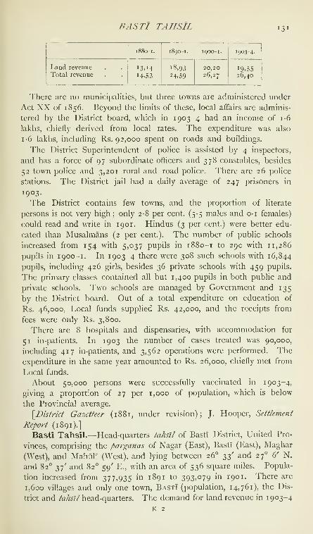
BASTI TAHSIL 131

132 BASTI TAHSIL
was Rs. 4,22,000, and for cesses Rs. 78,000. The density of popula-
tion, 733 persons per square mile, is the highest in the District. Thetahstl stretches north from the Gogra in the upland portion of the
District, and is crossed by the Kuwana and a number of smaller
streams. The area under cultivation in 1903-4 was 387 square
miles, of which 238 were irrigated. Wells supply more than half
the irrigated area, and tanks and swamps are a more important
source than rivers.
Basti Town.—Head-quarters of Basti District and tahstl, United
Provinces, situated in 26° 47' N. and 82° 43' E., on the Bengal and
North-Western Railway and on the Gorakhpur-Fyzabad road. Popula-
tion (1901), 14,761. The town became the residence of a local Raja
in the seventeenth century, but was never of importance. For some
time before the Mutiny it was the site of an opium storehouse and
treasury, and in 1865 it became the head-quarters of a new District.
Basti consists of the old village, in which the Raja's fort is situated,
a new bazar which has sprung up on the road south of this, and the
civil station. It is the head-quarters of the Church Missionary Society
in the District, which maintains the high school ; and besides the usual
offices there is a dispensary. The town is administered under Act XXof 1856, with an income of about Rs. 4,000. There is little trade.
Two schools for boys contain 330 pupils, and a small girls' school
has an attendance of 15.
Baswa.—Head-quarters of the tahsll of the same name in the
Daosa nizdmat of the State of Jaipur, Rajputana, situated in 27° 9' N.
and 76° 36' E., on the Rajputana-Malwa Railway, 63 miles east-by-
north-east of Jaipur city and 128 miles south of Delhi. Population
(1901), 5,908. The mud walls which surround the town are breached
in several places, and the small fort is in a dilapidated condition. Thetown possesses a post office, and three schools attended by about 160
boys. A fair, held yearly in April near the railway station, is visited by
7,000 to 8,000 Muhammadans. The town is locally famous for its
red and black terracotta pottery ; and in its neighbourhood are some
very old palaces, a reservoir, and a temple attributed to a Raja namedHar Chand.
Batala Tahsil.— Tahstl of Gurdaspur District, Punjab, lying be-
tween 31° 35' and 32° 4" N. and 74° 52' and 75° 34' E., with an area
of 476 square miles. It stretches south-east and north-west between
the Ravi and the Beas, and consists of strips of alluvial country along
these two rivers, with a fertile plateau between them irrigated by the
Bari Doab Canal and the Kiran (District) Canal. The population in
1 90 1 was 305,867, compared with 300,644 in 1891. The head-quarters
are at the town of Batai.a (population, 27.365). It also contains the
towns of Srigobindpur (4,380) and Dera Nanak (5,118); and 478

BATES^AR 133
villages. The land revenue and cesses amounted in 1903-4 to
Rs. 5,51,000.
Batala Town.—Head-quarters of the tahsJl of the same name in
Gurdaspur District, Punjab, situated in 30*^ 49' N. and 75° 12' E., on
the Amritsar-Pathankot branch of the North-U'estern Railway, 20 miles
from Gurdaspur town. It is distant by rail 1,272 miles from Calcutta,
1,303 from Bombay, and 859 from Karachi. Population (1901), 27,365,
including 17,876 Muhammadans and 9,071 Hindus. The town was
founded about 1465, during the reign of Bahlol Lodi, by Rai RamDeo, a Bhatti Rajput, on a piece of land granted by Tatar Khan,
governor of Lahore. Akbar gave it in jciglr to Shamsher Khan, his
foster-brother, who greatly improved and beautified the place, and out-
side it built the magnificent tank, still in perfect repair. Under the
Sikh commonwealth, Batala was held first by the Ramgarhias, and after
their expulsion by the Kanhaya confederacy. On their return from
exile the Ramgarhia chiefs recovered the town, which they retained till
the rise of Ranjit Singh. After the annexation of the Punjab, Batala
was made the head-quarters of a District, subsequently transferred to
Gurdaspur. The principal objects of antiquarian interest are the tank
above mentioned, the massive tomb of Shamsher Khan, and a hand-
some building known as the Anarkali, erected by Sher Singh, son of
Ranjit Singh, who held Batala in Jag'ir. This is now occupied by the
Baring high school. The central portion of the town is raised to some
height above the surrounding level, and has well-paved streets, good
drainage, and substantial brick-built houses ; but its suburbs consist of
squalid mud huts, occupied by Giijar shepherds and low-caste weavers,
where filth accumulates to the great detriment of the general health.
The municipality was created in 1867. The income during the
ten years ending 1902-3 averaged Rs. 34,900, and the expenditure
Rs. 34,100. The income in 1903-4 was Rs. 37,900, chiefly from
octroi ; and the expenditure was Rs. 38,500. The town has consider-
able manufactures, which include cotton, silk, and leathern goods. Susi,
a striped mixture of silk and cotton, used to be very largely made,
but the manufacture has now been superseded by that of chintz.
Carpets and woollen blankets are also woven. Soap is manufactured,
and a good deal of cotton is ginned. Batala has a large trade in grain
and sugar, which, however, are bought and sold at a mart outside muni-
cipal limits. Its chief educational institutions are the Baring Anglo-
vernacular high school for Christian boys and the A.L.O.E. Anglo-
vernacular high school, both maintained by the Church Missionary
Society, and two Anglo-vernacular middle schools, one maintained by
the municipal committee and the other unaided. The municipality,
aided by the District board, also supports two dispensaries.
Batesar.—Village in the Bah tahsil of Agra District, United Pro-

134 BATESAR
vinces, situated in 26° 56' N. and 78° 33' E., at a bend of the Jumna,
41 miles south-east of Agra city. Population (1901), 2,189. The place
is celebrated for its fair, the largest in the District. Originally this was
a religious festival, the great day being on the full moon of Kartik
(October-November), but it is now also celebrated as a cattle fair.
Horses, cattle, camels, and even elephants are exhibited, and remounts
for the native army and police are often bought here. For convenience,
a branch Government treasury is opened at the time of the fair. In
1904 the stock shown included 35,000 horses and ponies, 18,000
camels, 10,000 mules and donkeys, and 79,000 head of cattle; and
Rs. 13,000 was collected on account of bridge tolls, registration fees,
and shop rents.
Baud State.—The most westerly of the Tributary States of Orissa,
Bengal, lying between 20° 13' and 20° 53' N. and 83° 35' and 84° 48' E.,
with an area of 1,264 square miles. It is bounded on the north by the
Mahanadi river, separating it from Sonpur and Athmallik ; on the east
by Daspalla ; on the south by the Khondmals ; and on the west by
Patna and Sonpur, from which it is separated by the Tel river.
The State is one of the oldest in Orissa, and is said to have been
originally founded by a Brahman, but he being childless adopted a
nephew of the Raja of Keonjhar, who is regarded as the founder of
the present family. The list of chiefs contains forty-five names, who are
said to have ruled for nearly 1,400 years. The State was formerly of
considerable extent, but from time to time portions were wrested from
it by more powerful neighbours, and Athmallik, which was for centuries
part of Baud and acknowledged its suzerainty, is now quite separate.
The large tract known as the Khondmals, with an area of about 800
square miles, which originally belonged to Baud, was made over to the
British Government in 1835 t)y the chief, who was unable to control
the Khonds or to put a stop to their human sacrifices ; and it was in
1891 formed into a subdivision of Angul District. The State as now
constituted yields an estimated revenue of Rs. 64,000, and pays to the
British Government a tribute of Rs. 800. The population decreased
from 89,551 in 1891 to 88,250 in 1901. The falling off is due, as in the
case of the Khondmals, partly to the prevalence of epidemic disease and
the general unhealthiness of the climate, and partly to the emigration of
many migratory Khonds during the scarcity which occurred in 1900.
The number of villages is 1,070, and the density is 70 persons per
square mile. Of the total population, 87,988 claim to be Hindus, but
many of them are really Hinduized aborigines. The most numerous
castes are the Gaurs (23,000), Khonds (15,000), Pans (9,000), Sudhas
(7,000), and Chasas (4,000). The Khonds {see Khondmals) are
giving up their primitive customs and beliefs, and endeavouring to
amalgamate with their Hindu neighbours. The land is fertile and is

BAUSI 135
well provided with wells, reservoirs, and other sources of irrigation. The
MahanadT, which forms the northern boundary of the State, and the
Tel, which borders it on its west, afford excellent facilities for water-
carriage ; and rice, oilseeds, and such cereals as are produced in the
State are exported in large quantities by boat down the Mahanadi. The
State maintains a charitable dispensary, a middle English school, and
4 upper primary and 16 lower primary schools.
Baud Village.—Chief place of the Orissa Tributary State of the
same name, Bengal, situated in 20° 50'' N. and 84° 23' E., on the right
bank of the MahanadT. Population (1901), 3,292. The village con-
tains several ancient temples. The most important are the Nabagraha
temple, built of red sandstone, very profusely carved, and probably
dating from the ninth century ; and three temples of Siva with elabo-
rately carved interiors.
\^Archa€ologicaI Survey Reports, vol. xiii, pp. 118-9.]
Baugh.—Archaeological site in Central India. See Bagh.
Bauliari.—Seaport in Ahmadabad District, Bombay. See Bavliari.
Baura.—Village in the head-quarters subdivision of Jalpaigurl Dis-
trict, Eastern Bengal and Assam, situated in 26° 15' N. and 89° 5' E.,
on a small tributary of the Tista. Baura can be reached by boats of 30
or 40 tons burden all the year round, and is the principal river mart in
the District, whence large quantities of tobacco, mustard seed, jute,
cotton, and hides are exported by water to Sirajganj and Dacca. Baura
is also served by the Bengal-Duars Railway. The population in 1901
is not known. It was included for census purposes in mauza Sibram,
the population of which was 5,157.
Bausi.—Village in the Banka subdivision of Bhagalpur District,
Bengal, situated in 24° 48' N. and 87° 2' E., near the base of Mandar-
GiRi. Population (1901), 649. The numerous buildings, tanks, large
wells, and stone figures found for a mile or two round the base of the
hill show that a great city must once have stood here. The people of
the neighbourhood say that it contained 52 markets, 53 streets, and
88 tanks. According to local tradition, a large building, the ruins of
which still exist, and the walls of which contain an immense number of
small holes, evidently intended to hold chinlgs, or small native lamps,
was formerly illuminated on the night of the Dewali festival by
a hundred thousand of these lights, each householder being allowed
to supply only one. How or when the city fell into ruin is not known,
though popular tradition ascribes its destruction to Kala Pahar. ASanskrit inscription on a stone triumphal arch seems to show that the
city was in existence less than 300 years ago. After the destruction
of the temple of Madhusudan on Mandargiri hill, the image of the god
was brought to Bausi, where it now remains. Once a year, on the Paus
Sankranti day, the image is carried from Bausi to the foot of the hill.

136 BAUSI
and is swung on the triumphal arch. About 50,000 pilgrims assemble
from all parts of the country, in order to bathe in the sacred tank at
the foot of the hill, and a fair is held which lasts for fifteen days.
Bavda {Bdvada).—Petty chiefship feudatory to the Kolhapur State,
within the Political Agency of Kolhapur and the Southern Maratha
Country, Bombay, lying between 16° 25' and 16° 44'' N. and 73° 52'
and 74° 8' E. See Kolhapur State.
Bavisi Thana.—Petty State in Mahi Kantha, Bombay.
Bavliari.—Seaport on the creek of the same name, in the Dhan-
dhuka taliika of Ahmadabad District, Bombay, situated in 22° 4' N. and
72° 7' E. Population (1901), 980. In 1903-4 the imports and exports
were each valued at 8 lakhs, the chief articles of trade being cotton,
grain, gh'i, piece-goods, coco-nuts, oil, molasses, and timber.
Ba"w.—One of the Southern Shan States, Burma. See Maw.Bawal Nizamat.—A nizdmat or administrative district of the
Nabha State, Punjab, lying between 28° and 28° 25' N. and 76° 15'
and 76° 45' E., with an area of 281 miles. The population in 1901
was 71,430, compared with 68,147 i" 1891. It contains one town,
Bawal (population, 5,739), the head-quarters ; and 164 villages. Theland revenue and cesses amounted in 1903-4 to 2-2 lakhs. Thenizdmat consists of three separate pieces of territory : Bawal proper,
Kanti-Kallna, and the isolated village of Mukandpur Basi. Bawal
proper lies south of Rewari, a tahs'il of the British District of Gurgaon,
and forms a wedge jutting southwards into the Alwar and Jaipur States
of Rajputana. It is separated by the Rewari tahsll from the />argafia of
Kanti-Kalina, 21 miles long by 9^ broad, lying parallel to the Narnaul
nizdmat of the Patiala State. The whole nizdmat is geographically
a part of the Rajputana desert, being an arid, rainless tract, singularly
destitute of trees, streams, and tanks, though the Sawi, a seasonal
torrent which rises in the Jaipur hills, passes through the southern edge
of the Bawal pargana. It is divided into the two police circles of
Bawal Kanti and Chauki Deb-Kalan.
Ba"wal Town.—Head-quarters of the nizdmat of the same name in
Nabha State, Punjab, situated in 28° 4' N. and 76° 36' E., 10 miles
south of Rewari. Population (1901), 5,739. Founded in 1205 by
Rao Miswala, Chauhan Rajput of Alwar, it eventually came under the
Nawabs of Jhajjar and then passed to Nabha. It has since greatly
developed, though its trade suffers from competition with Rewari. It
contains several old buildings, the most interesting of which is a
mosque built in 1560 and still in good repair. It possesses a police
station, an Anglo-vernacular middle school, and a dispensary.
Bawa Malang.—Hill fortress in Thana District, Bombay. See
Malanggarh.Bawlake.—One of tlie Karenni States, Burma.

BA YANA 137
Bawnin.—Burmese name for one of the Southern Shan States,
Burma. See Mawnang.Bawzaing.—Burmese name for one of the Southern Shan States,
Burma, See Mawson.Baxa.—MiHtary cantonment in Jalpaiguri District, Eastern Bengal
and Assam. See Buxa.
Baxar.—Subdivision and town in Shahabad District, Bengal. See
Buxar,
Bayana.—Head-quarters of a tahstl of the same name in the State
of Bharatpur, Rajputana, situated in 26° 55'' N. and 77° iS' E., close
to the left bank of the Gambhir river, a tributary of the Banganga,
and about 25 miles south-by-south-west of Bharatpur city. Population
(1901), 6,867. Ihe town contains a vernacular school, attended by
150 boys, and a hospital. The ancient name of the place was Srlpatha.
Two old Hindu temples were, till recently, used by the Musalmans as
mosques, and each has a Sanskrit inscription. One of them, bearing
date a.d. 1043, mentions a Jadon Raja, Bijai Pal, to whom is unani-
mously attributed the building of the well-known fort of Bijaigarh,
which is situated on an eminence about 2 miles to the south-west, and
is shown in all maps under the name of Badalgarh Kot. There are
several old temples and remains in this fort ; but the chief object of
interest is a red sandstone pillar (Jdf) bearing an inscription of the
Varika king, Vishnuvardhana, a tributary of Samudra Gupta, dated in
A.D. 372. Bijai Pal, whose descendants rule at Karauli, is said to have
been killed about the middle of the eleventh century in a battle with
Masud Salar, a nephew of Mahmud of Ghazni, when the fort was taken.
It was soon after recovered by the Rajputs, only, however, to be again
stormed successfully by Abu Bakr, Kandahari, whose tomb is still
pointed out in the vicinity. Thenceforward, it seems to have been
held by whatever dynasty ruled at Delhi. Muhammad Ghori took
it in 1 196 and Sikandar LodI in 1492. Babar, writing in 1526,
describes the fort as one of the most famous in India, and his son
Humayun took it from the LodTs in 1535. Bayana is mentioned in the
Ain-i-Akbari as having in former times been the capital of a province
of which Agra was but a dependent village. It possessed a large
fort containing many buildings and subterranean caverns, also a very
high tower. The mangoes, some of which weighed above 2 lb., were
excellent, and the place was famous for its very white sugar and its
indigo, the latter selling at from Rs. 10 to Rs. 15 a maund '.
[Indian Antiquary, vols, xiv and xv; J. F. Fleet, Gupta Inscriptions,
P- 253-]
' As much as 3,562 'great maunds of Indicoe Byana,' valued at 278,673 viahniudis
(say ;^i4,ooo), was consigned to England in the Royal Anne, the ship which brought
home Sir Thomas Roe in 1619.

138 BAZAR
Bazar.—Valley in the Khyber Political Agency, North-West Frontier
Province, running east and west between the Surghar range on the
south, the Ilacha Ghar or eastern extension of the Safed Koh on
the east, and the Turo Sar range to the north, between 33° 38' and
35° N. and 70° 37' and 71° E. Its elevation ranges from 3,000 to
4,000 feet, and that of the enclosing hills from 5,000 to 7,000 feet.
The valley is sterile in the extreme, save where the village lands are
irrigated from the hill streams. The people are Afridis of the notorious
Zakka Khel or clan, the most active thieves on the frontier, against
whom on three occasions punitive expeditions have been sent. In
1878 their attacks on the line of communications in the Khyber
during the second Afghan War compelled a punitive expedition.
Major Cavagnari led an armed body of Kuki Khel Afridis, supported
by guns, against them, and inflicted some punishment ; but a regular
expedition followed in December, which effectively chastised them at
small cost of life. Nevertheless the clan continued to give trouble, and
another expedition had to be sent into the valley in 1879, after which
the clan submitted. In 1897 two columns under Sir William Lockhart
entered the valley by the Chora and Ilacha passes at its eastern
extremity, and destroyed the principal villages.
Beas {Hyphasis of the Greeks ; Arjikuja of the Vedas ; Sanskrit,
Vipdsd).—One of the ' five rivers ' of the Punjab from which the Pro-
vince derives its name. Rising on the southern face of the Rohtang
pass in Kulu, 13,326 feet above the sea, the Beas traverses the State of
Mandi and enters Kangra District at Sanghol, 1,920 feet above sea-level.
During the early part of its course the fall averages 125 feet per mile.
A fine suspension bridge spans the river at INIandl town, and a bridge
of boats is kept up during the cold season at Dera Gopipur in Kangra
District. During its lower hill course the Beas is crossed by numerous
ferries, at many of which the means of communication consists of
inflated skins {darais). Lower down it meanders in a westerly course
through hilly country, with a fall of 7 feet to the mile, and forms the
main channel for the drainage of Kangra. Near Reh in that District it
divides into three channels, which reunite after passing Mirthal, 1,000
feet above sea-level. On meeting the Siwalik Hills in Hoshiarpur, the
river sweeps sharply northward, forming the boundary between that
District and Kangra. Then bending round the base of the Siwaliks,
it takes a southerly direction, separating the Districts of Hoshiarpur
and Gurdaspur. In this portion of its course through the uplands of
the Punjab plains, a strip of low alluvial soil fringes its banks, subject
in flood-time to inundation from the central stream. The main channel
is broad and ill-defined, full of islands and expanding from time to time
into wide pcjols. The depth does not exceed 5 feet in the dry season,
increasing to 15 feet during the rains. Broad flat-bottomed country

BEA WAR 139
boats navigate this portion of the stream throughout the year. Nobridges span the Beas in the Districts of Hoshiarpur or Gurdasi)ur.
After touching Jullundur District for a few miles, the river forms the
boundary between Amritsar and the Kapurthala State. At Beas station
it is crossed by a railway bridge on the North-Western Railway ; and
a bridge of boats on the grand trunk road is also maintained there
during the cold season. The channel shifts from year to year through
the alluvial valley according to the action of the floods. Finally, the
Beas joins the Sutlej at the south-western boundary of the Kapurthala
State, after a total course of 290 miles. It ranks sixth in size amongthe rivers of the Punjab.
The chief tributaries are the Chakki and the Bein. The Chakki
collects the drainage of the Chamba hills and its main stream joins
the Beas near Mirthal, while the other branch, formerly a tributary
of the Ravi, has been turned aside by the Bari Doab Canal and forced
to return to the Beas lower down. The Bein—called the * Black
'
{Siydh) Bein to distinguish it from the ' AVhite ' {Safed) Bein— rises in
the Siwaliks, and joins the Beas to miles above its junction with the
Sutlej.
The old course of the Beas can be traced from its present point of
junction with the Sutlej through Lahore and Montgomery Districts
to the place where it used to join the Chenab, near Shujabad, before
the Chenab turned westwards. The united waters of the Jhelum,
Chenab, and Ravi joined the Beas in those days 28 miles south of
Multan. Since the end of the eighteenth century the course of the
Beas has changed but little.
Beauleah.—Head-quarters of Rajshahi District, Eastern Bengal
and Assam. See Rampur Boalia.
Beawar (also called Nayanagar).—Head-quarters of Merwara Dis-
trict, Ajmer-Mervvara, situated in 26° 5^" N. and 74° 19' E. Population
(1901), 21,928: including Hindus, 15,547; Muhammadans, 3,947;
and Jains, 2,094. Founded in 1835 by Colonel Dixon, afterwards
Commissioner of Ajmer-Mervvara, in the neighbourhood of a now-
abandoned cantonment, Beawar rapidly grew into a prosperous town,
owing to its advantageous position between Mewar (Udaipur) and
Marwar (Jodhpur). The town, which has wide streets and a sur-
rounding stone wall with four gates, was regularly planned out from the
beginning, and sites were allotted to traders who applied for shops.
Beawar is the only town in Merwara District, and is a station on the
main line of the Rajputana-Malvva Railway. The municipal income
in 1902-3 was about Rs. 60,000. Beawar is the chief cotton mart for
Merwara and the contiguous Native States of Mewar and Marwar, and
possesses a flourishing cotton-mill. The United Free Church of Scot-
land has a mission establishment, and maintains an industrial school.
140 BKCHRAJT
Bechraji,—Temple in the Kadi/ra///, Baroda State, situated about
23 miles from the town of Kadi, and about the same distance from
Modhera. The temple has been built in the jungle, and is surrounded
by large and costly works designed for the accommodation of pilgrims
and others—wells, tanks, dharmsdlas, dispensary, &c. In the months
of Aswin (September-October) and Chaitra (March-April) crowds of
devotees visit the shrine from all parts of Gujarat and make their offer-
ings to the goddess. From these offerings and from the rich endow-
ments given by former Gaikwars the expenses of the temple are met.
Bedadanuru Coal-field.—Bedadanuru is a hamlet in the Polavaram
minor ta/uk of Godavari District, Madras, situated in 17° 15' N. and81° 14' E., about 10 miles from Jangareddigudem on the Ellore-
Prakkilanka road. It is the centre of a small coal-field, where the
Barakar stage of sandstone outcrops over an area of about 5^ square
miles. This is the only coal-field lying entirely within the Madras
Presidency ; but though prospecting has been carried on for some
years, no paying seam has as yet been discovered.
Bedla.—Principal town of an estate of the same name in the State
of Udaipur, Rajputana, situated in 24° 38' N. and 73° 42" E., on the
left bank of the Ahar stream, about 4 miles north of Udaipur city.
Population (1901), 1,222. It contains a mission school attended by
30 boys. The estate is held by the second noble of Mewar, who is
styled Rao. It consists of in villages, the majority of which are
situated to the north of Chitor ; among them is Nagari, one of the
oldest places in Rajputana and mentioned in the article on Chitor.
The income is about Rs. 64,000, and a tribute of Rs. 4,100 is
paid to the Darbar. The Raos of Bedla are Chauhan Rajputs, and
claim direct descent from Prithwi Raj, the last Hindu king of Delhi.
Bakht Singh, the great-grandfather of the present Rao, brought the
European residents of Nimach from Dungla to Udaipur during the
Mutiny of 1857, by the order of Maharana Sarup Singh. For these
services he received a sword of honour and was subsequently created
a Rao Bahadur and a CLE.Bednor.—Estate and head-quarters thereof in Udaipur State,
Rajputana. See Badnor.
Bedsa.—Village in the Maval tdluka of Poona District, Bombay,
5 miles south-west of Khadkala station on the Great Indian Peninsula
Railway, which gives its name to a group of caves of the first century a. d.
Population (1901), 171. The caves lie in 18° 43' N. and 73° 35' E., in
the Supati hills, which rise above Bedsa village to a height of about
300 feet above the plain, and 2,250 feet above sea-level. The two chief
caves are a chapel or chaitya and a dwelling cave or layana, both of
them imitating wooden buildings in style. The chapel is approached
by a narrow passage 40 feet long between two blocks of rock about

BEGAMPUR 141
18 feet high. A passage 5 feet wide has been cleared between the
blocks and the front of two massive octagonal columns and two demi-
columns which support the entablature at a height of about 25 feet.
The veranda or porch within the pillars is nearly 12 feet wide, and
30 feet 2 inches long. Two benched cells project into it from the back
corners and one from the front, with, over the door, an inscription in
one line recording :' The gift of Pushyanaka, son of Ananda Shethi,
from Nasik.' The corresponding cell in the opposite end is unfinished.
Along the base and from the levels of the lintels of the cell doors
upwards the porch walls are covered with the rail pattern on flat
and curved surfaces, intermixed with the chaitya window ornaments, but
without any animal or human representations. This and the entire
absence of any figure of Buddha point to the early or Hinayana style of
about the first century after Christ. The dagoba or relic shrine has
a broad fillet or rail ornament at the base and top of the cylinder, from
which rises a second and shorter cylinder also surrounded above with
the rail ornament. The box of the capital is small and is surmounted
by a very heavy capital in which, out of a lotus bud, rises the wooden
shaft of the umbrella. The top of the umbrella has disappeared. Therelic shrine is now daubed in front with red lead and worshipped as
Dharmaraj's dhera or resting-place. There is a well near the entrance,
and about twenty paces away stands a large unfinished cell containing
a cistern. Over the latter is an inscription in three lines of tolerably
clear letters which records :' The religious gift of Mahabhoja's daughter
Samadinika, the MahadevI Maharathini and wife of Apadevanaka.'
This inscription is of very great interest, being one of the earliest
mentions of the term Maharatha yet discovered. A relic shrine or
dagoba lies a short distance from the chapel cave and also bears
a short inscription.
Beehea.—Village in Shahabad District, Bengal. See Bihiya.
Beerbhoom.—District in Bengal. See BIrbhum.
Begampur.—Village in the Sholapur idluka of Sholapur District,
Bombay, situated in 17° 34' N. and 75° 37' E., on the left bank
of the Bhima river, about 25 miles south-west of Sholapur city.
Population (1901), 2,304. The place takes its name from one of
Aurangzeb's daughters, who died while her father was encamped at
Brahmapuri on the opposite bank of the river. She was buried at this
place, and her tomb is a plain solid structure in a courtyard 180 feet
square. It overhangs the BhIma, from which it is guarded by a strong
masonry wall now much out of repair. Round the tomb a market
slowly sprang up, with the result that the suburb of Begampur outgrew
the original village of Ghadeshwar, from which it is separated by a water-
course. About Rs. 40,000 worth of thread, cloth, and grain change
hands every year at the weekly market on Thursday. The village has

142 BEGAMPUR
a little manufacture of coarse cotton cloth or khddi. It contains
a primary school.
Begari Canal.—An important water-channel in the Upper Sind
Frontier District, Sind, Bombay. It taps the Indus at its extreme
south-eastern boundary, forming for about 50 miles of its course a well-
defined line of demarcation between the Frontier District and Sukkur.
In 185 1 this canal was at its head only 50 feet wide, with a depth of
9 feet. It was enlarged in 1854, when the water was admitted into it
from the Indus and reached Jacobabad, 50 miles distant, in sixteen
hours. Subsequently, the tail of the canal was enlarged, and extended
farther westward. Several improvements have been carried out during
the last few years. The entire length of the main canal is 76 miles, and
it serves the Districts of Upper Sind Frontier (202 square miles), Sukkur
(46 square miles), Kalat (43 square miles), and Larkana (300 acres).
About five canals branch directly from it, the principal being the Nur
Wah (19 miles) and Mirza (10 miles). The canal is also connected
with the branches of the Ghar Canal. The aggregate cost of these
works up to the end of 1903-4 amounted to 17 lakhs ; the receipts in
the same year were about \\ lakhs, and the total charges (exclusive
of interest) over one lakh. The gross income was thus 26 per cent, on
the capital expended and the net receipts 18-3 per cent. The area
irrigated was 495 square miles. The canal is navigable for about
60 miles.
Begun.—Chief town of an estate of the same name in the State of
Udaipur, Rajputana, situated in 24° 59'' N. and 75° \' E., about 90 miles
east-by-north-east of Udaipur city. Population (1901), 3,625, about
70 per cent, being Hindus. The town contains a picturesque palace
and a fairly strong fort. The estate, which includes the town and
127 villages, belongs to one of the first-class nobles of Mewar, who is
styled Rawat Sawai. The income is about Rs. 48,000, and a tribute of
about Rs. 5,200 is paid to the Darbar. The Rawats of Begun belong
to the Chondawat family of the Sesodia Rajputs. In the estate is
the village of Menal, formerly called Mahanal or the 'great chasm,'
which possesses a monastery and Sivaite temple constructed, according
to the inscriptions they bear, in 11 68 by the wife of the famous
Prithwi Raj Chauhan, whose name was Suhav Devi, alias Riithi
Ran! (' the testy queen ').
Begusarai Subdivision.—North-western subdivision of Monghyr
District, Bengal, lying between 25° 15' and 25° 47' N. and 85° 47' and86° 27' E., with an area of 751 square miles. The population in 1901
was 642,966, compared with 611,349 in 1891. It contains 755 villages,
but no town ; the head-quarters are at Begusarai. The subdivision,
which forms a continuation of the fertile alluvial plain of Tirhut,
and supports 857 persons to the square mile, is the most densely

BELA 143
populated part of the District. The cultivation of indigo is carried
on, but the industry is decHning.
Begusarai Village.—Head-quarters of the subdivision of the samename in Monghyr District, Bengal, situated in 25° 26' N. and 86° 9' E.
Population (1901), 9,338. The village contains the usual public offices;
the sub-jail has accommodation for 28 prisoners.
Behar.—Subdivision and town in Patna District, Bengal. See
Bihar.
Behir.— Tahs'il in Balaghat District, Central Provinces. See Baihar.
Behror.—Head-quarters of a tahs'tl of the same name in the State of
Alwar, Rajputana, situated in 27° 53' N. and 76° 17' E., about 32 miles
north-west of Alwar city, and 18 miles west-by-south-west of Ajeraka
station on the Rajputana-Malwa Railway. Population (1901), 5,540.
The town possesses a mud fort about 50 yards square, a fair bazar,
a post office, a vernacular school, and a hospital with accommodation
for 6 in-patients. A municipal committee supervises the lighting
and conservancy, the income, derived mainly from octroi, being
about Rs. 2,200 and the expenditure Rs. 1,800. The tahs'il, which
contains 132 villages besides the town, is situated in the north-west of
the State, and has a population of 71,082. More than 35 per cent,
of the inhabitants are Ahirs, who are the best cultivators in the State.
Under the Mughals this tract was included in the Subah of Narnaul,
but the real rulers were the local Chauhan chiefs. In the first half
of the eighteenth century the Jats of Bharatpur overran it, but they
were ousted before the end of that century by Pratap Singh, the
first chief of Alwar.
Beji.— River in Baluchistan. See Nari.
Bekal.—Village in the Kasaragod taluk of South Kanara District,
Madras, situated in 12" 24'' N. and 75° 3' E. It has a fine fort on
a headland facing the sea, which was built by Sivappa Naik of Bedniir
about the middle of the seventeenth century. The defences are said
to show traces of European science. The surrounding tract is really
part of the Malayalam country, and was at one time subject to the
Chirakkal Rajas. Bekal formerly gave its name to the present
taluk of Kasaragod, but it is now of no importance.
Bela.—Capital of the Las Bela State, Baluchistan, and residence
of the Jam, situated in 26° 14' N. and 66° 19' E. It lies near the apex
of the Las Bela plain, \\ miles from the Porali river and 116 miles
from Karachi. Population (1901), 4,183. The majority were State
servants, but 356 Hindus were included. The town is not walled and
consists of 400 or 500 huts. The Jam's residence, a /<?/«/7/, a treasury,
a jail, and lines for the military police are the principal buildings.
The ancient name of the town was Armael or Armabel. Sir Robert
Sandeman died at Bela in 1892, and was buried on the south of the

144 BELA
town. His tomb, of granite and white English marble, is placed beneath
a dome erected by the Jam, and is surrounded by a garden. A small
establishment is maintained in the town for purposes of conservancy.
Cotton cloth and rice constitute the principal imports ; oilseeds, ghl,
and wool the exports. Bela crochet-work is well-known,
Bela (or Bela Partabgarh).—Head-quarters of Partabgarh District
and iahsll, United Provinces, situated in 25° 55' N. and 82° E., on the
bank of the Sai, at the junction of the main line of the Oudh and
Rohilkhand Railway with a branch from Allahabad to Fyzabad, and on
a road between the same two places. Population (1901), 8,041. Thetown derives its name from the temple of Bela Bhawani near the river.
It was founded in 1802 as a cantonment for the Oudh auxiliary force,
and after the Mutiny became the head-quarters of a District. The town
is well laid out and has been thoroughly drained. Besides the usual
offices, it contains a general dispensary and a magnificent female
hospital, and there is a branch of the Zanana Bible and Medical
Mission. Bela has been a municipality since 1871. During the ten
years ending 1901 the income and expenditure averaged Rs. 10,000.
In 1903-4 the income was Rs. 14,000, chiefly derived from octroi
(Rs. 8,000) and fees and rents ; and the expenditure was Rs. 16,000.
There is a flourishing trade in agricultural produce. Three schools
have 340 pupils.
Belagutti.^Town in the Honnali taluk of Shimoga District, Mysore,
situated in 14° 11' N. and 75° 31' E., 10 miles south-west of Honnali
town. Population (1901), 2,799. The original form of the name was
Belagavatti. It was the seat of a line of Naga chiefs who called them-
selves Sindas. They ruled during the twelfth and thirteenth centuries,
under the Chalukyas, Hoysalas, and Seunas. The place stands in a
plain of fertile black soil.
Belapur.—Village in the Rahuri tdliika of Ahmadnagar District,
Bombay, situated in 19° 34' N. and 74° 39' E., 15 miles north of Rahuri,
on the Dhond-Manmad Railway. Population (1901), 4,630, including
Belapur-Khurd (1,167). It lies on the north bank of the Pravara, which
in floods rises to the gates. On the river-side are some picturesque
buildings belonging to the Naiks, an old Maratha family. The chief
traders are Marwari Vanis and Telis. In 1822 an attempt was made
to make Belapur the centre of a revolt. Troops were to be collected
here and at Nandurbar in Khandesh, and in conjunction with the local
Kohs were to make a general attack upon the British posts. Theplot was, however, discovered and quashed.
Belgami (or Balgami).—Village in the Shikarpur taluk of Shimoga
District, Mysore, situated in 14° 24' N. and 75° 15' E., 14 miles north-west
of Shikarpur. Population (1901), 1,330. Its name appears in inscrip-
tions as Balligamve, Balligrame, Balipura, and similar forms. Even

BELGAUM DISTRICT 145
in tlie twelfth century it was of such antiquity as to be styled the mother
of cities, the capital of ancient cities, the immemorial capital, and
is said to derive its name from the giant Bali. On account of its
religious merit it was called the Dakshina Kedara, and also had the
name Kamatha. Under the Chalukyas and Kalachuris it was the capital
of the Banavasi ' twelve thousand ' province. It contained five maths,
with temples dedicated to Vishnu, Siva, Brahma, Jina, and Buddha, and
three ///;v?^, besides seven Brahmapuris. At the Kodiya math of the
Kedaresvara temple medicine and food were dispensed to all comers.
Of eighty-four inscriptions in the place most are of the eleventh and
twelfth centuries. Its prosperity continued under the Hoysalas and
Seunas, but the city no doubt fell a prey to the Muhammadan invaders
of the fourteenth century who overthrew the Hoysala power. Theruined temples are rich with carving equal to any in Mysore.
Belgaum District.—District in the Southern Division of the Bom-
bay Presidency, lying between 15° 22' and 16° 58' N. and 74° 2' and
75° 25' E., with an area of 4,649 square miles. It is bounded on the
north by the States of Miraj and Jath ; on the north-east by Bijapur
District ; on the east by the States of Jamkhandi, Mudhol, Kolhapur, and
Ramdurg ; on the south and south-west by the Districts of Dharwar and
North Kanara, the State of Kolhapur, and the Portuguese territory of
Goa ; and on the west by the States of Savantvadi and Kolhapur. Thelands of the District are greatly interlaced with those of the neighbouring
Native States, and within the District are large tracts of Native territory.
The country forms a large plain, studded with solitary peaks and
broken here and there by low ranges of hills. Many of the peaks are
crowned by small but well-built forts. The lower
hills are generally covered with brushwood, but inPhysical
some cases their sides are carefully cultivated almost
to the very summits. The most elevated portion of the District lies to
the west and south along the line of the Sahyadri Hills or Western Ghats.
The surface of the plain slopes with an almost imperceptible fall
eastwards to the borders of Bijapur. On the north and east the District
is open and well cultivated, but to the south it is intersected by spurs of
the Ghats, thickly covered in some places with forest. Except near the
Western Ghats, and in other places where broken by lines of low hills,
the country is almost a dead level ; but especially in the south,
and along the banks of the large rivers, the surface is pleasantly varied
by trees, solitary and in groups. From March to June the fields
are bare ; and but for the presence of the mango, tamarind, jack, and
other trees, reared for their fruit, the aspect of the country would
be desolate in the extreme.
The principal rivers are the Kistna, here properly called the Krishna,
flowing through the north, the Ghatprabha, flowing through the centre,
VOL. VII. L

146 BELGAUM DISTRICT
and the Malprabha, through the south of the District. From their
sources among the spurs of the Western Ghats, these rivers pass
eastwards through the plain of Belgaum on their way to the Bay of
Bengal. They are bordered by deeply cut banks, over which they
seldom flow. None is serviceable for purposes of navigation. In the
west the rivers and wells yield a sufficient supply of good water ; but
towards the east the wells become brackish, and the water-bearing strata
lie far below the surface. Except the Kistna, which at all times main-
tains a considerable flow of water, the rivers sink into insignificant
streams during the hot season, and the supply of water falls short of
the wants of the people.
In the south of the District is a narrow strip of Archaean gneissic rock,
including some hematite schists of the auriferous Dharwar series. In
the centre quartzite and limestone of the Kaladgi (Cuddapah) group
are found partly overlaid by two great bands of basalt belonging to
the Deccan trap system, and in the north and west basalt and laterite
occur. Several of the river valleys contain ancient alluvial deposits of
upper pliocene or pleistocene age, consisting of clay with partings and
thin beds of impure grits and sandstones. In the banks of a stream
that flows into the Ghatprabha at Chikdauli, 3 miles north-east of
Gokak, were found some remarkable fossil remains of mammalia,
including an extinct form of rhinoceros ^
Of the typical trees of the District, mdti {Termitialia tomefitosa)^
jdmbul {Eugenia Jambolana), nana, harda, sisva, and hasan {^Pterocarpus
Marsuphim) yield valuable timber ; kdrvi {Strobi/anthus Grahafuianus)
and small bamboos are used for fencing and roofing, and kumba {Carey
a
arborea) is in demand for the manufacture of field tools. The harda
and hela {Termina/ia belerica) furnish myrabolams, and the shemba
{Acacia concinna) supplies the ritha or soap-nut which is used in cleaning
clothes. The chief fruit trees are the mango, jack, custard-apple,
bullock's-heart, cashew-nut, Jdmbul, bael, wood-apple, pummelo, sweet
lime, citron, lime, orange, kokam, avla, bor, turan, guti, agasti, horse-
radish tree, guava, pomegranate, f>aj>ai, karanda, fig, mulberry, plantain,
and pineapple. Among creepers the most noticeable are several species
of convolvulus ; and a large number of English flowers have been
grown from seeds and cuttings.
Antelope are found in the north and east. Sdmbar, deer, wild hog,
and hyenas are not uncommon in the waste and forest lands. Of the
larger beasts of prey, leopards are pretty generally distributed, but
tigers are met with only in the south and south-west. Of game-birds
there are peafowl, partridge, quail, duck, snipe, teal, kalarn, and
occasionally bustard.
' R. B. Foote, Memoirs, Geological Survey of India, vol. xii, pt. i ; and
Palaeontologia Indica, Series X, vol. i, pt. i.
HISTORY 147
The moderate heat, the early and fresh sea-breeze, and its altitude
above the sea, make Uelgaum pleasant and healthy. The lowest tem-
perature recorded is 53° in January, while in May it rises to 100°. The
most agreeable climate is found in a tract parallel with the crest of
the Western Ghats between the western forests and the treeless east.
The cold and dry season lasts from mid-October to mid-February, the
hot and dry season from mid-February to early June, and the wet season
from early June to mid-October. The heat of April and May causes
occasional heavy showers, attended with easterly winds, thunder, light-
ning, and sometimes hail. Even in May the nights are cool, almost
chilly. Near the Ghats the south-west monsoon is very constant and
heavy. Farther east it is fitful, falling in showers separated by breaks
of fair weather. The rainfall at the District head-quarters averages
about 50 inches. In the east it is as low as 24, while in Chandgad in
the extreme west 107 inches are registered. From March to September
the prevailing winds are from the west and south, and from October to
February from the east and north.
The oldest place in Belgaum is Halsi, which, according to seven
copperplates found in its vicinity, was the capital of a dynasty of nine
Kadamba kings. In all probability the Early (550- .
610) and Western (610-760) Chalukyas held Belgaum
in succession, yielding place about 760 to the Rashtrakutas, a trace of
whose power survived till about 1250 in the Ratta Mahamandaleshwars
(875-1250), whose capital was first Saundatti and subsequently (1210)
Venugrama, the modern Belgaum. Inscriptions discovered in various
parts of the District show that during the twelfth and early years of the
thirteenth centuries the Kadambas of Goa (980-1250) held part of the
District known as the Halsi ' twelve thousand,' and the Venugrama or
Belgaum * seventy.' The third Hoysala king, Vishnuvardhana or Bitti
Deva (i 104-41), held the Halsi division for a time as the spoil of battle;
but the territory of the Goa Kadambas as a whole had by 1208 been
entirely absorbed by the Rattas. The last of the Rattas, Lakshmideo II,
was overthrown about 1250 by Vichana, the minister and general of the
Deogiri Yadava, Singhana II ; and from that date up to their final
defeat by the Delhi emperor in 1320, the Yadavas seem to have been
masters of Belgaum and surrounding tracts. During the brief overlord-
ship of the Delhi emperors Belgaum was administered by two Musalmannobles, posted at Hukeri and at Raybag. About the middle of the
fourteenth century, the District was partitioned between the HinduRajas of Vijayanagar, who held the portion south of the Ghatprabha,
and the king of Delhi, who held that to the north. On the foundation
of the Bahmani dynasty in 1347 the territories contained in the latter
half fell under the sway of that dynasty, which subsequently, in 1473,
took the town of Belgaum and conquered the southern division
L 2

148 BELGAUM DISTRICT
also. During the next hundred years the Vijayanagar Rajas madenumerous efforts to recover their territories, in which they were assisted
by the Portuguese ; but they failed to make any lasting conquests, and
were completely overthrown in the battle of Talikota (1565). For the
next hundred and twenty years Belgaum may be said to have remained
part of the territories of the Bijapur Sultans. On the overthrow of
Bijapur at the hands of Aurangzeb in 1686, the District passed to
the Mughals and was granted as a jdg'ir to the Nawab of Savanur, whosubsequently had to relinquish a share to the Nizam. Some part of it,
however, appears to have been in the hands of the Marathas. About
1776 the whole country was overrun by Haidar All, but was subse-
quently retaken by the Maratha Peshwa with the assistance of the
British. In 181 8, after a period of great disorder, during w^hich the
country was alternately harried by the troops belonging to Sindhia,
Kolhapur, Nipani, and other chiefs, the country passed to the British
and became part of the District of Dharwar ; but in 1836 it was con-
sidered advisable to divide the unwieldy jurisdiction into two parts.
The southern portion therefore continued to be known as Dharwar,
while the tract to the north was constituted a separate charge.
Copperplate inscriptions have been discovered at Halsi. The Dis-
trict contains some hill forts, the chief of which are Mahlpatgarh,
Kalanidhgarh, and Pargarh. Scattered temples are ascribed to Jakha-
nacharya but are really Chalukyan, a very fine one being found at
Deganve. There is an interesting group of prehistoric burial dolmens
at KoNNUR. Many temples dating from the eleventh, twelfth, and
thirteenth centuries are scattered over the District, of which nearly all
were originally Jain but have been converted into lingarn shrines. Themost noteworthy are a group in Belgaum fort ; those at Deganve,
Vakkund, and Nesargi in Sampgaum;groups at Huli, Manoli, and
Yellamma in Parasgad ; those at Shankeshwar in Chikodi, and at
Ramtirth and Nandgaon in Athni. The finest Musalman remains are
the fort and Safa mosque at Belgaum, and the mosques and tombs at
Hukeri and Sampgaon.
According to the Census of 1872 the population of the District was
946,702. The next Census of 1881 returned 865,922, showing a
^ , . decrease of over o per cent., due to the famine inPopulation. ^^xoii-- 1 r
1876. In 1891 the population mcreased to 1,013,261,
but again fell in 1901 to 993,976, owing to the bad years of 1892,
1896, 1899, and 1900.
The table on the next page gives statistics according to the Census
of 1901.
The Chikodi and Sampgaon ialukas contain many large and rich
villages and are well peopled. The chief towns are Belgaum, the
head-quarters, Nipani, Athni, Gokak, and Saundatti-Yellamma.

POPULATION 149
Classified according to religion, Hindus form 86 per cent, of the total
population, Musalmans 8 per cent., Jains 5 per cent. Among Hindus
the only special class are the Lingayats, a peculiar section of the wor-
shippers of Siva, numbering over 300,000, of whom a description will
be found under Dhakwar District. The languages in use are
MarathI, mostly in the south and west, and Kanarese generally over
the greater part of the District. The latter is spoken by 65 and
the former by 25 per cent, of the total. Hindustani is used by 8 per
cent.
Taluka.
I50 BELGAUM DISTRICT
The District has a considerable Christian population. Of the 5,366
native Christians in 1901 about 5,000 were Roman Catholics. The
majority are Konkani or Goa Catholics, who are immigrants from Goa,
and are under the jurisdiction of the Archbishop of that place. Theothers include Madras Catholics and Protestants, who came from
Madras about 181 7. The chief missions are an Anglican Tamil Mission
and the American Methodist Mission, with out-stations at Kanbargi,
Nesargi, and Bail Hongal. Roman Catholic priests are resident in
Belgaum, Khanapur, and Godoli ; and there are two orphanages and
a rescue home in the District, which are managed by independent
trustees, but belong to the Methodist Episcopal Mission. A mission to
soldiers, known as the Soldiers' Home, is situated in the cantonment.
The chief varieties of soil are black and red. The black, which
is by far the most fertile, is of two kinds. One variety is very friable,
. . . but when impregnated with moisture forms a toughAgriculture. , ,•, , , ,
clay-like substance, almost mipervious to water, and
therefore very valuable as a lining for tanks. The other kind is not so
tenacious of moisture, and, unless it receives abundance of irrigation,
either natural or artificial, not nearly so productive. In order to bring
a waste of black soil under tillage, the field must receive three complete
ploughings—one direct, one transverse, and one diagonal. It does not
receive any further ploughing ; but annually before sowing the ground
is cleared and the surface loosened with a small knife. The red and
sandy soils are very apt to cake and harden after rain, so that the field
must be ploughed every year—if possible, once lengthwise and a second
time transversely. This is done by a smaller plough of the same con-
struction as the large plough used for black fields, but lighter. Fields
of pure black soil do not receive manure ; on the other hand, the
out-turn from red and sandy lands seems to depend almost entirely
on the amount of dressing they have received.
On 'dry' fields, most of the grain, pulses, oilseeds, and fibres are
sown ; some are cultivated on red and sandy soils during the rainy
months ; others are grown on black soil as a cold-season crop.
Cotton is raised entirely on black soil as a cold-season crop.
The District is almost wholly ryotivari. Inam or jdgir lands cover
983 square miles. The chief statistics of cultivation in 1903-4 are
shown in the table on the next page, in square miles.
Joivdr, the staple of the District, occupying 884 square miles, is
grown in all parts, especially in Chikodi, Athni, Gokak, Parasgad, and
Sampgaon. Bdjra covered 297 square miles, chiefly in Athni, Gokak,
and Chikodi. The south-western portion, being too wet for millets,
produces rice (176 square miles) and the coarse hill grains. Wheat
(157 square miles) is the prominent crop of Parasgad. Rak-kdtig or
Italian millet occupied 118 scjuare miles. Pulses occupied ^t,^ square

AGRICULTURE 1ST
miles ; of these, 92 square miles were under tur, 98 under kulith or
horse-gram, and 62 square miles under gram. Oilseeds were grown on
98 square miles. Chikodi is famous for its sugar-cane and fruit and
vegetable gardens. Tobacco (35 square miles) is an important crop in
Chikodi in gardens or on favourable plots near villages or along rivers
and streams. Cotton, covering 352 square miles, is the most valuable
crop grown in the District. It is especially important in Athni, Paras-
gad, and Gokak.
Tilttka.

152 BELGAUM DISTRICT
for rice and vegetables in the best portions of the western half of the
District. Of the recently improved reservoirs the chief is the Gadekeri
lake about 15 miles south-east of Belgaum, in the Sampgaon td/uka,
which has an area of 129 acres and a maximum depth of 5 feet. Thecatchment basin measures 4-68 square miles, and the average rainfall is
29 inches. It supplied 337 acres in 1903-4. The most important
water-work is the Gokak canal and storage reservoir. A masonry weir
has been built across the Ghatprabha where its catchment area, in-
cluding that of its chief tributaries the Tamraparni and the Harankashi,
is about 1,100 square miles, of which a large extent lies in the Western
Ghats. The storage work and the first section of the canal were com-
pleted at a cost of 12-2 lakhs, the capital outlay to the end of 1903-4
being 12-9 lakhs. The Gokak canals command 28 square miles, and
irrigate an average of 16 square miles. Wells used for irrigation are
most common in Chikodi and Belgaum. In Khanapur no wells are
used for this purpose. In 1993-4 wells and tanks used for irrigation
numbered 12,660 and 1,161 respectively.
In the west of the District, among the spurs of the Western Ghats, is
a considerable area of forest land. Formerly large tracts were yearly
destroyed by indiscriminate cultivation of shiftingForests
patches of fire-cleared woodland. This form of
tillage has now been limited to small areas, specially set apart for the
purpose. The District possesses 665 square miles of ' reserved ' and
10 square miles of ' protected ' forest. Of this total, 51 square miles
are in charge of the Revenue department. It is very unevenly distri-
buted, the large tdlukas of Athni and Parasgad having little or no
forest, while Khanapur has twice as much forest as tillage. Theforest administration is under a divisional officer, assisted by a sub-
divisional officer. The Belgaum forests may be roughly divided into
' moist ' and ' dry,' the ' dry ' lying east of the Poona-Harihar road and
the ' moist ' lying west of the road. The latter includes the forests of
Belgaum and Khanapur, about 500 square miles. The ' dry ' forest, about
one-eighth of which is stocked with useful wood, is very poor and stony,
yielding only firewood scrub with a few small poles fit for hut-building.
The produce is chiefly cactus, four kinds of fig, dindal, and tarvar.
The most important trees in the ' moist ' forest are teak, black-wood,
honne {Pteroca?-pus Marsiipium), hirda or myrabolam, and jack-wood.
There are also a few babul Reserves. The forest supplies large quan-
tities of firewood to the Southern Mahratta Railway. The total forest
receipts in 1903-4 were 277 lakhs.
Diamonds are said to have been found in the sandstone towards
Kolhapur and gold in the valley of the Malprabha. Iron was formerly
smelted in Belgaum, Gokak, and Sampgaon, and near the Ram pass.
The ore is generally peroxide of iron, with a mixture of clay, quartz,

TRADE AND COMMUNICATIONS 153
and lime. All the laterite of the District is charged with iron, though
in too small a proportion to make it worth smelting. The manufacture
of iron has now ceased, partly on account of the increased cost of fuel
and partly because of the fall in the price of iron. Besides iron, the
only metallic ore which occurs in any quantity is an earthy powdery
form of peroxide of manganese, which is found among weathered
dolomite at Bhlmgarh.
Next to agriculture, hand-loom weaving forms the chief industry of the
District. The weavers are generally Lingayats or
Musalmans, with a small sprinkling of Marathas. The coimnunicationsfiner sorts of cloth are manufactured only in two or
three towns. With the exception of a small quantity of cloth sent to the
neighbouring Districts, the produce of its hand-looms is almost entirely
consumed in Belgaum. Simple dyeing and tanning are carried on over
the whole District. Gokak town was once famous for its dyers, and is
still noted for a coarse kind of paper made in large quantities. Gokaktoys, made both from light kinds of wood and from a peculiar kind
of earth, are also celebrated. They consist of models of men and
gods, fruits and vegetables. A factory for spinning and weaving
cotton yarn was established at Gokak, by an English company, in
1887, The mills are worked by water-power supplied from the falls of
the Ghatprabha from a height of about 170 feet. The average daily
number of labourers employed in the factory is 2,038, and the yearly
out-turn amounts to 5,000,000 lb. The railway station for the mills
is Dhupdhal.
The capitalists of the District are chiefly Marwaris and Brahmans,
but in the town of Belgaum there are a few Musalmans who possess
comfortable fortunes. There is a considerable trade in cloth and silk,
the chief exports being rice, jaggery, tobacco, and cotton, and the chief
imports cloth, silk, salt, and grain. In several villages throughout
the District markets are held at fixed intervals, usually once a week.
These markets supply the wants of the country round within a radius
of about 6 miles, containing as a rule from twenty-five to thirty
villages and hamlets.
The West Deccan section of the Southern Mahratta Railway,
crossing the District from north to south, was opened in 1887. Theline passes through the Khanapur, Belgaum, Chikodi, Gokak, andAthni talukas. A considerable traffic which used to pass along the
Poona-Harihar road, or coastwards by the ghat passes, is now carried
by the railway. At Londa, a station in the Khanapur tdhika, the WestDeccan section connects with the Bangalore and the Marmagao lines,
and in the spring a large amount of produce finds its way to the sea bythe latter route. The total length of metalled roads is 498 miles, andof unmetalled roads 515 miles. Of these, 449 miles of metalled and

1 54 BELGAUM DISTRICT
62 of unmetalled roads are maintained by the Public Works depart-
ment. The chief roads are the Harihar road, the Belgaum-AmboH-
Vengurla road, the Nipani-Mahalingpur road, the road from Sankeshwar
to Dharwar via Hukeri, Gokak, and Saundatti, the road from Shedbal
to Bijapur via Athni, and the Belgaum-Khanapur road to Londa and
Kanara.
The District has suffered from constant scarcities owing to the
uncertainty of its rainfall. The earliest recorded failure of rain led to
„ . the great Durga-devi famine. Subsequent faminesFamine. , •
/ • 1 j- xoccurred m 1419, 1472-3 (exceptional distress), 1790
(caused by the raids of the Marathas), 179 1-2 (failure of early rain),
1802-3 (caused by the depredation of the Pindaris), 1832-3, 1853, and
1876-7. The need of Government help began about the middle of
September, 1876. At the height of the famine in May, 1877, there
were 43,196 persons on relief works and 7,641 in receipt of gratuitous
relief. After fifteen years the District again (1892) suffered from famine,
which chiefly affected three of its talukas, Athni, Gokak, and Parasgad,
and relief works were opened. In 1896 the rains were indifferent, and
nearly one-third of the total area of the District was distressed, relief
being again required. In 1899 the rains failed, bringing on intense
scarcity in Athni, Gokak, Parasgad, and part of Chikodi. Relief works
were opened in December, 1900, and continued till October, 1902.
The highest number relieved in a day on works was 16,313 (excluding
5,672 dependents) in August, 1901, 5,876 being in receipt of gratuitous
relief. It is calculated that the excess of mortality over the normal
during the three years was 60,000, and that 100,000 cattle died.
Exclusive of advances to the agriculturists and remissions, the famine
in the District cost 5 lakhs. Remissions of land revenue and advances
amounted to about 2 lakhs.
The District is divided into seven talukas : Athni, Chikodi, Bel-
gaum, Gokak, Sampgaon, Khanapur, and Parasgad. The Collector
. , . . . is usually assisted by two officers of the Indian CivilAdmmistration. 01 t-x /^ h • 1 • t ,•
Service and one Deputy-Collector recruited in India.
There are three petty subdivisions {pethas) • Murgod in Parasgad,
Hukeri in Chikodi, and Chandgad in the Belgaum tdliika.
The District and Sessions Judge at Belgaum is assisted by five Sub-
ordinate Judges for civil business. There are altogether seventeen
officers to administer criminal justice in the District. The commonest
offences are burglary and theft.
On the acquisition of Belgaum in 1818 the Maratha assessment
remained for a time unrevised, although Baji Rao's revenue-farming
system, which had wrought great havoc in the District, was immediately
suspended in favour of the personal or ryoltvdri, then known as the
Madras system. A survey was attempted during the first ten years

ADMINISTRATION 155
of British rule, but no revision of assessment was carried out. Theprincipal features of the land-rent settlement between 1818 and 1848
were a very high nominal demand and the annual grant of large
remissions after inspection of the crops. The assessment both by village
and holding was very unequally distributed. The settlement of the
District began in 1848-g. It was at first introduced into 108 villages
of the Parasgad talnka, and by 1 860-1 the whole District had been
surveyed and its assessment fixed for thirty years. The villages were
arranged in five or more classes, the rate of assessment per acre for
each class being fixed in accordance with climatic conditions, pro-
pinquity of markets, and other circumstances. The net result was the
reduction of the total revenue from 6'4 to 5-5 lakhs. The revision
survey settlement was introduced into the District in 1879 and was
completed by 1897, The revision found an increase in the cultivated
area of 2 per cent, and enhanced the total revenue from 8-5 to 10-9 lakhs.
The average assessment per acre of 'dry' land is 13 annas, of rice land
Rs. 3-8, and of garden land Rs. 2-7.
Collections on account of land revenue and revenue from all sources
have been, in thousands of rupees :
—

156 BELGAUM DISTRICT
of which 37 were private institutions, attended by 12,927 pupils,
including 1,867 girls. Of the public institutions, 2 are high schools,
6 middle, and 307 primary schools. Of the institutions classed as
public, one is supported by Government, 220 are managed by local,
30 by municipal boards, and 64 are aided. The total expenditure on
education in 1903-4 was 1-38 lakhs, of which Rs. 22,500 was derived
from fees, and Rs. 34,000 was contributed by Local funds. Of the total,
75 per cent, was devoted to primary education.
Belgaum District contains one hospital, five dispensaries, and one
railway medical institution, accommodating 86 in-patients. In these
institutions 48,000 patients were treated in 1904, including 714 in-
patients, and 1,386 operations were performed. The total expenditure,
exclusive of the railway dispensary, was about Rs. 14,500, of which
about Rs. 6,000 was met from municipal and Local funds.
The number of persons successfully vaccinated in 1903-4 was
20,758, re[)resenting a proportion of 21 per 1,000 of population,
which is lower than the average for the Presidency.
[Sir J. M. Campbell, Gazetteer of the Bojnbay Presidency, vol. xxi
(1884) ; J. F. Fleet, Dynasties of the Kanarese Districts (1896) ; E. Stack,
Menwrandian on La7id Revenue Settlei7ients (Calcutta, 1880).]
Belgaum Taluka.—Central taluka of Belgaum District, Bombay,
lying between 15° 41' and 16° 3' N. and 74° 2' and 74° 43' E., with an
area, including the Chandgad petty subdivision {petha), of 644 square
miles. It contains one town, Belgaum (population, 36,878), the
head-quarters; and 201 villages. The population in 1901 was 137,562,
compared with 147,150 in 1891, the decrease being largely due to
the ravages of plague. The density, 214 persons per square mile, is
about the average for the District. The demand for land revenue in
1903-4 was 1-9 lakhs, and for cesses Rs. 16,000. In the north-west
of Belgaum, long sandstone ridges border and in many places cross
the central plain. In the west, close to the Western Ghats, the climate
is damp, while to the east it is more pleasant. The annual rainfall is
fairly heavy, averaging 52 inches. Round Belgaum town the country
is richly cultivated.
Belgaum Town.—Head-quarters of the District of the same namein the Southern Division of the Bombay Presidency, situated in 15°
51' N. and 74° 31' E., at an elevation of nearly 2,500 feet above sea-
level, on the northern slope of the basin of a watercourse called the
Bellary nullah, and on the Southern Mahratta Railway. Population
(1901), 36,878, including the cantonment (10,641) and suburbs (3,803).
The municipality was established in 1851. During the ten years ending
1 90 1 the income averaged about Rs. 50,000. In 1903-4 the income
was Rs. 51,500, chiefly derived from octroi (Rs. 22,000), conservancy
rates (Rs. g,ioo), and taxes on houses and land (Rs. 4,600). The
BELGAUM TOWN 157
expenditure amounted to Rs. 50,000, including general administration
(Rs. 6,400), public safety (Rs. 2,300), conservancy (Rs. 15,900), public
works (Rs. 4,000), and public instruction (Rs. 9,900). The average
receipts of the cantonment funds are Rs. 25,000.
The native town lies between the fort on the east and the canton-
ment, which extends along its western front, separated from it by
a watercourse. It forms an irregular ellipse, approximating to a circle,
of which the shorter axis is about 1,300 yards. The rock on which the
town is built consists of laterite, lying upon Deccan trap. The site
is well wooded. Bamboos, from which Venugrama, the ancient name
of the town, is said to be derived, are plentiful, and mangoes, tamarinds,
and banyans also abound. The fort, about 1,000 yards in length
and 700 yards in breadth and occupying an area of about 100 acres,
is surrounded by a broad and deep wet ditch, cut in hard ground. It
appears to have been built in 15 19 and contains two Jain temples
of great interest. The dargdh of Asad Khan and the Safa Masjid will
also repay a visit. Belgaum was the chief town of a district known as
the Belgaum 'seventy' in 1160. About 1205 the Rattas captured it
from the Goa Kadambas and made it their capital. In 1250 it passed
from the Rattas to the Yadavas. In 1375 the fortress of Belgaum was
included in Vijayanagar territory. After being held by Muhammadanrulers the fort passed to the Peshwas about 1754. In 181 8, after the
overthrow of the Peshwa, the place was invested by a British force.
It held out for twenty-one days, after which the garrison of 1,600 mencapitulated, having lost 20 killed and 50 wounded, while the British
loss amounted to 1 1 killed and 1 2 wounded.
Belgaum, since its acquisition by the British, has increased greatly in
size and wealth. It was chosen as the civil head-quarters of the District
in 1838. It is a military station of the Poona division of the Western
Command, and is usually garrisoned by British and Native infantry and
a battery of artillery. Of recent years it has suffered severely from
recurring epidemics of plague, which have driven many of the residents
to remove from the town site and to erect houses in the vicinity. The
principal articles of trade are salt, dried fish, dates, coco-nuts, and coir,
imported from the sea-coast, chiefly from the port of Vengurla. Grain
of all kinds, sugar, and molasses are also brought from the country
round. The city contains more than 300 hand-looms for the manufacture
of cotton cloth. The water-supply is derived entirely from wells.
Besides 9 municipal boys' schools with 980 pupils and 4 girls' schools
with 323 pupils, there are two high schools with about 500 pupils, one
a Government institution, the other belonging to the Methodist Episcopal
Mission. There are also two schools for European and Eurasian boys
and a Roman Catholic convent for girls. Belgaum is the residence
of the Commissioner of the Southern Division. Besides the ordinary

158 BELGAUM TOWN
revenue and judicial offices, the town contains a cantonment magis-
trate's court and a Subordinate Judge's court, a civil hospital, and
a railway dispensary.
Beliapatam.—Village and river in Malabar District, Madras. See
Valarpattanam.
Bellamkonda (' the hill of caves ').—Hill fortress in the Sattanapalle
taluk of Guntur District, Madras, situated in 16° 30'' N. and 80° E.
The works consist of a single stone wall, connecting the elevated points
of the hill and having bastions at the south-east and north-west angles,
which terminate the two extremities of the principal front. Theentrance, which is in this front, at about a third of its length from the
north-west bastion, is gained by a winding pathway from the foot of
the hill near the village. In shape, the fort is roughly an equilateral
triangle, enclosing an area of irregular elevation of about one-sixteenth
of a square mile. The wall is in a very ruinous state, every shower
loosening and bringing down parts of it. The two bastions are the
most perfect parts, but even these from their overhanging position seem
to threaten destruction to everything below. The interior is overgrown
with bushes and long grass, which obstruct the passage to the eastern
and western faces in many parts. There still remain some buildings
of stone, the old magazine and storerooms. The highest point is
1,569 feet above the sea. The early history ot the fortress is obscure.
It is said to have been constructed by the Reddi kings of Kondavid.
After their power had passed away in 1482 it perhaps fell into the hands
of the Orissa kings, for Firishta says it was taken by the Sultan of
Golconda from a Telugu Raja who was a vassal of Orissa. In 1531 the
Orissa king took the place a second time by a general escalade, regard-
less of the loss of his best troops. It must afterwards have reverted to
the kings of Vijayanagar, for it was finally taken by the Muhammadansin 1578, when they put an end to Hindu rule in this part of the country.
At the close of the eighteenth century the English had a few troops
stationed at the bottom of the hill in mud huts.
Bellary District {Balldri).—The westernmost of the four CededDistricts in the Madras Presidency, lying between 14° 28' and 15°
58' N. and 75° 40' and 77° 38'' E., with an area of 5,714 square miles.
It is bounded on the west and north by the river Tungabhadra, which
divides it from the Bombay Presidency and the Nizam's Dominions
;
on the east by Kurnool and Anantapur Districts ; and on the south by
the State of Mysore.
Bellary lies on the northern slope of the Deccan plateau, and the
trend of the country is towards the north-east, ranging
aspects.f^°"^ ^" elevation of over 2,000 feet above the sea on
the south to about 1,000 feet in the north-east corner.
The District is divided east and west by the range of hills in the

BELLARY DISTRICT 159
midst of which lies the Native State of Sandur. To the west the surtace
of the country is broken by various ranges of small hills, especially in
the Kudligi and Harpanahalli tahtks, where the land rises to join the
Mysore plateau, and is often well wooded and generally picturesque.
To the east lies a vast expanse of level, almost treeless, dreary, black
cotton soil, forming two-thirds of the District, which is broken only by
two small groups of hills in the extreme north and south, and by those
granite masses, springing abruptly from the surrounding country, which
form such a characteristic feature of the Deccan. The central rock
of these is usually surrounded by loose boulders, sometimes of enormous
size, split off by the action of the weather, and of every variety of
colouring from warm reds and browns to pale slaty greys. The principal
hills outside of Sandur are those round Kampli, Adoni, and Rayadrug,
and the Copper Mountain range. The Kampli group is an irregular
semicircle of barren hills lying to the north of Sandur on the banks
of the Tungabhadra, and is mainly interesting as forming the site and
natural fortification of the ancient city of Vijayanagar. The Copper
Mountain, so called from mines no longer worked, is a small range
7 miles west of Bellary town, running parallel to the Sandur hills and
rising to a height of 3,285 feet. The hills at Adoni and Rayadrug, on
which stand the ancient forts of those towns, run up to 2,000 and
2,727 feet respectively. With the exception of the Sandur range, there
is very little vegetation on any of these elevations, and no real forest.
The river system of the District consists of the Tungabhadra and its
tributaries. The Tungabhadra, formed by the junction of the Tunga
and Bhadra, both rising near the south-western frontier of Mysore,
skirts the District on its western and northern borders for about 195
miles and eventually falls into the Kistna near Kurnool. During the
hot season its stream is low and easily fordable in many places ; but
from June to October, after the south-west monsoon, the waters rise
from 15 to 25 feet and the river in several places exceeds half a mile in
breadth. When not fordable, it is crossed (except in heavy floods) by
means of coracles made of bamboo frames covered with hides. At
Vijayanagar the river passes through a fine granite gorge, and below
this its course is studded with rocks which render navigation impossible
in the dry season. Its waters abound with crocodiles, and considerable
quantities of fish are netted. It is crossed by the Southern Mahratta
and Madras Railways at Hosuru and Rampuram respectively. The
more notable places upon its banks are Vijayanagar, Kampli, and
Mailar. The Hagari or Vedavati, the main tributary of the Tunga-
bhadra in the District, rises in Mysore, and after flowing through the
Rayadrug and Bellary fdiiiks falls into the Tungabhadra at Halekota.
It is a very broad and shallow stream, with a total length of about
280 miles, of which 125 are in this District, and rarely has any flow of

i6o BELLARY DISTRICT
water for more than five months in the year. The sand from its bed,
carried by the prevaiHng south-westerly winds, is perpetually encroach-
ing on the land along its eastern banks. At Moka, 12 miles from
Bellary, the sand-beds are nearly 2 miles broad. The channel of the
river varies from a quarter to three-quarters of a mile in width, and even
at flood-time the water rarely exceeds 4 feet in depth. The Southern
Mahratta Railway bridges it at Paramadevanahalli. The Chikka Hagari
is a small stream, also rising in Mysore, which, after crossing the western
taluks, falls into the Tungabhadra at Kittanuru. Though it comes
down occasionally in heavy floods during the monsoons, it is perfectly
dry for many months in the year. The irrigation from these rivers is
referred to below.
Five-sixths of Bellary is covered with Archaean rocks, granitoid and
gneissic, and the little barren hills, characteristic of the Deccan, are
formed of these. Superimposed upon them are four well-marked bands
of the younger Dharvvar series, which run right across the District from
north-west to south-east. The chief of these is the line forming the
SandiJr hills, which is remarkable for the immense quantities of rich
hematite it contains. There is also an old gold-mine in it. Quartz
tops several of the hills, and trap dikes of great length and width are
further characteristics of the geology of the District.
In the drier eastern taluks the flora consists largely of such drought-
resisting plants as Euphorbias, acacias, and Asclepiads, and the Acacia
arabica and the margosa {Melia Azadirachta) are the characteristic
trees. In the west the growth is more luxuriant and date-palms flourish
in the damper hollows. Over all the waste lands grow the yellow-
flowered Cassia auriculata and the Dodonaea. The chief trees in such
forests as the District possesses are referred to under Forests below.
Leopards are fairly numerous in the hills of Sandur and in the
Kudligi and Harpanahalli taluks, where their depredations on cattle
are considerable. Bears are found in the western hills, and hyenas
and wolves in Harpanahalli. Wild hog infest the Kampli hills and
parts of the Kudligi taluk, and do much damage to crops. There are
also a considerable number of chinkdra (gazelle) and antelope in the
western taluks and in Adoni, but they are not often to be seen in the
flatter eastern taluks. Of the larger game-birds, peafowl and bustard
are found in Hadagalli and Harpanahalli. The former are especially
common along the banks of the Tungabhadra.
The climate of the District is exceedingly dry throughout and
correspondingly healthy. The only parts which are at all malarious are
the Kudligi taluk, where there are numerous hills and tanks (artificial
irrigation reservoirs), and the irrigated cultivation along the Tunga-
bhadra. The western taluks, especially Harpanahalli, where the
temperature approximates to that of the Mysore plateau, are consider-

HISTORY i6i
ably cooler than the eastern. The average mean of the year at Bellary
town is 82°, but this is considerably exceeded at Adoni. Ramandrug,the little military sanitarium on the Sandur hills, has an average
temperature about 1 2° cooler than Bellary.
Lying almost in the middle of the Peninsula, the District gets rain
from both monsoons, but only after their supply is almost exhausted.
Though everywhere very light, the fall varies considerably in different
parts. It is heaviest at Ramandrug (39 inches), and the Adoni and
Hospet taluks (27 inches) receive a good deal more than the western
taluks or Bellary and Rayadrug. In these last two the average fall is
only 19 inches, and they form one of the driest tracts in the Presidency.
Rather more than half the year's supply is received during the south-
west monsoon. The rainfall is not only small but also very uncertain,
and Bellary has suffered constantly from prolonged droughts and fre-
quent deficiencies in the monsoons. Except for famine, it has, how-
ever, been peculiarly free of late years from serious natural calamities.
In 1804, during the south-west monsoon, there was a series of terrific
storms during which hundreds of tanks were breached ; and again in
1 85 1 a cyclone swept through the District, washing away several villages,
and destroying many roads and irrigation works. The Hagari rose
suddenly during this storm and overwhelmed the town of Guliam on
its right bank, drowning many of the inhabitants.
The country round Vijayanagar is the traditional scene of some of
the most notable events in the Ramayana. Inscriptions show that
Bellary was intimately connected with the fortunes of _,.
the early dynasties of the Western Chalukyas and
their successors the Hoysala Ballalas. But little definite is known of
the history of the District before the fourteenth century. In 1336 was
founded on the banks of the Tungabhadra, near the present hamlet of
Hampi, the famous town of Vijayanagar, ' the city of victory.' Thetown rapidly became the nucleus of a kingdom, and the kingdom grew
into an empire. For two centuries its rulers succeeded in uniting the
Hindus of Southern India and holding in check the Musalmans who
were advancing from the north. In 1565, at the battle of Talikota,
Vijayanagar was utterly overthrown by a combination of the Sultans of
the Deccan. The Musalman dominion which followed was weak, and
the country was split up into small principalities under chieftains known
to history as poligdrs. Locally, their powers were absolute and they
used them mercilessly, so that the common people were everywhere
ground into the dust. Aurangzeb annexed the dominions of the
Musalman kings ; the Marathas, and after them Haidar All of
Mysore, followed and seized much of the District ; the Nizam's rule
succeeded ; but through all these changes the poligdrs continued
to hold all local authority, and it was with them that the British had to
VOL. VII. M

1 62 BELLARY DISTRICT
deal when the District was ceded to the Company. Bellary had fallen
into the power of Haidar All of Mysore and his son Tipti in the latter
part of the eighteenth century. At the partition of Tipu's territory in
1792, part of the District fell to the Nizam. At the further partition
which occurred after Tipu's defeat and death at Seringapatam in 1799,
the Nizam obtained the rest of it ; but he ceded both portions and
other adjoining territory to the British in 1800. Major (afterwards
Sir Thomas) Munro was the first Collector of the country so obtained,
called the Ceded Districts, which included the present Districts of
Cuddapah, Bellary, Anantapur, and much of Kurnool ; and his first
care was to reduce to order the €\^\.'^ poligdrs whom he found within
it. Some of these were pensioned and the estates of the remainder
were resumed. In 1808 the tract was split into two Districts, Cuddapah
and Bellary. The latter then included the present District of Ananta-
pur. This was formed into a separate Collectorate in 1882, and Bellary
District as it now stands has thus been a separate Collectorate for only
twenty-four years.
More palaeolithic and neolithic settlements and implements have
been found in Bellary than in any other District in Madras, and some
of them are of great interest. Round Gollapalle in the Rayadrug taluk
are hundreds of kistvaens of the usual pattern, some of which have been
found to contain pottery, bones, &c. Jain temples are numerous, and
in the western taluks are a number of little Chalukyan shrines, covered
with most delicate carving in steatite. These are described and
illustrated in Mr. Rea's Chdlukyati Architecture. At Adoni, Bellary,
Rayadrug, and elsewhere are ancient hill fortresses of much interest.
But the most important antiquities in the District are the extensive and
impressive ruins, near Hampi, of the great capital of the Vijayanagar
empire.
The District contains 10 towns and 929 villages. It is divided into
8 taluks, the head-quarters of which are at the places from which each
, .is named. Statistics of population according to the
Population. ,, r • -.u . uiCensus 01 1901 are given ni the table on next page.
The principal towns are the two municipalities of Bellary, the Dis-
trict head-quarters, and Adoni ; and the eight Unions of Hospet,
Yemmiganur, Rayadrug, Kampli, Harpanahalli, Kosigi, Kotturu,and Siruguppa. The population of the District in 1871 was 911,755 ;
in 1881, 726,275 ; in 1891, 880,950; and in 1901, 947,214. Hindusform 89 per cent, of the total and Musalmans 10 per cent. The famine
of 1876-8 was very severely felt, and it was not until over twenty years
afterwards that the population recovered the loss it then suffered. Thepercentage of increase during the last decade was a little above the
average for the Presidency, in spite of considerable emigration to Mysore.
The apparent decline in the Hadagalli taluk is due to the total for 1891

rorULATION 163
having been unduly inflated by the presence of numerous pilgrims at
the great festival at Mailar. Bellary is the least sparsely peopled Dis-
trict in the Deccan, the density being as much as 100 per square mile
below the Presidency average. Kanarese is the prevailing language in
the west and Telugu in the east. On the whole, 57 per cent, of the
people speak the former and 30 per cent, the latter tongue.
Taluk.

i64 BELLARY DISTRICT
Bellary mission continued under the charge of the Goa priests until
1837. In that year a chaplain was appointed by Government for the
Roman Catholic troops at Bellary, and under the double jurisdiction
which ensued many more churches and chapels were erected than the
number of Catholics required. The Goa jurisdiction ceased with
the establishment of the regular hierarchy by an apostolic letter of
Pope Leo XIII in 1886. The mission is at present under the direc-
tion of the Roman Catholic chaplain, assisted by four Fathers from
the Missionary Society of St. Joseph, London. The only Protestant
mission in the District is that of the London Missionary Society.
It was established in 181 o and has a staff of five missionaries, one
of whom is a lady.
The soils of the District are classed as red, mixed, and black ; the
two former preponderate in the hilly western idInks, and the latter
.in the level tracts of Bellary, Alur, Adoni, and
Rayadrug. The red ferruginous soils are derived
from the decomposition of the granitic rocks, and are loams of a more
or less sandy character. They are much less fertile than the black
cotton soil of the eastern taluks. The average depth of this latter
is about 4 feet, but a much greater thickness is found in certain
localities. In Alur it is of particular richness, and the rates of
assessment there are the highest in the District. A disadvantage,
however, is that, owing perhaps to the underlying beds of soft
calcareous limestone, trees will not flourish in it and the water in
the wells is frequently brackish.
The seasons of cultivation on the red and mixed soils differ alto-
gether from those on the black. On the former, ' dry ' crops are
sown at the beginning of the south-west monsoon in June ; but the
latter is held to require the thorough soaking obtainable only from
the later rains of that monsoon, and korra {Setaria italiai) and cotton
are sown on it in August and other crops in November. On ' wet
'
lands rice is sown in May and January and sugar-cane in March.
Like the other Deccan Districts, Bellary possesses several ingenious
agricultural implements which are almost unknown elsewhere, amongthem the bamboo seed-drill, the bullock-hoe, and the big iron plough
used for eradicating deep-rooted grasses.
There are no zaminddris in the District, but more than a fifth of
the total area is indm land. Of the total of 5,714 square miles,
the village accounts give particulars for 5,697. Details by taluks for
1903-4 are given in the table on the next page, areas being in square
miles.
The two principal food-grains are cholain {Sorghum vulgare) and
the korra already mentioned. The area under the former in 1903-4
amounted to nearly one-third of the total area cropped. Both are
AGRICULTURE 165
largely grown in all taluks, but arc especially favourite crops in Bellary,
Alur, and Adoni in the east. Pulses are grown to a considerable
extent; but, except in Rayadrug, they are usually mixed with the
cereals on no fixed principles, and the exact area is not ascertainable.
Irrigation being rare, the rice crop is small, occupying only 63 square
miles in 1903-4. The chief industrial crop is cotton, grown mainly
on the black cotton soil in the four eastern taluks and in Hadagalli.
In the red soils of Kudligi, Harpanahalli, and Hadagalli, large
quantities of castor and other oilseeds are raised. Sugar-cane is
grown mainly in Hospet, where it occupies 5 per cent, of the culti-
vated area. It has not yet developed the disease which has appeared
in other Districts, and the area under it is steadily increasing.
Tdluk.

i66 BELLARY DISTRICT
from Mysore and sold at the two great annual fairs on the Tungabhadra
at Mailar and Ruruvatti, A fine breed of pack-buffaloes, bred in the
Nizam's Dominions, is used in Kampli and the neighbouring villages.
Ponies are not raised in the District in any number. There are two
varieties of sheep, the black or long-fieeced and the white and reddish-
brown long-legged variety. The latter are kept chiefly for their manure
and flesh ; but the former give a fair wool, which is largely used in
Rayadrug, Kudligi, and Harpanahalli for the manufacture of the
cheap black or black and white blankets which serve the ryot as bed,
umbrella, portmanteau, or great-coat, as need may require. Goats are
reared in large numbers for both milk and manure.
Cattle for the plough and milch kine are fed mainly on cholain stalks
and cotton-seed. Sheep and the younger cattle are grazed in forest
Reserves and on waste lands. Goats, owing to their destructive habits,
are confined to waste lands and roadsides.
The area irrigated in 1903-4 was 90 square miles, or little more than
2 per cent, of the total area under cultivation. This was watered in
almost equal proportions from Government channels, from tanks, and
from wells. Practically the whole of the irrigation from channels is that
fed by the Tungabhadra canals. This river is perennial, and provides
the only unfailing source of supply in the District. There are ten dams
across it, all of which were originally constructed by the Vijayanagar
kings, though English engineers have done much to improve and
regulate the supply drawn from them. Near one of them is an in-
scription recording its construction in a.d. 152 i by the famous king
Krishna Deva Raya of Vijayanagar. The area irrigated by them
collectively in 1933-4 was about 17,000 acres, of which 12,500 were in
the Hospet tahik. The Tungabhadra runs in a deep bed and the
ground slopes down towards it, so that it is impossible for them to
command much land. Channels dug annually in the beds of the
Hagari and Chinna Hagari irrigate small areas in the Rayadrug and
Kudligi taluks. The great Tungabhadra irrigation project, designed
to benefit not only Bellary but several other Districts also, is described
in the separate account of that river.
The tanks of the District are usually small, irrigating on an average
less than 50 acres apiece. The two largest are the Kanekallu tank in
Rayadrug and the Daroji tank in Hospet. The former, which is
supplied by a channel from the Hagari, waters 2,300 acres. TheDaroji tank, which is said to have been constructed by Tipu Sultan,
has an embankment 2\ miles in length and in some places 60 feet in
height. It irrigates about 1,800 acres. Irrigation from wells is com-
monest in Kudligi and Rayadrug. There is room for more of these
sources in Harpanahalli and Hadagalli, l)Ut in the cotton-soil taluks
irrigation is not popular.

TRADE AND COMMUNICATIONS 167
Tliough there is a considerable area in each tCxluk of so-called forest,
the Reserves mainly consist of patches of more or less scanty scrub
jungle, in which it is hoped that careful preservation
extended over a number of years may induce a growth
of larger timber. Tradition says that there were originally extensive
forests in the District ; but none has existed within living memory, and
at present the resources of the Reserves are severely taxed to produce
even the firewood required locally. Timber and bamboos are largely
imported, chiefly from the Nallamalais. The Kudligi Reserves contain
the largest growth, including a small amount of teak. Anogeissus
iatifo/ia, acacias, Prosopis, Carissa, and Terminalia tomentosa are the
commonest forest trees. The growth on the hills in the Sandur State
is finer than anywhere in the District proper ; and 40,000 acres of
this range are leased from the Raja at a rental of Rs. 10,000 and
worked as part of the Bellary forests. The characteristic tree here is
Hardwickia binata, one of the hardest and heaviest woods in India.
A small amount of sandal-wood and teak is also cut, and it is hoped
that it may eventually be possible to supply the Southern Mahratta
Railway with fuel from these hills. Like other forest areas in the
District they suffer severely from fires, owing to the extreme dryness
of the climate.
Very little has been done to exploit the mineral resources of the
District, though they are considerable. Iron used until recently to be
smelted in small quantities in Hospet and Kudligi to make boilers for
the local manufacture of sugar, but it has now been ousted by the
cheaper English product. With greater facilities for obtaining fuel this
industry might be enormously extended, as the supply of hematite is
unlimited and the Sandur hills contain what is possibly the richest ore
in the whole of India. Manganese deposits also occur on this range,
and several beds of mineral pigments. A small quantity of gold has
been won in the past by washing in some of the jungle streams in
Harpanahalli, but this part of the District has been prospected under
European supervision without result. Among building materials may
be mentioned seven beautiful porphyries, eminently suitable for decora-
tive work, and the splendid varieties of ribbon jasper which occur in the
Sandur hills. Neither of these has ever been worked.
Cotton and silk-weaving are important in all parts of the District, and the
proportion of the population engaged in the former industry is unusually
large. The cotton stuffs woven are of the ordinary
coarse variety ; but at the centres of the silk-weavingcommunications
industry in Kampli, Hampasagaram, Rayadrug, and
elsewhere handsome fabrics of various patterns are manufactured, which
are exported to the Nizam's Dominions and Bombay. Both the cotton
and silk are largely dyed locally. Coloured cotton rugs, manufactured
1 68 BELLARY DISTRICT
at Adoni, mainly by Muhammadans, have a considerable sale all over
the Presidency and also in other parts of India. Woollen blankets are
woven in a large number of villages in the Kudligi and Harpanahalli
taluks, chiefly by Kurubas, the wool being obtained locally. They are
exported in large numbers to other Districts. A small amount of
ordinary brass-ware is made at Hospet and one or two other villages
;
and a family or two in the Kudligi and Harpanahalli taluks make from
soapstone small vessels and little images of Basava, the bull in whose
form the founder of the Lingayat sect is worshipped.
There are seven steam cotton-presses or ginning factories in the
District, two at Bellary and five at Adoni. The total number of hands
employed in 1904 was 660. A spinning mill established at Bellary in
1894, which is fitted with machinery of the latest pattern, employed an
average of 520 hands in 1903-4. The number of spindles was 17,800,
producing 650 tons of yarn valued at 4^ lakhs. Several tanneries are
at work, but the only one of any size is at Rayadrug, where 45 hands
were employed in 1904. About 45,000 skins were dealt with, producing
leather valued at Rs. 40,000. A small distillery at Bellary had an
out-turn of 32,000 gallons of spirit, valued at Rs. 37,000.
As is natural from its geographical position, the chief trade of Bellary
is with Bombay, the Nizam's Dominions, and Mysore, rather than with
the rest of the Madras Presidency. From Bombay are imported rice,
turmeric, chillies, metal and metal work (especially brass-ware from
Hubli) ; and in return cereals, silk fabrics, cotton carpets, blankets, and
jaggery (coarse sugar) are exported. Cattle, rice, timber, and coco-nut
oil are received from Mysore, blankets, oilseeds, and cotton stuffs being
exported thither. To the Nizam's Dominions Bellary sends cholani,
jaggery, cotton and silk fabrics, and receives in return chiefly raw cotton.
Trade with other parts of the Presidency is principally in manufactured
goods, the raw products of the District being sent in exchange. About
three-quarters of the total output of cotton is sent to Madras city.
The chief centres of general trade are Bellary, Adoni, and Hospet,
the large trade in cotton being confined to the first two of these.
Hospet serves as an entrepot for the exchange of the products of the
western taluks with the Dharwar District of Bombay and the Nizam's
Dominions, while a great deal of business with both Mysore and Bom-bay is transacted at the annual fairs at Mailar and Kuruvatti. Fromthe southern parts of the western taluks large quantities of merchandise
are taken to Davangere in the Chitaldroog District of Mysore. Theordinary trade is mostly in the hands of the Chetti caste, but a colony
of Marwaris at Bellary controls the export grain trade there. Besider
the fairs above mentioned, there are numerous local markets for in-
ternal trade. The fees levied at them by the local boards yield about
Rs. 7,000 annually.
FAMINE 169
The north-west Hue of the Madras Railway (standard gauge) traverses
the two eastern tiluks, passing through the town of Adoni and leaving
the District by a large girder-bridge over the Tungabhadra at Rampuram.
This section was opened in 1870. At Guntakal, just beyond the borders
of Bellary, there is a junction between the Madras and Southern
Mahratta Railways. The metre-gauge line of the latter crosses the
District in a westerly direction, connecting Guntakal with Bellary and
Bellary with Hospet and with Dharwar in Bombay. Through Guntakal,
Bellary is also connected southwards with Anantapur and Bangalore,
and to the east with the Districts of Kurnool, Cuddapah, Guntur, and
Kistna. The line from Guntakal to Bellary was finished in 1871, and
was originally part of the Madras Railway and on the standard gauge.
It was converted to the metre gauge in 1887. Two metre-gauge famine
protective lines from Bellary to Rayadrug and from Hospet to Kotturu,
33 and 38 miles in length respectively, have recently been constructed.
Bellary has 271 miles of metalled and 582 miles of unmetalled roads,
all of which are under the management of the local boards. More
avenues along them are badly needed, only 112 miles being planted
with trees, a shorter length than in any other Madras District except the
Nilgiris. The main routes are the road from Bangalore, which passes
through Bellary and Adoni on the way to Raichur and Secunderabad,
and that from Madras to Bombay through Bellary and Hospet. Theeastern and western taluks are joined by roads passing to the north and
south of the Sandur hills, and by a third which crosses the State of
Sandur by means of two narrow gorges through the hills which enclose
it. Were the roads kept in proper repair, the District would be amply
supplied with means of communication ; but money for bridges is
scarce, and in the cotton-soil taluks road-metal is difficult to obtain.
The whole of Bellary lies within the famine zone, irrigation works are
few, and any shortage in its scanty rainfall is liable to produce distress.
It has in consequence suffered perhaps more than any
other District in Madras from severe and protracted
famines. There were scarcities in 1802-4, 1805-7, 1824, 1884-5, and
1900; and famines in 1833, 1854, 1866, 1876-8, 1891-2, and 1896-7;
and it has been truly said that 'the unfortunate ryot has hardly emerged
from one famine before he is submerged under another.'
It has been calculated that during the last half-century alone the
expenditure on relief and the loss of revenue due to bad seasons in
Bellary have amounted to no less than 196 lakhs. The worst years
were 1854, 1866, 1876-8, and 1896-7. In the famine of 1876-8
Bellary was very severely affected ; more than a fifth of the population
is computed to have perished from starvation or disease, and the
mortality in the Adoni and Alur taluks was as high as one-third. At
the Census of 1891, fourteen years after the famine, the population of

lyo BELLARY DISTRICT
the District continued to be less than at the Census of 187 1, before
this visitation. At the height of the famine one-half of the population
were in receipt of relief in one form or other. The supreme difficulty
that baffled the authorities was the absolute impossibility of getting
grain to an area where the only means of transport was by bullock-cart
and there was no fodder for the bullocks. The railways will nowprevent the recurrence of such a disaster. The famine of 1896-7 was
severely felt in all but the Rayadrug and Harpanahalli taluks. In July,
1897, about 18,000 persons were receiving gratuitous relief by grain
doles and 78,000 were employed on relief works. There was con-
siderable mortality from cholera and measles, but, as far as could be
ascertained, no deaths occurred from privation alone.
For administrative purposes Bellary is arranged into three subdivisions.
The four western taluks of Hospet, Hadagalli, Harpanahalli, and Kudligi
. , . . . form one charge, known as the Hospet subdivision,Administration. , „ ,„..,. rr,, V. ,, 1 ,- •
under a Covenanted Civilian. The Bellary subdivi-
sion, consisting of Bellary and Rayadrug, and the Adoni subdivision,
consisting of Alur and Adoni, are usually under Deputy-Collectors
recruited in India. Besides the eight tahs'ildars in charge of these eight
taluks, deputy-ta/is/lddrs are stationed at Siruguppa in the Bellary taluk
and at Yemmiganur in Adoni; and stationary sub-magistrates at Bellary,
Hospet, Kudligi, and Adoni. The District Forest officer and the Dis-
trict Superintendent of police reside at Bellary, which is also the head-
quarters of the Inspector of Schools, Second Circle, of the Superin-
tending Engineer, Third Circle, and of the Assistant Commissioner of
Salt and Abkari Revenue, Bellary Subdivision.
For purposes of civil justice, part of Anantapur (which was originally
included in the old Bellary District) comes under the jurisdiction of the
District Judge at Bellary ; but on the other hand the Adoni taluk is
within the Munsifi of Gooty, outside the District, appeals from which
area lie to the District Court of Kurnool. There are two District
Munsifs, one at Bellary and the other at Hospet. As a rule, fewer
cases are dealt with by Village Munsifs in Bellary than in any other
District. The number of revenue suits is also extremely small, there
being no zaminddris and but few large indms.
The arrangements regarding criminal justice are also anomalous, the
Court of Sessions at Bellary taking cognizance of sessions cases in all
the taluks of Anantapur except Gooty and Tadpatri, as well as those in
Bellary. The Collector and the three divisional officers are first-class
magistrates with the usual powers. All tahs'ildars and deputy-Az/^^/MFri-,
as well as the stationary sub-magistrates, have second-class powers, and
in some cases the idluk sheristaddrs are third-class magistrates. Usually
very few of the village magistrates use the petty powers with which they
are entrusted.

ADMINISTRATION 1 7 r
The distinctive criminal caste of the District is the Korachas, an
incorrigible class who wander about in gangs. Several of their gangs
have settled permanently in Bellary, and are greatly aided in their
depredations by the_ proximity of the Nizam's Dominions, where they
can easily take refuge and are difficult to trace. They are some of the
most daring and best-organized dacoits in the Presidency. Murders,
which are numerous, are mostly due to village factions. Other crimes,
such as cattle-theft, are also common, and are traceable to the natural
poverty of the District and the uncertainty of the seasons.
Nothing is definitely known of the revenue system under the Vijaya-
nagar kings, but according to tradition the revenue was paid in kind in
the proportion of half the gross produce. The Musalman governments
which followed apparently continued the same system, though, by some
method not clearly ascertainable, a minimum amount was fixed as the
assessment for the whole region now constituting the Ceded Districts.
This was called the kdinil assessment, and was retained by Aurangzeb
and afterwards by Haidar All, though the latter and his son and
successor Tipu Sultan increased the revenue by a large resumption of
indms. After the overthrow of the Vijayanagar empire, the country was
largely in the hands of the poligdrs already mentioned, through whoma great part of the revenue was nominally collected. The amount
which reached the central government naturally varied according to
the relative power of the poligdrs^ and the result was an ever-increasing
impoverishment of the cultivating classes.
\\'hen the Ceded Districts were transferred to the East India Companyin 1800, the whole tract was placed in charge of Munro. His first step
was to do away with the interference of the eighty or movQ poligdrs who
were scattered over them, and to introduce a system of direct engage-
ments with every cultivator for the revenue, the assessment varying
according to the amount of land occupied. In conjunction with this,
he instituted a survey, which ascertained not only the extent of the
fields, but also the quality of the different kinds of soil.
While this settlement was in progress, the Government of India
directed that, as a preliminary step towards a permanent settlement of
the land revenue on the Bengal system, the villages should be leased to
renters for a fixed sum for three years, the lessee making his own
arrangements with the cultivators. In spite of the strenuous representa-
tions of Munro and the opposition of the Governor of Madras, Lord
William Bentinck, this system came into force in the Ceded Districts in
1808. Munro had taken leave shortly before this, and, on his departure,
the present Districts of Bellary and Anantapur were constituted a Col-
lectorate by themselves. Though the Collector reported very strongly
against the triennial leases and their damaging effect on the condition
of his charge, an extension in the shape of decennial leases was intro-

172 BELLARY DISTRICT
duced by order of Government in 181 2. The result was a complete
failure. The renters were incompetent and merciless, the ryots were
contumacious and obstructive, and large numbers of the former became
unable to pay their dues to Government. Eventually the Court of
Directors ordered a return to the ryotwdri settlement on the expiration
of the leases, and the immediate surrender of the leases was accepted in
all cases where the renters were willing to relinquish them at once. Theresult of this disastrous experiment was a great reduction in the wealth
of the District, the villages being given up by the renters with their
resources much impaired. From the introduction of the ryotwdri
settlement in 18 18 down to 1859 there were several general reductions
in the assessment, rendered necessary both by a succession of bad
seasons and also by the fact that Munro's original settlement had
imposed a higher rate than the land was capable of bearing, especially
since it was calculated on the basis of the grain prices in force at the
beginning of the century and these had since fallen very greatly.
In 1882 seven of the southern tdhiks were formed into the separate
District of Anantapur, A survey and settlement of the remaining taluks
which constitute the present Bellary District were carried out between
1884 and 1896. The excess discovered in the cultivated area was about
5 per cent., and the increase in the assessment effected (which was
especially lenient in consideration of the infertility of the District and
its losses by bad seasons) was Rs. 85,000, or rather less than 7 per cent.
The average assessment on 'dry' land in the cotton-soil taluks of Adoni,
Alur, and Bellary is now R, 0-15-7 per acre (maximum Rs. 2-8, mini-
mum 2 annas), and on 'wet' land Rs. 6-14-11 (maximum Rs. ir,
minimum R. i) ; while in the remaining red soil taluks the average
'dry' rate is R. 0-8-8 (maximum Rs. 2-4, minimum 2 annas), and
the average 'wet' rate Rs. 5-6-3 (maximum Rs. 11, minimum R. i).
Owing partly to the small extent of irrigated land, the average extent of
a holding is 15 acres, being greater than in any other Madras District
except the Nilgiris.
The revenue from land and the total revenue in recent years are
given below, in thousands of rupees :
—

ADMINISTRATION 1 7 3
2\ lakhs, of which nearly half was laid out on roads and buildings.
The chief item in the receipts, as usual, is the land cess. Nineteen
towns and villages have been constituted Unions under (Madras)
Act V of 1884.
The police force is controlled by a District Superintendent and an
Assistant Superintendent. In 1904 there were 61 police stations, and
the force consisted of 13 inspectors and 1,141 constables, with a reserve
of 89 men. There were also 974 rural police working in conjunction
with the regular force.
The District jail at Bellary town has accommodation for 323 males
and 23 females, exclusive of the observation cells and hospital, which
will hold 27 and 36 inmates respectively. As this does not sufficiently
provide for the needs of adjoining Districts, from which prisoners are
sent to this jail, 100 more cells are being constructed. The only
manufacture carried on in the jail is the weaving of the woollen blankets
of the country. There are nine subsidiary jails. Seven are situated at
the taluk head-quarters (except Bellary), and the other two at the
A^^wiy-tahsllddrs' stations at Siruguppa and Yemmiganur. They pro-
vide accommodation for a total of 161 prisoners.
As regards education, Bellary is one of the most backward areas in
Madras. At the Census of 1901 it stood seventeenth among the twenty-
two Districts of the Presidency in the literacy of its male population,
and last in that of its females. Persons who could read and write
formed only 4-6 per cent. (8-6 males and 0-3 females) of the total. TheBellary taluk contained a considerably higher proportion than any other,
but in Rayadrug only 3 per cent, were returned as literate. The total
number of pupils under instruction in 1881-2 was 10,368; in 1890-1,
18,858 ; in 1900-1, 26,283 ; and in 1903-4 only 14,861. The number
of educational institutions of all kinds in March, 1904, was 627, of which
604 were classed as public, and the remainder as private. Of the former,
1 1 were managed by the Educational department, 36 by the local boards,
and 8 by the two municipalities; 314 received grants-in-aid, and 235,
though not aided, conformed to the rules of the department. These
institutions included 591 primary, 9 secondary, 3 training and other
special schools, and the Wardlaw College at Bellary town. The numberof girls in them was 1,504. As usual, the majority of the pupils were
only in primary classes. The percentage of boys of school-going age in
these classes was 18, and of girls 2. Among Musalmans the corre-
sponding figures were 19 and 2. There are 13 Panchama schools in
the District, with 479 pupils. The total expenditure on education in
1903-4 was 1-22 lakhs, of which Rs. 34,000 was derived from fees. Of
the total, Rs. 8,500 was devoted to primary education.
Bellary possesses seven hospitals. Two are maintained by the
municipalities ; of the other five, which are all kept up by the local

174 BELLARY DISTRICT
boards, four are at taluk and one at a deputy-/(?/w/7(^(?/i' head-quarters.
They have a total accommodation of 95 beds, 57 for males and 38 for
females. The Bellary hospital, founded in 1842, with a small endow-
ment of Rs. 2,500, has 40 beds. There are also five dispensaries
maintained by the boards in certain of the larger villages, and two more
by the municipality at Bellary. The total number of cases treated in
1903 was 129,000, of whom 900 were in-patients, and 3,000 operations
were performed. The total expenditure was Rs. 31,000. There is a
hospital for women at Bellary town, built from subscriptions to the
Victoria Memorial Fund, and two others are to be opened shortly at
Adoni and Hospet.
Vaccination has been efficiently performed in late years. In 1903-4
the number of persons protected was 32 per 1,000 of the population,
compared with the average of 30 for the whole Presidency. Vaccination
is compulsory in the two municipalities of Bellary and Adoni, but in
none of the nineteen Unions.
[For further particulars of the District see the Bellary Gazetteer, by
W. Francis (1904).]
Bellary Subdivision.—Subdivision of Bellary District, Madras,
consisting of the Bkllary and Rayadrug taluks.
Bellary Taluk.—Eastern taluk of the District of the same name,
Madras, lying between 14° 57'' and i5°44'N. and 76° 40' and 77° 10' E.,
with an area of 962 square miles. The population in 1901 was 193,401,
compared with 180,353 in 1891. The taluk contains two towns,
Bellary (population, 58,247), the head-quarters and the capital of the
District, and Siruguppa (5,805); and 156 villages. The demand for
land revenue and cesses amounted in 1903-4 to Rs. 4,23,000, being
the highest in the District. As much as four-fifths of the total area, a
higher proportion than in any other taluk., is covered with black cotton
.soil, the remaining fifth being red land. Except in the extreme south,
where it is bounded, and in places broken up, by the spurs of the
Copper Mountain, it forms a wide level expanse diversified only by low
granite hills. It slopes north and north-eastwards towards the Tunga-
bhadra and the Hagari ; the Pedda Vanka, one of the streams which
carry its drainage into the latter, is of a respectable size. It is the
largest, most populous, and best-educated taluk in the District ; and it
contains the highest proportion of Musalmans, nearly four-fifths of all
the Christians, and an unusual number of the few Jains who are found
there. More than half the population speak Kanarese, only a fifth
speaking Telugu. The land served by the Tungabhadra channels about
Siruguppa is the most fertile in the District. Cholam and korra are the
staple crops, but the area under cotton is large and a considerable
amount of cambu is grown. The forest area is smaller than in any
taluk except Alur, and the rainfall is the lightest in the District.

BELLARY TOWN 175
Bellary Town.—Head-quarters of the District and taluk of the
same name, Madras, situated in 15° 9' N. and 76° 51' E. It is one
of the chief miHtary stations in Southern India, and is garrisoned by
both British and Native troops. The force maintained is, however,
considerably smaller than it used to be. Bellary is the seventh largest
town in the Presidency. Its population in 1871 was 51,766; in 1881,
53,460; in 1891, 59,467 ; and in 1901, 58,247. The growth has thus
been slow. The decline during the last decade was due to the removal
of some of the troops. In 1901, 60 per cent, of the inhabitants were
Hindus and 32 per cent. Musalmans ; Christians numbered about 4,000.
The town stands in the midst of a wide, level plain of black cotton
soil. The Southern Mahratta Railway passes through it, connecting it
with Hubli on the west and with Guntakal junction on the east, by which
route it is 305 miles from Madras. It also lies on the trunk road from
Bangalore to Secunderabad. The most conspicuous objects are the
Fort Hill and the Face Hill, the latter so called from the resemblance of
certain rocks on its summit to a human face. They are bare, rocky
elevations with hardly any vegetation on them. The fort on the former
gave Bellary its ancient importance and led to its selection as the site of
a cantonment. This fortress consists of an upper citadel on the rock,
the top of which is 1,976 feet above the sea, and a lower enclosure at
the foot. The citadel is guarded by three lines of strong fortifications,
which are still in excellent repair, and contains a number of substantial
buildings and an ample water-supply from reservoirs constructed in
the clefts of the rocks. There is only one way up, which is strongly
defended. The lower fort is surrounded by a rampart with numerous
bastions, faced by a deep ditch and glacis. Magazines, the quarters of
the guard in charge of them, the chief church of the civil station, andseveral public ofifices and schools are built within this. It used also
at one time to contain an arsenal. The town includes the civil station
to the east of the fort, the cantonment on the west, and on the
south, between these two areas, the Cowl Bazar and the suburbs of
Bruce-pettah and Mellor-pettah, named after two civil officers once
stationed at Bellary.
Until the British made Bellary a cantonment it contained little but
its fort. This was originally the residence of a chieftain called Hanum-appa Naik, whose family held it as vassals of the kings of Vijayanagar
and afterwards of the Sultans of Bijapur. About 1678 it was taken from
them by the famous Maratha chief SivajT, because as he was passing that
way some of his foragers had been killed by the garrison ; but he restored
it again at once on condition that tribute should be paid him. About
1 761 it became tributary to Basalat Jang of Adoni. The chief quarrelled
with Basalat Jang and refused to pay tribute. The place was accordingly
besieged by a force from Adoni. The chief applied for aid to Haidar

06 BELLARY TOWN
All, who made a wonderful forced march, which has been graphically
described by Wilks, and routed the Adoni troops. He then, however,
seized it for himself and erected the present fortifications. Tradition
says that they were designed by a Frenchman in Haidar's service, and
that Haidar, finding the fort was commanded by the Face Hill, hanged
him afterwards at the main guard gate. The fort was in the possession
of Mysore until 1792, when, with others of Tipu's territories, it was given
to the Nizam. The Nizam ceded it to the British with the rest of the
District in 1800. It did not become the head-quarters of the District
until 1840, the Collector until that year living at Anantapur.
Though Bellary is situated 1,400 feet above the sea, its climate is hot
and very dry, but it is considered a healthy town. Its great want is
a proper water-supply, and it is hoped that the completion of the great
irrigation project connected with the Tungabhadra will supply this.
Besides being the head-quarters of the District staff, it is also the
residence of a Superintending Engineer and an Inspector of Schools.
A company of the Southern Mahratta Railway Volunteer Rifles is also
located here, and the town is the head-quarters of the Roman Catholic
Mission and of the London Mission. It contains a District jail, with
accommodation for 346 prisoners.
The chief educational institution is the Wardlaw College, which was
founded as a school in 1846 by the Rev. R. S. Wardlaw, D.D., of the
London Mission, and was raised to a second-grade college in 189 1. It is
the only Arts college in the Ceded Districts. In 1903-4 it had an average
daily attendance of 319 students, of whom 17 were in the F.A. class.
A high school is maintained by the municipality ; and there is a techni-
cal class at St. Philomena's high school managed by the nuns of the
Order of the Good Shepherd, the pupils of which are almost all
Europeans or Eurasians.
Bellary was created a municipality in 1867. The receipts and expen-
diture during the ten years ending 1902-3 averaged Rs. 80,000 and
Rs. 85,000 respectively. The income in 1903-4 was Rs. 1,17,000, and
the expenditure Rs. 90,000. Of the former, Rs. 44,000 was contributed
by Government, and the rest was principally derived from the house
and land taxes and tolls, while the chief items of expenditure included
conservancy, roads and buildings, and education. The municipal
hospital, known as the Sabhapati Mudaliyar Hospital, was founded
in 1842 and has forty beds. The building was presented by the
gentleman whose name it bears. There are two other dispensaries. Theindustries of Bellary include a small distillery, two steam cotton-presses,
and a steam cotton-spinning mill. The latter, established in 1894 and
fitted with machinery of the latest pattern, employs 520 hands. Thenumber of spindles is 17,800.
Bellavi.—Town in the Tumkur taluk of Tumkur District, Mysore,

BEMETARA 177
situated in 13° 25' N. and 77° \' E., 9 miles north-west of Tumkurtown. Population (1901), 1,669. A great weekly fair is held here, onwhich all the surrounding country depends, and which is an important
mart for exports. The streets are wide, with uniform shops on either
side. The municipality formed in 1870 was converted into a Unionin 1904. The receipts and expenditure during the ten years ending
1901 averaged Rs. 960 and Rs. 700. In 1903-4 they were Rs. 1,000
and Rs, 2,700 respectively.
Belur.—North-western taluk of Hassan District, Mysore, lying
between 12" 58" and 13° 19' N. and 75° 44' and 76° 1' E., with an area
of 339 square miles. The population in 1901 was 79,192, compared
with 75,470 in 1891. The taluk contains one town, Belur (population,
3,862), the head-quarters ; and 410 villages. The land revenue demandin 1903-4 was Rs. 1,81,000. The west is a part of the Malnad, and for
a short distance is bounded by the Hemavati river. The Yagachi flows
through the centre in a south-easterly direction, being joined in the
north by the Berinji-halla. In the forests of the hill country to the west
are coffee plantations, while rice is grown in the valleys. In the
east are rocky hills, either bare or covered with scrub jungle. Thecentre is more level, with either gravelly and grassy plains, or stretches
of rice land. Some small channels are drawn from the Yagachi and the
streams falling into it. The soils are poor in the west but improve
eastwards, much of the best description being around Halebid and
Beliir. In the south-west the high ground, instead of sloping gradually
to the lower, drops abruptly in perpendicular scarps 50 to 100 feet
high. Good tobacco is grown in the east.
Bemetara.—Northern tahs'il of the new Drug District of the Central
Provinces, which was constituted in 1906 from portions of Raipur and
Bilaspur. The tahs'il lies between 21° 20' and 22° q' N. and 80° 43' and
82° 2' E., and contains portions of three former tahslls. A tract of 363
square miles was taken from the west of the MungelT tahs'il of Bilaspur
;
614 square miles comprised in six zamhiddri estates were transferred
from the old Drug tahstl ; and 589 square miles were transferred from
the Simga tahsil of Raipur. The Bemetara tahs'il is an irregularly
shaped tract, nearly cut in two by the Khairagarh State. Its area
is 1,566 square miles, and the population of the tract now constituting
the tahsil was 240,843 persons in 1901, compared with 290,238 in 1891.
The density is 154 persons per square mile, and there are 874 inhabited
villages. The head-quarters are at Bemetara, a village of 1,197 inhabi-
tants, 47 miles from Drug town by road. It includes the six zaminddri
estates of Sahaspur-Lohara, Silheti, Barbaspur, Gandai, Thakurtola, and
Parpori, with a total area of 614 square miles and a population of 48,327
persons. About 308 square miles in the zaminddris are forest, but there
are no Government Reserves. The western portion of the tahsil
VOL. VII. N

178 BEMETARA
consists of a fertile and closely cultivated black soil plain, while in the
east the zamhiddri estates border on the Satpura Hills. The demand
for land revenue in 1902-3 on the area now forming the tahsll was
approximately 1-90 lakhs.
Benares Division.—South-eastern Division of the United Provinces,
lying between 23° 52' and 26'' 12' N. and 82° 7' and 84° 39' E, The
northern portion is traversed by the Ganges and in the east reaches to
the Gogra, while the southern extends beyond the Kaimur range and the
river Son to the East Satpuras. The head-quarters of the Commissioner
are at Benares city. Population increased from 1872 to 1891, but fell
during the next decade. The numbers at the last four enumerations
were as follows: (1872) 4,395,252, (1881) 5,178,005, (1891) 5,368,480,
and (1901) 5,069,020. There is reason to believe that the Census of
1872 understated the actual population. The decrease between 1891
and 1 90 1 was due partly to an epidemic of fever following disastrous
floods in 1894, partly to emigration, and partly to the effects of famine.
The total area is 10,431 square miles, and the density is 486 persons
per square mile, as compared with 445 for the Provinces as a whole.
The Districts north of the Ganges include the most thickly populated
area in the United Provinces. In 1901 Hindus formed more than
91 per cent, of the total population, and Musalmans not quite 9 per
cent. There were 2,949 Christians and 1,984 Sikhs. The Division
contains five Districts, as shown below :
—

BENARES DISTRICT 179
Districts in the United Provinces. The largest towns are : Benares(population, 209,331 with cantonments), Mirzapur (79,862), Jaunpir
(42,771), and Ghazipur (39,429). There are few places of commer-
cial importance, the chief being Benares, Mirzapur, Ghazipur, Jaunpur,
Shahganj, and Ahraura. Benares is one of the holiest centres of
Hinduism, especially to the worshipper of Siva ; and some interesting
Buddhist remains have survived at Sarnath near it. Jaunpur was
the seat of a powerful kingdom during the fifteenth century, and con-
tains fine specimens of the Muhammadan buildings of that period.
Benares District {Bandras).—District in the Division of the same
name, United Provinces, lying between 25° 8' and 25° 35' N. and 82°
40'' and 83° 33' E., with an area of 1,008 square miles. Benares is
bounded by Jaunpur and Ghazipur on the north ; by the Shahabad
District of Bengal on the east ; by Mirzapur on the south ; and by
Jaunpur and Mirzapur on the west. The District is part of the alluvial
valley deposited by the river Ganges, and forms an
irregular parallelogram, divided by the sacred stream.ysxca
On each bank of the river is found a high ridge of
coarse gravelly soil, mixed with kankar or nodular limestone, and scored
by ravines. East of the Ganges the surface dips rapidly, and a large
portion of this tract is under water during the rains, and is generally
marshy. On the opposite bank the level is more uniformly maintained.
The Ganges first touches the District on the southern boundary, and
after crossing it in a series of bold curves, with a general direction from
south-west to north-east, leaves the northern border, at the point where
it receives the Gumtl, which forms the northern boundary for about
22 miles. Two small streams, the Barna and Nand, drain the area on
the left bank of the Ganges. The Karamnasa skirts the south-eastern
border ; it becomes a heavy stream after rain, and is subject to sudden
floods, but is almost dry during the hot months. The District contains
many small marshy lakes or jhils, some of which attain a length of
several miles during the rains, but most of them are almost dry in the
summer.
Benares lies entirely in the Gangetic alluvium, and kankar is the only
stone found. Saline efflorescences called reh are not uncommon,
especially in the Chandaull tahs'il.
The flora of the District presents no peculiarities. The mango and
bamboo are largely planted, and fine groves are numerous. Fruit is
also largely grown, and Benares is famous for its mangoes and guavas.
There is very little jungle.
Owing to the absence of uncultivated land, the wild animals found
here are not important. A few antelope are seen north-east of the
Ganges and along the Karamnasa. Wild-fowl congregate in numbers
on the rivers and lakes. Fish are caught abundantly in the Ganges.

i8o BENARES DISTRICT
The climate, except in the cold season, is moist and relaxing, and
resembles that of Bengal. Even during the winter months the cold
is much less marked than in the Districts farther west. In summer,
though the heat is great, the west winds blow intermittently ; but during
the rains a fairly constant east wind prevails. The mean monthly tem-
perature ranges from about 60° in January to 92° in May and June.
The annual rainfall over the whole District averages nearly 40 inches,
varying from 38 in the west to 41 in the east. Fluctuations from year
to year are occasionally considerable, but are not so violent as in
Districts farther west. In 1876 the fall was only 26 inches, while in
1894 nearly 64 inches were received.
Before the Muhammadan invasion Benares City was at times the
capital of a kingdom ; but the records of the early period are vague and
unreliable. Tradition relates that aboriginal races,
such as the Bhars and Koiris, once held the District
;
but in the twelfth century they certainly owed allegiance to the Raja
of Kanauj. Benares fell into the hands of Muhammad Ghorl after the
defeat of Jai Chand, and a governor was appointed to dispense justice
and repress idolatry. In the fifteenth century the District formed part
of the separate kingdom of Jaunpur till its fall ; and in the struggles of
the next century between Mughal and Pathan it suffered much. UnderAkbar it was included in the Subah of Allahabad, and enjoyed a period
of peace until the eighteenth century, when it shared in the troubles
that attended the fall of Mughal power. About 1722 the greater part
of the present Benares Division was included in the territory governed
by Saadat Khan, the first Nawab of Oudh, who sublet it to Mir Rustam
All. The latter was expelled in 1738 ; and the grant was transferred to
his agent, Mansa Ram, an ancestor of the present Maharaja, who had
already acquired a fort in Jaunpur.
Mansa Ram died in 1739; but his son, Balwant Singh, in whose
name the grant had been made and who had received the title of Raja,
successfully followed his father's policy. Through a long course of years
he endeavoured to make himself practically independent of the Nawab,
his lord-paramount, by building or seizing a line of fortresses on a
strong strategical base south of the Ganges. Step by step he acquired
new strips of territory, and strengthened each acquisition by fresh
military works.
In 1763 the Raja joined the emperor. Shah Alam, and the Nawab,
Shuja-ud-daula, in their invasion of Bengal. After the disastrous battle
of Buxar, however, he went over to the British camp and prudently
sought the protection of the conquerors. By an agreement of 1764,
Balwant Singh's estates were transferred from Oudh to the Company;
but the transfer was disapproved by the Court of Directors, and in 1765
the Benares territory was restored to Oudh, the Nawab consenting to

HISTORY i8i
guarantee the Raja in the quiet enjoyment of his possessions. Bahvant
Singh died in 1770, and the Nawab endeavoured to use the opportunity
thus afforded him of dispossessing his powerful vassal. The British,
however, compelled him to recognize the succession of Chet Singh, an
illegitimate son of the late Raja. Five years later, the Nawab ceded
the sovereignty of the Benares estate to the British, who confirmed
Chet Singh in his holding by sanad, dated April 15, 1776.
In 1778 a contribution of 5 lakhs was levied upon Chet Singh for
the maintenance of a battalion of sepoys ; similar demands were madein 1779 and 1780. In the latter year, British power in India being then
threatened with a simultaneous attack on the part of Haidar All, the
Nizam, and the Marathas, the Governor-General, Warren Hastings,
called upon the Raja to furnish a cavalry contingent of 1,500 men. TheRaja returned evasive answers, but did not send a single trooper. For
this conduct Hastings determined to inflict upon him a fine of 50 lakhs.
In August, 1 78 1, he arrived in person at Benares, and finding ChetSingh still insubordinate, gave orders that he should be arrested in his
own house. A riot occurred, the little body of British troops was
attacked and easily overcome, the Raja fled to one of his strongholds,
and a general rising took place in the city. Hastings, shut up with his
slender retinue in Benares, found himself in a most critical position,
from which he extricated himself by flight to Chunar. The Raja
remained in open rebellion till the end of September, when the British
troops dispersed- his followers. The Governor-General then returned
to Benares, deposed Chet Singh, and recognized his nephew, MahTpNarayan, as Raja. Chet Singh retired to Gwalior, where he died in
1810. The criminal administration of the whole estate and the civil
and criminal administration of the city were taken from the Raja and
assumed by the Company. For the later history of the family, see
Benares Estate. When Wazir AlT, Nawab of Oudh, was deposed by
the British in 1 798, he received orders to live at Benares. In January,
1799, he attacked Mr. Cherry, the Governor-General's Agent, and mur-
dered him with two other ofiicers. The Magistrate, whom he proceeded
to assail, defended himself in his house till the cavalry arrived from
Bitabar and rescued him. Wazir All escaped at the time, but was
subsequently given up and confined for life in Calcutta'.
From this period British rule was never seriously disturbed till the
Mutiny of 1857. News of the outbreak at Meerut reached Benares on
May 15. The 37th Native Infantry at once became disorderly, and it
was determined to disarm them on June i. They replied to the order
with a volley ; but when it was returned they shortly dispersed. TheSikhs and the Irregular Cavalry joined the mutineers. The civil officers,
however, held the mint and the treasury, and the rebellion went
^ Vizier Ali Khan, or the Massacre of Benares (1844 ; reprinted at Benares).

l82 BENARES DISTRICT
farther. Parties of Europeans passing up from Calcutta to the north-
west sufficed to keep the city quiet, though in the District some distur-
bances took place. Early in June the Rajputs of Jaunpur marched to
attack Benares, but on June 17 they were cut to pieces by a British
force. Next day the erection of the fort at Rajghat was commenced on
a site which commands the whole city, and no breach of the peace
afterwards occurred.
Ancient remains are found in many places, the oldest being the group
of Buddhist ruins at Sarnath. The famous temples of Benares City
are not conspicuous for architectural beauty or for antiquity ; and the
finest, together with the magnificent line of stone bathing ghats along
the Ganges, date principally from the eighteenth century.
The District contains 4 towns and 1,972 villages. Its population in-
creased between 1872 and 1891, and then decreased owing to a series of
bad seasons. The numbers at the last four enumera-
tions were as follows : (1872) 794,039,(1881)892,684,
(1891) 921,943, and (1901) 882,084. It is probable that the Census of
1872 understated the population. There are three tahslls—Benares,
Gangapur, and Chandauli— each named from its head-quarters.
Benares City is the administrative capital, and Ramnagar, the
residence of the Maharaja, is the only other town of importance. The
following table gives the chief statistics of population in 1901 :
—
Population.
Tahsil.
AGRICULTURE 183
Brahmans, 18,000 ; Rhars (an aboriginal tribe), 38,000 ; Lunias (labour-
ers), 15,000 ;and Gonds (corresponding to Kahars elsewhere), 12,000.
Among Muhammadans the castes and tribes chiefly represented
are the Julahas (weavers), 28,000 ; Shaikhs, 26,000 ; and Pathans,
10,000. The principal landholders are Brahmans, Bhuinhars, Rajputs,
various money-lending castes, and Kayasths. Agriculture supports
57 per cent, of the total population, and general labour 6 per cent.
There were 669 native Christians in 1901, of whom 380 belonged to
the Anglican communion. The Church Missionary Society commencedwork here in 18 18, and the London Missionary Society two years
later. The Baptist and Wesleyan Societies also have branches.
The characteristic features of the portion of the District east of the
Ganges are the absence of drainage and the clay soil in the centre.
Rice cultivation is thus more important here than in
the tract west of the river, and in ordinary years the
spring crops are largely grown without irrigation. In the extreme east
the soil turns to mar, the black soil of Bundelkhand. West of the
Ganges the soil is lighter, and not so liable to waterlogging. Thewhole District is very closely cultivated. In the cold season the
spring crops are often liable to attacks of rust.
In the portion of the District outside the Benares Estate the
ordinary tenures are found, zaminddri mahdls numbering 2,688, and
pattidari 1,972. Some of the mahdls are of the variety known as
complex, which comprise portions of a number of separate villages.
There are also tenants at fixed rates, who have a transferable as well
as a heritable right, and under-proprietors called iniikarnindiirs, whohold permanent leases. The main agricultural statistics for 1903-4
are given below, in square miles :
—
Agriculture.
Tahsil.

i84 BENARES DISTRICT
Gangapur tahsll) increased by only about 4 per cent. The principal
change in this period was the replacement of sugar by rice and
hemp {sati)^ and there have been no striking alterations since. As a
rule, few or no advances are made under the Loans Acts, but in
1896-7 Rs. 7,400 was lent.
The cattle of the District are very poor, and when better animals are
required they are imported. The ponies are also inferior, and there is
no peculiar breed of sheep or goats.
In 1903-4, 187 square miles were irrigated from wells and 59 from
tanks. The tanks are chiefly natural depressions ox jhlls, and are used
in October and November for rice cultivation, and later for the spring
crops and for sugar-cane if the water is not exhausted. Wells can be
made in most parts of the District, and are chiefly worked by bullocks.
The rivers are hardly used at all for irrigation, as the lowlands in their
beds do not require it, and the expense of raising water to a higher
level would be prohibitive.
Kankar, or calcareous limestone, is the only mineral product, and
is used for metalling roads and for making lime.
Excluding the city of Benares, there are few manufactures, and these
are confined to the preparation of a few classes of articles for local use,
the weaving of coarse cotton cloth being the most
coiJiminiStions.important. The city is, however, celebrated for gold
and silver jewellery, ornamental brass-work, embroi-
dery, and silk-weaving. It also contains three ice factories, several
printing presses, two chemical works, and two brick-making concerns.
There is little surplus agricultural produce in the District, and oil-
seeds are perhaps the most important export. The manufactures of the
city are, however, largely prepared for outside markets. The imports
include piece-goods, salt, and metals. Benares city is the only trade
centre, and absorbs a large part of the produce of the District, while it
is the chief place for the distribution of imported goods. Railways
have now taken the place of roads as trade-routes, and there is little
trafiic on the river except the carriage of stone and fuel from Mirzapur.
The District is exceptionally well served by railways and roads. Themain line of the East Indian Railway traverses the eastern portion, and
at Mughal Sarai gives off" a branch to Gaya in Bengal. Mughal Sarai is
also the terminus of the Oudh and Rohilkhand Railway, which crosses
the Ganges by a magnificent bridge, and then divides into two branches
at Benares, and serves the western half of the District. Benares is the
terminus of a branch of the Bengal and North-Western Railway which
runs north. There are 577 miles of road, of which 127 are metalled.
The latter are maintained by the Public Works department, but the
cost of all but 51 miles is charged to Local funds. The main
lines are : the grand trunk road, which traverses the south of the

ADMINISTRATION 185
District, crossing the Ganges at Benares; and a series of roads radiating
from Benares city to Jaunpur, Azamgarh, and Ghazipur. Avenues of
trees are maintained on 262 miles.
Benares District suffers like its neighbours from drought, and from
its natural consequence, famine; but it is less severely affected than the
regions south or west of it. In 1770 Benares was _,
visited by the famine which devastated Bihar and
Northern Bengal. In 1783, though the dearth was more marked in the
western Districts, Hastings described the country from Buxar to Benares
as devastated, and serious riots took place. There was little distress in
1803-4, though bounties were given to encourage the import of grain
from Bengal. The famines of 1837-8 and 1 860-1 were also not felt
here severely. High prices caused distress in i86g, in 1874, and in
1877-9, but to a much smaller degree than elsewhere. The monsoonof 1896 ceased prematurely, and the important rice crop yielded only
one-eighth of the normal. Prices rose very high ; but the distress was
mainly confined to artisans and those who were unable to labour, andthe numbers on the relief works opened did not reach 4,000, though
12,000 persons were in receipt of gratuitous relief.
The Collector is usually assisted by a member of the Indian Civil
Service, and by five Deputy-Collectors recruited in . .
India. A tahsilddr is stationed at the head-quarters
of each tahsll.
The civil courts of the District are those of the Munsif, Sub-Judge,
Small Cause Court Judge, and District Judge ; but these have no
jurisdiction within the Benares Domains in cases which are in any way
connected with land. The District Judge is also the Sessions Judge.
Murders are not uncommon, and agrarian quarrels often lead to riots.
Professional dacoity is rare. The Bhars, Musahars, and Doms of this
District commit dacoities in Eastern Bengal. Infanticide was formerly
suspected, but no villages are now proclaimed under the Act.
After the cession to the British in 1775 the revenue administration
was carried on for some years by the Raja, who paid a fixed subsidy to
the British Government. In 1787 Mr. Jonathan Duncan, afterwards
Governor of Bombay, was appointed Resident at Benares, and was
impressed by the mismanagement and extortion which prevailed.
Reforms were commenced in the following year, and a settlement was
made in which the annual value of each village was ascertained by
applying rates calculated on the average produce. The dmil's (native
collector) fees of 10 per cent, and banker's dues were deducted, and
half the balance was taken as revenue. The term then fixed was four
years in part of the District and ten years in the remainder. In 1 791-2
the Decennial Settlement was extended to the tract where engagements
for a shorter period had been taken, and in 1795, with a few revisions,

1 86 BENARES DISTRICT
the whole settlement was declared permanent. In 1818 the Districts of
GhazTpur (then including Ballia) and Jaunpur were formed, and in 1830
Benares was still further reduced by the formation of Mirzapur District.
The permanent settlement had not been based on a survey, and no
detailed record-of-rights was prepared, engagements being often taken
from a few representatives of large bodies of co-sharers. Between 1833
and 1 84 1 a survey was made, field maps were prepared, and detailed
records drawn up. A second formal revision was made between 1882
and 1886, since which time annual papers have been prepared as in the
rest of the Provinces. The revenue assessed in 1795 on the two tahslls
outside the Benares Domains was 7-9 lakhs, which by 1843 had risen to
8-2 lakhs, owing to the assessment of alluvial land and resumption of
revenue-free grants. In 1903-4 the demand was 7-7 lakhs, and the
demand in the Gangapur tahsil was 1-2 lakhs.
Collections on account of land revenue and total revenue have been,
in thousands of rupees :
—

BENARES ESTATE 187
expenditure in 1903-4 was 1-3 lakhs, of which Provincial revenues
contributed Rs. 58,000, Local funds Rs. 29,000, and fees Rs. 25,000.
There are 11 hospitals and dispensaries, with accommodation for
330 in-patients. In 1903 the number of cases treated was 12*4,000,
including 3,819 in-patients. The total expenditure w^as Rs. 27,000,
chiefly met from Local funds.
In 1903-4 the number of persons successfully vaccinated was 26,000,
representing a proportion of 28 per 1,000 of population. Vaccination
is compulsory only in the municipality and cantonment of Benares.
[District Gazetteer (1884, under revision); F. W. Porter, Survey andRevision of Records in Benares District (iSS-j) ; A. Shakespear, Selections
from the Dimcan Records (Benares, 1873).]
Benares Tahsil.—Northern tahsll of Benares District, United
Provinces, comprising the parganas of Dehat Amanat, Kaswar Sarkar,
Pandrah, Katehir, Sultanipur, Kol Aslah, Athganwan, Shivapur, and
Jalhiipur, and lying between 25° 12' and 25° 35' N. and 82° 40' and 83°
12' E., with an area of 464 square miles. Population fell from 580,467
in 1891 to 557,541 in 1901. There are 989 villages and two towns,
including Benares City (population, 209,331), the District and
tahsil head-quarters. The demand for land revenue in 1903-4 was
Rs. 4,94,000, and for cesses Rs. 77,000, The density of population,
1,202 persons per square mile, is considerably above the District average,
owing to the inclusion of a large city. The tahsil forms an elevated
plain, bounded in part on the south and east by the Barna and Ganges,
and on the north by the Gumti. The northern portion is also drained
by the Nand, a tributary of the Gumti. The soil is generally a rich
loam, and irrigation is provided chiefly by wells, though tanks or
ihils serve a small area. In 1903-4 the area under cultivation was
326 square miles, of which 159 were irrigated.
Benares Estate.—An estate, usually known as the Family Domains
of the Maharaja of Benares, comprising the tahsils of Gangapur in
Benares District and Korh or Bhadohl and Chakia in Mirzapur Dis-
trict, United Provinces. The total area is 988 square miles, and the
revenue due to Government from Gangapur and Korh is 3 lakhs,
Chakia being held revenue-free, while the rent-roll is about 10 lakhs.
The Maharaja is exempted from the payment of cesses on account
of the Domains, and under Act I of 1904 has recently been authorized
to collect certain rates which will be applied in the same manner as
local rates in ordinary Districts. Besides his Family Domains the
Maharaja owns a large area of zamlnddri land in the Districts of
Benares, Ghazipur, Ballia, Jaunpur, Allahabad, Mirzapur, and Shahabad
(Bengal), with a rent-roll of 7 lakhs, paying 3-9 lakhs revenue and
Rs. 59,000 cesses. The founder of the family was Mansa Ram, a
Bhuinhar, who entered the service of Rustam All, governor of Benares

1 88 BENARES ESTATE
under the Nawab of Oudh. In 1738 Mansa Ram obtained the engage-
ment for the revenue of the sarkdrs of Jaunpur, Chunar, and Benares in
the name of his son, Bahvant Singh, on whom the title of Raja was
conferred. Balwant Singh was subsequently recognized as the zaminddr
of Gangapur, and in 1754 he received a revenue-free grant of Chakia on
payment of Rs. 80,000. Later, on the accession of Shuja-ud-daula, half
the revenues of Korh were granted to him in jdglr. In 1764, after the
battle of Buxar, the territory held by Balwant Singh under the Nawab
of Oudh was granted by the emperor to the Company, but the Court
of Directors disapproved the treaty and restored the sovereign rights to
the Nawab. Balwant Singh was succeeded in 1770 by Chet Singh;
and the sovereignty of the tract under his control was ceded to the
Company in 1775. An agreement was made with Chet Singh confirming
him in his possessions subject to the payment of revenue. In 1778 the
Raja was required to pay for the maintenance of three battalions of
sepoys, and in 1780 he was further required to pay for cavalry for the
general service of the state. Chet Singh manifested great reluctance to
meet these demands, and was also believed to be disaffected, and to be
holding correspondence with the enemies of the British Government.
He was accordingly arrested in August, 1781, by order of Warren
Hastings, who had come to Benares ; but his retainers collected and
cut to pieces the troops guarding the Raja, and Hastings was compelled
to withdraw to Chunar. A month later, when a sufificient force had
been collected, the Raja's strongholds were reduced, and Chet Singh
fled to Gwalior, where he died in 1810. The zaminddri was then
granted to Mahip Narayan, a grandson of Balwant Singh, at an enhanced
revenue ; and the criminal administration of the province, as well as the
civil and criminal administration of the city of Benares, together with
control over the mint, was taken out of the new Raja's hands. In
1787 Mr. Duncan, the Resident at Benares, called attention to the
bad condition of the province, owing to maladministration, and was
authorized to carry out a settlement of revenue with the actual land-
holders, and to institute other reforms. A formal agreement was con-
cluded in 1794, by which the lands held by the Raja in his own right
were separated from the rest of the province, of which he was simply
administrator. The direct control of the latter was assumed by the
Government, and an annual income of i lakh of rupees was assured to
the Raja, while the former constituted the Domains. Within the
Domains the Raja has revenue powers similar to those of a Collector in
a British District, which are delegated to certain of his own ofificials.
All civil cases which are in any way connected with land, and all rent
cases arising within the Domains, are tried in the Raja's own courts.
The Commissioner of the Benares Division is Superintendent of the
Domains, and an appeal lies from all decisions of the Raja's courts to

BENARES CITY 189
the Superintendent. The Deputy-Superuitendent, who is a memberof the Indian Civil Service stationed at Mirzapur, exercises most of the
powers of the Superintendent, subject to the control of the latter.
Appeals lie from the Superintendent or Deputy-Superintendent to the
Board of Revenue, which stands in the place of the High Court for such
land suits as would be tried by the ordinary civil courts. The tenures
in the Domains differ in some respects from those in ordinary British
territory. Under-proprietors are called manzur'idars or viiikarrarldars;
the revenue payable by the former to the Raja is subject to revision at
a settlement made under his orders, while the latter pay a fixed sum.
The tenant rights resemble those of tenants at fixed rates and occupancy
tenants in the neighbouring Districts ; but the occupancy right is ac-
quired after twenty years instead of twelve, and is transferable by sale, as
well as heritable. The present Raja,Sir Prabhu Narayan Singh, G.C.I.E.,
who succeeded in 1889, holds the personal title of Maharaja Bahadur,
and the privilege of being addressed by the title of ' Highness.' Heis also authorized to possess 8 cannon and maintain 700 armed retainers.
\Narrative of the Insurrection in the Zettieedary of Banaris (Calcutta,
1782, reprinted at Roorkee, 1853); A. Shakespear, Selectionsfrom the
Duncan Records (Benares, 1873); F. Curwen, The Buhinmtnamah(Allahabad, 1875); H. B. Punnett, Manual of the Faniilv Donumis
(1891).]
Benares City {Banaras, or Kasi).—Head-quarters of Benares
District, United Provinces, with cantonment, situated in 25° 18' N. and
83^ i' E., on the left bank of the Ganges ; distant by rail from Calcutta
479 miles, and from Bombay 941 miles. The city is the second largest
in the United Provinces ; but its population includes a large number of
pilgrims and is liable to considerable fluctuations. The numbers at the
last four enumerations were as follows : (1872) 175,188, (1881) 214,758,
(1891) 219,467, and (1901) 209,331. In 1901 the population included
153,821 Hindus, 53,566 Musalmans, and about 1,200 Christians. Thecantonment contained a population of 4,958, included in the figures
already given.
The ancient name of the city of Benares was Varanasi, the et)mology
of which is uncertain ; its popular derivation from Varana (Barna) and
Asl, the names of the two small streams which confine the modern city,
is, however, untenable. A more recent name, still commonly used by
Hindus in all parts of India, is Kasi or KasI, which is possibly taken
from the name of a tribe of Aryas, though popularly explained as
meaning ' bright.' In the eighteenth century the city was officially
known as Muhammadabad. The great antiquity of Benares is attested
by its mention in both the Mahabharata and the Ramayana ; but details
of its history are very scanty, and even the Puranas record only
one dynasty of kings. It was close to Benares, in the deer-park which

I90 BENARES CITY
is identified with the country round Sarnath, that Gautama Buddha
commenced to preach. In the seventh century a. d., Hiuen Tsiang
found the kingdom of Benares inhabited mostly by Hindus, and only
a few followers of the law of Buddha. The city at that time contained
twenty Hindu temples, with a gigantic copper image of Siva. It is
probable that Benares was sacked by Mahmud of Ghazni early in the
eleventh century, and nearly 200 years later it fell into the hands
of Muhammad Ghori. Throughout the Musalman period its political
importance was slight, and the active cultivation of the Hindu religion
was forcibly restrained. In the eighteenth century, as has been shown
in the history of Benares District, the city and surrounding country
gradually came under the Raja of Benares, and finally in 1775 were
ceded to the British.
Benares or KasI is at the present time one of the holiest places to the
orthodox Hindu, and attracts great concourses of pilgrims, while manyof its inhabitants are persons who have settled there in the hope
of salvation through a death within its sacred precincts. The native
town lies for four miles along a kankar ridge on the north-west bank of
the Ganges, which forms a slightly curved reach below it, thus permit-
ting the eye to take in at a single sweep the long line of picturesque
ghats surmounted by irregular buildings of various styles and propor-
tions, the slender white minarets of Aurangzeb's mosque rising high
above the general level. For a distance of from one to two miles from
the bank the city consists of winding labyrinths and narrow alleys, lined
by many-storeyed buildings used as shops or private houses, with
innumerable shrines in every part, ranging from a shapeless fragment
of stone smeared with vermilion to magnificent temples. Raja ManSingh of Jaipur is said to have presented 100,000 temples to the city
in a single day.
The ordinary throng of a large city is swollen by the presence
of strings of pilgrims being conducted from one to another of the more
important shrines, and by the number of sacred bulls which wander
about the streets. Along the ghats strange figures of religious mendi-
cants and ascetics are to be seen, some superintending the ablutions of
the pilgrims in the sacred stream of the Ganges, while others practise
devotions or various forms of austerity. Within the city there are manyhandsome houses substantially built and elaborately decorated ; but the
narrow, dirty, and crowded environments usually disappoint the visitor,
after the high expectations aroused by the view from the river. Even
the temples are generally small, and are not more than a few hundred
years old. From a religious point of view, the Bisheshwar or Golden
Temple, dedicated to Siva, is the most important. Siva in the form
of Bisheshwar is regarded as the spiritual monarch of the city, and this
is the holiest of all the holy places in the sacred city. It contains

BENARES CITY 191
the venerated symbol of the god, a plain lingam of uncarved stone.
The building is not of striking dimensions and has no great pretensions
to beauty, but is crowned by a dome and spire covered with copper,
which was gilded at the cost of Maharaja Ranjit Singh of Lahore. It
was built by Ahalya Bai, the Maratha regent of Indore. Subordinate
to Bisheshwar is Bhaironath, who acts as his minister and magistrate.
The other temples to which pilgrims are specially directed are those
of Bhaironath, and his stafif or Dandpani, Ganesh or Dhundi Raj,
Vindumadhava or Vishnu, Durga, and Annpurna. These were chiefly
built by Marathas during the seventeenth century, and are all compara-
tively small. The Durga temple is, however, remarkable for its simple
and graceful architecture, and is situated in the outskirts on the bank of
a large tank. Along the river front the Dasashwamedh, Manikarnika,
and Panchganga ghats are the most esteemed. At the first of these
Brahma is said to have performed ten horse-sacrifices. Near the second
is situated the famous well, which Vishnu dug with his discus and filled
with his sweat, forming one of the chief attractions for pilgrims,
thousands of whom annually bathe in the fetid water. The Panchganga
ghat is so named from the belief that five rivers meet at it, but
the Ganges alone is visible to the gross material eye. Raja Jai Singh's
observatory, built in 1693, is a handsome and substantial building
overlooking the Man Mandir^/wA It includes a number of instruments
which have been allowed to fall out of repair. Close by stands the
Nepalese temple, which is ornamented by a series of obscene woodencarvings. The huge mass of Aurangzeb's mosque, built from the
remains of a temple, towers high above a steep cliff over the Panchganga
ghdt^ and is the most conspicuous building in the city when seen from
the river. Another mosque, also built on the remains of a temple
of Bisheshwar, stands close to the Gyan Bapi or ' well of knowledge,'
where Siva is said to reside. The older buildings and remains are
found chiefly in the north and west of the present city, and the ancient
site appears to have been situated on both banks of the Barna. This
stream flows into the Ganges about a mile beyond the present northern
limit of the city. West of the city lies the suburb of Sigra, the seat of
the chief missionary institutions. Northwards, the Sikraul cantonments
and parade-ground stretch away to the bank of the Barna, which is here
crossed by two bridges, of stone and iron respectively. The civil
station, including the courts and Central jail, occupies the northern bank.
The most noteworthy of the modern buildings are the Mint, the
Government College, the Prince of Wales's Hospital, built by the gentry
of Benares in commemoration of the visit of His Majesty to the city in
1876, the police station, and the town hall, a fine building constructed
at the expense of a Maharaja of Vizianagram. Benares is the head-
quarters of the Commissioner of the Division, who is also a Political

192 BENARES CITY
Agent for the payment of certain pensions ; of an Inspector of Schools,
and of an Executive Engineer in the Roads and Buildings branch. It
contains three male and three female hospitals, besides a lunatic asylum,
a leper asylum, a poorhouse, and branches of the Church Missionary,
London Missionary, Baptist, and Wesleyan Societies. Some members of
the ex-royal family of Delhi reside at Benares in a large building called
the Shivala, which was once occupied by Chet Singh.
A municipality was constituted in 1868. During the ten years
ending 1901 the income averaged 4'8 lakhs, and the expenditure
5-8 lakhs; the latter, however, included capital expenditure on water-
supply and drainage. In 1903-4, excluding a loan of 1-5 lakhs, the
income was 4-7 lakhs, the chief items being octroi (3 lakhs), water rate
(Rs. 83,000), other taxes (Rs. 34,000), and rents (Rs. 30,000). Theexpenditure amounted to 6-4 lakhs, including repayment of loans and
interest (I'l lakhs), water-supply and drainage (capital, 22 lakhs, and
maintenance, Rs. 72,000), conservancy (Rs. 70,000), roads and build-
ings (Rs. 28,000), public safety (Rs. 50,000), and administration and
collection (Rs. 40,000). An excellent system of water-works was con-
structed between 1890 and 1892, which has cost upwards of 26 lakhs.
In 1903-4 the daily consumption of filtered water amounted to over
16 gallons per head of population, and there were more than 5,000
house-connexions. Water is pumped from the Ganges and filtered
before use. An elaborate drainage scheme is still under construction,
which is estimated to cost 15 lakhs. It includes a system of sewers,
with house-connexions.
The cantonment is usually garrisoned by British and Native infantry.
The receipts and expenditure of the cantonment fund during the ten
years ending 1901 averaged Rs. 12,500. In 1903-4 the income was
Rs. 12,700 and the expenditure Rs. 13,100.
The wealth of Benares depends largely upon the constant influx of
pilgrims from every part of India, whose presence lends the same
impetus to the local trade as that given to European watering-places by
the season visitors. Some of the pilgrims are Rajas or other persons
of importance, who bring considerable retinues, and become large
benefactors to the various shrines and temples. Hindu princes of
distant States pride themselves upon keeping up a ' town residence
'
in holy Kasl. The city thus absorbs a large share of the agricultural
produce of the District, and it also acts as a distributing centre. Its
manufactures include ornamental brass-ware, silk, both plain and
embroidered with gold and silver, jewellery, and lacquered wooden
toys. The brass-ware has a considerable reputation among Europeans
as well as natives. The trade in silk kamk/nvdl? or kincob, woven with
gold and silver, is decreasing as native taste inclines towards European
fabrics. A good deal of German-silver work is now turned out in

BENGAL 193
Benares, employing a number of workmen who formerly prepared gold
and silver wire. This is perhaps the most flourishing industry of the
place. The only factories are three ice works, two brickyards, two
chemical works, and a few large printing presses.
The Benares College was opened in 1791, and the fine building in
which it is now housed was completed in 1852. It is maintained by
Government, and includes a first-grade college with 97 students in 1904,
and a Sanskrit college with 427 students. The Central Hindu College,
opened in 1898, is affiliated to the Allahabad University up to the
B.A. standard. It contained 104 students in the college and 204 in
the school department in 1904. It was founded largely through the
efforts of non-Indian theosophists, and is intended to combine Hindu
religious and ethical training, on an unsectarian basis, with modern
Western education. The missionary societies maintain a number of
schools for both boys and girls ; and the Church Missionary Society is
in charge of Jai Narayan's collegiate school, which was founded by a
Hindu, after whom it is called, in 18 18, and presented to the Society.
The same society manages a normal school for female teachers. The
municipality maintains fifteen schools and aids seven others, attended
by more than 1,300 pupils. Benares has produced a number of Hindu
scholars and authors, and was the residence of the celebrated religious
teachers Vallabhacharya, Kabir, and TulsT Das, and the nineteenth-
century author and critic, Harish Chandra. The Sanskrit college
issues a periodical called The Pandit, dealing with Sanskrit learning,
and a society called the Nagari Pracharini Sabha has recently com-
menced the publication of ancient vernacular texts. A few newspapers
are published, but none of importance.
[Rev. M. A. Sherring, The Sacred City of ike Hindus (1868).]
Bendamurlanka. — Village in Godavari District, Madras. See
Bandamurlanka.Bengal' (more precisely designated. Lower Bengal).—The largest
1 The arlicle was written before the changes were carried out which constituted
the new Province of EASTERN BengA]. and Assam. These were determined upon
to lighten the excessive burden imposed upon the Government of Bengal by the
increase of population, the expansion of commercial and industrial enterprise, and the
growing complexity of all branches of administration. The Province had hitherto
comprised an area of nearly 190,000 square miles, with a population of over 78
millions, and a gross revenue amounting to more than 1100 lakhs. In these circum-
stances, the relief of the Bengal Government had become an administrative necessity,
and it was decided that it could be afforded only by actual trnnsference of territory
and not by organic changes in the form of government. Accordingly, on October 16,
1905, the Divisions of Dacca, Chittagong, and Rajshahi (except Darjeeling), the
District of Malda, and the State of Hill Tippera were transferred to the newly formed
Province of Eastern Bengal and Assam, the area under tlie jurisdiction of the Bengal
Government being thus reduced by 50,000 square miles and its population by
VOL. VII. O
194 BENGAL
and most populous Province in India. It lies between 19° 18' and
28° 15' N. and betAveen 82° and 97° E., and contains four large sub-
provinces, Bengal proper, Bihar, Chota Nagpur, and Orissa. The two
former comprise the lower plains and deltas of the Ganges and the
Brahmaputra. Chota Nagpur is a rugged tract and jungle, broken by
deep ravines and river valleys. The greater part of Orissa belongs to
the same formation as Chota Nagpur ; but along the coast there is a
narrow belt of alluvium, formed from the silt deposited by the rivers,
which drain the hills as they find their sluggish way to the sea.
The Province is bounded on the north by Nepal and Tibet, and by
the mighty chain of the Himalayas ; on the east by Assam and the
continuation of the range of hills which divides Assam from Burma;
on the south by the Bay of Bengal and Madras ; and on the west by
the United and the Central Provinces.
The whole Province forms a Lieutenant-Governorship with an area
'
of 196,408 square miles, of which 84,728 square miles are included in
Bengal proper, 44,259 in Bihar, 24,306 in Orissa, and 43,115 in Chota
Nagpur. These figures include an unsurveyed tract of swamp and
jungle on the fringe of the delta, the extent of which is about 6,600
square miles. Of the total area, 157,796 square miles are British
territory, while 38,612 square miles lie in the Native States attached
to Bengal : namely, Cooch Behar, Sikkim, Hill Tippera*, and the
Tributary States of Orissa and Chota Nagpur.
According to Hindu legend, king Bali of the Lunar race had five
sons, begotten for him on his queen Sudeshna by the Rishi
Dirghatamas : namely, Anga, Vanga, Kalinga, Pundra, and Suhma.
Each of these sons founded a kingdom that was named after him.
Vanga ^ or Banga is said to have occupied the deltaic tract south of
the Padma, lying between the Bhagirathi and the old course of the
25,000,000. The five Hindi-spenking Native States of Jashpur, .Suiguja, Udaipur,
Korea, and Chang Bhakar were at the same time transferred to the Central Provinces
;
while the District of Sambalpur with the exception of two za/iiTiiJdris, and also the
Oriya-speaking States of Patna, Kalahandi or KarQnd, Sonpur, Bamra, and Rairakhol
in the Central Provinces, were attached to Bengal. The result of these transfers of
territory is that the Province as now constituted comprises an area of 148,592 square
miles, with a population of 54,662,529 persons. In order to show the effect of this
change in the constitution of the Province, footnotes have been added, wherever
possible, giving statistics for the new area ; and the States, Divisions, Districts, and
towns transferred from Bengal have been indicated by asterisks.
^ Of the total area of 148,592 square miles now included in Bengal, 35,576 square
miles are in Bengal proper (including 5,700 square miles in the Sundarbans", 43 524
square miles are in Bihar, 41,789 in Orissa, and 27,703 in Chota Nagpur. Altogether,
115,819 square miles are British territory and 32,773 square miles are Native States.
^ The word Vanga first appears as the name of a country in the Aitareya
Aranyaka (2-1-1), where its inhabitants are represented as eaters of indiscriminate
food, and as progenitors of many children.

PHYSICAL ASPECTS 195
Brahmaputra, and to have been conquered by the Pandava Bhim and
also by Raghu. The inhabitants of this region are described in the
Raghubansa as hving in boats, and as growing transplanted rice for
their staple crop. In the time of Ballal Sen the tract immediately to
the east of the Bhagirathi was called Bagri, and Banga occupied
the eastern portion of the delta. The tract west of the Bhagirathi was
known as Rarh, which in Prakrit was softened to Lala. Possibly
Bengal or Bangala is a combination of Banga Lala, and, in any case,
there can be no doubt that the word is connected with the ancient
Vanga. During the period of Muhammadan rule the term was applied
specifically to the whole delta, but later conquests to the east of the
Brahmaputra and north of the Padma were eventually included in it.
Under the British the name has at different times borne very different
significations. All the north-eastern factories of the East India
Company, from Balasore on the Orissa coast to Patna in the heart of
Bihar, belonged to the ' Bengal Establishment,' and as its conquests
crept higher up the rivers, the term continued to be the designation of
the whole of its possessions in Northern India. From the time of
Warren Hastings to that of Lord William Bentinck, the official style
of the Governor-General was ' Governor-General of Fort William in
Bengal.' In 1836, when the Upper Provinces were formed into a
separate administration, they were designated the North-Western
Provinces, in contradistinction to the Lower Provinces ; and although
they, as well as Oudh, the Punjab, the Central Provinces, and Burma,
were sometimes loosely regarded as forming the Bengal Presidency, the
word was ordinarily used in this sense only for military purposes, to
denote the sphere of the old army of Bengal, as distinguished from
those of Bombay and Madras. In its ordinary acceptation, the term
now covers only the jurisdiction of the Lieutenant-Governor of Bengal.
The term ' Bengal proper ' has a still more restricted meaning, and
indicates, roughly speaking, the country east of the Bhagirathi and
Mahananda, where the prevalent language is Bengali.
Bengal contains tracts of very different physical features, including
the alluvial plains of the Ganges and the Brahmaputra, and the
deltas of those rivers, which form the greater part of
Bihar and Bengal proper ; the crystalline plateauasnect^
of Chota Nagpur, including the Tributary States
of Orissa, and the hills stretching to the Ganges at Rajmahal ; the
narrow strip of alluvium comprising Orissa ; and lastly, a small portion
of the sub-Himalayas, the Sikkim State, and a tract which once be-
longed to Sikkim but now forms the main part of Darjeeling District.
It is thought that there was formerly a continuous chain connecting
the Rajmahal range with the remains of the ' peninsular system,' still
in existence in Assam, and that their subsidence was due to the
o 2
jg6 BENGAL
same disturbances that resulted in the elevation of the Himalayas.
The hollow thus formed has been filled in by the fluvial deposits of
the Himalayan rivers ; but the gradual raising of the surface has been,
to a great extent, discounted by fresh subsidences, which have been
accompanied by upheavals elsewhere. However this may be, the
uplands of Chota Nagpur date from a very ancient period, while the
Himalayas were thrown up at a time which, from a geological point
of view, is comparatively recent, and the alluvium in the greater part
of Bengal proper has been deposited at a much later date than that
in the Bihar plain west of Rajmahal.
The sub-province of Bihar occupies the north-western quarter of
Bengal. It is divided by the Ganges into two parts—north and south.
North Bihar is a level plain falling very gradually from the foot of the
Himalayas, and with a belt of fairly high land along the bank of the
Ganges. Between these two extremes the general elevation is lower,
and considerable areas are liable to damage by floods. The soil
consists mainly of the older alluvium or bilngar, a yellowish clay, with
frecjuent deposits of kankar ; but in many parts this has been cut away
by the torrents that rush down from the Himalayas, and the lowland,
through which these rivers have at one time or another found an exit
to the Ganges, is composed of more recent deposits of sand and silt
brought down by them when in flood. In South Bihar the effects of
recent fluvial action are less marked, especially towards the east, where
the oudying hills and undulations of the Chota Nagpur plateau trench
more and more upon the Gangetic plain until, at Monghyr, they extend
as far as the river itself, and offer an effectual opposition to the
oscillations in its course which the more yielding alluvial soil is unable
to prevent elsewhere. The Bihar of our administration contains two
tracts which do not properly belong to it. The Santal Parganas in
its physical and ethnic features is an integral part of Chota Nagpur,
while Malda* and the eastern part of Purnea belong to Bengal
proper.
The latter sub-province naturally subdivides itself into four distinct
parts. West Bengal, or the part west of the Bhagirathi, lies outside the
true delta. The eastern portion of this tract is low and of alluvial
formation ; but farther west laterite begins to predominate, and the
surface rises and becomes more and more undulating and rocky, until
at last it merges in the uplands of Chota Nagpur. Central Bengal, or
the part lying south of the Padma, between the Bhagirathi on the west
and the Madhuraati on the east, was formerly the Ganges delta ; but it
has gradually been raised above flood-level, and the great rivers which
formerly flowed through it, depositing their fertilizing silt, yielding an
ample supply of wholesome drinking-water, and draining it, have shrunk
to insignificance. Their mouths have silted up and their banks are

PHYSICAL ASPECTS i97
often higher than the .sunc^unding country, which they are no longer
able to drain. East Bengal, or the country east of the Madhumati,
includes the present delta of the Ganges and Brahmaputra, where the
process of land-formation is still going on ; but in the south-east the hill
range that divides Assam from Burma projects into it, while on the
confines of Dacca* and Mymensingh* the Madhupur Jungle*, a tract
of ^^/aw'-laterite, rises above the recent alluvium. North Bengal lies
north of the Padma and is wholly alluvial, with the exception of the
Himalayan State of Sikkim, the greater part of the District of Darjeeling,
and an elevated tract known as the Barind*, similar to the Madhupur
jungle, which occupies a considerable area on the confines ofDinajpur*,
Malda*, Rajshahi*, and Bogra*. In spite of its proximity to the hills,
the general level of the alluvial country is very low, especially in Cooch
Behar, Rangpur*, and the central part of Rajshahi*; and it suffers from
obstructed drainage, due to the silting-up of the rivers and the gradual
raising of their beds.
The plains of Orissa are a flat alluvial tract of which the centre and
south comprise the delta of the Mahanadi, and the north has been
formed by the fluvial deposits of the rivers which drain the southern
flank of the Chota Nagpur plateau. Behind these plains rises a belt
of hills, which gradually merge in the rocky uplands of the Tributary
States.
Chota Nagpur, with the Santal Parganas and the Tributary States of
Orissa, belongs throughout to the same geological formation. On the
whole, the level rises gradually towards the north and west, but some of
the highest peaks are in the south.
The main axis of the Himalayas skirts the northern boundary of
Sikkim, dividing it from Tibet ; but one of the loftiest mountains in
the world, Kinchinjunga (28,146 feet), lies within Sikkim, and three
outliers project far into the plains of Bengal. The Singalila range
strikes southward from Kinchinjunga in 88° E., and forms the boundary
between Nepal and Darjeeling, its highest peaks being Singalila (12,130
feet), Sandakphu (11,930 feet), Phalut (ii,8ii feet), and Sabargam
(11,636 feet), and the connected ranges and spurs covering the greater
part of Darjeeling District. Fifty miles to the eastward, the Chola
range runs southward from the Dongkya peak (23,190 feet), and divides
Sikkim from Tibet and Bhutan on the east ; it is pierced by the
Jelep La Pass, at 14,390 feet, and separates the basin of the TIsta
on the west from that of the Torsa on the east. At Gipmochi (the
tri-junction point of the Sikkim-Bhutan-Tibet boundary) this range
bifurcates into two great spurs ; one runs to the south-east and the other
to the south-west, including between them the valley of the Jaldhaka.
From Chumalhari (23,933 feet) another great ridge strikes south
through Bhutan between the basins of the Torsa (the Chumbi Valley)

198 BENGAL
and Raidak rivers, terminating in the Sinchula hills which form the
boundary between Jalpaiguri District* and Bhutan. The sub-Himalayan
zone is represented by the Someswar hills (2,270 feet), which form the
boundary between Champaran District and Nepal.
The Chota Nagpur plateau is contiguous to the Vindhyan system and
attains an elevation of 2,000 feet. There are in reality three separate
plateaux divided by belts of rugged hill and ravine ; and a confused
mass of hills fringes the plateaux, extending in the Rajmahal Hills
and at Monghyr north-east to the Ganges, and southwards over the
Orissa Tributary States, while outlying spurs project far into the plains
of South Bihar and West Bengal. Parasnath (4,480 feet) in Hazari-
bagh District is the loftiest of these spurs, and the Saranda hills in
Singhblulm rise to 3,500 feet.
On the south-eastern frontier a succession of low ranges running
north and south covers the east of the Chittagong Division* and Hill
Tippera*. The Sitakund* hill rises to 1,155 ^^et; but the ranges in
the Chittagong Hill Tracts* attain a greater altitude, the highest peaks
being Keokradang (4,034 feet) and Pyramid hill (3,017 feet).
The most distinctive feature of the Province is its network of rivers—
the Ganges and the Brahmaputra, with their affluents and distributaries.
These rivers are of use in many ways. They furnish an admirable andcheap means of transport ; they contain an inexhaustible supply offish;
and they bring down vast quantities of fertilizing silt, which they distri-
bute over the surface of the delta. The Ganges, which enters on the
western frontier, flows almost due east, with numerous oscillations, as
far as Rajmahal, where it escapes from the restraining influence of the
hard rocks of the Chota Nagpur formation and enters the loose alluvium
of Bengal proper. Until some 400 years ago, its subsequent course was
due south, down the channel of the Bhagirathi. By degrees this
channel silted up and became unequal to its task, and the main stream
of the Ganges was thus obliged to seek another outlet. In this way the
IcHA^L\TI, the JalangI, and the Matabhanga became in turn the mainstream. The river tended ever eastwards, and at last, aided perhaps by
one of those periodic subsidences of the unstable surface of the country
to which reference has already been made, it broke eastwards, right
across the old drainage channels, until it was met and stopped by the
Brahmaputra. The river, below the point where the Bhagirathi leaves
it, is known as the Padma.Having its source at no great distance from that of the Ganges, but
on the other side of the Himalayas, the Brahmaputra flows eastwards
through Tibet, where it is known as the Tsan-po, until it reaches a point
due north of the eastern extremity of Ass^m, when it takes a southerly
course and, threading its way through the Eastern Himalayas, emerges
in the plains of Assam. It then turns westwards and, after traversing

PHYSICAL ASPECTS 199
the Assam Valley, enters Bengal from the north-east. It formerly
followed the contour of the Garo Hills and, bisecting the District of
Mymensingh*, joined the Meghna, or the united channel of the rivers
which drain the Surma Valley and the surrounding hills of the Assamrange and Lushai. This is the course shown on the maps of Rennell's
survey in 1785; and it was not till the beginning of the nineteenth
century that, having raised its bed and lost its velocity, it was no longer
able to hold its own against the Meghna, and suddenly broke westwards.
Its new course runs due south from Dhubri and joins the Padma near
GoALUNDO*. From this point these two great rivers travel downa common channel and vie with each other in depositing their silt in
the eastern corner of the delta, where the land area is now being rapidly
thrust forward. They discharge into the Bay of Bengal down the
Meghna estuary.
Along the northern frontier of Bengal numerous rivers debouch from
the Himalayas. There are reasons for supposing that formerly, whenthe Ganges and the Brahmaputra were still 150 miles apart, many of
them united to form a great independent river which flowed southwards
to the sea, sometimes east of the Barind down the channel of the Kara-
TOVA, and sometimes west of it by way of the Mahananda. It has
been suggested that the Haringhata was the original estuary of the
Karatoya and its affluents, and it is possible that the Bhairab was the
ancient channel of the Mahananda. Its tortuous course can still be
traced on both sides of the Jalangi and the Matabhanga ; and it is only
near the Padma, almost opposite the point where the Mahananda flows
into it, that all upward traces of this old river disappear. At the present
time the chief Himalayan tributaries of the Ganges in this Province
are the Gandak, the Kosi, and the Mahananda, while the Tista—the
modern representative of the Karatoya— is an affluent of the Brahma-
putra. On its right bank the Ganges receives the Son from Chota
Nagpur ; and its ancient channel, the Bhagirathi, which, in the latter
part of its course, is called the Hooghly, is augmented from the same
direction by the waters of the Damodar and the Rupnarayan. Farther
south, in Orissa, several rivers, draining the Chota Nagpur plateau, find
an exit to the sea independently of the great fluvial system described
above. Of these the chief are the Subarnarekha, Baitarani,
BrahmanI, and MahanadI.
In a level alluvial country like Bengal, where the soil is composed of
loose and yielding materials, the courses of the rivers are constantly
shifting ; land is cut away from one bank and thrown up on the other,
and the definition and regulation of the alluvial rights of the riparian
proprietors, and of the state, form the subject of a distinct branch of
Anglo-Indian jurisprudence.
In spite of the dead level and the consequent absence of variety, the
200 BENGAL
scenery of Bengal proper and Orissa has a distinct charm i.A its own.
Even in the dry months the groves of bamboos and of mango, areca
and coco-nut palm, tamarind, plpal and other trees, in which the home-
stead lands of the people are buried, afford a profusion of green vegeta-
tion very restful to the eye, while in the rains, from the time when the
young rice seedlings cover the ground with a delicate green sward until
December, when the golden heads of the mature plants fall before the
sickle, the landscape verges very closely on the beautiful. In South Bihar,
the village sites are, for the most part, devoid of trees, and the houses are
crowded together in inartistic confusion. Except for occasional mango
groves and the trees on the steeper hills or along some of the main
roads, there is very little vegetation when the crops are off the ground,
and the prospect is bare and arid, until the rains cause the maize,
millets, and early rice to germinate. In North Bihar trees are more
plentiful, though much less so than in Bengal proper. The Chota
Nagpur plateau is a tangled mass of rock and forest. The outlook is
always diversified, and from the higher points magnificent views are
obtained.
In their upper reaches the rivers have a rapid flow and carry away the
soil ; but when they enter the level flats of Bengal proper, their speed
is reduced, and their torpid current is no longer able to support the
solid matter hitherto held in suspension. They accordingly deposit it
in their beds and on their banks, which are thus raised above the level
of the surrounding country, until at last the river breaks through to the
adjacent lowland and makes for itself a new bed, where it repeats the
process. Great marshes or bils are often found within the enclosures
thus formed by the high banks of rivers. These are generally connected
with the outside rivers by khdls or drainage channels ; but, owing to the
tendency of all watercourses to silt up, they remain open only so long
as the difference of level between the water in the basin and that outside
is sufficiently great to maintain a flow which gives an efificient scour.
The natural tendency of these swamps is to fill up ; in the rainy season
the rivers drain into them and deposit their silt, and decayed vegetable
matter also gradually accumulates. In this way, but for the vagaries of
the rivers and fresh subsidences of the surface^ the irregularities in
elevation would in course of time disappear. These marshes are met
with all over Bengal proper ; but they are especially numerous in the
south of Faridpur* and the west and north-west of Backergunge*,where the whole country is a succession of basins, full of water in the
rains, but partially or wholly dry in the winter months. The largest of
these depressions is the Chalan Bil*, lying partly in Rajshahi* and
partly in Pabna*, which has a water area varying from about 20 square
miles in the dry season to 150 in the rains. The average depth of
water during the dry season is about 3 feet ; a tortuous navigal)le

PHYSICAL ASPECTS 20.
channel runs through it, with a depth of from 6 t(j 12 feet all the year
round. In Bihar the number of these marshes is comparatively small,
and they usually dry up during the cold season. The only lakes, pro-
perly so called, are found in Champaran, where a chain of them (forty-
three in number), covering an area of 139 square miles, runs through
the centre of the District, marking the old bed of some extensive
river which has now taken another course.
The largest lake, if such it can be called, in the whole Province is
the Chilka, in the south of Orissa, a pear-shaped expanse of water,
44 miles long, with an area varying at different seasons from 344 to
450 square miles. It was once doubtless a gulf of the sea, protected on
the south by a barren spur of hills and on the north by the alluvial
formation deposited by the MahanadI and other rivers. These two
promontories are now joined by a bar of sand, thrown up by the winds
of the south-west monsoon, which is steadily growing in breadth.
Early in the nineteenth century the only opening had silted up, and an
artificial mouth had to be cut, which still connects it with the sea.
From December to June the water is salt ; but when the rivers which
feed it are in flood, the salt water is gradually driven out, and it
becomes a fresh-water lake. It is slowly filling up, and its average
depth is now only 3 to 5 feet.
The process of land-formation, which is active along the shores of the
Bay of Bengal, forms numerous islands, which tend to join the mainland
as the intermediate channels silt up ; many of them are, however, still
separated from the shore by broad channels. Sagar Island, off the
mouth of the Hooghly, has for centuries been famous as the scene of
an annual bathing festival, at the point where the sacred Ganges merges
its waters in the Bay. Dakhin Shahbazpur*, at the mouth of the
Meghna, is the largest of the islands formed by the silt-laden w:aters of
the Ganges and Brahmaputra, which have also created Sandwip* and
Hatia* ; the former was long notorious as a nest of the Portuguese
and Arakanese pirates who harried the coasts of Bengal in the seven-
teenth century. Kutubdia* is an alluvial island off the Chittagong*
coast which has also been formed by deposits of silt washed down from
the Meghna ; the adjacent island of Maiskhal* has a backbone of low
hills which rise abruptly from the sea.
The coast-line of the Bay of Bengal is everywhere alluvial, and the
harbours are situated up the rivers which until recently carried all the
commerce of the country. Calcutta, 80 miles from the mouth of the
Hooghly, absorbs almost the entire trade of the Province, the value of
its imports and exports in 1903-4 having been 113 crores, or 75 millions
sterling, out of a total for all Bengal of rather less than 118 crores. Ofthe entire volume of its trade 10 1 crores is with foreign ports.
Chittagong*, 12 miles up the Karnaphuli river, on the east side of

20 2 BENGAL
the Bay, is a much older port than Calcutta, but has until lately served
a very limited area, the principal business having been the shipment of
jute carried in brigs from Narayanganj*. The Assam-Bengal Railway
has now connected it with the Assam Valley, of which it promises to
become the principal outlet. The value of its imports and exports in
1903-4 was 4 crores or nearly 3 millions sterling. The Orissa ports
include Balasore, False Point, and Puri ; but their trade is declin-
ing owing to the competition of the East Coast Railway, and it was
valued in 1903-4 at only 83 lakhs.
As has already been stated, the greater part of the plains of Bengal
is covered by alluvium. Little is known of the hills in the Chitlagong
Hill Tracts* and Hill Tippera*, except that they are composed of
Upper Tertiary rocks, and geological interest is confined to the Chota
Nagpur plateau and to the portion of the Himalayas contained in
Darjeeling and Sikkim.
Cneissic rocks form the nucleus of the Chota Nagpur plateau, and
are fringed on all sides by transition rocks, and freely interbedded with
micaceous, siliceous, and hornblendic schists. The transition or sub-
metamorphic rocks form groups of isolated hills in South Bihar, knownas the Rajgir, Sheikhpura, Kharakpur, and Gidhaur hills ; and similar
transition rocks are found in parts of Manbhum, Singhbhum, and
Ranch! Districts. The transition rocks carry metalliferous lodes of
gold, silver, copper, and lead, but so far none of these have proved
remunerative.
Sandstones, shales, and limestones belonging to the Sasaram
Vindhyan system occur near Rohtasgarh in Shahabad District.
The Gondwana system contains coal-bearing strata, and is represented
in the Rajmahal Hills, the Damodar valley, in several of the Chota
Nagpur Districts, and in Orissa. At the base of this system lies the
Talcher group of shale and sandstone, and above it the Karharbari
sandstones, grits, and conglomerates, with seams of coal. This is super-
posed by the Damodar series, which comprises in ascending order the
Barakar group, ironstone shales, and the Raniganj beds. The Barakars
consist of conglomerates, sandstones, shales, and coal ; and above them,
in the Raniganj and a few other coal-fields of the Damodar valley, there
is found a great thickness of black or grey shales, with bands and
nodules of clay ironstone. The Raniganj beds comprise coarse and fine
sandstones, with shales and coal-seams.
Laterite (a porous argillaceous rock much impregnated with iron
peroxide) is well developed on the west coast, and is traced northward
from Orissa, through Midnapore, Burdwan, and Birbhum, to the flanks
of the Rajmahal Hills, where in places it is as much as 200 feet thick.
Gneiss of the well-foliated type, frequently passing into mica schist,
constitutes the greater portion of the Darjeeling Himalayas ; but sub-
PHYSICAL ASPECTS 203
metamorphic or transition rocks, known as the Daling series, are well
represented in the Tista and the Rangit valleys, and in the outer hills
south of Kurseong, while sandstones, conglomerates, and clays, referable
to the Upper Tertiary period, occur as a narrow band fringing the base
of the Himalayas. Intervening between the sub-metamorphics and
the tertiaries there is a thin belt of Lower Gondwana rocks, which
includes various alternations of sandstones or quartzite, shales, slates,
and beds of friable coal.
The vegetation of Bihar and Bengal proper is 'diluvial' : i.e. it is of
the kind usually found in or near places liable to inundation, and most
of the species, both wild and cultivated, if not cosmopolitan, are wide-
spread in the eastern tropics. In Bihar the older alluvium, with mainly
annual turf, has the crops and weeds of Upper India. Inundated tracts
near rivers are often under tamarisk. Village shrubberies, except on
abandoned sites, are scanty, and the forests in the south are open and
park-like. Bengal proper has perennial turf. Except in the extreme
north the forests are often mixed with reedy grasses, which are some-
times replaced by savannahs. The river-beds are wide and often bare.
East of the Bhaglrathi the country is for the most part a half-aquatic
rice plain, with patches of jungle on river banks, and shrubberies of
semi-spontaneous species on the raised ground found near habitations
and roadways. The marshes, pools, and sluggish streams are filled
with water-plants. These conditions become intensified eastwards in
the blls, which are rice swamps in the dry season but become inland
fresh-water seas with grassy floating islets during the rains ; and still
more so in the Sundarbans, where the partially-submerged muddyislands lying among interlacing brackish creeks are densely covered
with Malayan shore forest and mangrove swamps. The hills on the
extreme south-east are covered with forest, Indo-Chinese in character,
without sal {Shorea robustd), but with giirjan {Dipterocarpus turhinatiis\
unknown elsewhere.
In the north the flora gradually changes from tropical to Himalayan.
The lower ranges and the tarai beneath are covered with dense forest.
On sandy or gravelly soils, the sal is the typical tree, while in marshy
tracts the gab {Diospyros Pmbryop/eris) and other like species are
found. A similar forest skirts and ascends the hills of the Chota
Nagpur plateau. The high lands above have a vegetation which
is mainly of the Central Indian type, but that on the more elevated
peaks is sub-temperate. The Orissa rice plain resembles that of Bengal
proper. Except in the delta of the MahanadT, which is occupied by
a mangrove swamp, it is separated from the sea by sand-dunes covered
with Coromandel coast plants.
In ancient times Bengal was the home of numerous wild animals,
and the elephant, rhinoceros, and wild buffalo frequented the dense

204 BENGAL
jungles which ha\t; long since given place to cultivation. I'hese
animals have now disappeared from all but the most remote tracts, such
as the Sundarbans and the jungles of Chittagong*, Jalpaigurl*, and the
Orissa Tributary States. Practically the only large game remaining are
tigers, leopards, bears, deer, and wild hog. Tigers are comparatively
scarce, but still do a great deal of damage in some Districts ; leopards,
deer, and wild hog are common in many parts ; and bears abound
wherever there are rocky hills. Owing possibly to the absence of suit-
able grazing, the domestic animals are of an inferior stamp. The cattle
are small and weakly, and the buffaloes also are a very degenerate breed
compared with the wild stock from which they are descended.
Although Bengal is situated almost entirely outside the tropical zone,
its climate for about two-thirds of the year, i.e. from the middle of
March to the end of October, is of the kind usually characterized as
tropical ; it has a high temperature and humidity, and a dry and a wet
season. During the other months the temperature is much lower, the
humidity is slight or moderate, and the rainfall is generally scanty. Themean temperature during the cold-season months is about 64° and
during the hot season about 83°. About the beginning of March, as
the sun gains a higher altitude and the days grow longer, the tem-
perature increases rapidly. The process is aided, in the greater part
of Bengal proper and Orissa, by moisture-laden southerly winds from
the Bay of Bengal, which give a fairly copious rainfall when weather
is disturbed*, while in Bihar and part of North Bengal hot and dry
westerly winds are prevalent in the daytime, but die away at night.
From about the middle of May the south-west wind-current steadily
strengthens, and, being diverted northwards by the mountain range on
the western side of Burma, causes increasing rainfall in East Bengal.
By the middle of June, in normal years, the monsoon has attained its
full strength, and, flowing northwards, is checked and turned westwards
by the Himalayan range. The moist current in its northward course
is the cause of heavy rainfall near the coast and in the eastern Districts.
Farther west the rainfall is more intermittent, and is due more to the
cyclonic disturbances which develop at short intervals of two or three
weeks in the north-west angle of the Bay and in Lower Bengal. These
invariably move westwards, and in passing over the western Districts
cause continuous and occasionally very heavy rainfall for several days
at a time. From the beginning of September the south-west monsoonbegins to fall off in strength. Cloud and rainfall are more intermittent,
and are generally due to cyclonic storms, which begin to move more to
the north and north-east than to the west. Temperature increases owing
to the longer intervals of bright sunshine. Before the end of October
' '1 he local hot-season storms are known as ' nor'-westers.' They are generally
accompanied by heavy rain and occasionally by hail.

PHYSICAL ASPECTS 205
the south-west monsoon has ceased to affect the Province ; and, as
during the latter half of that month pressure becomes higher in Bengal
than over the Bay, northerly winds begin to set in. Being land winds,
they carry but a small amount of moisture, and coming from the colder
region in the north, their advent is followed by an immediate fall of
temperature. Hence, during the months from November to f^bruary,
fine dry weather, with an almost entire absence of cloud and rainflill,
prevails in all parts of the Province. Occasional disturbances originating
in, or proceeding from, the north-west of India j)ass from west to east
over Bengal in January and February. The cyclonic winds which they
cause are followed by the formation of general cloud, with irregular, but
at times heavy, rainfall.
Excluding the Darjeeling hills, where the mountain slopes cause an
annual rainfall varying from 209 inches at Buxa* to 122 inches at
Darjeeling, the areas of greatest precipitation are in the south-east,
where the rainfall ranges between 100 and 140 inches. In the rest of
East Bengal it is between 70 and 80 inches, but again rises in North
Bengal to 84 inches in Rangpur*, and to between 100 and 130 inches
in the submontane plains. In the coast Districts of Central and WestBengal and in Orissa, where the effect of cyclonic storms from the Bayis chiefly felt, the annual fall is generally from 60 to 70 inches, but in
places it exceeds 80 inches. In the other Districts of Bengal proper,
and in the east of Bihar, where the influence of mountain ranges andcyclonic storms is less apparent, the rainfall is lighter and more uniform,
being generally between 50 and 60 inches. Farther west it diminishes
to 45 inches in Chota Nagpur and to 42 inches in South Bihar. In the
submontane tracts of North Bihar the annual fall varies from 50 to
55 inches.
The rainfall depends largely upon local conditions, and the fluctuations
are irregular; but generally it was very deficient in 1873, in 1883 and
1884, and in 1895 and 1896. The most marked deficiency was in 1873,
when the fall was only between 50 and 60 per cent, of the normal.
Heavy rainfall occurred throughout the Province in the years 1876,
1886, and 1899; in other years heavy local falls occurred, e.g. in
Lower Bengal in 1893 and 1900. If the variabiHty be shown by the
absolute range, that is, the difference between the heaviest and lightest
rainfall on record expressed as a percentage of the normal, we find that
it is greatest in the north-west of the Province and diminishes southward
and eastward. In Bihar it is 108, in Chota Nagpur 87, in Orissa 87,
in the central Districts 83, and in North and East Bengal about 72.
One of the most remarkable features of the rainfall of Bengal is the
occasional occurrence of excessive local precipitation. Thus, on
September 25, 1899, a fall of 19^ inches was registered in Darjeeling,
causing numerous landslips and some loss of life. The natural effect
2o6 BENGAL
of a heavy downpour is to cause the rivers to rise and overflow their
banks, especially the rivers flowing from the Himalayas, which collect
the rain-water more rapidly than do those in the plains. The most
disastrous flood of this nature on record occurred in 1787, when the
Tista suddenly burst its banks and spread itself over the whole District
of Rangpur*. It is estimated that the direct loss of life due to
drowning, and the indirect mortality on account of famine and disease,
amounted to one-sixth of the entire District population. In the case
of non-Himalayan rivers, the liability to damage is greatest where
embankments have been thrown up to hold the river to its course. Theeffect of these embankments is that the w^ater, which is flowing at a
higher level than the surrounding country, suddenly rushes over them
instead of rising gradually, as it would do if there was no embankment.
Consequently, when a breach occurs, the water pours over the lower
land beyond and does immense damage. In 1885, and again in 1890,
when the great Lalitakuri embankment of the Bhagirathi gave way, the
flood-water swept right across Murshidabad and Nadia Districts for
a distance of more than 50 miles.
The Province suffers even more from cyclones, especially on the sea-
coast of East Bengal, where they often cause an inundation of salt water.
The most striking features in these cyclones are the great barometric
depression in the centre and the magnitude of the storm area. These
two causes produce a large accumulation of water at and near the
centre, which progresses with the storm and gives rise to a destructive
storm-wave when the centre reaches a gradually shelving coast. This
conjunction of adverse circumstances occurs more or less regularly
at intervals of ten or twelve years. The worst of the recent calamities
of this nature was in 1876, when a great part of Backergunge* and
the adjoining Districts was submerged to a depth of from 10 to 45 feet.
Nearly 74,000 persons were drowned in Backergunge* alone, and the
cholera epidemic which followed carried off close on 50,000 more. OnOctober 24, 1897, Chittagong District* was devastated by a similar
but more local catastrophe; 14,000 persons were drowned and nearly
three times that number died of the diseases that followed. Tidal
waves have more than once caused great damage to the shipping in the
HooGHLY ; and although Calcutta itself is so far from the sea, it is by
no means certain that it is beyond the reach of a bore of exceptional
height and momentum. Great damage is occasionally caused by
cyclones on the sea-coast of Orissa, and in 1885 a considerable area in
Cuttack and Balasore was inundated and large numbers of humanbeings and cattle were drowned.
In the earlier part of this article reference has been made to the
probability that in the distant past the surface of Bengal had been
greatly affected by changes of elevation. Small earth tremors are still

HISTORY 207
of constant occurrence, and on at least seven occasions in the past
150 years— in 1762, 1810, 1829, 1842, 1866, 1885, and 1897— earth-
quakes of considerable severity have taken place. By far the worst of
these was that of June 12, 1897. Its focus is believed to have been
somewhere near Cherrapunji in the Assam range, but it travelled with
such rapidity that it reached the western extremity of Bengal in six
minutes or even less. The violence of the shock in this Province was
greatest in the Districts bordering on Assam, and it was comparatively
slight west of the Bhagirathi. In North and East Bengal most of the
older masonry buildings fell or were severely damaged, and even
in Central Bengal a considerable proportion of the larger buildings
suffered. Some of the older ones collapsed altogether and many others
were rendered unfit for occupation. In the alluvial tracts near Assam
numerous long cracks and fissures opened in the ground, and cir-
cular holes were formed through which water and sand were ejected;
wells were filled with sand, and many small river-channels were entirely
blocked by the upheaval of their beds. The railways in the same
localities were rendered impassable owing to the damage done to bridges
and to fissures in the embankments, which in some places subsided
altogether. The shock fortunately occurred in the daytime and the
mortality was thus small ; had it occurred at night, the number killed
must have been very large. The previous earthquake (that of 1885) was
felt chiefly in the same parts of Bengal, but it was more local ; its area
of maximum intensity was in the neighbourhood of Bogra*.
The people of Bengal appear from their physical type to belong to
three distinct stocks—Dravidian, Mongoloid, and Aryan, Except on
the northern and eastern outskirts, the main basis
is everywhere Dravidian ; but in Bengal proper there
is a strong Mongoloid element, while in Bihar the Dravidian type
has been modified by an admixture of Aryan blood. Philologists hold
that the earliest recognizable linguistic formation in India is the Dra-
vidian. How the people who brought these languages with them en-
tered India is a problem regarding which we can only speculate. Theymay have come from the north-west by way of Arabia, where (if so) the
subsequent intrusion of a Semitic race has since obliterated all trace of
them ; or they may, more probably, have come from the south in
the prehistoric time when it is thought that India was connected with
Madagascar by a land area, known to naturalists as Lemuria, which
subsequently broke up and sank beneath the sea, leaving as its only
trace several huge shoals and a chain of islands, including the Seychelles,
Chagos Islands, the Laccadives and Maldives. Dravidian languages still
survive, not only in Southern India, where Tamil and 'J'elugu are its
leading representatives, but also in the Chota Nagpur plateau, where they
are spoken by the Oraon, Male, and other tribes. Bengal was next over-

2o8 BENGAL
run, as far as Bihar and Chota Nagpur, by tribes speaking languages of
the family known as Mon-Anam or Mon-Khmer, which is still extant in
Pegu, Cambodia, and Cochin China. These tribes probably came from the
north-east by way of the Patkai pass and the valley of the Brahmaputra.
The only dialect of this family which survives in Assam is the Khasi
;
in Bengal not a single representative is left, but indications of its former
existence are perhaps disclosed by the Munda family of languages^.
These invaders from the north-east were followed by fresh hordes from
the same direction, whose speech was of the type known as Tibeto-
Burman, of which Tibetan and Burmese represent the two standards
to which the other and ruder dialects tend to conform, and which is
believed to have had its origin in Eastern Tibet or in adjacent territory
now Chinese. The earliest of these later incomers were probably the
ancestors of the Pods of Central and the Chandals of East Bengal, whohave long since abandoned their characteristic dialects, while the latest
were the Kochs, Mechs, and Garos, many of whom still retain their tribal
forms of speech. The Aryan invasion from the north-west, which took
place while the incursions of Mongoloid tribes from the north-east were
still in progress, was the last notable movement so far as this Province
is concerned. Bihar was the seat of rule of Aryan princes, but in
Bengal proper the stream of immigration was comparatively thin and
attenuated. As the Aryan invasion spread, its character changed,
and arms gave way to arts. Aryan priests, adventurers, merchants, and
artificers found their way over and beyond Bengal, and by their superior
intelligence and culture gradually imposed their religion and language
on people whom they had never conquered, and sometimes even
snatched the crown from the indigenous ruling families.
The province of Bihar is known to us from very early times. Theancient kingdom of Magadha comprised the country now included in
the Districts of Patna, Gaya, and Shahabad. Its capital was at Raja-
griha (Rajgir), some 30 miles north-east of Gaya. North of the
Ganges was Videha or Mithila, which was very early a great seat
of Sanskrit learning, and included the modern Districts of Darbhanga,
Champaran, and North Muzaffarpur ; the south of the latter District
constituted the small kingdom of VaisalI. To the east lay Anga,
including Monghyr, Bhagalpur, and Purnea, as far as the Mahanandariver. There are constant references to these countries in the Maha-
bharata. Magadha is even mentioned under the name of Kikota in the
Rig Veda, and Mithila in the Satyapatha Brdhmana. It was in
Magadha that Buddha developed his religion, and that Mahavira
founded the cognate creed of the Jains. Soon after Buddha's death,
' There are traces of .in nlliance with the Mon-speaking races in the social
organization of the Munda-speaking tribes and in the monoliths which some of them
still erect.

HISTOR V 209
a Sadia, named Nanda, wrested tlie throne from the Kshattriyas andfounded a new dynasty. He made liis capital at the confluence of
the Son and the Ganges near the modern Patna. Chandragupta,
a contemporary of Alexander the Great, on the death of that monarch,
organized a powerful force with which he expelled the Macedonians.
He then turned his arms against Dhema Nanda, king of Magadha, andhaving defeated and slain him, seated himself on the vacant throne
of Pataliputra and gradually extended his rule over the greater
part of Northern India. He successfully resisted Seleucus, who hadsucceeded to the eastern portion of Alexander's empire. When peace
was made, all the Indian provinces of x^lexander, and probably also the
Kabul valley, were ceded to Chandragupta, and a matrimonial alliance
was effected between the two royal houses. Megasthenes was deputed
by Seleucus as his ambassador at Pataliputra, and it was here that
he compiled his work on India. The government of the Indian
monarch is described as strong and well organized, and as established
in a magnificent fortified city. The standing army numbered 60,000
infantry, 30,000 cavalry, 8,000 elephants, and a multitude of chariots.
On active service the army is said to have attained the huge total
of 600,000 men. In 272 b.c. Chandragupta's grandson, Asoka,
ascended the throne, and nine years later he added Kalinga to his
empire. His experiences during this campaign impressed him so deeply
with the horrors of warfare that he thenceforth turned his thoughts to
religion and became the great champion of Buddhism. He sent
his missionaries to every known country and himself took the vows
of a Buddhist monk.
In the fourth century a. d. the Gupta dynasty rose to power. Their
capital was also at Patna, and their supremacy was acknowledged by
the kings of the different countries now included in Bengal. Theywere Hindus by religion. In Hiuen Tsiang's time (seventh century)
North Bihar was divided into Vriji to the north and Vaisali to the
south, both countries stretching eastwards to the Mahananda. South
of the Ganges were Hiranya Parvana (Monghyr) and Champa (south
Bhagalpur, the Santal Parganas, and Birbhum). The rulers of both
these kingdoms were probably Khetauris of Mai origin. In the ninth
century the Buddhist dynasty founded by Gopal included Bihar in its
dominions. The last of this line was defeated in 1197 by Muhammad-i-Bakhtyar Khilji, whose soldiers destroyed the capital at Odantapuri
and massacred the Buddhist monks assembled there.
Very little is kriown of Bengal proper until the rise of the Pal
dynasty. At the time of the Mahabharata, North and East Bengal
formed, with Assam, the powerful kingdom of Pragjyotisha, or
Kamarupa as it was subsequently called, and its ruler, Bhagadatta, was
one of the great chiefs who fought in the battle of Kurukshettra. This
Vf'L. vii. p

2 IP BENGAL
kingdom stretched westwards as far as the Karatoya river. It was
ruled by a succession of princes of Mongoloid stock, and was still
flourishing when visited by Hiuen Tsiang in the seventh century.
South-west of Pragjyotisha, between the Karatoya and the Mahananda,
lay PuNDRA or Paundravardhana, the country of the Pods, which,
according to Cunningham, has given its name to the modern Pabna*;
its capital may have been at Mahasthan* on the right bank of the
old Karatoya river, or at Pandua*, near Malda*. This kingdom was
in existence in the third century B.C., and Asoka's brother found
shelter there in the guise of a Buddhist monk. It was still flourishing
when Hiuen Tsiang travelled in India ; and it is mentioned as a power-
ful kingdom in the eighth century a. d., and as a place of pilgrimage in
the eleventh century.
East of the Bhaglrathi and south of Pundra lay Banga or Samatata.
Its people are described in the Raghubatisa as possessing many boats,
and they are clearly the ancestors of the Chandals, who at the present
day inhabit this part of the country. On the west of the Bhaglrathi
lay Karna Suvarna (Burdwan, Bankura, Murshidabad, and Hooghly),
whose king, Sasanka or Narendra, the last of the Guptas, was a
fanatical worshipper of Siva, and invaded Magadha and cut down the
sacred bodhi tree early in the seventh century. The capital was pro-
bably near R.\ngamati, in Murshidabad District. Lastly, there was
the kingdom of Tamralipta, or Suhma, comprising what now con-
stitutes the Districts of Midnapore and Howrah. The rulers of this
country seem to have been Kaibarttas.
During the ninth century, the Pal dynasty rose to power in the
country formerly known as Anga, and gradually extended their sway
over the whole of Bihir and North Bengal. Traces of their rule are
very common in the south of Dinajpur*, where the memory of Mahipal,
in particular, is preserved both in the traditions of the people and in
numerous names of places. Like the kings of Pundra, they were
Buddhists, but they were tolerant towards Hinduism. They were
driven from Bengal proper, about the middle of the eleventh century,
by a king named Vijaya Sen of the Sen family, but they continued to
rule for some time longer in Bihar. The Sens rose to power in East
and deltaic Bengal towards the end of the tenth century, and eventually
included within their dominions the whole of Bengal proper from the
Mahananda and the Bhaglrathi on the west to the Karatoya and the
old Brahmaputra on the east. The Sens were Hindus, and during
their rule Buddhism was actively discouraged. The best remembered
king of this dynasty is Ballal Sen, who reorganized the caste system
and introduced Kulinism among the Brahmans, Baidyas, and Kayasths.
To him is attributed the division of Bengal into four parts : namely,
Karh, west of the P)hagTrathi, corresponding roughly to Karna Suvarna;

HISTORY 2.1
liARKNDKA, between the Mahananda and tlie Karatoya, corresponding
to Pundra ; Bagri (Bagdi) or South Bengal ; and Banga or East
Bengal. He conquered and annexed Mithila, where the era inaugu-
rated at the accession of his son, Lakshman Sen, is still current. Thelatter was still holding his court at Nabadwip at the time of Muhammad-i-Bakhtyar's invasion at the end of the twelfth century. He himself
fled to Orissa ; but his descendants exercised a precarious sovereignty
in East Bengal, with their capital at Bikrampur* in Dacca District,
for a further i2o years.
At the dawn of history Orissa formed part of the powerful kingdom
of Kalinga, which stretched from the mouths of the Ganges to those
of the Godavari. It was conquered by Asoka, but by 150 B.C. it had
again passed to the Kalinga kings. Jainism was then beginning to
spread in the land; but about the second century a.d. it was suc-
ceeded, according to Buddhist tradition, by the latter creed, which was
still flourishing in 640. Subsequently the power of the Kalinga dynasty
declined, and Orissa seems to have become independent. In 610,
however, an inscription of Sasanka, king of Magadha, claims it as a
part of the dominions of that monarch, and in 640 it was conquered
by Harshavardhana of Kanauj. In the tenth and eleventh centuries,
Orissa is said to have been under the rule of the Kesari kings, to whose
rule are ascribed the Saiva temples at Bhubanesvvar and most of the
ruins in the Alti hills ; but the existence of such a dynasty is uncertain'.
Then followed the dynasty founded by Chora Ganga of Kalinganagar.
These kings were of the Vaishnava faith ; they built the famous temple
of Jagannath at PuRi and the Black Pagoda of Konarak. There were
frequent wars with the Muhammadans, and about 1361 the emperor
Firoz Shah conducted an inroad into. Orissa in person. In 1434Kapileswar Deva, of the Solar line, usurped the throne. He extended
his dominions to the south, where Muhammadan inroads had sub-
verted the old order of things, as far as the Penner river ; but his
successors were gradually shorn of these additions by the Musalmanrulers of Golconda. In the north also the onset of the Muhammadansbecame more and more insistent ; and at last in 1568, after a period of
civil war, the last Hindu king, a usurper of the name of Mukund Deo,
W'as overthrown by Kala Pahar, the general of Sulaiman Kararani.
Muhammad-i-Bakhtyar Khilji, a Turki free-lance, who acknowledged
the suzerainty of Muhammad Ghori, conquered Bihar about 1197.
Two years later he advanced with a small troop of horsemen into
Bengal, and took possession of Gaur* and Nabadwip without a
' The account of these kings given in the Mddala Panjikd, or palm-leaf records of
the Temple of Jagannath, has been shown to be wholly unreliable, but several
inscriptions have recently come to light which are thought by some to jnove that tl>e
dynasty really txisti d.
P 2

212 BENGAL
struggle. He unsuccessfully invaded Tibet, and in his retreat lost the
greater part of his army at the hands of the Mechs east of the Karatoya.
The greater part of Bengal gradually came under the control of the
Muhammadan governors, who ruled at Gaur or LakhnautT, in loose
subjection to the Delhi emperors.
MughTs-ud-dIn Tughril, the sixteenth governor, who had originally
been a favourite slave of the emperor Balban, seeing that Balban was
preoccupied with the advance of the Mongols from the west, rebelled
and defeated in turn the imperial armies that were sent against him.
Balban himself then took the field (in 1282), and having surprised and
slain Tughril and put a great number of his followers to the sword,
installed his son, Nasir-ud-din Bughra, as governor. In 1338 Fakhr-ud-
din Mubarak revolted against Muhammad bin Tughlak, and declared
himself independent.
Eight years before this date South Bihar had been separated from
Bengal and annexed to Delhi. North Bihar apparently belonged to
Bengal for some time longer, as the Bengal king, Hajl Shams-ud-din
Ilyas, is reputed to have been the founder of HajTpur. In 1397 the
whole of Bihar became part of the kingdom of Jaunpur ; but a century
later it was again taken possession of by the emperors of Delhi, whocontinued to hold it, except for a short time when the Bengal king,
Ala-ud-din Husain, and his son, Nasir-ud-dln Nusrat, obtained tem-
porary possession of the country north of the Ganges. Under the
Mughals the capital of the country was the town of Bihar in the south
of the Patna District, and from this town the whole province took its
name. A considerable part of North Bihar was under the rule of a
line of Brahman kings, who were generally tributary to the Pathans,
from the middle of the fourteenth to the middle of the sixteenth
century. Another Hindu dynasty, possibly connected with them,
ruled during the fifteenth century in Champaran and Gorakhpur.
From 1338 till 1539, when it fell into the hands of Sher Shah,
Bengal was ruled by various lines of independent kings, mostly of
Pathan or TurkI origin. Some, however, were Abyssinian eunuchs,
and one. Raja Kans or Ganesh of Dinajpur*, was a Hindu ; the
latter's son, who succeeded him, became a convert to Islam. Theexact area of their dominions varied. Sometimes they were contracted
by the encroachments of the kings of Kamatapur, Arakan, and Tippera*,
while at others they were extended, notably by Ala-ud-dln Husain, who
in 1498 conquered the kingdom of Kamatapur in the north-east and
overran Orissa and Bihar.
After Babar had overthrown the Afghan dynasty at Delhi, he turned
his arms against the Afghan rulers of Bihar. These were twice
defeated in 1528 and 1529, and sought refuge with their compatriots in
Bengal, who in their turn were worsted in a battle on the banks of the

HISTORY 213
Clogra. After Babar's death tlie Bihar Afghans ralHed under a brother
of the late Lodi Sultan of Delhi, but were decisively vanquished by
Humayun in 1531 in an engagement near Lucknow. Meanwhile Sher
Shah, a descendant of the royal house of Suri kings of Ghor, who rose
from a humble executive office to the rank of prime minister of the
Afghan governors, or kings of Bihar, as they called themselves in
Babar's time, had established himself at Chunar. Humayun did not
trouble to reduce him, but contented himself with a verbal submission;
and the result was that during the next six years, while the emperor
was engaged elsewhere, Sher Shah became supreme on the borders of
Bengal. In 1537 Humayun marched against him, and after a siege
of six months reduced his fortress of Chunar. At the same time Sher
Shah was himself engaged in the conquest of Bengal. He effected this;
but when Humayun, after taking Chunar, marched into Bengal, Sher
Shah shut himself up in Rohtasgarh, which he had captured by a
stratagem, and made no effort to oppose his advance. Humayun spent
six months in dissipation in Bengal ; but then, finding that Sher Shah
had cut off his communications and that his brother at Delhi would not
come to his assistance, he retraced his steps and was met and defeated
near Buxar. Sher Shah then ousted the Mughal governor who had
been left at Gaur, and proclaimed himself king of Bengal and Bihar.
A year later he again defeated Humayun at Kanauj and became
emperor of Delhi. He proved a strong and capable ruler; during
his reign the country enjoyed peace and prosperity, and the people were
secure from oppression and bribery. He died in 1545. Ten years
later Humayun recovered the throne of Delhi from his nephew, but
the Afghan governors of Bengal remained unconquered. Raju, better
known as Kala Pahar, the general of Sulaiman KararanI, who acknow-
ledged the supremacy of Akbar, but was practically independent,
conquered Orissa in 1568. Sulaiman's son Daud at first made his
submission to Akbar. He subsequently rebelled, but was defeated;
and Bengal was definitely annexed to the Mughal empire, to which it
continued to belong practically till the disintegration of the empire
after the death of Aurangzeb, and nominally until it passed into the
possession of the East India Company,
During the earlier years of Mughal rule, the governors were called
upon to meet repeated risings of the previously predominant Afghans,
who, when defeated, took refuge in Orissa. Raja Man Singh inflicted
a crushing defeat on them, but they were not finally subdued until
161 1 in the viceroyalty of Islam Khan. At this time the incursions of
Maghs from Arakan, and Portuguese pirates from the islands at the
mouth of the Meghna, had become so persistent that special steps had
to be taken to resist them. With this object Islam Khan removed the
capital, which had usually been at Gaur or the neighbouring towns
2T4 BENGAL
of Pandua and Rajmahal, to Dacca*, where it remained, except
for a short interval, until Murshid Kuli Khan made Murshidabad his
head-quarters a hundred years later. ^Vhen Shah Jahan rebelled
against his father, the emperor Jahangir, in 162 1, and after being
defeated, fled to the Deccan, where he again suffered defeat, he
determined to seize upon Bengal. He took Orissa by surprise, and
subsequently, with the aid of the Afghans, overthrew the governor and
took possession of the whole Province. He held it for two years, but
was then defeated and made his submission. On the death of Jahangir
he became emperor, and in 1639 appointed his son Sultan Shuja to be
governor of Bengal. The latter subsequently fought against his brother
Aurangzeb, but was defeated by Mir Jumla and fled to Arakan, where
he died a miserable death. Mir Jumla was rewarded with the post of
governor, which he filled with conspicuous ability. The most important
event of his rule was his invasion of Cooch Behar and Assam in 1661
and 1662. He overran both countries ; but the rigours of a rainy
season in Upper Assam spread death and disease among his troops,
and he was compelled to return, only to die of dysentery contracted
during the campaign, shortly after his arrival at Dacca*.
When Aurangzeb died, the governor of Bengal was Murshid Kuli
Khan, a Brahman convert to Islam. He possessed great administrative
ability ; and, profiting by the dissensions at Delhi, he succeeded in
making himself practically independent. From that time forward the
supremacy of the Mughal emperors was little more than nominal.
In North Bengal various Mongoloid tribes rose in turn to power.
^^'hen Ala-ud-din Husain overran the country at the end of the fifteenth
century, the ruling monarch was Nllambar, the third of a line of Khen
chieftains. Shortly afterwards Biswa Singh, the progenitor of the Koch
kings, founded a new dynasty, whose rule extended from the Karatoya
to Central Assam ; and it was not until 1661 that the country as far as
Goalpara was permanently acquired by Mir Jumla. Previous to the
seventeenth century the Chittagong Division* was usually in the hands
of the Tipperas or of the Maghs, and it was only after the transfer of
the capital to Dacca* that this tract was gradually annexed.
Orissa (including Midnapore), which had been wrested from the
Hindu kings by Kala Pahar, remained in the possession of the Afghans
until 1592, when Man Singh annexed it. It was placed under separate
governors, but Midnapore and Balasore were subsequently transferred
to Bengal. In 1751 All Vardi Khan ceded the province to the
Bhonslas of Nagpur, in whose possession it remained until its conquest
by the British in 1803. The Marathas made no attempt to establish
any civil administration, and their rule was confined to a periodic
harrying of the country by their cavalry, who extorted whatever they
could from the people.

HISTORY 215
Chota Nag[)ur, including the Tributary States of Chota Nagpur and
Orissa, is called Jharkand in the Akbarndvia. The country was ruled
by chiefs of various aboriginal tribes, the Cheros being predominant in
Palamau, the Mundas in RanchI, and the Bhuiyas and Gonds in the
Orissa States. The south of Chota Nagpur proper was annexed by
Akbar, and Palamau by Shah Jahan. The remoter chiefs appear to
have remained independent until their subjugation by the Marathas
towards the end of the eighteenth century.
During Muhammadan rule the authority of the central government
varied with the character of the king or governor for the time being.
If he was energetic and masterful, the whole country accepted his
authority ; but if he was weak and indolent, the local rulers became
practically independent. At all times their internal administration was
but little interfered with, so long as they paid a regular tribute and
furnished troops or supplies for troops when required to do so.
Some of these local potentates were Hindu Rajas and others were
Muhammadan free-lances, who carved out kingdoms for themselves,
and some, again, were agents of the central authority, who gradually
secured a large measure of independence. The founder of the
Burdwan Raj family was a Punjabi Khattri, who had received an ap-
pointment under the Faujdar of Burdwan, and whose descendants
acquired property and power by degrees, until, in 1753, one of them
received from the emperor Ahmad Shah a farindn recognizing his
right to the Burdwan Raj. The Rajas of Bishnupur or Mallabhum
were pseudo-Rajputs of aboriginal origin, who were sometimes the
enemies, sometimes the allies, and sometimes the tributaries of the
governors, but were never completely subjugated. About the middle
of the fifteenth century a Muhammadan adventurer, named Khan
Jahan, or Khanja All, obtained a Jdgir from the king of Gaur, and
made extensive clearances in the Sundarbans, where he appears to
have exercised all the rights of sovereignty until his death in 1459.
A hundred years later, when Daud, the last king of Bengal, rebelled
against the emperor, one of his Hindu counsellors obtained a Raj in
the Sundarbans, the capital of which, near the Kaliganj police station
in Khulna, has given its name to the modern District of Jessore.
His son, Pratapaditya, was one of the twelve chiefs or Bhuiyas who
held the south and east of Bengal nominally as vassals of the
emperor, but who were practically independent, and were frequently
at war with each other. He rebelled against the emperor, and, after
some minor successes, was defeated and taken prisoner by Raja
Man Singh, the leader of Akbar's armies in Bengal from 1589 to
1606. Amongst the other Bhuiyas who were ruling at the time of
Ralph Fitch's travels (towards the end of the sixteenth century), may
be mentioned Paramananda Rai, who ruled over a small kingdom at

2l6 BENGAL
ChandradwTp in the south-east of the modern District of Backergunge*,
and Isa Khan, of Sonargaon* in Dacca*, who was 'chief of all the
other kings ' and powerful enough to make war on the Koch kings of
Kamarupa.
The following is a chronological table of the Muhammadan rulers of
Bengal :
—
Early MuJtaiiunadan Governors of Bengal
Nasir-ud-din Biighia (son of Bal-
bnn) ..... 1282
Rukn-ud-din Kaikaus (son of Iju-
ghra) . . . • . 1 291
Shains-ud-din Firoz (son of Bughra) 1 30 2
Shahab-ud-din Bughra (son of
Bughra, W. Bengal) . . 13 18
Ghiyas-ud-din Bahadur t^son of
FIroz, E. Bengal) . . .1310Ghiyas-ud-din Bahadur (all Ben-
gal) 1.^9
Nasir-ud-din (son of Flroz, Lakh-
nauti) . . . . 1323-5
Bahadur restored with Jjahram
(E.Bengal) . . . 1324-30
Bahram .... 1330-8
Kadar Khan (Lakhnautii . 1325-39
Izz iid-din (Satgaon) . . 1323-39

HISTOR V 217
Governors of Bengal under the Delhi Emperors

2i8 BEiVGAL
of Calcutta, Sfitanuti, and Gobindpur, subject to a revenue of
Rs. 1,195; and in 1717 the purchase was sanctioned of thirty-eight
more villages, paying a revenue of Rs. 8,121.
In June, 1756, Siraj-ud-daula, the Nawab of Bengal, finding that the
English, in fear of an attack by the French, who had established them-
selves at Chandernagore in t688, were strengthening the fortifications
of Calcutta without his permission, marched against the place and took
it. It was then that occurred the massacre of the Black Hole. TheEuropean prisoners, 146 in number, were confined in a small room,
only 18 feet by 14 feet, and next morning all but 23 were found to
have died of suffocation. A force was immediately dispatched from
Madras under Clive, who advanced in 1757 towards Murshidabad. TheNawab, with a large army, met him at Plassey, but was utterly
defeated ; Mir Jafar was appointed Nawab, but was soon afterwards
ousted in favour of his son-in-law, Mir Kasim. The latter, exasperated
by the exactions of the servants of the Company and their interference
with the transit duties, engaged in hostilities, but was twice defeated.
He fled to Oudh, after causing a number of English prisoners at Patna
to be put to death. The Nawab of Oudh espoused his cause ; but the
combined armies were defeated by Major Munro at Buxar in 1764,
and the Dlwani or civil authority over Bengal, Bihar, and Orissa was
conferred in perpetuity on the East India Company by the emperor
Shah Alam \ The result was that the centre of British power was
transferred from Madras to Calcutta, and that from 1774 to 1854 the
Governorship of Bengal was merged in the Governor-Generalship of
the Company's territories in India. The French Settlement at Chander-
nagore was captured at the same time, but was subsequently restored,
and the place is still a French possession administered in subordination
to the French governor of Pondicherry.
In 1765 was inaugurated Clive's celebrated 'dual system,' by which
it was thought that the Company would get all the benefit from its newpossessions, without the trouble and responsibility involved in their
actual administration. Mir Jafar was reinstated as Nawab ; but he was
required to execute an agreement by which the Company received the
revenues and undertook the military defence of the country, while he
carried on the civil administration in return for a fixed stipend. Therevenue was collected by Naibs or Deputy-Nawabs. This dual
government was found most unsatisfactory ; the people were subjected
to great oppression, while the collections rapidly declined. In 1769-70there was a terrible famine in which a third of the population is said to
have perished, and which is believed to have l)een aggravated by the
misgovernment of the agents of the Nawab and the ignorance of local
' Orissa was at tlie time in the possession of the Marathas, and it was not until 1803
that it was conquered and annexed by Lord Wellesley.

HISTORY 219
conditions on the part of British officials. After several abortive
experiments an entirely new system was introduced by \\'arren Hastings.
European Collectors were appointed in each of the fourteen Districts
into which Bengal was then divided, and the collection of the revenue
was placed in their hands. They were also placed over the Dlwani
Adalat or civil courts, where they were assisted by the advice of
experienced native officials. The Faujdari Adalat or criminal courts
were still presided over by Muhammadan officials, but the Collector
was required to see that all witnesses were duly examined and that the
decisions were fair and impartial. Appeals from the local civil and
criminal courts were allowed to two superior courts in Calcutta.
Subsequently the European Collectors were replaced by native dmils,
and the superintendence of the collection of the revenue was vested in
six Provincial Councils, at Calcutta, Burdwan, Dacca*, Murshidabad,
Dinajpur*, and Patna. The dmils administered civil justice, while the
criminal courts were presided over by native ofificers called faujddrs.
Further changes were made ; but when Lord Cornwallis became
Governor-General in 1786, the original system of Warren Hastings
was reverted to, with this difference that the Collector was himself
Civil Judge and Magistrate. For some years longer serious criminal
cases were required to be referred for trial to the Deputy of the Nawab,
but in 1793 fo"'' courts of circuit, superintended by covenanted servants
of the Company, were established to try cases not cognizable by the
magistrates. Separate judges were next appointed in each District,
with native subordinates to deal with petty civil cases.
Various further improvements and alterations were from time to time
effected, notably in 1829, when Commissioners of Revenue and Circuit
were appointed, but it is unnecessary to discuss them in detail. Thesystem of administration at the present day is the direct outcome by
a gradual process of evolution of the arrangements made by Lord
Cornwallis.
In 1836 the now overgrown Bengal Presidency' was divided into two
parts— Fort William in Bengal, and Agra—and a separate Lieutenant-
Governor, subordinate to the Governor-General, was appointed for the
latter. The former, which included the whole of what now constitutes
the Province of Bengal and the territories comprised in the Province of
Eastern Bengal and Assam ^, remained under the direct control of the
Governor-General, who was authorized, when absent from the Province,
to nominate a Deputy-Governor from among the ordinary Members of
his Council, to carry on the government. This arrangement continued
' The varying meaninij of the term lias already been explained on p. 195.^ Sylhet, Goalpara, and the Caro Hills formed part of Bengal from the beginning
of British rule ; the Assam Valley proper was acquired from I'.iirma in 1S26, and the
other tracts on different dates which need not here be detailed.

BENGAL
until 1854, when the Governor-General was relieved of the direct
administration of Bengal by the appointment of a permanent Lieu-
tenant-Governor. The change was much needed, as the Governor-
General being frequently absent, and his Deputy-Governor, who was
usually the senior ordinary Member of Council for the time being,
constantly changing, the element of personal continuity at the head of
the Administration was sadly lacking. The names of the successive
Lieutenant-Governors of Bengal are noted below ^ :
—
Sir Frederick Halliday . . 1854
Sir John Peter Grant . . 1 859Sir Cecil Beadon . . .1862Sir William Grey . 1867
Sir George Campbell . . 1871
Sir Richard Temple . . 1874
Sir Ashley Eden . . . 1S77
Sir Rivers Thompson . . 1S82
Sir Steuart Bayley . . 1887
Sir Charles Elliot . . 1890
Sir Alexander Mackenzie . 1895
Sir John Woodburn . . 189S
Sir James Bourdillon . . 1902
Sir Andrew Eraser . . 1903
The events of the Sepoy Revolt took place chiefly in Upper India,
and the rising in Bengal was comparatively unimportant. But the story
of the greased cartridges had its origin at Barrackpore, and both there
and at Berhampore, Dinapore, and Dacca*, the sepoys mutinied. They
were, however, quickly suppressed ; and it was only in Bihar that events
for a time took a serious turn, especially in Shahabad, where the
defence of the billiard-room at Arrah, by a handful of Civilians and
Sikhs, against the onslaught of the sepoy mutineers from Dinapore and
the levies of a local Rajput zamtnddr, forms one of the most splendid
pieces of gallantry in the history of the British arms.
In 1864 repeated raids by the Bhutanese, and the barbarous outrages
committed on the British Envoy sent to negotiate with the Bhutan
government, led to a campaign in which the Bhutanese were worsted
and the British troops took possession of the Duars, i.e. the passes into
the hills and the adjoining lowlands; and in 1865 a treaty was
concluded by which those territories were ceded to the British
Government in return for a fixed annual payment. In 1874 the
Districts constituting the Province of Assam were separated from
Bengal and placed under a Chief Commissioner. In 1888 the Tibetans
having advanced into Sikkim, an expedition was sent against them.
They were defeated with ease, the campaign ending with their complete
expulsion from Sikkim, and that State was brought into closer relations
with the British Government by the appointment of a resident Political
officer. This was followed by the execution of a convention which
provided for the improvement of the trade relation with Tibet ; but the
results in this respect were disappointing, and in 1904 a British Mission
was sent into Tibet and penetrated as far as Lhasa, where a new
convention was executed by the Tibetan authorities.
* Short officiating ap])ointments have been omitted.

HISTORY 221
The oldest remains of ascertained date are a series of inscriptions of
Asoka, partly on rocks, as at Dhauli in Purl District and in a small
cave high on the Chandan Pir hill at Sasaram, and partly on pillars,
four in number, marking the route taken by the great king through
Muzaffarpur and Champaran, on his visit to the sacred sites of
Buddhism in what is now the Nepal tarai ; of the latter the pillar near
Lauriya Nandangarh is still almost perfect. Next, in point of time,
come the caves on the Khandgiri and Udavagiri hills, in the District
of Purl, which were long believed to be Buddhist but are now thought
to be mostly of Jain origin. Their period is fixed by an inscription of
Kharavela in 165 B.C. With the exception of the Sonbhandar cave at
Rajgir, dating from the third century a.d., these are the only Jain
remains with any claim to antiquity. Buddhist relics, though
frequently reduced to mere heaps of bricks, are far more plentiful,
especially in South Bihar—^the ancient Magadha, the birthplace of
Jainism as well as of Buddhism— where the latter religion continued to
flourish more or less until finally swept away by the Muhammadans.
At BuDDH Gaya are still to be seen portions of an ancient stone
railing, with interesting carvings in relief, dating from about the time of
Asoka, which originally surrounded the holy /J/aZ-tree there. The
present temple of Buddh Gaya was probably erected about a.d. 450,
but it underwent many additions and repairs before it fell into ruins
;
its restoration was effected about twenty years ago under the auspices
of Government, but the method in which the work was carried out has
been much criticized. Interesting remains of the ancient city of
Pataliputra have recently been discovered at Patna by Major Waddell.
Numerous mounds at Baragaon, 7 miles south of Bihar town, bury
the remains of Nalanda, a famous seat of Buddhist learning in the days
of the Pal kings. The innumerable Buddhist images still to be seen
in every village in South Bihar date from the same period.
The temple of Jagannath at Puri and the Saiva temples at
Bhubaneswar have already been mentioned. The latter have recently
been repaired, and efforts are now being made to remedy the inroads
made by time and mischief in the temple of the Sun God at Konarak,
which was built by Nara Sinha Deva about a.d. 1275. Among other
Hindu remains, which are far from numerous, may be mentioned the
temples on the Mundeswari Hill in Shahabad and at Afsar near
Gaya, both dating from the sixth or seventh century ; a number of stone
temples at Barakar and elsewhere in the old tract of Jharkand, some
of which are upwards of 500 years old ; and some Bengali brick
temples, from 200 to 400 years old, of which those at Bishnupur in
Bankura and at Kantanagar in Dinajpur* are typical examples.
Under the rule of the independent Muhammadan kings, Bengal
proper developed a peculiar style of Pathan architecture, the most

222 BENGAL
striking feature of which is the curved battlement, imitating the pecuHar
shape of a BengaU hut. Gaur and Pandua, in the District of Malda*,
the ancient capitals of those dynasties, still contain the best specimens
of this type, such as the Baraduari of Ramkel, the Dakhil Darwaza, the
Tantipara, Sona, and Lotan mosques, the Kadam Rasul, and the Firoz
Minar. The Adina mosque, at Pandua, was built by Sultan Sikandar
Shah in 1368. It is constructed almost entirely from the spoils of
Hindu temples, which must have abounded in this neighbourhood '.
Many of these are now being repaired. Among other buildings of this
period may be mentioned the curious Shat Gumbaz, a mosque with
seventy-seven domes, near Bagherhat in the District of Khulna, built
by Khan Jahan, whose tomb is close to the mosque. At a second
Pandua, in Hooghly District, there is a large mosque and niitidr of
about the year 1300, and close to it, at Tribeni, is the dargdh of Zafar
Khan Ghazi and a mosque of the same period.
The short reign of Sher Shah is still borne witness to by one of the
finest specimens of Muhammadan sepulchral architecture, his own
tomb at Sasaram, which place he originally held as his jdglr. His
father's tomb in the same town, and the tomb of Bakhtyar Khan, near
Chainpur, in the Bhabua subdivision of Shahabad District, are similar
but less imposing. The small hill fort of Shergarh, 26 miles south-
west of Sasaram, dates from Sher Shah's time, but at Rohtasgarh
itself little remains of his period ; the palace at this place is attributed
to Man Singh, Akbar's famous general. The dargdh of Shah Daulat at
Maner, near Dinapore, completed in 1616, is a fine specimen of
architecture of the Mughal period ; it is covered with most exquisite
sandstone carvings. There are numerous other tombs and mosques of
the same period at Patna, Bihar, Rajmahal, Murshidabad, Monghyr,
Dacca*, &c.; but they are of little interest compared with similar
buildings in other parts of India.
The distribution of the population^, as disclosed by the Census of
1901, is shown in Tables II and IIa at the end of this article (pp. 343-5).
^ . . The total population of the Province, including NativePopulation. ,, • o r . 00^
States, IS 78,493,410, 01 whom 39,278,186 are males
and 39,215,224 females. Of the total number, 74,744,866 are in
British territory and 3,748,544 in Native States.
In the Province'" as a whole there are 400 persons to the square
mile, but the density varies remarkably in different parts. It is greatest
' It has already been mentioned th.it Pandua is believed by many to be identical
with the ancient I'aundiavardhana.
* The populatiun of the Province as now constituted is 54,662,529, of whom27,140,616 are males and 27,521,913 females. Of the total number 50,722,067 are
ill Hritish territory and 3,940,462 in the Native States.
' 'Ihe present area of Bengal coniains 36S persons to tlic square mile.

POPULATION 223
in North Bihar, where there are 634 persons to the square mile.
Central Bengal and \Vest Bengal are also thickly peopled. Then
follow South Bihar, Orissa, East and North Bengal, and last the Chota
Nagpur plateau, which, with only 152 persons per square mile, is the
area of least dense population. The density is far from uniform even
in the same natural division. In East Bengal, for example, Dacca
Di.strict* has 952 persons to the square mile, while the Chittagong Hill
Tracts* have only 24, and in North Bihar the number ranges from 908
in Muzaffarpur to 375 in Purnea. Howrah, with 1,668 persons to the
square mile, is the most thickly-inhabited District in Bengal, while the
most sparse population (21 to the square mile) is found in Sikkim and
in the Chang Bhakar* and Korea* Tributary States of Chota Nagpur
(22 to the square mile). Marked variations are sometimes found even
within the borders of a single District, e. g. in Dacca*, where the
Srlnagar police circle contains 1,787 inhabitants to the square mile
compared with only 415 in Kapasia. As a general rule it may be .said
that the tracts where cold-season rice is the chief staple of cultivation
are capable of supporting the largest number of inhabitants. Someparts of Bihar, where other crops are mainly grown, have a fairly dense
population ; but their inhabitants are not wholly dependent on local
sources of income, and a large proportion of the adult males earn their
livelihood in other parts of the Province, whence they make regulai
remittances for the support of their families.
In the Province as a whole, out of every 100 persons, 95 live in
villages and only 5 in towns'. Bengal is a distinctly agricultural country,
and many even of the so-called towns are merely overgrown villages.
The urban population is considerable only in Central Bengal, where the
inclusion of Calcutta and its environs brings the proportion up to 19 per
cent. The second place is shared by West Bengal, with its flourishing
industrial centres at Howrah, Bally, Serampore, and Raniganj;
and by South Bihar, with its ancient towns of Patna, Gaya, Monghyr,and Bihar. In both these tracts 7 per cent, of the inhabitants live in
urban areas. Orissa follows with an urban population of 4 per cent.,
then North Bihar and North Bengal with 3 per cent., and, lastly. East
Bengal and the Chota Nagpur plateau with only 2 per cent. The order
in which the different tracts stand is sufficient to show the want of any
connexion between the prosperity of the people and the growth of
towns. The general standard of comfort is highest in East Bengal,
although it has the smallest proportion of persons living in towns.
South Bihar ranks comparatively high in respect of its urban population,
and yet it includes the poorest part of the Province. The older towns,
which usually owed their origin to the presence of a native court, have
few industries, and such as they possess are for the most part decadent
;
' C)f the present population 94 per cent, live in villages and 6 per cent, in towns.

224 BENGAL
while in the newer towns the industries are carried on by foreign capital,
and even the employes come from other parts of the country. Themills of Howrah and the coal-mines of Asansol are alike worked, with
British capital, by coolies from Bihar and the United Provinces, and
the shopkeepers, who are enriched by the trade they bring, are also for
the most part foreigners.
The population of Calcutta, as limited by the jurisdiction of the
municipal corporation, is 848,000 ; but to this should be added that of
its suburbs (101,000), and also of Howrah (158,000), which lies on the
opposite bank of the Hooghly and is as much a part of Calcutta as
Southwark is of London. With these additions, the number of inhabi-
tants rises to 1,107,000, which is greater than that of any European city
except London, Constantinople, Paris, and Berlin. Next to Calcutta
Howrah is now the largest town in Bengal. It is of entirely modern
growth, and owes its position to its growing importance as a manufac-
turing centre. The increase during the last decade has been 35 per
cent., and it has grown by no less than 80 per cent, since 1872. Patna,
which stands next, has a very ancient history, and its population w^as
once much greater than at present. It was estimated by Buchanan
Hamilton at 312,000; but his calculation referred to an area of
20 square miles, whereas the city as now defined has rather less than
half that area. At the present time its prosperity is declining, owing to
the gradual diversion of trade from the river to the railway. At the time
of the Census plague was raging in the city, and the recorded population
was only 134,785. Six months later, when the epidemic had subsided,
a fresh count showed it to be 153,739, which was still less by nearly
17,000 than in 1881. Dacca* was also a flourishing city long before
the days of British rule. For about a century it was the capital of the
Nawabs, and its muslins were once famous throughout Europe. Whenthe demand for these muslins declined, its prosperity was seriously
affected, and in 1830 its inhabitants numbered only about 70,000.
Since then the growth of the jute trade has caused a revival, and the
population has now risen to 90,542.
The villages of Bengal vary greatly in different parts. In Bihar,
especially south of the Ganges, the buildings are closely packed together,
and there is no room for trees or gardens. As one goes eastwards, the
houses, though still collected in a single village site, are farther apart,
and each stands in its own patch of homestead land, where vegetables
are grown, and fruit trees and bamboos afford a grateful protection from
the glare of the tropical sun. Farther east, again, in the swamps of
East Bengal, there is often no trace of a central village site, and the
houses are found in straggling rows lining the high banks of rivers, or in
small clusters on mounds from 12 to 20 feet in height laboriously thrown
up during the dry months when the water temporarily disappears. The

POPULATION 225
average population of a village is 335, but the definition of this unit for
census purposes was not uniform. In some parts tihe survey area was
adopted ; elsewhere the residential village with its dependent hamlets
was taken ; but in practice it was often found very difficult to decide
whether a particular group of houses should be taken as a separate
entity or treated as a hamlet belonging to some other village.
The information regarding the early population of Bengal is scanty
and unreliable. In 1787 Sir William Jones thought that it amounted to
24 millions, including part of the United Provinces then attached to
Bengal. Five years later Mr. Colebrooke placed it at 30 millions. In
1835 Mr. Adam assumed it to be 35 millions, but this estimate was
thought too high and was reduced to 31 millions in 1844. In 1870 the
population was held to be about 42 millions, or more than a third less
than the figures disclosed by the first regular Census of the Province,
which was taken in 1872. The changes recorded by subsequent
enumerations are shown below :
—
Locality.

226 BENGAL
Bihar, then North Bengal, and then, in order. West Bengal, Central
Bengal, and Soutlx Bihar. At the Census of 1901 East Bengal again
heads the list, and is followed in order by the Chota Nagpur plateau,
Orissa, West Bengal, North Bengal, and Central Bengal. The population
of North Bihar is stationary, while that of South Bihar has suffered
a loss of 3'6 per cent.
So far as the figures go, the rate of growth in the Province as a whole
shows a progressive decline, but this is due to a great extent to omissions
at the earlier enumerations. The pioneer Census of 1872 was admit-
tedly very incomplete. That of 1881 was much more accurate; and
although it is impossible to estimate, even approximately, the extent to
which this affected the comparative results of the two enumerations, it
would probably be quite safe to say that, if the two enumerations had
been equally accurate, the excess of the figures for 1881 over those for
1872 would have been less than the increment disclosed by the Census
of 1 90 1 as compared with that of 1891. But although the Census of
1 88 1 was very much more complete than that of 1872, there were
still tracts where the standard of accuracy fell considerably below that
attained ten years later ; and it has been estimated that of the increase
disclosed by the Census of 1891, about half a million may be ascribed
to the greater accuracy of that enumeration, but even so the increment
then recorded exceeds that of the last decade by about 800,000. It is
calculated that the plague, which appeared for the first time in 1898,
accounted for 150,000 deaths; while the cyclone of October 24, 1897,
which devastated large tracts in Chittagong*, is believed to be respon-
sible, directly and indirectly, for a mortality of about 50,000. Apart
from the deaths due to plague and cyclone, there seems no reason to
believe that there has been any general increase in the death-rate, and
the slower rate of growth seems to be due rather to a falling off in the
birth-rate. In Orissa and Central and West Bengal the birth-rate prior
to 1891 was abnormally high, owing to the recovery, in the one case,
from the famine of 1866, and, in the other, from the ravages of malarial
fever. In Bihar successive bad seasons have led to various preventive
checks on the growth of the population; but, as noticed elsewhere, they
do not appear to have affected the death-rate, and it is only among the
wild tribes of Chota Nagpur that a certain amount of mortality was
possibly attributable to famine.
The number of immigrants to Bengal from other parts of India,
according to the Census of 1901, is 728,715, and the corresponding
number of emigrants is 879,583. By far the greatest influx is from the
United Provinces, which send a continually growing supply of labourers
for the mills of the metropolitan Districts and the coal-fields of Burdwan
and Manbhum, and for earthwork, /a/^/-bearing, &c., throughout the
Province. The total number of persons born in the United Provinces
POPULATION 227
and its States, hut enumerated in Bengal, was 496,940 in 1901, com-
pared with 365,248 in 1891 and 351,933 in 1881. These figures include
the ebb and flow between contiguous Districts along the boundary line.
If this be left out of account, the number of immigrants from the United
Provinces at the Census of 1901 is about 416,000. Of these, nearly
three-sevenths were residing in Calcutta, the Twenty-four Parganas, and
Howrah '. The emigrants to the United Provinces number only
128,991, of whom all but about 32,000 were found in Districts
contiguous to the District of their birth.
The emigrants from Bengal to Assam in 1901 numbered nearly
504,000, or 85,000 more than -at the previous Census. Of these,
300,000 were from the Chota Nagpur plateau, which is the great
recruiting ground for the tea gardens of Assam. About 157,000
persons born in Bengal were enumerated in Burma, compared with
112,000 in 1891. The majority were harvesters from the adjoining
District of Chittagong* ; but many also were from Bihar, and some of
these have been settled on waste-land grants in Upper Burma.
Of migration within the Province, the most noticeable feature is the
great movement from Bihar to Bengal proper in quest of employment
in coal-mines and factories, or on earthwork, or as field-labourers.
These immigrants are for the most part adult males who eventually
return to their old homes. Their total number at the time of the
Census was very little short of half a million. Another internal move-
ment of a more permanent nature is that of the tribes of the Chota
Nagpur plateau, who, in addition to 300,000 persons enumerated in
Assam, have given 400,000 to Bengal proper. The Santals have been
working their way steadily north and east for seventy years or more, and
are now found in considerable numbers in the elevated tract known as
the Barind, in the centre of North Bengal, which they are rapidly bring-
ing under cultivation. The other tribes are following their lead as
pioneers of cultivation ; many also take service in the coal-fields and
in the tea gardens of Jalpaiguri* and the Darjeeling iarai, and large
numbers leave their homes every cold season to obtain employment
on earthwork or as field-labourers.
The age return is so inaccurate that very little reliance can be placed
on the absolute results. The degree of error may, however, be assumed
to be fairly constant, and, if so, some interesting conclusions may be
deduced by a comparison of the figures for successive Censuses. It
would seem that the mean age of the population, which fell slightly in
' The Districts of the United Provinces from which most of the immigrants comeare those in the extreme east : namely, Ballia, Azamgarh, Ghazlpur, Gorakhpur,
Benares, Jaunpur, Mirzapur, and Allahabad. Then come the Districts immediately
to the west of these : namely, Fyzabad, Sultanpur, Partabgarh, Rae BarelT, Liickiiow,
Fatehpur, and Cawnpore.
Q 2

2z8 BENGAL
1891, has now risen to a somewhat higher figure than in 1881 \ This
is due mainly to the variations in the birth-rate. The population was
growing more rapidly than usual in the decade ending 1891, which was
a period of recovery from famine and disease, and the larger proportion
of young children reduced the average age of the population as a whole.
The higher castes appear to live longer than the aboriginal tribes, while
the latter have larger families than any other section of the community.
There does not seem to be much difference in the relative longevity of
Hindus and Muhammadans, but the latter have a larger proportion of
children than the Hindus, and the mean age of the community is
consequently lower.
Births and deaths are recorded throughout the Province, except in
Angul, the Chittagong Hill Tracts*, and the Feudatory States. Thepresent system of mortuary registration was introduced in 1869.
The duty of reporting deaths was imposed on the chaukiddrs, or
village watchmen, and not on the relations of the deceased. In
1876 the system was extended to births; but the returns received
were so incomplete that they were soon discontinued and, except in
towns, for which special legislation was undertaken in 1873, deaths
alone were registered until 1892. In that year the collection of
statistics of births as well as of deaths was ordered, and the system
now in vogue was introduced. In the Chaukidari Amendment Act
of 1892, the reporting of vital occurrences was made one of the legal
duties of the chaukiddrs. The births and deaths occurring in each
beat are entered on leaflets by the chaukiddr, or, if he be illiterate,
by the panchdyat, and taken by the former to the police station when
he attends his weekly muster. A consolidated monthly statement is
compiled at the police station and submitted to the Civil Surgeon,
who prepares a similar return for the whole District. The accuracy
of the reporting is checked by the police and other local officers, but
the most valuable testing agency is that of the vaccination establish-
ments, who are required to make inquiries regarding vital occurrences
when on their rounds to test the vaccination operations. Errors and
omissions thus brought to light, which usually range from i to i^ per
cent, on the total number of vital occurrences, are communicated to
the District Magistrate and the chaukiddrs at fault are punished.
Under the special Act for towns the reporting of births and deaths by the
nearest male relative was made compulsory. The information was col-
lected for some time by the municipal authorities, but the results were
not satisfactory, and the duty was subsequently transferred to the police.
' By mean age is meant the average age of the living, which (except in a stationary
population) is not the same thing as the mean duration of life. The mean age of
males is calculated to have been 24.2 years in 1S81, 24-0 in iScjijand 24-3 in 1901.
These figures, however, are mere apjiroximations.

POPULATION 229
These measures have led to a great improvement in the accuracy of
the vital statistics. The latest estimate of the birth and death-rates in
Bengal is that of Mr. Hardy, F.I. A., F.S.S., based on the Census
figures for 1891 and 1901, which places them at 43-9 and 38-9 per
1,000 respectively. The rates according to the returns are still below
this estimate, but the figures reported from year to year show a gradual
improvement ; and they are now sufficiently accurate not only for the
purpose of showing the relative healthiness or unhealthiness of the year,
but also for calculating the approximate growth of the population. Theincrease shown by the Census of 1901, as compared with that taken ten
years previously, in the areas for which vital statistics are collected, was
3,358,576, while that indicated by the excess of reported births over
deaths was 3,159,200. In Noakhali* in 1900 the reported birth-rate
was 52-3 per 1,000 calculated on the population disclosed by the
Census of 1901, and in Patna in 1901 the reported mortality was 56-8.
According to the returns, more than 70 per cent, of the total mortality
is ascribed to fever. This is due mainly to the difficulty of diagnosing
all but a few well-defined diseases. Cholera, dysentery, and small-pox
are known, but most other complaints are classed indiscriminately as
fever. It is impossible to say what proportion of the total is attributable
to malarial affections, but it may safely be assumed that, wherever the
mortality entered under ' fevers ' is unusually high, the greater part of
the excess over the normal is due to their prevalence. On an average,
about one-twelfth of the total mortality is due to cholera, but the
prevalence of this disease varies greatly from year to year and from
District to District. In 1898 it was responsible for less than i death
per 1,000 of the population of the Province, but in 1900 the mortality
from it rose to nearly 5 per 1,000. In the latter year it killed off nearly
24 persons in every 1,000 in Purnea, while in Bankura only i person
in 4,000 died from the disease. Dysentery and diarrhoea account for
barely a quarter as many deaths as cholera, while small-pox claims only
I victim in every 5,000 persons yearly.
Plague first appeared in Bengal in 1898, when there were two out-
breaks, one in Calcutta and the other in Backergunge*. In the early
part of 1899 it again visited Calcutta, and there were also outbreaks in
ten rural Districts ; and in the cold-season months of 1 900-1 the
disease spread over a larger area, not less than 40,000 deaths being
caused by it during that period. Plague has now become an annual
visitation in many parts of the Province, altogether twenty-seven Dis-
tricts being affected in 1905. In the eastern Districts the conditions^
whether of soil, climate, or habitations, seem to be inimical to the
propagation of the microbe ; but in the north-western part of the
Province, and particularly in the Patna Division, the disease has
established itself firmly, coming and going with the seasons with

23° BENGAL
wonderful regularity, being most prevalent in the winter, and then
practically disappearing or remaining dormant throughout the hot and
rainy seasons, to recrudesce in September with the advent of the cold
season. The mortality from plague in 1905 was the highest on record
since it first broke out in 1898, the total number of deaths being
126,000, as against 75,000 in 1904 and 58,000 the average of the
preceding quinquennium.
As in other parts of India, so also in Bengal, the infant mortality is
very high, and it was estimated in 1891 by Mr. Hardy that only 71 per
cent, of male and 75 per cent, of female children survive the first year
of life. During the second year the mortality is believed to be only
one-third as great as in the first year, and it then continues to fall
rapid ly.
Vital Statistics as registered

POPULATION 231
tioii was unnianied, and of these only 4 per cent, were over fifteen.
The proportion of the widowed is about i in 25 in the case of males,
but among females nearly i in every 5 is a widow.
The marriage practices vary greatly in different parts of the Province,
especially in regard to females. The girls of the animistic tribes marry
when they are about seventeen or eighteen years of age. Muhammadangirls marry earlier, but not so early as those of the Hindus, with whommarriage before puberty is the rule. In some parts of Bihar the Hindus
give their children in wedlock much earlier than elsewhere, and in
Darbhanga and the neighbourhood both boys and girls are frequently
married before the age of five. Widows remarry most freely amongst
the animistic tribes, and least so amongst the Hindus. Hindu widows
of the higher castes are everywhere forbidden to take a second husband,
and in Bengal proper the prohibition extends to all but the lowest
castes. The result is that the proportion of Hindu women of child-
bearing age who are widowed is nearly twice as great in this tract as
elsewhere. In the Province as a whole the age at marriage is gradually
rising, while the proportion of the widowed is diminishing. The former
circumstance is due, in part at least, to a genuine change in the customs
of the people. In Darbhanga and the neighbourhood, infant-marriage
is as prevalent as ever, but elsewhere the tendency is to postpone the
age at which girls are given in wedlock. The decline in the number of
widows is due partly to the fact that the Muhammadans, animistic
tribes, and low Hindu castes, who permit their widows to marry again,
are increasing more rapidly than the section of the community that
forbids them to do so, and partly to the effect of the preaching of the
Maulvis amongst the Muhammadans and to the gradual disappearance
of their old Hindu prejudices against widow marriage.
Polygamy is allowed among Hindus, Musalmans, and Animists alike,
but in the case of the first-mentioned it is often accompanied by restric-
tions ; many castes allow a man to take a second wife only when the
first is barren or suffers from some incurable disease ; frequently the
permission of the caste panchdyat has to be obtained, and in some
cases that of the elder wife. With the Muhammadans there are in
theory no restrictions on the practice, so long as a man does not exceed
the limit of four wives prescribed by the Prophet, but in practice
the poorer classes at least are almost invariably monogamous. The
fraternal form of polyandry, where a man's younger brothers share his
wife, still survives amongst the Bhotias ; but it seems to be dying out.
The woman is regarded as the wife of the elder brother, and the children
that are born of her call him ' father ' and his brothers ' uncle.' The
woman moreover can, if she wishes, withhold her favours from the
younger brothers. A somewhat similar system prevails amongst the
Santals.

232 BENGAL
Civil condition.

POPULATION 233
many castes not found elsewhere, and in the north there are numerous
representatives of the caste system of Nepal. Chota Nagpur is peopled
mainly by Dravidian tribes who are still outside the pale of Hinduism,
and on the eastern border there are many similar tribes of Mongoloid
stock. The main characteristics of the Dravidians are a long head,
a very broad bridgeless nose, a full round eye, thick protruding lips,
hair inclined to be woolly, somewhat low stature, black colour, and
absence of muscle on the limbs, especially the legs. The Mongoloid
nose is also broad and bridgeless, but less so than the Dravidian ; the
head is short, the eye oblique and narrow, the cheek-bones very promi-
nent, the hair coarse and straight, the colour inclined to yellow, and
the figure short and clumsy, but very muscular. The Aryan type, which
is comparatively rare in Bengal, except among some sections of the
higher castes, differs markedly from the others. The head is long,
like the Dravidian, but the features are finely cut, and the thin nose
in particular is characteristic ; the figure is tall and well shaped, and
the hair is comparatively fine.
Owing to the size of the Province and the inclusion within its limits
of the dissimilar tracts described above, the number of its castes and
tribes is exceptionally great. There are 66 castes with 100,000 members,
and 15 with a strength of more than a million: namely (in order of
numbers), the Ahir (or Goala), Brahman, Kaibartta, Rajbansi (including
Koch), Namasudra (Chandal), Santal, Chamar (including Muchi),
Rajput, KurmT, Teli, Kayasth, Koiri, Dosadh, Babhan, and Bagdi.
The Ahirs, who number nearly four millions, are by far the most
numerous ; next follow the Brahmans with nearly three millions, the
Kaibarttas with two and a half millions, and the Rajbansis with over
two millions. The Brahmans and Kayasths are found everywhere, and
so also are the Chamars, Telis, and Ahirs, though to a less extent ; the
Rajputs, Kurmis, Koiris, Dosadhs, and Babhans are, in the main, Bihar
castes. The home of the Kaibarttas and Bagdis is in West, of the Raj-
bansis in North, and of the Namasiidras in East Bengal ; the Santals
are one of the great non-Hindu tribes who inhabit the Chota Nagpur
plateau.
The persons who described themselves at the Census as Hindus con-
stitute 63 per cent, of the total population ^ of the Province, and the
Muhammadans t^T) pt^^" cent. ; all other religions taken together make
up only 4 per cent, of the population. Hindus are most numerous
in Bihar (excluding Malda* and East Purnea), Orissa, and West
Bengal, and Muhammadans in the Districts lying east of the Bhagi-
rathi and the Mahananda. The Musalmans of Bengal form more than
two-fifths of the total number in India.
' In the present area of Bengal, Hindus constilute 7S per cent., Muhammadans
17 per cent., and other religions 5 per cent, of the population.

234 BENGAL
The actual numerical increase since 1891 is about the same for both
the main religions ; but compared with their previous strength, the
followers of the Prophet have increased by nearly 8 per cent., while
the Hindus have gained only 4 per cent. The most progressive part
of the Province is that inhabited by Muhammadans, while Bihar, the
stronghold of Hinduism, has returned a smaller population than in
1891 ; but this affords only a partial explanation of the figures, and the
Muhammadans have gained ground in every Division as compared with
their Hindu neighbours. The subject has been discussed at length in
the Census Report for 1901, where it is shown that Islam gains to some
extent through conversions from Hinduism, but chiefly on account of
the greater prolificness of its adherents. They have a more nourishing
dietary, their girls marry later, and they permit widow marriage. They
are also, in Eastern Bengal, more prosperous than 4;he Hindus, as they
have fewer prejudices about changing their residence and move freely
to new alluvial formations, where the soil is exceptionally fertile. Theadvance made by Islam is to some extent obscured by the fact that
Hinduism has itself been gaining new recruits from the ranks of the
animistic tribes—the Santals, Mundas, Oraons, and other so-called
aborigines. These tribes are very prolific, and yet the strength of the
animistic religions has increased by only i per cent. The natural
growth was probably at least 11 per cent., but this has been counter-
balanced by conversions to Christianity and Hinduism. Christianity
has taken some 60,000 during the decade. The rest (about 200,000)
have entered the fold of Hinduism.
The conventional divisions of Hinduism are better known to the
readers of textbooks than to the people themselves. In Bengal proper
and Orissa, where the Vaishnava reformer, Chaitanya, gained a great
following, the people may often give a definite reply to the question,
whether they are followers of Vishnu or of Siva and his wife ; but in
Bihar it would be extremely difficult to collect accurate information
on the subject. Moreover, it is only the members of the highest castes
who concentrate their worship on the deities of the orthodox Hindu
pantheon. The everyday religion of the lower orders consists largely
of the propitiation of a host of minor deities and spirits. The personi-
fied powers of nature—the Earth, Sun, planets, and certain mountains
and rivers—are worshipped everywhere ; deified heroes are the main
objects of veneration in many parts of Bihar, while in West and part of
North Bengal snake-worship is widely prevalent. Farther east various
aboriginal deities are adored as forms of the goddess Kali. In addition,
almost every village has its special tutelary spirits, who preside over the
welfare of the community and have their home in a tree or sacred grove
somewhere within its precincts. There are again numerous disembodied
spirits of persons who have met with a painful or violent death, e.g. of
POPULATION 235
women who died in childbirth or of persons killed by wild animals.
These hover round the scene of their former existence and cause
various kinds of illness and misfortune, and they thus require to be
propitiated. In the quaint and childish ceremonial observed at the
worship and propitiation of these demons and spirits, the Brahman
has, as a rule, no place.
A third aspect of the amorphous collection of religious ideas known
as Hinduism is furnished by the followers of the different persons who
have from time to time set themselves up, sometimes as inspired
teachers, but more often as incarnations of the supreme deity. The
Kartabhajas, for example, regard their founder, a man of the Sadgop
caste, as an incarnation of the Divinity, and his descendants are held
in equal veneration. The exhibition of fervid love is the only form of
religious exercise practised by them, and indescribable excesses are said
to take place at their secret nocturnal meetings.
The religion of the uneducated majority of the people is a mixture of
Hinduism and Animism, in which the belief in evil spirits is the main
ingredient. There must be something tangible to represent a beneficent
or even a malignant spirit, on which vermilion can be rubbed, over
which a libation can be poured, and before which a fowl, goat, or pig can
be sacrificed. Accordingly, the simple villagers set up a shapeless stone
or block, or even a mound of mud, to represent the spirit whom they
worship, while side by side with it is a temple dedicated to one of the
regular gods of the Hindu pantheon. The architecture of these temples
varies greatly in different parts of the Province. In Bihar their dis-
tinguishing feature is a tall pyramidal spire, the outline of which appears
originally to have been determined by the natural bend of two bamboos,
planted apart in the ground, and drawn together at the top. In Lower
Bengal the temples are dome-shaped structures, with a peculiar hog-
backed roof, which has obviously been modelled on the form of the
ordinary Bengali huts surrounding them.
The Muhammadans of Bengal are mostly, in name at least, Sunnis.
But the great majority are of Hindu origin, and their knowledge of the
faith they now profess seldom extends beyond the three cardinal doc-
trines of the Unity of God, the Mission of Muhammad, and the Truth
of the Koran. It was, until recently, the regular practice of low-class
Muhammadans to join in the Durga Pilja and other Hindu festivals,
and, although they have been purged of many superstitions, many still
remain. In particular, they are very careful about omens and auspicious
days. Dates for weddings are often fixed after consulting a Hindu
astrologer ; bamboos are not cut, and the building of new houses not
commenced, on certain days of the week, and journeys are often under-
taken only after referring to the Hindu almanac to see if the proposed
day is auspicious. When disease is prevalent, Sltala and Rakshya Kali
236 BENGAL
are worshipped. I )harmaraj and Manasa or Bishaharl are also venerated
by many ignorant Muhammadans. SashthI is worshipped when a child
is born. Even now in some parts of Bengal they observe the Durga
Puja and buy new clothes for the festival like the Hindus. In Bihar
they join in the worship of the Sun, and when a child is born they light
a fire and place cactus and a sword at the door to prevent the demon
Jawan from entering and killing the infant. At marriages the bride-
groom frequently follows the Hindu practice of smearing the bride's
forehead with vermilion. Offerings are made to the grainya devatd
(' village god ') before sowing or transplanting rice seedlings, and exor-
cism is resorted to in case of sickness. These practices are gradually
disappearing, but they die hard, and amulets containing a text from
the Koran are commonly worn, even by the Mullas who inveigh against
these survivals of Hindu beliefs.
Apart from Hindu superstitions, there are certain forms of worship
common among Muhammadans which are not based on the Koran.
The most common of these is the adoration of departed Pirs. Whena holy man departs from this life, he is popularly believed to be still
present in spirit, and his tomb becomes a place of pilgrimage to which
persons resort for the cure of disease or the exorcism of evil spirits, or
to obtain the fulfilment of some cherished wish. The educated stoutly
deny that Pirs are worshipped, and say that they are merely asked to
intercede with God, but among the lower classes it is very doubtful if
this distinction is recognized. Closely allied to the adoration of Pirs is
the homage paid to certain mythical persons, among whom Khwaja
Khizr stands pre-eminent. This personage appears to have been a
pre-Islamic hero of the Arabs, and he is believed at the present day to
reside in the seas and rivers of India and to protect mariners from
shipwreck.
These unorthodox beliefs are violently inveighed against by numerous
reformers, most of whom owe their inspiration to Ibn Abdul Wahhabof Nejd in Arabia, who, early in the eighteenth century, founded the
sect called Wahhabi. He rejected the glosses of the Imams, denied
the superiority of the Ottoman Sultan, made comparatively light of the
authority of Muhammad, and insisted on the necessity for waging war
against all infidels. His followers in India at the present day do not
accept all his views, and many now hold that India is not a country
in which war against the infidels is lawful. But they are all united in
their opposition to non-Islamic superstitions, and in many places they
seem to have succeeded to a great extent in eradicating them.
In Eastern Bengal the Wahhabi movement met with considerable
success during the nineteenth century. The principal local reformers
were Dudhu Mian and Karamat All. The adherents of both are known
as Farazis, or followers of the law ; but there is a considerable difference

POPULATION 237
between them, the latter being pure revivahsts, while the former sub-
scribe to the extreme views of the original Wahhabis regarding infidels.
The aggregate Christian population in 1901 was 278,366, compared
with 192,484 in 1 89 1. Of the total number, 27,489, or 9-9 per cent.,
belong to European and allied races; 23,114, or 8'3 per cent., are
Eurasians ; and 227,763, or 8i-8 per cent., are native converts or their
descendants. About nine-tenths of the Europeans are of British nation-
ality. The great increase of the Christian population during the decade
is due to new conversions, especially in Chota Nagpur, and more par-
ticularly in Ranchi, where the German Lutheran missionaries have met
with great success. This District now contains 124,958 Christians,
against 75,693 only ten years ago. Some other Districts in the Province
which show a noteworthy increase in the number of Christians are
noted below :
—
Number ofChristians in

238 BENGAL
Church Missionary Society in 1831, and now claims nearly 6,000 native
Christians. Among other missions of the Church of England, those in
the Twenty-four Parganas, Calcutta, and the Santal Parganas are the
most successful. The Baptists have their head-quarters in the swampsof Backergunge* and Faridpur*, where they have been working amongthe Chandals since 1824. The number of their converts now exceeds
7,000. The Cuttack mission, founded in 1822, claims 2,000 con-
verts. The missionaries of the Church of Scotland have been at work
since 1870 in Darjeeling and Jalpaiguri* Districts with a fair measure
of success.
So far as the Anglican Church is concerned, the whole of Bengal,
with the exception of Chota Nagpur, which is under an Assistant
Bishop, lies in the diocese directly administered by the Bishop of
Calcutta, the Metropolitan of India. The ecclesiastical jurisdiction
of the Roman Catholic Church vests in an Archbishop resident in
Calcutta, who has suffragan sees at Krishnagar and Dacca*; but cer-
tain small communities of Portuguese origin are under the Portuguese
Vicar-General of Bengal.
Of the other religions returned at the Census it will suffice to mention
the Buddhists, numbering about a quarter of a million, found mainly on
the confines of Burma and Nepal; the Jains (7,831), who are chiefly
immigrant traders; and the Brahmos or Hindu Theists (3,171).
1 Religion.

POPULATION 239
and storage provide employment for 2 persons in every 100, of whomrather more than half are engaged on transport and storage, and slightly
less than half on commerce. Professions, including the priesthood,
are the means of subsistence of less than 2 persons per 100.
In East Bengal the cultivator takes as a rule three meals a day. Hebegins in the early morning with rice left over from the previous night's
supper, parched or popped rice, and jack-fruit or mango when in season.
The midday and evening meals have boiled rice as their foundation,
and with it are mixed pulses of different kinds, fish, or vegetables.
Muhammadans eat meat when they can afford it. Among the poorer
classes in Bihar conditions are very different. The principal meal is
taken at nightfall and consists of some coarse grain, such as maize or
a millet, boiled into a porridge. A lighter meal of the same diet is
taken at midday, but only the well-to-do enjoy two full meals a day.
In Orissa rice again forms the staple diet, but the cultivator is content
with a full meal in the evening of rice boiled with a little salt,
some pulse or vegetables, and perhaps fish ; in the morning he eats
cold the remains of the evening meal. In Chota Nagpur a cold meal
is taken at noon, and a hot supper in the evening ; the food consists
sometimes of rice or maize, but more commonly of a millet such
as 7narua {Eleusine coracand) or gondii {Panician miliare\ pulses, oil,
vegetables, &c. These are eked out with jungle fruits and roots, and
especially with the blossoms of the tnahua tree {Bassia latifolid) when
in season.
The garments commonly worn by men are the dhoti or waist cloth
and the chddar or loose cloth worn over the shoulders ; those who can
afford it wear 3.pird/i or coat. Among the strict Farazi Muhammadansof Eastern Bengal, the dhoti is worn as a lu/igi or kilt, and is frequently
of coloured cloth. Muhammadans wear a skull-cap, and Hindus
a pagri. In Bihar the poorer classes wear only the dhoti, and the pagri
is reserved for special occasions. For women the sari is almost uni-
versal, one end being worn over the head and shoulders and fastened
to the waist-piece ; a bodice is added by those who can afford it, and is
commonly worn even by women of the poorest class in North Bihar.
In the towns the men wear an English shirt over the dhoti, the tails
hanging loose, and a chddar over the shoulders ; English socks, loose
slippers or shoes, and an umbrella complete the costume. In the fields
the agriculturist is content with an exiguous rag round his loins, and in
Eastern Bengal a large wicker shield, and in Orissa a wicker hat,
protects him from the weather. Girls up to the age of three and boys
up to five years generally go naked. All but the very poorest womenwear ornaments on wrist, neck, and ankle ; these are generally of silver,
brass, or lac.
The houses in Lower Bengal are not congregated into villages, but

240 BENGAL
each homestead stands in its own orchard of fruit and pahn trees. I'he
sites have been laboriously raised by excavation, which has left tanks in
every compound ; and the houses are erected on mud plinths and built
round a courtyard with wooden or bamboo posts and interlaced walls
of split bamboo, with thatched roofs resting on a bamboo framework.
The whole is encircled with a bamboo fence, and sometimes by a moat
and a thorny cane or cactus hedge. In Bihar the compounds are
smaller, and where the fields are low the houses cluster thickly on the
raised village sites ; the walls are of mud and the roof tiled or thatched.
In the uplands of Bihar, and in Chota Nagpur and Orissa, the home-
steads are separate, though they generally adjoin one another ; each
house is surrounded by a well-manured patch of castor, tobacco, or
some other valuable crop.
The Hindus bury small children who die during the first year after
birth ; all others are nominally burnt, but where fuel is scarce the
cremation is often far from complete, and sometimes consists only
of putting a few lighted sticks in the mouth and on the face, after
which the corpse is thrown into the nearest river. In tracts near the
Ganges it is the practice to carry dead bodies to burning ghats on
its banks, and in all parts it is considered right that the ashes and main
bones should be thrown into the sacred stream. The Muhammadansbury their dead, and so do the Jugis of Eastern Bengal and various
sects of ascetics, and also the low castes and most aboriginal tribes.
The Jugis place the corpse in a sitting position, with the legs crossed in
the conventional attitude of Buddha, and the face turned towards the
north-east.
The chief amusement of the people lies in attending the fairs which
are held all over the Province. These gatherings are at stated seasons,
generally in connexion with some bathing festival or other religious
ceremony, and are attended by numerous hawkers, who set up booths
for the sale of miscellaneous articles, by religious mendicants, jugglers,
conjurers, actors, and musicians, all of whom contribute their quota
to the entertainment of the crowd. Every market is thronged by gaily
dressed crowds, who exchange the gossip of the day and discuss the
latest cause celebre while making their weekly purchases. The great
annual religious festivals afford an excuse for merry gatherings, espe-
cially at the New Year in April, when numbers congregate in the fields
and amuse themselves with wrestling, hook-swinging, which now takes
the form of a merry-go-round, and gossip. Every one goes mad with
merriment at the Holi festival, and many Musalmans enjoy the fun as
much as the Hindus. Their own religious festivals are attended by
devout worshippers ; they are very fond of religious discussions, and
immense crowds gather when famous Maul vis are pitted against each
other to argue some knotty point of law or practice. Football is by far

AGRICULTURE 241
the most popular outdoor game, and huge crowds assemble on the
Calcutta maiddn to watch games under Association rules, at wliich
Bengali boys are remarkably proficient. Among the aboriginal tribes
hunting, cock-fighting, bull-baiting, drinking bouts, and saturnalian
dancing are the chief amusements.
Hindu names are threefold. The third name is a family or caste
title, such as, among others, Mukhopadhyaya (contracted to Mukharji)
or Acharjya in the case of a Brahman, Das for a Kayasth, Singh for a
Rajput. The first two names are appellative, and the middle name is
often dropped in actual intercourse. In Bihar there is generally nomiddle name. Common affixes denoting a town are -dbdd, -pur, and-nagar ; -garh means a fort, -ganj a market, -gaoii or -gram a village,
and -bdgh a garden : e.g. Murshidabad, Chandpur, Krishnagar, Rohtas-
garh, Sirajganj, Bangaon, Kurigram, Hazaribagh,
The general characteristics which distinguish agricultural conditions
in Bengal are a regular and copious rainfall, a fertile soil, and a dense
population subsisting on the produce of the land
;
.
but within the Province conditions are by no means
uniform, and the important factors of soil, surface, and rainfall vary
widely in different localities. The soils may be classed as either
gneissic, old alluvium, or recent alluvium, the first two classes being
found for the most part to the west, and the last to the east, of the 88th
degree of longitude, which passes a few miles west of Calcutta andDarjeeling. The gneissic tract comprises the Chota Nagpur plateau
and portions of the neighbouring Districts. Laterite soils are to be
found sloping upwards towards the interior from beneath the old
alluvium of Orissa and of West Bengal, and overlying part of the ChotaNagpur plateau. For agricultural purposes the whole of this western
tract, comprising the sub-province of Bihar with the exception of MaldaDistrict*, the Chota Nagpur Division, and the Burdwan Division with
the exception of Hooghly and Howrah Districts, may be distinguished
from the eastern tract of recent alluvium which includes the excepted
Districts, the Rajshahi*, Presidency, and Dacca* Divisions, the greater
part of the Chittagong Division*, and the coast-line of Orissa. Hiegneissic, laterite, and old alluvial soils are alike mainly dependent upon
artificial manures to maintain their fertility, whereas the recent alluvium
is periodically fertilized by fresh deposits of silt from the overflowing
rivers. The latter process is most active in Eastern Bengal, in the
deltas of the Ganges and the Brahmaputra, whose waters possess the
fertilizing properties of the Nile.
The conformation of the surface in the old and the new alluvium is
widely different, the former being in process of denudation and the
latter of formation. In the tract covered by new alluvium the periodical
deposits of riv^r SJlt maintain a perfectly level surface, which is eminently
VOL. VII. R
242 BENGAL
adapted for rice cultivation. The surface of the old alluvium, on the
other hand, is broken by the scouring action of the rivers and of surface
drainage, and the level of the country rises and falls in parallel waves at
right angles to the watershed, the crest of each wave lying midw^ay be-
tween two rivers. In order to make this undulating surface fit for rice
cultivation, an elaborate system of small terraces and low embankments
has to be constructed to hold up the rain-water. Where the gradient is
steep, the expense of this terracing is prohibitive, and on such slopes
rice is generally replaced by some less thirsty crop.
There are of course local exceptions to this broad classification of
soils and surface conditions. In North Bihar, for instance, there are
numerous saucer-shaped depressions, sometimes of considerable extent,
in which rice thrives. The soil in these depressions is generally a strong
clay, with a much smaller admixture of sand than is found in the
higher uplands which mark the deposits of some ancient river. Again,
in the broad belt of hilly country which surrounds the Chota Nagpur
plateau, rice can be grown only in the valleys. The hill slopes are
steep, and are covered with forest and dense undergrowth, except where
they have been artificially cleared. Scanty crops of millets and pulses
are raised in patches on the hill-sides ; and where the forest has been
recently cleared, the primitive form of nomadic culture known Sisjhum
is practised, as it is also in the Chittagong Hill Tracts*.
The distinction between the east and west of the Province, due to the
difference in soils and surface, is accentuated by the unequal distribution
of rainfall, which is generally far less regular and copious in the west
than in the east. The annual fall in the western tract averages only
52 inches, as compared with 73 inches in the east. Rain commencesmuch earlier in North and East Bengal than it does farther west, and
heavy showers in April and May facilitate the cultivation of jute and
early rice. Moreover, the average yearly humidity in the east, including
Orissa, is 86 per cent., as compared with only 74 per cent, in the west
of the Province.
Not only do the eastern Districts receive a great deal more rain, but,
owing to the annual overflow of the great rivers that traverse them, they
remain practically under water for six months in the year, and the
people live on little island mounds and can move about only by boat.
The surface of this tract is low and flat, and much of it is covered with
huge marshes where rice and jute luxuriate. In fact, in the east of the
Province rice and jute are grown almost exclusively, the former occupy-
ing two-thirds, and both together no less than three-fourths, of the gross
cropped area.
In the west all this is changed. Rice is still the principal crop, but
the rainfall is often insufficient to bring it to maturity, and has to be
supplemented by artificial irrigation ; fortunately the broken surface

AGRICULTUKE 243
admits of water storage, and there are numerous small streams which
can be dannned. The products are far more varied ; there is very little
jute, and rice accounts for only half the cultivated area, the other crops
most extensively grown being maize, barley, wheat, oilseeds, mania{E/eusine coracana), and gram. The most striking contrast to the
monotony of cropping in East Bengal is furnished by West Bihar, where
an astonishing variety of staples is raised, and where it is by no means
unusual to find four crops, such as gram, wheat, sesamum, and linseed,
grown together in the same field.
Reference has already been made to the nomadic form of cultiva-
tion locally known as jhum. A piece of forest land, generally on a hill-
side, is selected in April ; the luxuriant undergrowth of shrubs and
creepers is cleared away, and the felled jungle is left to dry till May and
is then burnt. At the approach of the rains, small holes are made, and
into each is put a handful of mixed seeds, usually cotton, rice, melons,
pumpkins, maize, and yams. The crops ripen in succession, the
harvest ending with the cotton in October. After a year or two the
ground becomes choked with weeds and is abandoned for a new-
clearance, where the same process is repeated.
In the Darjeeling Himalayas steep mountain slopes are terraced
and revetted with stone for rice cultivation, wherever water is available
for irrigation ; elsewhere the mountain-sides are sown with maize or
millets. In the Rajmahal hills the level crests are cultivated with the
ordinary plains crops, and it is not uncommon in these parts to find
rice flourishing on a hill-top.
More than 56 millions, or 71 per cent, of the entire population of
Bengal, are supported by agriculture; and of every 100 agriculturists
89 are rent-paying tenants, 9 are agricultural labourers, and 2 live on
their rents. The proportion of field-labourers varies widely in different
parts, being as high as 16 per cent, of the agricultural population in the
Patna Division, and as low as 2 per cent, in the Dacca Division*. Theagriculturists are far better off in the east of the Province than in the west.
Not only are their profits much higher, especially from the very lucrative
jute crop, but they enjoy a far larger measure of rights in the soil.
No record is maintained in Bengal of the cropping of each field from
year to year, and accurate statistics of agriculture are not available.
The District officers furnish periodical estimates to the Agricultural
department of the areas in each District under each of the more
important crops, and it is upon these estimates that the agricultural
statistics of the Province are based. These are not sufficiently accurate
to form the basis of a reliable comparison between the results of
successive years, except in the case of such crops as jute and indigo, to
which special attention is devoted. Such as they are, they apply to
the whole of British territory, excluding the Chittagong Hill Tracts*
R 2

244 BENGAL
and the Sundarbans. They show that of the total area' of 146,132
square miles, 76,454 square miles, or 52-5 per cent., were cropped in
1903-4. Of the remainder, 4,372 square miles, or 3 per cent, of the
whole, were covered with forests, 35,263 square miles (24-1 per cent.)
were not available for cultivation, 19,470 square miles, or 13-3 per cent.,
were cultivable waste other than fallow, and 10,573 square miles
(7-2 per cent.) were fallow. An area of 16,925 square miles, or 22 per
cent, of the cultivated area, was returned as cropped more than once
in the year.
Food-crops occupy 82 per cent, of the gross cropped area ; 6 per
cent, is under oilseeds, \\ per cent, under fibres, and sugar-cane and
tobacco each occupy about i per cent. Of the food-crops, rice is by
far the most important, as it occupies 54,690 square miles, or 71 per
cent, of the net cropped area. Next come various cereals and pulses
with 11-^ per cent., and these are followed by maize (4 per cent.),
wheat and barley (3 per cent, each), and gram and tnarua (2 per cent,
each). Among the non-food-crops, jute (5 per cent.) occupies an area
second only to that of rice. Of the oilseeds, rape and mustard, together
covering 3,125 square miles, are grown most extensively.
There are innumerable varieties of rice, each possessing special
characteristics which adapt its cultivation to particular localities. They
may all, however, be classified, according to the harvesting season,
under three main heads : the winter rice, occupying 42,970 square
miles; the early rice, 10,940 square miles; and the spring crop, 780
square miles.
The wanter rice is grown on low land. A piece of high ground is
usually selected for a seed nursery, ploughed in May or June after the
first rain, and sown broadcast. In July or August the seedlings are
transplanted to flooded fields, which have been ploughed and re-
ploughed till the whole surface is reduced to mud, and the crop is
harvested between November and January. In the swamps of Eastern
Bengal, however, a variety of long-stemmed rice is sown broadcast after
one or two ploughings ; by harvest-time the fields are several feet under
water, and the rice, which rises with the flood-level, is reaped from
boats, the ears only being cut. In West Bihar the fields are drained
in September when the rice is flowering, and flooded when the grain is
forming in October. It is this practice, known as nigarh, which makes
' In Bengal as now constituted, the net cropped area was 54,138 square miles, or
49-1 per cent, of the total area of 110,217 square miles. Of the remainder, 4,419
s(|uare miles, or4 per cent, of the whole, were covered with forests, 26,161 square miles
(23.7 per cent.) were not available for cultivation, 16,421 square miles (14-9 per cent.)
were cultivable waste other than fallow, and 9,078 square miles (8.3 per cent.) were
fallow. Altogether 10,369 square miles, or 9-4 per cent, of the net cropped area,
were returned as cropped more than once in the year.

AGRICULTURE 245
rainfall or artificial irrigation in the beginning of October essential to
a successful harvest.
The early rice is generally sown broadcast in April or May, though
it is occasionally transplanted ; the crop is harvested in August or
September. Spring rice is grown on the low banks of rivers or on the
edges of swamps. The seed is sown in a nursery in October and trans-
planted a month later ; the crop is harvested in March and April. Theyield per acre of cleaned rice is estimated at 11-02 cwt. for winter rice
and 7-34 cwt. for the early and spring crops. This is the average yield
for the Province ; in the rich rice swamps of Eastern Bengal the return
is at least half as much again, while on the sterile uplands of Chota
Nagpur not half this estimate is realized. Unhusked rice or paddy yields
about three-fifths of its weight as cleaned rice.
Maize occupies 3,125 square miles, mainly in Bihar and Chota
Nagpur, and in Darjeeling District. It is a valuable food-crop, yield-
ing 7>34 cwt. per acre; it is sown in June and harvested in September
or October. Wheat and barley each cover about 2,344 square miles,
and both are grown principally in Bihar, barley thriving best north of
the Ganges, and wheat south of that river ; both are sown in November
and reaped in March. The out-turn of wheat is estimated at 8-8i cwt.
to the acre for Bihar, 7-7 1 cwt. for Bengal, and 4-04 cwt. for Chota
Nagpur, the average for the Province being 5'87 cwt. The normal
yield of barley is 7-88 cwt. per acre. Gram {Cicer arietmutn) is a pulse
which thrives on clay soils, and is grown on over 1,560 square miles,
principally in Bihar and Central Bengal. It is in the ground from
November to March, and yields about 7-88 cwt, to the acre. Marud is
a valuable millet which occupies nearly 1,560 square miles in Bihar and
Chota Nagpur. It is sown in July and reaped in November, and the
average yield is 7-34 cwt. per acre, /ozvar {Sorghum vulgare) and l>ajra
or spiked millet {Pemiisetu?n iyphoideum) are grown in Bihar and Chota
Nagpur; they are sown in July and reaped in November-December,
and yield about 7-34 cwt. per acre. Jotvdr is grown as a fodder-crop
in Central Bengal.
More than 1,562 square miles, principally in Bihar, are under various
cereals and pulses, which are sown in November and reaped in Marchor April. Among these are the china millet {Faniaim 7)iiliaceufn), peas,
lentils, kalai {Fhaseolus radiatus), kiirthi {Doiichos biJlori(s\ and khesari
{Lathyrus saiivus). Some other cereals and pulses are sown in July and
reaped in December. These occupy 1,953 square miles, and include
rahar {Cajanus indicus), gondii {Panicuin miliare), kodon {Paspalum
scrobiculatum\ a species of kalai, and urd {Fhaseolus Roxburghii).
Jute is commercially the most important crop in the Province, and its
cultivation is developing rapidly. In 1872 it occupied less than 1,560
square miles, while at the present time the normal area is probably

246 BENGAL
not far short of 3,900 square miles, and the exports in 1 900-1, a bumper
year, were valued at 14 millions sterling. The tract in North and East
Bengal which lies between 23° and 26° 30' N. and 88° and 91° E. is
by far the largest jute-growing area in the world. The crop is sown in
April and reaped in August, and, after retting, the fibre is baled to save
freight. The chief centres of the jute trade and baling are Narayan-
GANj*, SiRAjGANj*, and Chandpur*. The average yield per acre is
estimated at 10-71 cwt.
The various oilseeds are commercially important, and collectively
occupy nearly 6,250 square miles. Rape and mustard account for more
than half this area, and are grown extensively in North Bengal and
Mymensingh*. Linseed is commonly grown as a catch-crop after the
winter rice has been reaped. Other oilseeds are /// or gingelly {Sesamum
indicum), castor, and sarguja or niger-seed {Giiizotia al>Yssi/iica), the
latter grown largely in Chota Nagpur. These are mostly spring crops,
sown in October and harvested in March. Rape, mustard, and linseed
yield about 4-41 cwt. per acre, and the other crops about 3-12 cwt.
Sugar-cane, with 1,020 square miles, is usually planted in February or
March and occupies the ground for ten or eleven months ; the normal
out-turn is 22 cwt. per acre. The juice is boiled and sold as gur or
jaggery, and is also refined into sugar ; large refineries have recently
been started at Ottur in Muzaffarpur, and elsewhere in North-West Bihar,
where the cultivation of sugar-cane is to some extent replacing indigo.
Tobacco is grown everywhere in small quantities and occupies 780
square miles ; it is cultivated on a large scale in Rangpur* and the
neighbouring Districts of North Bengal, whence the leaf is exported to
Burma and made into cigars. The produce varies from 4-41 to
8-82 cwt. per acre in Bengal, and from 11-75 ^o i4'69 cwt. in Bihar;
it is sown in November and reaped in March.
Indigo occupies 390 square miles, chiefly in North Bihar, though it is
still cultivated in Central Bengal ; the area is shrinking, as the natural
dye suffers from competition with the artificial substitute. Indigo is
sown in March, and the leaf is cut in July and again in September ; the
yield of dye varies from 12 lb. per acre in Bengal to 20 lb. in Bihar.
The general practice is for the planter to take a lease of a village, and
then arrange with the cultivators to grow indigo, assisting them with
seed and cash advances, though in some places the villagers grow it
independently and sell it to the factory by weight.
The poppy is grown in West Bihar, and to a small extent in Chota
Nagpur, and occupies 390 square miles. It is cultivated with the help
of Government advances, and the opium is sold at a fixed rate to
Government, as will be described in the section on Miscellaneous
Revenue. The seed is sown in November, and the crop is collected in
March and April ; the yield varies from 10 lb. to 18 lb. per acre. Cotton

AGRICULTURE 247
is little grown ; there is none in the plains of Bengal proper, and else-
where it occupies only about 125 square miles. One crop is sown in
July and harvested in November, and another is sown in October and
harvested in April. Tea is cultivated on a large scale only in Jalpai-
GURi*, Darjeeling, and Chittagong* ; in 1903 there were 422
gardens, with a total area of 210 square miles and an out-turn of
51,000,000 lb. The average yield from mature plants is 367 lb. per
acre ; but the out-turn varies in different parts, averaging 453 lb. an acre
in Jalpaiguri*, 313 lb. in Chittagong*, and 288 lb. or less elsewhere.
The value of the crop in 1901 was \\ crores, and the average price per
pound in the same year was 5^ annas, compared with 7-| annas twelve
years previously. This disastrous fall in prices is due mainly to over-
production ; but during the last two or three years there have been very
few fresh extensions of tea cultivation, and it may be hoped that better
times are in store for this important industry. Gdnja {Cannabis sativa)
is a Government monopoly and is grown on 1,100 acres in Rajshahi
District*; the yield varies from 10 to 21 cwt. per acre. It is sown in
August and harvested in February.
Among non-food-crops grown in the rains are hemp and mulberry,
the latter chiefly in Malda*, Murshidabad, Rajshahi*, and Bogra*.
In the winter are grown condiments, such as chillies {Capsicum frutescens)
and onions, the safflower dye, and oats, which are generally used for
fodder. Turmeric is sown in June and harvested in March, and ginger
is sown in June and harvested from December to February. The pan
creeper {Pipe?- Betle) is planted in May or June in a thatched enclosure,
and the leaves are ready for picking in twelve months. Among other
condiments are garlic, coriander, cumin, and aniseed. Large areas are
given up to thatching grasses, such as 7(lu grass {Imperata arundifiacea)
and kiis {Saccharum spontaneum). In the Santal Parganas and parts
of Chota Nagpur sabai grass {Ischaemum angustifolitwi) grows on the
hilly slopes and is carefully preserved ; it is used locally for twine and
rope, and it is also extensively employed in the manufacture of paper.
Reeds, such as the hogla {Typha elephantina), nal {Amphidonax Kaika)^
and slialpdti {Phryniiim dicho/o/ninn), are extensively grown and woven
into mats.
A strong prejudice exists against night-soil or bonemeal as manure,
and chemical manures are practically unknown. Cattle-dung is used
wherever it can be spared, but it is largely burned as fuel, and little
or no use is made of the urine. The feeding of the cattle is also so
poor that their dung is not rich in manurial constituents. House-
sweepings are freely utilized, generally in the form of ashes. What
little manure is available is mostly applied close to the homesteads for
garden crops, and for maize, tobacco, castor, and poppy. Castor and
mustard-cake are occasionally used as a top-dressing for sugar-cane and

248 BENGAL
potatoes. In East Bengal rice straw is sometimes burnt as a manure,
and sugar-cane, garden crops, potatoes, and tobacco are generally
manured, though the quantity applied is very small. In Bihar refuse
indigo is used with avidity where it is available in the neighbourhood
of factories, and pond mud is very highly valued.
Clay soils grow winter rice year after year ; occasionally a catch-crop
of khesdri is taken as a fodder, or, if the land continues moist until
harvest time, it may be ploughed and sown in East Bengal with kalai,
and in Bihar with gram and peas or barley. Lighter soils generally bear
two crops in] the year—in the rainy season, early rice or jute in North
and Lower Bengal, and maize or some of the inferior millets in Bihar or
Chota Nagpur ; in the winter a pulse or an oilseed in Bengal, and a
mixture of various pulses and oilseeds with wheat or barley in Bihar.
Potatoes often follow maize in Bihar, and jute or early rice in North
and Lower Bengal, and jute itself is sometimes rotated with early rice.
Sugar-cane is an exhausting crop and is generally rotated with rice.
The mixture of pulses and cereals serves the purpose of rotation, as
the pulses belong to the leguminous family and enrich the soil with
nitrogen.
Among the cultivated fruits are the mango {Mangifera i/idiai), plantain
{Musa sapientu/n), pineapple {Ana?iassa sativa), jack -fruit {Ariocarpus
integri/olia), guava {Psydium pomiferum), custard-apple {A?iona squa-
mosa), llchl {Nephelium Litchi), and several varieties of fig and melon.
Many parts of East Bengal are studded with coco-nut plantations. Themangoes of Darbhanga and Malda* enjoy a high reputation. Vegetables
are everywhere cultivated in garden plots for household use, and also on
a larger scale in the neighbourhood of large towns. The favourite are
the egg-plant or baigiai {So/anian Melongena), ground-nut [Trichosanthes
dioicd), pumpkin {Lagenaria vulgaris), gourd {Betiincasa cerifera), and
anon {Colocasia Antiqiwruvi) grown in the rains, while in the winter
potatoes, yams, melons, and radishes are largely cultivated. Cauliflowers
and cabbages are also common, and spinach and onions are universal.
Potatoes are extensively grown on the rich soils bordering the Ganges
in ^^'est Bihar, and in the Hooghly and Burdwan Districts of West
Bengal; they yield about 2 tons to the acre.
There has been a steady increase of cultivation during the last twenty
years, but the earlier statistics were so defective that they do not afford
evidence of this increase. Tillage is extended by felling the forests on
upland tracts and in the submontane tarai, by reclaiming the sandy
islands which are constantly forming in the big rivers, by embanking
lands in the littoral tracts, and by cultivating the swamps of Eastern
Bengal, the level of which is being gradually raised by silt deposits.
An Agricultural Institute under the (Government of India has been
opened at POsa in Darbhanga District. Experimental farms under the

AGRICULTURE 249
superintendence of the Agricultural department are established at
SiBPUR, BuRDWAN, and Dumraon, and demonstration farms have
recently been started at Chittagong* and Angul. Experiments
have been made with improved varieties of rice, wheat, sugar-cane, and
potatoes, and with manures for these crops ; the cultivation of potatoes
has been extended, and Burdwan sugar-canes have been introduced into
Bihar. Useful work has been done in the direction of stimulating the
out-turn of raw silk, by training the rearers to eradicate pebrine and
other diseases of the silkworm. An agricultural class is attached to the
Sibpur Engineering College, but it has not been successful ; it is to be
moved to Pusa. The department has recently extended its sphere of
activity in many directions. Special investigations have been made into
the alleged deterioration of jute, efforts have been made to extend the
cultivation of cotton, aid has been given to indigo research operations,
and an experimental farm has been started at Cuttack to show cultivators
what can be done with water always at command. Besides this, agri-
cultural associations, working in co-operation with the department, have
been established in order to help it with advice, to disseminate agricul-
tural knowledge by communicating the results of its operations to the
people, and to awaken further interest in the development of the
agriculture of the Province. A Central Association has been formed
at Calcutta, and Divisional and District Associations are being formed
in the interior, which will work in concert with this central body.
Loans are rarely taken from Government, and in 1903-4 the total
sum amounted to only 3-6 lakhs, of which nearly half was advanced
in Palamau District. It is too early to pronounce an opinion on the
prospects of the Agricultural banks which have recently been started
;
but 58 banks are now in existence, and some of them seem to be
working successfully.
Little attention has been directed in Bengal to the subject of the
indebtedness of the cultivators, and in the Province generally the
question has never reached an acute stage. In a great part of Bengal
proper a system akin to peasant proprietorship prevails, and the rich
profits of jute cultivation are shared by all the cultivating classes. In
Bihar and Chota Nagpur the peasantry are as a class impoverished, but
there is little evidence to show the extent of their indebtedness. In
Chota Nagpur and the Santal Parganas, the Bengali money-lender at
one time threatened to oust the improvident aborigines from their
lands ; but land transfer to Bengalis has now been prohibited, and the
prohibition is strictly enforced at the time of rent .settlement. In
various parts of the Province a survey and record-of-rights are in
progress, which aim at securing to the ryots the fixity of status and
the immunity from arbitrary enhancement which the Tenancy Act
prescribes, and the Settlement officers have made careful inquiries as

250 BENGAL
to the extent of indebtedness in Gaya, Champaran, and Muzaffarpur
Districts, where, if anywhere in the Province, it might be expected to be
serious. The inquiries in Muzaffarpur and Gaya show that cultivators
owe on the average Rs. 2-6 a head and cultivating labourers Rs. 1-5,
and that indebtedness is decreasing. In Champaran the tenantry are
badly off, and, during the decade preceding the settlement, 1-4 per
cent, of the cultivators' holdings had been sold or mortgaged to
money-lenders. The people are thriftless, and the majority are in
debt to the mahdjan. In Saran only one-fifth of the cultivators are in
debt, and their total indebtedness is estimated at less than a crore,
whereas the net profits of cultivation amount to over 3^ crores. In the
whole Province only 7,000 holdings were purchased by money-lenders
in 1902, and there is no indication that the peasantry as a body are in
danger of losing their lands to money-lenders. A common rate of
interest is 36 per cent, per annum.
The implements in universal use are the plough, harrow, sickle, and
hoe, and they vary in size and shape according to the strength of the
draught cattle in use, the texture of the soil, and the description of
cultivation practised. The ploughs in Bihar are generally heavier and
more effective than in Bengal, and work the soil to a depth of 5 inches,
whereas those in use in North Bengal scratch the surface to a depth of
only 2 inches. The Cuttack and Noakhali* ploughs are very heavy,
and the two sides are shaped like mould-boards, giving them the
appearance of ridging ploughs. The Bihiya sugar-cane mill, made in
Shahabad, and a similar type of mill made at Kushtia in Nadia are the
only improved implements which are really popular ; they have largely
superseded the native wooden mills.
The cattle are generally poor, especially in the east of the Province,
where pasture is deficient ; in the north-west some improvement has
been effected by crossing with bulls imported from the United
Provinces. The chief breeds of cattle are the Patna, Sltamarhi,
Bachaur, and Bhagalpuri in Bihar, and the Siri and Nepali in
Darjeeling. These are worth from Rs. 30 to Rs. 40 a head, though the
Patna milch-cattle, which were crossed half a century ago with an
imported short-horn strain, sell for Rs. 80. Good buffaloes are to
be found in the forests and swampy island flats, and are much prized
for their milk. The only horses bred in Bengal are the weedy
indigenous ponies or iats^ which are found everywhere and are worth
from Rs. 50 to Rs. 60 each. Goats abound, but are very small.
Sheep are bred in Bihar and Chota Nagpur ; the Patna breed is
the best.
Pasture is plentiful in the neighbourhood of the few forests and on
the river islands ; but it is very scanty elsewhere, especially in Bengal
proper, where every inch of land grows rice and the cattle have to be

AGRICULTURE 251
content with such scanty herbage as the roadsides, tank banks, and
field boundary ridges afford. Cart bullocks and plough bullocks are
partly stall-fed on chopped rice straw when at work, and milch-buffaloes
are carefully tended ; but the cattle generally are under-fed and
miserably housed, and no attempts are made to improve the breed. In
Bihar and elsewhere dedicated bulls roam the countryside and feed on
the fat of the land, but they are not selected for breeding. The cattle
suffer from rinderpest, foot-and-mouth disease, haemorrhagic septi-
caemia, and malaria, and occasionally from anthrax. The Civil
Veterinary department trains young men at the Bengal Veterinary
College at Belgachia, and distributes them to the District boards and
other bodies requiring their services ; the total number of passed
students from this college who were employed as veterinary assistants
or in other capacities under these bodies and under Government in
1903-4 was 46.
A large number of cattle and horse fairs are held, the largest being
those at Sonpur, Sitamarhi, Suri, and Kalimpong. At these fairs
cattle shows are held, and prizes are given for the best specimens
exhibited.
The copious and regular rainfall renders irrigation far less essential
than in other parts of India, and it is almost unknown in a great part of
Bengal proper. Statistics are available only for the areas irrigated from
Government canals ; and in 1903-4 less than 2 per cent, of the rice crop
and only about 2 per cent, of the wheat crop were supplied with water
from this source. The principal crops irrigated are winter rice, wheat,
barley, poppy, sugar-cane, and potatoes. Of these, winter rice is by far
the most important. It is not irrigated in East or North Bengal, andbut .seldom in the Presidency Division, while in North Bihar it is only
irrigated near the foot of the Himalayas, where the hill streams can be
dammed without much difficulty. In Orissa there are large irrigation
works, but they are not much resorted to in normal years. In the
Burdwan and Chota Nagpur Divisions, however, and in South Bihar,
the natural supply of rain-water is insufficient, and rice can be grown
only with the aid of artificial irrigation. This is chiefly necessary in
October ; but if the rains are late in starting, water is also required for
the seed-beds, and again at the time of transplantation. Wheat and
barley are commonly grown without irrigation, except in the vicinity of
homesteads in North Bihar, where they get two or three waterings from
wells in November and December. The poppy is generally irrigated
from wells and requires weekly watering. Sugar-cane is irrigated,
except in North Bihar and North Bengal ; it is watered once a fortnight
during April, May, and June, and once a month in November andDecember. Potatoes are irrigated once a fortnight in Burdwan,
Hooghly, Patna, and Cuttack, but not usually elsewhere.

252 BENGAL
Bengal possesses three important systems of irrigation canals—the
Son, the Orissa, and the Midnapore. The Son Canals in Bihar are
fed from the Son river by means of a weir at Dehri ; they supply water
to Shahabad District on the west and to Gaya and Patna Districts on
the east. The system comprises (1903-4) 367 miles of main and
branch canals, of which 218 are navigable, with 1,217 miles of
distributaries, and 3,237 miles of village channels which are private
property. The supply of water available for the kharlf or autumnirrigation is about 6,500 cubic feet per second. For the rabi or spring
crops the supply is always ample. The demand fluctuates greatly
according to the rainfall in September and October ; the area irrigated
in 1903-4 was 790 square miles, compared with 756 square miles in
1902-3. In the hot season the supply of water is very limited, but
there is usually sufficient for the irrigation of about 25,000 acres of
sugar-cane.
The Orissa Canals are fed mainly from the MahanadI river, but
derive part of their supply from the Brahmani and BaitaranI, there
being in all seven anicuts or weirs. The country served by these canals
lies chiefly in the delta of the MahanadI, and, being liable to
inundation, it has been necessary to protect the irrigated tracts by
marginal flood embankments. Four main canals—the Taldanda,
the Kendrapara, the Machgaon, and the High Level—comprise 301
miles of main and branch canals, of which 205 miles are navigable, and
1,166 miles of distributaries. There are no village channels. Thesupply which can be given in the kharlf season is 4,550 cubic feet per
second. During the rabi season there is very little demand for water.
Sugar-cane is little cultivated in these parts.
The Midnapore Canal is supplied from the Kasai river. It is 72
miles in length and is navigable throughout, and possesses 267 miles
of distributaries and 30 miles of village channels. The capacity of
discharge is 1,500 cubic feet per second. The supply at the end of
the khafif season is, however, uncertain, and in a dry autumn there is
frequently difficulty in meeting the demand for water. There is little
irrigation in the rabi season.
In the north-west corner of Champaran District the Tribeni Canalis being constructed as a protective work. It is designed to carry
enough water to irrigate about 178 square miles.
Table III at the end of this article (p. 346) gives the principal
figures connected with these systems of canals ; the falling off" in
navigation tolls is due to the development of railways.
The ' minor ' irrigation works maintained by Government are the
Saran, the Eden, and the Tiar or Madhuban canals. The Saran canals
have a head sluice on one of the side channels of the Gandak river.
There is no weir, and, owing to alterations in the main channel, it is

AGRICULTURE 253
very difficult to feed the canals, which for the present are closed. TheEden canal takes off from the Damodar river in Burdwan. It was
intended primarily to supply fresh water to some old river-beds as a
sanitary measure, but it is also used for the irrigation of about 42
square miles. The Tiar canal in the north of Champaran is supplied
from the stream of the .same name, and can irrigate 9 square miles.
The sale of water for irrigation is regulated by Act III (B.C.) of
1876, which provides that it shall only be supplied on a written request.
For rice, leases are entered into for a term of years in which the
lands to be irrigated are specified in detail ; the quantity of water to
be given is not mentioned, but there is an implied obligation to supply
what is needed. In charging for the irrigation of rabi and sugar-cane,
it is not practicable to determine beforehand precisely which lands
are to be supplied, and the principle of the Northern India Act is
adopted, i.e. an acreage rate is charged on those fields which are
actually irrigated.
The principal private irrigation works are reservoirs and water
channels. This form of irrigation is mainly practised in the gneissic
and old alluvial tracts, where the broken surface facilitates water-
storage. In hilly country the reservoir is made by throwing an
embankment across a drainage channel, but on more level ground the
surface-water is confined in an artificial catchment basin, of a more or
less rectangular shape, by an embankment raised on three sides of the
rectangle. Artificial channels are dug parallel to the beds of rivers
which have a steep gradient, to irrigate high lands down stream ; manyof these are large works with numerous branches and distributaries.
Comparatively little use is made of wells for irrigation, though a good
deal of land along the banks of the Ganges ia Patna and Muzaffarpur
Districts is watered from earthen wells, and small masonry wells are to
be found near the houses in Bihar, and are used for irrigating poppy
and other crops. The cost of a masonry well varies from Rs. 100 to
Rs. 300 and of a kachchd well from Rs. 2 to Rs. 5. Tanks are used
to a considerable extent for irrigating rice, especially in Burdwan.
Numerous water-lifts are used, such as the lever and bucket or skin
bag, the swing-basket, and the spoon irrigation lever. The first-
mentioned lever is fitted to a forked tree or masonry pillar, and
counterpoised by clods of earth. When bullocks are used, they are
yoked to a rope which passes over a pulley carried on a cross-beam,
supported on two masonry pillars. The basket is swung by two menwith the aid of ropes tied to the corners, and is used for raising water
from a river or tank. The spoon irrigation lever is a canoe-shaped
dug-out working on a pivot. When the level of water is very low, two
or more successive lifts are required.
The importance of the Bengal fisheries may be gauged from the fact

254 BENGAL
that 1-6 per cent, of the population is engaged in catching, curing, and
selling fish, a percentage which rises to 2-6 in the Presidency, Rajshahi*
and Dacca* Divisions ; moreover, one cultivator in every twenty is
returned as a fisherman also. The waters of the Bay, the rivers, and
swamps swarm with fish, and every ditch and puddle furnishes small
fry to eke out the frugal diet of the people. The best salt-water fish
are the hekti, tapsi or mango-fish, mullet, pomfret, and sole. Inland
the hilsa {Clupea ilisha) is found in shoals in the Ganges, while the
rohu {^Labeo rohitd) and the katdl {Catla btichanani) abound every-
where, as do also innumerable other varieties much esteemed by the
Bengalis;prawns and crabs are caught in myriads. The mahseer is
found in the higher reaches of the rivers which debouch from the
Himalayas, and in some of the rivers of the Chota Nagpur plateau.
The Bengali is a very clever fisherman. In the Bay of Bengal he
practises deep-sea fishing, drying his catch ashore on stakes driven into
some sandy beach. The larger rivers are trawled from a sailing boat,
and the smaller streams are fished from weirs. The tanks and ditches
are periodically dragged, the fish at other times being angled or caught
in a cast-net. Every streamlet is studded with hundreds of wicker
fish-traps, while prawn cages are ubiquitous. The wonder is that any
living fish escapes, so persistent and remorseless is the hunt for the
finny tribe. Every other interest is subordinated to its pursuit, and not
only is navigation impeded, but the drainage of the country is blocked
by the obstruction of every channel and outlet.
The right of fishery in all but the largest rivers has generally been
alienated by Government to private persons, having been included in
the 'assets' on which the permanent settlement of estates was based,
but in some cases the fishery itself is a separate 'estate.' In tanks the
right of fishing vests in the owner or occupant ; in the Bay and large
rivers fishing is free to all.
The conditions which determine the rent paid by the actual culti-
vator to his immediate landlord vary widely in different parts of the
Province, and even in different estates. In some largeen s, wages,
gj^t:g^(-gg jj jg ^^^^^ according to rates current throughoutand prices. '.
.
°.
°.
a village, while in others lump-rents prevail. In Orissa
and the Santal Parganas the rents have been fixed by Settlement
officers. In Bengal proper, lump-rents are generally paid, except for
newly reclaimed lands, and inquiry often fails to detect the existence of
any standard rates known to the people. In large estates in Bihar, on
the other hand, it is usual to find the rent calculated according to rates
applied to different classes of soil or to particular crops. Generally
speaking, the principal factors which affect the incidence of rent are the
fertility of the land, the density of population, the antiquity of the hold-
ing, the social position of the tenant, and the position and character of

RENTS, WAGES, AND PRICES 255
the landlord. Where the population is dense, there is a keen demand
for arable land and rents rule high. On the other hand, rents which
were fixed some years ago are lower than those recently settled,
because prices and rent rates have steadily increased for many years.
A Brahman, again, usually pays a lower rate than a man of low caste.
The highest rents prevail where the landlord is a petty proprietor or a
middleman resident in the village. Specially high rent rates are usually
paid for land under special crops, such as sugar-cane, pan, mulberry,
and poppy. The cultivators have been protected from arbitrary rent
enhancement and eviction by the Bengal Tenancy Act of 1885, but,
owing to the apathy and ignorance of the peasantry, the Act has
remained a dead letter over a great part of the Province. In Bihar,
especially, the tenant is still very much at the mercy of his landlord,
who rarely gives him a written lease. In Eastern Bengal conditions
are different. Documents are far more freely interchanged, the demand
for cultivators to till the land is keen, and the tenant has the best of
the bargain.
Little accurate information is available in Bengal regarding rates of
rent, but the following are the average rates per acre ascertained by
Settlement officers. In Eastern Bengal Rs. 4 is paid in Tippera*, and
Rs. 5-12 in Chittagong*, where rents rule very high; the ordinary
minimum and maximum rates probably range from Rs. 3 to Rs. 12.
In Orissa rents vary from Rs. r-8 to Rs. 4, the average being Rs. 2-8.
In Central Bengal they run from Rs. 3-4 to Rs. 8-1 1, the average
being Rs. 5-8, and in North Bihar the limits are Rs. 1-14 and Rs. 4-5,
the average being about Rs. 3-2 an acre. In Chota Nagpur the rents
are much lower, varying from 8 annas to Rs. 2, with an average of
Rs. 1-4, while in the Santal Parganas the average is Rs. 4-4, the limits
being Rs. 3-12 and Rs. 6-12. The rates of rent for special crops
occasionally rise much higher, the maximum rates recorded for tobacco
being Rs. 37-8 ; for sugar-cane, Rs. 18 ; for potato and poppy, Rs. 20
;
and {ox pan, Rs. 75.
Rent is extensively paid in kind in Gaya, Shahabad, and Patna
Districts, where the character of the country renders the maintenance
of an elaborate system of irrigation necessary ; but to a less extent such
rents are to be found throughout the Province. Different methods of
payment prevail; sometimes the grain is divided on the threshing-floor,
or the standing crop is appraised, while sometimes a fixed payment in
grain is made irrespective of the yield. In Bengal newly reclaimed
lands are often tilled by temporary settlers, who contract to raise a
crop and give the landlord half of it ; they erect temporary shelters for
the season, and throw up the land at the end of it.
Wages for all kinds of labour are lowest in Bihar and highest in
Bengal, Orissa occupying an intermediate position. The actual daily

256 BENGAL
rates for skilled and unskilled labour in the different sub-provinces andin the three chief cities are shown below :
—

FORESTS 2 SI
The masses are much better off and enjoy a more generous diet in
Lower Bengal and Orissa than in Bihar and Chota Nagpur. The
annual cost of living per head of an average adult cultivator is estimated
at Rs. 15 in Bihar, Rs. 20 in Chota Nagpur, and Rs. 35 to Rs. 45 in
Lower Bengal and Orissa. An ordinary hut costs from Rs. 5 to Rs. 40,
and a well-to-do family has three or four of them. The furniture
consists of mats, one or two wooden boxes, bamboo baskets, earthen
pots and pans, and brass utensils. To dress himself and his family
costs a well-to-do cultivator from Rs. 10 to Rs. 15 per annum, while he
may spend Rs. 5 or Rs. 10 in brass and silver ornaments. The landless
day-labourer is generally attached to the household of his master, and
lives in a wretched hut on his employer's land. He gets one full meal
at midday and a scanty breakfast and supper.
The middle classes comprise those who live on land rents, members
of the learned professions, merchants and shopkeepers, and persons in
Government or private employment. The joint family system which
furnishes a common fund for all the members is a relief to those earning
small salaries. Their food consists of rice, pulses, vegetables, fish, gh'i,
oil, milk, sugar, flour, and sweetmeats, and occasionally meat. The
ornaments of a married woman of this class are usually not worth more
than Rs. 50. One or two bedsteads, a few cane or wooden stools, a few
cheap boxes, some coarse mats, together with a number of brass and
bell-metal utensils, make up the furniture of an ordinary house, except
in the towns, where it may include a table, a couple of chairs, and one
or two benches. The cost of living in Calcutta is estimated at Rs. 50
to Rs. 70 a month for an ordinary family, and in the country at
from Rs. 30 to Rs. 50.
There is no doubt that the standard of living has improved of late
years in North and East Bengal, where better clothes are worn, earthen-
ware is giving place to brass-ware, and vegetable oils to kerosene. In
Bihar progress is slower, though the improvement in communications
has facilitated migration to Bengal, where the remarkable industrial
expansion of recent years has created a great demand for labour. The
same causes have benefited Chota Nagpur, but here the people are
primitive in their habits, and they have not yet taken to growing
produce for export on a large scale ; the Bengal-Nagpur Railway has,
however, done much to open up this part of the country. The middle
classes suffer from high prices, unless they have an interest in land, as
many of them have ; and this is probably the class which has made
least progress.
The history of the Government forests in Bengal is similar to that
of the forests in other parts of India. When the
East India Company first began to acquire sovereign
rights, its officers were naturally impressed by the great extent of the
VOL. VII. s

258 BENGAL
forests, rather than by the benefits to be derived from them ; and for
many years their sole aim was to expedite their conversion into culti-
vated fields. Many of the best forests were alienated, and reckless
exploitation ran riot. The work of destruction was hastened by the
wasteful form of shifting cultivation known as jhftin, the constant
occurrence of forest fires, and the direct and indirect demands for
railway construction. But with the growing scarcity of valuable timber,
and the observed bad effects upon climatic conditions of the wholesale
removal of forest growth, a reaction set in ; and scientific forest manage-
ment and conservancy in Bengal dates from the year 1854, when the
first Conservator of Forests was appointed. As in other Provinces, rules
were then laid down for the control of forest matters, which eventually
led up to the passing of the Indian Forest Act, VII of 1878.
Under this enactment land at the disposal of the state may be divided
into 'reserved,' 'protected,' and 'village' and ' unclassed ' forests, and
powers are also taken for the issue of orders with the object of prevent-
ing the destruction of private forests. No such orders have hitherto
been issued in Bengal, and there are no ' village ' forests. The arrange-
ments for conservancy are most complete in the case of ' reserved
'
forests. These are permanently demarcated;private rights, where they
exist, are defined, commuted, or provided for elsewhere, and every
effort is made to prevent damage by fire. Timber is extracted from the
greater part of these forests in accordance with scientific working-plans,
and the regeneration of suitable species is carefully attended to. In
' protected ' forests the arrangements are less elaborate : private rights are
recorded but not defined, and the efforts of the Forest department
are directed mainly to the prevention of reckless felling and to securing
to Government its dues on account of forest produce extracted. Ascultivation extends, the area of these ' protected ' forests tends to becomemore and more restricted. There are also, in the Chittagong Hill
Tracts*, certain waste lands at the disposal of Government, in which
even this modified control is considered inadvisable. The forests on
such lands are known as ' unclassed,' and their management is regulated
by executive orders.
In consequence of the permanent revenue settlement, there is very
little land at the disposal of Government in the greater part of Bengal
proper and Bihar, and the forests there have long since yielded to the
axe and the plough. Owing to the moisture-laden winds of the south-
west monsoon, and the generally low and level surface of the country,
which prevents rapid draining and denudation, their disappearance has
not been accompanied by the ill effects which have supervened in other
less favourable conditions. Except in a few limited areas, vegetation is
sufficiently plentiful ; and the bamboos, palms, and fruit trees grown by
the villagers suffice to meet all their ordinary requirements. For other
FOJ^ESTS 2 59
purposes, however, such as sleepers for railways, timber for bridges and
large buildings, tea boxes, and to meet the fuel demand in cities, the
only important sources of supply, with the exception of the forests in
a few Native States and the timber imported from Nepal or from
abroad, are the Government forests which have been ' reserved ' or
* protected ' in the tracts lying outside the area which was permanently
settled : namely, in Chota Nagpur, the Santal Parganas, the Jalpai-
guri Diiars*, Uarjeeling, Chittagong*, Angul, and Purl Districts, the
Chittagong Hill Tracts*, and the Sundarbans. The Government
forests in these tracts^ in 1904 covered an area of 9,581 square miles,
of which 6,014 square miles were 'reserved,' and 3,567 'protected,'
while there were also 3,753 square miles of 'unclassed' forests in the
Chittagong Hill Tracts*. With a few exceptions, the whole of this
area is under the control of the Forest department of the Province.
At the head is a Conservator of Forests, and under him are deputy,
assistant, and extra-assistant Conservators, who are in charge of or
attached to Forest ' divisions ' (twelve in number), and a subordinate
staff of rangers, deputy-rangers, and foresters. In matters of general
Forest administration, the divisional officer is the assistant of the
Collector of the District, or in some cases of the Commissioner, while
as regards technical matters, accounts, establishments, and the like, he
is directly under the Conservator.
The forests of Bengal contain a great number of species, and their
composition is very varied in character. The principal types are
briefly : {a) The tidal forests situated in the delta of the Ganges, known
as the Sundarbans, where the sundri {Heritiera littoralis) is the most
important species ; {I)) the dry forests of Chota Nagpur and the Santal
Parganas, where the sal tree {Shorea I'obustd) largely predominates;
(c) the forests in the hilly portions of Orissa, where the sal occurs some-
times in pure forests, but usually in conjunction with several species of
Terniinalia, Diospyros, Albizzia, Dalbergia, and bamboo;{d) sal forests
in the Duars * and tarai at the foot of the Eastern Himalayas and on
the drier spurs of the lower hills, and those of Dalbergia Sissoo and
khair {Acacia Catechu) on the gravel and boulder deposits along the
rivers of that part of the country;
{e) the hill forests of British Sikkim
and Bhutan, stocked chiefly with oaks, magnolias, and rhododendrons;
and lastly (/) the Chittagong * forests, of which bamboos, jdrul
{Lagerstroemia Flos Reginae) and gurjan {Dipterocarpus turbitiatus)
are the most important products.
Timber and other forest produce are, for the most part, now removed
' The Jalpaiguri Duars, CliiUagong, and the Chittagong Hill Tracts have been
transferred to Eastern Bengal and Assam. The Government forests in the present
area of Bengal cover 7,806 square miles, of which ^,214 square miles are ' reserved,'
and 3;662 square miles are ' protected.'
S 2

2 6o BENGAL
by purchasers, and departmental working is resorted to only for the
supply of sal sleepers to railways, and of fuel to the Commissariat
department at Darjeeling. Water-carriage is little used save in the
forests of Angul, the Sundarbans, and the Chittagong Hill Tracts*,
and to some extent in the Jalpaigurl* and Buxa* forests. The practice
of shifting cultivation, which is most injurious not only on account of
the destruction of forest growth, but also because the fires employed
for clearing the felled areas often spread in all directions, is now almost
everywhere forbidden, though it is still allowed in the ' unclassed
'
forests of the Chittagong Hill Tracts* and in the ' protected ' forests
in the Santal Parganas. The most valuable minor products of the
forests are bamboos, golpdtd (palm) leaves, mica, honey and wax,
thatching grass and sahai grass {Ischaemum angustifoHuni), the last
named being largely used in the manufacture of paper.
The experiment of cultivating rubber [Ficus elasticd) has been tried
in the Darjeeling tarai, the Tista valley, and Chittagong* with some
success, but the plantations are still on a very small scale.
Measures for protecting the forests from fire were commenced in
1872, and have now been extended to all the more valuable areas.
At the beginning of the dry season fire-lines, as well as all boundaries
and forest roads, are cleared of grass and jungle, and a number of fire-
watchers are employed to assist the ordinary protective establishment
in patrolling the forests. In many parts, e.g. in the Sundarbans, the
forests are not inflammable, and in others, owing to the damp climate,
fire-protection is an easy matter. It is in the dry climate of Chota
Nagpur and Orissa that forest fires are most to be feared, and the
greatest care has to be taken ; but, in spite of all precautions, large
areas in these portions of the Province are frequently burnt. Of the
total area of 2,169 square miles in 1903-4, over which protection from
fire was attempted, 94-98 per cent, was successfully protected at a cost
of Rs. 7-8-7 per square mile.
With the exception of a small area in Jalpaigurl District*, there are
no special fuel and fodder Reserves. In the temporarily settled estates
of Orissa, however, lands have been set apart in many villages, during
the recent settlement operations, for grazing purposes, while in the
Government estates of the Kolhan and Palamau and in some recently
settled tracts in Singhbhum District blocks of waste land have been
detached from the ' protected ' forest areas and included in the limits
of villages, to meet the possible requirements of the villagers in respect
of fuel-supply and pasture grounds. In the case of famine or fodder
scarcity, the ' reserved ' forests in the affected area are thrown open for
the free removal of fruits and roots, and in some cases for grazing.
During the ten years ending 1890, the forest revenue, expenditure,
and surplus averaged, respectively, 6-51, 3-86, and 2-65 lakhs; and for

MINES AND MINERALS 261
the ten years ending 1900, 9-45, 4-86, and 4-59 lakhs. In 1900-1 the
gross revenue was I2-34 lakhs, the expenditure 5-78 lakhs, and the net
surplus 6-56 lakhs ; and in 1903-4 the gross revenue' was io-47 lakhs,
the expenditure 6-89 lakhs, and the net surplus 3-58 lakhs.
Coal is the chief mining industry. The Bengal mines furnish more
than 83 per cent, of the total output of coal in India, and nearly the
whole of the coke. With the exception of a narrow
unworked field of crushed anthracitic coal of Gond-minerals
wana (upper palaeozoic) age in Darjeeling District
near the Nepal frontier, the coal seams lie mainly in the valleys of two
rivers, the Barakar and the Damodar. The principal fields at present
worked are at GirTdIh, or Karharbari, in the valley of the Barakar, and
at Jherria and Raniganj in the valley of the Damodar. These fields
are estimated to be capable of yielding 14,000,000,000 tons of coal,
excluding 67,000,000 tons already extracted. They all lie within 200
miles of Calcutta and have been made accessible by rail. The Raj-
niahal fields give a small output, and Daltonganj, which has recently
been connected by rail with Barun, is being developed. Of the un-
worked fields, Karanpura with nearly 9,000,000,000 tons of coal is
perhaps the most important. The Auranga, Bokaro, Hutar, and Ram-garh fields are also of value, but they have not yet been opened out by
the construction of railways. These fields contain fair steam coals
;
some are very good, but they all contain a rather high percentage of
ash. Many of them yield a good firm coke suitable for furnaces.
The maximum thickness of the seams is 95 feet, and the portions
worked vary in thickness from 2\ to 45 feet. As a rule, a quarry is
commenced at the outcrop ; and as it pays to remove a large over-
burden from thick seams, a number of huge open excavations are
formed. When the cover overlying a seam is too thick to be econo-
mically removed, or when the seam is thin, galleries from 8 to 12 feet
wide are driven, both on the dip and along the strike of the seam,
leaving pillars of coal the size of which varies according to the methodof working and the thickness of the seams cover. A system which
provides for 12 feet galleries and 12 feet pillars yields at once three-
quarters of the coal ; but the remaining quarter, which is left in pillars,
can seldom be won. A system allowing 12 feet galleries and 60 feet
pillars yields 30 per cent, of coal in the first working, and 70 per cent,
is left in pillars ; but unless the seam be more than 20 feet thick, a large
proportion of the latter can be obtained in the second, or pillar, work-
ing. Pillar working is mainly confined to European-managed mines,
as there is always danger of a fire breaking out in large areas of pillars.
In driving galleries it is usual to start from the top of the seam with
' The conespuiidinj^ figures for ilengal as now constituted are: receipts, S-6 lakhs;
expenditure, 5-45 lakhs; and net surplus, 3-15 lakhs.

262 BENGAL
a heiglit of 6 feet, and, after this drive has advanced some distance, to
deepen it to the full height of the seam by cutting out the remainder
of the coal in successive steps. In a few mines the galleries are
commenced in the lower portion of the seam, and are heightened by
dropping the coal left above. In the East Indian Railway collieries in
the Girldih coal-field the coal is extracted by a combination of the pillar
and long wall methods. The lower portion of the seam is cut up into
pillars 6 feet in height, and the latter are thinned down till they are
only just able to carry the weight of the overlying coal. These thinned
pillars are then blown down by dynamite, and the top coal (17 feet
thick), which comes away readily from a strong sandstone roof, falls on
the floor. When a large area of coal has been extracted, a rib of coal
is left against the worked-out portion, or goaf, and a new set of workings
is started.
The methods of raising the coal to the surface vary from the primi-
tive means of baskets carried on the heads of cooly women to hauling
sets of 5 or 10 tubs on inclines provided with rails, or hoisting in
well-fitted shafts up to 640 feet in depth by direct-acting engines. All
three methods are in vogue in the chief coal-fields. The coal is cut with
picks of English pattern and make by natives of many castes, including
the aboriginal Santals, Mundas, and Oraons, and the semi-Hinduized
Musahars, Bauris, Bagdis, Ghatwals, Mahlis, Turis, Chamars, Telis,
and Pasls. The majority are recruited from the villages surrounding
the coal-fields, and from the adjoining parts of Bankura, Manbhum,Blrbhilm, and the Santal Parganas.
The underground work is performed at a fixed price per tub of coal
by families, or gangs of men, women, and children, who choose their
own hours of labour. The men cut the coal, and the women and
children carry it to the tubs. As a rule, they also push the tubs to the
shaft or incline, but at one colliery no horses and ponies are employed
to ' lead ' the coal underground. A man can cut about 2\ tubs (i-^ tons)
of coal per day of eight hours; but he seldom works more than five days
in the week, and strictly observes all high-days and holidays. Thenumber of working days per year varies from 200 to 300. The total
value of coal at the pit's mouth in 1901 was 1-54 lakhs; and as there
were 79,652 persons employed, the value of each person's out-turn for
the year was Rs. 191. Of this sum, the colliery owner's profit, the
landowner's rent or royalty, the cost of stores, tools and equipment, and
the superior establishment take about Rs. 98, leaving about Rs. 93
a year as the earnings of each person, or about Rs. 15-8 a month
per family.
In 1774 Mr. S. G. Heatly (the reputed discoverer of Bengal coal) and
Mr. J. Summer applied to Government for the right of working coal at
RanTganj. In 1777 six mines were worked and 90 tons of coal were

MINES AND MINERALS 263
(jl)tainecl. Nothing further was done till about 181 5, when a Mr. Jones
mined coal from pits and was the first to sell it in the general market.
The industry progressed slowly till 1840, when the imports to Calcutta
from RanTganj reached 36,200 tons. From 1840 to 1845 there was
a constant increase in output, which in 1845 amounted to 62,400 tons.
The East Indian Railway tapped the fields in 1854, and in 1858
the out-turn had increased to 220,000 tons. In 1903 the out-turn
exceeded 3,000,000 tons, obtained from 142 mines employing 34,000
persons daily. The RanTganj field contains two valuable coal series,
which are separated by ironstone shales 1,000 feet thick. The Giridih
field was worked from 1857 to 1861, when it was closed for a time;
it was reopened and worked systematically in 187 1, and in 1903 its
yield was 767,000 tons, from nine mines employing 10,700 persons.
It possesses two valuable seams in the lower coal series, and one of the
shafts has a depth of 640 feet. Jherria was opened in 1894, but its
output in 1903 had already risen to 2,746,000 tons, from 115 mines
employing 28,000 persons. As at RanTganj, two coal series exist, the
lower one containing eighteen, and the upper one two, valuable seams.
Of these seams, twelve are being worked. The East Indian Railway
Company at GTrTdTh, and the Bengal Coal Company in the Daltonganj,
GTrTdTh, and RanTganj coal-fields, each raise more than 600,000 tons
yearly ; and the output of the Equitable, New Birbhum, and the
Barakar Coal Companies exceeds 300,000 tons each. The European-
owned collieries raise between them more than 4,000,000 tons, and
those owned by natives have an output exceeding i\ million tons.
The capital invested in joint-stock companies is about 115 lakhs, and
there is also a large but unknown investment by private owners. Thetotal output of the Province in 1881 was 930,000 tons. In 1891 it had
risen to 1,747,000, in 1901 to 5,704,000, and in 1903 to 6,566,000 tons.
The railways consume one-third of the total output. The imports
of foreign coal into Calcutta, the only important distributing port, which
were 70,000 tons in 1880, had dwindled to 2,000 tons in 1901. Theexports to foreign ports amounted to 8 tons in 1880, 26,000 tons in
1890, a quarter of a million tons in 1897, and more than half a million
in 1 90 1. In Bombay English coal still competes with Indian, for
although the latter can be bought in Calcutta for Rs. 7 per ton, the
steamer freight and other charges raise its price to Rs. 15 at Bombay,
which is only Rs. 2 less than the cost of English coal of better quality.
Indian coal reaches Suez on the west and Singapore on the east ; at the
latter port it competes with the supply from the Japanese mines.
About 1,700 persons are employed in iron-mining, and practically all
the mineral won is dispatched to the works at Barakar, near Asansol,
where pig-iron, pipes, and various kinds of castings are turned out.
The ore is found in thin alluvial deposits at a number of places, as
264 BENGAL
masses of hematite and magnetite in metamorphic rocks at Kalimati
and in the ironstone shales of the RanTganj coal-field. The alluvial
deposits were at one time worked by natives. The Kalimati quarries
are shallow, and were opened in 1901, when they produced 7,800 tons
of ore, rising in the following year to 10,382 tons. The Ranlganj ore
is in the form of carbonate below ground, but it readily weathers, and
at the surface consists of hematite and limonite. The beds vary from
2 to 8 inches in thickness and form one-seventeenth of the whole series,
which is 1,000 feet thick. About 50,000 tons of ore were won in 1901
from shallow trenches and pits. The output of the Province rose from
20,000 tons in 1891 to 58,000 tons in 1901 and to 72,000 tons in 1902.
The success of the industry depends in a great measure on the coking
qualities of the Bengal coal. Attempts at steel-making have proved
unremunerative.
Details of Output and Labour for each
Coal-field in 1903

MINES AND MINERALS 265
mica. The output in 1901 was 914 tons, valued at \\ lakhs, or seven
times the quantity obtained ten years previously. Of this amount,
628 tons were obtained by a European firm, which owns a large
area of land outside the Kodarma Government forests, where most
of the other mines are situated. In 1903 the output had fallen to
692 tons.
Recent gold-bearing sands are widely distributed, and yield poor
wages to a few Jhoras working with wooden dishes. Numerous veins
of vitreous white quartz and grey quartzites occur in Singhbhum District,
and in 1895 several small shafts were sunk. Assays give results varying
from I to 7 dwts. per ton. A small amount of prospecting work was
done in 1901. Copper pyrites are found at Baraganda, in a band
of mica and talcose schists varying from 12 to 40 feet in thickness.
The only mine hitherto worked was closed in 1891. The rock contains
3 per cent, of copper, which was increased by concentration to 12 per
cent, and the concentrates were carted to Girldih and smelted. In all,
1,100 tons of copper were obtained. At Rajdoha also copper has been
worked in small quantities. Alluvial tin is reported from Hazaribagh,
but it has not yet been found in paying quantities.
The saltpetre of Indian commerce is obtained mainly from the Patna
Division and Monghyr. It occurs as a natural efflorescence on the
surface of the ground, and its manufacture affords employment to
a large number of people belonging to the caste (Nunia) named after
it. The quantity produced in 1900 is estimated at 160,000 cwt.,
valued at 12 lakhs, or rather less than the out-turn in 189 1. In 1903
the out-turn was 382,000 cwt., of a total value of 22-33 l!il<hs.
Slate has been quarried in Monghyr for many years, and is now
mined. The industry gives employment to nearly 400 persons, and
1,600 tons were produced in 1903. There are two beds of slate on
edge, 13 and 9 feet thick respectively. Owing to ' creep ' in the hill-side,
quarrying has been given up and underground chambers are now cut,
from 15 to 25 feet in height, leaving a minimum cover of 30 feet. The
slates are thicker than Welsh slates, but are strong and suitable for
the flat roofs of Indian bungalows. The castes employed are chiefly
Koras, Musahars, Beldars, Gonrs, Nunias, Chamars, and Goalas.
Limestone is widely distributed in the nodular form known as kankar,
except in the deltaic tract east of the Bhaglrathi. In 1900 the out-turn
was 100,000 tons, valued at three-quarters of a lakh. Sandstone, suit-
able for building and road-making, is found in the coal-fields. Anoutput of 40,000 tons, valued at a quarter of a lakh, was reported in
1900. Laterite is found in Bihar and Orissa ; 100,000 tons, valued at
half a lakh, were raised in 1900. Granite and other igneous rocks are
used in Gaya and Hazaribagh for road-metal. Soapstone occurs in
Manbhum, and is made into cups and images, but the industry is small.

266 BENGAL
Throughout the Province various handicrafts are carried on, but,
as a rule, the articles manufactured sufifice only to meet the local
demand. Dacca* and Santipur were formerlyArts d.Tid
manufactures^^"''ous for their fine mushns
; and early in the nine-
teenth century the quantity exported to Europe, and
especially to France, was very great. From Dacca* alone the exports
in 1817 were valued at 152 lakhs. Ordinary cotton goods were also in
great demand for the European market, and as early as 1706 efforts
were made to induce weavers to settle in the neighbourhood of
Calcutta. The introduction of machinery in Europe has not only
killed the export trade, but has flooded the country with cheap piece-
goods and seriously crippled the local weaving industry. Country-made
goods, however, are more durable, and, in the more remote parts,
country weavers have maintained their business. The weavers of
Serampore, who use an improved loom, still hold their own, and so do
those of Dacca*, where a carefully bleached white cloth with a border
of gold thread is made ; while in Patna District the trade in cotton
goods and cheap muslins made at Dinapore is still fairly brisk. Cotton-
spinning, except as a domestic industry, no longer exists, and the
weavers generally work with imported yarn or cotton twist.
Jute is worked up into cloth for gunny-bags, sails, and quilts, mainly
in Hooghly and Dacca*, but smaller quantities are manufactured in
most parts of Bengal proper. This work is the speciality of the Kapali
caste. The yarn is prepared by the men, and the women weave the
cloth. Jute is also twisted into twine from which ropes are afterwards
made.
The silkworm is reared in West Bengal and in the tract where the
Presidency and RSjshahi* Divisions meet. The industry was threatened
with extinction, owing to diseases among the worms ; but the subject
has been investigated by Government agency, and remedies have been
applied with a fair measure of success. Silk-reeling is carried on in
both European and native filatures, and raw silk is largely exported, the
value of the exports amounting in 1903-4 to 47 lakhs. Silk thread
is twisted from the reeled silk by women, and is knotted and uneven.
The cloth woven is thus of a rough quality, but in spite of this silk-
weaving was once a flourishing industry. Of late years it has suffered
greatly from the competition of silks made in Japan, China, and Italy,
and the value of manufactured silk exported in 1903-4 was estimated
at only 6 lakhs compared with 18 lakhs in 1881. The weaving of
mulberry silk, which is made chiefly for export, is carried on in
Murshidabad and several Districts of West Bengal. That of tasar silk,
which is in demand among natives, who wear it when performing
religious ceremonies, has its head-quarters in West Bengal, Manbhum,and Gaya ; the business is still fairly prosperous, but, as the worm

ARTS AND MANUFACTURES 267
is not cultivated and the cocoons are collected in the jun^^le, the supply
is very fluctuating. In East Bengal muga silk from Assam is woven,
and in North Bengal a rough cloth is made by the Mech womenfrom the silk of the eri worm. A mixed cloth, the warp of which
is tasar silk and the woof cotton, is woven at Dacca*, Bhagalpur,
and Bankura.
I-ocally made cloths and English cloths of similar texture are
embroidered in coloured silks and cottons at Santipur by the womenof the weaving class, but the arrangement of colours is not very
pleasing. Embroidered caps are made at the town of Bihar. Skilled
embroiderers in gold and silver are found at Patna and Murshidabad,
but their work is chiefly confined to caps and to the trappings of horses
and elephants. In Calcutta and the neighbourhood, the fancy work
known as chikan is a thriving industry, and there is a considerable
demand for it in EuroDe.
Cotton carpets are made at Nisbetganj in Rangpur* and at a few
places in Bihar. The weaving of woollen goods is carried on only in
Bihar and in part of Murshidabad District ; but the industry is almost
entirely confined to the manufacture of blankets, which are made for
the most part by the shepherds themselves. The cloth is woven in
narrow strips which are afterwards stitched together. Woollen carpets
of good texture are made at Obra in Gaya District.
The filigree gold- and silver-work of Cuttack and Dacca* is well-
known. The silver-work of Kharakpur in Monghyr is famous, and
there are also skilled workers in Calcutta. Blacksmiths and workers in
iron are found everywhere, but most of them are employed in the
manufacture and repair of agricultural implements and other articles of
general use. In Patna, Calcutta, and Kishanganj (Purnea), iron cages,
platters, spoons, chains, bolts, «Scc., are made. A few cutlers work in
the suburbs of Calcutta, at Kanchannagar near Burdwan, and at one
or two other places. Padlocks and keys are manufactured on a small
scale at Natagarh and elsewhere. Monghyr was famous for its iron-
workers before the days of foreign competition, and it still holds a
relatively high position. Its speciality is the making of shot-guns ; but
during the last few years the business has declined, and in 1901 only
463 guns were manufactured, or less than one-sixth of the out-turn
four years previously. The number of fire-arms exported in 1903-4
was 899. This is attributed by the dealers in arms partly to the effect
of foreign competition, and partly to the reduced number of gun
licences issued in recent years. The manufacture of brass and copper
utensils is the one indigenous industry which has not suffered from
foreign competition. Figures, supports for /lukkas, hinges, and the like
are sometimes moulded ; but the chief articles manufactured are do-
mestic utensils, vessels of brass being used by Hindus and of copper
268.
BENGAL
by Muhaniniadans. They are made either by casting and moulding, or
by joining together pieces of beaten-out metal, which at the present
day is usually imported in sheets from Europe. The methods employed
are of the simplest, and practically no machinery is used.
The manufacture of earthen vessels is carried on everywhere in
Bengal, but the best ware is made in Burdwan District, on the banks of
the Bhaglrathi, where the clay is especially suitable for the manufacture
of durable pottery. Black earthen jars are exported in large quantities
from the Satkhira subdivision of Khulna, and are used for storing oil
and grain. In Monghyr porous water vessels are made, and decorated
pottery of graceful form is produced at Sasaram. Ornamental pottery
is also made at Siwan in Saran, which is remarkable both for its shape
and decoration. The vessels are baked in earthen jars to prevent con-
tact with the flames ; they thus become black when baked, and are
then glazed with a mixture of clay and fuller's earth. Owing partly to
the absence of suitable clay, and partly to the fact that Hindus think
it necessary to change their earthen vessels constantly, nothing has yet
been done in Bengal towards the production of porcelain or white
earthenware. Glazes also are rarely resorted to. Occasionally vessels
are smeared, before burning, with a mixture of fine clay, but the art of
fusing glazes is not understood. Clay figures of some merit are moulded
at Krishnagar, and idols with no pretensions to artistic skill are madeeverywhere.
Stone-carving, as an art, is practised only in Gaya, where small
statues of gods and figures of animals are made of granite ; the carving
of stone for the decoration of temples and buildings has almost entirely
died out in Bengal. Glass-ware is made, chiefly in Patna, from Son
river sand mixed with carbonate of soda. The glass is green and
clouded, but at Patna a fair amount of white glass is now made. Bottles
for holding perfumery, lamps for illuminations, and glass bangles are
the chief articles produced. Bracelets of coarse glass are also made at
Bhagalpur.
The ordinary carpenter of Bengal is a very rough workman, and is
capable of little beyond the making of ploughs and other simple articles
in common use among the people. In North and East Bengal, Orissa,
and Chota Nagpur, the number even of such carpenters is deficient.
Carving in wood was formerly practised as an adjunct to architecture,
and there are traces of the skill of former workmen in the carved bal-
conies of Patna, Gaya, and Muzaffarpur. This sort of work has almost
entirely died out ; and the only indigenous wood-carving deserving of
mention at the present time is that of the ebony workers of Monghyr,
who make pieces of furniture, boxes and other small articles, which are
inlaid with patterns in horn and ivory. In some parts, especially in the
Patna Division, carpenters have been taught by Europeans to make

ARTS AND MANUFACTURES 269
articles of furniture from European models, and they often acquire great
accuracy and finish. In Calcutta there are now numerous cabinet-
makers who learnt their art in the English shops. In Muzaffarpur
hukka stems are turned, and over 200,000 are exported yearly;pdlkis
and cart-wheels are also manufactured on a large scale.
Conch-shell bracelets are made chiefly in Dacca*. They are sawn
out by a large metal disk, and are then polished and coloured. Bengal
has always been famous for its ivory-carving, the peculiar feature of
which is the minuteness of the work, which requires about eighty
different tools. The number of persons now employed is, however,
very small, and consists only of a few families in Murshidabad, Rang-
pur*, and Cuttack. Metal inlaying is practised in a few places, the
best known being the so-called hidri work of Purnea and Murshidabad,
which was introduced from the Deccan, and consists of inlaying with
silver a sort of pewter, which is made black with sulphate of copper.
Mat-making is largely carried on in South Midnapore, whence comesthe cyperus matting sold in Calcutta, and mats of fine reeds are wovenin various parts of East Bengal. Bamboo mats and baskets are madeeverywhere, and fancy baskets of coloured grasses in Bihar. The in-
digenous Chamar, or leather-dresser and cobbler, is found all over
the Province ; but his work is very rough and is confined to meeting the
simple requirements of ordinary village life—the supply of leather
straps for plough yokes, rough shoes, and the like. In Calcutta a
number of shoemakers working in the European style are found, com-prising both Chinamen and natives of the country. Leathern harness
is made on a small scale in Calcutta and Patna.
The extended use of jute, as a fibre, dates from 1832, when experi-
ments made in Dundee showed that it could be used as a substitute for
hemp ; and a further impetus was given to the demand when the diffi-
culties which once existed in bleaching and dyeing it were overcome.
It is used not only for the making of gunny-bags and coarse cloth, but
also in the manufacture of carpets, curtains, and shirtings, and is largely
mixed with silk or used for imitating silk fabrics. The rapid spread
of jute cultivation during recent years has already been described. Thewhole of the raw material, except such as was required for the hand-
looms of the villages, was formerly exported to Europe, mainly to
Dundee ; but of late a flourishing local industry has been established,
and the banks of the Hooghly are now lined with jute-mills, which are
rapidly growing in number and importance. In 1903-4 there were
36 mills with 18,000 looms, employing 122,724 hands, compared with
25 mills with 9,000 looms and 66,000 hands in 1892-3. Nearly half
the raw jute produced in Bengal is now consumed in the.se mills ; the
value of gunny-bags, rope, and other goods exported in 190 1-2 was
859 lakhs, against only 100 lakhs twenty years previously ; and the

270 BENGAL
export had further increased by 1903-4 to 936 lakhs. Jute presses are
also increasing rapidly in number; in 1903 there were 155, compared
with 37 in 1892 and only 4 in 1882.
The great centre of the Indian cotton-manufacturing industry is in
Bombay, but it is steadily growing in importance in Bengal, and there
are now ten mills employing about 11,000 hands, compared with an
average of six mills employing 6,000 hands in the decade 1881-90.
In 1903-4 the out-turn of yarn exceeded 46,000,000 lb. and that of
cloth w-as nearly 700,000 lb. The capital invested has risen from
83 to 177 lakhs.
The principal statistics in connexion with the jute and cotton indus-
tries are shown in the following table :
—

COMMERCE AND TRADE 271
These industries are at present worked chiefly under European sui)er-
vision and supported by European capital. It may be hoped that in
time the natives of the country will follow the lead thus given them.
It is said that the supply of labour for these large industries has not
kept pace with the rapidly growing demand, but in spite of this the
number returned as employed in 1902 aggregated 253,000, compared
with 247,000 ten years earlier. The real increase is much greater, as
many industries employing less than twenty-five persons have been left
out of account in recent years ; and if allowance be made for these, the
total number of labourers employed in 1902 may be estimated at 275,000.
The returns for 1903 show altogether 261,656 persons employed. These
labourers come chiefly from Bihar and the United Provinces and, to
a less extent, from Chota Nagpur. The wages ofl"ered by the mills are
nearly double those obtained by unskilled labourers in the tracts whence
they chiefly come ; and, although the cost of living is also higher,
there is no doubt that the rapid expansion of this field of employment
is a great boon to the poorer classes. Their main object is to save as
much money as they can for the support of their families at home or as
a provision for their old age. In the meantime, they live huddled to-
gether in crowded lodging-houses as close as possible to the mills and
factories where they work ; but in other respects they fare far better than
they would do in their own country, and their dietary is much more
liberal and of a far better quality than that to which they are accustomed
at home.
British trade with Bengal commenced about 1633; but prior to the
acquisition of the Province it was on a very small scale, and in 1759
only thirty vessels with an aggregate burden of less
than 4,000 tons sailed from Calcutta. The chief ,
tradeexports were opium from Bihar and Rangpur*, silk
manufactured goods and raw silk from Murshidabad and Rajshahi*,
muslins from Dacca*, indigo and saltpetre from Bihar, and cotton
cloths from Patna. Little except bullion was imported. The 150
years of British rule have witnessed a commercial revolution. Hand-
woven silks and cottons are no longer exported, and machine-made
European piece-goods have taken the first place among the imports.
On the other hand, owing to the increased facilities for the transport
of goods, the food-crops have been largely displaced by fibres and
oilseeds, which now figure largely among the exports. The principal
imports are yarns and textile fabrics, metals and machinery, oil, and
sugar ; and the principal exports are raw and manufactured jute, coal,
tea, opium, hides, rice, linseed, indigo, and lac. Bengal enjoys a
practical monopoly of the export of coal, raw and manufactured
jute, lac, saltpetre, and raw silk, and has a large or preponderating
share in that of opium, indigo, rice, hides, and tea.

272 BENGAL
The maritime trade of the Province is concentrated in Calcutta.
Chittagong*, the terminus of the Assam-Bengal Raihvay, exports
jute, rice, and tea, and imports salt and oil ; but its total trade is still
comparatively small. The Orissa ports do an insignificant rice trade.
The head-quarters of the jute trade are Narayanganj*, Sirajganj*,
Chandpur*, and Madaripur* in East Bengal, and JalpaigurI*
in North Bengal ; the jute-mills line both banks of the Hooghly river
from lo miles below to 30 miles above Calcutta. Patna is still a market
for grain, but the East Indian Railway has robbed it of much of its
importance. Raniganj, Asansol, GTrTdTh, Jherria, and Barakar are
the centres of the coal trade. Calcutta, with its suburbs of Howrah,Garden Reach, and Chitpur, is the centre of the commercial and
industrial activities of the Province.
The Bengal Chamber of Commerce was founded in 1834, and
represents all the large commercial interests of Calcutta. The Bengal
National Chamber of Commerce and the Calcutta Trades Association
have been formed to protect the interests of native merchants and
of the retail trading community. The affairs of the Calcutta and
Chittagong ports are administered by Port Trusts.
Broadly stated, the imports into Calcutta represent the convergence
of the products of the country to the chief seaport for shipment
overseas, and the exports from Calcutta the distribution inland of
foreign imports ; the principal articles of export and import are thus
the same as have already been enumerated for the Province as a whole.
The registration of internal trade is defective, except for Calcutta,
and complete returns exist only for rail-borne traffic. The Province is
divided for registration purposes into eight blocks. The articles most
largely exported from the Eastern block are jute, grain and pulses,
timber, kerosene oil, and fodder; from the Northern block jute, grain
and pulses, tobacco, and tea ; from the Dacca* block jute ; and from
Bihar grain, pulses, oilseeds, stone, and lime. All the blocks obtain
their piece-goods from Calcutta. Calcutta receives rice from East and
West Bengal ; coal from West Bengal and Chota Nagpur;jute from
Dacca* and East and North Bengal; timber from East Bengal ; grain and
pulses from West, East, and North Bengal, Dacca*, and Bihar ; and oil-
seeds, opium, and indigo from Bihar. West Bengal imports salt, oilcake,
wrought iron and steel, and sugar from Calcutta ; coal and timber from
Chota Nagpur ; and grain, stone, lime, and oilseeds from Bihar. East
Bengal draws its supplies of salt and railway material from Calcutta
;
coal from West Bengal and from Chota Nagpur ; and jute and rice from
North Bengal. Bihar imports coal and timber from Chota Nagpur.
The railways, rivers, canals, and roads carry country produce to the
ports for export, and distribute the imports : the main routes of traffic
will be described under the head of Communications. Calcutta,

COMMERCE AND TRADE 273
the chief receiving and distributing centre, is connected with all parts
of the Province by the railways, which carry the bulk of the internal
trade. Next in importance as a channel of communication are the
Calcutta and Eastern Canals, which carry enormous quantities
of rice and jute from the eastern Districts into Calcutta.
Jute is either exported from Calcutta or manufactured in the mills on
the Hooghly. In the former case it is pressed into bales to reduce the
freight. One-third of the jute pressed at Narayanganj* finds its wayto Chittagong* by the Assam-Bengal Railway, and is thence shipped
direct. The presses and the mills obtain their jute from the cultivator
through native brokers, and the trade in Calcutta is largely in the hands
of European brokers. Tea grown in North Bengal is taken to Calcutta
by rail, but most of that produced in Assam is carried thither by
steamer, and shipped thence to London either by the producers, or
by brokers who purchase it at auction. Considerable and increasing
quantities of Assam tea are, however, now sent by the Assam-Bengal
Railway to Chittagong*, and are shipped thence direct to England.
Coal is carried by rail from the mines to Calcutta, whence it is shipped
to Bombay and other coast ports. Opium intended for export is also
brought to Calcutta, where it is sold at auction by the Board of
Revenue. Imported foreign goods are bought by native merchants,
through European brokers, from the consignees, and distributed up-
country.
Only 8 per 1,000 of the population are engaged in commerce.
A great part of the trade is in the hands of enterprising merchants from
Marwar, chiefly Agarwals and Oswals ; the indigenous dealers belong in
Bengal to the Sunri, Kayasth, Teli, Subarnabanik, and Brahman castes,
and in Bihar to the Rauniar and Kalwar castes. The Marwaris are
bankers and money-lenders, and dealers in piece-goods and country
produce ; of the other castes mentioned, the Brahmans and Kayasths
are engaged as brokers, money-lenders, and bankers, while the others
are for the most part petty shopkeepers.
Statistics of the value (i) of the trade with other Provinces and States
in India, (ii) of the foreign maritime trade, and (iii) of the foreign
land trade are given in Tables V-VII on pp. 348-50. Of the trade by
sea with other Provinces the largest share, both in imports and exports,
is with Burma, which sends rice, timber, and kerosene oil to Bengal,
and receives from it coal, tobacco, gunny-bags, and betel-nuts. Next
comes the Bombay Presidency, which supplies Bengal with cotton
goods and salt, in exchange for coal, rice, gunny-bags and cloth, and tea.
The trade by land with Provinces other than those named is carried
by rail and river, and much of it is due to the position of Calcutta as
a seaport and medium of trade with other countries. The largest share
of this trade is with the United Provinces, whence are received opium,
VOL. VH. T

2 74 BENGAL
oilseeds, grain and pulses, hides and skins, and wool manufactures, and
to which are sent cotton piece-goods, gunny-bags and cloth, metals, and
sugar. From Assam, Calcutta receives tea, oilseeds, grain and pulses,
and stone and lime, and sends in return cotton piece-goods, metals and
manufactures of metals, oils (mostly rape and mustard), and salt.
Excluding the trade with Calcutta, the imports of Bengal consist
mainly of the staple products of the United Provinces, Assam, and the
Central Provinces, and the exports consist mainly of grain and pulses,
coal, jute, gunny-bags and cloth, spices, and sugar.
Of the foreign trade by far the largest part is with countries in
Europe ; and of this the greatest share is with the United Kingdom,
from which two-thirds of the imports come. Kerosene oil is imported
from Russia, sugar and piece-goods from Germany, wrought iron and
steel from Belgium, and sugar from Austria-Hungary and from the
Straits. The United Kingdom takes one-third of the total exports, and
Germany as much as all the other countries combined.
The foreign land trade is insignificant except with Nepal, which
absorbs about 92 per cent, of the total. Tibet still presents a practically
closed door to the Indian trader, and with Sikkim and Bhutan the trade
is trifling. About half of the imports consists of grain and pulses
(largely rice) ; the exports are cotton yarn and piece-goods (European
and Indian), metals, provisions, and salt.
The total length^ of the railways in the Province in 1904 was
4,578-4 miles, of which the state owned 3,894-8 miles, 971-3 being
worked by the state and 2,923-5 by companies, whileCommunications. . . / u i j ^ • ^ j -i
616-7 miles belonged to assisted companies, 33-3 miles
to an unassisted company, and 33-6 to Native States ; no lines are
owned by guaranteed companies. Of the total length, 2,932-6 miles
belonged to inter-Provincial railways ; these are the East Indian, Bengal-
Nagpur, Assam-Bengal, and Bengal and North-Western Railways.
The East Indian Railway, a broad-gauge line owned by the state, the
length of which in Bengal is 1,211-6 miles, connects Bengal with the
' In the same year the railways in Bengal as now constituted had a length of 3,484-9
miles, of which 3,040-5 miles were owned by the state, 377-5 miles by assisted com-
panies, 33-3 miles by an unassisted company, and 33-6 miles by Native States. Of
the state-owned railways, 2,808-8 miles were worked by companies, and 231-7 by the
state. Of the total length, 3,049.6 miles belonged to inter-Provincial railways
:
namely, the East Indian, Bengal-Nagpur, Bengal and North-Western, and Eastern
Bengal State Railways.
As a result of the partition the following railways now lie entirely outside the
Province : the Assam-Bengal (193-9 miles), Bengal-Duars (i52-3)> Mymensingh-
Jamalpur-Jagannathganj (51-4), and Noakhali (34-9) Railways. The Eastern
Bengal State Railway now lies partly outside Bengal, 231-6 miles being included in
the Province and 739-6 miles in Eastern Bengal and Assam. The length of the
Bengal-Nagpur Railway within Bengal has at the same lime been increased liy
79.2 miles.

COMMUNICATIONS 275
United Provinces, and for many years was the only connexion between
Calcutta and Bombay. It enters Bengal on crossing the Karamnasa
river a little west of Buxar, and has its terminus on the west bank of the
Hooghly at Howrah, which is connected with Calcutta by a pontoon
bridge. There is also a short link-line which connects the East Indian
Railway at Hooghly with the Eastern Bengal State Railway at Naihati,
The earliest alignment of the East Indian Railway ran due north from
Howrah to Sahibganj, where it struck the Ganges, and then swung
westwards along the south bank of that river. This is now known as
the loop-line, and has been replaced for through traffic by a chord-line
from Luckeesarai to Khana junction. Another chord-line from Mughal
Sarai via Gaya and Katrasgarh to Sitarampur was opened in 1907.
The East Indian Railway is the main carrier between Bengal and
the United Provinces, and it taps the coal-fields in the neigh-
bourhood of Raniganj. This railway is worked by a company, which
also works the South Bihar and Tarakeswar Railways, two small broad-
gauge lines owned by assisted companies.
The Bengal-Nagpur Railway is owned by the state, but is worked by
a company of that name. It is a broad-gauge line with a length of
855-4 miles within Bengal, and a terminus at Howrah ; it forms a con-
necting link between Bengal and Madras, and provides an alternative
and shorter route to Bombay. The bifurcation of the lines to Madras
and Bombay takes place at Kharakpur, 70 miles west of Calcutta,
whence the Madras line runs south through Orissa, while the Bombayline passes west through Chota Nagpur to the Central Provinces.
This line taps the Jherria coal-field, and competes with the East Indian
Railway as a coal-carrier to Calcutta.
The Assam-Bengal Railway is also a state line worked by a company.
It is a metre-gauge line with a length of 193*9 miles within Bengal.
The terminus is at Chittagong* and the main line runs north-east to
Assam. From Laksham* a branch runs west to Chandpur* on the
Meghna, whence communication with Calcutta is established by steamer
to Goalundo* ; and another branch from Laksham* to Noakhali* has
also been opened by the company, to whom land was given free of
charge. This line competes with the river steamers in carrying tea
from Assam, and it also brings Narayanganj* jute from Chandpur* to
Chittagong* for shipment.
The Bengal and North-Western Railway, a metre-gauge line, con-
necting North Bengal and Bihar with the United Provinces, belongs
to an assisted company, which also works the Tirhut State Railway,
and has a length in this Province of 671-7 miles, including 535 miles
of the Tirhut State Railway. The metre-gauge line from Sagauli to
Raxaul, 18 miles in length, was purchased from a company and
incorporated with the Tirhut State Railway. It is linked with the

2 76 BENGAL
Eastern Bengal State Railway at Katihar, and with the East Indian
Railway by ferries across the Ganges.
The railways lying wholly within Bengal are the Eastern Bengal State
(including the former Bengal Central), the Noakhali ^ (Bengal), the
Mymensingh-Jamalpur-Jagannathganj \ the South Bihar, the Bengal-
Duars, the Calcutta Port Commissioners', the Darjeeling-Himalayan,
the Deogarh, the Tarakeswar and the Cooch Behar Railways, and the
Howrah-Amta, Howrah-Sheakhala, Tarakeswar-Magra, Bakhtiyarpur-
Bihar, Barasat-Baslrhat, and Baripada light railways.
The Eastern Bengal State Railway is of different gauges : 278-7 miles
on the 5 feet 6 inch gauge and 20-3 miles on the 2 feet 6 inch gauge
are on the south of the Padma, and north of that river 63 7 -6 miles are
on the metre-gauge and 34-8 miles on the 2 feet 6 inch gauge. The
Cooch Behar State Railway, on the 2 feet 6 inch gauge, which is also
on the north of the same river, forms part of the Eastern Bengal State
Railway system. The terminus is at Sealdah in Calcutta. The main
line runs north to the foot of the Himalayas at Siliguri, crossing the
Padma by a ferry at Sara*. From Poradaha a branch line runs east to
the steamer terminus at Goalundo* ; and from Parvatlpur*, north of
the Ganges, branches run east to Dhubri in Assam and west to Katihar,
where a junction is effected with the Bengal and North-Western Rail-
way. Branch lines run south from Calcutta to Diamond Harbour,
Budge-Budge, and Port Canning ; and an isolated branch from
Narayanganj* runs north to Dacca* and Mymensingh*, and thence
to Jagannathganj* via Singhani. This railway brings to Calcutta large
quantities of jute and tea from North Bengal and of jute from East
Bengal.
The Bengal Central Railway, on the 5 feet 6 inch gauge, is a state
line formerly worked by a company, which has been worked by the
Eastern Bengal State Railway since July i, 1905, the date of the
termination of the contract between the Secretary of State for India
and the company. It runs north-east from its terminus at Sealdah to
Khulna, with a branch from Bangaon to Ranaghat, and carries a large
jute traffic. The Bengal-Duars Railway on the metre-gauge traverses
Jalpaiguri District*, and is connected with the Eastern Bengal State
Railway system at Jalpaiguri* and Lalmanir Hat*. It serves the sub-
Himalayan tea district known as the Duars. The Calcutta Port Com-
missioners' Railway on the 5 feet 6 inch gauge connects the Eastern
Bengal State Railway north of Calcutta with the docks ; a short branch
runs on the Howrah bank from Telkal Ghat to Shalimar. The Deogarh
Railway is a metre-gauge line of short length running from Baidyanath,
a station on the East Indian Railway, to Deogarh, a popular place
of Hindu pilgrimage. The Darjeeling-Himalayan Railway, which is
^ Traiisfcned entirely fioin Bengal.

COMMUNICATIONS 277
assisted by Government, runs from SilTgurl, the northern terminus of
the Eastern Bengal State Raihvay, to Darjeeh'ng. The ruHng gradient
is I in 28, and curves with radii varying from 60 feet (the sharpest)
to 1,000 feet are ahiiost continuous on the hill portion of the line.
The Howrah-Amta Light Raihvay, like most of the other light
lines, receives a 4 per cent, guarantee from the District board, and any
profits above that figure are divided equally between the board and the
company. Several similar lines huve been constructed of late years,
the most recent being the Barasat-Basirhat Railway opened in 1905.
The Tarakeswar-Magra I^ight Railway is also on the 2 feet 6 inch
gauge. The Baripada Light Railway, a feeder-line with a 2 feet 6 inch
gauge, opened in 1905, connects the Mayurbhanj State with the
Bengal-Nagpur Raihvay system.
The rapid extension of railways has revolutionized agricultural and
trade conditions. They have rendered the greater portion of the
Province immune from famine, and have greatly reduced the difliculty
of battling with it in the few Districts still liable to its attacks. Therailways have also done much to level prices and to moderate their
fluctuations ; and by putting food-grains in circulation, they have led
to a vast increase in the cultivation of fibres, oilseeds, and other non-
food crops of commercial value.
The principal statistics in connexion with the Provincial railways are
given in Table VIII at the end of this article (pp. 351-2).
Roads are classed as Provincial or District roads, the former being
maintained from Provincial and the latter from District funds. Pro-
vincial aid is occasionally given to the District boards for the construc-
tion of new roads, especially for those intended to serve as feeders to
railways. Minor roads are classed as municipal. Local fund, military
or cantonment, and village roads.
The total length^ of Provincial roads, which was 1,663 miles in
1890-1 and 1,659 in 1900-1, increased to 2,406 in 1903-4. During
the same periods the length of District roads increased from 32,110 to
37,728 and to 50,631 miles respectively; the last figure includes a great
many village roads already in existence but not previously taken into
account. The maintenance of Provincial roads cost 6-27 lakhs in 1890-1,
12-29 lakhs in 1900-1, and 9-99 lakhs in 1903-4. The corresponding
figures for District roads were 22-09, 22-81, and 21-16 lakhs. Theincrease in the cost of maintenance of Provincial roads in igoo-r was
due to the expenditure of 7-34 lakhs on the Darjeeling roads after the
cyclone. The grand trunk road traverses the Burdwan, Chota Nagpur,
and Patna Divisions, from Calcutta to the western frontier, with a total
' The total length of Provincial roads in 1904-5 in the Province as now constituted
was 2,362 miles, and of District roads 36,367 miles. The cost of maintenance of
Provincial roads was 8-21 lakhs, and of District roads 14-45 lakhs.

2 78 BENGAL
length in the Province of 390 miles. The Orissa trunk road runs
from Calcutta via Cuttack to the Madras border, the length being 320
miles. The Ranlganj-Midnapore road has a length of loi miles, and
the Barakar-KanchI road of 120 miles. The Ganges-Darjeeling road
runs from near Katihar to Siligurl for 124 miles. These roads are
metalled. An important unmetalled road runs from Chittagong* to
Daudkandi*, a distance of 124 miles.
In the alluvial soil of Bengal proper it is very dit^cult to make good
roads. The roads are raised by embankments above the level of the
swamps with earth dug from the roadsides, but, stone not being avail-
able locally, very few of them can be metalled. Those which are
metalled are soled with brick and dressed with broken brick. Stone
is employed only in Calcutta and Chittagong*, to which ports ships
bring stone in ballast. Elsewhere in the Province laterite and ka?ikar
make excellent road material, and stone also is sometimes available.
The construction of railways has diminished the importance of the
trunk roads, some of which have consequently been made over to
District boards for maintenance. On the other hand, the increased
facilities afforded by the railways for the export and import of goods
have created a demand for numerous feeder-roads.
The ordinary country cart of Bengal consists of a framework of
bamboo, supported on two wooden wheels and a wooden axle. The
body is in the shape of a triangle tapering down towards the front, and
it is drawn by a pair of bullocks which are yoked to a cross-bar about
4 feet long. The felloes of the wheels are made of six segments of sissu
wood, and there are six spokes arranged in parallel pairs. The ekka is
a light two-wheeled trap, drawn by a single pony. The body consists of
a framework covered with coarse cloth with netvar tape woven across.
It can be used over the most uneven ground. The Jiianjholi and the
chaiiipani are both drawn by a pair of bullocks. The former is similar
to an ekkd^ but the yoke consists of a beam of wood at right angles to
another long beam projecting from the body of the cart. The champani
is a two-wheeled, and sometimes a four-wheeled, light carriage similar in
construction to an omnibus. It has, however, no benches within to sit
on, and the travellers squat or lie down as they please. It has a pole
with a cross-bar, which rests on the necks of the bullocks which drag it.
On the hill roads of Darjeeling a very heavy strongly made cart is
used. In Bihar a distinction is made between the large heavy country
cart or chakrd and the sd^^ar, which is rougher, lighter, and cheaper, but
otherwise very similar. In Chota Nagpur and the Orissa Tributary
States, where the sagar is also in use among the villagers, the wheels do
not exceed 2| feet in diameter, and are made by joining three pieces of
solid wood hewn out of a mango or viahud tree ; being low and narrow,
it is well suited for rough work and bad roads. The Oriya cart is

COMMUNICA TIONS 2 7 9
peculiar. It consists of two poles of ^(7/ wood or bamboo tied together
at one end and about 3 feet apart at the other, and joined by cross-bars
at intervals. The framework rests on a pair of wheels about 4 feet high
and about 4 feet apart, and there is as much behind as in front of the
axle-bar. The bullocks are yoked one on each side of the narrow end,
and will drag half a ton 15 or 20 miles a day on a metalled road. For
carrying grain a long coffin-shaped basket of split bamboo holding some
10 maunds is fitted on to the body of the cart, while in towns the
body itself is often made in the shape of a box for transporting road
materials. In Cuttack town, with the advent of the railway, the light
little Madras hackeries drawn by a single bullock have become common.
Several steam tramways have been opened in rural areas ; but these
would be more properly described as light railways, and as such have
been mentioned in the section dealing with railways. The only tramway
in urban areas is that serving the city of Calcutta, which is owned by
a private company. This tramway was formerly dependent on horse
traction ; but the unsatisfactory condition of the tramway lines and of
the traction employed led in 1900 to the framing of a new agreement
between the Corporation and the company, the main features of which
were the introduction of electric traction by means of overhead wires,
the postponement of the Corporation's right to purchase the tramways
to 1 93 1, and the restriction of the fixed track rents payable by the
company for the existing tramways to Rs. 35,000 a year. An arrange-
ment has recently been made with the Calcutta Tramways Company for
the introduction of a similar electric tramway service in Howrah.
The Calcutta and Eastern Canals are a system of improved
natural channels connected by artificial canals, which carry the produce
of East Bengal and of the Brahmaputra Valley to Calcutta. The total
length is 1,127 niiles, and the capital outlay amounts to 77-1 lakhs. The
net revenue in 1903-4 was 1-3 lakhs, and in the same year the value of
the goods carried was estimated at 512 lakhs.
The HijiLi Tidal and Orissa Coast Canals run from the mouth of
the Rupnarayan river to Chandbali in Balasore District, with a total
length of 159 miles. The capital cost of the two canals has been 26-15
and 44-79 lakhs respectively. Their gross revenue in 1903-4 amounted
to Rs. 42,000 and Rs. 34,000 respectively ; the former showed a small
profit and the latter a loss on the year's working. The Bengal-Nagpur
Railway has diverted much of the traffic from these canals, as it has also
from the Midnapore and Orissa Canals, which, like the Son Canals,
were constructed primarily for irrigation. The Midnapore Canal is
navigable for 72 miles, and the tolls collected in 1903-4 amounted to
Rs. 47,153. The Orissa Canals are navigable for 205 miles, and carried
in 1903-4 cargo valued at 74 lakhs, the tolls aggregating Rs. 70,336.
The Son Canals are navigable for 218 miles. The East Indian Rail-

2go BENGAL
way has killed the traffic on them, and in 1903-4 they carried cargo
valued at only 16 lakhs, the tolls amounting to Rs. 22,708.
Finally, the Nadia Rivers are a group of spill channels of the
Ganges, which are kept open by artificial means in the dry season, and
are navigable for 472 miles. In 1903-4 the cargo carried by them was
valued at 205 lakhs ; the gross revenue amounted to Rs. 88,402, but
there was a loss of Rs. 15,986 on the year's working.
In the east of the Province the rivers and estuaries carry the bulk of
the country trade, and the roads are little used, especially in the rainy
season. The chief waterways are the Ganges and Brahmaputra, and
their joint estuary the Meghna, which are navigable throughout their
course in Bengal by river steamers and large country boats. Both rivers
throw off in their lower reaches innumerable distributaries, which inter-
sect the country in every direction and enable boats to find their way
to every village and almost to the door of every cottage. The eastern
deltaic offshoots of the Ganges feed the Calcutta and Eastern Canals.
The Gandak in North Bihar still carries a heavy traffic, and the
MahanadI and Brahman! tap the hinterland of Orissa.
Weekly steamers ply to Chittagong* and to Chandbali on the Orissa
coast ; small steamers also run from Chittagong* to Cox's Bazar*.
Goalundo*, at the confluence of the Padma and Brahmaputra rivers, is
the terminus of a great steamer traffic up the Ganges to Ghazlpur, and
up the Brahmaputra to Dibrugarh. A daily service to Narayanganj*
connects Dacca* with Calcutta, while mail steamers to Chandpur* link
up the Assam-Bengal with the Eastern Bengal State Railway. Steamers
ply daily from Calcutta through the Sundarbans to Assam, via Barisal*,
Chandpur*, and Narayanganj*. On the Hooghly river steamers run
daily up to Kalna, and down to Budge-Budge, Ulubaria, and Ghatal.
On the Padma steamers ply between Damukdia Ghat and RampurBoalia* and Godagari*, with a continuation to English Bazar (Malda)*,
and between English Bazar* and Sultanganj. From Khulna steamers
run to Barisal*, Noakhali*, Narayanganj*, Madaripur* and other places,
and there is a daily service on the Brahmaputra from Goalundo* to
Phulcharl*. Backergunge District* is also well served by steamers.
Several lines of steamers connect Calcutta with London, the principal
being those of the Peninsular and Oriental and the British India Steam
Navigation Companies, and the City, Clan, Harrison, and Anchor Lines.
The Hansa Line has a steamer service to Hamburg and Bremen, the
Austrian-Lloyd Steam Navigation Company to Trieste, and the Brockle-
bank Line to Antwerp. The South African mails are carried by the
Natal Line, while the steamers of the Indian and African Line also ply
between Calcutta and Durban. The chief steamers running to Australia
are those of the British India Steam Navigation Company and the
Currie and Commonwealth Lines. A steamer of the Messageries

COMMUNICATIONS 281
Maritimes Company plies regularly between Calcutta, Pondicherry, and
Colombo, where it connects with the main line between Marseilles and
the Far East. Vessels belonging to the fleet of the British India Steam
Navigation Company carry passengers and cargo to Penang and Singa-
pore, and also to Chittagong*, Akyab, Rangoon, Moulmein, and various
coast ports on both sides of the peninsula. The Calcutta-Hongkong
Line of Messrs. Apcar & Co. maintains a regular service to Penang,
Singapore, and Hongkong; while the Asiatic Steam Navigation Companycarries the mails to Port Blair, and has a line of steamers running
weekly to Burma and fortnightly to the coast ports and Bombay.
Country boats are of all shapes and sizes, and the largest carry some
150 tons. They are generally very broad in the beam and of light
draught. All carry a great square sail, the larger boats adding a topsail.
Against wind they are rowed, or poled if the water be shallow, and
against tide or current they are towed from the bank. The cargo boats
are always decked over. Passengers use the budgerow, a broad-beamed
craft with ample cabin space and room for a galley in the stern. Thebhaulid is a smaller and more lightly built passenger boat. On the
smaller streams and across the swamps light dug-outs carry all the
traffic. They are poled in shallow water and paddled on the deeper
channels.
The larger rivers are rarely bridged, and passengers, carts, and cattle
cross in ferry-boats. These ferries are leased annually at auction for
a considerable sum. Some are Provincial, but most have been made
over to District boards and municipalities. The total receipts from
ferries in 1903-4 were 6-5 lakhs, of which 5 lakhs was credited to
District boards and 1-5 lakhs to municipalities. Steam ferries ply
across the Ganges, connecting railway systems ; the most important
are at Sara, Mokanieh, and Paleza Ghat. A steam ferry crosses the
Hooghly from Diamond Harbour to Geonkhali.
The Province is divided for postal purposes into three circles \ of
which the Bengal circle (which includes Katmandu in Nepal) is under
a Postmaster-General, and the East Bengal and Bihar circles under
Deputy-Postmasters-General. Each circle is subdivided into divisions
managed by Superintendents. The table on the next page shows the
remarkable advance which has taken place in postal business, for the
three Bengal circles taken together.
The business is, however, still very small in comparison with the
population, and the number of postal articles of all kinds delivered
in 1903-4 works out to only two per head of the population. The
figures relate to both the Imperial and District post. The latter system
was a substitute for the official posts which under ancient custom
' In 1905 the Province, as reconstituted, became a single circle, the Jiihar circle
being abolished.

BENGAL
Bengal landowners had to maintain. A tax, known as the Dak cess,
was levied, and expended in maintaining postal communications required
for administrative purposes, the up-keep of which was not warranted on
commercial principles. The District Magistrate decided what communi-
cations were to be opened and maintained, but their management was
in the hands of the Postal department. The expenditure from this cess,
which was fixed for each District according to its requirements, averaged
3-58 lakhs annually for the five years ending in 1903-4. In 1903-4 the
offices numbered 292, the length worked was 11,832 miles, and the
expenditure amounted to Rs. 3,53,384. In 1906 the tax was abolished,
and the District post was amalgamated with the Imperial system.

FAMINE 283
seasons. It follows that, if the rainfall is uncertain, the tracts most
liable to famine are those in which the winter rice is most largely grown.
In the favoured Districts of Eastern Bengal the winter rice is the staple
crop ; but there a serious failure of the annual rains is unknown, andthe subsoil water-level is so high that, in years when the rainfall is only
moderately deficient, the ground retains sufficient moisture to prevent
anything approaching a total loss of the crops. The whole of the
Dacca* and Chittagong* Divisions are therefore excluded from the list
of tracts liable to famine. Here the only danger of disaster arises from
the cyclonic storm-waves which, at intervals, burst over the country andcarry in their train widespread ruin and desolation. In other parts of
Bengal proper, where also the winter rice is as a rule the principal crop,
the immunity from famine is less complete ; but the rainfall is usually
ample, and the areas liable to famine are less extensive than in the
other sub-provinces. From time to time the submontane tracts have
been swept by disastrous floods ; and, when the embankments on the
left bank of the Bhaglrathi give way, floods occasionally break across
Murshidabad and Nadia Districts. The Damodar also sometimes
inundates the country on its right bank.
In Bihar the conditions north and south of the Ganges differ con-
siderably. The latter has a more scanty rainfall ; but it enjoys an
extensive system of irrigation, partly from the Son Canals constructed
by the Government, and partly from reservoirs constructed by the ryots
themselves on the slopes of the undulations which characterize that part
of the country. A great variety of crops are grown, and it rarely happens
that famine obtains a grip over any considerable area. North of the
Ganges the rainfall is more copious than on the south bank, but it is
more capricious than in Bengal proper. In Saran and the south of
Muzaffarpur there is a good deal of irrigation from wells or streams, andthe crops are divided almost equally among the three great harvests of
the year, so that a total crop failure is practically impossible. Elsewhere,
and especially in the northern part of Champaran, Muzaffarpur, andDarbhanga Districts, which borders on the Nepal tarai, winter rice is
the main crop. In normal years the fertile soil yields bountiful crops
without irrigation, which has not been adequately provided and whichis necessary only in seasons of drought ; but the population is dense,
wages are low and rents high, and when the rains fail the distress is
great. This is the zone described by Sir Richard Temple as the' blackest of black spots on the famine map.' There has scarcely ever
been a year of distress or scarcity in any part of Bengal when NorthBihar did not bear the brunt of it. Orissa suffered terribly from famine
in 1866 and 1867; but, since the construction of the canals now in
existence, there has been nf) widespread crop failure, and it is only in
Purl District that famine on a large scale is at all likely to occur. Chota

284 BENGAL
Nagpur is a sparsely populated region, inhabited by wild tribes ; and its
liability to famine is due mainly to its inaccessibility, which makes it
difficult to import food-grains, and to the suspicious and restless nature
of the ignorant aborigines, who shun relief works as they would the
plague.
The danger of widespread famine is gradually being reduced, owing
to the improvement in the material condition of the people, the growing
demand for labour in the coal-mines, jute-mills, and other non-agricul-
tural undertakings, the great improvement that has been made in com-
munications, and especially the rapid growth of railways, which now tap
nearly every District in the Province, and the construction of protective
canals in the tracts where the danger of famine due to insufficient rain-
fall is greatest. In the whole Province it is estimated that an area of
74,500 square miles is liable to famine ; and of this area 28,500 square
miles are in the sub-province of Bihar, 27,000 in Chota Nagpur, 14,500
in Bengal proper, and 4,500 in Orissa. The population of this area is
29,000,000 ; and if all these tracts were simultaneously affected by severe
famine, it might be necessary to provide relief for 2,000,000 persons.
The first great famine of which we have any trustworthy record is
that which devastated the Province in 1769-70, when Bengal, though
under British control, was still under native administration. Eastern
Bengal alone escaped, and, except for the importation of a small quan-
tity of rice from this favoured tract, it does not appear that any public
measures for relief were taken. One-third of the population of Bengal
is believed to have perished in this terrible catastrophe. The next
really serious scarcity in Bengal was the memorable Orissa famine of
1865-7. The full extent of the crop failure consequent on the scanty
rainfall of 1865 and the exhaustion of the local food supplies was not
realized by the authorities in time; and when at last, in June, 1866, an
effort was made to provide the starving people with food, the south-west
monsoon prevented the ships, lying laden with grain in the port of
Calcutta, from reaching the stricken people ^. It is said that a quarter
of the population died of starvation and of the diseases which resulted.
This disaster, appalling as it was, had one good result— it led to a firm
determination to prevent all similar occurrences in future, and from that
time dates the earnest watchfulness which has never since been relaxed.
At the next serious crop failure in 1874 scarcity prevailed chiefly in
North Bihar and also, in a lesser degree, in South Bihar and North
Bengal. On this occasion relief measures were undertaken in ample
time, and all serious loss of life was prevented. The defect, if any, in
the administration of this famine was that money was expended too
* The monsoon of i8r)6 was as licavy as that of the previous year liad been light,
and in low-lying tracts tlie rice was destroyed by lloods. On this occasion amjile
relief was given.

FAMINE 285
lavishly, and the object in view might perha[)s have been effected at a
lower cost than the 6 crores actually spent.
In 1 89 1 the early close of the monsoon and the absence of the cold-
season rains caused much damage to the winter rice and rabi crops,
and relief operations were necessary in parts of Muzaffarpur, Darbhanga,
Monghyr, Bhagalpur, Purnea, and Dinajpur*, The largest number on
relief works on any one day was 83,000, and on gratuitous relief 4,700 ;
the total cost of the operations was rather less than 5 lakhs.
The famine of 1896-7 was far more serious. The causes of the crop
failure were a very unfavourable distribution of the rainftill early in 1896
and its entire absence after the early part of September. There had
been a very poor harvest of winter rice in 1895, and in 1896 it was
again this crop that suffered most. The brunt of the famine fell upon
the Districts of Champaran, Muzaffarpur, Darbhanga, and Saran, and
especially upon the tracts near the Nepal frontier, where the proportion
of rice cultivation is highest. In the Chota Nagpur plateau, Palamau,
Hazaribagh, Manbhum, and two tracts in the Santal Parganas were
seriously affected. Relief works were opened in November, 1896, and
by the close of the year 45,000 persons were employed on them. In
March, 1897, the distress deepened rapidly, and the numbers on relief
rose steadily until May, when 402,000 persons were employed on
famine works, and 426,000 were in receipt of gratuitous relief. As
soon as the monsoon had fairly set in, the numbers quickly diminished,
and during September and October relief operations were brought to
a close. The total expenditure was nearly no lakhs, in addition to
advances to cultivators aggregating nearly 3 lakhs, donations of nearly
20 lakhs from the Charitable Relief Fund, the outcome of voluntary
subscriptions in India, England, and other countries, and private relief
by zamlndCirs and others. The measures adopted were most successful
in saving life ; and the vital statistics, which are confirmed by the results
of the last Census, show that, except in the wilder parts of Chota Nag-
pur, the mortality was actually below the normal during the famine
year\ The birth-rate was very little affected; it fell slightly in 1898,
the year after the famine, but rose so much higher than usual in the
following year, that the mean birth-rate of the two years taken together
was considerably above the average for the decade.
In 1899 the monsoon was very capricious in parts of Chota Nagpur
and Orissa. There was excessive rain in July, but exceptionally litde
in August and September. The crops were very poor throughout
the area affected, but actual famine supervened only in about half of
Ranch! and a small part of Palamau District.
As already stated, the immediate control of the Province of Bengal
1 This subject is fully discussed in the Bengal Census Report for 1901, par.agraphs
iSi, 184, 1S6, 199, 202, and 397.

286 BENGAL
was vested in the Governor-General of India till 1854, when a Lieuten-
. . . ant-Governor was appointed. He has a staff of five
secretaries—three for the ordinary civil administration
and two for Public Works. The former are the Chief Secretary, who is
in charge of the Revenue, Political, and Appointment departments, the
General Secretary in the Judicial and General departments, and the
Secretary in the Financial and Municipal departments. One of the
Public Works Secretaries is concerned with irrigation, marine, and
railways, and the other with roads and buildings. The Judicial de-
partment was formerly under the Chief Secretary, and revenue matters
were dealt with by the General Secretary ; but recently (1905) a redis-
tribution of work has been introduced by which the Revenue depart-
ment has been transferred to the Chief Secretary, and the Judicial
department to the General Secretary. The branches of work nowunder the Chief Secretary include land revenue, surveys and settle-
ments, agriculture, forests, mines, police, registration, and political
matters ; those under the Judicial and General Secretary include
prisons, education, and emigration ; and those under the Financial
and Municipal Secretary include separate revenue, opium, local self-
government, medical, and sanitation.
The control of all matters connected with the collection of the
revenue and the administration of the land is vested in the Board of
Revenue, which was constituted by Regulation III of 1822. There
are two members, one of whom deals with land revenue, surveys and
settlements, land registration, the management of wards' estates, the
collection of cesses, &c., and the other with miscellaneous revenue,
including excise, opium, income-tax, salt, customs, and the like. Each
member is vested with the full powers of the Board in respect of his
own department, and can act for his colleague if the latter is absent.
For administrative purposes Bengal is divided into nine Divisions,
each of which is superintended by a Commissioner. Of these, five
—
the Burdwan, Presidency, Rajshahi*, Dacca*, and Chittagong* Di-
visions—lie within the limits of Bengal proper ; two—Patna and Bha-
galpur—make up the sub-province of Bihar, while Orissa and Chota
Nagpur each forms a separate Commissionership. The average area ^
of a Commissioner's Division is rather more than 17,000 square miles,
and the average population is a little more than 8 millions. TheChota Nagpur Division with 27,000 square miles is the largest, while
the most populous is the Patna Division with 15^ millions, or about
the population of the Bombay Presidency, excluding Sind. The Com-missioner exercises a general control over the conduct of affairs within
his Division. He is responsible for seeing that the local officers duly
' Bengal now consists of six Divisions, the .iverage area being a little over 19,000
square miles.

ADMINISTRATION 287
perform the duties required of them, and that the orders issued by
Government are carried into effect. He is addressed by the local
officers when they are in need of instructions, and he refers to Govern-
ment or to the Board of Revenue all questions which he is not competent
to dispose of himself. He also assists Government and the Board with
his advice when called upon to do so.
These Divisions are again subdivided into Districts, each under a
District officer, known as the Magistrate and Collector in regulation,
and the Deputy-Commissioner in non-regulation^ tracts. Including
Angul and the Chittagong Hill Tracts*, but excluding Calcutta, there
are in all forty-seven Districts. The two largest are Hazaribagh and
RanchI, each extending over more than 7,000 square miles, or about
half as large again as Wales, while the smallest is Howrah with only
510 square miles. The greatest number of inhabitants is found in
Mymensingh*, whose population of 4,000,000 does not fall far short
of that of the whole of Upper Burma. The average area^ of a District
exceeds 3,300 square miles, and the average population is more than
1^ millions.
These Districts again are usually partitioned into two or more sub-
divisions, the head-quarters subdivision being usually administered by
the District Magistrate and each of the others by a Joint, Assistant, or
Deputy-Magistrate subordinate to him. The total number of these
subdivisions is 134. Their area is on the average" 1,177 square miles,
and their population more than 559,000. The last and smallest unit of
administration is the police circle or thana. This is primarily the unit
of police administration, and is usually in charge of a sub-inspector ; but
it has also come to be the acknowledged unit of territorial partition and
is used in all administrative matters. The number of thdnas in Bengal
is 569, or about 12 per District; their average area is 277 square
miles, and their population about 130,000 persons. The fiscal divisions
of the Muhammadans, called parganas, formed the basis of the British
revenue system ; but they are wanting in compactness and, except for
the purpose of land revenue payments, they are no longer of any prac-
tical importance.
The mainstay of the British administration is the District officer.
He is the executive chief and administrator of the tract of country com-
mitted to him, and all other magisterial, police, and revenue officers
therein employed are subordinate to him. As District Magistrate he is
' The non-regulation Districts are those in which some at least of the general laws
and regulations are not in force. They form the ' Scheduled Districts ' referred to in
Act XIV of 1874 (see Vol. IV, p. 130.- There are now thirty-three Districts, the average area being 3,500 square miles.
° There are now 100 subdivisions, the average area being 1,170 square miles and
the average population 504,000.

288 BENGAL
the head of the department of criminal justice, which is charged with
the trial of all but the more important charges; the latter are committed
to the Court of Sessions, if inquiry goes to show that a prima facie case
has been established. He is assisted in police matters by the District
Superintendent of police, who is allowed a free hand in all purely
administrative details. He is ex-officio chairman of the District board,
and, as such, is in charge of all local public works, village sanitation,
and education ; he is assisted in these matters by the District Engineer
and the Deputy-Inspector of schools. The municipalities of the Dis-
trict are sometimes presided over by official, and sometimes by non-
official, chairmen, but in either case the District officer is expected to
exercise a general supervision and control. He is also ex-officio Regis-
trar of assurances. As Collector he is responsible for the realization of
all kinds of revenue and taxes, for the management of Government
estates, the assessment of the income-tax, the settlement of, and super-
vision over, excise and opium shops, &c., &c. The officers in charge
of subdivisions exercise in their own jurisdictions, in subordination to
the District officer, the powers of chief local magistrate ; certain other
powers are also delegated to them, but they do not usually collect land
revenue, and in police matters they have only judicial and not executive
control.
The Magistrate-Collector is assisted in the criminal and revenue
administration of the District by a subordinate staff—a Joint-Magis-
trate, Deputy-Magistrate-Collectors, Assistant Magistrate-Collectors, and
Sub-Deputy Magistrate-Collectors. Joint-Magistrates and Assistant Ma-
gistrates are junior officers of the Indian Civil Service ; the other officials
are recruited in India, and are members of the Provincial or the Subor-
dinate civil service. All these officials are stationed either at District
or at subdivisional head-quarters.
The village watch are paid from taxation assessed and collected in
the villages by ihe. panchdyats, who represent all that remains in Bengal
of village autonomy. These panchdyats assist in the registration of vital
statistics ; and recently, in order to develop the system of village govern-
ment, it has been decided that the presidents of the panchdyats are to
be ex-officio visitors of primary schools aided from public funds or
under public management, and also of pounds, public ferries, and
public sarais in their Unions. In some Districts the presidents have
also been granted certain magisterial powers. In Chota Nagpur village
communities are still to be found, and some account of the system is
given in the article on the Munda tribe.
The following are the Native States under the control of, or in
political relations with, the Government of Bengal' :
—
' la 1906 Sikkim and Bhutan were i)lacecl in direct relations with the Government
of India.

ADMINISTRA TION 289
Sikkini lies to the east of Nepal and is bounded on the north and
north-east by Tibet, on the east by Bhutan, and on the south by Dar-
jeeling District. Early in the nineteenth century Silckim was menaced
by the Gurkhas, but its independence was secured by the treaty madewith Nepal in 18 16, at which time it included the greater part of the
present District of Darjeeling. In 1835 part of the hilly tract west of
the Tista was ceded to the British Government, for the purpose of a
sanitarium ; and in 1850 the rest of it and the tarai^ i.e. the Sillguri
thana, were annexed on account of the Raja's misbehaviour. For
many years the State was left to manage its own affairs, but for some
time prior to 1888 the Tibetans were found to be intriguing with the
Maharaja, who became more and more unfriendly. Affairs reached a
climax in 1888, when an expedition was sent against the Tibetans, who
had advanced into Sikkim and built a fort at Lingtu. The Sikkim State
was occupied by British troops, and the Tibetans were driven off with
ease. Since 1889 a Political officer has been stationed at Gangtok, to
advise and assist the Maharaja and his council. No precise rules
have ever been laid down for the civil and criminal administration. All
except very trivial cases are tried at Gangtok, either by the Maharaja
himself or by the Political officer, or by one or other of them in associa-
tion with some member of the council. Appeals are heard by the
Maharaja, sitting with one or more members of the council, or by a
committee of the council. Capital sentences passed by other autho-
rities require the confirmation of the Maharaja. The annual budget
estimates of income and expenditure are, in the first instance, approved
by the Maharaja and the council, and are then submitted for the
sanction of the Government by the Political officer.
Bhutan lies east of Sikkim and Darjeeling and north of Jalpaiguri*
and of the Goalpara, Kamrup, and Darrang Districts of Assam. It is
internally independent, and there is no British Resident. Repeated
outrages on British subjects by the hillmen, and the brutal treatment
of a British envoy, led in 1864 to the hostilities already described,
which resulted in the confiscation of the Duars*, or submontane tracts,
with the passes leading into the hills, in return for which an annual
subsidy of Rs. 50,000 is paid at Buxa*. Since then relations with
Bhutan have, on the whole, been of a friendly character ; and under the
ascendancy of the Tongsa Penlop, who, in the name of the Deb Raja,
controls all public affairs, the country enjoys the advantage of a settled
government. The Political officer in Sikkim now conducts relations
with Bhutan also.
The Feudatory State of Cooch Behar lies in the plains at the foot
of the Bhutan hills, between the District of Rangpur* and the
Jalpaiguri Duars*. It is the only remnant of the great Koch kingdom
founded by Biswa Singh in the early part of the sixteenth century,
VOL. VII. u
290 BENGAL
which, under his son Nar Narayan, extended from the Mahananda as
far east as Central Assam. On Nar Narayan's death the kingdom was
divided into two parts, and only the western portion remained in the
possession of the ancestors of the present Maharaja, who accepted
the Muhammadans as their overlords. Their power gradually declined,
and from time to time they were shorn of outlying parts of their
dominions. Early in the eighteenth century the Bhotias began to
interfere, and by 1772 they had taken possession of the Raja and of his
capital. British aid was then sought, and, in consideration of the cession
in perpetuity of half the revenues as then ascertained, the Bhotias were
driven out. The Maharaja administers the State with the assistance
of a council, of which he is the president, and which includes the
Superintendent of the State, a British ofificer, who is vice-president,
and two State officials—the Diwan, who is revenue member, and the
Civil and Sessions Judge, who is the judicial member. The executive
control is vested in the Faujdari Ahlkar, who corresponds to the
Magistrate of a British District, and is subordinate to the Superintendent
of the State. The Civil and Sessions Judge occupies much the same-
position as the corresponding officer in Bengal regulation Districts.
Sentences of death require the confirmation of the Maharaja. The
budget is passed by the Maharaja, and does not need the sanction of
any other authority ; but a general control over the affairs of the State
is exercised by the Government of Bengal in the Political department.
Hill Tippera* lies to the south of Tippera District* and, like Cooch
Behar, represents the last fragment of a once powerful kingdom, which
formerly extended far into the plains of East Bengal and South Assam,
and which long bade defiance to the Muhammadan Nawabs^ The
Tippera kings were gradually deprived of their rule in the plains, and
at the time of the acquisition of Bengal by the East India Companythey exercised sovereign powers only in the hill tract now ruled
by them. The Raja, however, derives the greater part of his income
from certain large estates in British territory which he holds as
zaminddr. No formal treaty regulates the relations between the British
Government and the Raja of Hill Tippera*, but the succession of a new
Raja has always been subject to recognition and investiture by the
British authorities. No control was exercised in respect of the internal
administration until the year 187 1, when an English officer was
appointed to reside in the State as Political Agent, to protect British
interests and advise the Raja. This officer was subsequently withdrawn,
and his duties now devolve on the Magistrate and Collector of Tippera
District*, who is ex-officio Political Agent for Hill Tippera . He is
' The Kajmdla, or Chronicle of the Kings of Tippera, has been analyzed by the
Rev. J. Long, in a paper in the Journal of the Asiatic Society of /'Ciigal, vol. xix,
P hoi-

ADMINISTRA TION 29 r
required to maintain a close watch over the affairs of the State, andit is to him that Government looks for information regarding all
important occurrences there. All correspondence passes through him,
and an annual report on the administration of the State is submitted to
him for transmission to Government, through the Commissioner of the
Chittagong Division*. The chief is himself the highest court of appeal
in all civil and criminal matters, and sentences of death passed or
confirmed by him are final.
The Orissa Tributary States^ are 17 in number: namely, Athgarh,
Talcher, Mayurbhanj, Nllgiri, Keonjhar, Pal Lahara, Dhenkanal,
Athmallik, Hindol, Narsinghpur, Baramba, Tigiria, Khandpara, Naya-
garh, Ranpur, Daspalla, and Baud. These were acquired at the
conquest of Orissa from the Marathas in 1803 ; but as they had never
been brought under complete control by the native governments, they
were exempted from the operation of the general Regulations. Treaties
were made with the several States on various dates between 1803 and
1829. It has been held that these States do not form part of British
India, and the status, position, and power of the chiefs are defined in
their sanads. The chiefs administer civil and criminal justice under
the supervision of the Commissioner of the Orissa Division, who is
ex-officio Superintendent of the Tributary States. All capital cases, and,
except in special cases when a chief's powers have been increased, all
heinous offences which require more than two years' imprisonment, are
committed by the Assistants to the Superintendent of Tributary Mahals
for trial. One of these is a special native Assistant, who tries sessions
cases from certain States and such other cases as the Superintendent
may make over to him ; the others are the Magistrates of Cuttack, Purl,
and Balasore, and the Deputy-Commissioner of Angul, who are ex-officio
Assistant Superintendents, but, with the exception of the two last
mentioned, they do not often deal with criminal cases. The Assistant
Superintendents have the power of District Magistrates and Sessions
Judges, while the Superintendent has the powers of a Sessions Judge,
and also, in respect of the proceedings of his subordinates, those of a
High Court.
In Chota Nagpur there are seven Tributary and two Political States '^
The former, including Chang Bhakar*, Korea*, Jashpur*, Surguja*,
Udaipur ', Gangpur, and Bonai, were tributaries of the Bhonsla dynasty
^ Owing to the territorial change effected in October, 1905, the number of these
States has been increased from 17 to 24, as two States, Gangpur and Bonai, have been
transferred from the Chota Nagpur States, and five more, namely, Bamra, Rairakhol
Sonpur, Patna, and Kalahandi, have been, transferred from ihe Central Provinces.
^ The Chota Nagpur States now include only tiie two Political Slates of Kharsawanand Saraikela. Of the other States, Gangpur and Bonai have been transferred to the
Orissa Tributary Slates, and the rest, namely, Chang Bhakar, Korea, Jashpur, Surguja,
and Udaipur, have been transferred to the Central Provinces.
U 2

292 BENGAL
of Nagpur, and were ceded under the provisional agreement concluded
with Madhuji Bhonsla in 1818. The tribute was then fixed at a lower
rate than that levied under the Maratha government, and the settle-
ments with the chiefs were made for a limited period. Fresh settlements
for a nominal term of five years were made in 1827, but were not
renewed until 1875, when they were made for a period of twenty years.
The latter were renewed in 1889, when the tribute was fixed for
a further period of twenty years, and the States having in the mean-
time been declared by the Secretary of State to be outside British India,
the relations between them and the British Government were defined
in their new sanads. The chiefs of these States are under the control
of the Commissioner of Chota Nagpur. They are permitted to levy
rents and certain other customary dues from their subjects. They are
empowered to pass sentences of imprisonment up to five years and of
fine to the extent of Rs. 200 ; but sentences of imprisonment for more
than two years, or of fine exceeding Rs. 50, require the confirmation
of the Commissioner. Heinous offences calling for heavier punish-
ment are dealt with by the Deputy-Commissioners of Ranchi, Palamau,
and Singhbhum, who exercise the powers of District Magistrates and
Assistant Sessions Judges ; the Commissioner and Judicial Com-missioner in respect of such cases occupy the position of a Sessions
Court, while the functions of a High Court are performed by the
Government of Bengal.
The two Political States of Saraikela and Kharsawan lie in Singh-
bhum, and control over them is exercised by the Commissioner through
the Deputy-Commissioner of that District. They were claimed as
feudatories by the Raja of Porahat, whose territory was confiscated in
1857 for rebellion, but was in 1895 restored as a revenue-free zanwidari
to his son. It is believed that engagements were taken from the chiefs
of these States, but they are not now forthcoming. They have now,
however, received sanads similar to those described above, and their
general position is much the same as that of the Rajas of the Tributary
States, except that they do not pay tribute.
The laws in force in Bengal consist of (i) Acts of Parliament relating
to India; (2) certain still unrepealed Regulations of what was known
as the Bengal Code, framed by the Executive Govern-
iifsticenient before the creation of the legislative bodies
j
(3) Acts of the Governor-General's Legislative Council,
now constituted under the Indian Councils Acts, 1861 and 1892;
(4) Regulations for certain backward tracts issued by the Government
of India under the Statute 33 Vict., c. 3 ; and lastly, (5) Acts of the
Bengal Legislative Council. Ihe Bengal Council came into existence
on January 18, 1862, under a proclamation by the Governor-General-in-
Council which extended the provisions of the Indian Councils Act,

LEGISLATION AND JUSTICE 293
186 1, to the Bengal Division of the Presidency of Fort William '. The
Council at first consisted of twelve members and a president, the
Lieutenant-Governor of Bengal; but this number has been raised to
twenty under the Indian Councils Act, 1892. By regulations made
under this Act, it has been provided that of the twenty members not
more than ten shall be otificials ; of the non-official members seven are
nominated by the Lieutenant-Governor on the recommendation of
certain local bodies and associations, and three at his own discretion.
The financial position of the Government of Bengal is explained in
Council every year, and is there open to criticism, so far as it concerns
the branches of revenue and expenditure that are under the control
of the Government of Bengal. There is also a right of interpellation,
which is limited to matters under the control of the Lieutenant-
Governor, who may disallow questions which appear to him to be
inconsistent with the public interest. No resolution can be proposed
or division taken in connexion with the financial statement.
Among the legislative measures enacted since 1880, which specially
affect this Province, the following deserve mention :—
Act of the Indian Council
The Bengal Tenancy Act (VIII of 1S85).
Acts of the Bengal Council
The Bengal Drainage Act (VI of i88o\
The Cess Act (IX of iSSo).
The Bengal Municipal Act (III of 1SS4V
The Bengal Local Self-Government Act (III of 1SS5).
The Calcutta Port Act (III of 1S90).
The Public Demands Recovery Act (I of 1895).
The Calcutta Municipal Act (III of 1899").
In respect of civil justice the High Court at Calcutta (more properly
designated the High Court of Judicature at Fort William in Bengal)
is a court of record and equity, and is constituted under the Indian
High Courts Act, 1861, as the supreme court in Bengal, exercising
both original (including ecclesiastical, admiralty, and bankruptcy) and
appellate jurisdiction. Below the High Court are the District and
Additional Judges, the Small Cause Courts, the Subordinate Judges,
who are sometimes also appointed to be Assistant Judges, and the
Munsifs. Of these, the District, Additional, and Assistant Judges also
exercise the powers of a criminal court ; the others are purely civil
judges, with the exception of a few Munsifs who are vested with magis-
terial powers.
The ordinary jurisdiction of a Munsif extends to all original suits
cognizable by the civil courts in which the value of the subject-matter
' As regard:; legislation and ihe functions of the Provincial Legislative Councils,
see Vol. IV, chap. v.

294 BENGAL
in dispute does not exceed Rs. i,ooo, or, if specially extended, Rs. 2,000.
The jurisdiction of a Subordinate Judge or District Judge extends to
all original suits cognizable by the civil courts. It does not, however,
include the powers of a Small Cause Court unless these have been
specially conferred.
Appeals from Munsifs lie to the District Judge, or to the Subordinate
Judge, if the High Court, with the sanction of the Local Government,
so direct. Appeals from Subordinate Judges lie to the District Judge,
except when the value of the subject-matter exceeds Rs. 5,000, in which
case the appeal lies to the High Court. Appeals from the decrees
and orders of District and Additional Judges lie to the High Court.
An appeal may, subject to certain restrictions, be preferred from the
High Court to the Privy Council in England, if the amount in dispute
exceeds Rs. 10,000.
The powers of Courts of Small Causes are regulated by Act IXof 1887. Subject to certain exceptions, their jurisdiction extends to all
suits of a civil nature of which the value does not exceed Rs. 500, a
limit which may be increased to Rs. r,ooo by a special order of the Local
Government. The Local Government is empowered, under Act XIIof 1887, to invest Subordinate Judges and Munsifs with Small Cause
Court jurisdiction for the trial of cases not exceeding Rs. 500 in value
in the case of Subordinate Judges, and Rs. 100 in the case of Munsifs.
In civil suits above a certain limit Calcutta is under the original
jurisdiction of the High Court. The Small Cause Court of Calcutta
has a purely local jurisdiction and is regulated by a special Act.
The principal statistics^ relating to civil justice are embodied in the
statement below :—
Class of suits.

LEGISLATION AND JUSTICE 295
either rigorous or simple, up to two years, including solitary confine-
ment, or to fine to the extent of Rs. 1,000, or to imprisonment and fine
combined, or to whipping as a separate or an additional punishment.
A magistrate of the second class can award imprisonment up to six
months, fine up to Rs. 200, or both, and also whipping, if specially
empowered in this behalf. A magistrate of the third class may im-
prison up to one month or fine up to Rs. 50, or he may combine these
punishments. Benches consisting of two or more honorary magis-
trates, sitting together, have been appointed at almost all the District
head-quarters, and at most of the subdivisional stations in Bengal. Anhonorary magistrate, if specially empowered, can also sit singly for
the trial of cases. Honorary magistrates are ordinarily appointed for a
term of three years, which is renewable. I'heir powers vary according
to circumstances ; but, generally speaking, benches of honorary magis
trates are invested with second or third-class powers, and the majority
of honorary magistrates sitting singly with the powers of a magistrate
of the second class. The Magistrate of the District exercises first-class
powers, and hears appeals against convictions by magistrates of the
second and third classes. Such appeals may also be heard by any
magistrate of the first class duly empowered by the Local Government.
Magistrates of the first class and benches of magistrates of the second
and third classes may try certain offences summarily when specially
empowered to do so, but in such cases the sentence may not exceed
three months' imprisonment.
In Calcutta criminal justice is administered by three stipendiary
Presidency Magistrates a municipal magistrate appointed to try
offences under the Municipal Act, and several benches of honorary
magistrates.
The Courts of Sessions are presided over by a single Judge, whotries, with the aid of a jury or assessors, all cases committed to him by
the magistracy, and decides, sitting alone, all appeals from convictions
by magistrates of the first class, other than those in cases tried
summarily, when the magistrate passes a sentence of imprisonment not
exceeding three months, or fine not exceeding Rs. 200, or of whipping
only, or in petty cases, when the sentence does not exceed one month's
imprisonment or Rs. 50 fine. The Sessions Judge is also empowered
to call for and examine the record of any proceeding before a sub-
ordinate court, for the purpose of satisfying himself as to the correct-
ness and legality of any order passed. The powers of a Sessions Judge
are limited only by the maximum punishment fixed for each offence
in the Penal Code, but sentences of death are subject to confirmation
by the High Court.
The High Court, on its original side, tries, by a single Judge with a
jury, all cases committed to it by the Presidency Magistrates, and also

296 BENGAL
certain cases in which the accused are European British subjects,
which may be committed for trial by magistrates in the interior. Onits appellate side the High Court, by a bench of two or more Judges
disposes of appeals in respect of convictions on trials before a Court of
Sessions. It revises, upon reference from Sessions Judges or magis-
trates, the decisions of inferior courts, when in error upon points of law,
deals with appeals which the Local Government may prefer against
acquittals, and confirms, modifies, or annuls all sentences of death
passed by Sessions Courts.
The table ^ below contains some of the more important statistics
relating to criminal justice. During the last few years there has been
a considerable increase in the number of offences against property,
which is said to be due to the high price of food-grains.

FINANCE 297
presented for registration there, and assists the Registrar in the super-
vision of the proceedings of all other registration officers in the District.
The number of the latter, who are called rural sub-registrars, varies
according to local requirements. Formerly the special sub-registrars
used to receive, in addition to their salaries, a commission on the
documents registered by them, while the rural sub-registrars were
remunerated only by fees on a sliding scale and were entitled to no
pension or gratuity on retirement. A new scheme for the reorganization
of the department has, however, recently been introduced. The system of
payment of commission has been abolished, and both the special and
rural sub-registrars have been graded on fixed salaries, the services of the
latter, like the former, being made pensionable. In Calcutta the Registrar
is a separate officer on a fixed salary. The chief statistics connected
with registration operations are exhibited below. The number of
documents registered in 1901 was more than double the average of
the decade 1881-90, and the receipts exceeded those of the same
decade by more than 50 per cent.

298 BENGAL
Government was empowered to meet the deficiency by taxation to be
raised by a special public works cess imposed under Act II (B.C.) of
1877. This settlement was made for a period of five years.
On its expiry, a new settlement was arranged, on very similar terms,
but a proportion of the land revenue was given instead of the fixed
money contribution required to produce an equilibrium between revenue
and expenditure, and the public works cess, being no longer regarded
as hypothecated for the payment of interest on the capital cost of Pro-
vincial public works, became merged in the general revenues of the
Province. In the three quinquennial settlements which followed, nomaterial advance in the system of decentralization was made ; but the
shares of the Provincial and Supreme Governments in the three
principal heads of land revenue, stamps, and excise were redistributed^
the Local Government obtaining in 1887 and 1892 one-quarter of the
receipts from land revenue and excise, and three-quarters of the stamp
revenue. Meanwhile, the management of all but a few minor lines of
railway was gradually resumed by the Government of India, the last
railway to be transferred from local control being the Eastern Bengal
State Railway. This was in 1897 ; and in order to compensate for
the loss of this progressive source of revenue, the Provincial share
of the receipts from excise was raised from one-quarter to one-half. At
the same time, the receipts and expenditure of the Salt department
were reserved as wholly Imperial. The settlement of 1897 was, as
usual, fixed originally for five years, but was extended by two years
and did not expire until March 31, 1904.
The latest settlement marks a great advance in decentralization.
The previous five-year settlements began with undue economy and
ended with extravagance. The difficulty has been to devise a scheme
which should be permanent, but which should not involve unfairness,
or risk of unfairness after a lapse of years, to the Supreme Government
or to the Local Government. For this problem a simple solution has
been found. The present settlement is neither for five years nor is it
permanent, but it will last for an indefinite period, and it is subject to
revision if over a long period of years it is found to be unfair to one
side or the other. Another principle laid down was that when heads of
revenue or expenditure were divided, the Local Government should
have the same share both of the revenue and of the expenditure under
the same head. This has, however, been departed from in the case of
land revenue, the expenditure on which has been made wholly Provin-
cial, although the Local Government gets only one-quarter of the
receipts. The Local Government gets the whole of the receipts under
registration, one-half of those under stamps, seven-sixteenths of those
under excise, and one-quarter of those under assessed taxes and forests,
and bears the same proportion of expenditure in each case.

FINANCE 299
The result of tliis arrangement has been to reduce the annual net
addition to the Provincial revenue by about one-fourth. Previous
settlements involved a revision at the end of five years, which meant
that the Local Government gave up part of its income to the Supreme
(lovernment. As such revisions are no longer to be made, it is obvious
that the rate of expenditure must be fixed on a somewhat lower level.
On the other hand, the Local Government will not benefit from the
absence of revision until the expiry of five years, when the first revision
would otherwise take place ; and to make up for this, the Supreme
(Government made a grant to the Local Government of a lump sum of
50 lakhs, on the understanding that its expenditure was to be spread
over several years. The net result of the changes under the present
settlement is that the charges made over to Provincial management
exceed the Provincialized receipts by 49 lakhs, and this deficit is made
good annually by a fixed assignment under the Land Revenue head.
The general financial results, so far as the Province of Bengal is con-
cerned, will be seen from Tables IX and X at the end of this article
(pp. 353-4). The most noteworthy features are the expansion of the
revenue under the headings excise, Provincial rates, registration, stamps
and forests, and of the expenditure under superannuation, law and justice,
police, contributions to Local funds, medical, and general administration.
The growth of the excise revenue has been due to various causes, of
which the more important are enhancement of the rates of duty levied,
increase of population, greater prosperity of the people, which has
enabled them to spend more on luxuries, improvement in the efficiency
with which the department is administered, and not least the general
rise of prices, which has affected excisable equally with other articles,
and has swelled the receipts of the venders and the public revenue.
The avowed policy of the Government has been to restrict the con-
sumption of drugs and spirits by raising the duty charged on them.
The steady expansion under Provincial rates, which are assessed on the
annual value of land, is due mainly to periodic revaluations, and not to
any change in the rate at which the cess is levied, which has for many
years stood at the maximum allowed by law. The registration receipts,
though they still show an upward tendency, increased most rapidly
during the early years of the system of Provincial contracts, when
registration offices were freely opened wherever there appeared to be
a reasonable demand for them, with the result that many more
documents were brought under registration than had been the custom
in previous years. In 1887 it was decided that process-serving fees in
revenue courts and copying fees should in future be levied in court-fee
stamps and not in cash, and this led to a marked improvement in the
stamp revenue. Apart from this, the development of this source of
revenue is the outcome of growing prosperity and industrial and com-
300 BENGAL
mercial development, and that under forests is due to more efficient
management coupled with an increasing demand for forest produce.
There has been a rise on account of salaries in various departments.
Exchange compensation allowance has been granted to European
officials, and in several departments there has been a reorganization
of establishments and a general increase of pay. During the currency
of the settlement of 1884-5, ^" additional yearly expenditure of
4| lakhs was incurred under 'judicial courts,' the result of an increase
in the number of Subordinate Judges and Munsifs and of judicial
establishments generally. About the same time the reorganization of
the police department, in accordance with the recommendations of the
Police Commission of 1891, led to an additional yearly expenditure
of about 6 lakhs. In recent years the expenditure under medical has
been swollen by charges incurred in connexion with the suppression of
plague ; but large sums have also been spent on works of general utility,
such as the building of the BhawanTpur Hospital, the remodelling of
the General Hospital, and the extension of the Medical College in
Calcutta. The increased contributions to Local funds were made
partly to aid them in the arrangements they had to carry out for the
prevention of plague or in the repairs of damages caused by the disastrous
earthquake of 1897, and partly to assist them to provide feeder-roads for
railways and improve communications generally. The ordinary income
of the District boards is not capable of much expansion, and those
bodies have to rely on subventions from Government to meet their
growing needs, while the amount of aid which the latter is able to
render varies with its own financial position \
The transfer of a number of Districts to Eastern Bengal and Assam
has reduced the Provincial revenues to about 463 lakhs (estimate for
1906-7), to which is added a fixed contribution of 11 lakhs from
Imperial funds.
The current land revenue demand^ for the year 1903-4 was more
than 4 crores, or one-fifth of the principal heads of receipts in the
Province. Four-fifths of the land revenue was per-Land revenue.
, , , , 1 r.i • 1 . 1
manently settled at the end 01 the eighteenth century;
and since that date the zam'indars and their tenants have shared between
them the entire benefit of the enormous increase in the value of the
produce of land which has taken place, including that of waste land
since brought under cultivation. The result is that Bengal pays a lower
' The Provincial finances were seriously crippled in 1897 by an expenditure of 27^
lakhs on famine relief, besides nearly 5 lakhs granted as compensation for the dearness
of food to the lower-paid servants of Government, and a heavy expenditure on account
of plague ; it was thus necessary to withhold the much-needed aid to local bodies
until equilibrium was restored by a special contribution of 17 lakhs from the
Government of India.
- The demand in Bengal as now constituted was 284 lakhs, or nearly 3 crores.

LAND REVENUE 301
revenue tlian any other Province, with the single exce[)tion of the
Central I'rovinces, and the incidence of the land revenue per acre is
only R. 0-13-2 as compared with Rs. 1-7-8 for India as a whole.
According to valuation returns furnished by zamlndars and tenure-
holders under the Cess Act, the total rental of the Province amounted
in 1903-4 to 17-84 crores. Of this sum, the land revenue absorbs less
than one quarter, and the remainder is shared by the zamlndars, tenure-
holders, revenue-free proprietors, and rent-free holders. These figures
illustrate the huge financial sacrifice involved in the permanent settle-
ment, for, after deducting the gross rental of revenue-free estates, rent-
free holdings, and temporarily settled estates, the ' assets ' of the
permanently settled revenue-paying estates may be estimated at 1472
lakhs ; and if the revenue had been periodically resettled, their assess-
ment would probably now be not less than half the gross rental,
i. e. 736 lakhs, or considerably more than double the actual figures of
323 lakhs.
The earliest assessment known to have been made in the Province
was Todar Mai's great settlement of 1582, according to which the
revenue of Bengal, Bihar, and Orissa amounted to 185 lakhs of rupees.
The principle of Todar Mai's settlement was to ascertain the produce
of each field, and to take as the revenue a share of it, estimated by
different authorities at one-third or one-fourth. Bengal, however, being
an outlying Province of the empire, was not measured, and Bihar was
only partially surveyed ; the assessment was therefore made on the basis
of the reports of village accountants, and cannot be said to have borne
any ascertained relation to the produce of the soil. Such as it was,
however, it remained the basis of all subsequent Mughal settlements,
and practically of the Decennial Settlement also.
Todar Mai's revenue was enhanced by the successive Mughalgovernors of Bengal, the increases being due partly to territorial
acquisitions, partly to abwdbs or proportionate additions to the original
assessment of Todar Mai, and partly to the taxation of newly cul-
tivated or improved lands. By 1765, when the British acquired the
Dlwani or financial administration of the Province, the nominal revenue
had risen to 312 lakhs, though it is doubtful whether so large a sumwas ever realized.
In 1 790-1 the Decennial Settlement, which in 1793 was declared
permanent, was carried out by British officers, and the total assessment,
including that of two Districts in Assam, amounted to 268 lakhs oi sicca
rupees, or 286 lakhs of Company's rupees. It was made on the basis
of preceding temporary settlements ; and detailed inquiries regarding
out-turn and rates of rent were expressly forbidden, as the Directors
were anxious to avoid any investigations of an inquisitorial character.
It is impossible, therefore, to determine the proportion which the
302 BENGAL
assessment bore either to the produce of the land, or to the rental
received by the zamiudars. It was believed at the time, however,
that it amounted to 90 per cent, of the gross rental; and Sir John
Shore estimated that, of the gross produce of the soil, the British Gov-
ernment received 45 per cent., the zamiudars and their under-renters
15 per cent., and the cultivators 40 per cent.
The increase in the revenue of the permanently settled estates, from
286 lakhs in 1 790-1 to 323 lakhs in 1903-4, was due to the resumption
and assessment, during the first half of the nineteenth century, of a large
number of estates which had been claimed as free of revenue. During
the same period, however, the gross rental of these estates has risen
from 318 to 1472 lakhs (assuming that the assessment of 1790 was
equivalent to 90 per cent, of the gross rental) ; in other words, the
Government share of the rental has fallen during this period from 90 to
24 per cent.
The operations of the Permanent Settlement did not include the
unsettled part of Chittagong*, the Kolhan estate in Singhbhum and
other tracts in Chota Nagpur, the Daman-i-koh in the Santal Parganas,
or the Sundarbans. These tracts are temporarily settled, as are also
many alluvial islands and estates which have escheated, or been pur-
chased from time to time by the Government at revenue sales. Tracts
acquired since 1793 are also temporarily settled : namely, the sub-
province of Orissa, acquired from the Marathas in 1803 ; the Khurda
estate in Purl, confiscated in 1804 ; the District of Darjeeling, acquired
partly from Sikkim in 1835 ^"^ ^^850, and partly from Bhutan in 1864;
the estates of Banki and Angul, confiscated in 1839 and 1847 '> ^^^ the
Western Duars*, taken from Bhutan in 1864. Cachar and the Assam
Valley proper were acquired on various dates between 1826 and 1842 ;
but in 1874 they and the permanently settled Districts of Sylhet and
Goalpara were separated from Bengal and formed into a separate
administration. A brief review of the revenue history of the separate
tracts is given below.
Orissa was settled in 1845 at a revenue of 13-84 lakhs for a period
of thirty years, which, however, was extended in consequence of the
famine of 1866. In 1897 it was resettled for 21-05 lakhs, or 54 per
cent, of the ' assets,' which amounted to 38-68 lakhs. The incidence
of the new revenue is Rs. i-i-io per acre, and the period of settlement
thirty years. The Khurda estate was settled ryohvdri in 1875 for
2-68 lakhs. In 1897 the estate was resettled for fifteen years at a
revenue of 3-46 lakhs, the increase being effected by an enhancement of
3 annas in the rupee. The incidence of rent per acre is Rs. 1-10-6.
The resettlement of the Palamau estate in 1896 for a term of fifteen
years resulted in the increase of the rental from Rs. 58,000 to Rs. 74,000,
mainly on the ground of extension of cultivation ; the average rate of

LAND REVENUE 303
rent paid by settled ryots is Rs. 1-2-3 P^^ ^c^Q. By the settlement oi
the Darjeeling farai m 1898 the revenue was raised from Rs. 93,000
to Rs. 1,12,000, the assessment being made at rates varying from
4 annas to Rs. 2 per acre, and the term being fixed for twenty years.
The Banki estate in Cuttack District was resettled in 1891, the revenue
being increased from Rs. 21,000 to Rs. 29,000, mainly on account of
extensions of cultivation. The revenue of Angul, resettled in 1892,
was increased from Rs. 46,000 to one lakh for the same reason, but
the enhancement was introduced on the progressive system. The
Western Duars* were resettled in 1895, when the revenue was
increased from 2-34 to 3-75 lakhs.
The temporarily settled estates in Chittagong* were settled in 1848
and in 1881, the aggregate revenue amounting to 3-85 lakhs. This was
raised by the settlement of 1897 to 6 lakhs, the enhancement being
due chiefly to extension of cultivation. The settlement was made
partly with middlemen, who were allowed to retain, on the average, 41
per cent, of the 'assets,' and partly with the ryots direct. The average
rate of rent paid by settled ryots is Rs. 5 per acre. The term of this
settlement is thirty years.
The settlement of the Jaypur Government estate in Bogra District"^
in 1898 increased the revenue from Rs. 39,000 to Rs. 51,000, while the
resettlement of a number of petty Government estates in the Sundar-
bans'and elsewhere raised the demand from 4-20 to 541 lakhs.
It has already been stated that the revenue^ of the permanently
settled estates has risen from 286 to 323 lakhs. The revenue of the
temporarily settled estates, which was nil in 1790, was in 1903-4
36 lakhs, and that of estates held direct by Government 46 lakhs, the
total revenue of the three classes of estates taken together being 405
lakhs, compared with 347 lakhs in 1850, 379 lakhs in 1882, and 383
lakhs in 1892. The formation of the Province of Assam in 1874
deprived Bengal of a total land revenue of 30 lakhs, of which 4^ lakhs
was due from the permanently settled estates of Sylhet and Goalpara
and the remainder from other areas.
The number of permanently settled estates is increasing very rapidly
owing to partitions ; this is especially the case in the Patna Division,
where the number has almost trebled in thirty-eight years. Revenue-
paying estates^ in 1903-4 numbered 190,000, of which 176,000 are per-
manently and 10,500 temporarily settled, and the remainder are held
» In the present area of Bengal I he current demand from permanently settled
estates in the same year was 2 28 J lakhs, from t< mporarily settled estates 29^ lakhs,
and from estates held direct by Government 25I lakhs.
- In the same year the nimibcr of revenue-paying estates in the present area of
Bengal was 122,000, of which 110,000 were permanently and 10,000 temporarily
settled, the remainder being held direct by Government.

304 BENGAL
direct by Government. Only 474 estates are large properties of
over 20,000 acres, while 90 per cent, of the total number comprise
less than 500 acres apiece.
In addition, 56,000 revenue-free estates and 119,000 rent-free hold-
ings are assessed to road and public works cesses, hx the time of the
Permanent Settlement large areas were claimed revenue-free, and the
authority to scrutinize such revenue-free grants, and, if invalid, to resume
them, was specially reserved. They were divided into two classes,
according as they had been granted by the Mughal emperor direct, or
by the officials of the empire. The former were recognized as valid if
the holder could prove that his grant was hereditary and that he was in
possession. The latter were accepted as valid if dated prior to 1765 ;
all grants of a subsequent date were resumed, but those given between
1765 and 1790 were assessed at privileged rates. All rent-free grants
made by zaitilndars after 1790 were invalidated, and zamlnddrs were
authorized to nullify their own grants. Resumption proceedings were
systematically undertaken by special Commissioners between the years
1830 and 1850, when some thousands of estates were added to the
revenue-roll. The revenue-free estates are those which escaped re-
sumption during these proceedings, and their number has been swelled
by redemption of the land revenue, which is permitted in the case of
very petty estates. The rent-free holdings are small areas which were
assigned in former times by zafn'uiddrs for religious or charitable
purposes.
The land revenue is realized with remarkable punctuality. In 1903-4
no less than 97-8 per cent, of the current demand was realized within
the year, the percentages in the three classes of permanently settled,
temporarily settled, and directly managed estates being 98-9, 96-7, and
89-3 respectively. The revenue of estates belonging to the first two
classes is realized under the Sale Law, which renders an estate liable to
summary auction sale if the revenue is not paid in full by a fixed date.
The revenue is payable by instalments which have been fixed for each
District with reference to the date of the harvests, so that the instal-
ments may be paid from the sale proceeds of the surplus produce.
Arrears of rent in estates under direct management are recovered
under the ' certificate procedure ': in case of default the Collector cer-
tifies the amount due, and his certificate has the force and effect of
a decree of court, and is executed accordingly.
In early Mughal times the only zamlnddrs recognized were the terri-
torial chiefs, who were left in possession on grounds of policy, on
condition that they agreed to pay into the imperial treasury a certain
proportion of the revenue collected from their villages ; with this ex-
ception, the ordinary revenue system was to collect a share of the pro-
duce direct from the cultivators through their headmen. With the

LAND REVENUE 305
decay of the Mughal power, however, the practice of farming the
revenues grew up, and the ^.r-officials, court favourites, and men of
local influence who undertook to farm the revenues gradually acquired
the name and position of zam'indars.
Originally the zaminddrs paid into the treasury the whole amount
collected by them from the cultivators, less a definite allowance for
maintenance, for collection charges and the up-keep of accounts, and for
expenditure on charity. Gradually, however, the contributions to the
treasury tended to become fixed, though always liable to enhance-
ment, and meanwhile the zaminddrs exploited new sources of income
over and above the rental upon which their revenue was calculated.
They acquired private lands, realized rent from the cultivators of waste
lands, imposed cesses or additions to the rent rates, and levied dues
on fisheries and tolls on markets. By degrees also the zufninddr's
office became hereditary, and the practice of obtaining a fresh grant
or authority to succeed from the ruling power dropped into desuetude.
During the two centuries which followed Todar Mai's settlement, the
farmer class of zaminddrs had acquired a position similar to that of
the original landholders of the Province, and they were recognized as
proprietors of the soil by Lord Cornwallis, who was ' persuaded that
nothing could be so ruinous to the public interest as that the land
should be retained as the property of Government.' This bias was
shared by the Directors in 1792, and they were 'for establishing real,
permanent, valuable rights in our Provinces, and for conferring such
rights upon the zaminddrs.^ The proprietary title of the zaminddrs was
therefore not questioned at the time of the Permanent Settlement ; and
the Regulation which gave it the force of law prescribed that the
zaminddrs, with whom the Decennial Settlement had been made, and
their heirs and lawful successors, should be allowed to hold their
estates at the same assessment for ever. The right of transfer of their
estates was also conferred upon them. The present right of the
zaminddrs, therefore, is freely heritable and alienable. It is, however,
limited by the rights of their tenure-holders and ryots, and also by the
Government prerogative to sell the estate in default of full payment of
revenue on the due date.
There are two main classes of tenants—tenure-holders and ryots. It
is often difficult to distinguish between the two classes in individual
cases, but broadly a tenure is an intermediate interest between the
zamlnddr and the cultivating ryot. For practical purposes the essential
difference between a tenure-holder and a ryot is that the former can
sublet to an under-tenure-holder or to a ryot, while the sub-tenant of
a ryot must necessarily hold the inferior status of an under-ryot.
The distinction is of importance, because a sub-lease to an under-
tenure-holder or ryot commands a bonus, which is not ordinarily the
VOL. VII. X

3o6 BENGAL
case with a sub-lease to an under-ryot ; but, on the other hand, the
position of a settled ryot, who holds an occupancy right in all lands
held or acquired by him in a village, is much coveted by the tenure-
holder, whose rights are more restricted.
Tenures are distinguishable into four classes according to their origin.
Many ancient tenures existed before the creation of the zatnindaris to
which they are now subordinate. At the time of the Permanent Settle-
ment, many of these tenures, known as taluks, were separated from the
za/mtidilris, and formed into distinct estates, paying revenue direct to
Government. A large number of the smaller tenures, however, remained
subordinate to the zannnddrs. A second class of tenures was created
by the zammddrs, with a view to protect their property from the ruin
which involved so many estates immediately after the Permanent Settle-
ment. The paint taluk, which originated in Burdwan and has since
spread over other parts of Bengal, is an estate within an estate, the rent
being fixed in perpetuity and the tenure being saleable by the Collector
at the zamlnddr's instance for arrears, precisely in the same way as the
parent estate. In some parts the process of sub-infeudation has
proceeded much farther ; the patniddr has given his lands in per-
manent lease to dar-patnlddrs, and the dar-patnidars have done the
same to s'l-patnlddrs.
The reclaiming tenure is a bait which tempts the petty capitalist to
spend his resources on the land. It is found all along the coast, where
the low mud flats are being gradually raised by deposits of silt. The
great rivers discharge into the Bay of Bengal an immense mass of sand,
clay, and vegetable debris, which is again carried inland by the action of
the tide. The coast-line is ever encroaching on the Bay, and as the
deposits rise above water-level they become clothed with mangrove
jungle, and if left to themselves would in time rise to high spring-tide
level. But the impatience of the reclaimer forestalls this natural process,
and soon after the surface emerges, an earthen embankment is thrown
round it to exclude the salt tidal water, and the newly-formed islet is
cultivated. The natural growth of the surface is thus arrested, and the
deposit of silt is confined to the beds of the tidal channels, which
gradually rise until they threaten to overwhelm the new reclamation.
Perpetual leases at low rents are needed to persuade the capitalist to
undertake the heavy initial and recurring expenditure required for the
protection of such reclamations, and similar leases are often granted in
the case of waste land when heavy expenditure has to be incurred
in feUing dense forests and undergrowth.
There is a fourth class of tenures, which is probably the most numerous
of all, and which may be described as the land-jobbing tenure. This
class is to be distinguished from the reclamation leases described
above, though the nomcn<lature is generally the same. It is found in

LAND REVENUE 307
enormous numbers in Ixxckergunge* DIstrict, where, probably owing
to the depredations of Arakanese raiders in the seventeenth and eigh-
teenth centuries, reclamation in the coast tract was arrested until the
surface had risen above fiood-level, and where comparatively small ex-
penditure on embankments is required. The profits of agriculture are
very great in this District, as plentiful crops are reaped which find a good
market in Calcutta, and the rich soil, which is periodically fertilized by
silt deposits from the overflow of the great rivers, requires no manure.
The price of rice is also steadily rising, owing to the ra{)id growth of
population, the extension of non-food-crops, such as jute, and the infla-
tion of the currency caused by the export of jute from East Bengal.
The profits of agriculture are therefore steadily increasing, while at the
same time the practice of granting perpetual leases has stereotyped rent
rates. The cultivator is not, however, allowed to absorb the whole of
the increase in agricultural profits, but is compelled to disgorge a portion
of it in the shape of abtvdbs, or cesses proportionate to his rental, and
each new cess affords subsistence to a land-jobbing tenure-holder. Theryot, moreover, ekes out his income by subletting at rack-rates to under-
ryots, and the rents paid by the latter are perpetually rising.
The system may best be illustrated by taking the simplest case of
a zam'indar who has given a perpetual lease to a ryot. The ryot grows
rich, and the zaminddr is in need of money ; he offers the lease of
a tenure of his holding to the ryot at a reduced rent, upon payment
of a bonus equivalent to twenty years' purchase of the difference
between the two rents. If the ryot refuses, a third person is offered the
tenure, and he probably squeezes a cess out of the ryot. The same
process is repeated shortly afterwards, either by the zaminddr, who maycreate a tenure between himself and the new tenure-holder, or by the
latter, who creates an under-tenure between himself and the ryot. Thecreation of each new tenure is the occasion for the payment of a
substantial bonus, for which the lessee recoups himself by extracting
a cess from the man below him, which is ultimately passed on to
the ryot.
Tenures of the classes described above are usually hereditary and
held at fixed rates of rent. Temporary farming leases are common in
Bihar and on Government estates ; they are granted for a short term,
either at a fixed rent or a percentage of the rental of the farm.
The status and privileges of all classes of tenants have been secured
by the Bengal Tenancy Act of 1885. When Lord Cornwallis settled
the revenue of the za/n'inddrs in perpetuity in 1793, he apparently
intended to confer upon the ryots a similar immunity against enhance-
ment of their rents, and power was reserved to legislate in future, if
necessary, for the protection and welfare of the tenantry. The matter
was, however, lost sight of for half a century. The terms at which the
X 2

3o8 BENGAL
Decennial Settlement had been concluded were severe at the time, while
the proprietors were unaccustomed to the punctual payments necessary
to protect their estates from sale. The consequence was that manyproprietors defaulted and their estates were sold, and the attention of
(Government was for twenty years concentrated on efforts to realize the
revenue with punctuality. The zaymnddrs complained of the difficulty
they experienced in collecting rents punctually from their tenants, and
in 1799 special powers were given them to seize the person of a default-
ing ryot and to distrain on his crops summarily. These powers were
grossly abused and led to much oppression, but it was not until 1859
that a remedy was found. Act X of that year conferred on the ryots
a right of occupancy in lands cultivated by them for twelve years, and
protected occupancy ryots from enhancement of rent except on certain
specified grounds ; the landlord's power of distraint was also restricted.
This Act failed, however, to give the needed protection to the tenantry;
and after prolonged discussion a new Tenancy Act was passed in 1885,
which provided that every ryot who has held any land in a village for
twelve years acquires thereby a right of occupancy in all the land he
may hold in the village. The result is that a proportion of all the ryots
in the Province, varying from four-fifths to nine-tenths, have occupancy
rights in their lands. In the case of such ryots, enhancement by
contract is limited to an addition once in fifteen years of one-eighth to
the previous rent, and a civil court can enhance the rent only on certain
specified grounds, and even then only once in fifteen years. Whether
such holdings are transferable or not depends on local custom. A small
number of ryots hold at fixed rates of rent, and the remainder are with-
out a right of occupancy. Even the latter, however, cannot be ejected
except in execution of the decree of a competent court, nor can their
rents be enhanced at shorter intervals than five years.
Produce rents are to be found all over the Province, and are especially
common in South Bihar, where landlords maintain irrigation works or
embankments. Sometimes the value of the standing crop is estimated,
and the share to be paid as rent is fixed accordingly ; sometimes
the grain is divided on the threshing-floor. The landlord generally
takes about half the crop, exclusive of the straw.
No attempt has yet been made to check the transfer of land by ryots,
except in Chota Nagpur, the Santal Parganas, Angul, and the Kalim-
pong Government estate, where transfers to non-agriculturists, or, in
some cases, to any outsider, are forbidden, and where the prohibition
is strictly enforced at the time of setdement of the rents.
In the Bengal Tenancy Act of 1885 power was taken by Government
to order a survey and record-of-rights in any local area ; such operations
have since been completed in the four North Bihar Districts of Saran,
Champaran, Muzaffarpur, and Darbhanga, and are in progress in

MISCELLANEOUS REVENUE 309
portions of Monghyr, Bhagalpur, and Purnea Districts, and in Ranchi
and Backergunge*. The object of these operations is to frame an
authoritative record of the status and rents of the tenantry, with a view
either to protect them against arbitrary eviction and illegal enhance-
ment, or to compose or avert agrarian disputes. Similar operations
have been conducted on a large scale in estates under the administra-
tion of the Court of ^^'ards, with a view to preparing correct rent-rolls,
and also in a number of estates upon the application of the proprietors.
The land revenue in Bengal is so small a fraction of the produce that
it can have no bearing on the ability of the people to withstand famine.
The produce may be valued at not less than Rs. 20 per acre, or 9796lakhs for the Province as a whole, of which the total cropped area was
estimated at 76,454 square miles in 1903-4. The rental of 1670 lakhs,
therefore, represents 17 per cent., and the revenue of 400 lakhs only
about 4 per cent, of the value of the produce. Remissions and
suspensions of the revenue are very rarely granted in permanently
settled estates, as the incidence of the revenue is so light that they are
unnecessary. In temporarily settled and Government estates, however,
remissions are allowed for special reasons, among which are deteriora-
tion of land, drought, and damage caused by floods and cyclones.
The production of opium in Bengal and the United Provinces is
a Government monopoly, and the administration of the operations is in
the hands of the Board of Revenue, Bengal, under
whom are two Agents, stationed at Patna and GhazI- revenuepur respectively, and a subordinate staff of sub-deputy
and assistant opium agents. The poppy is grown in ten Districts
in Bengal and in thirty-six Districts of the United Provinces. Thetotal area under cultivation (deducting failures) averaged 823 square
miles during the ten years ending 1890, and 820 square miles in the
subsequent decade. In 1 900-1 it was 948 square miles, of which 345square miles were in Bengal and 603 square miles in the United
Provinces; and in 1903-4 it was 1,004 square miles, of which 324square miles were in Bengal and 680 in the United Provinces. Theprocess of manufacture is carried on in factories at the head-quarters of
each Agency. The legal position is governed by the provisions of Acts
XIII of 1857 and I of 1878.
The cultivation of the poppy is permitted only under annual licences
granted for the purpose ; sowing is restricted to the area applied for,
and the whole of the produce must be sold to Government at a fixed
rate, which for some years has been Rs. 6 per seer (2 lb.) of 70°
consistency. Advances free of interest are given to the cultivators,
whose accounts are adjusted after the opium has been taken over.
Application for a licence is entirely optional.
The opium is manufactured in two forms : ' provision opiiun ' for

3ro BENGAL
export principally to China and the Straits Settlements, and 'excise
opium' for consumption in India. The difference lies in the consis-
tency and size of the cakes and the method of packing. ' Provision
opium ' is dispatched to the warehouses of the Board of Revenue
in Calcutta, where it is sold at public auction, the number of chests to
be offered for sale during the year being fixed by the Government
of India, with reference to the quantity manufactured and the stock
held in reserve. During the period 1881-90, a yearly average of 54,664
chests (each containing 40 cakes weighing about 140 lb.) was exported
from Calcutta, and 43,164 chests during the succeeding decade. In
1900-1 47,950 chests, and in 1903-4 48,218 chests, were shipped, and
the normal sale standard is now 48,000 chests per annum. The gross
value of the chests sold averaged about 6^ crores between the years
1 88 1 and 1890, and a little over 5 crores between 1891 and 1900. In
1 900-1 it amounted to about 6^ crores, and in 1903-4 to just over
7 crores. ' Excise opium ' is supplied to all Government treasuries for
sale to licensed vendors. The price, which is fixed by Government,
varies in different parts of the Province. At the present time it ranges
from Rs. 28 to Rs. 31 per seer in Bengal proper ; in Orissa it is Rs. 33
;
and in the Patna Division, where the danger of smuggling is greatest,
it is only Rs. 1 7 per seer. With the retail sale of the drug to the actual
consumers the Opium department has no concern ; this is under the
control of the Commissioner of Excise, as described farther on.
The net yearly revenue of the Opium department averaged \\ crores
from 1 88 1 to 1890; from 1891 to 1900 it was a little over 3 crores; in
1 90 1 it amounted to about 4 crores, and in 1903 to 3-98 crores. The
revenue varies from year to year according to the quantity of opium
available for sale and the price realized for it. A standard quantity
to be produced yearly is periodically fixed by Government, and the
maximum area to be cultivated is calculated accordingly ; but the area
actually under poppy depends also on the willingness of the culti-
vator to grow it. The crop, though on the average a remunerative one,
is very sensitive to climatic conditions, and a series of unfavourable
years may create a prejudice against it. The amount realized by the sale
of ' provision opium ' depends partly on the quantity offered for sale,
and partly on the nature of the season in China and the area under
cultivation there. Differences in the rate of exchange between the two
countries may have a disturbing influence upon the market, and the
interest charged by the Calcutta banks also affects it.
The administration of excise, including the retail sale of opium,
is vested in the Excise Commissioner, subject to the general control of
the Board of Revenue. In the Districts the Collector is in charge,
assisted by a Deputy-Collector (who is, in the more important Districts,
a special officer) with a clerical, ])reventive, and, where Government

^^ISCELLANEO us RE VENUE 3"
distilleries have been established, a distillery staff. The revenue is
derived from imported liquors ; country spirits, including country rum;
fermented liquors made in India, including beer, tari (fermented date
juice), ?a\d. padnvai (rice beer) ; hemp drugs, including ganja, siddhi ox
bhang, charas, and indjum ; opium ; and cocaine. The revenue is
derived from {a) the duty levied on excisable articles passing into
consumption, other than imported liquors the duty on which is credited
to the Customs revenue, {b) the fees paid for a licence to manufacture
and sell excisable articles, and {c) the fees paid on spirits manufactured
in distilleries.
The following figures show the excise revenue ' for the decades
i88i-go and 1891-1900 (averages), and for the years 1900-1 and
1903-4, in thousands of rupees :—
Heads of revenue.

3T2 BENGAL
facilities for obtaining them are allowed only in order to meet an
ascertained demand, or for the prevention of illicit practices. The
number of licences issued is carefully considered, and the sites for
licensed shops are selected with due regard to local feeling. The fees
for a licence are ordinarily settled by auction, subject to a minimum
which is fixed with reference to the estimated sales at each shop and
the average fees previously paid for the licence. Educated opinion is
opposed to the use of stimulants, and the general feeling of the people
condemns over-indulgence. The consumption has, however, increased
rapidly among the educated classes, who, next to Europeans, are the
chief purchasers of imported liquors, and especially of the cheap brands
manufactured from German spirit and sold, under English names, in
bottles with attractive labels. These brands compete with the country-
made spirit in cheapness, and are believed to be stronger.
The revenue on salt is levied mainly in the shape of an import duty
—
formerly Rs. 2^, reduced in 1903 to Rs. 2, in 1905 to Rs. 1-8, and in
1907 to R. I per maund of 82 lb.—which is realized by the Customs
authorities. There are also certain miscellaneous receipts, of which the
most important are the rents paid for the storage of salt in Government
warehouses and the fees realized upon the passes granted for its
removal. The Bengal coast is unsuitable for the local manufacture
of salt, by reason of the dampness of the climate and the large amount
of fresh water discharged into the Bay of Bengal by the Ganges and the
Brahmaputra, and the manufacture of salt in the Province has been
discontinued since 1898 and is now forbidden. The quantity annually
manufactured by Government and private individuals during the ten
years 1881-90 averaged about 280,000 maunds, and during the
succeeding seven years about 120,000 maunds. The quantity imported
yearly from within India and from other countries during the periods
1881-90 and i89i-r9roOk^veraged 9^ and 10 million maunds respec-
tively. In 1 900-1 it was about 9 million maunds, and in 1901-2 about
\2i\ million maunds. The average consumption of salt per head of the
population during each of the four years 1 880-1, 1 890-1, 1 900-1, and
1903-4 was 5j;%, 5^, 5I, and 5^ seers respectively. The gross revenue
from this source, exclusive of miscellaneous receipts, averaged 2-18
crores between the years 1881 and 1890, and 2-59 crores between
1 89 1 and 1900, while in 1 900-1 it amounted to 2-66 crores, and in
T 903-4 to 2-27 crores.
The course of the salt trade has been greatly influenced by the
substitution of steamships for sailing vessels and by the improvement
in the means of communication in India. The former circumstance
has given a great impetus to the practice of bonding salt, as steamers
are unable to waste time in port. The opening of the East Coast
^ Railway encouraged the importation of Madras salt into Orissa, and it

MISCELLANEOUS REVENUE 313
is now acquiring a firm hold of the markets there. At the present time
the United Kingdom suppHes about half the salt imported by sea, Aden
and the Red Sea ports about 31 per cent., Germany approximately
10 per cent., while the remainder comes from the Persian Gulf,
Port Said, and Madagascar. The quantity supplied from the United
Kingdom is declining, owing to competition from other sources, and
especially from the Red Sea ports. Preventive establishments are
employed to cope with the illicit manufacture of salt along the coast
and in other saliferous areas, and the possession and transport of salt
are regulated by a system of passes.
The stamp revenue is collected under the Indian Stamp Act (II of
1899) and the Court Fees Act (VII of 1870). Stamps are broadly
divided into ' non-judicial,' or revenue stamps, and ' court-fee,' or judicial
stamps. Of non-judicial stamps there are two main classes, adhesive
and impressed. Adhesive stamps include share transfer stamps, foreign
bill stamps, and stamps for use by notaries, advocates, vakils, and
attorneys. Impressed stamps comprise impressed stamp paper and
impressed labels, and forms of different descriptions, such as skeleton
cheques, &c. For the distribution of stamps a central depot is main-
tained at Calcutta, while every treasury is a local, and every sub-treasury
a branch depot. There are, in addition, numerous licensed vendors,
who are allowed a discount on the stamps purchased by them. The net
revenue derived from the sale of judicial stamps ^ during the decades
1881-90 and 1891-1900 averaged 93 and 117 lakhs respectively; in
1900-1 it was 131 lakhs, and in 1903-4 it was 143 lakhs. The revenue
from non-judicial stamps^ during the same four periods amounted to
34, 44, 49, and 50 lakhs respectively.
The growth of litigation mainly accounts for the progressive increase
in the sale of judicial stamps, but probate duty also shows a tendency
to yield larger receipts. The revenue derived from non-judicial stamps
develops along with the normal progress of the country, but in ])articular
years the state of the harvests causes fluctuations.
Income-tax is levied on non-agricultural incomes under the provisions
of Act II of 1886 as recently amended (see Vol. IV, chap. viii). The
minimum income assessable under the original Act was Rs. 500, but
this has now been raised to Rs. 1,000 per annum, upon which, and up
to Rs. 2,000 a year, the tax is levied at the rate of 4 pies in the rupee.
On larger incomes the rate is 5 pies in the rupee.
The assessment and collection of the tax outside Calcutta are
subject to the control of the Collector, under the supervision of the
Commissioner and the Board of Revenue ; but the actual adminis-
tration of the Act is in the hands of a Deputy-Collector, who is usually
' In 1904-5 the net receipts from the sale of judicial stamps in Bengal as nowconstituted was 94'38 lakhs, and from the sale of non-judicial stamps 34-49 lakhs.

314 BENGAL
in charge of excise duties also. For Calcutta, which, with the town of
Howrah, constitutes a separate District for income-tax purposes, there
is a special Collector of Income-tax. Since the enhancement of the
minimum taxable income, assessors are appointed to Divisions, and the
work of assessment in the different Districts in each Division is dis-
tributed among them by the Commissioner in consultation with the
District officers. The rates of pay of the assessors are Rs. loo, Rs. 90,
and Rs. 80 a month. In Calcutta seven assessors are employed, who
belong to two grades with pay of Rs. 250 and Rs. 200 respectively.
The net revenue derived from the tax on incomes during the five
years 1886-90 averaged 37-5 lakhs. During the next ten years it
averaged 45-7 lakhs, and in 1901 it amounted to 54-4 lakhs ; in 1902-3
it was 56-5 lakhs, but in 1903-4 (after the increase of the minimum
assessable income) it fell to 47-7 lakhs'. The incidence of the tax per
head of the population during the same five periods averaged o-o6, o-o6,
0-07, o-o8, and o-o6 of a rupee, while the average number of assessees
was 109,000, 119,000, 134,000, 135,000, and 56,000, or i-6, 1-7, i-8,
1-8, and o-8 per 1,000 of the population respectively.
The work of the Calcutta Custom House is directed by a Collector
of Customs, who is subject to the control of the Board of Revenue as
the chief Customs authority, and is assisted by five Assistant Collectors.
The examination of goods and their valuation for customs purposes are
entrusted to a staff of eighteen appraisers, while the guarding of vessels
and patrolling of the port in order to prevent smuggling, the control
over the discharge of cargo, and the loading or unloading of salt at the
golds (warehouses) rest with a special establishment of about 205 officers
under the orders of the Superintendent of the Preventive Service and
Salt department.
Information as to the tariff is given in Vol. IV, chap, viii, and it will
suffice to state here that the ordinary import duty is 5 per cent., either
ad valorem or on a tariff valuation. The most important exceptions
are cotton piece-goods, assessed at 3^ per cent. ; iron and steel, at i per
cent.;petroleum below a certain flashing point, at i anna per imperial
gallon ; and machinery, railway material, and raw cotton, which are free.
The duty on salt has varied ; it was reduced from Rs. 2-14 to Rs. 2 per
maund in 1882, but was again raised to Rs. 2-8 per maund in 1888, at
which figure it continued till March, 1903, when it was again reduced
to Rs. 2 per maund. It has recently (1907) been still further reduced to
R. I per maund. A duty was first imposed on kerosene oil in 1888;
and in 1899 countervailing duties were placed upon bounty-fed sugar.
The total customs revenue in Bengal averaged 247 lakhs during the
period 1881-90, and 352 lakhs during the following decade. In
' The revenue from the income-tax in Bengal as now constituted was 41 -"^^ lakhs
in iyo4-5.
LOCAL AND MUNICLPAL 315
1900-1 it amounted to 427 lakhs \ and in 1903-4 to 384 lakhs.
Excluding the receipts from salt and rice, the import duties in 1903-4
yielded 150 lakhs, to which cotton-goods contributed 51 lakhs, mineral
oils 18 lakhs, metals 16 lakhs, and sugar (inclusive of countervailing
duties) 9 lakhs. The only export duty is that on rice, which realized
18 lakhs in 1880-1, nearly 22 lakhs in 1900-1, and 19 lakhs in 1903-4.
In discussing the rise and present position of local institutions it is
necessary to distinguish between town and country. In towns the need
for proper roads, water-supply, and sanitary arrange-
ments is far greater than in rural tracts, while, asmunicioal
their area is limited, it is comparatively easy for the
representatives of the people to deal with these matters. The inhabi-
tants of towns are also more advanced and better able to express their
requirements than those of the scattered villages in the interior. It
follows that the first steps in the direction of delegating to the natives
of the country a share in the administration of public affairs were
taken in towns, and in this, as in other matters, Calcutta naturally
led the way.
Outside towns the rise of local self-government in Bengal dates from
1870, when District committees were created for the administration of
the funds set apart for the construction, repair, and maintenance
of roads, bridges, &c., which were derived mainly from the road cess.
They consisted of the District Magistrate and other officers of the
District staff, and of a certain number of payers of road cess appointed
on the nomination of the local authorities. District school committees,
consisting partly of officials and partly of private persons nominated as
above, were at the same time formed for the control of education, and
were made responsible for the supervision of all Government schools
and the allotment of the sums set aside for grants-in-aid of private
schools. Owing partly to the constitution of the committees, and partly
to the fact that the powers delegated to them were very circumscribed,
these measures were not attended with much success, and local self-
government in the Districts was for some years little more than a name.
At the instance of Lord Mayo, a fresh scheme was drawn up by
Sir Ashley Eden, the Lieutenant-Governor, with the threefold object
of relieving the Provincial authorities of some portion of the ever-
growing details of the work of administration, of reconciling the public
to the burden of local taxation, and of conferring on the people or their
representatives greater powers of control over expenditure on objects of
local importance. This scheme was the foundation of the Local Self-
Government Act, III (B.C.) of 1885, which is still in force.
' These figures exclude collections in inland treasuries on bonded salt. Thereceipts on their account averaged 8 lakhs a year between 1S95 and 1900, and in
1900-1 and in i90,:;-4 amounted to 26 lakhs.

3i6 BENGAL
This Act provides for the constitution of three classes of local
authorities—the District board with jurisdiction over the whole District,
a local board for each subdivision, and Union committees for smaller
areas where circumstances may indicate the desirability of appointing
them. The District board is the principal local authority, and the local
boards and Union committees work in subordination to it, exercising
such powers and administering such funds as the District board may
direct. District boards have been constituted throughout Bengal, save
only in Darjeeling and a few remote tracts ; local boards have also been
formed in most Districts. On March 31, 1904, there were 42 District
boards and 104 local boards in Bengali The system of village Unions
has not yet been fully developed, and only 58 have been created, chiefly
in the Burdwan and Presidency Divisions. Half the members of Dis-
trict boards are appointed by Government and half are elected by local
boards ) where there are no local boards, the District board consists
entirely of members appointed by Government. On March 31, 1904,
the 42 District boards contained in all 846 members'^. Of these 221
were members ex officio^ 292 were appointed by Government, and 333were elected by the local boards. The Collector of the District has in
all cases been appointed chairman. The area dealt with by each board
is so large, and the interests of different parts of it are so divergent, that
no non-official member would be able to perform effectively the executive
duties of the post or to weigh impartially the conflicting claims of
different localities. The members of local boards are appointed partly
by nomination and partly by election, one or more members being
elected for each thdtia. All residents who possess a small property
qualification are entitled to vote, but the number who actually do vote
is usually very small. Similar rules have been framed for the constitution
of Union committees.
The District boards have full control over all roads and bridges, save
on a few main lines of communication of more than local importance.
They arc also entrusted wiTh the maintenance and supervision of all
primary and middle schools, the management of pounds and most
of the public ferries, the control over and upkeep of dispensaries, the
provision of a proper water-supply, village sanitation, l^c. When scarcity
occurs, it becomes their duty to subordinate all other objects to the
special consideration of saving life, and they are expected to devote
their whole available resources to affording relief. If the scarcity is not
serious or widespread, the District board is left to cope with it, with
1 The number of District boards in I'.cngal after the recent territorial changes was
29 and of local boards 76.
^ The number of members of District boards in Bengal as now constituted was 5S0
in 1904, of whom 148 were members ex officio, 188 were appointed by Government,
and 244 were elected.

LOCAL AND MUNICIPAL 317
such financial assistance as may .seem to be needed ; but when famine
supervenes, the management of reHef operations is taken over by
Government. The immediate administration of the roads and build-
ings under the control of the District board is vested in the District
Engineer, who is apjjointed and paid by the board, while that of the
schools subordinate to it lies with the Deputy-Inspector of schools, an
officer of the Educational department, who, in respect of these schools,
works in subordination to the board.
The chief functions hitherto delegated to local boards are the care
and maintenance of village roads, the management of pounds, and the
charge of ferries. In a large number of cases they have also been
entrusted with powers of varying extent with regard to primary educa-
tion, and in a few cases with the control of dispensaries and the main-
tenance of District roads. As at present constituted, local boards have
not been a very great success, and several of those at the head-quarters
of Districts have recently been abolished.
The Union committees exercise control over pounds, village roads,
sanitation, and water-supply. In regard to primary schools, their au-
thority is restricted to inspection. Their income consists of the receipts
from pounds situated within the Union, a lump sum granted by the
District board for village roads, sanitation, and water-supply, and funds
raised under section 118 of the Act. In some Districts these com-
mittees are reported to have done useful work within the narrow limits
of their powers and resources.
Nearly 53 per cent, of the income of District boards is derived from
the road cess levied on land, under the provisions of Act IX (B.C.) of
1880. A considerable sum is also derived from pounds and ferries and
special grants made by Government. The main heads of expenditure
are public works (59 per cent, of the total), education (22 per cent.),
medical (5 per cent.), and general administration (4 per cent.). Sta-
tistics of income and expenditure are given in Table XI at the end of
this article (p. 355). The duties of the boards tend to outgrow their in-
come, and it is becoming increasingly difficult for them to spare moneyfor the construction of feeder-roads to railways and other new works.
Government has therefore recently helped to restore the equilibrium by
assigning to the Commissioner of each Division a considerable sum to
be allotted by him to the boards which stand most in need of assistance.
The total of the special grants thus made amounted to 15 lakhs on
April I, 1904 ; and in 1905 a further grant of 12^ lakhs was made from
Imperial funds to the District boards.
The history of municipal government in Calcutta is dealt with in
the article on that city. The first enactment having for its object the
creation of local bodies elsewhere was Act XXVI of 1850, which autho-
rized the Lieutenant-Governor, on the application of the inhal^tants of
3i8 BENGAL
any place of public resort or residence, to extend the Act to it and to
appoint commissioners who, by the levy of a rate on houses or of town
duties or otherwise, were to make better provision for purposes of public
health or convenience. The Darjeeling municipality was constituted
in 1850 under the provisions of this Act; but otherwise very little ad-
vantage was taken of it or of a subsequent Act (XX of 1856), the main
object of which was to make better provision for the appointment of
police chaukidars in towns, but which also provided that any surplus
funds raised in a town, primarily for the above purpose, might be ap-
plied to cleansing or lighting or otherwise improving it. These two Acts
were superseded in the larger towns by Act VI of 1868, which repeated
their provisions in a modified form. The first real attempt at inaugu-
rating municipal government was made in 1864, when the District
Municipal Improvement Act was passed. This Act authorized the
Lieutenant-Governor to appoint municipal commissioners for any town
to which it was extended, with power to levy certain rates and taxes to
meet the cost of conservancy, general improvement, and police.
The enactments were consolidated and amended by Act V (B.C.)
of 1876, in which year there were in existence 24 municipalities under
Act III of 1864 and 2 under Act XXVI of 1850, 70 'unions' under
Act XX of 1856, and 95 ' towns ' under Act VI of 1868. The new Act
recognized four classes of municipal institutions : namely, first and
second-class municipalities, ' unions,' and stations. The elective prin-
ciple was allowed in the case of municipalities, provided that one-third
of the ratepayers desired it ; but this condition was fulfilled in respect
of only three municipalities. The Magistrate of the District or of the
subdivision, as the case might be, was as a rule ex-officio chairman of
all municipalities situated within his jurisdiction;power was given to the
Lieutenant-Governor to appoint other persons, but it was exercised only
in a single case.
This Act was, in its turn, superseded by Act III (B.C.) of 1884,
which is still in operation, and which provides for the election of a
majority of the commissioners and gives to them a far greater degree
of independence. By this Act the distinction between first and second-
class municipalities was abolished, and the other corporate bodies known
as ' unions ' and ' stations ' were extinguished. Under its provisions the
ratepayers of 125 municipalities, out of a total of 161, have obtained the
privilege of electing two-thirds of their commissioners, and in 109 cases
the latter have been empowered to choose their own chairman. In the
remaining towns, which are either very backward or are divided by con-
tending interests or strong party feeling, Government has reserved to
itself the power of appointing the commissioners or the chairman, but
in only twenty-seven municipalities does it appoint both. Except
in Howrah, the municipalities have been relieved of the charges on
PUBLIC WORKS 319
account of the local police, over which they exercised practically no
control, on the understanding that the funds thus set free must be
spent on works of general utility and may on no account be devoted to
the reduction of taxation. The charges previously borne by Govern-
ment on account of dispensaries and hospitals within municipal limits
have at the same time been transferred to these bodies. The muni-
cipal law has now been extended to all places of an urban character,
where alone it can be satisfactorily worked.
Act III of 1884 has been amended by Acts IV (B.C.) of 1894 and
II (B.C.) of 1896. By these enactments the elective principle has been
further developed, and the powers and responsibilities of the municipal
commissioners have been enhanced. The scope of municipal expendi-
ture has been extended, and now includes the establishment and
maintenance of veterinary institutions and the training of the requisite
statT, the improvement of breeds of cattle, the training and employment
of female medical practitioners, the promotion of physical culture, and
the establishment and maintenance of free libraries. The commissioners
may order a survey and organize a fire brigade ; they may control the
water-supply when its purity is suspected, even to the extent of inter-
ference with private rights ; larger powers of precaution are conferred
in the case of ruined and dangerous houses and other erections, as
well as increased powers for the general regulation of new buildings.
Out of the total number of municipalities* in existence on March 31,
1904 (excluding Calcutta), only two, Howrah and Patna, contained
over 100,000 inhabitants; 98 contained from 10,000 to 100,000, and
in 61 there were less than 10,000 inhabitants. The total population
within municipal limits was 2,871,249, and the incidence of taxation
per head of the population was Rs. 1-3-11. The total number of
municipal commissioners was 2,236, of whom 1,160 were elected and
1,076 appointed; 336 were official members, and 1,900 non-official;
261 were Europeans and 1,975 natives. The land holding classes and
members of the legal profession provide about 50 per cent, of the com-
missioners, and of the remainder the majority are Government servants
or traders. Statistics of municipal finance are given in Table XII
at the end of this article (p. 356).
There are two branches of the Public Works department, one of
which is in charge of roads and buildings and mis- ^ ,,.,, I,- 1 , ,
Public works.cellaneous public nnprovements, and the other con-
trols irrigation, marine matters, and railways. Each branch is under
^ In the present area of Bengal, there were 127 municipalities in 1904, of which 75contained from 10,000 to 100,000 inhabitants, while 50 had less than 10,000 inhabi-
tants. The total population within municipal limits was 2,354,180, and the incidence
of taxation was Rs. 1-4 per head. The total number of municipal commissioners
was 1,753, of whom 913 were elected and 745 were nominated; 249 were official
and 1,504 non-official members; 231 were Europeans and 1,522 were natives.

320 BENGAL
a Chief Engineer, who is also secretary to Government. The Roads
and Buildings branch administers five circles \ three of which are
controlled by Superintending Engineers and two by Executive En-
gineers, who are designated Inspectors of Works, and whose duties
are to inspect the work done under the Engineers employed by the
District boards and to exercise professional control over their proceed-
ings. The Imperial and Provincial buildings and roads in these circles
are in charge of the District Engineers, where the District boards con-
cerned have accepted the responsibility for their up-keep, and of the
Inspectors of \Vorks in certain Districts in which those bodies have not
accepted such a responsibility. The Superintending Engineers have
control of Public Works divisions held by Executive Engineers, and
they also act as Inspectors of Works in their circles. The Roads and
Buildings branch also includes a temporary charge, comprising the
buildings connected with the Imperial Agricultural Institute at Pusa,
which is under the control of a superintendent of works.
The Irrigation branch comprises four circles, each of which is under
a Superintending Engineer. In Irrigation circles the Executive
Engineers also carry out the works of the Roads and Buildings branch
within the limits of their divisions, and the Superintending Engineers
act as Inspectors of Works. Three revenue divisions formed for the
assessment and collection of canal water rates are held by Deputy-
Collectors under the control of the Superintending Engineer of this
branch. The main lines of railway and their branches are administered
directly by the Government of India, the Government of Bengal con-
trolling only a few minor railways undertaken by private enterprise.
Rapid progress has been made in all departments since the intro-
duction of Provincial finance in 187 1. The Northern section of the
Eastern Bengal State Railway was opened in 1878. The Orissa,
Midnapore, and HijilT Canals were completed in 1873, and, with the
exception of the Calcutta and Eastern Canals, the entire Provincial
canal system has been constructed since that date. The canalization
of the Bhangar channel in 1 899 and the opening of the Madhumati Bll
route in 1902 have greatly facilitated navigation by the Calcutta and
Eastern Canals. As regards roads, the operations of the department
are limited to the maintenance of a few trunk lines, and the initiative
in the construction of new roads has been transferred to the District
boards. Special efforts have, however, been directed to the improve-
ment of communications in the Western Duars*, and to the construction
of feeder-roads to the railways.
Great improvements have been effected in the public buildings both
' The number of circles in Bengal, as at present constituted, is four, of which three
are controlled by Superintending Engineers and one by an Executive Engineer, who
is designated Inspector of VVc^rks.

ARMY 321
in Calcutta and in the Districts. The antiquated structures in which
the courts and pubHc offices were formerly accommodated have been
replaced by more spacious edifices built with some pretensions to
architectural effect. Munsifs' courts, in particular, are being gradually
transformed from primitive mat-and-thatch structures into permanent
buildings of brick and mortar, and educational institutions are being
provided with more suitable accommodation than was formerly thought
sufficient for them, while the jails are being altered to meet modernsanitary requirements and to prevent overcrowding.
Among more or less recent buildings in Calcutta may be mentioned
the Imperial Secretariat, Writers' Buildings, the General Post Office,
the Telegraph Office, the Surveyor-General's Offices, the Governmentof India Central Press, the High Court, the Office of the Geological
Survey department, and the Economic and Art Museum. Of educational
buildings, the most important are the Senate House, Presidency College,
Hare School, School of Art, and the additions to the Medical College.
The Eden, Ezra, Sambhu Nath Pandit, and Victoria Zanana Hospitals
and the Leper Asylum are new, and the Presidency General Hospital
has been reconstructed.
Much attention has been devoted to the preservation of antiquities
at Pandua* and Gaur* ; and the Konarak temple and the Bhu-BANESWAR temples in Purl have been protected from decay.
Drainage schemes have been undertaken in Hooghly District at
a cost of 26 lakhs, whereby an area of 370 square miles has been
drained and cultivation rendered possible.
Extensive waterworks have been constructed at Dacca*, Bhagalpur,
IMymensingh*, Howrah, Burdwan, Arrah, Mljrshidabad, and
Darjeeling ; a complete drainage scheme has been carried out
at Patna, and electric lighting has been introduced at Dacca* and
Darjeeling.
The strength of the army stationed within the Province in June, 1903,
was 7,866, British troops numbering 3,221 and Native troops 4,645.
Bengal is garrisoned by the Lucknow division of the
Eastern Command. The troops are distributed at
eleven military stations. At Fort William in Calcutta there are British
and Native infantry, British artillery, and a submarine mining company;
and there are Native infantry and cavalry at Alipore. British and Native
infantry and British artillery are cantoned at Barrackpore, and British
and Native infantry and British artillery at Dinapore. Darjeeling with
Lebong has British infantry and artillery, and a British regiment
is stationed at Dum-Dum. The remaining cantonments of Ranchi,
Buxa, Cuttack, and Gangtok are manned by Native infantry. Norecruitment takes place among Bengalis.
There is an arsenal at Fort William, a foundry and shell factory at
VOL. VII. Y
322 BENGAL
Cossipore, an ammunition factory at Dum-Dum, and a rifle factory
at Ichapur.
Volunteer corps have their head-quarters at Calcutta, Muzaffarpur,
Darjeeling, RanchI, Jamalpur, Bankipore, Dacca*, and Chittagong*
;
and the head-quarters of the Bengal-Nagpur Railway Volunteer Rifles
are at Kharakpur. The following table gives the total strength of all
the corps in 1881, 1891, 1901, and 1903:
—

POLICE AND JAILS 323
divisions, where they exercised concurrent jurisdiction with the Magis-
trates of Districts and cities. These posts were aboHshed in 1829, but
they were again revived in 1837. The civil poHce force in that year
consisted of 444 ddrogas, 1,353 subordinate officers, called miiharrirs
a.n6. Jetnaddrs, and 6,699 barkanddz or constables.
The whole force was reorganized and placed on its present footing
by Act V of 1 86 1. An Inspector-General of police was appointed,
with complete powers of control in all departmental matters, and under
him were 6 Deputy-Inspectors-General, 52 District Superintendents,
III Assistant Superintendents, 570 inspectors, 936 sub-inspectors,
2,234 head constables, and 25,000 constables : these figures include
the police in Assam, who were not separated from the Bengal police
till 187 1. The annual cost of the police force in Bengal rose from
36-6 lakhs in 1881 1040-8 lakhs in 1891, to 51-7 lakhs in 1901, and
to 54-9 lakhs in 1903. The composition of the force in those years
is shown below :
—
Note.—These figures are exclusive of the Calcutta force, the aggregate strength
of which in 1Q03 was 3,3^3, and also of the railway and military police; they refer
only to the executive force together with the reserves, both ordinary and armed.* The corresponding figures for Bengal as now constituted were ;
—
Deputy-Inspectors-General.... 2
District and Assistant Superintendents . 57"
Inspectors 210Sub-inspectors ',241Head constables 1,566Constables, including municipal police . 10,101
The Deputy-Inspectors-General are, in the main, inspecting officers,
but they also arrange the posting of officers below the rank of Assistant
Superintendent. The District Superintendents are in charge of the
police of their Districts, but in all save purely departmental matters
they are subordinate to the District Magistrates. Inspectors are
employed chiefly on inspection, and the greater part of the investigations
is conducted by sub-inspectors ; much of this work was formerly done by
head constables, but of late years it has, as far as possible, been taken
out of their hands.
The higher grades of the police are filled on the results of a com-
petitive examination in England and a competitive examination in
V 2

324 BENGAL
India, restricted to nominated candidates, a certain number of appoint-
ments being also given by nomination to natives of the country. Thecompetitive examination held in India is now, however, to be abolished.
Inspectors are almost invariably promoted sub-inspectors, but in future
a certain number are to be appointed direct. Sub-inspectors are
appointed either by open competition or by nomination. As a result
of the Police Commission of 1903, it has been decided that there is
to be no competitive examination for the recruitment of sub-inspectors,
but that they shall be, as far as possible, recruited direct, and that a
maximum proportion of appointments shall be fixed for promotion from
the rank of head constable. In every case they have to go through
a year's training in the Bhagalpur Training School, where they are
taught law, the Police Manual so far as it concerns them, the reading
and recording of finger-impressions, riding, and drill. Head constables
are, as a rule, promoted constables. Constables are recruited at the
head-quarters of each District. The percentage of foreigners (i. e. menof another District) which it is permissible to enlist varies in different
Districts from 30 to 80. Constables receive some training at the
head-quarters before being sent out to investigating centres, and when
stationed at head-quarters they also get some instruction in drill. In
future they will be trained at central schools which are now being
established for the purpose.
Service in the police has, till very lately, been unpopular with
educated natives. The appointment of the Police Commission and
the hopes of an improved service have, however, of late led many
well-connected natives to apply for direct appointment to sub-in-
spectorships.
The rural police force of chaiikiddrs or village watchmen is a very
ancient institution, and, except in East and North Bengal, it is for the
most part descended from the old Hindu village system, under which
they were remunerated by small assignments of land. The village
watchmen were placed under the ddrogas by the Regulation of 1793
already referred to. Between 181 3 and 181 6 provision was made for
the maintenance of chaiikiddrs at all Magistrates' head-quarters, who
were paid monthly stipends by the residents of the towns in question;
and a somewhat similar arrangement was soon afterwards introduced
generally in all Districts where the indigenous system mentioned
above did not exist. The powers and duties of the chaiikiddrs
were laid down in detail in Regulation XX of 181 7. In 1838 their
number was estimated to be 190,000. In 1870 a new law was enacted
(VI (B.C.) of 1870) detailing their duties and providing for the levy of
their pay through the agency of local committees, called panchdya/s,
who were empowered not only to fix their pay at any rate between
Rs. 3 and Rs. 6 a month, but also to appoint and, if necessary, dismiss
POLICE AND JAILS 325
them. The latter powers are now exercised by the District Magistrate
;
the necessary funds are still usually collected by the panchayat, but
the Magistrate may, in certain cases, appoint a tahsilddr for the
purpose. The chaukiddrs are required to attend the police station at
regular intervals, usually once a week, in order to report the births
and deaths occurring in their beats, and to give information regarding
the movements of bad characters and other matters. They are also
required to give immediate notice of the occurrence of all heinous
offences, and are empowered to arrest and take to the police station
persons caught red-handed. In order to provide a link between the
regular police and the village chaukiddrs, daffadars have been appointed
over groups of from ten to isveniy chaukiddrs. The rural police are not
legally subordinate to the regular police, to whom they merely report.
They are under the control of the District Magistrate, who can, however,
delegate his powers to the District Superintendent of police. In someDistricts he delegates all his powers, keeping in his own hands only the
general power of control ; in some Districts he delegates his powers
in the head-quarters subdivision only ; in others, again, he delegates
powers to punish and reward within fixed limits. There are now153,000 chaukiddrs, and the value of their annual emoluments is
estimated at about 79 lakhs ^ Most of them are now under Act VI(B.C.) of 1870, but about 5,000 still hold service-lands in lieu of salary
;
about 4,500 are under Regulation XX of 1817, and upwards of 9,000,
in Chota Nagpur, are under a special Act (V (B.C.) of 1887) passed
for that part of the Province.
The only criminal tribe having its head-quarters in Bengal that need
be noticed is the Magahiya Doms. These are most numerous in
Saran and Champaran Districts, where an attempt has been made to
reclaim them by inducing them to settle down as agriculturists. Settle-
ments have been formed on land given for the purpose by zajnviddrs,
and allowances for the purchase of seeds, &c., have been made to themby Government. Enough has been done to make it possible for themto live honestly if they choose to do so, but there has so far been novery marked improvement in their habits ; their location in settlements,
however, gives the local authorities some hold over them.
Reformatory schools are maintained at Alipore and Hazaribagh;
these contained 383 boys at the end of March, 1904, the total cost to
Government during the year being Rs. 58,000. Boys of the agricultural
classes are sent to the Hazaribagh school, where cultivation andgardening are specially taught, while boys belonging to the industrial
castes are sent to the Alipore school, where they are instructed in
various industries. The kindergarten system of teaching has been
' The number of chatikldars in Bengal as now constituted is 106,500, and the value
of their annual emoluments is estimated at nearly 49 lakhs.

326 BENGAL
introduced at Alipore ; drill and gymnastics are included in the training
at both schools, and games are played. A number of boys are provided
with work outside the schools under a system of licences, and the
Educational department endeavours to follow up the history of each
boy for three years after his release.
On an average, 134,000 cases were reported yearly by the police
between 1896 and 1901, of which 67,000 were dealt with by the criminal
courts, 56,700 or 84-6 per cent, ending in conviction and the remainder
in discharge or acquittal. During the same period 32,000 cases were on
the average dealt with yearly by the Calcutta police, the nature of whose
work is very different; of these, 29,800 were referred to the courts, and
all but 950 ended in conviction.
The plan of identifying criminals by means of head measurements
was introduced by Sir Edward Henry, when Inspector-General of
Police ; but he subsequently replaced it by the system of finger-prints,
which is now in vogue everywhere. The record of finger-impressions,
which in 1897 consisted of only 8,000 slips, had risen to nearly 56,000
in 1 90 1, and to nearly 80,000 in 1903, when 1,555 ^"^^"^ were thus
identified, compared with 345 in 1898, the first complete year of
working.
A special reserve of from twenty to fifty constables, armed with
converted Sniders (now being replaced by converted Martini-Henry
carbines) under a sub-inspector, is maintained at the head-quarters of
each District, and four military police companies of 100 each, armed
with Martini-Henry rifles, are stationed at Dacca*, Bhagalpur, Dumka,
and Hooghly. In accordance with the recommendation of the Police
Commission, these reserves are to be strengthened and placed in charge
of European inspectors, and all members of the force are to pass
periodically through them for courses of training. A separate railway
police was formed in 1867, and now comprises 2 Assistant Inspectors-
General, 17 inspectors, 44 sub-inspectors, 154 head constables, and
731 native and 14 European constables.
The jails of Bengal are divided into three classes— Central, District,
and subsidiary. The Central jails, which are in charge of whole-time
officers, are intended for the confinement of persons sentenced to
long terms of imprisonment. Including the Presidency Jail in Cal-
cutta, where European convicts are incarcerated, there are now eight ^
Central jails; in 1881 there were nine, and in 1891 seven. At the
head-quarters of Districts where there is no Central jail, there is
a District jail, which, except at Darjeeling, is supervised by the Civil
Surgeon. Prisoners sentenced to imprisonment for more than two
years are transferred to a Central jail. There are subsidiary jails at all
subdivisional head-quarters for the detention of under-trial prisoners,
' There are six Central jails in Bengal as now constituted.

EDUCATION 327
and of those sentenced to imprisonment for not more than fourteen
days. It is proposed to detain only under-trial prisoners in these small
jails as far as is practicable. Detailed statistics are given in Table XIII
at the end of this article (p. 357).
The modern administration of the Jail department, which is controlled
by an Inspector-General, dates from the period between 1877 and i88r,
when many improvements were effected—the superintending staff was
strengthened, and the pay and prospects of the subordinates were
improved ; new jails were built, discipline was made more strict, and
greater care began to be taken to see that the prisoners were properly
housed, clothed, and fed, and that medical aid was promptly rendered
to those in need of it. The result of these measures has been most
satisfactory. In 1881 and for twenty years previously, the mortality
amongst prisoners had exceeded 61 per 1,000 ; in the next decade it fell
to 45; between 1892 and 1901 it was only 32, and in 1903 only 23-7
per 1,000. The chief jail diseases are dysentery, pneumonia, malarial
fevers, and cholera. Dysentery is becoming less common ; in 1903, in
spite of a greatly increased jail population, the deaths from this cause
numbered only 91, compared with 475 twenty years earlier. Cholera
has almost ceased to be a jail disease; in 1903 there were only 24
cases and 15 deaths. Fewer deaths than formerly are now ascribed
to 'fever,' but this is due in part to better diagnosis; and the same
cause may also perhaps account for the reported increase in tuberculosis,
which, like pneumonia, often results from overcrowding.
In the District jails the prisoners are employed on simple forms of
labour, such as brick-pounding, flour-grinding, and oil-pressing ; but in
the Central jails special industries are carried on to meet the require-
ments of various Government departments. In the Presidency Jail
much of the Government printing is done ; at Buxar tents and cotton
cloth are made ; at Midnapore the prisoners work in cane, coir, and
aloe fibre, and so on. The earnings aggregated nearly 6 lakhs in 1903,
compared with 5^ lakhs in 1881, but the provision of hard labour
for the prisoners is considered of more importance than the amount
earned. The expenditure is steadily rising, but this is due largely to the
increased cost of food-stuffs.
Bengal has always contained a large number of ordinary village
schools or pdthsdlas. These were used mainly by the higher Hinducastes and gave instruction in reading, writing, andvu .• u . .u A . .1, a- A A Education,
arithmetic, but the education they afforded was very
elementary ; it consisted largely in learning by rote, and especially in
committing elaborate arithmetical tables to memory. Brahman pandits
taught Sanskrit to their disciples, who were mostly Brahmans and
Baidyas, and there were also some indigenous medical schools. Muham-madan children attended viaktahs, or elementary schools where boys

328 BENGAL
learnt to recite the Koran, and madrasas, or more advanced schools
teaching Persian and Arabic. Under the Company's Charter Act of
1 8 13 a lakh of rupees a year was allotted for expenditure on education,
and in 1823 a Committee of Public Instruction was appointed. This
Committee sought to encourage the learning and literature respected by
the people and to foster high education as it was then understood, but
no attempt was made to arrange for any general system of education.
Under Lord William Bentinck the cause of English education, which
had hitherto been fostered mainly by the independent efforts of mission-
aries, rapidly gained ground ; and in 1835 it was decided, through the
influence of Macaulay, to impart instruction in the higher schools
through the medium of English. The abolition in 1837 of Persian as
the court language gave a great stimulus to the study of English, and
about the same time the education grant was raised to 4^ lakhs;
a system of scholarships was created for English schools, and Bengal
was divided into nine educational circles, in most of which there was
a central college, while every District was provided with a school to
teach both English and the vernacular.
The Committee of Public Instruction was replaced in 1842 by
a Council of Education. A system of examinations and scholarships
was devised, and steps were taken to obtain employment in the public
service for the most successful students. Model vernacular schools
were established, and arrangements were made for the periodical
examination of indigenous schools. Books were lent to these schools,
and money rewards, amounting to about Rs. 5,000 a year, were given
to deserving teachers and pupils.
The celebrated educational Dispatch, issued by the Court of Directors
in 1854, gave a great impulse to education in India, and led in Bengal
to the appointment in 1855 of a Director of Public Instruction and of
a certain number of inspectors and sub-inspectors of schools, and also,
shortly afterwards, to the constitution of a University Committee. This
was followed by the establishment of a regular department of Public
Instruction. From that date the progress of education in Bengal has
been rapid and sustained. Systematic inspection was introduced, the
scholarship system was developed, and grants-in-aid were given to
private schools and colleges. All grades of education were fostered,
and a complete system of examinations was organized. Encouragement
was afforded to elementary education by means of small scholarships
offered to the best pupils of vernacular schools. The most advanced
boys from the District schools competed every year for higher scholar-
ships tenable in colleges. Grants-in-aid were given to 79 English and
140 vernacular schools, and the School Book and Vernacular Literature
Societies were established, both of which published useful works.
In Bengal proper the colleges established prior to 1857 were fourteen

EDUCATION 329
in number, the earliest and most important being the Calcutta Madrasa,
which was founded by Warren Hastings in rySr. In 181 7 the Hindu
College, which was subsequently merged in the Presidency College, was
founded for the teaching of the English language and European science.
A college was established by the Baptist missionaries at Serampore in
1818. The Sanskrit College dates from 1824, and in 1830 Dr. Duff
founded the General Assembly's Institution. The schism in the
Scottish Church in 1843 led to the establishment of the Free Church
Institution. The Hooghly College was opened in 1836, and the Patna
College in 1855-6. Besides these, there were Government colleges at
Dacca*, Berhampore, Midnapore, and Krishnagar. The Doveton,
La Martiniere, and St. Paul's Colleges in Calcutta were private founda-
tions, and the Bhawanlpur College was maintained by the LondonMissionary Society.
The Educational department is divided into four sections : namely,
the Imperial service, the Provincial service, the Subordinate service,
and the Lower Subordinate service. The Imperial service ^ consists of
31 ofificers appointed in England, comprising the Director of Public
Instruction, Assam, the Assistant Director of Public Instruction, Bengal,
6 principals of colleges, 15 professors and 5 inspectors of schools,
and 3 to fill vacancies. The post of Director of Public Instruction
is not included within the Indian Educational service. The Provincial
service, which is filled mainly by recruitment in India, consists of
109 officers: namely, 6 divisional inspectors of schools, 7 assistant
inspectors, 7 principals of colleges, 56 professors of colleges, 23 head
masters of collegiate and training schools, and 10 other officers. TheSubordinate service, which includes all deputy-inspectors of schools,
head masters of District schools, some assistant masters in District
schools, foremen at technical institutions, &c., comprises 464 appoint-
ments. The minimum pay is Rs. 50 a month. The Lower Subordinate
service consists of 1,112 persons.
The Director is the chief controlling officer of the department.
Below him the chief executive officers are the divisional inspectors of
schools, one for each Commissioner's Division, who, with the help of
' Owing to the recent transfer of officers to the new Province of Eastern Bengal
and Assam, the strength of the Indian Educational service in Bengal has been reduced
to 27 officers. It includes 2 divisional inspectors of schools, the inspector of European
schools, the inspectress of schools, the Assistant Director of Public Instruction,
5 principals and 14 professors of colleges, and 3 officers to fill vacancies. After the
transfer of 27 officers to the new Province, there remain 81 officers in the Bengal
Provincial service: namely, 4 divisional inspectors and 5 assistant inspectors of schools,
5 principals and 42 professors of colleges, 16 head masters of collegiate and training
schools, and 9 other officers. Altogether 101 officers have been transferred to the new
Province from the Subordinate Educational service, which now comprises 346 officers
exclusive of the sub-inspectors of schools.
330 BENGAL
assistant inspectors, supervise all schools in their Divisions. Usually
each District is in charge of a deputy-inspector, who is assisted by a
sub-inspector in each subdivision and guru instructors in each thdna.
The District boards have control over education more or less elemen-
tary in rural tracts, but in some cases they have delegated their duties
in regard to primary education to local boards. In the few Districts
where these boards do not exist, the local control is vested in special
committees.
The department ^ maintains 1 1 Arts colleges, including one for girls;
9 professional colleges, of which 7 are law colleges attached to and
forming part of the same number of Arts colleges; 77 secondary schools,
including 2 high and one middle English school for girls; 123 primary
schools, including one for girls; and also 145 schools for special in-
struction, including a Government college and 4 Government vernacular
schools for medicine.
The teaching institutions fall into three main groups : namely, Uni-
versity education, or the advanced instruction given to candidates for
degrees ; and secondary education, or the instruction given to boys and
girls who have passed beyond the third or elementary stage, known as
primary education.
The rise of the Calcutta University dates from 1856, when rules were
formulated for conducting examinations and granting degrees in Arts,
Law, Medicine, and Engineering, and the Presidency College was
placed upon an improved footing. The Act of Incorporation of the
Calcutta University was passed in January, 1857. In 1859 the inter-
mediate examination in Arts was established, the degree of ' Licentiate
'
was created in the Faculties of Law and Engineering, and that of
Doctor in the Faculty of Law. The degree of M.A. was conferred for
the first time in 1862, and that of Bachelor of Science in 1901-2.
In 1904 the Indian Universities Act was passed, which gives greater
control in academical matters to the teachers who are connected with
colleges affiliated to the University ; it also aims at improving the
standard of education in colleges, imposes more stringent conditions
on affiliation, and provides for periodical inspection by experts.
The Viceroy is Chancellor of the University. The Fellows are
appointed by him, but some of them are selected on the suggestion
of graduates and of the Faculties of the Senate. The Vice-Chancellor
is appointed by the Governor-General-in-Council from the Fellows.
The University is not a teaching University in the ordinary sense of the
* In the new Provincial area the department maintains 8 Arts colleges, one of
which is for girls ; 6 professional colleges; 59 secondary schools, including one high
and 2 middle English schools for girls; 86 primary schools, one of which is for girls;
and 103 special schools, including one Government college and 3 Government
vernacular schools for medicine.

EDUCATION 331
term ; its principal functions are to affiliate colleges, to recognize high
schools, to prescribe courses of study for colleges and the upper classes
of high schools, to hold examinations, and to grant certificates and
diplomas to the successful candidates. The Chancellor, Vice-Chan-
cellor, and Fellows constitute the Senate, which meets once a year,
and also when convened by the Vice-Chancellor on the requisition of
any six members. It is divided into the Faculties of Arts, Law, Medi-
cine, and Engineering, to which a Faculty of Science has now been
added. These Faculties arc appointed by the Senate at its annual
meeting, and each elects its own president ; every member of the
Senate is a member of at least one Faculty. The executive government
of the University is vested in a Syndicate, consisting of the Vice-Chan-
cellor and ten of the Fellows, who are elected for one year by the
several Faculties, Boards of Studies consisting of from six to sixteen
members are appointed for the principal departments of studies ; their
duties are to recommend textbooks and the courses of study in their
respective departments, and to advise the Syndicate regarding the
appointment of examiners and upon any other matter that may be
referred to them. The expenditure of the University in 1903-4 was
2-29 lakhs, which was entirely met from the fees paid by candidates at
the examinations.
In 1857, 10 Arts colleges were affiliated to the Calcutta University.
The number had risen to 34 in 1891, to 44 in 1901, and to 46 in
1903-4. These are divided into two grades: the first-grade teach
up to the B.A. standard of the University, while in the second-grade
colleges the course prescribed for the intermediate examination in
Arts, or a course of a similar standard, is taught. An undergraduate
of the University may appear for the B.A. or B.Sc. examination, pro-
vided he has prosecuted a regular course of study in any affiliated
institution for not less than four academical years, and if he passes, he
may appear at the M.A. examination whenever he pleases. Of the
46 affiliated colleges, 1 1 are maintained by Government and one from
municipal funds ; 6 are aided and 28 unaided. The Presidency,
Patna, and St. Xavier's Colleges were affiliated to the B.Sc. standard
of the Calcutta University in 1901. The Indian Association for the
Cultivation of Science has also been affiliated to this standard. In
addition to those just mentioned, the Dacca* College, the General
Assembly's Institution, the Duff College, the Metropolitan Institution,
the Ripon and the Bangabasi Colleges are the most important Arts
colleges. The total expenditure incurred on Arts and Professional
colleges in 1903-4 was 12-73 l^khs, of which 5-87 lakhs was derived
from Provincial revenues and 4-92 lakhs from fees.
A Law department was attached to the Presidency College and
affiliated to the University in 1857. This example was soon followed,

332 BENGAL
and the number of colleges teaching law had grown to 12 in 1 890-1,
and to 17 in 1 900-1, the number falling to 16 in 1903-4. The open-
ing of law classes in other Calcutta institutions greatly reduced the
attendance and income of those at the Presidency College, which were
therefore abolished. The Calcutta Medical College was founded in
1835 by Lord William Bentinck, and affiliated to the Calcutta Univer-
sity in 1857. For the students of this college University standards of
various descriptions have been prescribed. Institutions for medical
education are now controlled by the Inspector-General of Civil Hos-
pitals. The Civil Engineering College was opened in November, 1856,
as a department of the Presidency College, but in 1880 it was replaced
by the Government Engineering College at Sibpur [see Howr.^h),
which was affiliated to the University ; the instruction was made more
practical, and classes were opened for civil engineers, mechanical
engineers, overseers, and mechanical apprentices. A few appointments
under Government are guaranteed to the students of this college.
Students not living with their parents or guardians are now required
to reside at duly authorized hostels. The number of such hostels in
1903-4 was 411, with 14,045 inmates; and they were maintained at
a cost of 10-95 'akhs, of which Rs. 51,000 was paid from pubHc sources.
The results of the most important examinations in each of the years
1880-T, 1890-1, 1900-1, and 1903-4 are shown below :
—
Passes* in

EDUCATION III
now outnumber the middle vernacular schools, and also contain con-
siderably more pupils. The attendance at schools of this class is
improving, and is now about the same as in high schools. The total
number of secondary schools for boys in 1903-4 was 2,465, of which
74, or 3 per cent, welre directly managed by Government, and 186, or
7'5 per cent., by District or municipal boards ; 1,584, or 64-3 per cent.,
were aided from public funds, including Native State revenues, while
the rest were unaided. The number attending these schools was
252,000, or 4-4 per cent, of the boys of school-going age.
Primary schools are intended chiefly for the masses. They are
divided into two grades—upper and lower. In the latter the elements
of reading, writing, simple arithmetic, and agriculture are taught. It is
now proposed to establish in purely agricultural areas rural schools with
shorter and simpler courses suited to the needs of the agricultural
population. In the upper primary schools the curriculum is a little
more advanced, though considerably below the final course prescribed
for middle schools ; it includes the elements of history, geography,
geometry, and science, in addition to the study of vernacular literature.
A few primary schools are managed by the Educational department or
by local bodies ; but the great majority are merely aided by the grant
of monthly or quarterly stipends, supplemented by grants made on the
result of local inspection and depending upon the number of pupils
under instruction, the stage of instruction reached, the qualifications of
the giirU^ the nature and condition of the school-house, and other factors
which go to make up a successful school. This system of payment was
until recently the usual one, except in backward localities, but it has
been held not to work satisfactorily. It has now been decided to pay
all the gurus by fixed stipends, and an additional grant of 5 lakhs has
been set aside by the Local Government for this purpose. In 1903-4,
122 primary schools were wholly maintained by the department, 18
by District or municipal boards, and 304 by Native States ; nearly 82
per cent, of the total number were aided in the manner described
above, and a few were aided by Native States ; the remainder were
unaided. The average yearly pay of the teachers of upper primary
schools was about Rs. 136 in 1900-1, and rose to Rs. 148 in 1903-4;that of the teachers of lower primary schools rose in the same period
from Rs. 56 to Rs. 63. In recent years no systematic attempt has
been made to train gurus, but training schools for them are now being
started in each subdivision.
The promotion of female education in Bengal is beset with difficulties.
There is no general demand for it as a means of livelihood ; the pardasystem and early marriage stand in the way, and, until recently, the
curriculum was not suitable for girls. New standards, containing more
congenial subjects such as literature, history, domestic economy, and

334 BENGAL
needlework, have now been prescribed for schools in and about
Calcutta, and are being gradually introduced in the Districts.
Girls' schools in advanced tracts are aided from Provincial revenues,
and model primary schools for them have been started in every District.
Training classes, aided from Provincial revenues, have been recently
opened in connexion with mission and other schools, and orthodox
Hindu and Muhammadan female teachers have been appointed to
further the spread of zandna education. Zandna teaching is also
carried on by Christian missionaries and by several Hindu and Brahmo
associations, especially in Calcutta.
The number of Arts colleges and schools for girls rose from 831 in
1881 to 2,362 in 1891, to 2,973 in 1901, and to 5,005 in 1904. In the
same years the numbers of girls in colleges were respectively 5, 40, 72,
and 98 ; in secondary schools, 6,000, 5,500, 5,600, and 5,600 ; and in
primary schools, 29,000, 75,000, 91,000, and 147,000. The percentage
of girls under instruction to the number of school-going age was 0-87
in 1880-1, i-6i in 1890-1, i-8 in 1900-1, and 2-8 in 1903-4. The
Bethune College, La Martiniere, and Loretto House are the principal
centres of female education. In all twelve high schools for girls were
aided by Government or by District or municipal boards in 1903-4.
District boards spent Rs. 25,000 on girls' schools in 1 890-1, Rs.
38,000 in 1 900-1, and Rs. 80,000 in 1903-4. The boards have also
created special scholarships for female pupils in primary schools. Toencourage their education up to higher standards at home, Government
has recently ruled that girls may draw scholarship stipends without
attending schools, if they can prove that they have attained a higher
standard by home study. There are an inspectress and assistant inspec-
tress of girls' schools, whose duty it is to look after female education.
The estabhshment of normal schools for training teachers other than
gurus dates from 1S55, but it was not until 1874 that they became at all
numerous. There were then 56 in all. There are 10 medical schools
as compared with 5 in 1884; of these 4 are Government institutions,
and the rest are unaided. Among other special schools may be
mentioned 4 engineering and survey and 4 art schools. There were 27
industrial schools with 806 pupils in 1903-4, against 4 with 144 pupils
twenty years previously. Aladrasas (for the teaching of Arabic and
Persian) have increased during the same period from 7 to 83. Various
other educational institutions, such as recognized tols (for the teaching
of Sanskrit), reformatory schools, music schools, and schools for the
deaf and dumb, number in all 590. An agricultural department
. attached to the Sibpur Civil Engineering College was attended in
1903-4 by 25 students, 11 in the first year class and 14 in the second
year ; it has not been very successful and will shortly be removed
to Pusa.

EDUCATION 335
Fixed grants were formerly given to certain European schools in
Bengal, but since 1882 the annual grants have been based partly on the
returns of attendance, and partly on the results of examinations. The
primary and secondary schools, taken together, numbered 55 with 5,000
pupils in 1883, and 69 with 7,000 pupils in 1891 ; while 80 schools
with 8,000 pupils were returned in 1903-4. The number of pupils who
passed the various code examinations was 65 in 1883, 247 in 1891, and
543 in 1903-4 ; the numbers who passed the entrance examination of
the Calcutta University in the same three years were 38, 95, and 16
respectively. A few boys of the better class are provided with appoint-
ments in the Police, Opium, and Accounts departments. Some have
obtained situations in railways, mercantile offices, tea-gardens, and jute
factories, and some have continued their education in the Medical
College or at the Sibpur Engineering College. The girls have become
teachers, typewriters, or shop assistants, and a few of them have entered
the medical profession.
Although some improvement is observable of late years, Muham-madans are still backward in respect of education. In proportion to
the relative populations, Hindus gained twelve times as many University
degrees in 1901 as Muhammadans, and they sent thrice the number of
pupils to secondary schools. In the same year only 9 per cent, of
Muhammadans of school-going age attended primary schools, as com-
pared with 1 1-9 per cent, among Hindus. The comparison, however,
cannot fairly be made solely on a numerical basis ; the great majority
of the Muhammadans of Bengal are converts from the lower strata of
the population, and it is doubtful if they are worse educated than the
Kochs and Chandals and cognate Hindu castes from whose ranks they
have sprung. Moreover, their instruction in the ordinary schools is
retarded by the long course of religious training which a devout
Musalman must undergo before he may turn his thoughts to the
acquisition of secular knowledge. In order to foster Muhammadaneducation, steps have been taken to improve the Maktabs and Koran
schools by offering subsidies to teachers who adopt the departmental
standards, by replacing teachers of the old type by better qualified men,
and by increasing the number of Muhammadans on the inspecting staff.
Muhammadan pupils in high schools are allowed additional free
studentships and enjoy the benefits of the Mohsin fund, under which
they obtain part remission of fees in schools and colleges. Several
special scholarships have also been created, with a view to enable
Muhammadans to receive collegiate education.
The great home of the aboriginal races is in the hills and uplands
of the Chota Nagpur plateau and the adjacent country. Special
attention has been given to the requirements of these rude tribes by
Government and the District boards, and excellent service has been
336 BENGAL
rendered by missionaries, who have established many schools in their
midst. The Dublin University Mission has started a college at
Hazaribagh for the promotion of their higher education, and a Govern-
ment high school at Rangamati is also chiefly intended for aborigines.
In the Santal Parganas a special inspector has been appointed to visit
Santal schools. In all 8,000 Christian and 34,000 non-Christian
aborigines attended school in 1903-4.
The expenditure on the various classes of educational institutions
in 1900-1 and in 1903-4, with the sources from which the funds were
derived, is shown in Table XIV at the end of this article (p. 358).
The number of children attending schools represented 10-2 per cent,
of the total population of school-going age in 1881, 13-5 in 1891, 14-2
in 1901, and 16-5 per cent, in 1903-4. The number of persons returned
as literate at the Census of 1901 was 4,259,000, or 5-5 per cent, of the
total population ; for males the percentage was 10-5 and for females 0-5.
During the last decade the number of literate males shows an increase
of 15 per cent., while that of females has risen by 63 per cent. In
every 10,000 persons of each sex, 89 males and 6 females can read and
write English. The Burdwan, Presidency, and Orissa Divisions are
the most advanced in the matter of education. Among religions,
Christians take the lead, followed, in the order mentioned, by Buddhists,
Hindus, Musalmans, and Animists. Of the Hindu indigenous castes,
the Baidyas and Kayasths have the largest proportion of literate
persons, and the depressed race-castes of Bihar have the smallest.
The fees in Government colleges vary from Rs. 12 a month in the
Presidency College to Rs. 2 in the Calcutta Madrasa and the Sanskrit
College ; those in aided colleges range from Rs. 5 to Rs. 3, and those
in unaided colleges from Rs. 5 to Rs. 2-8 ^ In Government high
schools fees range from R. i to Rs. 5 j in aided high schools from
annas 8 to Rs. 2, and in unaided high schools from annas 4 to Rs. 2.
In Government middle schools the fees vary from annas 2 to R. i, in
aided middle schools from 2 to 8 annas, and in unaided middle schools
from I to 8 annas. In primary schools the fees are from i to 4 annas.
The principal statistics of colleges, schools, and scholars for each of
the years 1 890-1, 1 900-1, and 1903-4 are shown in Table XV at the
end of this article (p. 359).
Leaving out of account the Samdchdr Darpan, which was started
long ago at Serampore by Baptist missionaries, and the Samdchdr
Cha?idrikd, a Calcutta publication, it is doubtful whether even
half a dozen vernacular newspapers were in existence in Bengal before
i860. In 1863, when a weekly official report on native papers was
instituted, the total number was 20, of which one was published in
English and Urdu, 3 in Persian, one in Hindi, and 15 in Bengali. No' The Raj College at Burdwan charges no fees.

MEDICAL 337
less than 7 of these papers were entirely devoted to religious and social
topics. The numbers of these newspapers stood at 40 in 1873, at
50 in 1881, at 71 in 1891, at 55 in 1901, and at 70 (4 only being
Muhammadan) in 1903-4. In that year there were also 22 native-
owned English newspapers and 4 Anglo-vernacular papers. Owing
to the spread of vernacular education and the growth of a reading
public, the native newspaper press has now, in its own way, become a
power in the country. A great change has gradually taken place in
its character, tone, and literary style. In 1863 and for some years
afterwards the papers devoted small space to the discussion of political
questions or large administrative measures, and items of news and
speculations on religious and social subjects constituted the major
portion of their contents. Politics received very meagre treatment
;
the writers offered their opinions with diffidence, and their tone was
always respectful ; their literary style was stiff and sanskritized. Theprincipal characteristics of such papers at the present time are the
increasing prominence given to political and administrative questions,
a reckless, exaggerated, and occasionally disloyal tone, and a colloquial,
ungrammatical, and anglicized style. With the spread of English
education, the papers published in English by Bengalis are rapidly
growing in importance.
The vernacular papers have, as a rule, a very limited circulation, and
only about 15 are of much importance. The HUabadl and Basiimati
occupy the first place in respect of circulation ; the latter paper has,
however, less influence than the Bangabdst, the organ of the orthodox
Hindus. The Sanjlbanl is the mouthpiece of the Brahmos, and the
Habl-ul-mat'in and Mihir-o-Siidhdkar represent the Muhammadans.
The number of publications received in the Bengal Library during
1903-4 was 2,905, of which 2,089 were books and 816 were periodicals.
These publications deal with literary, social, political, religious, and
economic subjects ; but, with the exception of a few important scientific
publications, they display little original research.
Most of the chief medical institutions of the Province are in Calcutta.
Among the Mofussil institutions the largest and most important is the
Mitford Hospital at Dacca*, which was built in 1858^
at a cost of over Rs. 76,000 ; it has accommodation
for 170 patients. The Bankipore Hospital, for which a new building is
being provided, has now 124 beds; the Cuttack General Hospital has
82 beds ; the Burdwan Hospital, 76 ; the Darbhanga Hospital, 65 ;
the Midnapore Hospital, 7 7 ; and the Gaya Pilgrim Hospital, 84 beds.
The Lady Dufferin Zanana Hospitals in Bettiah and Darbhanga, main-
tained, respectively, by the Bettiah and the Darbhanga Rajs, and
the Lady Elgin Zanana Hospital at Gaya are also doing excellent
work.
VOL. VII. z

338 BENGAL
There are dispensaries at all District and subdivisional head-quarters
and wherever there are municipalities, and also at many places in the
interior ; all the former and many of the latter of these have accommo-
dation for in-patients. They are for the most part maintained by the
municipality or District board concerned, with the aid of grants from
Government and public subscriptions. The total number of these
dispensaries in 1903 was 614, compared with only 237 twenty years
earlier. For further details Table XVI at the end of this article
may be referred to (p. 360).
There are 5 lunatic asylums in the Province, situated at Bhawampur
in Calcutta, Dacca*, Patna, Cuttack, and Berhampore. Of these, the
first is reserved for Europeans and Eurasians, and the others for
natives ; the latter, with the exception of that at Dacca*, will soon be
replaced by a single central asylum. The alleged causes of insanity
among Europeans are chiefly the abuse of alcohol among males and
heredity in the case of females;^a^//a-smoking and heredity are the
chief causes assigned for lunacy among natives.
There are 8 asylums for lepers, at Gobra, Deogarh, Purulia, RanT-
ganj, Asansol, Bankura, Bhagalpur, and Lohardaga. The six last
mentioned have been established by the Society for Missions to Lepers
in India and the East, and the Gobra asylum is a Government institution
managed by a body appointed by Government. The total number of
inmates in October, 1904, was 1,179, o^ whom 622 were in the Purulia
asylum. The Lepers Act, III of 1898, which came into force in
Bengal in 1901, provides for the segregation and medical treatment of
pauper lepers and for the control of lepers following certain trades
connected with the bodily requirements of human beings.
In former times the practice of inoculation was widespread. The
operation was preceded by a ceremony performed in honour of
Sitala, the goddess of small-pox : a twig of a mango-tree was dipped
in a pitcher of water, some mantras or charms were recited by
a Brahman, and offerings of milk and sweetmeats were made. The
patient was then inoculated with the crust of small-pox on the right
forearm, if a male, or on the left forearm, if a female. He was bathed
on the second day, to bring on fever, and was then confined for twenty-
one days, after which a mixture of turmeric, ?ilm leaves, and coco-nut
oil was rubbed over the body. Inoculation is still practised clan-
destinely in parts of Orissa and Bihar, but it is becoming more and
more rare, and vaccination is rapidly taking its place. Vaccinators are
licensed by District Magistrates, and their work is supervised by the
Civil Surgeons and the Superintendents of Vaccination. Where the
older method survives, the vaccinators are usually recruited from
the ranks of the former inoculators, but in the Province as a whole
barely a quarter of the staff belongs to this class.

SURVEYS 339
The chief statistics of hospitals, lunatic asylums, and of vaccination
are shown in Table XVI at the end of this article (p. 360).
In order to bring quinine within the reach of all, the system of selling
it through the agency of the Postal department, in pice-packets, each
containing 5 (now 7) grains, was inaugurated in 1892. The drug is
manufactured at the Government factory in Darjeeling, and is made upinto packets at the Alipore jail, whence it is supplied to all post ofifices
in Bengal. The postmasters receive a small commission on the sales
effected by them. The system has met with considerable success ; in
1903 nearly 3,000,000 packets of this valuable febrifuge were sold,
compared with one-eighth of a million in 1893.
The difficulties in the way of promoting village sanitation in India are
enormous, the chief being the ignorance and prejudices of the people
and the absence of an educated and trustworthy local agency. Some-thing has been done to improve the water-supply by providing tanks
and wells, and disinfecting them either periodically or when epidemic
disease breaks out ; and grave sanitary evils, which affect the public
health and so constitute a public nuisance, are dealt with under Chap-
ter XIV of the Indian Penal Code. The Local Self-Government Act
(III (B.C.) of 1885) contains provisions for enforcing sanitation, but
they have not yet been applied. A Sanitary Board was constituted in
1889, but it is merely a consultative body, and at present attention is
directed mainly to the education of public opinion in municipalities.
It is hoped that in time, with the diffusion of education, a knowledge
of sanitary requirements will gradually spread to rural areas ; but until
it does so very few improvements are feasible.
The basis of all surveys in Bengal is the Grand Trigonometrical
Survey which was carried out early in the nineteenth century. A general
revenue survey commenced in 1835, and by 1872 the
operations had been extended to the whole Province
except Midnapore District (which was surveyed in 1872-8), the Sundar-
bans. Hill Tippera*, the Chittagong Hill Tracts*, the Santal Parganas,
Angul, and the Chota Nagpur Division. Most of these tracts were
topographically surveyed during the same period on scales varying fromi inch to I inch to the mile. The revenue survey was preceded by
a demarcation of villages and estates, which was known as the thdk
survey, and was generally made on the scale of 4 inches to the mile.
The boundary of each village and estate was separately surveyed ; the
maps showed also important topographical details, but were on too
small a scale to indicate field boundaries. From these surveys District
maps have been prepared on \ and i inch scales.
Between 1863 and 1869 a diara^ survey was made along the banks
of the Ganges from the point where it enters Bengal down to its junction
' Diiira means an alluvial flat or island.
Z 2

340 BENGAL
with the Brahmaputra, and all changes due to alluvion and diluvion
which had taken place since the revenue survey were mapped. In
1874-6 this survey was continued down to the sea. About the same
time a number of surveys were made in different parts of the Province,
either in order to resettle the revenue of Government estates, as in the
case of Chittagong* and Khurda, or to assess ghdtwdli ^ lands in Chota
Nagpur. These surveys were generally on a scale of 16 inches to the
mile and showed field boundaries, but they were with some exceptions
partial and unprofessional, and were lacking in accuracy and finish.
In 1889 it became necessary to survey the sub-province of Orissa and
the District of Chittagong*, in order to resettle the revenue of time-
expired estates, and professional detachments of the Survey department
of the Government of India were organized for this purpose. In 1890
it was decided to prepare a survey and record-of-rights in the North
Bihar Districts, and similar methods were adopted. The total area
dealt with by parties of the Survey of the Government of India between
1889 and the end of September, 1904, has been 32,915 square miles,
as shown below :—
District.
BIBLIOGRAPHY 341
under the Bengal Government. His post was abolished in 1895, and
the appointment of Superintendent of Provincial Surveys created in
its stead.
[Vincent A. Smith: The Early History of India (1904).—Charles
Stewart: The History of Bengal (1813).
—
Fifth Report from the Select
Committee on the Affairs of the East India Company (1812).
—
Montgomery Martin : The History, Antiquities, Topography, and Sta-
tistics of Eastern India (1838).— Ofificial Mutiny Narratives.—W. W.
Hunter: The Annals of Rural Bengal (1868); Orissa (1872); AStatistical Account of Bengal (1875-7).— C. E. Buckland : Bengal
imder the Lieutenant-Governors (Calcutta, 1901).
—
Sair-ul-Mutdkharin,
Raymond's translation (reprinted at Calcutta, 1903).
—
Report on the
Administration of Bengal, 190 1-2 (Calcutta, 1903).
—
Riydzu-s-Saldtln,
translated by Maulvi Abdus Salam (Calcutta, 1904).
—
The Diary of
William Hedges, 3 vols., ed. H. Yule (Hakluyt Society, 1887-9).
—
' Indian Records Series,' S. C. Hill : Bengal in 1756-7, 3 vols. (1905).
—
C. R. Wilson : Early Annals of the English in Bengal, 2 vols.
(Calcutta, 1895 and 1900) ; List of Lnscriptions on Tombs or Monu-
ments in Be?igal {(Z2i\c\xitVi, 1896); Old Fort William in Bengal, 2 vols.
(1906).— Census Reports, 1872, 1881, 1891, and 1901.—H. H. Risley :
Tribes and Castes of Bengal (Calcutta, 1891).—A. P. MacDonnell
:
Food-grain Supply and Famine Relief in Bihar and Bengal (Calcutta,
1876).—E. W. Collin: Report on the Existing Arts and Industries in
Be?igal (Calcutta, 1890).—Provincial Monographs on Brass and Copper,
Pottery and Glass, Dyes, Cotton, Woollen and Silk Fabrics, Ivory and
Wood-carving, Gold and Silver Ware (Calcutta, 1894- 1905).]

342 BENGAL
•J<;
o
wmbOhJ
Q
;d
H<:
Pi
P<
SWH
E Mr>. ^>• 0^ 1^ "• ON nW 11 11 N PI M W
M lO » 1^ M- Cs rc
c«5s 5
00 N roX) I— w 1--.
0\ Cs -. "" O 11 OO
M (V> TJ-VO M * O
O >0 Tj- rO t--. !->. 00
•h t^ 6 6 CO A- i^' I
X CO OsCO OO CO >o
.5 5
*^ " " ^
CO OM>. -^ •OOO n
._ >- .o^m ^ rt g.SX^ 0)
O
(s 00 00 00 00 O i^M n O fO
c
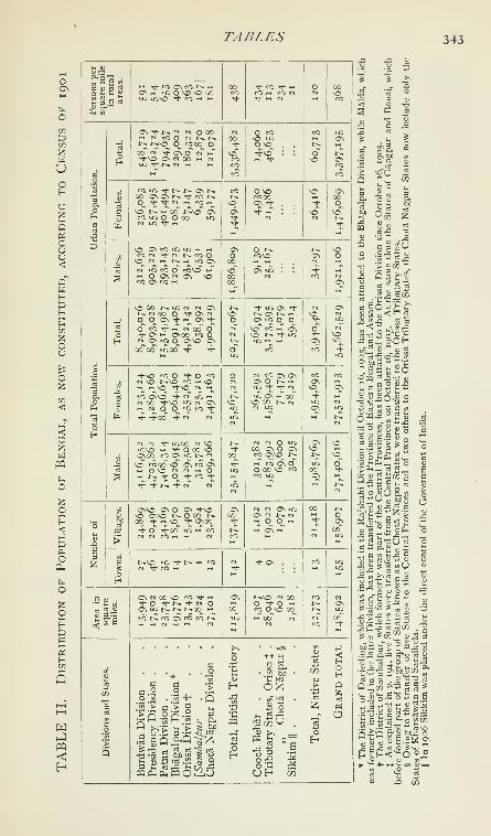
TABLES 343
wUoHO
5p<
oUO<
wH
H
<
wpq
O
oH<:
oPh
o
oHt3P3
sH
h""^
l< u

344 BENGAL

TABLES 345

346 BENGAL
TABLE III
Statistics of Canals in Bengal
Canals.

TABLES 347
TABLE IV
Prices of Stapliss in Bengal
(In seers per rupee)

348 BENGAL
TABLE V
Trade of Bengal with other Provinces and States in India
(In thousands of rupees)

TABLES 349
TABLE VI
Foreign Maritime Trade of Bengal, exclusive of
Government Stores and Treasure
(In thousands of rupees)

35° BENGAL
TABLE VII
Foreign Land Trade of Bengal
(In thousands of rupees)

TABLES 351
•
cost
true-
mile,ands
ees.
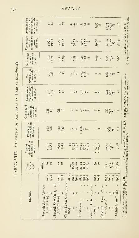
352 BENGAL
S 3 5 =" h C BilU S u "Mc S 32 o o._o
^ ^ o —
r^ t^tp=
u o
S ^ = p"s
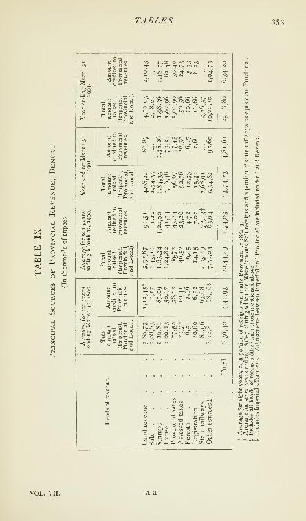
TABLES 353
t—
(
w
<oaWa"
W
S o
u
o

354BENGAL
TABLE X
Principal Heads of Provincial Expenditure, Bengal
(In thousands of rupees)

TABLES 355
TABLE XI
Income and Expenditure of District Boards*,
Bengal

356 BENGAL
TABLE XII
Income and Expenditure of Municipalities*, Bengal,
INCLUDING Calcutta
(In thousands of rupees)

TABLES 357
TABLE XIII
Statistics of Jails, Bengal
11881.
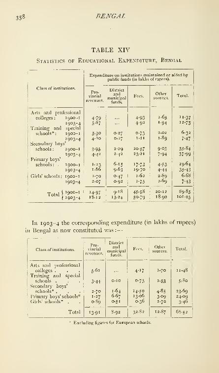
358 BENGAL
TABLE XIV
Statistics of Educational Expenditure, Bengal
Class of institutions.

TABLES 359

360 BENGAL
TABLE XVI
Statistics of Hospitals, Lunatic Asylums, and Vaccination,
Bengal

BERAR 361
Bera.—Village in the Sirajganj subdivision of Pabna District, Eastern
}3engal and Assam, situated in 24° 5'' N. and 89° 38' E., at the junction
of the IchamatI, Baral, and Hurasagar rivers. Population (1901), 1,675,
and including its adjacent hamlets, 5,417. Bera is a market with
a considerable trade, especially in jute, and two European firms have
branches here.
Berar (otherwise known as the Hyderabad Assigned Districts).
—
A province, lying between 19° 35' and 21° 47'' N. and 75° 59' and
79° \\' E., which has been administered by the British Government
on behalf of His Highness the Nizam of Hyderabad since 1853. It
consists of a broad valley running east and west, between two tracts of
hilly country, the Gawllgarh hills (the Melghat) on the north, and the
Ajanta range (the Balaghat) on the south. The old name of the central
valley was Payanghat ; and these three names—Melghat, Payanghat,
and Balaghat—will be used to define the three natural divisions of the
province. The area of Berar is 17,710 square miles.
The origin of the name Berar, or Warhad as it is spelt in MarathT, is
not known. It may possibly be a corruption of Vidarbha, the name of
a large kingdom in the Deccan, of which the modern Berar probably
formed part in the age of the Mahabharata. The popular derivation from
certain eponymous Warhadls, who accompanied Rukmin and Rukmini
to AmraotI when the latter went to pay her vows at the temple of AmbaDevi before her projected marriage to Sisupala, must be set aside as
purely fanciful ; and Abul Fazl's derivation of the name from Wardha,
the river, and tat, a ' bank,' is of no more value.
Berar is bounded on the north by the Satpuras and the Tapti, which
separate it from the Central Provinces ; on the east, where again it
adjoins the Central Provinces, by the Wardha ; along the greater part of its
southern frontier, where it adjoins the Hyderabad State, by the Penganga
;
while on the west an artificial line cutting across the broad valley from the
Satpura Hills to the Ajanta range, and produced southwards over those
hills, separates it from the Bombay Presidency and Hyderabad.
The Gawilgarh hills attain their greatest height along the southern-
most range, immediately overlooking the Payanghat, where the average
elevation is about 3,400 feet, the highest summit
being 3,989 feet. These hills decrease in height asPhysical
they stretch away towards the north, the average
elevation of the range overlooking the Tapti being no more than
1,650 feet. The plateaux of the Balaghat do not attain the height
of the hills of the Melghat, the elevation of Buldana, Basim, and
Yeotmal being only 2,190 feet, 1,758 feet, and 1,583 feet, respectively.
The general declination of the Balaghat table-land is from west to east,
or in the direction of the Wardha river, that of the Gawllgarh hills
being in the contrary direction.

362 BERAR
The principal rivers of Berar are the Tapti, the Purna, 'the
Wardha, and the Penganga. The Tapti runs from east to west and
the Penganga from west to east, each following the general declination
of the range from which it receives its principal affluents. The Wardharises in the Satpuras and flows in a southerly direction, receiving the
Penganga at the south-eastern corner of the province. The Puma,which is a tributary of the Tapti, drains the Payanghat, rising in the
lower slopes of the Gawilgarh hills in Amraoti District, and running
westward through the valley until it leaves the province at the northern-
most corner of the Malkapur taluk. The Penganga rises in the hills
near Deulghat in Buldana District, traverses that District in a south-
easterly direction, and enters the Basim taluk near Wakad. From Yeoti
eastwards it forms the southern boundary of Berar till it meets the
Wardha at Jugad. Its prinicpal tributaries are the Pus, Arna, Aran,
Waghari, KunT, and Vaidarbha, which rise in the Balaghat and flow to
meet it in a south-easterly direction.
The only lake in Berar is the salt lake of Lonar in Buldana District.
The scenery of the Payanghat is monotonous and uninteresting.
The wide expanse of black cotton soil, slightly undulating, is broken
by few trees except babuls and groves near villages. In the autumn
the crops give it a fresh and green appearance ; but after the harvest the
monotonous scene is unrelieved by verdure, shade, or water, and the
landscape is desolate and depressing. The Balaghat is more varied
and pleasing, though here also the country has a parched and arid
appearance in the hot season. The ground is less level and the country
generally is better wooded. It stretches in parts into downs and dales,
or is broken up into flat-topped hills and deep ravines, while in its
eastern section the country is still more sharply featured by a splitting
up of the main hill range, which has caused that variety of low-lying
plains, high plateaux, fertile bottoms, and rocky wastes found in Wiin
District. The scenery of the Melghat is yet more picturesque, the
most striking features of this tract being the abrupt scarps of trap rock
near the summits of the hills, the densely wooded slopes, and the steep
ravines. The undulating plateaux are rarely of great extent.
^ With the exception of the south-eastern corner, comprising a portion
of Wun District, the whole of Berar is covered by the Deccan trap
flows. In the south-eastern corner the trap has been removed by
atmospheric agencies, exposing small patches of the underlying Lameta
beds, and the great Godavari trough of Gondwana rocks, which are let
down into very old unfossiliferous Purana strata, are regarded as pre-
Cambrian in age, and are known in other parts of peninsular India as
Vindhyans, Cuddapahs, &c. The Deccan trap is itself covered with
' From a note supplied by Mr. T. H. Holland, Director of the Geological Survey
of India.

PHYSICAL ASPECTS 363
alluvium in the valley of the Puma. The groups represented in Berar
can be tabulated thus :
—
Alluvium . . . Recent and pleistocene.
Deccan trap . . Upper Cretaceous or lower eocene.
Lameta . . Upper Cretaceous.
Gondwana . . Permo-carboniferous to Jurassic.
Purana . . . Pre-Cambrian.
The old rocks of the Purana group come to the surface on the south-
eastern margin of the great cap of Deccan trap, occupying the border
out to the main boundary of the Gondwana strata. They are covered
by two small isolated patches of Deccan trap—outliers south-east of
Kayar—and with some outliers of Gondwana beds in the Vaidarbha
valley and farther west. In one or two small hills in this corner of the
province the distinction between the Purana sandstones and the much
later sandstones belonging to the Kamptee division of the Gondwanasystem is seen. Yanak hill (1,005 feet) is formed of Purana sandstones,
and several bands of conglomerate occur containing pebbles of hematite,
from which the iron ore formerly made at Yanak was obtained. Shales,
slates, and limestones of the Purana group prevail to the west of the
sandstone bed in Wun District, giving some magnificent sections in the
Penganga and its tributaries.
The Gondwana rocks are especially worthy of notice, on account of
their coal-measures. It has been estimated that about 2,100,000,000
tons of coal are available in Wun District. Direct evidence of the
occurrence of coal has been obtained throughout 13 miles of country
from Wun to Papur, and for 10 miles from Junara to Chincholl. It is
estimated that there are 150,000,000 tons above the 500 feet level
between Junara and ChincholT ; and the existence of thick coal has
been proved in the Barakars which crop out near the Wardha river, in
the south-eastern part of Wun District.
The Deccan trap, with which the greater part of Berar is covered,
was erupted towards the end of Cretaceous times, the volcanic activity
stretching on, probably, into the beginning of the Tertiary period. At
the base, and stretching beyond the fringe, of the Deccan trap, there
is often a fresh-water, or subaerial, formation, composed of clays, sand-
stones, and limestones, representing the materials formed by weathering
or actually deposited in water on the old continent over which the
Deccan lava flows spread.
The hollow containing the lake of Lonar in Buldana District was
probably caused by a violent gaseous explosion long after the eruption
of the Deccan trap, and in comparatively recent times.
An interesting feature of the alluvial deposits in the valley of the
Puma is the occurrence of salt in some of the beds at a little depth
below the surface. Wells used formerly to be sunk on both sides of

364 BERAR
the river for the purpose of obtaining brine from the gravelly layers.
The absence of fossils supports the idea that the salt is not derived
from marine beds, but is in all probability due to the concentration of
the salts ordinarily carried in underground water through the excessive
surface evaporation which goes on in these dry areas for most of the
year ^
2 The Melghat hills are forest-clad, the constituent vegetation being
that characteristic of the Satpuras generally. The most plentiful species
is Boswellia, accompanied by Cochlospermujn, Anogeissus latifo/ia, and
Lagerstroemia pa^-viflora. Where the soil is deeper more valuable
species, such as Tectona grandis, Dendrocalamus strictus^ and, more
sparingly, Hardwickia hinata, are found occupying the valleys and
ravines. Scattered throughout the forest occur Ougeinia dalbergioides,
Adina cordifolia, Stephegyne parvifolia, Terminalia tomentosa^ Schrebera
swietenioides, Eugoiia Jambolana, Bridelia retusa, Terminalia Chebitla;
some heavy creepers, such as Bauhinia Vahlii ; and species of Millettia,
Combretum, Vifis, &c. On lighter gravelly soil, both in Northern and
Southern Berar, forests with Hardwickia bifiafa are met with, Ptero-
carpiis Marsiipium occurs near the edges of most of the high plateaux,
with occasional trees of Dalbergia latifolia.
Where the soil in the Balaghat is thin, the slopes and plateaux are
covered chiefly with Boswellia ; but in deeper soil Anogeissus latifo/ia,
Diospyros ?nelanoxylon, and Terminalia tomentosa are the principal
species. Along river banks considerable quantities of Terminalia
Arjuna and Schleichera trijuga are sometimes met with. In the
bottoms of the ravines are scattered clumps of Dendrocalamus sirictus.
The hills are often bare and grass-clad, the most striking species being
large Andropogons, Anthistirias, Iseilemas, &c. In level tracts, mangoes,
tamarinds, mahuds, and p'lpals abound, with groves of Plwenix sylves-
tris. Stretches of babul jungle are characteristic of the province. In
cultivated ground the weed vegetation is that characteristic of the
Deccan, and includes many small Compositae.
The principal wild animals are the tiger, the leopard, the hunting
leopard, and the wild cat among Felidae. Deer and antelopes are
represented by the sdmbar, the spotted deer, the barking-deer, the
common Indian antelope, the nilgai, the four-horned antelope, and
the chinkdra ; and Canidae by the Indian wolf, the Indian fox, the
wild dog, and the jackal. The striped hyena, the wild hog, and the
Indian black or sloth bear are of frequent occurrence, the last
especially in the Melghat. Monkeys are represented by the langur
' Memoirs, Geological Survey ofIndia, \o\.\.i\i\ Records, Geological Su)-vey of hidia,
vol. i, part iii ; General Neporf of (lie Geological Stir-'ey of India (1902-5).'"' From a note supplied by Major D. I'rain, I. M.S., Director of the Botanical
Survey.

HISTORY 3^5
and the smaller red monkey, the latter being found in the Melghat only,
while the former is common throughout the province.
The climate differs very little from that of the Deccan generally,
except that in the Payanghat the hot season is exceptionally severe.
During April and May, and until the rains set in about the middle of
June, the sun is very powerful, and there is by day severe heat, but
without the scorching winds of Northern India. The nights are
comparatively cool throughout, and during the rains the air is moist
and fairly cool. The climate of the Balaghat is similar to that of the
Payanghat, but the thermometer stands much lower than in the plains.
On the higher plateaux of the Gawllgarh hills, the climate is always
temperate, and at the sanitarium of Chikalda the heat is seldom so
great as to be unpleasant. The following table shows the average tem-
perature, at two representative stations, in January, May, July, and
November :
—
Station.

366 BERAR
The next mention of Vidarbha is in connexion with the famous
Oriental romance of Nala and Damayanti. Nala, Raja of Nishadha
(Malwa), loved Damayanti, the daughter of Bhima, Raja of Vidarbha.
It is unnecessary to pursue this story, which is mainly mythical, through
its intricacies of detail ; but we learn from it that the kingdom of
Vidarbha had for its capital a city of the same name, with which the
city of Bidar in the Nizam's Dominions has been identified. If the
identification be correct, and it is supported by legend as well as by
etymology, we may conclude that the ancient kingdom was far more
extensive than the modern province of Berar. Tradition says that its
kings bore sway over the whole of the Deccan.
The authentic history of Berar commences with the Andhras or
Satavahanas, of whose dominions it undoubtedly formed part. In the
third century B.C., the Andhras occupied the deltas of the Godavari and
Kistna, and were one of the tribes on the outer fringe of Asoka's empire.
Soon after the death of that great ruler their territory was rapidly
enlarged, and their sway reached Nasik. The twenty-third king,
Vilivayakura II (a.d. 113-38), successfully warred against his neigh-
bours, the western Satraps of Gujarat and Kathiawar, whose predecessors
had encroached on the Andhra kingdom. A few years later, however,
the Satraps were victorious and the Andhra rule appears to have come
to an end about 236. The next rulers of the province of whom records
have survived were the Rajas of the Vakataka dynasty, of whom there
were ten. This dynasty was probably feudatory to the Vallabhis, but
their chronology is very uncertain. The Abhiras or Ahirs, who
succeeded the Vakatakas, are said to have reigned as independent
sovereigns for only sixty-seven years ; but Ahir and Gaoli chieftains
continued long afterwards to hold important forts in Berar and the
neighbouring country, giving their names to their strongholds, as in
the case of Gaoligarh in Khandesh, Asirgarh (Asa Ahir Garh) in the
Central Provinces, and Gawilgarh in Berar. The Chalukyas next rose
to power in the Deccan. Their dominions included Berar, and they
reigned until 750, when they were overthrown by the Rashtrakutas, whoruled till 973, when the Chalukyas regained their ascendancy, which
they retained, though not without vicissitudes, for two centuries. Onthe death, in 1189, of Somesvara IV, the last Raja of the restored
Chalukya line, his dominions were divided between the Hoysala
Ballalas of the south, whose capital was Dorasamudra or Dwaravati-
pura', and the Yadavas of Deogiri, the modern Daulatabad, Berar
naturally falling to the share of the latter. Raja Bhillama I, the founder
of this dynasty, established himself at Deogiri in 11 88; and the Yadavas
had reigned with some renown for rather more than a century, when, in
' Halebidi in Hassan District, Mvsore.

HISTORY 3^7
the reign of Ramchandra, the sixth Raja, the Deccan was invaded by
the Musalmans.
In 1294 Ala-ud-din, the nephew and son-in-law of Firoz Shah Khilji,
Sultan of Delhi, invaded the Deccan by way of Chanderi and EUichpur.
After defeating the Yadava Raja Ramchandra, styled Ramdeo by
Muhammadan historians, at Deogiri, he was attacked by the Raja's
son, whom also he defeated. He was then bought out of the country
by a heavy ransom, which included the cession of the revenues of
EUichpur, the district remaining under Hindu administration. On his
return to Hindustan Ala-ud-din murdered his uncle at Kara and usurped
the throne. Throughout his reign he dispatched successive expeditions
into the Deccan, but in the confusion which followed his death in 1316
Harpal Deo of Deogiri rose in rebellion. He was defeated by Kutb-
ud-din Mubarak Shah I in 13 17-8, and was flayed alive, his skin being
nailed to one of the gates of Deogiri. His dominions were annexed to
the Delhi empire, and thus Berar for the first time became a Muham-
madan possession, which it has remained ever since. Berar gained
considerably in importance during the reign of Muhammad bin
Tughlak of Delhi, who in 1327 transferred the capital of his empire from
Delhi to Daulatabad (Deogiri). In the latter years of this emperor's
reign the Amirs of the Deccan rebelled, and in 1348 Hasan Gangu,
Zafar Khan, was proclaimed Sultan of the Deccan under the title of
Ala-ud-din Bahman Shah^Ala-ud-din Bahman, shortly after he had ascended the throne, divided
his kingdom into four provinces or tarafs^ of which Berar, which
included Mahur, Ramgarh, and Pathri, was the northernmost. During
the next 130 years Berar furnished contingents in the innumerable wars
waged by the Bahmani kings against the Rajas of Vijayanagar, Telin-
gana, Orissa, and the Konkan, the Sultans of Gujarat, Malwa, and
Khandesh, and the Gonds. It was overrun by Musalmans from the
independent kingdoms on its northern frontier, by Gonds from Chanda,
and by Hindus from Telingana. Ahmad Shah Wall, the ninth king of
the Bahmani dynasty, found it necessary to recapture the forts of Mahur
and Kalam in Eastern Berar, which had fallen into the hands of the
infidels. In 1478 or 1479 Berar, which had hitherto been an impor-
tant province with a separate army and governed by nobles of high rank
and position, was divided into two governments, each of which was
known by the name of its fortress capital, the northern being called
Gawil and the southern Mahur. At the same time the powers of the
provincial governors were much curtailed, all important forts being
placed under the command of klladdrs, who were immediately sub-
ordinate to the Sultan.
' Most historians have erred in respect of the title under which Bahman ascended
the throne. His correct title is given as above in a contemporary inscription.

368 BERAR
These salutary reforms came too late to save the Bahmani dynasty
from ruin ; and in the reign of the fourteenth Sultan, Mahmud Shah II,
the principal iarafddrs, or provincial governors, proclaimed their
independence. Imad-ul-mulk, who had formerly been governor of the
whole of Berar and now held Gawil, proclaimed his independence in
1490 and soon annexed Mahur to his kingdom. He was by race
a Kanarese Hindu, who had been made captive as a boy in one of the
expeditions against Vijayanagar and brought up as a Musalman by the
governor of Berar, to whose place he ultimately succeeded. Imad-ul-
mulk died in 1504 and was succeeded by his son Ala-ud-din Imad Shah,
who made Gawilgarh his capital and waged fruitless war against Amir
Barid of Bidar and Burhan Nizam Shah of Ahmadnagar. Ala-ud-din
was succeeded on his death in 1529 by his son Darya Imad Shah, and
he, after a peaceful and uneventful reign, by his son Burhan Imad Shah
( 1560-1). This prince, shortly after his accession, was imprisoned in
Narnala by his minister, Tufal Khan, who declared himself independent.
In 1572 Murtaza Nizam Shah of Ahmadnagar invaded Berar with the
avowed intention of releasing Burhan from confinement. Tufal Khan,
his son Shams-ul-mulk who had surrendered Gawilgarh, and Burhan
were captured shortly afterwards, and were imprisoned and put to
death. Thus ended the rule of the Imadshahi dynasty in Berar, after
a duration of eighty-five years.
The Ahmadnagar dynasty was not long destined to hold possession
of the prize. At home it could do nothing to quell civil broils and allay
dangerous feuds. Even when the famous Chand Bibi became queen-
regent there was no chance of upholding a tottering state. In 1595
Sultan Murad, the fourth son of the emperor Akbar, besieged Ahmad-
nagar, but raised the siege, early in 1596, on receiving the formal
cession of Berar.
In those times the Deccan swarmed with adventurers from every
nation in Asia and even from the African coast of the Indian Ocean.
These men and their descendants settled in the towns, and their chiefs
occupied most of the high military and civil offices ; but the Musalman
rulers of the Deccan did nothing to disturb the routine of ordinary
revenue collections and the administration of the internal affairs of
villages and parganas, so that the old Hindu organization, with its
hereditary /ar^'-a^a and village officials, the relic, perhaps, of a civiliza-
tion older still, was allowed to remain, recognized by the conquerors as
a more convenient administrative machine than any which they could
devise. There are now in Berar several Muhammadan families of
deshmukhs (former pargana officials) ; but they are all believed, and for
the most part admit themselves, to be descendants of Hindus who in
the reign of Aurangzeb accepted Islam in preference to relinquishing
their hereditary offices. They may be distinguished from other Musal-

HISTORY 369
mans by their antipathy to beef, and frequently by a partiality for
Hindu names, while in one case there are in neighbouring /(7r^rt';/rt'i" two
families of deshmukhs, one Musalman and the other Hindu, acknow-
ledged cousins, both of them claiming to be Rajputs by caste. Of the
principal Maratha families enumerated by Grant Duff as holding goodpositions under the Bahmani monarchy, that of Jadon Rao is the only
one belonging to Berar. In lineage and historical repute it yields to
none, even if its claim to descent from the Yadava Rajas of Deogiri be
discredited ; and the line is not yet extinct.
Sultan Murad, after the annexation of Berar to the Mughal empire,
founded a town about 6 miles from Balapur, which he named Shahpur,
making it his residence ; and the newly won province was divided
among the Mughal nobles. After Murad's death in 1598 Akbar formed
the design of conquering the whole of the Deccan. Ahmadnagar was
besieged and captured ; and Daniyal, the emperor's fifth son, was
appointed governor of Ahmadnagar, Khandesh, and Berar. He died
in 1605, in the same year as his father, Akbar. For the greater part
of the reign of Jahanglr, Ak bar's son and successor, Berar was in the
possession of Malik Ambar, the Abyssinian (died 1626), who repre-
sented the independence of the moribund dynasty of Ahmadnagar, and
to whose military genius and administrative capacity a generous tribute
is paid in the TTizak-i-/akd>igJrI, the official record of Jahangir's reign.
In the first year of Shah Jahan, Berar passed once more under the
Mughal sway. In 1636 the whole of that part of the Deccan which
was in the possession of the Mughals was divided into four SFibahs, or
provinces, one of which was Berar, with EUichpur as its capital and
Gawilgarh as its principal fortress. Aurangzeb, Shah Jahan's third son,
was appointed viceroy of these four Subahs. After Aurangzeb deposed
his father, the resources of Berar were taxed to the utmost by his cam-
paigns in Bijapur, Golconda, and Southern India, and at the same time
the province was the prey of Maratha marauders. In 1680 it was over-
run by Sambhajl, the son of SivajT; and in 1698 Rajaram, the half-
brother and successor of Sambhajl, aided by Bakht Buland, the GondRaja of Deogarh, who had embraced Islam in order to obtain
Aurangzeb's support, again devastated the province.
In 1 718 Abdullah and Husain All Khan, the Saiyid ministers of the
emperor Farrukh Siyar, formally recognized the claim of the Marathas,
who periodically overran Berar, to chaufh, or blackmail, to the extent
of one-quarter of the revenue, and also permitted them to levy from the
ryots the contribution known as sardes/mnikki, which seems to have
been a royalty on appointments to or recognitions of the old Hinduoffice of deshmukh, and amounted to 10 per cent, of the revenue
collections.
A year later Muhammad Shah ascended the throne of Delhi, but the
VOL. VII. B b

370 BERAR
government was still in the hands of the two Saiyids. Chin Killj Khan,
afterwards known as Asaf Jah, who had distinguished himself in the
later wars of Aurangzeb, had been appointed viceroy of the Deccan
under the tide of Nizam-ul-mulk, but was opposed by the court party at
Delhi, who sent secret instructions to Mubariz Khan, governor of Khan-
desh, urging him to withstand Asaf Jah by force of arms. In 1724
a battle was fought at Shakarkhelda in Buldana District, in which
Mubariz Khan was utterly defeated. This battle established the virtual
independence of Asaf Jah, the founder of the line of the Nizams of
Hyderabad, who, to celebrate his victory, renamed the scene of it
Fathkhelda, or 'the village of victory'; and from that day Berar has
always been nominally subject to the Nizam. The Bhonsla Rajas of
Nagpur posted their officers all over the province ; they occupied it
with their troops ; they collected more than half the revenue, and they
fought among themselves for the right to collect ; but the Nizam con-
stantly maintained his title as de jure ruler of the country, with the
exception of Mehkar and some parganas to the south, which were ceded
to the Peshwa in 1760 after the battle of Udgir, and Umarkhed and
o\h&c parganas ceded in 1795 ^^^^^ ^^ battle of Kardla. This struggle
between Mughal and Maratha for supremacy in Berar commenced in
1737 between Asaf Jah and Raghuji Bhonsla. It ended in 1803,
when, after the defeat of the Maratha confederacy at Assaye and
Argaon, and the capture of GawTlgarh by General Arthur Wellesley,
the Bhonsla Raja signed a treaty by which he resigned all claim to
territory and revenue west of the Wardha, Gawilgarh and Narnala, with
a small tract of land afterwards exchanged, remaining in his possession.
The injury caused to Berar by the wars of the eighteenth century
must have been wide and deep. Described in the Ain-i-Akbari as
highly cultivated and in parts populous, supposed by M. de Thevenot
in 1667 to be one of the wealthiest portions of the Mughal empire, it fell
on evil days before the close of the seventeenth century. Cultivation
fell off just when the finances were strained by the long wars; the
local revenue officers rebelled ; the army became mutinous ; and
the Marathas easily plundered a weak province when they had severed
its sinews by cutting off its trade. Wherever the Mughals appointed
a collector the Marathas appointed another, and both claimed the
revenue, while foragers from each side exacted forced contributions,
so that the harassed cultivator often threw up his land and helped to
plunder his neighbour. The Marathas by these means succeeded in
fixing their hold on the province ; but its resources were ruined, and its
people were seriously demoralized by a regime of barefaced plunder
and fleecing without the semblance of principle or stability.
By the partition treaty of Hyderabad (1804) the Berar territories
ceded by the Bhonsla Raja were made over to the Nizam. Some

HISTORY 371
tracts about Sindkhed and Jalna were also restored by Sindhia to the
Hyderabad State.
The Treaty of Deogaon had put a stop to actual warfare in Berar, but
the people continued to suffer intermittently from the inroads of Pin-
daris, and incessantly from misgovernment ; for the province had been
restored to the Nizam just at the time when confusion in his territories
was at its worst. ' The Nizam's territories,' wrote General Wellesley in
January, 1804, 'are one complete chaos from the Godavari to Hyder-
abad ' ; and again, ' Sindkhed is a nest of thieves ; the situation of this
country is shocking ; the people are starving in hundreds, and there is
no government to afford the slightest relief.'
After the conclusion of the war of 181 7-8, which did not seriously
affect the tranquillity of Berar, a treaty was made in 1822 which fixed
the Wardha river as the eastern frontier of the province, the Melghat
and the subjacent districts in the plains being restored to Hyderabad
in exchange for the districts east of the Wardha and those held by the
Peshwa. The treaty also extinguished the Maratha claim to chauth.
Between 1803 and 1820 the revenue of Berar had declined by one-
half owing to the raids of Pindaris and Bhils, while the administration
was most wasteful, no less than 26,000 troops being quartered on the
province. General A\'ellesley had advised in 1804 that the local gover-
nor should be compelled to reform his military establishment, foretelling
the aggravation of civil disorder by the sudden cessation of arms. Thedisbanded troops were too strong for the weak police, while the spread
of British dominion established order all around, and drove all the
brigands of India within the limits of Native States. So Berar was har-
ried from time to time by bands of men under leaders who on various
pretexts, but always with the real object of plunder, set up the standard
of rebellion. Sometimes the British irregular forces had to take the
field against them, as, for instance, in 1849, when a man styling himself
Appa Sahib Bhonsla, ^.v-Raja of Nagpur, was with difficulty captured.
Throughout these troubles the Hindu deshmukhs and other pargafia
officials were openly disloyal to the Nizam's government, doing their
best to thwart his commanders and abetting the pretenders. Thelast fight against open rebels took place at Chichamba, near Risod,
in 1859.
After the old war-time came the 'cankers of a calm world,' for then
began the palmy days of the great farmers-general at Hyderabad.
Messrs. Palmer & Co. overshadowed the Government and very nearly
proved too strong for Sir Charles Metcalfe when he laid the axe to the
root of their power. The firm had made large loans at 24 per cent, for
the numerous cavalry maintained in Berar. Then Puran Mai, a great
money-lender of Hyderabad, got most of Berar in farm; but in 1839
he was turned out, under pressure from the Resident, in favour of
B b 2

372 BERAR
Messrs. PestonjI & Co. These were enterprising Parsi merchants, whoin 1825-6 made the first considerable exportation of cotton from Berar
to Bombay. They gave Hberal advances to cotton-growers, set up
presses at Khamgaon and other places, and took up, generally, the
export of produce from the Nizam's country. In 1841 Chandu Lai,
the Hyderabad minister, gave them large assignments of revenue in
Berar in repayment of loans to the State; but in 1843 the minister
resigned, having conducted the State to the verge of bankruptcy, and
PestonjI was subsequently forced to give up his Berar districts.
All these proceedings damaged the State's credit, as Chandu Lai's
financing had hampered its revenue; and in 1843 and several succeed-
ing years the pay of the Irregular Force maintained under the treaty of
1800 had to be advanced by the British Government. In 1850 it had
fallen again into heavy arrears, and in 1853 the debt due to the Bri-
tish Government on account of this pay and other unsatisfied claims
amounted to 45 lakhs. The bankruptcy of the State disorganized the
administration, and the non-payment of the troops continued to be a
serious political evil. Accordingly, in 1853, a new treaty was concluded
with the Nizam, under which the Hyderabad Contingent was to be
maintained by the British Government, while for the payment of this
force, and in satisfaction of the other claims, districts yielding a gross
revenue of 50 lakhs were assigned to the Company. The Berar dis-
tricts 'assigned' by this treaty are now popularly understood to form
the province of Berar, which was administered on behalf of the Govern-
ment of India by the Resident at Hyderabad, though they coincide in
extent neither with the Berar of the Nizams nor with the imperial Subah.
The territory made over under this treaty comprised, besides Berar, the
districts of Dharaseo and the Raichur Doab. It was agreed that ac-
counts should be annually rendered to the Nizam, and that any surplus
revenue should be paid to him. His Highness was released from
the obligation of furnishing a large force in time of war, and the Con-
tingent ceased to be a part of his army, and became an auxiliary force
kept up by the British Government for his use.
The provisions of the treaty of 1853, which required the submission
of annual accounts to the Nizam, were, however^ productive of muchinconvenience and embarrassing discussions. Difficulties had also arisen
regarding the levy of customs duties under the commercial treaty of
1802. To remove these difficulties, and at the same time to reward
the Nizam for his services in 1857, a new treaty was concluded in i860,
by which a debt of 50 lakhs due from him was cancelled ; and he also
received the territory of Surapur, which had been confiscated for the
rebellion of the Raja, and the districts of Dharaseo and Raichur
were restored to him. On the other hand, he ceded certain districts
on the left bank of the Godavari, traffic on which river was to be free
HISTOR V 373
from all duties, and agreed that Berar should be held in trust for the
purposes specified in the treaty of 1853.
The history of Berar from 1853 to 1902 is marked by no important
political events other than the changes made by the treaty of i860. Its
smooth course was scarcely rufitled even by the cyclone of 1857. AV^hat-
ever secret elements of disturbance may have been at work, the country
remained calm, measuring its behaviour not by Delhi, but by Hyderabad.
In 1858 Tantia Topi got into the Satpura Hills, and tried to breakaway
to the south that he might stir up the Deccan, but he was headed at all
outlets and never reached the Berar valley.
The management of Berar by the Nizam's officials had been worse
than the contemporary administration of the adjoining Nagpur territory,
which was, during a long minority, under British regency, and was
subsequently well governed until it lapsed. There had consequently
been wholesale emigration from Eastern Berar to the Districts beyond
the Wardha. When Berar came under British management the
emigrants, with the usual attachment of Indian cultivators to their
patrimony, the value of which had in this case been enhanced by muchof it having remained fallow for some time, returned in thousands to
Berar. This was only one mode out of several, which it would be
tedious to detail, whereby cultivation was restored and augmented.
Then supervened the American Civil War. The cultivation of cotton
received an extraordinary stimulus, the cultivators importing their
supply of food-grains so that all available land might be devoted to the
cultivation of the more profitable crop. Cotton requires much manual
toil in weeding, picking, ginning, packing and the like, and the increase
in the area under it created a great demand for rural labour, which
operated to raise the standard of wages. A great export of cotton
to Bombay was soon established ; and as the importation of foreign
produce was far from proportionate, much of the return consisted of
cash and bullion, so that prices rose and the labouring and producing
classes were rapidly enriched. At the same time a line of railway was
being laid across the province, causing the employment of all labour,
skilled and unskilled, that could be got on the spot, and also in-
troducing a large foreign element. The people became prosperous
and contented, and progress in all departments was vast and
rapid.
The Census Report of 188 1 showed material advance. The cultivated
area had increased by 50 per cent, and the land revenue by 42 per cent,
since 1867. But although Berar escaped the widespread famine of
1876-8, the poorer classes undoubtedly suffered much hardship at that
time, and cattle died by thousands for want of fodder. The next ten
years were, on the whole, prosperous, though cholera, which generally
appeared in an intense form every other year, caused great mortality.

374 BERAR
There was, however, an increase in trade, cultivation, and manufactures,
and the population rose by 8 per cent. The ten years preceding 1901
were not, owing to natural causes, marked by a general increase in
prosperity, but the province displayed considerable stability and powerof resistance. There was but one year in the decade, 1898, which could
be described as very favourable, and even then the 7-abi crops partially
failed. The other nine years were marked by unseasonable or deficient
rainfall, poor harvests, sickness, and high mortality, culminating in
1899 and 1900, when famine was sore in the land. The population
decreased by 5 per cent, during the decade. But, notwithstanding all
this, other statistics show steady progress and development. Cultivation
has extended ; the value of the import and export trade has increased
;
and the number of steam factories has risen by 84 per cent.
It had gradually become apparent since i860 that the maintenance
of the Hyderabad Contingent on its old footing as a separate force
was inexpedient and unnecessary, and also that the administration of
so small a province as Berar as a separate unit was very costly. In 1902,
therefore, a fresh agreement was entered into with the Nizam. This
agreement reaffirmed His Highness's rights over Berar, which, instead
of being indefinitely ' assigned ' to the Government of India, was leased
in perpetuity on an annual rental of 25 lakhs ; and authorized the
Government of India to administer the province in such manner as it
might deem desirable, as well as to redistribute, reduce, reorganize, and
control the Hyderabad Contingent, due provision being made, as stipu-
lated in the treaty of 1853, for the protection of His Highness's
dominions. In pursuance of this agreement the Contingent ceased,
in March, 1903, to be a separate force, and was reorganized and
redistributed as an integral part of the Indian army.
In October, 1903, Berar was transferred to the administration of the
Chief Commissioner of the Central Provinces. For the present the
rental paid to the Nizam is charged with an annual debit of 10 lakhs,
towards the repayment of loans made by the Government of India for
famine expenditure in Berar and for famine and other expenditure in
the Hyderabad State. When these loans have been repaid, the Nizamwill receive the full rent of 25 lakhs. The advantages secured to himby the new agreement are manifest, His rights over Berar have been
reaffirmed, and he will receive 25 lakhs per annum, compared with
a sum of between 8 and 9 lakhs which was the average surplus paid to
him under the former treaties.
The principal remains of archaeological or historical interest in Berar
are the small cave monastery and the shrine of Shaikh Baba at Patur;
the chhatri of Raja Jai Singh and the fort at Balapur ; various massive
stone temples attributed to the era of the Yadava Rajas of Deogiri, and
locally known as Hemadpanti temples, in the Chalukyan style ; some

POPULATION 375
Jain shrines, particularly that at Sirpur ; the hill forts of GawIlgarhand Narnala; and the mosques at Fathkhelda and Rohankhed.The principal Hemadpanti temples are those at Lonar, Mehkar,Bars! Takli, and Pusad, but many others are scattered throughout
the province.
The population of Berar in 1901 was 2,754,016, or 155 persons per
square mile. The distribution varies in accordance with the natural
advantages of the three divisions of the province.
Thus the density in the twelve taluks of the Payan-
ghat varies from 150 to 311 persons per square mile, and that of the
nine taluks of the Balaghat from 85 to 150, while the population of the
Melghat is very sparse, the density being no more than 22 persons per
square mile.
The table on the next page shows the population of the six Districts
of the province in 1901. In 1905 the six Districts were rearranged;
Ellichpur, Wun, and Basim have been abolished, and a new District
of Yeotmal has been formed. The present distribution of area and
population will be found in the several District articles.
The term ' village ' denotes in Berar the area demarcated for revenue
purposes as a inauza or kasba, mazras or hamlets being reckoned for
census purposes as part of the principal village. The term ' town
'
includes every municipality and civil station and villages with a popu-
lation of 5,000 or more. The villages are agricultural communities,
each with its hereditary officers and servants, the former paid by a per-
centage on collections and the latter by customary dues in kind. The
gaothiln, or village site, on which the houses are collected together,
is not surrounded by a wall ; but each village has its garhl, or fort,
usually of earth, in which the village officers possess hereditary rights,
but which was formerly used as a place of refuge by the whole
community in troublous times.
The first Census of Berar, which was taken in 1867, disclosed
a total population of 2,227,654. By 1881 this had increased to
2,672,673, and by 1891 to 2,897,491. The Census of 1901 showed
a decrease to 2,754,016, or by 4-9 per cent., due to the famines of
1896-7 and 1899-1900, and to abnormally high mortality from disease
in the years 1894-7 and 1900. One feature of the decade was the
gravitation of an unusually large proportion of the. people towards
the towns, the percentage of urban population to the whole being
15-2 in 1901, compared with i2'5 in 1881.
The deductions to be drawn from the age statistics in the Report on
the Census of 190 1 may be thus summarized : infant mortality is greatest
between the ages of one and two ; the mortality among children born
in the first half of the decade ending 1901 was considerably less than that
among children born in the second half, the difference being attributable

376 BERAR
Ka;Ui
ofin
Oiz:
oHt3
1«; «

POPULATION 377
to the harder conditions of hfe in the second quinquennium ; there is
a general tendency to understate the age of marriageable girls ; the last
(|uinquennial period of life exhibited in the tables (55-60) is the most
fatal ; and famine and disease have principally affected the youngest
and the oldest of the females, and the youngest and those over thirty
among the males.
The registration of births and deaths is carried out with greater
accuracy in Berar than in most of the Provinces of British India proper,
though the entire population is not under registration. The following
table shows the birth and death-rates and the principal fatal diseases
in 1881, 1891, 1901, and 1903:
—

378 BERAR
commercial element in a tdluk^ the less is the proportion of females
to males.
The following table gives statistics of civil condition for 1891 and
1901 :
—
Civil
condition.

POPULATION 379
District on the banks of the Penganga. The only important Mundalanguage is Korku, spoken by the Korkus in the Melghat and its
neighbourhood. Nihali is a moribund language of uncertain affinities,
returned as the mother-tongue of 91 Nihals, who, however, probably
speak Korku, defining it as Nihali. English was returned as the
mother tongue of 653 persons.
In this small province nearly four hundred castes and tribes are
represented. The three chief groups coincide generally with the main
religious divisions, Hindu, Muhammadan, and Animistic. Musalmanscall for little notice in this connexion. Many of them are descendants
of converted Hindus. Shaikhs number 131,000; Pathans, 52,000;
Saiyids, 19,000; and Mughals, 4,000.
The Kunbis, the great cultivating caste of the Provinces, are the
most important of the Hindu castes. They number 791,000, and pre-
dominate in every taluk except the Melghat. Very similar to them in
all respects are the Mails, numbering 193,000. The Kunbi is usually
of medium height, dark-skinned from exposure, and wiry. As a
cultivator he is moderately industrious, but devoid of enterprise and
intelligent energy. Next to the Kunbis the Mahars, numbering
351,000, are the most numerous caste. The Mahar occupies an
important, if humble, place in the village system of the Deccan.
Socially he is regarded as an unclean outcaste whose touch is pollution.
Similar to the Mahars, but even more unclean, are the Mangs,
who number 49,000. Other numerically important castes are : Telis
(77,000), Dhangars (75,000), Brahmans (73,000), Banjaras (60,000),
Warns (41,000), and Rajputs (36,000). The indigenous Rajputs are
not favourable specimens of their class, and it is doubtful whether
their claim to pure descent would be admitted in Rajasthan.
The two principal aboriginal tribes are the Gonds and the Korkus,
the former ordinary Dravidian and the latter Munda. The Gonds
number 69,000, or, if the cognate Kolams and Parahans be included,
96,000. They are very dark and usually slight and undersized, though
exceptions are found among the division known as Raj Gonds. TheKorkus number 26,000, and have their home in the north of the
province among the GawTlgarh hills. Their physique is superior to
that of the Gonds, and they are well-built and muscular, but their
personal appearance is not pleasing. They are distinguished princi-
pally by their small eyes, large mouths, flat noses, and large and
prominent ears.
The table on next page gives statistics for religions in 1891 and
1 90 1. Hindus constituted 86-7 per cent, of the total population
in the latter year. Since 1891 Hindus have lost absolutely 143,775
persons, Musalmans have gained 4,359, and Animists have lost 7,144.
All other religions, the followers of which are not numerous, have

38o BERAR
gained in all 3,085. There has been a large increase in Sikhs, which
is rather apparent than real, as it is attributable solely to more correct
enumeration. The increase among Musalmans seems to have been due
partly to their superior fecundity and partly to proselytizing efforts.

POPULATION 381
Agriculture supports 73 per cent, of the population, and of every
100 persons so supported 71 are workers. The preparation andsupply of material substances provide a living for i\ per cent, of the
people, the principal sub-orders under this head being, in the order of
their importance, (i) cotton; (2) textile fabrics and dress
; (3) food, drink,
and stimulants; (4) wood, cane, and leaves. Commerce supports 2\ per
cent,, and unskilled labour, not agricultural, nearly 2 per cent.
The food of the agricultural and labouring classes consists chiefly of
unleavened cakes oijowar (great millet) meal, with a seasoning of green
vegetables, onions, ghl, chillies, or pulse, or a combination of two or
more of these. Milk is an important article of diet ; wheat and rice are
luxuries. Goat's flesh is extensively eaten by Musalmans, and less so
by those Hindus to whom flesh is not forbidden as an article of diet.
Few Musalmans, except those living in towns and in some of the larger
villages, eat beef. It is necessary for those in smaller villages to respect
the prejudices of their Hindu neighbours, many of which they have
adopted. The Mahars, who are scavengers, are habitual eaters of beef
in the form of carrion.
The ordinary dress of the cultivator or labourer consists of a dhoti
a short jacket, an jtparna or upper cloth, and a red or white turban,
the former being the favourite colour. The jacket is often discarded.
Brahmans and other respectable castes wear long coats, and finer
uparnas and turbans. Musalmans frequently, though not invariably,
substitute /^r/;«wfl'j and a long coat for the dhoti and short jacket, andtheir turbans display a greater variety of colour. The dress of the
women consists of a lugade and a chol'i. The former is the principal
garment and corresponds to the sdri, being tied round the waist ; the
long end is taken over the head, and the front of the portion forming
the skirt is carried back between the legs and tucked in at the waist
behind, giving the wearer a singularly bunchy and ungraceful appear-
ance. The choll is a scanty bodice which confines the breasts.
Muhammadan women often wear the common combination of trousers,
shift, or choVi, and scarf, which is tied round the waist and carried over
the head. Gond and Kolam women do not wear the choli, but conceal
the breasts by drawing the end of the lugade across them. The dress
of the Banjara women is especially picturesque.
The dwelling-houses of the agricultural classes are mostly of sun-
dried brick roofed with thatch or tiles. Dhdbds, or flat roofs of earth,
are also common. The houses of labourers consist of one or two rooms,
with a small dngan or yard enclosed by a mud wall in front of the
house. The houses of the well-to-do are more pretentious, consisting of
several rooms opening into a rectangular courtyard, along one side
of which the cattle are usually stalled. The poorest classes live in huts
of hurdles or grass mats daubed with mud. In the early part of the hot

382 BERAR
season, while the grain is being threshed and garnered, cultivators move
with their cattle into their fields, where they live in spacious sheds in
the vicinity of their threshing-floors.
The higher castes among the Hindus burn their dead ; Musalmans,
Hindus of the lower castes, and aboriginal tribes bury them. TheKorkus erect posts of teak, curiously carved, at the heads of graves.
Among the Mahanubhavas and some other orders of ascetics the dead
are buried in salt, in a sitting posture.
The tastes of the agriculturist are principally domestic ; he has few
amusements beyond his family circle except the enjoyment of village
gossip, a weekly trip to the nearest market village, an occasional visit to
dijalra or religious fair, or, more rarely, a pilgrimage to a shrine of more
than local celebrity.
The principal festivals observed are the Mandosi, the Akshayyatritya,
the Nagapanchami, the Pola, the Mahalakshmi, the Pitrapaksha, or
feast to manes of male ancestors, the Dasara, the Divali, the Sivaratri,
and the Shimga or Holi. The three most important feasts to the
cultivator are the Holl, the Pola, and the Dasara ; and at these burn-
ing questions of social precedence, often ending in criminal complaints,
arise between different branches of the families oipatels or hereditary
headmen of villages. At the Pola festival the plough cattle are wor-
shipped. A rope called toran is then stretched across two upright poles,
and the cattle of the villagers, gaily decorated, are led beneath it,
headed by those belonging to members of \\\q. pateFs family in the order
of their seniority.
Hindus of all castes in Berar have three names. The first is the
personal name and corresponds to the Christian name of a European,
the second is the father's personal name, and the third is the family
surname. Thus Ganpat Raoji Sindhya would be Ganpat, the son of
,Raoji, of the Sindhya family or clan.
The three natural divisions of Berar have already been described.
The Melghat or northern division is extremely rugged, and is broken
into a succession of hills and deep valleys. Thehilly portion consists of basaltic and calcareous rock,
and the soil in the valleys and ravines is a light brown alluvium, over-
lying basalt accumulated from superficial rainwash from the hills. This
light-brown soil, extending to about 8 or 10 miles from the foot of
the hills towards the valley of the Purna, is cultivable, but is less rich
than the soil of the valley itself. The Balaghat, or southern division,
is formed of undulating high land of the Deccan trap. The plateaux
are covered with fairly rich soil, and the soil of the intermediate valleys
is an alluvium (;f loam of remarkably fine quality and very suitable
fi)r wheat.
The Payanghat, or central valley of Berar, contains the best land in

AGRICUL TURK i?>z
the province : a deep, rich, black, and exceedingly fertile loam, often of
great depth, with very thick underlying strata of yellow clay and lime.
Where this rich soil does not exist, as in the immediate vicinity of hills,
muriun and trap are found with a shallow upper crust of inferior light
soil. A great deal of the Puma alluvium produces efflorescences,
chiefly of salts of soda, and many of the wells sunk in this tract have
brackish water. The climate of Berar has already been described. It
may be briefly characterized as intensely hot and dry in the months of
March, April, and May, and temperate for the rest of the year, with
moderate rainfall between June and October.
Cotton, jowdr (great millet), tiiar (pulse), and sesamum are the
kharlf or monsoon crops ; and wheat, linseed, and gram the principal
rain or cold-season crops. In 1903-4, of the total area cropped, nearly
87 per cent, was devoted to kharlf ^nd 13 per cent, to rain, only-J
per
cent, being irrigated.
The areas sown with kharif and rain crops vary according to the
rainfall and market prices, and their extent is also partly regulated by
the system of rotation of crops in vogue. If the rains begin well in
June, a large area is sown with kharif, but if they are late more land is
kept for rabi. Thus in 1891, 1,390 square miles were sown with wheat,
the principal rabi crop, while in 1903-4, after several years of in-
adequate late rains, the area so sown had fallen to 710 square miles.
The cultivator generally commences the preparation of his field in
January. The rich black soil of the plains is not worked with the
?idngar or heavy plough for several years together, unless it should be
overgrown with grass or weeds ; but the lighter soil of the upland
country is ploughed nearly every year, especially when the land is
reserved for a rabi crop. Ploughing is generally commenced soon after
the crop of the year has been removed from the ground ; if it be
deferred longer, the soil dries and hardens and becomes difficult to
work. Land that has been lying follow cannot be ploughed until the
first monsoon rain has fallen. Parallel furrows are not considered
sufficient for hard soil, which is therefore cross-ploughed, the second
operation being at right angles to the first. Harrowing succeeds, or, in
the case of fields which do not require ploughing every year, takes the
place of ploughing. The first harrowing is done with the moghada, a
large, heavy harrow drawn by four bullocks. This turns up the earth
in large clods, and brings roots, grass, and weeds to the surface. Thesoil is then cross-harrowed with the wakhar, a lighter implement drawn
by two bullocks, which breaks up the clods and cleans the soil. In
some cases the soil is harrowed again at intervals of a few days, in order
that it may be thoroughly levelled and pulverized. The MarJ/" sowings
take place immediately after the first regular monsoon fall of rain in
June, and the rabi sowings in September or October.

384 BERAR
Weeding is commenced when the soil dries during the first break in
the rains. It is done with the daora, a two-bladed hoe which is drawn
by two bullocks, and removes the weeds from two of the interstices
between the rows of plants at once, the weeds growing among the plants
being removed by hand. Three or four weedings in a season are
generally considered sufficient, but the more industrious cultivators
often use the hoe every fortnight until the crop is sufficiently strong to
smother all surface weeds.
Cotton pods are usually ready for picking about the end of October,
and this light work is generally done by women and children. Pay-
ment is, as a rule, made in kind, each labourer receiving from one-
twelfth to one-eighth of the day's picking. From the short staple
variety of cotton which the Berar cultivator now grows he can obtain, if
the crop is good, from five to seven pickings at intervals of fifteen or
twenty days ; but the superior />ani and Jari varieties, the latter of
which is now extinct in Berar, will not yield a second picking under a
month, and the crop is generally exhausted in three pickings. The
cultivator finds that the short staple is easier to raise and pays him just
as well, for although he gets a lower price the crop is more plentiful.
Before the establishment of ginning factories in the province almost
every cultivator had his own seed for sowing cleaned by hand. Ginning
by steam-power was first introduced in 1887-8, in which year there were
only four factories working. In 1901 these had increased to 121, and
there is every prospect of a further development of this industry.
Joivar ripens early in December, and is reaped by men, the ears
being afterwards separated from the stalks by women. The stalks,
called kadba or kadbi, are stacked, and 'furnish the principal fodder-
supply for cattle. The ears are conveyed to the threshing-floor, where
bullocks tread out the grain, moving round a central pole. Six bullocks
can thresh a hhandi (about 14 cwt.) in two days. The threshed grain
is winnowed in a breeze. One man stands on a tripod, while another
hands up to him a basketful of grain from the threshing-floor. As he
slowly empties the basket, the chaff is carried away by the wind and the
grain falls to the ground.
Of the total population of Berar in 1901, 73-2 per cent, were
supported by agriculture. The figures are as follows :
—
Persons interested in land, landholders, tenants, co-sharers, &c. . 561,912
Agricultural labourers, &c. 1,452,221
Growers of fruit, vegetables, &c. 58')
Total 2,014,719
The principal crops in the order of their importance are cotton,
jowi'tr, wheat, linseed, gram, titar or ar/inr, and sesamum. Jo2vdr and
wheat are the staple food-grains^ rice and k'ljra, and, among pulses, iua?
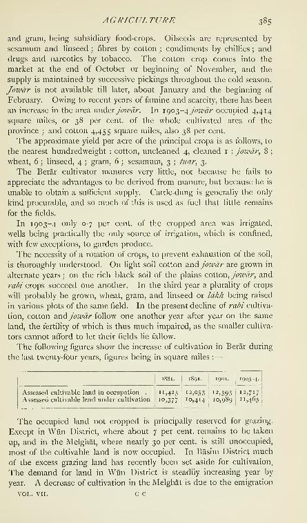
AGRICULTURE 385
and gram, being subsidiary food-crops. Oilseeds are represented by
sesamum and linseed ; fibres by cotton ; condiments by chillies ; and
drugs and narcotics by tobacco. The cotton crop comes into the
market at the end of October or beginning of November, and the
supply is maintained by successive pickings throughout the cold season.
Jowdr is not available till later, about January and the beginning of
February. Owing to recent years of famine and scarcity, there has been
an increase in the area vxwd&x jowdr. In \<^ot^-<\ jo7vdr occupied 4,414
square miles, or 38 per cent, of the whole cultivated area of the
province ; and cotton 4,455 square miles, also 38 per cent.
The approximate yield per acre of the principal crops is as follows, to
the nearest hundredweight : cotton, uncleaned 4, cleaned i;j07vdr, 8 ;
wheat, 6 ; linseed, 4 ;gram, 6 ; sesamum, 3 ; ti/ar, 3.
The Berar cultivator manures very little, not because he fails to
appreciate the advantages to be derived from manure, but because he is
unable to obtain a sufficient supply. Cattle-dung is generally the only
kind procurable, and so much of this is used as fuel that little remains
for the fields.
In 1903-4 only 0-7 per cent, of the cropped area was irrigated,
wells being practically the only source of irrigation, which is confined,
with few exceptions, to garden produce.
The necessity of a rotation of crops, to prevent exhaustion of the soil,
is thoroughly understood. On light soil cotton axxd Jowdr are grown in
alternate years ; on the rich black soil of the plains cotton, Jowdr, and
rabi crops succeed one another. In the third year a plurality of crops
will probably be grown, wheat, gram, and linseed or Idkh being raised
in various plots of the same field. In the present decline of rabi cultiva-
tion, cotton and Joivdr follow one another year after year on the same
land, the fertility of which is thus much impaired, as the smaller cultiva-
tors cannot afford to let their fields lie fallow.
The following figures show the increase of cultivation in Berar during
the last twenty-four years, figures being in square miles :
—

386 BERAR
of Korkus in the famine of 1899-1900. Liberal concessions, which
should tend to restore prosperity, have been granted.
Little is done towards the improvement of the quality of crops by
selection of seed or by the introduction of new varieties, and there is no
experimental farm in the province. As already remarked, the cultivator
has allowed the quality of the cotton crop to deteriorate in order to
obtain a greater yield. Seed separated from the fibre by the steam-
ginning process is said to be less fecund than the seed of hand-ginned
cotton.
A department of Land Records and Agriculture was formed in 1891,
but its work has hitherto been confined to survey and settlement.
The benefits of the Agriculturists' Loans Act and the Land Improve-
ment Loans Act are naturally appreciated most highly in years of scarcity
and famine. The delay in disbursing loans allowed under these Acts
was for a long time an obstacle in the way of their popularity, but
experience gained in years of famine has led to the simplification ot
procedure ; and there seems to be a fair field for the success of agri-
cultural banks.
The very few horses in Berar are inferior animals and merit no notice.
Ponies are more numerous, but are weedy. An attempt was made by
Government for a few years to improve the breed by keeping Arab
stallions at the head-quarters of Districts, but was abandoned about 1 893as a failure. The breed of cattle proper to the province is known as
Gaorani or Berari, of which there are two distinct varieties, the Umardaand the Khamgaon, the former being the smaller. Animals of this
breed are hardy, active, and enduring, and can easily cover 30 miles
within six or eight hours. A pair will sometimes cover 40 or 50 miles
in a day. The Khamgaon breed is more adapted to heavy draught.
This breed is found in the Khamgaon, Balapur, ChikhlT, Jalgaon, and
part of the Akot tahiks ; the Umarda breed elsewhere. Indiscriminate
crossing, the neglect of stock cattle, and fodder famines have contributed
to the deterioration of both breeds. On the eastern borders there are
very distinct indications of the influence of the Arvl or Gaulgani breed,
and on the southern border of that of the breeds of cattle found in the
Nizam's Dominions. The recent prevalence of famine has necessitated
the importation of working, and, to a smaller extent, of milch cattle.
The breeds most commonly imported have been the Nimari, Sholapuri,
Labbani, and Hoshangabadi ; cattle of the Malwi, Gujarati, and Surati
breeds are less frequently seen.
Buffaloes in the north and east of the province are of the Nagpuri,
and elsewhere of the Dakhani breed. Since the famine of 1899-1900buffaloes have been imported from Central India. These, which are
distinguished by the comparative smallness of their heads and horns,
are locally known as Malwi. The sheep and goats are inferior animals,

AGRTCUr.TURE 387
and the herdsmen, mostly Dhangars, lack the means and the knowledge
necessary to the improvement of the breed. In towns goats of the
Gujarat breed are found, and these are said to be good milch animals.
Large Umarda bullocks fetch about Rs. 60 to Rs. 70 each, small
Umarda bullocks from Rs. 30 to Rs. 40, and Khamgaon bullocks from
Rs. 50 to Rs. 70. Bullocks of other breeds cost from Rs. 25 to Rs. 40
each, and cows from Rs. 10 to Rs. 25, the Berar cow being a poor
milch animal. Buffaloes are sold at from Rs. 20 to Rs. 70 each, sheep
at from Rs. 2-8-0 to Rs. 3-8-0, and goats at from Rs. 3 to Rs. 10.
The price of a pony varies from Rs. 25 to Rs. 50.
Cattle suffered severely in the scarcity of 1896-7 and the famine of
1899-1900, and the mortality was great; but large importations have
gone far towards making good the deficiency. The grazing lands are
sufficient, except in parts of the Purna valley, such as the Akot and
Daryapur taluks. In the upland country almost every village has a
certain area of land set apart for free grazing. In 1903-4 the grazing
area was 335 square miles, of which 245 were Government land set
apart for free grazing and 90 were held by private occupants. Kadba,
Q>xjowdr stalks, form the principal fodder-supply, and the plough cattle
of the richer cultivators are partly fed on cotton seed.
There is only one cattle fair in the province, held at Wun in February
or March. Some fine cattle are brought to this fair and fetch good
prices ; but the fair has not been regularly held of late years, for fear
of importing plague. Ponies are brought in considerable numbers to
the Deulgaon Raja fair in Buldana District, held in September in con-
nexion with the festival of Balaji. The principal weekly cattle markets
in the province are those at Umarda, Digras, and Nandura.
Rinderpest, foot-and-mouth disease, and anthracoid diseases, such as
charboti symptoDiatiqtie, are the commonest infectious diseases, the two
former being much more frequent than the third. Anthrax is rare, and
sitrra has occurred only once among the ponies on a dak line. TheCivil Veterinary department has published a leaflet of instructions for
the prevention of the spread of contagious diseases. This has been
widely circulated ; a system of registration of cattle disease has been
introduced ; and on receipt of reports of outbreaks veterinary assistants
are deputed to carry out suppressive measures and to treat the sick.
Veterinary dispensaries are being established at taluk head-quarters.
The publication of a manual of simple veterinary instructions in the
vernacular has been delayed for want of funds. Bacteriological re-
searches have been commenced, and inoculation with anti-rinderpest
serum is carried on.
Irrigation is rare except for garden crops, which are irrigated almost
entirely from wells, the water-lift being the mot ox leathern bucket, raised
by two bullocks. The average cost of construction of a permanent well
c c 2
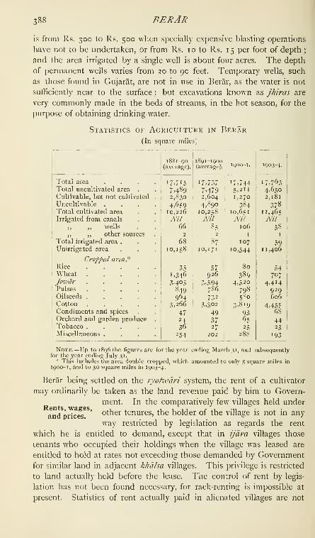
388 BERAR
is from Rs. 300 to Rs. 500 when specially expensive blasting operations
have not to be undertaken, or from Rs, 10 to Rs. 15 per foot of depth
;
and the area irrigated by a single well is about four acres. The depth
of permanent wells varies from 20 to 90 feet. Temporary wells, such
as those found in Gujarat, are not in use in Berar, as the water is not
sufficiently near to the surface ; but excavations known as jhiras are
very commonly made in the beds of streams, in the hot season, for the
purpose of obtaining drinking-water.
Statistics of Agriculture in Berar(In square miles)
RENTS, WAGES, AND PRICES 389
available ; but the Government assessment per acre, which may be
taken as a fair standard, varies from Rs. 2-12-0 to Rs. 1-14-0 in the
Payanghat and from Rs. 2-0-0 to Rs. 1-2-0 in the Balaghat. Oftenants holding under occupants there are three classes : tenants paying
money rent, tenants paying rent in kind on the batai system, axid potld-
7va)iiddrs or tenants-at-will, who pay rent either in money or in kind,
the landlord meeting the revenue demand. The batai sub-tenure,
which is in all respects similar to the mezzadria or metayer system, is
very common in Berar, but less so than formerly, as it is being replaced
by leases for money, owing to much of the land having fallen into the
hands of classes which do not cultivate. Statistics of the money rent
usually paid are not available. The ordinary conditions of batai are
that the lessor receives half the produce and pays the land revenue,
while the lessee bears all the expenses of cultivation and takes the
other half. Sometimes the lessee contributes a proportion, not ex-
ceeding one-third, of the land revenue, or agrees to pay half the land
revenue and hands over to the lessor one-fourth only of the produce.
For garden land the lessee, as a rule, delivers only one-third of the
produce, as the expense of cultivating land of this class is heavy.
The average daily wage for the last thirty years is R. o-i 1-7 for
skilled and R. 0-3-4 for unskilled labour, the rates for the province
in different years ranging between R. 0-12-9^ and R. 0-9-1 andR. 0-3-11 and R. 0-2-7. The lowest rates are those of the famine
year 1899- 1900, when food was only less costly than it was in the
following year. There was a similar though far less marked fall of
wages in 1896-7, which was a year of scarcity and high prices, and it
has been observed that wages do not rise with the rise in the price of
food. In years of famine, however. Government steps in as an employer
of labour, and provides all those in actual want with a living wage.
^Vages vary from year to year in different Districts and localities, but
the variations are not constant and are due to ephemeral and not to
permanent local conditions. The Melghat taluk, where wages are
ordinarily lower than elsewhere, is an exception. Though wages have
from time to time fluctuated during the past thirty years, they have, on
the whole, varied so little that it cannot be said that they have been
affected by the introduction of factory labour. The railway has, how-
ever, reduced wages for skilled labour, which could always commandR. I per diem before the railway, by facilitating communication, brought
the rate down to that which prevailed in other Provinces.
The average prices of the principal food-grains, in seers and chittacks
per rupee, in 1903-4 were as follows : jowdr, 22-1 ; wheat, 10-7;
gram, 14-13; rice, 8-12. These are slightly above the standard, but
prices were much disturbed by the famine of 1 899-1 900, and are
returning to the normal by slow degrees. Prices vary considerably

390 BERAR
in different Districts from year to year ; but as the variations are not
constant, they furnish no materials for an estimate of the conditions
of any particular locality.
The increase in the cultivated area seems to have had no effect on
prices, but the natural tendency of this increase towards the reduction
of prices may have been counteracted by the improvement in means of
communication. This improvement has not affected the price oijowdr,
which is not grown for export ; and though wheat is dearer now than it
was thirty years ago, it is doubtful whether the rise in price is due to
increased facilities for exportation. The effect of famine on prices is
very marked. Thus in 1895-6 joivdr sold at nearly 23 seers for the
rupee, while in the following year, which was a season of scarcity, only
I if seers could be obtained for that sum. In 1898-9 a rupee
purchased 27^ seers, but in the famine year which followed it would
purchase no more than 18^ seers, in spite of low prices in the early
part of the year; while in 1900-1 the average rate was \\\ seers for
the rupee, 5, 6, or 7 seers being the ordinary rate during the first six
months of the year 1900, when the effects of the famine were most
severely felt.
Another cause sometimes operates to reduce the price of grain.
Thus, in 1 880-1, 38 seers, and in 1884-5, 30^ seers oijoivdr could be
purchased for a rupee. The fall in price was attributed in each case
to the late rains, w^hich in the former year made it impossible to store
grain, and in the latter damaged the grain already stored.
The standard of comfort in Berar, though not high, is probably no
lower than in any other rural tract in India. The house of the middle-
class clerk, for which he probably pays a rent varying from Rs. 2 to
Rs. 10 a month, is scantily furnished. His food costs him but little,
for he is, in all probability, a Brahman, and therefore a vegetarian ; but
he uses such luxuries as wheat, rice, milk, ghi, and sweetmeats more
freely than does the cultivator. His clothes are of fine cotton cloth,
the dhoti having usually a border of silk, and he wears a silken turban;
but the whole outfit is so seldom renewed that it costs him com-
paratively little. The cultivator's style of living and the character of his
house depend on the size of his holding ; but the distinction between
the well-to-do and the impoverished cultivator consists largely in the
quantity and quality of the jewellery worn by the women of the family.
The cultivator's clothes are of coarse cotton cloth. The labourer's
standard of living is similar to the cultivator's, but lower. His house is
smaller and meaner, his cooking pots fewer, his food scantier, and his
family jewellery less costly. There has been no perceptible change in
the standard of living of these classes. So little does the cultivator
understand physical comfort that when he was suddenly and temporarily
enriched by the rise in the price of cotton, which was one of the results

FORESTS 391
of the American Civil War, he was sometimes unable to find a better
outlet for his wealth than the replacement of his iron ploughshares
and cart-wheel tires by shares and tires of silver.
Prices of Certain Staples in Berar

392 BERAR
miles, of which Class A forests occupied 1,770, Class B 83, and Class C2,088 square miles. The average revenue, expenditure, and surplus
for the ten years ending 1900 were Rs. 4,64,000, Rs. 2,32,000, and
Rs. 2,32,000, respectively, while in 1903-4 the revenue was Rs. 6,13,000,
the expenditure Rs. 2,56,000, and the surplus Rs. 3,57,000.
There are at present no mines, but the prospects of
mineralssuccessful coal-mining in the south-eastern corner of
the province are good.
The manufactures are few and unimportant. They are chiefly con-
fined to twist and yarn, coarse cotton cloth, and the productions
of unskilled craftsmen. Silk-weaving is carried on" / ^^ at Kholapur in Amraoti District, where pitdnibars
manufactures. ^ ' ^are made ; cotton carpets are woven at Akot and
EUichpur ; sarls^ turbans, khadls, and blankets are made in several
parts of the province, and khadls of different textures and colours at
EUichpur and Wun. There are also communities of dyers in some
towns and villages, but their work calls for no special notice. The only
spinning and weaving-mill in the province, at Badnera, is the property
of the Berar Manufacturing Company, Limited. It started work in
1885, and produces yarn and cotton cloth. The following table gives
some statistics of its progress :
—

COMMERCE AND TRADE 393
Rs. 5, and a child from Rs. 4-3-0 a month. The material condition
of the factory hands is good.
The only information concerning the trade of Berar prior to the
Assignment in 1S53 relates to raw cotton, the principal product of the
province. The first exportation direct to Bombaywas made by Messrs. Pestonji & Co., merchants of ,
tradeBombay and Hyderabad, in 1825-6. It consisted
of 500 bullock-loads, weighing 120,000 lb. and valued at Rs. 25,000.
General Balfour, writing in 1847, said that the trade had by that time
been principally diverted to Bombay, but that most of the Berar cotton
had formerly been taken 500 miles on pack-bullocks to Mirzapur and
there shipped in boats for Calcutta. After the Assignment, the exten-
sion of the Great Indian Peninsula Railway from Bhusawal to Nagpur
and the construction of metalled roads greatly stimulated the trade
with Bombay, and the pack-bullock became a thing of the past.
The chief centres of trade are Amraoti, Akola, Khamgaon, and She-
gaon ; and the channels of trade are the Nagpur branch of the Great
Indian Peninsula Railway, and the metalled roads connecting it with
trade centres of minor importance. The table on the next page
shows the general character of the trade of Berar. The enormous
increase in the importation of grain and pulse in the decade ending
1900-1 is attributable to the large importations during the years 1896-7
and 1899-1900, which were years of scarcity and famine. There is no
Chamber of Commerce in the province.
The internal trade is unimportant and calls for little notice. The
agriculturist or labourer buys what he wants at weekly markets held at
the old pargana towns and other large villages. Cotton cloth and yarn
manufactured in the Badnera mills, and silken pitambars or lugades
made in the province, are among the principal articles of internal com-
merce besides agricultural produce. The weaving castes are the Sails
and Koshtis, and the Mahars weave coarse blankets. Kasars and
Lobars make the ordinary utensils of brass, copper, and iron. The
ordinary earthen utensils used by the people are made by Kumhars,
the tiles used for roofing purposes being made principally by members
of this caste from Northern India, who visit Berar during the cold
and hot seasons, returning to their homes before the rains break.
Berar, being an inland province, has no registered trade beyond the
frontiers of India, but the greater part of the surplus produce of raw
cotton and grain and pulse is exported by sea from Bombay.
Experience has shown that the road-borne trade is not worth register-
ing ; and the external trade of the province may be briefly described as
consisting of the export by railway of agricultural produce, chiefly raw
cotton, and the import by the same means of simple necessaries of
life, manufactured articles, and a few luxuries not produced locally.

394 BERAR
Statistics of the Value of the Trade of Berar with
OTHER Provinces of India for the Years 1890-1,
1900-1, AND 1903-4
(In thousands of rupees)

COMMUNICATIONS 395
The railway has proved to be of the greatest use and benefit to the
people in years of famine, large supplies of food-grains having been
imported, especially in 1 899-1 900, from long distances, as in the case
of rice, which was imported from Burma via Calcutta. The tendency
of railway traffic is to bring about uniformity of prices. Thus scarcity
in other parts will now undoubtedly cause a rise in prices in Berar,
which would probably n(jt have occurred at all, or would have been
more gradual and less marked, before the introduction of railway com-
munication ; but, on the other hand, the railway prevents countless
deaths from starvation when the crops in Berar fail, so that the advan-
tages of railway communication in this respect far outweigh its disad-
vantages. The railway may have removed or modified some caste pre-
judices ; but, so far as has been observed, these prejudices seem to be
merely in abeyance during a journey, the social habits of the people
being unaffected by the temporary relaxation of customary restrictions.
The effect on language in Berar is not noticeable.
The railway has altered the entire course of communications. In-
stead of the single line of communication provided by the old Nagpur
dak road, which traversed the province from south-west to north-east,
we have the main line of communication provided by the railway, with
a system of feeder-roads running north and south from it. Thus to the
south there are roads connecting the railway (i) with Yeotmal, Wun,and Darwha
; (2) with Karanja and Basim; (3) with Basim, Pusad,
Umarkhed, and Hingoll ; and (4) with Buldana, ChikhlT, and Mehkar
;
while to the north roads run (i) to Mors! and Warud, (2) to Ellich-
pur and Chikalda, (3) to Daryapur, (4) to Akot, and (5) to Jalgaon.
The result of this extension of the road system has been that wheeled
transport has completely displaced pack transport, and the Banjara has
lost his former means of livelihood. The main lines of roads are Pro-
vincial, the District boards having as yet taken charge of very few roads.
There was no important change in the road system of the province
between 1891 and 1903. The total length of Provincial roads in 1891
was 857 miles, and in 1903 862 miles, the cost of maintenance per
mile being Rs. 436 in 1891, and Rs. 202 in 1903. For roads main-
tained at the cost of Local funds no figures are available. These con-
sist principally of a few fair-weather tracks, un metalled and practically
unbridged.
The conveyances in general use are the bandl, a large cart used for
carrying cotton and other agricultural produce ; the kachar, a two-
wheeled cart capable of holding several persons ; and the rengl, a small
and very light cart drawn by trotting bullocks, and capable of holding
one or at most two persons besides the driver.
Berar forms, for postal purposes, a part of the Central Provinces
and Berar Circle, which is in the charge of a Deputy-Postmaster-

396 BEKAR
General. The following statistics show the advance in postal business
in the province since 1880 :
—

FAMINE 397
other parts of the province. It so happened, both in 1896-7 and in
1 899- 1 900, that Wun District, in the south-eastern corner of the pro-
vince, suffered less than other Districts, but its more favourable circum-
stances were purely fortuitous.
The staple food-grain of the province, Jo7vdr, and also the pulse
most commonly eaten being both khanf cxo\)?,, this harvest is naturally
the more important. The only important food-grain grown as a rabi
crop is wheat, which, though eaten by the well-to-do, is regarded more
as a crop for export than as an addition to the food-supply. Moreover,
the rabi harvest, never very important as a source of food-supply, has
for some years past continuously decreased, owing to the failure of
the late rains.
Hitherto indications of famine have been slower to declare them-
selves in Berar than elsewhere, and the first warning of the calamity has
been a sudden rise in the price of grain, owing to exports. The partial
failure of the crops and the appearance of wanderers in search of work
are the next symptoms. In the famine of 1899- 1900 immigration from
the Nizam's Dominions, where relief measures were imperfect, was so
extensive as seriously to embarrass the Administration, and immigra-
tion from that State will probably be a factor to be reckoned with in
any future programme of relief measures.
Had the history of Berar been more carefully studied, it is probable
that the optimistic views advanced in 1893 would never have found
expression ; for, though the province may have been, on the whole,
more fortunate than other parts of India, there is ample evidence that
it has, in the past, suffered severely from famine.
In the reign of Muhammad Shah Bahmani (1378-97) Berar, in
common with the rest of the Deccan, was devastated by a terrible
famine ; and it is highly improbable that it escaped the famine of 141 7,
which affected the greater part of the Deccan. Again in 1472-3,
Malwa and the Deccan, including Berar, were wasted by a famine
which lasted for two years and caused wholesale emigration to Bengal
and Gujarat. In 1 630-1, the fourth year of the reign of Shah Jahan,
there was a terrible famine throughout Gujarat, Khandesh, Berar, and
the province of Daulatabad. The flesh of dogs was sold by butchers
as goat's flesh, the crushed bones of the dead were mingled with the
flour exposed for sale, and parents devoured their children.
It is unnecessary to discuss distress and scarcity due directly to
misrule and to intestinal wars and disturbances, since these are no
longer a factor in the liability of the country to famine. Berar did not
escape the famine of 1833, which caused considerable distress, as did
also the famine of 1839 and the scarcity in 1862.
In 1896 there was a partial failure of the rains ; and though the
province produced grain sufficient for its own needs, the simultaneous

398 BERAR
appearance of famine in other parts of India stimulated the export of
grain and caused distress by raising prices. Actual famine conditions
prevailed in the Melghat, Akola District, and the Malkapur tdliik.
An almost total failure of the rains in 1899 was followed in 1900 by
a severe famine. Except in Wun District, the failure of crops was
complete ; and the distress lasted till late in 1900, when copious rain
and the prospects of a good harvest caused a fall in prices and restored
the labour market to its normal condition.
A general increase in mortality during a famine is inevitable. In
Berar it has been found that the mortality increases gradually until the
hot season has set in. It then increases more rapidly, but does not
reach its highest point until a considerable quantity of rain has fallen.
Thus, in 1900 the highest death-rate (12 per 1,000 in the month) was
not reached till August. The rapid increase after the commencement
of the rains is due to inevitable exposure, to bowel complaints caused
by the consumption of foul water and rank green-stuff, and to endemic
diseases, the virulence of which is naturally more marked when large
numbers are predisposed to disease. A very distinct decrease in the
birth-rate is observable in the year following a famine.
An extensive system of irrigation is impracticable in Berar, though
storage tanks might perhaps be constructed in the Melghat and the
Balaghat. Protective measures, other than the maintenance and
extension of railway communication, are therefore confined to prepara-
tion for emergencies. Programmes of large and small relief works are
maintained, and during a famine a system of village relief by the
distribution of cooked and uncooked food is inaugurated. Poorhouses
are opened for the decrepit and deformed, loans are freely granted to
cultivators under the two Acts which govern their issue, private charity
is stimulated, and those whose scruples prevent them from receiving
gratuitous relief are helped by the opening of cheap grain-shops.
From the Assignment in 1853 until 1903, the administration of Berar
was conducted by the Resident at Hyderabad, who exercised, in
respect of the province, the powers of a Chief
Commissioner. His Secretariat consisted of his
two Assistants, besides a Secretary and an Assistant Secretary in the
Public Works department, while the Comptroller at Hyderabad
exercised a general control, under the Resident, in financial matters.
In 1903 the administration of Berar was transferred, in pursuance of
the agreement of 1902, from the Resident at Hyderabad to the Chief
Commissioner of the Central Provinces.
The province forms one Division, under a Commissioner, and up to
1905 was divided into six Districts— AmraotT, Ellichpur, Wun, Akola,
BuLDANA, and Basim—each under the charge of a Deputy-Commissioner.
These have now been rearranged and form four 1 )istricts : AmraotI,

LEGISLATION AND JUSTICE 399
Akola, Buldana, and Yeotmal. The Deputy-Commissioners have
a staff of Assistant Commissioners and Extra-Assistant Commissioners,
who exercise magisterial, civil, and revenue powers, and tahsllddrs, who
exercise criminal and revenue powers. Each tahsilddr has charge of
a tdluk, of which there are twenty-two in the province. Assistance in
petty magisterial cases is rendered by special or honorary magistrates,
of whom there are 31, including 23 who sit as benches, in five of the
most important towns. A Superintendent of Police manages the
police of each District, in subordination to the Deputy-Commissioner,
and there are three Assistant Superintendents in the province. The
District jails are under the charge of the Civil Surgeon at the head-
quarters of each District. The province is divided into five Forest
divisions, each of which is managed, under the control of the Deputy-
Commissioner of the District within the limits of which the forests are
situated, by a Deputy, Assistant, or Extra-Deputy-Conservator. These
officers are subordinate in departmental matters to the Conservator of
Forests in Berar.
The last link in the chain of administration consists of the village
officers, the /a/^/ and \h.e, pahvdri, whose offices are hereditary. The
pdtel has generally both revenue and police duties. He collects the
revenues in his village, and is superintendent of ihejdglyas or village
watchmen. He is bound to give timely information of all crimes, and
in cases of necessity may make arrests. In some large villages the
offices of police and revenue pdtel are held by different individuals.
The pativari is the village accountant. He prepares the annual
^amdbandl or statement showing the occupant, area, rental, and crop
of every field in his village or circle, keeps all the village papers and
registers, applications for and relinquishments of land, and statements
showing transfers. He and the pdtel are responsible that every pay-
ment of revenue is duly written up in the receipt-book which every
registered occupant of land holds. Pdtels and pativdris are remunerated
by a fixed percentage of the land revenue, forest dues, and town fund
taxes collected by them. The work of the patwdris is immediately
supervised by mutisarbns, of whom two or more are attached to each
tdhik. Alunsarims will soon probably be replaced by circle inspectors
under the supervision of District inspectors.
Berar has no local legislature, and Acts of the Indian Legislative
Council do not apply propria vigore to the province, which is not
legally a part of British India. They are, however,
generally made applicable to it by executive order ^^^ justice.
of the Governor-General-in-Council, and the same
authority makes local laws and rules for the province. The Resident
at Hyderabad was formerly, and the Chief Commissioner of the
Central Provinces is now, empowered to make subsidiary rules under

400 BERAR
certain Acts and laws. Owing to the extensive application of Acts of
the Legislative Council to the province, the administration of civil
and criminal justice is in all respects similar to the administration of
justice in a non-regulation Province of British India. The chief local
laws passed since 1880 have been the Excise Law (1897), the Rural
Boards Law (1885), the Municipal Law (1886), the Land Revenue
Code (1896), the Berar Courts Law, and the Berar Small Cause Courts
Law (1905).
In 1905, after the transfer of Berar to the Central Provinces, the
Berar Courts Law and the Berar Small Cause Courts Law came into
force; and the province is now divided, for the purposes of the
administration of justice, into the two civil districts of East Berar,
consisting of the revenue Districts of AmraotI and Yeotmal, and West
Berar, consisting of the revenue Districts of Akola and Buldana. In
each of the two civil districts a District Judge hears civil suits without
limit as regards value, and is assisted by an Additional District Judge.
Subordinate Judges, with powers to try and determine suits of which
the value does not exceed Rs. 5,000, hold their courts at AmraotI,
MorsT, Ellichpur, Daryapur, and Yeotmal in East Berar, and at Akola,
Basim, Khamgaon, and Buldana in West Berar ; and Munsifs, with
power to try and determine suits of which the value does not ex-
ceed Rs. 500, sit at AmraotI, MorsI, Ellichpur (where there are two),
Yeotmal, and Darwha in East Berar, and at Akola, Basim, Malkapur,
and Mehkar in West Berar.
Appeals from the decrees of subordinate courts lie to the District
and Additional District Judges ; and appeals from the District courts
lie to the court of the Additional Judicial Commissioner in Nagpur,
which is the Provincial High Court. Appeals from this court, when
allowed by law, lie to the Privy Council.
Courts of Small Causes, with power to try suits of a civil nature
not exceeding Rs. 1,000 in value and cognizable by such courts, are
established at x\mraoti in East Berar and at Akola and Khamgaon in
West Berar.
The limits of the two Sessions divisions coincide with those of the
civil districts, in which the District and Additional District Judges
exercise the powers of Sessions Judges. Sessions are held in alternate
months at AmraotI and Yeotmal in East Berar, and at Akola and
Buldana in West Berar. Deputy-Commissioners as District Magistrates
are empowered under section 30 of the Code of Criminal Procedure to
try as magistrates all offences not punishable with death, but they
exercise this power only in exceptional circumstances. Subdivisional
magistrates, with power to hear appeals from convictions by magis-
trates of the second and third classes and to call for records, are
stationed at Ellichpur, Basim, and Khamgaon.

LEGISLATION AND JUSTICE 4ot
Appeals lie from the Courts of Session to the Additional Judicial
Commissioner at Nagpur, by whom also all sentences of death must be
confirmed. Original and appellate jurisdiction over European British
subjects in Berar is exercised by the High Court at Bombay.
The number of criminal cases brought to trial varies but slightly from
year to year \ but in years of scarcity a great increase is always noticed
in the number of serious offences against property, accompanied by
a corresponding decrease in petty cases of assault, trespass, and the
like. At such times a marked decrease occurs in civil litigation,
followed, on the return of prosperity, by an abnormal increase,
especially in suits affecting real property.
The Registration department is controlled by the Inspector-General
of Registration. In each District a District registrar is appointed,
usually an Extra-Assistant Commissioner, to whom sub-registrars of
circles, who are the actual registering officers in all ordinary cases, are
subordinate. The average number of registration offices during the
decennial periods ending 1890 and 1900 was 59 and 66. In 1903
there were 68 offices. The number of documents registered in the two
decennial periods averaged 25,500 and 34,500, and was 37,400 in 1901.
Table showing the Number of Criminal Cases brought to
Trial in Berar

402 BERAR
The following figures, showing, in thousands of rupees, the revenue
collected under various heads in 1853-4, the year
after the Assignment of Berar, indicate the principal
sources of revenue under native rule :
—
I-and revenue . . .19,15Frontier and transit duties . 1,95
Abkari ..... 90
Sdyar, or town duties . . 71
Salt wells . . . . 19
Miscellaneous . . . 22
About 74 per cent, of the revenue raised by or for the Nizam
represented the assessment on the land. Other relatively important
headings, such as transit and town duties and salt wells, have long since
disappeared from the public accounts.
Former methods of taxation were most oppressive, for the greater
part of the province was usually leased out to bankers in payment of
debts due to them by the Hyderabad State, and they levied what they
could. All were not equally extortionate, but the uncertainty of their
tenure offered no inducement to ameliorate the condition of the
cultivator. The last of these great farmers had to give up his lease in
1845 ; and for the next eight years the khdlsa land was administered by
officers of the Nizam's government, whose yoke was probably no lighter
than that of the farmers. It was customary for an officer appointed to
any important administrative post to pay, on his appointment, a large
donation, which he recovered from his charge. The people had scarcely
recovered from these imposts, when the td/ukdihsgoi wind of the Assign-
ment to the British, and promptly raised the land revenue demand, in
order that they might carry off as much as possible. So much had Berar
suffered that, when it was ' assigned,' the revenues of this rich province
were estimated, by a government which certainly had no temptation to
underestimate them, at little more than 30 lakhs, while the actual col-
lections in 1853-4 fell short of 26 lakhs. In 1860-1 they had risen to
40 and in 1869-70 to 83^ lakhs.
The Provincial contract system was introduced in 1880, the Resident's
expenditure under the heads * Civil,' and ' Public Works, including
Railways,' being limited to 54 per cent, of the gross revenue. Fromthe year 1882-3 the percentage was reduced to 52, and again in 1887-8
to 50, which rate, although fixed for five years, was found to be in-
sufficient, and was raised to 51 in 1889-90. The percentage was again
reduced to 50 for the quinquennium which ended in 1896-7, and this
arrangement continued until the lease of Berar to the Government of
India in 1903.
The following figures show, in lakhs of rupees, the principal variations
in land revenue collections since the Assignment, the years selected
being those in which the variation has been most marked :
—
1S53-4 . . . . 19I
1S7.S-6 . . .. . 67
1S72-3 . . . . 53 I 1902-3 .... 741

LA!^D REVENUE 403
Collections in 1901-2 amounted to more than '6^\ lakhs, but this
total included many arrears. The remarkably rapid increase in the
course of the twenty years which followed the Assignment is attributable
rather to the extension of cultivation than to enhancement of the
demand. Excise revenue has similarly increased, but more gradually
and less continuously. It reached nearly 17 lakhs in 189 1-2, but de-
clined from that year onwards owing to the abolition, in the morepopulous parts of the province, of the out-still system and the intro-
duction of a more elaborate system of excise administration. Thedisappearance of some heads of revenue from the public accounts has
already been mentioned. Their loss has been much more than counter-
balanced by the revenue raised from sources untapped under the former
rule. Stamps were introduced in 1857, and by 1869-70 realized 4-6
lakhs. In 1903-4 the income from this head amounted to 8 lakhs.
Forests are another source from which former rulers drew no revenue;
but the control and administration of the forests was undertaken shortly
after the Assignment, and forest revenue, which in 1869-70 was less
than 2 lakhs of rupees, amounted in 1903-4 to Rs. 6,12,527. Regis-
tration was first introduced in 1877-8. The discovery of new sources
of revenue has been accompanied by the opening of new channels of
expenditure. Education was not provided by the state till 1862, and
ten years later the expenditure amounted to less than 2-| lakhs. In
1903-4 it was more than 5 lakhs. Medical relief was also unknownunder native rule. In 1870-1 little more than a lakh was spent under
this head. Rather more than i^- lakhs is now spent annually ; but in
1 900-1, the year after a severe famine, the expenditure was 2\ lakhs.
The expenditure on public works increased steadily until 1892-3, whenit reached nearly 15 lakhs. Since that time more rigid economy has
been practised, and the expenditure has gradually declined.
A distinctive feature of Berar finance before the lease was the heavy
military expenditure, which was necessarily an important item, for the
province was specially assigned for the maintenance of the Hyderabad
Contingent, a force which consisted of four regiments of cavalry, four
batteries of artillery, and six regiments of infantry. Statistics of this
expenditure will be found on p. 405. They show, as might be expected,
a steady and progressive increase, due to the necessity of maintaining
the standard of efficiency attained by the regular Indian army.
Berar has been settled on the Bombay ryohvdri system, under which
each field forms a holding for which the occupier engages separately
with Government. The whole province, with the ,.,,,,,_ ,^ ,. , Land revenue,
exception of the Melghat and some uncultivated tracts
in Yeotmal and Akola Districts, was measured, classified, and assessed,
field by field, by the close of 1878. The settlements, which were for
a term of thirty years, commenced to expire in 1891. Revision
D d 2

404 BERAR
operations have now been completed for the whole province except
the taluks of Kelapur, Yeotmal, and Wun in Yeotmal District, where
the work did not commence till 1904.
Principal Sources of Provincial Revenue in Berar
(In thousands of rupees)

LAND REVENUE 405
the Delhi emperors or by the Nizanis, one or two only by the Peshwas.
The term indin is applied to fields as Jih^r is to villages. Indms iiave
been granted for charitable objects, for service in villages, offices, or in
temples, and sometimes as purely personal favours. Falampat tenure
is similar to tenure in jdglr, but the holding is not entirely free. Afixed proportion of the rent is paid to (lovernment. Deshmukhs and
deshpdndyas in ^^'un District hold a few pdlampat villages under
ancient grants.
Principal Heads of Provincial Expenditure in Berar
(111 thousands of rupees)

4o6 BERAR
the rent is doubled, in the sixth trebled, and so on, until the full assess-
ment is reached. The object of the lease being to encourage the
breaking-up of the land for cultivation, tracts containing valuable timber
are exxluded, and quarrying or mining is prohibited ; but special
arrangements are made in the lessees' favour in the case of an excess of
uncultivable land, and special rules are laid down with regard to grazing.
During the currency of the lease the ijdraddr is pdtel and patwdri of the
village ; and at its expiry, when the village is liable to be surveyed and
to have its assessment revised, the offices of/a/^/and/a/?£/J?7 are offered
to him, and he is registered as the occupant of all land then actually
occupied by him. Such are the rules of 1880, which are now in force.
Under the former rules of 1865 the term of the lease was limited to
thirty years ; and the lessee had the option, on the termination of his
lease, of constituting the village his property in perpetuity, subject to the
payment annually to Government of one-half of a fair assessment, liable
to revision every thirty years, upon the whole of the cultivated and
cultivable area.
In 1901 the number of villages held under each class of tenure was
as follows : ryotwdri, 6,133 ; J^S'^^i 211 ; ijdra, 449 ; palajupat, 16. Ofthe assessment of ryotwdri villages amounting to 70-6 lakhs, land
assessed at Rs. 75,500 was occupied by indmdars.
Persons holding by cultivation occupancy may be thus classified :
—
(a) Registered occupants holding direct from Government, the
fields being registered in their names ;
{b) Persons possessing interests similar in kind to that of registered
occupants ; and
{c) Tenants.
The position of the registered occupant has already been described.
Those who possess an interest similar to his are co-sharers and co-
occupants. A co-sharer is a partner in a whole field, cultivating jointly
with the occupant on the co-operative system ; a co-occupant occupies
and cultivates a specific portion of a field. Co-sharers and co-
occupants may have co-sharers and co-occupants claiming under them
and not directly from the registered occupant. There are two ex-
ceptional varieties of co-sharers : one who obtains a share in the profits
by personal labour in the field, and one who obtains a share by supply-
ing bullocks. The latter variety of sub-tenure is rare.
The land revenue of Berar in 1903-4 was 85 lakhs. It is estimated
that, when the enhanced assessment of the tdluks of Murtazapur,
AmraotI, MorsT, Basim, Mangrul, EUichpur, Darwha, and Pusad—the
levy of which has been postponed in order to allow time to recover from
the effects of the famine of 1899-1900—is realized in 1906, the land
revenue of the province will amount to 99 lakhs.
The unit of calculation in the land revenue assessment is, as has

LAND REVENUE 407
been explained, the field or 'survey number,' but when a iahtk is to
be assessed it is divided into groups of villages, classified according to
the productiveness of soil and such adventitious advantages as means
of communication and proximity to markets or railways. A maximumrate per acre is fixed for each group of villages, and in assessing single
fields the fertility of the soil of each is considered. Soils are divided
into three classes, for each of which a maximum assessment jier acre is
fixed. In determining the assessment the depth of the soil, and any
defects, such as the presence of sand, of limestone nodules, or of a flow
of water over any portion of the field, are considered.
The land revenue demand in the reign of Akbar amounted to 161
A
lakhs, and fell in the reign of Shah Jahan to 13 yf lakhs. The famine
of 1 630-1 may account for the decrease, but it is probable that it was
partly due to an equitable assessment based on Malik Ambar's settle-
ment of 161 2 and to the relinquishment of paper claims against Gondchieftains. These figures are, however, of little use for comparison
with those of the present day, for Berar was, in the days of Akbar and
Shah Jahan, approximately twice as large as the present province.
Moreover, we have no means of estimating the population of the
province in Mughal times, or the area of the land actually under
cultivation. All, therefore, that can be asserted is that the mean
between the figures for the two reigns is approximately double the
present assessment of Berar, so that, taking gross area alone into
consideration, the Mughal cash assessment was about equal to the
British cash assessment, notwithstanding the rise in the money value
of agricultural produce. No margin remains to counterbalance the
hardships entailed by former methods of collection. We know that
in other parts of the empire, near the capital city and immediately
under the eye of Todar Mai, who perfected Akbar's land revenue
system, the rapacity of the karoris or collectors brought upon them
cruel punishments. It is not likely that provinces at a distance from
the capital, often the seat of war, and overrun by troops, fared any
better. The miserable condition of the province in the days of the
later Mughal emperors, and during and after the Maratha and Pindari
Wars, has been described. During the period which elapsed between
the overthrow of the Pindaris and the Assignment of Berar to the East
India Company, nobody but the revenue collectors and the ryots knew
the rates at which land revenue was actually levied, for the province
was leased out to farmers, who with perhaps a single exception squeezed
as much as they could out of it.
The number of holdings in ryotwdri villages in Berar in 1901 was
392,123, the corresponding assessment being 67-8 lakhs, so that the
incidence per occupant was very nearly Rs. 17-5. It is estimated that
the land revenue demand amounts to 7 per cent, of the gross produce.

4o8 BERAR
This being so, it is obvious that the assessment has no bearing whatever
on the abihty of the people to withstand famine, for in a prosperous
year the cultivator would not feel a deduction of 7 per cent, from his
gross produce. When crops failed completely—a phenomenon of very
rare occurrence—he might be able to meet the demand from savings;
but should he be unable to do this the demand would be postponed for
a year at least, so that in the year following the failure of crops he would
be able to pay 14 per cent, of the gross produce without hardship.
The principle observed in suspending and remitting land revenue in
times of scarcity is that nobody should be compelled to borrow in order
to meet the demand. Tahs'ildars are required to prepare lists of all
landholders known to be able to meet the demand, and to recover it
by the ordinary procedure. It is ordinarily assumed that recent pur-
chasers, mortgagees in possession, occupants other than agriculturists,
and occupants of fields which have yielded half of a normal crop are
able to pay. The Deputy-Commissioner is empowered to suspend
collections of land revenue due from persons who, by reason of their
known inability to pay, have not been entered in the tahsilddr's list.
When the prospects of the next kharlf crop can be estimated with
some degree of accuracy, the Deputy-Commissioner submits to the
Commissioner his proposals regarding the collection of arrears. Re-
missions of land revenue are few because, owing to the light assessment,
they are generally unnecessary.
The cultivation of the poppy has not been allowed in Berar for manyyears, all opium required for local consumption being imported from
either Indore or Bombay. The right to sell opium,isce aneous
^yhether wholesale or retail, is sold annually by auction,revenue. .
'.
' '
Wholesale vendors receive licences to import opium,
which is stored by them at sub-treasuries or authorized storerooms, and
may be sold to none but licensed retail vendors. The latter receive
licences authorizing them to open shops in localities approved by the
Deputy-Commissioner for the sale of opium to the general public, and
in certain circumstances are permitted to import opium.
The following statement shows the net revenue realized from opium
since 1881 :
—
Rs.
.I 1881-90 2,97,000
Average\ o'^( 1891-1900 3,00,000
1903-4 . 4,17,000
The figures for 1881-90 and 1 891- 1900 do not accurately repre-
sent the revenue derived from opium alone, for until 1893-4 the right
to sell hemp drugs was included in the opium licences, and separate
figures are not available.
The cultivation of the hemp plant in Berar has hitherto been
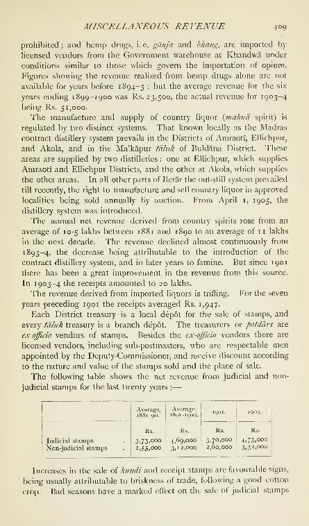
MISCELLANEO US RE VENUE 409
prohibited ; and hemp drugs, i. e. ganja and b/iang, are imported by
licensed vendors from the Government warehouse at Khandwa under
conditions similar to those which govern the importation of opium.
Figures showing the revenue realized from hemp drugs alone are not
available for years before 1894-5 ; but the average revenue for the six
years ending 1899-1900 was Rs. 23,500, the actual revenue for 1903-4
being Rs. 51,000.
The manufacture and supply of country liquor {viahi/a spirit) is
regulated by two distinct systems. That known locally as the Madras
contract distillery system prevails in the Districts of AmraotT, Ellichpur,
and Akola, and in the Malkapur tdliik of Buldana District. These
areas are supplied by two distilleries : one at Ellichpur, which supplies
AmraotI and Ellichpur Districts, and the other at Akola, which supplies
the other areas. In all other parts of Berar the out-still system prevailed
till recently, the right to manufacture and sell country liquor in approved
localities being sold annually by auction. From April i, 1905, the
distillery system was introduced.
The annual net revenue derived from country spirits rose from an
average of 10-5 lakhs between 1881 and 1890 to an average of 11 lakhs
in the next decade. The revenue declined almost continuously from
1893-4, the decrease being attributable to the introduction of the
contract distillery system, and in later years to fi\mine. But since 1901
there has been a great improvement in the revenue from this source.
In 1903-4 the receipts amounted to 20 lakhs.
The revenue derived from imported liquors is trifling. For the seven
years preceding 1901 the receipts averaged Rs. 1,947.
Each District treasury is a local depot for the sale of stamps, and
every ta/uk treasury is a branch depot. The treasurers or potddrs are
ex-officio vendors of stamps. Besides the ex-officio vendors there are
licensed vendors, including sub-postmasters, who are respectable men
appointed by the Deputy-Commissioner, and receive discount according
to the nature and value of the stamps sold and the place of sale.
The following table shows the net revenue from judicial and non-
judicial stamps for the last twenty years :
—

4 TO BERAR
for two reasons : namely, that the people cannot afford to go to law, andthat the prospect of recovering anything, even if a suit be successful,
is poor. Similarly, by affecting trade, they cause a decrease in the sales
of general stamps, though this effect is largely counteracted by the
necessity for borrowing. Plague in Bombay has had a detrimental
effect on trade, and consequently on the sale of general stamps in
Berar.
During the period of the Assignment income-tax was not levied in
the province, except from officers of the administration. It has been
introduced since the lease.
The Berar Rural Boards Law (1885) was the enactment which
introduced local self-government into the province ; but the first
elections for tdhik boards did not take place till late
municioal ^'^ 1888 and early in i88g. The District of Wun was
at first excluded from the operation of the law, which
was only extended to it in 1892, and the Melghat fdluk has alwa3's
been unrepresented.
The newly constituted District boards commenced their work in
1890 ; and although the law, the rules made, and the system of accounts
laid down were not at first clearly understood, the working of the
newly formed bodies has been on the whole satisfactory, and the
members have displayed some interest in their duties.
There are now twenty-one taluk boards, one for each tdhtk outside
the Melghat, and six ' District boards. The latter were composed in
1 90 1 of 152 members, of whom 122 were elected. The taluk boards
had 373 members, of whom 243 were elected. The functions of
District boards are generally those mentioned in Vol. IV, chapter ix;
and their principal duties are in connexion with the upkeep of roads,
schools, dispensaries, resthouses, and drinking-water sources. Thetaluk boards form, in practice, the electorate for the District boards
;
and they constitute the local agencies for the carrying out of District
board works, and for representing to the District boards the needs of
their taluks.
Speaking generally, it cannot be said that the principles of local self-
government have made much headway. The percentage of actual
voters to those entitled to vote is usually about 8 or 9, and sometimes
as low as 3 or 4. Nine candidates out of ten would probably think it a
greater honour to be appointed.by Government to the membership of
a board than to be elected.
Municipal administration was introduced into the towns of Amraoti,
Akola, Ellichpur, Basim, Yeotmal, and Khamgaon in 1869, under
special rules for the working of municipal committees drawn up under
section 10 of Act XV of 1867. The committees were composed of both
' Refluced to fmir in 1905.
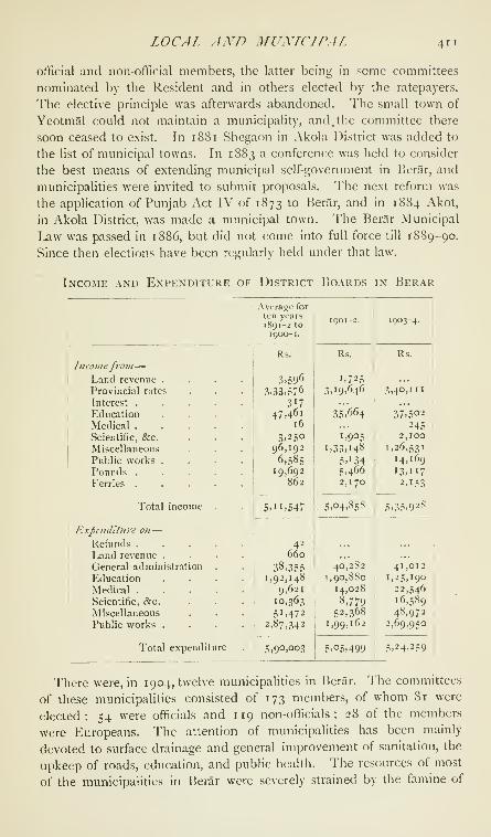
LOCAL AND MUXLCLPAL 411
official and non-offi(Hal members, the latter being in some committees
nominated by the Resident and in others elected by the ratepayers.
The elective principle was afterwards abandoned. The small town of
Yeotmal could not maintain a municipality, and. the committee there
soon ceased to exist. In i8<Si Shegaon in Akola District was added to
the list of municipal towns. In 1883 a conference was held to consider
the best means of extending municipal self-government in Berar, and
municipalities were invited to submit proposals. The next reform was
the application of Punjab Act IV of 1873 to Berar, and in 1884 Akot,
in Akola District, was made a municipal town. The Berar Municipal
Law was passed in 1886, but did not come into full force till i88g-go.
Since then elections have been regularly held under that law.
Income and Expenditure of District Boards in Berar

412 BERAR
1899-1900, and assistance by means of grants from Provincial revenues
was found necessary. The municipalities generally have shown some
remissness in the collection of arrears of taxation. The financial
condition of all places, except Akola, Khamgaon, and the AmraotI civil
station, is now satisfactory, and in these three an increase of taxation
is possible.
Electoral privileges are not highly valued. When the elective prin-
ciple was first introduced, it was believed that the apathy of the elector-
ate was due to ignorance, and that as the privileges of self-government
came to be understood they would be appreciated. These anticipations
have not been realized. The proportion of actual voters to the whole
body of the electorate varies much at different times and in different
municipalities, but a study of the figures for the period from 1 889-90 to
1 900-1 can only lead to the conclusion that interest in municipal self-
government has declined and is declining.
Income and Expenditure of Municipalities in Berar
POLICE AND JAILS 413
division of the Districts of Akola and Buldana. These two divisions
are controlled by a Superintending Engineer, who was formerly also
Secretary in the Public Works department to the Resi- ^ , ,.
J TT1-1-T ,i,,-i ,Pubhc works.
dent at Hyderabad, and had his head-quarters at
Bolarum ; but since Berar has been transferred to the administration of
the Central Provinces the head-quarters of the Superintending Engineer
have been moved to Nagjjur.
The department carries out all Provincial public works and repairs,
and also original works debitable to incorporated Local funds costing
over Rs. 1,000. District boards carry out incorporated Local fund
public works costing Rs. 1,000 and less, and all repairs in works other
than Provincial public works.
The sum available for expenditure during the ten years ending
1891-2 averaged ii-i lakhs, and for the next decade 14-6 lakhs. Thenormal expenditure was less in the latter than in the former period, but
the large expenditure of 60 lakhs necessitated by the famine of 1899-
1900 led to the increase in total expenditure during the latter decennium.
The expenditure on civil works in 1 901-2 and 1903-4 was 7-1 lakhs
and 6-5 lakhs respectively.
Berar contains no notable public works ; but it is very well provided
with roads, and communications are the principal item of expenditure.
Civil buildings, such as court-houses, schools, dispensaries, police
stations, (!s:c., come next in importance to, but far behind, communi-
cations. No large schemes of municipal drainage have been taken in
hand. A drainage project for AmraotI, the cost of which is estimated at
nearly 5 lakhs, was prepared in 189 1-2, but has not been begun owing
to want of funds. The town and civil station of AmraotI, and the towns
of Akola, Khamgaon, and Buldana each have a system of artificial
water-supply which, though ordinarily good, cannot withstand a long
drought.
The number of soldiers stationed within the province on June i,
1903, was 629, nearly all of whom belonged to the Native army. Berar
lies partly within the Mhow division of the WesternArmy
Command and partly within the independent Secun-
derabad division. The only military station, Ellichpur (since vacated),
was in the latter. The Berar Volunteer Rifles, who numbered 125 in
1903, have their head-quarters company at AmraotI, and a second
company at Akola.
Soon after the Assignment steps were taken to organize a regular
police force for the province. In 1870 this consisted of 2,613 officers
and men, or one policeman to every 6-77 square
miles of country and to every 849 of the population. -.^^
Since then the increase has been trifling, and has
failed to keep pace with the increase of population. The number of

414 BERAR
officers and men in 1903 was 2,900, giving one policeman to every 6-i
square miles of country and to every 949 inhabitants. There are
no rural police.
The force is recruited principally in the province, and the sanction of
the Inspector-General of Police is necessary for the enlistment of menwho are not natives of Berar or the Deccan. The enlistment of Gurkhas,
Sikhs, and frontier Pathans is prohibited ; and the authorized pro-
portions of various classes in the police are 40 per cent. Musalmans,
20 per cent. Hindus of Hindustan, and 40 per cent. Hindus of the
Deccan and other classes. Owing to the difficulty of obtaining suitable
Hindus, it is sometimes necessary to enlist Musalmans in excess of the
fixed proportion.
The newly enlisted policeman is trained in each District in a school,
where reading, writing, elementary arithmetic, drill, and the laws and
departmental rules which apply to the duties of the police are taught.
Four standards of examination have been framed for non-gazetted
officers and constables, and promotion is chiefiy regulated by the results
of these examinations. Service in the police cannot be said to be
popular among educated natives.
No special measures have been taken of late years to improve the
status and character of the police force. The principal measure adopted
for the repression of organized and habitual crime has been the closer
supervision of Banjara encampments or tdndds, which have in most
cases been moved closer to the sites of the villages in the lands of which
they are situated. Banjaras were formerly employed as detectives, but
the measure was only partially successful ; for they were not always
trustworthy, and were of no further use when their occupation became
known to their fellows. Anthropometry has been abandoned as a means
of identifying criminals, and dactylography has taken its place. Thefinger-print records have been largely increased of late years, and the
police should soon have a complete record of habitual criminals in
the province.

POLICE AND JAILS 415
Of the Districl police, 56 are armed with batons only, 1,799 with
swordy, and 1,018 with smooth-bore carbines.
The railway police force consists of one inspector, 2 chief constables,
12 head constables, and 58 constables. Their range is the branch of
the Great Indian Peninsula Railway which traverses the province, andthey are under the control of the District Superintendents of Amraotiand Akola.
I'he table on p. 4x4 gives the sanctioned strength in the various
ranks of the police at diflerent periods.
The following table gives statistics of cognizable crime :
—

4i6 BERAR
Since the redistribution of the Districts in August, 1905, the jails in
Berar are classified as follows : the jails at Amraoti and Akola are
Central jails, those at Buldana and Yeotmal District jails, and those
at Ellichpur and Basini subsidiary jails.
The principal industries are : in the Amraoti jail, the lithographic
printing of forms for official use, and weaving ; and in the Akola jail,
the manufacture of police and prison clothing, and weaving. Blankets
are woven in both jails. In the small District jails coarse w-eaving,
blanket-weaving, and oil-pressing are the principal industries ; and the
prisoners in all jails provide for their own needs by tilling the jail
gardens and grinding their own meal. vStone-breaking is the commonest
form of unskilled labour. Different departments of the administration
take the greater part of the jail produce. Textiles, such as towels,
dusters, tape, tS^c, are sold by private arrangement.
Neither under Hindu nor under Muhammadan rule were there any
schools in Berar expressly supported by the Government. Brahmans
in receipt of money-grants and inams taught SanskritEducation. , ^r -.u- • . • . r . aand Marathi, \\\ most mstances for payment ; and
schools in which the Arabic of the Koran, Persian, and Urdu were
taught were supported by wealthy Musalmans as a work of merit. Theprofession of teaching was regarded as derogatory, and was compared
to the herding of cattle. In 1862 a few Marathi and Anglo-Marathi
schools were established and placed under District officers ; and in 1866,
when there were 35 schools with an attendance of 1,881 pupils, a depart-
ment of Public Instruction was organized under the control of a Director,
assisted by a Deputy-Inspector for each District. Two European
Inspectors were next appointed, but after 1873 there was only one
Inspector for the whole province. In 1903 the administration of Berar
was transferred to the Central Provinces, and the supervising agency
under the Director of Public Instruction for both areas now consists in
Berar of one European Circle Inspector, and eleven Deputy and Sub-
Deputy-Inspectors.
There is no college in Berar, but scholarships are tenable in the Arts,
Science, and Medical colleges of the Bombay Presidency by candidates
from the Berar high schools. The educational authorities in Berar are
not directly concerned with the further education of those who proceed
to these colleges. In 1881 nine, in 1891 fifteen, and in 1903 twenty-
seven students from Berar matriculated, and the average annual number
of graduates for the last fourteen years has been two.
Secondary schools are of two classes : namely, high and middle
schools, English being taught in both. There are seven standards in
the curriculum of English education, the first three of which form the
middle school course. The first English, which succeeds the fourth
vernacular standard, includes arithmetic to the end of compound pro-
EDUCATIOX 417
portion, reading and writing the vernacular, history and geography,
and elementary instruction in English. These subjects, together with
grammar, constitute the middle school course, a wider knowledge of
each subject being of course required in each successive standard. Thehigh school course begins with the fourth standard. To the subjects
already taught elementary algebra and drawing are added, a classical
language, Sanskrit or Persian, may be substituted for the vernacular,
and geography and history are taught in English. In the fifth standard
Euclid and easy English composition are begun. The sixth standard
is similar, but more advanced ; and the seventh is the matriculation
standard of the Bombay University. There is a private unaided high
and middle school at Amraotl. The proportion of boys undergoing
secondary instruction to the total male population of school-going age
in 1904 was 6-05 per cent.
There are six purely vernacular standards. In the first standard
the pupil learns reading, the writing of the alphabet, and elementary
arithmetic ; in the third, geography ; in the fourth, elementary hygiene
and history; and in the sixth, the first book of Euclid and— as an
optional subject—land measurement are added to the curriculum.
Primary schools are under the management of municipalities and
District boards. In addition to the cess of 3 pies per rupee of land
revenue, the contribution of Government towards their maintenance
consists of a grant from Provincial revenues, which is made over to
District boards. Municipalities supply two-thirds of the expenditure on
primary schools in towns, one-third being contributed from Provincial
revenues. A few municipalities receive subsidies from District boards.
The pay of teachers in primary schools ranges from Rs. 10 to Rs. 35.
A tendency to cultivate the memory rather than the intelligence of
pupils is still noticeable, but it is probable that this defect will disappear
by degrees, now that the proportion of trained teachers is increasing.
The proportion of boys under primary instruction to the total male
population of school-going age in 1904 was 17-21 per cent.
Female education has not yet advanced beyond the primary stage.
The number of girls' schools was 12 in i88r, 48 in 1891, and 47 (includ-
ing 3 private institutions) in 1904; the proportion of female scholars to
the female population of school-going age in those years was 0'i4, 0-22,
and I -1 2 per cent. Girls' schools are supported and managed by
municipalities and District boards. The subjects taught are reading,
writing, arithmetic, geography, plain needlework, knitting, and fancy
work. Progress has been fairly satisfactory ; but the people in general
still need to be convinced that female education is a good thing. A great
obstacle in the way of any thorough teaching is the practice of with-
drawing girls from school at a very early age, due, among Hindus, to the
custom of infant marriage, and, among Muhanmiadans, to the general
VOL. VII. E e

4i8 BERAR
feeling that a girl who has attained the age of puberty, which may be
fixed at about twelve, is better at home than at school.
The training school for teachers at Akola is a useful institution. It
contains MarathI and Hindustani divisions, and was attended in 1881
by 71 teachers, in 1891 by 91, and in 1904 by 47. The Government
industrial school at Amraoti is at present an unimportant institution,
with an attendance of 12. The Alliance Mission Workshop at Akola
is an industrial school under competent management, with an attendance
of 29. Instruction is given in ironwork, carpentry, and other handicrafts,
and the pupils are generally well started in the world. In the Korku
Mission school at Ellichpur, 62 pupils are taught masonry, painting,
smiths' work, and carpentry.
The Convent school and the Anglican school at Amraoti are the only
schools for Europeans and Eurasians in the province. Both are mixed
schools. In 1904 the former had on its rolls 17 boys and 27 girls, and
the latter 1 1 boys and 3 girls. The highest standard in the former was
the seventh, and in the latter the fifth, and the two schools received
monthly grants of Rs. too and Rs. 40. Boys have usually proceeded
from these schools to others before making a start in life.
From the following table, which shows for the three census years
1 88 1, 1 89 1, and 1901 the percentage of Muhammadan and Hindu boys
attending secondary and primary schools to the total male population
of school-going age of each class, it will be seen that in Berar Musalmans
are not behind Hindus in appreciating the benefits of education :
—

EDUCATION 419
is conveyed in Urdii, and in the first standard no Marathi is taught.
In the second and subsequent standards the pupil learns Marathi ; but
after the fourth standard he may proceed to the middle-school course,
when he may abandon Marathi and take Urdu as his sole vernacular
language, or he may complete his vernacular education by going on to
the fifth and sixth standards.
It has occasionally been necessary to open here and there special
schools for the lowest castes, such as Mahars and Mangs, but the last
of these schools was closed in 1902 for want of attendance. The need
for these institutions no longer exists, as the prejudice which prevented
low-caste boys from attending ordinary schools has given way to a more
enlightened feeling.
There are two schools in the Melghat for Korkus, among whomeducation is making fair progress, though none have yet passed beyond
the primary stage. In 1891 only 127 Korkus attended school, and in
1904 the returns show only 38 Korku girls at these schools.
Educational Finance in Berar, 1903-4

420 BERAR
H
oH<O
Q
!
a

MEDICAL 421
Monthly fees in primary schools range from 2 annas for the first two
standards to 6 annas for the sixth; in middle schools from 8 to 12 annas;
and in high schools from Rs. 1-8-0 to Rs. 2-0-0.
No English newspapers are published. In 1904 six Marathl papers
were published, one of which had English columns. Their circulation
is local, and they have little influence. Twelve books, all in Marathi,
were registered in 1904. The books published in the province deal
principally with religious and social subjects, and cannot be said to
contain evidence of original research.
Soon after the Assignment in 1853, steps were taken to provide
medical aid by the establishment of hospitals and dispensaries, the
administration of which was entrusted to Civil Sur-
geons of Districts. By 187 1 there were 3 civil hos-
pitals and 20 charitable dispensaries in the province. The progressive
increase in the number of these institutions is shown in the table
below. In 1895 ^ hospital for females was opened in Amraoti
under the auspices of the Lady Dufferin Fund Committee. This
institution has made satisfactory, though not rapid, progress. Theaverage annual numbers of in-patients, out-patients, and operations
since its establishment have been 159, 6,069, and 153.
Statistics of Medical Institutions and V.\ccination in Berar
Medical.

42 2 BERAR
Xo lunatic asylum has been established in the province, and lunatics
for whose custody it is necessary to provide are sent to the asylum at
Nagpur. The principal causes of insanity are said to be the abuse of
alcohol and narcotic drugs, enforced widowhood among Hindus and
the zandfia system among Musalmans, physical ailments, and pecuniary
losses.
There was no indigenous method of inoculation in Berar before the
introduction of vaccination by the British Government, and it seems
that vaccination was at first regarded, if not with disfavour, at least as
an innovation of doubtful utility. This feeling has been gradually
removed.
The pice-packet system of selling quinine through the agency of the
Post Office was introduced in January, 1895, in which year 1,337 packets
were sold. In 1896 the aid of the Forest department was enlisted. In
1904 the total number of packets sold was 281,729, and it is evident
that the people are awakening to the value of this drug.
Village sanitation is attended to by village officials and by rural
boards under the advice and encouragement of District sanitary boards
and of officials on tour ; but very much remains to be done in this
direction, and it cannot be said that any considerable number of the
people have as yet any knowledge of elementary sanitary principles.
The revenue survey of Berar was begun in 1853-4, the year of
Assignment, in the Malkapur fd/uk. In 1855-6 and 1857-8 the
Balapur td/iik was surveyed, and the survey of
the taluks which then existed proceeded in the
following order: Jalgaon (1857-8)^ Mehkar (i 860-1), Akot, Chikhli,
Daryapur, and Murtazapur (1861-2). In the Berar revenue survey
areas are calculated by the English acre, divided into 40 guntas,
each gufita being subdivided into 16 'annas,' The chain used is
33 feet long, and is composed of 16 links. A gunta is one square
chain, and an 'anna' is one chain long by one link broad. Native
surveyors survey with the chain and a cross staff, and a proportion of
their work is checked by the survey officer. The original survey of the
province was generally checked and revised between 1891 and 1901,
but the survey of the Kelapur and Wun taluks has yet to be revised.
Afunsarims, under the control of Deputy-Commissioners and the de-
partment of Land Records and Agriculture, are entrusted with the
duty of keeping surveys up to date. Many of the pativdris go through
a course of surveying in the Survey Training School at Akola.
[A. C. Lyall, Berar Gazetteer (1870) ; The Gazetteer of Aurangdbdd
(1884); Dr. R. G. Bhandarkar, Early History of the Dekkan (1895);
Memoirs of the Geological Survey of Ifuiia, vol. xiii ; Records of the
Geological Survey of India, vol. i, part iii : General Report of the Geo-
logical Survey of India (1902-5) ; Brandis, Suggestions regarding Forest

BERASTA 423
Administration in tiie Hyderabad Assigned Districts ('^^79) : Taluk Sel-
llement Reports, enumerated under District articles.
Berasia {Barasia).—Head-quarters of the Ni/aniat-i-Shimal or
northern district of the Bhopal State, Central India, situated in 23°
38'' N. and 77° 27' E., 24 miles by metalled road from Bhopal city.
Population (1901), 4,276. Under Akbar, Berasia was included in the
sarkdr oi Raisen in the Subah of Malwa. In 1709 Dost MuhammadKhan acquired the neighbouring country on lease, and by rapidly ex-
tending his dominions founded the Bhopal State. In the eighteenth
century the tract was seized by Jaswant Rao Ponwar of Dhar, and sub-
sequently fell to Amir Khan, who made it over in jdgir to the famous
Pindari leader Karim Khan. After the suppression of the Pindaris in
181 7 it was restored to Dhar, but was confiscated in 1859, and in the
following year was made over to Bhopal as a reward for services ren-
dered during the Mutiny. In the town stands a mosque built by Dost
Muhammad in 17 16, which contains the tomb of his father, Nur
Muhammad Khan. Besides the usual offices, a school, a dispensary,
and a British and a State post office are maintained here.

OXFORDPRINTED AT THE CLARENDON PRESS
BY HORACE HART, M.A.
PRINTER TO THE UNIVERSITY

UNIVERSITY OF CALIFORNIA LIBRARY
Los Angeles .
This book is DUE on the last date s^^mped below.
atCD LD-UHh
THE TT-KARY
UNn'EH; ^ TFORNIA

Illlllllllllllllllillll
3 1158 00855 649J
UC SOUTHERN REGIONAL LIBRARY FACILITY
AA 001 138 990 5

Copyright © 2022 FDOKUMEN


![Smith's Canadian gazetteer [microform] : comprising statistical and ...](https://static.fdokumen.com/doc/165x107/631d3ef36c6907d36801aca9/smiths-canadian-gazetteer-microform-comprising-statistical-and-.jpg)