Impediments to recovery in New Orleans' Upper and Lower Ninth Ward: one year after Hurricane Katrina
32
Impediments to Recovery in New Orleans’ Upper and Lower Ninth Ward One Year after Hurricane Katrina Rebekah Green, 1 Lisa K. Bates, 2 Andrew Smyth 3 1. Earth Institute, Columbia University 2. Urban and Regional Planning, University of Illinois, Urbana-Champaign 3. Civil Engineering and Engineering Mechanics, Columbia University Keywords: hurricane, Katrina, New Orleans, damage, recovery, housing Abstract In the aftermath of Hurricane Katrina, a rapid succession of plans called for a host of recovery options for the Upper and Lower Ninth Ward of New Orleans. Much of the debate focused on catastrophic damage to residential structures and discussions of the capacity of low-income residents to repair their neighborhoods. This article examines impediments to the current recovery process of the Upper and Lower Ninth Ward, reporting results of an October 2006 survey of 3211 parcels for structural damage, flood damage and post-storm recovery. By examining recovery a year after Hurricane Katrina, and by doing so in light of flood and structural damage, it is possible to discuss recovery impediments that may disproportionately affect these neighborhoods. This paper concludes with a discussion of how pre and post-disaster inequalities have slowed recovery in the Lower Ninth Ward and the implications this has for post-disaster recovery planning here and elsewhere.
-
Upload
independent -
Category
Documents
-
view
1 -
download
0
Transcript of Impediments to recovery in New Orleans' Upper and Lower Ninth Ward: one year after Hurricane Katrina
Impediments to Recovery in New Orleans’ Upper and Lower Ninth Ward One Year after Hurricane
Katrina
Rebekah Green,1 Lisa K. Bates,
2 Andrew Smyth
3
1. Earth Institute, Columbia University
2. Urban and Regional Planning, University of Illinois, Urbana-Champaign
3. Civil Engineering and Engineering Mechanics, Columbia University
Keywords: hurricane, Katrina, New Orleans, damage, recovery, housing
Abstract
In the aftermath of Hurricane Katrina, a rapid succession of plans called for a host of recovery options for
the Upper and Lower Ninth Ward of New Orleans. Much of the debate focused on catastrophic damage to
residential structures and discussions of the capacity of low-income residents to repair their
neighborhoods. This article examines impediments to the current recovery process of the Upper and
Lower Ninth Ward, reporting results of an October 2006 survey of 3211 parcels for structural damage,
flood damage and post-storm recovery. By examining recovery a year after Hurricane Katrina, and by
doing so in light of flood and structural damage, it is possible to discuss recovery impediments that may
disproportionately affect these neighborhoods. This paper concludes with a discussion of how pre and
post-disaster inequalities have slowed recovery in the Lower Ninth Ward and the implications this has for
post-disaster recovery planning here and elsewhere.
P a g e | 2
Green, R. and Lisa Bates (2007) Impediments to recovery in New Orleans’ Upper and Lower Ninth Ward: one year after
Hurricane Katrina, Disasters 31(4): 311-335. Published by the Overseas Development Institute and Blackwell Publishing. The
definitive version is available at www.blackwell-synergy.com.
Introduction
In the aftermath of Hurricane Katrina, the fate of the Ninth Ward in New Orleans captured
national attention. A rapid succession of plans called for a wide variety of recovery options in the Upper
and Lower Ninth Ward. Initially, Mayor Nagin’s blue-ribbon Bring New Orleans Back Commission
championed a moratorium against rebuilding in heavily flooded areas like the Lower Ninth Ward until
their ―viability‖ was proven (compiled from BNOB 2006). The commission’s planning initiative called
for a drastically reduced city footprint, slating large sections of low income neighborhoods, such as the
Lower Ninth, for green space restoration (Konigsmark 2006). The Lambert Plan, commissioned by the
city council, suggested rebuilding the Lower Ninth ―from scratch‖ (Lambert 2006; Simmons 2006); other
plans supported ―voluntary clustering‖ whereby owners in heavily damaged areas would swap for homes
in less damaged, easier to service neighborhoods (UNOP 2007). More recently, the city’s Director of the
Office of Recovery Management announced that the Lower Ninth Ward would be an initial target for
heavy investment as a revitalization node. In short, governmental support for recovery in the Lower Ninth
Ward has spanned a wide range of options as the city moves to create a ―new New Orleans‖ (Johnson
2006).
Much of the media discussions and recovery plans regarding the Upper and Lower Ninth Wards
have presupposed a uniformly devastated, un-repairable neighborhood populated by people unable to
rebuild. This article examines recoverability and current recovery of the Upper and Lower Ninth Ward in
light of an October 2006 survey of 3211 parcels in the Upper and Lower Ninth Wards for structural
damage, flood damage and post-storm recovery. By examining recovery a year after Hurricane Katrina,
and by doing so in light of flood and structural damage, a critical discussion of impediments to recovery
in these neighborhoods is possible. We will argue in this paper that such an analysis reveals that structural
and flood damage is not the only, or perhaps even the primary, impediment to recovery. Rather, limited
resources of residents, widespread discussions of non-viability and the slow pace of infrastructure

P a g e | 3
Green, R. and Lisa Bates (2007) Impediments to recovery in New Orleans’ Upper and Lower Ninth Ward: one year after
Hurricane Katrina, Disasters 31(4): 311-335. Published by the Overseas Development Institute and Blackwell Publishing. The
definitive version is available at www.blackwell-synergy.com.
recovery in these neighborhoods have played a significant role in retarding repair and re-occupancy,
especially in the Lower Ninth Ward.
The following section will briefly describe the history of the Upper and Lower Ninth Wards and
the flooding they experienced as a result of Hurricane Katrina. This background will be followed by a
description of the methods and findings of our stratified, uniform-sample survey. Our analysis indicates
that the majority of structures in the Upper and Lower Ninth Wards were structurally undamaged - albeit
heavily flooded. The survey also found many residential structures in stages of repair, such that debris
removal, repair and re-occupancy of residential housing were in progress throughout the neighborhoods,
though this recovery was not equal across the neighborhoods surveyed. We follow this survey description
with a discussion of impediments to recovery – those that affect all returning residents and additional
difficulties for residents of the Upper and Lower Ninth Ward. These barriers include media portrayals of
damage, temporary housing shortages brought on by infrastructure failures, and access to capital. We
conclude the article with a discussion of how understandings of hurricane damage have helped obscure
pre and post disaster inequities and the need for recovery support in hurricane damaged, low-income
neighborhoods.
Historical Description of the Upper and Lower Ninth Wards
Before Hurricane Katrina, the Upper and Lower Ninth Wards in New Orleans were low to
moderate-income African-American residential neighborhoods. Comprising the historically developed
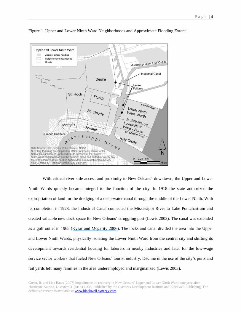
areas of the Ninth Ward, the districts are located downriver of the city’s famous French Quarter, as shown
in Figure 1. At the start of the 20th century, residency in the area was limited to the natural levee formed
along the bank of the Mississippi River (Colten 2005; Jackson 2006). Wharf laborers, emancipated slaves,
white rural migrants, and immigrants began settling in the brackish ―rear districts‖ behind this natural
levee (Campanella 2006; Jackson 2006). Unable to afford or denied access to housing elsewhere, they
divided it into residential plots and called it their own, though the city did not provide significant drainage
until the 1920s (Colten 2005; Colten 2006; Jackson 2006; Lewis 2003).
P a g e | 4
Green, R. and Lisa Bates (2007) Impediments to recovery in New Orleans’ Upper and Lower Ninth Ward: one year after
Hurricane Katrina, Disasters 31(4): 311-335. Published by the Overseas Development Institute and Blackwell Publishing. The
definitive version is available at www.blackwell-synergy.com.
Figure 1. Upper and Lower Ninth Ward Neighborhoods and Approximate Flooding Extent
With critical river-side access and proximity to New Orleans’ downtown, the Upper and Lower
Ninth Wards quickly became integral to the function of the city. In 1918 the state authorized the
expropriation of land for the dredging of a deep-water canal through the middle of the Lower Ninth. With
its completion in 1923, the Industrial Canal connected the Mississippi River to Lake Pontchartrain and
created valuable new dock space for New Orleans’ struggling port (Lewis 2003). The canal was extended
as a gulf outlet in 1965 (Kysar and Mcgarity 2006). The locks and canal divided the area into the Upper
and Lower Ninth Wards, physically isolating the Lower Ninth Ward from the central city and shifting its
development towards residential housing for laborers in nearby industries and later for the low-wage
service sector workers that fueled New Orleans’ tourist industry. Decline in the use of the city’s ports and
rail yards left many families in the area underemployed and marginalized (Lewis 2003).
P a g e | 5
Green, R. and Lisa Bates (2007) Impediments to recovery in New Orleans’ Upper and Lower Ninth Ward: one year after
Hurricane Katrina, Disasters 31(4): 311-335. Published by the Overseas Development Institute and Blackwell Publishing. The
definitive version is available at www.blackwell-synergy.com.
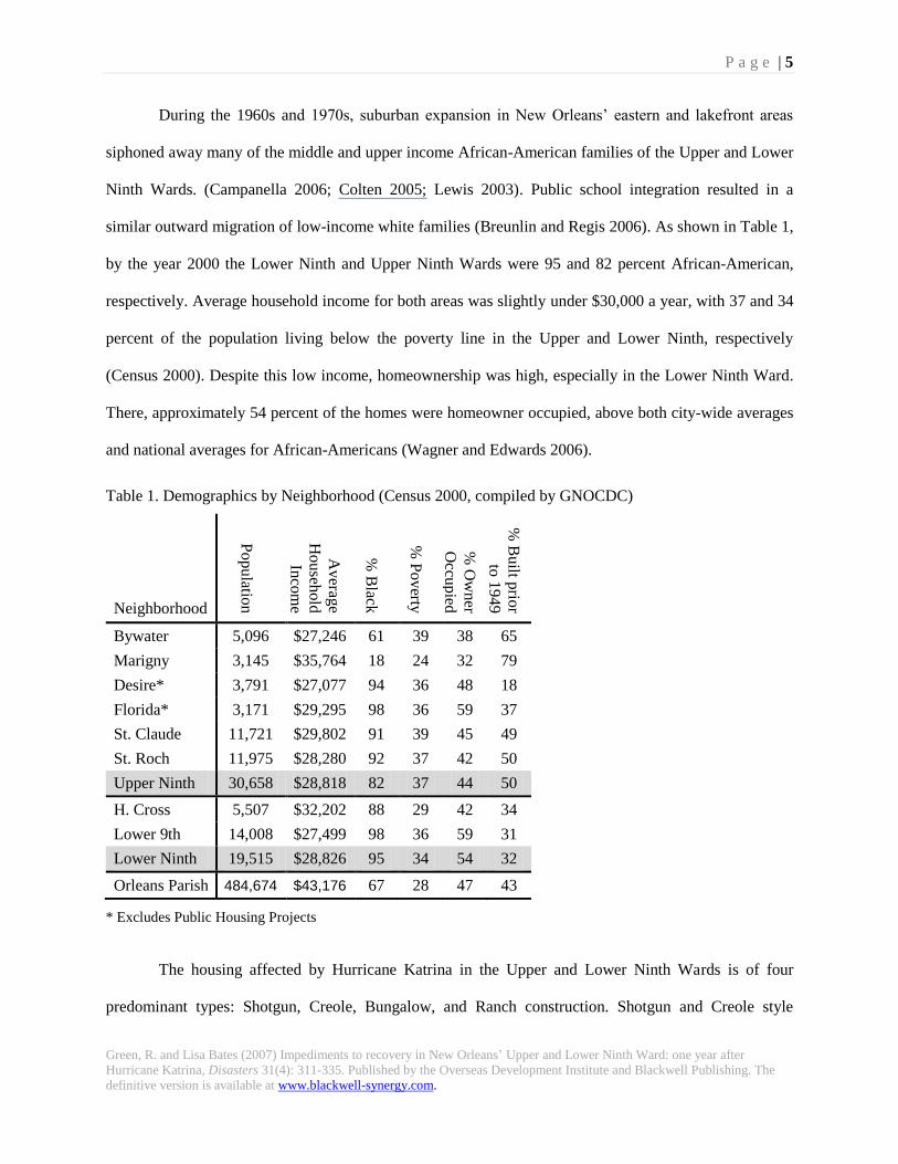
During the 1960s and 1970s, suburban expansion in New Orleans’ eastern and lakefront areas
siphoned away many of the middle and upper income African-American families of the Upper and Lower
Ninth Wards. (Campanella 2006; Colten 2005; Lewis 2003). Public school integration resulted in a
similar outward migration of low-income white families (Breunlin and Regis 2006). As shown in Table 1,
by the year 2000 the Lower Ninth and Upper Ninth Wards were 95 and 82 percent African-American,
respectively. Average household income for both areas was slightly under $30,000 a year, with 37 and 34
percent of the population living below the poverty line in the Upper and Lower Ninth, respectively
(Census 2000). Despite this low income, homeownership was high, especially in the Lower Ninth Ward.
There, approximately 54 percent of the homes were homeowner occupied, above both city-wide averages
and national averages for African-Americans (Wagner and Edwards 2006).
Table 1. Demographics by Neighborhood (Census 2000, compiled by GNOCDC)
Neighborhood
Populatio
n
Averag
e
Househ
old
Inco
me
% B
lack
% P
overty
% O
wner
Occu
pied
% B
uilt p
rior
to 1
949
Bywater 5,096 $27,246 61 39 38 65
Marigny 3,145 $35,764 18 24 32 79
Desire* 3,791 $27,077 94 36 48 18
Florida* 3,171 $29,295 98 36 59 37
St. Claude 11,721 $29,802 91 39 45 49
St. Roch 11,975 $28,280 92 37 42 50
Upper Ninth 30,658 $28,818 82 37 44 50
H. Cross 5,507 $32,202 88 29 42 34
Lower 9th 14,008 $27,499 98 36 59 31
Lower Ninth 19,515 $28,826 95 34 54 32
Orleans Parish 484,674 $43,176 67 28 47 43
* Excludes Public Housing Projects
The housing affected by Hurricane Katrina in the Upper and Lower Ninth Wards is of four
predominant types: Shotgun, Creole, Bungalow, and Ranch construction. Shotgun and Creole style

P a g e | 6
Green, R. and Lisa Bates (2007) Impediments to recovery in New Orleans’ Upper and Lower Ninth Ward: one year after
Hurricane Katrina, Disasters 31(4): 311-335. Published by the Overseas Development Institute and Blackwell Publishing. The
definitive version is available at www.blackwell-synergy.com.
construction predominate in the oldest settled areas along the natural river levee (Holy Cross, Marigny,
and Bywater). These vernacular New Orleans-style houses sit on fired brick or concrete block pier
foundations averaging 50 centimeters in height. Most common in the lower lying areas furthest from the
River are bungalow style homes on raised foundations and post-World War II ranch style construction on
slab-on-grade foundations. The ranch style homes are low-cost frame construction, made from Southern
Pine. Their slab-on-grade foundations give no protection from flood waters; thus, some lots have been
mounded to reduce flood risk.
Like most areas of New Orleans, a substantial portion of these neighborhoods are below sea level.
In its north-eastern corner, the Lower Ninth is estimated to be a 1.2-1.8 meters below sea level – at risk of
flooding, but significantly higher than other neighborhoods along the lakefront with higher average
household incomes (IPET 2006; NIST 2006; USGS 2006). Nevertheless, the Lower Ninth was
particularly vulnerable to damage from Hurricane Katrina. The neighborhoods of New Orleans East, the
Upper and Lower Ninth Ward and the neighboring parish of St. Bernard were exposed to a heightened
probability of overtopping due to their direct exposure to the Gulf via Lake Borgne and the Mississippi
River Gulf Outlet (Kysar and Mcgarity 2006).
When Hurricane Katrina struck land 75 kilometers to the southeast of the city on August 29,
2005, a 6 meter storm surge caused levee failure and flooding to over 75 percent of the city (IPET 2006;
NIST 2006). Funneled storm surge in the Industrial Canal caused overtopping of the levee protecting the
Lower Ninth Ward and was followed by an 250 meter failure of the levee near N. Claiborne Street (IPET
2006). A torrent of water poured into the neighborhood with hydrodynamic force that pushed residential
structures off their foundation and causing catastrophic damage to the blocks near this failure. Buoyancy
forces from fast rising water caused 125 structures to float onto the roads. Another 1000 were later
voluntarily demolished by owners due to heavy structural damage (Webster 2006).
Following Hurricane Katrina, NOAA and others used satellite imagery to map the extent of area
that was flooded. These maps indicate that flooding in the Upper Ninth Ward started north of St. Claude
P a g e | 7
Green, R. and Lisa Bates (2007) Impediments to recovery in New Orleans’ Upper and Lower Ninth Ward: one year after
Hurricane Katrina, Disasters 31(4): 311-335. Published by the Overseas Development Institute and Blackwell Publishing. The
definitive version is available at www.blackwell-synergy.com.
Avenue and increased to 3.5 meters along Florida Avenue and in Desire Neighborhood, a flood height
about 2.5 meters above sea level. In the Lower Ninth Ward, storm surge in the Industrial Canal caused
extensive levee breaches on the Lower Ninth side of the Canal. Flooding extended south to just behind the
River levees in the neighborhood of Holy Cross (IPET 2006). Water depths increased with distance from
the River to a height of over 3.5 meters in some areas along Florida Street in the Lower Ninth Ward -
North (USGS 2006). See Figure 1 for flood extent and location of levee breaks.
Survey Methodology
The Federal Emergency Management Agency (FEMA), in its direct inspection of Orleans Parish,
reported 107,379 houses as having flood damage. Approximately 3,545 of these flood damaged units
were in the Lower Ninth Ward and Holy Cross (FEMA 2006). FEMA’s assessment indicated that 82
percent of the residential units in the Lower Ninth Ward sustained severe damage or were destroyed.
These estimates included both structural damage and non-structural flood damage to homes, making it
difficult to assess the recoverability of these neighborhoods from the FEMA reports alone. Furthermore,
little was known about residents’ post-disaster recovery plans and desires for their neighborhoods.
As part of a community planning process, Cornell University, Columbia University and
University of Illinois, Urbana-Champaign conducted an extensive assessment of damage and recovery
conditions, business recovery, parks, and resident concerns in the Upper and Lower Ninth Wards of New
Orleans. 1
As part of this effort, an extensive field survey of damage and recovery in residential
neighborhoods of the Upper and Lower Ninth Wards was carried out. This survey was divided into two
levels: 1) a broad Neighborhood Conditions Assessment Survey (CA) and 2) an in-depth Building
Evaluation Survey (BE). The CA involved the collection of parcel level data on current recovery activity
from a sidewalk view of each lot. The survey tools were adapted from the Unified New Orleans Planning
Process conditions survey, though additional questions were added to further delineate recovery stages
and clarify building stock types (UNOP 2007). The BE teams gathered more detailed information on wind
and flood damage, recording information on wall, roof, foundation, veneer and roof surface damage in

P a g e | 8
Green, R. and Lisa Bates (2007) Impediments to recovery in New Orleans’ Upper and Lower Ninth Ward: one year after
Hurricane Katrina, Disasters 31(4): 311-335. Published by the Overseas Development Institute and Blackwell Publishing. The
definitive version is available at www.blackwell-synergy.com.
line with ATC-45 Field Manual: Safety Evaluation of Buildings after Wind Storms and Floods (ATC
2004). Copies of survey forms can be found in the appendices of ―The People’s Plan‖ (AHUP 2007).
Survey sites were selected using a stratified sampling technique with systematic sampling within
each residential housing stratum of approximate similar flooding conditions. We chose to survey only
predominantly residential, flooded zones as this is the area where housing recovery is most dynamic,
tenuous, and in need of more thorough documentation. Within flooded residential areas, the university
teams systematically sampled blocks selected in an approximately uniform grid pattern. Teams surveyed
every parcel on these blocks, including vacant lots and those with structures, thus avoiding any biasing
that could result from directional damage caused by wind and water flow. This approach also guaranteed
that teams sampled corner lots, which can be more damaged than lots on interior sections (Dutta, Das, and
Roy 2005). The Neighborhoods Conditions Survey teams surveyed approximately 3000 residential
parcels (203 city blocks) over three days. The Building Damage Evaluation Teams surveyed
approximately 800 residential parcels (36 city blocks) over the same period. Based upon estimates of
residential parcels in each neighborhood, the Neighborhood Conditions Survey teams surveyed
approximately 13 percent of the parcels in the Upper and Lower Ninth Wards and the Building Damage
Evaluation Teams surveyed approximately 3 percent. This uniform selection of survey sites provided
useful information on current conditions of surveyed lots with statistically valid assessments of residential
damage across the surveyed neighborhoods (Crandell and Kochkin 2005).
Structural Damage and Flooding
Hurricane Katrina and the subsequent levee failures and flooding caused significant damage to all
residential housing types in the Upper and Lower Ninth Wards (NIST 2006). Our Building Evaluation
survey documented this damage by dividing damage into three major components a) structural damage
that significantly affected the stability of the residential buildings, b) high-wind related damaged to
cladding and roof surfaces, and c) interior flood damage related to the destruction of the contents of
P a g e | 9
Green, R. and Lisa Bates (2007) Impediments to recovery in New Orleans’ Upper and Lower Ninth Ward: one year after
Hurricane Katrina, Disasters 31(4): 311-335. Published by the Overseas Development Institute and Blackwell Publishing. The
definitive version is available at www.blackwell-synergy.com.
buildings, as well as their wall surfaces, flooring and electrical systems. Further analysis of structural and
high-winds damage is the topic of future publications (Green et al. 2008).
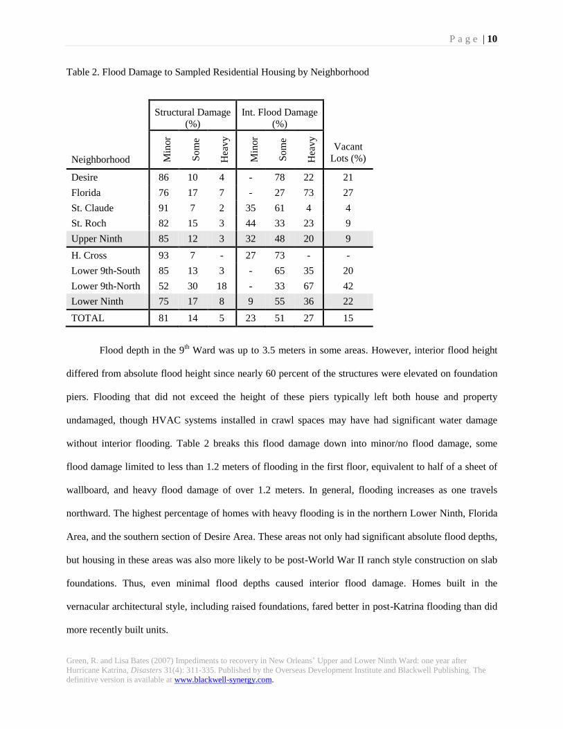
Table 2 divides the structural damage of the surveyed parcels into four mutually exclusive
categories: vacant lot, none/minor, some and heavy structural damage. Some structural damage was
defined as 11-40 percent damage or displacement to foundation, structural wall system or structural roof
system. Minor damage and heavy damage were defined as damage below or above this range,
respectively. Damage to roof shingles and non-structural exterior façade were excluded from definitions
of structural damage. Damage assessment is discussed further elsewhere (Franco et al. 2008; Green et al.
2008).
Despite graphic photojournalism of the overwhelming destruction in the Lower Ninth Ward,
Table 2 shows a surprisingly low percentage of heavy structural damage. Throughout the Upper and
Lower Ninth Wards, 75 percent of the existing structures surveyed in October, 2006 had no or minor
structural damage. Moreover, vacant lots – many from post-storm demolition - were limited to 9 and 22
percent of the parcels, respectively. Heavy structural damage was primarily limited to the northwestern
corner of the Lower Ninth Ward due to two significant levee breakages along the industrial canal during
the early morning of August 29, 2006. In the Lower Ninth Ward - North, the BE survey showed that 18
percent of the existing structures (equivalent to 12 percent of the surveyed parcels) had heavy structural
damage. However, 42 percent of the lots in this section were vacant. A percentage of these vacant lots
would have resulted from post-storm demolition of heavily damaged structures, but others would have
been vacant even before the storm. Thus, an upper-bound estimate of heavy structural damage in the
northern section of the Lower Ninth is 54 percent of the housing stock.
P a g e | 10
Green, R. and Lisa Bates (2007) Impediments to recovery in New Orleans’ Upper and Lower Ninth Ward: one year after
Hurricane Katrina, Disasters 31(4): 311-335. Published by the Overseas Development Institute and Blackwell Publishing. The
definitive version is available at www.blackwell-synergy.com.
Table 2. Flood Damage to Sampled Residential Housing by Neighborhood
Structural Damage
(%)
Int. Flood Damage
(%)
Neighborhood Min
or
So
me
Hea
vy
Min
or
So
me
Hea
vy
Vacant
Lots (%)
Desire 86 10 4 - 78 22 21
Florida 76 17 7 - 27 73 27
St. Claude 91 7 2 35 61 4 4
St. Roch 82 15 3 44 33 23 9
Upper Ninth 85 12 3 32 48 20 9
H. Cross 93 7 - 27 73 - -
Lower 9th-South 85 13 3 - 65 35 20
Lower 9th-North 52 30 18 - 33 67 42
Lower Ninth 75 17 8 9 55 36 22
TOTAL 81 14 5 23 51 27 15
Flood depth in the 9th Ward was up to 3.5 meters in some areas. However, interior flood height
differed from absolute flood height since nearly 60 percent of the structures were elevated on foundation
piers. Flooding that did not exceed the height of these piers typically left both house and property
undamaged, though HVAC systems installed in crawl spaces may have had significant water damage
without interior flooding. Table 2 breaks this flood damage down into minor/no flood damage, some
flood damage limited to less than 1.2 meters of flooding in the first floor, equivalent to half of a sheet of
wallboard, and heavy flood damage of over 1.2 meters. In general, flooding increases as one travels
northward. The highest percentage of homes with heavy flooding is in the northern Lower Ninth, Florida
Area, and the southern section of Desire Area. These areas not only had significant absolute flood depths,
but housing in these areas was also more likely to be post-World War II ranch style construction on slab
foundations. Thus, even minimal flood depths caused interior flood damage. Homes built in the
vernacular architectural style, including raised foundations, fared better in post-Katrina flooding than did
more recently built units.
P a g e | 11
Green, R. and Lisa Bates (2007) Impediments to recovery in New Orleans’ Upper and Lower Ninth Ward: one year after
Hurricane Katrina, Disasters 31(4): 311-335. Published by the Overseas Development Institute and Blackwell Publishing. The
definitive version is available at www.blackwell-synergy.com.
Evidence of Neighborhood Recovery
Housing units in the Upper and Lower Ninth Wards that experienced flood damage require
considerable repair before they can be re-inhabited; those with heavy structural damage must typically be
demolished and rebuilt. Our second survey objective was to assess recovery progress in this area. Given
considerable news coverage about the slow pace of recovery in the area, we wanted to accurately assess
progress. Though over a year had passed since Hurricane Katrina at the time of the survey, many
structures appeared to have been untouched since the storm. Thus, we used the CA survey, which covered
13 percent of the parcels, to gain a larger picture of recovery.
A Year after the Storm: Upper and Lower Ninth Recovery
A series of recovery questions evaluated the level of recovery of each parcel surveyed. Teams
assessed a series of criteria regarding whether or not the primary structure was secured, boarded, had
debris removed, had interior gutted, was in the process of repair and/or was occupied. They also indicated
whether or not someone was occupying a trailer on the lot. Surveying teams could answer most of these
recovery questions from a sidewalk assessment of each parcel. When occupants or their neighbors were
present, the surveyors confirmed their assessments of recovery with them.
The teams occasionally had difficulty determining from the sidewalk whether a house had been
cleaned - that is, whether molding and wet interior contents had been removed. In these cases the teams
marked the question as unknown. Gutting – removal of wet drywall, insulation, and flooring – was
assessed in a similar way. Surveyors used the presence of building permits, piles of construction
materials, and the appearance of house interior as indicators of repair. Signs of occupancy included
interior lights, watered plants, the presence of clean furniture or curtains in the windows, and household
garbage on the curb.
To analyze recovery across the neighborhoods, recovery questions were grouped into five
mutually exclusive stages of recovery. The first was vacant lot, where recovery questions did not apply.
P a g e | 12
Green, R. and Lisa Bates (2007) Impediments to recovery in New Orleans’ Upper and Lower Ninth Ward: one year after
Hurricane Katrina, Disasters 31(4): 311-335. Published by the Overseas Development Institute and Blackwell Publishing. The
definitive version is available at www.blackwell-synergy.com.
The second recovery stage was no visible signs of recovery. This was used for structures that did not
seem to have had debris removed, to have been gutted, repaired or occupied. A third stage was that of
debris removal and gutting. These parcels had the primary structure’s interior debris, drywall, insulation
or flooring removed, but had not been repaired and occupied. The fourth stage was that of repair without
occupancy and the final stage was that of occupancy, where any necessary cleaning, gutting, and repair
had been substantially completed and the structure was now inhabited.
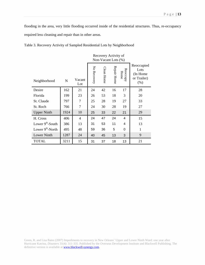
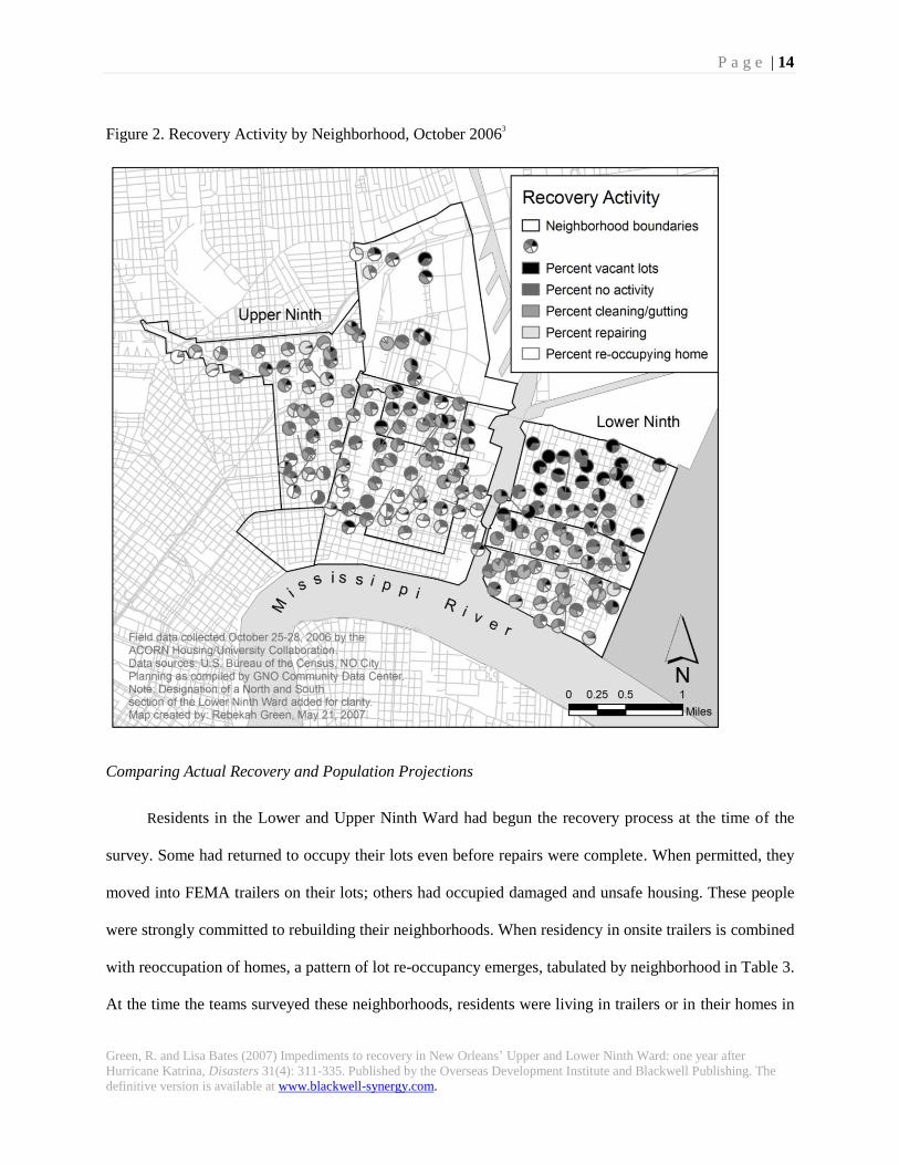
Figure 2 uses pie charts to display the percentage of parcels in each of the five stages of recovery
for each of the surveyed blocks; Table 3 tabulates these stages by neighborhood. As noted earlier, vacant
lots, either vacant prior to the storm or lots where structures have been demolished post-Katrina, were
most prevalent in the Lower Ninth Ward – North. With the heavy structural and flood damage
experienced, 59 percent of the non-vacant lots showed no visible sign of recovery.2 In other
neighborhoods, recovery activity was greater. In the Upper Ninth Ward, 25 percent of the existing
structures showed no activity; the remaining structures were divided fairly evenly between gutting, repair,
and re-occupancy. In the less flooded southern sections of St. Claude and St. Roch, a higher percentage
of these lots were in later stages of recovery. In Desire and Florida, recovery was retarded, with nearly
half of the non-vacant lots having only achieved cleaning/gutting. Similarly, in Holy Cross, nearly half of
the lots showed signs of gutting or cleaning, with smaller percentages of repair and only 4 percent re-
occupancy.
The geographic distribution of recovery activities is more clearly illustrated in Figure 2. Repair is
predominantly clustered in the southern sections of St. Roch and St. Claude, but is more evenly
distributed throughout Holy Cross. The only areas with significant levels of re-occupancy of repaired
structures were between St. Claude and N. Claiborne Avenues in the St. Roch and St. Claude
neighborhoods. Our teams found no to moderate levels of interior flood damage and little signs of
structural damage in this area. Most structures in this area were on pier foundations and while there was
P a g e | 13
Green, R. and Lisa Bates (2007) Impediments to recovery in New Orleans’ Upper and Lower Ninth Ward: one year after
Hurricane Katrina, Disasters 31(4): 311-335. Published by the Overseas Development Institute and Blackwell Publishing. The
definitive version is available at www.blackwell-synergy.com.
flooding in the area, very little flooding occurred inside of the residential structures. Thus, re-occupancy
required less cleaning and repair than in other areas.
Table 3. Recovery Activity of Sampled Residential Lots by Neighborhood
Recovery Activity of
Non-Vacant Lots (%)
Neighborhood
N
Vacant
Lot
No
Reco
very
Clean
Ho
me
Rep
air Ho
me
Reo
ccup
y
Ho
me
Reoccupied
Lots
(In Home
or Trailer)
(%)
Desire 162 21 24 42 16 17 28
Florida 199 23 26 53 18 3 20
St. Claude 797 7 25 28 19 27 33
St. Roch 766 7 24 30 28 19 27
Upper Ninth 1924 10 25 33 22 21 29
H. Cross 406 4 24 47 24 4 15
Lower 9th-South 386 13 31 53 11 4 13
Lower 9th-North 495 48 59 36 5 0 1
Lower Ninth 1287 24 40 45 13 3 9
TOTAL 3211 15 31 37 18 13 21
P a g e | 14
Green, R. and Lisa Bates (2007) Impediments to recovery in New Orleans’ Upper and Lower Ninth Ward: one year after
Hurricane Katrina, Disasters 31(4): 311-335. Published by the Overseas Development Institute and Blackwell Publishing. The
definitive version is available at www.blackwell-synergy.com.
Figure 2. Recovery Activity by Neighborhood, October 20063
Comparing Actual Recovery and Population Projections
Residents in the Lower and Upper Ninth Ward had begun the recovery process at the time of the
survey. Some had returned to occupy their lots even before repairs were complete. When permitted, they
moved into FEMA trailers on their lots; others had occupied damaged and unsafe housing. These people
were strongly committed to rebuilding their neighborhoods. When residency in onsite trailers is combined
with reoccupation of homes, a pattern of lot re-occupancy emerges, tabulated by neighborhood in Table 3.
At the time the teams surveyed these neighborhoods, residents were living in trailers or in their homes in
P a g e | 15
Green, R. and Lisa Bates (2007) Impediments to recovery in New Orleans’ Upper and Lower Ninth Ward: one year after
Hurricane Katrina, Disasters 31(4): 311-335. Published by the Overseas Development Institute and Blackwell Publishing. The
definitive version is available at www.blackwell-synergy.com.
29 percent of the lots in the flooded neighborhoods of the Upper Ninth Ward. They were also residing on
15 percent of the lots in Holy Cross and 13 percent of Lower Ninth Ward – South. The only area with
very little occupancy was the Lower Ninth Ward - North neighborhood, where lot occupancy was only 1
percent.
The level of recovery activity and re-occupancy observed by our surveyors differ from
demographic projections. ESRI, in their demographic analysis of hurricane-affected Gulf-States,
projected that the Lower Ninth Ward - North area would have no population by the end of 2006 and that
the Lower Ninth Ward as a whole would have no population through the year 2011. ESRI projected
similar low population returns for the Upper Ninth Ward, with only a 10.4 percent household return rate
in flooded neighborhoods (ESRI August 2006). This early analysis, based upon FEMA damage estimates,
direct assessment of recovery, change of address applications and assistance applications, could not
capture the slow, but steady, diasporic return to the city a year after the storm. As Table 3 shows, except
for the Lower Ninth Ward - North, re-occupancy is substantially higher than ESRI’s projections.
The RAND Corporation issued an alternative rate of return projection in January 2006 (McCarthy
et al. 2006). Using a ―consensus approach,‖ RAND based its projections on severity of flooding and
factors such as insurance/financing capacity, construction type, and residents’ willingness and ability to
return. In moderately flooded neighborhoods like St. Roch, St. Claude, Holy Cross and Lower Ninth
Ward - South, RAND projected 25 percent return. These much more optimistic projections are similar to
actual recovery rates in the Upper Ninth Ward neighborhoods of St. Roch and St. Claude. Yet, their
projections are much higher than return rates in Holy Cross and the Lower Ninth Ward - South. In
severely flooded areas like Lower Ninth Ward - North, RAND projected a 10 percent return rate by
September 2006, again, much higher than the recovery observed in October 2006. For both ESRI and
RAND, the recovery of the Lower Ninth Ward has been difficult to accurately project.
The October 2006 survey documented repopulation rates that span ESRI and RAND projections
in the Upper and Lower Ninth Ward. Critically, the survey shows a recovery that is far from uniform
P a g e | 16
Green, R. and Lisa Bates (2007) Impediments to recovery in New Orleans’ Upper and Lower Ninth Ward: one year after
Hurricane Katrina, Disasters 31(4): 311-335. Published by the Overseas Development Institute and Blackwell Publishing. The
definitive version is available at www.blackwell-synergy.com.
across the Upper and Lower Ninth Ward. Excluding the heavily damage areas of the Lower Ninth Ward -
North, recovery in Lower Ninth Ward - South and Holy Cross lags behind similarly flooded and similarly
damaged neighborhoods of the Upper Ninth Ward. In these neighborhoods, heavy structural damage was
limited to less than 10 percent of residential building stock. Similarly, these neighborhoods had moderate
to heavy flood damage, with the Lower Ninth Ward neighborhood of Holy Cross having less severe
flooding than the average flooding in the Upper Ninth neighborhoods. Yet, only 4 percent of residential
homes surveyed in Holy Cross had been reoccupied compared to 17, 19 and 27 percent in Desire, St.
Roch and St. Claude respectively. The only neighborhood with similarly low levels of home re-occupancy
was Florida, a neighborhood more severely flooded than Holy Cross or Lower Ninth - South. Survey
results demonstrate that even the least flood damaged areas of the Lower Ninth Ward lag behind in re-
occupancy.
A review of neighborhood recovery within Orleans Parish also shows a recovery lag in the Lower
Ninth Ward in comparison to other heavily damaged New Orleans neighborhoods. Using Census data and
permits issued by the city Building and Permits Department, the Times-Picayune detailed that only 2.8
percent of the households in the Lower Ninth Ward had applied for and received electrical permits to
refurbish flood damaged homes (Times-Picayune 2006b). This compared with 18.8 percent in upper-
middle income Lakeview and 14.6 percent in middle-income Gentilly, both neighborhoods along the
Lake that received 3.0-3.5 meters of flooding (Times-Picayune 2006b; USGS 2006). Despite considerable
time and resident effort in the Lower Ninth Ward, housing repairs and recovery are not keeping pace with
other heavily flooded neighborhoods. This uneven recovery is even shifting city-wide demographics: with
49 percent return of the pre-Katrina population one year after the storm (Brookings 2007), the white
population of New Orleans metropolitan area has increased from 59 percent to 73 percent and median
income increased from $55,000 to $64,000, indicating that white, affluent residents are disproportionately
returning to the city (Times-Picayune 2006a). Juxtaposing a largely structurally undamaged building
stock (excluding the northern section of the Lower Ninth) with this slow rate of recovery, suggests that
P a g e | 17
Green, R. and Lisa Bates (2007) Impediments to recovery in New Orleans’ Upper and Lower Ninth Ward: one year after
Hurricane Katrina, Disasters 31(4): 311-335. Published by the Overseas Development Institute and Blackwell Publishing. The
definitive version is available at www.blackwell-synergy.com.
limited recovery in the Upper and Lower Ninth Wards may not be primarily the result of heavy physical
damage. Limited repopulation is also the result of impediments to recovery that have slowed, but not
stopped, activity in this area.
Widespread Impediments to Recovery
Recovery after a major hurricane and flood event is fraught with difficulty. Many of the issues
with which residents of the Lower and Upper Ninth Ward struggle are issues shared with the rest of the
parish. Recovery throughout the city has been stymied by a host of interrelated factors that are both the
cause and the effect of slow population return. Foremost among these issues are levee reconstruction,
flood insurance coverage, labor shortages and an overwhelmed service sector.
The failure of the hurricane protection system during a glancing hit from a Category Three
hurricane4 is a concern to many resident of Orleans Parish – especially those with homes below sea level.
Inter-agency reviews of Gulf Coast vulnerability to hurricanes indicate that the city remains at significant
risk of re-flooding. Wetland erosion has increased over the last century, decreasing a natural buffer to
storm surges (Costanza, Mitsch, and Day 2006). Investigations of the levee system have also highlighted
multiple levels of inadequacy (Corps 2006; Kysar and Mcgarity 2006; Seed et al. 2005). The Army Corps
of Engineers is overseeing the repair of the failed levees - often with improved technologies – and the
President and Congress have committed the Corps to further strengthening the levee system to withstand
an annual one percent probability hurricane event by the year 2011. Yet, current funding for levee
improvements will not protect against low probability events like Hurricane Katrina, even when
completed (IPET 2006; Schwarts 2007). Furthermore, levee protection must be funded at the federal
level; under-funding remains a constant threat. Returning residents must decipher what these protracted
scientific and policy debates will mean for their own risk and their ability to access home flood insurance.
The limited protection offered by the current levee system, affects rebuilding beyond resident
confidence. Home insurance premiums have increased dramatically, and some carriers will not write new

P a g e | 18
Green, R. and Lisa Bates (2007) Impediments to recovery in New Orleans’ Upper and Lower Ninth Ward: one year after
Hurricane Katrina, Disasters 31(4): 311-335. Published by the Overseas Development Institute and Blackwell Publishing. The
definitive version is available at www.blackwell-synergy.com.
policies in flood hazard areas of New Orleans. The state’s Insurance Rating Commission recently
approved premium rate increases between 16 and 35 percent for 2007, some for carriers that had
increased rates by up to 40 percent in 2006 (Warner 2007). On average, 2006 homeowner’s insurance
premium rates increased by 22 percent statewide, with the greatest increases in coastal and flood hazard
parishes (Mowbray 2007). Where no private insurance is available, residents rely on Louisiana Citizens’
Property Insurance, a state owned carrier with premium rates set at 10 percent over prevailing private
market rates (Simpson 2007). LA Citizens’ rates increased by 38.8 percent in Orleans Parish as of June
2007 (LACitizens 2007).
Even residents who have capital available face difficulties in reconstructing their homes. Labor
shortages have become an ongoing crisis following the storm. With many residents flooded out of
residential neighborhoods and in temporary housing elsewhere, labor shortages have plagued business
recovery across multiple sectors (Bates et al. 2006; IAI 2007). Help wanted signs continue to fill windows
in tourist sections at the time of writing; these hospitality jobs were traditionally filled by the residents of
low-income neighborhoods that experienced severe flooding. The construction industry is also
experiencing an acute shortage of manual laborers. With fewer local residents to fill day labor positions,
much of the intensive debris removal, repair and rebuilding of flood damaged buildings is being carried
out by migrant laborers. Petterson, Stanley, Galzier and Phillipp (2006) estimate that immigrant Latinos
are removing over 80 percent of the debris from Hurricane Katrina. Yet, despite this influx of new
workers, the decimation of the local day labor pool has slowed reconstruction – retarding the
rehabilitation of housing and the return of the residents needed for business recovery.
Without residents as both as employees and as clientele – many commercial and municipal services have
also reduced their reach. Without a steady clientele, supermarkets, cafes and convenience stores have also
been slow to reopen or now operate on limited schedules. The few hospitals open are understaffed and
those accepting government-subsidized insurance are overwhelmed by their post-Katrina loads (Resident
2007). For returning families with children, access to schools remains an acute problem. Two years after
P a g e | 19
Green, R. and Lisa Bates (2007) Impediments to recovery in New Orleans’ Upper and Lower Ninth Ward: one year after
Hurricane Katrina, Disasters 31(4): 311-335. Published by the Overseas Development Institute and Blackwell Publishing. The
definitive version is available at www.blackwell-synergy.com.
the storm, a teacher shortage still plagues the few open schools and returning residents face long waiting
lists and long commutes to out-of-neighborhood school. Residents who have returned or who regularly
visit their properties also raise concerns about the reduction in police protection, fire patrol, garbage
collection and household postal delivery (Ritea 2006). Residents wishing to return must do so within a
context of a reduced access to amenities and basic services. For the elderly, those needing specialized care
and those with young children, the reduction of municipal and commercial services may make early
return especially difficult.
Additional Impediments in the Upper and Lower Ninth Ward
While a multitude of health, infrastructure, schooling, and levee protection issues reverberate
throughout the Upper and Lower Ninth Ward, there are also issues that have played out uniquely in these
neighborhoods. A consideration of these issues can help clarify some of the tangible and intangible
constraints on return that residents of the Ninth Ward - particularly, the Lower Ninth Ward - may feel
more acutely than other parish residents.
For residents of the Lower Ninth Ward, first among these impediments has been access to their
neighborhood. While levee protection has remained a top concern for many returning residents, the
significant levee failures in the Lower Ninth Ward - North neighborhood directly impacted residents’
ability to access their properties. FEMA reports indicate that while much of the city remained dry,
Hurricane Rita tore through levee patches, re-flooding the Upper and Lower Ninth neighborhoods. While
other New Orleans residents began repairing their homes, residents of Holy Cross and Lower Ninth Ward
- South waited a month and a half to be allowed to enter their neighborhood to view their property. Those
north of N. Claiborne Avenue waited a full three months before the city allowed them to ―look and leave‖
their properties (Azulay 2005; Lydersen 2006). With the opening of the district in December, media
portrayals of their neighborhood as unsalvageable, a temporary housing crisis and, for many, lack of
recovery capital contributed to the difficulty residents of the Upper, and especially, the Lower Ninth
Ward had when attempting to rebuild their homes and neighborhoods.

P a g e | 20
Green, R. and Lisa Bates (2007) Impediments to recovery in New Orleans’ Upper and Lower Ninth Ward: one year after
Hurricane Katrina, Disasters 31(4): 311-335. Published by the Overseas Development Institute and Blackwell Publishing. The
definitive version is available at www.blackwell-synergy.com.
Portrayals of Damage and Deterioration
Media reports on damage to the Ninth Ward focused most intently on the severe damage in the
Lower Ninth Ward - North, an area severely affected by the Industrial Canal levee breach. Based upon
images from this area, the Lower Ninth Ward has been described as ―shocking,‖ a site of ―total
destruction‖ and ―without a sound‖ (Lydersen 2006; Mason 2006; Williams 2005). These descriptions of
physical damage have been used to call into question the logic of rebuilding neighborhoods in the Ninth
Ward. Breunlin and Regis report declarations such as, ―Obviously, the Ninth Ward is just going to have to
be bulldozed‖ and ―There’s nothing there to salvage‖ (quoted in Breunlin and Regis 2006, p. 748).
Attention to pre-Katrina neighborhood distress has been used to further question the viability of
the neighborhood and the need to assist residents’ recovery. Economists quoted in the New York Times,
have singled out neighborhoods with low-income and high unemployment as liabilities to a recovering
city. The Lower Ninth Ward was given as an example of a neighborhood that might be better off if many
residents did not return (Nossiter 2006). Former First Lady Barbara Bush furthered this line of reasoning
by suggesting that the low-income hurricane victims in Houston’s Astrodome had some how made off
well due to the storm (quoted in Reed 2007). With an air of fatality, Brian Williams of NBC told the
world that with destroyed houses and residents evacuated, the Lower Ninth Ward was ―the neighborhood
that's been left to die‖ (Williams 2005). These portrayals have largely ignored the historical significance
of the Lower Ninth Ward as an area of black homeownership and indigenous New Orleans culture.
With local and national discussion about the recoverability of New Orleans in general, and the
Lower Ninth Ward in particular, many residents who want to return have been hesitant. A semi-structured
phone interview of 40 displaced Ninth Ward5 home owners prior to the Fall 2006 Conditions Assessment
and Building Damage Survey sheds some light upon the hesitancies of these residents. In July 2006, the
first and third authors contacted displaced residents who had signed up for home gutting services with the
local New Orleans branch of ACORN. Those who signed up for these services were tentatively interested
P a g e | 21
Green, R. and Lisa Bates (2007) Impediments to recovery in New Orleans’ Upper and Lower Ninth Ward: one year after
Hurricane Katrina, Disasters 31(4): 311-335. Published by the Overseas Development Institute and Blackwell Publishing. The
definitive version is available at www.blackwell-synergy.com.
in returning to the city. Of the 40 residents successfully contacted,6 76 percent indicated they wanted to
return to New Orleans and their pre-Katrina neighborhoods.
Despite the interviewees’ desires to return, only 18 percent had reoccupied their property. Many
said they were waiting for a clearer signal of commitment to recovery from the city and national
government. Asked to list the major concerns they had about returning, these 40 home-owners listed levee
protection, housing, and law enforcement most often as their highest priority concern. When tallying the
respondents’ top three concerns together, law enforcement emerged as the most significant overall
concern, followed by levee protection and availability of utilities. With widespread uncertainty about
municipal service recovery, levee reconstruction, and recovery grant legislation, and with portrayals of
the neighborhood as being too damaged and/or too distressed to be viable, return felt like a gamble. Low-
income residents of the Upper and Lower Ninth Ward desired to return, but were wary about committing
resources to repairing homes that may later be bulldozed or returning to neighborhoods that may never
regain municipal services.
Temporary Housing
When residents did commit to rebuilding their homes, they often needed temporary housing—
housing where their normal routine could be re-established and that could act as a home base during
reconstruction. As such, the location of temporary housing in the area has had important ramifications on
residents’ ability to rebuild quickly. Pre-storm evacuation choices impact neighborhood recovery;
temporary housing for some residents is far from the city or even outside of the state. Tizon and Smith
(2005) have argued that low income residents of New Orleans, the majority of residents in the Upper and
Lower Ninth Ward, were more likely to have relied upon institutional evacuation or post-storm rescue.
These residents were often settled farther from the city than those who depended upon their own
resources. Far from home, and without resources to regularly visit, low-income residents had more
obstacles to returning and repairing their Ninth Ward homes.

P a g e | 22
Green, R. and Lisa Bates (2007) Impediments to recovery in New Orleans’ Upper and Lower Ninth Ward: one year after
Hurricane Katrina, Disasters 31(4): 311-335. Published by the Overseas Development Institute and Blackwell Publishing. The
definitive version is available at www.blackwell-synergy.com.
Many survivors of Katrina resettled in trailers, either on their own lots or in parks, as a temporary
housing solution. However, for over a year after Katrina, many Lower Ninth residents lacked the
municipal services necessary for trailer placement. By August 2006, the mayor’s office reported full
coverage of municipal services, except in the Lower Ninth. There, gas availability was still only 70
percent and electrical coverage was 92 percent (City 2006c). Potable water was not fully restored to the
northern Lower Ninth Ward until the second week of October 2006 – a full 14 months after the storm
(City 2005, 2006a; Cotton 2006; Krupa 2006). Without these basic utilities, Lower Ninth Ward
homeowners could not place FEMA trailers on-site nor reoccupy their homes. As of October 2006, only
1.6 percent of flooded units in the Lower Ninth Ward had received trailer placements. At the same time,
the Upper Ninth Ward had a 5.3 percent trailer placement rate, close to the 6.3 percent city-wide rate
(AHUP 2006).
While residents may also have received rental vouchers to use for temporary housing, rental units
have been in very short supply after the storm. In the Upper Ninth Ward, 87 percent of rental units were
flooded; in the Lower Ninth, 75 percent of rental units was flooded (FEMA 2006). Only very few rental
units were available in these neighborhoods, and with such short supply, rent levels rose precipitously
post-Katrina. One indicator of rent levels is the HUD Fair Market Rent standard, which is set at the 40th
percentile of rents for the metropolitan area (FMR also dictates the upper bounds of acceptable voucher
rents). Fair Market Rents have gone up approximately 45 percent since fall 2005, with the FMR for a one
bedroom rental rising from $578 in 2005 to $836 in 2007 (HUD 2007). The lack of rental housing,
especially at affordable levels, has become an impediment to reconstruction in the low to moderate
income neighborhoods of the Ninth Ward.
Access to Rebuilding Capital
Residents’ access to recovery capital is also a critical factor in the speed at which recovery
occurs. Because rebuilding after a hazard event is up to the individual owner, outcomes depend heavily on
access to resources. Comerio (1997) concludes that the present system works best for well-insured single
P a g e | 23
Green, R. and Lisa Bates (2007) Impediments to recovery in New Orleans’ Upper and Lower Ninth Ward: one year after
Hurricane Katrina, Disasters 31(4): 311-335. Published by the Overseas Development Institute and Blackwell Publishing. The
definitive version is available at www.blackwell-synergy.com.
family homeowners, who tend to rebuild on the same site. Reconstruction of owner-occupied homes
requires tremendous resources—homeowners’ and flood insurance payouts, along with personal savings
and access to credit. Income and access to capital are, therefore, crucial determinants of the capacity to
return and begin rebuilding. Average household incomes in the Upper and Lower Ninth Ward were
approximately $30,000 a year before Katrina. In the Lower Ninth Ward, nearly a quarter of homeowners
were paying over 50 percent of their monthly incomes on housing costs, a significant burden that does not
leave much in reserves (Census 2000). Those whose budgets were already stretched thin by high housing
cost to income ratios have less saved for post-hurricane repairs, rental deposits, and replacement of
furniture and other household goods (Bates 2006).
Most critically, racial and income differences affect a key economic variable of early recovery –
adequate insurance coverage. Most New Orleanians with flood insurance have been able to get their
homes appraised and begin repairs to their structures. Yet, prior research has documented significant
insurance redlining in low-income and minority neighborhoods. Moreover, low-income and black
homeowners more often insure through second tier, regional insurers that have been shown to give out
lower and slower payouts in the event of a claim (Bates 2006; Bolin and Bolton 1986; Peacock, Morrow,
and Gladwin 1997). Basic homeowners’ insurance policies do not typically cover flood damage, leaving
even many insured homeowners with uninsured loss. For New Orleans residents within FEMA’s 100 year
flood plain, access to the National Flood Insurance Program was intended to alleviate insufficient
homeowner insurance coverage. Yet, because this coverage is mandatory only for those with a mortgage,
significant differences in coverage persisted. Although 71 percent of Orleans Parish households in the
FEMA designated 100 year flood plain held coverage under this program, flood coverage drops to about
one-third of Lower Ninth Ward households (FEMA 2006). As Table 4 indicates, adequate flood insurance
coverage was generally lower in the Upper and Lower Ninth Wards, especially within the FEMA
designated 100 year flood plain. Moreover, residents living south of N. Claiborne Avenue – most of

P a g e | 24
Green, R. and Lisa Bates (2007) Impediments to recovery in New Orleans’ Upper and Lower Ninth Ward: one year after
Hurricane Katrina, Disasters 31(4): 311-335. Published by the Overseas Development Institute and Blackwell Publishing. The
definitive version is available at www.blackwell-synergy.com.
whom sustained moderate flood damage - were outside of the designated floodplain and typically were
not required to have flood insurance.
Table 4. Insurance Rates Owner-Occupied Houses in Flood Damaged Areas (Adapted from FEMA 2006)
Upper Ninth
Ward (%)
Lower Ninth
Ward (%)
Orleans
Parish (%)
Flooded, within flood plain* 42.3 33.1 65.7
Fully insured 53.7 47.9 70.9
No flood insurance 18.1 18.3 15.0
Uninsured 28.1 33.8 14.0
Flooded, outside flood plain* 17.8 47.8 15.14
Fully insured 31.6 29.7 40.4
No flood insurance 36.9 36.3 36.0
Uninsured 31.5 34 23.5
*FEMA designated 100 year flood plain
Those without flood insurance - a majority of Lower Ninth residents – have had to wait for
federal home repair grants to begin rehabilitating their homes. The Louisiana Recovery Authority’s Road
Home Housing Program for owner-occupants is a grant of up to $150,000 for repairs and rebuilding on-
site according to FEMA standards for base flood elevations (other options, to rebuild elsewhere in
Louisiana or to leave the state, reduce the grant amount) (LRA 2007a). The amount of the grant is based
on housing value and repair costs, reduced by insurance payments and other assistance. The Road Home
does attempt to improve the prospects of moderate and low income homeowners by offering grants based
on financial need to supplement private capital, but the program’s extremely slow administration has been
a barrier for homeowners. At the time of the October 2006 survey, only a handful of residents in New
Orleans had received grants. As of June 2007, homeowners from the zip code for the Ninth Ward made
6,278 applications to the Road Home; fewer than a quarter of these applicants have closed or have
closings scheduled to receive funding (LRA 2007b).
P a g e | 25
Green, R. and Lisa Bates (2007) Impediments to recovery in New Orleans’ Upper and Lower Ninth Ward: one year after
Hurricane Katrina, Disasters 31(4): 311-335. Published by the Overseas Development Institute and Blackwell Publishing. The
definitive version is available at www.blackwell-synergy.com.
Conclusions
The October 2006 survey of damage clearly indicates that the Upper and Lower Ninth Wards
were significantly damaged by Hurricane Katrina flood waters, but structural damage to residential
houses was substantially limited to the northern sections of the Lower Ninth Ward. In total, eight out of
ten existing houses in these neighborhoods were structurally undamaged, although many experienced
flooding that destroyed their contents and non-structural building components.
The recovery survey adds a human dimension to the physical conditions of these neighborhoods.
While 15 percent of the lots were vacant, over a third of the standing structures had been gutted or
cleaned. This is a critical recovery step, as local ordinances have increasingly tied rights of return to this
and other recovery steps (City 2006b). Moreover, 31 percent of the structures in the flood damaged
sections of the Upper and Lower Ninth Wards were in the process of being repaired or had already been
re-occupied. Residents had received building permits and begun replacement of electrical, plumbing,
insulation, and wallboard systems. Most significantly, a fifth of residents had returned to live in
refurbished homes or trailers on lots that had flooded during Hurricane Katrina. Despite these positive
signs, recovery was not proceeding uniformly across the Upper and Lower Ninth Wards. Comparison of
recovery across the Upper and Lower Ninth Wards indicates the Lower Ninth Ward - South and Holy
Cross lag behind Upper Ninth Ward neighborhoods – neighborhoods with similar economic resources and
similar damage.
The slow recovery in the Lower Ninth Ward can be best understood as an outcome of both pre
and post-storm conditions. Over the last half century, demographics shifts have resulted in a high
concentration of low-income residents in the Upper and Lower Ninth Wards. These residents were more
likely to be evacuated further from their homes (Petterson et al. 2006) and have limited resources to return
and begin repairing their homes independently. Returning after the hurricane, New Orleanians had to
contend with limited municipal services, a shrunken service sector, and levee uncertainties. Yet, there
have been additional burdens for returning residents of the Lower Ninth Ward. Restrictions on entering
P a g e | 26
Green, R. and Lisa Bates (2007) Impediments to recovery in New Orleans’ Upper and Lower Ninth Ward: one year after
Hurricane Katrina, Disasters 31(4): 311-335. Published by the Overseas Development Institute and Blackwell Publishing. The
definitive version is available at www.blackwell-synergy.com.
the Lower Ninth Ward and the lack of potable water and electricity until a full 14 months after the storm
have slowed recovery, restricting residents’ ability to site FEMA trailers in the neighborhood. With lower
than average incomes, many residents of these neighborhoods could ill afford to rent in the now tight
temporary housing market. Furthermore, much of the flooding in the Lower Ninth Ward was in areas that
were not part of a FEMA flood zone. This contributed to a high percentage of flooded residents being
without flood insurance – insurance that jump started recovery activities in other neighborhoods.
As Peacock, Morrow et al. (1997) have shown after Hurricane Andrew, and as Comerio (1998)
has shown after the Loma Prieta and Northridge Earthquake, lagging recovery in marginalized sub-
populations has significant historical, social and economic components unrelated to the damage the
experience. Quarantelli further finds that, with a policy of non-government intervention in existing
economic inequalities, ―in the long run the housing configuration of the community will not be
significantly altered from the pre-disaster situation‖ (1991, p. 10). Fothergill et al (1999) find that, in the
long-term restoration after a disaster, the standard of living for minorities and low income households
often falls. Previous disasters inform the evaluation of recovery to date in the Ninth Ward in New
Orleans. Popular conceptions of the Ninth Ward suggested that slow rebuilding was due to significant and
severe housing damage. However, as prior research has shown, this study suggests that recovery lags are
not entirely due to damage levels, but are also the outcomes of pre-existing social and economic
marginalization.
The results of this survey of residential building conditions and recovery activity and analysis of
barriers faced by residents of the Ninth Ward of New Orleans, offers lessons for post-disaster planning.
One such lesson is the need to look beyond damage from an individual hazard event when devising
effective regional recovery strategies. It is tempting to read post-disaster stagnation in low-income New
Orleans neighborhoods like the Lower Ninth Ward as a direct result of heavy damage, a natural outcome
of living in a hazardous location. Yet, it is critical to remember that the structural damage experienced in
the Lower Ninth was a result of not only a particular hurricane, but a particular pattern of levee failures.

P a g e | 27
Green, R. and Lisa Bates (2007) Impediments to recovery in New Orleans’ Upper and Lower Ninth Ward: one year after
Hurricane Katrina, Disasters 31(4): 311-335. Published by the Overseas Development Institute and Blackwell Publishing. The
definitive version is available at www.blackwell-synergy.com.
A hurricane that came from the southwest may have severely flooded the western banks of the
Mississippi River while leaving neighborhoods in the Lower Ninth Ward less damaged. Similarly, failure
along the western banks of the Industrial Canal could have devastated Bywater rather than the Lower
Ninth. Depth below sea level is greater in many neighborhoods north of central city than in the Lower
Ninth Ward.
With the indeterminacy of future hurricane paths and potential levee failures, the urban
metropolis must be considered as a whole. The prioritization of recovery funding should not be predicated
on a direct relationship between damage, future risk and viability. Severely flooded and structurally
damaged neighborhoods from one particular hurricane event may provide critical housing stock, urban
linkages, and historical depth to an urban center. These neighborhoods may also be a lower risk location
in future events. While it is critical to consider ongoing risk in the recovery planning of cities such as
New Orleans, this should be done within a framework where multiple disaster scenarios are considered.7
Yet along side this risk assessment, recovery plans should also consider the relationship a neighborhood
has within the larger urban area and the need for neighborhoods to support a diverse range of residents.
These considerations may make the recovery support of heavily damaged neighborhoods critical to the
future function of a city.
The survey of lagging recovery also brings forth lessons on the potential effects of recovery
planning on returning residents and neighborhoods. It is important to recognize that slow recovery is not
always the result of extensive damage, but may also be related to economic and social inequalities that
predate the disaster event. In the Ninth Ward, recovery activity has been delayed by external factors—
infrastructure and levee reconstruction—as well as household issues with financial and social capital.
These factors have impeded recovery even in areas with only limited or moderate damage to the housing
stock. As such, the prioritization of reconstruction efforts cannot rely solely on observed rebuilding as the
assessment of neighborhood "viability."
P a g e | 28
Green, R. and Lisa Bates (2007) Impediments to recovery in New Orleans’ Upper and Lower Ninth Ward: one year after
Hurricane Katrina, Disasters 31(4): 311-335. Published by the Overseas Development Institute and Blackwell Publishing. The
definitive version is available at www.blackwell-synergy.com.
Extensive study of post-disaster housing reconstruction demonstrates that recovery is uneven, with
low-moderate income and minority households having the most difficult path to permanent housing.
Heavy structural damage to the Northern section of the Lower Ninth Ward is not a sufficient explanation
for the slow rates of recovery especially when coupled with slow recovery observed in the less damaged
areas to the south. Previous experience predicts that residents of the Ninth Ward, particularly the Lower
Ninth, would require more time and assistance to rebuild their homes; this extended transition period is
not an indicator of residents' unwillingness to return. When all residents do not have equal capacity to
begin to rebuild, the act of rebuilding does not measure preferences or plans. Slow recovery in the Ninth
Ward may reflect the non-viability of a laissez-faire approach to post-disaster housing recovery, rather
than the non-viability of the neighborhood's housing stock or social fabric. Given that vulnerability to
disaster events is greatest for low income and minority communities, it is important to clarify the
relationships among damage, recovery activity, and neighborhood viability in order to avoid strategies
that exacerbate social and economic inequality in recovery.
Correspondence
Rebekah Green, Earth Institute of Columbia University, 610 S.W. Mudd, Room 606A, 500 W. 120th
Street MC 4709, New York, NY 10027 USA. Email: [email protected].
Acknowledgements
The data analyzed in this publication was gathered through a partnership of ACORN Housing, students
and faculty at Cornell University, Columbia University, and University of Illinois at Urbana-Champaign.
Funding for Cornell’s participation was generously provided by the Department of City and Regional
Planning, the Dean’s Office in the College of Art, Architecture and Planning, the Graduate School, the
Office of the Vice-President for Student and Academic Services, and the Bartells Family. Funding was

P a g e | 29
Green, R. and Lisa Bates (2007) Impediments to recovery in New Orleans’ Upper and Lower Ninth Ward: one year after
Hurricane Katrina, Disasters 31(4): 311-335. Published by the Overseas Development Institute and Blackwell Publishing. The
definitive version is available at www.blackwell-synergy.com.
also provided by the University of Illinois Chancellor’s Office and Department of Urban and Regional
Planning. Support for Columbia University’s contribution was provided by the Earth Institute, the
Department of Civil Engineering and Engineering Mechanics and the National Science Foundation under
grant HSD-0606606. The authors would like to thank all faculty, students and funders that helped to make
this work possible. Any opinions, findings, and conclusions or recommendations expressed in this
material are those of the authors and do not necessarily reflect views of the National Science Foundation
or other parties.
References
AHUP. 2006. Planning district 7 and 8 assessment and needs analysis (October 20, 2006 deliverable).
Washington, D.C.: ACORN Housing/University Partnership for Unified New Orleans Planning
Process.
AHUP. 2007. A people’s plan for overcoming the hurricane Katrina blues: A comprehensive strategy for
building a more vibrant, sustainable, and equitable 9th ward. Ithaca, New York: ACORN
Housing/University Partnership (A collaboration between Cornell University, Columbia
University, University of Illinois, Urbana-Champaign, and ACORN Housing). Available from
www.rebuildtheninth.org.
ATC. 2004. ATC-45 field manual: Safety evaluation of buildings after wind storms and floods. Redwood
City: Applied Technology Council.
Azulay, Jessica. 2005. Some neighborhoods rebuild but part of lower 9th remains off-limits. The New
Standard, October 17, electronic edition.
Bates, Lisa, Zeba Aziz, Sara Egan, Tim Glass, Seongho Kim, Joy Ready, and Shawn Strate. 2006.
Current survey of major business corridors, october 2006. Urbana-Champaign: University of
Illinois at Urbana-Champaign, Department of Urban and Regional Planning for ACORN
Housing.
Bates, Lisa K. 2006. Post Katrina housing: Problems, policies, and prospects for African-Americans in
New Orleans. The Black Scholar 36 (4):13-32.
BNOB. 2006. Action plan for New Orleans: The new American city. New Orleans: Bring New Orleans
Back Commission Urban Planning Committee.
Bolin, Roberts, and Patricia A. Bolton. 1986. Race, religion, and ethnicity in disaster recovery
(Monograph No. 42). Boulder: University of Colorado, Institute of Behavioral Science.
Breunlin, Rachel, and Helen A. Regis. 2006. Putting the Ninth Ward on the map: Race, place, and
tranformation in Desire, New Orleans. American Anthropologist 108 (4):744-764.
Brookings. 2007. The Katrina index (No. March Statistics). The Greater New Orleans Data Center and
The Brookings Institution Metropolitian Policy Program. Available from
http://www.brookings.edu/metro/pubs/200512_katrinaindex.htm.
Campanella, Richard. 2006. Geographies of New Orleans: Urban fabrics before the storm. Lafayette:
Center for Louisiana Studies.
Census. 2000. Us decennial census: US Census Bureau. Available from http://factfinder.census.gov/.
City. 2005. City opens 9th ward for ‘look and leave’ (Press Release 11/30/05). New Orleans: Mayor's
Office.
P a g e | 30
Green, R. and Lisa Bates (2007) Impediments to recovery in New Orleans’ Upper and Lower Ninth Ward: one year after
Hurricane Katrina, Disasters 31(4): 311-335. Published by the Overseas Development Institute and Blackwell Publishing. The
definitive version is available at www.blackwell-synergy.com.
City. 2006a. Boil water advisory lifted in portion of Orleans parish Lower Ninth Ward (Press Release
10/6/06). New Orleans: Sewerage and Water Board of New Orleans.
City. 2006b. City ordinance no. 22203 m.S.C. New Orleans: New Orleans City Council.
City. 2006c. Situation report for New Orleans (Press Release 7/17/06). New Orleans: Mayor's Office.
Colten, C. E. 2006. Vulnerability and place: Flat land and uneven risk in New Orleans. American
Anthropologist 108 (4):731-734.
Colten, Craig. 2005. An unnatural metropolis:Wrestling New Orleans from nature. Baton Rouge: LSU
Press.
Comerio, Mary. 1997. Housing issues after disasters. Journal of Contingencies and Crisis Management 5
(3):166-178.
Comerio, Mary. 1998. Disaster hits home: New policy for urban housing recovery. Berkeley, CA:
University of California Press.
Corps. 2006. Louisiana coastal protection and restoration: Preliminary technical report to United States
congress. U.S. Army Corps of Engineers. Available from http://lacpr.usace.army.mil/.
Costanza, Robert, William J Mitsch, and John W Day. 2006. A new vision for New Orleans and the
Mississippi delta:Applying ecological economics and ecological engineering. Ecological Society
of America Online Journal 4 (9).
Cotton, Deborah. 2006. From the ground up: Tracey flores publicizes area disparity and wins water
restoration in the Ninth Ward. Times-Picayune, June 15.
Crandell, Jay H., and Vladimir Kochkin. 2005. Scientific damage assessment methodology and pratical
applications. Paper read at Structures 2005 - Metropolis & Beyond, at New York.
Dutta, S. C., P. K. Das, and R. Roy. 2005. Seismic behavior of code-designed bidirectionally eccentric
systems. Journal Of Structural Engineering-Asce 131 (10):1497-1514.
ESRI. August 2006. ESRI gulf coast updates methodology: 2006/2011. Redlands, CA: ESRI. Available
from http://www.esri.com/library/whitepapers/pdfs/gulf-coast-methodology.pdf.
FEMA. 2006. Current housing unit damage estimates: Hurricanes Katrina, Rita and wilma. Washington,
D. C.: The Office of the Federal Coordinator for Gulf Coast Rebuilding at the Department of
Homeland Security.
Fothergill, Alice, Enrique Maestas, and JoAnne Darlington. 1999. Race, ethnicity and disasters in the
United States: A review of the literature. Disasters 23 (2):156-173.
Franco, Guillermo, Rebekah Green, Bijan Khazai, Andrew Smyth, Lynn Seirup, Marty Shalloo, Scott
Hagy, Cathy Taylor, George Deodatis, and Susan Doll. 2008. A survey of damage after hurricane
Katrina in low-income homes in New Orleans. (forthcoming).
Green, R., Bijan Khazai, George Deodatis, and Andrew Smyth. 2008. Patterns of structural damage to
residential housing in the upper and Lower Ninth Ward of New Orleans following hurricane
Katrina. (forthcoming).
HUD. 2007. HUD fair market rents. HUD User Data Sets 2007 [cited June 19 2007]. Available from
http://www.huduser.org/DATASETS/fmr.html.
IAI. 2007. Preliminary assessment of the impacts of huricane Katrina on gulf of mexico coastal fishing
communities. Impact Assessment, Inc. for the U.S. Department of Commerce, National Oceanic
and Atmospheric Administration and the National Marine Fisheries Service.
IPET. 2006. Performance evaluation of the New Orleans and southeast Louisiana hurricane protection
system, volume iv – the storm (Final Report). Interagency Performance Evaluation Task Force.
Available from https://ipet.wes.army.mil/.
Jackson, Joyce Marie. 2006. Declaration of taking twice: The fazendeville community of the Lower Ninth
Ward. American Anthropologist 108 (4):765-780.
Johnson, M. L. 2006. Geographical reflections on the "new" New Orleans in the post-hurricane Katrina
era. Geographical Review 96 (1):139-156.
Konigsmark, Anne Rochell. 2006. New Orleans' recovery slow and slippery process. USA Today,
September 23.
P a g e | 31
Green, R. and Lisa Bates (2007) Impediments to recovery in New Orleans’ Upper and Lower Ninth Ward: one year after
Hurricane Katrina, Disasters 31(4): 311-335. Published by the Overseas Development Institute and Blackwell Publishing. The
definitive version is available at www.blackwell-synergy.com.
Krupa, Michelle. 2006. Potable water ready to flow in lower 9. Times-Picayune, October 7.
Kysar, D. A., and T. O. McGarity. 2006. Did nepa drown New Orleans? The levees, the blame game, and
the hazards of hindsight. Duke Law Journal 56 (1):179-235.
LACitizens. Rate level changes for homeowner’s and dwelling fire policies. Louisiana Citizens Property
Insurance Corperation 2007 [cited June 20, 2007. Available from http://lacitizens.com/.
Lambert. 2006. Lower Ninth Ward planning district rebuilding plan. New Orleans: New Orleans City
Council and Lambert Advisory, LLC.
Lewis, Peirce F. 2003. New Orleans: The making of an urban landscape. Santa Fe, New Mexico: Center
for American Places.
LRA. 2007a. The road home homeowner policies, version 4.1. Baton Rouge: Louisiana Road Home
Program of the Louisiana Recovery Authority. Available from
http://www.road2la.org/Docs/TRH_Deliverable_00035_Homeowner_Program_Policies_5-15-
07.pdf.
LRA. 2007b. The road home program update as of june 11, 2007. Baton Rouge: Louisiana Recovery
Authority. Available from
http://www.road2la.org/media/stats/RH_Program_Update_6.18.07.doc.
Lydersen, Kari. 2006. Fight continues over new orleans’s Lower Ninth Ward. The New Standard,
February 21, electronic version.
Mason, Peggy. 2007. Lower Ninth Ward of New Orleans. Katrina TLC 2006 [cited January 25 2007].
Available from http://www.katrinatlc.org/lower-9th-ward.aspx#id=lw&num=1.
McCarthy, Kevin, D.J. Peterson, Narayan Sastry, and Michael Pollard. 2006. The repopulation of New
Orleans after hurricane Katrina, 2006. Santa Monica, CA: RAND Gulf States Policy Institute.
Mowbray, Rebecca. 2007. Insurance panel locked in struggle ot survive; rate-control strategy ineffective,
some say. Times-Picayune, February 5, 1.
NIST. 2006. Performance of physical structures in hurricane Katrina and hurricane Rita: A
reconnaissance report (NIST Rechnical Note 1476). Gainsville: National Institute of Standards
and Technology.
Nossiter, Adam. 2006. New Orleans of future may stay half its old size. New York Times, January 21.
Peacock, Walter, Betty Hearn Morrow, and Hugh Gladwin. 1997. Hurricane andrew: Ethnicity, gender
and the sociology of disasters. New York & London: Routledge.
Petterson, John, Laura D. Stanley, Edward Glazier, and James Philipp. 2006. A preliminary assessment of
social and economic impacts associated with hurricane Katrina. American Anthropologist 108
(4):643-670.
Quarantelli, E. L. 1991. Patterns of shelter and housing in American disasters. University of Delaware
Disaster Research Center, Paper #170.
Reed, P. D. 2007. From the freedmen's bureau to FEMA - a post-Katrina historical, journalistic, and
literary analysis. Journal Of Black Studies 37 (4):555-567.
Resident. 2007. Audience comments on the people's plan community review. Holy Angels Church, New
Orleans, January 25.
Ritea, Steve. 2006. Bell's about to ring. Times-Picayune, July 3, electronic edition.
Schwarts, John. 2007. Army corps details flood risks facing New Orleans. New York Times, June 20,
electronic addition.
Seed, R.B., P.G. Nicholson, R.A. Dalrymple, J. Battjes, R.G. Bea, G. Boutwell, J.D. Bray, B. D. Collins,
L.F. Harder, J.R. Headland, M. Inamine, R.E. Kayen, R. Kuhr, J. M. Pestana, R. Sanders, F.
Silva-Tulla, R. Storesund, S. Tanaka, J. Wartman, T. F. Wolff, L. Wooten, and T. Zimmie. 2005.
Preliminary report on the performance of the New Orleans levee systems in hurricane Katrina on
August 29, 2005 (No. Report No. UCB/CITRIS-05/01). Report for University of California and
Berkeley and the American Society of Civil Engineers. Available from
http://www.ce.berkeley.edu/~new_orleans/report/PRELIM.pdf.
Simmons, Ann. 2006. Lower 9th plan: Start 'from scratch'. Los Angeles Times, September 23, A 12.
P a g e | 32
Green, R. and Lisa Bates (2007) Impediments to recovery in New Orleans’ Upper and Lower Ninth Ward: one year after
Hurricane Katrina, Disasters 31(4): 311-335. Published by the Overseas Development Institute and Blackwell Publishing. The
definitive version is available at www.blackwell-synergy.com.
Simpson, Doug. 2007. La house oks plan to ease insurance rates in hard hit parishes. Associated Press
State and Local Wire, June 4.
Times-Picayune. 2006a. Post-Katrina demographics - interactive graphic. Times-Picayune, June 7, web
graphic: www.nola.com/katrina/graphics/.
Times-Picayune. 2006b. Rebuilding New Orleans: An activity report. Times-Picayune, August 26, web
graphic: http://www.nola.com/katrina/graphics/wide.ssf?/katrina/graphics/flashrebuild.swf.
Tizon, Tomas Alex, and Doug Smith. 2005. Evacuees of hurricane Katrina resettle along a racial divide.
Los Angeles Times, December 12, A1.
UNOP. 2007. Citywide strategic recovery and rebuilding plan. New Orleans: Unified New Orleans Plan.
Available from http://unifiedneworleansplan.com/home3/.
USGS. 2006. Temporal analysis of flood water volumes after hurricane Katrina in New Orleans.
Available from http://gisdata.usgs.net/hazards/katrina/.
Wagner, Peter, and Susan Edwards. 2006. New Orleans by the numbers. Dollars and Sense: The
Magazine of Economic Justice, electronic version.
Warner, Coleman. 2007. Insurance rate increases ok'd; coastal parishes to bear buld of higher charges.
Times-Picayune, 1.
Webster, Richard A. 2006. Outline of New Orleans ninth ward's progress and challenges. CityBusiness,
September 4, electronic version.
Williams, Brian. 2005. Scenes of sorrow in the lower ninth: New Orleans’ forgotten ward looks as if
Katrina hit yesterday. MSNBC, November 30, electronic version.
1 A household survey of over 150 residents documented recovery plans and was led by Richard Kiely, Ken Reardon, and Pierre Clavel of Cornell University; a survey
of 4 major business arterials was conducted by students from University of Illinois, Urbana-Champaign, led by Lisa Bates; and a parks damage survey was conducted
by Michelle Thompson, affiliated with Cornell University. A survey of residential damage and recovery conditions was carried out by 45 planning, engineering, and
architecture students from Cornell and Columbia University in teams of two. These students were overseen by graduate student coordinators and supervised by
Michelle Thompson and Rebekah Green. Additional support was provided by Cornell affiliated faculty, John Forester and Jeremy Foster, and Columbia affiliated
faculty, Andrew Smyth and George Deodatis. Further information regarding this multi-university collaboration can be found in the People's Plan for Overcoming the
Hurricane Katrina Blues: A Comprehensive Strategy for Building a More Vibrant, Sustainable, and Equitable 9th Ward (AHUP, 2007). A complete list of the many
dedicated students, faculty and staff – without whom the data collection, entry and analysis effort could not have been possible – can also be found there.
2 The Lower Ninth Ward neighborhood had one of the city’s highest property blight rates – properties declared vacant, uninhabitable and hazardous. It is likely that
teams surveyed these blighted properties as vacant lots or lots with no recovery activity. It is reasonable to assume that many blighted property with dilapidated
structures would have been heavily damage and demolished by the city after the storm. For those that were not, it is reasonable to assume that most owners would not
have engaged in early recovery activity like cleaning and gutting. If blighted properties could have been excluded from the survey, we expect that the differences in
activity across the Lower Ninth Ward and other neighborhoods with lower levels of blight would have diminished, though not disappeared.
3 The authors would like to thank Marcel Ionescu Heroiu, Kerry Mclaughlin and Michael Shields, graduate students from Cornell and Columbia Universities who
contributed to early drafts of Figure 2.
4 Studies of hurricane storm surge following Hurricane Katrina indicate that intensity, as measured by the Saffron-Simpson Scale, is not an adequate measure of surge
potential. Rather, size, intensity and ground slope are key variables. Hurricane Katrina is now understood as a mid-intensity hurricane – Category 3 at landfall – that
produced almost double the storm surge height expected for this category of hurricanes. See the Army Corps of Engineers IPET Risk and Reliability Report (2007) for
further information.
5 The survey was conducted in three locations of the Ninth Ward: the Lower Ninth Ward, Upper Ninth Ward, and New Orleans East.
6 Many residents continued to move to new temporary housing throughout the first year of recovery and beyond. Often, numbers on the ACORN Housing services list
were outdated or disconnected. Of the 97 Ninth Ward residents listed with telephone numbers, contact was successfully initiated after four call attempts made at
varying days and times in 60 cases. Out of these 60 cases, there were 16 refusals and 4 incomplete interviews, leaving 40 completed surveys.
7 The Army Corps of Engineers is currently developing a probabilistic risk assessment for flooding in New Orleans. This is the first such flood assessment for a U.S.
city and is intended to become a tool for incorporating risk into urban planning.