11 chapter - City of New Orleans
43
PLAN FOR THE 21ST CENTURY: NEW ORLEANS 2030, ADOPTED AUGUST 2010 [AS AMENDED THROUGH 2012] | 11.1 11 chapter chapter TRANSPORTATION GOAL POLICIES FOR DECISION MAKERS FOR MORE INFORMATION, SEE PAGE: 1 Fix It First: Continued investment in rebuilding and then maintaining roads and bridges 1.A. Repave or reconstruct all damaged streets within the city, whether from Hurricane Katrina or pre-existing conditions. 11.19 1.B. Regularly monitor streets, diagnose level of failure and advance projects to address problems before they grow larger and more expensive to fix. 11.20 1.C. Coordinate road repairs with other infrastructure projects to increase efficiency, limit infrastructure costs and preserve roadway quality and operations. 11.20 2 Integration of land-use decision making with transportation projects 2.A. Establish a permanent transportation planner position for the CPC. 11.21 2.B. Coordinate higher-density land uses with existing and future transit hubs to support walkable, mixed-use, transit-oriented neighborhoods. 11.21 2.C. Advance projects that enhance connectivity, reduce barriers and improve attractiveness of neighborhoods, commercial sites and public spaces while addressing transportation mobility. 11.23 2.D. Modify regulations to encourage infill development that supports a vibrant pedestrian environment. 11.24 2.E. Establish policies that encourage efficient management of parking and encourage alternative travel modes where they exist. 11.24 VOLUME 2
-
Upload
khangminh22 -
Category
Documents
-
view
1 -
download
0
Transcript of 11 chapter - City of New Orleans

PLAN FOR THE 21ST CENTURY: NEW ORLEANS 2030, ADOPTED AUGUST 2010 [AS AMENDED THROUGH 2012] | 11.1
11chapterchapterTRANSPORTATION
GOAL POLICIES FOR DECISION MAKERS
FOR MORE INFORMATION, SEE PAGE:
1 Fix It First: Continued
investment in rebuilding and
then maintaining roads and
bridges
1.A. Repave or reconstruct all damaged streets
within the city, whether from Hurricane Katrina
or pre-existing conditions.
11.19
1.B. Regularly monitor streets, diagnose level
of failure and advance projects to address
problems before they grow larger and more
expensive to fi x.
11.20
1.C. Coordinate road repairs with other
infrastructure projects to increase effi ciency,
limit infrastructure costs and preserve roadway
quality and operations.
11.20
2 Integration of land-use
decision making with
transportation projects
2.A. Establish a permanent transportation planner
position for the CPC.
11.21
2.B. Coordinate higher-density land uses with
existing and future transit hubs to support
walkable, mixed-use, transit-oriented
neighborhoods.
11.21
2.C. Advance projects that enhance connectivity,
reduce barriers and improve attractiveness
of neighborhoods, commercial sites and
public spaces while addressing transportation
mobility.
11.23
2.D. Modify regulations to encourage infi ll
development that supports a vibrant pedestrian
environment.
11.24
2.E. Establish policies that encourage effi cient
management of parking and encourage
alternative travel modes where they exist.
11.24
VOLUME 2

VOLUME 2 | CHAPTER 11 | TRANSPORTATION
11.2 | PLAN FOR THE 21ST CENTURY: NEW ORLEANS 2030, ADOPTED AUGUST 2010 [AS AMENDED THROUGH 2012]
GOAL POLICIES FOR DECISION MAKERS
FOR MORE INFORMATION, SEE PAGE:
3 Roadways that integrate
vehicle transportation with
bicycling and walking
3.A. Establish a “Complete Streets” policy to
provide for pedestrians and bicycles, as well as
vehicles, in repairs of major streets with design
guidelines.
11.26
3.B. Establish a permanent multi modal
accommodation position within DPW.
11.27
3.C. Develop a pedestrian plan for the City of New
Orleans.
11.27
3.D. Provide signifi cant infrastructure investment
to make major boulevards and corridors more
attractive and pedestrian friendly particularly at
transit stops.
11.28
3.E. Provide signifi cant infrastructure investment
to make neighborhood streets more attractive
and pedestrian friendly.
11.29
3.F. Develop a bicycle strategy for the City of New
Orleans.
11.30
3.G. As part of the comprehensive bicycle plan,
create a comprehensive, connected city wide
network of bike lanes, multi-use paths and bike
boulevards to safely accommodate bicyclists.
11.31
3.H. Provide fi xed infrastructure to further bicyclist
safety and security and to encourage bicycling
as an alternative mode of transportation.
11.33
3.I. Develop programs that address enforcement,
education and encouragement of bicycling.
11.33

VOLUME 2 | CHAPTER 11 | TRANSPORTATION
PLAN FOR THE 21ST CENTURY: NEW ORLEANS 2030, ADOPTED AUGUST 2010 [AS AMENDED THROUGH 2012] | 11.3
GOAL POLICIES FOR DECISION MAKERS
FOR MORE INFORMATION, SEE PAGE:
4 Fast and effi cient mass
transit supported by transit-
oriented development
4.A. Enhance the quality of RTA rolling stock and
fi xed infrastructure.
11.34
4.B. Improve the existing bus and streetcar
system.
11.35
4.C. Invest in new rail, streetcar and bus rapid
transit (BRT) infrastructure by obtaining federal
and local funding.
11.36
4.D. Better market transit service to increase
mode share (percent of people who use
transit).
11.39
4.E. Create forums and entities for agency
coordination and consolidation to improve
transit service delivery and sustainability.
11.39
4.F. Identify and study potential new Mississippi
River connections.
11.39
5 Enhanced intercity
transportation with an
upgraded airport, better
passenger rail service, and
ultimately, regional high-
speed rail
5.A. Preserve and enhance Louis Armstrong New
Orleans International Airport (LANOIA) as the
pre-eminent airport facility in the state.
11.40
5.B. Support and advocate for federal and state
funding for high speed and regional rail lines
between New Orleans and other communities.
11.40
5.C. Improve connectivity and the environment for
users of the Union Passenger Terminal (UPT).
11.40
6 Freight transportation
systems that serve the
economy while respecting
neighborhoods
6.A. Support capital improvements that are
needed to keep the Port of New Orleans
competitive while protecting quality of life.
11.41
6.B. Refi ne and implement the New Orleans Rail
Gateway Plan to improve railroad safety.
11.41
6.C. Continue to refi ne truck routes and truck
parking requirements while improving
education and enforcement.
11.42
6.D. Ensure that the City’s hazard mitigation plan
contains suffi cient standards for the movement
of hazardous materials by truck and rail
through the city.
11.42
7 Transportation
infrastructure that is
resilient to fl ooding and
other natural hazards
7.A. Make capital investments and implement
administrative strategies to ensure the
resilience of the city’s transportation
infrastructure against future hazards.
11.43

VOLUME 2 | CHAPTER 11 | TRANSPORTATION
11.4 | PLAN FOR THE 21ST CENTURY: NEW ORLEANS 2030, ADOPTED AUGUST 2010 [AS AMENDED THROUGH 2012]
WWW.NOLAMASTERPLAN.ORG
Roadways
Street Repairs/Reconstruction
Mobility
WHAT DOES IT MEAN?
• Roadway infrastructure is dense and well connected, providing a strong base for all travel modes: cars, bikes, buses, and pedestrians.
• The city’s street network (grid scale, walkable distances, shorter blocks, pedestrian oriented) favors successful public transportation.
• Maintaining this large network requires significant financial resources and priority criteria can help focus improvements to areas of most critical need.
• Despite major reductions after Hurricane Katrina in available buses, routes, and coverage area, transit ridership continues to grow.
• Streetcar routes capture a much larger percentage of the population per route than bus routes. This is consistent with national trends where streetcars have been introduced.
• New Orleans has a relatively high level of bicycle ridership compared to other cities, but there is very little bicycle infrastructure.
Transit
TRANSPORTATION

VOLUME 2 | CHAPTER 11 | TRANSPORTATION
PLAN FOR THE 21ST CENTURY: NEW ORLEANS 2030, ADOPTED AUGUST 2010 [AS AMENDED THROUGH 2012] | 11.5
F I N D I N G S
• Many City roadways are in poor condition and have not yet been repaved and repaired after being damaged by the fl ooding that followed Hurricane Katrina. Many of the streets needing repair have been targeted for bicycle accommodation.
• The transit system, which was drastically reduced after Hurricane Katrina, has gradually increased service but still operates fewer routes with shorter service hours and longer headways than prior to Hurricane Katrina. As NORTA plans route adjustments and expansions of service, new concepts such as minibuses are being introduced to better match population shifts.
• The three existing streetcar lines, currently very popular with tourists, can be enhanced to perform as a convenient in-town transportation alternative and expanded to create a more complete system of premium transit service.
• 20 percent of New Orleans’ commuters do not drive or carpool, choosing instead to bicycle, take transit or live close enough to walk.
• Sidewalks are widespread but most are in need of maintenance and lack modern features such as ADA ramps and pedestrian crosswalks and crossing signals at intersections.
• The airport reached 78 percent of pre-Hurricane Katrina passenger levels by April 2009, and the port remains one of American’s ten largest in both foreign and domestic shipping.
C H A L L E N G E S
• Restoring the City’s inventory of aging and fl ood-impacted street infrastructure and maintaining it regularly in the future.
• Increasing the desirability and convenience of transit for all users.
• Creating and enhancing pedestrian and bicycle facilities that will attract people who want to bicycle and who are able to walk between destinations.
• Balancing freight and shipping needs with neighborhood and residential quality of life.
• Managing needed public investments and funding opportunities with limited staff and budget resources.
To aid in reading this section, below is a list of acronyms used within the text:
Acronyms
ADA Americans with Disabilities Act
BRT Bus Rapid Transit
CAO Chief Administrative Offi cer
CBD Central Business District
CDBG Community Development Block Grant
CPC New Orleans City Planning Commission
CZO Comprehensive Zoning Ordinance
DOTD Louisiana Department of Transportation
and Development
DPW New Orleans Department of Public Works
FEMA Federal Emergency Management Agency
FHWA Federal Highway Administration
JeT Jefferson Transit
LaDOTD Louisiana Department of Transportation
and Development
NOPD New Orleans Police Department
NORTA New Orleans Regional Transportation Authority
or RTA
RPC Regional Planning Commission
RTA New Orleans Regional Transportation Authority
S&WB Sewerage and Water Board
SBURT St. Bernard Urban Rapid Transit
UPT Union Passenger Terminal

VOLUME 2 | CHAPTER 11 | TRANSPORTATION
11.6 | PLAN FOR THE 21ST CENTURY: NEW ORLEANS 2030, ADOPTED AUGUST 2010 [AS AMENDED THROUGH 2012]
A Introduction
New Orleanians get around the city by all transportation modes—foot, car, bicycle, bus, streetcar, and ferry. Although much of New Orleans is a walking city, car travel still tends to dominate, particularly in areas built after 1960. Public transit is typically seen as for tourists, in the case of streetcars, or as transportation of last resort. The most successful urban places in America off er a
variety of ways to travel around the city. They also connect land use policy to transit investments. Because of its dense street grid and existing transit lines, New Orleans has the foundation to become a truly multimodal community.
The agencies with major responsibility for transportation facilities in New Orleans are the City’s Department of Public Works (DPW); and the New Orleans Regional Transportation Authority (RTA). The Regional Planning Commission (RPC) is responsible for coordinating planning and allocation of federal transportation dollars on a regional basis. DPW has responsibility for all streets (except federal and state highways), street lights, traffi c and street signs, traffi c signals, drain lines, catch basins and manholes, and parking management. Funding from the general fund and parking control has historically been inadequate for street maintenance, so maintenance becomes a capital expenditure funded through bond referendums. The RTA is a state agency created to take over the private company that ran the bus and streetcar system until 1983. In a public-private partnership, operating management of the system was contracted to Veolia Transportation in 2009.
Master Plan recommendations for transportation focus on fi xing streets and bridges that need repair; providing transportation choice; enhancing inter-city transportation; and managing freight transportation systems. These priorities include:
• Integration of land use and transportation policies so that higher-density land uses are coordinated with existing and future transit hubs
• Study replacing the I-10 Claiborne Expressway with a boulevard that would knit neighborhoods back together
• Ensuring that New Orleans receives and uses all federal transportation funds allocated to the city
• Identifying and publicizing criteria for road and bridge improvements and coordinating improvements with other infrastructure projects
• Establishing a pavement management program as part of an overall asset management program
• Establish a “complete streets” policy to provide for pedestrians and bicycles, as well as vehicles on major streets
• Invest over time in a premium transit system to provide greater reliability, comfort, and amenities
• Continue improvements to Louis Armstrong New Orleans International Airport (LANOIA)
• Support proposals for passenger rail to Louis Armstrong New Orleans International Airport, Baton Rouge and high-speed rail along the Gulf Coast
• Integrate the needs of the port, freight-rail, and truck traffi c to mitigate neighborhood impacts while supporting the needs of goods transport and distribution

VOLUME 2 | CHAPTER 11 | TRANSPORTATION
PLAN FOR THE 21ST CENTURY: NEW ORLEANS 2030, ADOPTED AUGUST 2010 [AS AMENDED THROUGH 2012] | 11.7
B Recommendations
A recommendations Summary linking goals, strategies and actions appears below and is followed by one or more early-action items under the heading Getting Started. The Narrative follows, providing a detailed description of how the strategies and actions further the goals. Background and existing conditions discussion to inform understanding of the goals, policies, strategies and actions are included in Volume 3, Chapter 11.
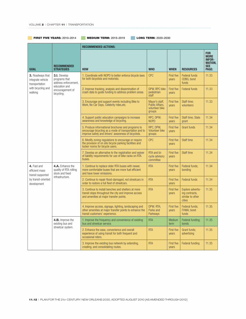
SummaryFIRST FIVE YEARS: 2010–2014 MEDIUM TERM: 2015–2019 LONG TERM: 2020–2030
GOALRECOMMENDED STRATEGIES
RECOMMENDED ACTIONS:
HOW WHO WHEN RESOURCES
FOR MORE INFOR-MATION, SEE PAGE:
1. Fix it First: Continued invest-ment in rebuilding and then main-taining roads and bridges
1.A. Repave or reconstruct all dam-aged streets within the city, whether from Hurricane Katrina or pre-existing condi-tions.
1. The City of New Orleans shall allocate suffi cient funds in each bond sale for street repairs so that the required 20 percent local match is set aside to ensure approval of federal transportation funding.
CAO; DPW Ongoing Capitol budget 11.19
2. Work with RPC to ensure that New Orleans receives and uses all federal transportation funds allocated to the city.
DPW; RPC; CPC transportation planner
First fi ve years
Staff time 11.19
3. Secure additional resources to bring New Orleans’ annual street maintenance budget in line with communities with high quality streets.
Mayor’s Offi ce; DPW; Regional Planning Commission
First fi ve years
Staff time 11.19
4. Make the public aware of street repair costs and criteria used to develop a priority list of repairs through public communications and meetings.
DPW First fi ve years
Staff time 11.20
5. Advocate for a statewide “fi x it fi rst” policy to direct state road funding toward road maintenance and repair, not new ex-urban road projects.
DPW; RPC First fi ve year
Staff time 11.20
6. Prepare another street repair bond when current bond funding is spent.
DPW; CAO Medium term
Staff time 11.20
7. Explore ways to increase parking revenues. DPW; consul-tant services
Medium term
Staff time; General Fund for consultant services
11.20
1.B. Regularly moni-tor streets, diagnose level of failure, and advance projects to address problems be-fore they grow larger and more expensive to fi x.
1. Implement a pavement management system as part of an overall city asset management system.
DPW; possible consultant services for selection, startup, training; possible coordination with RPC
Medium term
Staff time; gen-eral fund; basic system costs below $5,000/yr.
11.20

VOLUME 2 | CHAPTER 11 | TRANSPORTATION
11.8 | PLAN FOR THE 21ST CENTURY: NEW ORLEANS 2030, ADOPTED AUGUST 2010 [AS AMENDED THROUGH 2012]
FIRST FIVE YEARS: 2010–2014 MEDIUM TERM: 2015–2019 LONG TERM: 2020–2030
GOALRECOMMENDED STRATEGIES
RECOMMENDED ACTIONS:
HOW WHO WHEN RESOURCES
FOR MORE INFOR-MATION, SEE PAGE:
1. Fix it First: Continued invest-ment in rebuilding and then main-taining roads and bridges
1.C. Coordinate road repairs with other infrastructure projects to increase effi ciency, limit infrastructure costs, and preserve roadway quality and operations.
1. Coordinate with the Sewerage and Water Board to implement drainage and natural storm water management systems (bioswales, rain gardens) as streets are reconstructed and repaved.
DPW; S&WB First fi ve years
Staff time; storm water manage-ment grants
11.20
2. Improve upon existing protocols to coordinate with utility companies for major road repairs to ensure the simultaneous repair of subsurface infrastructure, including the possibility of a permitting process with fees and sanctions.
DPW; potential ordinance—City Council
Medium term
Staff time 11.21
3. Establish a permitting process and fee schedule for work that requires utility cuts in the streets or sidewalks, allow for tracking of projects, quality control of patched cuts and fi nancial incentives to limit cuts.
DPW First fi ve years
Staff time 11.21
4. Secure a cooperative endeavor agreement with Entergy to place above-ground utilities underground as roads are being comprehensively repaired.
DPW Medium term
Staff time; federal funds
11.21
2. Integration of land-use decision making with transportation projects
2.A. Establish a per-manent transportation planner position for the CPC.
1. Secure continued funding for a transportation plan-ner position.
City Planning Commission
First fi ve years
General fund; grant funding for transportation/ land use studies (federal and state)
11.21
2.B. Coordinate higher-density land uses with existing and future transit hubs to support walkable, mixed-use, transit-oriented neighborhoods.
1. Create area land use plans and associated zoning to allow transit-oriented development at appropriate locations and where the RTA is making investments.
CPC; transportation planner; coordinate with RTA
First fi ve years
CZO rewrite; staff time
11.21 - 11.23
2. Locate, design and maintain bus stops as neighbor-hood amenities located close to business/public space.
RTA First fi ve years
State and Federal transportation funding; advertising sponsorship
11.23
3. Encourage mixed-use developments within a fi xed distance of major transportation corridors
CPC; transportation planner; coordinate with RTA
First fi ve years
Staff time 11.23
2.C. Advance projects that enhance connectivity, reduce barriers and improve attractiveness of neighborhoods, commercial sites and public spaces while addressing transportation mobility.
1. Begin planning studies for the removal of the Clai-borne Avenue Expressway to St. Bernard Avenue.
CPC transpor-tation planner; RPC
First fi ve years
Federal transpor-tation funding
11.23
2. Study the feasibility of constructing a new bridge between Algiers and Chalmette to alleviate commuter traffi c and provide additional evacuation routes, which takes pressure off of I-10.
RPC Long term
Federal transpor-tation funding
11.23
3. Ensure safe access to transit stops and other major travel generators.
DPW, RTA First fi ve years
Road repair funds; CDBG
11.23
4. Develop landscape design requirements for pedes-trian walkways in parking lots.
CPC First fi ve years
CZO rewrite project
11.24

VOLUME 2 | CHAPTER 11 | TRANSPORTATION
PLAN FOR THE 21ST CENTURY: NEW ORLEANS 2030, ADOPTED AUGUST 2010 [AS AMENDED THROUGH 2012] | 11.9
FIRST FIVE YEARS: 2010–2014 MEDIUM TERM: 2015–2019 LONG TERM: 2020–2030
GOALRECOMMENDED STRATEGIES
RECOMMENDED ACTIONS:
HOW WHO WHEN RESOURCES
FOR MORE INFOR-MATION, SEE PAGE:
2. Integration of land-use decision making with transportation projects
2.D. Modify regula-tions to encourage infi ll development that supports a vibrant pedestrian environ-ment.
1. Modify zoning regulations to ensure that new devel-opment respects and is oriented to the pedestrian.
CPC First fi ve years
CZO rewrite project
11.24
2. Establish Traffi c Impact Analysis guidelines that look beyond the development site for pedestrian generators and linkages.
CPC, DPW, possible small consultant services contract
Medium term
Staff time; CDBG; smart growth oriented grant funding
11.24
3. Provide transit location criteria that support pedes-trian comfort and safety for access to and waiting for transit.
DPW, RTA First fi ve years
Staff time 11.24
2.E. Establish poli-cies that encourage effi cient manage-ment of parking and encourage alternative travel modes where they exist.
1. Modify off-street parking requirements to enhance parking effi ciency, improve urban design quality and encourage walking and alternative forms of transportation.
CPC First fi ve years
CZO rewrite 11.24
2. Exploration of incentives for remote parking and drop-off zones at schools, public facilities, shopping malls, and other destinations.
School Dis-tricts, Property Management Department, private owners
Medium Term
Staff Time 11.26
3. Roadways that integrate vehicle transportation with bicycling and walking
3.A. Implement the adopted “Complete Streets Policy” for the City of New Orleans which moves people and freight safely while prioritizing the non-motorized user by integrating various transportation modes.
1. Develop and adopt Complete Streets Guidelines for internal and consultant design engineers in project development.
DPW; CPC transportation planner
First fi ve years
Staff time; fund-ing from City, DOTD, FHWA
11.26
2. Require training on the design of Complete Streets for all design consultants doing business with the City.
DPW First fi ve years
Consultant; staff time
11.26
3. Evaluate sidewalk repair and maintenance ordi-nances and develop mechanisms for enforcement and betterment system options for property owners.
DPW; possible betterment ordinance - City Council
First fi ve years
Staff time 11.26
4. Update City of New Orleans Roadway Design Manual to include the best practices for the accommoda-tion of non-motorized transportation and streetscape improvements.
DPW First fi ve years
Staff time 11.26
5. Plan for and emphasize pedestrian, bicycle and tran-sit facilities linkages through improved design, funding, maintenance, enforcement and education.
DPW; RTA First fi ve years
Staff time 11.27
6. Implement pedestrian improvements for intersections, including ADA accessibility requirements, in areas with transit, pedestrian destinations, and high concentrations of children and elderly.
DPW First fi ve years
Staff time 11.2
7. Build capacity in DPW to track and guide multi modal accommodation in all projects and to coordinate with a transportation planner within the CPC.
DPW; CPC Transportation Planner
First fi ve years
General fund; grants
11.27
3.B. Establish a per-manent multi modal accommodation posi-tion within DPW.
1. Secure permanent funding for a multi modal accom-modation position to track and guide all road, bridge and community facilities capital and maintenance projects and coordinate with the transportation planner in the CPC, once one is hired.
DPW, CPC transportation planner
First fi ve years
Staff time, Grants 11.27

VOLUME 2 | CHAPTER 11 | TRANSPORTATION
11.10 | PLAN FOR THE 21ST CENTURY: NEW ORLEANS 2030, ADOPTED AUGUST 2010 [AS AMENDED THROUGH 2012]
FIRST FIVE YEARS: 2010–2014 MEDIUM TERM: 2015–2019 LONG TERM: 2020–2030
GOALRECOMMENDED STRATEGIES
RECOMMENDED ACTIONS:
HOW WHO WHEN RESOURCES
FOR MORE INFOR-MATION, SEE PAGE:
3. Roadways that integrate vehicle transportation with bicycling and walking
3.C. Develop a pe-destrian plan for the City of New Orleans.
1. Develop and adopt guidelines to improve the quality of the pedestrian environment throughout the city.
DPW First fi ve years
Federal funds; bond funds
11.27
2. Seek Safe Routes to Schools federal funding for walk-to-school programs and improvements.
DPW First fi ve years
Federal funds 11.28
3. Implement comprehensive streetscape upgrades to those boulevards not receiving recovery funding.
DPW; CPC transportation planner
Medium term
Federal funds; CDBG; developer contributions
11.28
3.D. Provide sig-nifi cant infrastructure investment to make major boulevards and corridors more attrac-tive and pedestrian-friendly particularly at transit stops.
1. DPW should develop and adopt guidelines for pedestrian facilities of all types to improve the quality of the pedestrian environment.
DPW First fi ve years
Recovery funds; CDBG; bond funds
11.28
2. Continue to build upon existing hurricane recovery appropriations to ensure comprehensive streetscape improvements in designated target areas.
DPW First fi ve years
Staff time 11.29
3. Implement comprehensive streetscape upgrades to those boulevards that are in need of upgrades.
DPW, CPC transportation planner
Medium term
Bond funds 11.29
4. Develop a system and procedures for regular mainte-nance of sidewalk infrastructure.
DPW Medium term
Staff time 11.29
3.E. Provide sig-nifi cant infrastructure investment to make neighborhood streets more attractive and pedestrian friendly.
1. Funding for “Complete Streets” construction and retrofi t/repair projects.
CAO; Council First fi ve years
Staff time,DOTD, FHWA, grants; bond funds
11.29
2. In coordination with street repaving projects, undertake a comprehensive streetscape improvement effort.
DPW; Parks and Parkways; DDD; RTA
First fi ve years
Staff time,DOTD, FHWA, grants; bond funds
11.29
3. Reinforce existing efforts to improve pedestrian infra-structure along neighborhood streets.
DPW; Parks and Parkways; DDD; RTA
First fi ve years
Staff time,DOTD, FHWA, grants; bond funds
11.29
4. Implement traffi c calming infrastructure along neighbor-hood streets, as needed.
DPW Medium term
Staff time 11.29
5. Develop a system and procedures for regular mainte-nance of sidewalk infrastructure.
DPW First fi ve years
Staff time 11.30
6. Review, update and implement the New Orleans ADA Transition Plan.
DPW; Mayor’s Offi ce
First fi ve years
Staff time 11.30
7. Support RTA’s effort to continue to improve safety for transit passengers and RTA employees, pedestrians and vehicular traffi c along streetcar lines and at or by bus and streetcar stops.
CPC, RTA, DPW, and NOPD
First fi ve years
Staff time 11.30

VOLUME 2 | CHAPTER 11 | TRANSPORTATION
PLAN FOR THE 21ST CENTURY: NEW ORLEANS 2030, ADOPTED AUGUST 2010 [AS AMENDED THROUGH 2012] | 11.11
FIRST FIVE YEARS: 2010–2014 MEDIUM TERM: 2015–2019 LONG TERM: 2020–2030
GOALRECOMMENDED STRATEGIES
RECOMMENDED ACTIONS:
HOW WHO WHEN RESOURCES
FOR MORE INFOR-MATION, SEE PAGE:
3. Roadways that integrate vehicle transportation with bicycling and walking
3.F. Develop a bicy-cling strategy for the City of New Orleans
1. Prior to creation of the plan, all state roadways that are presently planned for resurfacing or reconstruction should be considered for bicycle accommodation.
DPW; RPC; CPC Transpor-tation Planner
First fi ve years
Staff time 11.30
2. Incorporate “Complete Streets” guidelines into the strategy.
DPW; RPC; CPC Transpor-tation Planner
First fi ve years
Staff time 11.30
3. City should include adequate funding for future bicycle improvements.
City Council; Administration; CPC
First fi ve years
Staff time 11.30
3.G. As part of the comprehensive bicycling plan, create a comprehensive, connected citywide network of bike lanes, multi-use paths, and bike boulevards to safely accommodate bicyclists.
1. Establish a Pedestrian and Bicycle Advisory Committee, to assist in reviewing city projects, policies and plans and engage bicycle users.
DPW First fi ve years
Staff time 11.31
2. Develop the Lafi tte Greenway as a key bicycle and pedestrian corridor.
DPW First fi ve years
Staff time 11.31
3. Review previous bike plans and studies including the 2004 Transportation Element, UNOP plans and others and set priorities for adding street facilities/lanes in a phased manner.
DPW; RPC, CPC transportation planner
First fi ve years
Staff time, grants 11.31
4. As streets are being repaved, ensure that new bike facilities are provided.
DPW First fi ve years
Recovery funds; D-CDBG; bond funds; fed. Fund
11.32
5. For streets which are already in good condition and not in need of repaving, retrofi t streets with bike facilities.
DPW First fi ve years
DOTD, FHWA, grants; bond funds
11.32
6. Develop standards and guidelines for bicycle facilities. DPW First fi ve years
Staff time 11.32
7. Where feasible, extend and create levee top paved bike paths.
CPC transpor-tation planner, RPC, DPW
Medium term
Federal funds; bond funds
11.32
8. Study then establish a network of bike boulevards that takes advantage of quieter neighborhood streets.
RPC, CPC transportation planner
First fi ve years
Federal funds; staff time
11.32
3.H. Provide fi xed infrastructure to further bicyclist safety and security and to encourage bicycling as an alternative mode of transportation.
1. Provide ample bike racks and/or lockers on public rights of way at key activity nodes.
DPW, NOPD First fi ve years
Staff time 11.33
2. Allow for the transformation of a limited number of on street, parallel vehicular parking spaces into on street bike rack/storage areas as demand or adjacent landowners if calls for it.
DPW First fi ve years
Staff time 11.33
3. Provide improved on site bicycle storage and other amenities for bicycle users at publicly owned buildings.
DPW, Project Delivery Unit
First fi ve years
Recovery funds 11.33
4. Develop a public bike rental program, modeled on Paris’ Velib and other successful programs, with public bike kiosks throughout the city.
RTA with support from RPC bicycle advisory com-mittee
First fi ve years
Grants 11.33
VOLUME 2 | CHAPTER 11 | TRANSPORTATION
11.12 | PLAN FOR THE 21ST CENTURY: NEW ORLEANS 2030, ADOPTED AUGUST 2010 [AS AMENDED THROUGH 2012]
FIRST FIVE YEARS: 2010–2014 MEDIUM TERM: 2015–2019 LONG TERM: 2020–2030
GOALRECOMMENDED STRATEGIES
RECOMMENDED ACTIONS:
HOW WHO WHEN RESOURCES
FOR MORE INFOR-MATION, SEE PAGE:
3. Roadways that integrate vehicle transportation with bicycling and walking
3.I. Develop programs that address enforcement, education and encouragement of bicycling.
1. Coordinate with NOPD to better enforce bicycle laws for both bicyclists and motorists.
CPC First fi ve years
Federal funds CDBG, bond funds
11.33
2. Improve tracking, analysis and dissemination of crash data to guide funding to address problem areas.
DPW, RPC bike pedestrian staff
First fi ve years
Federal funds 11.33
3. Encourage and support events including Bike to Work, No Car Days, Celebrity rides,etc.
Mayor’s staff, Public Affairs, volunteer bike groups
First fi ve years
Staff time; volunteers
11.33
4. Support public education campaigns to increase awareness and knowledge of bicycling.
RPC; DPW; NOPD
First fi ve years
Staff time; State grant
11.34
5. Produce informational brochures and programs to encourage bicycling as a mode of transportation and to improve safety and drivers’ awareness of bicyclists.
RPC, DPW, Volunteer bike groups
First fi ve years
Grant funds 11.34
6. Modify zoning regulations to encourage or require the provision of on site bicycle parking facilities and locker rooms for bicycle users.
CPC First fi ve years
Staff time 11.34
7. Develop an alternative to the registration and waiver of liability requirements for use of bike racks on RTA buses.
RTA and bi-cycle advisory committee
First fi ve years
Staff time 11.34
4. Fast and effi cient mass transit supported by transit-oriented development
4.A. Enhance the quality of RTA rolling stock and fi xed infrastructure.
1. Continue to replace older RTA buses with newer, more comfortable buses that are more fuel effi cient and have lower emissions.
RTA First fi ve years
Federal funds; bonding
11.34
2. Continue to repair fl ood-damaged, red streetcars in order to restore a full fl eet of streetcars.
RTA First fi ve years
Federal funds 11.34
3. Continue to install benches and shelters at more transit stops throughout the city and improve access and amenities at major transfer points.
RTA First fi ve years
Explore advertis-ing contracts, similar to other cities
11.35
4. Improve access, signage, lighting, landscaping and other amenities at major transfer points to enhance the transit customers’ experience.
DPW; RTA; Parks and Parkways
First fi ve years
Federal funds; FHWA; bond funds
11.35
4.B. Improve the existing bus and streetcar system.
1. Improve the frequency and convenience of existing bus and streetcar service.
RTA Medium term
Federal funding; bonds
11.35
2. Enhance the ease, convenience and overall experience of using transit for both frequent and occasional riders.
RTA First fi ve years
Grant funds; advertising
11.35
3. Improve the existing bus network by extending, creating, and consolidating routes.
RTA First fi ve years
Federal funding 11.35

VOLUME 2 | CHAPTER 11 | TRANSPORTATION
PLAN FOR THE 21ST CENTURY: NEW ORLEANS 2030, ADOPTED AUGUST 2010 [AS AMENDED THROUGH 2012] | 11.13
FIRST FIVE YEARS: 2010–2014 MEDIUM TERM: 2015–2019 LONG TERM: 2020–2030
GOALRECOMMENDED STRATEGIES
RECOMMENDED ACTIONS:
HOW WHO WHEN RESOURCES
FOR MORE INFOR-MATION, SEE PAGE:
4. Fast and effi cient mass transit supported by transit-oriented development
4.C. Invest in new rail, streetcar, and bus rapid transit (BRT) infrastructure by obtaining federal and local funding.
1. Extensively study the feasibility of a streetcar and/or light rail hybrid distributor system in the Central Business District and French Quarter.
CPC transpor-tation planner; RTA support; RPC
First fi ve years
Grant funds 11.36
2. Conduct feasibility studies for new streetcar, light rail and BRT routes to connect residential and commercial districts throughout the city and to support higher-density transit oriented development (TOD).
RTA; RPC; CPC
Medium term
Federal funds 11.37
3. Identify and preserve future rights-of-way to avoid confl icts and accommodate future streetcar, BRT and light rail route expansions.
RTA; RPC; CPC; DOTD; DPW
Medium term
Federal and local funds
11.38
4. Seek federal and regional funding to study development of a regional passenger rail system and other modes of commuter transportation.
RPC; DOTD Long term
Federal funds 11.38
4.D. Better market transit service to increase mode share (percent of people who use transit).
1. Develop promotional materials to highlight the benefi ts and cost savings of using public transit.
RTA with So-cial Services and Housing Authority support
First fi ve years
Social Services and grant funds
11.39
4.E. Create forums and entities for agency coordination and consolidation to improve transit service delivery and sustainability.
1. Create a transit working group that includes transit providers, traffi c management, planing and travel demand management staff from each jurisdiction to collaborate on the actions of each required to support transit.
RTA; RPC; Jefferson and St. Bernard Transit and traffi c and planning staff from each parish
Medium term
Staff time 11.39
4.F. Identify and study potential new Mississippi River Ferry connections.
1. Conduct a study to identify new potential Mississippi River ferry connections.
RPC; CCC Medium term
State funds 11.39

VOLUME 2 | CHAPTER 11 | TRANSPORTATION
11.14 | PLAN FOR THE 21ST CENTURY: NEW ORLEANS 2030, ADOPTED AUGUST 2010 [AS AMENDED THROUGH 2012]
FIRST FIVE YEARS: 2010–2014 MEDIUM TERM: 2015–2019 LONG TERM: 2020–2030
GOALRECOMMENDED STRATEGIES
RECOMMENDED ACTIONS:
HOW WHO WHEN RESOURCES
FOR MORE INFOR-MATION, SEE PAGE:
5. Enhanced intercity trans-portation with upgraded airport, better passenger rail service, and ultimately regional high-speed rail
5.A. Preserve and enhance Louis Arm-strong New Orleans International Airport as the preeminent airport facility in the state.
1. Make major capital improvements and enhance marketing at Louis Armstrong New Orleans Interna-tional Airport to increase air traffi c.
Aviation Board First fi ve years
Bond funds 11.40
2. Complete improvements to airport terminals and expand terminals, as needed.
Aviation Board First fi ve years
Bond funds 11.40
3. Develop a passenger rail connection between the CBD, LANOIA and Baton Rouge.
RPC, City, RTA, Airport Authority
Long term
Federal Funding 11.40
5.B. Support and advocate for federal and state funding for high speed and regional rail lines between New Orleans and other communities.
1. Work with elected leadership to promote high-speed rail and to reinstate the New Orleans/Jacksonville Amtrak route.
City Council; SHSRC;
First fi ve years
Staff time 11.40
2. Actively work to reinstate and improve service between New Orleans and Jacksonville, FL.
AMTRAK; Congressional leadership; Mayor’s Offi ce; State leader-ship
First fi ve years
State funds 11.40
5.C. Improve con-nectivity and the en-vironment for users of the Union Passenger Terminal (UPT).
1. Conduct a study to improve multi modal access to and from the UPT.
RTA; RPC; DPW
First fi ve years
Federal funds 11.40
2.. Identify a priority location for pedestrian access and visibility for a UPT streetcar stop as part of streetcar system expansion plans.
City with RTA and Amtrak support
Medium term
Staff time 11.41
3. Focus planning efforts to access and improve mobil-ity to and from the UPT in all trip segments.
RTA; RPC; DPW
First fi ve years
Federal funds 11.41
4. Improve station conditions. Amtrak Long term
Federal funds 11.41
6. Freight trans-portation systems that serve the economy while respecting neigh-borhoods
6.A. Support capital improvements that are needed to keep the Port of New Orleans competitive while protecting quality of life.
1. Commission an independent review of the argu-ments for and against the Inner Harbor Canal Lock project to resolve community issues.
Mayor’s Offi ce First fi ve years
General fund 11.41
6.B. Refi ne and implement the New Orleans Rail Gateway Plan to improve railroad safety.
1. Encourage participation in EIS public hearings. CPC, RPC, New Orleans Public Belt, Class I Rail-roads
First fi ve years
Staff time; local, state and federal funding.
11.41
2. Pursue federal funding for the Gateway Plan, including adequate funding for the implementation of community mitigation and improvement projects.
RPC, New Orleans Public Belt, Class I Railroads, CPC
Medium term
Federal funding 11.41

VOLUME 2 | CHAPTER 11 | TRANSPORTATION
PLAN FOR THE 21ST CENTURY: NEW ORLEANS 2030, ADOPTED AUGUST 2010 [AS AMENDED THROUGH 2012] | 11.15
FIRST FIVE YEARS: 2010–2014 MEDIUM TERM: 2015–2019 LONG TERM: 2020–2030
GOALRECOMMENDED STRATEGIES
RECOMMENDED ACTIONS:
HOW WHO WHEN RESOURCES
FOR MORE INFOR-MATION, SEE PAGE:
6. Freight trans-portation systems that serve the economy while respecting neigh-borhoods
6.C. Continue to refi ne truck routes and truck parking requirements while improving education and enforcement.
1. Conduct a comprehensive review of the designated truck route system and update it as needed.
CPC, RPC, Port of New Orleans, DPW, Police
First fi ve years
Staff time 11.42
2. Conduct systematic outreach to trucking companies on approved truck routes.
RPC, DPW, Port of New Orleans, Police
First fi ve years
Staff time 11.42
3. Work with NOPD to ensure that there is vigorous enforcement of truck traffi c regulations.
DPW; NOPD First fi ve years
Staff time 11.42
4. Work to improve access to and from all inter modal freight terminals through way-fi nding signage and street improvements.
DPW; DOTD First fi ve years
City and State funds
11.42
6.D. Ensure that the City’s hazard-mitigation plan contains suffi cient standards for the movement of hazardous materials by truck and rail through the city.
1. Conduct a comprehensive review of the designated truck route system and update the list of streets with input from neighborhoods, truckers, business parks, in-ter modal terminal operators and other relevant groups.
DPW; Port of New Orleans; DOTD; NOPB; CPC Transportation Planner
First fi ve years
Staff time 11.42
7. Transportation infrastructure that is resilient to fl ooding and other natural hazards.
7.A. Make capital investments and implement administrative strategies to ensure the resilience of the city’s transportation infrastructure against future hazards.
1. Ensure that a thorough, timely, regularly updated plan is in place to secure bus and streetcar rolling stock from fl ooding.
Offi ce of Emergency Preparedness; RTA
First fi ve years
Staff time 11.43
2. As transportation facilities are renovated, ensure that critical building systems are elevated and that facilities are hardened against fl ood and wind damage.
RTA First fi ve years
Recovery funds; bond funds; federal funds
11.43
3. Minimize potential fl ood damage by using resistant techniques and materials in road and drainage repair.
DPW First fi ve years
Recovery funds; bond funds; federal funds
11.43

VOLUME 2 | CHAPTER 11 | TRANSPORTATION
11.16 | PLAN FOR THE 21ST CENTURY: NEW ORLEANS 2030, ADOPTED AUGUST 2010 [AS AMENDED THROUGH 2012]
Getting StartedThese items are short-term actions that can be undertaken with existing funding, or relatively little expenditure, and will help lay the groundwork for the longer-term actions that follow.
• Continue road repair and reconstruction of all damaged streets.
• Identify and publicize criteria for road and bridge improvements.
• Adopt a “Complete Streets” policy that recognizes street space should be designated to accommodate a variety of users including pedestrians, bicyclists, drivers, and transit riders.
• Work with the Regional Planning Commission to make sure the City receives and uses all allocated federal transportation funds.
• Establish a permanent transportation planner position for the CPC.
• Provide zoning to allow transit-oriented development at transit hubs along existing, proposed or potential transit lines.
• Seek federal funding to start a feasibility study on future options for the I-10 Claiborne Expressway, including replacement with a boulevard.
NarrativeBelow is a more detailed narrative of the various goals, strategies and actions highlighted in the “Summary” chart.
FUTURE ROAD REPAIR AND MAINTENANCEThe combined eff ects of pre-Hurricane Katrina budget constraints and fl ood impacts resulted in catastrophic damage to the city’s transportation network, especially its roads and streets. Fixing the city’s streets is the top transportation priority for New Orleanians across the city, but especially in fl ood-damaged neighborhoods. Disaster funding, whether through FEMA or the federal Submerged Roads Program, is designed by statute to fund repairs up to the condition at the time of the disaster. In New Orleans, local street conditions were poor at the time of the storm because of years of limited funding and maintenance. City offi cials are working to stretch disaster dollars as much as possible to bring streets up to a good standard, but in the long term, maintenance of local streets will remain a local fi nancial responsibility. Closer coordination with LaDOTD, the RPC and the City’s community development department can provide funds for certain kinds of improvements, such as streetscape projects. Bonds are the usual source of road improvement funding. The street condition inventories done by the DPW with FEMA since the storm provide the foundation for creating a program that identifi es costs and sets out clear criteria for applying scarce resources, and proposes priorities.
The conditions facing the City in terms of street repair and maintenance costs and the fi nancing options once the disaster funding is gone should be part of a public conversation. Convening a group of community stakeholders to discuss these issues and develop a plan for priorities and for fi nancing can help inform the public about the need for revenue increases and bonding. It is very important that the City communicate to the public what the costs and options are for a long-term program of street repair and maintenance.

VOLUME 2 | CHAPTER 11 | TRANSPORTATION
PLAN FOR THE 21ST CENTURY: NEW ORLEANS 2030, ADOPTED AUGUST 2010 [AS AMENDED THROUGH 2012] | 11.17
To ensure that the City is able to repair and maintain its extensive road network, a full range of additional fi scal enhancements should be explored, including demand and resource management with:• Better tracking and management of federal aid eligible projects and other public sources of
roadway system preservation funding (federal, state, local), potentially by a new full-time federal grants coordinator or manager. This is particularly important as the transportation reauthorization of 2010 takes shape, in which funds are anticipated to be directed toward multimodal system preservation, for which New Orleans will be at a competitive advantage due to its existing system.
• Improved infrastructure resource management to better position the city to receive federal and state grants. A pavement management system would provide clearly identifi ed roadway repair needs, direct funds where most needed, and identify funding gaps. This would allow the City to expediently apply for funding by presenting a detailed plan with clearly identifi ed needs.
• A short-term dedicated infrastructure tax, established through referendum or legislation, similar to what other low-tax cities like Wichita and Oklahoma City have enacted to raise funding for infrastructure improvements including roads; and
• Impact or “system development” charges (SDC) from the private sector for targeted redevelopment areas. For SDCs, cities bond fund infrastructure improvements, which is repaid by private developers who pay an impact fee/development charge based on the number of new units or square footage they add to the system within these targeted redevelopment areas. For example, an ordinance similar to Vancouver, WA’s Planned Action Ordinance (PAO), which established a small area plan and enacted development impact fees to pay for infrastructure improvements, could be adapted to target areas within New Orleans where market interest is reasonably high and where the City would be willing to bond fund projects that could be reimbursed by these SDCs.
WHY NEW ORLEANS SHOULD BE A MODEL OF TRANSPORTATION CHOICEThe most successful cities in America off er a wide array of choices to their residents—in neighborhoods, employment, culture, recreation, and in transportation. Transportation choice is becoming more important than ever with long-term energy prices increasing, a high percentage of
greenhouse gas emissions from transportation, and a growing urban market preference for locations with multiple options. Expanding and enhancing an urban transportation system of choice is a long-term process that requires careful and coordinated planning, community process, advocacy for funding, and step by step implementation. Transportation choice also translates to transportation effi ciency: optimum use of existing roadway space, effi cient mass transit, reduced capital investments and operating costs, reduced congestion and travel times, and better air quality and public health. Transportation choice and transportation effi ciency is most successful when it involves coordinating land use decision making with a supporting mix of complementary land uses and transportation options, including transit, in a relatively small area; compact, relatively dense residential or
employment development with a mix of housing types and aff ordability; connectivity of motorized and non-motorized facilities; management of parking supply and use; and plans to ensure improved safety and facilities for pedestrians and bicyclists.
COMPLETE STREETSNew Orleans has the foundation for a great multimodal transportation system and has begun to make some of the investments necessary in roadway, pedestrian and bicycle improvements. The City is
The Metro Orange Line BRT in Los Angeles
runs in an exclusive lane and offers on-time
route information at covered station areas.

VOLUME 2 | CHAPTER 11 | TRANSPORTATION
11.18 | PLAN FOR THE 21ST CENTURY: NEW ORLEANS 2030, ADOPTED AUGUST 2010 [AS AMENDED THROUGH 2012]
working to include enhanced pedestrian and bicycle facilities as it upgrades streets and streetscapes. An offi cial “complete streets” policy that mandates consideration of pedestrians and bicycles in every road project can ensure continued attention to all of these travel modes. Even in the parts of the city with more suburban-style development patterns, walking and bicycling can take the place of some auto trips if safe, convenient and attractive facilities are made available, and making destinations more pedestrian-friendly will make it possible to park once and walk at destinations, rather than entering multiple curb cuts. Regardless of how much driving we do, we are all pedestrians at the beginning and end of a trip.
PREMIUM TRANSITIn many cities, transit has tended to become the transportation of last resort, serving those who cannot drive or who do not own cars. To a great degree this is still the case in New Orleans, except for tourist travel on the streetcars, and ferry traffi c. By creating a premium transit system that attracts “choice” riders, New Orleans can provide better service to everyone, capture more revenue to operate and maintain the system, reduce pollution, moderate the number of vehicle miles traveled, and attract investment around transit hubs. The principles of premium transit are reliable on-time service, safe and convenient pedestrian access for the most users from the fewest number of stops, good connections to the overall transit system and regional transit connections.
Transit is the most transformative urban transportation mode, but also the most expensive and most demanding in terms of planning and coordination. New Orleans has a unique advantage over most American cities because of its core network of existing streetcar and bus routes, and their maintenance facilities and operating infrastructure. With adjustments that provide greater reliability, fewer stops, and shorter travel times, these existing routes have the potential to serve as NORTA’s fi rst links for a new and improved citywide premium transit network of buses, streetcars and rail systems. To more successfully serve residents, an expanded streetcar system needs to evolve towards modern trolley or light rail with fewer stops and more rapid service, in dedicated lanes away from automobile traffi c. However, trolley or light rail systems are very expensive.
An alternative, more cost-eff ective way to bring parts of the city where population densities cannot support rail lines within an upgraded transit system is to develop a bus rapid transit (BRT) network. BRT combines the fl exibility of buses, because it uses roadways, with the service advantages of rail. BRT systems are already successful around the world, from South America to Australia, and are becoming more visible in the United States, from Los Angeles, Cleveland, and San Francisco, to Houston and Boston. The best BRT systems adhere to “Premium Transit” principles, and have exclusive lanes on a roadway, stations where passengers pay before they get on, multiple-door vehicles fueled by clean energy, and they can off er express or local service. Because they are cheaper to build than rail, they can be put in place more quickly, making the transport and air quality benefi ts available more quickly. In New Orleans, BRT from the CBD to a New Orleans East station at a redeveloped Lake Forest Plaza or central location, and similarly along General De Gaulle on the West Bank to a redeveloped Schwegman’s site, and with a feeder to Federal City, could create transit hubs with feeder buses and attract compact, transit-oriented development, just like a transit station.
INTEGRATING LAND USE AND TRANSPORTATION PLANNINGBecause transportation projects are expensive and take a long time to come to fruition, it is essential that
A new streetcar extension along St. Claude
Avenue would provide transportation choice
to area residents, and support a walkable,
amenity-rich mixed-use neighborhood corridor.

VOLUME 2 | CHAPTER 11 | TRANSPORTATION
PLAN FOR THE 21ST CENTURY: NEW ORLEANS 2030, ADOPTED AUGUST 2010 [AS AMENDED THROUGH 2012] | 11.19
New Orleans start now to make sure that land use and transportation planning is integrated eff ectively. There are numerous strategies that should be researched including but not limited to access management (e.g., reducing the number of driveways on a corridor, rear parking requirements, and other policies); encouraging mixed-use development with housing and retail together; controlling lot sizes or density to reduce need for street expansion; reclaiming and retrofi tting heavy volume elevated streets to at-grade boulevards; and transit oriented development along existing and new transit lines. Research has also shown the need to plan for transit oriented development on a new line before the fi rst train or BRT vehicle leaves the station. The greatest success comes when a transit agency or city acquires developable land adjacent to a transit station (or potential station) and is able to capture the revenue from leasing the land to a developer. NORTA, NORA, the CPC and other city agencies should be working together to identify potential sites while the city is still in the recovery process.
GOAL 1
“Fix it First”—continued investment in rebuilding and maintaining roads and
bridges
1.A Repave or reconstruct all damaged streets within the city, whether from Hurricane Katrina or pre-existing conditions.
RECOMMENDED ACTIONS
1. The City of New Orleans shall allocate suffi cient funds in each bond sale (and other sources of funding) for street repairs so that the required 20 percent local match is set aside to ensure approval of federal transportation funding. Who: CAO; DPW When: Ongoing Resources: Capital Budget
2. Work with the RPC to ensure that New Orleans receives and uses all federal transportation funds allocated to the city. Who: DPW; RPC; CPC transportation planner When: First fi ve years Resources: Staff time
3. Secure additional resources to bring New Orleans’ annual street maintenance budget in line with communities with high quality streets. Who: Mayor’s offi ce; DPW; RPC When: First fi ve years Resources: Staff time > Secure additional federal funds to
continue post-Hurricane Katrina repairs.
> Make the public aware of street repair costs and criteria used to develop a priority list of repairs.
> Prepare another street repair bond when current bond funding is spent.
> Explore increasing parking revenues.
Transit needs a critical mass of density to support it. Minimum
densities within walking distance to support transit are:
• 7–8 households per acre around bus stops
• 15–20 households per gross acre for rail or high-frequency
BRT
• 50 employees per gross acre for a shift from cars to transit or
walking.
In addition to these densities, which would not require unusual de-
partures from existing density ranges in the urban condition of New
Orleans, transit also requires suffi cient connectivity, so passengers
can get to the station. New Orleans’ dense street grid provides this
level of connectivity in most areas.
Transit and Density

VOLUME 2 | CHAPTER 11 | TRANSPORTATION
11.20 | PLAN FOR THE 21ST CENTURY: NEW ORLEANS 2030, ADOPTED AUGUST 2010 [AS AMENDED THROUGH 2012]
4. Make the public aware of street repair costs and criteria used to develop a priority list of repairs through public communications and meetings. Who: DPW When: First fi ve years Resources: Staff time
5. Advocate for a statewide “fi x it fi rst” policy to direct state road funding toward road maintenance and repair, not new exurban road projects. Who: DPW; RPC When: First fi ve years Resources: Staff time
6. Prepare another street repair bond when current bond funding is spent. Who: DPW; CAO When: Medium term Resources: Staff time
7. Explore ways to increase parking revenues. Who: DPW; consultant services When: Medium term Resources: Staff time, General Fund for consultant services
1.B Regularly monitor streets, diagnose level of failure, and advance projects to address problems before they grow larger and more expensive to fi x.
RECOMMENDED ACTIONS
1. Implement a pavement management system, as part of an overall city asset management system, to provide a cost eff ective approach to system preservation, and establish technical criteria for street upgrade or replacement. Who: DPW; Possible consultant services for selection, startup, training, possible coordination with RPC. When: Medium term Resources: Staff time; general fund; basic system costs below $5 K per year
Management and monitoring systems should include:> Employ state of the art engineering techniques and resource knowledge to make decisions
on paving materials to ensure that streets remain in good condition for as long as possible.> Adopt a routine schedule and performance measures to ensure that all roads are repaired
at regular intervals and remain in good condition. Redirect resources to continual, minor repairs to avoid having to perform major street reconstruction projects.
> Establish performance standards for responding to and addressing potholes within a certain period of time.
1.C Coordinate road repairs with other infrastructure projects to increase effi ciency, limit infrastructure costs, and preserve roadway quality and operations.
ACTIONS
1. Coordinate with the Sewerage and Water Board to implement drainage and natural stormwater management systems (bioswales, rain gardens) as streets are reconstructed and repaved. Who: DPW; S&WB When: First fi ve years Resources: Staff time; stormwater management grants

VOLUME 2 | CHAPTER 11 | TRANSPORTATION
PLAN FOR THE 21ST CENTURY: NEW ORLEANS 2030, ADOPTED AUGUST 2010 [AS AMENDED THROUGH 2012] | 11.21
2. Improve upon existing protocols to coordinate with Entergy, the Sewerage and Water Board, Cox and AT&T for major road repairs to ensure the simultaneous repair of sub-surface infrastructure. Who: DPW; potential ordinance; City Council When: Medium term Resources: Staff time
3. Establish a permitting process and fee schedule for work that requires utility cuts in the streets or sidewalks, allows for tracking of projects, quality control of patched cuts and fi nancial incentives to limit cuts. Who: DPW When: First fi ve years Resources: Staff time
> Implement a policy that imposes a moratorium or heavy fi ne on utility cuts for the fi rst fi ve years following a road resurfacing or reconstruction.
4. Secure federal and local funding and a cooperative endeavor agreement with Entergy to place above-ground utilities underground as roads are being comprehensively repaired. Who: DPW When: Medium term Resources: Staff time; Federal funds
GOAL 2
Integration of land-use decision making with transportation projects, including
higher density transit-oriented development
2.A Establish a permanent transportation planner position for the CPC.
An experienced transportation planner will provide the CPC with expertise in land use/transportation relationships, update the Major Street Plan as needed, write grants for transportation studies, identify potential alternative truck routes and intersections, and serve as an offi cial liaison for the CPC with other city and state agencies and the Regional Planning Commission on transportation planning and all projects with transportation elements.
RECOMMENDED ACTION
1. Secure continued funding for a transportation planner position. Who: DPW When: Medium term Resources: Staff time; Federal funds
The CPC recently received a grant to fund a transportation planner for three years.
2.B Coordinate higher-density land uses with existing and future transit hubs to support walkable, mixed-use, transit-oriented neighborhoods along existing and potential future transit routes.
With the ongoing investment in transit and the development of transportation corridors in New Orleans, the city should encourage mixed-use developments within a fi xed distance of all major transportation corridors as the basis of a transit-oriented development policy. The city should also set distinct thresholds for density and mixed-uses aligned with the capacity of fi xed and non-fi xed transit lines, respectively. In all transit-oriented corridors, the combination of existing land uses and planned land uses should meet or exceed a threshold for mixed-income housing. Transit extension projects for areas that do not currently refl ect corridor goals for mixed-uses and mixed-income housing should receive prioritized support by agencies and the city for the redevelopment of these corridors to leverage transit investment.

VOLUME 2 | CHAPTER 11 | TRANSPORTATION
11.22 | PLAN FOR THE 21ST CENTURY: NEW ORLEANS 2030, ADOPTED AUGUST 2010 [AS AMENDED THROUGH 2012]
The possibility of removing the el-
evated I-10 Claiborne Expressway
attracted extensive comment in the
Master Plan process. The multiple benefi ts
of the undertaking are widely recognized:
removal would right a decades-old wrong
committed in the name of urban renewal; it
would enhance the livability and character
of adjacent neighborhoods like Tremé; it
would promote investment in the neglected
blocks along the expressway; and it would
set the stage for restoring historic Claiborne
as a grand, tree-lined boulevard. Concerns
focus on the ability to move I-10’s current
traffi c through the city without overwhelming
neighborhood streets, serve downtown’s
traffi c needs, and avoid widening other
expressways such as I-610.
The process of replacing the expressway
would begin with feasibility and environ-
mental-impact studies, largely funded
through federal grants, to address these
concerns and insure that the transportation,
economic, social, environmental, and other
benefi ts of removing the expressway out-
weigh the considerable costs. These stud-
ies would start by determining the sizable
costs of maintaining the aging overpass
and would identify alternatives such as:
• Increasing I-610’s capacity by improv-
ing its safety and taking advantage of
the unused space between its inbound
and outbound lanes.
• Creating a tree-lined
boulevard that
captures the qualities
of historic Claiborne
Avenue.
• Providing transit to serve New Orleans
East and neighborhoods along the
restored boulevard.
• Using land freed by removal of the
overpass and on-ramps for parks,
housing, and other amenities
• Protecting neighborhoods from cut-
through traffi c.
Boston and San Francisco have complet-
ed comparable initiatives, and studies for
similar projects are underway in Hartford,
Baltimore, Oklahoma City, and Seattle. In
every case, the process began with fed-
eral and state help in fi nancing studies of
costs, benefi ts, and a wide range of transit
and roadway alternatives.
Frequently asked questions:
What is the next step? Seek a
federal grant to begin a community-
based study of the options for the future
of the overpass that includes all affected
neighborhoods and community groups.
Will removing the overpass re-
quire widening I-610? The goal is to
avoid widening I-610; the neighborhoods
located along I-610 will be involved in
planning.
Would New Orleans need to plan
for the future of I-10 whether or
not it is removed?
Yes. Parade Magazine
recently ranked I-10
among American elevated
highways most in need of
repair. I-10 was planned
and designed to meet the
city’s needs in the 1970s,
not the 21st century.
Study the feasibility of replacing the I-10 Claiborne
Expressway and restoring Claiborne Avenue as a
major thoroughfare to knit neighborhoods back
together
2030
New directional ramps serve New Orleans East-to-downtown traffic
New transit hub for express ser-vice to downtown
Claiborne Avenue rebuilt asa grand boulevard with co-ordinated traffic signals for cars and transit-signal prior-ity for premier transit serice
Safety and geomet-ric improvements support increased traffic volume
8 minutes’ added travel time from northeast into downtown using either route after reconstruction
SOURCE: KITTELSON & ASSOCIATES
2009

VOLUME 2 | CHAPTER 11 | TRANSPORTATION
PLAN FOR THE 21ST CENTURY: NEW ORLEANS 2030, ADOPTED AUGUST 2010 [AS AMENDED THROUGH 2012] | 11.23
To be considered toward the transit-oriented corridor development goal, planned land uses must be adopted through general plans, and the appropriate implementation processes must be put in place, such as the Comprehensive Zoning Ordinance (CZO). General language alone without supportive implementation practices, such as zoning, will not be considered suffi cient for the purposes of refl ecting the transit-oriented development goals of this Master Plan. Planned land uses will be formally adopted through the FLUM process, the CZO and any general plan amendments adopted through the appropriate statutory authority at a public hearing. All design for the transit-oriented development corridor shall refl ect the character of the area it is serving.
RECOMMENDED ACTIONS
1. Create area land use plans and zoning regulations to encourage walkable, higher density, mixed-use, transit-oriented development (TOD) at key transportation opportunity nodes. Who: CPC transportation planner; coordinate with RTA When: First fi ve years Resources: CZO rewrite; staff time
This would include identifying areas along existing or proposed transit corridors that could support higher density residential, commercial or mixed-use development. (See Strategy 4.C for existing and potential transit routes.)
2. Locate, design and maintain bus stops as neighborhood amenities located close to business/public space. Who: RTA When: First fi ve years Resources: State and Federal transportation funding; advertising sponsorship
3. Encourage mixed-use developments within a fi xed distance of major transportation corridors. Who: CPC, transportation planner; coordinate with RTA When: First fi ve years Resources: Staff time
2.C Advance projects that enhance connectivity, reduce barriers and improve attractiveness of neighborhoods, commercial sites and public spaces while addressing transportation mobility.
RECOMMENDED ACTIONS
1. Begin planning studies to determine the feasibility/advisability of removing the I-10 Claiborne Avenue Expressway to St. Bernard Avenue to improve neighborhood and land use quality and connectivity. Who: CPC transportation planner; RPC When: First fi ve years Resources: Federal transportation funding
2. Study the feasibility of constructing a new bridge between Algiers and Chalmette alleviate commuter traffi c and provide additional evacuation routes, which takes pressure off I-10. Who: RPC When: Long term Resources: Federal transportation funding
3. Ensure safe access to transit stops and other major travel generators through improved intersection visibility (lights and high visibility pavement markings), sidewalk repairs and pedestrian countdown signals. Who: DPW; RTA When: First fi ve years Resources: Road repair funds; CDBG

VOLUME 2 | CHAPTER 11 | TRANSPORTATION
11.24 | PLAN FOR THE 21ST CENTURY: NEW ORLEANS 2030, ADOPTED AUGUST 2010 [AS AMENDED THROUGH 2012]
4. Develop landscape design requirements for parking lots with shade and lighting, and materials for pedestrian walkways to enhance and produce safe walkways and a pleasant pedestrian environment. Who: CPC When: First fi ve years Resources: CZO rewrite project
Surface parking lots are unfriendly to pedestrians and act as barriers to connection. Design requirements for landscaping, 50 percent tree canopy to provide shade, pedestrian-scale lighting, and safe pedestrian walkways through surface lots make them more comfortable for pedestrian connections. Parking structures should be designed to include ground fl oor retail.
2.D Modify regulations to encourage infi ll development that supports a vibrant pedestrian
environment.
RECOMMENDED ACTIONS
1. Modify zoning regulations to ensure that new development respects and is oriented toward the pedestrian, through building orientation, setback, signage, parking, and design review regulations. Who: CPC When: First fi ve years Resources: CZO rewrite project
2. Establish Traffi c Impact Analysis guidelines that look beyond the development site for pedestrian generators and linkages. Who: CPC; DPW; possible small consultant services contract When: Medium term Resources: Staff time; CDBG; smart growth oriented grant funding
The Traffi c Impact Analysis process should include a “scoping” by CPC staff that identifi es the range of intersections that must be included in the impact study, and the modes of travel, including pedestrians.
3. Provide transit location criteria that support pedestrian comfort and safety for access to and waiting for transit. Who: DPW; RTA When: First fi ve years Resources: Staff time
2.E Establish policies that encourage effi cient management of parking and encourage
alternative travel modes where they exist.Effi cient management of parking is a key element of cost-eff ective land use/transportation policies. Studies of local parking requirements have found that they often exceed peak parking demand on a typical day. Suburban-style retail parking lots are often built to accommodate needs on one day of the year, December 24, and remain half-empty the rest of the time. Though often presented as “free,” parking costs include the cost of land, the opportunity cost of an alternative use, and in the case of parking structures, the costs of construction and operation.
RECOMMENDED ACTIONS
1. Modify off -street parking requirements to enhance parking effi ciency, improve urban design quality and encourage walking and alternative forms of transportation. Who: CPC When: First fi ve years Resources: CZO rewrite project
This can be accomplished through:
VOLUME 2 | CHAPTER 11 | TRANSPORTATION
PLAN FOR THE 21ST CENTURY: NEW ORLEANS 2030, ADOPTED AUGUST 2010 [AS AMENDED THROUGH 2012] | 11.25
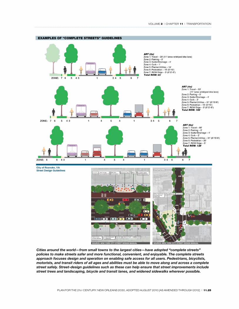
EXAMPLES OF “COMPLETE STREETS” GUIDELINES
Cities around the world—from small towns to the largest cities—have adopted “complete streets”
policies to make streets safer and more functional, convenient, and enjoyable. The complete streets
approach focuses design and operation on enabling safe access for all users. Pedestrians, bicyclists,
motorists, and transit riders of all ages and abilities must be able to move along and across a complete
street safely. Street-design guidelines such as these can help ensure that street improvements include
street trees and landscaping, bicycle and transit lanes, and widened sidewalks wherever possible.
SOURCE: NEW YORK CITY STREET DESIGN MANUALSOURCE: NEW YORK CITY STREET DESIGN MANUAL

VOLUME 2 | CHAPTER 11 | TRANSPORTATION
11.26 | PLAN FOR THE 21ST CENTURY: NEW ORLEANS 2030, ADOPTED AUGUST 2010 [AS AMENDED THROUGH 2012]
> Reduced off -street parking rations and encouragement of shared parking by complementary uses
> For commercial districts, require location of parking to the rear or side of buildings, or in consolidated areas to serve several blocks at a time
> Requirement that parking costs be decoupled from rents> Where transit is available, provision of discounted transit passes to employees > Provision of assigned parking spaces for carpool vehicles or car-sharing companies> Encourage short- and long-term bicycle parking options.
2. Exploration of incentives for remote parking and drop-off zones at schools, public facilities, shopping malls, and other destinations . Who: School Districts, Property Management Department, private owners When: Medium Term Resources: Staff Time
GOAL 3
Roadways that integrate vehicle transportation with bicycling and walking
3.A Implement the adopted “Complete Streets Policy” for the city of New Orleans which moves people and freight safely while prioritizing the non-motorized user by integrating various transportation modes.
The concept of Complete Streets recognizes that the street space should be available and comfortable for a variety of users, including pedestrians, bicyclists, drivers, transit riders and persons with disabilities. Depending on the function of the street, including the speed and character of auto traffi c, the street will require diff erent treatments for the full integration of other modes.
RECOMMENDED ACTIONS
1. Develop and adopt Complete Streets Guidelines for internal and consultant design engineers in project development. Who: DPW; CPC transportation planner When: First fi ve years Resources: Staff time; funding from City; DOTD; FHWA
2. Require training on the design of Complete Streets for all design consultants doing business with the City. Who: DPW; consultant When: First fi ve years Resources: Staff time; consultant
3. Evaluate sidewalk repair and maintenance ordinances and develop mechanisms for enforcement and betterment system options for property owners. Who: DPW; possible betterment ordinance - City Council When: First fi ve years Resources: Staff time
(See Volume 2, Chapter 5.)
4. Update City of New Orleans Roadway Design Manual to include modern best practices for the accommodation of non-motorized transportation modes and streetscape improvements. Who: DPW When: First fi ve years Resources: Staff time

VOLUME 2 | CHAPTER 11 | TRANSPORTATION
PLAN FOR THE 21ST CENTURY: NEW ORLEANS 2030, ADOPTED AUGUST 2010 [AS AMENDED THROUGH 2012] | 11.27
5. Plan for and emphasize pedestrian, bicycle and transit facilities linkages through improved design, funding, maintenance, enforcement and education. Who: DPW; RTA When: First fi ve years Resources: Staff time
6. Implement pedestrian improvements, such as crosswalks, pedestrian signals, traffi c calming, pedestrian refuges and ADA accessibility requirements in priority areas including transit routes, schools, retail/commercial corridors, residential complexes for senior citizens and persons with disabilities, parks and other recreational facilities, and government/institutional buildings. Who: DPW When: First fi ve years Resources: Staff time
7. Build capacity in DPW to track and guide multimodal accommodation in all projects and to coordinate with a transportation planner within the CPC. Who: DPW When: First fi ve years Resources: General fund; grants
3.B Establish a permanent multimodal accommodation position within DPW.
ACTION
1. Secure permanent funding for a multimodal accommodation position to track and guide all road, bridge and community facilities capital and maintenance projects, and coordinate with the transportation planner in the CPC, once one is hired. Who: DPW; CPC transportation planner When: First fi ve years Resources: Staff time; grant
PEDESTRIAN STRATEGIES
3.C Develop a pedestrian plan for the City of New Orleans. The new walking strategy should include data and trends (crashes and mode share), facility needs
assessments, identifi cation of future population growth areas, future route network, bicycle route hierarchies, bicycle parking needs, fi nancing/funding mechanisms, design guidance, agency roles and responsibilities, benchmarking and evaluation analyses, educational programs, enforcement policies, encouragement/promotion activities, overall citywide pedestrian goals, citywide implementation goals, public participation processes and citywide policies.
As of late 2009, the City, in lieu of a more comprehensive plan, has adopted a working strategy to consider and include, where feasible, pedestrian facilities on roadways that were damaged by Hurricane Katrina, for which federal recovery and stimulus funds have been received.
RECOMMENDED ACTIONS
1. Develop and adopt guidelines to improve the quality of the pedestrian environment throughout the city. Who: DPW When: First fi ve years Resources: Federal funds; bond funds
Prior to creation of the plan, all state roadways that are presently planned for resurfacing or reconstruction should be considered for pedestrian accommodation.

VOLUME 2 | CHAPTER 11 | TRANSPORTATION
11.28 | PLAN FOR THE 21ST CENTURY: NEW ORLEANS 2030, ADOPTED AUGUST 2010 [AS AMENDED THROUGH 2012]
2. Seek Safe Routes to Schools federal funding for walk-to-school programs and improvements. Who: DPW When: First fi ve years Resources: Federal funds
Incorporate “Complete Streets” guidelines into the strategy. (See Strategy 3.A.)
3. Implement comprehensive street scape upgrades to those boulevards not receiving recovery funding. Who: DPW; CPC transportation planner When: Medium term Resources: Federal funds; CDBG; developer contributions
The City should include adequate funding for future pedestrian infrastructure improvements in all future bond elections.
3.D Provide signifi cant infrastructure investment to make major boulevards and corridors more attractive and pedestrian friendly particularly where transit stops, schools, parks, and other pedestrian generators are present.
RECOMMENDED ACTIONS
1. DPW should develop and adopt guidelines for pedestrian facilities of all types to improve the quality of the pedestrian environment throughout the city by improving striping, signage, and pedestrian crossing signals.
POTENTIAL 2030 BICYCLE ROUTES

VOLUME 2 | CHAPTER 11 | TRANSPORTATION
PLAN FOR THE 21ST CENTURY: NEW ORLEANS 2030, ADOPTED AUGUST 2010 [AS AMENDED THROUGH 2012] | 11.29
Who: DPW When: First fi ve years Resources: Recovery funds; CDBG; bond funds
> Give priority to intersections near schools, senior housing, parks, and similar destinations.> Seek Safe Routes to Schools federal funding for walk-to-school programs and improvements.> Reinforce existing eff orts to improve pedestrian infrastructure along major corridors by
formally adopting guidelines.
2. Continue to build upon existing hurricane recovery appropriations to ensure comprehensive streetscape improvements in designated target areas, including lighting, landscaping, sidewalk enhancements, and the burying of above ground utilities. Who: DPW When: First fi ve years Resources: Staff time
> Invest in use of permeable concrete to help control fl ooding on sidewalks.
3. Implement comprehensive streetscape upgrades (lighting, landscaping, sidewalks, utilities) to those boulevards that are in need of upgrades yet are not already targeted for streetscape improvements through recovery funding, such as Broad, St. Claude, Tchoupitoulas, Chef Menteur, etc. Who: DPW; CPC transportation planner When: Medium term Resources: Bond funds
4. Implement traffi c calming infrastructure along neighborhood streets as needed. Who: DPW When: Medium term Resources: Staff time
3.E Provide signifi cant infrastructure investment to make neighborhood streets more attractive and pedestrian friendly.
RECOMMENDED ACTIONS
1. Funding for “Complete Streets” construction and retrofi t/repair projects should derive from a combination of sources including City, DOTD, FHWA and other agencies. Who: DPW; CAO; City Council When: First fi ve years Resources: Staff time; DOTD; FHWA; grants; bond funds
2. In coordination with street repaving projects, undertake a comprehensive streetscape improvement eff ort along neighborhood streets to enhance the tree canopy, sidewalk quality (provision of sidewalks where lacking, repair where needed), ADA compliance and overall streetscape aesthetic. Who: DPW; Parks and Parkways; DDD; RTA When: First fi ve years Resources: Staff time; FHWA; grants; DOTD; bond funds
3. Reinforce existing eff orts to improve pedestrian infrastructure along neighborhood streets by formally adopting guidelines. Who: DPW; Parks and Parkways; DDD; RTA When: First fi ve years Resources: Staff time; FHWA; grants; DOTD; bond funds
4. Implement traffi c calming infrastructure along neighborhood streets, as needed. Who: DPW When: Medium term Resources: Staff time

VOLUME 2 | CHAPTER 11 | TRANSPORTATION
11.30 | PLAN FOR THE 21ST CENTURY: NEW ORLEANS 2030, ADOPTED AUGUST 2010 [AS AMENDED THROUGH 2012]
5. Develop a plan for regular maintenance of sidewalk infrastructure through a combination of public and property-owner funding with criteria analogous to a pavement management system. Who: DPW When: First fi ve years Resources: Staff time
(See Chapter 5 for more information.)
6. Review, update and implement the New Orleans’ ADA Transition Plan relative to public rights-of-way to refl ect requirements of ADA Accessibility Guidelines and Public Rights of Way Accessibility Guidelines. Who: DPW; Mayor’s Offi ce When: First fi ve years Resources: Staff time
7. Support RTA’s eff ort to continue to improve safety for transit passengers and RTA employees, pedestrians, and vehicular traffi c along streetcar lines and at or by bus and streetcar stops through cooperative support from the DPW and other City agencies and/or departments. Who: CPC, RTA, DPW and NOPD When: fi rst fi ve years Resources: Staff time
BICYCLE STRATEGIES
3.F Develop a bicycling strategy for the City of New Orleans. The new bicycling strategy should include data and trends (crashes and mode share), facility
needs assessments, identifi cation of future population growth areas, future route network, bicycle route hierarchies, bicycle parking needs, fi nancing/funding mechanisms, design guidance, agency roles and responsibilities, benchmarking and evaluation analyses, educational programs, enforcement policies, encouragement/promotion activities, overall citywide bicycling goals, citywide implementation goals, public participation processes and citywide policies.
As of late 2009, the City, in lieu of a more comprehensive bicycling plan, has adopted a working strategy to consider and include, where feasible, bicycle facilities on roadways that were damaged by Hurricane Katrina for which federal recovery and stimulus funds have been received.
RECOMMENDED ACTIONS
1. Prior to creation of the plan, all state roadways that are presently planned for resurfacing or reconstruction should be considered for bicycle accommodation. Who: RPC; DPW; CPC Transportation planner When: First fi ve years Resources: Staff time
2. Incorporate “Complete Streets” guidelines into the strategy. (See Strategy 3.A.) Who: RPC; DPW; CPC Transportation planner When: First fi ve years Resources: Staff time
3. City should provide adequate funding for future bicycle improvements in all future local bond elections.
Bus and streetcar shelters enhance
the transit rider’s experience.

VOLUME 2 | CHAPTER 11 | TRANSPORTATION
PLAN FOR THE 21ST CENTURY: NEW ORLEANS 2030, ADOPTED AUGUST 2010 [AS AMENDED THROUGH 2012] | 11.31
Who: City Council; Administration; CPC When: First fi ve years Resources: DOTD; FHWA; grants
3.G As part of the comprehensive bicycling plan, create a comprehensive, connected citywide network of bike lanes, multi-use paths, and bike boulevards to safely accommodate bicyclists.
RECOMMENDED ACTIONS
1. Establish a Pedestrian and Bicycle Advisory Committee, to assist in reviewing city projects, policies and plans, and to engage bicycle users. Who: DPW When: First fi ve years Resources: Staff time
> Committee to advise on criteria used to identify priority bike infrastructure and facilities. (Potential routes for consideration are highlighted on the “Potential 2030 Bicycle Routes” map on the facing page, which compiles routes proposed in various planning processes including the 2004 Transportation Element, UNOP and MP working groups.)
2. Develop the Lafi tte Greenway as a key bicycle and pedestrian corridor. Who: DPW When: First fi ve years Resources: Staff time
The goal of creating the interconnected trail system will require strategic additions to be implemented. The fi rst planned expansion of the system is the Lafi tte Greenway. Currently funded and in the planning phase, the greenway will be built on a former canal and rail line connecting Basin Street with Canal Boulevard, touching the Central Business District, French Quarter, Tremé, Mid-City, and Lakeview. Redevelopment of adjacent parcels through careful trail-oriented development will help to revitalize the area and provide a vital transportation link through the core of the city.
Construction of the Lafi tte Greenway and accompanying design guidelines and trail-oriented development revitalization strategy will form a framework for other greenway and multi-use path projects. Key future projects identifi ed through the planning process include Peoples Avenue, the river levee in the Lower 9th Ward, Florida Avenue, and the Mississippi Riverfront. Transportation and revitalization planning in these areas should include provision for these greenways.
3. Review previous bike plans and studies, including the 2004 Transportation Element, UNOP plans, and others to set priorities for adding street facilities/lanes in a phased manner. Who: DPW; RPC; CPC transportation planner When: First fi ve years Resources: Staff time; grants
Projects that connect existing bike lanes, multi-use paths and greenways, and that off er commuter connections to employment centers, schools and activity centers, should be prioritized. Initial routes to be studied should include, but not be limited to:> Elysian Fields Ave.—Gentilly Blvd. to N. Peters St.> St. Charles Ave.—Nashville Ave. to Lee Circle> Carrollton Ave.—S. Claiborne Ave. to City Park Ave.> St. Claude Ave./N. Rampart St./S. Rampart St.—Elysian Fields Ave. to Gravier St.> General De Gaulle Dr.—Shirley Dr. to Woodland Dr.> Behrman Dr.—Mardi Gras Blvd. to Opelousas Ave.

VOLUME 2 | CHAPTER 11 | TRANSPORTATION
11.32 | PLAN FOR THE 21ST CENTURY: NEW ORLEANS 2030, ADOPTED AUGUST 2010 [AS AMENDED THROUGH 2012]
> General Meyer Ave.—Behrman Dr. to Bennett St.> Newton St.—Veret St. to Behrman Ave.> Shirley Dr.—General DeGaulle Dr. to General Meyer Ave.> Hayne Blvd.—Downman Rd. to Bullard Ave.> Chef Menteur Hwy. and Gentilly Blvd.—Michoud Blvd. to St. Bernard Ave.> Crowder Blvd.—Hayne Blvd. to Chef Hwy.> Read Blvd.—Hayne Blvd. to Chef Hwy.> Leon C. Simon Dr.—Paris Ave. to St. Anthony Ave.> St. Bernard Ave.—I-610 to St. Claude Ave. > Paris Ave.—I-610 to St. Bernard Ave. > Toledano St./Louisiana Ave.—Broad St. to St. Charles Ave. > Marconi Dr.—City Park Ave. to Navarre Ave.> Martin Luther King Jr. Blvd./Melpomene St.—O.C. Haley Blvd. to Camp St.> Claiborne Ave.—Carrollton Ave. to Martin Luther King Jr. Blvd.> Basin St./Elk Pl.—Lafi tte Greenway to Tulane Ave.
4. As streets are being repaved, ensure that new bike facilities are provided. Who: DPW When: First fi ve years Resources: Recovery funds; D-CDBG; bond funds; federal funds
5. For streets which are already in good condition and not in need of repaving, retrofi t streets with bike facilities. Who: DPW When: First fi ve years Resources: Bond funds; DOTD; FHWA; grants
6. Develop standards and design guidelines for all types of bicycle facilities within DPW based on the Manual of Uniform Traffi c Control Devices and American Association of State Highway and Transportation Offi cials standards. Who: DPW When: First fi ve years Resources: Staff time
7. Where feasible, create levee-top paved bike paths, such as along the Mississippi River levee in Algiers and Holy Cross, and the Lakefront levee in New Orleans East. Who: CPC transportation planner; RPC; DPW When: Medium term Resources: Federal funds; bond funds
8. Study then establish a network of bike boulevards that takes advantage of quieter neighborhood streets and provides the additional benefi t of traffi c calming. Who: RPC; CPC transportation planner When: First fi ve years Resources: Federal funds; staff time
> Determine criteria for future bike boulevards, including but not limited to proximity to schools, ability to eff ectively parallel major streets, access to neighborhood commercial/main street areas, and neighborhood traffi c concerns.
3.H Provide fi xed infrastructure to further bicyclist safety and security and to encourage bicycling as an alternative mode of transportation.
RECOMMENDED ACTIONS

VOLUME 2 | CHAPTER 11 | TRANSPORTATION
PLAN FOR THE 21ST CENTURY: NEW ORLEANS 2030, ADOPTED AUGUST 2010 [AS AMENDED THROUGH 2012] | 11.33
1. Provide ample bike racks and/or lockers on public rights of way at key activity nodes. Who: CPC When: First fi ve years Resources: Federal funds; CDBG; bond funds
2. Allow for the transformation of a limited number of on-street, parallel vehicular parking spaces into on-street bike rack/storage areas if demand or adjacent landowners call for it. Who: DPW When: First fi ve years Resources: Staff time
3. Provide improved on-site bicycle storage and other amenities for bicycle users at publicly owned buildings such as schools and municipal facilities. Who: DPW; Project Delivery Unit When: First fi ve years Resources: Recovery funds
Provide ample bike racks and/or lockers on public rights of way at key activity nodes.
4. Develop a public bike rental program, modeled on Paris’ Velib and other successful programs, with public bike kiosks throughout the city. Work with RTA’s new managing group Veolia. Who: RTA with support from RPC bicycle advisory committee When: First fi ve years Resources: Grants
3.I Develop programs that address enforcement, education and encouragement of bicycling.
RECOMMENDED ACTIONS
1. Coordinate with NOPD to better enforce bicycle laws for both bicyclists and motorists. Who: DPW; NOPD When: First fi ve years Resources: Staff time
2. Improve tracking, analysis, and dissemination of crash data to guide funding to address problem areas. Who: DPW; RPC bike pedestrian staff When: First fi ve years Resources: Federal funds
3. Encourage and support events including Bike to Work, No Car Days, Celebrity rides, etc. Who: Mayor’s staff ; Public aff airs; volunteer bike groups When: First fi ve years Resources: Staff time
Increased transit ridership that is embraced by a wide spectrum of users is largely
a function of travel times, short headways, predictable service, station location and
convenience, and safety of the service. The below transit best practices shall be followed
by the City to achieve a 21st-century premium transit system.
1. Rail and BRT cars travel in reserved, dedicated right-of-way or enhanced
medians with minimal crossings.
2. Safe and convenient pedestrian access to transit stations
3. Less frequent stops located every four to six blocks or more.
4. Prepaid fare-collection system at stops for expedited boarding.
5. Schedules and system maps posted at all stops.
6. Low-fl oor bus and rail cars for faster boarding and handicapped access.
7. Traffi c signal prioritization at intersections for transit vehicles to expedite
service.
8. Assuring that new routes have good connections to existing citywide system
and regional connections.
9. Land uses that allow for mixed-use, transit-oriented development at key
nodes to support greater densities of residents and jobs along routes.
10. Require coordinated planning approach that includes City and community
input, advocacy for funding, and step-by-step implementation.
A number of older cities—including Boston, Portland, and San Diego—have developed a
range of solutions for delivering fast, premium transit. They have used partially exclusive
rights-of-way in medians similar to New Orleans’ neutral grounds, and they have de-
ployed hybrid streetcar/light rail vehicles that operate more like a bus in dense locations
and like light rail cars in others. New Orleans can learn from these places when investing
in new or improved transit.
Best Practices Checklist for
Rail and BRT Premium Transit

VOLUME 2 | CHAPTER 11 | TRANSPORTATION
11.34 | PLAN FOR THE 21ST CENTURY: NEW ORLEANS 2030, ADOPTED AUGUST 2010 [AS AMENDED THROUGH 2012]
4. Support public education campaigns to increase awareness and knowledge with the goal of creating a safer environment, radio, TV, print and internet campaigns and materials. Who: RPC; DPW; NOPD When: First fi ve years Resources: Staff time; State grants
5. Produce informational brochures and programs (such as the RPC’s Create a Commuter initiative) to encourage bicycling as a mode of transportation and to improve safety and drivers’ awareness of bicyclists. Who: RPC; DPW; Volunteer bike groups When: First fi ve years Resources: Grant funds
6. Modify zoning regulations to encourage or require the provision of on-site bicycle parking facilities and locker rooms for bicycle users. Who: CPC When: First fi ve years Resources: Staff time
7. Develop an alternative to registration and waiver of liability requirements for use of bike racks on RTA buses. Who: RTA and bicycle advisory committee When: First fi ve years Resources: Staff time
GOAL 4
Fast and effi cient mass transit supported by transit-oriented development
4.A Enhance the quality of Regional Transit Authority rolling stock and fi xed infrastructure to increase on-time performance of service, improve customer communications, and enhance the quality of access to bus stops and their safety and waiting conditions.
RECOMMENDED ACTIONS
1. Continue to replace older RTA buses with newer, biodiesel and hybrid buses that are more fuel effi cient and have lower emissions. Who: RTA When: First fi ve years Resources: Federal funds, bonding
2. Continue to repair fl ood-damaged, red streetcars in order to restore a full fl eet of streetcars.
RAMPART STREET SECTION
EXISTING
PROPOSED
A transit advocacy group has devised potential street
layouts along proposed transit corridors, such as N.
Rampart Street.

VOLUME 2 | CHAPTER 11 | TRANSPORTATION
PLAN FOR THE 21ST CENTURY: NEW ORLEANS 2030, ADOPTED AUGUST 2010 [AS AMENDED THROUGH 2012] | 11.35
Who: RTA When: First fi ve years Resources: Federal funds
3. Continue to install comfortable, durable benches and shelters at all bus stops throughout the city and ensure adequate funding and coordination between agencies for maintenance of bus and streetcar stops. Who: RTA When: First fi ve years Resources: Explore advertising contracts similar to other cities, funds, bonding> Explore comprehensive contracts for provision of bus and streetcar stop amenities in return
for advertising, on the model of New York, Boston, and other cities.
4. Improve access, signage, lighting, landscaping, and other amenities at major transfer points to enhance the transit customers’ experience. Who: DPW; RTA; Parks and Parkways When: First fi ve years Resources: Federal funds; FHWA; bond funds
4.B Improve the existing bus and streetcar system.
RECOMMENDED ACTIONS
1. Improve the frequency and convenience of existing bus and streetcar service. Who: RTA When: Medium term Resources: Federal funding; bonds
> Implement capital improvements, such as signal priority technology, more effi cient fare collection/boarding techniques, and the consolidation of stops to reduce travel times and improve effi ciency along existing bus and streetcar routes.> Use state of the art transit technologies to improve customer communications, off er transit
priority on busy streets, improve access to and use of transit fare media, and reduce dwell time at stops.
> Reduce headways along major transit routes to less than 10 minute intervals during peak periods, including the following routes: Elysian Fields, St. Claude, Magazine, St. Charles, Broad, Canal streetcar, and others.
> Examine the feasibility of major upgrades in headways and operating hours along routes with historically less frequent service, including: Jackson-Esplanade, Claiborne, Freret, and others.
> Extend operating hours along both major and minor transit routes to accommodate residents with off -peak work hours and to better serve weekend entertainment destinations.
2. Enhance the ease, convenience and overall experience of using transit for both frequent and occasional riders. Who: RTA When: First fi ve years Resources: Grant funds; advertising
> Produce a user-friendly guide to the transit system for tourists and new transit users.> Provide transit route maps and schedules at every bus and streetcar stop.> At major transfer points and intersections, install real time technology to inform riders
when the next bus or streetcar will be arriving.> Improve the RTA website to allow for interactive scheduling, trip planning and real-time bus
location, accessible from desktop computers and mobile devices.

VOLUME 2 | CHAPTER 11 | TRANSPORTATION
11.36 | PLAN FOR THE 21ST CENTURY: NEW ORLEANS 2030, ADOPTED AUGUST 2010 [AS AMENDED THROUGH 2012]
3. Improve the existing bus network by extending, creating, and consolidating routes. Who: RTA; When: First fi ve years Resources: Explore advertising contracts, similar to other cities
> Create a new bus route to link the universities in uptown New Orleans (Xavier, Tulane, Loyola) to the Magazine Street Corridor.> Consolidate separate upriver/downriver routes (Elysian Fields/Magazine and Airline/St.
Claude, for example) to allow for more frequent, seamless upriver/downriver travel.> Implement minor capital and intersection improvements that would improve travel times of
buses (e.g., Decatur Street in the French Quarter).> Work with adjacent parishes to study potential RTA route extensions to key employment and
activity nodes outside of Orleans Parish (e.g., Claiborne bus to Ochsner Hospital in Jeff erson Parish).
> Create extensions and minor modifi cations to existing bus routes (e.g., extending Magazine route to the foot of Carrollton Avenue) to better connect major bus and streetcar lines.
> Examine the feasibility of consolidating redundant and/or underperforming routes to add additional service on nearby principal routes.
> Work with RTA to encourage bus routes that provide service from underserved neighborhoods to supermarkets and farmers markets.
4.C Invest in new rail, streetcar, and bus rapid transit (BRT) infrastructure by obtaining federal and local funding.
All transit expansion studies and projects detailed below shall require a comprehensive planning process by the RTA and RPC, with assistance from the CPC transportation planner and available staff . The City shall ensure that the process incorporates community outreach and input; that the City works with the RTA and other non-municipal agencies to implement the transit “best practices” adopted by this plan (see “Best Practices Checklist for Rail and BRT Premium Transit” on the facing page); and identify/study alternative route alignments, a requirement of Federal funding.
Additionally, a set of criteria shall be developed by the above entities to determine route expansion
priorities. Criteria should include, but not be limited to, potential ridership, economic and neighborhood enhancement opportunities, connectivity to the existing and future system, travel times, number of stops, and so on.
RECOMMENDED ACTIONS
1. Extensively study the feasibility of a streetcar and/or light rail hybrid distributor system in the Central Business District (CBD) and French Quarter to improve connectivity for residents, workers and tourists, and to best connect with existing and potential future transit routes to city neighborhoods. Who: CPC transportation planner; RTA support; RPC When: First fi ve years Resources: Grant funds
As of late 2009, the RTA is studying three potential distributor routes through the CBD and French Quarter and pursuing stimulus funds to fi nance half of the estimated $212 million cost. The Master Plan recommends alternative alignments to be studied to ensure the resulting distributor system provides the most eff ective, expedient premium transit service.
Proposed RTA alignments under study as of late 2009 include:> Convention Center/Riverfront: A circulator route from the existing Canal Street Streetcar
line, running along Convention Center Boulevard to Henderson, then connecting to the existing Riverfront streetcar route.

VOLUME 2 | CHAPTER 11 | TRANSPORTATION
PLAN FOR THE 21ST CENTURY: NEW ORLEANS 2030, ADOPTED AUGUST 2010 [AS AMENDED THROUGH 2012] | 11.37
> Union Passenger Terminal/Loyola Avenue: A double-track route along Loyola Avenue from Canal Street to the Union Passenger Terminal (UPT).
> North Rampart/St. Claude Avenue: A double-track line primarily along Rampart Street and St. Claude Avenue (to Press Street), with an extension along Elysian Fields Avenue connecting to the Riverfront Streetcar line.
Master Plan recommended alignments to be studied include: > Convention Center/Riverfront Alignment: A double-track extension of the Riverfront line to
Henderson Street. Should this not provide adequate service, construct proposed RTA route.> Union Passenger Terminal Route Alignment:
— A double-track trunk line on a widened neutral ground along the 100 block of S. Rampart Street connecting to Julia Street, connecting to UPT via Howard Avenue or a parallel street. The route should allow for limited automobile traffi c to better accommodate transit, pedestrian and bicycle traffi c.
— A double-track line on Howard Avenue from UPT to Lee Circle, extending along Andrew Higgins to Annunciation Street and following Euterpe Street/Henderson Street on a side-of-street reserved right-of-way to the existing Riverfront line.
> North Rampart/St. Claude Avenue Alignment: A double-track line on Elysian Fields Avenue neutral ground from existing Riverfront Streetcar to St. Claude Avenue.
> Additional Improvement: Open the John Churchill Chase stop on the existing Riverfront streetcar and build ADA access to the river side of the stop.
> The double track line running along St. Claude Avenue from Elysian Fields Avenue, then along North Rampart and South Rampart, and continuing along a portion of Oretha Castle Haley Boulevard (see next action), should serve as a trunkline for rail system through the French Quarter and CBD.
2. Conduct feasibility studies for new streetcar, light rail, and BRT routes to connect residential and commercial districts throughout the city, and to support higher-density transit oriented development (TOD). Who: RTA; RPC; CPC When: Medium term Resources: Federal funds
As indicated above, a set of criteria to identify priority routes will be established and should include input by the RPA, RPC, CPC and transit advocacy groups, with public input on alternatives to occur during the project scoping process. All priority routes should adhere to “premium transit” principles whenever feasible to provide fast, effi cient, connective service. (See the Potential 2030 Transit System map at the end of this chapter.)
Recommended priority routes to be studied or restudied include those identifi ed in previous
planning processes and by transportation advocacy groups, highlighted below.
> St. Claude Line: Potential rail route could be constructed in stages, originally to Desire Street (as part of Distributor System), then to transit hub at Industrial Canal, with potential future expansion to the Lower Ninth Ward / St. Bernard Parish line.—Land use designations should encourage nodes of higher-density, mixed-use development
along the route, with a transit-oriented hub at Poland Avenue.
> Carrollton Avenue Connector: Extend streetcar line along Carrollton Avenue to link the Canal Street/Carrollton spur with the St. Charles line.
> Elysian Fields Avenue BRT or Light Rail Line: Potential route would run in an exclusive right-or-way in or beside Elysian Fields neutral ground extending to Lake Pontchartrain to serve Gentilly and the UNO campus. Route should connect directly to the CBD. — Land use designations should encourage nodes of walkable, mixed-use development at

VOLUME 2 | CHAPTER 11 | TRANSPORTATION
11.38 | PLAN FOR THE 21ST CENTURY: NEW ORLEANS 2030, ADOPTED AUGUST 2010 [AS AMENDED THROUGH 2012]
the intersection of Elysian Fields Avenue and Gentilly Boulevard, near the UNO campus, and surrounding the Lake Pontchartrain terminus.
— Should BRT be built initially, the route should be designed for potential upgrade to streetcar or light rail.
> New Orleans East BRT or Light Rail Line: Potential alternatives include: — A 1980s Gannet Flemming study suggested a preferred route that would branch off the
Elysian Fields line detailed above, follow Fillmore Avenue / Dreux Avenue alignment, cross Industrial Canal on a vertical lift bridge to Dwyer Avenue / Lake Forest Boulevard.
—From Elysian Fields Avenue Line, follow Gentilly Boulevard / Chef Menteur Highway then to Lake Forest Boulevard via a connector street.
> West Bank/General DeGaulle Drive BRT or Light Rail Line: Potential alignment from the CBD would follow proposed distributor route (Loyola Avenue or S. Rampart alignment), then a side-of-street right-of-way and neutral ground along Howard Avenue, connecting to Crescent City Connection transit lanes, then along General DeGaulle neutral ground. — A future spur to Federal City should be studied upon completion of route.— Land use designations should allow for nodes of higher-density, mixed-use, walkable
development at intersections of General DeGaulle at Holiday Drive and Woodlawn Drive.
> Riverfront Streetcar Extension upriver to Jackson Avenue— Land use designations should allow for nodes of higher-density transit-oriented
development at strategic nodes along the route (e.g., South of Convention Center Opportunity Site).
> Riverfront Streetcar Extension downriver to Poland Avenue —Land use designations should allow for higher-density, mixed-use development at strategic
nodes along the route with a node at Poland Avenue.
> South Claiborne Avenue Line: As proposed in the UNOP District 2 Plan, this potential rail alignment would connect to the CBD distributor system with a double-track alignment extending from S. Rampart Street along a widened Oretha Castle Haley Boulevard neutral ground, turning on Martin Luther King Jr. Boulevard neutral ground, then to South Claiborne Avenue neutral ground to Carrollton Avenue.— Study potential BRT alternative along same alignment.
> Lake Area Line: Potential BRT or light rail alignments from Canal Street, include dedicated side-of-street right-of-way east or west on City Park Avenue, then:— Right-of-way between Greenwood Cemetery and UPT tracks, continuing adjacent to West
End Boulevard after Veterans Boulevard to Robert E. Lee Boulevard— Alignment along Canal Boulevard to Robert E. Lee Boulevard
> Jackson Avenue Connector: Potential alignment would extend O.C. Haley rail trackage (from Claiborne Avenue Line) onto Jackson Avenue onto a widened neutral ground to connect with the Riverfront line and Jackson Ave./Gretna ferry.
> Tulane Avenue/Airport BRT or Light Rail Line: Potential alignment would follow Tulane Avenue from the CBD, then Airline Highway and beyond.
3. Identify and preserve future rights-of-way to avoid confl icts and accommodate future streetcar, BRT and light rail route expansions. Who: RTA; RPC; CPC; DOTD; DPW When: Medium term Resources: Federal and local funds
4. Seek federal and regional funding to study development of a regional passenger rail system and other modes of commuter transportation. Who: RPC; DOTD When: Long term Resources: Federal funds

VOLUME 2 | CHAPTER 11 | TRANSPORTATION
PLAN FOR THE 21ST CENTURY: NEW ORLEANS 2030, ADOPTED AUGUST 2010 [AS AMENDED THROUGH 2012] | 11.39
4.D Better market transit service to increase mode share (percent of people who use transit).
RECOMMENDED ACTION
1. Develop promotional materials to highlight the benefi ts and cost savings of using public transit. Who: RTA with Social Services and HANO When: First fi ve years Resources: Social Services and grant funds
> Through direct community outreach, improve the marketing of fi xed-route and paratransit service to the elderly and the disabled community.> Conduct outreach to local universities to increase students’ awareness of transit alternatives.> Work with universities to develop discount fare passes for students, faculty, and staff .> Work with New Orleans Public Schools (NOPS) to restore the contract with the RTA for
transit passes for NOPS middle and high school students.
4.E Create forums and entities for agency coordination and consolidation to improve transit service delivery and sustainability.
RECOMMENDED ACTION
1. Create a transit working group that includes transit providers, traffi c management, planning and travel demand management staff from each jurisdiction to collaborate on the actions of each required to support transit. Who: RTA; RPC; Jeff erson and St. Bernard Transit and traffi c and planning staff each parish When: Medium term Resources: Staff time
> Study consolidation of NORTA and JeT (Jeff erson Transit) into a true regional transit agency. Include St. Bernard Transit if possible.
4.F Identify and study potential new Mississippi River ferry connections.
RECOMMENDED ACTION
1. Conduct a study to identify new potential Mississippi River ferry connections.
Who: RPC; CCC When: Medium term Resources: State funds
GOAL 5
Enhanced intercity transportation with an upgraded airport, better passenger
rail service and ultimately regional high-speed rail
5.A Coordinate with the state and other governments in the region to preserve and enhance Louis Armstrong New Orleans International Airport as the preeminent airport facility in the state.

VOLUME 2 | CHAPTER 11 | TRANSPORTATION
11.40 | PLAN FOR THE 21ST CENTURY: NEW ORLEANS 2030, ADOPTED AUGUST 2010 [AS AMENDED THROUGH 2012]
Airports serve as a city’s “front door” to visitors and play a key role in attracting and maintaining economic prosperity. Cities with airports that provide a quality experience and allow for effi cient movement internally, provide easy transportation access to and from downtown, and off er direct service to many destinations have a competitive edge.
RECOMMENDED ACTIONS
1. Make major capital improvements and enhance marketing at Louis Armstrong New Orleans International Airport to increase air traffi c. Who: Aviation Board When: First fi ve years Resources: Bond funds
2. Complete improvements to terminals at Louis Armstrong New Orleans International Airport to enhance the appearance and the comfort of the airport and to facilitate layovers and transfers between fl ights, and expand terminal capacity, as needed. Who: Aviation Board When: First fi ve years Resources: Bond funds
3. Develop a passenger rail connection between the CBD, Louis Armstrong New Orleans International Airport, and Baton Rouge. Who: RPC; City; RTA; Airport Authority When: Long term Resources: Federal funds
5.B Support and advocate for federal and state funding for high-speed and regional rail lines between New Orleans and other communities within the southern U.S., perhaps as a national demonstration project of new technology.
RECOMMENDED ACTIONS
1. Work with elected leadership, the Regional Planning Commission, and the Southern High Speed Rail Commission to promote funding for high-speed rail. Who: RPC; City; Southern High Speed Rail Commission When: First fi ve years Resources: Staff time
2. Actively work to reinstate and improve service between New Orleans and Jacksonville, FL. (Route has not been reactivated by Amtrak since Hurricane Katrina.) Who: AMTRAK; Congressional leadership; Mayor’s Offi ce; State leadership When: First fi ve years Resources: State funds
5.C Improve connectivity and the environment for users of the Union Passenger Terminal with greater neighborhood and transit system connectivity.
RECOMMENDED ACTIONS
1. Conduct a study to improve multimodal access to and from the UPT to address comprehensive way-fi nding signage, high-visibility crosswalks, bicycle and vehicle parking, bicycle routes, high-quality information services and improved taxi and bus service. Who: RTA; RPC; DPW When: First fi ve years Resources: Federal funds
VOLUME 2 | CHAPTER 11 | TRANSPORTATION
PLAN FOR THE 21ST CENTURY: NEW ORLEANS 2030, ADOPTED AUGUST 2010 [AS AMENDED THROUGH 2012] | 11.41
2. Identify a priority location for pedestrian access and for visibility of a UPT streetcar stop as part of streetcar system expansion plans. Who: City with RTA and Amtrak support When: First fi ve years Resources: Bond funds
3. Focus planning eff orts to access and improve mobility to and from the Union Passenger Terminal in all trip segments. Who: RTA: RPC: DPW When: First fi ve years Resources: Federal funds
4. Improve station conditions. Who: Amtrak When: First fi ve years Resources: Federal funds
> Construct a new commissary building for Amtrak service.> Build a new train shed to better protect passengers on the platforms.> Modernize the waiting areas and bring all passenger facilities up to ADA standards.
GOAL 6
Freight transportation systems that serve the economy while respecting
neighborhoods
6.A Support investment in the capital improvements that are needed to keep the Port of New Orleans competitive while protecting quality of life.
RECOMMENDED ACTION
1. Commission an independent review of the arguments for and against the Inner Harbor Canal Lock project. Who: Mayor’s offi ce When: First fi ve years Resources: General fund
6.B Refi ne and implement the New Orleans Rail Gateway Plan to improve railroad safety and operating effi ciency.
RECOMMENDED ACTIONS
1. Encourage participation in the Environmental Impact Statement (EIS) public hearings for the New Orleans Regional Gateway to review proposed projects and discuss and determine appropriate mitigation measures. (The NEPA process is in place to conduct this outreach under the current EIS.) Who: CPC; RPC; New Orleans Public Belt; Class 1 Railroads; CPC When: First fi ve years Resources: Staff time; local, state and federal funding
2. Pursue federal funding for the Gateway Plan, including adequate funding for the implementation of community mitigation and improvement projects identifi ed in the Gateway Plan (e.g., installing soundwalls along railroad tracks). Who: RPC; New Orleans Public Belt Class 1 Railroads, CPC When: Medium term Resources: Federal funds

VOLUME 2 | CHAPTER 11 | TRANSPORTATION
11.42 | PLAN FOR THE 21ST CENTURY: NEW ORLEANS 2030, ADOPTED AUGUST 2010 [AS AMENDED THROUGH 2012]
6.C Continue to refi ne truck routes and truck parking requirements while improving education and enforcement.
RECOMMENDED ACTIONS
1. Conduct a comprehensive review of the designated truck route system and update the list of streets with input from neighborhoods, truckers, business parks, intermodal terminal operators and other relevant groups. Who: CPC; RPC; Port of New Orleans; DPW; Police When: First fi ve years Resources: Bond funds
2. Conduct systematic outreach to trucking companies, the Port and railroad operators to ensure there is awareness of approved truck routes. Who: RPC; Port of New Orleans; DPW; Police When: First fi ve years Resources: Bond funds
3. Work with New Orleans Police Department to ensure that there is vigorous enforcement of truck traffi c regulations. Who: DPW; NOPD When: First fi ve years Resources: Staff time
4. Work to improve access to and from all intermodal freight terminals through way-fi nding signage and street improvements. Who: DPW; DOTD When: First fi ve years Resources: City and state funds
6.D Ensure that updates of the City’s hazard mitigation plan pay particular attention to handling hazardous materials and the response to hazardous spills by updating standards, practices and procedures.
RECOMMENDED ACTIONS
1. Ensure that a thorough and regularly updated plan is in place to handle hazardous materials and the response to hazardous spills, using up to date standards, practices and procedures. Who: DPW; Port of New Orleans; DOTD; NOPB; CPC Transportation Planner When: First fi ve years Resources: Staff time
Because port, rail, and truck operations are so proximate to residential areas of the city, suffi cient precautions and standards must be in place for the handling of hazardous materials and for the response to a hazardous spill. The city’s hazard mitigation plan must be explicit about hazardous materials standards, practices, and procedures.

VOLUME 2 | CHAPTER 11 | TRANSPORTATION
PLAN FOR THE 21ST CENTURY: NEW ORLEANS 2030, ADOPTED AUGUST 2010 [AS AMENDED THROUGH 2012] | 11.43
GOAL 7
Transportation infrastructure that is resilient to fl ooding and other natural
hazards
7.A Make capital investments and implement administrative strategies to ensure the resilience of the city’s transportation infrastructure against future hazards.
RECOMMENDED ACTIONS
1. Ensure that a thorough, timely, regularly updated plan is in place to secure bus and streetcar rolling stock from fl ooding. Who: Offi ce of Emergency Preparedness When: First fi ve years Resources: Staff time
2. As transportation facilities, such as the Canal Street RTA headquarters, are renovated, ensure that critical building systems are elevated and that facilities are hardened against fl ood and wind damage. Who: RTA When: First fi ve years Resources: Recovery funds; bond funds; federal funds
3. Where feasible, utilize construction techniques and materials as roads are repaved and new drainage systems introduced to allow them to minimize and withstand fl oodwaters. Who: DPW When: First fi ve years Resources: Recovery funds; bond funds; federal funds