
Casa Samba: Identity, Authenticity, and Tourism in New Orleans
Upload
khangminh22Category
view
2download
0
Wetland Restoration and Community-Based DevelopmentBayou Bienvenue, Lower Ninth Ward, New Orleans
Water Resources Management Practicum 2007Nelson Institute for Environmental StudiesUniversity of Wisconsin–Madison
August 2008


Wetland Restoration and Community-Based DevelopmentBayou Bienvenue, Lower Ninth Ward, New Orleans
Water Resources Management Practicum 2007Nelson Institute for Environmental StudiesUniversity of Wisconsin–Madison
August 2008

A note about Web sites
All URLs in this document were current at the time of publication.
An Equal Educational Opportunity Institution (Title VI, Title IX)In conformance with applicable federal and state law and with university policy, the University of Wisconsin–Madison does not discriminate on the basis of age, race, color, religion, sex, national origin or ancestry, sexual orientation, arrest or conviction record, marital status, handicap, political affiliation, or veteran’s status with regard to treatment of employees and students in its educational programs or activities. Inquiries concerning this policy may be directed to appropriate campus admitting or employing units or to the Equity and Diversity Resource Center, 179A Bascom Hall, 608/263-2378. Disabled persons should contact the McBurney Disability Resource Center, 905 University Avenue, 608/263-2741 (voice/TDD), for information and referral. If you need this information in an alternative format, contact the Nelson Institute for Environmental Studies, 608/262-7996.
The Water Resources Management Practicum is a regular part of the curriculum of the Water Resources Management (WRM) Graduate Program at the University of Wisconsin–Madison. The workshop involves an interdisciplinary team of faculty members and graduate students in the analysis of a contemporary water resources problem.
The conclusions and recommendations are those of the graduate student authors and do not necessarily reflect the offical views or policies of any of the cooperating agencies or organizations, nor does the mention of any trade names, commer-cial products, or companies constitute endorsement or recommendation for use.
For more information, contact: Nelson Insitute for Environmental StudiesPublic Information Office70 Science Hall550 North Park StreetMadison, Wisconsin 53706
✆ 608/262-7996 www.nelson.wisc.edu
This publication is available online at: www.nelson.wisc.edu
© 2008 Board of Regents of the University of Wisconsin System
ii

Contents
iii
Contents iii
Preface ix
Acknowledgements x
Executive Summary xi
Introduction xiii
THE BAYOU BIENVENUE 11. Louisiana’s Disappearing Wetlands 11.1.
Wetland Types and Distribution 11.1.1. Ecosystem Services 11.1.2. Wetland Loss 21.1.3.
The Bayou Bienvenue Wetland Triangle 21.2. Geographic Setting 21.2.1. A Brief History 51.2.2.
4,500 years ago–1718: Geologic Origins to European Settlement 51.2.2.1. 1718 - 1960s: Settlement and Infrastructure Development 51.2.2.2.
Vegetation 51.2.2.2.1. Levees 61.2.2.2.2. Drainage 61.2.2.2.3. Shipping Canals 71.2.2.2.4.
1960s - Present: The Mississippi River-Gulf Outlet and the Bayou Bienvenue1.2.2.3. Wetland Triangle 8
Construction of Mississippi River-Gulf Outlet 81.2.2.3.1. East Bank Sewage Treatment Plant 81.2.2.3.2. Crescent Acres Landfi ll 81.2.2.3.3.
Future Changes 101.2.2.4. Closing Mississippi River-Gulf Outlet 101.2.2.4.1. Implications and Considerations for Cypress Restoration 101.2.2.4.2.
Proposed Restoration of the Bayou Bienvenue Wetland Triangle 101.3. An Abandoned Proposal: Pumping Station Diversion and Terracing 101.3.1. The Current Proposal: Wastewater Assimilation 111.3.2.
References 12
THE SOCIO-ENVIRONMENTAL STORY OF THE LOWER NINTH WARD2. 14A Brief History 142.1. The History Matters 152.2. The Lower Ninth Ward and the Holy Cross Neighborhood 162.3.
Physical Setting of the Lower Ninth Ward 162.3.1. The Building of a Neighborhood 162.3.2. The Community Today 172.3.3.
The Holy Cross Neighborhood Association 172.4. References 19

iv
CYPRESS SWAMP ECOLOGY, RESTORATION, AND WASTEWATER ASSIMILATION 3. 20Cypress Swamp Ecology 203.1.
Geographic Extent 203.1.1. Geomorphology and Hydrology 203.1.2. Water Chemistry and Biogeochemistry 203.1.3. Ecosystem Structure 213.1.4.
Flora 213.1.4.1. Fauna 223.1.4.2.
Ecosystem Function 223.1.5. Cypress Swamp Productivity 223.1.5.1. Nutrient Cycling 223.1.5.2.
Cypress Swamp Restoration 223.2. Ecological Considerations for Cypress Restoration 223.2.1. Restoration Options – Terracing, Diversions, and Floating Treatment Wetlands 233.2.2.
Terracing 233.2.2.1. Freshwater and Sediment Diversion 233.2.2.2. Floating Treatment Wetlands 233.2.2.3. Study Prototypes 243.2.2.4.
The Use of Wetland Assimilation of Wastewater as Tertiary Treatment 243.3. Wetland Assimilation for Wastewater Treatment 243.3.1. Permitting Processes 253.3.2. Wetland Assimilation Prototypes 253.3.3.
References 26
ENVIRONMENTAL CHARACTERIZATION OF THE BAYOU BIENVENUE WETLAND TRIANGLE4. 28Biological Characteristics 284.1.
Flora 284.1.1. Fauna 294.1.2.
Birds 314.1.2.1. Fishes, Crabs, and Shrimp 314.1.2.2.
Physical Characteristics 334.2. Climate 334.2.1. Hydrology 334.2.2.
Hydrologic Setting: Regional-Scale 334.2.2.1. Hydrologic Setting: Site-Scale 334.2.2.2. Water Level Fluctuation 344.2.2.3. Water Depth 364.2.2.4. Water Volume 374.2.2.5. Water Budget 374.2.2.6.
Precipitation 37Evapotranspiration 37Runoff 37Groundwater Flow 38Surface Water Flow 38Conceptual Model 38
Bed Sediment 394.2.3. Deposition of Organic and Inorganic Sediment 394.2.3.1. Bottom Sediment Samples 394.2.3.2.

v
Water and Sediment Quality 394.3. Water Quality 404.3.1.
Salinity 404.3.1.1. pH 414.3.1.2. Dissolved Oxygen 414.3.1.3. Nutrients 424.3.1.4. Sulfate Reduction 424.3.1.5.
Sediment Quality 424.3.2. Mercury in Aquatic Organisms 444.4. Synthesis and Discussion 444.5.
Current Environmental State of the Bayou Bienvenue Wetland Triangle 444.5.1. Potential for Restoration to Cypress Swamp 444.5.2. Implications of Cypress Swamp Restoration to Current Biota 454.5.3. Ability to Meet Wastewater Treatment Standards 454.5.4.
References 46
RESTORATION OPTIONS AND CONSIDERATIONS FOR THE BAYOU BIENVENUE AREA5. 48Terracing 485.1. Freshwater and Sediment Diversions 485.2. Floating Treatment Wetlands 495.3. Mississippi River-Gulf Outlet Closure 495.4. Wetland Assimilation as Tertiary Treatment of Sewage 495.5.
East Bank Sewage Treatment Plant 495.5.1. Wetland Assimilation in the Bayou Bienvenue Central Wetland Unit 505.5.2. Wetland Assimilation in the Bayou Bienvenue Wetland Triangle 515.5.3.
Additional Research Needs 52 5.6. References 53
THE PEOPLE AND THEIR SWAMP: SOCIAL SCIENCE FINDINGS6. 54Methods 546.1. Survey Results 556.2. Remembering the Past: Swamp Stories 576.3. Hurricane Recovery and Current Outlook 596.4.
Impacts of Hurricanes Katrina and Rita 596.4.1. The Lower Ninth Ward Experience 606.4.2. Wetland Restoration and Community Rebuilding Post-Katrina 606.4.3. Future Directions in Post-Katrina New Orleans 606.4.4. Community Response to Katrina 616.4.5. Challenges of Rebuilding 616.4.6. Rumors and Attitudes Towards Rebuilding and How this Affects Plans for Bayou 6.4.7. Bienvenue Wetland Triangle 62The Economic Value of Urban Wetlands: New Orleans and Bayou Bienvenue Wetland 636.4.8.
Costs and Benefi ts: Bayou Bienvenue Wetland Triangle Restoration 646.4.8.1. Non-market Values of Urban Wetlands: Bayou Bienvenue Wetland 646.4.8.2.
References 65
CONCLUSIONS AND RECOMMENDATIONS7. 66References 70

vi
FIGURES
1.1. Site specifi c schematic of Bayou Bienvenue Wetland Triangle and surrounding features 3
1.2. Map of the city of New Orleans 4
1.3. New Orleans area and Bayou Bienvenue, 1723 5
1.4. Map of the New Orleans area, 1863 6
1.5. Comparison of the main outfall canal from Pumping Station no. 5 prior to its construction with modern Bayou Bienvenue 7
1.6. Aerial photograph of the Bayou Bienvenue Wetland Triangle and surroundings, 1933 8
1.7. Major infrastructural and natural events affecting the Bayou Bienvenue Wetland Triangle 9
3.1. Recently launched fl oating islands 24
3.2. Vegetative growth at six months on the fl oating islands 24
3.3. Conceptual model of wastewater assimilation showing the three main pathways of nutrient uptake 24
4.1. Dead cypress tree stumps scattered throughout the Bayou Bienvenue Wetland Triangle 28
4.2. The sole surviving cypress tree in the Bayou Bienvenue Wetland Triangle 28
4.3. Submerged aquatic vegetation in the Bayou Bienvenue Wetland Triangle 29
4.4. A green heron prepares to land on a cypress snag in the Bayou Bienvenue Wetland Triangle 29
4.5. Map showing the Louisiana Department of Wildlife and Fisheries shrimp and fi nfi sh monitoring stations relative to the Bayou Bienvenue Wetland Triangle 32
4.6. Average monthly temperature and precipitation at New Orleans International Airport, 1946 – 2006 33
4.7. Locations of mini-piezometers and the measurement point for water-level record (WL) 34
4.8. Daily variation in water depth at location WL in the BBWT, June 17-18, 2007 35
4.9. Record of water depth at location WL in the BBWT and precipitation at New Orleans International Airport, June 14 - July 28, 2007 35
4.10. A) Water depth in the BBWT and at a tidal monitoring station on the east bank of Lake Pontchartrain B) Record of water depth in the BBWT and at gaging stations at the intersection of the MRGO and Bayou Bienvenue and at the lock on the Inner Harbor Navigation Canal at St. Claude Avenue 35
4.11. Average monthly water elevation at U.S. Army Corps of Engineers Gaging Station #76020 36
4.12. Maximum water depths (in ft.) in the BBWT, June 14 - July 28, 2007 36
4.13. Conceptualization of the water budget of the Bayou Bienvenue Wetland Triangle 38
4.14. Surface water salinity (in ppt) in the Bayou Bienvenue Wetland Triangle, June 2007 40
4.15. Dissolved oxygen (in mg/L) in surface water in BBWT 41
5.1. Layout of the East Bank Sewage Treatment Plant, New Orleans, Louisiana 50
5.2. The 28,000 acre Bayou Bienvenue Central Wetland Unit is outlined in gold 50
6.1. How important do you think wetland restoration is for the long-term survival of New Orleans? (Survey data – pie chart) 56

vii
6.2. Do you think it is a good idea to use treated wastewater effl uent and wastewater sludge to help rebuild the wetland? (Survey data – pie chart) 56
6.3. Use of the Bayou Bienvenue Triangle (Survey data – bar chart) 57
6.4. Steve Ringo explaining history of bayou 58
6.5. John Taylor 58
6.6. Ron Williams Katrina Story 59
TABLES
3.1. Characteristic species of Louisiana alluvial river swamps 21
4.1. Faunal species observed in the Bayou Bienvenue Wetland Triangle, June – July, 2007 30
4.2. Shrimp and fi nfi sh species at monitoring stations on and near Bayou Bienvenue seaward of Bayou Bienvenue Wetland Triangle 32
4.3. Water budget for the Bayou Bienvenue Wetland Triangle 39
4.4. Description of soil samples from the BBWT 39
4.5. Heavy metal concentration (in ppm or mgL-1) exceeding toxicity effects limits established by the Ontario Ministry of Environment (1993) 43
4.6. Total mercury concentrations in fi sh and crabs collected from BBWT 44
6.1. Survey Respondent Characteristics 55
6.2. Wetland Functions and Economic Goods and Services 63
APPENDICES
Appendix I Wastewater Treatment Processes 71
Appendix II Wastewater Treatment Terminology 75
Appendix III Wetland Assimilation Prototypes: Louisiana Case Studies 76
Appendix IV Sediment and Freshwater Diversion Projects 81
Appendix V Water Quality Data 83
Appendix VI Economic Assessment Methods 86
Appendix VII Strategic Planning 89
Appendix VIII Bayou Bienvenue Restoration Outcome Matrix 91
Appendix IX Aerial Photographs: Bayou Bienvenue Wetland Triangle from 1933 to 1998 92

viii

PREFACE
This report is a product of the 2007 Water Resources Management (WRM) Practicum. The WRM Program is an interdisciplinary graduate program leading to a Master of Science degree from the Gaylord Nelson Institute for Environmental Studies at the University of Wisconsin–Madison. Degree requirements include a group practicum project in which a team of students and faculty research and assess a current water-resource issue. In the spring and summer of 2007, nine WRM students and one Land Resources student
worked on a community-driven wetland restoration project in New Orleans’ Lower Ninth Ward. Under the sponsorship of the Holy Cross Neighborhood Association of the Lower Ninth Ward, the practicum students participated in a feasibility study for restoring the Bayou Bienvenue Wetland Triangle. The results of this report are intended to help the Holy Cross Neighborhood Association understand current conditions and plan for the future of the Bayou Bienvenue Wetland Triangle.
Practicum Participants Andrew BakerJonathon CarterMichele CipitiLaura CraigNatalie HuntKristin MahargElizabeth PleussAshleigh RossTravis ScottKate Tillery-Danzer
Faculty Advisor Herbert Wang
ix
ACKNOWLEDGEMENTS
The rebuilding of the Lower Ninth Ward is an incredibly collaborative effort and we are honored to share in a small part of this inspirational work through our project at Bayou Bienvenue. This project would not have been possible without the support and generosity of many individuals and organizations.
We would like to thank the University of Wisconsin-Madison’s Nelson Institute for Environmental Studies and the Water Resources Management Program for allowing this project to develop and grow. We especially thank Nelson Institute Academic Programs Chair, Bill Bland and Water Resources Management Chairs Linda Graham and Ken Potter for their support and advice throughout this project. Also, thank you to the staff and faculty guest consultants from UW: David Armstrong, Jean Bahr, David Hart, David Lewis, Arthur McEvoy, Ken Potter, Stephanie Tai, Sue Thering, and Joy Zedler.
Welcoming us with open arms and friendly smiles, we are extremely grateful to our friends in the Lower Ninth Ward who have been unwavering in their hospitality and generosity. For showing us the power of vision and community, we thank Pamela Dashiell, Charles Allen III, John Koeferl, Steve Ringo, Warrenetta Banks, Kathy Muse, Marna David, Darryl Malek-Wiley, the Holy Cross Neighborhood Association, the Lower Ninth Ward Center for Sustainable Engagement and Development, and all the residents of the Lower Nine.
Countless individuals, organizations and institutions have been instrumental in the success of this project. For providing guidance and assistance with this project we thank: Rob Moreau, Turtle Cove Environmental Research Station, Southeastern Louisiana University; Austin Allen, University of Colorado-Denver School of Landscape Architecture; Tulane and Xavier’s Center for Bio-Environmental Research, New Orleans; University of Wisconsin Department of Geology and Geophysics; Steve Johannsen, RMT, Inc.; Louisiana State University
School of Landscape Architecture, Baton Rouge; New Orleans Sewerage and Water Board; Gulf Restoration Network, New Orleans; Alliance for Affordable Energy, New Orleans; Lake Pontchartrain Basin Foundation, New Orleans; Picolo Products and Supplies, New Orleans; U.S. Geological Survey, Middleton, Wisconsin; and Louisiana Department of Natural Resources.
We thank our generous friends and family, and the Associated Students of Madison, whose early support allowed the launch of this fledgling project; the Nelson Institute for Environmental Studies, the Ira and Ineva-Reilly Baldwin Grant, and the Sierra Club-Delta Chapter for supporting our work in New Orleans; and The McKnight Foundation for funding the publication of this report and generously providing for the continuation of this project for two more years.
Most of all, we would like to thank our project advisor, Dr. Herbert Wang. Starting in 2005 Herb spent many hours listening to the vague ideas of a few renegade students about a project that did not yet exist. Through his mentoring and guidance he has helped us focus our energy and passion toward the development of this project which allowed us to utilize our shared capabilities and develop new expertise, while benefiting the Lower Ninth Ward. We could not have done this project without him; yet through this experience we are each better prepared to further engage in bold endeavors of our own.
x

EXECUTIVE SUMMARY
The New Orleans Sewerage and Water Board has proposed restoring degraded cypress swamp—including the Bayou Bienvenue Wetland Triangle—by diverting the treatment plant’s partially treated effluent into the wetland. This practice, known as wastewater assimilation, may aid the restoration of the degraded swamp by increasing inputs of nutrients and fresh water. Potential benefits of this proposed project include increased cypress growth, decreased operating costs for the East Bank Sewage Treatment Plant, and a restored environmental resource for area residents.
The surrounding community, the Lower Ninth Ward of New Orleans, is still recovering from the devastation and chaos caused by Hurricane Katrina in 2005. Current awareness of potential protective benefits from intact wetlands and fond memories of the cypress swamp of earlier years have earned the Bayou Bienvenue Wetland Triangle restoration a place in the community’s ambitious, long-term, sustainable recovery plans.
For Lower Ninth Ward residents this project is a source of hope and inspiration, but there are serious obstacles and numerous uncertainties. The New Orleans Sewerage and Water Board is evaluating several locations as potential sites for this wastewater assimilation project; it is possible that the Bayou Bienvenue Wetland Triangle may not be chosen as one of these sites, or that its conditions may even make it unsuitable for consideration.
In order to better understand the Bayou Bienvenue Wetland Triangle’s potential for restoration, the Holy Cross Neighborhood Association of the Lower Ninth Ward requested that Water Resources Management students from the University of Wisconsin–Madison study the wetland and share their findings with the community. In the summer of 2007, the Water Resources Management group conducted an environ-mental characterization of the Bayou Bienvenue Wetland Triangle, researched wastewater assimilation techniques, and examined the post-Katrina social context surrounding this restoration proposal.
________________________
The Bayou Bienvenue Wetland Triangle is a 427-acre body of open water with an average depth of about two feet, and approximately one foot daily variation in response to tidal forces. The wetland’s primary water sources and sinks are currently tide-induced surface water flow into and out of the Bayou Bienvenue Wetland Triangle. Through the years, engineering projects have dramatically altered the natural hydrology of the area, resulting in decreased sediment, nutrient, and freshwater input, and enabling a gradual intrusion of salt water.
The Bayou Bienvenue Wetland Triangle supports a functioning ecosystem, although it contrasts starkly with the former cypress swamp. A sole surviving cypress tree exists in the extreme northwestern corner of the Bayou Bienvenue Wetland Triangle. The wetland is now open water dominated by submerged aquatic vegetation and dotted with stumps of dead cypress trees. Surprisingly, the standing stumps and submerged snags of former cypress trees still provide habitat for a variety of aquatic life and waterfowl.
________________________
Based on the Bayou Bienvenue Wetland Triangle’s current (2007) environmental conditions, it is unlikely that the area can be restored to a sustainable cypress swamp solely by means of wastewater assimilation. However, supplementing this approach with a secondary supply of sediment to the Bayou Bienvenue Wetland Triangle would increase the probability of success; the current water depth and insufficient exposure of sediment to oxygen due to lack of water level fluctuation are critical obstacles to restoring a self-sustaining cypress community.
Salinity levels are higher than the optimal range for reintroduction of cypress trees. The impending closure of the Mississippi River-Gulf Outlet may slow, and perhaps reverse, the trend of increasing salinity.
________________________
xi

Questions remain regarding the capacity of the existing vegetation community to assimilate effluent such that it meets tertiary treatment standards. When compared to existing cypress treatment wetlands in southeastern Louisiana, the short hydraulic retention time and relatively low vegetative surface area of the Bayou Bienvenue Wetland Triangle suggest that the current system may not attain treatment goals. Adequate evaluation is precluded by the lack of data regarding the existing system’s capacity to remove contaminants.
_________________________
Community members do enjoy bayou usage and anticipate more use in the future, including hunting, fishing, hiking, birding, and general relaxation and recreation. Several individuals currently fish or crab in the Bayou Bienvenue Wetland Triangle. Water quality does not appear to pose a problem, based on the limited criteria selected for this study.
Elevated heavy metal concentrations were measured in soil samples from several locations in the Bayou Bienv-enue Wetland Triangle. Mercury concentrations in fish and crabs from the Bayou Bienvenue Wetland Triangle were below standards for consumption advisories.
_________________________
Restoration of the Bayou Bienvenue Wetland Triangle through wastewater assimilation would significantly increase current knowledge regarding assimilation techniques and wetland restoration, and may be a major contribution to the ongoing effort to protect Louisiana’s coastal wetlands. Restoration of the Bayou Bienvenue Wetland Triangle also has the potential to greatly benefit the residents of the Lower Ninth Ward, through increased ecosystem services, recreational and educational opportunities, economic improvements, and increased social capital. The community is largely supportive of restoration, but rebuilding homes, assisting neighbors, and improving community services remain their top priorities.
xii

INTRODUCTION
New Orleans is a rarity. The uniqueness of its culture is matched only by the uniqueness of the threat that environmental conditions pose to its continued existence. New Orleans’ history is replete with accounts of devastation in the wake of hurricanes, and despite extensive engineering, the city remains at risk from future storm events due to decreased protection from disappearing coastal wetlands in and near the city, coupled with likely rising sea levels and increased hurricane frequency in response to global climate change.
As New Orleans’ residents work to rebuild their homes and communities, protecting and restoring wetlands has received greater national attention and gained import. During the 2005 hurricanes, much of the city sustained severe damage as floodwaters entered at breaches in the levee system caused by storm surge. The intensity of such surges is linked to the destruction of protective coastal wetlands to the east of the city. For residents of New Orleans, the link between healthy environments and public well-being is far from theoretical. The perilous relationship between the fate of the city and its surrounding environment has come to symbolize New Orleans almost as much as its unique culture.
The Lower Ninth Ward lies adjacent to a degraded cypress swamp, the Bayou Bienvenue Wetland Triangle, and is one of many areas in New Orleans facing tremendous rebuilding challenges. The swamp abutting this neighborhood was formerly part of the complex network of cypress swamps and fresh- and salt-water marshes that stretches 30 miles from New Orleans to Lake Borgne. A century of draining, diking, dumping, canal construction, and other manipulations of natural processes has reduced the Bayou Bienvenue Wetland Triangle to a salty, patchy remnant of mostly open water instead of a healthy wetland providing protection from storm surge.
The Bayou Bienvenue Wetland Triangle is a blank spot on many maps. Little research has been conducted within its bounds, and none has specifically focused on its former and future functioning as a cypress swamp ecosystem. Controversy surrounding the nearby Mississippi River–Gulf Outlet and its effect on hurricane floodwaters has focused attention on the diminished protective capacities of this wetland. At the same time, ambitious plans for wetland restoration by the New Orleans Sewerage and Water Board and other groups have given new hope that decades of degradation resulting from human activity can give way to a new era of restoration and sustainability.
The University of Wisconsin–Madison’s Water Resources Management program became involved in restoration planning for this small wetland in the fall of 2006. At that time, a group of ten graduate students began work with several area stakeholders on efforts to 1) study the environmental characteristics of the wetland, 2) discover community views on restoration of the Bayou Bienvenue Wetland Triangle, and 3) assess the feasibility of a proposed restoration plan. While researching the complex environmental, cultural, and socioeconomic landscapes surrounding this degraded wetland, the University of Wisconsin–Madison team has come to appreciate the complexity and global scope of the issues facing the community and its disappearing environmental resources.
The University of Wisconsin–Madison team understands that the complex problems facing the Lower Ninth Ward and the Bayou Bienvenue Wetland Triangle cannot be solved through a one year practicum, yet the team sincerely believes that their work at the bayou and with the stakeholders has established a solid base for future efforts regarding the restoration of the Bayou Bienvenue Wetland Triangle.
xiii

CHAPTER 1THE BAYOU BIENVENUE
1.1 Louisiana’s Disappearing Wetlands
1.1.1 Wetland Types and Distribution
Louisiana’s diverse and expansive coastal wetlands are some of the most productive and valuable in the United States. These marshes and swamps are vital both for the fish and wildlife habitats they provide and for the economic, social, and cultural functions they serve. Louisiana’s wetlands support large commercial fisheries (fish and shellfish), offer countless recreational opportunities, improve local water quality and provide protection from storm surges (Louisiana State University Agricultural Center, 1998).
Louisiana is home to 66 natural wetland community types, yet very few remain as virgin habitat (Faulkner, 2004). These natural wetland types are distributed among six eco-regions or associations of plant and animal communities found within specific landscapes or physical environments (Faulkner, 2004; Lester, Sorenson, Faulkner, Reid, & Maxit, 2005): they include the Upper West Gulf Coastal Plain, Lower West Gulf Coastal Plain, Mississippi River Alluvial Plain, Upper East Gulf Coast Plain, Gulf Coast Prairies and Marshes, and East Gulf Coastal Plain (Faulkner, 2004).
At 12,350 square miles, the Mississippi River Alluvial Plain is the largest of the six Louisiana eco-regions (The Nature Conservancy, 2008). Dominated by forested wetlands (such as cypress swamps) and bottomland hardwood forests (often situated in the floodplains of major rivers), this eco-region supports the greatest number of wildlife species in Louisiana (Lester et al., 2005; The Nature Conservancy, 2008); this wetland community includes the Bayou Bienvenue Wetland Triangle studied by our research team.
In southern Louisiana, both estuarine and palustrine coastal wetland types are categorized by plant species composition and salinity levels. The five dominant coastal wetland types include swamps and freshwater,
intermediate, brackish, and salt marshes (America’s Wetland, 2008).
Swamps: a swamp is an area that holds water and has woody vegetation. Key species include Cypress and Tupelo-gum. Other vegetation grows near tree roots or on the trees (e.g., Spanish Moss).
Freshwater marshes: a marsh is an area that holds water and has non-woody vegetation. Freshwater marshes have very low salinity levels; plant and animal species diversity is very high.
Intermediate marshes: a unique type of marsh, with a mix of plant species common to freshwater marshes and saltier marshes. Salinity is higher, and species diversity lower than in freshwater marshes.
Brackish marshes: salinity levels are between intermediate and salt marshes. Species diversity is low; Wire Grass is very common.
Salt marshes: are inundated by salt-water tides on a daily basis. Relatively few species thrive in these conditions; Oyster Grass is dominant (America’s Wetland, 2008).
1.1.2 Ecosystem Services
Wetlands provide a range of ecosystem services from flood control and water purification processes to recreational and aesthetic benefits (Mitsch & Gosselink, 2000). Conversely, wetlands have also historically been viewed by society as useless public health threats that harbor disease and only have value once drained for agricultural or commercial use. However, recent decades have been marked by a renewed awareness of the myriad benefits offered by wetlands. This attitudinal shift has come in tandem with increased scientific understanding of wetlands and changes in wetland protection regulations.
Prompted by a nationwide trend of wetland destruction (ranging from an average of 50 percent to a high of 90 percent in some states) federal policies have called for a “no net loss” of wetlands (Mitsch
1 Wetland Restoration and Community-Based Development

& Gosselink, 2000), an admirable but difficult goal. The 1978 Local Coastal Resources Management Act of Louisiana was an important step towards regulating development activities that affect wetland loss. In response, several state and local agencies have developed plans and programs aimed at wetland protection and restoration. One such agency is the Louisiana Department of Natural Resources, currently involved in the Breaux Act, Coast 2050, the Louisiana Coastal Area Ecosystem Restoration Plan, and the Coastal Impact Assistance Plan of 2005 (Office of Coastal Restoration and Management, 2007).
1.1.3 Wetland Loss
Louisiana’s wetlands constitute approximately 40 percent of those in the continental United States, yet they make up roughly 80 percent of the nation’s wetland losses, due in large part to human activity along the Mississippi River. In fact, with an average coastal wetland loss rate of 34 square miles per year over the past five years, Louisiana ranks highest of any U.S. state for annual wetland loss. Between 1932 and 2000, Louisiana lost approximately 1,900 square miles of land (U.S. Geological Survey, 1995 and 2003).
Additionally, Hurricanes Rita and Katrina resulted in the conversion of 217 square miles of marsh into open water. Without intervention, projections for wetland loss remain grim: estimates are that over 500 square miles of wetlands will be lost in Louisiana in the next 50 years (Barras, 2006).
One contributor to the problem is the extensive levee system that lines the Mississippi River banks for nearly 1,243 miles (2,000 kilometers). This massive, engineered flood-control system deprives the coastal wetlands of the regenerative and nutrient-rich sediments previously provided by the river’s seasonal spring floods (Morton et al., 2004; Swarenski, 2002). In addition, channelization of coastal wetlands has allowed saline water to flow into freshwater swamps, with devastating results. If wetland loss continues at the current rate, the state’s critical coastal habitat will be gone in 200 years (Morton et al., 2004; Office of Coastal Restoration and Management, 2007; Swarenski, 2002). This
loss of wetlands poses a serious economic threat to Louisiana. These wetland ecosystems support a $2.6 billion commercial fishing industry and a $1.6 billion recreational fishing industry (Southwick Associates, 2005). Additionally, the State’s wetlands support the largest fur-producing region in the continent, and provide critical habitat for over five million migrating waterfowl and other endangered and threatened species (Louisiana State University Agricultural Center, 1998), while also helping to provide storm protection for coastal communities by absorbing wave and wind energy (U.S. Army Corps of Engineers, 1963).
1.2 The Bayou Bienvenue Wetland Triangle
1.2.1 Geographic Setting
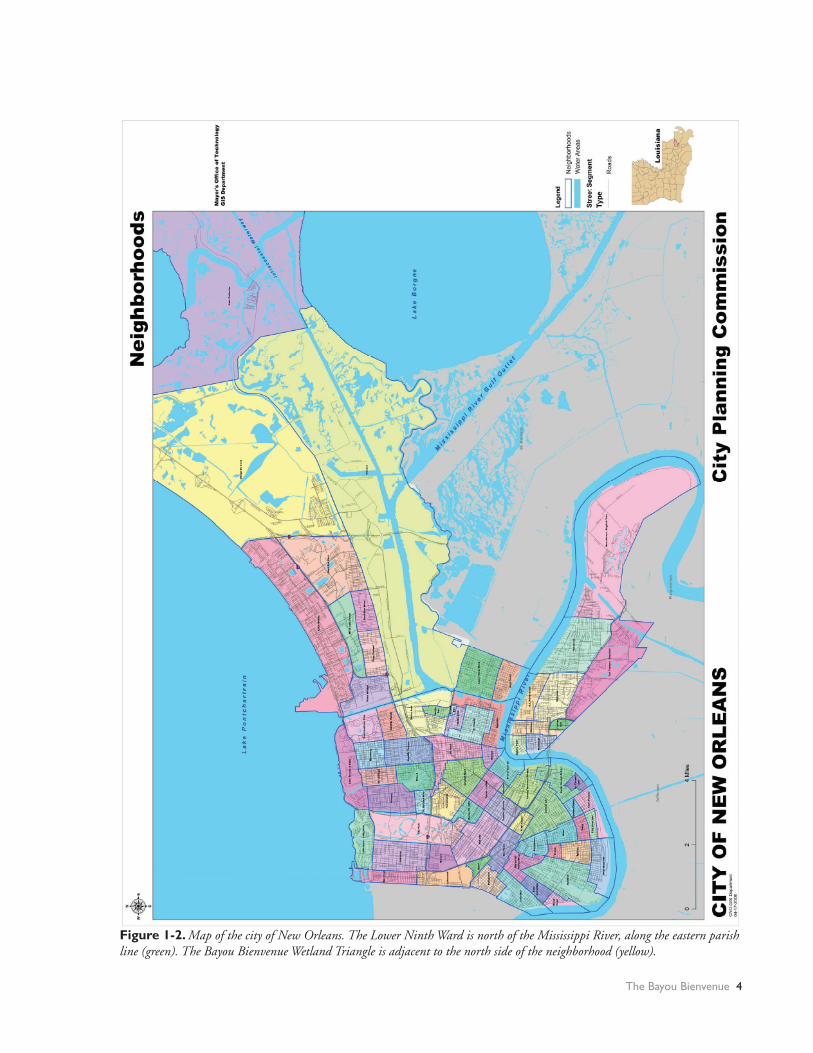
The study site—the Bayou Bienvenue Wetland Triangle—is a degraded urban wetland abutting the northern edge of New Orleans’ Lower Ninth Ward (see Figure 1-1). As attention turns to the restoration of wetlands, the Bayou Bienvenue Wetland Triangle has been viewed as a candidate for restoration. The Bayou Bienvenue Wetland Triangle comprises 427 acres situated in the extreme northwestern corner of the 28,000 acre Bayou Bienvenue Central Wetland Unit (Penland et al, 2002). The Bayou Bienvenue Wetland Triangle is part of an interconnected system of rivers, bayous, and man-made canals that dissects the greater New Orleans area (Figure 1-2).
With the neighborhood to the south, this wetland is bordered by the Bayou Bienvenue proper to the northwest and the Mississippi River-Gulf Outlet to the north. The eastern edge is flanked by the New Orleans Sewerage and Water Board’s East Bank Sewage Treatment Plant and the Crescent Acres Landfill. Beyond these structures, the waters merge with the Bayou Bienvenue Central Wetland Unit, which stretches 30 miles from New Orleans to Lake Borgne. At one time, the Bayou Bienvenue Wetland Triangle was a thriving cypress swamp; now we found only one living cypress tree.
Bayou Bienvenue is a natural bayou that meanders from its head near the southwest corner of the Bayou Bienvenue Wetland Triangle to the east for
The Bayou Bienvenue 2

Figure 1-1. Site specific schematic of Bayou Bienvenue Wetland Triangle and surrounding features. Schematic modified from the City of New Orleans “Citywide Neighborhoods” map. (City of New Orleans Geographic Information Department. Disclaimer: This information is derived from the City of New Orleans Enterprise GIS Database. The data are not a survey-quality product and the end user assumes the risk of utilizing it. The City of New Orleans does not assume any liability for damages arising from errors, omissions, or use of this information. End users are advised to be aware of the published accuracy, date, compilation methods, and cartographic format as described in the accompanying metadata, and are advised to utilize these data appropriately.)
3 Wetland Restoration and Community-Based Development
The Bayou Bienvenue 4
Figure 1-2. Map of the city of New Orleans. The Lower Ninth Ward is north of the Mississippi River, along the eastern parish line (green). The Bayou Bienvenue Wetland Triangle is adjacent to the north side of the neighborhood (yellow).

about 13 miles, where it ends at Lake Borgne. The bayou has served as an outfall for New Orleans’ drainage system since 1899, when the New Orleans Sewerage and Water Board’s Pumping Station no. 5 was constructed at its head near the intersection of Florida and Jourdan Avenues in the Lower Ninth Ward (Maygarden et al., 1999). This pumping station is fed by a system of lined canals that channel seepage and stormwater, which is then pumped into Bayou Bienvenue.
1.2.2 A Brief History
1.2.2.1 4,500 years ago – 1718: Geologic Origins to European Settlement
The sediment underlying the Bayou Bienvenue Wetland Triangle was deposited between 4,500 and 5,000 years ago, in a depression between the high grounds at the banks of the Mississippi River and
Bayou Sauvage (Frazier, 1967). The low elevation of this area resulted in a high water table and regular flooding. The cypress swamp and freshwater marsh communities historically found in the area developed shortly after the sediment deposition.
The area remained an undisturbed, intact cypress swamp or freshwater marsh up to 1718 when New Orleans was settled by Europeans, an event that marks a critical turning point in the history of the area.
1.2.2.2 1718 – 1960s: Settlement and Infrastructure Development
1.2.2.2.1 VegetationA New Orleans area map from 1723 (Figure 1-3) depicts Bayou Bienvenue with a cypress swamp to the north and individual plots to the south. This early map suggests that in 1723 the area may have been
Figure 1-3. New Orleans area and Bayou Bienvenue. Carte Particuliere Du Flevue [sic] St. Louis dix lieües au dessus et au dessous De La Nouvelle Orleans…[ca. 1723]. (Newberry Library, Chicago. Historic New Orleans Collection)
5 Wetland Restoration and Community-Based Development

a contiguous cypress swamp, partially cleared for settlement or agriculture. Later descriptions indicate that the Central Wetland Unit and the Bayou Bienvenue Wetland Triangle may not have been completely dominated by cypress swamp, but rather contained a mix of other plant community types.
Arsene Latour’s series of maps (created in response to the War of 1812) describe the then existing dominant vegetation at the site. Latour distinguished between two plant communities: cypress swamps and marsh prairies. Most of the Bayou Bienvenue Wetland Triangle, especially to the north, along with a large area of the Central Wetland Unit, is categorized as prairie. Bordering this expansive prairie on both the north and south is cypress swamp.
1.2.2.2.2 LeveesSeasonal flooding of the Mississippi River devastated settlements, and residents have long relied on constructing a series of levees to protect the city. Starting in the 19th century, these levees virtually eliminated the deposition of sediment critical for the growth of wetlands (U.S. Geological Survey, 1995).
1.2.2.2.3 DrainageIn addition to containing Mississippi River overflows, early engineers also worked to pump storm and floodwaters out of the city, often utilizing the hydraulic connection between Bayou Bienvenue and Lake Borgne. Early maps (from 1828 and 1863) (Figure 1-4) show that Bayou Bienvenue served as an outfall for drainage canals from riverside development and the Mexican Gulf Railroad. Although rainwater canals comprised part of the initial engineering plans dating back to the City’s inception in the early 18th century, attempts to develop a comprehensive drainage system utilizing underground pipes did not appear until the 1840s. Not until the 1890s, following a city council ordinance aimed at improving the then dilapidated drainage system, was a comprehensive effort made to modernize the city drainage system.
The result of this ordinance was the 1895 Drainage Plan. This plan considerably improved upon the existing drainage system. At this time Lake Borgne was chosen as the ultimate receptor of outfall from the drainage system, utilizing Bayou Bienvenue as a
Figure 1-4. Map of the New Orleans area, 1863. Source: Approaches to New Orleans http://www.davidrumsey.com/detail?id=1-1-26919-1100218&name=Approaches+to+New+Orleans.
The Bayou Bienvenue 6

Figure 1-5. Comparison of the main outfall canal from Pump-ing Station no. 5 prior to its construction with modern Bayou Bienvenue. The natural drainage pattern can be discerned .Map: (http://www.davidrumsey.com/detail?id=1-1-26919-1100218&name=Approaches+to+New+Orleans).Aerial photo: (TerraServer-USA, Microsoft Corp, USGS).
conduit. A canal was dredged between the pumping station and the head of Bayou Bienvenue so that sufficient discharge could be transmitted to Lake Borgne. The dredging spoils were placed on the banks of the channel, significantly reducing any previous hydraulic connection between Bayou Bienvenue and the Bayou Bienvenue Wetland Triangle.
Despite extensive hydrologic modification of the study site, certain historical features of the bayou are still intact today. A comparison of an 1863 map and a recent satellite image (Figure 1-5) shows that, with the exception of the Main Outfall Canal, the channel proper has not changed, although the swamp around it has degraded considerably.
Historical accounts, maps, and photographs suggest that the system’s overall health, while undoubtedly impacted by the sudden increase in polluted runoff, did not suffer greatly from this project. The natural buffering and cleansing ability of the wetland likely absorbed much of the pollution before its eventual outfall into Lake Borgne. It appears that the system absorbed elevated inputs of potentially polluted runoff with little noticeable effect, but evidence indicates that future waterworks projects had less benign effects on the site. Subsequent projects introduced saline water into the (then freshwater) wetland.
Over the ensuing decades, the drainage system was improved piecemeal. Project by project, the City of New Orleans worked to widen existing canals, install larger screw pumps, and cover exposed drainage canals, while enhancing the capacity of the system and streamlining its operation. In addition, the New Orleans Sewerage and Water Board’s East Bank Treatment Plant replaced Pump Station no. 5 in 1915-1916. With sewage and drainage systems in place, significant improvements in public heath were realized in the city: lower incidence of malaria and typhoid fever, and lower mortality rates.
1.2.2.2.4 Shipping CanalsDuring the 1920s, New Orleans completed the Industrial Canal (officially called the Inner Harbor Navigational Channel), a 5.5-mile channel built to connect the Mississippi River to Lake Pontchartrain; it passed through a large portion of intact swamp near Bayou Bienvenue. In 1949 this canal was
expanded to connect with the Gulf Intracoastal Waterway which—like others used for shipping and hydrocarbon exploration—likely contributed greatly to the destruction of wetlands by allowing saltwater intrusion (U.S. Geological Survey, 1995).
Construction of the early shipping canals seems not to have had an immediate impact on the predominant vegetation of the Bayou Bienvenue Wetland Triangle. Early aerial photos, such as the one in Figure 1-6, show an apparently healthy and relatively contiguous cypress swamp in the triangle despite
7 Wetland Restoration and Community-Based Development

canal construction and the reception of three decades of city runoff. Intrinsic wetland cleansing abilities, dilution into the Central Wetland Unit, and the spoil bank formed when the Main Outfall Canal was dredged probably combined to protect the triangle from pollution. However, the triangle underwent a slow ecosystem transformation as it was largely cut off from three primary components needed to create and maintain a healthy cypress ecosystem: freshwater inputs, nutrients and sediment. This transformation resulted in the cypress swamp’s slow conversion to an open water system; later canal construction hastened this process. (see aerial photos, Appendix IX).
1.2.2.3 1960s – Present: The Mississippi River-Gulf Outlet and the Bayou Bienvenue Wetland Triangle
1.2.2.3.1 Construction of the Mississippi River-Gulf OutletPhotographic evidence suggests that the wetlands of the Bayou Bienvenue Central Wetland Unit began to die off in the mid-20th century, and apparently the situation hardly improved in the subsequent decades. Due in part to the completion of the Mississippi River-Gulf Outlet (finished in 1968), and aided by the system of canals crisscrossing the coastal armor, salt water began to push into the Bayou Bienvenue
Central Wetland Unit on a consistent basis, especially during storm surges.
Of all the events that have influenced the Central Wetland Unit and Bayou Bienvenue Wetland Triangle over the years, from construction projects to hurricanes (Figure 1-7), the completion of the Mississippi River-Gulf Outlet has received the most attention. Lasting nearly 10 years, construction of the 76-mile shortcut was an enormous undertaking, with even larger ramifications for the surrounding wetlands. Designed to provide deep-draft ships (those which could not fit through the locks on the Inner Harbor Navigational Channel) a shorter route from the Gulf of Mexico to the Port of New Orleans inner harbor, the Mississippi River-Gulf Outlet remains contentious today: this canal has led to extensive saltwater intrusion into the area’s freshwater wetlands.
The loss of the cypress swamps is often attributed entirely to the construction of the Mississippi River-Gulf Outlet and the resulting infusion of salt water. This claim has been studied by others; it is adamantly asserted but has not been conclusively proven.
1.2.2.3.2 East Bank Sewage Treatment PlantThe East Bank Sewage Treatment Plant is located in the southeastern corner of the Bayou Bienvenue Wetland Triangle. The plant is surrounded by levees which protect against increased water level in the Bayou Bienvenue Wetland Triangle during typical storms. During Hurricane Katrina, the levee was overtopped and the plant was damaged extensively (Mack, 2007).
1.2.2.3.3 Crescent Acres LandfillThe Crescent Acres Landfill, owned by Browning Ferris, Inc., forms the southeastern boundary of the Bayou Bienvenue Wetland Triangle. This facility collected non-hazardous waste until its closure in 1993. In accordance with the closure, a stabilized cover was placed over the disposal cells to prevent stormwater from contacting the landfill solids. Stormwater runoff now collects from an area of approximately 296 acres and discharges from eight outfalls. The area draining to outfall one also has three 50,000 gallons tanks to store leachate collected from the landfill cells (Louisiana Department of Environmental Quality, 2000).
Figure 1-6. Aerial photograph of the Bayou Bienvenue Wetland Triangle and surroundings, 1933, showing the triangle as mostly forested with interspersed areas of mixed swamp/prairie. (LSU Department of Geography and Anthropology Cartographic Information Center)
The Bayou Bienvenue 8
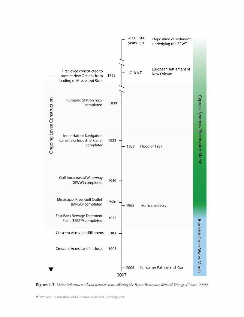
Figure 1-7. Major infrastructural and natural events affecting the Bayou Bienvenue Wetland Triangle (Carter, 2008).
9 Wetland Restoration and Community-Based Development

1.2.2.4 Future Changes
1.2.2.4.1 Closing the Mississippi River-Gulf OutletCalls to close the Mississippi River-Gulf Outlet are nearly as old as the channel itself. Dubbed the Hurricane Highway for its perceived ability to funnel hurricane storm surge, the channel has long suffered from inadequate usage, high maintenance costs and destructive impacts on nearby wetlands. Calls for closure intensified following Hurricane Katrina in 2005 with opponents of the canal citing myriad reasons. The U.S. Army Corps of Engineers itself has regularly called for its closure, but is careful to point out that concern regarding storm surge is not the motivating factor.
The Army Corps of Engineers explains that the Mississippi River-Gulf Outlet (MRGO) needs to be closed, but not because it funneled stormwater into the city. This assessment is based on the results of two independent and technically rigorous studies, one organized by the Corps (the Interagency Performance Evaluation Task Force) and one funded by the State of Louisiana, that indicate the MRGO channel cannot carry enough water to significantly impact water levels in the interior of the city. According to the U.S. Army Corps of Engineers, the reason MRGO should be closed is that it allows salt water to flow into freshwater wetlands, which degrades these natural protective barriers (Link, 2008).
Following this rationale, the U.S. Army Corps of Engineers in May 2007 issued a news release identifying the construction of a total closure structure across the Mississippi River-Gulf Outlet near Bayou La Loutre as a preferred strategy, citing both environmental and economic reasons (Morgan, 2007).
Subsequently, in June 2007 the U.S. Army Corps of Engineers published a draft version of the comprehensive Integrated Final Report to Congress and Legislative Environmental Impact Statement for the Mississippi River – Gulf Outlet Deep-Draft De-Authorization Study; the final version was released in November, 2007 and revised in January, 2008. On February 11, 2008, the U.S. Army Corps of Engineers announced that the final report had been completed and that work on the closure structure would begin in the summer of 2008 and
be completed prior to the 2009 hurricane season (Morgan, 2008). A complete history of the Mississippi River-Gulf Outlet as well as information regarding its impending closure can be found at the U.S. Army Corps of Engineers website: http://mrgo.usace.army.mil/default.aspx.
1.2.2.4.2 Implications and Considerations for Cypress Restoration Modeling studies performed by the U.S. Army Corps of Engineers have shown that salinity effects from the Mississippi River-Gulf Outlet began during the initial construction phase, in 1963. Three salinity studies were reviewed for the Integrated Final Report to Congress: one regards potential impacts in the Pontchartrain Basin estuary from the proposed Bonnet Carre freshwater diversion, another regards a Mississippi River-Gulf Outlet partial closure and width reduction project, and the third is a coastal area salinity modeling study. One study concludes that “the Mississippi River-Gulf Outlet is a significant contributor to salinity via connections to Lake Borgne,” that “the estuary salinity profile responds very slowly to changes in freshwater inflow to Lake Pontchartrain,” and as a result, target salinity levels may be difficult to obtain with freshwater diversions (U.S. Army Corps of Engineers, 2007, p. D-2). However, another conclusion of the report acknowledges that “it may be possible to approach target salinities by combining control of Mississippi River-Gulf Outlet salinity with freshwater diversions at reduced rates” (U.S. Army Corps of Engineers, 2007, p. D-3).
1.3 Proposed Restoration of the Bayou Bienvenue Wetland Triangle
1.3.1 An Abandoned Proposal: Pumping Station Diversion and Terracing
A restoration project proposed by the National Marine Fisheries Service and the Louisiana Department of Natural Resources included diverting discharge from Pumping Station no. 5 into the Bayou Bienvenue Wetland Triangle (National Marine Fisheries Service and Louisiana Department of Natural Resources, 2001). This restoration plan involved introducing grass species along the channel banks dredged into the southwestern corner of the
The Bayou Bienvenue 10

Bayou Bienvenue Wetland Triangle and along terraces constructed in the section of open water in the Bayou Bienvenue Central Wetland Unit just east of the Crescent Acres Landfill. The project was eventually abandoned due to high costs associated with terrace construction over low-strength organic clays and peat (Hartman Engineering, 2001).
1.3.2 The Current Proposal: Wastewater Assimilation
As part of its response to the devastation wrought by the 2005 hurricanes, the New Orleans Sewerage and Water Board has developed a plan to reduce operating costs and restore the Bayou Bienvenue Wetland Triangle by diverting its nutrient-rich effluent—which currently outfalls in the Mississippi
River—into the wetland. The intended outcome is that the wetland vegetation will consume the excess nutrients, providing tertiary treatment, while the effluent serves both as fertilizer to encourage cypress growth and as a source of sediment that counteracts the ongoing subsidence of the wetland. The touted benefits to the Lower Ninth Ward community include restoration of the cypress swamp, which would provide recreation opportunities, habitat for wildlife, and aesthetic beauty, as well as protection from storm surge. The proposed restoration would benefit the New Orleans Sewerage and Water Board by reducing operating costs since the expectation is that treatment standards for wastewater treatment will be relaxed when discharging to a treatment wetland.
11 Wetland Restoration and Community-Based Development

References
America’s Wetland. (2008). Types of wetlands. www.americaswetlandresources.com/wildlife_ecology/plants_animals_ecology/wetlands/TypesofWetlands.html. Accessed May 2008.
Barras, J. (2006). Land area change in coastal Louisiana after the 2005 hurricanes—a series of three maps: U.S. Geological Survey. Open-File Report 06-1274.
Faulkner, P. (2004). The natural communities of Louisiana. Baton Rouge, LA: Louisiana Department of Wildlife & Fisheries, Louisiana Natural Heritage Program.
Frazier, D. (1967). Recent deltaic deposits of the Mississippi River: Their development and chronology. Transactions – Gulf Coast Association of Geological Societies, 17:287-315.
Hartman Engineering, Inc. (2001). Bayou Bienvenue pump station diversion and terracing feasibility study. No. PO-25, XPO-74A. Baton Rouge and Kenner, Louisiana: Hartman Engineering, Inc. Consulting Engineers.
Lester, G., Sorenson, S., Faulkner, P., Reid, C., & Maxit, I. (2005). Louisiana comprehensive wildlife conservation strategy. Baton Rouge, LA: Louisiana Department of Wildlife and Fisheries.
Link, E. (2008). Negative articles about New Orleans recovery operations often do not tell the whole story. U.S. Army Corps of Engineers, http://www.hq.usace.army.mil/cepa/pubs/oct07/story4.htm. Accessed March 2008.
Louisiana Department of Environmental Quality. (2000). Document ID 32403392, AI 11072.
Louisiana Department of Natural Resources and National Marine Fisheries Service. (2001). Bayou Bienvenue Pump Station Diversions and Terracing Project Information Sheet. Coastal Wetlands Planning, Protection and Restoration Act Priority Project List no. 8, p. 34.
Louisiana State University Agricultural Center. (1998). Wetland functions and values in Louisiana. Report 2519. Baton Rouge, LA: LSU Agricultural Center.
Mack, S. (2007), personal communication, New Orleans Sewerage and Water Board.
Maygarden, B., Yakubik, K., Weiss, E., Peyronnin, C., & Jones, K. (1999). National Register Evaluation of New Orleans Drainage System, Orleans Parish, Louisiana. U.S. Army Corps of Engineers, New Orleans District.
Mitsch J. & Gosselink J. (2000). Wetlands. Hoboken, NJ: John Wiley and Sons.
Morgan, J. (2007). News Release, Total Closure Selected Plan for Mississippi River-Gulf Outlet. U.S. Army Corps of Engineers. May 19, 2007. www.mvn.usace.army.mil/pao/RELEASES/mrgo_meeting_070519.pdf. Accessed March 4, 2008.
Morton, R., Miller, T., & Moore, L. (2004). Historical shoreline changes and associated coastal land loss along the U.S. Gulf of Mexico. No. Open File Report 2004-1043. U.S. Department of the Interior.
Office of Coastal Restoration and Management. (2007). http://dnr.louisiana.gov/crm/background Accessed September 2007.
Penland, S., Beall, A., & Kindinger, J. (2002). Environmental Atlas of the Lake Pontchartrain Basin. U.S. Geological Survey: Open File Report no. 2002-206.
Southwick Associates. (2005). The economic benefits of fisheries, wildlife and boating resources in the state of Louisiana. Louisiana Department of Wildlife and Fisheries.
Swarenski, P. (2002). Evaluating Basin/Shelf effects in the delivery of sediment-hosted contaminants in the Atchafalaya and Mississippi River Deltas - a new U.S. Geological Survey coastal and marine geology project. No. Open File Report 01-215 U.S. Department of the Interior.
The Bayou Bienvenue 12

The Nature Conservancy. (2008). Mississippi River alluvial plain. Retrieved January 2008, from http://www.nature.org/wherewework/northamerica/states/louisiana/preserves/art6867.html
U.S. Army Corps of Engineers. (1963). Overland surge elevations coastal Louisiana: Morgan City and vicinity. No. File No. H-2-22758, Plate A-4.
U.S. Army Corps of Engineers. (2007). Integrated Final Report to Congress and Legislative Environmental Impact Statement for the Mississippi River – Gulf Outlet Deep-Draft De-Authorization Study. U.S. Army Corps of Engineers, New Orleans District. November 2007 (Revised January 2008).
U.S. Geological Survey, Marine and Coastal Geology Program. (1995). Louisiana wetlands: A coastal resource at risk. http://marine.usgs.gov/fact-sheets/LAwetlands/lawetlands.html Accessed May 2008.
U.S. Geological Survey. (2003). 100+ years of land change for coastal Louisiana. Lafayette, LA: U.S. Geological Survey National Wetlands Research Center.
13 Wetland Restoration and Community-Based Development

CHAPTER 2THE SOCIO-ENVIRONMENTAL STORY OF THE LOWER NINTH WARD
It’s impossible to tell the socio-environmental story of the Lower Ninth Ward, and the story of the swamp nestled along its northern edges without reviewing how the area was originally settled and the role of race in geographical placement. New Orleans is, in many ways, both a beacon of hope as communities collaborate to rehabilitate neighborhoods and natural areas following Hurricanes Katrina and Rita, and a testament to the consequences of inequitable development.
Many say that much of New Orleans should never have been developed in the first place. The naturally marshy land is full of saturated soils destined to compact upon drainage, which contributes to the rate of subsidence. Humans have altered the delta environment in ways that have put the entire city directly in the path of harm from storm events (Sparks, 2006). By removing or damaging many of the coastal wetlands, a critical component of protection from storm surges has been reduced, and in many cases removed completely.
Following the hurricanes of 2005, some individuals argued that, due to increasing risk, the city should shift residences out of vulnerable areas. Proponents of such plans assert that rebuilding on land prone to both sinking and flooding is irresponsible, and that residents could be relocated en masse to higher grounds (Sparks, 2006). Such a dramatic geographical change of neighborhoods is unlikely, however, given the lack of sufficient funds for subsidizing such an endeavor, and especially given the incredible connection that many in New Orleans feel to their neighborhoods and family homes.
2.1 A Brief History
New Orleans was founded by the French in 1717, on the highest ground of the natural levees of the Mississippi River, in an area occupied by the Chitimacha Indians. Early residents were responsible for building their own levees, leading to the creation of local levee boards. Later, the federal government began maintaining the river for navigation, already
hinting at an uneasy relationship between national use of the river and local responsibility for protection from the river (Austin, 2006).
By the 1800s the growing city of New Orleans, fueled by the success of the sugar industry, suffered from the impacts of demands of an increasing population on relatively inhospitable land. The surrounding areas were marshlands, and the soils within the burgeoning city were water-logged and frequently inundated. The moist soils and standing water provided perfect breeding grounds for disease-carrying mosquitoes. Accordingly, levels of mosquito-borne illnesses such as malaria and yellow fever were quite high (Vileisis, 1999). The city suffered a severe yellow fever epidemic in 1853, during which 10,000 people died and half the city population of 150,000 fled (Colten, 2005).
Storm events repeatedly led to severe floods throughout the city. Much of the land was barely above sea level, so the scarce elevated areas were at a premium. “[I]n New Orleans, every inch in elevation matters tremendously. Despite what appears to the eye as a flat cityscape, there is no isotrophic plain in terms of risk. Vulnerability is concentrated in areas below sea level” (Colten, 2006). It is not surprising then, that those with more wealth and power settled in the preferable, better drained soils of the higher ground. Lower-income residents, predominantly Southern European and Irish immigrants and Free African Americans, settled in lower-lying areas where land was less expensive (Breunlin & Regis, 2006; Colten, 2002; Colten, 2005; Colten, 2006).
Adding to the health risks caused by mosquito-borne diseases and flooding, were health concerns due to inadequate sewage disposal. Before the early 1900s, there was no centralized sewage system within the city. Raw sewage was collected in outhouses or in common canals and eventually dumped into that great diluter of North American waste, the Mississippi River (Colten, 2005). By the early 1900s, the situation was dire. Residents of the
The Socio-Environmental Story of the Lower Ninth Ward 14

city contributed more than two million pounds of human waste to the environment annually (Colten, 2005). Wealth and status did not protect residents from sanitation-related woes: “Even the fashionable Garden District had a large number of low lots and “defective drainage” in its rear or lakewards sections” (Colten, 2002).
At the time, this was underestimated, but recognized as a problem: “The greatest sources of impurity of air arise from privies, the offal from kitchens, stables, stores, markets, streets, manufactories, etc. It is estimated that a population of 130,000 produces annually 5,633 tons of night soil [feces] and 43,000 tons of urine...” (Carrington, 2006). Thus, plans to improve health and quality of life involved implementing drainage and sewage systems for the entire city. However, the benefits of the new systems were not equally shared among all residents.
During ante-bellum years, when slavery was prevalent, many African Americans lived with the families which enslaved them, adding illusion to the image of an integrated city (Breunlin & Regis, 2006; Colten, 2002; Colten, 2005; Colten, 2006). Even after the end of slavery, New Orleans did witness a relatively high level of racial integration compared to other Southern cities, at least until the implementation of Jim Crow segregation laws. Drainage increased the amount of land-area available for developing new neighborhoods, but opportunities for home purchase were inherently unequal, leading to increased segregation by race and class. “In one such neighborhood, Lakeview, deed restrictions explicitly prohibited land ownership by African Americans. This created an exclusively white district until the U.S. Supreme Court outlawed such real estate practices in the 1950s” (Colten, 2006). Later, federal mandates to desegregate public schools ironically resulted in “white flight” and contributed to segregation of neighborhoods (Jackson, 2006).
The Lower Ninth Ward was one area that encouraged African American home-ownership. As a result, at 59 percent prior to Hurricane Katrina, the Lower Ninth Ward had the highest rate of home-ownership in the city (Brady, 2001; Jackson, 2006; Landry, Bin, Hindsley, Whitehead, & Wilson, 2007).
2.2 The History Matters
This settlement history matters because it is integrated into the social fabric of this area and shapes the community’s outlook and way of relating to broader society. Responses to the destruction of Katrina and proposals for recovery and redevelopment must be interpreted with this understanding.
For example, many families living in the Lower Ninth Ward acutely remember the government’s 1964 declaration of eminent domain of the nearby village of Fazendeville—a small community of freed African Americans established in 1867 on former plantation land, which was also the site of the Battle of New Orleans at Chalmette (1815) (Jackson, 2006; National Park Service, 2007; Peña, 2006). For almost a century, residents of Fazendeville lived amidst relics of the war. Then, in 1964, local and national preservationists worked with the government to acquire the entire Fazendeville land parcel in order to expand the Jean Lafitte National Historical Park to include the Chalmette Battlefield. The preservationists subsequently encountered significant resistance from the roughly 200 Fazendeville residents who didn’t want to leave their homes (Jackson, 2006).
“[I]n 1964, the National Park Service acquired the Fazendeville residential area through forced purchases and condemnation, eliminated the structures, and physically erased the historic community. Essentially, most residents then moved into the Lower Ninth Ward in New Orleans, which was right across the parish line, predominantly black, and affordable” (Jackson, 2006).
The memories of the experience are still vivid for many Lower Ninth Ward residents and the possibility that eminent domain might be declared again (post-Hurricane Katrina) remains a steady concern for some in the area. As a result, many residents are quick to question the motives of even the most well-intentioned restoration plans, especially when such plans include the words “park” or “green-space.”
15 Wetland Restoration and Community-Based Development
2.3 The Lower Ninth Wardand the Holy Cross Neighborhood
2.3.1 Physical Setting of the Lower Ninth Ward
The Lower Ninth Ward is surrounded by water on three sides. At the southern edge lies the mighty Mississippi River where a levee, constructed in 1912 to help combat land erosion, offers a view of New Orleans’ skyline and the passing cruise ships. On the western edge lies the Industrial Canal. Built by the Port of New Orleans in 1923 as a navigational shortcut between the Mississippi River and Lake Pontchartrain, the canal separates the Lower Ninth Ward from the rest of New Orleans (including the Upper Ninth Ward), and gives the area the shape it has today. The canal—passable via two bridges—also divides the community from the rest of New Orleans. To the north is the open water of the Bayou Bienvenue Wetland Triangle, once a thriving cypress swamp teeming with wildlife.
Just beyond the swamp is the Bayou Bienvenue proper, and the controversial Mississippi River-Gulf Outlet (MRGO) which was completed in 1968 (after 10 years of construction) to connect the Gulf of Mexico with New Orleans’ inner harbor. Intended to provide a shorter route for deep-draft ships, “the MRGO is authorized as a 36-foot deep, 500-foot bottom width, waterway,” and has cost a total of $578,659,000 in federal monies since its construction (U.S. Army Corps of Engineers, 2007). Yet, ship traffic has been declining for years. At peak usage—from 1993-1997—the Mississippi River-Gulf Outlet saw an average of 5,980 vessel trips. In 2004, 2,370 vessel trips were made. In 2005, only 982 vessel trips occurred in the Mississippi River-Gulf Outlet (U.S. Army Corps of Engineers, 2007).
At the northeastern edge of the community, adjacent to the Bayou Bienvenue Wetland Triangle lies a small peninsula of dredged material housing the Crescent Acres Landfill. Bordering the landfill, along the Orleans/St. Bernard Parish line, is the East Bank Sewage Treatment Plant, the city’s largest, which treats 122 million gallons of waste per day.
2.3.2 The Building of a Neighborhood
The roots of the Lower Ninth Ward are entwined with the resources gleaned from both the wetlands and the soils. Early settlers to the area built homes along the higher ground by the Mississippi River. Much of the rest of what is now the Lower Ninth Ward was farmed (sugar plantations were common) and the existing cypress swamps were harvested for timber (Austin, 2006; Saucier, 1749).
Starting in the mid-1800s some plantations were divided into street grids with housing plots. The area subsequently attracted poor African Americans and immigrant laborers (many from Ireland, Germany and Italy) unable to afford land on higher ground. Benevolent associations and mutual-aid societies organized to assist both struggling free African Americans and immigrants in settling into the area. The support of these organizations encouraged settlement and laid the groundwork for the high rate of home-ownership that exists to this day (Breunlin & Regis, 2006; Jackson, 2006).
As families moved in, a distinct community began to form. In 1857, a group of Catholic residents founded St. Maurice Church, still a popular landmark today. Two years later, the Brothers of the Holy Cross purchased the Reynes plantation to establish a boys’ orphanage and later, a boarding school which gave the neighborhood its name. Until the damage caused by Hurricane Katrina, the Holy Cross High School functioned as the only private high school in the area (Holy Cross School, 2007). Historic steamboat houses also added color and historic flavor to the Holy Cross neighborhood.
Jackson Barracks, established in 1834, added another unique element to the growing community. Since its inception, the facility has served the U.S. Army as a post for troops, a training center and as a point of embarkation. Throughout the Civil War, the barracks housed both Union and Confederate soldiers. In 1869, they housed the early formations of the all-black 25th Infantry Regiment, the group which later gained fame as the fierce fighting “Buffalo Soldiers.” The barracks have even functioned as a temporary
The Socio-Environmental Story of the Lower Ninth Ward 16

hospital during several conflicts: the Florida Seminole War, the Mexican War, the Spanish American War, the Civil War, both World Wars, and for the Louisiana National Guard during Operation Desert Storm (The Jackson Barracks Military Library, 2007).
The current-day Lower Ninth Ward is bisected by Claiborne Avenue which has created two distinct neighborhoods within the ward, and yet the entire area developed a small town feel full of colorful shot-gun style homes with front porch stoops that encouraged neighborly communication. Many extended families owned several homes to house all of their relatives. Several famous artists and musicians, including Fats Domino, grew up in this family-oriented community.
Over time, infrastructural improvements paved the way to a post-war building boom. In the late 1950s, the city added a second (sorely needed) link between the Lower Ninth Ward and New Orleans proper: the Judge William Seeber Bridge (commonly referred to as the Claiborne Avenue Bridge). Additionally, retail development along St. Claude Avenue as well as industrial development bordering the Industrial Canal grew until 1965 (Greater New Orleans Community Data Center, 1980).
2.3.3 The Community Today
The Lower Ninth Ward today reflects many decades of physical and infrastructural challenges. Hurricane Betsy’s 1965 destruction deeply affected the area’s economy. Social and racial challenges also took their toll during this time; forced desegregation of schools combined with a struggling economy resulted in “white flight” and disinvestment (Falk, Hunt, & Hunt, 2006).
Although the Holy Cross neighborhood was listed in the National Register of Historic Places in 1986, and given a Local Historic District designation in 1990, the Lower Ninth Ward’s economic, education and housing situation continued to decline (Greater New Orleans Community Data Center, 1980; Louisiana National Register of Historic Places, 2007).
Children inherited homes from their parents but employment opportunities and income levels were decreasing. The 2000 U.S. Census reflects these
struggles: at that time, only 41.2 percent of the Lower Ninth Ward population over age 16 was employed (compared with 54.6 percent in Louisiana as a whole) (U.S. Department of Commerce, 2000). Many who were employed were working for low wages and living on fixed incomes. U.S. Census data show that, by 2000, in the Lower Ninth Ward 45 percent of homeowners and 55 percent of renters spent more than 30 percent of their household incomes on housing costs (U.S. Department of Commerce, 2000).
Despite depressed economic conditions and increasing crime, community attachment to the area is strong. Residents have a deep-rooted sense of place even after the devastating hurricane events of 2005 (Petroski, 2006). Grass-roots community groups, while always prevalent, have strengthened since the storm events. These organizations actively advocate for physical and social improvements in their communities.
2.4 The Holy Cross Neighborhood Association
The Holy Cross Neighborhood Association, incorporated in 1981, was founded by African American and white neighbors concerned with neighborhood advocacy, deteriorating economic and physical infrastructure, lack of city services, and lack of political influence. Due to activities by the Holy Cross Neighborhood Association, in 1986 the National Register of Historic Places recognized the historic importance of the Holy Cross neighborhood and included it on the register, showcasing the two unique steamboat houses built by Captain Paul Doullut in 1905 (Louisiana National Register of Historic Places, 2007). In 1990, the City of New Orleans followed and designated it a Local Historic District.
Since 1981, the Holy Cross Neighborhood Association has advocated for the community, sparked physical improvements, provided information on issues of concern and neighborhood activities, and provided residents with an opportunity to vote and be heard on vital issues and to work with neighbors on community improvement projects. Full membership is open to any Holy Cross resident, or
17 Wetland Restoration and Community-Based Development

property or business owner; associate memberships are open to all.
Since Hurricane Katrina, this Association has been extremely active in developing sustainable reconstruction plans for the Lower Ninth Ward and finding partners willing to assist in funding and implementing these plans. This includes rebuilding the recently devastated neighborhood,
developing a community environmental resource center, restoring the adjacent Bayou Bienvenue Wetland Triangle, and developing a landscaped path and platform overlooking the wetland. The Holy Cross Neighborhood Association and other area stakeholders have requested this study and report in order to better guide plans for the restoration of the Bayou Bienvenue Wetland Triangle.
The Socio-Environmental Story of the Lower Ninth Ward 18

References
Austin, D. (2006). Coastal exploitation, land loss, and hurricanes: A recipe for disaster. American Anthropologist, 108(4), 671.
Breunlin, R. & Regis, H. (2006). Putting the Lower 9th Ward on the map: Race, place, and transformation in Desire, New Orleans. American Anthropologist, 108(104), 744-764.
Carrington, Y. (2006). Hopes for Holy Cross. Southern Exposure. 34(2), 10.
Colten, C. E. (2002). Basin street blues: Drainage and environmental equity in New Orleans, 1890–1930. Journal of Historical Geography, 28(2), 237.
Colten, C. E. (2005). Unnatural metropolis. Baton Rouge, LA: Louisiana State University Press.
Colten, C. E. (2006). Vulnerability and place: Flat land and uneven risk in New Orleans. American Anthropologist, 108(5), 731.
Falk, W., Hunt, M., & Hunt, L. (2006). Hurricane Katrina and New Orleanians’ sense of place: Return and reconstruction or ‘gone with the wind’? Du Bois Review, (3), 115.
Greater New Orleans Community Data Center. (1980). Holy Cross neighborhood snapshot. http://gnocdc.org/orleans/8/20/index.html
Holy Cross School. (2007). The history of Holy Cross School. Retrieved October 2007, from http://www.holycrosstigers.com/section_2_16.asp
Jackson, J. M. (2006). Declaration of taking twice: The Fazendeville community of the Lower Ninth Ward. American Anthropologist, 108(4), 765.
Landry, C. E., Bin, O., Hindsley, P., Whitehead, J. C., & Wilson, K. (2007). Going home: Evacuation-migration decisions of Hurricane Katrina survivors. Southern Economic Journal, 74(2), 326.
Louisiana National Register of Historic Places. (2007). Retrieved October, 2007, from http://www.crt.state.la.us/hp/nhl/search_results.asp?search_type=historicname&value=Holy+Cross+Historic+District&pageno=1
National Park Service, Louisiana. (2007). Chalmette Battlefield. Retrieved 9, 2007, from www.nps.gov/jela/chalmette-battlefield.htm
Peña, A. (2006). Wade in the water: Personal reflections on a storm, a people, and a national park. American Anthropologist, 108(4), 781.
Petroski, H. (2006). Levees and other raised ground. American Scientist, 94(1).
Saucier, F. (1749). Carte particulière du cours du fleuve St. Louis depuis le village Sauvage jusqu’au dessous du detour aux angloix, des Lacs Pontchartrain & Maurepas & des rivières & bayou qui y aboutissent (American Memory ed.). Washington, DC: Library of Congress.
Sparks, R. (2006). Rethinking, then rebuilding New Orleans. Issues in Science and Technology, 33.
U.S. Army Corps of Engineers. (2007). Integrated final report to congress and legislative environmental impact statement for the Mississippi River – Gulf Outlet deep-draft de-authorization study. New Orleans, LA: U.S. Army Corps of Engineers, New Orleans District.
The Jackson Barracks Military Library. (2007). Jackson Barracks: Building the U.S. Army post. Retrieved Octorber, 2007, from http://www.la.ngb.army.mil/dmh/jbm_jbhist.htm
U.S. Department of Commerce. (2000). Profiles of general demographic characteristics: 2000 Census of population and housing, Louisiana. U.S. Department of Commerce.
Vileisis, A. (1999). Discovering the unknown landscape: A history of America’s wetlands. Washington, DC: Island Press.
19 Wetland Restoration and Community-Based Development

CHAPTER 3CYPRESS SWAMP ECOLOGY, RESTORATION, AND WASTEWATER ASSIMILATION
3.1 Cypress Swamp Ecology
3.1.1 Geographic Extent
Cypress swamp communities are found across the southeast United States, through the Coastal Plain and Mississippi embayment—particularly in the rich floodplain swamps of Mississippi River tributaries. Alluvial river swamps, including cypress swamps, are found in permanently flooded depressions in floodplains (e.g., oxbows) or sloughs that run parallel to rivers (Ewel & Odum, 1984).
3.1.2 Geomorphology and Hydrology
Cypress swamps are considered one type of alluvial river swamp and are characterized by the presence of standing water submersing the root system for at least part of the year. Much of the water and nutrient rich sediments are delivered to the wetlands by seasonal flood pulses, with additional inputs from near-by surface runoff, precipitation, throughfall, and groundwater. Though most cypress swamps receive significant input from river flooding, they are typically hydrologically isolated from riverine environments except during flood events (Ewel & Odum, 1984).
Cypress swamps are often found in the low-lying regions of watersheds, which are environments receptive to hydrologic inflows and conducive to standing water. They experience wet seasons in summer and winter, and dry seasons in spring and fall. These precipitation driven influences result in relatively fast dry downs during the dry seasons and high water levels that remain throughout the wet seasons. Water levels in cypress ecosystems can reach 3 to 6.5 feet (1 to 2 meters) during the wettest parts of the year, yet often lose all standing water to infiltration in the corresponding dry seasons (Ewel & Odum, 1984).
The effects of evapotranspiration (the combination
of evaporation and transpiration) in cypress swamps are similar to those in other deciduous freshwater swamps. Cypress trees lose their leaves in the fall and transpiration is minimal for four months out of the year. Evapotranspiration rates are highest in May, when the sun is strong and the air is relatively dry, they decrease approximately 20 percent in the summer wet season, and then drop to their lowest in December and January (Ewel & Odum, 1984).
3.1.3 Water Chemistry and Biogeochemistry
Alluvial cypress swamps are heavily influenced by hydrologic inputs; consequently, their biogeochemistry is highly dependent on the chemistry of those inflows. The more isolated the cypress swamp is from outside hydrologic inflows (aside from precipitation), the lower the nutrient input, alkalinity, and pH within the system. These values also vary seasonally depending upon the timing and intensity of water inputs, such as those from flooding and rainfall (Ewel & Odum, 1984). Cypress swamps can tolerate a wide range of biogeochemical conditions, which are controlled by several factors including position in the watershed and source of input (Mitsch & Gosselink, 2000). Alluvial cypress swamps flooded by rivers and other well-mineralized waters tend to have pH between 6 and 7, while swamps of similar composition fed primarily by rainwater often have pH of 3.5 to 5 (Mitsch & Gosselink, 2000).
The buffering capacity, or alkalinity, of alluvial cypress swamps is dependent on the swamp’s position in the watershed and the source of hydrologic inputs. Similar to pH, river fed cypress swamps have high alkalinity, as well as high concentrations of dissolved ions and nutrients (Mitsch & Gosselink, 2000).
Precipitation plays an important role in the chemical dynamics of these ecosystems by facilitating the leaching of organic matter, iron, aluminum, and silica. However, its disadvantage as a hydrologic input
Cypress Swamp Ecology, Restoration, and Wastewater Assimilation 20

is that rain is nutrient poor; and this lack of nutrient input may limit productivity of cypress swamps that receive much of their replenishment from precipitation and throughfall (Ewel & Odum, 1984).
Alluvial river swamps generally have mineral-rich waters due to the high mineral content of the riverine sediment. Because of this, nutrients such as phosphorous tend to be more abundant in alluvial cypress swamps than other types of swamps—particularly in shallow waters where the soil to surface water ratio is high, thus allowing increased contact between soil and the surrounding water (Ewel & Odum, 1984).
These wetlands are also typified by anoxic conditions that support high denitrification and sulfate reduction rates (Ewel & Odum, 1984). The advantage of such biogeochemically active environments is an increased capacity to remove excess nutrients from receiving waters.
Cypress trees have a limited tolerance for salinity, which makes it a critical parameter for their health and survival. A 1981 study concluded that cypress wetlands are limited to areas where salinity does not exceed 2 parts per thousand (ppt) more than 50 percent of the time (Wicker, 1981). Similarly, a later study conducted by the United States Geological Survey (1997) found that bald cypress seedlings died within two weeks of being exposed to floodwaters with salinity levels of 10 ppt, and showed altered growth at 2 ppt salinity (Allen, 1997).
3.1.4 Ecosystem Structure
3.1.4.1 Flora
Bald cypress (Taxodium distichum) stands are well adapted to wet and waterlogged environments, but their relatively low tolerance for salinity tends to restrict growth to freshwater or very low brackish regions. These ecosystems are characterized by the presence of large trees with high growth rates, an abundance of knees and buttresses, and annual flooding from surrounding rivers. Bald cypress are long-lived, with a reported maximum age of 1,000 years (Laderman, 1998); and when fully mature they can reach sizes of 30 to 40 meters in height and 1 to 1.5 meters in diameter.
The presence and abundance of understory vegetation depends on the amount of light penetrating the canopy. Most mature cypress swamps have little understory vegetation, as the full canopy blocks out much of the incoming light. When light is sufficient, the composition will consist of woody shrubs, herbaceous vegetation, and aquatic plants (Table 3-1).
Table 3-1. Characteristic species of Louisiana alluvial river swamps (common name, Latin name):
Cypress trees have evolved a number of adaptations for handling water stress, both in the context of water excess and scarcity. One of these adaptations is the cypress knee, extending from the roots to above the water surface. Their function has been widely debated, though it has been theorized that they serve as sites for gas exchange (primarily CO
2) in the roots,
or collectively as an anchor against wind and storm surges (Ewel & Odum, 1984).
Cypress tree seed germination and survival require moist, but not flooded, conditions. Fluctuating water levels, which allow soil to be exposed to oxygen, are necessary for seed germination. If continuously flooded, seed viability will decrease and the swamps
Dominantcanopy trees
Subdominantcanopy trees
Shrubs
Herbs and aquatics
Bald cypress (Tasodium distichum)
Water tupelo (Nyssa aquatica)
Drummond red maple (Acer rubrum var. drummondii)
Pumpkin Ash (Frasinus tomentosa)
Buttonbush (Cephalanthus occidentalis)
Hackberry (Celtis Laevigata)
Black willow (Salix nigra)
Duckweed (Lemna and Spirodela spp.)
Liverworts (Riccia spp.)
Common frog’s bit (Limnobium spongia)
21 Wetland Restoration and Community-Based Development

could transition to open water ponds, similar to what we see in the Bayou Bienvenue Wetland Triangle (see section 4.2.2.4). Seed dispersal is highly dependent on local hydrologic conditions. Bald cypress seeds are primarily produced in fall and winter when there is the widest range of high and low flows in adjacent stream systems (Ewel & Odum, 1984).
3.1.4.2 Fauna
Invertebrate communitiesInvertebrate communities are extremely dependent on the abundance of detritus found in permanently flooded swamps, and the greatest diversity and numbers are found in environments where water levels fluctuate significantly. Invertebrate species characteristic of cypress swamp communities include crayfish, clams, oligochete worms, snails, freshwater shrimp, midges, amphipods, and immature insect larvae (Mitsch & Gosselink, 2000).
Vertebrate CommunitiesFish species are both temporary and permanent residents of alluvial cypress swamps, as they utilize backwaters for spawning and feeding during the flooding season or for refuge when floodwaters recede. Species of forage minnows dominate cypress swamp systems, and larger fish are only temporary residents.
Reptiles and amphibians have adapted to the fluctuating water levels of alluvial river swamps. As many as ten species of frogs have been observed in southeastern cypress swamps (Mitsch & Gosselink, 2000). In addition, the American Alligator, as well as the cottonmouth (water moccasin) and other water snakes, are known to inhabit cypress swamp ecosystems.
3.1.5 Ecosystem Function
3.1.5.1 Cypress Swamp Productivity
The flow of energy in the swamp system is driven by primary productivity of canopy trees. Energy consumption generally occurs through the decom-position of organic matter. Decomposition rates vary with local conditions; they are low when anaerobic conditions exist and high in wet, but not permanently flooded, conditions (Mitsch & Gosselink, 2000).
Productivity exceeds respiration in all cypress wetlands, contributing to an autotrophic system. Alluvial cypress swamps receiving high nutrient inflows have high gross and net primary productivity as well as net ecosystem productivity. Build-up and export of organic matter is characteristic of the alluvial cypress swamp.
Impounding these wetlands with artificial levees contributes to decreased productivity in cypress swamps, as prolonged inundation of cypress seedlings greatly reduces their viability.
3.1.5.2 Nutrient Cycling
Forested wetlands can function as nutrient sinks, with subsequent phosphorous and nitrogen removal from water through uptake by vegetation, denitrification processes, or phosphorous adsorption to sediments (Mitsch & Gosselink, 2000).
3.2 Cypress Swamp Restoration
3.2.1 Ecological Considerations for Cypress Restoration
Key ecological factors that will greatly influence the success of cypress restoration and re-growth at Bayou Bienvenue include altered hydrology, permanent flooding conditions, and saltwater intrusion. Bald cypress trees tolerate flood conditions well and salinity at relatively low concentrations. However, the combined effects pose a significant threat to cypress swamp survival–particularly as salinity levels rise (Guntenspergen, Vairin, & Burkett, 1997).
Bald cypress trees rely heavily on seasonal flood pulses for nutrient acquisition and seed dispersal. Altered hydrology usually results in a disconnect from the floodplain, which disrupts seasonal water level changes, alters seed dispersal and germination patterns, and limits nutrient input. Extended flooding is a threat to bald cypress because seeds require exposure to oxygen for germination. Bald cypress seeds are usually viable for less than one year; without a persistent seed bank, frequent seed dispersal is absolutely critical for regeneration (Middleton, 2002 and 2003).
Cypress Swamp Ecology, Restoration, and Wastewater Assimilation 22

Under permanently flooded conditions (>1 meter), cypress trees experience physiological stress, and growth potential is greatly reduced (Allen et al., 1996). This leads not only to a decline in existing cypress tress, but also requires artificial regeneration measures (e.g., planting trees). There has been some success in planting bare-root seedlings in flooded conditions such as these, but cypress seedlings can only survive submergence for up to 45 days. Some swamps are so altered that even artificial regeneration is not possible or practical (Science Working Group, 2005).
Because cypress seedlings only have limited salt tolerance, rapid or large pulses of salt water during storm events can have significant effects (Science Working Group, 2005). No cypress has been found to survive sustained flooding with salinity greater than 8 ppt (Kraus, Chambers, & Allen, 1998). While bald cypress can tolerate salinity up to 8 ppt for short periods of time, regular exposure to salinity greater than 4 ppt results in decline of its productivity and survival (Science Working Group, 2005). The mean salinity of the surface waters in the Bayou Bienvenue Wetland Triangle is at the edge of this tolerance range (at 3.66 ppt), while the mean groundwater concentration is 7.34 ppt. Given that the minimum root depth for bald cypress is 40 inches (U.S. Department of Agriculture & Natural Resources Conservation Service, 2008), bald cypress at the Bayou Bienvenue Wetland Triangle will likely be impacted by soil salinity as well.
According to the Science Working Group on Louisiana Coastal Wetland Forest Conservation and Use (2005), sites without potential for either natural or artificial regeneration are those that are flooded for an extended period of time and are subject to saltwater intrusion. The Science Working Group also concluded that forests with water levels exceeding two feet at the time of planting make artificial regeneration impractical (Science Working Group, 2005). Such conditions characterize Bayou Bienvenue Wetland Triangle, and could be influential in selecting which restoration method to implement.
Studies have shown that there is considerable variation in salt tolerance of natural populations of bald cypress and that this tolerance is genetically
inheritable. Cypress trees propagated from stands already subjected to brackish conditions responded to saltwater treatments better than cypress trees that originated in freshwater conditions (Allen, 1997). This implies that there is great potential for new varieties of bald cypress to be developed and propagated in nurseries and used to restore cypress wetlands in impacted areas despite saltwater intrusion and flooding (Guntenspergen, Vairin, & Burkett,, 1997).
3.2.2 Restoration Options – Terracing, Diversions, and Floating Treatment Wetlands
3.2.2.1 Terracing
One option for compensation of degraded wetlands is the creation of terraces in the shallow open water of former wetlands. An example of a successful terracing project is in the Cameron Prairie National Wildlife Refuge, Louisiana where, in 2002, 27 miles of v-shaped terraces were built to provide strips of land for plant growth and bird habitat, as well as to calm the surrounding water and decrease turbidity. The terraces have encouraged the growth of submergent vegetation, and have provided barriers against wave action and erosion (U.S. Fish and Wildlife Service, 2008).
3.2.2.2 Freshwater and Sediment Diversions
Freshwater diversion is a process by which sediment rich river water is re-directed via crevasses, siphons, or culverts into struggling wetland units. It can provide a source of nutrients and sediment for freshwater-starved wetlands where degradation is compounded by rising mean sea level and subsequent saltwater intrusion. (LA Coast, 2008).
3.2.2.3 Floating Treatment Wetlands
Artificially created floating treatment wetlands have been developed by private companies as an alternative to constructed wetlands as treatment systems. Floating treatment wetlands consist of a buoyant raft structure, constructed with layers of a recycled plastic material and adhesive foam, which contains pre-cut pockets for planting wetland plants and sod. Natural planting succession can occur on the floating islands, producing a mat of regenerating vegetative material.
23 Wetland Restoration and Community-Based Development

The newly established plants and their roots provide additional surface area for microbial activity and nutrient uptake (Headley & Tanner, 2006).
The concept behind floating mats is to rapidly establish marsh grasses and other brackish plant species on these islands to provide wetland habitat (see Figures 3-1 and 3-2) (Headley & Tanner, 2006).
3.2.2.4 Study Prototypes
A review of existing literature on cypress restoration did not reveal any evidence of successful restoration projects that converted an open water system to a thriving cypress swamp ecosystem. Any project attempting this would be ambitious and experimental.
Figure 3-1. Recently launched floating islands (Floating Islands International).
Figure 3-3. Conceptual model of wastewater assimilation showing the three main pathways of nutrient uptake: vegetative uptake, burial, and microbial denitrification (Modified from Ko et al, 2004).
3.3 The Use of Wetland Assimilation of Wastewater as Tertiary Treatment
3.3.1 Wetland Assimilation for Wastewater Treatment
Wetland assimilation projects involve the discharge of treated effluent into an existing wetland system to provide advanced secondary or tertiary treatment for municipal wastewater treatment plants (Ko et al., 2004). Wetlands are capable of removing nutrients, pollutants, and sediment through a variety of processes including physical settling, filtration, chemical absorption and precipitation, vegetative uptake, burial in sediments, and denitrification. Of particular importance in wetland systems are the biogeochemical processes that give them the ability to act as sources, sinks, or transformers of nutrients such as nitrogen, phosphorus, and some heavy metals (Nixon & Lee, 1986). The wetland assimilation process utilizes the natural energy of these systems to consume, absorb, or convert nutrients from treated effluent, resulting in improved water quality (Figure 3-3) (Day et al., 2004; Mitsch & Gosselink, 2000).
The success of wetland assimilation as a form of wastewater treatment depends on the loading rate of nutrient-rich effluent into the wetland, the retention time of nutrients and biosolids, and the interaction between the water, soil, vegetation, and microorganisms within the wetland ecosystem (Breaux & Day, 1994; Faulkner & Richardson, 1989; Richardson & Nichols, 1985). In a properly
Figure 3-2. Vegetative growth at six months on thefloating islands (Floating Islands International)
Cypress Swamp Ecology, Restoration, and Wastewater Assimilation 24

functioning wetland assimilation system, the application rate does not exceed the decay or immobilization rate. As an example, an assimilation wetland receiving wastewater effluent with high levels of fecal coliform bacteria and high biochemical oxygen demand will be most effective at reducing the biochemical oxygen demand and removing bacteria if the wetland has long residence times that allow for utilization and degradation of the contaminants and organic matter (Day et al., 2005).
In southern Louisiana, forested wetlands have been used for decades to provide advanced secondary or tertiary treatment in municipal wastewater treatment plants (Ko et al., 2004). This low-cost form of wastewater treatment has resulted in numerous economic and ecosystem benefits. The input of nutrients and biosolids to the wetland increases vegetative productivity and reduces subsidence rates while improving water quality by removing excess nutrients (Rybczyk, Day, & Conner, 2002). In addition, utilizing the natural energy of these systems reduces some of the energy cost requirements of conventional methods applied to wastewater treatment such as sludge removal and treatment, and the application of sand filtration systems (Tchobanoglous & Burton, 1991; Viessman & Hammer, 1998). Many conventional treatment systems also lack the capacity to adequately remove excess nutrients, which can cause eutrophication (Zhang, Feagley, & Day, 2000).
3.3.2 Permitting Processes
Implementing wetland assimilation as advanced treatment has helped reduce the number of discharge permit violations in Louisiana, particularly for total suspended solids and biochemical oxygen demand. Incorporating wetland assimilation into the wastewater treatment process provides an additional treatment method to improve water quality and allows treatment facilities to reduce the risk of permit violations by meeting the less stringent effluent discharge standards that apply to wetland systems. In the state of Louisiana, discharging effluent into
wetlands requires prior approval from the Louisiana Department of Environmental Quality. Approval is granted on a case-by-case basis and only allows effluent that has already received secondary treatment (Breaux & Day, 1994).
Municipalities and industries considering incorporating wetland assimilation in wastewater treatment are required to conduct a Use Attainability Analysis, submitted to the Louisiana Department of Environmental Quality as part of the permitting process (Day et al., 2004). A wetland assimilation Use Attainability Analysis documents the ecological conditions of the site, evaluates the feasibility of its use as a wetland treatment system (including land use and ownership, and institutional considerations such as permitting feasibility and funding), and it provides preliminary engineering design recommendations (Day et al., 2004; Day et al., 2005).
3.3.3 Wetland Assimilation Prototypes
Several wastewater treatment plants in Louisiana use wetland assimilation as a method of advanced treatment. One is in Thibodaux, where the system has been in place since 1992. The Thibodaux treatment plant discharges secondarily treated effluent into the 234 hectare (578 acre) Pointe-au-Chene cypress-tupelo swamp. The secondarily treated effluent is pumped approximately 2.5 kilometers to the site and then distributed from 40 pipes (set 15 meters apart) located along the 610 meter spoil bank at the northern boundary.
A second example is in Hammond, where the South Wastewater Treatment Plant discharges secondarily treated effluent into the South Slough and Joyce Wildlife Management Area, a combined area of 4,000 hectares (10,000 acres). An elevated pipeline system was built along the south side of the spoil bank to evenly distribute the effluent along the north edge of the South Slough wetland.
For more detailed information about the use of wetland assimilation in Thibodaux and Hammond, consult Appendix III.
25 Wetland Restoration and Community-Based Development

References
Allen, J. A. (1997). Salt tolerance of southern bald cypress. United States Geological Survey National Wetlands Research Center, Global Climate Change Fact Sheet, 092(97), 4/18/07.
Allen, J. A., Pezeshki, S. R., Chambers, J. L. (1996). Interaction of the flooding and salinity stress on bald cypress (Taxodium distichum). Tree Physiology. 16(1/2), 307-314.
Breaux, A. M., & Day, J. W. J. (1994). Policy considerations for wetland wastewater treatment in the coastal zone: A case study for Louisiana. Coastal Management, 22(3), 285-307.
Day, J. W., Ko, J., Rybczyk, J., Sabins, D., Bean, R., Berthelot, G., et al. (2004). The use of wetlands in the Mississippi Delta for wastewater assimilation: A review. Ocean & Coastal Management, 47, 671-691.
Day J.W., Lane R.R., Lindsey J., Day J.N. (2005), Hammond Wetland Wastewater Assimilation Use Attainability Analysis, Comite Resources, Inc.
Ewel, K. C., & Odum, H. T. (Eds.). (1984). Cypress swamps. Gainesville: University Presses of Florida.
Faulkner, S. P., & Richardson, C. J. (1989). Physical and chemical characteristics of freshwater wetland soils. Proceedings from the First International Conference on Constructed Wetlands for Wastewater Treatment Held in Chattanooga, Tennessee on June 13-17, 1988--Pref. 41-72.
Guntenspergen, G., Vairin, B., & Burkett, V. R. (1997). Coastal wetlands and global change: Overview. United States Geological Survey Fact Sheet, 089(97).
Headley, T. R., & Tanner, C. C. (2006). Application of floating wetlands for enhanced stormwater treatment: A review. NIWA Client Report: HAM2006-123. Hamilton, New Zealand: National Institute of Water & Atmospheric Research Ltd.
Ko, J., Day, J. W., Lane, R. R., & Day, J. N. (2004). A comparative evaluation of money-based and energy-based cost–benefit analyses of tertiary municipal wastewater treatment using forested wetlands vs. sand filtration in Louisiana. Ecological Economics, 49(3), 331-347.
Kraus, K. W., Chambers, J. L., Allen, J. A. (1998). Salinity effects and differential germination of several half-sib families of bald cypress from different seed sources. New Forests. 15(1):53-68.
LA Coast website www.lacoast.gov. Accessed August, 2008.
Laderman, A. D. (Ed.). (1998). Coastally restricted forests. New York: Oxford University Press.
Middleton, B. A. (2002). Flood pulsing in the regeneration and maintenance of species in riverine forested wetlands of the southeastern United States. Flood pulsing in wetlands: Restoring the natural hydrological balance (pp. 223-294). New York: John Wiley & Sons.
Middleton, B. A. (2003). Soil seed banks and the potential restoration of forested wetlands after farming. Journal of Applied Ecology, 40, 1025-1034.
Mitsch J. and Gosselink J. (2000). Wetlands. John Wiley and Sons.
Nixon, S. W., & Lee, V. (1986). Wetlands and water quality: A regional review of recent research in the United States on the role of freshwater and saltwater wetlands as sources, sinks, and transformers of nitrogen, phosphorus, and various heavy metals. Vicksburg, MS; Springfield, VA: U.S. Army Engineer Waterways Experiment Station, United States. Army. Corps of Engineers & Wetlands Research Program.; available from National Information Technical Service.
Cypress Swamp Ecology, Restoration, and Wastewater Assimilation 26

Richardson, C. J., & Nichols, D. S. (1985). Ecological analysis of wastewater management criteria in wetland ecosystems. Ecological Considerations in Wetlands Treatment of Municipal Wastewaters, pp 351-391.
Rybczyk, J. M., Day, J. W., & Conner, W. H. (2002). The impact of wastewater effluent on accretion and decomposition in a subsiding forested wetland. Wetlands, 22(1), 18-32.
Science Working Group on Coastal Wetland Forest Conservation and Use. (2005). Conservation, protection and utilization of Louisiana’s coastal wetland forests: Final report to the Governor. http://www.crcl.org/images/FSD_Coastal_Forest_SWG_FinalReport.pdf
Tchobanoglous, G., & Burton, F. L. (Eds.). (1991). Wastewater engineering: Treatment, disposal, and reuse. New York: McGraw-Hill.
U.S. Department of Agriculture & National Resources Conservation Service. (2008). The PLANTS database. http://plants.usda.gov/
U.S. Fish and Wildlife Service. (2008). http://www.fws.gov. Accessed August 2008
Viessman, W., & Hammer, M. J. (1998). Water supply and pollution control (6th edition). New York: Addison-Wesley.
Wicker, K. M., (1981). Assessment of extent and impact of saltwater intrusion into the wetlands of Tangipahoa Parish, Louisiana. United States National Oceanic and Atmospheric Administration, Louisiana. Coastal Energy Impact Program, Coastal Environments, & Tangipohoa Parish (La.). Police Jury. Baton Rouge, LA: Coastal Environments, Inc.
Zhang, X., Feagley, S. E., & Day, J. W. (2000). A water chemistry assessment of wastewater remediation in a natural swamp. Journal of Environmental Quality, 29(6), 1960-1968.
27 Wetland Restoration and Community-Based Development

CHAPTER 4
ENVIRONMENTAL CHARACTERIZATION OF THE BAYOU BIENVENUE WETLAND TRIANGLE
The research team conducted fi eld studies in June and July of 2007 in order to make a preliminary assessment of selected chemical, physical, and biological conditions of the Bayou Bienvenue Wetland Triangle. The results provided the fi eld researchers with a base-line understanding of the study site’s current conditions and helped the team gage the impact these conditions will have on 1) the success of the proposed restoration of the Bayou Bienvenue Wetland Triangle to cypress swamp via wastewater assimilation, and 2) the capacity of the existing wetland to attain wastewater treatment goals. The fi ndings are presented and discussed below, and the chemical results are listed in Appendix V.
4.1 Biological Characteristics
4.1.1 Flora
The Bayou Bienvenue Wetland Triangle no longer functions as a cypress forest ecosystem, or even a wetland. Throughout the completely degraded swamp, dead cypress stumps rise out of the open water as reminders of the dense stand of cypress trees that once fi lled the area (Figure 4-1). Though destruction of the cypress forest is not complete, as a
single and resilient cypress tree was discovered by the research team in the far northwestern corner of the Bayou Bienvenue Wetland Triangle (Figure 4-2).
In the absence of cypress trees, the dominant plant community in the open water of the Bayou Bienvenue Wetland Triangle is submerged aquatic vegetation. Vegetation surveys conducted in June and July of 2007 suggest that there are at least two
Figure 4-1. Dead cypress tree stumps (“ghosts”) scattered throughout the Bayou Bienvenue Wetland Triangle. Photo: Travis Scott
Figure 4-2. The sole surviving cypress tree in the Bayou Bienvenue Wetland Triangle. This tree was discovered in the northwestern corner of the Bayou Bienvenue Wetland Triangle. Photo: Travis Scott
Environmental Characterization of the Bayou Bienvenue Wetland Triangle 28

distinct species of submerged aquatic vegetation in the wetland (Figure 4-3), but positive species identifi cation was not made. Likely species of submerged aquatic vegetation in the Bayou Bienvenue Wetland Triangle were identifi ed based on vegetation-distribution maps (U.S. Department of Agriculture & Natural Resources Conservation Service, 2008) and the measured salinity of the open water (subsection 4.3.1.1). Widgeon grass (Ruppia maritima) and sago pond weed (Stuckenia pectinata) are leading candidates as they are common in the region and are a relatively salt-tolerant species known to dominate areas of saltwater intrusion (Guntenspergen, Vairin, & Burkett, 1997).
Emergent and woody vegetation were found at the boundaries of the open water and on exposed banks. Along the edges of open water in the Bayou Bienvenue Wetland Triangle, some species of emergent herbaceous vegetation can be found. Though the species was not identifi ed, the most likely candidate species is marsh-hay cordgrass (Spartina patens), an emergent plant that characteristically dominates brackish marshes and grows in open conditions (The Nature Conservancy, 2008). The northern bank of Bayou Bienvenue and the dredge spoil bank between Bayou Bienvenue and the Bayou Bienvenue Wetland Triangle are dominated by dense, woody vegetation, including a single cypress tree.
While the vegetation community that currently inhabits the Bayou Bienvenue Wetland Triangle is quite different from the cypress swamp that previously occupied the area, the existing fl ora still serves some ecological functions. Submerged aquatic vegetation provides habitat for many fi sh and invertebrate species and is an important food resource for waterfowl. The diverse shrub and tree
Figure 4-3. Submerged aquatic vegetation in the Bayou Bienvenue Wetland Triangle. Photo: Travis Scott
communities that are present along the banks of Bayou Bienvenue provide critical habitat for many of the wetland-associated bird species utilizing this area.
4.1.2 Fauna
Faunal characterization was primarily focused on visual identifi cation of bird species. The species of observed birds was recorded; the number of individuals was not. The intent was to identify species that are regularly utilizing the resources of the Bayou Bienvenue Wetland Triangle rather than those just passing through.
The faunal diversity in the Bayou Bienvenue Wetland Triangle was greater than anticipated, given the degraded state of the wetland. Twenty-nine bird species were identifi ed, including both waterbirds and landbirds (Table 4-1). The majority of species identifi ed are waterbirds, which is to be expected given that the Bayou Bienvenue Wetland Triangle is almost entirely open water. Green herons were the most frequently observed bird species at the site (Figure 4-5). They were often seen roosting in the trees in large groups or colonies and perching on the many cypress stumps in the open water of the Bayou Bienvenue Wetland Triangle. A variety of herons, egrets, and other wading birds was observed along the channel of Bayou Bienvenue; the dense woody vegetation in this area provides roosting and foraging habitat.
Figure 4-4. A green heron prepares to land on a cypress snag in the Bayou Bienvenue Wetland Triangle. Photo: Liz Pleuss
29 Wetland Restoration and Community-Based Development

Table 4-1. Faunal species observed in the Bayou Bienvenue Wetland Triangle, June – July 2007.
Birds
Double-crested Cormorant Phalacrocorax auritus
Great Blue Heron Ardea herodias
Little Blue Heron Egretta caerulea
Cattle Egret Bubulcus ibis
Yellow-crowned Night-Heron Nyctanassa violacea
Black-bellied Whistling Duck Dendrocygna autumnalis
Mississippi Kite Ictinia mississippiensis
Killdeer Charadrius vociferus
Gull-billed Tern Sterna nilotica
Royal Tern Sterna maxima
Mourning Dove Zenaida macroura
American Crow Corvus brachyrhynchos
Tree Swallow Tachycineta bicolor
Prothonotary Warbler Protonotaria citrea
Sandpiper Calidris spp.
Anhinga Anhinga anhinga
Great Egret Ardea alba
Tri-colored Heron Egretta tricolor
Green Heron Butorides virescens
Black Vulture Coragyps atratus
Osprey Pandion haliaetus
Red-tailed Hawk Buteo jamaicensis
Laughing Gull Larus atricilla
Caspian Tern Sterna caspia
Black Skimmer Rynchops niger
Acadian Flycatcher Empidonax virescens
Purple Martin Progne subis
Barn Swallow Hirundo rustica
Louisiana Waterthrush Seiurus motacilla
Reptiles
Mississippi Green Water Snake Nerodia cyclopion
Green Anole Lizard Anolis carolinensis Fish
Alligator Gar Atractosteus spatula
Mullet Mugilidae
Sheepshead Minnows Cyprinodon variegatus
Bluegill Lepomis macrochirus Insects
Dragonfl ies-unidentifi ed spp. Odonata spp.
Damselfl ies-unidentifi ed spp. Odonata spp. Crustaceans
Blue Crab Callinectes sapidus
Environmental Characterization of the Bayou Bienvenue Wetland Triangle 30
4.1.2.1 Birds
The only waterfowl species observed in the Bayou Bienvenue Wetland Triangle was a small group of black-bellied whistling ducks (Dendrocygna autumnalis). No more than eight individuals of these ducks were observed at a given time and such groups were seen infrequently. It is possible that the ducks were attracted to the dead cypress trees in the wetland for roosting.
A pair of osprey (Pandion haliaetus) was also seen frequently roosting among the dead cypress trees and foraging for food in the wetland. It is unclear if this is a nesting pair. Gulls, terns, and skimmers were abundant in the open-water areas of the Bayou Bienvenue Wetland Triangle. The feeding behavior of skimmers was interesting to watch as they were commonly seen diving to catch fl ying insects or attempting to pluck fi sh from just below the water’s surface.
A species of particular interest found in the Bayou Bienvenue Wetland Triangle is the prothonotary warbler (Protonotaria citrea). The prothonotary warbler is a Partners in Flight and Audubon WatchList species that is commonly associated with forested fl oodplain wetlands such as cypress-tupelo (National Audubon Society, 2008). Its long-term survival is threatened by the decline and widespread loss of cypress forests nationwide. The prothonotary warbler breeds and winters in Louisiana’s coastal forests, making protection and restoration of cypress forests critical to sustaining viable populations of the species in the state (Science Working Group, 2005). It is unknown if the prothonotary warbler is utilizing this wetland site for breeding.
It should be noted that the summer season is not the ideal time for birding in Louisiana; there is greater abundance and diversity of birds during the spring and fall migrations. Bird surveys conducted during migrations would capture the full range of both resident birds and migrants that may be visiting the site. Knowledge of how the species composition changes over an annual cycle will strengthen an evaluation of restoration plans regarding the potential impacts and/or benefi ts to bird populations.
4.1.2.2 Fishes, Crabs, and Shrimp
Four species of fi sh in the open water of the Bayou Bienvenue Wetland Triangle were positively identifi ed: mullet, gar, sheepshead minnow, and bluegill. Blue crabs were abundant in the wetland and are a good indicator of the current brackish conditions, given their limited tolerance of fresh water during different growth stages (Hill, Fowler, & Ven Den Avyle, 1989).
Shrimp and fi nfi sh species observed at Louisiana Department of Wildlife and Fisheries monitoring stations (see Figure 4-5) on and near Bayou Bienvenue seaward of the Bayou Bienvenue Wetland Triangle collected between 1967 and 2006 are listed in Table 4-2. However, data from these monitoring stations cannot be used as perfect predictors of shrimp and fi nfi sh species in the Bayou Bienvenue Wetland Triangle, due to the distance between the two locations. Data from the monitoring stations closest to Bayou Bienvenue Wetland Triangle are presented to provide a list of species that might be found in the site.
Field data in the Bayou Bienvenue Wetland Triangle are lacking—particularly on fi sh and invertebrate species—and further research is needed. Analyzing the diversity and abundance of invertebrates (with an emphasis on those that serve as water quality indicators) may prove useful for evaluating site conditions. Researching the fi sh populations would be useful in terms of fi sheries management for recreation purposes, and also to gain a better understanding of the food-web dynamics of this former cypress swamp and how these would be affected by restoration or wastewater assimilation. Given the present brackish-water conditions, identifying habitat requirements and salinity tolerances of the fi sh species at Bayou Bienvenue will be critical in determining how the species composition might change if the wetland transitions back to a freshwater cypress swamp.
31 Wetland Restoration and Community-Based Development

Figure 4-5. Map showing Louisiana Department of Wildlife and Fisheries shrimp and fi nfi sh monitoring stations relative to the Bayou Bienvenue Wetland Triangle.
Atlantic sturgeon Acipenser oxyrhynchusSkipjack herring Alosa chrysochlorisStriped anchovy Anchoa hepsetusSheepshead Archosargus probatocephalusSea catfish Arius felisGafftopsail catfish Bagre marinusSilver perch Bairdiella chrysouraGulf menhaden Brevoortia patronusBlue crab Callinectes sapidusCrevalle jack Caranx hipposBull shark Carcharhinus leucasAtlantic spadefish Chaetodipterus faberAtlantic bumper Chloroscombrus chrysurusBay whiff Citharichthys spilopterusSand seatrout Cynoscion arenariusSpotted seatrout Cynoscion nebulosusAtlantic stingray Dasyatis sabinaGizzard shad Dorosoma cepedianumThreadfin shad Dorosoma petenenseLadyfish Elops saurus
Pinfish Lagodon rhomboidesSpot Leiostomus xanthurusSpotted gar Lepisosteus oculatusAlligator gar Lepisosteus spatulaSouthern kingfish Menticirrhus americanusAtlantic croaker Micropogonias undulatusLargemouth bass Micropterus salmoidesYellow bass Morone mississippiensisStriped mullet Mugil cephalusWhite mullet Mugil curemaSouthern flounder Paralichthys lethostigmaWhite shrimp Penaeus setiferusHarvestfish Peprilus alepidotusBlack drum Pogonias cromisCownose ray Rhinoptera bonasusSpanish sardine Sardinella auritaRed drum Sciaenops ocellatusSpanish mackerel Scomberomorus maculatusWalleye Stizostedion vitreumAtlantic needlefish Strongylura marina
Table 4-2. Shrimp and fi nfi sh species at monitoring stations on and near Bayou Bienvenue seaward of Bayou Bienvenue Wetland Triangle.
Environmental Characterization of the Bayou Bienvenue Wetland Triangle 32
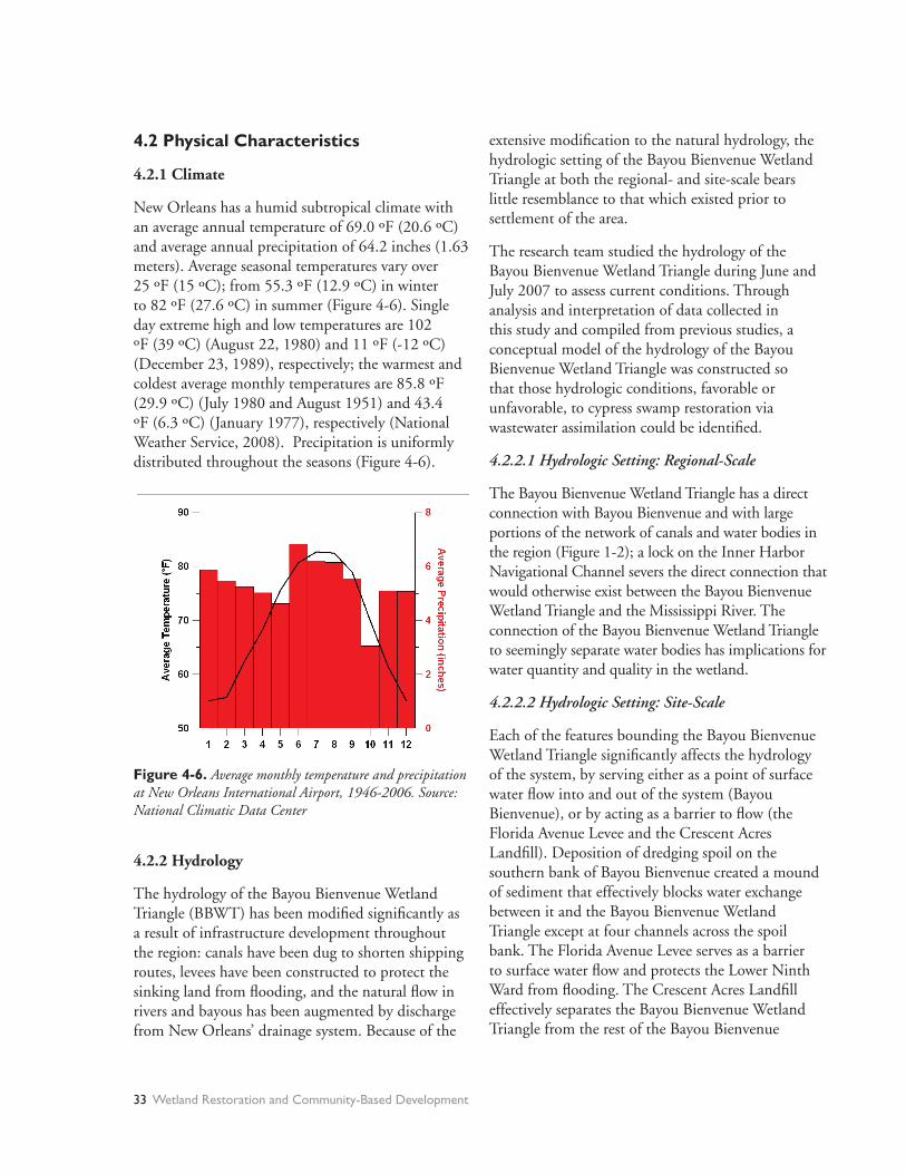
4.2 Physical Characteristics
4.2.1 Climate
New Orleans has a humid subtropical climate with an average annual temperature of 69.0 ºF (20.6 ºC) and average annual precipitation of 64.2 inches (1.63 meters). Average seasonal temperatures vary over 25 ºF (15 ºC); from 55.3 ºF (12.9 ºC) in winter to 82 ºF (27.6 ºC) in summer (Figure 4-6). Single day extreme high and low temperatures are 102 ºF (39 ºC) (August 22, 1980) and 11 ºF (-12 ºC) (December 23, 1989), respectively; the warmest and coldest average monthly temperatures are 85.8 ºF (29.9 ºC) (July 1980 and August 1951) and 43.4 ºF (6.3 ºC) (January 1977), respectively (National Weather Service, 2008). Precipitation is uniformly distributed throughout the seasons (Figure 4-6).
extensive modifi cation to the natural hydrology, the hydrologic setting of the Bayou Bienvenue Wetland Triangle at both the regional- and site-scale bears little resemblance to that which existed prior to settlement of the area.
The research team studied the hydrology of the Bayou Bienvenue Wetland Triangle during June and July 2007 to assess current conditions. Through analysis and interpretation of data collected in this study and compiled from previous studies, a conceptual model of the hydrology of the Bayou Bienvenue Wetland Triangle was constructed so that those hydrologic conditions, favorable or unfavorable, to cypress swamp restoration via wastewater assimilation could be identifi ed.
4.2.2.1 Hydrologic Setting: Regional-Scale
The Bayou Bienvenue Wetland Triangle has a direct connection with Bayou Bienvenue and with large portions of the network of canals and water bodies in the region (Figure 1-2); a lock on the Inner Harbor Navigational Channel severs the direct connection that would otherwise exist between the Bayou Bienvenue Wetland Triangle and the Mississippi River. The connection of the Bayou Bienvenue Wetland Triangle to seemingly separate water bodies has implications for water quantity and quality in the wetland.
4.2.2.2 Hydrologic Setting: Site-Scale
Each of the features bounding the Bayou Bienvenue Wetland Triangle signifi cantly affects the hydrology of the system, by serving either as a point of surface water fl ow into and out of the system (Bayou Bienvenue), or by acting as a barrier to fl ow (the Florida Avenue Levee and the Crescent Acres Landfi ll). Deposition of dredging spoil on the southern bank of Bayou Bienvenue created a mound of sediment that effectively blocks water exchange between it and the Bayou Bienvenue Wetland Triangle except at four channels across the spoil bank. The Florida Avenue Levee serves as a barrier to surface water fl ow and protects the Lower Ninth Ward from fl ooding. The Crescent Acres Landfi ll effectively separates the Bayou Bienvenue Wetland Triangle from the rest of the Bayou Bienvenue
Figure 4-6. Average monthly temperature and precipitation at New Orleans International Airport, 1946-2006. Source: National Climatic Data Center
4.2.2 Hydrology
The hydrology of the Bayou Bienvenue Wetland Triangle (BBWT) has been modifi ed signifi cantly as a result of infrastructure development throughout the region: canals have been dug to shorten shipping routes, levees have been constructed to protect the sinking land from fl ooding, and the natural fl ow in rivers and bayous has been augmented by discharge from New Orleans’ drainage system. Because of the
33 Wetland Restoration and Community-Based Development
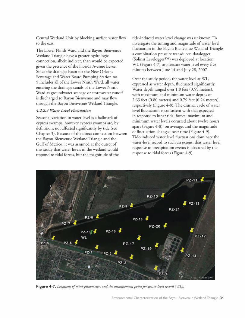
Central Wetland Unit by blocking surface water fl ow to the east.
The Lower Ninth Ward and the Bayou Bienvenue Wetland Triangle have a greater hydrologic connection, albeit indirect, than would be expected given the presence of the Florida Avenue Levee. Since the drainage basin for the New Orleans Sewerage and Water Board Pumping Station no. 5 includes all of the Lower Ninth Ward, all water entering the drainage canals of the Lower Ninth Ward as groundwater seepage or stormwater runoff is discharged to Bayou Bienvenue and may fl ow through the Bayou Bienvenue Wetland Triangle.
4.2.2.3 Water Level Fluctuation
Seasonal variation in water level is a hallmark of cypress swamps; however cypress swamps are, by defi nition, not affected signifi cantly by tide (see Chapter 3). Because of the direct connection between the Bayou Bienvenue Wetland Triangle and the Gulf of Mexico, it was assumed at the outset of this study that water levels in the wetland would respond to tidal forces, but the magnitude of the
tide-induced water level change was unknown. To investigate the timing and magnitude of water level fl uctuation in the Bayou Bienvenue Wetland Triangle a combination pressure transducer–datalogger(Solinst Levelogger™) was deployed at locationWL (Figure 4-7) to measure water level every fi ve minutes between June 14 and July 28, 2007.
Over the study period, the water level at WL, expressed as water depth, fl uctuated signifi cantly. Water depth ranged over 1.8 feet (0.55 meters), with maximum and minimum water depths of 2.63 feet (0.80 meters) and 0.79 feet (0.24 meters), respectively (Figure 4-8). The diurnal cycle of water level fl uctuation is consistent with that expected in response to lunar tidal forces: maximum and minimum water levels occurred about twelve hours apart (Figure 4-8), on average, and the magnitude of fl uctuation changed over time (Figure 4-9). Tide-induced water level fl uctuations dominate the water-level record to such an extent, that water level response to precipitation events is obscured by the response to tidal forces (Figure 4-9).
N. Hunt 2007
Figure 4-7. Locations of mini-piezometers and the measurement point for water-level record (WL).
Environmental Characterization of the Bayou Bienvenue Wetland Triangle 34

The signifi cant and unanticipated drop in water level that occurred between July 7 and 8, 2007 was caused by an event or force(s) of unknown origin. Corresponding drops in water level occurred at other locations in the region, suggesting that the event or force(s) acted on a similar scale. The water level drop between July 7 and 8 was likely not caused by tidal forces, as the magnitude of the drop exceeds the predicted tide-induced water level change(Figure 4-10).
Seasonal variations in water levels in the Bayou Bienvenue Wetland Triangle were determined from water elevation data recorded by the United States Army Corps of Engineers at gaging station #76020 on Bayou Bienvenue at Paris Road. At this station, measurements of water elevation were made daily at 8:00 am from 1975 to 1992. The monthly average water elevations for June and July are respectively the fourth-lowest and lowest of all monthly averages taken from this gaging station between 1975 and 1992 (Figure 4-11).
g
A
B
Figure 4-8. Daily variation in water depth at location WL in the BBWT, June 17-18, 2007. The vertical dashed lines correspond to the time at which daily measurements of water elevation wre made at USACE gaging station #76020.
Figure 4-9. Record of water depth at location WL in the BBWT and precipitation at New Orleans International Airport, June 14-July 28, 2007. Source of precipitation data: National Climatic Data Center.
Figure 4-10. A) Water depth in the BBWT and at a tidal monitoring station on the east bank of Lake Pontchartrain. The green line is the observed stage at the tidal monitoring station. B) Record of water depth in the BBWT and at gaging stations at the intersection of the MRGO and Bayou Bienv-enue and at the lock on the Inner Harbor Navigation Canal at St. Claude Avenue.
35 Wetland Restoration and Community-Based Development

Since water level is, on average, relatively low during June and July, the maximum water depth in the Bayou Bienvenue Wetland Triangle during the study period (2.63 feet = 0.80 meters) is less than both annual average and maximum water depths in the Bayou Bienvenue Wetland Triangle. Assuming the differences in monthly average water level at the United States Army Corps of Engineers gaging station are representative of conditions in the Bayou Bienvenue Wetland Triangle, the monthly average water depths may be 0.7 to 0.8 feet (0.21 to 0.24 meters) greater than those measured during the study
period. High-water marks on the exposed sheet pile of the Florida Avenue Levee several feet above the June/July water surface indicate sustained high water levels in the past.
4.2.2.4 Water Depth
Water depths were calculated at several locations across the Bayou Bienvenue Wetland Triangle using the continuous water level record at location
WL and surveyed elevations of the mud-water interface (Hartman Engineering, 2001). The water
Figure 4-11. Average monthly water elevation at U.S. Army Corps of Engi-neers Gaging Station #76020 (Bayou Bienvenue at Paris Road Bridge), 1975-1992. Source: Hartman Engineeing (2001)
Figure 4-12. Maximum water depths (in ft.) in the BBWT, June 14-July 28, 2007. Water deptsh were calculated from the maxi-mum recorded water depth at location WL and surveyed elevations of the mad-water interface from Hartman Engineering (2001).
Environmental Characterization of the Bayou Bienvenue Wetland Triangle 36

surface elevation at location WL was estimated by adding the measured water depth to the mud-water interface elevation interpolated at the location (-0.92 feet = -0.28 meters NGVD (National Geodetic Vertical Datum)). By assuming a uniform water surface elevation across the Bayou Bienvenue Wetland Triangle, water depths were calculated at other survey locations by subtracting the mud-water interface elevation from the water surface elevation.
Based on these calculations, the maximum water depth in Bayou Bienvenue Wetland Triangle over the period June 14 to July 28, 2007 was 3.02 feet (0.92 meters) (Figure 4-12).
4.2.2.5 Water Volume
The volume of water contained in the Bayou Bienvenue Wetland Triangle for the maximum measured water depth at location WL (3.02 feet = 0.92 meters) was estimated by multiplying the average of the maximum water depths calculated at the elevation survey points (2.65 feet = 0.81 meters) by the surface area of the Bayou Bienvenue Wetland Triangle (427 acres = 173 hectares). This approach provided an estimate of the maximum volume of water in the Bayou Bienvenue Wetland Triangle of about 345 million gallons (1.4 million cubic meters) during the period of measurement. The minimum volume of water in the Bayou Bienvenue Wetland Triangle during the period of measurement was estimated to be about 95 million gallons (0.36 million cubic meters) via the same procedure, but using the average of the minimum water depths at the survey locations (0.68 feet = 0.21 meters). However, the minimum volume is an overestimate, as the surface area of the Bayou Bienvenue Wetland Triangle was assumed to remain constant as water level drops.
4.2.2.6 Water Budget
A water budget was constructed for the Bayou Bienvenue Wetland Triangle to assess the site’s infl ow and outfl ow. For some of the water fl uxes, numerical estimates were determined from available data; other infl ows/outfl ows were evaluated qualitatively because there were no data with which to base a quantitative estimate. Producing a water budget for the Bayou Bienvenue Wetland Triangle is important because it
shows the relative importance of various sources and sinks of water for the system. Understanding how water fl ows into and out of the wetland is critical to managing water levels during the restoration process.
PrecipitationPrecipitation that falls on the surface of the Bayou Bienvenue Wetland Triangle is a direct input of water to the wetland. The annual volume of water infl ow to the Bayou Bienvenue Wetland Triangle as precipitation (INP) can be calculated by multiplying the average annual precipitation (64 inches = 1.63 meters; Section 4.2.1) by the surface area of the Bayou Bienvenue Wetland Triangle (427 acres = 173 hectares). This calculation yields an estimate of INP of about 740 million gallons (2.8 million cubic meters) per year.
EvapotranspirationEvapotranspiration is the process by which water is removed from a water body through 1) evaporation at the water surface and 2) uptake of water by plants and released to the atmosphere (transpiration). Evaporation from the surface of shallow lakes in southeastern Louisiana is approximately 43 inches (1.1 meter) per year (Farnsworth, Thompson, & Peck, 1982). The volume of water outfl ow from the Bayou Bienvenue Wetland Triangle as evaporation (OUTE) was calculated by multiplying the annual evaporation (43 inches = 1.1 meter) by the surface area of the Bayou Bienvenue Wetland Triangle (427 acres = 173 hectares), yielding an estimate of OUTE of about 500 million gallons (1.9 million cubic meters) per year. Transpiration (OUTT) was not quantifi ed in this study, but is assumed to be negligible relative to evaporation because most vegetation in the Bayou Bienvenue Wetland Triangle is submerged. Hence, evapotranspiration (OUTET) is equal to evaporation (OUTE) at 500 million gallons (1.9 million cubic meters) per year.
RunoffRunoff is not a signifi cant part of the water budget because only a small portion of the area of the Bayou Bienvenue Wetland Triangle is exposed land that would generate runoff. The East Bank SewageTreatment Plant and the Crescent Acres Landfi ll both generate runoff, but the research team was unable to collect runoff data at these sites.
37 Wetland Restoration and Community-Based Development

Groundwater FlowThe research team attempted to 1) determine the direction of vertical groundwater fl ow beneath the wetland using mini-piezometers (short-screened, small diameter tubes) (Lee & Cherry, 1978) and to 2) quantify the groundwater seepage using seepage meters (Lee, 1977). Twenty-one mini-piezometers were installed across the Bayou Bienvenue Wetland Triangle (Figure 4-7) at depths below the mud-water interface ranging from 1.5 feet (0.5 meters) to 8.3 feet (2.5 meters). Time constraints and installation diffi culties limited seepage meter deployment to four locations along the Florida Avenue Levee (PZ-1, PZ-2, PZ-3, and PZ-4 in Figure 4-7).
Attempts to determine groundwater fl ow direction and quantify seepage proved unsuccessful because the permeability of the bed sediment of the Bayou Bienvenue Wetland Triangle was too low to obtain credible results with the mini-piezometers, and the seepage meters were prone to leak. The seepage measurements that appeared to be the least affected by instrument error indicate strong upward fl ow at the levee; however, given the lack of confi dence in the measurements, the seepage rates are excluded from the water budget for the site.
Even though the measurement devices did not provide specifi c information on the groundwater component of the water budget for the Bayou Bienvenue Wetland Triangle, they demonstrated the resistance to water fl ow provided by the bed sediments. Based on this resistance, it was assumed that the groundwater fl ow into and out of the Bayou Bienvenue Wetland Triangle is outweighed by other infl ows and outfl ows, though the quantitative relations between groundwater and other water budget components are unknown.
Surface Water FlowNo attempt was made to directly measure surface water infl ow (INSW) and outfl ow (OUTSW) within the study area, as the water exchange between the wetland and Bayou Bienvenue is driven by tides and varies with time. Instead, a volumetric approach was applied, based on the assumption that tidal water level changes are solely the result of surface water fl ow.
The volume of surface water infl ow during an average tidal event was calculated by multiplying the average tide-induced water level increase by the surface area of open water in the Bayou Bienvenue Wetland Triangle. The volume of surface water outfl ow for an average tidal event was calculated using the same procedure, but with water level decreases instead of water level increases and excluding the anomalous water level decrease of July 7, 2007.
The average increase and decrease in water depth during a tidal cycle were 0.46 feet (0.14 meters) and 0.45 feet (0.14 meters), respectively. Multiplying these water level changes by the area of open water in the Bayou Bienvenue Wetland Triangle (427 acres = 173 hectares), the daily volumes of surface water infl ow and outfl ow of the Triangle are about 62 and 64 million gallons (average = 0.23 million cubic meters), respectively. Because the volume of water at the site does not continually increase, it is assumed that the surface water infl ow roughly equals the surface water outfl ow. Therefore, the study site’s annual surface water infl ow (INSW) and outfl ow (OUTSW) were both estimated at about 23,000 million gallons (84 million cubic meters), based on an average of the daily value of 63 million gallons (0.23 million cubic meters).
Conceptual ModelFrom the estimates of infl ow and outfl ow for the Bayou Bienvenue Wetland Triangle, it is apparent that the water budget of the wetland is dominated by surface water fl ow (Table 4-3; Figure 4-13).
Figure 4-13. Conceptualization of the water budget of the Bayou Bienvenue Wetland Triangle. Surface water is the primary component of water inflow/outflow for the wetland.
Environmental Characterization of the Bayou Bienvenue Wetland Triangle 38

4.2.3 Bed Sediment
4.2.3.1 Deposition of Organic and Inorganic Sediment
From a geologic perspective, the sedimentary layers underlying the New Orleans area were deposited quite recently, about 4,500 to 4,750 years ago (Frazier, 1967; Snowden et al., 1980). The region between Bayou Bienvenue and the main channel of the Mississippi River was an interdistributary trough (Snowden et al., 1980); and the land extending between the high natural levees along the banks of Bayou Sauvage and the Mississippi River was a depression (Frazier, 1967). Consequently, it was prone to fl ooding and supported cypress swamp and freshwater marsh communities. The sediments being deposited here were predominantly organic material from vegetative productivity with periodic inputs of inorganic sediment during fl ooding.
In the section of the Bayou Bienvenue Central Wetland Unit just east of the Crescent Acres Landfi ll, soil borings were collected and the sediment was described (Hartman Engineering, 2001). The near-surface soils were found to consist of very soft organic clay or peat with organic clay to a depth of approximately 10 feet. These layers are underlain by very soft gray clays to a depth of at least 25 feet. The peat layer represents the accumulation of organic material associated with swamp vegetation.
4.2.3.2 Bottom Sediment Samples
Inspection of the bottom sediments at the study site’s 21 mini-piezometer locations suggests that the top layer throughout most of the Bayou Bienvenue
Table 4-3 Water budget for the Bayou Bienvenue Wetland Triangle.
Wetland Triangle is fi ne organic matter and clay (Table 4-4), with two anomalous areas of more course-grained sediment. At PZ-3 a sand lens extends from the levee about 50 feet north to northeast (no soil sample was collected); and at PZ-19, adjacent to the East Bank Sewage Treatment Plant, the sediment is a red, granular material. At both of these locations, the deposition is likely from human activity, as the nature of the material is incongruous with that expected by natural processes, such as fi ne-grained clay and organic material.
4.3 Water and Sediment Quality
Water and sediment quality were assessed through fi eld measurements and laboratory analyses of samples collected during June and July of 2007. Chemical data for water and sediment samples collected by the research team provide preliminary information about current chemical conditions of the surface water, groundwater, and sediment within the study area. The results also contribute to identifying potential risks to human health and obstacles to
Table 4-4 Description of soil samples from the BBWT. Location of soil samples are shown in fi gure 4-7.
39 Wetland Restoration and Community-Based Development
Component 106 Gallons 106 Cubic Meters Inches
Annual Inflow
Precipitation 740 2.8 64
Surface Water 23000 84 1920
Groundwater
Runoff
Annual Outflow
Evapotranspiration 500 1.9 43
Surface Water 23000 84 1920
Groundwater
Runoff
Not Quantified
Not Quantified
Not Quantified
Not Quantified
Location Description
(samples taken to approximately 1.5
feet below mud-water interface)
PZ-1 Organic matter to clay mixed with broken
glass
PZ-6 Clay
Cyp-1 Organic matter (to about six inches) to clay
PZ-11 Organic matter
PZ-13 Organic matter (to about six inches) to clay
PZ-12 Organic matter (to about six inches) to clay
PZ-19 Shallow organic matter layer to sediment
mixed with red flakes that look like
pulverized brick. Red sediment also along
west shore of treatment plant
PZ-4 Sand with some clay
PZ-9 Clay
PZ-8 Organic matter to clay
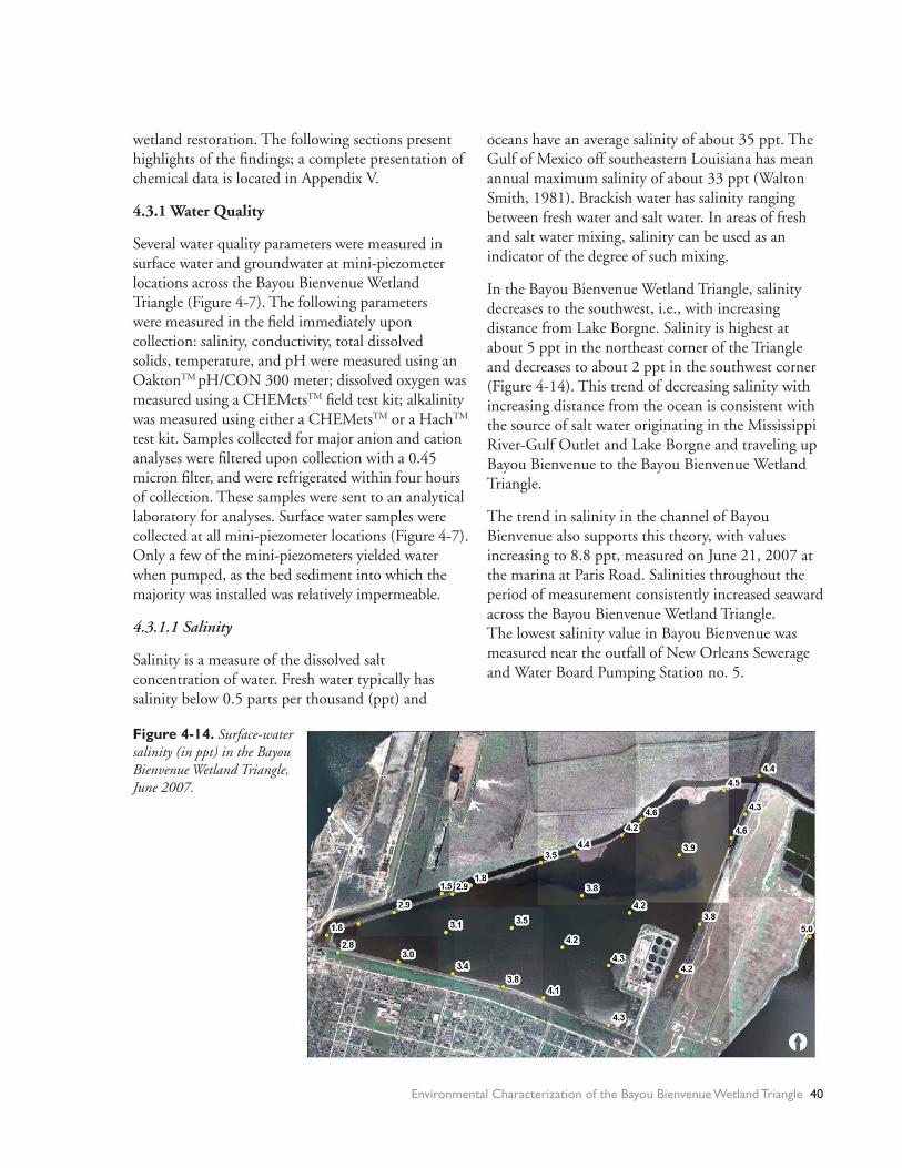
wetland restoration. The following sections present highlights of the fi ndings; a complete presentation of chemical data is located in Appendix V.
4.3.1 Water Quality
Several water quality parameters were measured in surface water and groundwater at mini-piezometer locations across the Bayou Bienvenue Wetland Triangle (Figure 4-7). The following parameters were measured in the fi eld immediately upon collection: salinity, conductivity, total dissolved solids, temperature, and pH were measured using an OaktonTM pH/CON 300 meter; dissolved oxygen was measured using a CHEMetsTM fi eld test kit; alkalinity was measured using either a CHEMetsTM or a HachTM test kit. Samples collected for major anion and cation analyses were fi ltered upon collection with a 0.45 micron fi lter, and were refrigerated within four hours of collection. These samples were sent to an analytical laboratory for analyses. Surface water samples were collected at all mini-piezometer locations (Figure 4-7). Only a few of the mini-piezometers yielded water when pumped, as the bed sediment into which the majority was installed was relatively impermeable.
4.3.1.1 Salinity
Salinity is a measure of the dissolved salt concentration of water. Fresh water typically has salinity below 0.5 parts per thousand (ppt) and
oceans have an average salinity of about 35 ppt. The Gulf of Mexico off southeastern Louisiana has mean annual maximum salinity of about 33 ppt (Walton Smith, 1981). Brackish water has salinity ranging between fresh water and salt water. In areas of fresh and salt water mixing, salinity can be used as an indicator of the degree of such mixing.
In the Bayou Bienvenue Wetland Triangle, salinity decreases to the southwest, i.e., with increasing distance from Lake Borgne. Salinity is highest at about 5 ppt in the northeast corner of the Triangle and decreases to about 2 ppt in the southwest corner (Figure 4-14). This trend of decreasing salinity with increasing distance from the ocean is consistent with the source of salt water originating in the Mississippi River-Gulf Outlet and Lake Borgne and traveling up Bayou Bienvenue to the Bayou Bienvenue Wetland Triangle.
The trend in salinity in the channel of Bayou Bienvenue also supports this theory, with values increasing to 8.8 ppt, measured on June 21, 2007 at the marina at Paris Road. Salinities throughout the period of measurement consistently increased seaward across the Bayou Bienvenue Wetland Triangle. The lowest salinity value in Bayou Bienvenue was measured near the outfall of New Orleans Sewerage and Water Board Pumping Station no. 5.
Figure 4-14. Surface-water salinity (in ppt) in the Bayou Bienvenue Wetland Triangle, June 2007.
Environmental Characterization of the Bayou Bienvenue Wetland Triangle 40

Salinity was measured to be consistently higher in groundwater than in surface water. In June 2007, groundwater salinity ranged from 7.2 ppt to 9.1 ppt, while surface water salinity at the same locations ranged from 2.6 ppt to 4.0 ppt. The average difference between groundwater and surface water salinity was 5 ppt. In July 2007, groundwater salinity ranged from 6.2 ppt to 8.8 ppt and was 4.6 ppt higher, on average, than surface water salinity at the same location.
4.3.1.2 pH
Acidity in water is expressed in terms of pH which is, by defi nition, the negative logarithm of the hydrogen ion concentration (pH = -log[H+]). Water is considered acidic below pH 7 and basic above pH 7. A pH of 7 represents neutral conditions. The pH range of natural surface waters is 6.5 to 8.5 (Hem, 1985); pH values outside this range may indicate contamination of the water body. The expected pH range for unpolluted groundwater (6.0 to 8.5) is slightly lower than that for surface water (Hem, 1985).
Surface water pH in the Bayou Bienvenue Wetland Triangle exceeds the upper limit of the expected pH range for unpolluted natural waters reported by Hem (1985). During the two water sampling events conducted by the research team (June 26-27, 2007 and July 22-23, 2007) the pH of the surface water in the Bayou Bienvenue Wetland
Triangle usually ranged between 8.4 and 9.0, with a maximum reading of 9.6. The surface water in the Bayou Bienvenue Wetland Triangle has signifi cantly higher pH than precipitation in the region, which is naturally slightly acidic. The pH of precipitation at Franklinton, Louisiana (located about sixty miles north of the Bayou Bienvenue Wetland Triangle) ranged from 4.34 to 6.46 during 2006, with an average value of 4.87 (National Atmospheric Deposition Program, 2007).
Groundwater pH in the Bayou Bienvenue Wetland Triangle was measured to be consistently lower than surface water pH; measured values are within the expected pH range for natural groundwater reported by Hem (1985). Groundwater pH ranged from 6.7 to 7.3 for the June and July sampling events; only a single well was sampled on both occasions and the measured pH values on these samplings are in close agreement (6.7 in June, 7.0 in July).
4.3.1.3 Dissolved Oxygen
Dissolved oxygen is a useful indicator of surface water quality, as oxygen is consumed preferentially in the decomposition of organic material. Where contamination with organics has occurred, dissolved oxygen concentration in the water will generally be low.
Figure 4-15. Dissolved oxygen (in mg/L) in surface water in BBWT.
41 Wetland Restoration and Community-Based Development

The surface water in the Bayou Bienvenue Wetland Triangle is well oxygenated (Figure 4-15); all dissolved oxygen measurements range from 3 to 11 milligrams per liter, with most falling between 6 and 9 milligrams per liter. Oxygen saturation of water varies with temperature; at 30°C (86°F), the oxygen saturation is 7.54 milligrams per liter (Hem, 1985). Almost half of the measured dissolved oxygen concentrations in surface water (13 of 27) indicate water saturated or oversaturated with dissolved oxygen.
The dissolved oxygen concentrations in groundwater are much lower, with most samples having concentrations below 1 milligram per liter. This suggests that oxygen consuming (anoxic) conditions exist in the sediment.
4.3.1.4 Nutrients
High nutrient concentrations in water may indicate contamination. Excess nutrients (e.g., nitrogen and phosphorus) may result in algal blooms, hypoxia, or other forms of ecosystem deterioration.
Though water samples were analyzed for several chemical parameters, including nutrients, some of the data are suspect, given the extreme outliers (e.g., total P for PZ-4SW in July 2007) and results that contradict expectations arising from observed conditions. As an example, the data indicate that nitrate concentrations in groundwater are higher than in the overlying surface water. But under the apparent anoxic conditions of the mostly organic sediment, the nitrate concentrations are expected to be very low due to microbial denitrifi cation.
It is diffi cult to interpret the chemical data given their dubious quality. However, trends have been identifi ed so that future analyses at a different laboratory can provide insight as to whether such trends are a refl ection of conditions in the Bayou Bienvenue Wetland Triangle or are merely artifacts of inaccurate analysis.
The July samples have signifi cantly higher nitrate concentrations than the June samples, though the total phosphorus and phosphate concentrations are not consistently higher for the July samples. Total phosphorus concentrations in June are generally
higher in groundwater than in surface water. Most samples had total phosphorus concentrations below 1 ppm.
4.3.1.5 Sulfate reduction
Sulfate reduction is the process by which sulfate(SO
4 2-) is converted to sulfi de (S2-). It is microbially
mediated and generally occurs under extreme reducing conditions where sources of dissolved oxygen and nitrate are depleted. Assessment of the potential for sulfate reduction is important as it has been linked to the conversion of mercury (Hg) to its toxic form (methyl-mercury).
Sulfate and sulfur concentrations, as well the characteristic “rotten egg” odor of reduced hydrogen sulfi de (H
2S) can help identify sulfate reduction
processes occurring within the sediment. In the eastern parts of the Bayou Bienvenue Wetland Triangle, particularly in the southeast and northeast, the strong “rotten egg” odor was present when the sediments were disturbed, suggesting both reducing conditions and sulfate reduction processes. This is supported by the noticeably lower sulfate concentrations in groundwater samples relative to surface water samples (with the exception of PZ-3).
4.3.2 Sediment Quality
Because of its urban location and semi-enclosed basin, the Triangle is susceptible to signifi cant build up of heavy metals in sediment. Aquatic organisms living in and near the bed sediments are particularly sensitive to high heavy metal concentrations. In fact, growing evidence indicates that, even in areas with waters that meet Water Quality Criteria (Stephen et al., 1985), environmental degradation still occurs with adverse effects to organisms that live in or close to contaminated sediment (Environmental Protection Agency, 2000).
Sediment samples from throughout the Bayou Bienvenue Wetland Triangle were analyzed for heavy metals at the University of Wisconsin–Madison Soil and Plant Analysis Laboratory; and for total mercury at the University of Louisiana–Monroe Soil-Plant Analysis Laboratory. Full results are included in Appendix V.
Environmental Characterization of the Bayou Bienvenue Wetland Triangle 42

Concentrations of heavy metals in the bed sediment of the Bayou Bienvenue Wetland Triangle are generally below severe toxicity levels, though all but one sample (PZ-4) had at least one heavy metal at a concentration above the lowest effects limit (LEL) (Table 4-5). Sample PZ-19 had concentrations of copper (Cu) and lead (Pb) above the severe effects limit (SEL), as defi ned by the Ontario Ministry of the Environment (1993). The sediment sample from PZ-19, on the west bank of the New Orleans Sewage Treatment Plant (Figure 4-7), overall contained the highest concentrations of heavy metals (Table 4-5; Appendix V). The other sampling location with high concentrations of heavy metals was PZ-11, located in the enclosed northeast corner of the wetland triangle. The sediment at this location is mostly organic matter with a strong smell of hydrogen sulfi de.
Mercury is a heavy metal of particular concern, as it bioaccumulates in aquatic organisms and can pose a risk to human health if contaminated plants or animals are consumed. The toxic form of mercury is methyl-mercury, which evolves from inorganic mercury under reducing conditions, particularly in the presence of sulfate reducing bacteria. Total mercury concentrations were measured in these analyses. The results are presented in Table 4-5.
In general there is no clear trend in mercury concentrations across the wetland. The highest concentration of total mercury is in the organic rich sediment at the northeast corner of the study area (PZ-11). Elevated total mercury levels are also present at PZ-19 adjacent to the wastewater treatment plant—a site that has high heavy metals concentrations relative to the other sampling sites in the Triangle.
Table 4-5 Heavy metal concentration (in ppm or mgL-1) exceeding toxicity effects limits established by the Ontario Ministry of the Environment (1993). SEL=severe effects limit; LEL=lowest effects limit. All heavy metal concentrations are included in Appendix V.
43 Wetland Restoration and Community-Based Development
Sample Cd Cr Cu Ni Pb Zn Hg
PZ-4
PZ-1 26.9 50.6 122.7
PZ-6 19
CYP-1 0.9 40 49.7 93.6 182.6 0.25
PZ-8 0.8 49.2 54.4 92.4 224.5
P-9 0.8 28.6 46.5 144.6 0.25
PZ-11 2.1 61.6 62.3 210 315.2 0.87
PZ-12 0.8
PZ-13 0.7 43.5 32.7 45 163.2
PZ-19 2.9 89.5 217.4 271.7 766.4 0.24
SEL 10 110 110 75 250 820 2
LEL 0.6 26 16 16 31 120 0.2

4.4 Mercury in Aquatic Organisms
Tissue samples from fi ve fi shes and three crabs taken from the Bayou Bienvenue Wetland Triangle on July 28 and August 1, 2007 were tested for total mercury concentrations to assess whether the current population of aquatic organisms poses a risk to human health when consumed. The specimens were analyzed for total mercury at the Soil-Plant Analysis Laboratory of the University of Louisiana-Monroe. Total mercury for each specimen (Table 4-6) was signifi cantly lower than the health standard, which varies but is generally less than 0.7 ug/g, suggesting that mercury concentrations in the existing population of fi shes and crabs in the Bayou Bienvenue Wetland Triangle do not pose a human health risk. Given the dynamic nature of the population of fi shes and crabs in the Bayou Bienvenue Wetland Triangle, future testing for mercury is warranted.
4.5 Synthesis and Discussion
4.5.1 Current Environmental State of the Bayou Bienvenue Wetland Triangle
Based on the current vegetation and salinity, the Bayou Bienvenue Wetland Triangle is most accurately categorized as a brackish, open-water marsh which, by defi nition, has a salinity range from 3-15 ppt (U.S. Geological Survey, 2007). The brackish water of the Bayou Bienvenue Wetland Triangle
is a mixture of fresh water from precipitation, discharge from the New Orleans drainage system, and salt water from the Gulf of Mexico. Most of the measured water quality parameters are within the range expected for natural water bodies that have not been signifi cantly degraded. The source of high surface water pH is unknown, but contamination has not been ascertained, as additional indication of contamination is lacking. Salinity is signifi cantly higher in groundwater than in surface water.
4.5.2 Potential for Restoration to Cypress Swamp
Restoration of a self-sustaining cypress swamp ecosystem in the Bayou Bienvenue Wetland Triangle requires the addition of sediment and fresh water. The sediment is required to raise the elevation of bed sediment to reduce prolonged fl ooding and allow cypress germination. The fresh water is required to lower salinity to levels favorable to the growth and survival of planted cypress seedlings (see section 3.1).
Salinity levels exceed the optimal range for reintroduction of cypress trees through plantings of seedlings. To our knowledge, there are no studies exploring the optimal range of groundwater salinity levels for successful reintroduction of cypress. Previous studies have focused on surface water salinity, rather than groundwater salinity. It is unclear how the relatively high salinity of groundwater beneath the Bayou Bienvenue Wetland Triangle would affect the survival and growth of cypress seedlings.
While wastewater discharge to the wetland will reduce surface water salinity and deliver suspended solids, the input of solids will likely be insuffi cient to offset subsidence; hence, the historic trend of increasing water depth will likely continue. Supplementing wastewater assimilation with another technique to provide a constant supply of sediment to the Bayou Bienvenue Wetland Triangle (e.g. freshwater diversion) would increase the likelihood of long-term restoration success. If water levels are not reduced to allow seed germination during exposure of the bed sediment to oxygen, regular plantings will be necessary to sustain a cypress swamp ecosystem.
en ngth nches) y
b -5 4 ab -5
gill
0.1119 0.0275
en ngth nches) y
b -5 4 ab -5
gill
0.1119 0.0275
Total Total Sample Sample SpecimSpecim LeLe
(i(i MercurMercur(ug/g)(ug/g)
BB-072807-1BB-072807-1 Mullet Mullet 10 10 0.06040.0604BB-072807-2BB-072807-2 Mullet Mullet 8 8 0.038 0.038 BB-072807-3 BB-072807-3 Blue CraBlue Cra 44 0.0360.036BB-072807-4 BB-072807-4 Blue CrBlue Cr 44 0.02430.0243BB- 08-01-01BB- 08-01-01 BlueBlue 6 6 0.021 0.021 BB- 08-01-02BB- 08-01-02 Mullet Mullet 7 7 0.03050.0305BB- 08-01-03 Gar BB- 08-01-03 Gar 24 BB- 08-01-04 Blue Crab 4-5
24 BB- 08-01-04 Blue Crab 4-5
Table 4-6 Total mercury concentrations in fi sh and crabs collected from the BBWT. Sample ID designates date of collection.
Environmental Characterization of the Bayou Bienvenue Wetland Triangle 44

Control structures may be needed to manage or limit water exchange with Bayou Bienvenue. Whether the control structures should be extended deep into the subsurface is not known as there is insuffi cient information on the movement of water through the bed sediments in the Bayou Bienvenue Wetland Triangle.
Given the low salinity of the water being introduced at the pumping station, it is anticipated that the salinity levels in Bayou Bienvenue, and in the Bayou Bienvenue Wetland Triangle, will fl uctuate depending upon the pumping schedule of Pumping Station no. 5. During operation, the water pumped out of Pumping Station no. 5 will push the intruding saltwater front toward the Mississippi River-Gulf Outlet. During periods of pump inoperation, the saltwater front will move further up Bayou Bienvenue and into the Bayou Bienvenue Wetland Triangle.
4.5.3 Implications of Cypress Swamp Restoration to Current Biota
While blue crabs appear to be relatively abundant in the Bayou Bienvenue Wetland Triangle, it is unclear how a transition from the present brackish water conditions to a fresh water cypress swamp would impact the population. The life history requirements of blue crab are largely dependent on the critical habitat that brackish water estuarine ecosystems provide. Blue crab growth and development occurs in a series of stages, including larval, juvenile, and adult life forms. At each of these life stages the range of salinity preferences and tolerances varies greatly. Lower salinity waters in the upper reaches of estuaries and the lower portions of the river systems that intersect estuaries are preferred by adult male blue crabs and juveniles. Mating also occurs in low-salinity conditions. Conversely, high-salinity waters in adjacent coastal areas are preferred by females and are necessary for spawning, egg-laying, and larval development. Because blue crabs can be found in saline waters ranging from 34 ppt to fresh water rivers upstream of coastal areas and their movement between these types of habitats is largely determined by life cycle needs (Hill et al., 1989), it will be diffi cult to predict how the environmental conditions at Bayou Bienvenue Wetland Triangle will affect this
population without a better understanding of their behavior and use of this ecosystem.
When introducing additional nutrients into a system, we must consider the potential impacts of providing nutrient sources to invasive and opportunistic species. It is possible that such species, when provided with an abundant nutrient source, could out-compete the desired native species, resulting in a monotype system. This issue has arisen with the wetland assimilation project in Hammond, Louisiana, specifi cally with cattails (Typha spp.).
4.5.4 Ability to Meet Wastewater Treatment Standards
The hydraulic residence time of the discharged wastewater effl uent in the Bayou Bienvenue Wetland Triangle is a key factor in the success of using the wetland for tertiary treatment. Low residence times result in limited exposure at the interfaces where the contaminant concentrations are reduced by biological and physical processes. Also, the surface area of these interfaces is an important factor. By increasing water depth, the hydraulic residence time is increased, but there is a trade off because the density of interfaces is also reduced. At Thibodaux, the hydraulic residence time is 120 days; given the dynamic water exchange, it is unclear what it will be for the Bayou Bienvenue Wetland Triangle, although it will likely be much less than 120 days. It is diffi cult to assess the residence time of the Bayou Bienvenue Wetland Triangle under hypothetical restoration conditions, given that surface water exchange dominates the water budget for the wetland. Based on surface water exchange alone, it is about 5.5 days, signifi cantly less than that at the Thibodaux site.
New Orleans Sewerage and Water Board Pumping Station no. 5, located at the head of Bayou Bienvenue, serves as the discharge point for seepage and stormwater collected in the Lower Ninth Ward. The quality of the water pumped into Bayou Bienvenue, and potentially into the Bayou Bienvenue Wetland Triangle, is infl uenced by the land use and waste disposal practices of the Lower Ninth Ward neighborhood.
45 Wetland Restoration and Community-Based Development

References
Environmental Protection Agency (EPA). (2000).Methods for measuring the toxicity andbioaccumulation of sediment-associatedcontaminants with freshwater invertebrates. No.EPA 600/R-99/064). Duluth, MN: EPA Offi ce ofResearch and Development.
Farnsworth, R. K., Thompson, E. S., & Peck, E.L. (1982). Evaporation atlas for the contiguous 48United States. NOAA technical report. No. NWS33). Washington, DC: U.S. Department ofCommerce.
Frazier, D. E. (1967). Recent deltaic deposits ofthe Mississippi River: Their development andchronology. Transactions - Gulf Coast Association of Geological Societies, XVII, 287-315.
Guntenspergen, G., Vairin, B., & Burkett, V. R.(1997). Coastal wetlands and global change:Overview. USGS Fact Sheet, 089(97).
Hartman Engineering. (2001). Bayou Bienvenupump station diversion and terracing feasibilitystudy. No. PO-25, XPO-74A). Baton Rouge and Kenner, LA: Hartman Engineering, Inc., Consulting Engineers.
Hem, J. D. (1985). Study and interpretation ofthe chemical characteristics of natural water, 3rdedition. U.S. Geological Survey Water SupplyPaper, 2254.
Hill, J., Fowler, D. L., & Van Den Avyle, M.J.(1989). Species profi les: Life histories andenvironmental requirements of coastal fi shesand invertebrates (mid-Atlantic): Blue crab. No.82(11.100). U.S. Army Corps of Engineers, TREL-82-4.
Lee, D. R. (1977). A device for measuringseepage fl ux in lakes and estuaries. Limnologyand Oceanography, 22(1), 140-147.
Lee, D. R., & Cherry, J. A. (1978). A fi eldexercise on groundwater fl ow using seepagemeters and mini-piezometers. Journal ofGeological Education, 27, 6-10.
National Atmospheric Deposition Program.(2007). National atmospheric depositionProgram/National trends network; 2006 annual& seasonal data summary for site LA30.
National Audubon Society. (2008). NationalAudubon society – WatchList. Retrieved 3/12,2008, fromhttp://web1.audubon.org/science/species/watchlist/profi le.php?speciesCode=prowar
National Weather Service. (2008). National WeatherService forecast offi ce – New Orleans/Baton Rouge. Retrieved 3/2, 2008, from http://www.srh.noaa.gov/lix/
Science Working Group on Coastal Wetland Forest Conservation and Use. (2005). Conservation, protection and utilization of Louisiana’s coastal wetland forests: Final report to the Governor. http://www.crcl.org/images/FSD_Coastal_Forest_SWG_FinalReport.pdf
Snowden, J. O., Ward, W. C., & Studlick, J. R. J.(1980). Geology of greater New Orleans: Itsrelationship to land subsidence and fl ooding. TheNew Orleans Geological Society.
Stephen, C. E., Mount, D. I., Hansen, D. J.,Gentile, J. H., Chapman, G. A., & Brungs, W. W.(1985). Guidelines for deriving numericalnational water quality criteria for the protectionof aquatic organisms and their uses. No. PB85-227049). Springfi eld, VA: National TechnicalInformation Service.
The Nature Conservancy. (2008). Gulf Coastprairies and marshes. Retrived Ocober 2007, fromhttp://www.nature.org/wherewework/northamerica/states/louisiana/preserves/art6866.html
Environmental Characterization of the Bayou Bienvenue Wetland Triangle 46

U.S. Geological Survey. (2007). The fragile fringe, Aguide for teaching about coastal wetlands. Retrieved in 2007 from,http://www.nwrc.usgs.gov/fringe/ff_index.html
United States Department of Agriculture & Natural Resources conservation Service. (2008). The PLANTS database. http://plants.usda.gov/
Walton Smith, F. G. (1981). In, Walton Smith F.G. (Ed.), CRC handbook of marine science. BocaRaton, FL: CRC Press, Inc.
47 Wetland Restoration and Community-Based Development

CHAPTER 5RESTORATION OPTIONS AND CONSIDERATIONS FOR THE BAYOU BIENVENUE AREA
5.1 Terracing
In 2001, Hartman Engineering released a feasibility study for a proposed terracing project in the Central Wetland Unit of Bayou Bienvenue, including the Bayou Bienvenue Wetland Triangle. A combination of planting smooth cordgrass (Spartina alterniflora) and/or terracing was proposed to help restore vegetative structure to the mostly open water system that exists today. The terracing project objective was to increase the retention of storm water pumped into the system by the three nearby pump stations, resulting in increased settlement of suspended solids from the storm water (Hartman Engineering, 2001). It was assumed that the combination of suspended solid settlement, vegetative growth, and subsequent organic matter deposition would mimic the sediment input long since cut off by the regional levee system. Citing the original parameters of the design, the project was ultimately deemed ‘not feasible’ because the soils, particularly those high in peat, would not provide a stable substrate for terrace construction. The cost of the terracing project was determined to outweigh the benefits (Hartman Engineering, 2001).
Regardless of these findings, a less ambitious terracing project could still be a viable component of future restoration efforts. Terracing involves the dredging and relocation of soil, deepening the areas between the newly created terraces. Such conditions would be unsuitable for dense cypress restoration, as some of the sites would remain well below the water level.
In keeping with a key recommendation of this report is the creation of a variable landscape, with surface levels and water depths similar to those found in naturally occurring cypress swamps, therefore natural landscape-emulating terraces could be incorporated into a broader restoration plan.
5.2 Freshwater and Sediment Diversions
The United States Army Corps of Engineers has been looking at ways to reestablish the wetland–river connection lost through centuries of levee construction and operation. The two systems are connected via culverts constructed through the levee, which allow diversion of fresh water into the wetland through an adjustable gate. Diversion gates are opened to allow a specified amount of water through the levees and into the target wetland, mimicking a natural over-bank flooding regime. This allows fresh water and nutrients, but not significant amounts of sediment, to pass.
The United States Army Corps of Engineers long-term plan for the region calls for up to three freshwater diversions: Caernarvon and Bonnet Carre on the east bank, and Davis Pond on the west. To-date the Caernarvon and Davis Pond are operational; construction on the Bonnet Carre has yet to begin (Hartman Engineering, 2001; Penland, Beall, & Kindinger, 2002).
Though not part of the comprehensive United States Army Corps of Engineers diversion plan, an additional diversion project, the Bayou Bienvenue Freshwater Diversion, has been proposed. This project would be conducted in conjunction with the new Florida Avenue Bridge Project and new lock construction in the Inner Harbor Navigational Canal. This project involves “the placement of elevated roadways in the open water areas north of Florida Avenue and south of Bayou Bienvenue” (i.e. the Bayou Bienvenue Wetland Triangle) and would include freshwater diversion into the open water of the Bayou Bienvenue Wetland Triangle to lower salinity levels and benefit wetland plant growth (Louisiana Department of Transportation and Development, 2007). This project is very
Restoration Options and Considerations for the Bayou Bienvenue Area 48

controversial; the community has expressed opposition to this project for quite some time, questioning the necessity of a new bridge in the area that would not connect to the neighborhood at all (the bridge would lead directly to a highway). These projects are explained in greater detail in Appendix IV.
5.3 Floating Treatment Wetlands
If used in the Bayou Bienvenue Wetland Triangle, this would be a transitional plant community until the conditions are suitable for cypress reintroduction. The islands could contribute to improved water quality by removing nitrogen, phosphorus, and heavy metals. In addition, if sediment were introduced, they might also facilitate sediment accumulation (Headley & Tanner, 2006).
5.4 Mississippi River-Gulf Outlet Closure
If the Mississippi River-Gulf Outlet was the dominant force for the demise of the cypress swamp in the Bienvenue Triangle and Central Wetland Unit, then restoration efforts would receive the biggest benefit from the impending deactivation of the structure as recommended by a recent United States Army Corps of Engineers study. According to initial reports the structure is set for closure via the placement of a large earthen dam at a Bayou crossing the middle of the shortcut; construction is slated to begin the summer of 2008 (U.S. Army Corps of Engineers, 2007).
5.5 Wetland Assimilation as Tertiary Treatment of Sewage
5.5.1 East Bank Sewage Treatment Plant
The East Bank Sewage Treatment Plant (East Bank Plant) in New Orleans is a Publicly Owned Treatment Works operated by the Aveolia Water Company (formerly United States Filter and now under contract to the New Orleans Sewerage and Water Board) (Louisiana Pollutant Discharge Elimination System, 2004 and 2005). The treatment plant is located in the northwest corner of the Bayou
Bienvenue Central Wetland Unit and adjacent to the Lower Ninth Ward. Conversion and expansion of the East Bank Plant from a 23 to 122 million gallons per day facility began in 1973 and was completed in 1980. It is the larger of two city treatment plants with the capacity to treat wastewater for the entire city of New Orleans (New Orleans Sewerage and Water Board, 2008).
This facility has six aerated grit chambers, two sedimentation tanks, eight clarifiers, and is supported by an oxygen activated sludge wastewater treatment method with chlorine as disinfectant (Figure 5-1). The treated effluent is currently discharged into the Mississippi River. Solids are handled using four belt filter presses and two sludge incinerators for processing sewage sludge. Processed sludge is transported to River Birch Landfill, an authorized solid waste disposal facility (Louisiana Pollutant Discharge Elimination System, 2004 and 2005).
The East Bank Plant has proposed adding wetland assimilation as advanced tertiary treatment to its current process. In the proposed plan effluent from the treatment plant would be distributed to several locations within the Bayou Bienvenue Central Wetland Unit rather than being pumped to the current discharge point in the Mississippi River. If the East Bank Plant is allowed to increase its effluent concentrations of total suspended solids from 30 milligrams per liter to 90 milligrams per liter, as requested in the proposed wetland assimilation project, the expected savings for the facility are $2 million per year in reduced solids handling fees. The effluent diversion will also help the facility stay in compliance with federal law by avoiding the stricter effluent permitting requirements that apply to river discharge (Mack, 2007). In addition, the Louisiana Department of Environmental Quality is expected to lower the allowable concentrations for nitrogen and phosphorous in the next few years, making the implementation of some type of advanced treatment a necessity (Day et al., 2005). The New Orleans Sewerage and Water Board anticipates that the nutrient-rich freshwater effluent will decrease salinity levels and help regenerate the degraded wetland.
49 Wetland Restoration and Community-Based Development
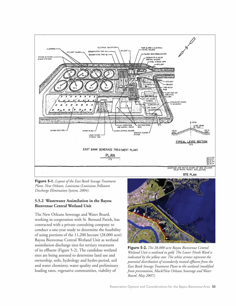
Figure 5-1. Layout of the East Bank Sewage Treatment Plant, New Orleans, Louisiana (Louisiana Pollutant Discharge Elimination System, 2004).
Figure 5-2. The 28,000 acre Bayou Bienvenue Central Wetland Unit is outlined in gold. The Lower Ninth Ward is indicated by the yellow star. The white arrows represent the potential distribution of secondarily treated effluent from the East Bank Sewage Treatment Plant to the wetland (modified from presentation, Mack/New Orleans Sewerage and Water Board, May 2007).
5.5.2 Wastewater Assimilation in the Bayou Bienvenue Central Wetland Unit
The New Orleans Sewerage and Water Board, working in cooperation with St. Bernard Parish, has contracted with a private consulting company to conduct a one-year study to determine the feasibility of using portions of the 11,200 hectare (28,000 acre) Bayou Bienvenue Central Wetland Unit as wetland assimilation discharge sites for tertiary treatment of its effluent (Figure 5-2). The candidate wetland sites are being assessed to determine land use and ownership, soils, hydrology and hydro-period, soil and water chemistry, water quality and preliminary loading rates, vegetative communities, viability of
Restoration Options and Considerations for the Bayou Bienvenue Area 50
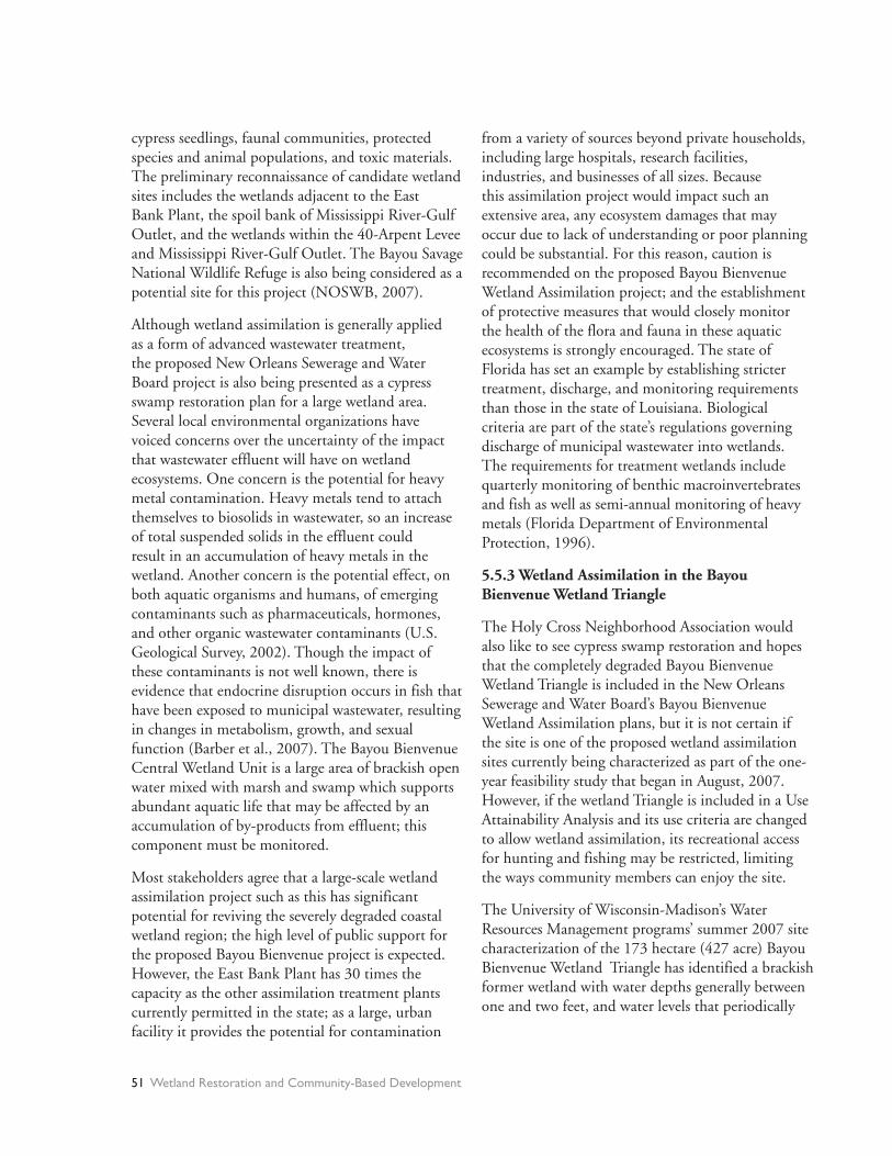
cypress seedlings, faunal communities, protected species and animal populations, and toxic materials. The preliminary reconnaissance of candidate wetland sites includes the wetlands adjacent to the East Bank Plant, the spoil bank of Mississippi River-Gulf Outlet, and the wetlands within the 40-Arpent Levee and Mississippi River-Gulf Outlet. The Bayou Savage National Wildlife Refuge is also being considered as a potential site for this project (NOSWB, 2007).
Although wetland assimilation is generally applied as a form of advanced wastewater treatment, the proposed New Orleans Sewerage and Water Board project is also being presented as a cypress swamp restoration plan for a large wetland area. Several local environmental organizations have voiced concerns over the uncertainty of the impact that wastewater effluent will have on wetland ecosystems. One concern is the potential for heavy metal contamination. Heavy metals tend to attach themselves to biosolids in wastewater, so an increase of total suspended solids in the effluent could result in an accumulation of heavy metals in the wetland. Another concern is the potential effect, on both aquatic organisms and humans, of emerging contaminants such as pharmaceuticals, hormones, and other organic wastewater contaminants (U.S. Geological Survey, 2002). Though the impact of these contaminants is not well known, there is evidence that endocrine disruption occurs in fish that have been exposed to municipal wastewater, resulting in changes in metabolism, growth, and sexual function (Barber et al., 2007). The Bayou Bienvenue Central Wetland Unit is a large area of brackish open water mixed with marsh and swamp which supports abundant aquatic life that may be affected by an accumulation of by-products from effluent; this component must be monitored.
Most stakeholders agree that a large-scale wetland assimilation project such as this has significant potential for reviving the severely degraded coastal wetland region; the high level of public support for the proposed Bayou Bienvenue project is expected. However, the East Bank Plant has 30 times the capacity as the other assimilation treatment plants currently permitted in the state; as a large, urban facility it provides the potential for contamination
from a variety of sources beyond private households, including large hospitals, research facilities, industries, and businesses of all sizes. Because this assimilation project would impact such an extensive area, any ecosystem damages that may occur due to lack of understanding or poor planning could be substantial. For this reason, caution is recommended on the proposed Bayou Bienvenue Wetland Assimilation project; and the establishment of protective measures that would closely monitor the health of the flora and fauna in these aquatic ecosystems is strongly encouraged. The state of Florida has set an example by establishing stricter treatment, discharge, and monitoring requirements than those in the state of Louisiana. Biological criteria are part of the state’s regulations governing discharge of municipal wastewater into wetlands. The requirements for treatment wetlands include quarterly monitoring of benthic macroinvertebrates and fish as well as semi-annual monitoring of heavy metals (Florida Department of Environmental Protection, 1996).
5.5.3 Wetland Assimilation in the Bayou Bienvenue Wetland Triangle
The Holy Cross Neighborhood Association would also like to see cypress swamp restoration and hopes that the completely degraded Bayou Bienvenue Wetland Triangle is included in the New Orleans Sewerage and Water Board’s Bayou Bienvenue Wetland Assimilation plans, but it is not certain if the site is one of the proposed wetland assimilation sites currently being characterized as part of the one-year feasibility study that began in August, 2007. However, if the wetland Triangle is included in a Use Attainability Analysis and its use criteria are changed to allow wetland assimilation, its recreational access for hunting and fishing may be restricted, limiting the ways community members can enjoy the site.
The University of Wisconsin-Madison’s Water Resources Management programs’ summer 2007 site characterization of the 173 hectare (427 acre) Bayou Bienvenue Wetland Triangle has identified a brackish former wetland with water depths generally between one and two feet, and water levels that periodically
51 Wetland Restoration and Community-Based Development

fluctuate by over a foot. The salinity levels in the groundwater three feet below the mud-water interface are two to four times higher than those in the overlying surface water. Salinity levels within the study site are lowest by the local pump station in the northwest and increase with distance to the east. The site is nearly devoid of emergent vegetation. One living cypress tree was found in the northwest on the spoil bank between the Triangle and Bayou Bienvenue proper (see Chapter 4: Environmental Characterization of the Bayou Bienvenue Wetland Triangle).
The conditions in the Bayou Bienvenue Wetland Triangle do not mirror those of the wetland sites that have been permitted for wetland assimilation, such as Thibodaux’s Pointe-au-Chene and Hammond’s South Slough wetland, both of which were already established, though degraded, wetlands (see Appendix III). In addition, they were freshwater systems that did not require the re-establishment of a freshwater environment prior to rebuilding a swamp or marsh. The process of restoring the Triangle to a cypress swamp, with or without implementing wetland assimilation, will likely require a robust wetland rebuilding program. The following elements are necessary for restoration of the Bayou Bienvenue
Wetland Triangle to a cypress swamp:
• Freshwater diversion (to flush out saline water)
• Sediment diversion (to decrease water depth)
• Establishment of emergent plant seedlings
• Monitoring and management program
5.6 Additional Research Needs
A major shortfall of this study is the lack of continuous seasonal data on Bayou Bienvenue Wetland Triangle. Obtaining these data, including a more comprehensive faunal species inventory and vegetative community characterization, will yield a more accurate picture of what changes and processes are occurring in Bayou Bienvenue Wetland Triangle. This will be critical in assessing the current state of the Triangle and for measuring any future changes.
More site-specific hydrologic information is also needed, particularly data regarding the amount and composition of storm water pumped from Pump Station no. 5 into the Bayou Bienvenue Outfall Canal. The New Orleans Sewerage and Water Board manages the Pump Station and may be a potential source of this information.
Restoration Options and Considerations for the Bayou Bienvenue Area 52

References
Barber, L. B., Lee, K. E., Swackhammer, D. L., & Shoenfuss, H. L. (2007). Reproductive responses of male fathead minnows exposed to wastewater treatment plant effluent, effluent treated with XAD8 resin, and an environmentally relevant mixture of alkylphenol compounds. Aquatic Toxicology, 8(1), 36-46.
Day J.W., Lane R.R., Lindsey J., Day J.N. (2005), Hammond Wetland Wastewater Assimilation Use Attainability Analysis, Comite Resources, Inc.
Florida Department of Environmental Protection. (1996). Chapter 62-611.200 wetlands application Florida Department of Environmental Protection.
Hartman Engineering, Inc. (2001). Bayou Bienvenue pump station diversion and terracing feasibility study. No. PO-25, XPO-74A. Baton Rouge and Kenner, Louisiana: Hartman Engineering, Inc. Consulting Engineers.
Headley, T. R., & Tanner, C. C. (2006). Application of floating wetlands for enhanced stormwater treatment: A review. NIWA Client Report: HAM2006-123. Hamilton, New Zealand: National Institute of Water & Atmospheric Research Ltd.
Louisiana Department of Transportation and Development. (2007). New Florida Bridge Over the Inner Harbor Navigational Canal (IHNC), Final Environmental Assessment. Louisiana Department of Transportation and Development, U.S. Department of Homeland Security, U.S. Coast Guard.
Louisiana Pollutant Discharge Elimination System. (2004). Compliance and Inspection Report for East Bank Sewage Treatment Plant. LDEQ: AI 4859, Permit No. LA0038091, ID 32397219.
Louisiana Pollutant Discharge Elimination System. (2005). Compliance and Inspection Report for East Bank Sewage Treatment Plant. LDEQ: AI 4859, Permit No. LA0038091, ID 32886667.
Mack, S. (2007). Personal communication. New Orleans Sewerage and Water Board.
New Orleans Sewerage and Water Board. (2008). www.swbno.org. Accessed 2008.
NOSWB (New Orleans Sewerage and Water Board) (2007), Public Notice: call for Regional Wetland Assimilation Pre-Design proposals, April.
Penland, S., Beall, A., & Kindinger, J. (2002). Environmental atlas of the Lake Pontchartrain basin No. 2002-206.
U.S. Army Corps of Engineers. (2007). Integrated final report to congress and legislative environmental impact statement for the Mississippi River – Gulf Outlet deep-draft de-authorization study. New Orleans, LA: U.S. Army Corps of Engineers New Orleans District.
U.S. Geological Survey. (2002). Pharmaceuticals, hormones, and other wastewater contaminants in U.S. streams. Report No. FS-027-02.
53 Wetland Restoration and Community-Based Development
CHAPTER 6THE PEOPLE AND THEIR SWAMP: SOCIAL SCIENCE FINDINGS
The restoration of any urban wetland would have a great impact on the surrounding community, and the community in turn, could impact the wetland. In the Lower Ninth Ward the once intimate connection between the bayou and the community has withered. A floodwall along Florida Avenue has separated the community from Bayou Bienvenue visually and physically; a significant number of residents are unaware that this resource even exists. Others have maintained a close connection with Bayou Bienvenue and appreciate the recreational and protective benefits associated with a neighborhood wetland.
Understanding the attitudes and views of the Lower Ninth Ward residents regarding wetlands, recovery efforts, the bayou, and its possible restoration is essential for determining the role that a restoration project can and should have in this community. Two methods were employed to gain this understanding: in-depth interviews and face-to-face surveys.
In-depth interviews with Lower Ninth Ward community members allowed the research team to gain insight into residents’ memories of the past, recent struggles, and concerns and hopes for the future. These interviews helped frame our understanding of the issues residents were grappling with and gave us a glimpse into what life near the bayou is like.
To gain input from a broader selection of residents, a structured, interview-style, 55-question survey, approved by the Institutional Review Board (IRB) at the University of Wisconsin-Madison, was conducted with individuals throughout the Lower Ninth Ward. Thirty-seven residents agreed to participate in the survey, and 36 completed it. Due to the small sample size our results lack statistical power. Nevertheless, the responses were quite informative and increased our understanding of the community considerably. The results of these surveys allowed our group to better tailor outreach efforts to meet the needs of the Lower Ninth Ward residents, and will provide baseline data regarding residents’ existing knowledge, use patterns,
and opinions concerning general wetland services and the Bayou Bienvenue Wetland Triangle.
6.1 Methods
With many pre-Katrina residents still scattered or displaced, our group lacked resources necessary to attempt a sampling methodology that would represent the pre-Katrina population; our survey results reflect the post-Katrina neighborhood during the summer of 2007. Due to lack of data about how many people had returned to the Lower Ninth Ward we were unable to establish an exact sample frame. We used a stratified area sampling method incorporating probability proportionate to size (PPS) principles (Czaja, 2005; Raj, 1965; Sirken, 2001).
Knowing that characteristics such as income level, race, and education, as well as degrees of hurricane destruction, were not distributed equally in the study area, we divided the Lower Ninth Ward into nine sections. Our target number of surveys for each section was proportionate to rough estimates of the post-Katrina number of households in that section (i.e., houses still standing) (Lepkowski, 1991). Individuals were eligible to participate if they were 18 years or older, were a resident of the Lower Ninth Ward (even if they had not yet moved back in), and gave verbal consent. Every individual the team encountered by knocking on doors and walking through the neighborhood on designated survey days was invited to participate.
The surveyors usually worked in three person teams: two University of Wisconsin-Madison graduate students and one paid community member. One graduate student led the questioning in the form of a guided conversation, one graduate student recorded the results, and the community member offered cultural translation and insight. This format enabled the team to develop much rapport with each survey participant.
A large GIS-based map of the entire Lower Ninth Ward was used as an aid for some questions.
The People and Their Swamp: Social Science Findings 54

Residents seemed to especially enjoy finding their own homes in relation to local landmarks and water bodies. Residents also used the map to point out areas of use for fishing, crabbing, and hunting. This information helped the research team to identify a few key patterns: of the people who have recently fished in the area, many still fish in the Industrial Canal (officially known as the Inner Harbor Navigational Canal, many fished near the sewage treatment facility (before the storm), and many used an access point near the pump station to get to Bayou Bienvenue proper for fishing and crabbing.
Although the surveys were time consuming, participants were interested in answering the questions and frequently added much additional information. The rich data collected during these interactions has helped to create a social picture of the area, of residents’ memories of the wetland, and of their thoughts on restoration efforts. As a gift of gratitude for their time, the survey team provided each participant with a $5 gift card, a cold beverage, and a Bring Back the Bayou hat.
While the primary purpose of the surveys was data gathering, the survey team also tried to incorporate outreach into the end of each visit. The team provided each participant with a Holy Cross Neighborhood Association newsletter, updates about offerings for residents through the Holy Cross Neighborhood Association (e.g., free paint, pest control, parties, meetings, etc.), and a copy of The Gambit Weekly, which featured a current, positive news article about recovery efforts in the Lower Ninth Ward.
6.2 Survey Results
A slight majority (54 percent) of our respondents were male, 86.5 percent were African American, 46 percent were in the 46-60 age range, and 17 percent were married. Our respondents exhibit strong ties to the community: 75 percent have lived in the Lower Ninth Ward for 15 or more years and 68 percent report that their families have lived in the area for a “long time”; 81 percent plan to live in the Lower Ninth Ward “as long as possible;” and 60 percent own their home, with an additional 16 percent living in a family home (Table 6-1). (Homeowners are more likely to return to damaged houses, but this area has
historically had a high rate of ownership—about 60 percent (Jackson, 2006; Landry, Bin, Hindsley, Whitehead, & Wilson, 2007)).
Residents report varying degrees of experience and interest in the Bayou. When asked if they had looked over the Florida Avenue floodwall, 56 percent of survey participants replied yes and 44 percent replied no. When asked what was on the other side of the floodwall 54 percent were able to describe the area, with descriptions varying from open water only, to swamp area with wildlife, to land used as scrap yard. Forty-six percent were not able to offer a description.
When asked, “How important do you think wetland restoration is for the long-term survival of New Orleans?” nearly 49 percent of respondents said it was important or very important (“The wetlands has our back—if we lose our wetlands—this city goes down”), 13.5 responded that it was important, but that taking care of people should take precedence now, only 5 percent felt that wetland restoration was not important. An additional 13.5 percent responded that they did not know, and another 13.5 percent
number percent
gender
male 20 54.05%
female 17 45.95%
age
18-29 3 8.11%
30-45 7 18.92%
46-60 17 45.95%
61-75 7 18.92%
>75 3 8.11%
marital status
married 17 45.95%
single 10 27.03%
divorced, widowed, other 10 27.03%
race
African American 32 86.49%
Creole Indian 2 5.41%
other/no response 3 8.11%
years lived in Lower 9th Ward
<3 2 5.41%
3-15 6 16.33%
>15 28 75.68%
current housing situation
own home 28 75.68%
personal ownership 22 59.46%
"Family House" 6 16.22%
rent 3 8.11%
temporarily w/family or friends 3 8.11%
no response 3 8.11%
Table 6-1. Survey Respondent Characteristics (n=37)
55 Wetland Restoration and Community-Based Development

did not offer any response. Several respondents (5 percent) offered other responses, including an expression of suspicion of wetland restoration disguised as land grabbing (“It’s about ‘greenspace’... we been living on greenspace... That is just another way of getting your land”) and an expression of fear of water (“Don’t want to talk about no water. It’s too traumatic. When it rains, I shake.”). (Figure 6-1).
To appreciate residents’ knowledge of what Bayou Bienvenue was like in the past, we asked survey participants to recall its past characteristics. The survey team did not give a specific date for the past, rather we sought to understand how individuals remembered it throughout the years. Twenty-seven percent of individuals did not know or did not remember what it was like in the past; 27 percent described it as a place for fishing, crabbing, and/or hunting; 11 percent described it as a swamp; and 8 percent said it was an area with trees or stumps. Eleven percent had no response, and 16 percent offered other responses, including an area of open water, a contaminated area, or a childhood playground.
The survey team wanted to identify any negative associations that residents had with a neighborhood wetland. When asked, “In your opinion is there anything negative about having a wetland near your community? If so, please describe,” only 11 percent of residents mentioned any negative aspects, including smell, presence of mosquitoes, presence of wild animals, and flooding concerns.
In order to gauge existing knowledge levels of physical, chemical or biological components of a wetland, we asked survey participants “What characteristics would indicate a healthy Bayou Bienvenue Wetland?” One-third of respondents did not know or did not respond; 14 percent mentioned the presence of fish and 8 percent mentioned the presence of wildlife; 5 percent mentioned less water, 3 percent mentioned more water, and 11 percent mentioned cleaner water; 27 percent mentioned the presence of trees and vegetation. This information will support the development of future educational workshops of wetlands ecology and restoration that satisfies the needs of the Lower Ninth Ward’s residents. One concern to note is that a restored cypress swamp is a freshwater system that would not necessarily support an increased crab population, an expectation of some residents.
The residents were very accepting of the treatment plant near their homes and had relatively good perceptions of the New Orleans Sewerage and Water Board. Many were unfamiliar with the concept of wetland assimilation of wastewater, but most were open to its use for restoration of the Bayou Bienvenue Wetland Triangle: 36 percent of surveyed residents thought that wetland assimilation sounded like a good idea; an additional 19 percent were quite hesitant, but not opposed; 30.5 percent wanted more information, scientific studies, or did not know; while only 8 percent were opposed (an additional 5.5 percent offered responses that did not clearly state an opinion) (Figure 6-2).
Figure 6-2 Do you think it is a good idea to use treated
wastewater effluent and wastewater sludge to help
rebuild the wetland?
Other
5.56%
Yes
36.11% Hesitant, but not
opposed
19.44%
Needs more information
30.56%
No
8.33%
The People and Their Swamp: Social Science Findings 56

Interest in the Bayou and support for its restoration seem to be shared among a wide variety of residents in the Lower Ninth Ward. No strong associations were found between support for wetland restoration and other characteristics such as number of years as resident, past use of the bayou, or anticipated future use of the bayou.
Finally, the research team identified how the community would like to use Bayou Bienvenue and for what types of activities. This will guide future restoration efforts to meet the needs and desires of the Lower Ninth Ward’s residents. Forty-one percent would like to use the Bayou Bienvenue Wetland Triangle for fishing and/or crabbing in the future, followed by 19 percent who would like to use the wetland for recreation and relaxation. Other responses included bird watching, hiking, and hunting.
Forty-nine percent of respondents used the bayou in the past, and only 5 percent currently use the bayou. The majority of respondents—60 percent—indicated that they would like to use the bayou in the future (Figure 6-3). Overall, residents have a positive sense of the benefits and services associated with wetlands, yet there are still many opportunities for increasing knowledge and appreciation through bayou-related events and educational outreach.
6.3 Remembering the Past: Swamp Stories
Older residents of the area vividly recall their families’ use, and in some cases non-use, of the swampland now located in the area vernacularly known as “back-a-town.” Years ago, the thriving cypress swamp served as a “free source of food” for many locals and as a “playground” for others. Residents described a time when the Bayou Bienvenue Wetland Triangle overflowed with wildlife. In the interviews and surveys, residents recalled catching rabbits, snapping turtles, and alligators for food as well as copious amounts of fish and crawfish. Many also shared vivid memories of swimming, exploring, and “hanging out” in and around the swamp. From the interviews and conversations with Lower Ninth Ward community members, it was apparent that the Bayou Bienvenue Wetland Triangle swamp at one time played an important role in the community. Locals remember
a swamp that was lush, green, and pleasant, a swamp that added to the area’s quality of life.
The research team sought to identify key local fishing hot spots in the former cypress swamp, known as a haven for area fishermen. Using a large aerial map brought by the researchers, residents identified several popular fishing areas: within the Bayou Bienvenue Canal, along the southwest corner of the swamp (by the pumping station), near the southern edge of the swamp, and in the southeast corner of the swamp triangle (near the East Bank Sewage Treatment Plant).
During the surveys, an area resident recalled the bounty of the swamp years ago: “Ten to fifteen years ago crawfish and crabs would come up, you could stay out for an hour and get enough to feed the multitudes.”
And though it has been many years, former Lower Ninth Ward resident and long-time area business owner Steve Ringo (Figure 6-4) still holds fond memories of the wetland. One childhood incident still stands out: “We was back in the swamp and there was a big snapping turtle. We got a big stick so he’d grab onto it. And then, we cut off his head. My friend rode around with that turtle on his bicycle showing it off. We made it into soup.”
Yet, in recent years, local fishermen say that fish catch diversity has declined. Since Hurricane Katrina area fishermen say that the bulk of their catches have been
Use of the Bayou Bienvenue Triangle
49%
5%
60%
0%
10%
20%
30%
40%
50%
60%
70%
80%
90%
100%
Reported Past Use, Current Use and
Desired Future Use
Pe
rce
nta
ge
of
Re
sp
on
de
nts
Past
Current
Future
Figure 6-3
57 Wetland Restoration and Community-Based Development

alligator gar and a type of fish commonly called a “pogie”—which is often used for bait. In the past, the swamp is said to have also contained “shoe-pick” or choupic (also known as mudfish and grinnel)—a type of bowfin (Amia calva) often mistaken for trout (FishBase 2007; Krumpelmann, 1945).
Lower Ninth Ward resident John Taylor, (Figure 6-5) affectionately known by locals as “swamp man,” has spent a good part of his life on the waters of the Bayou Bienvenue Wetland Triangle. He agreed that fish diversity has declined and highlighted physical changes to the wetland as a possible contributing factor. Taylor also noted that local fishermen may
have inadvertently played a role. Taylor says that several fishermen cut a couple of passages into the dense vegetation separating the cypress swamp from the Bayou Bienvenue proper to allow for boat access into the faster flowing channel. He also says that over time, these passages have widened significantly.
The research team gathered similar recollections from several other survey and interview respondents who had extensively used the Bayou Bienvenue Wetland Triangle.
The team also encountered many Lower Ninth Ward residents who had not utilized the swamp’s resources in the past. In fact, some locals actively avoided the area.
During a presentation about the swamp, one elderly resident, Ethel, commented, “I’m ashamed to say, I never knew that swamp was back there. Back when I was growing up, it was all forest, and my grandmother wouldn’t let me go back there. It was too dangerous.”
During survey interviews, other Lower Ninth Ward residents shared similar reservations about the swamp:
“It didn’t look like a place to be hanging out. It was deserted and eerie.”
Figure 6-4 Steve Ringo explaining history of bayou.
Photo: Liz Pleuss
Figure 6-5 John Taylor Photo: Ashleigh Ross
The People and Their Swamp: Social Science Findings 58

“[It] was all a waste area…there was swamp until the trees.”
“It never was healthy. Not with that swamp there. They were dumping toxic stuff.”
Additionally, a surprisingly low number of surveyed residents (only 5.4 percent of respondents) reported currently using the Bayou Bienvenue Wetland Triangle. The predominant reason stated was that people are simply too busy restoring their homes. Other reasons included perceptions that the area was too messy, that there was “too much debris” and that the Industrial Canal was now a better spot for fishing.
6.4 Hurricane Recovery and Current Outlook
6.4.1 Impacts of Hurricanes Katrina and Rita
Hurricanes Katrina and Rita caused one of the largest disasters in U.S. history, dispersing more than 750,000 Gulf Coast residents around the country, killing at least 1,800 people, destroying
275,000 homes and causing more than $100 billion in economic and physical losses (Kates, Colten, Laska, & Leatherman, 2006). The disaster had major implications for residents of the Gulf Coast and reverberations throughout the nation. It has prompted a Congressional review of the Army Corps of Engineers regarding the near-total failure of the federally-built flood protection system, which experts agree should have protected the city’s inhabitants from Katrina’s surge (Kilpatrick & Dermisi, 2007).
Hurricanes have been a part of New Orleans history since the Chitimacha inhabited the area. Even more, seven of U.S. history’s most damaging hurricanes have come ashore the Gulf Coast in the last 10 years, impacting the City of New Orleans (Gulf Restoration Network, Environmental Defense, the Coalition to Restore Coastal Louisiana, the National Wildlife Federation, Lake Pontchartrain Basin Foundation, 2006). After each event, the city rebuilt and often expanded, and levees were rebuilt and often raised. Small differences in elevation determined the location of the well-to-do and the poor. In a political culture that often rewarded industrial development and resource extraction at the expense of flood control or environmental protection, completion of an effective hurricane protection system suffered from misplaced priorities (Austin, 2006; Kates et al., 2006).
The environmental damages inflicted by the hurricanes of 2005 were severe: coastal communities throughout the region were wiped off the map, and wide swaths of our natural defenses were destroyed. Experts estimate that wetlands significantly reduce storm surge: for every 3.0 linear miles of healthy coastal wetlands, the surge is diminished by one foot (Stone & McBride, 1998). The 217 square miles of protective wetlands lost due to these hurricanes is potentially catastrophic for surviving area communities.
“Hurricanes Katrina and Rita revealed—more than ever—the relationship between wetland loss and storm damage, and thus the critical importance of coastal wetland restoration,” said Jim Tripp, member of the Louisiana Governor’s Advisory Commission on Coastal Protection, Restoration and Conservation. “Wetlands restoration is just as important to protecting populated areas and the nation’s oil, gas Figure 6-6 Ron Lewis Katrina Story. Photo: Liz Pleuss
59 Wetland Restoration and Community-Based Development

and navigation infrastructure as is repairing levees, yet the amount dedicated to restoring the wetlands as a hurricane buffer in response to hurricanes Katrina and Rita—$115 million—is nearly 60 times less than the $6.7 billion dedicated to levee repairs, restoration, improvement and expansion” (Bring New Orleans Back Commission & Urban Planning Committee, 2006).
6.4.2 The Lower Ninth Ward Experience
In 1965, the Lower Ninth Ward was devastated by Hurricane Betsy, which caused 81 deaths in New Orleans, mainly in this area of the city (Kay, 2005). Once a thriving cypress swamp, which residents frequented for hunting, fishing and recreation, the Bayou Bienvenue Wetland Triangle today is dotted with the remains of cypress trees. That disaster prompted calls for greater protection from the dangers posed by the adjacent Mississippi River. However, as has become clear from the catastrophe of Katrina, the systems that were put in place were entirely inadequate (Kay, 2005).
The Lower Ninth Ward faces formidable challenges as do all disaster-affected communities. By the eight-month anniversary of the disaster, few were able to return because the area did not have utility services to support returning residents even if their property was habitable (Holy Cross Neighborhood Association, 2006). Despite these challenges, Holy Cross and the Lower Ninth Ward have utilized impressive community assets and strengths as they have engaged in recovery and reconstruction. They have a strong history and sense of community, strong leaders, and a reasonable hope that a strategic plan to restore the Ward would bring back those who left (Holy Cross Neighborhood Association, 2006).
6.4.3 Wetland Restoration and Community Rebuilding Post-Katrina
The personal and community disruption has been extraordinary and includes the internal displacement of residents, struggles with post-traumatic stress and depression, and the breakup of the community (Kay, 2005). Given the economic importance of this great delta combined with its unique urban communities, many expected a clear commitment to its restoration.
Nevertheless, at both the federal and state levels, coastal restoration remains enmeshed in a host of other water resource, energy, and levee construction agendas (Gulf Restoration Network, et al., 2006). These agendas have obscured the need to focus on wetland restoration as an integral component of any storm-protection program for coastal Louisiana.
One year after Katrina, New Orleans’ recovery planning process and resources remained unclear, and individual neighborhoods proceeded to develop their own recovery plans at the urging of the mayor (Holy Cross Neighborhood Association, 2006). While the federal, state, and city governments set no restrictions on where people could rebuild, the availability and cost of private hazard insurance is a prohibitive factor facing many who would like to return to their homes in the lowest and most-damaged parts of the city, such as the Lower Ninth Ward (Kilpatrick & Dermisi, 2007). As of 2006, the City’s recovery plans recommend restoring wetlands in some of the lowest areas for amenity and beautification, and more importantly, as internal stormwater and flood retention basins. Yet many residents of badly flooded neighborhoods see these plans as predecessors to the loss of their property (Kates et al., 2006). At the same time, a detailed set of reconstruction plans came from the Bring New Orleans Back Commission, who envisioned a smaller city of 250,000 as a “sustainable, environmentally safe, socially equitable community with a vibrant economy…Each neighborhood will preserve and celebrate the heritage of culture, landscape, and architecture” (Bring New Orleans Back Commission & Urban Planning Committee, 2006).
6.4.4 Future Directions in Post-Katrina New Orleans
An important element to the ultimate success of the efforts to save coastal Louisiana is public understanding and support for effective action (Houck, 2006). Since the hurricanes, people from all walks of life in Louisiana and across the nation have come to understand the importance of committing to the conservation and restoration of coastal Louisiana as part of an investment in their heritage and their future (Gulf Restoration Network, et al., 2006). In this way, Hurricanes Katrina and Rita highlighted
The People and Their Swamp: Social Science Findings 60

the relationship between coastal restoration and hurricane protection for all the country to see. Successful rebuilding and long-term survival of New Orleans will depend on levees, floodgates, effective urban stormwater management, conservative building elevations, and most importantly, a viable coastal buffer zone (Kates et al., 2006).
6.4.5 Community Response to Katrina
For interviewees and survey respondents who have returned to the Lower Ninth Ward and are already rebuilding, a driving motivator was the deep sense of place and connection they felt to their community. Respondents felt strong obligations to watch over the neighborhood and to “keep tabs on” who had returned, who was rebuilding, and the general activity in the neighborhood. Further, speculation about investors interested in purchasing Lower Ninth Ward land for development projects has served to strengthen some residents’ resolve to stay. Lower Ninth Ward resident, Valerie Schexnayder, talked about her strong connection to the house her father built, “I’m not giving up my land to the Road Home; they aren’t giving me enough money. I am gonna rebuild and I feel like this is my roots and I feel like I don’t need to give my land to the state or investors.”
Many interviewed residents stated that they hoped to serve as models and examples to encourage neighbors to return and rebuild their homes in spite of tremendous challenges. The interviewees noted several key issues that they say are keeping folks from returning: a general lack of services, poor schools, crime, and a lack of financial resources.
6.4.6 Challenges of Rebuilding
The current rebuilding occurring in the Lower Ninth Ward is still focused on immediate needs. Many residents interviewed did not rate wetland restoration as an immediate need; instead they identified getting neighbors back home, keeping the yards mowed, and repairing houses as primary objectives. Stress due to the destruction may have eased, but stress associated with recovery and rebuilding continues to tax residents.
Home demolitions have been a common occurrence in the neighborhood, even for people who are trying
to follow the correct protocol. One elderly woman, Marges, reported that her home was demolished even after she had cut the lawn and fixed the door to her house as required by the city. Against this backdrop, wetland restoration is seen as necessary for the long-term survival of the area, but not as an immediate need.
Many residents reported that their promised Road Home money was inadequate for rebuilding, or had not yet been received. The financial difficulties encountered are significant. Residents are often faced with outstanding bills that have accrued since the storm. Respondents reported that food and building supplies were both difficult to obtain (due to lack of local availability) and expensive. Few had sufficient resources to hire laborers to reconstruct their homes—many residents have taken it upon themselves to do much of the physical labor involved in rebuilding.
Residents also expressed frustration regarding accessing information about assistance programs. Respondents noted that the Holy Cross Neighborhood Association meetings were informative and useful, but those who could not attend the meetings felt “left in the dark.”
Another key concern expressed by respondents was safety during the rebuilding and recovery process. One survey respondent, Larry Satcher, stated that he was living by himself in a trailer on his property while his wife was staying “across the river” because she was worried about her safety in the neighborhood. With a lack of working street lights, the presence of overgrown lawns, and a sparse police presence, safety concerns present a major deterrent to returning and rebuilding.
Finally, the availability of adequate health care was mentioned by many residents as a major issue to be evaluated when considering returning and rebuilding. With the closing of Charity Hospital, many residents expressed serious concern about access to health care services. Additionally, several of the interviewed residents indicated that they had been diagnosed with post-traumatic stress disorders or depression, sometimes both.
61 Wetland Restoration and Community-Based Development

These basic health and safety needs take precedence, for many residents over important, but less immediate projects such as wetland restoration. Thus, wetland restoration planners need to be sensitive and cognizant of the myriad issues faced by the community, and must interpret the prioritization of participation through these lenses of need. Most surveyed residents indicated a deep interest in a wetland restoration project, and many stated that following the completion of their homes they would be interested in becoming involved in the project.
6.4.7 Rumors and Attitudes Towards Rebuilding and How this Affects Plans for Bayou Bienvenue Wetland Triangle
Another complicating factor for both wetland restoration and rebuilding work is the prevailing “history of suspicion” in the Lower Ninth Ward. For decades the relationship between local residents and the city government along with the Army Corps of Engineers has been complicated by deep distrust. The research team frequently encountered residents with deeply-held wariness not only for the aforementioned bodies, but for all reconstruction efforts—generally based on past negative experiences.
Some prominent rumors circulating during the summer of 2007 included suspicions of foul play in the levee breaches (i.e., that the breaches were intentional), that non-residents were purchasing homes, lots and land tracts in the Lower Ninth Ward for development, and that the entire Lower Ninth Ward would be converted to “green space.”
One local resident, Valerie Schnexnayder, voiced her concerns that the area would become subject to eminent domain, “I don’t think they are planning to rebuild it back. I think that is why we haven’t gotten any money… We don’t have any homes on this side…. First they wanted it for an airport down here. That was the first deal when we first came back. Then, next they want to do a park… Then you have big investors who want this land for a resort area—casino area. You know all sorts of things they want. This is prime land here, that’s why I’m here to stay.”
The long-standing historical suspicion has been magnified by multiple levee failures which have
contributed to tense relationships between residents and agencies of the government. During flooding in 1927 the mayor of New Orleans gave permission to have a section of the levee in St. Bernard Parish blown up to decrease potential destruction to the business districts of New Orleans. Years later, during Hurricane Betsy in 1965, another major levee breach occurred, and many residents believe it was not accidental. One respondent remembered being trapped in her mother’s house during Hurricane Betsy, and her recollections of that event have led her to believe that “they blew it up” during Katrina.
The perception that the levees were blown during Hurricane Katrina is widespread. Many interviewed and surveyed residents reported hearing a large boom which they attribute to dynamite on the levee. Others question why a barge was positioned in the Industrial Canal, which either crashed through, or was sucked through, the main breach in the Lower Ninth Ward.
Valerie questions the location of the barge. She, and many other Lower Ninth Ward residents, places blame on the government. “This time with the barge—ya know it’s almost like a conspiracy. What’a barge doing sitting down there with a Category 5 coming? The hardest thing for me to deal with now is coming back and losing a lot of friends and neighbors that drowned. And how the City actually let these people drown—the mayor and the governor—and I still hold them responsible. Well, I really feel like they blew it up. They’ve done it before—1965 during Hurricane Betsy in order to save the City—they opened the flood gates on us. It flood us and St. Bernard Parish, we got all the water, just like Katrina.”
In addition to these past issues which have incited suspicion, residents are wary of several projects proposed in the area. Two projects that have faced much local opposition are the Army Corps of Engineer Lock Expansion project and the Florida Avenue bridge project (see Appendix IV). Residents are concerned that both of these projects could have disastrous consequences for the neighborhood. The Lock Expansion project has been opposed by the Holy Cross Neighborhood Association since the 1980s because the neighborhood feels that the project is not only unnecessary for the shipping industry,
The People and Their Swamp: Social Science Findings 62

but that it is also harmful for the neighborhood. To complete this project, the neighborhood would lose several streets (due to eminent domain). Additionally, residents fear that the foundations of nearby homes could be harmed because of the use of dynamite.
It should also be noted that the location of the new lock is planned for the approximate site of the largest levee breach. Some wary residents attribute the levee breach to preliminary work that the Army Corps of Engineers might have completed in preparation for the expansion project. The Florida Avenue Bridge project has been opposed for decades as well. Residents are concerned about this project because it would cut off access to the bayou. While touted as an evacuation route, in reality the plans call for it being at ground level in its traverse through the Lower Ninth Ward, effectively making it impassable during any flooding.
This history of suspicion contributes to the independent and innovative approach applied by organizations such as the Holy Cross Neighborhood Association and the Center for Sustainable Engagement and Development. As residents have become accustomed to government programs that run counter to their needs, many have taken it upon themselves to create and implement programs that are guided by goals focused on the long-term survival of the neighborhood. This reaction from the residents is a major strength in their efforts to rebuild and become a sustainable, thriving community.
6.4.8 The Economic Value of Urban Wetlands: New Orleans and Bayou Bienvenue Wetland
Urbanization and development are always a threat to the natural environment, making wetland protection and restoration in areas such as New Orleans a particular challenge. Ecosystems that provide the space and natural setting necessary to support wildlife are scarce in urban environments, because of this they are of particular economic and aesthetic value. The ecosystem services offered to the community increase the quality of life and the property value of local and regional neighborhoods, and can provide tourist opportunities such as fishing, birding, and boating.
Restoration of the former cypress swamp could potentially benefit both the Lower Ninth Ward and the City of New Orleans in a number of ways. In New Orleans, tourism contributes substantially to the economy. Providing a convenient natural environment open to the public, such as the Bayou Bienvenue Wetland Triangle, could attract visitors interested in eco-tourism and the regional natural history, and help revitalize the devastated Lower Ninth Ward. A restored wetland may also help protect the adjacent neighborhoods from future storm surges. A larger question regarding the Bayou Bienvenue Wetland Triangle is whether the cost of restoring this degraded ecosystem is economically viable, and to what degree it is financially feasible. To answer this question, the costs and benefits of wetland restoration—including those without a market value—and the provided ecosystem services must be identified Some of the potential goods and services provided by a restored Bayou Bienvenue Wetland Triangle are listed in Table 6-2.
Table 6-2. Wetland Functions and Economic Goods and Services (modeled from the U.S. Army Corps of Engineers, 1994).
Wetland Benefit of EconomicFunctions Function Goods and Services
Nutrient and Improved water Wastewatersediment quality treatmentremoval
Restore Maintain Educational,wetland healthy cultural, fishecosystem ecosystem, and wildlifeand landscape support wildlife habitat.integrity and plants
Setting for Recreational, Educational,cultural food, research, recreationalactivities aesthetic, historic
Store water Reduced flood Flood controland reduce damagestorm energy
63 Wetland Restoration and Community-Based Development
6.4.8.1 Costs and Benefits: Bayou Bienvenue Wetland Triangle Restoration
Costs
Restoring the open water to wetland: 1)
a. Transport of sediment to 173 hectare (427 acre) Bayou Bienvenue Wetland Triangle
b. Planting emergent vegetation in the Triangle as part of the restoration process
c. Monitoring and managing the Triangle
2) Building an educational/research center (model: Turtle Cove Environmental Research Station, Southeastern Louisiana University)
Benefits
Potential decrease in flood risk; wetlands absorb 1) energy from storm surges. Increased safety and decreased cost of storm damage.
Potential increase in water quality with nutrient 2) retention, and a cost effective form of tertiary treatment for the adjacent New Orleans Sewerage and Water Board Treatment Plant (see Chapter 3: Cypress Swamp Ecology, Restoration, and Wastewater Assimilation). An estimated savings to the New Orleans Sewerage and Water Board of $2 million per year in reduced biosolids handling costs (Mack, 2007).
Increased recreational and educational activities 3) will improve the local economy and directly benefit the residents: birding, boating, and fishing in a close and accessible urban setting within the New Orleans city limits. Indirect benefits to neighborhoods include local tourism (e.g., shopping, eating within the Lower Ninth Ward).
Property values and quality of life will increase 4) locally as a result of the close proximity to a wetland and natural area. However, this may result in gentrification of low-income neighborhoods, such as the Lower Ninth Ward, if proper measures to protect current residents are not implemented in advance.
6.4.8.2 Non-Market Values of Urban Wetlands: Bayou Bienvenue Wetland
Wetlands provide benefits that do not have a market value so other measures have been used to estimate the economic value of these natural environments. Consumptive uses such as timber harvesting and commercial fishing can be quantified, but it is difficult to quantify the value of non-consumptive services such as recreational fishing, bird watching, and hiking (Boyer & Polasky, 2004). This is where alternate valuation methods are useful. A list of non-market valuation approaches, examples and potential limitations are listed in Appendix VI. An in-depth economic assessment for the proposed Bayou Bienvenue Wetland Triangle restoration plan could consider one or more of those approaches.
The People and Their Swamp: Social Science Findings 64

References
Austin, D. (2006). Coastal exploitation, land loss, and hurricanes: A recipe for disaster. American Anthropologist, 108(4), 671.
Boyer, T., & Polasky, S. (2004). Valuing urban wetlands: A review of non-market valuation studies. Wetlands, 24(4), 744-755.
Bring New Orleans Back Commission & Urban Planning Committee. (2006). Action plan for New Orleans: The New American City.
Czaja, R. (2005). Sampling with probability proportionate to size. John Wiley & Sons, Ltd.
FishBase. (2007). FishBase. Retrieved 2007, from http://www.fishbase.org/Summary/SpeciesSummary.php?id=2600
Gulf Restoration Network, Environmental Defense, the Coalition to Restore Coastal Louisiana, the National Wildlife Federation, Lake Pontchartrain Basin Foundation. (2006). One year after Katrina, Louisiana still a sitting duck: A report card and roadmap on wetlands restoration.
Holy Cross Neighborhood Association. (2006). Sustainable restoration: Holy Cross historic district and Lower Ninth Ward. Unpublished manuscript.
Houck, O. (2006). Can we save New Orleans? Tulane Environmental Law Journal, 19(1).
Jackson, J. M. (2006). Declaration of taking twice: The Fazendeville community of the Lower Ninth ward. American Anthropologist, 108(4), 765.
Kates, R. W., Colten, C. E., Laska, S., & Leatherman, S. P. (2006). Reconstruction of New Orleans after Hurricane Katrina: A research perspective. Proceeding of the National Academies of Science, 103(40).
Kay, J. (2005). Hurricane Katrina: A calamity compounded by poverty and neglect. International Committee of the Fourth International. Conference Proceedings, 2005.
Kilpatrick, J. A., & Dermisi, S. (2007). The aftermath of Katrina: Recommendations for real estate research. Journal of Real Estate Literature, 15(2), 213-228.
Krumpelmann, J. T. (1945). Du Pratz’s history of Louisiana (1763), A source of Americanisms, especially of those attributed to Imlay. American Speech, 20(1).
Landry, C. E., Bin, O., Hindsley, P., Whitehead, J. C., & Wilson, K. (2007). Going home: Evacuation-migration decisions of Hurricane Katrina survivors. Southern Economic Journal, 74(2), 326.
Lepkowski, J. M. (1991). Sampling the difficult-to-sample. Journal of Nutrition, 121(3), 416-423.
Mack, S. (2007). Personal communication. New Orleans Sewerage and Water Board.
Raj, D. (1965). On sampling over two occasions with probability proportionate to size. The Annals of Mathematical Statistics, 36(1), 327-330.
Sirken, M. (2001). The Hansen-Hurwitz estimator revisited: PPS sampling without replacement. Proceedings of the Annual Meeting of the American Statistical Association.
Stone, G. W., & McBride, R. A. (1998). Louisiana barrier islands and their importance in wetland protection: Forecasting shoreline change and subsequent response of wave climate. Journal of Coastal Research, 14(3).
U.S. Army Corps of Engineers. (1994). Procedures for evaluating wetlands’ non-market values and functions. No. WG-EV-2.1.
65 Wetland Restoration and Community-Based Development

CHAPTER 7CONCLUSIONS AND RECOMMENDATIONS
Conclusions
I. Restoration of the Bayou Bienvenue Wetland Triangle has an important, but secondary, role to play within the broader recovery and sustainable development strategy of the Lower Ninth Ward.
Most residents are in favor of restoration of the Bayou Bienvenue Wetland Triangle, but it is not a top priority. Housing, crime prevention, educational opportunities, healthcare, and levee strengthening, among others, are all higher priorities for the majority of surveyed residents. Any wetland restoration effort must be approached accordingly. If a wetland restoration project is seen as diverting limited resources away from other priorities, it risks becoming resented by community members; this could deteriorate the relationship between the community and the wetland even further.
However, there is a significant and unique role that restoration can play in recovery and development efforts. This project is seen as a new endeavor, a fresh start; it is not burdened by past disappointments. Because it is not considered as immediately critical as other priorities are, it does not contribute to the tremendous stress that weighs on residents as they address other issues. At the same time, it is not seen as frivolous due to the growing awareness of the necessity of wetlands for protection of coastal areas. So many losses were experienced with Katrina—and so much of the current work is focused on regaining what was lost—a wetland restoration project can give residents a chance to think about a new resource that they may gain. As one Holy Cross Neighborhood Association member told us, “Every time we start talking about the project, the mood in the room changes, people start smiling a little. Sometimes it’s the only positive issue we have to report [at the weekly Holy Cross Neighborhood Association meetings].”
II. It is unlikely that the Bayou Bienvenue Wetland Triangle can be restored to a cypress swamp by wastewater assimilation alone.
As discussed in subsection 4.5.2, there are aspects of the current environmental state of the Bayou Bienvenue Wetland Triangle that pose obstacles to cypress swamp restoration, the most significant of which are water depth and salinity. The problem of high salinity may be more easily remedied: discharge of wastewater into the Bayou Bienvenue Wetland Triangle can reduce surface water salinity to levels favorable for cypress growth and survival. Water depth is a more difficult obstacle to overcome through wastewater assimilation alone, as the wastewater discharged to the Bayou Bienvenue Wetland Triangle will likely carry an insufficient volume of suspended solids to build up the bed sediment and offset subsidence. In order to reduce water depth by increasing the elevation of bed sediment, a secondary supply must be provided. For the restored cypress swamp to be sustainable over the long-term, the influx of sediment must be sufficient and continual in order to counteract the ongoing process of subsidence.
III. The Bayou Bienvenue Wetland Triangle, in its current condition, does not have the capacity to function as a treatment wetland for wastewater discharge.
The proposed restoration plan for the Bayou Bienvenue Wetland Triangle differs significantly from other successful restorations of cypress swamps via wastewater assimilation in that the current vegetative community within the Triangle is composed almost exclusively of submerged aquatic vegetation; previous restorations were conducted by discharging wastewater into degraded, but not completely dead, cypress swamps. Additionally, the residence time of water in the treatment wetlands was considerably longer than that in the Bayou Bienvenue Wetland Triangle. Therefore, claims that prior restoration and treatment successes may be used as models for restoration in the Bayou Bienvenue Wetland Triangle are unfounded. There is no evidence to suggest that an open water system lacking emergent vegetation can function at all as a treatment wetland for wastewater discharge. In fact, the Bayou Bienvenue Wetland Triangle may no
Conclusions and Recommendations 66

longer be classified as a wetland, which could prevent it from even being considered in the proposed wetland assimilation plan.
IV. Heavy metals in the Bayou Bienvenue Wetland Triangle do not constitute a significant threat to human health, though several locations contained heavy metals in sediment at concentrations that may threaten indicator species.
Methyl-mercury in the Bayou Bienvenue Wetland Triangle does not appear to constitute a significant threat to human health. Total mercury concentrations (methyl-mercury plus other species) in five fishes and three crabs from the Bayou Bienvenue Wetland Triangle were well below health advisory levels. Heavy metals were found in sediment at levels that may impact indicator species, although at most sampling sites the concentrations tended toward the low range at which adverse effects are observed. The sediment adjacent to the wastewater treatment plant contained heavy metals at concentrations close to, or above the Severe Effects Limit for toxicity in aquatic organisms (Ontario Ministry of the Environment, 1993). Discharging suspended solids into the Triangle via wastewater effluent may serve as an additional source of heavy metals.
Recommendations
A. Continue, and expand assessment of restoration options.
1. Conduct pilot studies of cypress restoration and wastewater treatment in the Bayou Bienvenue Wetland Triangle.
The use of wastewater as a stimulus for cypress swamp restoration is a site-specific endeavor. What works at one location may not work at another. Given that the Bayou Bienvenue Wetland Triangle is markedly different from every other site of successful wastewater-assimilation-driven cypress swamp restoration, it would be prudent to conduct a series of pilot studies to further determine the feasibility of 1) cypress restoration and 2) tertiary wastewater treatment in the Bayou Bienvenue Wetland Triangle.
We recommend constructing test plots in different areas of the Bayou Bienvenue Wetland Triangle in
which restoration pilot studies can be conducted to assess whether the current conditions in the wetland will prove favorable to cypress restoration. Within these test plots, a variety of approaches to restoration can be investigated to identify which would be the most successful and efficient. Such approaches could include, but are not limited to, the use of floating treatment wetlands as artificial substrate, or the introduction of additional sediment to reduce water depth. All studies should be conducted using effluent from the East Bank Sewage Treatment Plant as wastewater discharge is fundamental to the restoration plan. These pilot studies will advance the scientific foundation of cypress swamp restoration via wastewater assimilation and will help identify the best restoration option prior to significant investments of time, energy, and money.
2. Investigate restoration options with alternative goals.
Explore the suitability of restoring the Bayou Bienvenue Wetland Triangle to a wetland environment other than a cypress forest. Even if pilot studies of cypress restoration are unsuccessful, restoration to a different wetland ecosystem may be possible. Identify other options and intermediary states that would be acceptable to the community.
One example:
~Mangrove swamps can tolerate higher salinity levels than cypress swamps. Are other characteristics of the Bayou Bienvenue Wetland Triangle conducive to mangrove establishment?
~How would this impact the composition of species present in the Bayou Bienvenue Wetland Triangle?
~Would residents be satisfied with this result?
B. Develop more detailed knowledge of the Bayou Bienvenue Wetland Triangle.
1. Conduct in-depth vegetation surveys of the Bayou Bienvenue Wetland Triangle.
Given the research team’s lack of specialized knowledge of the plant species in the Bayou Bienvenue Wetland Triangle, a baseline vegetation
67 Wetland Restoration and Community-Based Development

inventory should be conducted by an appropriate plant specialist. This information will be critical to the development of a comprehensive restoration plan for the wetland.
2. Conduct additional bird surveys to capture population dynamics, especially during migration season.
While several bird species were identified in the Bayou Bienvenue Wetland Triangle during June and July 2007, an even greater number of species likely utilize the Bayou Bienvenue area during annual migrations. Therefore, bird surveys should be conducted at the site during migration seasons to capture the full species range of residents and migrants. Comparing such lists to those obtained during the 2007 practicum would provide an indication of the relative permanence of different species at the Bayou Bienvenue Wetland Triangle.
3. Establish a monitoring program in the Bayou Bienvenue Wetland Triangle.
A continuous monitoring program to collect data before, during, and after active restoration is crucial to planning and implementing a successful restoration project. By establishing baseline and trend data, the effects of subsequent changes to the Bayou Bienvenue Wetland Triangle or surrounding environment can be monitored (area changes may include modified sewage treatment practices, construction or new engineering projects). Ideally, such a monitoring program would promote community involvement and engender a sense of ownership of and responsibility to the wetland.
Some ideas:
~~Continuity is necessary, but different groups could certainly participate. Perhaps an effort coordinated by a local biology teacher, college student, or volunteer could include different groups: local school classes and clubs, churches, scouting or services club, social and pleasure clubs could each Adopt-the-Bayou for one season of monitoring.
~~Community monitoring of local water bodies often measures, at a minimum, the following:
temperature, salinity or conductivity, dissolved oxygen, pH, fecal coliform, nutrients, secchi depth, and visual observations of flora and fauna.
~~Document use of the Bayou. This will aid in understanding community members’ patterns of use and establish proof of the community’s connection to and use of the area.
4. Assess current human health threats from microbial pathogens (e.g., E. coli) in the Bayou Bienvenue Wetland Triangle and communicate findings to the public.
Microbial pathogens in water constitute a serious human health threat. If the restoration project is to result in a space open for recreational use, a thorough bacterial and microbial assessment should be conducted to ensure that those recreating are aware of threats to their health, should any exist. Design methods to communicate this information to the public.
5. Investigate the legal framework regarding the Bayou Bienvenue Wetland Triangle.
The following factors—and their implications—must be understood:
The waters in and around New Orleans are a. managed and monitored by a mix of agencies at the Parish, City, State, and Federal levels. A thorough understanding of the role each of these agencies play, and the mechanisms by which the Lower Ninth Ward can interact with them, needs to be established.
The Bayou Bienvenue Wetland Triangle has b. been defined as waters of the United States by the U.S. Army Corps of Engineers (Louisiana Department of Transportation, 2007). The phrase waters of the United States is defined in the Code of Federal Regulations (33 CFR §328.3) and clarified in a 2006 Supreme Court opinion (Rapanos v. United States, 547 U.S. 715, 2006).
If the use criteria of the Bayou Bienvenue c. Wetland Triangle are redefined to allow wastewater assimilation, restrictions on its use for fishing and recreation may also be imposed.
Conclusions and Recommendations 68

6. Conduct an economic assessment.
Any restoration project will have economic implications—both costs and benefits. An economic assessment, considering both market and non-market values, needs to be conducted in order to understand economic implications of various restoration options. See section 6.4.8 for discussion.
C. Plan for the future without limiting goals to cypress swamp restoration.
1. Integrate restoration into long-term plans.
Suggested planning projects for 2008 and beyond:
Write a comprehensive strategic plan for all a. of the Holy Cross Neighborhood Association and the Center for Sustainable Engagement and Development’s environmental programs, partnerships and organizational development, including a timeline for the next five years.
Add an “Ecological Restoration” section to the b. Holy Cross Neighborhood Association’s May 2006 “Sustainable Restoration: Holy Cross Historic District and Lower Ninth Ward” report.
Create a comprehensive plan for a permanent c. multi-use facility in partnership with the University of Wisconsin-Madison, University of Colorado-Denver, Tulane University, and local architects, planners and educators.
2. Keep expectations realistic – keep community informed.
The people of this area have been let down by promises and plans many times; care needs to be taken to avoid this. The excitement around a potential restoration project can easily overshadow the following facts:
a. The New Orleans Sewerage and Water Board may not include the Bayou Bienvenue Wetland Triangle as one of its discharge sites for the proposed wastewater assimilation project. Without it, the costs involved in a large-scale restoration project will be prohibitive unless a significant amount of additional funding is acquired.
b. It is unlikely that the Bayou Bienvenue Wetland Triangle will again become the thriving cypress swamp it was in the 1950s. Even if cypress can be re-established, dramatic hydrologic changes to the area, and increased population surrounding it, will prevent the wetland from becoming a truly natural environment.
3. Expand the network of supporters of Bayou Bienvenue Wetland Triangle restoration.
Engage other potential users and beneficiaries of the Bayou Bienvenue Wetland Triangle. This will broaden the advocacy base as well as build knowledge of potential resource and funding opportunities. Potential groups of interest include:
Birders The U.S. Fish and Wildlife Service estimates that, in 2001, birders spent $32 billion on wildlife-watching, which generated $85 billion in economic benefits to the U.S. (U.S. Fish & Wildlife Service, 2001). The Bayou Bienvenue Wetland Triangle is potentially an ideal site for birding: easily accessible from a major city, on the flyway of many migratory species, at the intersection of both fresh-water and salt-water habitats.
Ecotourists The International Ecotourism Society defines ecotourism as: “Responsible travel to natural areas that conserves the environment and improves the well-being of local people.” (The International Ecotourism Society, 1990). Their website, www.ecotourism.org, provides information about business opportunities, training and education opportunities, and advice from experts.
“Slow travelers” Staying in one place longer than typical tourists, as slow travelers do, “lets you experience a place more intensely because you get involved in the community” (Kenny, 2004). The Lower Ninth Ward could become a fascinating destination for this group of niche travelers.
Other groups include canoers and kayakers, scouting troops, and summer day-campers.
69 Wetland Restoration and Community-Based Development

References
33 CFR §328.3, Code of Federal Regulations.
Kenny, P. (2004). Slow travel: Settle down in a temporary home. Transitions Abroad. July/August 2004.
Louisiana Department of Transportation. (2007). New Florida bridge over the Inner Harbor Navigational Canal (INHC), Final Environmental Assessment.
Ontario Ministry of the Environment. (1993). Guidelines for the protection and management of aquatic sediment quality in Ontario, Toronto: Ministry of the Environment, Water Resources Branch.
Rapanos v. United States, 547 U.S. 715, (2006). No. 04-1034. Supreme Court.
The International Ecotourism Society. (1990). Description and Principles. www.ecotourism.org
U.S. Fish & Wildlife Service. (2001). Birding in the United States: A Demographic and Economic Analysis. Addendum to the 2001 National Survey of Fishing, Hunting and Wildlife-Associated Recreation. Report 2001-1. U.S. Fish & Wildlife Service, Washington, D.C.
Conclusions and Recommendations 70

APPENDIX I
WASTEWATER TREATMENT PROCESSES
Introduction
For public health, environmental, and aesthetic reasons, domestic and industrial wastewater must now be treated before it is released into public waterways (Madigan, Martinko, & Parker, 2000). Wastewater treatment processes involve both the physical separation of material as well as the large-scale use of microorganisms that feed on organic material (i.e., human waste). In addition to biological and physical treatment, many processes include chemical treatment (e.g., chlorination and de-chlorination as disinfectant). Some types of physical treatment are: sedimentation, filtration, and solidification. Biological treatment processes include microbial breakdown of organic matter and composting of organic waste. Wastewater effluent can be discharged into a public waterway after successful treatment as long as it meets water quality requirements and does not interfere with the beneficial reuse of water. Because of the potential health risks, wastewater treatment and effluent discharge require a permit or license. There are strict penalties for the improper disposal of waste, with specific disposal requirements that vary by state and jurisdiction (Crooks, 1998).
Regulations:
Treatment plant wastewater is regulated by the Federal Clean Water Act.
Federal requirements are found in regulations pursuant to the Resource Conservation and Recovery Act (RCRA) of 1976 as amended by the Hazardous and Solid Waste Amendment (HSWA) of 1984 (American Water Works Association, Water Environment Federation, & American Public Health Association, 1998).
Major Treatment Processes
1. Pre-treatment
When wastewater flows into a facility, it typically goes through a series of pre-treatment physical processes to remove coarse material such as rocks, sticks, and tampons. These pre-treatment processes include screening, shredding, and grit removal.
2. Primary (Sedimentation) Treatment
Once large material has been removed, wastewater begins the treatment process. During primary treatment the wastewater flows slowly through a tank allowing the heavier solids (sludge) to be separated and removed via a settling process while the light floating solids (e.g., grease, soap) are skimmed from the top. Longer detention times result in greater solids removal, and removal of these organic solids will reduce the
Figure I-1: Flow Diagram for wastewater treatment pro-cesses (Brady & Crooks, 1998).
71 Wetland Restoration and Community-Based Development

biochemical oxygen demand. These treatment tanks are called primary clarifiers (Figure I-2).
3. Secondary (Biological) Treatment
The main purpose of secondary treatment is to allow microorganisms to consume dissolved or non-settleable organic waste. Three examples are 1) trickling filter, 2) activated sludge treatment, and 3) rotating biological contactors, which are all aerobic microbial processes.
Activated sludge treatment is the most popular wastewater treatment method in large cities where land is expensive and large volumes must be treated. Effluent is pumped into a large aeration tank from a primary clarifier. Aerobic bacteria thrive in this
environment as they consume organic matter. After 4-8 hours the water reaches the end of the tank and most of the organic matter has been utilized by the bacteria. The effluent from this tank is called mixed liquor, and it consists of wastewater and suspended material with the living organisms. In this treatment phase, slime forming bacteria create flocs that capture soluble organic matter in the floating microbial cluster.
This mixed liquor is then piped into a secondary clarifier (Figure I-3), and the organisms settle to the bottom where they are removed. The clear effluent flows over the top of the effluent weirs. The activated sludge (settled organisms) can be used again in the secondary treatment and are often pumped back into the aeration tank. Activated sludge may also be pumped back into the primary clarifier and sent to the sludge digester (Brady & Crooks, 1998; Madigan, Martinko, & Parker, 2000).
4. Sludge Digestion and De-Watering
Sludge digestion is an anaerobic microbial process resulting from the separation of solids (70 percent organic, 30 percent mineral) from the wastewater that is subsequently broken down by microorganisms (Figure I-4). The purpose of anaerobic digestion is to reduce the volume of sludge by de-watering and by destroying organic matter. Sludge is mostly water that is bound to the sludge material. Microbes act by releasing the bound water from sludge so it can be separated. In addition, methane gas is one of the end-products of sludge digestion and is often used as an energy source (Mountain Empire Community College, 2004). Another method for reducing the volume of sludge is through the use of a belt filter press that de-waters by squeezing out water from the sludge. This is coupled with sludge incineration that then burns the dried sludge (Turner Fairbank Highway Research Center, 2007) (Figure I-5). The residual sludge from wastewater treatment facilities is either composted or taken to a landfill as waste.
5. Disinfection
Many treatment plants also disinfect their water, which is considered a form of tertiary treatment. Disinfection is done to kill potentially pathogenic
Figure I-2: Photograph of a primary clarifier (sedimenta-tion) in a wastewater treatment system. (http://www.rpi.edu/dept/chem-ene/Biotech-Environ/Guilderland/primclar.html)
Figure I-3: Photograph of a secondary clarifier in a waste-water treatment system. (http://www.rpi.edu/dept/chem-eng/BiotechEnviron/TreatmentPlants/GlensFalls/clarify.html)
Appendices 72

microbes from wastewater shortly before discharge, with chlorine and ultraviolet radiation the two most common methods. Chlorine kills bacteria in water, but chlorine must also be removed before it is discharged to prevent it from becoming toxic itself by forming chloromines. Ultraviolet radiation is a safe, non-chemical disinfectant process that kills microbes via exposure to high levels of ultraviolet rays which damage the genetic material of microbes. Disadvantages of ultraviolet as disinfectant include potential technical difficulties and high energy costs (Hom, 1998).
6. Effluent Disposal
Once wastewater is successfully treated, it can be returned to surface waters such as rivers and streams. Regular water quality analyses of influent and effluent are required to assure the public that wastewater effluent is complying with federal water quality standards. Water quality analyses are conducted daily, weekly, monthly, or quarterly, depending upon the components of interest (Dendy, 2001).
7. Solids Disposal
The reduced residual sludge from treatment processes is removed and either applied to land as fertilizer (if it is non-toxic), or disposed of in a landfill. All sludge must be tested for potential toxins and be used or disposed of accordingly (U.S. Environmental Protection Agency, 1993).
Figure I-4: Sludge Processing
Anaerobic sludge digest(www.dep.state.pa.us).
(www.gbmsd.org/)
Figure I-5: Sludge Processing 2: a) Belt Filter Press to de-water sludge b) Incinerator to burn dried sludge. New Orleans Wastewater Treatment Plant uses the belt filter press and incineration sludge process (www.gec.jp/)
Figure I-4: Sludge Processing 1: Anaerobic sludge digestion (www.dep.state.pa.us).
73 Wetland Restoration and Community-Based Development

References
American Water Works Association, Water Environment Federation, & American Public Health Association. (1998). Standard methods for the examination of water and wastewater.
Brady, J., & Crooks, W. (1998). Chapter 3, Wastewater treatment facilities. Operation of wastewater treatment plants (Fourth ed., pp. 28). Sacramento, California: California State University, Sacramento.
Crooks, W. (1998). Operation of wastewater treatment plants (Fourth ed., pp. 12). Sacramento, California: California State University, Sacramento.
Dendy, B. B. (2001). Chapter 13, Effluent disposal. Operation of wastewater treatment plants (pp. 246). Sacramento, California: California State University, Sacramento.
Hom, L. W. (1998). Chapter 10, Disinfection and chlorination. Operation of wastewater treatment plants (Fourth ed., pp. 338). Sacramento, California: California State University, Sacramento.
Madigan, M. Y., Martinko, J. M., Parker, J. (2000). Brock biology of microorganisms (Ninth ed.). New Jersey: Prentice Hall.
Mountain Empire Community College. (2004). Water/Wastewater distance learning. Retrieved July 2007, from http://water.me.vccs.edu/
Turner Fairbank Highway Research Center. (2007). Sewage sludge ash. Retrieved July 2007, from http://www.fhwa.dot.gov/index.html
U.S. Environmental Protection Agency. (1993). Code of Federal Regulations Title 40, Part 503.
Appendices 74

APPENDIX IIWASTEWATER TREATMENT TERMINOLOGY
Wastewater Treatment Plant Terminology
NPDES Permit: a National Pollutant Discharge Elimination System Permit is the regulatory agency document issued by federal or state agencies. It is designed to control discharges of pollutants from point sources (wastewater effluent) and stormwater runoff into U.S. waterways. NPDES permits are required by the Federal Water Pollution Control Act Amendments of 1972. Their intent is to make the waters of the U.S. suitable for swimming, fish, and wildlife. It regulates the discharge into navigable waters from all point sources. Wastewater effluent must comply with the limits set by this permit.
Effluent: wastewater flowing out of a treatment plant. It can be untreated, partially treated, or completely treated.
Influent: untreated wastewater flowing into a treatment plant.
Clarifier: a settling tank or sediment basin: it allows heavier solids sink to the bottom for removal.
Primary Treatment: the initial wastewater treatment process in a tank that physically separates heavy solid material, and very light floating material from the water being treated.
Secondary Treatment: the second treatment process that converts dissolved suspended materials into a form readily separated from the treatment water. This is usually a biological treatment process followed by secondary clarifiers that allow solids to settle out from the treatment water.
Tertiary Treatment: a third treatment process that upgrades treated wastewater to specific reuse standards.
Sludge: 1) Settleable solids separated from waste-water during processing; 2) Deposits of foreign materials on the bottom of water bodies. It is mostly organic matter.
From: Kerri, K. D. (1998). Water treatment plant operation (3rd Edition ed.).Connecticut State University System Foundation.
Chemical Terminology
Biochemical Oxygen Demand (BOD): a measurement of the oxygen consumption rate under controlled conditions. High BOD in effluent is unsafe for aquatic organisms as it can result in dangerously low dissolved oxygen concentrations.
Dissolved Oxygen (DO): the oxygen content dissolved in water.
Alkalinity: a measure of the capacity of water to neutralize acids (the carbonate, hydroxide content).
pH: the measure of the acidity of solution. It is the negative log of the hydrogen ion (H+) concentration.
Total Suspended Solids (TSS): the weight of residual solid that remains from a filtered sample.
Total Dissolved Solids (TDS): the total dissolved compounds (organic and inorganic) in solution. This is determined by first filtering the solution and then drying and weighing the residual solids.
Electrical Conductivity: the measure of the ionic charge (electric current) in solution, determined by the concentration, valence, and mobility of ions. Inorganic compounds are good conductors of electric current. High electric conductivity indicates high concentrations of dissolved inorganic compounds.
Salinity: the measure of the mass of dissolved solids in solution. Conductivity can be an indicator of salinity; however, the best method for determining salinity levels is through complete chemical analysis.
Coliform: a type of bacteria. Fecal coliform is present in the intestinal tract of warm-blooded animals. A coliform test of wastewater effluent is applied as an indicator of possible pathogenic bacterial contamination from feces.
From: American Water Works Association, Water Environment Federation, & American Public Health Association. (1998). Standard methods for the examination of water and wastewater.
75 Wetland Restoration and Community-Based Development

APPENDIX IIIWETLAND ASSIMILATION PROTOTYPES: LOUISIANA CASE STUDIES
Thibodaux
The City of Thibodaux (population approximately 15,000 (U.S. Department of Congress, 2000)) operates a secondary wastewater treatment plant with the capacity to treat 15.1 x 10⁶ L d-1 (4 million gallons per day) of average daily flow, utilizing a multi-step process for its treatment system. Influent is first discharged into an aerated lagoon in order to oxygenate the sewage and help break down organic matter (decreasing biochemical oxygen demand). The wastewater then moves to a primary clarifier to separate the solids, and to a biological rock filter which consumes dissolved organic matter and helps covert ammonium to nitrate. The remaining wastewater goes through a final clarifier and is disinfected using ultraviolet light just before it is discharged into the Pointe-au-Chene Swamp for final treatment using wastewater assimilation (Figure III-1).
The City of Thibodaux implemented wastewater assimilation as tertiary treatment in order to meet the state’s effluent discharge standards. In 1992 the Louisiana Department of Environmental Quality approved the wetland discharge with a grant that supported a 2-year monitoring program designed to determine, in part, the efficacy of wetlands as treatment systems (Zhang, Feagley, & Day,
2000). The Pointe-au-Chene wetland, classified as a cypress-tupelo swamp, lies approximately 10 kilometers southwest of Thibodaux. The total swamp area has several owners and was made available to the treatment plant for wastewater assimilation via a long-term lease agreement with the City of Thibodaux. It is a restricted use wetland and not open for recreational activities (Thibodaux Treatment Plant Staff, 2007). Since March of 1992, the 231 hectare (578 acre) swamp has received secondarily treated effluent that is pumped approximately 2.5 kilometers to the site and is then distributed from 40 pipes (set 15 meters apart) located along the 610-meter spoil bank along the northern boundary (Figure III-2) (Rybczyk, Day, & Conner, 2002). The water flows southward a distance of approximately 1.6 kilometers through Pointe-au-Chene where it exits into a larger 1194 hectare (2985 acre) swamp before emptying into the Terrebonne-Lafourche Drainage Canal. During the 2-year water quality study of the site, total suspended solids increased from 19.2 milligrams per liter at the effluent discharge point to 91.2 milligrams per liter at the 1.6 kilometer sampling point. This increase in total suspended solids through the wetland was likely due to additional decomposition of vegetative growth stimulated by effluent. The attenuation rates of nitrogen and phosphorus in the study site were very high (NO
3-N 100%, total Kjeldahl nitrogen (TKN)
69%, total phosphorous (TP) 66%), indicating that the swamp was acting as a nutrient sink. The fate of trace metals was not determined in this study because the input concentrations from the effluent were very low and similar to the output concentrations (Zhang et al., 2000).
As part of the Louisiana Pollutant Elimination Discharge System requirements for the wetland discharge permit the assimilation wetland is monitored annually. The 2006 Pointe-au-Chene Wastewater Assimilation Monitoring Report documented the impact of municipal effluent on floral communities, and monitored water levels and nutrient concentrations. The Out Site showed the Craig, L., 2007
Figure III-1. Layout of the Thibodaux wastewater treatment plant. It has the capacity to treat 4 MGD.
Appendices 76

Figure III-3. Map of Pointe au Chene wetland assimilation study site and sampling locations (Louisiana Pollutant Elimination Discharge System, 2006).
Figure III-2. Effluent distribution pipe for Thibodaux treatment plant at Pointe-au-Chene Swamp. (www.comiterecrouces.net)
most stem growth and was followed closely by the Control Site. The Treatment Site showed the least stem growth, which was likely due to degradation prior to receiving effluent in 1992 (Figure III-3). The water depth at the Treatment Site was usually between 48 and 50 centimeters (with two weeks at levels above 60 centimeters) and no recorded dry periods. The Control Site water depth was usually between 25 and 35 centimeters; however, six weeks in May and June had depths of approximately -27 centimeters (below ground level) (Louisiana Pollutant Elimination Discharge System, 2006).
The total Kjeldahl nitrogen concentrations were 5.13 milligrams per liter at the Treatment Site and dropped to 1.50 milligrams per liter at the Out Site. The Control Site concentrations were 1.15 milligrams per liter. The total phosphorus concentrations were 1.84 milligrams per liter at the Treatment Site and 1.43 milligrams per liter at the Out Site. The Control Site concentrations were 0.22 milligrams per liter. The report determined
that no corrective actions were necessary for the wetland (Louisiana Pollutant Elimination Discharge System, 2006). The assimilation process appeared to be operating adequately without adverse impact to the ecosystem, though no invertebrate studies were conducted as an environmental impact assessment of the aquatic environment. A 2006 Compliance Inspection report noted that no semi-annual monitoring of metals or “other” pharmaceuticals were being conducted at the wetland site (Compliance Inspection LDEQ, 2006).
Hammond
The City of Hammond (population approximately 19,000) has two treatment plants with the combined capacity to treat 15.1 x 10⁶ L d-1 (4 million gallons per day) (Day et al., 2005). The Southern Wastewater Treatment Plant is a simple three-cell lagoon with aeration to the first two cells, and chlorine injection as disinfectant before release (Figure III-4). The Southern Wastewater Treatment Plant is permitted for 9.4 x 10⁶ L d-1 (2.5 million gallons per day), and the North Wastewater Treatment Plant is permitted for 5.7 x 10⁶ L d-1 (1.5 million gallons per day). A Wetland Wastewater Assimilation Use Attainability Assessment was begun in March 2003 to investigate the feasibility of discharging secondarily treated effluent into the South Slough and Joyce Wildlife Management Area. It was determined that the wetlands would not be adversely impacted by the addition of secondarily treated effluent from the City of Hammond (Day et al., 2005). In December
(LPDES, 2006)
77 Wetland Restoration and Community-Based Development

Figure III-4. Layout of Hammond’s South Wastewater Treatment Plant. It currently treats approximately 2.5-4 million gallons per day (modified from TC Spangler Consulting Civil Engineers; LDEQ AI 19578, Permit No. LA0032328, Document ID: 35678125).
2006 the City of Hammond began re-routing the North Wastewater Treatment Plant effluent to the South Wastewater Treatment Plant. During the same month, the South Plant initiated its wastewater assimilation program with the distribution of secondarily treated effluent into the South Slough wetland and Joyce Wildlife Management Area.
The South Slough wetland, approximately seven miles south-east of Hammond, is owned by the city. It is bordered along the north side by the South Slough Canal, to the west by Highway 51 and I-55, and to the east and south by Joyce Wildlife Management Area, which is publicly owned and is managed by Louisiana Department of Wildlife and Fisheries (Figure III-5). Hunting and fishing is restricted in the South Slough wetland but not in the Joyce Wildlife Management Area. The South Slough wetland and Joyce Wildlife Management Area have a combined area of 4,000 hectares (10,000 acres) (Day et al., 2005). The wetland classifications for the study site are palustrine forested, palustrine scrub-shrub, palustrine emergent, and estuarine emergent (Cowardin, Carter, Golet, & LaRoe, 1979). Floral communities to the north of the slough are primarily cypress-tupelo-willow. South of the spoil bank within the South Slough is a freshwater marsh of cattails mixed with willow that transitions into a Sagittaria
dominated marsh. Much of the Joyce Wildlife Management Area is freshwater forested wetland that grades into brackish marsh. The 4.8 kilometer (3 mile) area around the South Slough wetlands is 88.52 percent land, most of which is wetlands (U.S. Department of Commerce, 2000). The east-west canal and spoil bank delineate the northern boundary of the treatment wetlands. A distribution system was built along the south side of the spoil bank with the purpose of distributing the effluent evenly along the north edge of the South Slough wetland (Figure III-5; Figure III-6). The Joyce Wildlife Management Area, located south of the discharge site, is intended to only receive wastewater that has first passed through the South Slough wetland (Figure III-5) (Day et al., 2005).
In December 2006 a wastewater assimilation distribution system went on-line with considerable problems within the South Treatment Plant that resulted in unacceptable discharge concentrations of total suspended solids, biochemical oxygen demand, copper, and zinc into South Slough. In addition, there were several septic odor complaints from residents and cell-one was black in color, suggesting insufficient aeration. These issues may have been due, in part, to a capacity overload caused by re-routing the North Plant’s effluent to the South
Appendices 78

Plant. In addition, the aeration system was added to the first two cells of the South Plant in late 2006, shortly before wastewater assimilation treatment was begun. The “new” facility changes were identified as a potential cause of the permit violations; however, the treatment plant had suffered repeated permit violations in previous years (Louisiana Department of Environmental Quality, 2007). The City of
Figure III-6. Distribution pipe system for effluent at the Hammond Wastewater Treatment Plant along South Slough wetland (photo: T. Scott, 2007).
FigureIII-5. Aerial view of the South Slough and Joyce Wildlife Management Area (Day et al., 2005).
Hammond appears to be working towards addressing the treatment plant’s design flaws in order to resolve the non-compliance problems. Because the Hammond wastewater assimilation project has been operating for less than a year, it is too early to determine if the above issues will be chronic or whether the wetland will adversely impacted.
79 Wetland Restoration and Community-Based Development
References
Compliance Inspection LDEQ (Louisiana Department of Environmental Quality). (2006). AI 19012, Permit No. LA0032948, Document ID: 35828489, December.
Cowardin, L. M., Carter, V., Golet, F. C., & LaRoe, E. T. (1979). Classification of wetlands and deepwater habitats of the United States. No. FWS/OBS-79/31. Washington, D.C: U.S. Fish and Wildlife Service, Office of Biological Services.
Day J.W., Lane R.R., Lindsey J., Day J.N. (2005), Hammond Wetland Wastewater Assimilation Use Attainability Analysis, Comite Resources, Inc.
Louisiana Department of Environmental Quality (LDEQ). (2007). Public Records: AI 19578, Permit No. LA 0032328. Documents retrieved in 2007.
Louisiana Pollutant Discharge Elimination System (LPDES) (2006), Wetland System Monitoring Requirement, City of Thibodaux Wetland Assimilation Project, Comite Resources, Inc, LDEQ: AI 19012, Permit No. LA 0032948, Doc. No. 35871487
Rybczyk, J. M., Day, J. W., & Conner, W. H. (2002). The impact of wastewater effluent on accretion and decomposition in a subsiding forested wetland. Wetlands, 22(1), 18-32.
Thibodaux Treatment Plant Staff. (2007). Personal Communication.
U.S. Department of Commerce. (2000). 2000 Census of population and housing, Louisiana. U.S. Department of Commerce.
Zhang, X., Feagley, S. E., & Day, J. W. (2000). A water chemistry assessment of wastewater remediation in a natural swamp. Journal of Environmental Quality, 29(6), 1960-1968.
Appendices 80

APPENDIX IVSEDIMENT AND FRESHWATER DIVERSION PROJECTS
Caernarvon
The Caernarvon Freshwater Diversion, the first through the Mississippi River levee system, was built from 1988 to 1991 and is expected to protect roughly 16,000 acres of marsh over a 50-year period. Located just south of New Orleans, up to 8,000 cubic feet per second of water per year can be diverted by the system. The U.S. Army Corps of Engineers points to a 6-fold increase in marsh plant coverage and a reduction in both salt- and brackish-marsh acreage as proof of the diversion’s success. The U.S. Army Corps of Engineers also notes a 3-fold increase in oyster production as well as similar gains for other species of interest (Hartman Engineering, 2001; Penland, Beall, & Kindinger, 2002).
Although the area incurred substantial wetland loss (up to 26,000 acres) following Hurricane Katrina, the U.S. Army Corps of Engineers is confident that with the diversion in place, long-term damage from saltwater intrusion and stagnation should be reduced due to these freshwater inputs (Hartman Engineering, 2001; Penland et al., 2002).
Davis Pond
The Davis Pond Freshwater Diversion, constructed from 1997 to 2002, is designed to protect up to 33,000 acres of marsh through the diversion of over 10,000 cubic feet per second into the Barataria Basin during a 50-year period. Similar fish, wildlife, and recreation benefits are expected for this portion of the project (Hartman Engineering, 2001; Penland et al., 2002).
Bayou Bienvenue Freshwater Diversion
The Bayou Bienvenue Freshwater Diversion Project (PPL15) was proposed in 2005 as a means of diverting Mississippi River water into the Central Wetland Unit via the Inner Harbor Navigational Canal. The project would send fresh water from the Inner Harbor Navigational Canal through a newly constructed box culvert and gate system into Bayou
Bienvenue at or around New Orleans Sewerage and Water Board Pump Station no. 5 at Florida Avenue for distribution through the Central Wetland Unit.
This project would provide the Central Wetland Unit, particularly the Bayou Bienvenue Wetland Triangle, an additional option for receiving the freshwater input requisite to proceeding with cypress restoration efforts. However, the benefits arising from the introduction of Mississippi River water via this diversion could come at great expense to the Lower Ninth Ward. Designers of the diversion project have proposed adding the needed infrastructure into a much larger project under consideration in the Inner Harbor Navigational Canal. The project calls for relocating, and increasing the capacity of the Inner Harbor Navigational Canal lock system, and is billed as an opportunity to install a culvert and gate system at the Mississippi River-side of the lock. This would be substantially closer to Bayou Bienvenue and much less expensive. This project has been met with widespread opposition from community members.
In May 2007, as part of the new Florida Avenue Bridge Project, a proposed connection over the Inner Harbor Navigational Canal connecting Tupelo Street in Orleans Parish with Paris Road in St. Bernard Parish, the Louisiana Department of Transportation and Development and its partners released a final report (Louisiana Department of Transportation and Development, 2007). As per the requirements of the Environmental Assessment, a public participation and community outreach component was required; the report documents these public meetings and hearings.
In accordance with the Clean Water Act that governs activities in designated wetlands of the U.S., the Louisiana Department of Transportation and Development met with the U.S. Army Corps of Engineers, which maintains jurisdiction over such land, to ascertain the Corps position on a certain component of the proposed project. The following excerpt is from that report:
81 Wetland Restoration and Community-Based Development

“On July 28, 2003, members of the project team met with staff members of the US Army Corps of Engineers to discuss wetland issues associated with the project, in particular, whether the Corps had any objections to the placement of elevated roadways in the open water areas north of Florida Avenue and south of Bayou Bienvenue. The Corps reaffirmed that these open water areas were not considered jurisdictional wetlands and were defined as ‘other waters of the United States’” (Louisiana Department of Transportation and Development, 2007).
This categorization of the Bayou Bienvenue Wetland Triangle as ‘other waters of the United States’ could have significant legal implications regarding what types of projects are allowed within the boundaries of the former cypress swamp, and would certainly have implications for protecting any restoration efforts from future encroachment.
In discussions with the National Marine Fisheries Service, the topic of a proposed freshwater diversion in the Bayou Bienvenue Wetland Triangle was covered. From this correspondence we get the following detailed description of the potential diversion project.
“The NMFS [National Marine Fisheries Service] noted the proposed diversion project would be constructed in conjunction with the new lock system in the IHNC [Inner Harbor Navigational Canal]. As the new lock would be physically closer to the wetlands needing freshwater diversion, it is proposed to build a concrete-lined canal within the IHNC east bank ‘batture’ on the water side of the hurricane protection levee. The canal would begin upstream of the locks and run north, parallel to the lock and IHNC, and would need to pass under existing infrastructure (floodwall, existing Florida Avenue, etc.) via box culverts. The box culverts would empty into Bayou Bienvenue north of the pumping station discharge area. Bayou Bienvenue would be blocked just north of this discharge area, with most water flow shunted toward the open water areas north of the Lower 9th ward. Water flow would pass back into Bayou Bienvenue near the Parish line, and similarly shunted into the open water areas north of the Florida Walk levee in St. Bernard Parish. The water flow would eventually rejoin Bayou Bienvenue and flow out to MRGO [Mississippi River
Gulf Outlet] via that waterway. It was also noted that the main purpose of the project is not sediment diversion, but freshwater diversion, which would lower salinity levels in the open water areas and provide more nutrients for marsh/wetland plant growth. Some fine sediments would also be distributed with the water flow” (Louisiana Department of Transportation and Development, 2007).
The group agreed that, given the height of the proposed bridge, construction of the canal underneath, either boxed or open, would not be a problem, nor would there be any impact to the diversion project if the bridge was sited over the current open water area (the Bayou Bienvenue Wetland Triangle). They also decided that any dredging necessary for barge movement would actually result in a ‘net benefit’ for the site. It was proposed that any dredged materials be placed in a “linear series of ‘islands’ north of the roadway, with gaps or breaks every so often to provide fish movements.” This was suggested as an alternative to placing dredged materials along existing shorelines (Louisiana Department of Transportation and Development, 2007).
As of this writing the proposed freshwater diversion project has not received funding under the Coastal Restoration Program (Louisiana Department of Transportation and Development, 2007).
ReferencesHartman Engineering. (2001). Bayou Bienvenue pump station diversion and terracing feasibility study. No. PO-25, XPO-74A. Baton Rouge and Kenner, Louisiana: Hartman Engineering, Inc. Consulting Engineers.
Louisiana Department of Transportation. (2007). New Florida bridge over the Inner Harbor Navigational Canal (INHC), Final Environmental Assessment.
Penland, S., Beall, A., & Kindinger, J. (2002). Environmental atlas of the Lake Pontchartrain basin. No. 2002-206.
Appendices 82

APPENDIXVWATER QUALITY DATA
83 Wetland Restoration and Community-Based Development

Appendices 84

Bayou Bienvenue Wetland Triangle, July 2007 Heavy Metal Concentrations in Sediment in ppm (mg/L): Sample Cd Co Cr Cu Fe Mn Mo Ni Pb Zn Li Hg PZ4 <0.4 3.7 7.0 7.7 8,393 126.1 <0.4 <0.4 15.4 53.2 5.8 0.12 PZ1 0.5 5.9 16.6 26.9 15,267 219.5 <0.4 <0.4 50.6 122.7 10.6 0.14 PZ6 0.5 6.1 16.7 19.0 14,907 262.8 <0.4 <0.4 27.7 85.9 12.9 0.09
CYP1 0.9 8.6 40.0 49.7 18,900 145.7 <0.4 <0.4 93.6 182.6 24.9 0.25 PZ8 0.8 6.6 49.2 54.4 19,584 168.8 <0.4 <0.4 92.4 224.5 25.8 0.1 PZ9 0.8 7.8 20.9 28.6 16,636 140.5 <0.4 <0.4 46.5 144.6 17.6 0.25 PZ11 2.1 8.4 61.6 62.3 21,587 218.1 1.8 <0.4 210.0 315.2 25.2 0.87 PZ12 0.8 3.4 9.8 11.0 7,809 126.4 <0.4 <0.4 24.03 68.8 6.6 0.09
PZ13 0.7 6.9 43.5 32.7 19,330 272.7 <0.4 <0.4 45.0 163.2 23.1 0.15 PZ19 2.9 7.3 89.5 217.4 23,355 497.5 <0.4 <0.4 271.7 766.4 14.6 0.24
85 Wetland Restoration and Community-Based Development

APPENDIX VIECONOMIC ASSESSMENT METHODS
Although an in-depth economic assessment was not conducted for the proposed Bayou Bienvenue wetland restoration plan, the following non-market valuation approaches provide examples for future economic studies of the proposed restoration plan. Table VI-1 shows some of the information necessary for conducting an economic assessment.
Hedonic Method: is used to place a value on urban wetlands by assessing the property value change due to proximity to an urban wetland (Doss & Taff, 1996; Lupi, Graham-Thomasi, & Taff, 1991; Mahan, Polasky, & Adams, 2000). The Mahan study was conducted in Portland, Oregon; the Lupi and the Doss and Taff studies were conducted in St. Paul, Minnesota. They found that open water and scrub-shrub wetlands were preferred to forested wetlands. All studies indicated that close proximity to wetlands increased property values. However, these studies were probably not conducted in low-income areas similar to the Lower Ninth Ward, and would not have considered the potential for adverse effects of gentrification. The hedonic method only measures the value of a wetland based on the adjacent property owners, which limits its applications (Boyer & Polasky, 2004).
Production Method: uses the increase in productivity such as recreational fishing, which is applicable to the Bayou Bienvenue wetland restoration plan. The following studies assumed a direct relationship between wetland area and fishery productivity: Ellis and Fisher (1987), Farber and Costanza (1987), Bell (1989, 1997), and Freeman (1991). However, identifying a quantitative link between wetlands and productivity can be difficult due to variations such as salinity level, fish population, and other ecosystem changes (Boyer & Polasky, 2004).
Replacement Cost (two examples):
1) This can be applied to the New Orleans Sewerage and Water Board’s proposed wetland assimilation project to compare the cost of treating wastewater using wetland assimilation versus continuing with the conventional method. The estimated savings for the New Orleans Sewerage and Water Board is $2 million per year:
Lower sludge handling costs if a higher • concentration of total suspended solids is released into the wetland (currently 30 parts per million vs. increasing to 90 parts per million of total suspended solids in effluent). The change results in a decrease in the amount of sludge that has to be processed by the treatment plant (Mack, 2007).
2) The cost of restoring the wetland versus the cost of leaving it as open water (see section 6.4.8).
Survey-Based Method: Contingent Valuation or Conjoint Valuation: the contingent valuation method uses a stated preference approach to assessing the value of a wetland. It involves estimating a willingness to pay for the service of using or maintaining a wetland. The conjoint valuation method uses a trade-off approach, for example, is a bird habitat more important than a fishing habitat? If one choice attribute is cost, then the willingness to pay approach can also be applied. This type of study depends on the group, so comparison with other studies is risky. It is also a very hypothetical study and has some critics. Conducting a formal survey-based economic study in New Orleans neighborhoods is recommended for the proposed Bayou Bienvenue wetland restoration plan.
Appendices 86

Table VI-1: Information Needs (modeled from U.S. Army Corps of Engineers, 1994).
Available from Preliminary Wetland Functional
Assessment
Not Available from Preliminary Wetland Functional
Assessment
Land Development
*Size and shape of wetland
Land Development
*Plans and costs for restoration of wetland
*Ownership of land within wetland area
Recreation
*Areal extent of wetland
*Habitat quality
*Potential recreation activities
Recreation
*Supply of resources and the regional value of wetland
*Recreation user characteristics (survey-based): age,
income, location; willingness to pay; stated preferences
Habitat
*Affected types (limited data)
Habitat
*Plans and costs of replacement/restoration
Cultural/Educational
*Local views on proposed wetland restoration plan
(limited data)
*Identifying issues regarding wetland restoration and
proposed assimilation plan (limited data)
*Access to wetland
Cultural/Educational
*Regional (city-wide) views on proposed restoration plan
*State and local laws and policies regarding issues
Flood Control
*none
Flood Control
*Extent of flood protection
*Flood damage estimates
Wastewater Treatment/Assimilation
*Estimated cost savings for New Orleans Sewerage
and Water Board
*Estimated water quality improvements
Wastewater Treatment/Assimilation
*Impact on wildlife and aquatic ecosystems
*Wetland areas to receive wastewater effluent
*Extent of wetland regeneration resulting from proposed
wetland assimilation plan
87 Wetland Restoration and Community-Based Development

References
Bell F.W. (1989). Application of wetland valuation theory to Florida fisheries, Florida Sea Grant Program, Tallahassee, FL, USA, Report No. 95.
Bell F.W. (1997). The economic value of saltwater marsh supporting marine recreational fishing the Southeastern United States, Ecological Economics, 21, pp. 243-254.
Ellis G.M. and Fisher A.C. (1987). Valuing the environment as input, Journal of Environmental Management, 25, pp. 149-156.
Farber S. and Costanza R. (1987). The economic value of wetlands systems, Journal of Environmental Management, 24, pp. 41-51.
Freeman A.M. (1991). Valuing environmental resources under alternative management regimes, Ecological Economics, 3, pp. 247-256.
Boyer, T., & Polasky, S. (2004). Valuing Urban Wetlands: a Review of non-Market Valuation Studies. Wetlands, 24(4), 744-755.
Doss, C. R., & Taff, S. J. (1996). The influence of wetland type and wetland proximity on residential property values. Journal of Agricultural and Resource Economics, 21, 120-129.
Lupi, F. J., Graham-Thomasi, T., & Taff, S. (1991). A hedonic approach to urban wetland valuation. St. Paul, MN: Department of Applied Economics, University of Minnesota.
Mahan, B. L., Polasky, L. S., & Adams, R. (2000). Valuing urban wetlands: A property price approach. Land Economics, 76, 100-113.
Mack, S. (2007). Personal Communication. New Orleans Sewerage and Water Board.
U.S. Army Corps of Engineers. (1994). Procedures for evaluating wetlands’ non-market values and functions. No. WG-EV-2.1.
Appendices 88
APPENDIX VIISTRATEGIC PLANNING
Strategic Planning for Environmental Program Development
This section is a summary of our strategic planning efforts, which aided initial program development and will guide further action by our clients and their academic partners in succeeding years. Due to the rapid pace of program development, the Holy Cross Neighborhood Association is in a position of planning, funding and executing projects at the same time. Plans must necessarily be flexible and adaptive, but will still benefit from thorough and realistic planning.
General Principles
First, we present a conceptual model and summary of the Holy Cross Neighborhood Association’s ultimate goals, the objectives that must be met to reach those goals, and the programs and actions that must be carried out to realize those objectives. Next, we look at the strategy for developing an organization to carry out this mission: developing programs, building facilities and growing a staff of professionals, volunteers and interns.
While researching the history and current state of the Bayou Bienvenue Wetland Triangle and the Lower Ninth Ward, the University of Wisconsin-Madison students noticed some recurring themes connecting the community and its local environment:
Restoring and respecting the local environment is • essential to survival, not a luxury.
Loss of local wetlands deprived the community • of many ecosystem services, and is a major environmental justice issue.
Local communities must play a major role in • managing their local environment.
A restored wetland will have great economic and • social value for all of New Orleans
Because it is so accessible, Bayou Bienvenue • Wetland Triangle can be a natural laboratory and classroom, a public representative of the regional wetland crisis.
According to Holy Cross Neighborhood Association member and Lower Ninth Ward businessman Steve Ringo, any action by the group should work to improve four main principles:
1) Safety
2) Education
3) Recreation
4) Economic Development
Program Goals and Objectives
The Holy Cross Neighborhood Association and the Center for Sustainable Engagement and Development have many aspirations for environmental restoration, education and economic programs that will benefit the community, but all fall into two overall categories or program goals. Every action, development and expenditure of resources should support these two linked long-term goals, as they define the desired future state.
1) Restore the protective capacity of the Bayou Bienvenue wetlands to prevent future destruction of the Lower Ninth Ward.
2) Restore the lost ecosystem services formerly provided by the swamps, and use the process of restoration to benefit the community physically, spiritually and economically.
Having identified the ultimate goals of the Center for Sustainable Engagement and Development’s environmental program, we next define program objectives - measurable actions that will lead to achieving the goals:
89 Wetland Restoration and Community-Based Development
1) Promote, assist and publicize the Bayou Bienvenue Wetland Triangle restoration
a) Develop programs, facilities and staff to promote the linked goals of wetland restoration and sustainable community development.
b) Conduct independent scientific studies of current wetland conditions, and analyses of restoration plans and progress.
c) Make the Bayou Bienvenue Wetland Triangle the public face of urban wetland restoration and establish its connections to environmental justice and sustainable redevelopment.
2) Maximize input by and benefit for community in the restoration process
a) Empower local communities to affect regional environmental management decisions and actions.
b) Use the ecological restoration process to promote social and economic recovery of the Lower Ninth Ward.
Development Strategy
With goals and objectives clearly identified, the next step is to develop the capacity to carry them out. Many of these initiatives have already begun and are well underway. A much more thorough plan is
available through the Holy Cross Neighborhood Association. The main elements are listed below
1) Program Development
a) Ecological restoration: direct action and facilitation of others’ efforts
b) Educational programs
c) “Citizen science” programs: information gathering, monitoring
d) Internship and training programs for redevelopment and restoration
e) Advocacy to assure local benefits from regional restoration
2) Facilities Development
a) Holy Cross Neighborhood Association/Center for Sustainable Engagement and Development headquarters
b) Community Environmental Restoration Center
3) Staff Development
a) Grant writing/fundraising
b) Community programs
c) Environmental programs
d) Information and outreach
Appendices 90

APPENDIX VIIIBAYOU BIENVENUE RESTORATION OUTCOME MATRIX
This diagram lays out possible future courses for the restoration or continued decline of the Bayou Bienvenue Wetland Triangle. The Center
for Sustainable Engagement and Development’s environmental programs should be developed with an eye toward pushing things in the “favorable” direction.
UNFAVORABLE NEUTRAL FAVORABLE O
utc
om
e
*C
on
tin
ued
det
erio
rati
on
*In
app
rop
riat
e
dev
elo
pm
ent,
du
mp
ing
*S
ite
rem
ain
s in
curr
ent
stat
e
*N
o c
yp
ress
reg
ener
ati
on
*W
etla
nd
veg
eta
tio
n
flo
uri
shin
g
*C
yp
ress
tre
es i
n p
art
or
all
of
site
*F
un
ctio
nin
g s
torm
bu
ffer
*S
ust
ain
able
hy
dro
log
y r
esto
red
*W
ild
life
div
erse
an
d
abu
nd
ant
Sta
te o
f B
ay
ou
*A
ccess
blo
cked
*E
lev
ated
fre
eway
com
pro
mis
es
rest
ora
tio
n p
ote
nti
al
*W
etla
nd
s b
eco
me
neg
ativ
e v
alu
e to
com
mu
nit
y
*L
imit
ed a
cce
ss
*L
ittl
e ed
ucat
ion
al
and
rec
reati
on
al
dev
elo
pm
ent
*R
eso
urc
es n
ot
use
d
by
co
mm
un
ity
*E
asy
acce
ss
*E
du
cati
on
al
and
recr
eat
ion
al
faci
liti
es
*F
ish
ing
, cr
abb
ing
*B
ird
wat
chin
g,
nat
ure
stu
dy
*W
etla
nd
res
tora
tio
n
lab
*A
ccess
no
t b
lock
ed
by
new
ro
ads
Acce
ss a
nd
Use
fuln
ess
of
Ba
yo
u
*P
lan
nin
g i
mp
ose
d
fro
m o
uts
ide
*C
om
mu
nit
y n
ot
inv
olv
ed o
r
con
sid
ered
*R
esto
rati
on
ou
tco
me d
oes
no
t
ben
efit
co
mm
un
ity
*C
om
mu
nit
y h
as t
o
fig
ht
for
lim
ited
inp
ut
*E
xte
rnal
inte
rest
s
pre
do
min
ate
*R
esto
rati
on
ou
tco
me h
as l
ittl
e
ben
efit
*D
irec
t co
mm
un
ity
inv
olv
emen
t in
pla
nn
ing
an
d
imp
lem
enta
tio
n
*L
oca
l an
d r
egio
nal
sch
oo
ls a
nd
gro
up
s
dir
ectl
y i
nv
olv
ed
*E
qu
al,
op
en
par
tner
ship
s b
etw
een
loca
l, s
tate
an
d
fed
eral
gro
up
s
Co
mm
un
ity
Inv
olv
emen
t in
Res
tora
tio
n a
nd
Ma
na
gem
en
t
*C
om
mu
nit
ies
furt
her
div
ided
by
in
fig
hti
ng
and
dis
cord
*L
ittl
e o
r n
o
loca
l b
enef
it
fro
m
rest
ora
tio
n
*L
oca
l
com
mu
nit
y
gai
ns
litt
le
ben
efit
fro
m
rest
ore
d
wet
lan
ds
*E
colo
gic
al
rest
ora
tio
n n
ot
use
d a
s ra
lly
ing
po
int
*R
all
yin
g
aro
un
d
rest
ora
tio
n
un
ites
and
emp
ow
ers
com
mu
nit
y
*N
ew O
rlea
ns
com
mu
nit
y
reg
ain
s lo
st
env
iro
nm
enta
l
reso
urc
es
Lo
cal
Inv
olv
emen
t
an
d I
mp
act
*G
lob
al
op
po
rtu
nit
ies
mis
sed
*B
ayo
u B
ien
ven
ue
wet
lan
d
beco
mes
th
e
emb
lem
of
the
fail
ure
to r
esto
re D
elt
a
wet
lan
ds
*B
ayo
u w
etla
nd
rest
ora
tio
n f
ades
fro
m p
ub
lic
vie
w
*B
ayo
u B
ien
ven
ue
wet
lan
d
do
es n
ot
bec
om
e m
od
el o
f
com
mu
nit
y
emp
ow
erm
ent
thro
ug
h r
esto
rati
on
*B
ayo
u B
ien
ven
ue
wet
lan
d
beco
mes
lab
ora
tory
an
d
dem
on
stra
tio
n s
ite
for
rest
ora
tio
n
*B
ayo
u B
ien
ven
ue
wet
lan
d
beco
mes
pu
bli
c f
ace
of
Delt
a
wet
lan
d r
esto
rati
on
*F
ocu
ses
wo
rld
atte
nti
on
on
env
iro
nm
enta
l an
d
soci
al i
ssu
es
Glo
ba
l
Inv
olv
emen
t a
nd
Imp
act
91 Wetland Restoration and Community-Based Development

Appendices 92
APPENDIX IXAERIAL PHOTOGRAPHS: BAYOU BIENVENUE WETLAND TRIANGLE FROM 1933 TO 1998
Figure IX-1. Bayou Bienvenue Wetland Triangle – 1933
Figure IX-2. Bayou Bienvenue Wetland Triangle – 1942

93 Wetland Restoration and Community-Based Development
Figure IX-3. Bayou Bienvenue Wetland Triangle – 1946
Figure IX-4. Bayou Bienvenue Wetland Triangle – 1952

Appendices 94
Figure IX-5. Bayou Bienvenue Wetland Triangle – 1959
Figure IX-6. Bayou Bienvenue Wetland Triangle – 1960

95 Wetland Restoration and Community-Based Development
Figure IX-7. Bayou Bienvenue Wetland Triangle – 1976
Figure IX-8. Bayou Bienvenue Wetland Triangle – 1989
All aerial photos courtesy of: Louisiana State University Cartographic Information Center; New Orleans Public Library; TerraServer-USA, Microsoft Corp., U.S. Geological Survey.
The research for these photographs was carefully conducted by Natalie Hunt and Travis Scott.


Cover Photo: Travis Scott
Copyright © 2022 FDOKUMEN


![University of New Orleans [Solomon R. Guggenheim Museum]](https://static.fdokumen.com/doc/165x107/631b543a5e4c963afd06cc8c/university-of-new-orleans-solomon-r-guggenheim-museum.jpg)