Report Downtown New Orleans Wayfinding System Master Plan
121
Stage 0 - Report Downtown New Orleans Wayfinding System Master Plan RPC Task A-2.16; FY-16 UPWP 8 June 2016 (Revised 24 June 2016) City of New Orleans signage system design consultancy services
-
Upload
khangminh22 -
Category
Documents
-
view
3 -
download
0
Transcript of Report Downtown New Orleans Wayfinding System Master Plan

Stage 0 - Report Downtown New Orleans Wayfinding System Master PlanRPC Task A-2.16; FY-16 UPWP8 June 2016 (Revised 24 June 2016)
City of New Orleans signage system design consultancy services

Applied | Downtown New Orleans Wayfinding System Master Plan - RPC Task A-2.16; FY-16 UPWP08 June 2016
22
Contents
1.0 Introduction
2.0 Research Destinations 2001 System
Audit of wayfinding
District overview
User research
Regulatory requirements
3.0 Analysis Legibility
Movement networks - Routing
Tourism
User scenarios
Information hirarchy
Proposed destination map
Destination criteria
4.0 Strategic recommendations Wayfinding Principles
Structuring information
Wayfinding overview
Managing seasonality
Seamless voice
5.0 Typology and placement
Signage palette
Levels of information
Route support signs
Vehicular support
Historic marker/touch-screen signs
Entry feature signs
Future scenarios
6.0 Form variation studies Character studies
Modern and geometric studies
Modular studies
Material selection
Sample rendering
7.0 Action plan and costing Project plan overview
Next steps
Cost estimate for fabrication
Cost estimate - next steps
Appendix A Meeting notes February 18
Meeting notes March 10-11
Meeting notes April 28
Meeting notes June 8
Appendix B Deficiency Report
Appendix C Stage 0 Report - Environmental checklist
Stage 0 Report - Scope and budget checklist
4
6 7
8
9
13
14
15 16
17
19
21
26
27
28
29 30
31
32
37
38
40
41
43
44
46
48
50
52
55 57
59
60
61
62
64 65
66
68
69
A1 A2
A3
A6
A7
B1 B2
C1 C2
C4

1.0 Introduction

Applied | Downtown New Orleans Wayfinding System Master Plan - RPC Task A-2.16; FY-16 UPWP08 June 2016
4
1.0 Introduction
Movement, location and hierarchy
Applied is working with Downtown Development District and the Regional Planning Commission for Jefferson, Orleans, Plaquemines, St. Bernard, St. Tammany, and Tangipahoa Parishes to develop a holistic wayfinding strategy to support the goals of the City of New Orleans.
The city is currently seeking to create a legible environment through a comprehensive wayfinding master plan for the downtown that can be expanded to include the adjacent districts to this first stage project.
This report forms the second part of the strategy which is instrumental towards assisting visitors, improving accessibility, optimizing movement networks, and reducing street clutter and congestion for the City of New Orleans.
Detailed recommendations are provided for preliminary sign locations and content hierarchy, incorporating pedestrian, vehicular, and bicycle systems. Subsequent work, will be required to refine the preliminary concept designs, mapping and hierarchy of information systems.
The structure of the report is as follows:
Section 1Provides an introduction to the overall study and sets out the objectives.
Section 2Research into the past, current and future public realm of the city, users needs and audit of wayfinding.
Reviews the system-wide needs for information touch-points which will define the sign typology using typical user journeys throughout the city.
Section 3Provides an overview of the information and management of destinations and sign types
Section 4Provides samples of information needs and guidance on structuring the required information, including destination hierarchy and addressing.
Section 5Provides sign typologies, location plans and routing systems for both vehicular and pedestrian wayfinding systems.
Each plan displays information focused on route type, location plans and sign quantities focused on major destinations, districts, neighbourhoods and facilities.
Section 6Provides a look at the proposed signage product design, materials and its components.
Section 7Provides a project plan to be taken forward towards system expansion, design development, map mastering and implementation.

Applied | Downtown New Orleans Wayfinding System Master Plan - RPC Task A-2.16; FY-16 UPWP08 June 2016
5
1.0 Introduction
Scope and objective
Undertake feasibility study for a wayfinding signage update plan to assist DDD in preparing an application for capital project assistance under DOTD’s Transportation Alternatives Program.
Geographic boundaries Iberville Street
US90B
Mississippi River
Claiborne Avenue
Study Area
Method1. Visual inspection and inventory of existing sign conditions to establish:
a. New or needed sign locations
b. Signs in need of updated content
c. Signs in need of repair or enhancement elements
d. Changes needed to comply LADOTD standards
2. Review
a. Major downtown destinations/ destination zones
b. Parking areas along preferred routings
c. Interpretive signs
d. Map elements and directories
e. ADA requirements/improvements
f. Complementary systems including street furniture and hard and soft landscaping
3. Analyse connectivity issues and opportunities between downtown and points of destination
4. Identify vehicle, bicycle and pedestrian linkages throughout the downtown commercial center and medical center
Deliverables1. Deficiency analysis (See Appendix B)
2. Overall wayfinding signage update master plan (before and after) ( Section 5 and Appendix B)
3. Detailed GIS/CAD map of the study area identifying both existing and proposed destinations (See pages 7 and 27)
4. Visualizations of the proposed improvements and conceptual design alternative details (See page 56)
5. Associated construction costs (See page 68)
6. Draft set of project plans (See pages 44, 46, 48, and 50)
7. Final recommendations and Stage 0 Feasibility Study (Stage 0 Report - Downtown NOLA Wayfinding System Master Plan -June 8 2016 and Appendix C)
RPC DISCLAIMER“The contents of this report reflect the views of the author(s) who is (are) responsible for the facts and the accuracy of the data presented herein. The contents do not necessarily reflect the official views of policies of the State or the Federal Highway Administration. This report does not constitute a standard, specification, or regulation.”
Stakeholders Involved- Downtown Development
- Regional Planning Commission
- New Orleans DPW
- RTA
- LA DOTD
- Place Based Planning (NOLA)
- City Planning Commissio
- The National WWII Museum
- New Orleans Tourism and Marketing Corporation
- New Orleans Convention and Visitors Bureau
- Convention Center
- Port of New Orleans
- Lighthouse Louisiana
-Greater N.O Hotel & Lodging Association
* The individual names of stakeholders can be found in the appendix with meeting and presentations minutes.NN
Clai
born
e Ave
.
Clai
born
e Ave
.
Mississippi R
iverM
ississippi River
Iberville St.
Iberville St.
US90BUS90B

2.0 Research

Applied | Downtown New Orleans Wayfinding System Master Plan - RPC Task A-2.16; FY-16 UPWP08 June 2016
7
2.0 Research Audit of wayfinding
For many visitors New Orleans is all about round-the-clock night-life, vibrant live-music scene and spicy, singular cuisine reflecting its history, but the city has a lot more to offer than entertainment and food.
The map to the right shows destinations that are listed as part of the 2001 vehicular and pedestrian sign system. Direction is provided to destinations both inside and outside of the wayfinding project boundaries.
As with any growing city destinations move locations, change names, close down as new ones open up. New Orleans has several destinations that have changed location or name such as the Cruise Ship Terminals, Financial District, The Louisiana Children’s Museum, Louisiana Superdome, Confederate Museum, and Tri-Centenial Plaza. Through several stakeholder meetings Applied has worked to define the past, current and upcoming changes to the city to provide a forward thinking strategy for the wayfinding system.
(FEET)
HOV
US90B E
US90B W
I-10
E
CANAL ST
CANAL ST
CANAL ST
CANAL ST
I-10
W
CLIO ST
CAM
P ST
POYDRAS ST
GRAVIER ST
CALLIOPE ST
BIENVILLE ST
BAR
ON
NE ST
S PETERS ST
MA
GAZIN
E ST
CAR
ON
DELET ST
ERATO ST
LA SALLE ST
LOYO
LA AVES R
AM
PART ST
PERDIDO ST
TULANE AVE
IBERVILLE ST
O'K
EEFE AVE
CONTI ST
EARHART BLVD
COMMON ST
FULTON ST
S RO
MAN
ST
SAINT JOSEPH ST
PORT OF NEW ORLEANS PL
SAIN
T CHA
RLES AVE
TCHOUPITOULAS ST
GIROD ST
HOWARD AVE
CLEVELAND AVE
UNION ST
S C
LAIB
OR
NE
AVE
S C
LAIB
OR
NE
AVE
OVE
RPA
SS
RO
YAL
ST
S DERB
IGNY ST
US90B EXIT
CAMP ST EXIT
ANDREW HIGGINS DR
LAFAYETTE ST
BOLIVA
R ST
BA
SIN
ST
I-10 E
ONRAMP
N PETER
S ST
DEC
ATU
R S
T
COMM
ERCE ST
CON
STANC
E ST
ELK
PL
SUGAR BOWL DR
US90B W ONRAMP
ANN
UNC
IATION
ST
JULIA ST
LOYOLA AVE EXIT
CH
AR
TRES
ST
BO
UR
BO
N S
T
DAVE DIXON DR
GAIENNIE ST
NOTRE DAME ST
FRERET ST
DA
UPH
INE
ST
TCHOUPITOULAS EXIT
MA
RA
IS S
T
BROOKLYN AVE
SLIDELL ST
CCC OUT ONRAMP
POYDR
AS PLA
ZA
TREM
E ST
POYD
RA
S EX
IT
EXC
HA
NG
E PL
US90B E ONRAMP
S CLA
IBO
RN
E EXIT
BU
RG
UN
DY
ST
CONVENTION CENTER BLVD
N R
AM
PAR
T ST
TECHE ST
CR
OZA
T ST
S VI
LLER
E ST
S DIAMOND STN DIAMOND ST
HOMER ST
POE ST
W STA
DIU
M D
R
EARHART BLVD EXIT
POEYFARRE ST
CLAR
A ST
JOHN CHURCHILL CHASE ST
NATCHEZ ST
PALMYRA ST
N FR
ON
T ST
CLA
IBO
RN
E O
NR
AM
P
SUPERDOME EXIT
N V
ILLE
RE
ST
N R
OM
AN
ST
N P
RIE
UR
ST
THALIA ST
S R
OB
ERTS
ON
ST
O'KEEFE AVE EXIT
N D
ERB
IGN
Y ST
ST CHARLES AVE EXIT
N R
OB
ERTS
ON
ST
PENN
ST
ELIZ
A ST
CHU
RCH
ST
S SA
RAT
OG
A ST
CYPRESS ST
CLAY ST
N C
LAIB
OR
NE
AVE
HENDERSON ST
SIM
ON
BO
LIVA
R A
VE
NEWTON ST
ROO
SEVE
LT W
AY
TRIANGLE ST
S LIBER
TY ST
I-10 W ONRAMP
CLI
NTO
N S
T
PRYT
AN
IA S
T
COLISEU
M ST
MA
GN
OLIA ST
CAR
RO
LL ST
S MAESTRI PL
N MAESTRI ST
DO
RSI
ERE
ST
PICAYUN
E PL
CAPDEVILLE ST
CA
NA
L ST
EXI
T
LE RO
UG
E ST
REV
EREN
D J
OH
N R
APH
AEL
JR
WAY
MA
RG
AR
ET P
L
DRY
AD
ES S
TO
RET
HA
CA
STLE
HA
LEY
BLV
D
SAINT THOMAS ST
CLA
RA
ST
S C
LAIB
OR
NE
EXIT
S LI
BER
TY S
T
US90B W ONRAMP
CONVENTION CENTER BLVD
N R
AM
PAR
T ST
CALLIOPE ST
CONSTANCE ST
JULIA ST
ERATO ST
S D
ERB
IGN
Y ST
S RO
BERTSO
N ST
TULANE AVE
IBERVILLE ST
MA
GNO
LIA ST
LAFAYETTE ST
S C
LAIB
OR
NE
AVE
US90B W ONRAMP
S CLA
IBOR
NE EXIT
S R
AM
PAR
T ST
S LI
BER
TY S
T
MA
GN
OLI
A ST
SAIN
T C
HA
RLE
S AV
E
BA
SIN
ST
HOWARD AVE
EARHART BLVD
US90B W ONRAMPCLIO ST CCC OUT ONRAMP
S SA
RAT
OG
A ST
ELK
PL
S C
LAIB
OR
NE
AVE
ERATO ST
US90B E ONRAMP
N C
LAIB
OR
NE
AVE
JULIA ST
FRER
ET S
T
S C
LAIB
OR
NE
AVE
OVE
RPA
SS
S D
ERB
IGN
Y ST
PERDIDO ST
US90B W ONRAMP
US90B E ONRAMP
TCHOUPITOULAS EXIT
SIM
ON
BO
LIVA
R A
VE
LAFAYETTE ST
BOLIVA
R ST
US90B E ONRAMP
CON
STANC
E ST
US90B W ONRAMP
CLAI
BORN
E O
NRAM
P
S R
OB
ERTS
ON
ST
Prepared by the Regional Planning Commissionfor Jefferson, Orleans, Plaquemines, St. Bernard, St. Tammany and Tangipahoa Parishes
WAYFINDING SIGNAGE BASEMAP DATA 20160 300 600150
Feet
CANAL ST
N PETERS ST
POYDRAS ST
JULIA ST
MAGAZINE ST
CONVENTION CENTER BLVD
CALLIOPE ST
CLAI
BORN
E ST
LOYOLA AVE
Lafayette
Spanish
Plaza
Square
LeeCircle
St. Mary’s Park
Heritage
Park
City Hall
ImmaculateConception
ChurchOrpheum
Theater
SaengerTheatre
St Patrick’sChurch
Historic Julia Row
Federal Complex
Ogden MuseumConfederate
MuseumCivil WarMemorial
NationalWWII Museum
ContemporaryArts Center
MorialConvention
Center
MorialConvention
Center
Ferry Terminal
Aquarium ofthe Americas
RiverwalkMarket Place
Casino
PiazzaD’Italia
Lousiana Children’sMuseum (moved)
CanalPlace
OC Hayley Blvd
(0.4 miles)
Southern Food and Beverage Museum
(0.3 miles)
FRENCHQUARTER
MEDICAL DISTRICT
Medical/Municipal Area
FINANCIAL DISTRICT
WAREHOUSE HISTORIC
DISTRICT
PICAYUNE PLACEHISTORIC DIST.
CANAL STREET HISTORIC DISTRICT
LouisianaSuperdome
MainPost
Office
Union Bus/Train Station
New OrleansArena
French Market
(0.9 miles)Ja
ckso
n Sq
uare
St. L
ouis
Cath
edra
l(0
.4 m
iles)
Louis
iana S
upre
me
Cour
t (0.
2 m
iles)
Woldenberg Park
(0.4 miles)
Arm
stron
gPa
rk(0
.6 m
iles)
Mah
alia J
acks
on T
heat
reof
the
Perfo
rming
Arts
Mun
icipa
l Aud
itoriu
m
Garden District(1 m
ile)
New OrleansPublic Library
LSU MedicalSchool
Tulane UniversityMedical & Science Ctr.
Destinations (2001 System)*Naming used in current signage
Canal St
MUSEUM/ART DISTRICT
(unknown boundaries)
CRUISE-SHIP TERMINALS
RIVERFRONT
Universities(4 m
iles)
Audubon Zoo
(5.8 miles)
Mardi Gras World
(0.5 miles)
LAFAYETTE SQUARE
HISTORIC DISTRICT
N

Applied | Downtown New Orleans Wayfinding System Master Plan - RPC Task A-2.16; FY-16 UPWP08 June 2016
8
2.0 Research Audit of wayfinding
The existing downtown wayfinding system as built in 2001 is in need of a update. Many signs have been damaged due to storms, vandalism or material failure. As a public facing element of the city it is important that the signs communicate a positive look of the public realm.
Materials implemented as part of the wayfinding system included paint, cast and reflective vinyl and fiberglass embedded graphics. All of which have a recommended life span which is less than the 15 years that the signs have been in place.
Applied’s audit of the signs has provided as a separate report recording the specific condition of the signs structure, foundation, bracket, fixings, graphics and materials. Each sign condition corresponds to a location map displaying the 2001 location of each sign as previously implemented. Full deficiency analysis can be found in Appendix B.
Examples of the existing wayfindingsystem audit as recorded March 2016
9 4%
15%
6%
25%
35%
32
12+
52
112
Signs with missing panels
Vandalized signs
Angled/not visible signs
Too small for right of wayIncluding all parking signs
Entire sign missing
Existing wayfinding inventory
Applied | New Orleans Downtown Wayfinding – Deficiency Analysis | RPC Task A-2.16 DDD | June 2016 12
Intersection: Canal St. /Convention Center Blvd
Position: 4 - Too Close to other street and streetcar track (Rotate)
Structure Conditions:
Foundation: 1
Pole Conditions: 2
Fastening Conditions: 1
Panel Conditions: 3 - Deteriorated
Intersection: Canal St. (in front of Casino)
Position: 2
Structure Conditions:
Foundation: 3
Pole Conditions: 3
Fastening Conditions: 3 - Missing screws
Panel Conditions: 4 - Deteriorated and scratched
Intersection: Canal St. /N. Peters St.
Position: 1
Structure Conditions:
Foundation: 2
Pole Conditions: 3 - Missing finials
Fastening Conditions: 2
Panel Conditions: 2
Intersection: Canal St. /N. Peters St.
Position: 5 - Too small. Not visible. Too close to turn.
Structure Conditions:
Foundation: N/A - On street light
Pole Conditions: N/A
Fastening Conditions: 2
Panel Conditions: 4 - Scratched
Pedestrian Sign #618 Pedestrian Sign #615 Pedestrian Sign #617 Parking Sign #414
Applied | New Orleans Downtown Wayfinding – Deficiency Analysis | RPC Task A-2.16 DDD | June 2016 14
Intersection: Canal St. /Decatur St.
Position: 1
Structure Conditions:
Foundation: 1
Pole Conditions: 3 - Beaten. Missing Finials
Fastening Conditions: 2
Panel Conditions: 3 - Deteriorated and scratched
Intersection: Canal St. /Decatur St.
Position: 5 - Not Visible (behind trees). Too far from intersection.
Structure Conditions:
Foundation: 1
Pole Conditions: 2
Fastening Conditions: 1
Panel Conditions: 4 - Too small for right of way
Intersection: Canal St. /Chartres St.
Position: 5 - Too small. Too close to turn.
Structure Conditions:
Foundation: N/A - On street light
Pole Conditions: N/A
Fastening Conditions: 1
Panel Conditions: 5 - Scratched
Intersection: Chartres St. /Canal St.
Position: 5 - Too close to curb ramps and pedestrian crossing.
Structure Conditions:
Foundation: 3 - Broken base
Pole Conditions: 4 - Missing finials
Fastening Conditions: 4 - Missing screws
Panel Conditions: 3
Pedestrian Sign #612 Vehicular Sign #114 Parking Sign #410 Pedestrian Sign #610
Applied | Downtown New Orleans Wayfinding System Master Plan - RPC Task A-2.16; FY-16 UPWP08 June 2016
9
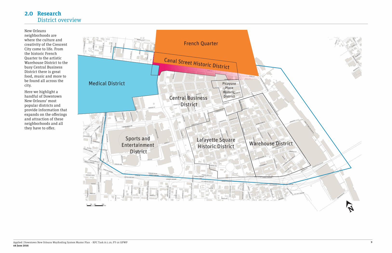
2.0 Research District overview
HOV
US90B E
US90B W
I-10
E
CANAL ST
CANAL ST
CANAL ST
CANAL ST
I-10
W
CLIO ST
CAM
P ST
POYDRAS ST
GRAVIER ST
CALLIOPE ST
BIENVILLE ST
BAR
ON
NE ST
S PETERS ST
MA
GAZIN
E ST
CAR
ON
DELET ST
ERATO ST
LA SALLE ST
LOYO
LA AVES R
AM
PART ST
PERDIDO ST
TULANE AVE
IBERVILLE ST
O'K
EEFE AVE
CONTI ST
EARHART BLVD
COMMON ST
FULTON ST
S RO
MAN
ST
SAINT JOSEPH ST
PORT OF NEW ORLEANS PL
SAIN
T CHA
RLES AVE
TCHOUPITOULAS ST
GIROD ST
HOWARD AVE
CLEVELAND AVE
UNION ST
S C
LAIB
OR
NE
AVE
S C
LAIB
OR
NE
AVE
OVE
RPA
SS
RO
YAL
ST
S DERB
IGNY ST
US90B EXIT
CAMP ST EXIT
ANDREW HIGGINS DR
LAFAYETTE ST
BOLIVA
R ST
BA
SIN
ST
I-10 E
ONRAMP
N PETER
S ST
DEC
ATU
R S
T
COMM
ERCE ST
CON
STANC
E ST
ELK
PL
SUGAR BOWL DR
US90B W ONRAMP
ANN
UNC
IATION
ST
JULIA ST
LOYOLA AVE EXIT
CH
AR
TRES
ST
BO
UR
BO
N S
T
DAVE DIXON DR
GAIENNIE ST
NOTRE DAME ST
FRERET ST
DA
UPH
INE
ST
TCHOUPITOULAS EXIT
MA
RA
IS S
T
BROOKLYN AVE
SLIDELL ST
CCC OUT ONRAMP
POYDR
AS PLA
ZA
TREM
E ST
POYD
RA
S EX
IT
EXC
HA
NG
E PL
US90B E ONRAMP
S CLA
IBO
RN
E EXIT
BU
RG
UN
DY
ST
CONVENTION CENTER BLVD
N R
AM
PAR
T ST
TECHE ST
CR
OZA
T ST
S VI
LLER
E ST
S DIAMOND STN DIAMOND ST
HOMER ST
POE ST
W STA
DIU
M D
R
EARHART BLVD EXIT
POEYFARRE ST
CLAR
A ST
JOHN CHURCHILL CHASE ST
NATCHEZ ST
PALMYRA ST
N FR
ON
T ST
CLA
IBO
RN
E O
NR
AM
P
SUPERDOME EXIT
N V
ILLE
RE
ST
N R
OM
AN
ST
N P
RIE
UR
ST
THALIA ST
S R
OB
ERTS
ON
ST
O'KEEFE AVE EXIT
N D
ERB
IGN
Y ST
ST CHARLES AVE EXIT
N R
OB
ERTS
ON
ST
PENN
ST
ELIZ
A ST
CHU
RCH
ST
S SA
RAT
OG
A ST
CYPRESS ST
CLAY ST
N C
LAIB
OR
NE
AVE
HENDERSON ST
SIM
ON
BO
LIVA
R A
VE
NEWTON ST
ROO
SEVE
LT W
AY
TRIANGLE ST
S LIBER
TY ST
I-10 W ONRAMP
CLI
NTO
N S
T
PRYT
AN
IA S
T
COLISEU
M ST
MA
GN
OLIA ST
CAR
RO
LL ST
S MAESTRI PL
N MAESTRI ST
DO
RSI
ERE
ST
PICAYUN
E PL
CAPDEVILLE ST
CA
NA
L ST
EXI
T
LE RO
UG
E ST
REV
EREN
D J
OH
N R
APH
AEL
JR
WAY
MA
RG
AR
ET P
L
DRY
AD
ES S
TO
RET
HA
CA
STLE
HA
LEY
BLV
D
SAINT THOMAS ST
CLA
RA
ST
S C
LAIB
OR
NE
EXIT
S LI
BER
TY S
T
US90B W ONRAMP
CONVENTION CENTER BLVD
N R
AM
PAR
T ST
CALLIOPE ST
CONSTANCE ST
JULIA ST
ERATO ST
S D
ERB
IGN
Y ST
S RO
BERTSO
N ST
TULANE AVE
IBERVILLE ST
MA
GNO
LIA ST
LAFAYETTE ST
S C
LAIB
OR
NE
AVE
US90B W ONRAMP
S CLA
IBOR
NE EXIT
S R
AM
PAR
T ST
S LI
BER
TY S
T
MA
GN
OLI
A ST
SAIN
T C
HA
RLE
S AV
E
BA
SIN
ST
HOWARD AVE
EARHART BLVD
US90B W ONRAMPCLIO ST CCC OUT ONRAMP
S SA
RAT
OG
A ST
ELK
PL
S C
LAIB
OR
NE
AVE
ERATO ST
US90B E ONRAMP
N C
LAIB
OR
NE
AVE
JULIA ST
FRER
ET S
T
S C
LAIB
OR
NE
AVE
OVE
RPA
SS
S D
ERB
IGN
Y ST
PERDIDO ST
US90B W ONRAMP
US90B E ONRAMP
TCHOUPITOULAS EXIT
SIM
ON
BO
LIVA
R A
VE
LAFAYETTE ST
BOLIVA
R ST
US90B E ONRAMP
CON
STANC
E ST
US90B W ONRAMP
CLAI
BORN
E O
NRAM
P
S R
OB
ERTS
ON
ST
Warehouse DistrictLafayette SquareHistoric District
Sports andEntertainment
District
Central Business District
PicayunePlace
Historic District
Medical District
French Quarter
Canal Street Historic District
0 300 600150Feet
New Orleans neighborhoods are where the culture and creativity of the Crescent City come to life. From the historic French Quarter to the artistic Warehouse District to the busy Central Business District there is great food, music and more to be found all across the city.
Here we highlight a handful of Downtown New Orleans’ most popular districts and provide information that expands on the offerings and attraction of these neighborhoods and all they have to offer.
N

Applied | Downtown New Orleans Wayfinding System Master Plan - RPC Task A-2.16; FY-16 UPWP08 June 2016
10
2.0 Research The city - major districts
Like so many American urban centers, New Orleans’ Central Business District (CBD) was once a ghost town after work, but not anymore! Evenings now bring crowds to historic Lafayette Square for free concerts, and numerous other restaurants, bars and theaters come to life after dark.
In addition to being a vibrant commercial center, and a meeting area for business travelers, the Central Business District is home to a wide variety of lunch spots, bars offering happy hours and restaurants. In the last few decades, the area has welcomed the Aquarium of the Americas, Harrah’s Casino, and great shopping at Canal Place.
Today, the historic neighborhood has become a hot address for visitors who enjoy around-the-clock access to all the city offers.
The growing medical corridor in New Orleans is commonly known as The Medical District, this economic development district that was created by the State of Louisiana in 2005 for the purpose of developing a biosciences industry in New Orleans that will provide research and development, healthcare delivery, and stable, high-paying jobs. The district spans the Downtown and Mid-City neighborhoods of New Orleans.
The area’s major developments include Veteran’s Affairs Medical Center, University Medical Center, Louisiana Cancer Research Center, New Orleans Bioinnovation Center and the Ochsner Health System.

Applied | Downtown New Orleans Wayfinding System Master Plan - RPC Task A-2.16; FY-16 UPWP08 June 2016
11
2.0 Research The city - major districts
The French Quarter, also known as the “Quarter” to locals, sits on a crescent in the Mississippi River on some of the highest ground in New Orleans. Not only is it the city’s cultural hub, but it is also a community where residents take time to welcome visitors in the streets.
Intimate and unique, New Orleans’ oldest neighborhood has exerted a spell over writers and artists since the time of Mark Twain, Lafcadio Hern and John James Audubon.
French Quarter architecture blends Spanish, French, Creole and American styles together in an idyllic, enchanting setting. From antiques and books to clothing and accessories, the French Quarter is full of boutique shopping.
This historic Warehouse District neighborhood is filled with amazing art galleries, fine restaurants, and world-class museums, has become a bustling center of attention in the heart of downtown New Orleans.
The district has abundant and open space warehouses were perfect for displaying artwork. Many galleries call the district home. Most are located on Julia Street, which is also the scene of an evening gallery hop that hosts a mix of art lovers.
The district includes museums such as the National World War II Museum, one of the most popular attractions in New Orleans that has brought in over 2 million visitors. Other museums like Louisiana’s Civil War Museum, The Children’s Museum and the Ogden Museum of Southern Art make the Warehouse Arts District the place to go to learn about the history and culture of New Orleans and Louisiana.
Sources: Essence.com
New Orleans Film Festival
New Orleans CVB

Applied | Downtown New Orleans Wayfinding System Master Plan - RPC Task A-2.16; FY-16 UPWP08 June 2016
12
2.0 Research Summary of users
The traveller economy at its core is about driving economic growth and enriching the lives of people. The more than nine million visitors pump billions in spending directly into New Orleans. That money contributes greatly to state and local economies and supports jobs for New Orleans from every neighborhood.
Mayor Mitch Landrieu said, “The people, culture, food and entertainment in New Orleans are arguably the best in the world. We take pride in offering our visitors an authentic experience and are adding new options every year, so it’s no surprise that the city is continuing to see record breaking visitor numbers. New Orleans is on a roll and we’re thrilled that visitors across the globe are taking notice.”
Sources: American Community Survey City of New Orleans CVB U.S. Census Bureau The Data Center ** Info based on Population estimates, July 1, 2015, (V2015)
#3
#12
140,000
80%
$8.4B
60%
1.3M
ranking in tourism for international travellers
Top travel pinned cityPinterest (above NYC and LA)
Commuters daily average
of international visitors first time
spent by visitors in 2019
Non-residents in workforce
Residents living in Metro New Orleans
43% of U.S. visitors first time
visitors predicted by 2019
New Orleans Area
11.3M

Applied | Downtown New Orleans Wayfinding System Master Plan - RPC Task A-2.16; FY-16 UPWP08 June 2016
13
Main conclusions from the responses
everyoneUsers using the landmarks tofind their way around the city
nearly halfUsers who had negative commentsabout the current signage and maps
three quartersUsers who could not locate the cities established districts
over halfUsers who wouldn’t use public transportation; as they did not know where it went
almost allUsers know the river and lake to find their way around when travel-ling long distances
2.0 Research User Research
Methodology in New OrleansWe spent three days in the city starting April 20th 2016 conducting user questionnaires. The idea of this research was to understand how people find their way around and what information they currently use. We wanted to understand if they think the place is easy to navigate, if the current signage is useful, and what improvements for wayfinding they would like to see.
Why do user research?To get an understanding of what a place is all about you have to listen to people. They may live there, they may work there or they may just be visiting, but they all provide a valuable insight.
“It’s a great city to explore and get lost in, but it’s also a city with areas that can make you uncomfortable – you don’t feel safe if you don’t know where you’re going”
“The maps in the hotel are easier than the maps on the street.”
“North is towards the lake”
“North is towards the lake”
“North? Nobody operates that way in New Orleans we use landmarks to get around”
“I need a map with one view of New Orleans not just French Quarter. I don’t want it split into areas”
“We are lost. We got lost this morning and I’m pretty sure we’ll get lost this afternoon.”
“I could tell you where theWWII Museum was if I knew where I was!”

Applied | Downtown New Orleans Wayfinding System Master Plan - RPC Task A-2.16; FY-16 UPWP08 June 2016
14
2.0 Research Regulatory requirements
Vehicular wayfinding guide signs are essential to direct road users along streets and highways, to inform them of intersecting routes, to direct them to cities, districts, or other important destinations, rivers, parks, and historical sites, and generally to give such information as will help them along their way in the most simple, direct manner possible.
Throughout the U.S. any vehicular oriented directional sign that is located along a publicly accessible roadway must be compliant with the Federal Highway Administration (FHWA) standards. The FHWA’s Manual for Traffic Control Devices addresses placement, location, and other general criteria for signs that are facing vehicular traffic on public access roadways.
Chapter 2D-50 of the MUTCD prescribes the requirement of vehicular directional sign design, messaging and placement. The requirements specific to Applied’s concept design for the City of New Orleans is demonstrated in the illustration on the right. While some requirements are general, such as radiused corners, others are specific, like number and order of destinations.
The MUTCD does not prescribe requirements for community identity (gateway), pedestrian directional or historic marker signs other than to make sure they are not confused with direction giving to vehicles.
In the design development phase of the New Orleans wayfinding project the MUTCD 2d-50 criteria for community guide signs will be detailed for construction and compliance with the standards.
LA DOTD has adopted the same criteria for guide sign requirements per Bao “Long” Le (DOTD).
Source: MUTCD - 2009, LADOTD
5'-0"
7'-0"
8'-0"

3.0 Analysis

Applied | Downtown New Orleans Wayfinding System Master Plan - RPC Task A-2.16; FY-16 UPWP08 June 2016
16
3.0 Analysis Legibility
(FEET)
HOV
US90B E
US90B W
I-10
E
CANAL ST
CANAL ST
CANAL ST
CANAL ST
I-10
W
CLIO ST
CAM
P ST
POYDRAS ST
GRAVIER ST
CALLIOPE ST
BIENVILLE ST
BAR
ON
NE ST
S PETERS ST
MA
GAZIN
E ST
CAR
ON
DELET ST
ERATO ST
LA SALLE ST
LOYO
LA AVES R
AM
PART ST
PERDIDO ST
TULANE AVE
IBERVILLE ST
O'K
EEFE AVE
CONTI ST
EARHART BLVD
COMMON ST
FULTON ST
S RO
MAN
ST
SAINT JOSEPH ST
PORT OF NEW ORLEANS PL
SAIN
T CHA
RLES AVE
TCHOUPITOULAS ST
GIROD ST
HOWARD AVE
CLEVELAND AVE
UNION ST
S C
LAIB
OR
NE
AVE
S C
LAIB
OR
NE
AVE
OVE
RPA
SS
RO
YAL
ST
S DERB
IGNY ST
US90B EXIT
CAMP ST EXIT
ANDREW HIGGINS DR
LAFAYETTE ST
BOLIVA
R ST
BA
SIN
ST
I-10 E
ONRAMP
N PETER
S ST
DEC
ATU
R S
T
COMM
ERCE ST
CON
STANC
E ST
ELK
PL
SUGAR BOWL DR
US90B W ONRAMP
ANN
UNC
IATION
ST
JULIA ST
LOYOLA AVE EXIT
CH
AR
TRES
ST
BO
UR
BO
N S
T
DAVE DIXON DR
GAIENNIE ST
NOTRE DAME ST
FRERET ST
DA
UPH
INE
ST
TCHOUPITOULAS EXIT
MA
RA
IS S
T
BROOKLYN AVE
SLIDELL ST
CCC OUT ONRAMP
POYDR
AS PLA
ZA
TREM
E ST
POYD
RA
S EX
IT
EXC
HA
NG
E PL
US90B E ONRAMP
S CLA
IBO
RN
E EXIT
BU
RG
UN
DY
ST
CONVENTION CENTER BLVD
N R
AM
PAR
T ST
TECHE ST
CR
OZA
T ST
S VI
LLER
E ST
S DIAMOND STN DIAMOND ST
HOMER ST
POE ST
W STA
DIU
M D
R
EARHART BLVD EXIT
POEYFARRE ST
CLAR
A ST
JOHN CHURCHILL CHASE ST
NATCHEZ ST
PALMYRA ST
N FR
ON
T ST
CLA
IBO
RN
E O
NR
AM
P
SUPERDOME EXIT
N V
ILLE
RE
ST
N R
OM
AN
ST
N P
RIE
UR
ST
THALIA ST
S R
OB
ERTS
ON
ST
O'KEEFE AVE EXIT
N D
ERB
IGN
Y ST
ST CHARLES AVE EXIT
N R
OB
ERTS
ON
ST
PENN
ST
ELIZ
A ST
CHU
RCH
ST
S SA
RAT
OG
A ST
CYPRESS ST
CLAY ST
N C
LAIB
OR
NE
AVE
HENDERSON ST
SIM
ON
BO
LIVA
R A
VE
NEWTON ST
ROO
SEVE
LT W
AY
TRIANGLE ST
S LIBER
TY ST
I-10 W ONRAMP
CLI
NTO
N S
T
PRYT
AN
IA S
T
COLISEU
M ST
MA
GN
OLIA ST
CAR
RO
LL ST
S MAESTRI PL
N MAESTRI ST
DO
RSI
ERE
ST
PICAYUN
E PL
CAPDEVILLE STC
AN
AL
ST E
XIT
LE RO
UG
E ST
REV
EREN
D J
OH
N R
APH
AEL
JR
WAY
MA
RG
AR
ET P
L
DRY
AD
ES S
TO
RET
HA
CA
STLE
HA
LEY
BLV
D
SAINT THOMAS ST
CLA
RA
ST
S C
LAIB
OR
NE
EXIT
S LI
BER
TY S
T
US90B W ONRAMP
CONVENTION CENTER BLVD
N R
AM
PAR
T ST
CALLIOPE ST
CONSTANCE ST
JULIA ST
ERATO ST
S D
ERB
IGN
Y ST
S RO
BERTSO
N ST
TULANE AVE
IBERVILLE ST
MA
GNO
LIA ST
LAFAYETTE ST
S C
LAIB
OR
NE
AVE
US90B W ONRAMP
S CLA
IBOR
NE EXIT
S R
AM
PAR
T ST
S LI
BER
TY S
T
MA
GN
OLI
A ST
SAIN
T C
HA
RLE
S AV
E
BA
SIN
ST
HOWARD AVE
EARHART BLVD
US90B W ONRAMPCLIO ST CCC OUT ONRAMP
S SA
RAT
OG
A ST
ELK
PL
S C
LAIB
OR
NE
AVE
ERATO ST
US90B E ONRAMP
N C
LAIB
OR
NE
AVE
JULIA ST
FRER
ET S
T
S C
LAIB
OR
NE
AVE
OVE
RPA
SS
S D
ERB
IGN
Y ST
PERDIDO ST
US90B W ONRAMP
US90B E ONRAMP
TCHOUPITOULAS EXIT
SIM
ON
BO
LIVA
R A
VE
LAFAYETTE ST
BOLIVA
R ST
US90B E ONRAMP
CON
STANC
E ST
US90B W ONRAMP
CLAI
BORN
E O
NRAM
P
S R
OB
ERTS
ON
ST
Prepared by the Regional Planning Commissionfor Jefferson, Orleans, Plaquemines, St. Bernard, St. Tammany and Tangipahoa Parishes
WAYFINDING SIGNAGE BASEMAP DATA 20160 300 600150
Feet
CANAL ST
N PETERS ST
POYDRAS ST
CONVENTION CENTER BLVD
CALLIOPE ST
CLAI
BORN
E ST
LOYOLA AVE
Legibility map
Major linear barrier to movement
Minor linear barrier to movement
Landmarks
Legibility affects on wayfinding
– Direction via landmarks
– Hierarchy of routing
– Provide routing options
– Promote use of transit
– Promote use of bike/ped options
Legibility analysis is a technique that looks at the major urban realm elements that affect how a user experiences and understands a city on the ground.
Roads, bridges, buildings and bodies of water are integral elements of a city. While these features are necessary for a city to function properly they also create challenges to movement from one place to another.
From a site-wide view the Downtown Development District is bound by the major highways of Interstate 10 and Highway 90. These barriers separate physically and visually this area from the surrounding city. Internal to the district several other barriers exist including busy (multi-lane) streets
N

Applied | Downtown New Orleans Wayfinding System Master Plan - RPC Task A-2.16; FY-16 UPWP08 June 2016
17
3.0 Analysis Movement networks
(FEET)
HOV
US90B E
US90B W
I-10
E
CANAL ST
CANAL ST
CANAL ST
CANAL ST
I-10
W
CLIO ST
CAM
P ST
POYDRAS ST
GRAVIER ST
CALLIOPE ST
BIENVILLE ST
BAR
ON
NE ST
S PETERS ST
MA
GAZIN
E ST
CAR
ON
DELET ST
ERATO ST
LA SALLE ST
LOYO
LA AVES R
AM
PART ST
PERDIDO ST
TULANE AVE
IBERVILLE ST
O'K
EEFE AVE
CONTI ST
EARHART BLVD
COMMON ST
FULTON ST
S RO
MAN
ST
SAINT JOSEPH ST
PORT OF NEW ORLEANS PL
SAIN
T CHA
RLES AVE
TCHOUPITOULAS ST
GIROD ST
HOWARD AVE
CLEVELAND AVE
UNION ST
S C
LAIB
OR
NE
AVE
S C
LAIB
OR
NE
AVE
OVE
RPA
SS
RO
YAL
ST
S DERB
IGNY ST
US90B EXIT
CAMP ST EXIT
ANDREW HIGGINS DR
LAFAYETTE ST
BOLIVA
R ST
BA
SIN
ST
I-10 E
ONRAMP
N PETER
S ST
DEC
ATU
R S
T
COMM
ERCE ST
CON
STANC
E ST
ELK
PL
SUGAR BOWL DR
US90B W ONRAMP
ANN
UNC
IATION
ST
JULIA ST
LOYOLA AVE EXIT
CH
AR
TRES
ST
BO
UR
BO
N S
T
DAVE DIXON DR
GAIENNIE ST
NOTRE DAME ST
FRERET ST
DA
UPH
INE
ST
TCHOUPITOULAS EXIT
MA
RA
IS S
T
BROOKLYN AVE
SLIDELL ST
CCC OUT ONRAMP
POYDR
AS PLA
ZA
TREM
E ST
POYD
RA
S EX
IT
EXC
HA
NG
E PL
US90B E ONRAMP
S CLA
IBO
RN
E EXIT
BU
RG
UN
DY
ST
CONVENTION CENTER BLVD
N R
AM
PAR
T ST
TECHE ST
CR
OZA
T ST
S VI
LLER
E ST
S DIAMOND STN DIAMOND ST
HOMER ST
POE ST
W STA
DIU
M D
R
EARHART BLVD EXIT
POEYFARRE ST
CLAR
A ST
JOHN CHURCHILL CHASE ST
NATCHEZ ST
PALMYRA ST
N FR
ON
T ST
CLA
IBO
RN
E O
NR
AM
P
SUPERDOME EXIT
N V
ILLE
RE
ST
N R
OM
AN
ST
N P
RIE
UR
ST
THALIA ST
S R
OB
ERTS
ON
ST
O'KEEFE AVE EXIT
N D
ERB
IGN
Y ST
ST CHARLES AVE EXIT
N R
OB
ERTS
ON
ST
PENN
ST
ELIZ
A ST
CHU
RCH
ST
S SA
RAT
OG
A ST
CYPRESS ST
CLAY ST
N C
LAIB
OR
NE
AVE
HENDERSON ST
SIM
ON
BO
LIVA
R A
VE
NEWTON ST
ROO
SEVE
LT W
AY
TRIANGLE ST
S LIBER
TY ST
I-10 W ONRAMP
CLI
NTO
N S
T
PRYT
AN
IA S
T
COLISEU
M ST
MA
GN
OLIA ST
CAR
RO
LL ST
S MAESTRI PL
N MAESTRI ST
DO
RSI
ERE
ST
PICAYUN
E PL
CAPDEVILLE ST
CA
NA
L ST
EXI
T
LE RO
UG
E ST
REV
EREN
D J
OH
N R
APH
AEL
JR
WAY
MA
RG
AR
ET P
L
DRY
AD
ES S
TO
RET
HA
CA
STLE
HA
LEY
BLV
D
SAINT THOMAS ST
CLA
RA
ST
S C
LAIB
OR
NE
EXIT
S LI
BER
TY S
T
US90B W ONRAMP
CONVENTION CENTER BLVD
N R
AM
PAR
T ST
CALLIOPE ST
CONSTANCE ST
JULIA ST
ERATO ST
S D
ERB
IGN
Y ST
S RO
BERTSO
N ST
TULANE AVE
IBERVILLE ST
MA
GNO
LIA ST
LAFAYETTE ST
S C
LAIB
OR
NE
AVE
US90B W ONRAMP
S CLA
IBOR
NE EXIT
S R
AM
PAR
T ST
S LI
BER
TY S
T
MA
GN
OLI
A ST
SAIN
T C
HA
RLE
S AV
E
BA
SIN
ST
HOWARD AVE
EARHART BLVD
US90B W ONRAMPCLIO ST CCC OUT ONRAMP
S SA
RAT
OG
A ST
ELK
PL
S C
LAIB
OR
NE
AVE
ERATO ST
US90B E ONRAMP
N C
LAIB
OR
NE
AVE
JULIA ST
FRER
ET S
T
S C
LAIB
OR
NE
AVE
OVE
RPA
SS
S D
ERB
IGN
Y ST
PERDIDO ST
US90B W ONRAMP
US90B E ONRAMP
TCHOUPITOULAS EXIT
SIM
ON
BO
LIVA
R A
VE
LAFAYETTE ST
BOLIVA
R ST
US90B E ONRAMP
CON
STANC
E ST
US90B W ONRAMP
CLAI
BORN
E O
NRAM
P
S R
OB
ERTS
ON
ST
Prepared by the Regional Planning Commissionfor Jefferson, Orleans, Plaquemines, St. Bernard, St. Tammany and Tangipahoa Parishes
WAYFINDING SIGNAGE BASEMAP DATA 20160 300 600150
Feet
CANAL ST
N PETERS ST
POYDRAS ST
JULIA ST
MAGAZINE ST
CONVENTION CENTER BLVD
CALLIOPE ST
CLAI
BORN
E ST
LOYOLA AVE
Primary Pedestrian Corridor
Secondary Pedestrian Corridor
Bike RoutesPath network affects on wayfinding
– Identification of road crossings
– Direction via trail network
– Multi-modal awareness
– Promote safety
– Information considerate of environmental conditions
– Leverage park connectivity
* Routes defined at stakeholder
meetings held March 10- 11 2016 N

Applied | Downtown New Orleans Wayfinding System Master Plan - RPC Task A-2.16; FY-16 UPWP08 June 2016
18
3.0 Analysis Movement networks
(FEET)
HOV
US90B E
US90B W
I-10
E
CANAL ST
CANAL ST
CANAL ST
CANAL ST
I-10
W
CLIO ST
CAM
P ST
POYDRAS ST
GRAVIER ST
CALLIOPE ST
BIENVILLE ST
BAR
ON
NE ST
S PETERS ST
MA
GAZIN
E ST
CAR
ON
DELET ST
ERATO ST
LA SALLE ST
LOYO
LA AVES R
AM
PART ST
PERDIDO ST
TULANE AVE
IBERVILLE ST
O'K
EEFE AVE
CONTI ST
EARHART BLVD
COMMON ST
FULTON ST
S RO
MAN
ST
SAINT JOSEPH ST
PORT OF NEW ORLEANS PL
SAIN
T CHA
RLES AVE
TCHOUPITOULAS ST
GIROD ST
HOWARD AVE
CLEVELAND AVE
UNION ST
S C
LAIB
OR
NE
AVE
S C
LAIB
OR
NE
AVE
OVE
RPA
SS
RO
YAL
ST
S DERB
IGNY ST
US90B EXIT
CAMP ST EXIT
ANDREW HIGGINS DR
LAFAYETTE ST
BOLIVA
R ST
BA
SIN
ST
I-10 E
ONRAMP
N PETER
S ST
DEC
ATU
R S
T
COMM
ERCE ST
CON
STANC
E ST
ELK
PL
SUGAR BOWL DR
US90B W ONRAMP
ANN
UNC
IATION
ST
JULIA ST
LOYOLA AVE EXIT
CH
AR
TRES
ST
BO
UR
BO
N S
T
DAVE DIXON DR
GAIENNIE ST
NOTRE DAME ST
FRERET ST
DA
UPH
INE
ST
TCHOUPITOULAS EXIT
MA
RA
IS S
T
BROOKLYN AVE
SLIDELL ST
CCC OUT ONRAMP
POYDR
AS PLA
ZA
TREM
E ST
POYD
RA
S EX
IT
EXC
HA
NG
E PL
US90B E ONRAMP
S CLA
IBO
RN
E EXIT
BU
RG
UN
DY
ST
CONVENTION CENTER BLVD
N R
AM
PAR
T ST
TECHE ST
CR
OZA
T ST
S VI
LLER
E ST
S DIAMOND STN DIAMOND ST
HOMER ST
POE ST
W STA
DIU
M D
R
EARHART BLVD EXIT
POEYFARRE ST
CLAR
A ST
JOHN CHURCHILL CHASE ST
NATCHEZ ST
PALMYRA ST
N FR
ON
T ST
CLA
IBO
RN
E O
NR
AM
P
SUPERDOME EXIT
N V
ILLE
RE
ST
N R
OM
AN
ST
N P
RIE
UR
ST
THALIA ST
S R
OB
ERTS
ON
ST
O'KEEFE AVE EXIT
N D
ERB
IGN
Y ST
ST CHARLES AVE EXIT
N R
OB
ERTS
ON
ST
PENN
ST
ELIZ
A ST
CHU
RCH
ST
S SA
RAT
OG
A ST
CYPRESS ST
CLAY ST
N C
LAIB
OR
NE
AVE
HENDERSON ST
SIM
ON
BO
LIVA
R A
VE
NEWTON ST
ROO
SEVE
LT W
AY
TRIANGLE ST
S LIBER
TY ST
I-10 W ONRAMP
CLI
NTO
N S
T
PRYT
AN
IA S
T
COLISEU
M ST
MA
GN
OLIA ST
CAR
RO
LL ST
S MAESTRI PL
N MAESTRI ST
DO
RSI
ERE
ST
PICAYUN
E PL
CAPDEVILLE ST
CA
NA
L ST
EXI
T
LE RO
UG
E ST
REV
EREN
D J
OH
N R
APH
AEL
JR
WAY
MA
RG
AR
ET P
L
DRY
AD
ES S
TO
RET
HA
CA
STLE
HA
LEY
BLV
D
SAINT THOMAS ST
CLA
RA
ST
S C
LAIB
OR
NE
EXIT
S LI
BER
TY S
T
US90B W ONRAMP
CONVENTION CENTER BLVD
N R
AM
PAR
T ST
CALLIOPE ST
CONSTANCE ST
JULIA ST
ERATO ST
S D
ERB
IGN
Y ST
S RO
BERTSO
N ST
TULANE AVE
IBERVILLE ST
MA
GNO
LIA ST
LAFAYETTE ST
S C
LAIB
OR
NE
AVE
US90B W ONRAMP
S CLA
IBOR
NE EXIT
S R
AM
PAR
T ST
S LI
BER
TY S
T
MA
GN
OLI
A ST
SAIN
T C
HA
RLE
S AV
E
BA
SIN
ST
HOWARD AVE
EARHART BLVD
US90B W ONRAMPCLIO ST CCC OUT ONRAMP
S SA
RAT
OG
A ST
ELK
PL
S C
LAIB
OR
NE
AVE
ERATO ST
US90B E ONRAMP
N C
LAIB
OR
NE
AVE
JULIA ST
FRER
ET S
T
S C
LAIB
OR
NE
AVE
OVE
RPA
SS
S D
ERB
IGN
Y ST
PERDIDO ST
US90B W ONRAMP
US90B E ONRAMP
TCHOUPITOULAS EXIT
SIM
ON
BO
LIVA
R A
VE
LAFAYETTE ST
BOLIVA
R ST
US90B E ONRAMP
CON
STANC
E ST
US90B W ONRAMP
CLAI
BORN
E O
NRAM
P
S R
OB
ERTS
ON
ST
Prepared by the Regional Planning Commissionfor Jefferson, Orleans, Plaquemines, St. Bernard, St. Tammany and Tangipahoa Parishes
WAYFINDING SIGNAGE BASEMAP DATA 20160 300 600150
Feet
CANAL ST
N PETERS ST
POYDRAS ST
JULIA ST
MAGAZINE ST
CONVENTION CENTER BLVD
CALLIOPE ST
CLAI
BORN
E ST
LOYOLA AVE
Secondary Vehicular Route
Primary Vehicular Route
From US90 BUS W O’Keefe Ave Exit
From I-10Poydras Exit
Main Tourist Exit #1
Exit #2
Exit #4
Exit #3
From Basin St.
/Orleans AveFrom
VieuxCarre Exit
From US90 BUS E and W
District Entry NodesFrom 10
CANAL ST EXIT
From US 90B W Camp St. Exit Tchoupitoulas Exit
From tra�
c avoiding CC Blvd
From US 90B ELoyola Ave. Exit
Vehicular network affects on wayfinding
– Promote network to the district
– Awareness of parking
– Promote multi-modal options
– Progressive disclosure of information
* Key entry nodes and routes defined
at stakeholder meetings held
March 10- 11 2016N

Applied | Downtown New Orleans Wayfinding System Master Plan - RPC Task A-2.16; FY-16 UPWP08 June 2016
19
3.0 Analysis Tourism
Mardi Gras- Fat Tuesday
Recognised as one of the top events in the world Mardi Gras attracts hundreds of thousands of bead-draped Louisianians and their guests from all over the world hit the streets of New Orleans for days of fun and frivolity at what is commonly referred to as “the biggest free party on earth”. More than 60 parades complete with cheeky costumes to celebrate the naughtiest time of year during the two weeks before Fat Tuesday, and no two places in New Orleans celebrate Mardi Gras in exactly the same way.
Tourism is New Orleans’ top industry, sure, but it is also incredibly valuable to each and every resident, whether they work in tourism or not.
1. It brings in billions of dollars to the local economy2. It provides more than 80,000 jobs of New Orleanians3. It provides a wide range of fulfilling careers from executives to service workers4. It spreads revenue throughout the city5. It provides revenue to improve schools and safety6. It supports infrastructure7. It nurtures the arts8. It helps New Orleanians know how special and unique their city is
New Orleans is slated to host 126 permitted festivals in 2016 all across the city, from the six-mile stretch of retail shops on Magazine Street to the art galleries in Bywater and the Jazz Market in Central City.
New Orleans is home to 38,000 bed spaces, and as would be expected for a tourist reliant city, the vacancy rate differs largely by season. In January occupancy is 42%, while in the summer months it rises to 78%.The growth of the cities many festival and has lead to a pronounced visitor peaks with 99% occupancy for Mardi Gras. In 2015 there were 142,000 people flying into Louis Armstrong Airport from the Friday before Mardi Gras to the Friday after.
Sources: Smith Travel Research neworleanswill.com
Film Festival - October
A popular event for more than two decades and named one of the Top 25 Film Festivals Worth the Entry Fee, the New Orleans Film Festival features a wide range of more than 1,250 major and short films from all over America and around the world, as well as presenting interaction with leaders in the film industry – directors, actors, screenwriters, cinematographers, and critics.
Jazz and Heritage Festival - April and May
The New Orleans Jazz & Heritage Festival, aka Jazz Fest, is a 7-day cultural feast in which thousands of musicians, cooks and craftspeople welcome 400,000 visitors each year. The Louisiana Heritage Fair at the Fair Grounds Race Course showcases unforgettable music on multiple stages, delicious Louisiana cuisine in two large food areas, and crafts artisans from the region and around the world demonstrating and selling their work.
Essence Music Festival - July
This arts, music and empowerment festival celebrating contemporary African-American music and culture attracts nearly 200,000 visitors in what has become the largest festival of African-American talent.
Voodoo Experience - October
Attracting more than 100,000 fans to New Orleans’ City Park each year, the Voodoo Experience (previously known as the Voodoo Music Festival), a multi-day music and arts festival features popular rock bands that appeal to a younger audience, but nevertheless also features many local and international bands and artists, the highest ranking of which will usually close the event with a final concert wooden or aluminium coins, stuffed toys and a host of cheap but fun trinkets.
French Quarter Festival - April
This award-winning festival, which began in 1984, has eighteen stages throughout the French Quarter to present the best in New Orleans music, representing every genre from traditional and contemporary jazz to R & B and New Orleans funk, brass bands, folk, gospel, classical, opera, Cajun Zydeco, Latin World, International, as well as musical stages for children.

Applied | Downtown New Orleans Wayfinding System Master Plan - RPC Task A-2.16; FY-16 UPWP08 June 2016
20
3.0 Analysis Tourism - Visitor Attractions
Tourism in New Orleans is part of the city’s DNA. It is said that New Orleans residents should have several costumes ready to go at any given time. Celebration is at the core of the New Orleans’ experience, and to get a true taste of the city, every visitor wants to join in the unforgettable festivals.
The map to the right highlights many of the downtown locations where these great events occur. From museums, plaza and park spaces, parade routes and tourist destinations each has a need to promote connectivity and ease of access.
Hotels
Visitor Attractions
Parade Routes
Sources: The Times Picayune March 05, 2015 Article: 15 Parade w/ route map
mardigrasneworleans.com googlemaps.com NewOrleansFrench.com HOV
US90B E
US90B W
I-10
E
CANAL ST
CANAL ST
CANAL ST
CANAL ST
I-10
W
CLIO ST
CAM
P ST
POYDRAS ST
GRAVIER ST
CALLIOPE ST
BIENVILLE ST
BAR
ON
NE ST
S PETERS ST
MA
GAZIN
E ST
CAR
ON
DELET ST
ERATO ST
LA SALLE ST
LOYO
LA AVES R
AM
PART ST
PERDIDO ST
TULANE AVE
IBERVILLE ST
O'K
EEFE AVE
CONTI ST
EARHART BLVD
COMMON ST
FULTON ST
S RO
MAN
ST
SAINT JOSEPH ST
PORT OF NEW ORLEANS PL
SAIN
T CHA
RLES AVE
TCHOUPITOULAS ST
GIROD ST
HOWARD AVE
CLEVELAND AVE
UNION ST
S C
LAIB
OR
NE
AVE
S C
LAIB
OR
NE
AVE
OVE
RPA
SS
RO
YAL
ST
S DERB
IGNY ST
US90B EXIT
CAMP ST EXIT
ANDREW HIGGINS DR
LAFAYETTE ST
BOLIVA
R ST
BA
SIN
ST
I-10 E
ONRAMP
N PETER
S ST
DEC
ATU
R S
T
COMM
ERCE ST
CON
STANC
E ST
ELK
PL
SUGAR BOWL DR
US90B W ONRAMP
ANN
UNC
IATION
ST
JULIA ST
LOYOLA AVE EXIT
CH
AR
TRES
ST
BO
UR
BO
N S
T
DAVE DIXON DR
GAIENNIE ST
NOTRE DAME ST
FRERET ST
DA
UPH
INE
ST
TCHOUPITOULAS EXIT
MA
RA
IS S
T
BROOKLYN AVE
SLIDELL ST
CCC OUT ONRAMP
POYDR
AS PLA
ZA
TREM
E ST
POYD
RA
S EX
IT
EXC
HA
NG
E PL
US90B E ONRAMP
S CLA
IBO
RN
E EXIT
BU
RG
UN
DY
ST
CONVENTION CENTER BLVD
N R
AM
PAR
T ST
TECHE ST
CR
OZA
T ST
S VI
LLER
E ST
S DIAMOND STN DIAMOND ST
HOMER ST
POE ST
W STA
DIU
M D
R
EARHART BLVD EXIT
POEYFARRE ST
CLAR
A ST
JOHN CHURCHILL CHASE ST
NATCHEZ ST
PALMYRA ST
N FR
ON
T ST
CLA
IBO
RN
E O
NR
AM
P
SUPERDOME EXIT
N V
ILLE
RE
ST
N R
OM
AN
ST
N P
RIE
UR
ST
THALIA ST
S R
OB
ERTS
ON
ST
O'KEEFE AVE EXIT
N D
ERB
IGN
Y ST
ST CHARLES AVE EXIT
N R
OB
ERTS
ON
ST
PENN
ST
ELIZ
A ST
CHU
RCH
ST
S SA
RAT
OG
A ST
CYPRESS ST
CLAY ST
N C
LAIB
OR
NE
AVE
HENDERSON ST
SIM
ON
BO
LIVA
R A
VE
NEWTON ST
ROO
SEVE
LT W
AY
TRIANGLE ST
S LIBER
TY ST
I-10 W ONRAMP
CLI
NTO
N S
T
PRYT
AN
IA S
T
COLISEU
M ST
MA
GN
OLIA ST
CAR
RO
LL ST
S MAESTRI PL
N MAESTRI ST
DO
RSI
ERE
ST
PICAYUN
E PL
CAPDEVILLE ST
CA
NA
L ST
EXI
T
LE RO
UG
E ST
REV
EREN
D J
OH
N R
APH
AEL
JR
WAY
MA
RG
AR
ET P
L
DRY
AD
ES S
TO
RET
HA
CA
STLE
HA
LEY
BLV
D
SAINT THOMAS ST
CLA
RA
ST
S C
LAIB
OR
NE
EXIT
S LI
BER
TY S
T
US90B W ONRAMP
CONVENTION CENTER BLVD
N R
AM
PAR
T ST
CALLIOPE ST
CONSTANCE ST
JULIA ST
ERATO ST
S D
ERB
IGN
Y ST
S RO
BERTSO
N ST
TULANE AVE
IBERVILLE ST
MA
GNO
LIA ST
LAFAYETTE ST
S C
LAIB
OR
NE
AVE
US90B W ONRAMP
S CLA
IBOR
NE EXIT
S R
AM
PAR
T ST
S LI
BER
TY S
T
MA
GN
OLI
A ST
SAIN
T C
HA
RLE
S AV
E
BA
SIN
ST
HOWARD AVE
EARHART BLVD
US90B W ONRAMPCLIO ST CCC OUT ONRAMP
S SA
RAT
OG
A ST
ELK
PL
S C
LAIB
OR
NE
AVE
ERATO ST
US90B E ONRAMP
N C
LAIB
OR
NE
AVE
JULIA ST
FRER
ET S
T
S C
LAIB
OR
NE
AVE
OVE
RPA
SS
S D
ERB
IGN
Y ST
PERDIDO ST
US90B W ONRAMP
US90B E ONRAMP
TCHOUPITOULAS EXIT
SIM
ON
BO
LIVA
R A
VE
LAFAYETTE ST
BOLIVA
R ST
US90B E ONRAMP
CON
STANC
E ST
US90B W ONRAMP
CLAI
BORN
E O
NRAM
P
S R
OB
ERTS
ON
ST
Prepared by the Regional Planning Commissionfor Jefferson, Orleans, Plaquemines, St. Bernard, St. Tammany and Tangipahoa Parishes
0 300 600150Feet N
03 00 600150Feet
Applied | Downtown New Orleans Wayfinding System Master Plan - RPC Task A-2.16; FY-16 UPWP08 June 2016
21
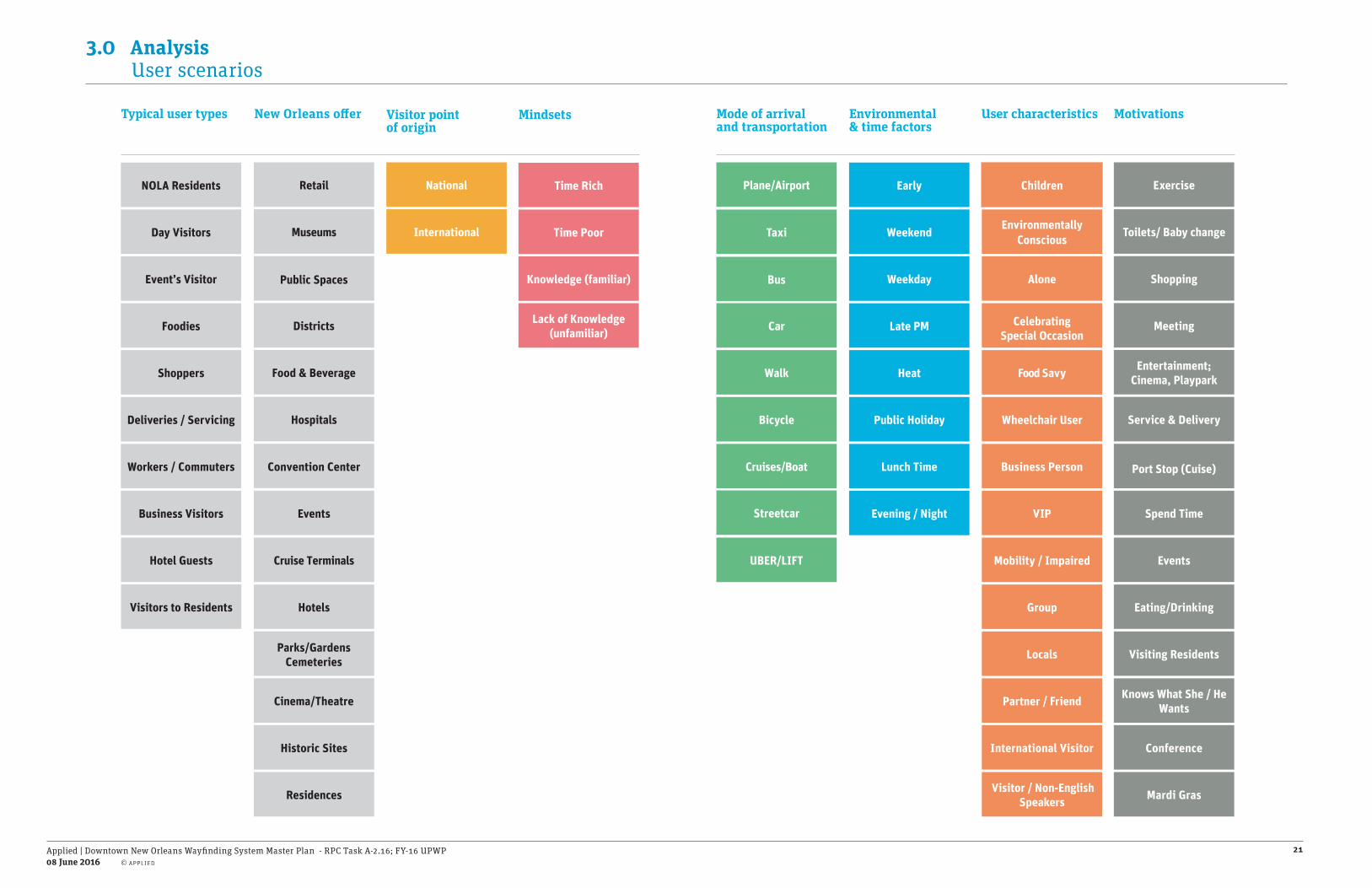
3.0 Analysis User scenarios
Public Holiday
Evening / Night
Weekend
Weekday
Late PM
Lunch Time
Heat
EarlyTime Rich
Time Poor
Lack of Knowledge (unfamiliar)
Knowledge (familiar)
Children
Mobility / Impaired
Partner / Friend
Group
Food Savy
Wheelchair User
Environmentally Conscious
Locals
Business Person
International Visitor
VIP
Visitor / Non-English Speakers
CelebratingSpecial Occasion
Alone
Meeting
Exercise
Eating/Drinking
Toilets/ Baby change
Shopping
Port Stop (Cuise)
Entertainment; Cinema, Playpark
Service & Delivery
Events
Knows What She / He Wants
Conference
Mardi Gras
Spend Time
Visiting Residents
Environmental & time factors
Mindsets User characteristics Motivations
Shoppers
NOLA Residents
Foodies
Business Visitors
Visitors to Residents
Event’s Visitor
Deliveries / Servicing
Workers / Commuters
Hotel Guests
Day Visitors
Retail
Events
Cruise Terminals
Districts
Hospitals
Residences
Convention Center
Public Spaces
Historic Sites
Hotels
Cinema/Theatre
Food & Beverage
Parks/GardensCemeteries
Museums International
National
Cruises/Boat
Taxi
Walk
Streetcar
UBER/LIFT
Bicycle
Plane/Airport
Car
Bus
Typical user types Visitor point of origin
Mode of arrivaland transportation
New Orleans o�er

Applied | Downtown New Orleans Wayfinding System Master Plan - RPC Task A-2.16; FY-16 UPWP08 June 2016
22
3.0 Analysis User scenarios
International businessman attending a conference and exhibition at the Convention Center
John, is on a business trip from Panama City and is staying at the New Orleans Downtown Marriott at the Convention Center. It’s his first time to the city.
1. He takes a taxi from the airport and gives the address of the hotel. The taxi driver exits off by the Superdrome, John doesn’t know when he has arrived in the city until he gets to his hotel.
2. On the drive in John did not see any interesting places to eat near by so he decides to take it easy and have dinner at the hotel. He then takes a short stroll around looking for shopping before heading back to the hotel for an early night.
3. The next day, John gets ready for his conference, he remembered seeing what seemed to be the convention center nearby; so he decides to walk. He did not realize how far away the venue was and wishes he would’ve left his hotel a little earlier.
4. After a full conference day, he wonders where he can get a quick bite to eat around the area. He is given a map at the conference but it does not show the restaurants near his hotel.
5. Its almost 9.30pm and John has walked quite a way down Julia Street. He overheard someone talking about a Casino but doesn’t find it and decides to head back to the hotel.
HOV
US90B E
US90B W
I-10
E
CANAL ST
CANAL ST
CANAL ST
CANAL ST
I-10
W
CLIO ST
CAM
P ST
POYDRAS ST
GRAVIER ST
CALLIOPE ST
BIENVILLE ST
BAR
ON
NE ST
S PETERS ST
MA
GAZIN
E ST
CAR
ON
DELET ST
ERATO ST
LA SALLE ST
LOYO
LA AVES R
AM
PART ST
PERDIDO ST
TULANE AVE
IBERVILLE ST
O'K
EEFE AVE
CONTI ST
EARHART BLVD
COMMON ST
FULTON ST
S RO
MAN
ST
SAINT JOSEPH ST
PORT OF NEW ORLEANS PL
SAIN
T CHA
RLES AVE
TCHOUPITOULAS ST
GIROD ST
HOWARD AVE
CLEVELAND AVE
UNION ST
S C
LAIB
OR
NE
AVE
S C
LAIB
OR
NE
AVE
OVE
RPA
SS
RO
YAL
ST
S DERB
IGNY ST
US90B EXIT
CAMP ST EXIT
ANDREW HIGGINS DR
LAFAYETTE ST
BOLIVA
R ST
BA
SIN
ST
I-10 E
ONRAMP
N PETER
S ST
DEC
ATU
R S
T
COMM
ERCE ST
CON
STANC
E ST
ELK
PL
SUGAR BOWL DR
US90B W ONRAMP
ANN
UNC
IATION
ST
JULIA ST
LOYOLA AVE EXIT
CH
AR
TRES
ST
BO
UR
BO
N S
T
DAVE DIXON DR
GAIENNIE ST
NOTRE DAME ST
FRERET ST
DA
UPH
INE
ST
TCHOUPITOULAS EXITM
AR
AIS
ST
BROOKLYN AVE
SLIDELL ST
CCC OUT ONRAMP
POYDR
AS PLA
ZA
TREM
E ST
POYD
RA
S EX
IT
EXC
HA
NG
E PL
US90B E ONRAMP
S CLA
IBO
RN
E EXIT
BU
RG
UN
DY
ST
CONVENTION CENTER BLVD
N R
AM
PAR
T ST
TECHE ST
CR
OZA
T ST
S VI
LLER
E ST
S DIAMOND STN DIAMOND ST
HOMER ST
POE ST
W STA
DIU
M D
R
EARHART BLVD EXIT
POEYFARRE ST
CLAR
A ST
JOHN CHURCHILL CHASE ST
NATCHEZ ST
PALMYRA ST
N FR
ON
T ST
CLA
IBO
RN
E O
NR
AM
P
SUPERDOME EXIT
N V
ILLE
RE
ST
N R
OM
AN
ST
N P
RIE
UR
ST
THALIA ST
S R
OB
ERTS
ON
ST
O'KEEFE AVE EXIT
N D
ERB
IGN
Y ST
ST CHARLES AVE EXIT
N R
OB
ERTS
ON
ST
PENN
ST
ELIZ
A ST
CHU
RCH
ST
S SA
RAT
OG
A ST
CYPRESS ST
CLAY ST
N C
LAIB
OR
NE
AVE
HENDERSON ST
SIM
ON
BO
LIVA
R A
VE
NEWTON ST
ROO
SEVE
LT W
AY
TRIANGLE ST
S LIBER
TY ST
I-10 W ONRAMP
CLI
NTO
N S
T
PRYT
AN
IA S
T
COLISEU
M ST
MA
GN
OLIA ST
CAR
RO
LL ST
S MAESTRI PL
N MAESTRI ST
DO
RSI
ERE
ST
PICAYUN
E PL
CAPDEVILLE ST
CA
NA
L ST
EXI
T
LE RO
UG
E ST
REV
EREN
D J
OH
N R
APH
AEL
JR
WAY
MA
RG
AR
ET P
L
DRY
AD
ES S
TO
RET
HA
CA
STLE
HA
LEY
BLV
D
SAINT THOMAS STC
LAR
A ST
S C
LAIB
OR
NE
EXIT
S LI
BER
TY S
T
US90B W ONRAMP
CONVENTION CENTER BLVD
N R
AM
PAR
T ST
CALLIOPE ST
CONSTANCE ST
JULIA ST
ERATO ST
S D
ERB
IGN
Y ST
S RO
BERTSO
N ST
TULANE AVE
IBERVILLE ST
MA
GNO
LIA ST
LAFAYETTE ST
S C
LAIB
OR
NE
AVE
US90B W ONRAMP
S CLA
IBOR
NE EXIT
S R
AM
PAR
T ST
S LI
BER
TY S
T
MA
GN
OLI
A ST
SAIN
T C
HA
RLE
S AV
E
BA
SIN
ST
HOWARD AVE
EARHART BLVD
US90B W ONRAMPCLIO ST CCC OUT ONRAMP
S SA
RAT
OG
A ST
ELK
PL
S C
LAIB
OR
NE
AVE
ERATO ST
US90B E ONRAMP
N C
LAIB
OR
NE
AVE
JULIA ST
FRER
ET S
T
S C
LAIB
OR
NE
AVE
OVE
RPA
SS
S D
ERB
IGN
Y ST
PERDIDO ST
US90B W ONRAMP
US90B E ONRAMP
TCHOUPITOULAS EXIT
SIM
ON
BO
LIVA
R A
VE
LAFAYETTE ST
BOLIVA
R ST
US90B E ONRAMP
CON
STANC
E ST
US90B W ONRAMP
CLAI
BORN
E O
NRAM
P
S R
OB
ERTS
ON
ST
1
2
3
4
5

Applied | Downtown New Orleans Wayfinding System Master Plan - RPC Task A-2.16; FY-16 UPWP08 June 2016
23
3.0 Analysis User scenarios
A couple on a port stop at the Julia St. Cruise Terminal
Matt and Emma, took a steamboat through the Mississippi river for their honeymoon. They have been on the boat for 8 days and are ready for their final stop in New Orleans. They will be spending two nights in town, since they got the Big Easy City Stay package.
1. They exit the boat with their suitcase and are unsure about how to get to their hotel and if they have enough time to drop off their bags before their appointment.
2. They have a booked a city tour but the concierge in the Inter Continental Hotel isn’t sure where the Architecture Tour of New Orleans starts. They find the tour a few minutes too late and re-book for the following day.
3. They have lunch at The Store Restaurant in downtown and ask directions to the French Quarter; which they explore on foot.
4. Getting lost on the way made them un-easy; although Matt and Emma did see the unique streets and architecture in the French Quarter. They experienced Bourbon Street on the way back to the hotel and called it a night. They decide to go have beignets in the morning. They hope to explore downtown New Orleans and find out how they can try out the street cars.
HOV
US90B E
US90B W
I-10
E
CANAL ST
CANAL ST
CANAL ST
CANAL ST
I-10
W
CLIO ST
CAM
P ST
POYDRAS ST
GRAVIER ST
CALLIOPE ST
BIENVILLE ST
BAR
ON
NE ST
S PETERS ST
MA
GAZIN
E ST
CAR
ON
DELET ST
ERATO ST
LA SALLE ST
LOYO
LA AVES R
AM
PART ST
PERDIDO ST
TULANE AVE
IBERVILLE ST
O'K
EEFE AVE
CONTI ST
EARHART BLVD
COMMON ST
FULTON ST
S RO
MAN
ST
SAINT JOSEPH ST
PORT OF NEW ORLEANS PL
SAIN
T CHA
RLES AVE
TCHOUPITOULAS ST
GIROD ST
HOWARD AVE
CLEVELAND AVE
UNION ST
S C
LAIB
OR
NE
AVE
S C
LAIB
OR
NE
AVE
OVE
RPA
SS
RO
YAL
ST
S DERB
IGNY ST
US90B EXIT
CAMP ST EXIT
ANDREW HIGGINS DR
LAFAYETTE ST
BOLIVA
R ST
BA
SIN
ST
I-10 E
ONRAMP
N PETER
S ST
DEC
ATU
R S
T
COMM
ERCE ST
CON
STANC
E ST
ELK
PL
SUGAR BOWL DR
US90B W ONRAMP
ANN
UNC
IATION
ST
JULIA ST
LOYOLA AVE EXIT
CH
AR
TRES
ST
BO
UR
BO
N S
T
DAVE DIXON DR
GAIENNIE ST
NOTRE DAME ST
FRERET ST
DA
UPH
INE
ST
TCHOUPITOULAS EXITM
AR
AIS
ST
BROOKLYN AVE
SLIDELL ST
CCC OUT ONRAMP
POYDR
AS PLA
ZA
TREM
E ST
POYD
RA
S EX
IT
EXC
HA
NG
E PL
US90B E ONRAMP
S CLA
IBO
RN
E EXIT
BU
RG
UN
DY
ST
CONVENTION CENTER BLVD
N R
AM
PAR
T ST
TECHE ST
CR
OZA
T ST
S VI
LLER
E ST
S DIAMOND STN DIAMOND ST
HOMER ST
POE ST
W STA
DIU
M D
R
EARHART BLVD EXIT
POEYFARRE ST
CLAR
A ST
JOHN CHURCHILL CHASE ST
NATCHEZ ST
PALMYRA ST
N FR
ON
T ST
CLA
IBO
RN
E O
NR
AM
P
SUPERDOME EXIT
N V
ILLE
RE
ST
N R
OM
AN
ST
N P
RIE
UR
ST
THALIA ST
S R
OB
ERTS
ON
ST
O'KEEFE AVE EXIT
N D
ERB
IGN
Y ST
ST CHARLES AVE EXIT
N R
OB
ERTS
ON
ST
PENN
ST
ELIZ
A ST
CHU
RCH
ST
S SA
RAT
OG
A ST
CYPRESS ST
CLAY ST
N C
LAIB
OR
NE
AVE
HENDERSON STSI
MO
N B
OLI
VAR
AVE
NEWTON ST
ROO
SEVE
LT W
AY
TRIANGLE ST
S LIBER
TY ST
I-10 W ONRAMP
CLI
NTO
N S
T
PRYT
AN
IA S
T
COLISEU
M ST
MA
GN
OLIA ST
CAR
RO
LL ST
S MAESTRI PL
N MAESTRI ST
DO
RSI
ERE
ST
PICAYUN
E PL
CAPDEVILLE ST
CA
NA
L ST
EXI
T
LE RO
UG
E ST
REV
EREN
D J
OH
N R
APH
AEL
JR
WAY
MA
RG
AR
ET P
L
DRY
AD
ES S
TO
RET
HA
CA
STLE
HA
LEY
BLV
D
SAINT THOMAS ST
CLA
RA
ST
S C
LAIB
OR
NE
EXIT
S LI
BER
TY S
T
US90B W ONRAMP
CONVENTION CENTER BLVD
N R
AM
PAR
T ST
CALLIOPE ST
CONSTANCE ST
JULIA ST
ERATO ST
S D
ERB
IGN
Y ST
S RO
BERTSO
N ST
TULANE AVE
IBERVILLE ST
MA
GNO
LIA ST
LAFAYETTE ST
S C
LAIB
OR
NE
AVE
US90B W ONRAMP
S CLA
IBOR
NE EXIT
S R
AM
PAR
T ST
S LI
BER
TY S
T
MA
GN
OLI
A ST
SAIN
T C
HA
RLE
S AV
E
BA
SIN
ST
HOWARD AVE
EARHART BLVD
US90B W ONRAMPCLIO ST CCC OUT ONRAMP
S SA
RAT
OG
A ST
ELK
PL
S C
LAIB
OR
NE
AVE
ERATO ST
US90B E ONRAMP
N C
LAIB
OR
NE
AVE
JULIA ST
FRER
ET S
T
S C
LAIB
OR
NE
AVE
OVE
RPA
SS
S D
ERB
IGN
Y ST
PERDIDO ST
US90B W ONRAMP
US90B E ONRAMP
TCHOUPITOULAS EXIT
SIM
ON
BO
LIVA
R A
VE
LAFAYETTE ST
BOLIVA
R ST
US90B E ONRAMP
CON
STANC
E ST
US90B W ONRAMP
CLAI
BORN
E O
NRAM
P
S R
OB
ERTS
ON
ST
4
13
2

Applied | Downtown New Orleans Wayfinding System Master Plan - RPC Task A-2.16; FY-16 UPWP08 June 2016
24
3.0 Analysis User scenarios
Foodie traveling to the City for We Live To Eat Restaurant Week
Justin, has been waiting over 6 month for that one week in September when he gets to go to New Orleans to eat at his favorite event of the year. The day is finally here and Justin loads his bag and drives from Jackson to New Orleans for four days to enjoy the We Live To Eat Restaurant Week.
1. He has his reservations and he drives all the way there thinking how good the previous year’s food was. Justin notices that the highway exit numbers are different than last visit and isn’t sure which exit was the right one.
As he exists I10 to US90, he starts looking for how to get to Canal St. which is where the Sheraton Hotel is located. He gets a
bit turned around but manages to find it. Although he is in the wrong lane to take a right turn so he goes around struggling with the confusing one-way streets.
2. He is tired and hungry from a 3 hour drive so he went across the street for a quick lunch and returned to the hotel to take a nap before his first dinner reservation at Estrella Steak and Lobster.
3. The next morning he asks for directions to Cafe’ Degas but is unsure of the address.
4. After lunch he is interested in the National WWII Museum but he does not have time as he found out about it too late. Perhaps next time he can plan that into his schedule.
HOV
US90B E
US90B W
I-10
E
CANAL ST
CANAL ST
CANAL ST
CANAL ST
I-10
W
CLIO ST
CAM
P ST
POYDRAS ST
GRAVIER ST
CALLIOPE ST
BIENVILLE ST
BAR
ON
NE ST
S PETERS ST
MA
GAZIN
E ST
CAR
ON
DELET ST
ERATO ST
LA SALLE ST
LOYO
LA AVES R
AM
PART ST
PERDIDO ST
TULANE AVE
IBERVILLE ST
O'K
EEFE AVE
CONTI ST
EARHART BLVD
COMMON ST
FULTON ST
S RO
MAN
ST
SAINT JOSEPH ST
PORT OF NEW ORLEANS PL
SAIN
T CHA
RLES AVE
TCHOUPITOULAS ST
GIROD ST
HOWARD AVE
CLEVELAND AVE
UNION ST
S C
LAIB
OR
NE
AVE
S C
LAIB
OR
NE
AVE
OVE
RPA
SS
RO
YAL
ST
S DERB
IGNY ST
US90B EXIT
CAMP ST EXIT
ANDREW HIGGINS DR
LAFAYETTE ST
BOLIVA
R ST
BA
SIN
ST
I-10 E
ONRAMP
N PETER
S ST
DEC
ATU
R S
T
COMM
ERCE ST
CON
STANC
E ST
ELK
PL
SUGAR BOWL DR
US90B W ONRAMP
ANN
UNC
IATION
ST
JULIA ST
LOYOLA AVE EXIT
CH
AR
TRES
ST
BO
UR
BO
N S
T
DAVE DIXON DR
GAIENNIE ST
NOTRE DAME ST
FRERET ST
DA
UPH
INE
ST
TCHOUPITOULAS EXIT
MA
RA
IS S
T
BROOKLYN AVE
SLIDELL ST
CCC OUT ONRAMP
POYDR
AS PLA
ZA
TREM
E ST
POYD
RA
S EX
IT
EXC
HA
NG
E PL
US90B E ONRAMP
S CLA
IBO
RN
E EXIT
BU
RG
UN
DY
ST
CONVENTION CENTER BLVD
N R
AM
PAR
T ST
TECHE ST
CR
OZA
T ST
S VI
LLER
E ST
S DIAMOND STN DIAMOND ST
HOMER ST
POE ST
W STA
DIU
M D
R
EARHART BLVD EXIT
POEYFARRE ST
CLAR
A ST
JOHN CHURCHILL CHASE ST
NATCHEZ ST
PALMYRA ST
N FR
ON
T ST
CLA
IBO
RN
E O
NR
AM
P
SUPERDOME EXIT
N V
ILLE
RE
ST
N R
OM
AN
ST
N P
RIE
UR
ST
THALIA ST
S R
OB
ERTS
ON
ST
O'KEEFE AVE EXIT
N D
ERB
IGN
Y ST
ST CHARLES AVE EXIT
N R
OB
ERTS
ON
ST
PENN
ST
ELIZ
A ST
CHU
RCH
ST
S SA
RAT
OG
A ST
CYPRESS ST
CLAY ST
N C
LAIB
OR
NE
AVE
HENDERSON ST
SIM
ON
BO
LIVA
R A
VE
NEWTON ST
ROO
SEVE
LT W
AY
TRIANGLE ST
S LIBER
TY ST
I-10 W ONRAMP
CLI
NTO
N S
T
PRYT
AN
IA S
T
COLISEU
M ST
MA
GN
OLIA ST
CAR
RO
LL ST
S MAESTRI PL
N MAESTRI ST
DO
RSI
ERE
ST
PICAYUN
E PL
CAPDEVILLE ST
CA
NA
L ST
EXI
T
LE RO
UG
E ST
REV
EREN
D J
OH
N R
APH
AEL
JR
WAY
MA
RG
AR
ET P
L
DRY
AD
ES S
TO
RET
HA
CA
STLE
HA
LEY
BLV
D
SAINT THOMAS ST
CLA
RA
ST
S C
LAIB
OR
NE
EXIT
S LI
BER
TY S
T
US90B W ONRAMP
CONVENTION CENTER BLVD
N R
AM
PAR
T ST
CALLIOPE ST
CONSTANCE ST
JULIA ST
ERATO ST
S D
ERB
IGN
Y ST
S RO
BERTSO
N ST
TULANE AVE
IBERVILLE ST
MA
GNO
LIA ST
LAFAYETTE ST
S C
LAIB
OR
NE
AVE
US90B W ONRAMP
S CLA
IBOR
NE EXIT
S R
AM
PAR
T ST
S LI
BER
TY S
T
MA
GN
OLI
A ST
SAIN
T C
HA
RLE
S AV
E
BA
SIN
ST
HOWARD AVE
EARHART BLVD
US90B W ONRAMPCLIO ST CCC OUT ONRAMP
S SA
RAT
OG
A ST
ELK
PL
S C
LAIB
OR
NE
AVE
ERATO ST
US90B E ONRAMP
N C
LAIB
OR
NE
AVE
JULIA ST
FRER
ET S
T
S C
LAIB
OR
NE
AVE
OVE
RPA
SS
S D
ERB
IGN
Y ST
PERDIDO ST
US90B W ONRAMP
US90B E ONRAMP
TCHOUPITOULAS EXIT
SIM
ON
BO
LIVA
R A
VE
LAFAYETTE ST
BOLIVA
R ST
US90B E ONRAMP
CON
STANC
E ST
US90B W ONRAMP
CLAI
BORN
E O
NRAM
P
S R
OB
ERTS
ON
ST
3
2
1
5
4

Applied | Downtown New Orleans Wayfinding System Master Plan - RPC Task A-2.16; FY-16 UPWP08 June 2016
25
3.0 Analysis User scenarios
Wayfinding information must respond to diverse visitor needs
Where can I sit down for a while?
Time to go home. How do I exit?
Where can I get a map?
Where are the museums?
Where are the street cars?
Where can I eat?
Where are the tours?
How do I get to the River?
Where is the Arts District?
What is there to eat?
Where is a safe place to cross Canal Street?
Can I get out the Garden District?
Which way?
Am I here yet?
Are there other Casinos?
Dónde puedo encontrar una guía del visitante?
Where can I buy a gift?
I love this. How can I find out more information?
Where can I learn about the local history?
Where are the restrooms?
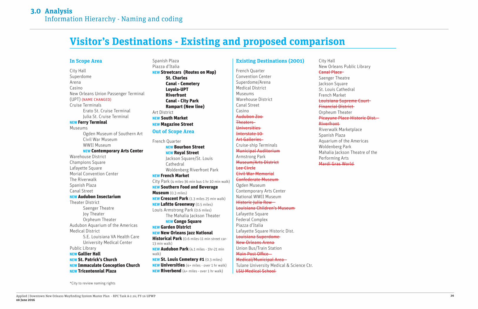
Applied | Downtown New Orleans Wayfinding System Master Plan - RPC Task A-2.16; FY-16 UPWP08 June 2016
26
3.0 Analysis Information Hierarchy - Naming and coding
Visitor’s Destinations - Existing and proposed comparison
In Scope Area
City HallSuperdomeArenaCasinoNew Orleans Union Passenger Terminal (UPT) (NAME CHANGED)Cruise Terminals Erato St. Cruise Terminal Julia St. Cruise TerminalNEW Ferry TerminalMuseums Ogden Museum of Southern Art Civil War Museum WWII Museum NEW Contemporary Arts CenterWarehouse District Champions SquareLafayette SquareMorial Convention CenterThe RiverwalkSpanish PlazaCanal StreetNEW Audubon InsectariumTheater District Saenger Theatre Joy Theater Orpheum TheaterAudubon Aquarium of the AmericasMedical District S.E. Louisiana VA Health Care University Medical CenterPublic LibraryNEW Gallier HallNEW St. Patrick’s ChurchNEW Immaculate Conception ChurchNEW Tricentennial Plaza
Spanish PlazaPiazza d’ItaliaNEW Streetcars (Routes on Map) St. Charles Canal - Cemetery Loyola-UPT Riverfront Canal - City Park Rampart (New line)Art DistrictNEW South MarketNEW Magazine Street Out of Scope Area
French Quarter NEW Bourbon Street NEW Royal Street Jackson Square/St. Louis Cathedral Woldenberg Riverfront Park NEW French MarketCity Park (4 miles-36 min bus-1 hr 10 min walk)NEW Southern Food and Beverage Museum (0.3 miles)NEW Crescent Park (1.3 miles 25 min walk)NEW Lafitte Greenway (0.5 miles)Louis Armstrong Park (0.6 miles) The Mahalia Jackson Theater NEW Congo SquareNEW Garden DistrictNEW New Orleans Jazz National Historical Park (0.6 miles-11 min street car-13 min walk)NEW Audubon Park (4.1 miles - 1hr-21 min walk)NEW St. Louis Cemetery #1 (0.3 miles)NEW Universities (4+ miles - over 1 hr walk)NEW Riverbend (4+ miles - over 1 hr walk)
Existing Destinations (2001)
French QuarterConvention CenterSuperdome/ArenaMedical DistrictMuseumsWarehouse DistrictCanal StreetCasinoAudubon ZooTheatersUniversitiesInterstate 10Art GalleriesCruise-ship TerminalsMunicipal AuditoriumArmstrong ParkMuseum/Arts DistrictLee CircleCivil War MemorialConfederate MuseumOgden MuseumContemporary Arts CenterNational WWII MuseumHistoric Julia RowLouisiana Children’s MuseumLafayette SquareFederal ComplexPiazza d’ItaliaLafayette Square Historic Dist.Louisiana SuperdomeNew Orleans ArenaUnion Bus/Train StationMain Post OfficeMedical/Municipal AreaTulane University Medical & Science Ctr.LSU Medical School
City HallNew Orleans Public LibraryCanal PlaceSaenger TheatreJackson SquareSt. Louis CathedralFrench MarketLouisiana Supreme CourtFinancial DistrictOrpheum TheaterPicayune Place Historic Dist.RiverfrontRiverwalk MarketplaceSpanish PlazaAquarium of the AmericasWoldenberg ParkMahalia Jackson Theatre of the Performing ArtsMardi Gras World
*City to review naming rights

Applied | Downtown New Orleans Wayfinding System Master Plan - RPC Task A-2.16; FY-16 UPWP08 June 2016
27
3.0 Analysis Proposed destination map
(FEET)
HOV
US90B E
US90B W
I-10
E
CANAL ST
CANAL ST
CANAL ST
CANAL ST
I-10
W
CLIO ST
CAM
P ST
POYDRAS ST
GRAVIER ST
CALLIOPE ST
BIENVILLE ST
BAR
ON
NE ST
S PETERS ST
MA
GAZIN
E ST
CAR
ON
DELET ST
ERATO ST
LA SALLE ST
LOYO
LA AVES R
AM
PART ST
PERDIDO ST
TULANE AVE
IBERVILLE ST
O'K
EEFE AVE
CONTI ST
EARHART BLVD
COMMON ST
FULTON ST
S RO
MAN
ST
SAINT JOSEPH ST
PORT OF NEW ORLEANS PL
SAIN
T CHA
RLES AVE
TCHOUPITOULAS ST
GIROD ST
HOWARD AVE
CLEVELAND AVE
UNION ST
S C
LAIB
OR
NE
AVE
S C
LAIB
OR
NE
AVE
OVE
RPA
SS
RO
YAL
ST
S DERB
IGNY ST
US90B EXIT
CAMP ST EXIT
ANDREW HIGGINS DR
LAFAYETTE ST
BOLIVA
R ST
BA
SIN
ST
I-10 E
ONRAMP
N PETER
S ST
DEC
ATU
R S
T
COMM
ERCE ST
CON
STANC
E ST
ELK
PL
SUGAR BOWL DR
US90B W ONRAMP
ANN
UNC
IATION
ST
JULIA ST
LOYOLA AVE EXIT
CH
AR
TRES
ST
BO
UR
BO
N S
TDAVE DIXON DR
GAIENNIE ST
NOTRE DAME ST
FRERET ST
DA
UPH
INE
ST
TCHOUPITOULAS EXIT
MA
RA
IS S
T
BROOKLYN AVESLIDELL ST
CCC OUT ONRAMP
POYDR
AS PLA
ZA
TREM
E ST
POYD
RA
S EX
IT
EXC
HA
NG
E PL
US90B E ONRAMP
S CLA
IBO
RN
E EXIT
BU
RG
UN
DY
ST
CONVENTION CENTER BLVDN
RA
MPA
RT
ST
TECHE ST
CR
OZA
T ST
S VI
LLER
E ST
S DIAMOND STN DIAMOND ST
HOMER ST
POE ST
W STA
DIU
M D
R
EARHART BLVD EXIT
POEYFARRE ST
CLAR
A ST
JOHN CHURCHILL CHASE ST
NATCHEZ ST
PALMYRA ST
N FR
ON
T ST
CLA
IBO
RN
E O
NR
AM
P
SUPERDOME EXIT
N V
ILLE
RE
ST
N R
OM
AN
ST
N P
RIE
UR
ST
THALIA ST
S R
OB
ERTS
ON
ST
O'KEEFE AVE EXIT
N D
ERB
IGN
Y ST
ST CHARLES AVE EXIT
N R
OB
ERTS
ON
ST
PENN
ST
ELIZ
A ST
CHU
RCH
ST
S SA
RAT
OG
A ST
CYPRESS ST
CLAY ST
N C
LAIB
OR
NE
AVE
HENDERSON ST
SIM
ON
BO
LIVA
R A
VE
NEWTON ST
ROO
SEVE
LT W
AY
TRIANGLE ST
S LIBER
TY ST
I-10 W ONRAMP
CLI
NTO
N S
T
PRYT
AN
IA S
T
COLISEU
M ST
MA
GN
OLIA ST
CAR
RO
LL ST
S MAESTRI PL
N MAESTRI ST
DO
RSI
ERE
STPIC
AYUNE PL
CAPDEVILLE ST
CA
NA
L ST
EXI
T
LE RO
UG
E ST
REV
EREN
D J
OH
N R
APH
AEL
JR
WAY
MA
RG
AR
ET P
L
DRY
AD
ES S
TO
RET
HA
CA
STLE
HA
LEY
BLV
D
SAINT THOMAS ST
CLA
RA
ST
S C
LAIB
OR
NE
EXIT
S LI
BER
TY S
T
US90B W ONRAMP
CONVENTION CENTER BLVD
N R
AM
PAR
T ST
CALLIOPE ST
CONSTANCE ST
JULIA ST
ERATO ST
S D
ERB
IGN
Y ST
S RO
BERTSO
N ST
TULANE AVE
IBERVILLE ST
MA
GNO
LIA ST
LAFAYETTE ST
S C
LAIB
OR
NE
AVE
US90B W ONRAMP
S CLA
IBOR
NE EXIT
S R
AM
PAR
T ST
S LI
BER
TY S
T
MA
GN
OLI
A ST
SAIN
T C
HA
RLE
S AV
E
BA
SIN
ST
HOWARD AVE
EARHART BLVD
US90B W ONRAMPCLIO ST CCC OUT ONRAMP
S SA
RAT
OG
A ST
ELK
PL
S C
LAIB
OR
NE
AVE
ERATO ST
US90B E ONRAMP
N C
LAIB
OR
NE
AVE
JULIA ST
FRER
ET S
T
S C
LAIB
OR
NE
AVE
OVE
RPA
SS
S D
ERB
IGN
Y ST
PERDIDO ST
US90B W ONRAMP
US90B E ONRAMP
TCHOUPITOULAS EXIT
SIM
ON
BO
LIVA
R A
VELAFAYETTE ST
BOLIVA
R ST
US90B E ONRAMP
CON
STANC
E ST
US90B W ONRAMP
CLAI
BORN
E O
NRAM
P
S R
OB
ERTS
ON
ST
Prepared by the Regional Planning Commissionfor Jefferson, Orleans, Plaquemines, St. Bernard, St. Tammany and Tangipahoa Parishes
WAYFINDING SIGNAGE BASEMAP DATA 20160 300 600150
Feet
CANAL ST
N PETERS ST
POYDRAS ST
JULIA ST
MAGAZINE ST
CONVENTION CENTER BLVD
CALLIOPE ST
CLAI
BORN
E ST
LOYOLA AVE
Lafayette
Spanish
Plaza
Square
LeeCircle
DuncanPlaza
Parks/Open Spaces
St. Mary’s Park
Heritage
Park
City Hall
ImmaculateConception
Church
JoyTheater
OrpheumTheater
The CivicTheatre
SaengerTheatre
St Patrick’sChurch
Julia Street Galleries
GallierHall
Ogden Museum ofSouthern Art Civil War
Museum
The NationalWWII Museum
ContemporaryArts Center
Erato St.Cruise Terminal
MorialConvention
Center
MorialConvention
Center
Julia St.Cruise Terminal
Ferry Terminal
Aquarium
Riverwalk
Harrah’sCasino
PiazzaD’Italia
InsectariumCanalPlace
Bour
bon
St
Magazine St
From Canal to Garden District
OC Hayley Blvd
(0.4 miles)
Southern Food and Beverage Museum
(0.3 miles)
FRENCHQUARTER
MEDICAL DISTRICT
CENTRALBUSINESS DISTRICT
WAREHOUSE DISTRICT
Superdome Champion’sSquare
PostOffice
UPT
ArenaRo
yal S
t Crescent Park(1.3 m
iles)
Jazz N.H. Park
(0.6 miles)Ja
ckso
n Sq
uare
(0.4
mile
s)Louis
Arm
stron
gPa
rk(0
.6 m
iles)
Lafit
teGr
eenw
ay(0
.5 m
iles)
St. L
ouis
Cem
eter
y #1
(0.5
mile
s)
SOUTH
MARKET
DISTRICT
SM
Garden District) el
im
1(
PublicLibrary
Southeast Louisiana VA Healthcare
University MedicalCenter New Orleans
(0.6 miles Canal& Galvez St)
Street Car Routes St. Charles Canal-Cemeteries Loyola-UPT Riverfront Canal-City Park Rampart-St Claude (New Line)
Canal St
TRICENTENNIAL PLA
ZA
(FUTURE)
LAFAYETTE SQUARE
HISTORIC DISTRICT
N

Applied | Downtown New Orleans Wayfinding System Master Plan - RPC Task A-2.16; FY-16 UPWP08 June 2016
28
3.0 Analysis Information Hierarchy - Naming and coding
Destination criteria for inclusion on signage
Is this attraction within the Downtown Development District? Is this a visitors/tourist destination?
Is this an events venue? Does it attact locals andrst time visitors?
Does it have at least 500 beds?
Does it attact over40,000 annual trips?
Is it a mall with at least1,000,000 sq. feet?
Is this a recreational attaction?
Is it within walking distance�om district?
Message not required
Is this a major city vistiors/touristdestination? Destination
NO NO
NO
Is this a cultural/artsattaction?
Is this a medicalservices destination?
NO
YES
YES YES
YES
Is this a public or governmentalentity or building? Destination
NO
YES
Is this a national orregional destination? Destination
NO
YES
DestinationYES
DestinationYES
DestinationYES
Destination
YES
YES
YES
YES
NO
Message not required
NO
Message not required
NO
NO NO YES
Message not required
Message not required
NO NO
Is it a historic areaapproved by city resolution?
NO
NO
Message not required
YES
Attraction must meet 7 out of 8 of the following criteria to beconsidered a destination on DOT signs: • Nationally recognized destination • Governmental, historical, or cultural institution • Not for profit or publicly owned institution • Greater than 50,000 visitors per year • Open a minimum of 48 hours per week • Includes a visitor information center or kiosk with personnel • Open 12 months a year • Majority of visitors are not local
General Standards • Is a public or governmental entity or building • Is an “Permitted Super Destination” with attendance of over 500,000 visitors annually • Is a cultural venue or historic site, college, university or hospital with 50,000 visitors annually • Destinations must have sufficient parking • Destinations must maintain set days and hours of operation • Recreational, historical, or cultural attractions ADA access & funded by federal, state or local governments based upon the following criteria (Historic - National Register/Open to Public Year Round)(Cultural – Open to the Public Year Round)(Recreational – Non-Profit and include multiple activates) • Public parking (open to public with non-reserved parking available daily with approved façade sign)
Destination Criteria
“Message subject to discretion of City Planning Commission Director”

4.0 Strategic Recommendations

Applied | Downtown New Orleans Wayfinding System Master Plan - RPC Task A-2.16; FY-16 UPWP08 June 2016
30
4.0 Strategic Recommendations Key wayfinding principles
This study proposes a number of strategic and tactical recommendations to deliver improved legibility to New Orleans.
The recommendations focus on developing an overarching strategy to support the Downtown Development District vision and have been derived from the audit, research and issues that have been identified through stakeholder workshops, consultations and observations.
At the core of this signing and information strategy are users: residents, visitors, businesses and many other communities and stakeholders who have an interest in the future success of the city. The design of information should be user-centred, accessible,coordinated, easy to use and be at the heart of journey planning.
It is important to consider the full scope for opportunities and applications and how they relate to users experience before setting out the strategic recommendations.
We have developed the strategy based on ten key wayfinding principles so that all modes, communications, developments can speak with one voice that the traveller can relate to in order to make ‘informed choices’. These are detailed on the right.
1. SeamlessIntegrating information across modes reflects the real journeys thatpeople make.
2. Stepping StonesStepping stones will assist people’s memory and provide connections forthe traveller.
3. System NamingThe consistent naming of places and things in the environment allowspeople to communicate what and where places are.
4. System CodesCodes are used as short-cuts for memory and for simplifying complicatedsystems and include colours, numbers, icons and names.
5. Progressive DisclosureAll things cannot be signed from all locations. Progressive disclosureprovides a rationale for what information is needed where.
6. PredictableInformation consistency, integrity and most-of-all availability are crucialto achieving predictability.
7. Don’t Make me ThinkKeep it simple. The simpler the information the easier it will be tounderstand.
8. InclusiveInformation should be provided so that it does not exclude any group orindividual, with particular focus on disability groups.
9. Help Me to LearnInformation that is easy to learn is more likely to be used. Teach peoplehow easy route choices are and modal change is more likely.
10. Tone of voiceProvide information with the right tone of voice in the right way andpeople are more likely to engage with it.

Applied | Downtown New Orleans Wayfinding System Master Plan - RPC Task A-2.16; FY-16 UPWP08 June 2016
31
4.0 Strategic Recommendations Structuring information
Structuring information to provide it progressively is important towards creating a legible system. Without a structure, the system has no reference point or rules and will quickly become a mess of ad-hoc decisions.
The structure has two broad levels:
— Naming: What assets are called and how those names relate to each other
— Selection Criteria: When and how those assets are shown in the system
The sign typology should reflect the hierarchy in a consistent way, regardless of sign type. This reinforces the system structure and allows the user to experience the city in a consistent and memorable way.
The sign typology contains several types that can be broadly categorised into three areas:
— Identification — Vehicular — Pedestrian & Cycling
Within these categories, information can be further divided into:
— Illustration based (mapping) — Text based (directional)
Once a citywide Naming Hierarchy has been established, Selection Criteria are then critical to manage how that hierarchy is displayed in mapping and directional information (See Destination Criteria on page 28).
This is also important to manage change as the wayfinding system expands into adjacent districts with New Orleans.
The detailed sign typology, in section 5 illustrates the functional elements in more detail. The broad information hierarchy approach is set out here.
AboveExamples of what happens without regulation or co-ordination.

Applied | Downtown New Orleans Wayfinding System Master Plan - RPC Task A-2.16; FY-16 UPWP08 June 2016
32
4.0 Strategic Recommendations Wayfinding overview
To make travel across New Orleans seamless, the system should take a holistic approach to wayfinding across its many applications.
While the Stage-0 scope of work only covers the directional signage parts as promoted on the system overview map the goal towards making a legible New Orleans can be achieved by making a coordinated system of information for the user. This will facilitate access and comfort for the visitor and encourage exploration.
The end result will inform, guide, and motivate visitors and residents. It is also important in shaping the identity of a place through style, design, colors, lettering, content and placement. Good wayfinding shall contribute significantly toward the satisfaction of visitors and community pride among residents.
19
SEAMLESSSYSTEM
GUIDELINES
COORDINATEDSTREET
FURNITUREMAPPING
SCHEDULES& TIMETABLES
INTERMODALCONNECTIVITY
DIGITALINFORMATION
NETWORK DIAGRAMS
DIRECTIONALINFORMATION
PEDESTRIAN SIGNAGEOn-street pedestrian maps and directional information
DIGITAL KIOSKSDigital units showing real-time, event-based information on the street, at airports, hotels and selected attractions
ONLINEDownloadable suite of maps available online via New OrleansTourism Marketing Website
DIGITAL DEVICESSatellite navigation/GPS capabilities and downloadable applications for mobile devices such as smartphones
NETWORK DIAGRAMInformation highlighting public transportation options available in printed and digital forms
REAL-TIME INFORMATIONOther opportunities for digital screens and temporary signage for event-based information
LEAFLETSA suite of information including mapping to accompany interpretative information
WALKING MAPA suite of free printed pedestrian maps specific to shopping destinations, visitor or event information
CYCLING MAPBike-friendly route maps for leisure and commuter cyclists supporting the Bikeway Master Plan
TRANSIT AND BIKE SHARE INFORMATIONIntegrated multi-modal route information and schedules at bus stops, hubs, docking stations and interchanges
DIRECTIONAL SIGNAGEGuide signs easily visible for drivers

Applied | Downtown New Orleans Wayfinding System Master Plan - RPC Task A-2.16; FY-16 UPWP08 June 2016
33
4.0 Strategic Recommendations Wayfinding overview
Strategic recommendations
The strategic recommendations that have been made
that fall within four themes:
— Creating a welcome – improving gateways, the
image of the city and making sure the first
impression gives a full picture
— Connecting places – connecting the riverfront,
districts and destinations, linking the station,
creating a network of routes and breaking barriers
— Making movement easy – linking transport
systems, giving support where it’s needed and
revealing what the city has to offer
— Managing seasonality – providing signing and
information to support seasonal activity
HOV
US90B E
US90B W
I-10
E
CANAL ST
CANAL ST
CANAL ST
CANAL ST
I-10
W
CLIO ST
CAM
P ST
POYDRAS ST
GRAVIER ST
CALLIOPE ST
BIENVILLE ST
BAR
ON
NE ST
S PETERS ST
MA
GAZIN
E ST
CAR
ON
DELET ST
ERATO ST
LA SALLE ST
LOYO
LA AVES R
AM
PART ST
PERDIDO ST
TULANE AVE
IBERVILLE ST
O'K
EEFE AVE
CONTI ST
EARHART BLVD
COMMON ST
FULTON ST
S RO
MAN
ST
SAINT JOSEPH ST
PORT OF NEW ORLEANS PL
SAIN
T CHA
RLES AVE
TCHOUPITOULAS ST
GIROD ST
HOWARD AVE
CLEVELAND AVE
UNION ST
S C
LAIB
OR
NE
AVE
S C
LAIB
OR
NE
AVE
OVE
RPA
SS
RO
YAL
ST
S DERB
IGNY ST
US90B EXIT
CAMP ST EXIT
ANDREW HIGGINS DR
LAFAYETTE ST
BOLIVA
R ST
BA
SIN
ST
I-10 E
ONRAMP
N PETER
S ST
DEC
ATU
R S
T
COMM
ERCE ST
CON
STANC
E ST
ELK
PL
SUGAR BOWL DR
US90B W ONRAMP
ANN
UNC
IATION
ST
JULIA ST
LOYOLA AVE EXIT
CH
AR
TRES
ST
BO
UR
BO
N S
T
DAVE DIXON DR
GAIENNIE ST
NOTRE DAME ST
FRERET ST
DA
UPH
INE
ST
TCHOUPITOULAS EXIT
MA
RA
IS S
T
BROOKLYN AVE
SLIDELL ST
CCC OUT ONRAMP
POYDR
AS PLA
ZA
TREM
E ST
POYD
RA
S EX
IT
EXC
HA
NG
E PL
US90B E ONRAMP
S CLA
IBO
RN
E EXIT
BU
RG
UN
DY
ST
CONVENTION CENTER BLVD
N R
AM
PAR
T ST
TECHE ST
CR
OZA
T ST
S VI
LLER
E ST
S DIAMOND STN DIAMOND ST
HOMER STPOE ST
W STA
DIU
M D
R
EARHART BLVD EXIT
POEYFARRE ST
CLAR
A ST
JOHN CHURCHILL CHASE ST
NATCHEZ ST
PALMYRA ST
N FR
ON
T ST
CLA
IBO
RN
E O
NR
AM
P
SUPERDOME EXIT
N V
ILLE
RE
ST
N R
OM
AN
ST
N P
RIE
UR
ST
THALIA ST
S R
OB
ERTS
ON
ST
O'KEEFE AVE EXIT
N D
ERB
IGN
Y ST
ST CHARLES AVE EXIT
N R
OB
ERTS
ON
ST
PENN
ST
ELIZ
A ST
CHU
RCH
ST
S SA
RAT
OG
A ST
CYPRESS ST
CLAY ST
N C
LAIB
OR
NE
AVE
HENDERSON ST
SIM
ON
BO
LIVA
R A
VE
NEWTON ST
ROO
SEVE
LT W
AY
TRIANGLE ST
S LIBER
TY ST
I-10 W ONRAMP
CLI
NTO
N S
T
PRYT
AN
IA S
T
COLISEU
M ST
MA
GN
OLIA ST
CAR
RO
LL ST
S MAESTRI PL
N MAESTRI ST
DO
RSI
ERE
ST
PICAYUN
E PL
CAPDEVILLE ST
CA
NA
L ST
EXI
T
LE RO
UG
E ST
REV
EREN
D J
OH
N R
APH
AEL
JR
WAY
MA
RG
AR
ET P
L
DRY
AD
ES S
TO
RET
HA
CA
STLE
HA
LEY
BLV
D
SAINT THOMAS ST
CLA
RA
ST
S C
LAIB
OR
NE
EXIT
S LI
BER
TY S
T
US90B W ONRAMP
CONVENTION CENTER BLVD
N R
AM
PAR
T ST
CALLIOPE ST
CONSTANCE ST
JULIA ST
ERATO ST
S D
ERB
IGN
Y ST
S RO
BERTSO
N ST
TULANE AVE
IBERVILLE ST
MA
GNO
LIA ST
LAFAYETTE ST
S C
LAIB
OR
NE
AVE
US90B W ONRAMP
S CLA
IBOR
NE EXIT
S R
AM
PAR
T ST
S LI
BER
TY S
T
MA
GN
OLI
A ST
SAIN
T C
HA
RLE
S AV
E
BA
SIN
ST
HOWARD AVE
EARHART BLVD
US90B W ONRAMPCLIO ST CCC OUT ONRAMP
S SA
RAT
OG
A ST
ELK
PL
S C
LAIB
OR
NE
AVE
ERATO ST
US90B E ONRAMP
N C
LAIB
OR
NE
AVE
JULIA ST
FRER
ET S
T
S C
LAIB
OR
NE
AVE
OVE
RPA
SS
S D
ERB
IGN
Y ST
PERDIDO ST
US90B W ONRAMP
US90B E ONRAMP
TCHOUPITOULAS EXIT
SIM
ON
BO
LIVA
R A
VE
LAFAYETTE ST
BOLIVA
R ST
US90B E ONRAMP
CON
STANC
E ST
US90B W ONRAMP
CLAI
BORN
E O
NRAM
P
S R
OB
ERTS
ON
ST
Prepared by the Regional Planning Commissionfor Jefferson, Orleans, Plaquemines, St. Bernard, St. Tammany and Tangipahoa Parishes
WAYFINDING SIGNAGE BASEMAP DATA 20160 300 600150
Feet
FRENCHQUARTER
TREME
ALGIERS
GARDENDISTRICT
WAREHOUSEDISTRICT
MEDICALDISTRICT
CARROLLTON

Applied | Downtown New Orleans Wayfinding System Master Plan - RPC Task A-2.16; FY-16 UPWP08 June 2016
34
4.0 Strategic Recommendations Creating a welcome
New Orleans should make visitors feel welcome, provide a essence of the city’s character, style. The first step in enhancing people’s experience of the place is to provide a welcome greeting for all visitors to the city and individual districts contained within. As a method of communication welcomes come in variety of forms: they can be structural, such as gateways, or information rich, such as signage and mapping.
Visitors need to know when they’re entering New Orleans and specific districts. It gives people an understanding of where they are and helps create a sense of place. The wayfinding sign design should be memorable and where possible unique, to help people recognize where they are and are therefore an opportunity to create excitement and anticipation through creative landmarking and public art.

Applied | Downtown New Orleans Wayfinding System Master Plan - RPC Task A-2.16; FY-16 UPWP08 June 2016
35
4.0 Strategic Recommendations Connecting the places
New Orleans is made up of many places: districts, neighbourhoods, streets, spaces, parks, museums, retail centers, buildings. The strategy needs to connect the places together in a rational, predictable and legible way to help users navigate the city and its immediate surroundings.
This is achieved by developing an understanding of the structure of the city, what are the barriers to movement, how places are described and what they are called, creating an optimised network of pedestrian and vehicular routes.
Place names are an important element in helping people understand their environment and how places relate to each other. As part of this strategy a place naming workshop was held on Thursday, April 28th. The results of this workshop are shown in section 3 - Analysis. Full meeting notes from workshop can be found on Appendix A.

Applied | Downtown New Orleans Wayfinding System Master Plan - RPC Task A-2.16; FY-16 UPWP08 June 2016
36
4.0 Strategic Recommendations Making movement easy
Travelling around new cities can be a stressful experience and needs to be as easy as possible to encourage people to explore the city in full and to create a positive and lasting impression.
This means that information must be consistent, seamless and integrated across all modes with a range of tools and applications such that people can access information in the way they chose.
Further wayfinding must add to the sum of the physical parts within the city, integrating in its appearance and function with other structures, without adding to clutter.

Applied | Downtown New Orleans Wayfinding System Master Plan - RPC Task A-2.16; FY-16 UPWP08 June 2016
37
4.0 Strategic Recommendations Managing seasonality
There is a great deal that can be done to enhance visitors’ experience by giving them targeted information about events using a variety of media – digital, on-street and printed.
Digital
Mobile phone applications could be used to provide people with a wide variety of information about tourist attractions, shopping, public transport and events in the city, all happening in real-time Specific applications can be developed for major events such as the The Jazz and Heritage Festival or for conferences at the convention center, which could include information about the times of events, event mapping, updated programmes and the latest event news.
Online journey planning information will provide people with the opportunity to plan ahead which can help with the effective management of people and events, allowing people to pick the most appropriate mode and decide before leaving where they want to visit. Journey planning information should compare modes side by side highlighting both the time and the costs associated with each option. A sophisticated approach could link timetables and routes with real-time information to show congestion and delays before picking mode or route.
On-street
Variable Message Signs (VMS)/ digital message signs could provide traffic information about upcoming road closures and temporary park and ride sites. Parking guidance information (PGI) gathered from car park counters displayed on VMS signage will allow people to find a suitable car park. This is vitally important as a build up of cars queueing for a car park on the road network can cause congestion and gridlock. VMS, web and mobile devices could provide information about up to date car park availability, road closures, diversions and any emergency information. However this requires a car parking strategy to decide the appropriate car parks to be incorporated within the system.
Printed
Printed maps can be customised to provide a variety of different types of information and reflect the needs of the different users of the city. These should be widely distributed at information centers, hotels, transport centers, shops and tourist attractions.
Dedicated maps for events could also be provided, such as to support conferences. Printed maps could also be incorporated into welcome packs given to delegates attending major conferences.

Applied | Downtown New Orleans Wayfinding System Master Plan - RPC Task A-2.16; FY-16 UPWP08 June 2016
38
4.0 Strategic Recommendations Seamless voice
The idea of seamlessness is woven into the study. Achieving it for a visitor is as much related to partnership between providers as it is about a central standard kit of parts.
A visit to New Orleans will inevitably take someone through different areas, using different types of transportation and accessing a range of information. The seamless system aims to provide the right information at the right point regardless of who is responsible for its delivery.
This means in practise that the wayfinding system will require a governance structure and consultation that can control and manage the delivery and maintenance of the visitor wayfinding experience.
The flow diagram opposite shows the key mode changes experienced in travelling to and around New Orleans, and suggests the various touch-points and agencies would be involved in managing the information.
W E L C O M E
BEFORE TRAVELING TO ARRIVING EXPLORING/FINDING
PRE PLANNING AIRPORT TRANSIT ARRIVAL MAP WALKING
MOBILECYCLING
GATEWAYSINTERSTATE PARKING
LA DOTD
City/RTA City
City City
City
MSY AirportNew Orleans Tourism Marketing
New Orleans Tourism Marketing
City, DDD, FQMD, NOCVB, RTA, NORPC, Third party
City, DDD, FQMD, NOCVB, RTA, NORPC, Third party
RTA

Applied | Downtown New Orleans Wayfinding System Master Plan - RPC Task A-2.16; FY-16 UPWP08 June 2016
39
Application 4Online maps
Application 5Walking plans
Application 6Printed walking guides
Application 7Mobile maps
Application 8Supporting maps
Application 1Sign system
Application 2Local walking maps
Application 3Arrival maps
& signs
ELEMENTSLiving Map
RULESManual
Manual
4.0 Strategic Recommendations Using one voice
Our research found that most information is produced for a specific need, mostly in one medium: a map designed for a sign system that’s restricted to one small area or a printed map used by one agency.
While this is understandable, it does not create seamless tools for visitors or a citywide quality standard.
The principles that are adopted in one place are not published or referred to when working on a neighbouring project.
Establishing a collective set of tools for the public, that fit together and are coherently applied, is an aim in creating a legible New Orleans.
This can be achieved by separating three core elements:
• the content (Elements)
• the way in which the scheme design holds together (Rules)
• the many uses of the system (Applications)
Elements
Centrally managed data and assets deliver coherent elements for use in all applications.
These include mapping elements, area names, landmarks, destinations, route hierarchies and criteria for location and inclusion.
Rules
The rules are agreed guidelines and methods for applying the principles using the elements in every application. Where things go, how an area is tackled, what is said, what it looks like and how it is managed.
Applications
All forms of information provision to the public are termed applications. They are implemented solutions that span many organizations, services and jurisdictions. Included are: local sign systems, information in transport hubs and other transport information, online and printed maps, street names, addresses and city guides. Some are likely to be funded and controlled centrally while, others are only using (complying with) the system standard to achieve the benefits of coordination.

5.0 Typology and placement

Applied | Downtown New Orleans Wayfinding System Master Plan - RPC Task A-2.16; FY-16 UPWP08 June 2016
41
5.0 Typology and placement Signage palette
While a seamless system needs to include print and online tools, the most visible components will be the signage.
The stage 0 Report is focused on vehicle and bicycle wayfinding as well the plan considers the role of walking as a connecting mode to all other forms of transportation. A sign family has therefore been developed that integrates walking information needs with other modes.
A detailed design exercise will be required to further develop the signage family and content to integrate the entire walk-able but it is provided here to propose the main elements based on understanding the functional roles they would perform to meet the strategic framework.
The family shown on the following pages includes the wayfinding workhorse of monolithic street sign elements based on the success of the map-based signs in the previous city sign system. Map based signs also provide opportunities to install similar elements in transit facilities.
One of the exercises necessary in the detailed design development will be to decide whether there should be one design for all wayfinding information across the City to highlight its presence consistently everywhere, or whether the information content should be the overriding consistent element with signage designed to suit local character.
Interface elements will be an important aspect of the New Orleans wayfinding project. The French Quarter, Uptown and Garden District have particular needs and the system should handover to them in a predictable and organized way.
Also included are simple plate signs such as vehicular guide signs. These should match user experience and not divert from accepted federal and state standards.

Applied | Downtown New Orleans Wayfinding System Master Plan - RPC Task A-2.16; FY-16 UPWP08 June 2016
42
5.0 Typology and placement Signage palette
Applied has identified a sign typology for New Orleans as part of the strategy exercise, the exact detailed design investigation in the next phases.
A consistent approach to the content, design, quality and placement of signage is required to provide a reassuring, seamless and intuitive journey for the user.
The audit of exiting signs throughout the city identified a reasonably consistent approach to sign product design, but highlighted a less consistent approach to material quality, placement, naming, branding and legibility, presenting opportunities to greatly improve the user experience.
Four levels of information are required to convey a legibility to the city as a whole. This includes a clear mental map of the city, the districts, the neighbourhoods, and the destinations.
Key placement principles
— Function; What does the user need? Welcome, route confirmation, building threshold etc?
— Decision points; Where are the key places?
— Connections between destinations; What are the user journeys and key routes?
— Accessibility; Scale and legibility. For example, current placement of external signs tends to be among newspaper and trash stands, which reduces accessibility to the information.
— Progressive disclosure; the right information at the right time and place.
— Don’t make me think; Placement should be predictable, easy and intuitive.
Route support
Route supporters are confirmation signs betweendestinations, at major junctions and arrival points. Most of the signs currently placed in New Orleans can be considered route support, mainly due to their placement and absence of specific sign address(such as district names at the top of a map sign).The routes that New Orleans needs to support are fairlysimple, but should be more considered to the typical visitors priority destinations and to reflect scale of the city, not just the signed area.
Entry feature
These provide a welcome to the city at the edges and should the format and scale of which will come out of design development.
Primary opportunities, such as at highway ramps entering New Orleans, division areas between districts and points of arrival from multi-modal transport.
Where possible, boundary signs could function forboth pedestrian and vehicular users.
Historic marker/touch-screens
Interpretive signs are anything that has a moreillustrative approach to information. The podiumsign on Julia Street is the only example thatreally communicates the historical significance of the area. The recommendation is not necessarily to produce more interpretive signs but to explore how thisapproach could be expressed in consistent way to communicate items of interest to the visitor. Touch-screens can also be used to provide a more robust method of getting information of personal interest like events, geographical or entertainment driven.
Vehicular support
These directional signs provide direction giving along major road routes into, through and around the city. Progressive disclosure is of primary focus as to provide the right information at the right time and not overload the sign or user with too many choices. These signs must follow the prescriptive standards of the Manual for Uniform Traffic Control Devices in order to communicate effectively to the fast moving audience.Follow LA DOTD EDSM on state roadways (Calliope and Claiborne)

Applied | Downtown New Orleans Wayfinding System Master Plan - RPC Task A-2.16; FY-16 UPWP08 June 2016
43
5.0 Typology and placement Levels of information
Welcome sign Route signDistrict overview
Directional signDistrict overview
Neighborhood overview
Nudge ConfirmationWelcome sign Directional signCity overview
City overview
Area sign Building
Level 1:The city
Level 2:The district
Level 3:The neighbourhood
Level 4:The destination
Arrival pointAir, bus station,street car and parking
The information hierarchy as noted on the sign palette descriptions highlighted 4 levels of information: about the city as a whole, the district, the neighborhood, and the destination.
A number of graphic and information devices can be used to provide wayfinding information at each of these 4 levels including: varying mapping bases, scales and crops; diagrams; text-based addressing and directional information;
contextual information about the city, the districts, the neighborhood, destinations; indexes of streets, landmarks, areas or shops.
This section will describe in more detail the levels of information and the set of devices applicable to each. The following section will draw these elements together into the full sign layouts that comprise the sign family.

Applied | Downtown New Orleans Wayfinding System Master Plan - RPC Task A-2.16; FY-16 UPWP08 June 2016
44
5.0 Typology and placement Route support signs
Route support signs offer an overview, or picture of the city, combined with a detailed map of the immediate surroundings. As with arrival signs this allows users to plan journeys throughout the city center, but also offers them a higher level of mapping detail for their immediate surroundings – useful to either plan their best route to a specific nearby destination or just to set off in the right direction for a longer walking journey.
Fabrication details: Powder-coated aluminium cabinet with flush graphic
inserts of porcelain enamel map and screen printed graphics.
Julia StreetWarehouse District
FRENCH QUARTER GARDEN DISTRICTSUPERDOME
CONVENTION CENTERThe National World War II Museum
Spanish PlazaHarrah’s Casino
Welcome to New Orleans
Legible NOLAThese signs can be found throughout the city; more detailed maps can be found in the city centre – including shop directories.
Free walking maps can be obtained from NOLA Visitor Center.
Explore NOLA with free mobile maps; simply visit walkNOLA.com
2 minute walk
It is easy to see why we are one of the most popular destinations in the US. With over five miles of shopping streets and an excellent nightlife with numerous restaurants and independent bars.
It has its own repertory theatre, opera house and ballet companies and Art Galleries has one of the US’s best collections of contemporary folk art and there are more listed buildings in Louisiana than in any other city with highlights including the French Quarter, The Corn Exchange and 1910 House.
Civic QuarterCivic Quarterrer
The Civic QuaThe Civic Quaarter is home to thee Leeds Magistrates and Magistrates and art s homes homeCrown CourtsCrown Courtss. Leeds Town Hall iis a prominent landmark Hall i minent landmarts. own Haown Hawhich was cowhich was co d opened by Queennand o ened by Queenas c anVictoria. The Victoria. The City Library and Ci allery are next door.y GallGallery are next dia. T y G City GPark Square iPark Square iis also found here. TThe city’s largest hoospital,city rgety’s lar ospital,Park Sq The citThe citthe Leeds Gethe Leeds General Infirmary, is aalso located here annd wasereated here d washe Leeds locatelocatefirst opened ifirst opened ifirst opened in
Financial & LFinancial & Legal Quarteral QuarFinancia
The FinancialThe Financiall & Legal Quarter is centred around thuarter annancial & Legal Quarter is centred around theGeorgian ParGeorgian Parrk Square, one of the green spaces in LeGeorgian Parrk Square, one of the green spaces in Le ds f the grark ark Square, one of the green spaces in Leedscity centre. Tcity centre. TThe City Centre Loopp passes through the ntre passes tCityCity Cenquarter, usingquarter, usingg City Square, Quebbec Street, King Streeet ane, Queb et, King Street quaquare, Quebec Street, King Street and East Parade. East Parade. Leeds Law Sch s located at Cloth HHallol is lo Cloth HaSchSchool isCourt. Major Court. Major names can be foundd in the financial quuartern thee fi arterund und in thsuch as Norwsuch as Norwwich Union and The Bank of England.sucsu landf EnglaBank onk onk of En
Holbeck UrbaHolbeck Urbaan VillageHolbeck UHolbeck U
Holbeck U n Village is an innoovative urban regenneration lb Vill i i ti b tiHolbeck Urban VHolbeck Urban regeHolb genegeneratioHolproject, focusct, focussed on the high valuue digital and creativeoject, focused on thproject, focused on tject, f eeectmedia sectorctors. Located just minutes from the city centre, it media sectors. Located jumedia sectors. Located ecto ititeccis expected ts expected to attract more than vvestments expected to attract more thaexpected to attract more td tod taand cr usands of new jobbs.create thousands of new jobs.reate thousands of new jobshoushou
QQuarry HilHillll
Quarry Hill isQ y g,Quarry Hill iss home to landmarks such as the BBC bbuilding,is home to landmarks such as the BBhome to landmarks such as the Bto lato which movedwhich moved from Woodhouse LLane just north of thhe city rom Woodhouse Lane just north of theom Woodhouse Lane just north of thodhouse Lane jusodcentre in Augcentre in Aug t Yorkshire Playhhe West Yorkshire he which openedwhich opened nd the Leeds Collegee wh ,Music, whichMusic, which moved to its curreo its curreits currusic, w rrent locatiren
SShoppingShoppinoppihopphoppi
Leeds has ovLeeds has ov the major high strethe major highe major r high sededs ha r high treet street et over s oveas ovs ovenames to quinames to quirky boutiques such as the v Bluenames to quirky boutiques such as th luehe vintage se vintage such as th store Bs ts to qu e store Blge store Bluoretorebouy by bokyky brkky boRinse. The stRinse. The stylish and elegant Victoria Quauarter is hometer is homeria Quar mehe sty mearter is hoarter is hor iser ind eland eandand e
esigner brands, whille The Light, in thethe heart he heart designdesign Light, in thLight, in tht, it, ids, wnds, andsnds, of the city offof the city offffers a great choice oof fashion and lifesttyleylea ers a gr shion andashion andon on ce oofoice ooiceoice oshops alongsshops alongside Vue cinema, bars and eateries. Leeeds has sideside Vue cinema, b s and eatrs and eated endandanrs anrss asrs anmmore than it s fair share of inde ent stores, andd regular s it’s fair share of indepependependentenden t sttnt sennnt dennent sfarmers markfarmers markkets, vintage fairs and arts fairs as well as therkmarkets, vintage fairs and and aa rs asirs aairs airs atraditional Kitraditional Kiirkgate Market.al Kal K
TThe Calls
TToday The C lls, including Call LLane and Lower BrigggateCCalls, including Call Lane a gggBrigggate gghas become Lhas become LLeeds’ main gay district. There are mannye Lee Leeds’ main gay district There are mere are man There aThere are mpubs and barpubs and barrs around the area uch as the Aire Bar, ars round the area sucnd bars around the area suc the Aire Barsuch a e Aire Baruch as the Aire Bar ssuch s s s the Aire Bar, such asCalls LandingCalls Landingg, Elbow Rooms, Opporto, Queens Court and ls Landing, Elbow Rooms, pporto, , Oms, orto, Qu, Opportos,ms, Oms, Oporto, Qms, OpRevolution. TRevolution. TThe most notable peerhaps is the The NeewRevolution. The most notablle pablnota le peblnotableablst notable pt notaPenny, whichPenny, whichh is supposedly the UK s longest runninng gayPenny whichh is supposedly the UK’s longest runninng g yyPenny, which is supposedly the UK’s longest running gayoseseds supupp sededdlsuppospposeis ssup oseds suppppub.
The UniversitThe UniversittiesesesiestittietUniversittieThe Un iesTh Uni sitiesties
Home to the Home to the University of Leeds and Leeds Metropoolitan troMetroLee oly s y of Leeds and Leeds Metropolthe theme to thome toHome H o theHoome me toUniversity, LeUniversity, Leeeds College of Ar and Leeds City Colllege.s CityCity ollean y Cooll dollege of Art and Leeds City CorsitersiUniversU ersitUn
WWaterfrontWateWatWaWat
Situated arouSituated arouund a tranquil dock es walknd a tfrom Leeds cifrom Leeds ciity centre, Clarencee Dock is a great desstinationy c grcity centre, Clarence Dock is a greaffor shopping eating and drinkinng along the waterfrront.e wng, eating and drinking along the wateIt features urIt features urrban lifestyle brands G-Star and All Saints es ures urban lifestyle brands G-Star and All Satogether withtogether withh a casino, bars andd restaurants. Breweerywi er with a casino, bars and restaurants. BreweWharf offers Wharf offers a vibrant and excitiing mix of independentxrf offers a vibrant and exciting mix of independeshops, restaushops, restauurants, apartments aand businesses.ops, entshoshops, restaurants, apartment
Level 1Planner mapThe planner map is designed to reinforce the image of the city, build an understanding of its constituent areas and their relative geographical locations.
Legible NOLA referenceA brief introduction to Legible NOLA, informing the user that they will fi nd more signs throughout the city and promoting the wider system that is available.
Level 1Welcome messageEngaging the user and encouraging them to use the sign with a brief overview of what New Orleans has to offer
Level 2 & 3AddressingAddress line 1 is street name (level 3), while address line 2 is the district (level 2)
Level 1District descriptionsA brief description of the diff erent areas, or ‘districts’, that make up the city, describing their diff erent characteristics and encouraging users to explore.
Level 3Finder inset mapUsed in conjunction with planner maps, the inset fi nder maps off er an understanding of the immediate environment at a walkers level of detail.
Level 3Directional informationPart of core navigation, directional information helps users orientate themselves in relation to nearby neighbourhoods, adjacent villages or landmarks and directs them to their destination.

Applied | Downtown New Orleans Wayfinding System Master Plan - RPC Task A-2.16; FY-16 UPWP08 June 2016
45
5.0 Typology and placement Route support sign placement - pedestrian directional
Route support signs offer site specific detailed heads-up mapping of a 5 minute area around the sign location, combined with a locator map. This allows users to understand their immediate surroundings at a walkers level of detail while also understanding the wider context and reinforcing their ‘picture of the city’.
HOV
US90B E
US90B W
I-10
E
CANAL ST
CANAL ST
CANAL ST
CANAL ST
I-10
W
CLIO ST
CAM
P ST
POYDRAS ST
GRAVIER ST
CALLIOPE ST
BIENVILLE ST
BAR
ON
NE ST
S PETERS ST
MA
GAZIN
E ST
CAR
ON
DELET ST
ERATO ST
LA SALLE ST
LOYO
LA AVES R
AM
PART ST
PERDIDO ST
TULANE AVE
IBERVILLE ST
O'K
EEFE AVE
CONTI ST
EARHART BLVD
COMMON ST
FULTON ST
S RO
MAN
ST
SAINT JOSEPH ST
PORT OF NEW ORLEANS PL
SAIN
T CHA
RLES AVE
TCHOUPITOULAS ST
GIROD ST
HOWARD AVE
CLEVELAND AVE
UNION ST
S C
LAIB
OR
NE
AVE
S C
LAIB
OR
NE
AVE
OVE
RPA
SS
RO
YAL
ST
S DERB
IGNY ST
US90B EXIT
CAMP ST EXIT
ANDREW HIGGINS DR
LAFAYETTE ST
BOLIVA
R ST
BA
SIN
ST
I-10 E
ONRAMP
N PETER
S ST
DEC
ATU
R S
T
COMM
ERCE ST
CON
STANC
E ST
ELK
PL
SUGAR BOWL DR
US90B W ONRAMP
ANN
UNC
IATION
ST
JULIA ST
LOYOLA AVE EXIT
CH
AR
TRES
ST
BO
UR
BO
N S
T
DAVE DIXON DR
GAIENNIE ST
NOTRE DAME ST
FRERET ST
DA
UPH
INE
ST
TCHOUPITOULAS EXIT
MA
RA
IS S
T
BROOKLYN AVE
SLIDELL ST
CCC OUT ONRAMP
POYDR
AS PLA
ZA
TREM
E ST
POYD
RA
S EX
IT
EXC
HA
NG
E PL
US90B E ONRAMP
S CLA
IBO
RN
E EXIT
BU
RG
UN
DY
ST
CONVENTION CENTER BLVD
N R
AM
PAR
T ST
TECHE ST
CR
OZA
T ST
S VI
LLER
E ST
S DIAMOND STN DIAMOND ST
HOMER ST
POE ST
W STA
DIU
M D
R
EARHART BLVD EXIT
POEYFARRE ST
CLAR
A ST
JOHN CHURCHILL CHASE ST
NATCHEZ ST
PALMYRA ST
N FR
ON
T ST
CLA
IBO
RN
E O
NR
AM
P
SUPERDOME EXIT
N V
ILLE
RE
ST
N R
OM
AN
ST
N P
RIE
UR
ST
THALIA ST
S R
OB
ERTS
ON
ST
O'KEEFE AVE EXIT
N D
ERB
IGN
Y ST
ST CHARLES AVE EXIT
N R
OB
ERTS
ON
ST
PENN
ST
ELIZ
A ST
CHU
RCH
ST
S SA
RAT
OG
A ST
CYPRESS ST
CLAY ST
N C
LAIB
OR
NE
AVE
HENDERSON ST
SIM
ON
BO
LIVA
R A
VE
NEWTON ST
ROO
SEVE
LT W
AY
TRIANGLE ST
S LIBER
TY ST
I-10 W ONRAMP
CLI
NTO
N S
T
PRYT
AN
IA S
T
COLISEU
M ST
MA
GN
OLIA ST
CAR
RO
LL ST
S MAESTRI PL
N MAESTRI ST
DO
RSI
ERE
ST
PICAYUN
E PL
CAPDEVILLE ST
CA
NA
L ST
EXI
T
LE RO
UG
E ST
REV
EREN
D J
OH
N R
APH
AEL
JR
WAY
MA
RG
AR
ET P
L
DRY
AD
ES S
TO
RET
HA
CA
STLE
HA
LEY
BLV
D
SAINT THOMAS STC
LAR
A ST
S C
LAIB
OR
NE
EXIT
S LI
BER
TY S
T
US90B W ONRAMP
CONVENTION CENTER BLVD
N R
AM
PAR
T ST
CALLIOPE ST
CONSTANCE ST
JULIA ST
ERATO ST
S D
ERB
IGN
Y ST
S RO
BERTSO
N ST
TULANE AVE
IBERVILLE ST
MA
GNO
LIA ST
LAFAYETTE ST
S C
LAIB
OR
NE
AVE
US90B W ONRAMP
S CLA
IBOR
NE EXIT
S R
AM
PAR
T ST
S LI
BER
TY S
T
MA
GN
OLI
A ST
SAIN
T C
HA
RLE
S AV
E
BA
SIN
ST
HOWARD AVE
EARHART BLVD
US90B W ONRAMPCLIO ST CCC OUT ONRAMP
S SA
RAT
OG
A ST
ELK
PL
S C
LAIB
OR
NE
AVE
ERATO ST
US90B E ONRAMP
N C
LAIB
OR
NE
AVE
JULIA ST
FRER
ET S
T
S C
LAIB
OR
NE
AVE
OVE
RPA
SS
S D
ERB
IGN
Y ST
PERDIDO ST
US90B W ONRAMP
US90B E ONRAMP
TCHOUPITOULAS EXIT
SIM
ON
BO
LIVA
R A
VE
LAFAYETTE ST
BOLIVA
R ST
US90B E ONRAMP
CON
STANC
E ST
US90B W ONRAMP
CLAI
BORN
E O
NRAM
P
S R
OB
ERTS
ON
ST
0 300 600150Feet
155 signs

Applied | Downtown New Orleans Wayfinding System Master Plan - RPC Task A-2.16; FY-16 UPWP08 June 2016
46
5.0 Typology and placement Vehicular support signs
Vehicular support signs offer direction giving to major destinations throughout the city, combined with a details of which district a driver is in. Used in conjunction with entry feature signs these sign types follow MUTCD and LADOT requirements for design, planning and sighting. These signs promote awareness of the top destinations and parking within close proximity of the district a user is in.
Level 1 and 2Welcome and AddressingAnnouncing New Orleans to the visitorAddress line is the district
Directional informationPart of core navigation, directional information helps users orientate themselves in relation to nearby destinations, adjacent parking or districts and directs them to their destination.
Level 3
Convention CenterFrench QuarterSpanish Plaza
Warehouse DistrictThe Riverwalk
Downtown District
P
NOLA
Fabrication details: Powder-coated aluminium post and panel. Sign face
retro-reflective vinyl per MUTCD 2D-50 standards.

Applied | Downtown New Orleans Wayfinding System Master Plan - RPC Task A-2.16; FY-16 UPWP08 June 2016
47
HOV
US90B E
US90B W
I-10
E
CANAL ST
CANAL ST
CANAL ST
CANAL STI-1
0 W
CLIO ST
CAM
P ST
POYDRAS ST
GRAVIER ST
CALLIOPE ST
BIENVILLE ST
BAR
ON
NE ST
S PETERS ST
MA
GAZIN
E ST
CAR
ON
DELET ST
ERATO ST
LA SALLE ST
LOYO
LA AVES R
AM
PART ST
PERDIDO ST
TULANE AVE
IBERVILLE ST
O'K
EEFE AVE
CONTI ST
EARHART BLVD
COMMON ST
FULTON ST
S RO
MAN
ST
SAINT JOSEPH ST
PORT OF NEW ORLEANS PL
SAIN
T CHA
RLES AVE
TCHOUPITOULAS ST
GIROD ST
HOWARD AVE
CLEVELAND AVE
UNION ST
S C
LAIB
OR
NE
AVE
S C
LAIB
OR
NE
AVE
OVE
RPA
SS
RO
YAL
ST
S DERB
IGNY ST
US90B EXIT
CAMP ST EXIT
ANDREW HIGGINS DR
LAFAYETTE ST
BOLIVA
R ST
BA
SIN
ST
I-10 E
ONRAMP
N PETER
S ST
DEC
ATU
R S
T
COMM
ERCE ST
CON
STANC
E ST
ELK
PL
SUGAR BOWL DR
US90B W ONRAMP
ANN
UNC
IATION
ST
JULIA ST
LOYOLA AVE EXIT
CH
AR
TRES
ST
BO
UR
BO
N S
T
DAVE DIXON DR
GAIENNIE ST
NOTRE DAME ST
FRERET ST
DA
UPH
INE
ST
TCHOUPITOULAS EXIT
MA
RA
IS S
T
BROOKLYN AVE
SLIDELL ST
CCC OUT ONRAMP
POYDR
AS PLA
ZA
TREM
E ST
POYD
RA
S EX
IT
EXC
HA
NG
E PL
US90B E ONRAMP
S CLA
IBO
RN
E EXIT
BU
RG
UN
DY
ST
CONVENTION CENTER BLVD
N R
AM
PAR
T ST
TECHE ST
CR
OZA
T ST
S VI
LLER
E ST
S DIAMOND STN DIAMOND ST
HOMER ST
POE ST
W STA
DIU
M D
R
EARHART BLVD EXIT
POEYFARRE ST
CLAR
A ST
JOHN CHURCHILL CHASE ST
NATCHEZ ST
PALMYRA ST
N FR
ON
T ST
CLA
IBO
RN
E O
NR
AM
P
SUPERDOME EXIT
N V
ILLE
RE
ST
N R
OM
AN
ST
N P
RIE
UR
ST
THALIA ST
S R
OB
ERTS
ON
ST
O'KEEFE AVE EXIT
N D
ERB
IGN
Y ST
ST CHARLES AVE EXIT
N R
OB
ERTS
ON
ST
PENN
ST
ELIZ
A ST
CHU
RCH
ST
S SA
RAT
OG
A ST
CYPRESS ST
CLAY ST
N C
LAIB
OR
NE
AVE
HENDERSON ST
SIM
ON
BO
LIVA
R A
VE
NEWTON ST
ROO
SEVE
LT W
AY
TRIANGLE ST
S LIBER
TY ST
I-10 W ONRAMP
CLI
NTO
N S
T
PRYT
AN
IA S
T
COLISEU
M ST
MA
GN
OLIA ST
CAR
RO
LL ST
S MAESTRI PL
N MAESTRI ST
DO
RSI
ERE
ST
PICAYUN
E PL
CAPDEVILLE ST
CA
NA
L ST
EXI
T
LE RO
UG
E ST
REV
EREN
D J
OH
N R
APH
AEL
JR
WAY
MA
RG
AR
ET P
L
DRY
AD
ES S
TO
RET
HA
CA
STLE
HA
LEY
BLV
D
SAINT THOMAS STC
LAR
A ST
S C
LAIB
OR
NE
EXIT
S LI
BER
TY S
T
US90B W ONRAMP
CONVENTION CENTER BLVD
N R
AM
PAR
T ST
CALLIOPE ST
CONSTANCE ST
JULIA ST
ERATO ST
S D
ERB
IGN
Y ST
S RO
BERTSO
N ST
TULANE AVE
IBERVILLE ST
MA
GNO
LIA ST
LAFAYETTE ST
S C
LAIB
OR
NE
AVE
US90B W ONRAMP
S CLA
IBOR
NE EXIT
S R
AM
PAR
T ST
S LI
BER
TY S
T
MA
GN
OLI
A ST
SAIN
T C
HA
RLE
S AV
E
BA
SIN
ST
HOWARD AVE
EARHART BLVD
US90B W ONRAMPCLIO ST CCC OUT ONRAMP
S SA
RAT
OG
A ST
ELK
PL
S C
LAIB
OR
NE
AVE
ERATO ST
US90B E ONRAMP
N C
LAIB
OR
NE
AVE
JULIA ST
FRER
ET S
T
S C
LAIB
OR
NE
AVE
OVE
RPA
SS
S D
ERB
IGN
Y ST
PERDIDO ST
US90B W ONRAMP
US90B E ONRAMP
TCHOUPITOULAS EXIT
SIM
ON
BO
LIVA
R A
VE
LAFAYETTE ST
BOLIVA
R ST
US90B E ONRAMP
CON
STANC
E ST
US90B W ONRAMP
CLAI
BORN
E O
NRAM
P
S R
OB
ERTS
ON
ST
0 300 600150Feet
5.0 Typology and placement Vehicular support sign placement
Vehicular support signs offer city-wide direction to a vehicular audience. Placement of signs is based upon a progressive disclosure methodology to weight destinations relevance to visitors to the city. High visit destinations and districts are signed to from a longer distance than smaller destinations; which are signed locally within and district area.
135 signs

Applied | Downtown New Orleans Wayfinding System Master Plan - RPC Task A-2.16; FY-16 UPWP08 June 2016
48
5.0 Typology and placement Historic marker/touch-screen signs
Lafayette SquareHistoric District
Lafayette Square Historic Distric comprises a portion of Faubourg St. Marie,the cities first suburb, which was subdivided in 1788. The district originallydeveloped as a residential area, with a considerable influx of new Americans following the 1803 Louisiana Purchase. As a counterpoint to the original city settlement of the Vieux Carre’, Faubourg St. Marie soon developed into theAmerican Sector, containing its own businesses, churches and government.
The faubourg’s central square originally Place Gravier, was re-named for Revolutionary War hero the Marquis de Lafyette after his 1825 visit to the cityPresiding over the square is monumental Greek Revival Gallier Hall, whichserved as a City Hall from 1852 to 1956. Today much of Layfayette Square has returned to its original role as a residential neighborhood of townhouses androwhouses, along with a mix of art galleries, offices, museums and hotels.
Level 2 & 3AddressingAddress line 1 is street name (level 3), while address line 2 is the district (level 2)
Level 4DestinationOverview of the significant attributes or the site.
Markers involve telling a story and bringing meaning and interest to a subject for the enjoyment of the user. It is not just about presenting facts. Whether providing historic, scientic, or cultural information, interpretive materials are meant to be entertaining and fun for the user, presented in an easy-to-understand method. Education in this format is important for two primary reasons: it responds to a much greater audience; and engages users in a thought- provoking and entertaining way, the hope is that the user will in turn be more likely to sustain and protect the valuable resource of the site the marker is projected for.
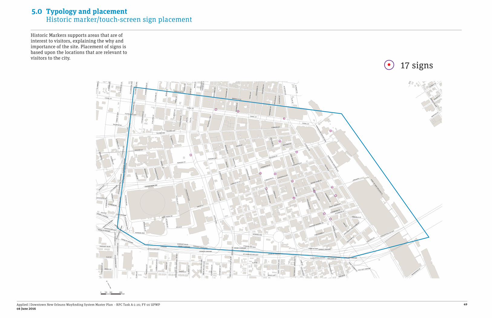
Applied | Downtown New Orleans Wayfinding System Master Plan - RPC Task A-2.16; FY-16 UPWP08 June 2016
49
5.0 Typology and placement Historic marker/touch-screen sign placement
Historic Markers supports areas that are of interest to visitors, explaining the why and importance of the site. Placement of signs is based upon the locations that are relevant to visitors to the city.
HOV
US90B E
US90B W
I-10
E
CANAL ST
CANAL ST
CANAL ST
CANAL ST
I-10
W
CLIO ST
CAM
P ST
POYDRAS ST
GRAVIER ST
CALLIOPE ST
BIENVILLE ST
BAR
ON
NE ST
S PETERS ST
MA
GAZIN
E ST
CAR
ON
DELET ST
ERATO ST
LA SALLE ST
LOYO
LA AVES R
AM
PART ST
PERDIDO ST
TULANE AVE
IBERVILLE ST
O'K
EEFE AVE
CONTI ST
EARHART BLVD
COMMON ST
FULTON ST
S RO
MAN
ST
SAINT JOSEPH ST
PORT OF NEW ORLEANS PL
SAIN
T CHA
RLES AVE
TCHOUPITOULAS ST
GIROD ST
HOWARD AVE
CLEVELAND AVE
UNION ST
S C
LAIB
OR
NE
AVE
S C
LAIB
OR
NE
AVE
OVE
RPA
SS
RO
YAL
ST
S DERB
IGNY ST
US90B EXIT
CAMP ST EXIT
ANDREW HIGGINS DR
LAFAYETTE ST
BOLIVA
R ST
BA
SIN
ST
I-10 E
ONRAMP
N PETER
S ST
DEC
ATU
R S
T
COMM
ERCE ST
CON
STANC
E ST
ELK
PL
SUGAR BOWL DR
US90B W ONRAMP
ANN
UNC
IATION
ST
JULIA ST
LOYOLA AVE EXIT
CH
AR
TRES
ST
BO
UR
BO
N S
T
DAVE DIXON DR
GAIENNIE ST
NOTRE DAME ST
FRERET ST
DA
UPH
INE
ST
TCHOUPITOULAS EXIT
MA
RA
IS S
T
BROOKLYN AVE
SLIDELL ST
CCC OUT ONRAMP
POYDR
AS PLA
ZA
TREM
E ST
POYD
RA
S EX
IT
EXC
HA
NG
E PL
US90B E ONRAMP
S CLA
IBO
RN
E EXIT
BU
RG
UN
DY
ST
CONVENTION CENTER BLVD
N R
AM
PAR
T ST
TECHE ST
CR
OZA
T ST
S VI
LLER
E ST
S DIAMOND STN DIAMOND ST
HOMER ST
POE ST
W STA
DIU
M D
R
EARHART BLVD EXIT
POEYFARRE ST
CLAR
A ST
JOHN CHURCHILL CHASE ST
NATCHEZ ST
PALMYRA ST
N FR
ON
T ST
CLA
IBO
RN
E O
NR
AM
P
SUPERDOME EXIT
N V
ILLE
RE
ST
N R
OM
AN
ST
N P
RIE
UR
ST
THALIA ST
S R
OB
ERTS
ON
ST
O'KEEFE AVE EXIT
N D
ERB
IGN
Y ST
ST CHARLES AVE EXIT
N R
OB
ERTS
ON
ST
PENN
ST
ELIZ
A ST
CHU
RCH
ST
S SA
RAT
OG
A ST
CYPRESS ST
CLAY ST
N C
LAIB
OR
NE
AVE
HENDERSON ST
SIM
ON
BO
LIVA
R A
VE
NEWTON ST
ROO
SEVE
LT W
AY
TRIANGLE ST
S LIBER
TY ST
I-10 W ONRAMP
CLI
NTO
N S
T
PRYT
AN
IA S
T
COLISEU
M ST
MA
GN
OLIA ST
CAR
RO
LL ST
S MAESTRI PL
N MAESTRI ST
DO
RSI
ERE
ST
PICAYUN
E PL
CAPDEVILLE ST
CA
NA
L ST
EXI
T
LE RO
UG
E ST
REV
EREN
D J
OH
N R
APH
AEL
JR
WAY
MA
RG
AR
ET P
L
DRY
AD
ES S
TO
RET
HA
CA
STLE
HA
LEY
BLV
D
SAINT THOMAS STC
LAR
A ST
S C
LAIB
OR
NE
EXIT
S LI
BER
TY S
T
US90B W ONRAMP
CONVENTION CENTER BLVD
N R
AM
PAR
T ST
CALLIOPE ST
CONSTANCE ST
JULIA ST
ERATO ST
S D
ERB
IGN
Y ST
S RO
BERTSO
N ST
TULANE AVE
IBERVILLE ST
MA
GNO
LIA ST
LAFAYETTE ST
S C
LAIB
OR
NE
AVE
US90B W ONRAMP
S CLA
IBOR
NE EXIT
S R
AM
PAR
T ST
S LI
BER
TY S
T
MA
GN
OLI
A ST
SAIN
T C
HA
RLE
S AV
E
BA
SIN
ST
HOWARD AVE
EARHART BLVD
US90B W ONRAMPCLIO ST CCC OUT ONRAMP
S SA
RAT
OG
A ST
ELK
PL
S C
LAIB
OR
NE
AVE
ERATO ST
US90B E ONRAMP
N C
LAIB
OR
NE
AVE
JULIA ST
FRER
ET S
T
S C
LAIB
OR
NE
AVE
OVE
RPA
SS
S D
ERB
IGN
Y ST
PERDIDO ST
US90B W ONRAMP
US90B E ONRAMP
TCHOUPITOULAS EXIT
SIM
ON
BO
LIVA
R A
VE
LAFAYETTE ST
BOLIVA
R ST
US90B E ONRAMP
CON
STANC
E ST
US90B W ONRAMP
CLAI
BORN
E O
NRAM
P
S R
OB
ERTS
ON
ST
0 300 600150Feet
17 signs

Applied | Downtown New Orleans Wayfinding System Master Plan - RPC Task A-2.16; FY-16 UPWP08 June 2016
50
5.0 Typology and placement Entry feature signs
Entry features or gateways serve to enhance the image of cities and districts. They identify when one has entered the area and provide hirarchy of entry roads. Gateways also serve to brand each district within the city.

Applied | Downtown New Orleans Wayfinding System Master Plan - RPC Task A-2.16; FY-16 UPWP08 June 2016
51
5.0 Typology and placement Entry feature sign placement
Entry features offer direction to a vehicular audience, they are located at key traffic decision points to give visitors the “we have arrived” feeling.
9 gateways
HOV
US90B E
US90B W
I-10
E
CANAL ST
CANAL ST
CANAL ST
CANAL STI-1
0 W
CLIO ST
CAM
P ST
POYDRAS ST
GRAVIER ST
CALLIOPE ST
BIENVILLE ST
BAR
ON
NE ST
S PETERS ST
MA
GAZIN
E ST
CAR
ON
DELET ST
ERATO ST
LA SALLE ST
LOYO
LA AVES R
AM
PART ST
PERDIDO ST
TULANE AVE
IBERVILLE ST
O'K
EEFE AVE
CONTI ST
EARHART BLVD
COMMON ST
FULTON ST
S RO
MAN
ST
SAINT JOSEPH ST
PORT OF NEW ORLEANS PL
SAIN
T CHA
RLES AVE
TCHOUPITOULAS ST
GIROD ST
HOWARD AVE
CLEVELAND AVE
UNION ST
S C
LAIB
OR
NE
AVE
S C
LAIB
OR
NE
AVE
OVE
RPA
SS
RO
YAL
ST
S DERB
IGNY ST
US90B EXIT
CAMP ST EXIT
ANDREW HIGGINS DR
LAFAYETTE ST
BOLIVA
R ST
BA
SIN
ST
I-10 E
ONRAMP
N PETER
S ST
DEC
ATU
R S
T
COMM
ERCE ST
CON
STANC
E ST
ELK
PL
SUGAR BOWL DR
US90B W ONRAMP
ANN
UNC
IATION
ST
JULIA ST
LOYOLA AVE EXIT
CH
AR
TRES
ST
BO
UR
BO
N S
T
DAVE DIXON DR
GAIENNIE ST
NOTRE DAME ST
FRERET ST
DA
UPH
INE
ST
TCHOUPITOULAS EXIT
MA
RA
IS S
T
BROOKLYN AVE
SLIDELL ST
CCC OUT ONRAMP
POYDR
AS PLA
ZA
TREM
E ST
POYD
RA
S EX
IT
EXC
HA
NG
E PL
US90B E ONRAMP
S CLA
IBO
RN
E EXIT
BU
RG
UN
DY
ST
CONVENTION CENTER BLVD
N R
AM
PAR
T ST
TECHE ST
CR
OZA
T ST
S VI
LLER
E ST
S DIAMOND STN DIAMOND ST
HOMER ST
POE ST
W STA
DIU
M D
R
EARHART BLVD EXIT
POEYFARRE ST
CLAR
A ST
JOHN CHURCHILL CHASE ST
NATCHEZ ST
PALMYRA ST
N FR
ON
T ST
CLA
IBO
RN
E O
NR
AM
P
SUPERDOME EXIT
N V
ILLE
RE
ST
N R
OM
AN
ST
N P
RIE
UR
ST
THALIA ST
S R
OB
ERTS
ON
ST
O'KEEFE AVE EXIT
N D
ERB
IGN
Y ST
ST CHARLES AVE EXIT
N R
OB
ERTS
ON
ST
PENN
ST
ELIZ
A ST
CHU
RCH
ST
S SA
RAT
OG
A ST
CYPRESS ST
CLAY ST
N C
LAIB
OR
NE
AVE
HENDERSON ST
SIM
ON
BO
LIVA
R A
VE
NEWTON ST
ROO
SEVE
LT W
AY
TRIANGLE ST
S LIBER
TY ST
I-10 W ONRAMP
CLI
NTO
N S
T
PRYT
AN
IA S
T
COLISEU
M ST
MA
GN
OLIA ST
CAR
RO
LL ST
S MAESTRI PL
N MAESTRI ST
DO
RSI
ERE
ST
PICAYUN
E PL
CAPDEVILLE ST
CA
NA
L ST
EXI
T
LE RO
UG
E ST
REV
EREN
D J
OH
N R
APH
AEL
JR
WAY
MA
RG
AR
ET P
L
DRY
AD
ES S
TO
RET
HA
CA
STLE
HA
LEY
BLV
D
SAINT THOMAS STC
LAR
A ST
S C
LAIB
OR
NE
EXIT
S LI
BER
TY S
T
US90B W ONRAMP
CONVENTION CENTER BLVD
N R
AM
PAR
T ST
CALLIOPE ST
CONSTANCE ST
JULIA ST
ERATO ST
S D
ERB
IGN
Y ST
S RO
BERTSO
N ST
TULANE AVE
IBERVILLE ST
MA
GNO
LIA ST
LAFAYETTE ST
S C
LAIB
OR
NE
AVE
US90B W ONRAMP
S CLA
IBOR
NE EXIT
S R
AM
PAR
T ST
S LI
BER
TY S
T
MA
GN
OLI
A ST
SAIN
T C
HA
RLE
S AV
E
BA
SIN
ST
HOWARD AVE
EARHART BLVD
US90B W ONRAMPCLIO ST CCC OUT ONRAMP
S SA
RAT
OG
A ST
ELK
PL
S C
LAIB
OR
NE
AVE
ERATO ST
US90B E ONRAMP
N C
LAIB
OR
NE
AVE
JULIA ST
FRER
ET S
T
S C
LAIB
OR
NE
AVE
OVE
RPA
SS
S D
ERB
IGN
Y ST
PERDIDO ST
US90B W ONRAMP
US90B E ONRAMP
TCHOUPITOULAS EXIT
SIM
ON
BO
LIVA
R A
VE
LAFAYETTE ST
BOLIVA
R ST
US90B E ONRAMP
CON
STANC
E ST
US90B W ONRAMP
CLAI
BORN
E O
NRAM
P
S R
OB
ERTS
ON
ST
0 300 600150Feet

Applied | Downtown New Orleans Wayfinding System Master Plan - RPC Task A-2.16; FY-16 UPWP08 June 2016
52
5.0 Typology and placement Future user scenarios
International businessman attending a conference and exhibition at the Convention Center
HOV
US90B E
US90B W
I-10
E
CANAL ST
CANAL ST
CANAL ST
CANAL ST
I-10
W
CLIO ST
CAM
P ST
POYDRAS ST
GRAVIER ST
CALLIOPE ST
BIENVILLE ST
BAR
ON
NE ST
S PETERS ST
MA
GAZIN
E ST
CAR
ON
DELET ST
ERATO ST
LA SALLE ST
LOYO
LA AVES R
AM
PART ST
PERDIDO ST
TULANE AVE
IBERVILLE ST
O'K
EEFE AVE
CONTI ST
EARHART BLVD
COMMON ST
FULTON ST
S RO
MAN
ST
SAINT JOSEPH ST
PORT OF NEW ORLEANS PL
SAIN
T CHA
RLES AVE
TCHOUPITOULAS ST
GIROD ST
HOWARD AVE
CLEVELAND AVE
UNION ST
S C
LAIB
OR
NE
AVE
S C
LAIB
OR
NE
AVE
OVE
RPA
SS
RO
YAL
ST
S DERB
IGNY ST
US90B EXIT
CAMP ST EXIT
ANDREW HIGGINS DR
LAFAYETTE ST
BOLIVA
R ST
BA
SIN
ST
I-10 E
ONRAMP
N PETER
S ST
DEC
ATU
R S
T
COMM
ERCE ST
CON
STANC
E ST
ELK
PL
SUGAR BOWL DR
US90B W ONRAMP
ANN
UNC
IATION
ST
JULIA ST
LOYOLA AVE EXIT
CH
AR
TRES
ST
BO
UR
BO
N S
T
DAVE DIXON DR
GAIENNIE ST
NOTRE DAME ST
FRERET ST
DA
UPH
INE
ST
TCHOUPITOULAS EXIT
MA
RA
IS S
T
BROOKLYN AVE
SLIDELL ST
CCC OUT ONRAMP
POYDR
AS PLA
ZA
TREM
E ST
POYD
RA
S EX
IT
EXC
HA
NG
E PL
US90B E ONRAMP
S CLA
IBO
RN
E EXIT
BU
RG
UN
DY
ST
CONVENTION CENTER BLVD
N R
AM
PAR
T ST
TECHE ST
CR
OZA
T ST
S VI
LLER
E ST
S DIAMOND STN DIAMOND ST
HOMER ST
POE ST
W STA
DIU
M D
R
EARHART BLVD EXIT
POEYFARRE ST
CLAR
A ST
JOHN CHURCHILL CHASE ST
NATCHEZ ST
PALMYRA ST
N FR
ON
T ST
CLA
IBO
RN
E O
NR
AM
P
SUPERDOME EXIT
N V
ILLE
RE
ST
N R
OM
AN
ST
N P
RIE
UR
ST
THALIA ST
S R
OB
ERTS
ON
ST
O'KEEFE AVE EXIT
N D
ERB
IGN
Y ST
ST CHARLES AVE EXIT
N R
OB
ERTS
ON
ST
PENN
ST
ELIZ
A ST
CHU
RCH
ST
S SA
RAT
OG
A ST
CYPRESS ST
CLAY ST
N C
LAIB
OR
NE
AVE
HENDERSON ST
SIM
ON
BO
LIVA
R A
VE
NEWTON ST
ROO
SEVE
LT W
AY
TRIANGLE ST
S LIBER
TY ST
I-10 W ONRAMP
CLI
NTO
N S
T
PRYT
AN
IA S
T
COLISEU
M ST
MA
GN
OLIA ST
CAR
RO
LL ST
S MAESTRI PL
N MAESTRI ST
DO
RSI
ERE
ST
PICAYUN
E PL
CAPDEVILLE ST
CA
NA
L ST
EXI
T
LE RO
UG
E ST
REV
EREN
D J
OH
N R
APH
AEL
JR
WAY
MA
RG
AR
ET P
L
DRY
AD
ES S
TO
RET
HA
CA
STLE
HA
LEY
BLV
D
SAINT THOMAS ST
CLA
RA
ST
S C
LAIB
OR
NE
EXIT
S LI
BER
TY S
T
US90B W ONRAMP
CONVENTION CENTER BLVD
N R
AM
PAR
T ST
CALLIOPE ST
CONSTANCE ST
JULIA ST
ERATO ST
S D
ERB
IGN
Y ST
S RO
BERTSO
N ST
TULANE AVE
IBERVILLE ST
MA
GNO
LIA ST
LAFAYETTE ST
S C
LAIB
OR
NE
AVE
US90B W ONRAMP
S CLA
IBOR
NE EXIT
S R
AM
PAR
T ST
S LI
BER
TY S
T
MA
GN
OLI
A ST
SAIN
T C
HA
RLE
S AV
E
BA
SIN
ST
HOWARD AVE
EARHART BLVD
US90B W ONRAMPCLIO ST CCC OUT ONRAMP
S SA
RAT
OG
A ST
ELK
PL
S C
LAIB
OR
NE
AVE
ERATO ST
US90B E ONRAMP
N C
LAIB
OR
NE
AVE
JULIA ST
FRER
ET S
T
S C
LAIB
OR
NE
AVE
OVE
RPA
SS
S D
ERB
IGN
Y ST
PERDIDO ST
US90B W ONRAMP
US90B E ONRAMP
TCHOUPITOULAS EXIT
SIM
ON
BO
LIVA
R A
VE
LAFAYETTE ST
BOLIVA
R ST
US90B E ONRAMP
CON
STANC
E ST
US90B W ONRAMP
CLAI
BORN
E O
NRAM
P
S R
OB
ERTS
ON
ST
John is looking forward to seeing New Orleans and is curious how far away it is from the airport to the city. He notices the public art and gateway sign as he exits the highway. Before he flew out from Panama City he downloaded the New Orleans Map App on his smartphone that enables him to search for restaurants.
He arrives at his hotel and is given a printed walking map that highlights all the major destinations including the convention center, where he is scheduled to be tomorrow. He notices it has the same map as his smartphone app and the kiosk in-front of the hotel too.
That evening he asks the hotel representative for a restaurant suggestion. He is able to find it on his smartphone app and is directed to Emrils in the Warehouse District. He notices that district ID sign and the kiosk maps along the way.
He thinks he has had a good first night in New Orleans and plans to return with his brother for his next vacation.

Applied | Downtown New Orleans Wayfinding System Master Plan - RPC Task A-2.16; FY-16 UPWP08 June 2016
53
5.0 Typology and placement Future user scenarios
HOV
US90B E
US90B W
I-10
E
CANAL ST
CANAL ST
CANAL ST
CANAL ST
I-10
W
CLIO ST
CAM
P ST
POYDRAS ST
GRAVIER ST
CALLIOPE ST
BIENVILLE ST
BAR
ON
NE ST
S PETERS ST
MA
GAZIN
E ST
CAR
ON
DELET ST
ERATO ST
LA SALLE ST
LOYO
LA AVES R
AM
PART ST
PERDIDO ST
TULANE AVE
IBERVILLE ST
O'K
EEFE AVE
CONTI ST
EARHART BLVD
COMMON ST
FULTON ST
S RO
MAN
ST
SAINT JOSEPH ST
PORT OF NEW ORLEANS PL
SAIN
T CHA
RLES AVE
TCHOUPITOULAS ST
GIROD ST
HOWARD AVE
CLEVELAND AVE
UNION ST
S C
LAIB
OR
NE
AVE
S C
LAIB
OR
NE
AVE
OVE
RPA
SS
RO
YAL
ST
S DERB
IGNY ST
US90B EXIT
CAMP ST EXIT
ANDREW HIGGINS DR
LAFAYETTE ST
BOLIVA
R ST
BA
SIN
ST
I-10 E
ONRAMP
N PETER
S ST
DEC
ATU
R S
T
COMM
ERCE ST
CON
STANC
E ST
ELK
PL
SUGAR BOWL DR
US90B W ONRAMP
ANN
UNC
IATION
ST
JULIA ST
LOYOLA AVE EXIT
CH
AR
TRES
ST
BO
UR
BO
N S
T
DAVE DIXON DR
GAIENNIE ST
NOTRE DAME ST
FRERET ST
DA
UPH
INE
ST
TCHOUPITOULAS EXIT
MA
RA
IS S
T
BROOKLYN AVE
SLIDELL ST
CCC OUT ONRAMP
POYDR
AS PLA
ZA
TREM
E ST
POYD
RA
S EX
IT
EXC
HA
NG
E PL
US90B E ONRAMP
S CLA
IBO
RN
E EXIT
BU
RG
UN
DY
ST
CONVENTION CENTER BLVD
N R
AM
PAR
T ST
TECHE ST
CR
OZA
T ST
S VI
LLER
E ST
S DIAMOND STN DIAMOND ST
HOMER ST
POE ST
W STA
DIU
M D
R
EARHART BLVD EXIT
POEYFARRE ST
CLAR
A ST
JOHN CHURCHILL CHASE ST
NATCHEZ ST
PALMYRA ST
N FR
ON
T ST
CLA
IBO
RN
E O
NR
AM
P
SUPERDOME EXIT
N V
ILLE
RE
ST
N R
OM
AN
ST
N P
RIE
UR
ST
THALIA ST
S R
OB
ERTS
ON
ST
O'KEEFE AVE EXIT
N D
ERB
IGN
Y ST
ST CHARLES AVE EXIT
N R
OB
ERTS
ON
ST
PENN
ST
ELIZ
A ST
CHU
RCH
ST
S SA
RAT
OG
A ST
CYPRESS ST
CLAY ST
N C
LAIB
OR
NE
AVE
HENDERSON ST
SIM
ON
BO
LIVA
R A
VE
NEWTON ST
ROO
SEVE
LT W
AY
TRIANGLE ST
S LIBER
TY ST
I-10 W ONRAMP
CLI
NTO
N S
T
PRYT
AN
IA S
T
COLISEU
M ST
MA
GN
OLIA ST
CAR
RO
LL ST
S MAESTRI PL
N MAESTRI ST
DO
RSI
ERE
ST
PICAYUN
E PL
CAPDEVILLE ST
CA
NA
L ST
EXI
T
LE RO
UG
E ST
REV
EREN
D J
OH
N R
APH
AEL
JR
WAY
MA
RG
AR
ET P
L
DRY
AD
ES S
TO
RET
HA
CA
STLE
HA
LEY
BLV
D
SAINT THOMAS ST
CLA
RA
ST
S C
LAIB
OR
NE
EXIT
S LI
BER
TY S
T
US90B W ONRAMP
CONVENTION CENTER BLVD
N R
AM
PAR
T ST
CALLIOPE ST
CONSTANCE ST
JULIA ST
ERATO ST
S D
ERB
IGN
Y ST
S RO
BERTSO
N ST
TULANE AVE
IBERVILLE ST
MA
GNO
LIA ST
LAFAYETTE ST
S C
LAIB
OR
NE
AVE
US90B W ONRAMP
S CLA
IBOR
NE EXIT
S R
AM
PAR
T ST
S LI
BER
TY S
T
MA
GN
OLI
A ST
SAIN
T C
HA
RLE
S AV
E
BA
SIN
ST
HOWARD AVE
EARHART BLVD
US90B W ONRAMPCLIO ST CCC OUT ONRAMP
S SA
RAT
OG
A ST
ELK
PL
S C
LAIB
OR
NE
AVE
ERATO ST
US90B E ONRAMP
N C
LAIB
OR
NE
AVE
JULIA ST
FRER
ET S
T
S C
LAIB
OR
NE
AVE
OVE
RPA
SS
S D
ERB
IGN
Y ST
PERDIDO ST
US90B W ONRAMP
US90B E ONRAMP
TCHOUPITOULAS EXIT
SIM
ON
BO
LIVA
R A
VE
LAFAYETTE ST
BOLIVA
R ST
US90B E ONRAMP
CON
STANC
E ST
US90B W ONRAMP
CLAI
BORN
E O
NRAM
P
S R
OB
ERTS
ON
ST
A couple on a port stop at the Julia St. Cruise Terminal
Matt and Emma arrive in New Orleans from their 8 day steamboat adventure and find a map kiosk at the port landing. They are able to locate the address to their hotel and take a taxi to the Inter Continental. In the hotel the concierge gives them a printed walking map of the city and helps them locate the tour they have booked in advance.
While on the tour the guide tells them about the great city smartphone app which can help them plan some activities and find a restaurant/bar that they are looking for. They use the app and directional signs which makes exploring easy. They decide to visit some art galleries in the Warehouse District.
That evening Matt notices on his phone app that he could buy a Jazzy Pass to take the Street Car. He surprises Emma the next morning with the news after the have beignets at Cafe’ Du Monde.
They are glad to be on land and have had a great first full day getting to know New Orleans. Emma wishes she had less time on the Steamboat and more time to explore New Orleans.

Applied | Downtown New Orleans Wayfinding System Master Plan - RPC Task A-2.16; FY-16 UPWP08 June 2016
54
5.0 Typology and placement Future user scenarios
Foodie traveling to the City for We Live To Eat Restaurant Week
HOV
US90B E
US90B W
I-10
E
CANAL ST
CANAL ST
CANAL ST
CANAL ST
I-10
W
CLIO ST
CAM
P ST
POYDRAS ST
GRAVIER ST
CALLIOPE ST
BIENVILLE ST
BAR
ON
NE ST
S PETERS ST
MA
GAZIN
E ST
CAR
ON
DELET ST
ERATO ST
LA SALLE ST
LOYO
LA AVES R
AM
PART ST
PERDIDO ST
TULANE AVE
IBERVILLE ST
O'K
EEFE AVE
CONTI ST
EARHART BLVD
COMMON ST
FULTON ST
S RO
MAN
ST
SAINT JOSEPH ST
PORT OF NEW ORLEANS PL
SAIN
T CHA
RLES AVE
TCHOUPITOULAS ST
GIROD ST
HOWARD AVE
CLEVELAND AVE
UNION ST
S C
LAIB
OR
NE
AVE
S C
LAIB
OR
NE
AVE
OVE
RPA
SS
RO
YAL
ST
S DERB
IGNY ST
US90B EXIT
CAMP ST EXIT
ANDREW HIGGINS DR
LAFAYETTE ST
BOLIVA
R ST
BA
SIN
ST
I-10 E
ONRAMP
N PETER
S ST
DEC
ATU
R S
T
COMM
ERCE ST
CON
STANC
E ST
ELK
PL
SUGAR BOWL DR
US90B W ONRAMP
ANN
UNC
IATION
ST
JULIA ST
LOYOLA AVE EXIT
CH
AR
TRES
ST
BO
UR
BO
N S
T
DAVE DIXON DR
GAIENNIE ST
NOTRE DAME ST
FRERET ST
DA
UPH
INE
ST
TCHOUPITOULAS EXIT
MA
RA
IS S
T
BROOKLYN AVE
SLIDELL ST
CCC OUT ONRAMP
POYDR
AS PLA
ZA
TREM
E ST
POYD
RA
S EX
IT
EXC
HA
NG
E PL
US90B E ONRAMP
S CLA
IBO
RN
E EXIT
BU
RG
UN
DY
ST
CONVENTION CENTER BLVD
N R
AM
PAR
T ST
TECHE ST
CR
OZA
T ST
S VI
LLER
E ST
S DIAMOND STN DIAMOND ST
HOMER ST
POE ST
W STA
DIU
M D
R
EARHART BLVD EXIT
POEYFARRE ST
CLAR
A ST
JOHN CHURCHILL CHASE ST
NATCHEZ ST
PALMYRA ST
N FR
ON
T ST
CLA
IBO
RN
E O
NR
AM
P
SUPERDOME EXIT
N V
ILLE
RE
ST
N R
OM
AN
ST
N P
RIE
UR
ST
THALIA ST
S R
OB
ERTS
ON
ST
O'KEEFE AVE EXIT
N D
ERB
IGN
Y ST
ST CHARLES AVE EXIT
N R
OB
ERTS
ON
ST
PENN
ST
ELIZ
A ST
CHU
RCH
ST
S SA
RAT
OG
A ST
CYPRESS ST
CLAY ST
N C
LAIB
OR
NE
AVE
HENDERSON ST
SIM
ON
BO
LIVA
R A
VE
NEWTON ST
ROO
SEVE
LT W
AY
TRIANGLE ST
S LIBER
TY ST
I-10 W ONRAMP
CLI
NTO
N S
T
PRYT
AN
IA S
T
COLISEU
M ST
MA
GN
OLIA ST
CAR
RO
LL ST
S MAESTRI PL
N MAESTRI ST
DO
RSI
ERE
ST
PICAYUN
E PL
CAPDEVILLE ST
CA
NA
L ST
EXI
T
LE RO
UG
E ST
REV
EREN
D J
OH
N R
APH
AEL
JR
WAY
MA
RG
AR
ET P
L
DRY
AD
ES S
TO
RET
HA
CA
STLE
HA
LEY
BLV
D
SAINT THOMAS ST
CLA
RA
ST
S C
LAIB
OR
NE
EXIT
S LI
BER
TY S
T
US90B W ONRAMP
CONVENTION CENTER BLVD
N R
AM
PAR
T ST
CALLIOPE ST
CONSTANCE ST
JULIA ST
ERATO ST
S D
ERB
IGN
Y ST
S RO
BERTSO
N ST
TULANE AVE
IBERVILLE ST
MA
GNO
LIA ST
LAFAYETTE ST
S C
LAIB
OR
NE
AVE
US90B W ONRAMP
S CLA
IBOR
NE EXIT
S R
AM
PAR
T ST
S LI
BER
TY S
T
MA
GN
OLI
A ST
SAIN
T C
HA
RLE
S AV
E
BA
SIN
ST
HOWARD AVE
EARHART BLVD
US90B W ONRAMPCLIO ST CCC OUT ONRAMP
S SA
RAT
OG
A ST
ELK
PL
S C
LAIB
OR
NE
AVE
ERATO ST
US90B E ONRAMP
N C
LAIB
OR
NE
AVE
JULIA ST
FRER
ET S
T
S C
LAIB
OR
NE
AVE
OVE
RPA
SS
S D
ERB
IGN
Y ST
PERDIDO ST
US90B W ONRAMP
US90B E ONRAMP
TCHOUPITOULAS EXIT
SIM
ON
BO
LIVA
R A
VE
LAFAYETTE ST
BOLIVA
R ST
US90B E ONRAMP
CON
STANC
E ST
US90B W ONRAMP
CLAI
BORN
E O
NRAM
P
S R
OB
ERTS
ON
ST
Justin, has been waiting over 6 month for that one week in September he gets to go to New Orleans to eat at his favorite event of the year. He uses his GPS to program in the hotels address which he found on the New Orleans web-site.
He arrives ready to go to find some good food grabs a brochure for restaurant week which has a printed walking map that looks just like the city kiosk maps. He finds a great dinner spot and enjoys walking the French Quarter for an hour.
As he gets to the highway exit he notices a large dynamic sign welcoming visitors to New Orleans - We Live To Eat Restaurant Week. He follows the directional signs to Canal Street where his hotel is located.
The next day Justin plans his itinerary with the brochure and makes time to visit the museums near the Warehouse District too. He enjoys military history and has a great time at the National WWII Museum.

6.0 Form variation studies

Applied | Downtown New Orleans Wayfinding System Master Plan - RPC Task A-2.16; FY-16 UPWP08 June 2016
56
6.0 Form variation studies Looking at concept design
Through the interaction with the Project Management Committee for the Stage 0 - wayfinding project it has been determined that the sign project will need to expand beyond the current geographic limits of the downtown.
The sign system will need to be able to adjust its character to the diversity of the cities districts. Therefore the concept designs as shown are not intended as a final solution for New Orleans but as a expression of various forms that will be further refined in the design development phase of work. The design development process will need to define a flexible and modular system to be implemented across a diverse range of rich character zones that make up the City of New Orleans.
The concept designs as shown in the following pages are a study of forms that will enlighten the future design development of the wayfinding program. Each of the components of the signs demonstrate treatments that can be, if accepted by client team, added to a modular sign system. To make the system economical it is paramount that it be modular in a way that district signs can be recognizable to the user as seamless; but have its own unique character elements.
The architectural form, graphics and information on the frame all help create a character that may be adapted in minor ways to be uniquely branded for a bespoke solution for each district. While it is paramount that the design be distinguished looking; consistency throughout the city is also important for the signs to be recognizable by the visiting audience seamless journey. Applied has therefore provided four sign concept and form studies which have unique attributes that can be adjusted to provide a distinctive element for character areas.

Applied | Downtown New Orleans Wayfinding System Master Plan - RPC Task A-2.16; FY-16 UPWP08 June 2016
57
6.0 Form variation studiesCharacter study - Modern and geometric
ANGLES
minimalism
modern
GEOM
ETRIC

Applied | Downtown New Orleans Wayfinding System Master Plan - RPC Task A-2.16; FY-16 UPWP08 June 2016
58
6.0 Form variation studiesCharacter study - Modular brand
COLO
RS
unifiedSIMPLE
historic

Applied | Downtown New Orleans Wayfinding System Master Plan - RPC Task A-2.16; FY-16 UPWP08 June 2016
59
6.0 Form variation studies Character: Modern and geometric
Form 1 Form 2
Form Variation Studies
1’
2’
3’
4’
5’
6’
7’
8’
9’
10’
11’
12’
13’
14’
15’
16’
17’
18’
OX
FO
RD
ST
RE
ET
Bond St reet
St Chr istoph e r
Ca ve ndis h
Mar yl e bon eVillag e
Portma n
G r o s ve no r
Sout hMolto n
M A Y F A I R
M A R Y L E B O N E
R E G E N T’SPAR K
PA D D I N G T O N
B E L G R AV I A
H Y D EPA R K
MA R Y L E B O N E
SO H O
F I T Z R O V I A
MAY FA I R
ST J AM E S’SC O V E N TG A R D E N
WAREHOUSE DISTRICTJulia Street
WAREHOUSE DISTRICTNational WWII MuseumOgden Museum of Art
FRENCH QUARTERConvention CenterCanal Street
GARDEN DISTRICTCity Hall
Saeger Theater
OX
FO
RD
ST
RE
ET
Bond St reet
St Chr istoph e r
Ca ve ndis h
Mar yl e bon eVillag e
Portma n
G r o s ve no r
Sout hMolto n
M A Y F A I R
M A R Y L E B O N E
R E G E N T’SPAR K
PA D D I N G T O N
B E L G R AV I A
H Y D EPA R K
MA R Y L E B O N E
SO H O
F I T Z R O V I A
MAY FA I R
ST J AM E S’SC O V E N TG A R D E N
WAREHOUSE DISTRICT
Julia Street
WAREHOUSE DISTRICTNational WWII MuseumOgden Museum of Art
FRENCH QUARTERConvention CenterCanal Street
GARDEN DISTRICTCity Hall
Saeger Theater
Canal Street Historic District
Lorem ipsum dolor sit amet, consectetuer adipiscing elit. Nam cursus. Morbi ut mi. Nullam enim leo, egestas id, condimentum at, laoreet mattis, massa. Sed eleifend nonummy diam. Praesent mauris ante, elementum et, bibendum at, posuere sit amet, nibh. Duis tincidunt lectus quis dui viverra vestibulum. Suspendisse vulputate aliquam dui. Nulla elementum dui ut augue. Aliquam vehicula mi at mauris. Maecenas placerat, nisl at consequat rhoncus, sem nunc gravida justo, quis eleifend arcu velit quis lacus. Morbi magna magna, tincidunt a, mattis non, imperdiet vitae, tellus. Sed odio est, auctor ac, sollicitudin in, consequat vitae, orci. Fusce id felis. Vivamus sollicitudin.Lorem ipsum dolor sit amet, consectetuer
adipiscing elit. Nam cursus. Morbi ut mi. Nullam enim leo, egestas id, condimentum at, laoreet mattis, massa. Sed eleifend nonummy diam. Praesent mauris ante, elementum et, bibendum at, posuere sit amet, nibh. Duis tincidunt lectus quis dui viverra vestibulum. Suspendisse vulputate aliquam dui. Nulla elementum dui ut augue. Aliquam vehicula mi at mauris. Maecenas placerat, nisl at consequat rhoncus, sem nunc gravida justo, quis eleifend arcu velit quis lacus. Morbi magna magna, tincidunt a, mattis non, imperdiet vitae, tellus. Sed odio est, auctor ac, sollicitudin in, consequat vitae, orci. Fusce id felis. Vivamus sollicitudin.
Canal Street Historic District
Lorem ipsum dolor sit amet, consectetuer adipiscing elit. Nam cursus. Morbi ut mi. Nullam enim leo, egestas id, condimentum at, laoreet mattis, massa. Sed eleifend nonummy diam. Praesent mauris ante, elementum et, bibendum at, posuere sit amet, nibh. Duis tincidunt lectus quis dui viverra vestibulum. Suspendisse vulputate aliquam dui. Nulla elementum dui ut augue. Aliquam vehicula mi at mauris. Maecenas placerat, nisl at consequat rhoncus, sem nunc gravida justo, quis eleifend arcu velit quis lacus. Morbi magna magna, tincidunt a, mattis non, imperdiet vitae, tellus. Sed odio est, auctor ac, sollicitudin in, consequat vitae, orci. Fusce id felis. Vivamus sollicitudin.
Lorem ipsum dolor sit amet, consectetuer adipiscing elit. Nam cursus. Morbi ut mi. Nullam enim leo, egestas id, condimentum at, laoreet mattis, massa. Sed eleifend nonummy diam. Praesent mauris ante, elementum et, bibendum at, posuere sit amet, nibh. Duis tincidunt lectus quis dui viverra vestibulum. Suspendisse vulputate aliquam dui. Nulla elementum dui ut augue.
French QuarterDowntown
Medical DistrictWarehouse District
French QuarterDowntown
Medical DistrictWarehouse District
This sign design is built on a minimalistic style and clean frame. The color of the sign face, graphics and frame design can change by district.
This sign design is built on a modern style and artistic geometry. The structure is layered to demonstrate a playful dimensionality from the front to rear panel. Background colors and additive branding elements can change by district.

Applied | Downtown New Orleans Wayfinding System Master Plan - RPC Task A-2.16; FY-16 UPWP08 June 2016
60
6.0 Form variation studiesCharacter: Modular
AL KHO
R HIG
HW
AY
AL KH
OR H
IGH
WAY
AL KH
OR H
IGH
WAY
Crescent trail
Golf trail
Qetaifan trail
Seef Lusail trail
Wadi trail
Waterfront trail
NORTH LUSAIL
QETAIFANISLANDS CENTRAL
LUSAIL
SOUTH LUSAIL You are here
Doha
Al Khor
MohammedTown Center
Doha
Crescent trail
Qetaifan trail
Golf trail
Seef Lusail trail
Wadi trail
Waterfront trail
Historic DistrictLafayette Square
Medical District
Superdome
Arena
Immaculate ConceptionChurch
Frech Quarter
Bourbon St.
Julia Street
Warehouse District
Convention Center
Cruise Terminals
Riverwalk
Canal Street Historic District
OX
FO
RD
ST
RE
ET
Bond St reet
St Chr istoph e r
Ca ve ndis h
Mar yl e bon eVillag e
Portma n
G r o s ve no r
Sout hMolto n
M A Y F A I R
M A R Y L E B O N E
R E G E N T’SPAR K
PA D D I N G T O N
B E L G R AV I A
H Y D EPA R K
MA R Y L E B O N E
SO H O
F I T Z R O V I A
MAY FA I R
ST J AM E S’SC O V E N TG A R D E N
WAREHOUSE DISTRICTNational WWII MuseumOgden Museum of Art
FRENCH QUARTERConvention CenterCanal Street
GARDEN DISTRICTCity Hall
Saeger Theater
French QuarterDowntown
Medical DistrictWarehouse District
Lorem ipsum dolor sit amet, consectetuer adipiscing elit. Nam cursus. Morbi ut mi. Nullam enim leo, egestas id, condimentum at, laoreet mattis, massa. Sed eleifend nonummy diam. Praesent mauris ante, elementum et, bibendum at, posuere sit amet, nibh. Duis tincidunt lectus quis dui viverra vestibulum. Suspendisse vulputate aliquam dui. Nulla elementum dui ut augue. Aliquam vehicula mi at mauris. Maecenas placerat, nisl at consequat rhoncus, sem nunc gravida justo, quis eleifend arcu velit quis lacus. Morbi magna magna, tincidunt a, mattis non, imperdiet vitae, tellus. Sed odio est, auctor ac, sollicitudin in, consequat vitae, orci. Fusce id felis. Vivamus sollicitudin.
Canal Street Historic District
Lorem ipsum dolor sit amet, consectetuer adipiscing elit. Nam cursus. Morbi ut mi. Nullam enim leo, egestas id, condimentum at, laoreet mattis, massa. Sed eleifend nonummy diam. Praesent mauris ante, elementum et, bibendum at, posuere sit amet, nibh. Duis tincidunt lectus quis dui viverra vestibulum. Suspendisse vulputate aliquam dui. Nulla elementum dui ut augue. Aliquam vehicula mi at mauris. Maecenas placerat, nisl at consequat rhoncus, sem nunc gravida justo, quis eleifend arcu velit quis lacus. Morbi magna magna, tincidunt a, mattis non, imperdiet vitae, tellus. Sed odio est, auctor ac, sollicitudin in, consequat vitae, orci. Fusce id felis. Vivamus sollicitudin.
Form 3 Form 4
Form Variation Studies
1’
2’
3’
4’
5’
6’
7’
8’
9’
10’
11’
12’
13’
14’
15’
16’
17’
18’
French QuarterDowntown
Medical DistrictWarehouse District
This clean boxed design is built heavily branded architecture that highlights the district identity. The graphics elements at the top and vertical striping provide a unique identity for each district.
This boldly colored design is built on a subtle branded architecture that highlights the district identity. One simple graphic elements at the top provides identity for each district.

Applied | Downtown New Orleans Wayfinding System Master Plan - RPC Task A-2.16; FY-16 UPWP08 June 2016
61
6.0 Form variation studies Material selection
HIGH PRESSURE LAMINATESub-surface laminate panel that is impervious to moisture,UV rays, scratching and graffiti. Warranted not to colourfade for 12 to 15 years based upon manufacturer. High sandabrasion may cause clouding of laminate.
VINYL SURFACESPoor colours for sunny environments include black, dark reds, and dark blues will get the most gradation and will be noticeable faded in a 5 years. Protective surfacetreatment includes graffiti resistant clear coatings.
PORCELAIN ENAMELFused graphics on a steel substrate make porcelain enamel a very durable material. Resistant to vandalism, UV raysand is durable against vandalism and abrasion.
METALMild Steel and aluminium should be coated to prevent weathering damage. Powder coating and anodizing will give an even hard wearing finish. Stainless steel should be specified of a grade suitable for a marine environment.
Durable Materials
When designing a wayfinding system it is imperative that thematerial selection matches the environmental conditions inwhich they will exist Specifications of durable materials for thesign program shall take into account the coastal environment, temperatures and climate in the New Orleans. In all cases the manufacturerguidelines will be the primary reference for material suitability.
The weather processes materials are exposed to include:
• UV radiation from sun exposure
• High temperature fluctuation from the extreme hot to cool
• Sand abrasions from the coastal environment
• Salt erosion
• High winds
• Vandalism
DDDDDDDDDDDDDDDDDDDDDDDDDDDDDDDDDDDDDDDDDDDDDDDDDDDDDDDDDDDDDDDDDDDDDDDDDDDDiiiiiiiiiiiiiiiiiiiiiiiiiiiiiiiiiiiiiiiiiiiiiiiiiiiiiiiiiiiigggggggggggggggggggggggggggggggggggggggggggggggggggggggggggggggggiiiiiiiiiiiiiiiiiiiittttttttttttttttttttttttttttttaaaaaaaaaaaaaaaaaaaaaaaaaallllllllllllllllllll PPPPPPPPPPPPPPPPPPPPPPPPPPPPPPPPPPPPPPPPPPPPPPPPPPPPPPPPPPPPPPPPPPPPPPPPPPPPrrrrrrrrrrrrrrrrrrrrrrrrrrrrrrrrrrrrrrrrrrrrrrrrrrriiiiiiiiiiiiiiiiiiiiiiiiiiiiiiiiiinnnnnnnnnnnnnnnnnnnnnnnnnnnnnnnnnnnnnnnnnnnttttttttttttttttttttttttttttttttttttttttttttttttttttteeeeeeeeeeeeeeeeeeeeeeddddddddddddddddddd GGGGGGGGrrrrrrraaaaaaaappppphhhhhiiiiiccccccccccc DDDDDDDDDDDDDDDDDDDDDDDDDDDDDDDDDDDDDDDDDDDDDDDDDDDDDDDDDDDDDDDDDDDDDDDDDDDDiiiiiiiiiiiiiiiiiiiiiiiiiiiiiiiiiiiiiiiiiiiiiiiiiiiiiiiiiiiigggggggggggggggggggggggggggggggggggggggggggggggggggggggggggggggggiiiiiiiiiiiiiiiiiiiittttttttttttttttttttttttttttttaaaaaaaaaaaaaaaaaaaaaaaaaallllllllllllllllllll PPPPPPPPPPPPPPPPPPPPPPPPPPPPPPPPPPPPPPPPPPPPPPPPPPPPPPPPPPPPPPPPPPPPPPPPPPPPrrrrrrrrrrrrrrrrrrrrrrrrrrrrrrrrrrrrrrrrrrrrrrrrrrriiiiiiiiiiiiiiiiiiiiiiiiiiiiiiiiiinnnnnnnnnnnnnnnnnnnnnnnnnnnnnnnnnnnnnnnnnnnttttttttttttttttttttttttttttttttttttttttttttttttttttteeeeeeeeeeeeeeeeeeeeeeddddddddddddddddddd GGGGGGGGrrrrrrraaaaaaaappppphhhhhiiiiiccccccccccc

Applied | Downtown New Orleans Wayfinding System Master Plan - RPC Task A-2.16; FY-16 UPWP08 June 2016
62
6.0 Form variation studies Sample rendering - Route support sign
Minimalistic and clean frame design with brushed aluminium surround, porcelain enamel modular double sided graphics.
Modern design with geometric painted aluminium single piece bent panel. Screen printed directional and digital high pressure laminate flush to surface map graphics.
Historic and decorative design with painted aluminium boxed cabinets. Screen printed directional and digital high pressure laminate modular unit map graphic inserts.
Branded design with boxed modular painted aluminium cabinet. Screen printed directional and/or digital high pressure laminate map graphic inserts.

Applied | Downtown New Orleans Wayfinding System Master Plan - RPC Task A-2.16; FY-16 UPWP08 June 2016
63
6.0 Form variation studies Sample rendering - Vehicular support sign
Minimalistic and clean framed symmetrical design with brushed aluminium surround, painted background with retro-reflective sign face per MUTCD requirements.
Modern geometric cantilevered design with district specific coloring. Sign face painted or vinyl colored with retro-reflective sign face.
Historic decorative design with district icon painted aluminium on frame-mounted panel. Sign face painted or vinyl colored with retro-reflective sign face.
Branded symmetrical design painted aluminium or boxed cabinet. Sign face painted or vinyl colored with retro-reflective sign face.

7.0 Action plan and costing

Applied | Downtown New Orleans Wayfinding System Master Plan - RPC Task A-2.16; FY-16 UPWP08 June 2016
65
7.0 Action plan and costing Project plan overview
– New Orleans to agree that strategy and concepts outlined in this document is correct way forward
snoitpo 20 esahP 10 esahP
project 3
WayfindingSystem Implementation
project 5
Accessible mapping
project 6
Downloadable mapsproject 7
iPhone Application
project 4
Printed walking maps
project 1
Detailed strategies
DetailedStrategy
DesignDevelopment
Stage 0
Feasibilty
Study
project 2
LansdowneRoundabout
Richmond HillRoundabout
Bath HillRoundabout Russell-Cotes
Art Gallery &Museum
East CliffLiftEast Cliff
Zig-Zag
BeaconSteps
West CliffLift
St Paul’sRoundabout
St Swithun’sRoundabout
St Peter’s
Bournemouth StationRoundabout
b.i.cRoundabout
St Peter’sChurch
nodnoLesuoH
ehTegelloC
HorseshoeCommon Rbt
BournemouthPier
Pavilion
Bournemouth WestRoundabout
St Stephen’sChurch
DurleyRoundabout
Library
St Michael’sRoundabout
TownHall
htuomenruoBnoollaB
The
BournemouthInternational
Centre(b.i.c.)
Future options
Master map
t c h u r c h r o a d
n r o a d
annerley
rd
l ansdowne
r oa
we s
s e xw a y
w e l l i n g tt oss snnr
r o a
r o a d
we s
s e xw a y
os s
knyvetgarden

Applied | Downtown New Orleans Wayfinding System Master Plan - RPC Task A-2.16; FY-16 UPWP08 June 2016
66
7.0 Action plan and costing Next steps
Project Plan
We envision a multi-modal signage strategy for New Orleans, which can be taken forward with the following projects.
Strategy agreement and refining
Phase 1 – Final strategy and cost
— Agree that the strategy and recommendations outlined in Section 5.0 of this document are the correct way forward for the project.
— Applied will provide New Orleans with a district phased implementation cost/budget plan.
Project 1
Creating a MasterMap®
— Applied to develop a master map of New Orleans. This is the important initial phase which will create a master map of the Central Business District and immediate surroundings.
— The MasterMap® will be royalty-free and once created will belong to New Orleans with no limit to reproduction numbers or online restrictions.
— The map is created using aerial photography.
— It includes GIS coding which is necessary to create online maps and iPhone applications.
— Further mapping outputs can be created from the original MasterMap® including; iPhone Applications, Accessible Printed Maps, Online Accessible Maps, website, online journey planning, printed walking maps, printed shopper maps with shop locations and restaurants, printed museum information and route maps, travel information.
Costs
Through our extensive experience in developing city base maps, we have calculated the cost of the detailed mapping layer to be $24,000 per square kilometre. We suggest that the area covered for New Orleans base mapping should be 5 square kilometres. This gives us a predicted cost for the MasterMap® of $130,000.
Timing - 3 months
Project 2
Refining the Strategy and Detailed Design
This will include work being undertaken by Applied to produce refined and detailed design for the project. This should include a Vehicular Signage Strategy, a Public Transport Signage Strategy and a Pedestrian Signage Strategy.
Costs
— Vehicular Signage Design Development – $95,000
— Gateway Signage Design Development – $55,000
— Heritage Signage Design Development – $60,000
— Pedestrian Signage Design Development – $75,000
Timing - 6/8 weeks

Applied | Downtown New Orleans Wayfinding System Master Plan - RPC Task A-2.16; FY-16 UPWP08 June 2016
67
7.0 Action plan and costing Next steps
Project Plan - Cont’d
Project 3
Wayfinding System Implementation
Following on from the signage strategy, Applied would develop and implement an on street signage system which would run parallel to the vehicular and gateway and heritage signage systems to encourage walking and raise awareness of facilities available within the Central Business District.
Due to the complexity of this project, it is very difficult at this stage to put costs to this phase. For the purpose of this indicative costings we have looked at our Ipswichprovided a ballpark figure. In section 5.0 it shows an indicative sign placement for the sign types which can be implemented in phases.
There is a choice between a standard and a bespoke product for all of these sign types.
Costs
Counting up the indicative numbers of signs we estimate a cost of $2,515,380 should be earmarked for the existing sign system to be removed and the newly designed on-street signage system to be implemented. This will include the installation of 9 welcome signs, 17 historic markers, 135 vehicular directionals and 165 pedestrian directionals in the ground.
Timing - Allow a period of nine months from the funding release to installing the signs in the ground. A detailed schedule can be refined when the design of signs has been agreed.
Project 4
Printed Walking Maps
Using the developed MasterMap® as a base map, we can develop a series of printed maps catered for specific user groups.
At this stage we can forsee two initial formats:
— a single-sided Walk New Orleans map. This is intended for used by and distributed to all hotels in the city, and has limited extra information.
— A double sided and folded pocket size Walk New Orleans map, text and images on reverse to be supplied by New Orleans Marketing. This would be widely distributed, especially at arrival points and with retailers.
Costs
— Indicative design and artwork costs are between $10,000-15,000
Timings
Allow 4-6 weeks for design, client consultation, refinement and final artwork, allow 1–2 weeks.
Project 5
Accessible Mapping
— Accessibility versions of the base map should be developed to cover the DDD area. The MasterMap® can be used as the base map. The accessibility versions may revise the appearance of the maps in terms of colour, type size, etc. Additional content is also likely to be added where this is considered useful.
— It is likely that 2 different accessibility map bases will be required, for example to cater for people with mobility impairments and to cater for people with visual impairments.
— The specific requirements of the accessibility maps should be
established in consultation with the New Orleans access officers.
— The outputs are a series of downloadable maps (likely to be 8.5 x 11) crops for a given area, adapted to suit low quality black and white printing.)
— The accessible maps have to be developed in line with accessible guidelines and should include various consultations with access officers and target user groups.
Costs
Indicative figure is approximately $30,000 which will include consultation, design development and alteration of the MasterMap® base layer and development of printed and downloadable outputs.
Timings
Depending on the length and detail of consultations undertaken we should allow 10 weeks.

Applied | Downtown New Orleans Wayfinding System Master Plan - RPC Task A-2.16; FY-16 UPWP08 June 2016
68
7.0 Action plan and costing Cost estimate for fabrication - Project #3
type description quantity cost per unit sub-total install (ea) total
A
B
C
D
Pedestrian Directional 155
Vehicular Directional 135
Historic Marker 17
Gateway Feature 9
$4,500
$5,800
$2,800
$697,500
$783,000
$47,600
$220,500
$500
$800
$350
$3,000
$775,000
$891,000
$53,550
$247,500
Total Cost
subtotal
$24,500
$2,455,380
20% Contingency
Removal of existing way�nding signs (5-gateways, 81-vehicual, 35, parking, 76-pedestrian)
$409,230
$79,100
$2,046,150
removal
Project #3 - Way�nding system implementation costs

Applied | Downtown New Orleans Wayfinding System Master Plan - RPC Task A-2.16; FY-16 UPWP08 June 2016
69
7.0 Action plan and costing Cost estimate for next steps
$2,455,380Project #3 - Waynding system implementation 9 months
Project #2 - Rening the Strategy and Detailed Design 2 months
Project #1 - Creating a MasterMap® 3 months
$285,000
$130,000
Project #5 - Accessible maps 2 months
Project #4 - Printed walking maps 1.5 months
$30,000
Project #6 - Downloadable maps TBD $12,000
Project #7 - Moble device applications TBD TBD
$15,000
Project # - Desription Timeline Cost

APPENDIX A

Applied | Downtown New Orleans Wayfinding System Master Plan - RPC Task A-2.16; FY-16 UPWP08 June 2016
A2
APPENDIX A Meeting notes
DDD Wayfinding Signage Study Update Project Management Meeting #1
Thursday, February 18, 2016 9:00am
Agenda: I. IntroductionsII. Background about Applied Wayfinding III. Review Scope of Work and Expectations
a. TASK 1: Project Management Committee i. Full group PMC Meeting #1: Today
ii. Various one-on-one conversations with PMC members throughout the processiii. Full group PMC Meeting #2: Present design alternatives iv. Full group PMC Meeting #3: At end of project to present findings
b. TASK 2: Existing and proposed sign destinations and directional needsi. Sign locations
ii. Sign aestheticiii. Updatable formativ. What should be included on signs (sites of interest, transit, future bike share, bike
routes) v. Hierarchy of what should be on signs
c. TASK 3: Deficiency analysisi. Field visual inspection of signs and content
ii. Identify what can be salvaged (e.g. sign posts) d. TASK 4: Planning and conceptual design
i. Overall wayfinding signage update master plan, including other amenities (benches, trash receptacles, bike racks, etc.) to be evaluated by PMC
ii. Visualizations of proposed improvements and conceptual design alternative detailse. TASK 5: Prepare conceptual plans for PMC review
i. Include as accurate as possible of cost estimates f. TASK 6: Prepare draft report to distribute to PMC (including associated costs for conceptual
plans)g. TASK 7: Final Stage 0 Feasibility Study
IV. Timeline: work to be complete by end of JuneV. Preliminary review of existing systemVI. Discussion points
a. What should be included on the signs? Should there be a hierarchy?b. DOTD, DPW, and CPC restrictions on signage? c. Other questions
VII. Other Matters

Applied | Downtown New Orleans Wayfinding System Master Plan - RPC Task A-2.16; FY-16 UPWP08 June 2016
A3
APPENDIX A Meeting notes
PMC Meeting 1 - Wayfinding Workshop9am - 10:30am - Thursday, 18- February, 2016
Attendees: Meredith Soniat, Richard McCall, Cameron Bonnett, Stephanie Kreller, Rox’e Homstad, Walter Brooks, Long (LA-DOT), Alan,Le Bao, William Gilchrist, Kurt Weigle, Stephen Read, Jonathan Mugmon.
Agenda: Project Management Meeting #1
Item Notes Action (dates Suggested)
1 Introductions2 Approach to project
3 Review of Scope
4 Review of Schedule5 Open discussion - Goals and Objectives6 Existing Conditions Review (vehicular & pedestrian)7 Best practices
Detailed Notes:
- Provide the ability for public to “get lost” and find their way as necessary.- Should make people comfortable getting lost.- Scoped area for wayfinding project is DDD area; not Medical District, Uptown and French Quarter which is a start but will leave gaps.- Design of the physical sign elements will need to work with the architectural standards that may match individual district character (River, Historic or Business).- Nomenclature review will be important towards expansion of the system.- Must know requirements of federal funds.- Wayfinding is an important economic development issue.- Planning wayfinding routes shall be based upon a quality experience not fastest route from A to B.- Possibly explore fewer wayfinding touch points; for richer informational ones.
applied_wayfinding information design
london new york vancouver seoul
300 Park AvenueOrlando, Florida 32789Tel [email protected]
www.appliedwayfinding.com
aig Edenspiekermann Limited Registered no. 07672025vat no. 114348045
applied_wayfinding information design
london new york vancouver seoul orlando
300 Park AvenueOrlando, Florida 32789Tel [email protected]
www.appliedwayfinding.com
aig Edenspiekermann Limited Registered no. 07672025vat no. 114348045
RPC Task A-2.16 DDD
Meeting 1 - Stakeholder Workshop1pm- 1:45pm - Thursday, March 10, 2016
Attendees: Meredith Soniat (RPC), Allen Yrle (NOLA DPW), Bao “Long” Le (DOTD), Jonathan Mugmon (Applied Wayfinding), Ana Oropeza (Applied Wayfinding).
Detailed Notes:
- Public works is not currently maintaining the existing signs. DDD is probably in charge of maintenance now and probably will be for the new system-DPW capability allows them to make 2’x4’. Wayfinding signs large format won’t allow them to make or maintain in shop- Direct burial is how signs are currently installed and agreed for future system- There is currently not a standard on sign location. The signs are put up where there is place/room- Challenges on sign implementation include locating signs so they don’t interfere with pedestrians- An 18” clearance from curb was agree by DOTD- Construction drawings for the existing wayfinding system were requested by Ap-plied; DDD to follow-up- All signs are banded to poles- No objection from DOTD to add design/color to back of sign- Standard speed limit: 25 mph for undivided roads 35 mph for divided roads - 4” character approved by DOTD for roads with limits under 45 mph- Direct Burial approved by DOTD. For urban settings break-away is not necessary- MUTCD 2009 followed by Louisiana. Font allowed Highway Gothic (C, D, E). Follow guidelines for destination and location requirements- Applied to develop destination criteria- DOTD will maintain signs located on DOT roads (Claiborne and Calliope)- Sign removal plan will be provided by Applied. There is no concern from DOTD on removing green or brown signs to eliminate redundancies - DPW is not concern about what goes on signs. City planning will have some regula-tions on destinations (sign codes) - In some locations there will need to be a relocation or removal of trees. Depending on type and age of tree this might be allowed. Coordination with City Parks and Planning Department will be needed

Applied | Downtown New Orleans Wayfinding System Master Plan - RPC Task A-2.16; FY-16 UPWP08 June 2016
A4
APPENDIX A Meeting notes
applied_wayfinding information design
london new york vancouver seoul orlando
300 Park AvenueOrlando, Florida 32789Tel [email protected]
www.appliedwayfinding.com
aig Edenspiekermann Limited Registered no. 07672025vat no. 114348045
RPC Task A-2.16 DDD
Meeting 2 - Stakeholder Workshop2pm- 2:45pm - Thursday, March 10, 2016
Attendees: Meredith Soniat (RPC), Richard McCall (DDD), Jennifer Ruley (NOLA DPW), Justine Augustine (RTA), Mark Major (RTA), Jonathan Mugmon (Applied Wayfinding), Ana Oropeza (Applied Wayfinding).
Detailed Notes:
- Major Pedestrian and Bike routes and corridors were marked by Jennifer-Lafayette St. is really not a corridor and the street might be too narrow for any directional information. The interest on this street relies on it’s history- Moving traffic from Convention Center to Tchoupitoulas is currently an issue- Starting April 15 a new system will runs from UPT to the airport and will affect heavily the Downtown District- Highest traffic stops is St Charles & Canal- Show street cars on map and bus stops, but ok not to show bus routes- The Ferry terminal will change and be part of the Tricentennial plaza - Lafitte Greenway currently started a wayfinding system (bike)- Destinations were discuss. A list of destinations will be provided by Applied for approval
applied_wayfinding information design
london new york vancouver seoul orlando
300 Park AvenueOrlando, Florida 32789Tel [email protected]
www.appliedwayfinding.com
aig Edenspiekermann Limited Registered no. 07672025vat no. 114348045
RPC Task A-2.16 DDD
Meeting 1 - Stakeholder Workshop1pm- 1:45pm - Thursday, March 10, 2016
Attendees: Meredith Soniat (RPC), Allen Yrle (NOLA DPW), Bao “Long” Le (DOTD), Jonathan Mugmon (Applied Wayfinding), Ana Oropeza (Applied Wayfinding).
Continuation:
- Work with Parks and Parkways Dept and DDD when dealing with street trees in sight lines- Overhead structures on downtown must have at least an 18’ clearance because of parades. (17’ clear tents) 18’10” is the min. for street lights based on the height of the red light- DPW express no need for dynamic messages on their department- No city parking problems in city. Police will direct traffic when needed- Max of 3 destinations per sign. 4 destinations will be allowed when needed to avoid adding a sign (reduce sign clutter)- The whole sign face needs to be reflective
Signs to be:
• Directburialinstallation
• 18inchesfromcurb
• 4incharacter(HighwayGothic)onVDsigns
• Overheadclearance18ft
• Max4destinations(preferred3)onVDsigns
• ReflectivesignfaceonVDsigns
• Systemshouldleveragedistrict,riverandlakelegibility
• Provideemergencycontactinfo
• Consistentdesignthroughout;w/cityminorchangesperdistrict
• Integratewithbusandbikesystems

Applied | Downtown New Orleans Wayfinding System Master Plan - RPC Task A-2.16; FY-16 UPWP08 June 2016
A5
APPENDIX A Meeting notes
applied_wayfinding information design
london new york vancouver seoul orlando
300 Park AvenueOrlando, Florida 32789Tel [email protected]
www.appliedwayfinding.com
aig Edenspiekermann Limited Registered no. 07672025vat no. 114348045
RPC Task A-2.16 DDD
Meeting 4 - Stakeholder Workshop9am- 9:45am - Friday, March 11, 2016
Attendees: Meredith Soniat (RPC), Richard McCall (DDD), Bob Johnson (Conven-tion Center), Bryan Hayden (Convention Center0, Bob Farnsworth (WWII Museum), Karley Frankic (Port of New Orleans), Jonathan Mugmon (Applied Wayfinding), Ana Oropeza (Applied Wayfinding).
Detailed Notes:
- WWII currently has a wayfinding system and design planned- The museum provided Applied with locations and design, and they are open for suggestions- The current WWII Wayfinding system is all in the immediate area - Convention Center submitted plans to the city planning to redesign Convention Center Blvd.- The Convention center has identified key nodes for vehicular directional, but don’t currently have a design.-Wayfinding should wait until Convention Center Blvd is designed to do the plan-ning and design for the system- There is significant change from Poydras to Julia linear park (on new design)- Parking for the CC is all concentrated on a block pass Claiborne, making the walk to some parts of the convention center too long- Moving sidewalks is one of the solutions they are considering-Wayfinding will enhance walkability and make the walk more pleasant- Suggested meeting with planners and designers from the CC to talk about sign location and coordination- Applied to receive both plans talked about the CC (city/street improvement and on property changes)- Deliveries is one of the biggest issues for the entire riverfront. CC trying to get deliveries off Convention Center Blvd to alleviate congestion- All traffic from Julia St Cruises comes in Henderson St.- Julia has less traffic than Erato St. terminal- Issue: Sign clutter at the cruise terminal. The port has around 11 officers redirect-ing traffic because the current wayfinding doesn’t work- There is currently a plan to redesign and redo wayfinding in the cruises terminals. They are currently in the process or doing an inventory of signs on site- Pedestrians are a problem going into the terminals, especially on Erato St. No prop-er sidewalks or marking. The Port doesn’t want people walking on the area- WWII Museum would like to meet on site on next Applied visit
applied_wayfinding information design
london new york vancouver seoul orlando
300 Park AvenueOrlando, Florida 32789Tel [email protected]
www.appliedwayfinding.com
aig Edenspiekermann Limited Registered no. 07672025vat no. 114348045
RPC Task A-2.16 DDD
Meeting 3 - Stakeholder Workshop 3pm- 3:45pm - Thursday, March 10, 2016
Attendees: Meredith Soniat (RPC), Richard McCall (DDD), Mark Romig (NOLA Tourism and Marketing), Kristian Sonnier (NOLA Convention and Visitors Bureau), Mavis Early (Greater NO Hotel and Lodging Assoc), Jonathan Mugmon (Applied Wayfinding), Ana Oropeza (Applied Wayfinding).
Detailed Notes:
- Suggestion to locate people on districts- System needed not just on the downtown - overlaying districts- NOLA Tourism has an strategy implemented to encourage people to explore NOLA’s neighborhoods and not just Bourbon St. Including an app (GO NOLA)- Suggestion to add 911 an emergency numbers on future signs- Hyatt is the biggest convention hotel and it is removed from tourist area- WWII Museum brings between 200-300,00 “heads in beds” a year (large destina-tion)- Point people towards the river and lake more so than N-E-W-S

Applied | Downtown New Orleans Wayfinding System Master Plan - RPC Task A-2.16; FY-16 UPWP08 June 2016
A6
APPENDIX A Meeting notes
applied_wayfinding information design
london new york vancouver seoul orlando
300 Park AvenueOrlando, Florida 32789Tel [email protected]
www.appliedwayfinding.com
aig Edenspiekermann Limited Registered no. 07672025vat no. 114348045
RPC Task A-2.16 DDD
Meeting 5 - Stakeholder Workshop10am- 10:45am - Friday, March 11, 2016
Attendees: Meredith Soniat (RPC), Richard McCall (DDD), Bill Gilchrist (Place Based Planning), Bob Rivers (City Planning Commission), Leslie Alley (City Planning Commission), Cameron Bonnett (City Planning Commission), Jonathan Mugmon (Applied Wayfinding), Ana Oropeza (Applied Wayfinding).
Detailed Notes:
- The Executive Director City Planning needs to sign off the system- Honorary street names to come- Code and ordinance for city can be found online. (Sec 134-121 sign on Public Roads)- WWII Museum signs to go on Museum property and not on city property- Sign design and colors should be sophisticated. Avoid purple, green and gold- Aesthetics: Thin, new, sleek- No need to imitate or emulate existing architecture- There is no clear boundary for all districts-Evacuation routes has a logo. Look to integrate route to wayfinding system. City to provide graphic standard for evacuation logo- Have a map of the city and add bubbles to start introducing district colors per bub-ble. See drawing provided by Cameron-Multimodal map will be provided by city planning. Zoning code - for limited pedes-trian activity- Riverwalk mall and Tricentennial Park (future) have low city visibility. Riverwalk Mall has been pushing for a sign package to direct pedestrian to their facilities and not just cruise traffic- Bike share is coming- Show the districts map/directory as the side of the bus shelter

Applied | Downtown New Orleans Wayfinding System Master Plan - RPC Task A-2.16; FY-16 UPWP08 June 2016
A7
DDD Wayfinding Final PMC Meeting: June 8, 2016
NAME AFFILIATIONAlejandra Guzman New Orleans Business AllianceAllen Yrle City Department of Public WorksBill Gilchrist City of New OrleansCameron Bonnett City Planning CommissionCJ Bright Regional Transit Authority / TransdevDevonna Dolliole Downtown Development DistrictJonathan Mugmon AppliedKurt Weigel Downtown Development DistrictLeigh Ferguson Downtown Development DistrictLeslie Alley City Planning CommissionLynn Dupont Regional Planning CommissionMeredith Soniat Regional Planning CommissionNicole Rizzo Louisiana Department of Transportation and DevelopmentNolan Marshall Downtown Development DistrictRichard McCall Downtown Development DistrictStephen Read Applied
APPENDIX A Meeting notes
PMC Meeting 2 – Route and destination identification9:00am - 10:30am - Thursday, April 28, 2016
Attendees: Alejandra Guzman (New Orleans Business Alliance), Leslie Alley (City Planning Commission), Cameron Bonnett (City Planning Commission), John Roussell (Downtown Development District), Leigh Ferguson (Downtown Development District), Quentin L Messer Jr. (New Orleans Business Alliance), Devona Dolliole (Downtown Development District), Dani Galloway (CNO) Kurt Weigel (Downtown Development District), Meredith Soniat (Regional Planning Commission), Jonathan Mugmon (Applied Wayfinding), Stephen Reed (Applied Wayfinding)
Nolan Marshall (Downtown Development District), Richard McCall (Downtown Development District), Stephen Read (Applied Wayfinding)
Agenda: PMC Meeting 2
Detailed Notes:
At this meeting we discussed both the specific destinations and the criteria that would warrant destinations being listed throughout the wayfinding system. The criteria is very important in order for the City to update its code. As it is currently written, the code would not warrant such signs, as they would be considered advertising.
The PMC discussed appropriate naming of the Superdome, Arena, and Casino. For longevity of signs, other cities use the common name (e.g., Superdome rather than Mercedes-Benz Superdome); however, the City will make the specific naming determination in a future phase of the project.
Discussion also surrounded the fact that the DDD is a collection of neighborhoods, and they should be treated as such. This is particularly notable if/when the City decides to expand the wayfinding system outside of the DDD and into adjacent neighborhoods.
A question was posed about long term maintenance of the system, and the rough estimate of an annual maintenance budget would be 5-10% of the construction cost.
applied_wayfinding information design
london new york vancouver seoul
300 Park AvenueOrlando, Florida 32789Tel [email protected]
www.appliedwayfinding.com
aig Edenspiekermann Limited Registered no. 07672025vat no. 114348045

Applied | Downtown New Orleans Wayfinding System Master Plan - RPC Task A-2.16; FY-16 UPWP08 June 2016
A8
APPENDIX A Meeting notes
PMC Meeting 1 - Wayfinding Presentation10am - 11:30am - Wednesday, 8 - June, 2016
Attendees: Alejandra Guzman (New Orleans Business Alliance), Allen Yrle (City Department of Public Works), Bill Gilchrist (City of New Orleans), Cameron Bonnett (City Planning Commission), CJ Bright (Regional Transit Authority / Transde), Devonna Dolliole (Downtown Development District), Jonathan Mugmon (Applied Wayfinding), Kurt Weigel (Downtown Development District), Leigh Ferguson (Downtown Development District), Leslie Alley (City Planning Commission), Lynn Dupont (Regional Planning Commission), Meredith Soniat (Regional Planning Commission), Nicole Rizzo (Louisiana Department of Transportation and Development), Nolan Marshall (Downtown Development District), Richard McCall (Downtown Development District), Stephen Read (Applied Wayfinding)
Agenda: Final Presentation
Detailed Notes:
- Code changes to asset selection policies (planning)- Review density of sign placement- What comparable cities have integrated systems like this? London/NYC- Who is going to take ownership of the project? DDD, City, RTA, other?- City planning will control asset criteria- Comparable cities with integration of bus/ped/bike/trails- Buy-in two (2) mayor city commission at development committee meeting #3 Penn State, #2 NYC, #1 London- Show more value for wayfinding-DDD does not want to wait for city wide system to implement the downtown needs- City master plan shall need to be amended to reflect wayfinding system this engages funding mechanism and approvals (public engagement happens this summer)- All transit elements are regulated through zoning code- How do you see the timing on integrating the airport/RTA/Marketing...- Presentation to show a phasing structure- Decouple interactive/Historic in typology
applied_wayfinding information design
london new york vancouver seoul
300 Park AvenueOrlando, Florida 32789Tel [email protected]
www.appliedwayfinding.com
aig Edenspiekermann Limited Registered no. 07672025vat no. 114348045

APPENDIX B

Applied | Downtown New Orleans Wayfinding System Master Plan - RPC Task A-2.16; FY-16 UPWP08 June 2016
B2
APPENDIX B Deficiency report
“Deficiency Analysis”April 28, 2016
New OrleansDowntownWayfinding
RPC Task A-2.16 DDD
applied_Applied | New Orleans Downtown Wayfinding – Deficiency Analysis | RPC Task A-2.16 DDD | June 2016 1
Introduction
A visual inspection of all existing signage within the study area was conducted to examine the existing conditions of the sign structure: fastening mechanisms, pole, foundation and panel.
The current wayfinding system was implemented in 2001. The MUTCD (Manual on Uniform Traffic Control Devices), the document that LADOTD uses as their design standards, was published in 2009. Most of the current signage is not LADOTD or ADA compliant.
Because it has been 15 years since the system was implemented, the majority of the structures have been deteriorated. Some signs will only need paint, others will need to be completely removed.
The following document contains the existing sign location plan for both vehicular and pedestrian signs, and a survey of the conditions of each existing sign. Some of the signs were missing from the proposed locations either due to new constructions or as a result of weather impact. Missing signs and/or parts of the sign structure are marked on the map and on the detailed study of each sign.
A scale from 1-5 was used to describe the conditions of the existing structures 1 meaning is in perfect condition, 5 meaning it needs to be removed.
12345
Good conditions
Minor fixing - Paint
Deteriorated
Some structure damage
Should be removed or replaced

Applied | Downtown New Orleans Wayfinding System Master Plan - RPC Task A-2.16; FY-16 UPWP08 June 2016
B3
APPENDIX B Deficiency report
Applied | New Orleans Downtown Wayfinding – Deficiency Analysis | RPC Task A-2.16 DDD | June 2016 2
N
AB
C D
Vehicular Signs
Overall Existing Sign Location Plan
Applied | New Orleans Downtown Wayfinding – Deficiency Analysis | RPC Task A-2.16 DDD | June 2016 3
N
A
Sign missing
Single PoleNo Sign Panel
Parking Sign
Vehicular Sign
P
P
P
Zone A - Existing Sign Location PlanVehicular Signs

Applied | Downtown New Orleans Wayfinding System Master Plan - RPC Task A-2.16; FY-16 UPWP08 June 2016
B4
APPENDIX B Deficiency report
Applied | New Orleans Downtown Wayfinding – Deficiency Analysis | RPC Task A-2.16 DDD | June 2016 4
N
B
Sign missing
Single PoleNo Sign Panel
Extra
Parking Sign
P
Extra
Veh. Sign
Parking Sign
Vehicular Sign
P
Zone B - Existing Sign Location PlanVehicular Signs
Applied | New Orleans Downtown Wayfinding – Deficiency Analysis | RPC Task A-2.16 DDD | June 2016 5
N
C
Sign missing
Single PoleNo Sign Panel
Extra
Dir. SignParking Sign
Vehicular Sign
P
Zone C - Existing Sign Location PlanVehicular Signs

Applied | Downtown New Orleans Wayfinding System Master Plan - RPC Task A-2.16; FY-16 UPWP08 June 2016
B5
APPENDIX B Deficiency report
Applied | New Orleans Downtown Wayfinding – Deficiency Analysis | RPC Task A-2.16 DDD | June 2016 6
N
D
Sign missing
Single PoleNo Sign Panel
P
Parking Sign
Vehicular Sign
P
Zone D - Existing Sign Location PlanVehicular Signs
Applied | New Orleans Downtown Wayfinding – Deficiency Analysis | RPC Task A-2.16 DDD | June 2016 7
Overall Existing Sign Location Plan
N
AB
C D
Pedestrian Signs

Applied | Downtown New Orleans Wayfinding System Master Plan - RPC Task A-2.16; FY-16 UPWP08 June 2016
B6
APPENDIX B Deficiency report
Applied | New Orleans Downtown Wayfinding – Deficiency Analysis | RPC Task A-2.16 DDD | June 2016 8
H1
N
A
Sign missing
Extra Marker
Historic Marker
Pedestrian Sign
Pedestrian Directory
Zone A - Existing Sign Location PlanPedestrian Signs
Applied | New Orleans Downtown Wayfinding – Deficiency Analysis | RPC Task A-2.16 DDD | June 2016 9
N
B
Sign missing
H2
H3
H5
Historic Marker
Pedestrian Sign
Pedestrian Directory
Zone B - Existing Sign Location PlanPedestrian Signs

Applied | Downtown New Orleans Wayfinding System Master Plan - RPC Task A-2.16; FY-16 UPWP08 June 2016
B7
APPENDIX B Deficiency report
Applied | New Orleans Downtown Wayfinding – Deficiency Analysis | RPC Task A-2.16 DDD | June 2016 10
N
C
Sign missing
Historic Marker
Pedestrian Sign
Pedestrian Directory
Zone C - Existing Sign Location PlanPedestrian Signs
Applied | New Orleans Downtown Wayfinding – Deficiency Analysis | RPC Task A-2.16 DDD | June 2016 11
N
D
Sign missing
H4
H7
Extra DirectorySign
Historic Marker
Pedestrian Sign
Pedestrian Directory
Zone D - Existing Sign Location PlanPedestrian Signs

Applied | Downtown New Orleans Wayfinding System Master Plan - RPC Task A-2.16; FY-16 UPWP08 June 2016
B8
APPENDIX B Deficiency report
Applied | New Orleans Downtown Wayfinding – Deficiency Analysis | RPC Task A-2.16 DDD | June 2016 12
Intersection: Canal St. /Convention Center Blvd
Position: 4 - Too Close to other street and streetcar track (Rotate)
Structure Conditions:
Foundation: 1
Pole Conditions: 2
Fastening Conditions: 1
Panel Conditions: 3 - Deteriorated
Intersection: Canal St. ( front of Casino)
Position: 2
Structure Conditions:
Foundation: 3
Pole Conditions: 3
Fastening Conditions: 3 - Missing screws
Panel Conditions: 4 - Deteriorated and scratched
Intersection: Canal St. /N. Peters St.
Position: 1
Structure Conditions:
Foundation: 2
Pole Conditions: 3 - Missing finials
Fastening Conditions: 2
Panel Conditions: 2
Intersection: Canal St. /N. Peters St.
Position: 5 - Too small. Not visible. Too close to turn.
Structure Conditions:
Foundation: N/A - On street light
Pole Conditions: N/A
Fastening Conditions: 2
Panel Conditions: 4 - Scratched
Pedestrian Directory #618 Pedestrian Sign #615 Pedestrian Directory #617 Parking Sign #414
Applied | New Orleans Downtown Wayfinding – Deficiency Analysis | RPC Task A-2.16 DDD | June 2016 13
Intersection: Canal St. /N. Peters St.
Position: 1
Structure Conditions:
Foundation: 2
Pole Conditions: 3 - Missing finials
Fastening Conditions: 1
Panel Conditions: 4 - Vandalism
Intersection: Canal St. (in front the Insectarium)
Position: 1
Structure Conditions:
Foundation: 2
Pole Conditions: 3 - Missing finials
Fastening Conditions: 2
Panel Conditions: 2
Intersection: Iberville St. /N. Peters St.
Position: 5 - Too small. Not visible. Too close to turn. Too high. Sign clutter
Structure Conditions:
Foundation: N/A - On street light
Pole Conditions: N/A
Fastening Conditions: 2
Panel Conditions: 3
Intersection: Iberville St. /N. Peters St.
Position: 5 - Too small. Not visible. Too close to turn. Too high. Sign clutter
Structure Conditions:
Foundation: 1
Pole Conditions: 2
Fastening Conditions: 2
Panel Conditions: 3 - 4 - Too small for right of way
Pedestrian Sign #613 Historic Marker - H2Parking Sign #413 Vehicular Sign #118

Applied | Downtown New Orleans Wayfinding System Master Plan - RPC Task A-2.16; FY-16 UPWP08 June 2016
B9
APPENDIX B Deficiency report
Applied | New Orleans Downtown Wayfinding – Deficiency Analysis | RPC Task A-2.16 DDD | June 2016 14
Intersection: Canal St. /Decatur St.
Position: 1
Structure Conditions:
Foundation: 1
Pole Conditions: 3 - Beaten. Missing Finials
Fastening Conditions: 2
Panel Conditions: 3 - Deteriorated and scratched
Intersection: Canal St. /Decatur St.
Position: 5 - Not Visible (behind trees). Too far from intersection.
Structure Conditions:
Foundation: 1
Pole Conditions: 2
Fastening Conditions: 1
Panel Conditions: 4 - Too small for right of way
Intersection: Canal St. /Chartres St.
Position: 5 - Too small. Too close to turn.
Structure Conditions:
Foundation: N/A - On street light
Pole Conditions: N/A
Fastening Conditions: 1
Panel Conditions: 5 - Scratched
Intersection: Chartres St. /Canal St.
Position: 5 - Too close to curb ramps and pedestrian crossing.
Structure Conditions:
Foundation: 3 - Broken base
Pole Conditions: 4 - Missing finials
Fastening Conditions: 4 - Missing screws
Panel Conditions: 3
Pedestrian Sign #612 Vehicular Sign #114 Parking Sign #410 Pedestrian Sign #610
Applied | New Orleans Downtown Wayfinding – Deficiency Analysis | RPC Task A-2.16 DDD | June 2016 15
Intersection: Canal St. /Bourbon St.
Position: 4 - Too close to pedestrian crossing. Too close to stop light (obstruction)
Structure Conditions:
Foundation: 3
Pole Conditions: 3 - Missing finials
Fastening Conditions: 3 - Missing screws
Panel Conditions: 2
Intersection: Bourbon St. /Iberville St.
Position: 5 - Not Visible (Angled)
Structure Conditions:
Foundation: N/A
Pole Conditions: N/A
Fastening Conditions: 2
Panel Conditions: 5 - Scratched
Intersection: Canal St. /Royal St.
Position: 2
Structure Conditions:
Foundation: 2
Pole Conditions: 3
Fastening Conditions: 3 - Missing screws
Panel Conditions: 3 - Missing top frame
Intersection: Canal St. /Bourbon St.
Position: 5 - Not visible. On hotel’s balcony support poles.
Structure Conditions:
Foundation: N/A
Pole Conditions: N/A
Fastening Conditions: 5 - Broken bracket
Panel Conditions: 2
Pedestrian Sign #605 Parking Sign #406Pedestrian Directory #606 Parking Sign #407

Applied | Downtown New Orleans Wayfinding System Master Plan - RPC Task A-2.16; FY-16 UPWP08 June 2016
B10
APPENDIX B Deficiency report
Applied | New Orleans Downtown Wayfinding – Deficiency Analysis | RPC Task A-2.16 DDD | June 2016 16
Intersection: Canal St. /Dauphine St.
Position: 1
Structure Conditions:
Foundation: 2 - Broken base covers
Pole Conditions: 4 - Missing finials
Fastening Conditions: 3 - Missing screws
Panel Conditions: 3 - Deteriorated and scratched
Intersection: Canal St. /Burgundy St.
Position: 4 - Other street furniture blocking double sided sign.
Structure Conditions:
Foundation: 2
Pole Conditions: 2
Fastening Conditions: 3 - Missing screws
Panel Conditions: 5 - Scratched. Vandalism (graffiti)
Intersection: Canal St. /Burgundy St.
Position: 5 - Too small. Mounted 6’ not ADA compliant
Structure Conditions:
Foundation: N/A - On street light
Pole Conditions: N/A
Fastening Conditions: 2
Panel Conditions: 3
Intersection: University Pl. /Canal St.
Position: 5 - Not visible. Tree obstruction.
Structure Conditions:
Foundation: 1
Pole Conditions: 2
Fastening Conditions: 2
Panel Conditions: 4 - Too small for right of way
Pedestrian Sign #604 Historic Marker - H1 Parking Sign #405 Vehicular Sign #112
Applied | New Orleans Downtown Wayfinding – Deficiency Analysis | RPC Task A-2.16 DDD | June 2016 17
Intersection: Canal St. /St Charles St.
Position: 5 - Too small. Too close to turn. Not visible, too close to trees. Sign Clutter
Structure Conditions:
Foundation: N/A on street light
Pole Conditions: N/A
Fastening Conditions: 1
Panel Conditions: 2
Intersection: St Charles St. /Common St.
Position: 5 - Too small. Too far from turn
Structure Conditions:
Foundation: N/A on street light
Pole Conditions: N/A
Fastening Conditions: 1
Panel Conditions: 2
Intersection: Canal St. /Bourbon St.
Position: 4 - Too close to palm tree - Double sided sign.
Structure Conditions:
Foundation: 1
Pole Conditions: 2
Fastening Conditions: 3 - Missing screws
Panel Conditions: 2
Intersection: Canal St. /Royal St.
Position: 5 - Too close to street crossing. Newspaper stands and trash receptacles blocking access
Structure Conditions:
Foundation: 1
Pole Conditions: 3 - Beaten and missing finials
Fastening Conditions: 3 - Missing screws
Panel Conditions: 4 - Scratched
Parking Sign #408 Parking Sign #420Pedestrian Directory #607 Pedestrian Sign #609

Applied | Downtown New Orleans Wayfinding System Master Plan - RPC Task A-2.16; FY-16 UPWP08 June 2016
B11
APPENDIX B Deficiency report
Applied | New Orleans Downtown Wayfinding – Deficiency Analysis | RPC Task A-2.16 DDD | June 2016 18
Intersection: Canal St. /Camp St.
Position: 1
Structure Conditions:
Foundation: 2 - Broken base covers
Pole Conditions: 2 - Missing finial
Fastening Conditions: 3 - Missing screws
Panel Conditions: 4 - Vandalism
Intersection: Camp St. /Common St.
Position: 1
Structure Conditions:
Foundation: 1
Pole Conditions: 2
Fastening Conditions: 2
Panel Conditions: 4 - Too small for right of way
Intersection: Camp St. /Canal St.
Position: 5 - Too small. Not visible. Too close to turn.
Structure Conditions:
Foundation: N/A - On street light
Pole Conditions: N/A
Fastening Conditions: 5 - Broken brackets
Panel Conditions: 3
Intersection: Canal St. /Camp St.
Position: 5 - Too small. Too far from curb. Not necessary (sign clutter)
Structure Conditions:
Foundation: N/A - On street light
Pole Conditions: N/A
Fastening Conditions: 1
Panel Conditions: 2
Pedestrian Sign #611 Extra Parking Sign not on Map Vehicular Sign #115 Parking Sign #411
Applied | New Orleans Downtown Wayfinding – Deficiency Analysis | RPC Task A-2.16 DDD | June 2016 19
Intersection: Barone St. /Gravier St.
Position: 1
Structure Conditions:
Foundation: 2 - Rusted base covers (5)
Pole Conditions: 3
Fastening Conditions: 2
Panel Conditions: 4 - Broken. Scratched
Intersection: Canal St. /Decatur St.
Position: 5 - Too close to street light (ob-struction) Too far from turn.
Structure Conditions:
Foundation: 1
Pole Conditions: 2
Fastening Conditions: 2
Panel Conditions: 2
Intersection: Canal St. /Decatur St.
Position: 5 - Too small. Too far from turn.
Structure Conditions:
Foundation: N/A - On street light
Pole Conditions: N/A
Fastening Conditions: 2
Panel Conditions: 5 - Too low to ground - Not ADA compliant.
Intersection: Decatur St. / Common St.
Position: 5 - Too small. Not visible. Tree right in front of sign
Structure Conditions:
Foundation: N/A - On street light
Pole Conditions: N/A
Fastening Conditions: 1
Panel Conditions: 3
Parking Sign #419 Pedestrian Sign #611Vehicular Sign #117 Parking Sign #412

Applied | Downtown New Orleans Wayfinding System Master Plan - RPC Task A-2.16; FY-16 UPWP08 June 2016
B12
APPENDIX B Deficiency report
Applied | New Orleans Downtown Wayfinding – Deficiency Analysis | RPC Task A-2.16 DDD | June 2016 20
Intersection: Common St. /Roosevelt Way
Position: 5 - Too small. Too low to ground - Not ADA compliant
Structure Conditions:
Foundation: N/A - On street light
Pole Conditions: N/A
Fastening Conditions: 2
Panel Conditions: 2
Intersection: O’keefe Ave. /Common St.
Position: 3 - Far from turn
Structure Conditions:
Foundation: 2
Pole Conditions: 1
Fastening Conditions: N/A
Panel Conditions: 5 - Missing Panel
Intersection: Carondelet St. /Gravier St.
Position: 3
Structure Conditions:
Foundation: 2
Pole Conditions: 3
Fastening Conditions: 2
Panel Conditions: 4 - Scratched. Vandalism
Intersection: Carondelet St. /Gravier St.
Position: 5 - Too close to pedestrian cross-ing. Other street furniture obstructing.
Structure Conditions:
Foundation: 1
Pole Conditions: 2
Fastening Conditions: 3
Panel Conditions: 4 - Broken. Scratched. Missing top and bottom frame.
Parking Sign #421a Vehicular Sign #145 Pedestrian Sign #629 Pedestrian Sign #630
Applied | New Orleans Downtown Wayfinding – Deficiency Analysis | RPC Task A-2.16 DDD | June 2016 21
Intersection: Magazine St. /Gravier St.
Position: 2
Structure Conditions:
Foundation: 2
Pole Conditions: 2
Fastening Conditions: 2
Panel Conditions: 3
Intersection: Magazine St. /Gravier St.
Position: 4 - Too close to tree and street furniture
Structure Conditions:
Foundation: 1
Pole Conditions: 2
Fastening Conditions: 2
Panel Conditions: 2
Intersection: Gravier St. /Camp St.
Position: 4 - Too close to other street furniture.
Structure Conditions:
Foundation: 1
Pole Conditions: 2
Fastening Conditions: 2
Panel Conditions: 5 - Vandalism.
Intersection: Gravier St. /Camp St.
Position: 3 - Too close to #626
Structure Conditions:
Foundation: 2
Pole Conditions: 2
Fastening Conditions: 2
Panel Conditions: 3
Pedestrian Sign #623 Pedestrian Sign #624Pedestrian Sign #626 Pedestrian Sign #625
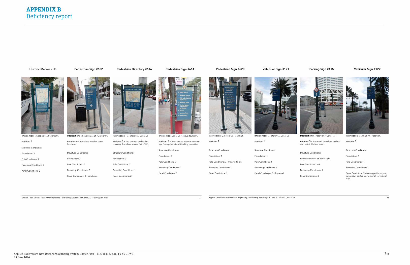
Applied | Downtown New Orleans Wayfinding System Master Plan - RPC Task A-2.16; FY-16 UPWP08 June 2016
B13
APPENDIX B Deficiency report
Applied | New Orleans Downtown Wayfinding – Deficiency Analysis | RPC Task A-2.16 DDD | June 2016 22
Intersection: Magazine St. /Poydras St.
Position: 1
Structure Conditions:
Foundation: 1
Pole Conditions: 2
Fastening Conditions: 2
Panel Conditions: 2
Intersection: Tchoupitoulas St. /Gravier St.
Position: 4 - Too close to other street furniture.
Structure Conditions:
Foundation: 2
Pole Conditions: 2
Fastening Conditions: 2
Panel Conditions: 4 - Vandalism
Intersection: S. Peters St. / Canal St.
Position: 3 - Too close to pedestrian crossing. Too close to curb (min. 18”)
Structure Conditions:
Foundation: 2
Pole Conditions: 2
Fastening Conditions: 1
Panel Conditions: 2
Intersection: Canal St. /Tchoupitoulas St.
Position: 5 - Too close to pedestrian cross-ing. Newspaper stand blocking one side.
Structure Conditions:
Foundation: 2
Pole Conditions: 2
Fastening Conditions: 2
Panel Conditions: 3
Historic Marker - H3 Pedestrian Sign #622 Pedestrian Directory #616 Pedestrian Sign #614
Applied | New Orleans Downtown Wayfinding – Deficiency Analysis | RPC Task A-2.16 DDD | June 2016 23
Intersection: S. Peters St. / Canal St.
Position: 5 - Too small. Too close to deci-sion point. On turn lane.
Structure Conditions:
Foundation: N/A on street light
Pole Conditions: N/A
Fastening Conditions: 1
Panel Conditions: 2
Intersection: Canal St. / S. Peters St.
Position: 1
Structure Conditions:
Foundation: 1
Pole Conditions: 1
Fastening Conditions: 1
Panel Conditions: 5 - Message (U turn plus turn arrow) confusing. Too small for right of way
Intersection: S. Peters St. / Canal St.
Position: 1
Structure Conditions:
Foundation: 1
Pole Conditions: 3 - Missing finials
Fastening Conditions: 1
Panel Conditions: 3
Intersection: S. Peters St. / Canal St.
Position: 1
Structure Conditions:
Foundation: 1
Pole Conditions: 1
Fastening Conditions: 1
Panel Conditions: 5 - Too small
Parking Sign #415 Vehicular Sign #122Pedestrian Sign #620 Vehicular Sign #121
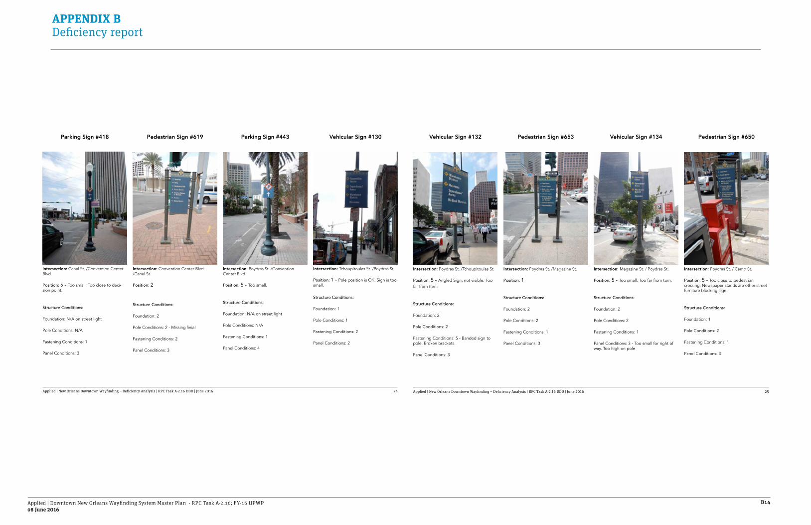
Applied | Downtown New Orleans Wayfinding System Master Plan - RPC Task A-2.16; FY-16 UPWP08 June 2016
B14
APPENDIX B Deficiency report
Applied | New Orleans Downtown Wayfinding – Deficiency Analysis | RPC Task A-2.16 DDD | June 2016 24
Intersection: Convention Center Blvd./Canal St.
Position: 2
Structure Conditions:
Foundation: 2
Pole Conditions: 2 - Missing finial
Fastening Conditions: 2
Panel Conditions: 3
Intersection: Tchoupitoulas St. /Poydras St
Position: 1 - Pole position is OK. Sign is too small.
Structure Conditions:
Foundation: 1
Pole Conditions: 1
Fastening Conditions: 2
Panel Conditions: 2
Parking Sign #418 Parking Sign #443Pedestrian Sign #619 Vehicular Sign #130
Intersection: Canal St. /Convention Center Blvd.
Position: 5 - Too small. Too close to deci-sion point.
Structure Conditions:
Foundation: N/A on street light
Pole Conditions: N/A
Fastening Conditions: 1
Panel Conditions: 3
Intersection: Poydras St. /Convention Center Blvd.
Position: 5 - Too small.
Structure Conditions:
Foundation: N/A on street light
Pole Conditions: N/A
Fastening Conditions: 1
Panel Conditions: 4
Applied | New Orleans Downtown Wayfinding – Deficiency Analysis | RPC Task A-2.16 DDD | June 2016 25
Intersection: Magazine St. / Poydras St.
Position: 5 - Too small. Too far from turn.
Structure Conditions:
Foundation: 2
Pole Conditions: 2
Fastening Conditions: 1
Panel Conditions: 3 - Too small for right of way. Too high on pole
Intersection: Poydras St. / Camp St.
Position: 5 - Too close to pedestrian crossing. Newspaper stands are other street furniture blocking sign
Structure Conditions:
Foundation: 1
Pole Conditions: 2
Fastening Conditions: 1
Panel Conditions: 3
Intersection: Poydras St. /Tchoupitoulas St.
Position: 5 - Angled Sign, not visible. Too far from turn.
Structure Conditions:
Foundation: 2
Pole Conditions: 2
Fastening Conditions: 5 - Banded sign to pole. Broken brackets.
Panel Conditions: 3
Intersection: Poydras St. /Magazine St.
Position: 1
Structure Conditions:
Foundation: 2
Pole Conditions: 2
Fastening Conditions: 1
Panel Conditions: 3
Vehicular Sign #134 Pedestrian Sign #650Vehicular Sign #132 Pedestrian Sign #653

Applied | Downtown New Orleans Wayfinding System Master Plan - RPC Task A-2.16; FY-16 UPWP08 June 2016
B15
APPENDIX B Deficiency report
Applied | New Orleans Downtown Wayfinding – Deficiency Analysis | RPC Task A-2.16 DDD | June 2016 26
Intersection: Poydras St. /St. Charles St.
Position: 1
Structure Conditions:
Foundation: 2
Pole Conditions: 1
Fastening Conditions: 1
Panel Conditions: 2
Intersection: St. Charles St. /Poydras St.
Position: 3
Structure Conditions:
Foundation: 1
Pole Conditions: 2
Fastening Conditions: 2
Panel Conditions: 5 - Too small. Peeling
Vehicular Sign #136 Pedestrian Directory #647Pedestrian Sign #648 Vehicular Sign #138
Intersection: Poydras St. /Camp St.
Position: 5 - Too small. Too far from turn.
Structure Conditions:
Foundation: 1
Pole Conditions: 1
Fastening Conditions: 5 - Sign too big to be banded to pole. Broke brackets
Panel Conditions: 3 - Too small for right of way
Intersection: St. Charles St. /Poydras St.
Position: 5 - ON pedestrian crossing.
Structure Conditions:
Foundation: 1
Pole Conditions: 2
Fastening Conditions: 1
Panel Conditions: 4 - Top frame missing. Vandalism
Applied | New Orleans Downtown Wayfinding – Deficiency Analysis | RPC Task A-2.16 DDD | June 2016 27
Intersection: Poydras St. / O’keefe Ave.
Position: 3 - Too small. Far from turn.
Structure Conditions:
Foundation: 2
Pole Conditions: 3
Fastening Conditions: 3
Panel Conditions: 4 - Too small for right of way
Intersection: Poydras St. / Camp St.
Position: 5 - Too small. Too close to turn.
Structure Conditions:
Foundation: N/A on street light
Pole Conditions: N/A
Fastening Conditions: 1
Panel Conditions: 5 - Peeling. Deteriorated.
Intersection: Poydras St. /Carondelet St.
Position: 2
Structure Conditions:
Foundation: 2
Pole Conditions: 2
Fastening Conditions: 5 - Banded sign to pole. Broken brackets.
Panel Conditions: 5 - Too low from ground - Not ADA compliant. Too small for right of way
Intersection: Poydras St. /Barone St.
Position: 1
Structure Conditions:
Foundation: 2
Pole Conditions: 2
Fastening Conditions: 4- Missing screws and screw covers
Panel Conditions: 4 - Beaten and scratched
Vehicular Sign #143 Parking Sign #430Vehicular Sign #140 Pedestrian Sign #643
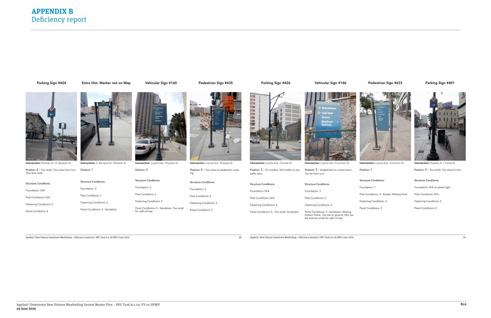
Applied | Downtown New Orleans Wayfinding System Master Plan - RPC Task A-2.16; FY-16 UPWP08 June 2016
B16
APPENDIX B Deficiency report
Applied | New Orleans Downtown Wayfinding – Deficiency Analysis | RPC Task A-2.16 DDD | June 2016 28
Intersection: S. Rampart St. /Perdido St.
Position: 1
Structure Conditions:
Foundation: 2
Pole Conditions: 1
Fastening Conditions: 2
Panel Conditions: 4 - Vandalism
Intersection: Loyola Ave. /Poydras St.
Position: 4 - Too close to pedestrian cross-ing
Structure Conditions:
Foundation: 3
Pole Conditions: 2
Fastening Conditions: 2
Panel Conditions: 3
Parking Sign #424 Vehicular Sign #160Extra Hist. Marker not on Map Pedestrian Sign #635
Intersection: Perdido St. /S. Rampart St.
Position: 4 - Too small. Too close from turn. One lane road.
Structure Conditions:
Foundation: N/A
Pole Conditions: N/A
Fastening Conditions: 2
Panel Conditions: 4
Intersection: Loyola Ave. /Poydras St.
Position: 2
Structure Conditions:
Foundation: 2
Pole Conditions: 2
Fastening Conditions: 2
Panel Conditions: 5 - Vandalism. Too small for right of way
Applied | New Orleans Downtown Wayfinding – Deficiency Analysis | RPC Task A-2.16 DDD | June 2016 29
Intersection: Loyola Ave. /Common St.
Position: 1
Structure Conditions:
Foundation: 1
Pole Conditions: 3 - Rusted. Missing finial
Fastening Conditions: 2
Panel Conditions: 3
Intersection: Poydras St. / Camp St.
Position: 5 - Too small. Too close to turn.
Structure Conditions:
Foundation: N/A on street light
Pole Conditions: N/A
Fastening Conditions: 2
Panel Conditions: 2
Intersection: Loyola Ave. /Gravier St.
Position: 5 - On median. Not visible to any traffic lane.
Structure Conditions:
Foundation: N/A
Pole Conditions: N/A
Fastening Conditions: 2
Panel Conditions: 5 - Too small. Scratched.
Intersection: Loyola Ave. /Common St.
Position: 5 - Angled due to construction. Too far from turn.
Structure Conditions:
Foundation: 3
Pole Conditions: 3
Fastening Conditions: 2
Panel Conditions: 5 - Vandalism. Missing bottom frame. Too low to ground. Not visi-ble and too small for right of way
Pedestrian Sign #633 Parking Sign #401Parking Sign #426 Vehicular Sign #146

Applied | Downtown New Orleans Wayfinding System Master Plan - RPC Task A-2.16; FY-16 UPWP08 June 2016
B17
APPENDIX B Deficiency report
Applied | New Orleans Downtown Wayfinding – Deficiency Analysis | RPC Task A-2.16 DDD | June 2016 30
Intersection: Canal St. /Elk Pl.
Position: 1
Structure Conditions:
Foundation: 2
Pole Conditions: 3 - Missing finials
Fastening Conditions: 2
Panel Conditions: 5 - Vandalism. Bent
Intersection: Basin St. /Iberville St.
Position: 2
Structure Conditions:
Foundation: 2
Pole Conditions: 2
Fastening Conditions: 2
Panel Conditions: 3
Pedestrian Sign #601 Gateway Sign #107Pedestrian Sign #602 Vehicular Sign #106
Intersection: Canal St. /Elk Pl.
Position: 1
Structure Conditions:
Foundation: 1
Pole Conditions: 2
Fastening Conditions: 3 - Exposed screws
Panel Conditions: 2
Intersection: Iberville St. /Basin St.
Position: 1 - In median
Structure Conditions:
Foundation: 1
Pole Conditions: 1
Fastening Conditions: 1
Panel Conditions: 1
Applied | New Orleans Downtown Wayfinding – Deficiency Analysis | RPC Task A-2.16 DDD | June 2016 31
Intersection: Elk Pl. /Tulane Ave.
Position: 5 - Too far from turn. Not visible, tree blocking sign. Too low to ground - Not ADA compliant
Structure Conditions:
Foundation: 1
Pole Conditions: 2
Fastening Conditions: 4 - Broken bracket. Sign angled 45° away from road
Panel Conditions: 5 - Vandalism. Not visible
Intersection: Elk Pl. / Tulane Ave.
Position: 2
Structure Conditions:
Foundation: 2
Pole Conditions: 3 - Missing finials
Fastening Conditions: 5 - Missing almost all screws
Panel Conditions: 2
Intersection: Canal St. /Burgundy St.
Position: 5 - Too small. Too far from curb. Not visible. Too far from turn
Structure Conditions:
Foundation: 1
Pole Conditions: 2
Fastening Conditions: 2
Panel Conditions: 4 - Too small for right of way. Angled.
Intersection: Canal St. /Elk Pl.
Position: 5 - Too small. Too far from turn, on previous turn shoulder (confusing)
Structure Conditions:
Foundation: 1
Pole Conditions: 2
Fastening Conditions: 2
Panel Conditions: 3
Vehicular Sign #148 Pedestrian Sign #634Vehicular Sign #111 Vehicular Sign #108

Applied | Downtown New Orleans Wayfinding System Master Plan - RPC Task A-2.16; FY-16 UPWP08 June 2016
B18
APPENDIX B Deficiency report
Applied | New Orleans Downtown Wayfinding – Deficiency Analysis | RPC Task A-2.16 DDD | June 2016 32
Intersection: Tulane Ave. /Robertson St.
Position: 4 - Not enough sidewalk clearance - Not ADA compliant
Structure Conditions:
Foundation: 2
Pole Conditions: 2
Fastening Conditions: 2
Panel Conditions: 3
Intersection: Tulane Ave. /Clairborne Ave.
Position: 1
Structure Conditions:
Foundation: 2
Pole Conditions: 2
Fastening Conditions: 2
Panel Conditions: 4 - Too low to ground
Parking Sign #434a Vehicular Sign #151Vehicular Sign #149 Vehicular Sign #152
Intersection: S. Villere St. /Cleveland Ave.
Position: 5 - Too small. After turn.
Structure Conditions:
Foundation: N/A
Pole Conditions: N/A
Fastening Conditions: 3
Panel Conditions: 3
Intersection: Clairborne Ave. /Tulane Ave.
Position: 4 - Too close to trees.
Structure Conditions:
Foundation: 1
Pole Conditions: 2
Fastening Conditions: 3
Panel Conditions: 2
Applied | New Orleans Downtown Wayfinding – Deficiency Analysis | RPC Task A-2.16 DDD | June 2016 33
Intersection: Canal St. /Villere St.
Position: 5 - Too small. Not visible, tree blocking sign
Structure Conditions:
Foundation: 1
Pole Conditions: 2
Fastening Conditions: 2
Panel Conditions: 5 - Too small for right of way. Not visible
Intersection: Canal St. / La Salle St.
Position: 2 - Too small
Structure Conditions:
Foundation: 1
Pole Conditions: 1
Fastening Conditions: 2
Panel Conditions: 4 - Too small for right of way
Intersection: Canal St. /Claiborne Ave.
Position: 5 - Too close to turn
Structure Conditions:
Foundation: 2
Pole Conditions: 1
Fastening Conditions: 2
Panel Conditions: 2
Intersection: Claiborne Ave. /Canal St.
Position: 1
Structure Conditions:
Foundation: 3
Pole Conditions: 3
Fastening Conditions: 2
Panel Conditions: 3
Vehicular Sign #104 Vehicular Sign #105Vehicular Sign #101 Vehicular Sign #100

Applied | Downtown New Orleans Wayfinding System Master Plan - RPC Task A-2.16; FY-16 UPWP08 June 2016
B19
APPENDIX B Deficiency report
Applied | New Orleans Downtown Wayfinding – Deficiency Analysis | RPC Task A-2.16 DDD | June 2016 34
Intersection: Tulane Ave. /La Salle St.
Position: 5 - Too small. Too close to turn
Structure Conditions:
Foundation: N/A
Pole Conditions: N/A
Fastening Conditions: 3
Panel Conditions: 3
Intersection: Tulane Ave. /Loyola Ave.
Position: 2 - OK. Not visible (too small)
Structure Conditions:
Foundation: 2
Pole Conditions: 2
Fastening Conditions: 2
Panel Conditions: 5 - Panel splitting and cracked
Parking Sign #433 Vehicular Sign #147Parking Sign #433a Parking Sign #432
Intersection: Tulane Ave. /La Salle St.
Position: 5 - Too small. In the median after turn.
Structure Conditions:
Foundation: N/A
Pole Conditions: N/A
Fastening Conditions: 1
Panel Conditions: 3
Intersection: Tulane Ave. /Loyola Ave.
Position: 2 - OK. Not visible (too small)
Structure Conditions:
Foundation: 1
Pole Conditions: 1
Fastening Conditions: 2
Panel Conditions: 4 - Too small for right of way
Applied | New Orleans Downtown Wayfinding – Deficiency Analysis | RPC Task A-2.16 DDD | June 2016 35
Intersection: Poydras St. / Loyola Ave.
Position: 3 - Close to pedestrian crossing
Structure Conditions:
Foundation: 1
Pole Conditions: 1
Fastening Conditions: 1
Panel Conditions: 2
Intersection: Loyola Ave. /Gravier St.
Position: 5 - Too small. After turn
Structure Conditions:
Foundation: 2
Pole Conditions: 1
Fastening Conditions: 2
Panel Conditions: 2
Intersection: Gravier St. /La Salle St.
Position: 4 - Too small. At turn.
Structure Conditions:
Foundation: N/A
Pole Conditions: N/A
Fastening Conditions: 1
Panel Conditions: 2
Intersection: Gravier St. /La Salle St.
Position: 4 - Too small. At turn.
Structure Conditions:
Foundation: N/A
Pole Conditions: N/A
Fastening Conditions: 1
Panel Conditions: 2
Parking Sign #426c Pedestrian Directory #637Parking Sign #426a Parking Sign #426b

Applied | Downtown New Orleans Wayfinding System Master Plan - RPC Task A-2.16; FY-16 UPWP08 June 2016
B20
APPENDIX B Deficiency report
Applied | New Orleans Downtown Wayfinding – Deficiency Analysis | RPC Task A-2.16 DDD | June 2016 36
Intersection: Tulane Ave. /La Salle St.
Position: 3 - On shoulder
Structure Conditions:
Foundation: 1
Pole Conditions: 1
Fastening Conditions: 3
Panel Conditions: 2
Intersection: Tulane Ave. /Loyola Ave.
Position: 1
Structure Conditions:
Foundation: 1
Pole Conditions: 2
Fastening Conditions: 2
Panel Conditions: 3
Vehicular Sign #159 Gateway Sign #157Vehicular Sign #155 Vehicular Sign #155
Intersection: Poydras St. /La Salle St.
Position: 5 - Too small.
Structure Conditions:
Foundation: 1
Pole Conditions: 1
Fastening Conditions: 2
Panel Conditions: 4
Intersection: Tulane Ave. /Loyola Ave.
Position: 1 - In Median
Structure Conditions:
Foundation: 1
Pole Conditions: 2
Fastening Conditions: 1
Panel Conditions: 2
Applied | New Orleans Downtown Wayfinding – Deficiency Analysis | RPC Task A-2.16 DDD | June 2016 37
Intersection: Robertson St. / Poydras St.
Position: 3 - On shoulder.
Structure Conditions:
Foundation: 2
Pole Conditions: 3
Fastening Conditions: N/A
Panel Conditions: 5 - Panel Missing
Intersection: White /Poydras St.
Position: 1 - In Median
Structure Conditions:
Foundation: 1
Pole Conditions: 2
Fastening Conditions: 1
Panel Conditions: 2
Intersection: Claiborne Ave. /Poydras St.
Position: 4 - On shoulder. Too close to right of way curb.
Structure Conditions:
Foundation: 2
Pole Conditions: 2
Fastening Conditions: N/A
Panel Conditions: 5 - Panel Missing
Intersection: White /Poydras St.
Position: 3 - On shoulder.
Structure Conditions:
Foundation: 2
Pole Conditions: 2
Fastening Conditions: 2
Panel Conditions: 2
Vehicular Sign #156 Vehicular Sign #158Gateway Sign #435 Vehicular Sign #154

Applied | Downtown New Orleans Wayfinding System Master Plan - RPC Task A-2.16; FY-16 UPWP08 June 2016
B21
APPENDIX B Deficiency report
Applied | New Orleans Downtown Wayfinding – Deficiency Analysis | RPC Task A-2.16 DDD | June 2016 38
Intersection: Poydras St. /Loyola Ave.
Position: 5 - Too close to Loyola Intersection 80’ from turn.
Structure Conditions:
Foundation: 1
Pole Conditions: 2
Fastening Conditions: N/A
Panel Conditions: 5 - Panel Missing
Intersection: Poydras St. /Loyola Ave.
Position: 1
Structure Conditions:
Foundation: 2
Pole Conditions: 3
Fastening Conditions: 2
Panel Conditions: 3
Pedestrian Directory #638 Pedestrian Sign #639Vehicular Sign #161 Pedestrian Directory #640
Intersection: La Salle St. /Poydras St.
Position: 2
Structure Conditions:
Foundation: 2
Pole Conditions: 3
Fastening Conditions: 3
Panel Conditions: 2
Intersection: Poydras St. /Loyola Ave.
Position: 1
Structure Conditions:
Foundation: 1
Pole Conditions: 3
Fastening Conditions: 3
Panel Conditions: 2
Applied | New Orleans Downtown Wayfinding – Deficiency Analysis | RPC Task A-2.16 DDD | June 2016 39
Intersection: Earhart St. / Loyola Ave.
Position: 2
Structure Conditions:
Foundation: 2
Pole Conditions: 2
Fastening Conditions: 2
Panel Conditions: 3
Intersection: White /Poydras St.
Position: 1
Structure Conditions:
Foundation: 3
Pole Conditions: 4
Fastening Conditions: N/A
Panel Conditions: 5 - Panel missing
Intersection: Girod /Loyola Ave.
Position: 2
Structure Conditions:
Foundation: 3 - Too close to edge
Pole Conditions: 2
Fastening Conditions: 5 - Panel twisted at 45º from traffic
Panel Conditions: 5 - Panel too small for 4 lane road
Intersection: Julia St /Loyola Ave.
Position: 3 - Too close to turn.
Structure Conditions:
Foundation: 3
Pole Conditions: 5 - Broken / Cracked
Fastening Conditions: N/A
Panel Conditions: 5 - Panel missing
Vehicular Sign #182 Gateway Sign #185Vehicular Sign #164 Vehicular Sign #165

Applied | Downtown New Orleans Wayfinding System Master Plan - RPC Task A-2.16; FY-16 UPWP08 June 2016
B22
APPENDIX B Deficiency report
Applied | New Orleans Downtown Wayfinding – Deficiency Analysis | RPC Task A-2.16 DDD | June 2016 40
Intersection: Poydras St. /Loyola Ave.
Position: 2
Structure Conditions:
Foundation: 1
Pole Conditions: 1
Fastening Conditions: 1
Panel Conditions: 1
Intersection: Calliope St. /Haley.
Position: 3 - Hidden in corner
Structure Conditions:
Foundation: 1
Pole Conditions: 2
Fastening Conditions: 2
Panel Conditions: 3 - Too small for location
Vehicular Sign #187 Parking Sign #190Vehicular Sign #189 Gateway Sign #192
Intersection: Earhart St. /Loyola Ave.
Position: 5 - Under 90 bridge
Structure Conditions:
Foundation: 1
Pole Conditions: 1
Fastening Conditions: 1
Panel Conditions: 5 - Too small for location
Intersection: Earhart /Halley.
Position: 2
Structure Conditions:
Foundation: N/A
Pole Conditions: N/A
Fastening Conditions: 2
Panel Conditions: 5 - Too small
Applied | New Orleans Downtown Wayfinding – Deficiency Analysis | RPC Task A-2.16 DDD | June 2016 41
Intersection: Julia St. / Rampart St.
Position: 5 - Behind tree
Structure Conditions:
Foundation: 1
Pole Conditions: 2
Fastening Conditions: 2
Panel Conditions: 5 - Too small for right of way
Intersection: Calliope St. /Haley.
Position: 3 - Behind pole
Structure Conditions:
Foundation: 3
Pole Conditions: 3
Fastening Conditions: 2
Panel Conditions: 3
Intersection: Howard /Loyola Ave.
Position: 1
Structure Conditions:
Foundation: 1
Pole Conditions: 2
Fastening Conditions: 2
Panel Conditions: 5 - Panel too small for 5 lane road
Intersection: Howard /Loyola Ave.
Position: 5 - Behind tree. Too close to turn
Structure Conditions:
Foundation: 1
Pole Conditions: 2
Fastening Conditions: 2
Panel Conditions: 2
Vehicular Sign #184 Vehicular Sign #181Vehicular Sign #186 Vehicular Sign #188
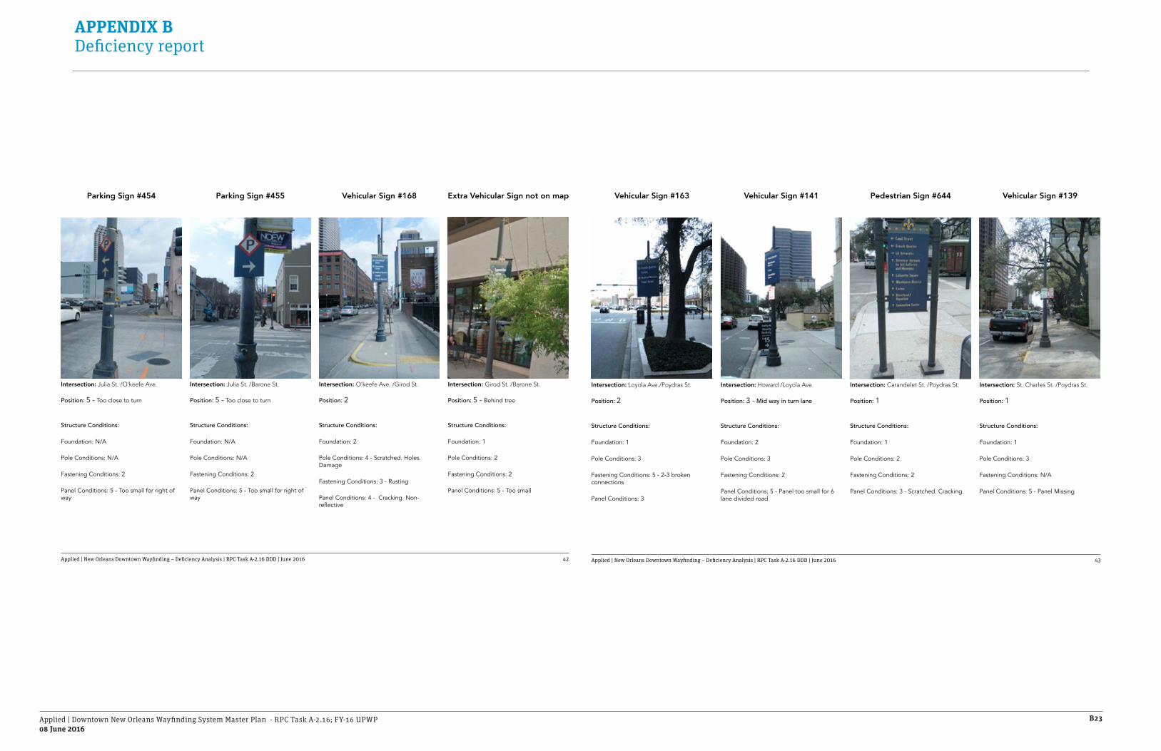
Applied | Downtown New Orleans Wayfinding System Master Plan - RPC Task A-2.16; FY-16 UPWP08 June 2016
B23
APPENDIX B Deficiency report
Applied | New Orleans Downtown Wayfinding – Deficiency Analysis | RPC Task A-2.16 DDD | June 2016 42
Intersection: Girod St. /Barone St.
Position: 5 - Behind tree
Structure Conditions:
Foundation: 1
Pole Conditions: 2
Fastening Conditions: 2
Panel Conditions: 5 - Too small
Parking Sign #454 Vehicular Sign #168Parking Sign #455 Extra Vehicular Sign not on map
Intersection: Julia St. /O’keefe Ave.
Position: 5 - Too close to turn
Structure Conditions:
Foundation: N/A
Pole Conditions: N/A
Fastening Conditions: 2
Panel Conditions: 5 - Too small for right of way
Intersection: Julia St. /Barone St.
Position: 5 - Too close to turn
Structure Conditions:
Foundation: N/A
Pole Conditions: N/A
Fastening Conditions: 2
Panel Conditions: 5 - Too small for right of way
Intersection: O’keefe Ave. /Girod St.
Position: 2
Structure Conditions:
Foundation: 2
Pole Conditions: 4 - Scratched. Holes. Damage
Fastening Conditions: 3 - Rusting
Panel Conditions: 4 - Cracking. Non-reflective
Applied | New Orleans Downtown Wayfinding – Deficiency Analysis | RPC Task A-2.16 DDD | June 2016 43
Intersection: St. Charles St. /Poydras St.
Position: 1
Structure Conditions:
Foundation: 1
Pole Conditions: 3
Fastening Conditions: N/A
Panel Conditions: 5 - Panel Missing
Intersection: Loyola Ave./Poydras St.
Position: 2
Structure Conditions:
Foundation: 1
Pole Conditions: 3
Fastening Conditions: 5 - 2-3 broken connections
Panel Conditions: 3
Intersection: Howard /Loyola Ave.
Position: 3 - Mid way in turn lane
Structure Conditions:
Foundation: 2
Pole Conditions: 3
Fastening Conditions: 2
Panel Conditions: 5 - Panel too small for 6 lane divided road
Intersection: Carandelet St. /Poydras St.
Position: 1
Structure Conditions:
Foundation: 1
Pole Conditions: 2
Fastening Conditions: 2
Panel Conditions: 3 - Scratched. Cracking.
Pedestrian Sign #644 Vehicular Sign #139Vehicular Sign #163 Vehicular Sign #141

Applied | Downtown New Orleans Wayfinding System Master Plan - RPC Task A-2.16; FY-16 UPWP08 June 2016
B24
APPENDIX B Deficiency report
Applied | New Orleans Downtown Wayfinding – Deficiency Analysis | RPC Task A-2.16 DDD | June 2016 44
Intersection: St. Charles St. /Girod St.
Position: 1
Structure Conditions:
Foundation: 1
Pole Conditions: 1
Fastening Conditions: 1
Panel Conditions: 2
Parking Sign #454 Pedestrian Directory #667Extra Vehicular Sign not on Map Pedestrian Sign #668
Intersection: St. Charles St. /Poydras St.
Position: 3- Other street furniture blocking sign
Structure Conditions:
Foundation: 1
Pole Conditions: 4 - Broken leg
Fastening Conditions: 2
Panel Conditions: 3 - Cracking face
Intersection: S. Maestri St. /St. Charles St.
Position: 4 - Behind tree. Too close to turn
Structure Conditions:
Foundation: 2
Pole Conditions: 1
Fastening Conditions: 1
Panel Conditions: 2
Intersection: S. Maestri St. /St. Charles St.
Position: 2
Structure Conditions:
Foundation: 2
Pole Conditions: 4 - Scratched. Holes. Damage
Fastening Conditions: 3 - Rusting
Panel Conditions: 4 - Cracking.
Applied | New Orleans Downtown Wayfinding – Deficiency Analysis | RPC Task A-2.16 DDD | June 2016 45
Intersection: St. Charles St. /Poydras St.
Position: 1
Structure Conditions:
Foundation: 2
Pole Conditions: 5
Fastening Conditions: 4
Panel Conditions: 3
Intersection: Carandelet St. /Girod St.
Position: 1
Structure Conditions:
Foundation: 2
Pole Conditions: 3
Fastening Conditions: 2
Panel Conditions: 3
Intersection: Howard /Loyola Ave.
Position: 1
Structure Conditions:
Foundation: 1
Pole Conditions: 4
Fastening Conditions: 5 - Sign turned 90º from right of way
Panel Conditions: 5 - Panel too small for right of way
Intersection: Carandelet St. /Poydras St.
Position: 1
Structure Conditions:
Foundation: 1
Pole Conditions: 4
Fastening Conditions: 3
Panel Conditions: 4
Pedestrian Sign #673 Historic Marker - H6Vehicular Sign #163 Vehicular Sign #169

Applied | Downtown New Orleans Wayfinding System Master Plan - RPC Task A-2.16; FY-16 UPWP08 June 2016
B25
APPENDIX B Deficiency report
Applied | New Orleans Downtown Wayfinding – Deficiency Analysis | RPC Task A-2.16 DDD | June 2016 46
Intersection: Lee Circle
Position: 1
Structure Conditions:
Foundation: 3
Pole Conditions: 3
Fastening Conditions: 3 - Rusted
Panel Conditions: 5 - Too small for right of way
Pedestrian Sign #672 Vehicular Sign #195Pedestrian Sign #689 Vehicular Sign #194
Intersection: St. Charles St. /Julia St.
Position: 1
Structure Conditions:
Foundation: 5 - Broken. Leaning
Pole Conditions: 5
Fastening Conditions: 4
Panel Conditions: 3
Intersection: St. Joseph /St. Charles St.
Position: 1
Structure Conditions:
Foundation: 1
Pole Conditions: 3
Fastening Conditions: 2
Panel Conditions: 4
Intersection: Howard /St. Charles St.
Position: 3 - Too close to turn
Structure Conditions:
Foundation: 2
Pole Conditions: 2
Fastening Conditions: 2
Panel Conditions: 5 - Too small
Applied | New Orleans Downtown Wayfinding – Deficiency Analysis | RPC Task A-2.16 DDD | June 2016 47
Intersection: Calliope St. /Charles Ave.
Position: 2
Structure Conditions:
Foundation: 1
Pole Conditions: 2
Fastening Conditions: 2
Panel Conditions: 5 - Too small
Intersection: Lee Circle
Position: 4 - Behind trees
Structure Conditions:
Foundation: 1
Pole Conditions: 3 - Broken
Fastening Conditions: 2
Panel Conditions: 5 - Too small
Intersection: Lee Circle
Position: 4 - Behind trees
Structure Conditions:
Foundation: 1
Pole Conditions: 2
Fastening Conditions: 2
Panel Conditions: 5 - Too small
Intersection: Charles Ave. /Calliope St.
Position: 2
Structure Conditions:
Foundation: 1
Pole Conditions: 3
Fastening Conditions: 3
Panel Conditions: 4
Extra Ped. Directory not on Map Vehicular Sign #212Vehicular Sign #193 Vehicular Sign #207

Applied | Downtown New Orleans Wayfinding System Master Plan - RPC Task A-2.16; FY-16 UPWP08 June 2016
B26
APPENDIX B Deficiency report
Applied | New Orleans Downtown Wayfinding – Deficiency Analysis | RPC Task A-2.16 DDD | June 2016 48
Intersection: Charles Ave. /Calliope St.
Position: 2
Structure Conditions:
Foundation: 1
Pole Conditions: 2
Fastening Conditions: 2
Panel Conditions: 5 - Too small
Intersection: Lee Circle
Position: 3
Structure Conditions:
Foundation: 2
Pole Conditions: 3
Fastening Conditions: 4 - Sign turn 90°
Panel Conditions: 5 - Too small - Vandalism
Gateway Sign #211Vehicular Sign #215Vehicular Sign #213 Vehicular Sign #206
Intersection: Calliope St. /Margaret Pl.
Position: 1
Structure Conditions:
Foundation: 1
Pole Conditions: 3 - Graffiti
Fastening Conditions: 2
Panel Conditions: 4 - Graffiti
Intersection: Lee Circle.
Position: 1 - Too small
Structure Conditions:
Foundation: 1
Pole Conditions: 3
Fastening Conditions: 3
Panel Conditions: 3
Applied | New Orleans Downtown Wayfinding – Deficiency Analysis | RPC Task A-2.16 DDD | June 2016 49
Intersection: Lee Circle
Position: 3
Structure Conditions:
Foundation: 2
Pole Conditions: 3
Fastening Conditions: 3
Panel Conditions: 3
Intersection: Higgins / Camp St.
Position: 4 - Too close to turn
Structure Conditions:
Foundation: 2
Pole Conditions: 4
Fastening Conditions: 2
Panel Conditions: 4
Intersection: St. Joseph/ Camp St.
Position: 1
Structure Conditions:
Foundation: 1
Pole Conditions: 3
Fastening Conditions: 3
Panel Conditions: 4
Intersection: Camp St. /St. Joseph
Position: 1
Structure Conditions:
Foundation: 1
Pole Conditions: 3
Fastening Conditions: 3
Panel Conditions: 4
Pedestrian Sign #688Vehicular Sign #193 Pedestrian Sign #685Vehicular Sign #197

Applied | Downtown New Orleans Wayfinding System Master Plan - RPC Task A-2.16; FY-16 UPWP08 June 2016
B27
APPENDIX B Deficiency report
Applied | New Orleans Downtown Wayfinding – Deficiency Analysis | RPC Task A-2.16 DDD | June 2016 50
Intersection: Camp St. /St. Joseph
Position: 2
Structure Conditions:
Foundation: 2
Pole Conditions: 4
Fastening Conditions: 4
Panel Conditions: 4
Intersection: Julia St. /Camp St.
Position: 3 - Street furniture blocking one side of sign
Structure Conditions:
Foundation: 1
Pole Conditions: 2
Fastening Conditions: 2
Panel Conditions: 4
Pedestrian Sign #675Vehicular Sign #178Pedestrian Directory #686 Pedestrian Sign #674
Intersection: Camp St. /Julia St.
Position: 3 - Too close to turn
Structure Conditions:
Foundation: 2
Pole Conditions: 4
Fastening Conditions: 4 - Sign turn 90°
Panel Conditions: 3
Intersection: Camp St. /Julia St.
Position: 1
Structure Conditions:
Foundation: 1
Pole Conditions: 4
Fastening Conditions: 3
Panel Conditions: 5
Applied | New Orleans Downtown Wayfinding – Deficiency Analysis | RPC Task A-2.16 DDD | June 2016 51
Intersection: Camp St. /Girod St.
Position: 2
Structure Conditions:
Foundation: 3
Pole Conditions: 3
Fastening Conditions: 5
Panel Conditions: 5
Intersection: Camp St. /Girod St.
Position: 2
Structure Conditions:
Foundation: 4 - Broken
Pole Conditions: 4
Fastening Conditions: 5
Panel Conditions: 5
Intersection: Camp St. /Lafayette
Position: 3 - Facing 90° off best position
Structure Conditions:
Foundation: 1
Pole Conditions: 1
Fastening Conditions: 2
Panel Conditions: 2
Intersection: Camp St. /Lafayette
Position: 2 - 30’ from plaza entrance. Move to center access point
Structure Conditions:
Foundation: 1
Pole Conditions: 2
Fastening Conditions: 2
Panel Conditions: 2
Historic Marker - H4Pedestrian Sign #666 Pedestrian Directory #685Pedestrian Sign #665

Applied | Downtown New Orleans Wayfinding System Master Plan - RPC Task A-2.16; FY-16 UPWP08 June 2016
B28
APPENDIX B Deficiency report
Applied | New Orleans Downtown Wayfinding – Deficiency Analysis | RPC Task A-2.16 DDD | June 2016 52
Intersection: Camp St. /Maestri St.
Position: 1
Structure Conditions:
Foundation: 1
Pole Conditions: 5 - Cracked at base
Fastening Conditions: 5 - 2 of 3 brackets working
Panel Conditions: 4
Intersection: Poydras St. /Magazine St.
Position: 1
Structure Conditions:
Foundation: 1
Pole Conditions: 3
Fastening Conditions: 2
Panel Conditions: 3
Vehicular Sign #133Pedestrian Sign #649Vehicular Sign #135 Pedestrian Sign #652
Intersection: Poydras St. /Magazine St.
Position: 1
Structure Conditions:
Foundation: 1
Pole Conditions: 3
Fastening Conditions: 3
Panel Conditions: 3
Intersection: Poydras St. /Magazine St.
Position: 2 - Could move forward to see better
Structure Conditions:
Foundation: 1
Pole Conditions: 1
Fastening Conditions: N/A
Panel Conditions: 5 - Missing panel
Applied | New Orleans Downtown Wayfinding – Deficiency Analysis | RPC Task A-2.16 DDD | June 2016 53
Intersection: Magazine St. /Girod St.
Position: 1
Structure Conditions:
Foundation: 2
Pole Conditions: 4
Fastening Conditions: 4
Panel Conditions: 4
Intersection: Magazine St. /Girod St.
Position: 1
Structure Conditions:
Foundation: 2
Pole Conditions: 4
Fastening Conditions: 3
Panel Conditions: 4
Intersection: Magazine St. /Girod St.
Position: 2
Structure Conditions:
Foundation: N/A
Pole Conditions: N/A
Fastening Conditions: 1
Panel Conditions: 4 - Too small
Intersection: Magazine St. /Julia St.
Position: 1
Structure Conditions:
Foundation: 1
Pole Conditions: 3
Fastening Conditions: 2
Panel Conditions: 4 - Too small for right of way
Parking Sign #447Pedestrian Sign #664b Vehicular Sign #176Pedestrian Sign #664a

Applied | Downtown New Orleans Wayfinding System Master Plan - RPC Task A-2.16; FY-16 UPWP08 June 2016
B29
APPENDIX B Deficiency report
Applied | New Orleans Downtown Wayfinding – Deficiency Analysis | RPC Task A-2.16 DDD | June 2016 54
Intersection: Calliope St. /Annunciation St.
Position: 1
Structure Conditions:
Foundation: 1
Pole Conditions: 1
Fastening Conditions: 1
Panel Conditions: 4 - Graffiti
Intersection: Magazine St. /Julia St.
Position: 5 - Too close to early intersection. Move forward
Structure Conditions:
Foundation: 1
Pole Conditions: 2
Fastening Conditions: 5 - 1 of 3 fasteners broken
Panel Conditions: 2
Vehicular Sign #217Parking Sign #458Vehicular Sign #177 Vehicular Sign #218
Intersection: Julia St. /Magazine St.
Position: 1
Structure Conditions:
Foundation: 1
Pole Conditions: 3
Fastening Conditions: 3
Panel Conditions: 3
Intersection: Magazine St. /Calliope St.
Position: 5 - Under 90 bridge. Too small
Structure Conditions:
Foundation: 2
Pole Conditions: 3
Fastening Conditions: 3
Panel Conditions: 5 - Too small for right of way
Applied | New Orleans Downtown Wayfinding – Deficiency Analysis | RPC Task A-2.16 DDD | June 2016 55
Intersection: Calliope St. /Annunciation St.
Position: 1
Structure Conditions:
Foundation: 1
Pole Conditions: 1
Fastening Conditions: 1
Panel Conditions: 3
Intersection: Tchoupitoulas St. /Howard St.
Position: 2
Structure Conditions:
Foundation: 2
Pole Conditions: 3
Fastening Conditions: 1
Panel Conditions: 5 - In tree. Vinyl falling off
Intersection: Tchoupitoulas St. / Julia St.
Position: 1
Structure Conditions:
Foundation: 1
Pole Conditions: 3
Fastening Conditions: 3
Panel Conditions: 4
Intersection: Tchoupitoulas St. / Julia St.
Position: 1
Structure Conditions:
Foundation: 1
Pole Conditions: 3
Fastening Conditions: 3
Panel Conditions: 4
Pedestrian Sign #677Vehicular Sign #219 Pedestrian Sign #678Vehicular Sign #200

Applied | Downtown New Orleans Wayfinding System Master Plan - RPC Task A-2.16; FY-16 UPWP08 June 2016
B30
APPENDIX B Deficiency report
Applied | New Orleans Downtown Wayfinding – Deficiency Analysis | RPC Task A-2.16 DDD | June 2016 56
Intersection: Poydras St. /Tchoupitoulas St.
Position: 1
Structure Conditions:
Foundation: 1
Pole Conditions: 3
Fastening Conditions: 2
Panel Conditions: 4
Intersection: Julia St. /Tchoupitoulas St.
Position: 1
Structure Conditions:
Foundation: 1
Pole Conditions: 2
Fastening Conditions: 2
Panel Conditions: 5 - Too small
Pedestrian Sign #664Vehicular Sign #174Vehicular Sign #176 Pedestrian Sign #654
Intersection: Julia St. /Tchoupitoulas St.
Position: 3 - Too close to turn
Structure Conditions:
Foundation: 1
Pole Conditions: 3
Fastening Conditions: 4 - 1 of 3 fasteners not fixed
Panel Conditions: 3 - Too small
Intersection: Girod St. /Tchoupitoulas St.
Position: 1
Structure Conditions:
Foundation: 3
Pole Conditions: 5
Fastening Conditions: 3
Panel Conditions: 2
Applied | New Orleans Downtown Wayfinding – Deficiency Analysis | RPC Task A-2.16 DDD | June 2016 57
Intersection: Poydras St. /Tchoupitoulas St.
Position: 1
Structure Conditions:
Foundation: 1
Pole Conditions: 3
Fastening Conditions: 4
Panel Conditions: 3
Intersection: Poydras St. /Tchoupitoulas St.
Position: 1
Structure Conditions:
Foundation: 3
Pole Conditions: 4
Fastening Conditions: 5 - 1 of 4 brackets broken. Sign turned 45°
Panel Conditions: 4
Intersection: S Peters /Poydras St.
Position: 1
Structure Conditions:
Foundation: 1
Pole Conditions: 2
Fastening Conditions: 2
Panel Conditions: 3
Intersection: Convention Center Blvd. /Poydras St.
Position: 3 - Sign turned 45° to accommodate Harrah’s Awning
Structure Conditions:
Foundation: 1
Pole Conditions: 2
Fastening Conditions: 2
Panel Conditions: 4 - Cracking / Peeling vinyl
Pedestrian Sign #656Historic Marker - H5 Vehicular Sign #127Vehicular Sign #129

Applied | Downtown New Orleans Wayfinding System Master Plan - RPC Task A-2.16; FY-16 UPWP08 June 2016
B31
APPENDIX B Deficiency report
Applied | New Orleans Downtown Wayfinding – Deficiency Analysis | RPC Task A-2.16 DDD | June 2016 58
Intersection: Convention Center Blvd. /Lafayette St.
Position: 1
Structure Conditions:
Foundation: 1
Pole Conditions: 2
Fastening Conditions: 2
Panel Conditions: 5 - Too small for right of way
Intersection: Convention Center Blvd. /Poydras St.
Position: 5 - Too small on high pole
Structure Conditions:
Foundation: N/A
Pole Conditions: N/A
Fastening Conditions: 2
Panel Conditions: 4 - Cracking /Peeling
Pedestrian Sign #658Pedestrian Sign #657Parking Sign #444 Vehicular Sign #128
Intersection: Convention Center Blvd. /Poydras St.
Position: 5 - Obscured behind plant/pot
Structure Conditions:
Foundation: 1
Pole Conditions: 2
Fastening Conditions: 2
Panel Conditions: 3
Intersection: Poydras St. /Convention Center Blvd.
Position: 1
Structure Conditions:
Foundation: 1
Pole Conditions: 2
Fastening Conditions: 3 - Rusted
Panel Conditions: 4 - Cracked. Scratched. Stickers
Applied | New Orleans Downtown Wayfinding – Deficiency Analysis | RPC Task A-2.16 DDD | June 2016 59
Intersection: Convention Center Blvd. /Girod St.
Position: 5 - Next to delivery zone
Structure Conditions:
Foundation: 4 - Wobbling
Pole Conditions: 4 - Beat up. Vandalized
Fastening Conditions: 3
Panel Conditions: 5 - Scratched. Cracking
Intersection: Girod St. /Convention Center Blvd.
Position: 3 - On minor street approaching stop
Structure Conditions:
Foundation: 2
Pole Conditions: 3
Fastening Conditions: 2
Panel Conditions: 4 - Scratched.
Intersection: Convention Center Blvd. /Notre Dame St.
Position: 4 - Too close to early turn. Move forward
Structure Conditions:
Foundation: 1
Pole Conditions: 3
Fastening Conditions: 2
Panel Conditions: 5 - Sign too small for right of way
Intersection: Julia St. / Convention Center Blvd.
Position: 2
Structure Conditions:
Foundation: 2
Pole Conditions: 4 - Scratched. Rusted
Fastening Conditions: 2
Panel Conditions: 5 - Scratched. Graffiti
Vehicular Sign #172Pedestrian Sign #661 Pedestrian Sign #680Vehicular Sign #171

Applied | Downtown New Orleans Wayfinding System Master Plan - RPC Task A-2.16; FY-16 UPWP08 June 2016
B32
APPENDIX B Deficiency report
Applied | New Orleans Downtown Wayfinding – Deficiency Analysis | RPC Task A-2.16 DDD | June 2016 60
Intersection: Andrew Higgins / Convention Center Blvd.
Position: 5 - Too small. At decision point. Too high on light pole
Structure Conditions:
Foundation: N/A
Pole Conditions: N/A
Fastening Conditions: 2
Panel Conditions: 5 - Too small
Intersection: Convention Center Blvd. /Julia St.
Position: 2 - Too close to bus drop off /waiting area. Not visible from road
Structure Conditions:
Foundation: 2 - Exposed fasteners
Pole Conditions: 2 - Scratched
Fastening Conditions: 5 - 1 of 3 brackets broken
Panel Conditions: 4
Parking Sign #128Pedestrian Directory #683Vehicular Sign #173 Parking Sign #460
Intersection: Convention Center Blvd. /Andrew Higgins.
Position: 1
Structure Conditions:
Foundation: 3 - Base loose
Pole Conditions: 3
Fastening Conditions: 1
Panel Conditions: 2
Intersection: Convention Center Blvd. /Andrew Higgins.
Position: 1
Structure Conditions:
Foundation: 3 - Base loose. Wrapped alum. wiggling sign
Pole Conditions: 3
Fastening Conditions: 2
Panel Conditions: 5 - Cracking. Vandalized
Applied | New Orleans Downtown Wayfinding – Deficiency Analysis | RPC Task A-2.16 DDD | June 2016 61
Intersection: Andrew Higgins / Convention Center Blvd.
Position: 1
Structure Conditions:
Foundation: 2
Pole Conditions: 5 - Cracked. Hole in base
Fastening Conditions: 2
Panel Conditions: 2
Intersection: Convention Center Blvd. /Calliope St.
Position: 5 - Too high on light pole. Too small
Structure Conditions:
Foundation: N/A
Pole Conditions: N/A
Fastening Conditions: 2
Panel Conditions: 5 - Too small
Intersection: Convention Center Blvd. /Calliope St.
Position: 1
Structure Conditions:
Foundation: 1
Pole Conditions: 2
Fastening Conditions: 1
Panel Conditions: 5 - Sign too small for right of way
Intersection: Convention Center Blvd. /Calliope St.
Position: 1 - Need landscape to soften
Structure Conditions:
Foundation: 1
Pole Conditions: 3
Fastening Conditions: 2
Panel Conditions: 4
Vehicular Sign #202Vehicular Sign #201 Gateway Sign #221Parking Sign #473

Applied | Downtown New Orleans Wayfinding System Master Plan - RPC Task A-2.16; FY-16 UPWP08 June 2016
B33
APPENDIX B Deficiency report
Applied | New Orleans Downtown Wayfinding – Deficiency Analysis | RPC Task A-2.16 DDD | June 2016 62
Intersection: Calliope St. / Convention Center Blvd.
Position: 1 - Off ramp
Structure Conditions:
Foundation: 1
Pole Conditions: 1
Fastening Conditions: 2
Panel Conditions: 5 - Delaminating. Cracking
Historic Marker - H7Pedestrian Sign #683Vehicular Sign #220
Intersection: Calliope St. / Convention Center Blvd.
Position: 1 - On light pole. Off ramp
Structure Conditions:
Foundation: N/A
Pole Conditions: N/A
Fastening Conditions: 2
Panel Conditions: 3
Intersection: Convention Center Blvd. /Andrew Higgins.
Position: 1
Structure Conditions:
Foundation: 1
Pole Conditions: 2
Fastening Conditions: 2
Panel Conditions: 3 - Scratched up
Applied | New Orleans Downtown Wayfinding – Deficiency Analysis | RPC Task A-2.16 DDD | June 2016 63
Deficiency Analysis
9 4%
19%
12%
37%
35%
37
24
76112
Signs with missing panels
Vandalized signs
Angled/not visible signs
Too small for right of wayIncluding all parking signs
Entire sign missing
Existing wayfinding

Applied | Downtown New Orleans Wayfinding System Master Plan - RPC Task A-2.16; FY-16 UPWP08 June 2016
B34
APPENDIX B Deficiency report
MUTCD Placement GuidelinesApplied | New Orleans Downtown Wayfinding – Deficiency Analysis | RPC Task A-2.16 DDD | June 2016 65
MUTCD 2009 Edition
The Manual on Uniform Traffic Control Devices (MUTCD) is a document issued by the Federal Highway Administration (FHWA) of the United States Department of Transportation (USDOT) to specify the standards by which traffic signs, road surface markings, and signals are designed, installed, and used.

Applied | Downtown New Orleans Wayfinding System Master Plan - RPC Task A-2.16; FY-16 UPWP08 June 2016
B35
APPENDIX B Deficiency report
Applied | New Orleans Downtown Wayfinding – Deficiency Analysis | RPC Task A-2.16 DDD | June 2016 66
Vehicular Directional Signs
These signs are intended to direct vehicular traffic to a desired destination or activity. They direct to and provide ease of access to top destinations. Signs can direct to three destinations.
Criteria
Signs must be placed a minimum of 100’ in advance to an intersection where visitors will need to turn to reach facilities or parking.
Keep sign quantity to a minimum by using a multi-destination sign when possible.Use signs to direct to top destinations only, less popular activities may not require vehicular directionals.
Locate signs on the right side of the road 18” minimum from edge of pavement; facing travel lanes entering facility.
These signs shall be located adjacent to the right-of-way of major access routes within a facility.Place sign in front of any obstructions to avoid bocking sign messages.
18”min.
18”min.
Direction of view
er
100 � minimum200 � preferredto intersection
50 � minimumto previous intersection
Vehicular Directional
Direction
of Viewer
If 35 mph or less100 � minimum
to start of turn lane
If 40 mph or greater200 � minimum
to start of turn lane
Vehicular Directional with turn lane
Applied | New Orleans Downtown Wayfinding – Deficiency Analysis | RPC Task A-2.16 DDD | June 2016 67
* Measurements and distances listed in the above figure serve as a guideline and shall not supersede state or municipal codes.
Lateral O�sets
18”
2 ft
3 ft
MUTCD Option—18” minimum lateral oset for business, commercial or residential areas where sidewalk width is limited or where existing poles are close to the curb.
ADA Compliance—3 minimum clearance between sign post and nearest structure
MUTCD Option—On conventional roads, a lateral oset of at least 2 feet may be used.

Applied | Downtown New Orleans Wayfinding System Master Plan - RPC Task A-2.16; FY-16 UPWP08 June 2016
B36
APPENDIX B Deficiency report
Applied | New Orleans Downtown Wayfinding – Deficiency Analysis | RPC Task A-2.16 DDD | June 2016 68
Pedestrian Directional Signs
These signs are intended to direct pedestrians and cyclists on a trail or sidewalk towards adjacent facilities/amenities by communicating through graphic icons, text and arrows.
Criteria
These signs shall be located adjacent to the paths/sidewalks within a facility.
Locate signs 2’ minimum from edge of trail/sidewalk/pavement and 3’ minimum from trees or benches located on the furniture zone close to the sign location.
The sign can be place parallel or perpendicular to the curb and next to the light fixture.
Signs should be placed at decision points as trail or sidewalk approaches facility/amenity.
Sign may be placed on either side of the trail or sidewalk, however placement must be consistent with other signs on the same location.
2 ftMin.
Urban Intersection
MARKED ORUNMARKEDCROSSWALK
SIDEWALK
4 ft Min.4 ft Min.
6 ft Min.8 ft Min.
Pedestrian Corridor
Pedestrian Corridor
3'-0" min.
2'-0" min.
Applied | New Orleans Downtown Wayfinding – Deficiency Analysis | RPC Task A-2.16 DDD | June 2016 69
ADA Regulations
All signs were design considering ADA rules. The following graphics show how ADA should be applied in the position and location of signs.
The minimum clearance applies for street name signs, banners and any other sign that could be a potential hazard for pedestrians and cyclists.
27”
min
12”max 27
”m
ax
Min
umum
Cle
aran
ce 8
0”
Can exceed12” whenlower edgeabove 80”
Any single post signbetween 27” and 80”from FF may overhangmax 12”
12”min
12”min
12”min
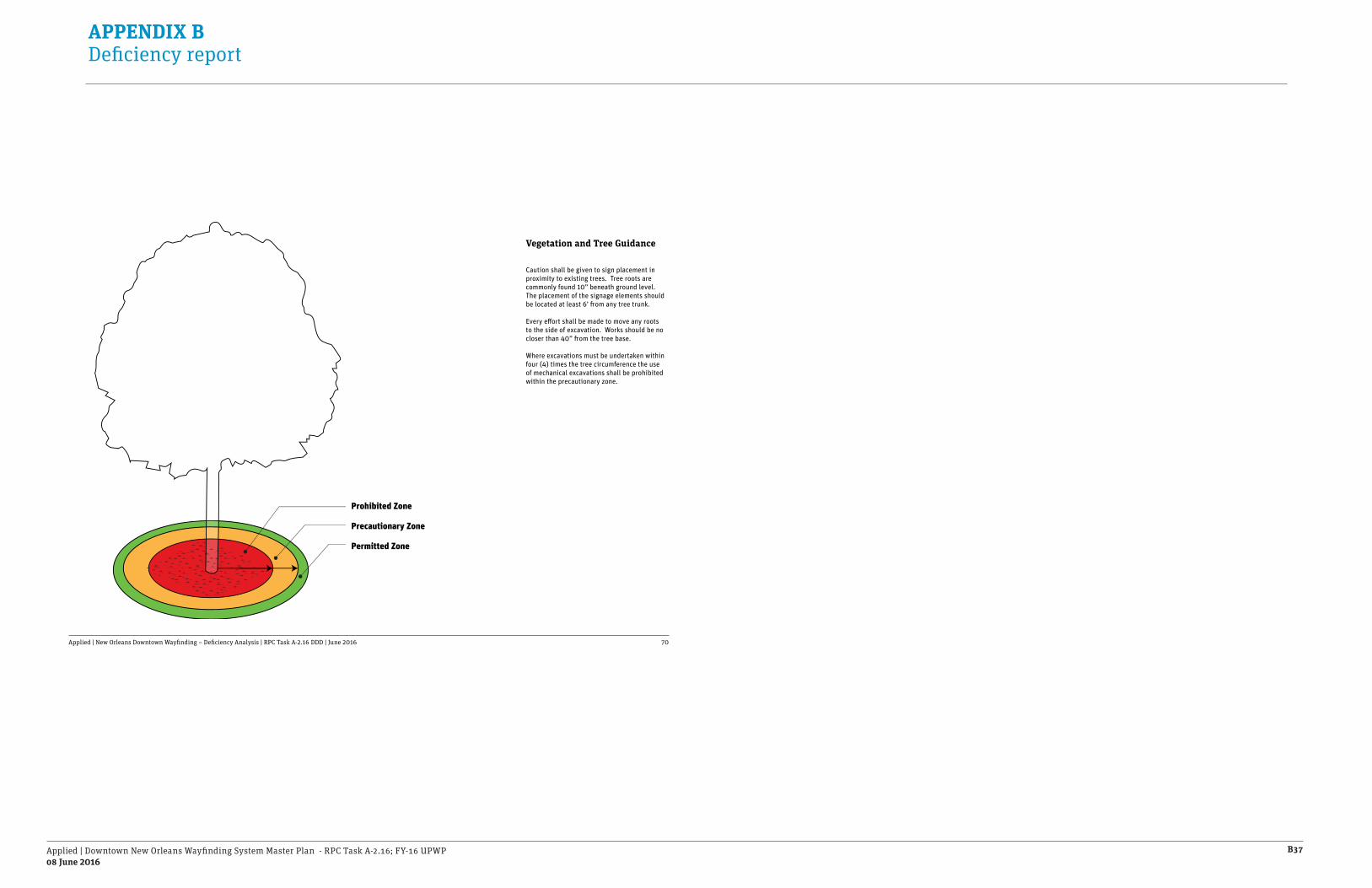
Applied | Downtown New Orleans Wayfinding System Master Plan - RPC Task A-2.16; FY-16 UPWP08 June 2016
B37
APPENDIX B Deficiency report
Applied | New Orleans Downtown Wayfinding – Deficiency Analysis | RPC Task A-2.16 DDD | June 2016 70
Prohibited Zone
Precautionary Zone
Permitted Zone
Vegetation and Tree Guidance
Caution shall be given to sign placement in proximity to existing trees. Tree roots are commonly found 10” beneath ground level. The placement of the signage elements should be located at least 6’ from any tree trunk.
Every effort shall be made to move any roots to the side of excavation. Works should be no closer than 40” from the tree base.
Where excavations must be undertaken within four (4) times the tree circumference the use of mechanical excavations shall be prohibited within the precautionary zone.

APPENDIX C

Applied | Downtown New Orleans Wayfinding System Master Plan - RPC Task A-2.16; FY-16 UPWP08 June 2016
C2
APPENDIX CStage 0 Report
STAGE 0 Environmental Checklist
══════════════════════════════════════════════════
Page 1 of 5 Revised 2/2011
Route N/A Parish: Orleans
C.S. N/A Begin Log mile N/A End Log mile N/A
ADJACENT LAND USE: Downtown Core Neighborhood Mixed Use
Any property owned by a Native American Tribe? (Y or N or Unknown) If so, which Tribe? N
Any property enrolled into the Wetland Reserve Program? (Y or N or Unknown) If so, give the location N
Are there any other known wetlands in the area? (Y or N) If so, give the location N
Community Elements: Is the project impacting or adjacent to any (if the answer is yes, list names and locations): (Y or N) Cemeteries N – no impact (Y or N) Churches N – no impact (Y or N) Schools N – no impact (Y or N) Public Facilities (i.e., fire station, library, etc.) N – no impact/signs may direct to public facilities (Y or N) Community water well/supply N– no impact
Section 4(f) issue: Is the project impacting or adjacent to any (if the answer is yes, list names and locations): (Y or N) Public recreation areas N– no impact/signs may direct to public recreation areas (Y or N) Public parks N– no impact/signs may direct to public parks (Y or N) Wildlife Refuges N– no impact (Y or N) Historic Sites N– no impact/signs may direct to historic sites
Is the project impacting, or adjacent to, a property listed on the National Register of Historic Places? (Y or N) Is the project within a historic district or a national landmark district? (Y or N) If the answer is yes to either question, list names and locations below: N– no impact/Signs located along right-of-way and public realm areas
Do you know of any threatened or endangered species in the area? (Y or N) If so, list species and location. N
Does the project impact or adjacent to a stream protected by the Louisiana Scenic Rivers Act? (Y or N) If yes, name the stream. N
Are there any Significant Trees as defined by EDSM I.1.1.21 within proposed ROW? (Y or N) If so, where? N – no impact
What year was the existing bridge built? N/A
Are any waterways impacted by the project considered navigable? (Y or N) If unknown, state so, list the waterways: N
Hazardous Material: Have you checked the following DEQ and EPA databases for potential problems? (If the answer is yes, list names and locations.)
(Y or N) Leaking Underground Storage Tanks N (Y or N) CERCLIS N (Y or N) ERNS N (Y or N) Enforcement and Compliance History N
STAGE 0 Environmental Checklist
══════════════════════════════════════════════════
Page 2 of 5 Revised 2/2011
Underground Storage Tanks (UST): Are there any Gasoline Stations or other facilities that may have UST on or adjacent to the project? (Y or N) N If so, give the name and location: Any chemical plants, refineries or landfills adjacent to the project? (Y or N) Any large manufacturing facilities adjacent to the project? (Y or N) Dry Cleaners? (Y or N) If yes to any, give names and locations: N
Oil/Gas wells: Have you checked DNR database for registered oil and gas wells? (Y or N) List the type and location of wells being impacted by the project. N
Are there any possible residential or commercial relocations/displacements? (Y or N) How many? N
Do you know of any sensitive community or cultural issues related to the project? (Y or N) If so, explain N
Is the project area population minority or low income? (Y or N) N
What type of detour/closures could be used on the job? Lane closures may be necessary as part of the sign installation process. Installers will be required to follow City of New Orleans and LADOT standards for Maintenance of Traffic requirements.
Did you notice anything of environmental concern during your site/windshield survey of the area? If so, explain below. N
Meredith Soniat Point of Contact [email protected] or 504-483-8522 Phone Number 30-June-2016 Date

Applied | Downtown New Orleans Wayfinding System Master Plan - RPC Task A-2.16; FY-16 UPWP08 June 2016
C3
APPENDIX CStage 0 Report
STAGE 0 Environmental Checklist
══════════════════════════════════════════════════
Page 3 of 5 Revised 2/2011
General Explanation: To adequately consider projects in Stage 0, some consideration must be given to the human and natural environment which will be impacted by the project. The Environmental Checklist was designed knowing that some environmental issues may surface later in the process. This checklist was designed to obtain basic information, which is readily accessible by reviewing public databases and by visiting the site. It is recognized that some information may be more accessible than other information. Some items on the checklist may be more important than others depending on the type of project. It is recommended that the individual completing the checklist do their best to answer the questions accurately. Feel free to comment or write any explanatory comments at the end of the checklist. The Databases: To assist in gathering public information, the previous sheet includes web addresses for some of the databases that need to be consulted to complete the checklist. As of February 2011, these addresses were accurate. Note that you will not have access to the location of any threatened or endangered (T&E) species. The web address lists only the threatened or endangered species in Louisiana by Parish. It will generally describe their habitat and other information. If you know of any species in the project area, please state so, but you will not be able to confirm it yourself. If you feel this may be an issue, please contact the Environmental Section. We have biologist on staff who can confirm the presence of a species. Why is this information important? Land Use? Indicator of biological issues such as T&E species or wetlands. Tribal Land Ownership? Tells us whether coordination with tribal nations will be required. WRP properties? Farmland that is converted back into wetlands. The Federal government has a permanent easement which cannot be expropriated by the State. Program is operated through the Natural Resources Conservation Service (formerly the Soil Conservation Service). Community Elements? DOTD would like to limit adverse impacts to communities. Also, public facilities may be costly to relocate. Section 4(f) issues? USDOT agencies are required by law to avoid certain properties, unless a prudent or feasible alternative is not available. Historic Properties? Tells us if we have a Section 106 issue on the project. (Section 106 of the National Historic Preservation Act) See http://www.achp.gov/work106.html for more details. Scenic Streams? Scenic streams require a permit and may require restricted construction activities. Significant Trees? Need coordination and can be important to community. Age of Bridge? Section 106 may apply. Bridges over 50 years old are evaluated to determine if they are eligible for the National Register of Historic Places. Navigability? If navigable, will require an assessment of present and future navigation needs and US Coast Guard permit. Hazardous Material? Don’t want to purchase property if contaminated. Also, a safety issue for construction workers if right-of-way is contaminated. Oil and Gas Wells? Expensive if project hits a well. Relocations? Important to community. Real Estate costs can be substantial depending on location of project. Can result in organized opposition to a project. Sensitive Issues? Identification of sensitive issues early greatly assists project team in designing public involvement plan. Minority/Low Income Populations? Executive Order requires Federal Agencies to identify and address disproportionately high and adverse human health and environmental effects on minority or low income populations. (Often referred to as Environmental Justice) Detours? The detour route may have as many or more impacts. Should be looked at with project. May be unacceptable to the public.
STAGE 0 Environmental Checklist
══════════════════════════════════════════════════
Page 4 of 5 Revised 2/2011
Louisiana Governor’s Office of Indian Affairs: http://www.indianaffairs.com/tribes.htm Louisiana Wetlands Reserve Program: http://www.nrcs.usda.gov/programs/wrp/states/la.html Community Water Well/Supply http://sonris.com/default.htm Louisiana Department of Wildlife and Fisheries – Wildlife Refuges http://www.wlf.louisiana.gov/refuges http://www.fws.gov/refuges/profiles/ByState.cfm?state=LA http://www.fws.gov/refuges/refugelocatormaps/Louisiana.html U.S. Fish & Wildlife Service – National Wetlands Inventory: http://www.fws.gov/wetlands/ Louisiana State Historic Sites: http://www.crt.state.la.us/parks/ihistoricsiteslisting.aspx National Register of Historic Places (Louisiana): http://nrhp.focus.nps.gov/natreghome.do?searchtype=natreghome http://www.nationalregisterofhistoricplaces.com/la/state.html National Historic Landmarks Program: http://www.nps.gov/history/nhl/ Threatened and Endangered Species Databases: http://www.wlf.louisiana.gov/wildlife/louisiana-natural-heritage-program Louisiana Scenic Rivers: http://www.wlf.louisiana.gov/wildlife/scenic-rivers http://media.wlf.state.la.us/experience/scenicrivers/louisiananaturalandscenicriversdescriptions/ http://www.legis.state.la.us/lss/lss.asp?doc=104995 Significant Tree Policy (EDSM I.1.1.21) http://notes1/ppmemos.nsf (Live Oak, Red Oak, White Oak, Magnolia or Cypress, aesthetically important, 18” or greater in diameter at breast height and has form that separates it from surrounding or that which may be considered historic.) CERCLIS (Superfund Sites): http://www.epa.gov/superfund/sites/cursites/ http://www.epa.gov/enviro/html/cerclis/cerclis_query.html ERNS - Emergency Response Notification System - Database of oil and hazardous substances spill reports: http://www.epa.gov/region4/r4data/erns/index.htm Enforcement & Compliance History (ECHO) http://www.epa-echo.gov/echo/ DEQ – Underground Storage Tank Program Information: http://www.deq.louisiana.gov/portal/tabid/2674/Default.aspx Leaking Underground Storage Tanks: http://www.deq.state.la.us/portal/tabid/79/Default.aspx

Applied | Downtown New Orleans Wayfinding System Master Plan - RPC Task A-2.16; FY-16 UPWP08 June 2016
C4
APPENDIX CStage 0 Report
STAGE 0 Environmental Checklist
══════════════════════════════════════════════════
Page 5 of 5 Revised 2/2011
SONRIS – Oil and Gas Well Information & Water Well Information http://sonris.com/default.htm Environmental Justice (minority & low income) http://www.fhwa.dot.gov/environment/ej2000.htm
Demographics http://www.census.gov/ FHWA’s Environmental Website http://www.fhwa.dot.gov/environment/index.htm Additional Databases Checked Other Comments:
Page 1 of 4 Revised December 2013
STAGE 0 Preliminary Scope and Budget Checklist
Urban Systems Program MPO Area: Regional Planning Commission for Jefferson, Orleans, Plaquemines, St. Bernard, St.
Tammany, and Tangipahoa Parishes
A. Project Background
Project Name (40 characters max.) Downtown New Orleans Wayfinding Signage Study Update District: 02 Parish Orleans City/Town New Orleans Local Road Name Entire district If project is on a state route: Route: N/A Control Section: N/A
Begin Log Mile: N/A End Log Mile: N/A List study team members: Meredith Soniat (RPC), Richard MaCall (DDD), Applied Wayfinding Who is the sponsor of the study? Regional Planning Commission Has someone on the sponsor’s staff attended the LPA Certification class? yes Sponsor DUNS#: 069305308 Date Study Completed: June 8, 2016
Describe the existing facility: Functional classification: N/A Number and width of lanes: N/A Shoulder width and type: N/A Mode: N/A Access control: N/A ADT: N/A Posted Speed: N/A Describe any existing pedestrian facilities (ADA compliance should be considered for all improvements that include pedestrian facilities): N/A Describe the adjacent land use: N/A Will this project be adding miles to the state highway system (new alignment, new facility)? If yes, has a transfer of ownership been initiated with the appropriate entity? No Are there recent, current or near future planning studies or projects in the vicinity? N/A
If yes, please describe the relationship of this project to those studies/projects. Provide a brief chronology of these planning study activities:
B. Purpose and Need
State the Purpose (reason for proposing the project) and Need (problem or issue)/Corridor Vision and a brief scope of the project. Also, identify any additional goals and objectives for the project. The Regional Planning Commission in coordination with the Downtown Development District (DDD) has conducted a feasibility study for a wayfinding signage update plan for the purpose of updating the points of interest for the identity signs as well as updating the directional multi-modal traffic signage downtown to nearby specific destinations. Existing Wayfinding signage, though originally well received and noted for its appropriate graphic design, is aging and somewhat outdated. The study provided an inventory existing sign conditions in order to establish new or needed sign locations, signs in need of updated content, signs in need of repair or enhancement elements, and has also noted where changes are needed in order to follow LADOTD standards regarding the order of sign elements and arrows on directional signage. The geographic boundaries of this scope are the (Iberville St.,US90B, the Mississippi River, S. Claiborne Ave.). The project is to update the wayfinding signage within this project area based upon the concept designs and plans as developed as part of the feasibility study.
C. Agency Coordination

Applied | Downtown New Orleans Wayfinding System Master Plan - RPC Task A-2.16; FY-16 UPWP08 June 2016
C5
APPENDIX CStage 0 Report
Page 1 of 4 Revised December 2013
Provide a brief synopsis of coordination with federal, tribal, state and local environmental, regulatory and resource agencies. RPC has established a Project Management Committee (PMC) to guide the study and evaluation process. PAC members include the City of New Orleans (Mayor’s Office, Department of Public Works, City Planning Commission), Louisiana Department of Transportation and Development (District 02), Regional Planning Commission, the DDD, New Orleans Business Alliance and other stakeholders identified during the course of the study. The PMC will oversee the work in progress, review inventory findings, and assist in the development of the recommended signage plan and related improvements
What transportation agencies were included in the agency coordination effort? Department of Public Works, Louisiana Department of Transportation and Development (District 02), Regional Planning Commission
Stage 0 Preliminary Scope and Budget Checklist
Page 2 of 4 Revised December 2013
C. Agency Coordination (Continued)
Describe the level of participation of other agencies and how the coordination effort was implemented. The Project Management Committee works to oversee the work in progress, review inventory findings, and assist in the development of the recommended signage plan and related improvements.
What steps will need to be taken with each agency during NEPA scoping? N/A
D. Public Coordination
Provide a synopsis of the coordination effort with the public and stakeholders; include specific timelines, meeting details, agendas, sign-in sheets, etc. (if applicable). Stakeholder team met for progress review of project on Feb 16, March 7, April 21 and June 8, 2016 during these meetings the stakeholders from various planning and design agencies provided input on the planning of destinations and routes for the multi-modal transportation wayfinding system.
E. Project Scope, Range of Alternatives, Alternative Evaluation and Screening
Provide a project scope and give a description of the project concept for each alternative studied.
What are the major design features of the proposed facility? Attach a vicinity map showing project limits. If applicable also attach an aerial photo with concept layout. The project has resulted in a planning and development of replacement needs and new sign installation concepts and locations. Considerations for signs is based upon a thorough review of major downtown destinations or destination zones, parking areas along preferred routings, interpretive signs bringing attention to historic places and sites of interest, and map elements and directories aiding tourists in orienting themselves in the city.
Will design exceptions be required? N/A Follow this link to view LADOTD Minimum Design Guidelines: http://www.dotd.louisiana.gov/highways/project_devel/design/road_design/Memoranda/English_Design_Guidelines.pdf
What impact would this project have on freight movements? The wayfinding system will enhance direction giving and therefore travel times throughout the region. This project will have a positive impact of traffic, flow, movement and legibility for locals, delivery and visitors alike.
Does this project cross or is it near a railroad crossing? N/A
DOTD’s “Complete Streets” policy should be taken into consideration. Per the policy, any exception for not accommodating bicyclists, pedestrians and transit users will require the approval of the DOTD chief engineer. For exceptions on Federal-aid highway projects, concurrence from FHWA must also be obtained. In addition any exception in an urbanized area, concurrence from the MPO must also be obtained. Follow this link to view the policy: http://www.dotd.la.gov/programs_grants/completestreets/documents/cs-la-dotpolicy.pdf
•
Describe how the project will implement the policy or include a brief explanation of why implementing the policy would not be feasible. A successful walking and bicycle environment requires a comprehensive navigation system and encourages a fluid experience for multiple modes of travel. The wayfinding system as planned encourages walking, cycling and clear access to destinations and transfer between modes.
How are Context Sensitive Solutions (CSS) being incorporated into the project? For more information on CSS follow this link: http://www.dotd.la.gov/administration/policies/DOTD_CSS_Policy_20060526.pdf. while encouraging safety and mobility. Working with the various project stakeholders from the city the wayfinding plans encourage movement on priority routes to the top destinations in the region.

Applied | Downtown New Orleans Wayfinding System Master Plan - RPC Task A-2.16; FY-16 UPWP08 June 2016
C6
APPENDIX CStage 0 Report
Stage 0 Preliminary Scope and Budget Checklist
Page 3 of 4 Revised December 2013
E. Project Scope, Range of Alternatives, Alternative Evaluation and Screening (Continued)
Was the DOTD’s “Access Management” policy taken into consideration? If so, describe how. (See EDSM IV.2.1.4 for more information.) N/A
Were any safety analyses performed? If so describe results and attach documentation. For safety analysis guidance follow this link: http://www.dotd.la.gov/planning/highway_safety/home.aspx?key=3 N/A
Are there any abnormal crash locations or overrepresented crashes within the project limits? N/A
What future traffic analyses are anticipated? N/A
Will fiber optics be required? If so, are there existing lines to tie into? N/A
Are there any future ITS/traffic considerations? N/A
What is the required Transportation Management Plan (TMP) level as defined by EDSM No. VI.1.1.8? • Is this project considered significant as defined in EDSM No. VI.1.1.4? • If yes, describe the mobility and safety analysis and assessment that was conducted as required in the
development of a TMP. N/A
• What further data will need to be collected to address the content and scope of the TMP in the design stage/phase of this project? N/A
Was Construction Transportation Management/Property Access taken into consideration? N/A
Were alternative construction methods considered to mitigate work zone impacts? N/A
Describe screening criteria used to compare alternatives and from what agency the criteria were defined. N/A
Give an explanation for any alternative that was eliminated based on the screening criteria. N/A
Which alternatives should be brought forward into NEPA and why? N/A
Did the public, stakeholders and agencies have an opportunity to comment during the alternative screening process? N/A
Describe any unresolved issues with the public, stakeholders and/or agencies. N/A
Stage 0 Preliminary Scope and Budget Checklist
Page 4 of 4 Revised December 2013
F. Planning Assumptions and Analytical Methods
What is the forecast year used in the study? N/A
What method was used for forecasting traffic volumes? N/A
Are the planning assumptions and the corridor vision/purpose and need statement consistent with the long range transportation plan? N/A
What future year policy and/or data assumptions were used in the transportation planning process as they are related to land use, economic development, transportation costs and network expansion? N/A
G. Potential Environmental Impacts
See the attached Stage 0 Environmental Checklist H. Schedule Planner Worksheet
Please attach a completed schedule worksheet
I. Budget/Cost Estimate
Provide a cost estimate for each feasible alternative:
Phase Total
Estimated Cost
Funding Source (STP>200K, STP<200K, CMAQ, DEMO, DOTD Priority Program, Local)
Match Provided By (City, Parish, State, Other)
TIP Fiscal Year
Environmental (document, mitigation, etc.)
Engineering Design $415,000
R/W Acquisition (C of A if applicable)
Utility Relocations
Construction $2,455,380
Construction Engineering & Inspection Services
TOTAL COST $2,870,380
ATTACH ANY ADDITIONAL DOCUMENTATION Disposition (circle one): (1) Advance to Stage 1 (2) Hold for Reconsideration (3) Shelve

![University of New Orleans [Solomon R. Guggenheim Museum]](https://static.fdokumen.com/doc/165x107/631b543a5e4c963afd06cc8c/university-of-new-orleans-solomon-r-guggenheim-museum.jpg)