Creating a Successful Wayfinding System: Lessons Learned ...
121
University of Massachuses Amherst ScholarWorks@UMass Amherst Landscape Architecture & Regional Planning Masters Projects Landscape Architecture & Regional Planning Fall 11-2016 Creating a Successful Wayfinding System: Lessons Learned from Springfield, Massachuses Yanhua Lu University of Massachuses Amherst, [email protected] Follow this and additional works at: hps://scholarworks.umass.edu/larp_ms_projects Part of the Graphic Communications Commons , Graphic Design Commons , Landscape Architecture Commons , Urban, Community and Regional Planning Commons , Urban Studies Commons , and the Urban Studies and Planning Commons is Article is brought to you for free and open access by the Landscape Architecture & Regional Planning at ScholarWorks@UMass Amherst. It has been accepted for inclusion in Landscape Architecture & Regional Planning Masters Projects by an authorized administrator of ScholarWorks@UMass Amherst. For more information, please contact [email protected]. Lu, Yanhua, "Creating a Successful Wayfinding System: Lessons Learned from Springfield, Massachuses" (2016). Landscape Architecture & Regional Planning Masters Projects. 86. Retrieved from hps://scholarworks.umass.edu/larp_ms_projects/86
-
Upload
khangminh22 -
Category
Documents
-
view
1 -
download
0
Transcript of Creating a Successful Wayfinding System: Lessons Learned ...
University of Massachusetts AmherstScholarWorks@UMass AmherstLandscape Architecture & Regional PlanningMasters Projects Landscape Architecture & Regional Planning
Fall 11-2016
Creating a Successful Wayfinding System: LessonsLearned from Springfield, MassachusettsYanhua LuUniversity of Massachusetts Amherst, [email protected]
Follow this and additional works at: https://scholarworks.umass.edu/larp_ms_projects
Part of the Graphic Communications Commons, Graphic Design Commons, LandscapeArchitecture Commons, Urban, Community and Regional Planning Commons, Urban StudiesCommons, and the Urban Studies and Planning Commons
This Article is brought to you for free and open access by the Landscape Architecture & Regional Planning at ScholarWorks@UMass Amherst. It hasbeen accepted for inclusion in Landscape Architecture & Regional Planning Masters Projects by an authorized administrator of ScholarWorks@UMassAmherst. For more information, please contact [email protected].
Lu, Yanhua, "Creating a Successful Wayfinding System: Lessons Learned from Springfield, Massachusetts" (2016). LandscapeArchitecture & Regional Planning Masters Projects. 86.Retrieved from https://scholarworks.umass.edu/larp_ms_projects/86
CREATING A SUCCESSFUL WAYFINDING SYSTEM: LESSONS LEARNED FROM SPRINGFIELD, MASSACHUSETTS
A Master’s Project Presented
by
YANHUA LU
Submitted to the Department of Landscape Architecture and Regional Planning of the University of Massachusetts Amherst in partial fulfillment
of the requirements for the degree of
MASTER OF LANDSCAPE ARCHITECTURE
November 2016
Landscape Architecture

© Copyright by Yanhua Lu 2016
All Rights Reserved
CREATING A SUCCESSFUL WAYFINDING SYSTEM: LESSONS LEARNED FROM SPRINGFIELD, MASSACHUSETTS
A Master’s Project Presented
by
YANHUA LU
Approved as to style and content by: _________________________________________ Michael DiPasquale, Chair _________________________________________ Ethan Carr, Member
______________________________________ Elisabeth M. Hamin, Department Head Department of Landscape Architecture and Regional Planning

DEDICATION
To my mother.
v
ACKNOWLEDGMENTS
I would like to thank my chair of committee, professor Michael DiPasquale. He supported
me on the topic I am interested in, and kept me in the right track even when he was sick. Besides
that, he hired me as a research assistant for him and UMass Design Center. I found out my strong
points and my interests by working with him. I really appreciate the time working with him, the
opportunities he provided me, and everything he taught me. Thanks for being so nice to me.
I want to thank my committee member, Ethan Carr. He helped shaping my ideas of this
project, and gave me suggestions academically. In the last two years, as my advisor, he gave my
advices when I was confused, and cared about me as an international student.
A special thank you to my fellow classmates in the 2016 Masters of Landscape
Architecture at the University of Massachusetts Amherst. From them, I learned how to be
professional, patient, and kind.
vi
ABSTRACT
Creating a Successful Wayfinding System: Lessons learned from Springfield, Massachusetts
February 1, 2017
YANHUA LU, BLA, BEIJING FORESTRY UNIVERSITY
MLA, UNIVERSITY OF MASSACHUSETTS AMHERST
Directed by: Professor Michael DiPasquale
The masters project presents findings from recent work the author completed related to
wayfinding, and wayfinding systems. This work began as part of a graduate urban design studio,
followed by work as a research assistant at the UMass Design Center in Springfield, on a new
“demonstration” wayfinding system installed in Springfield, Massachusetts. The wayfinding
project was done in association with the Pioneer Valley Planning Commission and the Springfield
Office of Planning and Community Development, was implemented with the main goals of
improving public health by encouraging more people to walk.
Wayfinding systems are increasingly seen as an important part of a successful built
environment. For many cities, good wayfinding systems can make the environment easier to
understand and navigate, making for a better, more enjoyable experience. And an enjoyable
experience may encourage people to return again, further enhancing civic life.
The overall aim of this project is to use the experience gained as part of an actual project in
Springfield to make recommendations and provide guidance to other cities and towns considering
new wayfinding systems.
vii
TABLE OF CONTENTS
Page ACKNOWLEDGMENTS ............................................................................................................... v ABSTRACT .................................................................................................................................... vi LIST OF TABLES ........................................................................................................................... x LIST OF FIGURES ........................................................................................................................ xi CHAPTER 1. PROJECT OVERVIEW ..................................................................................................... 1
Masters Project Goals and Objectives ................................................................................ 2
What is Wayfinding? .......................................................................................................... 3
Wayfinding Types.................................................................................................. 3
Overview of the Development of Wayfinding .................................................................... 7 2. LITERATURE REVIEW ................................................................................................. 11
Overview of Wayfinding .................................................................................................. 11
History of Wayfinding Design .......................................................................................... 12
The Benefits of Good Wayfinding Systems ..................................................................... 17
3. METHODOLOGY ........................................................................................................... 21
Literature Review ............................................................................................................. 21
Case Studies ...................................................................................................................... 21 Interview ........................................................................................................................... 22
4. DETAILED CASE STUDIES .......................................................................................... 24
Charlotte, North Carolina.................................................................................................. 25
Philadelphia, Pennsylvania ............................................................................................... 28
Portland, Oregon ............................................................................................................... 32
Springfield, Oregon .......................................................................................................... 36
viii
Portland, Maine ................................................................................................................. 40
New York City, New York ............................................................................................... 45
Raleigh, North Carolina .................................................................................................... 49 Dorchester Community, Boston, Massachusetts............................................................... 51
Ottawa-Vanier, Canada ..................................................................................................... 54
Springfield, Massachusetts ............................................................................................... 56 Summarye and Recommendations .................................................................................... 58
5. SURVEY AND DATA ANALYSIS ................................................................................ 61
Identifying Potential Starting Points and Destinations ..................................................... 61
Overview of Springfield Metro Center, MA ........................................................ 62
Potential Starting Points ....................................................................................... 64
Survey Goals and Objectives ............................................................................................ 66
General ................................................................................................................. 67
Limitation ............................................................................................................ 67
Summary of Data .............................................................................................................. 68
Data Analysis .................................................................................................................... 76
Recommendations ............................................................................................................. 80
Recommended Signage Design ........................................................................................ 83
Graphic Specifications ......................................................................................... 86
6. GUIDELINES: A WAYFINDING TOOLKIT FOR CITIES AND TOWNS .................. 88
Who should Use this Toolkit?........................................................................................... 88
Do You Really Need a Wayfinding Signage System? ...................................................... 89
Funding for Wayfinding Systems ..................................................................................... 89
Lessons Learned ............................................................................................................... 91
Things to Watch Out for Building a Wayfinding System ................................................. 92
ix
Recent Trends in Wayfinding ........................................................................................... 92
Top 10 Recommendations ................................................................................................ 92
References to Data and List of Case Studies/Links to Websites ...................................... 95 APPENDICES A. SUMMERIZATION OF CASE STUDIES ...................................................................... 99 B. QUESTIONARE OF INTERVIEW IN SPRINGFIELD ................................................ 100 BIBLIOGRAPHY ........................................................................................................................ 102
x
LIST OF TABLES
Table Page
1. Have you ever been to ... (destinations)? ........................................................................ 68
2. Do you know how to get to ... (destinations)? ................................................................ 69
3. How long do you think it would take you to ... (destinations)? ...................................... 70
4. Locations Where People Remember Seeing Wayfinding Signs ..................................... 72
5. How People Get to Downtown Springfield?................................................................... 72
6. Interviewee Information.................................................................................................. 73
7. Time People willing to spend walking to a Destination ................................................. 74
8. Distance (in Blocks) People willing to walk to a Destination ........................................ 74
9. Distance (in Miles) People willing to walk to a Destination .......................................... 75
10. Features that Encourage Walking ................................................................................... 75
11. Have you ever walked to ... (destinations)? .................................................................... 76
xi
LIST OF FIGURES
Figure Page
1. Identification Sign : Entrance to Jones Canyon Campground .......................................... 4
2. Directional Sign: Arrival at Logan International Airport in Boston ................................. 5
3. Informational Sign: UMass Amherst Campus Map outside W.E.B. Du Bois Library ..... 6
4. Regulatory Sign: Speed Limit Sign .................................................................................. 6
5. An 800-year-old Bent Oak Tree in Georgia...................................................................... 7
6. Egyptian Hieroglyphics .................................................................................................. 13
7. Roman Inscriptions on Arch of Titus .............................................................................. 13
8. J & A Ferguson Tea Merchant Glasgow, 1827 ............................................................... 14
9. The Harper Establishment, New York, 1865 .................................................................. 14
10. The corner of Sixth Avenue and 40th Street in Manhattan, 1940 ................................... 15
11. Charlotte, North Carolina and Target Area of the Wayfinding Program ........................ 25
12. Pedestrian On-street Sign ................................................................................................ 26
13. Map Kiosk at Light Rail Station ..................................................................................... 27
14. Vehicular Signage ........................................................................................................... 27
15. Philadelphia, PA and Central City, the Target Area of Walk!Philadelphia .................... 29
16. Pedestrian Signs Distribution .......................................................................................... 30
17. Directional Signs ............................................................................................................. 30
18. Disk Map......................................................................................................................... 31
19. Portland, OR ................................................................................................................... 33
20. Target Area and Sign Locations ..................................................................................... 34
21. Two Faces of a Pedestrian Sign ...................................................................................... 35
22. Springfield, OR and Target Area of the Wayfinding Program ....................................... 36
23. Springfield, OR Logic Map ............................................................................................ 37

xii
24. Pedestrian Directional Sign and Map Kiosk ................................................................... 38
25. Vehicular Signs and Welcome Sign with the City Motto ............................................... 39
26. Public Art Incorporated with Wayfinding in Springfield, OR ........................................ 39
27. Portland, ME and Target Area of the Wayfinding Program ........................................... 40
28. Information Kiosk ........................................................................................................... 41
29. Pedestrian Directional Signage Face .............................................................................. 42
30. Sign Locations ................................................................................................................ 43
31. Pedestrian Directional Sign and Map Kiosk ................................................................... 43
32. Vehicular Signs ............................................................................................................... 44
33. Pedestrian Map Kiosk ..................................................................................................... 45
34. New York City, NY and target area of WalkNYC program ........................................... 46
35. WalkNYC Pedestrian Sign ............................................................................................. 47
36. Range of Signage Types has been Developed for Different Urban Environments ......... 48
37. Raleigh, NC and Target Area of Walk Raleigh Program................................................ 49
38. Walk Raleigh Signage .................................................................................................... 50
39. Dorchester, Boston, MA and Target Area of the Wayfinding Program ......................... 52
40. Dorchester Temporary Wayfinding Signage .................................................................. 53
41. Vanier-Ottawa, Canada and Target Area of the Wayfinding Program ........................... 54
42. Vanier Wayfinding Signs ................................................................................................ 55
43. Springfield, MA and Target Area of the Wayfinding Program ...................................... 56
44. Focus Area, Main Street - Elliot Street, State Street - Liberty Street ............................. 57
45. One of the temporary signs near 1331 Main St. ............................................................. 58
46. Proposed Target Area ..................................................................................................... 62
47. Springfield is located in Western Mass .......................................................................... 62
48. Location of Metro Center in Springfield ........................................................................ 63
49. Target area of the Wayfinding Program ......................................................................... 64
xiii
50. Potential Starting Points .................................................................................................. 64
51. Five-Minute Walking Range & Ten-Minute Walking Range......................................... 66
52. Springfield Wayfinding Signage ..................................................................................... 81
53. Wayfinding Signage in Turners Falls, MA ..................................................................... 82
54. Before & After ................................................................................................................ 83
55. Two Sides of Informational Sign .................................................................................... 84
56. Conceptual Wayfinding Sign Family .............................................................................. 85
57. Graphic Specifications .................................................................................................. 86
58. Dorchester Temporary Wayfinding Signage .................................................................. 94
1
CHAPTER 1
PROJECT OVERVIEW
The master’s project presents findings from recent work the author completed related to
wayfinding, and wayfinding systems. This work began as part of a graduate urban design studio,
followed by work as a research assistant at the UMass Design Center, on a new “demonstration”
wayfinding system for Springfield, Massachusetts.
Wayfinding systems are increasingly seen as an important part of a successful built
environment. In general, successful wayfinding systems can help make the environment easier to
understand and navigate, making for a better, more enjoyable experience for users. And an
enjoyable experience may encourage people to return again, further enhancing civic life.1
Beginning in the spring of 2016 the City of Springfield lead a demonstration pedestrian wayfinding
system in the city’s downtown Metro Center neighborhood. The project, a collaboration between
the City of Springfield, the Pioneer Valley Planning Commission (PVPC), Walk Boston,
MassDevelopment, Springfield Business Improvement District (Springfield BID), and UMass
Design Center, was implemented with the main goal of improving public health by encouraging
more people to walk.
This goal would be accomplished by meeting the following main objectives:
Create a wayfinding system that helps demonstrate that popular destinations are within
"walking distance";
Install a wayfinding system in Metro Center that is clear and easy to use in order to benefit
residents, tourists, and visitors, in turn making it easier for them to navigate and locate downtown
destinations;
Install a well designed and comprehensible wayfinding system that is attractive and useful.
2
Master’s Project Goals and Objectives
In general the research project seeks to present useful information about the design and
implementation of a successful downtown wayfinding system. The overall aim of this project is to
use the experience gained as part of an actual project in Springfield to make recommendations and
provide guidance to other cities and towns considering new wayfinding systems.
Goal 1: Present an overview of the history and importance of "wayfinding".
Objectives include:
Describe history and development of wayfinding.
Describe the different types of wayfinding systems, how they benefit the urban landscape
especially, and in what occasions are they used.
Show benefits and drawbacks of wayfinding systems.
Goal 2: Present case studies, highlighting Springfield to show "lessons learned".
Objectives include:
Research and present relevant case studies for Springfield and nine other cities.
Compare, contrast and present "lessons learned".
Categorize/identify different types of wayfinding systems.
Goal 3: Develop a set of standards and guidelines (Toolbox) to assist cities and towns
interested in implementing wayfinding systems.
Objectives include:
Summarize research data and determine most useful information to present.
Determine table of contents and chapters.
Create graphic/written format to present information.
Create bibliography/references for readers to find additional information.
Create quick "checklist" of cities and towns to use before starting a wayfinding system.
Determine graphic and presentation style.
3
Determine ways to distribute guidelines/findings.
What is Wayfinding?
"Wayfinding is the process of determining and following a path or route between an origin
and a destination."2
Wayfinding is knowing where you are in space, knowing where you are going, and
knowing how to get there from your current location.3 It refers to people's experience of orientation
and facilitates the selection of a particular route to traverse the urban environment, helping people
successfully get to their destination. Wayfinding not only directs people to destinations, but also
educate them on boundaries, and the key features of the urban environment as a teaching tool.4 By
doing this, the city or environment becomes more legible. Wayfinding and associated identification
elements help support the way we understand and experience the city.1
Wayfinding Types
Wayfinding is a holistic concept that focuses on making the environment easier to read and
understand. Wayfinding in the conventional sense includes elements such as physical signage,
electronic signage, use of landmarks as navigational aids, and certain types of tactile features that
employ the sense of touch.5 In this project, we will discuss different types of physical signage, used
most commonly for wayfinding.
Different types of wayfinding signage can present different kinds of information. Certain
types of signage are useful for some situations more than others.
Ernest Dwight describes four types of signs:
1. Identification,
2. Directional,
3. Informational,
4. Regulatory.6
4
The four types of signs convey different types of information. It is important to know the
characteristics of the different systems in order to choose the most appropriate type for the
situation.
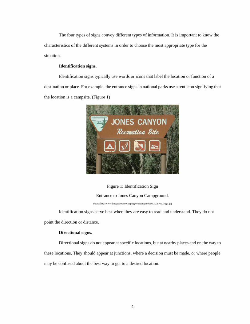
Identification signs.
Identification signs typically use words or icons that label the location or function of a
destination or place. For example, the entrance signs in national parks use a tent icon signifying that
the location is a campsite. (Figure 1)
Figure 1: Identification Sign
Entrance to Jones Canyon Campground. Photo: http://www.freeguidetonwcamping.com/images/Jones_Canyon_Sign.jpg
Identification signs serve best when they are easy to read and understand. They do not
point the direction or distance.
Directional signs.
Directional signs do not appear at specific locations, but at nearby places and on the way to
these locations. They should appear at junctions, where a decision must be made, or where people
may be confused about the best way to get to a desired location.
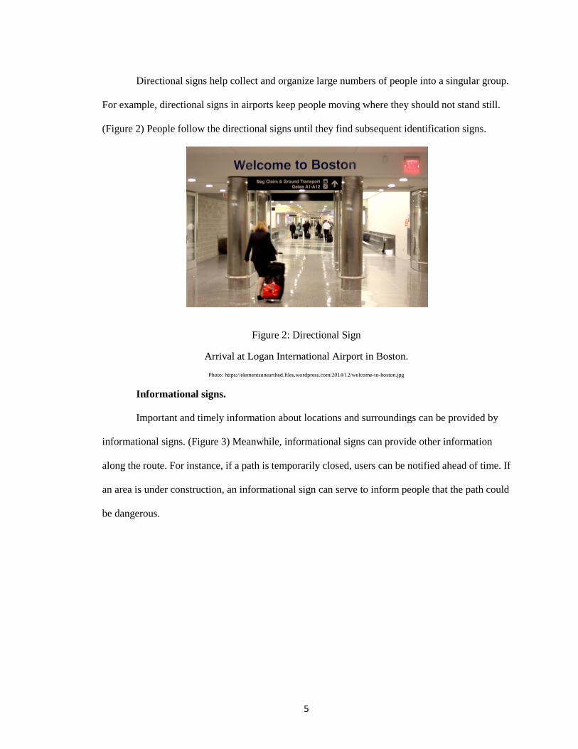
5
Directional signs help collect and organize large numbers of people into a singular group.
For example, directional signs in airports keep people moving where they should not stand still.
(Figure 2) People follow the directional signs until they find subsequent identification signs.
Figure 2: Directional Sign
Arrival at Logan International Airport in Boston. Photo: https://elementsunearthed.files.wordpress.com/2014/12/welcome-to-boston.jpg
Informational signs.
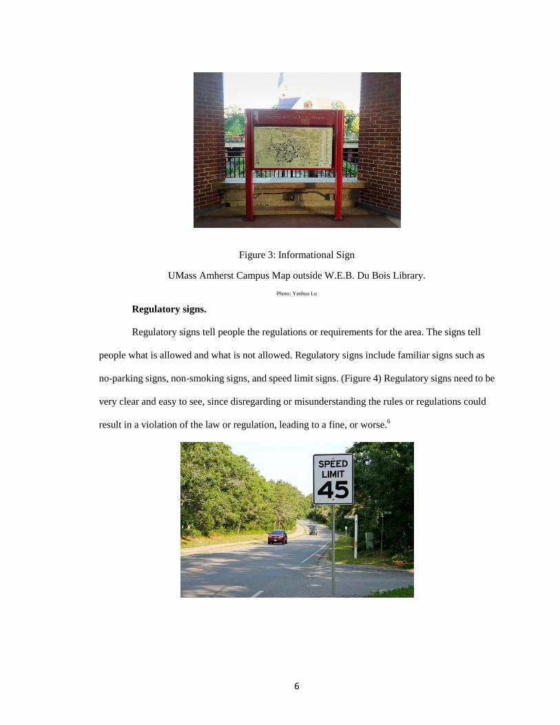
Important and timely information about locations and surroundings can be provided by
informational signs. (Figure 3) Meanwhile, informational signs can provide other information
along the route. For instance, if a path is temporarily closed, users can be notified ahead of time. If
an area is under construction, an informational sign can serve to inform people that the path could
be dangerous.
6
Figure 3: Informational Sign
UMass Amherst Campus Map outside W.E.B. Du Bois Library. Photo: Yanhua Lu
Regulatory signs.
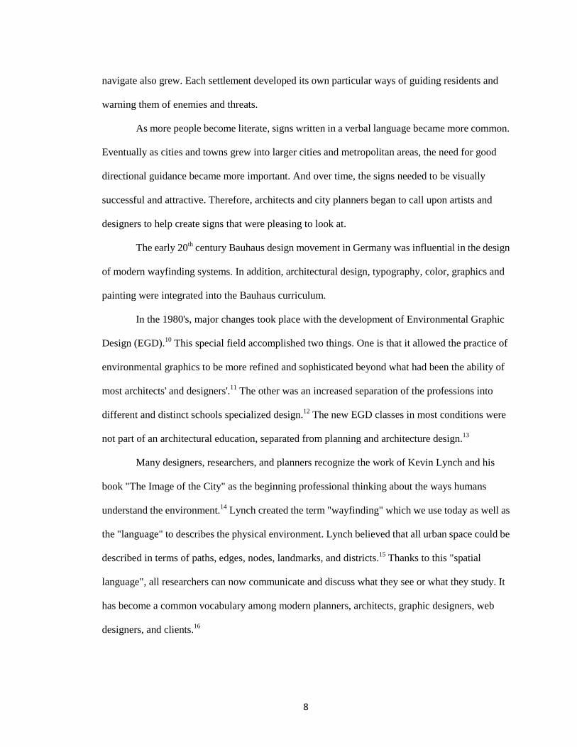
Regulatory signs tell people the regulations or requirements for the area. The signs tell
people what is allowed and what is not allowed. Regulatory signs include familiar signs such as
no-parking signs, non-smoking signs, and speed limit signs. (Figure 4) Regulatory signs need to be
very clear and easy to see, since disregarding or misunderstanding the rules or regulations could
result in a violation of the law or regulation, leading to a fine, or worse.6

7
Figure 4: Regulatory Sign
Speed Limit Sign. Photo: http://www.mvtimes.com/mvt/uploads/2014/07/old-speed-limit-sign-45.jpg
Overview of the Development of Wayfinding
Humans have always had the need to know where they are, and where they are going. The
existence of signs and markers dates to the beginning of time, evidenced by the simple piling up of
rocks on a trail, or cave and rock paintings that helped guide and send messages to a passersby. The
picture below (Figure 5) shows an 800-year-old oak tree bent as a sapling and tied to the ground to
mark directions and the location of important destinations by American Indians in Georgia.7
Figure 5: An 800-year-old Bent Oak Tree in Georgia Photo: https://web.extension.illinois.edu/illinoissteward/issues/backissues/2006/Summer/page2.jpg
The need for wayfinding and approaches to address this need have not changed a great deal
over the years, even as wayfinding systems have become more sophisticated. Finding safe shelter,
or a productive fishing hole, was necessary long before our current generation needed the kinds of
wayfinding systems that have become commonplace today. Most of the changes have been due to
the availability of new technology and materials.8
Over time, as humans developed and became less transient, they started to build
settlements, and then villages. As these communities got larger, the necessity to provide ways to
8
navigate also grew. Each settlement developed its own particular ways of guiding residents and
warning them of enemies and threats.
As more people become literate, signs written in a verbal language became more common.
Eventually as cities and towns grew into larger cities and metropolitan areas, the need for good
directional guidance became more important. And over time, the signs needed to be visually
successful and attractive. Therefore, architects and city planners began to call upon artists and
designers to help create signs that were pleasing to look at.
The early 20th century Bauhaus design movement in Germany was influential in the design
of modern wayfinding systems. In addition, architectural design, typography, color, graphics and
painting were integrated into the Bauhaus curriculum.
In the 1980's, major changes took place with the development of Environmental Graphic
Design (EGD).10 This special field accomplished two things. One is that it allowed the practice of
environmental graphics to be more refined and sophisticated beyond what had been the ability of
most architects' and designers'.11 The other was an increased separation of the professions into
different and distinct schools specialized design.12 The new EGD classes in most conditions were
not part of an architectural education, separated from planning and architecture design.13
Many designers, researchers, and planners recognize the work of Kevin Lynch and his
book "The Image of the City" as the beginning professional thinking about the ways humans
understand the environment.14 Lynch created the term "wayfinding" which we use today as well as
the "language" to describes the physical environment. Lynch believed that all urban space could be
described in terms of paths, edges, nodes, landmarks, and districts.15 Thanks to this "spatial
language", all researchers can now communicate and discuss what they see or what they study. It
has become a common vocabulary among modern planners, architects, graphic designers, web
designers, and clients.16
9
Notes
1 Huelat, Barbara J. "Wayfinding: Design for Understanding." The Center for Health Design. Network Solutions, LLC, 2007.
2 Foltz, Mark A. "Designing Navigable Information Spaces." Designing Navigable Information
Spaces. MASSACHUSETTS INSTITUTE OF TECHNOLOGY, 20 May 1998. 3 Nady, Riham. "How Do We Explore Cities?" Arch2Ocom. NAMESILO, LLC, 06 July 2016.
Web. Retrieved 10 July 2016. <http://www.arch2o.com/how-to-explore-cities/>. 4 Golledge, Reginald G. "Human Wayfinding and Cognitive Maps." Wayfinding Behavior:
Cognitive Mapping and Other Spatial Processes. Baltimore: Johns Hopkins UP, 1999. 6-7. 5 Beynon, Chris, and Maggie Campbell. "Wayfinding." Re:Streets. MIG, Inc, 2011. Web. 10
Oct. 2016. <http://www.restreets.org/wayfinding>. 6 Farr, Anna Charisse, Tristan Kleinschmidt, Prasad Yarlagadda, and Kerrie Mengersen.
"Wayfinding: A Simple Concept, a Complex Process." Transport Reviews 32.6 (2012): 715-43. 7 McClain, William. "Mysteries of the Trail-Marker Trees." The Illinois Stewed. University of
Illinois Extension, 2006. Web. 17 July 2016. <https://web.extension.illinois.edu/illinoissteward/openarticle.cfm?ArticleID=26&Page=2>. 8 Westerkamp, Thomas A. "New Wayfinding Technology, Ordinance Changes Offer
Challenges to Managers." Facilitiesnet. Trade Press Media Group, July 2013. Web. Retrieved 18 July 2016.
<http://www.facilitiesnet.com/maintenanceoperations/article/New-Wayfinding-Technology-Ordinance-Changes-Offer-Challenges-to-Managers-Facility-Management-Maintenance-Operations-Feature--14207>.
9 Morville, Peter. Ambient Findability: What We Find Changes Who We Become. Beijing:
O'Reilly, 2005. 10 Bennani, Kristin, and Kathleen Turner. "What Is Environmental Graphic Design (EGD)?"
SEGD: A Multidisciplinary Community Creating Experiences That Connect People to Place. Network Solutions, LLC, 2013. Web. Retrieved 19 Jul. 2016.
<https://segd.org/article/what-environmental-graphic-design-egd>. 11 Berger, Craig. "Typography, Placemaking and Signs." International Sign Association.
Signage Foundation, INC, 01 Jan. 2014. Web. Retrieved 20 July 2016. <https://www.signs.org/pdf2014/ISA_Typography_White_Papers_full_final.pdf>. 12 Margolin, Victor. Design Discourse: History, Theory, Criticism. Chicago: U of Chicago,
1989.

10
13 Christophersen, Jon. Universal Design: 17 Ways of Thinking and Teaching. Oslo: Husbanken, 2002.
14 Lange, Michael De. "Review: Kevin Lynch – The Image of the City." The Mobile City.
Greenhost, INC, 08 May 2009. Web. Retrieved 20 Jul. 2016. <http://themobilecity.nl/2009/05/08/review-kevin-lynch-the-image-of-the-city/>. 15 Lynch, Kevin. The Image of the City. Cambridge, MA: MIT, 1960. 16 Francis, Mark. "A Case Study Method for Landscape Architecture." Landscape Journal
20.1 (2001): 15-28.
11
CHAPTER 2
LITERATURE REVIEW
Overview of Wayfinding
"Wayfinding is the process of determining and following a path or route between an origin
and a destination."1 Wayfinding refers to an information system that guides people within the
physical environment to improve their understanding and experience of the space.
There is a large body of literature related to the subject of wayfinding. The literature dates
back to 1960, when the word was first used by the prominent urban planner, Kevin Lynch. Other
important work was done in 1992 by Romedi Passini and Paul Arthur who argued that wayfinding
includes more than the creation of static “mental map” of space, as Lynch suggested, but also a
spatial problem-solving exercise as people move across architectures and urban spaces.
The subject of wayfinding, originally studied by cognitive and environmental
psychologists, has become more relevant to cities and towns and the field of urban design and
planning in the last twenty years.2 Today, most cities and towns, large and small include
wayfinding systems as an important part of the built environment.
Wayfinding is particularly important in complex built environments. These include
downtowns but may also include large buildings or campuses such as hospitals, universities, and
transportation facilities. Over time, as architectural environments have become more complex,
more and better visual cues are needed. These cues can come from maps or directional signs and
symbols that help direct users to specific destinations. In modern environments, effective
wayfinding systems can contribute to a sense of safety, well-being, and security.3
Some early wayfinding systems were designed for especially complex environments such
as hospitals and airports. Hospitals present many unique navigational challenges. In many hospitals,
the physical layout has evolved over many years to often include multiple buildings, making them

12
particularly complex to navigate. In addition, many patients and their families must find their way
in a hospital setting under stressful situations.
In some complex settings, designers rely less on text-based systems and instead favor
systems that rely more heavily on non-text cues such as colors and graphics. In transportation
settings, such as airports and railway stations, where travelers must be directed to intermodal
connections, wayfinding systems provide critical guidance along carefully-planned paths designed
for large numbers of travelers.4
In recent years wayfinding design has evolved to become standard practice within the
planning departments of cities and towns. Increasingly wayfinding systems are seen as an
important component of today’s emphasis on "placemaking". The latest wayfinding systems often
incorporate new technologies such as mobile applications, digital displays, Radio-frequency
identification(RFID), and other wireless systems. New systems may also include a variety of
high-tech materials and graphics that combine symbols, maps, signage, different colors and other
communication facilities.
History of Wayfinding Design
There are many examples of early wayfinding design systems. Many of these were created
to identify and provide important information about landmarks or destinations, with symbols such
as carved letterforms, pictographs, and imagery. These "signs" were produced by artisans to
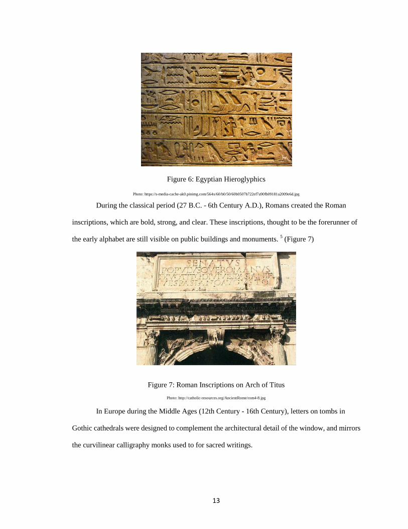
communicate civic information or religious meaning. Ancient Egyptians used hieroglyphics (3400
B.C. – 396 A.D.) to call attention to the accomplishments of royalty and their dynasties.5 (Figure 6)
13
Figure 6: Egyptian Hieroglyphics
Photo: https://s-media-cache-ak0.pinimg.com/564x/60/b0/50/60b0507b722ef7a90fb09181a2009e6d.jpg
During the classical period (27 B.C. - 6th Century A.D.), Romans created the Roman
inscriptions, which are bold, strong, and clear. These inscriptions, thought to be the forerunner of
the early alphabet are still visible on public buildings and monuments. 5 (Figure 7)
Figure 7: Roman Inscriptions on Arch of Titus Photo: http://catholic-resources.org/AncientRome/rom4-8.jpg
In Europe during the Middle Ages (12th Century - 16th Century), letters on tombs in
Gothic cathedrals were designed to complement the architectural detail of the window, and mirrors
the curvilinear calligraphy monks used to for sacred writings.
14
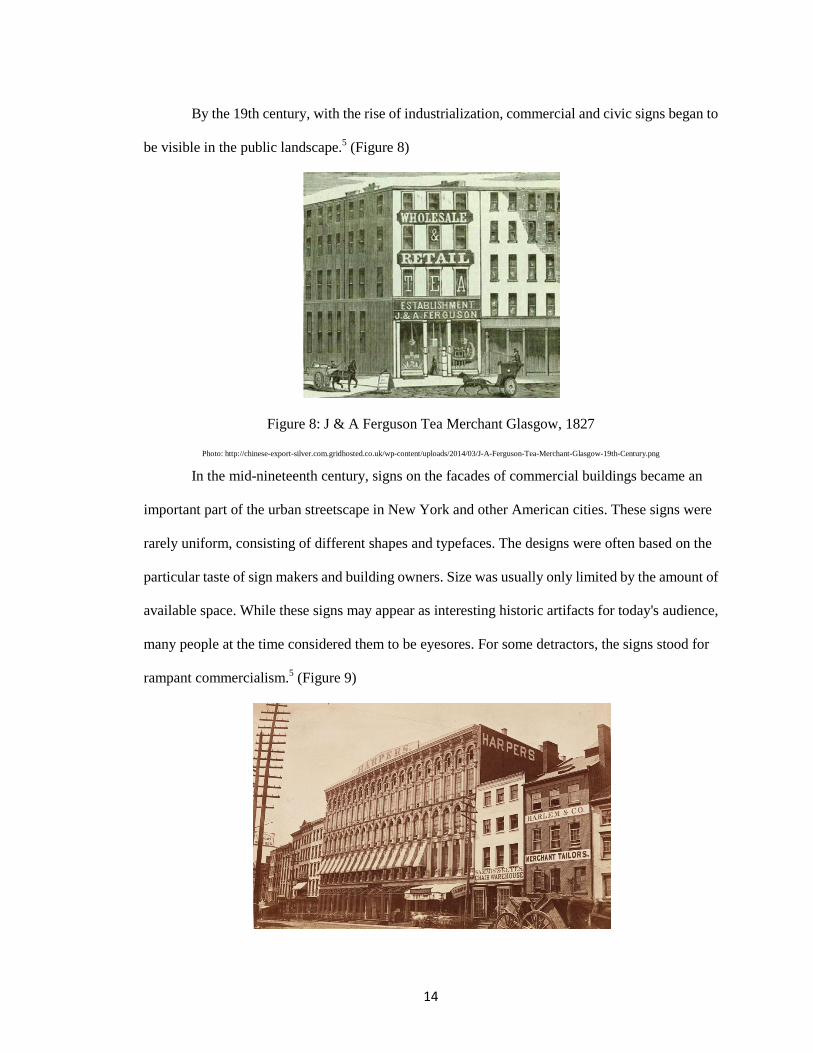
By the 19th century, with the rise of industrialization, commercial and civic signs began to
be visible in the public landscape.5 (Figure 8)
Figure 8: J & A Ferguson Tea Merchant Glasgow, 1827
Photo: http://chinese-export-silver.com.gridhosted.co.uk/wp-content/uploads/2014/03/J-A-Ferguson-Tea-Merchant-Glasgow-19th-Century.png
In the mid-nineteenth century, signs on the facades of commercial buildings became an
important part of the urban streetscape in New York and other American cities. These signs were
rarely uniform, consisting of different shapes and typefaces. The designs were often based on the
particular taste of sign makers and building owners. Size was usually only limited by the amount of
available space. While these signs may appear as interesting historic artifacts for today's audience,
many people at the time considered them to be eyesores. For some detractors, the signs stood for
rampant commercialism.5 (Figure 9)
15
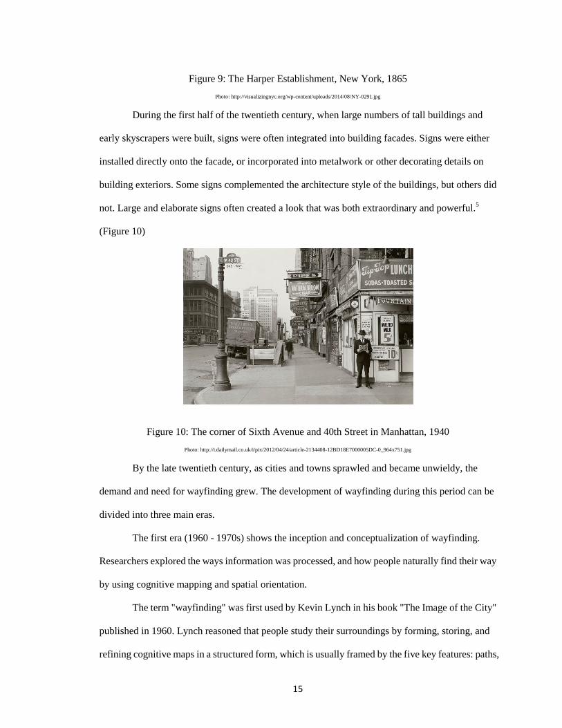
Figure 9: The Harper Establishment, New York, 1865 Photo: http://visualizingnyc.org/wp-content/uploads/2014/08/NY-0291.jpg
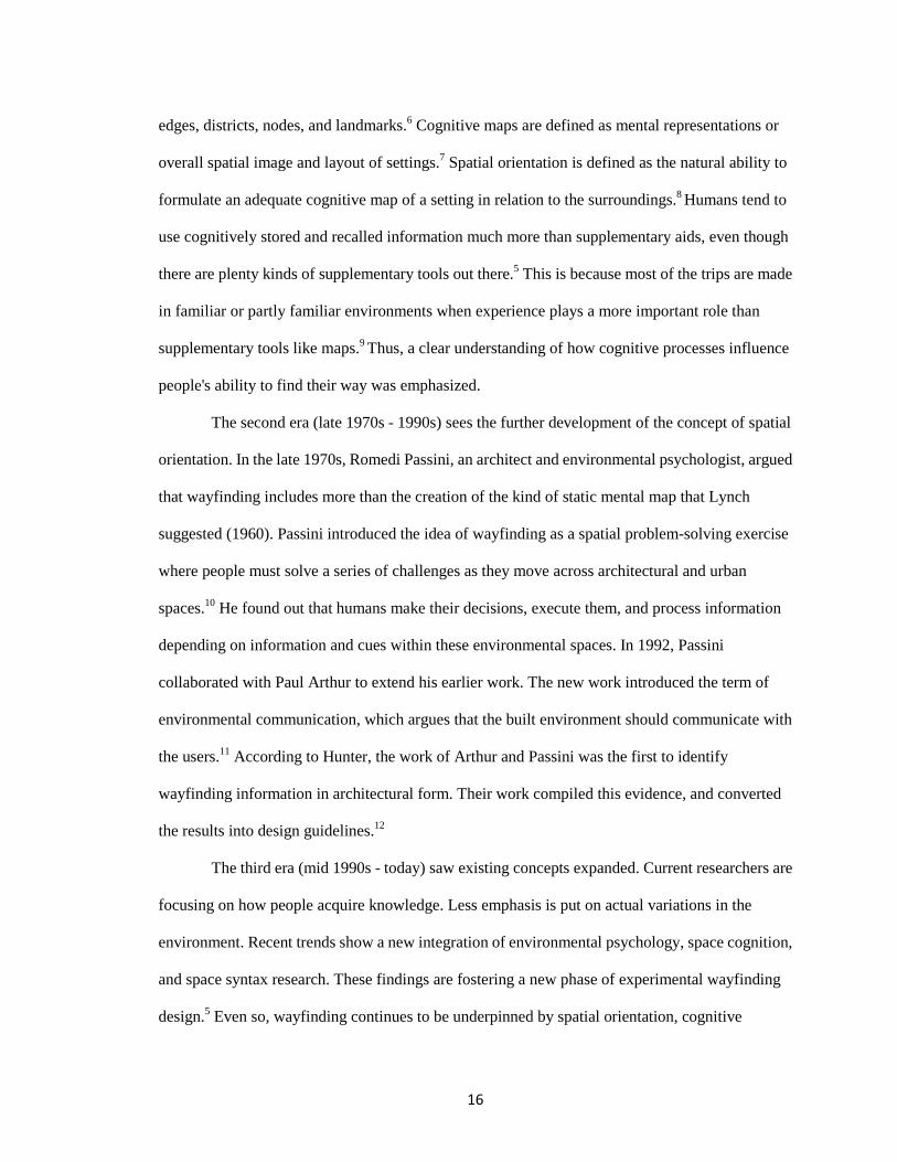
During the first half of the twentieth century, when large numbers of tall buildings and
early skyscrapers were built, signs were often integrated into building facades. Signs were either
installed directly onto the facade, or incorporated into metalwork or other decorating details on
building exteriors. Some signs complemented the architecture style of the buildings, but others did
not. Large and elaborate signs often created a look that was both extraordinary and powerful.5
(Figure 10)
Figure 10: The corner of Sixth Avenue and 40th Street in Manhattan, 1940 Photo: http://i.dailymail.co.uk/i/pix/2012/04/24/article-2134408-12BD18E7000005DC-0_964x751.jpg
By the late twentieth century, as cities and towns sprawled and became unwieldy, the
demand and need for wayfinding grew. The development of wayfinding during this period can be
divided into three main eras.
The first era (1960 - 1970s) shows the inception and conceptualization of wayfinding.
Researchers explored the ways information was processed, and how people naturally find their way
by using cognitive mapping and spatial orientation.
The term "wayfinding" was first used by Kevin Lynch in his book "The Image of the City"
published in 1960. Lynch reasoned that people study their surroundings by forming, storing, and
refining cognitive maps in a structured form, which is usually framed by the five key features: paths,
16
edges, districts, nodes, and landmarks.6 Cognitive maps are defined as mental representations or
overall spatial image and layout of settings.7 Spatial orientation is defined as the natural ability to
formulate an adequate cognitive map of a setting in relation to the surroundings.8 Humans tend to
use cognitively stored and recalled information much more than supplementary aids, even though
there are plenty kinds of supplementary tools out there.5 This is because most of the trips are made
in familiar or partly familiar environments when experience plays a more important role than
supplementary tools like maps.9 Thus, a clear understanding of how cognitive processes influence
people's ability to find their way was emphasized.
The second era (late 1970s - 1990s) sees the further development of the concept of spatial
orientation. In the late 1970s, Romedi Passini, an architect and environmental psychologist, argued
that wayfinding includes more than the creation of the kind of static mental map that Lynch
suggested (1960). Passini introduced the idea of wayfinding as a spatial problem-solving exercise
where people must solve a series of challenges as they move across architectural and urban
spaces.10 He found out that humans make their decisions, execute them, and process information
depending on information and cues within these environmental spaces. In 1992, Passini
collaborated with Paul Arthur to extend his earlier work. The new work introduced the term of
environmental communication, which argues that the built environment should communicate with
the users.11 According to Hunter, the work of Arthur and Passini was the first to identify
wayfinding information in architectural form. Their work compiled this evidence, and converted
the results into design guidelines.12
The third era (mid 1990s - today) saw existing concepts expanded. Current researchers are
focusing on how people acquire knowledge. Less emphasis is put on actual variations in the
environment. Recent trends show a new integration of environmental psychology, space cognition,
and space syntax research. These findings are fostering a new phase of experimental wayfinding
design.5 Even so, wayfinding continues to be underpinned by spatial orientation, cognitive
17
mapping and spatial problem solving to a large extent. Perhaps more than anything else, the current
era’s extraordinary interest in wayfinding especially as it relates to design and technology,
indicates that the field has a range of needs and challenges that provide many opportunities for
further study.
The Benefits of Good Wayfinding Systems
There are a variety of costs associated with having poor wayfinding systems. Zimring,13
Arthur and Passini,10 Carpman and Grant14 and Huelat,15 say that stress related problems such as
raised blood pressure and headaches, are linked to deficient wayfinding systems in complex
environments. The additional costs can be fairly serious. These include lost staff time and
disruption due to the need to provide directions, lost business and user dissatisfaction, the need for
additional security staff and traffic management, danger to users wandering into limited access
areas of buildings, and injury and death during emergency.
Zimring's study found that the hidden cost of needing to give directions to people because
of the poor wayfinding in a building complex was about $220,000 a year, which equaled the cost to
hire two full-time professionals.13 Zimring noted that, the need to have guidance and directions
provided by staff and other occupants was something that should be limited, by developing an
efficient and comprehensive wayfinding system.13
People often feel inadequate for lacking the acumen11 to navigate complex buildings.16
However, a lot of people who have studied wayfinding assert that getting lost is often due to a
poorly designed environment or wayfinding system.
Other researchers show that women18 have less spatial confidence than men,19 and they
rely more on localized landmarks for wayfinding.20 Men on the other hand tend to find their way or
give directions by using globalized configuration strategies.21 Lawson asserts that space belonging
to us should communicate with us by its physical properties. He argues that this "human language

18
of space" should be the basic tool of the trade for an architect.22 A similar point was made by Lynch,
who emphasized that design should be used to reinforce existing social meanings, rather than deny
them. From their research, we can see wayfinding coordinate with well-designed environment that
based on "human language of space" would be efficient and effective.
19
Notes
1 Golledge, Reginald G. "Human Wayfinding and Cognitive Maps." Wayfinding Behavior: Cognitive Mapping and Other Spatial Processes. Baltimore: Johns Hopkins UP, 1999. 6-7.
2 Budev, Sapna, John Bosio, and Craig Berger. "Planning and Implementing an Urban
Wayfinding Project." International Sign Association. ISA, 2013. Web. Retrieved 03 Aug. 2016. 3 American Public Transportation Association. "Why Design Matters for Transit." Why
Design Matters for Transit. APTA Sustainable Urban Design Standards Working Group, 31 Mar. 2011. Web. Retrieved 25 Aug. 2016.
<https://www.planning.org/events/activity/9110702/>. 4 Rooke, Clementinah. "Improving Wayfinding in Old and Complex Hospital Environments."
Salford E-theses Collection. University of Salford, Manchester, Nov. 2012. Web. Retrieved 3 Aug. 2016.
<http://usir.salford.ac.uk/id/eprint/27358>. 5 Gibson, David. "Wayfinding Design Topography and Layout." The Wayfinding Handbook:
Information Design for Public Places. New York: Princeton Architectural, 2009. 75-76. 6 Lynch, Kevin. The Image of the City. Cambridge, MA: MIT, 1960. 7 Arthur, Paul, and Romedi Passini. Wayfinding: People, Signs, and Architecture. New York:
McGraw-Hill Book, 1992. 8 Passini, Romedi Eugenio. Wayfinding: A Study of Spatial Problem Solving with Implications
for Physical Design. Pennsylvania State U, 1977. 9 Passini, Romedi. Wayfinding in Architecture. New York: Van Nostrand Reinhold, 1984. 10 Arthur, Paul, and Romedi Passini. Wayfinding: People, Signs, and Architecture. New York:
McGraw-Hill Book, 1992. 11 Hunter, Susan. "Spatial Orientation, Environmental Perception and Wayfinding." IDeA
Center, University at Buffalo, 2010. Retrieved Web. 03 Aug. 2016. <http://www.udeworld.com/space-syntax-and-the-importance-of-access-to-architectural-t
heory.html >. 12 Zimbardo, Philip G., Ann L. Weber, and Robert L. Johnson. Psychology: Core Concepts.
Boston: Allyn and Bacon, 2003. 13 Golledge, Reginald G. Wayfinding Behavior: Cognitive Mapping and Other Spatial
Processes. Baltimore: Johns Hopkins UP, 1999. 14 Zimring, C. "The Cost of Confusion: Non-monetary and Monetary Cost of the Emory
University Hospital Wayfinding System." Thesis. Georgia Institute of Technology, 1990.
20
Wayfinding: Design for Understanding. The Center for Health Design, Inc., 2007. Web. Retrieved 07 Aug. 2016.
<https://www.healthdesign.org/chd/research/wayfinding-design-understanding>. 15 Carpman, Janet Reizenstein, Myron A. Grant, and Deborah A. Simmons. Design That
Cares: Planning Health Facilities for Patients and Visitors. 3rd ed. John Wiley & Sons, 2001. 16 Huelat, B. J. "The Elements of a Caring Environment - Wayfinding." Healthcare Design
2004. 17 Rooke, Clementinah Ndhlovu, John Alfred Rooke, Lauri Koskela, and Patricia
Tzortzopoulos. "Using the Physical Properties of Artefacts to Manage Through-life Knowledge Flows in the Built Environment: An Initial Exploration." Construction Management and Economics 28.6 (2010): 601-13. Web. Retrieved 07 Aug. 2016.
<http://usir.salford.ac.uk/11300/>. 18 Klipp, Mark Vander. "Develop a Successful Wayfinding System." Buildings.
BUILDINGS.COM, 04 Mar. 2006. Web. Retrieved 07 Aug. 2016. <http://www.buildings.com/article-details/articleid/3036/title/develop-a-successful-wayfin
ding-system>. 19 Lawton, Carol A., Stephanie I. Charleston, and Amy S. Zieles. "Individual- and
Gender-Related Differences in Indoor Wayfinding." Environment and Behavior 28.2 (1996): 204-19.
20 Lawton, Carol A., and János Kállai. "Gender Differences in Wayfinding Strategies and
Anxiety About Wayfinding: A Cross-Cultural Comparison." Sex Roles 47.9 (2002): 389-401. Web. Retrieved 09 Aug. 2016.
<http://link.springer.com/article/10.1023/A:1021668724970>. 21 Bechtel, Robert B., and Arzah Ts'erts'man. "Women and Environments." Handbook of
Environmental Psychology. New York: J. Wiley & Sons, 2002. 347-62. 22 Bever, T. "The Logical and Extrinsic Sources of Modularity." Modularity and Constraints in
Language and Cognition. Vol. 25. Hillsdale, NJ: L. Erlbaum Associates, 1992. 197-212.
21
CHAPTER 3
METHODOLOGY
Literature Review
The literature review focuses mainly on two topics: the development of wayfinding
systems and the benefits that wayfinding provides.
Human beings are born with the need to understand their environment. Some form of
wayfinding has existed from the beginning of time.1 Still most wayfinding designs have been
developed recently, beginning in the nineteenth century. The 1800’s saw the beginning of an era of
new industrial development highlighted by the growth of major cities. And as the urban
environment becomes more complex, the need for better wayfinding systems increased. This is true
in the United States, but also in every part of the world.
Case Studies
The case studies approach, presenting and comparing a range of exemplary projects has
shown to be a highly appropriate and valuable research method. This method not only provides
practical information on potential solutions to a problem, but the case study examples provide
effective teaching opportunities.2
The case studies used for this project explore ten wayfinding designs in a range of cities
including Springfield, Massachusetts. A variety of data has been collected including signage types,
population, density, cost, quantity of signs, etc. By comparing the data collected and the different
approaches and solutions implemented in each city, the most successful strategies will be identified.
The project benefits from "lessons" learned as part of a recently completed project in Springfield.
These lessons, and the lessons learned from the other case studies are used to help create guidelines
for general wayfinding design.

22
Interview
A questionnaire designed in collaboration with the UMass Design Center in Springfield
was created to establish baseline data about wayfinding in Springfield. The questions provided on
the questionnaire were created to establish general information about how people feel about
wayfinding in downtown Springfield. The questionnaire also addresses how people reacted to the
new wayfinding system.
The interview technique included a pre-interview analysis and interview guidelines.
The pre-interview includes understanding the current situation in downtown Springfield
and helped inform the interview locations. In order to collect adequate data and information, the
followings had been done: visiting downtown Springfield in different times, on-line research,
meetings with clients such as planners of the Office of Planning and Economic Development in the
city of Springfield, and collecting GIS data and overlay maps.
After defining interview locations, UMass Design Center interviewed pedestrians in each
of the location and analyzed the strengths and weaknesses3 of downtown environment, if it helps
people find their ways or make it harder, and how residents and visitors feel about the city and their
expectations.
23
Notes
1 Gibson, David. "Wayfinding Design Topography and Layout." The Wayfinding Handbook: Information Design for Public Places. New York: Princeton Architectural, 2009. 75-76.
2 Francis, Mark. "A Case Study Method for Landscape Architecture." Landscape Journal 20.1
(2001): 15-28. 3 Zeisel, John. "10. Focused Interviews." Inquiry by Design: Tools for Environment-behavior
Research. Monterey, CA: Brooks/Cole Pub., 1981. 227-256.
24
CHAPTER 4
DETAILED CASE STUDIES
Although we live in a world where cities can be navigated by smartphones and other
technologies, and any information on a destination can be found within minutes, physical
wayfinding elements are still necessary.
Municipal wayfinding systems serve more than basic navigation, identification, and
information. Wayfinding elements, such as monuments, directional systems, interpretive and even
regulatory signs, can enhance and enrich our experience with urban environments. Wayfinding is
the organization and communication of our dynamic relationship to space and environment.
Successful environmental design to promote wayfinding allows people to determine their location
within settings; determine their position relative to their destination; and develop a plan that will
take them from their current location to their destination. A good wayfinding design should
accomplish the following main goal: identifying and marking of specific spaces; grouping of
spaces; and linking and organizing spaces using both architectural and graphic means.
The foundation of a successful urban wayfinding plan is having a direct and conscious
connection to the existing logic of a city or place. The “logic of the city” is the organization of parts
of the city into a coherent pattern that can be recognized by the user, as part of a "mental map" to
help navigate from place to place. A successful wayfinding plan can transfer a cityscape from a
chaotic mix of elements to an understandable language that is logically understood by users.
Effective wayfinding signage can not only highlight specific destinations, but they can also
help brand the city, providing a shared image among residents that helps support the entire
community.
Studying "successful" wayfinding examples provides large quantities of useful data that
can help inform the design of successful wayfinding systems planned for Springfield and other
cities. The case studies listed below were selected because they represent deemed "successful"
25
wayfinding approaches. Each of them has been praised as achieving the goals set by their cities, and
have been well-received by local residents and visitors.
Charlotte, North Carolina
Charlotte is the largest city in the state of North Carolina, and the second largest city in
southeastern America. The area of the city is 297.7 square miles (771 km2). The population of the
city is 809,958, and the density is 2,720.7/sq mi.
Wayfinding system in Uptown Charlotte may be one of the most highly integrated urban
wayfinding systems in the world.
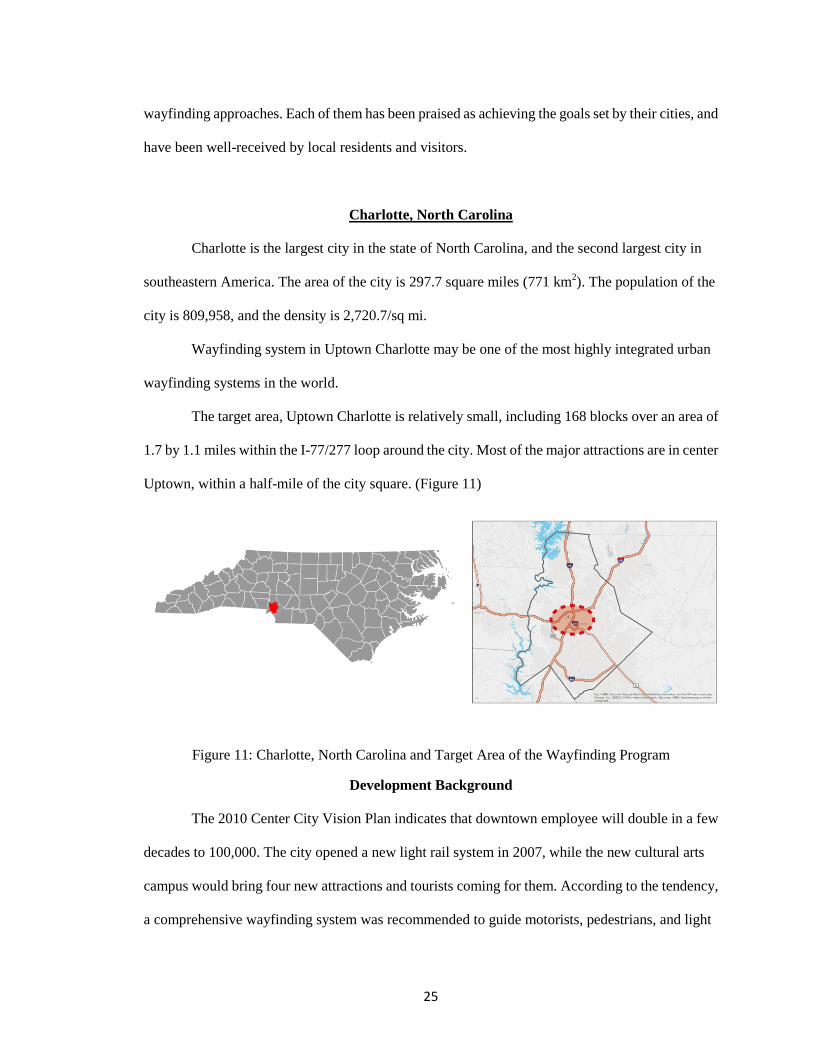
The target area, Uptown Charlotte is relatively small, including 168 blocks over an area of
1.7 by 1.1 miles within the I-77/277 loop around the city. Most of the major attractions are in center
Uptown, within a half-mile of the city square. (Figure 11)
Figure 11: Charlotte, North Carolina and Target Area of the Wayfinding Program
Development Background
The 2010 Center City Vision Plan indicates that downtown employee will double in a few
decades to 100,000. The city opened a new light rail system in 2007, while the new cultural arts
campus would bring four new attractions and tourists coming for them. According to the tendency,
a comprehensive wayfinding system was recommended to guide motorists, pedestrians, and light
26
rail passengers to their destinations in Uptown, the center-city core of Charlotte. The wayfinding
system finds the hidden logic in the organization of the city, and reduces complex geography into a
simple diagrammatic idea.
Signage Information and Design Elements
Wayfinding system in Charlotte includes both pedestrian and vehicular signage.
The first phase of the pedestrian signage program included 13 on-street signs and 14 map
kiosks at light rail stations. The second phase added 30 more signs on street throughout uptown.
The final phase added 6 more signs in Spring 2010, when two arts museums, a new
African-American Cultural Center, the NASCAR Hall of Fame, and other new venues opened.
Vehicular system includes 45 freeway signs, at least 38 on-street signs, 10 parking
guidance signs, and at least 1 dynamic sign that will broadcast parking availability.
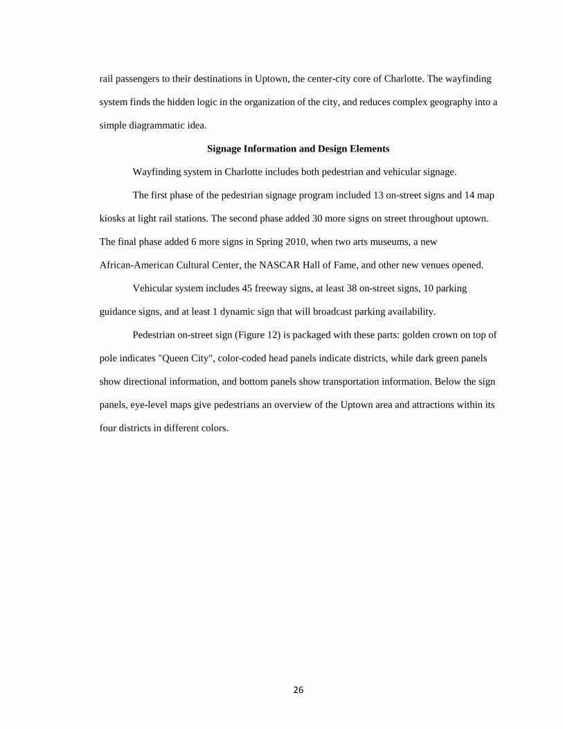
Pedestrian on-street sign (Figure 12) is packaged with these parts: golden crown on top of
pole indicates "Queen City", color-coded head panels indicate districts, while dark green panels
show directional information, and bottom panels show transportation information. Below the sign
panels, eye-level maps give pedestrians an overview of the Uptown area and attractions within its
four districts in different colors.
27
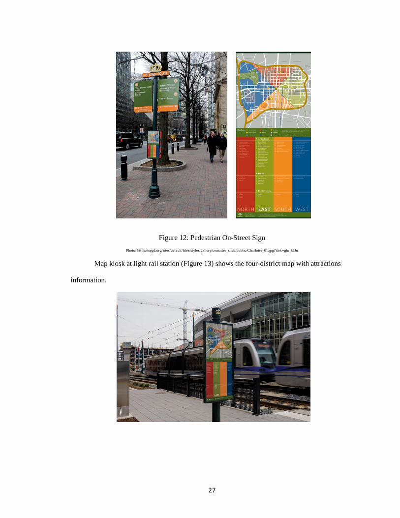
Figure 12: Pedestrian On-Street Sign Photo: https://segd.org/sites/default/files/styles/galleryformatter_slide/public/Charlotte_01.jpg?itok=ghr_bIJu
Map kiosk at light rail station (Figure 13) shows the four-district map with attractions
information.
28
Figure 13: Map Kiosk at Light Rail Station Photo: https://segd.org/sites/default/files/styles/galleryformatter_slide/public/Charlotte_09.jpg?itok=C6ZR7DhH
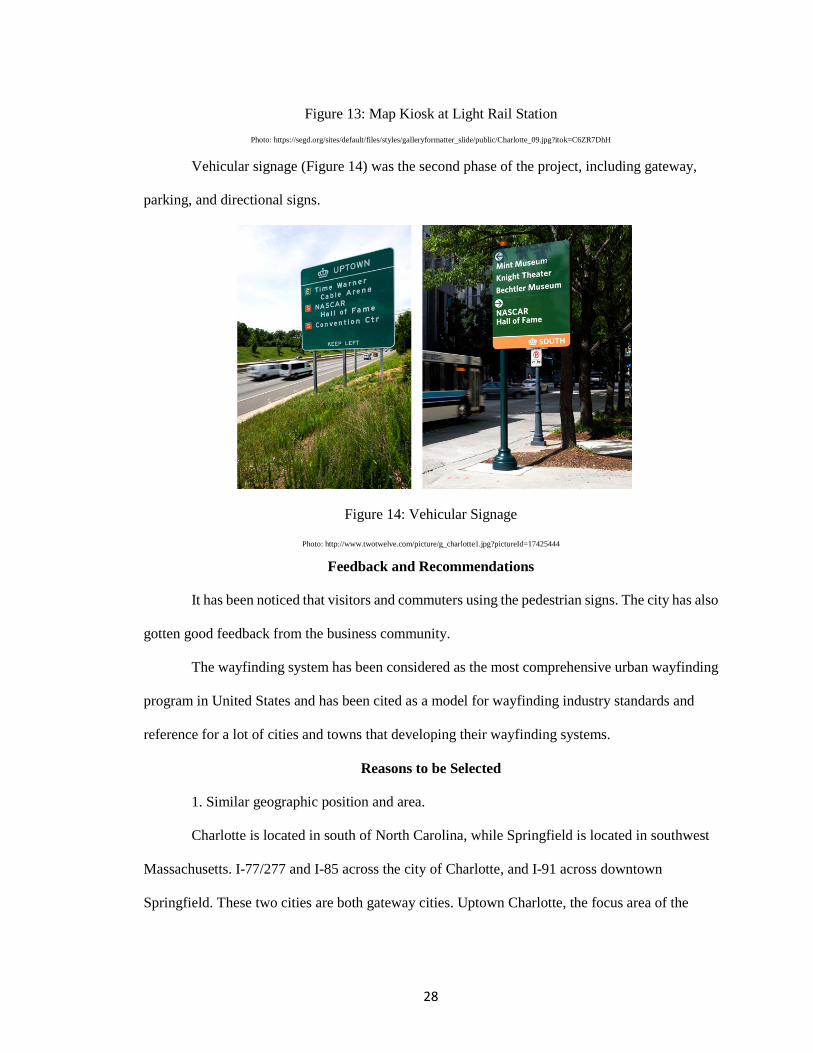
Vehicular signage (Figure 14) was the second phase of the project, including gateway,
parking, and directional signs.
Figure 14: Vehicular Signage
Photo: http://www.twotwelve.com/picture/g_charlotte1.jpg?pictureId=17425444
Feedback and Recommendations
It has been noticed that visitors and commuters using the pedestrian signs. The city has also
gotten good feedback from the business community.
The wayfinding system has been considered as the most comprehensive urban wayfinding
program in United States and has been cited as a model for wayfinding industry standards and
reference for a lot of cities and towns that developing their wayfinding systems.
Reasons to be Selected
1. Similar geographic position and area.
Charlotte is located in south of North Carolina, while Springfield is located in southwest
Massachusetts. I-77/277 and I-85 across the city of Charlotte, and I-91 across downtown
Springfield. These two cities are both gateway cities. Uptown Charlotte, the focus area of the
29
program, is about 1.87 square miles. Metro Center/downtown Springfield, which would be the
target area, is about 0.92 square miles.
2. Similar developing background.
Major attractions in both cities are in a centralized district. They share the same
background of developing wayfinding system, which is promoting venues and satisfy the needs of
increasing visitors brought by venues.
Philadelphia, Pennsylvania
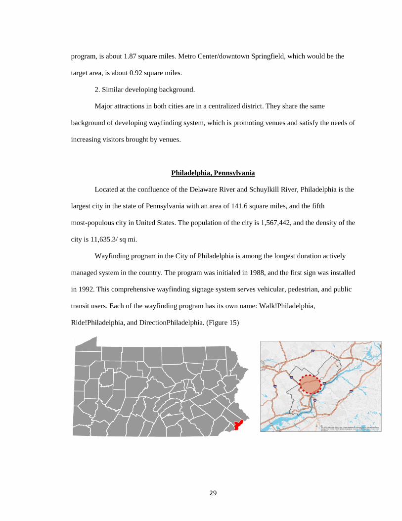
Located at the confluence of the Delaware River and Schuylkill River, Philadelphia is the
largest city in the state of Pennsylvania with an area of 141.6 square miles, and the fifth
most-populous city in United States. The population of the city is 1,567,442, and the density of the
city is 11,635.3/ sq mi.
Wayfinding program in the City of Philadelphia is among the longest duration actively
managed system in the country. The program was initialed in 1988, and the first sign was installed
in 1992. This comprehensive wayfinding signage system serves vehicular, pedestrian, and public
transit users. Each of the wayfinding program has its own name: Walk!Philadelphia,
Ride!Philadelphia, and DirectionPhiladelphia. (Figure 15)
30
Figure 15: Philadelphia, PA and Central City, the Target Area of Walk!Philadelphia
Developing Background
The project started as the DerectionPhiladelpiha vehicular wayfinding program in Center
City Philadelphia. In 1985, the Foundation for Architecture (FFA) held a public forum and came up
with the wayfinding idea with city agencies, area tourist attractions, local businesses and
institutions and organizations such as the American Institute of Graphic Arts. The Foundation for
Architecture (FFA) led the stakeholder process, managed the Sussman/Prejza design team, and
implemented and managed the program. In 1988, the William Penn Foundation supported the
committee with a three-year grant to develop the wayfinding signage program.
Signage Information and Design Elements
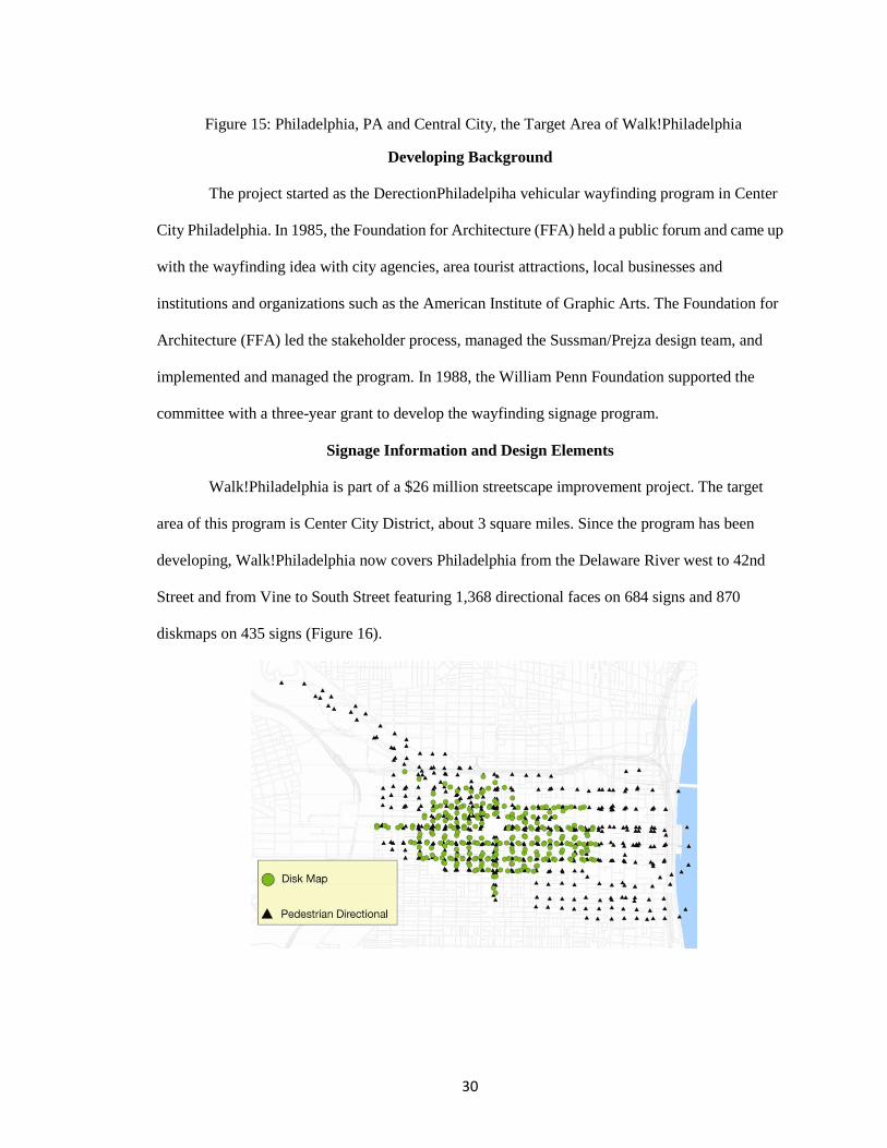
Walk!Philadelphia is part of a $26 million streetscape improvement project. The target
area of this program is Center City District, about 3 square miles. Since the program has been
developing, Walk!Philadelphia now covers Philadelphia from the Delaware River west to 42nd
Street and from Vine to South Street featuring 1,368 directional faces on 684 signs and 870
diskmaps on 435 signs (Figure 16).

31
Figure 16: Pedestrian Signs Distribution Photo: http://www.dvrpc.org/Transportation/BicyclePedestrian/
The pedestrian wayfinding includes two types, directional sign and diskmap. Directional
signs (Figure 17) located at each street corner, displaying 6 to 10 nearby destinations. The
double-faced directional signs also show the name, color, and icon of the district at the location.
Destinations and areas shown on the disk maps are in 2-5 blocks radius.
Figure 17: Directional Signs
Photo: http://www.lhsigns.com/wp-content/uploads/2012/08/4-Walk-Philadelphia-urban-wayfinding-sign-on-Broad-Street-in-front-of-City-Hall-resized-600.jpg
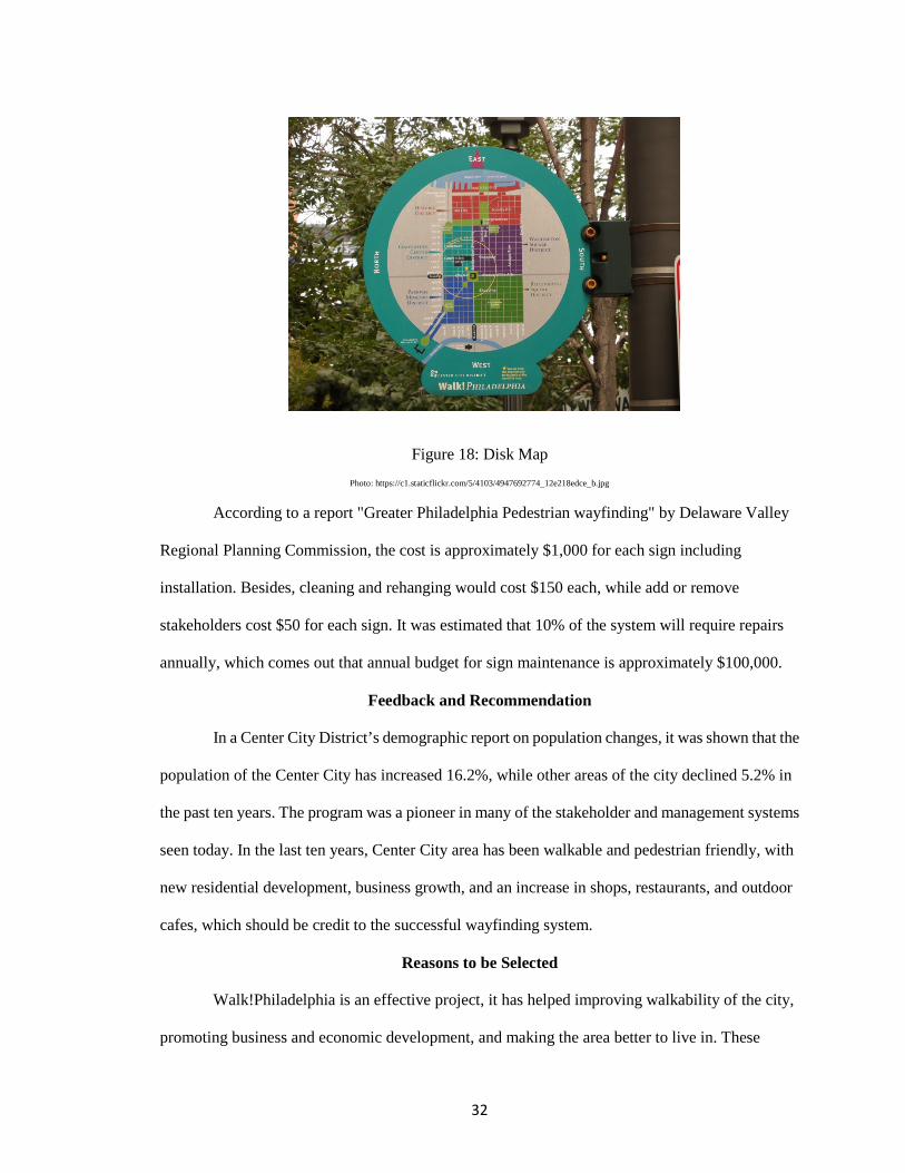
The simplified, diagrammatic Diskmaps (Figure 18) are located mid-block on both sides of
the streets. Their facing the direction the viewer is facing at the top of the map makes visitors orient
themselves easily. For example, if the destination on the map is towards the top and left to the map,
visitors would simply walk forward and turn left. The map divides Center City into five
color-coded districts. Major landmarks and significant business and cultural districts are shown on
the map. A "You Are Here" star with a 10-minute walking radius help users determine their
walking distance.
32
Figure 18: Disk Map Photo: https://c1.staticflickr.com/5/4103/4947692774_12e218edce_b.jpg
According to a report "Greater Philadelphia Pedestrian wayfinding" by Delaware Valley
Regional Planning Commission, the cost is approximately $1,000 for each sign including
installation. Besides, cleaning and rehanging would cost $150 each, while add or remove
stakeholders cost $50 for each sign. It was estimated that 10% of the system will require repairs
annually, which comes out that annual budget for sign maintenance is approximately $100,000.
Feedback and Recommendation
In a Center City District’s demographic report on population changes, it was shown that the
population of the Center City has increased 16.2%, while other areas of the city declined 5.2% in
the past ten years. The program was a pioneer in many of the stakeholder and management systems
seen today. In the last ten years, Center City area has been walkable and pedestrian friendly, with
new residential development, business growth, and an increase in shops, restaurants, and outdoor
cafes, which should be credit to the successful wayfinding system.
Reasons to be Selected
Walk!Philadelphia is an effective project, it has helped improving walkability of the city,
promoting business and economic development, and making the area better to live in. These
33
achievements indicates that Walk!Philadelphia is a successful wayfinding project, and is also what
we are chasing for in Metro Center, Springfield. This project has been used as case study for a lot of
cities' wayfinding developing plan as well.
Portland, Oregon
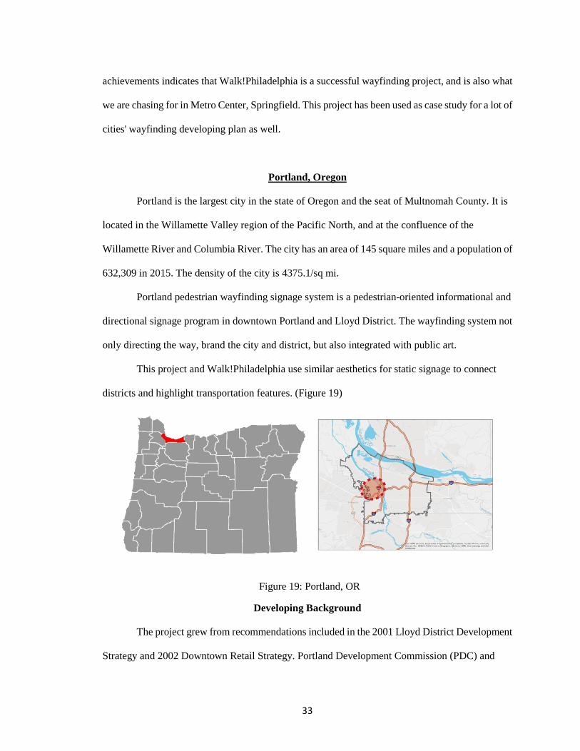
Portland is the largest city in the state of Oregon and the seat of Multnomah County. It is
located in the Willamette Valley region of the Pacific North, and at the confluence of the
Willamette River and Columbia River. The city has an area of 145 square miles and a population of
632,309 in 2015. The density of the city is 4375.1/sq mi.
Portland pedestrian wayfinding signage system is a pedestrian-oriented informational and
directional signage program in downtown Portland and Lloyd District. The wayfinding system not
only directing the way, brand the city and district, but also integrated with public art.
This project and Walk!Philadelphia use similar aesthetics for static signage to connect
districts and highlight transportation features. (Figure 19)
Figure 19: Portland, OR
Developing Background
The project grew from recommendations included in the 2001 Lloyd District Development
Strategy and 2002 Downtown Retail Strategy. Portland Development Commission (PDC) and
34
Portland Office of Transportation (PDOT) started to develop the project in May 2003, and it has
been completed in 2009.
The project was developed with Joel Katz Design Associates (JKDA), which is responsible
for the successful Walk!Philadelphia project.
Signage Information and Design Elements
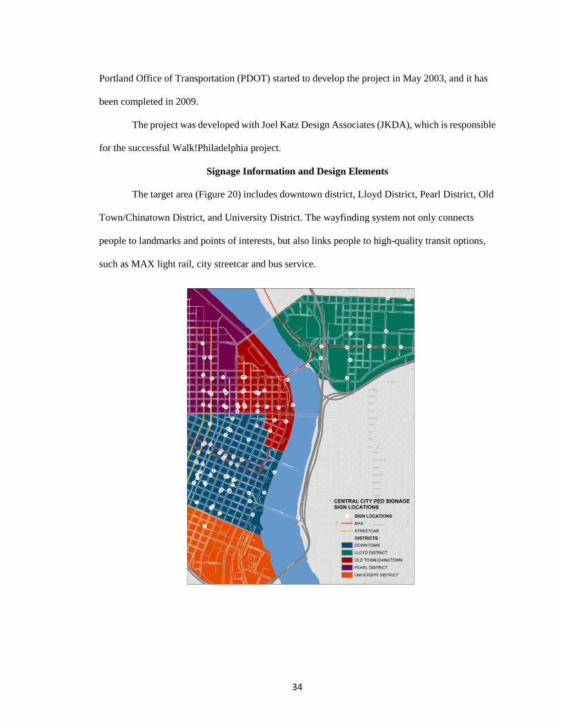
The target area (Figure 20) includes downtown district, Lloyd District, Pearl District, Old
Town/Chinatown District, and University District. The wayfinding system not only connects
people to landmarks and points of interests, but also links people to high-quality transit options,
such as MAX light rail, city streetcar and bus service.
35
Figure 20: Target Area and Sign Locations Photo: https://www.portlandoregon.gov/shared/cfm/image.cfm?id=164044
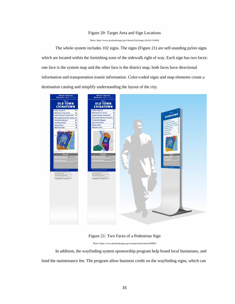
The whole system includes 102 signs. The signs (Figure 21) are self-standing pylon signs
which are located within the furnishing zone of the sidewalk right of way. Each sign has two faces:
one face is the system map and the other face is the district map, both faces have directional
information and transportation transit information. Color-coded signs and map elements create a
destination catalog and simplify understanding the layout of the city.
Figure 21: Two Faces of a Pedestrian Sign Photo: https://www.portlandoregon.gov/transportation/article/98859
In addition, the wayfinding system sponsorship program help brand local businesses, and
fund the maintenance fee. The program allow business credit on the wayfinding signs, which can
36
show their support of downtown retail and activity. Sponsorship is $400 per sign face for two years,
which allow maintenance and expansion of the system without using additional tax payer dollars.
Feedback and Recommendation
I have been to Portland for a trip in winter 2015. Even in the cold winter and snowy
weather, pedestrians were still everywhere. Visitors are always packed in Portland, and the
wayfinding signs really helped a lot. I even spent one day walking around the entire five districts in
Portland studying open spaces, such as Lovejoy Plaza and Keller Fountain Park designed by
famous landscape architect Lawrence Halprin.
In the five districts area, there are numerous retails, open spaces, cultural attractions and
other venus, most of the streets are one-way, the climate is always warm... All these features
become the reasons Portland is a walkable city. In that case, wayfinding signs are necessary for
pedestrians, especially for visitors.
Reasons to be Selected
The area of wayfinding signage coverage is approximately 1.1 square miles, which is close
to Springfield, 0.92 square miles of the target area. Population density of the two cities are similar
as well. In that case, it would be a good lesson to learn that how many signs are needed, where to
install them would serve such people in certain area for Springfield.
Springfield, Oregon
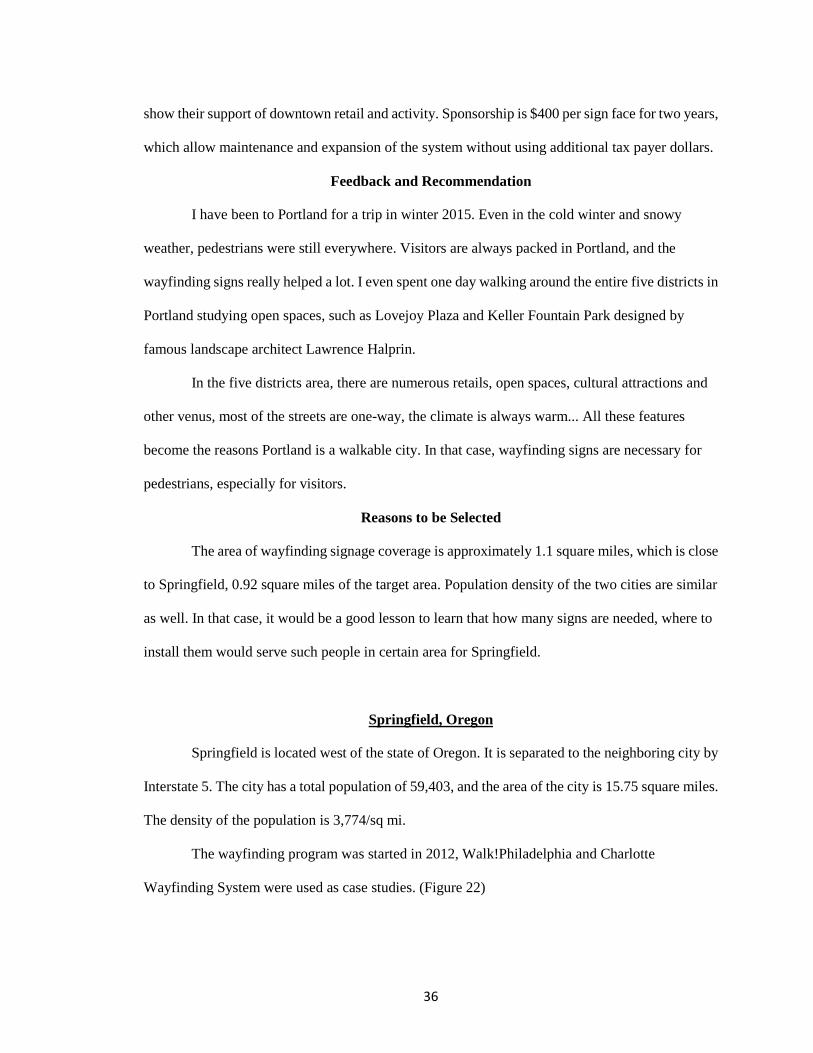
Springfield is located west of the state of Oregon. It is separated to the neighboring city by
Interstate 5. The city has a total population of 59,403, and the area of the city is 15.75 square miles.
The density of the population is 3,774/sq mi.
The wayfinding program was started in 2012, Walk!Philadelphia and Charlotte
Wayfinding System were used as case studies. (Figure 22)
37
Figure 22: Springfield, OR and Target Area of the Wayfinding Program
Developing Background
Springfield lacked standards to regulate community wayfinding signage. Signs were
installed based on individual needs and manuals from different offices. Lack of coordination had
resulted in the placement of signage without full consideration of specific local needs.
City spatial arrangement is one of the challenge for wayfinding system planning in
Springfield. The boundary of the city is heavily influenced by surrounding natural features, rather
than radial patterns in most cities. The downtown heart is not the geographic center of Springfield,
but the southwest area where the city oriented, which makes Springfield unique.
When the city of Springfield studied about the existing logic of the city, they examined
how the city is currently based; how individuals are navigated; how individuals communicate travel
directions to others; and how a visitor interprets the navigational tools available to him/her.
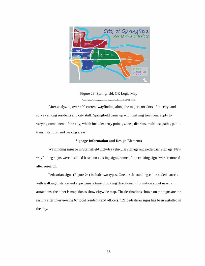
Springfield created their existing logic map (Figure 23) based on the research, which has been used
in map kiosks as base map.
38
Figure 23: Springfield, OR Logic Map Photo: https://scholarsbank.uoregon.edu/xmlui/handle/1794/12608
After analyzing over 400 current wayfinding along the major corridors of the city, and
survey among residents and city staff, Springfield came up with unifying treatment apply to
varying component of the city, which include: entry points, zones, districts, multi-use paths, public
transit stations, and parking areas.
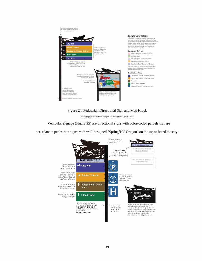
Signage Information and Design Elements
Wayfinding signage in Springfield includes vehicular signage and pedestrian signage. New
wayfinding signs were installed based on existing signs, some of the existing signs were removed
after research.
Pedestrian signs (Figure 24) include two types. One is self-standing color-coded parcels
with walking distance and approximate time providing directional information about nearby
attractions, the other is map kiosks show citywide map. The destinations shown on the signs are the
results after interviewing 67 local residents and officers. 121 pedestrian signs has been installed in
the city.
39
Figure 24: Pedestrian Directional Sign and Map Kiosk Photo: https://scholarsbank.uoregon.edu/xmlui/handle/1794/12608
Vehicular signage (Figure 25) are directional signs with color-coded parcels that are
accordant to pedestrian signs, with well-designed "Springfield Oregon" on the top to brand the city.
40
Figure 25: Vehicular Signs and Welcome Sign with the City Motto. Photo: https://scholarsbank.uoregon.edu/xmlui/handle/1794/12608
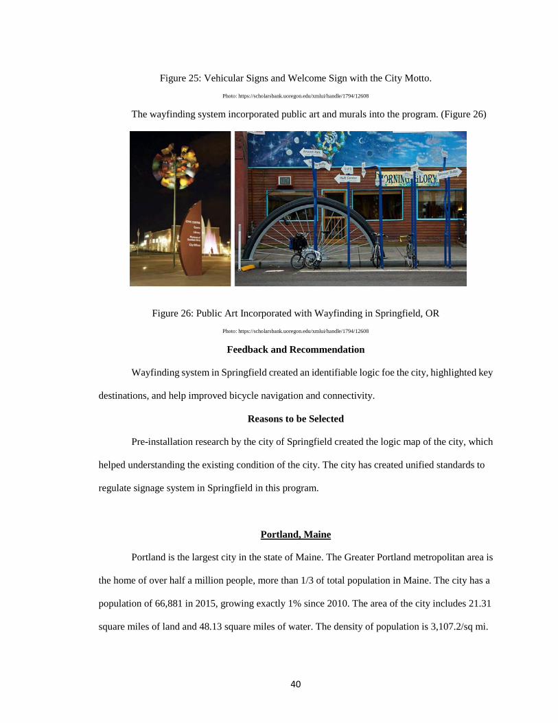
The wayfinding system incorporated public art and murals into the program. (Figure 26)
Figure 26: Public Art Incorporated with Wayfinding in Springfield, OR Photo: https://scholarsbank.uoregon.edu/xmlui/handle/1794/12608
Feedback and Recommendation
Wayfinding system in Springfield created an identifiable logic foe the city, highlighted key
destinations, and help improved bicycle navigation and connectivity.
Reasons to be Selected
Pre-installation research by the city of Springfield created the logic map of the city, which
helped understanding the existing condition of the city. The city has created unified standards to
regulate signage system in Springfield in this program.
Portland, Maine
Portland is the largest city in the state of Maine. The Greater Portland metropolitan area is
the home of over half a million people, more than 1/3 of total population in Maine. The city has a
population of 66,881 in 2015, growing exactly 1% since 2010. The area of the city includes 21.31
square miles of land and 48.13 square miles of water. The density of population is 3,107.2/sq mi.
41
Portland has a diverse culture, it has both historic and modern in architecture and lifestyle.
The city is a tourist attraction. All visitors need to locate where they are, where they want to go, and
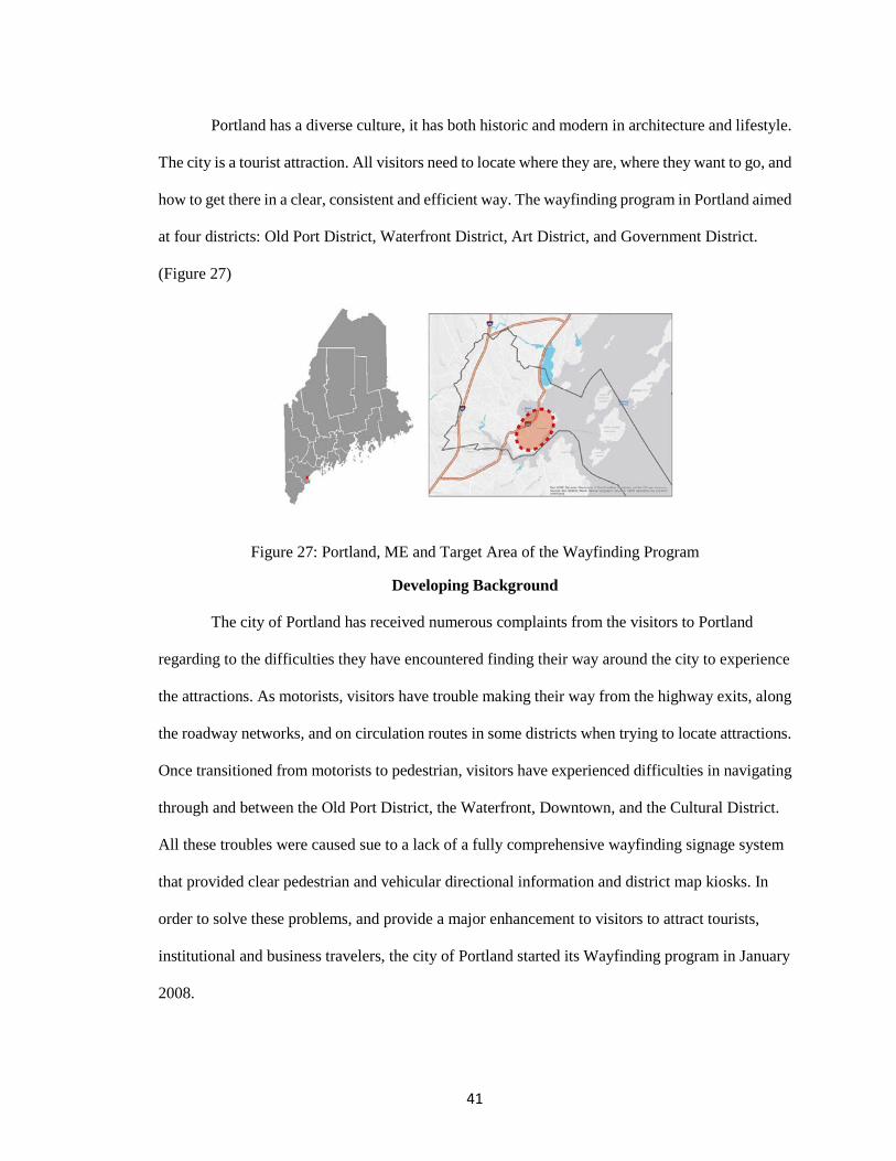
how to get there in a clear, consistent and efficient way. The wayfinding program in Portland aimed
at four districts: Old Port District, Waterfront District, Art District, and Government District.
(Figure 27)
Figure 27: Portland, ME and Target Area of the Wayfinding Program
Developing Background
The city of Portland has received numerous complaints from the visitors to Portland
regarding to the difficulties they have encountered finding their way around the city to experience
the attractions. As motorists, visitors have trouble making their way from the highway exits, along
the roadway networks, and on circulation routes in some districts when trying to locate attractions.
Once transitioned from motorists to pedestrian, visitors have experienced difficulties in navigating
through and between the Old Port District, the Waterfront, Downtown, and the Cultural District.
All these troubles were caused sue to a lack of a fully comprehensive wayfinding signage system
that provided clear pedestrian and vehicular directional information and district map kiosks. In
order to solve these problems, and provide a major enhancement to visitors to attract tourists,
institutional and business travelers, the city of Portland started its Wayfinding program in January
2008.
42
While Portland has good printed and internet materials for education, branding and
orientation purposes, visitors do not always have access to or aware of the media. The city is
lacking repetitive information at street level, educating visitors of the additional destinations within
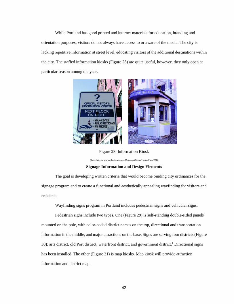
the city. The staffed information kiosks (Figure 28) are quite useful, however, they only open at
particular season among the year.
Figure 28: Information Kiosk
Photo: http://www.portlandmaine.gov/DocumentCenter/Home/View/2214
Signage Information and Design Elements
The goal is developing written criteria that would become binding city ordinances for the
signage program and to create a functional and aesthetically appealing wayfinding for visitors and
residents.
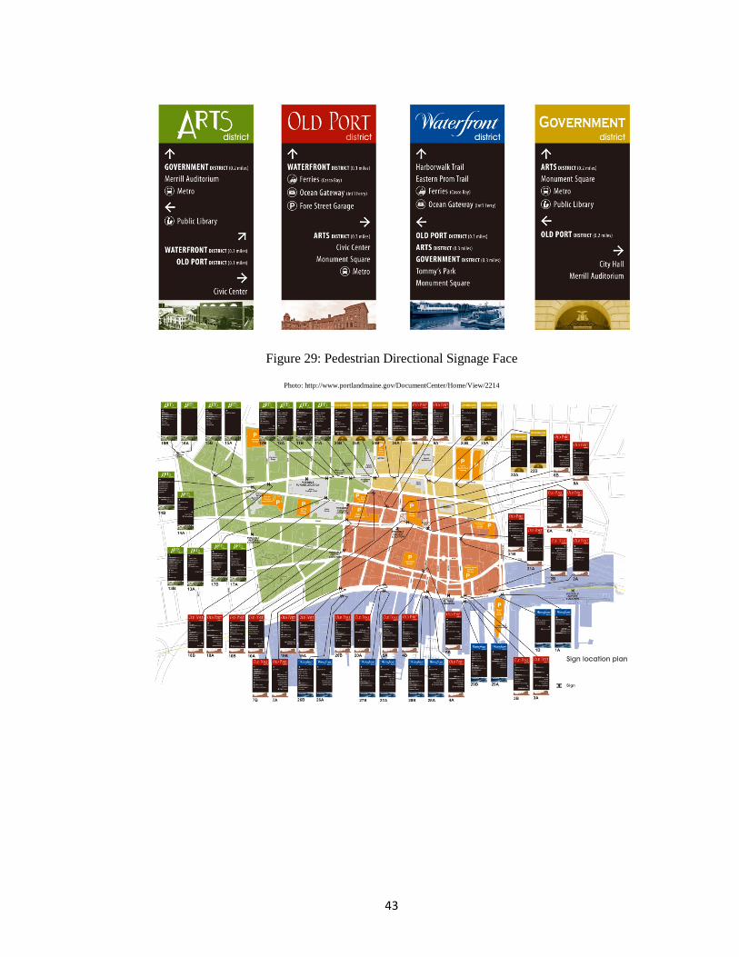
Wayfinding signs program in Portland includes pedestrian signs and vehicular signs.
Pedestrian signs include two types. One (Figure 29) is self-standing double-sided panels
mounted on the pole, with color-coded district names on the top, directional and transportation
information in the middle, and major attractions on the base. Signs are serving four districts (Figure
30): arts district, old Port district, waterfront district, and government district.1 Directional signs
has been installed. The other (Figure 31) is map kiosks. Map kiosk will provide attraction
information and district map.
43
Figure 29: Pedestrian Directional Signage Face
Photo: http://www.portlandmaine.gov/DocumentCenter/Home/View/2214
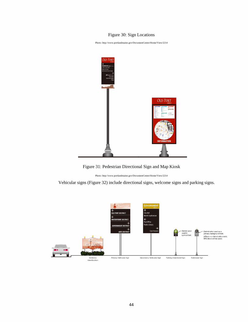
44
Figure 30: Sign Locations Photo: http://www.portlandmaine.gov/DocumentCenter/Home/View/2214
Figure 31: Pedestrian Directional Sign and Map Kiosk
Photo: http://www.portlandmaine.gov/DocumentCenter/Home/View/2214
Vehicular signs (Figure 32) include directional signs, welcome signs and parking signs.
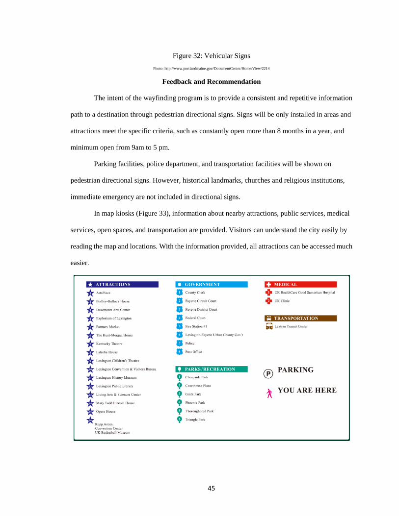
45
Figure 32: Vehicular Signs Photo: http://www.portlandmaine.gov/DocumentCenter/Home/View/2214
Feedback and Recommendation
The intent of the wayfinding program is to provide a consistent and repetitive information
path to a destination through pedestrian directional signs. Signs will be only installed in areas and
attractions meet the specific criteria, such as constantly open more than 8 months in a year, and
minimum open from 9am to 5 pm.
Parking facilities, police department, and transportation facilities will be shown on
pedestrian directional signs. However, historical landmarks, churches and religious institutions,
immediate emergency are not included in directional signs.
In map kiosks (Figure 33), information about nearby attractions, public services, medical
services, open spaces, and transportation are provided. Visitors can understand the city easily by
reading the map and locations. With the information provided, all attractions can be accessed much
easier.
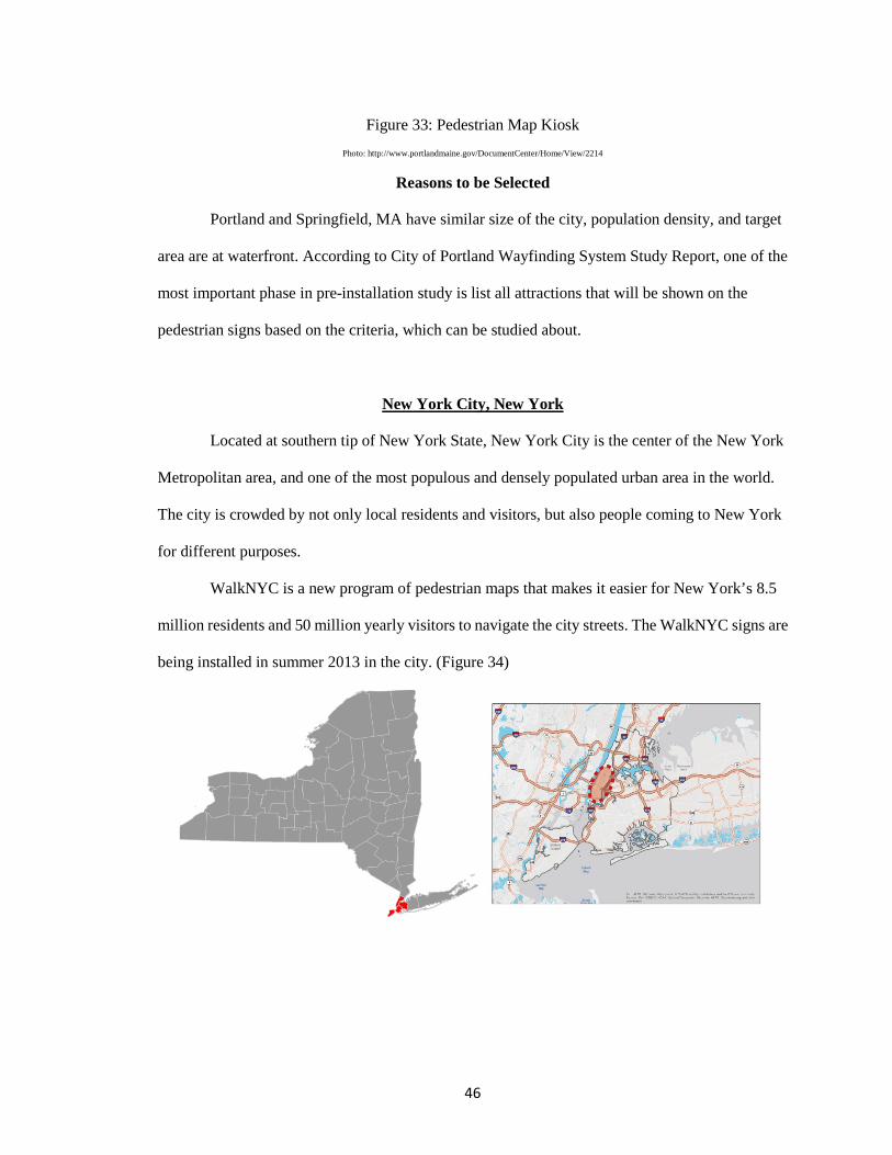
46
Figure 33: Pedestrian Map Kiosk Photo: http://www.portlandmaine.gov/DocumentCenter/Home/View/2214
Reasons to be Selected
Portland and Springfield, MA have similar size of the city, population density, and target
area are at waterfront. According to City of Portland Wayfinding System Study Report, one of the
most important phase in pre-installation study is list all attractions that will be shown on the
pedestrian signs based on the criteria, which can be studied about.
New York City, New York
Located at southern tip of New York State, New York City is the center of the New York
Metropolitan area, and one of the most populous and densely populated urban area in the world.
The city is crowded by not only local residents and visitors, but also people coming to New York
for different purposes.
WalkNYC is a new program of pedestrian maps that makes it easier for New York’s 8.5
million residents and 50 million yearly visitors to navigate the city streets. The WalkNYC signs are
being installed in summer 2013 in the city. (Figure 34)
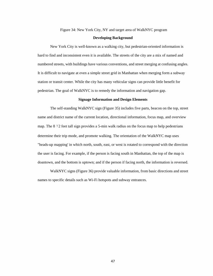
47
Figure 34: New York City, NY and target area of WalkNYC program
Developing Background
New York City is well-known as a walking city, but pedestrian-oriented information is
hard to find and inconsistent even it is available. The streets of the city are a mix of named and
numbered streets, with buildings have various conventions, and street merging at confusing angles.
It is difficult to navigate at even a simple street grid in Manhattan when merging form a subway
station or transit center. While the city has many vehicular signs can provide little benefit for
pedestrian. The goal of WalkNYC is to remedy the information and navigation gap.
Signage Information and Design Elements
The self-standing WalkNYC sign (Figure 35) includes five parts, beacon on the top, street
name and district name of the current location, directional information, focus map, and overview
map. The 8 ⅟2 feet tall sign provides a 5-min walk radius on the focus map to help pedestrians
determine their trip mode, and promote walking. The orientation of the WalkNYC map uses
"heads-up mapping' in which north, south, east, or west is rotated to correspond with the direction
the user is facing. For example, if the person is facing south in Manhattan, the top of the map is
doantown, and the bottom is uptown; and if the person if facing north, the information is reversed.
WalkNYC signs (Figure 36) provide valuable information, from basic directions and street
names to specific details such as Wi-Fi hotspots and subway entrances.
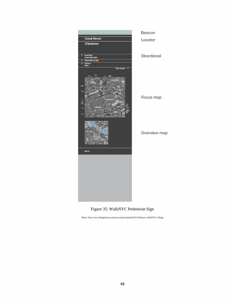
48
Figure 35: WalkNYC Pedestrian Sign
Photo: http://www.designboom.com/wp-content/uploads/2013/06/pent_WalkNYC_08.jpg
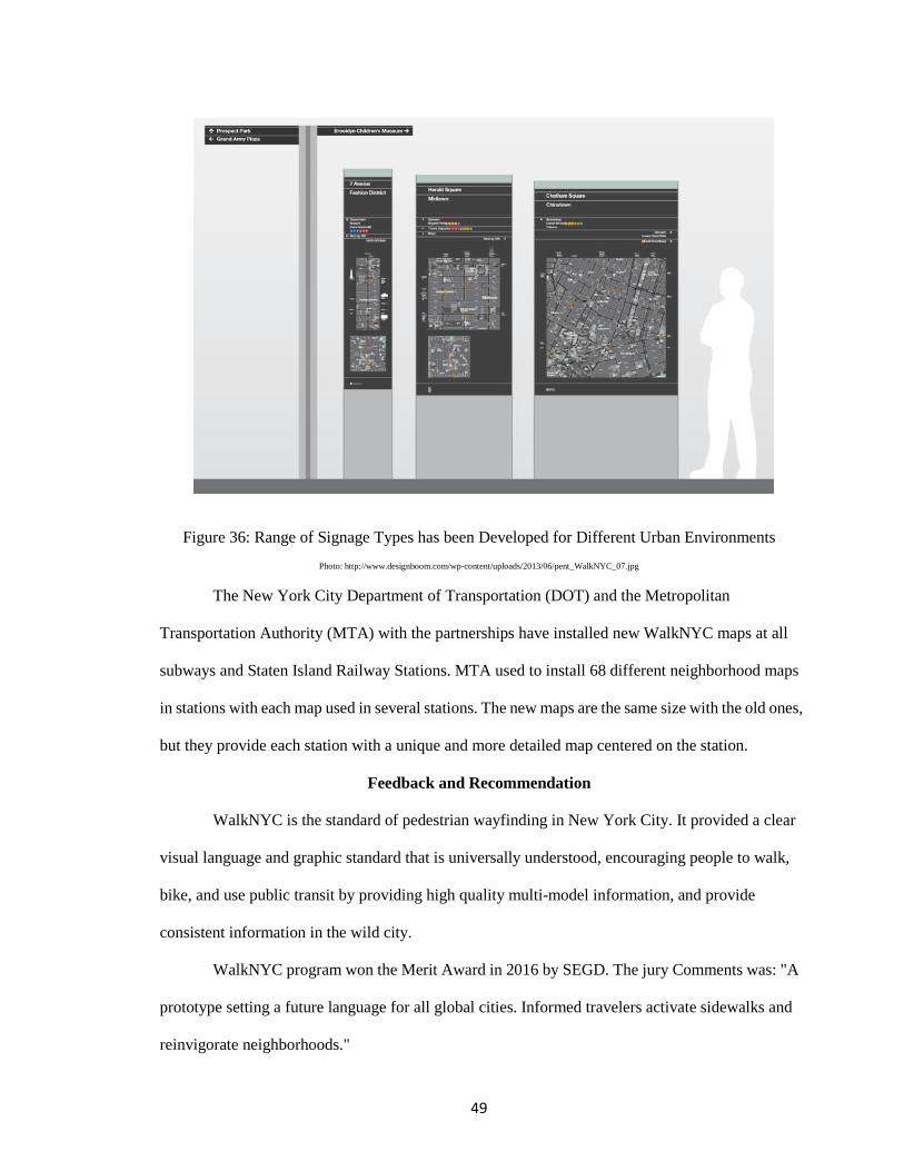
49
Figure 36: Range of Signage Types has been Developed for Different Urban Environments Photo: http://www.designboom.com/wp-content/uploads/2013/06/pent_WalkNYC_07.jpg
The New York City Department of Transportation (DOT) and the Metropolitan
Transportation Authority (MTA) with the partnerships have installed new WalkNYC maps at all
subways and Staten Island Railway Stations. MTA used to install 68 different neighborhood maps
in stations with each map used in several stations. The new maps are the same size with the old ones,
but they provide each station with a unique and more detailed map centered on the station.
Feedback and Recommendation
WalkNYC is the standard of pedestrian wayfinding in New York City. It provided a clear
visual language and graphic standard that is universally understood, encouraging people to walk,
bike, and use public transit by providing high quality multi-model information, and provide
consistent information in the wild city.
WalkNYC program won the Merit Award in 2016 by SEGD. The jury Comments was: "A
prototype setting a future language for all global cities. Informed travelers activate sidewalks and
reinvigorate neighborhoods."
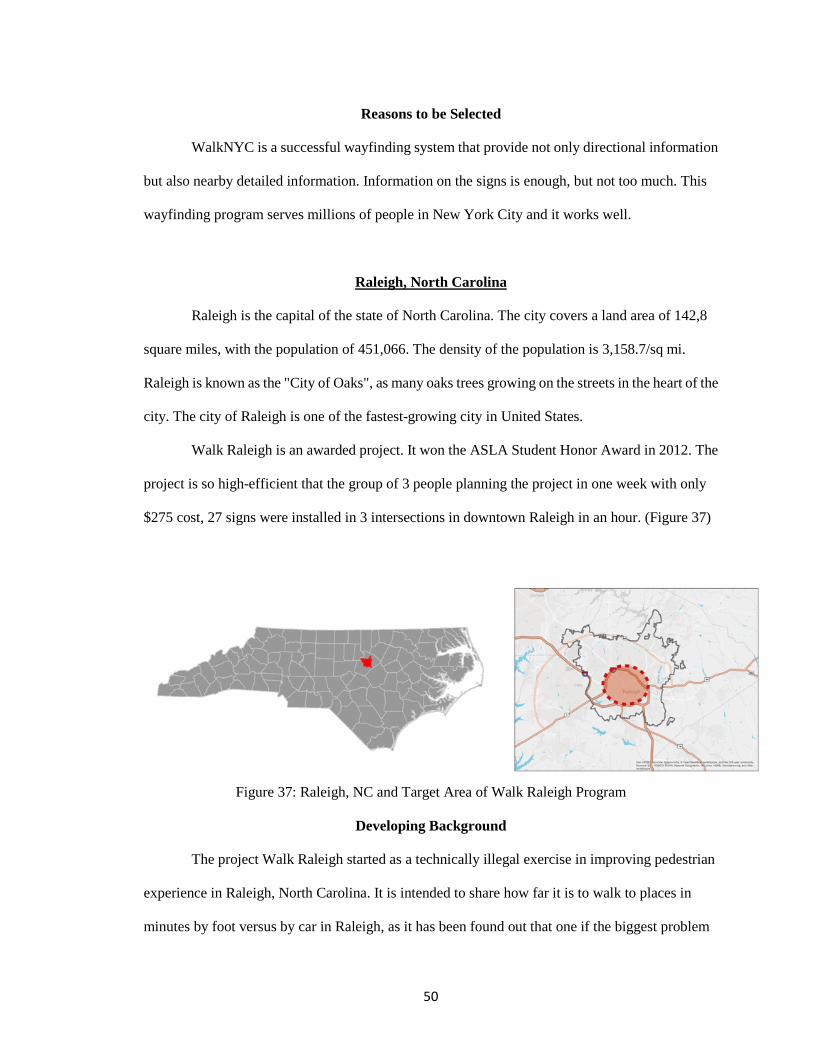
50
Reasons to be Selected
WalkNYC is a successful wayfinding system that provide not only directional information
but also nearby detailed information. Information on the signs is enough, but not too much. This
wayfinding program serves millions of people in New York City and it works well.
Raleigh, North Carolina
Raleigh is the capital of the state of North Carolina. The city covers a land area of 142,8
square miles, with the population of 451,066. The density of the population is 3,158.7/sq mi.
Raleigh is known as the "City of Oaks", as many oaks trees growing on the streets in the heart of the
city. The city of Raleigh is one of the fastest-growing city in United States.
Walk Raleigh is an awarded project. It won the ASLA Student Honor Award in 2012. The
project is so high-efficient that the group of 3 people planning the project in one week with only
$275 cost, 27 signs were installed in 3 intersections in downtown Raleigh in an hour. (Figure 37)
Figure 37: Raleigh, NC and Target Area of Walk Raleigh Program
Developing Background
The project Walk Raleigh started as a technically illegal exercise in improving pedestrian
experience in Raleigh, North Carolina. It is intended to share how far it is to walk to places in
minutes by foot versus by car in Raleigh, as it has been found out that one if the biggest problem
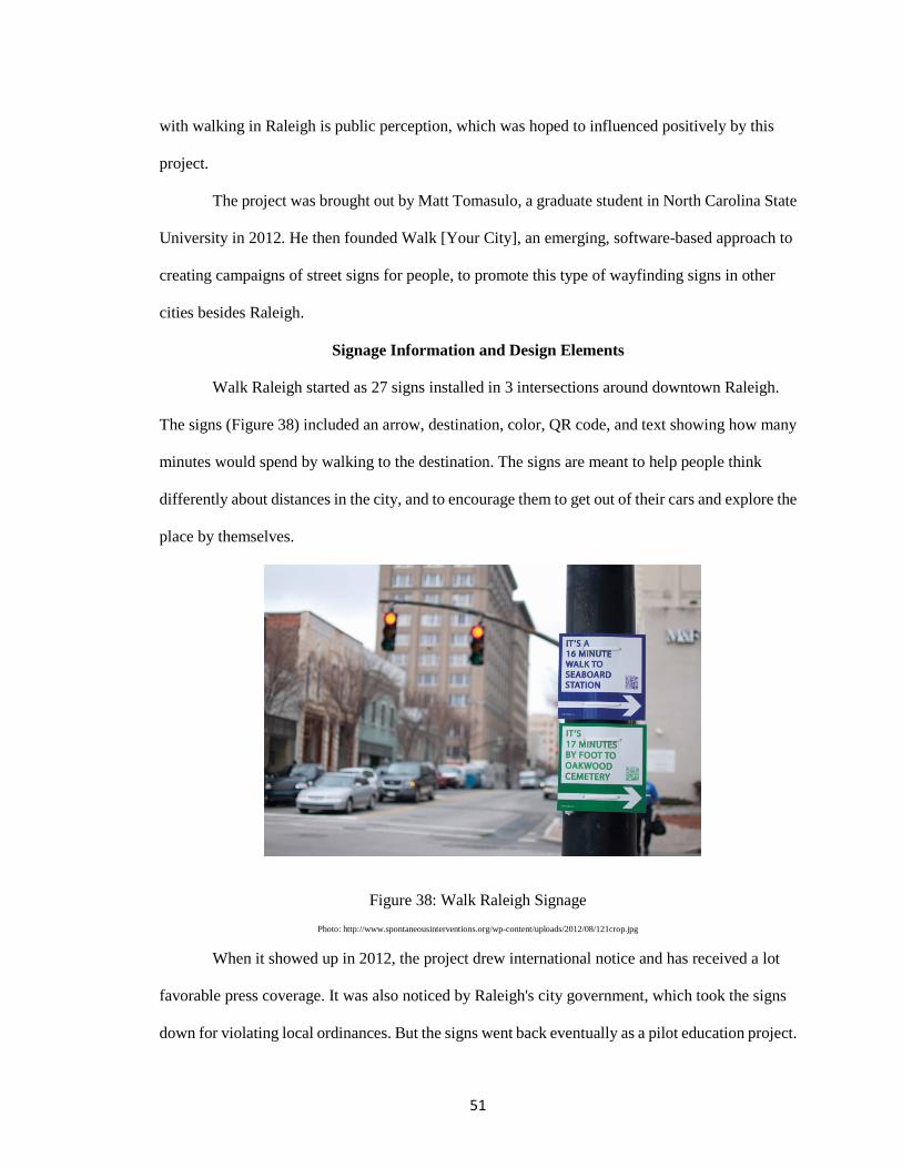
51
with walking in Raleigh is public perception, which was hoped to influenced positively by this
project.
The project was brought out by Matt Tomasulo, a graduate student in North Carolina State
University in 2012. He then founded Walk [Your City], an emerging, software-based approach to
creating campaigns of street signs for people, to promote this type of wayfinding signs in other
cities besides Raleigh.
Signage Information and Design Elements
Walk Raleigh started as 27 signs installed in 3 intersections around downtown Raleigh.
The signs (Figure 38) included an arrow, destination, color, QR code, and text showing how many
minutes would spend by walking to the destination. The signs are meant to help people think
differently about distances in the city, and to encourage them to get out of their cars and explore the
place by themselves.
Figure 38: Walk Raleigh Signage Photo: http://www.spontaneousinterventions.org/wp-content/uploads/2012/08/121crop.jpg
When it showed up in 2012, the project drew international notice and has received a lot
favorable press coverage. It was also noticed by Raleigh's city government, which took the signs
down for violating local ordinances. But the signs went back eventually as a pilot education project.
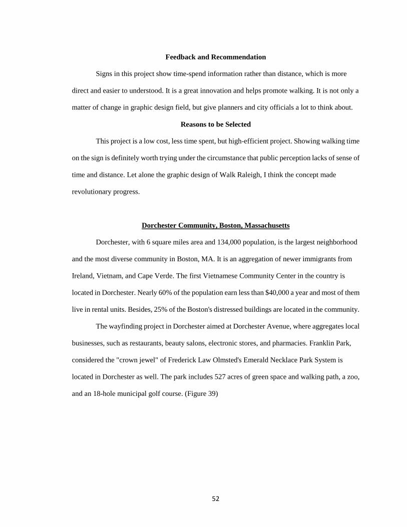
52
Feedback and Recommendation
Signs in this project show time-spend information rather than distance, which is more
direct and easier to understood. It is a great innovation and helps promote walking. It is not only a
matter of change in graphic design field, but give planners and city officials a lot to think about.
Reasons to be Selected
This project is a low cost, less time spent, but high-efficient project. Showing walking time
on the sign is definitely worth trying under the circumstance that public perception lacks of sense of
time and distance. Let alone the graphic design of Walk Raleigh, I think the concept made
revolutionary progress.
Dorchester Community, Boston, Massachusetts
Dorchester, with 6 square miles area and 134,000 population, is the largest neighborhood
and the most diverse community in Boston, MA. It is an aggregation of newer immigrants from
Ireland, Vietnam, and Cape Verde. The first Vietnamese Community Center in the country is
located in Dorchester. Nearly 60% of the population earn less than $40,000 a year and most of them
live in rental units. Besides, 25% of the Boston's distressed buildings are located in the community.
The wayfinding project in Dorchester aimed at Dorchester Avenue, where aggregates local
businesses, such as restaurants, beauty salons, electronic stores, and pharmacies. Franklin Park,
considered the "crown jewel" of Frederick Law Olmsted's Emerald Necklace Park System is
located in Dorchester as well. The park includes 527 acres of green space and walking path, a zoo,
and an 18-hole municipal golf course. (Figure 39)
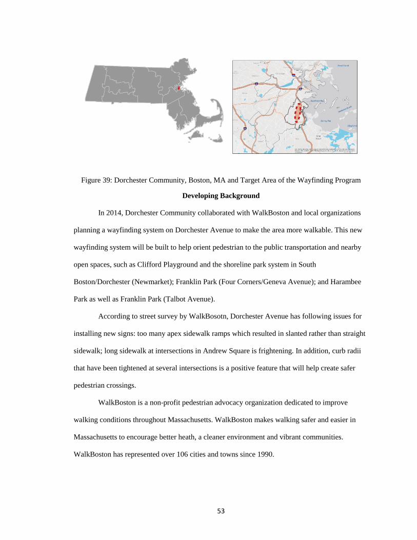
53
Figure 39: Dorchester Community, Boston, MA and Target Area of the Wayfinding Program
Developing Background
In 2014, Dorchester Community collaborated with WalkBoston and local organizations
planning a wayfinding system on Dorchester Avenue to make the area more walkable. This new
wayfinding system will be built to help orient pedestrian to the public transportation and nearby
open spaces, such as Clifford Playground and the shoreline park system in South
Boston/Dorchester (Newmarket); Franklin Park (Four Corners/Geneva Avenue); and Harambee
Park as well as Franklin Park (Talbot Avenue).
According to street survey by WalkBosotn, Dorchester Avenue has following issues for
installing new signs: too many apex sidewalk ramps which resulted in slanted rather than straight
sidewalk; long sidewalk at intersections in Andrew Square is frightening. In addition, curb radii
that have been tightened at several intersections is a positive feature that will help create safer
pedestrian crossings.
WalkBoston is a non-profit pedestrian advocacy organization dedicated to improve
walking conditions throughout Massachusetts. WalkBoston makes walking safer and easier in
Massachusetts to encourage better heath, a cleaner environment and vibrant communities.
WalkBoston has represented over 106 cities and towns since 1990.
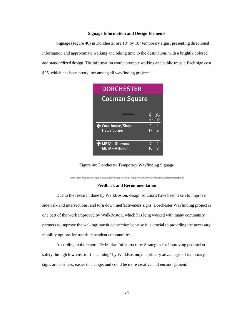
54
Signage Information and Design Elements
Signage (Figure 40) in Dorchester are 18" by 18" temporary signs, presenting directional
information and approximate walking and biking time to the destination, with a brightly colored
and standardized design. The information would promote walking and public transit. Each sign cost
$25, which has been pretty low among all wayfinding projects.
Figure 40: Dorchester Temporary Wayfinding Signage
Photo: http://walkboston.org/sites/default/files/WalkBoston%20-%20Low%20Cost%20Pedestrian%20Improvements.pdf
Feedback and Recommendation
Due to the research done by WalkBoston, design solutions have been taken to improve
sidewalk and intersections, and torn down ineffectiveness signs. Dorchester Wayfinding project is
one part of the work improved by WalkBoston, which has long worked with many community
partners to improve the walking-transit connection because it is crucial to providing the necessary
mobility options for transit dependent communities.
According to the report "Pedestrian Infrastructure: Strategies for improving pedestrian
safety through low-cost traffic calming" by WalkBoston, the primary advantages of temporary
signs are cost less, easier to change, and could be more creative and encouragement.
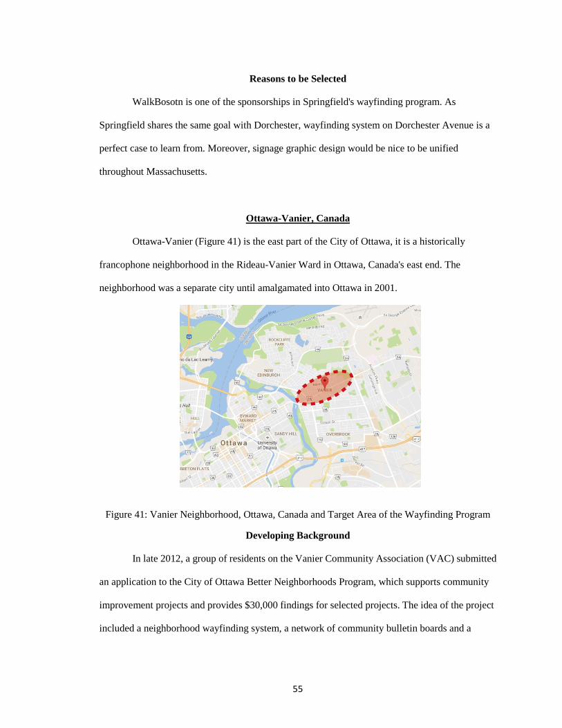
55
Reasons to be Selected
WalkBosotn is one of the sponsorships in Springfield's wayfinding program. As
Springfield shares the same goal with Dorchester, wayfinding system on Dorchester Avenue is a
perfect case to learn from. Moreover, signage graphic design would be nice to be unified
throughout Massachusetts.
Ottawa-Vanier, Canada
Ottawa-Vanier (Figure 41) is the east part of the City of Ottawa, it is a historically
francophone neighborhood in the Rideau-Vanier Ward in Ottawa, Canada's east end. The
neighborhood was a separate city until amalgamated into Ottawa in 2001.
Figure 41: Vanier Neighborhood, Ottawa, Canada and Target Area of the Wayfinding Program
Developing Background
In late 2012, a group of residents on the Vanier Community Association (VAC) submitted
an application to the City of Ottawa Better Neighborhoods Program, which supports community
improvement projects and provides $30,000 findings for selected projects. The idea of the project
included a neighborhood wayfinding system, a network of community bulletin boards and a
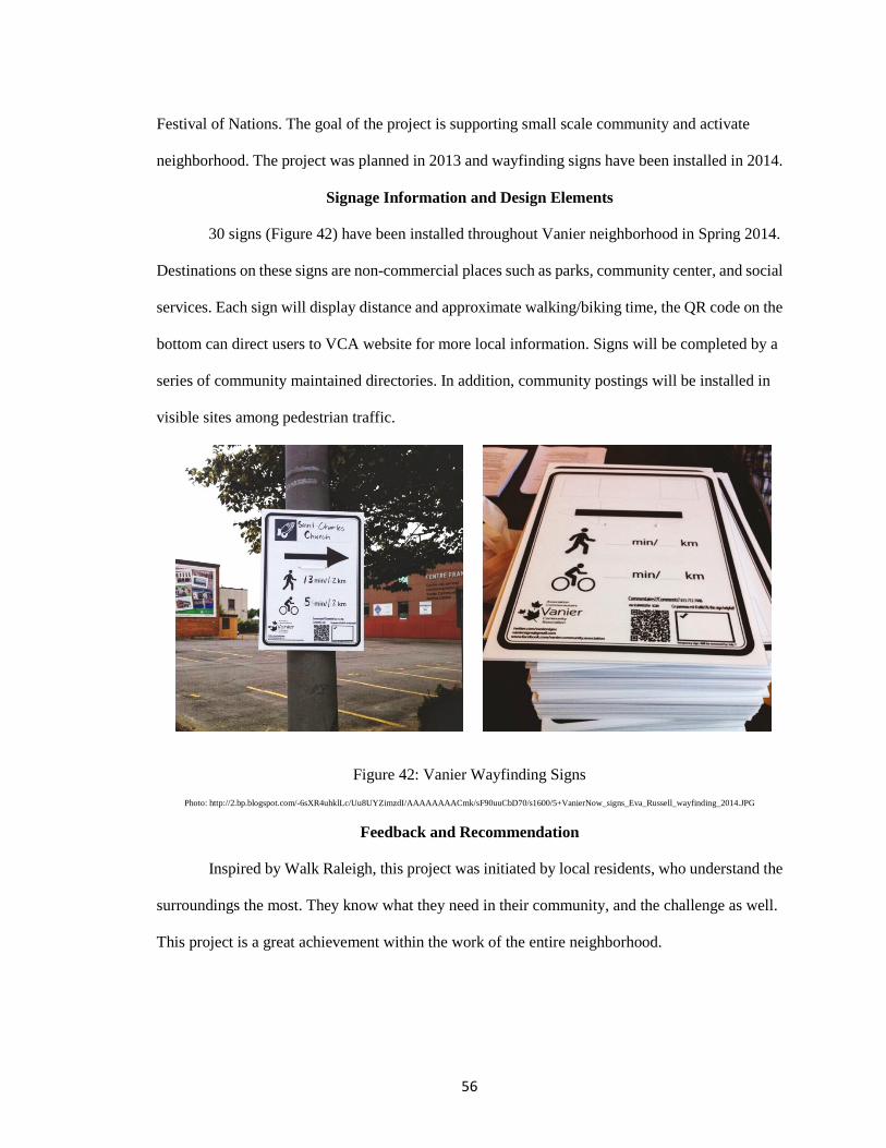
56
Festival of Nations. The goal of the project is supporting small scale community and activate
neighborhood. The project was planned in 2013 and wayfinding signs have been installed in 2014.
Signage Information and Design Elements
30 signs (Figure 42) have been installed throughout Vanier neighborhood in Spring 2014.
Destinations on these signs are non-commercial places such as parks, community center, and social
services. Each sign will display distance and approximate walking/biking time, the QR code on the
bottom can direct users to VCA website for more local information. Signs will be completed by a
series of community maintained directories. In addition, community postings will be installed in
visible sites among pedestrian traffic.
Figure 42: Vanier Wayfinding Signs Photo: http://2.bp.blogspot.com/-6sXR4uhklLc/Uu8UYZimzdI/AAAAAAAACmk/sF90uuCbD70/s1600/5+VanierNow_signs_Eva_Russell_wayfinding_2014.JPG
Feedback and Recommendation
Inspired by Walk Raleigh, this project was initiated by local residents, who understand the
surroundings the most. They know what they need in their community, and the challenge as well.
This project is a great achievement within the work of the entire neighborhood.
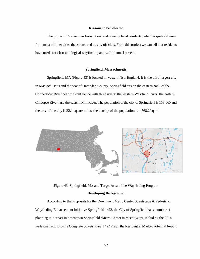
57
Reasons to be Selected
The project in Vanier was brought out and done by local residents, which is quite different
from most of other cities that sponsored by city officials. From this project we can tell that residents
have needs for clear and logical wayfinding and well-planned streets.
Springfield, Massachusetts
Springfield, MA (Figure 43) is located in western New England. It is the third-largest city
in Massachusetts and the seat of Hampden County. Springfield sits on the eastern bank of the
Connecticut River near the confluence with three rivers: the western Westfield River, the eastern
Chicopee River, and the eastern Mill River. The population of the city of Springfield is 153,060 and
the area of the city is 32.1 square miles. the density of the population is 4,768.2/sq mi.
Figure 43: Springfield, MA and Target Area of the Wayfinding Program
Developing Background
According to the Proposals for the Downtown/Metro Center Streetscape & Pedestrian
Wayfinding Enhancement Initiative Springfield 1422, the City of Springfield has a number of
planning initiatives in downtown Springfield /Metro Center in recent years, including the 2014
Pedestrian and Bicycle Complete Streets Plan (1422 Plan), the Residential Market Potential Report
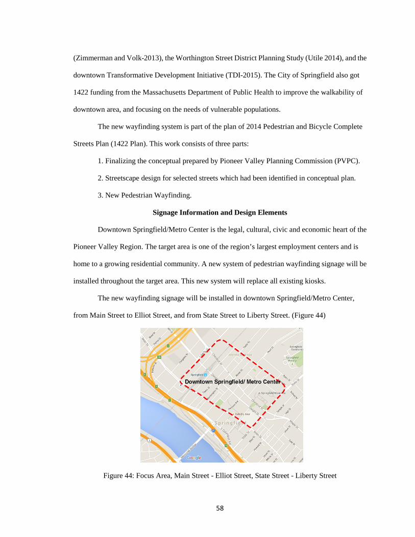
58
(Zimmerman and Volk-2013), the Worthington Street District Planning Study (Utile 2014), and the
downtown Transformative Development Initiative (TDI-2015). The City of Springfield also got
1422 funding from the Massachusetts Department of Public Health to improve the walkability of
downtown area, and focusing on the needs of vulnerable populations.
The new wayfinding system is part of the plan of 2014 Pedestrian and Bicycle Complete
Streets Plan (1422 Plan). This work consists of three parts:
1. Finalizing the conceptual prepared by Pioneer Valley Planning Commission (PVPC).
2. Streetscape design for selected streets which had been identified in conceptual plan.
3. New Pedestrian Wayfinding.
Signage Information and Design Elements
Downtown Springfield/Metro Center is the legal, cultural, civic and economic heart of the
Pioneer Valley Region. The target area is one of the region’s largest employment centers and is
home to a growing residential community. A new system of pedestrian wayfinding signage will be
installed throughout the target area. This new system will replace all existing kiosks.
The new wayfinding signage will be installed in downtown Springfield/Metro Center,
from Main Street to Elliot Street, and from State Street to Liberty Street. (Figure 44)
Figure 44: Focus Area, Main Street - Elliot Street, State Street - Liberty Street
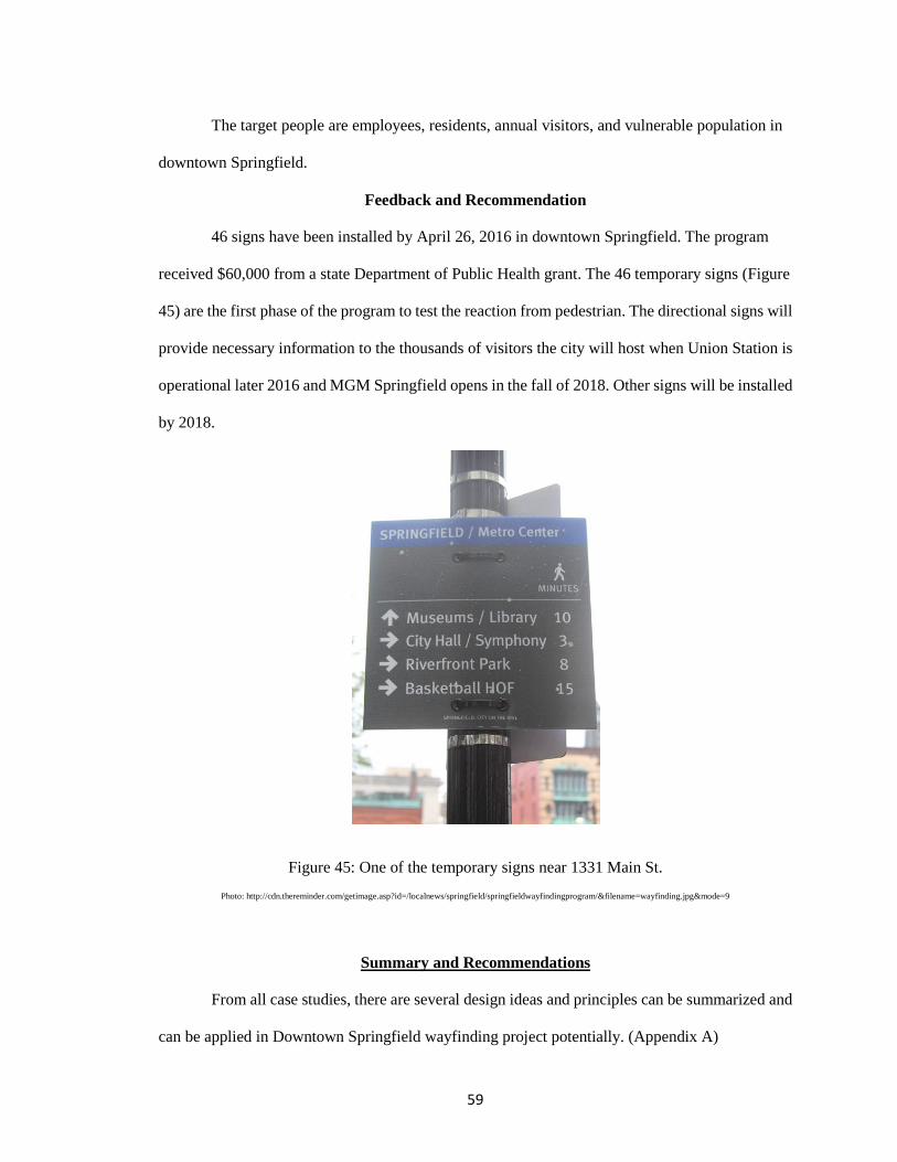
59
The target people are employees, residents, annual visitors, and vulnerable population in
downtown Springfield.
Feedback and Recommendation
46 signs have been installed by April 26, 2016 in downtown Springfield. The program
received $60,000 from a state Department of Public Health grant. The 46 temporary signs (Figure
45) are the first phase of the program to test the reaction from pedestrian. The directional signs will
provide necessary information to the thousands of visitors the city will host when Union Station is
operational later 2016 and MGM Springfield opens in the fall of 2018. Other signs will be installed
by 2018.
Figure 45: One of the temporary signs near 1331 Main St. Photo: http://cdn.thereminder.com/getimage.asp?id=/localnews/springfield/springfieldwayfindingprogram/&filename=wayfinding.jpg&mode=9
Summary and Recommendations
From all case studies, there are several design ideas and principles can be summarized and
can be applied in Downtown Springfield wayfinding project potentially. (Appendix A)
60
Design Ideas from case studies
Unique Character on Sign
Walking Radius
Provide transit options (light rail, bus, subway, etc.)
Sponsorship for local businesses
Logic Map
Collaborate with public art
Color-coded for each district
Public participation of the project
Principles
Design standards should address all types of users, including local residents, visitors,
etc.
Each sign should provide appropriate adequate information, either too much or too
poor would be confusing.
Signage should be easy to recognized and read. They should be positioned
consistently so that people can find each type of information easily.
Signage should be in a uniform, modular frame that allows quick changes and
withstand frequent cleaning.
Types of signage could be determined by size of target area, main goal of the project,
zoning of the target area, and so on. Map kiosks are recommended especially the
target area is large with multiple districts.
Temporary signage has become a trend in recent years, because of lower cost, easy to
change and maintain, and short period for conduction.

61
Notes
1 Rooke, Clementinah Ndhlovu, John Alfred Rooke, Lauri Koskela, and Patricia Tzortzopoulos. "Using the Physical Properties of Artefacts to Manage Through-life Knowledge Flows in the Built Environment: An Initial Exploration." Construction Management and Economics 28.6 (2010): 601-13. Web. Retrieved 07 Aug. 2016.
<http://usir.salford.ac.uk/11300/>.
62
CHAPTER 5
SURVEY AND DATA ANALYSIS
A survey, created by the UMass Design Center in Springfield was given to various
Springfield residents and visitors in spring 2016 in order to better understand how familiar they
were with the downtown (Metro Center) area. The survey had four main parts.
Part 1: Identifying a group of locations that made up “starting points” and another group
designated as “destinations”.
Part 2: Survey design.
Part 3: Administering the survey to a range of persons.
Part 4: Summarizing and analyzing survey data.
Identifying Potential Starting Points and Destinations
Identifying potential starting points and destinations is an important part of the
pre-evaluation work of the wayfinding program for downtown Springfield. The potential
starting points should be places where people congregate and that are within walking
distance of useful destinations (transportation center, service/medical, cultural
centers/landmarks).
According to the proposals for the "Downtown/Metro Center Streetscape &
Pedestrian Wayfinding Enhancement Initiative", the focus area (Figure 46) is from Main
Street to Elliot Street, and from State Street to Liberty Street.
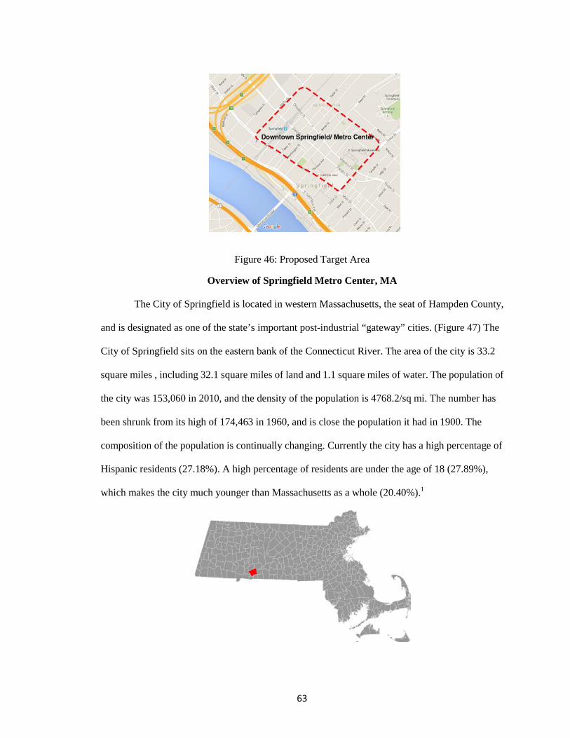
63
Figure 46: Proposed Target Area
Overview of Springfield Metro Center, MA
The City of Springfield is located in western Massachusetts, the seat of Hampden County,
and is designated as one of the state’s important post-industrial “gateway” cities. (Figure 47) The
City of Springfield sits on the eastern bank of the Connecticut River. The area of the city is 33.2
square miles , including 32.1 square miles of land and 1.1 square miles of water. The population of
the city was 153,060 in 2010, and the density of the population is 4768.2/sq mi. The number has
been shrunk from its high of 174,463 in 1960, and is close the population it had in 1900. The
composition of the population is continually changing. Currently the city has a high percentage of
Hispanic residents (27.18%). A high percentage of residents are under the age of 18 (27.89%),
which makes the city much younger than Massachusetts as a whole (20.40%).1
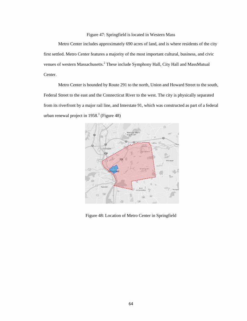
64
Figure 47: Springfield is located in Western Mass
Metro Center includes approximately 690 acres of land, and is where residents of the city
first settled. Metro Center features a majority of the most important cultural, business, and civic
venues of western Massachusetts.2 These include Symphony Hall, City Hall and MassMutual
Center.
Metro Center is bounded by Route 291 to the north, Union and Howard Street to the south,
Federal Street to the east and the Connecticut River to the west. The city is physically separated
from its riverfront by a major rail line, and Interstate 91, which was constructed as part of a federal
urban renewal project in 1958.3 (Figure 48)
Figure 48: Location of Metro Center in Springfield
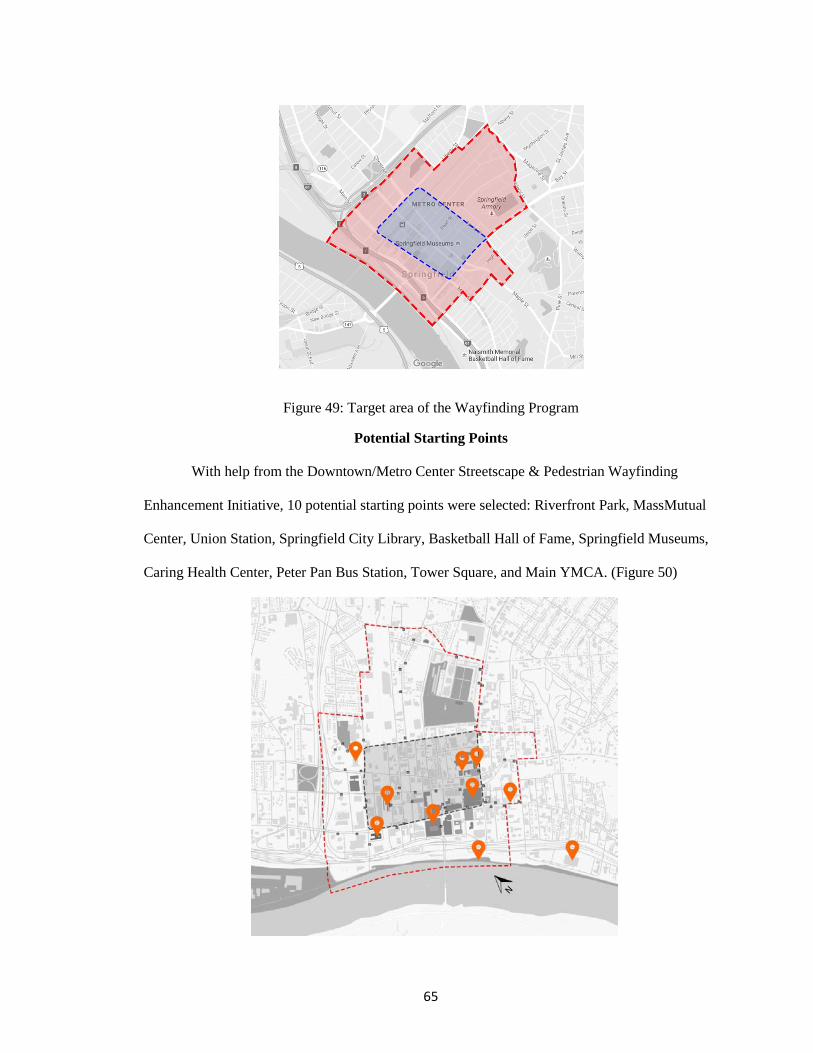
65
Figure 49: Target area of the Wayfinding Program
Potential Starting Points
With help from the Downtown/Metro Center Streetscape & Pedestrian Wayfinding
Enhancement Initiative, 10 potential starting points were selected: Riverfront Park, MassMutual
Center, Union Station, Springfield City Library, Basketball Hall of Fame, Springfield Museums,
Caring Health Center, Peter Pan Bus Station, Tower Square, and Main YMCA. (Figure 50)
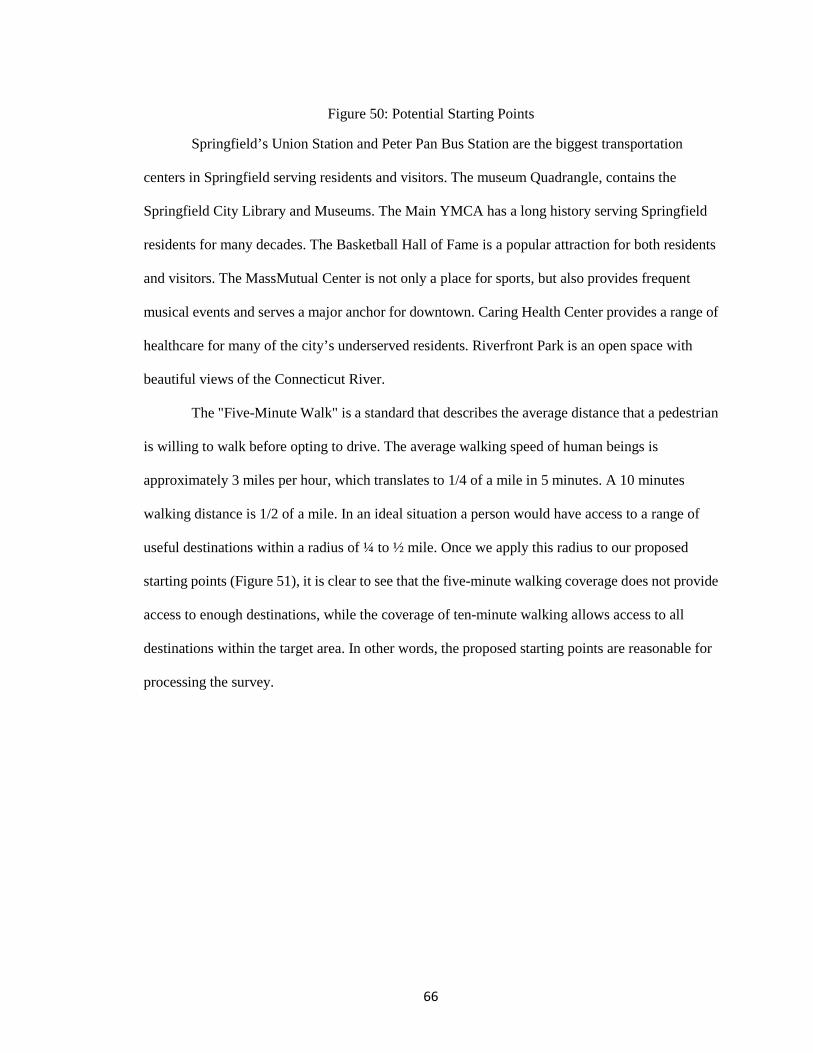
66
Figure 50: Potential Starting Points
Springfield’s Union Station and Peter Pan Bus Station are the biggest transportation
centers in Springfield serving residents and visitors. The museum Quadrangle, contains the
Springfield City Library and Museums. The Main YMCA has a long history serving Springfield
residents for many decades. The Basketball Hall of Fame is a popular attraction for both residents
and visitors. The MassMutual Center is not only a place for sports, but also provides frequent
musical events and serves a major anchor for downtown. Caring Health Center provides a range of
healthcare for many of the city’s underserved residents. Riverfront Park is an open space with
beautiful views of the Connecticut River.
The "Five-Minute Walk" is a standard that describes the average distance that a pedestrian
is willing to walk before opting to drive. The average walking speed of human beings is
approximately 3 miles per hour, which translates to 1/4 of a mile in 5 minutes. A 10 minutes
walking distance is 1/2 of a mile. In an ideal situation a person would have access to a range of
useful destinations within a radius of ¼ to ½ mile. Once we apply this radius to our proposed
starting points (Figure 51), it is clear to see that the five-minute walking coverage does not provide
access to enough destinations, while the coverage of ten-minute walking allows access to all
destinations within the target area. In other words, the proposed starting points are reasonable for
processing the survey.
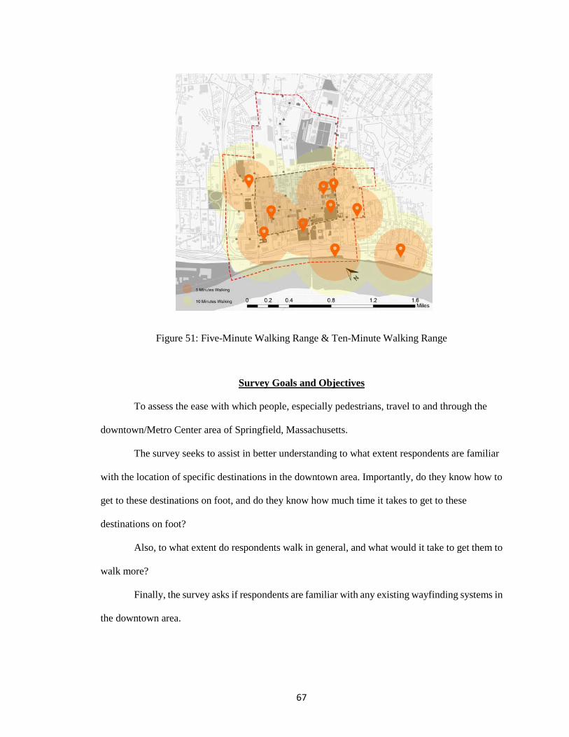
67
Figure 51: Five-Minute Walking Range & Ten-Minute Walking Range
Survey Goals and Objectives
To assess the ease with which people, especially pedestrians, travel to and through the
downtown/Metro Center area of Springfield, Massachusetts.
The survey seeks to assist in better understanding to what extent respondents are familiar
with the location of specific destinations in the downtown area. Importantly, do they know how to
get to these destinations on foot, and do they know how much time it takes to get to these
destinations on foot?
Also, to what extent do respondents walk in general, and what would it take to get them to
walk more?
Finally, the survey asks if respondents are familiar with any existing wayfinding systems in
the downtown area.

68
General
The surveys were conducted in person, at specific downtown locations on weekdays during
the months of February and March 2016. Most surveys were conducted indoors due to the very cold
weather, and during daytime hours. Respondents were selected randomly, based on their
willingness to participate. A sample survey is attached. (Appendix B)
A total of 103 people were surveyed at 5 downtown locations:
YMCA (15 respondents)
Peter Pan Bus Station (10 respondents)
Tower Square Food Court (50 respondents)
Museums/Quadrangle (18 respondents)
Classical Condominiums (10 respondents)
Limitations
The sample size of 103 respondents is adequate, but the information was gathered at a
small number of locations (5 total), and was conducted on 4 separate days. Also, surveys were
conducted in unequal numbers across locations (for example, 50 responses come from Tower
Square, while only 10 come from Peter Pan Bus and Classical Condominiums). Furthermore,
respondents were not selected in any way to approximate a “typical downtown population” or a
“typical downtown resident” etc. All information was gathered in random fashion.
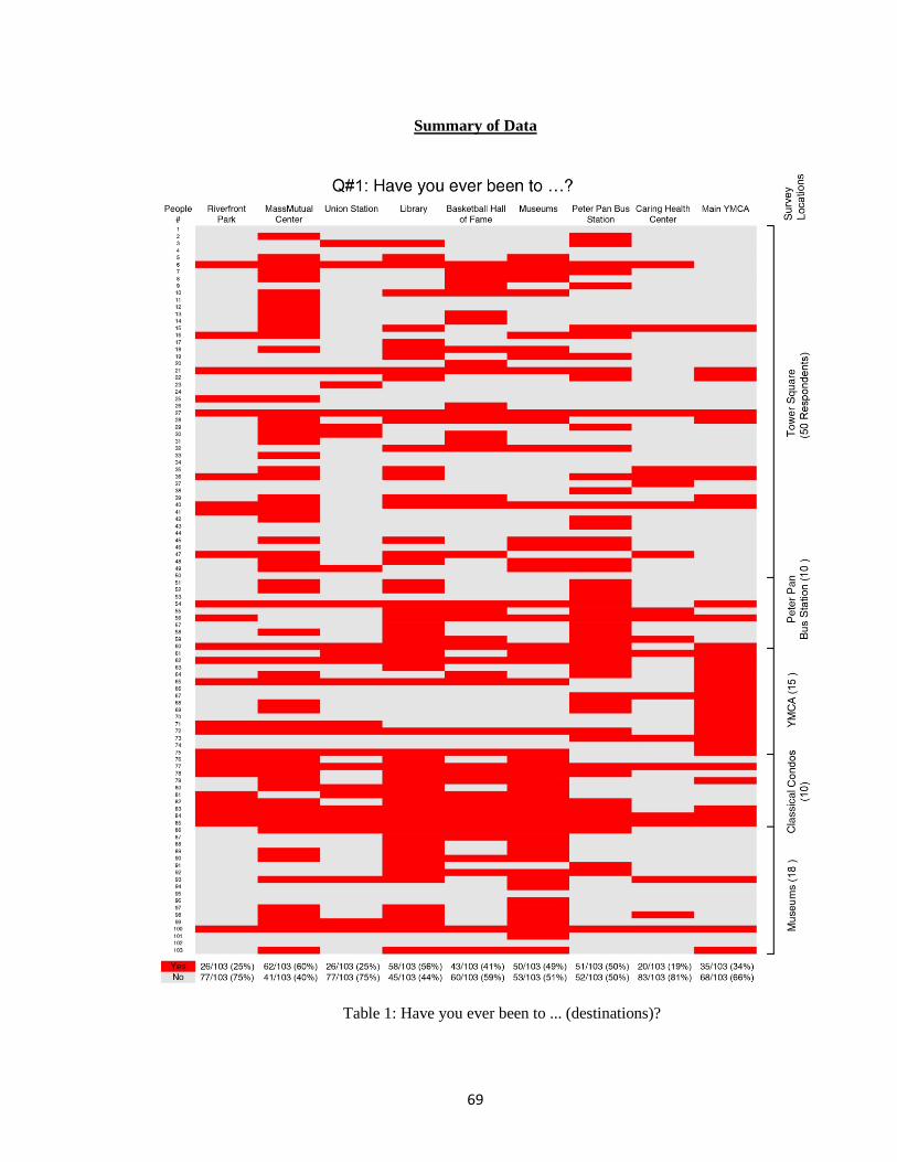
69
Summary of Data
Table 1: Have you ever been to ... (destinations)?
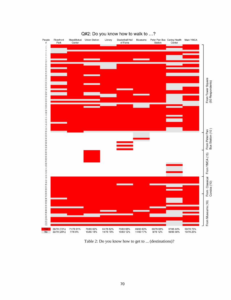
70
Table 2: Do you know how to get to ... (destinations)?
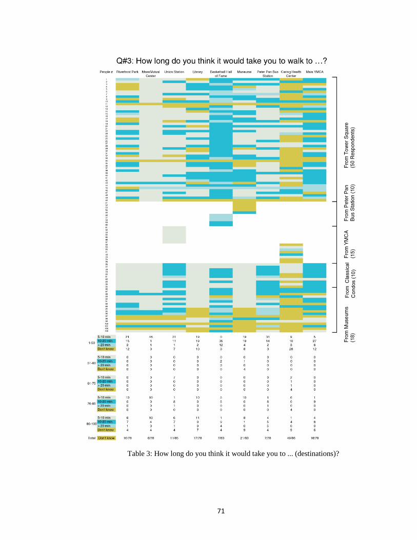
71
Table 3: How long do you think it would take you to ... (destinations)?
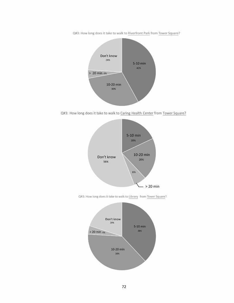
72
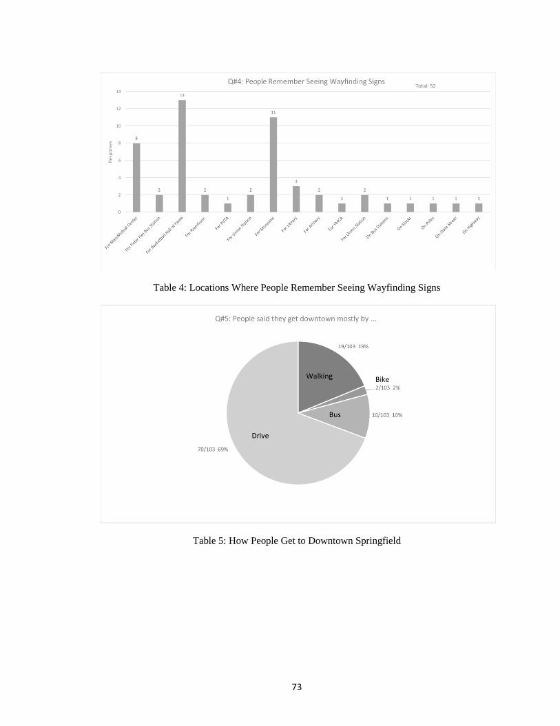
73
Table 4: Locations Where People Remember Seeing Wayfinding Signs
Table 5: How People Get to Downtown Springfield
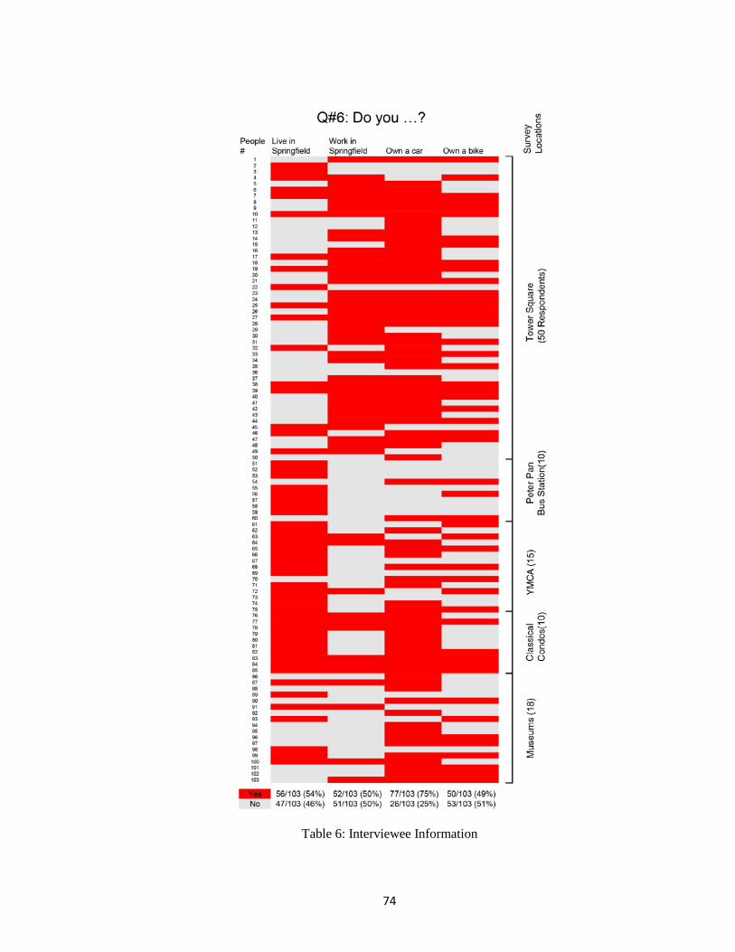
74
Table 6: Interviewee Information
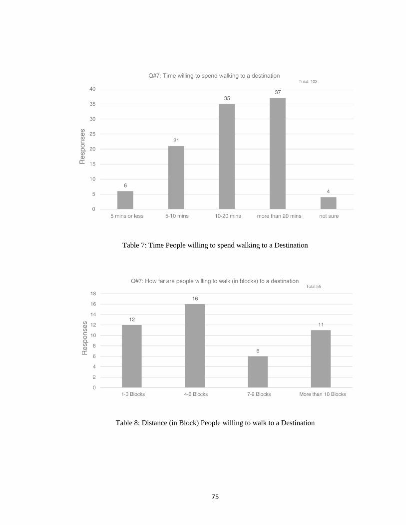
75
Table 7: Time People willing to spend walking to a Destination
Table 8: Distance (in Block) People willing to walk to a Destination
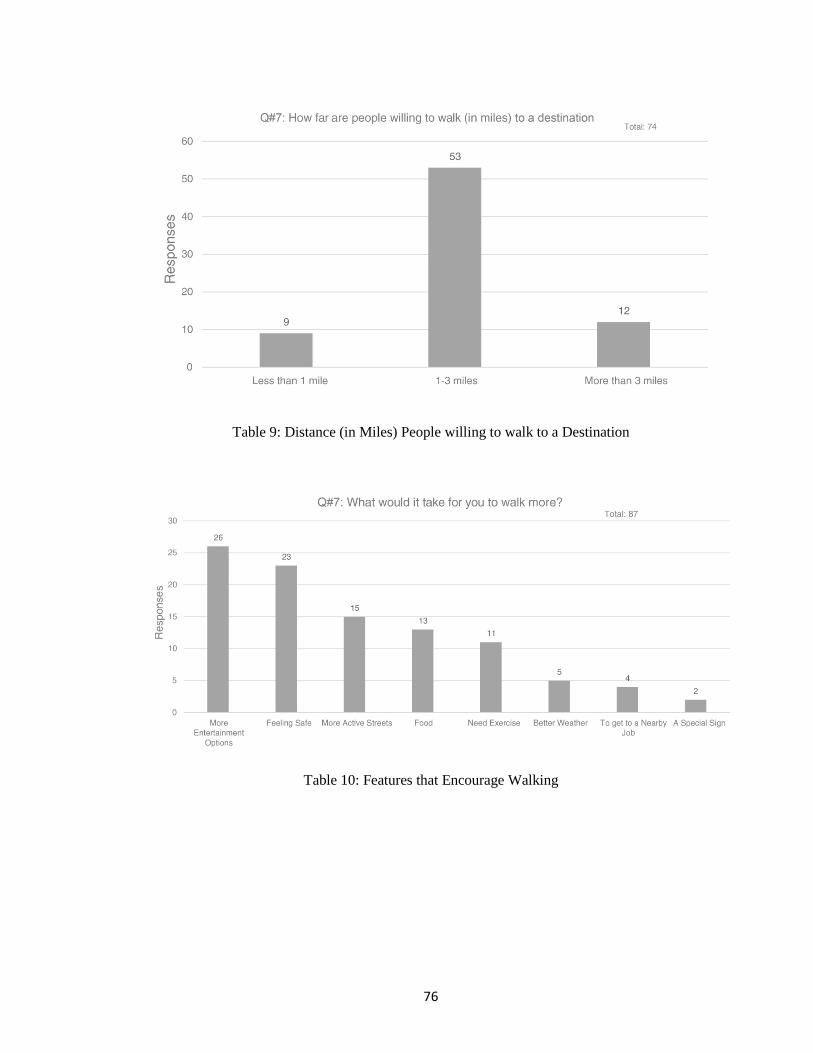
76
Table 9: Distance (in Miles) People willing to walk to a Destination
Table 10: Features that Encourage Walking
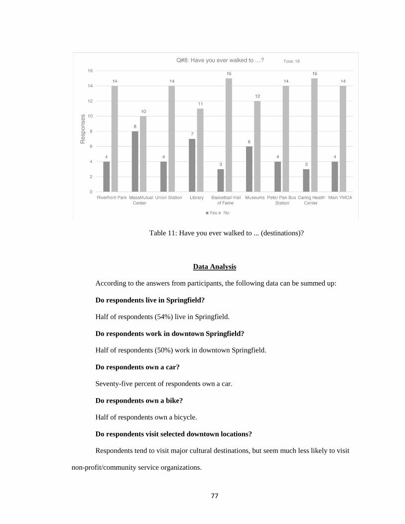
77
Table 11: Have you ever walked to ... (destinations)?
Data Analysis
According to the answers from participants, the following data can be summed up:
Do respondents live in Springfield?
Half of respondents (54%) live in Springfield.
Do respondents work in downtown Springfield?
Half of respondents (50%) work in downtown Springfield.
Do respondents own a car?
Seventy-five percent of respondents own a car.
Do respondents own a bike?
Half of respondents own a bicycle.
Do respondents visit selected downtown locations?
Respondents tend to visit major cultural destinations, but seem much less likely to visit
non-profit/community service organizations.
78
In the last year,
Over 60% of respondents had been to the MassMutual Center.
Over 50% had been to the main library, museums, and Peter Pan Bus station.
Just over 40% of respondents had been to the Basketball Hall of Fame in the last year.
25% of respondents had been to Riverfront Park and Union Station in the past year.
Only 20% of respondents had been to Caring Health Center or the YMCA in the past
year.
Do respondents know how to walk to selected downtown locations?
Yes. Even though respondents had not been to some locations within the last year, they still
know how to walk to them. The exception is Caring Health Center. Most respondents have not been
there and don’t know how to walk there. Also, the survey suggests that even for respondents that
had been there, some do not know how to walk there.
Generally speaking, do respondents walk to selected destinations?
Not many. Even though a majority of respondents could tell us how to walk to the selected
destinations, our impression is that few people actually walk to them. Furthermore, fewer than 20%
of respondents said that they get to downtown by foot on a regular basis. Almost 70% of
respondents said they “mostly drive” to get downtown.
When we asked people visiting the Quadrangle if they walked from there to other nearby
destinations, more than 2/3 said they did not.
How do respondents perceive walking distance (in blocks or miles) to selected
locations?
Respondents have an accurate sense of walking distance to locations they are familiar with.
They do not have an accurate sense of walking distance to locations they are not familiar with.
How far are respondents willing to walk (in blocks or miles) to a destination they
want to get to?
79
Over 1/3 of people that answered the survey (36 %) said they would walk more than 20
minutes to get to a place they wanted to go.
Did respondents know how long (in minutes) it takes to walk to specific destinations?
Yes and no. Even though most people know how to walk to the destinations, some did not
know how long (in minutes) it takes to walk to these destinations.
At Tower Square:
17/50 (34%) respondents live in Springfield
39/50 (78%) work in Springfield
34/50 (68%) said they know how to walk to Riverfront Park
12/50 (24%) said they don’t know how long it takes to walk to Riverfront Park
At Museums/Quadrangle
7/17 respondents (40%) live in Springfield
4/17 (24%) work in Springfield
13/17 (76%) said they know how to walk to Riverfront Park
4/17 (24%) said they don’t know how long it takes to walk to Riverfront Park
At Classical Housing
10/10 respondents (100%) live in Springfield
5/10 (50%) work in Springfield
10/10 (100%) said they know how to walk to Riverfront Park
10/10 (100%) know how long it takes to walk to Riverfront Park
Are respondents familiar with existing wayfinding systems?
No. Fewer than half (36/83) 43% of respondents said they can remember seeing a
wayfinding sign mentioning one of the selected locations. Of those that said they had seen a sign,
most remembered signs related to the Basketball Hall of Fame, the Museums and MassMutual
Center.
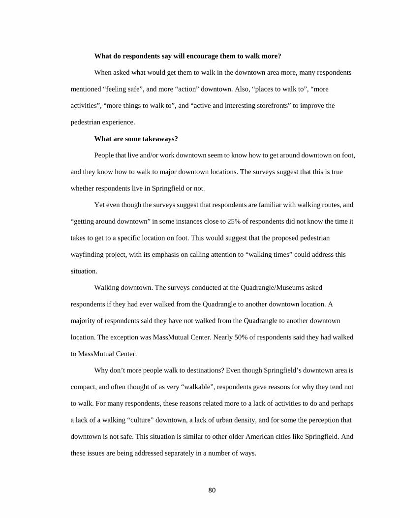
80
What do respondents say will encourage them to walk more?
When asked what would get them to walk in the downtown area more, many respondents
mentioned “feeling safe”, and more “action” downtown. Also, “places to walk to”, “more
activities”, “more things to walk to”, and “active and interesting storefronts” to improve the
pedestrian experience.
What are some takeaways?
People that live and/or work downtown seem to know how to get around downtown on foot,
and they know how to walk to major downtown locations. The surveys suggest that this is true
whether respondents live in Springfield or not.
Yet even though the surveys suggest that respondents are familiar with walking routes, and
“getting around downtown” in some instances close to 25% of respondents did not know the time it
takes to get to a specific location on foot. This would suggest that the proposed pedestrian
wayfinding project, with its emphasis on calling attention to “walking times” could address this
situation.
Walking downtown. The surveys conducted at the Quadrangle/Museums asked
respondents if they had ever walked from the Quadrangle to another downtown location. A
majority of respondents said they have not walked from the Quadrangle to another downtown
location. The exception was MassMutual Center. Nearly 50% of respondents said they had walked
to MassMutual Center.
Why don’t more people walk to destinations? Even though Springfield’s downtown area is
compact, and often thought of as very “walkable”, respondents gave reasons for why they tend not
to walk. For many respondents, these reasons related more to a lack of activities to do and perhaps
a lack of a walking “culture” downtown, a lack of urban density, and for some the perception that
downtown is not safe. This situation is similar to other older American cities like Springfield. And
these issues are being addressed separately in a number of ways.
81
Additional notes:
Visitors from outside the area.
We don’t believe our survey (105 respondents) captured many (if any) out of town visitors.
From the survey responses, virtually everyone surveyed, lived or worked in Springfield (Question
#6). Even at the Museums/Quadrangle area, where respondents said they don’t live in Springfield,
and don’t work there, they still could tell us how to walk from the museum to nearby destinations.
Many of the respondents said they grew up in Springfield, or used to live there. They were not new
to the area. The time of the year, and the weather may have impacted the number of tourists. Also,
we should note that we did not survey at the Basketball Hall of Fame, where we would expect to
find more people from outside the area.
Caring Health Center.
Of all the locations that were included in the survey, one location stands out as being a
place that the majority of respondents (56%) do not know how to walk to. Only 19% of respondents
have ever been there.
Recommendations
Recommendations and Suggestions are based on the pre-installation interview, and
reactions from the city after installing 46 signs in April, 2016.

82
Figure 52: Springfield Wayfinding Signage Photo: http://media.masslive.com/republican/photo/2016/03/03/19868977-standard.jpg
1. The size is too small to be easily noticed.
Pedestrian may not notice the 18"X18" signs.
2. The font size is too small to read.
Even if pedestrians notice the newly-installed sign, they have to be very close the sign to
read them. As most of pedestrians would not do that, the idea of "to promote walking" may be of
limited success.
3. Lack of unique character.
WalkBoston has done a series of wayfinding projects in Massachusetts. The graphic
designer repeated the same format used by WalkBoston in most instances. Better results may occur
by trying other colors. For example colors and designs reflect Springfield's culture. This could add
a special quality and character that relates to Springfield (such as basketball themes, riverfront view
photo, city skyline, history, etc).
It is easy to tell that the wayfinding signs recently installed in Turners Falls, MA (Figure 53)
were designed by WalkBoston. And Turners Falls shows the same problems as we find in
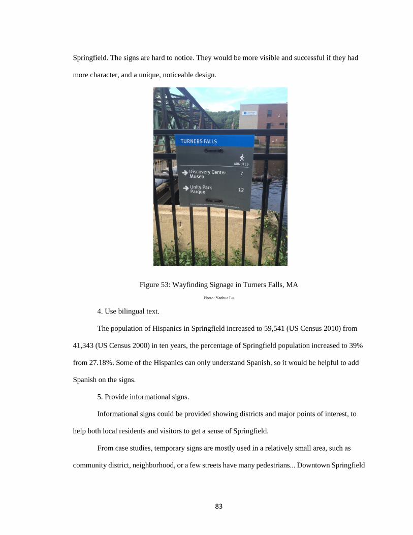
83
Springfield. The signs are hard to notice. They would be more visible and successful if they had
more character, and a unique, noticeable design.
Figure 53: Wayfinding Signage in Turners Falls, MA Photo: Yanhua Lu
4. Use bilingual text.
The population of Hispanics in Springfield increased to 59,541 (US Census 2010) from
41,343 (US Census 2000) in ten years, the percentage of Springfield population increased to 39%
from 27.18%. Some of the Hispanics can only understand Spanish, so it would be helpful to add
Spanish on the signs.
5. Provide informational signs.
Informational signs could be provided showing districts and major points of interest, to
help both local residents and visitors to get a sense of Springfield.
From case studies, temporary signs are mostly used in a relatively small area, such as
community district, neighborhood, or a few streets have many pedestrians... Downtown Springfield
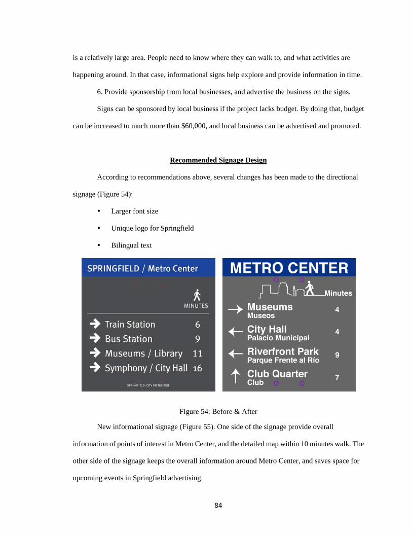
84
is a relatively large area. People need to know where they can walk to, and what activities are
happening around. In that case, informational signs help explore and provide information in time.
6. Provide sponsorship from local businesses, and advertise the business on the signs.
Signs can be sponsored by local business if the project lacks budget. By doing that, budget
can be increased to much more than $60,000, and local business can be advertised and promoted.
Recommended Signage Design
According to recommendations above, several changes has been made to the directional
signage (Figure 54):
Larger font size
Unique logo for Springfield
Bilingual text
Figure 54: Before & After
New informational signage (Figure 55). One side of the signage provide overall
information of points of interest in Metro Center, and the detailed map within 10 minutes walk. The
other side of the signage keeps the overall information around Metro Center, and saves space for
upcoming events in Springfield advertising.
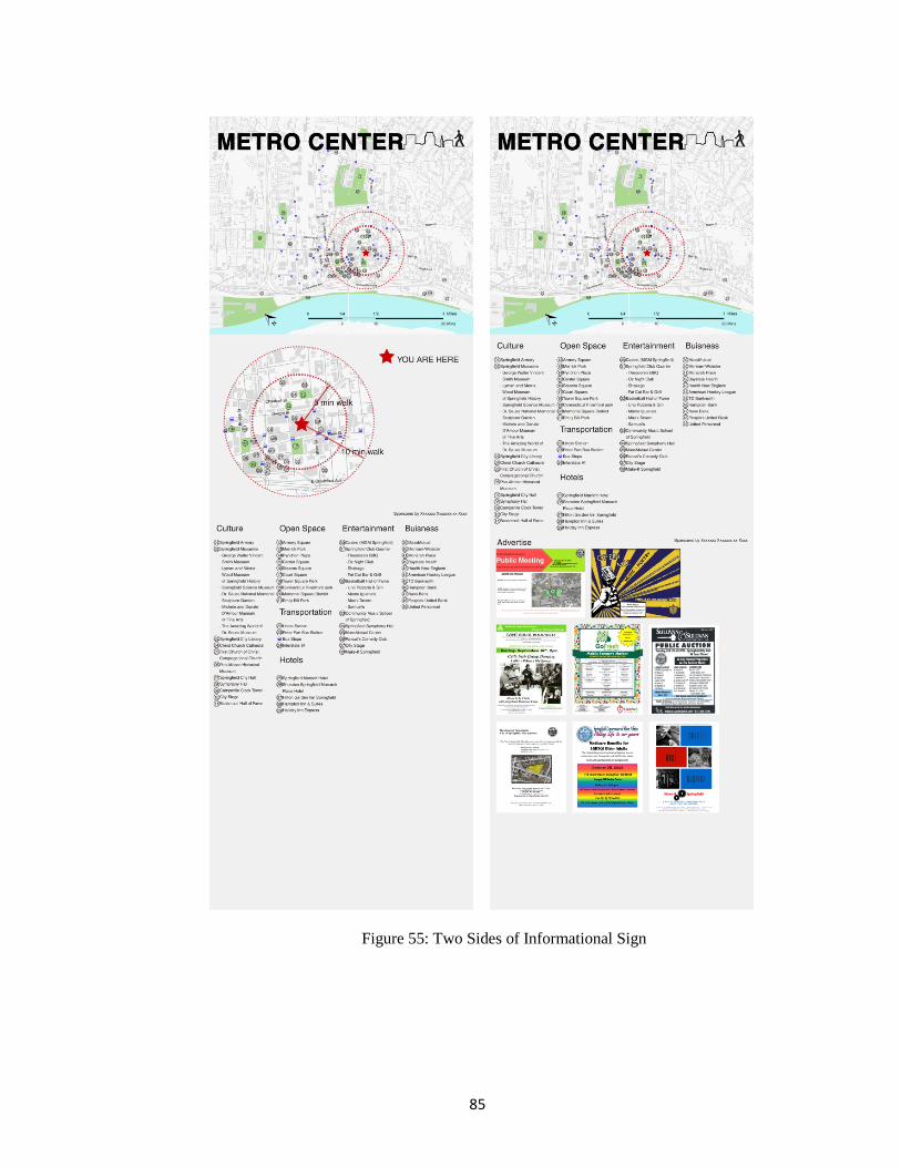
85
Figure 55: Two Sides of Informational Sign
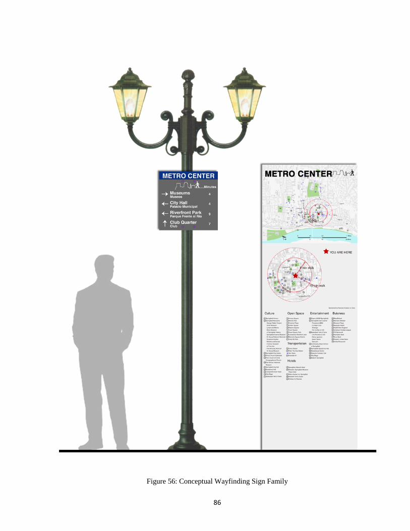
86
Figure 56: Conceptual Wayfinding Sign Family
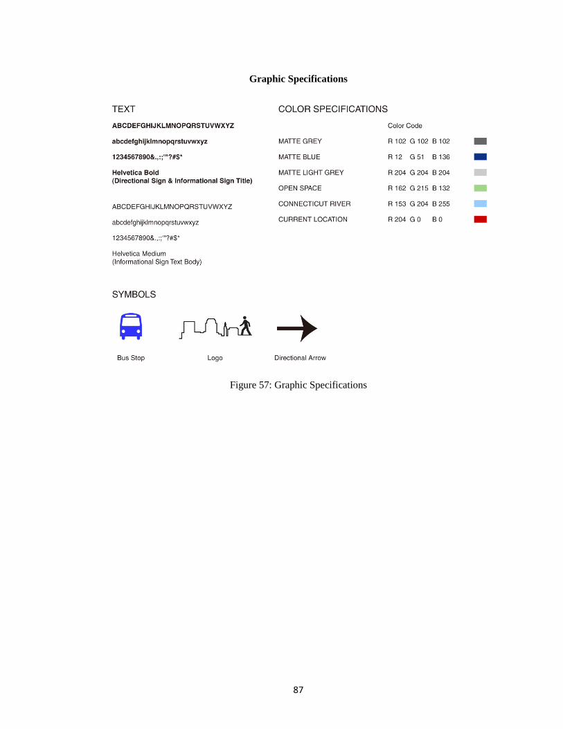
87
Graphic Specifications
Figure 57: Graphic Specifications
88
Notes
1 Foster, Paul N., Stefanie M. Santaniello, Justine Calcina, Delania Barbee, and Kinshasa Fowlkes. "A Demographic and Economic Analysis Of the City of Springfield." City of Springfield, Massachusetts. Pioneer Valley Planning Commission, Sept. 2006. Web. Retrieved 17 Aug. 2016.
<https://www.springfield-ma.gov/planning/fileadmin/Planning_files/Springfield_Market_Study_2006.pdf&sa=U&ved=0ahUKEwi5qJCvzO7PAhWKOD4KHQwyC3gQFggLMAM&client=internal-uds-cse&usg=AFQjCNGivrOBdCDw2NqI36i-s0FACs2NNA>.
2 Bloniarz, David. "Springfield Neighborhoods Report: ReGreen Springfield." Encyclopedic
Dictionary of Landscape and Urban Planning (2010): 1053. 3 Inthasorn, Piyawut. "Landscape Urbanism for the Highway City of Springfield North End."
ScholarWorks@UMass Amherst. UMass Amherst, 14 May 2010. Web. Retrieved 18 Aug. 2016. <http://scholarworks.umass.edu/cgi/viewcontent.cgi?article=1000&context=larp_honors&
sei-redir=1#search=>. 4 Springfield BID. "Downtown/Metro Center Pedestrian Wayfinding Enhancement
Initiative." Bid Detail 16-140 - RFP. City of Springfield, Massachusetts, 10 Mar. 2016. Web. Retrieved 20 Aug. 2016.
<http://www.springfield-ma.gov/finance/procurement/bid_detail.php?bid=201616-140>.
89
CHAPTER 6
GUIDELINES: A WAYFINDING TOOLKIT FOR CITIES AND TOWNS
As this project has tried to show, wayfinding systems have become especially popular in
recent years. Examples can be found around the globe, with many more coming. The proliferation
of so many projects means that cities and towns contemplating wayfinding systems have almost
unlimited resources and examples to look at for help. Yet, the work in this project is perhaps unique
in that it is based on the author’s direct experience on an actual wayfinding project, augmented by
considerable research, including case studies and "lessons learned" The work is summarized in the
following chapter as a "Toolkit" that provides important and convenient recommendations for
wayfinding projects.
Who should use this toolkit?
In recent years, wayfinding systems have been implemented in cities and towns, large and
small. A major goal of most projects is to make navigation easier for pedestrians, motorists, and
cyclists. Wayfinding systems help reinforce key destinations, and enhance the "image", "brand", or
what urban designers call "as sense of place". However, city leaders are left to consider developing
wayfinding programs, often on limited budgets with little knowledge about lessons learned from
other cities and towns, or clear directions for how to proceed.
The "Toolkit" presented in this chapter should be used by citizens and civic leaders in cities
and towns interested in developing a wayfinding program. It is the hope that individual cities and
towns will be able to use this toolkit as a way to build support in their own community so that they
can implement a successful wayfinding program.
90
Do you really need a wayfinding signage system?
It seems almost every city and town is developing a new wayfinding system. Wayfinding
systems often require much time and money to implement. Before you begin, it is important to
confirm that your community needs a wayfinding system.
The goal of a wayfinding signage system above all is making the a specific “project area”
effectively navigable. The criteria of navigability include a person’s current location and
orientation; the ability to successfully perform wayfinding tasks; and how well pedestrians can
accumulate wayfinding orientation in space.
It is important to remember that wayfinding is much more than a signage system. Kevin
Lynch explains the importance of “imageability” or the ability of a navigator to form a coherent
image or map of his or her surroundings. Lynch says that people usually organize the image they
have for a city by using a set of common features: paths, landmarks, districts, edges (barriers), and
nodes (intersections). In other words, these important features can help direct people, and in some
cases can even negate the need for a formal wayfinding system. In fact, a specially designed
signage system is not always beneficial, especially in places that already have sufficient existing
signs or landmarks. Time and money can be saved by carefully assessing the city or town’s needs,
including goals and objectives. This should be done in a beginning phase of the project as part of a
pre-installation evaluation/survey in the target area.
Funding for Wayfinding System
In general, the costs for a wayfinding system usually include four main areas: planning,
design, fabrication and installation, followed by costs associated with any repairs and ongoing
maintenance/management required for the system.
91
Planning
The cost of initial planning includes a vision statement, design brief, planning scope, and
system conceptual design. These costs are range from $10,000 - $50,000 depending on the size and
complexity of the project.
Design
The cost of design includes design development, approvals, documentation and bidding.
These cost are generally from $35,000 - $500,000.
Sample design budgets include:
Neighborhoods and Main Streets $35,000 - $75,000;
Small Town $75,000 - $100,000;
Small Downtown or Mid Sized City $100,000 - $150,000;
Large Downtown $125,000 - $300,000;
Entire Cities and Regional Areas $125,000- $500,000.
Fabrication and Installation
The cost of drawings, fabrication and installation could range from $100,000 - $5,000,000.
Sample fabrication budgets include:
Neighborhood and Main Streets $75,000 - $150,000;
Small Town $200,000 - $350,000;
Small Downtown or Mid Sized City $ 350,000 - $750,000;
Large Downtown $ 750,000 - $1.5 million;
Entire Cities and Regional Areas $1.5 million - $3 million+.
Ongoing Maintenance/Management
The cost of cleaning, replacing and expanding the system various. It is financed through
several approaches including destination fees, business levies and internal budgeting.
92
The costs of a wayfinding program are usually paid by grants, taxpayer funds or a
public/private collaboration. The top five leading financing sources for wayfinding programs are:
Transportation Equity Act (TEA-LU), City Capital budget for Economic Development,
Community Development Block Grants, and Institutional and Corporate Grants.
Projects include special landmarks, gateways, streetscapes could cost more. The size of
signs and types affect price greatly.
Lessons Learned
Based on the previous case studies, several principles have been identified below that can
be applied to wayfinding systems:
Design standards should address all types of users, including local residents, visitors,
able-bodied or not, appropriate for a diverse population.
Each sign should provide adequate information, either too much or too little can be
confusing.
Signage should be easy to recognize and read. They should be positioned
consistently so that people can find each type of information easily.
Signage should be in a uniform, modular frame that allows quick changes and
withstand frequent cleaning.
Types of signage could be determined by size of target area, main goal of the project,
zoning of the target area, and so on. Map kiosks are recommended especially the
target area is large with multiple districts.
Temporary signage has become a trend in recent years, because of lower cost, easy
to change and maintain, and short period for conduction.

93
Things to watch out for building a Wayfinding System
1. Wayfinding signs should be designed easily to be updated and maintained.
2. Information should be presented consistently and logically.
3. Wayfinding signs should be designed to address the appropriate audience.
Recent Trends in Wayfinding
In 1960, Lynch coined the term of wayfinding and defined it as "the elements of the built
environment that allow us to navigate successfully through complex spaces like cities and towns".
Wayfinding includes four elements: orientations, route decisions, mental map, and destinations.
These four core components might not change, however, the resources and structures building an
effective wayfinding system has been changing.
Technology development is just one of the new developments to impact the design of
wayfinding systems. Others include:
Option to have hand-held map and translation service for any language;
Option to provide service for people with visual disability, hearing loss...;
A wayfinding system that is easy to be updated and maintain.
Top 10 Recommendations
1. Start with pre-survey or low-cost tactical installation.
Pre-survey and evaluation is recommended when start planning wayfinding system, in
order to know if new wayfinding system is needed for residents and visitors. From the pre-survey
in Springfield, it is easy to know that lack of place to go in Metro Center is the major reason why
residents do not walk much. In addition, there are a large number of existing wayfinding signs in
Metro Center, which is distracting.
94
Planners and communities can have a reference from the survey and evaluation, and
decide to build a new wayfinding system, to improve existing wayfinding signs, or use the budget
to create activities for residents.
2. Communicate with all related stakeholders.
Bring together all stakeholders who will be affected by the completed wayfinding design.
There is always a conflict of interest among different parties and organizations as wayfinding
helps brand the city.
3. Keep information simple.
Too much information is overwhelming. Successful wayfinding systems present
information that is easy to understand. Display information in a logical way and use graphics and
symbols that are universally understood.
4. Existing signs may cause conflict with new ones.
Too much information is confusing, as well as multiple styles of signs. Most of the cities
and towns have built wayfinding signs in the past. Try to incorporate new wayfinding signs with
existing ones before tearing them down. And try to uniform existing and new signs.
5. Directional signs with walking distance and time spend serve a limited range of
area.
Comparing to traditional directional signs, signage with walking distance and time spend
(Figure 58) is more perceptual intuition by indicating how close and convenient to get to a
destination by WALKING, especially for those who do not have an accurate sense of distance
and how long it takes them to walk for a certain distance.
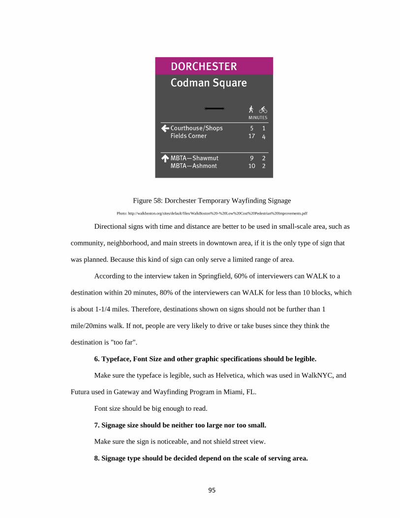
95
Figure 58: Dorchester Temporary Wayfinding Signage Photo: http://walkboston.org/sites/default/files/WalkBoston%20-%20Low%20Cost%20Pedestrian%20Improvements.pdf
Directional signs with time and distance are better to be used in small-scale area, such as
community, neighborhood, and main streets in downtown area, if it is the only type of sign that
was planned. Because this kind of sign can only serve a limited range of area.
According to the interview taken in Springfield, 60% of interviewers can WALK to a
destination within 20 minutes, 80% of the interviewers can WALK for less than 10 blocks, which
is about 1-1/4 miles. Therefore, destinations shown on signs should not be further than 1
mile/20mins walk. If not, people are very likely to drive or take buses since they think the
destination is "too far".
6. Typeface, Font Size and other graphic specifications should be legible.
Make sure the typeface is legible, such as Helvetica, which was used in WalkNYC, and
Futura used in Gateway and Wayfinding Program in Miami, FL.
Font size should be big enough to read.
7. Signage size should be neither too large nor too small.
Make sure the sign is noticeable, and not shield street view.
8. Signage type should be decided depend on the scale of serving area.
96
The simpler the signs are made, the more efficient they will be. Information on signage
should be neither too much nor too little. Before developing the wayfinding system, the particular
characteristics of the systems are needed to know in order to help make the right choice of which
type to use. For example, based on the scale of downtown Philadelphia and Manhattan, overall
maps were provided to give an overview for pedestrians, while only directional signs were
applied in Dorchester and Raleigh.
9. Thinking about wayfinding program at the time when planning a street or space,
rather than after the community has been built.
10. Provide signs at decision points.
Install signs at the most effective locations, where pedestrians must make a decision
which way to go.
References to Data and List of Case Studies/Links to Websites
Case studies include wayfinding program in cities and towns listed below.
http://americawalks.org/
https://segd.org/what-wayfinding
http://idea.ap.buffalo.edu/udny/Section4-1c.htm
Charlotte, NC: Uptown Charlotte Wayfinding System
Charlotte has similar geographic location and area with Springfield, MA, and similar
developing background as well. It would be worth learning about the density of
signs, locations of signs, and other details in Charlotte.
https://segd.org/charlotte-wayfinding-system
http://www.twotwelve.com/wayfinding-systems/city-of-charlotte.html
Philadelphia, PA: Walk!Philadelphia
97
This program has been widely recognized as one of the most successful wayfinding
program in United States. It has been used as case study for wayfinding system
program in many cities and towns.
http://www.lhsigns.com/urban-wayfinding-signage.html
http://www.restreets.org/case-studies/comprehensive-hierarchical-wayfinding
http://planphilly.com/articles/2014/09/29/not-all-those-who-wander-are-lost-but-mo
st-are-a-wayfinding-tour-of-city-hall
Portland, OR: Portland Pedestrian Wayfinding Signage System
This program has been recognized as a successful wayfinding system, and has been
studied by an amount of cities and towns. The designer Joel Katz Design Associates
(JKDA) is responsible for the success of Walk!Philadelphia as well.
https://www.walkscore.com/score/portland-oregon
https://www.portlandoregon.gov/transportation/40500
Springfield, OR: Springfield Wayfinding System
The city of Springfield studied about the existing logic of the city, and came up with a
logic map which was used on map kiosk in the wayfinding program. In addition,
public arts and murals incorporated with wayfinding in this program, which can
promote public participation.
http://www.ci.springfield.or.us/SCYWayfinding.htm
http://cargocollective.com/shannonpaine/Springfield-Wayfinding-Proposal
https://scholarsbank.uoregon.edu/xmlui/handle/1794/13515
Portland, Maine: Portland Wayfinding System
Portland, ME and Springfield, MA has similar population density, and located at
waterfront, which leads to a same problem: how to guide people to waterfront, and
make full use of the waterfront view.
98
http://www.portlandmaine.gov/DocumentCenter/Home/View/2214
New York City, NY: WalkNYC
WalkNYC serves 8.5 million residents and 50 million yearly visitors to navigate the
city streets. It provided a clear visual language and graphic standard that is
universally understood.
http://www.nyc.gov/html/dot/html/pedestrians/walknyc.shtml
https://www.dwell.com/collection/how-new-york-city-developed-its-wayfinding-sig
nage-812a8ae3
http://www.designboom.com/design/walknyc-pedestrian-maps-by-the-pentacitygrou
p/
http://www.aiga.org/case-study-walknyc-pedestrian-wayfinding/
Raleigh, NC: Walk Raleigh
WalkRaleigh is an award-winning project conducted by a student team from North
Carolina State University. After winning the 2012 ASLA Student Award, the project
has raised a revolution of temporary wayfinding signage.
https://www.asla.org/2012studentawards/255.html
http://www.citylab.com/tech/2012/02/guerilla-wayfinding-raleigh/1139/
http://www.citylab.com/design/2015/02/diy-wayfinding-signs-are-about-to-go-main
stream/386081/
Dorchester Community, Boston, MA: WalkBoston
WalkBoston is an organization dedicated to promote walking for transportation and
recreation in Massachusetts. It has sponsored wayfinding projects in many cities and
towns in Massachusetts, such as Dorchester Community and Turners Falls. It is one
of the sponsorships in Springfield wayfinding program as well.
https://www.boston.gov/neighborhood/dorchester
99
http://walkboston.org/what-we-do/being-advocate
Ottawa-Vanier, Canada: Walk Vanier
Walk Vanier is a project launched by local residents, in order to support small scale
community and activate neighborhood.
http://vaniernow.blogspot.com/2014/02/making-way-for-new-signs.html
Metro Center, Springfield, MA: Springfield Pedestrian Wayfinding System
103 random-selected pedestrian were interviewed in Springfield, MA. Detailed
survey see Appendix B.
http://www.pvpc.org/content/city-springfield-pedestrian-wayfinding
https://www.springfield-ma.gov/cos/index.php?id=2029
http://www.masslive.com/news/index.ssf/2016/04/walkable_springfield_city_unve.h
tml
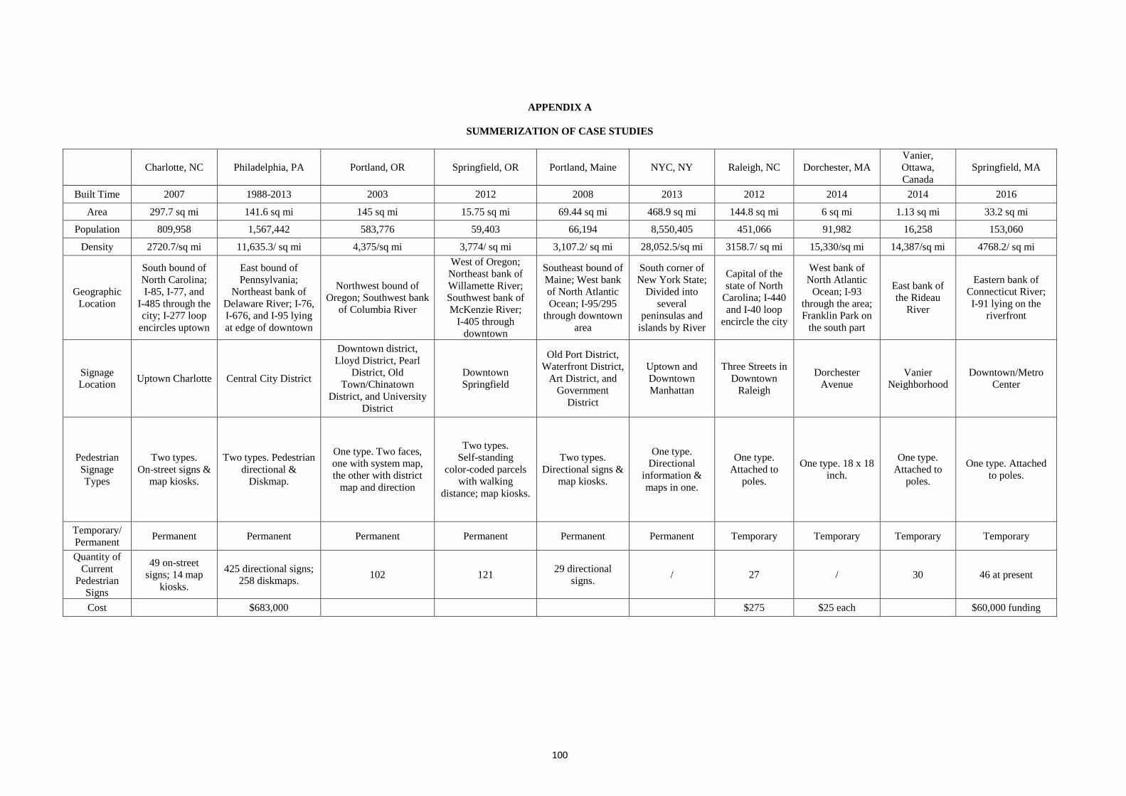
100
APPENDIX A
SUMMERIZATION OF CASE STUDIES
Charlotte, NC Philadelphia, PA Portland, OR Springfield, OR Portland, Maine NYC, NY Raleigh, NC Dorchester, MA Vanier, Ottawa, Canada
Springfield, MA
Built Time 2007 1988-2013 2003 2012 2008 2013 2012 2014 2014 2016
Area 297.7 sq mi 141.6 sq mi 145 sq mi 15.75 sq mi 69.44 sq mi 468.9 sq mi 144.8 sq mi 6 sq mi 1.13 sq mi 33.2 sq mi
Population 809,958 1,567,442 583,776 59,403 66,194 8,550,405 451,066 91,982 16,258 153,060
Density 2720.7/sq mi 11,635.3/ sq mi 4,375/sq mi 3,774/ sq mi 3,107.2/ sq mi 28,052.5/sq mi 3158.7/ sq mi 15,330/sq mi 14,387/sq mi 4768.2/ sq mi
Geographic Location
South bound of North Carolina; I-85, I-77, and
I-485 through the city; I-277 loop
encircles uptown
East bound of Pennsylvania;
Northeast bank of Delaware River; I-76, I-676, and I-95 lying at edge of downtown
Northwest bound of Oregon; Southwest bank
of Columbia River
West of Oregon; Northeast bank of Willamette River; Southwest bank of McKenzie River;
I-405 through downtown
Southeast bound of Maine; West bank of North Atlantic Ocean; I-95/295
through downtown area
South corner of New York State;
Divided into several
peninsulas and islands by River
Capital of the state of North
Carolina; I-440 and I-40 loop
encircle the city
West bank of North Atlantic
Ocean; I-93 through the area; Franklin Park on
the south part
East bank of the Rideau
River
Eastern bank of Connecticut River; I-91 lying on the
riverfront
Signage Location Uptown Charlotte Central City District
Downtown district, Lloyd District, Pearl
District, Old Town/Chinatown
District, and University District
Downtown Springfield
Old Port District, Waterfront District,
Art District, and Government
District
Uptown and Downtown Manhattan
Three Streets in Downtown
Raleigh
Dorchester Avenue
Vanier Neighborhood
Downtown/Metro Center
Pedestrian Signage Types
Two types. On-street signs &
map kiosks.
Two types. Pedestrian directional &
Diskmap.
One type. Two faces, one with system map, the other with district
map and direction
Two types. Self-standing
color-coded parcels with walking
distance; map kiosks.
Two types. Directional signs &
map kiosks.
One type. Directional
information & maps in one.
One type. Attached to
poles.
One type. 18 x 18 inch.
One type. Attached to
poles.
One type. Attached to poles.
Temporary/ Permanent Permanent Permanent Permanent Permanent Permanent Permanent Temporary Temporary Temporary Temporary
Quantity of Current
Pedestrian Signs
49 on-street signs; 14 map
kiosks.
425 directional signs; 258 diskmaps. 102 121 29 directional
signs. / 27 / 30 46 at present
Cost $683,000 $275 $25 each $60,000 funding
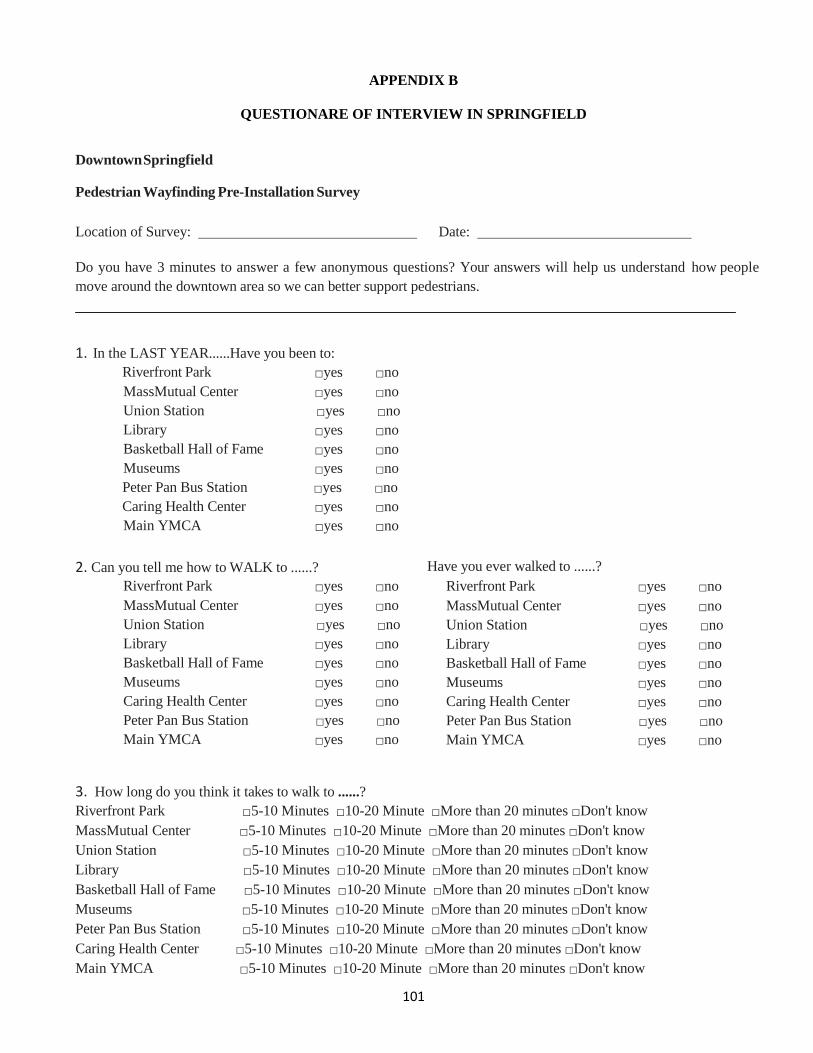
101
APPENDIX B
QUESTIONARE OF INTERVIEW IN SPRINGFIELD
Downtown Springfield
Pedestrian Wayfinding Pre-Installation Survey
Location of Survey: Date:
Do you have 3 minutes to answer a few anonymous questions? Your answers will help us understand how people move around the downtown area so we can better support pedestrians. 1. In the LAST YEAR......Have you been to:
Riverfront Park □yes □no MassMutual Center □yes □no Union Station □yes □no Library □yes □no Basketball Hall of Fame □yes □no Museums □yes □no Peter Pan Bus Station □yes □no Caring Health Center □yes □no Main YMCA □yes □no
2. Can you tell me how to WALK to ......? Have you ever walked to ......?
Riverfront Park □yes □no Riverfront Park □yes □no MassMutual Center □yes □no MassMutual Center □yes □no Union Station □yes □no Union Station □yes □no Library □yes □no Library □yes □no Basketball Hall of Fame □yes □no Basketball Hall of Fame □yes □no Museums □yes □no Museums □yes □no Caring Health Center □yes □no Caring Health Center □yes □no Peter Pan Bus Station □yes □no Peter Pan Bus Station □yes □no Main YMCA □yes □no Main YMCA □yes □no
3. How long do you think it takes to walk to ......? Riverfront Park □5-10 Minutes □10-20 Minute □More than 20 minutes □Don't know MassMutual Center □5-10 Minutes □10-20 Minute □More than 20 minutes □Don't know Union Station □5-10 Minutes □10-20 Minute □More than 20 minutes □Don't know Library □5-10 Minutes □10-20 Minute □More than 20 minutes □Don't know Basketball Hall of Fame □5-10 Minutes □10-20 Minute □More than 20 minutes □Don't know Museums □5-10 Minutes □10-20 Minute □More than 20 minutes □Don't know Peter Pan Bus Station □5-10 Minutes □10-20 Minute □More than 20 minutes □Don't know Caring Health Center □5-10 Minutes □10-20 Minute □More than 20 minutes □Don't know Main YMCA □5-10 Minutes □10-20 Minute □More than 20 minutes □Don't know
102
4. Have you seen any signs that tell you how to get to any of these destinations? □yes □no Which ones?
5. When you come to downtown, how often do you …..
Walk □mostly □sometimes □neve Bike □mostly □sometimes □never
Bus □mostly □sometimes □never Driv
□mostly □sometimes □never 6. Do you ......
live in Springfield? □yes □no work in downtown Springfield? □yes □no own a car? □yes □no own a bike? □yes □no
7. How many minutes would you be willing to walk to a destination?
□ 5 Minutes or less □ 5-10 Minutes □ 10-20 Minutes □ More than 20 minutes □ Not sure (please explain):
8. How FAR would you be willing to walk to a destination?
blocks and/or miles
□ Not sure (please explain):
9. What would encourage you to walk more?
Thank you!
103
BIBLIOGRAPHY
Appleyard, Donald, and Mark Lintell. "The Environmental Quality of City Streets: The Residents' Viewpoint." Journal of the American Institute of Planners 38.2 (1972): 84-101.
Arthur, Paul, and Romedi Passini. Wayfinding: People, Signs, and Architecture. New York:
McGraw-Hill Book, 1992. Bechtel, Robert B., and Arzah Ts'erts'man. "Women and Environments." Handbook of
Environmental Psychology. New York: J. Wiley & Sons, 2002. 347-62. Bennani, Kristin, and Kathleen Turner. "What Is Environmental Graphic Design (EGD)?" SEGD:
A Multidisciplinary Community Creating Experiences That Connect People to Place. Network Solutions, LLC, 2013. Web. Retrieved 19 Jul. 2016.
<https://segd.org/article/what-environmental-graphic-design-egd>. Berger, Craig. "Typography, Placemaking and Signs." International Sign Association. Signage
Foundation, INC, 01 Jan. 2014. Web. Retrieved 20 July 2016. <https://www.signs.org/pdf2014/ISA_Typography_White_Papers_full_final.pdf>.
Bever, T. "The Logical and Extrinsic Sources of Modularity." Modularity and Constraints in
Language and Cognition. Vol. 25. Hillsdale, NJ: L. Erlbaum Associates, 1992. 197-212. Beynon, Chris, and Maggie Campbell. "Wayfinding." Re:Streets. MIG, Inc, 2011. Web. Retrieved
10 Oct. 2016. <http://www.restreets.org/wayfinding>.
Bloniarz, David. "Springfield Neighborhoods Report: ReGreen Springfield." Encyclopedic
Dictionary of Landscape and Urban Planning (2010): 1053. Brösamle, Martin, and Christoph Hölscher. "How Do Humans Interpret Configuration?" 6th
International Space Syntax Symposium ISTANBUL 2007. Proc. of 6th International Space Syntax Symposium, Istanbul. Istanbul Technical University, 15 June 2007. Web. Retrieved 09 Aug. 2016.
<http://www.spacesyntaxistanbul.itu.edu.tr/papers.htm>. Budev, Sapna, John Bosio, and Craig Berger. "Planning and Implementing an Urban Wayfinding
Project." International Sign Association. ISA, 2013. Web. Retrieved 03 Aug. 2016. Carpman, Janet Reizenstein, Myron A. Grant, and Deborah A. Simmons. Design That Cares:
Planning Health Facilities for Patients and Visitors. 3rd ed. John Wiley & Sons, 2001. Chen, Jui Lin, and Kay M. Stanney. "A Theoretical Model of Wayfinding in Virtual Environments:
Proposed Strategies for Navigational Aiding." Presence: Teleoperators and Virtual Environments 8.6 (1999): 671-85. Retrieved Web. 03 Aug. 2016.
Christophersen, Jon. Universal Design: 17 Ways of Thinking and Teaching. Oslo: Husbanken,
2002.
104
City of Springfield, Mass. "Parks Dept. Fun for Kids and Families." Springfield Dept. of Parks &
Recreation: Parks. City of Springfield, Mass, 03 June 2013. Web. Retrieved 25 Aug. 2016. <https://www.springfield-ma.gov/park/>.
Danford, G. Scott., and Beth Tauke. Universal Design New York. New York, NY: City of New
York Office of the Mayor, 2001. Darken, R. P., and W. P. Banker. "Navigating in Natural Environments: A Virtual Environment
Training Transfer Study." IEEE Virtual Reality Annual International Symposium. Los Alamitos, CA: IEEE Service Center, 1998. 12-19.
Dehais, Mary F., Yuanfang Gong, John E. Hulsey, Pamela Jo Landi, and Adam G. Monroy. "From
the Quadrangle to the River: Revitalizing the Heart of Downtown Springfield." ScholarWorks@UMass Amherst. UMass Amherst, 1 Apr. 2010. Web.Retrieved 24 Aug. 2016.
<http://scholarworks.umass.edu/cgi/viewcontent.cgi?article=1015&context=larp_grad_research>.
Downs, Roger M., and David Stea. Maps in Minds: Reflections on Cognitive Mapping. New York:
Harper & Row, 1977. Dwight, Ernest. "Signs of the Times." American School and University: 38-40. Signs of the Times.
CSC CORPORATE DOMAINS, INC., 30 June 2008. Farr, Anna Charisse, Tristan Kleinschmidt, Prasad Yarlagadda, and Kerrie Mengersen.
"Wayfinding: A Simple Concept, a Complex Process." Transport Reviews 32.6 (2012): 715-43.
Foltz, Mark A. "Designing Navigable Information Spaces." Designing Navigable Information
Spaces. MASSACHUSETTS INSTITUTE OF TECHNOLOGY, 20 May 1998. Foster, Paul N., Stefanie M. Santaniello, Justine Calcina, Delania Barbee, and Kinshasa Fowlkes.
"A Demographic and Economic Analysis Of the City of Springfield." City of Springfield, Massachusetts. Pioneer Valley Planning Commission, Sept. 2006. Web. Retrieved 17 Aug. 2016.
<https://www.springfield-ma.gov/planning/fileadmin/Planning_files/Springfield_Market_Study_2006.pdf&sa=U&ved=0ahUKEwi5qJCvzO7PAhWKOD4KHQwyC3gQFggLMAM&client=internal-uds-cse&usg=AFQjCNGivrOBdCDw2NqI36i-s0FACs2NNA>.
Francescato, Donata, and William Mebane. "How Citizens View Two Great Cities: Milan and
Rome." Image and Environment: Cognitive Mapping and Spatial Behavior. Chicago, IL: Aldine, 1973. 131-48.
Francis, Mark. "A Case Study Method for Landscape Architecture." Landscape Journal 20.1 (2001):
15-28.
105
Gibson, David. "Wayfinding Design Topography and Layout." The Wayfinding Handbook: Information Design for Public Places. New York: Princeton Architectural, 2009. 75-76.
Golledge, Reginald G. Wayfinding Behavior: Cognitive Mapping and Other Spatial Processes.
Baltimore: Johns Hopkins UP, 1999. Haq, Saif, and Sara Girotto. 4th International Space Syntax Symposium. London, UK. Space
Syntax Network, 19 June 2003. Web. Retrieved 07 Aug. 2016. <http://www.spacesyntax.net/symposia/4th-international-space-syntax-symposium/>.
Huelat, B. J. "The Elements of a Caring Environment - Wayfinding." Healthcare Design 2004. Huelat, Barbara J. "Wayfinding: Design for Understanding." The Center for Health Design.
Network Solutions, LLC, 2007. Hunter, Susan. "Spatial Orientation, Environmental Perception and Wayfinding." IDeA Center,
University at Buffalo, 2010. Retrieved Web. 03 Aug. 2016. <http://www.udeworld.com/space-syntax-and-the-importance-of-access-to-architectural-t
heory.html >. Inthasorn, Piyawut. "Landscape Urbanism for the Highway City of Springfield North End."
ScholarWorks@UMass Amherst. UMass Amherst, 14 May 2010. Web. Retrieved 18 Aug. 2016.
<http://scholarworks.umass.edu/cgi/viewcontent.cgi?article=1000&context=larp_honors&sei-redir=1#search=>.
Kaplan, Stephen. "Adaptation, Structure, and Knowledge." Environmental Knowing: Theories,
Research, and Methods. Stroudsburg, PA: Dowden, Hutchinson & Ross, 1976. 33-43. Klipp, Mark Vander. "Develop a Successful Wayfinding System." Buildings. BUILDINGS.COM,
04 Mar. 2006. Web. Retrieved 07 Aug. 2016. <http://www.buildings.com/article-details/articleid/3036/title/develop-a-successful-wayfin
ding-system>. Lange, Michael De. "Review: Kevin Lynch – The Image of the City." The Mobile City. Greenhost,
INC, 08 May 2009. Web. Retrieved 20 Jul. 2016. <http://themobilecity.nl/2009/05/08/review-kevin-lynch-the-image-of-the-city/>.
Lawson, Bryan. The Language of Space. Oxford: Architectural, 2001. Lawton, Carol A., and János Kállai. "Gender Differences in Wayfinding Strategies and Anxiety
About Wayfinding: A Cross-Cultural Comparison." Sex Roles 47.9 (2002): 389-401. Web. Retrieved 09 Aug. 2016.
<http://link.springer.com/article/10.1023/A:1021668724970>. Lawton, Carol A., Stephanie I. Charleston, and Amy S. Zieles. "Individual- and Gender-Related
Differences in Indoor Wayfinding." Environment and Behavior 28.2 (1996): 204-19. Lynch, Kevin. The Image of the City. Cambridge, MA: MIT, 1960.
106
Margolin, Victor. Design Discourse: History, Theory, Criticism. Chicago: U of Chicago, 1989. McClain, William. "Mysteries of the Trail-Marker Trees." The Illinois Stewed. University of
Illinois Extension, 2006. Web. 17 July 2016. <https://web.extension.illinois.edu/illinoissteward/openarticle.cfm?ArticleID=26&Page=2>.
Morville, Peter. Ambient Findability: What We Find Changes Who We Become. Beijing: O'Reilly,
2005. Museums, Springfield. "Springfield Museums | One Stop, Four Museums." Springfield Museums.
Network Solutions, LLC, 17 Oct. 2016. Web. Retrieved 22 Oct. 2016. <https://springfieldmuseums.org/>.
Nady, Riham. "How Do We Explore Cities?" Arch2Ocom. NAMESILO, LLC, 06 July 2016. Web.
Retrieved 10 July 2016. <http://www.arch2o.com/how-to-explore-cities/>.
Passini, Romedi Eugenio. Wayfinding: A Study of Spatial Problem Solving with Implications for
Physical Design. Pennsylvania State U, 1977. Passini, Romedi. Wayfinding in Architecture. New York: Van Nostrand Reinhold, 1984. Peponis, John, and Jean Wineman. "Spatial Structure of Environment and Behavior." Handbook of
Environmental Psychology. New York: J. Wiley & Sons, 2002. 271-91. Peponis, J., C. Zimring, and Y. K. Choi. "Finding the Building in Wayfinding." Environment and
Behavior 22.5 (1990): 555-90. Retrieved Web. 03 Aug. 2016. Rooke, Clementinah. "Improving Wayfinding in Old and Complex Hospital Environments."
Salford E-theses Collection. University of Salford, Manchester, Nov. 2012. Web. Retrieved 3 Aug. 2016.
<http://usir.salford.ac.uk/id/eprint/27358>. Rooke, Clementinah Ndhlovu, John Alfred Rooke, Lauri Koskela, and Patricia Tzortzopoulos.
"Using the Physical Properties of Artefacts to Manage Through‐life Knowledge Flows in the Built Environment: An Initial Exploration." Construction Management and Economics 28.6 (2010): 601-13. Web. Retrieved 07 Aug. 2016.
<http://usir.salford.ac.uk/11300/>. Sarno, Dormenic J. "OPEN SPACE AND RECOVERY ACTION PLAN 2015-2022." Springfield
Planning Board (n.d.): n. pag. City of Springfield Planning Files. City of Springfield, Massachusetts. Web. Retrieved 22 Aug. 2016.
<https://www.springfield-ma.gov/planning/fileadmin/Planning_files/Open_Space_Plan/OpenSpace_DRAFT2015_KC.pdf>.
107
Springfield BID. "Downtown/Metro Center Pedestrian Wayfinding Enhancement Initiative." Bid Detail 16-140 - RFP. City of Springfield, Massachusetts, 10 Mar. 2016. Web. Retrieved 20 Aug. 2016.
<http://www.springfield-ma.gov/finance/procurement/bid_detail.php?bid=201616-140>. Springfield BID. "Springfield Central Cultural District Background." SCCD Members -
Springfield BID. NETWORK SOLUTIONS, LLC, n.d. Web. Retrieved 22 Aug. 2016. <http://springfielddowntown.com/cultural-district/visit-cultural/>.
Springfield PVTA. "Transportation Services Findings." Redevelopment Plan for the Union Station
Intermodal Transportation Center (2012): n. pag. Pioneer Valley Transit Authority, 2012. Web. Retrieved 26 Aug. 2016.
<http://www.springfield-ma.gov/planning/fileadmin/Planning_files/union_sta_Final_devel_Plan_PART_3.pdf>.
Turner, Julia. "Signs: The Most Useful Thing You Pay No Attention To." Slate Magazine. CSC
CORPORATE DOMAINS, INC., 01 Mar. 2010. Web. Retrieved 05 Aug. 2016. <http://www.slate.com/articles/life/signs/2010/03/the_secret_language_of_signs.html>.
Tversky, Barbara. "Cognitive Maps, Cognitive Collages, and Spatial Mental Models." Lecture
Notes in Computer Science Spatial Information Theory A Theoretical Basis for GIS (1993): 14-24.
Westerkamp, Thomas A. "New Wayfinding Technology, Ordinance Changes Offer Challenges to
Managers." Facilitiesnet. Trade Press Media Group, July 2013. Web. Retrieved 18 July 2016.
<http://www.facilitiesnet.com/maintenanceoperations/article/New-Wayfinding-Technology-Ordinance-Changes-Offer-Challenges-to-Managers-Facility-Management-Maintenance-Operations-Feature--14207>.
United States. National Park Service. "Springfield Armory National Historic Site (U.S. National
Park Service)." National Parks Service. U.S. Department of the Interior, n.d. Web. Retrieved 22 Aug. 2016.
<https://www.nps.gov/spar/index.htm>. Zeisel, John. "10. Focused Interviews." Inquiry by Design: Tools for Environment-behavior
Research. Monterey, CA: Brooks/Cole Pub., 1981. 227-256. Zimbardo, Philip G., Ann L. Weber, and Robert L. Johnson. Psychology: Core Concepts. Boston:
Allyn and Bacon, 2003. Zimring, C. "The Cost of Confusion: Non-monetary and Monetary Cost of the Emory University
Hospital Wayfinding System." Thesis. Georgia Institute of Technology, 1990. Wayfinding: Design for Understanding. The Center for Health Design, Inc., 2007. Web. Retrieved 07 Aug. 2016.
<https://www.healthdesign.org/chd/research/wayfinding-design-understanding>.