Impact of lower plate structure on upper plate deformation at the NW Sumatran convergent margin from...
10
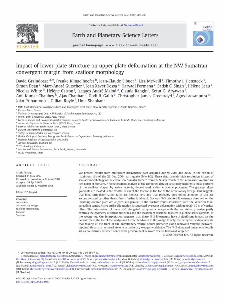
Impact of lower plate structure on upper plate deformation at the NW Sumatran convergent margin from seafloor morphology David Graindorge a, ⁎, Frauke Klingelhoefer b , Jean-Claude Sibuet b , Lisa McNeill c , Timothy J. Henstock c , Simon Dean c , Marc-André Gutscher a , Jean Xaver Dessa d , Haryadi Permana e , Satish C. Singh f , Hélène Leau g , Nicolas White h , Hélène Carton f , Jacques André Malod a , Claude Rangin i , Ketut G. Aryawan j , Anil Kumar Chaubey k , Ajay Chauhan f , Dodi R. Galih e , Christopher James Greenroyd l , Agus Laesanpura m , Joko Prihantono n , Gillian Royle f , Uma Shankar o a UMR 6538 Domaines Océaniques UBO/IUEM, Technopôle Brest-Iroise, Place Nicolas Copernic, F-29280 Plouzané, France b Ifremer, Brest, France c National Oceanography Centre, University of Southampton, Southampton, UK d UPMC, UMR Géosciences-Azur, Nice, France e Earth Dynamics and Geological Disaster Division, Research Center for Geotechnology, Indonesia Institute of Sciences, Bandung, Indonesia f Institut de Physique de Globe de Paris (IPGP), Paris, France g Institut Polaire Paul Emile Victor (IPEV), Brest, France h Bullard Laboratories, Cambridge, UK i Collège de France/CNRS, Aix en Provence, France j Marine Geological Institute, Energy and Earth Resources Department, Bandung, Indonesia k National Institute of Oceanography, Goa, India l Durham University, Durham, UK m ITB, Bandung, Indonesia n Marine and Fishery Department, Pasir Putih, Jakarta, Indonesia o NGRI, Hyderabad, India ABSTRACT ARTICLE INFO Article history: Received 14 May 2007 Received in revised form 19 April 2008 Accepted 26 April 2008 Available online 12 October 2008 Editor: C.P. Jaupart Keywords: subduction accretionary wedge seafloor morphology tectonic Sumatra We present results from multibeam bathymetric data acquired during 2005 and 2006, in the region of maximum slip of the 26 Dec. 2004 earthquake (Mw 9.2). These data provide high-resolution images of seafloor morphology of the entire NW Sumatra forearc from the Sunda trench to the submarine volcanic arc just north of Sumatra. A slope gradient analysis of the combined dataset accurately highlights those portions of the seafloor shaped by active tectonic, depositional and/or erosional processes. The greatest slope gradients are located in the frontal 30 km of the forearc, at the toe of the accretionary wedge. This suggests that long-term deformation rates are highest here and that probably only minor amounts of slip are accommodated by other thrust faults further landward. Obvious N–S oriented lineaments observed on the incoming oceanic plate are aligned sub-parallel to the fracture zones associated with the Wharton fossil spreading center. Active strike-slip motion is suggested by recent deformation with up to 20–30 m of vertical offset. The intersection of these N–S elongated bathymetric scarps with the accretionary wedge partly controls the geometry of thrust anticlines and the location of erosional features (e.g. slide scars, canyons) at the wedge toe. Our interpretation suggests that these N–S lineaments have a significant impact on the oceanic plate, the toe of the wedge and further landward in the wedge. Finally, the bathymetric data indicate that folding at the front of the accretionary wedge occurs primarily along landward-vergent (seaward- dipping) thrusts, an unusual style in accretionary wedges worldwide. The N–S elongated lineaments locally act as boundaries between zones with predominant seaward versus landward vergence. © 2008 Elsevier B.V. All rights reserved. Earth and Planetary Science Letters 275 (2008) 201–210 ⁎ Corresponding author. Tel.: +33 2 98 49 88 29; fax: +33 2 98 49 87 60. E-mail addresses: [email protected] (D. Graindorge), [email protected] (F. Klingelhoefer), [email protected] (J.-C. Sibuet), [email protected] (L. McNeill), [email protected] (T.J. Henstock), [email protected] (S. Dean), [email protected] (M.-A. Gutscher), [email protected] (J.X. Dessa), [email protected] (H. Permana), [email protected] (S.C. Singh), [email protected] (H. Leau), [email protected] (N. White), [email protected] (H. Carton), [email protected] (J.A. Malod), [email protected] (C. Rangin), [email protected] (K.G. Aryawan), [email protected] (A.K. Chaubey), [email protected] (A. Chauhan), [email protected] (D.R. Galih), [email protected] (C.J. Greenroyd), [email protected] (A. Laesanpura), [email protected] (G. Royle), [email protected] (U. Shankar). 0012-821X/$ – see front matter © 2008 Elsevier B.V. All rights reserved. doi:10.1016/j.epsl.2008.04.053 Contents lists available at ScienceDirect Earth and Planetary Science Letters journal homepage: www.elsevier.com/locate/epsl
Transcript of Impact of lower plate structure on upper plate deformation at the NW Sumatran convergent margin from...
Earth and Planetary Science Letters 275 (2008) 201–210
Contents lists available at ScienceDirect
Earth and Planetary Science Letters
j ourna l homepage: www.e lsev ie r.com/ locate /eps l
Impact of lower plate structure on upper plate deformation at the NW Sumatranconvergent margin from seafloor morphology
David Graindorge a,⁎, Frauke Klingelhoefer b, Jean-Claude Sibuet b, Lisa McNeill c, Timothy J. Henstock c,Simon Dean c, Marc-André Gutscher a, Jean Xaver Dessa d, Haryadi Permana e, Satish C. Singh f, Hélène Leau g,Nicolas White h, Hélène Carton f, Jacques André Malod a, Claude Rangin i, Ketut G. Aryawan j,Anil Kumar Chaubey k, Ajay Chauhan f, Dodi R. Galih e, Christopher James Greenroyd l, Agus Laesanpura m,Joko Prihantono n, Gillian Royle f, Uma Shankar o
a UMR 6538 Domaines Océaniques UBO/IUEM, Technopôle Brest-Iroise, Place Nicolas Copernic, F-29280 Plouzané, Franceb Ifremer, Brest, Francec National Oceanography Centre, University of Southampton, Southampton, UKd UPMC, UMR Géosciences-Azur, Nice, Francee Earth Dynamics and Geological Disaster Division, Research Center for Geotechnology, Indonesia Institute of Sciences, Bandung, Indonesiaf Institut de Physique de Globe de Paris (IPGP), Paris, Franceg Institut Polaire Paul Emile Victor (IPEV), Brest, Franceh Bullard Laboratories, Cambridge, UKi Collège de France/CNRS, Aix en Provence, Francej Marine Geological Institute, Energy and Earth Resources Department, Bandung, Indonesiak National Institute of Oceanography, Goa, Indial Durham University, Durham, UKm ITB, Bandung, Indonesian Marine and Fishery Department, Pasir Putih, Jakarta, Indonesiao NGRI, Hyderabad, India
⁎ Corresponding author. Tel.: +33 2 98 49 88 29; fax:E-mail addresses: [email protected] (D. Graindo
[email protected] (T.J. Henstock), [email protected](H. Permana), [email protected] (S.C. Singh), hleau@(J.A. Malod), [email protected] (C. Rangin), igka2000@(D.R. Galih), [email protected] (C.J. G(U. Shankar).
0012-821X/$ – see front matter © 2008 Elsevier B.V. Aldoi:10.1016/j.epsl.2008.04.053
A B S T R A C T
A R T I C L E I N F OArticle history:
We present results from m Received 14 May 2007Received in revised form 19 April 2008Accepted 26 April 2008Available online 12 October 2008Editor: C.P. Jaupart
Keywords:subductionaccretionary wedgeseafloor morphologytectonicSumatra
ultibeam bathymetric data acquired during 2005 and 2006, in the region ofmaximum slip of the 26 Dec. 2004 earthquake (Mw 9.2). These data provide high-resolution images ofseafloor morphology of the entire NW Sumatra forearc from the Sunda trench to the submarine volcanic arcjust north of Sumatra. A slope gradient analysis of the combined dataset accurately highlights those portionsof the seafloor shaped by active tectonic, depositional and/or erosional processes. The greatest slopegradients are located in the frontal 30 km of the forearc, at the toe of the accretionary wedge. This suggeststhat long-term deformation rates are highest here and that probably only minor amounts of slip areaccommodated by other thrust faults further landward. Obvious N–S oriented lineaments observed on theincoming oceanic plate are aligned sub-parallel to the fracture zones associated with the Wharton fossilspreading center. Active strike-slip motion is suggested by recent deformation with up to 20–30 m of verticaloffset. The intersection of these N–S elongated bathymetric scarps with the accretionary wedge partlycontrols the geometry of thrust anticlines and the location of erosional features (e.g. slide scars, canyons) atthe wedge toe. Our interpretation suggests that these N–S lineaments have a significant impact on theoceanic plate, the toe of the wedge and further landward in the wedge. Finally, the bathymetric data indicatethat folding at the front of the accretionary wedge occurs primarily along landward-vergent (seaward-dipping) thrusts, an unusual style in accretionary wedges worldwide. The N–S elongated lineaments locallyact as boundaries between zones with predominant seaward versus landward vergence.
© 2008 Elsevier B.V. All rights reserved.
+33 2 98 49 87 60.rge), [email protected] (F. Klingelhoefer), [email protected] (J.-C. Sibuet), [email protected] (L. McNeill),c.uk (S. Dean), [email protected] (M.-A. Gutscher), [email protected] (J.X. Dessa), [email protected] (H. Leau), [email protected] (N. White), [email protected] (H. Carton), [email protected] (K.G. Aryawan), [email protected] (A.K. Chaubey), [email protected] (A. Chauhan), [email protected]), [email protected] (A. Laesanpura), [email protected] (G. Royle), [email protected]
l rights reserved.

202 D. Graindorge et al. / Earth and Planetary Science Letters 275 (2008) 201–210
1. Introduction
The 26 December 2004 East Indian Ocean earthquake (Mw 9.2)was the biggest earthquake recorded in the past 40 years andgenerated the largest far-field (trans-oceanic) tsunami ever mon-itored (Merrifield et al., 2005). This subduction megathrust earth-quake triggered an average ~10m slip along a 1300 km long segmentof the plate boundary between the Indo-Australian plate and theEurasian (Sunda–Burma) plate (Lay et al., 2005). Rupture initiated at30–40 km depth, about 50 km north of Simeulue Island, along asegment of the subduction zone which had not experienced a greatthrust earthquakeMN8 in the past at least 200 years (Lay et al., 2005)(Fig. 1). Vertical motion of the seafloor and subsequently the watercolumn above generated a tsunami that killed over 250,000 people inSoutheast Asia. The earthquake was caused by sudden slip (up to~30m) releasing the elastic stress accumulated along the subductionzone interface between the Indo-Australian plate and the Sunda–Burma plate (Bilham, 2005), subducting obliquely at a rate of 4–6 cm/yr in a N8–20° azimuth (Vigny et al., 2005).
In the 2 years following this event, a concerted international effortto study the rupture zone of this great earthquake led to severaloceanographic expeditions (e.g., Singh and Sumatra-AftershocksTeam, 2005; Ladage et al., 2006; Henstock et al., 2006). One of thepriorities was to determine the detailed morphology of the seafloorand to delineate the underlying structure in the zone of maximumcoseismic slip. A key objective was to map the major tectonic featuresand in particular to search for evidence of submarine scarps,outcropping faults, slide scars etc., geologically reflecting recentdeformation of the margin possibly related to the earthquake andinteraction with longer term processes. Our analysis of the bathy-metric dataset presented in this paper contributes to the attempt tobetter understand the region of this event. Specifically, these dataprovide high-resolution images of the seafloor morphology offshoreSumatra, covering the deep oceanic domain, the accretionary wedge,forearc basin, Sumatran shelf and offshore extension of the strike-slipSumatran Fault which show significant impact of the lower plate onupper plate deformation patterns.
2. Datasets and processing
The high-resolution images of the seafloor morphology have beenobtained by the combination of the bathymetric datasets acquired byHMS Scott (January–February 2005; Henstock et al., 2006), and R/VMarion Dufresne (July–August 2005, and July–August 2006). The R/VMarion Dufresne is equipped with a deep-water multibeam echosoun-der (MBES) Seafalcon 11 developed by Thales Underwater System. Theechosounder uses 400–500 beams on 5 planes at 12 kHz frequencyacross a 120° fan. The lateral resolutionvarieswith depth and is typicallyequal to depth/100. The survey was carried out at a mean speed of14 knots. Positions were computed in the geodetic system WGS 84.Sound velocities were obtained using regularly spaced SIPPICANExpendable Temperature probes (XBT's) and processed manually withCARAIBES software on board. The HMS Scott is equipped with a high-precision deep deep-water multibeam echosounder, jointly developedby the United States Navy and SeaBeam Instruments Inc.: the SASS IVsystem (Sonar Array Sounding System) with 361 beams and a 120°swath width. It is a 12 kHz frequency high-resolution multibeam sonarsystem, with vertical resolution of ~5 m and deep-water horizontalresolution up to ~25 m (Henstock et al., 2006). To obtain uniform datacoverage, the data were combined in a 90 m grid.
Interpretations of structures observed on the oceanic plate arestrengthened by new Sub-Bottom Profiler (SBP: very high-resolutionseismic) data acquired during the RV Marion Dufresne Sumatra-OBScruise using the Thomson Marconi TSM 5265 MBES combinedmultibeam echosounder and Sub-Bottom Profiler with Thales SeaFalcon 11 software. The SBP data were acquired using a 3.75 kHz chirp
source wavelet. Data were recorded in SEG-Y format at 0.417 mssample rate and 400 ms fixed trace length (960 samples/trace). Theoriginal shot interval is 20 s, and the spacing between traces variesfrom 30 to 100 m depending on the vessel speed which varied from14 knots during the bathymetric survey to 4.5 knots during a survey tocollect seismic refraction data which will be detailed elsewhere. Datafrom the SBPwere then binned/interpolated to a 75m regular spacing.
3. General morphology of NW Sumatra forearc
The bathymetric compilation resulting from the three cruisesprovides a high-resolution image of the seafloor with a 90 m grid overa region of roughly 3.5°×2.5°, an area of approximately 100,000 km2.The map includes the entire forearc off northwestern Sumatra to theAndaman Sea north of Sumatra and to the Indonesian–Indianboundary to the north-west (Fig. 1). Coverage is over 80% in thecentral region (93–95°E, 2.5–5°N) that includes the epicenter(position of rupture initiation) of the 26 December 2004 earthquake.This precise bathymetric chart allows the division of the region intofive tectonic provinces across the margin from SW to NE:
1. The flat, relatively undeformed sea bed of the oceanic plate and trench.This domain consists of a nearly featureless abyssal plain at depthsof 4300–4900 m, with an extremely gentle slope towards the east,terminating at the toe of the accretionary wedge. The thickness ofsediments at the Northern Sumatra “trench” reaches 2–3 s twowaytravel time (Moore and Curray, 1980; Ségoufin et al., 2004; Singhet al., 2006; Gaedicke et al., 2006). The sediment-filled trench istherefore barely observable. Close to the trench, a few, lineamentsand a series of conspicuous en-echelon depressions are aligned in aN–S to N15E direction, the same as the orientation of fracture zonesrelated to the Wharton fossil spreading center documented byDeplus et al. (1998).
2. The accretionary wedge corresponding to the lowermost forearcdown to the trench consists of a series of elongate ridges alignedsub-parallel to the trench, with an average spacing of 5–15 km anda typical vertical relief of 200–1000 m (e.g., Henstock et al., 2006).Within 20–40 km of the trench, the seafloor rapidly rises over3000 m to depths of about 1500 m. The next 100 km across theforearc towards the NE forms a plateau, with meanwater depths of1000–2000 m, marked by 8–10 submarine elongate hills andintervening basins approximately parallel to the subduction front.This high rugosity region ends at a major 30 km wide elongatedridge which decreases in width and deepens to the south. Thisprominent feature has been previously recognized and termed the“outer-arc ridge“ by Karig et al. (1980); it forms the south-westernboundary of the Aceh forearc basin. Within the north-eastern flankof the ridge, clear geomorphological lineations mark the trace ofthe right-lateral West Andaman Fault (Izart et al., 1994; Malod andMustafa Kemal, 1996; Curray, 2005; Singh and Sumatra-After-shocks Team, 2005) which is thought to be the equivalent of theMentawai fault off central-south Sumatra (Diament et al., 1992).Further south, this system becomes more complex with a littledescribed compressive relay/transpressional structure known asthe Tuba ridge (Malod et al., 1993; Curray, 2005). Further south still,the relatively shallow water (less than 1000 m) Simeulue plateau(north of Simeulue) may be the southern equivalent of the outer-arc ridge or high. Generally, the accretionary wedge narrows fromthe NW (120 km seaward of the Aceh Basin) to the SE (60 km offSimeulue Island) possibly related to the change in orientation of thetrench and deformation front.
3. The forearc basin. The Aceh forearc basin lies landward of theaccretionary wedge plateau and is characterized by generallysmooth, flat seafloor at a mean depth of 2500 m. The SimeulueBasin further southeast is a shallower basin with a mean depth ofabout 1000 m, and is divided into two sub-basins by a structural

Fig. 1. Bathymetric image (shaded relief with illumination from the SW) of the NW Sumatra forearc, from the combined datasets of the 2005–2006 R/V Marion Dufresne surveys andthe HMS Scott survey. Inset shows tectonic setting of the study area, with red star representing the epicenter of the 26 December 2004 earthquake.
203D. Graindorge et al. / Earth and Planetary Science Letters 275 (2008) 201–210
high at ~800 m depth (Neben et al., 2006) possibly associated withthe Mentawai fault or equivalent (Izart et al., 1994). These forearcbasins widths varying between 20 and 50 km. The Aceh andSimeulue basins are separated by the WNW-ESE trending Tubaridge (Malod et al., 1993; Curray, 2005).
4. The upper continental slope and shelf off Sumatra has a width of 20–50 km. It is widest (40–50 km) off the NW tip of Sumatra, with a
generally smooth but west-dipping slope of a few degrees locallyincised by canyons transporting terrestrial sediments down to theforearc basin.
5. The Sumatra–Andaman submarine arc trough north of Sumatra iscomposed of several predominantly right-lateral strike-slip faultsas part of the northern extension of the Sumatran and Seulimeumfaults (Malod et al., 1993; Mustafa Kemal, 1993; Sieh and

Fig. 2. Seafloor slope map of the study area. Flat slopes are white to blue, and steep slopes red (N10°) and black (N20°), background contours are derived from digital bathymetricdatasets (IOC et al., 2003).
204 D. Graindorge et al. / Earth and Planetary Science Letters 275 (2008) 201–210
Natawidjaja, 2000). NNW of Sumatra Island and ESE of GreatNicobar Island, west of the volcanic axis, there are two major faultswith down to the NEmovement (normal or transtensional) and onemajor fault to the east. These bound a deep trough (water depths of3000–3600 m) with submarine volcanic edifices exposed in thecentral axis of this deep basin.
In this article we will focus mainly on the 2 first domains.
4. Seafloor slope and morphotectonic maps
To provide clues as to which portions of the seafloor are beingshaped by active processes (tectonic, sedimentary, gravitational) andestimates of the mechanical properties of the shallow sediments (e.g.coefficient of internal friction, which affects slope stability), we havecalculated the seafloor slope from our original combined bathymetrydataset (Fig. 2). The steepest slopes in the region (N15–20°) are, notsurprisingly, found along the flanks of the elongate accretionarywedge thrust ridges (particularly at the toe of wedge where wesuggest active deformation is focused), along canyons incised into theupper and lower portions of the margin and locally along the edges oflandslide scars. All slopes greater than 20° in this environment can beconsidered to be potentially unstable.
The precise seafloor bathymetry, the calculated slopes, and the3.5 kHz seismic data constrain themorphotectonicmap shownon Fig. 3.Features with slopes N5° depict potentially active structures, e.g., blind
thrusts, surface-breaking faults or submarine canyons. In the geody-namic setting of an accretionary wedge, thrust (fault-bend fold) typeanticlines are commonly observed in nature (e.g., Suppe, 1983; Fluehet al., 1998) and have been reproduced in analogue models (Gutscheret al.,1998). Seismic data from this region (e.g., Singh et al., 2006; Sibuetet al., 2007; Franke et al., 2006; Gaedicke et al., 2006) have also revealedsuch structures. We have interpreted the widespread elongate sub-parallel ridges as landward and seaward vergent thrusts based on theprevious geomorphological interpretations of Henstock et al. (2006) andhave marked thrusts and fold axes with different symbols for clarity.Furthermore, we highlight fold axes, major canyons, major fault andlandslide scarps, distributed landslide blocks and clear lineaments onthe oceanic crust and in the wedge (Fig. 3).
5. The oceanic plate and N–S lineaments
On the flat-lying oceanic plate outboard of the trench, thebathymetry data reveal a set of obvious N–S to N15°E trendinglineaments (Fig. 3) which are also clearly imaged in the SBP high-resolution seismic lines (Figs. 4 and 5). One of themost prominent N–Slineaments, near 92.8°E, is over 50 km long and corresponds to a gentlestep down to the east characterized by a vertical offset of 10–30m; thisis marked with red triangles the four 3.5 kHz profiles of Fig. 4. In thesame area, smaller graben-type features (typically 10 m in height, e.g.,line G, Fig. 4) can be observed parallel to this major N–S scarp. This
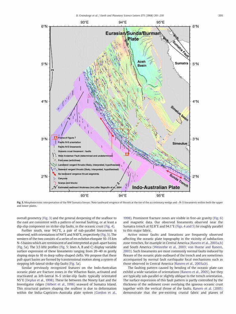
Fig. 3.Morphotectonic interpretation of the NW Sumatra forearc. Note landward vergence of thrusts at the toe of the accretionary wedge and ~N–S lineaments within both the upperand lower plates.
205D. Graindorge et al. / Earth and Planetary Science Letters 275 (2008) 201–210
overall geometry (Fig. 3) and the general deepening of the seafloor tothe east are consistent with a pattern of normal faulting, or at least adip-slip component on strike-slip faults, in the oceanic crust (Fig. 4).
Further south, near 94.1°E, a pair of sub-parallel lineaments isobserved, with orientations of N4°E and N10°E, respectively (Fig. 5). Thewestern of the two consists of a series of en-echelon elongate 10–15 kmN–S basinswhich are reminiscentof and interpreted as pull-apart basins(Fig. 5a). The 3.5 kHz profiles (Fig. 5: lines A, B and C) display variablesurface expression of these lineaments ranging from 20–40 m gentlysloping steps to 10 m deep valley-shaped clefts. We propose that thesepull-apart basins are formed by transtensionalmotion along a system ofstepping left-lateral strike-slip faults (Fig. 5a).
Similar previously recognized features on the Indo-Australianoceanic plate are fracture zones in the Wharton Basin, activated andreactivated as left-lateral N–S strike-slip faults typically orientatedN5°E (Deplus et al., 1998). These lie between the Ninety East and theInvestigator ridges (Hébert et al., 1996) seaward of Sumatra Island.This structural pattern shaping the seafloor is due to deformationwithin the India–Capricorn–Australia plate system (Gordon et al.,
1998). Prominent fracture zones are visible in free-air gravity (Fig. 6)and magnetic data. Our observed lineaments observed near theSumatra trench at 92.8°E and 94.1°E (Figs. 4 and 5) lie roughly parallelto this major fabric.
Active minor faults and lineations are frequently observedaffecting the oceanic plate topography in the vicinity of subductionzone trenches, for example in Central America (Ranero et al., 2003a,b)and South America (Weinrebe et al., 2003; von Huene and Ranero,2003). Such lineaments are most commonly normal faults induced byflexure of the oceanic plate outboard of the trench and are sometimesaccompanied by normal fault earthquake focal mechanisms such asthose observed in Central America (Ranero et al., 2003a,b).
The faulting pattern caused by bending of the oceanic plate canexhibit a wide variation of orientations (Ranero et al., 2005), but theyare typically sub-parallel or slightly oblique to the trench orientation.The surface expression of this fault pattern is partly controlled by thethickness of the sediment cover overlying the igneous oceanic crusttogether with the vertical throw of the faults. Ranero et al. (2005)demonstrate that the pre-existing crustal fabric and planes of
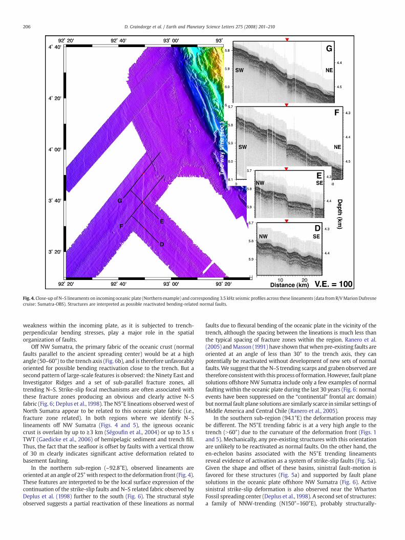
Fig. 4. Close-up of N–S lineaments on incoming oceanic plate (Northern example) and corresponding 3.5 kHz seismic profiles across these lineaments (data fromR/VMarion Dufresnecruise: Sumatra-OBS). Structures are interpreted as possible reactivated bending-related normal faults.
206 D. Graindorge et al. / Earth and Planetary Science Letters 275 (2008) 201–210
weakness within the incoming plate, as it is subjected to trench-perpendicular bending stresses, play a major role in the spatialorganization of faults.
Off NW Sumatra, the primary fabric of the oceanic crust (normalfaults parallel to the ancient spreading center) would be at a highangle (50–60°) to the trench axis (Fig. 6b), and is therefore unfavorablyoriented for possible bending reactivation close to the trench. But asecond pattern of large-scale features is observed: the Ninety East andInvestigator Ridges and a set of sub-parallel fracture zones, alltrending N–S. Strike-slip focal mechanisms are often associated withthese fracture zones producing an obvious and clearly active N–Sfabric (Fig. 6; Deplus et al., 1998). The N5°E lineations observedwest ofNorth Sumatra appear to be related to this oceanic plate fabric (i.e.,fracture zone related). In both regions where we identify N–Slineaments off NW Sumatra (Figs. 4 and 5), the igneous oceaniccrust is overlain by up to ≥3 km (Ségoufin et al., 2004) or up to 3.5 sTWT (Gaedicke et al., 2006) of hemipelagic sediment and trench fill.Thus, the fact that the seafloor is offset by faults with a vertical throwof 30 m clearly indicates significant active deformation related tobasement faulting.
In the northern sub-region (~92.8°E), observed lineaments areoriented at an angle of 25°with respect to the deformation front (Fig. 4).These features are interpreted to be the local surface expression of thecontinuation of the strike-slip faults and N–S related fabric observed byDeplus et al. (1998) further to the south (Fig. 6). The structural styleobserved suggests a partial reactivation of these lineations as normal
faults due to flexural bending of the oceanic plate in the vicinity of thetrench, although the spacing between the lineations is much less thanthe typical spacing of fracture zones within the region. Ranero et al.(2005) andMasson (1991) have shown thatwhenpre-existing faults areoriented at an angle of less than 30° to the trench axis, they canpotentially be reactivated without development of new sets of normalfaults.We suggest that the N–S trending scarps and graben observed aretherefore consistentwith this process of formation.However, fault planesolutions offshore NW Sumatra include only a few examples of normalfaulting within the oceanic plate during the last 30 years (Fig. 6: normalevents have been suppressed on the “continental” frontal arc domain)but normal fault plane solutions are similarly scarce in similar settings ofMiddle America and Central Chile (Ranero et al., 2005).
In the southern sub-region (94.1°E) the deformation process maybe different. The N5°E trending fabric is at a very high angle to thetrench (N60°) due to the curvature of the deformation front (Figs. 1and 5). Mechanically, any pre-existing structures with this orientationare unlikely to be reactivated as normal faults. On the other hand, theen-echelon basins associated with the N5°E trending lineamentsreveal evidence of activation as a system of strike-slip faults (Fig. 5a).Given the shape and offset of these basins, sinistral fault-motion isfavored for these structures (Fig. 5a) and supported by fault planesolutions in the oceanic plate offshore NW Sumatra (Fig. 6). Activesinistral strike-slip deformation is also observed near the WhartonFossil spreading center (Deplus et al., 1998). A second set of structures:a family of NNW-trending (N150°–160°E), probably structurally-

Fig. 5. (b) Close-up of N–S lineaments on incoming oceanic plate (Southern example) and corresponding 3.5 kHz seismic profiles across lineaments (data from R/V Marion Dufresnecruise: Sumatra-OBS). Structures are interpreted as bending-related normal faults with a major left-lateral strike-slip motion. Inset (a) is an interpreted sketch of southern pull-apartbasins indicating a hypothetical left-lateral strike-slip motion. This figure exhibits clearly the two sets of lineaments identified in the oceanic crust and their interaction.
207D. Graindorge et al. / Earth and Planetary Science Letters 275 (2008) 201–210
derived, troughs and scarps (black dotted lines in Figs. 3 and 5), areobserved in the southern sub-region. These structures are oriented atan angle of about 35° to the local deformation front and areinterpreted as a new set of normal faults which are the localexpression of the far-field plate bending stresses, reflecting the overallcurvature of the Sumatran margin here.
6. The accretionary wedge
The seafloor topography of the lower part of the accretionarywedge (the most seaward 20–40 km section) is marked by a rapidchange in depth from the adjacent oceanic basin and deformationfront (mean depth ~4600 m) to an undulating plateau with meanwater depths oscillating from 1000 to 2000 m. This 2500 m rise of theseafloor where the steepest slopes are found (locally over 20°) iscomposed of 2–3 elongated ridges (folds) sub-parallel to the trenchwith an average spacing of 5–15 km. This frontal wedge fold and thruststyle of deformation is present along ~70% of the wedge toe surveyedin this study (morphology A of Henstock et al., 2006) and theremaining 30% (red arrow on Fig. 3) is characterized by a lack of suchfolds (morphology B of Henstock et al., 2006; McNeill et al., 2006).
The slope gradientmap (Fig. 2) highlights the asymmetryof the 1–2frontal folds where the wedge toe is characterized by morphology A.These frontal thrust anticlines are segmented into 25–100 km long
structures along the trench (Henstock et al., 2006) and the steepestslopes are commonly observed on the landward side of the thrustanticline, with the more gentle slope on the seaward side. Thisasymmetry of the frontal fold with a vertical relief of 200–1000 m isclearly documented in the 3.5 kHz data and is caused by the seawardtilting of strata during slip along the primary (seaward-dipping orlandward-vergent) thrust fault (Henstock et al., 2006).
Landward-vergent thrusting is an unusual phenomenon which isprobably present in less than 1% of accretionary wedges worldwide.The morphology observed in our bathymetric data confirms that thefrontal thrusts are almost systematically verging or directed towardsthe NE in the morphology A region. This structural style is alsoobserved in the Cascadia subduction zone offshore Washington, USA(MacKay et al., 1992). Analogue modeling has successfully reproducedlandward-vergent thrusting behavior, for example, using granularmaterials overlying a ductile basal layer, and exhibiting a Newtonianfluid type rheology (Gutscher et al., 2001).
In Cascadia, the variation of structural style (i.e. seaward versuslandward-vergent thrusting) reflects a regional change in both sedimenttype and rate of deposition that affect the potential for overpressure inthe sediments (MacKay, 1995). The presence of landward vergence hereis particularly associated with the development and subducting ofsubmarine fans (i.e. Astoria and Nitinat) (Fisher et al., 1999). Along theNorthern Sumatra margin there is a significant thickness of

Fig. 6. (a) Free-air gravitymapof studyarea (Sandwell and Smith,1997), showingN–S trending fracture zones of the Indo-Australianplate. Focalmechanisms for strike-slip events (red) andnormal events (blue) plotted are from the CMTcatalog (1976 toMarch 2007). The two black events are fromDeplus et al. (1998). All the strike-slip events for the forearc (in the accretionarywedge domain) and the oceanic domain are plotted. For normal and sub-normal events, only those from the oceanic domain are plotted. (b) Close-up of the detailed bathymetry in theWharton basin from the Samudra cruise (Deplus et al., 1998). Black dots indicate possible position of fossil spreading center from magnetic anomalies (Deplus et al., 1998).
208 D. Graindorge et al. / Earth and Planetary Science Letters 275 (2008) 201–210
unconsolidated sediments at the trench (Fig. 3, McNeill et al., 2006).However, even where landward vergence dominates, a conjugateseaward-verging fault develops and may eventually dominate withmaturity of the structure (Franke et al., 2006).
In the other part of the margin (morphology B), where noelongated thrust folds are present, the major thrusts at thedeformation front may be predominantly landward-dipping (Hen-stock et al., 2006), as proposed on the interpreted map. Similarly,higher up in thewedge, based onmorphological criteria, we interpretthat landward-dipping thrusts become dominant. Both interpreta-tions are supported by recent seismic data (Mosher et al., 2005;Franke et al., 2006, Singh et al., 2006). The upper/inner wedgeconsists of a pattern of doubly-verging elongated folds separated bytroughs or elongated valleys possibly representing piggy-back basins(Sibuet et al., submitted). The 6–8 elongated folds are discontinuouswith fold crest elevations of 800–1200m, spacing up to 5–25 km, andsegment lengths of 20–110 km long (Fig. 3, see also Henstock et al.,2006). The segments are separated by short 10 to 35 km long N–Slineaments, which appear as N–S elongated valleys. The interactionbetween the N–S oriented lineaments and the fold axes is expressedas a sigmoidal morphologic pattern of ridges and troughs (Fig. 3:4.7°N and 93.65°E). We hypothesize that this is the expression ofdistributed dextral deformation within the wedge related to obliqueconvergence.
Earthquake focal mechanisms (during and after the 2004 mainshock, Fig. 6) show little evidence of pure left-lateral strike-slip
motion in the study area. This suggests that ongoing deformation ofthe Indo-Australian plate is decoupled from the upper plate within theinterseismic period, even if some aftershock events are reported toalign along N–S trends (Sibuet et al., 2007, 2006).
7. Lower plate control of upper plate structures
N–S trending lineaments on the oceanic crust eventually reachand intersect with the deformation front. Here, they locally (e.g.,94°E, 3°N) coincide with clear segment boundaries of the frontalthrust anticlines in the morphology A part of the toe of the wedge(Fig. 3) and are visible as N–S trending lineations in the toe of thewedge in bathymetric data (Fig. 7). In some cases, these segmentboundaries also coincide with a proposed change from landward toseaward vergence (Fig. 7). This is best expressed in the seafloor slopemap (Fig. 2) and in the 3D perspective view (Fig. 7). Other anticlinesegment boundaries may be controlled by minor oceanic platestructures not reaching the seafloor or other, as yet unidentified,processes. The intersection of the N–S elongated bathymetric reliefwith the deformation front of the accretionary wedge also appears tolocally control the location of many of the canyon and complex slumpsystems which incise the slope and frontal folds (Tappin et al., 2007).
In Cascadia the structural change at 45°N from seaward vergencein the south to landward vergence in the north appears to becontrolled by WNW-trending left-lateral strike-slip faults (MacKayet al., 1992; MacKay, 1995). Some of these faults cut the Juan de Fuca

Fig. 7. 3D view (looking N15E along the Sunda trench) of toe region of accretionarywedge and hypothesized sub-surface structural geometry, with N–S lineaments onoceanic plate controlling segmentation of some of the thrust anticlines and positions ofmajor erosional features. Note the major erosional features indenting the slopes andsuperimposed on the folds. Note the asymmetry of the frontal folds.
209D. Graindorge et al. / Earth and Planetary Science Letters 275 (2008) 201–210
plate and can be traced into the North American plate; they probablyoriginate in the Juan de Fuca plate and propagate into the overlyingforearc (Goldfinger et al., 1992, 1996, 1997). The Cascadia strike-slipfaults may locally juxtapose sediments with different physicalproperties, and act as fluid conduits, both phenomena resulting instepwise changes in pore pressure (Johnson et al., 2004, 2007). On theSumatran deformation front, we observe only a localized impact of theN–S structures within the Indo-Australian plate (Fig. 6). Similarphenomena to those hypothesized on the Cascadia margin may occurlocally (Fig. 3: 3°N, 94°E and Fig. 7), affecting the structural style of theNorthern Sumatran margin deformation front, for example segmen-ting frontal thrust fold axes and affecting the dominant vergencedirection.
8. Conclusion
High-resolution multibeam bathymetric images from the sourceregion of the 26 December 2004 Sumatra earthquake reveal activeprocesses shaping the seafloor. The steepest slopes are in the frontal30 km of the wedge, indicating that the majority of active long-termcompressive deformation is focused here. N–S oriented lineamentsare observed on the downgoing oceanic plate, which are related to thefracture zone fabric of the oceanic crust; they are activated both bylarge-scale India–Australia deformation and by bending of the plate asit approaches the Subduction zone. These structures contribute tocontrol of deformation and slope failure in the active part of theaccretionary wedge of the upper plate.
Acknowledgments
Thanks to the Captain and the crew of the R/VMarion Dufresne andRoyal Navy HMS Scott. We gratefully acknowledge financial supportfrom the French ANR Program through the SAGER project and theIndonesian Government for permission to carry out the surveys. Mostof the figures were drafted using GMT software (Wessel and Smith,1991). This paper is IUEM contribution number XXXX.
References
Bilham, R., 2005. A flying start, then a slow slip. Science 308, 1126–1127.Curray, J.R., 2005. Tectonics andhistoryof theAndamanSea region. J. Asian Earth Sci. 25 (1),
187–232.
Deplus, C., Diament, M., Hebert, H., Bertrand, G., Dominguez, S., Dubois, J., Malod, J.,Patriat, P., Pontoise, B., Sibilla, J.-J., 1998. Direct evidence of active deformation in theeastern Indian oceanic plate. Geology 26, 131–134.
Diament, M., Harjono, H., Karta, K., Deplus, C., Dahrin, D., Zen, M.T., Gerard, M., Lassal, O.,Martin, A., Malod, J., 1992. Mentawai fault zone off Sumatra; a new key to thegeodynamics of western Indonesia. Geology 20 (3), 259–262 (March).
Fisher, M.A., Flueh, E.R., Scholl, D.W., Parsons, T., Wells, R.E., Trehu, A., ten Brink, U.,Weaver, C.S., 1999. Geologic processes of accretion in the Cascadia subduction zonewest of Washington State. Geodynamics 27, 277–288.
Flueh, E.R., Fisher, M.A., Bialas, J., Childs, J.R., Klaeschen, D., Kukowski, N., Parsons, T.,Scholl, D.W., ten Brink, U., Tréhu, A.M., Vidal, N., 1998. New seismic images of theCascadia subduction zone from cruise SO108— ORWELL. Tectonophysics 293 (1–2),69–84.
Franke, D., Gaedicke, C., Ladage, S., Tappin, D., Neben, S., Ehrhardt, A., Mueller, C.,Djajadihardja, Y., 2006. Contrasting styles of deformation along the Sumatrasubduction zone. AGU Fall Meeting, Abstract. EOS Trans. Amer. Geophys. Union, vol.87, p. U53A-0017. n. 52.
Gaedicke, C., Franke, D., Ladage, S., Tappin, D., Baranov, B., Barkhausen, U., Berglar, K.,Delisle, G., Djajadihardja, Y., Heyde, I., Lutz, R., Khafid, K., Mueller, C., Nur Adi, K.,Park, J., Seeber, L., Neben, S., Triarso, E., 2006. Imaging the rupture areas of the giantnorthern Sumatra earthquakes: a multidisciplinary geophysical experiment. AGUFall Meeting, Abstract. EOS Trans. Amer. Geophys. Union, vol. 87, p. U52A-01. n. 52.
Goldfinger, C., Kulm, L.D., Yeats, R.S., Appelgate, B., MacKay, M., Moore, G.F., 1992.Transverse structural trends along the Oregon convergent margin: implications forCascadia earthquake potential. Geology 20, 141–144.
Goldfinger, C., Kulm, L.D., Yeats, R.S., Hummon, C., Huftile, G.J., Niem, A.R., McNeill, L.C.,1996. Oblique strike-slip faulting of the Cascadia submarine forearc: the Daisy Bankfault zone off central Oregon. Subduction Top to Bottom. Amer. Geophys. UnionGeophys. Monogr., vol. 96, pp. 65–74.
Goldfinger, C., Kulm, L.D., Yeats, R.S., McNeill, L., Hummon, C., 1997. Oblique strike-slipfaulting of the central Cascadia submarine forearc. J. Geophys. Res. 102 (B4),8217–8243.
Gordon, R.G., DeMets, C., Royer, J.-Y., 1998. Evidence for long-term diffuse deformationin the equatorial Indian Ocean. Nature 395, 370–374.
Gutscher, M.-A., Kukowski, N., Malavieille, J., Lallemand, S., 1998. Episodic imbricatethrusting and underthursting: analog experiments andmechanical analysis appliedto the Alaskan accretionary wedge. J. Geophys. Res. 103, 10161–10176.
Gutscher, M.-A., Klaeschen, D., Flueh, E.R., Malavieille, J., 2001. Non-Coulomb wedges,wrong-way thrusting, and natural hazards in Cascadia. Geology 29, 379–382.
Henstock, T.J., McNeill, L.C., Tappin, D., 2006. Seafloor morphology of the Sumatransubduction zone: surface rupture during a mega-thrust earthquakes? Geology 34,485–488.
Hébert, H., Deplus, C., Diament, M., 1996. Origin of the 90E Ridge and the investigatorRidge deduced from the analysis of bathymetric and gravity data. C.R. Acad. Sci., Sér.2, Sci. Terre planetes 323 (2), 105–112.
IOC, IHO, and BODC, 2003. “Centenary edition of the GEBCO Digital Atlas”, published onCD-ROM on behalf of the Intergovernmental Oceanographic Commission and theInternational Hydrographic Organization as part of the General Bathymetric Chartof the Oceans; British Oceanographic Data Centre, Liverpool.
Izart, A., Mustafa Kemal, B., Malod, J.A., 1994. Seismic stratigraphy and subsidenceevolution of the northwest Sumatra fore-arc basin. Mar. Geol. 122, 109–124.
Johnson, J.E., Goldfinger, C., Bangs, N.L., Tréhu, A.M., 2007. Structural vergence variationand clockwise block rotation in the Hydrate Ridge region, Cascadia accretionarywedge offshore Oregon. Tectonics (in revision).
Johnson, J.E., Goldfinger, C., Bangs, N.L., Tréhu, A.M., Chevallier, J., 2004. Structural vergencevariation and clockwise block rotation in the Cascadia accretionary wedge, offshorecentral Oregon. Fall Meet. Suppl., Abstract. Eos Trans. AGU, vol. 85(47), p. T41C-1235.
Karig, D.E., Lawrence, M.B., Moore, G.F., Curray, J.R., 1980. Structural framework of thefore-arc basin, NW Sumatra. J. Geol. Soc. London 137, 77–91.
Ladage, S., Gaedicke, C., Djajadihardja, Y., 2006. Great Sumatran earthquakes: MCSimages and bathymetry offshore Sumatra — first results of SEACAUSE2 Leg1 cruiseSO186. Proc. EGU Meeting, Vienna April 2006. Geophys. Res. Abstr., vol. 8, p. 06774.
Lay, T., Kanamori, H., Ammon, C.J., Nettles, M., Ward, S.N., Aster, R.C., Beck, S.L., Bilek,S.L., Brudzinski, M.R., Butler, R., DeShon, H.R., Ekstrom, G., Satake, J., Sipkin, S., 2005.The Great Sumatra–Andaman earthquake of 26 December 2004. Science 308,1127–1133.
MacKay, M., 1995. Structural variation and landward vergence at the toe of the Oregonaccretionary prism. Tectonics 14 (5), 1309–1320.
MacKay, M.E., Moore, G.F., Cochrane, G.R., Moore, J.C., Kulm, L.D., 1992. Landwardvergence, oblique structural trends, and tectonic segmentation in the Oregonmargin accretionary prism. Earth Planet. Sci. Lett. 109, 477–491.
Malod, J.-A., Mustafa Kemal, B., 1996. The Sumatra margin: oblique subduction and lateraldisplacement of the accretionary prism. In: Hall, R., Bluendell, D. (Eds.), TectonicEvolution of Southeast Asia. Geol. Soc. Special Publication, vol. 106, pp. 19–28.
Malod, J.-A., Mustafa Kemal, B., Beslier, M.-O., Deplus, C., Diament, M., Karta, K.,Mauffret, A., Patriat, P., Pubellier, M., Regnault, H., Aritonang, P., Zen Jr., M.T., 1993.Déformations du basin d'avant-arc au Nord-Ouest de Sumatra: une réponse à lasubduction oblique. C.R. Acad. Sci. Paris, t. 316, Série II, pp. 791–797.
Masson, D.G., 1991. Fault patterns at outer trench walls. Mar. Geophys. Res. 13, 209–225.McNeill, L., Henstock, T., Tappin, D., Curray, J., 2006. Forearc morphology and thrust
vergence, Sunda subduction zone. AGU Fall Meeting, Abstract. EOS Trans. Amer.Geophys. Union, vol. 87, p. U44A-07. n. 52.
Merrifield, et al., 2005. Tide gauge observations of the Indian Ocean tsunami, 26December, 2004. Geophys. Res. Lett. 32. doi:10.1029/2005GL022610.
Moore, G.F., Curray, R.C., 1980. Structure of the Sunda trench lower slope off Sumatrafrom multichannel seismic reflection data. Mar. Geophys. Res. 4, 319–340.

210 D. Graindorge et al. / Earth and Planetary Science Letters 275 (2008) 201–210
Mosher, D.C., Austin, J.A., Saustrup, S., Fisher, D., Moran, K., 2005. High-resolutionseismic reflection images crossing the Sumatran seismogenic zone: SumatraEarthquake And Tsunami Offshore Survey (SEATOS), 2005. AGU Fall Meeting,Abstract. EOS Trans. Amer. Geophys. Union, vol. 86, p. U14A-05. n. 52.
Mustafa Kemal, B., 1993. La marge active au Nord Ouest de Sumatra. Mécanismesgéodynamiques de transfert liés à la subduction oblique, Thèse de Doctorat del'Université Pierre et Marie Curies, No. 93.17, 165 p.
Neben, S., Franke, D., Gaedicke, C., Ladage, S., Berglar, K., Damm, V., Ehrhardt, A., Heyde,I., Schnabel, M., Schreckenberger, B., 2006. Project SUMATRA: the fore-arc basinsystem of Sumatra. AGU Fall Meeting, Abstract. Amer. EOS Trans. Amer. Geophys.Union, vol. 87, p. U53A-0024. n. 52.
Ranero, C.R., Phipps Morgan, J., McIntosh, K., Reichert, C., 2003a. Bending, faulting, andmantle serpentinization at the Middle America trench. Nature 425, 367–373.
Ranero, C.R., Weinrebe, W., Grevemeyer, L., Phipps Morgan, J., Vannucchi, P., von Huene,R., 2003b. Tectonic structure of the Middle America Pacific Margin and incomingCocos plate from Costa Rica to Guatemala. AGU Fall Meeting, Abstract. EOS Trans.Amer. Geophys. Union, vol. 84, n. 46, p. T52C-0289.
Ranero, C.R., Villasenor, A., PhippsMorgan, J., Weinrebe,W., 2005. Relationship betweenbend faulting at trenches and intermediate-depth seismicity. Geochem. Geophys.Geosyst. 6, Q12002. doi:10.1029/2005GC000997.
Sandwell, D.T., Smith, W.H.F., 1997. Marine gravity anomaly from Geosat and ERS 1satellite altimetry. J. Geophys. Res. 102 (B5), 10039–10054.
Ségoufin, J., Munschy, M., Bouysse, P., and Mendel, V. et al., 2004. Map of the IndianOcean (1:20 000 000), sheet 1:“Physiography”, sheet 2:“Structural map”. CGMWEdition, Paris.
Sibuet, J.-C., Rangin, C., Le Pichon, X., Singh, S., Cattaneo, A., Graindorge, D.,Klingelhoefer, F., Lin, J.-Y., Malod, J.A., Maury, T., Schneider, J.-L., Sultan, N., Umber,M., Yamagushi, H., the “Sumatra aftershocks” team, 2007. 26th December 2004Great Sumatra–Andaman Earthquake: Seismogenic Zone and Active Splay Faults.Earth and Planet. Sci. Lett., 263, pp. 88–103. doi:10.1016/j.epsl2007.09.005.
Sibuet, J.C., Rangin, C., Le Pichon, X., Singh, S., Cattaneo, A., Graindorge, D., Klingelhoefer,F., Lin, J., Malod, J., Maury, T., Sultan, N., Umber, M., 2006. 26th December 2004 GreatSumatra–Andaman Earthquake: seismogenic zone and active splay faults. AGU FallMeeting, Abstract. EOS Trans. Amer. Geophys. Union, vol. 87, p. U51B-03. n. 52.
Sieh, K., Natawidjaja, D.H., 2000. Neotectonics of the Sumatran Fault, Indonesia. J.Geophys. Res. 105 (B12), 28295–28326.
Singh, S., Sumatra-Aftershocks Team, 2005. Sumatra earthquake research indicates whyrupture propagated northwards. EOS Trans. Amer. Geophys. Union 86 (48),497–502.
Singh, S., Carton,H., Hartoyo, D.,Hananto,N., Chauhan,A., Tapponnier, P.,White, N., Bunting,T., Christie, P., Lubis, H., Martin, J., Klingelhoefer, F., 2006. Seismic reflection images ofthe Great Sumatra–Andaman earthquake rupture: from source to surface. AGU FallMeeting, Abstract. EOS Trans. Amer. Geophys. Union, vol. 87, p. U44A-04. n. 52.
Suppe, J., 1983. Geometry and kinematics of fault-bend folding. Am. J. Sci. 283, 684–721.Tappin, D., McNeill, L., Henstock, T., Mosher, D., 2007. Mass wasting processes— offshore
Sumatra. In: Lykousis, V., Sakellariou, D., Locat, J. (Eds.), Submarine Mass Move-ments and Their Consequences (Advances in Natural and Technological HazardsResearch). Springer, Berlin.
Vigny, C., Simons, W.F.J., Abu, S., Bamphenyu, R., Satirapod, C., Choosakul, N., Subarya, C.,Socquet, A., Omar, K., Abidin, H.Z., Ambrosius, B.A.C., 2005. Insight into the 2004Sumatra–Andamanearthquake fromGPSmeasurements on southeast Asia. Nature 436,201–206.
von Huene, R., Ranero, C.R., 2003. Subduction erosion and basal friction along thesediment-starved convergent margin off Antofagasta, Chile. J. Geophys. Res. 108(B2), 2079. doi:10.1029/2001JB001569.
Weinrebe, W., Ranero, C.R., Diaz, J., Reichert, C., Vera, E.E., 2003. Continental margintectonics along the convergent plate boundary of central Chile. AGU Fall Meet.,Abstract. Eos Trans. AGU, vol. 84, n. 46, p. T31C-0859.
Wessel, P., Smith, W.H.F., 1991. Free software helps map and display data. EOS Trans.AGU 72, 445–446.