
Imaging the Alpine Mantle Transition Zone using Receiver Functions
32
Imaging the Alpine Mantle Transition Zone using Receiver Functions Lombardi D. 1 , Braunmiller J. 2 , Kissling E. 1 and Giardini D. 1 EGU 2008 Vienna 15.04.2008 1 : 2 : [email protected]
-
Upload
independent -
Category
Documents
-
view
4 -
download
0
Transcript of Imaging the Alpine Mantle Transition Zone using Receiver Functions

Imaging the Alpine Mantle Transition Zone
using Receiver Functions
Lombardi D.1, Braunmiller J.2, Kissling E.1 and Giardini D.1
EGU 2008 Vienna 15.04.2008
1: 2: [email protected]

EUROPEAN CONTINENT
ADRIATIC BLOCK
N
S
A L P S

BEST STUDIED OROGEN !
European lower-crust Adriatic lower-crust
(Schmid et al. 2004)
CR
US
T
N
S N S
Dipping Moho
Lower-crust indentation

BEST STUDIED OROGEN !
Subduction of lithospheres
European lower-crust Adriatic lower-crust
UP
PE
RM
OS
T M
AN
TLE
CR
US
T
N
S N S
Dipping Moho
Lower-crust indentation

BEST STUDIED OROGEN !
UP
PE
RM
OS
T M
AN
TLE
Subduction of lithospheres
European lower-crust Adriatic lower-crust
Dipping Moho
Lower-crust indentation CR
US
T M
AN
TLE
TR
AN
SIT
ION
ZON
E (M
TZ)
Bijwaard and Spakman 2000
Velocity anomaly within the MTZ
N
S N S
Remnants of the Alpine Tethys Ocean

ADRIATIC BLOCK
BEST STUDIED OROGEN !
N S U
PP
ER
MO
ST
MA
NTL
E
Subduction of lithospheres
European lower-crust Adriatic lower-crust
Dipping Moho
Lower-crust indentation CR
US
T M
AN
TLE
TR
AN
SIT
ION
ZON
E (M
TZ)
Bijwaard and Spakman 2000
Velocity anomaly within the MTZ
Remnants from Alpine Tethys Ocean
Do Receiver Functions image
the remnants of Alpine Tethys ?

NETWORK
DATA
RECEIVER
FUNCTIONS
MTZ
CONCLUSIONS
STATION NETWORK
DATA
RECEIVER FUNCTION IMAGING
MANTLE TRANSITION ZONE
CONCLUSIONS
OUTLINE

STATION NETWORK
ACCESSIBILITY: . SED database . AutoDRM1/NetDC2 . web interface3
STATION NETWORK:
. 14 Networks (for 7 countries)
. 87 BB + 5 SP
1: http://www.seismo.ethz.ch/autodrm 2: http://www.iris.edu/manuals/netdc 3: http://www.dipteris.unige.it/geofisica
NETWORK
DATA
RECEIVER
FUNCTIONS
MTZ
CONCLUSIONS
DATA
NETWORK
DATA
RECEIVER
FUNCTIONS
MTZ
CONCLUSIONS
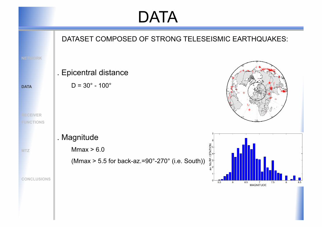
. Epicentral distance D = 30° - 100°
. Magnitude Mmax > 6.0
(Mmax > 5.5 for back-az.=90°-270° (i.e. South))
DATASET COMPOSED OF STRONG TELESEISMIC EARTHQUAKES:

DATA
. Time period
1999-2007
complete 8 years for 25 stations
. Receiver function dataset ~ 6500 useful RF for 92 stations (~ 60 RF/station)
DATASET COMPOSED OF STRONG TELESEISMIC EARTHQUAKES:
NETWORK
DATA
RECEIVER
FUNCTIONS
MTZ
CONCLUSIONS

0 10 20 30 TIME (sec)
PsMoho multiplesMoho
RECEIVER FUNCTION IMAGING
(P-to-S) Receiver Function: time series for which P-to-S conversions are enhanced by deconvolution of vertical from radial seismograms
NETWORK
DATA
RECEIVER
FUNCTIONS
MTZ
CONCLUSIONS

0 10 20 30 TIME (sec)
station surface Moho
depth
PsMoho multiplesMoho NETWORK
DATA
RECEIVER
FUNCTIONS
MTZ
CONCLUSIONS
RECEIVER FUNCTION IMAGING

0 10 20 30 40 50 60 70 TIME (sec)
PsMoho P410s P660s multiplesMoho NETWORK
DATA
RECEIVER
FUNCTIONS
MTZ
CONCLUSIONS
RECEIVER FUNCTION IMAGING

0 10 20 30 40 50 60 70 TIME (sec)
surface Moho
410 km
660 km
depth
station
PsMoho P410s P660s multiplesMoho
P410s
P660s P-wave leg S-wave leg
NETWORK
DATA
RECEIVER
FUNCTIONS
MTZ
CONCLUSIONS
RECEIVER FUNCTION IMAGING

surface Moho
410 km
660 km
depth
0 10 20 30 40 50 60 70 TIME (sec)
station
PsMoho P410s P660s multiplesMoho NETWORK
DATA
RECEIVER
FUNCTIONS
MTZ
CONCLUSIONS
RECEIVER FUNCTION IMAGING

surface Moho
410 km
660 km
depth
station
0 10 20 30 40 50 60 70 TIME (sec)
station B
PsMoho P410s P660s multiplesMoho NETWORK
DATA
RECEIVER
FUNCTIONS
MTZ
CONCLUSIONS
RECEIVER FUNCTION IMAGING

surface Moho
410 km
660 km
depth
station
0 10 20 30 40 50 60 70 TIME (sec)
station B
PsMoho P410s P660s multiplesMoho
amplitude stacking
amplitude stacking
NETWORK
DATA
RECEIVER
FUNCTIONS
MTZ
CONCLUSIONS
RECEIVER FUNCTION IMAGING

station
410
660
NETWORK
DATA
RECEIVER
FUNCTIONS
MTZ
CONCLUSIONS
RECEIVER FUNCTION IMAGING

station
410
660
. dense sampling covering the entire chain at 410 km and 660 km
NETWORK
DATA
RECEIVER
FUNCTIONS
MTZ
CONCLUSIONS
RECEIVER FUNCTION IMAGING

MANTLE TRANSITION ZONE
IN THE ALPS
NETWORK
DATA
RECEIVER
FUNCTIONS
MTZ
CONCLUSIONS

CROSS-SECTIONS
NETWORK
DATA
RECEIVER
FUNCTIONS
MTZ
CONCLUSIONS

CROSS-SECTIONS
Cell dimension: 10x10x5 km Velocity model: IASP91
~140 km for P410s ~180 km for P660s
Fresnel 1st radius:
NETWORK
DATA
RECEIVER
FUNCTIONS
MTZ
CONCLUSIONS

WEST Rhine Graben Molasse EAST
MOHO
MOHO MULTIPLES
East-West profile in the Alpine Foreland
. Significant amplitude at ‘410’ and ‘660’
. No particular topography
CROSS-SECTIONS
NETWORK
DATA
RECEIVER
FUNCTIONS
MTZ
CONCLUSIONS

North-South profile across the Central Alps
NORTH Swabian Jura Central Alps North. Apennines SOUTH
MOHO
MOHO MULTIPLES
CROSS-SECTIONS
. Significant amplitude at ‘410’ and ‘660’
NETWORK
DATA
RECEIVER
FUNCTIONS
MTZ
CONCLUSIONS

NORTH Swabian Jura Central Alps North. Apennines SOUTH
MOHO
MOHO MULTIPLES
. Significant amplitude at ‘410’ and ‘660’
. ~40 km depression of the ‘660’ over 300 km
North-South profile across the Central Alps
CROSS-SECTIONS
NETWORK
DATA
RECEIVER
FUNCTIONS
MTZ
CONCLUSIONS

man
tlepl
umes
.org
MOHO
MOHO MULTIPLES
. Significant amplitude at ‘410’ and ‘660’
. ~40 km depression of the ‘660’ over 300 km
CROSS-SECTIONS
NORTH Swabian Jura Central Alps North. Apennines SOUTH
North-South profile across the Central Alps
NETWORK
DATA
RECEIVER
FUNCTIONS
MTZ
CONCLUSIONS

MANTLE TRANSITION ZONE
thicker MTZ
‘normal’ MTZ
thinner MTZ
. SW-NE 1000 km long anomaly
. ~ 40 km thicker min. ~ 400° C colder MTZ
NETWORK
DATA
RECEIVER
FUNCTIONS
MTZ
CONCLUSIONS

MANTLE TRANSITION ZONE
Spakman and Wortel 2004
? A
MAP VIEW
-1.5%
1.5%
NETWORK
DATA
RECEIVER
FUNCTIONS
MTZ
CONCLUSIONS

MANTLE TRANSITION ZONE
NORTH Swabian Jura Central Alps North. Apennines SOUTH
MOHO
MOHO MULTIPLES
Alpine Tethys remnant
X-SECTION
51 49 47 45 43
Bijwaard and Spakman 2000
51 48.5 46 43.5
Piromallo and Morelli 2003
NETWORK
DATA
RECEIVER
FUNCTIONS
MTZ
CONCLUSIONS

80 Ma after Piromallo and Faccenna 2004
NORTH Swabian Jura Central Alps North. Apennines SOUTH
MOHO
MOHO MULTIPLES
Alpine Tethys remnant
X-SECTION
MANTLE TRANSITION ZONE
30 Ma
Present
NETWORK
DATA
RECEIVER
FUNCTIONS
MTZ
CONCLUSIONS

CONCLUSIONS
RF do detect 410- & 660-km discontinuities . large and high-quality dataset
410- & 660-km discontinuities
. continuous features
. significant amplitude
Mantle Transition Zone . normal MTZ in the Alpine forelands
. anomalously ~40 km thicker (400°C colder) MTZ south of the Alps and Western Alps
. evidence for the presence of the Alpine Tethys ocean stalling at 660 km
MOHO
MOHO MULTIPLES
PsMoho P410s P660s

OUTLOOK:
Connection to the South (Ligur.+Apenn.) and to the East (previous talk by W. Geissler)
Absolute depth (3D velocity model)
Properties of the 410 and 660-km discontinuities (waveform amplitude)
ACKNOWLEDGMENTS:
GEOSCOPE, GIS-RAP, GRSN, IGCAS, INGV, LGIT-Observatoire de Grenoble, LRGB Freiburg, MedNet, Rosalp, RSNI, SNRS, SDS-Net, TGRS and ZAMG
CONCLUSIONS