ICONARCH II - Konya Teknik Üniversitesi
546
ICONARCH II INTERNATIONAL CONGRESS OF ARCHITECTURE INNOVATIVE APPROACHES IN ARCHITECTURE AND PLANNING INTERNATIONAL CONGRESS PROCEEDINGS E-BOOK 20-22 November 2014 Selcuk University Süleyman Demirel Cultural Center, Konya ISBN: 978-975-448-205-8 Selcuk University Faculty of Architecture This Congress is supported by TÜBİTAK (The Scientific and Technological Research Council of Turkey) This Project is funded by Selcuk University Scientific Research Projects Coordination Unit
-
Upload
khangminh22 -
Category
Documents
-
view
1 -
download
0
Transcript of ICONARCH II - Konya Teknik Üniversitesi
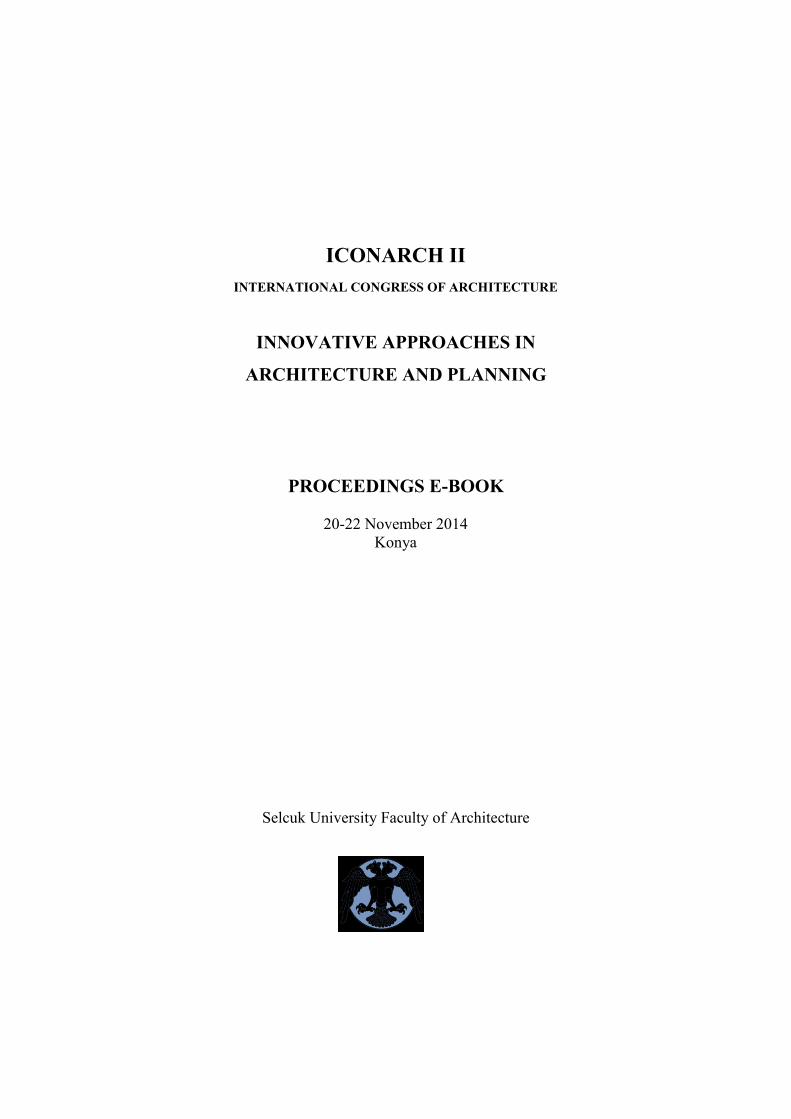
ICONARCH II
INTERNATIONAL CONGRESS OF
ARCHITECTURE
INNOVATIVE APPROACHES IN ARCHITECTURE
AND PLANNING
INTERNATIONAL CONGRESS
PROCEEDINGS E-BOOK
20-22 November 2014
Selcuk University Süleyman Demirel Cultural Center, Konya
ISBN: 978-975-448-205-8
Selcuk University Faculty of Architecture
This Congress is supported by TÜBİTAK (The Scientific and Technological Research Council of Turkey)
This Project is funded by Selcuk University Scientific Research Projects Coordination Unit
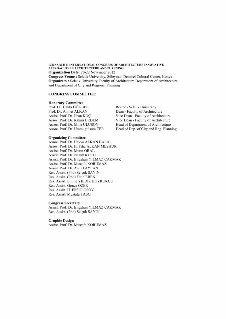
ICONARCH II INTERNATIONAL CONGRESS OF ARCHITECTURE INNOVATIVE
APPROACHES IN ARCHITECTURE AND PLANNING
Organization Date: 20-22 November 2012
Congress Venue : Selcuk University, Süleyman Demirel Cultural Center, Konya
Organizers : Selcuk University Faculty of Architecture Department of Architecture
and Department of City and Regional Planning
CONGRESS COMMITTEE:
Honorary Committee
Prof. Dr. Hakkı GÖKBEL Rector - Selcuk University
Prof. Dr. Ahmet ALKAN Dean - Faculty of Architecture
Assist. Prof. Dr. İlhan KOÇ Vice Dean - Faculty of Architecture
Assoc. Prof. Dr. Rahmi ERDEM Vice Dean - Faculty of Architecture
Assoc. Prof. Dr. Mine ULUSOY Head of Department of Architecture
Assoc. Prof. Dr. Ümmügülsüm TER Head of Dep. of City and Reg. Planning
Organizing Committee Assoc. Prof. Dr. Havva ALKAN BALA
Assoc. Prof. Dr. H. Filiz ALKAN MEŞHUR
Assist. Prof. Dr. Murat ORAL
Assist. Prof. Dr. Nazım KOÇU
Assist. Prof. Dr. Bilgehan YILMAZ ÇAKMAK
Assist. Prof. Dr. Mustafa KORUMAZ
Assist. Prof. Dr. Arzu TAYLAN
Res. Assist. (Phd) Selçuk SAYIN
Res. Assist. (Phd) Fatih EREN
Res. Assist. Emine YILDIZ KUYRUKÇU
Res. Assist. Gonca ÖZER
Res. Assist. H. Elif ULUSOY
Res. Assist. Mustafa TAŞCI
Congress Secretary
Assist. Prof. Dr. Bilgehan YILMAZ ÇAKMAK
Res. Assist. (Phd) Selçuk SAYIN
Graphic Design Assist. Prof. Dr. Mustafa KORUMAZ
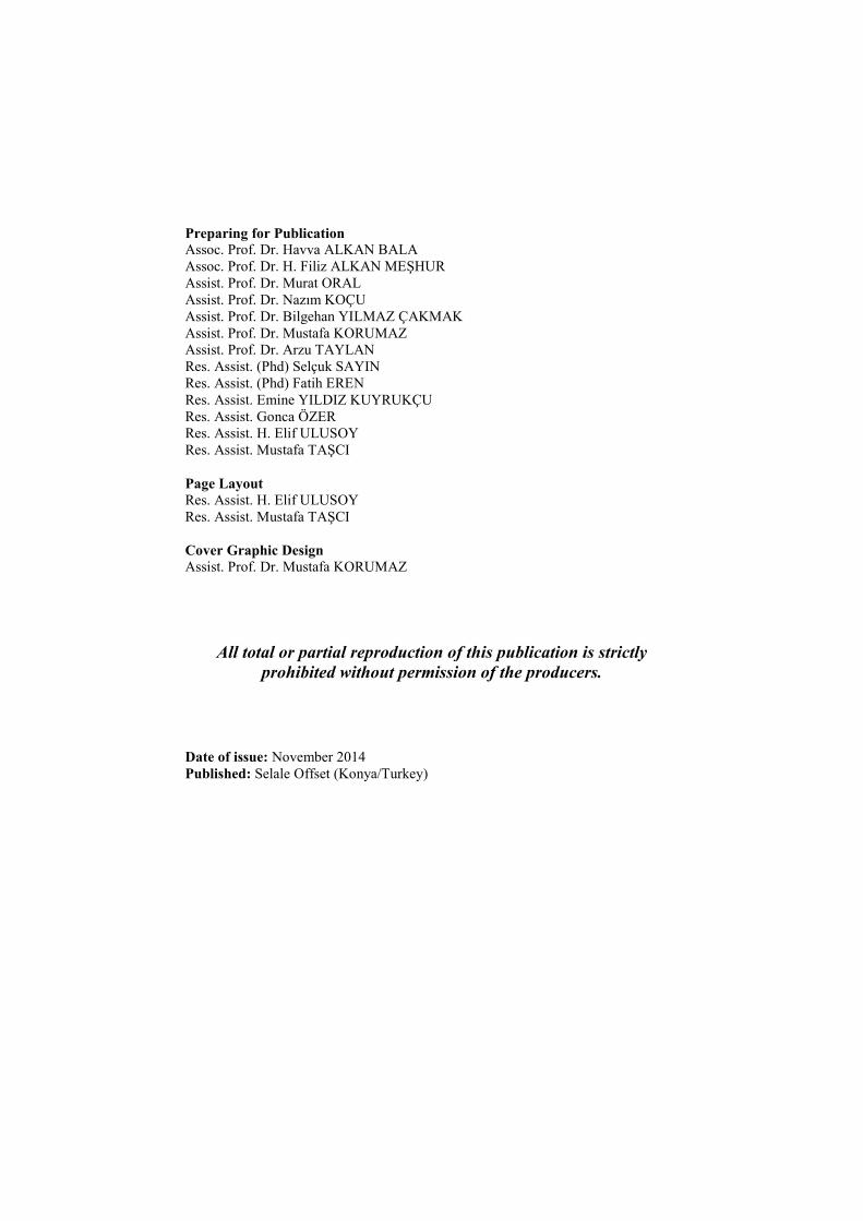
Preparing for Publication Assoc. Prof. Dr. Havva ALKAN BALA
Assoc. Prof. Dr. H. Filiz ALKAN MEŞHUR
Assist. Prof. Dr. Murat ORAL
Assist. Prof. Dr. Nazım KOÇU
Assist. Prof. Dr. Bilgehan YILMAZ ÇAKMAK
Assist. Prof. Dr. Mustafa KORUMAZ
Assist. Prof. Dr. Arzu TAYLAN
Res. Assist. (Phd) Selçuk SAYIN
Res. Assist. (Phd) Fatih EREN
Res. Assist. Emine YILDIZ KUYRUKÇU
Res. Assist. Gonca ÖZER
Res. Assist. H. Elif ULUSOY
Res. Assist. Mustafa TAŞCI
Page Layout Res. Assist. H. Elif ULUSOY
Res. Assist. Mustafa TAŞCI
Cover Graphic Design
Assist. Prof. Dr. Mustafa KORUMAZ
All total or partial reproduction of this publication is strictly
prohibited without permission of the producers.
Date of issue: November 2014
Published: Selale Offset (Konya/Turkey)

ICONARCH II
INTERNATIONAL CONGRESS OF ARCHITECTURE
INNOVATIVE APPROACHES IN
ARCHITECTURE AND PLANNING
PROCEEDINGS E-BOOK
20-22 November 2014
Konya
Selcuk University Faculty of Architecture

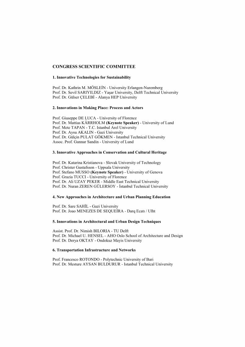
CONGRESS SCIENTIFIC COMMITTEE
1. Innovative Technologies for Sustainability
Prof. Dr. Kathrin M. MÖSLEİN - University Erlangen-Nuremberg
Prof. Dr. Sevil SARIYILDIZ - Yaşar University, Delft Technical University
Prof. Dr. Gülser ÇELEBİ - Alanya HEP University
2. Innovations in Making Place: Process and Actors Prof. Giuseppe DE LUCA - University of Florence
Prof. Dr. Mattias KÄRRHOLM (Keynote Speaker) - University of Lund
Prof. Mete TAPAN - T.C. Istanbul Arel University
Prof. Dr. Aysu AKALIN - Gazi University
Prof. Dr. Gülçin PULAT GÖKMEN - Istanbul Technical University
Assoc. Prof. Gunnar Sandin - University of Lund
3. Innovative Approaches in Conservation and Cultural Heritage Prof. Dr. Katarina Kristianova - Slovak University of Technology
Prof. Christer Gustafsson - Uppsala University
Prof. Stefano MUSSO (Keynote Speaker) - University of Genova
Prof. Grazia TUCCI - University of Florence
Prof. Dr. Ali UZAY PEKER - Middle East Technical University
Prof. Dr. Nuran ZEREN GÜLERSOY - İstanbul Technical University
4. New Approaches in Architecture and Urban Planning Education
Prof. Dr. Sare SAHİL - Gazi University
Prof. Dr. Joao MENEZES DE SEQUEİRA - Darq Ecatı / Ulht
5. Innovations in Architectural and Urban Design Techniques
Assist. Prof. Dr. Nimish BILORIA - TU Delft
Prof. Dr. Michael U. HENSEL - AHO Oslo School of Architecture and Design
Prof. Dr. Derya OKTAY - Ondokuz Mayis University
6. Transportation Infrastructure and Networks
Prof. Francesco ROTONDO - Polytechnic University of Bari
Prof. Dr. Mesture AYSAN BULDURUR - Istanbul Technical University
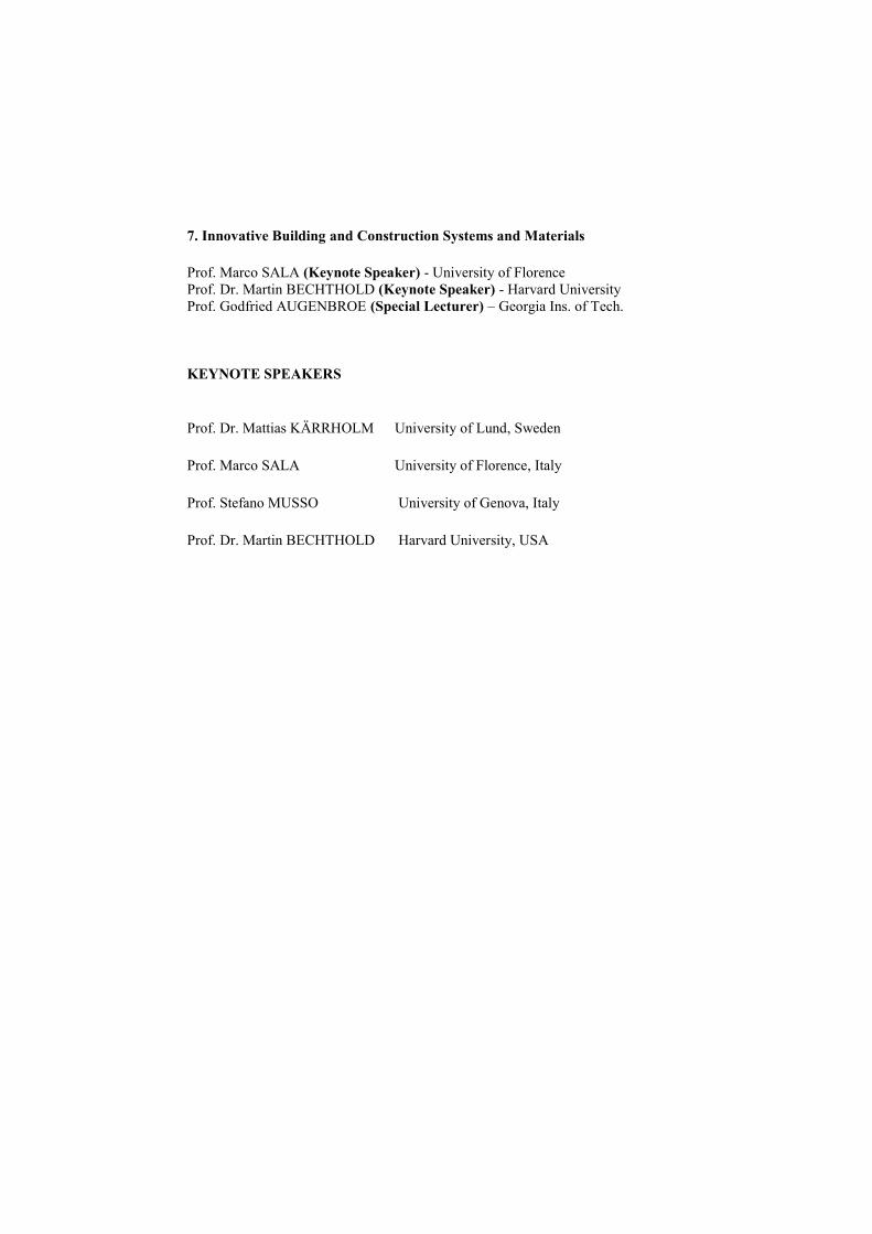
7. Innovative Building and Construction Systems and Materials Prof. Marco SALA (Keynote Speaker) - University of Florence
Prof. Dr. Martin BECHTHOLD (Keynote Speaker) - Harvard University
Prof. Godfried AUGENBROE (Special Lecturer) – Georgia Ins. of Tech.
KEYNOTE SPEAKERS
Prof. Dr. Mattias KÄRRHOLM University of Lund, Sweden
Prof. Marco SALA University of Florence, Italy
Prof. Stefano MUSSO University of Genova, Italy
Prof. Dr. Martin BECHTHOLD Harvard University, USA
ICONARCH II INTERNATIONAL CONGRESS OF
ARCHITECTURE 20-22 NOVEMBER 2014 KONYA
9
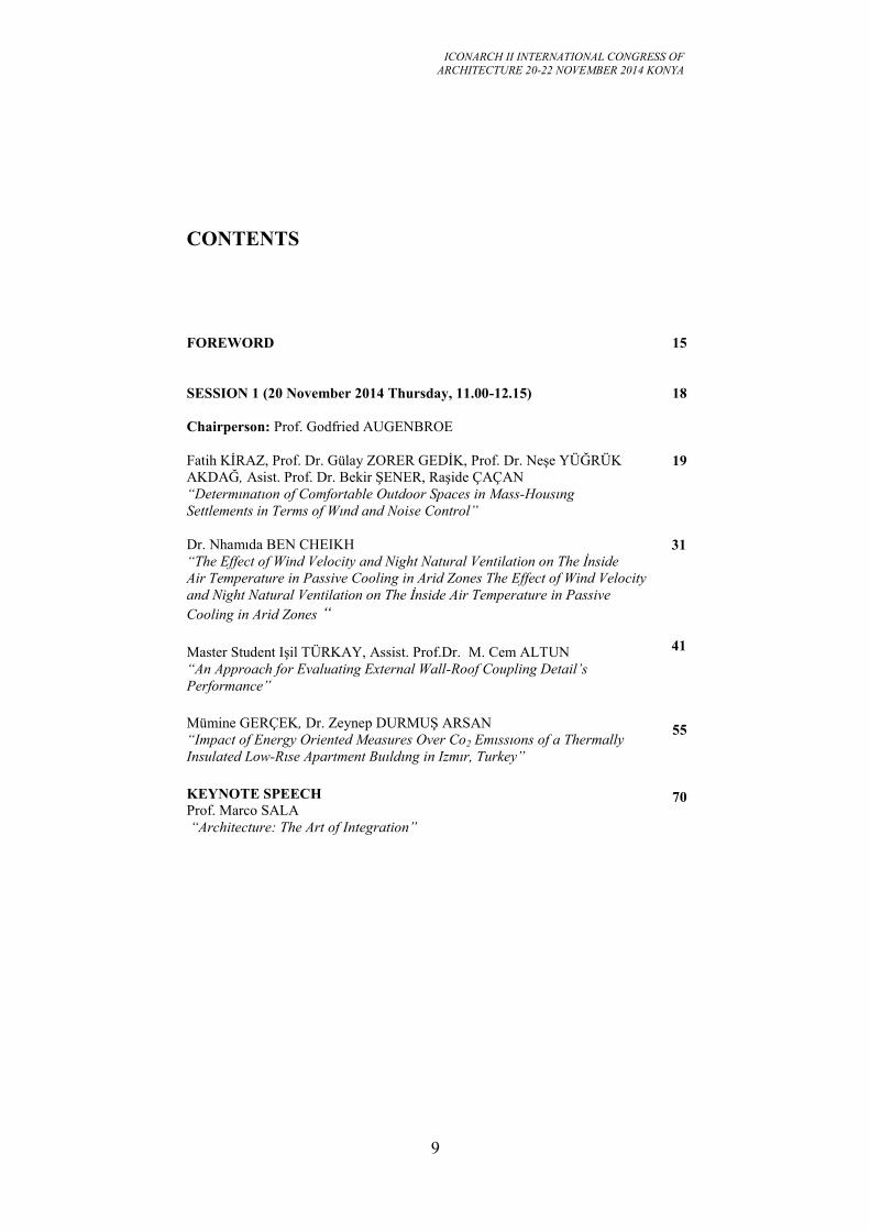
CONTENTS
FOREWORD
15
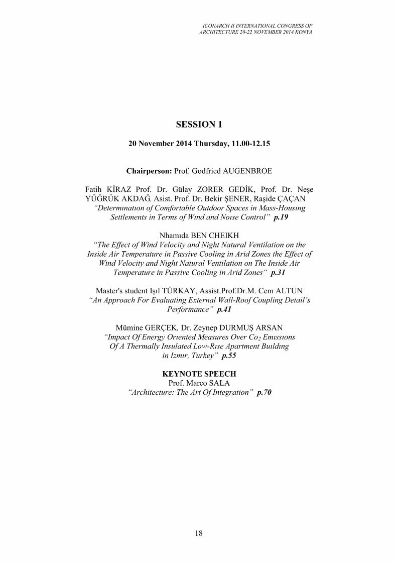
SESSION 1 (20 November 2014 Thursday, 11.00-12.15)
Chairperson: Prof. Godfried AUGENBROE
Fatih KİRAZ, Prof. Dr. Gülay ZORER GEDİK, Prof. Dr. Neşe YÜĞRÜK
AKDAĞ, Asist. Prof. Dr. Bekir ŞENER, Raşide ÇAÇAN
“Determınatıon of Comfortable Outdoor Spaces in Mass-Housıng
Settlements in Terms of Wınd and Noise Control”
Dr. Nhamıda BEN CHEIKH
“The Effect of Wind Velocity and Night Natural Ventilation on The İnside
Air Temperature in Passive Cooling in Arid Zones The Effect of Wind Velocity
and Night Natural Ventilation on The İnside Air Temperature in Passive
Cooling in Arid Zones “
Master Student Işil TÜRKAY, Assist. Prof.Dr. M. Cem ALTUN
“An Approach for Evaluating External Wall-Roof Coupling Detail’s
Performance”
Mümine GERÇEK, Dr. Zeynep DURMUŞ ARSAN
“Impact of Energy Oriented Measures Over Co2 Emıssıons of a Thermally
Insulated Low-Rıse Apartment Buıldıng in Izmır, Turkey”
KEYNOTE SPEECH
Prof. Marco SALA
“Architecture: The Art of Integration”
18
19
31
41
55
70
ICONARCH II INTERNATIONAL CONGRESS OF
ARCHITECTURE 20-22 NOVEMBER 2014 KONYA
10
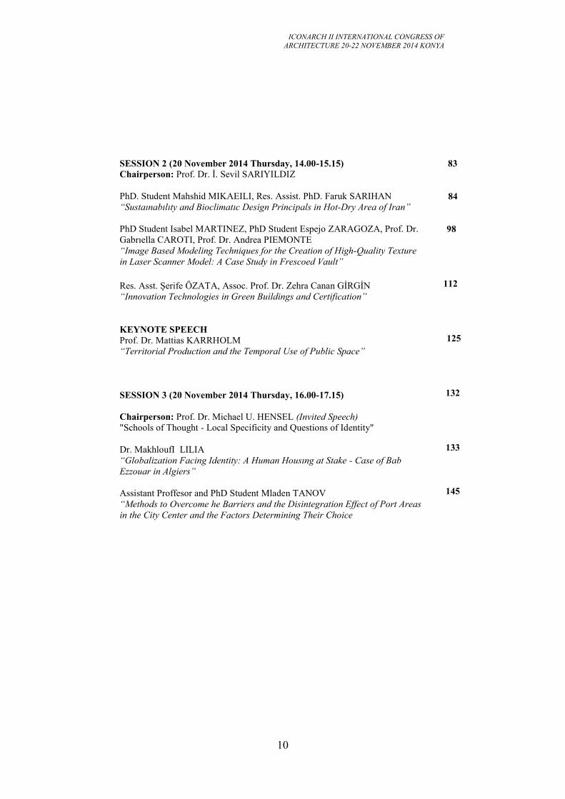
SESSION 2 (20 November 2014 Thursday, 14.00-15.15)
Chairperson: Prof. Dr. İ. Sevil SARIYILDIZ
PhD. Student Mahshid MIKAEILI, Res. Assist. PhD. Faruk SARIHAN
“Sustaınabılıty and Bioclimatıc Design Principals in Hot-Dry Area of Iran”
PhD Student Isabel MARTINEZ, PhD Student Espejo ZARAGOZA, Prof. Dr.
Gabrıella CAROTI, Prof. Dr. Andrea PIEMONTE
“Image Based Modeling Techniques for the Creation of High-Quality Texture
in Laser Scanner Model: A Case Study in Frescoed Vault”
Res. Asst. Şerife ÖZATA, Assoc. Prof. Dr. Zehra Canan GİRGİN
“Innovation Technologies in Green Buildings and Certification”
KEYNOTE SPEECH
Prof. Dr. Mattias KARRHOLM
“Territorial Production and the Temporal Use of Public Space”
SESSION 3 (20 November 2014 Thursday, 16.00-17.15)
Chairperson: Prof. Dr. Michael U. HENSEL (Invited Speech)
"Schools of Thought - Local Specificity and Questions of Identity"
Dr. MakhloufI LILIA
“Globalization Facing Identity: A Human Housıng at Stake - Case of Bab
Ezzouar in Algiers”
Assistant Proffesor and PhD Student Mladen TANOV
“Methods to Overcome he Barriers and the Disintegration Effect of Port Areas
in the City Center and the Factors Determining Their Choice
83
84
98
112
125
132
133
145
ICONARCH II INTERNATIONAL CONGRESS OF
ARCHITECTURE 20-22 NOVEMBER 2014 KONYA
11
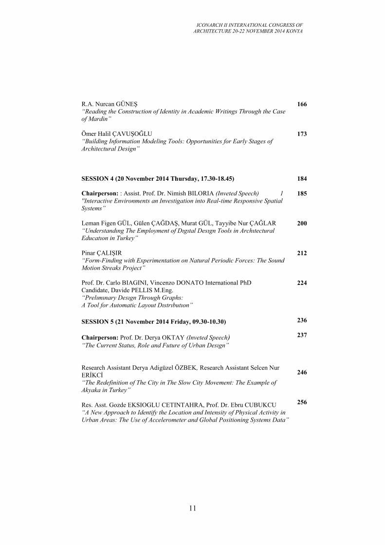
R.A. Nurcan GÜNEŞ
“Reading the Construction of Identity in Academic Writings Through the Case
of Mardin”
Ömer Halil ÇAVUŞOĞLU
“Building Information Modeling Tools: Opportunities for Early Stages of
Architectural Design”
SESSION 4 (20 November 2014 Thursday, 17.30-18.45)
Chairperson: : Assist. Prof. Dr. Nimish BILORIA (Inveted Speech) 1
''Interactive Environments an Investigation into Real-time Responsive Spatial
Systems”
Leman Figen GÜL, Gülen ÇAĞDAŞ, Murat GÜL, Tayyibe Nur ÇAĞLAR
“Understandıng The Employment of Dıgıtal Desıgn Tools in Archıtectural
Educatıon in Turkey”
Pinar ÇALIŞIR
“Form-Finding with Experimentation on Natural Periodic Forces: The Sound
Motion Streaks Project”
Prof. Dr. Carlo BIAGINI, Vincenzo DONATO International PhD
Candidate, Davide PELLIS M.Eng.
“Prelımınary Desıgn Through Graphs:
A Tool for Automatic Layout Dıstrıbutıon”
SESSION 5 (21 November 2014 Friday, 09.30-10.30)
Chairperson: Prof. Dr. Derya OKTAY (Inveted Speech) “The Current Status, Role and Future of Urban Desıgn”
Research Assistant Derya Adigüzel ÖZBEK, Research Assistant Selcen Nur
ERİKCİ
“The Redefinition of The City in The Slow City Movement: The Example of
Akyaka in Turkey”
Res. Asst. Gozde EKSIOGLU CETINTAHRA, Prof. Dr. Ebru CUBUKCU
“A New Approach to Identify the Location and Intensity of Physical Activity in
Urban Areas: The Use of Accelerometer and Global Positioning Systems Data”
166
173
184
185
200
212
224
236
237
246
256
ICONARCH II INTERNATIONAL CONGRESS OF
ARCHITECTURE 20-22 NOVEMBER 2014 KONYA
12
SESSION 6 (21 November 2014 Friday, 11.00-12.15)
Chairperson: Prof. Giuseppe DE LUCA (Invited Speech)
“Evolution In Regional Planning: The Italian Path”
Li HAO
“The Preservation and Reincarnation of Sid-Lin Monastery”
Research Assistant Kadriye Burcu YAVUZ
“An Investigation of Territory Concept in the Context of Two Residential Units
in Ankara: Israel Houses and Saraçoğlu Neighborhood”
KEYNOTE SPEECH
Prof. Martin BECHTHOLD
“The Quest for Innovation: Methods and Mindsets“
SESSION 7 (20 November 2014 Friday, 11.00-12.15)
Chairperson: Prof. Dr. Joao MENEZES DE SEQUEIRA (Invited Speech)
“Approach Academia and Professional Practice Trough Research by Design”
Dr. Bouzid BOUDIAF
“Innovatıve Approaches in Archıtecture and Plannıng.
The Future of Our Past”
Research Assistant Irem YILMAZ
“Kinetic Archıtecture: Towards the Poetry of Space in Movement”
PhD. Student Rashaa MALIK, Lecturer Alaa HADI
“Consciousness & Creation
A Study of the Process of Communication and Innovation in The Design of
Contemporary Urban Monuments”
Teaching Assist. Mine KOYAZ, Assist. Prof. Dr. M. Cem ALTUN
“Usability of a Material Selection Tool for Architecture Students as a Sub
Process of Building Element Design”
KEYNOTE SPEECH
Prof. Stefano Francesco MUSSO
“Inheriting” our Cultural Heritage Changes of Paradigm of Conservation”
269
270
285
304
315
323
324
342
372
383
396
411
ICONARCH II INTERNATIONAL CONGRESS OF
ARCHITECTURE 20-22 NOVEMBER 2014 KONYA
13
SESSION 8 (21 November 2014 Friday, 15.45-17.00)
Chairperson: Prof. Dr. Ali Uzay Peker (Invited Speech)
“Architectural Technology in History Class”
Assoc. Prof. Grazıa TUCCI, Alessandro CONTI, Lıdıa FIORINI
“The Mock-Up of The "Ratto Delle Sabıne" By Gıambologna:
Makıng and Utılızatıon of a 3d Model”
Phd Candidate Armagan Gulec KORUMAZ, Assist. Prof. Mustafa
KORUMAZ, Assoc. Prof Grazıa TUCCI, Arch. PhD Valentına BONORA, Prof
Wolfgang NIEMEIER, Dr. Björn RIEDL
“Uav Systems for Documentation of Cultural Heritage”
Phd Candidate Armagan Gulec KORUMAZ, Assist. Prof. Dr.Mustafa
KORUMAZ, Arch. PhD Valentına BONORA, Assoc. Prof Grazıa TUCCI
“Restoration Laboratory Class and the Role of Geomatics in Cultural Heritage
Education“
SESSION 9 (21 November 2014 Friday, 17.15-18.30)
Chairperson: Prof. Grazıa TUCCI (Invited Speech)
“Geomatics: New Technologies for an Innovative Planning Approach”
Ru CHEN
“A Study of Tectonıc Culture and Technology of Religious Masonry
Architecture in Wuhan”
Assist.Prof. Dr. Fuat ARAS
“Innovative Technologies for the Protection of Historical Structures Against
Earthquakes”
Fatih YAZICIOĞLU
“Contemporary Timber Window Solutions in Traditional Turkish Houses”
426
427
439
448
460
472
473
481
488
500
ICONARCH II INTERNATIONAL CONGRESS OF
ARCHITECTURE 20-22 NOVEMBER 2014 KONYA
14
POSTER SESSION
Rahmanı KELKOUL LEILA
“A Way to Conserve Cultural Heritage in Architecture Creation”
Martin MBIDHI, Susan KIBUE
“The Effect of Typological and Morphological Elements of Urban Space, And
Non-Motorized Transport: The Case of Nairobi City”
Graduate Student Sepideh SAFARI
“A Study on Lalehzar Street to be Changed to a Proper Walking Street While
Focusıng on Loose Spaces”
CITY TOUR
510
511
517
539
546
ICONARCH II INTERNATIONAL CONGRESS OF
ARCHITECTURE 20-22 NOVEMBER 2014 KONYA
15
FOREWORD
Dear Colleagues,
We are pleased to invite you to participate in ICONARCH II - International
Congress of Architecture II, about “INNOVATIVE APPROACHES in ARCHITECTURE
and PLANNING”, which will be held in Konya, TURKEY, 20-22 November, 2014.
I am very honored and pleased to emphasize that we became Faculty of
Architecture. The ICONARCH I, which was organized by Faculty of Engineering-
Architecture, was about “Architecture and Technology”. A total of 27 foreign scholars from
the USA, Italy, Holland, Austria, England, Finland, Portugal, Germany, Poland, Lebanon,
Iran and Cyprus, and 33 Turkish scholars attended the Congress. ICONARCH claims to be a
brand name in Turkey and in the world as a platform where various issues in Architecture,
Planning and, connected with them, various cultural, sector-related and intellectual topics are
discussed. The congress event not only creates a scientific and academic surplus value but
also becomes o field of synergy highlighting the historical, cultural, spatial and intellectual
wealth of the city of Konya through trips organized within the scope of the congress. Details
about ICONARCH I are given at ( http://www.iconarch2012.org/ ). Our dream is to be able to
organize ICONARCH III in our new campus area devoted specifically to our Faculty.
Innovation can be defined as developing new ideas in different fields and putting
them into practice. New or significantly altered products, processes, methods, applications
and organizations fall within the scope of innovation. According to the previously produced
products and processes in Architecture and planning;
• To make better designs
• To eliminate problems observed in previous structures
• To increase functionality
• Sustainable, renewable and eco-technological approaches
• Globalization and social networks in processes and actors
• Digitalization in conservation and restoration
• To solve spatial problems through changes made in planning
• And smart systems in transportation and infrastructure are all innovation.
Researchers from all over the world are fully invited to present their papers and
attend this congress to share their experiences with others about innovative approaches in
Architecture and Planning. On behalf of the organizing committee, I hope you will join us for
a symphony of outstanding science, and take a little extra time to discover the unique beauty
of Konya. We look forward to welcoming you to Konya.
Yours Sincerely..
Prof. Dr. Ahmet ALKAN Dean of the Faculty of Architecture

ICONARCH II INTERNATIONAL CONGRESS OF
ARCHITECTURE 20-22 NOVEMBER 2014 KONYA
16

ICONARCH II INTERNATIONAL CONGRESS OF
ARCHITECTURE 20-22 NOVEMBER 2014 KONYA
17
ICONARCH II INTERNATIONAL CONGRESS OF
ARCHITECTURE 20-22 NOVEMBER 2014 KONYA
18
SESSION 1
20 November 2014 Thursday, 11.00-12.15
Chairperson: Prof. Godfried AUGENBROE
Fatih KİRAZ Prof. Dr. Gülay ZORER GEDİK, Prof. Dr. Neşe
YÜĞRÜK AKDAĞ, Asist. Prof. Dr. Bekir ŞENER, Raşide ÇAÇAN
“Determınatıon of Comfortable Outdoor Spaces in Mass-Housıng
Settlements in Terms of Wınd and Noıse Control” p.19
Nhamıda BEN CHEIKH
“The Effect of Wind Velocity and Night Natural Ventilation on the
Inside Air Temperature in Passive Cooling in Arid Zones the Effect of
Wind Velocity and Night Natural Ventilation on The Inside Air
Temperature in Passive Cooling in Arid Zones“ p.31
Master's student Işıl TÜRKAY, Assist.Prof.Dr.M. Cem ALTUN
“An Approach For Evaluating External Wall-Roof Coupling Detail’s
Performance” p.41
Mümine GERÇEK, Dr. Zeynep DURMUŞ ARSAN
“Impact Of Energy Orıented Measures Over Co2 Emıssıons
Of A Thermally Insulated Low-Rıse Apartment Buıldıng
in Izmır, Turkey” p.55
KEYNOTE SPEECH
Prof. Marco SALA
“Architecture: The Art Of Integration” p.70
ICONARCH II INTERNATIONAL CONGRESS OF
ARCHITECTURE 20-22 NOVEMBER 2014 KONYA
19
DETERMINATION OF COMFORTABLE OUTDOOR SPACES
IN MASS-HOUSING SETTLEMENTS IN TERMS OF WIND
AND NOISE CONTROL
FATİH KİRAZ1
GÜLAY ZORER GEDİK2
NEŞE YÜĞRÜK AKDAĞ3
BEKİR ŞENER4
RAŞİDE ÇAÇAN5
ABSTRACT
In recent times, pre-analysis and necessary precautions and measures on wind and
noises are ignored and cannot be reflected in design process of indoor and outdoor
spaces. In mass housing apartments, the comfort and quality of living conditions
decrease due to the wind and noise level especially in balconies, terraces, gardens
and swimming pools etc. The quantitatively and empirically testing of building
models according to the physical conditions in regard to the wind and noise
parameters directly affect the formation of building blocks in design process. In
Yıldız Technical University, a research project supported by TUBITAK has been
completed in order to determine the most suitable settlement formations and to
develop a methodology for a design guide to deal with the controlling of the wind
and noise conditions. This paper aims to present spatial formation solutions to
provide usage areas in maximum comfort level due to the conditions of different
climate zones and different building orientations in terms of wind and noise in
Istanbul case.
Key words : Mass-housing, noise, wind, optimum area
1 Fatih Kiraz, Nuh Naci Yazgan University, Department of Architecture, KAYSERİ
2 Prof. Dr. Gülay Zorer Gedik, Yıldız Technical University, Department of Architecture, İSTANBUL
3 Prof. Dr. Neşe Yüğrük Akdağ, Yıldız Technical University, Department of Architecture, İSTANBUL
4 Assist. Prof. Dr. Bekir Şener, Yıldız Technical University, Department of Naval Architecture and
Marine Engineering, İSTANBUL 5 Raşide Çaçan. Yıldız Technical University, Department of Architecture, İSTANBUL
ICONARCH II INTERNATIONAL CONGRESS OF
ARCHITECTURE 20-22 NOVEMBER 2014 KONYA
20
1. INTRODUCTION
Wind and noise are both physical environment factors that cause serious problems in
urban areas and should be considered in design and planning process. They also
have many negative effects on human health and comfort. Nowadays, unhealthy
structures and cities are ensued as a result of ignoring the importance of wind and
noise and they directly influence the public and environmental health.
The number of mass-housing projects still increases day by day to meet the demand
for housing quickly and economically that increase subject to rapid population
growth and urbanisation. In recent mass-housing areas, some application samples
ensue with different problems because an effective study is not realized for physical
environmental factors apart from conformity of zoning laws.
As a result of not considering important sufficiently the wind characteristics of
regions and interaction with noise sources results mass-housing areas are formed
with uncomfortable conditions in terms of wind and noise.
Unavailable open, semi-open areas, balconies and terraces due to wind; not opened
windows for natural ventilation; physical ailments and psychological disorders due
to indoor and outdoor noise pollution are major problems originating from wind and
noise in mass-housing areas. Depending on the placement of structures with
increasing of wind speed or mass-housing areas exposed to the wind, uncomfortable
wind conditions, occur in open-semi open public areas used especially in warm
seasons. These areas cannot be used by reason of wrong design and applications.
Allowing the wind into the structure is one of the effective and economical methods
for natural ventilation. It cannot be possible to use this positive effect of the wind
due to the windows and openings that cannot be opened because of the excessive
speed and blowing number of wind.
One of the major sources of noise pollution is road noise. In mass-housing areas that
designed without considering the position of the road according to settlement area
and traffic density serious noise problems are occurred. Structures with negative
influence on human health are built by reason of ignoring necessary precautions on
design process of mass-housing, around roads, on layout plan works and directly in
structure.
In Yıldız Technical University, a TUBITAK supported research project has been
completed with the aim of developing a method that will guide the designer in
determining stage of most suitable settlement formations in terms of wind and noise
control (Zorer Gedik et al. 2014). Within the project, it is targeted to determine
common uncomfortable open spaces that both wind and noise problems overlap and
to design optimized barriers and to generate suitable settlement formations for mass-
housing. Simulations are realized in five different climatic zones (cold, hot humid
and hot dry, temperate humid and temperate dry). In this paper, it is aimed to
determine maximum comfortable usage areas in different noise levels and settlement
formations with using the wind data of Istanbul.
ICONARCH II INTERNATIONAL CONGRESS OF
ARCHITECTURE 20-22 NOVEMBER 2014 KONYA
21
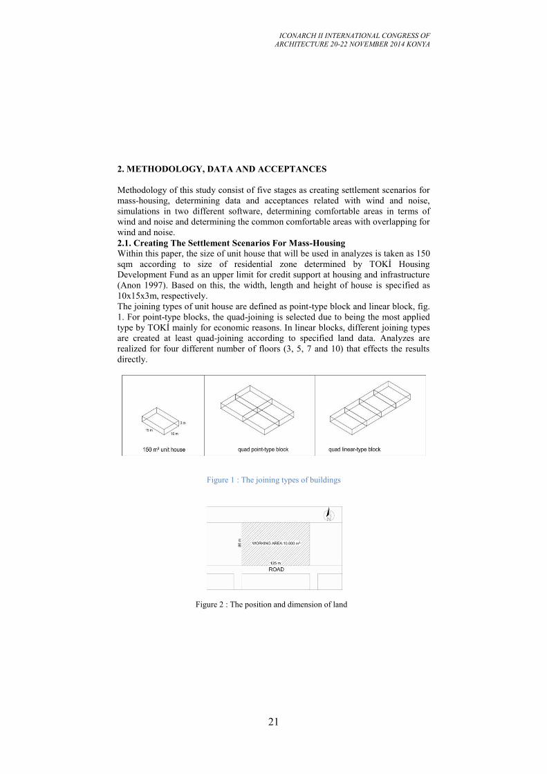
2. METHODOLOGY, DATA AND ACCEPTANCES
Methodology of this study consist of five stages as creating settlement scenarios for
mass-housing, determining data and acceptances related with wind and noise,
simulations in two different software, determining comfortable areas in terms of
wind and noise and determining the common comfortable areas with overlapping for
wind and noise.
2.1. Creating The Settlement Scenarios For Mass-Housing Within this paper, the size of unit house that will be used in analyzes is taken as 150
sqm according to size of residential zone determined by TOKİ Housing
Development Fund as an upper limit for credit support at housing and infrastructure
(Anon 1997). Based on this, the width, length and height of house is specified as
10x15x3m, respectively.
The joining types of unit house are defined as point-type block and linear block, fig.
1. For point-type blocks, the quad-joining is selected due to being the most applied
type by TOKİ mainly for economic reasons. In linear blocks, different joining types
are created at least quad-joining according to specified land data. Analyzes are
realized for four different number of floors (3, 5, 7 and 10) that effects the results
directly.
Figure 1 : The joining types of buildings
Figure 2 : The position and dimension of land
ICONARCH II INTERNATIONAL CONGRESS OF
ARCHITECTURE 20-22 NOVEMBER 2014 KONYA
22
1 hectare (10.000sqm) land is assumed as working area, fig. 2. The width and length
of the land is determined as 80x125m, respectively. The possible road alternatives
are defined from one-way to four-way (parallel to short edge, parallel to long edge,
at short and long edge). However, because it directly affects the wind and noise
analysis and in order to limit the duration and number of analyzes, the road was
selected on the south parallel edge of the land. “Planned Area Type Zoning
Regulations” is used to determine the front, side and back yards of the houses
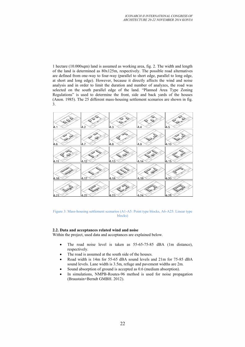
(Anon. 1985). The 25 different mass-housing settlement scenarios are shown in fig.
3.
Figure 3: Mass-housing settlement scenarios (A1-A5: Point type blocks, A6-A25: Linear type
blocks)
2.2. Data and acceptances related wind and noise
Within the project, used data and acceptances are explained below.
The road noise level is taken as 55-65-75-85 dBA (1m distance),
respectively.
The road is assumed at the south side of the houses.
Road width is 14m for 55-65 dBA sound levels and 21m for 75-85 dBA
sound levels. Lane width is 3.5m, refuge and pavement widths are 2m.
Sound absorption of ground is accepted as 0.6 (medium absorption).
In simulations, NMPB-Routes-96 method is used for noise propagation
(Braustain+Berndt GMBH. 2012).
ICONARCH II INTERNATIONAL CONGRESS OF
ARCHITECTURE 20-22 NOVEMBER 2014 KONYA
23
The wind data of İstanbul is transferred into the simulation software.
In simulations, grid spacing is taken as 5m and the height from ground
1.5m.
Acceptable noise level is 55 dBA for daytime (Anon. 2010, Anon. 1996).
In this work, the wind data for Istanbul is used that obtained from daily and
hourly measuring during 30 years by Turkish State Meteorological Service
(Anon. 2013).
Acceptable maximum wind speed is taken as 5m/sec for sitting and walking
(Caniot et al. 2011).
Percentage of annual hours of exceedance frequency of acceptable wind
speed is accepted as F(V>5) < %5 for sitting and F(V>5) < %10 for
walking. F states the percentage of annual hours of exceedance frequency
(Caniot et al. 2011).
Calculation height is 1.5m from ground.
Because of the wind data used in the software ought to be in .tab file
format, all data obtained from Turkish State Meteorological Service for 30
years was compiled and converted to related file format. Wind
measurements are realized at 10m height in Turkey. Therefore, a reference
point at 10m height was defined in software and calculations are realized
according to this reference point (Urbawind 2013).
3. DETERMINATION OF COMFORTABLE OUTDOOR SPACES OF
SETTLEMENT ALTERNATIVES IN REGARD TO WIND AND NOISE
3.1. Determination of comfortable spaces in terms of wind and noise
To determine the comfortable spaces in terms of wind and noise, the process steps
were followed for each settlement alternatives, as shown below:
“Urbawind” software for wind simulations and “Soundplan” software for
noise simulations were used.
Wind data for 30 years were transformed to proper format and entered to
Urbawind and maps were obtained that shows comfortable areas in terms of
wind.
Noise maps were prepared based on road noise as 55-65,75-85 dBA,
respectively.
Tables were created for all results which show the percentage of
comfortable areas in total open areas.
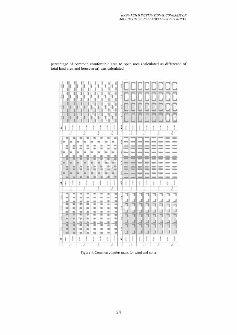
The maps obtained for wind and noise were superposed to determine
common suitable usage areas for both factors. Some examples of the
comfort maps prepared for 25 settlement alternatives according to different
number of floors, noise levels and activity type are shown in fig. 4.
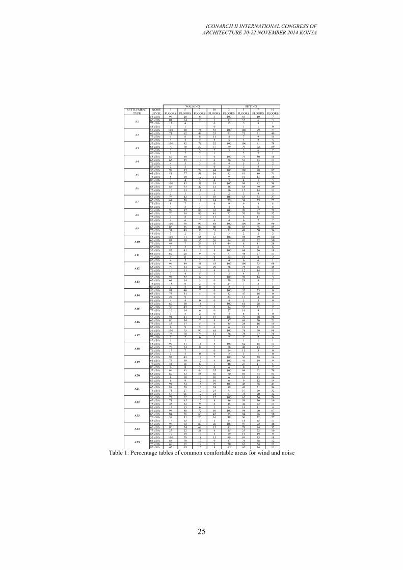
Percentages of comfort calculated from common comfort maps in terms of wind and
noise for 25 settlement type are presented in table 1. To create the table, ratio by
ICONARCH II INTERNATIONAL CONGRESS OF
ARCHITECTURE 20-22 NOVEMBER 2014 KONYA
24
percentage of common comfortable area to open area (calculated as difference of
total land area and house area) was calculated.
Figure 4: Common comfort maps for wind and noise
ICONARCH II INTERNATIONAL CONGRESS OF
ARCHITECTURE 20-22 NOVEMBER 2014 KONYA
25
Table 1: Percentage tables of common comfortable areas for wind and noise
55 dBA 96 20 6 3 100 63 10 7
65 dBA 81 14 2 1 83 55 6 3
75 dBA 13 4 1 0 13 5 3 1
85 dBA 1 1 1 0 1 1 1 0
55 dBA 100 90 76 55 100 100 99 77
65 dBA 71 62 49 33 71 71 71 49
75 dBA 4 6 8 11 4 7 9 14
85 dBA 3 3 2 2 3 3 2 3
55 dBA 100 92 76 52 100 100 91 78
65 dBA 79 70 57 37 79 79 72 59
75 dBA 5 5 5 7 5 5 6 7
85 dBA 1 2 2 1 1 2 2 1
55 dBA 89 30 17 6 100 74 30 15
65 dBA 65 25 14 4 76 53 23 11
75 dBA 4 5 3 0 4 5 5 2
85 dBA 2 2 1 0 2 2 2 1
55 dBA 99 93 74 44 100 100 98 87
65 dBA 81 77 59 36 82 81 80 71
75 dBA 8 10 12 11 9 10 13 18
85 dBA 3 4 5 4 3 4 5 5
55 dBA 100 85 51 18 100 99 82 38
65 dBA 86 73 42 12 86 85 69 29
75 dBA 16 13 11 6 16 15 14 11
85 dBA 2 3 3 2 2 3 4 3
55 dBA 76 42 14 18 100 65 33 27
65 dBA 64 38 11 14 79 54 29 22
75 dBA 8 7 4 6 9 9 8 8
85 dBA 4 5 3 4 4 6 6 5
55 dBA 99 87 80 63 100 99 87 79
65 dBA 70 58 80 41 72 70 58 52
75 dBA 4 8 10 11 5 8 11 14
85 dBA 4 6 7 6 4 6 7 7
55 dBA 100 98 93 88 100 100 99 96
65 dBA 86 85 84 80 86 85 85 85
75 dBA 51 49 50 51 51 49 50 54
85 dBA 3 2 2 2 3 2 2 2
55 dBA 100 71 65 33 100 98 89 60
65 dBA 84 58 55 26 84 83 72 50
75 dBA 44 7 29 13 44 8 41 28
85 dBA 3 3 5 1 3 3 6 6
55 dBA 82 41 13 8 100 68 26 18
65 dBA 62 28 9 0 77 48 27 11
75 dBA 9 8 3 0 12 10 8 2
85 dBA 4 5 2 0 4 6 6 1
55 dBA 94 89 81 45 100 100 93 68
65 dBA 70 64 67 29 76 75 75 45
75 dBA 10 11 13 4 11 12 14 11
85 dBA 3 4 5 3 3 4 5 5
55 dBA 92 22 6 1 100 39 14 3
65 dBA 64 14 3 0 79 29 8 2
75 dBA 18 6 2 0 24 7 3 1
85 dBA 2 2 0 0 2 2 1 0
55 dBA 91 40 7 0 100 55 23 0
65 dBA 75 34 4 0 82 47 16 0
75 dBA 22 9 1 0 24 13 4 0
85 dBA 4 4 0 0 4 5 3 0
55 dBA 67 50 18 1 100 61 28 3
65 dBA 58 43 13 0 84 53 21 2
75 dBA 16 14 6 0 27 16 9 1
85 dBA 3 5 2 0 4 6 4 0
55 dBA 91 41 11 15 100 79 28 28
65 dBA 80 34 7 9 87 69 20 21
75 dBA 35 17 5 6 35 28 16 15
85 dBA 6 9 5 6 6 10 11 12
55 dBA 100 75 97 65 100 78 99 98
65 dBA 78 78 74 51 78 78 77 75
75 dBA 7 7 6 3 7 7 7 6
85 dBA 1 1 1 1 1 1 1 1
55 dBA 97 31 11 5 100 62 18 11
65 dBA 73 24 8 2 78 48 13 7
75 dBA 13 7 1 0 14 11 3 0
85 dBA 2 2 0 0 2 2 1 0
55 dBA 92 43 19 7 100 56 28 14
65 dBA 75 30 12 4 100 41 19 9
75 dBA 41 16 6 1 48 23 11 5
85 dBA 6 8 3 0 6 8 5 2
55 dBA 99 91 84 55 100 99 92 78
65 dBA 69 63 58 36 70 69 64 53
75 dBA 6 10 13 10 6 10 13 16
85 dBA 6 9 12 10 6 9 12 14
55 dBA 94 34 15 29 100 48 26 41
65 dBA 84 28 12 24 89 41 21 34
75 dBA 71 27 12 24 71 37 20 32
85 dBA 53 26 12 24 53 34 20 32
55 dBA 77 52 16 12 100 65 36 24
65 dBA 71 45 12 8 86 59 30 19
75 dBA 45 32 9 6 45 42 22 13
85 dBA 14 13 6 1 14 14 11 4
55 dBA 98 88 72 50 100 98 90 67
65 dBA 84 76 63 43 85 84 76 58
75 dBA 38 31 25 16 39 36 32 27
85 dBA 14 15 13 3 14 15 15 11
55 dBA 98 92 87 26 100 97 92 48
65 dBA 80 74 69 13 81 78 74 32
75 dBA 25 22 21 4 25 23 22 10
85 dBA 19 19 17 3 19 19 19 9
55 dBA 100 78 18 13 99 84 45 18
65 dBA 84 70 13 9 87 75 38 12
75 dBA 69 65 12 9 70 67 34 11
85 dBA 65 63 12 9 65 65 34 11
A3
WALKING SITTING
SETTLEMENT
TYPE
NOISE
LEVEL
3
FLOORS
5
FLOORS
7
FLOORS
10
FLOORS
3
FLOORS
5
FLOORS
7
FLOORS
10
FLOORS
A1
A2
A10
A11
A12
A13
A4
A5
A6
A7
A8
A9
A14
A15
A16
A17
A18
A25
A19
A20
A21
A22
A23
A24
ICONARCH II INTERNATIONAL CONGRESS OF
ARCHITECTURE 20-22 NOVEMBER 2014 KONYA
26
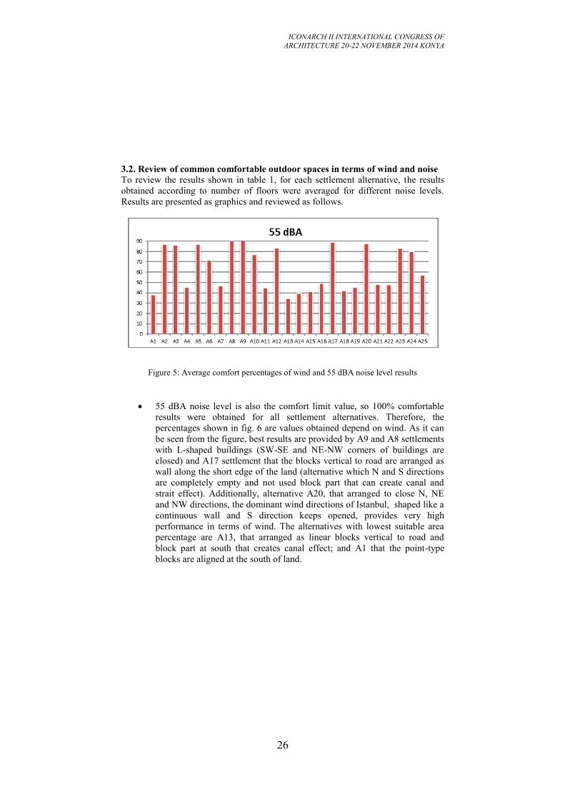
3.2. Review of common comfortable outdoor spaces in terms of wind and noise
To review the results shown in table 1, for each settlement alternative, the results
obtained according to number of floors were averaged for different noise levels.
Results are presented as graphics and reviewed as follows.
Figure 5: Average comfort percentages of wind and 55 dBA noise level results
55 dBA noise level is also the comfort limit value, so 100% comfortable
results were obtained for all settlement alternatives. Therefore, the
percentages shown in fig. 6 are values obtained depend on wind. As it can
be seen from the figure, best results are provided by A9 and A8 settlements
with L-shaped buildings (SW-SE and NE-NW corners of buildings are
closed) and A17 settlement that the blocks vertical to road are arranged as
wall along the short edge of the land (alternative which N and S directions
are completely empty and not used block part that can create canal and
strait effect). Additionally, alternative A20, that arranged to close N, NE
and NW directions, the dominant wind directions of Istanbul, shaped like a
continuous wall and S direction keeps opened, provides very high
performance in terms of wind. The alternatives with lowest suitable area
percentage are A13, that arranged as linear blocks vertical to road and
block part at south that creates canal effect; and A1 that the point-type
blocks are aligned at the south of land.
ICONARCH II INTERNATIONAL CONGRESS OF
ARCHITECTURE 20-22 NOVEMBER 2014 KONYA
27
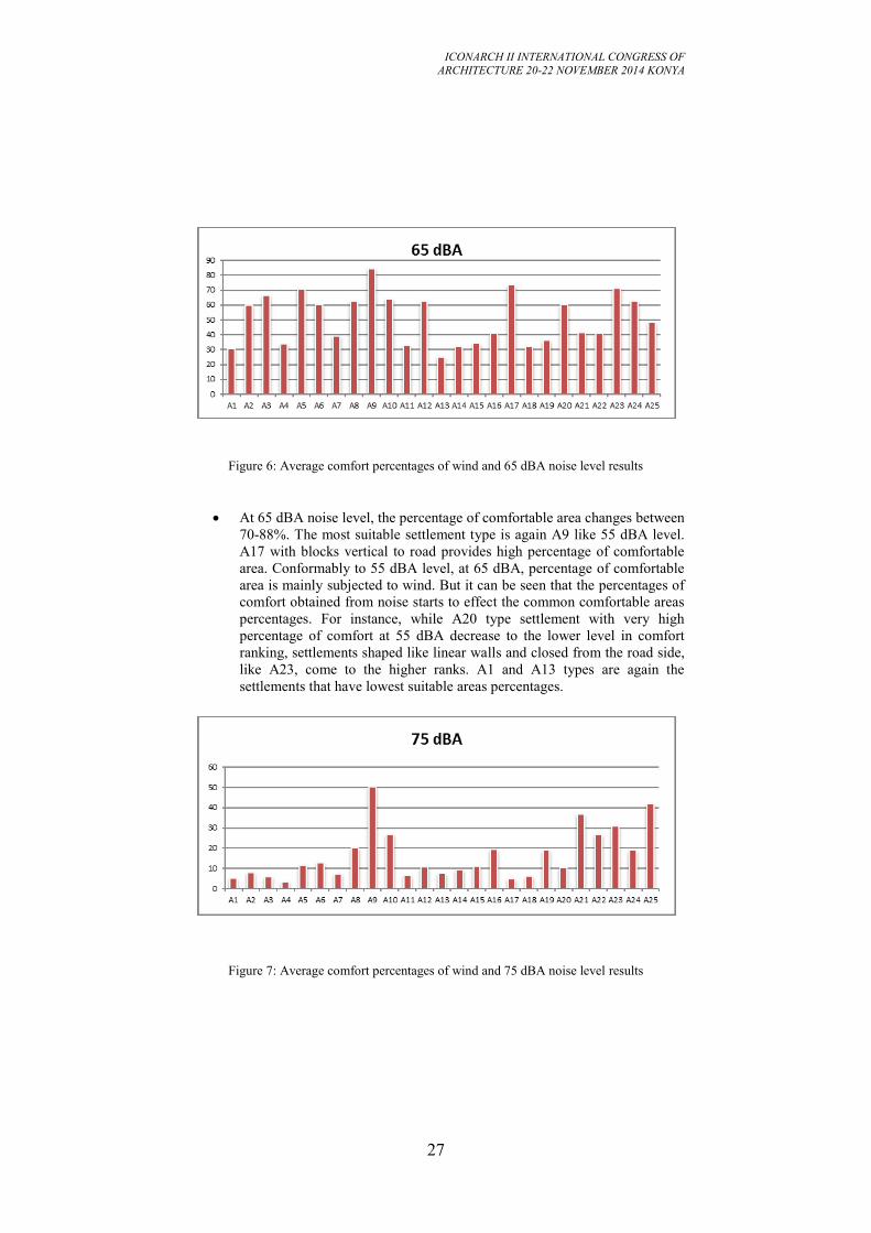
Figure 6: Average comfort percentages of wind and 65 dBA noise level results
At 65 dBA noise level, the percentage of comfortable area changes between
70-88%. The most suitable settlement type is again A9 like 55 dBA level.
A17 with blocks vertical to road provides high percentage of comfortable
area. Conformably to 55 dBA level, at 65 dBA, percentage of comfortable
area is mainly subjected to wind. But it can be seen that the percentages of
comfort obtained from noise starts to effect the common comfortable areas
percentages. For instance, while A20 type settlement with very high
percentage of comfort at 55 dBA decrease to the lower level in comfort
ranking, settlements shaped like linear walls and closed from the road side,
like A23, come to the higher ranks. A1 and A13 types are again the
settlements that have lowest suitable areas percentages.
Figure 7: Average comfort percentages of wind and 75 dBA noise level results
ICONARCH II INTERNATIONAL CONGRESS OF
ARCHITECTURE 20-22 NOVEMBER 2014 KONYA
28
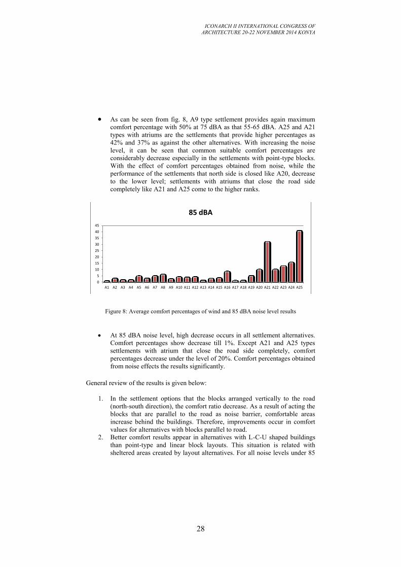
As can be seen from fig. 8, A9 type settlement provides again maximum
comfort percentage with 50% at 75 dBA as that 55-65 dBA. A25 and A21
types with atriums are the settlements that provide higher percentages as
42% and 37% as against the other alternatives. With increasing the noise
level, it can be seen that common suitable comfort percentages are
considerably decrease especially in the settlements with point-type blocks.
With the effect of comfort percentages obtained from noise, while the
performance of the settlements that north side is closed like A20, decrease
to the lower level; settlements with atriums that close the road side
completely like A21 and A25 come to the higher ranks.
Figure 8: Average comfort percentages of wind and 85 dBA noise level results
At 85 dBA noise level, high decrease occurs in all settlement alternatives.
Comfort percentages show decrease till 1%. Except A21 and A25 types
settlements with atrium that close the road side completely, comfort
percentages decrease under the level of 20%. Comfort percentages obtained
from noise effects the results significantly.
General review of the results is given below:
1. In the settlement options that the blocks arranged vertically to the road
(north-south direction), the comfort ratio decrease. As a result of acting the
blocks that are parallel to the road as noise barrier, comfortable areas
increase behind the buildings. Therefore, improvements occur in comfort
values for alternatives with blocks parallel to road.
2. Better comfort results appear in alternatives with L-C-U shaped buildings
than point-type and linear block layouts. This situation is related with
sheltered areas created by layout alternatives. For all noise levels under 85
0
5
10
15
20
25
30
35
40
45
A1 A2 A3 A4 A5 A6 A7 A8 A9 A10 A11 A12 A13 A14 A15 A16 A17 A18 A19 A20 A21 A22 A23 A24 A25
85 dBA
ICONARCH II INTERNATIONAL CONGRESS OF
ARCHITECTURE 20-22 NOVEMBER 2014 KONYA
29
dBA, A9 type settlement with L-shaped buildings shows the best
performance in terms of wind and noise. But, at 85dBA noise level, C and
U type settlements provide better results because of closed road side.
3. Increasing of number of floors causes decreasing of comfort level. The
decrease on comfort level occurs as a result of reflections on building
surfaces, dispersions and directions created by building forms. From the
perspective of noise control, the main reasons of this situation are the
distance of buildings to road, distance of one another and reflections from
buildings surfaces. As for the perspective of wind, both increase of number
of floors and structuring on the north or south side that creates canal or
strait effect decrease the comfort level considerably.
4. CONCLUSION
Wind and noise, physical and environmental factors that directly affect user comfort.
Due to both factors, outdoor and semi-outdoor spaces are not used efficiently. This
situation is also valid modern-day mass-housing. Both wind and noise are important
components of building physics in the field of specifying the area for structuring,
orienting structures in terms of climatic factors, designing of structure shape and
positioning according to other structures. In compliance with the analyze results of
25 settlement alternatives realized using climatic data of Istanbul, linear type layouts
provides better results compared to point-type blocks. In block type settlements,
layouts parallel to road continue along the south side have more comfortable areas
than vertical settlement alternatives. Increase in the number of floors of buildings
effect negatively both wind and noise comfort. Therefore, buildings with lower
number of floors should be preferred. Position and configuration of buildings should
be determined considering dominant wind direction and annual blowing distribution.
As a result of the study, it was found that the performance of comfortable open
spaces is not sufficient provided by components such as structure configuration,
position and height. For this reason, additional precautions are needed to provide
common comfortable areas in terms of wind and noise. Within the scope of an
completed research project in Yıldız Technical University, several studies are
carried out to determine optimum percentage of common area in terms of wind and
noise comfort and the design of optimum wind and noise barrier that will be applied
to settlement types that cannot provide requested percentage. In project, all
simulations and calculations realized for different cities which have characteristic
features of five climatic zones and it is only exemplified for Istanbul in this paper.
By means of the data that will be presented as a result of the project, it will be
possible to select suitable configuration in regard to wind and noise depends on
wind data of current city, position of the design area according to road and the noise
level of the road.
ICONARCH II INTERNATIONAL CONGRESS OF
ARCHITECTURE 20-22 NOVEMBER 2014 KONYA
30
Acknowledgement
This paper is written within the TUBITAK 1001 project and authors would like to
acknowledge TUBITAK because of their support.
REFERENCES
- Anon.1985, The Zoning Regulation of Planned Areas, The Official Gazette, No:
18916, Turkey,02 November 1985 (in Turkish).
- Anon. 1996, Future Noise Policy, European Commission Green Paper, Com (96),
Commission of E.C., Brussels, Belgium.
- Anon., 1997, Prime Ministry Housing Development Administration Regulations
For The Implementation Of The Public Housing Loans, The Official Gazette, No:
23019, (14.06.1997), Turkey, (in Turkish).
-Anon, 2010, The Regulation of Environmental Noise Assessment and Management.
The Official Gazette, No:25862, (04.06.2010), Turkey, (in Turkish).
- Anon. 2013. Turkish State Meteorological Service Archive.
- Caniot, G. , Li, W. , Dupond, G. 2011. Validations and applications of a CFD tool
dedicated to wind assessment in urban areas, 13th International Conference on Wind
Energy, Amsterdam, The Netherlands.
- Braustain+Berndt GMBH, SoundPLAN Manual V 7.3, 2012.
- UrbaWind User manual, 2013.
-Zorer Gedik G, Yüğrük Akdağ, N, Kiraz, F, Çaçan R., Şener, B.. Optimization of
mass-housing settlements in terms of wind and noise control, Tübitak 1001 Project,
Pr. No: 111M560, 2012-2014 (in
ICONARCH II INTERNATIONAL CONGRESS OF
ARCHITECTURE 20-22 NOVEMBER 2014 KONYA
31
THE EFFECT OF WIND VELOCITY AND NIGHT NATURAL
VENTILATION ON THE INSIDE AIR TEMPERATURE IN
PASSIVE COOLING IN ARID ZONES THE EFFECT OF
WIND VELOCITY AND NIGHT NATURAL VENTILATION
ON THE INSIDE AIR TEMPERATURE IN PASSIVE
COOLING IN ARID ZONES
NHAMIDA BEN CHEIKH1
ABSTRACT
The effect of wind velocity and night natural ventilation in lowering the inside
daytime air temperature in passive cooling in arid zones, were investigated by
numerical calculations and experimental means for different values of air change
flow rate due to infiltrations and natural ventilation and different wind speed. The
numerical calculations based on the inside outside air temperature, wind speed,
cracks and openings dimensions to determine the volume of air change per hour.
The experimental model was a test cell with door facing north and window in the
opposite side facing south, the volume of the model was 9m³. The calculated and
measured results show that 1.8 volume per hour of air change flow rate and 2m/s
wind speed show a high concordance between calculated and measured inside air
temperature, and can lower the inside air temperature by 3°c to 4°C compared to
non ventilated test cell (Bencheikh & Bouchair 2004) .
Key words : Wind velocity, night natural ventilation, passive cooling, arid zones,
1. INTRODUCTION
Night natural ventilation potential for improving thermal comfort in buildings has
been investigated by numerical and experimental means, (Santamouris and al. 1996
1997) introduced an interested method to calculate the energy contribution of night
ventilation technique to the cooling load of a building. Many researchers investigate
the improvement of space cooling by night natural ventilation such as: (Kolokotroni
and al. 1998) used temperature and humidity charts to generate a pre-design tool for
summer cooling evaluation of night ventilation. (Geros et al. 1999) carried out an
experimental evolution of night ventilation effect on the inside air temperature for
four buildings and simulations investigation to determine the effect of air change
rate on night natural ventilation. (Givoni 1998) carried out experiment work to
investigate the effectiveness of night ventilation in lowering the indoor day time
temperature and many other researchers’ worked on the same subject. This paper
1 Dr. Amar Telidji University, Department of Architecture, Laghouat, Algeria
ICONARCH II INTERNATIONAL CONGRESS OF
ARCHITECTURE 20-22 NOVEMBER 2014 KONYA
32
focuses on numerical calculation and experiment work to validate the theoretical
results, on night natural ventilation effect in lowering the daytime inside air
temperature.
2. NUMERICAL MODEL
2.1. Air flow rates calculation
Air flow into buildings is either by infiltration of outside air through cracks around
exterior openings, or by natural ventilation through opened exterior openings. Any
outdoor air that enters by way of infiltration or ventilation is assumed to be
immediately mixed with inside air.
2 .1. 1 Infiltration
The determination of the amount of infiltration air is quite complicated and subject
to significant uncertainty. The infiltration quantity is converted from a number of air
change by hour (ACH) and unclouded in the inside air heat balance using the outside
air current simulation time step.
There are three models for estimating the infiltration flow rate. The first is the design
flow rate, the second is the effective leakages area base on (Sherman and Grimsrud
1980) , and the third is the flow coefficient model based on (Walker and Wilson
1998).
Infiltration design flow rate
The flow of air from the outside environment directly into the inside one is generally
caused by cracks around exterior openings, temperature differences and wind speed.
The basic equation (Coblens and Achenbach 1963) used to calculate infiltration.
Infiltration=( ( CV+D (1)
Infiltration effective leakage area
Infiltration leakage area model is based on Sherman and Grimsrud [7]
Infiltration=(
(2)
Where
is a value from the user-difined scheduls.
is the effective air leakage area in cm² that corresponds to a 4Pa pressure
differential.
is the coefficient from stack-induced infiltration in (
)²(
is the absolute difference between inside and outside air temperature.
is the coefficient for wind-induced infiltration in (
)²(
V is the local wind speed in m/s.
ICONARCH II INTERNATIONAL CONGRESS OF
ARCHITECTURE 20-22 NOVEMBER 2014 KONYA
33
Infiltration by flow coefficient
The flow coefficient model is based on (Walker and Wilson 1998) equation.
Infiltration= (3)
c is the flow coefficient in m²/(s. )
is the coefficient from stack-induced infiltration in
n is the pressure exponent.
is the coefficient for wind-induced infiltration in
.
s is the shelter factor.
2 .1 .2 Natural ventilation
Natural ventilation is a controlled air change with the exterior environment through
openings due to temperature differences, wind speed, and the opening area. The
controlled natural ventilation calculation is based on three models.
Design flow rate
Design flow rate is based on the outside inside temperature difference, wind speed
and openings area, the basic equation to calculate the design flow rate is;
Ventilation= ( ( CV+D (4)
Ventilation by wind and stack with open area
The ventilation air flow rate is function of wind speed and thermal stack effect,
along with the area of the opening, the equation used to calculate the ventilation rate
is (ASHRAE 2006) .
(5)
Where
= Opening effectiveness dimensionless
²
= 0.55-
If the difference= -180°
The equation used calculates the ventilation rate due to stack effect is given by
ASHRAE 2009 handbook;
=
(6)
Volumetric air flow rate due to stack effect m³/s.
= discharge coefficient for opening dimensionless.
=Height from midpoint of lower opening to the neutral pressure level (m).
ICONARCH II INTERNATIONAL CONGRESS OF
ARCHITECTURE 20-22 NOVEMBER 2014 KONYA
34
The inside and outside air temperature in degree (k).
The discharge coefficient for opening dimensionless is given by (ASHRAE
2009) handbook;
=0.40+0.0045 The total ventilation rate by wind and stack air flow;
3. EXPERIMENTAL WORK
The experimental set-up consisted of two identical test cells (a) and (b), a cubic room
with 3m high and 3m wide as shown in figure (1). South wall is provided with a
window and the North one is provided with a door, the window and door were closed
during day time and opned during night to allow night natural ventilation . The
experimental cell (b) was the basic reference unit. The roof was constructed of simple
aluminum sheet painted white. The model situated in Laghouat Algeria (latitude
+33.46°, longitude +2.56° and elevation 767 m).
Figure 1. (a) Room with cooling roof (b) Room without cooling roof.
An experimental study of the effect of night natural ventilation on day time inside air
temperature was carried out for a typical summer day of June for Laghouat in Algeria.
The first experimental work was done under clear sky and 0.25m/s wind speed during
night time, the second day under cloudy sky and 0.81m/s wind speed, after three days
of experiment the night natural ventilation had a good effect on in lowering the inside
air temperature. The effect of air change flow rate and wind speed were studied and
simulated for an average wind speed of 3m/s and a variable air change flow rate (1.8,
2.7,and 3.6 V/h). Figure (2) shows the variations of inside air temperature for constant
wind speed 3m/s and variable air change flow rate , the inside air temperature decreases
with the increase of air change flow rate. When the air change flow rate taken to its
ICONARCH II INTERNATIONAL CONGRESS OF
ARCHITECTURE 20-22 NOVEMBER 2014 KONYA
35
maximum for variable wind velocities, for velocity ≥3m/s the inside air temperature had
the almost the same values as shown in figure (3).
0 4 8 12 16 20 24Temps
25
30
35
40
Tem
péra
ture
°C
Température extériuere
Température intérieure Taux de vent=0.36V/h
Température intérieure Taux de vent=0.9V/h
Température intérieure Taux de vent=1.8V/h
Température intérieure Taux de vent=2.7V/h
Figure 2: inside air temperature for 3m/s
wind speed and variable air change flow
rate
0 4 8 12 16 20 24
Temps
25
30
35
40
Te
mp
éra
ture
en
°C
Température extérieure
Température intériuere V= 0 m/s
Température intériuere V= 2 m/s
Température intériuere V= 6 m/s
Température intériuere V= 10 m/s
Figure 3 : inside air temperature for 7.2 V/h air
change flow rate and variable wind spe
4. TEMPERATURE MEASUREMENTS
Air temperatures outside the room were measured using weather stations installed near
the laboratory, far from the test cell by 150m. The temperature at different positions
under the roof level has been measured by copper constant thermocouples connected to
digital thermometer. Thermocouples fixed under the roof surface the end of the
thermocouples were enveloped in thin aluminum paper to reflect the radiation from the
surrounding interior surfaces. The readings of all thermocouples have been averaged to
give the average temperature
ICONARCH II INTERNATIONAL CONGRESS OF
ARCHITECTURE 20-22 NOVEMBER 2014 KONYA
36
5. RESULTS AND DISCUSSIONS
Figure (4, 5, 6 and 7) show the inside air temperatures variations for variable air change
flow rate (0.9, 1.8, 3.6, and 7.2V/h) and variable wind speed (from 0 to 10m/s). After
analyzing the results obtained by experimental and simulation, by comparing the results,
the values of 1.8V/h of air change flow rate and 2m/s wind speed give the smaller error
between measured and simulated inside air temperature as shown in figure (7).
0 4 8 12 16 20 24
Temps
25
30
35
40
Te
mp
éra
ture
° C
Température extérieure
Température intérieure V = 0 m/s
Température intérieure V = 2 m/s
Température intérieure V = 6 m/s
Température intérieure V = 10 m/s
Figure 4: inside air temperature for 0.9
V/h air change flow rate and variable
wind speed
0 4 8 12 16 20 24
Temps
25
30
35
40
Te
mp
éra
ture
° C
Température extérieure
Température intérieure V= 0 m/s
Température intérieure V= 2 m/s
Température intérieure V= 6 m/s
Température intérieure V= 10 m/s
Figure 5: inside air temperature for 1.8
V/h air change flow rate and variable
wind speed
ICONARCH II INTERNATIONAL CONGRESS OF
ARCHITECTURE 20-22 NOVEMBER 2014 KONYA
37
0 4 8 12 16 20 24
Temps
25
30
35
40
Tem
péra
ture
° C
Température extérieure
Température intérieure V = 0 m/s
Température intérieure V = 2 m/s
Température intérieure V = 6 m/s
Température intérieure V = 10 m/s
Figure 6: inside air temperature for 3.6
V/h air change flow rate and variable
wind speed
0 4 8 12 16 20 24
Temps
25
30
35
40
Te
mp
éra
ture
en
°C
Température extérieure
Température intériuere V= 0 m/s
Température intériuere V= 2 m/s
Température intériuere V= 6 m/s
Température intériuere V= 10 m/s
Figure 7: inside air temperature variation
for 7.2 V/h air change flow rate and variable
wind speed
Figure (8) presents the measured and simulated inside air temperature for non ventilated
space, the two curves have almost the same values which mean the simulations are
accurate. Figure (10) present the measured and simulated inside air temperature for
night ventilated space for 1.8V/h air change flow rate and 2m/s wind speed, the two
inside air temperature curves show a smaller error, these error were due to, wind speed
was considered in simulation a constant value during simulation period, which is
different to the reality, the wind speed was very variable from time to time and
sometimes present a big differences which effect directly the air change flow rate
which effect the inside day time air temperature. In the space without night natural
ventilation and when the wind speed was assumed null for space with night ventilation
the two curves of the inside air temperature measured and simulated have almost the
same values as shown in figure 8. Figure 9 shows the inside air temperature for the
space with and without night natural ventilation , so the night natural ventilation for
space in arid zone participate in lowering the day time inside air temperature from 3to
6°C.
ICONARCH II INTERNATIONAL CONGRESS OF
ARCHITECTURE 20-22 NOVEMBER 2014 KONYA
38
0 4 8 12 16 20 24Temps
25
30
35
40
Tem
péra
ture
° C
Température extérieure
Température intérieure calculéé
Température intérieure mesurée
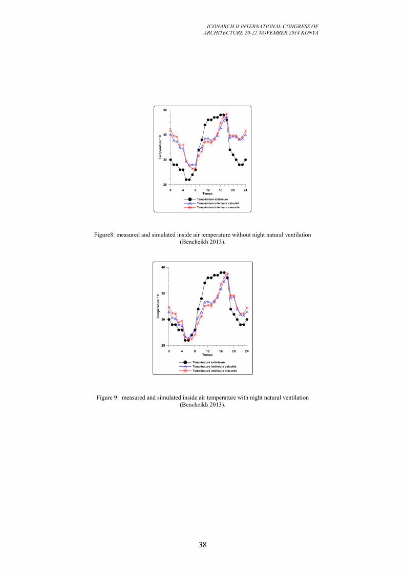
Figure8: measured and simulated inside air temperature without night natural ventilation
(Bencheikh 2013).
0 4 8 12 16 20 24Temps
25
30
35
40
Tem
pé
ratu
re °
C
Température extérieure
Température intérieure calculée
Température intérieure mesurée
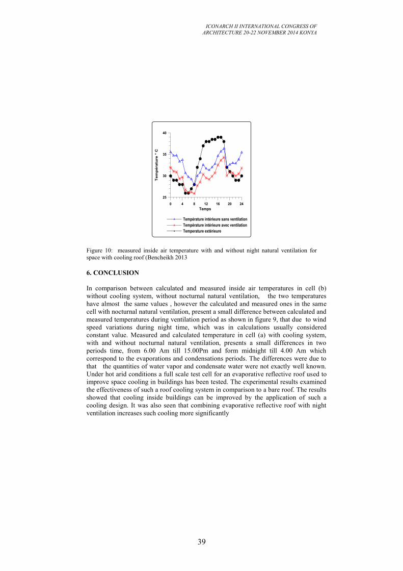
Figure 9: measured and simulated inside air temperature with night natural ventilation
(Bencheikh 2013).
ICONARCH II INTERNATIONAL CONGRESS OF
ARCHITECTURE 20-22 NOVEMBER 2014 KONYA
39
0 4 8 12 16 20 24
Temps
25
30
35
40
Te
mp
éra
ture
° C
Température intérieure sans ventilation
Température intérieure avec ventilation
Temperature extérieure
Figure 10: measured inside air temperature with and without night natural ventilation for
space with cooling roof (Bencheikh 2013
6. CONCLUSION
In comparison between calculated and measured inside air temperatures in cell (b)
without cooling system, without nocturnal natural ventilation, the two temperatures
have almost the same values , however the calculated and measured ones in the same
cell with nocturnal natural ventilation, present a small difference between calculated and
measured temperatures during ventilation period as shown in figure 9, that due to wind
speed variations during night time, which was in calculations usually considered
constant value. Measured and calculated temperature in cell (a) with cooling system,
with and without nocturnal natural ventilation, presents a small differences in two
periods time, from 6.00 Am till 15.00Pm and form midnight till 4.00 Am which
correspond to the evaporations and condensations periods. The differences were due to
that the quantities of water vapor and condensate water were not exactly well known.
Under hot arid conditions a full scale test cell for an evaporative reflective roof used to
improve space cooling in buildings has been tested. The experimental results examined
the effectiveness of such a roof cooling system in comparison to a bare roof. The results
showed that cooling inside buildings can be improved by the application of such a
cooling design. It was also seen that combining evaporative reflective roof with night
ventilation increases such cooling more significantly
ICONARCH II INTERNATIONAL CONGRESS OF
ARCHITECTURE 20-22 NOVEMBER 2014 KONYA
40
REFERENCES
-ASHRAE handbook of fundamentals. 2006 chapter 27 and 2001 chapter 26.
-Bencheikh, A. and Bouchair, A. 2004. Passive cooling by evap-reflictive roof for
hot dry climate. Renewable Energy 29(11), pp.1877-1886, Elsevier Scienc.
-Bencheikh, H. 2013. Full scale experimental studies of a passive cooling roof in hot
arid areas. International Journal of Renewable Energy Technology Research 2 (6),
pp. 170 -180.
-Coblenz, C. W. and Achenbach, P. R. 1963. field measurement of ten electrically
heated houses. ASHRAE transactions, pp. 358-365
-Geros, V. and al. 1999. Experimental evaluation of night ventilation phenomena.
Energy and Buildings 29, Elsevier Scienc.
-Givoni, B. 1998. Effectiveness of mass and night ventilation in lowering the indoor
daytime temperatures. Energy and Buildings 28, Elsevier Scienc.
-Kolokotroni, M. and al. 1998. cooling with night ventilation for office buildings in
moderate climates. Energy and Buildings 27, Elsevier Scienc.
- Santamouris, M. and al. 1996. On the efficiency of night ventilation techniques for
thermostatically controlled buildings. Solar Energy 56 (6),
-Santamouris, M. and al. 1997. On the coupling of thermostatically controlled
buildings with ground and night ventilation passive dissipation techniques. Solar
Energy 60 (3–4), Elsevier Scienc .
-Sherman, M. H. and Grimsud, D. T. 1990. Infiltration-pressurization correlation,
simplified physical modeling. ASHRAE transactions 86(2), pp. 778.
-Walker, I. S. and Wilson, D. J. 1998 .field validation of equations for stack and
wind driven air infiltration calculations. International journal of HVAC and
Research 4(2).
ICONARCH II INTERNATIONAL CONGRESS OF
ARCHITECTURE 20-22 NOVEMBER 2014 KONYA
41
AN APPROACH FOR EVALUATING EXTERNAL WALL-
ROOF COUPLING DETAIL’S PERFORMANCE
IŞIL TÜRKAY1
M. CEM ALTUN2
ABSTRACT
Designing a coupling detail is a complicated job since coupling details are areas
where building elements and other sub-systems come together and performances of
single building elements come into a complex interaction. Mistakes in the design
stage can lead to building failures after construction, which on the other hand are
causing unhealthy environments and high repair or retrofitting costs. The
intersection areas in the external envelope, exposed to environmental conditions, are
even more vulnerable to building failures. Building element systems of the external
envelope do have several functions. Some of them are in common, but some
functions are differing. These common and/or varying functions are coupled at the
intersection area, working independently, cooperatively or opposing. This is why a
complex interaction is born in a coupling detail. The coupling area of the exterior
wall system with the roof system is one of those intersection areas of the external
envelope. It is obvious that a way to avoid building failures is proper detailing.
In this paper, an approach to evaluate external wall-roof coupling detail’s
performance is presented. The evaluation approach consists of two modules. The
first module is a “performance requirements checklist” separately generated for each
building element, namely; the exterior wall systems and the roof systems. The
second module is a step-by-step evaluation tool for coupling details. The tool and
the checklists are prepared by taking into consideration of sole functional continuity
at coupling details, supported by material continuity and geometric precautions. The
evaluation tool can be used either in the detail design process or before the tendering
process for finalized details.
The usability of the proposed approach is demonstrated through its application on a
real world problem and pros and cons of the approach are discussed in conclusion.
Key words: Detail, Evaluation, Exterior Wall, Roof, Performance
1. INTRODUCTION
In some buildings failures occur a while after construction, affecting users’ comfort
and health and also causing high repair or retrofitting costs. The intersection areas in
the external envelope, exposed to environmental conditions, are the most vulnerable
1Master's student, Istanbul Technical University,Graduate School of Science, Engineering and
Technology, Environmental Control and Construction Technologies Programme , ISTANBUL 2Assistant Professor, PhD, Istanbul Technical University, Department of Architecture, ISTANBUL
ICONARCH II INTERNATIONAL CONGRESS OF
ARCHITECTURE 20-22 NOVEMBER 2014 KONYA
42
parts of a building to failures. A remarkable reason for building failures are faulty
designed details (Schild, 1984).
Intersection areas in the external envelope are coupling details where at least two
building elements and/or other sub-systems such as the structural system come
together (Rush, 1986). Each individual building element of the external envelope
has to fulfill several functions. Some of them are in common, but some functions are
differing. These common and/or varying functions are coupled at the intersection
area, working independently, cooperatively or opposing (Emmitt, 2004). This is why
a complex interaction is born in a coupling detail. The main goal has to be here the
accurate integration of the systems and providing the continuity of performances at
coupling details (Olie, 2011).Moreover, there is a great variety of building materials
and a substantial amount of construction techniques, today. Due to this richness, it
might be easier to prevent the building failures (Knaack, 2007). But at the same
time, countless alternatives are causing a complex decision process. All those factors
are leading to a complicated design process of the coupling detail which on the other
hand also increases the risk of faulty design. Design errors should be detected at the
design stage, to avoid carrying those mistakes to the construction stage. Although
design review procedures at different scales to preclude those failures do exist, they
rarely form a methodical approach for evaluating details.
In this paper, an approach to evaluate external wall-roof coupling detail’s
performance is presented. The evaluation tool can be used either in the detail design
process or before the tendering process for finalized details. The proposed tool is to
be used in the context of the building envelope, consisting of the exterior wall and
roof systems.
2. METHODOLOGY
The evaluation approach consists of two modules. The first module is a
“performance requirements check list” separately generated for each building
element, namely; the exterior wall systems and the roof systems. The second module
is a step-by-step evaluation tool for the exterior wall- roof coupling details.
2.1. Checklists for Performance Requirements for External Walls and Roofs To propose a systematical approach in the context of building details, checklists
were drawn up for building element systems as the first module of the analyzing
approach. Checklists can be used as design or analysis tool in order to avoid
overlooking any requirement which should be met by any product (Jones, 1992).
These checklists were generated by determining all performance requirements for
each building element through an extensive literature review. As the study is
focusing on the intersection area of the exterior wall system and the roof system,
firstly, performance requirements for exterior wall and roof systems were compiled
in form of tables. Reliable resources, such as text books, guidelines and standards
from years between 1970’s and 2010’s about building construction and details were
used to identify performance requirements. Secondly, a frequency analysis was
conducted to determine the most important requirements. Then, the performance
ICONARCH II INTERNATIONAL CONGRESS OF
ARCHITECTURE 20-22 NOVEMBER 2014 KONYA
43
requirements were transformed into checklists for the exterior wall and the roof
systems. Finally, checklists were tested on a great amount of typical building
element details to control their accuracy and extensity. In this regard, a large number
of roof and external wall details (Lückmann, 2011), (Beinhauer, 2013) were studied
by using those checklists.
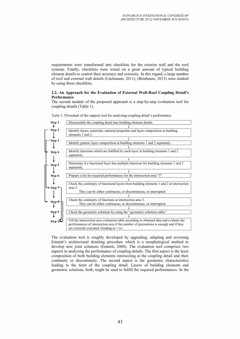
2.2. An Approach for the Evaluation of External Wall-Roof Coupling Detail’s
Performance
The second module of the proposed approach is a step-by-step evaluation tool for
coupling details (Table 1).
Table 1: Flowchart of the support tool for analyzing coupling detail’s performance
Disassemble the coupling detail into building element details.
Identify layers, materials, material properties and layer composition in building
elements 1 and 2.
Identify generic layer composition in building elements 1 and 2 separately.
Identify functions which are fulfilled by each layer in building elements 1 and 2
separately.
Determine if a functional layer has multiple functions for building elements 1 and 2
separately.
Prepare a list for required performances for the intersection area “3”.
Check the continuity of functional layers from building elements 1 and 2 at intersection
area 3.
They can be either continuous, or discontinuous, or interrupted
Check the continuity of functions at intersection area 3.
They can be either continuous, or discontinuous, or interrupted.
Check the geometric solutions by using the “geometric solutions table.”
Fill the intersection area evaluation table according to obtained data and evaluate the
performances of intersection area if the number of precautions is enough and if they
are correctly executed. Grading as +/o/-.
The evaluation tool is roughly developed by upgrading, adapting and reversing
Emmitt’s architectural detailing procedure which is a morphological method to
develop new joint solutions (Emmitt, 2004). The evaluation tool comprises two
aspects in analyzing the performance of coupling details. The first aspect is the layer
composition of both building elements intersecting at the coupling detail and their
continuity or discontinuity. The second aspect is the geometric characteristics
leading to the form of the coupling detail. Layers of building elements and
geometric solutions, both, might be used to fulfill the required performances. In the
Step 1
Step 2
Step 3
Step 4
Step 5
Step 6
Step 7
Step 8
Step 9
Step 10
ICONARCH II INTERNATIONAL CONGRESS OF
ARCHITECTURE 20-22 NOVEMBER 2014 KONYA
44
performance analysis of coupling details, firstly, building element systems
composing the coupling detail are disassembled and defined namely “1” and “2”.
Functional layers in the building element system sections are examined. Secondly,
physical properties of building elements 1 and 2 are identified such as materials,
layer composition and functional layers. Then functions for building elements 1 and
2 are defined and checked according to performance requirement tables as stated in
section 2.1. The common performance requirements of the two building elements
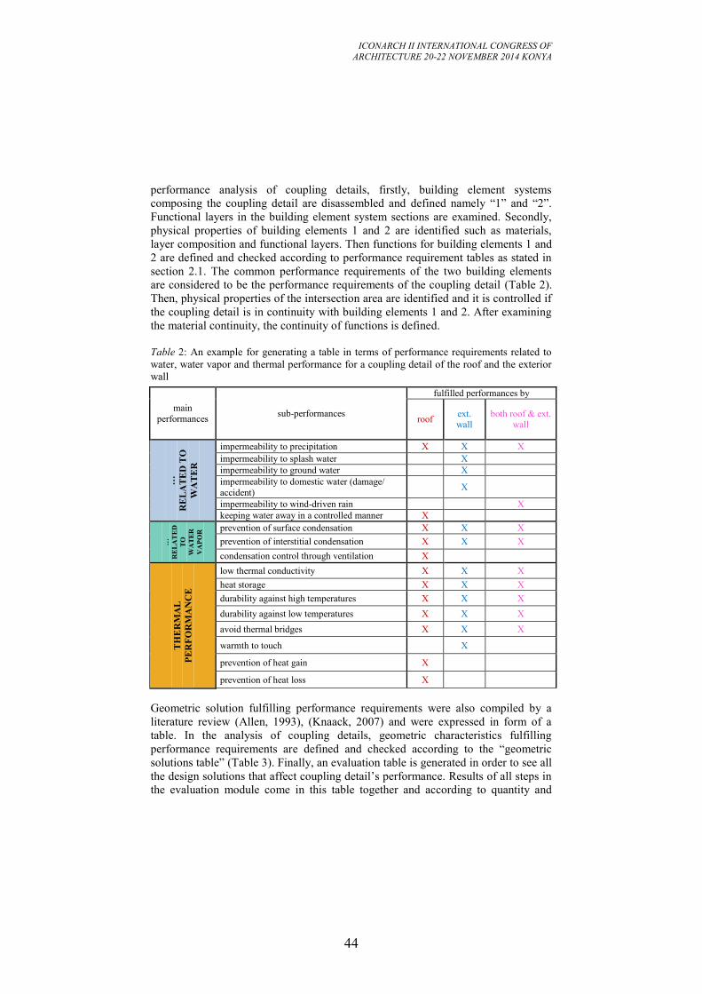
are considered to be the performance requirements of the coupling detail (Table 2).
Then, physical properties of the intersection area are identified and it is controlled if
the coupling detail is in continuity with building elements 1 and 2. After examining
the material continuity, the continuity of functions is defined.
Table 2: An example for generating a table in terms of performance requirements related to
water, water vapor and thermal performance for a coupling detail of the roof and the exterior
wall
main
performances sub-performances
fulfilled performances by
roof ext. wall
both roof & ext. wall
…
RE
LA
TE
D T
O
WA
TE
R
impermeability to precipitation X X X
impermeability to splash water X
impermeability to ground water X
impermeability to domestic water (damage/
accident) X
impermeability to wind-driven rain X
keeping water away in a controlled manner X
…
RE
LA
TE
D
TO
WA
TE
R
VA
PO
R prevention of surface condensation X X X
prevention of interstitial condensation X X X
condensation control through ventilation X
TH
ER
MA
L
PE
RF
OR
MA
NC
E
low thermal conductivity X X X
heat storage X X X
durability against high temperatures X X X
durability against low temperatures X X X
avoid thermal bridges X X X
warmth to touch X
prevention of heat gain X
prevention of heat loss X
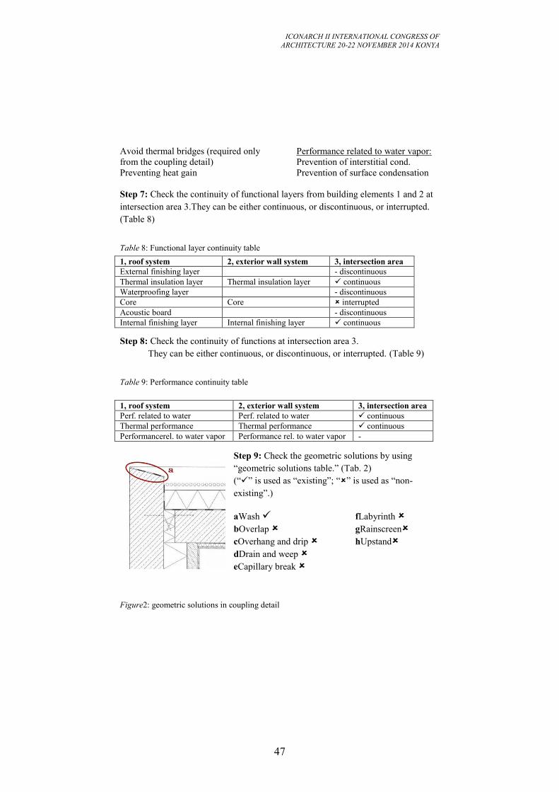
Geometric solution fulfilling performance requirements were also compiled by a
literature review (Allen, 1993), (Knaack, 2007) and were expressed in form of a
table. In the analysis of coupling details, geometric characteristics fulfilling
performance requirements are defined and checked according to the “geometric
solutions table” (Table 3). Finally, an evaluation table is generated in order to see all
the design solutions that affect coupling detail’s performance. Results of all steps in
the evaluation module come in this table together and according to quantity and
ICONARCH II INTERNATIONAL CONGRESS OF
ARCHITECTURE 20-22 NOVEMBER 2014 KONYA
45
quality of solutions, the required performances are graded through a three-level
ordinal scale with scores assigned as; “good”(+), “moderate”(o) and “poor”(-). In
this way, it is obtained which performance requirements are fulfilled by the coupling
detail and how “successful” they are.
Table 3: “Geometric solutions” table (Allen, 1993), (Knaack, 2007)
performance geometric solutions
performance geometric
solutions
… r
elat
ed t
o w
ater
wash
…re
late
d t
ow
ater
vap
ou
r
condensate
drainage overlap
overhang and drip
drain and weep
capillary break
labyrinth
rainscreen
upstand
3. THE USABILITY OF THE PROPOSED APPROACH IN ANALYZING
EXTERIOR WALL-ROOF COUPLING DETAILS
Two coupling details are analyzed with the evaluation tool in order to demonstrate
its usability. Thermal performance, performance related to water and water vapor of
the coupling details are taken into consideration.
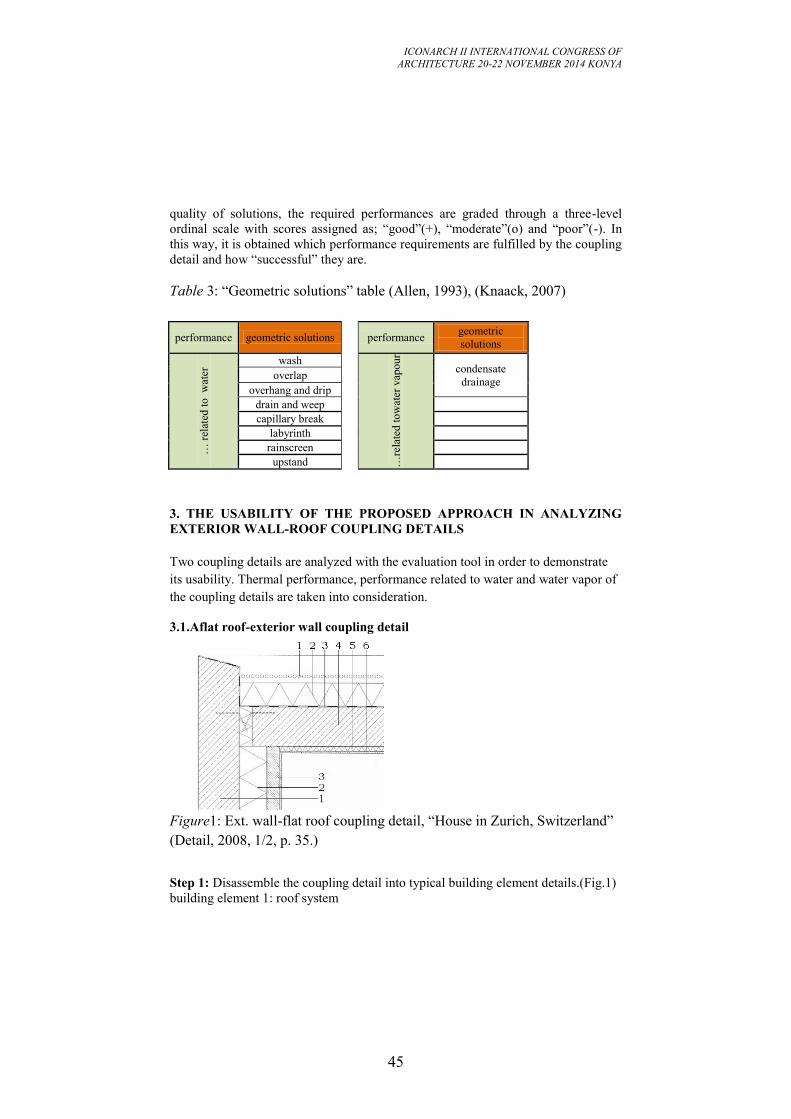
3.1.Aflat roof-exterior wall coupling detail
Figure1: Ext. wall-flat roof coupling detail, “House in Zurich, Switzerland”
(Detail, 2008, 1/2, p. 35.)
Step 1: Disassemble the coupling detail into typical building element details.(Fig.1)
building element 1: roof system
ICONARCH II INTERNATIONAL CONGRESS OF
ARCHITECTURE 20-22 NOVEMBER 2014 KONYA
46
building element 2: exterior wall system
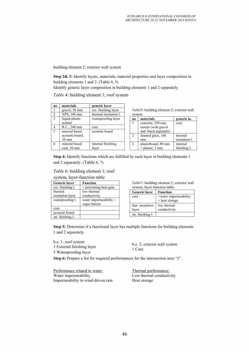
Step 2& 3: Identify layers, materials, material properties and layer composition in
building elements 1 and 2. (Table 4, 5)
Identify generic layer composition in building elements 1 and 2 separately.
Table 4: building element 1; roof system
no materials generic layer
1 gravel, 50 mm ext. finishing layer
2 XPS, 140 mm thermal insulation l.
3 liquid-plastic
sealant
waterproofing layer
4 R.C., 240 mm core
5 mineral based
acoustic board,
30 mm
acoustic board
6 mineral based
coat, 10 mm
internal finishing
layer
Table5: building element 2; exterior wall
system
no materials generic la.
1 concrete, 250 mm,
mortar (with gravel
and black pigments)
core
2 foamed glass, 160
mm
thermal
insulation l.
3 plasterboard, 80 mm
+ plaster, 3 mm
internal
finishing l.
Step 4: Identify functions which are fulfilled by each layer in building elements 1
and 2 separately. (Table 6, 7)
Table 6: building element 1; roof
system, layer-function table
Generic layer Function
ext. finishing l. + preventing heat gain
thermal
insulation layer
low thermal
conductivity
waterproofing l. water impermeability +
vapor barrier
core
acoustic board
int. finishing l.
Table7: building element 2; exterior wall
system, layer-function table
Generic layer Function
core +water impermeability
+ heat storage
ther. insulation
layer
low thermal
conductivity
int. finishing l.
Step 5: Determine if a functional layer has multiple functions for building elements
1 and 2 separately.
b.e. 1: roof system
1 External finishing layer
3 Waterproofing layer
b.e. 2: exterior wall system
1 Core
Step 6: Prepare a list for required performances for the intersection area “3”.
Performance related to water:
Water impermeability
Impermeability to wind-driven rain
Thermal performance:
Low thermal conductivity
Heat storage
ICONARCH II INTERNATIONAL CONGRESS OF
ARCHITECTURE 20-22 NOVEMBER 2014 KONYA
47
Avoid thermal bridges (required only
from the coupling detail)
Preventing heat gain
Performance related to water vapor:
Prevention of interstitial cond.
Prevention of surface condensation
Step 7: Check the continuity of functional layers from building elements 1 and 2 at
intersection area 3.They can be either continuous, or discontinuous, or interrupted.
(Table 8)
Table 8: Functional layer continuity table
1, roof system 2, exterior wall system 3, intersection area
External finishing layer - discontinuous
Thermal insulation layer Thermal insulation layer continuous
Waterproofing layer - discontinuous
Core Core interrupted
Acoustic board - discontinuous
Internal finishing layer Internal finishing layer continuous
Step 8: Check the continuity of functions at intersection area 3.
They can be either continuous, or discontinuous, or interrupted. (Table 9)
Table 9: Performance continuity table
1, roof system 2, exterior wall system 3, intersection area
Perf. related to water Perf. related to water continuous
Thermal performance Thermal performance continuous
Performancerel. to water vapor Performance rel. to water vapor -
Step 9: Check the geometric solutions by using
“geometric solutions table.” (Tab. 2)
(“” is used as “existing”; “” is used as “non-
existing”.)
aWash
bOverlap
cOverhang and drip
dDrain and weep
eCapillary break
fLabyrinth
gRainscreen
hUpstand
Figure2: geometric solutions in coupling detail
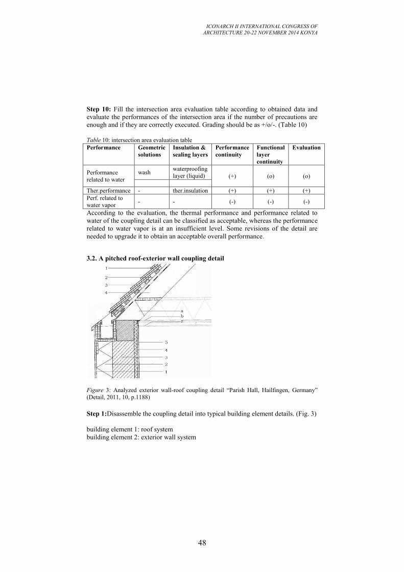
ICONARCH II INTERNATIONAL CONGRESS OF
ARCHITECTURE 20-22 NOVEMBER 2014 KONYA
48
Step 10: Fill the intersection area evaluation table according to obtained data and
evaluate the performances of the intersection area if the number of precautions are
enough and if they are correctly executed. Grading should be as +/o/-. (Table 10)
Table 10: intersection area evaluation table
Performance Geometric
solutions
Insulation &
sealing layers
Performance
continuity
Functional
layer
continuity
Evaluation
Performance
related to water
wash waterproofing
layer (liquid) (+) (o) (o)
Ther.performance - ther.insulation (+) (+) (+)
Perf. related to
water vapor - - (-) (-) (-)
According to the evaluation, the thermal performance and performance related to
water of the coupling detail can be classified as acceptable, whereas the performance
related to water vapor is at an insufficient level. Some revisions of the detail are
needed to upgrade it to obtain an acceptable overall performance.
3.2. A pitched roof-exterior wall coupling detail
Figure 3: Analyzed exterior wall-roof coupling detail “Parish Hall, Hailfingen, Germany”
(Detail, 2011, 10, p.1188)
Step 1:Disassemble the coupling detail into typical building element details. (Fig. 3)
building element 1: roof system
building element 2: exterior wall system
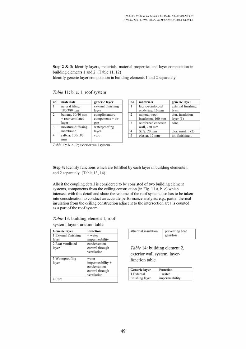
ICONARCH II INTERNATIONAL CONGRESS OF
ARCHITECTURE 20-22 NOVEMBER 2014 KONYA
49
Step 2 & 3: Identify layers, materials, material properties and layer composition in
building elements 1 and 2. (Table 11, 12)
Identify generic layer composition in building elements 1 and 2 separately.
Table 11: b. e. 1; roof system
no materials generic layer
1 natural tiling,
180/380 mm
external finishing
layer
2 battens, 50/40 mm
+ rear ventilated
layer
complimentary
components + air
gap
3 moisture-diffusing
membrane
waterproofing
layer
4 rafters, 100/180
mm
core
Table 12: b. e. 2; exterior wall system
no materials generic layer
1 fabric-reinforced
rendering, 16 mm
external finishing
layer
2 mineral wool
insulation, 160 mm
ther. insulation
layer (1)
3 reinforced concrete
wall, 250 mm
core
4 XPS, 20 mm ther. insul. l. (2)
5 plaster, 15 mm int. finishing l.
Step 4: Identify functions which are fulfilled by each layer in building elements 1
and 2 separately. (Table 13, 14)
Albeit the coupling detail is considered to be consisted of two building element
systems, components from the ceiling construction (in Fig. 11 a, b, c) which
intersect with this detail and share the volume of the roof system also has to be taken
into consideration to conduct an accurate performance analysis. e.g., partial thermal
insulation from the ceiling construction adjacent to the intersection area is counted
as a part of the roof system.
Table 13: building element 1, roof
system, layer-function table
Generic layer Function
1 External finishing
layer
+ water
impermeability
2 Rear ventilated
layer
condensation
control through
ventilation
3 Waterproofing
layer
water
impermeability +
condensation
control through
ventilation
4 Core
athermal insulation preventing heat
gain/loss
Table 14: building element 2,
exterior wall system, layer-
function table
Generic layer Function
1 External
finishing layer
+ water
impermeability
ICONARCH II INTERNATIONAL CONGRESS OF
ARCHITECTURE 20-22 NOVEMBER 2014 KONYA
50
2 Ther.insulation
layer (1)
preventing heat
gain/loss
3 Core + heat storage
4 Thermal
insulation layer
(2)
preventing heat
gain/loss + avoid
thermal bridges +
preventing surface
condensation
5 Internal
finishing layer
Step 5: Determine if a functional layer has multiple functions for building elements
1 and 2 separately.
b. e. 1: roof system
1 External finishing layer
3 Waterproofing layer
b. e. 2: exterior wall system
1 External finishing layer
3 Core
4 Thermal insulation layer (2)
Step 6: Prepare a list for required performances for the intersection area “3”.
Performance related to water:
Impermeability to precipitation
Impermeabilityto wind-driven rain
Thermal performance:
Low thermal conductivity
Heat storage
Avoid thermal bridges
Performance related to water vapor:
Prevention of interstitial cond.
Prevention of surface condensation
Step 7: Check the continuity of functional layers from building elements 1 and 2 at
intersection area 3.They can be either continuous, or discontinuous, or interrupted.
(Table 15)
Table 15: Functional layer continuity table
1, roof system 2, exterior wall sys. 3 intersection area
1 External finishing layer 1 Ext. finishing layer interrupted
2 Rear ventilated layer - discontinuous
3 Waterproofing layer - discontinuous
4 Core 3 Core continuous
a- Thermal insulation layer
(from the ceiling construction)
2, 4 Ther. insulation
layer (1&2)
continuous
b- Vapor-retarding layer (from
the ceiling construction)
- discontinuous
c- Internal finishing layer (from
the ceiling construction)
5 Internal finishing
layer
continuous
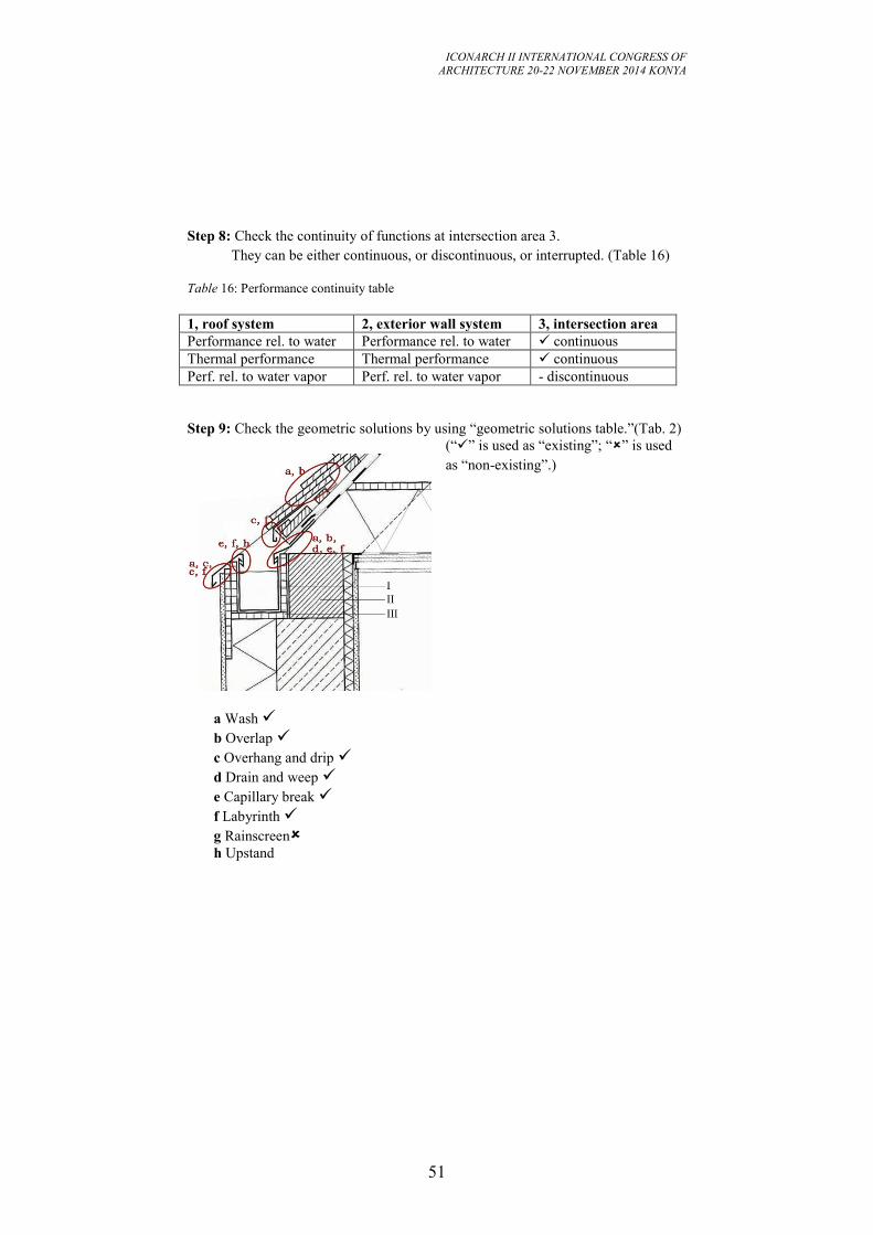
ICONARCH II INTERNATIONAL CONGRESS OF
ARCHITECTURE 20-22 NOVEMBER 2014 KONYA
51
Step 8: Check the continuity of functions at intersection area 3.
They can be either continuous, or discontinuous, or interrupted. (Table 16)
Table 16: Performance continuity table
1, roof system 2, exterior wall system 3, intersection area
Performance rel. to water Performance rel. to water continuous
Thermal performance Thermal performance continuous
Perf. rel. to water vapor Perf. rel. to water vapor - discontinuous
Step 9: Check the geometric solutions by using “geometric solutions table.”(Tab. 2)
(“” is used as “existing”; “” is used
as “non-existing”.)
a Wash
b Overlap
c Overhang and drip
d Drain and weep
e Capillary break
f Labyrinth
g Rainscreen
h Upstand
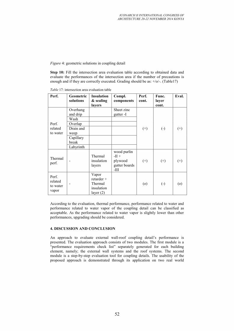
ICONARCH II INTERNATIONAL CONGRESS OF
ARCHITECTURE 20-22 NOVEMBER 2014 KONYA
52
Figure 4: geometric solutions in coupling detail
Step 10: Fill the intersection area evaluation table according to obtained data and
evaluate the performances of the intersection area if the number of precautions is
enough and if they are correctly executed. Grading should be as: +/o/-. (Table17)
Table 17: intersection area evaluation table
Perf. Geometric
solutions
Insulation
& sealing
layers
Compl.
components
Perf.
cont.
Func.
layer
cont.
Eval.
Perf.
related
to water
Overhang
and drip
Sheet zinc
gutter -I
(+) (-) (+)
Wash
Overlap
Drain and
weep
Capillary
break
Labyrinth
Thermal
perf. -
Thermal
insulation
layers
wood purlin
-II +
plywood
gutter boards
-III
(+) (+) (+)
Perf.
related
to water
vapor
-
Vapor
retarder +
Thermal
insulation
layer (2)
(o) (-) (o)
According to the evaluation, thermal performance, performance related to water and
performance related to water vapor of the coupling detail can be classified as
acceptable. As the performance related to water vapor is slightly lower than other
performances, upgrading should be considered.
4. DISCUSSION AND CONCLUSION
An approach to evaluate external wall-roof coupling detail’s performance is
presented. The evaluation approach consists of two modules. The first module is a
“performance requirements check list” separately generated for each building
element, namely; the external wall systems and the roof systems. The second
module is a step-by-step evaluation tool for coupling details. The usability of the
proposed approach is demonstrated through its application on two real world
ICONARCH II INTERNATIONAL CONGRESS OF
ARCHITECTURE 20-22 NOVEMBER 2014 KONYA
53
problems. The evaluation approach is to be used in the design process as a design
review tool to avoid building failures caused by faulty design.
Futures of the evaluation tool are as follows:
The tool is established upon investigating existing details, so it is also a
means to analyze how an architect works on a detail and what he/she thinks
while designing. In other words, the proposed tool reveals the “nature” of
design and helps to understand how a detail is “born”.
The tool provides an explicitly organized, rationalized method that
complicated detailing process becomes clear for the architect at design
stage.
The tool does not only evaluate a coupling detail of two building elements,
it also evaluates the typical building element details.
It shows that fulfillment of performances at intersection area depends on
the performances existing in typical building element details and their
continuity at intersection areas.
If a coupling detail is regarded as not sufficient according to the evaluation,
hints can be found in the evaluation table, for feed-back and redesigning the
detail.
Since the module is based on ranking and scaling methods, self-evaluation
is easy for designers.
Still, there are some flaws or some points to fulfill:
In the grading step of the evaluation tool, a certain level of expertise on
related areas is required.
The analyzing module, if necessary, should be quantitative for more precise
evaluation.
The evaluation tool should also be extended to cover all types of building
elements and sub-systems and their combinations in creating coupling
details.
The development of the tool continues with respect to the findings from the
applications.
ICONARCH II INTERNATIONAL CONGRESS OF
ARCHITECTURE 20-22 NOVEMBER 2014 KONYA
54
REFERENCES
-Allen, E. 1993. Architectural detailing: Function, constructability, aesthetics. New
York: John Wiley & Sons.
-Beinhauer, P. 2013. Standard-Detail-Sammlung: Neubau, Köln: Verlagsgesellschaft
Rudolf Müller.
-Emmitt, S. 2004. Principles of architectural detailing. Oxford: Blackwell Pub.
-Jones, C. J. 1992. Design methods. New York: Van Nostrand Reinhold.
-Knaack, U., Klein, T., Bilow, M. and Auer, T. 2007. Façades: Principles of
construction. Basel: Birkhäuser Verlag.
-Lückmann, R. 2011. Baudetail-Atlas-Hochbau. Kissing: Weka.
-Moro, J. L., Rottner, M., Alihodzic, B. and Weissbach, M. 2009. Baukonstruktion
vom Prinzip zum Detail, Band 3. Berlin: Springer-Verlag.
-Olie, J. 2011. Detail and change: a sustainable development in architecture. 10th
International detail design in architecture conference, ddia10, Proceedings. Istanbul,
Istanbul Technical University. pp 283-292.
-Rush, Richard D. 1986. The building systems integration handbook. New York:
John Wiley & Sons.
-Schild, E. [et al.] 1977-84. Schwachstellen: Schäden, Ursachen, Konstruktions- und
Ausführungsempfehlungen, Band I, II, III, IV, V. Wiesbaden: Bauverlag.
- Schittich, C. (ed.) 2008. Wohnhaus in Zürich. Detail,1/2 (2008), pp. 32-35.
- Schittich, C. (ed.) 2011. Parish Hall in Hailfingen. Detail, 10 (2011), pp. 1186-
1189.
ICONARCH II INTERNATIONAL CONGRESS OF
ARCHITECTURE 20-22 NOVEMBER 2014 KONYA
55
IMPACT OF ENERGY ORIENTED MEASURES OVER CO2
EMISSIONS OF A THERMALLY INSULATED LOW-RISE
APARTMENT BUILDING IN IZMIR, TURKEY
MÜMİNE GERÇEK1
ZEYNEP DURMUŞ ARSAN2
ABSTRACT
Climate change has drawn the attention of many researchers and practitioners to
focus on the methods to address the challenges in achieving low-carbon buildings
and cities and in future developments. Nevertheless, few studies have explored the
impacts of thermal mass applications for the lowest carbon emissions of building
operational energy consumption. A comparative study of CO2 emissions due to
different wall and floor compositions is presented in accordance with their lifespans
for a hot-humid climate site. Aim of this study is to examine the relation between the
energy oriented operations and carbon emissions of the building. Firstly, an existing
low-rise building in İzmir is selected, then modelled in the dynamic simulation
model software DesignBuilder v4 by synchronizing drawings with basic operational
principles of the program. Furthermore, various influence factors of building
envelope thermal characteristics are selected as follows: type, location, thickness
and thermal specifications of materials used by keeping thermal conductivity value
constant. Selection of optimal CO2 emission case would be investigated based on the
simulation results. The research would provide further information about variable
CO2 emission levels depending on the changes in building envelope of a thermally
insulated building.
Keywords: Housing, CO2 emission, Thermal mass, Energy efficiency
1 Mümine GERÇEK, Izmir Institute of Technology, Department of Architecture, İZMİR
2 Dr. Zeynep DURMUŞ ARSAN, Izmir Institute of Technology, Department of Architecture, İZMİR
ICONARCH II INTERNATIONAL CONGRESS OF
ARCHITECTURE 20-22 NOVEMBER 2014 KONYA
56
1. INTRODUCTION
In many countries, energy consumption of buildings is 25–40% of the total energy
consumption, in which most of the energy is used for space heating or cooling (i.e.,
air-conditioning) of buildings (Zeng et al. 2011). The huge energy consumption for
heating or cooling buildings not only demands valuable fossil fuel resources, but
also emits a huge amount of CO2 and other pollutants into the atmosphere. In fact,
studies related to energy efficient buildings are of great importance all around the
world. For example, Turkey paid $60.1 billion for energy exports and the
dependence on foreign energy sources reached 72% in 2012, based on data from the
Ministry of Energy and Natural Resources (MENR) and Turkish Statistical Institute
(TUIK). Annual average energy demand saw an increase as 4.6%, while remaining
at 1.6% in EU member states after the 1990s (Düzgün and Kömürgöz 2014). This
creates the energy oriented approach where minimization of energy consumption is
the main target. When the amount of CO2 released in building is the main indicator
for reaching sustainability, the energy measures taken for achieving required heat
transmittance coefficient (U) value may contradict with the targets for minimization
of CO2 emissions.
There are different ways to reduce mechanical energy needs of buildings, which are
shading, control of daytime ventilation, and use of better thermal mass qualities
(CIBSE TM 36 2005). This paper focuses on thermal mass which is related with the
heat gain of a building.
Thermal capacitance is the amount of heat required for a unit temperature change in
material’s temperature. It is also necessary to examine the time required for
materials response to heat gain. Hence, thermal mass is associated with the building
time constant )/( AUcmtc , which explains the speed of building reaction
to incoming heat as well as its thermal capacitance. In other words, transformation
of mass into volume and density )( Vm , time constant formula is defined as:
ni
li
ii
i
ni
li
ii
c
AU
cV
t
)(
Eq(1)
So that, increasing density, volume, specific heat, and reducing overall conductance-
area product of the building (UA) will also increase time constant and thermal mass.
Decisions about placement of thermal mass is also considered in order to increase its
exposure to solar heat gains. In this content, primary and secondary thermal mass
issues take place where exposure to solar heat input straightforward describes
primary, while exposure to internal heat input is observed as well as heat transfer
with air conditioning system in secondary thermal mass.
In buildings, thermal mass is typically provided by heavyweight materials such as
brick, stone or earth-based materials. Although inclusion of thermal mass in this way
has thermal benefits, it is important to compare them in order to investigate better
options. For example, the impact of thermal mass on the thermal performance of
ICONARCH II INTERNATIONAL CONGRESS OF
ARCHITECTURE 20-22 NOVEMBER 2014 KONYA
57
several types of Australian residential construction was examined numerically using
the AccuRate energy rating tool. The performance of each construction type was
evaluated using four different hypothetical building envelopes, referred to here as
building modules. It was found that the thermal mass had a dramatic impact on the
thermal behaviour of the modules studied, particularly in those where the thermal
mass was within a protective envelope of insulation. The RBV and CB constructions
were found to be the most effective walling systems in this regard (Gregory et al.
2008). Then, analysis of the effect of several wall and building design features on
the energy savings is seen owing to thermal mass in exterior walls of residential
buildings. Thermal mass effects on annual heating and cooling loads were analysed
in 12 climates for three types of exterior walls including insulation placement and U
value variations. The study highlights the heating and cooling load decreases due to
various interactions between parameters affecting thermal mass (Byrne and
Ritschard 1985). Later on, construction materials studies with regard to life-cycle
assessment and CO2 emissions as energy efficiency criteria are also included into
researches. The actual building was being constructed in concrete, and two further
versions were designed with steel or timber structures and finishes. Besides, large
quantities of finish materials were common to all three buildings. Both energy use
and CO2 emissions have been assessed over three main stages in the life of a
building: initial production of the building materials; operation of the building; and
the refurbishment and maintenance of the building materials over the building's
effective life. DesignBuilder software was used to estimate whole life-cycle energy
used and CO2 emitted in the operation of the buildings over a period of 60 years.
The results showed that operating CO2 emissions were majority of life-cycle CO2
emissions, instead of total embodied emissions. The findings were of significance, in
the assessment and weighting of the embodied energy and embodied CO2
components of building sustainable rating tools (Fernandez 2008).
However, these kind of researches do not fulfil the need for focusing on the relation
between thermal specifications of building and carbon emissions of residential
buildings in Turkey. In this context, the specific objective of the present study is to
investigate how thermal mass influences building behaviour and CO2 emissions.
Furthermore, this investigation allows determining the effects of low carbon
building design on heat absorption capabilities of building envelope.
A flat located in thermally insulated low-rise apartment building in Izmir, created in
DesingBuilder v4. is used to investigate how different materials influence building
thermal behaviour and environmental performance. Eighteen scenarios are
developed over the modifications of thermal mass characteristics through which
insulation layer placement, material type, location and thickness are combined for
floor, partitions and exterior walls. In order to compare like with like, the overall
conductance-area product UA is kept the same for different comparison scenarios.
At the end, this paper presents the influence of material types on reducing energy
demands and improving energy rating. Besides, it shows the important impact of the
lifespans of materials on embodied and operational CO2 emissions on residential
buildings.
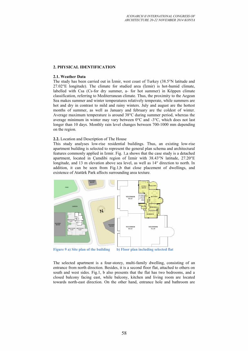
ICONARCH II INTERNATIONAL CONGRESS OF
ARCHITECTURE 20-22 NOVEMBER 2014 KONYA
58
2. PHYSICAL IDENTIFICATION
2.1. Weather Data
The study has been carried out in İzmir, west coast of Turkey (38.5°N latitude and
27.02°E longitude). The climate for studied area (İzmir) is hot-humid climate,
labelled with Csa (Cs-for dry summer, a- for hot summer) in Köppen climate
classification, referring to Mediterranean climate. Thus, the proximity to the Aegean
Sea makes summer and winter temperatures relatively temperate, while summers are
hot and dry in contrast to mild and rainy winters. July and august are the hottest
months of summer, as well as January and february are the coldest of winter.
Average maximum temperature is around 38°C during summer period, whereas the
average minimum in winter may vary between 0°C and -3°C, which does not last
longer than 10 days. Monthly rain level changes between 700-1000 mm depending
on the region.
2.2. Location and Description of The House
This study analyses low-rise residential buildings. Thus, an existing low-rise
apartment building is selected to represent the general plan schema and architectural
features commonly applied in Izmir. Fig. 1,a shows that the case study is a detached
apartment, located in Çamdibi region of İzmir with 38.43°N latitude, 27.20°E
longitude, and 13 m elevation above sea level, as well as 14° direction to north. In
addition, it can be seen from Fig.1,b that close placement of dwellings, and
existence of Atatürk Park affects surrounding area texture.
Figure 9 a) Site plan of the building b) Floor plan including selected flat
The selected apartment is a four-storey, multi-family dwelling, consisting of an
entrance from north direction. Besides, it is a second floor flat, attached to others on
south and west sides. Fig.1, b also presents that the flat has two bedrooms, and a
closed balcony facing east, while balcony, kitchen and living room are located
towards north-east direction. On the other hand, entrance hole and bathroom are
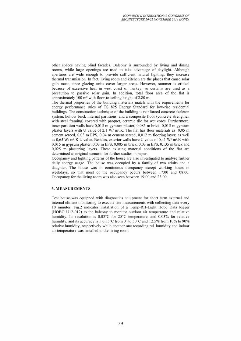
ICONARCH II INTERNATIONAL CONGRESS OF
ARCHITECTURE 20-22 NOVEMBER 2014 KONYA
59
other spaces having blind facades. Balcony is surrounded by living and dining
rooms, while large openings are used to take advantage of daylight. Although
apertures are wide enough to provide sufficient natural lighting, they increase
thermal transmission. In fact, living room and kitchen are the places that cause solar
gain most, since glazing units cover larger areas. However, summer is critical
because of excessive heat in west coast of Turkey, so curtains are used as a
precaution to passive solar gain. In addition, total floor area of the flat is
approximately 100 m² with floor-to-ceiling height of 2.80 m.
The thermal properties of the building materials match with the requirements for
energy performance rules of TS 825 Energy Standard for low-rise residential
buildings. The construction technique of the building is reinforced concrete skeleton
system, hollow brick internal partitions, and a composite floor (concrete strengthen
with steel framing) covered with parquet, ceramic tile for wet cores. Furthermore,
inner partition walls have 0,015 m gypsum plaster, 0,085 m brick, 0,015 m gypsum
plaster layers with U value of 2,1 W/ m².K. The flat has floor materials as 0,05 m
cement screed, 0,03 m EPS, 0,04 m cement screed, 0,012 m flooring layer; as well
as 0,65 W/ m².K U value. Besides, exterior walls have U value of 0,41 W/ m².K with
0,015 m gypsum plaster, 0,03 m EPS, 0,085 m brick, 0,03 m EPS, 0,135 m brick and
0,025 m plastering layers. These existing material conditions of the flat are
determined as original scenario for further studies in paper.
Occupancy and lighting patterns of the house are also investigated to analyse further
daily energy usage. The house was occupied by a family of two adults and a
daughter. The house was in continuous occupancy except working hours in
weekdays, so that most of the occupancy occurs between 17:00 and 08:00.
Occupancy for the living room was also seen between 19:00 and 23:00.
3. MEASUREMENTS
Test house was equipped with diagnostics equipment for short term external and
internal climate monitoring to execute site measurements with collecting data every
10 minutes. Fig.2 indicates installation of a Temp-RH-Light Hobo Data logger
(HOBO U12-012) to the balcony to monitor outdoor air temperature and relative
humidity. Its resolution is 0.03°C for 25°C temperature, and 0.03% for relative
humidity, and its accuracy is ± 0.35°C from 0° to 50°C and ±2.5% from 10% to 90%
relative humidity, respectively while another one recording rel. humidity and indoor
air temperature was installed to the living room.
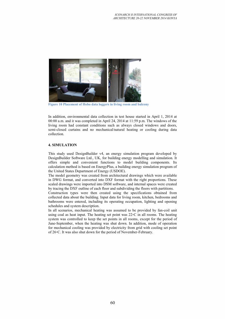
ICONARCH II INTERNATIONAL CONGRESS OF
ARCHITECTURE 20-22 NOVEMBER 2014 KONYA
60
Figure 10 Placement of Hobo data loggers in living room and balcony
In addition, environmental data collection in test house started in April 1, 2014 at
00:00 a.m. and it was completed in April 24, 2014 at 11:59 p.m. The windows of the
living room had constant conditions such as always closed windows and doors,
semi-closed curtains and no mechanical/natural heating or cooling during data
collection.
4. SIMULATION
This study used DesignBuilder v4, an energy simulation program developed by
DesignBuilder Software Ltd., UK, for building energy modelling and simulation. It
offers simple and convenient functions to model building components. Its
calculation method is based on EnergyPlus, a building energy simulation program of
the United States Department of Energy (USDOE).
The model geometry was created from architectural drawings which were available
in DWG format, and converted into DXF format with the right proportions. These
scaled drawings were imported into DSM software, and internal spaces were created
by tracing the DXF outline of each floor and subdividing the floors with partitions.
Construction types were then created using the specifications obtained from
collected data about the building. Input data for living room, kitchen, bedrooms and
bathrooms were entered, including its operating occupation, lighting and opening
schedules and system description.
In all scenarios, mechanical heating was assumed to be provided by fan-coil unit
using coal as heat input. The heating set point was 22◦C in all rooms. The heating
system was controlled to keep the set points in all rooms, except for the period of
June-September, when the heating was shut down. In addition, mode of operation
for mechanical cooling was provided by electricity from grid with cooling set point
of 26◦C. It was also shut down for the period of November-February.
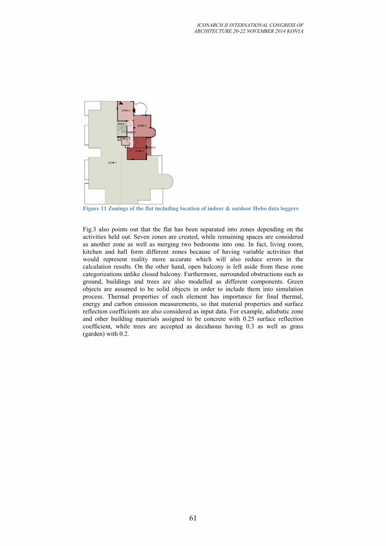
ICONARCH II INTERNATIONAL CONGRESS OF
ARCHITECTURE 20-22 NOVEMBER 2014 KONYA
61
Figure 11 Zonings of the flat including location of indoor & outdoor Hobo data loggers
Fig.3 also points out that the flat has been separated into zones depending on the
activities held out. Seven zones are created, while remaining spaces are considered
as another zone as well as merging two bedrooms into one. In fact, living room,
kitchen and hall form different zones because of having variable activities that
would represent reality more accurate which will also reduce errors in the
calculation results. On the other hand, open balcony is left aside from these zone
categorizations unlike closed balcony. Furthermore, surrounded obstructions such as
ground, buildings and trees are also modelled as different components. Green
objects are assumed to be solid objects in order to include them into simulation
process. Thermal properties of each element has importance for final thermal,
energy and carbon emission measurements, so that material properties and surface
reflection coefficients are also considered as input data. For example, adiabatic zone
and other building materials assigned to be concrete with 0.25 surface reflection
coefficient, while trees are accepted as deciduous having 0.3 as well as grass
(garden) with 0.2.
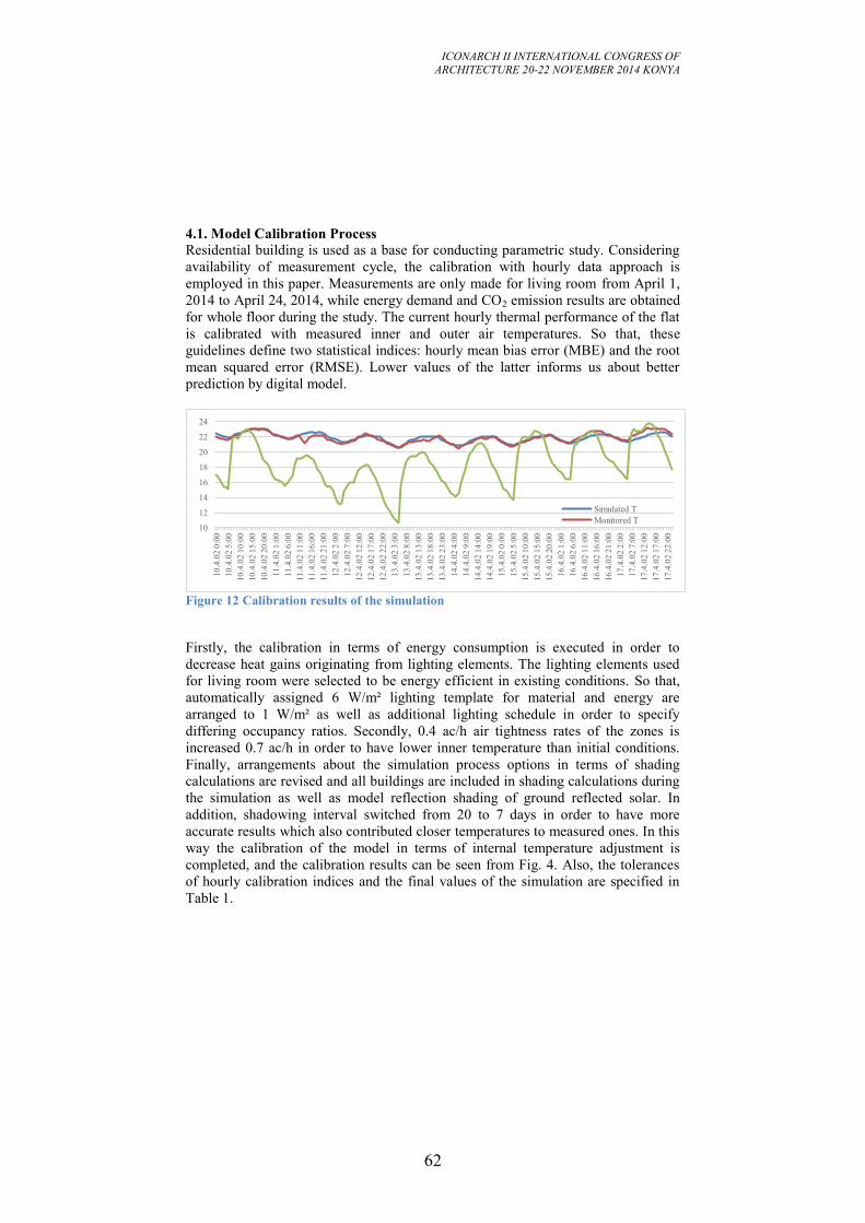
ICONARCH II INTERNATIONAL CONGRESS OF
ARCHITECTURE 20-22 NOVEMBER 2014 KONYA
62
4.1. Model Calibration Process
Residential building is used as a base for conducting parametric study. Considering
availability of measurement cycle, the calibration with hourly data approach is
employed in this paper. Measurements are only made for living room from April 1,
2014 to April 24, 2014, while energy demand and CO2 emission results are obtained
for whole floor during the study. The current hourly thermal performance of the flat
is calibrated with measured inner and outer air temperatures. So that, these
guidelines define two statistical indices: hourly mean bias error (MBE) and the root
mean squared error (RMSE). Lower values of the latter informs us about better
prediction by digital model.
Figure 12 Calibration results of the simulation
Firstly, the calibration in terms of energy consumption is executed in order to
decrease heat gains originating from lighting elements. The lighting elements used
for living room were selected to be energy efficient in existing conditions. So that,
automatically assigned 6 W/m² lighting template for material and energy are
arranged to 1 W/m² as well as additional lighting schedule in order to specify
differing occupancy ratios. Secondly, 0.4 ac/h air tightness rates of the zones is
increased 0.7 ac/h in order to have lower inner temperature than initial conditions.
Finally, arrangements about the simulation process options in terms of shading
calculations are revised and all buildings are included in shading calculations during
the simulation as well as model reflection shading of ground reflected solar. In
addition, shadowing interval switched from 20 to 7 days in order to have more
accurate results which also contributed closer temperatures to measured ones. In this
way the calibration of the model in terms of internal temperature adjustment is
completed, and the calibration results can be seen from Fig. 4. Also, the tolerances
of hourly calibration indices and the final values of the simulation are specified in
Table 1.
10
12
14
16
18
20
22
24
10.4
.02 0
:00
10.4
.02 5
:00
10.4
.02 1
0:0
0
10.4
.02 1
5:0
0
10.4
.02 2
0:0
0
11.4
.02 1
:00
11.4
.02 6
:00
11.4
.02 1
1:0
0
11.4
.02 1
6:0
0
11.4
.02 2
1:0
0
12.4
.02 2
:00
12.4
.02 7
:00
12.4
.02 1
2:0
0
12.4
.02 1
7:0
0
12.4
.02 2
2:0
0
13.4
.02 3
:00
13.4
.02 8
:00
13.4
.02 1
3:0
0
13.4
.02 1
8:0
0
13.4
.02 2
3:0
0
14.4
.02 4
:00
14.4
.02 9
:00
14.4
.02 1
4:0
0
14.4
.02 1
9:0
0
15.4
.02 0
:00
15.4
.02 5
:00
15.4
.02 1
0:0
0
15.4
.02 1
5:0
0
15.4
.02 2
0:0
0
16.4
.02 1
:00
16.4
.02 6
:00
16.4
.02 1
1:0
0
16.4
.02 1
6:0
0
16.4
.02 2
1:0
0
17.4
.02 2
:00
17.4
.02 7
:00
17.4
.02 1
2:0
0
17.4
.02 1
7:0
0
17.4
.02 2
2:0
0
Simulated T
Monitored T
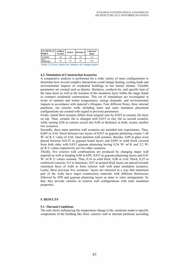
ICONARCH II INTERNATIONAL CONGRESS OF
ARCHITECTURE 20-22 NOVEMBER 2014 KONYA
63
Table 2 Error ratios for indoor air temperature
4.2. Simulation of Construction Scenarios
A comparative analysis is performed for a wide variety of mass configurations to
determine how several complex interactions could change heating, cooling loads and
environmental impacts of residential buildings in hot humid climate. Variable
parameters are created such as density, thickness, conductivity, and specific heat of
the mass layer as well as the location of the insulation layer within the range found
in common residential constructions. This set of simulations are investigated in
terms of summer and winter temperatures, energy demands, and environmental
impacts in accordance with material’s lifespans. Four different floors, three internal
partitions, ten exterior walls including inner and outer insulation placement
configurations are created with regard to previous parameters.
Firstly, initial floor scenario differs from original case by 0,025 m ceramic tile layer
on top. Then, ceramic tile is changed with 0,015 m clay tile as second scenario,
while turning 0,04 m cement screed into 0,08 m thickness in both, creates another
two scenarios.
Secondly, three inner partition wall scenarios are included into experiments. Thus,
0,085 m AAC block between two layers of 0,015 m gypsum plastering creates 1,48
W/ m².K U value of AAC inner partition wall scenario. Besides, 0,09 m glass wool
placed between 0,0125 m gypsum board layers and 0,085 m solid brick covered
from both sides with 0,015 gypsum plastering having 0,36 W/ m².K and 2,2 W/
m².K U values respectively are two other scenarios.
Thirdly, five exterior wall combinations are produced by changing major wall
material as well as keeping 0,08 m EPS, 0,015 m gypsum plastering layers and 0,41
W/ m².K U values constant. Thus, 0,16 m solid brick, 0,06 m AAC block, 0,55 m
reinforced concrete, 0,5 m limestone, 0,07 m aerated brick layers are placed towards
outermost faces of walls to form exterior wall with inner insulation scenarios.
Lastly, these previous five scenarios’ layers are mirrored in a way that innermost
part of the walls have major construction materials with different thicknesses
followed by EPS and gypsum plastering layers as inner to outer arrangement. So
that, they provide varieties in exterior wall configurations with outer insulation
properties.
5. RESULTS
5.1. Thermal Conditions
The only factor influencing the temperature change is the variations made to specific
components of the building like floor, exterior wall or internal partitions according
ASHRAE
14-2002IPMVP MVFEM P
Calibrated
Model
MBE ±10 ±20 ±10 -1,3
RMSE 30 20 30 2,81
STATISTICAL
INDICE
ho
url
y
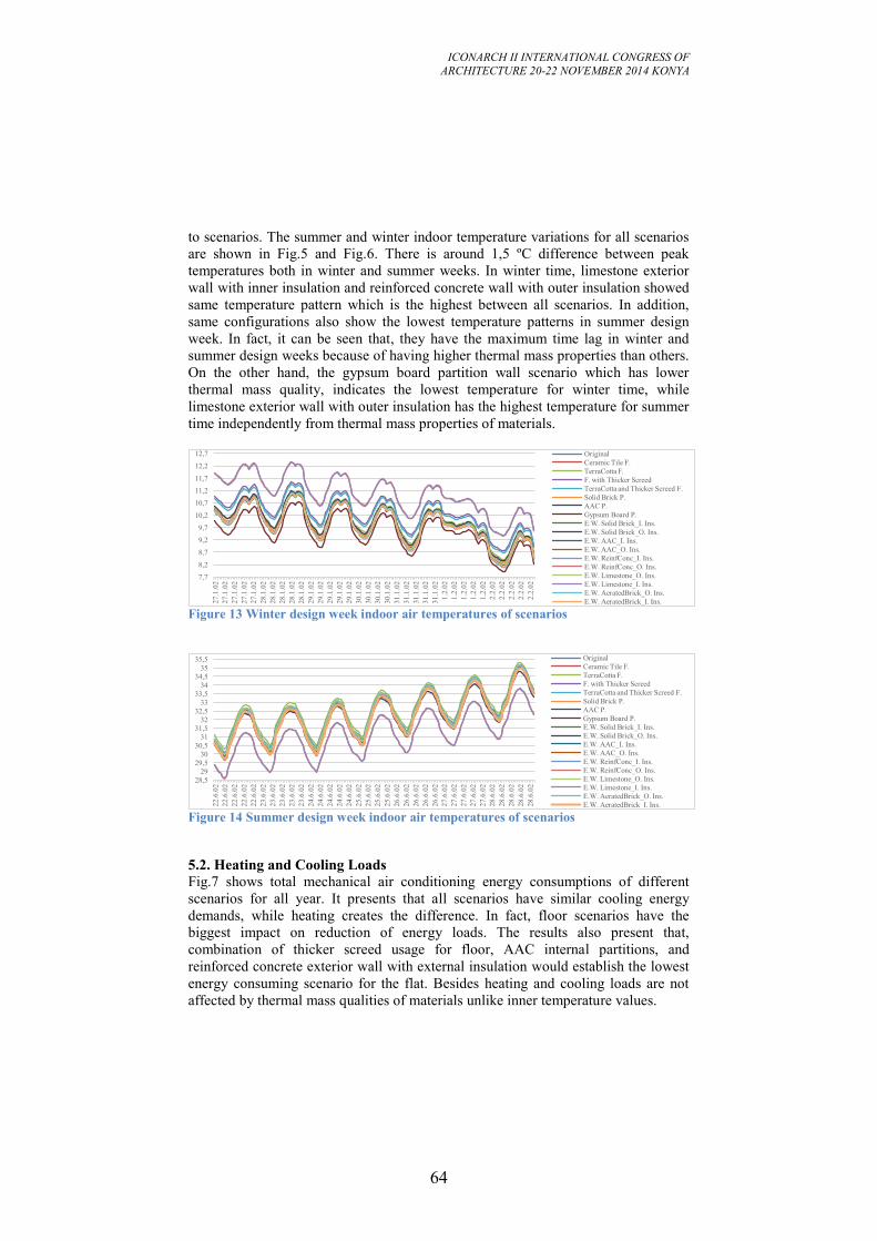
ICONARCH II INTERNATIONAL CONGRESS OF
ARCHITECTURE 20-22 NOVEMBER 2014 KONYA
64
to scenarios. The summer and winter indoor temperature variations for all scenarios
are shown in Fig.5 and Fig.6. There is around 1,5 ºC difference between peak
temperatures both in winter and summer weeks. In winter time, limestone exterior
wall with inner insulation and reinforced concrete wall with outer insulation showed
same temperature pattern which is the highest between all scenarios. In addition,
same configurations also show the lowest temperature patterns in summer design
week. In fact, it can be seen that, they have the maximum time lag in winter and
summer design weeks because of having higher thermal mass properties than others.
On the other hand, the gypsum board partition wall scenario which has lower
thermal mass quality, indicates the lowest temperature for winter time, while
limestone exterior wall with outer insulation has the highest temperature for summer
time independently from thermal mass properties of materials.
Figure 13 Winter design week indoor air temperatures of scenarios
Figure 14 Summer design week indoor air temperatures of scenarios
5.2. Heating and Cooling Loads
Fig.7 shows total mechanical air conditioning energy consumptions of different
scenarios for all year. It presents that all scenarios have similar cooling energy
demands, while heating creates the difference. In fact, floor scenarios have the
biggest impact on reduction of energy loads. The results also present that,
combination of thicker screed usage for floor, AAC internal partitions, and
reinforced concrete exterior wall with external insulation would establish the lowest
energy consuming scenario for the flat. Besides heating and cooling loads are not
affected by thermal mass qualities of materials unlike inner temperature values.
7,7
8,2
8,7
9,2
9,7
10,2
10,7
11,2
11,7
12,2
12,7
27
.1.0
2
27
.1.0
2
27
.1.0
2
27
.1.0
2
27
.1.0
2
28
.1.0
2
28
.1.0
2
28
.1.0
2
28
.1.0
2
28
.1.0
2
29
.1.0
2
29
.1.0
2
29
.1.0
2
29
.1.0
2
29
.1.0
2
30
.1.0
2
30
.1.0
2
30
.1.0
2
30
.1.0
2
31
.1.0
2
31
.1.0
2
31
.1.0
2
31
.1.0
2
31
.1.0
2
1.2
.02
1.2
.02
1.2
.02
1.2
.02
1.2
.02
2.2
.02
2.2
.02
2.2
.02
2.2
.02
2.2
.02
Original
Ceramic Tile F.
TerraCotta F.
F. with Thicker Screed
TerraCotta and Thicker Screed F.
Solid Brick P.
AAC P.
Gypsum Board P.
E.W. Solid Brick_I. Ins.
E.W. Solid Brick_O. Ins.
E.W. AAC_I. Ins.
E.W. AAC_O. Ins.
E.W. ReinfConc_I. Ins.
E.W. ReinfConc_O. Ins.
E.W. Limestone_O. Ins.
E.W. Limestone_I. Ins.
E.W. AeratedBrick_O. Ins.
E.W. AeratedBrick_I. Ins.
28,5
29
29,5
30
30,5
31
31,5
32
32,5
33
33,5
34
34,5
35
35,5
22.6
.02
22.6
.02
22.6
.02
22.6
.02
22.6
.02
23.6
.02
23.6
.02
23.6
.02
23.6
.02
23.6
.02
24.6
.02
24.6
.02
24.6
.02
24.6
.02
24.6
.02
25.6
.02
25.6
.02
25.6
.02
25.6
.02
26.6
.02
26.6
.02
26.6
.02
26.6
.02
26.6
.02
27.6
.02
27.6
.02
27.6
.02
27.6
.02
27.6
.02
28.6
.02
28.6
.02
28.6
.02
28.6
.02
28.6
.02
Original
Ceramic Tile F.
TerraCotta F.
F. with Thicker Screed
TerraCotta and Thicker Screed F.
Solid Brick P.
AAC P.
Gypsum Board P.
E.W. Solid Brick_I. Ins.
E.W. Solid Brick_O. Ins.
E.W. AAC_I. Ins.
E.W. AAC_O. Ins.
E.W. ReinfConc_I. Ins.
E.W. ReinfConc_O. Ins.
E.W. Limestone_O. Ins.
E.W. Limestone_I. Ins.
E.W. AeratedBrick_O. Ins.
E.W. AeratedBrick_I. Ins.
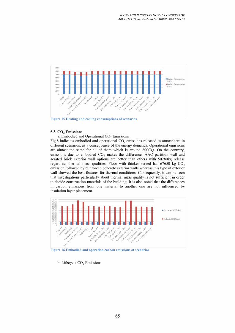
ICONARCH II INTERNATIONAL CONGRESS OF
ARCHITECTURE 20-22 NOVEMBER 2014 KONYA
65
Figure 15 Heating and cooling consumptions of scenarios
5.3. CO2 Emissions
a. Embodied and Operational CO2 Emissions
Fig.8 indicates embodied and operational CO2 emissions released to atmosphere in
different scenarios, as a consequence of the energy demands. Operational emissions
are almost the same for all of them which is around 8000kg. On the contrary,
emissions due to embodied CO2 makes the difference. AAC partition wall and
aerated brick exterior wall options are better than others with 50280kg release
regardless thermal mass qualities. Floor with thicker screed has 67650 kg CO2
emission followed by reinforced concrete exterior walls whereas this type of exterior
wall showed the best features for thermal conditions. Consequently, it can be seen
that investigations particularly about thermal mass quality is not sufficient in order
to decide construction materials of the building. It is also noted that the differences
in carbon emissions from one material to another one are not influenced by
insulation layer placement.
Figure 16 Embodied and operation carbon emissions of scenarios
b. Lifecycle CO2 Emissions
0
2000
4000
6000
8000
10000
12000
14000
16000
Heating Consumption
(kWh)
Cooling Consumption
(kWh)
0 5000
10000 15000 20000 25000 30000 35000 40000 45000 50000 55000 60000 65000 70000
Operational CO2 (kg)
Embodied CO2 (kg)
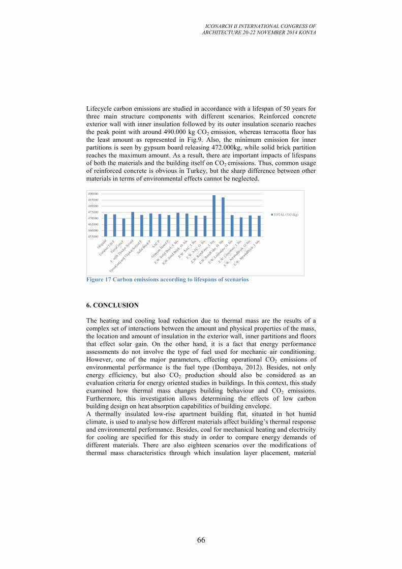
ICONARCH II INTERNATIONAL CONGRESS OF
ARCHITECTURE 20-22 NOVEMBER 2014 KONYA
66
Lifecycle carbon emissions are studied in accordance with a lifespan of 50 years for
three main structure components with different scenarios. Reinforced concrete
exterior wall with inner insulation followed by its outer insulation scenario reaches
the peak point with around 490.000 kg CO2 emission, whereas terracotta floor has
the least amount as represented in Fig.9. Also, the minimum emission for inner
partitions is seen by gypsum board releasing 472.000kg, while solid brick partition
reaches the maximum amount. As a result, there are important impacts of lifespans
of both the materials and the building itself on CO2 emissions. Thus, common usage
of reinforced concrete is obvious in Turkey, but the sharp difference between other
materials in terms of environmental effects cannot be neglected.
Figure 17 Carbon emissions according to lifespans of scenarios
6. CONCLUSION
The heating and cooling load reduction due to thermal mass are the results of a
complex set of interactions between the amount and physical properties of the mass,
the location and amount of insulation in the exterior wall, inner partitions and floors
that effect solar gain. On the other hand, it is a fact that energy performance
assessments do not involve the type of fuel used for mechanic air conditioning.
However, one of the major parameters, effecting operational CO2 emissions of
environmental performance is the fuel type (Dombaya, 2012). Besides, not only
energy efficiency, but also CO2 production should also be considered as an
evaluation criteria for energy oriented studies in buildings. In this context, this study
examined how thermal mass changes building behaviour and CO2 emissions.
Furthermore, this investigation allows determining the effects of low carbon
building design on heat absorption capabilities of building envelope.
A thermally insulated low-rise apartment building flat, situated in hot humid
climate, is used to analyse how different materials affect building’s thermal response
and environmental performance. Besides, coal for mechanical heating and electricity
for cooling are specified for this study in order to compare energy demands of
different materials. There are also eighteen scenarios over the modifications of
thermal mass characteristics through which insulation layer placement, material
455000
460000
465000
470000
475000
480000
485000
490000
TOTAL CO2 (kg)
ICONARCH II INTERNATIONAL CONGRESS OF
ARCHITECTURE 20-22 NOVEMBER 2014 KONYA
67
type, location and thickness are combined for floor, partitions and exterior walls.
Comparison is made between same construction element with different
configurations by keeping conductance area product constant in order to compare
like with like
The result of this study reveals that thermal mass has a noticeable affect on thermal
behaviour and CO2 production considering outer walls, inner partitions and floors
together. Besides, it shows the important impact of lifespans of materials on
embodied and operational CO2 emissions on residential buildings.
For further studies, additional mechanical air conditioning or natural ventilation in
order to compare inner temperature results and keeping mass layer thickness while
varying U values of the construction components are also important points to have
more developed results.
ICONARCH II INTERNATIONAL CONGRESS OF
ARCHITECTURE 20-22 NOVEMBER 2014 KONYA
68
REFERENCES
-Byrne, S., and Ritschard, R. "A parametric analysis of thermal mass in residential
buildings." Proceedings of the ASHRAE/DOE/BTECC Conference on Thermal
Performance of the Exterior Envelopes of Buildings. (1985): 2-5.
-CIBSE TM 36, Climate Change and the Indoor Environment of Buildings,
Chartered Institution of Building Services Engineers, 2005.
-Dombaycı, A. "Investigation of the Effect of Thermal Insulation for a Model House
in Cold Regions: A Case Study of Turkey" Environmental Progress & Sustainable
Energy. (2013): 527-537.
-Duzgun, B., and Komurgoz, G. "Turkey’s energy efficiency assessment: White
Certificates Systems and their applicability in Turkey." Energy Policy. (2014): 465-
474.
-Fernandez, N. "The influence of construction materials on life-cycle energy use and
carbon dioxide emissions of medium size commercial buildings." MSc, Victoria
University of Wellington, 2008.
-Gregory, C., Moghtaderi, B., Sugo, H. and Page, A. "Effect of thermal mass on the
thermal performance of various Australian residential constructions
systems." Energy and Buildings. (2008): 459-65.
-Zeng, R., Wang, X., Di, H., Feng, J. and Yinping, Z. "New concepts and approach
for developing energy efficient buildings: Ideal specific heat for building internal
thermal mass." Energy and Buildings. (2011): 1081-1090.
ICONARCH II INTERNATIONAL CONGRESS OF
ARCHITECTURE 20-22 NOVEMBER 2014 KONYA
69
KEYNOTE SPEECH (20 November 2012 Thursday, 13.30-14.00)
Prof. MARCO SALA
“Architecture: The Art of Integration”
ICONARCH II INTERNATIONAL CONGRESS OF
ARCHITECTURE 20-22 NOVEMBER 2014 KONYA
70
ARCHITECTURE: THE ART OF INTEGRATION
MARCO SALA1
ABSTRACT
Bioclimatic Technologies and sustainable design approach can be applied in the
transformation of the natural and built environment at any operational scale. The application of bioclimatic technologies must complete with the conditions of the
environment, in relation to the prevalent objectives to be achieved, such reduction of
energy consumption, improving both winter and summer comfort, improving visual
comfort and natural lighting, indoor comfort and indoor air quality, as well the
sustainable use of water resources and the integration of Renewable Energies in
buildings. Appropriate building envelope remains the main strategy for sustainable design, but
in the mild temperate/mesothermal climates, the rapid changing of outdoor
conditions push toward a dynamic response of envelope parameters to allow the
maintenance of interior good adaptive comfort. To achieve the reduction of energy consumption both in new and existing buildings,
we need the integration among mechanical, architectural and structural approach for
a sustainable design approach.
Sustainable architecture in Mediterranean area meets its roots in traditional culture
and the education of architects and engineers in this part of the world should be
aimed to develop a sustainable approach to design, through the understanding of the
evolution of the architectural technology and local cultural influences with new
models (systems approach, holistic view of the project). Key words: Sustainability, Technology, Energy, Retrofitting, Integration
1 Prof. Marco Sala, University of Florence, Department of Architecture, Firenze, Italy
ICONARCH II INTERNATIONAL CONGRESS OF
ARCHITECTURE 20-22 NOVEMBER 2014 KONYA
71
1. INTRODUCTION
Building components, construction tools and know how did not change a lot during
many centuries while architects and craftsmen shared similar knowledge how to rise
buildings and the local society identified itself in the same architectural culture. With the beginning of last century the rapid growing of new materials, competencies
and energy sources, brought industrial revolution, markets globalization and the
rapid spreading and contamination of different cultures through the world. The new scenario deeply modified traditional design approach and local building
technology and now architects and engineers have at their disposal a large number of
construction systems, building materials and energy choices that allow them to
overcome nearly any problems, with the dangerous feeling that only economical
issue and aesthetic inspiration are the criteria to achieve success. But in the last two decade, a new general concern developed and soon has became a
great ethic approach in every field, up to be recognized as the international global
paradigm that will mark our century: the need to pursue a sustainable future as
strategy that can be applied in every activity aimed to modifies and transform our
world. The growing of construction market, the rapid transformation of our cities and
villages, need new rules and limits, benchmarks and certification to evaluate the
results, guide lines to address planning and design activities. The holistic approach in architecture means the art of integration different
competencies, technologies and materials, to meet project requirements with a
sustainable strategy.
2. “BIOCLIMATIC TECHNOLOGIES”
They are the set of strategies of design and construction, through which it seeks to
achieve the realization of a sustainable architecture, an architecture that using its
formal configuration, technologies, components, materials and equipment, try to
establish an optimal relationship with the surrounding environment so as to reduce
energy consumption and provide the best comfort to the occupants, using as far as
possible natural systems and reducing the use of mechanical systems of the building. This design approach can applied in the transformation of the natural and built
environment at different operational scales: from the size of regional and urban
planning to town and district design, architectural concept, building detailed design,
mechanical plant, up to the choice of building component and to sustainable building
materials and even applied to rules setting and post realization management. Definition of “bioclimatic technologies” can be misleading because it does not
constitute an independent category of technologies applied to construction, but are
the result of a more comprehensive, holistic approach that involves all issues related
to sustainability, and in this meaning includes both the reduction of impacts on the
ICONARCH II INTERNATIONAL CONGRESS OF
ARCHITECTURE 20-22 NOVEMBER 2014 KONYA
72
environment, the amount of energy contained in the components (embodied energy),
the evaluation of their active role in the life of the building, until the final disposal
(life cycle analysis). However, there is a tendency to define “bioclimatic technologies” some applications
where the aims to pursue bioclimatic architecture is more relevant, and these
technologies are mainly related to the building envelope, such as ventilated roof or
façade, winter garden, solar shading systems, light chimneys, ventilation towers, and
so on, but the concept of “bioclimatic technology” must always be compared and
validated by the analysis of its appropriateness with respect to the local context in
which it is used, ie the climatic context and the specific environmental design
intervention and not as a model or a fashion design. For this reason, a bioclimatic technology that is properly applied in Berlin is
certainly not very appropriate when applied in Dubai and vice versa. The choice of appropriate technology may rise from the needs of the specific
building under the current climatic condition.
A possible articulation of bioclimatic technologies in line with the conditions of the
environment, could be made in relation to the prevalent objectives to be achieved.
2.1 Improving winter comfort and the reduction of energy consumption
1. use of solar energy and other renewable energy sources that may be available
through use of the greenhouse effect: form of buildings, optimal orientation of the
building, atriums, conservatories, windows to gain direct, skylights, solar panels,
2. reduction of heat loss through the thermal insulation of the building, dynamic
insulation, controlled ventilation, heat recovery, thermal mass, phase change
materials
3. optimization of heating systems through the selection of heat source (boiler, heat
pump) and the supply network, choice and optimization of heat transfer to the
environment (radiation systems, mixed with air) monitoring systems and optimized
management of all systems (BEMS Building Energy Management System)
2.2 Improving summer comfort and the reduction of energy consumption
1. shielding of solar radiation, shading the building through the form, shading with
vegetation, exterior screening fixed and mobile, pergolas, marquees, green roof
2. natural ventilation and internal exploitation of the prevailing winds, shape and
arrangement of buildings, cross ventilation, chimneys and towers of ventilation,
ventilation openings, design of fixtures, underground pipes, night ventilation (night
cooling), mechanical ventilation inside
3. evaporative cooling: the use of vegetation, evaporative systems internal and
external, capillary evaporation, fountains, ponds,
4. choice, color and exterior finish materials, reflective surfaces and non-absorbent
wall panels and flooring
5. thermal mass and phase shift of the thermal wave, position of the thermal
insulation, roof pond, ventilated roof, green roof
2.3 Improving visual comfort and natural lighting 1. shape and size of the windows, characteristics of the glasses, special glasses,
ICONARCH II INTERNATIONAL CONGRESS OF
ARCHITECTURE 20-22 NOVEMBER 2014 KONYA
73
skylights in the roof, chimneys, light reflection systems, heliostats, 2. mobile screens, inner and outer reflective screens, shape of the ceilings and
screens included in the IG, 3. choice, color and external finishing of materials, reflective surfaces and non-
absorbent materials for internal and external 4. rational use of artificial lighting systems with the use of high output lamps,
sensors and controls, use of LEDs, integration of artificial and natural light. 2.4 Improve indoor comfort and indoor air quality 1. natural ventilation and internal exploitation of the prevailing winds, shape and
arrangement of buildings, cross ventilation, chimneys and towers of ventilation,
ventilation openings, design of fixtures, internal mechanical ventilation, automatic
controls for the management of various ventilation devices. 2.5 Improving the sustainable use of water resources 1. collect and use of rainwater for non-drinking use, indoor and outdoor 2. local management and treatment of wastewater with possible reuse, constructed
wetlands, environmental accommodations neighborhood, controlled flow of water,
rolling the surplus rainfall, use of vegetation to reduce the flow velocity. Many of the technologies and strategies that can be applied to the building are
potentially contradictory with each other, especially in temperate climates where we
have opposite demands in winter and summer conditions, which may be overcame
with compromise or compensatory strategies or better with the introduction of
dynamic components able to modifies the performance of the building in relation to
external conditions, with manual controls or equipped with sensors and automatic
controls like BEMS (Building Energy Management System). 2.6 Integrating Renewable Energies in buildings This aspect cannot be as additional strategy to apply in the building, but is an
important issue to be considered from the very starting of the design process, not
only for the relevant visual aspect that can badly impact with architecture, but also
for the constrain and limit of integrating such technologies in the building. Elements like thermal solar panels, photovoltaic elements (crystalline or amorphous)
integrated into glazing, thin photostatic cladding integrated into building
components, small wind mills, geothermal wheel, heat pumps, biomass boilers, fuel
cells, and also the rationalization of combined energy use such cogeneration and
trigeneration, which can make a contribution significant energy needs of a building,
up to more recent effort to introduce small hydrogen fuel cells at building scale.
ICONARCH II INTERNATIONAL CONGRESS OF
ARCHITECTURE 20-22 NOVEMBER 2014 KONYA
74
3. DYNAMIC BUILDING ENVELOPE
Appropriate building envelope remains the main strategy for sustainable design, but
in the mild temperate/mesothermal climates, the rapid changing of outdoor
conditions push toward a dynamic response of envelope parameters to allow the
maintenance of interior good adaptive comfort. Dynamic envelope of buildings, such “kinetic” facades that respond to outside
conditions according to the needs of the people inside or the use of mechanical
louvers is an ancient technology (IE. all the systems to control the window
performances) has been applied in modern iconic architecture with the Arab Institute
in Paris by Jean Nouvel where the southern façade is realized with hundreds of light-
sensitive diaphragms that automatically regulated the amount of light entering the
building and since that project in many other buildings, until the recent realization
through the world such as: Al Bahr Towers in Abu Dhabi http://www.youtube.com/watch?v=RU7kXOR94qg
Design Hub, Melbourne
http://www.smh.com.au/entertainment/art-and-design/hub-has-designs-on-rmits-
creative-types-20120921-26ceo.html
Center for Architecture, Science and Ecology, New York
http://www.case.rpi.edu/index.php
The traditional response of the windows components that characterizes the
Mediterranean architecture has recently developed by the ABITA Centre to a new
range of innovative facade modules and new materials able to play different roles
and dynamic response to climate.
Building components refers to more familiar elements such as operable windows,
controllable blinds, flexible furniture layout and spatial freedom. Due to the
variation in personal requirements, it is easier to satisfy occupants in cellular
buildings than open-plan office, but it is also found that people are much more
tolerant of variation in environmental conditions (for example temperature), if they
are close to a window. There is also growing evidence that the provision of good
outdoor views affects the overall well-being of occupants which in turn influences
their response to internal conditions in a positive way: this are the basic principles of
“adaptive comfort” , that produced the “green building” fashion in UK and around
the world. These issues are more familiar territory for the architect and can effect the
design of the building from its first planning, to the detailed specification of
elements and components.
A crucial point when integrating dynamic component systems in buildings is to
define a control strategy that allows the use of solar gains during the heating period
and provides acceptable thermal comfort conditions during the whole year. The risk
ICONARCH II INTERNATIONAL CONGRESS OF
ARCHITECTURE 20-22 NOVEMBER 2014 KONYA
75
of overheating the offices during the summer months is high when the design is not
coupled properly with the strategy of the HVAC system.
Efficient control system needs to be applied to manage rapidly changing outside
conditions. A successful application can only be achieved when the contributions of
all the devices can be synchronized by an integral control system.
The control system of the “Passive climate system” of the building should be done
according to the following principles:
The dynamic building components must be controlled by automatic systems, but the
occupants must be able to influence everything, even if their intervention spoils
energy, and in order to save energy, the control system must take the maximum
advantage from the outside conditions before switches over to the air conditioning
system. (A.H.C. van Paassen, 1995).
All the control system must be focused on the realization of the comfort with the
lowest energy consumption and during the unoccupied period the control system is
focused only on the energy saving, while during the occupied period must be
focused on the comfort as well.
The control system has three tasks to fulfill with the use of the passive and active
components: keep the right level of the temperature inside the building, supply
sufficient amount of the ventilation air to the building and ensure the right amount of
light inside the building.
The ABITA Research Centre of University of Florence has a long experience in the
field and presents here a series of prototypes and new component able to modify
their performances according occupants needs and outdoor conditions, but trying to
integrate them into the contemporary architecture.The design approach focuses the
goals of: -Controls solar radiation (redirect, diffuse or reflect direct radiation) -Controls air changes (natural and forced ventilation, heat exchangers) -Reduces energy losses and recover the heat in ventilation -Increases security and control in windows frame -Integrates RE in facade components -Increases the thermal mass of industrialized building envelope (PCM) -Increases the overall prefabrication in buildings. The development of new facade system has been developed under current project
research ABITARE MEDITERRANEO and will be soon tested under a Test Cell
realized in Engineering Campus of University of Florence. The system guarantees a considerable energy saving in office building and high
standardization. With the cooperation of local window assembler company has been
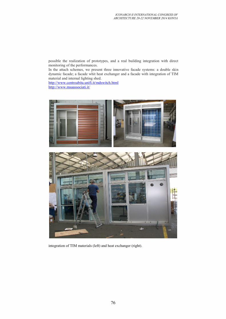
ICONARCH II INTERNATIONAL CONGRESS OF
ARCHITECTURE 20-22 NOVEMBER 2014 KONYA
76
possible the realization of prototypes, and a real building integration with direct
monitoring of the performances. In the attach schemes, we present three innovative facade systems: a double skin
dynamic facade; a facade whit heat exchanger and a facade with integration of TIM
material and internal lighting shed. http://www.centroabita.unifi.it/mdswitch.html
http://www.msaassociati.it/
integration of TIM materials (left) and heat exchanger (right).
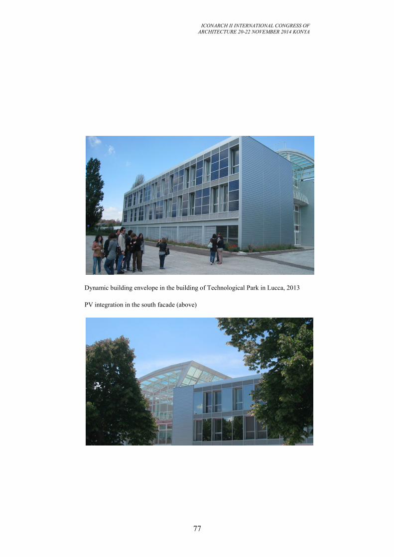
ICONARCH II INTERNATIONAL CONGRESS OF
ARCHITECTURE 20-22 NOVEMBER 2014 KONYA
77
Dynamic building envelope in the building of Technological Park in Lucca, 2013
PV integration in the south facade (above)
ICONARCH II INTERNATIONAL CONGRESS OF
ARCHITECTURE 20-22 NOVEMBER 2014 KONYA
78
4. INTEGRATION OF MECHANICAL AND ARCHITECTURAL DESIGN
When two different interacting technologies are not homogeneous for scientific
content, level of innovation and industrialization, generally the more evolved one
tends to prevail in interaction and the decision-making.
But this does not apply in the building sector, in the relationship between the
construction technology that is traditionally "conservative", and and the mechanical
technology, that has developed to high level of innovation and industialization. This diversity of technological level, led to a strict separation of competence and
professional roles, which in fact has limited the interaction and reduced the area of
dialogue between engineers and architects. Often the architectural designer is only interested in the shape of the building and
believes that its proper functioning from the point of view of comfort is delegated in
full to the mechanical engineer, except for dicussing about the size of space where
allocate the machinery. If this picture of relations was certainly the prevailing until recently, today we are
facing a renewed interest in looking for the better integration between architectural
inputs and comfort of occupants that always existed in the history of architecture
until the beginning the last century. Interest in environmental issues, the spread of ecological awareness, and the need to
achieve real energy savings, are bringing more and more architects to focus thir
interest also in heating and cooling mechanical systems and several engineers to look
for a better interaction with the architect to optimize the mechanical choices. From a theoretical point of view, we can say that the building, if properly
constructed, should play a primary role to achieve internal conditions of well-being
(at least in the temperate climatic zones) and that the mechanical equipment should
be designed to achieve its goals with the minimum energy consumption. If we consider the different durability of the two technologies, we notice that
traditional masonry construction system, and the culture of conservation and
maintenance (most common in Europe) compared to the logic of the demolition and
rebuilding (mainly in US), leads to a remarkable durability of building envelope
compared to the rapid obsolescence of the mechanical components. This different durability should make reflect that wrong decisions in design phase of
the building affect a much longer period, while appropriate design solutions and
investments in higher quality of construction are lasting in a longer period, allowing
to spread the higher costs in more annuity. In heating and cooling technology, the rapid growing of new components and
materials brings more dynamism and innovation, while the lower durability of
ICONARCH II INTERNATIONAL CONGRESS OF
ARCHITECTURE 20-22 NOVEMBER 2014 KONYA
79
components leads to more frequent replacement during the life time of the building,
with lower payback time. The integration that today we are seeking between architectural and mechanical
approach, is enhanced by "bioclimatic" architecture, the holistic concept where all
components of the project are seen in relation to each other and in relation to the
external environment including of course the mechanical components. Better performance can be achieved in new buildings, where the integration between
building components and mechanical systems brings maximum benefits, both in
terms of cost and environmental comfort, but even in refurbishment and retrofitting
of existing building there are interesting opportunity. Retrofitting the existing building stock is a crucial challenge in Europe, where this
sector is responsible for the highest energy consumption, and this market is rapidly
increasing and stands at about 40% of the all construction work of European Union
(source: DAEI Euroconstruct), while in Italy and France exceeded the new building
market. Residential construction absorb the largest part of retrofitting and if ten years ago,
the building recovery weighed to 30% on demand for materials and construction
products, today the figure stands at 50% and the trend is mainly represented by the
urban construction realized from '50s and' 70s, (post war reconstruction). The theme of the recovery of "modern architecture" in suburban areas is therefore
one of the most topical issues at European level, also from economical point of view,
since demolition and reconstruction of new buildings is a much more costly strategy
than retrofitting.and restoring the quality of buildings according to the logic of
environmentally friendly . Rehabilitating energetically a building involves considerations, evaluations and
different choices depending on many variables that characterize the specificity of the
building: the age, the degree of conservation, the structural characteristics, the
typology, the internal distribution, the different activities carried out in the building. The analysis of the artifact in all its characteristics is thus the basis of any type of
intervention; the designer will be faced with the constraints of various kinds
(structural, regulatory, distributive, cultural) that limit the ability to change and adapt
to the changing needs of the building both from the architectural point of view and
from the mechanical one. The maintenance operations are dues to normal deterioration of the different parts of
the building, its technological systems in addition to the general aging process of the
construction. There are also circumstances that pushe to intervent, such changes in
the needs of users, progress and technological innovations that offer increasingly
high standards of quality of life and work, and pushing for a continuous update. In most cases, the intervention of renoval of existing buildings, is not directly related
to the energy sector and any maintenance, rehabilitation or renovation of the
building, offers a significant opportunity to operate also for the energy
rehabilitation.
ICONARCH II INTERNATIONAL CONGRESS OF
ARCHITECTURE 20-22 NOVEMBER 2014 KONYA
80
Intervents for energy retrofitting or improving energy efficiency, as part of a wider
project of renewal or maintenance of the building, is a way to reduce the cost of
individual measures and the time of return of the investment is lower, both for the
normal maintenance operations and for those related to the energy efficiency, with
increase in the convenience of the interventions. In conclusion, the reduction of energy consumption, sustainable socio-economic
development and the improvement of facilities in existing buildings, is strongly
linked to the general process of urban renoval and maintenance of buildings and that
these policies must be realized with the integration among mechanical, architectural
and structural approach: the art of integration for a sustainable development of our
cities and villages.
5. SUSTAINABLE ARCHITECTURE IN MEDITERRANEAN REGION
The Mediterranean area is today a central focus from the strategic viewpoint as
union rather than competition bridge between Europe, Africa and Middle East, and
needs a commun thinking about existing constructions and new construction policies
in the different countries facing this sea. The reflection about present trends focus on
the need of a cultural consciousness about the importance of safeguarding the built as
well as the natural heritage, by means of sustainable development strategies. There is a number of common architectural lines and engineering techniques in
settlement organisation, established in the roots of Mediterranean traditional culture,
and a number of similar principles in line with the sustainable development and
ecological concern. Now we have the opportunity to deeply investigate so as to
define a common strategy for the future of cities and villages. As it is very well known, the amount of resources on our planet are going to be
depleted very soon, and a large number of conferences, worldly summit and
meetings in the high areas of government and management have been held during the
last two decades around the themes of sustainable development, pointing out the
need of moving our society towards a different economy and a different way of
reflecting on the possible transformation of land and city. Such terms as “green
economy”, “smart cities”, “emerging technologies” and others have been created so
as to clarify the various opinions and movements which can help during the
establishment of this new society.
Abitare Mediterraneo is an applied research project, sponsored by the Tuscany
Region EU program FESR 2007-2013, developed by the University of Florence in
synergy with some construction companies.
Project aim’s to realize an “Open System” to promote technological innovation and
architectural quality in the construction process in order to encourage the

ICONARCH II INTERNATIONAL CONGRESS OF
ARCHITECTURE 20-22 NOVEMBER 2014 KONYA
81
development of building initiatives focused on high energy efficacy; the catalog of
the “Open System” is a flexible tool dedicated to enterprises to promote innovative
products in the Mediterranean Areas.
The research propose a formula to create a synergy between the research and
production in the building sector and also involves a «construction model» to adopt
for architecture in these kind of climates and it is dedicated to draftsmen and
enterprises as a promotion tools supporting design and planning in the Mediterranean
climate.
The purpose is to transform Tuscany into an International Laboratory for Research of
high quality living in the Mediterranean area; develop analysis of Case Studies in
order to promote the future of Environmental Sustainable Buildings, designed in the
context of history, culture and Mediterranean climate. Key objective fosters the
creation of a “Centre for Technological Competence” as a benchmark point for
research, innovation and implementation of environmental sustainability, eco-
efficiency, quality of life. Innovative results from Abitare Mediterraneo up to now
has been the realization of:
• Test Cell - outdoor Laboratory for Thermal Dynamic behavior of façade
components realized in Florence University , Engineering Department.
Prototypes of building components such:
• MIA - Temporary Living Module specific for Mediterranean climate
• Domino - Façade System that guarantees significant energy savings
• AIW - Facade System with an integrated heat exchanger
• Shading Screen -Innovative Ventilated Wall
6. CONCLUSION
6.1 University education and ABITA Master course
The education of the architect and the engineer should aim to develop a sustainable
approach to design, through the understanding of the evolution of the architectural
technology and cultural influences that new models (systems approach, holistic
view of the project) resulted in the design synthesis. Energy issues and the concept
of sustainability applied to the design changes at different scales require new tools
for understanding and analysis that will be integrated with the traditional skills of
the architect. In the universities the curricula of students should be aimed to achieve
ICONARCH II INTERNATIONAL CONGRESS OF
ARCHITECTURE 20-22 NOVEMBER 2014 KONYA
82
the means of ensuring the effective coherence between the cognitive phase and the
project, to develop a sustainable design that manages to integrate the needs of the
environment and the fulfillment of the objectives of the client. The post graduate Master ABITA has been developed twelve years ago in
University of Florence as a second level of training and as a response to the high
interest expressed by administration and private developers for experts in
management of natural resources and sustainable design. As part of the general transformation process as implementation of the Kyoto
Protocol, and the new legislation such as the European Directive on energy
conservation in buildings, ministerial decrees on green certificates and licenses to
energy saving, skills of the Master Bio-ecological Architecture and Technology
Innovation for the Environment refer to the objective urgency to solve the energy
problem in the field of architecture, in order to define a new professional with more
specialized training and in all aspects of the building process, which integrates
knowledge and the basic skills of planning and design acquired in university college
courses. The need for greater environmental sustainability and proper energy management
requires a high quality of the planning process and land management and execution
of the works on the basis of eco-friendly environment. The Master responds to the
increasing need for new professionals with specific expertise in the field of
innovative strategies for the deployment of renewable energy sources and their
integration into the urban space. The goal is to provide a high-level training than would generally be offered in the
current context of teaching faculty of architecture and engineering, and to provide
new inputs to stimulate the creativity of the designers of the City of Tomorrow:
methods and operational tools for design of the built environment in a sustainable
perspective. The training objective is therefore to define a cultural base capable of
formulating and managing eco-design criteria through the identification of
procedures and tools to determine methods of intervention and economic viability for
both the new building and for the retrofit of existing stock, in terms of quality,
environmental and energy performances.
REFERENCES
Sala, M., Carta, A., 2013 Sustainable buildings in Mediterranean Area, Academic
Press INC, S.Diego, CA. USA
Sala, M., Romano, R. Simoni, 2012 “Pareti verticali portanti e non portanti” in
Piano, R. Almanacco dell’Architetto, F. Proctor Edizioni spa, Bologna
Sala, M. Alcamo, G., Murgia, S. 2007. The impact of different window
configurations, natural ventilation and solar shading strategies on indoor comfort
level in simple rooms, in Mediterranean area.. In: 2nd PALENC Building low
energy cooling and advanced ventilation technologies in the 21st century, Creta, 27-
29 Settembre 2007, pp. 22-25.
H.Mueller, M.Wilson, M.Sala, H.Coch, F.Allard, O.Sepannen (2007) Euleb -
EUropean high quality Low Energy Buildings. http://www.euleb.info/
ICONARCH II INTERNATIONAL CONGRESS OF
ARCHITECTURE 20-22 NOVEMBER 2014 KONYA
83
SESSION 2
20 November 2014 Thursday, 14.00-15.15
Chairperson: Prof.Dr. İ.Sevil SARIYILDIZ
PhD. Student MAHSHID MIKAEILI, Res. Assist. PhD FARUK
SARIHAN
“Sustainability and Bioclimatic Design Principals in Hot-Dry Area of
Iran” p.84
PhD Student ISABEL MARTINEZ, PhD Student ESPEJO
ZARAGOZA, Prof. Dr. GABRIELLA CAROTI, Prof. Dr. ANDREA
PIEMONTE
“Image Based Modeling Techniques for The Creation of High-Quality
Texture in Laser Scanner Model: A Case Study in Frescoed Vault”
p.98
Res. Asst. ŞERİFE ÖZATA, Assoc. Prof. Dr. ZEHRA CANAN
GİRGİN
“Innovation Technologies in Green Buildings
and Certification” p.112
KEYNOTE SPEECH
Prof. Dr. MATTIAS KARRHOLM
“Territorial Production and the
Temporal Use of Public Space” p.125
ICONARCH II INTERNATIONAL CONGRESS OF
ARCHITECTURE 20-22 NOVEMBER 2014 KONYA
84
SUSTAINABILITY AND BIOCLIMATIC DESIGN
PRINCIPALS IN HOT-DRY AREA OF IRAN
MAHSHID MIKAEILI1, FARUK SARIHAN2
ABSTRACT
Today, buildings worldwide account for up to 40% of total end-use energy.
Sustainable architecture is a general term that described environmentally conscious
design techniques in architecture and landscape design. The aims of sustainable
architecture at producing buildings that adapted to climate, local, cultural and
environmental contexts. Sustainable architecture also referred as Green Architecture,
Energy Conscious, Eco friendly, Energy Efficient is a design that uses natural
building materials that are energy efficient and that make little or no impact on the
nature of a site and its resources. Climate has a major effect on the energy
consumption in building. Bioclimatic design in vernacular architecure aims to lower
energy consumption, based on the understanding of the climatic parameters that
influence the energy behavior of a building. It requires knowledge of the relation
between the building’s envelope and the local environment. Reducing energy
consumption, using natural resources and providing comfortable, and sustainable
living spaces are the aims of bioclimatic design or climatically responsive
sustainable building design (vernacular building) in hot-dry areas of Iran.
Key words: Sustainable Architecture, Bioclimatic Design, Passive Solar Methods,
Vernacular Architecture.
1. INTRODUCTION
Buildings worldwide account for up to 40% of total end-use energy. Today, in
construction of some modern buildings, using new strategies of sustainable design
have a great importance on human living and energy using. In this system climate
has a major effect on the performance of the building, and energy consumption. The
important responsive of the sustainable building design is reducing energy
1 PhD. Student. Ankara University, Department of Landscape Architecture, ANKARA
2 Res. Assist. PhD Student. Ankara University, Department of Landscape Architecture, ANKARA
ICONARCH II INTERNATIONAL CONGRESS OF
ARCHITECTURE 20-22 NOVEMBER 2014 KONYA
85
consumption, using natural resources and providing comfortable and sustainable
spaces for living (Serbescu 2009).
According to accumulation of empirical knowledge in vernacular architecture in
differnt parts of Iran, using passive design strategies such as solar orientation, natural
ventilation, using of thermal inertia and shading are basically techniques of
adaptation with environment. Noticeably, during the last decade, the academic
interest in the sustainability of vernacular architecture has grown. Unfortunately,
around the world, vernacular traditions are seen to be in a state of decline and are
frequently looked down upon, abandoned, neglected or actively demolished.
Steadily, vernacular architectural methods are replaced by modern architectural
methods, international technologies, materials and forms (Oliver 2003, Knapp et al.
2005, Vakili et al. 2006). Interestingly, these vernacular traditions are exactly the
ones that are identified as being able to provide valuable lessons in terms of
sustainable design. To many academics these represent a sophisticated, advanced and
refined nature of vernacular passive cooling, ventilating and heating strategies (Fathy
1986, Kheirabadi 1991, Qobadian 2006).
In a vast country such as Iran with 1,648,000 km2 width and very different climatic
zones, traditional builders have presented a series of logical solutions for human
comfort (Tavassoli 2008). Despite of the high diversity in architectural patterns,
there are five principles in all historical buildings. These principales are; 1)
introversion, 2) avoidance of vanity, 3) self-sufficiency, 4) architecture structure, 5)
people oriented (Pirnia 2003). This study is based on a research program on traditional building techniques that
have used in differnt parts of the hot-dry areas of Iran. The study introduced
designing strategies and principles in hot-dry climate in traditional housing based on
climate responsive design. These issues related to sustainable and bioclimatic design
in vernacular buildings. The research examines the various passive methods that are
widely adopted by vernacular architecture in historical buildings. These methods
explain their operation in details, solar orientation, distances between buildings,
natural ventilation, building envelope, thermal inertia and building form that
highlighted the main factors of their use that reduces environment effectiveness.
2. SUSTAINABLE ARCHITECTURE
The history of environmental friendly architecture becoming widespread goes back
to 1970’s. Since then, the words “Green”, “Ecological” and “Sustainable” are terms
used by environmentalists to indicate modes of practice (Ghani 2012). The transition
from “green” to “eco” to “sustainable” in the design field represents a steady
broadening of scope in theory and practice, and to a certain extent, an increasingly
critical perspective on ecology and design (Madge 1997).
In Architecture there are many ways a building may be “green” and respond to the
growing environmental problems of our planet. Green buildings are high quality
buildings, they last longer, cost less to operate and maintain and provide greater
ICONARCH II INTERNATIONAL CONGRESS OF
ARCHITECTURE 20-22 NOVEMBER 2014 KONYA
86
occupant satisfaction than standard development (Ghani 2012). A green building is
an outcome of a design that focuses on minimizing the use and on increasing the
efficiency of resources. The steady depletion of non-renewable resources of energy
has forced the search for energy efficient building alternatives as it is the single
largest consumer of energy-intensive materials (Vijayalaxmi 2010).
Sustainable architecture can be practiced still maintaining efficiency, layouts and
cost effectiveness. Construction projects typically consume large amounts of
materials, produce tons of waste, and often involve weighing the preservation of
buildings that have historical significance against the desire for the development of
newer, more modern designs. Sustainable development is one such measure, which
presents an approach that can largely contribute to environmental protection (Ghani
2012). However, being sustainable is not just about energy saving, but also about the
better use of suitable materials. We have to use materials far more efficiently than we
do now. Sustainability also means an increased importance being placed on use of
materials, which are renewable, recycled and non-toxic. Public awareness must be
generated that such buildings, which incidentally are low cost, are not inferior to
conventional concrete buildings. Similarly, using locally sourced materials, materials
with a high recycled content and ensuring an envelope design, which does not
enhance the operational heating or cooling energy can go a long way in designing
energy-efficient buildings (Vijayalaxmi 2010).
Sustainable architecture is a general term that describes environmentally conscious
design techniques in the field of architecture. Sustainable architecture is framed by
the larger discussion of sustainability and the pressing economic and political issues
of our world. In the broad context, sustainable architecture seeks to minimize the
negative environmental impact of buildings by enhancing efficiency and moderation
in the use of materials, energy, and development space. Today, the idea of
sustainability and ecological designs are to ensure that our actions and decisions do
not inhibit the opportunities of future generations. This term can be used to describe
an energy and ecologically conscious approach to the design of the built
environment. The aims of sustainable architecture at producing buildings that is
adapted to local, social-economic, cultural and environmental contexts, having in
mind the consequences to future generations. In this frame, the important priority
must be to minimize energy consumption in buildings in both terms of maintenance
and embodied energy, through the use of passive design strategies for reducing the
use of energy consuming equipment.
Besides all these measures and approaches, passive strategies such as bioclimatic
design offer great ways of energy saving. Bioclimatic design is a design strategy
which relates climate control in a building to the analysis of weather data and the
requirements for human comfort. Bioclimatic design is also the outcome of such a
strategy. Hence the bioclimatic design can be understood as the architectural design
using human adaptability and passive climate control as interactive measures of
energy efficiency (Bromberek 1995).
ICONARCH II INTERNATIONAL CONGRESS OF
ARCHITECTURE 20-22 NOVEMBER 2014 KONYA
87
Traditional and Vernacular buildings in contrast to Modern buildings constructed in
20th century are more climate-receptive; the climate-responsive architecture
originates in the pre-industrial era before the introduction of air-conditioning and
electric lighting. Each region of the world employs its own techniques and designs in
its buildings that are best suited to that particular region and that encompass the
region’s cultural patterns (Sharma and Sharma 2013). The essence of bioclimatic
design is to create a favorable microclimate both inside the building and outdoors
through the application of architectural techniques (Bondars 2013). Bioclimatic
design measures are centered primarily on the climate of a specific area as thus;
building envelope and orientation, energy source, sun shading devices, passive
design, indoor air quality, heating and cooling, landscape (Folaranmi et al. 2013).
For effective design and good thermal achievement, Bioclimatic design recommends
the following factors to be considered:
- Building orientation: buildings should be inclined on site to face the north-east,
south-west approach to allow minimum solar radiation into the buildings
- Window openings: the openings should be wide enough to allow maximum natural
ventilation into the indoor space.
- Glazing: solar glasses that are double paneled and well laminated that allow light
but reduce heat penetration should be used.
- Natural materials: should be used for construction such as adobe, compressed earth,
and wood as they have better thermal inertia than most conventional building
materials.
- Renewable energy: these energy sources as solar and wind energy are more energy
efficient and do not contribute to CO2 emission which pollutes the environment.
- Landscape: trees should be planted around the houses as they help improve the
surrounding air and keeps the environment cool.
- Cross ventilation: houses should be cross ventilated for effective air flow in and out
of the building (Folaranmi et al. 2013).
Passive climate control is the climate control achieved as a consequence of the use -
exclusive or prevailing- of passive means, that is: means that do not use power
(inflows of externally produced energy) to perform the intended tasks (Bromberek
1995).
2.1. Principles of Climatic Responsive Design
The climatic conditions of the central part of Iran share common traits of extremely
low annual precipitation and low humidity, restriction of water source, intense
daylight and thermal gain from the sun, dynamic seasonal, daily temperature
fluctuations, seasonal wind and sand storm.
ICONARCH II INTERNATIONAL CONGRESS OF
ARCHITECTURE 20-22 NOVEMBER 2014 KONYA
88
Composition of architectural components and spaces create dynamically urban areas.
In these regions cities illustrated integration of homogeneous and centralized
structures that compressed for creating close correlation between components.
Vernacular architecture in these areas has demonstrated by sustainable architecture
components that suggested various solutions which are adapted with environments
potentials, natural ventilation, as a certain parameter for cooling and sense of
comfort. The buildings are constructed according to the specific climatic conditions
and differ with those built in other climates. Central Iranian vernacular buildings are
commonly equipped with thick and high walls, vernacular materials, wind-catcher,
central courtyards, water pools and vegetation, basements, loggias and separate
seasonal rooms. All these features together form a vernacular passive cooling system
that modifies to some extent the impact of the hostile outdoor environment.
Due to lack of access to modem heating and cooling equipment’s in ancient times the
architects were obliged to rely on natural energies to render the inside condition of
the buildings pleasant. By this way, without any mechanical methods and just by
utilizing environmental energies such as wind, solar energies and architectural
elements such as shape of roofs (using dome and arched roofs instead of flat roofs),
walls (using huge and thicken walls), materials (includes mud, mud brick ,stone,
brick, mortar, lime and rarely wood), multistory yards or garden puddle (Persian:
Godal Baghcheh) in the yard of houses for increasing the contact of building surface
with earth, window, wind-catcher (Persian: Badgir) have been provided comfortable
condition for occupants. Furthermore, the urban morphology in hot-dry regions is the
cause of condensed and concentrated urban texture in which the main arteries are
facing the desired wind and opposing undesired one. Many of these vernacular
cooling strategies in central Iran are said to have remained relevant to local cultural
needs and to work in harmony with the natural environment because they are based
on low and local use of energy and resources (Afshar et al. 1975, Heidari 2006).
Because of this relevance, it is frequently claimed that there are many lessons to be
learned from them in terms of creating a contemporary sustainable design and
construction (McMurry et al. 2000, Qobadian 2006).
Through evaluating traditional architecture, designers have taken advantages of
difficulties of areas and presented the most suitable settlements designs for each
climatic region based on this three scales; macro, medium, and micro scale. This
classification is on base urban designing scale, house designing scale and
architectural elements designing scale in a house. Basic principles of macro climate
responsive are in the urban designing scale. This principal include; Site and
orientation of the building, distance between buildings, enclosed urban environment
and using organic designing method for creating narrow and irregular streets.
Site and orientation of the building: The most important design parameters in urban
designing scale that affecting indoor thermal comfort and energy conservation in
building are site and orientation of the building. These parameters depend on
topography as a basic parameter, climate, sun radiation and wind direction.
Commonly, in these areas houses are situated according to the slope of a city hill.
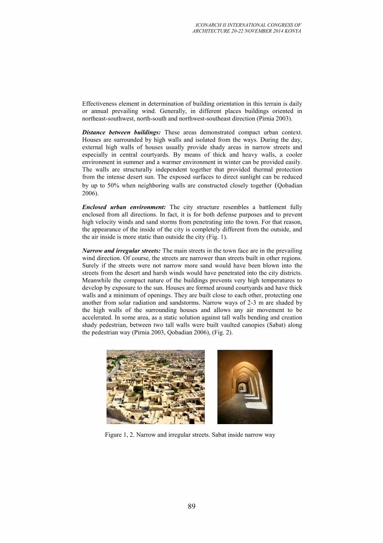
ICONARCH II INTERNATIONAL CONGRESS OF
ARCHITECTURE 20-22 NOVEMBER 2014 KONYA
89
Effectiveness element in determination of building orientation in this terrain is daily
or annual prevailing wind. Generally, in different places buildings oriented in
northeast-southwest, north-south and northwest-southeast direction (Pirnia 2003).
Distance between buildings: These areas demonstrated compact urban context.
Houses are surrounded by high walls and isolated from the ways. During the day,
external high walls of houses usually provide shady areas in narrow streets and
especially in central courtyards. By means of thick and heavy walls, a cooler
environment in summer and a warmer environment in winter can be provided easily.
The walls are structurally independent together that provided thermal protection
from the intense desert sun. The exposed surfaces to direct sunlight can be reduced
by up to 50% when neighboring walls are constructed closely together (Qobadian
2006).
Enclosed urban environment: The city structure resembles a battlement fully
enclosed from all directions. In fact, it is for both defense purposes and to prevent
high velocity winds and sand storms from penetrating into the town. For that reason,
the appearance of the inside of the city is completely different from the outside, and
the air inside is more static than outside the city (Fig. 1).
Narrow and irregular streets: The main streets in the town face are in the prevailing
wind direction. Of course, the streets are narrower than streets built in other regions.
Surely if the streets were not narrow more sand would have been blown into the
streets from the desert and harsh winds would have penetrated into the city districts.
Meanwhile the compact nature of the buildings prevents very high temperatures to
develop by exposure to the sun. Houses are formed around courtyards and have thick
walls and a minimum of openings. They are built close to each other, protecting one
another from solar radiation and sandstorms. Narrow ways of 2-3 m are shaded by
the high walls of the surrounding houses and allows any air movement to be
accelerated. In some area, as a static solution against tall walls bending and creation
shady pedestrian, between two tall walls were built vaulted canopies (Sabat) along
the pedestrian way (Pirnia 2003, Qobadian 2006), (Fig. 2).
Figure 1, 2. Narrow and irregular streets. Sabat inside narrow way
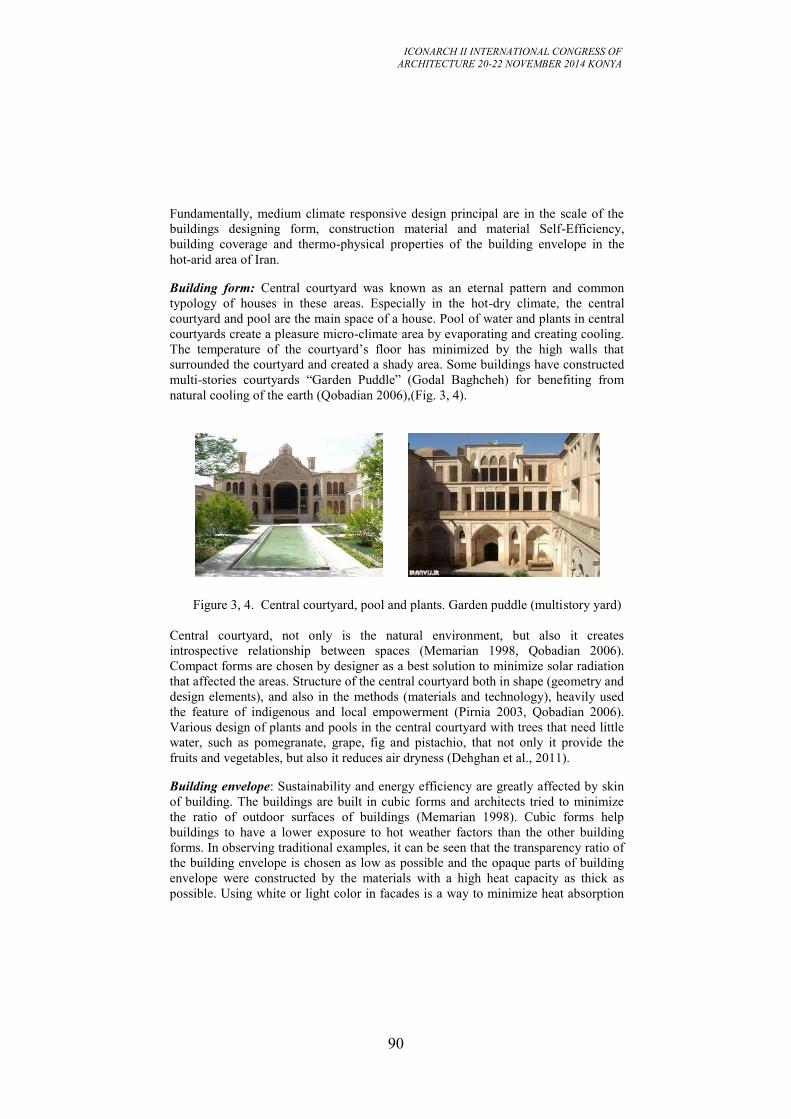
ICONARCH II INTERNATIONAL CONGRESS OF
ARCHITECTURE 20-22 NOVEMBER 2014 KONYA
90
Fundamentally, medium climate responsive design principal are in the scale of the
buildings designing form, construction material and material Self-Efficiency,
building coverage and thermo-physical properties of the building envelope in the
hot-arid area of Iran.
Building form: Central courtyard was known as an eternal pattern and common
typology of houses in these areas. Especially in the hot-dry climate, the central
courtyard and pool are the main space of a house. Pool of water and plants in central
courtyards create a pleasure micro-climate area by evaporating and creating cooling.
The temperature of the courtyard’s floor has minimized by the high walls that
surrounded the courtyard and created a shady area. Some buildings have constructed
multi-stories courtyards “Garden Puddle” (Godal Baghcheh) for benefiting from
natural cooling of the earth (Qobadian 2006),(Fig. 3, 4).
Figure 3, 4. Central courtyard, pool and plants. Garden puddle (multistory yard)
Central courtyard, not only is the natural environment, but also it creates
introspective relationship between spaces (Memarian 1998, Qobadian 2006).
Compact forms are chosen by designer as a best solution to minimize solar radiation
that affected the areas. Structure of the central courtyard both in shape (geometry and
design elements), and also in the methods (materials and technology), heavily used
the feature of indigenous and local empowerment (Pirnia 2003, Qobadian 2006).
Various design of plants and pools in the central courtyard with trees that need little
water, such as pomegranate, grape, fig and pistachio, that not only it provide the
fruits and vegetables, but also it reduces air dryness (Dehghan et al., 2011).
Building envelope: Sustainability and energy efficiency are greatly affected by skin
of building. The buildings are built in cubic forms and architects tried to minimize
the ratio of outdoor surfaces of buildings (Memarian 1998). Cubic forms help
buildings to have a lower exposure to hot weather factors than the other building
forms. In observing traditional examples, it can be seen that the transparency ratio of
the building envelope is chosen as low as possible and the opaque parts of building
envelope were constructed by the materials with a high heat capacity as thick as
possible. Using white or light color in facades is a way to minimize heat absorption
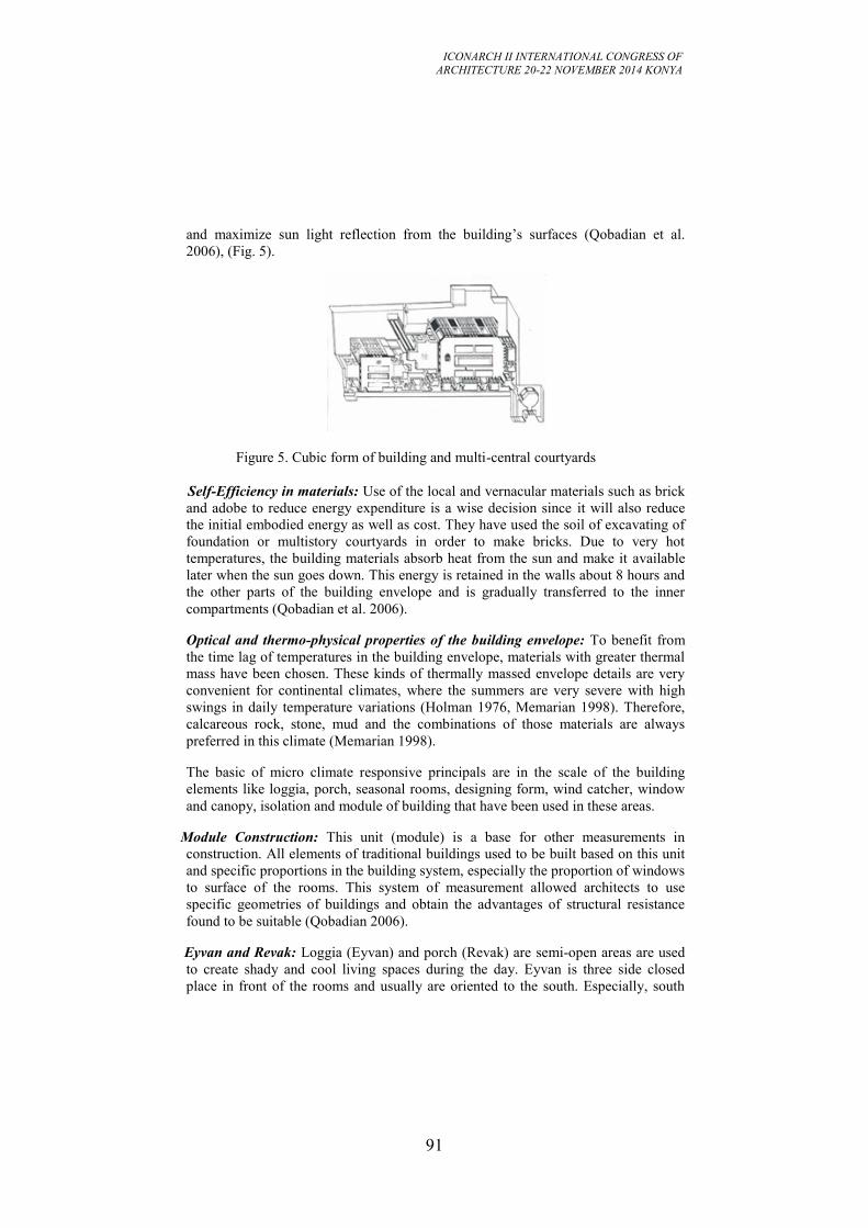
ICONARCH II INTERNATIONAL CONGRESS OF
ARCHITECTURE 20-22 NOVEMBER 2014 KONYA
91
and maximize sun light reflection from the building’s surfaces (Qobadian et al.
2006), (Fig. 5).
Figure 5. Cubic form of building and multi-central courtyards
Self-Efficiency in materials: Use of the local and vernacular materials such as brick
and adobe to reduce energy expenditure is a wise decision since it will also reduce
the initial embodied energy as well as cost. They have used the soil of excavating of
foundation or multistory courtyards in order to make bricks. Due to very hot
temperatures, the building materials absorb heat from the sun and make it available
later when the sun goes down. This energy is retained in the walls about 8 hours and
the other parts of the building envelope and is gradually transferred to the inner
compartments (Qobadian et al. 2006).
Optical and thermo-physical properties of the building envelope: To benefit from
the time lag of temperatures in the building envelope, materials with greater thermal
mass have been chosen. These kinds of thermally massed envelope details are very
convenient for continental climates, where the summers are very severe with high
swings in daily temperature variations (Holman 1976, Memarian 1998). Therefore,
calcareous rock, stone, mud and the combinations of those materials are always
preferred in this climate (Memarian 1998).
The basic of micro climate responsive principals are in the scale of the building
elements like loggia, porch, seasonal rooms, designing form, wind catcher, window
and canopy, isolation and module of building that have been used in these areas.
Module Construction: This unit (module) is a base for other measurements in
construction. All elements of traditional buildings used to be built based on this unit
and specific proportions in the building system, especially the proportion of windows
to surface of the rooms. This system of measurement allowed architects to use
specific geometries of buildings and obtain the advantages of structural resistance
found to be suitable (Qobadian 2006).
Eyvan and Revak: Loggia (Eyvan) and porch (Revak) are semi-open areas are used
to create shady and cool living spaces during the day. Eyvan is three side closed
place in front of the rooms and usually are oriented to the south. Especially, south
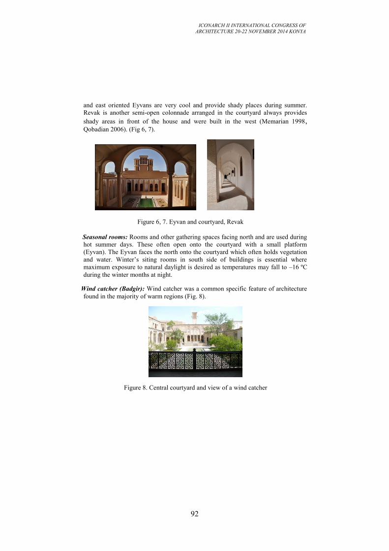
ICONARCH II INTERNATIONAL CONGRESS OF
ARCHITECTURE 20-22 NOVEMBER 2014 KONYA
92
and east oriented Eyvans are very cool and provide shady places during summer.
Revak is another semi-open colonnade arranged in the courtyard always provides
shady areas in front of the house and were built in the west (Memarian 1998, Qobadian 2006). (Fig 6, 7).
Figure 6, 7. Eyvan and courtyard, Revak
Seasonal rooms: Rooms and other gathering spaces facing north and are used during
hot summer days. These often open onto the courtyard with a small platform
(Eyvan). The Eyvan faces the north onto the courtyard which often holds vegetation
and water. Winter’s siting rooms in south side of buildings is essential where
maximum exposure to natural daylight is desired as temperatures may fall to –16 ºC
during the winter months at night.
Wind catcher (Badgir): Wind catcher was a common specific feature of architecture
found in the majority of warm regions (Fig. 8).
Figure 8. Central courtyard and view of a wind catcher
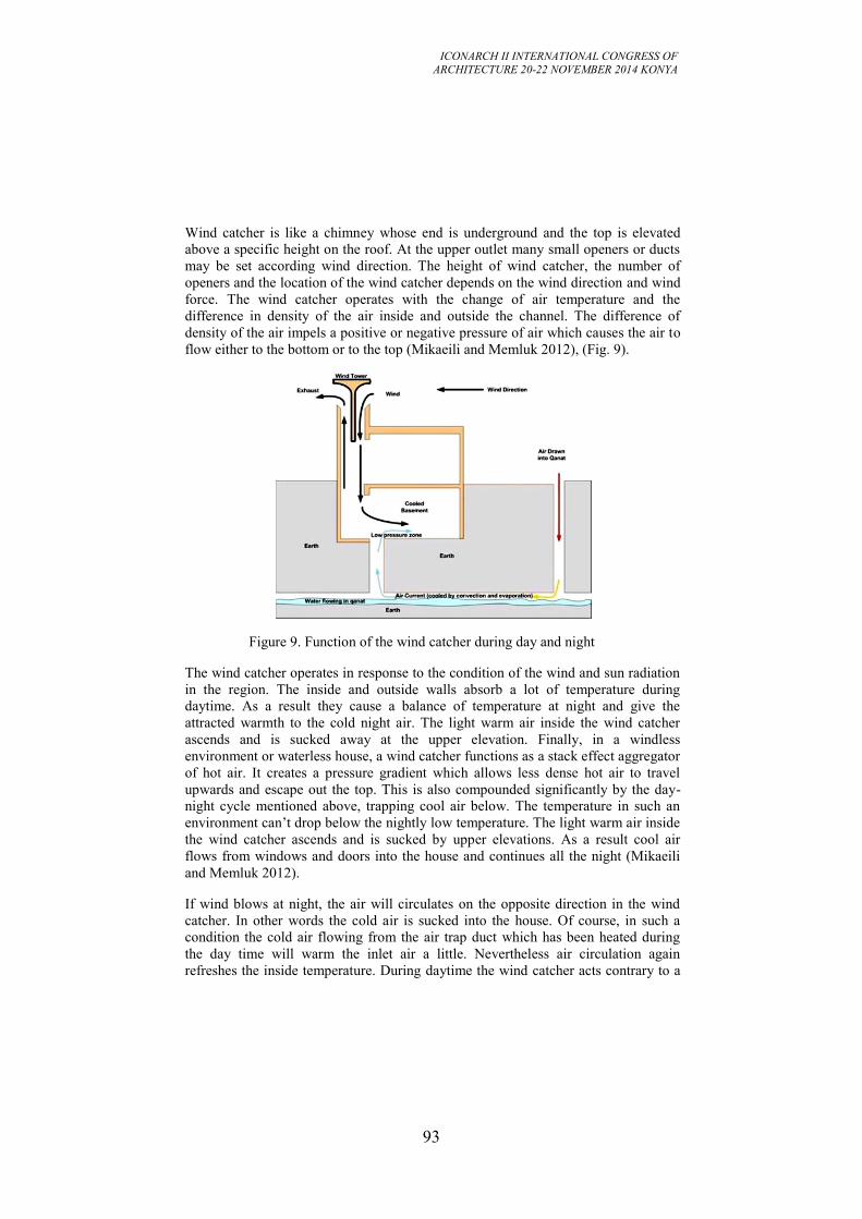
ICONARCH II INTERNATIONAL CONGRESS OF
ARCHITECTURE 20-22 NOVEMBER 2014 KONYA
93
Wind catcher is like a chimney whose end is underground and the top is elevated
above a specific height on the roof. At the upper outlet many small openers or ducts
may be set according wind direction. The height of wind catcher, the number of
openers and the location of the wind catcher depends on the wind direction and wind
force. The wind catcher operates with the change of air temperature and the
difference in density of the air inside and outside the channel. The difference of
density of the air impels a positive or negative pressure of air which causes the air to
flow either to the bottom or to the top (Mikaeili and Memluk 2012), (Fig. 9).
Figure 9. Function of the wind catcher during day and night
The wind catcher operates in response to the condition of the wind and sun radiation
in the region. The inside and outside walls absorb a lot of temperature during
daytime. As a result they cause a balance of temperature at night and give the
attracted warmth to the cold night air. The light warm air inside the wind catcher
ascends and is sucked away at the upper elevation. Finally, in a windless
environment or waterless house, a wind catcher functions as a stack effect aggregator
of hot air. It creates a pressure gradient which allows less dense hot air to travel
upwards and escape out the top. This is also compounded significantly by the day-
night cycle mentioned above, trapping cool air below. The temperature in such an
environment can’t drop below the nightly low temperature. The light warm air inside
the wind catcher ascends and is sucked by upper elevations. As a result cool air
flows from windows and doors into the house and continues all the night (Mikaeili
and Memluk 2012).
If wind blows at night, the air will circulates on the opposite direction in the wind
catcher. In other words the cold air is sucked into the house. Of course, in such a
condition the cold air flowing from the air trap duct which has been heated during
the day time will warm the inlet air a little. Nevertheless air circulation again
refreshes the inside temperature. During daytime the wind catcher acts contrary to a
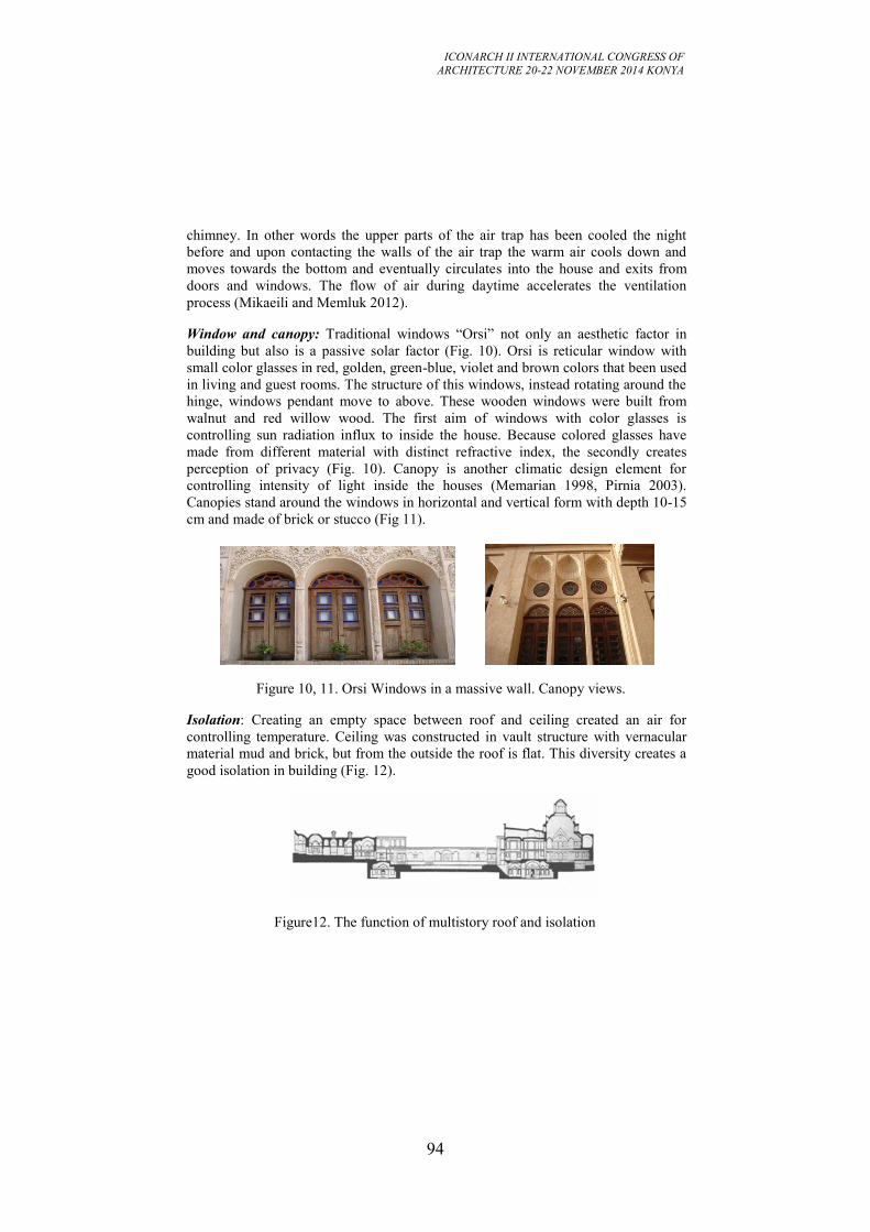
ICONARCH II INTERNATIONAL CONGRESS OF
ARCHITECTURE 20-22 NOVEMBER 2014 KONYA
94
chimney. In other words the upper parts of the air trap has been cooled the night
before and upon contacting the walls of the air trap the warm air cools down and
moves towards the bottom and eventually circulates into the house and exits from
doors and windows. The flow of air during daytime accelerates the ventilation
process (Mikaeili and Memluk 2012).
Window and canopy: Traditional windows “Orsi” not only an aesthetic factor in
building but also is a passive solar factor (Fig. 10). Orsi is reticular window with
small color glasses in red, golden, green-blue, violet and brown colors that been used
in living and guest rooms. The structure of this windows, instead rotating around the
hinge, windows pendant move to above. These wooden windows were built from
walnut and red willow wood. The first aim of windows with color glasses is
controlling sun radiation influx to inside the house. Because colored glasses have
made from different material with distinct refractive index, the secondly creates
perception of privacy (Fig. 10). Canopy is another climatic design element for
controlling intensity of light inside the houses (Memarian 1998, Pirnia 2003).
Canopies stand around the windows in horizontal and vertical form with depth 10-15
cm and made of brick or stucco (Fig 11).
Figure 10, 11. Orsi Windows in a massive wall. Canopy views.
Isolation: Creating an empty space between roof and ceiling created an air for
controlling temperature. Ceiling was constructed in vault structure with vernacular
material mud and brick, but from the outside the roof is flat. This diversity creates a
good isolation in building (Fig. 12).
Figure12. The function of multistory roof and isolation
ICONARCH II INTERNATIONAL CONGRESS OF
ARCHITECTURE 20-22 NOVEMBER 2014 KONYA
95
4. CONCLUSION
In this paper attempt was made to suggest a method for achieving of the sustainable
architectural design based on vernacular architectural principals. Climate responsive
design principals in hot-dry area of Iran were classified in three levels. In the first
level, distance between buildings, enclosed urban environment and narrow and
irregular streets were considered as macro strategies. Review and development of
these traditional urban patterns should be considered in hot and dry cities. Medium
scale strategies cover building form, building envelop, self-efficiency in materials
and optical and thermo physical properties of building envelop in this paper.
Sustainable architecture force us to re-think what we do and synchronize traditional
methods of construction and the use of domestic materials. Finally, micro scale
strategies demonstrate some more relevant architectural design methods which are
the same as contemporary passive systems. The central courtyard must be capable of
creating secure in houses or sustainable buildings in the Iranian culture. We present
relations between central courtyard and sustainable architecture, and it concluded
that the central courtyard is the best strategy to achieve sustainable and economic
buildings. The building techniques of the hot arid climatic zones, developed over a
long history of construction, have progressed to promote passive climatic
conditioning to protect inhabitants from their harsh environments. Those ideas and
techniques of city planning, building form, and constructions methods offer great
insight to the contemporary designer of Middle Eastern desert architecture.
ICONARCH II INTERNATIONAL CONGRESS OF
ARCHITECTURE 20-22 NOVEMBER 2014 KONYA
96
REFERENCES
- Afshar, F., Cain, J.N., 1975. Indigenous Building and the Third World.
Architectural Design. 4(April), p-p. 207-218.
- Bondars, E. 2013. Implementing Bioclimatic Design in Sustainable Architectural
Practice. Architecture and Urban Planning, doi: 10.7250/aup.2013.011.
- Bromberek, Z. 1995. Passive climate control for tourist facilities in the coastal
tropics (Far North Queensland).
- Fathy, H., 1986. Natural Energy and Vernacular Architecture: Principles and
Examples with Reference to Hot Arid Climates. The University of Chicago Press:
London.
- Folaranmi, A.O., Philip, A., Stephen, O., Amina, B., 2013. Bioclimatic Design
Principle a Solution to Thermal Discomfort in Minna Residences, Niger State
Nigeria. Journal of Environment and Earth Science, ISSN 2224-3216 (Paper) ISSN
2225-0948 (Online).
- Ghani, F. 2012. Issues in Sustainable Architecture and Possible Solutions.
International Journal of Civil & Environmental Engineering. IJCEE-IJENS Vol: 12
No: 01.
- Heidari, S., 2006. New life, Old Structure Comfort and Energy Use in Buildings.
Proceeding of a Conference. Windsor. UK, 27–30 April. http://www.nceub.org.uk.
- Holman, J.P., 1976. Heat transfer. 4th Ed. New York: McGraw Hill Book Co.
- Kheirabadi, M., 1991. Iranian Cities: Formation and Development”, University of
Texas Press: Austin, Texas.
- Knapp, R.G., Lo, K., 2005. House, Home and Family: Living and Being Chinese.
University of Hawai’i Press: Honolulu. HI.
- Madge, P. 1997. Ecological Design: A New Critique. Design Issues, Vol. 13, No. 2,
a Critical Condition: Design and Its Criticism, Summer, pp. 44-54.
- McMurry, S., Adams, A., 2000. People, Power, Places. University of Tennessee.
Press: Knoxville, TN.
- Memarian, Gh. 1998. Introduction to House typology in Iran, Courtyard Houses.
Tahran University of Sciences and Technology.
- Mikaeili M., Memluk, Y., 2012. Badgir: Design with Nature, a traditional
Architectural and Climatic Element in Hot Dry Region of Iran. ICONARCH-I. 15-17
November, Konya.
- Moule, E., Dittmar, H. and Polyzoides, S. 2008. Canons of Sustainable
Architecture and Urbanism.
- Oliver, P., 2003. Dwellings: The vernacular House World Wide. Phaidon. London.
- Pirnia, M. K., 2003. Edited by: Gh. Memarian. The style of Iranian architecture.
- Qobadian, V. 2006. A Survey on the Climatic Design of the Iranian Traditional
Buildings. Tehran University. Tehran.
- Qobadian, V., Feyz, M., 2006. Climatic Design: Principles of Energy Usage in
Buildings, Tehran University, Tehran.
- Serbescu, A. 2009. On change and adaptation: Rural Inhabitation During the
Romanian Post-Socialist Transition. Traditional Dwellings and Settlements Review.
21(1), p-p. 37-50.
ICONARCH II INTERNATIONAL CONGRESS OF
ARCHITECTURE 20-22 NOVEMBER 2014 KONYA
97
- Sharma, S., Sharma, P. 2013. Traditional and Vernacular buildings are Ecological
Sensitive, Climate Responsive Designs- Study of Himachal Pradesh. International
Journal of Chemical, Environmental & Biological Sciences (IJCEBS) Volume 1,
Issue 4 (2013). ISSN 2320-4079; EISSN 2320–4087.
- Tavassoli, M., 2008. Climatic Design of Buildings. Tehran.
- Vakili A., Boussabaine, A.H., 2006. Quality Concept in Persian Precedent
Architecture: A Lesson in Eco-Building Design. PLEA. 23th. Conference on Passive
and Low Energy Architecture. Geneva. Switzerland.
-Vijayalaxmi, J. 2010. Towards sustainable architecture: a case with Greentainer.
Local Environment, Vol. 15, No. 3, March, p-p. 245–259.
ICONARCH II INTERNATIONAL CONGRESS OF
ARCHITECTURE 20-22 NOVEMBER 2014 KONYA
98
IMAGE-BASED MODELING TECHNIQUES FOR THE
CREATION OF HIGH-QUALITY TEXTURE IN LASER
SCANNER MODEL: A CASE STUDY IN FRESCOED VAULT
ISABEL MARTINEZ-ESPEJO ZARAGOZA1
GABRIELLA CAROTI2
ANDREA PIEMONTE2
ABSTRACT
The new survey tools used in studies aimed to preserving architectural heritage often
show some dilemmas. Several studies have been able to confirm that laser scanner
surveys allow to obtain three-dimensional models of high accuracy in morphology
and topological level. However, nowadays the quality level of colour obtained with
laser scanners is not acceptable for high quality texturing. Moreover, high quality
colour medels can be obtained through techniques of Structure from Modeling, but
feature a lower precision of mesh, even though results obtainable by Computer
Vision programs, make this approach increasingly viable. In this context, a case
study is proposed on a vault located in the Palazzo Roncioni (Pisa, Italy) decorated
with a important fresco painted by the painter Giovan Battista Tempesti in the
second half of the eighth century. In this case, different tests will be carried out by
Structure from Modeling techniques to have a high resolution texture applied to the
model obtained with laser scanner, thus obtaining a model with high resolution
texture and high quality mesh. This model allows to generate an accurate
documentation of the vault for digital preservation and restoration studies.
Key words: Image-based modeling, Texture Mapping, Structure from Motion,
Scanner Laser, Photogrammetry
1. INTRODUCTION
The new technologies for three-dimensional architectural survey - 3D laser scanner,
Structure from Motion, etc. - allow the creation of highly faithful virtual models
which, when applied to historical-architectural heritage, provide a rigorous
documentation of its state as regards geometry, construction techniques and
materials used. Applications of such new technologies are now widespread and well
established in the framework of interventions aimed at restoration and preservation,
as well as in widespread monument enhancement and promotion (virtual tours,
digital communication projects, etc.) (Biosca Taronger et al., 2007; Wenzel et al.,
1 PhD Student of Pisa University, Department of Civil and Industrial Engineering, PISA
2 Prof. Dr. Pisa University, Department of Civil and Industrial Engineering, PISA
ICONARCH II INTERNATIONAL CONGRESS OF
ARCHITECTURE 20-22 NOVEMBER 2014 KONYA
99
2013; Guidi et al., 2010; Benedetti et al., 2010; Juan Vidal and Martínez-Espejo
Zaragoza 2011; Merlo et al., 2013).
Besides, the potential of documentation and investigation has been increased by the
development, in recent years, of new sensors and instruments, capable of either
independent or integrated implementation; high performance digital cameras,
multispectral, hyperspectral and thermal cameras, with ever increasing resolution,
radar, etc. in fact, allow to gain a considerable amount of information, each one
related to models derived from laser scanner which, after appropriate processing, are
in fact an integrated platform for high-density information (Guidi and Remondino
2012; Adembri et al., 2011; Verdiani 2011).
These new investigating technologies are extensively used both globally, for the
survey of the historic architectural complex as a whole, and locally, for the survey of
the decorative and architectural details. Among them, the painted decorations
(frescoes, surface paintings in general, etc.) are perhaps the most significant, but
certainly more fragile, elements, receiving the constant attention of all the figures
that in various capacities are involved in the planning and implementation of
restoration and conservation (architects, administrators, engineers, art historians,
restorers, etc.).
If in the past restoration techniques for pictorial work were based on a traditional
inquiry by view, nowadays, with the advent of new digital technologies it is possible
to achieve objective, three-dimensional, geometrically accurate data, to which all
results of different types of investigation can be referred. New technologies have
therefore given a strong boost to digital cataloguing, documentation of and
monitoring of preservation state of painted decorations, so that availability of virtual
models is now an essential tool in the development of heritage rendering.
It seems clear, therefore, that it is exactly in the phase transition from cognitive and
investigative to operational that new technologies are required to interface and
integrate with traditional techniques and methods of intervention.
For these reasons, restorers need to have a high quality documentation not only for
metric purposes but also for colour. In this context, this work proposes a study of
various techniques to apply high quality colour textures to laser scanner based
models featuring high precision for topology and morphology.
2. STATE OF THE ART
2.1. Modelling The last decade has witnessed the emergence of the laser scanner as a consolidated
methodology to produce accurate high-resolution three-dimensional models (Lerma
et al., 2011; Marambio et al., 2009; Dore and Murphy, 2012; Juan Vidal and
Martínez-Espejo Zaragoza, 2011). In particular, this methodology has been applied
in many case studies on historical, archaeological and architectural heritage with
excellent results (Martínez-Espejo Zaragoza and Juan Vidal, 2012; Caroti and
Piemonte, 2012; Bevilacqua et al., 2012; Caroti and Piemonte, 2008).
Compared to earlier methods (traditional discrete points survey with reflectorless
total stations, 3D classic photogrammetric survey with manual stereo-rendering, ...),
ICONARCH II INTERNATIONAL CONGRESS OF
ARCHITECTURE 20-22 NOVEMBER 2014 KONYA
100
laser scanning has allowed to obtain very detailed models with reduced field time.
By contrast the cost of the instrumentation, both hardware and software, is high and
office-based postprocessing is burdensome (a texturized mesh model requires about
nine days of data processing every one day of field survey).
Lately a new technique, whose main data are sets of photographs of the object to be
surveyed, is proposing to replace or supplement laser scanning methodology:
Structure from Motion (SfM). This technique stems from computer vision sciences
and is well integrated into the established procedures of classical 3-D
photogrammetry (Lerma et al., 2010; Koska and Kremen, 2013; Guidi et al., 2010;
Guidi and Remondino 2012; Rodriquez 2012), from which the techniques of optics
calibration and the good practice of planning a rigorous geometric structure for
pictures takes were borrowed (Wenzel et al, 2013; Alsadik et al 2013).
On the other hand, computer vision legacy includes the algorithms for the automatic
detection of homologous points, in order to solve the collinearity equations and,
therefore, to define the orientation parameters of the cameras.
However, even if software evolution in this field is very fast and the solutions are
gradually higher performing in terms of processing time, amount of manageable data
and obtainable precisions, SfM methodologies may not always be considered
reliable. In fact, they show non-homogeneous precision, strongly dependent on the
pattern present on surveyed objects, as well as the difficulty of having little control
of the achievable accuracy at geometric and morphological levels (Guidi and
Remondino, 2012; Appollonio et al., 2014).
As regards the latter, we can state that SfM systems fail to compare to laser scanning
in terms of homogeneity of accuracy. So, if a metric strictness typical of very large
scale (eg. 1:20 or greater) is required, the laser is probably the most suitable
surveying tool for the time being.
In general, whether using laser scanning or SfM techniques, it must be emphasized
that, if very detailed models at very large scale are needed, it is essential to proceed
appropriately introducing different levels of detail (LODs) (Guidi et al. 2010). The
idea of LODs originates from the concept of optimization of the model according to
the intended purpose.
2.2. Texture
In many cases, particularly in the context of architectural survey, good quality,
photo-realistic textures must be used to apply to the model.
These textures are not meant solely as aesthetic completion of the model but as an
added tool allowing to better identify the details when using the model as an object
of measurement.
In fact, after a texture has been applied to surface models, from the perceptual point
of view the collimation of points is driven by the texture itself rather than the
underlying geometry.
Applications involving the use of laser scanner or SfM models may require textures
with the same level of geometric precision of the models they will be applied to.
These requirements are met by a few different surveying and rendering methods.
Many of the laser scanners have built-in cameras, whose relative orientation is
calibrated by the manufacturer, which allow direct true colouring of the point cloud.
ICONARCH II INTERNATIONAL CONGRESS OF
ARCHITECTURE 20-22 NOVEMBER 2014 KONYA
101
These textures are characterized by a high geometric accuracy, but the photographic
take system usually does not achieve good results in terms of resolution and colour
fidelity (Apollonio and Remondino 2010)
Simplified, realistic-looking models may not suffice for restorers, who require
rigorous rendering in both morphology and colour information.
In these cases, it is essential to resort to a dedicated photographic campaign, taken
with high quality cameras as regards optics, sensor size and post-processing
graphics.
The traditional way to obtain textures from these photos is to derive camera features
from a single take, generate the UV map using the so-called texture mapping (Guidi
et al., 2010; Baldissini et al., 2010; Apollonio et al., 2010) of the projection of the
single-frame model and finally unite the different partial UV maps to generate the
texture of the model as a whole. Textures obtained in this way allow to have 3-D
models featuring high quality for geometric, morphological and chromatic respects
(Fantini et al., 2012).
On the other hand, this procedure is very time-consuming, also requiring constant
operator intervention in the collimation of the points on the model and on
photograms. In addition, software and procedures commonly used quite often do not
take into account the distortion present on photograms.
In the case of SfM software, the creation of models and textures is pretty much
contextual and the procedure usually involves the camera self-calibration which also
takes account of characteristic distortion parameters. In these models, textures have
usually good photographic quality, although, as we said in section 2.1, the overall
morphological reliability of such models is not comparable to laser derived ones.
3. MATERIALS AND METHODS
This research proposes a different way to obtain texture models with high quality
levels for geometry, morphology and colour, that takes advantage of the strictness of
3D models produced from laser scanner surveys, and of the quality of textures
derived from sets of photograms oriented with dedicated SfM software.
The basic concept is to use laser scanner surveys as the geometric foundation.
Regarding the texture, a campaign of dedicated photographs is completed and, rather
than orienting and projecting each one individually, SfM software is used not so
much for the model that it generates, as for its ability to automatically detect
numerous sets of homologous points and to solve the problem of calculating the
orientation parameters (camera features). Finally, the model generated by the laser
survey is imported in the same SfM software used for camera orientation and the
images are projected on it. As a case study for this methodology a frescoed vault
under restoration has been chosen.
3.1. Object of the test surveys
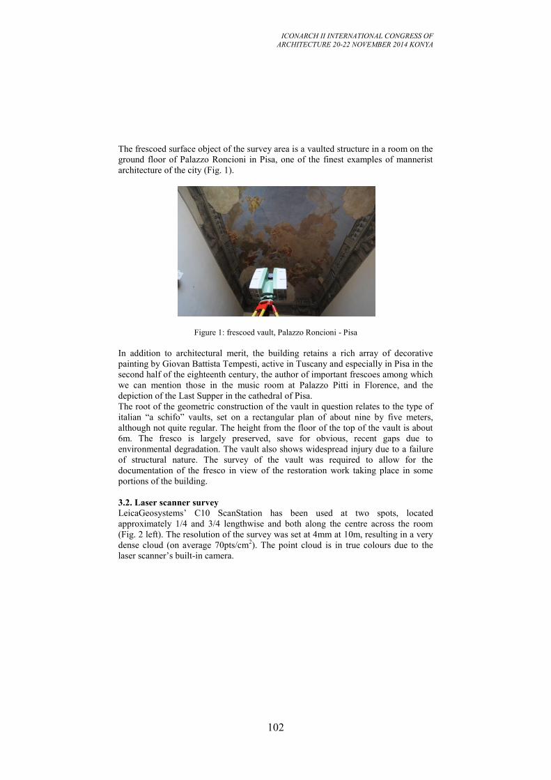
ICONARCH II INTERNATIONAL CONGRESS OF
ARCHITECTURE 20-22 NOVEMBER 2014 KONYA
102
The frescoed surface object of the survey area is a vaulted structure in a room on the
ground floor of Palazzo Roncioni in Pisa, one of the finest examples of mannerist
architecture of the city (Fig. 1).
Figure 1: frescoed vault, Palazzo Roncioni - Pisa
In addition to architectural merit, the building retains a rich array of decorative
painting by Giovan Battista Tempesti, active in Tuscany and especially in Pisa in the
second half of the eighteenth century, the author of important frescoes among which
we can mention those in the music room at Palazzo Pitti in Florence, and the
depiction of the Last Supper in the cathedral of Pisa.
The root of the geometric construction of the vault in question relates to the type of
italian “a schifo” vaults, set on a rectangular plan of about nine by five meters,
although not quite regular. The height from the floor of the top of the vault is about 6m. The fresco is largely preserved, save for obvious, recent gaps due to
environmental degradation. The vault also shows widespread injury due to a failure
of structural nature. The survey of the vault was required to allow for the
documentation of the fresco in view of the restoration work taking place in some
portions of the building.
3.2. Laser scanner survey
LeicaGeosystems’ C10 ScanStation has been used at two spots, located
approximately 1/4 and 3/4 lengthwise and both along the centre across the room
(Fig. 2 left). The resolution of the survey was set at 4mm at 10m, resulting in a very
dense cloud (on average 70pts/cm2). The point cloud is in true colours due to the
laser scanner’s built-in camera.
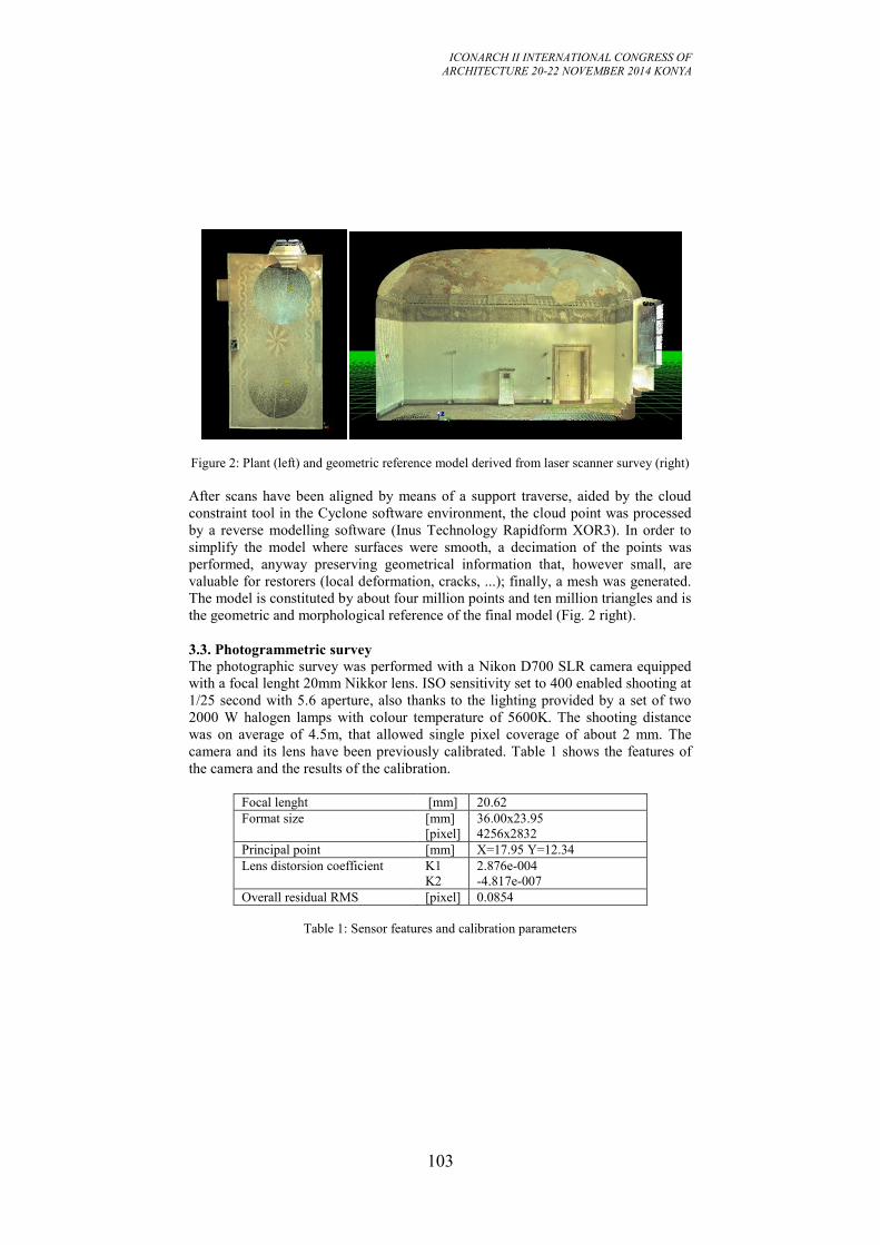
ICONARCH II INTERNATIONAL CONGRESS OF
ARCHITECTURE 20-22 NOVEMBER 2014 KONYA
103
Figure 2: Plant (left) and geometric reference model derived from laser scanner survey (right)
After scans have been aligned by means of a support traverse, aided by the cloud
constraint tool in the Cyclone software environment, the cloud point was processed
by a reverse modelling software (Inus Technology Rapidform XOR3). In order to
simplify the model where surfaces were smooth, a decimation of the points was
performed, anyway preserving geometrical information that, however small, are
valuable for restorers (local deformation, cracks, ...); finally, a mesh was generated.
The model is constituted by about four million points and ten million triangles and is
the geometric and morphological reference of the final model (Fig. 2 right).
3.3. Photogrammetric survey
The photographic survey was performed with a Nikon D700 SLR camera equipped
with a focal lenght 20mm Nikkor lens. ISO sensitivity set to 400 enabled shooting at
1/25 second with 5.6 aperture, also thanks to the lighting provided by a set of two
2000 W halogen lamps with colour temperature of 5600K. The shooting distance
was on average of 4.5m, that allowed single pixel coverage of about 2 mm. The
camera and its lens have been previously calibrated. Table 1 shows the features of
the camera and the results of the calibration.
Focal lenght [mm] 20.62
Format size
[mm]
[pixel]
36.00x23.95
4256x2832
Principal point [mm] X=17.95 Y=12.34
Lens distorsion coefficient K1
K2
2.876e-004
-4.817e-007
Overall residual RMS [pixel] 0.0854
Table 1: Sensor features and calibration parameters
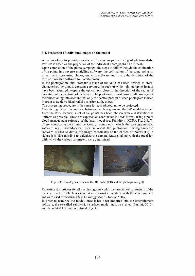
ICONARCH II INTERNATIONAL CONGRESS OF
ARCHITECTURE 20-22 NOVEMBER 2014 KONYA
104
3.4. Projection of individual images on the model
A methodology to provide models with colour maps consisting of photo-realistic
textures is based on the projection of the individual photographs on the mesh.
Upon completion of the photo campaign, the steps to follow include the collimation
of tie points in a reverse modelling software, the collimation of the same points to
orient the images using photogrammetric software and finally the definition of the
texture through a software for entertainment.
In the photographic take draft the surface of the vault has been divided in areas,
characterized by almost constant curvature, in each of which photographic images
have been acquired, keeping the optical axis close to the direction of the radius of
curvature of the centroid of each area. The photograms must ensure full coverage of
the object taking into account that only the central portion of each photogram is used
in order to avoid residual radial distortion at the edges.
The processing procedure is the same for each photogram to be projected.
Considering the part in common between the photogram and the 3-D model obtained
from the laser scanner, a set of tie points has been chosen with a distribution as
uniform as possible. These are exported as coordinates in DXF format, using a point
cloud management software of the laser model (eg. Rapidform XOR3, Fig. 3 left).
These coordinates constitute the Control Points (CP) which the photogrammetric
software (eg. PhotoModeler) uses to orient the photogram. Photogrammetric
software is used to derive the image coordinates of the chosen tie points (Fig. 3
right); it is also possible to calculate the camera features along with the precision
with which the various parameters were determined.
Figure 3: Homologous points on the 3D model (left) and the photogram (right)
Repeating this process for all the photograms yields the orientation parameters of the
cameras, each of which is exported in a format compatible with the entertainment
software used for texturing (eg. Luxology Modo - format * .fbx).
In order to texturize the model, once it has been imported into the entertainment
software, the so-called subdivision surfaces model must be created (Fantini, 2012),
and the related UV map is defined (Fig. 4).
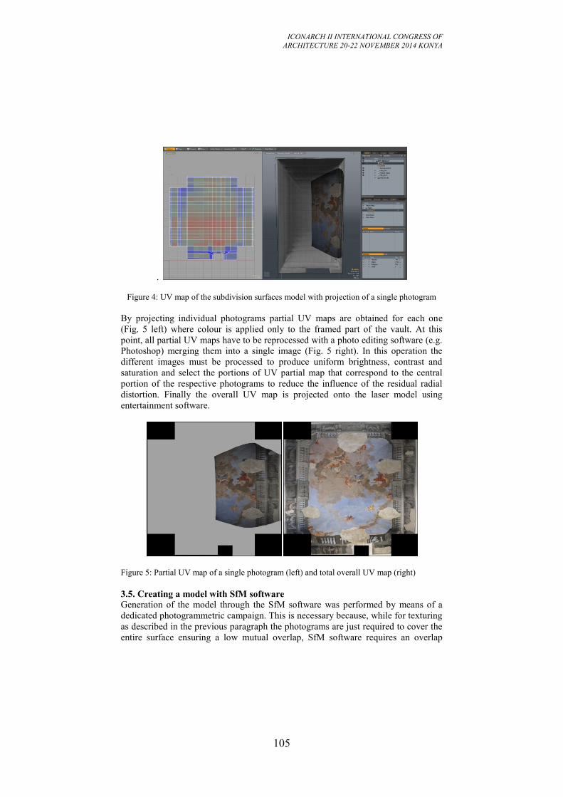
ICONARCH II INTERNATIONAL CONGRESS OF
ARCHITECTURE 20-22 NOVEMBER 2014 KONYA
105
.
Figure 4: UV map of the subdivision surfaces model with projection of a single photogram
By projecting individual photograms partial UV maps are obtained for each one
(Fig. 5 left) where colour is applied only to the framed part of the vault. At this
point, all partial UV maps have to be reprocessed with a photo editing software (e.g.
Photoshop) merging them into a single image (Fig. 5 right). In this operation the
different images must be processed to produce uniform brightness, contrast and
saturation and select the portions of UV partial map that correspond to the central
portion of the respective photograms to reduce the influence of the residual radial
distortion. Finally the overall UV map is projected onto the laser model using
entertainment software.
Figure 5: Partial UV map of a single photogram (left) and total overall UV map (right)
3.5. Creating a model with SfM software
Generation of the model through the SfM software was performed by means of a
dedicated photogrammetric campaign. This is necessary because, while for texturing
as described in the previous paragraph the photograms are just required to cover the
entire surface ensuring a low mutual overlap, SfM software requires an overlap
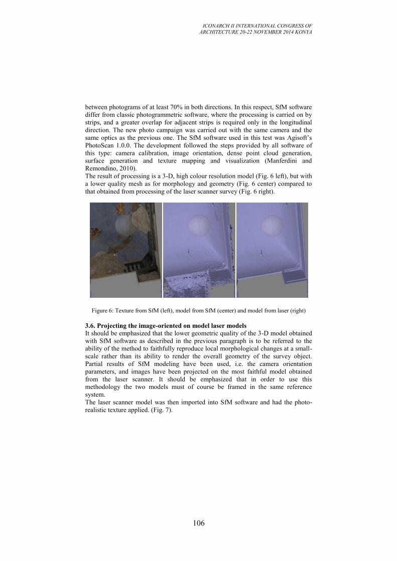
ICONARCH II INTERNATIONAL CONGRESS OF
ARCHITECTURE 20-22 NOVEMBER 2014 KONYA
106
between photograms of at least 70% in both directions. In this respect, SfM software
differ from classic photogrammetric software, where the processing is carried on by
strips, and a greater overlap for adjacent strips is required only in the longitudinal
direction. The new photo campaign was carried out with the same camera and the
same optics as the previous one. The SfM software used in this test was Agisoft’s
PhotoScan 1.0.0. The development followed the steps provided by all software of
this type: camera calibration, image orientation, dense point cloud generation,
surface generation and texture mapping and visualization (Manferdini and
Remondino, 2010).
The result of processing is a 3-D, high colour resolution model (Fig. 6 left), but with
a lower quality mesh as for morphology and geometry (Fig. 6 center) compared to
that obtained from processing of the laser scanner survey (Fig. 6 right).
Figure 6: Texture from SfM (left), model from SfM (center) and model from laser (right)
3.6. Projecting the image-oriented on model laser models
It should be emphasized that the lower geometric quality of the 3-D model obtained
with SfM software as described in the previous paragraph is to be referred to the
ability of the method to faithfully reproduce local morphological changes at a small-
scale rather than its ability to render the overall geometry of the survey object.
Partial results of SfM modeling have been used, i.e. the camera orientation
parameters, and images have been projected on the most faithful model obtained
from the laser scanner. It should be emphasized that in order to use this
methodology the two models must of course be framed in the same reference
system.
The laser scanner model was then imported into SfM software and had the photo-
realistic texture applied. (Fig. 7).
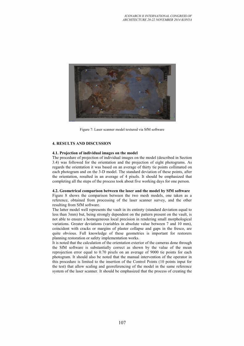
ICONARCH II INTERNATIONAL CONGRESS OF
ARCHITECTURE 20-22 NOVEMBER 2014 KONYA
107
Figure 7: Laser scanner model textured via SfM software
4. RESULTS AND DISCUSSION
4.1. Projection of individual images on the model
The procedure of projection of individual images on the model (described in Section
3.4) was followed for the orientation and the projection of eight photograms. As
regards the orientation it was based on an average of thirty tie points collimated on
each photogram and on the 3-D model. The standard deviation of these points, after
the orientation, resulted in an average of 4 pixels. It should be emphasized that
completing all the steps of the process took about five working days for one person.
4.2. Geometrical comparison between the laser and the model by SfM software Figure 8 shows the comparison between the two mesh models, one taken as a
reference, obtained from processing of the laser scanner survey, and the other
resulting from SfM software.
The latter model well represents the vault in its entirety (standard deviation equal to
less than 3mm) but, being strongly dependent on the pattern present on the vault, is
not able to ensure a homogeneous local precision in rendering small morphological
variations. Greater deviations (variables in absolute value between 7 and 10 mm),
coincident with cracks or margins of plaster collapse and gaps in the fresco, are
quite obvious. Full knowledge of these geometries is important for restorers
planning restoration or safety implementation works.
It is noted that the calculation of the orientation exterior of the cameras done through
the SfM software is substantially correct as shown by the value of the mean
reprojection error equal to 0.70 pixels on an average of 9000 tie points for each
photogram. It should also be noted that the manual intervention of the operator in
this procedure is limited to the insertion of the Control Points (10 points input for
the test) that allow scaling and georeferencing of the model in the same reference
system of the laser scanner. It should be emphasized that the process of creating the
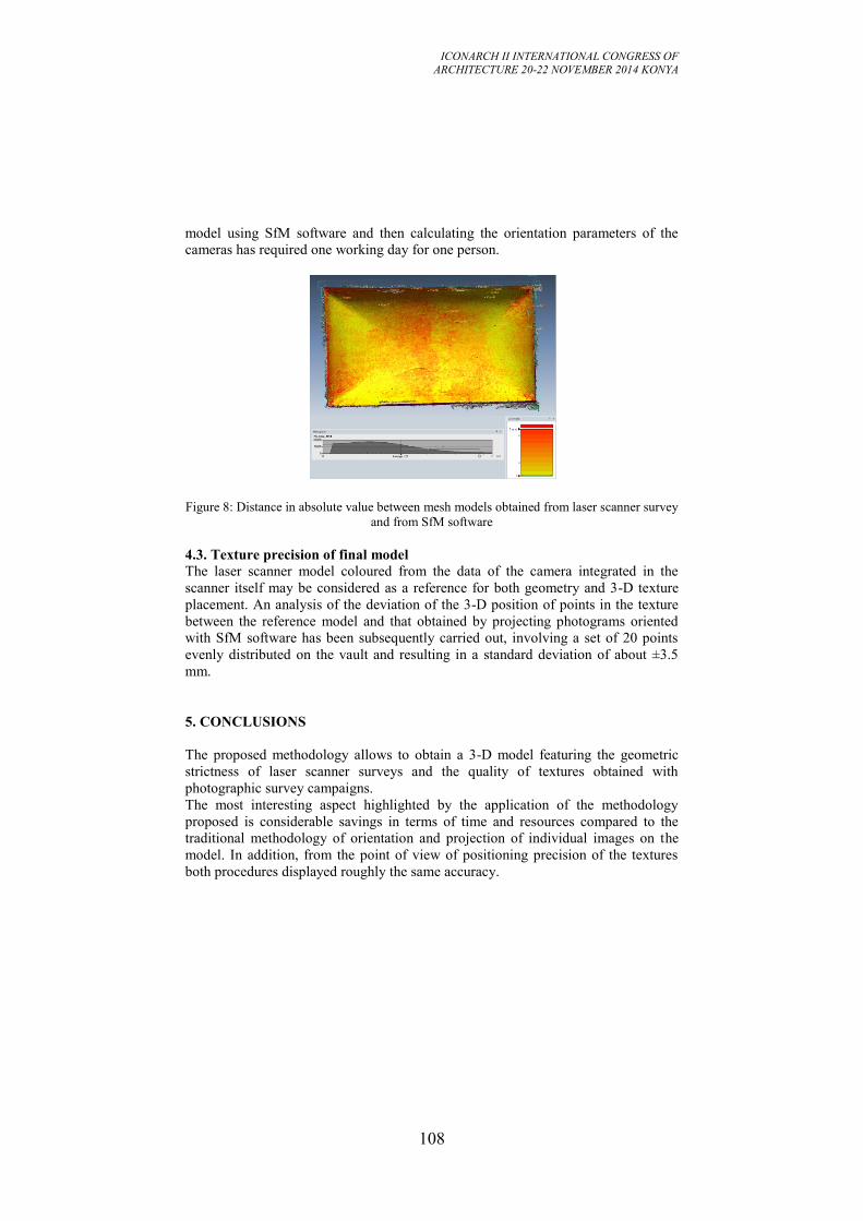
ICONARCH II INTERNATIONAL CONGRESS OF
ARCHITECTURE 20-22 NOVEMBER 2014 KONYA
108
model using SfM software and then calculating the orientation parameters of the
cameras has required one working day for one person.
Figure 8: Distance in absolute value between mesh models obtained from laser scanner survey
and from SfM software
4.3. Texture precision of final model
The laser scanner model coloured from the data of the camera integrated in the
scanner itself may be considered as a reference for both geometry and 3-D texture
placement. An analysis of the deviation of the 3-D position of points in the texture
between the reference model and that obtained by projecting photograms oriented
with SfM software has been subsequently carried out, involving a set of 20 points
evenly distributed on the vault and resulting in a standard deviation of about ±3.5
mm.
5. CONCLUSIONS
The proposed methodology allows to obtain a 3-D model featuring the geometric
strictness of laser scanner surveys and the quality of textures obtained with
photographic survey campaigns.
The most interesting aspect highlighted by the application of the methodology
proposed is considerable savings in terms of time and resources compared to the
traditional methodology of orientation and projection of individual images on the
model. In addition, from the point of view of positioning precision of the textures
both procedures displayed roughly the same accuracy.
ICONARCH II INTERNATIONAL CONGRESS OF
ARCHITECTURE 20-22 NOVEMBER 2014 KONYA
109
REFERENCES
- Adembri, B., Juan Vidal, F. y Martínez-Espejo Zaragoza, I., 2011. “Hunting
friezes of the Piazza d’Oro at the Hadrian’s Villa: new hypothesis for a virtual
reconstruction inside an integrated research strategy” in “16th International
Conference on Cultural Heritage and New Technologies”. Museen der Stadt Wien –
Stadtarchäologie. Viena. ISBN: 978-3-200-02740-4, pp.140-153.
- Alsadik, B., Remondino, F., Menna, F., Gerke, M. y Vosselman, G., 2013. “Robust
extraction of image correspondences exploiting the image scene geometry and
approximate camera orientation” in International Archives of the Photogrammetry,
Remote Sensing and Spatial Information Sciences, Volume XL-5/W1.
- Apollonio, F.I., Baldissini, S., Manferdini, A.M., Remondino, F., 2010. “Rilievo
3D nell’area archeologica di Pompei: risultati e considerazioni.” in Benedetti, B.,
Gaiani, M. y Remondino, F. (ed.) Modelli Digitali 3D in archeologia: Il caso di
Pompei. Edizioni della Normale. Scuola Normale Superiore Pisa, pp. 270-307.
- Appollonio, F.I., Ballabeni, A., Gaiani, M.,Remondino, F. 2014. "Evaluation of
feature-based methods for automated network orientation.” ISPRS Archives of the
Photogrammetry, Remote Sensing and Spatial Information Sciences, Vol. XL-5.
- Apollonio, F.I. y Remondino, F., 2010. “Modellazione 3D da sensori attivi
Pipeline con laser scanner” in Benedetti, B., Gaiani, M. y Remondino, F. (ed.)
Modelli Digitali 3D in archeologia: Il caso di Pompei. Edizioni della Normale.
Scuola Normale Superiore Pisa, pp. 94-117.
- Baldissini, S., Gaiani, M. y Remondino, F., 2010. “Rilievo, gestione e mappatura
del colore” in Benedetti, B., Gaiani, M. y Remondino, F. (ed.) Modelli Digitali 3D
in archeologia: Il caso di Pompei. Edizioni della Normale. Scuola Normale
Superiore Pisa, pp. 200-235.
- Benedetti, B., Gaiani, M. y Remondino, F. (ed.), 2010. Modelli Digitali 3D in
archeologia: Il caso di Pompei. Ed. della Normale. Scuola Normale Superiore Pisa.
- Bevilacqua M.G., Caroti G., Piemonte A., 2012; "Rilievi integrati della Basilica
romanica di San Gavino a Porto Torres", Proceedings 16° Conferenza Nazionale
ASITA. VICENZA, p. 391-396, ISBN 978-88-903132-7-1
- Biosca Taronger, J.M., Navarro Tarín, S. y Lerma García, J.L., 2007. Modelado
tridimensional de una bóveda barroca mediante la combinación de láser escáner y
fotogrametría, 7 Setmana Geomàtica, Febrero 20–23, Barcelona, España.
- Caroti G., Piemonte A., 2008 "An integrated survey for knowledge and
preservation of a cultural heritage: the albanian fortified citadel of Elbasan.", The
International Archives of the Photogrammetry, Remote Sensing and Spatial
Information Sciences, vol. XXXVII, part B5/V; p.373-378, ISSN: 1682-1750
- Caroti G., Piemonte A., 2012 "Studio relativo al rilevamento di dettaglio di una
porzione del transetto nord della chiesa di San Paolo a Ripa d'Arno al fine di
procedere al consolidamento strutturale", In “Un incontro informale per i 70 anni del
Prof. Carlo Monti ”, pp. 1-6, Edizioni SIFET, ISBN 978-88-905017-6-1.
- Dore, C. y Murphy, M., 2012. “Integration of Historic Building Information
Modelling (HBIM) and 3D GIS for Recording and Managing Cultural Heritage
ICONARCH II INTERNATIONAL CONGRESS OF
ARCHITECTURE 20-22 NOVEMBER 2014 KONYA
110
Sites” in 18th International Conference on Virtual Systems and Multimedia
(VSMM). VSMM 2012 Virtual Systems in the Information Society. 2 - 5
Septiembre 2012 Milan, Italia, pp. 369-376.
- Fantini, F., 2011 "La modellazione in Displaced sub-D: Modelli a dettaglio
variabile da scansione laser" in Verdiani, G. (ed.) Il ritorno all'immagine, nuove
procedure image based per il Cultural Heritage. ISBN 978-1-4452-9256-4.
- Fantini, F., Rodríguez-Navarro, P. y Di Tondo, S., 2012. “Il problema della
mappatura del colore nei modelli digitali 3d a displaced subdivision surface da
rilevamento laser scanner in ambito archeologico” in Rossi, M. y Siniscalco, A.,
(ed.) Colore e colorimentria. Contributi multidisciplinari. Vol. VIII A. Dip. Indaco.
Politecnico di Milano,pp. 31-38.
- Guidi, G. y Remondino, F., 2012. “3D Modelling from Real Data” in Modelling
and Simulation in Engineering. Edited by Catalin Alexandru, InTech, 3 de Marzo.
- Guidi, G., Russo, M. y Beraldin, J.A., 2010. Acquisizione 3D e modellazione
poligonale. McGraw-Hill. Italia.
- Juan Vidal, F. y Martínez-Espejo Zaragoza, I., 2011. “Hypotesis for the virtual
anastilosis of the main chapel of the Iglesia de Los Desamparados de Les Coves de
Vinromá” in “16th International Conference on Cultural Heritage and New
Technologies”. Museen der Stadt Wien – Stadtarchäologie. Viena. ISBN: 978-3-
200-02740-4, pp.201-212.
- Koska, B. y Křemen, T., 2013. “The combination of laser scanning and structure
from motion technology for creation of accurate exterior and interior orthophotos of
St. Nicholas Baroque church” in International Archives of the Photogrammetry,
Remote Sensing and Spatial Information Sciences, Volume XL-5/W1.
- Lerma, J.L., Navarro, S., Cabrelles, M. y Villaverde V., 2010. “Terrestrial Laser
Scanning and Close Range Photogrammetry for 3D Archaeological Documentation:
the Upper Palaeolithic Cave of Parpalló As a Case Study” in Journal of
Archaeological Science 37. Elsevier, pp. 499–507.
- Lerma, J.L., Cabrelles, M., Navarro, S., and Seguí, A.E., 2011. “La documentación
patrimonial mediante sensores de imagen o de barrido láser” in Documentación
gráfica del patrimonio, Ministerio de Cultura,pp. 108-117.
- Manferdini, A.M. y Remondino, F., 2010. “Modellazione 3D da immagini
Perperline fotogrammetrica” in Benedetti, B., Gaiani, M. y Remondino, F. (ed.)
Modelli Digitali 3D in archeologia: Il caso di Pompei. Edizioni della Normale.
Scuola Normale Superiore Pisa, pp. 162-199.
- Marambio, A., Pucci, B., Nuñez, M.A. y Buill, F., 2009. “La aplicación del escáner
láser terrestre en la catalogación del patrimonio arquitectónico del casco histórico de
Castellfollit de la Roca” inVIII Semana Geomática Internacional,pp. 1-8.
- Martínez-Espejo Zaragoza, I. y Juan Vidal, F., 2012. “Gestión gráfica avanzada de
edificaciones antiguas” in “XI Congreso internacional de expresión gráfica aplicada
a la edificación”, Universidad Politécnica de Valencia. ISBN: 978-84-8363-964-1.
- Merlo, A., Fantini, F., Lavoratti, G., Aliperta, A. and López Hernández, J.L., 2013
"Texturing and optimization of reality based digital models: the church of Compañía
de Jesús" in DISEGNARECON. Vol. 6, n. 12.

ICONARCH II INTERNATIONAL CONGRESS OF
ARCHITECTURE 20-22 NOVEMBER 2014 KONYA
111
- Rodríguez Navarro, P., 2012. “La fotogrametría digital automatizada frente a los
sistemas basados en sensores 3D activos” in Revista EGA (Expresión Gráfica
Arquitectónica). Universidad Politécnica de Valencia. Valencia, pp.100-111.
- Wenzel, K., Rothermel, M., Fritsch, D. Y Haala, N., 2013. “Image acquisition and
model selection for multi-view stereo” in International Archives of the
Photogrammetry, Remote Sensing and Spatial Information Sciences, Volume XL-
5/W1.
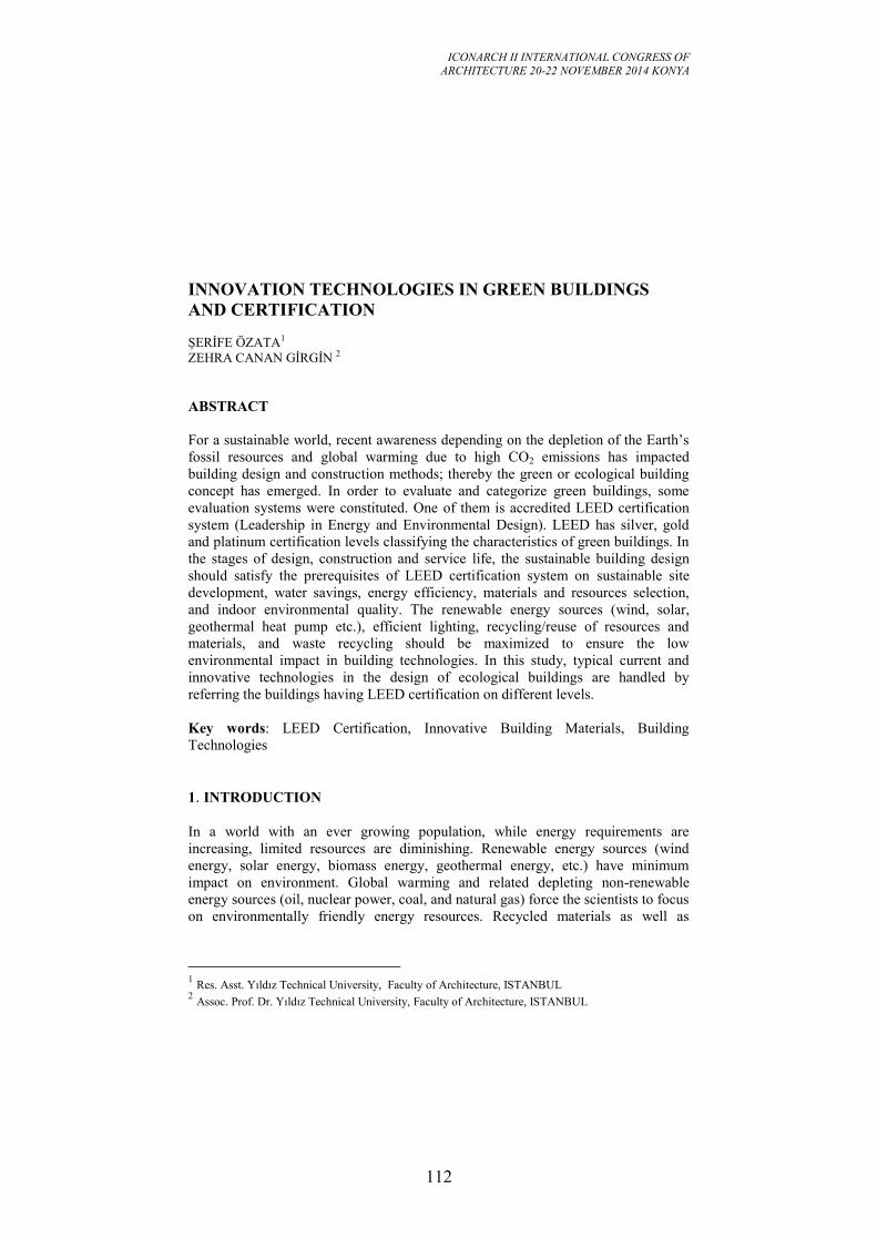
ICONARCH II INTERNATIONAL CONGRESS OF
ARCHITECTURE 20-22 NOVEMBER 2014 KONYA
112
INNOVATION TECHNOLOGIES IN GREEN BUILDINGS
AND CERTIFICATION
ŞERİFE ÖZATA1
ZEHRA CANAN GİRGİN 2
ABSTRACT
For a sustainable world, recent awareness depending on the depletion of the Earth’s
fossil resources and global warming due to high CO2 emissions has impacted
building design and construction methods; thereby the green or ecological building
concept has emerged. In order to evaluate and categorize green buildings, some
evaluation systems were constituted. One of them is accredited LEED certification
system (Leadership in Energy and Environmental Design). LEED has silver, gold
and platinum certification levels classifying the characteristics of green buildings. In
the stages of design, construction and service life, the sustainable building design
should satisfy the prerequisites of LEED certification system on sustainable site
development, water savings, energy efficiency, materials and resources selection,
and indoor environmental quality. The renewable energy sources (wind, solar,
geothermal heat pump etc.), efficient lighting, recycling/reuse of resources and
materials, and waste recycling should be maximized to ensure the low
environmental impact in building technologies. In this study, typical current and
innovative technologies in the design of ecological buildings are handled by
referring the buildings having LEED certification on different levels.
Key words: LEED Certification, Innovative Building Materials, Building
Technologies
1. INTRODUCTION
In a world with an ever growing population, while energy requirements are
increasing, limited resources are diminishing. Renewable energy sources (wind
energy, solar energy, biomass energy, geothermal energy, etc.) have minimum
impact on environment. Global warming and related depleting non-renewable
energy sources (oil, nuclear power, coal, and natural gas) force the scientists to focus
on environmentally friendly energy resources. Recycled materials as well as
1 Res. Asst. Yıldız Technical University, Faculty of Architecture, ISTANBUL
2 Assoc. Prof. Dr. Yıldız Technical University, Faculty of Architecture, ISTANBUL
ICONARCH II INTERNATIONAL CONGRESS OF
ARCHITECTURE 20-22 NOVEMBER 2014 KONYA
113
optimization of water use are other important issues for a global sustainability.
Innovative technologies for a sustainable world should be addressed more and more.
The main purpose of this study is to investigate the special features of innovative
building technologies (wind and solar energy; heating, ventilating and air
conditioning systems; lighting systems; optimized water material use) as well as the
certification system of Leadership in Energy and Environmental Design (LEED) to
promote sustainable building design.
2. GREEN BUILDING CERTIFICATION SYSTEMS AND LEED
Green building has a lighter footprint on environment and comprises the issues such
as energy, water, material efficiency and minimum waste in the design, production,
operation, maintenance and demolition removal phases in the life cycle. Various
green building certifications (DGNB, BREEAM, CASBEE, and LEED) have been
used since the end of 20th
century.
The LEED environmental certification by U.S. Green Building Council (USGBC) is
most popular and reliable protocol used in over 40 countries. USGBC defined four
levels for LEED: Certified, Silver, Gold and Platinum. LEED v4 (2013) is the last
version (USGBC 2014). However, teams may still register the projects under LEED
v3/2009 until June 1, 2015. LEED v3 has 7 categories: Sustainable Sites, Water
Efficiency, Energy & Atmosphere, Material&Resources, Indoor and Environmental
Quality, Innovation in Design and Regional Priority) over total 100 points. There
also have 6 possible points in Innovation in Design and 4 points in Regional
Priority.
3. FEATURES OF INNOVATIVE BUILDING TECHNOLOGIES
In this section, innovative technologies in green buildings are focused by addressing
certificated buildings.
3.1. Wind Energy
Wind energy could be converted to mechanical energy through the wind turbine up
to the rate 50% (İlkiliç and Türkbay 2010). Worldwide wind turbines installed by
the end of 2013 can provide 320 GW and 628 TWh consumptions per year (BP
Statistics 2014). This consumption is 2.7 % of global electricity generation.
Denmark, Spain, Germany and Portugal are the leading countries in the base on
daily wind energy per person (Girgin 2012).
Wind turbines in building are used more and more. Prediction of wind velocity and
direction, and orientation of building are important parameters. Two main concepts
of wind turbines are under consideration: the horizontal-axis turbines (HAWT) and
the vertical-axis wind turbines (VAWT). Three-blade HAWT turbines are popular
due to smoother rotational operation and cost efficiency. As a typical example, the
massive three-blade 65kW wind turbine on 37 m mast in the site of Alberici
ICONARCH II INTERNATIONAL CONGRESS OF
ARCHITECTURE 20-22 NOVEMBER 2014 KONYA
114
Corporate Headquarters (2005, LEED Platinum) provides 92 MWh as 20% of
annual energy needs [1] (Fig.1a).VAWT system has the advantages such as lower
noise / vibration levels, operation ability in lower wind speeds. In addition, this
system does not need to be pointed into the wind which is important in urban areas
due to highly variable wind direction and local turbulences.
In addition to wind farms, to design wind turbines in urban areas becomes popular in
middle-rise buildings. Mast mounted turbines on the roof (Fig.1b, c) maybe seems to
be a cost effective solution but not a very aesthetical solution. The connection of two
buildings with wind turbines in Bahrain (World Trade Center, 2008), building
integrated five-blades wind turbine in London (Strata Building, 2010), and finally
mounting wind turbines into tunnels through a tall building in China (Pearl River
Tower, 2012) are pioneering solutions (Fig.2). 225-kW three turbines in Bahrain
World Trade Center satisfy 11-15 % of total energy demand, that this quantity
(1200 MWh) is equivalent to lighting of 300 homes per year [2], in the 4-20 m/s
operation limits of wind velocity [3].
Integration with building involves complex design techniques due to high
aerodynamic noise levels, radio/TV interference due to electro-magnetic forces and
the vibration which necessitates damped bearings to isolate building. RC structure
option and to install VAWT to mechanics floor may give suitable solution.
Cost and energy efficient turbines with less noise and vibration levels as well as
integration with architecture become the main issues. Façade integration, double
roof or funneling concepts through Venturi effect [4] are new ideas for building
architecture as well (Fig.3a, b).
3.2. Photovoltaic Systems
Current worldwide photovoltaic power (PV) capacity is 140 GW, i.e. 125 TWh
(2013) (BP Statistics 2014) corresponds to only 0.5 % of global electricity
generation. Germany is the leading country in the base on daytime solar energy per
person (Girgin 2012).
Photovoltaic materials include silicon, gallium arsenide, copper indium diselenide,
cadmium telluride, indium phosphide etc. PV cell can be a mono-crystalline,
multicrystalline or amorphous (Kalogirou 2014). Solar cells are mainly categorized
into three different types. Inorganic solar cells are first generation, organic solar
cells (OSCs) and dye-sensitized solar cells (DSCs) are second generation and hybrid
solar cells (HSCs) based on nanostructures are considered for third generation. The
power conversion efficiency of first and second generation solar cells were ~25%
(silicon) and ~20% (copper indium gallium di-selenide) at lab scale (Babu et al.
2014). Copper Indium Gallium Selenide (CIGS) PVs are a promising technology
with moderate efficiency, low cost and light weight characteristics for rooftop
installations both in residential and commercial buildings. It is expected nano cells
to be commercially available within the next few years, by tremendously reducing
cost.
Building-integrated photovoltaics (BIPV) either in the façade and/or roof of the
building are the typical application of PVs (Fig.4a, b, c). To prevent additional

ICONARCH II INTERNATIONAL CONGRESS OF
ARCHITECTURE 20-22 NOVEMBER 2014 KONYA
115
thermal load and efficiency loss, a gap is created between the PV and the building
element (brick, slab, etc.) for air circulation. PVs are recently used on external
automated shading system moving around on tracks (Fig.4d, e).
In PV systems, generator is used for deep charge the batteries a few times annually
to extend their lifespan or to charge the batteries dropped below a critical ratio (e.g.
20%).
If the construction site is not near electricity lines, a zero energy building can be
designed as off-grid system; e.g. Audubon Center, LA (LEED Platinum) gain
110.5% energy (demand is 55 kWh/m2
per year) via roof- mount via 25-kW
polycrystalline off-grid PV system (Gevorkian 2008). Energy need of the building
can be provided by battery cells during four or five winter days without direct sun
light.
3.3. Heating, Ventilating and Air Conditioning (HVAC) Systems
Automatically operable windows by monitoring outside weather conditions, carbon
dioxide (CO2) monitors to adjust necessary airflow levels throughout the building,
under floor air-distribution system supplying air at the level of the occupants are the
some characteristics of green buildings.
Blocking north face of building with masonry walls is a good and well known way
to save indoor heat. Double façade helps the building maintain its thermal conditions
by trapping heat that is radiated from the building and blocking solar heat.
Reflective surfaces are used to reduce heat absorption and cool the air.
Low-grade waste steam from neighboring cogeneration plant can be exchanged to
heat or used to drive chiller for cooling instead of electricity to reduce energy costs.
Orienting wind through funnel (Venturi effect) by flowing toward open atria on the
roof is another innovative method for ventilation (Siemens HQ, Masdar City, LEED
Platinum, 2014) (Fig.3a, b).
Temperature and humidity monitors maintain optimal thermal comfort, indoor
reflective pond and plants also regulate humidity levels naturally. In addition to
outdoor green walls as well as green roofs are organized to reduce heat gain and loss
in building. 20 m living wall of atrium in La Maison Du Développement (LEED
Platinum, 2013) (Lagace 2014) is a special example to indoor applications (Fig.5b).
Geothermal wells are installed underneath the building (e.g. Clock Shadow
Building, 2012, LEED Platinum) to efficiently remove heat from the building. In La
Maison Du Développement (LEED Platinum, 2013) on the total area of 6350 m2, 28
geothermal wells (14 kW) were drilled down to 152 m to satisfy nearly 100% of the
heating and cooling requirements via geothermal energy (Lagace 2014). Siemens
HQ (2014) has the deepest one of 2.5 km [5].
Pond with aquathermal heat pump system can be used for heating during the winter
and cooling in the hot summer. 37 % reduction in energy cost was predicted in
Saginaw Valley State University (2008, LEED Silver) over 5 ha manmade pond
(Thompson and Kerbelis 2013).
ICONARCH II INTERNATIONAL CONGRESS OF
ARCHITECTURE 20-22 NOVEMBER 2014 KONYA
116
Combined heat and power system (CHP) (SUNY-ESF’s Gateway Center, LEED
Platinum, 2014), is a new alternative to provide steam and electricity in green
buildings due to minimal waste output and efficiency twice according to traditional
technology by using biomass in addition to other energy sources well [6].
In the near future, it is thought that a technology called “Enhanced Geothermal
Systems” would be attainable that involves drilling at least down to 10 km in a
similar way to oil exploration techniques [7].
3.4. Lighting Systems
South-facing rooms for daylighting, blocking west-facing windows via masonry
wall are known solutions. Work places can have almost fully natural lighting.
Computer controlled shades and louvers optimize the amount of daylight brought in
and prevent glare (Fig.4d, e and Fig.6a, b) in ecological buildings. Innovative
shielding system in Al Bahar Towers requires less artificial lighting and 50% less air
conditioning (Fig.6c).
Roof mounted mirrors, heliostats, fiber optic system directing the daylight into the
building through skylight and sun pipe system delivering daylight up to 14-story
(Fig.7a, b). Tertiary mirrors are typical natural lighting techniques nowadays
(Fig.8a). The reflective pool in the atrium or the reflective panels on atrium walls are
light distributing mechanisms as well. Milled acrylic prisms can be used to enhance
reflection, diffuse light, prevent heat absorption and eliminate glare due to halogen
lights at night (Genzyme Center, LEED Platinum, 2003) (Fig.8b).
3.5 Material Usage and Impact on Environment
It is a well-known reality that the cement sector is responsible for 7% of global
CO2 emissions. In order to decrease this emission in huge construction sector,
innovative techniques such as to change the raw material CaCO3 with MgCO3 or to
produce concrete without cement via 100 % fly ash are under development. In view
of structural systems, the embodied carbon emission to ultimate strength ratios
(Fig.9) (Kuruscu and Girgin, 2014) reveal the importance of recycled material
utilization instead of virgin one (e.g. steel, aluminum) as well as green concrete and
masonry blocks by partially replacing cement with waste by-products such as fly
ash, blast furnace slag, rice husk ash etc. Recycled aggregate usage, to put waste tire
pieces as aggregate into concrete, to apply CO2 cure to masonry blocks (Fig.10) and
to use chemicals absorbing emissions in concrete decrease environmental impact.
Some applications such as illuminating concrete and translucent concrete provide
aesthetical solutions to save lighting energy in indoor and outdoor applications
(Fig.11).
Wooden composite structures from renewable and certified forests are currently
being constructed to reduce CO2 footprint more and more. Formaldehyde-free glues
and paints in wooden composites are used to prevent health problems in humans
(Fig.12).
ICONARCH II INTERNATIONAL CONGRESS OF
ARCHITECTURE 20-22 NOVEMBER 2014 KONYA
117
Building materials from local sources in high ratios and water-based finishers reduce
impact on environment. Nearly total waste of construction or demolition should be
diverted to landfill, reuse, donate or recycle.
Green roof by planting an insulated roof membrane assembly (IRMA) is a wide
spread application in green buildings. Moisture sensors installed in the soil (inside
and outside) is a good solution to eliminate unnecessary watering (Fig.13a). In
Alberici Corporate Headquarters won the highest LEED rating (60 over 69 credits in
six categories in 2004), rainwater from the garage roof is collected in retention
ponds and used in the building’s cooling tower and sewage conveyance system
(Fig.13b). Thus, less water consumption up to % 70 is possible via rainwater
collection and other preventions.
4. CONCLUSION
Innovative technologies progress toward min. energy requirement and almost full
usage of recycled/reusable materials in buildings. Zero-energy building, 70 % less
water consumption, ecofriendly recycled/reusable material in high ratios, 100 %
lighting of work places are possible in current green buildings certified by LEED.
Renewable energy technologies such as solar panels, geothermal wells, wind
turbines are under progress. Although initial capital cost in green buildings is
relatively high, especially lifetime energy expenses are less compared with
conventional buildings. However, sustainable buildings should not be designed not
only to be registered by LEED but also should be affordable for common housing by
people as well. It is suggested that the credit in LEED for Innovation in Design can
be encouraged with higher points than current 6 points to provide the development
and use of innovative technologies.
4.1. Figures, Graphics, Photographs and Tables
a. b. c.
Figure 1: a. Alberici Corporate Headquarters (USA, 2005), b. Hafencity (Germany,
2014), c.Twelve West (USA, 2009) c. [8, 9]
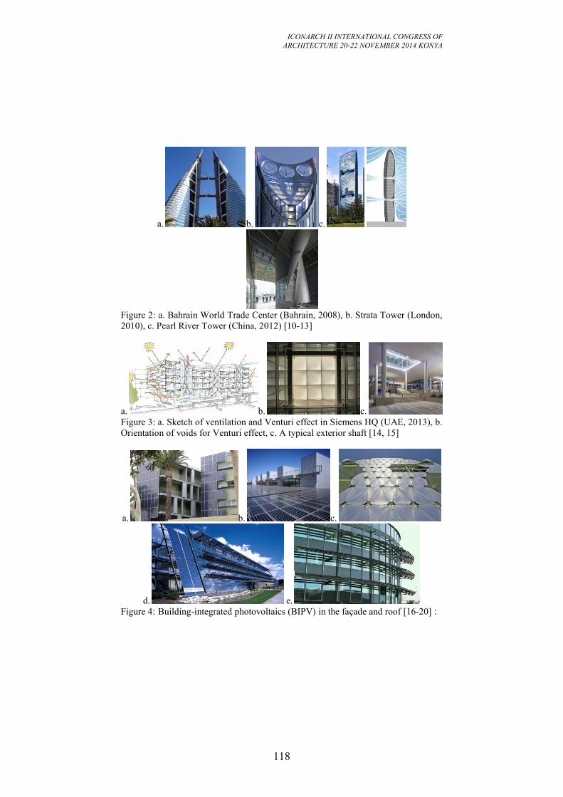
ICONARCH II INTERNATIONAL CONGRESS OF
ARCHITECTURE 20-22 NOVEMBER 2014 KONYA
118
a. b. c.
Figure 2: a. Bahrain World Trade Center (Bahrain, 2008), b. Strata Tower (London,
2010), c. Pearl River Tower (China, 2012) [10-13]
a. b. c.
Figure 3: a. Sketch of ventilation and Venturi effect in Siemens HQ (UAE, 2013), b.
Orientation of voids for Venturi effect, c. A typical exterior shaft [14, 15]
a. b. c.
d. e.
Figure 4: Building-integrated photovoltaics (BIPV) in the façade and roof [16-20] :
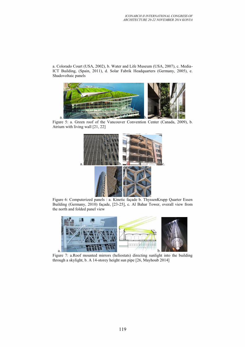
ICONARCH II INTERNATIONAL CONGRESS OF
ARCHITECTURE 20-22 NOVEMBER 2014 KONYA
119
a. Colorado Court (USA, 2002), b. Water and Life Museum (USA, 2007), c. Media-
ICT Building, (Spain, 2011), d. Solar Fabrik Headquarters (Germany, 2005), e.
Shadovoltaic panels
a. b.
Figure 5: a. Green roof of the Vancouver Convention Center (Canada, 2009), b.
Atrium with living wall [21, 22]
a. b. c.
Figure 6: Computerized panels : a. Kinetic façade b. ThyssenKrupp Quarter Essen
Building (Germany, 2010) façade, [23-25], c. Al Bahar Tower, overall view from
the north and folded panel view
a. b.
Figure 7: a.Roof mounted mirrors (heliostats) directing sunlight into the building
through a skylight, b. A 14-storey height sun pipe [26, Mayhoub 2014]
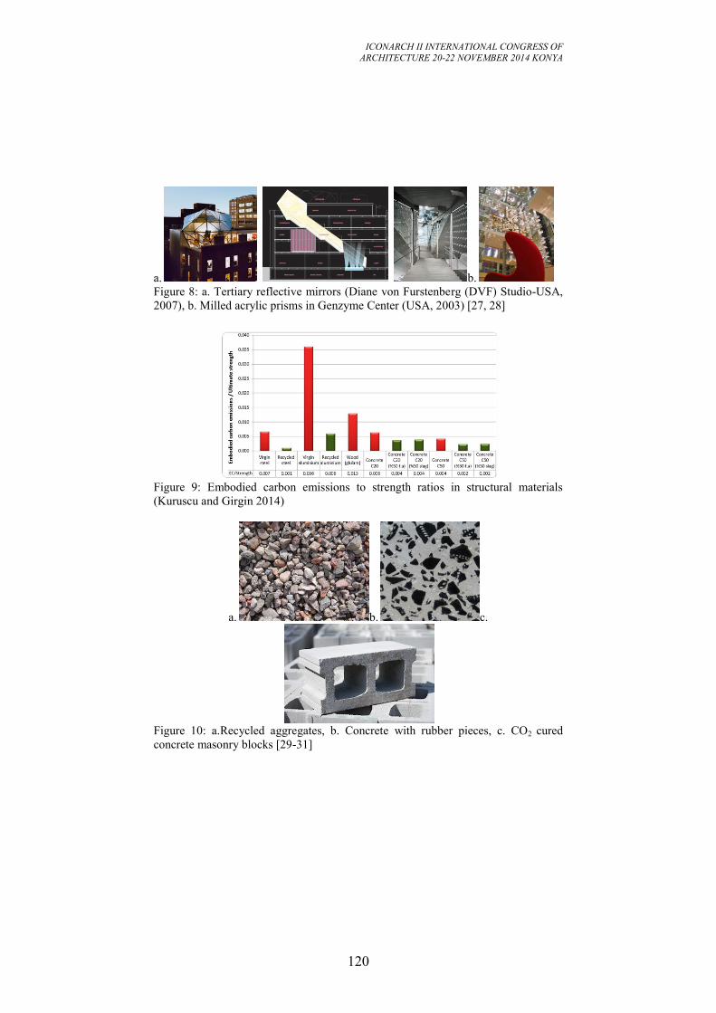
ICONARCH II INTERNATIONAL CONGRESS OF
ARCHITECTURE 20-22 NOVEMBER 2014 KONYA
120
a. b.
Figure 8: a. Tertiary reflective mirrors (Diane von Furstenberg (DVF) Studio-USA,
2007), b. Milled acrylic prisms in Genzyme Center (USA, 2003) [27, 28]
Figure 9: Embodied carbon emissions to strength ratios in structural materials
(Kuruscu and Girgin 2014)
a. b. c.
Figure 10: a.Recycled aggregates, b. Concrete with rubber pieces, c. CO2 cured
concrete masonry blocks [29-31]
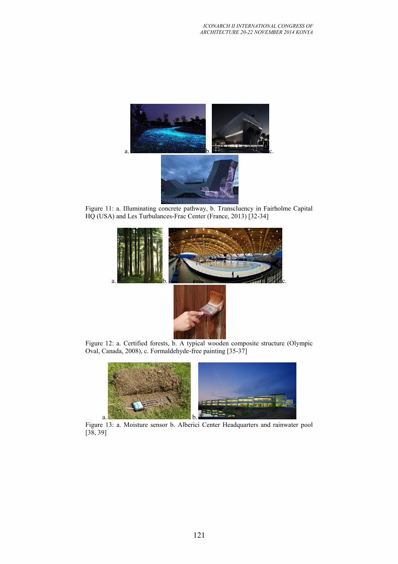
ICONARCH II INTERNATIONAL CONGRESS OF
ARCHITECTURE 20-22 NOVEMBER 2014 KONYA
121
a. b. c.
Figure 11: a. Illuminating concrete pathway, b. Transcluency in Fairholme Capital
HQ (USA) and Les Turbulances-Frac Center (France, 2013) [32-34]
a. b. c.
Figure 12: a. Certified forests, b. A typical wooden composite structure (Olympic
Oval, Canada, 2008), c. Formaldehyde-free painting [35-37]
a. b.
Figure 13: a. Moisture sensor b. Alberici Center Headquarters and rainwater pool
[38, 39]
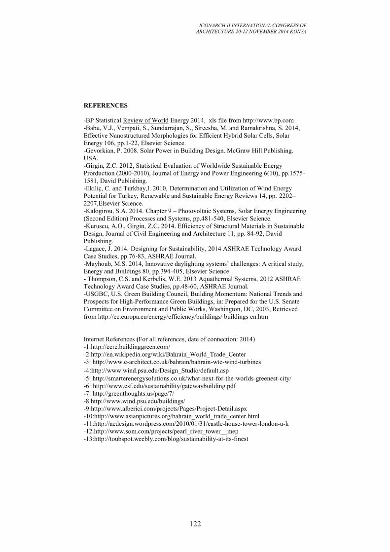
ICONARCH II INTERNATIONAL CONGRESS OF
ARCHITECTURE 20-22 NOVEMBER 2014 KONYA
122
REFERENCES
-BP Statistical Review of World Energy 2014, xls file from http://www.bp.com
-Babu, V.J., Vempati, S., Sundarrajan, S., Sireesha, M. and Ramakrishna, S. 2014,
Effective Nanostructured Morphologies for Efficient Hybrid Solar Cells, Solar
Energy 106, pp.1-22, Elsevier Science.
-Gevorkian, P. 2008. Solar Power in Building Design. McGraw Hill Publishing.
USA.
-Girgin, Z.C. 2012, Statistical Evaluation of Worldwide Sustainable Energy
Prorduction (2000-2010), Journal of Energy and Power Engineering 6(10), pp.1575-
1581, David Publishing.
-Ilkiliç, C. and Turkbay,I. 2010, Determination and Utilization of Wind Energy
Potential for Turkey, Renewable and Sustainable Energy Reviews 14, pp. 2202–
2207,Elsevier Science.
-Kalogirou, S.A. 2014. Chapter 9 – Photovoltaic Systems, Solar Energy Engineering
(Second Edition) Processes and Systems, pp.481-540, Elsevier Science.
-Kuruscu, A.O., Girgin, Z.C. 2014. Efficiency of Structural Materials in Sustainable
Design, Journal of Civil Engineering and Architecture 11, pp. 84-92, David
Publishing.
-Lagace, J. 2014. Designing for Sustainability, 2014 ASHRAE Technology Award
Case Studies, pp.76-83, ASHRAE Journal.
-Mayhoub, M.S. 2014, Innovative daylighting systems’ challenges: A critical study,
Energy and Buildings 80, pp.394-405, Elsevier Science.
- Thompson, C.S. and Kerbelis, W.E. 2013 Aquathermal Systems, 2012 ASHRAE
Technology Award Case Studies, pp.48-60, ASHRAE Journal.
-USGBC, U.S. Green Building Council, Building Momentum: National Trends and
Prospects for High-Performance Green Buildings, in: Prepared for the U.S. Senate
Committee on Environment and Public Works, Washington, DC, 2003, Retrieved
from http://ec.europa.eu/energy/efficiency/buildings/ buildings en.htm
Internet References (For all references, date of connection: 2014)
-1:http://eere.buildinggreen.com/
-2:http://en.wikipedia.org/wiki/Bahrain_World_Trade_Center
-3: http://www.e-architect.co.uk/bahrain/bahrain-wtc-wind-turbines
-4:http://www.wind.psu.edu/Design_Studio/default.asp
-5: http://smarterenergysolutions.co.uk/what-next-for-the-worlds-greenest-city/
-6: http://www.esf.edu/sustainability/gatewaybuilding.pdf
-7: http://greenthoughts.us/page/7/
-8 http://www.wind.psu.edu/buildings/
-9:http://www.alberici.com/projects/Pages/Project-Detail.aspx
-10:http://www.asianpictures.org/bahrain_world_trade_center.html
-11:http://aedesign.wordpress.com/2010/01/31/castle-house-tower-london-u-k
-12.http://www.som.com/projects/pearl_river_tower__mep
-13:http://toubspot.weebly.com/blog/sustainability-at-its-finest
ICONARCH II INTERNATIONAL CONGRESS OF
ARCHITECTURE 20-22 NOVEMBER 2014 KONYA
123
-14:http://www.archdaily.com/517456/inside-masdar-city
-15:http://www.archdaily.com/539213/siemens-hq-in-masdar-city-sheppard-robson/
-16:https://www.flickr.com/photos/limelightpower/5546248591/
-17:http://inhabitat.com/hemet-water-and-life-museums/hemet1/
-18:http://www.ruiz-geli.com/
-19:http://www.solar-fabrik.de/company/company/energy-concept/headquarter/
-20:http://www.coltinfo.nl/shadovoltaic.html
-21:http://enr.construction.com/buildings/sustainability/2012/slideshow.asp -
22:http://www.sabmagazine.com/blog/2013/12/24/maison-du-developpement-
durable/
-23:http://www.ctbuh.org/TallBuildings/FeaturedTallBuildings/AlBaharTowers
-24:http://www.archdaily.com/326747/q1-thyssenkrupp-quarter-essen-jswd-
architekten-chaix-morel-et-associes/
-25:http://weburbanist.com/2014/03/16/kinetic-facade-awesome-adaptive-window-
shading-system/
-26:http://sustainability.tufts.edu/wp-content/uploads/Genzyme.pdf
-27:http://work.ac/diane-von-furstenberg-studio-headquarters/?tag=architecture
-28:http://www.solaripedia.com/13/294/3276/genzyme_center_atrium.html
-29:http://www.skiphireedinburgh.com/aggregate.asp
-30:http://www.germansucon.com/english/rubberconcrete.html
-31:http://greensource.construction.com/products/2013/1301-product.asp
-32:http://delightmakers.com/news-bleat/illuminating-dark-pathways/
-33:http://miami.curbed.com/archives/2014/10/13/mindboggling-facts
-34:http://www.detail-online.com/architecture/topics/
-35:http://www.internationalpaper.com/EN/Company/Sustainability/PF_General
-36:http://darkroom.danielyeow.com/2009/olympic-oval/
-37:http://www.doityourself.com/stry/paintfencing#b
-38:http://www.buildgreen.ufl.edu/SMS/HomeownerEdu.html
-39:http://www.aiatopten.org/node/155
ICONARCH II INTERNATIONAL CONGRESS OF
ARCHITECTURE 20-22 NOVEMBER 2014 KONYA
124
KEYNOTE SPEECH (20 November 2014 Thursday, 15.30-16.00)
Prof. Dr.Mattias KÄRRHOLM
“Territorial Production and the Temporal Use of Public Space”
ICONARCH II INTERNATIONAL CONGRESS OF
ARCHITECTURE 20-22 NOVEMBER 2014 KONYA
125
TERRITORIAL PRODUCTION AND THE TEMPORAL USE
OF PUBLIC SPACE MATTIAS KÄRRHOLM 1
My aim with this text is to present territoriality as a way of discussing spatio-
temporal aspects of everyday urban life, with a special focus on urban and material
design. I will start by introducing a conceptual framework that enables an analysis of
the territorial structure of public space at a micro level. I then go on to present an
empirical study of the urban square Stortorget in Malmö, Sweden, discussing how
architectural and urban design play different roles in the production and
territorialisation of time-space. Finally, I discuss how (and why) a time-space
territorology, can be used to investigate and describe the role of urban design in the
shifting and transformative power relations of an ongoing everyday life.*
The concept of territoriality is well known in research, and has been used in a wide
range of different disciplines. For some reason it has never been very popular in
architectural research, where other spatial concepts such as place, space, site and
zone, often have been preferred. The concept of territory has a long history and a
wide variety of uses. It has its origin in the Latin word territorium which was used
to mean the area surrounding a roman city, but also used to mean those foreign states
that had connections with the Roman Empire. The word is sometimes thought to
come from terra, meaning earth (and territorium meaning, that which belongs to
earth). Sometimes it is said that it might come from terrere (which means to
frighten) or tererre (to step on). Looking through the literature on territoriality one
can see that it has two primary uses, one within the behavioural sciences and one
within the social sciences. The concept began to be more widely used in the
behavioural sciences during the 1960’s and was then used to indicate the claiming
and defending of space (in Swedish often distinguished as revir, and in German as
Revier). The concept was first influenced from zoology and ethology, where it had
been used at least since the 1920s in order to denote animals marking their territory
(for example, the territorial singing of birds). In studies of human territoriality,
however, research soon became more interested in spatial claims that were not
actively defended, but even so perceived as owned in some sense. In the social
sciences the use of the concept goes back to its Roman origin, and is used (for
example, in political geography) to denote spatial strategies of power, for example
the delimiting of land into nations, municipalities, regions, etc.
1 Professor in Architectural Theory, University of Lund, Sweden
ICONARCH II INTERNATIONAL CONGRESS OF
ARCHITECTURE 20-22 NOVEMBER 2014 KONYA
126
So why is territoriality of interest to architects and planners? Simply because
architecture and urban design play important roles in the production of territories
and territorial effects. If we want to use territoriality as a way of analysing or
discussing architecture one might, however, need to change the perspective on
territoriality slightly. Traditionally, both within the social and behavioural sciences,
territoriality has been studied from the perspective of a privileged actor, whether that
actor is an individual, a group, a community or some kind of institution. Focus has
been on the ‘master’ of the territory: who is establishing it and why? Another
perspective would be to start from place, in an effort of describing the territories that
are effective at that place. What territorial power relations can we find, and how do
the territorial effects come about? Looking at it from this perspective one can often
note that the attribution of a territory to just one actor, or one ‘master of place’ is not
always easy, or at times even possible. Instead there are a lot of people, things and
designs that together produce the effect of a certain territory. Territorial power is in
short the result of complex relations between humans and non-humans. The built
environment is often co-producing the territorial productions of the urban landscape
– walls, lines, markers and doors are important parts in shaping and stabilising
territorial power.
Territories are produced everywhere. They can be stable or unstable, they can be
long lasting or just temporary. In order to more fully describe different territorial
productions it could be useful to distinguish between different modes of production.
First there is the intended production of a territory, where you deliberately delimit a
certain space as a means to some end. This intentional production could be done
either by territorial strategies or territorial tactics. Territorial strategies represent
impersonal, planned and to some extent mediated control, and often involve the
delegation of control to things, rules, etc. Territorial strategies are always planned at
a distance in time and/or space from the territory produced. All planned spaces
involve some territorial strategy, from playgrounds to parking lots. Territorial
strategies also have a temporal side to them, that could be made more or less salient.
Strategically produced time-spaces could, for example, include the opening hours of
shops, parking garages, or the operating hours of factories. Territorial tactics refers
to a more personal relationship between the territory and the person or group that
mark it as theirs. This includes situational and more spontaneously produced
territories, i.e. more unofficial or informal tactics, such as the temporary marking of
a chair at a café with ones jacket or scarf. This might also include micro-situations
such as the emission of certain phatic utterances, intended to stall for time and keep
one’s audience quiet and attentive while attempting to finish a thought, or somewhat
more stable procedures, such as setting up one’s tent for the night, personally
claiming a certain time-space in a public park.
Besides intentional strategies and tactics, territories can also be produced in a more
indirect manner, through associations and appropriations. Territorial associations
and appropriations represent productions that are not planned or intentionally
established, but are consequences of established and regular practices. These
practices may be the effects of rational and planned decision; but not with the
explicit intention of producing a territory. Territorial appropriation produces
territories through the repetitive and consistent use of an area by a certain person or
ICONARCH II INTERNATIONAL CONGRESS OF
ARCHITECTURE 20-22 NOVEMBER 2014 KONYA
127
group who to some extent perceive this area as their own. The object of territorial
appropriation could, for example, be one’s home, one’s street or one’s regular table
at a restaurant. Appropriation thus often includes a territorialisation “through time”,
but can also ensue during a very short period of use. Taking a seat for a lecture, for
example, often implies an appropriation of a time-space. This would become
noticeable if the place in question were contested: if the seat were taken by someone
else during a short coffee break, one would probably be left with the feeling that
one’s seat had been taken (‘but, that seat was mine, at least until the end of the
lecture!’). The object of territorial association represents an identifiable area,
characterised by a certain usage and those specific conventions and regularities that
underpin this usage. These areas do not necessarily have to be considered by any
person or groups as ‘their own’, but are nevertheless associated by others as
pertaining to a certain function or category of users, and could for examples include
‘bathing places’ or ‘climbing trees’. A lot of places in the city are associated with a
certain behavioural regularity that involves both time and space: activities such
smoking a cigarette, walking a dog or going to the toilet are often connected to a
certain spatial and temporal extension. If you stand in front of an ATM, you are
expected to use that space during the time it takes you to withdraw money. If you
use it too long or incorrectly – for example, as a place to eat your lunch – protest
would probably ensue. If one starts to look around for territorial productions one
soon notices that one space is often layered with several different territorial
productions, so there is not just one territory for each space. A lot of spaces in the
city are thus associated both with a specific use and an approximate or ‘proper’
duration of that use, whether it is the pedestrian crossing or the table of an outdoor
café. The spatio-temporal ‘borders’ or limits of associated or appropriated time-
spaces might not be clearly expressed or settled (as in tactics and strategies), nor
might they be agreed upon, but they are there, and at some point they might be
contested, or it might simply become clear that a particular time-space situation has
come to an end or been transformed into something else: ‘It is ok to take the seat, I
was finished anyway’.
**
The four different forms of territorial time-space production discussed above, will
now serve as a basic way of describing the territorial landscape of Stortorget in
Malmö and its changes from 1978 to 2013. The square, Stortorget, was inaugurated
in 1530s, and it was then largest square in Northern Europe measuring c:a 140 * 140
meter. The square has a long history and is an important and emblematic space for
the city of Malmö (a city situated in the south of Sweden of approximately 300.000
inhabitants). In 1978, Korosec-Serfaty (1982) did a thorough study of the square
observing its everyday activities. Malmö was in the late 1970s an industrial city in
crisis with a declining population. Perla Korosec-Serfaty study of Stortorget in
Malmö, The Main Square, Functions and Daily Uses of Stortorget, Malmö (1982),
summarizes a large empirical work made by “Study group on public squares” in
1978. This was around the time that the pedestrianisation of Malmö inner city
started. Malmö was in the late 1970s an industrial city in crisis with a declining and
ageing population. Today Malmö is a growing city and it is, together with
Copenhagen, part of a large and growing European urban region. Comparing
ICONARCH II INTERNATIONAL CONGRESS OF
ARCHITECTURE 20-22 NOVEMBER 2014 KONYA
128
Korosec-Serfaty’s results with how the square is used today (2013), 35 years later,
shows some interesting differences when it comes to territorial production.
First, it should be noted that the square of today looks remarkably similar to the
square of 1978. The benches have a new design but are still there, a kiosk has been
substituted for another one. In terms of more permanent territorial strategies (the
roads, a statue, a fountain, a large parking lot, a pedestrianised area) things remains
similar. One difference is, however, the introduction of temporary outdoor
restaurants which today takes more than 600 sqm of the square. Another is the
proliferation of temporary planned large-scale events. In 1977, most of the (167)
newspaper articles reporting from the square mentions political gatherings and
activities on the square (26 %). In 2012, the articles (119 all in all) tend to focus on
collective celebrations (23 %). The new collective celebrations tend to be quite large
scale week-long events such as Malmöfestivalen (the city festival) and Musikhjälpen
(a fund-raising event), with concerts and cultural performances. A study made by the
municipality of Malmö in 2008 shows that this eventalisation of the square also
seems to be welcomed by the inhabitants (Malmö Stad 2008). In line with the
process of eventalisation, a lot of the stores that were there on Stortorget during the
1970s (selling everyday things) have disappeared or given places to cafés and
restaurants. Although the pedestrian precinct with hundred of shops starts here, the
square itself has today just five shops (but fourteen in 1978). Perhaps this can be
seen as signifier of how the square now is being turned into a specialized space for
events – territorial strategies of a temporal nature, often dominating the square as a
whole. In short then, the temporary territorial strategies have been added to the
square together with a territorial association of the square as a place of events. What
about territorial appropriations and tactics? One way of looking at this is to see
changes in how people cluster on the square of people. From the comparison of an
observation study made in 1978 (of 901 clusters) and that of a study made in 2013
(of 2079 clusters), one could see that the ratio of women walking alone has
increased from 18 to 29 percent, although the square is still somewhat dominated by
male presence. In terms of clustering one interesting change is that the number of
adult couples has decreased with c:a 30 % and so has the number of people in
groups of 3 or more adults. People primarily tend to appropriate the square on their
own.
Comparing photographic studies of 1978 and 2013 (listing 4341 and 13798 users
respectively), one can see that there is a smaller percentage of people sitting on the
square today as the ratio of sitting people has gone from 45% to 21%. A higher
percentage is walking and also a somewhat higher percentage is taking shorter
breaks on the square. In all it seems as if people spending shorter time on the square
on a regular day, people take shorter breaks (most of the talking on the phone,
texting or taking photos), and tend to sit less and walk more. Although people
certainly spend a lot of time on the square during the large and planned events, one
could argue that it has become increasingly rare for larger groups to temporarily
appropriate the square for non-official uses.
The territorial association of the square as a place of official activities would appear
to have given way to the square as a place of events. The dominating role of the
rhythms of the industrial city – including the role of the male-dominated workplaces
ICONARCH II INTERNATIONAL CONGRESS OF
ARCHITECTURE 20-22 NOVEMBER 2014 KONYA
129
the retired people on their benches, the busy weekday rush hours and the calmer
weekends – have, to a certain extent, been replaced by rhythms more strongly
associated with consumer society. Stortorget thus seems to have found its role as a
specialised place within the pedestrian precinct of Malmö. With a decreasing
number of permanent activities, a faster pace and shorter pauses from temporary
activities on the one hand, and an increasing frequency of prearranged temporary
events on the other, Stortorget has come to play a double role. The square facilitates
movement to, from and through the pedestrian precinct. Sometimes, during large
events, it works as a strong and highly accessible if temporary magnet, but otherwise
it acts as a facilitator of movement to other places than the square itself. The
duration and ratio of temporary appropriations and tactics seem to have decreased
since the 1978 study; instead, a larger ratio uses the square purely for thoroughfare
movement. Furthermore, the temporary stays that do take place tend to be made
more by individuals and less by groups, less by residents of the city centre and more
by tourists, visiting shoppers and those eating lunch. The general pace has changed
as well; and the activity during the working week tends to be more intense, its
timeframe undergoing expansion with a colonisation of evenings and weekends. All
these territorial changes are traceable at different temporal scales. The number of
small artefacts and objects moved about and used on Stortorget has also increased,
and these seem to affect the temporary use as well as how visitors temporarily claim
space by way of tactics and appropriation on the square; for example, pausing while
standing rather than sitting down. On a larger temporal scale, the role of territorial
strategies in the form of advertisement campaigns, outdoor restaurants and large-
scale events, lasting from a week to a whole season have increased.
Even if the material design and outline of Stortorget is fundamentally the same today
as in 1978, the role of the material figures on the square has undergone
transformations as human behaviour has changed, and new artefacts have come into
play. For example, the podium of the statue of the riding king, located at the centre
of the square, has become more important for eating, the Town hall benches for
resting with bags, and the fountain has become more important for pausing with cell
phones and cameras. The built environment of Malmö’s Main Square might thus
look the same today as in 1978, but the timespaces produced here do not. Counting
territorial productions, it is perhaps impossible to discern a greater variety today, i.e.
when it comes to the range of different time-space territorialisations. However,
territorial complexity has decreased due to the increasing dominance and
stabilisation of certain types of territorial productions (people walking by, scheduled
events, etc.) and also due to an increase in verticality, where certain territorial
strategies (such as major events) are made to manage a series of others.
***
One of the main points of the study above is to try to see public space as a complex,
sensitive and transformative ecological system of territorial productions. Theories of
urban design have often shown a tendency to address public life as a homogenous
and general phenomena (e.g. Hillier 1996, Gehl 2010) where connections between
isolated categories are made into universal truths, like: “doubling the amount of
bench seating meant doubling the number of people seated” (Gehl and Svarre
2013:111), or that “spatial configuration correlates powerfully with observed
ICONARCH II INTERNATIONAL CONGRESS OF
ARCHITECTURE 20-22 NOVEMBER 2014 KONYA
130
movement by both pedestrians and drivers” (Penn 2003:31). In one way or another,
this approach has been dominant in public life studies from Jane Jacobs to Jan Gehl.
Although full of good intentions, the effects of methods such as Gehl’s and Hillier’s
seem to be an urban designs promoting homogenisation and universalisation. The
present study seems instead to suggest that one must take more generic recipes for
public space design with a grain of salt. The material figures of Malmö’s Main
Square are largely unaltered, but their actor roles change as they get new
associations. A thorough development of a time-space territorology might be one
way of studying public space use as a complex system, acknowledging that the
territorial production of time-spaces are never static or independent, but always
relational, interdependent and entangled in transformative processes. In studies of
material culture, discrete objects such as clothes has been showed to play a
fundamental part in how we use public spaces and the city (see for example
Banerjee et. al. study of the Indian sari, 2003, or Sixtensson’s study of women in
veil in Malmö, 2009). The division of labor between researchers of urban design and
morphology (focusing on buildings, streets, etc.) and researchers of material culture
(focusing on artifacts), has unfortunately often resulted in that materialities are
handled in different discourses depending on size rather than their role in a certain
situation. One aim of a time-space territoriology is to map actors and objects based
on their relevance for the territorializing situation, and this will necessarily includes
actors, practices, materialities etc. of different sizes and relating to different scales.
Material factors are indeed vital for the understanding all forms of co-existence. For
example, our time is always shared with objects, things that perish – batteries that
run out, coffee that gets cold, food that gets eaten, etc. Activities like texting,
smoking and reading takes, time and demand the territorial appropriation or tactics
of a time-space. Things – and this goes for all objects: a square, a bike, a cell phone,
etc. – have their own autonomy, and thus also bring difference to situations in public
space. However, the relation between materiality and use is never a simple one, it
cannot be isolated as a direct relation between means and ends, or objects and
subjects, instead it must be studied as part of an ‘ecological’ and multi-scalar
landscape.
ICONARCH II INTERNATIONAL CONGRESS OF
ARCHITECTURE 20-22 NOVEMBER 2014 KONYA
131
REFERENCES
Amin, A.2012. Land of Strangers, Cambridge, Polity.
Banerjee, M., Miller, D., Dixie, & Das, O. 2003. The Sari. Oxford: Berg.
Brighenti A.M. 2010. On Territorology. Toward a general science of territory,
Theory, Culture & Society January 2010, 27, 1, 52-72
Certeau, M. 1984. The Practice of Everyday Life. Berkeley: University of California
Press.
Gehl, J., & Svarre, B. 2013. How to study public life. Washington: Island Press.
Hillier B 1996, Space is the Machine, Cambridge University Press, Cambridge.
Kärrholm, Mattias 2012, Retailising Space, Architecture, Retail and the
Territorialisation of Public Space, Farnham, Ashgate.
Korosec-Serfaty, Perla, 1982: The Main Square, Functions and daily uses of
Stortorget, Malmö, Aris, Nova Series 1, Lund.
Malmberg, T. 1980. Human Territoriality: Survey of behavioural territories in man
with preliminary analysis and discussion of meaning. The Hague: Mouton.
Penn, Alan. 2003. "Space syntax and spatial cognition or why the axial line?"
Environment and Behavior 35.1: 30-65.
Sack, R.D. 1986. Human Territoriality, It’s Theory and History, Cambridge,
Cambridge University Press
Sixtensson J. 2009. Hemma och främmande i staden, kvinnor med slöja berättar,
Malmö University, Malmö.
ICONARCH II INTERNATIONAL CONGRESS OF
ARCHITECTURE 20-22 NOVEMBER 2014 KONYA
132
SESSION 3
20 November 2014 Thursday, 16.00-17.15
Chairperson: Prof. Dr. Michael U. HENSEL (Invited Speech)
Schools of Thought - Local Specificity and Questions of Identity"
Dr. MakhloufI LILIA
“Globalization Facing Identity: A Human Housing At Stake - Case of
Bab Ezzouar in Algıers” p.133
Assistant-Proffesor and PhD Student Mladen TANOV
“Methods to Overcome the Barriers and the Disintegration Effect fo
Port Areas in the City Center and the Factors Determining their
Choice” p.145
R.A Nurcan GÜNEŞ
“Reading the Construction of Identity in Academic Writings Through
the Case of Mardin” p.166
Ömer Halil ÇAVUŞOĞLU
“Buildıng Information Modeling Tools: Opportunıtıes for Early Stages
of Architectural Design” p.173
ICONARCH II INTERNATIONAL CONGRESS OF
ARCHITECTURE 20-22 NOVEMBER 2014 KONYA
133
GLOBALIZATION FACING IDENTITY: A HUMAN HOUSING
AT STAKE - CASE OF BAB EZZOUAR IN ALGIERS
MAKHLOUFI LILIA1
ABSTRACT
The commune of Bab Ezzouar is situated in the nearest periphery of Algiers and
symbolizes a residential zone par excellence. The commune corresponded to a big
place of accommodation with a predominance of rental public housings, social
participative housings and particularly renting-sale housings realized by Housing
Improvement and Development Agency (AADL). The aim of this housing policy is
to establish equity and social cohesion. Nevertheless, it appears difficult to escape a
repetitive architecture, considering the rigorousness of the economic system of the
construction and the constraints due to the prefabrication process. The ideology of
globalization would like that sooner or later no one escapes living in the same way,
to satisfying some identical needs and to constructing similar cities. However, the
real-life experiences prove to be more complex. Better, the inhabitants resist to the
homogenization. Bab Ezzouar commune lets appear its fragility, the standardization
proved to be maladjusted to aspirations of inhabitants. Does similar dwellings imply
similar lifestyles and behaviours? Actually, the "standard" solutions led important
modifications. The inhabitants have introduced transformations at the level of the
internal distribution of the dwellings as well as the composition of the façades. Do
some distinct identities suppose specifics dwellings?This paper will analyze the pros
and the cons of architectural and urban innovations in matter of housing in Algiers,
while observing their effects on the local identities, but particularly on the
conception of one's home.
Keywords : Identity, Globalization, Dwelling, Homogenization
1. INTRODUCTION
Algeria witnessed in the last decade significant construction development with the
particular emphasis on housing projects. These housing developments aim for a
better social cohesion and coherence in the intervention of the different public
services in relation to institutions and populations. Currently enterprises and property
developers investigate partnerships opportunities in order to achieve a common
vision between the different actors and thus improve management of such projects.
In that respect, housing became a major stake in terms of reflection and action. But
can the territorial development only be defined according to institutional and
economic criteria? Can housing be only the product of an interdependent system of
actors? A quick survey of the mutiple housing projects is expected to help to identify
1 Dr. Ecole Polytechnique d’Architecture et d’Urbanisme (EPAU), ALGIERS
ICONARCH II INTERNATIONAL CONGRESS OF
ARCHITECTURE 20-22 NOVEMBER 2014 KONYA
134
the different actors and beneficiaries and to recognize the existence of a particular
setting of reference.
2. HOUSING IN THE CORE OF PUBLIC POLICIES
In Algeria, housing shortage prompts immediate political intervention to launch
important programs of housing. According to the Ministry of Habitat and Urbanism,
the first economic plan launched between 1999 and 2003 permitted the realization of
693.800 housings with almost a half million in rental-public housing units and
social-participative housing, with an average rate of 140.000 housings realized per
year. Nevertheless, the rate never exceeded 100.000 units per year. To face an
estimated deficit of 1.1 million of housing units, the Government announced a new
program that spreads from 2005 to 2009 with:
24.9% of rental-public housings, (a group of block of flats built with public
money for low-income families).
20.9% of social-participative housings, (this category of housing is based on
the claimant's financial participation: 30% advanced by the claimant, 30% as a
banking loan and 30% as a non-refundable help from the Algerian State).
10.3% of renting-sale housings, (this category of housing allows the claimant
to pay his dwelling by easy terms: 10% to begin, 15% when the block of flats
is achieved, and the rest payable monthly during 25 years).
3.1% of promotional-public housings (realized by property developers,
promotional housing is characterised by its high quality, its big surface and its
good finishes, the access to this private property being truly out of range for a
lot of households).
40.8% of rural housing, (a group of small homes built with public money to
encourage low-income families to stay in the countryside instead of moving to
the nearest towns).
Without forgetting the private housings, otherwise said, the whole individual
homes constructed by the Algerian citizens by using their own financial
means.
The construction of more than one million housing units was expected by 2009 by
the Ministry of Habitat and Urbanism (MHU). This ambitious program was included
in the law of finances of 2005, at a rate of 70 billions of Algerian dinars
(approximately 744 millions of euros). However, in the setting of a liberal economy,
invitations to tenders have been launched by the MHU, the realization was therefore
opened to foreign enterprises and thus to competitions.
The new quinquennial Plan (2010-2014) intended to reinforce the intention of the
Algerian State to continue its intense answer to housing demand according to the
speech of the President of the Republic. Another million of various categories of
housings will be delivered during these five years. The new Prime Minister added on
the 16th
of October 2012 that a complementary program of 1.450.000 housings has
been launched. In all, 2.450.000 housings are expected to be achieved during this
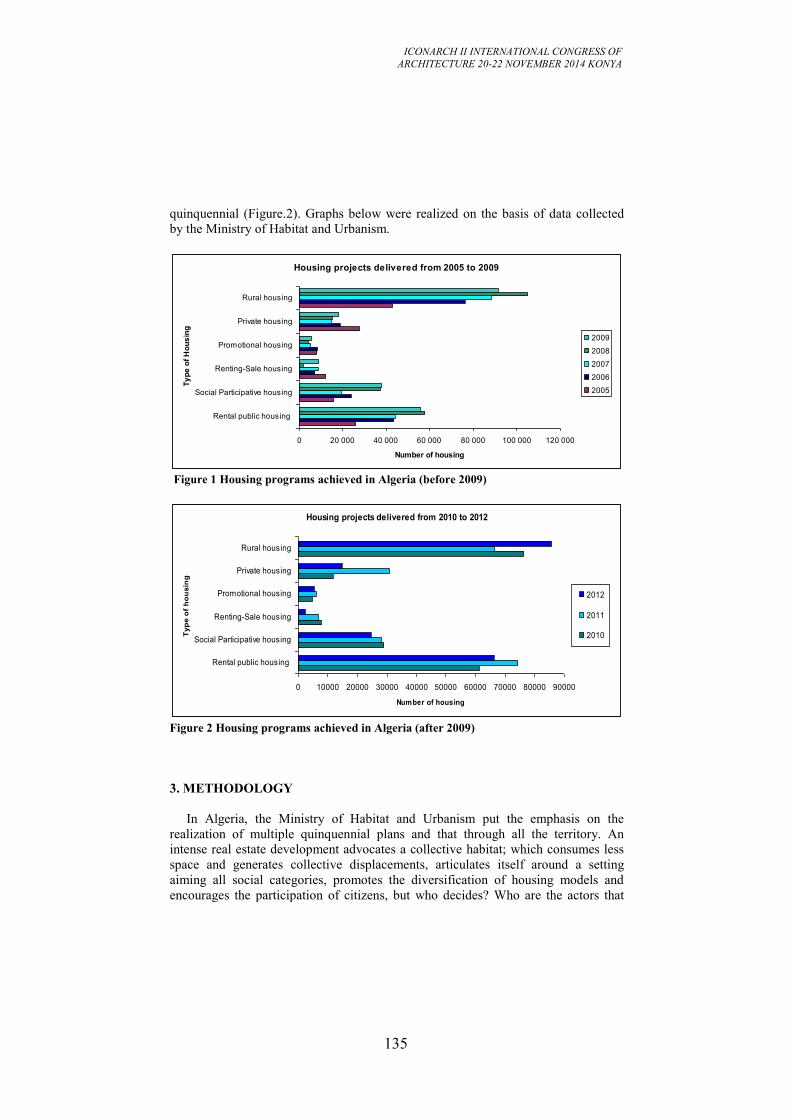
ICONARCH II INTERNATIONAL CONGRESS OF
ARCHITECTURE 20-22 NOVEMBER 2014 KONYA
135
quinquennial (Figure.2). Graphs below were realized on the basis of data collected
by the Ministry of Habitat and Urbanism.
Figure 1 Housing programs achieved in Algeria (before 2009)
Figure 2 Housing programs achieved in Algeria (after 2009)
3. METHODOLOGY
In Algeria, the Ministry of Habitat and Urbanism put the emphasis on the
realization of multiple quinquennial plans and that through all the territory. An
intense real estate development advocates a collective habitat; which consumes less
space and generates collective displacements, articulates itself around a setting
aiming all social categories, promotes the diversification of housing models and
encourages the participation of citizens, but who decides? Who are the actors that
Housing projects delivered from 2005 to 2009
0 20 000 40 000 60 000 80 000 100 000 120 000
Rental public housing
Social Participative housing
Renting-Sale housing
Promotional housing
Private housing
Rural housing
Ty
pe
of
Ho
us
ing
Number of housing
2009
2008
2007
2006
2005
Housing projects delivered from 2010 to 2012
0 10000 20000 30000 40000 50000 60000 70000 80000 90000
Rental public housing
Social Participative housing
Renting-Sale housing
Promotional housing
Private housing
Rural housing
Typ
e o
f h
ou
sin
g
Number of housing
2012
2011
2010
ICONARCH II INTERNATIONAL CONGRESS OF
ARCHITECTURE 20-22 NOVEMBER 2014 KONYA
136
lead these operations? And who are the beneficiaries? In Algeria, the variety of the
housing offer is perceptible in construction sites and generates an important
development. Under the double pressure of politics and citizens, the claimants are
oriented according to their own financial means towards rental-public housings,
social-participative housings, renting-sale housings, promotional-public housings
and rural housings. Whether it is considered as a challenge for the instigators or an
opportunity for the beneficiaries, housing welcomes nevertheless the social life, and
is above all a fundamental territory for man.
Offering many dwellings, the new urban spaces in Algeria are supposed to
respond to today’s population needs, their construction capacity is important, they
are aired and equipped with relevant facilities. But, are they really a place where
people want to live, now and in the future? What about urban harmony and
wellbeing in this case? This research analyzes firstly, the renting-sale housing
realized in Algeria while focusing on the financial and administrative methods
adopted by the Algerian State. This paper investigates secondly, the housing projects
realized and their impact on inhabitants’ welfare, by examining the case of Bab
Ezzouar in Algiers, a representative example at the national scale when it comes to
renting-sale housing. The investigation analyzed the city starting from its residents
who reside, practise and live the space in a subjective and personal way, the
objective being to seize the problems that inhabitants meet as individuals and as
community in their built environment.
4. INVOLVING THE FINANCIAL MEANS OF THE POPULATION:
WHICH STRAGTEGIES FOR THE DECISION-MAKERS?
The participation in housing sector is encouraged with the renting-sale housing
which permits to subscribers to buy a real estate by easy terms with an initial
contribution of 25%, the rest being paid monthly on a period of 25 years. This
procedure was widely accepted since its launching in 2001, why? What are the
advantages for the citizens? And what are the limits for the decision-makers? To
understand this strategy and its socio-economic impact, an investigation is needed.
4.1. Strategy to Promote Renting-Sale Housing
Agreed to subscribers who don't possess in all property schemes a dwelling and who
don't benefit from any financial help from the State, and who have a level of income
that doesn't exceed five times the SNMG, the renting-sale housing widens the offer
to the residence or to the high-class apartment. But, what was the procedure to
follow, this time?
In accordance with the foreseen legislation and the authorized dispositions, every
claimant of a dwelling in the setting of the renting-sale procedure fulfilled an initial
contribution of 25% minimum of the housing price1. The subscribers proceeded to
the payment of the 10% of the global amount of the housing (a margin of 12.000 to
1 According to the article 7 of the ministerial decree n°01-105 of April 23rd, 2001 fixing the conditions of
acquirement of renting-sale housing
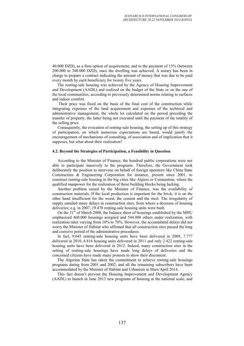
ICONARCH II INTERNATIONAL CONGRESS OF
ARCHITECTURE 20-22 NOVEMBER 2014 KONYA
137
40.000 DZD), as a firm option of acquirement, and to the payment of 15% (between
200.000 to 300.000 DZD), once the dwelling was achieved. A notary has been in
charge to prepare a contract indicating the amount of money that was due to be paid
every month by each beneficiary for twenty five years.
The renting-sale housing was achieved by the Agency of Housing Improvement
and Development (AADL) and realized on the budget of the State or on the one of
the local communities, according to previously determined norms relating to surfaces
and indoor comfort.
Their price was fixed on the basis of the final cost of the construction while
integrating expenses of the land acquirement and expenses of the technical and
administrative management, the whole lot calculated on the period preceding the
transfer of property, the latter being not executed until the payment of the totality of
the selling price.
Consequently, the evocation of renting-sale housing, the setting up of this strategy
of participation, on which numerous expectations are based, would justify the
encouragement of mechanisms of consulting, of association and of implication that it
supposes, but what about their realization?
4.2. Beyond the Strategies of Participation, a Feasibility in Question
According to the Minister of Finance, the hundred public corporations were not
able to participate massively to the programs. Therefore, the Government took
deliberately the position to intervene on behalf of foreign operators like China State
Construction & Engineering Corporation for instance, present since 2001, to
construct renting-sale housing in the big cities like Algiers or Constantine; where the
qualified manpower for the realization of these building blocks being lacking.
Another problem raised by the Minister of Finance, was the availability of
construction materials. If the local production is important for the brick, it is on the
other hand insufficient for the wood, the cement and the steel. The irregularity of
supply entailed many delays in construction sites, from where a decrease of housing
deliveries; e.g. in 2007, 19.478 renting-sale housing units were built.
On the 31st of March 2008, the balance sheet of housings established by the MHU
emphasized 460.000 housings assigned and 544.000 others under realization, with
realization rates varying from 10% to 70%. However, the accumulated delays did not
worry the Minister of Habitat who affirmed that all construction sites passed the long
and coercive period of the administrative procedures.
In fact, 9.043 renting-sale housing units have been delivered in 2009, 7.777
delivered in 2010, 6.816 housing units delivered in 2011 and only 2.422 renting-sale
housing units have been delivered in 2012. Indeed, many construction sites in the
setting of renting-sale housings have made long delays of deliveries and the
concerned citizens have made many protests to show their discontent.
The Algerian State has taken the commitment to achieve renting-sale housings
programs dating from 2001 and 2002, and all the remaining subscribers have been
accommodated by the Minister of Habitat and Urbanism in Mars/April 2014.
This fact doesn’t prevent the Housing Improvement and Development Agency
(AADL) to launch in June 2013 new programs of housing at the national scale, and
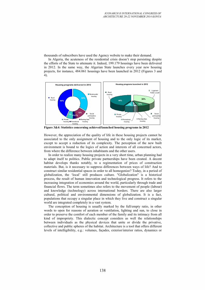
ICONARCH II INTERNATIONAL CONGRESS OF
ARCHITECTURE 20-22 NOVEMBER 2014 KONYA
138
thousands of subscribers have used the Agency website to make their demand.
In Algeria, the acuteness of the residential crisis doesn’t stop persisting despite
the efforts of the State to attenuate it. Indeed, 199.179 housings have been delivered
in 2012. In the same way, the Algerian State launches every year new housing
projects, for instance, 484.061 housings have been launched in 2012 (Figures 3 and
4).
Figure 3&4: Statistics concerning achieved/launched housing programs in 2012
However, the appreciation of the quality of life in these housing projects cannot be
associated to the only assignment of housing and to the only logic of its market,
except to accept a reduction of its complexity. The perception of the new built
environment is bound to the logics of action and interests of all concerned actors,
from where the difference between inhabitants and the other users.
In order to realize many housing projects in a very short time, urban planning had
to adapt itself to politics. Public private partnerships have been created. A decent
habitat develops thanks notably, to a regimentation of prices of construction
materials. But, is it necessary to suppress differences between ways of life? And to
construct similar residential spaces in order to all homogenize? Today, in a period of
globalization, the ‘local’ still produces culture. "Globalization" is a historical
process, the result of human innovation and technological progress. It refers to the
increasing integration of economies around the world, particularly through trade and
financial flows. The term sometimes also refers to the movement of people (labour)
and knowledge (technology) across international borders. There are also larger
cultural, political and environmental dimensions of globalization. It is a fact,
populations that occupy a singular place in which they live and construct a singular
world are integrated completely in a vast system.
The conception of housing is usually marked by the full/empty ratio, in other
words to open for reasons of aeration or ventilation, lighting and sun, to close in
order to preserve the comfort of each member of the family and its intimacy from all
kind of impropriety. This dialectic concept considers as well the relationships
between individuals as the physical devices that unite or divide the privative,
collective and public spheres of the habitat. Architecture is a tool that offers different
levels of intelligibility, e.g.: volumes, façades, exterior/interior ratios, dynamics or
Housing programs delivered in 2012
Rural
housing
Rental public
housing
Private
housing Promotional
housing
Renting-Sale
housing
Social
participative
housing
44%
33%
1%7%
3%
12%
Housing programs launched in 2012
Social
participative
housingRenting-Sale
housingPromotional
housing
Private
housing
Logement
Public LocatifRural
housing
44%36%
7% 10%3%
ICONARCH II INTERNATIONAL CONGRESS OF
ARCHITECTURE 20-22 NOVEMBER 2014 KONYA
139
statics, integration into the environment. Doesn't one has to promote the protection
and the valorisation of some ways of constructing and some ways of living the space,
in order to aim at an enrichment and not at uniformity?
5. BAB EZZOUAR: A COMMUNE FACING THE UNIFORMITY OF
CULTURES
Globalization has been made possible by the progressive dismantling of commercial
barriers and the mobility of capitals, as well as by the technological progress and the
regular decrease of the cost of transportation, communications and data processing.
Advantages of globalization are manifests: sustained economic growth, more
elevated standard of living, increased innovation and faster diffusion of technologies
and techniques of management, new economic perspectives for individuals as well as
for countries. However, the globalization of the economy goes together with a global
standardization of the architectural production. According to Jean-François
Dortier, the West had colonized the world previously by strength, producing thus
ethnocides. Today, westernization develops mainly by acculturation, a voluntary
adherence (Dortier, 2007). Thus, if all big international cities have the tendency to
look alike, it is because globalization produces certainly homogeneity, but also
creates diversity, crossbreeding and identity, because the cities develop continuously
cultural diversity. Is it then, today, completely obsolete to worry about the urban and
architectural shapes?
In Bab Ezzouar, the residential spaces let appear obvious maintenance difficulties.
The inhabitants denounce the formal and architectural poverty of these innumerable
buildings made of concrete and don't hesitate to ask plumbers or masons for help, in
order to renew the inside as well as the outside of the apartments. An investigation to
understand better the present context is needed.
According to the interviewees: «the balcony is exposed to the indiscreet looks of
passers-by […] a veranda will allow us to make use of the balcony, in all intimacy».
Otherwise, it is not rare to see that the balcony is not anymore autonomous but
became a part of the living room or the kitchen, without thinking about problems of
thermal insulation or humidity.
The inhabitants call into question the image of Bab Ezzouar in general and of its
apartments in particular: « the depreciation of the locality, when this one is not chic,
doubles itself of the one of a concrete-city compromised by the illegibility of places
[…] and other burrs that badly sign the concrete and the coat of plaster».
As voluntary urbanism example, the commune of Bab Ezzouar is confronted to
difficulties that it must surmount. Some dissuasive measures have been taken to
thwart the alterations worked out by the new residents and to warn them about the
risk of damaging the building structure which can get unsafe. From our interviews to
the AADL Agency, it emerged that: «services of the AADL don't have the right to go
inside the apartments, in order to estimate the damages […] only a report done under
control of a process-server is necessary to estimate the acuteness of the deteriorations
[…] several families have been told, after intervention of a process-server, that it is
forbidden to add a window or a veranda and therefore to modify the façades, a
ICONARCH II INTERNATIONAL CONGRESS OF
ARCHITECTURE 20-22 NOVEMBER 2014 KONYA
140
dissuasive measure for all the neighbours who expected to transform their balcony ».
It is difficult to have an exact evaluation of the number of inhabitants who have
remodelled their apartment, without any authorization. Several families have been
told, after intervention of the court, that it is forbidden to modify the façades and of
course to modify the inside. The judge stipulated that tenants have to put back the
balconies in the state in which they found them and to pay a fine. That is why the
inhabitants didn’t allow us to take some pictures of their apartments, anonymity
being thus respected.
While examining the conduct of inhabitants concerning dwellings and the one of
the AADL control services, the investigation has demonstrated that no sociological
survey has been led beforehand, and that if one applies the standardization of
lifestyles, it is translated by a ceaseless need of change for inhabitants. Otherwise,
the architectural conception of buildings in Bab Ezzouar is so rigid that it would be
erroneous to believe that many transformations are possible, according to how the
inhabitants feel, and that because of prefabricated walls in reinforced concrete
impossible to pull down.
For the meantime, it’s the ground-floor spaces that are lived as elements of
identity because one finds out under arcades a set of small boutiques, recalling
Algiers and its powerful commercial device composed of a juxtaposition of stalls and
shops. Therefore, one can regret the absence of a feeling of adherence in a newborn
territory. Beyond the supposed assets to make of it a place of exchange and urban
life, the local registration is, in the context of Bab Ezzouar, the key of the local
cultures renewal and the permanence of their specificity. «The possibility to identify
ourselves positively to a place […] to develop the pride to live in», this is the
essential stake for the new residents. It is therefore a question of personality. People
lack a picture of reference, a proof of identity and anchorage in their territory. For
everyone, the images evoked by one’s home and town are inextricably linked to
processes of identity. The image of the new town is linked to how it is used by the
residents from the moment they move in, whether by choice or constrained by
circumstances.
Our position is not attached to the past. It neither defends the historic city nor
praises a kind of architecture in particular. We merely want to seize dimensions
making possible to act up, but not to brush an ineluctable and irreversible future. We
try, on the contrary, to adopt another stance facing the contemporary city.
Globalization must be much more than the expansion of markets. One would not
consider the economic domain as independent from the social and political context
and to accept that it is only subjected to its own logic. To survive and to prosper, the
world economy must settle on shared values and steady institutional practices and
must serve more equally ambitious social objectives. Let's recall that the urbanism
goes beyond the simple material dimension and also includes the social, economic
and political matters. The real-life experiences, in the context of Bab Ezzouar, have
proved to be much more complex than they appear. Since, the population resists to
all shapes of homogenization. In our point of view, the architectural and urban field
must focus more on the local, for localized contemporary cities, tempting to refute
this ideology of globalization. In the objective to preserve identity and financial
aspirations, architectures must be referred to precise places, by constructing multiple
ICONARCH II INTERNATIONAL CONGRESS OF
ARCHITECTURE 20-22 NOVEMBER 2014 KONYA
141
faces, alternative to the totalitarian features of the so-called global city.
5.1. Beyond the Dwelling, Living in One’s District
Beyond the simple addition of housing, of activities, of services, of streets, the city
defines itself by its districts and its characteristics, the animation, life that results
from the combination of all these elements. Every year, thousands of lodgings are
taken in site in the new town. For their occupants, to lodge is necessary, but not
sufficient. Around that, they expect to find a district, with its exchanges, a town full
of life. The worry for the dwellers’ welfare in their new environment is accompanied
by a willing to endow every district with sufficient collective services. According to
the interviewees, what was missing lies in:« public spaces, true streets with
sidewalks, places edged with boutiques and arcades to take shelter […] a garden
where to stroll or to eat lunch, a market where to go shopping; places of meetings
and exchanges, crowded day and night […] well planted trees, correctly fixed lamps,
well laid fences …all that has been neglected». The idea that inhabitants adapt
themselves with difficulty to life in Bab Ezzouar has imposed qualitative
interventions that aim at the improvement of living conditions in the new districts, in
order to make some fully-fledged life places.
The deterioration observed in these districts ( deterioration of the public space)
leads to asking questions under another angle than the one of the formal and
architectural relevance of the residential spaces; the perception being bound to the
logics of action and interests of all concerned actors, from where the difference
between inhabitants and the other users. The supplying of appropriate public services
implies a great concern. Planning presented clear layouts that might suppose that the
realization was going to be simple. The rational character of these plans
corresponded to the idea to give the new generations a balanced environment. Urban
planners having thought that a satisfactory life quality got itself thanks to a strong
population density, solely capable of guaranteeing services, transportation and
animation of the district. Today, as the city tries to define its role, it undergoes
periodic adjustments, taking into consideration the social disparities and lifestyles,
makes feel itself more and more. According to the interviewees : « the too linear
volumes, of an immediate proximity, let appropriate themselves with difficulty, too
many discontinuities and hollows subsist leaving a flavour of incomplete, […]
without forgetting the absence of collective spaces management».
The local authorities have made the bet to give them more than a dwelling, an
urban environment thanks to a dense network of tertiary facilities and big projects
next to the university of Bab Azzouar, the arrival of financial and commercial
activities in a substantial number can entail the creation of new atmosphere. Wanting
to create an attractive urban setting in which nothing should lack or nearly, but again
and particularly an urban and social life, the local authorities meet difficulties to
manage the time factor. The commune of Bab Ezzouar is supposed to respond
today’s population needs. Its construction capacity is important. It is aired, endowed
of important facilities. Certainly, its dynamism and interrelations that it will have to
ICONARCH II INTERNATIONAL CONGRESS OF
ARCHITECTURE 20-22 NOVEMBER 2014 KONYA
142
tie with its environment plead for the pursuit of its development.
However, the 21st century urban life cannot be considered without taking into
account the globalization because it offers extensive opportunities for truly
worldwide development. With globalization, one can have access to more capital
flows, technology, cheaper imports, and larger export markets. But markets do not
necessarily ensure that the benefits of increased efficiency are shared by all.
Therefore, all the question is to know if globalization that finally puts in competition
economic and social systems, is likely to take into account a society where the social
tie would be exclusively merchant, or on the contrary, to consider societies that
estimate indispensable to preserve "non merchant" cultural spaces, valorising thus
the cultural capital of societies, because that one does want it or not, the identities
construct themselves, even today, essentially in a territorialized dimension.
6. CONCLUSION
The local life and the spatial dimension being a privileged support of identity, the
evolution of Bab Ezzouar commune must start from the needs of its inhabitants, their
motivation to participate in adequate organizations expressing their life conception;
this in relationship with the economy, the culture of the country, the choice of local
construction materials, aiming a human architecture rather than a fashionable one. At
the present time, one realizes that this commune is progressively affected by
regional, interregional, national and international economic conditions. Crossroad of
expertise and initiatives, stimulating support for education and innovation, it
encourages the economic take-off. This reality becomes more and more striking if
one evokes globalization, since the financial markets push subtly toward uniformity,
including architecture. This tendency consists in making everything similar because
that is less expensive. What about respect for cultural diversity in habitation in this
case?
The case of Bab Ezzouar pushes to the critical judgment, to the definition of the
pros and cons, to a hold of position towards these big housing projects and the
challenge that they raised. To build blocks of flats is, for the Algerian decision-
makers, a good answer to housing shortage, despite the fact that the inhabitants
denounce the architectural poverty of these multiple buildings of concrete. In Bab
Ezzouar, the built homogeneity is defined by its identical blocks signaling
paradoxically who lives there and why. Actually, it seems difficult to escape a
repetitive architecture, due to the constraints of the prefabrication process. Certainly,
housing being above all an object defined by its spatial dimension, it is characterized
by three attributes: the metrics, the scale and the substance. Nevertheless, housing
constitutes also the concrete matter of the social space and contains the material
contexts of the social life.
The analysis of our investigations and interviews indicates that the representations
of the residential spaces of the inhabitants depend closely on their experience at the
same time personal, social and spatial. Consequently, constrained by inhabitants’
attitudes, housing projects cannot conceive themselves outside of their context and
must define themselves according to the will of the local actors and their
prerogatives certainly, but also and especially according to the inhabitants needs. The
ICONARCH II INTERNATIONAL CONGRESS OF
ARCHITECTURE 20-22 NOVEMBER 2014 KONYA
143
construction, design and type of housing are critical to the long term quality of life
for the inhabitants who will live in these spaces. Therefore, greater efforts must be
done to build inhabitants’ participation into all steps of the development process. If
inhabitants are given a feeling that they are able to contribute to decisions affecting
their lives and the lives of their children, friends and neighbours, the housing projects
in general and Bab Ezzouar in particular will become more sustainable.
Creating buildings and urban environment that people enjoy living in and
working in requires therefore, best practices at the same time economic, social and
environmental. Building and strengthening a sustainable community imposes as well,
to improve the quality of life of the population and to consider the longer term
implications of decisions. For the present as for the future, the local authorities must
learn to put the inhabitants first, not fees or speed of construction, while going
beyond the simple information of the population, while accepting to approach "topics
that annoy", while admitting the contradiction and while accepting to be disavowed
sometimes, because that they do want it or not, the adherence of citizens to projects
that concern them is, in the present context, the key of a strong local identity.
Henceforth, and beyond its appearance, that everyone can appreciate in his manner,
it contains the capacity to be renewed, while leaning on its internal dynamics, made
of tensions, like any dynamics. Let's join André Bruston to say that: « it is not the
new that matters, but its capacity of future».
REFERENCES
Bruston, A. (1996). Ville et Architecture Workshop, Urbanisme Français, nouvelles
lectures. Paris: DAFU.
Diagana, I. (2001). Régularisation et intégration des quartiers précaires et irréguliers
de Nouakchott, in quelles réponses à l’informalité et à l’illégalité des établissements
humains dans les villes en développements. Leuven: N-AERUS Conference.
Direction of Town Planning and Construction, (2003). Les fiches techniques de la
ville nouvelle Ali Mendjeli. Constantine: DUC.
Direction of Town Planning and of Development, (2000). Monographie de la wilaya
de Constantine. Constantine: DPAT.
Dortier, J-f. (2007). Vers une uniformisation culturelle ?
http://www.scienceshumaines.com/10-questions-sur-la-mondialisation_fr_279.htm
IMF Staff. (2002). Globalization: Threat or Opportunity?
http://www.imf.org/external/np/exr/ib/2000/041200.htm#II
Jean, Y., & Calenge, C. (2002). Lire les territoires. Tours: MSH.
Lévy, J., & Lussaut, M. (2003). Dictionnaire de la géographie. Paris: Belin.
Merlin, P., & Choay, F. (1988). Dictionnaire de l’urbanisme et de l’aménagement.
Paris: PUF.
Makhloufi, L. (2013). Housing Projects in Algeria: which Context for which
Consequences on Built Environments? – Case of Zerhouni City in Algiers –. Built
Environment Journal, 10 (2), 38-47. Shah Alam, Selangor: Faculty of Architecture,
Planning and Surveying, University of Technology MARA.
Makhloufi, L. (2010). Inhabitants/Authorities: a Sustainable Housing at Stake. Case
ICONARCH II INTERNATIONAL CONGRESS OF
ARCHITECTURE 20-22 NOVEMBER 2014 KONYA
144
of: Ali Mendjeli new town in Constantine. In S. Lehmann & H. Al Waer & J. Al-
Qawasmi (Ed.), Sustainable Architecture & Urban Development, SAUD 2010,
Volume1/4, (pp.367-383). Amman: The Center for the Study of Architecture in the
Arab Region & University of Dundee (UK).
Makhloufi, L. (2009). Socio-economic issues in Constantine: which contexts for
which consequences on the sustainable urban development? In S. Fortea & J. Al-
Qawasmi (Ed.), Sustainable Architecture and Urban Development, SAUD 2009,
Volume1/2, (pp.367-381). Amman: The Center for the Study of Architecture in the
Arab Region & University of Tripoli.
Makhloufi, L. (2009). Le logement comme moteur du développement territorial en
Algérie : quels défis ? Quelles opportunités ? In C. Mager (Ed.), Développement
territorial : jeux d’échelles & enjeux méthodologiques, (pp.141-148). Lausanne :
Observatoire de la ville et du développement durable.
Makhloufi, L. (2007). Identity in Transition: Residential Spaces Undergoing
Profound Conceptual Change - Case of: Ali Mendjeli new town. In J. Al-Qawasmi &
A. Mahmoud & A. Djerbi (Ed.), Regional Architecture and Identity in the Age of
Globalization, Volume1/3, (pp. 271-284). Amman: The Center for the Study of
Architecture in the Arab Region.Modot, J. (1974). Constantine et ses environs. In
Les guides bleus, Algérie (pp. 387-403). Paris: Hachette.
Thibaud, J-P. (Ed.) (2007). Variations d’ambiances. Processus et modalités
d’émergence des ambiances urbaines. ENSA Grenoble : CRESSON Laboratory.
Torgue, H. (2008). Les enjeux des ambiances. In J-F. Augoyard (Ed.), Faire une
ambiance/Creating an atmosphere, (pp.399-404). Grenoble: À la Croisée.
Torgue, H. (2012). Le sonore, l’imaginaire et la ville. De la fabrique artistique aux
ambiances urbaines. coll. « Logiques sociales / Série Études culturelles », Paris :
L’Harmattan.
Veschambre, V., & Ripoll, F. (2005). L’appropriation de l’espace comme
problématique. Norois Journal : L’appropriation de l’espace, 195(2), 7-15.
Veschambre, V., & Ripoll, F. (2005). Le territoire des géographes, quelques points
de repère sur ses usages contemporains. In B. Cursente & M. Mousnier (Ed.), les
territoires du médiéviste (pp.271-291). Renne
ICONARCH II INTERNATIONAL CONGRESS OF
ARCHITECTURE 20-22 NOVEMBER 2014 KONYA
145
METHODS TO OVERCOME THE BARRIERS AND THE
DISINTEGRATION EFFECT OF PORT AREAS IN THE CITY
CENTER AND THE FACTORS DETERMINING THEIR
CHOICE
MLADEN TANOV 1
ABSTRACT
Port warehouse complexes and transport infrastructure around them, located near the
urban centers of major cities are huge barriers and buffers in urban organism. Once
engines for the emergence and development of cities, in the last 40 years these areas
act as restraints in the development of cities. At the same time historically formed
cities also do not allow modernisation and expansion of ports. Economic dynamics
and the new functional profile of the coastal towns exert asignificant pressure for
change, requiring the transformation of these large areas for new features, their
opening to wider user groups and their greater commitment to the historic core of the
town.
What are the opportunities to reconnect the city to the coast, to extend the city center
and accommodate new needs, increase pedestrian, recreational and green areas near
the center and improve the overall quality of living environment?
In some cases this is achieved through the transformation of part of the port
complexes in open public areas, enriched by various social-service and recreational
activities. In others - through the complete removal or relocation of activities (port,
warehouse, industrial) and a new design/redesign of the towns. In the yet other -
through purely spatial-invasive solutions that give people access to water without
changing port areas.
The report examines the factors determining the regeneration solution and the main
methods of approach based on analysis of 12 realized coastal transformations and
several approved but unrealized projects. Particular attention is paid to the functional
profile of the renovated areas and predominant functions in the mix and the inclusion
of these new parts in the functioning of the urban organism.
Key words: Regeneration, Port Areas, Urban Planning & Design, Green Areas and
Open Public Spaces
1 Assistant Proffesor and PhD Student, Master of Architecture, Landscape Architecture and Ecology,
Varna Free Univercity, Faculty of Architecture, VARNA.
ICONARCH II INTERNATIONAL CONGRESS OF
ARCHITECTURE 20-22 NOVEMBER 2014 KONYA
146
1. INTRODUCTION
The modern city is a place in which live and reside many different groups of people
– considered by social, cultural, professional, ethnic and religious signs and this
diversity is much greater than at any other past point in history. Clash of interests
and activities is intense and this greatly increases the importance of city
management, that has to balance those interests and protect public interest. Certain
events and trends of the last 50-60 years, threaten the convening character of the city
by creating insurmountable buffers and isolated areas, gated structures, and gated
communities.
This happens because these events provoke many negative effects, one of the most
important being the gradual degradation of a wide brim of these areas and loss of
attractiveness of many central urban areas. Port complexes of the time of the
Industrial Revolution are a kind of a city gated structure and actively participate in
the described model. Today there is a great need to find a new form of relationship
and interlocking between the city and the port.
2. PROBLEMS OF WATERFRONTS TODAY
2.1. Historical Development of the Port Areas
Convenient location for construction of protected ports is the key factor for the
coastal cities. Ports are the main structural elements of these settlements and engine
for development.
Many modern port centers in Europe formed in the Middle Ages as a result of
increased trade with the Middle East. Some of them existed in Аntiquity, but we can
assume that in their present form, without time interruptions they have basically
medieval origin. Strong political and economic development marked the centers of
maritime trade on the route Middle East - Italy - Western Europe: Genoa, Venice,
Amalfi, Bruges, Ghent, Hamburg, Amsterdam. Strong cash flows stimulated the
development of the banking system and wealth gave their independence.
Renaissance changed the nature of trade, the main trade flows in terms of
destinations, as well as type and quantity of goods. Development of overseas
warships and commercial carriers lead to a rapid expansion of trade. New water
routes between Europe and East Asia realized import at lower prices compared to
transport by land. The discovery of America, and its tobacco, gold and silver trade
opened new horizons to the Far East. Thanks to the experience gained in ocean
navigation, Europeans occupied a decisive position in the Asian trade shipping.
Emergence of joint stock companies in the shipping.
Since the Industrial Revolution occurred in Europe first, this continent is the center
of the world trade network throughout most of the 19th century. The growth of
industrial production is accompanied by a rapid expansion of trade in goods and raw
materials. They in turn stimulate significant changes in transport - both vessels and
ports are enlarged and modernized; railways stimulated the rise of internal trade.
Strong development of production and trade concentrates huge capital in cities and
generates migration from rural areas. So the early 19th century port cities inevitably
ICONARCH II INTERNATIONAL CONGRESS OF
ARCHITECTURE 20-22 NOVEMBER 2014 KONYA
147
transform in large industrial centers because they have everything - raw materials,
capital, labor and technology, and markets.
Three phenomena of Post-industrial times change the meaning of ports for European
cities and from engines for development, they become handicaps.
Changes in the economic profile of the cities and their transport infrastructure:
dislocation and change in the heavy industry, specialization and modernization
of ports, reduction of cargo processing time and increase the share of air freight
Ports Barrier effect against typical urban areas and the effect of restricting
development and degradation in the border lines between them
Strong growth in the leisure, tourism and services, which creates "hunger" for
new attractive areas; the waterfront can serve modern city various functions
2.2. Principles of Modern Urbanism
Intensive urbanization and the development of democratic social system require
regulation, guaranteeing the rights of citizens for high-quality living environment
and access to social services and universal benefits. Principles of modern urbanism
are the product of the development of urban and social science and practice. The
proposed classification based on international agreements on human rights and
sustainable development include:
Principle of pure and favourable environment for living
Principle of openness, responsiveness and maximum accessibility of the
environment
Principle of parallel evolution of the urban areas; fairness in the distribution of
wealth
Principle of multi-functionalism and enhancement of the urban environment
Principle of conservation of the focal character of the city and the traditional
center
Principle of maintaining diversity, uniqueness and historical memory
Principle of effectiveness in the use of land resources and sustainable
development;
Comparison between the current situation and these principles revealed the wide
range of existing imperfections in the territories. They are grouped into 4 groups of
problems.
2.3. Basic Problems
Socio-economic problems and Efficiency:
Status and profile of the economy (decline of industries important to urban
structure)
Unemployment (due to closed enterprises and ports)
Demography and dynamics (e.g. outflow of residents because of economic
downturn)
Significant social needs - housing, parks, sports facilities, servicing, culture
objects
Urban problems:
Lack of connectivity and accessibility and the presence of barriers
Negative impact on the development of the central areas and their peripheries
Limited visual connectivity of the city with the coast and the water
ICONARCH II INTERNATIONAL CONGRESS OF
ARCHITECTURE 20-22 NOVEMBER 2014 KONYA
148
Structural and functional dissonance - define the “tearing” of "urban fabric"
Problems with cultural heritage and architectural image:
The existence and condition of valuable historical buildings and ensembles in
the port;
Presence of preserved historic urban ensemble in proximity and the level of
relation between it and the regenerated area (compositional and visual)
Preservation of historical memory about the functions of the area
Monotony and lack of aesthetic qualities of the coastal skyline
Ecological problems:
Problems of urban ecology
Environmental problems of water area
Problems with the Coast and dynamics of water level
Negative impact on protected natural areas and water areas
Based on the a/m classification and for the purpose of this PhD research, an analytic
matrix was developed to evaluate regeneration projects by comparing the situation
before and after their implementation. The effects in each of the a/m groups bring a
certain number of credit, as leading group and weight is pre-defined.
3. APPROACHES TO SOLVE THE PROBLEMS To solve the problems are applied approaches, bearing different names -
revitalization, redevelopment, regeneration, waterfront renovation, etc. We will not
dwell on the specifics of the terms, but will mark the trends in the development of
waterfront update. Historically several stages of regeneration practices can be
defined, which are characterized by differences in the scope, objectives and value of
projects, participants and results.
In the First stage (from 60-ties to the early 80-ties) the private sector has the leading
role. The low price of degraded areas attracts investors who turn them into highly
profitable business centers. Changes do not take into account the needs of the city
and society and do not contribute to the opening of the city nor provide a coast for
wide use. The scope - local.
The Second stage (80-ties and 90-ties) is characterized by the beginning of the
public-private partnership. Local authorities impose stricter conditions on projects
that cover the whole port area. First attempts to create mixed areas including service
and recreation.
In the Third stage (from 90-ties) design is based on equal public-private partnership,
the recovery task is prepared on the basis of studies on the role and functions of the
coasts and linking them with the master plan of the city. It specifies the function,
structure and balance of the area. Local authorities have a leading role in the
preparation of the assignment and in monitoring. The scope includes the entire
waterfront.
This PhD research focuses on the transformations during the second two stages,
aiming to classify the different solutions in terms of the urban aspect. The functional
profile, the structure and intensity of development and linking with neighbouring
regions and the city are the key assessment indicators that affect the participation of
green and open spaces. The analytic matrix examines in detail 10 cities famous for
ICONARCH II INTERNATIONAL CONGRESS OF
ARCHITECTURE 20-22 NOVEMBER 2014 KONYA
149
their successful projects: Genoa, Naples, Bilbao, Barcelona, Amsterdam, Antwerp
Hamburg, London, Liverpool and Cardiff, as we will briefly present some of them.
Another 10 cities including Valencia, Toronto, New York, are also the focus of
study.
3.1. Brief Analysis of the Significant and Successful Waterfront Regenerations
Amsterdam - Shortage of Housing, Excess of Water
The purpose of the transformation of the eastern docks is turning them into a
residential area – the concept of the compact city and because of the great need for
housing. The main requirements are: high density of occupation; good connectivity,
permeability and accessibility of urban areas; broad social mix of residents
Functional profile and urban image: In the regeneration of the eastern port area
functional area is divided into western multi-functional area bordering the periphery
of the city center and eastern residential area which is seriously remote and isolated
from the center of linear barriers. In the south-western and central parts many of
notable historical buildings have been converted to shopping centers, hotels and
restaurants, cultural and entertainment centers; institutes, museums and libraries and
in modern buildings are located a cruise terminal and a modern music hall. The
Eastern zone, consisting of 4 peninsula, was converted into a purely residential area
with diverse architectural style - from luxury single-family homes to large-scale
multi-storey social housing. Despite the high density everywhere were realized green
and public spaces and pedestrian areas.
Specific characteristics of the decision:
Preservation of many storage buildings and the waterways and use for new
needs
Diverse in style, structure and scale architectural style, which is distant from the
typical urban environment and this requires close coordination and
harmonization
Poorly balanced functional areas with a lack of facilities and services
Unresolved problem with linear barriers, well realized commitment to the city
by public transport
Well laid and implemented system of green and open spaces with high qualities
Complete regeneration of the east zone; incomplete regeneration of the central
zone
Analysis on key indicators:
1. Level of solving socio-economic problems and achieved efficiency in land
utilisation (amount of credit: 3/10);
1.1. Functional efficiency according to the level of functional mix and effective
functional balance (credits: 0/2);
1.2. Functional efficiency according to the level of satisfaction of the socio-economic
needs and gaps - jobs and services for the population (credits: 2/2)
1.3. Functional efficiency according to the level of stimulation of the urban economy
(cr: 0/2)
1.4. Functional efficiency according to sustainability of the loading of the area (day-
ICONARCH II INTERNATIONAL CONGRESS OF
ARCHITECTURE 20-22 NOVEMBER 2014 KONYA
150
round, all-seasons, long-term) (credits: 0/2);
1.5. Functional efficiency according to the level of wide-mix of users (credits: 1/2);
2. Level of solving of urban problems (amount of credit: 8/12)
2.1. Achieved transport linkage with the region and the city (credits: 2/2);
2.2. Implemented pedestrian links (credits: 0,5/2);
2.3. Level of development of the green system and the system of open public spaces
(cr.: 2/2);
2.4. Achieved visual connectivity (credits: 2/2);
2.5. Structural adequacy of the urban environment / harmonization with the typical
urban structure (credits: 1/2);
2.6. Functional harmonization and consistency with the surrounding urban areas (cr.:
0,5/2);
3. Level of solving the environmental problems (amount of credit: 4/8)
3.1. Level of improvement of the urban ecology (credits: 2/2)
3.2. Level of improvement of the quality and characteristics of the water area
(credits: 2/2)
3.3. Level of improvement in the management of water levels
3.4. Level of reduction of indirect negative impact on protected natural areas and
water areas
4. Level of solving the problems of cultural heritage and creating a memorable
architectural image (amount of credit: 5/10) 4.1. Level of alignment with the historic environment and cultural heritage (credits:
0/2)
4.2. Conservation and recovery of valuable historic buildings and ensembles in the
territory (credits: 1/2)
4.3. Preservation of historical memory of the historical functions of the area (credits:
1/2)
4.4. Prominence and aesthetic qualities of architecture (credits: 1/2)
4.5. Diversification and enrichment of coastal silhouette (credits: 2/2)
Credit rating: 20/40.
Hamburg - Second City Center
Purpose of the transformation: Reviving one of the oldest harbor and storage
areas, and its integration into the urban organism as a central urban area Hafencity.
Functional profile and urban image: Typical downtown area of the wide center of
the European city. More than 30% of the area is occupied by residential buildings -
permanent and temporary occupancy. There are many office and administrative
buildings, head-offices of large international companies, a substantial share of
educational, research and museum centers, places of trade and services, restaurants
and cruise terminal. Appropriately situated many open public spaces, recreational
areas and green spaces.
Specific characteristics of the decision:
Comprehensive renovation of the southern coastal areas, turning them from an
industrial port into a complete urban area – new residential, cultural and
business center
Structure connectivity and adequacy of the urban environment and successful
ICONARCH II INTERNATIONAL CONGRESS OF
ARCHITECTURE 20-22 NOVEMBER 2014 KONYA
151
harmonization with the typical urban structure with a gradual transition from
the architectural style of the existing historic buildings to the contemporary
office and residential buildings; Using some of the landmark old buildings for
new functions
Well-developed system of public spaces, recreational and green areas
associated with existing urban spaces and pedestrian routes; high quality design
of open spaces
high proportion of residential areas to ensure full-time occupation of services
because of the remoteness from the center and large size of the area compared
to the center.
Analysis on key indicators:
1. Level of solving socio-economic problems and achieved efficiency in land
utilisation (amount of credit: 10/10);
1.1. Functional efficiency according to the level of functional mix and effective
functional balance (credits: 2/2);
1.2. Functional efficiency according to the level of satisfaction of the socio-economic
needs and gaps - jobs and services for the population (credits: 2/2)
1.3. Functional efficiency according to the level of stimulation of the urban economy
(cr.: 2/2)
1.4. Functional efficiency according to sustainability of the loading of the area (day-
round, all-seasons, long-term) (credits: 2/2);
1.5. Functional efficiency according to the level of wide-mix of users (credits: 2/2);
2. Level of solving of urban problems (amount of credit: 12/12)
2.1. Achieved transport linkage with the region and the city (credits: 2/2);
2.2. Implemented pedestrian links (credits: 2/2);
2.3. Level of development of the green system and the system of open public spaces
(cr.: 2/2);
2.4. Achieved visual connectivity (credits: 2/2);
2.5. Structural adequacy of the urban environment / harmonization with the typical
urban structure (credits: 2/2);
2.6. Functional harmonization and consistency with the surrounding urban areas (cr.:
2/2);
3. Level of solving the environmental problems (amount of credit: 4/8)
3.1. Level of improvement of the urban ecology (credits: 2/2)
3.2. Level of improvement of the quality and characteristics of the water area
(credits: 2/2)
3.3. Level of improvement in the management of water levels
3.4. Level of reduction of indirect negative impact on protected natural areas and
water areas
4. Level of solving the problems of cultural heritage and creating a memorable
architectural image (amount of credit: 7/10) 4.1. Level of alignment with the historic environment and cultural heritage (credits:
1/2)
4.2. Conservation and recovery of valuable historic buildings and ensembles in the
territory (credits: 1/2)
ICONARCH II INTERNATIONAL CONGRESS OF
ARCHITECTURE 20-22 NOVEMBER 2014 KONYA
152
4.3. Preservation of historical memory of the historical functions of the area (credits:
1/2)
4.4. Prominence and aesthetic qualities of architecture (credits: 2/2)
4.5. Diversification and enrichment of coastal silhouette (credits: 2/2)
Credit rating: 33/40.
Bilbao - Cultural and Tourist Identification
The goal is a complete restructuring of the city after the decline of the metal
production industry and transfer of the port to the bay, to stimulate a balanced socio-
economic development of the city with a focus on the development of tourism,
culture, education and services, and to restore the unity of the urban organism.
Regeneration program includes 16 major transformations in the coastal regions, in
infrastructure and environmental measures to restore the river ecosystem. Here we
present Abandiobarra /in the central part of the city in a port and storage area/ and
Barakaldo /near the district center in a port and storage area
Functional profile and urban image: mixed multifunctional zones in a park area
with residential, hotels, business, concert and congress centers, large shopping
centers, sports and landscape subareas, university and office buildings, museums;
memorable sculpture park design and decoration; many parks, green squares and
pedestrian spaces, parts of the waterfront promenade; Abandiobarra is organically
linked to the Guggenheim Museum and the bridge Salve constructed earlier.
Specific characteristics of the decision:
the urban fabric is restored - streets and squares constructed with expressive
urban silhouette and while these solutions immerse buildings in green, and the
density of the buildings gradually decreases towards the river and passes into a
coastal park
appropriate mix and functional structure, but different for the two zones; many
green areas, well-integrated system to be adopted in the green city
Good pedestrian and car links with neighboring territories and city in
Abandiobarra were constructed; in Barakaldo linear barriers - highway and
train lines - are overcome on one place on land, on a second place - through a
tunnel, and on a third place - through a trestle.
In Barakaldo the old building ILGNER is converted into an office center and
mining industry facilities are exposed in a theme park, in Abandiobarra the ship
museum is the only sign of historical past.
Analysis on key indicators:
1. Level of solving socio-economic problems and achieved efficiency in land
utilisation (amount of credit: 10/10);
1.1. Functional efficiency according to the level of functional mix and effective
functional balance (credits: 2/2);
1.2. Functional efficiency according to the level of satisfaction of the socio-economic
needs and gaps - jobs and services for the population (credits: 2/2)
1.3. Functional efficiency according to the level of stimulation of the urban economy
(cr: 2/2)
1.4. Functional efficiency according to sustainability of the loading of the area (day-
ICONARCH II INTERNATIONAL CONGRESS OF
ARCHITECTURE 20-22 NOVEMBER 2014 KONYA
153
round, all-seasons, long-term) (credits: 2/2);
1.5. Functional efficiency according to the level of wide-mix of users (credits: 2/2);
2. Level of solving of urban problems (amount of credit: 12/12)
2.1. Achieved transport linkage with the region and the city (credits: 2/2);
2.2. Implemented pedestrian links (credits: 2/2);
2.3. Level of development of the green system and the system of open public spaces
(cr.: 2/2);
2.4. Achieved visual connectivity (credits: 2/2);
2.5. Structural adequacy of the urban environment / harmonization with the typical
urban structure (credits: 2/2);
2.6. Functional harmonization and consistency with the surrounding urban areas (cr.:
2/2);
3. Level of solving the environmental problems (amount of credit: 6/8)
3.1. Level of improvement of the urban ecology (credits: 2/2)
3.2. Level of improvement of the quality and characteristics of the water area
(credits: 2/2)
3.3. Level of improvement in the management of water levels (credits: 2/2)
3.4. Level of reduction of indirect negative impact on protected natural areas and
water areas (credits: 2/2)
4. Level of solving the problems of cultural heritage and creating a memorable
architectural image (amount of credit: 7/10) 4.1. Level of alignment with the historic environment and cultural heritage (credits:
1/2)
4.2. Conservation and recovery of valuable historic buildings and ensembles in the
territory (credits: 0/2)
4.3. Preservation of historical memory of the historical functions of the area (credits:
2/2)
4.4. Prominence and aesthetic qualities of architecture (credits: 2/2)
4.5. Diversification and enrichment of coastal silhouette (credits: 2/2)
Credit rating: 35/40.
Genoa - Naval History - Tradition and Modernity
The aim of coastal regeneration is to improve the physical conditions and public
services, revitalize the economy and mobility and increase the attractiveness of
Genoa as a cultural destination (the center is a UNESCO site). A complete
regeneration of the old port is performed.
Functional profile and urban image: Mixed multifunctional zone including: Half-
sheltered arena and outdoor arena; large green square, transformation of cotton
warehouses into a congress center and children's attraction, aquarium and
tropicarium, commercial centres, sports facilities, museums and research institutes,
restaurants, cineplex, hotels. Development of marinas, travel, cruise and ferry
terminals with diffusion of public functions in them.
Specific characteristics of the decision:
An overall renovation of the area, turning it from an industrial port into a city
center, busy all year round and offering many opportunities for recreation and
entertainment.
ICONARCH II INTERNATIONAL CONGRESS OF
ARCHITECTURE 20-22 NOVEMBER 2014 KONYA
154
Creating an environment for cultural events and conference activities and
converting the city into an international tourist center; Transformation of the
old warehouses;
Overcoming the barriers and connecting the cost with renewed city center
Many open public spaces, but few green elements; they will increase after
implementation of Ponte Parodi building with roof gardens
Analysis on key indicators:
1. Level of solving socio-economic problems and achieved efficiency in land
utilisation (amount of credit: 10/10);
1.1. Functional efficiency according to the level of functional mix and effective
functional balance (credits: 2/2);
1.2. Functional efficiency according to the level of satisfaction of the socio-economic
needs and gaps - jobs and services for the population (credits: 2/2)
1.3. Functional efficiency according to the level of stimulation of the urban economy
(cr: 2/2)
1.4. Functional efficiency according to sustainability of the loading of the area (day-
round, all-seasons, long-term) (credits: 2/2);
1.5. Functional efficiency according to the level of wide-mix of users (credits: 2/2);
2. Level of solving of urban problems (amount of credit: 12/12)
2.1. Achieved transport linkage with the region and the city (credits: 2/2);
2.2. Implemented pedestrian links (credits: 2/2);
2.3. Level of development of the green system and the system of open public spaces
(cr.: 1/2);
2.4. Achieved visual connectivity (credits: 2/2);
2.5. Structural adequacy of the urban environment / harmonization with the typical
urban structure (credits: 2/2);
2.6. Functional harmonization and consistency with the surrounding urban areas (cr.:
2/2);
3. Level of solving the environmental problems (amount of credit: 4/8)
3.1. Level of improvement of the urban ecology (credits: 2/2)
3.2. Level of improvement of the quality and characteristics of the water area
(credits: 2/2)
3.3. Level of improvement in the management of water levels (credits: 0/2)
3.4. Level of reduction of indirect negative impact on protected natural areas and
water areas (credits: 0/2)
4. Level of solving the problems of cultural heritage and creating a memorable
architectural image (amount of credit: 10/10) 4.1. Level of alignment with the historic environment and cultural heritage (credits:
2/2)
4.2. Conservation and recovery of valuable historic buildings and ensembles in the
territory (credits: 2/2)
4.3. Preservation of historical memory of the historical functions of the area (credits:
2/2)
4.4. Prominence and aesthetic qualities of architecture (credits: 2/2)
4.5. Diversification and enrichment of coastal silhouette (credits: 2/2)
ICONARCH II INTERNATIONAL CONGRESS OF
ARCHITECTURE 20-22 NOVEMBER 2014 KONYA
155
Credit rating: 36/40.
3.2. Classification of the Urban Models for Waterfront Regeneration
Main groups of regeneration models:
A. Solutions with complete removal of port complexes in suburban areas and clear
the waterfront of the "core" city
B. Decisions / Solutions with transfer of handling, ship repair and military terminals
and storage areas outside the "core" city and development of passenger and
fishing ports with diffusion "typical urban" functions.
C. Decisions as to which ports remain in the same range (due to lack of suitable areas
and unjustified expenses) and other tools are used to overcome the
inaccessibility.
Complementary groups of Regeneration models:
ME. Mega-events. Conversion associated with these projects is realised by full or
partial relocation of ports and they are an intermediate stage of models A and B.
LB. Linear barriers. Overcoming them through various methods is an approach that
combines with each major group of regeneration models.
The following factors should be taken into account when choosing a group:
Is the port complex a barrier and a buffer for the town itself and its center?
Is there a practical way to move the equipment?
Is there a need to modernize the port and service infrastructure?
Are there potential host areas without such problems?
Are there serious environmental problems in the sea and land?
Are there a valuable ecosystems and areas of high nature value in the area?
Are there areas with high cultural and historic value in the complex?
What is the tourist and ecological potential of host territories?
Subgroups of Regeneration models:
A. Solutions with complete removal of port complexes can be developed as:
A1. Parks or predominantly park areas
A1.1. Classical park areas
A1.2. Parks, filled with objects of public services and attractions
A1.3. Multifunctional areas in parks
A1.4. Large specialized parks: zoo, botanical, sports, fun / attraction parks
A2. Wide-area exhibition complexes
A3. Mixed multifunctional central zones with predominance of services and
recreational functions and restoration of urban "fabric"
A4. Business, administrative and research centers
A4.1. Business areas with offices and hotels, richly designed with open spaces
A4.2. Predominantly administrative complexes
A4.3. Dominated by research and education centers
A5. Mixed residential areas with offices, hotels and services
The following factors should be taken into account when selecting the subset:
ICONARCH II INTERNATIONAL CONGRESS OF
ARCHITECTURE 20-22 NOVEMBER 2014 KONYA
156
The proximity to the city center and the district center and pedestrian
accessibility
The size of the city and the district center, population
The ratio of the transformed area to the area of the functional center of the city
Available or possible connection to functioning pedestrian zones and parks
Presence of nearby stops of high capacity ecological public transport
Tourist profile of the city and forecast tourist capacity
Significant social lack/ need
B. Decisions with transfer of some of the terminals and the development of
passenger and fishing terminals that are "open" to the city and most often become
multifunctional areas saturated with marketing, attractions, museums, hotels,
congress centers, open spaces and green areas. According to the functional balance
they are:
B1. Multifunctional central areas dominated by service sites
B2. Park recreational areas saturated with social-service facilities
B3. Entertainment areas saturated with social-service facilities
B4. Complexes dominated by hotel-residential functions
B.ME.1. Land hosting single mega events
B.ME.P. Small permanent exhibition and trade fair complexes with administration.
C. Other measures to overcome inaccessibility to the waterfront – subgroups:
C1.Transforming part of the terminals in multi-functional zones and aesthetization
or visual isolation of the other terminals, that have low permeability of urban
functions
C2.Inner-port translations, followed by port transformations; the terminals that can
act as multifunctional zones are transferred to the center and the others - to the
periphery
C3.Space-invasive solutions and structures for public access to the waterfront
ceded public spaces in restricted areas; applied when no other methods are
available
C3.1.By opening public access to existing bridges, piers and docks that can be
released and access to them will not interfere with the operation of the
terminal
C3.2.By facilities that bridge the port area - pedestrian gangways or relief-
morph buildings and structures whose roofs are used as public open
spaces
Key factors in determining the structure and architectural image:
Distance from the center and the intensely built-up urban areas
Preservation of historic formed central-urban ensemble nearby
Homogeneity / heterogeneity of the architectural style in the complex;
ensemble
Homogeneity / heterogeneity of buildings nearby; ensemble / diffusion
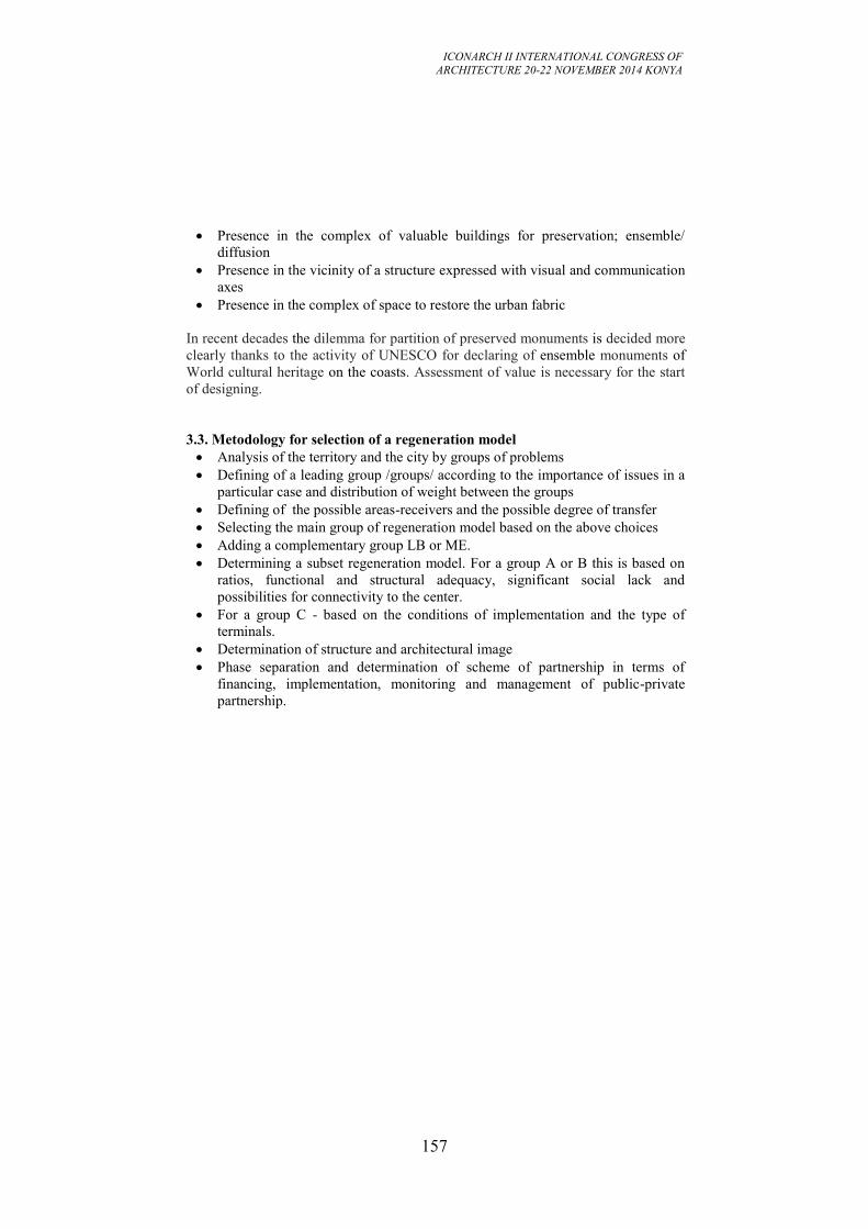
ICONARCH II INTERNATIONAL CONGRESS OF
ARCHITECTURE 20-22 NOVEMBER 2014 KONYA
157
Presence in the complex of valuable buildings for preservation; ensemble/
diffusion
Presence in the vicinity of a structure expressed with visual and communication
axes
Presence in the complex of space to restore the urban fabric
In recent decades the dilemma for partition of preserved monuments is decided more
clearly thanks to the activity of UNESCO for declaring of ensemble monuments of
World cultural heritage on the coasts. Assessment of value is necessary for the start
of designing.
3.3. Metodology for selection of a regeneration model
Analysis of the territory and the city by groups of problems
Defining of a leading group /groups/ according to the importance of issues in a
particular case and distribution of weight between the groups
Defining of the possible areas-receivers and the possible degree of transfer
Selecting the main group of regeneration model based on the above choices
Adding a complementary group LB or ME.
Determining a subset regeneration model. For a group A or B this is based on
ratios, functional and structural adequacy, significant social lack and
possibilities for connectivity to the center.
For a group C - based on the conditions of implementation and the type of
terminals.
Determination of structure and architectural image
Phase separation and determination of scheme of partnership in terms of
financing, implementation, monitoring and management of public-private
partnership.
ICONARCH II INTERNATIONAL CONGRESS OF
ARCHITECTURE 20-22 NOVEMBER 2014 KONYA
158
4. CONCLUSION
THE MOST SUCCESSFUL SOLUTIONS TO RESTORE THE URBAN
FABRIC AND CONNECTIVITY OF THE WATERFRONT TO THE CITY
To select the most appropriate for each case decision all factors and conditions in the
city must be taken into account, as well as the public needs and characteristics of the
surrounding areas and to identify solutions for maximum of the existing problems.
However, aggregated dependencies show that:
When selecting regeneration models A and B, the more remote the port area
from the city center or the district center, and the greater the ratio of its area to
the area of the active center, the greater must be the share of housing and
employment areas. Conversely, the closer the regeneration area is to the active
center and the smaller it is compared to the center, the more easily this zone can
be converted into its natural extension. This ensures a sufficient number of
users of services, trade, green areas and public spaces in it. If this rule is not
obeyed, these objects and spaces will be deserted, as they will not have enough
users. Public transport has an important role also, since it can generate
permanent and sustainable user load of the territory
The connectivity of the city and its elements is greatest in the center and
decreases towards the periphery, so in order the waterfront to be a fully
functional part of the city, its zoning must provide such a distribution of
functions, which can respond to this dependence
The intensity and multi-spectrality of usage of urban areas is highest in the
center and decreases towards the periphery
A greater functional mix would ensure a sustainable daily, yearly and long-term
load and economically sustainable solutions
Maximum accessibility and maximum range of users have both a moral aspect
and also ensure sustainable development.
Because of the specific situation of the old ports (near to the city center) and
the need to serve a variety of functions, pure mono functional decisions are not
the best, nor most effective and sustainable.
On the other hand the green and open spaces are a necessary component of the
solutions to urban waterfront, because they provide the final link in the system
of pedestrian routes and common accessibility requires it.
These statements define the range of eligible effective urban solutions:
In city centers in small coastal zones (up to 1/2 of the area of the center)
suitable park solutions saturated with services, mix areas in parks and mix areas
rich in green spaces
In more remote from the center and wider zones (more than 1/2 of the area of
the center) are appropriate solutions of the "core zones" type with a strong
participation of homes and services and availability of parks
In the urban periphery and suburbs are eligible limited accessibility parks (fun
and sports centers, protected natural areas, big zoo) and zones with more
greenery (campuses, research centers, large exhibitions, luxury residentials) or
ICONARCH II INTERNATIONAL CONGRESS OF
ARCHITECTURE 20-22 NOVEMBER 2014 KONYA
159
other gated complexеs such as storage and non-polluted industrial zones.
Classical park areas being variety of the mono-functional decisions are also a
controversial decision, especially when they are monotonically conducted along
the entire coast. When planning the city waterfront area we should be looking
for an opportunity to lay on an uninterrupted "green" pedestrian strip along the
coast that pulsing (by size and diffusivity) to "overflow" in the a/m areas and
provide accessibility and connectivity of pedestrian routes. In case of shortage
of green areas in the city center, the choice of a green area full of public service
facilities is suitable for the central coast. It must comply with realities (structure
and function) of the adjacent urban periphery and adapt appropriately. Thus the
main axes of communication from the city will spill over into the main lanes of
entertainment and shopping facilities, and the load of the side of the park areas
will gradually decline and will respond to the quiet residential areas. Rhythmic
pulsation of the workload with visitors and sites along the coast is appropriate.
An important aspect is the promotion of the usage whole park area through
adequate service by public and private transport. An important condition for
successful implementation is the limitation of motor traffic in these areas – it
must be either underground or be strictly limited and controlled in order to
prevent "falling apart" of parks.
4.1. Figures, Graphics, Photographs and Tables
HAMBURG
Fig.1 Left: Hamburg and new Hafencity on Google Earth; right: New concert hall
Elbphilharmonie and 5-star Hotel in old cocoa warehouse, Architects: Herzog & de
Meuron, from: www.formwaende.de/single/article/elbphilharmonie-hamburg-1.html
ICONARCH II INTERNATIONAL CONGRESS OF
ARCHITECTURE 20-22 NOVEMBER 2014 KONYA
160
Fig.2 Hafencity from bird eye – structural harmony between new and historic
structures, from:www.hafencity.com/
Fig.3 Hafencity, functional and structural analysis
BILBAO
Fig.4 Left: District Barakaldo and area Galindo in Bilbao;
/from www.bilbaoria2000.org, www.barakaldo.org/.;
Right: functional and structural analysis of the same area;
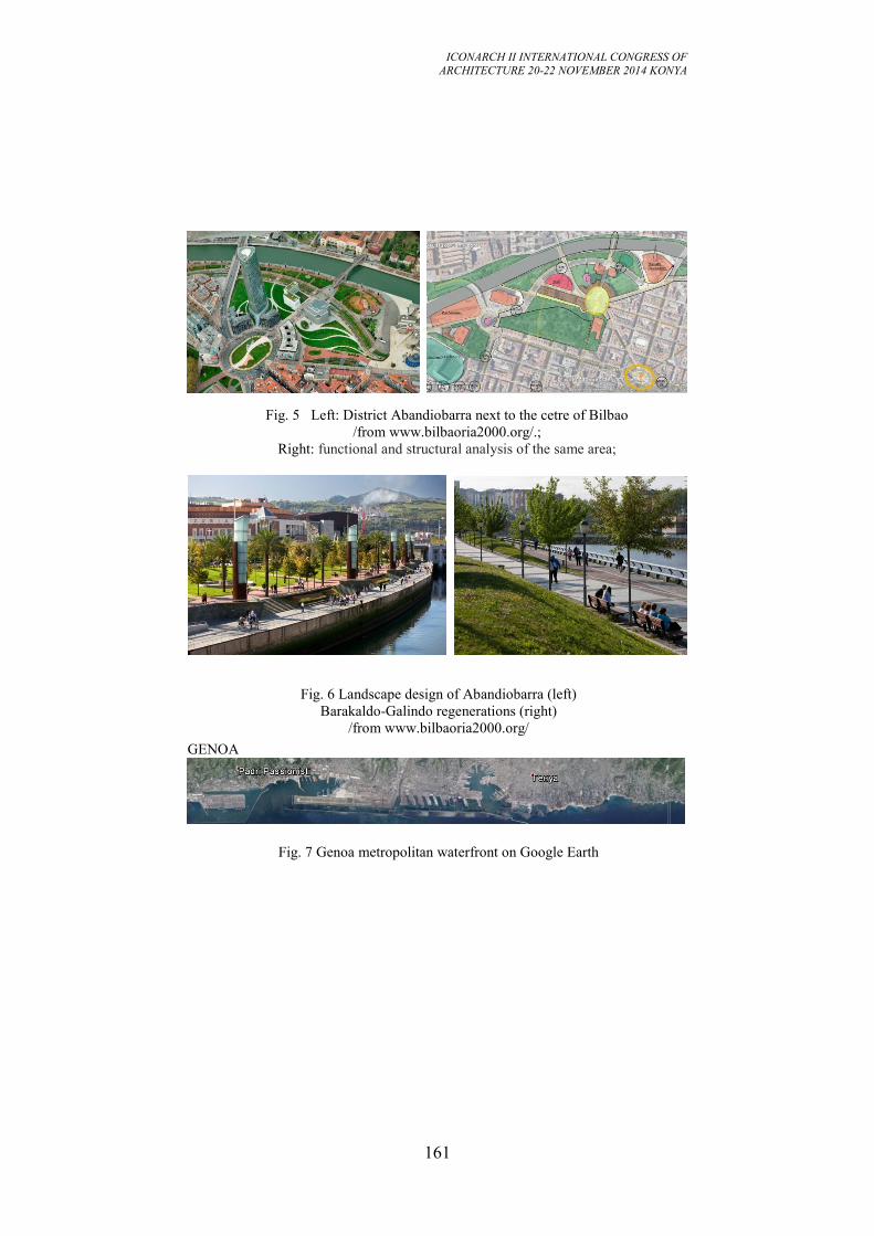
ICONARCH II INTERNATIONAL CONGRESS OF
ARCHITECTURE 20-22 NOVEMBER 2014 KONYA
161
Fig. 5 Left: District Abandiobarra next to the cetre of Bilbao
/from www.bilbaoria2000.org/.;
Right: functional and structural analysis of the same area;
Fig. 6 Landscape design of Abandiobarra (left)
Barakaldo-Galindo regenerations (right)
/from www.bilbaoria2000.org/
GENOA
Fig. 7 Genoa metropolitan waterfront on Google Earth
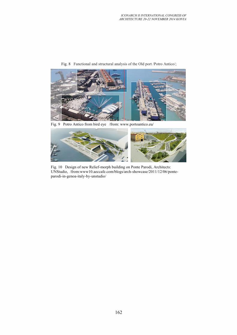
ICONARCH II INTERNATIONAL CONGRESS OF
ARCHITECTURE 20-22 NOVEMBER 2014 KONYA
162
Fig. 8 Functional and structural analysis of the Old port /Potro Antico/;
Fig. 3 Landscape design of Abandiobarra (left) and Barakaldo-Galindo(right)
regenerations
Fig. 9 Potro Antico from bird eye /from: www.portoantico.eu/
Fig. 10 Design of new Relief-morph building on Ponte Parodi, Architects:
UNStudio, /from:www10.aeccafe.com/blogs/arch-showcase/2011/12/06/ponte-
parodi-in-genoa-italy-by-unstudio/
ICONARCH II INTERNATIONAL CONGRESS OF
ARCHITECTURE 20-22 NOVEMBER 2014 KONYA
163
REFERENCES
Ana Estevens, Waterfront Rehabilitation: A Model Of Spatial Intervention.
The Case Of Lisbon Metropolitan Area, 41st Isocarp Congress 2005;
Ann Breen, Dick Rigby, The New Waterfront: A Worldwide Urban Success
Story, Mcgraw-Hill Professional, 01.11.1996;
Antonio Bevilacqua, Il Masterplan Per Il Waterfront Di Palermo 2006 -
2007.
Antonio Bevilacqua, L Piano Regolatore Portuale Di Palermo 2007-2008.
Bas Butuner, Waterfront Revitalization As A Challenging Urban Issue In
Istanbul, 42nd Isocarp Congress 2006;
Beatriz Garcia, Cultural Policy And Urban Regeneration In Western
European Cities: Lessons From Experience, Prospects For The Future,
Local Economy, Vol. 19, No.4, 312-326, 2004;
Bilbaoria2000, Revista De Divulgacion Editada Por La Sociedad Bilbao Ria
2000, Numero 23, Julio 2011
Cardiff Bay, Urban Regeneration In Wales Capital: Welsh Assembly And
Waterfront Attractions In Cardiff, Wales, Available On
Http://Www.Suite101.Com/Content/Cardiff-Bay-Urban-Regeneration-In-
Wales-Capital-A218553#Ixzz0zhq7ijkm [November 2012].
Carlos J. L. Balsas, City Centre Revitalization In Portugal: A Study Of
Lisbon And Porto, Journal Of Urban Design, Volume 12, Issue 2 June 2007
, Pages 231 - 259.
Chris Couch, Charles Fraser, Susan Percy, Urban Regeneration In Europe,
Blackwell Science, 12.06.2003.
Chunsong Wang, Waterfront Regeneration, Cardiff University. Paper. 2008.
Clark, M, Fallow Land In Old Docks: Why Such A Slow Take-Up Of
Britain’s Waterside Redevelopment Opportunities?, Maritime Policy And
Management, 12(2), Pp.157 – 157, 1985.
Cook, A.Al., Port And City Relations: San Francisco And Boston, In
Marshall, R.Ed., Waterfronts In Post-Industrial Cities, London And New
York: Spon Press, Pp. 117 – 133, 2001.
Cooper Eckstut Associates, Battery Park City Draft Summery Report And
1979 Master Plan, New York: Battery Park City Authority, 1979.
De Jong, W. M., Revitalizing The Urban Core Waterfront Development In
Baltimore, Maryland, In Fox-Przeworski, J. Ed Al. Urban Regeneration In
A Changing Economy: An International Prospective, Oxford: Clarendon
Press, Pp. 185 - 198, 1991.
Francisco-Javier Monclús, The Barcelona Model: An Original Formula?
From ‘Reconstruction’ To Strategic Urban Projects (1979–2004), Planning
Perspectives, 18 (10.2003) .
Gordon, L. A. D., Battery Park City: Politics And Planning On The New
York Waterfron, Amsterdam: Gordon And Breach Publishers, 1997
ICONARCH II INTERNATIONAL CONGRESS OF
ARCHITECTURE 20-22 NOVEMBER 2014 KONYA
164
Economic Development In Baltimore: Three Decades Of Public-Private
Partnership, Washington, Dc, Hud (Us Department Of Housing And Urban
Development),1985
Ian Cook, Waterfront Regeneration, Gentrification And The Entrepreneurial
State: The Redevelopment Of Gunwharf Quays, Portsmouth, Spa Working
Paper 51, School Of Geography, University Of Manchester, July 2004,
Jim Berry, Stanley Mcgreal, Bill Deddis, Urban Regeneration. Property
Investment And Development, Taylor & Francis, 01.11.1993.
John Mccarthy, Spatial Planning, Tourism And Regeneration In Historic
Port Cities. Disp - The Planning Review , Volume 39, Issue 154, 2003
John Mullin, Zenia Kotval, Carlos Balsas, Historic Preservation In
Waterfront. Communities In Portugal And The Usa, Landscape
Architecture & Regional Planning. Faculty Publication Series, University
Of Massachusetts – Amherst, 2000
José María Tomás Llavador, STUDY CASE. LA SPEZIA, ITALY.
REGENERATING THE WATERFRONT. WATERFRONT EXPO 2008, LIVERPOOL
Karachalis Nicholas, Kyriazopoulos Evangelos, Greek Port Cities In
Transition: Regeneration Strategies, Waterfront Development And The
Role Of Cultural And Tourist Resources. Regional Development Institute
Of Panteion University, 1992,
Laura Capel-Tatjer, Culture, Technollogy And Creativity As Drivers Of
Urban Regeneration In Barcelona, Trieste, 6th October 2009
Lisa Nevitt, The Green Point Urban Park Is Open For Business, Http://
Www.Capetownmagazine.Com/City-News/The-Green-Point-Urban-Park-
Is-Open-For-Business [May,2012]
Maltese Planning Authority, Valletta Cruise Passenger Terminal. Approved
Development Brief. Valletta: Maltese Planning Authority, 1998
Marshall, R., Waterfronts, Development And World Heritage Cities:
Amsterdam And Havana, In Marshall R. Ed. Waterfronts In Post-Industrial
Cities, London And New York: Spon Press, Pp. 137 -159, 2001
Meyer, H. City And Port, Urban Planning As A Cultural Venture In
London, Barcelona, New York And Rotterdam: Changing Relations
Between Public Urban Space And Large-Scale Infrastructure, Utrecht:
International Books, 1999.
Orianna Giovinazzi, Marta Moretti, Port Cities And Urban Waterfront:
Transformations And Opportunities, Temalab Journal Of Mobility, Land
Use And Еnvironment,Vol 3, 03. 2010.
Paula Pacheco, City's Port Qualification – City And Port Relationships,
43rd Isocarp Congress, 2007.
Pedro Ressano Garcia, «Tagus Platform» Project – Innovating Lisbon's Port
Territory, Cities And Ports Innovating For An Inter-Dependent Future. 11th
International Conference Cities And Ports – 23/27 June 2008 – Stockholm,
Sweden.
ICONARCH II INTERNATIONAL CONGRESS OF
ARCHITECTURE 20-22 NOVEMBER 2014 KONYA
165
Phil Jones, James Evans, Urban Regeneration In The UK, Sage Publications
Ltd, 23.05.2008, Through
Http://Www.Books.Google.Bg/Books/About/Urban_Regeneration_In_The_
Uk.Html [2013].
Review Of Governance Models For Waterfront Development And The
Relationship With Port Precincts And Cbds, Auckland Regional Holdings,
20 March 2009.
Robert Cervero, Freeway Deconstruction And Urban Regeneration In The
Usa, International Symposium For The 1st Anniversary Of The
Cheonggyecheon Restoration Seoul, 2006.
Rossana Galdini, Urban Regeneration Process: The Case Of Genoa, An
Example Of Integrated Urban Development Approach, 45th
Congress Of
The European Regional Science, Vrije Universiteit Amsterdam, 23-27
August 2005.
Stefanos Gerasimou, Anastassios Perdicoulis, Urban Renaissance In Palaio
Faliro, The 3-Rd Int. Conference On Energy And Development-
Environment–Biomedicine.
Teresa Barata Salgueiro, Port And City Relationships: Challenges For
Collaboration In The Regeneration Of The Landscape, Port-City Univ
League:The Port As A Complex Reality, Lisboa.
Teresa Colletta, The Historical Naples’ Waterfront And The Reconversion
Of The Military Locations: The Acton Dock, The Bourbon Dockyard And
The San Vincenzo Pier, Méditerranée, 2010.
Timothy Sieber, Public Participation In Environmental Impact Assessment:
A Comparison Of Urban Waterfront Redevelopment In Lisbon And Boston,
Usa, Through Http://Www.Citidep.Pt/Papers
ICONARCH II INTERNATIONAL CONGRESS OF
ARCHITECTURE 20-22 NOVEMBER 2014 KONYA
166
READING THE CONSTRUCTION OF IDENTITY IN
ACADEMIC WRITINGS THROUGH THE CASE OF MARDIN
NURCAN GÜNEŞ1
ABSTRACT
Today, in many spheres of life including architecture, “to have an identity” is
considered to be an important qualification for anything, and the reverse is
considered to be extrinsic. Particularly, “identity” is emerging as a theoretical
obstacle / limiter in architectural education and also in the professional practice.
Construction process of identity is possible to refer in field of architecture as in all
human sciences. Identity is a subject which is hard to talk about, despite its quality
of creating new controversy routes. While the research of humanities related to
identity issues tend to refer to dichotomies, in the field of architecture it produces
clichés. When the PhD and master thesis that are done in the field of architecture
were made subject to textual analysis is thought that identities of architects,
architectures, urban districts and buildings are all produced in similar pragmatics.
This paper will focus on how academia- which is one of the identity constructing
actors- constructs identities. In the study, examples about production of urban and
buildings’ identification will be given. Thesis was written in Turkish academic
institutes which included keywords of "architecture" and "identity" will be
examined. Such research that has a small but effective cross-section is expected to
reveal academia’s role in the production of identity. After identity constructions or
productions of ideals in academia are tried to be explained through several
examples, their impacts on the production of novelties will be discussed in the
conclusion. What kinds of problems will emerge from interference to an urban area,
a building or an object which is considered a production of architecture with identity
rhetoric or engagements will be discussed. In this respect, if holiness references such
as owning an identity or essence are being produced by academia, it is possible to
talk boundaries about understanding and signification. Despite the studies that are
made to bring architectural products identity into view, it is argued in this study that
here is no hierarchical priority among the numerous combinations that form the
identity.
Key Words: Identity
1 R.A., Mardin Artuklu University, Department of Architecture, MARDIN
ICONARCH II INTERNATIONAL CONGRESS OF
ARCHITECTURE 20-22 NOVEMBER 2014 KONYA
167
1. INTRODUCTION
It is known that many academic gatherings held in Turkey for so many years have
frequently thematized their sub-titles with ‘identity’. Particularly in architectural and
urbanism studies of social sciences, it is possible to mention several titles focusing
on identity. Taking this as a point of departure and assuming that identity is
constructed by several specific means, it is safe to argue that academia is also one of
those means.
The academic world of architecture has also produced many identities and
particularized that knowledge with the domination of scholarship. This study is
written, as a reference to a chapter in the thesis titled ‘A new reading approach to
Identity: the Discursive Construction of Identity and the Case of Mardin,’ which was
submitted to Karadeniz Technical University in 2013, with the purpose of
developing a critical point of view with regard to scholarship produced by academic
works.
2. EXAMINATION OF IDENTITY PRODUCTION IN ACADEMIA
THROUGH EXAMPLES
Knowledge production in academia is a subject that needs to be studied and
criticized. Aiming particularly to know and understand the subjects, this domain’s
occlusive approach to create identities is noteworthy. In academic circles, yet
especially in architectural academic circles, the ongoing dominance of positivism
can be seen as the reason for such approach. Restraining almost all knowledge into a
concept by categorizing them is one of most frequently used methodology in
academia. Most academics not only conflate all concepts and use them in one ideal
monolithic term, but also create a homogenizing reflection vis-à-vis such concepts.
Further, they label the research topics with a codification of forms. This eventually
leads us to a description of the research subject as ‘absolute,’ existing in a space far
away from its own reality (albeit directed to a nearby space).
This approach, which to some extent is understandable in natural sciences, is not
practical in social sciences since ever-changing research object in such disciplines is
‘humans. ‘Likewise, the discourses of identity by academics, for the sake of being
objective, are produced with idee fixe that freezes or stabilizes human factors as
much as possible. I criticize not the quantity here but rather the very belief on the
invariance of the quantity. The reason for that is because different identities are
constructed on the quantities that are regarded as invariant in academic texts written
in the field of humanities, and even these constructed identities are expressed
repeatedly as entrenched stereotypes.
At this juncture, when we look at the meaning of the concept of identity we see that
the concept itself produces a continuous dichotomy between its meaning and the
object it describes. For example, when one says " something with A identity,’ this at
the same time means that the described thing is regarded as similar to all identity A
ICONARCH II INTERNATIONAL CONGRESS OF
ARCHITECTURE 20-22 NOVEMBER 2014 KONYA
168
holders or members and dissimilar to other non-A identities. This case makes hybrid
identities difficult to include or even think about them in existence. On the contrary,
the absence of hybridity cannot be the case at all.
Owing to the scope of this study, the construction of identity in urban and
architectural context is examined with relevant examples. For example, "Turkish
House" (Sarıalioğlu, 2007) epitomizes one of the most widely used and remarkable
examples of the construction of this identity, which is a commonly written
stereotype in this regard. Sarıalioğlu, studying the conceptual construction of
"Turkish House"(Sarıalioğlu, 2007), argues that the concept of Turkish house
roughly began to be discussed and therefore constructed since the 1930s,
concomitantly when Turkey's traditional residential architecture or cultural heritage
began to be ‘officialised.’ The conclusion of Sarıalioğlu’s work evidently
demonstrates how academia constructs an identity.
"During 1928-1950 when the earliest texts on “Turkish house" in Turkey were
written and in the process of developments in the Early Republican Era’s Turkey, a
“national "category, under the name of "Turkish house" was created. With its
known discourse, typological, morphological, social, and even esoteric approaches
were developed for the subject categorized under ‘Turkish house; not only in
architectural narratives or in historical narratives on architecture, but also in in the
popular imagination, the term Turkish became a concept that everyone agreed to
use. It is evident that the aim of that approach was to melt the pluralism/diversity of
normal housing into a ‘singular’ national architectural category. Therefore, the
construction of the ‘nation’ in Turkey is accompanied by the concept of ‘Turkish
house.’ In the texts written after the 1960s, however, it is seen that the construction
of the concept of ‘Turkish house’ was completed, that is to say, there was left no
doubt about the existence of ‘Turkish house’ typology by then. "
Accordingly, construction of a similar structure can be observed in many theses
written on urban identity. Moreover, it is likely to see a variety of identity
construction in many theses written in other fields, apart from architecture and
urbanism. For instance, if the study subject of a work in any field of study is about a
city or an urban area, it is possible to read the monolithic identity that is constantly
produced for an urban area in the titles describing the field of study. To exemplify,
when theses that are written about and around Mardin1 are examined the said two
cases appear to be a common feature. In this line, some of these theses contain
identification of local findings and design models that are developed based on such
identification. In these theses in question, the concern of "protectionism" leads to an
approach that accept building dating back to only a certain period, or ‘old’
architecture as meaningful and valuable stands out.
Apart from these, likewise in many of the titles of these theses, the information on
the identity of Mardin presents many stereotypes and even myths, which indicated
the latter case. The phrase, "History and Culture of the city of Mardin" (Davutoğlu,
2008), (Demir MM, 2010) is present in almost all theses studying the city. In the
1 List of last ten years’ examples are provide from the1st Attachment of "A new reading approach to
Identity: the Discursive Construction of Identity and the Case of Mardin"
ICONARCH II INTERNATIONAL CONGRESS OF
ARCHITECTURE 20-22 NOVEMBER 2014 KONYA
169
same way "historic urban fabric" is presented as magnum opus or masterpieces,
decontextualized from its social fabric (Gündüz, 2011).
It is demonstrable to see the impact of academia in identity formation in many
studies as in the abovementioned examples. After such recognition some discussion
as well as frameworks on the definition of the identity can be discussed.
To begin with, for example, one of the topics needs to be discussed is the design
grammar that is built on the acceptance of the historic urban fabric and architecture
of the city. In these works, which are mostly based on formal data, it is observed that
the reading of social relations networks seems insufficient. In such a reading
methodology, the performer’s point of view is fixed with numerical values, thereby;
a definition that defines an invariant inferred from relationship diagrams of specific
but limited number of networks is the conclusion. In this methodology, which can
also be described as the implementation of mathematics to space, regardless of
numerous results, because the conclusions are fixed, the method intrinsically is
limited too. This following tack is followed in this methodology. First of all, the
identity of the subject of the research is determined and then this presupposition is
regarded as factual input for the next stage. The determined identity is regarded as a
grammar however this grammar is established solely on subjective readings. At the
end of each study, a presupposition or postulation is developed based on the
grammar therein While studies conducted with this framework might be important
for proposing alternatives, they are problematic at the same time because they also
produce the perception as though there is a single and monolithic identity in that
respect. Furthermore, it is seen that the methodology used for drawing such a
conclusion reduces the design activity to a "chemical reaction" whose input, output
and catalyst are deemed self-evident. However, architectural design indicates a
further level in which social inputs continuously produce different and time variable
results. With the progress in computer technology and its incorporation into
architectural design process, one can see the inevitable use of this method in
architectural theses completed in this field.
An example of this case is again present in one of thesis conducted on Mardin. The
thesis, titled "Contemporary Mardin Housing Settlement Arising from Tradition," as
the author argues, " aims to write about development of an design method of
residential alternatives derived from modern housing typologies compatible with
historical texture. " (Uzbek, 2004). As the author points out that the study is carried
out in order to develop an alternative in the first chapter, the second chapter,
however, describes the characteristic features of "Mardin houses." In the third
chapter, the author develops presumptions regarding the new residential settlements,
employing the grammar that is established from the characteristics of houses.
Although the study is successful in terms of its methodology, it can be argued that
the thesis also poses some problematic issues as well. When starting with the design
and doing so by a presupposition of characteristics of Mardin houses, developing
typology in this manner is required. However, this presupposition is questionable in
terms of its correctness and seems to consist of an imagined and self-produced
morphology. Another issue of conflict is the assumption that the tradition is
regarded as a value that needs to be produced, sampled or imitated or followed. In
addition, the type of relationship that an image that is denominated as "traditional"
ICONARCH II INTERNATIONAL CONGRESS OF
ARCHITECTURE 20-22 NOVEMBER 2014 KONYA
170
would have in this "traditional state" of space or how it will establish a presence in"
contemporary" settings should be contemplated and described.
One can make reference to many more theses that are written in this regard.
Nevertheless, without dwelling on this subject more, it is useful to touch on the
construction of tradition in order to better understand the construction of identity.
For creating an identity, grammar or a language, one primarily needs ‘ideal' or more
generally, a typology. The production platform for this construction is the existing
theory and previous academic studies. That is why especially the chapter in which
the object of study is defined contains many academic references and quotations.
For example, the book by Füsun Alioğlu, titled " Houses and Texture of the city of
Mardin" is considered as one of the most important works among texts, studies, and
books written about Mardin. The book, which was published as a book in 2000 and
was derived from Alioğlu’s 1988 doctoral thesis titled "An Essay on Traditional
Houses and Texture of the City of Mardin," as well as other subsequent and enriched
studies by the same author has been a textbook many researchers (Seçkin, 2007).
The foregoing book, however, is a reference book for researchers working on
Mardin. In the preface of the doctoral thesis, which was published into a book 12
years after its submission, first impressions and generalizations of a researcher draw
the attention. The thesis, which aims to establish characteristic of Mardin houses
within the framework of traditional houses and with the help of then research on
"Turkish house," and to understand the composition of the urban fabric in Mardin,
endeavors to explain the "historical" and "formal" identity of the region. In the
introduction of this thesis, Alioğlu writes that periodic readings can be demarcated
however she mentions that it is difficult to determine chronology in terms of
structures (Alioğlu, 2003).
"The effects of increasing industrial developments in the world since the
19th
century, was the case in Anatolia after the second half of the 20th
century.
Mardin is one of the latecomers of this process in which both large and small
settlements were affected. This is the reason that Mardin is more preserved today
compared to other settlements, and this itself was regarded as an opportunity, which
also determined the decision to work on Mardin in this thesis. In studies on
traditional Anatolian cities and houses, conclusions are derived usually ignoring the
East and Southeast regions.
The main point of debate in these studies is centered on the texture of the city before
and after Turkish period. In the pre-Turkish period texture of the city, although
Hellenistic, Roman traces are tracked down, more often the question regarding what
the Byzantine meant and what the Turks had added on top of that background was
the case. The cities located in the southeast of the country, albeit within the borders
of Turkish period Anatolia, could not receive attention and space in the narratives
aiming to cover the overall subject, basically because these cities also had
undergone Arab-Islam dominance prior to Turkish period. Another objective of this
thesis, at this point, also revealed the need for studying traditional texture and
houses of the city of Mardin"(Alioğlu, 1989).
ICONARCH II INTERNATIONAL CONGRESS OF
ARCHITECTURE 20-22 NOVEMBER 2014 KONYA
171
It can be seen that, when stating the objective of her thesis, Alioğlu describes the
city’s architectural heritage with an identity narrative based on race, region, nation
or rulership. Such an identity narrative can be claimed to challenge a research that
aims to have and integrated approach focusing on Mardin from today to the past.
The reason is that because the city does not appear to be suitable for making an
identity distinction leading an architectural heritage typology thereto. It can be
argued that a historical analysis would yield more objective results without
developing a typology.
3. CONCLUSION
As a result, this study elucidates the construction of identity or production of ‘ideal’
by academic works through focusing the case of Mardin. Similar studies can be
carried out on architecture, urban studies or even all cases involving identity
discourses. The main criticism that is aimed to be made in this study is the
unchangeable, occlusive and uncritical conclusions of discourses of identity. When
examining the studies done, contemporary researchers, as Tanyeli also argues
(Tanyeli, 2011, p. 459), should take into account the fact that an ‘identity is not
unique at least in four aspects.’ The first of these aspects is that identities are not
objective but rather subjective. Identity can differ according to person or who
defines identity. Another aspect is that criteria for differentiation of an identity also
contain many other identities as well. Defining the third parameter as the time,
Tanyeli points out, identities can transform in the course of time. Finally, describing
the fourth parameter as the context, Tanyeli underlines that each time an identity is
articulated it is defined differently and questions which contextual identity should be
accepted as ‘the genuine’ articulation of that identity.
Throughout the study, the discussion of what determines identity is particularly not
mentioned. That is because identity is regarded as a discursive discipline and can
permeate all sociological fields, therefore all kinds of identity discourses that are
produced by academic works overall is the focus.
Likewise, concepts used in architecture and urban studies such as architectural
identity, and structural identity are also criticized in the same pot. Any
predetermination of studies aiming to read identities that does not take into
consideration those four parameters above as well as numerous combinations
thereafter seems to be out of the hearth of the issues and self-evident. In the urban
context, if the references of sanctity are attached to some terms such as locality,
identity and having a particular identity are produced by academia, then, it is
possible to talk about a tendency towards a deadlock, which has its own boundaries
with regard to understanding and explaining such concepts. Tanyeli’s criticisms of
identity and architectural identity, in this context, seem to be elucidatory and
informative.
"Let's suppose that we can to build things that reflect our ‘identities,’ then, we have
to specify, according to whom, when, and which components of which of our
identities they should reflect. Those arguing that a city lost its architectural identity
ICONARCH II INTERNATIONAL CONGRESS OF
ARCHITECTURE 20-22 NOVEMBER 2014 KONYA
172
or has a fake identity, should first try to define the original identity they talk about.
Of course, that does not yield any answers. Such identity definitions cannot be made.
Neither is it possible, nor is democratic. Let alone being rational "(Tanyeli, 2011, p.
461).
REFERENCES
Alioğlu, E. F. (1989). Geleneksel Mardin Şehir Dokusu ve Evleri Üzerine Bir
Deneme. Doktora Tezi, İstanbul Teknik Üniversitesi, Fen Bilimleri
Enstitüsü, İstanbul.
Alioğlu, E. F. (2003). Mardin Şehir Dokusu ve Evleri (2.Baskı b.). İstanbul: Türkiye
Ekonomi ve Toplumsal Tarih Vakfı.
Davutoğlu, S. (2008). Değişen Yerleşim Alanlarına Göre Kent Bilinci: Mardin
Örneği. Yüksek Lisans Tezi, Kırıkkale Üniversitesi, Sosyal Bilimler
Enstitüsü, Kırıkkale.
Demir, M. M. (2010). Mardin Şehri. Yüksek Lisans Tezi, İstanbul Üniversitesi,
Sosyal Bilimler Enstitüsü, İstanbul.
Gündüz, E. (2011). Tarihi Kentin Korunmasında Çevresel Kapasite Yöntemi-Mardin
Örneği. Doktora tezi, Selçuk Üniversitesi, Fen Bilimleri Enstitüsü, konya.
Güneş, N. (2013). Kimlik Üzerine Yeni Bir Okuma Denemesi: Kimliğin Söylemsel
İnşası ve Mardin Örneği. Tranzon: Karadeniz Teknik Üniversitesi Fen
Bilimleri Enstitüsü.
Özbek, H. (2004). Gelenekselden Türeyen Çağdaş Mardin Konut Yerleşimi. Yüksek
Lisans Tezi, Yıldız Teknik Üniversitesi, Fen Bilimleri Enstitüsü, İstanbul.
Sarıalioğlu, C. (2007). Historiyografik Bir Sorunsal Olarak "Türk Evi"(1928-1995).
Yüksek Lisans Tezi, Yıldız Teknik Üniversitesi, Fen Bilimleri, İstanbul.
Seçkin, S. (2007). Yayınlar Işığında Mardin. İ. Özçoşar içinde, Makalelerle Mardin
(Cilt III Kentsel Yapı, s. 282). istanbul: Mardin Tarihi İhtisas Kütüphanesi.
Tanyeli, U. (2011). Rüya, İnaş,İtiraz Mimari Eleştiri Metinleri. istanbul: Boyut
Yayıncılık.
ICONARCH II INTERNATIONAL CONGRESS OF
ARCHITECTURE 20-22 NOVEMBER 2014 KONYA
173
BUILDING INFORMATION MODELING TOOLS:
OPPORTUNITIES FOR EARLY STAGES OF
ARCHITECTURAL DESIGN
ÖMER HALİL ÇAVUŞOĞLU1
ABSTRACT
In the practice of building design, numerous researchers point out that, at the early
stages of architectural design, many significant decisions are taken to directly affect
functional qualities, the performance of the building, aesthetics, and the relationship
of the building with the natural environment and climate, even if there is no certain
and valid information to create and obtain satisfying design.
In this paper, I particularly focus on the early stages of architectural design and
search for the opportunities provided by Building Information Modeling (BIM)
tools, towards the concept of performance analysis and aesthetic variations. Study
also includes case study implementations which visualize the early processes of
architectural design with benefits of BIM under different conditions to evaluate its
opportunities during these design processes. To clarify and to test the benefits of
BIM tools, the task is done to create a concept model with Vasari and Revit
software. Participants are asked for designing alternatives within the given
requirements and synchronically, I analyzed the process within the perspective of
how design products are shaped and also how the process effects the designers while
they are designing.
Later on, I observe how participants use the tool to obtain aesthetic variations and
how tool provides a connection between aesthetic issues and the performance
realities. At this stage, BIM tools provide an evaluation platform to crosscheck the
current design alternatives with the selected building components and environmental
conditions such as temperature, sun light directions, wind directions, and so on. By
this way, designers are able to realize the relationship between the design product
and the environment and also be able to obtain performance analysis of the
alternatives on the very early stages of architectural design.
As a result of these case studies, I observe that the BIM tools (Vasari and Revit)
which are used in this study, do not provide an automated design process, but only
analyze the designer’s existing design to enable the evaluation of the relationship
between the building and the environment. Then, the design relies on both the
functional realities and the subjective judgements of designer. This operation
continues as an iterative process until designer feels satisfied for his/her design
product.
As a summary, early stages of the architectural design are accepted as the weakest
point of the BIM systems. In this study, two case studies have been implemented to
reveal how BIM can help to designers in these stages. As a result of the
1 Department of Architectural Design Computing, Istanbul Technical University
ICONARCH II INTERNATIONAL CONGRESS OF
ARCHITECTURE 20-22 NOVEMBER 2014 KONYA
174
implementations, it is understood that BIM is a powerful early stages of architectural
design tool, not for designing but for design supporting.
Key words: conceptual design analysis, computational design analysis, building
information modeling
1. INTRODUCTION
Architecture is a profession that is in a tension between imagination and reality. The
architect’s task is to convert the client’s dreams into a concept design which is
expected to lead to a functional, legally proper, and aesthetic design (Foqué, 2010).
The role of the architects in the related process often begins from the starting point
of the project to the end of the construction. As the architectural design process has a
complicated structure with different purposes, it is divided into stages.
Numerous researchers point out that, at the early stages of architectural design,
many significant decisions are taken to directly affect functional qualities, the
performance of the building, aesthetics, and the relationship of the building with the
natural environment and climate, even if there is no certain and valid information to
create and obtain adequate design.
In this paper, I particularly focus on the early stages of architectural design and
search for the opportunities provided by Building Information Modeling (BIM)
tools, towards the concept of performance analysis and aesthetic variations. The
focus of the study is to offer, not an alternative way for traditional design practices
but a supporter. From this perspective, firstly, I review the literature on early stages
of architectural design, its characteristics, usual habits, and positive / negative
aspects. The following two sections (Case Study A and B) are the implementations
of BIM tools (i.e. Vasari and Revit) in the early stages of architectural design. These
sections also include assessment of the cases to discuss the strong and weak features
of the tools. In the last section, I also evaluate the findings of the case and literature
review in the same context to constitute a new approach for early stages of
architectural design.
2. EARLY STAGES OF ARCHITECTURAL DESIGN
Stages of architectural design process are defined within the various procedures by
different authorities. For instance, the Royal Institute of British Architects’ (RIBA’s)
Plan of Work includes nine main stages as inception, feasibility, outline proposals,
scheme design, detail design, production information, bills of quantities, tender
action, and project planning (Thompson, 1999). From the perspective of RIBA, the
early design stages refer to inception, feasibility, outline proposals, and scheme
design.
Other studies show that, in the early stages of architectural design, sketching and
drawing with paper and pencil still has an important role for exploring possible
design alternatives, evaluating the ideas, and also communication with self (Do,
ICONARCH II INTERNATIONAL CONGRESS OF
ARCHITECTURE 20-22 NOVEMBER 2014 KONYA
175
2002; Lawson, 1994; Herbert, 1993; Graves, 1977; Schön, 1985; Goldschmidt,
1989). On the other hand, being digital makes CAD softwares more effective than
traditional drafting methods in terms of time, cost and ease of use. However, these
CAD software which are really useful for drafting, are not suitable for initial design
tasks like exploring new ideas.
In this stage, designers also are expected to decide on key factors such as building
orientation, building shape, structural system, building envelope and interior finishes
with inadequate and indefinite information (Gervasio et. al., 2014; Granadeiro et. al.,
2013; Oral & Yılmaz, 2002; Oral & Yılmaz, 2003; Hong, Chou & Bong, 2000;
Holm, 1993; Gratia & De Herde, 2003). These decisions which are taken with often
inadequate information on the site, climate, geography, also provide a basis for the
final performance and the aesthetics of the final outcome.
To address both the negative impacts of designing with inadequate information, and
the emergence of the performance requirements for the building efficiency,
researchers and practitioners become aware of the need for digital preliminary
design information databases which are systems including all relevant statistical
informations about the existing environment such as temperature, sun light
directions, wind directions and so on.
Do (2002) mentions that in order to support creative design, design tools might offer
additional capabilities to standard drafting and editing software. She argues about a
computational sketching system and emphasizes in parallel the importance of
knowledge-based editing, simulation, and accessibility of relevant design
information. Since 2002, these database systems have been more and more used as
integrated parts of BIM software. Now, designers can exploit the advantages of BIM
software (such as powerful drafting, visual analysis reports, scheduling and
budgeting features) and also analyze their designs within the conditions of given
information in the same media.
Foqué (2010) expresses that “intuitive thinking and rational thinking are not
opponents; they are the twin poles between which the artist structures reality”. In
addition, he also asserts that with the emergence of modernity, architecture
practitioners hover between science and art (Foqué, 2011). Within this context, he
states that research by design is a keystone as it comprehends possible realities,
searches their attraction, shifts the existing reality by implementing a new one and
evaluates the resultant reality by creating design applications, relying on
technological knowledge and artistic interpretation (Foqué, 2011).
All in all, I can underline that taking advantage of essential information in the early
stages of architectural design is useful and important for the whole design process
and the final product. Additionally, BIM tools with their “information” capability,
operate as an improved architecture software with powerful 2D and 3D drafting
features, performance simulations, and visual analysis feedbacks. It must be
mentioned that these tools (Vasari and Revit) do not provide an automated design
process, but only analyze the designer’s existing design to enable the evaluation of
the relationship between the building and the environment. Then, the design relies
on both the functional realities and the subjective judgments of designer.
In this section of the paper, I study the current realities of the early stages of
architectural design by literature review, and then, I explain how BIM tools can
ICONARCH II INTERNATIONAL CONGRESS OF
ARCHITECTURE 20-22 NOVEMBER 2014 KONYA
176
offer new opportunities within the design processes. Below are the implementations
of two case studies to evaluate the efficiency of BIM tools within the context of
basic design decisions with regards to the later stages of architectural design.
3. CASE STUDY A
3.1. Problem Definition Case Study A is an implementation of designing an office building in
Istanbul/Turkey, at the very early stage of architectural design, which is needed to
have 5000 m2 area with decent energy performance. I determine some constraints to
make design simpler and also to give Vasari (conceptual mass design tool which is
used for this implementation) more freedom. These constraints are: Assuming the
immediate environment is unconstructed (1), evaluating the aesthetic issues as only
aesthetic variations (2), assuming land use property limitations such as ground usage
or maximum height as free (3), and also ignoring the relationship quality between
the topography and the building model (4). There is also another constraint that the
only design tool used in this case is Vasari.
3.2. Case Study Methodology At this case, to clarify and to test the benefits of BIM tools in the very early stage of
architectural design, the task is done to create a concept model with Vasari software
and to observe its reflections on the designer and design product. Case study has
been done by a master degree student of architectural design computing department
who has a moderate BIM knowledge.
Participant is asked for designing alternatives within the given requirements.
Synchronically, I analyzed the process within the perspective of how design
products are shaped and also how the process effects the designer while he is
designing. Later on, I observe how participant uses the tool to obtain more aesthetic
product and how tool provides a connection between aesthetic issues and the
performance realities.
3.3. Implementation Towards to the benefit from the capabilities of Vasari, case study participant decided
to create three basic alternatives to work with. These alternatives were the basic
masses which are dimensioned as 25x100m with two floors, 20x50m with five
floors, and 22.3x22.3m with ten floors. At this point, he also decided to differentiate
the alternatives within themselves. To achieve these variations, participant used the
conceptual mass analysis and the energy model feature. Within energy model
feature’s settings, participant defined the building type as office, location as
Istanbul/Turkey, building operation period as 24/5 facility, and HVAC system as
Central VAV, HW Heat, Chiller 5 (Figure 1). Also, participant used the default
building component settings of Vasari and automated three more alternatives
(percentage of glazing as 20%, 50%, and 80%) for each initial three alternatives. All
the information that the software used when producing the new alternatives are
taken from the database of Vasari.
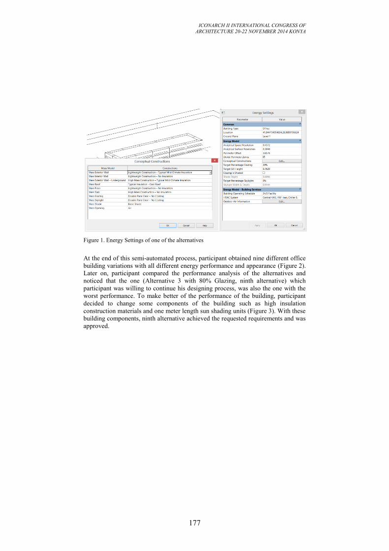
ICONARCH II INTERNATIONAL CONGRESS OF
ARCHITECTURE 20-22 NOVEMBER 2014 KONYA
177
Figure 1. Energy Settings of one of the alternatives
At the end of this semi-automated process, participant obtained nine different office
building variations with all different energy performance and appearance (Figure 2).
Later on, participant compared the performance analysis of the alternatives and
noticed that the one (Alternative 3 with 80% Glazing, ninth alternative) which
participant was willing to continue his designing process, was also the one with the
worst performance. To make better of the performance of the building, participant
decided to change some components of the building such as high insulation
construction materials and one meter length sun shading units (Figure 3). With these
building components, ninth alternative achieved the requested requirements and was
approved.
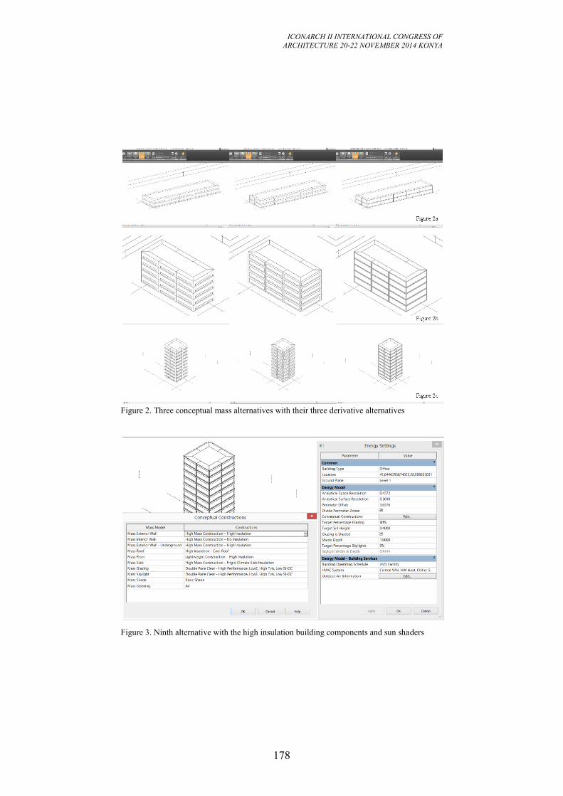
ICONARCH II INTERNATIONAL CONGRESS OF
ARCHITECTURE 20-22 NOVEMBER 2014 KONYA
178
Figure 2. Three conceptual mass alternatives with their three derivative alternatives
Figure 3. Ninth alternative with the high insulation building components and sun shaders
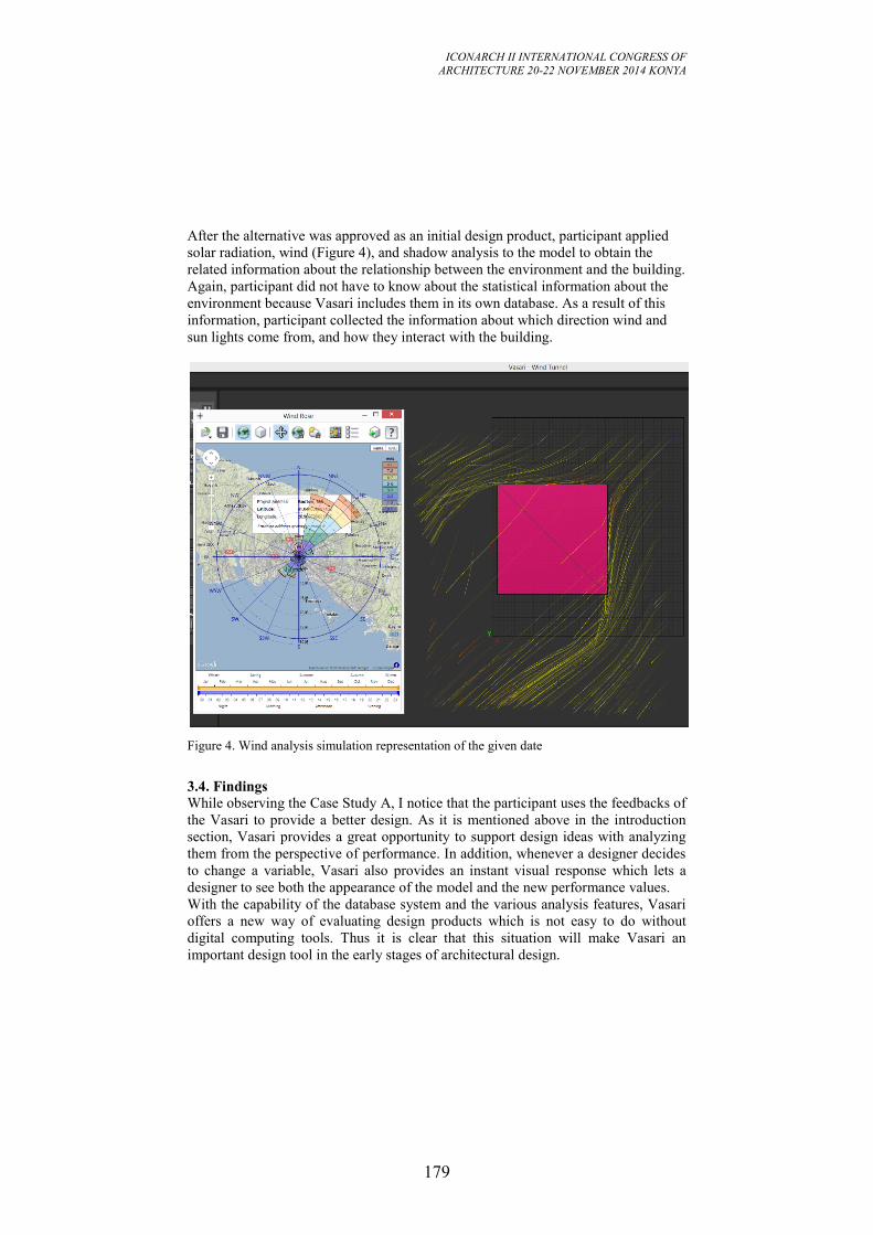
ICONARCH II INTERNATIONAL CONGRESS OF
ARCHITECTURE 20-22 NOVEMBER 2014 KONYA
179
After the alternative was approved as an initial design product, participant applied
solar radiation, wind (Figure 4), and shadow analysis to the model to obtain the
related information about the relationship between the environment and the building.
Again, participant did not have to know about the statistical information about the
environment because Vasari includes them in its own database. As a result of this
information, participant collected the information about which direction wind and
sun lights come from, and how they interact with the building.
Figure 4. Wind analysis simulation representation of the given date
3.4. Findings While observing the Case Study A, I notice that the participant uses the feedbacks of
the Vasari to provide a better design. As it is mentioned above in the introduction
section, Vasari provides a great opportunity to support design ideas with analyzing
them from the perspective of performance. In addition, whenever a designer decides
to change a variable, Vasari also provides an instant visual response which lets a
designer to see both the appearance of the model and the new performance values.
With the capability of the database system and the various analysis features, Vasari
offers a new way of evaluating design products which is not easy to do without
digital computing tools. Thus it is clear that this situation will make Vasari an
important design tool in the early stages of architectural design.
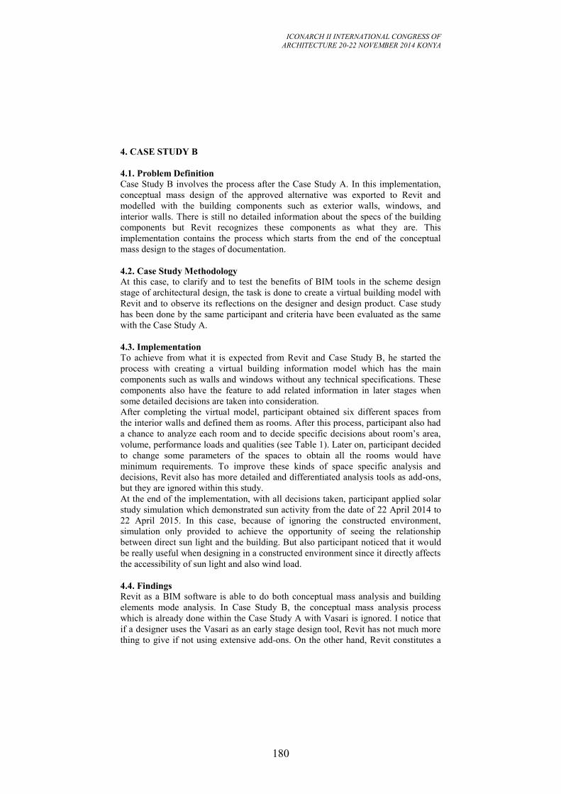
ICONARCH II INTERNATIONAL CONGRESS OF
ARCHITECTURE 20-22 NOVEMBER 2014 KONYA
180
4. CASE STUDY B
4.1. Problem Definition Case Study B involves the process after the Case Study A. In this implementation,
conceptual mass design of the approved alternative was exported to Revit and
modelled with the building components such as exterior walls, windows, and
interior walls. There is still no detailed information about the specs of the building
components but Revit recognizes these components as what they are. This
implementation contains the process which starts from the end of the conceptual
mass design to the stages of documentation.
4.2. Case Study Methodology At this case, to clarify and to test the benefits of BIM tools in the scheme design
stage of architectural design, the task is done to create a virtual building model with
Revit and to observe its reflections on the designer and design product. Case study
has been done by the same participant and criteria have been evaluated as the same
with the Case Study A.
4.3. Implementation To achieve from what it is expected from Revit and Case Study B, he started the
process with creating a virtual building information model which has the main
components such as walls and windows without any technical specifications. These
components also have the feature to add related information in later stages when
some detailed decisions are taken into consideration.
After completing the virtual model, participant obtained six different spaces from
the interior walls and defined them as rooms. After this process, participant also had
a chance to analyze each room and to decide specific decisions about room’s area,
volume, performance loads and qualities (see Table 1). Later on, participant decided
to change some parameters of the spaces to obtain all the rooms would have
minimum requirements. To improve these kinds of space specific analysis and
decisions, Revit also has more detailed and differentiated analysis tools as add-ons,
but they are ignored within this study.
At the end of the implementation, with all decisions taken, participant applied solar
study simulation which demonstrated sun activity from the date of 22 April 2014 to
22 April 2015. In this case, because of ignoring the constructed environment,
simulation only provided to achieve the opportunity of seeing the relationship
between direct sun light and the building. But also participant noticed that it would
be really useful when designing in a constructed environment since it directly affects
the accessibility of sun light and also wind load.
4.4. Findings Revit as a BIM software is able to do both conceptual mass analysis and building
elements mode analysis. In Case Study B, the conceptual mass analysis process
which is already done within the Case Study A with Vasari is ignored. I notice that
if a designer uses the Vasari as an early stage design tool, Revit has not much more
thing to give if not using extensive add-ons. On the other hand, Revit constitutes a
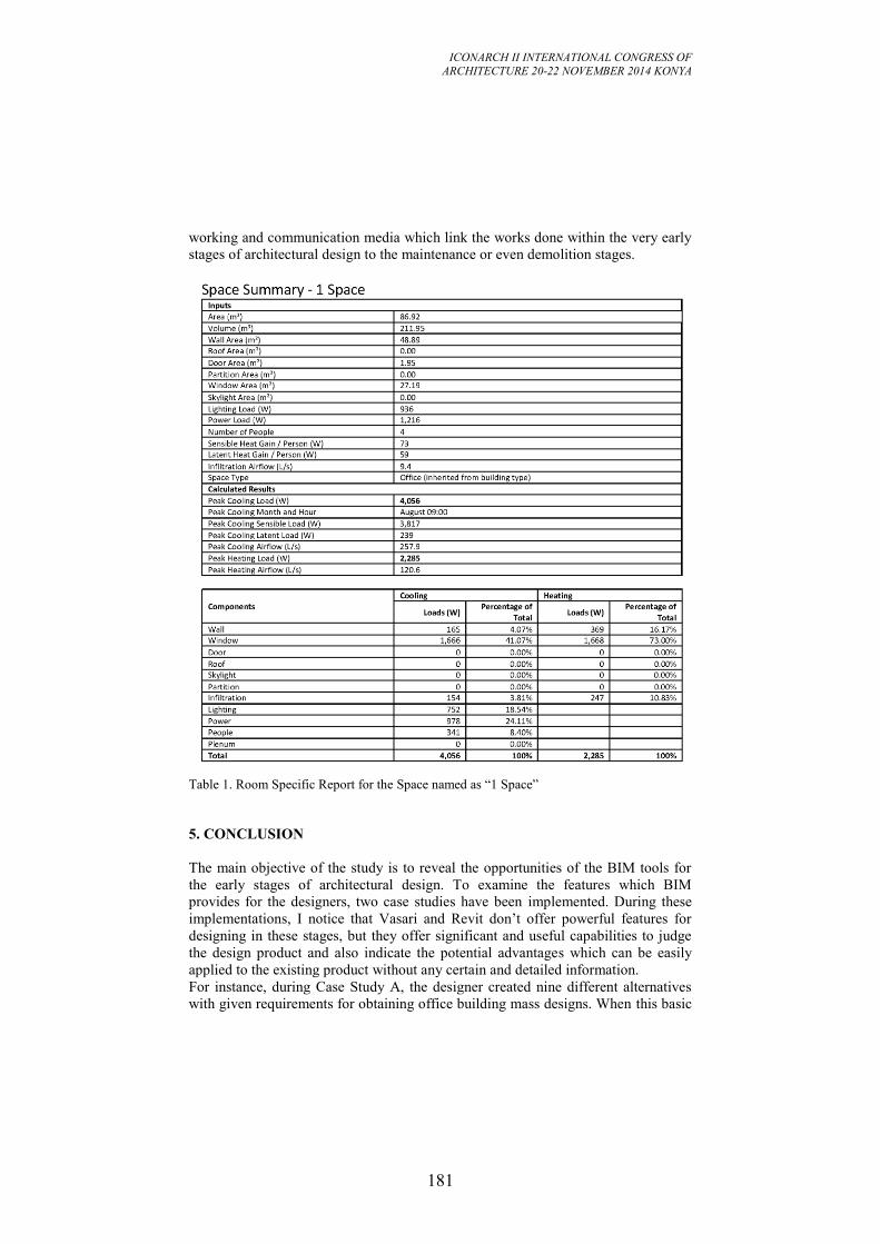
ICONARCH II INTERNATIONAL CONGRESS OF
ARCHITECTURE 20-22 NOVEMBER 2014 KONYA
181
working and communication media which link the works done within the very early
stages of architectural design to the maintenance or even demolition stages.
Table 1. Room Specific Report for the Space named as “1 Space”
5. CONCLUSION
The main objective of the study is to reveal the opportunities of the BIM tools for
the early stages of architectural design. To examine the features which BIM
provides for the designers, two case studies have been implemented. During these
implementations, I notice that Vasari and Revit don’t offer powerful features for
designing in these stages, but they offer significant and useful capabilities to judge
the design product and also indicate the potential advantages which can be easily
applied to the existing product without any certain and detailed information.
For instance, during Case Study A, the designer created nine different alternatives
with given requirements for obtaining office building mass designs. When this basic
ICONARCH II INTERNATIONAL CONGRESS OF
ARCHITECTURE 20-22 NOVEMBER 2014 KONYA
182
design process was completed, he was also able to obtain the detailed analysis
reports for all these alternatives. Later on, he noticed that the one which he felt close
to continue, was also the one with the worst performance. By this way, Vasari
warned the participant about the performance outputs of his design and also advised
him to change the related predefined construction materials to obtain better results.
On the other hand, during Case Study B, the designer was able to work with more
definite factors such as the area, volume, wall area, and window area of the room.
Also, there was some estimation about the lighting, power, cooling and heating
loads. With these analysis, he decided to change the interior wall settlements to
provide larger areas for the needed rooms.
In this study, two major acceptances were taken as case study constraints. Firstly,
the nine alternatives were accepted enough for the aesthetic form seeking. Because
the task is not designing an aesthetic product but it provides to understand how these
tools interact with designers during the evaluation of design products. Secondly,
neighborhood relationships such as nearby buildings, land use issues, social impacts,
and topography are ignored. For this reason, it is needed to do more case studies
with more complex functional and performance requirements within the respect of
aesthetic performance to reveal more benefits and/or limitations of BIM tools during
the early stages of architectural design.
As it can be understood from the previous examples, BIM tools provide an
opportunity to test the existing design products and also offer a way to improve
them. Then, the designer also has a chance to design and analyze their own ideas
within an iterative process until they feel satisfied. This way of working proposes a
connection between functional realities and designers’ subjective judgments which
can interact with themselves.
In conclusion, BIM is still an ever-developing system which is one of the most
popular research and implementation topics of AEC industry. From the first stage of
the design to the end of the building life, BIM offers many benefits to its users. In
spite of that, early stages of the architectural design are accepted as the weakest
point of the BIM systems. In this study, two case studies have been implemented to
reveal how BIM can help to designers in these stages. As a result of the
implementations, it is understood that BIM is a powerful early stages of architectural
design tool, not for designing but for design supporting, which visualizes the given
inputs of climate, geography, material information and so on, to analyze and
improve current solutions.
ACKNOWLEDGMENT
I would like to acknowledge Assoc. Prof. Dr. Mine Özkar who guides me during the
drafting process of the paper to achieve a better foundation. I also would like to
thank my PhD advisor Prof. Dr. Gülen Çağdaş because of encouraging me to send
my research paper to ICONARCH-II.
ICONARCH II INTERNATIONAL CONGRESS OF
ARCHITECTURE 20-22 NOVEMBER 2014 KONYA
183
REFERENCES
-Do, E. L. 2002. Drawing marks, acts, and reacts: Toward a computational sketching
interface for architectural design. Artificial Intelligence For Engineering Design,
Analysis And Manufacturing: AIEDAM, 16(3), 149-171.
doi:10.1017/S0890060402163037
-Foqué, R. 2010. Building knowledge in architecture / Richard Foqué. Brussels :
UPA, c2010.
-Foqué, R. 2011. Building knowledge by design. 4th International Meeting on
Architectural and Urbanism Research.
-Gervásio, H. H., Santos, P. P., Martins, R. R., & Simões da Silva, L. L. 2014. A
macro-component approach for the assessment of building sustainability in early
stages of design. Building And Environment, 73256-270.
doi:10.1016/j.buildenv.2013.12.015
-Goldschmidt, G. 1989. Problem representation versus domain of solution in
architectural design teaching. Journal of Architectural and Planning Research 6,
204–215.
-Granadeiro, V., Correia, J. R., Leal, V. S., & Duarte, J. P. 2013. Envelope-related
energy demand: A design indicator of energy performance for residential buildings
in early design stages. Energy & Buildings, 61215-223.
doi:10.1016/j.enbuild.2013.02.018
-Gratia, E. E., & De Herde, A. A. 2003. Design of low energy office buildings.
Energy And Buildings, 35(5), 473-491. doi:10.1016/S0378-7788(02)00160-3
-Graves, M. 1977. The necessity for drawing: Tangible speculation. Architectural
Design 6, 384–394.
-Herbert, D.M. 1993. Architectural Study Drawings. NewYork: Van Nostrand
Reinhold.
-Holm, D. D. 1993. Building thermal analyses: What the industry needs: The
Architect's perspective. Building And Environment, 28(4), 405-407.
-Hong, T. T., Chou, S. K., & Bong, T. Y. 2000. Building simulation: An overview
of developments and information sources. Building And Environment, 35(4), 347-
361.
-Lawson, B. 1994. Design in Mind. Oxford, UK: Butterworths.
-Oral, G. K., & Yilmaz, Z. Z. 2002. The limit U values for building envelope related
to building form in temperate and cold climatic zones. Building And Environment,
37(11), 1173-1180. doi:10.1016/S0360-1323(01)00102-0
-Oral, G. K., & Yilmaz, Z. Z. 2003. Building form for cold climatic zones related to
building envelope from heating energy conservation point of view. Energy And
Buildings, 35(4), 383-388. doi:10.1016/S0378-7788(02)00111-1
-Schön, D.A. 1985. The Design Studio. London: RIBA Publications.
-Thompson, A. 1999. Architectural design procedures / Arthur Thompson. Oxford:
Architectural Press.
ICONARCH II INTERNATIONAL CONGRESS OF
ARCHITECTURE 20-22 NOVEMBER 2014 KONYA
184
SESSION 4
20 November 2014 Thursday, 17.30-18.45
Chairperson: : Assist.Prof.Dr.Nimish BILORIA (Invited Speech)
“Interactive Environments
an Investigation into Real-time Responsive Spatial Systems” p.185
Leman Figen GÜL, Gülen ÇAĞDAŞ, Murat GÜL , Tayyibe Nur
ÇAĞLAR
“Understandıng the Employment of Digital Design Tools in
Architectural Education in Turkey” p.200
Pinar ÇALIŞIR
“Form-Finding with Experimentation on Natural Periodic Forces: the
Sound Motion Streaks Project” p.212
Prof. Dr. Carlo BIAGINI, International PhD Vincenzo DONATO,
Davide PELLIS
“Preliminary Design Through Graphs:
A Tool for Automatic Layout Distribution” p.224
ICONARCH II INTERNATIONAL CONGRESS OF
ARCHITECTURE 20-22 NOVEMBER 2014 KONYA
185
1 Hyperbody, Faculty of Architecture and the Built Environment, TU Delft, The Netherlands
INTERACTIVE ENVIRONMENTS AN INVESTIGATION
INTO REAL-TIME RESPONSIVE SPATIAL SYSTEMS
Dr. Nimish Biloria1
ABSTRACT
The design-research work illustrated in this article is centred on the emerging field of
Interactive Architecture. The real-time information exchanging spatial outputs
showcased in the paper demonstrates a fusion between the human, the material, the
electronic and the digital domains. This fusion is explicitly attained through a
synergistic merger between the fields of human psychology, embedded sensing and
control systems, ubiquitous computing, architectural design, kinetic systems and
computation. The resultant interactive projects attain the dimension of complex
adaptive systems, continually engaged in activities of data-exchange resulting in
physical and ambient adaptations of their constituting components in response to
contextual variations. Interdependent componential networks, where every
constituent component of a spatial prototype becomes a potential information hub by
means of its ability to collect, process and communicate contextual data. Apart from
this, the components themselves operate, as an actuated detail owing to their ability
to kinetically re-position themselves in three-dimensional. A strategy apt for binding
physical with the digital and the human counterpart is thus illustrated via selected
research and design projects conducted at Hyperbody, TU Delft, The Netherlands.
Key words: Real-time interaction, sensing, actuation and control systems,
performance, adaptation, human computer interaction
1. UNDERPINNINGS
The contemporary environment is increasingly being engulfed in a networked digital
information exchange based paradigm. The potential of re-envisioning the physical
environment itself as an interface to this very digital medium, thus becomes an
interesting proposition. It is in this context that the paper explores the importance
associated with information regulation and the creation of the much-speculated real-
time interactive forms of architecture, which thrive on a purposeful fusion of the
ICONARCH II INTERNATIONAL CONGRESS OF
ARCHITECTURE 20-22 NOVEMBER 2014 KONYA
186
digital and material domains.
As proposed by Ishii and Ulmer 1997: towards seamless interfaces between people,
bits and atoms [1], the paper stresses on the idea of giving physical form to digital
information by coupling the dual worlds of bits and atoms. The age old conception
of architectural space as a closed system is seen as a complete contrast through this
paper to perceive architecture as a subject for real time adaptation.
The systemic prototypes, expanded upon in this paper are conceived via
multidisciplinary studies in the field of emergence [2, 3], natural systems and self-
organization. The paper exemplifies the dynamism inherent in biotic systems, and
applies the study of such complex systems through a synergetic merger of the fields
of electronics, material technologies, embedded computation, sensor and actuation
systems and swarm behaviour based principles. The products hence are an active
contribution to the much-researched field of information driven, real time interactive
architecture. The paper exemplifies information exchange by means of tactile
augmentation of physical structures and ambient modulations of associated media
such as sound, light and colour generated as a response to human, environmental and
contextual intervention. Tangible adaptation is manifested via integrating physical
materials with digital, electronic and information media. Carefully assigning the
generated data into a display that successfully masks the information into new forms
and gestures (by means of the nature of information generated, the tectonic
variations etc), in the visual, tactile or audio space (multi-modal) is thus speculated
through the research investigations.
Besides this, some of the projects illustrated in this article are the resultant of a
strategic fusion between Industry, Praxis and Academia sectors. Such collaborations
typically involve series of associative brain storming, simulation, prototyping and
testing sessions focusing upon the usage of pneumatic and electro pneumatic
technologies, interaction design concepts, integrated control systems, structural
stability and performance aspects concerning the conceptualized spatial
configuration of the system. Experimentations with material systems as regards their
flexibility, shape retention and strength ratios coupled with kinetic structural systems
formulate a vital part of the collaborative research agenda. Parallel research and
development in interaction design, ubiquitous communication, creating
computational routines via strategically using a mixture of software as well as
developing project specific sensing networks are also carried out under such
collaborative design initiatives.
Context, for such interactive bodies, instead of being understood as physical
attributes such as fenestration, scale and aesthetics, is understood as a dynamic data
set of continually monitored parameters such as density of people, temperature
variation, humidity levels, noise levels etc. Understanding context as a dynamic
information field of intensive and extensive parameters is thus deemed essential in
the development of a meta-system, or in other words creating a ‘soft’
computationally enriched open systemic frameworks (informational) which, in real-
time interface with the ‘hard’, material component and the users of any interactive
architectural body developed by us.
ICONARCH II INTERNATIONAL CONGRESS OF
ARCHITECTURE 20-22 NOVEMBER 2014 KONYA
187
2. ADAPTATION AND INTERACTION
Adaptation, at a physiological, behavioural and structural front is a vital aspect to be
considered while developing such Interactive projects. The study of this
phenomenon results in discovering inter-disciplinary bridges of knowledge.
Adaptation, when looked at from the perspective of Evolutionary Biology, concerns
the origin of species from a common descent and the decent of species, as well as
their change, multiplication and diversity over time. Adaptation as a process can thus
be defined as the change in living organisms that allow them to live successfully in
an environment. It enables living organisms to cope with environmental stresses and
pressures. According to Julian Huxley [4], adaptations can be categorized as
structural, behavioural or physiological:
• Structural adaptations are special body parts of an organism that help it to
survive in its natural habitat (e.g., skin colour, shape, body covering).
• Behavioural adaptations are special ways a particular organism behaves to
survive in its natural habitat (e.g., phototropism).
• Physiological adaptations are systems present in an organism that allow it to
perform certain biochemical reactions (e.g., making venom, secreting slime, and
homeostasis).
These three features, namely structural, behavioural and physiological adaptation, in
the architectural domain formulate the crux for developing bottom-up interactive
spatial systems. A component based approach can thus be embarked upon where
akin to cells in natural systems, components can be seen as intelligent building
entities endowed with abilities of structural, behavioural and physiological
adaptations. In the case of building components, adhering to a performative agenda
(per component) the three aspects of adaptation can thus be seen as follows:
• Structural adaptations is seen as a by-product of the inter-dependence
between geometry, material and fabrication based affordances in order to produce
structurally stable component variations (e.g. Creating morphological variations of
the same component in terms of shape, size)
• Behavioural adaptations is closely associated with the domain of responsive
interaction which the component should inherit in order to successfully survive and
communicate with its context in both active and pro-active ways (e.g. kinetic
abilities, information exchange abilities, ambient abilities, sensorial abilities)
• Physiological adaptations in the case of building components is directly
linked with the manner in which the component can deal with issues of self
sustainment (e.g. energy conservation, retention and dispensation abilities, power
generation, distribution and circulation abilities)
Interaction is a terminology used to elaborate the action, which occurs as two or
more objects have an effect upon one another. The generation of a two-way
effect/dialogue instead of a one-way causal effect/monologue is the basic underlying
principle for Interaction. The combinations of many such, simple interactions can
lead to surprising emergent phenomena. Interaction has been interpreted in a variety
of manners in differing fields of sciences such as medicine, communication, media
art, physics, sociology and statistics.
What is of interest however is the manner in which all the above-mentioned fields
ICONARCH II INTERNATIONAL CONGRESS OF
ARCHITECTURE 20-22 NOVEMBER 2014 KONYA
188
adhere to the phenomenon of pro-active communication. The area of Physical
Interaction where a technologically mediated whole is conceptualised with the
central issue of Interaction is of specific importance to such interactive prototypes.
The physicality of space itself tends to be perceived as a subject (rather than the
modernistic/industrial objective notion), possessing its own behaviour, which is
carefully developed with a user oriented (Human computer interaction) perspective.
A response (programmed in accordance with event based scenarios), specifically
acting upon the interpreted logic from a received message/action (sensed data)
formulates the basis for a successful Interaction. Such responsive behaviour is
specifically termed as Interactivity. Interactivity is similar to the degree of
responsiveness, and is examined as a communication process in which each message
is related to the previous messages exchanged, and to the relation of those messages
to the messages preceding them – Sheizaf Rafaeli. The understanding of the term is
further clarified when taken into consideration the degree of responsiveness
substantiated in the interaction process. As Sheizaf states, there are three basic levels
of Interactivity: Interactive, Reactive and Non-interactive. These respectively
account for the following levels of response:
• Interactive: a state when a message is related to a number of previous
messages and the relation between them
• Reactive: a state when a message is related to only one previous message
• Non interactive: when a message is not related to previous messages
What this implies is that in the case of Interactive and Reactive response, the roles of
the sender and the receiver are interchangeable with each subsequent message. Thus,
a basic condition for interactivity to prevail is a coherent response from each
communicant, in the case of this paper, between people, space and the context.
3. DESIGN RESEARCH PROJECTS
The following design research projects are exemplified in this section: The Emotive
Interactive Wall, The Muscle Re-configured, The Muscle NSA and Performative
Building Skin Systems. The projects are specifically selected in order to showcase
multi-scalar implications of fusing the aforementioned discussion on Adaptation and
Interaction. Scalar variations ranging from the component scale (building skins), an
architectural element scale (wall) as well as an interior scale (interior section of
space), are featured in this article. Design driven thinking and the creative, yet,
systematic inclusion of computational and technological domains to address the issue
of real-time adaptation and interaction of architectural space are thus explained in
this paper. Besides the scalar variations, the parameters to which, these experiments
respond also vary. Environmental variations (sunlight, wind, sun angle), movement
of people, proximity of people, speed of approaching an installation as well as the
coordinates of constituting components of architectural space are some of the vital
parameters that the experiments selectively address.
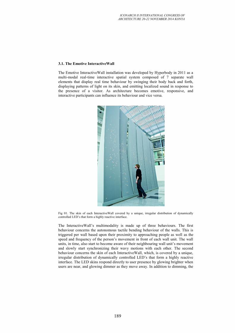
ICONARCH II INTERNATIONAL CONGRESS OF
ARCHITECTURE 20-22 NOVEMBER 2014 KONYA
189
3.1. The Emotive InteractiveWall
The Emotive InteractiveWall installation was developed by Hyperbody in 2011 as a
multi-modal real-time interactive spatial system composed of 7 separate wall
elements that display real time behaviour by swinging their body back and forth,
displaying patterns of light on its skin, and emitting localized sound in response to
the presence of a visitor. As architecture becomes emotive, responsive, and
interactive participants can influence its behaviour and vice versa.
Fig 01. The skin of each InteractiveWall covered by a unique, irregular distribution of dynamically
controlled LED’s that form a highly reactive interface.
The InteractiveWall’s multimodality is made up of three behaviours. The first
behaviour concerns the autonomous tactile bending behaviour of the walls. This is
triggered per wall based upon their proximity to approaching people as well as the
speed and frequency of the person’s movement in front of each wall unit. The wall
units, in time, also start to become aware of their neighbouring wall unit’s movement
and slowly start synchronizing their wavy motions with each other. The second
behaviour concerns the skin of each InteractiveWall, which, is covered by a unique,
irregular distribution of dynamically controlled LED’s that form a highly reactive
interface. The LED skins respond directly to user presence by glowing brighter when
users are near, and glowing dimmer as they move away. In addition to dimming, the
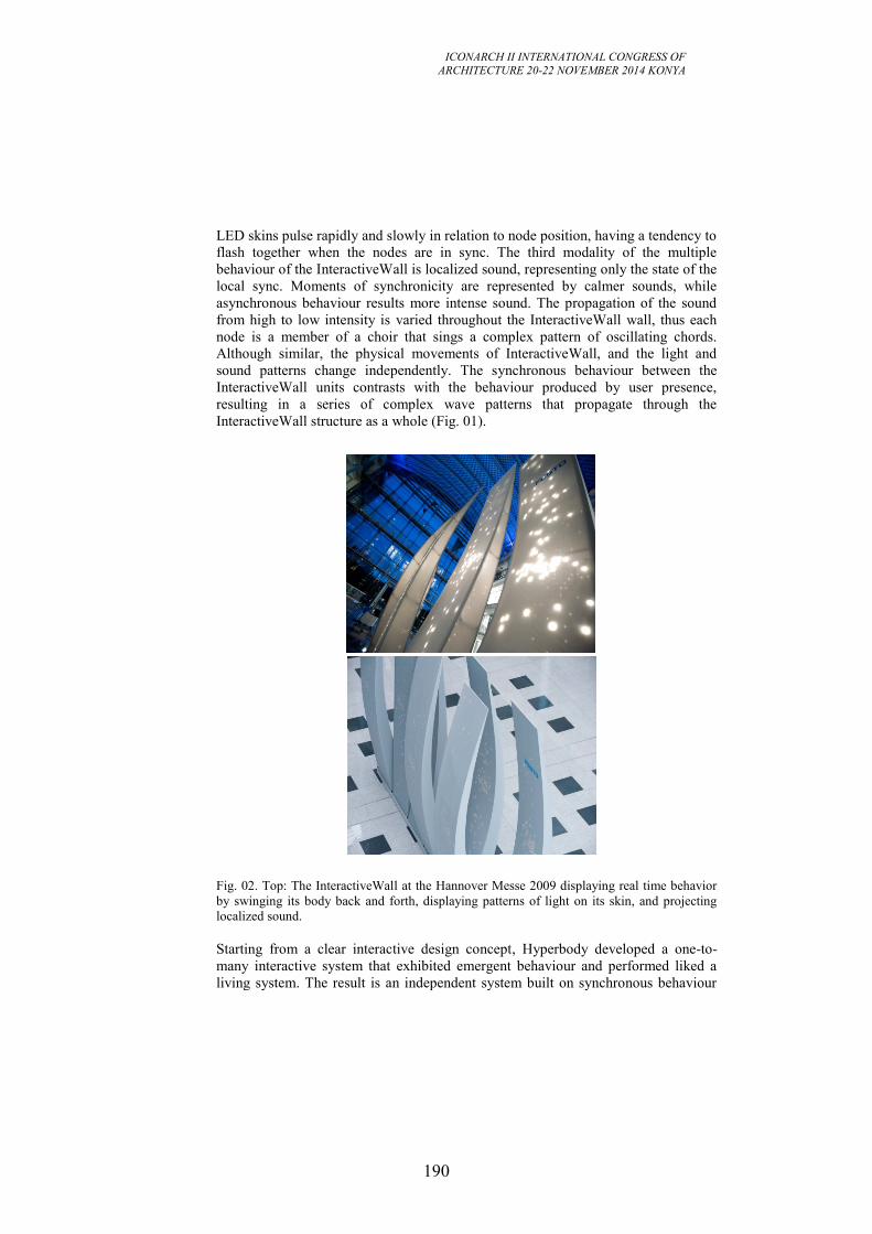
ICONARCH II INTERNATIONAL CONGRESS OF
ARCHITECTURE 20-22 NOVEMBER 2014 KONYA
190
LED skins pulse rapidly and slowly in relation to node position, having a tendency to
flash together when the nodes are in sync. The third modality of the multiple
behaviour of the InteractiveWall is localized sound, representing only the state of the
local sync. Moments of synchronicity are represented by calmer sounds, while
asynchronous behaviour results more intense sound. The propagation of the sound
from high to low intensity is varied throughout the InteractiveWall wall, thus each
node is a member of a choir that sings a complex pattern of oscillating chords.
Although similar, the physical movements of InteractiveWall, and the light and
sound patterns change independently. The synchronous behaviour between the
InteractiveWall units contrasts with the behaviour produced by user presence,
resulting in a series of complex wave patterns that propagate through the
InteractiveWall structure as a whole (Fig. 01).
Fig. 02. Top: The InteractiveWall at the Hannover Messe 2009 displaying real time behavior
by swinging its body back and forth, displaying patterns of light on its skin, and projecting
localized sound.
Starting from a clear interactive design concept, Hyperbody developed a one-to-
many interactive system that exhibited emergent behaviour and performed liked a
living system. The result is an independent system built on synchronous behaviour
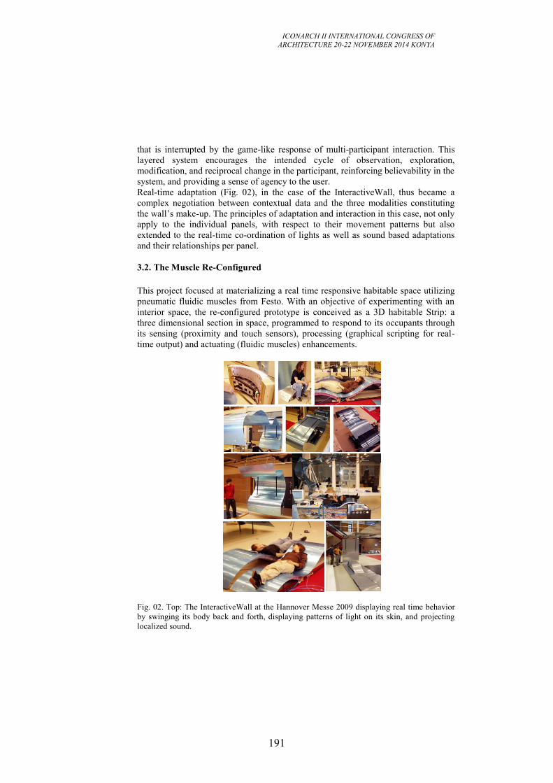
ICONARCH II INTERNATIONAL CONGRESS OF
ARCHITECTURE 20-22 NOVEMBER 2014 KONYA
191
that is interrupted by the game-like response of multi-participant interaction. This
layered system encourages the intended cycle of observation, exploration,
modification, and reciprocal change in the participant, reinforcing believability in the
system, and providing a sense of agency to the user.
Real-time adaptation (Fig. 02), in the case of the InteractiveWall, thus became a
complex negotiation between contextual data and the three modalities constituting
the wall’s make-up. The principles of adaptation and interaction in this case, not only
apply to the individual panels, with respect to their movement patterns but also
extended to the real-time co-ordination of lights as well as sound based adaptations
and their relationships per panel.
3.2. The Muscle Re-Configured
This project focused at materializing a real time responsive habitable space utilizing
pneumatic fluidic muscles from Festo. With an objective of experimenting with an
interior space, the re-configured prototype is conceived as a 3D habitable Strip: a
three dimensional section in space, programmed to respond to its occupants through
its sensing (proximity and touch sensors), processing (graphical scripting for real-
time output) and actuating (fluidic muscles) enhancements.
Fig. 02. Top: The InteractiveWall at the Hannover Messe 2009 displaying real time behavior
by swinging its body back and forth, displaying patterns of light on its skin, and projecting
localized sound.
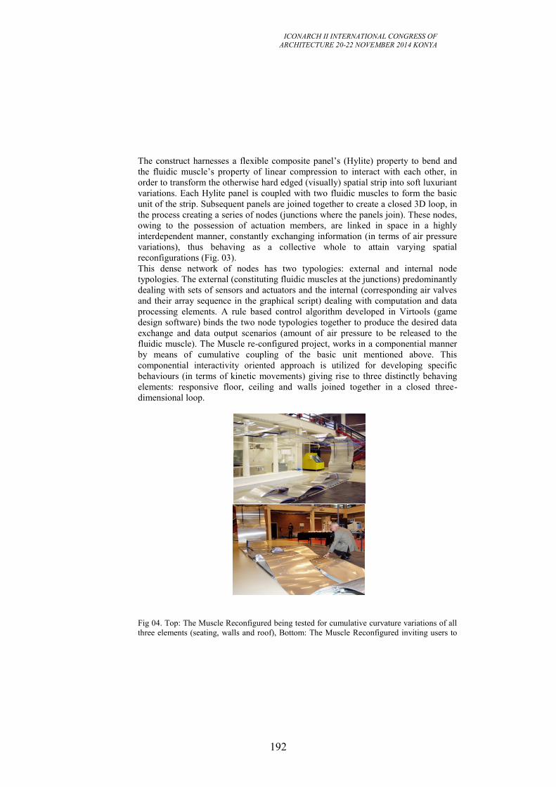
ICONARCH II INTERNATIONAL CONGRESS OF
ARCHITECTURE 20-22 NOVEMBER 2014 KONYA
192
The construct harnesses a flexible composite panel’s (Hylite) property to bend and
the fluidic muscle’s property of linear compression to interact with each other, in
order to transform the otherwise hard edged (visually) spatial strip into soft luxuriant
variations. Each Hylite panel is coupled with two fluidic muscles to form the basic
unit of the strip. Subsequent panels are joined together to create a closed 3D loop, in
the process creating a series of nodes (junctions where the panels join). These nodes,
owing to the possession of actuation members, are linked in space in a highly
interdependent manner, constantly exchanging information (in terms of air pressure
variations), thus behaving as a collective whole to attain varying spatial
reconfigurations (Fig. 03).
This dense network of nodes has two typologies: external and internal node
typologies. The external (constituting fluidic muscles at the junctions) predominantly
dealing with sets of sensors and actuators and the internal (corresponding air valves
and their array sequence in the graphical script) dealing with computation and data
processing elements. A rule based control algorithm developed in Virtools (game
design software) binds the two node typologies together to produce the desired data
exchange and data output scenarios (amount of air pressure to be released to the
fluidic muscle). The Muscle re-configured project, works in a componential manner
by means of cumulative coupling of the basic unit mentioned above. This
componential interactivity oriented approach is utilized for developing specific
behaviours (in terms of kinetic movements) giving rise to three distinctly behaving
elements: responsive floor, ceiling and walls joined together in a closed three-
dimensional loop.
Fig 04. Top: The Muscle Reconfigured being tested for cumulative curvature variations of all
three elements (seating, walls and roof), Bottom: The Muscle Reconfigured inviting users to
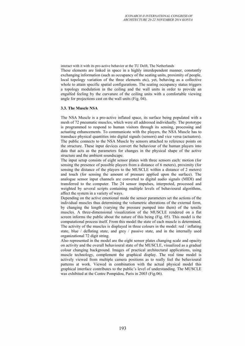
ICONARCH II INTERNATIONAL CONGRESS OF
ARCHITECTURE 20-22 NOVEMBER 2014 KONYA
193
interact with it with its pro-active behavior at the TU Delft, The Netherlands
These elements are linked in space in a highly interdependent manner, constantly
exchanging information (such as occupancy of the seating units, proximity of people,
local topology variation of the three elements etc), yet, behaving as a collective
whole to attain specific spatial configurations. The seating occupancy status triggers
a topology modulation in the ceiling and the wall units in order to provide an
engulfed feeling by the curvature of the ceiling units with a comfortable viewing
angle for projections cast on the wall units (Fig. 04).
3.3. The Muscle NSA
The NSA Muscle is a pro-active inflated space, its surface being populated with a
mesh of 72 pneumatic muscles, which were all addressed individually. The prototype
is programmed to respond to human visitors through its sensing, processing and
actuating enhancements. To communicate with the players, the NSA Muscle has to
transduce physical quantities into digital signals (sensors) and vice versa (actuators).
The public connects to the NSA Muscle by sensors attached to reference points on
the structure. These input devices convert the behaviour of the human players into
data that acts as the parameters for changes in the physical shape of the active
structure and the ambient soundscape.
The input setup consists of eight sensor plates with three sensors each: motion (for
sensing the presence of possible players from a distance of 6 meters), proximity (for
sensing the distance of the players to the MUSCLE within a distance of 2 meters)
and touch (for sensing the amount of pressure applied upon the surface). The
analogue sensor input channels are converted to digital audio signals (MIDI) and
transferred to the computer. The 24 sensor impulses, interpreted, processed and
weighted by several scripts containing multiple levels of behavioural algorithms,
affect the system in a variety of ways.
Depending on the active emotional mode the sensor parameters set the actions of the
individual muscles thus determining the volumetric alterations of the external form,
by changing the length (varying the pressure pumped into them) of the tensile
muscles. A three-dimensional visualization of the MUSCLE rendered on a flat
screen informs the public about the nature of this being (Fig. 05). This model is the
computational process itself. From this model the state of each muscle is determined.
The activity of the muscles is displayed in three colours in the model: red / inflating
state, blue / deflating state, and grey / passive state, and in the internally used
organizational 72 digit string.
Also represented in the model are the eight sensor plates changing scale and opacity
on activity and the overall behavioural state of the MUSCLE, visualized as a gradual
colour changing background. Images of practical architectural applications, using
muscle technology, complement the graphical display. The real time model is
actively viewed from multiple camera positions as to really feel the behavioural
patterns at work. Viewed in combination with the actual physical model this
graphical interface contributes to the public’s level of understanding. The MUSCLE
was exhibited at the Centre Pompidou, Paris in 2003 (Fig.06).
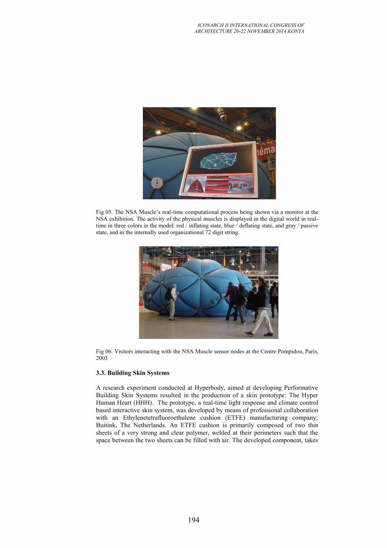
ICONARCH II INTERNATIONAL CONGRESS OF
ARCHITECTURE 20-22 NOVEMBER 2014 KONYA
194
Fig 05. The NSA Muscle’s real-time computational process being shown via a monitor at the
NSA exhibition. The activity of the physical muscles is displayed in the digital world in real-
time in three colors in the model: red / inflating state, blue / deflating state, and gray / passive
state, and in the internally used organizational 72 digit string.
Fig 06. Visitors interacting with the NSA Muscle sensor nodes at the Centre Pompidou, Paris,
2003
3.3. Building Skin Systems
A research experiment conducted at Hyperbody, aimed at developing Performative
Building Skin Systems resulted in the production of a skin prototype: The Hyper
Human Heart (HHH). The prototype, a real-time light response and climate control
based interactive skin system, was developed by means of professional collaboration
with an Ethylenetetrafluoroethulene cushion (ETFE) manufacturing company;
Buitink, The Netherlands. An ETFE cushion is primarily composed of two thin
sheets of a very strong and clear polymer, welded at their perimeters such that the
space between the two sheets can be filled with air. The developed component, takes
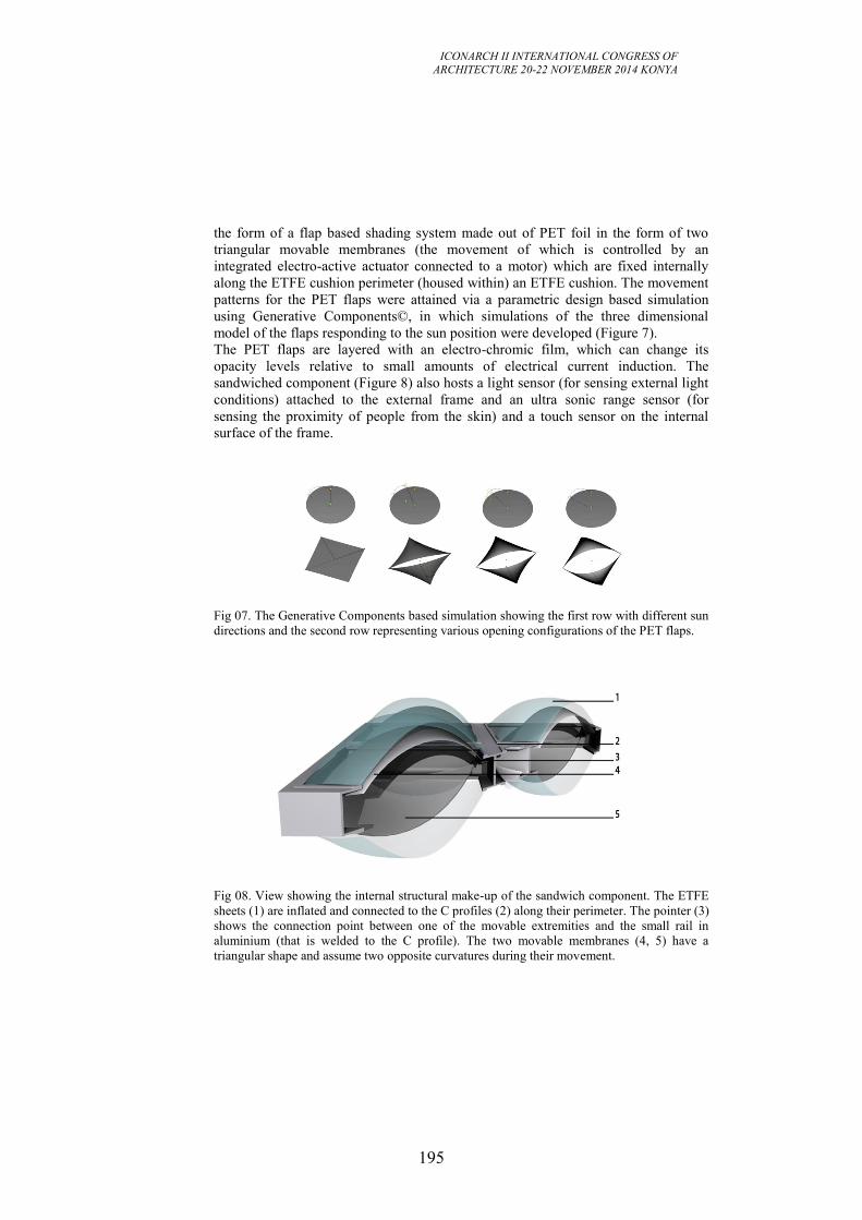
ICONARCH II INTERNATIONAL CONGRESS OF
ARCHITECTURE 20-22 NOVEMBER 2014 KONYA
195
the form of a flap based shading system made out of PET foil in the form of two
triangular movable membranes (the movement of which is controlled by an
integrated electro-active actuator connected to a motor) which are fixed internally
along the ETFE cushion perimeter (housed within) an ETFE cushion. The movement
patterns for the PET flaps were attained via a parametric design based simulation
using Generative Components©, in which simulations of the three dimensional
model of the flaps responding to the sun position were developed (Figure 7).
The PET flaps are layered with an electro-chromic film, which can change its
opacity levels relative to small amounts of electrical current induction. The
sandwiched component (Figure 8) also hosts a light sensor (for sensing external light
conditions) attached to the external frame and an ultra sonic range sensor (for
sensing the proximity of people from the skin) and a touch sensor on the internal
surface of the frame.
Fig 07. The Generative Components based simulation showing the first row with different sun
directions and the second row representing various opening configurations of the PET flaps.
Fig 08. View showing the internal structural make-up of the sandwich component. The ETFE
sheets (1) are inflated and connected to the C profiles (2) along their perimeter. The pointer (3)
shows the connection point between one of the movable extremities and the small rail in
aluminium (that is welded to the C profile). The two movable membranes (4, 5) have a
triangular shape and assume two opposite curvatures during their movement.
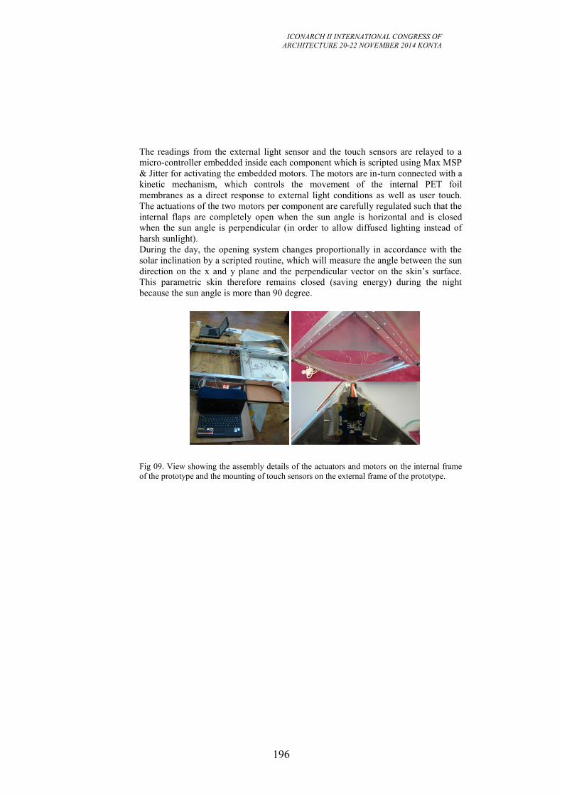
ICONARCH II INTERNATIONAL CONGRESS OF
ARCHITECTURE 20-22 NOVEMBER 2014 KONYA
196
The readings from the external light sensor and the touch sensors are relayed to a
micro-controller embedded inside each component which is scripted using Max MSP
& Jitter for activating the embedded motors. The motors are in-turn connected with a
kinetic mechanism, which controls the movement of the internal PET foil
membranes as a direct response to external light conditions as well as user touch.
The actuations of the two motors per component are carefully regulated such that the
internal flaps are completely open when the sun angle is horizontal and is closed
when the sun angle is perpendicular (in order to allow diffused lighting instead of
harsh sunlight).
During the day, the opening system changes proportionally in accordance with the
solar inclination by a scripted routine, which will measure the angle between the sun
direction on the x and y plane and the perpendicular vector on the skin’s surface.
This parametric skin therefore remains closed (saving energy) during the night
because the sun angle is more than 90 degree.
Fig 09. View showing the assembly details of the actuators and motors on the internal frame
of the prototype and the mounting of touch sensors on the external frame of the prototype.
ICONARCH II INTERNATIONAL CONGRESS OF
ARCHITECTURE 20-22 NOVEMBER 2014 KONYA
197
Fig 10. The finished skin as an assembly of three interactive components with built-in micro-
controllers and sensing (proximity, touch and light- above) and actuation systems per
component.
Users from the inside of the building, on the other hand activate the ultrasonic range
sensor and the touch sensor. The ultrasonic range sensor can sense the movement of
people in close proximity of the skin. This sensed data after being processed by
embedded micro-controllers per component triggers corresponding components to
open their internal PET flaps as an immediate response thus providing playful ever-
changing skin patterns.
All component on being touched, register this touch via the embedded touch sensor.
This reading overrides the aforementioned external light response based actuation
and instead via the embedded micro-controller sends a direct response for the motors
to open the PET foil membrane to its maximal extent as well as induce a light
electric charge for changing the opacity level of the electro chromic film from
opaque to transparent. The skin can thus become fully transparent or become a
mirrored glass (with a transparency of 30%). The touch sensor operates on a time
frame basis: the duration of time for which the touch sensor is pressed the more or
less transparent the electro-chromic film becomes. The system also has an inbuilt
clock (scripted using MAX/MSP/JITTER), which it uses to reset itself in the default
configuration (depending on the light sensor) after being out of use for an hour.
In this way, a direct relation between users and the external skin is created at any
point in time thus resulting in emergent opening patterns of the entire skin. The HHH
group worked consistently at the Buitink manufacturing plant, where engineers from
Buitink helped mount the internal PET system with embedded actuators and sensors
to be encased within a pressure pump inflated ETFE cushion thus creating one skin
component.
The component thus developed (Figure 9) is an excellent example displaying how
fundamental research and praxis can collaboratively develop a meaningful
environment based on the idea of performance.
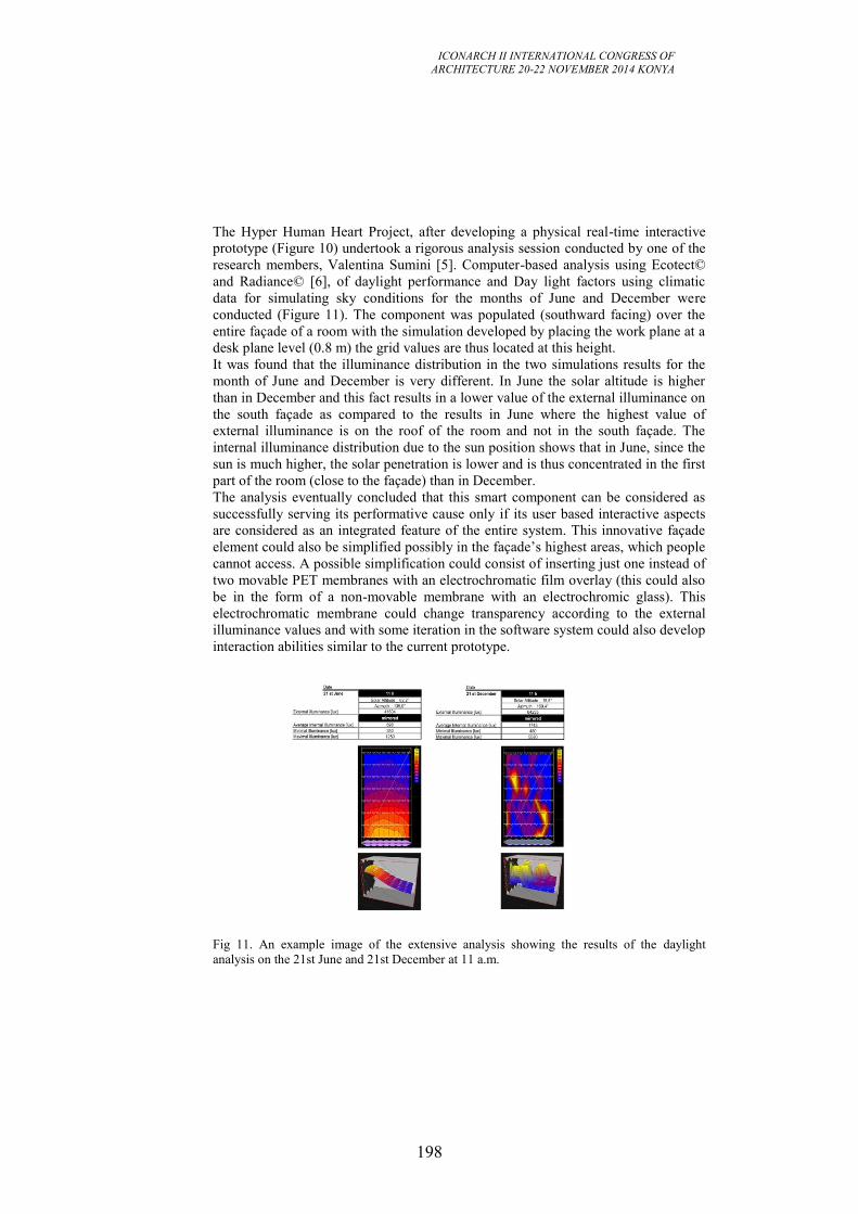
ICONARCH II INTERNATIONAL CONGRESS OF
ARCHITECTURE 20-22 NOVEMBER 2014 KONYA
198
The Hyper Human Heart Project, after developing a physical real-time interactive
prototype (Figure 10) undertook a rigorous analysis session conducted by one of the
research members, Valentina Sumini [5]. Computer-based analysis using Ecotect©
and Radiance© [6], of daylight performance and Day light factors using climatic
data for simulating sky conditions for the months of June and December were
conducted (Figure 11). The component was populated (southward facing) over the
entire façade of a room with the simulation developed by placing the work plane at a
desk plane level (0.8 m) the grid values are thus located at this height.
It was found that the illuminance distribution in the two simulations results for the
month of June and December is very different. In June the solar altitude is higher
than in December and this fact results in a lower value of the external illuminance on
the south façade as compared to the results in June where the highest value of
external illuminance is on the roof of the room and not in the south façade. The
internal illuminance distribution due to the sun position shows that in June, since the
sun is much higher, the solar penetration is lower and is thus concentrated in the first
part of the room (close to the façade) than in December.
The analysis eventually concluded that this smart component can be considered as
successfully serving its performative cause only if its user based interactive aspects
are considered as an integrated feature of the entire system. This innovative façade
element could also be simplified possibly in the façade’s highest areas, which people
cannot access. A possible simplification could consist of inserting just one instead of
two movable PET membranes with an electrochromatic film overlay (this could also
be in the form of a non-movable membrane with an electrochromic glass). This
electrochromatic membrane could change transparency according to the external
illuminance values and with some iteration in the software system could also develop
interaction abilities similar to the current prototype.
Fig 11. An example image of the extensive analysis showing the results of the daylight
analysis on the 21st June and 21st December at 11 a.m.
ICONARCH II INTERNATIONAL CONGRESS OF
ARCHITECTURE 20-22 NOVEMBER 2014 KONYA
199
4. CONCLUSION
The paper exemplifies a paradigm shift in the architectural context by embracing
inter-disciplinary approaches towards architectural space making. Conceptualizing
and appropriating architecture as an open systemic network provides the designer
with opportunities to explore creative methods pertaining to dynamic data flows as
well as real-time information processing in order to achieve an intelligent response
from the designed entities. The future of architectural space is thus visualized as a
transient, real time behavioral body, by means of the illustrated projects.
Information flow becomes a continual process in such real-time interactive spaces,
hence converting them into executable processing and reacting systemic entities.
Such architectural constructs eventually acquire the characteristics of living entities,
sending and receiving information, processing this information locally and producing
optimal interactive output. The intrinsic design decision of enriching the nature of
architectural detailing and acquiring an inter-disciplinary work process thus has
significant impact on the nature of architectural space and its structuring principles.
An intuitive interaction, opinionated towards seamless information exchange is thus
initiated through these research experiments, hence transforming everyday utilitarian
space into an inter-activating network of spatial correlations. What is also evident
throughout the projects is the degree of responsiveness and interactivity, which, via
the medium of design driven technological thinking results in multi-modal real-time
spatial response. The central idea of developing Interactive morphologies, which
inverse the subject-object discourse in architecture is thus successfully experimented
with via these selected experiments.
REFERENCES
[1] Ishii. H., Ullmer. B., Tangible Bits: Towards Seamless Interfaces between
People, Bits and Atoms, Proceedings of CHI '97, March 22-27, 1997, © 1997 ACM
[2] Johnson. S., Emergence, the Connected Lives of Ants, Brains, Cities and
Software, Penguin Press, London, 2001.
[3] Hensel & Menges, “Differentiation and Performance: Multi-Performance
Architectures and Modulated Environments”, Architectural Design AD, 76 (3), John
Wiley & Sons, London, 2006, pp. 60-69
[4] Huxley. J., Evolution: The modern synthesis, Macmillan Pub Co; 3rd edition,
1975.
[5] Biloria, N, Sumini, V. (2009); Performative Building Skin Systems: A
Morphogenomic Ap- proach Towards Developing Real-Time Adaptive Building
Skin Systems, International Journal of Architectural Computing vol. 7 - no. 4, pp.
643-676.
[6] G.J. Ward, The Radiance Lighting Simulation and Rendering System, Computer
Graphics Proceedings, Annual Conference Series, ACM SIGGRAPH, 1994.
ICONARCH II INTERNATIONAL CONGRESS OF
ARCHITECTURE 20-22 NOVEMBER 2014 KONYA
200
1 TOBB ETÜ, Department of Architecture, ANKARA
2 Istanbul Technical University, Department of Architecture, ISTANBUL
UNDERSTANDING THE EMPLOYMENT OF DIGITAL
DESIGN TOOLS IN ARCHITECTURAL EDUCATION IN
TURKEY
LEMAN FİGEN GÜL1
GÜLEN ÇAĞDAŞ2
MURAT GÜL1
TAYYİBE NUR ÇAĞLAR1
ABSTRACT
With the Global developments and technological advances in the rapidly changing
world, some alterations to the higher education system are inevitable. In Turkey,
there has been a fast transformation in the higher education system with the
establishment of foundation universities and spending of the significant amount of
resources. In particular, as of 2013, there are eighty-three design schools offering
bachelor of architecture degree in Turkey. There is no evidence of whether those
schools offer up-to-date curriculum, which complies with the international standards
and contemporary education models. We also do not know how the information and
communication technologies, which have the growing impact on architectural
education worldwide, are implemented in the curricula. The aim of the paper is: to
understand the current architectural curricula in Turkey, to investigate the changing
trends in education and to understand the role of advance information and
communication technologies in architectural design education. The results of the
project can be used to develop models for the future program developments.
Key words: Architectural education, digital tools, digital design environments
1. INTRODUCTION In the past twenty years, the information and communication technologies have
become affordable in all segments of the building sector. Architecture-Construction-
Engineering industries push the boundaries further to facilitate design and
communication in order to have efficient working environments. There is a trend
towards using advanced integrated virtual building information systems (BIM and
other virtual environments) (Rajala and Penttila, 2006) in the design profession.
With the recent developments on computer technology, working without CAD is
hardly possible any more (Nordic, 2002). Although most of the architectural work is
still documented in CAD-based 2D documents, the evolutionary trend in developing
digital CAD-drawings towards more augmented visual representation with data
management capabilities has extended increasingly during the last ten to fifteen
years (Gül, et al. 2007). Computer technology has been increasing its expressive
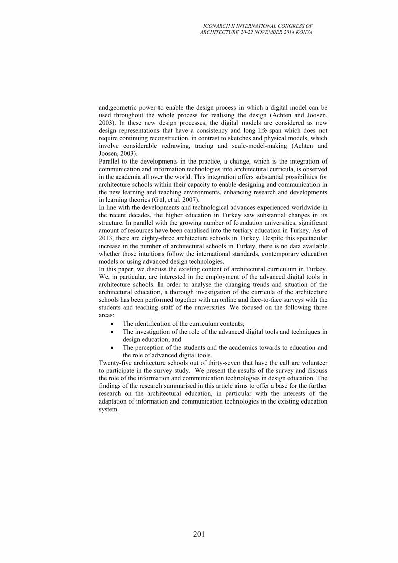
ICONARCH II INTERNATIONAL CONGRESS OF
ARCHITECTURE 20-22 NOVEMBER 2014 KONYA
201
and,geometric power to enable the design process in which a digital model can be
used throughout the whole process for realising the design (Achten and Joosen,
2003). In these new design processes, the digital models are considered as new
design representations that have a consistency and long life-span which does not
require continuing reconstruction, in contrast to sketches and physical models, which
involve considerable redrawing, tracing and scale-model-making (Achten and
Joosen, 2003). Parallel to the developments in the practice, a change, which is the integration of
communication and information technologies into architectural curricula, is observed
in the academia all over the world. This integration offers substantial possibilities for
architecture schools within their capacity to enable designing and communication in
the new learning and teaching environments, enhancing research and developments
in learning theories (Gül, et al. 2007).
In line with the developments and technological advances experienced worldwide in
the recent decades, the higher education in Turkey saw substantial changes in its
structure. In parallel with the growing number of foundation universities, significant
amount of resources have been canalised into the tertiary education in Turkey. As of
2013, there are eighty-three architecture schools in Turkey. Despite this spectacular
increase in the number of architectural schools in Turkey, there is no data available
whether those intuitions follow the international standards, contemporary education
models or using advanced design technologies.
In this paper, we discuss the existing content of architectural curriculum in Turkey.
We, in particular, are interested in the employment of the advanced digital tools in
architecture schools. In order to analyse the changing trends and situation of the
architectural education, a thorough investigation of the curricula of the architecture
schools has been performed together with an online and face-to-face surveys with the
students and teaching staff of the universities. We focused on the following three
areas:
The identification of the curriculum contents;
The investigation of the role of the advanced digital tools and techniques in
design education; and
The perception of the students and the academics towards to education and
the role of advanced digital tools.
Twenty-five architecture schools out of thirty-seven that have the call are volunteer
to participate in the survey study. We present the results of the survey and discuss
the role of the information and communication technologies in design education. The
findings of the research summarised in this article aims to offer a base for the further
research on the architectural education, in particular with the interests of the
adaptation of information and communication technologies in the existing education
system.
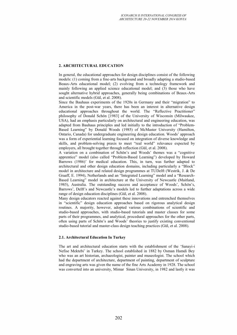
ICONARCH II INTERNATIONAL CONGRESS OF
ARCHITECTURE 20-22 NOVEMBER 2014 KONYA
202
2. ARCHITECTURAL EDUCATION
In general, the educational approaches for design disciplines consist of the following
models: (1) coming from a fine-arts background and broadly adapting a studio-based
Beaux-Arts educational model; (2) evolving from a technology framework and
mainly following an applied science educational model; and (3) those who have
sought alternative hybrid approaches, generally being combinations of Beaux-Arts
and scientific models (Gül, et al. 2008).
Since the Bauhaus experiments of the 1920s in Germany and their “migration” to
America in the post-war years, there has been an interest in alternative design
educational approaches throughout the world. The “Reflective Practitioner”
philosophy of Donald Schön [1983] of the University of Wisconsin (Milwaukee,
USA), had an emphasis particularly on architectural and engineering education, was
adapted from Bauhaus principles and led initially to the introduction of “Problem-
Based Learning” by Donald Woods (1985) of McMaster University (Hamilton,
Ontario, Canada) for undergraduate engineering design education. Woods’ approach
was a form of experiential learning focused on integration of diverse knowledge and
skills, and problem-solving praxis to meet “real world” relevance expected by
employers, all brought together through reflection (Gül, et al. 2008).
A variation on a combination of Schön’s and Woods’ themes was a “cognitive
apprentice” model (also called “Problem-Based Learning”) developed by Howard
Barrows (1986)’ for medical education. This, in turn, was further adapted to
architectural and other design education domains, including particularly a “Block”
model in architecture and related design programmes at TUDelft (Westrik, J. & De
Graaff, E. 1994), Netherlands and an “Integrated Learning” model and a “Research-
Based Learning” model in architecture at the University of Newcastle (Maitland,
1985), Australia. The outstanding success and acceptance of Woods’, Schön’s,
Barrows’, Delft’s and Newcastle’s models led to further adaptations across a wide
range of design education disciplines (Gül, et al. 2008).
Many design educators reacted against these innovations and entrenched themselves
in “scientific” design education approaches based on rigorous analytical design
routines. A majority, however, adopted various combinations of scientific and
studio-based approaches, with studio-based tutorials and master classes for some
parts of their programmes, and analytical, procedural approaches for the other parts,
often using parts of Schön’s and Woods’ theories to justify existing conventional
studio-based tutorial and master-class design teaching practices (Gül, et al. 2008).
2.1. Architectural Education In Turkey
The art and architectural education starts with the establishment of the ‘Sanayi-i
Nefise Mektebi’ in Turkey. The school established in 1882 by Osman Hamdi Bey
who was an art historian, archaeologist, painter and museologist. The school which
had the department of architecture, department of painting, department of sculpture
and engraving arts was given the name of the fine Arts Academy in 1928. The school
was converted into an university, Mimar Sinan University, in 1982 and lastly it was
ICONARCH II INTERNATIONAL CONGRESS OF
ARCHITECTURE 20-22 NOVEMBER 2014 KONYA
203
named as Mimar Sinan Fine Arts University in 2004. In the department of
architecture, the school adapted the Ecolé des Beaux-Arts approach in which the
atelier or the studio were at the heart of the system. Each atelier operated under the
supervision of a patron who was a master architect expected to be knowledgeable in
the arts and sciences of architecture, but also to be able to model the intellectual and
social qualities required of an architect (Ostwald, MJ and Williams, A, 2008). This
dimension is very significant because it recognises that architectural education has
always involved a mixture of education and enculturation (Ostwald, MJ and
Williams, A, 2008).
Another important school of architecture in Turkey is the Istanbul Technical
University, first established as an engineering school (Bahr-ı Hümayun) in 1773. In
1844, with the additional architectural subjects into the engineering curriculum, the
school started to educate engineers with architectural background. With the
establishment of the Law of Higher Education dated 1944, it became an architectural
education institution delivering the 10 semester long curriculum, named as the
Istanbul Technical University (ITU). Established by Walter Gropius in 1919,
Bauhaus model was adapted in ITU (Aliçavuşoğlu and Artun, 2014). According to
the Bauhaus model, workshops where unify the artist and craftsmen together in a
partnership of equality are the backbone of the system (Harimurti et al., 2011). The
main objective is to train and produce partners for the world of industry and
handicraft producing the standard products for the industrial purposes (Harimurti et
al., 2011).
2.2. Digital Environments in Design Education
Integration of digital tools into design curricula offers significant potentials for
design schools, through their capacity to facilitate design learning through the
simulation of design context and situations. Perkins (1991) classified constructivist
paraphernalia that are information banks, symbol pads, construction kits and task
managers. In this view, digital environments serve as the new learning platform that
includes all necessary learning materials. Such digital environments facilitate human
memory and intelligence to interpret experience to refine their mental model.
There are a series of potential areas in which digital activities expand design
education. Following are some ways in which can contribute to design learning
(Williams et al., 2011):
Distant Learning: 3D virtual worlds are the cutting-edge form of distant learning
environments. Previously, the most common tools for distance learning are web-
page-based platforms such as Blackboard and WebCT. These learning platforms are
basically networked databases that have a collection of course materials (lecture
notes and assessments). Users access the databases through a graphical interface
similar to a web page. They are most useful for recapturing what have happened in
the physical learning environments.
Collaborative Learning: Collaborative virtual environments used for educational
reasons are often named as Learning Virtual Environments (LVEs) or Educational
Virtual Environments (EVEs). 3D virtual worlds evidently have the capacities to
facilitate innovative and effective education, including debate, simulation, role-play,
ICONARCH II INTERNATIONAL CONGRESS OF
ARCHITECTURE 20-22 NOVEMBER 2014 KONYA
204
discussion, problem solving and decision-making in a group content, etc. Many
researchers have pointed out the importance of collaboration and communication and
experiment with currently available communication and information technologies.
Virtual Design Studios: Since mid 1990s, Virtual Design Studios have been
established by architecture and design schools around the world aiming to provide a
shared “place” where distant design collaboration especially synchronised
communications can occur. The forms of virtual design studios differ from the initial
approach of digital design data sharing to the more recent 3D virtual world approach
where the design artefact and the designers/learner are simulated and represented in
the virtual worlds. Kvan (2001) argues that while design education has traditionally
focused on the product, virtual design studios allow students to learn more about the
design process. Dickey (2005) suggests 3D virtual environments can provide
“experiential” and “situated” learning. Clark and Maher (2005) examine the role of
place in 3D virtual learning environments that encourage “collaboration and
constructivism”. Wyeld et al. (2006) assess the use of 3D virtual learning
environments for supporting social awareness among design students and focus on
the cultural aspect in virtual learning environments where students from different
backgrounds design and learn collaboratively.
3. UNDERSTANDING THE CHANGING TREND IN ARCHITECTURAL
EDUCATION IN TURKEY
In order to understand the changing trend in architectural education in Turkey, we
conducted a comprehensive research, which includes quantitative and qualitative
data. The quantitative data of the study includes the architecture schools’ profiles
and programmes: The curricula of the schools that are accessible in their websites
have been investigated. The qualitative data of the study includes surveys and
interviews of the academics and the students. With the completion of the collection
of the data, the surveys and programmes are investigated and the data is analysed.
The results of the study is presented into three sections as follows:
Scope and limitations,
Mapping curriculum content, and
The assessment of the role of digital tools in design education.
3.1. Scope and Limitations
A series of important developments have occurred in the higher education during the
last few years in Turkey. Since the foundation of the first foundation university in
1984, there is a large number of universities established; by 2013, 83 schools of
architecture both public and foundation exist in Turkey. In this study, having the
graduates of architecture is the key to make a call for participation. Thus the research
is focused on only 37 schools of architecture out of 83 who have the graduates.
In order to gather information on the preferences and the employment of digital
environments/tools in architectural education, a set of separate surveys (of the
students and the academics) were conducted. In general having enough response to
the survey calls is the main difficulty in the qualitative research. To overcome this
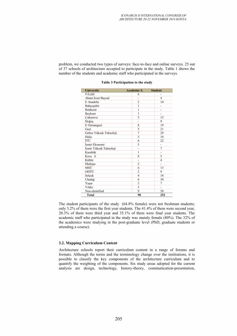
ICONARCH II INTERNATIONAL CONGRESS OF
ARCHITECTURE 20-22 NOVEMBER 2014 KONYA
205
problem, we conducted two types of surveys: face-to-face and online surveys. 25 out
of 37 schools of architecture accepted to participate in the study. Table 1 shows the
number of the students and academic staff who participated in the surveys.
Table 3 Participation to the study
University Academic S. Student
9 Eylül 6 -
Abant İzzet Baysal - 4
E Anadolu 2 10
Bahçeşehir 1 -
Balıkesir 1 -
Beykent 1 -
Çukurova 5 15
Doğuş - 9
E Osmangazi 8 19
Gazi 5 21
Gebze Yüksek Teknoloji 7 29
Haliç 5 10
İTÜ 6 22
İzmir Ekonomi 5 -
İzmir Yüksek Teknoloji - 7
Karabük 1 -
Koca li 8 5
Kültür - 4
Maltepe 2 -
MSÜ 6 13
ODTÜ 2 9
Selçuk 4 18
Uludağ 6 30
Yaşar 3 7
Yıldız 5 -
Non-identified 9 20
Total 98 252
The student participants of the study (64.8% female) were not freshman students;
only 3.2% of them were the first year students. The 41.4% of them were second year,
20.3% of them were third year and 35.1% of them were final year students. The
academic staff who participated in the study was mainly female (80%). The 32% of
the academics were studying in the post-graduate level (PhD, graduate students or
attending a course).
3.2. Mapping Curriculum Content
Architecture schools report their curriculum content in a range of forums and
formats. Although the terms and the terminology change over the institutions, it is
possible to classify the key components of the architecture curriculum and to
quantify the weighting of the components. Six study areas adopted for the current
analysis are design, technology, history-theory, communication-presentation,
ICONARCH II INTERNATIONAL CONGRESS OF
ARCHITECTURE 20-22 NOVEMBER 2014 KONYA
206
practise-management and environment. In addition to those areas, elective subjects
also exist, as shown in Table 2.
Table 4 The study areas of architecture curriculum
Design: Includes all of the compulsory and elective design related courses;
Technology: Includes building technology, material, construction and building
services and building science;
History-Theory: Includes architectural and urban history, and theory;
Communication-
Presentation
Includes all kind of architectural and verbal presentation
techniques, computer-based drafting, presentation and
documentation skills;
Practice–
Management
Includes project management, building management and
economics, building codes and regulations;
Environment Includes sustainability, ecology, landscape and energy;
Electives Includes all kinds of elective subjects
The Figure 1 shows the percentages of the quantifying the weighting of the six study
areas in the architecture curricula (only the architecture departments complied with
the criteria of the study are chosen). The total hours per week of each study area are
calculated and the average weighting is determined. As expected, the design studios
consistently occupy the largest time slot of the curricula, followed by technology,
history-theory, and communication related subjects. Elective subjects keep almost
10% of the time in the curricula studied.
There is a degree of overlap between those study areas that can encumber by the
interpretation of the data. For example, some of the subjects in the technology such
as building science may cover some areas of construction and environment.
Similarly, it is also very common to merge some areas into design studios. For
example, it is possible to have construction, ecology, drafting and communication
related issues discussed in design studio. In fact, this is very common pedagogical
approach over the world (Ostwald and Williams, 2008), but it makes the mapping
more difficult.
ICONARCH II INTERNATIONAL CONGRESS OF
ARCHITECTURE 20-22 NOVEMBER 2014 KONYA
207
Figure 18 The perception of the average weighting of the study areas
3.3. The assessment of the role of digital tools/environments in design education
In order to understand the perception of digital tools in design education, we asked
the students and academic staff to rate the tools in terms of the common use in
design education. Figure 2 shows the comparison of the perception of the
employment of the digital tools in design education. The 3D modelling tools have
the highest percentage followed by the photo-realistic rendering tools and the 2D
drafting tools. The consistent awareness across the participants is observed in those
three tools. Other three digital tools, which are the communication tools, the
collaboration tools and the virtual environments have the highest percentage rate
among the academic staff.
Figure 19 The comparison of the perception of digital design tools
Although, 97,9% of the schools has a computer laboratory, 84% of the students
Design Technology Hist-Theory Communication Management Environment Electives
Study Areas in Curriculum
2D drafting tools 3D modelling tools Photo-realistic rendering tools
Communication tools Collaboration tools Virtual environments
Students 63,3% 92,0% 67,3% 32,3% 37,8% 43,0%
Academic S 45,8% 79,2% 59,4% 41,7% 65,6% 67,7%
0,0%
20,0%
40,0%
60,0%
80,0%
100,0% Perception of digital tools in design
ICONARCH II INTERNATIONAL CONGRESS OF
ARCHITECTURE 20-22 NOVEMBER 2014 KONYA
208
consider the computer laboratories as insufficient. The most common shortcoming of
the laboratories that the students mentioned is the lack of recent technology
(insufficient RAM and hard drive capacity, very slow computers etc.), lack of staff
and lack of software. Most of the students commented on having not enough time to
learn the knowledge and skills of using computer mediated design tools. Some
comments are:
‘We have the subject in the second year, two hours per week I think…one week was
for Photoshop, two weeks were for AutoCAD, three weeks were for Max…it was very
much overview approach.’
‘We don’t have the computer mediated courses in the laboratory; we are taking our
own laptops to the class. In general, the instructor teaches the commands, gives us
some homework and we apply those knowledge and skills to our homework…I think
the hours for that course is not sufficient. They try to squeeze three software in two
hours, it is bad.’
The most common used software is AutoCAD, 93% of the students specified that
they are knowledgeable about and using this software during their education. The
other most commonly used software are (74.5%) Photoshop, (63.5%) SketchUp,
(35.8%) 3D Max, (26.7%) ArchiCAD, (23.9%) Revit, (16%) Illustrator, (15.2%)
Rhinoceros, (7.4%) Premier, (6.6%) Grasshopper and (5.3%) Corel Draw. The
95.7% of the academic staff identified that the students are allowed to use any kind
of digital media and tools in the design studios.
The academic staff commented on the employment of digital tools in design studio
which has a great potential to improve the design studio teaching and learning
experience. Particularly, the staff emphasised that the employment of digital tools in
the conceptual phase of the design process ought to be supported. By using the
digital design tools, the free-form exploration and creativity through moving away
from the Cartesian forms can be obtained.
‘Information and communication technologies are the tools which can be facilitated
in the every phases of the design process. A designer should have enough knowledge
and skills to employ those tools in the design activity.’
‘To employ the digital design tools in the early phases design process, there must be
out of the framework of computer-aided design…There is nothing new about using
the digital tools for the representation of the design concepts…But we don’t have
enough infrastructures and resources to do more than that.’
‘There could be some problems because of the lack of software that supports the
fuzzy phases of the design process. It is very necessary to develop applications that
facilitate the liquid mental processes’
The use of the virtual worlds among the academic staff is very low; only 9% of them
visited a virtual world before. Those are respectively Active Worlds, Second Life
ICONARCH II INTERNATIONAL CONGRESS OF
ARCHITECTURE 20-22 NOVEMBER 2014 KONYA
209
and Open Sim Grid. The 91% of the academic staff specified that they have never
employed a virtual world / virtual environment in their design teaching. In the open-
ended questions, we observed that there is confusion about what a virtual world
would be. The academic staff mixes the concept of virtual worlds up with the
animation and simulation. The 25.7% of the participated students, on the other hand,
have visited a virtual world before, that were Active Worlds (26%), Second Life
(17%), Club Penguin (14%), Free Realms (5.2%) and Open Sim Grid (3.4%). The
curiosity (18%) and gaming (15%) are the most popular two answers given as the
reasons of the visit.
The virtual environments (some forms of Web 2.0- social media- blogs, Facebook
and local intranet) are used as the communication and discussion media in most of
the time (51% of the academic staff). Particularly in design studios, groups employ
the social media for the discussions platform and as the storage of shared
information. Some comments include:
‘Particularly the blog pages are visible and accessible virtual environments so they
would be perceived as a stage that enhances the productivity of the students.’
‘Of course it depends on what you would share there. In general we share some
tutorial materials during the process, in some cases we are sharing some
architectural precedents to help them to gain knowledge on the architectural
history.’
4. DISCUSSION AND CONCLUSION In the last decade there has been an increasing demand to establish new universities
at every city in Turkey. Mirroring this demand, by 2013, there are 83 architecture
schools established, with 5000 students entering the education system to become an
architect each year. This research is an early attempt to gather information about the
current situation of the architectural education in Turkey. As noted above the
research focuses on: The identification of the curriculum contents; the investigation
of the role of the advanced digital tools and techniques in design education; and the
perception of the students and the academics towards to education and the role of
advanced digital tools.
In order to analyse the above points the curricula of the schools are investigated and
the detailed surveys are conducted. Based on our observations and the results of the
analysis of the collected data, we summarized our findings as follows:
First, while it is very difficult to capture every nuance that exists in the schools’
curricula, we collected and characterised the structures of the education programme.
Our analysis shows that in terms of the resources and the curricula, the schools are
fragmented and competitive. Several hybrid models, which commonly have the
architectural design studio in the centre of the education, exist. The academic staff,
who qualified in the well-established public schools, generally takes the leading
position to establish new foundation schools. In many cases those academic staff
could not go beyond what they gained in the public schools in their new roles, thus
they have disseminated the smaller replicas of the architectural curricula.
Second, the digital tools are integrated in the design curricula of the schools and
mainly used in form of CAD programs for documentation and graphical
ICONARCH II INTERNATIONAL CONGRESS OF
ARCHITECTURE 20-22 NOVEMBER 2014 KONYA
210
representation programs such as AutoCAD and Photoshop. In many schools, the
computer laboratories exist although their quantity and quality are not always at
desired level.
Third, the virtual environments, virtual reality and collaborative virtual environments
are mainly perceived as some kind of social media. Particularly, the employment of
those systems in education as the representation and communication tool (for making
the movies and documentation of the design concepts) is very common. There are
only a limited number of schools which employs those tools and environments for
design teaching in the spatial and visual reasoning of the 3D space and design
concept, and as a computational/generative design tools.
Finally, the results of the study show that the architectural education in Turkey,
similar to the common educational approaches around the world, concentrated to
design studio that is the backbone of the curricula. It is also observed that the
employment of the advanced digital design tools in education is far behind the level
of the world’s leading architectural schools. However, we believe that the use of
such technologies in architectural education will be enhanced to support new
generation of architects in Turkey in near future.
4.1. ACKNOWLEDGEMENT This research is funded by TUBİTAK 1002, Proje No:112K373. Authors wish to
thank the students and academic staff who participated in this study for their time,
and the assistant of the study Özgün Balaban and Işıl Ruhi Sipahioğlu for their
valuable contribution for the collection of the data.
REFERENCES
-Achten, H. and Joosen, G. 2003. The Digital Design Process - Reflections on a
Single Design Case. Digital Design, 21st eCAADe Conference Proceedings. Graz,
Austria, 269-274.
-Aliçavuşoğlu, E. and Artun, A. (Eds.) 2014. Bauhaus: Modernleşmenin Tasarımı,
ISBN:9789750506666, Sanat Hayat- 16.
-Barrows, H.S. 1986. A Taxonomy of Problem-based Learning Methods. Medical
Education 20, doi:10.1111/j.1365-2923.1986.tb01386.x.
-Clark, S. and Maher, M.L. 2005. Learning And Designing In A Virtual Place:
Investigating The Role Of Place In A Virtual Design Studio, Proceedings of
eCAADe 2005, Technical University of Lisbon, 303-310.
-Dickey, M.D. 2005. Three-Dimensional Virtual Worlds And Distance Learning:
Two Case Studies Of Active Worlds As A Medium For Distance Education, British
Journal of Educational Technology, 36, 439-451.
-Harimurti, R.P., Wijono, D. and Hatmoko, A.U. 2011. The Bauhaus’s Ideology,
Concept and Method in Architecture, the International Conference on Creative
Industry, Department of Industrial Design of Institute Technology, Sepuluh
Nopember Surabaya Indonesia.
-Gül, L.F., Gu, N. and Williams, A. 2007. A New Approach to Design Education:
Evaluations of 3D Virtual Worlds on Design Teaching and Learning, ConVR’07,
Proceedings of the 7th International Conference on Construction Applications of
ICONARCH II INTERNATIONAL CONGRESS OF
ARCHITECTURE 20-22 NOVEMBER 2014 KONYA
211
Virtual Reality, The Pennsylvania State University, pp. 40-49, October 22-23.
-Gül L.F., Gu N. and Williams A. 2008. Virtual Worlds as a Constructivist Learning
Platform: Evaluations of 3D Virtual Worlds on Design Teaching and Learning,
Journal of Information Technology in Construction, ISSN: 1874-4753, Vol.13,
Special Issue Virtual and Augmented Reality in Design and Construction, pp. 578-
593.
-Kvan, T. 2001. The Problem In Studio Teaching - Revisiting The Pedagogy Of
Studio Teaching, Proceedings of the 1st ACAE Conference on Architecture
Education, National University of Singapore, 157-166.
-Maitland, B.S. 1985. A Problem-based Course in Architecture. In Boud, D. (Ed.),
Problem-based Learning in Education for Professions. Sydney: HERDSA.
Nordic, ISS. 2002). Nordic Council of Minister. Yliopistopaino, Helsinki.
-Ostwald, M.J. and Williams, A. 2008. Understanding Architectural Education in
Australasia, Volume 1, ISBN:978-0-9805545-0-2, Australian Learning and Teaching
Council, Sydney.
-Perkins D. 1991. Technology Meets Constructivism: Do They Make A Marriage?
Educational Technology, 31, 18-23.
-Rajala, M. and Penttila, H. 2006. Testing 3D Building Modelling Framework in
Building Renovation. 24th eCAADe Conference Proceedings, ISBN 0-9541183-5-
9. Volos, Greece, 268-275.
-Schön, D.A. 1983. The Reflective Practitioner: How Professionals Think in Action,
New York, Basic Books.
-Wyeld, T.G., Prasolova-Forland, E. and Teng-Wen, C. 2006. Virtually
collaborating across cultures: A case study of an online theatrical performance in a
3dcve spanning three continents, Sixth International Conference on Advanced
Learning Technologies, 1076- 1078.
-Westrik, J. and De Graaff, E. 1994. Development and management of the new PBL-
based
curriculum in Architecture. Key note lecture presented at the conference Reflection
and
Consolidation Newcastle, Australia, 3-6 July 1994. In: S.E. Chen, R.M. Cowdroy,
A.J.
Kingsland and M.J. Ostwald (Eds.), Reflections on Problem-based Learning.
Sydney: Australian Problem Based Learning Network.
-Williams, A., Gu, N. and Gül, L.F. 2011. The Introduction of a Problem Based
Learning Approach to the Implementation of a Virtual Reality Context, in Cheney,
A. and Sanders, R.L. (Eds.), Teaching and Learning in 3D Immersive Worlds:
Pedagogical Models and Constructivist Approaches, Chapter 13, ISBN13:
9781609605179, IGI Global, p.226-247.
-Woods, D. 1985. Problem-based Learning and Problem-solving. In Boud, D. (Ed.),
Problem-based Learning in Education for Professions. Sydney: HERDSA.
ICONARCH II INTERNATIONAL CONGRESS OF
ARCHITECTURE 20-22 NOVEMBER 2014 KONYA
212
1 Pınar ÇALIŞIR, ITU, Architectural Design Computing Graduate Program, ISTANBUL
FORM-FINDING WITH EXPERIMENTATION ON NATURAL
PERIODIC FORCES: THE SOUND MOTION STREAKS
PROJECT
PINAR ÇALIŞIR1
ABSTRACT
Today, many computational techniques of form-finding use the term “design” with
the term “research”. So that, architectural studios become more and more like
laboratories for design experiments. This paper proposes The Sound Motion Streaks
Project -done by the author, Ines Gavelli and Wei Weiwei during the research course
in Bartlett MArch GAD in 2012- where the sound can be used as a generative
computational data and applied to digital form finding experimentations. This
process relies on an idea that sound as an external force can produce or deform
shapes according to its influence. The first phase of the process is to make physical
experiments on the sound and see its influences on granular and fluid materials. We
can say that, in these physical experimentations, there is a knowledge transmission
from physical to digital medium that we can use as design parameters on a software.
In digital software, sound can be a force field and manipulate digital matters such as
particles, curves and meshes. This form-finding method is constituted by all physical
and digital experiments, and applied in an urban area in order to discuss its
architectural potentials. For instance, all material events in the area depend on
duration and movement of digital tools, thus the notion of form and/or space become
kinetic. This kinetic reactions bring out a new understanding of space and form
which consists of motionless boundary, translatability, rhythmicity, differentiated
densities and heterogeneity. Also this generative approach gives architects many
potential solutions for architectural forms.
Key words: Form-finding, Kinetic Form, Sound, Experimentation
ICONARCH II INTERNATIONAL CONGRESS OF
ARCHITECTURE 20-22 NOVEMBER 2014 KONYA
213
1. INTRODUCTION
Experimentation is the most important parameter for a scientific discovery. What
about discoveries of forms in architecture? Nature has a lot of novel forms and
patterns and produces new ones without stopping a moment. Thus, it is not a
coincidence that the novel ideas in architecture usually come from experimentation
procedures copying the processes of nature. To do this, architects need to understand
how nature finds her forms and what her rules during the process of form generation.
Our motivation in this paper is a desire to create a form finding process which is
called “the Sound Motion Streaks Method” in terms of experimentation on natural
forces in order to find novel ideas in architecture. Sound is the force that we used in
our study. The main objective of using sound is to see what sound looks like through
interaction with matters. By doing this, we can produce a new notion of space which
negates with the traditional Euclidian space and create a kinaesthetic experience on
users with the help of sound materialization. While reading this paper audience will
see that there is no starting shape in this process but there are different materials
reacting the sound influences. Therefore, this kind of formation processes will lead
us to create a variety of topological geometry. Spaces emerging in this process are no
longer static but dynamic, and this dynamism in the structure brings some kinetic
properties to the form. In an animated form, the notion of kinetic reveals with a
continuous motion through immovable structure of form. We can see the history of
material movement under the influence of sound through transparent and
overlapping structures of form. This illusion of movement called as “frozen
moment” and the designer becomes a person who “orchestrates” the whole process
(Terzidis, 2003).
The design process in this study is developed in four stages. First stage is to gain a
general knowledge about the notion of form-finding process and physical sound
properties. In this stage, additional to the literature review, we repeated physical
sound experiments from the precedents -such as Cymatics- in order to strength our
understanding of sound properties and material interactions. The second stage is to
using this general knowledge coming from the first stage and constitute various
digital experiments to examine the nature of digital materials and their reactions to
the sound. Third stage is to generate our form-finding method and test it with
different parameters in order to find a way for creating an urban scale prototype. Our
final stage is to test this method in an urban area and discuss its architectural
potentials through this way
2. UNDERSTANDING THE TERM FORM-FINDING AND THE SOUND
PHENOMENA
2.1. Form-Finding
In 1806 Goethe introduced the term “Morphology”. He has a unique understanding
on how forms emerge in nature and how the constant formation and transformation
of forms related to environmental forces (Menges&Ahlquist, 2011).
According to him generative processes in nature affect both organic and inorganic
ICONARCH II INTERNATIONAL CONGRESS OF
ARCHITECTURE 20-22 NOVEMBER 2014 KONYA
214
systems with the help of natural forces. He invented “Ur-forms” in order to explain
“the foundational programs” in nature. These programs determine differences and
similarities between forms in nature which is to say that similar forms (Urforms)
should share a common foundational program (Aranda&Lasch, 2006). These
foundational systems actually refer environmental forces which affect all forms in
nature and cause a constant transformation throughout its lifetime. For instance,
imagine different cracking systems in nature. The foundational program behind dry
mud and dry paint is the same, therefore these cracking systems looks like identical.
They are “Urforms”. Both are shaped by same environmental force which is “fluvial
erosion” (Aranda&Lasch, 2006). D’Arcy Thompson explained similar ideas with
Goethe in his book “On Growth and Form” in 1917. He proposed that there are
environmental (external) forces in nature affecting shape of things. More
importantly, he believed that we can solve this process with mathematics (Menges,
Ahlquist, 2011). Similarly, Philip Ball (1999) stated that patterns and forms in nature
are not only generated through biological coding, but also there are simple physical
laws behind them. Therefore, we can repeat complex forms in nature by repeating
these rules. From all these ideas, we can say that there are some natural forces in the
world and they are acting on organic and inorganic things and determine their
appearances. These external forces cause similarities and differences and we can
repeat their effect on forms by repeating these physical forces. In the Sound Motion
Streaks Project, our departure point is to use sound as an external force and find
sound patterns and structure by means of form and force relations. Therefore, in the
next chapter we examine some precedents works on sound phenomena and repeat
some of their experiments in order to find the foundational program behind sound
patterns and forms.
2.2. Sound Properties
To understand periodicity of sound we should understand the properties that create
rhythmic vibrations. Sound is a kind of wave which passes through the air effecting
particles back and forth and change their equilibrium positions, but it is the
disturbance which travels not the individual particles in the medium [1].
The frequency is the number of occurrences of a repeating event (period) per unit
time. The amplitude is the measure of a magnitude (energy transported) of
oscillation of a wave [2].If we find a sound analysis of a particular sound, we can see
that, both amplitude and frequency reflects the periodicity of sound and rhythmicity.
2.3. Sound as a Natural Phenomena
Nature consists of complex systems constantly changing one assemblage of
conditions to another, opposite one. These changing systems –animate or inanimate-
create their own repetitive patterns and forms and their formation reveals hidden
periodic forces which lay beneath them. A continual state of “vibration, oscillation,
undulation and pulsation” give these forces periodicity (Jenny, 2001). On the basis
of vibrational phenomena sound can be seen as another example.
Taking information from its nature cannot be done with an eye or other senses except
hearing. However, this does not give any visual data on the periodicity of the sound.
Thus, since the eighteenth century, scientists have worked to make sound visible in
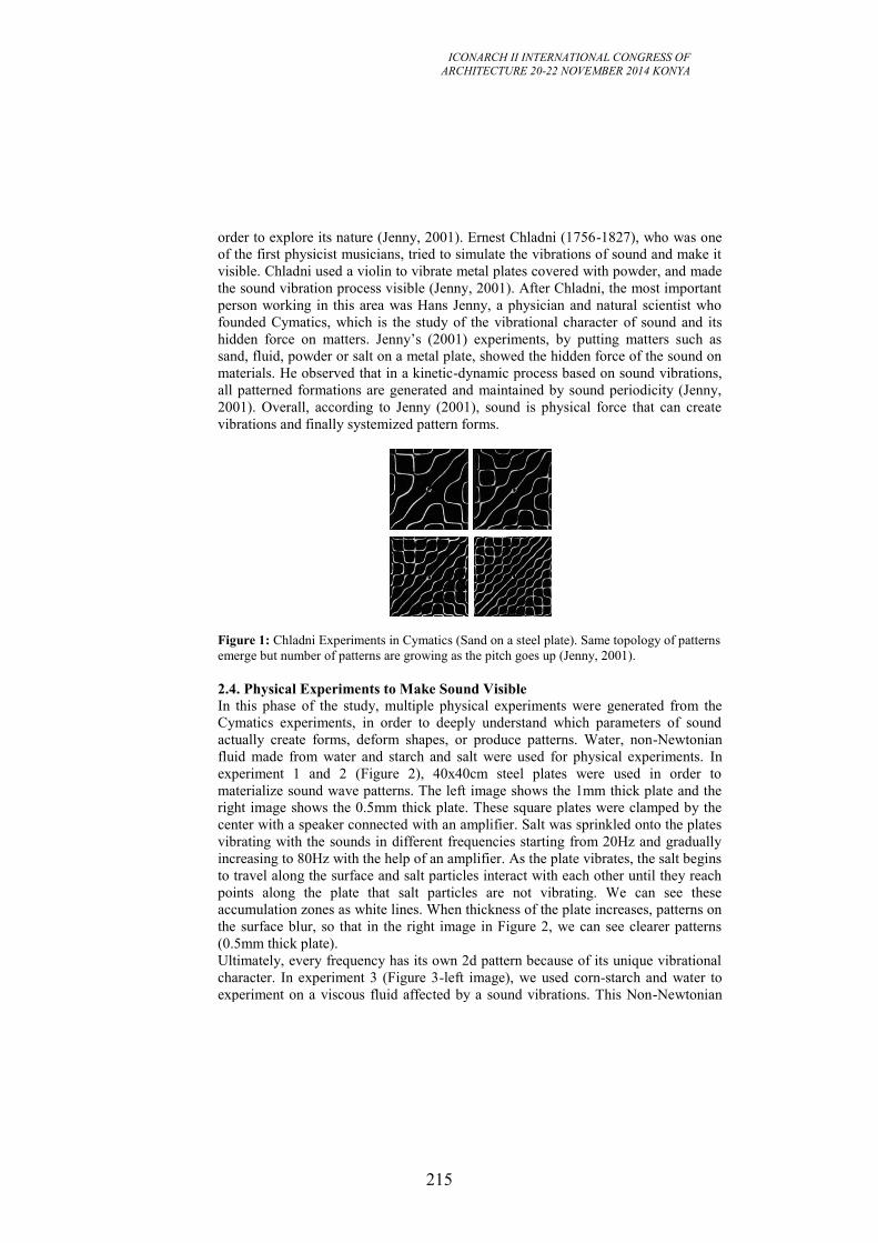
ICONARCH II INTERNATIONAL CONGRESS OF
ARCHITECTURE 20-22 NOVEMBER 2014 KONYA
215
order to explore its nature (Jenny, 2001). Ernest Chladni (1756-1827), who was one
of the first physicist musicians, tried to simulate the vibrations of sound and make it
visible. Chladni used a violin to vibrate metal plates covered with powder, and made
the sound vibration process visible (Jenny, 2001). After Chladni, the most important
person working in this area was Hans Jenny, a physician and natural scientist who
founded Cymatics, which is the study of the vibrational character of sound and its
hidden force on matters. Jenny’s (2001) experiments, by putting matters such as
sand, fluid, powder or salt on a metal plate, showed the hidden force of the sound on
materials. He observed that in a kinetic-dynamic process based on sound vibrations,
all patterned formations are generated and maintained by sound periodicity (Jenny,
2001). Overall, according to Jenny (2001), sound is physical force that can create
vibrations and finally systemized pattern forms.
Figure 1: Chladni Experiments in Cymatics (Sand on a steel plate). Same topology of patterns
emerge but number of patterns are growing as the pitch goes up (Jenny, 2001).
2.4. Physical Experiments to Make Sound Visible
In this phase of the study, multiple physical experiments were generated from the
Cymatics experiments, in order to deeply understand which parameters of sound
actually create forms, deform shapes, or produce patterns. Water, non-Newtonian
fluid made from water and starch and salt were used for physical experiments. In
experiment 1 and 2 (Figure 2), 40x40cm steel plates were used in order to
materialize sound wave patterns. The left image shows the 1mm thick plate and the
right image shows the 0.5mm thick plate. These square plates were clamped by the
center with a speaker connected with an amplifier. Salt was sprinkled onto the plates
vibrating with the sounds in different frequencies starting from 20Hz and gradually
increasing to 80Hz with the help of an amplifier. As the plate vibrates, the salt begins
to travel along the surface and salt particles interact with each other until they reach
points along the plate that salt particles are not vibrating. We can see these
accumulation zones as white lines. When thickness of the plate increases, patterns on
the surface blur, so that in the right image in Figure 2, we can see clearer patterns
(0.5mm thick plate).
Ultimately, every frequency has its own 2d pattern because of its unique vibrational
character. In experiment 3 (Figure 3-left image), we used corn-starch and water to
experiment on a viscous fluid affected by a sound vibrations. This Non-Newtonian
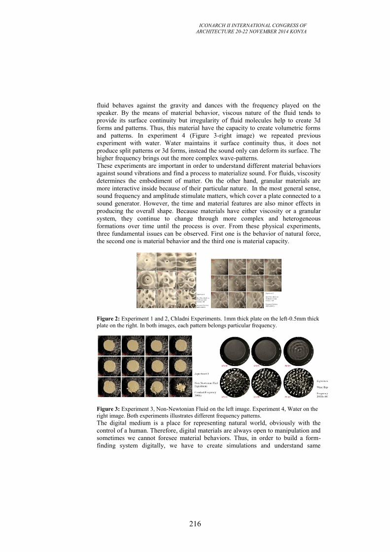
ICONARCH II INTERNATIONAL CONGRESS OF
ARCHITECTURE 20-22 NOVEMBER 2014 KONYA
216
fluid behaves against the gravity and dances with the frequency played on the
speaker. By the means of material behavior, viscous nature of the fluid tends to
provide its surface continuity but irregularity of fluid molecules help to create 3d
forms and patterns. Thus, this material have the capacity to create volumetric forms
and patterns. In experiment 4 (Figure 3-right image) we repeated previous
experiment with water. Water maintains it surface continuity thus, it does not
produce split patterns or 3d forms, instead the sound only can deform its surface. The
higher frequency brings out the more complex wave-patterns.
These experiments are important in order to understand different material behaviors
against sound vibrations and find a process to materialize sound. For fluids, viscosity
determines the embodiment of matter. On the other hand, granular materials are
more interactive inside because of their particular nature. In the most general sense,
sound frequency and amplitude stimulate matters, which cover a plate connected to a
sound generator. However, the time and material features are also minor effects in
producing the overall shape. Because materials have either viscosity or a granular
system, they continue to change through more complex and heterogeneous
formations over time until the process is over. From these physical experiments,
three fundamental issues can be observed. First one is the behavior of natural force,
the second one is material behavior and the third one is material capacity.
Figure 2: Experiment 1 and 2, Chladni Experiments. 1mm thick plate on the left-0.5mm thick
plate on the right. In both images, each pattern belongs particular frequency.
Figure 3: Experiment 3, Non-Newtonian Fluid on the left image. Experiment 4, Water on the
right image. Both experiments illustrates different frequency patterns.
The digital medium is a place for representing natural world, obviously with the
control of a human. Therefore, digital materials are always open to manipulation and
sometimes we cannot foresee material behaviors. Thus, in order to build a form-
finding system digitally, we have to create simulations and understand same
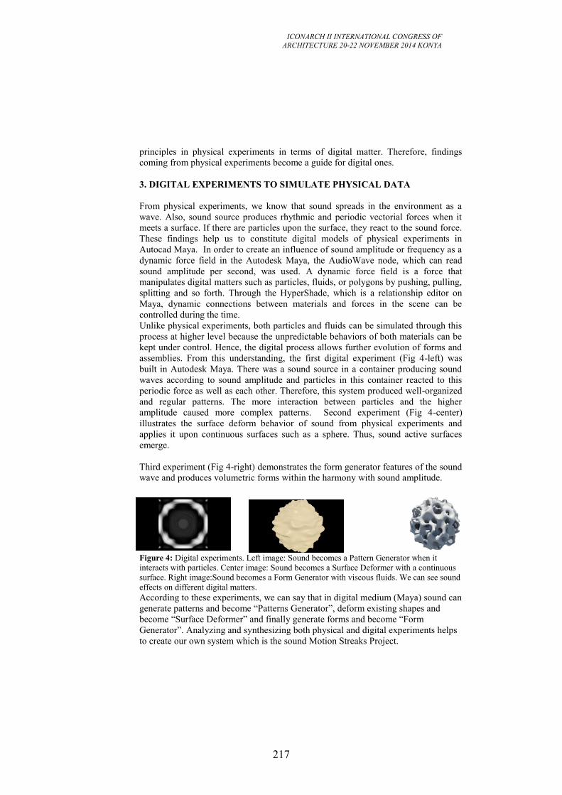
ICONARCH II INTERNATIONAL CONGRESS OF
ARCHITECTURE 20-22 NOVEMBER 2014 KONYA
217
principles in physical experiments in terms of digital matter. Therefore, findings
coming from physical experiments become a guide for digital ones.
3. DIGITAL EXPERIMENTS TO SIMULATE PHYSICAL DATA
From physical experiments, we know that sound spreads in the environment as a
wave. Also, sound source produces rhythmic and periodic vectorial forces when it
meets a surface. If there are particles upon the surface, they react to the sound force.
These findings help us to constitute digital models of physical experiments in
Autocad Maya. In order to create an influence of sound amplitude or frequency as a
dynamic force field in the Autodesk Maya, the AudioWave node, which can read
sound amplitude per second, was used. A dynamic force field is a force that
manipulates digital matters such as particles, fluids, or polygons by pushing, pulling,
splitting and so forth. Through the HyperShade, which is a relationship editor on
Maya, dynamic connections between materials and forces in the scene can be
controlled during the time.
Unlike physical experiments, both particles and fluids can be simulated through this
process at higher level because the unpredictable behaviors of both materials can be
kept under control. Hence, the digital process allows further evolution of forms and
assemblies. From this understanding, the first digital experiment (Fig 4-left) was
built in Autodesk Maya. There was a sound source in a container producing sound
waves according to sound amplitude and particles in this container reacted to this
periodic force as well as each other. Therefore, this system produced well-organized
and regular patterns. The more interaction between particles and the higher
amplitude caused more complex patterns. Second experiment (Fig 4-center)
illustrates the surface deform behavior of sound from physical experiments and
applies it upon continuous surfaces such as a sphere. Thus, sound active surfaces
emerge.
Third experiment (Fig 4-right) demonstrates the form generator features of the sound
wave and produces volumetric forms within the harmony with sound amplitude.
Figure 4: Digital experiments. Left image: Sound becomes a Pattern Generator when it
interacts with particles. Center image: Sound becomes a Surface Deformer with a continuous
surface. Right image:Sound becomes a Form Generator with viscous fluids. We can see sound
effects on different digital matters.
According to these experiments, we can say that in digital medium (Maya) sound can
generate patterns and become “Patterns Generator”, deform existing shapes and
become “Surface Deformer” and finally generate forms and become “Form
Generator”. Analyzing and synthesizing both physical and digital experiments helps
to create our own system which is the sound Motion Streaks Project.
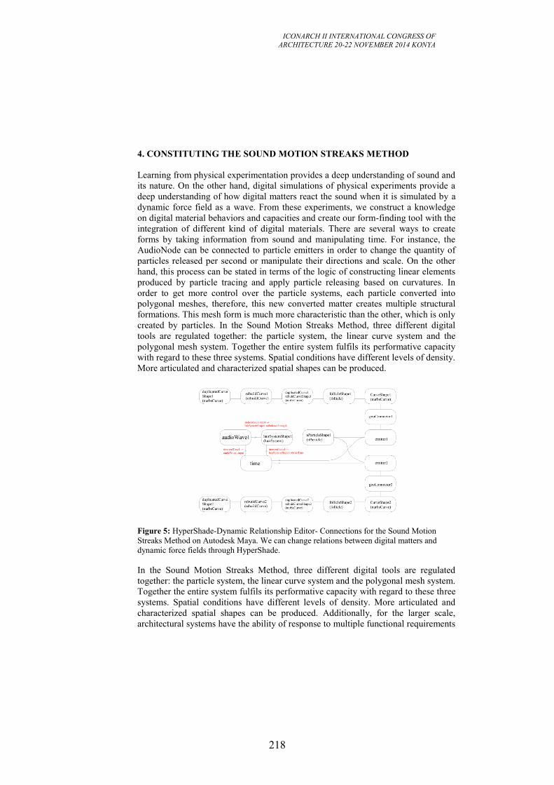
ICONARCH II INTERNATIONAL CONGRESS OF
ARCHITECTURE 20-22 NOVEMBER 2014 KONYA
218
4. CONSTITUTING THE SOUND MOTION STREAKS METHOD
Learning from physical experimentation provides a deep understanding of sound and
its nature. On the other hand, digital simulations of physical experiments provide a
deep understanding of how digital matters react the sound when it is simulated by a
dynamic force field as a wave. From these experiments, we construct a knowledge
on digital material behaviors and capacities and create our form-finding tool with the
integration of different kind of digital materials. There are several ways to create
forms by taking information from sound and manipulating time. For instance, the
AudioNode can be connected to particle emitters in order to change the quantity of
particles released per second or manipulate their directions and scale. On the other
hand, this process can be stated in terms of the logic of constructing linear elements
produced by particle tracing and apply particle releasing based on curvatures. In
order to get more control over the particle systems, each particle converted into
polygonal meshes, therefore, this new converted matter creates multiple structural
formations. This mesh form is much more characteristic than the other, which is only
created by particles. In the Sound Motion Streaks Method, three different digital
tools are regulated together: the particle system, the linear curve system and the
polygonal mesh system. Together the entire system fulfils its performative capacity
with regard to these three systems. Spatial conditions have different levels of density.
More articulated and characterized spatial shapes can be produced.
Figure 5: HyperShade-Dynamic Relationship Editor- Connections for the Sound Motion
Streaks Method on Autodesk Maya. We can change relations between digital matters and
dynamic force fields through HyperShade.
In the Sound Motion Streaks Method, three different digital tools are regulated
together: the particle system, the linear curve system and the polygonal mesh system.
Together the entire system fulfils its performative capacity with regard to these three
systems. Spatial conditions have different levels of density. More articulated and
characterized spatial shapes can be produced. Additionally, for the larger scale,
architectural systems have the ability of response to multiple functional requirements
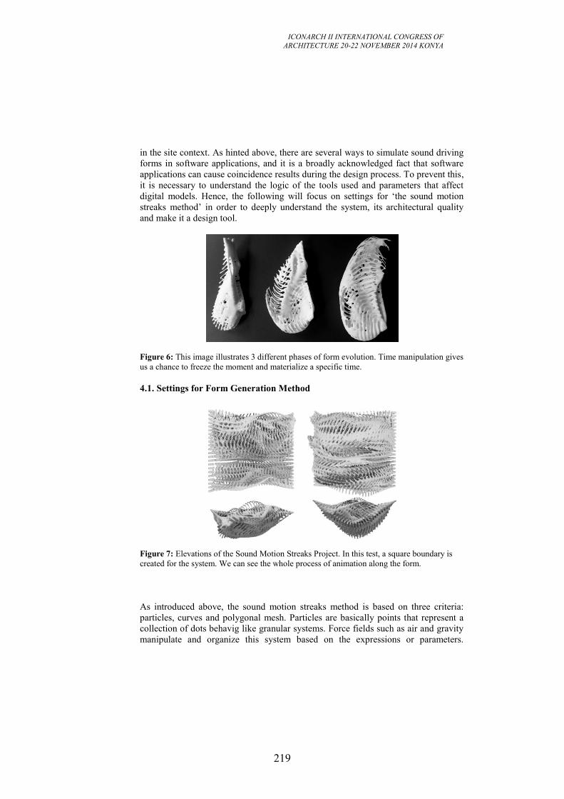
ICONARCH II INTERNATIONAL CONGRESS OF
ARCHITECTURE 20-22 NOVEMBER 2014 KONYA
219
in the site context. As hinted above, there are several ways to simulate sound driving
forms in software applications, and it is a broadly acknowledged fact that software
applications can cause coincidence results during the design process. To prevent this,
it is necessary to understand the logic of the tools used and parameters that affect
digital models. Hence, the following will focus on settings for ‘the sound motion
streaks method’ in order to deeply understand the system, its architectural quality
and make it a design tool.
Figure 6: This image illustrates 3 different phases of form evolution. Time manipulation gives
us a chance to freeze the moment and materialize a specific time.
4.1. Settings for Form Generation Method
Figure 7: Elevations of the Sound Motion Streaks Project. In this test, a square boundary is
created for the system. We can see the whole process of animation along the form.
As introduced above, the sound motion streaks method is based on three criteria:
particles, curves and polygonal mesh. Particles are basically points that represent a
collection of dots behavig like granular systems. Force fields such as air and gravity
manipulate and organize this system based on the expressions or parameters.
ICONARCH II INTERNATIONAL CONGRESS OF
ARCHITECTURE 20-22 NOVEMBER 2014 KONYA
220
Similarly, a curve system lets one create dynamic curves so that natural movements
and collisions can be created. Finally, polygons are a geometrical type that can be
used to create three-dimensional structures in order to produce surface or
architectural skin covering the systems. The whole system behaves like natural forms
and like all forms in nature, they assemble themselves and also have the ability to
gather their matter and interact with the environment under gravity or different
fields. On the other hand, in order to produce these forms, the system must be run in
a simulation. Simulations are essential for laying out complex architectural systems,
in software applications and examining their behavior over extended periods of time.
Also, simulations provide generative design processes (Hensel et al, 2010) and take
advantage of motion movement and time. We can control dynamic relations between
digital matters, dynamic force fields and time through HyperShade Editor (Figure 5).
In order to discuss the potentials of the Sound Motion Streaks Method by the means
of space and form we apply this method in an urban area.
5. AN URBAN SCALE PROTOTYPE
For an urban scale prototype, an old bridge in Limehouse in London was chosen.
The bridge is a kind of extension for Dockland Light Railways(DLR) but now is
neglected and separated from DLR from a barrier. The whole area is affected by the
rhythmic noise of DLR. In order to make visible the sound-scape of this area-a sound
that is unique to an area- and produce sonic awareness, the sounds of this particular
site in London were recorded and translated into an architectural proposal.
The idea is to “see what the sound looks like in a particular place” and through this,
to provoke a synaesthetic experience in the user. The proposal is an urban path and
connector between two different “sound areas”, and making use of an abandoned rail
bridge, this construction crosses a busy road to a quiet area behind the new railways.
To make possible the sound visualization, the sound was captured and recorded on
real time. It means that the sounds used in this proposal, present the exact
differentiation of the noise/calm areas as they were captured along the path. For the
urban prototype we do not fix curves in the space, instead, the sound curves travel
following the path, and are influenced in accordance to the area they are passing.
This form extends in a linear site, and unfolds as a canopy that varies with the urban
sound. The resulting form is dynamic with differentiation of spaces, densities and
textures. The linearity is broke were the sound is higher because higher sound creates
voids between the layers that could be used to accommodate internal spaces. The
spaces are articulated with the continuity of the shape, as a linear and kinetic space,
encourages the user to flow along it. The sound as the creator of the space is frozen
in time and allows the user to witness and become aware of the acoustic
environment.
Wall, roof, and floor are all blend together, giving a sense of continuous space and
enhanced perceptual experience. Nothing in this form is predictable, everything is
opened to be discovered by the self-experience.
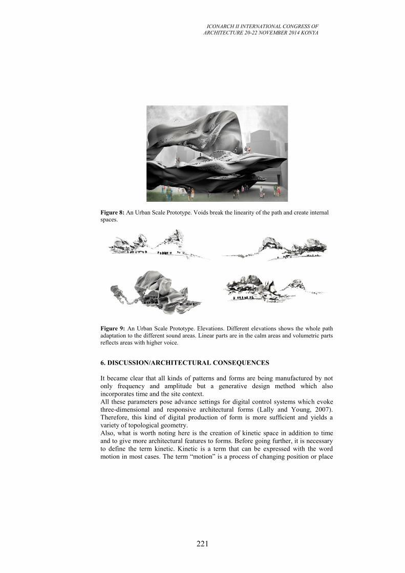
ICONARCH II INTERNATIONAL CONGRESS OF
ARCHITECTURE 20-22 NOVEMBER 2014 KONYA
221
Figure 8: An Urban Scale Prototype. Voids break the linearity of the path and create internal
spaces.
Figure 9: An Urban Scale Prototype. Elevations. Different elevations shows the whole path
adaptation to the different sound areas. Linear parts are in the calm areas and volumetric parts
reflects areas with higher voice.
6. DISCUSSION/ARCHITECTURAL CONSEQUENCES
It became clear that all kinds of patterns and forms are being manufactured by not
only frequency and amplitude but a generative design method which also
incorporates time and the site context.
All these parameters pose advance settings for digital control systems which evoke
three-dimensional and responsive architectural forms (Lally and Young, 2007).
Therefore, this kind of digital production of form is more sufficient and yields a
variety of topological geometry.
Also, what is worth noting here is the creation of kinetic space in addition to time
and to give more architectural features to forms. Before going further, it is necessary
to define the term kinetic. Kinetic is a term that can be expressed with the word
motion in most cases. The term “motion” is a process of changing position or place
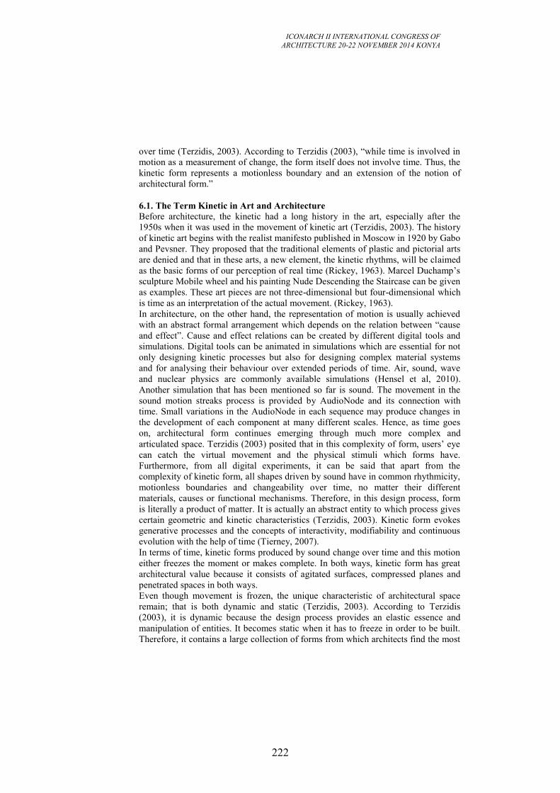
ICONARCH II INTERNATIONAL CONGRESS OF
ARCHITECTURE 20-22 NOVEMBER 2014 KONYA
222
over time (Terzidis, 2003). According to Terzidis (2003), “while time is involved in
motion as a measurement of change, the form itself does not involve time. Thus, the
kinetic form represents a motionless boundary and an extension of the notion of
architectural form.”
6.1. The Term Kinetic in Art and Architecture
Before architecture, the kinetic had a long history in the art, especially after the
1950s when it was used in the movement of kinetic art (Terzidis, 2003). The history
of kinetic art begins with the realist manifesto published in Moscow in 1920 by Gabo
and Pevsner. They proposed that the traditional elements of plastic and pictorial arts
are denied and that in these arts, a new element, the kinetic rhythms, will be claimed
as the basic forms of our perception of real time (Rickey, 1963). Marcel Duchamp’s
sculpture Mobile wheel and his painting Nude Descending the Staircase can be given
as examples. These art pieces are not three-dimensional but four-dimensional which
is time as an interpretation of the actual movement. (Rickey, 1963).
In architecture, on the other hand, the representation of motion is usually achieved
with an abstract formal arrangement which depends on the relation between “cause
and effect”. Cause and effect relations can be created by different digital tools and
simulations. Digital tools can be animated in simulations which are essential for not
only designing kinetic processes but also for designing complex material systems
and for analysing their behaviour over extended periods of time. Air, sound, wave
and nuclear physics are commonly available simulations (Hensel et al, 2010).
Another simulation that has been mentioned so far is sound. The movement in the
sound motion streaks process is provided by AudioNode and its connection with
time. Small variations in the AudioNode in each sequence may produce changes in
the development of each component at many different scales. Hence, as time goes
on, architectural form continues emerging through much more complex and
articulated space. Terzidis (2003) posited that in this complexity of form, users’ eye
can catch the virtual movement and the physical stimuli which forms have.
Furthermore, from all digital experiments, it can be said that apart from the
complexity of kinetic form, all shapes driven by sound have in common rhythmicity,
motionless boundaries and changeability over time, no matter their different
materials, causes or functional mechanisms. Therefore, in this design process, form
is literally a product of matter. It is actually an abstract entity to which process gives
certain geometric and kinetic characteristics (Terzidis, 2003). Kinetic form evokes
generative processes and the concepts of interactivity, modifiability and continuous
evolution with the help of time (Tierney, 2007).
In terms of time, kinetic forms produced by sound change over time and this motion
either freezes the moment or makes complete. In both ways, kinetic form has great
architectural value because it consists of agitated surfaces, compressed planes and
penetrated spaces in both ways.
Even though movement is frozen, the unique characteristic of architectural space
remain; that is both dynamic and static (Terzidis, 2003). According to Terzidis
(2003), it is dynamic because the design process provides an elastic essence and
manipulation of entities. It becomes static when it has to freeze in order to be built.
Therefore, it contains a large collection of forms from which architects find the most
ICONARCH II INTERNATIONAL CONGRESS OF
ARCHITECTURE 20-22 NOVEMBER 2014 KONYA
223
suitable in terms of function, architectural space and environmental context.
6.2. Conclusion
This paper propose a method to create forms and patterns in a dynamic-kinetic
process by using sound as an external force. To create this method, first physical,
then digital experiments are done to understand the sound phenomena and its
influence on materials. After these phases, we construct our method with 3 different
tools in Autodesk Maya-curves, particles and polygonal mesh-. Sound affects this
hybrid material system and we manipulate time-sound and material properties
through HyperShade. The ultimate form emerging in this process depends on time
therefore we can track the whole process along the form and this brings kinetic
properties to spaces created in the Sound Motion Streaks Project. The value of this
kinetic process is its changeability and endless topology. Moreover, in this animated
space, users discover sound with their eyes and become aware of the sound-scape of
the area. Through this kinesthetic experiences, users can not only hear the sound in
the environment but also see and touch therefore, the perceptual experiences are
enriched and enhance.
REFERENCES
-Aranda, B., Lasch, C. 2006. Pamphlet Architecture 27: Tooling. Princeton
Architectural Press, New York.
-Ball, P. 1999. The Self Made Tapestry. Oxford University Press, Oxford.
- Hensel, M., Menges, A., Weinstock, M. 2010. Emergent Technologies and Design:
Towards a Biological Paradigm for Architecture. Routledge, New York.
-Jenny, H. 2001.Cymatics. Macromedia Press, San Francisco.
-Lally, S., Young, J. 2007. Softspace. Taylor and Francis, New York.
-Menges, A., Ahlquist, S. 2011. Computational Design Thinking. Wiley Publication,
Sussex.
-Kiendl, A. 2008. Informal Architecture: Space and Contemporary Culture.
Blockdog, London.
-Rickey, G.W. 1963. The Morphology of Movement: A Study of Kinetic Art. Art
Journal, vol.22, no.4, summer, pp. 220-231.
-Terzidis, K. 2003. Expressive Form. Spon Press, London.
-Tierney, T. 2007. Abstract Space: Beneath the Media Surface. Taylor and Francis,
New York.
-[1] http://www.acs.psu.edu/drussell/demos.html
-[2] http://www.physicsclassroom.com/class/sound
ICONARCH II INTERNATIONAL CONGRESS OF
ARCHITECTURE 20-22 NOVEMBER 2014 KONYA
224
1 This article has been co-authored by: C. Biagini, Prof. Dr. at University of Florence, Dept. of
Architecture, Florence; Vincenzo Donato, International PhD Candidate at University of Florence and
Technical University of Braunschweig; Davide Pellis, M.Eng. in Building Engineering, Florence.
PRELIMINARY DESIGN THROUGH GRAPHS:
A TOOL FOR AUTOMATİC LAYOUT DISTRIBUTION
CARLO BIAGINI, VINCENZO DONATO, DAVIDE PELLIS 1
ABSTRACT
Diagrams are essential in the preliminary stages of design for understanding
distributive aspects and assisting the decision-making process. By drawing a
schematic graph, designers can visualize in a synthetic way the relationships between
many aspects: functions and spaces, distribution of layouts, space adjacency,
influence of traffic flows within a facility layout, and so on. This process can be
automated through the use of modern Information and Communication Technologies
tools (ICT) that allow the designers to manage a large quantity of information.
The work that we will present is part of an on-going research project into how
modern parametric software influences decision-making on the basis of automatic
and optimized layout distribution. The method involves two phases: the first aims to
define the ontological relation between spaces, with particular reference to a specific
building typology (rules of aggregation of spaces); the second entails the
implementation of these rules through the use of specialist software. The generation
of ontological relations begins with the collection of data from historical manuals
and analyses of case studies. These analyses aim to generate a “relationship matrix”
based on preferences of space adjacency. The phase of implementing the previously
defined rules is based on the use of Grasshopper to analyse and visualize different
layout configurations. The layout is generated by simulating a process involving the
collision of spheres, which represents specific functions of the design program. The
spheres are attracted or rejected as a function of the relationships matrix, as defined
above. The layout thus obtained will remain in a sort of abstract state independnt of
information about the exterior form, but will still provide a useful tool for the
decision-making process. In addition, preliminary results gathered through the
analysis of case studies will be presented. These results provide a good variety of
layout distributions over a short time for medium and large-scale problems.
Key words: graph representations, parametric design, automated layout distributions
ICONARCH II INTERNATIONAL CONGRESS OF
ARCHITECTURE 20-22 NOVEMBER 2014 KONYA
225
1. INTRODUCTION
In the design process understanding which layout distribution is suitable for a
particular context is a complicated task, especially regarding the design of complex
buildings that are highly influenced by the functional types (such as airports,
hospitals, industrial factories, and so on). Obtaining an optimized distribution in
terms of minimization of connections between spaces in advance could give the
designer an important advantage.
In the literature different methods have been shown that bring the designer towards
an automated layout distribution. Many of them are based on algorithms that lead to
abstract solutions in terms of architectural quality; they also generate very
complicated numerical results which require a great deal of effort to decode the
output data.
One possible approach is to implement an algorithm that can automatically produce
an abstract representation of a possible optimized layout distribution. In our work we
intend “optimal solution” to mean a layout that presents the minimum distances
between functions and spaces. Subsequently this abstract representation can be used
as a reference to generate a conventional architectural representation.
To achieve an automated layout distribution it is possible to use the analogy of the
cinematic system where spaces, represented by circles or spheres, are inserted in a
specific universe governed by dynamic laws. These cycles are attracted or rejected in
accordance with the strength of the springs that connect the barycentre of the circles.
Once the analysis begins, these circles assume an equilibrium configuration.
Grasshopper, a plug in for Rhinoceros, allows the automatization of this task.
The calculation of the optimal design solution is a function of specific mathematical
criteria, based on the transformation of qualitative factors into quantitative
parameters. The ontological relations between spaces or functions are expressed
through a relationships matrix that considers the adjacency preferences (adjacency,
proximity, inclusion separation, and so on). These preferences are converted into
different forces of attraction or repulsion, through a dynamic system.
In the article we will present a method to achieve a set of possible optimized
distributions starting from a relationship matrix. In addition, we will also show a
case study based on the urban distribution analysis of the layout distribution for a
complex urban distribution of the Hospital of the city of Florence.
2. STATE OF THE ARTS
According to Kalay, design can be considered as a problem-solving activity and “the
problem it sets out to solve arises from the inability of a current situation to satisfy
some needs” (Kalay, 2004). He continues by proposing a series of questions: “ How
can we tell if a proposed design solution will achieve them? How can we measure
the “goodness” and uncover its undesired side and after-effects before constructing
the buildings? How can we begin the search for design solutions in the first place?”
(Kalay, 2004 p. 205).
An answer can be found in the history of architecture. In particular, research into
ICONARCH II INTERNATIONAL CONGRESS OF
ARCHITECTURE 20-22 NOVEMBER 2014 KONYA
226
“best practice in design” has perplexed philosophers and architects since Ancient
Greek times. In the first century BC, Vitruvius offered some answers to this
question, giving a “good solution” through specific geometrical proportion. Since
then, architects and researchers have tried to formulate theories, methods, and tools
that will help the designer to “predict” the results (Edwards, 1979).
In recent eras, the starting point for many design methods has been the notion that
design is a process of searching for a solution that satisfies a given set of goals and
constraints. One possible tool to use in architecture (or indeed in any field that
requires similar design activity) is to represent the problem through graphs and
diagrams. In fact in the work of Hellen Do and Nigel Gross they explain “graphs and
diagrams are the essential representations for thinking, problem solving, and
communication in the design disciplines in an abstract form” (Do & Gross, 2001).
This abstraction allows the designer to “distil the meaning of the message, focusing
attention on its salient characteristics […] which details are preserved, and which
ones are omitted, depend on the subject of communication, on its purpose, on the
knowledge of the receiver, on the connect of the commutation, and on the medium
used for its transmission” (Kalay, 2004, p. 88).
If we refer to a layout distribution, for instance, it is possible to represent the same
floor plan in two different types of encoding, as depicted in the figure below (Figure
1.1).
Figure 1.1. Second floor plan of the Gropius House
A high degree of abstraction, therefore, makes communication more efficient,
though not necessarily more effective. Abstraction can help to highlight certain
specific features to capture the receiver’s attention. Clearly the balance between the
loss of information and abstraction has to be decided in accordance with the
knowledge of the receiver, because this form of representation omits a series of
information that must be completed by the receiver.
In the Information Technology (IT) age this abstraction was catapulted and
converted into a machine language and explored in different forms.
ICONARCH II INTERNATIONAL CONGRESS OF
ARCHITECTURE 20-22 NOVEMBER 2014 KONYA
227
3.1. IT tool for design process solving
In the early sixties, Christopher Alexander published the influential book “Notes on
the Synthesis of Form” (Alexander, 1964). As a mathematician, he introduced set
theory, analysis and algorithms as tools for addressing design problems. At the time,
these were only partially implemented through the use of computers, due to the high
cost of the technology.
Following this research, in the late ‘60s, scientists and academics began to
experiment with computerized algorithms in the field of architecture. “One of the
areas where the computer can be helpful to an architect is in space allocation, in
finding a large number of possible schemes at a sufficiently early stage of the design
process, and choosing the best one for further development” (Terzidis, 2001). But
the main problem was the “[…] high number of constraints that have to be
simultaneously taken into account in solving a design problem, and it was difficult to
find a method to consider them all. Moreover, the only way to arrive at a conclusion
was to break down the problem into sub-problems and use a non-deterministic
approach” (Terzidis, 2001).
After a few years, new ways were sought to approach design problems using
“linguistics” and “logic”. In this instance, the designer confronts the problem
through decomposing its structure by grouping constraints into thematic areas (e.g.
zoning, circulation), and then considering each group of constraints more or less
independently. This information, converted into sentences, allows for the
consideration of not only singular elements but also the rules and relationships for
achieving a meaningful composition.
For Coons, the design process is a complex phenomenon consisting of intricate
nodes in which intuitive imaginative and analytical, mathematical and rational
processes are in dialogue. In his work he explains that human reason always shows a
great ability for invention, building, comparison and judgement; but is extremely
inefficient in executing rational processes that require the manipulation of a large
quantity of interrelated data in a complex way. On the other hand, computers are
particularly efficient on an analytical level, but completely free of the ability to
create. The most logical thing seems to be to find a way of merging the creative
capability of the human brain and the analytic and computational capability of the
machine (Coons, 1964).
The way in which the human brain differs from the computer is precisely what
makes it more efficient during the design process. In terms of learning ability,
memory, precision, and operation of an algorithm, the computer is more efficient
than the brain. But the brain will always be superior any time it has to make a
judgement of value, recognition of form or association of ideas. In other words, the
most efficient design process is one that is able to use the brain and the computer in a
symbiotic relation (Broadbent, 1970).
Another type of approach that was experimental and partially implemented through
experiences with the computer has made it essential to use “heuristic approaches”:
“Design synthesis methods are typically inspired by the analogies and guided by the
architect’s own or another designer’s previous experience” (Kalay, 2004, p. 255).
Techniques of trial and error are usually the basis for a heuristic approach to a
ICONARCH II INTERNATIONAL CONGRESS OF
ARCHITECTURE 20-22 NOVEMBER 2014 KONYA
228
solution. In fact, this technique is closer to the “search-and-evaluate” process used in
architectural design than any other type. For synthesizing the design solution, one of
the most common heuristic methods is to “borrow” from other knowledge areas,
which appear to hold some relevance to the problem. Philip Steadman in 1974 was
the first to propose borrowing the metaphor from electrical networks to guide the
computational synthesis of architectural form. He found a surprising similarity
between a specially constructed graphical representation of architectural floor plans
and the physics of electricity, as expressed by Kirchhoff’s law of electrical flow.
A similar metaphor was presented by Arvin and House, which made an analogy with
mechanical springs, applying “the principle of dynamic motion and geometrical
deformation to rigid and non-rigid objects for the purpose of simulating realistic
behaviour and visual effects” (Arvin & House, 2002). Topological design objectives
such as adjacencies between spaces and relationships between them could be
expressed by the strength of a spring that is linked into the barycentre of a space.
Instead, many researchers affirm that the most common approach to the synthesis of
new design solutions is by looking at case studies because it is believed that the
current problem under investigation is not fundamentally different from a similar
problem that has been encountered in the past.
3. METHODOLOGY
Usually the preliminary design phase begins with a careful analysis of the
preliminary requirement documents, which make it possible to define the number of
functional spaces needed. Moreover, the designer has to think of a solution which is
compatible with the standard laws, both architectural and urban, and convert the idea
into a “boundary condition volume”, in which it is possible to allocate the spaces
previous defined.
In this moment the process of searching for the best design solution starts, by
proposing several layout configurations. One possible method is to define a
relationship matrix that allows a systematic evaluation of the relation between
functions and spaces.
The designer assigns a value to a specific spatial relationship. This spatial
relationship could, for example, be subdivided into a five-point scale such as “close
proximity essential”, “close proximity desirable”, “separation desirable”, “high
separation desirable”, and “no spatial relation”. The value is indicated in the
intersection of the rows (Fig. 3.1).
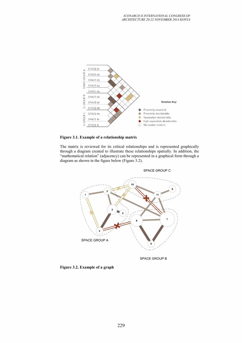
ICONARCH II INTERNATIONAL CONGRESS OF
ARCHITECTURE 20-22 NOVEMBER 2014 KONYA
229
Figure 3.1. Example of a relationship matrix
The matrix is reviewed for its critical relationships and is represented graphically
through a diagram created to illustrate these relationships spatially. In addition, the
“mathematical relation” (adjacency) can be represented in a graphical form through a
diagram as shown in the figure below (Figure 3.2).
Figure 3.2. Example of a graph
SPACE GROUP B
SPACE GROUP A
SPACE GROUP C
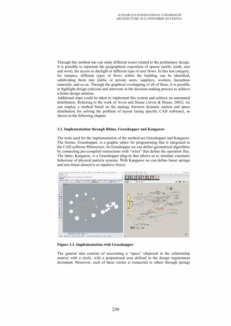
ICONARCH II INTERNATIONAL CONGRESS OF
ARCHITECTURE 20-22 NOVEMBER 2014 KONYA
230
Through this method one can study different issues related to the preliminary design.
It is possible to represent the geographical exposition of spaces (north, south, east
and west), the access to daylight or different type of user flows. In this last category,
for instance, different types of flows within the building can be identified,
subdividing them into public or private users, suppliers, workers, hazardous
materials, and so on. Through the graphical overlapping of all of these, it is possible
to highlight design criticism and intervene in the decision-making process to achieve
a better design solution.
Additional steps could be taken to implement this system and achieve an automated
distribution. Referring to the work of Arvin and House (Arvin & House, 2002), we
can employ a method based on the analogy between dynamic motion and space
distribution for solving the problem of layout (using specific CAD software), as
shown in the following chapter.
3.1. Implementation through Rhino, Grasshopper and Kangaroo
The tools used for the implementation of the method are Grasshopper and Kangaroo.
The former, Grasshopper, is a graphic editor for programming that is integrated in
the CAD software Rhinoceros. In Grasshopper we can define geometrical algorithms
by connecting pre-compiled instructions with “wires” that define the operation flux.
The latter, Kangaroo, is a Grasshopper plug-in that allows us to simulate cinematic
behaviour of physical particle systems. With Kangaroo we can define linear springs
and non-linear attractive or repulsive forces.
Figure 3.3. Implementation with Grasshopper
The general idea consists of associating a “space” (depicted in the relationship
matrix) with a circle, with a proportional area defined in the design requirement
document. Moreover, each of these circles is connected to others through springs
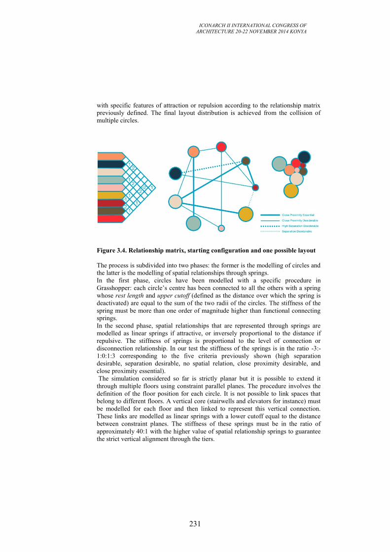
ICONARCH II INTERNATIONAL CONGRESS OF
ARCHITECTURE 20-22 NOVEMBER 2014 KONYA
231
with specific features of attraction or repulsion according to the relationship matrix
previously defined. The final layout distribution is achieved from the collision of
multiple circles.
Figure 3.4. Relationship matrix, starting configuration and one possible layout
The process is subdivided into two phases: the former is the modelling of circles and
the latter is the modelling of spatial relationships through springs.
In the first phase, circles have been modelled with a specific procedure in
Grasshopper: each circle’s centre has been connected to all the others with a spring
whose rest length and upper cutoff (defined as the distance over which the spring is
deactivated) are equal to the sum of the two radii of the circles. The stiffness of the
spring must be more than one order of magnitude higher than functional connecting
springs.
In the second phase, spatial relationships that are represented through springs are
modelled as linear springs if attractive, or inversely proportional to the distance if
repulsive. The stiffness of springs is proportional to the level of connection or
disconnection relationship. In our test the stiffness of the springs is in the ratio -3:-
1:0:1:3 corresponding to the five criteria previously shown (high separation
desirable, separation desirable, no spatial relation, close proximity desirable, and
close proximity essential).
The simulation considered so far is strictly planar but it is possible to extend it
through multiple floors using constraint parallel planes. The procedure involves the
definition of the floor position for each circle. It is not possible to link spaces that
belong to different floors. A vertical core (stairwells and elevators for instance) must
be modelled for each floor and then linked to represent this vertical connection.
These links are modelled as linear springs with a lower cutoff equal to the distance
between constraint planes. The stiffness of these springs must be in the ratio of
approximately 40:1 with the higher value of spatial relationship springs to guarantee
the strict vertical alignment through the tiers.
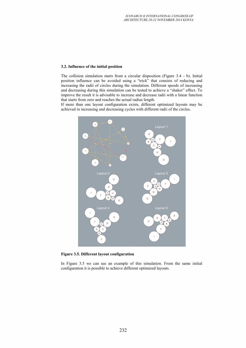
ICONARCH II INTERNATIONAL CONGRESS OF
ARCHITECTURE 20-22 NOVEMBER 2014 KONYA
232
3.2. Influence of the initial position
The collision simulation starts from a circular disposition (Figure 3.4 - b). Initial
position influence can be avoided using a “trick” that consists of reducing and
increasing the radii of circles during the simulation. Different speeds of increasing
and decreasing during this simulation can be tested to achieve a “shaker” effect. To
improve the result it is advisable to increase and decrease radii with a linear function
that starts from zero and reaches the actual radius length.
If more than one layout configuration exists, different optimized layouts may be
achieved in increasing and decreasing cycles with different radii of the circles.
Figure 3.5. Different layout configuration
In Figure 3.5 we can see an example of this simulation. From the same initial
configuration it is possible to achieve different optimized layouts.
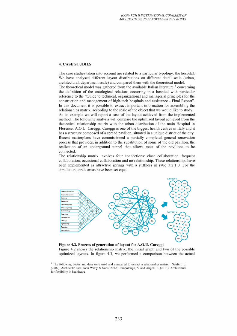
ICONARCH II INTERNATIONAL CONGRESS OF
ARCHITECTURE 20-22 NOVEMBER 2014 KONYA
233
1 The following books and data were used and compared to extract a relationship matrix: Neufert, E.
(2007). Architects' data. John Wiley & Sons, 2012; Campolongo, S. and Angeli, F. (2013). Architecture
for flexibility in healthcare
4. CASE STUDIES
The case studies taken into account are related to a particular typology: the hospital.
We have analysed different layout distributions on different detail scale (urban,
architectural, department scale) and compared them with the theoretical model.
The theoretical model was gathered from the available Italian literature 1 concerning
the definition of the ontological relations occurring in a hospital with particular
reference to the “Guide to technical, organizational and managerial principles for the
construction and management of high-tech hospitals and assistance - Final Report”.
In this document it is possible to extract important information for assembling the
relationships matrix, according to the scale of the object that we would like to study.
As an example we will report a case of the layout achieved from the implemented
method. The following analysis will compare the optimized layout achieved from the
theoretical relationship matrix with the urban distribution of the main Hospital in
Florence: A.O.U. Careggi. Careggi is one of the biggest health centres in Italy and it
has a structure composed of a spread pavilion, situated in a unique district of the city.
Recent masterplans have commissioned a partially completed general renovation
process that provides, in addition to the substitution of some of the old pavilion, the
realization of an underground tunnel that allows most of the pavilions to be
connected.
The relationship matrix involves four connections: close collaboration, frequent
collaboration, occasional collaboration and no relationship. These relationships have
been implemented as attractive springs with a stiffness in ratio 3:2:1:0. For the
simulation, circle areas have been set equal.
Figure 4.2. Process of generation of layout for A.O.U. Careggi
Figure 4.2 shows the relationship matrix, the initial graph and two of the possible
optimized layouts. In figure 4.3, we performed a comparison between the actual
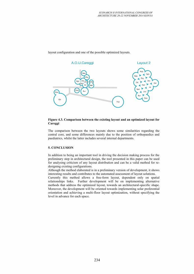
ICONARCH II INTERNATIONAL CONGRESS OF
ARCHITECTURE 20-22 NOVEMBER 2014 KONYA
234
layout configuration and one of the possible optimized layouts.
Figure 4.3. Comparison between the existing layout and an optimized layout for
Careggi
The comparison between the two layouts shows some similarities regarding the
central core, and some differences mainly due to the position of orthopaedics and
paediatrics, whilst the latter includes several internal departments.
5. CONCLUSION
In addition to being an important tool in driving the decision making process for the
preliminary step in architectural design, the tool presented in this paper can be used
for analysing criticism of any layout distribution and can be a valid method for re-
designing existing configurations.
Although the method elaborated is in a preliminary version of development, it shows
interesting results and contributes to the automated assessment of layout solutions.
Currently this method allows a free-form layout, dependent only on spatial
relationships links. Further development will be on implementing alternative
methods that address the optimized layout, towards an architectural-specific shape.
Moreover, the development will be oriented towards implementing solar preferential
orientation and achieving a multi-floor layout optimization, without specifying the
level in advance for each space.
ICONARCH II INTERNATIONAL CONGRESS OF
ARCHITECTURE 20-22 NOVEMBER 2014 KONYA
235
REFERENCES
- Arvin, S. A., & House, D. H. (2002). Modelling architectural design objectives in
physically based space planning. Automation in Construction, 213-225
- Alexander, C. 1964. Notes on Synthesis of Form. Cambridge, Massachusetts,
England: Harvard University Press.
- Broadbent, G. H. (1970). La creatività. In S. A. Gregory, Progettazione razionale.
Padova: Marsilio.
- Coons, S. (1964). Computer Aid Design. First Boston Architectrual Center
Conference. Boston: MIT
- Donato V. 2014. Transformability of Existing Building: a system based on BIM
technologies for the information management, University of Florence and TU
Braunschweig. PhD Thesis, pp. 31-43.
- Do, E. Y.-L., Gross, M. D. .2001. Thinking with diagrams in architectural design.
Artificial Intelligence Review, 15, 135-149.
- Edwards, B. 1979. Drawing on the right side of the brain: A course in enhancing
creativity and artistic confidence. New York: Putnam.
- Kalay, Y. E. 2004. Architecture's New Media - Principle, Theory, and Methods of
Computer-Aided Design. Cambridge, Massachusetts: MIT Press.
- Terzidis, K., & Vakalo, E. (1992). The role of Computers in Architectural Design.
In F. L. Baerle (Ed.), Socio-environmental Metamorphoses: Proceedings 12th
International Conference of the IAPS In Socio-environmental Metamorphoses:
Proceedings 12th International Conference of the IAPS (pp. 186-191). Halkidiki:
Aristotle University Press.
ICONARCH II INTERNATIONAL CONGRESS OF
ARCHITECTURE 20-22 NOVEMBER 2014 KONYA
236
SESSION 5
21 November 2014 Friday, 09.30-10.30
Chairperson: Prof. Dr. Derya OKTAY (Invited Speech)
“The Current Status, Role and
Future of Urban Design” p.237
Research Assistant Derya Adıgüzel ÖZBEK, Research Assistant
Selcen Nur ERİKCİ
“The Redefinition of the City in the Slow City Movement: The Example
of Akyaka in Turkey” p.246
Res. Asst Gozde EKSIOGLU CETINTAHRA, Prof. Dr. Ebru
CUBUKCU
“A New Approach to Identify the Location and Intensity of Physical
Activity in Urban Areas: The Use of Accelerometer and Global
Positioning Systems Data” p.256
ICONARCH II INTERNATIONAL CONGRESS OF
ARCHITECTURE 20-22 NOVEMBER 2014 KONYA
237
THE CURRENT STATUS, ROLE AND FUTURE
OF URBAN DESIGN
DERYA OKTAY1
Introduction Over the past three decades, the advent of a post-industrial economy, the rise of the
environmental movement, and the critique of top-down government decision-
making have called for new approaches, both conceptually and methodologically, to
the design and construction of urban environments. In this context, there appears a
need for a critical urban design framing the increasingly contested terrain of urban
resources and environments that addresses the emerging global trends, complex
urban patterns, and evolving challenges of urbanization (UN Habitat, 2009).
Though urban design is historically embedded in the development of cities, urban
design, as a contemporary theoretical and professional discipline, is relatively new
compared to the associated disciplines of architecture, urban planning, and civil
engineering. Urban design’s close connection with these allied disciplines has also
been the reason for its ambiguous nature, and its muddled definition. Accordingly, it
is claimed here that a re-examination of the definition, status, and role of urban
design is essential for the future directions of urban design and that of cities.
The Current Understanding and Position of Urban Design
As defined in By Design, a guidance manual commissioned by the UK Government
for local authority planners incorporating the conventional approach to good urban
design (ODPM - UK, 2003), “urban design is the art of making places for people…
it concerns the connections between people and places, movement and urban form,
nature and the built fabric, and the processes for ensuring successful villages, towns
and cities”.
On the contrary to its position in the 1980s, the value of urban design has been
widely acknowledged over the last three decades. In the West, it is now well
integrated in the planning system. Urban designers increasingly occupy a central
role in the development and redevelopment of cities. Design professionals with good
urban design knowledge and skills are much sought after by private consulting
firms, development organisations and local and state governments – where they are
required to prepare and evaluate urban design policies, strategies, frameworks,
guidelines, concepts, master plans and programs, as well as be involved in the more
detailed design and management of urban spaces. Urban design knowledge and
skills also assist in designing for specific sites by providing a better appreciation of
urban structure and context.
1Prof. Dr. Faculty of Architecture Ondokuz Mayis University
ICONARCH II INTERNATIONAL CONGRESS OF
ARCHITECTURE 20-22 NOVEMBER 2014 KONYA
238
However, only fairly recently has urban design been identified as a specific
discipline. It encompasses practices which have always had a central place in urban
planning and urban development, though with new techniques and different points
of emphasis related to contemporary issues. The need for such a discipline has arisen
as a result of the fundamental cultural, political, social and economic changes. These
have focused attention on environmental issues and the quality of life, on the nature
of the city and on how urban form can best be adapted to our current and future
needs (Lloyd-Jones 1998).
At present, there are problems with the manner in which urban design is conceived,
practiced and researched. Owing to the emphasis on morphological aspects (physical
aspects of the urban environment), that is the result of the stress on the problematic
effect of negative space, urban design is often regarded as an ambiguous
combination of architecture, urban planning, landscape architecture and civil
engineering. In this context, the qualities of the physical environment are perceived
as being detached from urban use and appropriation as they would be discussed, for
example, by Jacobs (1961) and Alexander (1976), who regard the city primarily as a
place of human habitation. Concentrating on the abstract concept of the spatial
experience rather than on actual day-to-day life has ignored the users and their
functional, social and emotional needs. Thus, although the city is examined and
designed on the implicit basis of human experience, this experience is never
discussed or considered specifically enough to make a difference (Kallus 2001).
Another problem with current urban design thought and practice is the sense that it
has become almost synonymous with ‘architecture at a larger scale’ made up of
building facades or building complexes, or designing ‘objects’ rather than creating
‘places’. In line with this approach, there is too much emphasis on the visual and
contextual dimensions of the townscape, an over-emphasis on the architect as urban
designer and an obsession with design of individual buildings, and not enough
consideration of ‘urban context’ (e.g. how cities work) (Lloyd-Jones 1998, Inam
2002) and building and urban space relationship. Accordingly, the profession has
become very ‘product’ oriented, and the resulted urban environment has failed in
terms of liveability and sense of place.
Even when architects want to take the city into consideration, what precisely they
take into account are mainly the visual aspects; however, it is just as important for
the design to fulfill the physical, social, emotional and spiritual needs of the people
who use the environment. In this context, there are some architects like Ralph
Erskine, Lucien Kroll, Herman Hetzberger who are worth mentioning as they have
contributed through their architecture and writing to designing with people in mind,
through their idiosyncratic approaches to making healthier and happier places for
people to live in.
Another useful distinction of urban design lies in the relationship between the
designer and the designed object. All designers (architect, interior designer,
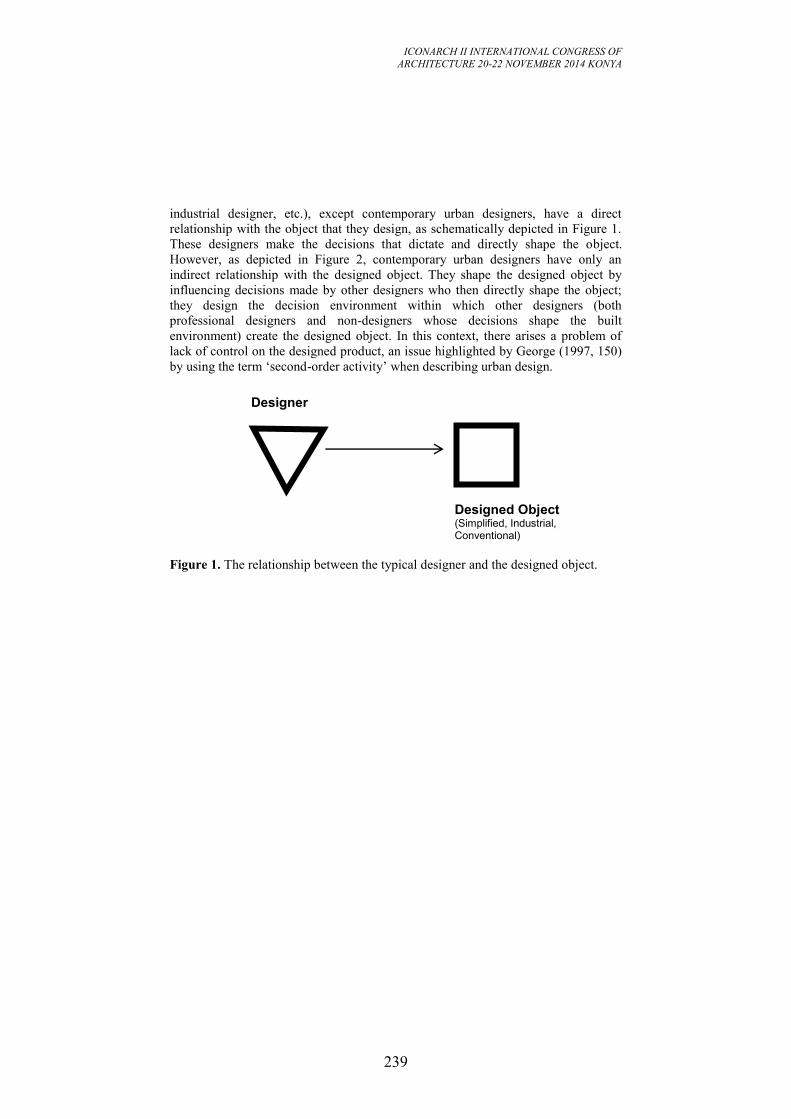
ICONARCH II INTERNATIONAL CONGRESS OF
ARCHITECTURE 20-22 NOVEMBER 2014 KONYA
239
industrial designer, etc.), except contemporary urban designers, have a direct
relationship with the object that they design, as schematically depicted in Figure 1.
These designers make the decisions that dictate and directly shape the object.
However, as depicted in Figure 2, contemporary urban designers have only an
indirect relationship with the designed object. They shape the designed object by
influencing decisions made by other designers who then directly shape the object;
they design the decision environment within which other designers (both
professional designers and non-designers whose decisions shape the built
environment) create the designed object. In this context, there arises a problem of
lack of control on the designed product, an issue highlighted by George (1997, 150)
by using the term ‘second-order activity’ when describing urban design.
Figure 1. The relationship between the typical designer and the designed object.
Designer
Designed Object (Simplified, Industrial, Conventional)
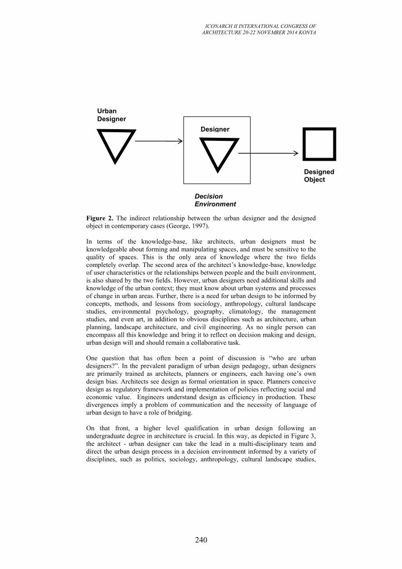
ICONARCH II INTERNATIONAL CONGRESS OF
ARCHITECTURE 20-22 NOVEMBER 2014 KONYA
240
Figure 2. The indirect relationship between the urban designer and the designed
object in contemporary cases (George, 1997).
In terms of the knowledge-base, like architects, urban designers must be
knowledgeable about forming and manipulating spaces, and must be sensitive to the
quality of spaces. This is the only area of knowledge where the two fields
completely overlap. The second area of the architect’s knowledge-base, knowledge
of user characteristics or the relationships between people and the built environment,
is also shared by the two fields. However, urban designers need additional skills and
knowledge of the urban context; they must know about urban systems and processes
of change in urban areas. Further, there is a need for urban design to be informed by
concepts, methods, and lessons from sociology, anthropology, cultural landscape
studies, environmental psychology, geography, climatology, the management
studies, and even art, in addition to obvious disciplines such as architecture, urban
planning, landscape architecture, and civil engineering. As no single person can
encompass all this knowledge and bring it to reflect on decision making and design,
urban design will and should remain a collaborative task.
One question that has often been a point of discussion is “who are urban
designers?”. In the prevalent paradigm of urban design pedagogy, urban designers
are primarily trained as architects, planners or engineers, each having one’s own
design bias. Architects see design as formal orientation in space. Planners conceive
design as regulatory framework and implementation of policies reflecting social and
economic value. Engineers understand design as efficiency in production. These
divergences imply a problem of communication and the necessity of language of
urban design to have a role of bridging.
On that front, a higher level qualification in urban design following an
undergraduate degree in architecture is crucial. In this way, as depicted in Figure 3,
the architect - urban designer can take the lead in a multi-disciplinary team and
direct the urban design process in a decision environment informed by a variety of
disciplines, such as politics, sociology, anthropology, cultural landscape studies,
Designed Object
Designer
Decision Environment
Urban
Designer
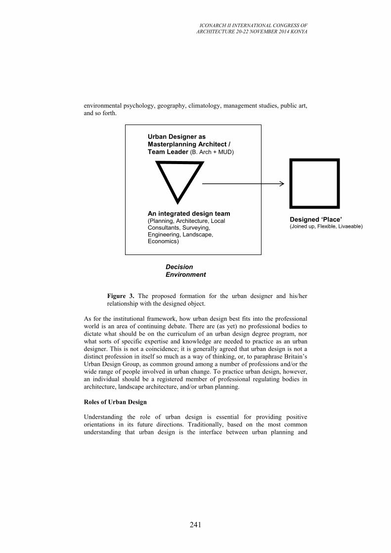
ICONARCH II INTERNATIONAL CONGRESS OF
ARCHITECTURE 20-22 NOVEMBER 2014 KONYA
241
environmental psychology, geography, climatology, management studies, public art,
and so forth.
Figure 3. The proposed formation for the urban designer and his/her
relationship with the designed object.
As for the institutional framework, how urban design best fits into the professional
world is an area of continuing debate. There are (as yet) no professional bodies to
dictate what should be on the curriculum of an urban design degree program, nor
what sorts of specific expertise and knowledge are needed to practice as an urban
designer. This is not a coincidence; it is generally agreed that urban design is not a
distinct profession in itself so much as a way of thinking, or, to paraphrase Britain’s
Urban Design Group, as common ground among a number of professions and/or the
wide range of people involved in urban change. To practice urban design, however,
an individual should be a registered member of professional regulating bodies in
architecture, landscape architecture, and/or urban planning.
Roles of Urban Design
Understanding the role of urban design is essential for providing positive
orientations in its future directions. Traditionally, based on the most common
understanding that urban design is the interface between urban planning and
Designed ‘Place’ (Joined up, Flexible, Livaeable)
Urban Designer as Masterplanning Architect / Team Leader (B. Arch + MUD)
Decision Environment
An integrated design team (Planning, Architecture, Local Consultants, Surveying, Engineering, Landscape, Economics)
ICONARCH II INTERNATIONAL CONGRESS OF
ARCHITECTURE 20-22 NOVEMBER 2014 KONYA
242
architecture, it plays a mediator role between two major disciplines involved in the
urban realm, but at different levels and scales.
The following objectives of the contemporary mainstream approach to urban design
based on the contributions of a number of European and American academics,
theorists and practitioners from the 1950s onwards make it clear what roles a
responsive urban design activity may play: (Lloyd-Jones 2006)
Character and identity: to promote character in townscape and landscape
by responding to and reinforcing locally distinctive patterns of
development, landscape and culture.
Continuity and enclosure: to promote the continuity of street frontages and
the enclosure of space by development that clearly defines private and
public areas.
Quality of the public realm: to promote public spaces and routes that are
public spaces and routes that are attractive, safe, uncluttered and work
effectively for all in society, including disabled and elderly people.
Ease of movement: to promote accessibility and local permeability by
making places that connect with each other and are easy to move through,
putting people before motor car and integrating land uses and transport.
Legibility: to promote legibility through development that provides
recognisable routes, intersections and landmarks to help people find their
way around.
Adaptability: to promote adaptability through development that can respond
to changing social, technological and economic conditions.
Diversity: to promote diversity and choice through a mix of compatible
developments and uses that work together to create viable places that
respond to local needs.
In a widening context, urban designers are now being given new roles being called
upon to address development issues in all types of context, greenfield, suburban and
inner-city and brownfield regeneration, as well as the city centres. ‘Anti-sprawl’or
‘compact’ city models of sustainable, higher-density, mixed-use, permeable
neighbourhoods and centres with well-structured, pedestrian and public-transport
orientated features have been developed for most, if not all these contexts.
Conventional urban design contributes greatly to the policies required to achieve the
sustainable development of rich world cities, most of which are not growing very
much in population but continue to eat up land and natural resources. The
established urban design principles have also proved quite robust in addressing other
aspects of sustainable development in the cities of the developed world, including
quality of life, social inclusion and social integration and identity issues.
ICONARCH II INTERNATIONAL CONGRESS OF
ARCHITECTURE 20-22 NOVEMBER 2014 KONYA
243
Conclusion
Urban design lies at the intersect of the interests of the three main professions
concerned with the layout of the environment – architecture, landscape architecture
and urban planning, and civil engineering. However, urban design while overlapping
these fields has developed its own area of expertise.
Since current urban design thought and practice have recently been dominated by
the visual and contextual understanding of the townscape, and in many cases has
become almost synonymous with ‘architecture at a larger scale’, there is a need for a
paradigmatic shift in the focus of urban design from the current model of urban
design framework, where the social control, economic efficiency, and spatial order
are compartmentalized. The focus on understanding urban, on the contrary, requires
an adaptive inclusive model that addresses relational issues among multiple
dimensions of urban design and the urban environment. In brief, a dynamic multi-
dimensional viewpoint is required which combines political, environmental,
economic and cultural aspects of urban design and development in the changing of
the city.
As these deliberations suggest, we should be aware of the fact that “urban design is
different from architecture!”. It requires additional skills and knowledge of the urban
context. Further, there is a need for urban design to be informed by concepts,
methods, and lessons from sociology, anthropology, cultural landscape studies,
environmental psychology, geography, climatology, the management studies, and
even art, in addition to obvious disciplines such as architecture, urban planning,
landscape architecture, and civil engineering. As no single person can encompass all
this knowledge and bring it to reflect on decision making and design, urban design
will and should remain a collaborative task.
The problem of communication between architects, who see design as formal
orientation in space, and planners, who have problems with the language of design,
compels the necessity of language of urban design to have a role of bridging. On that
front, a higher level qualification in urban design following an undergraduate degree
in architecture is crucial. Such a formation would also enable the architect to
develop interdisciplinary critical skills to build better places, and acquire the role of
the ‘masterplanning architect’ within an integrated design team.
If urban design is to have any impact at all on ill-planned sprawling development in
many world cities in a fast changing context, it needs to look to a wider landscape
understanding of character and identity, to relationships between built form that are
not exclusively focused on continuity and enclosure; to consider more accessible
and communicative city and legibility beyond the street environment, roads and
public transport interchanges; to give much greater concern to the legibility of the
urban and suburban landscape; and to focus on the requirements of sustainable
urbanism for safeguarding the natural, built and cultural values in our cities.
ICONARCH II INTERNATIONAL CONGRESS OF
ARCHITECTURE 20-22 NOVEMBER 2014 KONYA
244
REFERENCES
Batchelor, P. & Lewis, D. (Eds.), Urban Design in Action. Raleigh NC: School of
Design, North Carolina State University, 1986.
Bentley, I. et al., Responsive Environments: A Manual for Designers, Architectural
Press, London, 1985.
Cullen, G., The Concise Townscape, Butterworth Architecture, London, l971.
ODPM - UK, By Design: Urban Design in the Planning System - Towards Better
Practice, Commission for Architecture & the Built Environment, 2003.
Greed, C., “Definitions and Perceptions of Urban Design”, Introducing Urban
Design: Interventions and Responses (Eds: C. Greed & M. Roberts), Pearson
Education, Essex, 1998, pp. 3-14.
George, R. V., “A Procedural Explanation for Contemporary Urban Design”,
Journal of Urban Design, Vol. 2, No. 2, June 1997, pp. 143-162.
Inam, A., “Meaningful Urban Design: Teleological/Catalytic/Relevant”, Journal of
Urban Design, Vol. 7, No. 1, 2002, pp. 35-58.
Jacobs, J., The Death and Life of Great American Cities, Random House, New
York, l961.
Kallus, R., “From Abstract to Concrete: Subjective Reading of Urban Space”,
Journal of Urban Design, Vol. 6, No. 2, 2001, pp. 129-150.
Karaman, A., Kentsel Tasarım: Kuramlar, İlkeler, Roller, Mimar.Ist, Vol. 8, No. 3,
2008, pp. 34-42.
Lang, J., Urban Design: A Typology of Procedures and Products, Architectural
Press, Oxford, 2005.
Lifchez, R. “Designing with People in mind”, Journal of Architecture and Planning
Research, Special Issue, XXXV (1), 36-40.
Lloyd-Jones, T., “The Scope of Urban Design”, Introducing Urban Design, 1998,
pp. 15-35.
Lynch, K. A Theory of Good City Form, The MIT Press, Cambridge, Mass,1971.
Madanipour, A., “Ambiguities of Urban Design”, Town Planning Review, Vol. 68,
No.3, pp. 363-383.
Oktay, D., ‘Kentsel Tasarım ve Kamusal Alan: Kavram, Uygulama ve Eğitim
Bağlamında Değerlendirmeler, Mimar.Ist, Vol. 8, No. 3, 2008, Sayı 28, pp. 50-
57.
Oktay, D., “Architectural Education and Social Perspectives: Establishing The
Human Context of Everyday Urban Life through Design Studios”, The Oxford
Conference: 50 years on: Re-setting the Agenda for Architectural Education,
Oxford, July 2008.
Oktay, D., “Urban Design for Sustainability: A Study on the Turkish City”,
International Journal of Sustainable Development and World Ecology. Vol. 11,
March 2004, pp. 24-35.
Rossi, A. The Architecture of the City, MIT Press, Cambridge, Mass., 1982
Schurch, T. W., “Reconsidering Urban Design: Thoughts about its Definition and
Status as a Field or Profession”, Journal of Urban Design, Vol. 4, No. 1, 1999,
pp. 5-28.

ICONARCH II INTERNATIONAL CONGRESS OF
ARCHITECTURE 20-22 NOVEMBER 2014 KONYA
245
Thomas, L., “Urban Design and Architecture are not the same thing - the context is
changing”, The Oxford Conference: 50 years on / Resetting the Architectural
Agenda for Architectural Education, Oxford, July 2008.
UN Habitat (United Nations Centre for Human Development) – www.unhabitat.org
ICONARCH II INTERNATIONAL CONGRESS OF
ARCHITECTURE 20-22 NOVEMBER 2014 KONYA
246
THE REDEFINITION OF THE CITY IN THE SLOW CITY
MOVEMENT: THE EXAMPLE OF AKYAKA IN TURKEY
DERYA ADIGÜZEL ÖZBEK1
SELCEN NUR ERİKCİ2
ABSTRACT
Slow city is a way of life that cultural richness and quality of life are preserved and
defended in the city's local scale. Also, it is an urban model which may prevent in
the standardization of lifestyles to achieve environmentally-conscious and tourism-
based local development. Thus, its purpose is to improve the quality of life in cities
and it is opposed to the homogenization of cities. Contrary to the global, the
forefront of locality is to support the local production and producers. The slow city
movement, which is basically included the critique of rapid consumption in cities, is
required to query with a critical perspective that the process of getting of the title
and developments after this process for the accurately detected and implementation.
In the context of this study is discussed as a case study of Akyaka in Turkey which
is the slow city title in 2010. The situation before taking the title of a slow city, the
process of getting the title and subsequent developments of the Akyaka will be
analyzed with the critical bibliography method by the review of the literature, the
visual and written media news. The processes of slow city and after the
changes/improvements of Akyaka are discussed.
Key words: Environments, Slow Food, Slow City Movement (CittaSlow), Speed,
Locality.
1. INTRODUCTION
Cities are organisms into their social, economic and cultural dynamics. Today, they
are becoming undefined places that have lost cultural, local and environmental
values rapidly under the rule of advancing technology, globalization processes and
the capitalist system.
Countries that have disappeared the boundaries between the other ones with the
globalization process and advancing technology form the cornerstones of the
economic system with their big cities. This issue needs to emphasize clearly with its
advantages and disadvantages that new concepts and formations are sitting instead
of changing milestones in the transformation process. From now on, the examples
are increasing such as city economies that are independent and cosmopolitan
concepts. A change in the balance is considered as a transformation of globalization
1 Research Assistant. İstanbul Kültür University, Department of Interior Architecture and Environmental
Design, İstanbul 2 Research Assistant. Yeni Yüzyıl University, Department of Interior Architecture, İstanbul
ICONARCH II INTERNATIONAL CONGRESS OF
ARCHITECTURE 20-22 NOVEMBER 2014 KONYA
247
process such as power not coming from the country, coming from the city-owned.
However in economy a structure, occurs outside of based on the industry or
agricultural, based on the global information technology and accordingly cities
transform to focusing on production/consumption spaces.
As a result of constant change and development of consumption patterns, cities
become a part of these changes and transformations continuously. These structures
that are forced to enter into the one distinct mold especially by the globalization
process and constitute more places than all other economic and political activities,
has been faced various problems such as the loss of local-cultural characteristics. All
these city structures cause to perceive a single space, culture or center assessment of
the planned formation of the world. However, each city's has own socio-cultural
structure, historical process, residents, local amenities and activities. Combination of
conventional production methods and unconscious consumption is emergency for
today's world/cities. Communication types such as media convey the destruction by
fast life and in parallel with excessive and faster consumption than ever seen.
Improving the quality of urban life and local properties taking place into urban
spaces outside of global structures should be the priority targets. Precisely at this
point on a global food brand, which is considered the world's largest cities in the
main square in Rome, was born as a reaction to a shop that started as a continuation
of slowfood Cittaslow movement occurred in the organization. Cittaslow refers to
"Slow City" that consists of an Italian word Citta (city) and an English word Slow.
Cittaslow is a city union born from Slow Food movement that prevents to
standardize of the texture, calmness and life style of cities and eliminate the local
characteristics by globalization (Miele, 2008; Radstrom, 2011). In this respect, the
slow life aims to protect and remove the local. Increasing the access conditions to
future generations what we have in world order and adopting the sensitive
understanding to nature and environment are basic goals and principles.
2. THE MOVEMENT OF CREATING AN URBAN INITIATIVE:
CITTASLOW
Environmental issues and correspondingly source problems are known at the top
rates. The increase in imbalances between production and consumption reduces the
constructs of self-sufficient city. At this point, a Japanese approach "Kaizen" can be
given an example for evaluating all the world as a whole, further support of
production and paving the way for the improvement of urban spaces. “Kaizen”
means small but steady steps to progress. The main objectives of member cities in
the Cittaslow movement are based on it. "Slow" is not a trend, contrary should be a
philosophy. An effort must be permanent and meaningful identity which melting in
pots of the changes' and transformations' state of being "slow" in developing world.
The main goal of "Slow City Movement" is blending today's and tomorrow's
opportunities by taking advantage of the prior cultural heritage and knowledge. In
this goal, the city's air, water, soil cleaning, the food’s local and organic and
distinctive local architecture of the city are listed as being environmentally friendly.
Especially in harmony with nature and eco-friendly systems is very important to use
ICONARCH II INTERNATIONAL CONGRESS OF
ARCHITECTURE 20-22 NOVEMBER 2014 KONYA
248
without causing damage. The application to the urban fabric should be based on
taking advantage of technology and keeping in mind the historical and ecological
structure. Happy structures can be obtained by constructing more humane and
livable spaces in slow cities unlike the chaotic and stress-installed metropolitan ones
and own their own value and features.
Slow City movement is created in the framework of saving us into the mold that the
globalization forced us as a single type of person model and protecting the local
values. (Eskicioğlu, 2009) For these purposes, cities have to set goals to achieve in 7
topics 59 main criterias and 3 specific conditions listed below and begin working in
these areas (Web 1). These are the main 7 topics classified by criteria:
1. Environmental Policies
2. Infrastructural Policies
3. Activities for Increasing the Urban Quality Benefiting from the
Technologies
4. Supporting Local Product and Production
5. Hospitality
6. Awareness
7. Supporting the Slow Food Activities and Projects.
Each city have its own internal dynamics and a structure of life. It is just a
kind of machine that has melting the wheels inside and not capturing the
interventions such as adding, editing etc. However, each settlement, ideally as part
of a whole, in accordance with basic principles of CittaSlow movement provides;
• production is primarily local, but globally connected
• quality is maintained by feedback, ratings and reviews
• mechanisms for public reputation are the principal means of social control
• ‘real costs’ – social and environmental – guide people’s consumption
(Alexander, 2002).
All of these transformations are considered important in the realization of the public
to embrace within the Cittaslow movement. Chaotic and complex states will breed
as a result of any kind of discourse or activism secretive by the public. In this
respect, Cittaslow is a movement to fed by a contemporary municipalize through a
common platform for all activities in the public's conscious. In this movement an
understanding should be based on the word of Hz. Mevlana Celaleddin-i Rumi. "Be
patient, because how countryside laugh if not clouds cry? Do not be hasty. Accessed
to purpose patiently, not in a hurry. Ordinary herbs grow within two months, but red
rose grows in a year. Even food is cooking in pot slowly and subtle more delicious
than simmering crazy.” It must be associated with not slowness, laziness, weakness
and inability, on the contrary, with calmness, production and use on-site. Due to
base on human and humane life in basically, sustainability should be ensured by
controlling every single step's tightly and constantly.
The location of cities surveyed in slow motion is also important. The factors that
determine this location are;
- The city's local networks
- Trading links with the city/ turnover
- Daily lives of residents and way of life.
ICONARCH II INTERNATIONAL CONGRESS OF
ARCHITECTURE 20-22 NOVEMBER 2014 KONYA
249
All these sub-factors come together, when considered as a whole, will reinforce the
basic structure of the city by moving slowly existing studies.
These factors include "Slow City Movement" scale should be supported by a variety
of inferences. In this way, life and philosophy are blended together. Production
constitutes one of the main points of the moving-consumer relationship and the
local-global balance should be determined by a variety of preliminary research. Life
planning within the city-campus problematic, "slow" should be considered and
should be adopted within the framework of the concept of living people. Things to
propose and experiment with "local" concept underlining, priority should be listed
principles to create Akyaka example.
3. A CRITICAL APPROACH TO SLOW CITY: AKYAKA EXAMPLE
Turkey met to this movement for the first time in November 2009 with the
announcement of Seferihisar's being Cittaslow. In 2010, the town of Akyaka, Muğla
started to increase with the number of members. Cittaslow movement for the
implementation of the right may not be detected until after the title of the
developments in the process of getting a critical need to inquire. One of the main
criticisms of Cittaslow is that the criteria have not been carry for country's specific
features. In this context local-cultural, social structure should be much stronger by
adding country-specific criteria. Studies have been started to be carried out to
determine what criteria would be for Turkey (Web 13). Akyaka was given the title
of Cittaslow in 2010, Turkey examined as a case study both for contributing the
determination of these criterias and the implementation its' local level perception
and contribution to the city. The most significant features of Akyaka are being
Special Environmental Protection Area and its biodiversity. Also wooden houses
make Akyaka special that were designed the typical Muğla-Ula architecture by Nail
Çakırhan and have traditional lines.
The study was structured in two phases. In the first step; Akyaka cittaslow state
before taking the title, title-making process and review of the literature relating to
developments in the post, were analyzed by the method of critical biblografy over
the news in the visual and written media. In the second stage; analysis of the data by
going to the region in line with the results of observations were made.
3.1. Location and physical properties of Akyaka
Akyaka, located in the north-eastern corner of the Gulf of Gökova, is a fertile plain
between Kadın and Akçapınar River Branches. At the same time it has a specific
geography with isolated bays opened to the Gulf of Gökova. It is in a natural
protected area next to the Statute of the Special Environmental Protection with these
features and hosted the variety of life. One of the two rivers in determining position
of geography, Kadınlar River Branch constitutes a natural aquarium for diving with
its under water plant population and high flow rate. Akçapınar, other stream, creates
a long coastline between the sea. Alternative extreme sports are also popular such as
kona between two streams, kite-skiing, paragliding double, motorized water sports
(Bilgi, 2013; Sungur, 2013). Akyaka's vision is respect for nature, protecting of
architectural structure, strong infrastructure service, sustainable and alternative
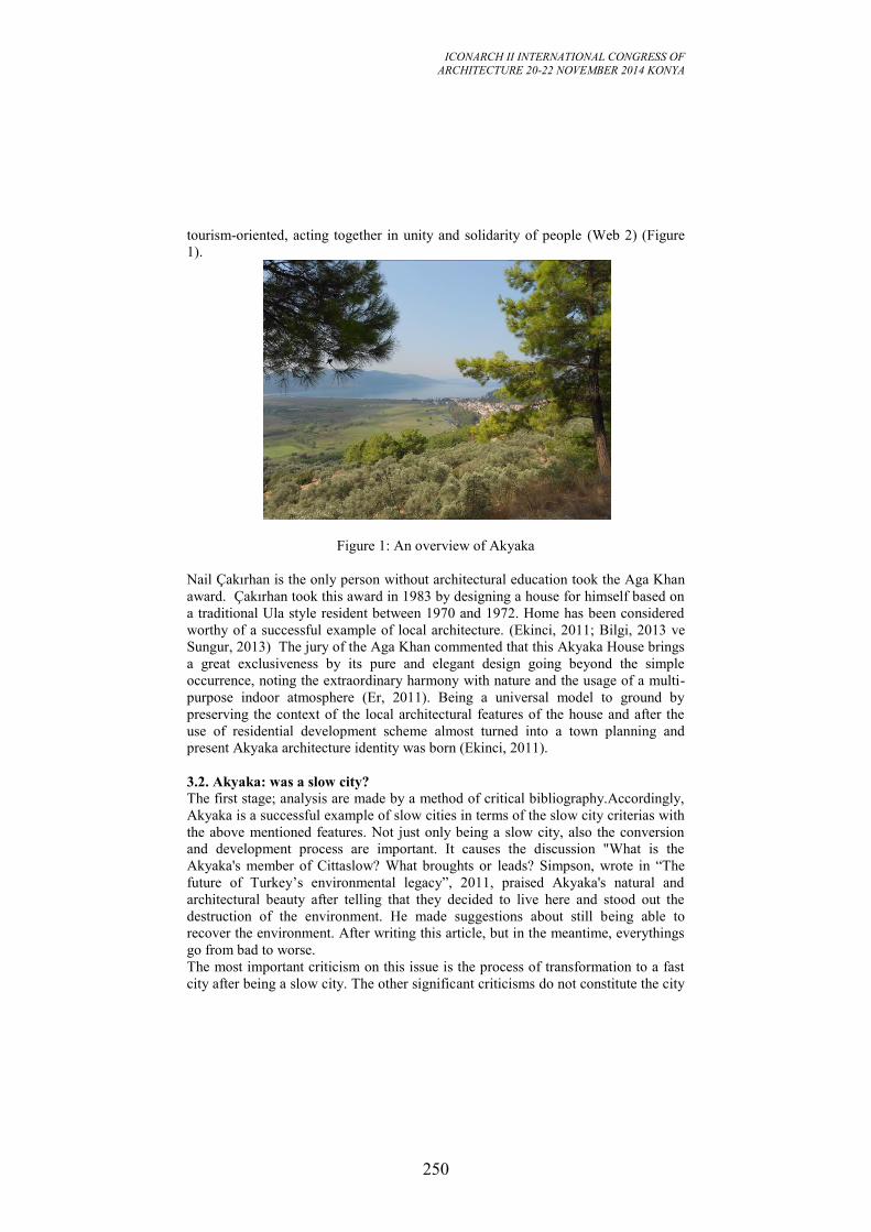
ICONARCH II INTERNATIONAL CONGRESS OF
ARCHITECTURE 20-22 NOVEMBER 2014 KONYA
250
tourism-oriented, acting together in unity and solidarity of people (Web 2) (Figure
1).
Figure 1: An overview of Akyaka
Nail Çakırhan is the only person without architectural education took the Aga Khan
award. Çakırhan took this award in 1983 by designing a house for himself based on
a traditional Ula style resident between 1970 and 1972. Home has been considered
worthy of a successful example of local architecture. (Ekinci, 2011; Bilgi, 2013 ve
Sungur, 2013) The jury of the Aga Khan commented that this Akyaka House brings
a great exclusiveness by its pure and elegant design going beyond the simple
occurrence, noting the extraordinary harmony with nature and the usage of a multi-
purpose indoor atmosphere (Er, 2011). Being a universal model to ground by
preserving the context of the local architectural features of the house and after the
use of residential development scheme almost turned into a town planning and
present Akyaka architecture identity was born (Ekinci, 2011).
3.2. Akyaka: was a slow city? The first stage; analysis are made by a method of critical bibliography.Accordingly,
Akyaka is a successful example of slow cities in terms of the slow city criterias with
the above mentioned features. Not just only being a slow city, also the conversion
and development process are important. It causes the discussion "What is the
Akyaka's member of Cittaslow? What broughts or leads? Simpson, wrote in “The
future of Turkey’s environmental legacy”, 2011, praised Akyaka's natural and
architectural beauty after telling that they decided to live here and stood out the
destruction of the environment. He made suggestions about still being able to
recover the environment. After writing this article, but in the meantime, everythings
go from bad to worse.
The most important criticism on this issue is the process of transformation to a fast
city after being a slow city. The other significant criticisms do not constitute the city
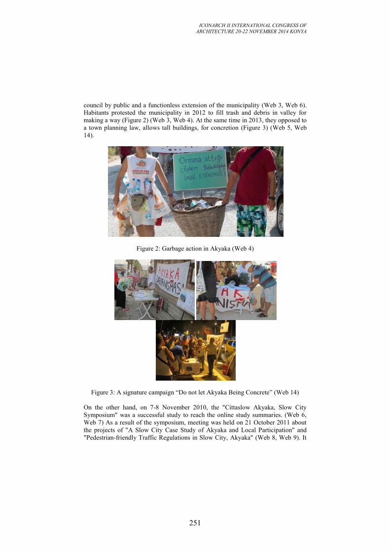
ICONARCH II INTERNATIONAL CONGRESS OF
ARCHITECTURE 20-22 NOVEMBER 2014 KONYA
251
council by public and a functionless extension of the municipality (Web 3, Web 6).
Habitants protested the municipality in 2012 to fill trash and debris in valley for
making a way (Figure 2) (Web 3, Web 4). At the same time in 2013, they opposed to
a town planning law, allows tall buildings, for concretion (Figure 3) (Web 5, Web
14).
Figure 2: Garbage action in Akyaka (Web 4)
Figure 3: A signature campaign “Do not let Akyaka Being Concrete” (Web 14)
On the other hand, on 7-8 November 2010, the "Cittaslow Akyaka, Slow City
Symposium" was a successful study to reach the online study summaries. (Web 6,
Web 7) As a result of the symposium, meeting was held on 21 October 2011 about
the projects of "A Slow City Case Study of Akyaka and Local Participation" and
"Pedestrian-friendly Traffic Regulations in Slow City, Akyaka" (Web 8, Web 9). It
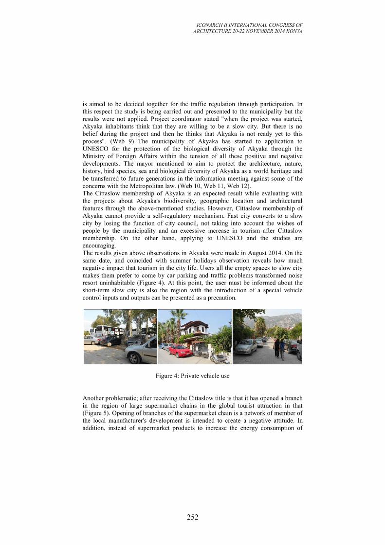
ICONARCH II INTERNATIONAL CONGRESS OF
ARCHITECTURE 20-22 NOVEMBER 2014 KONYA
252
is aimed to be decided together for the traffic regulation through participation. In
this respect the study is being carried out and presented to the municipality but the
results were not applied. Project coordinator stated "when the project was started,
Akyaka inhabitants think that they are willing to be a slow city. But there is no
belief during the project and then he thinks that Akyaka is not ready yet to this
process". (Web 9) The municipality of Akyaka has started to application to
UNESCO for the protection of the biological diversity of Akyaka through the
Ministry of Foreign Affairs within the tension of all these positive and negative
developments. The mayor mentioned to aim to protect the architecture, nature,
history, bird species, sea and biological diversity of Akyaka as a world heritage and
be transferred to future generations in the information meeting against some of the
concerns with the Metropolitan law. (Web 10, Web 11, Web 12).
The Cittaslow membership of Akyaka is an expected result while evaluating with
the projects about Akyaka's biodiversity, geographic location and architectural
features through the above-mentioned studies. However, Cittaslow membership of
Akyaka cannot provide a self-regulatory mechanism. Fast city converts to a slow
city by losing the function of city council, not taking into account the wishes of
people by the municipality and an excessive increase in tourism after Cittaslow
membership. On the other hand, applying to UNESCO and the studies are
encouraging.
The results given above observations in Akyaka were made in August 2014. On the
same date, and coincided with summer holidays observation reveals how much
negative impact that tourism in the city life. Users all the empty spaces to slow city
makes them prefer to come by car parking and traffic problems transformed noise
resort uninhabitable (Figure 4). At this point, the user must be informed about the
short-term slow city is also the region with the introduction of a special vehicle
control inputs and outputs can be presented as a precaution.
Figure 4: Private vehicle use
Another problematic; after receiving the Cittaslow title is that it has opened a branch
in the region of large supermarket chains in the global tourist attraction in that
(Figure 5). Opening of branches of the supermarket chain is a network of member of
the local manufacturer's development is intended to create a negative attitude. In
addition, instead of supermarket products to increase the energy consumption of
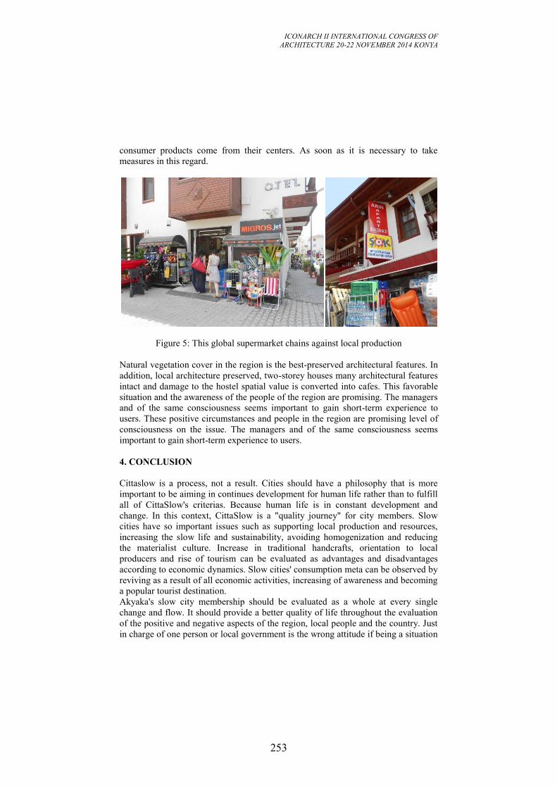
ICONARCH II INTERNATIONAL CONGRESS OF
ARCHITECTURE 20-22 NOVEMBER 2014 KONYA
253
consumer products come from their centers. As soon as it is necessary to take
measures in this regard.
Figure 5: This global supermarket chains against local production
Natural vegetation cover in the region is the best-preserved architectural features. In
addition, local architecture preserved, two-storey houses many architectural features
intact and damage to the hostel spatial value is converted into cafes. This favorable
situation and the awareness of the people of the region are promising. The managers
and of the same consciousness seems important to gain short-term experience to
users. These positive circumstances and people in the region are promising level of
consciousness on the issue. The managers and of the same consciousness seems
important to gain short-term experience to users.
4. CONCLUSION
Cittaslow is a process, not a result. Cities should have a philosophy that is more
important to be aiming in continues development for human life rather than to fulfill
all of CittaSlow's criterias. Because human life is in constant development and
change. In this context, CittaSlow is a "quality journey" for city members. Slow
cities have so important issues such as supporting local production and resources,
increasing the slow life and sustainability, avoiding homogenization and reducing
the materialist culture. Increase in traditional handcrafts, orientation to local
producers and rise of tourism can be evaluated as advantages and disadvantages
according to economic dynamics. Slow cities' consumption meta can be observed by
reviving as a result of all economic activities, increasing of awareness and becoming
a popular tourist destination.
Akyaka's slow city membership should be evaluated as a whole at every single
change and flow. It should provide a better quality of life throughout the evaluation
of the positive and negative aspects of the region, local people and the country. Just
in charge of one person or local government is the wrong attitude if being a situation
ICONARCH II INTERNATIONAL CONGRESS OF
ARCHITECTURE 20-22 NOVEMBER 2014 KONYA
254
of "good" does not occur or slow city quickly converts into "fast" city. These actors
are;
* Seen as a means of profit – Akyaka
* Brandization of slow urban concept corrupting
* Remains silent to misleading practices for their own interests
* Users with the mentality of "The snake, which touched to me, thumbs up
thousands"
But getting the title of slow city and ensuring the continuity are seen as important
steps despite all faults and criticisms. Also applying to UNESCO will contribute to
the resolution of issues quickly. Also gaining experience in Akyaka is an example
for other slow city candidates in our country. Thus an increase in the number of slow
cities in our country contributes to urbanity in terms of social, economic, cultural,
spatial, ecological and so on and cities that have high quality life.
Enough knowledge and understanding for the improvement of sustainable
development and local tourism and local production are one of the priority issues.
Also they are expected to improve in the scale of Turkey's Slow City Movement.
Component and knowledge that come from history, supported by new technological
applications, are expected to articulation to this movement. The factors such as food
security, development of local markets, environmental compliance, orderly and safe
traffic flow, energy saving planning can be listed at the first-stage and separate
themselves from other metropolitan cities. At this point, a situation occurs such as
these Slow City spaces' connecting to global without any need of metropolis. A
separate economic, law and management mechanism system within the progressive
process are the most stunning developments for these small spaces. This
development is not valid for most of the governments, but will have the opportunity
in the future.
REFERENCES
- Alexander, G. 2002. eGaia: Growing a Peaceful Sustainable Earth through
Communications. (2.nd ed.). Lighthouse Books.
- Bilgi, M. G. 2013. Permacultural Conservation, Planning, Management and
Educational Practices in the Cittaslow of Turkey, Selçuk Üniversitesi Sosyal
Bilimler Enstitüsü Dergisi 29, 45-59.
-Ekinci, O. 2011. Akyaka’da ‘Çakırhan’la , Cumhuriyet Gazetesi, 3 Kasım 2011.
-Er, A. 2011. Salyangoz Hızında Yaşamak, National Geographic Türkiye, Aralık,
128: 116-119.
-Eskicioğlu, H. 2009. Modern Yaşam ile Geleneksel Yaşam Arasında Kaliteli Bir
Yaşam Biçimi-Yavaş Şehirler: http://www.izmirdesanat.org/yavas-sehirler
-Radstrom, S. 2011. A Place Sustaining Framework for Local Urban Identity: an
Introduction and History of Cittaslow, Journal of Planning 1, (1) pp.90-113.
-Simpson, S.J.A. 2011. The future of Turkey’s environmental legacy
http://www.todayszaman.com/newsDetail_getNewsById.action?load=detay&newsI
d=254787&link=254787 (accessed September 09, 2013)
ICONARCH II INTERNATIONAL CONGRESS OF
ARCHITECTURE 20-22 NOVEMBER 2014 KONYA
255
-Sungur, Z. 2013. Türkiye'nin Sakin Şehirlerindeki Kadın Girişimciliğine Sosyolojik
Bir Bakış, Internationl Euroasian Economies Conference, St. Petersburg- Rusya:
641-648.
-Miele, M. 2008. Cittaslow: Producing Slowness against the Fast Life, Space and
Polity, 12(1), pp.135-156.
-Web 1: CittaSlow International Charter, CittaSlow Headquarters, Orvieto. (date of
connection: 2013).
-Web 2: http://v3.arkitera.com/news.php?action=displayNewsItem&ID=50111
(accessed August 19, 2013)
-Web3:http://www.haberler.com/sakin-sehir-akyaka-da-cop-eylemi-yapildi-
3923791-haberi/ (accessed August 07, 2013)
-Web 4: http://www.akdenizim.net/guncel/sakin-sehir-akyakada-cop-eylemi-yapildi-
h12949.html (accessed September 17, 2013)
-Web 5:
http://toplumunsehircilikhareketi.org/index.php?option=com_content&view=article
&id=270%3Ayava-ehir-akyakay-betonlatracak-
plan&catid=1%3Ahaberler&Itemid=27 (accessed August 07, 2013)
-Web 6: http://akyakaninsesi.blogspot.com/2013/05/akyakaunescoya-basvuruyor-
hoca.html (accessed September 17, 2013)
-Web 7: http://www.akyakakentkonseyi.org.tr/cittaslow/sempozyum-sunum-
ozetleri.pdf (accessed August 12, 2013)
-Web 8: http://www.akyakakentkonseyi.org.tr/?p=147 (accessed August 12, 2013)
-Web 9:
http://www.akyakakultursanat.com/haberler/bizden/haber_devam.asp?id=126
(accessed August 12, 2013)
-Web 10:http://www.yapi.com.tr/Haberler/akyaka-unescoya-bir-adim-daha-
yaklasti_108237.html
-Web 11:
http://www.cnnturk.com/2013/yasam/01/13/sakin.kent.akyaka.unescoya.basvuracak/
692391.0/index.html (accessed August 19, 2013)
-Web 12: http://www.arkitera.com/haber/index/detay/akyaka-unesco-dan-koruma-
istedi/11628 (accessed August 19, 2013)
-Web 13: http://www.cittaslowturkiye.org/haberler/139-cittaslowda-ulke-kriterleri-
uygulamasi-basladi.html (accessed September 19, 2013)
-Web 14: http://akyakaninsesi.blogspot.com/2013/08/akyakann-betonlasmasna-kars-
imza.html (accessed September 17, 2013),
ICONARCH II INTERNATIONAL CONGRESS OF
ARCHITECTURE 20-22 NOVEMBER 2014 KONYA
256
A NEW APPROACH TO IDENTIFY THE LOCATION AND
INTENSITY OF PHYSICAL ACTIVITY IN URBAN AREAS:
THE USE OF ACCELEROMETER AND GLOBAL
POSITIONING SYSTEMS DATA
GOZDE EKSIOGLU CETINTAHRA1, EBRU CUBUKCU2
ABSTRACT
Recent studies showed that physical inactivity leads to chronic diseases and death.
Various practices and policies, which have been discussed to promote physical
activity, require information about the barriers of physical activity. Research focused
on not only biological, social and psychological characteristics but also physical
environment characteristics as barriers of physical activity. Yet, which and how
physical environmental characteristics affect individual’s physical activity is still
unknown (as research on physical environment characteristics produced
contradictory findings). Methodological differences may have led to such
contradictory findings. Subjective and objective methods have been used to identify
people’s physical activity levels. Subjective methods (such as self-report, face to
face interviews and telephone surveys) tend to produce semi-reliable data which is
based on personal declaration. Objective observation methods, such as physical
activity monitors, have been acknowledged to produce more reliable data.
Accelerometer, a kind of physical activity monitor, sorts and stores intensity of
physical activity (sedentary, light, moderate and vigorous physical activity
parameters) with reference to date, time and activity counts. Although,
accelerometers fail to reveal information about the location of the activity, combined
data of accelerometer and Global Positioning Systems (GPS) provides this
information. The present study aims to introduce a new methodology to map the
location where children are active and inactive. 51 children (9-12 years old), who
were attending sportive activities in a private Sport School in Izmir, volunteered to
participate. Information about the intensity of their physical activity was collected
via accelerometer (Actigraph wGT3X-BT) and information about where their
activities took place was collected via GPS (Qstarz Travel Recorder XT).
Participants were asked to wear the devices for 7 days (5 week days, 2 weekend
days). Accelerometer data analyzed with ActiLife software, and the GPS data
analyzed with Qstarz Data Viewer software. The data were matched and combined
via ArcGIS. Based on the combined data participants’ physical activity intensities
were mapped.
Keywords : Physical activity, accelerometer, global positioning systems.
1 Res. Asst. Dokuz Eylul University, Department of City and Regional Planning, IZMIR
2 Prof. Dr. Dokuz Eylul University, Department of City and Regional Planning, IZMIR
ICONARCH II INTERNATIONAL CONGRESS OF
ARCHITECTURE 20-22 NOVEMBER 2014 KONYA
257
1. INTRODUCTION
World Health Organization announced that childhood obesity is a global public
health problem (WHO, 2014) that could penetrate to next generations. Childhood
obesity causes chronic diseases and death (Stettler et al., 2002). Sixty minutes of
moderate to vigorous physical activity at least 3 days per week (USDHHS, 2008) is
recommended to prevent obesity. However, research showed that high proportion of
population could not achieve this recommended amount of physical activity in their
daily life (CDC, 2002). Therefore, identifying the barriers of physical activity is
necessary.
One barrier that prevents a child to be physically active is physical environmental
characteristics (Burdette & Whitaker, 2005; Ewing et al. 2003; Frank et al. 2004;
French et al. 2001; Hill et al. 2003; Lopez, 2004; Saelens et al. 2002; Saelens et al.
2003). Presence of mixed land use in the neighborhood (Dunton et al. 2013),
presence of urban parks, playgrounds, and sports clubs in the neighborhood
(Brodersen et al. 2005; Coombes et al. 2013; Dunton et al. 2013; Mackett et al.
2007; Quigg et al. 2010; Timperio et al. 2004; Tucker et al. 2009; Van Sluijs et al.
2011; Wheeler et al. 2010;), distances between the house and various amenities
(CDC, 2002; Hume et al. 2007; Kemperman & Timmermans, 2011), the level of
traffic safety on the neighborhood streets (Hume et al. 2009; Timperio et al. 2004;
Trapp, et al., 2012; Ziviani et al. 2004) and presence of active trasportation
opportunities in the neighbourhood (Cooper et al. 2005; Tomson et al. 2003; Ford et
al. 2007; Davison et al. 2008; Loucaides & Jago, 2008; Southward et al. 2012) have
been listed as the physical environmental characteristics that may effect the level of
children's physical activity. Although majority of research showed a significant
effect of those variables on physical activity, few did not. This contradictory
findings may stem from methodological differences in measuring physical activity.
Thus it is necessary to discuss the potential advantages and disadvantages of various
measures of physical activity. Recent studies investigated children's physical
activity intensity via either subjective or objective measures. This study used both
measures to compare advantages and disadvantages.
Moreover, majority of research focused on the physical environmental
characteristics in the close vicinity of the child’s house (or the neighbourhood).
However, common knowledge suggests that a child could be active beyond the
neighborhood unit. In paralel, Yin et al. (2013) highlighted the fact that children's
physical activity cannot be limited to close vicinity around their houses or well
defined bordered areas. Given that, this study aims to discuss a methodology to map
the locations where children are active and inactive. Such methodological
improvements would pave the way to analyze the physical environmental barriers of
physical activity not only in well defined bordered areas but also in the whole city.
ICONARCH II INTERNATIONAL CONGRESS OF
ARCHITECTURE 20-22 NOVEMBER 2014 KONYA
258
2. MEASURES OF PHYSICAL ACTIVITY
2.1. Subjective Measures of Physical Activity Intensity and Location Subjective measures of physical activity intensity and location refers to self-
reporting techniques such as the use of diaries and surveys. These methods are low
cost and easy to apply to large populations in a short amount of time. Various
structured survey forms have been developed and widely used. For example, the
survey form developed by Active Living Research (a program of the Robert Wood
Johnson Foundation) and titled as “Active Where? Parent-Child Survey” collects
information about the children's physical activity intensities and locations. A similar
survey form is used in this study to derive information about children's tendency to
be active or inactive and where do they tend to be active (indoors or outdoors)
(Table 1). As children may reveal inaccurate and unreliable information due to
misunderstanding, this survey form is filled by parents. Yet, as all other survey
forms, data derived via such reporting techniques are not free from systematic or
random errors. Subjective measures usually involve recall bias (Ward, et al. 2005).
Table 1. Subjective measures of children's physical activity
Survey question type Question Evaluation
Children's activity
behavior
Does your child attend to a sport club regularly?
Yes, No Does your child involved in
unorganized sportive activities regularly? Does your child attend to other activities regularly?
Children's sedentary
behaviors
Does your child interact with electronic instruments often (TV,
VCD/DVD player, PC/tablet, etc)?
Yes, No
Children's activity location
Generally my child is active at home. Generally my child is active in closed areas except home.
Generally my child is active in opened areas.
Agreed, Uncertain,
Disagreed
2.2. Objective Measures of Physical Activity Intensity and Location Activity monitors are claimed to produce more reliable data to understand the
intensity of physical activity (Ward, et al. 2005). There are 2 kinds of activity
monitors: (1) pedometer and (2) accelerometer. Pedometers are sensitive only on
step counts. Thus, pedometers could provide information on distances, but not on
exact location of routes. Accelerometers can sort and store the intensity of physical
activity (sedentary, light, moderate and vigorous physical activity parameters) with
reference to date, time and activity counts. Compared to pedometers, accelerometer
data collects information about all kinds of activities (not only walking or running).
ICONARCH II INTERNATIONAL CONGRESS OF
ARCHITECTURE 20-22 NOVEMBER 2014 KONYA
259
Figure 1. Accelerometer: Actigraph wGT3X-BT
Similar to pedometers, sole use of accelerometers fail to reveal information about
the location of the physical activity. In the last decade, researchers began to use
accelerometer with global positioning system (GPS) devices. GPS is a kind of global
navigation system and provides information about the exact location of any place on
the Earth based on satellite data (Kreen et al. 2011). It also sorts and stores location
data (latitude, longitude) with reference to date and time. The number of studies
using accelerometers to measure children's physical activity levels has been rapidly
increasing (Cooper et al. 2005; Hume et al. 2005; Salmon et al. 2005; Treuth et al.
2005; Sallis et al. 2002; Cooper et al. 2003; Cradock et al. 2007; Hume et al. 2007;
Baquet et al. 2007; Brockman et al. 2010; Craggs et al. 2011; Pabayo et al. 2011;
Toftager et al. 2011; Van Sluijs et al. 2011). Yet, there are limited number of studies
which used GPS and accelerometer simultaneously (Yin et al. 2013; Jerrett, et al.
2013; Dunton et al. 2013). In this study, accelerometers (Actigraph wGT3X-BT,
ActiGraph LLC, Figure 1) were used to measure the intensity of the physical activity
and GPS (BT-Q1000XT Travel Recorder XT, QStarz International Co., Ltd., Figure
2) were used to identify the location where each type of activity (sedentary, light,
moderate and vigorous) took place.
Figure 2. GPS device: QStarz BT-Q1000XT Travel Recorder XT
ICONARCH II INTERNATIONAL CONGRESS OF
ARCHITECTURE 20-22 NOVEMBER 2014 KONYA
260
3. A CASE STUDY TO MAP LOCATIONS OF PHYSICAL ACTIVITY
INTENSITIES VIA COMBINED ACCELEROMETER AND GPS DATA
3.1 Equipment Acquisition
The cost of an accelerometer-GPS pair is about 400 $ and the cost of software to
transfer accelerometer data to a personal computer is about 5000 $. Given that,
objective measures of physical activity costs encourage researchers to apply for
funding their research. Moreover such costs, determines limited sample sizes for
such research. On the other hand, low costs of subjective measures (survey forms)
make such measures more preferable for short term research. This study was funded
by Dokuz Eylul University, Department of Scientific Research Projects. 40
accelerometer-GPS pairs and related software was obtained via this financial
support.
3.2 Participants
This study was approved by Dokuz Eylul University Ethics Committee. All
participants (child-parent pairs) signed an “Informed Consent Form”. This form
informed participants that; (1) the devices (accelerometers and GPS) have no effect
on users’ health, (2) they have no responsibility for the device damages or lost, and
(3) they can withdraw anytime they want without any penalty. The participants
were supposed to devote themselves to use the devices for a week (which may be
uncomfortable for some) and our experience showed that people were reluctant to
volunteer in such kind of long term studies in Turkey. 56 people were informed
about the study with permissions from a private sports school administrators.4
people declined to participate and 52 child – parent pairs volunteered to participate
in this study. All children were either attending to basketball classes or swimming
classes.
Moreover, such kind of research inherits the risk of participants’ failure to return the
devices as is. One would expect higher probability for a device to be lost, when the
research focus group is children. In this study the devices were distributed to 52
children, and one participant lost a pair of accelerometer – GPS.
The procedure followed in this study aims to diminish the methodological biases.
First the researcher (first author of this study) provides information about the study
to all child – parent pairs who accepted to participate. Then the devices were
distributed and children were helped to adjust the elastic belt (which carries the
devices) to their waist. Parents were warned to re-charge the GPS batteries via a
USB cable every night when child sleeps. They were also warned not to turn off the
GPS devices. The devices were collected after 7 days. Since there were only 40
accelerometer, the study was held with two groups in two weeks. 33 basketball class
members worn the devices for one week and 19 swimming class members worn the
devices the other week. The weather conditions in two weeks did not show
substantial differences. However, it is necessary to note that the number of devices
ICONARCH II INTERNATIONAL CONGRESS OF
ARCHITECTURE 20-22 NOVEMBER 2014 KONYA
261
determines the sample size as the research could not be extended in time due to the
seasonal variations.
3.3 Data Management
The accelerometer data was transferred to a personal computer via ActiLife software
(Actigraph, LLC). Children's height, weight and age information (which was
provided by the sports school teachers) was entered to the software. Each child's
physical activity level per minute intervals was calculated via Freedson (2005)
algorithm as below:
METs=2.757 + [0.0015 x counts/min] - [0.08957 x age (year)] - [0.000038 x
counts/min x age (year)].
Then, for each minute each child’s physical activity levels were classified in three
groups as: (1) sedentary (1 METs), (2) light activity (1 - 2.9 METs), (3) moderate to
vigorous activity (more than 3 METs) based on METs (unit of metabolic
equivalent). Moderate to vigorous activities are called MVPA.
GPS data was transferred to a personal computer via QStarz software. The GPS data
contained date, time, latitude, longitude, altitude, and speed information for 1 minute
epochs. Accelerometer data were aligned with the next closest GPS data via
ActiLife's GPS Correlator. This matched data involves information about the
intensity and location of physical activity for one minute intervals. The data was
coded as "missing value" when activity counts were zero (the participant was not
wearing the belt) or when the longitude-latitude information was missing. Missing
values were eliminated from the analyses.
3.4 Mapping
The matched data was transferred to ArcGIS 10.0 by adding longitude-latitude
information as XY data and converting the data to a shape file. For each one minute
interval the intensity and the location of the physical activity was showed with a
“point” on the map. "Data Management Tools" were used to define the coordinate
system as Geographic Coordinate System WGS 184. The raster image derived from
the “ArcGIS basemap library” was used as the base map. The activity points
perfectly matched with this base map (Figure 3). Besides, for each child the location
of their house, school, and sports school were represented as points on the maps.
Figure 3 shows the activity map of one child. This is repeated for all participants.
“Red” dots represents MVPA, “green” dots represents low physical activity,
“yellow” dots represents sedentary behavior. Note, activity maps involve
information about activities in mobilized vehicles as well as walking, running and
other types of activities. To eliminate the mobilized data from the sample, the
activities for which the speed is higher than 5 km per hour were eliminated. In
general, activity speeds of 5 km per hour or above are assumed to be mobilized
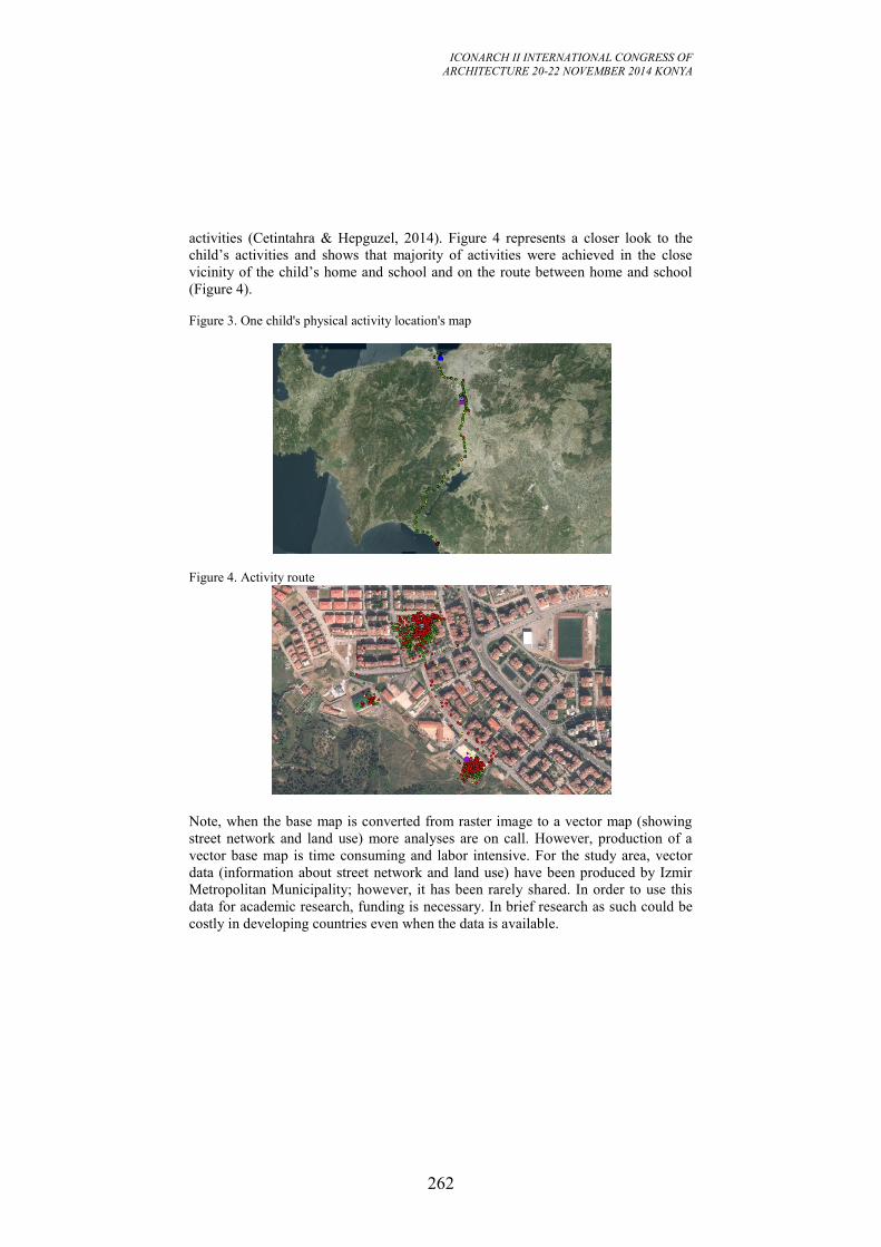
ICONARCH II INTERNATIONAL CONGRESS OF
ARCHITECTURE 20-22 NOVEMBER 2014 KONYA
262
activities (Cetintahra & Hepguzel, 2014). Figure 4 represents a closer look to the
child’s activities and shows that majority of activities were achieved in the close
vicinity of the child’s home and school and on the route between home and school
(Figure 4).
Figure 3. One child's physical activity location's map
Figure 4. Activity route
Note, when the base map is converted from raster image to a vector map (showing
street network and land use) more analyses are on call. However, production of a
vector base map is time consuming and labor intensive. For the study area, vector
data (information about street network and land use) have been produced by Izmir
Metropolitan Municipality; however, it has been rarely shared. In order to use this
data for academic research, funding is necessary. In brief research as such could be
costly in developing countries even when the data is available.
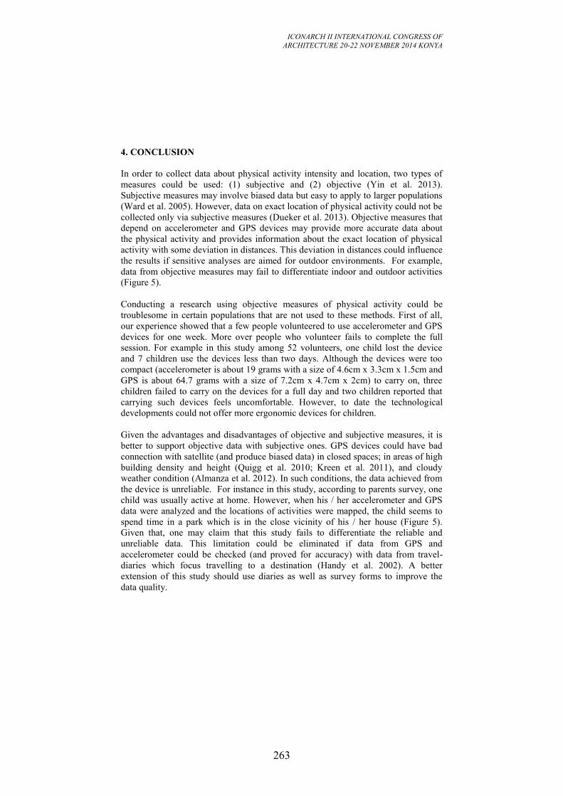
ICONARCH II INTERNATIONAL CONGRESS OF
ARCHITECTURE 20-22 NOVEMBER 2014 KONYA
263
4. CONCLUSION
In order to collect data about physical activity intensity and location, two types of
measures could be used: (1) subjective and (2) objective (Yin et al. 2013).
Subjective measures may involve biased data but easy to apply to larger populations
(Ward et al. 2005). However, data on exact location of physical activity could not be
collected only via subjective measures (Dueker et al. 2013). Objective measures that
depend on accelerometer and GPS devices may provide more accurate data about
the physical activity and provides information about the exact location of physical
activity with some deviation in distances. This deviation in distances could influence
the results if sensitive analyses are aimed for outdoor environments. For example,
data from objective measures may fail to differentiate indoor and outdoor activities
(Figure 5).
Conducting a research using objective measures of physical activity could be
troublesome in certain populations that are not used to these methods. First of all,
our experience showed that a few people volunteered to use accelerometer and GPS
devices for one week. More over people who volunteer fails to complete the full
session. For example in this study among 52 volunteers, one child lost the device
and 7 children use the devices less than two days. Although the devices were too
compact (accelerometer is about 19 grams with a size of 4.6cm x 3.3cm x 1.5cm and
GPS is about 64.7 grams with a size of 7.2cm x 4.7cm x 2cm) to carry on, three
children failed to carry on the devices for a full day and two children reported that
carrying such devices feels uncomfortable. However, to date the technological
developments could not offer more ergonomic devices for children.
Given the advantages and disadvantages of objective and subjective measures, it is
better to support objective data with subjective ones. GPS devices could have bad
connection with satellite (and produce biased data) in closed spaces; in areas of high
building density and height (Quigg et al. 2010; Kreen et al. 2011), and cloudy
weather condition (Almanza et al. 2012). In such conditions, the data achieved from
the device is unreliable. For instance in this study, according to parents survey, one
child was usually active at home. However, when his / her accelerometer and GPS
data were analyzed and the locations of activities were mapped, the child seems to
spend time in a park which is in the close vicinity of his / her house (Figure 5).
Given that, one may claim that this study fails to differentiate the reliable and
unreliable data. This limitation could be eliminated if data from GPS and
accelerometer could be checked (and proved for accuracy) with data from travel-
diaries which focus travelling to a destination (Handy et al. 2002). A better
extension of this study should use diaries as well as survey forms to improve the
data quality.
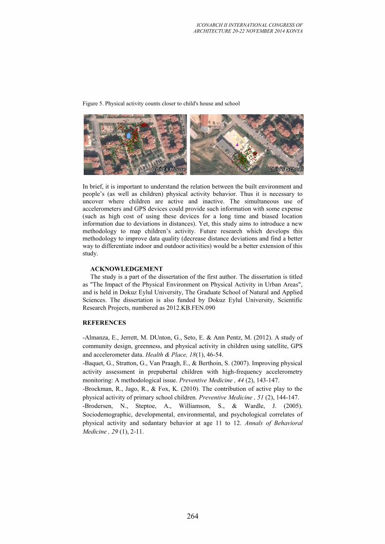
ICONARCH II INTERNATIONAL CONGRESS OF
ARCHITECTURE 20-22 NOVEMBER 2014 KONYA
264
Figure 5. Physical activity counts closer to child's house and school
In brief, it is important to understand the relation between the built environment and
people’s (as well as children) physical activity behavior. Thus it is necessary to
uncover where children are active and inactive. The simultaneous use of
accelerometers and GPS devices could provide such information with some expense
(such as high cost of using these devices for a long time and biased location
information due to deviations in distances). Yet, this study aims to introduce a new
methodology to map children’s activity. Future research which develops this
methodology to improve data quality (decrease distance deviations and find a better
way to differentiate indoor and outdoor activities) would be a better extension of this
study.
ACKNOWLEDGEMENT
The study is a part of the dissertation of the first author. The dissertation is titled
as "The Impact of the Physical Environment on Physical Activity in Urban Areas",
and is held in Dokuz Eylul University, The Graduate School of Natural and Applied
Sciences. The dissertation is also funded by Dokuz Eylul University, Scientific
Research Projects, numbered as 2012.KB.FEN.090
REFERENCES
-Almanza, E., Jerrett, M. DUnton, G., Seto, E. & Ann Pentz, M. (2012). A study of
community design, greenness, and physical activity in children using satellite, GPS
and accelerometer data. Health & Place, 18(1), 46-54.
-Baquet, G., Stratton, G., Van Praagh, E., & Berthoin, S. (2007). Improving physical
activity assessment in prepubertal children with high-frequency accelerometry
monitoring: A methodological issue. Preventive Medicine , 44 (2), 143-147.
-Brockman, R., Jago, R., & Fox, K. (2010). The contribution of active play to the
physical activity of primary school children. Preventive Medicine , 51 (2), 144-147.
-Brodersen, N., Steptoe, A., Williamson, S., & Wardle, J. (2005).
Sociodemographic, developmental, environmental, and psychological correlates of
physical activity and sedantary behavior at age 11 to 12. Annals of Behavioral
Medicine , 29 (1), 2-11.
ICONARCH II INTERNATIONAL CONGRESS OF
ARCHITECTURE 20-22 NOVEMBER 2014 KONYA
265
-Burdette, H., & Whitaker, R. (2005). A national study of neighborhood safety,
outdoor play, television viewing, and obesity in preschool children. Pediatrics , 116,
657-662.
-CDC. (2002). Barriers to children walking and biking to school--United States,
1999. Morbidity and Mortality Weekly Report , 51 (32).
-Cetintahra, E.G. & Hepguzel, B. (2014). The influence of the urban
facilities/inabilities on the preference of walking for transformation. 26th
International Building & Life Fair and Cogress: Re-invention of City Center, Bursa.
-Coombes, E., van Sluijs, E., & Jones, A. (2013). Is environmental setting associated
with the intensity and duration of children's physical activity? Findings from the
SPEEDY GPS study. Health & Place , 20, 62-65.
-Cooper, A., Andersen, L., Wedderkopp, N., Page, A., & Froberg, K. (2005).
Physical activity levels of children who walk, cycle, or are driven to school.
American Journal of Preventive Medicine , 29 (3), 179-184.
-Cooper, A., Page, A., Foster, L., & Qahwaji, D. (2003). Commuting to school: Are
children who walk more physically active? American Journal of Preventive
Medicine , 25 (4), 273-276.
-Cradock, A., Melly, S., Allen, J., Morris, J., & Gortmaker, S. (2007).
Characteristics of school campuses and physical activity among youth. American
Journal of Preventive Medicine , 33 (2), 106-113.
-Craggs, C., van Sluijs, E., Corder, K., Panter, J., Jones, A., & Griffin, S. (2011). Do
children's individual correlates of physical activity differ by home setting? Health &
Place , 17 (5), 1105-1112.
-Davison, K., Werder, J., & Lawson, C. (2008). Children's active commuting to
school: Current knowledge and future directions. Preventing Chronic Disease , 5
(3), 1-11.
-Dueker, D., Taher, M., Wilson, J. & McConnell, R. (2014). Evaluating children's
location using a personal GPS logging instrument: Limitations and lessons learned.
Journal of Exposure Science and Environmental Epidemiology, 24(3), 244-252.
-Dunton, G., Liao, Y., Almanza, E., Jerrett, M., Spruijt-Metz, D., & Pentz, M.
(2013). Locations of joint physical activity in parent-child pairs based on
accelerometer and gps monitorin. Annals of Behavioral Medicine , 45 (1), 163-172.
-Ewing, R., Schmid, T., Killingsworth, R., Zlot, A., & Raudenbush, S. (2003).
Relationship between urban sprawl and physical activity, obesity, and morbidity.
American Journal of Health Promotion , 18 (1), 47-57.
-Ford, P., Bailey, R., Coleman, D., Woolf-May, K., & Swaine, I. (2007). Activity
levels, dietary energy intake, and body composition in children who walk to school.
Pediatric Exercise Science , 19 (4).
ICONARCH II INTERNATIONAL CONGRESS OF
ARCHITECTURE 20-22 NOVEMBER 2014 KONYA
266
-Frank, L., Andresen, M., & Schmid, T. (2004). Obesity relationships with
community design, physical activity, and time spent in cars. American Journal of
Preventive Medicine , 27, 87-96.
-Freedson. (2012, 04 30). What is the difference among the MET algorithms? 06 09,
2014 tarihinde ActiGraph: https://help.theactigraph.com/entries/21383846-What-is-
the-difference-among-the-MET-Algorithms- adresinden alındı
-French, S., Story, M., & Jeffery, R. (2001). Environmental influences on eating and
physical activity. Annual Review of Public Health , 22 (1), 309-335.
-Handy, S.L., Boarnet, M.G., Ewing, R. & Killingsworth, R. (2002). How the built
environment affects physical activity: Views from urban planning. American
Journal of Preventive Medicine, 23(2), 64-73.
-Hill, J., Wyatt, H., Reed, G., & Peters, J. (2003). Obesity and the environment:
Where do we go from here? Science , 299, 853-855.
-Hume, C., Salmon, J., & Ball, K. (2007). Associations of children's perceived
neighborhood environments with walking and physical activity. American Journal
of Health Promotion , 21 (3), 201-207.
-Hume, C., Salmon, J., & Ball, K. (2005). Children's perceptions of their home and
neighborhood environments, and their association with objectively measured
physical activity: A qualitative and quantitative study. Health Education Research ,
20 (1), 1-13.
-Hume, C., Timperio, A., Salmon, J., Carver, A., Giles-Corti, B., & Crawford, D.
(2009). Walking and cycling to school: Predictors of increases among children and
adolescents. American Journal of Preventive Medicine , 36 (3), 195-200.
-Kemperman, A., & Timmermans, H. (2011). Children's Recreational Physical
Activity. Leisure Sciences , 33 (3), 183-204.
-Kreen, P., Mag, D., Titze, S., Oja, P., Jones, A., & Ogilvie, D. (2011). Use of global
positioning systems to study physical activity and the environment: A systematic
review. American Journal of Preventive Medicine , 41 (5).
- Jerrett, M., Almanza, E., Davies, M., Wolch, J., Dunton, G., Spruitj-Metz, D. &
Pentz, M.A. (2013). Smart growth community design and physical activity in
children. American Journal of Preventive Medicine, 45 (4), 386-392.
-Lopez, R. (2004). Urban sprawl and risk for being overweight or obese. American
Journal of Public Health , 94, 1574-1579.
-Loucaides, C., & Jago, R. (2008). Differences in physical activity bu gender,
weight status and travel mode to school in Cypriot children. Preventive Medicine ,
47, 107-111.
-Mackett, R., Brown, B., Gong, Y., Kitazawa, K., & Paskins, J. (2007). Children's
independent movement in the local environment. Built Environment , 1978, 454-
468.
ICONARCH II INTERNATIONAL CONGRESS OF
ARCHITECTURE 20-22 NOVEMBER 2014 KONYA
267
-Pabayo, R., Belsky, J., Gauvin, L., & Curtis, S. (2011). Do area characteristics
predict change in moderate-to-vigorous physical activity from ages 11 to 15 years?
Social Science & Medicine , 72 (3), 430-438.
-Quigg, R., Gray, A., Reeder, A., Holt, A., & Waters, D. (2010). Using
accelerometers and GPS units to identify the proportion of daily physical activity
located in parks with playgrounds in New Zeland children. Preventive Medicine , 50
(5-6), 235-240.
-Saelens, B., Sallis, J., Black, J., & Chen, D. (2003). Neighborhood-based
differences in physical activity: An environmen scale evaluation. American Journal
of Public Health , 93, 1552-1558.
-Saelens, B., Sallis, J., Nader, P., Broyles, S., Berry, C., & Taras, H. (2002). Home
environmental influences on children's television watching from early to middle
childhood. Journal of Developmental & Behavioral Pediatrics , 23 (3), 127-132.
-Sallis, J., Taylor, W., Dowda, M., Freedson, P., & Pate, R. (2002). Correlates of
vigorous physical activity for children in grades 1 through 12: Comparing parent-
reported and objectively measured physical activity. Pediatric Exercise Science , 14
(1), 30.
-Salmon, J., Timperio, A., Telford, A., Carver, A., & Crawford, D. (2005).
Association of family environment with children's television viewing and with low
level of physical activity. Obesity Research , 13 (11), 1939-1951.
-Southward, E., Page, A., Wheeler, B., & Cooper, A. (2012). Contribution of the
school journey to daily physical activity in children aged 11-12 years. American
Journal of Preventive Medicine , 43 (2), 201-204.
-Stettler, N., Bovet, P., Shamlaye, H., Zernel, B., Stallings, V., & Paccaud, F.
(2002). Prevalence and risk factors for overweight and obesity in children from
Seychelles, a country in rapid transition: The importance of early growth.
International Journal of Obesity and Related Metabolic Disorders: Journal of the
International Association for the Study of Obesity , 26 (2), 214-219.
-Timperio, A., Crawford, D., Telford, A., & Salmon, J. (2004). Perceptions about
the local neighborhood and walking and cycling among children. Preventive
Medicine , 38 (1), 39-47.
-Toftager, M., Christiansen, L., Kristensen, P., & Troelsen, J. (2011). SPACE for
physical activity-a multicomponent intervention study: Study design and baseline
findings from a cluster randomized controlled trial. BMC Public Health , 11 (1),
777.
-Tomson, L., Davidson, M., & Cuddihy, T. (2003). Walking to school-does it make
a difference in children's physical activity levels. 16-24.
-Trapp, G., Giles-Corti, B., Christian, H., Bulsara, M., Timperio, A., McCormack,
G., et al. (2012). Increasing children's physical activity: Individual, social, and
ICONARCH II INTERNATIONAL CONGRESS OF
ARCHITECTURE 20-22 NOVEMBER 2014 KONYA
268
environmental factors associated with walking to and from school. Health Education
& Behavior , 39 (2), 172-182.
-Treuth, M., Hou, N., Young, D., & Maynard, L. (2005). Accelerometry-measured
activity or sedantary time and overweight in rural boys and girls. Obesity Research ,
13 (9), 1606-1614.
-Tucker, P., Irwin, J., Gilliland, J., He, M., Larsen, K., & Hess, P. (2009).
Environmental influences on physical activity levels in youth. Health & Place , 15
(1), 357-363.
-USDHHS. (2008). 2008 Physical Activity Guidelines for Americans: Be Active,
Healthy, and Happy! U.S. Deparment of Health & Human Services.
-Van Sluijs, E., Jones, N., Jones, A., Sharp, S., Harrison, F., & Griffin, S. (2011).
School-level correlates of physical activity intensity in 10-year-old children.
Pediatric Obesity , 6 (2), 574-581.
-Ward, D., Evenson, K., Vaughn, A., Rodgers, A., & Troiano, P. (2005).
Accelerometer use in physical activity: Best practices and research
recommendations. Medicine and Science in Sports and Exercise , 37, 582-588.
-Wheeler, B., Cooper, A., Page, A., & Jago, R. (2010). Greenspace and children's
physical activity: A GPS/GIS analysis of the PEACH project. Preventive Medicine ,
51 (2), 148-152.
-WHO, W. H. (2014). Childhood Overweight and Obesity. 4 17, 2014 tarihinde
Global Strategy on Diet, Physical Activity and Health:
http://www.who.int/dietphysicalactivity/childhood/en/ adresinden alındı
-Yin, L., Raja, S., Li, X., Lai, Y., Epstein, L., & Roemmich, J. (2013).
Neighborhood for playing: Using GPS, GIS and accelerometry to delineate areas
within youth are physically active. Urban Studies , 50 (14), 2922-2939.
-Ziviani, J., Scott, J., & Wadley, D. (2004). Walking to school: Incidental physical
activity in the daily occupations of Australian children. Occupational Therapy
International , 11 (1), 1-11.
ICONARCH II INTERNATIONAL CONGRESS OF
ARCHITECTURE 20-22 NOVEMBER 2014 KONYA
269
SESSION 6
20 November 2014 Friday, 11.00-12.15
Chairperson: Prof. Giuseppe DE LUCA (Invited Speech)
“Evolution in Regional Planning: The Italian Path” p.270
Li HAO
“The Preservation and Reincarnation of Sid-Lin Monastery” p.285
Research Assistant Kadriye Burcu YAVUZ
“An Investigation of Territory Concept in The Context Of Two
Residential Units in Ankara: Israel Houses and Saraçoğlu
Neighborhood” p.304
KEYNOTE SPEECH
Prof.Dr. Martin BECHTHOLD
“The Quest for Innovation: Methods and Mindsets“ p.315
ICONARCH II INTERNATIONAL CONGRESS OF
ARCHITECTURE 20-22 NOVEMBER 2014 KONYA
270
EVOLUTION IN REGIONAL PLANNING:
THE ITALIAN PATH
Giuseppe De Luca1, Valeria Lingua
2
ABSTRACT
Focus of the paper are the models and practices of regional spatial planning
activated in Italy in the most recent years, in order to evidence the innovation
occurred and the challenges that regional planning institutions are facing.
Compared to a theoretical and legislative framework that tends to separate the
different types of regional planning (spatial, landscape, development planning), the
experimental framework is characterized by pluralistic approaches in which a
balance between a normative and a strategic nature of the territorial plan is searched,
in order to introduce perspectives of economic and social development.
In a continuous process of institutional reflexivity and learning, the regional
institutions have now achieved that the notion of 'region' has become more about
social interaction than geographical location. For that, interesting experiences of
intraregional and interregional cooperation are developing, as called Interregional
table of Padano-Alpine-Maritime Macro Area in Northern Italy, a place-based
approach generating supra-local shared visions that are of a certain interest.
Keywords: Regional spatial planning, cooperation, regional strategies
1. INTRODUCTION
This paper focuses on the models and practices of regional spatial planning activated
in Italy in recent years, in order to evidence the innovations that occurred and
challenges that Regional planning institutions are facing. Just after the devolution of
local power in Italy in 1977, spatial planning competences began being organized
into Regional Institutions. Each of the twenty new Regions must make a Territorial
Regional Plan (Piano territoriale regionale) together with a Regional Landscape Plan
1 Architecture Department, Urban and Regional Planning Section, University of Florence
2 Architecture Department, Urban and Regional Planning Section, University of Florence
ICONARCH II INTERNATIONAL CONGRESS OF
ARCHITECTURE 20-22 NOVEMBER 2014 KONYA
271
(Piano paesaggistico), possibly in connection with a Development Regional Program
(Programma regionale di sviluppo).
The first experiments in regional planning, carried out in the 1980s and 1990s, have
led to the formation of territorial plans with an indicative planning setting, the
development of special regional areas, and the planning of infrastructure, such as
road networks and railways.
The new millennium opened with two important changes that have considerable
influence on the nature and form of regional planning:
- the amendment to Title V of the Constitution (2001) that, by incorporating
the principles of subsidiarity, adequacy and differentiation, has reversed the
institutional hierarchy in favour of municipalities, making it urgent to
reflect on the role of the Region and its planning territorial instruments;
- the approval of the National Landscape Code (2004), which has modified
the landscape issue in the statutory of national and regional regulation.
These changes have generated important revisions of legislation at the regional
level. A review of the regional spatial plans reveals that although the plans have
different forms and work according to different timelines, they address one common
need: to overcome the traditional approach to regional planning system with a set of
innovations.
In this direction, the latest experiments abandon the traditional approach to
regulatory coordination, turning to a regional cooperative plan. A mixed model,
characterized as strategic, structural and operational at the same time, the regional
plan is required to convey an idea of the future, a common goal, and a shared vision.
It is supported by a set of guidelines for the protection and enhancement of the
elements of identity in the region and is made operative in specific territorial
projects. From a multilevel governance perspective, the local and provincial bodies
are called on to share and specify both the regional scenario and the operational
scenarios. This specification must also be accomplished through the coordination of
bottom-up and sector-based planning in terms of coherence and conformity to the
directions defined at the regional level.
Focus of the paper are the models and practices of regional spatial planning
activated in Italy in the most recent years, in order to evidence the innovation
occurred and the challenges that regional planning institutions are facing.
Particularly, in a context of global crisis, and driven by the most recent trends of
Europeanization of regional policies and the diffusion of European Spatial Planning
practices, the challenge for the Italian regional territorial plan lies in the difficult
implementation of coherent spatial strategies, oriented by strategic vision focused on
the socio-economic development and by operative regional projects, and regulatory
and statutory measures for the protection and enhancement of the environment and
landscape.
Moreover, the relationship between regional spatial planning and economic
programming is still not resolved: it has been treated differently in many years and
experiences, but it always expresses the indispensability of linking economic
development to the territory and vice versa. This need has emerged with greater
urgency during the formation of regional policy frameworks for the previous course
ICONARCH II INTERNATIONAL CONGRESS OF
ARCHITECTURE 20-22 NOVEMBER 2014 KONYA
272
of EU Cohesion Policy 2007-2013, and certainly has important effects on regional
spatial planning tools of the last generation.
Through the analysis of some recent regional territorial plans, the paper provides an
outline of recent experiences and reflections, to highlight issues, problems, common
questions.
Compared to a theoretical and legislative framework that tends to separate the
different types of regional planning (spatial, landscape, development planning), the
experimental framework emerging by the most recent experiences of regional
planning is characterized by pluralistic approaches in which a balance between a
normative and a strategic nature of the territorial plan is searched, in order to
introduce perspectives of economic and social development.
Together, various cases of recently formalized planning (Veneto, Emilia-Romagna,
Lombardy, Tuscany, Piedmont), some in-progress cases (Friuli Venice-Giulia,
Liguria), and the case of an interregional experience of coordination of regional
spatial strategies carried out by eight Regions under the name of Padano-Alpine-
Maritime Area, can provide a framework for these reflections.
The paper addresses these innovations.
2. NATURE AND FORM OF THE PLAN IN THE ITALIAN REGIONAL
PLANNING
Through experiences in regional planning coming to fruition at the turn of the late
1990s and the new millennium, we can identify three major trends:
- the first, expressed mainly by Regional Territorial Plans of the Valle
d’Aosta and Umbria, seems to still be strongly anchored to the model
envisioned by the traditional Law no. 1150 of 1942: a unified plan to
coordinate and address, giving an overview of the issues of territorial
government, through a subdivision of land for fields and an explanation of
the program lines in the region, in close connection with the regional
program development;
- the second, a strategic concept of regional planning, is made explicit
through the construction of shared vision and cooperation on the scenarios
of perspective, as in the case of the Territorial Indicative Plan in the
Marche Region and/or of the Piedmont Regional Spatial Plan;
- the third, a structural approach to regional planning, is one in which the
regional plan is considered a real ‘warranty’ actor for all of the choices
which are considered to be priorities for the land, landscape and
environment. The indications of the plan are aimed to build consensus
among the institutions in order to ensure resource quality and resilience of
the reference system. This approach is developed in the experiences of the
Tuscany and Liguria regions.
These three trends give rise to different forms and characters of the regional plan, as
well as different modes of interaction, each having various limitations and
opportunities.
ICONARCH II INTERNATIONAL CONGRESS OF
ARCHITECTURE 20-22 NOVEMBER 2014 KONYA
273
All offer meaningful forms of interaction: the first, a hierarchical system, allows a
clear distinction between regulatory apparatus, which enables public and private
entities to have a clear awareness of their responsibilities, and the scope of their
autonomy. The second involves the construction of a coherent vision of the region
among the various institutions, reinterpreted in a unique strategic vision. The third
identifies factors to be considered as spatial structures of territorial identity (be they
physical or intangible resources, social or cultural capital) and, as such, be subject to
rules and performance criteria to allow for protection and reproducibility over time.
In all cases, the interaction required to give form to the regional plan involves
critical issues: the joint rules of the Regional Territorial Plans of Valle d’Aosta and
Umbria assume that all of those involved in the governance of the territory are
cooperative and willing to work together. This is because the objectives are not
local, but are of general interest. It also requires that the regional and local
authorities take an active and constructive role in the process of transformation and
development.
In the case of strategic regional planning, the likely limits are related to present
interests within the political market, without taking into account possible future
interests. While moving away from more traditional territorial coordination plan, in
fact, collective interest can be considered as pertaining only to the interests of so-
called “strong actors”, that is, those who are organized and structured.
Structural regional planning also tries to consider the interests of the weaker parties.
This gives rise to an instrument consisting of a set of elements characterized by the
nature, dynamics and different degrees of uncertainty and inconsistency. As a result,
the instruments sometimes penalize the design aspirations, reducing them to tools
for defining “structural invariants”.
However, the latest plans, newly approved or soon to be adopted, appear to show a
decided movement toward the reconciliation of these trends in the same instrument
landing. A new trend may herald the desired formation of a mixed system of
planning that contains within it both structural and strategic elements.
The “mixed” nature of the regional plan seems to resolve the dichotomy between
strategic and structural planning which is highlighted in the experiences at the turn
of the twentieth century and the beginning of the twenty-first century. Rather than
being considered an element of incoherence of a structural plan, the presence of
elements with cogency and different degrees of uncertainty creates a point of
strength when inserted in a strategic plan. The term strategic refers to a sharing
process which helps define a shared regional vision. It also refers to the product of
such sharing, that is, a plan which is broken down into strategies, goals and actions
to be followed accordingly, in a more or less prescriptive manner.
In this sense, it is possible to find consistency between a strategic vision which is
more focused on economic development and visions which are more oriented to the
protection and enhancement of the environment and landscape.
Most recent regional plans, therefore, are not only strategic or structural, they have a
mixed valence in which there is predominant tendency towards a balance among the
different natures. Balance that comes from “eclectic” (Fabbro, 2002) processes of
formation of the regional facility, which offers some form of institutional
cooperation, participation and inclusion of very different interests, Balance that
ICONARCH II INTERNATIONAL CONGRESS OF
ARCHITECTURE 20-22 NOVEMBER 2014 KONYA
274
comes from eclectic processes and geometries, which provides for institutional
cooperation, participation and inclusion, not just as the result of regional legislation,
but also coming from the policy and technical interpretation of the regional plan.
In relation to inding a balance between the three dimensions of the regional planning
(strategic, structural, land-use oriented), we will highlight some common issues and
experiences in the emerging regional planning in progress, all converging towards
the identification of appropriate forms of cooperation:
- the construction of strategic vision with multimedia tools and methods, as
is reflected in a plan aimed at defining the vision, objectives and actions
that revolve around the strategies outlined in the form of intriguing slogans
(as in the case of Emilia-Romagna and Veneto) and involve the interests
increasingly marked by experiment, in addition to traditional instruments
(Lombardy), and modes of participation involving citizens in a broader
sense (Veneto, Apulia, Tuscany).
- the relationship between spatial planning and landscape planning, which
assumes very different shades because of how the two dimensions are
conceived in the regional legislation. The regions, in fact, may choose to
provide a landscape plan in addition to the regional spatial plan, or they
may choose to merge the two dimensions (landscape and territory) within
the spatial plan. In any case, to avoid the excesses typical of strategic
planning (non-inclusion of weaker interests and future interests), the
identification of identity elements (structural invariants) and the definition
of strategies for landscape protection and enhancement (quality objectives
and guidelines) involve a wide cooperation and the capability of
acknowledging and addressing the complexity of territorial interests.
- finally, the implementability of the plan is resulting in the identification of
design areas at the regional level (Lombardy, Marche, Campania, Liguria)
which are able to stimulate public interest and private agencies, both in
terms of the local practices of area-wide planning (inter-municipalities,
unions of municipalities, etc.) and through the identification of possible
areas of inter-institutional cooperation (Friuli Venice-Giulia, and
Piedmont).
3. CURRENT ISSUES AND TRENDS IN RECENT REGIONAL PLANNING
PRACTICES
In an up-dating process due to the new issues raised by the cultural debate and by
the legislative changes, regional territorial plans show different forms and speeds of
adaptation (De Luca & Lingua, 2008), but are united by the common need to
overcome the traditional approach to territorial planning, through a plan of a
strategic rather than structural nature: the regional territorial plan (Piano territoriale
regionale - PTR) must provide an idea of the future, a common objective, a shared
vision. Local and provincial authorities are required to share and to specify this
scenario, also by coordinating lower-level and sectoral planning in terms of
consistency and compliance with the regional guidelines.
ICONARCH II INTERNATIONAL CONGRESS OF
ARCHITECTURE 20-22 NOVEMBER 2014 KONYA
275
Some recent territorial planning experiences in Northern Italian regions (Veneto,
Emilia Romagna, Friuli Venezia Giulia, Piedmont) provide an advanced picture of
this reflection, outlining some possible responses to the new regional planning
challenges.
The scenario outlined in the PTR for Emilia Romagna, for instance, illustrates three
main prospects: the networks of cities and territories, the knowledge economy and
the ecological networks, with a number of related objectives. The PTR therefore
defines objectives and guidelines for going towards the outlined scenario, while it is
the task of the Provinces, with their territorial coordination plans (Piano territoriale
di coordinamento provinciale - PTCP), to sediment and consolidate a series of prior
norms specific to sectoral planning, outlining a comprehensive vademecum of the
provisions which preside over the supralocal area, so that the rules are consistent
with the regional scenario. To turn the strategic scenario into reality, the PTR will
propose a new “social pact” with local authorities, which will stem from a shared
vision of the future.
The Veneto regional territorial coordination plan (Piano territoriale regionale di
coordinamento - PTRC) is also conceived as a social pact and its slogan, “a forward-
looking plan from the human perspective” recalls an instrument that is not so much
intended to impose prescriptive rules, but rather to construct meaning around a
shared vision. This new conception of the nature of the plan derives from a broad
debate between all the administrative, political and socio-economic components of
the Region, which has led to the exclusion of the idea, now outdated, of a “master
plan for Veneto”, but also not to consider the PTRC simply as a territorial
transposition of the contents of the Regional Development Programme (Programma
Regionale di Sviluppo - PRS), but rather as the design of a vision. In the light of this
intention, the definition of a planning process based on “visionary pragmatism”,
though it may sound like an oxymoron, makes it possible to understand the kind of
plan which derives from it: a lean, technological and evocative instrument, which
can be understood even by non-experts through a language including schematic
tables of the development trends and objectives, films and multimedia descriptions,
guidelines intended not to restrict but to guide lower-level planning.
The current experiments evince a new turn towards co-planning, and while the
activation of widespread participation practices is still in an embryonic stage, there
are episodes of great interest. In particular, the theme of the landscape seems to
imply a close search for consensus on the resources to protect that, at the regional
level, requires more consideration of both the weaker and more general interests. It
should be noted, in light of the first experiments, that the regional level necessarily
implies a selection of interests and actors through a process which can occur in
several ways:
- through self-selection, when meetings, conferences, etc., are called, with
the intention of involving which involve institutional entities, citizens and
associations. As already noted for conference services, the very act of
attending the conference and presenting the plan would entail the
consideration of its contribution, while non-attendance has the value of
self-exclusion
ICONARCH II INTERNATIONAL CONGRESS OF
ARCHITECTURE 20-22 NOVEMBER 2014 KONYA
276
- randomly, when the process is based on the extraction of a larger
representative sample of participants, as in the case of the town meeting
- through a combination of the aforementioned approaches, for cases in
which sample-areas and pilot projects are identified, and the use of
localized participatory practices is activated.
Finally, the attempt to make implementation planning instruments is one of the main
characteristics of the newest generation of the regional territorial plan. This involves
implementing strategies which more and more oriented to the identification of
contexts for regional, subregional or thematic projects.
In most cases, the regional level foreshadows programs and integrated projects
covering a range of topics and areas of particular weaknesses and particularly
problematic. If, at first, this orientation to the project seems more evident in those
plans that promote a strategic approach to planning, it is now an integral part of most
more recent regional plans. Already, the 1990s regional territorial plans of Liguria,
Marche, Umbria and Campania provided for an extensive use of operational tools
with multiple definitions and objectives (“regional initiative projects”, “pilot
projects”, “integrated projects”, “project areas” in the Regional Territorial Plan of
Liguria, “shipyard projects” in the Marche region, “field projects” in the Campania
Regional Territorial Plan, and “plans and programs” in the Umbria Region). Today,
the latest plans make extensive use of tools and programs that include character
design, as well as inter-institutional cooperation and the intervention of the private
sector.
It is clear that the identification of areas of subregional planning involves the
activation of a direct relationship between the region and the specific interests that
focus on the design theme identified on the scope or area defined in the plan.
Strongly related to this way of understanding the operation of the plan, through
thematic or territorial projects at the regional level, is the identification of areas for
intervention or co-planning above the local level.
In some regions, in fact, there is an evident link between territorial cooperation and
the operation of the regional plan, for which the identification of geographical areas
based on historical characters, and socio-economic identity is not only aimed at the
specification of objectives and policies of the plan, it is also the basis for how to
activate co-planning and institutional cooperation. It is the case, for example, in the
Piedmont and Friuli Venezia Giulia Regional Territorial Plans (PTR).
The Friuli Venezia Giulia Region, with its special statute, is in a different situation,
both in terms of territorial governance and of its relations with the local and
provincial authorities. Regional law n. 5 of 2007 and the regional territorial plan
adopted in the same year endorse the abandonment of a purely conformative
dimension of territorial planning, associated with the 1978 Regional Master Plan
(Piano urbanistico regionale generale - PURG). Though that plan was paradigmatic
for that period and enabled urgent problems to be faced (such as reconstruction after
the earthquake in 1976), today much effort is needed to adapt to the current
territorial governance requirements. Compared with a traditional type of plan
therefore, the PTR adopted in 2007 and the amendments made by the new regional

ICONARCH II INTERNATIONAL CONGRESS OF
ARCHITECTURE 20-22 NOVEMBER 2014 KONYA
277
government1 are aimed at defining a more strategic perspective for regional
territorial governance and at outlining new relations with local authorities.
The PTR perspective considers the provincial level not to be feasible and intends to
give the municipalities a scenario with general and specific objectives within which
they can have full autonomy in the governance of their territory, also through inter-
municipal cooperation.
In this situation, there are new common issues emerging from the regional planning
experiences underway: on the one hand, the relationship with lower-level and
sectoral planning requires a reflection on the nature of the regional territorial plan
and invokes the need for a strategic and political dimension, with the aim of
enabling the contents of PTCP, inter-municipal planning instruments, as well as the
municipal plans, to converge and also of providing the focus around which the
current and sectoral legislation - in itself already substantial and often conflicting -
can be coordinated.
On the other hand, the strategic vision conveyed by the PTR necessarily requires an
effort for integration among inter-municipal policies.
The Piedmont Regional Territorial Plan (PTR), approved in 2011, goes in this way,
by identifying 33 Areas of Territorial Integration (AIT) and defines them as supra-
regional systems. These areas represent the aggregation of systems against economic
social, and territorial decline.
To these areas, the plan takes an compliant approach to urban spatial planning , in
order to provide for “government guarantees” (environmental protection, standards,
monitoring tools, etc.). This is a multilevel governance which activates a process of
interpretation-design-decision to be implemented both in each regional system and
at the local level. Decisions may result from governments’ specificity, from
traditions and from values expressed by local communities.
In summary, the current experiences show a common issue related to the possibility
of implementation of the regional plan: the strategic vision conveyed by the spatial
plan necessarily requires an effort of integration among policies for large areas,
including financial policies. The Regional Spatial Plan, in fact, suffers from two
problems. Firstly, it needs to include estimates of regional development in a
framework that offers increasingly globalizing trends. On the other hand, the
regional plan is affected by difficulties affecting some industries more than others,
difficulty reconciling the need for effective correspondence between the policies of
the regional plan and the provisions of the Regional Development Plan (PRS). The
political will to implement certain actions rather than others still determines the
emergence of the strongest themes (mobility, living, renewable resources, etc.),
since they are better funded and supported at the political level, as opposed to issues
such as weak rural areas and the landscape.
In this case, the experiences in Tuscany and Piedmont seem the most interesting
while the regional program development one developed in Apulia is more strongly
bound to the political landscape with.
1 Adopted with presidential decree n. 329 of 16th October 2007, the PTR for Friuli Venezia Giulia is now
under review by the new regional government.
ICONARCH II INTERNATIONAL CONGRESS OF
ARCHITECTURE 20-22 NOVEMBER 2014 KONYA
278
The years 2007-2013 were marked by a strong period of hybridization between the
two dimensions in the construction of regional strategic frameworks. While in some
regions (Emilia Romagna and Lombardy), the strategy was built through policies
and actions related to the programming of resources to planning, in other cases (as
Tuscany, Umbria and Marche) the strategies were built together, so there has been a
real territorialisation of policies. Throughout this last experience, however, the
relationship with the State has been inconsistent and sometimes it did not take into
account both the national strategies and the possible interregional strategies.
Despite being characterized by advanced tools, spatial planning systems (Plans and
regional) of the regions of central Italy failed to generate a collaborative process.
Collaboration was not possible even when the Ministry of Infrastructure and
Transportation had proposed “regional platforms” as strategic areas of cooperation,
within the National Strategic Framework 2007-2013.
The possible solution, in relation to the management of inter-municipal and
subregional issues based on interaction and cooperation amongst local authorities,
necessarily involves a reflection both on the nature of the PTR (from conformative
to performative, from advisory to strategic) and on the type of plan that could derive
from it, as well as the need to interpret regional dynamics on all levels: not only sub-
regional and regional, but also on a macro-regional scale.
4. HORIZONTAL FORMS OF GOVERNANCE: THE INTER-REGIONAL
TABLE OF PADANO-ALPINE-MARITIME AREA OF THE NORTH
ITALY
The definition of an interregional experience of coordination of regional spatial
strategies was mainly driven by the need to shift some weight away from the
European context. The approach can be considered a particular and significant one
for the evolution of the regional plan in Italy: the process of collaborative
governance organized around an Interregional Table which aimed to develop a
Padano-Alpine-Maritime Zone in Northern Italy.
The Interregional Table was created in 2007 and included the regions of Veneto,
Emilia-Romagna, Friuli Venice-Giulia, Piedmont, Lombardy, as well as the
autonomous provinces of Trento and Bolzano. It served as a moment to capitalize on
the institutional learning conveyed by their participation in the EU's Metrex
network. This new cooperative form was intended as a technical working
community, firstly aimed to build a shared cognitive framework within which
strategies could be generated for the sustainable development of the first so called
“Adria-Po Valley”.
The Interregional Table is a committed that was designed to identify a system of
coherences and to promote the competitiveness of the regions concerned, both in the
new context of European development and within the media planning. In practice, it
was created as a space for discussion and exchange of knowledge in the process of
construction of instruments of regional planning, with the aim of promoting, on an
ongoing basis, initiatives for the comparison of relevant inter-regional issues.
ICONARCH II INTERNATIONAL CONGRESS OF
ARCHITECTURE 20-22 NOVEMBER 2014 KONYA
279
The Interregional Table also aimed to acquire a role as a forum for the sharing of a
common position regarding the construction of the Territorial Agenda of the
European Union, an agenda which is also based on the sharing and dissemination of
results of trans-national and trans-border cooperation activities.
This committee, politically motivated, is supported by a technical committee which
prepares materials and activities for the Interregional Table itself: in fact, after the
signing of the Charter of Venice, it soon became clear that the real promoters of the
Table were those of the technical regional administrations, appointed for the
formation of governmental instruments for the territory (regional territorial plans
and regional landscape plans).
The Interregional Table for Adria Po Valley was then immediately established for a
“technical discussion”, in which the revision of spatial planning instruments became
the common theme of the exchange. Many regions were preparing the new regional
territorial plans and this forum facilitated comparison during the meetings, as
evinced by the themes for discussion: ‘the protection and enhancement of the natural
environment and the strengthening of the economic system and the networking of
excellence; the development of cities as engines of the future; strengthening the
connections and intangible assets; the promotion of innovation activities and
research and the promotion and enhancement of best practices to reduce energy
consumption and combat climate change’ (Interregional Table, Venice Charter,
2007).
The first results of this experience, presented in July 2008, led to the creation of
three landscape- related charters for a shared vision of the Padano-Alpine Area,
concerning the system of ecological structures, the layout of infrastructure networks
and the system of urban polarity.
This vision was built expressly to form an intermediate level of knowledge between
the European level (usually borrowed from the ESPON program) and the regional
level. For this purpose, there has been an analysis of the area of the relationships and
influences of some urban centers and infrastructure systems and systems of other
nuclei and, in general, the spatial contexts of belonging, which often go beyond the
regional borders. The vision, which has been defined as a ‘gentlemen's agreement’,
was inserted directly in the planning tools through a sharing process at the technical
and political meetings, which were held in each region. Between 2008 and 2009,
those regions with more active participation have formalized their instruments:
Veneto, Emilia-Romagna and Lombardy have received approval, and Piedmont has
adopted the plan. In all cases, the scenarios prepared have been incorporated into the
plan, particularly in the cognitive frameworks.
The year 2009 is considered a stagnant period, due to a change of legislature in
almost all regions which led to a lack of sharing at the political table. After
launching a committee which emphasized balance between politicians and lobbies at
the European level, the political participation (and therefore the interest) seemed to
slowly wane. The technical component, however, continued to meet regularly, both
for the promotion of initiatives in cross-border and transnational cooperation
(participation in tenders ESPON and Interreg), and for the sharing and dissemination
of the results of project activities. In addition, interregional coordination (in its
ICONARCH II INTERNATIONAL CONGRESS OF
ARCHITECTURE 20-22 NOVEMBER 2014 KONYA
280
technical component) has been indicated as a reference for the ministerial committee
appointed to integrate the requirements of the Leipzig Charter.
The technical component has thus promoted the continuity of the committee, which
first took the political path on 12 October 2010 through the signing of the Pact for
Sustainable Development of interregional Padano-Alpine-Maritime Area, and then
through the signing of Bologna Agreement, on 27 January 2012. In fact, a new
program of committee activities is set to begin under the new administration , based
on the following objectives:
- promoting the area of the Mediterranean basin as the most
important macro-region for central Europe (with its 120,000
square kilometres and 27 million inhabitants, the production of
more than 54% of Italian GDP, the largest share of research and
for its innovation)
- sharing policies for the regional territory and the landscape,
through the definition of strategies and objectives for the
recognition of the importance of macro-alpine region of the Po
Valley in the European context and at national level, in particular
relating to landscape matters
- implementing coordination in the strategic planning of large areas,
which comprises development, environment, landscape, location
of major functions and infrastructure, defining common rules to
ensure efficient use of resources, and the containment of land
consumption
- building a map for landscape identity in order to link the policy of
protection and enhancement of landscape with strategic
environmental assessment
- spreading good practices.
The final goal, therefore, is the certainly the need to transform a common vision (at
the time, more oriented towards knowledge than to projects) in a model of self-
representation and of a strong and valid territorial marketing in order to compete in
the European space.
It is necessary that this vision be reinforced by other Italian regions, especially those
of Central Italy, even if it is not yet fully realized.
5. CONCLUSION
The focus of the paper are the theories and practices of regional spatial planning
activated in Italy in the last 20 years, in order to evidence the innovation which
occurred and the challenges that regional planning institutions are facing.
Compared to a theoretical framework and regulatory landscape planning, that tends
to separate the different areas of planning (landscape, land, cultural heritage), the
evolving experimental framework outlined by the most recent experience of regional
planning is characterized by pluralistic approaches in which, in the face of the
ICONARCH II INTERNATIONAL CONGRESS OF
ARCHITECTURE 20-22 NOVEMBER 2014 KONYA
281
widespread use of strategic rhetorical orientation, different aspects of planning seem
to prevail at various times (alternatively, strategic, structural, or both).
The new regional plans, therefore, are not only strategic or structural, but have a
mixed valence in predominately striving for a balance between the different natures.
The balance comes from eclectic training processes of regional facility, which offer
some form of institutional cooperation, participation and inclusion of very different
interests, resulting not only in regional, policy and technical legislation, but also
from the political and technical imprint given to the plan.
The problems of consistency of views on the one hand, and social equity and
distribution on the othervhand, seem to find a synthesis when the following elements
are identified within the same regional territorial plan:
- a vision for the future with fewer strategic objectives, so the nature of the
regional plan has a long-term time horizon
- structural elements which are required for performance and quality criteria,
with medium to long- term horizons, especially in reference to the system
of landscape protection understood as a cultural and identity product;
- operative projects and programs that collect instances of the territory, by
stimulating public interests and private actors, and therefore involve a
feasibility of short-medium term.
In a context dominated by globalization, the future vision, as well as operational
programs and projects, necessarily require:
- a co-operative attitude in regional planning processes.
- a leap in scale that allows for movement outside the regional boundaries and into
to macro-regional areas located in a specific European space.
Concerning the first need, last generation regional territorial plans outline a strategic
rather than a structural scenario, around which to build a shared vision of the
regional development processes. Structural contents mostly concern sectoral
planning and landscape and environmental issues, in particular when the regional
plan also has the value of a landscape plan. This strategic, purely performative
character determines a plan typology that is very different from the traditional
conformative plan: with diagrams and scenario tables the region is placed in macro-
regional analytical contexts and development goals and directions, instead of rules
and constraints, are defined in a schematic and appealing way. The plan drafting
procedures themselves require complex scenario-sharing processes involving
regional and local stakeholders.
In this framework, the distinctive features of a regional territorial plan of a
cooperative type can be summarised as follows:
- the strategic nature of the plan, both in the form and in the process, which is
expressed in the construction of territorial visions that are defined and shared in the
setting of discussion and interaction panels;
- the definition of regional planning domains as opportunities to measure the
operationality of the strategic options of the plan;
- the necessity of identifying the relevant actors, at the regional level, it does not
seem possible to involve the general population, therefore owing to its strategic
nature the plan should be able to identify and interact with the most relevant actors
involved in the issues at stake (so that processes which are not only selective but
ICONARCH II INTERNATIONAL CONGRESS OF
ARCHITECTURE 20-22 NOVEMBER 2014 KONYA
282
sometimes more inclusive are generated, precisely on the basis of the vision to
which they refer);
- the encouragement of cooperation among municipalities and, in general, of
cooperation within the relevant actors, to work on problems in a given territory
rather than within an institutional territory;
- the openness toward an even wider, inter-regional dimension .
In this sense, regional authorities have already recognized that the notion of 'legal
region' is weak; and that a new "soft" association is the future strategy. In this
context, interesting examples of intraregional and interregional cooperation are
maturing: the example of the Interregional Padano-Alpine-Maritime Area in
Northern Italy is one that has possibilities.
The experience has provided a unique opportunity to activate a process of co-
planning at the supra-regional scale- planning that is characterized as bottom-up and
not imposed from above. The simultaneous preparation of spatial plans in each
region allow for the representation of the area as macro-region through a shared
vision and common indicators. At the same time, it allows regions to work together
on common themes, translating them into a set of skills and strategies that have a
common language for all the regional instruments.
However, the potential of this approach does not seem to be fully explicit: the
regional planning documents, for the most part, treat the vision as a piece of a
cognitive framework, without a real inclination to the project. This is due to the lack
of an approach geared to action, which will lead to an effective coordination
expressed by the various plans, if not an actual strategic plan. While this
coordination is indicated in the objectives of the new cycle of the Interregional
Table, it should have emerged earlier during the phase of drafting the instruments-
instruments that are by now institutionalized and, therefore, not subject to revision.
If this weakness emerges at the national level, within the EU, it is likely to be
amplified. The degree to which weakness will be amplified will depend on the
nature of cooperation, the size and characteristics of the partnership, and relations
with the European Union.
To free itself from the characterization as a community-based project and really
project itself in Europe, against the local marketing done by creating a shared vision,
there should be a strong political marketing operation of the committee, to boost its
value and capability as an instrument of interregional co-planning in the broader
landscape of European development.
In this sense, institutional arrangements for the partnership must be established.
These may be based the European model of the EGTC, or even without creating new
institutions, as envisaged in the recent macro-regional experiences. Such
arrangements will give legs to the table, through formal agreements on inter-regional
strategies that are able to project Northern Italy in the competitive system of the
European Union.
The other regional experiences seem too weak and little prepared to set up macro-
planning experiences in Central or South Italy. In this sense, only the Northern
macro-region, which has already taken wing, can be a real example of
competitiveness in the European system.
ICONARCH II INTERNATIONAL CONGRESS OF
ARCHITECTURE 20-22 NOVEMBER 2014 KONYA
283
Competition must be built, nationally and across regions, through a substantial effort
to integrate the regional spatial planning and development policies so that there is a
profitable relationship between local-regional and global.
In this framework, the Regional Spatial Plan can play a key role in providing a
regional development strategy for the next season of the Structural Funds (2014-
2020). It is the tool that - when integrated with the Regional Development Plan - can
provide a territorialized vision of development strategies, to meet the objectives of
territorial cohesion with place-based strategies (Barca, 2009) and inter-regional
strategies, based on shared projects and geographical areas that go beyond the
institutional boundaries.
To take on this ambitious task, the Regional Spatial Plan can only assume a
cooperative nature, made explicit through processes marked by inclusiveness and
capable of:
- systemizing, the different options of the regional government, in particular
the different interests and the different governing options they have
pursued;
- projecting these options into the broader framework of the relevant macro-
reference area (in Italy we can speak of north, central or south) through
inter-regional planning experiences like that of the Po Valley -Alps-
Maritime. A thorough national strategy based on its regional cooperation
will facilitate entrance into the system of European territorial cohesion.
Stronger political support, as well as the development of innovative practices
provided by operative interregional projects, can play an important role in improving
and strengthening the interregional tables, leading to a real cooperation of a scope in
which geography and economy converge to develop the necessary requisites of
competitiveness and sustainability in an European and global panorama.
REFERENCES
Barca, F. (2009), An Agenda For A Reformed Cohesion Policy. A place-based
approach to meeting European Union challenges and expectations, Independent
Report,
http://www.europarl.europa.eu/meetdocs/2009_2014/documents/regi/dv/barca_re
port_/barca_report_en.pdf
Belli, A., Mesolella, A. (eds) (2009), Forme Plurime della Pianificazione Regionale
(Firenze, Alinea).
Calvaresi, C., Cognetti, F. (2010), Progettare nell’interazione con gli attori, Paper
presented at the XIIIth Conferece of the Italian Urban Planners Society (Società
Italiana degli Urbanisti) Città e crisi globale: clima, sviluppo e convivenza,
Rome, 25-27 February.
Cotella, G., Janin Rivolin, U. (2011), Europeanization of Spatial Planning through
Discourse and Practice in Italy, in: disP, 186 (3), pp. 42-53.
De Luca, G. (2008), «Quale natura cooperativa per la pianificazione regionale», in:
A. Belli & A. Mesolella (Eds), Forme Plurime della Pianificazione Regionale
(Firenze, Alinea).
ICONARCH II INTERNATIONAL CONGRESS OF
ARCHITECTURE 20-22 NOVEMBER 2014 KONYA
284
De Luca, G., Lingua, V. (2008), Piani e Quadri Regionali, in: Properzi P. (Eds),
Rapporto dal Territorio 2007 (Roma, INU Edizioni), pp. 45-74.
De Luca, G., Lingua, V. (2011), Forme di interazione nella pianificazione
regionale, in: P. Properzi (Eds), Rapporto dal Territorio 2010 (Roma, Inu
Edizioni), pp. 113-124.
De Luca, G., Lingua, V. (2012), Pianificazione regionale cooperativa, (Firenze,
Alinea).
Fabbro, S. (Eds) (2003), I nuovi piani territoriali regionali in Italia: approcci,
scenari, efficacia, in Urbanistica, 121, pp. 57-86.
Fabbro, S. (2004), Per un sistema misto e plurale di governo del territorio, CRU, 16
(2), pp. 37-59.
Fabbro, S. (2007), Il progetto della regione europea, Milano, FrancoAngeli.
Gualini, E. (2003), Multi-level governance and institutional change. The
europeanization of regional policy in Italy, Ashgate, Aldershot.
Janin Rivolin, U. (2003), Shaping European spatial planning. How Italy’s
experience can contribute, in: Town Planning Review, 74 (1), pp. 51-76.
Janin Rivolin, U. (2008), Conforming and Performing Planning Systems in Europe:
An Unbearable Cohabitation, in: Planning Practice and Research, 23 (2), pp.
167-186.
Lingua, V., Voghera, A. (2011), Piani e quadri regionali, in P. Properzi (Eds),
Rapporto dal territorio 2010, (Roma, Inu Edizioni), pp. 125-142.
Mesolella, A. (2006a), Pianificazione regionale tra interessi territoriali e garanzie a
lungo termine, FrancoAngeli, Milano.
Mesolella, A. (2006b), La pianificazione regionale: spunti di riflessione sulle
esperienze in corso, in: Archivio di studi urbani e regionali, 85-86, pp. 9-23.
Properzi, L. (2003), Sistemi di pianificazione regionale e legislazioni regionali,
Urbanistica, 121, pp. 60-64.
Properzi, P., Chietini, A., Di Ludovico, D. (2009), Le nuove forme del piano
nell’Italia Mediana, in: A. Belli & A. Mesolella (Eds), Forme Plurime della
Pianificazione Regionale (Firenze, Alinea).
Seassaro, L. (Eds) (2000), Il governo del territorio nelle regioni, in: Urbanistica
Dossier, 34.
Vettoretto, L. (2009), Planning Cultures in Italy. Reformism, Laissez-Faire and
Contemporary Trends, in J. Knieling & F. Othengrafen eds, Planning Cultures in
Europe (London, Ashgate), pp. 189-204.
ICONARCH II INTERNATIONAL CONGRESS OF
ARCHITECTURE 20-22 NOVEMBER 2014 KONYA
285
THE PRESERVATION AND REINCARNATION OF SID-LIN
MONASTERY
Li HAO
ABSTRACT
Side-lin Temple is located in the old city of Lhasa. Located 100 meter west to the
intersection of East Beijing Road and Danjie-lin Road and enclosed by
circumambient newer constructions, the remaining ruins is only accessible through
some alleys to the yard.. The temple is believed to be relocated to the present spot
from Ramoche area under the 7th
Dalai Lama’s rulership. During its 260 years of
history, the temple suffered from periodic destructions and reconstruction. As a
result, the main temple fell from the majestic edifice of 5th
Reting Rinpoche to
obsolescent ruins surrounded by a residence area. Dysfunction of religion,
urbanization and transformation of districts’ context all contributed to the decline of
Side-lin Temple.
In 1984, peripheral underused monk dormitories were allotted to homeless citizens
or families in bad dwelling condition. A unique remains-centered residential
community was established. Similar transition occurred to other temples in the old
city, such as Tsomon Ling and Moru Temple: parts of the sacred precincts were
turned into secular places. However, with monks operating regular ceremonies and
devotees continually worshiping idols, their main buildings retain the Buddhist
functions. Side-lin Temple represents a different result. In order to carry on the
preaching, the former Buddhist organization has to be resettled in other temple. With
the demolished temple and the cease of religious practice, the site was given a
completely different mission: to become to gathering place for the community life.
Dwellers tried to strike a subtle balance between their awe to the relic and their own
daily convenience. Pine branches are burned each week in the antiquated stove as
part of praying, but circumambience of the stove was barricaded by household
garbage. Old people are garrulous about ancient taboos, while kids like to climb into
the personal bedroom of Reting Rinpoche. All these conflicting phenomena prompt
me to address a few questions in my paper. How can the spiritual layer of Side-lin
ruins be restored and still preserve a balance between the religious and secular lives
in this area? How to rejoin the temple site with the neighborhood? How can the
adjustment of the site and neighborhood adapt to the city under significant
transformation?
Side-lin Temple deserves better regulations instead of today’s unsupervised
situation. In the mean time, a simple rehabilitation would not be a great solution
because of the intertwined relationship between the relic and the neighborhood
ICONARCH II INTERNATIONAL CONGRESS OF
ARCHITECTURE 20-22 NOVEMBER 2014 KONYA
286
developed in the last decades. Through intensive on-site research, interview, and
speculative design, I try to shed a new light on the, history, current context, and
future development of Side-lin Temple, which hopefully will lead to a holistic
solution for preservation and revitalization of this important historic site.
Key words: Sid-Lin, transformation, different perspective
1. INTRODUCTION
1.1. Background Introduction
Tibetan Buddhism is the leading religion in Tibetan region of today. In the long
course of its preaching history, there have been several alternations of extinction and
promotion of religion. As the bridge linking the spiritual world and the material
world, architectures of Tibetan Buddhism will be either demolished or
reconstructed, depending on the trend of religion during certain time period. The
nearest dstructive activities happened in the Great Cultural Revolution, 1966~1976.
Then following Reform and Opening up since 1979 not only brought about
economic boost, but also urged people to reflect. Consequently, there were a large
number of temples being renovated or reconstructed. Some temples even begin to
have a more magnificent and exquisite decoration than before. Among the renovated
temples, there are many perfectly finished projects, in terms of architectural form,
material selection, building technique and construction. This article focuses on Sid-
Lin Monastery relics by analyzing the architecture from a new perspective, that is,
from urban district to community and then back to the architecture itself. Sid-Lin
Monastery is unique in every aspect. Its uniqueness is that although the main
building has already been ruined, the auxiliary buildings and the courtyards have
become the residence for ordinary citizens. This is accompanied by a subtle
transition in terms of its relation with the urban district (fig 1). Therefore, for the
protection on the relics of Sid-Lin Monastery, we should avoid the complete
duplication depending on its original appearance, but to make it reborn by the
merging with new environment.
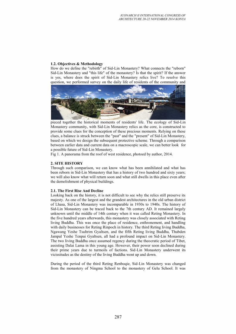
ICONARCH II INTERNATIONAL CONGRESS OF
ARCHITECTURE 20-22 NOVEMBER 2014 KONYA
287
1.2. Objectives & Methodology
How do we define the "rebirth" of Sid-Lin Monastery? What connects the "reborn"
Sid-Lin Monastery and "this life" of the monastery? Is that the spirit? If the answer
is yes, where does the spirit of Sid-Lin Monastery relics live? To resolve this
question, we performed survey on the daily life of residents of the community and
pieced together the historical moments of residents' life. The ecology of Sid-Lin
Monastery community, with Sid-Lin Monastery relics as the core, is constructed to
provide some clues for the conception of these precious moments. Relying on these
clues, a balance is struck between the "past" and the "present" of Sid-Lin Monastery,
based on which we design the subsequent protective scheme. Through a comparison
between earlier data and current data on a macroscopic scale, we can better look for
a possible future of Sid-Lin Monastery.
Fig 1. A panorama from the roof of west residence, photoed by author, 2014.
2. SITE HISTORY
Through such comparison, we can know what has been annihilated and what has
been reborn in Sid-Lin Monastery that has a history of two hundred and sixty years;
we will also know what will return soon and what still dwells in this place even after
the demolishment of physical buildings.
2.1. The First Rise And Decline
Looking back on the history, it is not difficult to see why the relics still preserve its
majesty. As one of the largest and the grandest architectures in the old urban district
of Lhasa, Sid-Lin Monastery was incomparable in 1930s to 1940s. The history of
Sid-Lin Monastery can be traced back to the 7th century AD. It remained largely
unknown until the middle of 14th century when it was called Reting Monastery. In
the five hundred years afterwards, this monastery was closely associated with Reting
living Buddha. This was once the place of residence, enthronement, and handling
with daily businesses for Reting Rinpoch in history. The third Reting living Buddha,
Ngawang Yeshe Tsultrim Gyaltsen, and the fifth Reting living Buddha, Thubden
Jampal Yeshe Tenpai Gyaltsen, all had a profound impact on Sid-Lin Monastery.
The two living Buddha once assumed regency during the theocratic period of Tibet,
assisting Dalai Lama in this young age. However, their power soon declined during
their prime years due to turmoils of factions. Sid-Lin Monastery underwent its
vicissitudes as the destiny of the living Buddha went up and down.
During the period of the third Reting Renboqie, Sid-Lin Monastery was changed
from the monastery of Ningma School to the monastery of Gelu School. It was
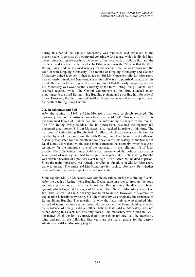
ICONARCH II INTERNATIONAL CONGRESS OF
ARCHITECTURE 20-22 NOVEMBER 2014 KONYA
288
during this period that Sid-Lin Monastery was renovated and expanded to the
present scale. It consists of a courtyard covering 0.63 hectare, which is divided into
the scripture hall in the north of the center of the courtyard, a Buddha Hall and the
residence and kitchen for the monks. In 1862, which was the 7th year that the third
Reting living Buddha assumed regency for the second time, he was drawn into the
conflict with Drepung Monastery. The monks of Drepung Monastery and Gandan
Monastery united together in their attack on Sid-Lin Monastery. Sid-Lin Monastery
was seriously ruined, and Ngawang Yeshe himself was also punished because of this
event. He died in the next year. It is without doubt that the early prosperity of Sid-
Lin Monastery was owed to the sublimity of the third Reting living Buddha, who
assumed regency twice. The Central Government at that time attached much
importance to the third Reting living Buddha, praising and awarding him for several
times. However, the first rising of Sid-Lin Monastery was suddenly stopped upon
the death of Reting living Buddha.
2.2. Renaissance and Fall After the ruining in 1862, Sid-Lin Monastery was only carelessly repaired. The
monastery was not reconstructed on a large scale until 1935. This is what we see as
the combined layout of Buddha hall and the surrounding residences of the monks.
The fifth Reting living Buddha, like its predecessor, assumed the regency and
possessed great power. Sid-Lin Monastery also reached its prime at this time. The
bedroom of Reting living Buddha had 16 pillars, which was never seen before. As
recalled by an old man in Lhasa, the fifth Reting living Buddha once held a dharma
assembly that lasted for one month and four days in this monastery, as the teacher of
Dalai Lama. More than two thousand monks attended the assembly, which is a great
testimony for the important role of the monastery in the religious life of local
people. The fifth Reting living Buddha also encountered the political crisis after
seven years of regency, and had to resign. Seven years later, Reting living Buddha
was arrested because of a political event in April 1947. After that, he died in prison.
Since the main monastery was ruined, the religions functions of Sid-Lin Monastery
came to an end. The entire Sid-Lin Monastery fell back to obscurity. But whether
Sid-Lin Monastery was completely ruined is uncertain.
Some say that Sid-Lin Monastery was completely ruined during this "Reting Event".
After the death of Reting living Buddha, Dazha gave an order to dress up the body
and transfer the body to Sid-Lin Monastery. Reting living Buddha was libeled
against, which triggered the anger of the mass. Then Sid-Lin Monastery was set on
fire. That is how Sid-Lin Monastery was burnt to ruins". However, this version of
explanation is hardly convincing. Sid-Lin Monastery was originally the residence of
Reting living Buddha. The question is: why the mass public, who admired him,
instead of taking actions against those who persecuted the living Buddha, invaded
the residence of living Buddha? Others believe that Sid-Lin Monastery was not
ruined during this event, but was only closed. The monastery was ruined in 1959.
No matter which version is correct, there is one thing for sure, i.e., the attacks by
wind and rain in the following fifty years are the main reasons for the current
situation of Sid-Lin Monastery (fig 2).
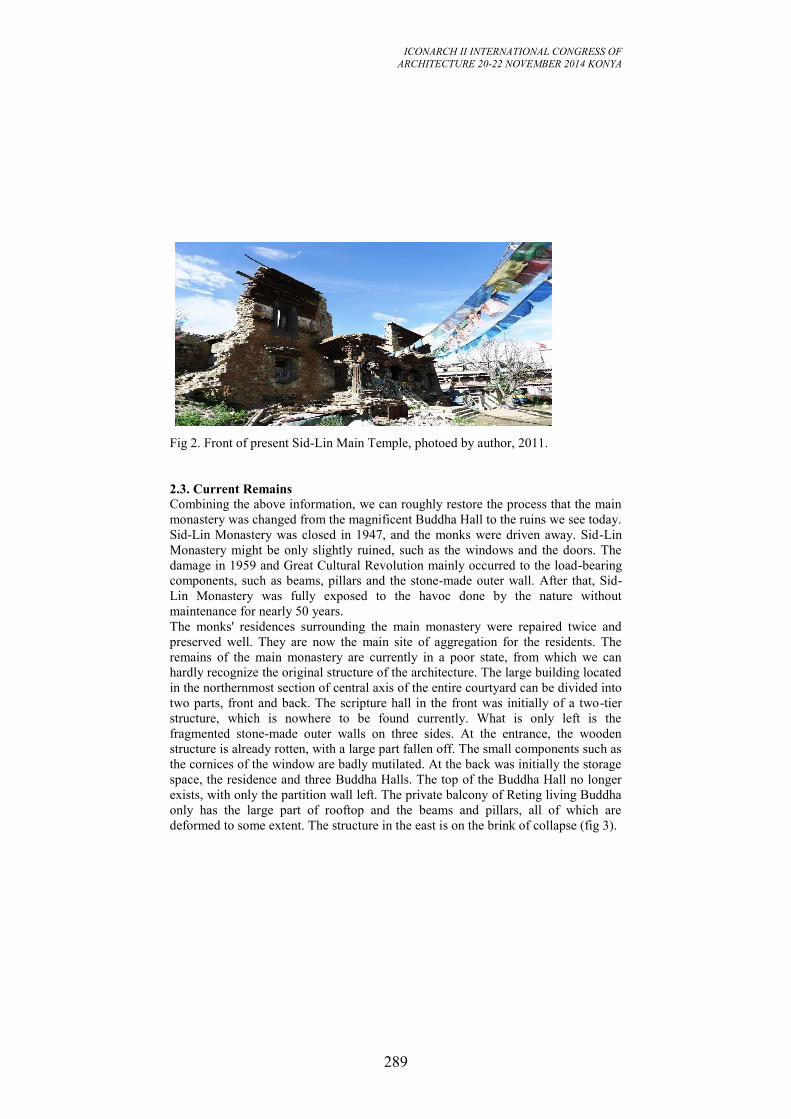
ICONARCH II INTERNATIONAL CONGRESS OF
ARCHITECTURE 20-22 NOVEMBER 2014 KONYA
289
Fig 2. Front of present Sid-Lin Main Temple, photoed by author, 2011.
2.3. Current Remains
Combining the above information, we can roughly restore the process that the main
monastery was changed from the magnificent Buddha Hall to the ruins we see today.
Sid-Lin Monastery was closed in 1947, and the monks were driven away. Sid-Lin
Monastery might be only slightly ruined, such as the windows and the doors. The
damage in 1959 and Great Cultural Revolution mainly occurred to the load-bearing
components, such as beams, pillars and the stone-made outer wall. After that, Sid-
Lin Monastery was fully exposed to the havoc done by the nature without
maintenance for nearly 50 years.
The monks' residences surrounding the main monastery were repaired twice and
preserved well. They are now the main site of aggregation for the residents. The
remains of the main monastery are currently in a poor state, from which we can
hardly recognize the original structure of the architecture. The large building located
in the northernmost section of central axis of the entire courtyard can be divided into
two parts, front and back. The scripture hall in the front was initially of a two-tier
structure, which is nowhere to be found currently. What is only left is the
fragmented stone-made outer walls on three sides. At the entrance, the wooden
structure is already rotten, with a large part fallen off. The small components such as
the cornices of the window are badly mutilated. At the back was initially the storage
space, the residence and three Buddha Halls. The top of the Buddha Hall no longer
exists, with only the partition wall left. The private balcony of Reting living Buddha
only has the large part of rooftop and the beams and pillars, all of which are
deformed to some extent. The structure in the east is on the brink of collapse (fig 3).
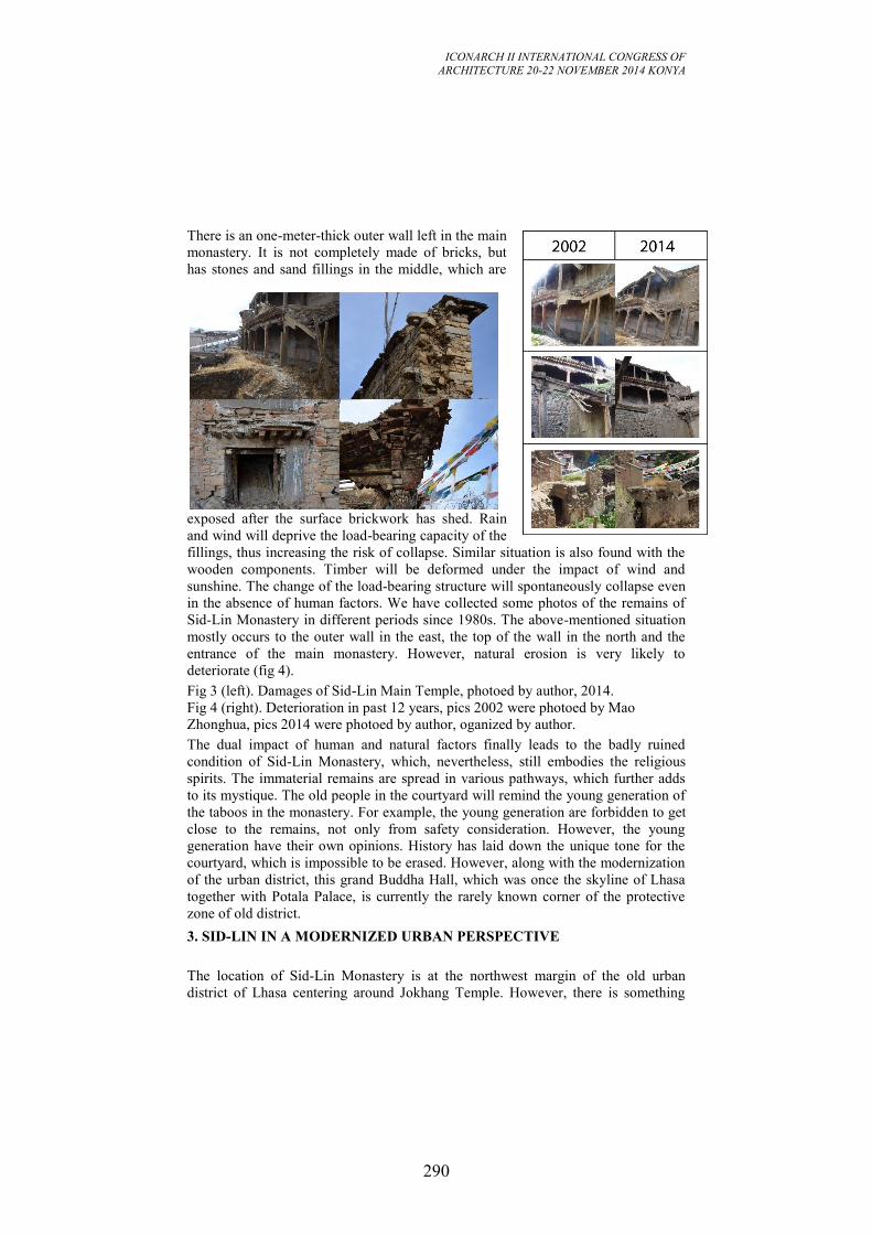
ICONARCH II INTERNATIONAL CONGRESS OF
ARCHITECTURE 20-22 NOVEMBER 2014 KONYA
290
There is an one-meter-thick outer wall left in the main
monastery. It is not completely made of bricks, but
has stones and sand fillings in the middle, which are
exposed after the surface brickwork has shed. Rain
and wind will deprive the load-bearing capacity of the
fillings, thus increasing the risk of collapse. Similar situation is also found with the
wooden components. Timber will be deformed under the impact of wind and
sunshine. The change of the load-bearing structure will spontaneously collapse even
in the absence of human factors. We have collected some photos of the remains of
Sid-Lin Monastery in different periods since 1980s. The above-mentioned situation
mostly occurs to the outer wall in the east, the top of the wall in the north and the
entrance of the main monastery. However, natural erosion is very likely to
deteriorate (fig 4). Fig 3 (left). Damages of Sid-Lin Main Temple, photoed by author, 2014.
Fig 4 (right). Deterioration in past 12 years, pics 2002 were photoed by Mao
Zhonghua, pics 2014 were photoed by author, oganized by author. The dual impact of human and natural factors finally leads to the badly ruined
condition of Sid-Lin Monastery, which, nevertheless, still embodies the religious
spirits. The immaterial remains are spread in various pathways, which further adds
to its mystique. The old people in the courtyard will remind the young generation of
the taboos in the monastery. For example, the young generation are forbidden to get
close to the remains, not only from safety consideration. However, the young
generation have their own opinions. History has laid down the unique tone for the
courtyard, which is impossible to be erased. However, along with the modernization
of the urban district, this grand Buddha Hall, which was once the skyline of Lhasa
together with Potala Palace, is currently the rarely known corner of the protective
zone of old district.
3. SID-LIN IN A MODERNIZED URBAN PERSPECTIVE
The location of Sid-Lin Monastery is at the northwest margin of the old urban
district of Lhasa centering around Jokhang Temple. However, there is something
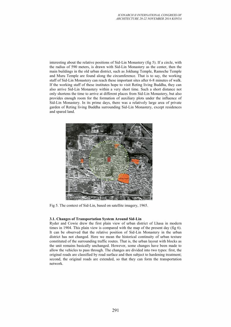
ICONARCH II INTERNATIONAL CONGRESS OF
ARCHITECTURE 20-22 NOVEMBER 2014 KONYA
291
interesting about the relative positions of Sid-Lin Monastery (fig 5). If a circle, with
the radius of 590 meters, is drawn with Sid-Lin Monastery as the center, then the
main buildings in the old urban district, such as Jokhang Temple, Ramoche Temple
and Muru Temple are found along the circumference. That is to say, the working
staff of Sid-Lin Monastery can reach these important sites after 6-8 minutes of walk.
If the working staff of these institutes hope to visit Reting living Buddha, they can
also arrive Sid-Lin Monastery within a very short time. Such a short distance not
only shortens the time to arrive at different places from Sid-Lin Monastery, but also
provides enough room for the formation of auxiliary plots under the influence of
Sid-Lin Monastery. In its prime days, there was a relatively large area of private
garden of Reting living Buddha surrounding Sid-Lin Monastery, except residences
and spared land.
Fig 5. The context of Sid-Lin, based on satellite imagery, 1965.
3.1. Changes of Transportation System Around Sid-Lin
Ryder and Cowie drew the first plain view of urban district of Lhasa in modern
times in 1904. This plain view is compared with the map of the present day (fig 6).
It can be observed that the relative position of Sid-Lin Monastery in the urban
district has not changed. Here we mean the historical continuity of urban texture
constituted of the surrounding traffic routes. That is, the urban layout with blocks as
the unit remains basically unchanged. However, some changes have been made to
allow the vehicles to pass through. The changes are divided into two types: first, the
original roads are classified by road surface and then subject to hardening treatment;
second, the original roads are extended, so that they can form the transportation
network.
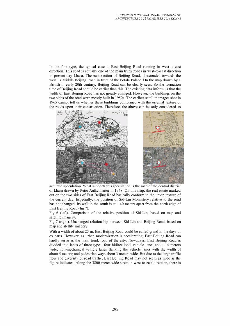
ICONARCH II INTERNATIONAL CONGRESS OF
ARCHITECTURE 20-22 NOVEMBER 2014 KONYA
292
In the first type, the typical case is East Beijing Road running in west-to-east
direction. This road is actually one of the main trunk roads in west-to-east direction
in present-day Lhasa. The east section of Beijing Road, if extended towards the
west, is Middle Beijing Road in front of the Potala Palace. On the map drawn by a
British in early 20th century, Beijing Road can be clearly seen. So the formation
time of Beijing Road should be earlier than this. The existing data inform us that the
width of East Beijing Road has not greatly changed. However, the buildings on the
two sides of the road were mostly built in 1950s. The earliest satellite images shot in
1965 cannot tell us whether these buildings conformed with the original texture of
the roads upon their construction. Therefore, the above can be only considered as
accurate speculation. What supports this speculation is the map of the central district
of Lhasa drawn by Peter Aufschnaiter in 1948. On this map, the real estate marked
out on the two sides of East Beijing Road basically conform to the urban texture of
the current day. Especially, the position of Sid-Lin Monastery relative to the road
has not changed. Its wall in the south is still 40 meters apart from the north edge of
East Beijing Road (fig 7).
Fig 6 (left). Comparison of the relative position of Sid-Lin, based on map and
satellite imagery.
Fig 7 (right). Unchanged relationship between Sid-Lin and Beijing Road, based on
map and stellite imagery With a width of about 25 m, East Beijing Road could be called grand in the days of
ox carts. However, as urban modernization is accelerating, East Beijing Road can
hardly serve as the main trunk road of the city. Nowadays, East Beijing Road is
divided into lanes of three types: four bidirectional vehicle lanes about 14 meters
wide; non-mechanical vehicle lanes flanking the vehicle lanes with the width of
about 5 meters; and pedestrian ways about 3 meters wide. But due to the large traffic
flow and diversity of road traffic, East Beijing Road may not seem as wide as the
figure indicates. Along the 3800-meter-wide street in west-to-east direction, there is
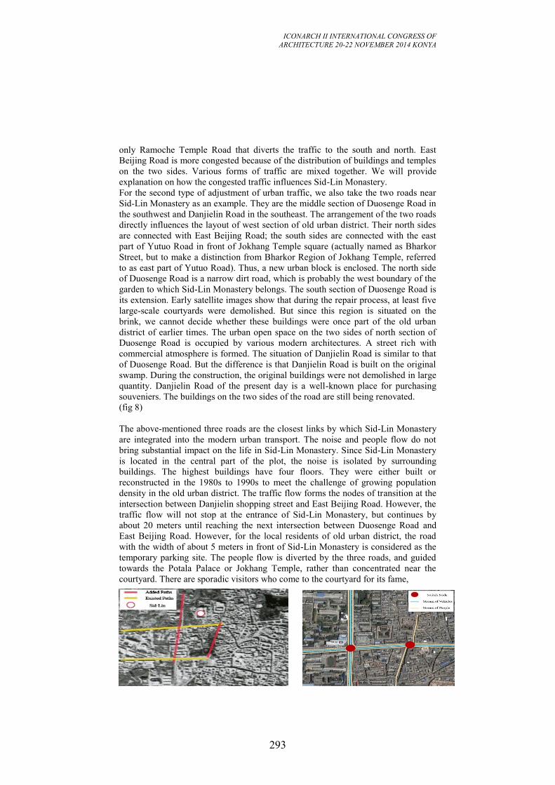
ICONARCH II INTERNATIONAL CONGRESS OF
ARCHITECTURE 20-22 NOVEMBER 2014 KONYA
293
only Ramoche Temple Road that diverts the traffic to the south and north. East
Beijing Road is more congested because of the distribution of buildings and temples
on the two sides. Various forms of traffic are mixed together. We will provide
explanation on how the congested traffic influences Sid-Lin Monastery.
For the second type of adjustment of urban traffic, we also take the two roads near
Sid-Lin Monastery as an example. They are the middle section of Duosenge Road in
the southwest and Danjielin Road in the southeast. The arrangement of the two roads
directly influences the layout of west section of old urban district. Their north sides
are connected with East Beijing Road; the south sides are connected with the east
part of Yutuo Road in front of Jokhang Temple square (actually named as Bharkor
Street, but to make a distinction from Bharkor Region of Jokhang Temple, referred
to as east part of Yutuo Road). Thus, a new urban block is enclosed. The north side
of Duosenge Road is a narrow dirt road, which is probably the west boundary of the
garden to which Sid-Lin Monastery belongs. The south section of Duosenge Road is
its extension. Early satellite images show that during the repair process, at least five
large-scale courtyards were demolished. But since this region is situated on the
brink, we cannot decide whether these buildings were once part of the old urban
district of earlier times. The urban open space on the two sides of north section of
Duosenge Road is occupied by various modern architectures. A street rich with
commercial atmosphere is formed. The situation of Danjielin Road is similar to that
of Duosenge Road. But the difference is that Danjielin Road is built on the original
swamp. During the construction, the original buildings were not demolished in large
quantity. Danjielin Road of the present day is a well-known place for purchasing
souveniers. The buildings on the two sides of the road are still being renovated.
(fig 8)
The above-mentioned three roads are the closest links by which Sid-Lin Monastery
are integrated into the modern urban transport. The noise and people flow do not
bring substantial impact on the life in Sid-Lin Monastery. Since Sid-Lin Monastery
is located in the central part of the plot, the noise is isolated by surrounding
buildings. The highest buildings have four floors. They were either built or
reconstructed in the 1980s to 1990s to meet the challenge of growing population
density in the old urban district. The traffic flow forms the nodes of transition at the
intersection between Danjielin shopping street and East Beijing Road. However, the
traffic flow will not stop at the entrance of Sid-Lin Monastery, but continues by
about 20 meters until reaching the next intersection between Duosenge Road and
East Beijing Road. However, for the local residents of old urban district, the road
with the width of about 5 meters in front of Sid-Lin Monastery is considered as the
temporary parking site. The people flow is diverted by the three roads, and guided
towards the Potala Palace or Jokhang Temple, rather than concentrated near the
courtyard. There are sporadic visitors who come to the courtyard for its fame,
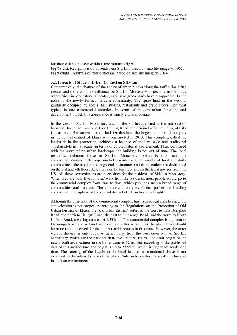
ICONARCH II INTERNATIONAL CONGRESS OF
ARCHITECTURE 20-22 NOVEMBER 2014 KONYA
294
but they will soon leave within a few minutes (fig 9).
Fig 8 (left). Reorganization of roads near Sid-Lin, based on satellite imagery, 1965.
Fig 9 (right). Analysis of traffic streams, based on satellite imagery, 2014.
3.2. Impacts of Modern Urban Context on SID-Lin
Comparatively, the changes of the nature of urban blocks along the traffic line bring
greater and more complex influence on Sid-Lin Monastery. Especially in the block
where Sid-Lin Monastery is located, extensive green lands have disappeared. In the
north is the newly formed modern community. The spare land in the west is
gradually occupied by hotels, hair studios, restaurants and brand stores. The most
typical is one commercial complex. In terms of modern urban functions and
development model, this appearance is timely and appropriate.
In the west of Sid-Lin Monastery and on the 8.5-hectare land at the intersection
between Duosenge Road and East Beijing Road, the original office building of City
Construction Bureau was demolished. On this land, the largest commercial complex
in the central district of Lhasa was constructed in 2013. This complex, called the
landmark in the promotion, achieves a balance of modern style and traditional
Tibetan style in its facade, in terms of color, material and element. Thus, compared
with the surrounding urban landscape, the building is not out of tune. The local
residents, including those in Sid-Lin Monastery, obtain benefits from the
commercial complex: the supermarket provides a great variety of food and daily
commodities; the middle and high-end restaurants and drink outlets are distributed
on the 3rd and 4th floor; the cinema in the top floor shows the latest movies from the
US. All these conveniences are necessities for the residents of Sid-Lin Monastery.
When they are only five minutes' walk from the residents, most people would go to
the commercial complex from time to time, which provides such a broad range of
commodities and services. The commercial complex further pushes the bustling
commercial atmosphere of the central district of Lhasa to a new height.
Although the existence of the commercial complex has its practical significance, the
site selection is not proper. According to the Regulations on the Protection of Old
Urban District of Lhasa, the "old urban district" refers to the west to East Dongkuo
Road, the north to Jiangsu Road, the east to Duosenge Road, and the north to North
Linkuo Road, covering an area of 1.33 km2. The commercial complex is adjacent to
Duosenge Road and within the protective buffer zone under the plan. There should
be more room reserved for the ancient architectures in this zone. However, the outer
wall in the east is only about 6 meters away from the west outer wall of Sid-Lin
Monastery, which are the national first-level cultural relics. The limit height of the
newly built architectures in the buffer zone is 12 m. But according to the published
data of this architecture, the height is up to 23.95 m, which is higher by nearly one
time. The catering of the facade to the local features as mentioned above is not
extended to the internal space of the block. Sid-Lin Monastery is greatly influenced
in such an environment.
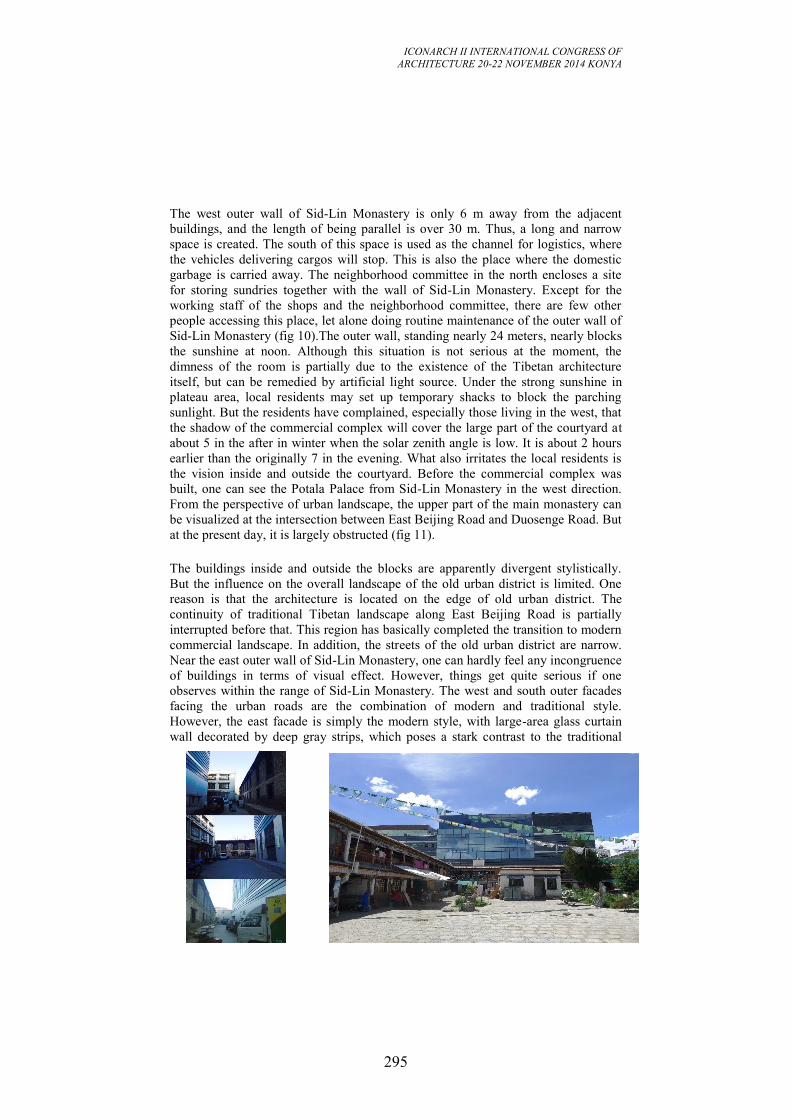
ICONARCH II INTERNATIONAL CONGRESS OF
ARCHITECTURE 20-22 NOVEMBER 2014 KONYA
295
The west outer wall of Sid-Lin Monastery is only 6 m away from the adjacent
buildings, and the length of being parallel is over 30 m. Thus, a long and narrow
space is created. The south of this space is used as the channel for logistics, where
the vehicles delivering cargos will stop. This is also the place where the domestic
garbage is carried away. The neighborhood committee in the north encloses a site
for storing sundries together with the wall of Sid-Lin Monastery. Except for the
working staff of the shops and the neighborhood committee, there are few other
people accessing this place, let alone doing routine maintenance of the outer wall of
Sid-Lin Monastery (fig 10).The outer wall, standing nearly 24 meters, nearly blocks
the sunshine at noon. Although this situation is not serious at the moment, the
dimness of the room is partially due to the existence of the Tibetan architecture
itself, but can be remedied by artificial light source. Under the strong sunshine in
plateau area, local residents may set up temporary shacks to block the parching
sunlight. But the residents have complained, especially those living in the west, that
the shadow of the commercial complex will cover the large part of the courtyard at
about 5 in the after in winter when the solar zenith angle is low. It is about 2 hours
earlier than the originally 7 in the evening. What also irritates the local residents is
the vision inside and outside the courtyard. Before the commercial complex was
built, one can see the Potala Palace from Sid-Lin Monastery in the west direction.
From the perspective of urban landscape, the upper part of the main monastery can
be visualized at the intersection between East Beijing Road and Duosenge Road. But
at the present day, it is largely obstructed (fig 11).
The buildings inside and outside the blocks are apparently divergent stylistically.
But the influence on the overall landscape of the old urban district is limited. One
reason is that the architecture is located on the edge of old urban district. The
continuity of traditional Tibetan landscape along East Beijing Road is partially
interrupted before that. This region has basically completed the transition to modern
commercial landscape. In addition, the streets of the old urban district are narrow.
Near the east outer wall of Sid-Lin Monastery, one can hardly feel any incongruence
of buildings in terms of visual effect. However, things get quite serious if one
observes within the range of Sid-Lin Monastery. The west and south outer facades
facing the urban roads are the combination of modern and traditional style.
However, the east facade is simply the modern style, with large-area glass curtain
wall decorated by deep gray strips, which poses a stark contrast to the traditional
ICONARCH II INTERNATIONAL CONGRESS OF
ARCHITECTURE 20-22 NOVEMBER 2014 KONYA
296
style of Sid-Lin Monastery.
Fig 10 (left). Present situation of west exterior elevation of Sid-Lin,photoed by
Lobsang Draga.
Fig 11 (right). Discordant modern elevation against Sid-Lin Courtyard, photoed by
author, 2014.
Besides the commercial complex, the spare land in the north of Sid-Lin Monastery is
allocated to Tibet Daily. The north wall of the remains of Sid-Lin Monastery has
become part of the outer wall of residence for family members. This structure, with
an area of about 6 hectares, is a confined space, leaving only one entrance at the
north section near Duosenge Road. The Summer Palace Xidezhuokang, which is
attached to Sid-Lin Monastery, is hidden in this structure. Initially, the main
monastery had an entrance at this side, which is currently disused. In the process of
our survey, we can only access the north wall of the main monastery by passing
through the gate of Tibet Daily and the southermost section of the residence for
family members. In other directions, such as the northeast, the channels are
obstructed by simple barriers. The initial entrance close to the kitchen in the east has
been completely obstructed by brickwork. Thus, the connection between Sid-Lin
Monastery and Summer Palace is completely cut off. The connection with the
channels inside this region is also weakened. But from another perspective, such
closedness of Sid-Lin Monastery ensures its purity and independence. Sid-Lin
Monastery is connected with the well preserved urban landscape on the east and
regarded as part of the original texture. Moreover, the unnecessary relations with the
surrounding are severed, so Sid-Lin Monastery can be singled out and considered as
a unique element in the region.
3.3 A Recommended Attitude to Changes
On the macroscopic scale, Sid-Lin Monastery is subject to the vicissitudes of the
surrounding environment. But these changes are irreversible within a short period of
time, and may be aggravated over time. The changes are highly incompatible with
the religious spirit and the splendid history of Sid-Lin Monastery. What position
should we taken when talking about the protection of Sid-Lin Monastery. If we
formulate and implement the plans to the restore the appearance of Sid-Lin
Monastery only depending on the anger on deteriorating environment, does it mean
that what we are doing to the on-going history as what we have done before.
If Sid-Lin Monastery is preserved intact, the above-mentioned problems will be
ignored against our own will. The focus of this article will be also diverted to other
aspects, such as restoration technique, restoration degree, demolishment of illegal
buildings and the relocation of the residents. For Sid-Lin Monastery remains, we can
attempt to justify the irreparable mistakes done to Sid-Lin Monastery. These
mistakes can be transformed as the environment changes, just like Sid-Lin
Monastery itself. Instead of redressing the mistakes, we should find ways to make
these mistakes more acceptable to more interest groups. As stated in Nara
Declaration, we should try our best to update realistic evaluation from the
perspective of values and environment in evolution. Xi'an Declaration released on

ICONARCH II INTERNATIONAL CONGRESS OF
ARCHITECTURE 20-22 NOVEMBER 2014 KONYA
297
the 15th International Conference on Ancient Relics in 2005 also contained similar
statements "managing the changes of ancient architectures and ancient relics and the
changes of the historical environment does not necessarily mean preventing or
obstructing such changes". If changes are inevitable, how to accept and utilize the
good or bad changes is a more realistic subject when talking about the protection of
Sid-Lin Monastery.
We should not be satisfied with managing the external environment on the city
scale. The internal environment should be also viewed on the community level or
even more microscopic level.
Fig 12. Sid-Lin Courtyard in 1930s,1992,2014. pics 1930s,1992 were quoted from
The temples of Lhasa Tibetan Buddhist Architecture, pics 2014 was photoed by
author.
4. IN A SECULARIZED SID-LIN COURTYARD
Sid-Lin Monastery was once a spiritual place for Buddhists' practice. But now it
becomes a mundane community for residents (fig 12). As mentioned before, the
main monastery of Sid-Lin Monastery had been a residence of Rezhen living
Buddha for a long time. Its large-scale monks' apartments in the surroundings were
established under such circumstances. Such unit is called Dratsang in the
organizational system of Monasteries of Tibetan Buddhism. A Dratsang is similar to
a school in universities nowadays. It can be an independent unit with its complete
organization and its own property as well as working capital. Those who live in a
Dratsang are almost all monks in Buddhist practice. Though they are different at
Buddhist accomplishments, job title and social status, they all practice religious
activities of the same nature in this yard. In a particular historical period, these
activities endowed Sid-Lin Monastery with a strong spiritual attribute which was
beyond physical space. This spiritual attribute will not disappear along with its
material carrier, but will fade with time or be covered by new attributes. It is none
other than the residents who bring new attributes.
4.1. The Reorganization of Sid-Lin Courtyard Before the 1980s, Sid-Lin Monastery had always been an office-like unit which
accommodated circuit teams and Tibetan opera groups. In 1984, two floors of Sid-
Lin Monastery underwent a major maintenance. From then on, it started its
transition to a residential community. Back then, in order to solve the increasingly
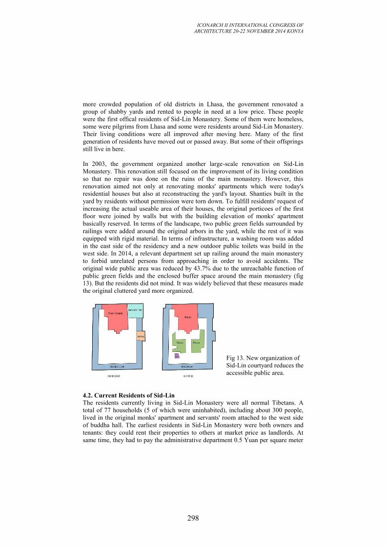
ICONARCH II INTERNATIONAL CONGRESS OF
ARCHITECTURE 20-22 NOVEMBER 2014 KONYA
298
more crowded population of old districts in Lhasa, the government renovated a
group of shabby yards and rented to people in need at a low price. These people
were the first offical residents of Sid-Lin Monastery. Some of them were homeless,
some were pilgrims from Lhasa and some were residents around Sid-Lin Monastery.
Their living conditions were all improved after moving here. Many of the first
generation of residents have moved out or passed away. But some of their offsprings
still live in here.
In 2003, the government organized another large-scale renovation on Sid-Lin
Monastery. This renovation still focused on the improvement of its living condition
so that no repair was done on the ruins of the main monastery. However, this
renovation aimed not only at renovating monks' apartments which were today's
residential houses but also at reconstructing the yard's layout. Shanties built in the
yard by residents without permission were torn down. To fulfill residents' request of
increasing the actual useable area of their houses, the original porticoes of the first
floor were joined by walls but with the building elevation of monks' apartment
basically reserved. In terms of the landscape, two public green fields surrounded by
railings were added around the original arbors in the yard, while the rest of it was
equipped with rigid material. In terms of infrastructure, a washing room was added
in the east side of the residency and a new outdoor public toilets was build in the
west side. In 2014, a relevant department set up railing around the main monastery
to forbid unrelated persons from approaching in order to avoid accidents. The
original wide public area was reduced by 43.7% due to the unreachable function of
public green fields and the enclosed buffer space around the main monastery (fig
13). But the residents did not mind. It was widely believed that these measures made
the original cluttered yard more organized.
Fig 13. New organization of
Sid-Lin courtyard reduces the
accessible public area.
4.2. Current Residents of Sid-Lin The residents currently living in Sid-Lin Monastery were all normal Tibetans. A
total of 77 households (5 of which were uninhabited), including about 300 people,
lived in the original monks' apartment and servants' room attached to the west side
of buddha hall. The earliest residents in Sid-Lin Monastery were both owners and
tenants: they could rent their properties to others at market price as landlords. At
same time, they had to pay the administrative department 0.5 Yuan per square meter
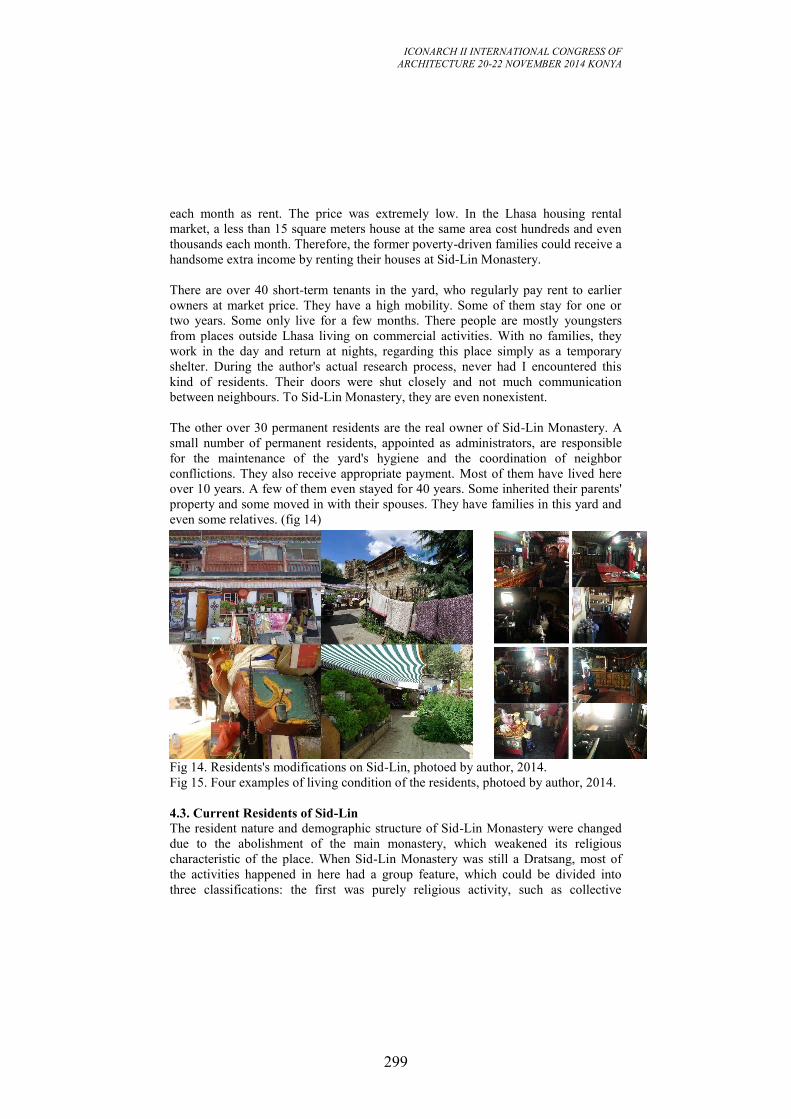
ICONARCH II INTERNATIONAL CONGRESS OF
ARCHITECTURE 20-22 NOVEMBER 2014 KONYA
299
each month as rent. The price was extremely low. In the Lhasa housing rental
market, a less than 15 square meters house at the same area cost hundreds and even
thousands each month. Therefore, the former poverty-driven families could receive a
handsome extra income by renting their houses at Sid-Lin Monastery.
There are over 40 short-term tenants in the yard, who regularly pay rent to earlier
owners at market price. They have a high mobility. Some of them stay for one or
two years. Some only live for a few months. There people are mostly youngsters
from places outside Lhasa living on commercial activities. With no families, they
work in the day and return at nights, regarding this place simply as a temporary
shelter. During the author's actual research process, never had I encountered this
kind of residents. Their doors were shut closely and not much communication
between neighbours. To Sid-Lin Monastery, they are even nonexistent.
The other over 30 permanent residents are the real owner of Sid-Lin Monastery. A
small number of permanent residents, appointed as administrators, are responsible
for the maintenance of the yard's hygiene and the coordination of neighbor
conflictions. They also receive appropriate payment. Most of them have lived here
over 10 years. A few of them even stayed for 40 years. Some inherited their parents'
property and some moved in with their spouses. They have families in this yard and
even some relatives. (fig 14)
Fig 14. Residents's modifications on Sid-Lin, photoed by author, 2014.
Fig 15. Four examples of living condition of the residents, photoed by author, 2014.
4.3. Current Residents of Sid-Lin The resident nature and demographic structure of Sid-Lin Monastery were changed
due to the abolishment of the main monastery, which weakened its religious
characteristic of the place. When Sid-Lin Monastery was still a Dratsang, most of
the activities happened in here had a group feature, which could be divided into
three classifications: the first was purely religious activity, such as collective
ICONARCH II INTERNATIONAL CONGRESS OF
ARCHITECTURE 20-22 NOVEMBER 2014 KONYA
300
learning of Buddhist classics and holding religious ceremonies, etc. This kind
comprised primary activities of Sid-Lin Monastery's spiritual place back then; the
second was rather mundane activities to keep the Dratsang running, such as financial
procurement from outside and reception of visiting followers, etc; the third was
some purely mundane but necessary activities like daily dinning, sleeping and
human communication, etc.
Now the first and second kind activities no long exist as religious organization
moved out. Now public activities with religious features happened in here, such as
burning aromatic plant on Wednesday and changing suspended prayer flags on New
Year's Day, were more reasonably cataloged into folk custom. Pilgrimage and
consecration are routines for residents. Nearly every family has its own Buddhist
prayer room in a separate compartment or as part of sitting room. But these are just
common features in Tibetans' daily life. They should not be considered as
continuation of original Sid-Lin Monastery's religious characteristic. The third
mundane activities become main activities happened in Sid-Lin Monastery with a
wider variety. These activities add new place characteristics for Sid-Lin Monastery.
Unlike the monks before, nowadays residents live with family as unit rather than
organized group living. Children shuttle through families and play around; the
young sometimes gather around the tables and chairs near the registration room at
their door to play a particular Tibetan dice game; the old watch them on the side and
chat with each others. These mundane scenes of life could not be seen when Sid-Lin
Monastery was a Dratsang.
Besides changing the scenes of life, residents of Sid-Lin Monastery also respectively
transformed their private areas basing on their needs, especially within the limited
area before their door. Some families showed affection for plants. They set up a
pergola in front of their house to put various plot plants on; some put things that
could not fit indoor, like washing machine and abandoned old furniture. Second
floor residents between the vertical and horizontal aisles could not utilize public
areas in the yard like first floor residents so they use simple board to close the
second floor aisles. There are also families who extend their means of sustenance to
the wider public area within yard. These reconstructions mentioned above may be
too random some times and leave the yard in disorder but they have added strong
smack of everyday life for Sid-Lin Monastery and become normal state of it. (fig
15)
4.4. New Residential Pattern in Sid-Lin
In order to establish the residential environment formed in Sid-Lin Monastery, the
author performed household surveys on 12 long-term residents. During the survey,
apart from rising questions specific to real situations, 4 questions designed before
surveys were asked as follows. When and why did they move in? Are they satisfied
with current living condition and do they want move out? How is the relationship
between the neighbours? Do they always participate activities in the yard and what
kinds of activities?
ICONARCH II INTERNATIONAL CONGRESS OF
ARCHITECTURE 20-22 NOVEMBER 2014 KONYA
301
The followings are three typical examples as the limitation of pages.
Nima Ciren lives in the bigger house with about 30 square meters on the first floor
of the yard's southeast side. This area is enough for his wife, two kids and himself to
live in, even with surplus. Therefore he transformed the part at back into a clothing
studio. His wife and him were introduced to here in 2004. They make clothes and
sell them on the near markets for a living, with an income of about 2000 to 3000
Yuan each month now. They were quite satisfied with current living condition and
never have the thought of moving out. His wife sell their ready-made clothes at
Barkhor Street Mall with 850 meters from Sid-Lin Monastery at the crossing of
Linkuo East Road and Beijing East Road and himself stay working at the clothing
studio. Since Nima Ciren spends most time in the yard, he was appointed as
householder in charge of coordination for 10 families. When it comes to traditional
festivals, he also organized public recreational activities with other householders. He
was so familiar with residents near the area and get along with them well. He often
basked in the yard's sunshine but seldom move about the ruins of the main
monastery.
Duola is one of Cizong's neighbors. In the courtyard of Sid-Lin Monastery at least
two households are his relatives. His mother has been living in Sid-Lin Monastery
for more than 40 years. She lived here since the time of Tibetan Opera Troupe.
During her residence here, she moved for several times, mostly within the courtyard.
Currently, Duola's mother and her sisters' family (totaling 9 people) are living on the
second floor of the largest room in the west. This was once the kitchen for the
monks, whose structure differs from other rooms. One part of the room extends
outwards, making the room more spacious. Dola himself is a carpenter, and he
moved back to the courtyard in 1983. Like Cizong, he made various types of
traditional Tibetan furniture using the space on one side. One household on the east
side is a painter, who works with Dola and draws patterns on the furniture. He does
not want to move out of the courtyard, because this courtyard provides the working
space for him. If he has to move out, he hopes to live with his neighbors.
The family of Cangqiong in his young age lives on the floor above Nima Ciren. He
moved into Sid-Lin Monastery in 2009, because his parents lived in this courtyard.
When she told the authorities that she wanted to move back, she soon obtained the
approval. At present, she lives with her husband, children and brothers in a crowded
room less than 30 square meters. Cangqiong's brother works in a cleaning company,
and her husband works as a security nearby. Since she lives on the second floor, she
rarely goes out to the courtyard, but looks after children in the house. She does not
want her children to play near the remains, because she thinks it is unsafe. She does
not think too much of the convenient transportation here or her easy access to a
courtyard. She wants to move out to a new-style community.
The three examples mentioned above are the representatives of over 30 long-term
households living in Sid-Lin Monastery. They have been long accustomed to the life
of the courtyard and the relations between the neighbors are harmonious. These
ICONARCH II INTERNATIONAL CONGRESS OF
ARCHITECTURE 20-22 NOVEMBER 2014 KONYA
302
people's life is already integrated into the changing environment near Sid-Lin
Monastery. As to the remains of the main monastery, they only hope that it will be
soon recovered. But when it comes to the question of how it should be restored and
what problems will ensue after restoration, they do not give too much consideration.
If Sid-Lin Monastery is to be restored in a conventional way, the interests of the
residents here will be the first to be compromised. The residents of Sid-Lin
Monastery have been living here for more than 30 years, and they are already
accustomed to the living environment. In fact, whatever protective measures to be
adopted for Sid-Lin Monastery, the tranquil life of the residents here will be
disturbed. If that is to happen, we have to adopt certain measures to ensure that the
changes are constructive. Sid-Lin Monastery should not be only the object of these
changes.
5. CONCLUTION AND SUGGESTIONS
From an urban perspective, Sid-Lin Monastery is squarely embedded into the new
urban system. The surrounding of Sid-Lin Monastery is enveloped in an increasingly
strong commercial atmosphere. This is the hard truth. In this context, it is unrealistic
to restore its position as Dratsang. If the internal microscopic structure of Sid-Lin
Monastery is not renovated, the monastery can hardly fit the traditional religious
institution. From the standpoint of sustainability, the protection of Sid-Lin
Monastery should highlight the return of the spirits, rather than the reconstruction of
a physical entity.
Probably we can utilize the existing conditions to restore part, if not all, of the
religious functions of Sid-Lin Monastery on a community level. This practice not
only conforms to the wish of the public, but also produces no major influence on the
existing urban pattern, thus causing no conflicts. The place for religious activities is
confined to the small domain where the main monastery is located. Thus the
religious activities can be performed without invading the life space of the residents.
As some of the religious functions are restored, some adjustments can be made to
the public layout to accommodate two life styles, the life of the monks and the life
of the worldly people. The originally closed public greenspace can be opened. The
remains of the main monastery may not be completely restored and be cleaned up,
consolidated and renovated locally. While preserving its historical value as a relic,
the main monastery may be restored into a religious place. A few monks can reside
in this place for routine management. Then more work can be done to strengthen its
religious and spiritual nature and to pinpoint its significance in the courtyard of Sid-
Lin Monastery. Next, the restored religious attributes and the worldly life will
coexist and develop together in mutual benefits.
The above conception will be refined in subsequent design. This article has made
some preliminary discussions on the issues centering around the courtyard of Sid-
Lin Monastery. To be "reborn" in a real sense, Sid-Lin Monastery should resemble
ICONARCH II INTERNATIONAL CONGRESS OF
ARCHITECTURE 20-22 NOVEMBER 2014 KONYA
303
the living Buddha in the unique incarnation system of Tibetan Buddhism: no matter
how profound the preceding life, he should start the next life like an infant, adapting
to the new environment and obtaining recognition from a new start.
REFERENCES
-Andre Alexander, The temples of Lhasa Tibetan Buddhist Architecture (From the
7th
to the
21st Centuries), 2005
-ICOMOS CHINA, Xi’an Manifesto, 2005
-Knud Larsen and Amund Sinding-Larsen, 2001, The Lhasa Atlas.
-Lian Xiangmin, 2004, The Suffering: Reting Event in Spring 1947.
-Liu Shengqi, 2010, The Temples and Monks in Tibet (1940s).
-Lcang Skya Jo Bbe Dorji,The 7th
Dalai Lama, 2006
-The Protection Ordinance of Traditional Urban Area of Lhasa, 2013
-The Institution of City Planning and Design, China, The Conservation Planning of
Barkhor District, 2004
-The Law of the People’s Republic of China on Protection of Cultural Relics, 1991
-UNESCO World Heritage Committee, the Nara Documenton Authenticity, 1994
-Urban and Rural Planning Law of the People’s Republic of China, 2007
-Reference from Internet: http://ditu.google.cn/maps?output=classic&dg=ctry (refer
to Lhasa, date of connection 2014)
ICONARCH II INTERNATIONAL CONGRESS OF
ARCHITECTURE 20-22 NOVEMBER 2014 KONYA
304
AN INVESTIGATION OF TERRITORY CONCEPT IN THE
CONTEXT OF TWO RESIDENTIAL UNITS IN ANKARA:
ISRAEL HOUSES AND SARAÇOĞLU NEIGHBORHOOD KADRİYE BURCU YAVUZ1
ABSTRACT
The term of territoriality has been a significant concept since the beginning of
history for both animals and human being. It is required for the maintenance of their
lives to sustain their nourishment, sheltering and the other needs. Accordingly, the
reflection of this situation has shown itself as an occupancy desire. A special space
which its boundaries are defined is needed to be occupied for that purposes by
promoted by the archetype which is inside of us. In this sense, the space regulates
the behavior of people depending on its hierarchical structure. As the hierarchy of
the space changes, then the interaction between people also changes. To this respect,
the term of space could be defined as a regulative mechanism which alters the
connection among people. This is directly linked with the territoriality concept. The
more personal the space, the less interaction between people. The less personal the
space, the more interaction between people. The first type of the territoriality
concept might cause introversion or alonessness. On the other hand, the second type
of the territoriality concept might cause extraversion or socialness. Introversion /
alonessness and extraversion / socialness are related with the privacy levels which
are defined by the inhabitants of a specific territory. The relationship between the
desired and achieved privacy levels constitutes the formation of introversion /
alonessness or extraversion / socialness of the people in their boundaries of defined
territories. In this context, territoriality concept is examined considering two
residential areas in Ankara, named as Israel Houses residential unit and Saraçoğlu
Neighborhood. The study is supported by field survey. In the process of field survey,
the territorial boundaries in the residential areas have been recognized depending on
their types. Whether the territory boundaries are defined or not is determined for the
both residential area. Then, it is linked with the occupancy, privacy and archetype
concepts. As a result of the field survey, it is observed that Israel Houses residential
unit has exactly defined territory boundaries which constitutes an ideal situation for
the interaction between people. However, it is confirmed that Saraçoğlu
Neighborhood does not have exactly defined territory boundaries as in Israel Houses
residential unit. Therefore, it could be stated that the interaction between people
constitutes a level which might disturbs the inhabitants of the neighborhood which
creates an unfavorable situation for them.
Key words: Territoriality, Privacy, Archetype, Space
1 Research Assistant Gazi University, Department of City and Regional Planing, ANKARA
ICONARCH II INTERNATIONAL CONGRESS OF
ARCHITECTURE 20-22 NOVEMBER 2014 KONYA
305
1. INTRODUCTION
Human being has always needed a space which is possessed by them. This is a law
of nature which is adopted by both human being and animals. The possessed space
is required for living species to maintain their existence, to maintain their vital
activities. This is actually an interesting fact that causes the formation of boundaries
in terms of space. Each living creature should have a certain amount of space to live.
In the case of occupation of this space, the existence of them would be in danger.
Accordingly, the living creatures are in the tendency to protect their own existence
spaces, in other words their boundaries to sustain their features of animacy. Looking
at a different standpoint, a spatial territory is appropriated. It is highly connected
with the privacy issue. People look forward privacy to resume their own spaces,
namely their appropriated spatial territories by occupying these territories.
2. THE TERRITORY CONCEPT AND ITS RELATED FEATURES
Privacy constitutes the fundamental term which is required for the protection of the
boundaries of territories. This term is defined as main regulatory tool which sustains
the level of accessibility of a person or a group considering the others (Altman
1975). Privacy determines the openness of the territorial boundaries of a person to
the others. If a person or group prefers to add another person or group, the level of
privacy is decreased by them to include the others to their own spatial territories. It
is determined by the desired privacy preference of people. There exists two level of
privacy. The first one is defined as desired privacy and the second one is defined as
achieved privacy (Altman 1975). Desired privacy could be identified as desirable
privacy level which a person or group prefer. If desired privacy is sustained, then it
could be stated that people show the ability to adjust ideal level of privacy
considering their interaction relationship with the other people. On the other hand,
achieved privacy could be stated as the occurred level of privacy apart from the
desired privacy level. It is claimed that if the desired privacy is equal to achieved
privacy, the ideal privacy level is sustained (Altman 1975). In the light of this
information it could be asserted that if the desired privacy level is greater than the
achieved privacy level, then it is stated that more interaction is sustained than the
desired level. On the other hand, if desired privacy level is less than the achieved
privacy level, then it is stated that the person or the group is defined as alone, little
interaction than the desired level.
The ensuring elements which privacy sustains could be considered in two
dimensions. First of all, privacy is significant in the sense of regulating relations
with the other people. It is a tool for people to regulate their social relationships with
other people. Second, it sustains the psychological wellbeing of people since it
ensures the self identity (Altman and Wohlwill 1994). Thence, it could be specified
that privacy give people an opportunity to alter their egregiousness level to other
people. Accordingly, they have a chance to choose people that they want to included
in their personal space. On the other hand, privacy is required to sustain the self
ICONARCH II INTERNATIONAL CONGRESS OF
ARCHITECTURE 20-22 NOVEMBER 2014 KONYA
306
identity of people. Boundary protection of the boundaries of the personal spaces is
significant in the context that people feel safe themselves in these boundaries and it
is not possible for people to develop their self identities without a safe environment.
The privacy needs of people are related with four occupancy issue. The occupied
territory is protected or appealed by different levels of privacy. Occupancy of a
specific territory could be analyzed under three titles as personal, community and
society occupancy. Personal occupancy could be defined as territories which belong
to the people who have deep relations, for instance people who are married or
having blood relations. Community occupancy could be defined as territories which
are more open to the stranger people. In these territories, there is less freedom exists
considering the territories occupied by personal. The last type of occupancy, namely
society occupancy can be divided into two. Social occupancy could be defined as
territories which are accessible to the public generally. However, it is not required to
always open to the whole public. Additionally, free occupancy could be defined as
territories which have not persistence rules to follow (Altman and Wohlwill 1994).
In the light of this information it could be indicated that the more occupancy level
exists, for instance as in the personal occupancy, the more privacy degree is
observed. People are more inclined to protect their boundaries of territories as in the
personal occupancy. Thus, this situation increases the level of privacy needs of the
people.
The mentioned privacy and occupancy issues are directly related with the space, in
other words territory. Territory is defined as the fact that the related aspects with the
spatial behavior of people are called as territoriality (Altman and Wohlwill 1994).
As different definition, territories imply a spatial area which is defined by a specific
boundary and this area is generated with a sense of ownership. In the context of
ownership, people constitute their daily performances to sustain their lives. This can
be also observed in the case of the other living creatures. Another aspect which
territories has that they are marked in order to indicate that they are the special
boundaries possessed by certain groups. This marking issue could be implemented
by some types of specific signs which define the boundaries of territories. These
markings might include elevation differentiations or fences in the spatial sense.
These markings refer that the boundary of an occupied space, namely territory,
begins with the marking. Therefore, the stranger stays out of the defined territory
(Altman 1975).
Territories are comprised of three types as primary, secondary and public territory.
Primary territory could be defined as owned by people with strict rules to define the
boundaries of the territory to keep away the others from that area. Additionally,
owners of primary territories maintain their daily lives in the boundaries of these
territories. The homes of the people could be defined as primary territories of that
people. Secondary territory could be defined as having less strict rules comparing
with primary territories in the context of interaction with the other people. These
territories show less private characteristic. They might be identified as semi public
areas. The last type of territory, public territory could be defined as an area which
boundaries are open to the general public and there are no rules to keep away any
specific groups from that area. Everyone has the right to involved in public
territories.
ICONARCH II INTERNATIONAL CONGRESS OF
ARCHITECTURE 20-22 NOVEMBER 2014 KONYA
307
The issue of the occupation level of territories and types of territories are highly
interconnected with themselves. As stated earlier, personally occupied territories are
shared with people who have close relations, therefore it would not be wrong to state
that personally occupied territories could also be defined in the context of primary
territory concept. Similarly, community occupancy issue is related with the
secondary territories. The occupancy of specific territories by the specific
communities causes the formation of secondary territories which boundaries are
protected by the rules to allow specific communities to include in. Lastly, social
occupancy and free occupancy are related with public territory. In the socially
occupied territories, whole public could not be included in the boundaries of these
areas. However considering in the free occupancy context, everyone could be
included within these areas. Therefore; although both social and free occupancy
concepts could be defined under the head of public territories, there exists a bit level
differentiation between them.
After the definitions of privacy needs and occupancy of territories arising from these
needs, the feelings in which people develop within the boundaries of certain
territories should be investigated. These feeling are in a relationship with the terms
called as appropriation, attachment or identity. These three terms identifies meaning
and importance which are developed by people living in using their certain types of
territories. Their territories gain value when they develop a meaning about that
territory. This situation causes the formation of a relation with the people and the
territory as a significant place. Therefore, meanings attached to the territories are
significant in the sense of the determination of a certain territory’s characteristics
related with the human behavior included in. This causes the attachment of people to
particular place, namely territory, called as place attachment. Both place attachment
and place identity refer that when people develop social, cultural and psychological
importance to those places, they feel themselves as a unity with those places
(Altman and Werner 1985). Additionally, as another definition, attachment feelings
of people to certain places reflect the feeling of possessiveness arising from
developed image and identity (Franck and Schneekloth 1994). Therefore, it could
be stated that place gain its value, in other words its meaning, when people living in
it develop mentally relations with it considering socially, psychologically and
culturally. So that it would be possible to think the place and the habitants included
in as a single component, compatible with each other.
It could be stated that the territoriality term could be related with the archetypes
which people develop. Archetype could be defined as learnt behavior which is
derived from ancestors. Most of the time we could not recognize the fact that some
of the behaviors we show in our daily lives are highly connected with the archetypes
which come from previous generations by birth. These behaviors constitute basic
daily behaviors as sheltering and nourishment. Attendantly, it could be stated that
basic daily activities could be considered as instinctively learnt. This instinctively
learnt behaviors show themselves in an unconscious way. This concept is also
discussed by Jung under the perspective of title called as collective unconscious.
Individual unconscious which is obtained by the person from the community life and
its integration with collective unconscious which is obtained by birth, come down
from ancestors, is called by Jung as archetypes.
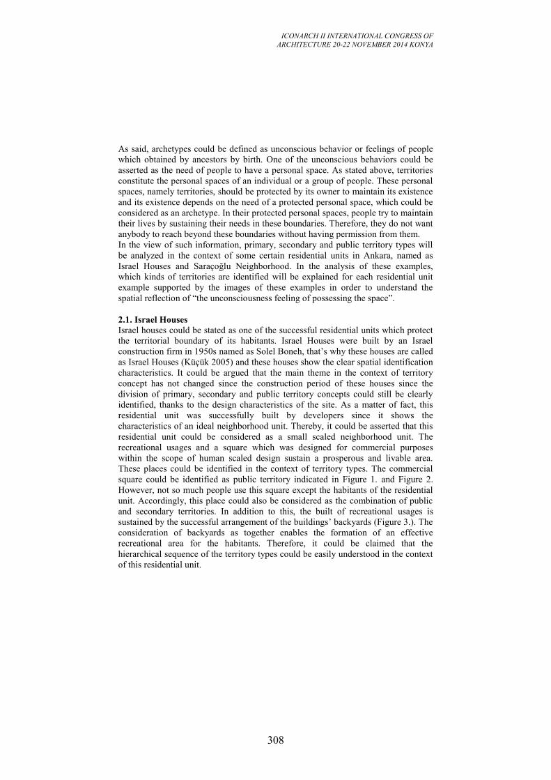
ICONARCH II INTERNATIONAL CONGRESS OF
ARCHITECTURE 20-22 NOVEMBER 2014 KONYA
308
As said, archetypes could be defined as unconscious behavior or feelings of people
which obtained by ancestors by birth. One of the unconscious behaviors could be
asserted as the need of people to have a personal space. As stated above, territories
constitute the personal spaces of an individual or a group of people. These personal
spaces, namely territories, should be protected by its owner to maintain its existence
and its existence depends on the need of a protected personal space, which could be
considered as an archetype. In their protected personal spaces, people try to maintain
their lives by sustaining their needs in these boundaries. Therefore, they do not want
anybody to reach beyond these boundaries without having permission from them.
In the view of such information, primary, secondary and public territory types will
be analyzed in the context of some certain residential units in Ankara, named as
Israel Houses and Saraçoğlu Neighborhood. In the analysis of these examples,
which kinds of territories are identified will be explained for each residential unit
example supported by the images of these examples in order to understand the
spatial reflection of “the unconsciousness feeling of possessing the space”.
2.1. Israel Houses
Israel houses could be stated as one of the successful residential units which protect
the territorial boundary of its habitants. Israel Houses were built by an Israel
construction firm in 1950s named as Solel Boneh, that’s why these houses are called
as Israel Houses (Küçük 2005) and these houses show the clear spatial identification
characteristics. It could be argued that the main theme in the context of territory
concept has not changed since the construction period of these houses since the
division of primary, secondary and public territory concepts could still be clearly
identified, thanks to the design characteristics of the site. As a matter of fact, this
residential unit was successfully built by developers since it shows the
characteristics of an ideal neighborhood unit. Thereby, it could be asserted that this
residential unit could be considered as a small scaled neighborhood unit. The
recreational usages and a square which was designed for commercial purposes
within the scope of human scaled design sustain a prosperous and livable area.
These places could be identified in the context of territory types. The commercial
square could be identified as public territory indicated in Figure 1. and Figure 2.
However, not so much people use this square except the habitants of the residential
unit. Accordingly, this place could also be considered as the combination of public
and secondary territories. In addition to this, the built of recreational usages is
sustained by the successful arrangement of the buildings’ backyards (Figure 3.). The
consideration of backyards as together enables the formation of an effective
recreational area for the habitants. Therefore, it could be claimed that the
hierarchical sequence of the territory types could be easily understood in the context
of this residential unit.
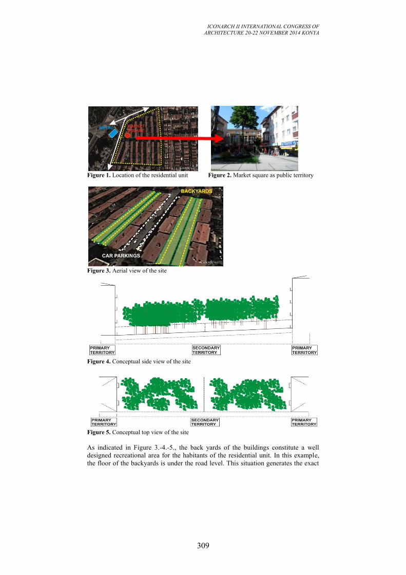
ICONARCH II INTERNATIONAL CONGRESS OF
ARCHITECTURE 20-22 NOVEMBER 2014 KONYA
309
Figure 1. Location of the residential unit Figure 2. Market square as public territory
Figure 3. Aerial view of the site
Figure 4. Conceptual side view of the site
Figure 5. Conceptual top view of the site
As indicated in Figure 3.-4.-5., the back yards of the buildings constitute a well
designed recreational area for the habitants of the residential unit. In this example,
the floor of the backyards is under the road level. This situation generates the exact
ICONARCH II INTERNATIONAL CONGRESS OF
ARCHITECTURE 20-22 NOVEMBER 2014 KONYA
310
division between the backyards and road, one of them is secondary territory and the
other one is public territory, respectively. The buildings, in this case, are primary
territories; backyards are secondary territories and are used effectively for
recreational purposes by the residential units’ habitants and the roads including
sidewalks are public territories. Additionally, a market square was designed to
provide necessary daily needs of the habitants of the residential unit. This square
could be considered as public territory; however, it also shows the characteristics of
a secondary territory since most of the time habitants of the residential unit and the
people from immediate environment use this square.
In addition to this, this residential unit is a successful example in which its habitants
have equal desired and actual privacy levels. It is due to the division between
primary, secondary and public territories are clearly defined in this example. People
continue their daily lives in their flats which are primary territory, socialize with the
other habitants of the residential unit at their secondary territories which are created
by the effective arrangement of the backyards. Additionally, strangers cannot enter
to this secondary territory of the habitants since this area has exact distinction with
the road used by the public, defined as public territory. This distinction was
procured by the ground level differentiation between the back yards and the road,
secondary territory and public territory, respectively.
2.2. Saraçoğlu Neighborhood
Saraçoğlu neighborhood stands on Kızılay, central business district of Ankara, exists
on a central position of the city, nearby the ministries zone (Figure 6.). The
neighborhood was built for the bureaucrats who work for ministries. Accordingly, it
could be stated that the neighborhood was built for meeting the residential needs of
top-tier public officers. The neighborhood has similar design characteristics with
Israel Houses residential unit explained previously. Buildings stand as human scaled
perspective makes the neighborhood having a calmer environment which reflects the
built environment characteristics of mid-1940s, the period which the built of
Saraçoğlu Neighborhood was started. The neighborhood and the ministries area
attached with the neighborhood had an effective relationship considering in the
context of territory concept beginning from the period of mid 1940s. However, when
Kızılay area has had the characteristics of central business district of the city, the
division of territories could not be differentiated clearly as it could be before (Figure
7.-8.-9.). The main reason for this constitutes the population increase of the area,
which rises the circulation of people who desire to benefit from central business
activities. Therefore, at the present time, it could be claimed that the houses
constitute primary territories; however, the front yards of the buildings do not
constitute a defined primary or secondary territory. It seems like enabling strangers
to enter these yards. Apart from primary and secondary territories, public territory
includes the sidewalk and continues with roads (Figure 10. and Figure 11.).
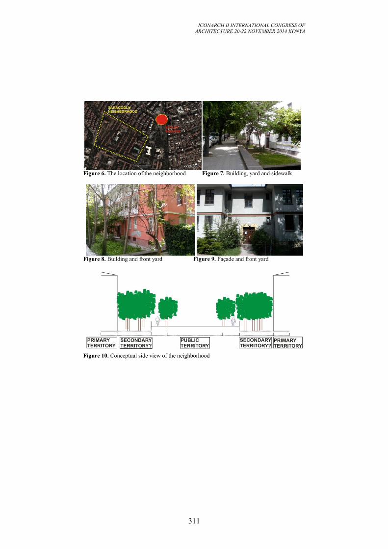
ICONARCH II INTERNATIONAL CONGRESS OF
ARCHITECTURE 20-22 NOVEMBER 2014 KONYA
311
Figure 6. The location of the neighborhood Figure 7. Building, yard and sidewalk
Figure 8. Building and front yard Figure 9. Façade and front yard
Figure 10. Conceptual side view of the neighborhood
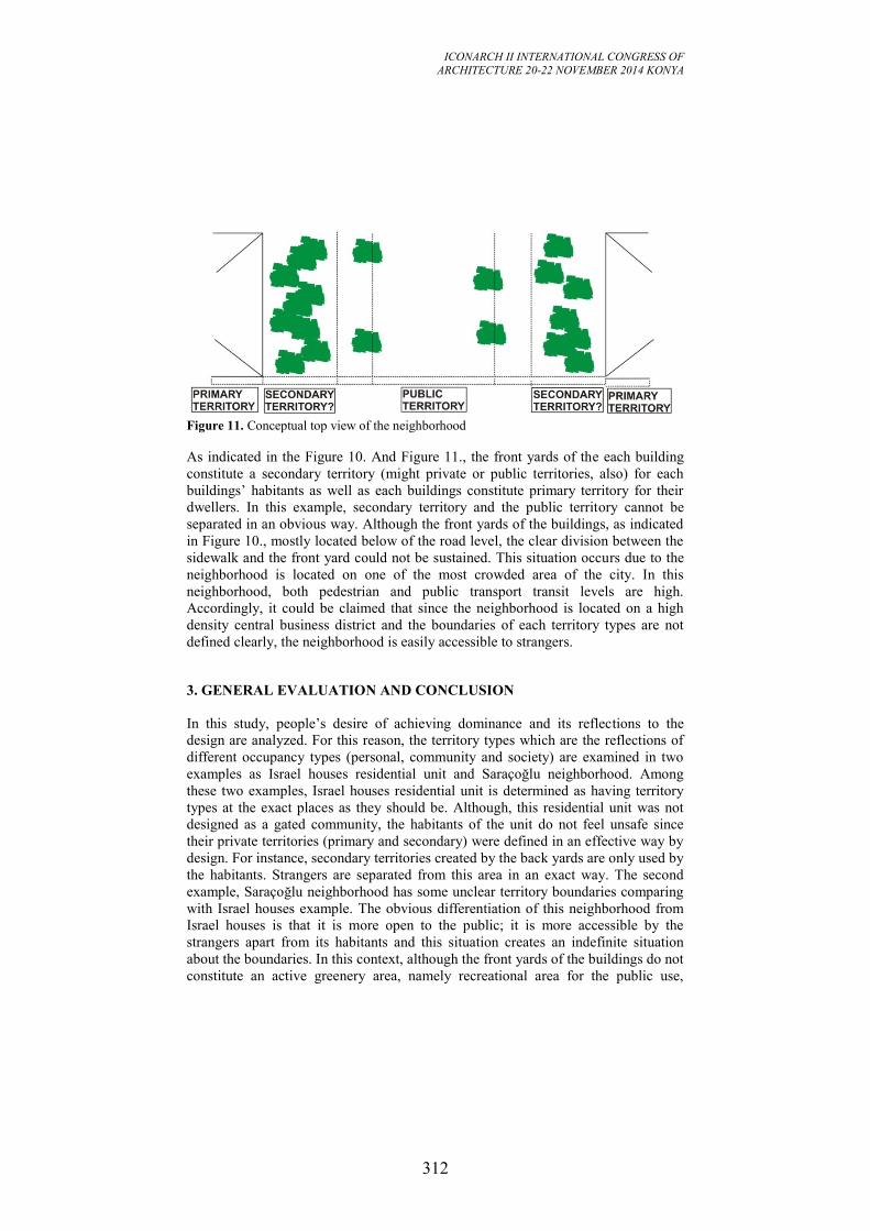
ICONARCH II INTERNATIONAL CONGRESS OF
ARCHITECTURE 20-22 NOVEMBER 2014 KONYA
312
Figure 11. Conceptual top view of the neighborhood
As indicated in the Figure 10. And Figure 11., the front yards of the each building
constitute a secondary territory (might private or public territories, also) for each
buildings’ habitants as well as each buildings constitute primary territory for their
dwellers. In this example, secondary territory and the public territory cannot be
separated in an obvious way. Although the front yards of the buildings, as indicated
in Figure 10., mostly located below of the road level, the clear division between the
sidewalk and the front yard could not be sustained. This situation occurs due to the
neighborhood is located on one of the most crowded area of the city. In this
neighborhood, both pedestrian and public transport transit levels are high.
Accordingly, it could be claimed that since the neighborhood is located on a high
density central business district and the boundaries of each territory types are not
defined clearly, the neighborhood is easily accessible to strangers.
3. GENERAL EVALUATION AND CONCLUSION
In this study, people’s desire of achieving dominance and its reflections to the
design are analyzed. For this reason, the territory types which are the reflections of
different occupancy types (personal, community and society) are examined in two
examples as Israel houses residential unit and Saraçoğlu neighborhood. Among
these two examples, Israel houses residential unit is determined as having territory
types at the exact places as they should be. Although, this residential unit was not
designed as a gated community, the habitants of the unit do not feel unsafe since
their private territories (primary and secondary) were defined in an effective way by
design. For instance, secondary territories created by the back yards are only used by
the habitants. Strangers are separated from this area in an exact way. The second
example, Saraçoğlu neighborhood has some unclear territory boundaries comparing
with Israel houses example. The obvious differentiation of this neighborhood from
Israel houses is that it is more open to the public; it is more accessible by the
strangers apart from its habitants and this situation creates an indefinite situation
about the boundaries. In this context, although the front yards of the buildings do not
constitute an active greenery area, namely recreational area for the public use,
ICONARCH II INTERNATIONAL CONGRESS OF
ARCHITECTURE 20-22 NOVEMBER 2014 KONYA
313
strangers could easily enter to these yards or could interrupt the process of the usage
of local people.
Both of the examples were built to sustain ideal neighborhood life to their residents
by providing clear identification of territory types. However, the rise of the central
business district characteristics of Kızılay, nearby Saraçoğlu Neigborhood, has
caused the neighborhood to lose its defined boundaries of territory types. On the
other hand, the location advantage of Israel Houses, namely located on the
residential area of the city where does not constitute central business district
characteristics, has ensured these houses to provide their clearly defined territory
types.
To sum, at the present time, Israel houses residential building has the ideal territory
types division. The area enables people both to live their personal lives in their
personal territories and to socialize with the habitants of the site providing efficient
recreational usage created by its back yards. Habitants of Israel houses could adjust
their privacy levels as they wish since design opportunities which their living area
sustains. On the other hand, Saraçoğlu neighborhood has indefinite territory types
division. In the area, the habitants could have difficulty in adjusting their desired
privacy levels since the secondary territories are under the threat of public one.
Therefore, what is the ideal one between these two examples? The answer is Israel
houses residential unit. Since this unit allows people to live their both private and
social lives by sustaining a successful design, namely a livable environment has
appropriate territorial divisions, it could be indicated as a good example about how
territories should be designed considering people’s need of occupancy related with
their privacy levels.
REFERENCES
-Altman, I. (1975). The Environment and Social Behavior: Privacy, Personal Space,
Territory, Crowding. Brooks/Cole Publishing Company.
-Altman, I., Werner, C. M. (1985). Home Environments. Springer.
-Altman, I., Wohlwill, J. F. (ed). (1994). Human Behavior and Environment:
Environment and behavior studies. Plenum Press.
-Franck, K. A., Schneekloth, L. H. (1994). Ordering Space: Types in Architecture
and Design. VanNostrand Reinhold.
-Küçük, Y. (2005). İsyan 1. Cilt. İthaki Yayınları.
ICONARCH II INTERNATIONAL CONGRESS OF
ARCHITECTURE 20-22 NOVEMBER 2014 KONYA
314
KEYNOTE SPEECH (21 November 2014 Friday, 13.30-14.00)
Prof. Dr. Martin BECHTHOLD
“The Quest for Innovation: Methods and Mindsets”
ICONARCH II INTERNATIONAL CONGRESS OF
ARCHITECTURE 20-22 NOVEMBER 2014 KONYA
315
THE QUEST FOR INNOVATION: METHODS AND
MINDSETS
MARTIN BECHTHOLD 1
If airplanes were like buildings we would still be going around in biplanes. A
comparison of the rate of progress and advancement in the building industry with
that in the field of aerospace engineering can lead to no other conclusion. Humans
have constructed shelters from the very beginning of human existence many
thousands of years ago, but even today’s most advanced buildings have ultimately
advanced very little. Bricks today have the same shape as the very first human made
unfired clay bricks about 6000 years ago. Glass today is only marginally better than
glazing systems in the middle-ages. Structural efficiency in wood construction, for
example, has only increased by a factor of an estimated 3 or 4 over 2000 years.
Drafting a similar comparison with human flight we find a much accelerated
development from Otto Lilienthal’s work and the Wright brother’s first motorized
flight in 1903. Now, just over 110 years later, airplanes carry hundreds of people, fly
faster than the speed of sound, and last decades in continuous service. What went
wrong with architecture?
The well-known fragmentation of the building industry usually is first blamed for
the snail-pace of progress in our field. Compared to that relatively few companies,
and solid government support, has propelled the aerospace industry forward. The
World Wars with their military needs triggered an intense research phase that fast-
forwarded airplane design and engineering, and without which the aerospace
industry would not be where it is today. Wars have contributed little if anything to
building design, instead drawing resources away from any serious building-related
research effort. But don’t our buildings, after all, perform reasonably well as they
are? Even buildings constructed hundreds of years ago are fairly safe and
moderately comfortable. Why invest much towards innovation in the construction
sector?
Today we know this presumption to be utterly wrong. The relative inefficiency of
constructing and operating our buildings consumes the majority of global raw
materials and energy, and contributes a large amount of emissions to our rapidly
warming planet. Building design and construction has to rapidly catch up and
become vastly smarter, leaner, and more sustainable. But to advance our industry we
need new ideas and methods in order to accelerate the rate of innovation. We cannot
wait hundreds of years to lower carbon efficiency of our existing and our new
buildings. We can no longer afford to postpone progress. We need to re-tool our
discipline, and emphasize research!
1 Prof.Dr.Harvard University, USA
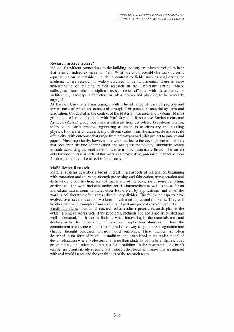
ICONARCH II INTERNATIONAL CONGRESS OF
ARCHITECTURE 20-22 NOVEMBER 2014 KONYA
316
Research in Architecture?
Individuals without connections to the building industry are often surprised to hear
that research indeed exists in our field. What one could possibly be working on is
equally unclear to outsiders, much in contrast to fields such as engineering or
medicine where research is widely assumed to be fundamental. There is more
understanding of building related research in the University setting, where
colleagues from other disciplines expect those affiliate with departments of
architecture, landscape architecture or urban design and planning to be scholarly
engaged.
At Harvard University I am engaged with a broad range of research projects and
topics, most of which are connected through their pursuit of material systems and
innovation. Conducted in the context of the Material Processes and Systems (MaPS)
group, and often collaborating with Prof. Sayegh’s Responsive Environments and
Artifacts (REAL) group, our work is different from yet related to material science,
refers to industrial process engineering as much as to chemistry and building
physics. It operates on dramatically different scales, from the nano-scale to the scale
of the city, with outcomes that range from prototypes and pilot project to patents and
papers. Most importantly, however, the work has led to the development of methods
that accelerate the rate of innovation and our quest for novelty, ultimately geared
towards advancing the built environment to a more sustainable future. This article
puts forward several aspects of this work in a provocative, polemical manner as food
for thought, not as a literal recipe for success.
MaPS Design Research
Material systems describes a broad interest in all aspects of materiality, beginning
with extraction and sourcing, through processing and fabrication, transportation and
distribution to construction, use and finally end-of life scenarios of reuse, recycling,
or disposal. The work includes studies for the intermediate as well as those for an
immediate future, some is more, other less driven by applications, and all of the
work is collaborative often across disciplinary divides. The following aspects have
evolved over several years of working on different topics and problems. They will
be illustrated with examples from a variety of past and present research projects.
Briefs not Plans: Traditional research often crafts a precise research plan at the
outset. Doing so works well if the problems, methods and goals are articulated and
well understood, but it can be limiting when innovating in the materials area and
dealing with the uncertainty of unknown application domains. Here the
commitment to a theme can be a more productive way to guide the imagination and
channel thought processes towards novel outcomes. These themes are often
described in the form of briefs – a tradition long established in the studio model of
design education where professors challenge their students with a brief that includes
programmatic and other requirements for a building. In the research setting briefs
can be less quantitatively specific, but instead often focus on themes that are aligned
with real world issues and the capabilities of the research team.
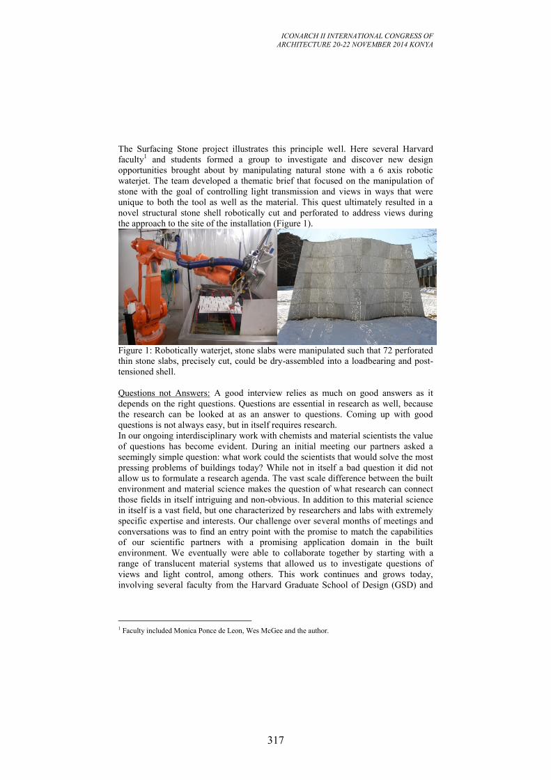
ICONARCH II INTERNATIONAL CONGRESS OF
ARCHITECTURE 20-22 NOVEMBER 2014 KONYA
317
The Surfacing Stone project illustrates this principle well. Here several Harvard
faculty1 and students formed a group to investigate and discover new design
opportunities brought about by manipulating natural stone with a 6 axis robotic
waterjet. The team developed a thematic brief that focused on the manipulation of
stone with the goal of controlling light transmission and views in ways that were
unique to both the tool as well as the material. This quest ultimately resulted in a
novel structural stone shell robotically cut and perforated to address views during
the approach to the site of the installation (Figure 1).
Figure 1: Robotically waterjet, stone slabs were manipulated such that 72 perforated
thin stone slabs, precisely cut, could be dry-assembled into a loadbearing and post-
tensioned shell.
Questions not Answers: A good interview relies as much on good answers as it
depends on the right questions. Questions are essential in research as well, because
the research can be looked at as an answer to questions. Coming up with good
questions is not always easy, but in itself requires research.
In our ongoing interdisciplinary work with chemists and material scientists the value
of questions has become evident. During an initial meeting our partners asked a
seemingly simple question: what work could the scientists that would solve the most
pressing problems of buildings today? While not in itself a bad question it did not
allow us to formulate a research agenda. The vast scale difference between the built
environment and material science makes the question of what research can connect
those fields in itself intriguing and non-obvious. In addition to this material science
in itself is a vast field, but one characterized by researchers and labs with extremely
specific expertise and interests. Our challenge over several months of meetings and
conversations was to find an entry point with the promise to match the capabilities
of our scientific partners with a promising application domain in the built
environment. We eventually were able to collaborate together by starting with a
range of translucent material systems that allowed us to investigate questions of
views and light control, among others. This work continues and grows today,
involving several faculty from the Harvard Graduate School of Design (GSD) and
1 Faculty included Monica Ponce de Leon, Wes McGee and the author.
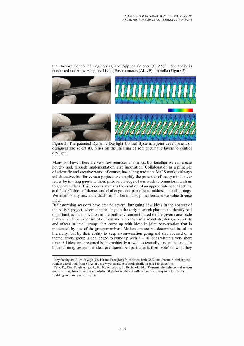
ICONARCH II INTERNATIONAL CONGRESS OF
ARCHITECTURE 20-22 NOVEMBER 2014 KONYA
318
the Harvard School of Engineering and Applied Science (SEAS)1 , and today is
conducted under the Adaptive Living Environments (ALivE) umbrella (Figure 2).
Figure 2: The patented Dynamic Daylight Control System, a joint development of
designers and scientists, relies on the shearing of soft pneumatic layers to control
daylight2.
Many not Few: There are very few geniuses among us, but together we can create
novelty and, through implementation, also innovation. Collaboration as a principle
of scientific and creative work, of course, has a long tradition. MaPS work is always
collaborative, but for certain projects we amplify the potential of many minds over
fewer by inviting guests without prior knowledge of our work to brainstorm with us
to generate ideas. This process involves the creation of an appropriate spatial setting
and the definition of themes and challenges that participants address in small groups.
We intentionally mix individuals from different disciplines because we value diverse
input.
Brainstorming sessions have created several intriguing new ideas in the context of
the ALivE project, where the challenge in the early research phase is to identify real
opportunities for innovation in the built environment based on the given nano-scale
material science expertise of our collaborators. We mix scientists, designers, artists
and others in small groups that come up with ideas in joint conversation that is
moderated by one of the group members. Moderators are not determined based on
hierarchy, but by their ability to keep a conversation going and stay focused on a
theme. Every group is challenged to come up with 5 – 10 ideas within a very short
time. All ideas are presented both graphically as well as textually, and at the end of a
brainstorming session the ideas are shared. All participants then ‘vote’ on what they
1 Key faculty are Allen Sayegh (Co-PI) and Panagiotis Michalatos, both GSD, and Joanna Aizenberg and
Katia Bertoldi both from SEAS and the Wyss Institute of Biologically Inspired Engineering. 2 Park, D., Kim, P. Alvarenga, J., Jin, K., Aizenberg, J., Bechthold, M.: “Dynamic daylight control system
implementing thin cast arrays of polydimethylsiloxane-based millimeter-scale transparent louvers” in:
Building and Environment, 2014.
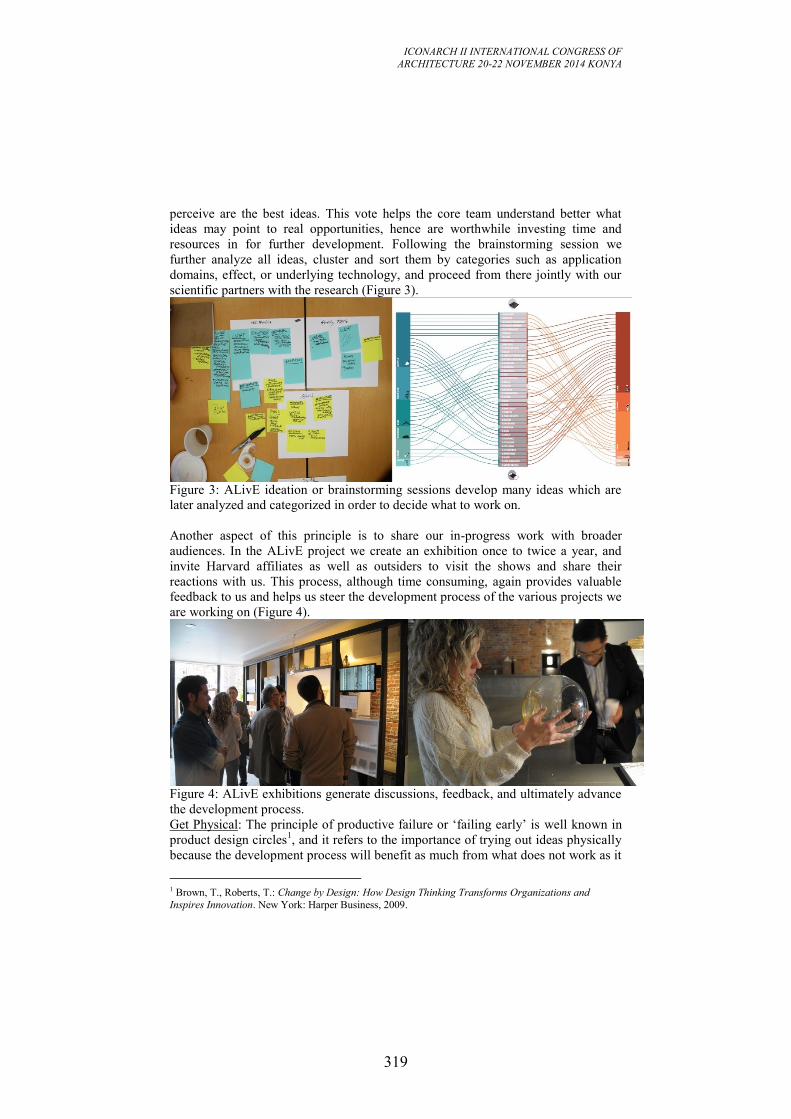
ICONARCH II INTERNATIONAL CONGRESS OF
ARCHITECTURE 20-22 NOVEMBER 2014 KONYA
319
perceive are the best ideas. This vote helps the core team understand better what
ideas may point to real opportunities, hence are worthwhile investing time and
resources in for further development. Following the brainstorming session we
further analyze all ideas, cluster and sort them by categories such as application
domains, effect, or underlying technology, and proceed from there jointly with our
scientific partners with the research (Figure 3).
Figure 3: ALivE ideation or brainstorming sessions develop many ideas which are
later analyzed and categorized in order to decide what to work on.
Another aspect of this principle is to share our in-progress work with broader
audiences. In the ALivE project we create an exhibition once to twice a year, and
invite Harvard affiliates as well as outsiders to visit the shows and share their
reactions with us. This process, although time consuming, again provides valuable
feedback to us and helps us steer the development process of the various projects we
are working on (Figure 4).
Figure 4: ALivE exhibitions generate discussions, feedback, and ultimately advance
the development process.
Get Physical: The principle of productive failure or ‘failing early’ is well known in
product design circles1, and it refers to the importance of trying out ideas physically
because the development process will benefit as much from what does not work as it
1 Brown, T., Roberts, T.: Change by Design: How Design Thinking Transforms Organizations and
Inspires Innovation. New York: Harper Business, 2009.
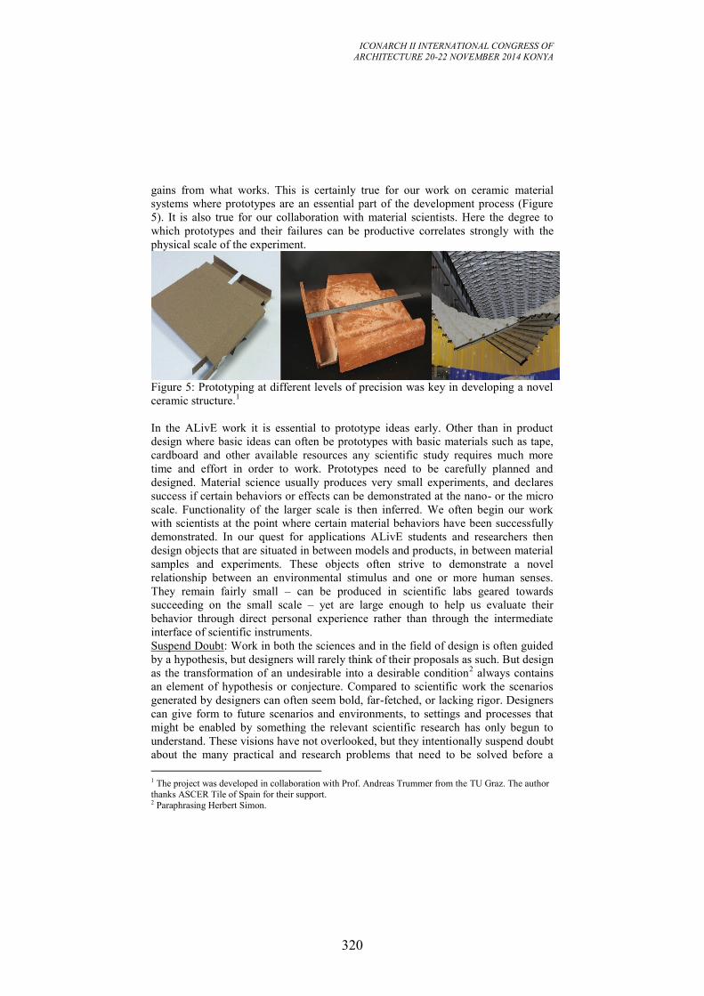
ICONARCH II INTERNATIONAL CONGRESS OF
ARCHITECTURE 20-22 NOVEMBER 2014 KONYA
320
gains from what works. This is certainly true for our work on ceramic material
systems where prototypes are an essential part of the development process (Figure
5). It is also true for our collaboration with material scientists. Here the degree to
which prototypes and their failures can be productive correlates strongly with the
physical scale of the experiment.
Figure 5: Prototyping at different levels of precision was key in developing a novel
ceramic structure.1
In the ALivE work it is essential to prototype ideas early. Other than in product
design where basic ideas can often be prototypes with basic materials such as tape,
cardboard and other available resources any scientific study requires much more
time and effort in order to work. Prototypes need to be carefully planned and
designed. Material science usually produces very small experiments, and declares
success if certain behaviors or effects can be demonstrated at the nano- or the micro
scale. Functionality of the larger scale is then inferred. We often begin our work
with scientists at the point where certain material behaviors have been successfully
demonstrated. In our quest for applications ALivE students and researchers then
design objects that are situated in between models and products, in between material
samples and experiments. These objects often strive to demonstrate a novel
relationship between an environmental stimulus and one or more human senses.
They remain fairly small – can be produced in scientific labs geared towards
succeeding on the small scale – yet are large enough to help us evaluate their
behavior through direct personal experience rather than through the intermediate
interface of scientific instruments.
Suspend Doubt: Work in both the sciences and in the field of design is often guided
by a hypothesis, but designers will rarely think of their proposals as such. But design
as the transformation of an undesirable into a desirable condition2 always contains
an element of hypothesis or conjecture. Compared to scientific work the scenarios
generated by designers can often seem bold, far-fetched, or lacking rigor. Designers
can give form to future scenarios and environments, to settings and processes that
might be enabled by something the relevant scientific research has only begun to
understand. These visions have not overlooked, but they intentionally suspend doubt
about the many practical and research problems that need to be solved before a
1 The project was developed in collaboration with Prof. Andreas Trummer from the TU Graz. The author
thanks ASCER Tile of Spain for their support. 2 Paraphrasing Herbert Simon.
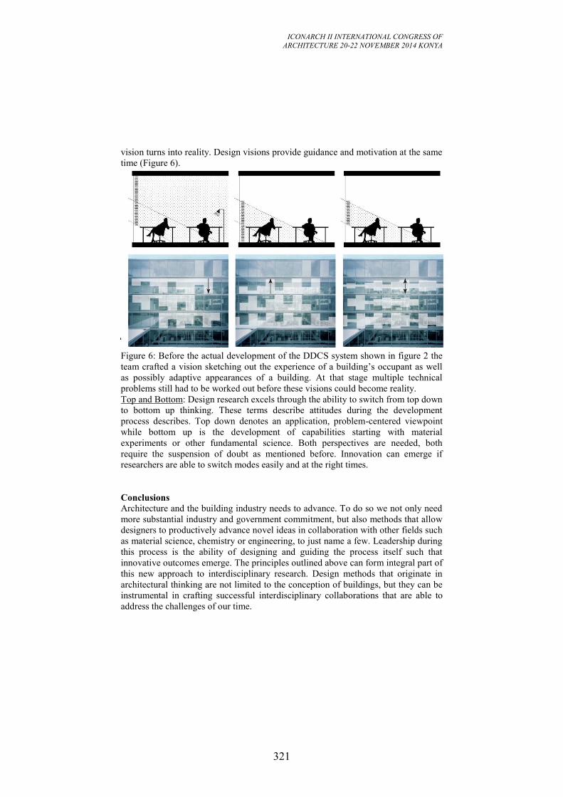
ICONARCH II INTERNATIONAL CONGRESS OF
ARCHITECTURE 20-22 NOVEMBER 2014 KONYA
321
vision turns into reality. Design visions provide guidance and motivation at the same
time (Figure 6).
Figure 6: Before the actual development of the DDCS system shown in figure 2 the
team crafted a vision sketching out the experience of a building’s occupant as well
as possibly adaptive appearances of a building. At that stage multiple technical
problems still had to be worked out before these visions could become reality.
Top and Bottom: Design research excels through the ability to switch from top down
to bottom up thinking. These terms describe attitudes during the development
process describes. Top down denotes an application, problem-centered viewpoint
while bottom up is the development of capabilities starting with material
experiments or other fundamental science. Both perspectives are needed, both
require the suspension of doubt as mentioned before. Innovation can emerge if
researchers are able to switch modes easily and at the right times.
Conclusions
Architecture and the building industry needs to advance. To do so we not only need
more substantial industry and government commitment, but also methods that allow
designers to productively advance novel ideas in collaboration with other fields such
as material science, chemistry or engineering, to just name a few. Leadership during
this process is the ability of designing and guiding the process itself such that
innovative outcomes emerge. The principles outlined above can form integral part of
this new approach to interdisciplinary research. Design methods that originate in
architectural thinking are not limited to the conception of buildings, but they can be
instrumental in crafting successful interdisciplinary collaborations that are able to
address the challenges of our time.

ICONARCH II INTERNATIONAL CONGRESS OF
ARCHITECTURE 20-22 NOVEMBER 2014 KONYA
322
Acknowledgments:
The author likes to thank ASCER Tile of Spain and the Adaptive Materials
Technology Platform (directed by Prof. Joanna Aizenberg) at the Wyss Institute for
Biologically Inspired Engineering for their support. The work would have been
impossible without many dedicated and talented Harvard students. Prof. Allen
Sayegh, my joint principal investigator of the ALivE project, deserves special
mention.
ICONARCH II INTERNATIONAL CONGRESS OF
ARCHITECTURE 20-22 NOVEMBER 2014 KONYA
323
SESSION 7
20 November 2014 Friday, 11.00-12.15
Chairperson: Prof. Dr. Joao MENEZES DE SEQUEIRA (Invited
Speech)
“Approach Academia and Professional Practice Through Research
by Design” p.324
Dr. Bouzid BOUDIAF
“Innovative Approaches in Architecture and Planning.
the Future of Our Past” p.342
Research Assistant İrem YILMAZ
“Kinetic Architecture:
Towards The Poetry of Space in Movement” p.372
PhD. Student Rashaa MALIK, Lecturer Alaa HADI
“Consciousness & Creation
A Study of the Process of Communication and Innovation in the
Design of Contemporary Urban Monuments” p.383
Teaching Assit Mine KOYAZ, Asst. Prof. Dr. M. Cem ALTUN
“Usability of a Material Selection Tool for Architecture Students as
a Sub Process of Building Element Design” p.396
KEYNOTE SPEAKER
Prof. Stefano Francesco MUSSO
“Inheriting our Cultural Heritage. Changes of Paradigm of
Conservation.” p.411
ICONARCH II INTERNATIONAL CONGRESS OF
ARCHITECTURE 20-22 NOVEMBER 2014 KONYA
324
APPROACH ACADEMIA AND PROFESSIONAL PRACTICE
TROUGH RESEARCH BY DESIGN
JOÃO MENEZES DE SEQUEİRA1
ABSTRACT
This paper will try to stress that the approximation between academia and
professional practice has its roots on the revolution that occurs in the schools of
architecture in the beginnings of the XX century. And this revolution has its origin
in the idea of connecting arts and crafts and then the idea of bringing practitioners
into the academia and changing the concept of academic curriculum. We think that
the consolidation of this approximation can be done if we consider architectural
research by design as the main path to develop.
This paper result of the lecture made in the 21th of November in Konya at the
occasion of the seventh session of the 2nd
International Congress of Architecture
(ICONACH II) under the theme “New approaches in architecture and urban
planning in education”.
Keywords: Research, education, architectural practice
APPROACHING ACADEMIA AND PRACTICE
Today and for me, both as a teacher of Architectural and Urban Design, a
researcher and as a practicing architect, speaking about new approaches in
education, is to speak about the ways research has introduce herself in the
academia and in practice as a unifying path.
What I mean is that, I believe architectural research and especially research by
design is the best way to approach academia and the architectural practice.
This approximation is possible if we start with design-oriented approaches and
trying to clarify some concepts.
Research in architecture is a very fuzzy and complex issue due to the hemorrhagic
literature that talks about design research. According to some authors, like Nigel
Cross (2001, 45) the discussion start’s in the 60’s of the last century with the
design methods conference organized by John Christopher Jones and D. G.
Thornley, even if we think, like Jonathan Hill (2013) that the origin of this idea is
much older and is more complex then we expect.
Howsoever we can, in a simplifying manner, try to organize some types of research
that can help us to understand research by design. We will use two different
approaches, one from Trygve and Haakon Faste (2012) that identifies at least four
1 Prof. Doc. Architectural Lab. R&D - LabART / Lusófona University. LISBON
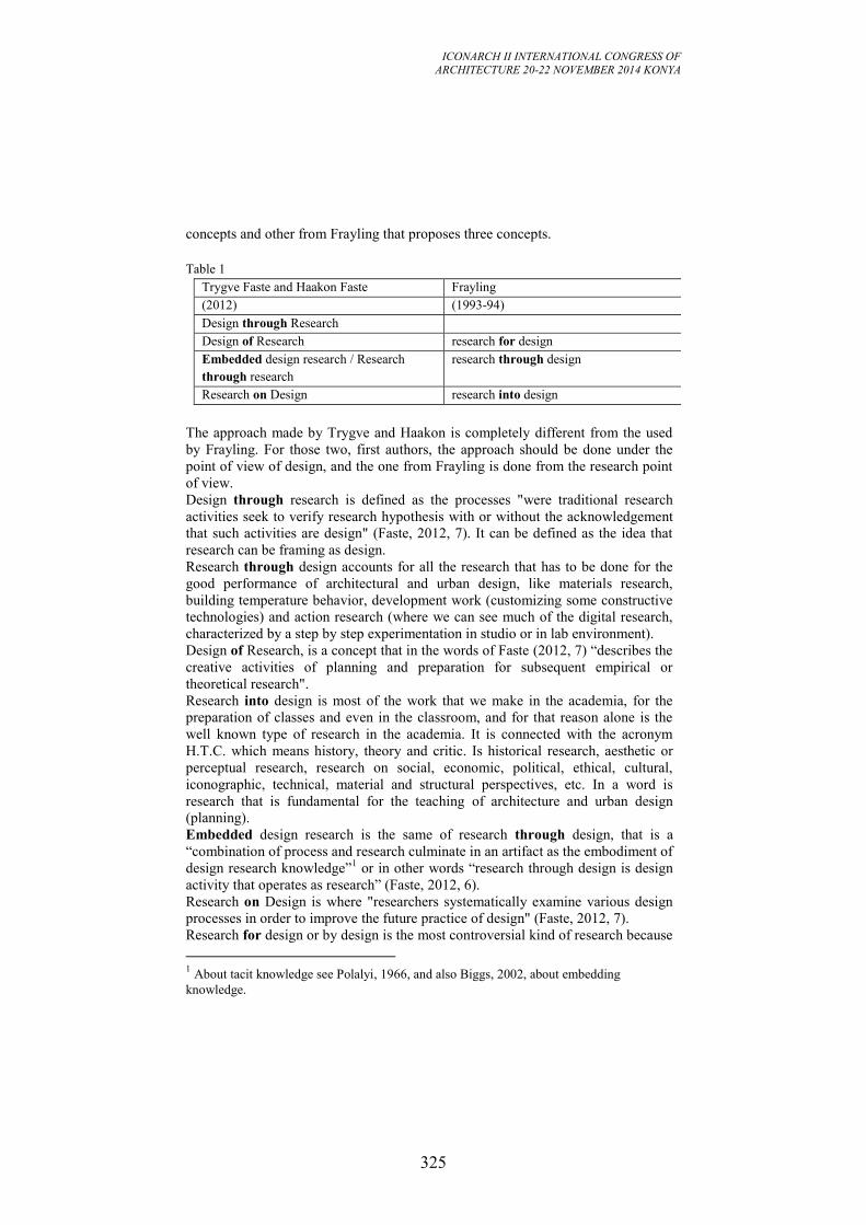
ICONARCH II INTERNATIONAL CONGRESS OF
ARCHITECTURE 20-22 NOVEMBER 2014 KONYA
325
concepts and other from Frayling that proposes three concepts.
Table 1
Trygve Faste and Haakon Faste Frayling
(2012) (1993-94)
Design through Research
Design of Research research for design
Embedded design research / Research
through research
research through design
Research on Design research into design
The approach made by Trygve and Haakon is completely different from the used
by Frayling. For those two, first authors, the approach should be done under the
point of view of design, and the one from Frayling is done from the research point
of view.
Design through research is defined as the processes "were traditional research
activities seek to verify research hypothesis with or without the acknowledgement
that such activities are design" (Faste, 2012, 7). It can be defined as the idea that
research can be framing as design.
Research through design accounts for all the research that has to be done for the
good performance of architectural and urban design, like materials research,
building temperature behavior, development work (customizing some constructive
technologies) and action research (where we can see much of the digital research,
characterized by a step by step experimentation in studio or in lab environment).
Design of Research, is a concept that in the words of Faste (2012, 7) “describes the
creative activities of planning and preparation for subsequent empirical or
theoretical research".
Research into design is most of the work that we make in the academia, for the
preparation of classes and even in the classroom, and for that reason alone is the
well known type of research in the academia. It is connected with the acronym
H.T.C. which means history, theory and critic. Is historical research, aesthetic or
perceptual research, research on social, economic, political, ethical, cultural,
iconographic, technical, material and structural perspectives, etc. In a word is
research that is fundamental for the teaching of architecture and urban design
(planning).
Embedded design research is the same of research through design, that is a
“combination of process and research culminate in an artifact as the embodiment of
design research knowledge”1 or in other words “research through design is design
activity that operates as research” (Faste, 2012, 6).
Research on Design is where "researchers systematically examine various design
processes in order to improve the future practice of design" (Faste, 2012, 7).
Research for design or by design is the most controversial kind of research because
1 About tacit knowledge see Polalyi, 1966, and also Biggs, 2002, about embedding
knowledge.
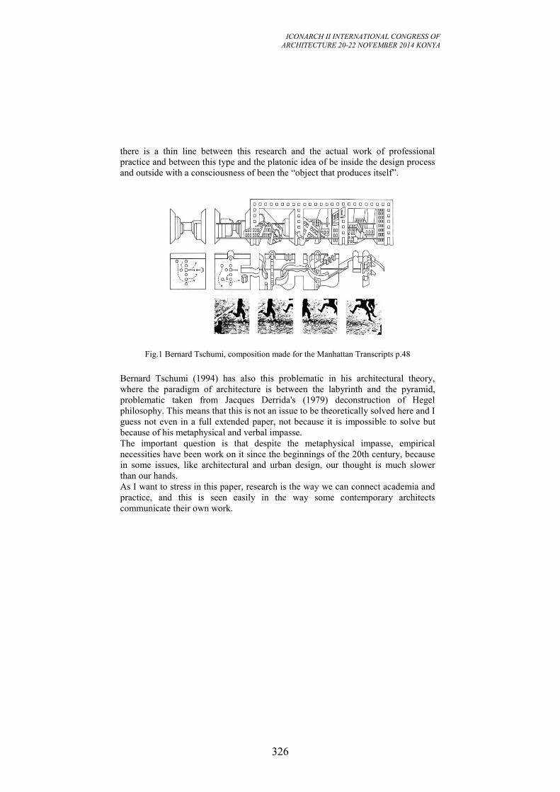
ICONARCH II INTERNATIONAL CONGRESS OF
ARCHITECTURE 20-22 NOVEMBER 2014 KONYA
326
there is a thin line between this research and the actual work of professional
practice and between this type and the platonic idea of be inside the design process
and outside with a consciousness of been the “object that produces itself”.
Fig.1 Bernard Tschumi, composition made for the Manhattan Transcripts p.48
Bernard Tschumi (1994) has also this problematic in his architectural theory,
where the paradigm of architecture is between the labyrinth and the pyramid,
problematic taken from Jacques Derrida's (1979) deconstruction of Hegel
philosophy. This means that this is not an issue to be theoretically solved here and I
guess not even in a full extended paper, not because it is impossible to solve but
because of his metaphysical and verbal impasse.
The important question is that despite the metaphysical impasse, empirical
necessities have been work on it since the beginnings of the 20th century, because
in some issues, like architectural and urban design, our thought is much slower
than our hands.
As I want to stress in this paper, research is the way we can connect academia and
practice, and this is seen easily in the way some contemporary architects
communicate their own work.
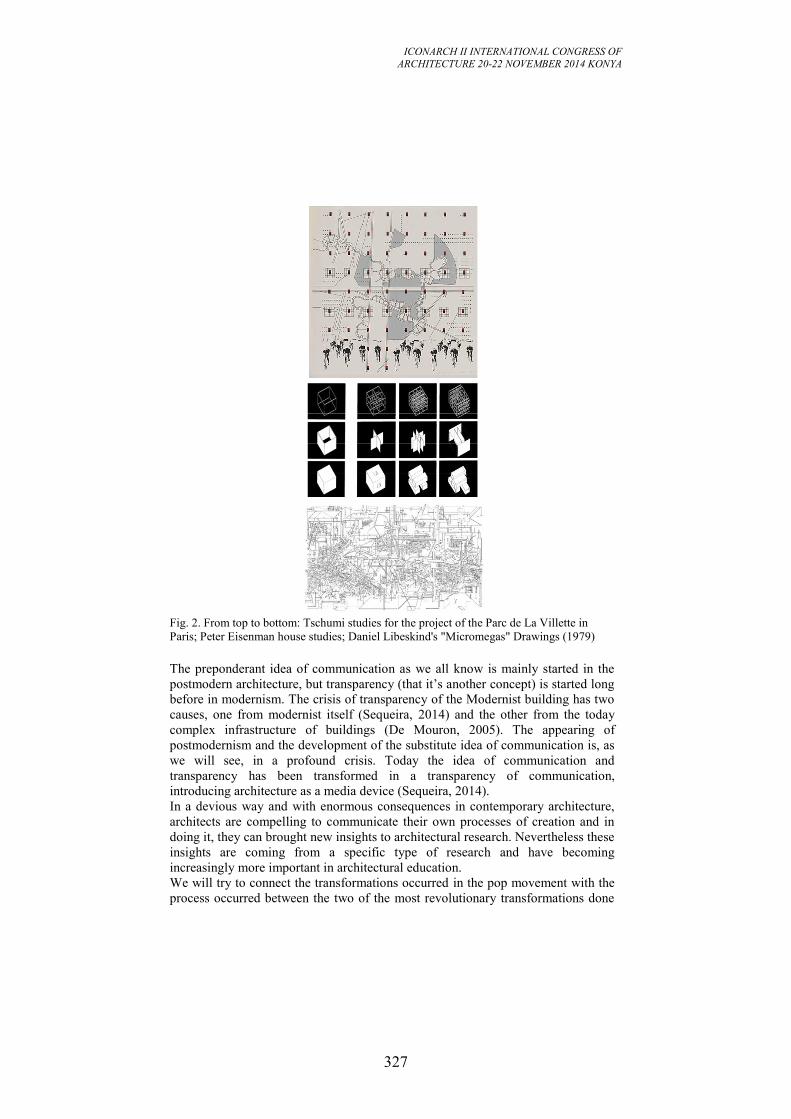
ICONARCH II INTERNATIONAL CONGRESS OF
ARCHITECTURE 20-22 NOVEMBER 2014 KONYA
327
Fig. 2. From top to bottom: Tschumi studies for the project of the Parc de La Villette in
Paris; Peter Eisenman house studies; Daniel Libeskind's "Micromegas" Drawings (1979)
The preponderant idea of communication as we all know is mainly started in the
postmodern architecture, but transparency (that it’s another concept) is started long
before in modernism. The crisis of transparency of the Modernist building has two
causes, one from modernist itself (Sequeira, 2014) and the other from the today
complex infrastructure of buildings (De Mouron, 2005). The appearing of
postmodernism and the development of the substitute idea of communication is, as
we will see, in a profound crisis. Today the idea of communication and
transparency has been transformed in a transparency of communication,
introducing architecture as a media device (Sequeira, 2014).
In a devious way and with enormous consequences in contemporary architecture,
architects are compelling to communicate their own processes of creation and in
doing it, they can brought new insights to architectural research. Nevertheless these
insights are coming from a specific type of research and have becoming
increasingly more important in architectural education.
We will try to connect the transformations occurred in the pop movement with the
process occurred between the two of the most revolutionary transformations done
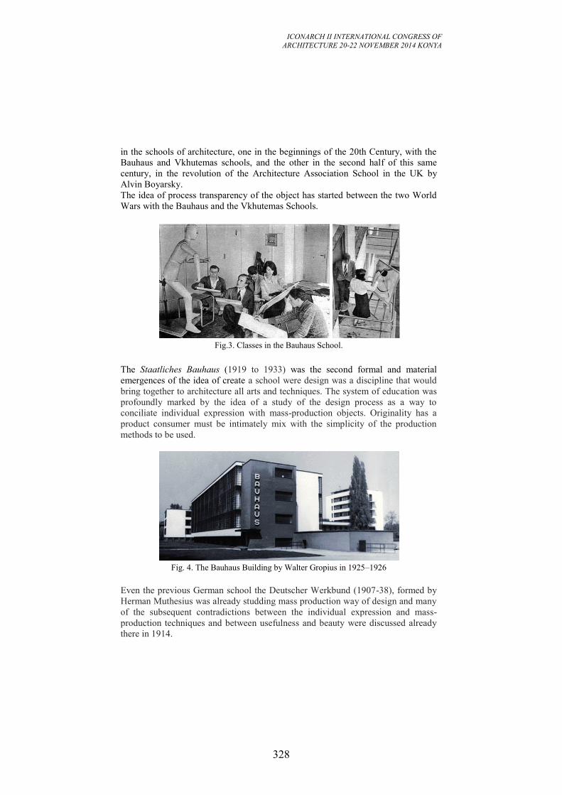
ICONARCH II INTERNATIONAL CONGRESS OF
ARCHITECTURE 20-22 NOVEMBER 2014 KONYA
328
in the schools of architecture, one in the beginnings of the 20th Century, with the
Bauhaus and Vkhutemas schools, and the other in the second half of this same
century, in the revolution of the Architecture Association School in the UK by
Alvin Boyarsky.
The idea of process transparency of the object has started between the two World
Wars with the Bauhaus and the Vkhutemas Schools.
Fig.3. Classes in the Bauhaus School.
The Staatliches Bauhaus (1919 to 1933) was the second formal and material
emergences of the idea of create a school were design was a discipline that would
bring together to architecture all arts and techniques. The system of education was
profoundly marked by the idea of a study of the design process as a way to
conciliate individual expression with mass-production objects. Originality has a
product consumer must be intimately mix with the simplicity of the production
methods to be used.
Fig. 4. The Bauhaus Building by Walter Gropius in 1925–1926
Even the previous German school the Deutscher Werkbund (1907-38), formed by
Herman Muthesius was already studding mass production way of design and many
of the subsequent contradictions between the individual expression and mass-
production techniques and between usefulness and beauty were discussed already
there in 1914.
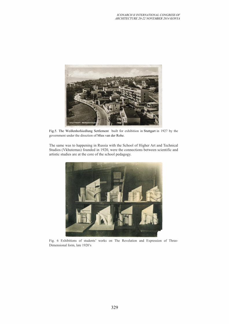
ICONARCH II INTERNATIONAL CONGRESS OF
ARCHITECTURE 20-22 NOVEMBER 2014 KONYA
329
Fig.5. The Weißenhofsiedlung Settlement built for exhibition in Stuttgart in 1927 by the
government under the direction of Mies van der Rohe.
The same was to happening in Russia with the School of Higher Art and Technical
Studios (Vkhutemas) founded in 1920, were the connections between scientific and
artistic studies are at the core of the school pedagogy.
Fig. 6 Exhibitions of students’ works on The Revelation and Expression of Three-
Dimensional form, late 1920’s
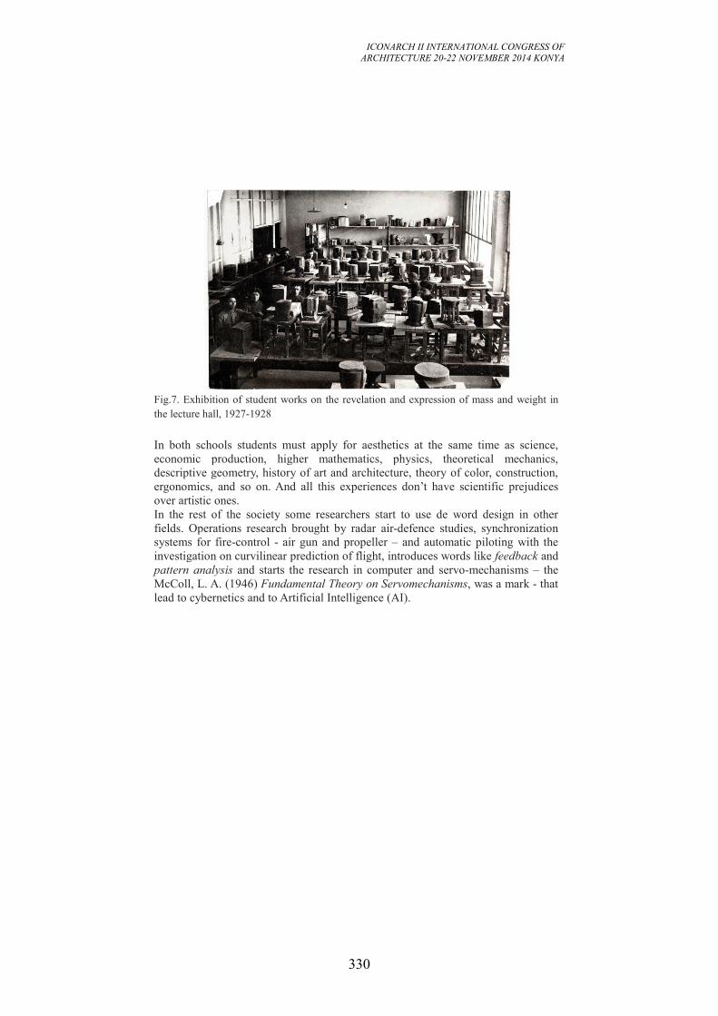
ICONARCH II INTERNATIONAL CONGRESS OF
ARCHITECTURE 20-22 NOVEMBER 2014 KONYA
330
Fig.7. Exhibition of student works on the revelation and expression of mass and weight in
the lecture hall, 1927-1928
In both schools students must apply for aesthetics at the same time as science,
economic production, higher mathematics, physics, theoretical mechanics,
descriptive geometry, history of art and architecture, theory of color, construction,
ergonomics, and so on. And all this experiences don’t have scientific prejudices
over artistic ones.
In the rest of the society some researchers start to use de word design in other
fields. Operations research brought by radar air-defence studies, synchronization
systems for fire-control - air gun and propeller – and automatic piloting with the
investigation on curvilinear prediction of flight, introduces words like feedback and
pattern analysis and starts the research in computer and servo-mechanisms – the
McColl, L. A. (1946) Fundamental Theory on Servomechanisms, was a mark - that
lead to cybernetics and to Artificial Intelligence (AI).
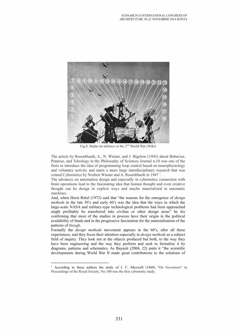
ICONARCH II INTERNATIONAL CONGRESS OF
ARCHITECTURE 20-22 NOVEMBER 2014 KONYA
331
Fig.8. Radar air-defence in the 2nd World War (Wiki)
The article by Rosenblueth, A., N. Wiener, and J. Bigelow (1943) about Behavior,
Purpose, and Teleology in the Philosophy of Sciences Journal n.10 was one of the
firsts to introduce the idea of programming loop control based on neurophysiology
and voluntary activity and starts a more large interdisciplinary research that was
coined Cybernetics by Norbert Wiener and A. Rosenblueth in 1947 1.
The advances on automation design and especially in cybernetics connection with
brain operations lead to the fascinating idea that human thought and even creative
thought can be design in explicit ways and maybe materialized in automatic
machines.
And, when Horst Rittel (1972) said that “the reasons for the emergence of design
methods in the late 50’s and early 60’s was the idea that the ways in which the
large-scale NASA and military-type technological problems had been approached
might profitably be transferred into civilian or other design areas” he his
confirming that most of the studies in process have their origin in the political
availability of funds and in the progressive fascination for the materialization of the
patterns of though.
Formally the design methods movement appears in the 60’s, after all these
experiences, and they focus their attention especially in design methods as a subject
field of inquiry. They look not at the objects produced but both, to the way they
have been engineering and the way they perform and seek to formalize it by
diagrams, patterns and schematics. As Bayazit (2004, 22) putts it “the scientific
developments during World War II made great contributions to the solutions of
1 According to these authors the study of J. C. Maxwell (1868) "On Governors" in
Proceedings of the Royal Society, No.100 was the first cybernetic study.
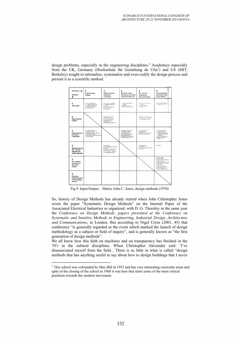
ICONARCH II INTERNATIONAL CONGRESS OF
ARCHITECTURE 20-22 NOVEMBER 2014 KONYA
332
design problems, especially in the engineering disciplines.” Academics especially
from the UK, Germany (Hochschule für Gestaltung de Ulm1) and US (MIT,
Berkeley) sought to rationalize, systematize and even codify the design process and
present it as a scientific method.
Fig.9. Input/Output – Matrix John C. Jones, design methods (1970)
So, history of Design Methods has already started when John Crhistopher Jones
wrote the paper "Systematic Design Methods" on the Internal Paper of the
Associated Electrical Industries or organized, with D. G. Thornley in the same year
the Conference on Design Methods: papers presented at the Conference on
Systematic and Intuitive Methods in Engineering, Industrial Design, Architecture
and Communications, in London. But according to Nigel Cross (2001, 45) that
conference “is generally regarded as the event which marked the launch of design
methodology as a subject or field of inquiry”, and is generally known as “the first
generation of design methods”.
We all know how this faith on machines and on transparency has finished in the
70’s in the cultural disciplines. When Christopher Alexander said: ‘I’ve
disassociated myself from the field... There is so little in what is called “design
methods that has anything useful to say about how to design buildings that I never
1 This school was cofounded by Max Bill in 1953 and has very interesting curricular areas and
spite of the closing of the school in 1968 it was here that starts some of the most critical
positions towards the modern movement.
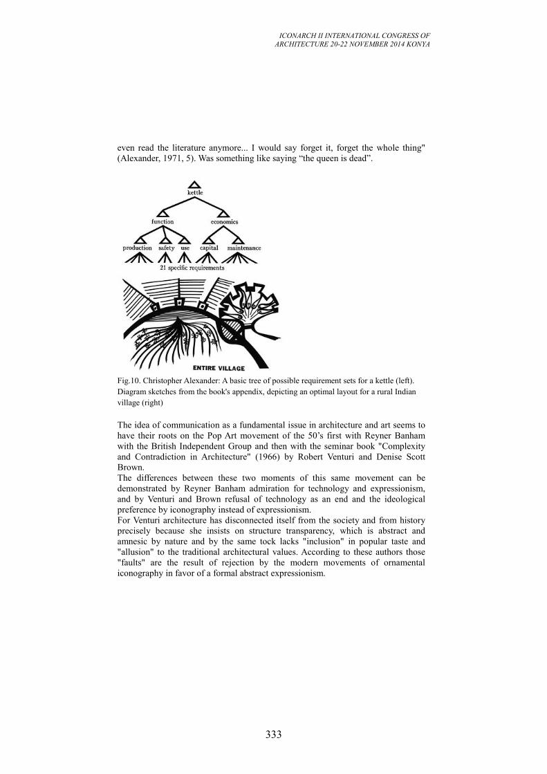
ICONARCH II INTERNATIONAL CONGRESS OF
ARCHITECTURE 20-22 NOVEMBER 2014 KONYA
333
even read the literature anymore... I would say forget it, forget the whole thing"
(Alexander, 1971, 5). Was something like saying “the queen is dead”.
Fig.10. Christopher Alexander: A basic tree of possible requirement sets for a kettle (left).
Diagram sketches from the book's appendix, depicting an optimal layout for a rural Indian
village (right)
The idea of communication as a fundamental issue in architecture and art seems to
have their roots on the Pop Art movement of the 50’s first with Reyner Banham
with the British Independent Group and then with the seminar book "Complexity
and Contradiction in Architecture" (1966) by Robert Venturi and Denise Scott
Brown.
The differences between these two moments of this same movement can be
demonstrated by Reyner Banham admiration for technology and expressionism,
and by Venturi and Brown refusal of technology as an end and the ideological
preference by iconography instead of expressionism.
For Venturi architecture has disconnected itself from the society and from history
precisely because she insists on structure transparency, which is abstract and
amnesic by nature and by the same tock lacks "inclusion" in popular taste and
"allusion" to the traditional architectural values. According to these authors those
"faults" are the result of rejection by the modern movements of ornamental
iconography in favor of a formal abstract expressionism.
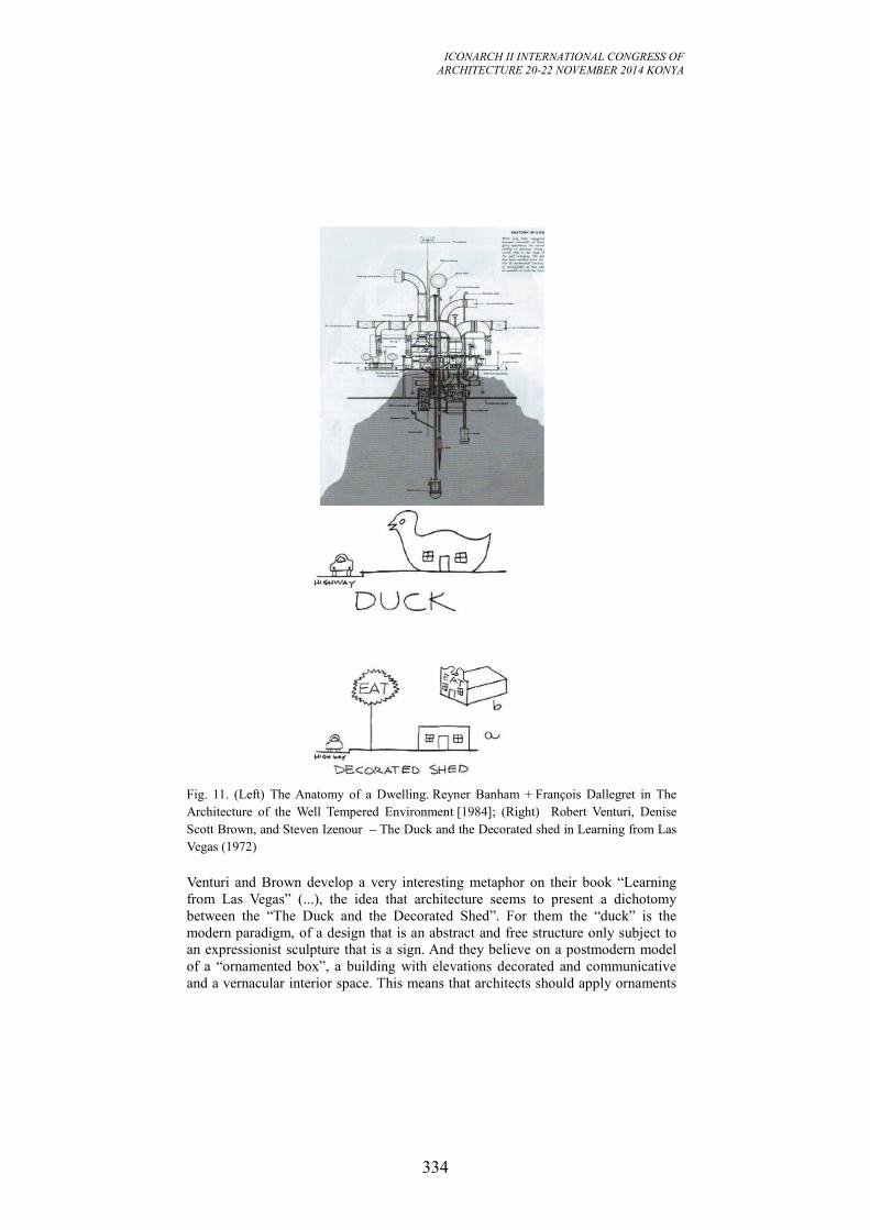
ICONARCH II INTERNATIONAL CONGRESS OF
ARCHITECTURE 20-22 NOVEMBER 2014 KONYA
334
Fig. 11. (Left) The Anatomy of a Dwelling. Reyner Banham + François Dallegret in The
Architecture of the Well Tempered Environment [1984]; (Right) Robert Venturi, Denise
Scott Brown, and Steven Izenour – The Duck and the Decorated shed in Learning from Las
Vegas (1972)
Venturi and Brown develop a very interesting metaphor on their book “Learning
from Las Vegas” (...), the idea that architecture seems to present a dichotomy
between the “The Duck and the Decorated Shed”. For them the “duck” is the
modern paradigm, of a design that is an abstract and free structure only subject to
an expressionist sculpture that is a sign. And they believe on a postmodern model
of a “ornamented box”, a building with elevations decorated and communicative
and a vernacular interior space. This means that architects should apply ornaments
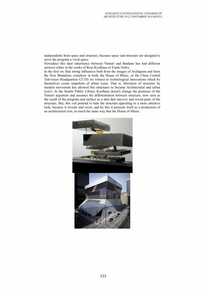
ICONARCH II INTERNATIONAL CONGRESS OF
ARCHITECTURE 20-22 NOVEMBER 2014 KONYA
335
independents from space and structure, because space and structure are designed to
serve the program a vivid space.
Nowadays this dual inheritance between Venturi and Banham has had different
answers either in the works of Rem Koolhaas or Frank Gehry.
In the first we find strong influences both from the images of Archigram and from
the New Brutalism, somehow in both, the House of Music, or the China Central
Television Headquarters CCTH we witness to technological innovations which by
themselves create snapshots of urban icons. That is, liberation of structure by
modern movement has allowed this structures to became Architectural and urban
icon’s. In the Seattle Public Library Koolhaas doesn't change the premises of the
Venturi argument and assumes the differentiation between structure, now seen as
the result of the program and surface as a skin that uncover and reveal parts of the
structure. But, this veil pretend to hide the structure appealing to a more attentive
look, because it reveals and cover, and by this it presents itself as a production of
an architectural icon, in much the same way that the House of Music.
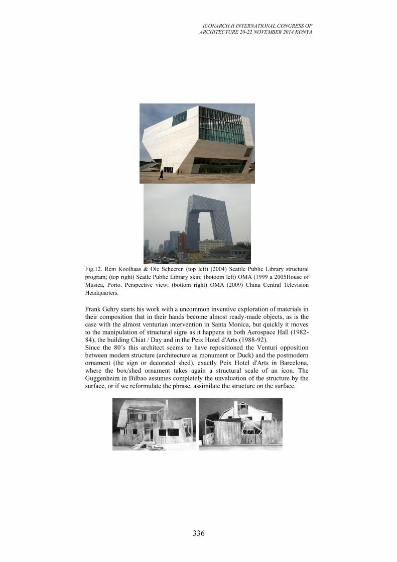
ICONARCH II INTERNATIONAL CONGRESS OF
ARCHITECTURE 20-22 NOVEMBER 2014 KONYA
336
Fig.12. Rem Koolhaas & Ole Scheeren (top left) (2004) Seattle Public Library structural
program; (top right) Seatle Public Library skin; (botoom left) OMA (1999 a 2005House of
Música, Porto. Perspective view; (bottom right) OMA (2009) China Central Television
Headquarters.
Frank Gehry starts his work with a uncommon inventive exploration of materials in
their composition that in their hands become almost ready-made objects, as is the
case with the almost venturian intervention in Santa Monica, but quickly it moves
to the manipulation of structural signs as it happens in both Aerospace Hall (1982-
84), the building Chiat / Day and in the Peix Hotel d'Arts (1988-92).
Since the 80’s this architect seems to have repositioned the Venturi opposition
between modern structure (architecture as monument or Duck) and the postmodern
ornament (the sign or decorated shed), exactly Peix Hotel d'Arts in Barcelona,
where the box/shed ornament takes again a structural scale of an icon. The
Guggenheim in Bilbao assumes completely the unvaluation of the structure by the
surface, or if we reformulate the phrase, assimilate the structure on the surface.
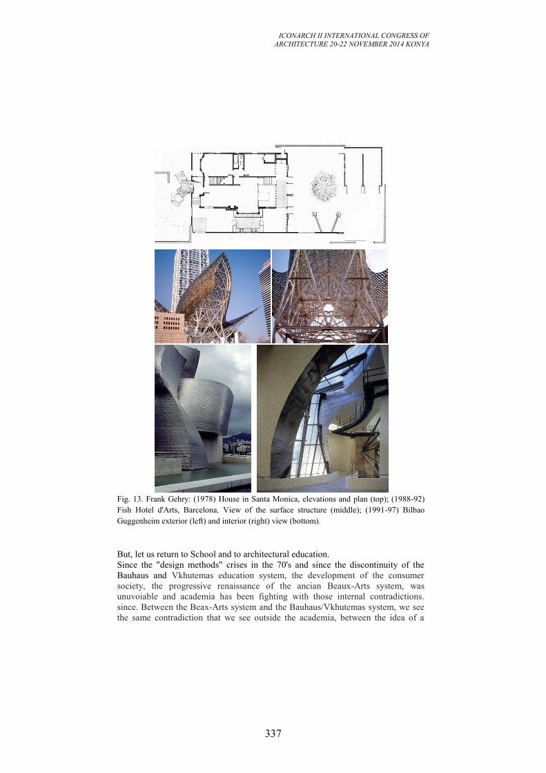
ICONARCH II INTERNATIONAL CONGRESS OF
ARCHITECTURE 20-22 NOVEMBER 2014 KONYA
337
Fig. 13. Frank Gehry: (1978) House in Santa Monica, elevations and plan (top); (1988-92)
Fish Hotel d'Arts, Barcelona. View of the surface structure (middle); (1991-97) Bilbao
Guggenheim exterior (left) and interior (right) view (bottom).
But, let us return to School and to architectural education.
Since the "design methods" crises in the 70's and since the discontinuity of the
Bauhaus and Vkhutemas education system, the development of the consumer
society, the progressive renaissance of the ancian Beaux-Arts system, was
unuvoiable and academia has been fighting with those internal contradictions.
since. Between the Beax-Arts system and the Bauhaus/Vkhutemas system, we see
the same contradiction that we see outside the academia, between the idea of a
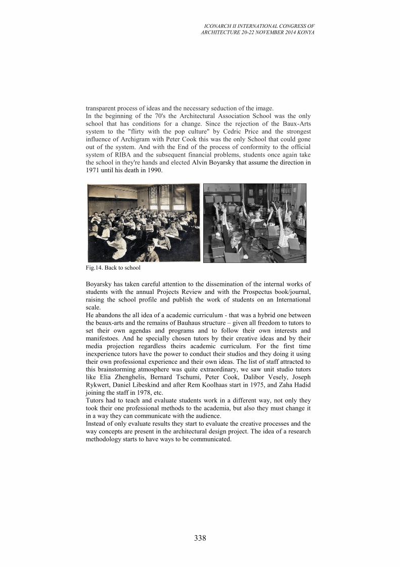
ICONARCH II INTERNATIONAL CONGRESS OF
ARCHITECTURE 20-22 NOVEMBER 2014 KONYA
338
transparent process of ideas and the necessary seduction of the image.
In the beginning of the 70's the Architectural Association School was the only
school that has conditions for a change. Since the rejection of the Baux-Arts
system to the "flirty with the pop culture" by Cedric Price and the strongest
influence of Archigram with Peter Cook this was the only School that could gone
out of the system. And with the End of the process of conformity to the official
system of RIBA and the subsequent financial problems, students once again take
the school in they're hands and elected Alvin Boyarsky that assume the direction in
1971 until his death in 1990.
Fig.14. Back to school
Boyarsky has taken careful attention to the dissemination of the internal works of
students with the annual Projects Review and with the Prospectus book/journal,
raising the school profile and publish the work of students on an International
scale.
He abandons the all idea of a academic curriculum - that was a hybrid one between
the beaux-arts and the remains of Bauhaus structure – given all freedom to tutors to
set their own agendas and programs and to follow their own interests and
manifestoes. And he specially chosen tutors by their creative ideas and by their
media projection regardless theirs academic curriculum. For the first time
inexperience tutors have the power to conduct their studios and they doing it using
their own professional experience and their own ideas. The list of staff attracted to
this brainstorming atmosphere was quite extraordinary, we saw unit studio tutors
like Elia Zhenghelis, Bernard Tschumi, Peter Cook, Dalibor Vesely, Joseph
Rykwert, Daniel Libeskind and after Rem Koolhaas start in 1975, and Zaha Hadid
joining the staff in 1978, etc.
Tutors had to teach and evaluate students work in a different way, not only they
took their one professional methods to the academia, but also they must change it
in a way they can communicate with the audience.
Instead of only evaluate results they start to evaluate the creative processes and the
way concepts are present in the architectural design project. The idea of a research
methodology starts to have ways to be communicated.
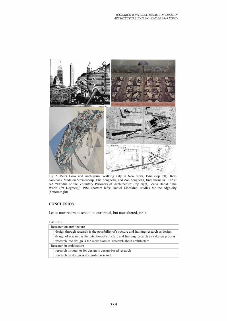
ICONARCH II INTERNATIONAL CONGRESS OF
ARCHITECTURE 20-22 NOVEMBER 2014 KONYA
339
Fig.15. Peter Cook and Archigram, Walking City in New York, 1964 (top left); Rem
Koolhaas, Madelon Vreisendorp, Elia Zenghelis, and Zoe Zenghelis, final thesis in 1972 at
AA “Exodus or the Voluntary Prisoners of Architecture” (top right); Zaha Hadid “The
World (89 Degrees),” 1984 (bottom left); Daniel Libeskind, studies for the edge-city
(bottom right)
CONCLUSION
Let us now return to school, to our initial, but now altered, table.
TABLE 2
Research on architecture
design through research is the possibility of structure and framing research as design;
design of research is the intention of structure and framing research as a design process
research into design is the more classical research about architecture
Research in architecture
research through or for design is design-based research
research on design is design-led research

ICONARCH II INTERNATIONAL CONGRESS OF
ARCHITECTURE 20-22 NOVEMBER 2014 KONYA
340
My hypothesis is to structure architectural research into two main areas, research
on architecture and research in architecture.
The first one can be designerly research as design or research about or on the
architectural product. Is research that is concern with the building as it is when
finished and with his past, present and future behavior, performance, reception, etc.
Or the possibility, conscious or unconscious, of structure research through design.
The second one is research in architecture, is research that can be based in design
or research on the processes of design. Research not only about the processes and
methods used during the designing, but also about the way the research subject
emerges in the outcomes of design.
The first type contemplates design through research, design of research, and
research into design. In a way it has more to do with fundamental research, but is
not confined to it.
The second type contemplates research through design or research for design and
research on design. In a way it has more to do with applied research, but also is not
confined to it. Design-led research is a type of research that is concern about the
study of the nature of the design process, the object of inquiry is design and can be
seen also in practice when we are concern with the nature of practice and we want
to gain operational knowledge about our own practice. In a certain way is what we
are constantly teaching to our students, to reflect in their own design process.
On the other hand we have design-based research that is a research about a specific
subject treated in an architectural project. For design-based research the process of
design is the pattern used as a research methodology and it seeks to gain new
knowledge partly by the creative means and the outcomes of the artifact created.
REFERENCES
- Bayazit, Nigan (2004) Investigating Design: A Review of Forty Years of Design
Research, in Design Issues: Volume 20, Number 1. MIT
- Biggs, M. (2002) The Role of the Artefact in Art and Design Research in
International Journal of Design Sciences and Technology, 10(2), pp. 19-24.
- De Meuron, Pierre & Herzog, Jacques (2006) Natural History. Lars Müller
Publishers
- Derrida, Jacques (1979) O poço e a pirâmide: introdução à semiologia de Hegel
in Hegel e o pensamento moderno. Porto: Rés Editora Limitada. p.39-107. Original
de 1970, Paris: Presses Universitaires de France.
- Cross, Nigel (1982) Designerly Ways of Knowing, in Design Studies, Vol. 3, No.
4, pp. 221-227.
- Faste, Trygve and Haacon (2012) Demystifying "Design Research": Design is not
research, research is design, in IDSA Education Symposium, August. Boston.
- Frayling, Christopher (1993) Research in Art and Design in Royal College of Art
Research Papers, v.1, n.1. London: Royal College of Art.
- Hill, Jonathan (2013) Design Research: the first 500 years in Design Research in
Architecture: an overview. London: Ashgate Publishing Limited.
ICONARCH II INTERNATIONAL CONGRESS OF
ARCHITECTURE 20-22 NOVEMBER 2014 KONYA
341
- Jones, John Chris. (1962) Systematic Design Methods in Associated Electrical
Industries, Manchester, Internal Publication.
- Rittel, Horst (1972 On the Planning Crisis: Systems Analysis of the ‘First and
Second Generations’ in Bedriftskonomen, Vol. 8.
- Polalyi, M. (1966) The Tacit Dimension. London: Routledge and Kegan Paul.
- Rosenblueth, A., N. Wiener, and J. Bigelow (1943) Behavior, Purpose and
Teleology in Philosophy of Science, 10(1943), S. 18–24
- Sequeira, João Menezes (2014) “The Scale of Objects: thoughts on the birth and
expansion of an architectural operator in Lusófona Journal of Architecture and
Education, n. 10, Lisbon: LabART Editions, p. 011-052.
- Tschumi, Bernard ([1981]1994) The Manhattan Transcripts. London: Academy
Editions.
ICONARCH II INTERNATIONAL CONGRESS OF
ARCHITECTURE 20-22 NOVEMBER 2014 KONYA
342
INNOVATIVE APPROACHES IN ARCHITECTURE AND
PLANNING THE FUTURE OF OUR PAST. Dr.Bouzid BOUDIAF1
ABSTRACT
Historic Arab cities show a variety of origins and modernization patterns; these
were conditioned on the one hand by external factors such as pre-existing
settlements, deliberate locational choices and prevailing dynastic modernization
and transformation, on the other hand by internal factors such as the morphological
principles implied in individual architecture components and in genesis of the
urban environment.
In this paper, we will try to highlight the socio-cultural aspects in the city structure
context and their relations to the city morphology referring to the underlying
shaping forces of urban form which, drawing on related, deep-rooted human
attitudes, constitute the real agents of physical manifestation and are source of the
non-material qualities transpiring through materials expressions.
This presentation seeks to understand the significance of the city structure in
different dimensions of urban environment. Understanding the interaction between
underlying political, economic, socio-cultural forces as deep structure elements is
an important aspect of research objectives. This paper also studies how physical or
functional changes follow changes in the underlying forces among the
modernization process and city structure regeneration.
The approach to the research objectives is based on two methodologies:
• Deductive: a theoretical investigation based on the properties of the city structure,
definitions, principles of design, and the dilemma of achieving modernization is as
much cultural as technical. This combines information from literature reviews and
the ideas of key figures in the urban development field and the place-identity,
social identity and identity process as theories for cultural models of the city.
• Inductive: a study of Algiers as example of historical settlements that have
undergone much change processes. The study looks to elicit the images of the city
main structure to support the theoretical propositions of surface and deep structural
city elements. The conclusion to this part is based on an analysis of the case study.
The research concludes its conclusion through the theoretical and empirical work
the socio- cultural aspect in the modernization process as a board and complex
field.
Moreover, it introduces the concept of City Structure as a new way to envisage
urban Conservation studies.
1 Ajman University of Science and Technology (AUST);College of Engineering;
Department of Architectural Engineering
ICONARCH II INTERNATIONAL CONGRESS OF
ARCHITECTURE 20-22 NOVEMBER 2014 KONYA
343
Key words: Architecture, Culture, Urban design, Conservation, Sustainability.
1. INTRODUCTION:
The last decade of the XX century was marked by deep economical and political
changes provoking some irreversible transformations in the socio cultural
organization and the physical structure. These changes can be explained by the
failure of the economical models on which were worked out the different policies
of development and principles of growth and management.
The economic models of Ford and Keynes were replaced by the new economical
order, which is characterized by a new economical logic based on the accumulation
of the capital. This new order led implicitly to the process of restructuring
economy through the emphasis of the specialization and the flexibility. Implicitly
this new order led Algeria to readjust the political and economical environments in
the hope to be in adequacy with the project of globalization. This readjustment is
based on the rationality, and is materialized through the management of the human
resources and the territorial planning at different scales and levels.
In 1997, the Algerian population reached 30 millions, a figure which is expected to
rise by another 5 millions by the year 2010. More than 50% of the population is
living in cities (Algiers alone represents almost 20% of the urban population),
which represents more than 100% increase in city dwellers in a period of less than
20 years.(Bearing in mind that 25% of the dwellings have been built between 1999
and 2005 and for the other 75%, 2/3 of them necessitate whether a rehabilitation or
some maintenances)*. The impact of this rapid urban development is that large
areas of almost all the Algerian cities, situated in the North of the country, look the
same. So do Algerian cities look Algerian and if they do what makes them look
that way ? As a result, the city of today differs from its past in several
respects : size and scale, street layout, land use patterns, architectural style
and type of housing. Traditional urban form and building which would have
provided information about regional and national identity have been largely
replaced by forms characterizing the international and universal buildings and
spaces. These changes have altered the city’s form and have given rise to questions
about the impact of these changes on the image of the city in terms of size and
cultural values. So the concept of urban space becomes a determinant of the ability
of planners, architects, engineers and administrators to provide an environment
which is adequately structured to avoid chaos and to maintain an acceptable quality
of life.
2.STRUCTURAL TRANSFORMATION OF THE CITY:
The objective of part one is literature review that builds up a conceptof the city
main structure properties particularly in the process of urban transformation based
on
ICONARCH II INTERNATIONAL CONGRESS OF
ARCHITECTURE 20-22 NOVEMBER 2014 KONYA
344
the structuralism approach which defined a structure as a system of transformation.
The proposed structural approach to urban transformation of the built environment
in this research is coming from an awareness of the meaning and concepts of city
structure, city center and city evolution, comparative studies on the ideas of the
theory of structuralism, are presented. These cover descriptive, explanatory and
analytical discussions. Structural transformation is the major property of the city
structure. The mainsource of transformation in cities is its city main structure. The
city main structure is responsible for growth, development and finally,
transformation of a city. Its impacts on the evolutions of the whole city, on
transformation of pattern and variety of land uses, the physical growth, and its
impacts on urban environment sustainability are under consideration in this part.
2.1 Structuralism:
The significance of structuralism is to look into knowledge as an entity. The
concept of structure is used in a variety of academic disciplines and cross-cultural
contexts to question form, order, systems and transformation. Structuralism
proposes in essence the reconstruction of what is already known. Piaget (1968)
claims that there are two important differences between global structuralism and
the deliberative, analytical structuralism of Levi-Strauss, where the former speaks
of laws of composition. Durkheim's structuralism, for example, is merely global
because he treats totality as a primary concept explanatory, as such, the social
whole arises of itself from the union of components, and its emerges.
2.2 General concepts:
The views on the process of changes in a city and its main structure consisted of
various interpretations. The general term mostly used is change. The hypothesis
based on the major differentiations between the term change and transformation
that become very clear in the modernization processes in the urban environment for
Arab cities. The other terms are growth, evolution, and development. The meaning
of these terms for urban concept is derived from its common meaning.
2.2.1 Change
The meaning of change covers various ranges, from change with physical manifest
to changes in activities or even economic or social-cultural characteristics. City
systems and their elements can change through cultural and educative process. It is
this form of change that is significant. It can, of course, imply direction, as though
it is a product of conscious thought (Larkham; 1999). Human settlements are
continually changing (Lang; 1994). The physical interpretation is the most
perceivable form of the changes. Kostof (1992) reaches the conclusion that in
cities, only change endures, that all cities are caught in a balancing act between
destruction and preservation. The scale of change either physical or functional
varies from a single element, which is the building as an urban unit, to the scale of
the global form of the city. The changes could be organic or planned. There is
necessity for changes in cities, as Lang (1994) claims, for, inevitably, changes in
the public realm create new opportunities and new problems resulting in the need
for future changes. The cycle is endless.
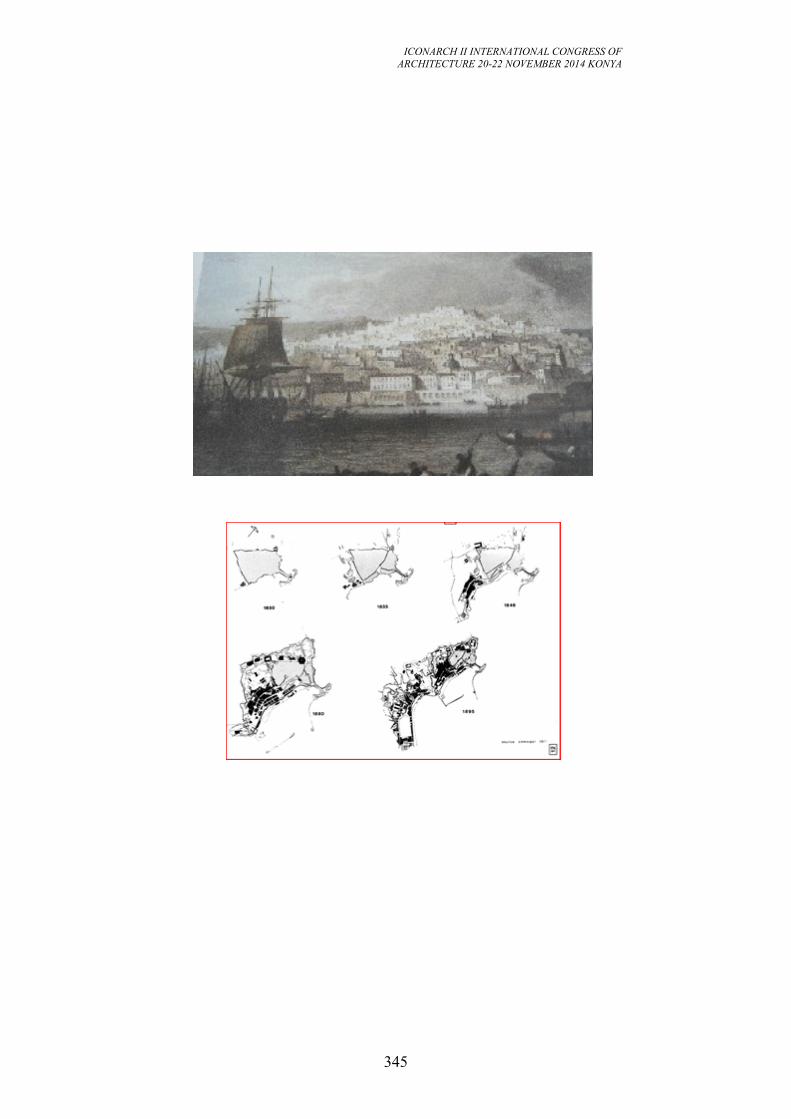
ICONARCH II INTERNATIONAL CONGRESS OF
ARCHITECTURE 20-22 NOVEMBER 2014 KONYA
345
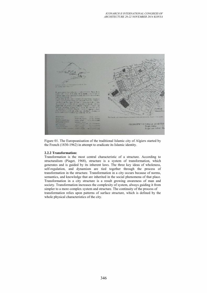
ICONARCH II INTERNATIONAL CONGRESS OF
ARCHITECTURE 20-22 NOVEMBER 2014 KONYA
346
Figure 01. The Europeanisation of the traditional Islamic city of Algiers started by
the French (1830-1962) in attempt to eradicate its Islamic identity.
2.2.2 Transformation:
Transformation is the most central characteristic of a structure. According to
structuralism (Piaget, 1968), structure is a system of transformation, which
generates and is guided by its inherent laws. The three key ideas of wholeness,
self-regulation, and dynamism are tied together through the process of
transformation in the structure. Transformation in a city occurs because of norms,
semantics, and knowledge that are inherited in the social phenomena of that place.
Transformation in a city structure is a result growing awareness of man and
society. Transformation increases the complexity of system, always guiding it from
simpler to a more complex system and structure. The continuity of the process of
transformation relies upon patterns of surface structure, which is defined by the
whole physical characteristics of the city.
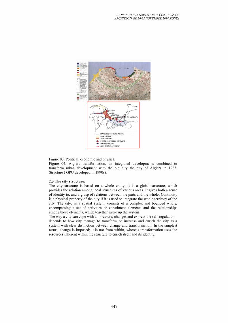
ICONARCH II INTERNATIONAL CONGRESS OF
ARCHITECTURE 20-22 NOVEMBER 2014 KONYA
347
Figure 03. Political, economic and physical
Figure 04. Algiers transformation, an integrated developments combined to
transform urban development with the old city the city of Algiers in 1985.
Structure ( GPU developed in 1990s).
2.3 The city structure:
The city structure is based on a whole entity; it is a global structure, which
provides the relation among local structures of various areas. It gives both a sense
of identity to, and a grasp of relations between the parts and the whole. Continuity
is a physical property of the city if it is used to integrate the whole territory of the
city. The city, as a spatial system, consists of a complex and bounded whole,
encompassing a set of activities or constituent elements and the relationships
among those elements, which together make up the system.
The way a city can cope with all pressure, changes and express the self-regulation,
depends to how city manage to transform, to increase and enrich the city as a
system with clear distinction between change and transformation. In the simplest
terms, change is imposed; it is not from within, whereas transformation uses the
resources inherent within the structure to enrich itself and its identity.
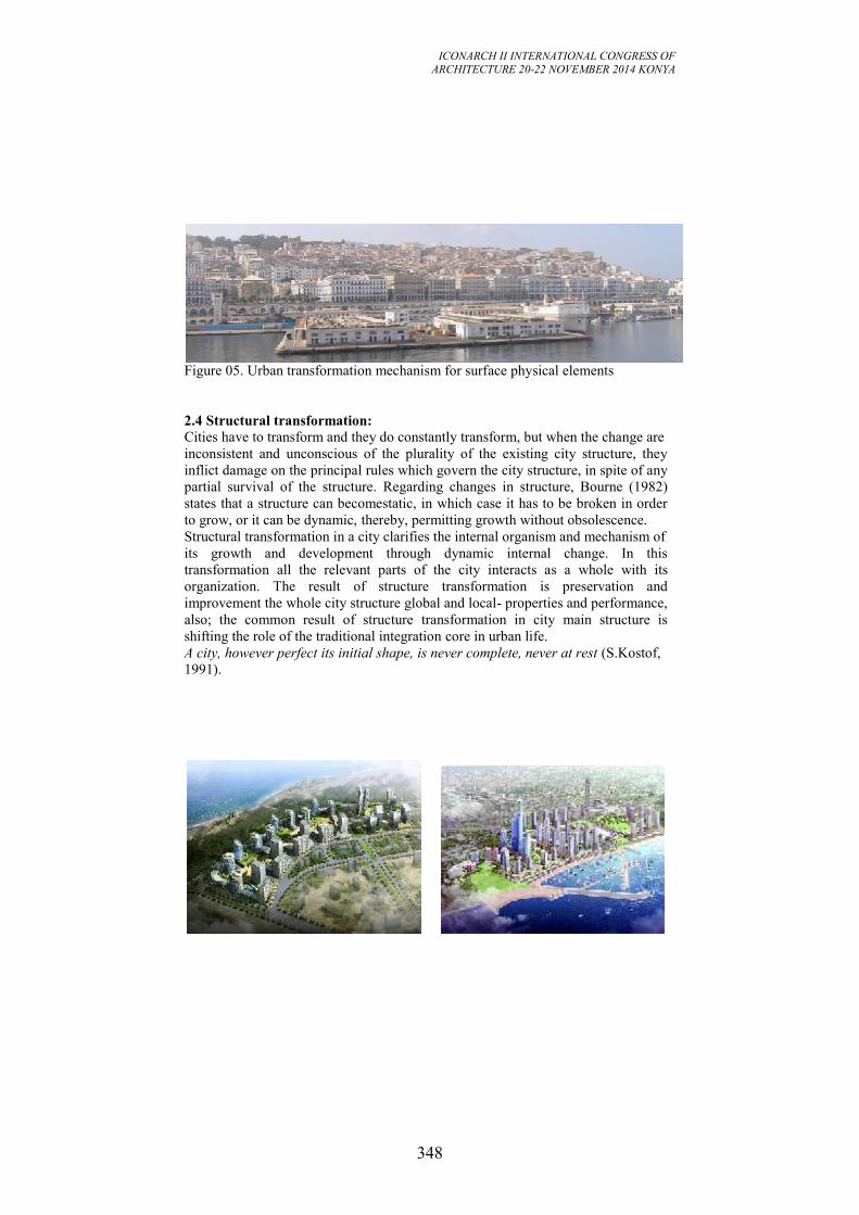
ICONARCH II INTERNATIONAL CONGRESS OF
ARCHITECTURE 20-22 NOVEMBER 2014 KONYA
348
Figure 05. Urban transformation mechanism for surface physical elements
2.4 Structural transformation:
Cities have to transform and they do constantly transform, but when the change are
inconsistent and unconscious of the plurality of the existing city structure, they
inflict damage on the principal rules which govern the city structure, in spite of any
partial survival of the structure. Regarding changes in structure, Bourne (1982)
states that a structure can becomestatic, in which case it has to be broken in order
to grow, or it can be dynamic, thereby, permitting growth without obsolescence.
Structural transformation in a city clarifies the internal organism and mechanism of
its growth and development through dynamic internal change. In this
transformation all the relevant parts of the city interacts as a whole with its
organization. The result of structure transformation is preservation and
improvement the whole city structure global and local- properties and performance,
also; the common result of structure transformation in city main structure is
shifting the role of the traditional integration core in urban life.
A city, however perfect its initial shape, is never complete, never at rest (S.Kostof,
1991).
ICONARCH II INTERNATIONAL CONGRESS OF
ARCHITECTURE 20-22 NOVEMBER 2014 KONYA
349
3. CITY STRUCTURAL TRANSFORMATION: A SUSTAINABLE
PROCESS FOR URBAN ENVIRONMENT MODERNIZATION
A structure is considered to be an abstract set of formal relations underlying the
greater manifestation of observable forms. Eiseman distinguishes a surface or
perceptual structure and a conceptual or deep structure. Deep structure is specified
as an abstract underlying order of elements that makes possible the functioning of
transformational rules. The surface structure is the transformation of a deep
structure.
3.1 Underlying forces within the city structure:
According to structuralist paradigm, transformation within any kind of structure
takes place because of underlying forces and mechanism of how these forces work
together. For the city structure these forces could be interpreted as deep structural
elements.Underlying forces are densest in the city main structure. All kinds of
transformation like cultural transformation are more evident, powerful and more
effective within the city main structure are the concentrated laws for cultural
activities and monuments, attraction for people coming to these places and so
places of greatest interaction between them. Consequently the city main structure is
the place that the power of whole underlying forces emerges. The surface structural
elements, like different places, buildings, and activities are the way the society
responds to the forces embedded in the city main structure.
3.2 Principles of city structure sustainability:
"Sustainable architecture involves a combination of values: aesthetic,
environmental, social, political, and moral. It's about using one's imagination and
technical knowledge to engage in a central aspect of the practice -- designing and
building in harmony with our environment. The smart architect thinks rationally
about a combination of issues including sustainability, durability, longevity,
appropriate materials, and sense of place. The challenge is finding the balance
between environmental considerations and economic constraints. Consideration
must be given to the needs of our communities and the socio-cultural paradigm that
helps the urban transformation during the development and modernization process
in the Arab cities. The following principals are the major aspect to achieve the
sustainable city structure:
• Understanding Place - Sustainable design begins with an intimate understanding
of place. If we are sensitive to the nuances of place, we can -inhabit without
destroying it.
• Connecting with Nature - Whether the design site is a building in the inner city
or in a more natural setting, connecting with nature brings the designed
environment back to life.
• Understanding Environmental Impact - Sustainable design attempts to have an
understanding of the environmental impact of the design by evaluating the site, the
embodied energy and toxicity of the materials, and the energy efficiency of design,
materials and construction techniques.
• Embracing Co-creative Design Processes - Sustainable designers are finding
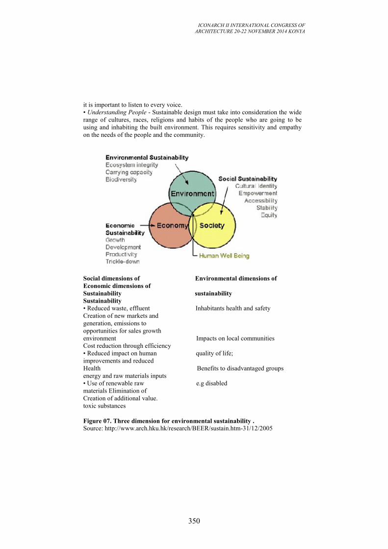
ICONARCH II INTERNATIONAL CONGRESS OF
ARCHITECTURE 20-22 NOVEMBER 2014 KONYA
350
it is important to listen to every voice.
• Understanding People - Sustainable design must take into consideration the wide
range of cultures, races, religions and habits of the people who are going to be
using and inhabiting the built environment. This requires sensitivity and empathy
on the needs of the people and the community.
Social dimensions of Environmental dimensions of
Economic dimensions of
Sustainability sustainability
Sustainability
• Reduced waste, effluent Inhabitants health and safety
Creation of new markets and
generation, emissions to
opportunities for sales growth
environment Impacts on local communities
Cost reduction through efficiency
• Reduced impact on human quality of life;
improvements and reduced
Health Benefits to disadvantaged groups
energy and raw materials inputs
• Use of renewable raw e.g disabled
materials Elimination of
Creation of additional value.
toxic substances
Figure 07. Three dimension for environmental sustainability . Source: http://www.arch.hku.hk/research/BEER/sustain.htm-31/12/2005
ICONARCH II INTERNATIONAL CONGRESS OF
ARCHITECTURE 20-22 NOVEMBER 2014 KONYA
351
3.3 Socio-cultural force as a deep structural element:
The underlying forces are the elements of the deep city main structure while the
physical elements are the elements of the surface structure. Interaction between the
forces is manifested on the surface characteristics. That interaction is based on laws
of composition as city structure property. Transformation in the surface elements
among the city structure leads to survive the responsiveness of the city. The central
concern in any study of the city structure should refer to the interrelationships of
the underlying forces.
Physical environment determinants, social needs, demographic pressure, culture
and religion, political issues and technological development, could be considered
assome of these underlying shaping forces. The inherent power of sustainability
and responsiveness, even after the worst periods of deterioration, can be considered
as the self-regulation of the structural property and the process of transformation.
This is dependent on the interacting mechanism of socio-cultural forces and on the
balanced status between them.
3.3.1 Social forces:
The social force is a driving force. It embodies in human beings the desire to
socialize and belong to a society. People are unconsciously aware of the social
forcesand accommodate them within the settlement structure and then interpret
them onto the surface structure, to the spatial layout of the settlement structure. The
need unconsciously embedded in the human soul to socialize, are fulfilled by
formation of city structure.
Social structure determines the social distribution of space and the evolution of
urban spatial. Even the appearances and physical organizations of objects in public
spaces depend on the social forces, because these kinds of spaces within the city
main structure are supposed to be the containers for social life. Social relationships
address the dynamism and transformation within urban environment and the social
communication.
3.3.2 Cultural forces:
An important aspect of culture with considerable impacts on city structure,
especially the city main structure, belongs to religion in its many interpretations
across time. Religious should be considered intrinsic in human life. Religious
beliefs are the context of culture and at time have had the highest degree of
influence onhuman civilization, and consequently on major urban objects. It many
instances religion was so predominant in the physical structure of the holy cities as
to be the very essence of them.
3.4 Sustainable urban principles of the Arab city structure. A sociocultural
view.
A number of factors played decisive roles in ordering and shaping the plan and
form of Arab and Muslim city. In addition to the influence of surface structure
factors, local topography and morphological features of pre-existing town, the

ICONARCH II INTERNATIONAL CONGRESS OF
ARCHITECTURE 20-22 NOVEMBER 2014 KONYA
352
Muslim cityreflected the general socio-cultural, political, and economic structures
of the newly created society. Saoud (2001) defined the concept of quality of urban
environment in terms of both “sustainability”, and “city structure” quality, based
upon the sociocultural paradigm; In general this involved the following:
• Natural Laws: The first principle that defined much of the character of the
Muslim city is the adaptation form and plan of the city to natural circumstances
expressed through weather conditions and topography.
• Religious and cultural beliefs: The religious beliefs and practices formed the
center of cultural life for this population, thus giving the mosque the central
position in spatial and institutional hierarchies. The cultural beliefs separating
public and private lives regulated the spatial order between uses and areas.
• Design principles stemmed from Sharia Law: The Arabic Islamic city also
reflected the rules of Sharia (Islamic Law) in terms of physical and social relations
between public and private realms, and between neighbors and social groups.
• Social principles: The social organization of the urban society was based on
social grouping sharing the same mentality, ethnic origin and cultural perspectives.
Development and modernization were therefore directed towards meeting these
social needs especially in terms of kinship solidarity, defense, social order and
religious practices. Factors such as extended-family structures, privacy, sex
separation and strong community interaction were clearly translated in the dense
built form of the courtyard houses. The social organization of the urban society
based on social grouping. Social and legal issues were taken over by religious
scholars who lived in central places close to the city main structure which contains
the mosque and the public life were disputes mostly arose.
4.URBAN GROWTH OF ALGIERS: FROM A TOWN TO THE
METROPOLIS
Just as many other cities do, Algiers comes from a small town on the coast,
encircled in walls and surrounded by fields. Until late in the XIX Century, these
walls were used as a separation between the urban center and the small villages and
« summer residence » or Fahs.
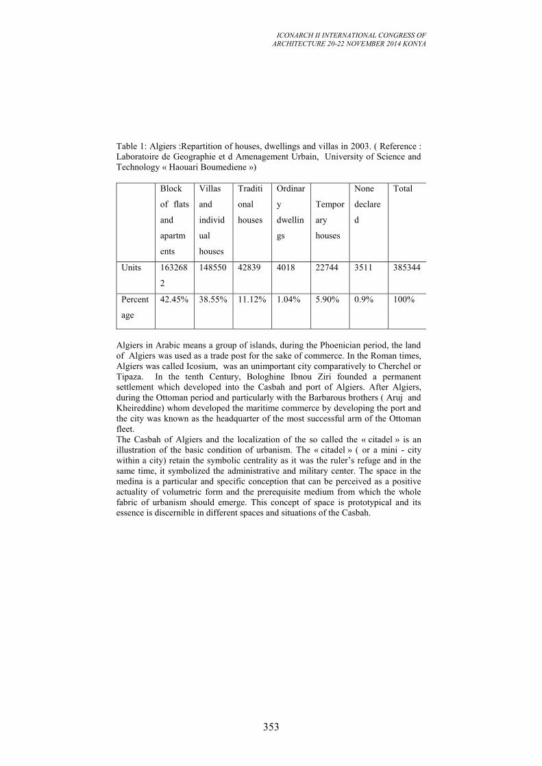
ICONARCH II INTERNATIONAL CONGRESS OF
ARCHITECTURE 20-22 NOVEMBER 2014 KONYA
353
Table 1: Algiers :Repartition of houses, dwellings and villas in 2003. ( Reference :
Laboratoire de Geographie et d Amenagement Urbain, University of Science and
Technology « Haouari Boumediene »)
Block
of flats
and
apartm
ents
Villas
and
individ
ual
houses
Traditi
onal
houses
Ordinar
y
dwellin
gs
Tempor
ary
houses
None
declare
d
Total
Units 163268
2
148550 42839 4018 22744 3511 385344
Percent
age
42.45% 38.55% 11.12% 1.04% 5.90% 0.9% 100%
Algiers in Arabic means a group of islands, during the Phoenician period, the land
of Algiers was used as a trade post for the sake of commerce. In the Roman times,
Algiers was called Icosium, was an unimportant city comparatively to Cherchel or
Tipaza. In the tenth Century, Bologhine Ibnou Ziri founded a permanent
settlement which developed into the Casbah and port of Algiers. After Algiers,
during the Ottoman period and particularly with the Barbarous brothers ( Aruj and
Kheireddine) whom developed the maritime commerce by developing the port and
the city was known as the headquarter of the most successful arm of the Ottoman
fleet.
The Casbah of Algiers and the localization of the so called the « citadel » is an
illustration of the basic condition of urbanism. The « citadel » ( or a mini - city
within a city) retain the symbolic centrality as it was the ruler’s refuge and in the
same time, it symbolized the administrative and military center. The space in the
medina is a particular and specific conception that can be perceived as a positive
actuality of volumetric form and the prerequisite medium from which the whole
fabric of urbanism should emerge. This concept of space is prototypical and its
essence is discernible in different spaces and situations of the Casbah.
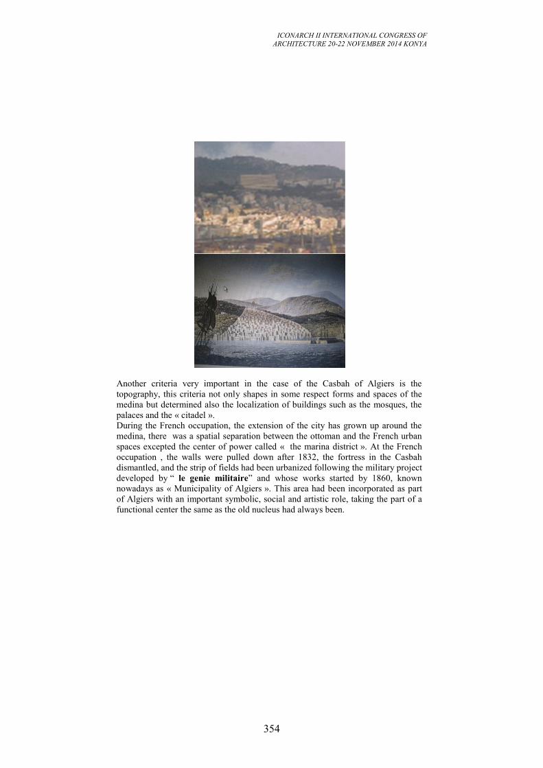
ICONARCH II INTERNATIONAL CONGRESS OF
ARCHITECTURE 20-22 NOVEMBER 2014 KONYA
354
Another criteria very important in the case of the Casbah of Algiers is the
topography, this criteria not only shapes in some respect forms and spaces of the
medina but determined also the localization of buildings such as the mosques, the
palaces and the « citadel ».
During the French occupation, the extension of the city has grown up around the
medina, there was a spatial separation between the ottoman and the French urban
spaces excepted the center of power called « the marina district ». At the French
occupation , the walls were pulled down after 1832, the fortress in the Casbah
dismantled, and the strip of fields had been urbanized following the military project
developed by “ le genie militaire” and whose works started by 1860, known
nowadays as « Municipality of Algiers ». This area had been incorporated as part
of Algiers with an important symbolic, social and artistic role, taking the part of a
functional center the same as the old nucleus had always been.
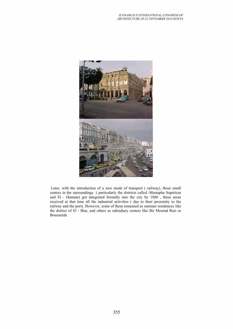
ICONARCH II INTERNATIONAL CONGRESS OF
ARCHITECTURE 20-22 NOVEMBER 2014 KONYA
355
Later, with the introduction of a new mode of transport ( railway), those small
centers in the surroundings ( particularly the districts called :Mustapha Supérieur
and El - Hamma) got integrated formally into the city by 1880 , these areas
received at that time all the industrial activities ( due to their proximity to the
railway and the port). However, some of them remained as summer residences like
the district of El - Biar, and others as subsidiary centers like Bir Mourad Rais or
Bouzaréah.
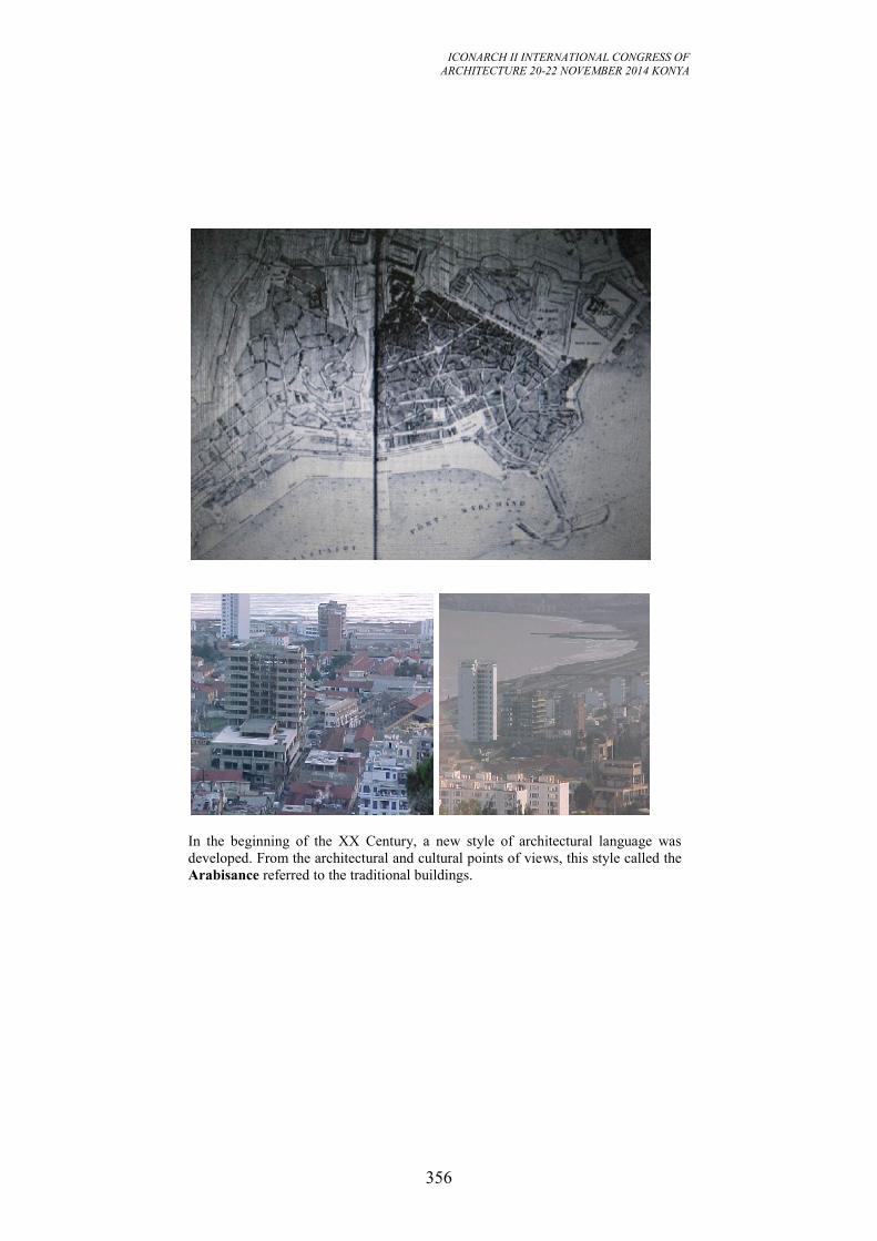
ICONARCH II INTERNATIONAL CONGRESS OF
ARCHITECTURE 20-22 NOVEMBER 2014 KONYA
356
In the beginning of the XX Century, a new style of architectural language was
developed. From the architectural and cultural points of views, this style called the
Arabisance referred to the traditional buildings.
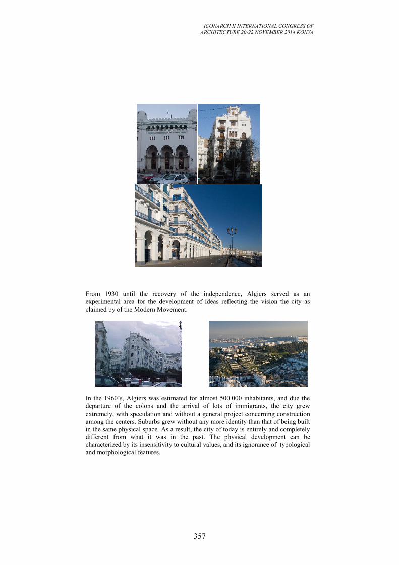
ICONARCH II INTERNATIONAL CONGRESS OF
ARCHITECTURE 20-22 NOVEMBER 2014 KONYA
357
From 1930 until the recovery of the independence, Algiers served as an
experimental area for the development of ideas reflecting the vision the city as
claimed by of the Modern Movement.
In the 1960’s, Algiers was estimated for almost 500.000 inhabitants, and due the
departure of the colons and the arrival of lots of immigrants, the city grew
extremely, with speculation and without a general project concerning construction
among the centers. Suburbs grew without any more identity than that of being built
in the same physical space. As a result, the city of today is entirely and completely
different from what it was in the past. The physical development can be
characterized by its insensitivity to cultural values, and its ignorance of typological
and morphological features.
ICONARCH II INTERNATIONAL CONGRESS OF
ARCHITECTURE 20-22 NOVEMBER 2014 KONYA
358
This development exposed Algiers to another problem which is the
conservation of the traditional city. As masses of people had migrated from rural
areas and from the mountains to the city; so in addition to creating squatter
settlements on the outskirts of the city, the migration had and still is one of the
reasons for the deterioration and destruction of the traditional city. The main
aspects that can explain the deterioration of the medina are the densification and
the judicial status of the houses.
In the 1970's, the decision makers of urban development focused on the
distribution of functions by applying the Zoning, they tried to balance
concentration of activities in the traditional city by a policy of decentralization and
progressive endowment of peripheral dorm areas with qualified services both at
neighborhood and urban scales.
The growth and extension of Algiers were oriented to the East side of the city, and
many civil public buildings and housing were realized such as the U.S.T.H.B(
University of Science and Technology « Houari Boumèdiene » at Bab - Ezzouar),
thousands of dwellings were built particularly on the sites of Bab - Ezzouar,
Bachdjarah and Bordj - El - Kiffane. At the end of that decade, the government
realized that this development were done on the most fertile land from the
agricultural point of view, so the decision was taken to reorient the development to
the South - East. This orientation allowed the planners to suggest the delocalization
of the industrial activities situated in El - Hamma and they proposed to increase the
density of this district with high rise buildings developed principally as offices.
In the beginning of 1990’s, the development was oriented on the basis of new laws
in which the inhabitant should be involved as a participant. This development took
into consideration what was launched in the 80’s. The Master plan of the 1990’s
called the P.D.A.U.( Plan Directeur d’Aménagement et d’Urbanisme) was
established on the following hypotheses :
The preservation of the traditional city or « la médina » ;
The densification of the districts El - Hamma and Hussein - Dey ;
The development of the main and important civil public buildings on the same
virtual axis;
The objectives from these hypotheses were the development of a linear centre with
a multi poles, and each pole should have a vocation. These poles are:
A historic pole represented by the Casbah reflecting the heritage of the Ottoman
period;
The district of « Premier Mai, El - Hamma » were destined for tertiary activities,
with the main buildings determining the notion of centrality in the city ;
The third pole « The memorial » was much more symbolic with political and
cultural buildings;
The fourth and the last pole in the East side and opposite to the medina should
contain the financial buildings, it represents the C.B.D.
In 1997, the city of Algiers was reorganized and it had a different status
comparatively to the other cities of the country. Algiers was elevated as a
ICONARCH II INTERNATIONAL CONGRESS OF
ARCHITECTURE 20-22 NOVEMBER 2014 KONYA
359
gouvernorat and the limits of territory of this governorat are four times of what it
was before when it was considered as a wilaya. The administrative authority had
carried out a new structuring project called G.P.U. of the G.G.A.( Grand Projet
Urbain du Gouvernorat du Grand Alger). The approach adopted in this project is
based on the polarity of the city. Six poles were identified, so the territory is
divided in six areas and each one had a vocation that should able the city to be
competitive at the international level. Before the enumeration of these vocations,
we must emphasize that this development focalized principally on the coastal
areas. The six poles can be summarized as follow:
Pole one contains the medina and the first colonial center with the port: Cultural
vocation;
Pole two composed of areas where their urbanization were done between 1880 and
1924, and during the French occupation, these areas were designated to industrial
activities. The districts are: 1er
Mai; El - Hamma and Ravin de la Femme Sauvage.
The vocation of this pole is administrative activities;
The third pole nearby the second and presenting almost the same characteristics as
the second except the slums which were developed along side « Oued El- Harrach
and the industrial area of Oued Smar ». The pole contains the following districts :
Caroubier, El - Harrach and Pins Maritimes, this pole should be developed for
cultural and sportive activities ;The village created in 1860 juxtaposed to a group
of buildings used, during the ottoman period, for military defense. This village was
created for agricultural exploitation, and the development was oriented towards the
agricultural activities and not to the sea. The districts of this pole are : Bordj -El -
Kiffane ;Lido ; Verte Rive and Stamboul. The vocation was cultural and tourist
activities.
The fifth and the sixth are situated at the West side of the medina, the others
mentioned above are in East side. So these two pole composed respectively of Cap
Caxine for the fifth and El - Djemila ; les dunes and Zeralda for the sixth which
was designated for touristic and business activities. The main activities retained for
the fifth were for tourism.
ICONARCH II INTERNATIONAL CONGRESS OF
ARCHITECTURE 20-22 NOVEMBER 2014 KONYA
360
Table 2: Algiers: The urban development of Algiers through the statistics.
(Reference: Laboratory of geography and urban design,
University of Science and Technology « Haouari Boumediene », 2003)
Population in
1966
Population in
1977
Population in
1987
Population in
1998
Designation Grand Alger
( according to
the repartition
of 1959
called
Constantine’s
Plan)
Grand Alger
( according
to the new
repartition of
the national
territory of
1974)
Grand Alger
( according to
the new
repartition of
the national
territory of
1984)
Gouvernorat
d Alger
Number of
municipalitie
s
10 13 28 57
Area 170km2 186km2 250km2 870km2
Population 1094851 1641521 2015374 2562428
We should say that for the last three poles that besides the lack of urbanistic
structure - which obviously implies a lack of structure in the identity of the
physical space, we must mention that most of these areas have developed during
the post - colonial period and according to their potentialities, they present a poor
development of the tertiary sector and almost no development of the services
related to their status and localization from a regional point of view. Another
aspect characterizing these poles is that most of the families living in the periphery
are immigrants, they left their villages or lands for economical reason or they were
searching for security. So they weren’t interested in getting integrated and
identified with their social environment.
This manner of structuring the city of Algiers was rejected, in 1999, by the
president himself as it could lead to physical and social segregations. After the rain
fall and the earth quake, the city council has been carrying a series of urbanistic
interventions in the entire city: shaping of urban spaces, creation of some new ones
trying to provide them with symbolic elements. The result is that any void was
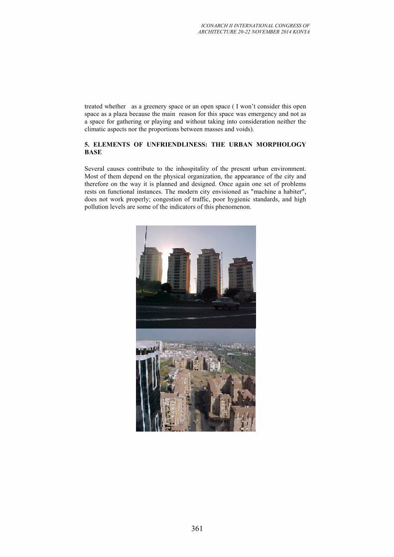
ICONARCH II INTERNATIONAL CONGRESS OF
ARCHITECTURE 20-22 NOVEMBER 2014 KONYA
361
treated whether as a greenery space or an open space ( I won’t consider this open
space as a plaza because the main reason for this space was emergency and not as
a space for gathering or playing and without taking into consideration neither the
climatic aspects nor the proportions between masses and voids).
5. ELEMENTS OF UNFRIENDLINESS: THE URBAN MORPHOLOGY
BASE
Several causes contribute to the inhospitality of the present urban environment.
Most of them depend on the physical organization, the appearance of the city and
therefore on the way it is planned and designed. Once again one set of problems
rests on functional instances. The modern city envisioned as "machine a habiter",
does not work properly; congestion of traffic, poor hygienic standards, and high
pollution levels are some of the indicators of this phenomenon.
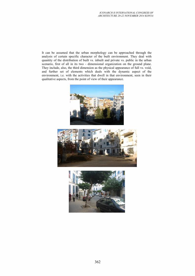
ICONARCH II INTERNATIONAL CONGRESS OF
ARCHITECTURE 20-22 NOVEMBER 2014 KONYA
362
It can be assumed that the urban morphology can be approached through the
analysis of certain specific character of the built environment. They deal with
quantity of the distribution of built vs. inbuilt and private vs. public in the urban
scenario, first of all in its two - dimensional organization on the ground plane.
They include, also, the third dimension as the physical appearance of full vs. void,
and further set of elements which deals with the dynamic aspect of the
environment, i.e. with the activities that dwell in that environment, seen in their
qualitative aspects, from the point of view of their appearance.
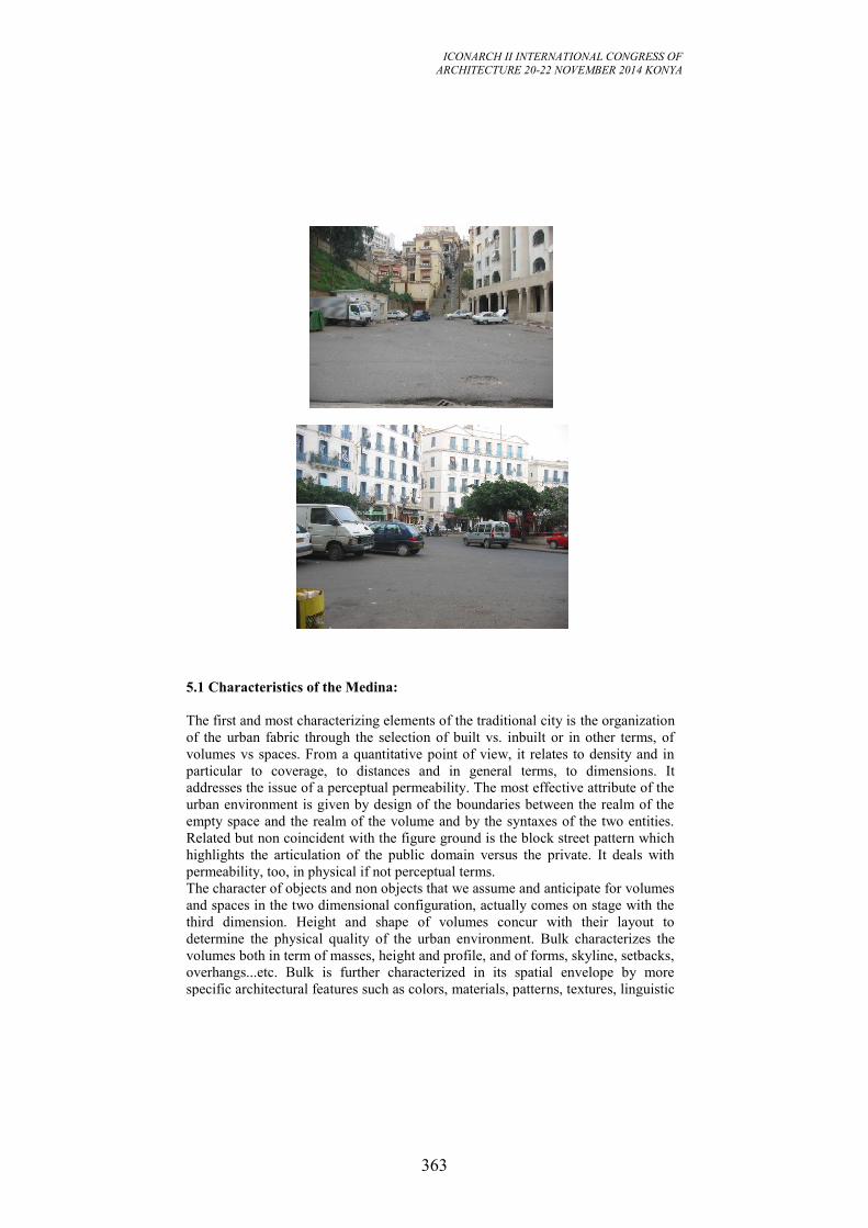
ICONARCH II INTERNATIONAL CONGRESS OF
ARCHITECTURE 20-22 NOVEMBER 2014 KONYA
363
5.1 Characteristics of the Medina:
The first and most characterizing elements of the traditional city is the organization
of the urban fabric through the selection of built vs. inbuilt or in other terms, of
volumes vs spaces. From a quantitative point of view, it relates to density and in
particular to coverage, to distances and in general terms, to dimensions. It
addresses the issue of a perceptual permeability. The most effective attribute of the
urban environment is given by design of the boundaries between the realm of the
empty space and the realm of the volume and by the syntaxes of the two entities.
Related but non coincident with the figure ground is the block street pattern which
highlights the articulation of the public domain versus the private. It deals with
permeability, too, in physical if not perceptual terms.
The character of objects and non objects that we assume and anticipate for volumes
and spaces in the two dimensional configuration, actually comes on stage with the
third dimension. Height and shape of volumes concur with their layout to
determine the physical quality of the urban environment. Bulk characterizes the
volumes both in term of masses, height and profile, and of forms, skyline, setbacks,
overhangs...etc. Bulk is further characterized in its spatial envelope by more
specific architectural features such as colors, materials, patterns, textures, linguistic
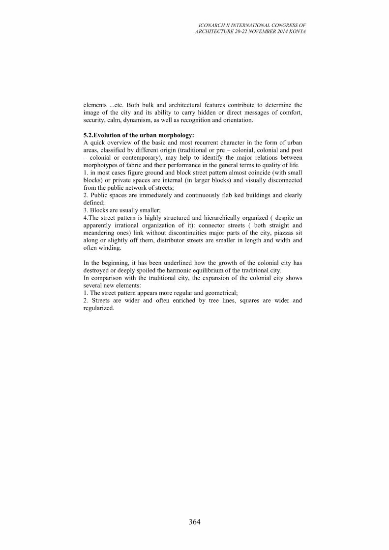
ICONARCH II INTERNATIONAL CONGRESS OF
ARCHITECTURE 20-22 NOVEMBER 2014 KONYA
364
elements ...etc. Both bulk and architectural features contribute to determine the
image of the city and its ability to carry hidden or direct messages of comfort,
security, calm, dynamism, as well as recognition and orientation.
5.2.Evolution of the urban morphology:
A quick overview of the basic and most recurrent character in the form of urban
areas, classified by different origin (traditional or pre – colonial, colonial and post
– colonial or contemporary), may help to identify the major relations between
morphotypes of fabric and their performance in the general terms to quality of life.
1. in most cases figure ground and block street pattern almost coincide (with small
blocks) or private spaces are internal (in larger blocks) and visually disconnected
from the public network of streets;
2. Public spaces are immediately and continuously flab ked buildings and clearly
defined;
3. Blocks are usually smaller;
4.The street pattern is highly structured and hierarchically organized ( despite an
apparently irrational organization of it): connector streets ( both straight and
meandering ones) link without discontinuities major parts of the city, piazzas sit
along or slightly off them, distributor streets are smaller in length and width and
often winding.
In the beginning, it has been underlined how the growth of the colonial city has
destroyed or deeply spoiled the harmonic equilibrium of the traditional city.
In comparison with the traditional city, the expansion of the colonial city shows
several new elements:
1. The street pattern appears more regular and geometrical;
2. Streets are wider and often enriched by tree lines, squares are wider and
regularized.
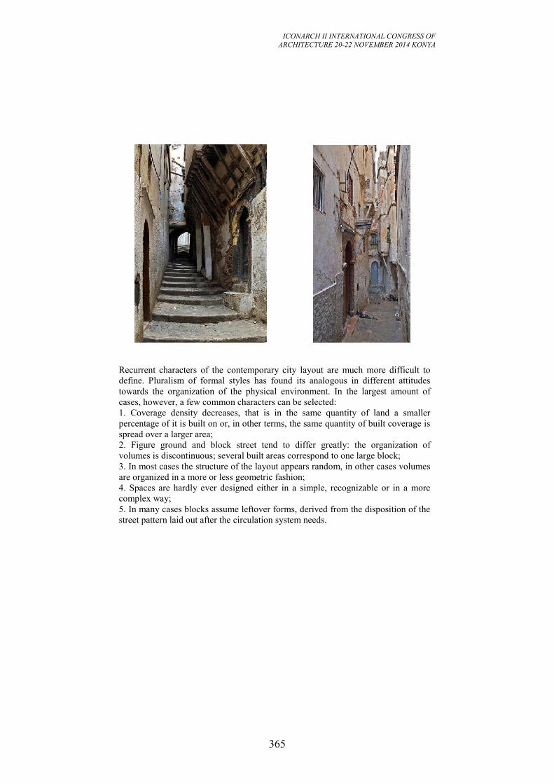
ICONARCH II INTERNATIONAL CONGRESS OF
ARCHITECTURE 20-22 NOVEMBER 2014 KONYA
365
Recurrent characters of the contemporary city layout are much more difficult to
define. Pluralism of formal styles has found its analogous in different attitudes
towards the organization of the physical environment. In the largest amount of
cases, however, a few common characters can be selected:
1. Coverage density decreases, that is in the same quantity of land a smaller
percentage of it is built on or, in other terms, the same quantity of built coverage is
spread over a larger area;
2. Figure ground and block street tend to differ greatly: the organization of
volumes is discontinuous; several built areas correspond to one large block;
3. In most cases the structure of the layout appears random, in other cases volumes
are organized in a more or less geometric fashion;
4. Spaces are hardly ever designed either in a simple, recognizable or in a more
complex way;
5. In many cases blocks assume leftover forms, derived from the disposition of the
street pattern laid out after the circulation system needs.
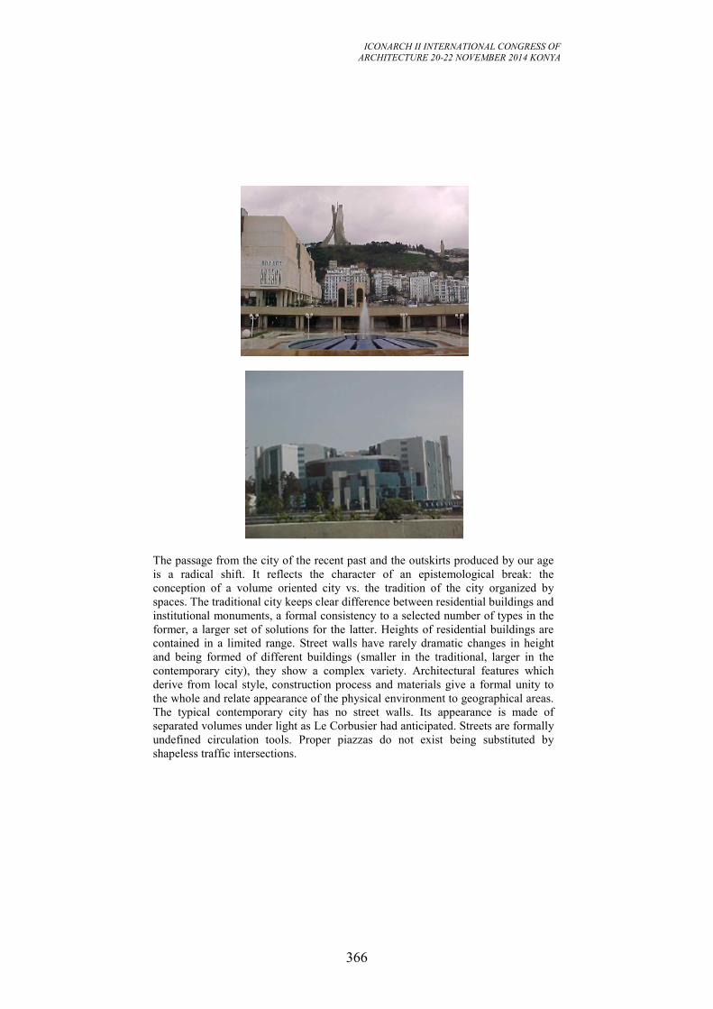
ICONARCH II INTERNATIONAL CONGRESS OF
ARCHITECTURE 20-22 NOVEMBER 2014 KONYA
366
The passage from the city of the recent past and the outskirts produced by our age
is a radical shift. It reflects the character of an epistemological break: the
conception of a volume oriented city vs. the tradition of the city organized by
spaces. The traditional city keeps clear difference between residential buildings and
institutional monuments, a formal consistency to a selected number of types in the
former, a larger set of solutions for the latter. Heights of residential buildings are
contained in a limited range. Street walls have rarely dramatic changes in height
and being formed of different buildings (smaller in the traditional, larger in the
contemporary city), they show a complex variety. Architectural features which
derive from local style, construction process and materials give a formal unity to
the whole and relate appearance of the physical environment to geographical areas.
The typical contemporary city has no street walls. Its appearance is made of
separated volumes under light as Le Corbusier had anticipated. Streets are formally
undefined circulation tools. Proper piazzas do not exist being substituted by
shapeless traffic intersections.
ICONARCH II INTERNATIONAL CONGRESS OF
ARCHITECTURE 20-22 NOVEMBER 2014 KONYA
367
5.3. Irreproducibility of the traditional city:
The traditional city is more livable than the contemporary one because of the way
spaces are organized, its volumes are put together and their surfaces are treated,
and, in general, the way it was built. There is no room for nostalgia, however, the
traditional city is irreproducible, but not because of the stylistic intolerance of the
modernistic attitude.
The situation we have to live with is made of more stable realities. The first one is
almost obvious: the functional performance we ask of a city today is out of the
reach of the pre - colonial city in terms of concentration, growth, circulation,
activities...etc. The second one, less obvious but as relevant, we need to consider in
any attempt to improve the built environment. It has to do with the changes in the
production patterns which have been drastically modified without any analogous
adaptation to the design and the control system.
Size and modalities of intervention by which the city grows have radically
changed. Times of urban modification make the city dynamic jump in a different
qualitative reality. Furthermore, from a construction industry point of view, the
economic background has induced a rapid evolution of the market. The special
nature of the product and its unusual life cycle seem to have represented restraint
for the maturation of the market itself. Finally, from the point of view of public
control, the tools that have been used so far, most of them informed to a limitative
attitude, have proved to be inadequate to maximize the benefits of private and
public investments on the public at large.
Between the end of the last century and the beginning of the present one, the ideal
city started to look with progressively larger attention at images of the future as a
reference for its organization. With the globalization, the architectural production
is developed by what I consider the new stars or the new “elites” . Among the
leading characters of what I consider as a reform, space, culture and history are
directions towards which studies should headed? By doing so, we will recover
values and positive characters of the traditional city while taking advantage of the
technological progress. The architects and the common sensibility are rapidly
evolving together with an increasing participation of the public to design process.
Now that the collective consciousness is ready to back a new positive attitude
towards designing and building the urban environment, the main themes rest on the
tools and ways to achieve the expected results. Some of the tools that seem to have
recently been the most effective from the public use and enjoyment point of view
are related to the internal methodology of the discipline, the design process and
before all, to the principles from which the designers’s activity springs. Some
others deal with the legal procedural frame tiding together the three main groups of
actors in the urban development processes.
The building is composed of different elements which have different longevities.
So :it is necessary to distinguish;
Elements that do not need maintenance (foundations, pillars, beams, walls...etc.);
Elements that necessitate a minimum of maintenance such as the interior paneling;
Because of the usury, some elements need to be renewed periodically (faucets,
ICONARCH II INTERNATIONAL CONGRESS OF
ARCHITECTURE 20-22 NOVEMBER 2014 KONYA
368
carpets...etc.);
Elements that have to be renewed due to mechanical factors (motors, fans,
floodgates... etc.) or to the physical and chemical factors (asphalts, joints,
painting... etc.);
Elements that have to be replaced while they continue to assume their function
(sanitary devices, electric facilities... etc).
DISCUSSION:
It is clear that improving the maximum of the existing housing will not resolve the
problem of habitat, the need for the construction of new lodging is inevitable. The
new production contributes partially to this improvement, and we can say that the
new lodgings will represent a yearly growth of about yearly growth of the order of
4% of the real estate park.
The rehabilitation and the modernization revalue the heritage. While either
preserving or raising the habitability of the units to an acceptable level, we can in
this case, maintain a balance between the demand and the new construction and the
available resources to construct them. The nature of the heritage, the reality of our
habitat make that the maintenance and the modernization should be treated as one
of the activities of the construction. The improvement of the habitat requires that
we have to maintain the existing and give it the same importance as the new
constructions. This consideration will lead us to see: how can we make a judicious
repartition of capital, labor and material between the rehabilitation, the new
construction and the modernization. The rehabilitation and the renovation are more
difficult to organize; they require qualified employees comparatively to the new
construction. They include a lot of small and very various tasks or works, most of
them are unforeseeable.
The main justifications for the increase of the expenses in the rehabilitation and
modernization are:
1. The charges and taxes for the maintenance, the rehabilitation and the
modernization;
2. The disproportion between the offer and the demand in terms of lodgings and
population needs;
3. Acceleration of the change in all domains of life and which might explain the
requirement for the frequent transformations;
4. The use of sophisticated facilities in the buildings increases the fragility of the
latter and let them to be vulnerable.
From the technical point of view, the traditional city should be preserved by
intervening periodically on its components whether in terms of maintenance,
renovation or rehabilitation. In the central area, most of the traditional houses are
built with a sustainable material. The accessibility to this area is easier and is
already equipped comparatively to the periphery which needs infrastructure and
consumption of land.
ICONARCH II INTERNATIONAL CONGRESS OF
ARCHITECTURE 20-22 NOVEMBER 2014 KONYA
369
The problem of the qualification lead us to say that generally speaking, in for new
construction, the qualified workers represents almost 20%, while in the
rehabilitation or renovation this proportion is around 80%. The maintenance of the
traditional buildings or their modernization necessitates an experienced staff as
they should be able to recognize the weaknesses and to know how to remedy. So,
this fact help us to understand why most of the employees are aged and don't work
at the same cadence that their new construction colleagues, and of those whom are
occupied in the new buildings, and generally speaking they are employed by a
small and specialized enterprises. These enterprises are usually incapable to
guarantee some social advantages offered by the famous or international
enterprises and interested by the development and the construction of the new
buildings. So the impact of this situation is the difficulties of recruitment in the
renovation or rehabilitation. These aspects justify however the prices practiced by
the enterprises and unaffordable by most of the population. It is known that the
sector of construction and building is a sector that requires less qualified
employees and for more than a decade, this rehabilitation and renovation were
considered as secondary activities in this sector and from the cultural and heritage
points of views, the main obstacle was and is the nature of property from the
juridical side. So do we have to think about changing our strategy when it will be
too late for preserving our heritage?
Rehabilitation and renovation are costly comparatively to the new construction,
but these expenses become more and more important with the time. For a new
building, they are around 0, 25% of its value per year, but they climb quickly to
reach 1, 6% at the end of 3 years and 1, 8% of the forth year. Several things can be
deducted of it: few saving gained while trimming on the quality of the
construction which will have a great impact on the expanse for the maintenance.
More the real estate heritage is old; more the charges for the maintenance are high.
The exploitation of the renovated building is more expensive than a new one,
because the value brought by the improvement of the arrangement and the
equipment will not stop the process of usury and do not reduce the expenses. So in
terms of sustainable development, the improvement of the habitat might be a
poisoned gift for the future generations if we keep things as they are particularly in
terms of qualification of the employees, the cost and the use as most of the
renovated and rehabilitated buildings are used as museums, restaurants or for
prestigious ceremonies: it is much more seen as an elitist attitude toward the
preservation of our heritage.
CONCLUSION
In structuralism theory, the structure is a system of transformation based on the
evolution of the surface structure. The transformation of structure depends on the
dynamic interrelations between the structure’s elements.
In structuralist thought, structure and transformation are bonded together and their
interrelationship is reflected in the surface appearances of phenomena. The
structure,
ICONARCH II INTERNATIONAL CONGRESS OF
ARCHITECTURE 20-22 NOVEMBER 2014 KONYA
370
then, can be understood by investigating its evolutionary process, which has
transformed their entity while keeping identity.
Arab cities change dramatically (Case of the G.C.C) or gradually (Maghreb :
Algiers, Tunis, Rabat), assuming many different kinds of change. Physical growth,
socio-economic development and urban evolution are all varieties of such change,
each with its own meaning and variously based on different factors either physical
or non-physical.
Many factors like system information, economy, and technology play role in the
changes. If a city relies on indigenous knowledge, technology, cultural values and
tradition, these changes could be considered as transformation for all the energies
that drive them emerge from within the city and its society, i.e. from its own
structure. Many things can happen in a city that is changes not transformation.
These are caused by process that are not inherent in the city structure and will
weaken it. The Muslim city, with its socio-cultural features, had a cultural, social,
political, and economic logic in terms of physical fabric, layout, and uses, which
can provide a lesson for modern planning and design practices. The modern
Muslim city should maintain the deep structure identity, and then it can achieve the
proper transformation of the surface structure without losing the unique features for
its urban environment during the modernization process.
As well; the Muslim city can be easily adapted to meet modern functionality and
urban responsiveness and maintain its high congruence with our deep structure (our
natural, religious and socio-cultural environment) paradigm of planning in the
madina inorder to expose its intrinsic urban order that is not merely orthogonal or
geometrical. This is argued by revisiting the concept of planning as an intention
and action, in its historic context, while being prudent so as to not create confusion
with the current urban planning, the objectives and tools of which are totally
different. However, the lessons gained from inquiring into madina’s urban
mechanisms, and their sustainable synergies, may support the current planners to
bridge the gaps in the making of current chaotic cities – which are void of sound
communal constructs and rely heavily on aesthetic orders.
Before embarking on presenting the planning paradigm of the madina, a brief
review of its persistent Orientalist images was essential in order to expose their
deliberate emphasis on its unplanned nature. While intentionally disregarding the
apparent social and cultural order of the madina, which manifested a typical
sustainable urban pattern throughout its history, these images were driven by using
widely external aesthetic and form typologies.
To prove the attitudes of planning in the madina, a review of different actions of
organizing or making order was necessary so as to reveal its comprehensive
urbanism, and distance it from the colonial notion of a confined me´dina. This has
led to the discussion on its different levels of planning and what constitutes its
urban parts following the jurisprudential and functional archetypes.
While the madina is presented as not a merely totalitarian and authoritative
territory, its consistent social and spatial microcosmical order through its strategic
corpus’ internal and neighbourhoods’ local planning is explored.
The notion of order behind its compact urban fabric is also substantiated through
different meanings that stem from a user’s experience in a beehive urban fabric.
ICONARCH II INTERNATIONAL CONGRESS OF
ARCHITECTURE 20-22 NOVEMBER 2014 KONYA
371
However, the modern planning practices have come to vindicate the relevance of
such a beehive urban structure that places the human being at the centre of an
urban space, which creates a sense of belonging and memory in a city that several
current living madina(s) have proved.
The main strength of the current madina is its sustainability as a city capable of
encountering the challenges of twentieth-century urbanism, particularly in
developing countries. This paper argues that the historic urban experience and
deduced lessons of planning from historic cities could open a new horizon for
contemporary planners to assimilate the complexity of human space without being
biased to a certain orthogonal order that is merely aesthetically geometrical or
culturally superior.
REFERENCES
Boudiaf, B, 2006: Homes, Dwellings and the Quality of the Urban Spaces: case of
Algiers in the 5th Symposium on Architecture and Development, Ajman
University of Science and Technology, Faculty of engineering, Department of
Architecture and interior design, Ajman, U.A.E., 22nd March 2006;
Boudiaf, B, 2007: The future of our past in 2nd International Conference and
Exhibition on Architectural Conservation: Opportunities and Challenges in the 21st
Century, Dubai Municipality, U.A.E., 11th-13th February 2007.
Boudiaf, B, 2011 : Algiers: Place, Space-Form and Identity: Martyrs’ Plaza as a
case study, in City Identity in the 21st Century: Challenges and Opportunities, 5th
Ajman Urban Planning Conference 21st-25th March 2011, AJMAN,U.A.E.
Boudiaf, B & Mushatat, S, 2012: Towards a responsive environment, Lambert
Academic Publishing, Saarbrücken, Germany.
EL-Kadi, H, 1999: On Cultural Diversity and Technology. In Architectural
Knowledge and Cultural Diversity. William O'Reilly, ed. Lausanne:
Comportements.
Fawcett, J. (Ed). (2001): The Future of the Past, Whitney Library of Design. NY
Hakim, B, (1986): Arabic Islamic Cities; Building and Planning Principles.
Routledge, Oxford
Michelle, G. (ed.), et al (1978): Architecture of the Islamic World. London,
Thames and Hudson.
Rantsis, S., 2004. Community Participation and Impact of Conflict on the
Conservation of Traditional Architecture. In: The 1st International Conference on
Heritage, Globalization and the Built Environment, 6-8 December, Manama: The
Bahrain Society of Engineers, 151-166.
Rapoport, A., (ed.) 1976:The mutual interaction of people, and their built
environment: a cross- cultural, Perspective, Chicago: Mouton.
ICONARCH II INTERNATIONAL CONGRESS OF
ARCHITECTURE 20-22 NOVEMBER 2014 KONYA
372
KINETIC ARCHITECTURE: TOWARDS THE POETRY OF
SPACE IN MOVEMENT1
İREM YILMAZ2
ABSTRACT
The concept of “Kinetic Architecture” provides an extensive framework for the
broad-array of inquiries upon the relationship between movement, human and
space. Focusing on the dynamic configuration of physical space via movement in
Kinetic Architecture, in this paper it is asserted that in order to understand kinetic
spatial embodiments, a new aesthetic conception that goes beyond our conception
of static spatial embodiments is needed. Using the conceptual frameworks; Eco’s
poetics of the “Work in Movement” in context of his theory of “The Open Work”,
Dewey’s theory of “Art as Experience” and Heidegger’s conceptions of “poetry as
building” and “poetical measuring” as an explanatory tool, it intends to
conceptualize aesthetics of the space in movement. As considering the movement
as existential manifestation, poetical building of space in movement is opened to
discussion as an alternative way of production of space in relation to aesthetics.
Key words: kinetic architecture, movement, human, space, poetry, aesthetics
1. INTRODUCTION
Kinetic Architecture is developed as a field of study in order to examine how
architecture can respond to diverse needs, desires and conditions within the
constantly changing modes of life. Going beyond the traditional conception of
space which is static, immobile and determinate, it introduces movement as a new
element of building to generate a new conception of space which is dynamic,
mobile indeterminate and unpredictable. It promotes continuous change of space
via movement bringing forward dynamics, flexibility and adaptability of artificial
environment and establishes an interactive adaptable relationship between the
natural and the artificial environment. In this interactive relationship, movement
which can only be grasped within time, becomes an element of communication.
And this leads to a challenge for architecture in terms of conceptualizing changing
patterns of human interaction with artificial environment through time and via
movement. To deal with such a challenge, architects develop many diverse
approaches to kinetic spatial design.
Although there are many kinetic spatial design approaches in the literature,
1 This study is developed in context of the PhD lecture of “Formation Of Spatial Image in Architecture”
directed by Prof. Dr. Aysu Akalın in Gazi University 2 Research Assistant Gazi University, Department of Architecture, ANKARA
ICONARCH II INTERNATIONAL CONGRESS OF
ARCHITECTURE 20-22 NOVEMBER 2014 KONYA
373
Michael Fox explains them in two categories as pragmatic and humanistic. In his
definition, whereas pragmatic category concerns practical aspects of movement
such as space efficiency, shelter, security, transportation, safety, economics and
etc., humanistic category interests phenomenological aspects of it focusing on
personal spatial experiences. And he asserts that even though one should consider
design in relation to both of these categories, it is important to understand and
accommodate an inclusive range of humanistic considerations on top of the more
pragmatic spatial optimization of the space.1 In this context within the scope of this
paper, the humanistic category is brought forward to discuss the aesthetics of
kinetic architecture objects in terms of their phenomenal attributes.
As Robert Kronenburg stated aesthetic value of motion challenge the very nature
of what architecture really is.2 Kinetic architecture structures as behaving like
living organism changed the way we communicate to artificial environment. In this
sense Sokratis Yiannoudes uses Shery Turkle’s term of “marginal objects” for
kinetic architecture structures which he defines as beings on the boundary of
human and machine. As they blur the boundaries separating the living and the non-
living, their phenomenal attributes stand on the boundary between these
categories.3 In this case, traditional aesthetic conceptions lose validity to interpret
such structures. So that in order to understand kinetic spatial embodiments, a new
aesthetic conception that goes beyond our conception of static spatial embodiments
is needed. Accordingly, this paper aims to examine how can a new aesthetic
conception can be developed and it opens factors that affect the aesthetic value of
such structures up for discussion. In this framework it brings forward three
phenomenons:
- movement as an element of interaction in architecture
- human as a performer of space
- space built by movement as an existential manifestation
Thus and so, it intends to explain poetry of space in movement in relation to
aesthetics.
2. MOVEMENT IN ARCHITECTURE
To understand the phenomenon of movement in architecture, Kinetic Architecture
serves as an extensive research field. It defines a new spatial design praxis closely
related to kinetics which refers to the study of motion and its causes. Substantially
shaping as a distinctive research field in the second half of the 20th century Kinetic
Architecture carries out its study on rethinking architecture in terms of movement
going beyond conventional static and single-function spatial design. 20th century
architectural trends of Expressionism, Futurism, Constructivism, Kinetic Art
Movements have been widely influential in the development of such a field along
1 Fox, M., Kemp, M., “Interactive Architecture”, Princeton Architectural Press, 2009, p.30, 34 2 Ibid.,2009, p. 27 3 Yiannoudes, S. “Kinetic Digitally-Driven Architectural Structures as ‘Marginal’ Objects - a Conceptual
Framework”, Digitally-Driven Architecture, Footprint Delft School Of Journal, Delft, 2010, p.46.
ICONARCH II INTERNATIONAL CONGRESS OF
ARCHITECTURE 20-22 NOVEMBER 2014 KONYA
374
with scientific and technological developments.1Although there are many
definitions of Kinetic Architecture in the literature2, it is possible to define it as a
field that problematizes situations of the production of responses via movement in
artificial environment to the effects of natural environment in terms of formal,
functional and technical issues. In this perspective as Fouad also indicated in his
thesis, Kinetic Architecture is about creating a relation between natural
environment and artificial environment.3
To interrelate natural environment and artificial environment, Kinetic Architecture
problematizes the continuous re-building of space via movement in terms of
dynamics, flexibility and adaptability of artificial environment. Moreover, as
considering natural environment with all its constituents (human, heat, wind, etc.)
as a set of forces which are energizers of the movement, it explores the effects of
these forces on material forms. And in relation, it works on the changing and
evolving patterns of that constituents’ interaction with the artificial environment.4
Working on such patterns leads to thinking in scenarios of movement revealing
different levels of possible engagements. And architectural state built on these
scenarios turns to be in flux. So that in Kinetic Architecture, space transforms from
a former static modular order into a topological field5
which responses to the
forces of its environment and dynamically changes.6
In order to investigate how to design such a dynamic space, Kinetic Architecture
lays its foundations on an interdisciplinary base and accordingly relates to other
fields of knowledge such as material science, biomimetic, robotics, cybernetics,
informatics and also other concepts in architecture such as interactive architecture,
responsive architecture, and liquid architecture. Via its interaction of all these
fields, Kinetic Architecture provides a generic base of knowledge for directing the
movement to build a dynamic space. As to direct the movement in space, Kinetic
Architecture brings forward the ways and means for operability. The ways consists
1 See also. Alkhayyat, J. M. J., “Design Strategy for Adaptive Kinetic Patterns: Creating a Generative
Design for Dynamic Solar Shading Systems”, MSc Digital Architectural Design, School Of Build
Environment, University of Salford, Manchester 2013, p.17 Parkes, A., “Phrases of the Kinetic: Dynamic Physicality as a Construct of Interaction Design”, Thesis
Proposal for the degree of Doctor of Philosophy, Massachusetts Institute of Technology, Cambridge,
2008, p.10-12. Fouad S. M. A. “Design Methodology: Kinetic Architecture”, B.Sc. of Architecture Thesis, Alexandria
University, Alexandria, Egypt, 2012, p.9,16. 2Although the resources that one can see in the references bring a variety of definitions for Kinetic
Architecture, especially the thesis study of Soha Mohamed Abd El-Hady Fouad presents a comprehensive
literature analysis on Kinetic Architecture definitions.
See also Fouad S. M. A. “Design Methodology: Kinetic Architecture”, B.Sc. of Architecture Thesis, Alexandria University, Alexandria, Egypt, 2012, p.9,10. 3 Ibid., Fouad S. M. A., 2012, p.10 4 Fox, M., Kemp, M., “Interactive Architecture”, Princeton Architectural Press, 2009, p.26, 28 5 Umberto Eco explains the concept of “field” in relation to its origins in physics. In this sense the
concept of “field ,evaluates the classical one-way casual relationships from a new stanpoint and regards
complex effects of forces, configurations of possible events and the dynamisn of the structure.
See also, Eco, U. (1989).The Open Work, Harvard University Press, p.14. 6 Grünkranz, D., “Towards a Phenomenolofy of Responsive Architecture: Intelligent Technologies and
Their Influence on the Experience of Space”, Vienna, 2012.p.6
ICONARCH II INTERNATIONAL CONGRESS OF
ARCHITECTURE 20-22 NOVEMBER 2014 KONYA
375
of kinetic methods by which kinetic structures perform such as rotating, folding,
sliding, transforming, expanding and etc. But these performances are closely
related to quality of the materials used. The materials varying as rigid, plastic,
elastic play a decisive role on the performance type. And the means are described
as the impetus for actuation such as pneumatics, chemicals, magnetism, electrical
systems, mechanical systems and etc. Additionally the means are also differentiates
according to their performance in an analog or digital way. However, the ways and
the means as working in unison build up the embodiment of movement and
constitute the topology of movement. Besides these, Fox divides basic topologies
of movement in three categories as embedded, deployable and dynamic systems.
Embedded systems define integral and necessary parts of the building coupled with
computational control. Deployable systems characterize deconstruction and
reconstruction possibilities which afford mobility. And dynamic systems determine
movable part of the building that act independently with respect the control of a
larger context. 1 In
1 Fox, M., Kemp, M., “Interactive Architecture”, Princeton Architectural Press, 2009, p.46
Schumacher, M., “Move: Architecture in Motion- Dynamic Components and Elements” Birkhauser,
2010, p.32-35, 44
ICONARCH II INTERNATIONAL CONGRESS OF
ARCHITECTURE 20-22 NOVEMBER 2014 KONYA
376
Figure 1a. Examples of Kinetic Structures in Categories
ICONARCH II INTERNATIONAL CONGRESS OF
ARCHITECTURE 20-22 NOVEMBER 2014 KONYA
377
Figure 1b. Examples of Kinetic Structures in Categories
ICONARCH II INTERNATIONAL CONGRESS OF
ARCHITECTURE 20-22 NOVEMBER 2014 KONYA
378
this sense, topologies of movement, a mixture of different ways and means and
also systems, promotes a way of continuously building space spreading over its
whole process of being. This process actualizing in interaction with natural
environment constituents is full of numerous possibilities and potentials base on
the constituents’ effect on movement. Among these constituents, human as being
the performer of space at the same time faces extensive field of possibilities. Each
time he performs in the space, he experiences a different series of spatial situation
in line with the effect of his own decisions or the environmental factors. Thusly,
any experience of him cannot be exactly the same as the other. And he combines
all his experiences to generate a general perception of space. So that this kind of
perception of such a dynamic space consists of multiple spatial appearances. And
to make sense of all these appearances a new aesthetic conception is required.
To enable interpretations of new aesthetic conception and to draw a general view
upon kinetic structures, a table1 is constituted analyzing them in categories of Kind
of Work (Art work, architectural prototype/installation, architectural work),
Mobility (fixed, non-fixed), Natural Effect (human, other), Technology (analog,
digital), Reason (humanistic, pragmatic), Movement (building components,
complete building structure) and Movement Topology (ways and means). By way
of choosing kinetic structure examples that has different combinations of these
categories, a general perception is constituted in relation to field of Kinetic
Architecture.(Figures 1a-1b)
3. POETICS OF THE “WORK IN MOVEMENT”
To develop a new aesthetic conception for Kinetic Architecture, Umberto Eco’s
poetic of the “work in movement” sets the pace. Eco develops the poetics of the
“Work in Movement” in context of his theory of “The Open Work”. Thereby he
explains the poetics of the “Work in Movement” in relation to the openness of art
work. Based on his studies on many fields of art such as music, literature,
sculpture, architecture, he asserts that although a work of art is complete and closed
form in its uniqueness as a balanced organic whole, it is also open on account of
susceptibility to countless different interpretations which do not impinge on its
unadultarable specificity and he evaluates aesthetic value of the art work according
to its potential of interpretation. But beyond this kind of openness, he also
mentions about another kind of openness which he calls an intentional openness
of the art work different from typical openness of other art works. In this
framework he defines the work in movement as formed by structural units that are
unplanned or incomplete physically so as to allow many interventions. However
this doesn’t mean that a work in movement creates a random state. On the contrary,
he mentions about that the artist builds up a network of relationships to which the
performer can join in a directed way and constitutes an incomplete work of art for
1 Although a version of this table is prepared for another study on analyzing movement of kinetic
structures, in the context of this paper it is solelt used to construct a general view to the field.
ICONARCH II INTERNATIONAL CONGRESS OF
ARCHITECTURE 20-22 NOVEMBER 2014 KONYA
379
the performer to complete. And this can lead to that the performer can configure
the work in way that the artist cannot predict. So that as Eco mentions, each
performance of the art work reveals a diverse appearance of it depending on the
performers way to interpret it. In this sense each performance is complementary of
other performances and solely the whole of these performances presents a
satisfying appearance of art work. Because such art works cannot present all its
artistic manifestations simultaneously. This fact brings forward the conceptions of
subjectivity and complementarity. The work in moment reveals itself through the
performers’ subjective interpretations of it complementing each other. 1
The work in movement creating a field of possibilities, comprises ambiguous
situations open to diverse sorts of operative choices and interpretations. In this kind
of works, there is wideness of information which is measure of one’s freedom of
choice when one selects a message. Within this wideness of information the
performer choses and focuses on a few elements of it, but by experiencing it he
binds together all the defined elements of which he is focally aware and makes
them whole. Every whole created in such manner presents a way of existence of
the work. But in this process, the reflection is generated by original pervasiveness
of the work within which the performer exercises its selectivity. So that although
the performer rebuilds the work multifacetedly via his experiences gained through
his reflections and actions, constitutively the designer enables such a building via
the field of possibility he created. And the aesthetic value of the work relates to the
quality of this field of possibility. In other words the work in movement is open to
the extent of the wideness of information and it raises in value in line with the
multiplicity of its meanings that is to say the abundance of its all possible
interpretations.2
In the work in movement, meaning is created through experiences. To comprehend
such creation of meaning, besides Eco’s theory his precedent Dewey’s theory of art
as experience is also a significant reference at this point. Dewey refuses to identify
the existence of work of art apart from human experience and conceptualizes the
word “aesthetics” referred to experience as appreciative, perceiving and enjoying.
He asserts that the work of art is complete only as it works in the experiences of
others than the one who created it. Emphasizing the individual property of
experience, he claims that a work of art is recreated every time it is aesthetically
experienced. Along with he explains that one have an experience when the material
experienced runs it course to fulfillment and experience becomes conscious, a
matter of perception, only when meanings enter it that are derived from prior
experiences.3
Considering Eco’s and Dewey’s aesthetic conceptions, in Kinetic Architecture,
meaning is created as a result of human’s (performer) subjective experiments over
the course of interaction with space in movement. Human connects the experiences
gained through his experiments and the experiences he picked among his earlier
1 Eco, U. (1989).The Open Work, Harvard University Press. p. 4, 19, 20, 24, 27. 2 Ibid., Eco,1989, p. 42, 43, 44, 57. 3 Dewey, J., “Art As Experience”, Art and Its Significance : An Anthology of Aesthetic Theory, ed. Ross,
D. S., State University of New York Press, 1994, p. 207, 213, 218
ICONARCH II INTERNATIONAL CONGRESS OF
ARCHITECTURE 20-22 NOVEMBER 2014 KONYA
380
experiences to create meaning. In this sense, distinguishing appropriate experiences
among a great deal of experiences to connect the diverse facts and establishing
organic relationships between them build up poetry.1 So that, each rebuilding of
the work in movement reveals poetry as an artistic manifestation of it.
Accordingly, each interpretation of the work in movement leads to poetical
building of it.
4. POETICAL BUILDING OF SPACE IN MOVEMENT
Poetical building of space in movement is closely related to the poetry of
movement. Michael Schumacher relates poetry of movement to one’s sense of
poetry as one’s sense of being as a whole and directly connects it to the cultural
identity.2 To understand such a conception of poetry of movement and to discuss
poetical building of space in movement, Heidegger’s conception of poetical
building in relation to human existence is significant for this study. Heidegger
explains every act of building in interpretation of existence as poetry. He uses the
term poetical measuring as an activity that enables to comprehend existential
conditions by way of evaluating experiences.3 He explains it as: “A strange
measure for ordinary and in particular also for all merely scientific ideas, certainly
not a palpable stick or rod but in truth simpler to handle than they, provided our
hands do not abruptly grasp but are guided by gestures befitting the measure here
to be taken. This is done by a taking which at no time clutches at the standard but
rather takes it in a concentrated perception, a gathered taking-in that remains a
listening.”4And he defines poetical building of space by constant poetical
measuring.
Within this conception, the relationship between the phenomenons of movement,
human and space become more of an issue to quest poetical building of space in
movement in relation to aesthetics. When human experiences a work of kinetic
architecture, correlates to the space as multi-dimensional information field and
rebuilds it via his experiences in the framework of the possibilities of space
enabled by movement. And this process of building bases on poetical measuring.
In this process performed in reflection and action5 of the human, each
configuration of space with the effect of human or other natural environment
constituents carries a poetic nature on the extent that it turns into an existential
manifestation in relation to the human experiences. In each interpretation of the
space, human rebuilds it as poetry revealing an artistic existential manifestation of
1Opcit., Eco,1989, p. 112. 2 Schumacher, M., “Move: Architecture in Motion- Dynamic Components and Elements” Birkhauser, 2010,p.11. 3 See also . Heiddeger, M., “…Poetically Man Dwells…”, Poetry, Lanaguage, Thought, New York:
Harper and Row, 1971. 4 Ibid., Heiddeger, M.,1971, p.223 5 See also. Schön, D. A ., “ The Reflective Practitioner: How Professionals Think in Action”, Basic
Books, 1983.
ICONARCH II INTERNATIONAL CONGRESS OF
ARCHITECTURE 20-22 NOVEMBER 2014 KONYA
381
it. And in each poetical building of space, associating it to his own existence, he
creates a unique spatial situation and becomes belonged to the spatial situation he
created as individualizing it. So that space in movement due to its diversity
manifests numerous existential situations establishing effective relationships with
each performer. And the performer develops a multifaceted spatial perception to
the extent of the diversity of these situations. And the kinetic structure forming the
space in movement equally gains aesthetic value in accordance with this diversity.
4. CONCLUSION
Establishing its main discussion on the conception of space challenged by
movement as a new element of space in context of Kinetic Architecture, this study
aims to explore how to develop a new aesthetic conception for kinetic structures.
Using the conceptual frameworks; Eco’s poetics of the “Work in Movement” in
context of his theory of “The Open Work”, Dewey’s theory of “Art as Experience”
and Heidegger’s conceptions of “poetry as building” and “poetical measuring” as
an explanatory tool, it intends to conceptualize the way we interact and make sense
of this kind of works. Analyzing the way one interacts and interprets Kinetic
Architecture works, it also opens poetical building of space in movement up for
discussion as an alternative way of production of space in relation to aesthetics.
In this context it present mainly three things:
- the movement as an element of interaction in architecture establishes a new kind
of relationship between human and space which leads to dynamically changing
experience of space.
- space in movement presenting an extensive field of possibilities, allow human to
manipulate it according to his existential situation.
- space in movement gains aesthetic value depending on the diversification of the
existential situations it enables.
And as concluding, this study opens and promotes the possibilities of further
research in this field on the relationships movement, human, space and aesthetics
of kinetic structures.
ICONARCH II INTERNATIONAL CONGRESS OF
ARCHITECTURE 20-22 NOVEMBER 2014 KONYA
382
REFERENCES
- Alkhayyat, J. M. J., 2013. “Design Strategy for Adaptive Kinetic Patterns:
Creating a Generative Design for Dynamic Solar Shading Systems”, MSc Digital
Architectural Design, School Of Build Environment, University of Salford,
Manchester.
- Dewey, J., 1994. “Art As Experience”, Art and Its Significance : An Anthology
of Aesthetic Theory, ed. Ross, D. S., State University of New York Press.
- Eco, U., 1989. The Open Work, Harvard University Press.
- Fouad S. M. A., 2012. “Design Methodology: Kinetic Architecture”, B.Sc. of
Architecture Thesis, Alexandria University, Alexandria, Egypt.
- Fox, M., Kemp, M., 2009. “Interactive Architecture”, Princeton Architectural
Press.
- Grünkranz, D., 2012. “Towards a Phenomenology of Responsive Architecture:
Intelligent Technologies and Their Influence on the Experience of Space”,
Vienna.
- Heiddeger, M., 1971. “…Poetically Man Dwells…”, Poetry, Lanaguage,
Thought, New York: Harper and Row.
- Parkes, A., 2008. “Phrases of the Kinetic: Dynamic Physicality as a Construct of
Interaction Design”, Thesis Proposal for the degree of Doctor of Philosophy,
Massachusetts Institute of Technology, Cambridge.
- Schön, D. A., 1983 “ The Reflective Practitioner: How Professionals Think in
Action”, Basic Books.
- Schumacher, M., 2010 “Move: Architecture in Motion- Dynamic Components
and Elements” Birkhauser.
- Terzidis, K. , 2004. “Expressive Form: A Conceptual Approach to Computational
Design”, Routledge.
- Yiannoudes, S. , 2010. “Kinetic Digitally-Driven Architectural Structures as
‘Marginal’ Objects - a Conceptual Framework”, Digitally-Driven Architecture,
Footprint Delft School Of Journal, Delft.
- Zuk, W., Clark, R., H., 1970. “Kinetic Architecture”, Van Nostrand Reinhold.
ICONARCH II INTERNATIONAL CONGRESS OF
ARCHITECTURE 20-22 NOVEMBER 2014 KONYA
383
CONSCIOUSNESS & CREATION
A STUDY OF THE PROCESS OF COMMUNICATION AND
INNOVATION IN THE DESIGN OF CONTEMPORARY
URBAN MONUMENTS
RASHAA MALIK & ALAA
HADI1
ABSTRACT
The main message that any architectural work carries is related to the objective
facts and literal meanings .Architecture "in the eyes of the theorists" has always
been in between. Architecture has the physical characteristics that enable it to be
declared as visual engineering facts. On the other hand the vision of creative
architectural works around us cannot be emptied from the poetic literal
performance as a literal work. Connection happens when the recipient has reaction
towards the architectural work. At this point the ultimate aim for this processes
happens in two directions .To communicate with the Architectural work, there
should be a process of the characteristics of the human mind to respond to the
perception so that the recipient understands the architectural work . Depending on
the process of perception which depends on the human mind and its awareness
taste of Architecture through analysis. The relation between man and architecture
is the main point of poetic relation of architecture because it is, space and place,
therefore, two main directions can be found between the recipient and the architect
.which is the connection.
The objective is to find a mechanism that help to measure the degree of similarity
between the creator interpretation and the recipient of the creative architectural
work through the signal concept which depends on the literal studies and the poetic
concept in architecture which is used to measure the general taste of humans .
Hypothesis of the study can be illustrated as" architecture creative process cannot
reach its perfectness unless the schemata of the recipient reach its ultimate while
his evaluation of the architectural-product". It's the positive understanding of the
architectural work through the communicative relation with the viewer
Key words: - Creativity, Poetic architecture, Sign, communication theory.
Babylon University, Department of Architecture, BABYLON 1 PhD. Student &Lecturer
ICONARCH II INTERNATIONAL CONGRESS OF
ARCHITECTURE 20-22 NOVEMBER 2014 KONYA
384
1.INTRODUCTION:
The range of study to concept of beauty is divided into two main parts. The first
part is considered with the recipient and concentrated on issues of sensitivity and
evaluation of audience to esthetic value. While the other part is considered with
creation and production .These are topics of esthetic argument that deals with
architecture as a product. Architecture can be mimed or gain through looking at it,
understanding it throw signs. There is no need for a dictionary to translate it. Since
it is different from read signs because they have a symbolic function they have
information and give this information to the viewer though they are literal phrases
they don't have pure rules and can't give specific information for one reason or
another they should keep symbolic relation.
2. CREATIVITY AND THE CONCEPT OF BEAUTY
2.1 Creativity
Creativity is a multidimensional concept has been debated by theorists .It's the
whole ideas that cannot be denied which is a behavior enhanced by the
environment which is represented by the ability to produce artistic works as a
struggle between the architect and the architecture (Abdu, Mustafa 1999).
Creation happens through stages, which are: preparation, Incubation, illumination,
and verification.
As "Wales" has put it, these four stages of creation do not happen one after the
other
(Abdu ,Mustafa 1999). It happens through cognitive procedures. Creative
activity is an image of the human thoughts, his motivations his abilities, his morals,
his ideas, his accumulated experience, his heritage, and his personality, its details
his ways of thinking which produced the" Architectural work ".
2.2 Concept of Beauty
When relating "Architectural work" to the concept of beauty, we should consist on
some points:
- The concept of beauty differs between the two poles of the communication
process "the recipients" and the creator "the architect"
- The historic\philosophical struggle between beauty and function
The separation between the good and the beautiful, these points represent the main
themes of philosophies which accomplished by Greek philosophers contribution to
discuss the subject of beauty (Hegel 1979). The more recent French school in
philosophy, thoughts that beauty was a spiritual phenomenon though they agree to
ICONARCH II INTERNATIONAL CONGRESS OF
ARCHITECTURE 20-22 NOVEMBER 2014 KONYA
385
the material criteria as the suitable size and the unity of building and the integration
(completeness) and the degree of affection in color and the flexibility and steamily
in the shape but they insisted that these elements can't work together to produce
what is beautiful unless they are under an ultimate and mighty power from outside.
The English School in philosophy concentrated on the psychological aspects that
beauty is an complicated phenomena which is more difficult to be noticed by sense
or obviously can be understood clearly should be studied thoroughly to be
understood by scientific analysis. Others" didn't find any beauty in the substance
unless it was formed by a specific system. According to the creation of the universe
which is going on according a neat system in which life and motion are
characterized pushed by the power of God .The main reason for that is the
independent presence of beauty is our inability to control the power that creates.
"Higden" contradicted this classification where he said the beauty is ultimate which
is the beauty of the main sources that always related to nature and the partial
beauty which can be measured by the scale of similarity and compliance of the
sources. The sight meditation of things is the main source of the pleasure of
visualizing things .That pleasure which classified into two types . The initial
pleasure which we can reach from the first period of meditation and the second
which we can come up with through thought and feelings and the visions found
from meditating things. "Hogarth" emphasized again and consolidating his
processors that it is essential to relate the part to the whole through the compliance
of the different parts for the composed value in drawing the lines (Stolintese,
Gero1988).
2.3 Evaluating Beauty
Also" Burk" mentioned that his criteria in the composed beauty as the small size
and smoothness the brightness and the harmony of color which slide down , the
elegance of lines , purity and relaxing beside the calmness, and ordinarily of the
grades of color. So the beauty which lied inside the image of creator and judged by
the viewer through:
- Evaluating beauty and building an attitude. The cognition of creativity depends
on the attitude built by the thing that was cognized and this is an essential side.
On the other hand the thing that is cognized as a pure fact" or sensed by any
degree of human sensitivity "through subjective characteristics.
- Specialized groups acquire, created change through time by their special criteria
for evaluation which cannot be understood by the people in general media. In a
situation where the high cultural and educational level, and opened to the degree of
cultural gap between the ordinary people and the highly educated groups. In most
cases the technical elements are sources of special tools.
- General audience does not deal with it in his enjoyment in Art. The field of
composition used in, the elements of the line the solid and the void and the space
balance the distribution of color and light and its grades it signs the visual fantasy.
3. POETIC OF ARCHITECTURE
It's the Art of collecting and composing to find the easy way to get from other
ICONARCH II INTERNATIONAL CONGRESS OF
ARCHITECTURE 20-22 NOVEMBER 2014 KONYA
386
arts outside architecture to change an empty space using the poetics of architecture.
It's the composition of beauty and the beauty accumulated or composed, Ex. the
relation between architecture and dancing and through its existence in a relation
with space and time. "The truth of the poem "as Armand illustrated ", is neither
representation nor expression … it's more resourceful than reality ...everything is
relative " (Armand2007) .In the use of the style, as the architects after renascence.
The poetics also added that it is very important to study poetry and get the benefit
of it's to develop the poetic characteristics of architects. "Antoniadis" in 1990, also
added that there is a vague meaning of poetics .It was used as a heading for
composition" The aesthetics of the configuration" (Antoniadis1999) .The word
poetics emerged from the Greek verb (to make) which simply means the work of
musical space, architecture and also a poem. It emphasizes the esthetic meaning of
all the books that deals with mentioned term. "The idea of return to things
themselves "modernism" or things as they are but poetic is about value "the
metaphor of metaphor" that argues a crucial linkage between ontology and
morality: what constitutes an object, may not be a pure product of will…it's the un
written law behind."(Armand2007). The researcher hints that there is a possibility
of figurative metaphor between drama and architecture. These studies deal with the
classification of metaphor the following types: - Intangible metaphor, tangible
metaphor, and combined metaphor.
First: intangible metaphor: - It is the start to borrow thoughts and images
concepts or ideas or humanitarian case or specific characteristic as an ex. the
engineering steps to follow the movement of post modernism and connecting with
other arts.
Second: Tangible Metaphor: - this emerges from a visual or solid characteristic.
Third: Combined metaphor: - The concept and visual contents emerge become
the source to scan the characteristics of visual shapes within the levels of the
esthetic experiment. Where we can find the levels of the esthetic experiment in
relation with the subjective bases of beauty in architecture which is three levels:-
Aspiration where existence of the relations where the elements of architecture
organized to form a formal organization characterized by purity , simplicity which
include the lows of balance , repetition , harmony and( rhythm )using the scale of
similarities and differences .
4. CONSCIOUSNESS
It is a side that pin point the criteria of the receiver of the artistic piece .And the
live power of him to through his taste, explanation , and receiving the artiste piece.
The artistic acceptance revolt emotional and experience composted elements
(Abdu, Mustafa 1999). The receiver respond to these effects and differentiate
between these pieces of art by his artistic experiences through the preparation and
arising and his cultural medium to able to translate / change these blocks into a
testable process giving testable judgments and these judgments must follow three
aspects :-
First: Concerned with the receiver of the artistic piece of art and his experience.
ICONARCH II INTERNATIONAL CONGRESS OF
ARCHITECTURE 20-22 NOVEMBER 2014 KONYA
387
Second: Concerned with the environment offered and all that it is composed of.
Third: The characteristics of artistic piece of art concerning its shape, quality,
concept, and meaning.
- Architecture: Is a creative work understood according to the theories and ideas
that analyses the architectural-work. Through ages within different levels of
receiving, the architectural-work may not be appreciated in its time but it's
appreciated after a time of it building.
- The society: The economical and ethical cultural background and the people
understanding of what is created anywhere and especially Architecture" the most
important side in Architecture" is its ability to build bridges with the users of urban
environment and to show the relation between the created work and its recipient ,in
local architecture its whole value and content.
-The dialogue: The dialogue between the artist and the recipient through the work
of art, the word dialogue hear means, the esthetic connection which occur between
the artist and the piece of art .The dialogue consists of:
The message: Acquisition jumps to our minds how can a dialogue done by an
architect and a well-educated recipient. "Artist" and between things that are (solid)
irrational which is the work of art "The architectural work". This dialogue happens
through the mind of the artist and the recipient and reflected through the creative
path of the creator and the rational path of the recipient. It is a mental case where
the creator and the recipient attract each other (Stolintese, Gero 1988).
According to linguistic studies which" De- Saussure" and" Roman Jackson" put in
1929. They presented a study about functions of language. They think that
language has only one function which is communication and each communicative
process has its elements:
- The transmitter (sender) the architect.
- The recipient (receiver).
- The message (the medium) the work of Art (creative work). The message needs
three elements which are:
-The Context (the authority): The context is the cultural social and economic
heritage which both the (signifier and the significant own it. The message is the
authority which enables the reader to understand the text. In the novel " the
hostage" by" Mute Diageo", the reader won't be able to understand the events
unless he acquired a historic idea an authorized power about the era of" Al-Imam
Ahmed" in Yemen and how the Imam used to take others' from the people of "Al
Mashaiekh" so as not to revolute against him.
- The Communicative aid: In this it is considered a technical only and is divided
into two elements solid and lateral. It is divided into a number of elements. The
first element is the "story" what was written. This is the first solid picture (image)
to that the writer had written the text. The second element is the print house which
takes the duty of revising it and publishing it. The third element is the distribution
of the story or the written text, till it reaches its destination which is the reader
- The Code: It is a system of relations all phenomena are considered systems of
signs weather it is Architectural or else. "The idea as digital poetry in 1975 which
illustrate everyone was worried about that language is code, in 2003 everyone is
worried that code is language"(L. Armand 2007) . Each modern communication
ICONARCH II INTERNATIONAL CONGRESS OF
ARCHITECTURE 20-22 NOVEMBER 2014 KONYA
388
consists of three elements a Sender, Receiver and message. It is a code to mark it
this code carries constructions and meanings and special symbols. There are three
types categories of Cods according to the idea of "Peirce", contained three aspects,
they are: Code types, Code articulation, and codification (We will consider in the
analysis the code type).
-Code type: The types of signs are:
- Symbolic signs: it is the sign of a shape in a hypothetic image to a system in a
language used between the signifier and the significant within the code it is a
symbol . It is not the same item but an image of it.
- The Icon: It is the sign that the features of the thing due to the same features in
the icon and the object this is isolated in Architecture – which stands alone where
there isn't an identical geometrical shape (Eco Umberto, Broadbent, and
Geoffrey1980).
-Indexical sign: - It is the sign that represents the object in its relation with the
item as a fact. The indexical sign is related to the item physically and compose an
organic duality which the sign that loses the feature that makes it a sign if the
object is removed. But it doesn't lose its feature if there isn't any index. It has three
features from other sings. It mustn't be a noun or any part of the verbal language or
written it may be mere a taste or a sight. There is a connection where the case of
continuity the traditional concepts and the inherited values appeared in a serial
form without occurring clear (jumps) (function and sign). That formed an
architectural dictionary for the old classic world and the kinds of connection which
is the traditional type of the five pillars "Dorky, Tuscany, Ionic, Corinthian, and
Romano". Eco Umberto, Broadbent, Geoffrey1980). These elements were
associated with meanings due to some tribal rules in those civilizations. The direct
representation for those characters representing subjective ideas which was
originated in these elements as the: perfectness, the highness of spirit, subjectivity
to god which was reflected in the religious buildings.
The process of communication in the classic architecture is a case direct
representation of ideas by using characteristics elements. According to" Soccer" ,
In his structural study, there is a root relation between significant and signifier
bound by a social agreement which cannot be altered while the two concepts
Denotation and connotation refer to levels of meanings according to the connection
occurs. The first is Denotation: the level of meanings that the shape has and is
known by its users the second represents the Connotation: the level of meanings is
built according to sympathetic platform and during the effect of the building on the
user each one of them. Let's take the cave as an example .It represent home, patios,
family, and origin in the idea. The urban phenomenon is considered a system of
signs one of these is Architecture where the function of the Architectural element
gets the meaning in two ways. The first is rotates (alternative) and the second is the
result of the type of function that the element do the roof (or ceiling). The element
act the function of protection and covering the glass prevents water from entering
inside and the victory arch. The gate is a functional type of explanation has a clear
signal of power and victory and other carcasses according to a total idea in addition
the elements that show the consciousness of the recipient and his cognition.
ICONARCH II INTERNATIONAL CONGRESS OF
ARCHITECTURE 20-22 NOVEMBER 2014 KONYA
389
5. THE CONTACT AND THE COMMUNICATION
The philosopher "Kant" divided the human brain into three parts: Outside brain
which the virtue of knowledge feeds it, the hidden brain which the virtue of desire
feeds it, and the creative brain which the is felt by the feature of feeling in it
emerge the concept of (images) this concept which lead the world to the freedom
of thought which elevated, with Kant, the level of total harmony from it emerge the
images of the ultimate and the peak of goodness (Kant, Immanua1973). This
harmony will make the world of Kant's beauty which reflects the rhythm of beauty
for this creative brain in picture of a creative beautiful work .As beauty is the end
of reactivity (Basher Zhuhai1988). Process has a number of items that interact with
each other inside the Artist and his mind. If this process is a total process that
include Knowledge ability, sensibility and cognition, feelings emotions sensibility
and motive. This creative process occurs in a series of steps that are interacted and
we can submit it in twenty steps: -
1- Forming the frame and acquiring it in the actor's mind.
2-Compromising between special and general motivation..
3- Catching the ideas and constant formation.
4- Grasping the cognitive ideas and the creative for the aesthetic flashes.
5- The reflected ideas until they are called to begin the process of creation.
6- Preparing and accumulating the cognitive thoughts and arranging them.
7- Creative fancy and the images that are added to the creative work.
8- Concentration and deep thinking emerging and solubility in the artist art.
9- Form the images for the mention concepts with balanced usage.
10- Highlight the creative piece of art using the artistic devices.
11- The formation and liability of the artistic medium to build the creative work.
12- Solving the obstacles and passing them.
13- Relaxation to change the vision and highlighting it.
14- The importance of highlighting the indirect ability to predict things .
15- Executing and forming the creative art and fulfilling it.
16- Assessing the creative work and testing it in a critical way.
17- Re-forming by repletion of relative works and constant formation.
18- Controlling the (process of creation) by analyzing and forming and finishing
it.
19- Communicate to the aesthetic value to others, which is the message of creator.
20- Accomplish the achievements of the creation process and accomplish the
goal of creativity which is natural beauty. We can came up with these steps the
idea that the artistic creativity is achieved through cognitive , interactive and
accumulated facts where the creative act emerge from it which is changed into a
great aesthetic piece of art through the creative process .fig(1) ( Mustafa
Abdu1999).
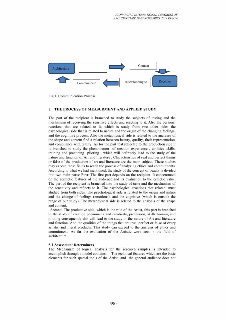
ICONARCH II INTERNATIONAL CONGRESS OF
ARCHITECTURE 20-22 NOVEMBER 2014 KONYA
390
Fig.1. Communication Process
5. THE PROCESS OF MEASURMENT AND APPLIED STUDY
The part of the recipient is branched to study the subjects of testing and the
mechanism of receiving the sensitive effects and reacting to it. Also the personal
reactions that are related to it, which is study from two other sides the
psychological side that is related to nature and the origin of the changing feelings,
and the cognitive process. Also the metaphysical side is related to the analyses of
the shape and content find a relation between beauty, quality, their representation,
and compliance with reality. As for the part that reflected to the production side it
is branched to study the phenomenon of creation experience , abilities ,skills,
training and practicing piloting , which will definitely lead to the study of the
nature and function of Art and literature . Characteristics of real and perfect things
or false of the production of art and literature are the main subject. These studies
may exceed these fields to reach the process of analyzing ethics and commitments.
According to what we had mentioned, the study of the concept of beauty is divided
into two main parts: First: The first part depends on the recipient. It concentrated
on the aesthetic features of the audience and its evaluation to the esthetic value.
The part of the recipient is branched into the study of taste and the mechanism of
the sensitivity and reflects to it. The psychological reactions that related, must
studied from both sides. The psychological side is related to the origin and nature
and the change of feelings (emotions), and the cognitive (which is outside the
range of our study). The metaphysical side is related to the analysis of the shape
and content.
Second: The productive side, which is the role of the Artist, this part is branched
to the study of creation phenomena and creativity, profession, skills training and
piloting consequently this will lead to the study of the nature of Art and literature
and function. And the qualities of the things that are true, perfect or false of every
artistic and literal products. This study can exceed to the analysis of ethics and
commitment. As far the evaluation of the Artistic work acts in the field of
architecture.
5.1 Assessment Determiners
The Mechanism of logical analysis for the research samples is intended to
accomplish through a model contains: -The technical features which are the basic
elements for such special tools of the Artist and the general audience does not
Architecture
Receiver Communicate
Contact
Understanding to
Innovation to
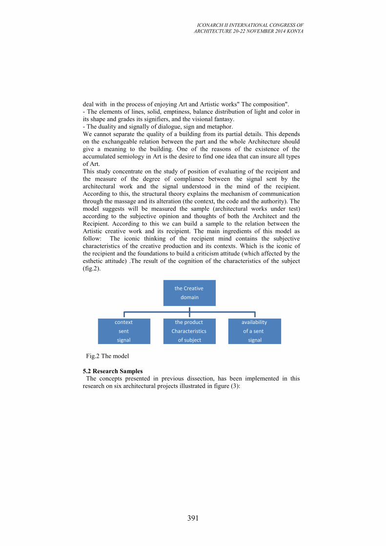
ICONARCH II INTERNATIONAL CONGRESS OF
ARCHITECTURE 20-22 NOVEMBER 2014 KONYA
391
deal with in the process of enjoying Art and Artistic works" The composition".
- The elements of lines, solid, emptiness, balance distribution of light and color in
its shape and grades its signifiers, and the visional fantasy.
- The duality and signally of dialogue, sign and metaphor.
We cannot separate the quality of a building from its partial details. This depends
on the exchangeable relation between the part and the whole Architecture should
give a meaning to the building. One of the reasons of the existence of the
accumulated semiology in Art is the desire to find one idea that can insure all types
of Art.
This study concentrate on the study of position of evaluating of the recipient and
the measure of the degree of compliance between the signal sent by the
architectural work and the signal understood in the mind of the recipient.
According to this, the structural theory explains the mechanism of communication
through the massage and its alteration (the context, the code and the authority). The
model suggests will be measured the sample (architectural works under test)
according to the subjective opinion and thoughts of both the Architect and the
Recipient. According to this we can build a sample to the relation between the
Artistic creative work and its recipient. The main ingredients of this model as
follow: The iconic thinking of the recipient mind contains the subjective
characteristics of the creative production and its contexts. Which is the iconic of
the recipient and the foundations to build a criticism attitude (which affected by the
esthetic attitude) .The result of the cognition of the characteristics of the subject
(fig.2).
Fig.2 The model
5.2 Research Samples
The concepts presented in previous dissection, has been implemented in this
research on six architectural projects illustrated in figure (3):
the Creative
domain
context
sent
signal
the product
Characteristics
of subject
availability
of a sent
signal
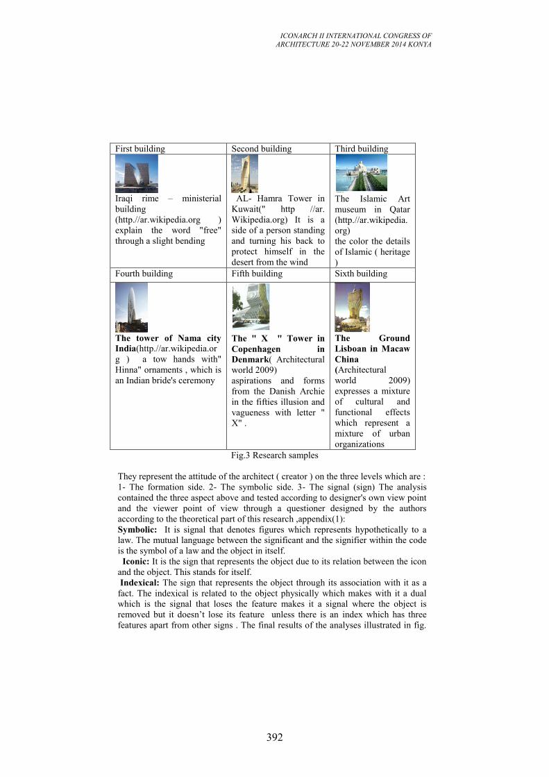
ICONARCH II INTERNATIONAL CONGRESS OF
ARCHITECTURE 20-22 NOVEMBER 2014 KONYA
392
Third building Second building First building
The Islamic Art
museum in Qatar
(http.//ar.wikipedia.
org)
the color the details
of Islamic ( heritage
)
AL- Hamra Tower in
Kuwait(" http //ar.
Wikipedia.org) It is a
side of a person standing
and turning his back to
protect himself in the
desert from the wind
Iraqi rime – ministerial
building
(http.//ar.wikipedia.org )
explain the word "free"
through a slight bending
Sixth building Fifth building Fourth building
The Ground
Lisboan in Macaw
China
(Architectural
world 2009)
expresses a mixture
of cultural and
functional effects
which represent a
mixture of urban
organizations
The " X " Tower in
Copenhagen in
Denmark( Architectural
world 2009)
aspirations and forms
from the Danish Archie
in the fifties illusion and
vagueness with letter "
X" .
The tower of Nama city
India(http.//ar.wikipedia.or
g ) a tow hands with"
Hinna" ornaments , which is
an Indian bride's ceremony
Fig.3 Research samples
They represent the attitude of the architect ( creator ) on the three levels which are :
1- The formation side. 2- The symbolic side. 3- The signal (sign) The analysis
contained the three aspect above and tested according to designer's own view point
and the viewer point of view through a questioner designed by the authors
according to the theoretical part of this research ,appendix(1):
Symbolic: It is signal that denotes figures which represents hypothetically to a
law. The mutual language between the significant and the signifier within the code
is the symbol of a law and the object in itself.
Iconic: It is the sign that represents the object due to its relation between the icon
and the object. This stands for itself.
Indexical: The sign that represents the object through its association with it as a
fact. The indexical is related to the object physically which makes with it a dual
which is the signal that loses the feature makes it a signal where the object is
removed but it doesn’t lose its feature unless there is an index which has three
features apart from other signs . The final results of the analyses illustrated in fig.
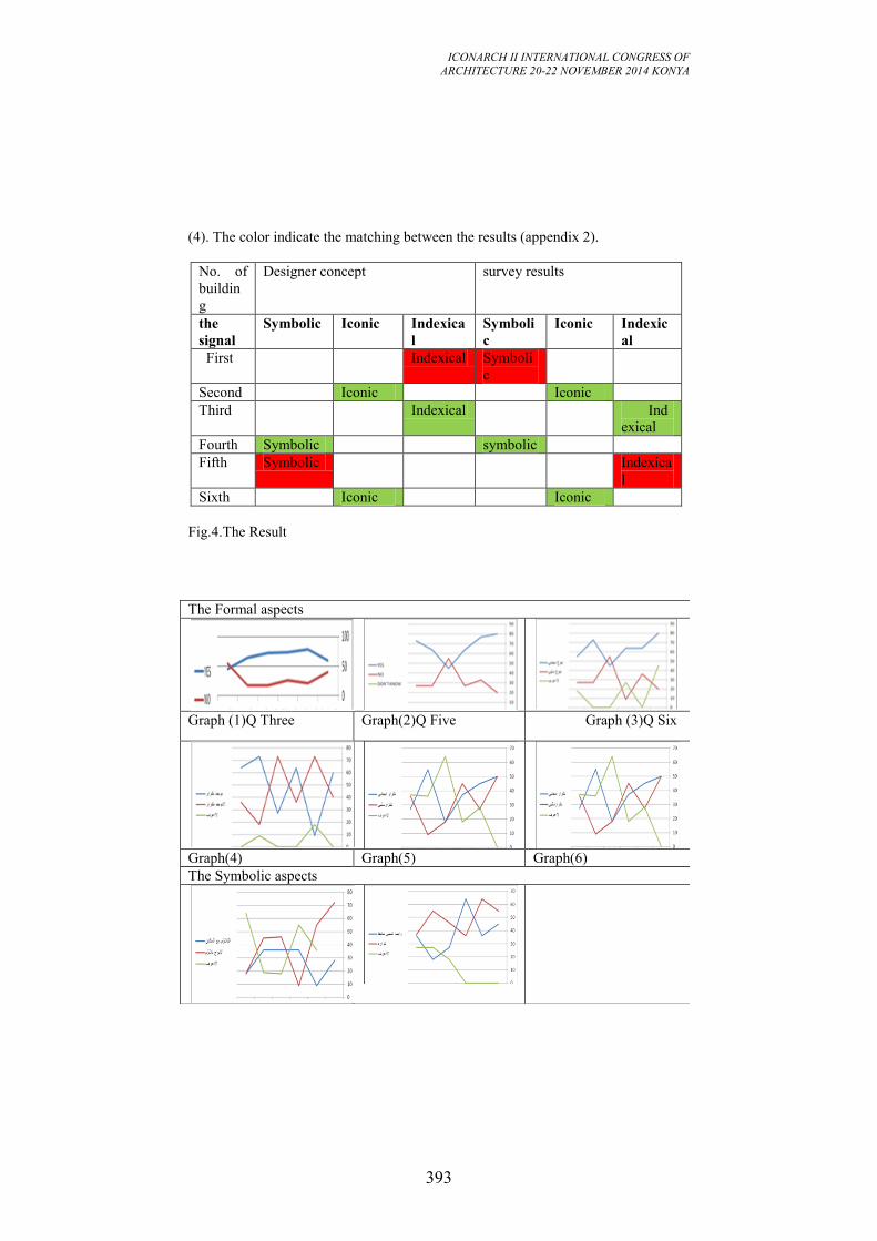
ICONARCH II INTERNATIONAL CONGRESS OF
ARCHITECTURE 20-22 NOVEMBER 2014 KONYA
393
(4). The color indicate the matching between the results (appendix 2).
survey results Designer concept
No. of
buildin
g
Indexic
al
Iconic Symboli
c
Indexica
l
Iconic Symbolic the
signal
Symboli
c
Indexical First
Iconic Iconic Second
Ind
exical
Indexical Third
symbolic Symbolic Fourth
Indexica
l
Symbolic Fifth
Iconic Iconic Sixth
Fig.4.The Result
The Formal aspects
Graph (3)Q Six Graph(2)Q Five Graph (1)Q Three
Graph(6) Graph(5) Graph(4)
The Symbolic aspects
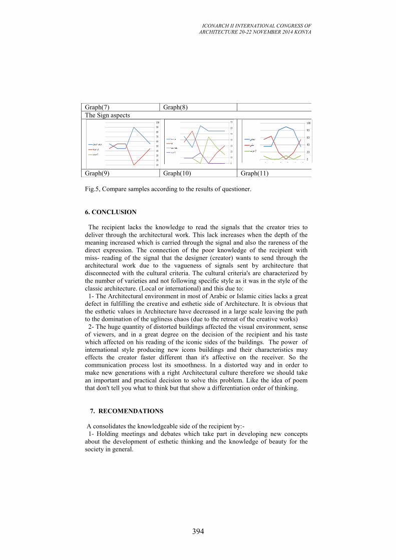
ICONARCH II INTERNATIONAL CONGRESS OF
ARCHITECTURE 20-22 NOVEMBER 2014 KONYA
394
Fig.5, Compare samples according to the results of questioner.
6. CONCLUSION
The recipient lacks the knowledge to read the signals that the creator tries to
deliver through the architectural work. This lack increases when the depth of the
meaning increased which is carried through the signal and also the rareness of the
direct expression. The connection of the poor knowledge of the recipient with
miss- reading of the signal that the designer (creator) wants to send through the
architectural work due to the vagueness of signals sent by architecture that
disconnected with the cultural criteria. The cultural criteria's are characterized by
the number of varieties and not following specific style as it was in the style of the
classic architecture. (Local or international) and this due to:
1- The Architectural environment in most of Arabic or Islamic cities lacks a great
defect in fulfilling the creative and esthetic side of Architecture. It is obvious that
the esthetic values in Architecture have decreased in a large scale leaving the path
to the domination of the ugliness chaos (due to the retreat of the creative works)
2- The huge quantity of distorted buildings affected the visual environment, sense
of viewers, and in a great degree on the decision of the recipient and his taste
which affected on his reading of the iconic sides of the buildings. The power of
international style producing new icons buildings and their characteristics may
effects the creator faster different than it's affective on the receiver. So the
communication process lost its smoothness. In a distorted way and in order to
make new generations with a right Architectural culture therefore we should take
an important and practical decision to solve this problem. Like the idea of poem
that don't tell you what to think but that show a differentiation order of thinking.
7. RECOMENDATIONS
A consolidates the knowledgeable side of the recipient by:-
1- Holding meetings and debates which take part in developing new concepts
about the development of esthetic thinking and the knowledge of beauty for the
society in general.
Graph(8) Graph(7)
The Sign aspects
Graph(11) Graph(10) Graph(9)
ICONARCH II INTERNATIONAL CONGRESS OF
ARCHITECTURE 20-22 NOVEMBER 2014 KONYA
395
2- Architectural departments should take a vital role to strengthen the interest of
the society in the innovation process widening the schemata (The background
knowledge) of the recipient concerning beauty in Architecture.
3- Taking into account the new achievements " complex, multi-layered and
convoluted systems" which can be elements are fused together to achieve a
printable file to be processed by a large-scale 3D Rapid-Prototyping machine,
which produced this unique piece (due to its size and aesthetics) and its effects on
the product as well the recipient.
4- Form commissions and institutions that carried the responsibilities of
consultants where they can monitor supervise the level of designing and esthetics
for the projects which can affect the civilized style of the city . and affect the level
of sensitivity of the recipient.
REFERENCES
-Armand,Louis.2007. Contemporary Poetics, pp8-52, Marjorie Perloff.
http://books.google.iq. /
-Antoniadis. 1999. Poetics of Architecture, Theory of design, pp.119-189, Van
Nostrand . Rein hold New York.
- Zuhdi, Basher. 1988. The science of beauty and criticism, pp.210-212, Damascus
University presses.
-Eco Umberto, Broadbent, Geoffrey and others. 1980. Sign, likeness, Symbol
&Architecture, pp.58-72, John Wiley and Sons, Chi Chester.
- Gero, Stolintese. 1988. The Artful Criticism, An Esthetic and Philosophical
Study, Translated by: Fu ad Zechariah, pp.68-101, The Arabic Institution For
Research and Publication.
- Hegel. 1979. The Art of Architecture translated by George Tarabishi, p.55, Al-
Taleeah House for Publishing.
- Reference from Internet: http: //ar. Wikipedia. org. (date of connection: 2013)
-Kant, Immanuel.1973. Observations on the feelings of the beautiful and sublime,
Translated by John, Goldthwaite, p.54, University of California Press.
- Abdu, Mustafa. 1999. The philosophy of Beauty, Second edition, pp.162-169,
The Arabic Institution For Research and Publication.
- Architecture world. 2009. 55 44 skyscrapers, pp.76-284.
ICONARCH II INTERNATIONAL CONGRESS OF
ARCHITECTURE 20-22 NOVEMBER 2014 KONYA
396
USABILITY OF A MATERIAL SELECTION TOOL FOR
ARCHITECTURE STUDENTS AS A SUB PROCESS OF
BUILDING ELEMENT DESIGN
MİNE KOYAZ1
M.CEM ALTUN2
ABSTRACT
Material selection as a sub process of building element design is a hard task
especially for the architecture students with a minimum material knowledge. In
order to overcome such a problem one of the approaches is the use of methodical
support tools within the process. With respect to that approach a systematic
material selection tool is developed. The material selection tool intends to define
the main steps of the process and to guide the students. In order to investigate the
usability of the tool and for further development, the tool is applied by the 2nd year
architecture students in Bilgi University as a part of their “Building Materials and
Technologies” course and a usability questionnaire is conducted.
In the paper, firstly the methodology of the work is explained; the development
process of both, the “material selection tool” and the questionnaire. Secondly, the
relationship of the material selection process with the architectural detail design
process is issued. The application of the tool is stated and finally, the results of the
conducted usability questionnaire are presented and discussed.
Key words: Material selection tool, Building element design, Architectural
education
1 Teaching Assit. Mine Koyaz. Istanbul Bilgi University, Department of Architecture, İSTANBUL
2 Asst. Prof. Dr. M. Cem Altun. Istanbul Technical University, Department of Architecture, İSTANBUL
ICONARCH II INTERNATIONAL CONGRESS OF
ARCHITECTURE 20-22 NOVEMBER 2014 KONYA
397
1. INTRODUCTION
Selection of the “right” materials satisfying the expected performances is
significantly important for any design. Today, with the constantly evolving and
developing technologies, there are more than numerous options of materials to be
used in an architectural design. In such a wide material “pond” it is even more
crucial to make the “right” choice of materials. At this point, the necessity of the
use of some support tools is arising, therefore the necessity of being more
systematic.
The material selection tool that is to be developed has to systematize the “intuitive
approach” in material selection process. The issued material selection tool is
mainly developed for educational purposes and trying to show a more methodic
way of material selection in architectural detailing for the use of architecture
students with the minimum knowledge of materials. What are the encountered
problems of an architecture student in a material selection process of detail design?
How could this process be systematized? How could the material selection process
become more practical? For that purpose, the existing “methodic approaches” for
the material selection process has to be examined, simplified and transformed to be
more “practical” with the addition of a data base usage. The developed tool should
be setting the basic steps of material selection process in architectural detail design,
aiming to be guiding, easily applied, fast, and result oriented.
2. METHODOLOGY
The steps that are followed in this work starts with a literature review. Existing
material selection tools are researched and examined. A main flow chart of the
"material selection tool" has been developed via those. After a research on the data
bases the tool is adapted to be used with a selected data base. The application stage
of the tool will be explained in detail at the following sections. In pursuit of that, a
usability questionnaire is conducted. Finally according to the evaluation of the
results the tool is rearranged.
The methodology for developing the "material selection tool" and the usability
questionnaire are explained in detail at the following.
2.1. Developing a "material selection tool"
The methodology used in developing of the "material selection tool" starts with
researching and examining the existing material selection methods and design
supporting tools. During this step there were methods examined such as; Sneck’s
method (Sneck et al. 1969), Cronberg’s method (Özkan 1976), Lohaus and
Steinborn’s method (Fouad 2013), Müller’s method (Cziesielski 1990), Ashby’s
method (Ashby and Johnson 2002), Japanese method (Japanese 1968) and
Balanlı’s method (Balanlı 1997). The methods were applied on some example
cases and their usability was compared through pilot studies. All the strong and
weak attributes of each method were evaluated.
ICONARCH II INTERNATIONAL CONGRESS OF
ARCHITECTURE 20-22 NOVEMBER 2014 KONYA
398
Briefly, Sneck’s method and Cronberg’s method only deals with the definition
process of the material properties and does not define a decision process. Sneck
defines the material properties from a performance based model (Sneck et al.
1969), on the other hand, Cronberg defines them from a user based model (Özkan
1976). Lohaus and Steinborn’s method describes the material selection as an
“iterative” process and defines the factors that are effective and expected to be
taken into consideration during the material selection (Fouad 2013). Müller’s
method is based on defining the requirements affecting the selection process
(Cziesielski 1990).
All the methods explained so far are developed to be used in architectural design.
Different from those, Ashby’s method is a practical and visual method from an
industrial designer point of view (Ashby and Johnson 2002).
One of the examined methods was the research of the Japanese Research Group in
1968, which could be considered the most comprehensive and systematic method
for selecting building materials and therefore the main inspiration for the
developed “material selection tool”. The method comprises the whole material
selection process, from defining the material properties to their comparison and
selection (Japanese Research Group 1968).
There are several later works that have used the Japanese method and developed
further; such as, Ayşe Balanlı’s work on the material selection process in a
building. The main structure is similar with the Japanese method, but it also
investigates the relations of a material and the building element and also states a
more strict way for the evaluation and selection of the material (Balanlı 1997).
Regarding to the examination of the existing methods and tools the main structure,
the main flow chart of the "material selection tool" is formed. The struggle here
was to create a tool that is simple enough to be used by a designer with minimum
material knowledge but still leading the designer to the “right” choice in the most
practical way. In order to achieve that goal, there arises the necessity to use of a
data base which has to be compatible with the main system of the "material
selection tool". However, none of the existing material selection methods includes
a data base or suggests the use of any data base. An exception is Ashby’s method
which is related to industrial design. So, after a research of existing data bases and
testing their compatibility with pilot studies, the steps of the developed "material
selection tool" is adapted to be used with a selected data base, in this case, Material
Connexion. This data base has been chosen because of the possibility of different
ways of searching and filtering and because of its wide material pond which is
close to 70.000. It’s accessibility via the library of Bilgi University from free of
charge was also a motivation. From the examined other data bases; Yapı Kataloğu
and Materia were also free of charge and compatible to be used with the tool,
however they were found either not sufficient for their filtering options or their
material pound. Therefore the usage of Material Connexion within the material
selection process was encouraged through the application.
2.2. Developing a usability questionnaire
When approaches of data collection are examined, questionnaires are the fastest
technique at gathering information from large groups (Naoum 1999). For that
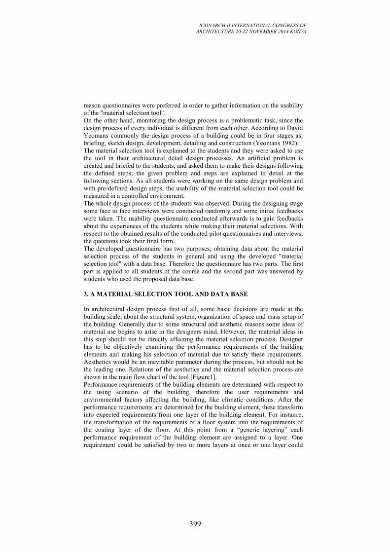
ICONARCH II INTERNATIONAL CONGRESS OF
ARCHITECTURE 20-22 NOVEMBER 2014 KONYA
399
reason questionnaires were preferred in order to gather information on the usability
of the "material selection tool".
On the other hand, monitoring the design process is a problematic task, since the
design process of every individual is different from each other. According to David
Yeomans commonly the design process of a building could be in four stages as;
briefing, sketch design, development, detailing and construction (Yeomans 1982).
The material selection tool is explained to the students and they were asked to use
the tool in their architectural detail design processes. An artificial problem is
created and briefed to the students, and asked them to make their designs following
the defined steps; the given problem and steps are explained in detail at the
following sections. As all students were working on the same design problem and
with pre-defined design steps, the usability of the material selection tool could be
measured in a controlled environment.
The whole design process of the students was observed. During the designing stage
some face to face interviews were conducted randomly and some initial feedbacks
were taken. The usability questionnaire conducted afterwards is to gain feedbacks
about the experiences of the students while making their material selections. With
respect to the obtained results of the conducted pilot questionnaires and interviews,
the questions took their final form.
The developed questionnaire has two purposes; obtaining data about the material
selection process of the students in general and using the developed "material
selection tool" with a data base. Therefore the questionnaire has two parts. The first
part is applied to all students of the course and the second part was answered by
students who used the proposed data base.
3. A MATERIAL SELECTION TOOL AND DATA BASE
In architectural design process first of all, some basic decisions are made at the
building scale; about the structural system, organization of space and mass setup of
the building. Generally due to some structural and aesthetic reasons some ideas of
material use begins to arise in the designers mind. However, the material ideas in
this step should not be directly affecting the material selection process. Designer
has to be objectively examining the performance requirements of the building
elements and making his selection of material due to satisfy these requirements.
Aesthetics would be an inevitable parameter during the process, but should not be
the leading one. Relations of the aesthetics and the material selection process are
shown in the main flow chart of the tool [Figure1].
Performance requirements of the building elements are determined with respect to
the using scenario of the building, therefore the user requirements and
environmental factors affecting the building, like climatic conditions. After the
performance requirements are determined for the building element, these transform
into expected requirements from one layer of the building element. For instance,
the transformation of the requirements of a floor system into the requirements of
the coating layer of the floor. At this point from a “generic layering” each
performance requirement of the building element are assigned to a layer. One
requirement could be satisfied by two or more layers at once or one layer could
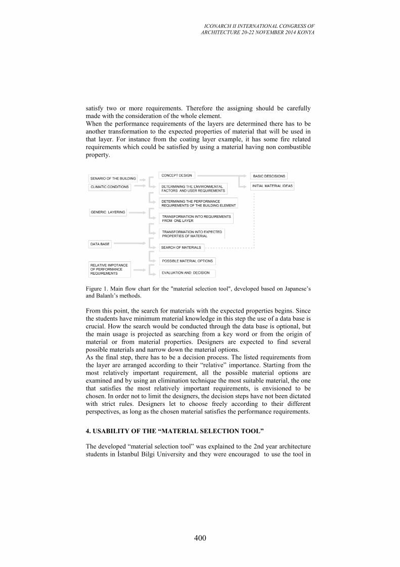
ICONARCH II INTERNATIONAL CONGRESS OF
ARCHITECTURE 20-22 NOVEMBER 2014 KONYA
400
satisfy two or more requirements. Therefore the assigning should be carefully
made with the consideration of the whole element.
When the performance requirements of the layers are determined there has to be
another transformation to the expected properties of material that will be used in
that layer. For instance from the coating layer example, it has some fire related
requirements which could be satisfied by using a material having non combustible
property.
Figure 1. Main flow chart for the "material selection tool", developed based on Japanese’s
and Balanlı’s methods.
From this point, the search for materials with the expected properties begins. Since
the students have minimum material knowledge in this step the use of a data base is
crucial. How the search would be conducted through the data base is optional, but
the main usage is projected as searching from a key word or from the origin of
material or from material properties. Designers are expected to find several
possible materials and narrow down the material options.
As the final step, there has to be a decision process. The listed requirements from
the layer are arranged according to their “relative” importance. Starting from the
most relatively important requirement, all the possible material options are
examined and by using an elimination technique the most suitable material, the one
that satisfies the most relatively important requirements, is envisioned to be
chosen. In order not to limit the designers, the decision steps have not been dictated
with strict rules. Designers let to choose freely according to their different
perspectives, as long as the chosen material satisfies the performance requirements.
4. USABILITY OF THE “MATERIAL SELECTION TOOL”
The developed “material selection tool” was explained to the 2nd year architecture
students in İstanbul Bilgi University and they were encouraged to use the tool in
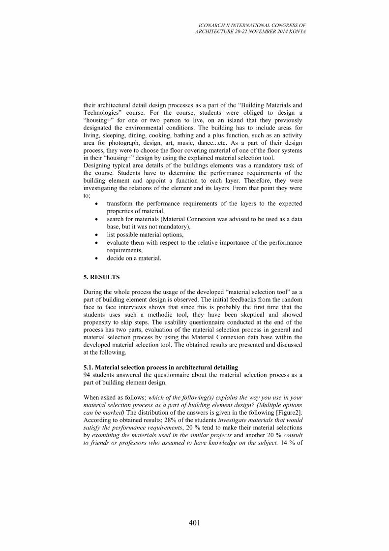
ICONARCH II INTERNATIONAL CONGRESS OF
ARCHITECTURE 20-22 NOVEMBER 2014 KONYA
401
their architectural detail design processes as a part of the “Building Materials and
Technologies” course. For the course, students were obliged to design a
“housing+” for one or two person to live, on an island that they previously
designated the environmental conditions. The building has to include areas for
living, sleeping, dining, cooking, bathing and a plus function, such as an activity
area for photograph, design, art, music, dance...etc. As a part of their design
process, they were to choose the floor covering material of one of the floor systems
in their “housing+” design by using the explained material selection tool.
Designing typical area details of the buildings elements was a mandatory task of
the course. Students have to determine the performance requirements of the
building element and appoint a function to each layer. Therefore, they were
investigating the relations of the element and its layers. From that point they were
to;
transform the performance requirements of the layers to the expected
properties of material,
search for materials (Material Connexion was advised to be used as a data
base, but it was not mandatory),
list possible material options,
evaluate them with respect to the relative importance of the performance
requirements,
decide on a material.
5. RESULTS
During the whole process the usage of the developed “material selection tool” as a
part of building element design is observed. The initial feedbacks from the random
face to face interviews shows that since this is probably the first time that the
students uses such a methodic tool, they have been skeptical and showed
propensity to skip steps. The usability questionnaire conducted at the end of the
process has two parts, evaluation of the material selection process in general and
material selection process by using the Material Connexion data base within the
developed material selection tool. The obtained results are presented and discussed
at the following.
5.1. Material selection process in architectural detailing
94 students answered the questionnaire about the material selection process as a
part of building element design.
When asked as follows; which of the following(s) explains the way you use in your
material selection process as a part of building element design? (Multiple options
can be marked) The distribution of the answers is given in the following [Figure2].
According to obtained results; 28% of the students investigate materials that would
satisfy the performance requirements, 20 % tend to make their material selections
by examining the materials used in the similar projects and another 20 % consult
to friends or professors who assumed to have knowledge on the subject. 14 % of
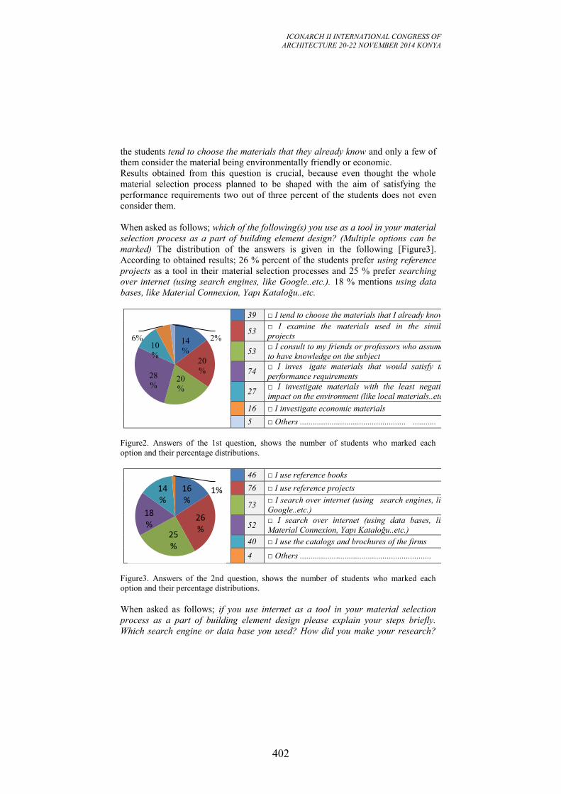
ICONARCH II INTERNATIONAL CONGRESS OF
ARCHITECTURE 20-22 NOVEMBER 2014 KONYA
402
the students tend to choose the materials that they already know and only a few of
them consider the material being environmentally friendly or economic.
Results obtained from this question is crucial, because even thought the whole
material selection process planned to be shaped with the aim of satisfying the
performance requirements two out of three percent of the students does not even
consider them.
When asked as follows; which of the following(s) you use as a tool in your material
selection process as a part of building element design? (Multiple options can be
marked) The distribution of the answers is given in the following [Figure3].
According to obtained results; 26 % percent of the students prefer using reference
projects as a tool in their material selection processes and 25 % prefer searching
over internet (using search engines, like Google..etc.). 18 % mentions using data
bases, like Material Connexion, Yapı Kataloğu..etc.
39 □ I tend to choose the materials that I already know
53 □ I examine the materials used in the similar
projects
53 □ I consult to my friends or professors who assumed
to have knowledge on the subject
74 □ I inves igate materials that would satisfy the
performance requirements
27 □ I investigate materials with the least negative
impact on the environment (like local materials..etc.)
16 □ I investigate economic materials
5 □ Others .................................................. ...........
Figure2. Answers of the 1st question, shows the number of students who marked each
option and their percentage distributions.
46 □ I use reference books
76 □ I use reference projects
73 □ I search over internet (using search engines, like
Google..etc.)
52 □ I search over internet (using data bases, like
Material Connexion, Yapı Kataloğu..etc.)
40 □ I use the catalogs and brochures of the firms
4 □ Others ..............................................................
Figure3. Answers of the 2nd question, shows the number of students who marked each
option and their percentage distributions.
When asked as follows; if you use internet as a tool in your material selection
process as a part of building element design please explain your steps briefly.
Which search engine or data base you used? How did you make your research?
14
%
20
%
20
%
28
%
10
%
6%
2%
16%
26%
25%
18%
14%
1%
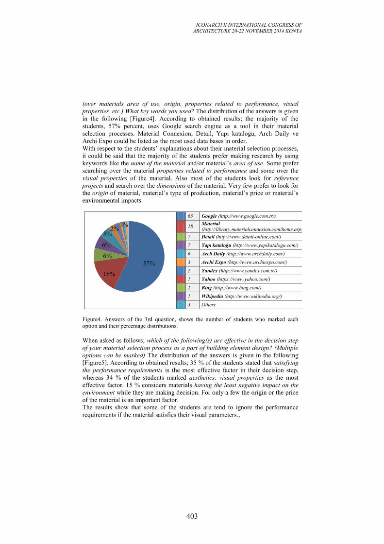
ICONARCH II INTERNATIONAL CONGRESS OF
ARCHITECTURE 20-22 NOVEMBER 2014 KONYA
403
(over materials area of use, origin, properties related to performance, visual
properties..etc.) What key words you used? The distribution of the answers is given
in the following [Figure4]. According to obtained results; the majority of the
students, 57% percent, uses Google search engine as a tool in their material
selection processes. Material Connexion, Detail, Yapı kataloğu, Arch Daily ve
Archi Expo could be listed as the most used data bases in order.
With respect to the students’ explanations about their material selection processes,
it could be said that the majority of the students prefer making research by using
keywords like the name of the material and/or material’s area of use. Some prefer
searching over the material properties related to performance and some over the
visual properties of the material. Also most of the students look for reference
projects and search over the dimensions of the material. Very few prefer to look for
the origin of material, material’s type of production, material’s price or material’s
environmental impacts.
65 Google (http://www.google.com.tr/)
18 Material Connexion (http://library.materialconnexion.com/home.aspx)
7 Detail (http://www.detail-online.com/)
7 Yapı kataloğu (http://www.yapikatalogu.com/)
6 Arch Daily (http://www.archdaily.com/)
3 Archi Expo (http://www.archiexpo.com/)
2 Yandex (http://www.yandex.com.tr/)
1 Yahoo (https://www.yahoo.com/)
1 Bing (http://www.bing.com/)
1 Wikipedia (http://www.wikipedia.org/)
3 Others
Figure4. Answers of the 3rd question, shows the number of students who marked each
option and their percentage distributions.
When asked as follows; which of the following(s) are effective in the decision step
of your material selection process as a part of building element design? (Multiple
options can be marked) The distribution of the answers is given in the following
[Figure5]. According to obtained results; 35 % of the students stated that satisfying
the performance requirements is the most effective factor in their decision step,
whereas 34 % of the students marked aesthetics, visual properties as the most
effective factor. 15 % considers materials having the least negative impact on the
environment while they are making decision. For only a few the origin or the price
of the material is an important factor.
The results show that some of the students are tend to ignore the performance
requirements if the material satisfies their visual parameters.,
57%
16%
6%
6%
5%
2%
1%
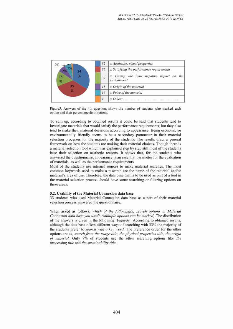
ICONARCH II INTERNATIONAL CONGRESS OF
ARCHITECTURE 20-22 NOVEMBER 2014 KONYA
404
82 □ Aesthetics, visual properties
85 □ Satisfying the performance requirements
37 □ Having the least negative impact on the
environment
18 □ Origin of the material
16 □ Price of the material
4 □ Others ..............................................................
Figure5. Answers of the 4th question, shows the number of students who marked each
option and their percentage distributions.
To sum up, according to obtained results it could be said that students tend to
investigate materials that would satisfy the performance requirements, but they also
tend to make their material decisions according to appearance. Being economic or
environmentally friendly seems to be a secondary parameter in their material
selection processes for the majority of the students. The results draw a general
framework on how the students are making their material choices. Though there is
a material selection tool which was explained step by step still most of the students
base their selection on aesthetic reasons. It shows that, for the students who
answered the questionnaire, appearance is an essential parameter for the evaluation
of materials, as well as the performance requirements.
Most of the students use internet sources to make material searches. The most
common keywords used to make a research are the name of the material and/or
material’s area of use. Therefore, the data base that is to be used as part of a tool in
the material selection process should have some searching or filtering options on
these areas.
5.2. Usability of the Material Connexion data base.
33 students who used Material Connexion data base as a part of their material
selection process answered the questionnaire.
When asked as follows; which of the following(s) search options in Material
Connexion data base you used? (Multiple options can be marked) The distribution
of the answers is given in the following [Figure6]. According to obtained results;
although the data base offers different ways of searching with 33% the majority of
the students prefer to search with a key word. The preference order for the other
options are as, search from the usage title, the physical properties title, the origin
of material. Only 8% of students use the other searching options like the
processing title and the sustainability title.
34%
35%
15%
7% 7%
2%
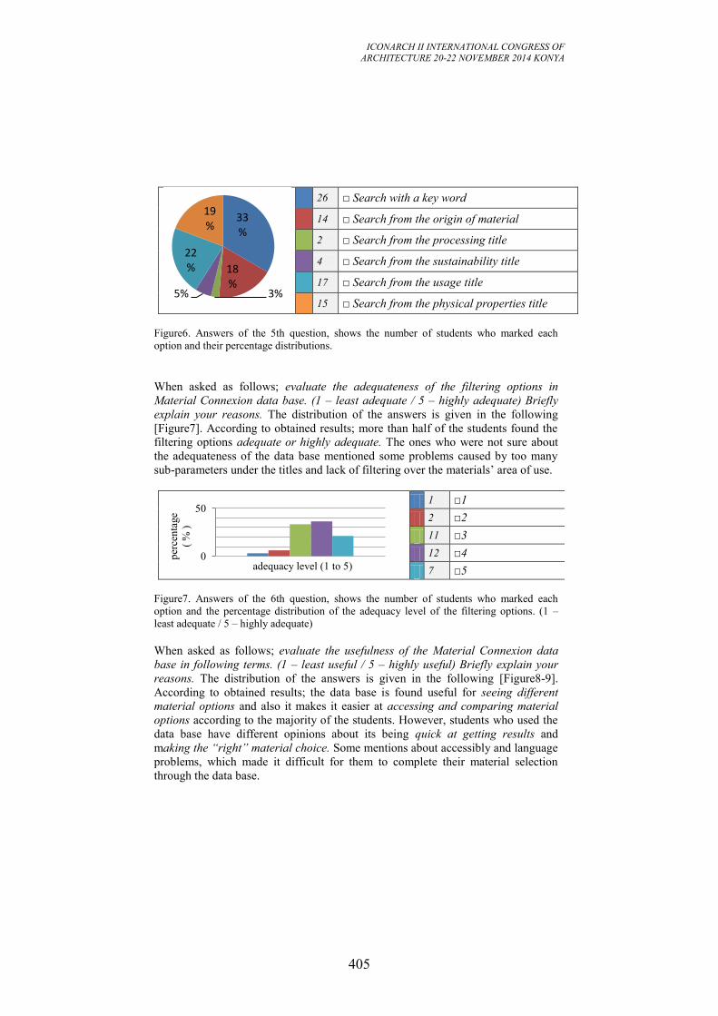
ICONARCH II INTERNATIONAL CONGRESS OF
ARCHITECTURE 20-22 NOVEMBER 2014 KONYA
405
26 □ Search with a key word
14 □ Search from the origin of material
2 □ Search from the processing title
4 □ Search from the sustainability title
17 □ Search from the usage title
15 □ Search from the physical properties title
Figure6. Answers of the 5th question, shows the number of students who marked each
option and their percentage distributions.
When asked as follows; evaluate the adequateness of the filtering options in
Material Connexion data base. (1 – least adequate / 5 – highly adequate) Briefly
explain your reasons. The distribution of the answers is given in the following
[Figure7]. According to obtained results; more than half of the students found the
filtering options adequate or highly adequate. The ones who were not sure about
the adequateness of the data base mentioned some problems caused by too many
sub-parameters under the titles and lack of filtering over the materials’ area of use.
1 □1
2 □2
11 □3
12 □4
7 □5
Figure7. Answers of the 6th question, shows the number of students who marked each
option and the percentage distribution of the adequacy level of the filtering options. (1 –
least adequate / 5 – highly adequate)
When asked as follows; evaluate the usefulness of the Material Connexion data
base in following terms. (1 – least useful / 5 – highly useful) Briefly explain your
reasons. The distribution of the answers is given in the following [Figure8-9].
According to obtained results; the data base is found useful for seeing different
material options and also it makes it easier at accessing and comparing material
options according to the majority of the students. However, students who used the
data base have different opinions about its being quick at getting results and
making the “right” material choice. Some mentions about accessibly and language
problems, which made it difficult for them to complete their material selection
through the data base.
33%
18%
3% 5%
22%
19%
0
50
per
cen
tage
( %
)
adequacy level (1 to 5)
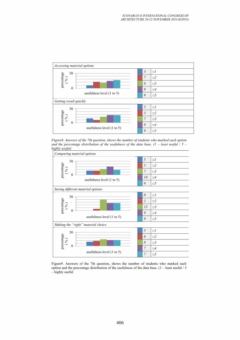
ICONARCH II INTERNATIONAL CONGRESS OF
ARCHITECTURE 20-22 NOVEMBER 2014 KONYA
406
Accessing material options
3 □1
7 □2
6 □3
8 □4
9 □5
Getting result quickly
5 □1
3 □2
7 □3
9 □4
9 □5
Figure8. Answers of the 7th question, shows the number of students who marked each option
and the percentage distribution of the usefulness of the data base. (1 – least useful / 5 –
highly useful)
Comparing material options
5 □1
5 □2
7 □3
10 □4
6 □5
Seeing different material options
0 □1
2 □2
13 □3
9 □4
9 □5
Making the “right” material choice
5 □1
6 □2
8 □3
7 □4
7 □5
Figure9. Answers of the 7th question, shows the number of students who marked each
option and the percentage distribution of the usefulness of the data base. (1 – least useful / 5
– highly useful
0
50
per
cen
tage
( %
)
usefulness level (1 to 5)
0
50
per
cen
tage
( %
)
usefulness level (1 to 5)
0
50
per
cen
tage
( %
)
usefulness level (1 to 5)
0
50
per
cen
tage
( %
)
usefulness level (1 to 5)
0
50
per
cen
tage
( %
)
usefulness level (1 to 5)
ICONARCH II INTERNATIONAL CONGRESS OF
ARCHITECTURE 20-22 NOVEMBER 2014 KONYA
407
When asked as follows; do you plan to use Material Connexion data base in your
next material selection processes? (1 – definitely no / 5 – definitely yes) Briefly
explain your reasons. The distribution of the answers is given in the following
[Figure10]. According to obtained results; the majority of the students are planning
to use the data base in their next material selection processes, whereas one of three
of the students is indecisive. Overall the data base if found helpful for a material
selection via performance requirements perspective.
4 □1
4 □2
11 □3
7 □4
7 □5
Figure10. Answers of the 8th question, shows the number of students who marked each
option and the percentage distribution of the planning level to use the data base in the future. (1 – definitely no / 5 – definitely yes) In general, the use of Material Database as a part of the material selection process
found to be useful by the most of the students. Having a wide material pond and
having various filtering options are the strong points of the database. Also the
relative comparison of the material properties like; low, medium, high, allows the
users to easily compare materials. However lack of filtering over the materials’
area of use could be listed as a weakness of the database.
6. DISCUSSION AND CONCLUSION
A material selection tool has been developed which is to be used within the
building element design process. The usability of the tool is investigated with its
application by 2nd year architecture students in İstanbul Bilgi University as a part
of the “Building Materials and Technologies” course and with a usability
questionnaire, answered by 94 students. Obtained results could be listed as;
Most of the students investigate materials that would satisfy the
performance requirements, but they are leaning to make their material
decisions according to aesthetic reasons.
In the decision process, being economic or environmentally friendly
seems to be a secondary parameter for the majority of the students. In
general, they tend to make their choices according to appearance but they
check if the chosen material satisfies the performance requirements.
For that reason, although it was intentionally left more flexible, the decision
process should be more strictly defined. Making a material choice for an aesthetic
reason should not lead the users of the tool to a material that would not satisfy the
performance requirements.
Most of the students use the internet sources to make material searches.
0
50
per
cen
tage
( %
)
planning level (1 to 5)
ICONARCH II INTERNATIONAL CONGRESS OF
ARCHITECTURE 20-22 NOVEMBER 2014 KONYA
408
The most common keywords used to make a research are name of the
material and/or material’s area of use.
Since it was the first time that the students used a methodic material selection tool,
they were tentative about its usage and they were tending not to follow the steps
exactly the way it’s explained. The majority of the students were not using any
material data base in their previous material selection processes and although it
was advised some still choice not to use. According to the feedback of the 33
students who used the Material Connexion data base as a part of the material
selection process;
The data base found useful, because of having a wide material pond,
having various filtering options and presentation of material properties in
an easily comparable way.
The deficiency of the data base is not having a searching option over the
area of use.
Although there were positive feedbacks about the data base, sometimes the usage
of one data base may not be enough at reaching a decision. Therefore the use of
multiple data bases in relation with each other could be an alternative solution.
Besides, generally firm based data bases are used but some non commercial data
bases listing the general characteristics of the material and the standards could also
be included to the process.
In the light of the application of the developed “material selection tool” and the
evaluation of the results of the usability questionnaire, the development of the tool
continues with respect to the preliminary findings.
REFERENCES
-Ashby, M., Johnson, K. 2002. Materials and Design: the art and science of
material selection in product design. Italy: Butterworth-Heinemann publications.
-Balanlı, A. 1997. Yapıda ürün seçimi. Yıldız Üniversitesi Mimarlık Fakültesi
Eğitim ve Kültür Hizmetleri Derneği Yayını. No:4.
-Cziesielski, E. (ed.). 1990. Lehrbuch der Hochbaukonstruktionen. Stuttgart : G.
Teubner
-Fouad, N. A. (ed.). 2013. Lehrbuch der Hochbaukonstruktionen. Springer
Fachmedien Wiesbaden.
-Japanese Research Group. 1968. The systematic Method for Selecting Building
Materials.
--Naoum, S.G. 1999. Dissertation Research and Writing for Construction
Students. Oxford: Butterworth-Heinemann.
-Özkan, E. 1976. Yapım Sistemleri’nin Seçimi için bir Yöntem. Doktora, İTÜ.
- Materia database. [Online]. [Accessed Sebtember 2014]. Available from:
http://materia.nl/material/
- Material Connexion database. [Online]. [Accessed Sebtember 2014]. Available
from: http://library.materialconnexion.com/
- Yapı Kataloğu database. [Online]. [Accessed Sebtember 2014]. Available from:
http://www.yapikatalogu.com/

ICONARCH II INTERNATIONAL CONGRESS OF
ARCHITECTURE 20-22 NOVEMBER 2014 KONYA
409
-Sneck. T., Bring. C, Lossius. P, Malmstedt. K, Neilsen. P, Schjot. R. 1969.
Qualitative Performance Analysis of Floors. Helsinki.
-Sneck. T. 1972. On the Connection Between Performance Evaluation and Material
Science. Valtion teknillinen tutkimuskesku. Oteniemi marraskuu.
-Yeomans, D. 1982. Monitoring design process, in Changing desig. Edited by B.
Evans, J.A. Powell and R. Talbot. Chichester, New York: John Wiley & Sons
ICONARCH II INTERNATIONAL CONGRESS OF
ARCHITECTURE 20-22 NOVEMBER 2014 KONYA
410
KEYNOTE SPEECH (21 November 2014 Friday, 15.30-16.00)
Prof. Stefano Francesco Musso “Inheriting our Cultural Heritage. Changes of Paradigm of
Conservation.”
ICONARCH II INTERNATIONAL CONGRESS OF
ARCHITECTURE 20-22 NOVEMBER 2014 KONYA
411
INHERITING OUR CULTURAL HERITAGE. CHANGES OF
PARADIGM OF CONSERVATION
STEFANO FRANCESCO MUSSO1
Abstract
The world is quickly and deeply changing, facing new challenges in the built
environment. Conservation can play a crucial role for preserving the future of the
planet, not wasting but rather continuing to use (or reuse) the depot of physical
traces that the previous ages left us, as provisional responsible for them, in cultural
ways and respectful. A crucial question rises apropos: are we really ready and able
to inherit this impressive mine of knowledge, identity and cultural richness? We
cannot in fact go on along the paths that have been traced, within the western world
and culture, since more than two centuries about conservation/restoration (with all
its contradictions and suggestions). We cannot behave as if nothing has changed and
ignoring the problems of the contemporary societies, or like they were external to
our commitments, interests and responsibilities. The key-lecture will deal with some
of the main challenges that the culture of conservation (or movement, as someone
could call it) will have to face in the near future in order to survive and not to reduce
itself to an ancillary role and to an un-influencing condition within the contemporary
world. A particular focus will be put for this reason on the crucial role that ICT play
also in this field.
The reasons of conservation/restoration nowadays.
We come after two centuries of debate that has been deeply and completely aroused
in the Western World or - even better – that would be considered as merely
European. This long process saw the appearing and progressive consolidation of the
opposite polarities of conservation and restoration, up until the slow, but now ever
consolidated expansions process, “for kind, age of formation, for extension and
quality”, of the various “goods” subjected to tutorship and safeguard. For this
reason, we often think to a completely known and consolidated universe of objects,
though it appears to be progressively and quickly expanding far beyond the
traditional notion of “monument” as an isolated masterpiece of art or as a historical
memory or witness. New problems or artefacts can always emerge to our attention
1 Full professor of Architectural Restoration – Director of the Specialization School in Architectural and
Landscape Heritage
Department DSA of Sciences for Architecture – Polytechnic School – University of Genoa (Italy)
ICONARCH II INTERNATIONAL CONGRESS OF
ARCHITECTURE 20-22 NOVEMBER 2014 KONYA
412
and they could also make our world, rich of fragile certainties, explode or implode.
Many journalists or scholars, politicians or architects could also remind us the
fatigue and disillusions while working in some troubled lands and parts of the
present world, where conserving can mean to have to deal, not just and not as much,
with the technical or theoretical alternatives within we often limit our work. It would
imply to face wider horizons of sense and, in particular, the problem of coexistence
between peoples which are fighting, each living and interpreting the environment
and its depots of signs and historic tracks in very hostile ways. Not to speak about
the dramatic situation of many human groups and communities with no state, no
land, no food or citizenship and for whom conservation, even before restoration,
could assume a very understandable and crucial meaning. We conserve, in fact, for a
future world of civilization, cohabitation and sharing of memories, values and
potentialities of life. Otherwise: why should we do it? For this and other reasons, we
cannot just ignore similar questions, pretending they concern exclusively political
assets not regarding us, or our possibility of acting. It seems that, instinctively, we
think to ourselves as to responsible of some “jewels” which value we debate on, but
that certainly belong to a world of consolidated peace, for which these problems
seems to have no meaning at all, or that have been already solved by other fights in
previous times. Things are not exactly like this, neither for us, European, and it is
plain to see we have to acknowledge the fact. Being able to see through the curtains
of unawareness and approximation, we can discover that they could concern also
monuments or artefacts of our civilized countries1.
Conservation/restoration for whom? Values, impacts, consequences.
Nevertheless, when we think to (or we deal with) the problems, the ideas and the
aims of any conservation or restoration theory, or with the correlated practical
actions, we inevitably face the crucial theme of the values involved in the field.
It is not a novelty. Alois Riegl2 treated this conflicting and contradictory aspect at
the beginning of the Nineteen century, asking to himself the reasons why his times
were so deeply crossed by a new and powerful “modern cult for ancient
monuments”, almost a religious attitude that never existed before. While examining
the phenomenon, he clearly outlined and analysed a wide and articulated range of
values belonging to the dimensions of contemporary (present) and of memory (past),
of every time, of course. They were and still are values belonging to men and are
assigned by themselves to the ancient monuments, thus reflecting the changing in
their cultural asset and atmosphere, along the times passing on. We could even now
1 On these arguments see also: Stefano Francesco Musso (2009). Conservation/restoration of built
Heritage. “Dimensions of contemporary culture”, in: Piet Lombaerde, Laura Lee (editors),. Bringing the World into Culture. Comparative Methodologies in Architecture, Art, Design and Science, UPA Editions
(University Press Antwerp), ANTWERPEN (Belgium), p. 86-107, ISBN: 9789054876304 2 Cf. Alois Riegl, Der Moderne Denkmalkultus, sein Wesen, seine Entstehung, Braunmuller, Vienna-
Lipsia 1903 (It. tr.: A. Riegl, Il culto moderno dei monumenti. Il suo carattere e i suoi inizi, in
Scarrocchia, Sandro, A. Riegl: teoria e prassi della conservazione dei monumenti. Antologia di scritti,
discorsi, rapporti 1898-1905, Accademia Clementina-CLUEB, Bologna 1995)
ICONARCH II INTERNATIONAL CONGRESS OF
ARCHITECTURE 20-22 NOVEMBER 2014 KONYA
413
refer ourselves to those values, together with their complex games, in order to
explain which the real contents of our discussions and actions are, within the field of
the protection, conservation, restoration and valorisation of built Heritage. This last
notion, in itself, is quite recent and it represents the result of the long and rich
history of the modern theories of restoration, starting from its right beginnings,
between the XVIII and the XIX centuries, as many protagonists affirm (Eugène
Emmanuel Viollet-le-Duc, John Ruskin, William Morris, Max Dvorak, Camillo
Boito or Gustavo Giovannoni, among the others). It is sufficient to recall, apropos,
the important analysis by Francoise Choay1 about the evolution of the same idea of
monument. This was initially considered only as a “masterpiece of art”, an isolated
and unique object mainly characterized by aesthetical or historical values.
Afterwards, a new and more complex concept was slowly developed considering a
monument as a cultural good, not exclusively of material nature, that can also have
outstanding social and economic values2. Any doubt should therefore exist about the
crucial role that our ideas, concepts, theories, as well as our analytical, diagnostic
and intervention techniques, in their whole, play in the contemporary world and
society, even if with sometimes contradictory and conflicting results.
The question “why?” do we conserve/restore thus emerges as the really crucial one,
as regards our attempts to understand and correctly use our ideas and instruments.
Within this perspective, in fact, any our desire or compelling attitude towards the
conservation/restoration of a material good that derives from an almost unknown
past, so that it can reach the future, should be explained, communicated and
hopefully accepted from the social communities we belong to, more than by the only
cultural or scientific ones. Only in this way we could hope that this effort will be
really sustainable for our descendants and will be felt as a chance and not only as a
load or as a problem for our present situation.
The conservation/restoration project: times, contents and goals
The word and the topic “project” of course emerges every time we speak about
conservation/restoration of built Heritage, but it is always characterised by
profoundly different meanings and accents. We all know it is a crucial crossroad for
research, teaching and professional practice, as it is in other fields. Right for this
reason, someone underlines the fundamental differences between a “project
concerning a new object” and a “project concerning an existing one”. This is
particularly evident because this last one cannot just be the mere sum of some
functional modifications but it aims to take a real care of the existing artefact, with
its memories, depots of knowledge and potentialities, in order to make it useable for
our future in the most undamaged and preserved state - if ever also enriched by new
1 Cf. Choay, Françoise, L’allegorie du patrimoine, (It. tr. D’Alfonso, Ernesto & Valente, Ilaria (ed.),
L’allegoria del patrimonio, Officina, Roma 1985) 2 See, a propos, all the international documents and the numerous International charters devoted to the
problem of the destiny of ancient architectures, towns and cultural landscapes but also to the huge legacy
of immaterial goods of humankind in the contemporary world in the perspective of the future generations.
ICONARCH II INTERNATIONAL CONGRESS OF
ARCHITECTURE 20-22 NOVEMBER 2014 KONYA
414
resources and not certainly impoverished of the already existing ones. The project is
in any case and with no doubt a crucial point in the process of
conservation/restoration of our Heritage. However, the project is just one moment,
even if fundamental, in the process of conservation/restoration and, in any case, it is
a moment that “only apparently” seems to ratify its conclusion. Here an enormous
risk lies. Centuries of discussions, in fact, have not decided, neither the coming ones
will do, which possible alternatives concerning goals, objects, instruments and
methods of the conservation/restoration project could be. Meanwhile, if our research
or practice only concentrates itself on its riving contradictions, the hazard is losing
other key elements of the problem. Many scholars suggest apropos not to limit our
look to the conservation’s culture, meant as a withdrawn world, all-sufficient or,
worst of all, self related. A route exists in fact between teaching, learning and acting
in this field and it is marked by profound divisions and connections, by polarities
and reflected images. In the today’s world, architecture and conservation/restoration
often look like “poor neighbours”, not communicating, subjected to the perennial
contraposition between the exaltation of creativity and the research for analytical
rigor, but also between the tension for pure knowledge and the profession’s
pragmatism and needs, in time of deep transformations which would instead demand
their profound and meditated integration. According to many experts, the
relationship between conservation/restoration and architecture is not only inside
their common affiliation to the same world of objects, methods or instruments.
Conservation and restoration are tied to architecture firstly by the common aim of
inhabiting the world on an even keel, between memories of a past which can still be
significant and productive and a future which must be free but not oblivious, for us
not to waste what the earth has given and still gives us. Therefore, we need to ask
“what” and “how much” architecture can offer to conservation, but also - and with
the same strength - what and how much conservation can offer to architecture1. The
reference to the contemporary philosophic and epistemological thought, at this point,
is the necessary background to correctly underline the need of a higher integration
with the various architectural disciplines, even by facing the risk – by many dreaded
– that this would end up in a loss of centrality (or of power!!!) of the
conservation/restoration seen as autonomous worlds. However, we must ask
ourselves if our scientific, cultural and technical actions can keep on being proposed
as a sort of “pillbox defence” (or a “Ivory tower”), granted that it exists or should
exist, or if rather opening up for a confrontation in which our reasons would stand
just because their own strength, instead of invoking weak protectionist or binding
policies when those are actually ignored or half tolerated by the society, for the
welfare of which we are saying that they should be adopted2. On the other hand, it
appears evident that the project, considered as a mere technical action, tied to the
artefact and its destiny, could not be the only focal point of our activity, because a
1 Cf. Kealy, Loughlin, Teaching/thinking/learning/doing. Conservation and creativity in architectural
education, in Musso, Stefano F., De Marco Luisa (ed.), Teaching Conservation/Restoration of the
Architectural Heritage. Goals, Contents and Methods. EAAE-ENHSA Transactions n. 38 – Leuven
(Belgium – Tessaloniki – Greece) 2008 - ISBN/ISSN: 2-930301-35-X (now in press). 2 Cf. Musso, Stefano F., Teaching Conservation/Restoration: tendencies and emerging problems, in
Musso, Stefano F., De Marco Luisa (ed.), Teaching Conservation/Restoration…, quoted.
ICONARCH II INTERNATIONAL CONGRESS OF
ARCHITECTURE 20-22 NOVEMBER 2014 KONYA
415
wide amount of questions, themes and objects are progressively emerging.
Moreover, this is true if we think to the difficult relationship that presently exists
between Science and Technique where the second one is no more the instrument
adopted to realise the previsions of the first one, but it is going to begin more and
more the goal of (and in) itself1. We must at least consider with a new attention the
problems connected to the management phases or, even, to normative rules, which
closely concern conservation and restoration. Unless, we reduce our activities to a
mere search for more or less sharable technical solutions (accepted by many or few,
by a “school” or another), the only attempts for answering questions which, at heart,
others have selected before our intervention2. The fact is that, perhaps, we cannot
just restrict ourselves to the mere discussion or confrontation, sometimes hostile,
exclusively about “how” to technically intervene, completely ignoring “who”
decides “where” and, most of all, “why”, something must or can be conserved or
restored3. By and large, we cannot simply ignore, forget or avoid the many facets
and implications which the problem implies at larger scales (urban, territorial, of the
built landscape) which exceed each single artefact we take care of. Above all, at
these levels, it seems clear that the themes related to conservation/restoration are
profoundly entwined with the more general processes that condition or mark our
communities and landscapes, now ever more immerged in a global and planetary
dimension but always seeking for more or less certain identities (or, better,
specificities). These last, just as regards Heritage, should be deeply rooted and
clearly expressed, thus demanding an active safeguard, for a really sustainable future
(not only economically, socially and environmentally but also cultural).
Methods, instruments, tools and procedures
Though the problems could have very different answers, every
conservation/restoration process usually respects some fundamental methodological
steps, a sort of logic scheme, or a sort of flow-chart that always asks frequent feed-
back procedures, in order to check its correctness and efficacy.
We could recall in this regard the ancient metaphor of the Architecture or, better, of
a building as a “body. Leon Battista Alberti4 inaugurated the Renaissance and the re-
discovery of the Roman classical culture not to imitate but to overpass it, with this
powerful “paradigm” as Francoise Choay defined it5. One of the consequences of
this theoretical concept is the paragon we often propose between the activity of a
1 As regards the relationships and the respective roles of Science and Technique/Technology in the contemporary world see, as a simple example: Garimberti, Umberto, Psyche e Techne. L’uomo nell’età
della tecnica, Feltrinelli, Milano 1999 – ISBN: 88-07-10257-9 and, in general, the most recent
epistemological elaboration from Karl Popper to Hans Georg Gadamer, from Francoise Lyotard to Jürgen Habermas. 2 Cf. Stovel, Herb, Challenges in moving from architectural conservation education to heritage
conservation education, ibidem 3 Cf. Della Torre, Stefano, Cultural Heritage Process Charted: defining competences to decide
educational programs, in: Musso, Stefano F., De Marco Luisa (ed.), Teaching
Conservation/Restoration…, quoted. 4 Cf. Alberti, Leon Battista De re aedificatoria…, quoted 5 Cf. Choay, Françoise, La regola e il modello: sulla teoria dell'architettura e dell'urbanistica, Officina.
Roma 1986 D’Alfonso, Ernesto (ed.).
ICONARCH II INTERNATIONAL CONGRESS OF
ARCHITECTURE 20-22 NOVEMBER 2014 KONYA
416
physician and that of an architect when he intervenes on an existing monument that
was built following forgotten rules and plans and is now affected by unknown decay
phenomena or structural instabilities. This metaphor was proposed and utilized by
Leonardo-da-Vinci when he was asked by the Milanese people to suggest a solution
for the completion of their unfinished “Duomo” (Cathedral) proposing the best form
to be adopted for its new flesh. Leonardo1 proposed, starting from Alberti’s idea of
the necessary “conformitas” (accomplishment) between the existing and the new
parts, to adopt a light structure based on a square or octagonal plan in order to match
the existing pillars of the dome and thus respecting the structural logic of the gothic
church.
If we accept for a moment to use again that metaphor (conscious of its limits), we
could individuate in our job at least the following schematic but fundamental phases,
even if they do not always exist and follow each other in this specific unidirectional
order: analysis, diagnosis, anamnesis, prognosis, therapy, prophylaxis. To the basic
phases of inquiry, as we see, other parts of the job follow, on the level of
intervention, passing towards the crucial and not automatic moments of the
interpretation of the analytical and diagnostic results. These new phases are
represented by the project hypothesis assumption (prognosis), their control, the
definition of the project (the therapy: aims, tools, intervention techniques,
technological, environmental and economic requirements…etc.) and its realization
in the construction site to end with the programmed maintenance of the restored
building.
The “Anamnesis”, in particular, is very interesting, because it implies the attempt to
re-construct the history of the monument in order to understand “how” it was
conceived, realized and afterwards modified by men or by natural events, but also
“how” and “why” it was used and consumed in the past. We are speaking of course
about an “idea of history” that is quite distant from the traditional one and that
shows all the influences that the evolution of the historical sciences and methods
knew during the past century and, particularly, the birth and development of a “New
History” (“Nouvelle Histoire”) 2 aside the traditional one. A new history defined as a
“history as a problem”, facing the ancient “history as a tale”, attentive to the “long
duration” of some phenomena and not only to the single outstanding “events” that
marked the existences of the past generations and societies. It was a new concept of
1 Cf. Leonardo Da Vinci, Lettera ai fabbriceri, Published in Bruschi A. Maltese C., Tafuri M., Bonelli
R., (editors), Scritti rinascimentali, Il Polifilo, Milano 1978. 2 As regards the so named “New History” or more properly “Nouvelle Histoire” that developed during the
Twenties of the past century aside the French revue “Annales d'historie economique et sociale” see, as a
simple reference among a very wide literature about the argument, the following texts: Braudel, Fernand, Un leçon d’histoire, Les Editions Arthaud, Paris 1986 (It. Tr. Una lezione di storia, Einaudi, Torino,
1988),; Braudel, Fernand, L’Europe. L’espace, le temps, les hommes, Art set métiers graphiques, Paris
1987 - for the notions of “histoire de la long duré” o “histoire evenementielle”; Bloch Marc, Apologie pour l’histoire ou métier d’historien, “Cahiers des Annales”, Librerie Armand Colin, Paris 1949 (It. tr.:
Apologia della storia o mestiere di storico, Einaudi, Torino 1969); Le Goff, Jacques, Storia e memoria,
Einaudi, Torino, 1982; Le Goff, Jacques (ed.), La nuova storia, Mondadori, Milano, 1990; Le Goff,
Jacques – Nora, Pierre (ed.), Fare storia. Temi e metodi della nuova storiografia, Einaudi, Torino, 1981;
Le Goff. Jacques, Histoire et Mémoire, Gallimard, “Folio”, Paris 1997; Lucien Fevre, Civilisation.
Évolution d'un mot et d'un groupe d'idées, Paris, Renaissance du livre, 1930.
ICONARCH II INTERNATIONAL CONGRESS OF
ARCHITECTURE 20-22 NOVEMBER 2014 KONYA
417
the historian’s trade carefully intent in studying all the possible traces of the past,
material and immaterial, descriptive and qualitative but also quantitative and
apparently meaningless in themselves, because their sense could exclusively emerge
from the great series of single data considered in a different perspective. It was a
method to reconstruct the unknown history of the past, ancient or recent, avoiding
any preventive selections of data, any a-priori choice of a particular position within
the rich offer elaborated on the level of the “Philosophy of History”. Only this kind
of historical research could allow reaching these new epistemological borders, thus
contributing also to an innovative development of the conservation/restoration
matter. This attempt to highlight the moment of its construction and all the
subsequent phases of the existence of the artefact can and must use, in fact, different
data and various information sources: indirect, that is to say independent from the
physical consistency of the monument (written documents, iconography or oral
testimonies and traditions), or direct, that is the monuments considered as the first
and fundamental documents of themselves, as Jacques Le Goff has clearly
explained. Right within this second perspective, our job inevitably interacts with all
the analysis and diagnostic tests that could be developed in order “to inquiring” the
building, in its present state and consistency material, hoping to understand at the
end, despite it changes during our studies.
Innovation in Conservation
The themes related to the knowledge, or better to the many forms of non destructive
studies and inquires of existing buildings, have thus acquired along the recent years
an outstanding role. A sort of satisfaction also exists in this regard, because a
common language has certainly been acquired on this field, with evident and
appreciable fallouts. Nevertheless, some worries emerge for the risk of a kind of
consolidated “orthodoxy”, which may hide a simply formalistic respect for some
apparently inescapable rules, accompanied by a certain passiveness of our way to
handle conservation/restoration interventions.
In any case, we are always intent in achieving the sure capability to develop:
rigorous architectural surveys, supported by adequate technological devices and,
first of all, clearly based on methodological geometrical basis recurring to
traditional methodologies of longimetric nature, to topographic devices, to
analytic or digital photogrammetric instruments and tools till the most updated
3D laser scanning possibilities; they are intended to know and dominate, also
thanks to the evolving elaboration and restitution techniques, the “geometries” of
the monuments (original and acquired, for construction mistakes or for structural
assessments or changes, regular and irregular, intentional and casual1)
serious historical inquiries, grounded on strong critic and analytical apparatus, as
well as on rigorous studies of the indirect archive sources, always compared with
1 As regards these different “geometries” which always characterise the ancient buildings and that
constitute the real “scientific object” of any serious architectural survey, see: Torsello, Paolo B., La
materia del restauro, Marsilio, Venezia 1988 – Musso, Stefano F., Recupero e restauro degli edifici
storici. Guida pratica al rilievo e alla diagnostica, EPC Libri, Roma 2006 (II ed.).
ICONARCH II INTERNATIONAL CONGRESS OF
ARCHITECTURE 20-22 NOVEMBER 2014 KONYA
418
the results of correspondent archaeological inquires of the artifacts considered as
the first and direct sources to be used in order to reconstruct their past history;
meticulous analytical and diagnostic studies, collecting and organizing data
concerning the physical state of the artifacts, as regards the building materials,
their state of deterioration/conservation, conducted with rigorous empiric
methodologies supported by sometimes very sophisticated laboratory tests
(mineralogical and petrography characterization, physical and chemical analysis,
biological, botanic and zoological inquires…), faithfully visualized and
synthesized in “thematic maps” of sure communicative and perceptive impact;
analysis and interpretation of the constructive techniques, throughout the
instruments of the “history of material culture” and of the archaeological
methods applied to architectural structures (see also the experiences of the
“medieval archaeology” and Harris’s stratigraphy);
basic or sophisticated and instrumental structural analysis using specific
interpretative numeric models and non destructive tests;
refined and reliable “virtual simulations” of the designed interventions, regarding
the built materials and elements, but also the spaces and the layout of the ancient
buildings we are working on;
more and more accurate and dynamic systems for monitoring (in situ or in
remote) the microclimatic conditions of our monuments, in strict relation with
the environment in which they are inserted, which must be studied and
understood as a fundamental condition to explain their present status and to
design their future.
These aspects, at the end, can be essentially used exactly in order to understand not
only the building as it is today but, above all, to discover why it is in the present
conditions and this is one of the main goals of any historical enquiry (that is the
“anamnesis”, by the way) considered as a preventive and accompanying phase for
any conservative intervention.
Every day, on the other hand, we discover that is almost impossible (dangerous or
even useless) limiting our look to the conservation’s culture, considering it as a
withdrawn, self-sufficient or self-related world. It tracks a route between searching
and understanding marked by profound connections, polarities and reflected images.
The emphasis should furthermore be placed on the need for an affective
“programmed conservation” and on the “conservation of the whole”, that is to say of
the systems of cultural goods, more than on the need of intervention on single
artifacts interpreted as “masterpieces of art”, especially if the intervention intends to
bring them back towards ancient and lost splendors (impossible, fake and always
obtained by destroying their status present and their values). These concepts have
remarkable implications because they pay attention to the “system” of goods that
constitute our built heritage (from the single artifact to the city, till the rich and
irreplaceable landscapes we are living in), going beyond its single and separate
elements. This situation nevertheless requires new competences and
professionalisms, which we have to create in the University and in the world of
professional training. In front of the challenges proposed by the destiny of our

ICONARCH II INTERNATIONAL CONGRESS OF
ARCHITECTURE 20-22 NOVEMBER 2014 KONYA
419
monuments, cities and cultural landscapes, on the other hand, are really needed not
only some new “technical professionalisms” (analytical, diagnostic and design
oriented) but a different cultural attitude. We rather have to avoid that this crucial
field for the future of the world be reduced to a simple and indistinct sum of separate
responses to the various emergencies every day occurring. These last, in fact, could
be at the end acceptable but they are always arguable (on the cultural, economic,
technological, technical, functional or political field). It is therefore necessary that
the “training” sector create new professional competences, by promoting a strong
sensitivity for the strategic aspects of the tutorship, in terms of structural and long
term governance of the “system” of goods of our interest. This will not reduce the
spaces devoted to the cultural and scientific debate in this field or to our
experimental and professional work, as architects, even out the technical side of the
question that remains crucial in the search for a more open and shared quality of
future interventions. This goal, nevertheless, will be easily achievable only thanks to
the existence of new professionals capable of facing the pre-existing problems
together with the new ones emerging during and after the single interventions, by
rationalizing the employable resources, improving the possible technical solutions,
exploiting the unexpected but fundamental synergies between different attitudes and
capabilities, accepting and capitalizing the several confrontations and corrections
that can only result from a clear, recorded and widely shared accumulation of
experiences. The work to be made in this direction is every day more urgent, facing
the new challenges our Heritage will be invested by, like those proposed by the
needs for a true environmental and energetic sustainability of its recovery and uses,
for a real universal accessibility of our monuments and sites, for their effective
defense against the risks of fire, earthquake or other natural and human disasters.
A clear help, in this perspective, can be found:
in the several computerized systems applied to surveying and cataloguing the
existing cultural goods (if they are not self-centered or exclusively directed to a
passive administration of tutorship bonds);
in the progressively developing technical databases used as a necessary reference
by the operators (in the analytic, diagnostic and intervention areas, but only if
they are not self-directed and interpreted as simple collections of meaningfulness
data);
in the emerging expressions of interest for their practical experimentation
towards a real and efficacy management and improvement of the goods
themselves (in the planning, administrative, didactic and divulgation fields.
If really we will work within such a perspective, the full recognition of the global
(systemic) and not occasional nature of any intervention (yet in the respect of the
local specificities) will perhaps emerge. Above all, a new awareness will develop
regarding the quality of the interventions themselves that are carried out on the
existing artifacts (small or big, famous or unknown), sometimes considered as
insignificant by our traditional and insufficient means of evaluation, while they are
certainly important for the communities they belong to.
Unfortunately, one of the main problems is represented in this perspective by the
circumstance for which the problems that have been here highlighted should require,
ICONARCH II INTERNATIONAL CONGRESS OF
ARCHITECTURE 20-22 NOVEMBER 2014 KONYA
420
to be really faced, a new attention and a real commitment, that the world of the
University, of the Institutions and of the professionals involved within the field of
Conservation/Restoration of our Built Heritage still find hard to express loud and
clear. This simply means that we still have to work a lot in the suggested directions.
ICT and Conservation
In this field we are experimenting, on the other hand, a challenging relationship
between the so called “Information Communication Technologies” and the
disciplines that, for their statutory duties, deal with the knowledge and the care of
the material and immaterial depot of our cultural and, more specifically,
architectural Heritage1.
It is important, in this regard, to immediately point out the need for a clarification.
We are so accustomed to using the acronym “ICT” that we often forget that each of
the terms to which its letters refer should be clarified every time it is used in that
specific context. We should explain, in essence, to what kind of "information" we
refer and for which purposes of “communication” we intend to use those
“technologies”. None of these terms is in fact neutral and each of them leads
towards complex conceptual frameworks, to rich and complex theoretical reflections
and towards a field equally vast and constantly evolving of operational processes.
We cannot ignore this fact and we have to fulfill a requirement for clarity also to
check if the goals, ways and means of each application of these technologies are
appropriate to the primary objectives that the protection of Cultural Heritage should
pursue. The means should never take the prevalence over the goals, in fact, as the
contemporary philosophical/epistemological thinking denounces. And in this regard,
I believe that all we can agree at least on one basic fact. All efforts and all the
resources we use to exploit the capabilities offered by the modern ICT, to broaden
the knowledge, understanding, appreciation and enhancement of cultural heritage
would be unnecessary costs if in the meantime the goods that we want to preserve,
disappear. This means that everything will be useful only if the “meta-data” do not
eat (that is to say do not metabolize), till their disappearance, the data (taking into
account, of course, of the naïf distinction between these two categories and concepts
only apparently well separated). After at least two millennia of reflection on what is
“reality” (if there is indeed “a reality outside of us”), with the revolution of the so
called digital era (of which we still do not fully understand the real meanings and
impacts, the implications and the possible developments), this fundamental question
opens towards unexpected answers. We do not longer talk only of "virtual reality",
1 As for the impact of ICT on heritage conservation see also: Stefano Francesco Musso (2011), Information Communication Technologies and conservation of Cultural and Architectural Heritage, in:
“Safeguard Of Cultural Heritage: a Challenge from the Past for the Europe of Tomorrow”, Florence,
Italy, on July 11th-13th, 2011, p. 217-220,Firenze University Press, ISBN: 9788866550587; and Stefano Francesco Musso (2011), Innovation in Conservation of Architectural Heritage, in: “Safeguard Of
Cultural Heritage: a Challenge from the Past for the Europe of Tomorrow”, Florence, Italy, on July 11th-
13th, 2011, p. 223-225,Firenze University Press, ISBN: 9788866550587
ICONARCH II INTERNATIONAL CONGRESS OF
ARCHITECTURE 20-22 NOVEMBER 2014 KONYA
421
but now also of "augmented reality". Someone imagines for example (and in part
has already realized thanks to the basic research and applied ), some “virtual field
trips”, conceived to visit museums, monuments or archaeological sites, without
having to move from where we are and this can change radically our sense of time
and space. It is argued that move, touch, see and experiment in direct relationship
with places and objects that are far and different from us is no longer necessary. In
other cases someone imagines exhibition spaces in which various kinds of sensors
stare and immediately identify the directions in which the visitors’ eyes move and
then offer, in different forms and media (increasingly engaging and friendly) a
selection of information available on what has attracted their attention. Comfort and
efficiency may so well hide the abdication to any critical thinking, the pre-ordained
control of the possible ways for the fruition of the Heritage, of which we are
discussing, with potentially very sad implications for human beings and behavior.
They are new and fascinating frontiers of research, no doubt full of developments
potentially useful to humans. They can certainly help even our efforts toward the
preservation of the Heritage on condition, however, that the construction of new
“virtual realities” or of “augmented realities” does not take place at the expense of a
perhaps uncertain “factual reality” that surrounds us and to which belongs even the
Heritage, in its perishable materiality. Although, in ontological and epistemological
terms, this statement can be and has been repeatedly challenged several times.
New Needs
For these reasons some new needs emerge:
need of clearer and deeper links between the ICT applied to Cultural and
Architectural Heritage (considered in its material consistency) and the physical
conservation of the various artefacts belonging to it. This would be, in fact, a
fundamental condition to really save, together with their material bodies, also
their immaterial values and meanings of which we are equally interested ,
according to the most updated theoretical and ethic international elaborations on
this topic (see the several charters, documents and declarations proposed by
UNESCO, ICOMOS and ICCROM);
need for a stronger and more evident link between the competences and the
professional skills, within the ICT applied to Cultural and Architectural Heritage
and those involved by the design and realization processes of the conservation
and maintenance interventions;
need for a stronger integration, in terms of funding policies, of the several
researches developed by various Research Bodies, on one side and the real
actions that can be developed, starting from their results, for the effective
protection of the artefacts entrusted to our care. This means, in other words, that
we need a clearer way to link and to support the two sides of the common field:
that is to say of the concrete safeguard and of the tutorship of our Heritage and
that of the ICTs applied to it, in terms of study, monitoring, management,
evaluation and enhancement (or “mise en valeur”).
ICONARCH II INTERNATIONAL CONGRESS OF
ARCHITECTURE 20-22 NOVEMBER 2014 KONYA
422
For all the recalled reasons, it is important furthermore to stress the following
recommendations towards those who are concerned by the duty to decide “where”,
and “for which goals”, allocate the future funds in this field, so that some new
efforts should be made in order to:
develop comprehensive vocabularies, procedures and methodologies for
documentation of Cultural and Architectural Heritage in Europe, which consider
the aspects of data gathering, processing, dissemination and archival, always
ensuring a strict link and coherence with a rigorous knowledge of the artefacts
involved (and of their current status);
assessing and define the boundaries of multimedia applications and
documentation for safeguarding Cultural Heritage, avoiding the risk that their
use could be resolved in itself, as auto-referential or, even worst, as a self-
sufficient goal that may provoke a detriment for the safeguard and protection of
the Heritage itself;
develop low-cost approaches to Cultural Heritage documentation, to allow a real
diffusion of the tools we can imagine and realize at the service of the Heritage
and for the benefit of a true improvement of the public consciousness of the
values that the Heritage has and, even more, can have for our future;
create digital repositories of Cultural Heritage resources (possibly based on
open-source software, at least in ideal terms), to prevent the fragmentation and
duplication of information. This could in fact provoke a painful loss of the
invested resources and, further, a dangerous lack of effective results for a sort of
diminishing of the comprehension of our general goals on the part of the public
opinion. Such a repository should also ensure the archival and transmission to
future generations of which we take care;
Promote a stronger support for actions that can put in relation the ICTs applied
for Architectural Heritage with the researches carried out in the field of real
policies for conservation. This is essential to prevent the risk that the efforts and
resources human, the technical and economic conditions that are used in this
crucial area may go on in themselves, while the actual artefacts o f which we're
talking about and of which we want to take care, disappear, for lack of care and
maintenance, or as a consequence of wrong actions;
allocate sufficient resources, for the mentioned reasons, to training activities, in
cooperation with Universities, local authorities, professional bodies and with
industry, to create “new competences” in the fields of analytical and diagnostic
studies, of planned conservation and maintenance and of designing some
rigorous conservative interventions on historic buildings and, last but not least,
of the monitoring and management of Cultural and Architectural, after any
intervention.
The complex of actions here briefly highlighted could in fact help us in ensuring
the permanence of this Heritage and its transmission to the future generations. It
is even more crucial that that Heritage may arrive to our descendants with all the
material signs and the immaterial features, the values and the meanings (already
known or still hidden within their bodies) that history stratified upon (and
within) the several artefacts belonging to our built environments, so that these
ICONARCH II INTERNATIONAL CONGRESS OF
ARCHITECTURE 20-22 NOVEMBER 2014 KONYA
423
last can be really conceived as Cultural Landscapes in which our societies can
find a consistent reason for surviving and consciously developing in the future.
New research perspectives
The new and still evolving technologies offer us undisputed advantages to the
management of information and data of various nature but have also evident limits,
which are often inherent to the development of some models that struggle to
acknowledge and to represent complex architectural structures.
Technological innovation was introduced in the management of the information
collected on the architectural heritage and its protection at the end of the 1990s for
the purpose of developing a culture of the programmed conservation and
maintenance. This innovation has also improved the organization, effectiveness, and
efficiency of the technical and administrative aspects of the projects.
Therefore, there is a growing need to have access to complex and efficient
equipment for the professionals involved in the project, into the actual restoration
work, and into the management of the buildings. Suffice to think of equipments
universally accessible and interoperable and that permit the effective and fast linking
of information from diverse sources and of diverse nature, acquired during the
preliminary analytical and diagnostic stage, during the planning phase, and
throughout the entire process of restoration.
The creation of 3D models in the field of conservation and protection of
Architectural Heritage is now almost defined and used. The transition from 3D
modeling BIM (Building Information Modeling), with the same purpose, on the
contrary, still registers sporadic applications because the technology has been
originally conceived for the design of the "new" and for the management of its
construction process.
For these reasons some new researches are now aimed at exploring the possibility of
transferring tools such as the BIM to the Heritage's context, adapting them to the
complexity of the historical, monumental, and non-monumental buildings, by using
innovative models to manage diverse categories of information, data and processes
connected to the “three-dimensional spatiality” of the architectural structures and not
only to their surfaces.
These tools are not yet widely employed, except in the Anglo-Saxon countries or in
northern Europe and in the United States, where they are also used for managing the
protected historical heritage. An effective coordination of the professionals involved
in the construction process, with regard to its phases, times and costs can be
hopefully achieved by using the BIM. If these tools are well-designed and properly
used, in fact, they could also improve the quality of the work carried out, eliminating
the risky margins for discretional or invasive procedures and could therefore have
positive impacts on the protection of Heritage.
The so named "Green BIM", furthermore, introduces into the management of the
construction process, some parameters linked with the sustainability of the entire life
cycle of the buildings, with clear impacts for the environmental assessment. These
themes are nevertheless not yet perceived as crucial in the traditional architectural
restoration field. Until now, the built heritage has in fact been excluded from any
specific reflection on these aspects. This situation is made evident even by the
ICONARCH II INTERNATIONAL CONGRESS OF
ARCHITECTURE 20-22 NOVEMBER 2014 KONYA
424
European Directive on energy-saving measures, which has relieved this heritage
from the obligation to comply with the directive's provisions, not only due to
problems regarding compatibility, respect, and historical and cultural aspects; but
also to the lack of interest which the scientific community involved in its
enhancement commonly expresses towards technological innovation.
With the integrated work of experts in different fields, guided by common interests
and objectives (first and foremost the protection and appropriate management of the
historical and monumental heritage), an innovative research pathway may emerge
from this concise picture. The result would be a BIM specifically conceived for the
bodies responsible for the Architectural and Landscape Heritage, rich of data,
information, and assessments relating to the history of the building, as well as to its
constructive elements and materials (analyzed with the methods and tools employed
for the archeology of architecture) and to the sustainability of each work carried out
on it, in terms of resource-saving measures, and of impact on the environment,
during the entire life cycle of the building, including the disposal of materials and
components on the construction site.
Communication and promotion
At the end we must also acknowledge that, in a national and international context in
which, with increasing speed of changes, also the dynamics and techniques of
disseminating information continuously change, and it is therefore crucial conceive
and apply new strategies for the promotion and the communication of the various
and complex contents related to the Heritage. It is in fact of crucial importance to
ensure that more and more people will know and make frequent use of it and will
appreciate it, thus increasing the cultural awareness of its crucial importance for the
future.
This goal is common to any actor involved in the protection, safeguard,
conservation, management and enhancement of our Heritage, each one of them
while he works within the limits of its competences, duties and powers, starting
from the State (at the central or at the peripheral level), to the Regional and Local
Authorities, involving also the private operators.
In order to reach, in a more effective way, these general goals it is of crucial
importance know and correctly use the tools and mediums of communication
contemporary that, in the recent years, thanks to an unstoppable technological
innovation, are revealing new and really effective potential applications also in the
field which we are dealing with. Also for this reason, in addition to traditional
communication practices, it is necessary and useful looking to the new media (ICT),
in order to reach large audiences with no limits of space and time, bettering our
capability to inform, educate, move the interests and the responsibilities of all the
Citizens that, at the end, are the unique and real owner of those cultural goods. Of
course, many questions are open and regularly they are re-proposed for scientific
reasons and not only for communication ones. The main one is strictly linked to the
possible risks that this kind of evolution and these forms of communication can hide
in themselves the more they are frequently used (or abused) in the field. Let’s think,
on the one hand, to the need to preserve the rigour and scientific seriousness of any
content and information that can be communicate or transferred to a great public
ICONARCH II INTERNATIONAL CONGRESS OF
ARCHITECTURE 20-22 NOVEMBER 2014 KONYA
425
using these new tools, whilst it could seem a compulsory goal their simplification. It
is a real matter of research and of experimentation that involves nowadays many
protagonists, like scholars, experts in communication, administrators, and
politicians. If we lose the custom to tend towards our main goal (i.e. the preservation
or protection of our Heritage for the future generations), we could risk to assign
more attention, and to invest more economic resources, in the communication
process than in the real safeguarding of that same Heritage. It is necessary, at this
regards, to avoid the risk that what we do for the willing to enhance the immaterial
side of the Heritage we want to preserve, does not take the final prevalence on the
real conservation of its “material” permanence.
Facing the growing demand for cultural information, furthermore, there is an equal
growth of the maturation of the recipient of that information, so that he becomes
more and more expert of new languages, that is to say, more and more able to assess
the quality and the quantity of the information that he receives. The diversification
of the media channels and tools, therefore, serves to offer the maximum possible
information to the public in order to promote and diffuse the knowledge and the
promotion of goods and sites cultural. This is a crucial issues for all those who are
involved in the “safeguard" and in the "promotion” processes, that is to say, all the
devoted Institutions (or bodies), at a National and regional or local level.
The adoption of several new combined media thus aims to optimize the level of
information dedicated to each and every good or event, trying to increase the public
awareness of the dimensions and of the importance of our Cultural Heritage for a
future and sustainable life on the Planet Earth.
ICONARCH II INTERNATIONAL CONGRESS OF
ARCHITECTURE 20-22 NOVEMBER 2014 KONYA
426
SESSION 8
21 November 2014 Friday, 15.45-17.00
Chairperson: Prof.Dr.Ali Uzay PEKER(Invited Speech)
“Architectural Technology in History Class” p.427
Assoc. Prof. Grazia TUCCI, Alessandro CONTI, Lidia FIORINI
“The Mock-Up of the "Ratto Delle Sabine" by Giambologna:
Making and Utilization of a 3D Model” p.439
Phd Candidate Armağan Güleç KORUMAZ, Assist. Prof. Dr. Mustafa
KORUMAZ, Assoc. Prof. Grazia TUCCI, Arch. PhD Valentina
BONORA, Prof. Wolfgang NIEMEIER, Dr. Björn RIEDL
“Uav Systems for Documentation of Cultural Heritage” p.448
Phd Candidate Armağan Güleç KORUMAZ, Assist. Prof. Dr. Mustafa
KORUMAZ, Arch. PhD Valentina BONORA, Assoc. Prof Grazia
TUCCI
“Restoration Laboratory Class and the Role of Geomatics in Cultural
Heritage Education” p.460
ICONARCH II INTERNATIONAL CONGRESS OF
ARCHITECTURE 20-22 NOVEMBER 2014 KONYA
427
ARCHITECTURAL TECHNOLOGY IN HISTORY CLASS
Ali Uzay Peker1
‘Technology’ according to Webster’s is “the science of the application of knowledge
to practical purposes” and “the totality of the means employed by a people to
provide itself with the objects of material culture”.2 In both definitions, technology
share angles of a triangle in reciprocity with knowing and doing.
Vitruvius (1st century BC) finds scientific training a must for the profession of
architecture: structures like machinery for festivals “require careful thought and
planning by a well-trained architect”3. In keeping with this, he puts physics under
philosophy, a branch of study that the architect should be equipped.4 Vitruvius
underscores inseparableness of manual skill and theory (scholarship):
“It follows, therefore, that architects who have aimed at acquiring manual skill
without scholarship have never been able to reach a position of authority to
correspond to their pains, while those who relied only upon theories and scholarship
were obviously hunting the shadow, not the substance.”5
Webster’s above-stated concept of ‘technology’ recuperates Vitruvian entrenching
of theory in practice, or science in doing.
In the US, since the publication of a report in 1995 by National Academy of
Sciences with the title “Education of Architects and Engineers for Careers in Facility
Design and Construction”, integration of technology in curricula of architecture
schools became a central issue. This report has a high tone of criticism targeting the
existing scene:
“The committee concluded that both engineers and architects leave school with
inadequate knowledge of technology. Many schools of architecture place emphasis
on aesthetics, the art of architecture, and broad design concepts, and, as a matter of
policy, leave the teaching of practical technology to the practitioners who hire their
graduates. For architects, the problem is integrating academic design with applied
technology. Architectural schools tend to separate design from the production
process. Students may know how to design, but they do not know how to put things
together in an efficient and practical way using the minimum amount of material...
The committee believes the situation can be remedied by placing considerably more
emphasis on technology -especially construction methods and materials and building
systems- and that technology must be integrated into the design studios.”6
1 METU Department of Architecture 2 Webster’s Third New International Dictionary of the English Language (Springfield: Merriam-Webster,
1986). 3 Vitruvius, The Ten Books on Architecture. Trans. M.H. Morgan (NY: Dover Publc., 1960) 281-2. 4 Ibid., 8. 5 Ibid., 5. 6 Education of Architects and Engineers for Careers in Facility Design and Construction, by Board on
Infrastructure and the Constructed Environment, Committee on Education of Facilities Design and
Construction Professionals (Washington, DC: National Academy Press, 1995) 51.
ICONARCH II INTERNATIONAL CONGRESS OF
ARCHITECTURE 20-22 NOVEMBER 2014 KONYA
428
The report instigated educators of architecture to rethink technology track in the
school. As a matter of fact, the report came two thousand years after the Vitruvian
postulate. This article is not the place to discuss how the place of technology came
to be questioned in architectural education in the end of the 20th
century. It is about
how inventiveness has been technological in manifestations of architectural
innovation that accordingly needs to be rendered central to architectural history class
in departments of architecture.
Watson in a paper on the topic notifies that “any architectural curriculum that does
not integrate design and technological inquiry can be considered absolute.”7 He
suggests that technological knowledge base of architecture needs to be presented
through inquiry based on physics, chemistry and environmental sciences, and this
knowledge is also gained through empirical experience and design.8 This approach
reminds the definition of Vitruvius, whose education model becomes clearer when
we visit Graham Pont’s treatment of the concept fabrica (practice). Pont is against
the translation of the term fabrica as referring directly any kind of manual art.
According to him “fabrica yields the kind of professional knowledge and experience
that is derived from thoughtful study of...various constructive arts”, and it is
“practical know-how”.9
Technological awareness can be efficiently instilled in architecture school earlier
than professional experience teaches it in the field. We know from history that new
technologies promoted innovation in architecture. Zeniths in architectural history
need to be profoundly studied and thought on the way to create insight about the role
of innovative technology.
Recent advance in horizontal construction through strengthened cantilever
trivialized uprights, and resulted in open plans and floating configurations.10
Given
this and further high tech tools for construction, contemporary architects like Zaha
Hadid (1950-) reached convoluted formal expressions and spatial dimensions by
computational design.
Industrial revolution invigorated recurrence of innovation. Le Corbusier’s (1887-
1965) acclaim of machinery and construction methods in the beginning of the
twentieth century reveals architect’s thrill before technology. Manifestly discovering
new design and building opportunities in new materials, Le Corbusier finds steel and
concrete revolutionary: “…steel and concrete have brought new conquests, which
7 Donald Watson, “Architecture, Technology, and Environment,” Journal of Architectural Education,
51/2 (Nov., 1997) 120. 8 Ibid., 123, 125. 9 Graham Pont, “The Education of the Classical Architect from Plato to Vitruvius,” Nexus Network
Journal, 7/1 (2005) 77-78. M.H. Morgan translated fabrica in the Ten Books as ‘practice’; and ‘manibus’ as manual work: “...Practice is the continuous and regular exercise of employment where manual work is
done with any necessary material according to the design of a drawing. Theory, on the other hand, is the
ability to demonstrate and explain the productions of dexterity on the principles of proportion” (Vitruvius, The Ten Books, 5), (orig. ...fabrica est continuata ac trita usus meditatio quae manibus perficitur e
materia cuiuscumque generis opus est ad propositum deformationis. ratiocinatio autem est quae res
fabricatas sollertiae ac rationis pro- portione demonstrare atque explicare potest (Frank Granger,
“Vitruvius' Definition of Architecture,” The Classical Review, 39/3-4 (May - Jun., 1925) 67). 10 Manja van de Worp, “On Technology and Architecture: In Pursuit of Floating: The Cantilever.”
http://nocloudinthesky.wordpress.com/tag/zaha-hadid/. 03 November 2014
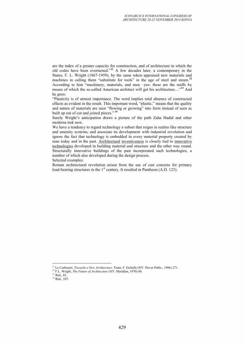
ICONARCH II INTERNATIONAL CONGRESS OF
ARCHITECTURE 20-22 NOVEMBER 2014 KONYA
429
are the index of a greater capacity for construction, and of architecture in which the
old codes have been overturned.”11
A few decades later, a contemporary in the
States, F. L. Wright (1867-1959), by the same token appraised new materials and
machines in calling them “substitute for tools” in the age of steel and steam.12
According to him “machinery, materials, and men –yes- these are the stuffs by
means of which the so-called American architect will get his architecture…”13
And
he goes:
“Plasticity is of utmost importance. The word implies total absence of constructed
effects as evident in the result. This important word, “plastic,” means that the quality
and nature of materials are seen “flowing or growing” into form instead of seen as
built up out of cut and joined pieces.” 14
Surely Wright’s anticipation draws a picture of the path Zaha Hadid and other
moderns trek now.
We have a tendency to regard technology a subset that reigns in realms like structure
and amenity systems, and associate its development with industrial revolution and
ignore the fact that technology is embedded in every material property created by
man today and in the past. Architectural inventiveness is closely tied to innovative
technologies developed in building material and structure and the other way round.
Structurally innovative buildings of the past incorporated such technologies, a
number of which also developed during the design process.
Selected examples:
Roman architectural revolution arisen from the use of cast concrete for primary
load-bearing structures in the 1st century. It resulted in Pantheon (A.D. 123).
11 Le Corbusier, Towards a New Architecture. Trans. F. Etchells (NY: Dover Publc., 1986) 271. 12 F.L. Wright, The Future of Architecture (NY: Meridian, 1970) 84. 13 Ibid., 82. 14 Ibid., 107.
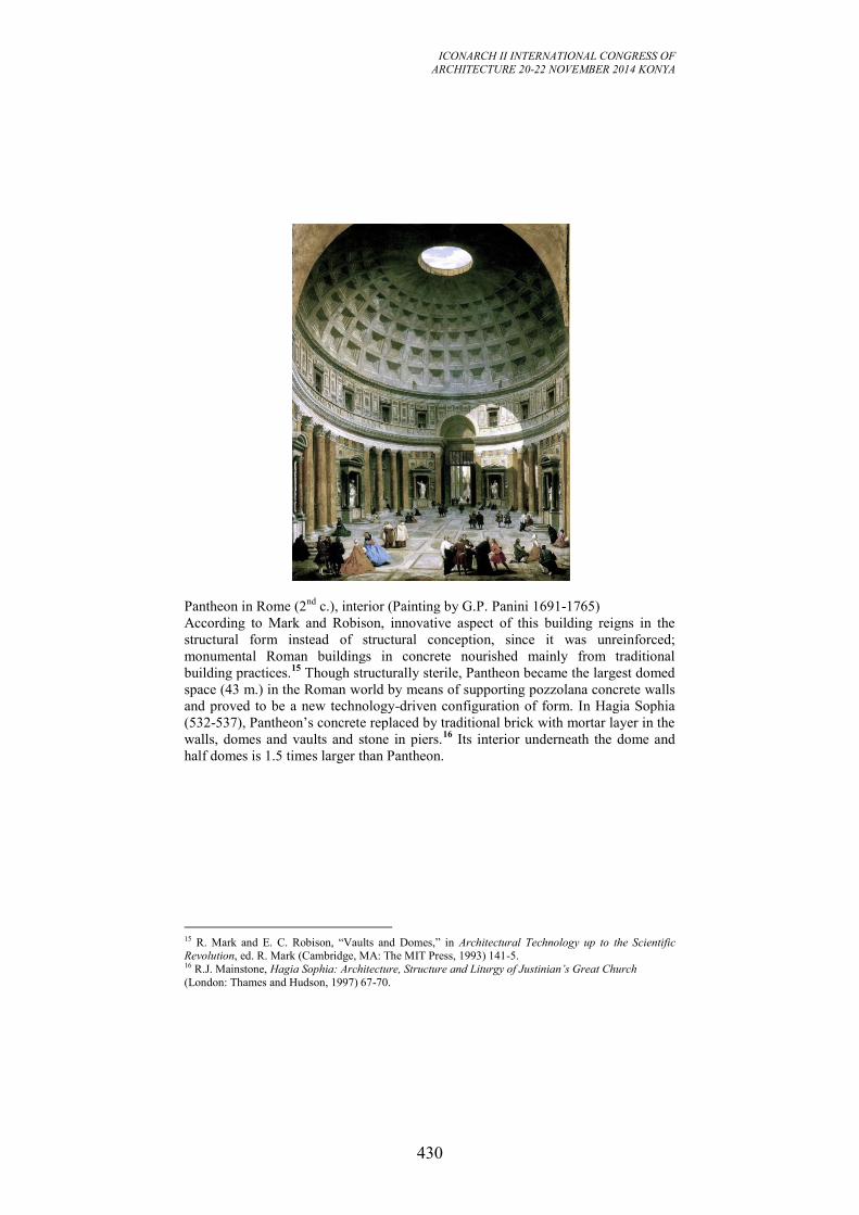
ICONARCH II INTERNATIONAL CONGRESS OF
ARCHITECTURE 20-22 NOVEMBER 2014 KONYA
430
Pantheon in Rome (2nd
c.), interior (Painting by G.P. Panini 1691-1765)
According to Mark and Robison, innovative aspect of this building reigns in the
structural form instead of structural conception, since it was unreinforced;
monumental Roman buildings in concrete nourished mainly from traditional
building practices.15
Though structurally sterile, Pantheon became the largest domed
space (43 m.) in the Roman world by means of supporting pozzolana concrete walls
and proved to be a new technology-driven configuration of form. In Hagia Sophia
(532-537), Pantheon’s concrete replaced by traditional brick with mortar layer in the
walls, domes and vaults and stone in piers.16
Its interior underneath the dome and
half domes is 1.5 times larger than Pantheon.
15 R. Mark and E. C. Robison, “Vaults and Domes,” in Architectural Technology up to the Scientific
Revolution, ed. R. Mark (Cambridge, MA: The MIT Press, 1993) 141-5. 16 R.J. Mainstone, Hagia Sophia: Architecture, Structure and Liturgy of Justinian’s Great Church
(London: Thames and Hudson, 1997) 67-70.
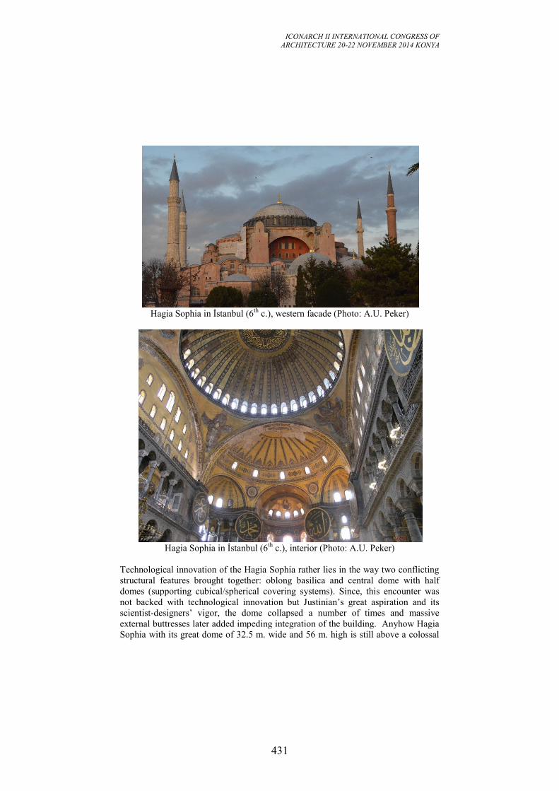
ICONARCH II INTERNATIONAL CONGRESS OF
ARCHITECTURE 20-22 NOVEMBER 2014 KONYA
431
Hagia Sophia in İstanbul (6
th c.), western facade (Photo: A.U. Peker)
Hagia Sophia in İstanbul (6
th c.), interior (Photo: A.U. Peker)
Technological innovation of the Hagia Sophia rather lies in the way two conflicting
structural features brought together: oblong basilica and central dome with half
domes (supporting cubical/spherical covering systems). Since, this encounter was
not backed with technological innovation but Justinian’s great aspiration and its
scientist-designers’ vigor, the dome collapsed a number of times and massive
external buttresses later added impeding integration of the building. Anyhow Hagia
Sophia with its great dome of 32.5 m. wide and 56 m. high is still above a colossal
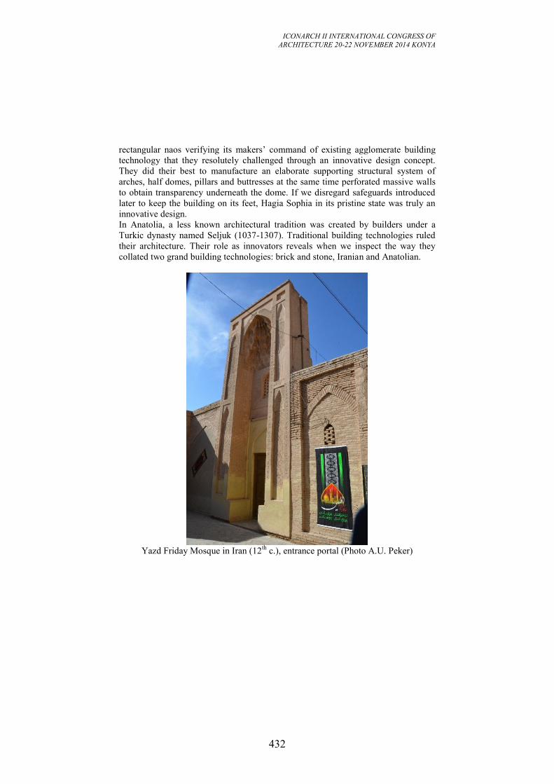
ICONARCH II INTERNATIONAL CONGRESS OF
ARCHITECTURE 20-22 NOVEMBER 2014 KONYA
432
rectangular naos verifying its makers’ command of existing agglomerate building
technology that they resolutely challenged through an innovative design concept.
They did their best to manufacture an elaborate supporting structural system of
arches, half domes, pillars and buttresses at the same time perforated massive walls
to obtain transparency underneath the dome. If we disregard safeguards introduced
later to keep the building on its feet, Hagia Sophia in its pristine state was truly an
innovative design.
In Anatolia, a less known architectural tradition was created by builders under a
Turkic dynasty named Seljuk (1037-1307). Traditional building technologies ruled
their architecture. Their role as innovators reveals when we inspect the way they
collated two grand building technologies: brick and stone, Iranian and Anatolian.
Yazd Friday Mosque in Iran (12
th c.), entrance portal (Photo A.U. Peker)
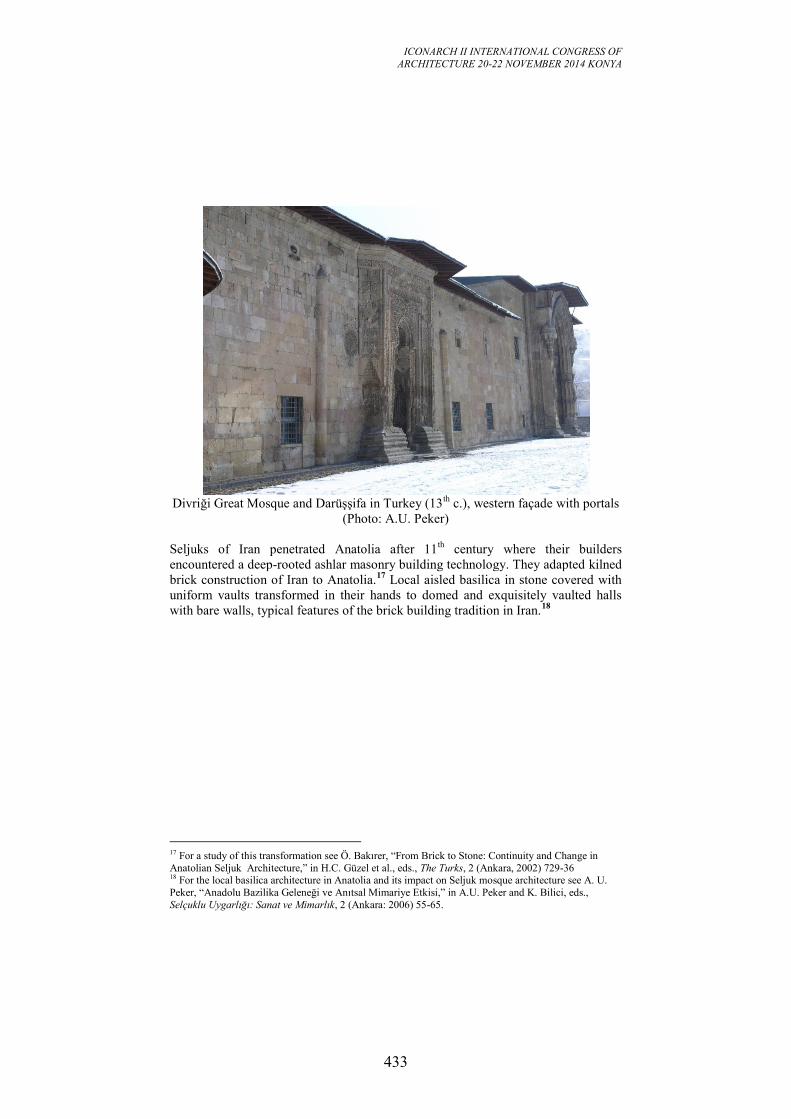
ICONARCH II INTERNATIONAL CONGRESS OF
ARCHITECTURE 20-22 NOVEMBER 2014 KONYA
433
Divriği Great Mosque and Darüşşifa in Turkey (13
th c.), western façade with portals
(Photo: A.U. Peker)
Seljuks of Iran penetrated Anatolia after 11th
century where their builders
encountered a deep-rooted ashlar masonry building technology. They adapted kilned
brick construction of Iran to Anatolia.17
Local aisled basilica in stone covered with
uniform vaults transformed in their hands to domed and exquisitely vaulted halls
with bare walls, typical features of the brick building tradition in Iran.18
17 For a study of this transformation see Ö. Bakırer, “From Brick to Stone: Continuity and Change in
Anatolian Seljuk Architecture,” in H.C. Güzel et al., eds., The Turks, 2 (Ankara, 2002) 729-36 18 For the local basilica architecture in Anatolia and its impact on Seljuk mosque architecture see A. U.
Peker, “Anadolu Bazilika Geleneği ve Anıtsal Mimariye Etkisi,” in A.U. Peker and K. Bilici, eds.,
Selçuklu Uygarlığı: Sanat ve Mimarlık, 2 (Ankara: 2006) 55-65.
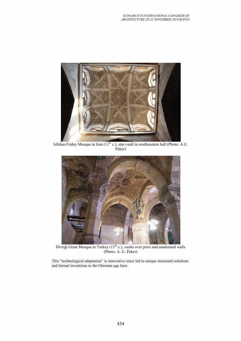
ICONARCH II INTERNATIONAL CONGRESS OF
ARCHITECTURE 20-22 NOVEMBER 2014 KONYA
434
Isfahan Friday Mosque in Iran (11
th c.), star-vault in southeastern hall (Photo: A.U.
Peker)
Divriği Great Mosque in Turkey (13
th c.), vaults over piers and unadorned walls
(Photo: A. U. Peker)
This “technological adaptation” is innovative since led to unique structural solutions
and formal inventions in the Ottoman age later.
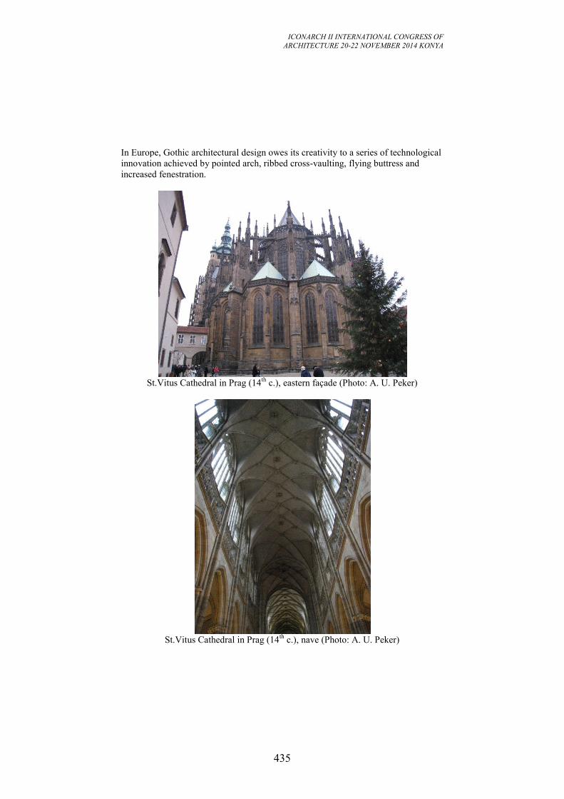
ICONARCH II INTERNATIONAL CONGRESS OF
ARCHITECTURE 20-22 NOVEMBER 2014 KONYA
435
In Europe, Gothic architectural design owes its creativity to a series of technological
innovation achieved by pointed arch, ribbed cross-vaulting, flying buttress and
increased fenestration.
St.Vitus Cathedral in Prag (14
th c.), eastern façade (Photo: A. U. Peker)
St.Vitus Cathedral in Prag (14
th c.), nave (Photo: A. U. Peker)
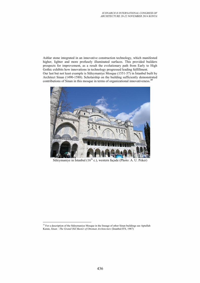
ICONARCH II INTERNATIONAL CONGRESS OF
ARCHITECTURE 20-22 NOVEMBER 2014 KONYA
436
Ashlar stone integrated in an innovative construction technology, which manifested
higher, lighter and more profusely illuminated surfaces. This provided builders
prospects for improvement, as a result the evolutionary path from Early to High
Gothic exhibits how innovations in technology progressed leading fulfillment.
Our last but not least example is Süleymaniye Mosque (1551-57) in İstanbul built by
Architect Sinan (1490-1588). Scholarship on the building sufficiently demonstrated
contributions of Sinan in this mosque in terms of organizational innovativeness.19
Süleymaniye in İstanbul (16
th c.), western façade (Photo: A. U. Peker)
19 For a description of the Süleymaniye Mosque in the lineage of other Sinan buildings see Aptullah
Kuran, Sinan : The Grand Old Master of Ottoman Archıtecture (İstanbul:ITS, 1987)
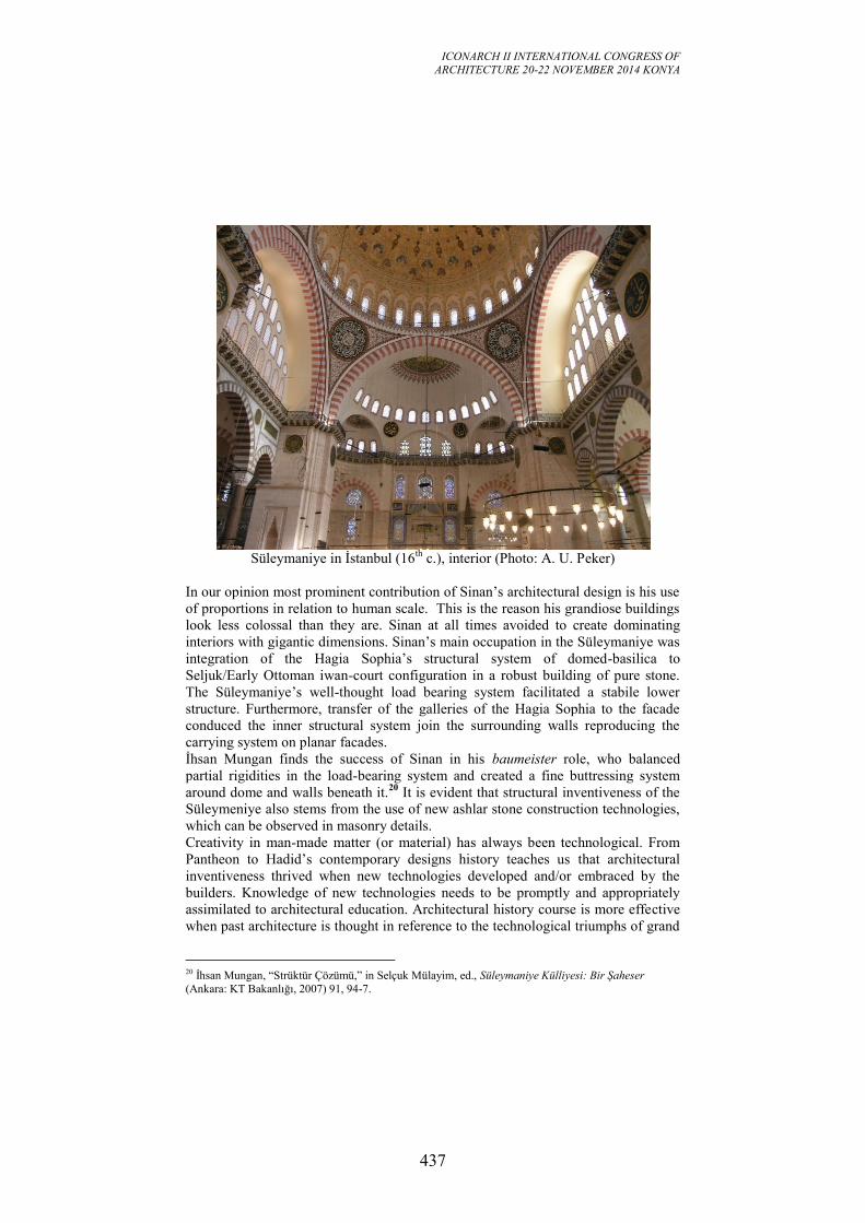
ICONARCH II INTERNATIONAL CONGRESS OF
ARCHITECTURE 20-22 NOVEMBER 2014 KONYA
437
Süleymaniye in İstanbul (16
th c.), interior (Photo: A. U. Peker)
In our opinion most prominent contribution of Sinan’s architectural design is his use
of proportions in relation to human scale. This is the reason his grandiose buildings
look less colossal than they are. Sinan at all times avoided to create dominating
interiors with gigantic dimensions. Sinan’s main occupation in the Süleymaniye was
integration of the Hagia Sophia’s structural system of domed-basilica to
Seljuk/Early Ottoman iwan-court configuration in a robust building of pure stone.
The Süleymaniye’s well-thought load bearing system facilitated a stabile lower
structure. Furthermore, transfer of the galleries of the Hagia Sophia to the facade
conduced the inner structural system join the surrounding walls reproducing the
carrying system on planar facades.
İhsan Mungan finds the success of Sinan in his baumeister role, who balanced
partial rigidities in the load-bearing system and created a fine buttressing system
around dome and walls beneath it.20
It is evident that structural inventiveness of the
Süleymeniye also stems from the use of new ashlar stone construction technologies,
which can be observed in masonry details.
Creativity in man-made matter (or material) has always been technological. From
Pantheon to Hadid’s contemporary designs history teaches us that architectural
inventiveness thrived when new technologies developed and/or embraced by the
builders. Knowledge of new technologies needs to be promptly and appropriately
assimilated to architectural education. Architectural history course is more effective
when past architecture is thought in reference to the technological triumphs of grand
20 İhsan Mungan, “Strüktür Çözümü,” in Selçuk Mülayim, ed., Süleymaniye Külliyesi: Bir Şaheser
(Ankara: KT Bakanlığı, 2007) 91, 94-7.
ICONARCH II INTERNATIONAL CONGRESS OF
ARCHITECTURE 20-22 NOVEMBER 2014 KONYA
438
works and traditions. But, one might still ask: If innovative technology is so decisive
what would be the purpose of such a course focusing on outdated technologies of the
past? Straightly speaking, its function is to teach new generations the formula often
failed to be noticed that architectural inventiveness is contingent upon new
technologies (and vice versa).
ICONARCH II INTERNATIONAL CONGRESS OF
ARCHITECTURE 20-22 NOVEMBER 2014 KONYA
439
THE MOCK-UP OF THE "RATTO DELLE SABINE" BY
GIAMBOLOGNA:
MAKING AND UTILIZATION OF A 3D MODEL
GRAZIA TUCCI, ALESSANDRO CONTI, LIDIA FIORINI1
ABSTRACT
Within a project for the knowledge and preservation of the mock-up of
Giambologna's Ratto delle Sabine housed in the Galleria dell'Accademia in
Florence, the GeCO laboratory has made laser scanner acquisitions to create surface
models at different resolutions for structural analysis, on which to check the
coverage of the photographic campaign and to create a three-dimensional thematic
mapping of data relating to investigations and restoration works. The PDF3D file
format has been used to easily manage data on a platform immediately available to
all operators.
Key words: Laser scanning, 3-D modelling, PDF3D, Cultural heritage, Mesh
1. INTRODUCTION
The present paper, promoted by the Galleria dell’Accademia within the project of
restoration of the sketch of the “Ratto delle Sabine”, constitutes an anticipation of
the complete documentation of the restoration that will be published soon.
The creation of digital surface models is now a widespread practice for the most
diverse applications of documentation, preservation and communication of cultural
heritage (Guidi et al, 2009, Trinchão Andrade, Mazetto Mendes, 2012, Arbace et al.
2013). When we design a model, two conflicting requirements must be considered:
on the one hand, obviously high resolution models reproduce at best the tiniest
details, on the other hand, small files are preferable for viewing on non-dedicated
hardware and software or on-line. It is therefore necessary to optimize the models in
order to reduce the file size while maintaining a proper resolution.
The survey of the mock-up done by Giambologna for the “Ratto delle Sabine” (“The
Abduction of the Sabine women”), was run as support to different lines of research,
each of which requires outputs with different characteristics. Initially, the Galleria
dell'Accademia (that is the Museum in Florence which houses the statue) demanded
a model for structural analysis, for which a very simplified model is usually
sufficient, because the structural simulations and Finite Element Analysis software
are not able to import surface models consisting of very complex meshes.
It also emerged the need to verify the completeness of the existent photographic
documentation and to summarize in a visual way the analyses and restoration
1 GeCO Lab, Dept. of Civil and Environmental Engineering, University of Florence, ITALY
ICONARCH II INTERNATIONAL CONGRESS OF
ARCHITECTURE 20-22 NOVEMBER 2014 KONYA
440
interventions, applications requiring more detailed models. In this way, the case
study has also offered the opportunity to study how to create three-dimensional
maps of the restoration works, overcoming the limitations of most GIS 2D tools
used for this purpose, and our 3D model was put at the disposal of the other working
groups for referencing the results of their investigations.
2. THE KNOWLEDGE AND RESTORATION PROJECT OF THE
ABDUCTION OF THE SABINES
The Galleria dell'Accademia in Florence hosts the preparatory sketch of Ratto delle
Sabine, made with clay by Giambologna around 1580, whose final version in marble
is located in Piazza della Signoria under the Loggia dei Lanzi. This statue is one of
the few still existing sketches of large sculptures in full scale.
The sculpted group, 4.30 m tall (without the pedestal) is characterized by the a-whirl
movement of three figures, whose bodies spin around their axes, intersect and
overlap, and is considered a masterpiece of Mannerist sculpture.
The artist created this model as a training to face the most demanding challenges for
sculptors, both ancient and his contemporary ones: get many figures from a single
block of marble, balance masses of a figure who supports another one, create a
perfect composition from everywhere you look. (Avery, 1978).
In addition to this full scale maquette, there were other small models which testify to
the attention of Giambologna for this statue originally without name, if we rely on
the writer Vincenzo Borghini who reports that he had personally recommended to
Giambologna the name of “Ratto delle Sabine”. The famous Latin legend tells that
the first generation of Roman men (who were descendants of the Trojan survivors)
kidnapped some girls from the neighboring Sabine families to acquire wives for
themselves. So the bent figure could represent a Sabine father, the standing young
man could be the Roman Thalassius and the raised woman one of the abducted girls
(Borghini, 1584).
For the restoration of an artifact whose characteristics and construction materials are
little known and that is in poor condition, the Galleria dell'Accademia considered
essential to have a team of specialists a wide diagnostic and learning campaign. For
this project, developed between 2011 and 2014, both restorers and research institutes
(including the ICVBC-CNR, the IUAV and the GeCO lab) were involved.
3. ACQUISITIONS
The data acquisition was made by two operators on November 21, 2011. The
digitization was done as a complementary part during the survey of the Galleria
dell'Accademia, where the statue is located. So the scanner employed has been the
same phase-shift scanner (Leica Geosystems HDS7000) used for the architectural
survey, whose resolution was adequate for a surface model for structural analysis, as
requested by the Client at first.
Although it is known (Tucci, Bonora, 2007) that the triangulation scanners allow to
scan large statues with greater accuracy than with phase-shift or TOF tools, the
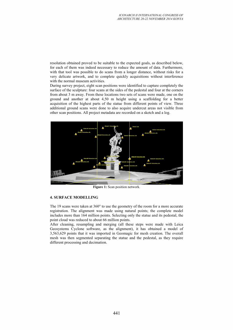
ICONARCH II INTERNATIONAL CONGRESS OF
ARCHITECTURE 20-22 NOVEMBER 2014 KONYA
441
resolution obtained proved to be suitable to the expected goals, as described below,
for each of them was indeed necessary to reduce the amount of data. Furthermore,
with that tool was possible to do scans from a longer distance, without risks for a
very delicate artwork, and to complete quickly acquisitions without interference
with the normal museum activities.
During survey project, eight scan positions were identified to capture completely the
surface of the sculpture: four scans at the sides of the pedestal and four at the corners
from about 3 m away. From these locations two sets of scans were made, one on the
ground and another at about 4,50 m height using a scaffolding for a better
acquisition of the highest parts of the statue from different points of view. Three
additional ground scans were done to also acquire undercut areas not visible from
other scan positions. All project metadata are recorded on a sketch and a log.
Figure 1: Scan position network.
4. SURFACE MODELLING
The 19 scans were taken at 360° to use the geometry of the room for a more accurate
registration. The alignment was made using natural points; the complete model
includes more than 164 million points. Selecting only the statue and its pedestal, the
point cloud was reduced to about 66 million points.
After cleaning, resampling and merging (all these steps were made with Leica
Geosystems Cyclone software, as the alignment), it has obtained a model of
3,563,629 points that it was imported in Geomagic for mesh creation. The overall
mesh was then segmented separating the statue and the pedestal, as they require
different processing and decimation.
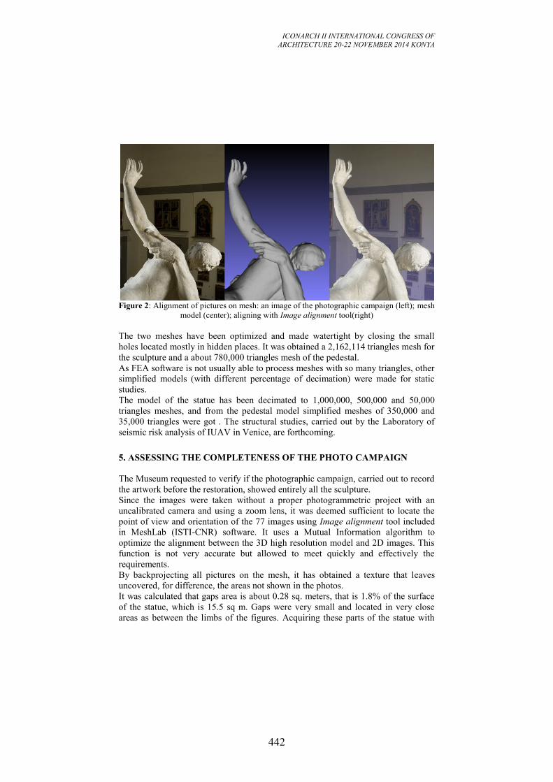
ICONARCH II INTERNATIONAL CONGRESS OF
ARCHITECTURE 20-22 NOVEMBER 2014 KONYA
442
Figure 2: Alignment of pictures on mesh: an image of the photographic campaign (left); mesh
model (center); aligning with Image alignment tool(right)
The two meshes have been optimized and made watertight by closing the small
holes located mostly in hidden places. It was obtained a 2,162,114 triangles mesh for
the sculpture and a about 780,000 triangles mesh of the pedestal.
As FEA software is not usually able to process meshes with so many triangles, other
simplified models (with different percentage of decimation) were made for static
studies.
The model of the statue has been decimated to 1,000,000, 500,000 and 50,000
triangles meshes, and from the pedestal model simplified meshes of 350,000 and
35,000 triangles were got . The structural studies, carried out by the Laboratory of
seismic risk analysis of IUAV in Venice, are forthcoming.
5. ASSESSING THE COMPLETENESS OF THE PHOTO CAMPAIGN
The Museum requested to verify if the photographic campaign, carried out to record
the artwork before the restoration, showed entirely all the sculpture.
Since the images were taken without a proper photogrammetric project with an
uncalibrated camera and using a zoom lens, it was deemed sufficient to locate the
point of view and orientation of the 77 images using Image alignment tool included
in MeshLab (ISTI-CNR) software. It uses a Mutual Information algorithm to
optimize the alignment between the 3D high resolution model and 2D images. This
function is not very accurate but allowed to meet quickly and effectively the
requirements.
By backprojecting all pictures on the mesh, it has obtained a texture that leaves
uncovered, for difference, the areas not shown in the photos.
It was calculated that gaps area is about 0.28 sq. meters, that is 1.8% of the surface
of the statue, which is 15.5 sq m. Gaps were very small and located in very close
areas as between the limbs of the figures. Acquiring these parts of the statue with
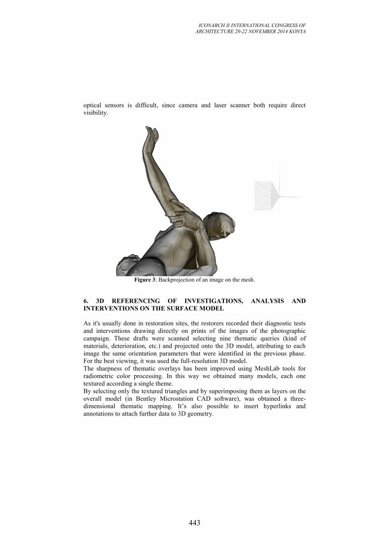
ICONARCH II INTERNATIONAL CONGRESS OF
ARCHITECTURE 20-22 NOVEMBER 2014 KONYA
443
optical sensors is difficult, since camera and laser scanner both require direct
visibility.
Figure 3: Backprojection of an image on the mesh.
6. 3D REFERENCING OF INVESTIGATIONS, ANALYSIS AND
INTERVENTIONS ON THE SURFACE MODEL
As it's usually done in restoration sites, the restorers recorded their diagnostic tests
and interventions drawing directly on prints of the images of the photographic
campaign. These drafts were scanned selecting nine thematic queries (kind of
materials, deterioration, etc.) and projected onto the 3D model, attributing to each
image the same orientation parameters that were identified in the previous phase.
For the best viewing, it was used the full-resolution 3D model.
The sharpness of thematic overlays has been improved using MeshLab tools for
radiometric color processing. In this way we obtained many models, each one
textured according a single theme.
By selecting only the textured triangles and by superimposing them as layers on the
overall model (in Bentley Microstation CAD software), was obtained a three-
dimensional thematic mapping. It’s also possible to insert hyperlinks and
annotations to attach further data to 3D geometry.
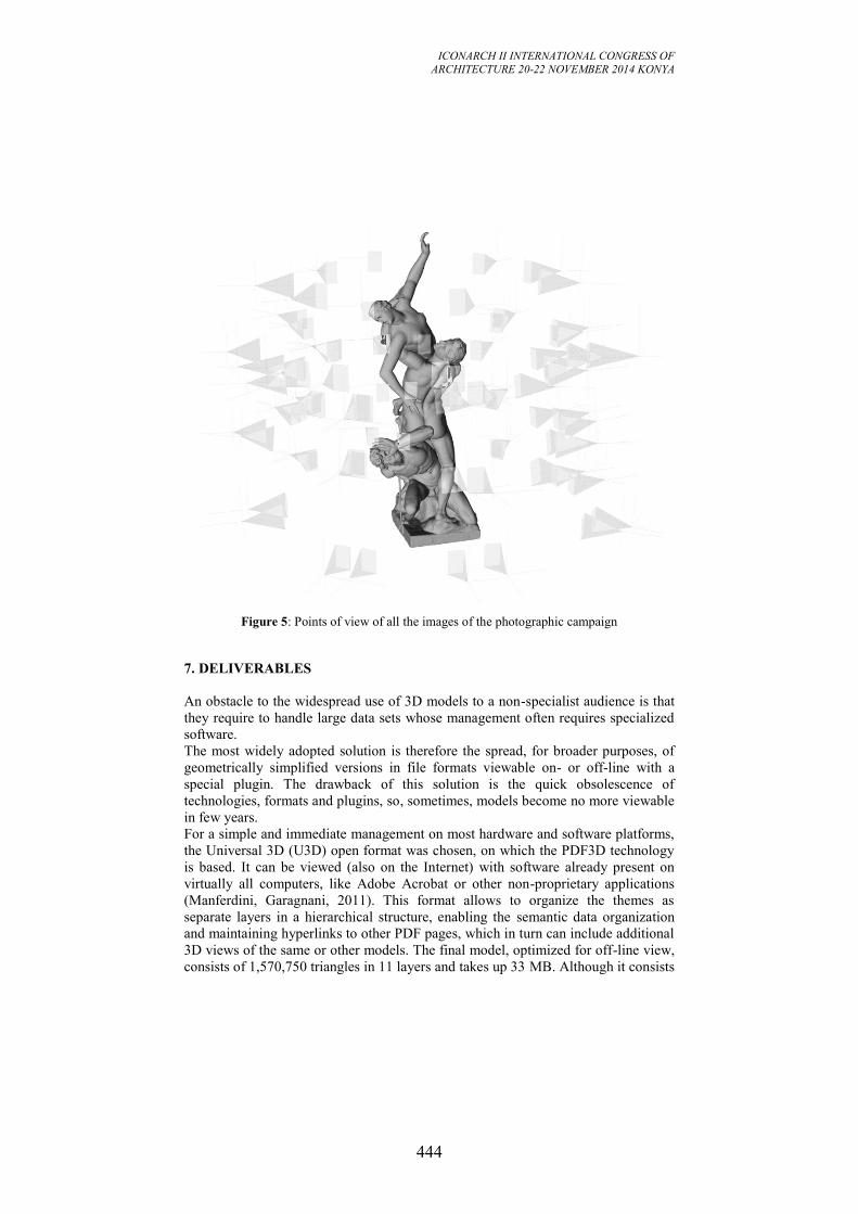
ICONARCH II INTERNATIONAL CONGRESS OF
ARCHITECTURE 20-22 NOVEMBER 2014 KONYA
444
Figure 5: Points of view of all the images of the photographic campaign
7. DELIVERABLES
An obstacle to the widespread use of 3D models to a non-specialist audience is that
they require to handle large data sets whose management often requires specialized
software.
The most widely adopted solution is therefore the spread, for broader purposes, of
geometrically simplified versions in file formats viewable on- or off-line with a
special plugin. The drawback of this solution is the quick obsolescence of
technologies, formats and plugins, so, sometimes, models become no more viewable
in few years.
For a simple and immediate management on most hardware and software platforms,
the Universal 3D (U3D) open format was chosen, on which the PDF3D technology
is based. It can be viewed (also on the Internet) with software already present on
virtually all computers, like Adobe Acrobat or other non-proprietary applications
(Manferdini, Garagnani, 2011). This format allows to organize the themes as
separate layers in a hierarchical structure, enabling the semantic data organization
and maintaining hyperlinks to other PDF pages, which in turn can include additional
3D views of the same or other models. The final model, optimized for off-line view,
consists of 1,570,750 triangles in 11 layers and takes up 33 MB. Although it consists
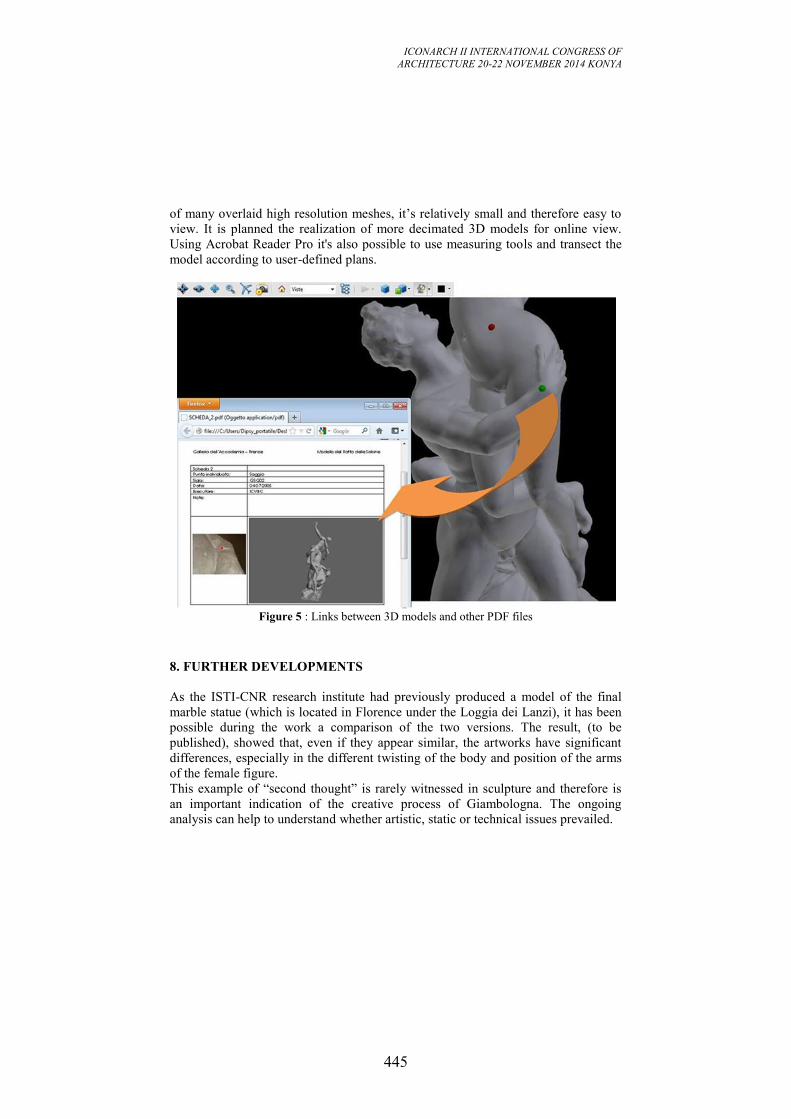
ICONARCH II INTERNATIONAL CONGRESS OF
ARCHITECTURE 20-22 NOVEMBER 2014 KONYA
445
of many overlaid high resolution meshes, it’s relatively small and therefore easy to
view. It is planned the realization of more decimated 3D models for online view.
Using Acrobat Reader Pro it's also possible to use measuring tools and transect the
model according to user-defined plans.
Figure 5 : Links between 3D models and other PDF files
8. FURTHER DEVELOPMENTS
As the ISTI-CNR research institute had previously produced a model of the final
marble statue (which is located in Florence under the Loggia dei Lanzi), it has been
possible during the work a comparison of the two versions. The result, (to be
published), showed that, even if they appear similar, the artworks have significant
differences, especially in the different twisting of the body and position of the arms
of the female figure.
This example of “second thought” is rarely witnessed in sculpture and therefore is
an important indication of the creative process of Giambologna. The ongoing
analysis can help to understand whether artistic, static or technical issues prevailed.
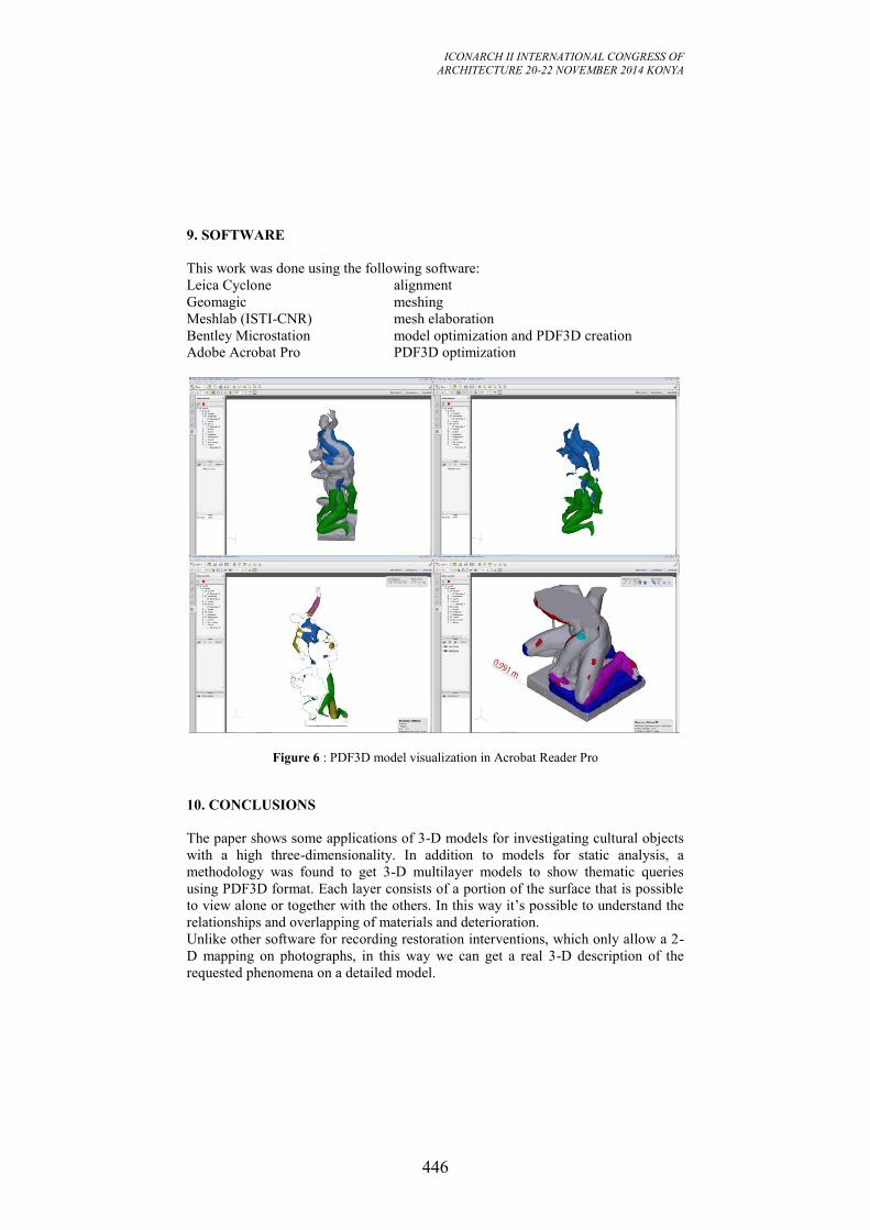
ICONARCH II INTERNATIONAL CONGRESS OF
ARCHITECTURE 20-22 NOVEMBER 2014 KONYA
446
9. SOFTWARE
This work was done using the following software:
Leica Cyclone alignment
Geomagic meshing
Meshlab (ISTI-CNR) mesh elaboration
Bentley Microstation model optimization and PDF3D creation
Adobe Acrobat Pro PDF3D optimization
Figure 6 : PDF3D model visualization in Acrobat Reader Pro
10. CONCLUSIONS
The paper shows some applications of 3-D models for investigating cultural objects
with a high three-dimensionality. In addition to models for static analysis, a
methodology was found to get 3-D multilayer models to show thematic queries
using PDF3D format. Each layer consists of a portion of the surface that is possible
to view alone or together with the others. In this way it’s possible to understand the
relationships and overlapping of materials and deterioration.
Unlike other software for recording restoration interventions, which only allow a 2-
D mapping on photographs, in this way we can get a real 3-D description of the
requested phenomena on a detailed model.
ICONARCH II INTERNATIONAL CONGRESS OF
ARCHITECTURE 20-22 NOVEMBER 2014 KONYA
447
In addition to cultural heritage applications, this technique can be easily applied in
all fields in which a 3-D mapping is useful, as in architecture and archeology.
11. ACKNOWLEDGEMENTS
The authors are really thankful to dott. Franca Falletti and dott. Angelo Tartuferi,
Directors of the Galleria dell’Accademia, and to the non-profit Foundation “Friends
of Florence” (www.friendsofflorence.org) which supported this investigation project
on the sketch of the “Ratto delle Sabine” sculpture by Giambologna with an
agreement with DICEA (Department of civil and environmental engineering) -
University of Florence for a project entitled Study for spatial referencing on the
surface model of data coming from diagnostic tests and preventive interventions on
the sculptural group “ Ratto delle Sabine”.
REFERENCES
-Tucci, G., Conti, A., Fiorini L. (2014). Realizzazione ed impiego del modello 3D.
(forthcoming).
-Callieri, M., Tucci, G., Scopigno, R. (2014) Copia fax-simile o reinterpretazione?
Un confronto dei modelli 3D del marmo e del bozzetto del Ratto delle Sabine.
(forthcoming)
-Arbace, L., Sonnino, E., Callieri, M., Dellepiane, M., Fabbri, M., Iaccarino Idelson,
A., & Scopigno, R. (2013). Innovative uses of 3D digital technologies to assist the
restoration of a fragmented terracotta statue. Journal of Cultural Heritage, 14(4),
332-345.
-Trinchão Andrade, B., Mazetto Mendes, C. (2012). 3D preserving XVIII century
barroque masterpiece: Challenges and results on the digital preservation of
Aleijadinho's sculpture of the Prophet Joel. Journal of Cultural Heritage, 13(2),
210-214.
-Manferdini, A. M., & Garagnani, S. (2011). Virtual Exhibition and Fruition of
Archaeological Finds. ISPRS-International Archives of the Photogrammetry,
Remote Sensing and Spatial Information Sciences, 3816, 429-436.
-Guidi, G., Spinetti, A., Carosso, L., Atzeni, C. (2009). Digital Three-Dimensional
Modelling of Donatello's David by Frequency-Modulated Laser Radar. Studies in
Conservation, 54(1), 3-11.
-Cole, M. (2008). Giambologna and the sculpture with no name. Oxford Art
Journal, 31(3), 337-359.
-Tucci, G., Bonora, V. (2007). Application of high resolution scanning systems for
virtual moulds and replicas of sculptural works. International Archives of the
Photogrammetry, Remote Sensing and Spatial Information Sciences, Vol. XXXVI,
Part 5/C53 721-726.
-Avery, C. (1978). Giambologna's sketch models and his sculptural technique. The
connoisseur, 199(799), 3-11.
-Borghini, R. (1584). Il riposo. Facsimile (Rosci M. cur.) Labor riproduzioni e
documentazioni, Milano, 1967.
ICONARCH II INTERNATIONAL CONGRESS OF
ARCHITECTURE 20-22 NOVEMBER 2014 KONYA
448
UAV SYSTEMS FOR DOCUMENTATION OF CULTURAL
HERITAGE
ARMAGAN GULEC KORUMAZ1, MUSTAFA KORUMAZ2, GRAZIA TUCCI1 ,
VALENTINA BONORA1 , WOLFGANG NIEMEIER3, BJÖRN RIEDL3
ABSTRACT
Architectural documentation is an activity which requires getting information from
different sources for complete and comprehensive analysis. In the field of
architectural documentation different innovative systems have been developed in
survey like digital photogrammetry and Terrestrial Laser Scanning (TLS). One of
these techniques Unmanned Aerial Vehicles (UAVs) equipped with a digital camera
have become one of the most promising techniques in last years. It opens various
new applications in large scale and close-range and so becoming progressively
common due to the considerable potentials in terms of accuracy, costs and abilities.
Their capability of data acquisition with high resolution allows texture mapping on
DSM (Digital Surface Model), 3D models and orthophotos. It is also possible to
create mosaics, maps and drawings which can be used for image interpretation.
These data can be applied to several applications including 3D documentation of
environment, cultural heritage, monitoring and recording landscape data and
infrastructural assets for risk analysis and management process.
This paper discusses the potentials of UAVs in order to analyze, interpret and
manage cultural heritage data through a case study (carried out before). It also
presents the procedure of processing UAV data in order to create digital surface
models and photo-realistic outputs for digital reconstruction models and
visualization. The obtained results have been demonstrated with case study and
general discussion has been made for evaluating potential of UAV technique for
cultural heritage documentation.
Key words: : UAVs, Cultural Heritage Documentation, DSM, Orthoimage.
1. INTRODUCTION
Heritage documentation process involves huge multimedia data containing different
information such as photographs, photographic panoramas, rectified photographs,
orthophotos, technical drawings, different 3D models including point clouds and
other kind of data such as videos, reports, pictures, texts etc. This process can be
1 Phd Candidate, Laboratorio GeCo, Dipartimento di Ingegneria Civile e Ambientale, Università degli
Studi di Firenze. 2 Assist. Prof.Dr., Selçuk University, Architecture Faculty, Department of Architecture, KONYA 1 Assoc. Prof., Laboratorio GeCo, Dipartimento di Ingegneria Civile e Ambientale, Università degli Studi
di Firenze. 1 Arch. PhD., Laboratorio GeCo, Dipartimento di Ingegneria Civile e Ambientale, Università degli Studi
di Firenze. 3 Prof., Geodesy and Photogrammetry Institute, Braunschweig Technical University. 3 Dr.-Ing., Geodesy and Photogrammetry Institute, Braunschweig Technical University.
ICONARCH II INTERNATIONAL CONGRESS OF
ARCHITECTURE 20-22 NOVEMBER 2014 KONYA
449
considered mainly in five main parts as (1) planning documentation, (2) data
acquisition, (3) data processing, (4) data management and (5) dissemination of the
data. All these steps involve diverse and intensive use of digital technologies. In this
case, choosing the appropriate technology, procedure and workflow is always a
challenging and depends on the size, complexity and the level of required accuracy
of the project (Patias et al., 2008).
Even though traditional survey methods are still important and useful in some cases,
technological possibilities have given opportunity to support traditional techniques
in different ways. As hand measurement can provide dimensions and positions of
objects and scenes of a few meters, sketches in small size, it is sometimes more
impractical and not enough for larger objects. In this case, photogrammetry and
terrestrial laser scanning could be more suitable by covering larger areas and
enabling a large quantity of three-dimensional measurements to be collected
(English Heritage, 2007). The studies have shown that photogrammetry has
advantages for large amount of data, accurate data, possibility to texture in high
resolution and detail, geo-reference data with stereo-viewing capability of the 3D
data (Grussenmeyer et al., 2002, Patias, P., 2006). Similarly Terrestrial Laser
Scanning technology has high performance in terms of data acquisition speed
(Russo and Guidi, 2011) in different field of uses and has advantageous when used
appropriately (English Heritage, 2007; Russo and Guidi, 2011). Even each
technology has pros and cons., in most cases the combination of these technologies
and related methodologies regarding their benefits may be the best solution (Russo
and Guidi, 2011; Grussenmeyer et al., 2008; Patias, 2006.).
These both techniques has made it possible to obtain a high level of detail and
accuracy and result to be very effective for small and medium-extension areas.
However for large areas close range photogrammetry and terrestrial laser scanning
are not always the most suitable techniques. Here, the information obtained from
aerial or satellite images provide an overview of the study area to complete the
documentation. Even they have been used for a long time; such images have some
limitations linked to the geometric resolution, inadequate for detailed studies, to the
periods of acquisition and to the cost (Lo Brutto et al., 2012). Besides, another
challenge of these methods is the difficulty involved in acquiring reliable
radiometric information of the complete surveyed area, which can easily be obtained
by means of traditional aerial photogrammetry. However, the costs of aerial
photogrammetry are usually too high in relation to the limited extension of the
surveyed areas. Even the aerial techniques can be an optimal solution in the case of
medium-sized and large sites, since the possibility of raising sensors and capturing
the information, in many cases it is rather difficult to obtain data at ground level,
which can increase the performance of photogrammetry. But these surveys generally
require working with large scales and high resolutions. As result, conventional aerial
photogrammetric surveys can be unfeasible because of the limited site extent, the
large scale required, the expected low flight height, speed of the aircraft and the
relatively high cost of the technique (Mozas-Calvache et al., 2012). In this case the
use of alternative techniques based on close range photogrammetry and laser
scanning from light and low height platforms can be a solution for these problems.
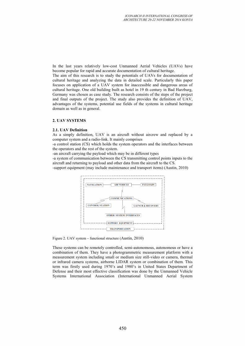
ICONARCH II INTERNATIONAL CONGRESS OF
ARCHITECTURE 20-22 NOVEMBER 2014 KONYA
450
In the last years relatively low-cost Unmanned Aerial Vehicles (UAVs) have
become popular for rapid and accurate documentation of cultural heritage.
The aim of this research is to study the potentials of UAVs for documentation of
cultural heritage and analyzing the data in detailed scale. Particularly this paper
focuses on application of a UAV system for inaccessible and dangerous areas of
cultural heritage. One old building built as hotel in 19 th century in Bad Harzburg,
Germany was chosen as case study. The research consists of the steps of the project
and final outputs of the project. The study also provides the definition of UAV,
advantages of the systems, potential use fields of the systems in cultural heritage
domain as well as in general.
2. UAV SYSTEMS
2.1. UAV Definition
As a simply definition, UAV is an aircraft without aircrew and replaced by a
computer system and a radio-link. It mainly comprises
-a control station (CS) which holds the system operators and the interfaces between
the operators and the rest of the system.
-an aircraft carrying the payload which may be in different types
-a system of communication between the CS transmitting control points inputs to the
aircraft and returning to payload and other data from the aircraft to the CS.
-support equipment (may include maintenance and transport items) (Austin, 2010)
Figure 2. UAV system – functional structure (Austin, 2010)
These systems can be remotely controlled, semi-autonomous, autonomous or have a
combination of them. They have a photogrammetric measurement platform with a
measurement system including small or medium size still-video or camera, thermal
or infrared camera systems, airborne LIDAR system or combination of them. This
term was firstly used during 1970’s and 1980’s in United States Department of
Defense and their most effective classification was done by the Unmanned Vehicle
Systems International Association (International Unmanned Aerial System
ICONARCH II INTERNATIONAL CONGRESS OF
ARCHITECTURE 20-22 NOVEMBER 2014 KONYA
451
Community) in 2008. Depending on this classification, they have mainly three
categories based on their possible use which are; tactic, strategic and special
purpose (Eisenbeiß, 2009).
UAVs have been used for different applications in many countries. They have
diverse application fields mainly civilian and military ones. Beside their use in
military in navy, army and air force, they have a great potential in observation,
maintenance, surveillance, monitoring, remote sensing and security tasks
(Eisenbeiss, 2004). Especially in environmental field they have been used for
detection of environmental areas at risk, monitoring pollution, land, forestry, water
course and level besides road traffic control, analysis of forecasting, power line
inspection and pipe line security (Austin, 2010). Moreover, vegetation monitoring
like coffee plantation and as an integral part of farm equipment in Japan, in road
accident simulations and in many cases of forest fire monitoring, to monitor
volcanoes and traffic fields are examples of UAVs use fields (Everaerts, 2008). As
well as environmental tasks, they can also be deployed in surveillance applications
against civilians, such as applications in policing (for missing persons, security and
incident surveillance), border surveillance (Finn and Wright, 2012) and three-
dimensional cadastral and transportation map updates, reconstructing mountain rock
faces and calculating volumes of stock piles (Haarbrink and Eisenbeiss, 2008) and
also in the last years for slope studies because of the reality in three-dimensional
(3D) (Anuar et al., 2013).
However, the development of UAVs has been strongly motivated by military
applications, during the World Wars balloons, pigeons and rockets were used for
spying. Also after World War II, some nations were looking for aerial vehicles,
which have the capability for surveillance, reconnaissance and penetration of hostile
terrain without the deployment of human beings in areas of high risk (Eisenbeiss,
2004). The development of these systems have evolved with levels of technology of
ever-higher performance and they have become a part of research field and opened
new areas (Rinaudo et al., 2012). The first aerial photographs were taken by Gaspard
Tournachon in 1858 from a manned balloon in Paris (Newhall, 1969). By the years,
manned balloons and later model balloons were a part of this evolution. Wester-
Ebbinghaus was the first to use a rotary wing UAV for photogrammetric purposes in
1980 (Eisenbeiss, 2009). But that time, these systems have several problems
especially related to vibration because of wind and manual control which caused
these system not to be acceptable as photogrammeric platform (Eisenbeiss, 2004).
During the evolution of UAVs different kinds of balloons, kites, model helicopters
and UAVs have showed high potential in process.
3. UAVs for CULTURAL HERITAGE
Photogrammetry has a long history of successful achievements in 3D recording and
documentation. Since the first steps of photogrammetry, unconventional
documentation problems could be dialed with the help of remotely taken images for
3-dimensional mapping in high accuracy. From that time on, close-range
photogrammetry developed innovative and novel tools, techniques, and best
ICONARCH II INTERNATIONAL CONGRESS OF
ARCHITECTURE 20-22 NOVEMBER 2014 KONYA
452
practices to handle special and extreme, in some cases, technical problems in 3D
mapping. Inaccessibility of monuments, visibility problems, highly oblique images,
low texture objects, restrictions in time and/or budget etc. made for a search for the
new technologies. A major technology boost with the introduction of digital images
and the universal use of laser scanning, along with the development of new digital
image processing techniques, offered new solutions (Rinaudo et al., 2012).
Following the developments in image capturing and processing, Unmanned Aerial
Vehicles (UAVs) have become an alternative in cultural heritage domain and have
been started to be successfully used in different projects. Since they have the ability
to perform in high risk situations without any danger for researcher and they can
reach the places where men cannot, they have become standard platforms in cultural
heritage sector. Their cost-effectiveness, less economic limits, real time data
capability, fast data acquisition and small-size features have made them as a strong
alternative in heritage documentation projects. In cultural heritage area their
applications are mainly focused on documentation, observation, monitoring,
mapping, 3D modelling and 3D reconstruction (Remondino et al., 2011) as well as
digital maps, digital orthophoto, digital elevation model (DEM) and digital surface
models (DSM) (Patias et al., 2008).
In documentation and modelling of buildings, images are generally taken from the
ground level for façade information and to detect the features on façades. However
in many cases, it is difficult to get the photos of the roof of the buildings and to get
an overview from the top with the building surrounding. In this sense UAVs enable
to capture the images from the roof and to see the surrounding of the building in
larger view. Additionally, with the help of oblique images, it is possible and easier
to get information and observe also building façades with these systems. Oblique
images make possible to record of historical objects with a vertical direction and
they may be used for 3D photorealistic model production and façade views which
also give opportunity to make analysis and determination of materials. Here, high
accuracy recording should be considered so the details have to be recognized. In
addition to such details, with the help of oblique cameras, it is possible
systematically to take photos of the cities and then to arrange them in high quality
and to share (Höhle, 2013). When needed, their combination with infrared and
thermography cameras can be preferred for special purposes. Infrared and
thermography cameras have valuable information for further data interpretation and
object analysis in cultural heritage field in terms of spatial and spectral information.
The applications with the integration of UAVs with such systems are considered as
successful practices in cultural heritage study areas (Patias et al., 2013).
Archaeological documentation is other research and application field in which
UAVs have been effectively used in cultural heritage domain. In 1970 Whittlesey
reported on the use of a tethered balloon for archaeological documentations in the
first time, which he actually started in 1967 (Eisenbeiß, 2009). After this experience,
during the history, many systems like kites, balloons etc. have been used for
archaeological area documentation. In parallel to this evolution, in last years,
increasing particular attention has been especially paid to archaeological areas in
cultural heritage field in order to obtain complete documentation. In addition to
terrestrial laser scanning and photogrammetry, UAVs applications has shown
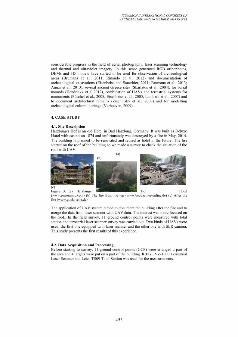
ICONARCH II INTERNATIONAL CONGRESS OF
ARCHITECTURE 20-22 NOVEMBER 2014 KONYA
453
considerable progress in the field of aerial photography, laser scanning technology
and thermal and ultraviolet imagery. In this sense generated RGB orthophotos,
DEMs and 3D models have started to be used for observation of archaeological
areas (Brumana et al., 2011; Rinaudo et al., 2012) and documentation of
archaeological excavations (Eisenbeiss and Sauerbier, 2011; Brumana et al., 2013;
Anuar et al., 2013), several ancient Greece sites (Skarlatos et al., 2004), for burial
mounds (Hendrickx et al.2012), combination of UAVs and terrestrial systems for
monuments (Püschel et al., 2008; Eisenbeiss et al., 2005; Lambers et al., 2007) and
to document architectural remains (Zischinsky et al., 2000) and for modelling
archaeological cultural heritage (Verhoeven, 2009).
4. CASE STUDY
4.1. Site Description
Harzburger Hof is an old Hotel in Bad Harzburg, Germany. It was built as Deluxe
Hotel with casino on 1874 and unfortunately was destroyed by a fire in May, 2014.
The building is planned to be renovated and reused as hotel in the future. The fire
started on the roof of the building so we made a survey to check the situation of the
roof with UAV. (a)
(b)
(c) Figure 3: (a): Harzburger Hof Hotel
(www.panoramio.com) (b) The fire from the top (www.beobachter-online.de) (c) After the
fire (www.goslarsche.de)
The application of UAV system aimed to document the building after the fire and to
merge the data from laser scanner with UAV data. The interest was more focused on
the roof.. In the field survey, 11 ground control points were measured with total
station and terrestrial laser scanner survey was carried out. Two kinds of UAVs were
used: the first one equipped with laser scanner and the other one with SLR camera.
This study presents the first results of this experience.
4.2. Data Acquisition and Processing
Before starting to survey, 11 ground control points (GCP) were arranged a part of
the area and 4 targets were put on a part of the building. RIEGL VZ-1000 Terrestrial
Laser Scanner and Leica TS09 Total Station was used for the measurements.
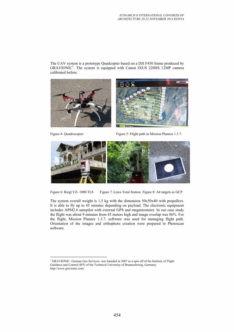
ICONARCH II INTERNATIONAL CONGRESS OF
ARCHITECTURE 20-22 NOVEMBER 2014 KONYA
454
The UAV system is a prototype Quadcopter based on a DJI F450 frame produced by
GRAVIONIC1. The system is equipped with Canon IXUS 220HS 12MP camera
calibrated before.
Figure 4: Quadrocopter Figure 5: Flight path in Mission Planner 1.3.7.
Figure 6: Riegl VZ- 1000 TLS Figure 7: Leica Total Station Figure 8: A4 targets as GCP
The system overall weight is 1,5 kg with the dimension 50x50x40 with propellers.
It is able to fly up to 45 minutes depending on payload. The electronic equipment
includes APM2.6 autopilot with external GPS and magnetometer. In our case study
the flight was about 9 minutes from 45 meters high and image overlap was 86%. For
the flight, Mission Planner 1.3.7. software was used for managing flight path.
Orientation of the images and orthophoto creation were prepared in Photoscan
software.
1 GRAVIONIC- German Geo Services- was founded in 2007 as a spin off of the Institute of Flight
Guidance and Control (IFF) of the Technical University of Braunschweig, Germany.
http://www.gravionic.com/
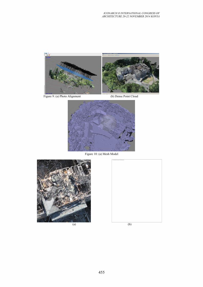
ICONARCH II INTERNATIONAL CONGRESS OF
ARCHITECTURE 20-22 NOVEMBER 2014 KONYA
455
Figure 9: (a) Photo Alignment (b) Dense Point Cloud
Figure 10: (a) Mesh Model
(a) (b)
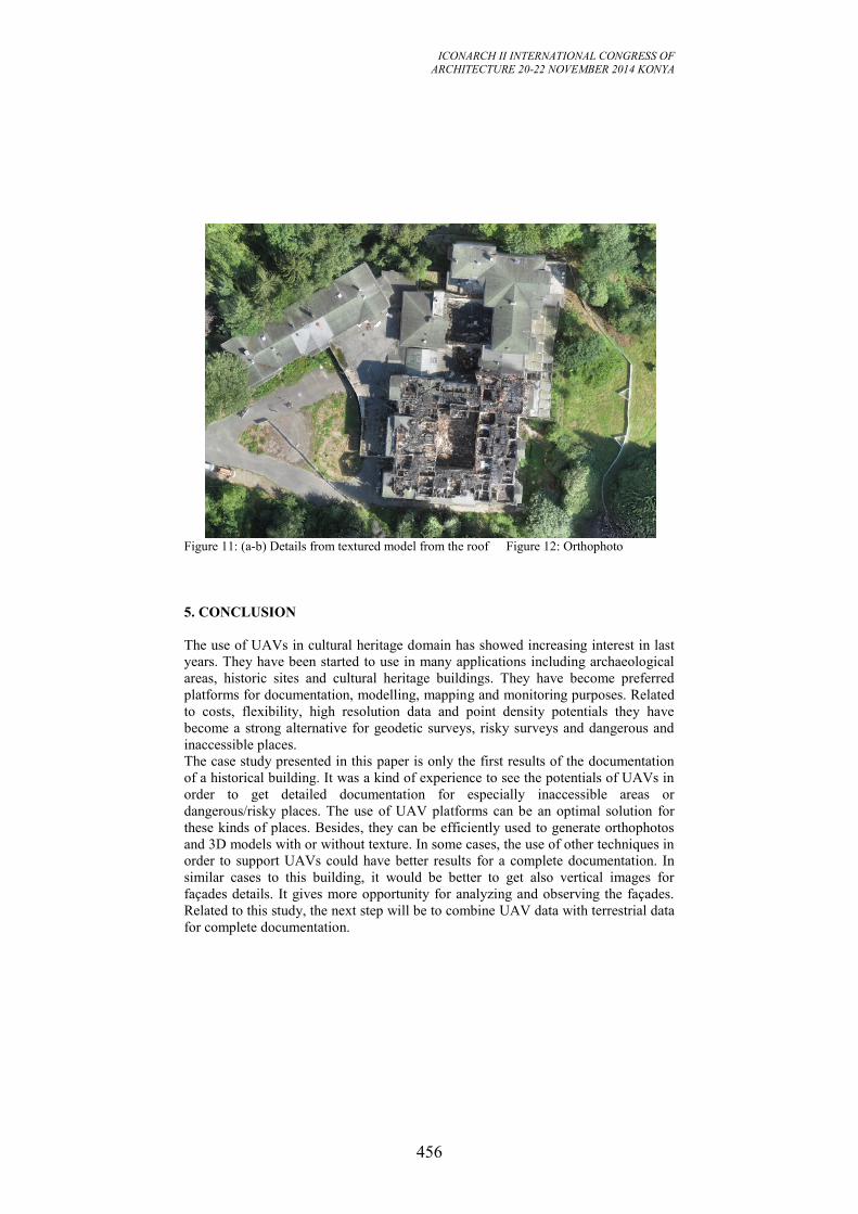
ICONARCH II INTERNATIONAL CONGRESS OF
ARCHITECTURE 20-22 NOVEMBER 2014 KONYA
456
Figure 11: (a-b) Details from textured model from the roof Figure 12: Orthophoto
5. CONCLUSION
The use of UAVs in cultural heritage domain has showed increasing interest in last
years. They have been started to use in many applications including archaeological
areas, historic sites and cultural heritage buildings. They have become preferred
platforms for documentation, modelling, mapping and monitoring purposes. Related
to costs, flexibility, high resolution data and point density potentials they have
become a strong alternative for geodetic surveys, risky surveys and dangerous and
inaccessible places.
The case study presented in this paper is only the first results of the documentation
of a historical building. It was a kind of experience to see the potentials of UAVs in
order to get detailed documentation for especially inaccessible areas or
dangerous/risky places. The use of UAV platforms can be an optimal solution for
these kinds of places. Besides, they can be efficiently used to generate orthophotos
and 3D models with or without texture. In some cases, the use of other techniques in
order to support UAVs could have better results for a complete documentation. In
similar cases to this building, it would be better to get also vertical images for
façades details. It gives more opportunity for analyzing and observing the façades.
Related to this study, the next step will be to combine UAV data with terrestrial data
for complete documentation.
ICONARCH II INTERNATIONAL CONGRESS OF
ARCHITECTURE 20-22 NOVEMBER 2014 KONYA
457
Acknowledgement
The author wish to acknowledge for the cooperation and support to Dipl.-Ing. Ralf
Heyen (Geodesist and Assessor of the German Public Survey Administration
Board)-CEO&Owner of GRAVIONIC; and from his team Markus Bobbe, Thomas
Krüger and Christian Tonhauser for their help and to Martin Lehman from
Braunschweig Technical University Geodesy and Photogrametry Institute.
REFERENCES
-Austin, R., 2010. “Unmanned Aircraft Systems-UAVs Design, Development and
Deployment”. John Wiley & Sons Ltd., United Kingdom. ISBN 9780470058190
(H/B).
-Eisenbeiß, H., 2009. “UAV Photogrammetry”. Institut für Geodäsie und
Photogrammetrie Eidgenössische Technische Hochschule Zürich. ISSN 0252-9335.
ISBN 978-3-906467-86-3.
- Eisenbeiss, H., 2004. “A Mini Unmanned Aerial Vehicle (Uav): System Overview
And Image Acquisition”. International Workshop on "Processing And Visualization
Using High-Resolution Imagery". 18-20 November 2004, Pitsanulok, Thailand.
-Finn, R. L., Wright, D., 2012. “Unmanned aircraft systems: Surveillance, ethics and
privacy in civil applications”. Elseiver, Computer Law&Security Review 28 (2012),
184 – 194.
-Remondino, F., Barazzetti, L., Nex, F., Scaioni, M., Sarazzi, D. 2011. “ UAV
Photogrammetry for Mapping and 3D Modeling-Current Status and Future
Perspectives-“. International Archives of the Photogrammetry, Remote Sensing and
Spatial Information Sciences, Vol. XXXVIII-1/C22 UAV-g 2011, Conference on
Unmanned Aerial Vehicle in Geomatics, Zurich, Switzerland.
-Haarbrink, R. B., Eisenbeiss, H. , 2008. “Accurate DSM Production From
Unmanned Helicopter Systems”. The International Archives of the Photogrammetry,
Remote Sensing and Spatial Information Sciences. Vol. XXXVII. Part B1., pp:1259-
1264, Beijing 2008.
-Everaerts, J., 2008. “The Use of Unmanned Aerial Vehicles (UAVs) for Remote
Sensing and Mapping”. International Archives of the Photogrammetry, Remote
Sensing and Spatial Information Sciences. Vol. XXXVII. Part B1. Beijing 2008.
-Brumana, R., Oreni, D., Van Hecke, L., Barazzetti, L., Previtali, M., Roncoroni, F.,
Valente, R., 2013. “Combined Geometric and Thermal Analysis From UAV
Platforms for Archaeological Heritage Documentation”. ISPRS Annals of the
Photogrammetry, Remote Sensing and Spatial Information Sciences, Volume II-
5/W1, 2013, XXIV International Cipa Symposium, 2 – 6 September 2013,
Strasbourg, France.
-Irschara A., Kaufmann, V., Klopschitz, M., Bischof, H., Leberl F., 2010. ISPRS
TC VII Symposium 100 Years ISPRS, Vienna, Austria, July 5–7, 2010, IAPRS,
Vol. XXXVIII, Part 7A.
-Höhle, J., 2013. “Oblique Aerial Images and Their Use in Cultural Heritage
Documentation”. International Archives of the Photogrammetry, Remote Sensing
and Spatial Information Sciences, Volume XL-5/W2, 2013 XXIV International
CIPA Symposium, 2 – 6 September 2013, Strasbourg, France.
ICONARCH II INTERNATIONAL CONGRESS OF
ARCHITECTURE 20-22 NOVEMBER 2014 KONYA
458
-Russo,M., Guidi, G., 2011. “Reality-Based and Reconstructive Models: Digital
Media for Cultural Heritage Valorization”. SCIRES-IT SCIentific RESearch and
Information Technology Ricerca Scientifica e Tecnologie dell'Informazione Vol 1,
Issue 2 (2011), 71-86, e-ISSN 2239-4303.
-Hendrickx, M., Wouter Gheyle, W., Bonne, J., Bourgeois, J., Wulf, A., Goossens,
R., 2011. “The use of stereoscopic images taken from a microdrone for the
documentation of heritage e An example from the Tuekta burial mounds in the
Russian Altay”. Journal of Archaeological Science 38 (2011) 2968-2978.
-P. Patias,P., Kaimaris, D., Georgiadis, Ch., Stamnas, A., Antoniadis, D.,
Papadimitrakis, D., 2013. “3D Mapping of Cultural Heritage: Special Problems and
Best Practices in Extreme Case-Studies”. ISPRS Annals of the Photogrammetry,
Remote Sensing and Spatial Information Sciences, Volume II-5/W1, 2013 XXIV
International Cıpa Symposium, 2 – 6 September 2013, Strasbourg, France.
-Rinaudo, F., Chiabrando, F., Lingua, A., Spanò, A., 2012. “Archaeological Site
Monitoring: UAV Photogrammetry Can Be an Answer”. International Archives of
the Photogrammetry, Remote Sensing and Spatial Information Sciences, Volume
XXXIX-B5, 2012. XXII ISPRS Congress, 25 August – 01 September 2012,
Melbourne, Australia.
-Lo Brutto, M., Borruso, A., D’Argenio, A., 2012. “UAV Systems for
Photogrammetric Data Acquisition of Archaeological Sites”. Progress in Cultural
Heritage Preservation – EUROMED 2012
-Anuar A., Khairul N.T., Wani S. U., Khairil A. H., NorHadija D., Mohd H., Mohd
R., Nurul Farhah A.H., Noor Aniqah M.A., & Shahrul M. A., 2013. “Digital Aerial
Imagery of Unmanned Aerial Vehicle for Various Applications”. 2013 IEEE
International Conference on Control System, Computing and Engineering, 29 Nov. -
1 Dec. 2013, Penang, Malaysia.
-Patias, P., Grussenmeyer, P., Hanke, K., 2008. Applications in Cultural Heritage
Documentation. Chapter (22 pages) in ISPRS 2008 Congress Book. Ed. CRC Press,
Taylor and Francis Group.
-Grussenmeyer, P., Hanke, K ., Streilein, A. 2002. Architectural photogrammetry.
Chapter in « Digital Photogrammetry ». Edited by M. KASSER and Y. EGELS,
Taylor & Francis, ISBN: 0-7484-0945-9, pp. 300-339.
-English Heritage. 2007. “3D Laser Scanning for Heritage: advice and guidance to
users on laser scanning in archaeology and architecture. Product code 51326.
Available at www.heritage3D.org (accessed March 2008).
-Grussenmeyer, P., Landes, T., Voegtle, T., Ringle, K., 2008. “Comparison Methods
of Terrestrial Laser Scanning, Photogrammetry and Tacheometry Data for
Recording of Cultural Heritage Buildings”, The International Archives of the
Photogrammetry, Remote Sensing and Spatial Information Sciences. Vol. XXXVII.
Part B5. Beijing 2008.
-Patias, P., 2006. “Cultural Heritage Documentation”. International Summer School
“Digital Recording and 3D Modeling”, Aghios Nikolaos, Crete, Greece, 24-29 April
2006
-Remondino, F., El-Hakim, S. Image-Based 3D Modeling: A review. The
Photogrammetric Record, 2006, vol. 21, n. 115, pp. 269-291. ISSN: 1477-9730.
ICONARCH II INTERNATIONAL CONGRESS OF
ARCHITECTURE 20-22 NOVEMBER 2014 KONYA
459
-Lo Brutto, M., Borruso, A., D’Argenio. A. “UAV Systems For Photogrammetric
Data Acquisition of Archaeological Sites”. International Conference on Cultural
Heritage, Oct. 29th-Nov.3rd.Lemesos, Cyprus,EUROMED 2012.
-Mozas-Calvache, A.T., Pérez-García, J.L., Cardenal-Escarcena, F.J., Mata-Castro,
E., Delgado-García, J., 2012. “Method for Photogrammetric Surveying of
Archaeological Sites with Light Aerial Platforms”. Journal of Archaeological
Science 39 (2012) 521-530.
-Brumana, R., Oreni, D., Alba, M., Barazzetti, L., Cuca, B., Scaioni, M., 2011.
Panoramic UAV views for landscape heritage analysis integrated with historical
map atlases. 23th Int. CIPA Symposium, 12-16 September, Prague,2011.
-Rinaudo, F., Chiabrando, F., Lingua, A., Spanò, A., 2012. Archaeological site
monitoring: UAV photogrammetry can be an answer. IAPRSS&IS, Melbourne,
Australia, Vol. XXXIX, Part B5, pp. 583-588.
-Sauerbier, M., Eisenbeiss, H., 2010. UAV for the documentation of archaeological
excavations. IAPRSS&IS, Newcastle upon Tyne, UK, Vol. XXXVIII, Part 5, pp.
526-531.
-Skarlatos, D., Theodoridou, S., Glabenas, D., 2004. Archaeological surveys in
Greece using radio controlled helicopter. In: Proceedings of FIGWorkingWeek,
Athens (Greece), pp. 1-15.
-Püschel, H., Sauerbier, M., Eisenbeiss, H., 2008. A 3d model of castle Landenberg
(CH) from combined photogrammetric processing of terrestrial and UAV-based
Images. International Archives of Photogrammetry, Remote Sensing and Spatial
Information Sciences 37, 93-98.
-Eisenbeiss,H.,2004.AminiUnmannedAerialVehicle (UAV): System overview and
image acquisition, International Workshop on Processing and Visualization using
High Resolution Imagery, Pitsanulok, Thailand. International Archives of
Photogrammetry, Remote Sensing and Spatial Information Sciences, Vol. XXXVI-
5/W1, 1-7.
-Eisenbeiss, H., Lambers, K., Sauerbier, M., Zhang, L., 2005. Photogrammetric
documentation of an archeological site (Palpa, Peru) using an autonomous model
helicopter. International Archives of Photogrammetry, Remote Sensing and Spatial
Information Sciences 34 (5), 238-243. http://www.geod.ethz.ch/p02/
research/pinchango/238.pdf.
-Lambers, K., Eisenbeiss, H., Sauerbier, M., Kupferschmidt, D., Gaisecker, T.,
Sotoodeh, S., Hanusch, T., 2007. Combining photogrammetry and laser scanning for
the recording and modelling of the late intermediate period site of Pinchango Alto,
Palpa, Peru. Journal of Archaeological Science 34 (10),1702-1712.
-Zischinsky, T., Dorffner, L., Rottensteiner, F., 2000. Application of a new model
helicopter system in architectural photogrammetry. International Archives of
Photogrammetry and Remote Sensing 33 (B5), 7.
-Verhoeven, G.J., Loenders, J., Vermeulen, F., Docter, R., 2009. Helikite aerial
photography or HAP - a versatile means of unmanned, radio controlled low altitude
aerial archaeology. Archaeological Prospection 16, 125-138.
ICONARCH II INTERNATIONAL CONGRESS OF
ARCHITECTURE 20-22 NOVEMBER 2014 KONYA
460
RESTORATION LABORATORY CLASS AND THE ROLE OF
GEOMATICS IN CULTURAL HERITAGE EDUCATION
ARMAGAN GULEC KORUMAZ1, MUSTAFA KORUMAZ2, VALENTINA BONORA1,
GRAZIA TUCCI1
ABSTRACT
Conservation-restoration education has been discussed in context of teaching
methods, curriculums, quality of courses and interdisciplinary relations since
Bologna Declaration has started. Conservation-restoration classes are generally
devoted to give general knowledge about theoretical background of restoration and
to make some practices related to theoretical part with preparation of restoration
project. In recent years, innovative technologies have given different opportunities
to conservation-restoration practice and its education as well. University of Florence
Restoration Laboratory class gives both theoretical and practical courses with
innovative approach and interdisciplinary study. In this course GECO3 Laboratory
provides methodologies and tools with new techniques in documentation/surveying
and analysis of cultural heritage. This support would be very effective for students’
future studies and practices in their professional life. The aim of this paper is to
represent an approach to conservation-restoration education adopted by University
of Florence, to explain possible integration between different disciplines and to
emphasize the significance of geomatics laboratories in conservation-restoration
education.
Keywords: Conservation-Restoration Education, Geomatics for Architecture,
University of Florence, Educational Activities
1. INTRODUCTION
Conservation-restoration education is a part of contemporary architecture education
and a practice of architecture directly affected by social, technological and cultural
transformation of today. Valuable monuments, sites and landscapes are increasingly
being threatened by large scale or uncontrolled developments of the built
environment (Verpoest et al., 2008). Recent environmental and cultural
degenerations prove that conservation-restoration practice has become more
important than in the past. Conservation-restoration education as a combination of
diversity theoretical knowledge and practical skills is expected to find appropriate
balance between the theoretical knowledge and practical training in basis of this
education (Crăciunescu, 2008). Moreover, since this education has strong relation
with some cultural, historical, aesthetic and technical issues (Hutchings, 2009;
Loughlin, 2008), conservation-restoration education can be organized with
interdisciplinary curriculum which includes theoretical background of conservation-
1Geomatics for Conservation & Communication of Cultural Heritage Laboratory (GECO), University of
Florence, 50121Florence,Italy 2 Selçuk University, Faculty of Architecture, Department of Architecture, 42031 Konya, Turkey
ICONARCH II INTERNATIONAL CONGRESS OF
ARCHITECTURE 20-22 NOVEMBER 2014 KONYA
461
restoration practice, solutions for some problems of cultural heritage, knowledge of
materials properties and their behaviors in different conditions, techniques related to
preventing deformations, different restoration techniques, new design methodologies
in historic building/environment as well as documentation of cultural heritage.
Context of cultural heritage education has been discussed over the last two decades
and several methods have been used for conservation-restoration education. During
Bologna process, the conservation-restoration education programs in most European
countries have undergone great changes including adoption of University of
Florence structure. The original recommendation of Bologna Declaration was a call
for an introduction of a common two-tier education; three years undergraduate and
two years graduate studies. This recommendation was based on shared academic
values and principles and the goal of it was to foster mobility of student, teacher and
researcher for enriching education (Winter and Ogleby, 2008). Addition to Bologna
recommendations, European Minister of Education has a declaration aimed at
creation of a single European Higher education commonly referred to Bologna
declaration. E.C.C.O. (European Confederation of Conservator-Restorer’
Organization) involves guides and recommendations on conservation-restoration
education and professional competences of cultural heritage area. This guideline
addresses its own requirements for professional work including education
qualification. Some of European universities have already deep experiences on
conservation-restoration education and have been changing their education systems
based on Bologna declaration and European Union suggestions.
Recent researches have shown that studies related to conservation-restoration
education commonly concentrate on development of education and professional
work quality. Observation of learning outcomes can change academic emphasis of
education from what educators wish to teach to what graduates need to know. These
learner-centered approaches can be reorganized in courses that require a well-
defined curriculum in order to provide access to professional working platform
(Hutchings, 2009). This is directly related to how an educator should convey
concept and forms during teaching. It’s one of the aim to teach students how
regularly attendance to a class can help to tackle with many problems in professional
life both culturally and technically. Restoration project class is a main course
generally most of the universities give knowledge to students both in main
theoretical field and how to come across with different problems. An integrated and
multi discipliner curriculum is followed in Restoration Laboratory class for 3-year
bachelor degree students in University of Florence. Main important part of this
curriculum is devoted to documentation of historical buildings with modern
techniques.
Data collection and recording is very important and the main part of cultural
heritage studies related to ICT (Information and Communication Technology).
Especially 3D data acquisition has been important for analyzing data, recognizing of
problem, education activity and dissemination knowledge in recent decades
(EPOCH, 2008). In this context, with awareness of future technological
development and innovations, most of educators believe that new techniques and
innovative approaches should take place in conservation-restoration education. This
approach is not just a documentation process of architectural heritage; it is also
ICONARCH II INTERNATIONAL CONGRESS OF
ARCHITECTURE 20-22 NOVEMBER 2014 KONYA
462
related to full understanding of cultural heritage and ICT relation. In this context,
Geomatics laboratory provides teaching to students who will be professional profiles
after graduation of university. This paper aiResearch Agendams to present that
Geomatics education as a part of architectural education should be a way in order to
prepare students better for their professional life shaped by fast developing
technology.
2. CONSERVATION-RESTORATION EDUCATION IN UNIVERSITY OF
FLORENCE
Italy is a rich country to find different kinds of programs related to cultural heritage
for researchers and students. Conservation-restoration education in University of
Florence teaching approach has deep relations with establishment of Conservation
Institute (1960) and the founder of the institute Piero Sanpaolesi (1904-1980).
Sanpaolesi played a major role in growth of the international conservation method in
1960’s and 1970’s in Italy. Sanpaolesi, primarily suggested to rediscover of historic
architecture built in previous centuries by different nations. After awareness of
historical architecture, he promoted crucial discussions in international level on
restoration criteria and methods. In these discussions, people tried to find a
compromise on what would be considered as acceptable restoration work.
According to Sanpaolesi, restoration education needs to integrate theoretical
learning and some experiences gained on the field works. Sanpaolesi also
emphasized that restorer architects had a main coordinator role in various types of
projects and constructions in order to control their preservation measures and their
compatibility with historic context. Moreover, he mentioned that restorer architects
are guarantor of restoration works quality and operations of preservation institutions
in different places and at different levels (Devita, 2008). In this historic background,
it should be emphasized that conservation-restoration education in University of
Florence has continued without any interruption since conservation institution was
established. Main objectives of teaching activity in University of Florence can be
summarized as:
- to improve learning, research for active protect of cultural, historical and
natural heritage.
- to understand cultural heritage with in its physical consistency and construction
process.
- to get potential in order to exchange knowledge and experiences with different
disciplines related to cultural heritage.
- to have ability to solve problems related to cultural heritage by modern
techniques, concepts, restoration and preservation methods.
- to improve capability for using modern acquisition and dissemination
techniques in cultural heritage field.
- to increase knowledge regarding to cultural heritage and its behavior in
different conditions in order to improve the restoration.
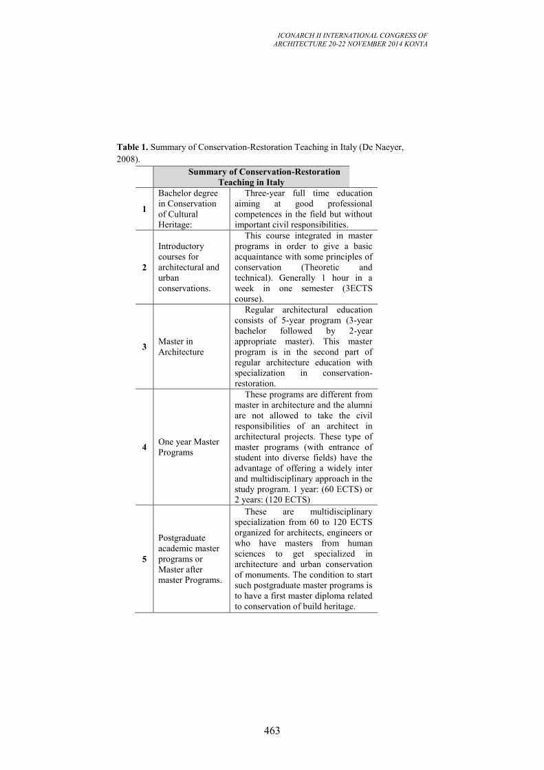
ICONARCH II INTERNATIONAL CONGRESS OF
ARCHITECTURE 20-22 NOVEMBER 2014 KONYA
463
Table 1. Summary of Conservation-Restoration Teaching in Italy (De Naeyer,
2008).
Summary of Conservation-Restoration
Teaching in Italy
1
Bachelor degree
in Conservation
of Cultural
Heritage:
Three-year full time education
aiming at good professional
competences in the field but without
important civil responsibilities.
2
Introductory
courses for
architectural and
urban
conservations.
This course integrated in master
programs in order to give a basic
acquaintance with some principles of
conservation (Theoretic and
technical). Generally 1 hour in a
week in one semester (3ECTS
course).
3 Master in
Architecture
Regular architectural education
consists of 5-year program (3-year
bachelor followed by 2-year
appropriate master). This master
program is in the second part of
regular architecture education with
specialization in conservation-
restoration.
4 One year Master
Programs
These programs are different from
master in architecture and the alumni
are not allowed to take the civil
responsibilities of an architect in
architectural projects. These type of
master programs (with entrance of
student into diverse fields) have the
advantage of offering a widely inter
and multidisciplinary approach in the
study program. 1 year: (60 ECTS) or
2 years: (120 ECTS)
5
Postgraduate
academic master
programs or
Master after
master Programs.
These are multidisciplinary
specialization from 60 to 120 ECTS
organized for architects, engineers or
who have masters from human
sciences to get specialized in
architecture and urban conservation
of monuments. The condition to start
such postgraduate master programs is
to have a first master diploma related
to conservation of build heritage.
ICONARCH II INTERNATIONAL CONGRESS OF
ARCHITECTURE 20-22 NOVEMBER 2014 KONYA
464
6 Phd programs.
Such studies can start after an
academic master degree and always
consist of authentic and original
scientific researches.
3. ICT AND GEOMATICS LABORATORY FOR CONSERVATION-
RESTORATION EDUCATION
Progress in Information &Communication Technology (ICT) has quickly changed
our standard of life, the way of working, teaching, studying and the way of carrying
out research. Cultural heritage studies cannot neglect these technologies as they are
a way to reach a new and greater population of users and to get and share more
information (Petrone, 2012). Also in education field, the role of ICT in teaching and
learning brings changes to digitalization of cultural heritage artifact, to view them as
3D in digital platforms and to share data with different stakeholders (Ott and Pozzi,
2011). This sharing is significant for effective interpretation and presentation of
cultural heritage for enhance personal experience, increase public respect and
understanding and communicating (ICOMOS, 2007). Geomatics Laboratory
(GECO) organizes a sort of atelier aiming to emphasize the role of innovative
techniques in documentation and conservation of cultural heritage.
Main objective of teaching activity in this geomatics laboratory are:
- to give general information related to new techniques for cultural heritage
and environmental documentation (small object documentation, photogrammetric
techniques for building and large areas and laser scanning techniques).
- to use modern survey techniques to understand of whole morphology of
buildings and site to make decisions (with topographic survey, laser scanning and
photo-base modelling).
- to produce 3D models and ortho-images to analyze shape of objects,
anomalies, material differences and structural problems and to transfer these data to
related disciplines .
- to get some experiences with interdisciplinary study in restoration project
class (with geomatic engineers, construction and environmental engineers, historians
and restorers).
- to understand how important dissemination and sharing of data for
education and scientific proposes.
- to get practice to present all data with different graphic expressions (3D
modelling programs and graphic design programs).
These objectives also contain some on-site analysis, diagnoses as well as
preparing some reports for actual situation of building and sites for conservation and
restoration process.
ICONARCH II INTERNATIONAL CONGRESS OF
ARCHITECTURE 20-22 NOVEMBER 2014 KONYA
465
4. SOME EXPERIENCES FROM CONSERVATION-RESTORATION
LABORATORY CLASS
Traditionally, conservation-restoration education is based on both theoretical and
practical approach in department of architecture. Teaching conservation-restoration
education aims at giving basis of conservation and restoration history, analyzing of
historic architecture, giving methodology for survey techniques, understanding of
spatial units and geometry of building, figuring out structural and material features
of building and site besides drawing a restoration project analyzing with all acquired
data. Conservation-restoration laboratory class in University of Florence consist of
three different courses and three different steps: Theoretical background, Field work,
Restoration project.
Table 2. Restoration Laboratory Course Sections.
Restoration laboratory course sections and their descriptions
Section Description
1 Geomatics for Conservation/Restoration Modern survey techniques
2 Restoration Theoretical background &
project
3 Static and Stability for Conservation Material and Structural
Behaviors.
-Theoretical Background
Each year, as educator, which theoretical and technical principles are leading
conservation-restoration classes and educational goals which should be persuaded
are discussed. The beginning of course is generally dedicated to intervention on
historical architecture. History and theory of conservation, legislations related to
conservation-restoration practice are given more in theoretical part of the course.
Subsequent work of conservation-restoration works are exemplified and critical
commentary of conservation-restoration works and some good or misrepresenting
works are evaluated and interpreted in the class. Current theoretical debates and
most recent themes and solutions dealt with in Italy and the rest of Europa are
debated in theoretic part of this course. New approaches for conservation-restoration
works and reusing of historical buildings, restoration techniques, new scientific
academic researchers are presented to students for helping their restoration projects.
Conservation-restoration should be taught as heritage care application in which
different kind of disciplines can take part of this didactic activity (Torsello, 2008). In
this part, some interdisciplinary presentations are carried on in our curriculum.
Depending on the case study, some history and art-history, environmental relations,
landscape and urban planning presentation take place in theoretical part. Historical
and most common current materials for restoration applications, technical and
structural characteristic of buildings, urban conservation and related regulative
references are studied in conservation-restoration class with structural and material
engineers, urban planners and historians. About thirty years ago, architectural
heritage was primarily understood as a single building or building groups that were

ICONARCH II INTERNATIONAL CONGRESS OF
ARCHITECTURE 20-22 NOVEMBER 2014 KONYA
466
valuable for conservation in the Charter of Venice (1964). Today a more in depth
approaches are advocated which identify various dimensions and aspects of
architectural heritage. Recent studies represent that cultural heritage issue is very
complicated and it clearly needs interdisciplinary studies.
In theoretical part, connection with practical part, educators are tried to answer
general questions regarding consolidation, maintenance, modification, integration,
new additions and technical operation in context of destiny of built heritage, of an
environment, of way life, of a landscape through a clear design process (Franco,
2008). In this class, description of architectural buildings peculiarities, surface
analyses, analysis of deformations, crack analysis, sign of material decays and long-
time behaviors of material and building components are studied. Students can apply
this theoretically developed knowledge in their individual conservation-restoration
projects as thematic maps to recognize and represent structural problems, material
differences, anomalies, cracks and risky parts. The material evidences of the
monuments in theoretical part are especially focused on conservation and restoration
projects.
-Field Work and Metric Survey
The training courses are process of connection between theoretical considerations
and operational answers that are direct examinations (manual or instrumental
surveys, geometrical technological and material studies, structures and walls) and
studying on bibliography and sources (Fiorani, 2008). The practice runs parallel to
theoretical lessons with building survey and analytical studies. Students develop a
field study for diagnosis and analysis of current situation of building and study on
historical changes, different additions and authentic situation of building. Acquired
data is collected in an analysis report for using design phase or restoration project.
Different possible restoration techniques are compared and discussed using on-site
study report. On-site study consists of these steps:
- Survey of historical building
- Diagnosis of problems and historical studies.
- Synthesis of acquired data as a report for using restoration project.
- Elaboration of restoration project using with this data.
Traditional metric survey and modern documentation techniques are taught in
restoration laboratory. In contrast to photogrammetry and laser scanning technology,
direct survey and topographic survey are taught as traditional survey techniques.
Choosing single subjects for small study groups study independently on a survey
project for leaving them free to follow theoretical part supported by laboratory
educators. Direct measurement techniques are basis of survey projects and still used
in most of restoration projects and are given in different courses in department of
architecture. In conservation-restoration class, students use direct measurements
supported by topographic measurements. Basis of topographic survey techniques
and equipment, how restorer can manage topographic survey and elaborate
topographic data in office or CAD programs are in this process.
ICONARCH II INTERNATIONAL CONGRESS OF
ARCHITECTURE 20-22 NOVEMBER 2014 KONYA
467
Terrestrial laser scanners and photogrammetry are increasingly being used for 3D
cultural heritage documentation works. It is not possible to know or understand
some problems of building without complex survey including whole building. These
new technologies provide detailed knowledge related to whole building. One
objective of these courses is to get student familiar with these kinds of technologies
for their future professional life and education. Photogrammetry is generally used
for obtaining ortho-images for drawing of building façades easily. Façades of case
study are studied in photogrammetric software, and then elevations of building are
drawn with ortho-images. This technique is very effective for thematic drawings and
analyses of building facades. Similarly, some part of case study is scanned with
students to explain laser scanning technologies and its working principles. After
scanning of building, in laboratory, management of laser scanning data is explained
and some section, elevations and plans are prepared for students to draw and to use
in their survey project. Thanks to facilitation of the laboratory, it was easier to teach
students how to use nondestructive techniques for acquiring data of historical
building and diagnosis of their conservation conditions as a fundamental support of
conservation-restoration education.
-Restoration project
Restoration project is main part of conservation-restoration education. Student can
find an opportunity to solve same problems and to combine theoretical and practical
requirements as a one goal of the restoration laboratory. This part of the project
concern how can be kept a historical building alive with some conservative,
maintenance, re-using interventions. Student can try possible different restoration
alternatives in this process discussing with educators.
Another goal of architectural restoration project is to examine re-using alternatives
with comparing physical character of building by preserving with authentic space
character or reusing building with new additions. This is more related to design
activity in historic district or building with modern restoration approaches. The
design activity related to historical building and site contains trans-disciplinary
approaches in order to cope with some problems of design area especially regarding
old and new relations in historical area. In addition, design activities combined with
restoration projects have interdisciplinary dimensions related to cultural studies,
sustainable activities in building and its environment. In the restoration project,
educators aim to be sure that attendance of the class make correct assessment of the
links between cause and effect in analyzing process and it is expected to use this
data in restoration project to find solutions for cultural, technical and operational
domain.
5. CONCLUSION
University of Florence has deep conservation-restoration background starting from
the contribution of Piero Sanpaolesi. Recent years conservation-restoration
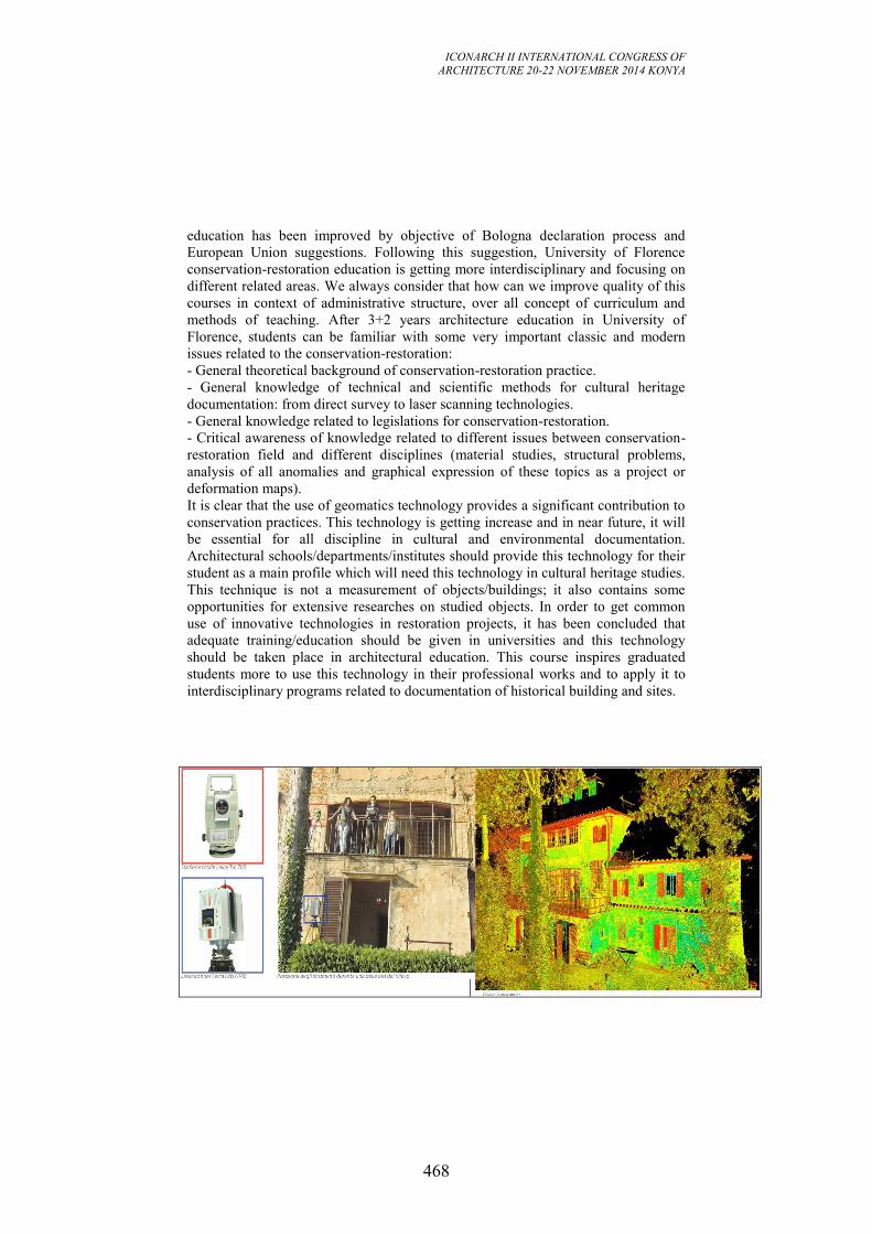
ICONARCH II INTERNATIONAL CONGRESS OF
ARCHITECTURE 20-22 NOVEMBER 2014 KONYA
468
education has been improved by objective of Bologna declaration process and
European Union suggestions. Following this suggestion, University of Florence
conservation-restoration education is getting more interdisciplinary and focusing on
different related areas. We always consider that how can we improve quality of this
courses in context of administrative structure, over all concept of curriculum and
methods of teaching. After 3+2 years architecture education in University of
Florence, students can be familiar with some very important classic and modern
issues related to the conservation-restoration:
- General theoretical background of conservation-restoration practice.
- General knowledge of technical and scientific methods for cultural heritage
documentation: from direct survey to laser scanning technologies.
- General knowledge related to legislations for conservation-restoration.
- Critical awareness of knowledge related to different issues between conservation-
restoration field and different disciplines (material studies, structural problems,
analysis of all anomalies and graphical expression of these topics as a project or
deformation maps).
It is clear that the use of geomatics technology provides a significant contribution to
conservation practices. This technology is getting increase and in near future, it will
be essential for all discipline in cultural and environmental documentation.
Architectural schools/departments/institutes should provide this technology for their
student as a main profile which will need this technology in cultural heritage studies.
This technique is not a measurement of objects/buildings; it also contains some
opportunities for extensive researches on studied objects. In order to get common
use of innovative technologies in restoration projects, it has been concluded that
adequate training/education should be given in universities and this technology
should be taken place in architectural education. This course inspires graduated
students more to use this technology in their professional works and to apply it to
interdisciplinary programs related to documentation of historical building and sites.
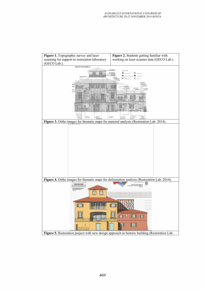
ICONARCH II INTERNATIONAL CONGRESS OF
ARCHITECTURE 20-22 NOVEMBER 2014 KONYA
469
Figure 1. Topographic survey and laser
scanning for support to restoration laboratory
(GECO Lab.).
Figure 2. Students getting familiar with
working on laser scanner data (GECO Lab.).
Figure 3. Ortho images for thematic maps for material analysis (Restoration Lab. 2014).
Figure 4. Ortho images for thematic maps for deformation analysis (Restoration Lab. 2014).
Figure 5. Restoration project with new design approach in historic building (Restoration Lab.
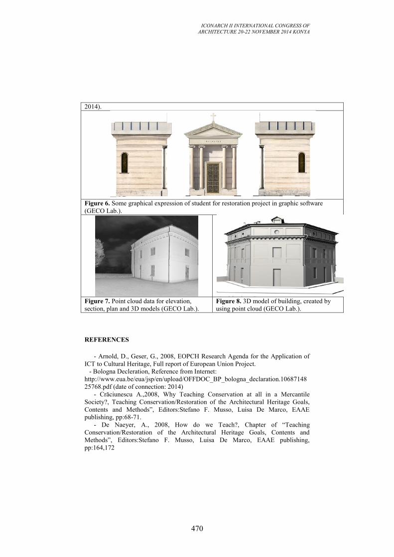
ICONARCH II INTERNATIONAL CONGRESS OF
ARCHITECTURE 20-22 NOVEMBER 2014 KONYA
470
2014).
Figure 6. Some graphical expression of student for restoration project in graphic software
(GECO Lab.).
Figure 7. Point cloud data for elevation,
section, plan and 3D models (GECO Lab.).
Figure 8. 3D model of building, created by
using point cloud (GECO Lab.).
REFERENCES
- Arnold, D., Geser, G., 2008, EOPCH Research Agenda for the Application of
ICT to Cultural Heritage, Full report of European Union Project.
- Bologna Decleration, Reference from Internet:
http://www.eua.be/eua/jsp/en/upload/OFFDOC_BP_bologna_declaration.10687148
25768.pdf (date of connection: 2014)
- Crăciunescu A.,2008, Why Teaching Conservation at all in a Mercantile
Society?, Teaching Conservation/Restoration of the Architectural Heritage Goals,
Contents and Methods”, Editors:Stefano F. Musso, Luisa De Marco, EAAE
publishing, pp:68-71.
- De Naeyer, A., 2008, How do we Teach?, Chapter of “Teaching
Conservation/Restoration of the Architectural Heritage Goals, Contents and
Methods”, Editors:Stefano F. Musso, Luisa De Marco, EAAE publishing,
pp:164,172
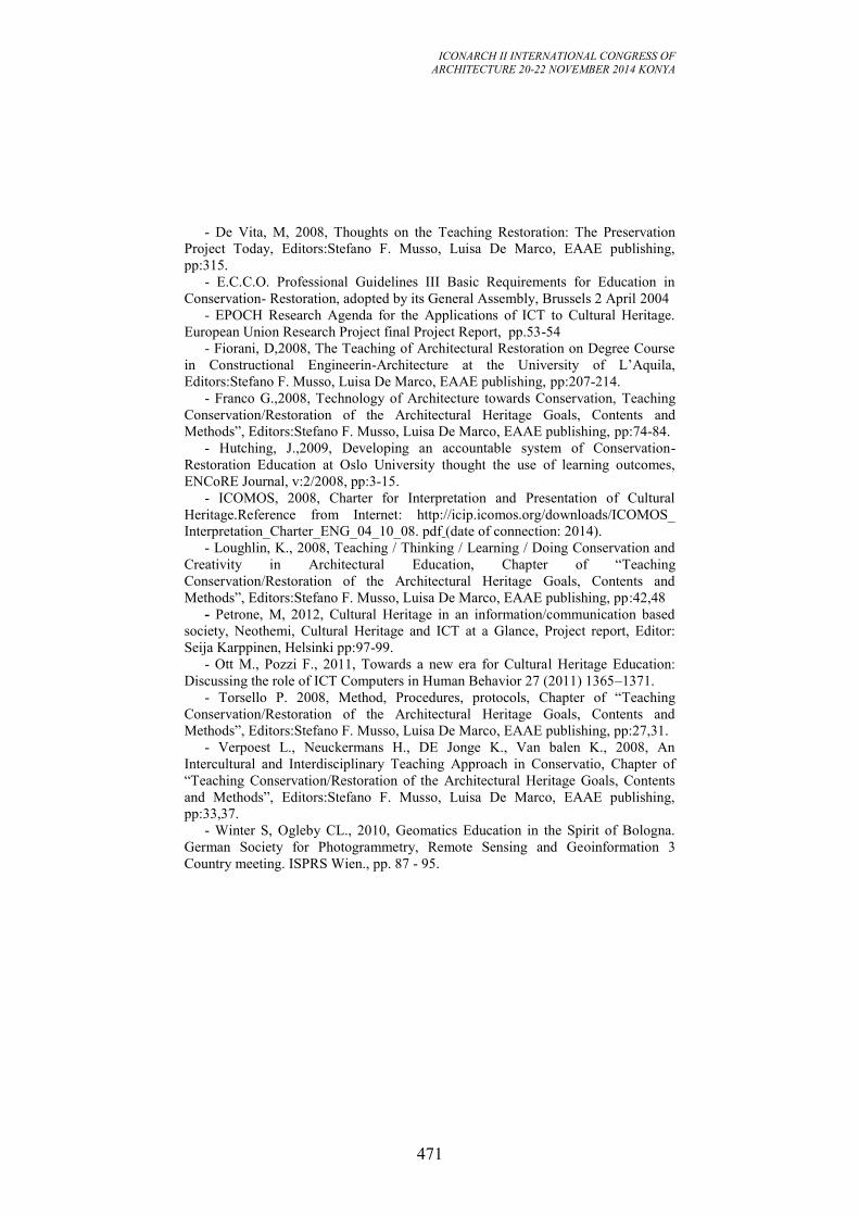
ICONARCH II INTERNATIONAL CONGRESS OF
ARCHITECTURE 20-22 NOVEMBER 2014 KONYA
471
- De Vita, M, 2008, Thoughts on the Teaching Restoration: The Preservation
Project Today, Editors:Stefano F. Musso, Luisa De Marco, EAAE publishing,
pp:315.
- E.C.C.O. Professional Guidelines III Basic Requirements for Education in
Conservation- Restoration, adopted by its General Assembly, Brussels 2 April 2004
- EPOCH Research Agenda for the Applications of ICT to Cultural Heritage.
European Union Research Project final Project Report, pp.53-54
- Fiorani, D,2008, The Teaching of Architectural Restoration on Degree Course
in Constructional Engineerin-Architecture at the University of L’Aquila,
Editors:Stefano F. Musso, Luisa De Marco, EAAE publishing, pp:207-214.
- Franco G.,2008, Technology of Architecture towards Conservation, Teaching
Conservation/Restoration of the Architectural Heritage Goals, Contents and
Methods”, Editors:Stefano F. Musso, Luisa De Marco, EAAE publishing, pp:74-84.
- Hutching, J.,2009, Developing an accountable system of Conservation-
Restoration Education at Oslo University thought the use of learning outcomes,
ENCoRE Journal, v:2/2008, pp:3-15.
- ICOMOS, 2008, Charter for Interpretation and Presentation of Cultural
Heritage.Reference from Internet: http://icip.icomos.org/downloads/ICOMOS_
Interpretation_Charter_ENG_04_10_08. pdf (date of connection: 2014).
- Loughlin, K., 2008, Teaching / Thinking / Learning / Doing Conservation and
Creativity in Architectural Education, Chapter of “Teaching
Conservation/Restoration of the Architectural Heritage Goals, Contents and
Methods”, Editors:Stefano F. Musso, Luisa De Marco, EAAE publishing, pp:42,48
- Petrone, M, 2012, Cultural Heritage in an information/communication based
society, Neothemi, Cultural Heritage and ICT at a Glance, Project report, Editor:
Seija Karppinen, Helsinki pp:97-99.
- Ott M., Pozzi F., 2011, Towards a new era for Cultural Heritage Education:
Discussing the role of ICT Computers in Human Behavior 27 (2011) 1365–1371.
- Torsello P. 2008, Method, Procedures, protocols, Chapter of “Teaching
Conservation/Restoration of the Architectural Heritage Goals, Contents and
Methods”, Editors:Stefano F. Musso, Luisa De Marco, EAAE publishing, pp:27,31.
- Verpoest L., Neuckermans H., DE Jonge K., Van balen K., 2008, An
Intercultural and Interdisciplinary Teaching Approach in Conservatio, Chapter of
“Teaching Conservation/Restoration of the Architectural Heritage Goals, Contents
and Methods”, Editors:Stefano F. Musso, Luisa De Marco, EAAE publishing,
pp:33,37.
- Winter S, Ogleby CL., 2010, Geomatics Education in the Spirit of Bologna.
German Society for Photogrammetry, Remote Sensing and Geoinformation 3
Country meeting. ISPRS Wien., pp. 87 - 95.
ICONARCH II INTERNATIONAL CONGRESS OF
ARCHITECTURE 20-22 NOVEMBER 2014 KONYA
472
SESSION 9
21 November 2014 Friday, 17.15-18.30
Chairperson: Prof. Grazia TUCCI (Invited Speech)
“Geomatics: New Technologies for an Innovative Planning
Approach” p.473
Ru CHEN
“A Study of Tectonıc Culture And Technology of Religious Masonry
Architecture in Wuhan” p.481
Fuat ARAS
“Innovative Technologies fortThe Protection of Historical Structures
Against Earthquakes” p.488
Fatih YAZICIOĞLU
“Contemporary Timber Window Solutions in Traditional Turkish
Houses” p.500
ICONARCH II INTERNATIONAL CONGRESS OF
ARCHITECTURE 20-22 NOVEMBER 2014 KONYA
473
GEOMATICS: NEW TECHNOLOGIES
FOR AN INNOVATIVE PLANNING APPROACH
GRAZIA TUCCI1, VALENTINA BONORA2
ABSTRACT
The paper discusses the technical and cultural evolution of the approach to
environment, landscape and cultural heritage, providing a short review of the
international charters, recommendations and conventions focused on those themes.
It presents some innovative ways for collecting 3D metric documentation, such as
digital photogrammetry from UAV systems and mobile mapping, since 3D models
are widely used in cultural heritage to create accurate records of individual
monuments and buildings as well as complete sites, and they are of great interest
both for research and for dissemination purposes.
The topic of the re-use and promotion of digital cultural resources is proposed as a
challenge for the near future.
Key words : Geomatics, New Technologies, Digital Heritage, Drones, Mobile
Mapping
1. INTRODUCTION
Traditionally, the architect’s work is strictly related to the environment, meant as a
place of changes and historical processes, as well as a spatially defined territory.
With time, there has been an increase in the sensitivity shown towards the context
where the engineer works, as can be seen by the progressively broader and more
complex meaning attributed to terms such as environment, landscape and cultural
heritage. Indeed, the contemporary meaning attributed to environment has systemic
connotations that highlight the relations between geographical area, populations,
resources, physico-climatic conditions, etc..
Over the last century, an interesting cultural debate has also expanded and structured
the term landscape: "in Europe the concept of landscape and the words for it in both
Romance and Germanic languages emerged around the turn of the sixteenth century
to denote a painting whose primary subject matter was natural scenery" (Cosgrove
1993).
For long time the idea of landscape was close to "a cultural image, a pictorial way of
representing, structuring or symbolising surroundings" (D. Cosgrove, S. Daniels,
1988) following a so-called structural approach (K. Benediktsson, K. A. Lund,
1 Prof. Arch. University of Florence, Department of Environmental and Civil Engineering, FLORENCE
2 Postdoctoral Research Fellow, Department of Environmental and Civil Engineering, FLORENCE
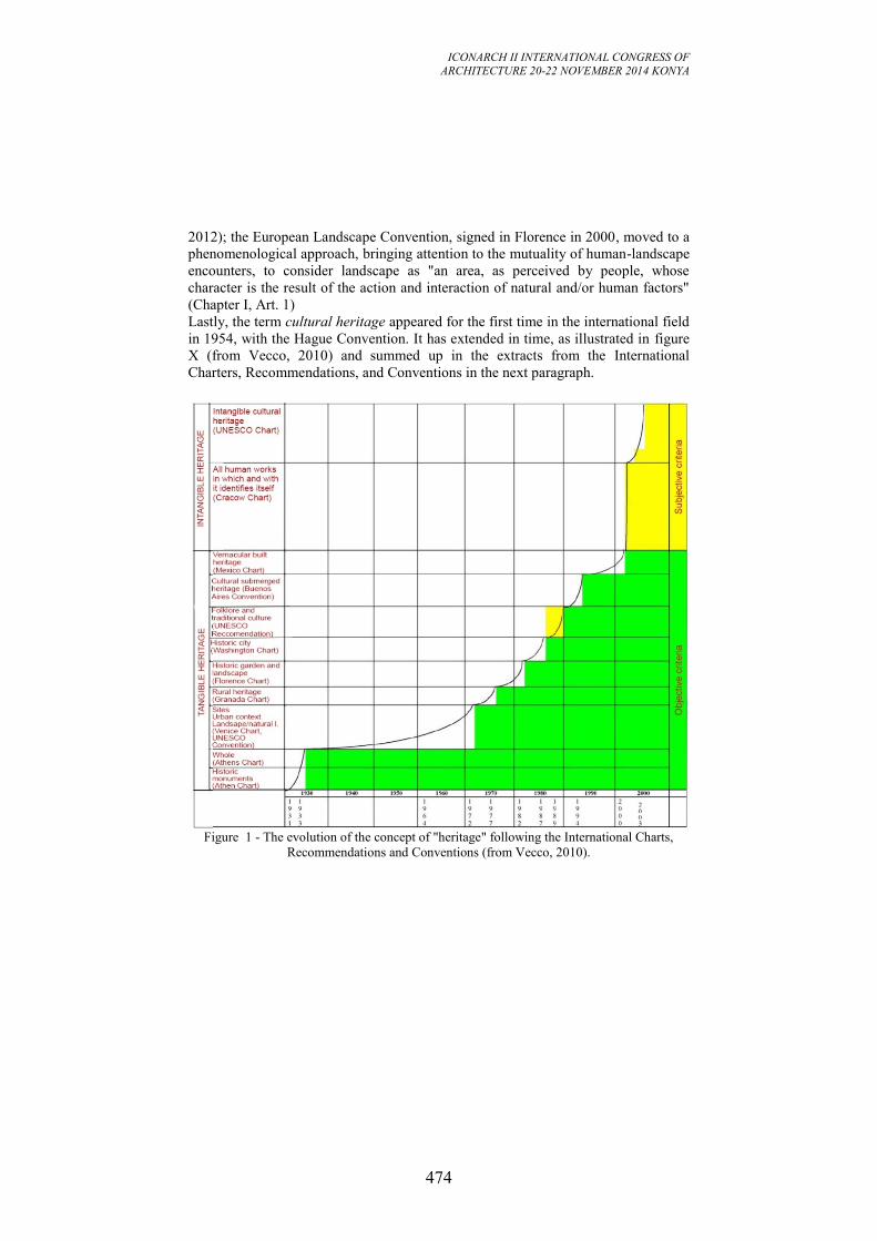
ICONARCH II INTERNATIONAL CONGRESS OF
ARCHITECTURE 20-22 NOVEMBER 2014 KONYA
474
2012); the European Landscape Convention, signed in Florence in 2000, moved to a
phenomenological approach, bringing attention to the mutuality of human-landscape
encounters, to consider landscape as "an area, as perceived by people, whose
character is the result of the action and interaction of natural and/or human factors"
(Chapter I, Art. 1)
Lastly, the term cultural heritage appeared for the first time in the international field
in 1954, with the Hague Convention. It has extended in time, as illustrated in figure
X (from Vecco, 2010) and summed up in the extracts from the International
Charters, Recommendations, and Conventions in the next paragraph.
Figure 1 - The evolution of the concept of "heritage" following the International Charts,
Recommendations and Conventions (from Vecco, 2010).
ICONARCH II INTERNATIONAL CONGRESS OF
ARCHITECTURE 20-22 NOVEMBER 2014 KONYA
475
2. RECCOMMENDATIONS AND CONVENTIONS
2.1. Le Corbusier, commented version of the CIAM Athens Charter (Athens,
1933), published in 1942/43 (La Charte d'Athènes) "The life of a city is a continuous event, expressed through the centuries by
hardware works, drawn or built, which provide its own personality and which comes
little by little his soul. These are precious witnesses of the past to be respected for
their historical or sentimental value first; then because some carry with them in a
plastic virtue under which the highest degree of intensity of human genius was
incorporated.”
2.2. 1964, Venice Charter “The concept of an historic monument embraces not only the single architectural
work but also the urban or rural setting in which is found the evidence of a particular
civilization, a significant development or an historic event. This applies not only to
great works of art but also to more modest works of the past which have acquired
cultural significance with the passing of time.” 2.3. 1972 UNESCO World Heritage Convention “With respect to cultural landscapes, the Committee has furthermore adopted the
following guidelines: Cultural landscapes represent the ‘combined works of nature
and of man’; they are illustrative of the evolution of human society and settlement
over time, under the influence of the physical constraints and/or opportunities
presented by their natural environment and of successive social, economic and
cultural forces, both external and internal. The term ‘cultural landscape’ embraces a
diversity of manifestations of the interaction between humankind and its natural
environment.”
2.4. Recommendation concerning the safeguarding and contemporary role of
historic areas, adopted by UNESCO in Nairobi, 26 November 1976 “'Historic and architectural (including vernacular) areas’ shall be taken to mean any
groups of buildings, structures and open spaces including archaeological and
palaeontological sites, constituting human settlements in an urban or rural
environment, the cohesion and value of which, from the archaeological,
architectural, prehistoric, historic, aesthetic or socio-cultural point of view are
recognized.
The 'environment' shall be taken to mean the natural or man-made setting which
influences the static or dynamic way these areas are perceived or which is directly
linked to them in space or by social, economic or cultural ties.”
3. GEOMATICS: NEW TOOLS FOR HERITAGE DOCUMENTATION
In recent times, those disciplines that have always been involved in the creation of
documentation projects have had to deal with revolutions brought about by the
advent of electronics first of all, and then digital technology. Now, in the latest
ICONARCH II INTERNATIONAL CONGRESS OF
ARCHITECTURE 20-22 NOVEMBER 2014 KONYA
476
development, they are summed up under the newly diffused neologism of
‘geomatics’. Geomatics includes the techniques traditionally used to document the
territory and the artefacts that persist there, such as topography, photogrammetry,
cartography, plus more recent systems such as GNSS, scanning systems, remotely
sensed imagery from satellites and GIS. With the technological evolution comes an
expansion in the discipline’s fields of interest. No longer is it only finalised towards
the morphometric description of the object under investigation, but also the
management of various kinds of phenomena in which spatial referencing is
important: traffic flows, climate changes, structural deformation, etc.. Many of the
studies conducted in numerous disciplines make use of geographic or, more
generally, spatial data, and geomatics often finds itself in an area of overlap between
various competences. Nowadays, surveys no longer need to be “static”, defining
documents with a metric value, located in time, valid for an instant in the history of
the object under survey, an instant later already recounting a past story, albeit in
many cases these approximations may be tolerable for even long periods of time.
Time is now a variable taken into consideration both in the data acquisition and
elaboration phases. On the tiniest scale, for example, the form of the Earth is
described in relation to systems of reference with a collocation in time, which must
be progressively updated owing to the movements of the tectonic plates. On a much
more enormous scale of analysis, it is possible to monitor the micro-movements of
structures of particular interest with sensors connected in real time to alarm systems
that can be triggered when safety thresholds are exceeded.
Albeit with the inevitable approximations produced through the reduction to
diagram form, today we can distinguish both range-based measurement techniques
and image-based techniques.
The former include total stations, an evolution of the optical-mechanical theodolites,
as well as the more modern satellite systems (initially GPS, now integrated with
other satellite constellations), radar systems and land and air laser scanners.
The second group consists of digital photogrammetry, with the same principles as
traditional analogical photogrammetry, but with a work flow completely innovated
by the introduction of algorithms that permit both the automatic orientation of the
photograms, and automatic graphical plotting, as well as the possibility to use drones
for the filming that can fly at a low altitude even in urban areas or in environmental
contexts that are risky for operators to access directly.
While without doubt advantageous in terms of productivity, these changes at times
risk overshadowing the need for a rigorous measurement approach, namely an
accurate design with the necessary resolution. Careful post-checking is also required
so that the appeal of the graphical products obtained – generally they are 3D models
– does not make one forget that they are nevertheless representations of the real
world and that, despite being uniform and certified, their correspondence with the
real world is inevitably approximate.
ICONARCH II INTERNATIONAL CONGRESS OF
ARCHITECTURE 20-22 NOVEMBER 2014 KONYA
477
Figure 2 - Optocopter AeroMax 800 tested by Lab. GeCo for a
digital photogrammetric project
Figure 3 -Different vehicles for Mobile Mapping Systems (from:
http://www.fgi.fi/fgi/research/mobile-mapping-platforms)
ICONARCH II INTERNATIONAL CONGRESS OF
ARCHITECTURE 20-22 NOVEMBER 2014 KONYA
478
Today the techniques quoted above work alongside so-called “mobile mapping”
systems in which different sensors are placed in a single vehicle moving along the
city streets. 2D laser scanners are used (profilometers) in order to document shape
and sizes; cameras and video cameras for textures; and GNSS systems, inertial
platforms and odometers are used to position all the data collected instant by instant.
Further sensors can be positioned on the vehicle to acquire specific information,
such as thermal imaging cameras, profilometers to measure the wrinkles in the road
surface, radar to evaluate buried elements, etc..
There are multiple possible applications for the data found with mobile mapping
systems and they involve aspects linked to documentation,
management/maintenance and communication. In particular:
documentation of the state of shores, banks and overlooking buildings;
management/maintenance of the structures of bridges, the road surface,
sub-installations, lighting systems, road signs;
aid in planning interventions, also in emergency situations, on historic
buildings;
communication and promotion of the existing built heritage (and its urban
context)
simulation of interventions, in multiple sectors: lighting, realizing
scaffolding and relative shielding;
modelling and risk assessment in situations such as flooding, crowd
movements, etc..
GeCo Lab. has recently gained some important experience in photogrammetic
surveying, with cameras mounted on both multirotor and fixed-wing UAVs, and it is
set to acquire 3D and multisensor documentation of the urban rivers in Florence
with a mobile mapping system.
4. GEOMATICS: NEW TOOLS FOR SUSTAINABLE CULTURAL
ENHANCEMENT
Over recent years, numerous digitalisation projects have been set in motion on both
environmental contexts and monumental buildings, sculptures and artefacts of
various dimensions.
An important European project has been Europeana, whose goal was to provide
content and technology demonstrators. In the Europeana archive, with an impressive
collection of millions of objects, it is possible to find books, paintings, films,
museum objects and archival records that have been digitised throughout Europe.
Some specific projects focused on 3D digitisation: CARARE
(http://pro.europeana.eu/web/carare) and 3D-COFORM (http://www.3d-coform.eu),
up to the most recent 3D-ICONS (http://pro.europeana.eu/web/3d-icons), whose
goal is to digitise in 3D architectural and archaeological monuments and buildings
identified by UNESCO as being of outstanding cultural importance.
In addition, we cannot forget the numerous initiatives carried forward by research
centres and private companies. GeCo Lab. has been involved in the MusInt project
(virtual INTeractive MUSeum of the Aegean and Cypriot collections in Tuscany, on
ICONARCH II INTERNATIONAL CONGRESS OF
ARCHITECTURE 20-22 NOVEMBER 2014 KONYA
479
line: http://musint.dreams.sns.it), and in the 3D documentation of the Gallery of the
Accademia and the Baptistery of San Giovanni in Florence, the Basilica of the Holy
Sepulchre in Jerusalem, some historical buildings in the city centres of Multan in
Pakistan and La Habana in Cuba, and other significant architectural and natural
contexts.
Now the question for the near future is "how can the digital cultural heritage be used
and enhanced?". The open call for European projects focuses on the use and
promotion of digital cultural resources by businesses and citizens and on the
exploitation of cultural digital resources, providing clear rules for their use and re-
use, especially in the fields of education, tourism and leisure.
The first draft document from the latest UNESCO Forum, held in Florence in
October, is entitled “Culture, Creativity and Sustainable Development. Research,
Innovation, Opportunities”. The Declaration requests that culture be given due
consideration in the post-2015 development agenda and identifies "the key role of
cities and regions as actors of change and where the culture in and for human
development acknowledges the monetary and non monetary aspects of the economy
through cultural expression, artistic practice, safeguarding of tangible and intangible
heritage, promotion of cultural diversity, urban planning and architecture." (Florence
Declaration, 2014)
4. CONCLUSION
3D models are widely used in cultural heritage to create accurate records of
individual monuments and buildings as well as complete sites.
Thanks to the innovative ways of documenting the city, its streets and its buildings,
the traditional codes of cartography and drawings can now be surpassed to instead
produce digital, 3D, texturised maps that at the same time are able to describe the
material consistency of roads, structures, infrastructures and their relationships with
each other. What is more, they have an added value thanks to the fluidity with which
the digital data can be used, transmitted, integrated and updated. The new maps are
no longer just technical drawings characterised by objectivity and accuracy; today
they have dynamic and captivating interfaces and they can present new images of
the city.
At the same time, a big challenge for the near future will be to manage heritage and
culture [Barthel-Bouchier], while redefining some past strong power relations and
encompassing more players in the process.
Already available digital assets should become accessible, high-quality, well-
organized and attractive information used for creative ends by cultural industries,
supporting culture and sustainable development.
ICONARCH II INTERNATIONAL CONGRESS OF
ARCHITECTURE 20-22 NOVEMBER 2014 KONYA
480
REFERENCES
- Jokilehto, J. 2005. Definition of cultural heritage: References to document in
history (on line:
http://cif.icomos.org/pdf_docs/Documents%20on%20line/Heritage%20definitions.p
df)
- Vecco, M. 2010. A definition of cultural heritage: From the tangible to the
intangible, Journal of Cultural Heritage, n. 11 (2010), pp. 321-324.
- Florence Declaration, Third UNESCO World Forum on culture and cultural
industries, “Culture, Creativity and Sustainable Development. Research, Innovation,
Opportunities", Florence, 4th October 2014 (on line: http://www.focus2014.org/wp-
content/uploads/2014/09/ENG_Florence_Declaration_4oct.pdf
- Barthel-Bouchier, D. 2012. Cultural Heritage and the Challenge of Sustainability,
Left Coast Press.
- CARARE: Connecting Archaeology and Architecture in Europeana (on line:
http://pro.europeana.eu/web/carare)
- 3D-ICONS (on line: http://pro.europeana.eu/web/3d-icons)
- 3D-COFORM (on line: http://www.3d-coform.eu)
- Cosgrove, D., Daniels, S. 1988. The Iconography of Landscape: Essays on the
Symbolic Representation, Design and Use of Past Environments, Vol. 9, Cambridge
Studies in Historical Geography, ISSN 1747-3128, Cambridge University Press.
- Benediktsson, K., Lund, K.A. (Editors) 2012, Conversations With
Landscape,ISBN 9781409492696, Ashgate Publishing
- European Landscape Convention, Florence, 20.10.2000 (on line:
http://conventions.coe.int/Treaty/en/Treaties/Html/176.htm)
- Cosgrove, D. 1993. The Palladian Landscape: Geographical Change and its
Cultural Representations in Sixteenth Century Italy, Leicester University Press.
ICONARCH II INTERNATIONAL CONGRESS OF
ARCHITECTURE 20-22 NOVEMBER 2014 KONYA
481
A STUDY OF TECTONIC CULTURE AND TECHNOLOGY OF
RELIGIOUS MASONRY ARCHITECTURE IN WUHAN
RU CHEN1
ABSTRACT
Western style masonry architecture had been much promoted because of western
influences since the mid-nineteenth century, and the well preserved Griffith Church
in Wuhan was a representative to investigate its tectonic culture and technology.
While the various masonry methods applied in its brick wall, its door and window
openings, and its main structure, were largely western in nature, the Chinese or the
local methods were incorporated where appropriate. This shows that the tectonic
culture and technology of contemporary religious masonry architecture in China
could not be fully understand without a consideration of the Chinese architectural
tradition and the social context. Also, with respect to construction technology and
spatial expression, Griffith Church could provide invaluable lessons in the
exploration of construction potential and architectural treatment of the brick
masonry.
Key words: Tectonic culture and technology, Masonry architecture, Griffith Churth
1. INTRODUCTION
Brick is a common building material and plays an important role in the design and
construction of masonry architecture. As it is well known that Chinese traditional
architecture was of a wooden structure (Guo, 2000; Li, 2003), it is interesting to
investigate Chinese masonry architecture in bricks which had been much promoted
because of western influences since the First Opium War (1840-1842) in the mid-
nineteenth century when China was forced to open its door to foreign trade. In this
process, many treaty ports were opened in strategic coastal and riverside locations,
and Wuhan was one of the most important treaty ports, where some western style
masonry architecture was established. Among these, church, a kind of religious
architecture, became popular for preaching purposes of missionaries. While some
other architectural types that emerged in contemporary treaty ports have been
extensively explored, there is much scope in the study of religious architecture
(Johnston, 1996; Cheng, 2008; Guo, 2009; Tong, 2011), particularly in respect of
the issue of building material and its tectonic culture and technology (Hackett, 2014;
Jung, 2013). This study sets out to make up this deficiency.
1 School of Architecture & Urban Planning, Huazhong University of Science & Technology
ICONARCH II INTERNATIONAL CONGRESS OF
ARCHITECTURE 20-22 NOVEMBER 2014 KONYA
482
The concept of ‘tectonic’ is the theoretical basis for this study. According to
Kenneth Frampton, ‘tectonic’ should be understood as the technological aspect in
construction and the way to create meaningful spaces or places (Frampton, 1995). It
should be noted that in architectural history, innovation and advances in these two
aspects often brought forth new architectural forms or expressions. As such, this
study of the tectonic culture and technology of masonry architecture is not only
about architectural aesthetics or style, but also about the integration of building
process and architects’ design aspirations. It concerns the construction potential and
architectural expression of the brick material, and therefore fundamentally the
essence of architecture and construction.
2. THE GRIFFITH CHURCH
The churches in Wuhan from the mid-nineteenth century were almost western style
masonry architecture. But they were regretfully almost not well preserved. Some of
them were torn down, some became derelict and abandoned, and some others were
subjected to functional change, which resulted in damages in various degrees.
Among them, Griffith Church is the best preserved. Built in 1880, it was the
principal church of the London Missionary Society in central China. It was
originally the Flower Mansion, located on Jianghan Road at the juncture of the
British Concession and the Chinese community. It was moved to Yunqiao Road
(now Huangshi Road) in 1931, and in order to commemorate Griffith John (1831-
1912), the earliest Christian missionary in central China, was renamed Griffith
Church. The church was built with plain brick wall, and its window openings were
largely made with pointed arches. With a floor area of 1,191 square meters, it was
the biggest church in Wuhan with a seating capacity for 1,000 people. The church
was renamed Rongguang Church in December 1951, closed during the Cultural
Revolution (1966-1976), and not re-opened until November 1980. It has now
become a popular place for Christian activities and regularly receives 1,000 or so
people per day.
3. THE BRICK WALL: THE FUNCTIONAL AND THE SPIRITUAL
The bricks used in the construction of Griffith Church were all red ones imported
from the West, with a standard dimension of 250 millimetres in length, 120
millimetres in width, and 70 millimetres in height. In Griffith Church, door or
window openings, arches, pilasters, and cornices, were all made with such standard
bricks. Most of the bricks were arranged in cross bond, the so-called ‘English style’,
which was popularly implemented for its simple and easy manipulation. Besides
cross bond, there was also Gothic masonry method, the so-called plum style (figure
1, 2).
The thickness of the walls of Griffith Church was varied in different part of the
building. It was normally 250 millimetres thick, but it might be 380 or 520
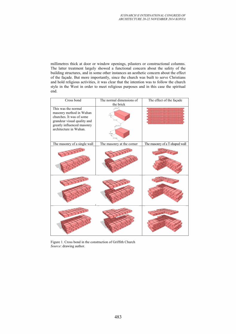
ICONARCH II INTERNATIONAL CONGRESS OF
ARCHITECTURE 20-22 NOVEMBER 2014 KONYA
483
millimetres thick at door or window openings, pilasters or constructional columns.
The latter treatment largely showed a functional concern about the safety of the
building structures, and in some other instances an aesthetic concern about the effect
of the façade. But more importantly, since the church was built to serve Christians
and hold religious activities, it was clear that the intention was to follow the church
style in the West in order to meet religious purposes and in this case the spiritual
end.
Cross bond The normal dimensions of
the brick
The effect of the façade
This was the normal
masonry method in Wuhan
churches. İt was of some
grandeur visual quality and
greatly influenced masonry
architecture in Wuhan.
The masonry of a single wall The masonry at the corner The masonry of a T-shaped wall
Figure 1. Cross bond in the construction of Griffith Church
Source: drawing author.
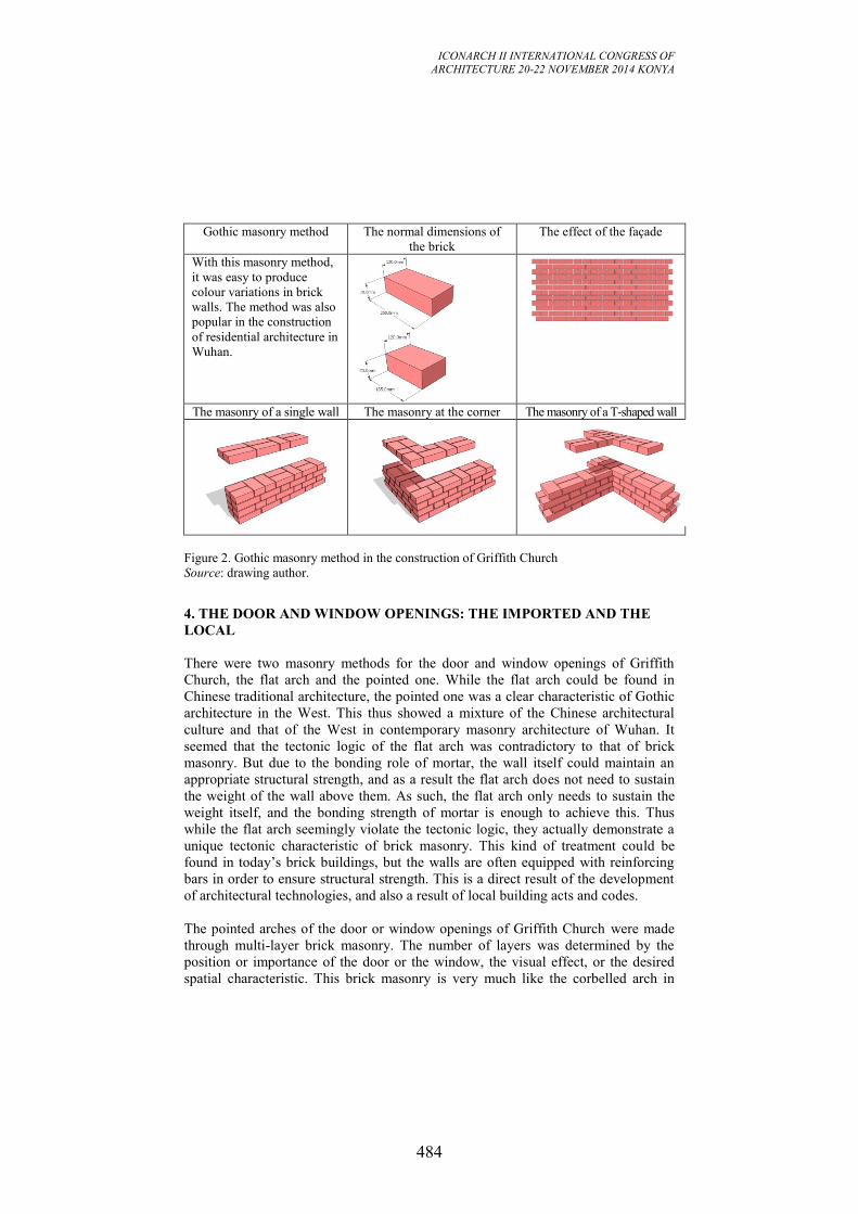
ICONARCH II INTERNATIONAL CONGRESS OF
ARCHITECTURE 20-22 NOVEMBER 2014 KONYA
484
Gothic masonry method The normal dimensions of
the brick
The effect of the façade
With this masonry method,
it was easy to produce
colour variations in brick
walls. The method was also
popular in the construction
of residential architecture in
Wuhan.
The masonry of a single wall The masonry at the corner The masonry of a T-shaped wall
Figure 2. Gothic masonry method in the construction of Griffith Church
Source: drawing author.
4. THE DOOR AND WINDOW OPENINGS: THE IMPORTED AND THE
LOCAL
There were two masonry methods for the door and window openings of Griffith
Church, the flat arch and the pointed one. While the flat arch could be found in
Chinese traditional architecture, the pointed one was a clear characteristic of Gothic
architecture in the West. This thus showed a mixture of the Chinese architectural
culture and that of the West in contemporary masonry architecture of Wuhan. It
seemed that the tectonic logic of the flat arch was contradictory to that of brick
masonry. But due to the bonding role of mortar, the wall itself could maintain an
appropriate structural strength, and as a result the flat arch does not need to sustain
the weight of the wall above them. As such, the flat arch only needs to sustain the
weight itself, and the bonding strength of mortar is enough to achieve this. Thus
while the flat arch seemingly violate the tectonic logic, they actually demonstrate a
unique tectonic characteristic of brick masonry. This kind of treatment could be
found in today’s brick buildings, but the walls are often equipped with reinforcing
bars in order to ensure structural strength. This is a direct result of the development
of architectural technologies, and also a result of local building acts and codes.
The pointed arches of the door or window openings of Griffith Church were made
through multi-layer brick masonry. The number of layers was determined by the
position or importance of the door or the window, the visual effect, or the desired
spatial characteristic. This brick masonry is very much like the corbelled arch in
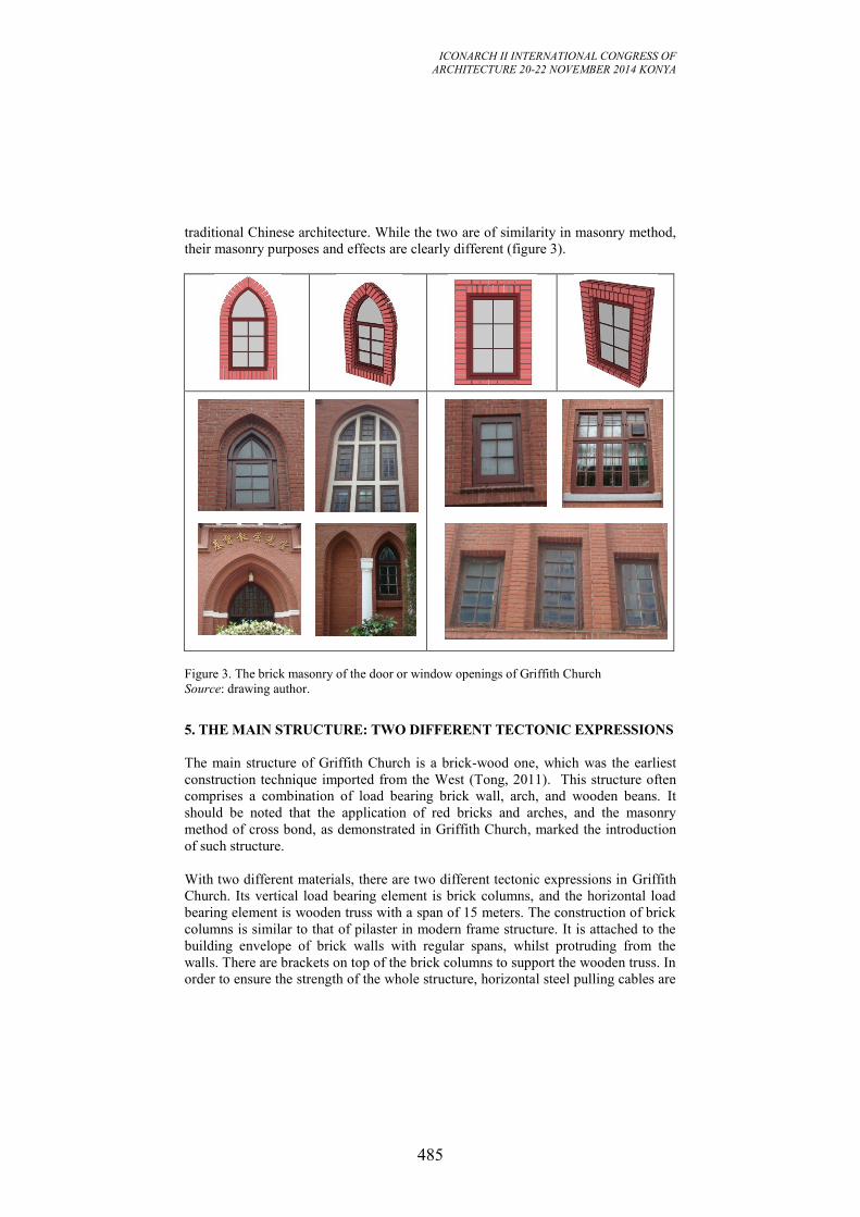
ICONARCH II INTERNATIONAL CONGRESS OF
ARCHITECTURE 20-22 NOVEMBER 2014 KONYA
485
traditional Chinese architecture. While the two are of similarity in masonry method,
their masonry purposes and effects are clearly different (figure 3).
Figure 3. The brick masonry of the door or window openings of Griffith Church
Source: drawing author.
5. THE MAIN STRUCTURE: TWO DIFFERENT TECTONIC EXPRESSIONS
The main structure of Griffith Church is a brick-wood one, which was the earliest
construction technique imported from the West (Tong, 2011). This structure often
comprises a combination of load bearing brick wall, arch, and wooden beans. It
should be noted that the application of red bricks and arches, and the masonry
method of cross bond, as demonstrated in Griffith Church, marked the introduction
of such structure.
With two different materials, there are two different tectonic expressions in Griffith
Church. Its vertical load bearing element is brick columns, and the horizontal load
bearing element is wooden truss with a span of 15 meters. The construction of brick
columns is similar to that of pilaster in modern frame structure. It is attached to the
building envelope of brick walls with regular spans, whilst protruding from the
walls. There are brackets on top of the brick columns to support the wooden truss. In
order to ensure the strength of the whole structure, horizontal steel pulling cables are
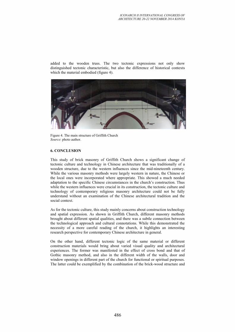
ICONARCH II INTERNATIONAL CONGRESS OF
ARCHITECTURE 20-22 NOVEMBER 2014 KONYA
486
added to the wooden truss. The two tectonic expressions not only show
distinguished tectonic characteristic, but also the difference of historical contexts
which the material embodied (figure 4).
Figure 4. The main structure of Griffith Church
Source: photo author.
6. CONCLUSION
This study of brick masonry of Griffith Church shows a significant change of
tectonic culture and technology in Chinese architecture that was traditionally of a
wooden structure, due to the western influences since the mid-nineteenth century.
While the various masonry methods were largely western in nature, the Chinese or
the local ones were incorporated where appropriate. This showed a much needed
adaptation to the specific Chinese circumstances in the church’s construction. Thus
while the western influences were crucial in its construction, the tectonic culture and
technology of contemporary religious masonry architecture could not be fully
understand without an examination of the Chinese architectural tradition and the
social context.
As for the tectonic culture, this study mainly concerns about construction technology
and spatial expression. As shown in Griffith Church, different masonry methods
brought about different spatial qualities, and there was a subtle connection between
the technological approach and cultural connotations. While this demonstrated the
necessity of a more careful reading of the church, it highlights an interesting
research perspective for contemporary Chinese architecture in general.
On the other hand, different tectonic logic of the same material or different
construction materials would bring about varied visual quality and architectural
experiences. The former was manifested in the effect of cross bond and that of
Gothic masonry method, and also in the different width of the walls, door and
window openings in different part of the church for functional or spiritual purposes.
The latter could be exemplified by the combination of the brick-wood structure and
ICONARCH II INTERNATIONAL CONGRESS OF
ARCHITECTURE 20-22 NOVEMBER 2014 KONYA
487
the steel cable feature. As such, the case of Griffith Church could provide invaluable
lessons in the exploration of construction potential and architectural treatment of the
brick masonry.
ACKNOWLEDGEMENT
This research was supported by National Natural Science Foundation of China
(NSFC) (No. 51278210).
REFERENCES
- Cheng, H. and Huang, Y. 2008. ‘A study about the architecture in Wuhan treaty
port’ 浅谈武汉租界建筑. Aesthetics and the Time (6): pp. 113-119.
- Frampton, K. 1995. Studies in Tectonic Culture: The Poetics of Construction in
Nineteenth and Twentieth Century Architecture. Chicago, Ill.; London: Graham
Foundation for Advanced Studies in the Fine Arts.
- Guo, F. 2009. ‘Christian churches in contemporary Wuhan’
武汉近代基督教教堂建筑. Central China Architecture (3): pp. 247-251.
- Guo, Q. 2000. ‘Tile and Brick Making in China: a Study of the “Yingzao Fashi”’.
Construction History (16): pp. 3-11.
- Hackett, D. 2014. ‘Revolutionary Masonry:Republican and Christian, 1757–1825’.
In That Religion in Which All Men Agree. Oakland: University of California Press:
pp. 55-83.
- Johnston, T. 1996. Far from Home: Western Architecture in China’s Northern
Treaty Ports. Hong Kong: Old China Hand Press.
- Jung, I. 2013. ‘Architecture and the Introduction of New Materials’. In
Architecture and Urbanism in Modern Korea. Honolulu: University of Hawai’i
Press: pp. 36-48.
- Li, S. 2003. ‘Reconstituting Chinese Building Tradition: The Yingzao fashi in the
Early Twentieth Century’. Journal of the Society of Architectural Historians (4): pp.
470-489.
- Tong, Q. and Liu, Y. 2011. ‘Wuhan modern consulate architecture’
武汉近代领事馆建筑. Central China Architecture (9): pp. 171-175.
ICONARCH II INTERNATIONAL CONGRESS OF
ARCHITECTURE 20-22 NOVEMBER 2014 KONYA
488
INNOVATIVE TECHNOLOGIES FOR THE PROTECTION OF
HISTORICAL STRUCTURES AGAINST EARTHQUAKES
FUAT ARAS
ABSTRACT
Cultural heritage buildings are special structures and must be protected from natural
disasters preserving at the same time their authenticity. In the seismic areas, one of
the building classes that is consistently exposed to seismic risk is the one
constituting the architectural heritage of the region. To minimize further destruction
under future seismic activity it is necessary to reinforce the existing structures that
are more vulnerable. As a consequence, new technological systems are needed, able
to provide solution not only to specific structural or architectural problems, but also
aiming at improving the global performance of the construction. Similarly, great
attention is paid not only to reliability and durability of intervention methods, but
also to the possibility to be easily monitored and removed if required, according to
the widely shared policy, aiming at the safeguard of existing buildings, in particular
in case of historical and monumental works, from inappropriate restoration
operations.
This study aims to represent innovative technologies and strategies to preserve the
cultural heritage structures against earthquake effect. In particular, the application of
fibre reinforced polymers and structural control systems are explained. Suitability of
the strategies to architectural, historical and structural features and reversibility
aspects are evaluated. As a case study the application of these strategies to a
historical building in Istanbul is discussed.
Key words: historical structures, preservation, reversibility, innovative methods.
1. INTRODUCTION
With its permanent occupancy over 8000 years Anatolia is the cradle of civilization.
Since Hittites, different tribes, resulting with the establishment of many countries
and empires, have occupied the region. Roman, Byzantine, Seljuk and Ottoman
empires are the most significant civilizations in the history that had brought Anatolia
to its historical structure stock. There are many churches, bridges, school, mosques,
cisterns, public baths, palaces and pavilions, defying the centuries with their
magnificence. Istanbul, as the capital of Byzantine and Ottoman empires has an
important and special place among the other cities in Turkey with respect to cultural
heritage.
As well known, Turkey is greatly exposed to seismic hazard, which causes its large
and valuable buildings to be strongly at risk of severe damage or even destruction
ICONARCH II INTERNATIONAL CONGRESS OF
ARCHITECTURE 20-22 NOVEMBER 2014 KONYA
489
due to earthquake. This problem mostly stands for historical and monumental
constructions, due to the fact that most of them frequently lack basic anti-seismic
features. In one of the latest seismic event, 1999 earthquakes, 36 historical
monumental structures including Fatih mosque have been damaged in Istanbul. Only
this situation is enough to underline the necessity of special care for the preservation
of the cultural heritage structures (Aras 2013).
Heritage structures should be passed on to future generations in its authentic state
and in all its variety as an essential part of the memory of the human race.
Otherwise, part of man's awareness of his own continuity will be destroyed
(Amsterdam Charter, 1975). For the protection of the historical structures the best
available protection strategy must be aimed. For this reason the problem must be
analysed well and the solution should be effective to provide desired safety with
minimum intervention. In that respect the technological and innovative solutions
should always be used, bearing the authenticity of the structure in mind. This study
aims to represent innovative technologies and strategies to preserve the cultural
heritage structures against earthquake effect. Recently two main applications for the
preservation of the heritage structure are the strengthening and rehabilitation of
dynamic properties of the systems. For the strengthening of the systems use of Fibre
Reinforced Polymers became very popular strategy for the historical structures and
Base Isolation technique is seen as an effective and applicable.
Great attention is paid not only to reliability and durability of intervention methods,
but also to the possibility to be easily monitored and removed if required. Aiming to
safeguard the existing historical structures from inappropriate restoration operations,
the key parameter is named as reversible technologies. The use reversible
technologies in the protection of the historical heritage buildings are also assessed
briefly in this study.
2. EARTHQUAKES AND HISTORICAL BUILDINGS IN TURKEY
Over the course of history Anatolia has been the site of numerous destructive
earthquakes. At least 70% of the region is under-risk of earthquake. Between 1902
and 2005, 128 earthquakes hit the region causing more than 80.000 deaths. The
recent Van and Erciş earthquakes also confirm the destructive effects of the seismic
activities in Turkey. Most of the historical documentation is related to damages
suffered in Istanbul. The earthquake history of the city reveals that; it experiences
with a medium earthquake (I0 = VII – VIII) in every 50 years and with a strong
earthquake (I0 = VIII - IX) in every 300 years. Moreover recent extensive
geophysical studies have clearly delineated the presence of a single major tectonic
entity crossing the Marmara Sea. The probability of having an MW 7 + earthquake
is in the vicinity of 70% in the next 30 years (Erdik et al 2004).
Historical structures in Turkey can be classified based on the construction material
as masonry and timber structures. Masonry structures are brittle and heavy, and their
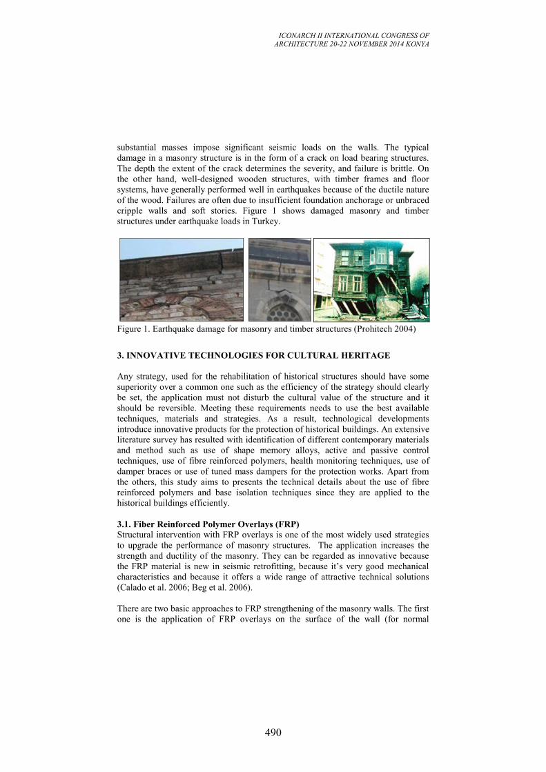
ICONARCH II INTERNATIONAL CONGRESS OF
ARCHITECTURE 20-22 NOVEMBER 2014 KONYA
490
substantial masses impose significant seismic loads on the walls. The typical
damage in a masonry structure is in the form of a crack on load bearing structures.
The depth the extent of the crack determines the severity, and failure is brittle. On
the other hand, well-designed wooden structures, with timber frames and floor
systems, have generally performed well in earthquakes because of the ductile nature
of the wood. Failures are often due to insufficient foundation anchorage or unbraced
cripple walls and soft stories. Figure 1 shows damaged masonry and timber
structures under earthquake loads in Turkey.
Figure 1. Earthquake damage for masonry and timber structures (Prohitech 2004)
3. INNOVATIVE TECHNOLOGIES FOR CULTURAL HERITAGE
Any strategy, used for the rehabilitation of historical structures should have some
superiority over a common one such as the efficiency of the strategy should clearly
be set, the application must not disturb the cultural value of the structure and it
should be reversible. Meeting these requirements needs to use the best available
techniques, materials and strategies. As a result, technological developments
introduce innovative products for the protection of historical buildings. An extensive
literature survey has resulted with identification of different contemporary materials
and method such as use of shape memory alloys, active and passive control
techniques, use of fibre reinforced polymers, health monitoring techniques, use of
damper braces or use of tuned mass dampers for the protection works. Apart from
the others, this study aims to presents the technical details about the use of fibre
reinforced polymers and base isolation techniques since they are applied to the
historical buildings efficiently.
3.1. Fiber Reinforced Polymer Overlays (FRP)
Structural intervention with FRP overlays is one of the most widely used strategies
to upgrade the performance of masonry structures. The application increases the
strength and ductility of the masonry. They can be regarded as innovative because
the FRP material is new in seismic retrofitting, because it’s very good mechanical
characteristics and because it offers a wide range of attractive technical solutions
(Calado et al. 2006; Beg et al. 2006).
There are two basic approaches to FRP strengthening of the masonry walls. The first
one is the application of FRP overlays on the surface of the wall (for normal
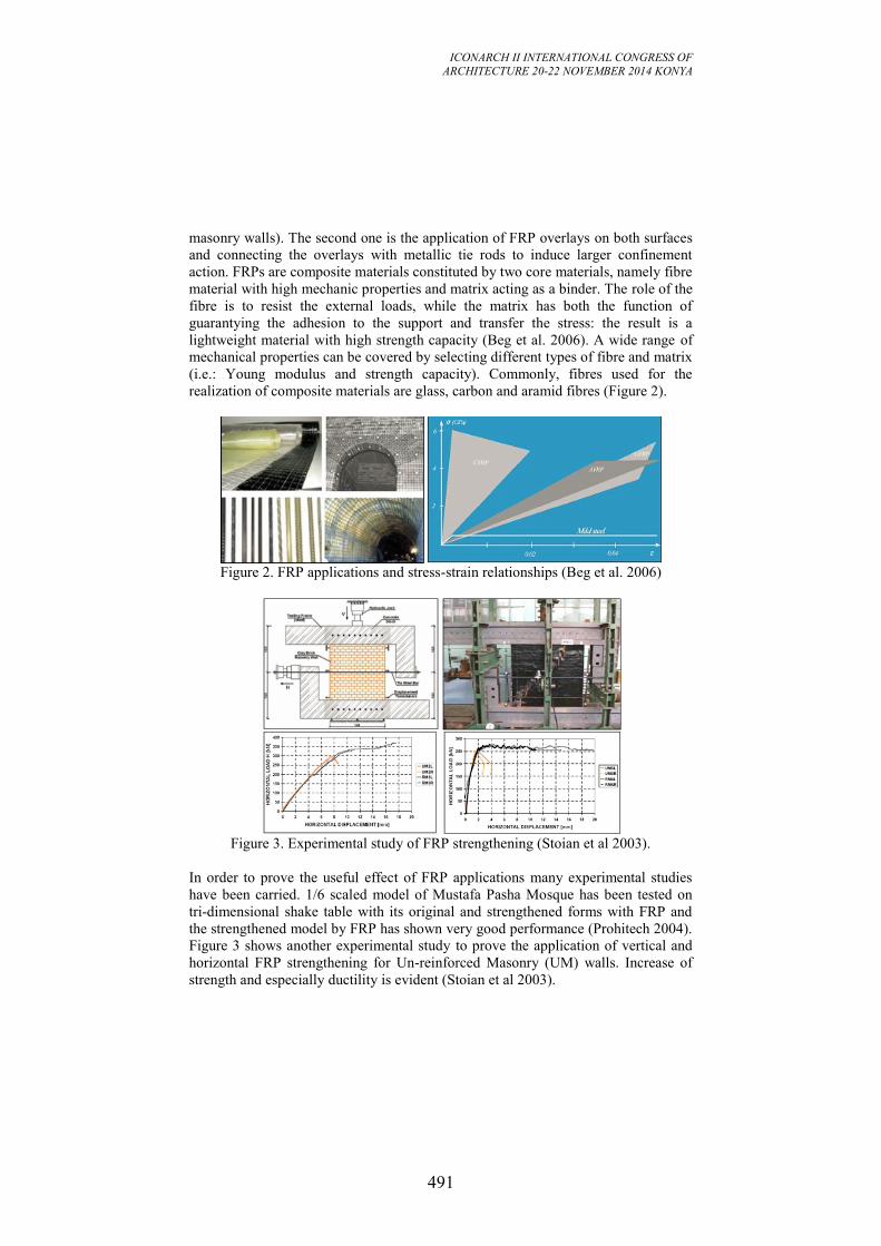
ICONARCH II INTERNATIONAL CONGRESS OF
ARCHITECTURE 20-22 NOVEMBER 2014 KONYA
491
masonry walls). The second one is the application of FRP overlays on both surfaces
and connecting the overlays with metallic tie rods to induce larger confinement
action. FRPs are composite materials constituted by two core materials, namely fibre
material with high mechanic properties and matrix acting as a binder. The role of the
fibre is to resist the external loads, while the matrix has both the function of
guarantying the adhesion to the support and transfer the stress: the result is a
lightweight material with high strength capacity (Beg et al. 2006). A wide range of
mechanical properties can be covered by selecting different types of fibre and matrix
(i.e.: Young modulus and strength capacity). Commonly, fibres used for the
realization of composite materials are glass, carbon and aramid fibres (Figure 2).
Figure 2. FRP applications and stress-strain relationships (Beg et al. 2006)
Figure 3. Experimental study of FRP strengthening (Stoian et al 2003).
In order to prove the useful effect of FRP applications many experimental studies
have been carried. 1/6 scaled model of Mustafa Pasha Mosque has been tested on
tri-dimensional shake table with its original and strengthened forms with FRP and
the strengthened model by FRP has shown very good performance (Prohitech 2004).
Figure 3 shows another experimental study to prove the application of vertical and
horizontal FRP strengthening for Un-reinforced Masonry (UM) walls. Increase of
strength and especially ductility is evident (Stoian et al 2003).
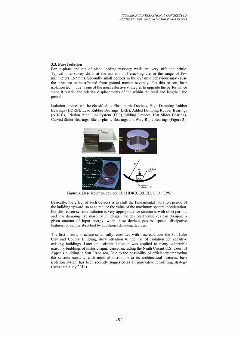
ICONARCH II INTERNATIONAL CONGRESS OF
ARCHITECTURE 20-22 NOVEMBER 2014 KONYA
492
3.3. Base Isolation
For in-plane and out of plane loading masonry walls are very stiff and brittle.
Typical inter-storey drifts at the initiation of cracking are in the range of few
millimeters (2-3mm). Secondly small periods in the dynamic behaviour may cause
the structure to be affected from ground motion severely. For this reason, base
isolation technique is one of the most effective strategies to upgrade the performance
since it restrict the relative displacements of the within the wall and lengthen the
period.
Isolation devices can be classified as Elastomeric Devices, High Damping Rubber
Bearings (HDRB), Lead Rubber Bearings (LRB), Added Damping Rubber Bearings
(ADRB), Friction Pendulum System (FPS), Sliding Devices, Flat Slider Bearings,
Curved Slider Bearings, Elasto-plastic Bearings and Wire-Rope Bearings (Figure 3).
Figure 3. Base isolation devices (A : HDRB, B:LRB, C, D : FPS)
Basically, the effect of such devices is to shift the fundamental vibration period of
the building upward, so as to reduce the value of the maximum spectral acceleration.
For this reason seismic isolation is very appropriate for structures with short periods
and low damping like masonry buildings. The devices themselves can dissipate a
given amount of input energy, when these devices possess special dissipative
features, or can be absorbed by additional damping devices.
The first historic structure seismically retrofitted with base isolation, the Salt Lake
City and County Building, drew attention to the use of isolation for sensitive
existing buildings. Later on, seismic isolation was applied to many vulnerable
masonry buildings of historic significance, including the Ninth Circuit U.S. Court of
Appeals building in San Francisco, Due to the possibility of efficiently improving
the seismic capacity with minimal disruption to its architectural features, base
isolation system has been recently suggested as an innovative retrofitting strategy
(Aras and Altay 2014).
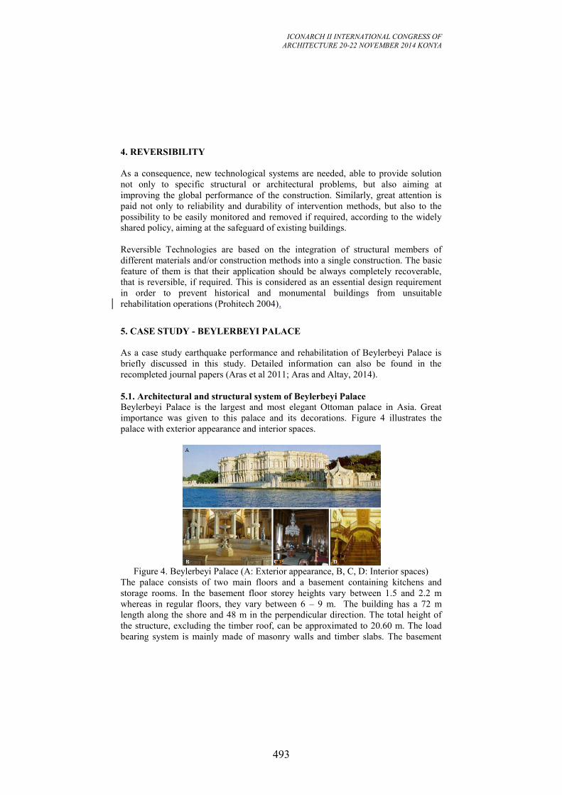
ICONARCH II INTERNATIONAL CONGRESS OF
ARCHITECTURE 20-22 NOVEMBER 2014 KONYA
493
4. REVERSIBILITY
As a consequence, new technological systems are needed, able to provide solution
not only to specific structural or architectural problems, but also aiming at
improving the global performance of the construction. Similarly, great attention is
paid not only to reliability and durability of intervention methods, but also to the
possibility to be easily monitored and removed if required, according to the widely
shared policy, aiming at the safeguard of existing buildings.
Reversible Technologies are based on the integration of structural members of
different materials and/or construction methods into a single construction. The basic
feature of them is that their application should be always completely recoverable,
that is reversible, if required. This is considered as an essential design requirement
in order to prevent historical and monumental buildings from unsuitable
rehabilitation operations (Prohitech 2004).
5. CASE STUDY - BEYLERBEYI PALACE
As a case study earthquake performance and rehabilitation of Beylerbeyi Palace is
briefly discussed in this study. Detailed information can also be found in the
recompleted journal papers (Aras et al 2011; Aras and Altay, 2014).
5.1. Architectural and structural system of Beylerbeyi Palace
Beylerbeyi Palace is the largest and most elegant Ottoman palace in Asia. Great
importance was given to this palace and its decorations. Figure 4 illustrates the
palace with exterior appearance and interior spaces.
Figure 4. Beylerbeyi Palace (A: Exterior appearance, B, C, D: Interior spaces)
The palace consists of two main floors and a basement containing kitchens and
storage rooms. In the basement floor storey heights vary between 1.5 and 2.2 m
whereas in regular floors, they vary between 6 – 9 m. The building has a 72 m
length along the shore and 48 m in the perpendicular direction. The total height of
the structure, excluding the timber roof, can be approximated to 20.60 m. The load
bearing system is mainly made of masonry walls and timber slabs. The basement
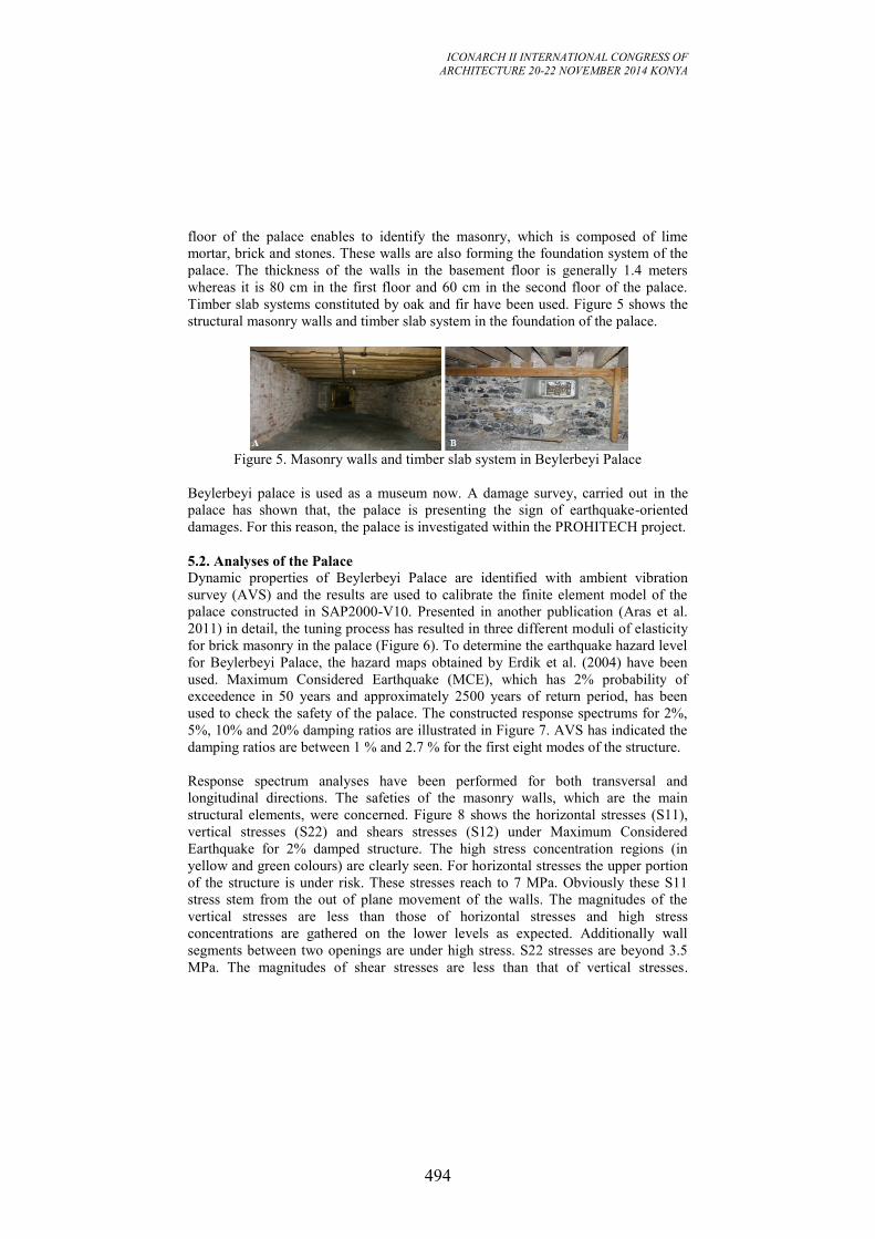
ICONARCH II INTERNATIONAL CONGRESS OF
ARCHITECTURE 20-22 NOVEMBER 2014 KONYA
494
floor of the palace enables to identify the masonry, which is composed of lime
mortar, brick and stones. These walls are also forming the foundation system of the
palace. The thickness of the walls in the basement floor is generally 1.4 meters
whereas it is 80 cm in the first floor and 60 cm in the second floor of the palace.
Timber slab systems constituted by oak and fir have been used. Figure 5 shows the
structural masonry walls and timber slab system in the foundation of the palace.
Figure 5. Masonry walls and timber slab system in Beylerbeyi Palace
Beylerbeyi palace is used as a museum now. A damage survey, carried out in the
palace has shown that, the palace is presenting the sign of earthquake-oriented
damages. For this reason, the palace is investigated within the PROHITECH project.
5.2. Analyses of the Palace
Dynamic properties of Beylerbeyi Palace are identified with ambient vibration
survey (AVS) and the results are used to calibrate the finite element model of the
palace constructed in SAP2000-V10. Presented in another publication (Aras et al.
2011) in detail, the tuning process has resulted in three different moduli of elasticity
for brick masonry in the palace (Figure 6). To determine the earthquake hazard level
for Beylerbeyi Palace, the hazard maps obtained by Erdik et al. (2004) have been
used. Maximum Considered Earthquake (MCE), which has 2% probability of
exceedence in 50 years and approximately 2500 years of return period, has been
used to check the safety of the palace. The constructed response spectrums for 2%,
5%, 10% and 20% damping ratios are illustrated in Figure 7. AVS has indicated the
damping ratios are between 1 % and 2.7 % for the first eight modes of the structure.
Response spectrum analyses have been performed for both transversal and
longitudinal directions. The safeties of the masonry walls, which are the main
structural elements, were concerned. Figure 8 shows the horizontal stresses (S11),
vertical stresses (S22) and shears stresses (S12) under Maximum Considered
Earthquake for 2% damped structure. The high stress concentration regions (in
yellow and green colours) are clearly seen. For horizontal stresses the upper portion
of the structure is under risk. These stresses reach to 7 MPa. Obviously these S11
stress stem from the out of plane movement of the walls. The magnitudes of the
vertical stresses are less than those of horizontal stresses and high stress
concentrations are gathered on the lower levels as expected. Additionally wall
segments between two openings are under high stress. S22 stresses are beyond 3.5
MPa. The magnitudes of shear stresses are less than that of vertical stresses.
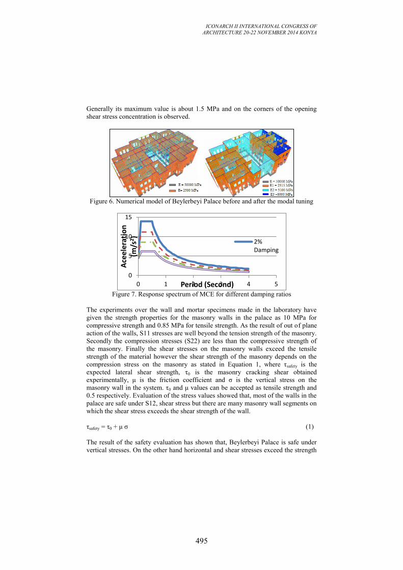
ICONARCH II INTERNATIONAL CONGRESS OF
ARCHITECTURE 20-22 NOVEMBER 2014 KONYA
495
Generally its maximum value is about 1.5 MPa and on the corners of the opening
shear stress concentration is observed.
Figure 6. Numerical model of Beylerbeyi Palace before and after the modal tuning
Figure 7. Response spectrum of MCE for different damping ratios
The experiments over the wall and mortar specimens made in the laboratory have
given the strength properties for the masonry walls in the palace as 10 MPa for
compressive strength and 0.85 MPa for tensile strength. As the result of out of plane
action of the walls, S11 stresses are well beyond the tension strength of the masonry.
Secondly the compression stresses (S22) are less than the compressive strength of
the masonry. Finally the shear stresses on the masonry walls exceed the tensile
strength of the material however the shear strength of the masonry depends on the
compression stress on the masonry as stated in Equation 1, where τsafety is the
expected lateral shear strength, τ0 is the masonry cracking shear obtained
experimentally, μ is the friction coefficient and σ is the vertical stress on the
masonry wall in the system. τ0 and μ values can be accepted as tensile strength and
0.5 respectively. Evaluation of the stress values showed that, most of the walls in the
palace are safe under S12, shear stress but there are many masonry wall segments on
which the shear stress exceeds the shear strength of the wall.
τsafety = τ0 + μ σ (1)
The result of the safety evaluation has shown that, Beylerbeyi Palace is safe under
vertical stresses. On the other hand horizontal and shear stresses exceed the strength
0
5
10
15
0 1 2 3 4 5
Ace
eler
atio
n
(m/s
2)
Period (Second)
2% Damping
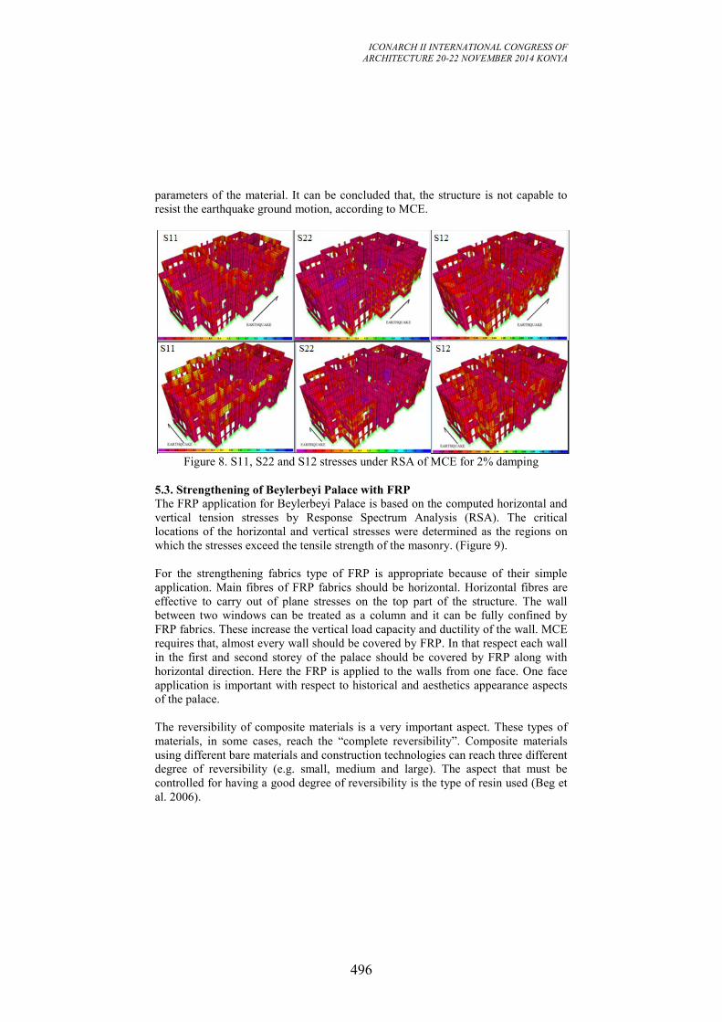
ICONARCH II INTERNATIONAL CONGRESS OF
ARCHITECTURE 20-22 NOVEMBER 2014 KONYA
496
parameters of the material. It can be concluded that, the structure is not capable to
resist the earthquake ground motion, according to MCE.
Figure 8. S11, S22 and S12 stresses under RSA of MCE for 2% damping
5.3. Strengthening of Beylerbeyi Palace with FRP
The FRP application for Beylerbeyi Palace is based on the computed horizontal and
vertical tension stresses by Response Spectrum Analysis (RSA). The critical
locations of the horizontal and vertical stresses were determined as the regions on
which the stresses exceed the tensile strength of the masonry. (Figure 9).
For the strengthening fabrics type of FRP is appropriate because of their simple
application. Main fibres of FRP fabrics should be horizontal. Horizontal fibres are
effective to carry out of plane stresses on the top part of the structure. The wall
between two windows can be treated as a column and it can be fully confined by
FRP fabrics. These increase the vertical load capacity and ductility of the wall. MCE
requires that, almost every wall should be covered by FRP. In that respect each wall
in the first and second storey of the palace should be covered by FRP along with
horizontal direction. Here the FRP is applied to the walls from one face. One face
application is important with respect to historical and aesthetics appearance aspects
of the palace.
The reversibility of composite materials is a very important aspect. These types of
materials, in some cases, reach the “complete reversibility”. Composite materials
using different bare materials and construction technologies can reach three different
degree of reversibility (e.g. small, medium and large). The aspect that must be
controlled for having a good degree of reversibility is the type of resin used (Beg et
al. 2006).
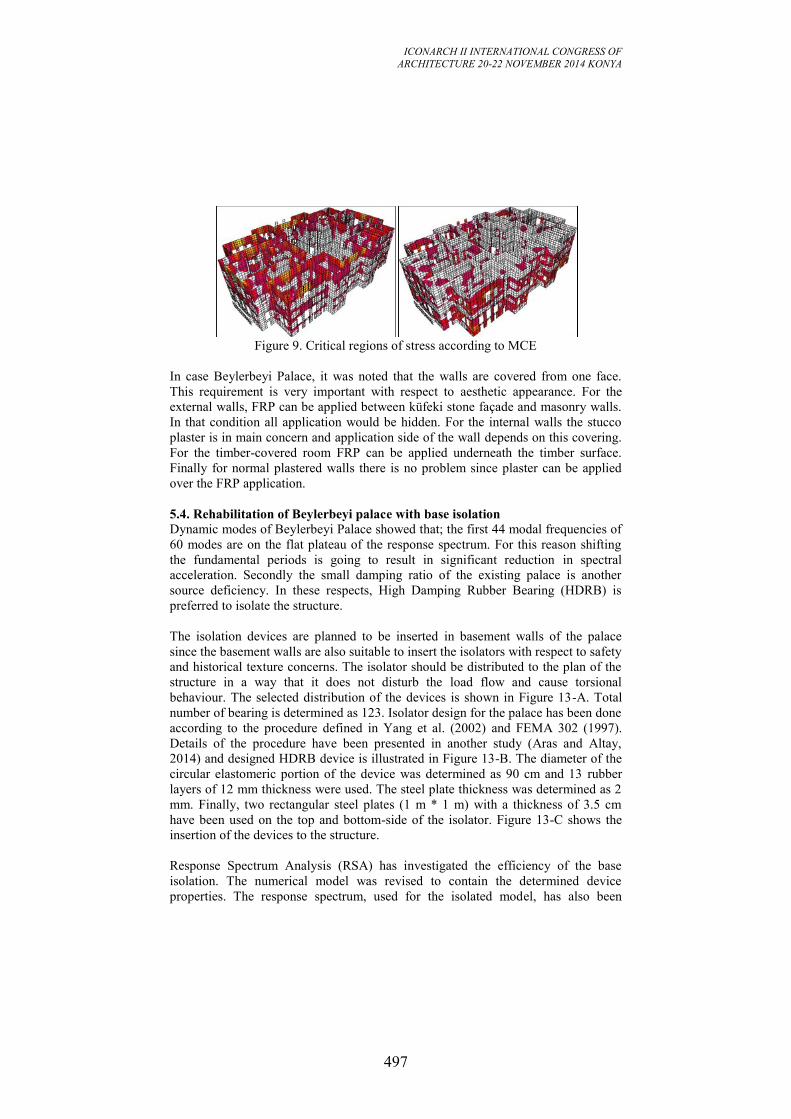
ICONARCH II INTERNATIONAL CONGRESS OF
ARCHITECTURE 20-22 NOVEMBER 2014 KONYA
497
Figure 9. Critical regions of stress according to MCE
In case Beylerbeyi Palace, it was noted that the walls are covered from one face.
This requirement is very important with respect to aesthetic appearance. For the
external walls, FRP can be applied between küfeki stone façade and masonry walls.
In that condition all application would be hidden. For the internal walls the stucco
plaster is in main concern and application side of the wall depends on this covering.
For the timber-covered room FRP can be applied underneath the timber surface.
Finally for normal plastered walls there is no problem since plaster can be applied
over the FRP application.
5.4. Rehabilitation of Beylerbeyi palace with base isolation
Dynamic modes of Beylerbeyi Palace showed that; the first 44 modal frequencies of
60 modes are on the flat plateau of the response spectrum. For this reason shifting
the fundamental periods is going to result in significant reduction in spectral
acceleration. Secondly the small damping ratio of the existing palace is another
source deficiency. In these respects, High Damping Rubber Bearing (HDRB) is
preferred to isolate the structure.
The isolation devices are planned to be inserted in basement walls of the palace
since the basement walls are also suitable to insert the isolators with respect to safety
and historical texture concerns. The isolator should be distributed to the plan of the
structure in a way that it does not disturb the load flow and cause torsional
behaviour. The selected distribution of the devices is shown in Figure 13-A. Total
number of bearing is determined as 123. Isolator design for the palace has been done
according to the procedure defined in Yang et al. (2002) and FEMA 302 (1997).
Details of the procedure have been presented in another study (Aras and Altay,
2014) and designed HDRB device is illustrated in Figure 13-B. The diameter of the
circular elastomeric portion of the device was determined as 90 cm and 13 rubber
layers of 12 mm thickness were used. The steel plate thickness was determined as 2
mm. Finally, two rectangular steel plates (1 m * 1 m) with a thickness of 3.5 cm
have been used on the top and bottom-side of the isolator. Figure 13-C shows the
insertion of the devices to the structure.
Response Spectrum Analysis (RSA) has investigated the efficiency of the base
isolation. The numerical model was revised to contain the determined device
properties. The response spectrum, used for the isolated model, has also been
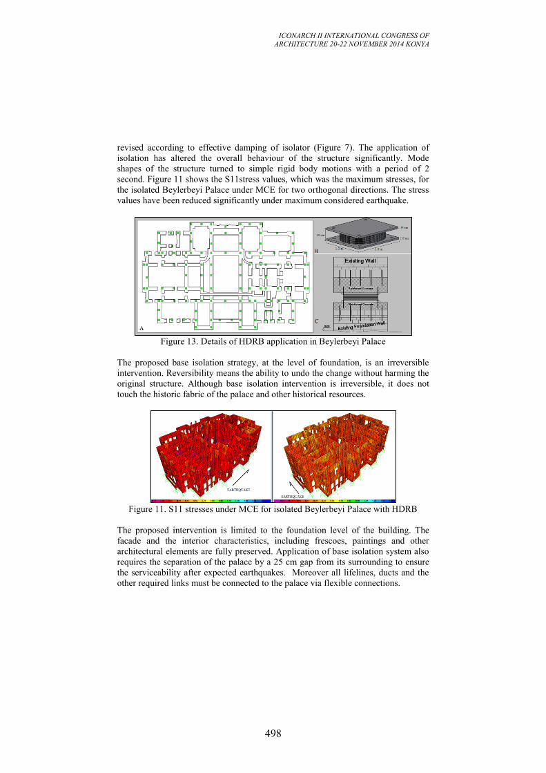
ICONARCH II INTERNATIONAL CONGRESS OF
ARCHITECTURE 20-22 NOVEMBER 2014 KONYA
498
revised according to effective damping of isolator (Figure 7). The application of
isolation has altered the overall behaviour of the structure significantly. Mode
shapes of the structure turned to simple rigid body motions with a period of 2
second. Figure 11 shows the S11stress values, which was the maximum stresses, for
the isolated Beylerbeyi Palace under MCE for two orthogonal directions. The stress
values have been reduced significantly under maximum considered earthquake.
Figure 13. Details of HDRB application in Beylerbeyi Palace
The proposed base isolation strategy, at the level of foundation, is an irreversible
intervention. Reversibility means the ability to undo the change without harming the
original structure. Although base isolation intervention is irreversible, it does not
touch the historic fabric of the palace and other historical resources.
Figure 11. S11 stresses under MCE for isolated Beylerbeyi Palace with HDRB
The proposed intervention is limited to the foundation level of the building. The
facade and the interior characteristics, including frescoes, paintings and other
architectural elements are fully preserved. Application of base isolation system also
requires the separation of the palace by a 25 cm gap from its surrounding to ensure
the serviceability after expected earthquakes. Moreover all lifelines, ducts and the
other required links must be connected to the palace via flexible connections.
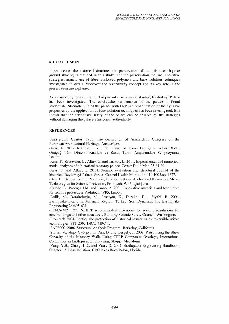
ICONARCH II INTERNATIONAL CONGRESS OF
ARCHITECTURE 20-22 NOVEMBER 2014 KONYA
499
6. CONCLUSION
Importance of the historical structures and preservation of them from earthquake
ground shaking is outlined in this study. For the preservation the use innovative
strategies, namely use of fibre reinforced polymers and base isolation techniques
investigated in detail. Moreover the reversibility concept and its key role in the
preservation are explained.
As a case study, one of the most important structures in Istanbul, Beylerbeyi Palace
has been investigated. The earthquake performance of the palace is found
inadequate. Strengthening of the palace with FRP and rehabilitation of the dynamic
properties by the application of base isolation techniques has been investigated. It is
shown that the earthquake safety of the palace can be ensured by the strategies
without damaging the palace’s historical authenticity.
REFERENCES
-Amsterdam Charter, 1975. The declaration of Amsterdam, Congress on the
European Architectural Heritage, Amsterdam.
-Aras, F. 2013. Istanbul’un kültürel mirası ve maruz kaldığı tehlikeler, XVII.
Oratçağ Türk Dönemi Kazıları ve Sanat Tarihi Araştırmaları Sempozyumu,
İstanbul.
-Aras, F., Krstevska, L., Altay, G. and Taskov, L. 2011. Experimental and numerical
modal analyses of a historical masonry palace. Constr Build Mat. 25:81-91
-Aras, F. and Altay, G. 2014. Seismic evaluation and structural control of the
historical Beylerbeyi Palace. Struct. Control Health Monit.. doi: 10.1002/stc.1677.
-Beg, D., Skuber, p. and Pavlovcic, L. 2006. Set-up of advanced Reversible Mixed
Technologies for Seismic Protection, Prohitech, WP6, Ljubljana.
-Calado, L., Proença J.M. and Panão, A. 2006. Innovative materials and techniques
for seismic protection, Prohitech, WP5, Lisbon.
-Erdik, M., Demircioglu, M., Sesetyan, K., Durukal, E., Siyahi, B. 2004.
Earthquake hazard in Marmara Region, Turkey. Soil Dynamics and Earthquake
Engineering 24:605-631.
-FEMA-302. 1997 NEHRP recommended provisions for seismic regulations for
new buildings and other structures, Building Seismic Safety Council, Washington.
-Prohitech 2004. Earthquake protection of historical structures by reversible mixed
technologies, FP6-2002-INCO-MPC-1.
-SAP2000. 2006. Structural Analysis Program- Berkeley, California.
-Stoian, V., Nagy-György, T., Dan, D. and Gergely, J. 2003. Retrofitting the Shear
Capacity of the Masonry Walls Using CFRP Composite Overlays, International
Conference in Earthquake Engineering, Skopje, Macedonia.
-Yang, Y.B., Chang, K.C. and Yau J.D. 2002. Earthquake Engineering Handbook,
Chapter 17: Base Isolation, CRC Press Boca Raton, Florida.
ICONARCH II INTERNATIONAL CONGRESS OF
ARCHITECTURE 20-22 NOVEMBER 2014 KONYA
500
CONTEMPORARY TIMBER WINDOW SOLUTIONS IN
TRADITIONAL TURKISH HOUSES
FATİH YAZICIOĞLU
ABSTRACT
Traditional Turkish houses are known with their unique architectural character
within a wide perspective, comprising different detail solutions. The character of
these houses is mainly shaped by the place and context they are located.
Geographical conditions, such as climate, sun, and wind, together with the cultural
factors dominate the planning of these houses in different scales. Organization of the
facade and especially the windows and doors, are some of the important attributes of
these houses. Within this framework, this paper aims to question and analyse timber
window solutions of traditional Turkish houses. Because of the different
configurations of traditional Turkish Houses this paper is limited with the houses
located in Istanbul, Bosporus. Firstly, traditional wooden houses, called ‘köşk’, of
Bosporus will be introduced. The visual relation of the house with the outer world
and mahalle, starts from the road they are located in with their entrance door and
continues through their inner hall ‘sofa’; and continues back to the road with the
views from the windows. This introduction shows the importance and dominance of
the windows in traditional Bosporus houses. The timber window solutions of these
houses allow the visual relation with their wide openings which bring several
challenges about the details of the windows. The weight of the sashes is an example
for these challenges. Without a mechanical support operating the sashes are a hard
and tiring activity, hence sometimes counterbalance systems were used in the
original details. Today in the restoration and reconstructions by using contemporary
technological solutions these kinds of side effects can be surpassed. In the paper, a
traditional house reconstruction in Bosporus is introduced by focusing its timber
window solutions. In this project, the form and size of the windows are the same as
the original traditional house so that the visual relation of the house with its
surrounding, and the overall original character of the building continues. By the
implication of contemporary detail solutions for its timber window, like the usage of
hydraulic pumps, double glazing, aluminium roller shutters, etc. its performance is
improved significantly. The performance of the window system is evaluated and
tentative proposals for the reconstructions, and restorations will be made.
Key words: windows; u-values; emissions; counter-balance systems, Traditional
Turkish houses
ICONARCH II INTERNATIONAL CONGRESS OF
ARCHITECTURE 20-22 NOVEMBER 2014 KONYA
501
1. INTRODUCTION
The design of one building element critically affects the function of the entire
building. External walls, which are parts of the envelope systems, are mainly
designed to be a barrier between the natural outdoor and the artificial indoor, and
they may perform a structural role (Binan, 1975). On the other hand, external walls
are far more inclined to be pierced with holes, better known as windows and doors
(Harris, 2001). Windows are the most critical parts of the envelope as several
different performance requirements are expected from them. They are both expected
to stay as an opening but on the other hand to stop unwanted conditions of the
natural environment (Pearce, 2007). The resulting output is a complex building
element with several components.
Bosporus has its unique architecture with unique window details. After 1983 it has
been protected by a special law through which new building constructions are
forbidden (TBMM, 1984). It is only possible to make restoration or reconstruction
of old buildings. The details used in the reconstructions of the Bosporus region is a
challenging field to study as the typical requirements of windows are also expected
from them, with the same appearance of their original design.
In this study, the details of the window system of a reconstructed original Bosporus
mansion is examined. 4 main implementations have been realized in the
reconstruction of the window system to better its performance. The examinations are
focused on those 4 main implementations. A performance assessment has been
realized to find out the usefulness of the implementations. The assessment is mainly
based on a self-reflection. At the end tentative proposals have been made to guide
the architects about the reconstruction of the window systems.
2. METHOD
The method adopted to this research consist of 3 parts. The first part is the detailed
documentation of the detail design of the case building’s window. The second part is
the analysis of the window, determination of the important implementations to the
original detail and the explanation of those implementations.
In this second part 4 important implementations have been determined and
explained:
1. The chemically treated and laminated wooden parts,
2. The double glazing,
3. The operation components, locking system and counter balance system,
4. The aluminium roller shutters.
In the final part a self-reflective performance assessment of the implementation have
been realized. 6 different performances were assessed in this part:
1. The structural performance,
2. The thermal performance,
3. The acoustic performance,
4. The water & moisture related performance,
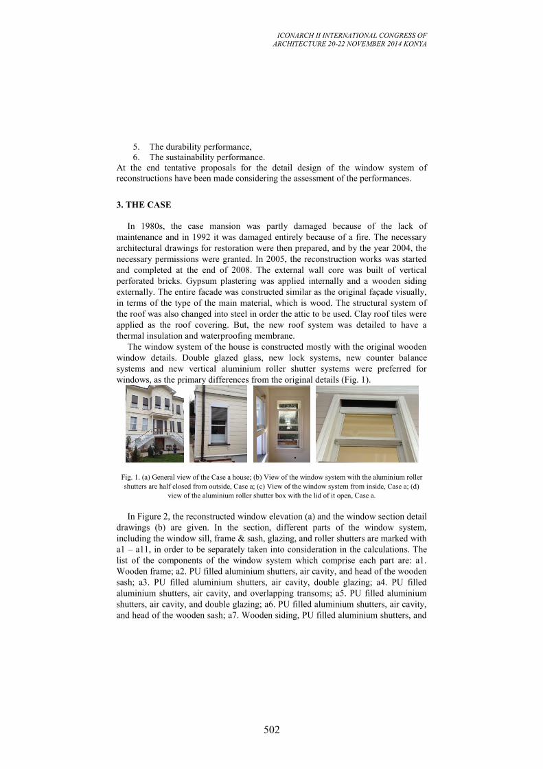
ICONARCH II INTERNATIONAL CONGRESS OF
ARCHITECTURE 20-22 NOVEMBER 2014 KONYA
502
5. The durability performance,
6. The sustainability performance.
At the end tentative proposals for the detail design of the window system of
reconstructions have been made considering the assessment of the performances.
3. THE CASE
In 1980s, the case mansion was partly damaged because of the lack of
maintenance and in 1992 it was damaged entirely because of a fire. The necessary
architectural drawings for restoration were then prepared, and by the year 2004, the
necessary permissions were granted. In 2005, the reconstruction works was started
and completed at the end of 2008. The external wall core was built of vertical
perforated bricks. Gypsum plastering was applied internally and a wooden siding
externally. The entire facade was constructed similar as the original façade visually,
in terms of the type of the main material, which is wood. The structural system of
the roof was also changed into steel in order the attic to be used. Clay roof tiles were
applied as the roof covering. But, the new roof system was detailed to have a
thermal insulation and waterproofing membrane.
The window system of the house is constructed mostly with the original wooden
window details. Double glazed glass, new lock systems, new counter balance
systems and new vertical aluminium roller shutter systems were preferred for
windows, as the primary differences from the original details (Fig. 1).
Fig. 1. (a) General view of the Case a house; (b) View of the window system with the aluminium roller
shutters are half closed from outside, Case a; (c) View of the window system from inside, Case a; (d)
view of the aluminium roller shutter box with the lid of it open, Case a.
In Figure 2, the reconstructed window elevation (a) and the window section detail
drawings (b) are given. In the section, different parts of the window system,
including the window sill, frame & sash, glazing, and roller shutters are marked with
a1 – a11, in order to be separately taken into consideration in the calculations. The
list of the components of the window system which comprise each part are: a1.
Wooden frame; a2. PU filled aluminium shutters, air cavity, and head of the wooden
sash; a3. PU filled aluminium shutters, air cavity, double glazing; a4. PU filled
aluminium shutters, air cavity, and overlapping transoms; a5. PU filled aluminium
shutters, air cavity, and double glazing; a6. PU filled aluminium shutters, air cavity,
and head of the wooden sash; a7. Wooden siding, PU filled aluminium shutters, and
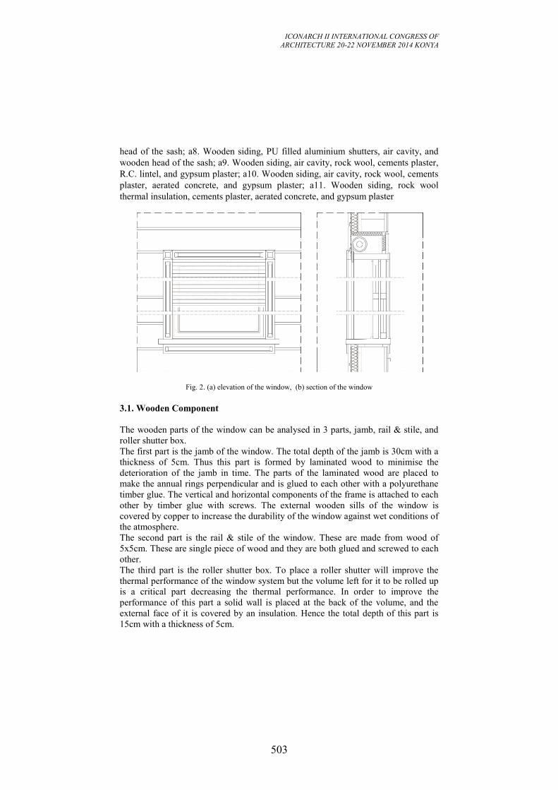
ICONARCH II INTERNATIONAL CONGRESS OF
ARCHITECTURE 20-22 NOVEMBER 2014 KONYA
503
head of the sash; a8. Wooden siding, PU filled aluminium shutters, air cavity, and
wooden head of the sash; a9. Wooden siding, air cavity, rock wool, cements plaster,
R.C. lintel, and gypsum plaster; a10. Wooden siding, air cavity, rock wool, cements
plaster, aerated concrete, and gypsum plaster; a11. Wooden siding, rock wool
thermal insulation, cements plaster, aerated concrete, and gypsum plaster
Fig. 2. (a) elevation of the window, (b) section of the window
3.1. Wooden Component
The wooden parts of the window can be analysed in 3 parts, jamb, rail & stile, and
roller shutter box.
The first part is the jamb of the window. The total depth of the jamb is 30cm with a
thickness of 5cm. Thus this part is formed by laminated wood to minimise the
deterioration of the jamb in time. The parts of the laminated wood are placed to
make the annual rings perpendicular and is glued to each other with a polyurethane
timber glue. The vertical and horizontal components of the frame is attached to each
other by timber glue with screws. The external wooden sills of the window is
covered by copper to increase the durability of the window against wet conditions of
the atmosphere.
The second part is the rail & stile of the window. These are made from wood of
5x5cm. These are single piece of wood and they are both glued and screwed to each
other.
The third part is the roller shutter box. To place a roller shutter will improve the
thermal performance of the window system but the volume left for it to be rolled up
is a critical part decreasing the thermal performance. In order to improve the
performance of this part a solid wall is placed at the back of the volume, and the
external face of it is covered by an insulation. Hence the total depth of this part is
15cm with a thickness of 5cm.
ICONARCH II INTERNATIONAL CONGRESS OF
ARCHITECTURE 20-22 NOVEMBER 2014 KONYA
504
3.2. Glazing
In the first sample window manufactured a standard double glazing is used, which
consist of 6mm of glazing, 12mm of air space and 6mm of glazing. But the total
weight of a sash has become about 19kg which is much for a standard counter
balance system. So it is decided to use a specially manufactured double glazing with
4mm of glazing, 6mm of air space, and 4mm of glazing. Although this will decrease
the thermal performance of the glazing of the window the performance related with
the ease of usage is accepted to be more critical. The double glazing is dimensioned
with the exact same size of the sash, this is rare in window designs and only in
wooden windows it is possible to do so. In other materials the difference between
the expansion capabilities of the materials usually deteriorates the glazing. This
detail make the integrated working of sash and glazing better and removes the need
of a nail to hold the glazing in its place. Once the glazing is placed, a glazing lath is
nailed to the rails & stiles, and silicone is applied in between.
3.3. Operating Components
There are 2 main operating components in the window systems; the lock
mechanisms, and the counter balance system.
The locking mechanism used in the window systems are specially produced to be fit
in the windows. They are working by tying the upper rail of the lower sash to the
lower rail of the upper sash. A pin attached to a spring is the component which ties
them. The resulting tying is strong and durable as the pin enters inside the upper
sash about 1cm.
The counter balance system used in the windows are also specially manufactured as
they should be critically designed to carry the exact same weight of each sash. The
working principle of the counter balance is simple but inspiring. A plastic tube of
about 1cm of diameter is hosting a spring. The spring is the critical component
which should be precisely manufactured to carry the load of the sashes. Though the
spring is adjustable it is limited to 0.5 kg. At the end point of the tube 2 small plates
is connected perpendicular to the spring. When these plates are screwed to the
sashes they start to tension the spring when the sash is open and loose the spring
when the sash is closed. The tube is placed in a space inside the jamb, next to the
sash. Both the upper and lower sashes of the window is operable so 4 counter
balances are used in each window.
3.4. Solar Control Component
Aluminium roller shutters are used in the window system. The casing used to store
the shutters when rolled up has been explained in section 2.1. The shutter is made of
aluminium and the lamellas of the shutter is filled by polyurethane thermal
insulation material which results a considerably improvement in the thermal
performance of the window system. A previous study has shown that the total U-
value of the window system is about 0.30W/m2K which is about 10 times better
ICONARCH II INTERNATIONAL CONGRESS OF
ARCHITECTURE 20-22 NOVEMBER 2014 KONYA
505
than the U value of the wooden windows of 3.00W/m2K (TSE, 2008), (Yazicioglu,
2013). In order to make the air space between the shutter and the sashes contribute
to the thermal performance it should be a closed space and the related standard only
accepts an open space of about 0.4mm. In order to achieve this a brush is added on
the intersection point of the shutter and the frame (ISO, 2012). It is for sure that the
shutters won’t be kept close all along but it will make significant contributions. The
rails the aluminium shutters are moving in are also made of aluminium and they are
placed inside the jamb near to the front. The shutters are operated with a tubular
electric motor which is activated from the buttons placed next to the inner face of
the jamb.
4. PERFORMANCE ASSESSMENT
The reconstruction of a historic building is always a difficult and problematic
activity. The reason of this is the intention to keep the buildings appearance and
character the same as the original building, but at the same time improving almost
all performances of the building and its elements. This makes the detail design
activity even more complicated because the original details limits the usage of most
detail patterns available and the architect should find a new way for almost all
simple detail parts. The windows are the most critical parts of these reconstructions
as they are both giving the main character of the building and they are most critical
part of the building in terms of performances. In this section of the paper the
performance of the parts of the window system is going to be evaluated. In each sub-
section firstly the main performances expected from that component is going to be
listed according to their priority, and then each component is evaluated according to
each performance. Charts has been generating showing the success of the
component according to each performance. If a component is very successful it is
going to get a “+”, if it is moderate it is going to get a “0”, and if it is not successful
it is going to get a “-“.
4.1. Performance Assessment of the Wooden Components of the Window
The main performance requirements expected from the wooden components of the
window are; structure, thermal, water & moisture, acoustics, durability, and
sustainability. Firstly the structural performance; loads coming onto the window,
both static and dynamic loads are transferred to the wall by the help of the wooden
components of the window. The wooden component of the window are very
successful against static loads. But it is not as strong as the static loads against the
dynamic loads. Depending on the amplitude of the wind the sashes may sometimes
make cracking noises. The reason of this is the absence of a rubber joint sealant but
in these kinds of sliding windows it is not possible to place a sealant as a space
should be left between the sash and the jamb to make sliding possible. There is only
a felt between them but under strong wind conditions that becomes insufficient.
Secondly, the thermal performance of the window is very successful both about the
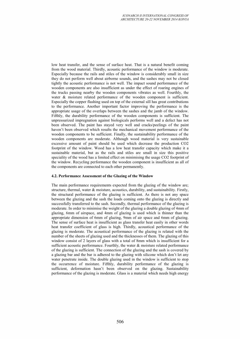
ICONARCH II INTERNATIONAL CONGRESS OF
ARCHITECTURE 20-22 NOVEMBER 2014 KONYA
506
low heat transfer, and the sense of surface heat. That is a natural benefit coming
from the wood material. Thirdly, acoustic performance of the window is moderate.
Especially because the rails and stiles of the window is considerably small in size
they do not perform well about airborne sounds, and the sashes may not be closed
tightly the acoustic performance is not well. The impact sound performance of the
wooden components are also insufficient as under the effect of roaring engines of
the trucks passing nearby the wooden components vibrates as well. Fourthly, the
water & moisture related performance of the wooden component is sufficient.
Especially the copper flashing used on top of the external sill has great contributions
to the performance. Another important factor improving the performance is the
appropriate usage of the overlaps between the sashes and the jamb of the window.
Fifthly, the durability performance of the wooden components is sufficient. The
unpressurized impregnation against biologicals performs well and a defect has not
been observed. The paint has stayed very well and cracks/peelings of the paint
haven’t been observed which results the mechanical movement performance of the
wooden components to be sufficient. Finally, the sustainability performance of the
wooden components are moderate. Although wood material is very sustainable
excessive amount of paint should be used which decrease the production CO2
footprint of the window. Wood has a low heat transfer capacity which make it a
sustainable material, but as the rails and stiles are small in size this positive
speciality of the wood has a limited effect on minimising the usage CO2 footprint of
the window. Recycling performance the wooden component is insufficient as all of
the components are connected to each other permanently.
4.2. Performance Assessment of the Glazing of the Window
The main performance requirements expected from the glazing of the window are;
structure, thermal, water & moisture, acoustics, durability, and sustainability. Firstly,
the structural performance of the glazing is sufficient. As there is not any space
between the glazing and the sash the loads coming onto the glazing is directly and
successfully transferred to the sash. Secondly, thermal performance of the glazing is
moderate. In order to minimise the weight of the glazing a double glazing of 4mm of
glazing, 6mm of airspace, and 4mm of glazing is used which is thinner than the
appropriate dimension of 6mm of glazing, 9mm of air space and 6mm of glazing.
The sense of surface heat is insufficient as glass transfer heat easily in other words
heat transfer coefficient of glass is high. Thirdly, acoustical performance of the
glazing is moderate. The acoustical performance of the glazing is related with the
number of the sheets of glazing used and the thicknesses of them. The glazing of this
window consist of 2 layers of glass with a total of 8mm which is insufficient for a
sufficient acoustic performance. Fourthly, the water & moisture related performance
of the glazing is sufficient. The connection of the glazing and the sash is covered by
a glazing bar and the bar is adhered to the glazing with silicone which don’t let any
water penetrate inside. The double glazing used in the window is sufficient to stop
the occurrence of moisture. Fifthly, durability performance of the glazing is
sufficient, deformation hasn’t been observed on the glazing. Sustainability
performance of the glazing is moderate. Glass is a material which needs high energy
ICONARCH II INTERNATIONAL CONGRESS OF
ARCHITECTURE 20-22 NOVEMBER 2014 KONYA
507
to be manufactured or recycled. Hence production CO2 footprint performance is
insufficient and recycling performance of the glazing is moderate. The in use CO2
footprint of the glazing is moderate as the thermal performance of it is moderate.
4.3. Performance Assessment of the Operation Components of the Window
There are 2 operation related components in the window system, locking mechanism
and the counter balance system. The locking mechanism is placed in the internal
side of the window and the counter balance system is buried inside the jamb which
makes them irrelevant with thermal, acoustic, and water & moisture related
performances. The main performance requirements expected from the operation
components of the window are; structure, durability, and sustainability related. The
performance assessment of the locking mechanism is going to be made firstly. The
structural performance of the lock system is sufficient. It doesn’t let sashes to be
opened when closed. The durability performance of it is moderate because there the
lock is working by the help of a spring inside the lock system. That spring
sometimes loosens which results a malfunction. The sustainability performance of it
is also moderate as it is made of aluminium and although aluminium is a recyclable
material it needs high energy to recycle. The performance assessment of the counter
balance system is going to be made secondly. The structural performance of the
counter balance system is sufficient. The counter balances holds the sashes in the
desired height without a failure. They also make the operation of the sashes easy and
smooth. The durability performance of them is also sufficient as a failure or
malfunction hasn’t been observed. Finally the sustainability performance of the
counter balances is moderate as it is made of plastics and steel which are both
recyclable but need lots of energy to be produced and recycled.
4.4 Performance Assessment of the Roller Shutters of the Window
The main performance requirements expected from the roller shutters of the window
are; structure, thermal, water & moisture, acoustics, durability, and sustainability.
Firstly; the structural performance of the roller shutters are sufficient. The roller
shutters may operate easily. The only moderate thing about them is under the effect
of strong winds some cracking noises may come from the shutters which decrease
its structural performance a little bit. Secondly; the thermal performance of the
shutter are sufficient. It gives great contribution to the thermal performance for the
window system with the help of the PU filling inside the lamellas. They also act as a
shading device in summer conditions and minimising the heat gains from sun light.
Thirdly, the acoustic performance of the shutters are moderate. As they do not have
a large mass their contribution to acoustic performance of the window is limited.
Fourthly, water related performance of the shutters is moderate. The shutters mainly
blocks the penetration of water on the internal side of the shutter. But on the internal
joints of the lamellas moisture may sometimes be observed. Fifthly the durability
performance of the shutters are sufficient. Malfunctions related with the movement
of the shutter were not observed. Lastly sustainability performance of the shutters
are moderate. The shutters are made of aluminium with PU filling inside both of
ICONARCH II INTERNATIONAL CONGRESS OF
ARCHITECTURE 20-22 NOVEMBER 2014 KONYA
508
which have very large CO2 footprints because of the energy needed to produce the
materials. But they have significant contributions to the thermal performance of the
window system which minimise the in use CO2 footprint of the system. On the other
hand recycling the lamellas are also not convenient as separating the PU and
aluminium is not easy (Yazicioglu, 2013).
5. CONCLUSION
In 2005 a traditional Bosporus mansion has been reconstructed. The character, the
overall appearance, and the main material of the window has been kept same as the
original window but some modifications have also been made to improve the
performance of the window system. The main modifications realized are the usage
of treated wood, double glazing, new counter balance & lock, and the
implementation of an aluminium roller shutter. The new window system has been
observed for 4 years, the maintenances realized has been observed and interviews
were realized with the users of the windows. The data obtained has been analysed
and a critical performance assessment has been made about the new
implementations. Table 1 demonstrates different performances of the
implementations. 6 different performances have been taken into account for the
assessment, these are; structural, thermal, acoustics, water & moisture related,
durability, and sustainability. If the implementation is sufficient about the
performance than a “+”, if it is moderate about the performance than a “0” has been
marked, and if it is insufficient about the performance than a “-” has been marked to
the designated space in the table. Table 1. Performance assessment of the implementations of the window.
wooden
component glazing
operation
components
aluminium
roller shutter
Performance
related with
structure
static loads + + + +
dynamic loads (wind) 0 + + 0
Performance
related with
thermal issues
low heat transfer + 0 / +
sense of high surface
heat + - / /
shading / / / +
Performance
related with
acoustics
impact sound 0 0 / 0
air born sound 0 0 / 0
Perf. rel. w. water
& moisture
resistance
water resistance + + / 0
moisture resistance + + / 0
Performance
related with
durability
resistance to
biologicals + / / /
res. to mechanical
movements 0 + + +
Performance
related with
sustainability
CO2 footprint of
production 0 - 0 -
CO2 footprint of usage 0 0 / +
recycling - 0 0 -
The structural performance of the implementations of the window is mainly
sufficient. Only the usage of wooden component and aluminium shutter is
moderately satisfying the performance. In order to slide the sashes vertically a space
ICONARCH II INTERNATIONAL CONGRESS OF
ARCHITECTURE 20-22 NOVEMBER 2014 KONYA
509
should be left between the sash and the jamb which results a decrease about the
dynamic loads. The same kind of a situation also exists in roller shutters, as they
consist of small and light lamellas they perform slightly insufficient under the effect
of dynamic loads. The thermal performance of the implementations of the window is
mainly sufficient. Only the glazing used has a moderate thermal performance. The
reason is the need of lightening and minimising the window and in order to lighten it
thin layers of glazing is used and in order to minimise a thin layer of air space is
used. The acoustic performance of the implementations of the window is mainly
moderate. The joints between the sashes and the lamb and the minimal design of the
window are the main reasons of this. Water & moisture related performance of the
window is mainly sufficient. Only when the roller shutters are closed rainwater or
moisture may pass between the lamellas of the shutter, but as the passing rain water
or moisture is still in the external environment this is not a critical performance
failure. Durability related performance of the window is sufficient. Although there
are several working pieces in the window a critical failure has not been found. And
finally sustainability performance is moderate. Treating wooden component with
chemicals, painting them, usage of aluminium with PU fillings are the main factors
decreasing the sustainability performance.
Although further quantitative studies should be made, with this qualitative
assessment the overall performance of the window system is found to be sufficient.
There isn’t any major performance failures in the window system. The most
important performance requirement, which is the appearance or appropriateness to
the original character, has also been satisfied sufficiently. Hence the details
implemented for this window may be used for other reconstructions’ windows.
REFERENCES
-Binan, M. 1975. Yapı Elemanları, İstanbul İTÜ
-Harris, S.Y., 2001. Building Pathology-Deterioration, Diagnostics, and
Intervention. John Wiley&Sons, Inc.
-Pearce, J., 2007. Windows : history, repair, and conservation. Shaftesbury :
Donhead Pub.
-TBMM, 1984, Boğaziçi Kanunu, T.C. Resmi Gazete, Ankara
-TS825 Standart for Turkish Regulation of Heat Insulation in Buildings, Istanbul,
2008
-ISO 10077-2 2012, Thermal performance of windows, doors and shutters —
Calculation of thermal transmittance, Part 2: Numerical method for frames
- Yazicioglu, F. 2013, A comparative analysis of the energy performance of
traditional wooden shutters and contemporary aluminium roller shutters in Istanbul,
a case study, Energy Procedia, Volume 42, Pages 483-492
ICONARCH II INTERNATIONAL CONGRESS OF
ARCHITECTURE 20-22 NOVEMBER 2014 KONYA
510
POSTER SESSION
Rahmani KELKOUL LEILA
“A Way to Conserve Cultural Heritage in Architecture
Creation” p.511
Martin MBIDHI, Susan KIBUE
“The Effect of Typological and Morphological Elements of
Urban Space, and Non-Motorized Transport: The Case of
Nairobi City” p.517
Sepideh SAFARI
“A Study on Lalehzar Street to be Changed to a Proper
Walking Street While Focusing on Loose Spaces“ p.539
ICONARCH II INTERNATIONAL CONGRESS OF
ARCHITECTURE 20-22 NOVEMBER 2014 KONYA
511
A WAY TO CONSERVE CULTURAL HERITAGE IN
ARCHITECTURE CREATION
RAHMANI KELKOUL LEILA1
ABSTRACT
Using definitions of the type and model and through some architectural works this
presentation proposes an approach and a way to preserve the architectural heritage
through the architectural creation not by reproducing and copying but considering it
as a referential reservoir of ideas and architectural principles.
Key words: architectural heritage - architectural creation- model- type- reference.
INTRODUCTION
The architectural heritage question is often inquired in terms of physical and
technical conservation then all the reflections are oriented towards this direction. We
can also approach this issue from a different point of view; wich is the role of this
heritage in the architectural creation. What is that role? And how architectural
design can tap into that legacy without being in a movement such as mimicry,
kitsch, culturalism or post modernism? Are there any examples of architectural
creation that can support this speech? This topic will try to answer these questions
by taking the architectural legacy as a reference model to the architectural design
which transforms it into a new type. Using definitions of the architectural type and
model as presented by Quatremaire de Quincy and having for example a few
architectural works as the Pyramid’s Louvre of Pei, the Defence Arch of Johann
Otto Von Spreckelsen, and the Arabic World Institute of Jean Nouvel.
The architecture constitutes the living witness of what every society has built, it thus
reflects its way of living and being throughout the different periods of history. It is
therefore a considerable legacy and has a value that ranges it in what we can call
‘'heritage'. To ensure the transmission and continuity of this heritage, disciplines are
appeared to recognize, preserve and safeguard it. Recognition is done by the
archeology, the history of architecture and the history of the arts. The backup is
done mainly by the restoration which experienced a boom and considerable
development since the need was felt. So to evoke patrimony and cultural heritage
guide implicitly and explicitly to the evocation of its backup and thus the use of
conservation and restoration. However the recognition of the architectural value of
1 Master Assistant. El Bez University Institute of Architecture SETIF
ICONARCH II INTERNATIONAL CONGRESS OF
ARCHITECTURE 20-22 NOVEMBER 2014 KONYA
512
any object and the transmission of its legacy can also be done in a different way. A
dynamic way where it is highlighted through the present and the future and where it
plays a key role through the architectural creation and where the creation by
referring to this architectural heritage, demonstrates creativity and innovation while
remaining within the contemporary. How to get to take this challenge? Are there
examples of authors who held it? Refer to architectural heritage, requires first and
foremost a good knowledge of this heritage and its history. Thanks to architectural
archaeology, history of architecture could be built and was able to offer us a
concrete body of reference models. However knowledge of these models and their
use as reference does not mean copy them and imitate them as what. But and this is
the entire role innovative creative architectural, is using these models to invent and
build new types that are part of the present and the future. And this is all the
distinction between the model and the type in architecture, established for centuries
since the writings of Quatremaire de Quincy until our days. Indeed Quatremaire d. Q
defines the model and type as follows: “The model, heard in the practical execution
of the art, is an object that must be repeated as it is; the type is on the contrary, an
object from what everyone can design structures that look not like them. Everything
is accurate and given in the model; everything is more or less vague in the type.”
(«Le modèle, entendu dans l’exécution pratique de l’art, est un objet qu’on doit
répéter tel qu’il est ; le type est au contraire, un objet d’après le quel chacun peut
concevoir des ouvrages qui ne se ressembleraient pas entre eux. Tout est précis et
donné dans le modèle ; tout est plus ou moins vague dans le type»).He also said "the
Word type presents less the image of a thing to copy or imitate completely, that the
idea of an element that must it self be used as a rule to the model" (« le mot type
présente moins l’image d’une chose à copier ou à imiter complètement, que l’idée
d’un élément qui doit lui-même servir de règle au modèle ») (Quatremaire D. Q
1832). Later, references to these definitions have been included and well developed
with C Aimonino and the typo-morphological approach, Wittkower, Brinkmann ,
Schmarsow and much later by Portoghesi, C.Norberg Shulz...with the idea of
establishing the elements of scientific analysis of architecture different from the
aesthetic approach (Panerai P., et Al 1980). The dictionary definitions are not far
from these definitions they are given as follows «model: which serves as the object
of imitation...» and for" type: model abstract in a high degree the essential traits of
all objects of the same nature” («Modèle : ce qui sert d’objet d’imitation… », « type:
modèle abstrait réunissant à un haut degré les traits essentiels de tous les êtres ou de
tous les objets de même nature » ) (Larousse 2000). This distinction is fundamental
and it is allows the architectural creation to be always in contemporary by creating
new types from existing models, without however lapsing into culturalism (largely
explained by Françoise Choay and others as watershed in the tradition) or trends
such as postmodernism (established by Robert Venturi and other authors as picking
up items from the past), mimicry or even kitsch. The creation of the type requires
scientific knowledge of the model and its adaptation to the context environmental,
social, technique, economic, and cultural of its application. This is what attributes to
the architectural creation innovation and contemporary. Ignore the distinction
between the model and the type and the scientific ignorance of what is the template
leads to such reproduction without adapting it to its context; It is which accuses the
ICONARCH II INTERNATIONAL CONGRESS OF
ARCHITECTURE 20-22 NOVEMBER 2014 KONYA
513
architectural creation by mimicry. The resumption of some formal elements without
being actually the fundamental characteristics of the model this is what taxes the
architectural creation of the production of the image of kitsch.
Since antiquity the architectural creation has steadily innovate drawing references
from models that preceded it. Therefore, we cite the example of the evolution of the
pyramid of Egypt which referring to the Mesopotamian Ziggurat and the Mastaba of
Egypt, it was able to combine between them and evolved through time to constitute
later a reference to the pyramid of the Louvre. The pyramid of Egypt as the Mastaba
is a funerary temple sheltering inside intimate the mortal remains of the deceased
gods, however it is not sufficient for Pyramid to have the parallelipedique block
appearance of the Mastaba but as the image of the Ziggurat, it superimposes floors
until reach the Summit. This is what gave the pyramid of degree that has evolved in
the bent pyramid then the pyramid in its perfect form, which the concept was
revived later by the pyramid of the Louvre. Although the idea of creating a pyramid
at the Louvre Museum dates from the 18th
century it has seen its design and its
realization in the current form in 1989. The architect Ieoh Ming Pei proposed a
modern and innovative glass and metal pyramid using references in the pyramid of
Cheops. Several studies have tried to find the similarity and the references of the
pyramid of the Louvre in the pyramid of Egypt. They cited the reference to the
measures; the resumption of the idea of small pyramid next to the largest and
especially the idea of the basement of the Louvre which houses the treasures of the
past of the civilization to the idea of the treasures of the Pharaohs gods sheltered by
the pyramid of Egypt. (refer to the figure1 and 2).
The idea of the Arch to celebrate the victory of the Romans was also taken in many
regions of the world; the most innovative is witch the architect Johann Otto Von
Spreckelsen appropriates at the Big Defense Arch of Paris. He took the idea of the
Arch of triumph in the wanting rather than a victory but a modern opening and a
window on the world, as says the author "the Arch is first the Arch of the
brotherhood, which is the motto of the Republic as that of masonry." (« L’Arche est
d’abord l’Arche de la Fraternité, qui est la devise de la République comme celle de
la maçonnerie.») (On line 2014http://archives). (Refer to the figure 3)
Even modern architecture which is known for having revolutionized the
architectural language by providing a new vision of the world, a new relationship,
new forms and new composition... this architecture doesn’t cease to refer in its
creations to the architectural heritage. The Work of the Pyramid of the Louvre, and
the Big Defense Arch are examples that illustrate their references to architectural
heritage while being in modernity. We also quote at this effect two great names of
modern architecture, Le Corbusier and Jean Nouvel. The most eloquent of Le
Corbusier references to the ancient legacy was his conception of the Modulor witch
the idea of proportionality and scaling architecture had been borrowed from the Or
Division (Section d’Or) of Greek architecture. The Modulor was the leitmotif of the
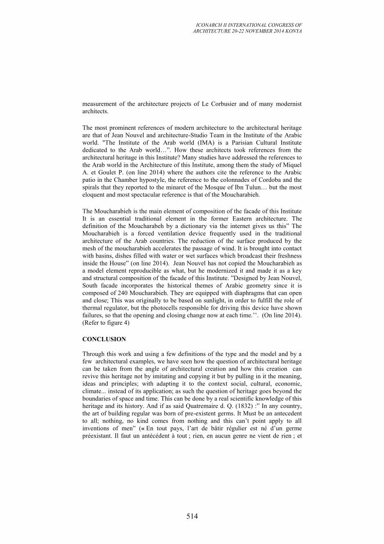
ICONARCH II INTERNATIONAL CONGRESS OF
ARCHITECTURE 20-22 NOVEMBER 2014 KONYA
514
measurement of the architecture projects of Le Corbusier and of many modernist
architects.
The most prominent references of modern architecture to the architectural heritage
are that of Jean Nouvel and architecture-Studio Team in the Institute of the Arabic
world. "The Institute of the Arab world (IMA) is a Parisian Cultural Institute
dedicated to the Arab world…”. How these architects took references from the
architectural heritage in this Institute? Many studies have addressed the references to
the Arab world in the Architecture of this Institute, among them the study of Miquel
A. et Goulet P. (on line 2014) where the authors cite the reference to the Arabic
patio in the Chamber hypostyle, the reference to the colonnades of Cordoba and the
spirals that they reported to the minaret of the Mosque of Ibn Tulun… but the most
eloquent and most spectacular reference is that of the Moucharabieh.
The Moucharabieh is the main element of composition of the facade of this Institute
It is an essential traditional element in the former Eastern architecture. The
definition of the Moucharabeh by a dictionary via the internet gives us this” The
Moucharabieh is a forced ventilation device frequently used in the traditional
architecture of the Arab countries. The reduction of the surface produced by the
mesh of the moucharabieh accelerates the passage of wind. It is brought into contact
with basins, dishes filled with water or wet surfaces which broadcast their freshness
inside the House” (on line 2014). Jean Nouvel has not copied the Moucharabieh as
a model element reproducible as what, but he modernized it and made it as a key
and structural composition of the facade of this Institute. ”Designed by Jean Nouvel,
South facade incorporates the historical themes of Arabic geometry since it is
composed of 240 Moucharabieh. They are equipped with diaphragms that can open
and close; This was originally to be based on sunlight, in order to fulfill the role of
thermal regulator, but the photocells responsible for driving this device have shown
failures, so that the opening and closing change now at each time.’’. (On line 2014).
(Refer to figure 4)
CONCLUSION
Through this work and using a few definitions of the type and the model and by a
few architectural examples, we have seen how the question of architectural heritage
can be taken from the angle of architectural creation and how this creation can
revive this heritage not by imitating and copying it but by pulling in it the meaning,
ideas and principles; with adapting it to the context social, cultural, economic,
climate... instead of its application; as such the question of heritage goes beyond the
boundaries of space and time. This can be done by a real scientific knowledge of this
heritage and its history. And if as said Quatremaire d. Q. (1832) :” In any country,
the art of building regular was born of pre-existent germs. It Must be an antecedent
to all; nothing, no kind comes from nothing and this can’t point apply to all
inventions of men” (« En tout pays, l’art de bâtir régulier est né d’un germe
préexistant. Il faut un antécédent à tout ; rien, en aucun genre ne vient de rien ; et
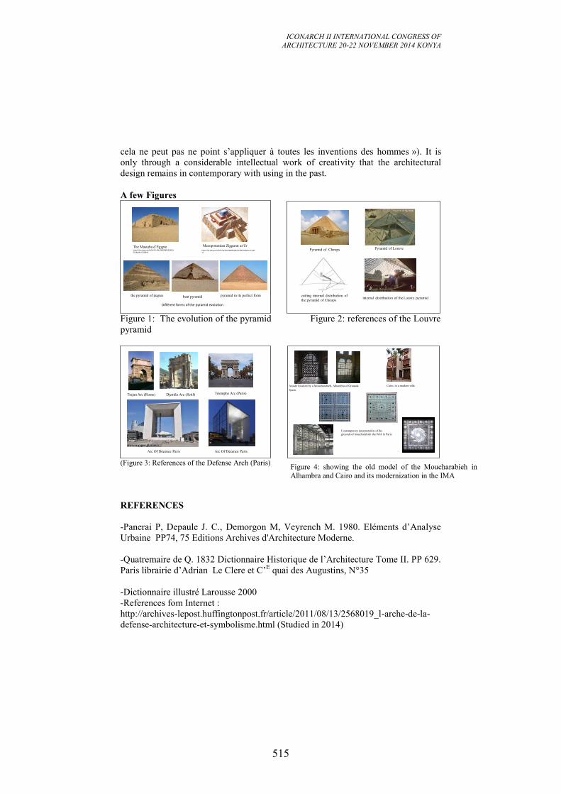
ICONARCH II INTERNATIONAL CONGRESS OF
ARCHITECTURE 20-22 NOVEMBER 2014 KONYA
515
cela ne peut pas ne point s’appliquer à toutes les inventions des hommes »). It is
only through a considerable intellectual work of creativity that the architectural
design remains in contemporary with using in the past.
A few Figures
The Mastaba d’Egypte https://sp.yimg.com/ib/th?id=HN.608005891532063531&pid=15.1&P=0
https://sp.yimg.com/ib/th?id=HN.608039186121363421&pid=15.1&P=0
Mesopotamian Ziggurat at Ur
the pyramid of degree bent pyramid pyramid in its perfect form
Différent forms of the pyramid evolution
cutting internal distribution of
the pyramid of Cheopsinternal distribution of the Louvre pyramid
Pyramid of LouvrePyramid of Cheops
Figure 1: The evolution of the pyramid Figure 2: references of the Louvre
pyramid
Trajan Arc (Rome) Djemila Arc (Setif) Triomphe Arc (Paris)
Arc Of Décence Paris Arc Of Décence Paris
Contemporary interpretation of the
grounds of moucharabieh the IMA in Paris
Arcade blocked by a Moucharabieh, Alhambra of Granada
Spain.
Cairo, in a modern villa
(Figure 3: References of the Defense Arch (Paris)
REFERENCES
-Panerai P, Depaule J. C., Demorgon M, Veyrench M. 1980. Eléments d’Analyse
Urbaine PP74, 75 Editions Archives d'Architecture Moderne.
-Quatremaire de Q. 1832 Dictionnaire Historique de l’Architecture Tome II. PP 629.
Paris librairie d’Adrian Le Clere et C’E quai des Augustins, N°35
-Dictionnaire illustré Larousse 2000
-References fom Internet :
http://archives-lepost.huffingtonpost.fr/article/2011/08/13/2568019_l-arche-de-la-
defense-architecture-et-symbolisme.html (Studied in 2014)
Figure 4: showing the old model of the Moucharabieh in
Alhambra and Cairo and its modernization in the IMA

ICONARCH II INTERNATIONAL CONGRESS OF
ARCHITECTURE 20-22 NOVEMBER 2014 KONYA
516
-(.Miquel A, P. Goulet) in
http://www.imarabe.org/sites/default/files/architecture.pdf . (Studied in 2014)
-http://archives-epost.huffingtonpost.fr/article/2011/08/13/2568019_l-arche-de-la-
defense-architecture-et-symbolisme.html (2014)
-http://v-a-m.forumactif.com/t36-l-institut-du-monde-arabe. (2014)
-http://fr.wikipedia.org/wiki/Moucharabieh (2014)
ICONARCH II INTERNATIONAL CONGRESS OF
ARCHITECTURE 20-22 NOVEMBER 2014 KONYA
517
TYPOMORPHOLOGICAL ELEMENTS OF URBAN SPACE
AND NON-MOTORIZED TRANSPORT IN NAIROBI CITY MBIDHI MARTIN, KIBUE SUSAN
ABSTRACT
At the rate the world is urbanizing, it is predicted that by 2030 all developing
regions will have more people living in urban than rural areas. The rapid
urbanization has led to change in urban structures leading to sprawling cities. The
urban sprawl has resulted in challenges of mobility thereby making access to work
opportunities and services more difficult for urban residents. The challenge for
urban planners is how the urban space can be transformed innovatively to solve the
mobility problem in the midst of incalculable complexity of the cities, composed as
they are of so many different actors groups and institutions. This paper is based on a
study conducted in Nairobi city, Kenya on Non-Motorised Transport (NMT) users.
Most NMT users in Nairobi are captive to this mode of transport but are faced with
long travel distance and difficult and dangerous travel environment. The study
hypothesizes that the unfavourable travel environment is as a result of the poor
planning and design of the urban space. It seeks to establish the effect of typo-
morphological elements of the urban space on NMT travel environment by focusing
on the journey to work. The study covered selected neighbourhoods in Nairobi as
trip origins and the work places in the industrial area as the trip destination. A multi-
stage technique was used in obtaining the primary data: interview schedule applied
at trip destinations, a walk-through interview schedule applied along travel route and
an observation checklist applied on four major routes selected on the basis of
frequency. Preliminary results show that the spaces NMT users select to walk or
cycle through are at variance with those areas designated for their use through urban
planning. The study is expected to contribute towards the development and
refinement of guidelines for designing new neighbourhoods and for retrofitting
existing ones to better reflect current NMT planning goals. Ultimately, the
predictions will be used to help determine how public resources can be best
prioritized and allocated to achieve the planning goals of the city and create a safe
and attractive travel environment for NMT users.
Key words: Typo-Morphology, Urban space, Innovative, Complexity,
Computations
1. INTRODUCTION
Many transportation planners have noted that cities in all parts of the world are
struggling to achieve some acceptable standard of mobility due to its significance to
all social and economic activities of any city. Pacione(2009) has shown that demand
for transport in the cities whether for people or goods, is determined largely by the
spatial arrangement of different land uses. In most countries, passenger cars and
trucks have become the most important transport modes (Joewono, 2005). This
ICONARCH II INTERNATIONAL CONGRESS OF
ARCHITECTURE 20-22 NOVEMBER 2014 KONYA
518
scenario is encouraged by the post-war “modernist” planning practices that focused
on the large scale and efficiency of the motorised transport (Salingaros, 2012).
In many developing cities high growth of the vehicle fleet has taken place in recent
years (Pacione, 2009) and planners have tended to plan at large scale to
accommodate growing vehicle numbers. Non-motorized transport (NMT), which in
earlier times was the common way of linking together places of activities, has to a
large extent been substituted by the car in daily mobility, and by trucks, for freight
movement (Fjellstrom, 2002). Nevertheless, NMT still has a significant beneficial
impact to users and their environment. In many cities, it is the main mode of
transportation for the majority of urban dwellers, and in some a significant source of
income. It therefore has a very significant poverty reduction impact. Where NMT is
the main transport mode for the work journeys of the residents, it is also critical for
the economic functioning of the city (Joewono 2009). Despite this obvious merit,
NMT has tended to be ignored by policymakers in the formulation of infrastructure
policy and sometimes discouraged as a transport mode. Further, it is sometimes
viewed as an unpleasant and dangerous, mode of transport in some of the very poor
countries (Witink, 1998).
In the recent years, the problems associated with motorised transportation systems
have led urban planners and designers of cities in highly industrialized countries to
re-evaluate the approach to planning of cities are in respect to mobility and the
general quality of the urban life. As Joh et al. (2012) point out, planning for
sustainable communities has arguably become the dominant paradigm for urban and
community planners in the twenty-first century with the promotion of walkable
communities and walking behaviour as its primary thrust. In this endeavour, the
over-arching view has been that the city is a very complex entity and that its
problems, be they mobility related or other cannot be solved by focusing on one
aspect in isolation. In other words, the city needs not only to be efficient but also
liveable (Marshal, 2012). Thus, the problems of mobility must be studied in the
context of the entire urban space.
The emerging urban space planning and design concept promotes an approach
which seeks to limit car use in cities by focusing on small-scale mixed use
neighbourhoods. This concept, promoted by the New Urbanism movement
recognizes the significant role played by NMT in urban environments and aims at
developing neighbourhoods and other urban spaces that are not only NMT friendly
but also contribute to the liveability of the city in the overall.
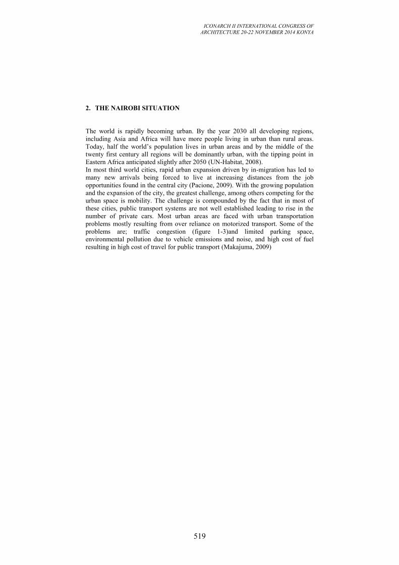
ICONARCH II INTERNATIONAL CONGRESS OF
ARCHITECTURE 20-22 NOVEMBER 2014 KONYA
519
2. THE NAIROBI SITUATION
The world is rapidly becoming urban. By the year 2030 all developing regions,
including Asia and Africa will have more people living in urban than rural areas.
Today, half the world’s population lives in urban areas and by the middle of the
twenty first century all regions will be dominantly urban, with the tipping point in
Eastern Africa anticipated slightly after 2050 (UN-Habitat, 2008).
In most third world cities, rapid urban expansion driven by in-migration has led to
many new arrivals being forced to live at increasing distances from the job
opportunities found in the central city (Pacione, 2009). With the growing population
and the expansion of the city, the greatest challenge, among others competing for the
urban space is mobility. The challenge is compounded by the fact that in most of
these cities, public transport systems are not well established leading to rise in the
number of private cars. Most urban areas are faced with urban transportation
problems mostly resulting from over reliance on motorized transport. Some of the
problems are; traffic congestion (figure 1-3)and limited parking space,
environmental pollution due to vehicle emissions and noise, and high cost of fuel
resulting in high cost of travel for public transport (Makajuma, 2009)
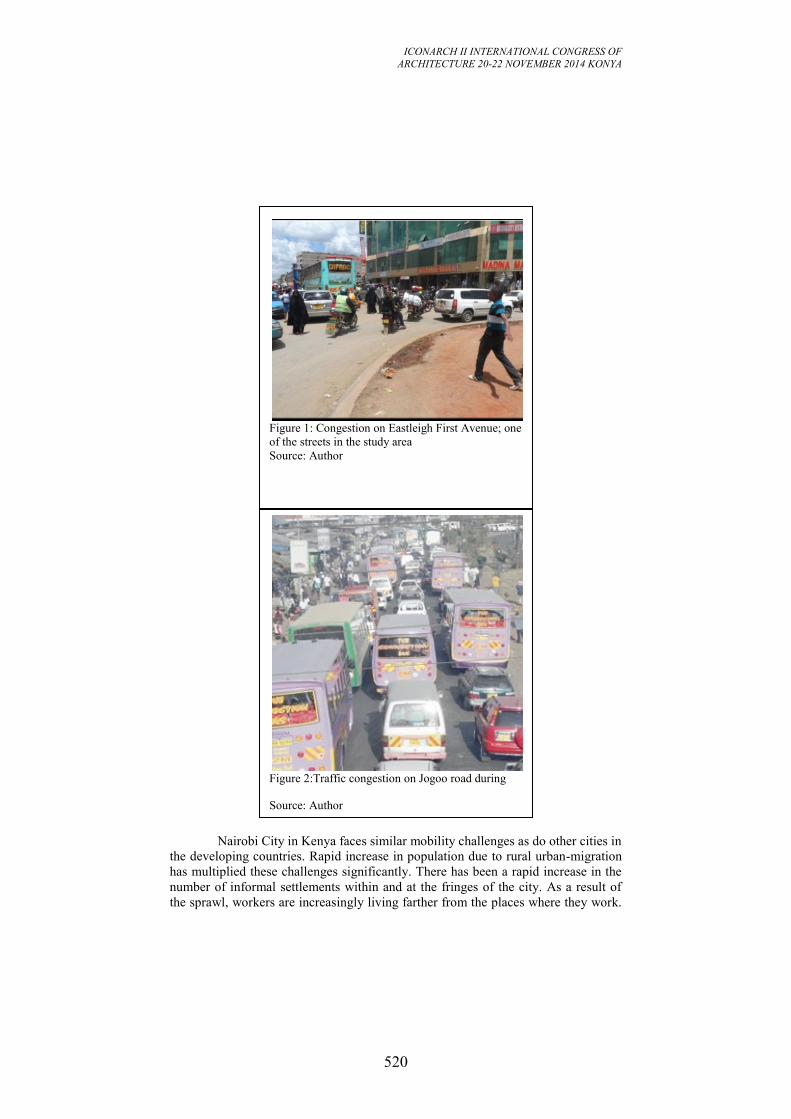
ICONARCH II INTERNATIONAL CONGRESS OF
ARCHITECTURE 20-22 NOVEMBER 2014 KONYA
520
Nairobi City in Kenya faces similar mobility challenges as do other cities in
the developing countries. Rapid increase in population due to rural urban-migration
has multiplied these challenges significantly. There has been a rapid increase in the
number of informal settlements within and at the fringes of the city. As a result of
the sprawl, workers are increasingly living farther from the places where they work.
Figure 2:Traffic congestion on Jogoo road during
Source: Author
Figure 1: Congestion on Eastleigh First Avenue; one
of the streets in the study area
Source: Author
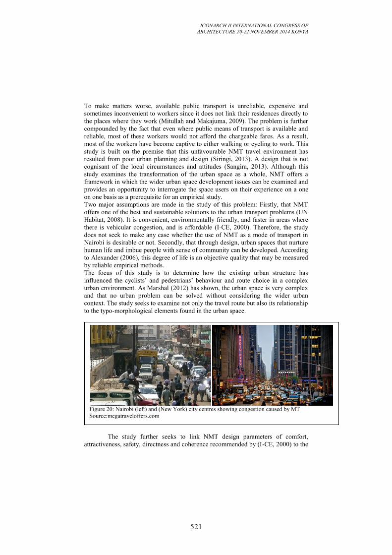
ICONARCH II INTERNATIONAL CONGRESS OF
ARCHITECTURE 20-22 NOVEMBER 2014 KONYA
521
To make matters worse, available public transport is unreliable, expensive and
sometimes inconvenient to workers since it does not link their residences directly to
the places where they work (Mitullah and Makajuma, 2009). The problem is further
compounded by the fact that even where public means of transport is available and
reliable, most of these workers would not afford the chargeable fares. As a result,
most of the workers have become captive to either walking or cycling to work. This
study is built on the premise that this unfavourable NMT travel environment has
resulted from poor urban planning and design (Siringi, 2013). A design that is not
cognisant of the local circumstances and attitudes (Sangira, 2013). Although this
study examines the transformation of the urban space as a whole, NMT offers a
framework in which the wider urban space development issues can be examined and
provides an opportunity to interrogate the space users on their experience on a one
on one basis as a prerequisite for an empirical study.
Two major assumptions are made in the study of this problem: Firstly, that NMT
offers one of the best and sustainable solutions to the urban transport problems (UN
Habitat, 2008). It is convenient, environmentally friendly, and faster in areas where
there is vehicular congestion, and is affordable (I-CE, 2000). Therefore, the study
does not seek to make any case whether the use of NMT as a mode of transport in
Nairobi is desirable or not. Secondly, that through design, urban spaces that nurture
human life and imbue people with sense of community can be developed. According
to Alexander (2006), this degree of life is an objective quality that may be measured
by reliable empirical methods.
The focus of this study is to determine how the existing urban structure has
influenced the cyclists’ and pedestrians’ behaviour and route choice in a complex
urban environment. As Marshal (2012) has shown, the urban space is very complex
and that no urban problem can be solved without considering the wider urban
context. The study seeks to examine not only the travel route but also its relationship
to the typo-morphological elements found in the urban space.
The study further seeks to link NMT design parameters of comfort,
attractiveness, safety, directness and coherence recommended by (I-CE, 2000) to the
Figure 20: Nairobi (left) and (New York) city centres showing congestion caused by MT
Source:megatraveloffers.com
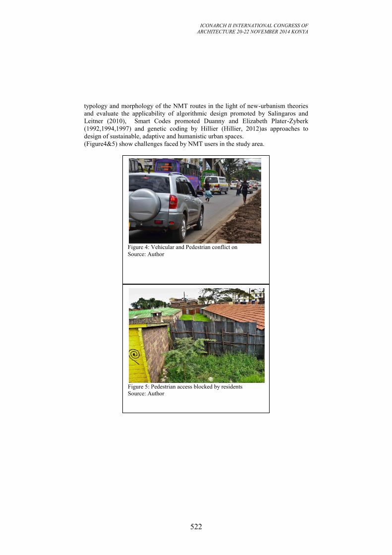
ICONARCH II INTERNATIONAL CONGRESS OF
ARCHITECTURE 20-22 NOVEMBER 2014 KONYA
522
typology and morphology of the NMT routes in the light of new-urbanism theories
and evaluate the applicability of algorithmic design promoted by Salingaros and
Leitner (2010), Smart Codes promoted Duanny and Elizabeth Plater-Zyberk
(1992,1994,1997) and genetic coding by Hillier (Hillier, 2012)as approaches to
design of sustainable, adaptive and humanistic urban spaces.
(Figure4&5) show challenges faced by NMT users in the study area.
Figure 5: Pedestrian access blocked by residents
Source: Author
Figure 4: Vehicular and Pedestrian conflict on
Source: Author
ICONARCH II INTERNATIONAL CONGRESS OF
ARCHITECTURE 20-22 NOVEMBER 2014 KONYA
523
3. RESULTS AND DISCUSSION
3.1 Introduction
This study was set on the premise that the unfavourable travel environment for NMT
users in Nairobi is as a result of poor urban space planning and design. The
independent variables of typological and morphological elements of urban space are
looked at in terms of density, diversity, design and destination against the dependent
variables for NMT defined in terms of coherence, directness, attractiveness, safety
and comfort. This section identifies the typological and morphological elements and
seeks to establish which of these elements and the extent to which they influence the
NMT users’ behaviour and route choice on a home-to-work trip. The data is
presented following the objectives set out for this study. Firstly, the typological and
morphological characteristics of the NMT routes in selected Eastland’s estates are
established according to route choices by NMT users; and secondly the NMT users’
behaviour in their travel environment and their response to it are established
3.2 Typological and morphological characteristics of the routes
The NMT user interview carried out at the travel destinations identified four major
routes used by respondents on the home to work trips. The respondents were shown
the area map of the travel routes on which landmarks had been identified. The
respondents were then asked to identify the routes which they frequently used shows
the main routes used by NMT users as identified from the interview at travel
destinations. The table shows the numbers that use the routes after cleaning out the
data by eliminating routes that do not fall directly within the study area.
ICONARCH II INTERNATIONAL CONGRESS OF
ARCHITECTURE 20-22 NOVEMBER 2014 KONYA
524
Figure 6: The four routes in the study area
Source: Author shows the routes on a map of the study area. Route one runs through
the outer edge along Eastleigh First Avenue and connects Jogoo road directly to Juja
road. Route three and four cut through the study area in the north-easterly direction.
At one point, the two routes merge within Jericho estate. It is notable that due to the
large area covered by the Moi Airbase, there is a large distance, almost four
kilometres between route 2 and 3. NMT users that live beyond the airbase have
therefore to cover much longer distances to reach their destinations. It is also clear
that the NMT users using route three and four follow a more convoluted route to
reach their destination at the junction of Outer Ring road and Juja road. From the
ICONARCH II INTERNATIONAL CONGRESS OF
ARCHITECTURE 20-22 NOVEMBER 2014 KONYA
525
study, it was noted that most NMT users avoid routes which have high vehicular
traffic and would rather travel longer distances than use more direct routes that have
higher vehicular traffic. This is evident in the fact that route three and four users
converge at an area which has almost no vehicular traffic.
3.3 Typological characteristics of the four routes
The study sought to identify the typological characteristics of the NMT routes in the
study area. Four main routes were identified. Shows the typology of buildings found
in selected sections along the four routes. Route one has predominantly high rise
(more than two storey) buildings with either commercial function or mixed use. In
the mixed use buildings, most commercial activities take place at ground floor level
while the upper floors are used as residential premises. Route two is predominantly
high rise residential blocks. There are also a significant number of single storey
informal structures along this route. Route three has predominantly single storey and
double storey residential blocks. However, there are other typologies such as
schools, commercial blocks, churches and community centres. The route also passes
through an area of informal settlements (Kamande) along the Airbase boundary.
Route four has almost similar typology to route three except that some sections of
the route have high rise residential blocks while others have mixed use functions
especially in the Hamza area.
Shows a figure ground image of the four routes. Route one and two show high
densities with most areas covered by building blocks. Route three has sections
which show varying densities. The area between Jogoo road and Eldebi road has a
variety of built and open spaces along the route. The section passing through
Kamande informal settlement is heavily built with very few open spaces left. Route
four has the largest areas that are open. The routes passes through a number of
neighbourhoods with low rise residential blocks planned around courtyards.
Figures 9-12 show different typologies found along the four routes.
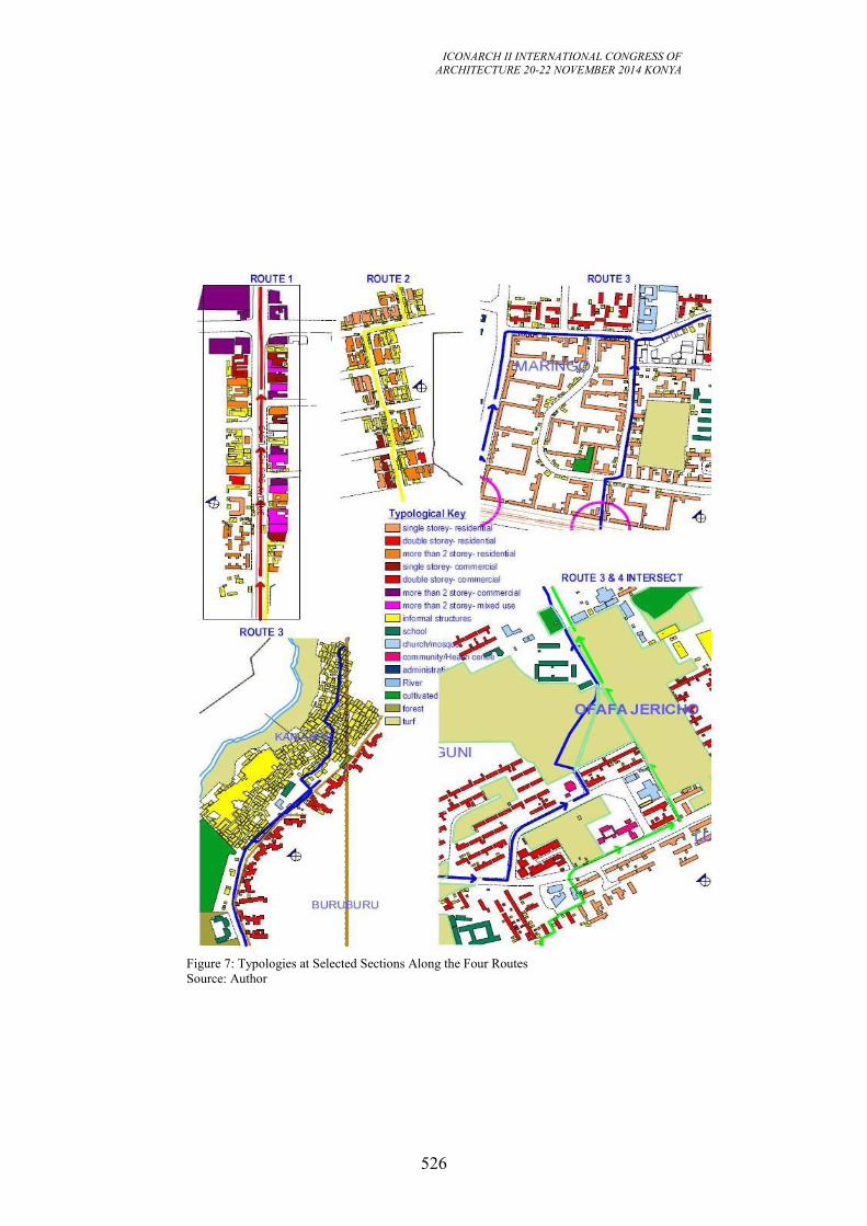
ICONARCH II INTERNATIONAL CONGRESS OF
ARCHITECTURE 20-22 NOVEMBER 2014 KONYA
526
Figure 7: Typologies at Selected Sections Along the Four Routes
Source: Author
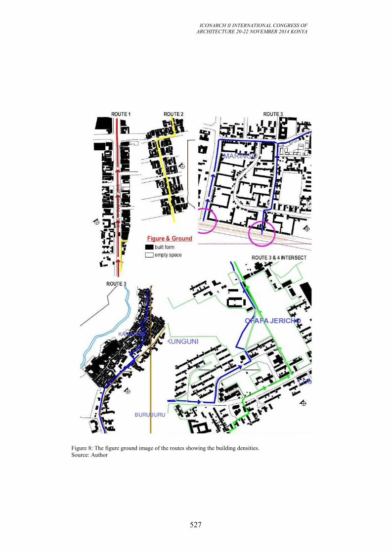
ICONARCH II INTERNATIONAL CONGRESS OF
ARCHITECTURE 20-22 NOVEMBER 2014 KONYA
527
Figure 8: The figure ground image of the routes showing the building densities.
Source: Author
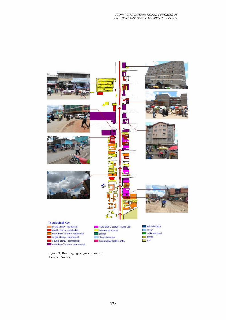
ICONARCH II INTERNATIONAL CONGRESS OF
ARCHITECTURE 20-22 NOVEMBER 2014 KONYA
528
Figure 9: Building typologies on route 1
Source: Author
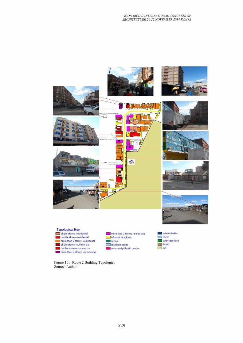
ICONARCH II INTERNATIONAL CONGRESS OF
ARCHITECTURE 20-22 NOVEMBER 2014 KONYA
529
Figure 10 : Route 2 Building Typologies
Source: Author
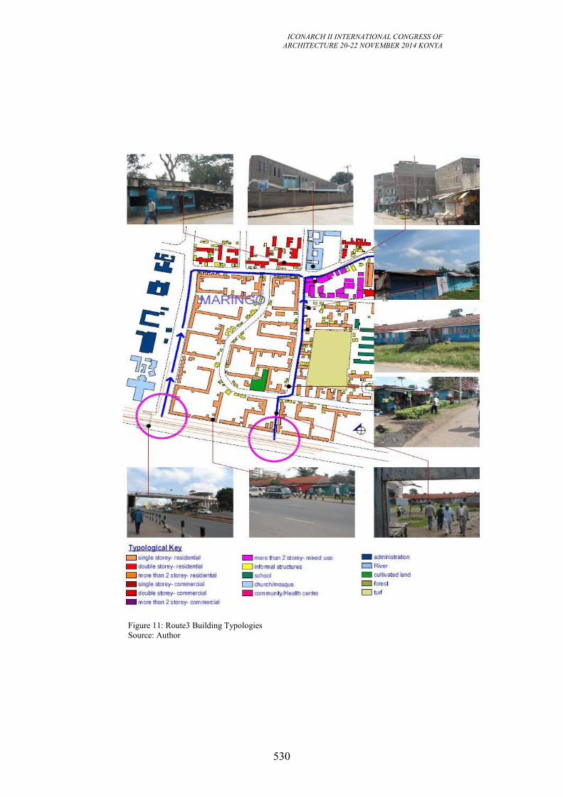
ICONARCH II INTERNATIONAL CONGRESS OF
ARCHITECTURE 20-22 NOVEMBER 2014 KONYA
530
Figure 11: Route3 Building Typologies
Source: Author
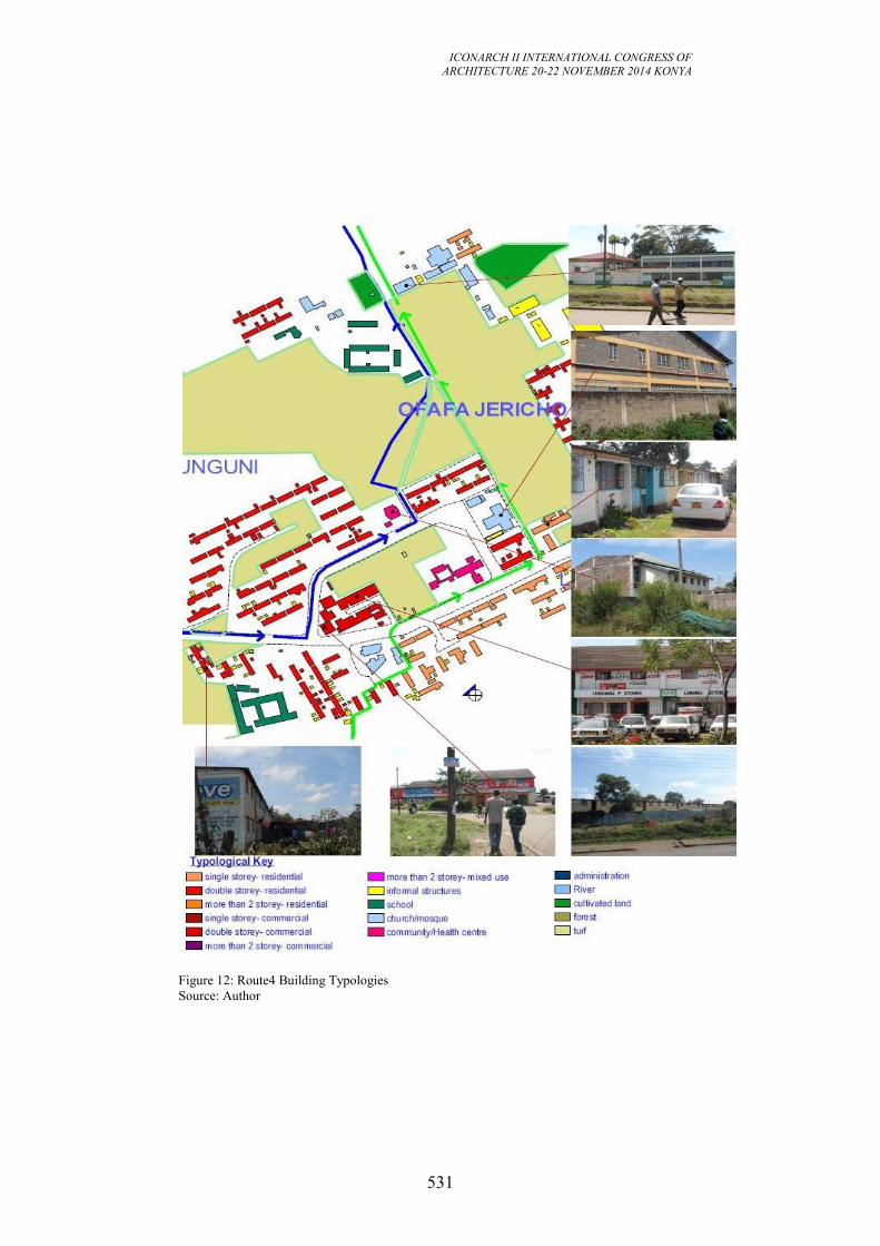
ICONARCH II INTERNATIONAL CONGRESS OF
ARCHITECTURE 20-22 NOVEMBER 2014 KONYA
531
Figure 12: Route4 Building Typologies
Source: Author
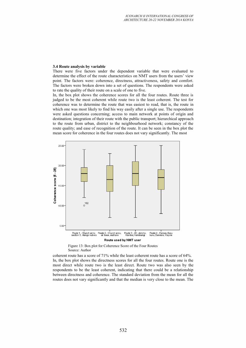
ICONARCH II INTERNATIONAL CONGRESS OF
ARCHITECTURE 20-22 NOVEMBER 2014 KONYA
532
3.4 Route analysis by variable
There were five factors under the dependent variable that were evaluated to
determine the effect of the route characteristics on NMT users from the users’ view
point. The factors were: coherence, directness, attractiveness, safety and comfort.
The factors were broken down into a set of questions. The respondents were asked
to rate the quality of their route on a scale of one to five.
In, the box plot shows the coherence scores for all the four routes. Route three is
judged to be the most coherent while route two is the least coherent. The test for
coherence was to determine the route that was easiest to read, that is, the route in
which one was most likely to find his way easily after a single use. The respondents
were asked questions concerning; access to main network at points of origin and
destination; integration of their route with the public transport; hierarchical approach
to the route from urban, district to the neighbourhood network; constancy of the
route quality; and ease of recognition of the route. It can be seen in the box plot the
mean score for coherence in the four routes does not vary significantly. The most
coherent route has a score of 71% while the least coherent route has a score of 64%.
In, the box plot shows the directness scores for all the four routes. Route one is the
most direct while route two is the least direct. Route two was also seen by the
respondents to be the least coherent, indicating that there could be a relationship
between directness and coherence. The standard deviation from the mean for all the
routes does not vary significantly and that the median is very close to the mean. The
Figure 13: Box plot for Coherence Score of the Four Routes
Source: Author
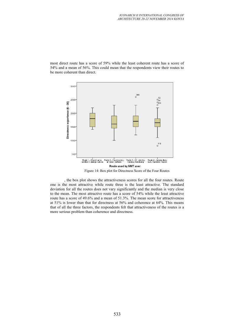
ICONARCH II INTERNATIONAL CONGRESS OF
ARCHITECTURE 20-22 NOVEMBER 2014 KONYA
533
most direct route has a score of 59% while the least coherent route has a score of
54% and a mean of 56%. This could mean that the respondents view their routes to
be more coherent than direct.
, the box plot shows the attractiveness scores for all the four routes. Route
one is the most attractive while route three is the least attractive. The standard
deviation for all the routes does not vary significantly and the median is very close
to the mean. The most attractive route has a score of 54% while the least attractive
route has a score of 49.6% and a mean of 51.3%. The mean score for attractiveness
at 51% is lower than that for directness at 56% and coherence at 64%. This means
that of all the three factors, the respondents felt that attractiveness of the routes is a
more serious problem than coherence and directness.
Figure 14: Box plot for Directness Score of the Four Routes
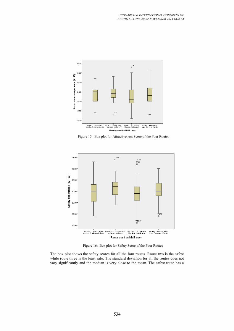
ICONARCH II INTERNATIONAL CONGRESS OF
ARCHITECTURE 20-22 NOVEMBER 2014 KONYA
534
The box plot shows the safety scores for all the four routes. Route two is the safest
while route three is the least safe. The standard deviation for all the routes does not
vary significantly and the median is very close to the mean. The safest route has a
Figure 16: Box plot for Safety Score of the Four Routes
Figure 15: Box plot for Attractiveness Score of the Four Routes
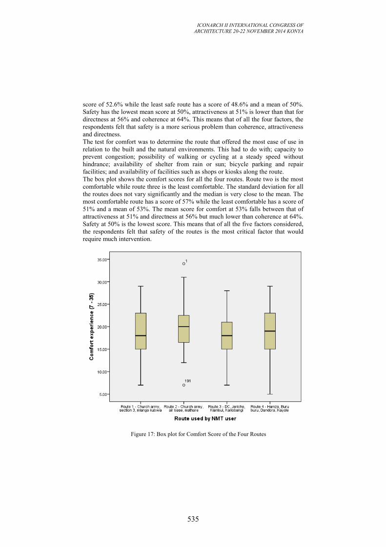
ICONARCH II INTERNATIONAL CONGRESS OF
ARCHITECTURE 20-22 NOVEMBER 2014 KONYA
535
score of 52.6% while the least safe route has a score of 48.6% and a mean of 50%.
Safety has the lowest mean score at 50%, attractiveness at 51% is lower than that for
directness at 56% and coherence at 64%. This means that of all the four factors, the
respondents felt that safety is a more serious problem than coherence, attractiveness
and directness.
The test for comfort was to determine the route that offered the most ease of use in
relation to the built and the natural environments. This had to do with; capacity to
prevent congestion; possibility of walking or cycling at a steady speed without
hindrance; availability of shelter from rain or sun; bicycle parking and repair
facilities; and availability of facilities such as shops or kiosks along the route.
The box plot shows the comfort scores for all the four routes. Route two is the most
comfortable while route three is the least comfortable. The standard deviation for all
the routes does not vary significantly and the median is very close to the mean. The
most comfortable route has a score of 57% while the least comfortable has a score of
51% and a mean of 53%. The mean score for comfort at 53% falls between that of
attractiveness at 51% and directness at 56% but much lower than coherence at 64%.
Safety at 50% is the lowest score. This means that of all the five factors considered,
the respondents felt that safety of the routes is the most critical factor that would
require much intervention.
Figure 17: Box plot for Comfort Score of the Four Routes
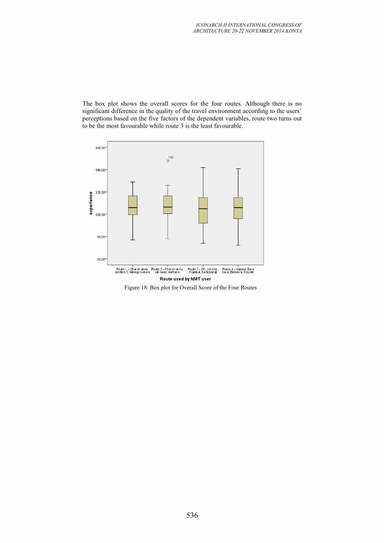
ICONARCH II INTERNATIONAL CONGRESS OF
ARCHITECTURE 20-22 NOVEMBER 2014 KONYA
536
The box plot shows the overall scores for the four routes. Although there is no
significant difference in the quality of the travel environment according to the users’
perceptions based on the five factors of the dependent variables, route two turns out
to be the most favourable while route 3 is the least favourable.
Figure 18: Box plot for Overall Score of the Four Routes
ICONARCH II INTERNATIONAL CONGRESS OF
ARCHITECTURE 20-22 NOVEMBER 2014 KONYA
537
4. CONCLUSION
This study has established that typological and morphological elements of urban
space do not have significant influence on NMT users’ behaviour and route choice
on journey to work. However, the study has identified safety of the NMT users as
the critical factor to be considered hen designing urban space for these users. Here
safety means that the NMT users are segregated from motorized traffic, and that
situations or environments that may expose the user to acts of thugery or mugging
should be eliminated.
REFERENCES
Alexander, C. (2006, December 16). Empirical Findings From The Nature of Order.
Berkeley, California, U.S.A.
Alexander, C., Ishikawa, S., Silverstein, M., Jacobson, M., Fiksdahl, I., & Angel, S.
(1977). A Pattern Language: Towns, Buildings, Construction. New York:
Oxford University Press.
Antonio Caperna, M. M.-Q. (2011). A Defination of P2P (Peer-to- Peer Urbanism).
In N. A. Salingaros, P2P URBANISM (pp. 4-9). Solingen: Umbau- Verlag.
Aspen, J. (2013). Oslo-The Triumph of Zombie Urbanism. In R. E.-K. Robbins
(Ed.), Shaping the City. Studies in History, Theory and Urban Design (pp.
183-200). Abingdon: Routledge.
BBC. (2014, January 23). Can Purpose-built Cities Solve Living Problems. The
Standard, p. 11.
Burgess, P. K. (2013, April Wednesday). Cyclists are set to win revolution in road
safety. The Times, p. 1 & 6.
Dumbaugh, R. E. (2009). The Built Environment and Traffic Safety: A Review of
EMperical Evidence. Journal of Planning Literature, 347-367.
Fjellstrom, K. (2002). Transport Demand Management: Towards an Integrated
Approach. Regional Woekshop on Transport Planning. Manila, Philippines.
Handy, S., & Mokhtarian, P. (2005). Which Comes First: The Neighbourhood or the
Walking. ACESS, 16-21.
Hillier, B. (2012). The Genetic Code for Cities: Is it Simpler than We Think. In N.
Portugali, Complexity Theories of Cities Have Come of Age. (pp. 129-
152). Berlin: Springer- Verlag.
Joan, B. (2013). Barcelona- Re-thinking Urbanistic Projects. In E.-K. R. Edward
(Ed.), Shapingthe City.Studies in History, Theory and Urban Design (2nd
ed., pp. 32-58). London: Routledge.
Joewono, T. B. (2005). The Characteristics of Paratransit and Non-Motorized
Transport in Bandung, Indonesia. Journal of the Eastern Asia Society for
Transportation Studies, 6, 262-277.
Kallus, R. (2001). From Abstract to Concrete: Subjective Reading of Urban Space.
Journal of Urban Design, 129-150.
ICONARCH II INTERNATIONAL CONGRESS OF
ARCHITECTURE 20-22 NOVEMBER 2014 KONYA
538
Marshal, S. (2012). Planning, Design and the Coplexity of Cities. In J. P. al (Ed.),
Complexity Theories of Cities Have Come Of Age. (pp. 191-205). Berlin:
Springer- Verlag.
Molthrop, E. (2011). Biophilic Design: A Review of Principles and Practice.
Dartmouth Undergraduate Journal of Science, 37-39.
Pacione, M. (2009). Urban Geography. Abingdon: Routledge..
Robbins, R. E.-K. (2013). Itroduction. In R. E.-K. Robbins (Ed.), Shaping the City.
Studies in History, Theory and Urban Design (pp. 1-5). London: Routledge.
Robins, E. (2013). New Urbanism. In R. E.-K. Robins (Ed.), Shaping the City.
Studiesin History, Theory and Urban Design (2nd Edition ed., pp. 312-
330). London: Routledge.
Rossi, A. (1982). The Architecture of the City. Massachusetts: MIT.
Rudofsky, B. (1964). Architecture Without Architects. London: Academy Edition.
Salingaros, N. A. (2006). A Theory of Architecture. Solingen: Umbau-Verlag.
Salingaros, N. A. (2010). Life and Geometry of the Environment. The Athens
Dialogues, 1-19.
Salingaros, N. A. (2012). Urbanism as Computation. In P. J. al, Complexity
Theories of Cities Have Come Off-Age (pp. 245-268). Berlin: Springer-
Verlag.
Siringi, S. (2013, May 11). How Poor Planning of Estates and Bad Roads Let
Criminals Thrive. Saturday Nation, pp. 10-11.
Times. (2013, April). Cycling and Safety. The Times. London: Times.
Ullman, C. D. (1945). The Nature of Cities. Annals of the American Academy of
Political and Social Science, 7-17.
Wilson, E. (1984). Biophilia. Cambridge: Havard University Press.
Witink, R. (1998). Road Safety Education: An Introduction to Road Traffic Safety-
a Multidisciplinary Approach. Utrecht: I-CE.
ICONARCH II INTERNATIONAL CONGRESS OF
ARCHITECTURE 20-22 NOVEMBER 2014 KONYA
539
A STUDY ON LALEHZAR STREET TO BE CHANGED TO A
PROPER WALKING STREET WHILE FOCUSING ON LOOSE
SPACES SEPIDEH SAFARI1
ABSTRACT
Nowadays, the quality and attraction of public urban spaces has been one of the
most crucial features for a city to be called developed and manageable. Pedestrian
walkways have a key role in social interactions in todays' virtual technology
age,economical impacts on the areas around and multi-functional dimensions
encompassing a wide range of activities. Historical texture and pedestrian walkways
have an important role in peoples' quality of living, therefore, different factors
affecting pedestrian walkways should be recognized and the loose spaces should be
used as a parameter to develop the pedestrian walkways qualitatively. Having
studied the related theories and concepts, and also Lalehzar street which has lost its
livelihood, the mentioned theories have been tried to be proven right. This research
tries to find strategies to make Lalehzar a successful urban pedestrian walkway.
Since the concept of Loose space has not been utilized for similar places in Iran, and
it is an effective factor in lively spaces, utilizing it along with historical Lalehzar
pedestrian walkway can be considered an innovative approach.Therefore, the
research model is prepared which covers the general model affecting factors on
practical pavements and proper urban spaces. Furtheremore, the loose spaces are
used for comparison and, finally, the loose spaces are mentioned as a progressive
development factor along with the pedestrian walkways.
Key words : Loose Space, Lalehzar Street, Pedestrian Walkway, Urban Space
1 Graduate student,Tehran Markaz University , Departement of Art and Architecture, Tehran.
ICONARCH II INTERNATIONAL CONGRESS OF
ARCHITECTURE 20-22 NOVEMBER 2014 KONYA
540
1. INTRODUCTION
Pedestrian walkways are the free spaces, with multi-purpose functions,
encompassing a wide range of activities like recreation, resting, pastime, games,
hobbies, artistic and cultural occasions, and business center unique to the cities in
the new millenium which are studied in this paper. The results show that people can
make the pedestrian walkways filled with joy, if the streets have a safe and proper
space and if the activities and hobbies are organized in a well-developed way,
peoples' attendance and also its viability and livelihood increase.
The urban loose spaces have complex symbols of functions and possess a variety of
principles and concepts whose understanding can affect the process of designing the
civil pedestrian walkways. Safety, livelihood and flexibility are the parameters
considered, while focusing on the designing of pedestrian walkways to be changed
to a successful urban area on Lalehzar Street and the loose spaces are introduced as
a symbol having all the factors of successful urban areas, proper pedestrian
walkways and a useful area to do a variety of functions. According to the above
ideas and in order to determine the research domain, the following questions are
given: 1-what strategies and guidelines should be used to change Lalehzar Street to a
proper urban pedestrian walkways? 2-what are the parameters for a successful
pedestrian walkway and what are their common qualities with the loose spaces?
This paper focuses on the mentioned goal in four parts. In part one, the crucial
viewpoints about a successful pedestrian walkway will be studied as one of the most
important urban spaces. Part two deals with qualities and practicalities of the loose
spaces. In part three, Lalehzar is named as a pedestrian walkway with the potential
to be changed to a successful urban place based on the qualities of loose spaces. In
concluding part, the results are given.
2. SUCCESSFUL URBAN SPACES
Urban spaces or public ones are the main living places for citizens; therefore, they
have a key role in the environmental livelihood and social life. The urban spaces
quality depends on many factors dealing with different individual understanding and
cultural values (Kashanijoo 2006). Car et.al, have made a list of people's needs to
have the optimum joy of a public space, including: "comfort, resting, non-active
presence in the place, active presence in the place while exploring, and proper
places." in figure 7 these factors were compared with the characteristics of Loose
spaces.
3. VARIOUS FUNCTIONS OF PEDESTRIAN WALKWAYS
People walk for different reasons and studies show that passersby walk to go
shopping, run errands, or have fun. Walking affects us both on body and mind. In
figure1, some of crucial functions of the pedestrian walkways are given (Shahidi
2002). Pedestrian walkways are multi-purpose which differentiates them from other
open and public urban areas. Dr. Pakzad in his book entitled 'Designing the urban
ICONARCH II INTERNATIONAL CONGRESS OF
ARCHITECTURE 20-22 NOVEMBER 2014 KONYA
541
spaces in Iran' summarizes the most crucial goals and qualities of a walkway named
livelihood, flexibility, and security (Pakzad 2005) (figure2).
Figure1. Varıous functıons of pedestrıan walkways
Figure2. Three characteristics of a proper pedestrain
4. FEATURES OF LOOSE SPACE
In urban public spaces around the world people pursue a very rich variety of
activities not originally intended for those locations. Accessibility, freedom of
choice and physical elements that occupants can appropriate all contribute to the
emergence of a loose space, but they are not sufficient. For a site to become loose,
people themselves must recognize the possibilities inherent in it and make use of
those possibilities for their own ends, facing the potential risks of doing so.
1-Flexibility: Many of the activities that generate looseness are neither productive
(like traveling to work) nor reproductive (like buying necessities), being instead a
matter of leisure, entertainment, self-expression or political expression, reflection
and social interaction- all outside the daily routine and the world of fixed functions
and fixed schedules. As importantly, loose space is a space apart from the
aesthetically and behaviorally controlled and homogeneous “themed” environments
of leisure and consumption where nothing unpredictable must occur (A.Frank 2006).
2-Livelihood and social interaction: The sense of freedom and the inclination to
engage in actions one might not elsewhere arise partly from the anonymity of urban
public space. For many people, the sense of being free from judgment is one of the
main pleasures of being out in public (Lofland 1998). Others may also approach us
and force us into engagements: foreigners who are lost, drunks, charity collectors, as
well as those who merely bump into us in crowds.
3-Safety: People’s frequent presence in loose spaces helps them have peace of mind.
Homeless people find shelter in loose spaces. If limiting the comings and goings is
necessary, then using obstacles is required. Then these obstacles can be used for
relaxing, leaning against, and other leisure activities. And by this the obstacles make
the space loose (A. Frank 2006).
Pedestrian walkway
Resting area
Fun and game area
Recreational green area
Recreational- business area
Cultural- artistic area
Proper pedestrian
Livelihood
Flexibility
Safety
ICONARCH II INTERNATIONAL CONGRESS OF
ARCHITECTURE 20-22 NOVEMBER 2014 KONYA
542
5. VARIOUS FUNCTIONS OF LOOSE SPACES Some of the activities that make a space loose are, in Gehl’s (1987) terms, necessary
while others are optional. People address their economic need to make a living
when, for instance, street vendors sell fresh produce and prepared foods in public
urban spaces on sidewalks and in squares. Or they may be selling art works,
handicrafts, “designer” watches, jewelry and sunglasses, souvenirs or handbags.
Musicians and mimes give street performances.
Physical recreation is one broad category of voluntary action that characterizes loose
space like climbing up lampposts, dirt biking in empty lots. Games may also be
more sedentary, such as chess. People find places for reading, drawing, sun bathing,
dancing, gardening, chatting, having a meal or a snack or just relaxing, lost in their
own thoughts or studying the passing scene (Lefebvre 1991). Art installations and
art festivals may gather many people, stimulating spin-off events and vending.
Expressive and political activities are also common in loose space (figure3).
Figure3. Various functions of loose spaces
6. CASE STUDY: LALEHZAR STREET
Lalehzar Street is one of the most brilliant streets of old Tehran built in Nasereddin
Shah's age and with undeniable visual values. Lalehzar street was chosen due to the
following criteria: 1-The area should have the least attraction for people. 2-There
should be a public place in the area.3-It should have the needed capacity. 4-The
livelihood of the area should be on the decline. 5- It should have the potential to be
improved.
If Lalehzar Street is changed to a pedestrian walkway, we can stop its being
destroyed and correct the wrong activities happening in the area through social and
cultural actions. It has been tried hard to achieve wider and more detailed
information by collecting data and also based on peoples' viewpoints. In fact, the
neighborhood quality control is done dealing with safety, livelihood, social
acceptance and flexibility through proper techniques and methods. Survey and
investigation methods are used to analyze what the inhabitants believe and also their
needs. To do so, different techniques are used as the following.
Loose Space
Rest Fun and Game
Commercial Eating Art Activity Green Space Social
Interaction Public
Meeting
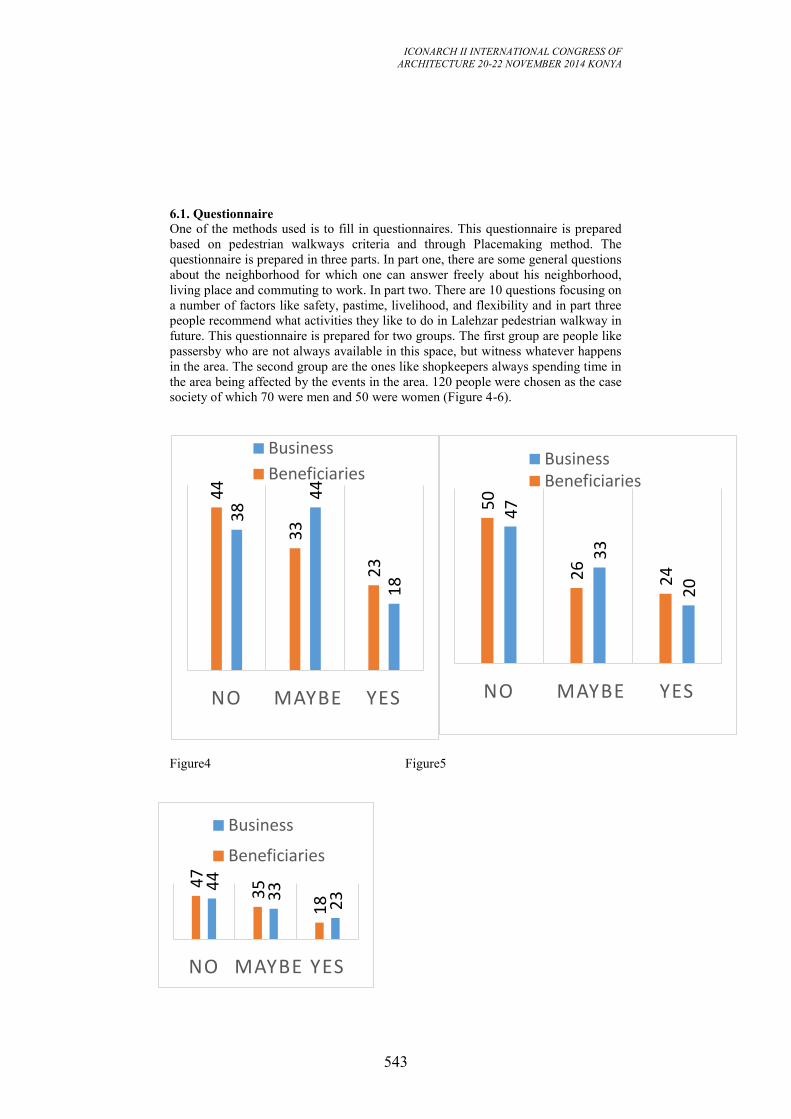
ICONARCH II INTERNATIONAL CONGRESS OF
ARCHITECTURE 20-22 NOVEMBER 2014 KONYA
543
6.1. Questionnaire
One of the methods used is to fill in questionnaires. This questionnaire is prepared
based on pedestrian walkways criteria and through Placemaking method. The
questionnaire is prepared in three parts. In part one, there are some general questions
about the neighborhood for which one can answer freely about his neighborhood,
living place and commuting to work. In part two. There are 10 questions focusing on
a number of factors like safety, pastime, livelihood, and flexibility and in part three
people recommend what activities they like to do in Lalehzar pedestrian walkway in
future. This questionnaire is prepared for two groups. The first group are people like
passersby who are not always available in this space, but witness whatever happens
in the area. The second group are the ones like shopkeepers always spending time in
the area being affected by the events in the area. 120 people were chosen as the case
society of which 70 were men and 50 were women (Figure 4-6).
Figure4 Figure5
18
44
38
23
33
44
YES MAYBE NO
Business
Beneficiaries
20
33
47
24
26
50
YES MAYBE NO
Business Beneficiaries
23
33
44
18
35
47
YES MAYBE NO
Business
Beneficiaries
ICONARCH II INTERNATIONAL CONGRESS OF
ARCHITECTURE 20-22 NOVEMBER 2014 KONYA
544
Do you find opportunities in Lalehzar Street to do your favorite activities?
Figure5. Do you find Lalehzar Street a lively place?
Figure6. Do you find Lalehzar Street a safe place?
In part three, the interview were to answer what makes them go to Lalehzar street
the most whose results and given in continue: 1. coffee shops and restaurant 2.
Specific cultural construction 3. Street ceremonies and parades 4. Seating spaces 5.
Social security for pedestrians 6. Vendors 7. Social interaction 8. Presenting
artworks 9. Meeting friends 10. Different individual and group activities.
6.2. Interviewing Some Trustable Citizens
Some trustable residents were interviewed to have more detailed and correct
information. This method is not that much scientific, but it renders proper qualitative
information to better know the area. The interviews focused on problems and
priorities of the neighborhood, the taken actions to improve the area, and the
interviewees' opinions and suggestions to renovate the whole neighborhood.
6.3. Data Analysis
The results for the last part of the questionnaire show that when the majority of
people in the area attend Lalehzar Street, they are interested in different functions of
pedestrian walkway, like artistic jobs, rest, fun and individual and group activities.
Based on the achieved results, the following suggestions are made to improve the
overall conditions in Lalehzar area. 1-Constructing business centers along with some
locations for vendors. 2-Making enough green areas. 3- Providing some places to
hold ceremonies and street parades. 4-Considering pedestrians' need. 5-Having the
feeling of freedom, comfort and safety. 6-Proper environmental condition to have
people participation along with people supervision. 7-The importance of edges in
designing and their being joined to walking spaces. 8-Specific areas for games and
fun. Having compared the results with the parameters related to free and loose
space, we can conclude that more than 75% of needed features are available to
change Lalehzar to a proper pedestrian walkway (Figure.7).
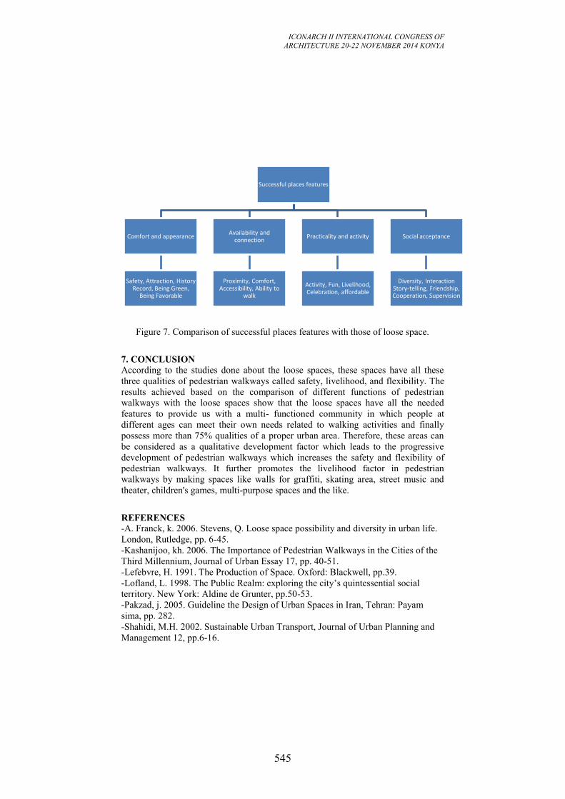
ICONARCH II INTERNATIONAL CONGRESS OF
ARCHITECTURE 20-22 NOVEMBER 2014 KONYA
545
Figure 7. Comparison of successful places features with those of loose space.
7. CONCLUSION
According to the studies done about the loose spaces, these spaces have all these
three qualities of pedestrian walkways called safety, livelihood, and flexibility. The
results achieved based on the comparison of different functions of pedestrian
walkways with the loose spaces show that the loose spaces have all the needed
features to provide us with a multi- functioned community in which people at
different ages can meet their own needs related to walking activities and finally
possess more than 75% qualities of a proper urban area. Therefore, these areas can
be considered as a qualitative development factor which leads to the progressive
development of pedestrian walkways which increases the safety and flexibility of
pedestrian walkways. It further promotes the livelihood factor in pedestrian
walkways by making spaces like walls for graffiti, skating area, street music and
theater, children's games, multi-purpose spaces and the like.
REFERENCES
-A. Franck, k. 2006. Stevens, Q. Loose space possibility and diversity in urban life.
London, Rutledge, pp. 6-45.
-Kashanijoo, kh. 2006. The Importance of Pedestrian Walkways in the Cities of the
Third Millennium, Journal of Urban Essay 17, pp. 40-51.
-Lefebvre, H. 1991. The Production of Space. Oxford: Blackwell, pp.39.
-Lofland, L. 1998. The Public Realm: exploring the city’s quintessential social
territory. New York: Aldine de Grunter, pp.50-53.
-Pakzad, j. 2005. Guideline the Design of Urban Spaces in Iran, Tehran: Payam
sima, pp. 282.
-Shahidi, M.H. 2002. Sustainable Urban Transport, Journal of Urban Planning and
Management 12, pp.6-16.
Successful places features
Comfort and appearance
Safety, Attraction, History Record, Being Green,
Being Favorable
Availability and connection
Proximity, Comfort, Accessibility, Ability to
walk
Practicality and activity
Activity, Fun, Livelihood, Celebration, affordable
Social acceptance
Diversity, Interaction Story-telling, Friendship, Cooperation, Supervision
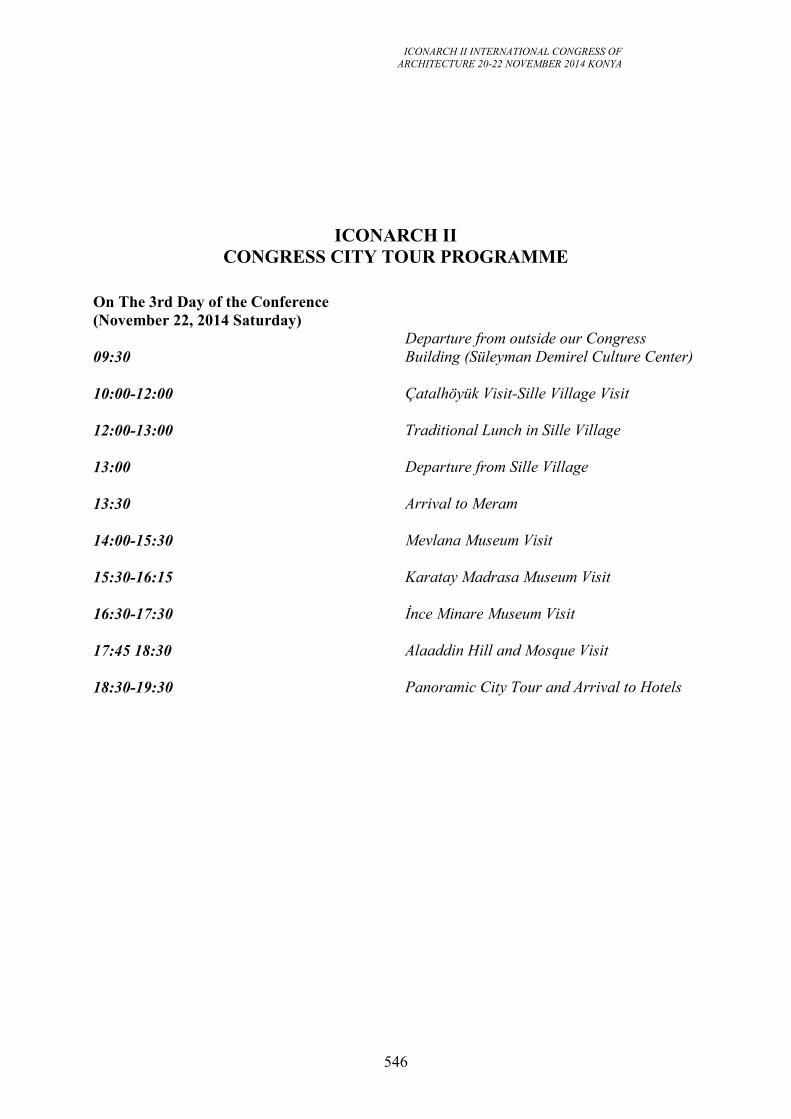
ICONARCH II INTERNATIONAL CONGRESS OF
ARCHITECTURE 20-22 NOVEMBER 2014 KONYA
546
ICONARCH II
CONGRESS CITY TOUR PROGRAMME
On The 3rd Day of the Conference
(November 22, 2014 Saturday)
09:30
Departure from outside our Congress
Building (Süleyman Demirel Culture Center)
10:00-12:00
Çatalhöyük Visit-Sille Village Visit
12:00-13:00
Traditional Lunch in Sille Village
13:00
Departure from Sille Village
13:30
Arrival to Meram
14:00-15:30
Mevlana Museum Visit
15:30-16:15
Karatay Madrasa Museum Visit
16:30-17:30
İnce Minare Museum Visit
17:45 18:30
Alaaddin Hill and Mosque Visit
18:30-19:30
Panoramic City Tour and Arrival to Hotels