
I2tI I7L f4+. H4YPC
175
I2tI I7L f4+. H4YPC/ (J(5 6oIo,caI JU7 Viastrg'l0', P.C. c Ven*rQ. - - 2DB QrC 4i'n - ---------- VIL '.er 25T5 21I 1 3 Lei*r 4 1ri*st*t I 73 175 (C*I 5,4e av) 1i5 v"m4 - 178 Zo2.
-
Upload
khangminh22 -
Category
Documents
-
view
3 -
download
0
Transcript of I2tI I7L f4+. H4YPC

I2tI I7L f4+. H4YPC/
(J(5 6oIo,caI JU7
Viastrg'l0', P.C.
c Ven*rQ. - - 2DB
QrC 4i'n - ----------
VIL '.er25T5
21I
1 3
Lei*r 4 1ri*st*t I 73175(C*I 5,4e av) 1i5
v"m4 - 178Zo2.

wm.] CARBONIFEROUS rossus. 163
at the sutures by the prominence of the middle portion of each basalpiece, column facet large, first radial pieces ntarly equal in size withthe basals, and, with that exception, they are the largest pieces in thbody; second and third radials about equal to each other in size, and notmore than half as large as the first radials, each third radial piece bearing two secondary rays consisting of two pieces each, both of which arecmaller than the second and third radials; each second secondary radialpiece bearing two brachial pieces, and each brachial piece giving originto an arm, making twenty arms in alI.* Arms long and slender, andabove the first four or five brachial pieces, which are single, they arecomposed of a double series of minute pieces which meet along, themedian line of the aim, forming there a zigzag suture Anal pieceseight or nine; the first one being of about the same size as the firstraclials; the next three pieces above are about half as large as thefirst, and above these the other pieces are quite small; interradialpieces three or four, the first one being somewhat larger than thesecond radials, and ocdupyiig about half the interradial space. Vaultconvex or subconical, more than half as high as the' height of the bodybelow the arms, composed of irregular pieces' of moderate size, all of'which are more or less sharply tumid in the middle, and ending at thesummit in a long, strong proboscis, which is composed of similar sharplytumid pieces. All the body plates are strongly tumid, the lower onesbearing each a strong transverse projection.
The specific name is given in honor of Mr. Charles' Wachsuth, whose,excellent labors among the Crinoidea are well known.
Position and tocality.Subcarboniferous strata probably equivalentwith those of the Keokuk division, Crawfordsville, md., where it wasobtained by Mr. William Gurley.
Genus LEPIDESTHES Meek, & Worthem.LEPIDESTHES COLLETTI White.
Plate 40, figs. 2 aand 7,.
Lepidesthes cofletti White, 1878, Proc. Acad. Nat. Sd. Philad., p. 33.
General form apparently ovate. Interambulacral areas very narrow,liuear, slightly convex from side to side, composed of four or five rowsof small pieces, which rows do tiot apparently decrease in number, ex-cept perhaps near each extremity. Ambulacral areas broad, partakingof the convexity of the body, lance-oval in outline, and five or six timesas broad as the interambulacral areas are. Ambulacral areas made upof very numerous small rhombic pieces, the transverse diameter of whichis a little greater than the vertical; their lateral angles moderately acute,and interlocking so that they appear to be arranged in oblique rows;size f the pieces nearly uniform throughout the field, except that theyall become a little smaller near both the upper and lower extremities.The number of vertical rows of pieces in each field is apparently 18 or 20.Each ambulacral piece has two distinct round pores near each other andnear the upper angle of the piece; but they are sometimes obscured bythe overlapping of adjacent pieces. Surface granules small, more distinct upon the interambulacral than upon the ambulacral pieces.
'Two examples of this species have been discovered, both of which are* The example represented by fig. 1 boa plate 40 has an extra arm-base immediately
over the center of the anal space, and it a'so has an extra basal piece about one-thirdas large as each of the other three basal pieces.

164 GEOLOGICAL SURVEY OP THE TERRITORIES.
crushed and otherwise in a much damaged condition. The best exam-pie, which is represented by fig. 2 a on plate 40, shows that the originalheight of the body was about 45 millimeters, and its transverse dianie-ter prObably considerably less.
The crushed condition of the specimens causes some doubt as to thetrue number of longitudinal rows of interambulacral pieces, but theyevidently do not exceed five. There seems to be only four rows to eacharea, one row of comparatively large pieces, with two smaller rows uponthe right hand side of it, and one row on the left This want of bilateralsymmetry of the best preserved area in the example figured suggests thepossibility that one row of smaller pieces on the left-hand side of the rowof larger ones has been forced beneath the others by pressure, but acareful examination fails to demçnstrate it.
This species is clearly distinguished from L. coreiji M. & W., the onlyother known species of the genus, by th very much narrower interain-bulacral areas, the different and varying proportions of the pieces com-posing those areas, as well as some other important but less conspicu.ous differences.
Position and locality.Subcarbonifeius strata, probably equivalentwith those of the Keokuk division, Salem, Washington County, hid.
MoLLuscA;(MOLLUSCOIDEA.)
BRACHIOPODA.
(Genus ORTHIS Dalman.)
O1iTrns TrnEMEI White.
Plate 41, figs. 4 a, b, e, and d.
Ortlzi8 thienwi White, 1860, Jour. Bost. Soc. Nat. list., vol. vii, p. 231.
Shell depressed, orbicular, usually a litfie wider than long, widest infront of the middle; hinge line short. Dorsal valve deeper thall theventral valve, regularly convex, with the general exception of a veryshallow median sinus which extends from front to about midlength ofthe shell where it becomes obsolete; beak projecting a little beyond thehinge line and slightly curving towards the beak of the opposite valve;cardinal process strong, with a strong blunt-edged median septum cx-tending from it nearly half the length of the valve; brachial processesstrong, slightly notched at the ends; margin crenulate in front.
Ventral valve convex near the umbo, depressed in front, which, with thedepression on the opposite valve, considerably flattens the front border;beak short, elevated and incurved, leaving but little space between thetwo beaks when both valves are in position; width and height. offoramen about equal, nearly filled by the strong cardinal process of thedorsal valve; muscular cavity large, heart-shaped, with a more or lessdistinct forked septum occupying its middle.
Surface marked with fine raised strkn, which have occasional minutetubular openings upon them; the strife increasing in number by im-plantation, and traversed by the ordinary stri of growth and a fewcoarser imbricatiiig lines.
Length from 10 to 14 millimeters.

IliT.] CARBONIFEROUS FOSSILS. 165
This shell is somewhat variable in the convexity of the dorsal valve,the distinctness of the dorsal sinus, and the strength of the cardinaland brachial processes.
Position and locality.The upper portion of the Kinilerhook division ofthe Subearboniferous series at Burlington, Iowa. A closely sinniar formexists in the upper portion of the Burinigtoii limestone, and another mthe Keokuk division, but they are at present regarded as distinct.
Genus RIIYNCHONELLA Fiseher.
EHYNcHONELLA OTTIThLWA White.
Plate 41, figs. 5 a, b, and .
RynohoneUa ottuwmdWhite, 1862, Proc. Best. Soc. Nat. list., vol. ix, . 2.Shell rather small, variable in outline from subtrianguiar to subovoid;
valves nearly equally convex. Ventral valve regularly convex along themiddle from beak to front, broadly convex across the middle from side toside; beak prominent, projecting backward and with an upward curve;the space beneath it a little flattened, which, gives it somewhat the ap-pearanceof an area; deltidial pieces occupying a rather large equilateraltriangular space, with a moderately large, oval framen. Dorsal valvebroadly convex, umbo depressed. Surfice marked by from nine toeleven somewhat angular plications on each valve, which are absent orbecome obsolete on the posterior third of the shell; two of these plications occupy the mesial sinus of the ventral valve and three of them themesial fold of the dorsal valve; the mesial sinus is deep, and forms amore conspicuous feature than the in esial fold. Young examples of thisshell are nearly plain, but the plications on the older ones are wellmarked..
Length frOm ventral beak to front, 12 millimeters; greatest breadth,which is in front of the middle, about the same.
Position and toeality.Saint Louis division of the ubea,rl?oniferousseries, Ott inwa, Iowa, and various other localities in lown, Illinois; andMissouri.
Genus SPIRIFER Sowerby.
SPIRIFER SUBCAItDIIFORMIS HalL
Plate 41, figs. 2a, b, aad.
Spirifer subeardiiforsnis Hall, 1858, Iowa Geol. Rep., vol. , part ii, p. 660.
Shell subelliptical in marginal outline, a little wider than long hinline shorter than the greatest width of the shell. Dorsal valve a littleless convex than the ventral, its beak somewhat prominent and project-ing beyond the hinge line; mesial fold rather broad in front, slightlyelevated, marked by four plications which all coalesce at the beak; avery slight elevation appears in the bottom. of the groove which separates the two middle plications of the fold, and the two grooves whichseparate the fld from the lateral portions of the valve are broader thanany of the others; from seven to nine simplc, rounded plications markthe space on each side of the fold, the inner ones being strong and theouter ones becoming obsolete. Ventral valve having its beak prominent,incurved, and projectIng back further than that of the dorsal valve;inesial sinus broad, not deep, bearing three piieatirns from seven ho

166 GEOLOGICAL SURVEY OF THE TERRITORIES.
ten plications on each side of the mesial sinus, which correspond in char-actor with those upon the other valve; the postero-lateral portions of thevalve rounded into the area, which is very short and its limits ill-defined;foramen moderately large, triangular, and nearly equilateral.
Length from ventral beak to front, 28 millimeters; greatest breadth,3 millimeters; greatest thickness, both valves together, 18 millimeters.
This species was originally described froni an imperfect example whichwas obtained from the Warsaw limestone near Alton, ill. Among acollection of fossils obtained by Mr. William Gurley, from equivalentstrata at Spergen Hill, md., is a more perfect example, which has servedas the basis for the description and illustrations herein given.
Position and looality.Subcarboniferous strata, Warsaw division,Alton, Ill., and Spergen Hill, Monroe County, Indiana.
(MOLLUSOA VERA.)
CONCHIFIERA.
Genus ANTIIRACOPTERA Salter.
ANTHRACOPTERA POLITA. (sp. nov.).
Plate 42, figs. 5 a and b.
Shell rather small, aviculoid, moderately gibbous, height greater thanthe breadth from front to rear; test thin; valves subequal; hinge mar-gin short, straight, terminating posteriorly in a somewhat obtuselyangular wing, but not extending in front of the beaks; basal arid frontmargins forming a nearly regular curve from beneath the beaks to thepostero-basal extremity, which is more narrowly rounded; between thatextremity aid the posterior angle of the wing the margin is slightlyconóave; umbo prominent, or having the appearance of being somewhatinflated; beak elevated a little above the hinge line; the ear is distinct,but no well-defined auricular groove separates it from the body of theshell in either valve. Surface having a smooth aspect, but it is markedby numerous fine lines of growth, which are plainly visible under a lens.
Height from base to hinge line, 20 millimeters; length from 'imbo toposterior basal extremity, 24 millimeters.
This hell seems evidently referable to Anthraeoptera of Salter,although nothing is known of the character of its hinge or of its interiormarkings. It differs too materially from any known species to needdetailed comparison.
Position aid localty.Coal-measure strata, Major's Mill, lTermillionCounty, Ill., where it was discovered by Mr. William Gurley.
Genus ASTAIRTELLA Hall.
ASTARTELLA GURLEYI White.
Plate 42, figs. 6 a and 1.
AstarleZlagur?eyi White, 1578, Proc. Acad. Nat. &i. Philad., p. 35.Shell small, not very gibbous, subtetrahedral in outline; anterior end
truncated from the beaks obliquely downward and forward to about

WllIT] CARBONIFEBOUS FOSSILS. 167
midheight of the shell, where the front is sharply rouBded to the some-what broadly rounded basal margin; posterior margin broadly convexor sometimes almost straight and perpendicular, and joining both thebasal and dorsal margins by abrupt curves; dorsal margin compara-tively short, nearly straight; beaks small; umbones not elevated norvery prominent. Au indistinctly defined ambonal ridge extends fromeach of the umbones to the postero-basal margin, behind which ridgethe shell is siightlycompressed. Surface marked by concentric furrows,which are separated by sharp linear ridges.
Length of an average-sized example, 7 millimeters; height from baseto beaks, 4 millimeters.
This species diflérs from A. 'vera Hall, from the same formation, in itssmaller size, in the slight prominence and want of elevation of the urn-bones, the greater proportional projection of the front beyond the beaks,and in being wider behind than in front, the reverse being the casewith A. Vera.
Position and loeality.Coal-measure strata, Danville, Ill., where it wasobtained by Mr. William Gurley.
Genus ALLORIST%IA King.
ALLO1USMA 3ILAEIONENSIS White.
Plate 41, figs. 3 a and b.
AiZorisma rnarionevsis White, 1876, Proc. Acad. Nat. Sd. Philad., p. 31.
Shell small, elongate, ventrieose anteriorly, and laterally flattenedbehind, where it is usually a little broader from base to dorsal marginthan the anterior portion is; umbones prominent, elevated; beaks in-curved, placed far forward; dorsal margin straight or slightly concave;postero-dorsal margin sloping backward to the posterior exüemity, thegreatest prominence of, which is at, or a little below, midheight of theadult shell; base broadly rounded or sr raightt ned about midway, wherethe slight umboiial flattening of each valve meets it. Surface markedby the ordinary concentric lines and undulations of growth.
Length, 28 millimeters; height, 13 millimeters. A few examples havebeen obtained which are about one-third larger than that of which' thedimensions are there given, but it is an unusually small species.
Position and loeality.Saint Louis division of the Subcarboniferousseries, Marion and Mahaska Counties, Iowa, where it sometimes ocursquite plentifully in both the calcareous and magnesian layers of thatform atinu.
GASTE ROPODA.
Genus EUOMPHALUS Sowerby.
EUOMPHALUS - SPIIINGYALENSIS White.
Plate 41, figs. 1 a and b.
Enomphaiu.9-sprLngvalen8i. White, 1876, Proc. Acad. Nat. Sd. Philad., p. 32
Shell rather large; spire much extended for a species of this genus;volutions six or seven, gradually increasing in size from the apex to theaperture; moderately flattened upon the distal or upper side, regularly

168 GEOLOGICAL SURVEY OF THE TERRITORIES.
and continuously rounded from that, side all the way around to the con-tact with the next volution; aperture therefore nearly circular, its out-line being modified only by the slight flattening of the distal side of thevolutions and their short contact with each other.
Length, or height, about 55 millimeters; breadth of coil of last volu-tion, 70 millimeters; diameter of aperture, 23 millimeters.
Position and locality Kinderhool drusion of the Subearboniferousseries, Springs ale, flumboldt Couut, Iowa
Genus PLATYCEIRAS Conrad.
PLATYCERAS TRIBULOSUM (sp nov)
Plate 41, figs 0 a and b
Shell of medium size, very obliquely and rudely conical, curved butnot coiled; apex free, slender, pointed, incurved, and turned a little tothe left side; body expanded; aperture very irregular in marginal out-line, expanded in front, narrower behind, aiid having a prominent double,lobe beneath the umbonal portion of the shell. Surface marked by theordinary lines of growth, and also by three longitudinal rows of hollowspines arranged upon the dorsal aspect of the shell, the rows extendingback more than half the length of the shell and containing five or sixspines each.
Length of the shell from beak to front margin, 28 millimeters; breadthof itsaperture, 21 millimeters.
This species is especially characterized by its spines, arranged iii threerows, and the irregular character of its margin. It differs too muchfrom any described species to need detailed comparison, but it maybecompared with the two spiulous species, P. biserialis Hall, from the sameformation, and P. dumosurn Conrad, from the Devonian rocks of NewYork.
Position and locality.Burlington limestone division of the Suhcarbon-iferous series, Burlington, Iowa, where it was obtained by F1r. CharlesWachsmuth.
Genus NATICOPSIS McCoy.,
NATICOPSIS MOMLIFERA. (sp nov)
Plate 42, figs 3 a, b, and c
Shell small, siibglobose ; spire short, obtuse, and its immediate apexflattened; volution about six, but the apical ones are very small, thehst one constituting the greater part of the shell, broadest upon itsbasal or proximal portion, the proximal side of which is somewhat ab-ruptly rounded inward to the aperture; the small volutions of the apexare plain, but uron the distal border of the two last ones, adjacent to thesuture, there is a conspicuous row of small nodes, constituting a prettyornamentation of the shell; the remainder of the surface is smoothand has a polished aspect, upon which a good lens reveals fine strhe ofgrowth; aperture suboval in outline; inner lip having a distinct callus,especially in front; outer lip thin, its border sinuate, having an almostdistinct notch just in front of the row of nodes.
Extreme length, 10 millimeters, extreme diameter of the last olutionnearly the same.
Position and locality - Upper Coal Measures, Pleasant Hill, CassCounty Mo., where it was obtained by PrOf. G. C. Broadhead.

WUITE.) CARBONIFEROUS FOSSILS. 169
Genus PLEUROTOMARIA Defrance
PLEUR0T0MntIA B1tOADIIEADI (sp. nov.).
Plate 42, figs. 1 a nd b.
Shell large, narrowly umbilicated; spire somewhat extended, its lengthnot quite half the full length of the shell; volutions about seven, stronglyconvex from suture to suture, gradually increasing in size; last volutionlarge, soniewhat produced on its proximal side, especially near the aper-ture, and abruptly rounded in to the umbilicus, but otherwise regularlyconvex; aperture subovate in outline, angular at its proximal end,straight upon its inner side; the straight inner lip thin, its edge rang-ng in line with the axis of the shell, so curved laterally as to give con-
tinuity to the narrow umbilicus almost to the proximal extremity of thelast volution; outer lip sinuous, its notch small and shallow, situated atabout the middle of the prominent convexity of the lip; revolving bandnarrow and somewhat obscure. Surface marked by numerous slightlyimpressed revolving lines, which are more distinct upon the proximalthan upon the- distal side of the spiral band,. and still more distinctwithin and upon the borders of the umbilicus; spaces between the de-pressed lines narrow; plain, and somewhat unequal in width.
Full length, 88 millimeters; length of aperture, 50 millimeters; breadthof the same, 49 millimeters; full diameter of the last volution, includingaperture, 75 millimeters.
This large, fine shell difièrs too materially from any of the numerousforms of Pleurolomaria that have been obtained from- the Carboniferousstrata to need detailed comparison.
Position and loeality.Ca1 Measure limestone, Kansas City, Mo., whereit was obtained by Prof. U. C. Broadhead, and in whose honor the spe.cific name is given.
PLEUIIOTOMARIA. NEWPORTENSIS (sp. nov.).
Plate 42, figs. 2 a and b
Shell of medium size; spire moderately short, less in height than thevertical diameter of the apertule, olutious about fi' e, regularly andprominently convex from suture to suture, gradually increasing in size;the last volution continuously rounded from the suture. to the axialcenter; aperture subcircuhir in outline, its margin oblique; outer liphaving a broad notch a little above its middle, at the bottom of whichthe spual band ends, inner up apparently thickened, pir il bandconsisting of an elevated, narrow, roughened ridge, which is eitherwholly or partly obscured upon the volutions of the spire by the sübse-quent v.olutions. Surface marked with numerous, somewhat irregular,raised revolving lines, the concave spaces between which are somewhatwider than the lines.
Extreme height of the shell, 39 millimeters; height of aperture, about25 millimeters; transverse diameter about the same; extreme transversediameter of thc shell, 39 millimeters. -
This shell resembles P. ecvrbonaria Norwood & Pratten, but it differsin having its revolving band, simple and raised instead of concave, withrevolving lines within it, as in that species, and also in having its aper'ture subcireular instead of nearly semicircular.
Position and locality.Coal Measure strata, Newport, md., where itwas obtained by Mr William Gurley.

170 GEOLOGICAL SIJRVEY OF THE TERRITORIES.
PTEROPODA.
Genus CONULARIA Miller.
(JONULARIA CRUSTULA (sp. nov.).
Plate 42, fig. 4 a.
Shell rather small, having the usual four-sided pyramidal furm; thefour sides being equal, and flat or nearly so near the apex, but slightlyconvex towards the aperture; the four angles distinctly furrowed, anda slender furrow also marks the median line of each side, which furrowis more distinct upon the cast of the interior of the shell than upon theexternal surface of the test. Surface marked by the numerous traiis-verse raised stri common to this genus, which arch gently forward fronteach of the four angles; the majority of the stri are continuous acrossthe median line of the sides, alid also across the angle-furrows, in cross-ing which they bend slightly backward.
Length, 31 millimeters; diameter of aperture, about 16 millimeters.This shell is clOsely like several other known forms, but it possesses
peculiar interest from the fact that it is the oniy species knowii to meto occur in the Coal Measure strata of the Mississippi Valley, althoughseveral specis are known in the Subearboniferous strata of that region.It is, therefore, the most recent known American species, and adds toour knowledge another feature of close relationship between the fauneof the upper and lower Carboniferous series.
Position and tocality.Ooal Measure strata near Kansas City, where itwas obtained by Professor Broadhead. Among some Carboniferousfossils 'rought by Piof. E. D. Cope from near Taos, New Mexico, are acouple of fragments apparently of this species.
CEPHALOPODA.
Genus NAUTI [US Breynius
NAUTILUS DANVILLENSIS White.
Plate 42, fig. 7 a.
gautilus danvWensis White, 1878, Proc. Acad. Nat. Sd. Philad., p. 36.Shell moderately large; umbilicus deep but not very broad, showing all
the volutions, at least in large part; volutions apparently four, increas-ing rapidly in size, very slightly embracing, subtrihedral in cross-section,the two sides of the volution forming two sides of that outline, whilethe inner side of the volution forms its third principal side; sides ofthe volution plain, nearly flat or slightly convex; peripheral side verynarrow, concave, and marked at eit.her edge, where it joins the side,by a roW of longitudinally compressed nodes. The sides are roundedabruptly into the umbilicus, which is unusually deepened by the trans-verse diameter of the volutions being greater at the inner side than else.where. Septa plain, somewhat deeply concave dorso-ventrally, but lessso transversely; siphnncle subeentral, a Little nearer to the peripheralthan to the inner side. Surface smooth except the ordinary lines ofgrowth and the two rows of dorsal nodes before referred to. Test thu.

WmTE.) CARBONIFEROUS FOSSILS. 171
The oniy discovered specimens of this species being crushed or other-wise imperfect, it has not been practicable to illustrate it by any otherfigures than the transverse section given on plate 42, although the char-acters above given hav' been well ascertained. The exact form of theaperture, however, is not accurately known, but the lines of growth showthe lateral margins to have been sigmoid or sinuous, and the peripheralmargin concave. These lines also indicate that the aperture was obliqueto the diameter of the plane of the shell, the peripheral portion retreat-ing and the inner projecting.
Transverse diameter of a volution of less than full adult size from edgeto edge of the umbilicus, 40 millimeters; width of its sides, 50 millime-ters; breadth of peripheral side, 16 millimeters; the frill diameter ofthe plane of the largest example discovered, about 130 millimeters.The narrow concave periphery, with its two marginal rows of compressednodes, and the plain, flattened sides of the volutions, which expandtowards the umbilicus, are characters which distinguish this species fromall others known to me.
Position and tocality.Coal Measure strata, Danville, Ill., where it wasobtained by Mr. William Garley.
ARTICULATAVERMES.
Genus SERPULA Linneus.SERPULA. INSITA. White.
Plate 42, fig. 8 a.
&rpula isita White, 1878, Proc. Acad. Nat. Sci. Phila., p. 37.Scattered through an earthy, Carbonaceous layer of Coal Measure
strata at Newport, Vermillion County, md., are abundant examples andfragments of a very small &rpula, which evidently burrowed in the masswhen it was in the condition of mud. Also sessile upon some imbeddedniolluscan shells are found occasional nearly perfect examples of the samespecies. The species of the genus &rpula are so devoid of distinguishingcharacteristics that a specific diagnosis is often difficult or impossible.This species, however, is not likely to be mistaken for any other, becauseof its very small size, and because no other form has been recognized inthe strata of that age in that region. It ishere named, mainly, for thepurpose of aiding in the classification of the rivh fauna of the Carbonif-eroas rocks. The species may be characterized as minute, sessile orfree, tortuous, and s!ibcylindrical.

PLATE 39.Page.
FIG. 1. MIcHIUNIA? PLACENTA - - - -157
Calycular view of a large example; natural size.Lateral view of the same.Calycular view of a small example; natural size.Under side of the same, showing the concentrically wrinkled
epitheca.
FIG. 2. MIc1TtLINL& uXPANSACalycular view of a small, imperfect, silicifled example; natural
size.Lateral view of the same.
Fza. 3. OJIONOPRYLLUM SEDALTENSE
a. Side view of a partially crushed and broken example; natural size
FiG. 4 L0PH0PRYLLUM EXPANSUMSide view of a type specimen; natural size.Calycular view of the same.
The spots near the columella are accidental; and the figure does notshow the full prominence of the columella.
FIG. 5. HAnROPHYLLUM GLANSCalycular view; natural size.Lateral view of the same
FiG. 6. ZAPHRENTIS cicuojLateral view of a specimen from Sedalia, Mo.; natural size; show-
ing. a minimum degree of flattening upon the lower portion ofthe convex side.
Calyeular view of the same. The edge of the .calyx of this speci-men is coustricted, giving it the appearance of being thickened.It is usually thin and sharp.
o. View of the convex side of another example, from Burlington,Iowa, showing a maximum degree of flattening of the lowerportion of the convex side.
d. Calycular view of the same, showing the border of the usualcharacter, except that its lower portion has been broken away.
FIG. 7. ZAP1IRENTIS ELLIPTICA. ..........Side view; natural size.Calycular view of the salne.
'5
158
157
157
156
156

SUBCARBONIFEROU S.U S CEOLOCCAL SURVEY PLATE 39
J CMConneIL Thou. 6iror & So,Lh
71

PLATE 40.Page.Fm. 1. ACTIIOCRINUS WACUSMUTHI 162
Side view of a crushed example, showing the proboscis and a partof the arms; natural size.Side view of the body of another example, oniy slightly distortedby pressure.
Fm. 2. LEPIDESTHES COLLETTI.
Side view of a specimen somewhat smaller than the type; naturalsize.Diagram of a single piece of the ambulacral series, with adjacentborders of others, showing the two pores; enlarged.
Fza. 3. SCAPfflOCRINUS GURLEYI
a. Side view of the type specimen; natural size.The black spots at the junction of the column with the body areaccidental.
Pta. 4. SCAPHIOCRINUS GIBSONI r .. 161a. Side view of the type specimen; natural size. The slight zigzagarrangement of the smaller divisions of the arms is not distinctlyshown in the figure, and it 4oes not quite clearly represent the
angular aspect of all the small pieces composing the arms.FIG. 5. PLATYCRINUS EONOENSIS 160
a. Side view of the type specimen; natural size.FIG. 6. LITHOSTROTION MAMILLARE 159
Calycnlar view of a portion of a large corallum, showing threedouble coralljtes.Tinder view of the same, showing that portion of the same doublecorallites.
Fm. 7. LITHOSTROTTON I&ICROSPYLIJM159
a. Calycular view of two or three corallites; natural size. Thedetails are partially obscured by the bad state of preservCtiouof the specimen.
163
162

I-
I H !Q{A SURVEY

FIG. 3. ALLORISMA MATtIONENSIS
Lateral view; natural size.Dorsal view of another example.
FIG. 4. OItTms TrnEMRr
Ventral view of an example fromnatural size.
Dorsal view of the same.Latefal view of the same.Interior view of the ventral valve
the large muscular scan
1IHYNCHONELLA OTTUMWA........FIG. 5..
PLATE 41.Page.
FIG. 1. EUOMPHALUS SPRINGVALENSIS . - 167
Lateral view of the type specimen; natural size; the outer por-tion of the spire being imperfect by erosion.
Umbilical view of the same.
FIG. 2. SPIEIFER SUBCARDIIFORIris .. . - 165
Ventral view of an example from Spergen mu, md.; naturalsize.
Dorsal view of the same. -
Lateral view of the same.
167
Ventral view; natural size.Dorsal view of the same.Lateral view of the same.
FIG. 6. PLATYCERAS TRIBIILOSU1W 168Dorsal view of the typo specimen; from Mr. Waclismuth's collec-
tion; natural size.Lateral view of the same.
164
Mr. Wachsmuth's collection;
of another example, showing
165

I PLATL -U S GEOLOGICAL SURVEY
SUBCABBONIFERO1J S.
J.CWConnell jel.Thoe. Siecleir &
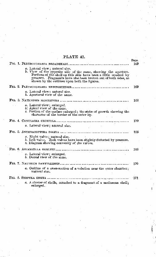
PLATE 42.Page.
Fm. 1. PLEU1IOTOMARIA BROADHEADI .. . - . Th9
a. Lateral view; natural size.b. View of the opposite side of the same, showing the aperture.
Portions of the shell on this side have been a little crushed bypressure. Fragments have also been broken out of both sides, asshown by the outlines upon both the figures.
Fm. 2. PLEUEOTOMARIA NEWPORTENSIS 169
Lateral view; natural size.Apertural view of the same.
FIG. 3. NATicorsIs MONILIFEEA 168
a. Lateral view; enlarged.b: Apical view of the same.
Portion of the surface enlarged; the stri of growth showing thecharacter of the herder of the outer lip.
Fm. 4. CONULARIA CRUSTULA. 170
a. Lateral view; natural size.
Fm. 5. ANTHRACOPTERA POLITA 166
a. Right valve; natural size.5. Left valve. Both valves have been slightly distorted by pressure.c. Diagram showing convexity of the valves.
Fia. 6. ASTARTELLA GURLEYT 166
a. Lateral view; enlarged.5. Dorsal view of the same.
Fm. 7. NAUTILUS DANITILLENSIS
a. Outline of a cross-section of a volution near the outer chamber;natural size.
FIG. 8. SERPULA INSITA
a. A cluster of shells, attached to a fragment of a inolluscan shell;enlarged.
170
171

U $ GEOLOGICAL SURVEY

t1ENRY LAKE AJD TRE TETONS FROM T1E SUMMIT OF i jAS LUOX1fli.j OU'Vj1

REPORT OF ORESTES ST. JOHN.
LETTER OF TRANSMITTAL.
OFFICE UNITED STATES GEOLOGICAL AIDGEOGRAPHICAL STIaVEY OF THE TERRITORIES,
Washington, D. C., &pteniber, 1879.SIR: I submit herewith myreport on the geol.ogy of the district assigned
to the Wind River division of th survey during the season 1878, togetherwith a copy of the map of the territory visited by myself during theseasons 1877 and 1878, on which the distribution of the geological form-ations is indicated by appropriate colors.
The party to which I was assigned as geologist the past season wasin charge of Mr. Frederick C. Clark, topographer, accompanied by Mr.Nelson Perry, mineralogist, Mr. Wells, topographical assistant, Georgeand Mac, packers, and the cook, Henry. Outfitting at Cheyenne, theparty was transported by rail to Granger Station on the Union PacificRailway, whence in company with Messrs. Gannett and Peale's partywe moved up the valley of the Green River, arriving on the southernconfines of our territory on the 31st July.
The first work performed was in the northern extremity of the WyomingMountains, in the southwest corner of the district. We thence movedalong the southern foot of the Gros Ventre Range to the west flank ofthe Wind River Mountains. Later in the season the northern half ofthe eastern slope of this range was visited, the work extending to arapid survey of the eastern portion of the Gros Ventre Basin, over toBuffalo Fork. In the latter quarter, about the middle of October, justas we reached Pacific Creek, a heavy fall of snow virtually closed theseason's field-work. The return was via Togwotee Pass, where the snowlay to the depth of above a foot, descending Wind River to Camp Brown,from which place I returned by stage to Green River Station, on theUnion Pacific Railway. The time actually spent in the field was about
fr ten weeks, during which time our movements were harassed by inclem-ent weather, and latterly by that peculiar mental condition consequenton the uncertaiu and exaggerated rumors relative to the movements ofhostile Bannacks by whoiii the country was said. to be overrun, but ofwhose presence we saw no more than the traces of some days' old trails.
In relation to the geological map, a copy of which is herewith trans-mitted, so far as it records actual examinations it is believed to be inthe main correct. But it embraces tracts which were either not visited,the geological features being viewed at a distance, or other sectionswhere the data derived in the course of'a hasty visit failed to afford themeans of determining the exact age of the rock formations found therein.In the former case is included the belt traversing the central portion ofthe Snake River Mountains ,whose rather complicated geological struct-ure it was impossible to satisfactorily make out from such examina-tions at a distance, with which we had to be content; and in the latterinstance are included the several areas indicated by the common color
173

174 REPORT UNITED STATES GEOLOGICAL SURVEY.
employed to represent the distribution of those post-Jurassic formationsoccupying the positions of the Cretaceous and Laramie formations inthe geologic scale. In the latter instances, although the occurrenceswere visited, the evidence of their age in the majority of cases dependsentirely on sequence or their stratigraphic position in reference to well-determined earlier formations in their neighborhood; the organic -re-mains which these horizons afforded unfortunately were in so indifferentstate of preservation as not to be recognizable with that degree of cer-tainty desirable in defining the age of the deposits whence they came.it was therefore deemed advisable not to attempt the definition ofCretaceous and Laramie formations on grounds purely lithological, andthis, too, in a region where apparently there exists no unconformity be-tween the various members of the great Mesozoic series; and hence theareas alluded to are given a single color with, however, queries and otherlegendary signs in accord with the inipressions arrived at as to theprobable stratigraphical relations of the deposits therein met with. Thefmiliarity acquired duriug a season's hasty examination of large terri-tories, if it could be supplemented by revisiting special localities, wouldresult in exact knowledge such as it may not be possible to arrive at inany other manner. As it is, the work recorded on this map materiallyamplifies that of earlier explorations in this region, the differencesamIcorrections being such as might be expected from the somewhat betterfacilities accorded the parties of this survey.
It is with pleasure and a due sense of my indebtedness I here acknowl-edge the favors I have received at the hands of Dr. White, who, in myabsence, kindly examined my pakeontological collections whose deter.minations have given me greatest aids in preparing my report. Also toDr. Peale and Professor Lesquereux I am under many obligations forthe favor of important information.
Very respectfully, your obedient servant,OBESTES ST. JOHN.
Dr. P. V. HAYDEN, -
United ,States Geologist, in charge.

BEPORT ON THE GEOLOGY OF THE WINi RIVER DISTRICT.
By ORESTzS ST. Joiiu.
CHAPTER I.AREA AND BOUNDARIES.
The country examined during the past season by the Wind. Riverdivision of the survey includes an area of, approximately, 4,000 squaremiles. The region is triangular in shape, the base corresponding to theforty-third parallel north latitude, extending from the one hundred andeleventh meridian, west longitude, east about 100 miles. The two sidesare respectively defined, on the west by a line passing northeastwardlyfrom the upper entrance to the Grand Canon of the Snake, east of Jack-son's Basin, to Togwotee Pass on the east of the continental watershed,430 45' north, and on the east by a southeasterly line, conforming, in ageneral way, to the coarse of Wind River; the meridian 1090 30', how-.ever, forms the eastern boundary line of the mapped area embracing thedistrict especially alluded to.
GENERAL SURFACE FEATURES.
Iirainage.The region embraced within the above mentioned limitsmainly lies on the west slope of the continental watershed, its drainagebelonging to three great river systems, viz, the Columbia, Colorado,and the Missouri. To the former belongs the drainage of the westernborder, which is gathered by the eastern tributaries of Snake River. Ofthe latter, the Elk Horn and Gros lTentre rise in the watershed, whileto the south Hoback's and John Day's Rivers have their sources inthe water-divide between the Snake and Green rivers. The ultimatesource of Wind River originates in Togwotee Pass, its western tributa-ries draining the eastern slope of the great water-shed, their waters fi-nally gaining the Missouri by the circuitous channels of the Big Hornand Yellowstone, far to the north and east. The southern half of thewestern slope of the watershed, in this district, belongs to the Coloradosystem, the sources of Green River rising in the most elevated portionof the Wind River Mountains.
Mountain Ranges.By far the greater portion of the region surveyedmay be denominated mountainous, although extensive tracts of thebroken country may properly be considered in connection with the hydro-graphic basin areas. The continental watershed in the eastern portionof the district has a general southsoutheast and north-northwest courseof about60 miles in extent. About two-thirds, or 40 miles, of the water-shed is formed by the northern half of the Wind River Range, whoseaxialpeaks, culminating near our southern border and dominating the dis-trict, are among the most lofty mountain heights of the great central Cor-dilleran region. To the northwest of Union Pass, and thence to Tog-wotee Pass, it entirely changes its Alpine character as also its geologic
17

176 REPORT UNITED STATES GEOLOGICAL SURVEY.
structure, becoming a wooded divide, ranging from 9,000 to 10,O0 feetaltitude.
Near the middle of the district lies the Gros Ventre range, a peculiarisolated mountain zone about 30 miles in northwest-southeast extent,culminating in altitudes between 11,000 and 12,000 feet above sea-level.This raige forms a sort of link connecting the Wind River and TétonThnges, although topographically and geologically it is quite distinct fromeither of these ranges, possessing its own separate history. Jackson'sBasin intervenes between its western end and the Téton Range, whilea moderately elevated divide spans the interval between its easternextremity and the Wind River Mountains The Mt Leidy highlandsform an exceedingly rugged belt projecting westward from the water-shed into the interval lying between the Gros Ventre and Bufflilo Fork,and which is scarcely less in altitude than this portion of the greatdivide itself, with which, indeed, it is geologically intimately connected.Southwest of the Gros Ventre Range, occupying the extreme southwestcorner of the district, the northern portion of the Wyoming Range issuddenly limited by the Grand Cailon of the Snake, beyond which therange is continued in the chain known as the Snake River Range, andwhich together make up one of the longest mountain ranges, a unit ingeological structure, in this region.
Basin areas.The basin areas which have to be considered in this con-nection corresiond to the principal drainage depressions of the district.They are the Hoback, Gros Ventre, and Green River basiiis on the westslope, and on the east side of the watershed the Wind River Valley.An interesting conclusion arrived at in the course of the examinationsin this region is that of the intimate geological relations existing betweenthese depressed areas, especially with reference to the Gros Ventre andWind River basins. The water divides separating these areas one fromthe other are generally low aiid composed of deposits pertaining to theTertiary age. This is shown in the character of the divide between Ho-back's and Green River basins, as also that between the latter and theGros Ventre basin, in the latter quarter, however, the surface is heavilycovered with Quaternary materials, in part dispersed by glacial agents,which hide from. view the older deposits upon which they rest. Thatsection of the great watershed lying between Union and Togwotee passesis essentially of the same geological character, though here the Tertiarydeposits were buried beneath a vast accumulation of volcanic qj ectamenta,which has served to protract the degradation of these soft deposits,rnaiitaining them as a conspicuous barrier along the continental divide. 'In the details of their topographic and geological features there aremarked contrasts in the several basin areas above briefly alluded to, andwhich will receive further notice in another place.
The extremes in altitude within the region under consideration, asdetermined by hypsometric observations made by this survey during sev-eral seasons subsequent to the expedition of 1872, show a range of about8,400 feet. The lowest point, t the foot of the Grand Cañon of SnakeRiver, has an altitude of 5,400 feet above the sea, and Fremont's Peak,one of the dominating summits of the. Wind River Range, according toMr. Wilson, attains an actual altitude of 13,790 feet. East of the water-shed, that part of the Wind River Basin lying within the limits of thepresent district ranges from about 6,600 feet to 8,000 feet iii altitude.On the west slope, within our limits, the altitudes of the several basinareas occurring therein are as follows: Green River Valley, 7,500 to.about 8,000 feet; Hoback's Basin, 6,000 to 7,000; the Gros 'Sfentre Basin,6,500 to 8,500 feet.

While the foregoing hypsometric data may coiivey some notion of thegeneral surface reliefs of the district and its drainage depiessions, acloser examination reveals great diversity, the mountain ranges present-ing broad contrasts, which may also be said of the basinareas. Withthe exception of the Green River Valley, the alluvial tracts borderingthe streams are of liimted extent, usually confined to narrow strips otgravelly bottom land. In the Tertiary basins of the iloback and GrosVentre, the tributaries of the main streams generally occupy deep, nar-row valleys eroded out of the soft strata, while along those which rise inthe neighboring mountains is met some of the wildest and often sublimecalion scenery. The region on the west slope is generally well coveredwith forests of pine and fir trees, the lower hilly country being fairly cov-ered with good grating herbage. Perennial streams are everywhere en-countered in this quarter. But on the east slope, beyond Wind River,the country presents some of the aspects of "bad lands"; only the largerstreams are filled with flowing water the whole year, and extensive bench-plateaus are covered with a sparce growth of herbage, and no forests.
1211
6T. JOHN.] GENERAL SURFACE FEATURES 177

CHAPTER II.
WYOMING RANGE.
TOPOGRAPHIC FEATURES, &C.
In the country to the south the Wyoming Range forms the water-divide between the Green on the east and the drainage of Bear andSnake rivers on the west; but within the present territory its drainageis effected by numerous water courses tributary to Snake River. On thewest it is defined by the valley of Salt River, and on the east by iloback'sBasin. The intermediate space is penetrated by John Day's River, andthe southern affluents of the iloback, a comparatively narrow belt alongthe north side draining directly into the Snake along that part of itscourse known as the Grand Cañon To the northwest the same mountam belt is continued, scarcely diminished in relative altitude,. underthe name of the Snake River Range into the region partially exploredthe preceding season b the Teton di ision ot the survey In its pisageacross this inouulain chain Snake River follows a southwesterly direc-tion in a direct line from the mouth of Hoback's River, where the cañonmay b said to begin to the confluence of John Day's River, where itenters its lower valley, of about 20 miles. It forms a rift through themountains the upper portion of which is occupied by terraces and occa-sional tracts of gavelly intervals continuous with the benches in thelower part of Jackson's Basin but the lower half is said to be scarcelywider than the bed of the river.
The main ridge of the range lies between John Day's and Salt riverson the extreme western border, occupying a space about 10 miles across,east-west, and which has received in the district to the south the name"Salt River Range." From either side it presents a bold, ruggedmountain barrier, attaining 10,400 feet actual altitude, and is known tobe largely made up of Carboniferous strata. Towards the north endthe John Day's has excavated a deep passage across the ridge parallelwith and only about 4 miles south of the lower portion of the GrandCañon, joining the Snake just below the debouchure from the mountains.Above this gorge the stream forks, sending ofi a fine tributary to theeastward whose sources lie in the crest of the Hoback Cañon, or eastern-most mountain ridge of the range, the main stream from the forks pur-suing a southerly course and confined to a narrow valley iii that partpassing through our territory.
The central portion of this highland belt is traversed in a nearly northsouth direction by a narrow ritige, the north half constituting a barrierbetween thedrainage flowing directly into the Snake on the west andthat of the Hoback on the east. To the south, however, this ridge iscut across by the East Fork John Day's River, in an exceedingly wild,narrow cañon, whose adjacent slopes are densely wooded with coniferousforests. South of the cañon the ridge reaches its maximum elevation,
178

ST. JOHN.] WYOMING RANGEHOBACK CANON RIDGE. 179
10,450 feet, at Station VII near our south line. For convenience sakethis ridge has beell designated by the name John Day's ridge.
East of the latter point a high, undulating mountain plateau extendsover to the Hoback Cafion ridge some 4 miles distant, and which formsa part of the mountain basin in which rise the East Fork John Day'sRiver and one of the tributary sources of the main Hoback. Geologic-ally, this basin forms the southern continuation of the valley betweenthe middle and iloback Cañon ridges and is principally (Trained northby a lower south tributary of the Hoback, which gains the latterstream 2 or 3 miles below the cañon. Thus limited it forms a narrowtrough 20 miles in length gradually widening to the north where it isabout 6 miles across, and is mainly occupied by Mesozoic and Tertiarydeposits. The basin area to the west occupying the interval betwecathe Salt River and John Day's ridges, although much widerlO to 12miles east-west---is very similar in geologic structure to that just men-tioned.
The eastern barrier ridge of the range, which we have designated asthe Hoback Cañon ridge, stretches due south from the south flank of theGros Ventre Mountains to the south line of the district, a distance of 38miles. Although narrow, averaging 4 or 5 miles iii width, it constitutesone of the most iiiiportant topographic and geological features of theraige in this region. In the northern, half the Hoback River has openeda narrow way across the ridge nearly at right angles to its course, inwhich the geological structure of the ridge is well displayed BetweenHoback's Cañon and the south flank of the GrosVentre Mountains theridge has an altitude of 10,000 feet; to the south of the cañOn it gradu-ally rises, culminating in Hohack's Peak (Station VI), a few miles northof the south line of the district, at an altitude of 10,800 feet above the sea.In the latter quarter it is broken by the cafloned sources of iloback'sRiver, and thence southward the water-divide' is transferred to the middleor John Day's ridge, which soon constitutes the main divide limiting thewest side drainage of the Green River Basin in the district to the south.Throughout its extent this ridge presents from either side a very brokenappearance, with steep, often precipitous, rocky accliVities, diversifiedby the rich color-contrasts imparted by the deep reds and drab brownsof the Jura-Trias, the grays of the Carboniferous limestone, and the dark'and light shades of the forest-covered and grassy slopes.
For so comparatively small area as that occupied b3r the WyomingRange within this district, being oriiy about 25 miles acrOss and of anaverage north-south distance even less, it presents an exceedingly diver-sified surface and intricate drainage, with which are associated equallyvaried and interesting geological phenomena, which will be briefly, dis-cussed in the following section.
ROBACK CANON RIDGE.
Along the eastern flak of the Wyoming Range there occurs a lowoutlying ri(lge parallel with and 3 or 4 miles distant from the HobackCañon ridge, from which latter it is separated by the valley of tributarieswhich gain the Hoback a few miles above the caflon. This ridge is quitepersistent to a point perhaps 7 miles north of our south line, where it iscompletely enveloped b the Tertiary deposits which here sweep high upon the eastern flank of the range, as will be noticed in a subsequentchapter devoted to the Green Riveriloback Basin. To the north of theHoback the ridge, as such, is less well marked, being much eroded by'Iloback tributaries descending from the south flank of the Gros VeitreRange,' east of Station XIL -

180 REPORT UNITED STATES GEOLOGICAL SURVEY.
The nucleus of this outer ridge is apparently almost exclusively madeup of Mesozoic strata, excepting a small angle in the vicinity of the junc-tion of this south affluent with the main stream, where strata of laterdate compose its bulk. Structurally, it presents a somewhat variablepresent condition that was determined by a sharp fold in the older strata,which locally exhibit the appearance of a regular anticlinal. In thesQuthern portion, 6 or 8 miles above the mouth of the stream, the ridgeshows a monoclinal structure, the stream occupying a synclinal fromwhich the strata rise to the eastward into the narrow, picturesquely-weathered crest, 1,000 to 1,200 feet high. The east side is sharply brokendown, and on the upturned edges of the nucleal strata rest the uncon-formable Tertiary deposits, dipping off to the eastward. Whether thecondition of things here represents a fault with down throw on the east,or is attributable to denudation along the shore line of the Tertiary sea,was not clearly apparent. In the latter ease the tilting of the Tertiarydeposits would indicate a late-continued elevatory movement within thearea of this western mountain border of the Hoback Basin sufficient toaccount for the present position of the Tertiary deposits which slope off.into the basin at an angle of variable steepness.
Eight miles south of the Hoback this ridge is made up of hard red..dish-buff sandstone and brecciated silicious beds, steeply tilted andrising along the crest into picturesque, ruin-like crags. TSvo or threemiles lower down the stream, the west slope is flagged with drab, spar.seamed limestone, containing a small Ostrea and Pentacrinites. Thesebeds dip about WNW. at angles of 35° to 65°, and are overlaid by lime-stnes and indurated calcareous shales containing abundance of Gnjpheacalceola, which, however, are soon concealed beneath the dbris lower inthe slope. Below the latter point the reddish or flesh-colored Triassicsandstones descend lower in the west slope, and as the course of the streambears more to the east it crosses these beds, cutting a narrow gorge inwhich their ant.iclival structure is well brought out. Below the gorgethe valley is less confined, and is bordered on the east by beautifullyrounded hills based on the soft gray depositsalternations of sandstonesand shalesof the Tertiary, which continue thence below the confluenceof the Hoback. The latter deposits show a thickness of perhaps 1,001)feet, dipping eastward at an angle of 30° to 450, and at the confluenceof the streams forming a low outlying hill on the west side of the vallcySimilar remnants occur below the junction for some distance, formingbenches low in the slope resting upon the westerly-dipping Triassic redsand stones, which form the crest of the west side border ridge. TheTertiary slopes are partially wooded with conifers, as also are the morerugged Triassic acclivities.
The main Hoback here pursues a northwesterly course, and a mile orso below the junction it has formed a narrow passage across the Triassicmonoclinal ridge. The typical red sandstones show picturesque expos-ures, dipping west at an angle of 35°, the outlying ridges on the eastbeing made up of the Tertiary deposits. In the angle formed by a con-siderable inflowing branch from the north, a high castellated mass of redsandstone fills the east side of the valley, sharply turning the streamwest. The west slope of this bill is faced with heavy ledges of redsandstone, including a drab ealcareous or limestone deposit, steeply in-clined westward. The summit is crowned by apparently nearly hor-zontal ledges of the same character, as though the strata had been par-
tially severed and broken down or dragged on the west side of the fold,leaving the crest intact. In the west side of the narrow valley the strataagain rise, but a little lower down they are seen to form a perfect arch

a Carboniferous.Hoback Caflon.
Plate I.
b Jura-Trias.

ST. JOHN.] HOBACK CAON RIDGE. 181
plated by the Jura. The "red beds" appear in force on the west sideof the cañon above, exhibiting a thickness of above 1,000 feet, dippingwestward, in which direction they merge into the broken outlying slopesof the Hoback Cañon ridge. North of the Hoback, as before mentioned,the continuity of this ridge is much broken by the streams here descend-ing from the Gros Ventre Mountains, and it is not improbable that, inits geologic structure, it is also complicated by proximity to the lattermountain range.
The valley of the tributary separating the above outlying ridge fromthe main ridge south of Hoback Cañon is generally narrow and fre-quently walled in by precipitous rocky slopes. The narrow intervaleexpansions show well-defined terraces, and the stream-bed is paved withwater-worn fragments of red sandstone and drab limestone, derived fromthe environing Jura-Trias deposits. However, on gaining the Hoback,the Quaternary deposits which fill the valley-bed are largely composedof Archman and Palozoic debris, from the Gros Ventre Mountains onthe north. These materials extend through the cañon, where they areintermingled with the debris fallen from the adjacent cliffs and washeddown the short gulches that penetrate the hills on either side. Therecan be little doubt that during the time of the Quaternary period thisgorge was filled with drift miterials, remnants of whichboulders ofvarious kinds of rocksstill being met with high up on the adjacentmountain slopes. Subsequently these deposits were to a great extentswept away, and in the narrow portions of the cañon the talus slopesconsist almost entirely of the sliding, angular rock fragments fallen fromthe limestone and sandstone cliffs, over which the trail, in places, hasprecarious footing. From time immemorial the Hoback t)añon has beenused as a highway, communicating between the Upper Snake and GreenRiver vaiJeys. Many well-beaten trails converge at the upper efltraice,whose antiquity may be inferred from their distinctness in spite of theircomparative present disuse. Its importance in this respect is, indeed, amatter of historic record, reaching back to the first decade of the cen-tury when the region was first visited by the adventurous fur-traders.
About midway of the Hoback Cañon the bills recede, inclosing a prettylittle park clothed with verdure, shrubs and trees. On the north sideit is terraced with high benches, in which Mr. Perry discovered someinteresting deposits of gypsum. The gypsum, so far as investigated,seems to occur in isolated patches included in the loose debris of whichthe terraces are composed, recalling the tufaceous deposits of springs.In texture and color it varies from compact to porous, pure white tograyish or soiled white, and apparently forms quite extensive deposits.That examined appears in the steep slope of the terrace near the brink,at an elevation of about 115 feet above the stream, and shows a thicknessof 4 feet. Lower down, or just within the lower entrance to the cañon,a powerful sulphur spring issues along the north bank at the edge of thewater for a distance of 30 or 40 yards, emitting the odor of suiphuretedhydrogen. The spring water is not unpleasant to the taste; the tem-perature at 7 a. m. (7th August) indicated 470 F. The spring is seatedimmediately over an anticlinal ¶old, whose axis is here composed of Car-boniferouspossibly Niagaralimestone. In fiworable situations, thepebbles in the way of the spring currents are coated with a sulphur pre-cipitate, and the infiowing spring water discolors that of the river for thedistance of several hundred yards below with a strip of beautiftl green.This unquestionably is the sulphur spring described by Rev. Samuel Par-ker,* whojourneyed down the Hoback in 1834. It may be well to remark,
* Journal of an exploring tour beyond the Rocky Mountains. Ithaca, N. Y., 1844.

182 REPORT TJNITEt STATES GEOLOGICAL SURVEY.
however, that at the time of our visit gaseous emissions were far lessnoticeable, than one would be led to infer was the case fifty years agoat the time of Mr. Parker's observations.
For a few miles south of the Hoback Cañon the main mountain ridgepresents a sort of double crest, although the eastern and more prominentis the main drainage crest, the western one having the relations of hugebuttressspurs with outlying eminences but little inferior in height tothe main ridge. Its structure throughout is that of two parallel foldsseparated by a shallow synclinal trough. The eastern, or Station IIridge, presents an abrupt and often escarped wall 500 to 800 feet high,facing the iloback Basin, in which the :edges of the westerly dippingstrata are exposed. These consist chiefly of red and flesh-colored Trias-sic sandstones, capped by leaden shales and drab limestones of the lowermeasures of the Jura. From the foot of the escarpment on the east, arugged wooded belt steeply descends into the parallel valley, in whichthe strata, though much disturbed and complicated, apparently formthe eastern flank of an antidilnal fold. The above state of things is'plainly indicated in the vicinity of Station II, where outlying hog-backridges facing the monoclinal crest are made up of the Triassic red sand-stones. dipping steeply to the east. Lower in the slope there, are indi-cations of a second lower fold, also arched by the Trias, whose east flankdeclines into the synclinal trough occupied by the parallel valley, andwhich is partially filled with Jurassic depusits. The eastern flank ofthis synclinal is the same as the outer harrier ridge already described.The relative position of the folds and thiir component strata are indi-cated in the section diagram across this purl of the ridge. But whilethe above-mentioned structural features may he regarded as normal inthis part of the east slope of the ioback Cañon ridge, it was undoubtedlysubject to greater or less local variation, recording the variable actionof the dynamical forces which uplifted and folded the strata into abroad north-south mountain zone.
From the Hoback Pasin; looking up the valley of the main stream. to-wards its sources, a comprehensive view is gained of the eastern wall ofthe ridge extending from Station VI to the -south line of the district,and which afibrds a fair knowledge of its geological structure. Theoutlying eastern slope is largely if not entirely enveloped by the Ter-tiary deposits of the basin, which a little farther to the south extendhigh up on the mountaiu ridge. Nothing could more strongly contrastwith the abrupt, broken' mountain declivity than do the long slopingbenches that here descend the mountain flank, reaching far out into the ,'middle of the basin area Even to the north, where the Tertiary depositshave been much more eroded by the streams, they still retain to no in- '
considerable extent their distinctive bench features. But at a distancewhat may appear to be uninterrupted, smoOth slopes, on nearer approachgenerally prove to be high beebes, whose almost inaccessible sides' arescored by the wildest gullies, while the comparative levels above aredensely clothed with jine and spruce amongst which the fires havewrought wide-spread devastation, the interlacing of the fallen tree-trunks erecting almost insurmountable barriers to travel.,
As seen from this point of view, the ridge in the neighborhood ofStation VI shows a broad. synclinal or sag in the component stratabased upon, heavy deposits of red sandstone. The trough of the de-pression is filled with variegated chocolate-drab beds, which are separatedfrom the "red beds" by an intermediate buflcolored deposit formingescarpments in either flank, of the sag, remuants of reddish sandstoneoccurring above the drab beds. The 'basis rocks of the exposed section

East ank of Hoback Cañon Ridge, from Upper Hoback Basin.c Archan, Sta. XII Gros Ventre Range. b Jura-Trias. c Tertiary foreland.
Plate II.

here referred to are clearly of Triassic age, while the overlying drab andvariegated deposits are undoubtedly referable to the Jura. The depres-sion alluded to is believed to be merely a sag in the strata between twopoints of maximum elevation, as it appears to be in line with, and nottransverse to, the general north-south direction of the mountain folds.The same is further indicated from points of view foreshortening themountain wall and bringing into profile the great headlands defining itsamphitheaters, where the strata uniformly incline westward.
But at Station VI the mountain ridge presents a very marked syn-dinal fold, on a high point on the eastern flank of which the stationwas located, at an altitude of 10,800 feet. In an east-west direction theridge is, perhaps, a mile across, either flank exhibiting the upturnedstrata in the position of monoclinals due to erosion. On the west sidethe strata rise much more steeply than on the opposite, and from certainpoints of view they appear to be almost vertical. The axial portion orcrest of the west-side fold, however, has been removed by erosion at thispoint, but to the south it presents the appearance of a rather low, broadarch flagged with the ariegated chocolate drab Jurassic deposits, thesame that fill the synclinal and cOnstitute the greater height of theflanking ridges. The Jura is here made up of drab limestone layersand chocolate-drab shales including reddish arenaceous deposits, the:whole, exclusive of the dirty buff deposits below, attaining a thickness -of probably, at least, 1,500 feet.
A few miles north of Station VI, in the neighborhood of Station V,the ridge assumes its double - character, the latter station being locatedon the western ridge, 10,050 feet above sea-level. The above-mentionedbroad-spanned anticlinal fold southwest of S'tation VI is not recognized.at this locality, unless it prove to be identical with the sharp fold of thewestern ridge occupied by Station V. The western ridge rises abruptlyfrom the valley of the lower fbrk' of the Hoback, its crest nearly corre-sponding to the axis of a sharp antidinal fold in the Carboniferous lime-stones, which is preserved as far north as the lower entrance to theHobach Cafion. The upper portion of the western slope is faced by thewesterly-dipping Carboniferons limestones, succeeded by the buff and.flesh-colored hard sandstones lower in the slope, which is covered withangular siliceous debris. The latter horizon holds the brecciatedlayers,composed of angular fragments of the quartzitic sandstone and drablimestone, recalling conglomeritic horizons in the Carboniferous in theregion of Ross Fork basin south of Fort Hall, Idaho. These depositsreach well down the slope, where they are in turn overlaid by typicalred sandstones of the Trias, which form the first bench rising on theeast of the little valley. From the crest of the ridge the inner syndlirail is overlooked, occupying a belt about one and a half miles acrossextending over to Station II ridge, and which is eroded into irregularsharp ridges more or less parallel to the border mountain ridges. Thissynelinal trough is filled with the Triassic "red beds" overlaid by a fewhu;dred feet 'thickness of the drab-colored Jurassic limestones and,shales; the latter being mainly confined to the eastern portion of thedepression, risiMg into the crest of the east or Station II ridge. Thelatter mountain, however, is principally composed. of the inferior "redbed" series, which also reaches well up on the eastern flank of the westor Station V ridge, upon which it is steeply inclined
The continuity of the western ridge is interrupted by deep gorges cutby tributaries flowing west into the lower south fork of the Hoback, con-trasting with the east ridge in this respect, which forms the water-divideas far south as station VI. These cafions afford natural -sections in
ST. io.] SOUTHERN PORTION HOBACK CAON RIDGE. 183

184 REPORT UNI'ED STATES GEOLOGICAL SURVEY.
which- the structure of the ridge is fully revealed, besides afibrding excel-lent facilities for detail stratigraphical examinations.
One of the most interesting sections across this mountain belt is thatpresented in the skies of Hoback Caion. This gorge traverses theridge in a direction a little north of west, and that portion here alludedtb is about five miles in length. The Hoback flows in narrow defiles atintervals, several miles above this point. Throughout this distance thesouth side of the cafion is closely hemmed in by steep mountain slopes,which are frequently broken by mural escarpments several hundred feethigh, iu which the strata are well exposed.
At the upper entrance to this stretch of cafion stands the before-men-tioned eastern border ridge, in which the Triassie red sandstones aresteeply tilted, dipping westward into a synclinal depression, whose axisapparently is but a few hundred yards distant. The west flank of thissynclinal rises with a more gradual ascent, bearing a heavy series ofJurassic deposits, which consist of a rather heavy deposit. of rusty bufflimestone, resting upon hard reddish sandstone, probably belonging tothe upper portion of the Trias. Then succeed heavy ledges of drab lime-stone, associated with drab nodular and indurated caleareous shales,charged with quantities of Gryph-ra calceola, the whole dipping a littlenorth of east at angles of 300 to 35°. The latter deposits are overlaid bya series of chocolate-red and gray, more or less arenaceous shales. Inthe latter series, at a point on the north side of the stream, a short dis-tance above the upper entrance to the caflon, a thick bed of brownish-drab limestone forms a rather prominent outcrop in the slope, rising tothe westward at an angle of 45°, finally curving over past verticalityin the crest of the low ridge. The same flexure is also noticeable in in-ferior ledges lower down the cailon, though less markd than in theabove instance. Although no fossils are detected in these higher strata,they are presumed to belong to the Jura, with the lower fossiliferous bedsof which they are conformable. On the east flank of the synclinal thelatter beds reappear, affording abundance of their characteristic fossils.
Just east of the deboitchure of a gulch heading in the north end ofStation Ii ridge, the Triassic red sandstones rise up and curve over in afold with sharp, in places almost vertical, inclination on the west side,the same deposits in the east slope of the fold dipping at an angle of25° north of east. Higher up the gulch the steeply-tilted ledges havebeen weathered into narrow walls, presenting interesting examples ofatmospheric erosion. The outer plating of this west-side slope consistsof gray ledges, probably of the age of the Jura. On the north side ofthe cañon these horizons are not as well exposed, the slopes being strewnwith red sandstone debris. Ii the opposite side of the gulch, a fewhundred yards below, a heavy series of buff or pale flesh-colored andgray, very hard sandstone, including layers of siliceous limestone, oc-curs, which rises up into a fold with rather steep inclination in the eastflank. The strata descend much more gently on the west flank of thfold, the ledges as seen in the exposures along the south side of thecaflon gently undulating, until reaching a point half to three-fourths ofa mile below the above-mentioned gulch, where they again more steeplyrise to the westward, as shown in the mural exposures which rise 500to 800 feet above the stream on either side. The ipper siliceous depos-its here occupy the crests of the ridges, and are underlaid by a heavyseries of grayish-drab, more or less cherty limestone, containing Zaph-re,itis, crinoidal remains, Polyzoans, Hemipronites, Spirifer, &c. Thelatter beds rise descending the cañon, presenting marked inequalities orundulations, and finally make up the bulk of the cañon walls, and show.

8T. Jom.] HOBACK CANON SECTION. 185
ing a thickness of a thousand feet, perhaps more. Appr9aching thedebouchure of the cañon, where these strata exhibit their greatest verti-cal exposure, the limestones are crumpled into two low anticlinals. theaxis of the lower fold, or that forming the west flank of the HobackCañon mountain belt, exposing a nucleus of brownish-gray magnesianlimestone, which lithologically resembles the s-ealled Niagara horizon.A short distance within the mouth of the cañon a small cave has beenfashioned out of this bed in the wall rising over the north side of thestream; and just below this issues the sulphnr spring previously men-tioned. The west flank of the cañon ridge is here much eroded, theledges ill the steep slope farther south showing their basset edges, dip-ping westward. Higher up the cañon the limestone beds exhibit inter-esting examples of irregular deposition, in places a heavy bed wedgingout, so that subjacent and overlying beds elsewhere separated by wanyfeet thickness of intervening layers re brought into immediate con-tact.
The above-described limestones, which compose the walls throughoutthe lower reaches of the cañon, are unquestionably Carboniferous, asshown by the fossils they contain, while the heavy series of conformablysuperimposed siliceous and limestone deposits agree in relative positionwith identical deposits occurring in the Snake River Mountains andelsewhere, which have been referred to the later epochs of the same age.No fossils, however, were here observed in these beds, and the demarka-tion between them and the typical "red beds" of the Trias is obscurein the cañon section. But from the adjacent heights the Triassic "red
are seen to be well developed, occupying the synclinal in the cen-tral portion of the mountain belt.
The eastern border of the Carboniferous belt in the above describedcañon section presents an interesting flexure, which, in connection withthat observed in the early Mesozoic strata just above, exhibits anomalousresults in the action of the dynamical forces in this part of the HobackCañon ridge which may be of local significance. In the elevation and fold-ing of the strata over this mountain belt the Carboniferons beds wereforced up into the position they now occupy, the strata in the eastern foldremaining intact, although there is evidence that along the eastern flankof the west fold the beds were subjected to excessive tension, which mighthave resulted in the severance of the superimposed and perhaps lesstenacious Mesozoic strata, the latter appearing in the correspondingparallel fold directly opposite the upper siliceous horizons of the Carbon-iferous. the before-mentioned gulch descending from Station II, markingthe line of disruption. The facts, such as were observed, are reproducedin the diagram of the cañon section.
Six miles north of iloback Cañon the mountain ridge is crossed by asmall tributary of the Snake, which rises in the southerii slope of theGros lTentre Mountains, in the vicinity of Station XII, whose picturesquevalley exhibits essentially the same structural features above notdThe narrow debouchure of the cañon is marked on either side by wallscomposed of massive gray limestone and pale reddish siliceous beds ofthe Carboniferous, dipping at a moderate angle northeastward. Ascend-lug the cañon, the same ledges outcrop in mural exposures, the incli-nation changing a mile or so above the entrance to a westerly one at anangle of 10° to 15°, and gradually steepening higherup the valley, whichopens out into pretty little meadow intervales; the narrow portions of thevalley walled by limestone clifl and steep taluses of debris; the mountainslopes furrowed by exceedingly steep ravines and clothed with beauti-ful evergreen forests. The bed of the stream is filled with a vaiety of

186 REPORT UNITED STATES GEOLOGICAL SURVEY.
bowlders, including metamorphic fragments, which were derived fromthe Gros Ventre Mountains. The expansions of the valley receive con-siderable affluents from the north, and this section marks the axis of asynclinal depression which is filled with the Triassic "red beds." Afew miles above the entrance to the cañon the strata are much disturbed,and in the space beyond, lying between this ridge and the southern footof the G-ros Ventre Mountains, the continuity of the Mesozoics is lostbeneath accumulations of more recent origin.
In the low northern continuation of the ridge the sedimentary for-mations apparently trend round more to the .west, where they approachnearest to the south flank of the Gros lTentre Mountains. There is evi-dence of much disturbance in thi, quarter, the Triassic "red beds" beingsteeply upraised and resthg upon deposits referred to the Upper Carbon-iferous. The latter here show a heavy ledge of gray, rusty weatheied,fragmentary limestone, locally showing a tendency to concretionarystructure, as also magnesian in composition. The bed outcrops in asharp ridge between two northern affluents of the above-mentionedstream, and dips southwestwardly at angles varying from 450 to 800.In lithological character and composition the ledge resembles horizonsin the uppermost or Permo-Carboniferous division, as elsewhere developed in this region, although no fossils were recognized at this locality.The "red beds" here show 500 to 1,000 feet of the inferior portion ofthe series, conisting of alternations of deep red and thinner gray, lami-nated areliaceous shales and sandstones. These deposits inclose bandsof reddish-stained, vesicular calcareous rock, which weathers with aroughsurface, recalling the tufhceous-like limestone layers interbedded in theTriassic sandstones on the east flank of the Wind River Mountains.The latter "red bed" series forms a belt, the trend of which apparentlyidentifies the fold at the present locality with the first abrupt break onthe east of the Carboniferous bek in the Hoback Cañon section alreadynoticed. The position of this red belt is indicated in the steep slopes,both by the red color imparted to the soil by the disintegration of thered arenaceous deposits and the luxuriant herbaceous growth which thissoil sustains in mountaiious regions.
As already intimated, the eastern flank of the latter Mesozoic foldnorth of the little stream above described is obscured by later deposits.But in the section between this stream and iloback Caflon, ascending toStation lir, which occupies an eminence in the midst of this area nearly10,000 feet in altitude, the following observationswere made: West of theontflanking eastern anticlinal ridge, on crossing the synelinal, the calca.reons indurated shales, drab limestones, and chocolate-red arenaceousshales composing the Jura, succeeded below by the Triassie sandstones,outcrop at intervals in the outlying spur ridges at the foot of StationIII. These deposits dip to the eastward, but in the space lying betweenthe abrupt spur ridges and the main mountain group the strata are ob-seujely xposed, so that it is not clear how intimate the western borderof the Il esozoic fold here corresponds to its appearance 3 or 4 miles tothe south in the Hoback Cañon section.
In tie summit of Station III the strata dip southwest at an angle of300, the direction and angle of inclination varying considerably evenwithin short distaiices. The crest shows a ledge of gray sandstone, inplaces slightly calcareous and laminated, underlaid by red, induratedarenaceous deposits. The high shoulder on the east, however, exposessimilar gray and brownish red sandstones, dipping 250 northeastward,and a few hundred. yards south of the station the same ledges inclinenorthwest at the same angle. It is apparent that Station III ridge is

Hoback Caison Ridge.
a Archwan.
L
*w
Caiion north of Hoback River,b Quartzite. Quebec limestone.
-
Sta. XII.
A(W
g
SouLhwest flank of the Gros Venre Range.d Carboniferous. e Jura-Trias.
Gros Ventre Mountains.
6
_'..:.-: A.
FIE
Divide between Hoback Cailon Ridge and Gros Ventre Mts./ Tertiary, red conglomerate. g Morainal deposits.
Plate 111.

188 REPORT UNITED STATES GEOLOGICAL SURVEY.
its rise within the same basin on the extreme southern boundary of thedistrict. This north-south valley belt has a length of about 25 milesfrom our south line to where it finally merges into the Snake Valley,in east-west extent ranging from 3 to 6 miles, approximately. It is en-tirely occupied by Mesozoic and Cenozoic formations, which uniformlyincline off the Carboniferous in the west flank of the Hoback Ca.ionridge. Along the western border of the basin, or high up on the eastflank .01 the John Day ridge, the strata have been faulted with down-throw on the east amounting to several thousand feet, so that the upper-most or latest of the geologic deposits impinge against the Carboniférous,which latter forms the crest of the ridge.
South of the East Fork John Day's River, which crosses this centralmountain ridge in a deep cañon 4 or 5 miles north of our south line, theinterspace between the two ridges is apparently occupied by Laramie,possibly also Cretaceous, deposits, which here hold a much higher actualaltitude than is the case farther north, the later formafions having beenremoved to a large extent, at least, in this quarter. The exact line ofthe fault probably passes well to the east of the monoclinal crest of thatpart of the ridge south of the East Fork John Day's River, which is madeup of heavy deposits of. hard light-reddish sandstone and gray lime-stones of the Upper Carboniferous. These deposits, which were identi-fled from specimens obtained at Station VII by Mr. Clark, dip at a mod-erate and steepening angle of inclination to the westward, presentingrugged escarpments on the east several hundred feet in height. Eastof the heights the inferior limestone ledges rise up more gently in thesame direction, appearing in long lines of' step-like exposures in the highplateau of this part of the basin.
In the divide north of the East Fork, however, in the line extendingacross from Hoback's Peak (Station Vi) to Station VIII on the JohnDay ridge, the section discloses the entire Mesozoic series, as developedin this region, including above a heavy series of soft buff and graysandstones and arenaceous clays probably referable to the Laramie.Two or three miles to the northeastward of Statiou VIII a high outly-ing ridge, between the forks of the lower south branch of the Hoback,about midway between the iloback Cañon and John Day ridges, is herecrested with strata of the age of the Bear River Laramie. These con-sist of brownish gray and buff sandstones, dark blue, drab, and choco-late-red shales, with more or less indurated layers and occasional ledgesof dark siliceous limestone. The latter beds at one point in this vicinityafforded a few fossils, Goniobasis macilenta White, Corbula pyriformisMeek I Pyryulifera hu.merosa Meek, Unio vetnsta M., &c., and obscurevertebrate remains, which identitv the strata with the Bear River divis-ion, It is very difficult to estimate the exact vertical extent of thismember, owing to the soft character of the beds, which readily yield toatmospheric erosion, and although the belt it occupies is exceedinglybroken, few good exposures are to be met with. However, it probablyreaches a thickness of several thousand feet, an(l is apparently conform-able to the Jurassic beds beneath. At the above locality the dip iswestwardly at an angle of 350, the intervening depression on the eastbeing occupied by the Jura-Trias which rises up on the west flank ofthe Hóback Cañon ridge, and which apparently folds round the southextremity of the ridge on which Station V was located. On the west,in the saddle reaching over to the John Day ridge in the Vicinity ofStation VIII, a heavy series of greenish gray and light buff sandstonesand soft elayey deposits succeeds, dipping uniformly westward, andreaching within 209 or 30t feet of the crest of the latter ridge, in abrupt

geologically the same as that on which Station II was located; that is,the eastern flank of the synclinal trough, which is here also filled with the"red beds," and probably remnants of the .Jura. The eastern verge ofthe synclinal probably lies at least a mile east of the station, 'where it ismarked by prominent red pyramidal heights overlooking the highmorainal benches in the foot of the Gros Ventre Monutains, and whichhere constitute the divide between the upper north affluents of theHoback and the little stream that joins the Snake a mile or so aj3ove,the mouth of Hoback's River. The heavy upper "red beds" rest upona series of grayish buff limestones and red drab and chocolate bandedarenaceous deposits, occurring in heavy alternating beds with a verti-cal exposure of near 1,000 feet in the south side of the cañon north ofthe Hoback. The latter deposits bear marked resemblance, lithologi-cally, to the Permo Carboniferous horizon in the Snake, RiverMountains;but in the absence of fossils, none having been noticed in these beds, thedata is as yet insufficient to establish their identity beyond question.
As regards the 'geological character of the outlying strip on the south-west flank of the Gros Ventre Mountains, and extending well over tothe Snake River south of the basin course of the Little Gros VentreCreek, the only data gained was that presented in the view from StationIII This mainly discloses the red and gray depomts of the Jura Trias,from beneath which the Palmozoic formations rise up on the south flankof the great Archman spur of the Gros Ventre Mouutains,'whichabruptlyterminates on the Little Gros Ventre in Jackson's Basin, to the north-west of Station XII. To what extent the strata in this belt have beendisturbed is not clearly made out. Nor is the contact of the HobackCaflon ridge with the southern flank of the Gros Ventre Mountains inthis quarter better displayed, though the two undoubtedly belong toentirely distinct areas of mountain upheaval, as will be further noticedin another place.
The CarbonitèrOus series in the Hoback Cañon ridge offers strikingresemblances to the same series as developed in the Snake River Rangeto the northwest of the Grand Cañon; the upper measures consistingof gray, buff, and flesh-tinted hard sandstones and red arenaceous de-posits, including beds of more or less siliceous and sometimes magne-sian limestones. This upper siliceous member is of great thickness (theexact measurement in feet would be difficult to determine after so hastyexploration), and in the deeper gulches and cañon it has contributed im-mense quantities of fragmentary materials to the steep taluses. Withthe inferior and perhaps heavier limestone member the whole seriesprobably attains a thickness above 3,000 feet in this area.
JOHN DAY RIDGE.
West of the Hoback Cañon ridge a nearly paraIlil mountain ridgeextends from the southern line of the district, where it is identified withthe Green and Snake River water-divide, northwards in a nearly direçitcourse a distance of 22 miles, terminating in the angle at the junctionof the Hoback and Snake Rivers, and which may be distinguished bythe above appellation.
The belt intervening between the Hoback Cañon and John Day ridgesis partly drained by the lower south fork of the Hoback, and north ofthe latter stream the area here alluded to merges into the valley of theSnake above the Grand Cation. To the south a high divide separatesthe Hoback drainage from the sources of the East Fork John Day's River,south ot which one of the upper tributaries of the in un iloback takes
ST. JOHN.] HOBACK CANON RIDGEJOHN DAY RIDGE. ' 187

Section of Mesozoic formations between Hoback Cañon and John Day Ridges.
Plate IV.John Day Ridge. Hoback Caflon Ridge.
Sta. V ridge. Sta. II ridge.

ST. .rom.] HOBACK CANON AND JOHN DAY RIDGES. 189
spurs defining beautiful amphitheaters eroded out of the Carboniferouslimestones which constitute the main mountain ridge. The position ofthe fault may be closely located at this locality, but to the south, in theundulating plateau. east of Station VII, it is not so clearly indicated, asseen from this point.
From the above nientioned Laramie ridge an extensive view of thesurrounding country is gained, showing the general geological featuresmost clearly. The Bear River belt soon passes to the west side of theHoback tributary, below the forks of which it is dimly traced in therough slopes rising up on the John Day ridge. In the latter quarter asomewhat detailed section was obtained, showing the Jura-Trias andlater deposits, which is incorporated in the section through Station V.This section commences near the forks of the stream, and is thence car-ried westward up the slope to the crest of the John Day ridge, present-ing the following stratigraphic details:
Section across basin between Hoback C'alom and John Day ridges.
No. 1. Reddish and buff siliceous Carboniferous deposits, plating thewest slope of Station V, Hoback Calion ridge.
..j No. 2. Triassic red sandstones, in which the valley of the creek is hereexcavated. This series is here made up of red sandstones and grayishred arenaceous shales, capped by a heavy bed of buff sandstone, dippingWSW., at an angle of 35°; 1,500 to 2,500 feet.
j 3. Soft, buff, brecciated, vesicular limestone, with calcite, forming'- a heavy ledge. Dip WSW., angle of 25°.
No. 4. Rather hard, fragmentary, drab limestone, with Jurassic fossils. A heavy bed.
No. 5. Drab, indurated and nodular calcareous shales, with Pentacri-nus, Gryphva, &c.
No. 6. Blue, fragmentary, even-bedded limestone, with shaly partings,Jurassic fossils. Dip 32°, WSW.
No. 7. Red, partially indurated shales.No. 8. Blue limestone anti drab, indurated calcareous shales, with
Camptonectes, Grypha?a, &c., 300 feet or more.No. 9. Greenish sandstone and éhocolate-red streaked shales, capped
by- gray, rusty-weathered sandstone, 100 to 150 feet.' No. 10. Reddish shales, including a bed of light drab limestone and
rusty indurated clay, overlaid by reddish and light gray sandstones,\Y 300 to 500 feet.
No. 11. Dark shale, passing above into drab shales with induratedK bands, 300 to 500 feet.
No. 12. Heavy series of gray, buff and bluish, rusty and reddish-weathered sandstone, in places with ripple-markings, outcropping inledges separated by intervening softer deposits, and exposed over anextent above a mile across. Dip 30° to 450, WS W.
No. 13. Light and dark drab and gray limestone, cherty and spar-seamed, containing Zapkrentis, crinoidal remains, Orthoceras, upper lay-ers, charged with Zaphrentis, Syringopora, and other Carboniferous fossils.Dip 10° to 40°, WSW., a vertical thickness of about 800 feet exposed ineast face and crest of the John Day ridge, 5 miles north of Station VIII.
The lower members of the foregoing section are clearly referable, bytheir fossils and lithology, to the Jura and Trias But the series abovethe black clays, No. 11, including a vertical thickness of a few thousandfeet, are doubtfully referred in part to the Crc taceous, but mainly to alater period, or the Laramie, possibly including early Cenozoic deposits.

190 REPORT UNITED STATES GEOLOGICAL SURVEY.
There appears to be no break in the conformity of the earlier and laterdeposits of this series of strata, and this fact, notwithstandthg the mod-ern appearance of the upper sandstones, suggests their identity with theLaramie formation. The impingement of the late sandstone depositsagainst the Carbonjferous Jimestones in the foot of the sharp rise culmi-nating in the crest of the John Day ridge is shown in the section dia-gram, and needs no further explanation. The junction of the Laramieand .arbonjferous beds marks the position of the fracture in which resultedthe fault, the downthrow of which probably amounts to not less than6,000 feet at its locality. The crest of the John Day ridge was followedfrom this point, south, as far as the heights overlooking the gorge of theEast Fork John Day's River, the Carboniferous limestones forming amarked monoclinal the whole distance. To the north, although this partof the ridge was not visited, except at its extreme ilorthern end, where itterminates on Snake River, the appearances indicate precisely the samestate of things.
Between the line of the last section and the Hoback the earlier Mesozoicformations again pass to the east side of the valley basin, where thelater or Bear River beds are tolerably well exposed in claycy slopes andtilted ledges to the north and in the vicinity of Station IV. But in thisquarter the earlier members are less well exposed in the outlying slopeson the west foot of the Hoback Cañon ridge. At Station IV, which occu-pies an eminence of a fewbundreil feet elevation, and between two and threemiles south of the confluence of the Lower South Fork and the Hoback,obscure ledges of grayish buff and reddish laminated sandstone inter-bedded with bluish shales appear, and in the summit underlying asimilar sandstone ledge occurs a considerable thickness of dark-bhe in-durated clays. Below the latter, arenaceous indurated layers affordeda few fossils, amongst which Dr. White has recognized Limncea vetusta,Meek, Gompelo'ma megctspira, Meek Curb icula ( Veloritiva) Durkeii, Meekand a fragment of reptilian bone. These deposits incline westwardly atan angle of 30°. On the opposite, west, side of the stream similar de-posits appear in steep bluff slopes, l)resenting more or less distinctlybanded dark leaden and gray exposures along the line of strike, whichmay be traced several miles up and down the stream, and rising up inthe east flank of the John Day ridge, where they pass into the before-mentioned yellow-weatherel sandstones and clays. Above the stationthe valley narrows, the Bear River ledges appearing in hog-back ridges,made up of blueish, brown-weathered sandstones, and more or less arena-ceous clays, including layers of light drab limestone, associated with vanegated chocolate-red, shaly ealcareous sandstone, all dipping south ofwest at angles of 30° to 45°. Higher up the valley widens into a beautifulterraced intervale, the adjacent slopes wooded with pine and fir trees,although vast tracts have been devastated by forest fires. Below thecañon the Hoback flows through a fine terraced basin-valley, closing upa little lowei down, but retaining its valley character to the confluenceof the Snake, four or five miles below.
To the east, south, and west the view as seen from Station IV islimited by the bordering mountain ridges, but to the north, looking outinto the lower part of Jackson's Basin, the southern half of the TétonRange rises boldly into view. In the latter direction are observed someinteresting phenomena in relation to the position of the geological dc-posits occurring in the northern portion of the present basin area.I Along the course of the little stream 3 to 5 miles north of the iloback,and in the bordering hills, there appears a rather heavy deposit of dull-

StaJ7/7. nZ1yRdge..
Archcea.
ct. 11 rWst slope of the Rba ek idqe, Fror,t StxtonZV
b. (ar&oiiUèroitc. c. - rfas.
Easi slope oP the .Johi B q J1ib. (ctrboiufrcits. C. Ja- 7'ta-.
Piat \'.
retow S.c. Jackson-
Staylli
Pro m St-1to n- e. Tertia ri,.
e Te-rtia7q.ci. i,yirite.

Tdton Pass. Lower Gros Ventre Buttes
7
Snake River Mts.a Archan.
Téton Mountains.
c Carboniferous.
SSW
Gros Ventre Range.Mt. Hayden. Mt. Moran. Sta. XLIV (1877). North end Hoback Cation Ridge, Sta. XII.
+
Snake Valley, below Jackson's Hok. CaTion north of Hoback River.g Tertiary, red conglomerate.
-
d Jura.Trias. e Laramiet f Tertiary, limestone conglomerate.
Plate VL

ST.JOH.] JOHN DAY AND HOBACK CAiON RIDGES. 191
red, soft, gritty, slightly calcareous clays, holding quantities of lime.stone and red sandstone bowiders, also fragments of gray sandstoneidentical with beds occurring in the iLaramie. These deposits inclinequite uniformly to the iiotheastward at an angle of about 15°, abuttingagainst the Carbomferous ledges in the Hoback Cañon ridge Iong theeastern margin of the basin. At the latter point the juxtaposition ofthe stratigraphicaily widely separated form atiois is not as clearly dis-played as could bawished, yet it fs sate to infer from their relativeposition either the existence of a fault by which the Carboniferousbedsare brought up to the level of the Tertiary congomerate, or the latterbeds, which were originally laid down horizontally, have been upraisedinto their present position by subsequent disturbances situated in thecentral portion of this mountain range.
The conglomerate deposits may be traced in beautifully weathered ex-posures in the outlying slopes along the west foot of the Iloback Cañonridge to the north and south of the little stream, where they were alsoexamined by Mr. Perry. To the west they are underlaid by a gray ledge,consisting of ater worn pebbles of gray limestone, various kinds of sandstone, quartzite and chert, the light-gray calcareous matrix, or cement-ing paste, often replacing the coarser material and forming a coarse light-gray limestone quite free from pebbles. This ledge, of which a thicknessof above 50 feet is exposed, also dips northeastward at an, angle of 20°,appearing in the hills just north of the Hoback a couple of miles aboveits mouth, and outcropping in the edge of the high terrace on the eastside of Snake Ri er several miles to the north At the former locality on the Hoback the expostlres reach an elevation of 1,500 or 1,600feet above the Snake, and a few hundred yards to the west a heavyunderlying series of grayish sandstone outcrop, showing about the sanedirection and rate of inclination The lattei deposits afford obscure vegetable remains, which, together with their hthology, wai rants their iclentification with the Laramie If there be nonconformity between thesebeds and the gray calcareous conglomerate, it is not apparent at thislocality.
In the slopes rising into the more rugged outlying hills of the JohnDay ridge, on the sOuth side of the Hoback, the same series of sandstones occur, dipping to the southwestward at angles of 15° to 20°. Theaxis 'of the fold here indicated, extending in a northwesterly and south-easterly direction, has been deeply eroded by the Hoback just above itsjunction with the Snake, to the est of winch the stiata composing thearch merge into the series elsewhere described, in the section alongSnake River.
How far up the valley of the Snake,' to' the north, the gçay calcareousand red conglomerates extend was not ascertained. However, their ex-tension in that direction suggests the possible identity of at least thegray calcareous deposit with the soft calcareous and earthy late Tertiaryor Pliocene beds known to exist in the mountain-locked basin' east of theTtons. That these deposits belong to a very late geological time isabundantly indicated by the nature and derivation of the componentmaterialsthe coarse detrital materials plainly having been derived fromthe Pabrozoic and Mesozoic strata occurring in the adjacent mountains.Their apparent conformity audnonconformity in relation to the supposedLaramie deposits which they immediately overlie and the Carboniferousformations against which they impinge in the foot of the Hoback Cañonridge complicate' the determination of their exact position in the geologi.cal series.

192 REPORT UNITED STATES GEOLOGICAL SURVEY.
JOHN DAY EASIN.
The area drained by John Days River comprises the extreme south-western portion of the district, the examination of which was limited,for want of time, to the eastern portion, or that drained by the EastFork. On the west a rather high and rugged mountain ridge (the SaltRiver ridge) intervenes between John Day's and Salt rivers, shutting outthe view of the valley of the latter stream. Along the crest banks ofsnow sdll lingered in shaded ravines as late as the middle of August.A few miles south of the Grand Caflon of the Snake and sonth of thewater-pass of the John Day's the high crest abruptlyfalls ton lowermount-am ridge, which forms its continuation northward; to the south themountain gradually rises in altitude, presenting a uniform ridge 10,000to 10,800 feet in height in the district explored the previous season byMessrs. Gannett and Peale. The belt between this ridge and John Day'sridge is occut,ied by a hilly basin holding many pretty little valleys andmeadow basins. Both the John Day's and its East Fork flow throughwillowy iutervales hemmed by steep slopes.
Descending the west flank of the John Day ridge, the upper siliceousdeposits of the Carboniferous fall steeply, their debris strewing the slopesand burying the foot of the mountain beneath great piles of fragmentarymaterials. In the edge of the parallel depression more or less well-ex-posed Jura-Trias deposits may be traced both to the north and south;dipping uniformly westward, and occupying a belt one or two miles inwidth. Beyond lies a wider belt, 4 to 5 miles or more across, in whicha heavy series of sandstone and clay deposits is met with, also dippingwestwardly at angles of varying inclination.
On the western border of the latter belt, in the vicinity of the ridgelying between the forks of the John Day's, on which Stations X and XIwere made, thi series of beds, together with the Jura (l), is elevate:linto a sharp anticlinal fold, with northeasterly dips of 50°, more or less,and much less steep westerly inclination. But ascending to Station XIridge, the strata resume their westerly inclination, and from, the crestthey descend 'into a depression where the series impinge against theabrupt mountain barrier whose bisis rocks consist of the heavy gray lime-stone ledges of the Carboniferous, overlaid by red sandstones probablybelonging to the middle member of the same series. The latter depositsalso dip westward in the direction of Salt River Valley, though in placsthey have been described as being much disturbed, as noticed by Pro-fessor Frank Bradley in the lower portion of the Grand CaSon of theSnake.*
To the north, along the Snake, the Jura-Trias outflanks the John Dayridge, the Jurassic member of the group appearing in fine exposuresmade up of variegated clays, sandstone and limestone ledges, in theabrupt mountain slopes hemming the right bank of the river. Bothformations occur along a little stream which rises in a lakelet on the westfoot of the John Day ridge, a few miles to the north of Station VIII,gaining the Snake just below the last bend in its course through theGrand Cañon. The Trias here exhibits its typical lithology, consistingof buff and red sandstones, dipping off the Carboniferous mountain ridge.The Jura near the confluence of the streams exposes heavy beds of woreor less indurated light drab calcareous shales and limestone, which affordabundance of Gryphe calceola.
Hayden's United States Geological Survey, Montana, Idaho, and Wyoming, 1872,p. 268.

Sta. XI,
Plate VII.John Day Ridge.
/0,000
Section through Station XI.

ST. .TortN.] JOHN DAY BASINSECTION OF MESOZOIC STRATA. 193
From the divide at the head of the west branch of this stream and ashallow meadow-valley tributary to the East Fork of John Day's River, asection was hastily examined extending over to Station XII ridge in thevicinity of Station IX, a distance of about 4 miles, or between 6 and 7miles west of the crest of the John Day ridge. The section alluded to, adiagram of which is given on an accompanying plate, is described below:
Sectiom east of Station IX.
No. 1. Carboniferous limestone, in crest of Station VIII, or the JohnDay ridge.
No. 2. Heavy deposit of red or flesh-colored and white quartzitic sand-stone, much broken up, corresponding to the upper siliceous member ofthe Carboniferous.
No. 3. Imperfectly exposed series of reddish and buff laminated sand-stones and arenaceous shales, dip WSW. at angles of 350 to 45°, occupy-ing a belt half a mile or more across. This series is the equivalent ofthe Trias, its outcrop for a large part of the distance forming a welldefined and, in places, rugged outlying ridge along the west foot of themountain. Probably 2,000 feet thick.
No. 4. Clays and chocolate-red sandstone.No. 5. Light weathered, bluish, spar-seamed, and cherty limestone, a
thickness of 5 feet exposed of an apparently heavy bed, dipping west-ward. Contains obscure fragments of fossils, a small gasteropod, re-ferred provisionally to Lioplacodes veternus M. and H., being most numer-ous and best preserved.
No. 6. Space, probably shales. (150 yards, + -.)No. 7. Buff and rusty colored; rather hard fragmentary sandstone,
associated with ferruginous gritty indurated deposits.No. 8. Space. (100 yards, + -.)No. 9. Dirty gray, laminated, rather hard sandstone; dip 40°, about
W. 10° S.No. 10. Space. (300 yards, + -.)No. 11. Reddish buff sandstones, with traces of vegetable remains,
forming a heavy ledge, 50 yards across the exposure.No. 12. Space. (150 yards, + -.)No. 13. Heavy bed of light gray and buff, reddish tinted, fragmentary
sandstone, overlaid by grayish indurated clay and a band of light coloredchert, 50 yards across the exposure.
No. 14. Dark blue, indurated clay shales, exposed in steep bluff slopeson the east side of East Fork, east of Station IX.
No. 15. Gray, dark rusty weathered sandstone, forming a heavy bedoverlaid by greeish-gray and reddish layers with bands of flesh-coloredchert and dark indurated clay shales. Exposed in bluffs on the westside of East Fork; dip 30°, about W. 30° S.
No. 16. Yeliow and drab shales, with seams of white calcite, underlaidby gray, shaly sandstone.
No. 17. Gray and buff, dirty weathered, obliquely laminated sandstone.No. 18. Gray and reddish thin-bedded sandstone, including a ledge of
conglomerate composed of water-worn quartz pebbles, together forminga heavy bed outcropping iii the broken slopes east of Station IX rndX; dii) westward at a moderate angle.
No. 19. Gray sandstones and light clays, exposed at intervals over aspace 500 yards or more across; dip southwestward.
No. 20. Rusty gray sandstone, obscurely exposed ledge, tilted nearlyvertical.
13 H

194 REPORT UNITED STATES GEOLOGICAL SURVEY.
No. 21. Similar grayish sandstones containing plant impressions, ex-posed in outlying slopes descending east from Station IX, over a spacethree-quarters to one mile across dip westward.
A similar section was observed a few miles to the north, in passingalong the ridge separating the East Fork and the Snake drainage, onthe way to Station XI, which, while it is made up of the same series ofdeposits described above, exhibits some additional stratigraphic detailsnot seen at the above locality. The eastern portion of the present sec-tion corresponds to Nos. 1 to 6 of the above section, and thence west-ward such exposures as occur over a belt about three miles wide arenoted below.
Section through Station XI.
No. 1. Reddish gray sandstone, including chocolate-red shales.No. 2. Space. (400 yards, + -.)No. 3. Reddish-gray sandstone.No. 4. Space. (300 yards, + -.)No. 5. Reddish sandstone, dip 20° to 25°, WSW.No. 6. Space, with ledges of gray sandstone. (700 yards, + -.)No. 7. Dark-blue shales, resembling Bear River deposits west of Ho-
back Cañon ridge.No. 8. Space. (200 yards, + -.)No. 9. Coarse and rather friable gray sandstone.No. 10. Space. (150 yards, + -.)No. 11. Heavy ledge of gray laminated sandstone, containing ob-
scure plant remains; dip WSW.No. 12. Space. (200 yards, + -.)No. 13. Light greenish-gray, shaly sandstone.No. 14. Space (100 yards, + .-.), with darkish indurated and soft light.
colored shales interbedded with sandstones.No. 15. Gray and reddish tinted laminated sandstone, containing frag-
ments of fossil wood and holding a band of partially oolitic light andgreenish tinted chert; dip 25° about W. 20° S.
No. 16. Space (900 yards, + .-.-), with ledge of brownish-gray sand-stone containing fragments of endogenous wood, and in the upper andwesterly portion ledges of conglomeritic sandstone apparently inter-bedded with soft clays and areiiaceou8 deposits; dip WSW.
No. 17-. Sandstone; dip WSW.No. 18. Dark shales.No. 19. Space, with obscure ledges of grayish brown-stained sand-
stone; nearly vertical.No. 20. Gray and brown shaly sandstone, overlaid by dark-blue shales,
like No. 18; dip northeastward at an angle of 50° an less. Exposedin east flank of slope rising into Station XI, over a space between theconglomerate, No. 16, and summit, about 900 yards across.
No. 21. Greenish.gray sandstone and chocolate-red shales, apparentlymaking a heavy deposit.
No. 22. Drab fragmentary limestone, associated with chOcolate-redshales containing calcareous nodules. The limestone which contains asmall gasteropod too imperfect for specific determination, appears in thesummit of the ridge at Station XI (8,549 feet altitude) dipping at amoderate angle of inclination westwardly.
No. 23. Rusty-weathered chocolate-red shales and indurated aren-aceous beds, exposed in the west slope of Station XI ridge; dip west-ward.
No. 24. Drab shales and indurated arenaceous beds; dip westward

T. JoHN.] JOHN DAY BASINEAST FLANK SALT RIVER RIDGE. 195
into deep ravine, apparently impinging against the faulted Carbonifer-ous deposits in the east flank of the Salt River ridge.
The conglomerate ledges mentioned under No.16 of the foregoing sec-tion are undoubtedly identical with bed No. 18 of the preceding sectioneast of Station IX; also the vertically-upraised sandstone beds, 19 and20 respectively of the two sections, are doubtless the same ledge. Thelatter horizon marks the site of a sharp synclinal flexure, into which thestrata are wedged and so crushe.d together as to render the determina-tion of the exact character of the fold extremely difficult. The dark-blue shales included in No. 20 are not dissimilar to the supposed BearRiver Laramie shales, No. 7, farther east, while the limestone, No. 22,found on the summit contains a small univalve shell resembling similarimperfectly-preserved forms occurring in Jurassic limestone beds de-scribed under the preceding section. fhe latterinference and surmise(lidentity of the deposits in question, if well founded in fact, indicate afracture or fault in the strata at this point, which must have taken placeduring the folding of the beds into the anticlinal of Station XI, andwhich latter movement was probably closely synchronous with thatconcerned in the upheaval of the neighboring parallel ridges of thismountain belt.
The western slope of Station XI descends with steepening abruptnessiiito a deep depression largely filled with grayish deposits (No. 24), onthe farther side of which rises a more prominent mountain mass belong-ing to the ridge bordering the east side of Salt River Valley and prop-erly considered as the northern terminus of the mountain ridge bearingthe same name. In the abrupt eastern face of the latter mountain a finesection is exhibited, the lower two-thirds or more, based on the Carbon-iferous gray limestones, capped by a few hundred feet thickness of redareriaceous deposits, constituting the summit. Although the latter de-posits bear lithologic resemblance to the "red beds" of the Trias, theymay prove to belong to the red sandstone horizon forming the middlemember of the Carboniferous series of the region. The strata in the lat-ter mountain ridge dip to the westward, the general exposure as seenfrom Station XI being along the strike of the strata, and in places ex-tensively barred, though much eroded, by drainage action. Betweenthis mountain and the confluence of John Day's River and the Snake,at the lower entrance to the Grand Cañon, a belt some 5 miles acrossmtervenes, which is known to be composed largely, if not entirely, ofCarhoniferous deposits, an account of which was given by Professor Brad-ley in the report of this survey for 1872. To the south, in the adjoin-ing district, Dr Peale found the same deposits extensively developedin the southern continuation of this mountain ridge, where they form asynclirral depression.
There can be little doubt that the strata composing the latter moun-tain ridge are faulted, e Carboniferous beds having been forced upinto a position high above those pertaining to theMesozoic and Laramicepochs which flank the ridges west of Stations IX and XI, descendinginto the valley of John Day's River. The condition of things referredto is sufficiently clearly interpreted in the diagram of the foregoing sec-tion, which, together with the diagrams of sections farther to the east,afford a comprehensive view of the structural features of this mountainzone in the territory immediately south of the Grand Cañon of the Snake.
From the above account of the observations made in this region, it willhave appeared that the work of exploration was carried nearly acrossthe Wyoming Range; indeed, the results practically give a connectedsection across this portion of the range, between the upperbasin of th

196 REPORT UNITED STATES GEOLOGICAL SURVEY.
Hoback and Salt River Valley. But, unfortunately, the facilities wereentirely insufficient for acquiring a knowledge of the mountain tractforming the continuation of this range in the region north of the GrandCañon of Snake River, it being impossible to trace out in a satisfactorymanner the complicated structural features, which obtain with equalforce in that quarter, from such distant points of view afforded by themountain eminences on the south side of the Grand Cañon. The obser-vations of Professor Bradley, in 1872, disclosed several folds and extra,-ordinary local disturbance in the strata comprising the natural sectionexposed in the walls of the Grand Cañon, and which doubtless bear inti-mate connection with the facts observed during the perhaps more de-tailed work of the present season briefly alluded to above. The regionnorth of the Grand Cañon is excessively cut up by the combined effectsresulting from geologic disturbance and subsequent aqueous erosion, someidea of which may be gathered from inspection of the topographic chartsprepared by the survey; and while the one state of things offers excep-tionably favorable facilities for the detail study of local sections, theother renders a more gerieraltudy, especially at this distance, extremelyhazardous and unsatisfactory. In certain instances the identity of for-mations may be confidently recognized, but, in other cases, color or litho-logical appearances are insufficient criteria upon which to affirm thestratigraphical position and age of extensive deposits prevalent in thatquarter. The outlying gray ridge on the west, which forms the easternbarrier of the lower valley of Snake and Salt rivers, is unmistakablyCarboniferous. Then succeeds a wide belt, out of which huge ridgeshave been sculptured by the elements from pale-red and buff beds, whichseem to hold a position high above the latter, possibly forming part ofthe Laramie series, which appears to be much better developed (probablydue to its being less extensively denuded) in that quarter than in theregion visitedtlie present season. And to the east of the latter, extend-ing over to the Upper Snake iii the vicinity of the lower portion of Jack-son's Basin, the mountain escarpments exhibit all the lithological ap-pearances familiarly ascribed to the Jura-Trias and post-Jurassic forum-tions of the region. More than this the nature of the facts perhaps donot warrant. But a brief summary of the examinations of that part ofthe latter belt lying along a part of the coarse of the Grand Cañon visitedthe present season is here appended.
Our route brought us to the Snake, at the confluence of a small tribu-tary draining part of the west flank of the John Day ridge, about sevenmiles in a direct line south of the mouth of Hoback's River. This littlevalley is wholly excavated in the westerly- dipping Jura-Trias deposits,the Gryphma bed of the former being well developed in the immediateneighborhood of the confluence. Below this point the Snake enters thatpart of its course more properly designated by the term cañon. We herefound on the terraced intervale indications of old placer workings, whichhad been opened eight years ago by a party of miners associated withJeff. Stautiford, a well-lnown prospector and explorer of this region.The enterprise was, however, interfered with by the Indians, since whenno organized mining operations have been resumed in this quarter. Thelocality, which is wonderfully interesting, both in its scenic and geologicsurroundings, was carefully examined by my companion, Mr. Perry, withespecial reference to the placer deposits and warm and mineral springs.A mile or so above this place the Snake changes its southerly course toa westerly direction, which it pursues thence to the debouchure of theGrand Cañon. The steep hills on the west side of the river, oppositeand for some distance abovi the abandoned placer mines, present fine

iac14 Cañon-Xic1gtJloZecM.&. V1L Sd ]lzv. FZtiqe.
Sta.,VllL Ca,Thn oFEastFoi* J'h flaiJI?ii-'eP
T/Vyorn-iing Moitains. Frcr& StcitionVllT (.JoImJJcqjIJ1ia-. Ca,'borfrov.r b. Trz. c. - .1 ararn-ie- e-. Terticiry ?
Car u- ]'It7v.SaV J?ü]?icge. Jo/i-nDaj Cwon. St. IX1
SnaZce Xzver4<[oz4lmtazn-s.Orarici- Can of Sn a.ke- Rvez
7e.F Wcatch fertiarq.
Te'ton Pass. Téton Mts.JoknDayRzdge
SrukeRLi'er anc1 147 onuiigilfoiin-tath-s. Fro,i& Sta. 17/1 (JihnBaq} ridge.a. (2rbo iz ifero uc. & Jur a- - 1'r i-a-s. c-. Ta-ra-mi&. cL.
Plate VillL

ST. jons.] UPPER PORTION OF GRAND CANON OF SNAKE RIVER. 197
exposures of probable Jurassic strata, showing alternations of variegatedclays and indurated beds resting upon the Triassic red sandstones, thewhole uniformly dipping south of west. The exposures, however, forsome distance, appear along the strike of the strata, the section present-ing the following lithologic appearance, as seen from the east side of theriver, the vertical spaces being roughly estimated:
Section west side of Snake River, in the Grand Cañon.
No. 1. Red sandstones; Trias.No. 2. l)rab clays, a heavy bed, 200 feet or more Jura.No. 3. Ledge of dirty gray rock, probably limestone.No. 4. Clays, with thdurated layers, 100 feet.No. 5. Drab and chocolate-red clays, alternating with brown and gray
sandstone and limestone layers, 100 feet.No. 6. Chocolate-red and drab clays, 100 feet.No. 7. heavy ledge of light gray rock, probably limestone, 40 feet.No. 8. Drab and ehocolae-red clays, 40 feet, with a bed of gray lime-
stone (f), 15 feet.The exposures along the east side of the river in this vicinity are
much less satisfactorily revealed. In the neighborhood of the placermines along the little stream draining the west slope of John Dayridge, the following Jurassic strata underlying the Gryphcva bed appear:Half a mile above the debouchure of the gulch there appears a ledge ofdrab, fragmentary limestone, containing fragments of Ostrea (f), a smallgasteropod, and segments of the the column of Pentacrinites, underlaidby drab and chocolate-red variegated sliales and earthy buffweathereilimestone, dipping about W. 15° S., at an angle of 38°. Underlying theabove occurs a heavy bed of drab indurated calcareous shales, with frag-ments of a chambered shell resembling Amnwnites, also fragments of a coil-chifer, Pentacrinites, &c. Then follows a ledge of softish buff-gray, mag-iiesian () limestone, with pink calcite seams, dip 430 southwest, followedby a heavy bed of gray, reddish tinted quartzitic sandstone, weatheringrusty reddish, and changing to red, laminated sandstone below, dil) 370
to 40°, W. 20° S. The latter red sandstones belong to the Trias. Theyoccur in a belt of rugged, outlying ridges along the foot of the John Dayridge, whose crest, as already stated, is composed of Carboniferous rocks,tile limestone and siliceous debris of which is plentifully scattered overtime lower siopes and incorporated with the soil, which is largely derivedfrom the breaking up of the Jura-Trias deposits.
The latter section of strata is the same as that mentioned in connec-tion with the sections east of Stations IX and XI ridge. In the extensionnorth of the Grand Cahomi it probably constitutes a belt of Mesozoicstrata continuous with that noticed the previous season at Station XL,in the Snake River Mountains. Further, as was at that time surmised,it appears highly probable that these formations are faulted ill the lat-ter quarterthe western border ridge of the Snake River Mountainscorresponding in geologic structure and in its disturbed condition to theJohn Day ridge in the southwest portion of the present district. TheMesozoics were there found to be overlaid by a great thickness of drab,buff, and variegated pale red deposits, the same as above iloticed westof Station XI, and there as here the deposits apparently abut againstthe Carboniferous along the line of the fault. It will thus be seen thatthis faulted condition, in the areas here alluded to north and south of theGrand Cation, has an extent of at least 60 miles; its southeasterly ex-tension in the Wyoming Range was defined by Dr. Peale the previous

198 REPORT UNITED STATES GEOLOGICAL SURVEY.
season. It is not improbable that the exceedingly complicated belt men-tioned by Professor Bradley * in the Grand Cañon, in which the strataare tilted and disturbed in an extraordinary manner, involving Carbon-iferous and Mesozoic beds, was caused by proximity to the disturb-ances that produced the great faults of the John Day and Salt Riverridges. But it will have been made apparent from the observationsalong the divide between John Day's and Salt rivers, in the neighbor-hood and east of Station XI, recorded in foregoing pages, that only onewell defined anticlinal arch was found in the legion lying between theJohn Day ridge and the similarly fitulted Carbonitèrous monoclinalinoiuitaiii that forms the northern terminus of the Salt River ridge.
The ground traversed in ascending the Snake Valley to the mouth ofHoback's River has already been reported upon by Professor Bradley,who accompanied the Snake River expedition of this survey in 1872.This part of the valley has a general northerly direction, and thoughhemmed by hills it hardly deserves the name cañon. At intervalsthe valley expands, affording narrow tracts of gravelly bottom-land,covered with willows and grass plots, and beautiful clumps of Menziesspruce, aspeis, and cottonwoo(l; the hillsides being clothed with pineand the ordinary fit-trees. Interesting examples of terrace formationsare also met with in these valley expansions, the highest reaching 250feet above the river-level. At one point the terrace declivity shows athickness of 15 feet of horizontally stratified pebbles and bowiders atauelevation of about 100 feet above the intervale, which is cemented intoa quite firm conglomerate. The terraces slope gently towards the cen-ter of the valley, their steep declivities being strewn with the thoroughlywater-worn rock fragments which are identical with the materials pav-ing the present shod river-bed. These consist chiefly of quartz, withsome granitie and other rocks, rarely a volcanic bowlder. Pieces of ob-sidian were found mixed with the terrace gravel, which were doubtlessderived from the region. of the (Jpper Snake or froni the watershed,many miles to the northeastward. The Snake in this part of its courseoften occupies a wide, shoal bed, which at this season (August) exposesextensive bars of shingle and cobble-stones, amidst which the sti-eamwinds in many channels. The views from the higher terraces, com-mantling long reaches of the river hemmed by disconnected terraces andthe more rugged low mountain borders, are extremely beautiful. Thetrail along the left bank was found in good condition for the pack-train,and, save at one or two points, without serious obstacles in the way ofmaking a wagon road. For railway purposes the valley and GrandCañon offers a feasible route between the lower valley of the Snakeand Jackson's Basin.
For three or four miles the valley is bounded on the east by the JohnDay ridge, in which the Carboniferous ledges are steeply tilted, inclin-ing at an angle of 500 to 700 south of west. The mountain-foot termi-nates in a steep talus composed of light and flesh-tinted quartzitic sand-stone and gray limestone debris. In the outlying slopes occurs a brown-weathered gray shaly limestone, containing a few obscure fossils, whichDr. White refers to the young of Ostrea. From this evidence it wouldappear that these beds probably belong to a remnant of the Jura, or pos-sibly a later formation, the stratigraphical relations of which are notwell made out at this locality, more than that they overlie the Carbonif-erous. At a locality a short distance higher up the valley, the foot ofthe mountain is covered with rusty red and brown weathered, bluishand greenish gray sandstone debris, which probably belongs to the same
U. S. Geol. Survey, Hayden, report 1872, p. 268.

sr Jorn.] TERMINUS JOHN DAY RIDGE BELOW HOBACK'S RIVER. 199
horizon. The light reddish siliceous beds of the Carboniferous appearin castellated masses high up on the mountain side, and above these, iiithe crest of the ridge, occurs a series of light grayish deposits of doubtfulage. A short distance below, where the valley changes to a north-southcourse, the Triassic quartzitic sandstones appear in force, forming arocky point jutting into the river. These strata hold the same south-westerly inclination as do the older formations iii the mountain ridge,the strike carrying them along the foot of the hills bordering the oppo-site side of the river for some distance above this point. They hereprobably attain a thickness of above 2,000 feet, with the same deep-redshaly arenaceous layers below. These deposits continue to a point wherethe valley course again trends northeasterly. The hills on the east sideare well wooded arid roughly scored by short drainage gulches, but thoseon the opposite side are comparatively bare, presenting gentler slopes,in which appears a heavy series of chocolate-red and drab-colored sand-stones and clays, which resemble and apparently hold the position of theJura. The latter deposits continue in the bordering hills a couple ofmiles or more, extending inland, northwards, as far as could be seen.
Passing round the north end of the John Day ridge, in the neighbor-hood of the bend in the valley, about 3 miles below the mouth of Ho-back's River, extraordinary exhibitions of disturbance are introducedinto the geologic section of this part of the valley. As yet, no clew isobtained of the character of the extreme northern portion of this mount-ain range, except that the western flank is heavily mailed by the steep-ly upraised Carboniferons buds. The trend of the main crest, however,veers round east of north, and, from the manner of weathering, it is evi-dent that this portion of the ridge is composed of different materialsfrom those making up the Carbonuferous crest farther south, and whichprobably represent Post-Cretaceous formations. But in the neighbor-hood of the tale marsh (which is caused by the overflow of lime-charged-warm springs that issue in the south side of the Snake) the slopes arestrewn with drab, spar-seamed limestone debris, also fragments of hard,reddish sandstone, recalling the Carboniferous, although no fossils werefound by which to establish their identity beyond doubt. In the oppo-site side of the river, however, the general structural features are welldisplayed, and beyond the necessary explanatory notes on the accom-panyilig section diagram of this locality, I shall not repeat the observa-tions here made by Professor Bradley in 1872.
Section in right bank of the &rake, below the mouth of Hoback's River.
a. b. Dark reddish sandstones (Trias) and chocolate-red and drabsandstones and shales (Jura ?).
e. Brownish-red ledge; dip southwestward.Black shales, interbedded with light colored indurated bed; dip
northeasterly.Dirty yellow siliceous beds. In the ridge above apparently hori-
ontal, light colored, unconsolidated deposits appear, possibly Quater-nary or lake beds.
f Red-colored beds, dipping off flank of spur ridge, southwesterly.Rusty weathered beds, probably gray sandstones; dip southwest-
ward at a steep angle.Apparently soft drab or ash-colored beds, obscurely exposed.Rusty weathered, greenish-gray sandstones.Chocolate-red beds, apparently indurated clays, curving over and
dipping steeply northeastward.Indurated drab beds, dip very steep to the southeastward and

200 REPORT UNITED STATES GEOLOGICAL SURVEY.
curving tip to the west where the chocolate-red beds are seen to formpart of arch.
1. Dark rusty-weathered beds, probably gray sandstone, forming jag.ged crest of spur, with undulating inclination northeastward.
Soft, ash-drab deposits, apparently upraised into a low arch, butnot clearly made out at a distance.
Dhrk rusty-weathered, probably bluish-gray sandstones and argil-laceous beds.
The deposits a, b, of the foregoing section unquestionably belong tothe west flank of the John Day ridge uplift. The lower arch representedin the section, on the east flank of which occur the black carbonaceousclays, d, may possibly be the northern continuation of the above ridge,and which, in the latter event, was not here faulted. The reddish.brown ledge, c, the sole vestige of the west flank of the fold, strikinglyresembles the. earthy sandstones associated with the before-mentionedOstrea? shaly beds found in the west foot of the ridge a few milessouth. Should the identity sought prove well founded, it would appearthat the John Day ridge here sinks sufficiently to allow the Mesozoicsto completely mantle the arch. The carbonaceous deposits alluded toare the same. visited by Professor Bradley, and in his notice lie refers tothe exposure as consisting of "two or three heavy beds of black, calea.reous shale and friable clay, with some harder bituminous mud-stones,* * * containing fragments of teeth and bones, probably belongingto amphibians." These deposits are overlaid by a thick bed of chert,probably represented by c of the above section.
The fold represented next above the last described, constitutes theaxis of the more elevated, rugged portion of the ridge which here closelyborders the stream, and which is believed to lie to the east of the axialtrend of the John l)ay ridge proper. This fold was also mentionect byProfessor Bradley, who describes it as being of mountainous propor.tions, with a nucleus of limestone. Opposite these exposures, as alreadymentioned, quantities of spar-seamed drab limestone and hard reddishsandstone debris occur in the steep declivities, but in the absence offossils their age remains in doubt. A short distance above the latteroccurrence, however, and opposite this uplift, the trail passes a succes-sion of steeply inclined gray, rusty-weathered, thin-bedded sandstones,with which are associated fragmentary light chert beds, whose ensemblecertainly hears close resemblance to horizons in the plant-bearing bedseast of Station XI, which were compared with the Laramie. The latterbeds are doubtless the same shown at 1, and if their stratigraphicalidentity, as above inferred, be correct, the underlying strata composingthe axis of the fold may not include deposits of earlier date than theJura. To the north, however, in the more mountainous region occupy-ing the bend of the Snake below Jacksn's Basin, and constituting theextreme eastern flank of the Snake River Range south of TCton Pass,the prevalent rock formations apparently belong to a later or Post-Ju.rassie age. The latter quarter, however, was not visited, and the infer.ences arrived at are founded upon litho]ogical appearances made out ata distance.
The deposits n appear in more or less interrupted exposures in thebluff-bank of the terrace, the evenly leveled-off tilted strata bearingthe Quaternary deposits which constitute an important element in thecomposition of the terraces that now fill the valley. These strata con-tinue as far as the mouth of Hoback River, where good exposures recurin the banks of the latter stream, a short distance above the continence.At this locality a thickness of 20 to 30 feet is made up of bluish-gray, thin-bedded to shaly, sometimes concretionary, sandstone and fine argillo.are.

SECTIONACROSS THE jWYOIMINGRAN&E,NORTII OF HOBACKCANON.Sect-o,i r191'I /,ai d -ke &vei. bewhi6k Ho ba4k conRidç,ie 6ros Ve,ure-Mtc
5000 f.
-bct. A7 z-cct,z b. Si t-,ia. c.
SECTION ACROSS THE WYOIMiNQ RANGE) THROUGH STATIONS VI,VI1T AND IX.Sale Rive,'
SZtRiver7Ta2lezj.5Ooo.
ct. Car'bonñ,'o its. b.' l'icss
Bc.ct lzje 5000fFJ. eth a i'e z. le'ei-. --> E.aNi -- E.35°JVd-. Jra--1ria. e. z'zm,ee. J' Tertüry. g. Querctwq.
Bce ze- .50001e. tC. Jit7ct8S Ic. it. Lerciinic, etC.
Joh,
ThhizDajRth!qe. llobcie/c CanmRa1ge.Jlobcwlc (Stct.VT)1BAK.1/thciek
Basiv
e. TCri-ici y.- EMS7.r Qucriici?y.
SECTION ACROSS THE WYOMING1 RANGE, SffIJT1I OF 1FIOBACTK CA*ON, AX!) PART OF TilE SNAKE RIVER BANGE.SiwJkc Rii'er' Rge.
ViRawd i'Idqei-.
1 Mi1ct. Crb eu iferc' iis. 1. i(fsSic.
st(-xr.M4
(Ba üz 5OOofi abc sea erei)C. Trr2sstc.
Plate IX.
StizJ/5.000
ci. Lciramie et.-i R.
e-. TCrtir!J.
& e.. Teftctry -> EASr
SECTION ACROSS THE WYOMING RANGE, THROUGH STATIONS VAND XL.$cil RiverR icqe. John-Zkiq /fiiqe. JJobcick CafwnJ?i

BT. .ioirw] MOUTH OF HOBACK'S RIVER-PLACER DEPOSITS, &C. 20t
naceous layers, with partings of dark, almost fissile, shale charged withcharcoal particles. These deposits, in which the argillaceous element pre-dominates, incline at an angle of 17° about W. 18° S. They belong to theseries n of the foregoing section. In the high bluffs on the south sideoftheHoback, just above the last noticed locality, heavy ledges of rather coarse-grained, thin-bedded, bluish-gray sandstone outcrop at a" elevation 175to -200 feet above the stream, the dip being to the southwest at an angleof 20°. The beds aflrd only obscure vegetable remains, like tree-trunks.They enter largely into the rock materials composing the outlying hillson the east flank of the John Day ridge. The gray sandstones andargillaceous beds outcrop in the narrows of the Hoback above as far ascould be seen; but there are no conspicuous developments of red-coloredstrata along this part of the course of the Hoback, or between the cailonarid the Snake. On the contrary, as has already been stated in relationto the valley of the lower south tributary of the Hoback, lying betweenthe Hoback Cailon and John Day ridges, the grayish deposits constitutean important stratigraphical feature in this part of the Hohack Valley,especially in the east flank of the John Day ridge. Indeed, these depositsmay appear in the topographical crest of this ridge towards its northernextremity.
In the angle between the confluence of the Snake and Hoback, a ratherhigh ridge abruptly terminates, which forms a sort of long spur descend-ing from the Hoback Cafion ridge north of the latter stream, the termi-jial point overlooking the Snake Valley having a relative elevation ofabout 1,600 feet. Ascending to the summit there appear in the upperpart of the west slope exposures of gray and slightly reddish tinted,coarse-grained and shaly sandstones, interbedded with more or less in-durated drab clays, dipping variably northeastward at angles of 16° to250. The sandstones hold indistinct plant impressions, and are in allrespects identical with the great series that reaches up on the east flankof the John Day ridge. The inclination of the strata at this localityshows a low anticlinal, of which the present exposures form the east slope.To the eastward, along the summit of the ridge, newer deposits succes-sively appear, maintaining an easterly inclination, and reaching over tothe Hoback Calion ridge where they abut against the Carboniferous, ashas been already noticed.
The Hoback is here a fine stream, about 50 yards wide, with a briskcurrent of sweet, limpid water. Looking down upon the shadowed poolsfrom the adjacent hills, the water has a beautiful green reflection. Thestream bed is paved with water-worn boulders and pebbles identical withthe materials found in the bed of the adjacent Snake River. The gravelsin theriver side aflbrded Mr. Perry a few scales of gold. In this connec-tion may be mentioned the favorable facilities for placer prospectingalong the river banks in this vicinity. The sandstones and clays inclinein such way as to present their eroded, planed-off edges to the currentof the ancient stream, like natural riffles, to retain the anrifèrous par-ticles borne along by the flood. On the west side of the Snake, a milebelow the mouth of the Hoback, a lively little stream emerges from themountains clustered around Mount Baird, in the Snake River range, itslower course broken into a series of beautiful cascades. Where it crossesthe terraces in the valley it might, perhaps,be easily utilized in sluicingoperations, though it is to be hoped so beautifula spot may never beinvaded by the chaotic ruin which placer mining entails whereverprofitmay be gained from the washing of the soil. The elevation of the valley,about 6,000 feet, may not conduce to exceptionally favorable conditionsfor agriculture, but the valleys and adjacent hills are well stocked withgrasses, and no doubt the hardier farm products would thrive.

CHAPTER III.
HOBAOKGREEN RIVER BASIN.
The region occupied by the principal drainage of Hoback's River andthat of Green River after it leaves the Wind River Mountains is hereconsidered under one head, since it presents a general uniform depres-sion defined on three sides by mountain barriers. But its actual con-dition presents some interesting features, especially its hydrography,the development of which is due to the topographical department of thesurvey.
The basin as such opens to the south so that in ascending Green Riverthe entire drainage of the great recess, bounded by the Wyoming Rangeon the west, the Gro Ventre Mountains to the north, ad the, WindRiver range on the east, might be readily supposed to be tributary tothis stream. Near the south Iinii of the distriei, the Green River Valleyproper, which here has an altitude of about 7,500 feet above tide-water,is nrrowed to a width of about 20 miles, its western rim resting upon alow divide which curves round with its convexity to the southeast fromthe Wyoming Range north of Lead Creek where the width of the basinis augmented about one-third to the eastern extremity of the Gros VentreMountains. The most depressed point of the divide, which has a lengthof about 30 miles, occurs about midway, where its elevation is somethingless than 8,000 feet. To the northwest lies the basin of Hoback's River.The descent in that direction is comparatively rapid, soon reaching theegeneral basin-level of 7,000 feet, and thence gradually declining to thelowest portion of the basin, 6,325 feet, where the collected waters of theiloback enter the cañon through the eastern ridge of the WyomingRange on the way to the Snake.
Sufficient has been detailed to draw attention to the leading physicalfeatures of this basin area as a whole, and the somewhat pronouncedcontrasts presented by its dual drainage system when compared onewith the other. It may, however, be difficult to comprehend the pro-cesses which have maintained the present state of things, to explain thecauses which have been concerned in originating its system of drainage;especially since there exists no natural orographic definition by whichthe waters of the Green might have been held to their present courseinstead of flowing into the more depressed area drained by the Hoback.Were the requisite data forthcoming this subject might properly be rele-gated to the section reviewing the dynamical geology of the district.However, brief allusion to some of the conclusions arrived at in this con-nection may be admissible in this place.
In the description of the eastern or Hoback Cañon ridge of the Wyo-ming llountains, in a preceding section, occasion was had to notice thedisturbed condition of Imonconthrmable Tertiary deposits in the immediatevicinity of the folded Mesozoics of that mountain ridge. During thebrief examinations along the foot of the Wind River Range on the east-202

ciarii J1I.ilaf/den 6roc,t,'eIeaJc.
S01771T F&A7VK OF 6ROS VJi.VTfiE .RAYGE: FROM S74TfOET, ABO ('O11JTE OF LEAD CJi. AWl) GREEARIVcq.Archceaj-ic Fa2ceozi b. l-iz-c-.so u-t1i af i-1-er con-a iz-. c-. Ji-ra- 7'js.P1ate.

sr jom.] SURFACE FEATURES HOBACK-GREEN RIVER BASIN. 203
em border of the basin, similar Tertiary deposits were also met withwhich appear to have been little if at all disturbed from their normalposition. Along the Gros Ventre side of the basin perhaps the sameobservations, in part, hold good, with, however, certain exceptions in theneighborhood of the convergence of the Hohack Cañon ridge where theinclination of presumably Cenozoic strata is towards the mountain. Thefacts, therefore, imply dynamical moveinnts within the area of the Wyo-Thing Range and along the western border of the basiii during a timesubsequent to the deposition df the Tertiaries of the basin area; andwas the tendency of these movements a downward one within the basinarea and an upward one in the western mountain border, the subsidencein the one I)lace would encroach on the former drainage planes and orig-inate a new system tributary to that of the depressed area. In thismanner might have originated the Hoback, and at a time relatively re-cent compared with the inception of the Green River drainage. Theextent of the movements above alluded to cannot at present be defined;the appearances, however, indicate for them rather a local character,centering in the region of convergence of the Wyoming-Snake, Téton,and Gros Ventre ranges.
The area embraced in the iloback drainage is diversified by intervale-bordered streams and terraces, covered with herbage, aspen and ever-green groves; the open slopes, of course, are well sprinkled with theubiquitous sage. Hemmed to the north and west by mountain ridgesbuilt up of variously color-contrasted rocks, it is an interesting andbeautiful region. Approaching the mountains on the west ad north,the benches gradually rise, the streams occupying deep valleys, and of-ten confined to narrows walled by steep bluffs, the lateral drainage fur-rowing the high benches with narrow ravines separated-by sharp ridgesor steep slopes, broken by landslides into step-like inequalities, havingthe semblance of rude terraces.
The almost equally extensive area belonging to Green River drainage,to the south, contains a greater proportionate extent of level bottomland immeeliately adjacent the stream, with broad belts of low, undulat-ing uplands on either hand; to the west, rising into the low water-di-vide, heading the basin sources of the Hoback, and to the east soonmerging into the foot hills and morainal ridges lying at the western baseof the Wind River Range. To the north this portion of the basin ismore broken, the tributary drainage which here reaches around the east-ern extremity of the Gros Veutre 1\lountains draining a small portion oftheir northern slope, having fashioned a few broad-topped spurs reach-ing from that mountain - axis, with gradually diminishing elevation, farout into the valley. While still farther to the north, a broad, undulat-ing saddle-ridge, at least 15 miles in east-west length, stretches acrossfrom the northern slopes of the Gros Ventre Mountains to the westflankof the Wind River Range, forming the water-divide separating theGreen from the Gros Ventre River. The divide is about 9,000 feet inactual altitude, comprising a beautiful park-like region of open, grassyprairies, dotted with aspen thickets and more or less extensive tracts ofevergreen forests. The Green, after holding a nearly north-south courseof 26 miles within the limits of this district, here sharply bends uponitself, and a few miles above, to the southeast, emerges from its mount-ain course through one of the grandest gorges penetrating this side ofthe Wind River Range.
This basin area is almost exclusively occupied by Tertiary depositsbelonging to and continuous with the great Green River series of thatage. The low water-divide separating the Green from floback's River,

204 REPORT UNITED STATES GEOLOGICAL SURVEY.
is macic up of alternations of soft, in places friable, sandstones of agrayish-buff color, including coarse-grained and conglomeritic layers,interbedded in the soft drab or blue and variegated dull chocolate-redclays, in quite horizontal position. The nature of the deposits, whichreadily decompose at the surface, renders their outcrop obscure savealong the streams, where they appear in low bluff exposures. The iiife-nor portion of the series, as it is here developed, becomes more clayey,like Wasatch deposits lower down the Green. The same beds reappearalong Lead Creek, and they apparently constitute the great slopingbenches that rise high up on and even invest the broad summit of theeastern portion of the Wyoming Range iii the vicinity of the south lineof the district. The benches here alluded to constitute the divide be.tweei Lead Creek, which flows into Green River near our south line,and the ultimate source of Roback's River, which rises just southof ioback's Peak (Station VI), in the Wyoming Mountains, and hencethey belong to the before-mentioned water-divide. The whole uplandregion, as also the terraces and stream-beds, are strewii with drift mate-rials mainly composed of quartz rock with occasional granitic and lime-stone bowlders. But these superficial deposits become less prevalentin the western portion of the basin in proportion to the greater distancethe remove from the loftier mountain elevations that lie to the east.
The view from the divide-ridge lohkiug towards the western mountain-border south of Boback Cañon, shows the Tertiary gently upraised alongthe eastern outlying ridge of the Wyoming Range. As has been else-where stated, these deposits, here constituted of light grayish slightlycalcareous sandstones and clays, incline off themonoclinal ridge of steeplydipping, non-conformable Jura-Trias at angles of inclination varying from150 to 450 eastward, gradually flattening out towards the center of thebasin. The soft deposits are seldom well exposed, the comparativelysmooth, herbaceous-covered slopes here as elsewhere contrasting withthe densely timbered surface of the more rugged mountain declivities.The unconformity of these deposits is well displayed at the forks of theHoback 3 or 4 miles above tIme caflon, where their most westerly exposuresare reached. In the west side of the valley the Triassic red sandstonesappear, dipping to the southwestward, while in the same side low out-liers of the later deposits cling to the foot of the mountain slopes, andon the opposite side of the stream they form a considerable elevation inthe bluff face of which several hundred feet thickness of the soft sand-stones and clays are seen, dipping eastward at angles of 300 to 450
South of the latter locality, the Tertiary deposits rapidly rise in eleva-tion, and finally surmount the mountain summit, in the neighborhoodof the south boundary of the district. In the latter quarter, these de-posits incline eastward at a much gentler angle; but as this part ofthe Wyoming Range was not visited, their relations to the underlyingLaramie formations, which Dr. Peale recognized stifl farther south, wasnot determined. It is improbable that the latter formation appears in thecentral portion of the Hoback Basin; not, however, that it does not ex-ist there, but becaise it is concealed beneath the equally vast accumu-lations of Tertiary strata that fill the basin. Neither are the limits ofthe Tertiary deposits well-defined in the angle between the HobackCaflon ridge and the Gros Ventre Mountains, where they are covered byerratic materials that in places deeply bury the foot of the moumitain andoutlying slopes. But the slopes soon merge into the benches descend-ing into the lower level of the basin, which in places disclose the Ter-tiary strata apparently inclined in a northerly direction or towards themountain.

SLa.i. JI'jomthgJ/its. ][obtc7c-1?ec-k
6r'eeri J?ii-'er am JJaback 8 ii-i, £roin- 6rv8 J/è-ntr'e Feak J?ütge.c.Arc7i-ceaiz-. b. Ca bori-i-fè-r ais. C. Trics. ci. Ji-r'c&. e. J]eitiay. £Hob tek- Greeic-' ers7ie-d-
Plate T

wr. TERTIARY CONGLOMERATEGROS VENTRE RANGE. 205
Although the immediate mountain border of the basin may be withequal propriety considered in connection with the description of themountain areas for the sake of bringing together under one head allthe data relating to the basin deposits, the observed occurrences in theborder region are briefly reviewed in this place. In the narrow belt orsaddle intervening betweei the iloback Cauion ridge and the southernfoot of the Gros Ventre Mountains, a set of imperfectly exposed bedsoccur, whose like was not elsewhere observed, unless they prove to bea recurrence of the Tertiary (i) conglomerate before mentioned, as 00-
curring in the depression lying at the west foot of the ilohack Cafionridge, and thence extending north into the lower portion of Jk5o5Basin on the Snake. These deposits consist mainly of water-worn frag-ments of gray and bluish limestsne, red and gray shaly sandstone, in-closed in a more or less calcareous arenaceous matrix, the exposureshaving a pale reddish color. The coarse materials vary from medium-sized bowiders to small pebbles. Their derivation may be traced to theneighboring mountains, the red sandstones having been furnished bythe Triassie deposits, the gray shaly sandstone pebbles are apparentlyidentical with beds occurring in the Cretaceous or Laramie, and thelimestone fragments may have come from either the Jura, Carbonifer-oiis, or Quebec formatioiis, all of which are in situ near at hand. Themore conglomeritic portions show a homgeneous mass with obscurelines of deposition, best seen in the partially bared slopes where the bed-ding usually may be readily made out.
The latter deposits occupying the outlying slopes (9,000 to 10,000 feetaltitude) at the foot of the mountain wall, a mile or so southeast ofStation XII. 'The outcrop forms a belt several hundred yards in width,to the south of which and perhaps less than a mile distant, the south-westerly dipping Triassic red sandstones appear in the opposite side ofthe saddle, within the area of the Hoback Caflon ridge. The conglom-erate dips at angles of 50° to 750 northward, or towards the Gros Yen-tre Mountains, iii whose flank at this place the Paleozoic formationsare much complicated and overtopped by the Archan in the crest ofthe mountain. To the southeast of the above locality, and still cling-ing high up on the mountain foot, the conglomeritic (leposits appear inthe grassy slopes of the much eroded divide which here separatesUpper Bohack and Snake River drainage. It is here readily identifiedby its reddish color, though apparently less disturbed, indeed in placesgently dipping away from the mountain and then gently rising, until itis lost to view a mile or so to the south. It was not recognized to theeast of the stream descending from the divide to the Hoback, where itsplace appears to be occupied by the light drab and yellowish Tertiarysandstones and clays. In the divide it appears only in the ravines, theslopes next the mountain being generally enveloped inmorainal depositsbrought from the immediately adjacent Arelian and Paleozoic mount-ains, in the vicinity of Station XII, and which are piled in charaeteristioridges, whose inequalities affird numerous receptacles for water, form-ing diminutive lakelets amidst the partially wooded and open herbaceoisslopes.
East of the divide beyond the limits of the mountain debris, the Ter-tiary deposits immediately appear in the sloping benches that make outinto the basin to the south, a very broken region which, however, istraversed by beautiful terraced valleys of Hoback tributaries flowingut from the mountains to the north. The summits of the Tertiary
benches often present wide, flat surfaces, through which wind swale-likedrainage depressions, and covered with gileiss, quartzite, and limestone

206 REPORT UNITED STATES GEOLOGICAL SURVEY.
bowiders. The nature of the erratic materials is determined to a dis-cernible extent by the prevalent rocks composing the nearest mountainwall. Paleozoic quartzite and limestone masses occurring at one place,and Archaan bowlders predominating at other localities.
Still fa.rther east, and reaching over to the angle in the mountainsat Gros Ventre Peak, the Tertiary deposits are much eroded by thestreams that issue from the range, from whose foot they are here sepa-rated by a narrow intervening belt of Mesozoic formations, which prop-erly pertain to the mountain area. A few miles to the eastward of GrosVentre Peak these deposits reach high up in an outlying shoulder, about10,000 feet altitude, where they rest unconformably upon deep red are-naceous beds holding the position of the Trias, and thence southwardthey compose the bulk of the water-divide between the Green and Ho-back. At the latter locality, about south of Gros Veritre Peak, theTertiary is chiefly made up of light buff or yellow and drab sandstonesand arenaceous clays, dipping gently southward or southwestward intothe basin where they merge into the long lines of terraces or benchesthat form a characteristic topographic feature of this area. The occa-sional exposures in the bluff escarpments along the water courses andravines reveal the bedding with tolerable distinctness and often the beau-tiful effects of weather action peculiar to these soft deposits. No indica-tions of coal were observed i connection with these deposits, althoughthe observations made during a hasty visit hardly warrant the assertionthat it does not exist.
In the region east of the water-divide, the middle, and perhaps later,Mesozoic formations have been denuded over a considerable area of therolling high lands at the eastern terminus of the GrosVentre range,where the Tertiary has been swept away. But farther south the latterdeposits are again encountered, and thence they constitute the superficialrocks, filling the Green River portion of the basin, extending over tothe great morainal accumulations that bury the western foot of the WindRiver Mountains and reach well out into the more level basin uplands,where the erratic materials conceal the underlying deposits over exten-sive areas. However, exposures sufficient to show the identity and dis-tribution of the Tertiary formation are not wanting, though to the actionof fiuvial, and to a less degree glacial agencies, they have been generallyleveled and covered with soil. Soutii of Lao d'Auralia, the light drab,soft Tertiary deposits, nearly horizontal, fill a rather wide bay-like re-cess, extending in towards the mountain foot from the lower portions ofthe valley at a point oii the south line of the district. This recess isdefined on the north anJ. south by great morainal ridges, so that it isimpossible to ascertain the condition of the Tertiary deposits near themountain border. These deposits probably extend not above 8 or 10miles north of the 43d parallel along the river, where they give way to theI1\Iesozoics which cross the valley in a low fold extending o'er from theGros Ventre to the Wind River Mountains, south of the great bend ofthe Green, and which will receive fhller notice under the head of theformerrange. Although the valley extends 15 to 20 miles farther north,the geological limits of the common basin area occupied by the Tertiarysediments, may be defined by a line projected southeasterly from GroslTentre Peak across Green River Valley. Tertiary beds may occur northof this line, but they are to be regarded as remnants which have es-caped demolition in the process of erosion of the valley. Indeed thesedeposits may once have extended over the above mentioned geologicalfold, uniting and forming an uninterrupted belt with the Tertiary for-mations occurring in the otherwise well-defined basin area of the Gros

DOW1 ORUS VENTREE PORKJuTtA r4xA t TUE pORE O8OU)

I2aooEt.
-
Plate XII.
Wind River Mts.Sta. XVI.
:-L:_,'i.a','-'- E/V
Profile of Green River Valley, Vicinity Station XVI.a Arehan. b Tertiary. c Tertiary conglomerate.
Wind River Mth. SE. S (mag.) Wyoming Mts.
Sta. XVIL Upper Green River Valley.a .&rclja. ( Laramie ?) c Tertiary. d Moraine,

ST. JoHN.] VALLEY OF GREEN RIVER. 207
Ventre drainage. But the meager facts in our possession are not deemedsufficient to establish beyond question so intimate stratigraphical syn-chronism in the Tertiaries of the at present topographically distinctbasin areas here alluded to.
The Green River Valley, lying within this district, shows a broad ex-panse of level bottom-land and low terraces, giving place on either handto gently undulating uplands, with here and there low hills and isolatedbuttes composed of horizontal Tertiary strata. Not till beyond ourlimits is the stream encroached upon by the uplands and accompanyingbluffs, which to the south constitute so characteristic and interestingfeatures in the geology and scenery of the valley. The river bottomsand terraces are both well defined, and if they are not entirely they areat least largely fashioned out of Quaternary deposits. The river gener-ally has a rapid flow over a broad, shallow, bowlder-paved bed. Theintervales are often little better than spongy mosses, densely overgrownwith willows; but the terraces are invariable gravel strewn, and beau-tiful examples of their kind. The whole country is well covered withbunch grass, and for grazing purposes it would seem to be eminentlyadapted.

CHAPTER IV.
GIROS VENTRE RANGE.
The Gros Ventre Mountains constitute a well defined range with atrend approximately ESE. and WNW., stretching from the foot of Jack-son's Basin, east of the southern terminus of the Tétons, over to theWind River range, nearly opposite the debouchure of Green River Calion.Hence, its longer axis is little more than 40 miles, with a transversebreadth of somewhat less distinctly marked limits ranging from 8 to 14miles. The western end of the range was visited the previous season,an account of which, together with a general account of the range, wasgiven in the report on the Téton district, United States Geological andGeographical Survey of the Territories, 1877. Notwithstanding the hastewith which the present season's explorations were conducted, it is be-lieved a sufficiency of data was secured by means of which a general un-derstanding of its geological structure may be arrived at.
It is apparent that the present condition of the range does not pre-serve its original proportions; that in Pre-Cenozoic times it was sub-jected to erosive agents whose action has degraded and removed anenormous quantity of rock materials over its whole extent, but espe-cially active were these degrading influences in the western portion of theuplift where half its original bulk has been swept away and the commi-nuted materials intermingled with the thousands of feet thickness ofTertiary sediments filling the neighboring basin areas. Although thevertical displacement varied considerably, being greatest in the westLem half, erosion has reduced the crest of the range to a nearly uniformaverage height of 11,000 feet. The highest point, 12,200 feet, lies about12 miles to the northwestward of Gros Ventre Peak; at Station XII iiithe western part of the range the altitude is 11,19ff feet above the sea.
For the better understanding of the account of detail geology givenin the following pages, a brief summary of the general structural fea-tures of the range, such as they are understood to be, is here intro-duced. Although the trend of the range, topographically, is as abovestated, ESE. and WNW., the axis of elevation lies more nearly in aSE. and NW. direction. The upheaval, which was evidently an eventclosely following the close of the Mesozoic age and probably extendinginto Cenozoic time, was accompanied by at least two principal mount-ain corrugations parallel with one another, and perhaps not more than5 miles apart. Besides the principal folds there were other minorundulations, whose extent and relations can only he worked out by acareful detail survey. The respective extent of the longer axis of theprincipal folds cannot at this time be determined, but the amount of ver.tical displacement in the southern fold was at least a few hundred feetin excess of that in the northern one. In the eastern half of the range,however, the southern fold has been entirely removed by erosion, sothat the south flank of the mountain in the latter quarter is formed by
208

. Si/za
QROS VENTRE RANGE: SECTION BETWEEN STATIONS iXll AND XLW U877)S, Ice 7?ir Ti7Z
Jfobc&dqe
12.O(1Oft.
9,
GROS VEINTRE RAN GE: SECTION TIIROIJH S TAT IONS XLJIV, XLVI (1877.)StV(187) . st.1i1t1 Oras Ventr C
Stay. xrridSotkFod.
cLROSYEINTRE RANGE: SECTION THROTSGIII STATION XIIn.frai .F1ate.iw.
..,w "' ,.viRe.c 6000/e a1ioe se Z.eve2
C. Cab or/rou.s
..L1tth. Gros T7èntr QJrtk bl-ci
Oros Vthti'e. ZinV
d< Jiwa- - Tria. C. Terciccy.
eros Vntre.RiV
(iros r,freRivV
a ArvkAwJz b Suit C 7bon.uJ'er p zts it .J.ira -7'r,.a..r e. F Tertr.a.ry red co,qZüimercu.te.. 9 .Morcij..ne..y
Plate XIIT[
a .ArcJiczn- b. Sili.rim.-- C. (rbcn.u'èro z. d. Ju-ra.. - C. (reface.ous. F 7'ertiry
(lV. Arcltce.aiz b. c. ci. J,'a - e. Creta,cect.,y. - XE
GROS VENTRE RANGE: SECTION ALONG A LINE WSW. FROM STATION XXIX.(Ridgr SofhJbid.lfoI?aji,i., lfobc,,ck d,zcq&. &rcis '(7(q('.. Gros I7ei lie B;,viOoo /

GROS VENTRE RANGE: SECTiON EIGHT MILES .W? OF GROS VENTRE PEAK.TIobo'..ck 6ros Veiz.ire-- Bagu&
h''bac/c clraTza9e..
.. ,, .. ..- . I I
c,..Arc/zcexm b. Siiuvictzi c Cor bo7?lTz'azc Jiirt -
UROS VENTRE RAN(E! SECTIOIN F'IVE IMILES !N.W OF &ROS VENTRE PEAK.k2ib4
PorrHobwlcJi.V
12.000 1.
(},ç VenJre. Ba.sin
---> E.30'W:
F I,
Jioba,i.*. 2ICL5tJl-.j[ohwIiRz2'eIl2.0O0/.
ciV. Archean- b. S,ture,a',.'
c. 2t" 6oniYero
GROS YENTRE BANGE: SECTION TIIROTJGII GROS YENTRE PEAK (STA.XIIL)StcXH1. 6ros Ve,iv&'e Bc?Rth-.
6reen River cbaifl429e.
c. b,.iniJroz.z.s.
ii?.. j,ra, Trzcs. e Cretciceoii.v.
ci Jui'a -
-,.---. ,Ezo°2V1? 7'ertia.ry
2V 55 '.E.
GROS VEINTRE IIA1NGE: SECTION AIi ONG A.. IL1NE S .W FROM STATION NXIX.bakBath. .ffobackdrcwzqe. Gros Yen.tr& Bc.ctn..- Stct. LK
13.000 ft. &rn.el BcwIc
(l h/r(2 -.Thric e eta..ceoc, lower lzqn- serec..9 oper &qT1Ft sej'tcs'.
Plate Xlii.
A
(rosVeiitrBivV
Congloinerczte.. fl Terttai.(i Ai'c/,'izii. ii. 1Iivtit C. ((2i'h()flfrOflS
f2..A7'C.h-1l_ b.
e- Cretaceo zzc. f i'ertiary

ST. JOHN.] STRUCTURAL RELATIONS-GROS VENTRE MOUNTAINS. 209
the abrupt south slope of the northern fold. South of G-ros Ventre Peakthe site of the greater fold is concealed by Tertiary deposits, whichreach high up on the mountain flank at this point and thence incline offgently into the Hoback-Green River Basin.
Both the principal folds closely correspond in contour, and which isretained in a marked degree in the present configuration of the greatridges. It consists of long gentle slopes on the north, with abrupt flex-are on the south, which latter was apparently, in places, accompaniedby the rupture and complete severance of the sedimentary strata. Ofthe latter manifestations, such as were observed will be described fartheron. Both termini of the range are masked by late geological deposits,and hence it is not clear what relation the Gros Ventre uplift holds tothat of the Wind River Mountains on the one hand and the Téton Rangeon the other. An interesting and important coincidence iii this connec-tion is the existence of strongly marked, broad, deep gaps at either ex-tremity of the range in the vicinity of the junction of the three great up-lifts. The upper course of the Green, after it bends south, on leavingits mountain gorge, crosses the present uplift, which has declined suffi-ciently to carry the Carboniferous to the levei of the river, where it isseen in a low fold with comparatively gentle inclinations of the compo-nent strata on either flank. From this it appears that the uplift wasmuch less emphasized in the region approaching the west flank of theWind River Mountains, than was the case at the opposite extremity,where the metamorphic nucleus has a much more abrupt termination onthe borders of Basin, fronting the Téton Range. But here ourresources fail; the interval separating the two ranges is occupied by adeep valley filled with late Tertiary sediments, which are pierced at onlytwo points by insular remnants of the older sedimentary rocks that enterso largely into the composition of the mountain folds. Yet tle evidence,meager and incomplete as it is, points to a more intimate relation of thepresent uplift with those of the Tdton and Wyoming ranges than withthat of the Wind River Mountains, though the whole may be said to betied together by the transverse elevation of the Gros Ventre Mountains.
The southern flank of the Gros Ventre Range, in the extreme north-west, was not approached nearer than Station XII, 8 or 10 miles to theeastward. It is known, however, that the Areluean ridge of the southfold, on whose loftiest peak Station XII was located, extends throughto a point opposite the Lower Gros Ventre Buttes in Jackson's Basin.It carries in its western part a mantle of Paleozoic strata of variable thick-ness, through which the Archan nucleal rocks here and there protrudeard at one point, 5 miles northwest of Station XII, rising into a sym-metrical cone overlooking Jackson's Basin, on which was made StationXL1V of the Téton division the previous season. To the south of thisridge the surface falls in broken ridges, in which are discernible appar-ently the full Paleozoic series steeply inclining off the south flanl intothe Snake Valley. A little to the east high benches sweep up from theterraces bordering the Snake into the broken hills at the north end ofthe iloback Caüon ridge, in which, as has been already noticed, north-erly dipping Tertiary deposits occur, the higher mountainous belt beyond,being made up of Carboniferous and the Jura-Trias. The latter belongto the Hoback Caboll ridge of the Wyoming Range, under which headthey have been noticed in preceding pages.
The ridge which culminates in Station XII corresponds to' the crestof the south fold, of which about 3 miles linear extent is made up ofthe metainorphics, with remnants of the Lower Silurian quartzite stillcapping high points. The latter show dull buff and rusty exposures, the
l4ii

210 REPORT UNITED STATES GEOLOGICAL SURVEY.
ledges inclining northeastward. Their reappearance was not observedon the steep southwest flank of the mountain immediately under thestation, where the only sedimentary beds found are Carboniferous lime-stones with characteristic fossils, which outcrop in low, glaciated bosses,and dipping toward the mountain, whose foot is here buried in the debris.West of this, however, the quartzite, succeeded by the rusty-drab, even-bedded Quebec group limestones, is seen rising upon the mountain flank,and in outlying ridges the gray Carboniférous limestones recur. It is inthe interval lying between the latter and the Triassic "red beds" occur-ring in the iloback Cailon ridge, that the singular red conglomeriticdeposits occur, also dipping toward the mountain, and which hide fromview the older rocks. This conglomerate is made up of abraded rockfragments, contributtons from all the older rocks, including those of aslate date as the Jura-Trias, and possibly the Laramie formations, fromwhich its relatively recent age is inferred. It seems highly probablethat the interval alluded to marks the site of extraordinary geologicaldisturbance, such as might occur along the line of impingement of twodistinct axes of upheaval.
The mountain is here much eroded, showing peculiarly weatheredprecipitous Archan ledges terminated in extensive taluses of slidingdebris. It is au exceedingly picturesque locality, presenting those typicalforms in mountain sculpture strikingly in contrast with the architecturalforms into which the later sedimentary formatiOns are wrought. Mr.Clark brought from the peak of Station XII fragments of quartzite,showing that even on this height the Archan is barely denuded of itsPrimordial covering. Mr. Perry, who also ascended the mountain, re-ported it made up of contorted gneissic rocks, quartz, feldspathic andhoriiblendic, traversed by quartz veins, and showing a well-marked anti-clinal, strile east-west, trending round to northwest and southeast, withinclination of 25° to the horizon. To the northeast the slopes are com-paratively gentle, descending into the depression intervening betweenthis and the north folda region filled with denuded, rocky inclines andsloping sedimentary tables, the same as described in the report on theTdton District, 1877. This depression drains southeast into the Hobackand north into the Little Gros Ventre. The latter quarter was reportedupon the previous season.
A couple of miles to the southeast of Station XII this south ridge iscrested by Silurian formations, dipping gently northeastward, and a littlefarther on a heavy mass of Carboniferous limestone rises high up on ashort spur in the south flank, the strata dipping toward the mountain,or N. 37° E., at angles of 20° to 30°, or more. The latter show bluish-gray, spar-seamed, cherty limestone and light buff; brecciated, impurelimestone layers, containing numerous examples of a small zaphreutoidcoral, a large Syrin9opora, and crinoidal remains. In the opposite side ofthe amphitheater, to the east, the quartzites and Quebec limestones areseen steeply inclined off the foot of the mountain and crowning the crestin isolated, monumental masses which have been but little disturbed fromtheir horizontal position in the elevation of the mountain. The middleportion of the abrupt south front of the ridge shows a belt of denudedArciunan rocks separating the lower and upper sedimentary ccurrence8.At this point the Carboniferous limestones have been swept away, butthe remnant of Quebec limestone is flexed up in a sharp synclinal, a merefragment of the south flank of the trough remaining
The Primordial quartzite here exhibits the same appearance noted inthis horizon to the west. It is a dark brownish-red to rusty buff, lami-nated rock, steeply dipping southward, and rests immediately upon the

(roVentr&Afts. Sta<)i7ff TdRJ Mt. St.L Hock- Gr Riv vicie.
C
Smag)Sta.VL ft. bac]i- Caoi?RüZge.
Jfoc/cisin fioiri d'ide orth of Ifol acic Caifto,v.a Ar cit c a r, b fr 1 rn OT d Ai qu a '1 t C Ti I1TC tori d/ ( 7 b o ifo us C Ju7 Tr ac
f 2itthq, W,z.cciteh-. q. if2J'y, cortgiorTre7(Xte. 7? Dii' id4, 717orCtu1ci dibC?r frorn ,ie- Mis.Plate XIIV

wi. J0HN.J GEOLOGY SOUTh FLANK GROS VENTRE MOUNTAINS. 211
gneissic ledges. The Quebec limestones also here show typical exposures,consisting of usually even, thin-bedded layers of a dark gray and dirtyyellow color, weathered in rough surfaces, with brecciated and oöliticlayers, the whole attaining an exposed thickness of 300 to 400 feet, moreor less.
A mile or so to the southeast of the above locality, the quartzite com-poses the south-facing mountain wall. Intermingled with the debris inthe talus slopes are huge blocks of quartzite, containing fucoidal mark-ings. In the vicinity the Quebec limestones, also, are seen folding overthesteep south face of the ridge, and in the summit they are overlaid by aheavy bed, 200 to 400 feet in thickness, of heavy-bedded light buff-gray,vesicular, rough-weathered maguesian limestone. The latter agreeswell with what elsewhere has been referred to the Niagara epoch, al-though search failed to detect confirmatory paleontological evidencegoing to establish this identity. Indications of the above-mentionedsynclinal were not again met with in the mountain flank, whose slopesare heavily loaded with the sedimentary rock debris fallen from theledges perched along the summit of the ridge, concealing even the morai-nal deposits which are detected in many of the high benches outlyingthe mouths of gulches. Thence to the debouchure of the Hobacktributary that drains a considerable area of mountain basin on the north-east of Station XII ridge, the south slope of this ridge is heavily platedwith sedimentary deposits.
In the angle on the west side of the debouchure of the latter stream,the mountain flank facing southward is composed of the drab or graylimestone of the Carboniferous, steeply rising into the relatively low crestin which they fold over, again descending northeast into the depressionof the mountain course of this stream. The mountain in the oppositeangle of the debouchure has the appearance of a huge block of Carbonifer-ous strata which has been bodily uplifted and but slightly tilted fromthe horizontal. The south slope does not distinctly reveal the southerlyflank of the fold, which was here eroded and concealed beneath the ba-sin Tertiary deposits. The Carboniferous deposits in the present mount-ain reveal a thickness of several hundred feet of darj gray limestoneswith distinct reddish tint abovethe latter color-feature being quiteprevalent in these beds in this part of the range.
The exit of this first considerable Hoback tributary shows a ratherwide cailon-debouchure, bordered on either hand by mountains sculp-tured out of the Carboniferous ledges, which appear in escarped slopesand picturesquely-weathered pinnacles. These deposits are traced wellup the cañon to the northeast, as far as could be seen, forming theheights along the mountainous northeast side of the valley. Below theexit, the stream, on entering the softer deposits of the basin Tertiary,presently forms a low intervale bordered by well-defined terraces. Itcarries a good volume of swift-flowing water, and its bed is composedof water-worn fragments of Archman, quartzite and limestone.
Although it was not with absOlute certainty s determined, yet, bothfrom the relatively low elevation and nearly horizontal position of theblock of Caboniferous strata composing the mountain in the east angleof the above-mentioned stream, it may be that this mass belongs to thenorth slope of the great south antidilnal fold. This explanation is sug-gested by the position of sedimentary occurrences in the loftier crests tohe northeast, with which this mountain forms an outlying prominent
spur. In the latter mountain ridge, which may be more or less parallelwith that of Station XII, the strata are bent up in a great flexure, ofwhich the southeast face is that seen from this point of view. This is

212 REPORT UNITED STATES GEOLOGICAL SURVEY.
doubtless identical with the north fold into which the strata over thearea of this mountain range were uplifted. Along the broken crest ofthis ridge, the reddish drab-gray Carboniferous and light buff-gray Ni-agara () limestones hold a prominent place in the rugged mountainmasses and isolated peaks. But in the southeasterly continuation ofthe ridge the sedimentaries are, in places, removed, revealing a narrowbelt of the Archean nucleal rocks, so indicated by thepeculiar mode ofweathering exhibited by the rocks in the south face of the ridge andthe presence of quantities of gneissie debris in the outlying slopes andstream-beds that emerge opposite this spot. This supposed Arcineanridge, in places bears along the crtst dirty yellowish deposits, recallingthe lithologic appearance of exposures of the Primordial horizon to thewest. But the outlying flanks on the south are plated by Carboniferousand Silurian strata, which rise up steeply on the lower half or more ofthe height of the mountain ridge.
The above mentioned ridge terminates in a prominent mountain be-tween the forks of the stream whose eastern and lesser branch drains apart ol the northeast flank of the north fold, and which lies to the west-northwest of Gros Ventre Peak between 8 and 9 miles distant. On thesouth the slope falls in an even and slightly bulging curve, correspond-ing to the planes of the flexed strata into the border of the basin, whileon the west, north, and east the mountain breaks down in precipices,showing hundreds of feet thickness of the component strata. The exposures are mainly, if not entirely, of Oarboniferous rocks, the upper partshowing characteristic outcrops of harder and softer limestone bedsalternating in mural exposures and steep, bare slopes that reach up tothe summit The basis rocks may belong to Silurian horizons. Thedenuded Archan ridge lies less than a mile to the north, and althoughconsiderably lower than the summit of the terminal mountain, its crestrises above the actual altitude of the lowermost sedimentary exposuresin the precipitous north wall of the mountain. The presence of thismountain mass of sedimentary rocks brings out in the mOst vivid man-ner all these relationships and the enormous extent of erosive actionnecessary to uncover the metamorphic core f the north fold. The ver-tical displacement in the fold at this point is probably not less than3,000 feet. Its abrupt southern flank may be traced itearly its wholeextent from the heights in the western part of the range, sometimes ex-hibiting the flexed strata, in situ, on the steep mountain sides, and then,again, eroded so as to appear in monoclinal ridges capped here and thereby red beds possibly of Triassic age, whose gentle northerly declinationforms the broad plateau reaching over to the culminating mountaincrest overlooking the Gros Ventre Basin. This part of the range isdeeply eroded by a considerable G-ros Ventre tributary, in whose bedthe Archan may be revealed similar to the occurrence in the mount-ain basin of the sources of the cascade tributary flowing into the Hoback.
A couple of miles southeast of the last-mentioned cafion the sourcesof a small, independent Hoback tributary have excavated a deep amphi-theater extending back into the mountains 2 or 3 miles frp the southborder. Where it emerges, its course is interrupted by a beautiful cas-cade, the stream tumbling or sliding inaiiy feet down the steep inclineover Carboniferous ledges, which throw a heavy belt across the mouthof the recess and rise high up in the mountain elevations on either side.On the east of this amphitheater the Archman is denuded, forminganother spur which bears atop the whole of the Primordial quartzitecapped by remnants of Quebec limestone, which latter appears in undu-lating low mural masses, weathered dark brownsh gray. The south

1a9)
:1?-
SoutIvFront of the- Viitre- Ilcinqe-, be-tit'e&i CameZ Back- aizd- (ios YentreJ?ek (5ta X7]T,AArch c au Ii Sr Zr i- za-n- c Car 6o n iYe-ro d Ju ra. - as e La.r a in ia
F 7'erlz a o/' H s' j' pj-' 2'r 11f - 7 1 (071 q 107/f ei a fe
Plate IXV
StaIYJf( Wiui Ri 21ftS Rbu* - (ircei, i7iiCzñ-oji. o 7obcw7c 1ribwt&ry.Gme1 Back.

sr. jom.1 MESOZOIC DEPOSITSGROS VENTRE RANGE. 213
side of the easterly continuation of this ridge fronting the basin is alsoplated by the uplifted sedimentaries, while looking up the cañon, theArehaan is conspicuously displayed, making up the greater height ofthe mountain walls in the sides of the amphitheater. The latter mount-ain ridge sweeps round to the north where it merges into the main northridge of the range 8 miles to the northwest of Gros Ventre Peak.The former described axial ridge that forms the west wall of the amphi-theater has a much more involved relationship in consequence of itsmedian position between the two principal topographical ridges of therange in the region of the sources of Gros Veutre and iloback tributa-ries and forming what may be termed a third mountain ridge with spursconnecting both with the south and north ridges, with the former in thevicinity of Station XII, northeast, and with the latter at a point about11 miles northwest of Gros Ventre Peak.
These connecting spurs are but remnants left by erosion of the broadsummit of the principal north fold, which indeed still retains much ofits distinctive features in the elevated mountain plateau into which thecentral topographic ridge expands a few miles to the northwest in thedirection of Station XLVI (1877) with which it forms a circuitous butalmost uninterrupted chain of mountain tables from the point northeastof Station XII, where this ridge veers round from the axial line of thefold easterly and then northwesterly, finally forming the northern bar-rier towards the northwest extremity of the range
In the outlying slopes in the vicinity of the cascade unmistakable andmost interesting exhibitions of Mesozoic strata are encountered, the firstof these rocks observed on this side of the range east of Hoback Cañonridge. Drab and bluish indurated arenaceous clays, associated withbuff sandstone, containing obscure vegetable remains, outcrop in thedivide west of the cascade, dipping northeastward toward the mountainat an angle of 200 to 45°. There are indications of a fold in these depos-its with more gentle inclination on the southerly flank. These depositsbear a strong resemblance to Laramie horizons occurring in the Wyo-ming Mountains. Their exposure is also here accompanied by the brown-drab soil and iiimerous spring sources that are the concomitants of theoutcrop of certain Laramie deposits in the latter region; and farther,the presence of ferruginous-stained impressions of plants in some of thesandstone layers furnish additional evidence of their probable strati-graphical identity with those deposits. On the stream below the de-bouchure limited exposures of dark colored limestone were seen whichrecall similar layers that were found in lower member of the Laramiewest of the Hoback Caflon ridge. Next the mountain occurs a set ofbeds resembling the Jura-Trias conformably superimposed on the south-eily dipping Carboniferous. At the base of the Jura occurs a heavybed of buff Magnesian limestone abounding with calcite. The "red beds,"however, seem to be attenuated as compared with their thickness inthe Wyoming Mountains. These deposits at this locality reach well upon the foot of the mountain, where they are much obscured by accumu-lations of rock debris.
Outlying the Jura-Trias belt, in the extremely broken slopes risinginto the high bench on the southeast side of the stream, perhaps acouple of miles below the cascade, an interesting oyste*ed exposureoccurs within the limits of the previously mentioned utlying fold.The bed shows a thickness of about 2 feet, closely packed with fossilOstrea, included in a thin-bedded grayish buff sandstonewhich inclinesnorthward at an angle of 500, more or less, at the point examined. Theexact stratigraphical relations of this bed to the before-mentioned Lara-

214 REPORT UNITED STATES GEOLOGICAL SURVEY.
mie deposits of similar lithological appearance is not clearly discernibleat this locality. Dr. White refers the most prevalent Ostrea to 0. sole-niscus Meek, of the Upper Cretaceous sandstones near Coalville, Utah. As-sociated with the above form there were also recognized Barbatia coal-villensis White, and a small Ostrea which resembles 0. insecura White,of the Bitter Creek Laramie series, although it may be the young of thefirst-named species. The strata are so generally concealed by loose m-terials in the surface as not to afford the means for determining eithertheir vertical thickness nor the extent of their outcrops. The occur-rences are confined to the high benches well beyond the foot of the Pa-leozoic-plated mountain, in the upheaval of which they evidently par-took, although at no point do they probably remain on the high ridgesof the range. The above stratigraphical occurrences probably occupythe synclinal trough intervening between the north and south folds ofthe range, the latter exposures pertaining to the remnant of the northflank of the south fold which here exhibits extraordinary abruptness ofdeclivity.
Two or three miles below the cascade the brook enters a pretty inter-vale and terrace bordered valley eroded out of the soft basin deposits.The hill-sides are covered with large tracts of vigorous young pines froma foot and upwards in height, amidst which rise the stark trunks of theirburned predecessors. Not unfrequently the same phenomenon was ob-served at other places in this region, which seems to prove that theconditions for forest growth are as favorable to-day as at any time in thepast. At, a locality north of iloback Cafion, a tract of burned spruceforests occupying a northwesterly slope was renewed by a dense growthof young pines.
Just below the valley expansion, well defiiied lateral moraines are de-veloped, rising 75 feet, more or less, above the stream, and clinging tothe steep slopes. There are two or three of these ridges one above theother. Lower down the moraines decline and spread laterally overthe more gentle declivities, in the hollows of which wet meadows fre-quently occur. The lowermost one finally converges, throwing a lowembankment in the shape of a terminal moraine clear across the valley,through which the stream has eroded a narrow channel to the depth of25 feet. How far below this the moraines extend was not ascertained.The one described was the most perfect example of terminal moraine ob-served during the visit to these mountains, although it probably doesnot mark the ultimate distance the ancient glacier traveled beyouds itsmountain limits. The position of these morainal deposits conclusivelyshows that the glacier which transported their materials flowed down apre-existing valley of nearly the same spaciousness as the present trough,and which possibly had almost equal preglacial extent within the mount-am area as that which it there presents to-day. There was noted nounmistakable glaciation on the sedimentary mountain flanks in the de-bouchure, although the limestone-incline over which the cascade glideswas bared and smoothed by the effects of the ice-fall. But withill thecaflon, doubtless, all the concomitant phenomena of glacial action wouldreward a more careful exploration than it was possible to undertakeduring the present visit.
To the ease the mountain wall curves round into a shallow recess,which is drained by another tributary of the Hoback. Occasional expos-ures of gray Laramje (?) sandstone were met with in the high slopingbasin benches that here reach close up to the foot of the abrupt mountaindeclivity. The east side of the recess is defined by the ridge reachingnorth from the angle of Gros Ventre Peak, which here, as in the south

g.-
- ---- ----
.- ,- UI - -'---- ,----.-- -.- - .. . ( -
'- . .
.
- .j
Gros Ventre Mountains.Glaciated limestone surfaces.
Buffalo Fork Peak.Togwotee Pass.
Sta. XXIX.
Wind River Mountains.Sta. XV.
Green River Caflon. Frtmont's Peak.
MI. Leidy. Sta. XXX. Washakee Needles.Gros Ventre Peak. Sta. XXVIII. Union Peak.
Plate XVI.
Looking North from Gros Ventre Peak Ridge.f Tertiary, including upper lignite formation. g Volcanic conglomerate, Sierra Shoshone.a Archcan. b Silurian. o Carboniferous. d Jura-Trias. e Cretaceous. h Gros Ventre River. i Green River. k Wind River.

BT. jom.] GROS VENTRE PEAK_CARBONIFEROUS SANDSTONE. 215
face of the east arm of this mountain ridge, forms long, steep talus slopes
of loose debris, terminated above in a grand line of escarped ledges that
rise ul. into the crest. Gros Ventre Peak is a conspicuous object viewed
from the south, having the appearance of a bulky quadrangular mass of
sedimentary rocks lifted bodily to the height of nearly 11,500 feet above
sea-level. A low wedge of compressed pyramidal shape near the south-
west angle of the mountain was selected for Station XIII, and which
also served the purposes of a primary station for Mr. Wilson the previous
season. The west and south fronts break down abruptly from eleva-
tions 2,000 to 3,000 feet above the basin benches at their foot. Near the
angle, the heavy bedded light buff magnesian limestone, elsewhere pro-
visionally ideiltified with the Niagara, rises up steeply in the mountainfoot, forming a sharp flexure with southwesterly inclination at a high
gle. These beds are succeeded by the thinner-bedded gray and red-
dish-stained liinestones of the Carboniferous, which curve over and at a
higher elevation from the escarped monoclinal heights of the ridge. The
crest of this mountain was found to consist of a narrow ridge; that tothe east wrought out of sandstones into a jagged, almost impassable,
comb. On the north the descent is precipitous, broken by vast piles of
angular debris, in 300 to 500 feet, reaching the limestone floor of an ex-
tensive, glaciated mountain basin. On this side the OarboniferOuS strata
everywhere slope off to the northeastward, at a comparatively moderate
angle of inclination. In the upper portion of the basin the limestoneplane is burdened with low piles and ridges of debris, probably of mo-
rainal origin, and dotted with lakelets. The drainage flows east into the
Green, and at the western end of the depression a south affluent of the
Gros Ventre rises, flowing out to the northward across a wide belt of
Jura Trias.A section of nearly 1,000 feet vertical thickness of Carboniferous strata
is exposed in the east arm of Gros Ventre Peak. The upper 500feet consists of a heavy deposit of buff-gray and reddish tinted, lami-
nated sandstone, with obliquely laminated and quartzitic layers, and
thin bands of deeper red color. The inferior half of the exposure ismade up of numerous ledges of drab and gray limestones, the upper part
containing layers stained chocolate-red, and containing characteristic
CarboniferouS fossils_Zaphrefltis, crinoidal remains, Hemiproflites ere-
nistria, &c. The beds incline northward, at an angle not exceeding 100,
and generally not more than 50 to the horizon. As before stated, thesandstone forms a mere wall along the crest, which gradually declines
to the east, where its appearance will be again referred. to further on.
To the north, in low southerly-facing declivities, defining that side ofthe mountain basin, the sandstone horizon reappears, where it is over-laid by several hundred feet thickness of drab limestones, sandstones,
and shales, alternating. Beyond the latter, in similar abrupt terminat-
ing benches, typical exposures of the Triassic "red occur, occu-
pying a wide belt sloping off the gently inclined north flank of the range
into the basin area, drained by Gros Ventre River. The occurrencesabove noted bear a strong likeness to the stratigraPhical se4uence of
the Carboniferous observed the previous season in the Téton Range and
in the Snake River Mountains, to the west. Indeed, the resemblance is
so marked that it may be regarded as conclusive evidence of the iden-tity of the strata of these horizons in the regions mentioned. This
middle Carbouiferous sandstone, however, iu the present mountain range,perhaps attains a somewhat greater development and differs lithologi-
cally in its generally paler tints from the equivalent horizon in the Téton
Mountains.

216 REPORT UNITED STATES GEOLOGICAL SURVEY,
East of Station XIII the southern flank of the north flexure has beenalmost entirely removed by erosion, only limited exposures in the footof the mountain preserving part of the curved strata. Along this partof the mountain the high outlying slopes show here and there limitedexposures of the arenaceous "red beds " that form a belt continuouswith the Triassic deposits occurring a few miles to the westward of GrosVentre Peak, of which mention has already been made. At the presentlocality these deposit appear to be little disturbed; their inclination, al-though varying from northerly to southerly, perhaps does not exceedan angle of 10°. Their position at the foot of the mountain is not favor-able to the determination of their relations to the Carboniferous depositsoccurrin gin the latter, while on the south they are soon concealed beneaththe Tertiary deposits that here gently rise up in the northern terminusof the Green and iloback water-divide. It is possible that the uplift atthis point was accompanied by a fault, with downthrow on the south,amounting iii vertical extent to about the thickness of the carboniferousformations.
Sooii after crossing the Hoback-Green divide, in the vicinity of thelake source of a stream flowing south into Green River, the Carbonif-erous limestone, here highly siliceous, forms a low, broad arch, withgentle inclination both north and southwards. The limestone appearsover a considerable area in the low, hilly and undulating wooded coun-try immediately south of the sandstone-capped eastern prolongation ofGros Ventre Peak ridge, at the foot of which lies the above-mentionedlittle lake-basin, partially environed by the sandstone and limestonecliffs. Thence eastward, this ridge steadily declines, flattening out intoone of the low divides terminating on the west side of Green River Val-ley, about 8 miles distant. The Station XIII, or north fold of the range,is not traced with certainty but a short distance east of the lake, and itseems probable that it also dies out in that direction.
The west side of the stream flowing south into Green River is bor-dered above by bluffs composed of the "red beds," and lower down bythe rather abrupt east face of the main divide separating the drainageof the Green from that tributary to the Hoback, and which is here madeup of Tertiary deposits. Perhaps 3 miles south of the lake limited ex-posures of Jurassic sandstone and calcareous deposits appear in thegentle slopes on the east side of the valley, dipping about 25° south,and containing Pentacrinus, Ostrea, and Belenmites. The way thenceleads southeasterly over low, undulating divides in the country interven-ing between this stream and the Green. The only rock exposures metwith in this section consisted of occasional outcrops of drab clays andreddish-buff, thin-bedded, rather hard sandstone. These rusty-weath-ered sandstones continued nearly to the Green, forming low ledges hereand there in the grassy slopes, and uniformly inclined about south, atangles of 20° to 35°. Lithologieally they bear intimate resemblance to,and are probably identical with, horizons elsewhere referred to theLaramie. They are apparently in conformable superposition to the Ju-rassic deposits occurring to the north, which further suggests the above-inferred identity, unless they prove to belong to an intermediate Creta-ceous formation. But thQ latter formation was not recognized here, andin the absence of fossils our acquaintance with its stratigraphieal com-position is too imperfect to warrant its recognition in obscure outcrops.
The most southerly observed exposures of the above-mentioned Lara-nile (1) sandstones occur in the uplands on the west of Green River,about 3 miles northwest of an isolated Tertiary butte that rises fromthe plain on the opposite side of the river, or about 11 miles above the

BT. JOHN IGREEN RIVER VALLEY-GROS VENTRE RANGE 217
mouth of Lead Creek. Ascending the valley of Green River from thispoint the east side of the stream is closely bor1ered for several milesby a low, outlying ridge at the western base of the Wind River Mount-ains, which is composed of gently-inclined Jura-Trias deposits. About11 miles north of the butte a low arch of Carboniferous limestone risesa few feet above the river-level, the strata gently inclining north andsouth at an angle not to exceed 100, with which the superimposed Meso-zoic formations conform, as displayed in the exposures on both sides ofthe valley. The axis of this arch lies a little north of east of Gros VentrePeak ridge, and in its physical character it offers little by which it maybe distinguished from the low arch immediately south of the eastern ter-minus of the above-named ridge, as mentioned above. In case of theiridentity the trend of the Gros Ventre Peak or north fold of the range,curves round from a southeasterly course, wñch it has hitherto held, toan easterly direction on approaching the Wind River uplift. The before-mentioned outlying ridge on the western foot of the latter range bearsthe record of dynamical disturbances that transpired in both zones ofmountain elevation.
The north flank of the Gros Ventre Range was not approached nearerthan the outlying and probably geologically parallel low ridges that liewithin the Gros Ventre Basin. But from the latter and more distantmountain peaks situated in the northern part of the Wind River Rangeand in the Mount Leidy highlands, to the northeast and north, respect-ively, a general knowledge of its geological structure was acquired.From the points of view above designated the great north fold of therange more or less closely corresponds to the prominent mountain crestthat constitutes the eastern half of the northern barrier. To the westthe tributary drainage of the Gros Ventre River has eroded the northflank of the fold forming the culminating mountain ridge that makes aslight north deflection from the eastern portion of the ridge with whichits topographical relations are most intimate. This ridge throughoutranges in actual elevation between 10,000 and 12,000 feet, bearing a grandchain of architectural peaks sculptured out of theuplifted sedimentaries.
As has been already stated, the north flank of the range presents acomparatively gradual and remarkably uniform declivity descendinginto the basin area of the Gros Ventre. Its component geological for-mations embrace the entire sedimentary series of the region, from theSilurian to the Jura-Trias, inclusive. In the eastern half only the Pale-ozoic formations, chiefly the Carboniferous, remain along the main mount-ain crest, while to the west, in the before-mentionednorth deflection ofthis topographic crest, the Triassic "red beds" hold a prominent placeon the flank of the monoclinal ridge. But what is regarded as the west- -
erly continuation of the geological ridge or north fold, which was exces-sively eroded by the sources of the previously-mentioned south affluentof the Gros lTentre, which rises, 5 or 6 miles to the northeast of StationXII, exists as a mere remnant, on the southwest flank of which low out--
liers of nearly vertical strata were seen from Station XLIV at the westend of the range the previous season. The erosion of the Little GrosVentre, which heads in this quarter, has stripped the sedimentaries fromthe axis of the fold, revealing the quartzite and possibly also a belt ofthe metamorphic nucleus of undetermined extent along the course of itscallon. The mountain ridge lying between Gros Ventre River and LittleGros Ventre Creek, and which constitutes the extreme northwest extrem-ity of the rtnge, exhibits the lower limestone and middle reddish-tintedsandstolle members of the Carboniferous in long lines of monoclinal

218 REPORT UNITED STATES GEOLOGICAL SURVEY.
exposures lying a little to the north of the axis of the north fold andsloping off to the northeastward at a moderate angle of inclination.The middle sandstone member of the Carboniferous, which is well-
developed in the latter quarter, is conspicuous on account of its redcolor. In this respect it presents a marked contrast to the lithologicappearance of the same horizon noted towards the opposite extremityof the range, in the vicinity of G-ros lTentre Peak, and which might leadto its being mistaken for the Triassic "red beds," were its stratigraphicalassociations locally masked or not recognizable in distant views, suchwith which the geologist too often has to be content.
The Jura-Trias occupies a relatively wide belt on the north flank ofthe range, even rising into quite prominent tables and foreland benches,descending in long inclines, and merging into the area of the basinproper. The Jura was hardly touched at a single locality in this quar-ter, its presence being determined chiefly from the lithological appear-ance and sequence of its exposures. It seems to be in part made up ofdeep drab and chocolate-red variegated clays, sandstones, marly indu-rated layers, and drab limestone. Owing to the prevalence of claycyconstituents the exposures are seldom satisfactory. On the contrary,the deep-red arenaceous shales and sandstones of the Trias are exposedin numerous and extensive escarpments, and wherever in the region ofits, occurrence the soil from one cause or other has been disturbed, agleaming spot of red color may be contrasted with the deep-green ofhethage-clothed slopes, discloses its presence.


CIIAPTER V.
GROS VETRE BASIN.
Gros Ventre River drains a large basin tract lying to the north of themountain range bearing the same name, and which is about twice thesuperficial extent of the upper basin of the Hoback on the south of that
range. To the southeast it is defined by the low, inconspicuOuS divide
stretching over from the north slope of the Gros lTentre Range, east,
to the great foreland bench on the west flank of the Wind River Rangesouth of Union Peak; the elevated water-shed that spans the gap be-tween Union Peak at the northern terminus of the latter range and the
great sedimented volcanic mountains in the vicinity of Towotee Pass,
a distance of 24 miles, constitutes the barrier on the east between thisdrainage and the upper course of Wind River; while it is separated from
the valley of Buffalo Fork by the low mOuntainOUs highlands dominated
by Mount Leidy, which form the northern boundary of this special drain-
age basin. Thus defined, the Gros Vente Basin has an area of 500
square miles, approximately.The main stream rises in a glaciated defile a few miles south of Union
Peak, and once it emerges upon the elevated park-like slopes at the foot
of the latter mountain, it pursues a general course a little north of west
for the distance of about 42 miles to the point where it gains the plain of
Jackson's Basin. It receives several good-sized tributaries from thesurrounding highlands, and is of additional importance from the factthat it affords easy commmncatiOn with the Wind River Valley via
Union Pass at the north end of the Wind River Range. Chiefly occu-
pied by easily eroded tertiary deposits, the general superficial contour
of the basin is exceedingly broken, especially in the central and north-
ern portion. The streams generally flow in narrow valleys, often deerv-ing the name caflons; lower down the main valley expands, affording
small tracts of intervale and terrace land. The uplands present pleasing
variety of forest and herbaceous openings in the undulating southeast-
ern quarter, where the woods and meadows were found stocked withnumerous bands of elk and deer. But in economic importance it scarcelyequals the beautiful basin of the Hoback (its general elevation being in
the neighborhood of a thousand feet higher), save in one particular, itsextensive deposits of coal.
Geologically, the area above alluded to constitutes but a part of thegreat Cenozoic basin that stretches nOrth until it is lost beneath the lava
flows and volcanic ejectamenta that mask the whole country around
Yellowstone Lake. Its present orographic boundaries are, on the west,the TOton Range; south, the Gros Ventre Mountains and the northerjiend of the Wind River Range; to the north and east, except for the
presence of the probably isolated uplift on Buffalo Fork, described in the
report on the Téton district the previous season, it has an extent reach-
ing far beyond the limits of the present district.It is not the province of this special report to attempt the defluition
219

220 REPORT UNITED STATES GEOLOGICAL SURVEY.
of the original boundaries of this great Tertiary basin. Within the areaof this particular district observation seems almost to warrant the con-clusion, if it fails to establish the fact, that the waters of that time corn.municated with the basin area of Green River, although denudation hasinterrupted the continuity of the sediments then accumulated in the in.tervening straits between the Wind River and Gros 1Tentre Ranges.But in the latter quarter the vertical displacement or upheaval, in theregion of the eastern extremity of the latter range, was not sufficient toerect an insurmountable barrier to the encroachments of the waters oneither hand and the eventual union of the north and south expansionsof the Cenozoic sea. From a geological point of view the evidence issomewhat conflicting, inasmuch as it is not yet known with that cer-tainty necessary to well-founded generalization to what extent theCenozoic deposits themselves have been disturbed by forces actingwithin the present orographical boundaries, and, until the latter problemshall have reached solution, the original extent of surface occupied- bythese sediments must remain more or less a matter of conjecture. In theWyoming Mountains they are known to reach high up on the summit inplaces, where they rest unconformably upon older geological formations;at the same time their inclination, although moderate, shows that dis.turbing influences had not ceased subsequent to their deposition. Al-though in the Gros Ventre and Buffalo Fork uplifts these deposits at nopoint were observed in the more elevated portions of the mountains, yetthey are more or less disturbed wherever they appear on the mountainflank. Whether their disturbed condition is due to elevatory move-ments within the mountain zones or to subsidence in the outlying basinareas is not so evident, although within the present topographically-de-fined basin area these beds exhibit marked evidence of disturbance,which resulted in their being uplifted into more or less well markedfolds, whose parallelism with one or other of the bordering mountain up-lifts may be readily recognized.
The northerly or northeast inclination of the Paleozoic and Mesozoicformations off the north flank of the (J-ros Ventre Mountains, as has beenindicated in the preceding chapter, extends along the entire south borderof the Gros Ventre Basin, so that it is difficult to draw the exact linedefining on the one side the basin limits from the mountain foot on theother. Of the above formations only the Mesozoics enter the basin areaproper, where they occupy a rather wide belt in the southeastern borderportion. In the westerly-rising declivity of the Gros-Ventre-Green di-vide, at a point perhaps 8 miles about north.northeast of Gros VentrePeak, the Triassic "red beds" arch partially over a low fold, the easternflank of which has been eroded and is at present covered with dense forests.East of the latter fold the channels of streams flowing down either sideof the divide reveal the presence of the soft yellowish sandstones andlight-drab clays of the Tertiary(I); but on the declivity rising up on theWind River Mountains to the east, the surface is composed of drift ma-terials evidently derived from that range. West of the Triassie fold, inthe gentle slopes descending the north flank of the Gros Ventre Rangeinto the shallow intervening depression, the same deposits outcrop inlow bluffs, the northerly inclination of the surface conforming to the dipof the strata. This low arch was not again recognized to the northwest,and it may be of merely local extent.
In the southwestern half of the basin the strata are complicated by aseries of flexures lying quite within the basin limits, although, of course,intimately related to the mountain upheaval culminating in the northfold of the Gros Ventre 1ange. This belt of flexed basin deposits extends

a Drift-covered wooded and open slopes.
Gap between Wind River and Gros Ventre Ranges.b Archan, south of Green River Canon. c Palaozoie.
(From Station XX VIII.)
d Trias.
Plate XVIII.
e Tertiary.
S. (niag.) Gros Ventre Mts. Sta. XIII.S.S.E.Wind River Mts.

ST. joa.] GROS VENTRE BASINCRETACEOUS. 221
a distance of 5 miles or more along the Gros Ventre, or from the uppermain forks to the valley of a considerable south tributary that skirtsthe foot of the Carboniferous plated mountain ridge which here formsthe northernmost culminating crest of the range. The exposures arewell displayed but for occasional interruptions in the cpntinuity of theuvisible outcrops in the terrace bluff along the southeast side of the stream.The rocks involved in the flexures are of Cretaceous age, according tothe specific identity of the few fossils here obtained, as kindly determinedby Dr. White. The northeast-facing mountain slope to the west of thebefore-mentioned Gros Ventre south tributary is heavily plated by theJura-Trias, the outlying lower slopes in places showing low ridges oflight-buff deposits, which are presumably referable to the Cretaceous.The strata are again exposed in the east side of the valley, and thenceto the main forks of the Gros Ventre they are exhibited in a well-definedsynclinal and anticlinal fold, the axial trend of which is in a direction afew degrees east of south and west of north, changing farther east toabout southeast-northwest. A diagram of the geological section herealluded to is given in an accompanying plate, the horizontal distancesbeing rough approximations, in explanation of which is appended thefollowing description:
Section along Gros Ventre River.
No. 1-4. The formations, Carboniferous to Cretaceous, inclusive, thatrise up on the northeast flank of the Gros Ventre Range have been al-ready mentioned. The outer border of the Cretaceous, No. 4, at themountain foot is concealed by morainal deposits, No. 5, and alluvial ma-terials in the valley. It may be that in this space the Cretaceous stratahave been eroded over the site of a low fold corresponding to a previouslymentioned broad low arch in the "red beds" immediately outlying thefoot of the range to the northeast of Gros Ventre Peak.
No. . Gray, indurated argillaceous beds and drab clays, and soft graysandstone, with thin seams of cannel-like coal. Dip northeastward.
No. 7. Gray, argillo-calcareous, indurated beds, gray sandstones anddrab clays, with obscure plant-remains, and thin layers of lignite. Dip20° about E. 30° N.
No. S. Space, showing only obscure rock exposures of similar charac-ter to above and following.
No. 9. Indurated drab shales and drab and brown clays, and graysandstone, underlaid by a thick deposit of heavy-bedded, gray, buff-weathered, soft sandstone. In the overlying drab shales, which alsoform a heavy deposit, at one place a thirty4nch bed of coal was observed,below which other thinner seams were seen, the outcrop crumbling onexposure to the weather; dip 55°, about W. 10° S. Overlying the coal,a small ovate leaf with crenate margins occurs in a drab indurated ar-gillaceous bed, together with comminuted vegetable remains, the sand-stone also afibrding what appear to have been large stems of trees, butvery imperfectly preserved.
No. 10. Gray sandstone, dip little south of west at an angle of about60°. This is probably identical with the sandstone next mentionedbelow, having arched over a sharp anticlinal fold, the axis of which hasbeen eroded or otherwise concealed at this point.
No. ii. Half a mile or thereabout below the main forks of the (IrosVentre, a heavy deposit of gray and buff-gray, coarse- grained, heavy andthin-bedded sandstone appears in the bluffs along the left side of thestream, and lower down underlaid by dark or brown-drab clays showing

222 REPORT UNITED STATES GEOLOGICAL SURVEY.
only obscure exposure; dip E. 8° N., at an angle of 5Ø0 At one pointthe sandstones, which are in places calcareous,afforded a few imperfectly-preserved fossils, amongst which Dr. White has determined the follow.ing Cretaceous forms: Mactra arenaria Meek ?, Ostrea sp. l, Inoceramu8erectus Meek , and other undetermined conchifers. The Inoceranzi havea considerable vertical range in the heavy sandstone deposit, althoughits presence is chiefly determined from mere fragments showing the pecu-liar shell structure.
No. 1. The steep hills in the immediate vicinity of the main forks ofthe stream are made up of gray, buff-weathered sandstones and drabclays, inclined at an angle of 55° E. 33° N.
No fossils were observed in the latter beds of the above section, butthere is no doubt of their conformable superposition to the strata de-scribed under No. ii, and which, together with No. 4-11, inclusive,constitute a heavy series of light gray and yellowish-weathered sand-stones and drab clays occurring within the basin area proper, and whosedisturbed condition is apparently attributable to, and synchronous with,the disturbances that folded the strata over the region of what is nowthe Gros Ventre Range.
Station XXIX was located on a commanding crest of the ridge justwest of the mail branch of the Gros Ventre, about 6 miles southeast ofthe forks. The view from this point commanded nearly the wholenortheastern front of the Gros Ventre Range, besides nearly the entireextent of the basin from a nearly central position. The nature of thestrata composing the ridge itself, in the main soft sandstones and clays,dipping northeastward, affords few rock exposures of any considerablevertical extent. But the surface of the whole region, reaching up to andcrowning the sharp ridge on which the topographical station was made,is strewn with the remnants of a remarkable con glomeritic deposit,whose origin might at first be mistaken for Quaternary, as indeed thedegradation and dispersion of its component materials was affectedduring that period. Approaching the valley of the Gros Ventre, theCretaceous deposits have been extensively eroded, but to the southeastthey rise up into higher ridges, which still farther in that direction havebeen denuded, bringing to view the Triassic "red beds" and drab vari-egated deposits of the Jura in the before-mentioned low arch to thenortheast of Gros Ventre Peak. This arch is about southeast of StationXXIX, to the east of which the Cretaceous deposits, if they still existin that quarter, merge into the undulating drainage divide defining thesouthern limits of the basin.
In this connection may be mentioned limited occurrences, in the directline of the south-southeasterly strike of the deposits above noticed, thatwere examined along Green River just above the great bend. Therehere occurs an exposure of gray and bluish clays with bluish induratedfine arenaceons layers, which break into narrow slabs or post-like masses,the dip of the beds being about N. 40° B., at an angle of 30°. Theisolation of the exposures and the absence of fossils renders the deter-mination of their stratigraphjoal position a difficult question. But thereis certainly a somewhat striking coincidence in the direction of theirstrike, which, at least, suggests a possible identity with the above-men-tioned deposits in Station XXIX ridge.
The general northwesterly strike of the Creta.ceous deposits, in theGros Ventre section above described, apparently veers round more tothe west on passing into the region north of this stream. This is itidi-cated by the occurrence of very similar lithological manifestations inthe broken slopes midway between Mount Leidy and the Gros Ventre,

a Conglomerate.Gros Ventre River: Caflon in conglomerate.
(Looking N. W.)
Plate XIX.
b Upper lignite.

.onxj GROS VENTRE BASIN_CONGLOMERATE AND COAL. 223
and in the regular order of stratigraphical superposition to the varie-
gated Jura and unmistakable "red beds" of the Trias, all of which, sofar as can be made out at a distance, belong to the northerly-inclinedflank of the northwestern extremity of the Gros lTentre Range Butthese deposits appear over a comparatively narrow belt in this northernslope of the basin, at least not of greater width than along the GrosVentre, while in the crest of the Mount Leidy highlands they are super-seded by later deposits, presently to be mentioned.
The main branch of the 0-ros Veutre, after leaving the elevatedmountain flats, flows in a gradually deepening narrow valley, in whosesides fine exhibitions of the Tertiary are met with, extending as far down
as a point about 4 miles above the two principal forks, where the streamenters the above-mentioned Upper Oretaceous horizons. The Tertiarydeposits are based upon a heavy accumulation of brownish-drab con-glomerate, several hundred feet in thickness, and which is composed ofthoroughly water-worn and rounded pebbles and small bowlders consist-ing almost exclusively of variously-colored quartz and quartzitic frag-
ments, rarely a metamorphic pebble being seen. The conglomeritic char-acter predominates throngh a great vertical extent of' the horizon, with,however, intercalations of soft yellowish sandstone of a more or less localextent, and which is essentially of the same character as the fine brownishdrab or gray and slightly calcareous matrix of the conglomerate. Above,the sandstone layers increase in thickness and frequency of occurrence,alternating with thinner layers of conglomerateand green and drab clays.The main mass of the conglomerate in the wierdlyerOded exposures alongthe cailoned portion of the stream was found to contain fragments of tree-trunks, but which are so changedbyferruginouS infiltrations and decayedas probably to be indeterminable.
In the section (a diagram of which is associated on the plate illustra-ting the last preceding section with which this is in direct continuationto the northeastward) exposed along the northeast fork of the GrosVentre, the conglomerate reappears in the hills at a place about a mileabove the forks, where it is seen to rest with apparent non-conformityupon the sandstone No. 12 of the section last described. The dip is tothe northeastward at an angle of about 100; on the main stream at thefirst-mentioned exposures of this horizon the inclination is about 50 in
the same direction. The exposures continue about a mile before theyfinally pass beneath the level of the stream, the inclination graduallylessening, ascending the valley to the northeast. This horizon is repre-sented by No. 13 of section diagram referred to.
The conglomerate is conformably overlaid by a still greater thicknessof soft yellowish sandstones, light and drab clays, forming broken hillsand slide-benches, in which the strata are usually more or less concealedby the soil derived from their degradation. The latter deposits also
incline gently northeastwardly, occurring along the valley for the dis-
tance of perhaps a couple of miles. This series is also finely developedon and to the east of the southeast fork, where, at a point about 8 milesabove the forks, Mr. Perry secured a very interesting detail section. Ina vertical thickness of about 1,000 feet, made up of generally light buffcalcarous sandstones and clay shales in about the proportion 2 to 1,and including five beds of limestone aggregating 40 feet in thickness,there were found eighteen distinct lignite horizons, composed of 47 lay-ers, varying from thin seams up to beds 2 feet thick, and aggregatingabout 28 feet. The exposed outcrops of the coal beds usually are moreor less decomposed, and while, in the main, the beds are thin seams fromless than 1 inch to 8 inches thick, there are at least 11 showing a thick-

224 REPORT UNITED STATES GEOLOGICAL SURVEY.
ness of 10 inches and upwards each; several of the thinner seams sepa-rated by thin partings of clay might be mined as one bed, many of themshowing an aggregate thickness of 20 to 30 inches of coal. (Jonimi-nuted vegetable remains occur throughout, and at one carbonaceoushorizon in the middle portion of the series a few imperfectly preservedfossils were found belonging to the genera Unio, Hydrobia , Spherium,which Dr. White provisionally refers to Bear River Laramie forms. Innearly horizontal sandstones in the upper part of the section examinedby 1'jr. Perry a species of Viviparus closely allied to, if not identicalwith, V. paludinwformis Hall, was obtained, which, according to Dr.White, indicates the Wahsatch age of the supralignitic horizons.
The latter deposits, on the before-mentioned northeast fork of GrosVentre River, continue for a distance of 1- to 2 miles; the exactthickness attained by them is difficult to determine. The upper por-.tion may be destitute of coal deposits, although presenting great uni-formity in composition and lithologic characters. Overlooking a moreor less extended belt of the outcrops of this series, it presents a lightbuff color that readily distinguishes it from the brownish inferior con-glomerate, as also from the overlying series. But it would be prem-ature at this time to attempt to draw the line of demarkation betweenthe lignite-bearing inferior portion with its supposed Laramie inverte-brate fauna and the apparently conformable upper portion character-ized by the Viviparus paludinwformis (f), except arbitrarily; while thenon-conformity between the basis conglomerate and the subjacent Cre-taceous deposits is unmistakable.
The above horizon is succeeded to the east by a series of variegatedpale red or pinkish clays (No. 15), in apparently conformable superposi-tion, and inclined gently northeastward. The outcrop of this memberis traced as a somewhat narrower belt, distinguishable by its peculiarcolor at long distances. It frequently appears in bluffs and denudedslopes, in which respect, as also the banded disposition of the coloringmatter, pink and light drab, forcibly recalls the peculiar deposits soprominently developed in the Wind River Valley, east of the presentbasin. To the south these deposits are not so distinctly traced, so thatat present it would be impossible to define their areal extent in thatquarter. In the opposite direction, however, they are seen to rise up inthe broken slopes culminating in the Mount Leidy highlands on thenorth border of the basin, beyond which again they were not with cer-tainty recognized.
A considerably thicker series of very light drab and buff deposits,probably arenaceous clays and soft sandstone, including pale, orange-colored horizons (No. 16), overlies the last preceding deposits, rising upinto and forming the bulk of the sedimentary deposits in the crest ofthe watershed separating this basin from the upper valley -of WindRiver on the east. They are but slightly disturbed from their originalhorizontal position, as appears from such exposures occurring along thestreams descending either slope of the watershed. About midway be-tween Union and Togwotee passes, where the watershed is most de-pressed, 9,800 feet altitude, these deposits are clearly continuous withthose occurring on the headwaters of Wind River. This region is gen-erally well wooded, and but for the barred bluffs along the drainagechannels intersecting the watershed, its geological structure might notbe so easily made out in the course of a hasty examination. No fossilswere found in these deposits by which they might be compared withelsewhere well-determined Tertiary formations.
To the south they are hidden beneath Quaternary dóbris over exten-

WASRED BLUlIS ON WIND iu;i : UItOUF'

ST. Ionic.] CONTINENTAL WATER-SHED--MT. LEIDY HIGHLANDS. 225
sive areas in the slopes in the vicinity of Union Pass. Just north, how-ever, on the head of Warm Spring Creek and upper drainage flowing tothe Gros Ventre, they appear in the bluffs, showing nearly horizontalstrata of yellow and brown sandy clays and soft yellow sandstones.The ridges separating the drainage are here often overspread by quan.tities of water-worn and rounded quartz pebbles, strikingly like the ma-terial derived from the degradation of the before-mentioned conglomer-ate lower down the Gros Ventre. But the surface is generally envel-oped in fhe morainic debris consisting chiefly of Archean bowlders. Ap-proaching Station XXVIII, a low conical eminence rising on the summitof the watershed 11 miles to the northwest of Union Peak, attainingan altitude of 10,142 feet, the drift material shows constantly-increasingaccessions of volcanic fragments and chalcedony. The station eminenceis composed of a brownish-green easily-weathered deposit, intermingledwith which, at the surface at least, occur quantities of basalt, red tobrown and (lark scoriaceous lavas, drab, brown, and pink trachyte, vol-canic conglomerate and green-stained quartz conglomerate, such as oc-curs in Togwotee Pass, together with beautiful green volcanic glass andchalcedony, and fragments of fossil wood. Indeed, the hill would seemto be made up of fragmentary volcanic products of a kind identical withthe great volcanic deposits in the neighborhood of Togwotee Pass. Thegreen-stained basis deposit, also, is like that occurring beneath.the greatvolcanic conglomerates at the latter locality, and which, the previousseason, was found to extend some distance from the summit of the passalong the upper course of Wind River, where it in turn rested uponlight buff and drab Tertiary deposits, probably identical with those no-ticed above. A few miles to the north of the latter locality the flowedlavas connected with the high volcanic plateau that culminates in a lowdome (the same occupied as Station LI by the TCton division of the sur-vey the preceding season), 6 miles south-southeast of Togwotee Pass,first appear in .situ (No. 17 of the section diagram), and thence round byway of that pass the watershed bears a heavy mantle of volcanic rocks.The stratigraphical appearance of these deposits in the latter quarterwere noticed in the' report upon the TCton district, 1877.
The range of hills separating this basin from Buffalo Fork drainageis apparently largely made up of the above-mentioned formations. Thishighland belt was crossed at a point about 10 miles east of NountLeidy, in the vicinity of one of its culminating peaks, Station XXX,which has an altitude of 10,338 feet above the sea. The divide is herecapped by the conglomerate, No. 13, composing several hundred feetthickness of the summit strata, and inclined about 5. 12° E., at an angleof 10° or less. Phe conglomerate is here interbedded with hardish,gray, dirty-buff weathered sandstone containing fragments of twigs andtree trunks. The rock in the high summits weathers in precipitousslopes and steep taluses, through which protrude sharp arête-like but-tresses which give to the weather sculpture of these eminences so pecu-liar and striking an appearance seen from a distance. East of this pointthe conglomerate is overlaid by the same succession of formations asnoticed in Gros Ventre River section, 10 miles to the south, with which,indeed, these exposures have uninterrupted continuity. At the time ofour visit the present season (October 11) the country was covered withsnow; but in the numerous abrupt hillsides the geological formationscould be readily recognized, and especially so in the ease of the greatinterlignifje conglomerate, which rises up into the heights that markthe irregular crest of the Mount Leidy highlands.
The inferior coal-bearing series, composed of softer materials, was not15n

226 REPORT UNITED STATES GEOLOGICAL SURVEY.
so markedly displayed in escarpment exposures, although it also doubt-less largely eiiters into the basis deposits of this highland region. It isnot impossible that thc lignite seams reported the previous season onElkhorn Creek, at the northern foot of Mount Leidy, belong to the latterseries, in which case they should, together with their accompanyingstrata, be referred to the Cretaceous instead of the Tertiary as in the re-port upon the Tdton district, 1877. The strata of a widish belt upon thewestern and southern flank of the highlands, which quarter, tbr want oftime, was not visited, are also probably referable to the same age.
The conglomerate reappears in characteristically weathered summitsiiortli of Buffalo Fork, and it is very probable that the vast accumula-tions of drift-like debris, noticed by Professor Bradley in the high dividebetween the latter stream and the sources of Snake river, were derivedfrom the breaking up of this deposit. It has contributed an immenseamount of loose itiaterials to fluviatile deposits in all the valleys of boththe Buffalo Fork arid the Gros Ventre basins, and most probably thewater-worn and rounded quartz pebbles that enter so largely into thecomposition of the bars in the bed of Snake River along many miles ofits course through Jackson's Basin, and even in its lower valley belowthe Grand Cañon, are attributable to this conglomerate formation. Thestreams south of the Gros Ventre Range are bedded with different andgreater variety of rock materials, which may be traced to ledges in thesurrounding mountains. It is said by old prospectors that this depositaffords gold, invariably in very minute particles.
In the Buffalo Fork region the deposit descends to the northeastwardat a gentle rate of inclivation,.as shown in the fine exposures north sideof Pacific Creek, a few miles above its mouth. This northerly incli-nation was also observed within the Mount Leidy belt, where the con-glomerate seems to form a very low, broad, undulating swell. Abovethe mouth of Blackrock Creek, five or six miles, a limited exposure of aconglomerate ledge appears in the south bank of the river, the relationsof which to the higher occurring exposures could not be ascertained.If the latter ledge is in situ it shows that these strata also partook inthe disturbances of the Bufihlo Fork Peak uplift, low on the flanks ofwhich Prof. Theodore Comstock found highly inclined lignite-bearinging deposits. The latter, I am now prepared to believe, are of Cretaceousage, as was originally stated by Protèssor Comstock in his report to'Captain Jones (Yellowstone Expedition, 1873). It was the intentionthe present season to carefully examine the borders of Buffalo Fork Peakuplift with the view of gathering as complete data as possible regarthngthe coal deposits known to occur there; but the early approach of wintersnows forced the party to withdraw, leaving the northern part of thedistrict unworked.
In the right bank of Buffalo Fork, near the confluence of BlackrockCreek, exposures of bluish-drab indurated argillaceous beds and shales,with gray and buff weathered sandstones appear, inclining at an angleof about 100 to the northward. The shale here aflbrded abundant vege-table remains, among which a small long ovate leaf resembling theplum was most numerous. These plant remains, which were the onlypalmontological evidence obtained bearing on the age of these depositshave not been determined, so that we have to depend on stratagraphicaldata to determine this question. A mile or less to the north on theJ3lackrock, apparently identical strata incline northeastwardly at annngle of 15 to 20°, which would appear to show a nonconformity withthe conglomerate similar to that noticed on the Gros \Tentre. Appar-ently the same series of deposits constitute the bulk of the hills north ofBuffalo Fork, and extend west to the border of Jackson's Basin.

U CEOLOC CAL SURVEY
W ND R VER MOUNFA NS-GLAC AL LAFEY

J2Ooo /1.
. .AreJv. b. & Crbon.iIèrou.c Ctwe.o?,c, coal-
6ros T,e-M
j.'.000f.1
Yi'osYjv1re-J1fts.
11.000 f.
Oros YentreJ1
Gr'o s
6ras }77t-fre-
- 9Jo21- 4 6'
'. Z
StciWJIr
mate TXX.
1kkcrn. Jfllackrock LbV V
V lca.iiic-.
36'
LlTa1ers7ud..StX'vLu
T4Tcdrs1wc1.Stc ii.
--.--..-....-'.--....-
fJZxi.For/c,
'---- NNEci. Jtrcz-Tras
-'3
PiieTT7öOo-'
-
SECTIONS ACROSS GROS VENTRE -IBIJFFALO FORK BAS1N.GrosTiritt& Sta.XL BuffdoFfea/.
V

ST. JOHN.] GROS VENTRE BASIN CONGLOMERATE. 227
The apparent local occurrence of the conglomerate, which is, so far asknown, restricted to the region north of Gros Ventre Mountains, wouldsuggest the environing mountain ranges, the Teton, Gros Ventre, andWind River, as the sources whence its component materials were de-rived. Observation, as yet, is too limited for the purposes of tracing thephysical history of the horizon and noting the changes in the componentmaterials remote from the ancient shores of the basin in which they weredeposited. The beautifully rounded condition of the hard quartz frag-ments and the thorough comminution of the softer rocks which aremingled with the deposit in the condition of fine sand and limy cement,evidently show the work of wave action. At present the deposit has notbeen observed in immediate contact with the rocks in the mountain bor-ders whose degradation contributed the materials, so that it is not knownto what extent the trituration of these materials had progressed alongthe immediate shore. The peculiar conglomerate in the region of thenorthern end of the Hoback Cailon ridge on the south slope of the OrosVentre Range, described on a preceeding page, possesses in a marked man-ner the peculiarities of a shore deposit, from which the softer rock frag-ments have not been eliminated or so completely reduced by attrition asis the case in the Gros Ventre Basin conglomerate; but here the datain hands, so far as relates to tracing identity with the latter formationcease, although that deposit is also of Tertiary age, but presumably oflater date, or Pliocene.

CHAPTER VI.
WIND RIVER RANGE.
The Wind River Range has a general course a little west of northand east of south of about 88 miles, and a breadth of from 12 to 32 miles.Within the present district there lies some 36 miles of the northern por-tion of the range, of which it forms by far the most prominent orographicfeature. The southeast corner of the district lies in the heart of themountains a few niiles to the east of New Fork Peak; and thence the eastboundary line descends north, gaining the Wind River Valley at theeastern foot at a point nearly due east of Union Peak, the most northerlyeminence of the range. Circumstances beyond our control preventedthe party penetrating the Alpine region, except at the northern ex-tremity of the range. But to the south, Mr. Wilson, the previous sea-son, succeeded in carrying the primary triangulation to the dominatingsummits at Fremont's and, I believe, New Fork Peak, revisiting in com-pany with Dr. Hayden, at an earlier date the present season, the sameregion; so that the topographic features of the heart of the range, withits rock structure and interesting glacial phenomena within the district,have been subjects of investigation by several members of the survey.Our own work, however, was mainly confined to the flanks of the range,and chiefly within the belt occupied by the uplifted sedimentary forma-tions, the exhibition of which, as displayed in the gorges through whichthe streams descend on their way to the plains, is of extreme simplicity.
Archran area.The summit of the range within this district is coin-posed of Archaii rocks, forming a broad wedge-shaped area with theapex resting on Union Peak and expanding to the south-southeast,where along the forty-third parallel it may reach a maximum width of30 miles. The watershed and main topogtaphic crest lies to the westof the central line of this area, forming a massive ridge to the south outof which erosion has sculptured the huge mountain summits dominatingthe range. The whole summit is lifted above timber-line between 2,000and 3,000 feet. To the north the summit widens into a plateau, itssurface paved with weathered blocks of granite and rising here andthere into broad-based domes or craggy ridges a few hundred .feet inelevation. This is the character of the range from Union Peak southto near the line of 43° 15'.
The eastern face of the main ridge, from a point opposite the sourcesof Torrey's Creek, south at least as far as Little Wind River, breaksdown precipitously, the stream sources draining this side of the rangerising in elevated rugged basins and amphitheaters along the foot ofthe summit ridge. The united waters of these streams generally takea direct course tratisverse to the general direction of the range, andsoon enters the broad belt of uplifted sedimentary formations recliningon the flank of the range, in crossing which they have eroded deep,picturesque cafions displaying the complete Paheooic and the lowermembers of the Mesozoic series of formations. This belt of uplifted
228

a Glaciated Archnan ledges.
Caflou of North Fork of Green River.l Moraines.
Plate XXI.
- '/,__. \/y\ 1
/-
Gros Ventre Mountains.W. (mag.)
S. W.

t4/4 t!u(;
h
Vor1h-Thrk Oion. Green]ive ,. Caiw
:4 Y/
-
Gros nrePeak.
d
a. r cha? b. fz1coc'i-. Ws Fi."xnk of' WiTtidJ1ii'ei' Han-ge, 1-'icin-itq oT 6re-e, Ri-,-'er- iJon. c. ct-l7ricLs. (1 JIOi(U;TUXi- ridge.c.Plate XXIEL

ST. JoHN.] WIND RIVER MO1JNTAIrSMETAMORPHIC ROCKS. 229
sedimentary rocks locally forms two or more distinct subordinate paral-lel ridges whose aggregate makes up an outlying mountain ridge thatmay be traced nearly the entire length of the range. The latter, as seenfrom the valley, forms the prominent orographic feature of the range,the high Archan summit only appearing here and there up throughthe openings formed by the calTions of the descending streams; but fromthe higher or inner crests of the sedimentary belt the broken Arcineanbasin area is overlooked, terminated by the precipitous eastern wall of'the culminating summit ridge only a few miles distant. The appearanceof this lofty mountain barrier is indescribably varied and sublime. Thestream beds are choked with confused piles of bowhlers, and the rocksurfaces everywhere bear unmistakable evidence of glacial action. Thebasins of all the streams that rise within the Arciunan area presentmore or less perfect examples of roches nzoutonues; indeed the wholeregion s replete in these most interesting and varied phenomena.
On the west, the summit ridge is flanked by an exceedingly ruggedelevated Archan plateau or bench several miles in width. The streamsthat penetrate to the main crest flow in profound gorges walled by gran-ite often many miles in length, as is the case with Fremont's Creek andGreen River. The lesser drainage channels, rising in the outer edge ofthe outlying mountain plateau, often head in a cul de sac hemmed inbetween precipitous granite escarpments hundreds of feet in height,and flow out through callous scarcely inferior in the grandeur of theirscenic surroundings to those eroded by the principal water courses thatdrain the western flank of the range. Throughout nearly its entireextent within this district, the western edge of the Alpine plateau pre-sents the appearance of a huge terrace escarpment which abruptlybreaks down to the comparatively low, narrow belt of foot hills thatslope into the valley of the Green River. Ancient glacial phenomenaare here met with on a scale of great magnitude. indeed the properinvestigation of this branch of the geology of the mountains wouldprofitably occupy many months.
Although little opportunity was presented for the systematic studyof the central area of the mountains, such observations as were madein the northern portion of the range sustain the inference that the nu-deal rocks are largely metamorphic. This is clearly the case along thewest flank in the vicinity of Green River Cailon, as also at Union Peak,and along the eastern flank, where these rocks are revealed in the mount-ain valleys of Little Wind River and the streams of the north, where-ever the latter were ascended beyond the limits of the unconformablysuperimposed Paleozoic formations. But with the meager data in hands,it would be impossible to attempt to define the lithologic and structuralfeatures of the rocks of this area, the successful elucidation of whichwould require a liberal allowance of time and facilities such as were be-yond our means of supplying.
Along the mountain course of the tributary four or five miles north ofGreen River the gray banded gneissose ledges, associated with feldsparand talcose belts, have a general westernly inclination, the rock present--
ing locally a brecciated appearance, with angular hornblendic inclu-sions. The feldspar constituents weather into a soft, white earth, whichmay in part account for the milky discoloration of the waters of theGreen above the lakes. Ascending this stream to its sources in thesummit plateau 8 miles south of Union Peak, the same gneissic rockswere still prevalent, the glaciated surface bringing out the contortedlamiiiation and ramifications of quartz and feldspar veins with whichthe rock is traversed. Just above a narrow rock-hemmed gorge, down

230 REPORT UNITED STATES GEOLOGICAL SURVEY.
which the stream plunges, the schistose ledges curve over in an anti-clinal, on the east flank of which the inclination is 30°, + In the vi-cmity a well marked porphyry dike appeais on the north side of thestream, and may be traced at intervals to the ESE. and WNW.,along its line of strike, a distance of a few miles. The dike is perhaps100 feet across, and has a slight southerly inclination from the veDtieal;to the east Mr. Perry reports it divided into three distinct branches,holding the same general course. In texture and lithology it variesfrom coarse mottled to dark green chioritic hue, weathering dark rñsty,like trap. Its appearance is exactly similar to the dikes occurring in Mt.Hayden and Mt. Moran in the Tton range.
On the summit of the range between the above-mentioned tributaryof Green River and Campbell's Fork of Wind River, knobby outliers offeldspathic granitoid gneiss rise above the plateau that here forms thesummit. The rock weathers in blocks, recalling the granite knobs onthe summit of the Laramie Range in the vicinity of Sherman Station, onthe Union Pacific Railway. The gneiss, which is traversed by quartzveins, is represented by many varieties, including chloritic talcose andmica schists, the latter sometime garnetiferous. The quartz veins haveevery appearance of segregated origin, resembling auriferous lodes;but the gravel deposits of the west side streams revealed no gold.South of Green River Canon the west flank of the mountain appears tobe largely made up of a coarse feldspathic granitoid rock, the relationsof which to the gneissic ledges was not ascertained; but judging fromthe evidence afibrded by the erratic materials composing the greatmorainic ridges along this mountain foot the latter ledges must occurin the interior of the range.
All aloug the east side of the Wind River Range, wherever we pene-trated to the Archaan area, these rocks were found to be composed ofgneissic and various schistose rocks, including hornblende, upon whichthe upraised Palozoic formations rest, forming a more or less well-marked outer mountain ridge with escarped face towards the main sum-mit crest. Union Peak, the most northerly eminence of the range, nearly11,600 feet altitude, is made up of beautifully laminated and much con-torted gray, rusty-weathered gneissic ledges, including hornblende andmica schists, showing a general westerly inclination at variable angles.On the northeast shoulder of the mountain, a short distance from thesummit, feldspathic granite appears in characteristic blocky exposures,identical with the knobs previously mentioned occurring in the plateausummit 6 miles to the SSE. Perhaps a couple of hundred yardssouth (t) of the peak a well marked granite dike, 30 yards in width,crosses a high shoulder of the mountain, strike about east-west, anddipping southwards at an angle of 450, + -, which is inclosed betweengray gneissic walls, similar to that forming the summit. The dike con-sists of flesh-colored feldspar with segregations of mica and quartz, the1atter sometimes replacing the silvery mica as pseudomorphs. Fivemiles to the north, in the vicinity of the trail over Union Pass, low,rugged exposures of feld-spathie granite outcrop, forming the mostnortherly observed exhibitions of the nucleal rocks of the range.
In the upper mountain basin of Warm Water Creek, above the caüonat Clarke's Camp, placer mines have been recently worked. At the timeof our visit the mines were temporarily abandoned, nor could definiteinformation be gained as to the character and richness of the deposits.From time to time considerable prospecting has been performed in thisvicinity, test-pits having been carried high up on the summit of thepass. Mr. Charles Blackburn, who accompanied the party, describes

Green River Cañon, above the lakes.Glacial-polished Arcbean Jedges.
Plate XXIII.SE. (mag.)

Morairial ridges (a) debouchure Lao Canon, west flank Wind River Range.

s io WIND RIVER RANGE--MORAINES AND SEDIMENTARIES. 231
tIn placer gold occurring hereabout as exceedingly finely comminutedani in consequence difficult to save by the ordinary processes employedin working the auriferous gravels.
Tifteen to eighteen miles of the western mountain front north of thede1ouchure of Frémout's Creek is denuded to the crystalline rocks, andthe streams that flow down from the mountains, with the exception ofFrémont's Creek, which issues on the south line, are small and rise inthe beforementioned Alpine bench. They all show wonderful exhibi-tions of glacial action in the rock-polished surfaces of t e cañon-Wallsaild the enormous quantitks of debris built up into moraineS outlyingtheir debouchures. The latter materials are spread well out over thelow slopes, effectually concealing from view the Tertiary deposits alongthe margin of the Green River Valley. Within this Arelimall wesfront lies one of the grandest caflons, that by which Frdinon t's Creekemerges, whose sources cluster about the mountain peak bearing thesane ijame. This stream isues from the aforesaid Alpine bench, througha profound gorge hemmed in between precipitous glacial-polished wallsof granite, its exit flanked by ridges of morainal origin a thousand feetand more in height. The minute description of these immense accumu-
lations of morainic materials would require many pages; and while inthe main features repetition is encountered along. time whole mountainfront, each debouching stream has something peculiar to offer i'm the dis-position of the erratic materials brought down by the great ice riversand heaped up on or spread out over the plain. All the phenomenaconnected with the attained work of the glaciers is both striking andbeautiful, and perhps no field in the west offers so favorable opportu-nity for the study of these phenomena as does that of the Wind RiverMountains.
Sedirneatary border belts.Twenty-one miles northof the south bound-ary of the district, Green River issues from the mountains at a pointeighteen miles northwest of Frémonts' Peak. Rising in the neighbor-hood of the latter peak, its mountain course is eroded hundreds of feetinto the crystalline rocks which flank the gorge with precipitous glacial-polished walls scarcely inferior in height and grandeur to those that haverendered famous the scenery of the Yosemite. The calion was ascendeda distance of six miles above its mouth, where the way was obstructedby the flooded condition of the few-yards-wide intervales, the adjacentrocks allörding no practicable trail. Four or five miles above the moutha huge block of granite with neafly vertical sides and truncated sum-mit, rises on the south side of the stream to a height of perhaps two thou-sand feet. Below this mountain the valley expands, and is occupied bya pair of beautiful lakes. The upper and smaller late is perhaps amile in length and half a mile wide, its waters of a milky green from sedi-ment brought down by the main stream, and margined by low willowybogs and fiats. Time lower lake, a mile or so to the northeast, is abouttwice the length of the upper, its half mile breadth of deep green water.nearly fihliug the narrow valley. The contrast in the color of the waterin the upper and lower lakes was very marked, as though all the sedi-memit had been caught and retaiued in the upper basin and the waterperfectly filtered on its passage th nce to the larger lake.
A very interesting geological feature of this locality, and one whichis so far as known unique on this side of the range, is the occurrenceof a comisiderable remnant of Palmozoic formations adhering to andlifted high up on the mountain flank on either side of the debouchure of theGreen. These great tables of seidmeutary strata, jn places flexed andshattered, present a peculiar feature in time topographical aspect of this

232 REPORT UNITED STATES GEOLOGICAL SURVEY.
part of the range and whic.h is conspicuously displayed from long 1s-tance to the southwest, west, and north. The area occupied by theserocks is probably included within a northeast-southwest belt eight mileslong and not exceeding four miles in width, the bulk of the occurrenceslying to the south of the Green where they also attain, perhaps, tkeirgreatest altitude. The outer mountain barrier crowned by these depitsis planed oil level irrespective of the inclined position of the strata, aresult attributable to glacial action.The nucleal rocks hereabout show gneissoid granite, the ledges moreor less feldspathic and of a pale red color, at one point near head oflower lale dipping gently westward. Higher up the caiio.n, the rockchanges to a gray color, is laminated and much complicated by joini orcleavage structure. The mountain walls on either side of the entranceto the catIon reveal the uplifted sedimentaries, which probably repre-sent the complete Palozojc series of the region. These consist in thefirst place, of typical exposures of bufi; gray, and reddish stained r-bonitèrous limestone and a buff hard sandstone, 2,000 feet or more inthickness, and which are apparently identical with the rooks composing
the great ridge of Gros Veiitre Peak that lie twenty miles due west ofthis locality. Below the above ledge appears a heavy bed of grayishbuff rusty-weathered magnesian limestone, 200 to 400 feet in thickness,and in all respects identical with the ledge elsewhere referred provision-ally to the IN iagara epoch, although no fossils were detected in the rockat this locality. Below the latter occurs a few hundred feet thickness -of dark drab and gray rough weathered limestone, even-bedded and inplaces brecciated, resting upon a heavier series of yellowish-buff sili-cious beds, which probably are the equivalents of the Quebec and Pots-dam formations. The thickness of the sedimentary series above alludedto based upon rough estimates may not exceed 3,000 feet, of which two-thirds, perhaps more, belong to the carboniferous.
The outer mountain declivity bears a heavy plating of carboniferousstrata, the beds dipping north of west at an angle of 25° + -. Onboth sides of the cañon these deposits, together with the Niagara, arecarried flJ) forming escarpeii. and peculiarly weathered mountain peaksor ridges. Between the lakes a sharp fiexure arches the sedimentaryformations, the axis of the fold being occupied by an Archaan ridge thatgradually rises to the south or southwest, in which quarter it was foundto be quite denuded of the former rocks. Ascending the cañon, east,the sedimentaries again rise quite uniformly or with gentle un(lulations,so that the lowest members of the series are carried to the highest ele-vations within perhaps a couple of miles above the upper lake on thenorth side and a less distance on the south side, beyond which the Ar-chmean is denuded over the remainder of the mountain plateau to thesummit.
A low outfianking ridge lies close along the foot of the range, extend-ing from the great bend of the Green 10 miles south, where ir dies outin an uneven benched area. Beyond this point to the south line of thedistrict the Tertiary deposits of Green River Basin impinge against theArchman mountain flank without intervention of older sedimentary for-mations. Throughout the greater length of the ridge the Triassic "redbeds" are displayed in frequent exposures in the slope descending toGreen River, the interrupted section along this north-and-south lineshowing a broad, low undulation, in the axis of which Carboniferous lime-stones are brought to view, as has been elsewhere mentioned. In thebenched area at the south end of the ridge the surface is broken by nu-merous sinks, the greater number of which are grassed over, although

S. 600 E
Archaan.
SE. (mag.)
It'
Entrance to Green River Caou.Pa1ozoio.
S. ao° E.Plate XXV.
NN\..'/\---
' -." ''-
- 7
q4
------=--- d---- ----- ------
cZ Moraine8.

Watershed Green and Gros Ventre Basins.Green River. N. Fork.
1a8oi
Plate XXVI.
Section three miles SW. of Green River Cafion.a Archan. b Silurian. c Ijarboniferous. d Jura.Trias. e Cretaceous, &c.
Wind River Range: Section north side Green River Cafioii.a Archman. b Silurian. c Carboniferous. d Trias. e Tertiary, red conglomerate. / Morainal (leprait.
E.st end Gras Venue Mts. Green River. Weet flank Wind River Range.
krohman Plateau.Lower Lake. Upper Lake.

si. orn.J WIND RIVER RANGEJTJRA-TRIAS, &C. 233
some are apparently of recent date. Occasionally limited rock exposuresare seen in the sides of the sinks, showing alternations of usually whiteto gray gypsum in layers from a few inches to 5 feet and more in thick-ness, and variegated reddish and drab clays and indurated layers. Inthe immediate neighborhood more or less extensive accumulations ofcalcareous spring deposits are met with, and at one point in the low Huffbordering the river ifltervale a copious stream issues from subterraneansources its waters charged with mineral substances that render themunfit for use One of the ancient spring orifices was examined, its dimensions being about 50 yards one way by 30 in the other direction and10 to 15 feet deep, portions of the calcareous tufa walls remaining quiteperfect, as also the exterior limits of the deposition from the overflow.The sinks occur even on the opposite side of the Green, where one ap-parently formed only a few days before was seen close beside the road,the terrace gravel-walls forming its sides retaining their vertical positionat the time it was examined. Their origin may be attributed to thesolvent powerof water acting upon the gypsiferous beds, and where thelatter deposits lie near the surface their removal may cause the super-jacent earth to sink into the cavities tilus formed.
Overh big the Triassic beds in the southern portion of the ridge arefound a series of imperfectly-exposed Jurassic rocks made up of vane-guted pink, drab, and light-drab clays, and dark and light limestories.At a locality near the south extremity of I he ridge the latter beds yielda few characteristic Jurassic fossils, Gamptoneeles, &c., by which their ageis definitely determined. The deposits incline about southeast at anaigle of 160, the exposures belonging to the east or southeast declivityof the before-mentioned broad, low anticlinal arch. A short distance tothe northeast gray sandstones and light-drab limestones, associated withvariegated clays, appear in the slopes of a small stream draining the in-terval lying over against the motrntain flank, where they show a dip of250 about east. Ascending east to the near vicinity of the mountain,a limited outcrop, consisting of a four-foot ledge of hard, pinkish grayand dirty bufl finely brecciated limestone, included in pale-red shales,was met with, dipping about east at an angle of 70°. The relation ofthe latter to the foregoing Jurassic strata was not satisfactorily deter-mined, but it may belong to a Post-Jurassic formation.
In the adjacent mountain slope heavy-bedded buff magnesian lime-stone appears, associated with much silicious matter or passing into light-gray reddish-tinged sandstone and overlaid by typical Carboniferouslimestones. At one place, near the southernmost exposures of the Pa-lieozoic remnant, the heavy magnesian ledges, though the bedding isobscure, incline steeply to the eastward but a short distance to thenorth the mountain flank exhibits the same overlying Carboniferouslimestones dipping off the range to the westward. The steep easterlyinclination of the Palmooic strata at this localiy may have some rela-tion to the PoSt-Jurassic exposures above alluded to, although it is pos-sible they belong to the west flank of the synclinal trough into whichthese beds were folded. To the south, 4 or 5 miles, in the neighborhoodof Station XVI, Mr. Perry found a series of pale-reddish deposits similarin their lithological appearance to the Post-Jurassic above referred to,and which apparently impinge with easterly dip against the Archmanwall that here forms the abrupt western flank of the range. The stateo things observed in this quarter apparently indicates a fracture orfault extending parallel with and immediately along the foot of this partof the range, and which carried the IPalmozoic series down a vertical dis-tance amounting to several thousand feet, subsequent erosion having

234 REPORT UNITED STATES GEOLOGICAL SURVEY.
only uncovered later Mesozoic deposits along the downthrow side of thefractureline, above which towers the denuded Archan ill escarped.mountain walls a thousand feet and more in height. That these distur-bances occurred prior to the deposition of the supposed Wahsatch Ter-tiary strata is evident from the fact of the occurrence of the latter intheir original horizontal position ony a few miles to the south, well upin the slopes outlying the Arehwan wall that there defines the westernborder of the range.
The sections on an accompanying plate present the general facts re-lating to the above-mentioned Pala3ozoic remnant occurring on the westflank of the range vicinity of Green River Cañon, while the extent ofarea which they at present occupy is approximately shown on the geo-logical map. But in respect to the outlying Mesozoic ridge, it is evidentthat the deposits occurring therein have still intimate connection withthe Mesozoic area filling the depression between the Gros Ventre andWind River Ranges in the interval just south of the great bend of theGreen. Apparently the same series of "red beds" recurs on the outlyingslopes of the latter range immediately north of the debouchure of GreenRiver, where, however, they are concealed for the most part beneath themorainal materials that heavily cover the divide between the main streamand a smaller tributary that issues from the mountains four miles to thenorth. At the latter locality "red beds" are seen resting directly on theArchman border of the mountain, recalling the previously-mentionedsimilar occurrences observed by Mr. Perry in the mountain flank sevenor eight miles south of Green River Cañon, in the vicinity of StationXVI. Along the lower abrupt descent of the tributary that crosses thisoutlying morainal bench, red conglomerate deposits were observed, dip-ping steeply northwards, which strikingly resemble the Tertiary con-glomerate along the south flanh of the Gros Ventre Range at the inter-section of Hoback Cañon ridge, described in a preceding chaiiter. Tothe ncth, still, the Quaternary deposits increase in importance as an ele-ment in the superficial geology of the broad outlying slopes that descendto the west and form the watershed between the Green and Gros \Tentredrainages. This divide region is apparently largely made up of Tertiaryformations, and their presence here seems to justi1 the inference of theformer connection of the waters, in which at least the earlier Cenozoicmeasures were contemporaneously deposited over the ground that nowbelongs to two separate drainage systems.
It is difficult to say to what extent the Mesozoic barrier has been erodedwithin the time belonging to the present era or the Quateinary, and inview of the geological movements that are known to have continued intolate Cenozoic time, the meager knowledge at present possessed hardlywarrants conclusive statements as to the relations of the present physi-cal conditions to what obtained during the deposition of the early Ter-tiary formations in the area above alluded to. This will be understood,perhaps, with greater clearness from the following stateuieiit of facts:The Carboniferous occurring in the axis of the low niter-moulltain fold Onthe Green has anultitude of about 7,800 feet, or 1,100 feet lower than thedivide between the Green and Gros Ventre 8 miles north, and only about2,300 feet below the highest altitude of the latest Tertiary deposits oceurring in the great watershed north of Union Peak. If ve assume thewhole Mesozoic series of the region to have been intact at the commence-merit of the Wasatch epoch, the interval now occupied by the bed ofGreen River must have presented a barrier of equal if not greater actualelevation than that of the Gros Ventre Mountains to-day, which may wellhave isolated, then as now, the drainage basins occupied respectively by

Archan.West flank Wind River Range south of Green River CaIlon.
b Paluozoic. c Mesozoic. d Tertiary.
Plate XXVII.
e Moraines.

I2.OooJt
7 a7' 17' ..' Ba.re 'OOo a,6oz'e sea -
Union Peak.Gros Ventre River.
Section across Wind River Range through Union Peak.
Plate XXVIII
Source Gros Ventro River.Union Pass Summit.
Warm Spring Creek Btsin. Wind River.
7/aooif.
'V
Wenfljvcr
Pt, en C lrniePcipeOOOOft.govj :teee
VE
Section across north end of Wind River Range.a Archnan. b Silurian. c Carboniferous. d Jura-Trias. Wind River Tertiary. f Tertiary and Morainal deposits.

ST. JOHN.] NORTH EXTREMITY OF WI!D RIVER RANGE. 235
the Upper Green and Gros Ventre Rivers. But to the south it is wellknown that a long interval of time elapsed subsequent to the depositionof the later Mesozoic and Post-Cretaeeous deposits common to the region,whose elevation and folding and subsequent erosion prepared the surfaceupon which the Tertiary beds were unconformably laid down. So, in thequarter here particularly referred to, a similar state of things may havetranspired, but at present the evidence might not be deemed as justify-ing a conclusive statement to the effect that the same physical conthtionshere prevailed to the extent of uniting the early Tertiary basins of thenorth and south by a common sheet of water iii the straits of what isnow the low barrier of the Green and Gros Ver tre water-divide. Withmore complete data, such as it were doubtless possible to acquire bymore extended examinations in this divide region than it was possil)le tomake during the past season, the facts bearing on this question of thecontinuity of water connection between these great Tertiary areas mightbe as easily solved as in the case of the Wind River and Gros Ventre-Buffalo Fork Basins, which latter undoubtedly origmally formed onegreat basin during the accumulatioi of the Cenozoic formations.
Around the northwestern extremity of the Wind River Range properthe flanks of the Arch 'ean nucleus are buried beneath immense detritalaccumulations of the Quateruary period, and which are spread out overan extensive plateau ridge, across which Union or Warm Spring Passlies, at an altitude of 9,500 feet above the sea. The descent into theGros Ventre Basin on the west is over comparatively gentle declivities,whose basis rocks of Tertiary age have already been descri ed in thechapter relating to the Gros Ventre-BufibJo Fork Basin. The plateaucharacter of the watershed eontinus thence to the vicinity of TogwoteePass, although its flanks are deeply scored by the streams flowing downinto Wind River on the east and the Gros Ventre on the opposite side,and in whose steep bluffs more or less complete sections of the strataof which the watershed is made up are displayed. But on gaining thenortheastern flank of the range the declivity descending into the valleyof Wind River falls much niore steeply, and in the place of the longgentle slopes over comparatively undisturbed Tertiary deposits, themountain flank is broken by great ridges of upraised Palmozoic rocks,which only terminate after passing Warm Spring Creek, when they arein turn enveloped in the later-formed sediments constituting the water-shed. The appearances, however, strongly indicate a heniiquaquaversalcondition of the upraised Palozoic strata at the northern extremity ofthe range, although this cannot be proved from the tact that these earlierformations, i1 they have not been removed by erosion, are so deeplyburied beneath the Tertiary deposits as completely to conceal theirformer relation to the Archman nucleus in this quarter.
On leaving Wind River Valley, the Union Pass trail begins the ascentof the mountain flank at a point perhaps 3 miles above the confluence ofWarm Spring Creek. Some distance below this point Wind River flowsthrough a narrow gorge cut into northeasterly dipping rusty weatheredsandstone ledges belonging to the middle division of the Carbonilèrousseries, aud which rise u oi the mountain side forming a sort of hog-backridge 500 or 600 feet above the stream. The same set of strata appearin similar ridges along the mountain side above this point perhaps 2 or3 miles, beyond which the mountain flank trends round to the west,where the slopes are densely clothed with forests concealing the natureof their rock structure. The ascent of the trail is almost a continuousclimb up through beautiful forests of pine for the distance of 4 or 5 miles,when it again descends into the upper mountain basin of Warm Spring

236 REPO1T UNITED STATES GEOLOGICAL SURVEY.
Creek. The way thus far has passed successively over the hidden ledgesof the Lower Carboniferous limestones and Silurian formations, the latterappearing as low ledges of rusty weathered limestone in the high ridgecrests off to the eastward either side of the Warm Spring Cañon. Inthe south-side slopes rising from the Warm Spring Basin we encounteredalong the trail much debris ofcoarse buff and red sandstone, probably Pots-dam, which extends some 2 or 3 miles, reaching an altitude of near 9,400feet. Here we first met with Arcliaan exposures, occurring in lowcombson the eastern edge of the elevated grassy plateau that stretches acrossthe summit in the vicinity of the pass. To the west of this point thesurface is deeply buried beneath the Quaternary gravels; meager ex-posures of yellow and drab sandy clays, Possibly referable to the Tertiary,occasionally appear in shallow valleys occupied by the southern sourcesof Warm Spring Creek.
Above Warm Spring Creek the course of Wind River for 8 to 10miles is east-westerly. About midway it is joined by a small affluentheading in the watershed a few miles to the northwest of Union Passsummit, and which, it is believed, defines the limits of the Palaozoic beltaround the northern extremity of the Wind River uplift. Vestiges of"red beds" holding the stratigraphical position of the Trias were observedin the slopes descending to Wind River between the confluence of thisstream and Warm Spring Creek, but the surface configuration of thevalley slopes, after the stream enters the hills, shows them to be wroughtout of the comparatively soft deposits of Tertiaryage. This is indicatedby the benched and densely wooded slopes, contrasting with the longdeclivities characteristic of the Pahnozoic mountain flank, as seen in thevicinity of Warm Spring Creek, and thence extending south nearly theentire length of the range along its eastern front.
Warm Spring Creek, as before mentioned, rises in the elevated water-shed to the northwest of Union Pass, flowing in a general directionabout east-northeast, in a direct course about 12 miles. The sources liewithin the Tertiary area, its middle course occupying a rather widemountain basin excavated out of the Paheozoic belt. Four or five milisabove its mouth the stream enters a narrow defile which it has exc-vated across the upraised Palaozoic belt, its bed at the upper entranceto the cañon being eroded several hundred feet into the Archa3an basisrocks. Lower down the sedimentary frmations close in upon the stream,forming cliffs on either hand several hundred feet in height. In a dis-tance of 4 miles the stream descends about 600 feet, the course beingnearly in the direction of the inclination of the strata across which itflows, the cañon becoming shallower and finally emerging in the Triassic"red beds" as the stream leaves the mountain and crosses the narrowterrace bordering the right bank of Wind River. The geological sectinexposed in the cañon walls is roughly reproduced in one of the accom-panying plates of section diagrams. a description of which follows:
Section in Warm Spring Cree1 Ca?ion.
No. 1. Archan basis rocks, belong to the principal core-mass of therange.
No. 2. Dark, rusty weathered outcrop, probably representing the Pots-dam sandstone, and forming the lowest member of the Palozoic series.This ledge rises high up on the wooded Archman ridges that sweepround on either hand, and plates the declivity on the south side of themoutain basin above the cañon.
No. 3. Position of the Quebec formation, not clearly distinguishable

Plate XXIX.
East flank Wind River Range. Wind River Basin.
Warm Spring Creek Basin. Caaon. Wind River.
Section in. Warm Spring Creek Cauion.
1. Archaan. 2. Polsdain. 3. Quebec. 4, 5, 6, 7. Carb. limestone. 8. Middle Caib. sandstone. 9. Pormo.Carb. 10. Triassic.
11. Tufaceous limestone benches. 12. Caic. tufa arch. 13. Quaternary. 14. Recent spring deposits. 15. Wind River Tertiary.
East flank Wind River Mts.
70000 Ii.
Wind River.Sta. LIII (1877).
Section below Warm Spring Creek.d Carboniferous limestone. e Middle Carb. sandstone.
Ic Wind River Tertiary. 1 Quaternary gravels.
Wind River Basin.
Lk4ce. &00it Ci4,/2%- N NE
.f Permo-Carb. g Triassie.m Tufaceous spring deposits.a Archaan. b Potsdam. o Quebec.
S J. Passage beds. i Jma.

BT. JOliN.] SECTION IN WARM SPRING CREEK CANON. 237
in the talus slopes at foot of cañon walls. In the high crest of the sedimentary foreland ridge to the south this horizon recurs, where it showsledges of even-bedded, dark-drab weathered limestone.
No. 4. Buff weathered limestone, probably magnesian, holding a strat-igraphical position inferior to the Carboniferous, and doubtfully referredto the Niagara, forms castellated cliffs towards upper end of cañon.
No. 5. Heavy ledge of grayish-buff, red-stained limestone, separatedfrom the preceding and overlying ledges by narrow talus slopes.
No. 6. Gray, drab, and dirty-buff weathered limestone, with whichcherty bands are associated, dip 200 1 northeasterly; forms a heavyledge rising up into promontory overlooking the upper basin of WarmSpring Creek.
No. 7. Heavy deposit of buff magnesian limestone interbedded withdrab limestone and chert, overlaid by fragmentary, fine-grained, drab-buff, cherty limestone, with a prominent band of deep-red sandstone andsandy shales several feet in thickness, dip 150 to 200 northeastwardly.The lower limestone layers contain Carboniferous forms of Athyris, &c.
No. 8. Buff, pink, and reddish stained sandstone, of variable hard-ness, with obliquely laminated layers, forming a heavy deposit, of which,however, only about one hundred feet thickness is exposed in bluffs onright bank of the creek below the cañon. This horizon belongs to themiddle member of the Carboniferous series.
No. 9. Gray limestone layers, with Produotus, ,Spirifer, &c., overlaidby rusty-brown weathered, indurated, argillaceous beds, passing up intolight-drab partially indurated clays, all imperfectly exposed exhibitionsof upper Carboniferous horiwns, including the Permo-Carboniferous ar-gillaceous deposits above.
No. 10. Triassic "red beds," consisting of more or less indurated redarenaceous shales and sandstones, with thin bands of gray sandstoneappearing in terrace along south side of Wind River, where the edgesof the moderately tilted strata have been evenly planed off, upon whichrests a Quaternary deposit, cemented by calcareous infiltrations fromadjacent springs into a sort of conglomerate, in places 30 feet thick.
No. 11. Calcareous tufa, in places holding water-worn drift pebblesformed by ancient springs, and crowning benches at various levels alongthe mountain-foot south side of Wind River Valley.
No. 12. Calcareous tufa arch spanning the stream in the cañon, originsame as above deposits.
No attempt was made to secure measurements of the thickness of thevarious members described in the above section, though they appear toconform in all respects to the same series as met with along this side ofthe range to the southeast, where their appearance will be noted in de-tail farther on. The section is reproduced here because it is the mostnortherly locality where the complete Paheozoic series is revealed toview, displaying a connected section from base to top along the courseof this wild and picturesque mountain gorge. The geological examina-tions were carried along the brink of the north wall of the calion, fromwhich the general geologic structure, as displayed in the opposite cañonwall, could be most satisfactorily made out, and which may in a measurecompensate for the lack of stratigraphic details, which are not to be ac-quired in the course of a hasty visit.
From Warm Spring Creek all along the east front of the range thePalaozoic formations present a uniform and rather steep foreland ac-clivity, culminating in the before-mentioned outer mountain ridge, thecrest of which attains an altitude ranging from 10,000 to 11,000 feet.The slope, which always closely conforms in inclination to the dip of the

238 REPORT UNITED STATES GEOLOGICAL SURVEY.
strata, is pierced by numerous water-courses, whose deeply eroded caflonsbreak the continuity of the great sedimentary ridge, revealing its struct-ural features in a series of most remarkable natural rock sections. Themeager observations made above Warm Spring Creek have already re-ceived brief mention, and the following notes are based on observationsmade along the mountain front below that locality, extending to theeastern boundary of the district a few miles below the mouth of Tor-reys Creek. However, much interesting data was gained relating to thedetail geology of the great eastern forehand between the latter point andCamp Brown, which, although outside the limits of this district, will beintroduced in the order of their occurrence in journeying southwardsalong this side of the mountains.
A few miles below Warm Spring Creek and about a mile distant fromWind River the foreland slope is interrupted by a rather prominentledge of rusty weathered rock, having the appearance of a trap-dike asseen from a distance. it was found, however, to consist of a steeplytilted mass of middle Carboiiiferous sandstone, at one point dippingabout northeast at an angle of 800. It is made up of buff and reddishpartially metamorphosed sandstones, including softer portions. Thesteep slope below is strewn with fragments of dark buff and drab lime-stones and chert, containing Produetus and Spirifrr, belonging to the up-per division of the Carboniferous. On reaching the foot of the steepdeclivity the Triassic "red beds" are encountered, extending thence inthe terrace bench to Wind River, where they form low mural exposures.The gentle inclination of the latter deposits might almost be regardedas evidence of non-conformity, an appearance which is doubtless due tothe abrupt flexure of the strata at this point, and the erosion of thesofter superimposed deposits over the steep acclivity down to or belowthe line defining the abrupt spring of the uplift.
Just below, on the opposite side of Wind River, and perhaps three orfour miles below Warm Spring Creek, Station LII of 1877 was locatedon an emiiience of the Wind River Tertiary, which here closely ap-proaches the stream. The above-mentioned Trias "red beds" reappearin the outlying bench at the foot of the Tertiary plateau, where they arein turn overlaid by a few feet thickness of the inferior strata of the Jura,resting upon the soft light-colored sandstones, &c., composing the bedsof passage between the Jurassic and the typical "red beds" of the Trias.The Jura appears in a bench about 300 feet above the river, and is unconformably overlaid by the variegated or banded pale-red and greenish-drab arenaceous clays of the Wind River Tertiary, which culminate inthe before-mentioned station promontory at an elevation of 600 to 650feet above the stream. The Jura and inferior strata at this locality pre-sent the following section:
&ctiom at Station LII (1877), north side of Wind Eiver.
Triassic "red beds," consisting of deep-red and greenish-drab in-durated gritty layers, upper ieasures concealed in terrace surface.
Green clays, with thin streaks of deep-red indurated gritty layers,10 feet exposed, at elevation of about 275 feet above river.
6. Soft, thin-bedded yellow sandstone, with red and gray streaks, 30feet; overlaid by soft whitish sandstone, 40 to 50 feet.
Greenish-blue marly clays, with layers of dirty gray-buff lamina.ted and thin shaly limestone, 25 feet k.
Drab-gray, heavy bedded fragmentary limestone, 4 to 5 feet.Light marly shales, 25 feet i.

"Permo-Carboniferons" sections.
Plate XXX.
I1id Cajum. hull LakeJork.ad1Jbj* "$ Trzcjs
15 i
:12
redsa,zd,t ' '"
i75/OO'
19 - --I.)
(7 ,'.. -.
F 1'
.10 :.b4q/,
dIi 5,9
cs e 'i':.O' 50' :
a 1(1 ", , --"-'.-
3 tZ ;, ? y'//911' 9 .J
/= -J F
JO'
--- 4'zo' d-
'- 30'(.8/-
3 --- 3 .&.:..'-'i -,ci -----'
22'2 ;o'
-( o,- ..-7 -/ ,- -J

East flank Wind River Mts.Sta. XXVI.
Plate XXXI.N. Fk. Wind River.
c Quebec. d Carb. limestone. e Carb. sandstone.i Jura. Ic Wind River Tertiary.
Section above Horse Creek.
a Arc1mean. b Potdan. c Quebec. d Camb. limestone. a Middle Carb. sandstone. f Permo.Carb. g Triassic. h Jurassic.
i Cretaceous 1 Ic Wiud River Tertiary. 1 Brown beds. im Variegated purple deposits. n Morainal deposits.
Section vicinity of Toirey's Creek.
Wind River Basin.Horse Creek.

sr. .ionz.] PALEOZOIC AND MESOZOIC VICINITY TORREY'S CREEK. 239
Gray even and thin-bedded pure limestone, 2 feet ; dip, 15°N. 39° E.
Yellow many class with light shaly layers, 20 feet :1=.Very hard, rusty-buff weathered, gray limestone, with gritty layers
containing small pebble and calcite, and thin oölitie layers above, 5feet 1, exposed.
A profile of the mountain flank at this locality is given in an accom-panying plate of illustrations, in which the above-mentioned strati-graphic features are presented with an approximation to accuracy, to-gether with exhibitions of Quaternary and modern spring deposits,which latter will be noticed in the following chapter under the head ofWind River Valley.
Below the above-mentioned locality, on the south side of the river, theTriassie "red beds " appear in quite extensive surface exposures, ex-tending down along the stream to a point opposite Horse Creek, reach-ing back perhaps a mile to the foot of the mountains. The localityderives much interest from the fact of its exhibiting the Jura-Trias pas-sage beds. This horizon is here seen to be made up of the followingstrata:
Greenish-ochery sandy beds and variegated chocolate-red arenaceousclays, 50 to 100 feet in thickness, resting upon typical Triassic "redbeds."
Soft light or buff sandstones, 100 to 200 feet.Many clays and thinbeds of limestone with Jurassic fossils.
The inferior limestone bed of the Jura in places forms the cappingledge of low, broad-based buttes iii the denuded Mesozoic area on thesouth side of the river. The sandstone b of the above section appearsin the river bluff on the same side lower down, where it shows 50to 60feet of its upper portion It is here immediately overlaid by 5 feet ormore of brick-red clays, upon which rest a thickness of 7 feet of greenish-drab nodular calcareous clays, capped by a 3 to 4 foot ledge of drab, frag-mentar-, brecciated limestone, the strata inclining northeastwardly atan angle of 7° to 10°.
Below the mouth of Horse Creek the south-side terrace is covered bymoraine bowider deposits, thence to a point below Torrey's Creek, on theeastern boundary of the district, only meager rock exposures croppingout here and there. Such an one appears in the terrace bluffs on thelower side of Torrey's Creek where it joins Wind River, showing a lim-ited exposure of gray or buff, rusty-weathered, friable, even-beddedsandstone, with firmer ealcareous layers, dipping 50° about N. 650 E.The calcareous layers contain a small Rhynchonella, probably referableto a Jurassic form. After leaving the mouiitains, in its passage acrossthe drift-covered terraces on the way to join Wind River, no rock expo-sures were observed on Torreys Creek, with perhaps the exception oflimited outcrops of "red beds." This stream also deeply penetrates themountains, its passage across the great sedimentary outer mountainridge being marked by a profound cleft, through which an immenseamount of morainic materials was boriie by the glacier that once floweddown this gorge. In the debouchure of the valley two or more beautifullittle lakes occur, which re doubtless of glacial origin.
Above Torrey's Creek a couple of miles, Jake's Creek gains WindRiver. The terrace course of this stream is much like the former, buttwo or three miles above its mouth the Triassic "red beds" appear inbluff exposures along the north side and just without its debouchurefrom the mountains. The lower portion of the cañon cuts the upliftedPalozoic formations to their foundation, the upper seven or eight miles

240 REPORT UNITED STATES GEOLOGICAL SURVEY.
being walled by Archean rocks. In the debouchure of the cafion Mr.Perry found limited exposures of gray and brownish-gray soft sandstonesin horizontal position, containing obscure fossils of apparently Tertiaryfades. These presumably Tertiary occurrences seem to indicate thepre-Tertiary existence of the mountain gorge in which these strata weredeposited, and which latter were subsequently subjected to extensiveglacial and fluviatile erosion, so that the present exposures may well beregarded as mere remnants ofan originally extensively distributed Ceno-zoic formation. Some analogy may be recognized between the aboveexposures and the upper lignitic formation occurring in the Gros VentreBasin, but the evidence, unfortunately, is too meager to more than sug-gest their possible identity with the latter horizons.
Station XXVI was located on the uplifted Palaozoie ridge, midwaybetween Jake's and Torrey's Creeks, at an actual altitude computed at10,269 feet, the crest culminating at a somewhat higher elevation alittle to the south, or nearer Torrey's Creek Caflon. A fine view of thewestern or inner abrupt declivity of this mountain ridge was gainedfrom the summit of Union Peak, extending southeast as far as StationXXV, south of Campbell's Fork Cafiou, a distance of fourteen miles.The greater elevation of the abrupt west-facing break is composed ofArchan rocks, bearing above characteristic exposures of the Silurianand Carbonjferous formations. The latter outcrops in long lines of lowmural exposures, separated by intervals of more or less gentle talusslopes. As seen from the eastern edge of the summit p'ateau two orthree miles north of Station XV, and overlooking the profound depres-sion in the bottom of which lies the glacier-fed lakelet that forms thesource of Campbell's Fork, the great sedimentary mountain ridge isshut out from view by lofty intervening Archaan walls. This part ofthe range is frightfully gashed by erosive agents, and in the chasmsthat reach up into the high summit still linger not insignificant remnantsof glaciers, which above emerge into the snow-fields that envelop ex-tensive areas over the northeast slope of the summit.
Between Torrey's Creek and Little Wind River Cai'ions the mountainflank preserves the same geological character as noted to the northwestof the former stream. But the caflons that pierce this part of the rangeafford more complete sections of the Mesozoic rocks, owing to the factthat the mountain border to the south has suffered to a much less degreefrom the effects of the denuding agents, which to the north, in places,barred the Paheozoics to the base of the mountain.. Although lying tothe east of the limits of the present district, opportunity was offered forvisiting some of the more important caflons cutting the great sediment-ary ridge, and the securing of an amount of interesting data bearing onthe general structure of the mountain flank. In compliance with therequest of IDr. Hayden, a brief account of the observations in thisquarter, including both the mountain flank and such portions of the ba-sin area as came under hasty examination, is subjoined.
Eight miles southeast of Torreys Creek, Campbell's Fork issues fromthe mountains. Its sources, which have already been alluded to, liewell within the territory of this district, and flowing north of east itjoins Wind River, after a course of about sixteen miles, at a point sixmiles below the mouth of North Fork. For fully three-fourths of thisdistance the stream traverses a deep mountain gorge, the upper half ly-ing exclusively in the Arehan area, the lower portion cutting acrossthe outer mountain ridge, where the uplifted sedimentaries are shownin escarpments hundreds of feet in height. Just below the debouchurethe stream is dammed by low, transverse barriers, doubtless of glacial

Bad-lands Wind River Basin.Plate XXXII.
East slope Wind River Mts.
(Non-conformable Tertiary and Jura.) Confluence of North Fork nod Wind River. (Flexure in Jurn-Trias.)a Carboniferous. b Trias, deep red. c Yellow passage beds. d Jurassic, limestone, sandstone, variegated sliales
e Tertiary, including variegated bndetl Wind Firer formation. f Campbell's Fork Moraine. p Drift-covered benches. Is North Fork. i Wind River.

XX XIII.
PER'TIARYAiD MORAJNATVA DEPOSITS5 IJEBOUGHURE CAMPBELLS IFORIc.(re't II ,idJizverAft8. Wind R i-ver Bas iiv.J3.2oOj!.
TiwieL lJrei#'clde- ---- --- -V.,-!)coci' - . .. - .-
- ---- -. - -- :.......- , -.- -.._ --.-2-----'
- l3fi? ( lj'' (ie'jcift IV1,,,'( V. .< 7 5 o V1ZV.V. 12
1.A7acu 2. 3. Que5ec. 6,7,8, Carbo,iTerou' etoi-..9. MidUe. Ca.rb - s cw-dytc rtc. ic. ]?ermo - Ccrb. JI. Th ia,r,cic "re-cl- beds'.72. Terticiirq 13. Wi'nc RIVeT' Tert2-c1'y. J4 ifrzZ clepcsit-

So,J/ side vut o[ G plidlc Fork ()zion.
- - -- - --;G1Ci
SiimmLt oi° t7e- Range-.. St cXVT Sierra SIwsfwn.Jlcrsç U'eek
Owl CreekhulsJ1ToDThFo7'k Pz1R
ELSt- Flank Wiitd ]?er J?a-n-ye. Frorn foraiaJ Ridge ]\Torth/ Side- of CampbelCs Fork (ñori-.a Ar( k(LT1 C Stl an (1 (rb o n2Jerou.c imagns i ii Ca rb 1w-test f (a 6 anxiito iw q Ji mo - Carboru £erou.s It Trias,"red b eds i- Jiir'ct k W1TUI Rii' Tertwr
7. 1?ilcajtic. m-. Fliocera (1'1I ufac-eou l2TFie-gtOrtC an-(t conglomerate- fl-. Morane'.Plate XXX1V

origin, forming a long, irregular lake, or chain of lakes, perhaps a coupleof miles in length, nestled between high, steep bluffs, crowned by mo-rainal materials. A mile above the lake, or just within the entrance tothe cañon, the stream has for a short distance tunneled the Carbonifer-ous limestone that here spans the bed of the cañon perhaps 50 feet abovethe present water-level in the suliterranean passage. Above this smallerlake expansions occur, much silted up from the deposition of sediment.
The section revealed in the lower portion of the cañon includes thecomplete series of Palinozoic formations. The Primordial horizons, in-cluding the Potsdam quartzitic sandstones and Quebec limestones, are inthe main concealed beneath the accumulations of débs in the taluses, sothat the exposed portion of the cañon walls are entirely formed by theCarboniferous limestones. Towards the exit, however, the great sand-stone horizon forming the middle division of the Carboniferous appearsin the cañon walls, and rising well up on the mountain flank, where itforms a well-marked topographic feature. The sandstone is succeededby the limestone and shaly Permo-Carboniferous deposits, which, how-ever, are much obscured by debris. To the latter succeed the Triassic"red beds," upon which rests an unconformable series of soft, dirty yel-low and drab Tertiary sandstones that appear in the bluffs borderingthe course of the stream for a couple of miles below the cañon.
The geological section, of which a diagram. illustration has been pre-pared, consists of the following members at this locality, the thicknessof the various beds being roughly estimated:
Section in Campbell's Fork cañon.No. 1. Archan.No. 2. Potsdam quartzitic sandstones.No. 3. Drab shaly passage, beds.No. 4. Quebec; drab, rusty-weathered, even-bedded limestones.No. 5. Buff, reddish-stained limestone, 300 feet . Carboniferous.No. 6. Grayish-buff heavy-bedded magnesian limestone, 300 feet :1:.No. 7. Buff-drab limestone, magnesian below, with a conspicuous red
band above, 200 feet .
No. 8. Drab cherty limestone,with reddish shaly limestones and clays,400 feet :1:. Contains Syrinyopora.
No. 9. Generally buff sandstones, 200 to 400 feet.No. 10. Limestones and shales, Permo-Carboniferous, 200 feet ± -
No. 11. Trias. Red sandstone and arenaceous clays.No. 12. Tertiary. Dirty buff and drab sandstones and clays, uncon-
formably overlying the Triassie, and dipping slightly down stream ornortheastward.
No. 13. Morainal deposits.Between Torreys Creek and Campbell's Fork the outlying bench at
the foot of the mountain shows a low bulging area which is denuded tothe Trias over the greater portion of its extent, in which the dips afterleaving the spring of the mountain flank are generally quite moderate.But in the narrow area lying immediately along the left side of WindRiver the strata are more sharply inclined, in places at an angle of 500or 60°. In the latter quarter, or in the immediate vicinity of theconfluence of North Fork of Wind River, the section displayed in theabrupt barren bluff slopes is made up of the variegated and bullsandstone deposits of the inter-Jura-Trias horizon, and above occurs aconsiderable thickness, probably amountiig to a few hundred feet, ofbeautifully variegated clays, rusty sandstones, and bands of limestone
16 H
ST. JOHN.J WIND RIVER RANGE-CAMPBELL'S FORK CANON. 241

242 REPORT UNITED STATES GEOLOGICAL SURVEY.
belonging to the Jura proper, and which in turn are unconformablyoverlaid by the pale-red and drab banded Tertiary deposits that a littlefarther back rise up into the general upland level of the basin region.The exposures here displayed would doubtless afford interesting andvaluable data bearing on the detail stratigraphy of that portion of theMesozoic series represented. Such observations as were necessarilyhastily made at this locality are embodied in an accompanying sketch,to which is added a brief explanatory legend of the geological depositsshown therein.
On the south edge of the above-mentioned outlying Mesozoic platform,only a short distaitce from Campbell's Fork, the gently inclined Triassic"red beds" are mnch eroded, the drainage channels having excavatedshallow picturesque cailons on their passage to Wind River. A smallstream about two miles above Campbells Fork, and which rises in theouter flank of the great sedimentary border ridge, issues from a deep,narrow gorge in the foot of the mountain, where the junction of theupper Carboniferous and Triassic deposits is most clearly revealed.Below is given a detail section of the upper division of the Carbonifer-ous series, including the Permo-Carboniferous horizon at the top, andwhich embraces all the strata at this locality lying between the middleCarboniferous sandstone below and the Triassic "red beds" and con-formably associated deposits above. The diagram, in which the above-referred-to strata are incorporated, is extended down the cafion to thenortheast and a mile along the left bank of Wind River to the borderof the Tertiary formations occupying the basin area to the north of thatstream.
&ction of Permo-Carboniferous horizon, &c., in cañon two miles northwestof Campbell's 1'ork.
No. 1. Middle division Carboniferous: Light gray, buff, and reddishsandstones, with oblique bedded layers, dip 100 about N. 60° B., andrising up on mountain flank at a somewhat steeper angle.
No. 2. Gray and brownish, in places nodular limestone layers inter-bedded with shales, imperfectly, exposed 25 feet .
No. 3. Unexposed space, 22 feet .
No. 4. Gray earthy limestone, exposed 3 feet.No. 5. Unexposed space, 35 feet .
No. 6. Hard, bluish-gray limestone, with chert, exposed 15 feet :1:.No. 7. a, gray limestone ledge; b, indurated nodular calcareous
shales, ifiled with Productus, sp. l, recalling P. horridus, &c.; c, frag-mentary gray, greenish-stained limestone, charged with Productuspunc-tatus ?, Rkynchonella, Retzia, S!pirifer, Syringopora, with Discina in brownshaly layers above; all 15 feet .
No. 8. Dark drab and brown indurated gritty shales; numerous indi-viduals of a small iVucula (N. beyrichii?) are weathered out oi surfaceof this horizon, also fragments of Petalodus?; 30 feet 1.
No. 9. a, gray, fragmentary limestone, 2 feet exposed; b, cherty bed,with geodes discolored with bitumen and green stained, also some gyp-sum; c, fragmentary, grayish-drab limestone, mainly ehert above; d,gray limestone, green stained, with more or less chert and chalcedony,containing crinoidal remains, Fistulipora?, Clustetes making up a layer,Heniipronites, Retzia, Spirifer, Productus, &c.; all 50 feet 6.
No. 10. Gray, gritty, slightly calcareous, indurated argillaceous de-posit, with thin sheets of limestone, containing in upper part a smallPleurophorus, Schizodus l, Lingula, pyrite crystals and nodules, and thingypsum lamime; 60 to 75 feet 1.

(D


ST. JOHN.] EAST FLANK SOUTH OF CAMPBELL'S FORK. 243
No. 11. Light-drab arenaceous clays, 75 to 100 feet.No. 12. Triassic "red beds," composed of red shaly sandstone and
arenaceous clays, with bands of gray sandstone, thin lamin of gyp-sum, and above thin tufaceous limestone layers; the formation attain-ing a thickness probably in the neighborhood of 800 feet.
No. 13. Buff sandstone and chocolate-red variegated arenaceous clays,Jura-Trias passage beds, 100 to 200 feet .
No. 14. Jurassic, possibly including Cretaceous strata above, andshowing the following lithologic members as made out at a distance: a,variegated chocolate-red deposits; b, buff or yellow clays and sand-stones; c, drab clays; d, soft buff deposits; e, dark chocolate-redvariegated clays, &c.; f, soft yellow deposits; g, chocolate or purplered variegated clays; h, drab clays; i, purple-band clay;. k, dirtybrown-yellow clays and sandstones.
No. 15. a, soft, light-buff deposits, apparently unconformable to the pre-ceding, and relations to following not clearly apparent; b, pale-red anddrab banded Wind River Tertiary deposits, clearly non-conformably su-perimposed upon No. 14.
No. 16. Conglomerate and tufaceous limestone deposits of modern orpossibly Pliocene date, consisting of: a chocolate-drab mottled clays,5 feet , apparently an irregular deposit filling inequalities in theeroded surface of Trias "red beds and forming floor of conglomerate;b, conglomerate, here made up of water-worn pebbles chiefly of limestone,fewer sandstone and Archaan rocks, usually in thin, moderately com-pacted layers, alternating with red, coarse-sandy clays, 10 to 15 feet;c tufaceous limestone, varying from rather compact to porous laminatedrock, with calcite concretions, and with con glomeritic layers above andbelow, 50 to 55 feet. These deposits conform to the gently inclined sur-face of the previously eroded older rocks, upon which they were un-conformally deposited.
Below Campbell's Fork about three miles a beautiful little stream pene-trates across the great sedimentary mountain ridge, its sources lying ina basin well within the Archan area, where the latter rocks are revealedover extensive glacial surfaces. The debouchure, which has an altitudeof about 7,600 feet, is flanked by high blufis of Middle Carboniferoussandstone, which here. probably reaches a thickness of 500 or 600 feet, andrising up on the mountain side at angles of 10° to 14°. Ascending thestream, which occupies a widish mountain valley, successively lowerstrata in the geological series appear in the lower slopes until the Arch-
an basis rocks are encountered three or four miles above the debou-chure. Here the stream at once becomes a wild mountain brook filledwith dark poois and picturesque cascades. A couple of miles above theentrance the bed of the valle.y is blocked up by the massive Carbonifer-ous magnesian limestone horizon, across which the stream has worn atortuous narrow cleft 50 to 100 feet in depth and in places scarcely 10feet in width. The walls show beautiful examples of the erosive actionof running water, the overhanging cliffs in places intercepting the viewof the swiftly gliding water in the depths of the chasm. The limestoneledges still bear evidences of glaciation in characteristic rounded, smooth-surfce contours. The gorge is doubtless of post-glacial origin. Thestrata appearing in the precipitous sides of the valley are coraparativelymoderately inclined, the dip ranging from 10° to 15° off the mountainflank or northeasterly. At a point well up that part of the valley tra-versing the sedimentary ridge, the strata present a low subordinateflexure, the recurrence of which farther south will be noticed farther on.The mountain-foot is denuded of the upper members of the Carbonifer-

244 REPORT UNITED STATES GEOLOGICAL SURVEY.
ous as also the Mesozoic formations, which, however, appear in the slopesto the north arid south of this stream. Below the debouchure the valleyis bordered by well-defined morainal ridges, that on the north side ex-tending high up the mountain valley in a strictly characteristic highbench resting on the steep slope. The observations at this locality areembodied in the following section, the details being derived from theisolated outcrops along the stream, but which form heavy ledges in thecliff on either side.
Section in cañon three miles south of Camp Fork.
No. 1. Archean; rusty weathered gneissic ledges.No. 2. Potsdain; reddish, gray and variously tinted and mottled,
coarse and fine grained sandstones, in places partially quartzitic, withoblique laminated layers, dip 100 to 15° northeastwardly, 100 feet,1, exposed.
No. 3. Quebec; brownish limestone, with thin-bedded arenaceous lay-ers interbedded with drab shales below, 25 feet exposed to level of stream,but much thicker.
No. 4. Drab shales, 15 feet 6.No. 5. Dark drab, yellow mottled, fragmentary, thin.bedded limestone,
in places showing brecciated structure, outcrops brown weathered, ex-posed 15 feet, but evidently thicker. Resembles Upper Quebec lime-stone.
No. 6. Unexposed space.No. 7. Drab, brownish-buff and gray, fragmentary, thin-bedded lime-
stone, rough weathered surfaces resembling lower magnesian limestoneof the Carboniferous and so-called Niagara horizon of other localities inthe region, 10 feet =6.
No. 8. Greenish-drab shales, including thin layers of limestone, 30feet 1.
No. 9. Drab and gray, thin-bedded, fragmentary limestone, of whicha thickness of 5 feet is exposed, but belonging to a thicker bed, under-laid by greenish gray disintregrated limestone. Contains Fistulipora?Crinoid remains, Hernipronites, &c.
No. 10. Unexposed space probably occupied by the preceding bed andadditional layers, forming a well-marked horizon 150 feet, , in thick-ness in the mountain ridge, consisting of even-bedded, buff reddishweathered limestone.
No. 11. Dirty buff reddish tinted, rough weathered, even-bedded mag-nesian limestone, in places a breccia consisting of flesh-colored limestonefragments embedded in baff matrix, and belonging to a heavy ledgeof which 200 feet , are exposed in the neighborhood of the chasmwhich the stream has worn into its mass. Contains crinoidal remains.
No. 12. TJnexposed space.No. 13. a, gray or drab, reddish tinted limestone, a heavy bed as seen
in cliffs bordering the valley; b, blue shaly layers, 10 feet, ; c, drabreddish tinted limestone, more or less magnesian below, 200 to 300 feet;d, drab, reddish stained, dirty buff weathered fragmentary limestonein thick layers with caic. spar lined cavities, 100 feet . Dips 10°to 15°.
No. 14. Middle Carboniferous; gray, reddish stained sandstone, withobliquely bedded layers, sand concretions and seams of clay. Theweathered ledges show shallow cavities. 600 feet, .
The mountain flank for the next sixteen miles to the southeast pre-sents a nearly uniform, moderate, grassy slope, the lower half of whichis composed of the middle Carboniferous sandstolle and more or less per-

Dry Creek Canon, Thoking toward Wind River Basin.
cc Metamorphic, glaciated surfaces. b Quebec limestone. C Carb. magnesian limestone. d Carb. limestone Moi ainal deposits. f Owl Creek Mts.
C.. 16Cj- 24
,,,S £j''- -?
-,..' -,;- 3 / 5 6 7' 8 9 6' LI ,y a, c./Jrc/uzaa. - -' -, .
Ba.e 700oft.at4oz'& sect lel/.di
East flnk Wind giver Mts.: Section in Dry Cveelc çguiun.
Plate XXXVII.
N.E. (mag.) S.
Sta. XXV.Gorge.

Sta. XXII.NW.
Washakie Needles.'I
- ::East flank Wind River Mts., vicinity Bull Lake Fork Cation.
a Archean. b Potsdam. c Quebec. d Carb. limestone. e Carb. sandstone.i Crotaceous. k Tertiary. 1 Wind River (i) Tertiary.
Section along Bull Lake Fork.
N. (niag.)Crow Heart Butte.
Plate XXXVIII.
Bull L.
f Permo-Carbon. p Trias. ii Jura.m Morainal.
- tNE
Sta. XXII. Bull Lake. Wind River.

feet exhibitions of the upper Carboniferous ilmestones and Permo-Carbo-niferous horizon. The small streams, of which there are four in thissection, cut through the sedimentary ridge down to the Archaau coreof the range, revealing in their narrow gorges sections essentially likethat last described above. Immediately along the foot of the mountainusually occurs a shallow parallel depression, in which the Triassic "redbeds," and farther out local exhibitions of dark drab and variegatedJurassic horizons appear, gently inclined to the northeast. The formerdeposits occupy a belt half a mile to one mile in width, and never ex-tend to any height on the mountain flank. Their junction with the sub-jacent Permo-Oarboniferous is well exposed at several localities, thelatter beds being charged with the characteristic little Lamellibranchi-ate shell, Pleurophorus. But the Jura is much less well exposed inthis quarter. Indeed, the gentle grassy slopes intervening between thestreams rarely showing later deposits than the thin coating of drift andsoil that is spread over their surface, and here and there mesa-like rem-nants of the tufa-conglomerates. The main crest of the outer mountainridge is formed of the lower members of the Carboniferous and the Sun-nan formations, which rise into elevations between 10,000 and 11,000feet above the sea.
Twenty miles to the southeast of Campbell's Fork the great sediment-ary mountain ridge is again cleft to its base by the caiion in which BullLake Fork flows. The latter stream rises high up under the precipitouswall of the great central crest of the range in the neighborhood of Fre-mont's Peak, and flowing east-northeast joins Wind River, 25 to 30miles distant from. its ultimate source. Of its upper course, or that por-tion lying within the elevated rugged Arehean area, little can be saidfrom actual knowledge of the region. It is not, however, an inaccessi-ble region, and to the lithologist and mineralogist it offers an absolutelynew field of research. Along its lower course it has eroded a broadcafion-way walled by characteristic cliff exposures of the Palozoic for-mations, which on the south side rise up into heights above 10,800 feetactual altitude. At its exit from the mountain the stream flows in anarrow valley hemmed in by high bluffs capped by enormous morainalaccumulations that extend to Wind River, eight miles away. Just be-low the debouchure the stream expands into a lake between two andthree miles in length, its indented shores bordered by sage-covered slopesand fringed with cotton-woods and willows. Mr. Clark's barometricalobservations give the water-level of Bull Lake an altitude of 5,911 feetabove the sea.
The immediate mountain-foot in the debouchure of Bull Lake Fork iscomposed of the upper members of the Carboniferous series. In thebluiTh bordering the stream in its passage across the outlying benchedarea, late continued erosion, fortunately, has swept off the superficialmaterials and barred one of the most complete sections of the Mesozoicseries to be met with in the northern half of the range. Besides thePaheozoic series shown in the lower eafion walls, where their generalcharacteristics were hastily glanced over, we here have the Mesozoicformations displayed under exceptionally favorable conditions for detailstratigraphic study. This whole grand series of geological formationsfrom the Primordial up to th upper member of the Cretaceous of theregion, are here revealed without slightest indication of discordance ofdeposition of more than local significance or such as a stratum of anysubordinate member may be expected to show. But during the Post-Cretaceous time the duration of these conditions was interrupted, andthe evidence is legibly recorded in the unconformably superimposedCenozoic deposition here met with.
ST. JOUN.1 BULL LAKE FORK CANON. 245

246 REPORT UNITED STATES GEOLOGICAL SURVEY.
,Seotion on Bvll Lake Fork.No. 1. Archan.No. 2. Primordial quartzitic sandstone.No. 3. Quebec limestone formations.No. 4. Buff or drab reddish stained limestones, apparently forming a
distinct horizon underlying the buff magnesian limestone, as seen in thegreat cliff exposures in the cañon walls. This limestone holds the hori-zon of the Niagara, but it is regarded as probably belonging to the Car-boniferous.
No. 5. Carboniferous magnesian limestone, 300 feet, 4.No. 6. Drab and gray rusty-weathered limestones, more or less cherty,
with magnesian layers 400 feet :1:. Contains characteristic Carbonif-erous fossils, and is here referred to the lower division of the series ofwhich it forms the upper member.
No. 7. Middle Carboniferous division, light gray, reddish buff, weath-ered, even-bedded sandstones, 400 feet, i.
No. 8. a, buff or light-gray limestones, with occasional shaly layersard bands of chert, with calcite and gypsum, 40 feet, 4: ; b, chertband with fibrous gypsum, 4 feet; c, gray limestone, with cherty layersin middle containing nodules of chalcedony with a black bitumen min-eral and calcite geodes, 15 feet, 4: ; d, dark and light-gray limestones,cherty and nodular, alternating with shaly layers, with a 6-inch layercharged with black bitumen or carbonaceous matter, contains obscurefossils, 15 to 20 feet; e, gray limestone, with calcite, 8 feet.
No. 9. Drab clays and brown indurated shales, 50 feet, 4:.No. 10. Gray magnesian () limestone, with calcite 15 feet, 4:.No. 11. a, gray nodular limestone with clay partings, and chert, nu-
merous fossils of same species occurring in No. 14, 35 feet, 4: ; b, bluenodular limestone and shales underlaid by indurated dark drab calca-reous shales containing cavities lined with caic. spar, 40 feet, 4:.
No. 12. Chert band, made up of uneven layers, 8 feet, ±.No. 13. Gray limestone, in places brecciated, with flint nodules, con-
tains Ciwetetes (°) Bryozoa, &c., 20 to 30 feet.No. 14. Permo-Carboniferous horizon; a, light-drab cys with nod-
ules of flint and calcite, and thin layers of gritty brown and gray lime-stone containing casts of a small Pleurophorus, Bakevillia, &c., and inlower part thin irregular layers of limestone alternating with clays con-taining numerous fossils, Produetus eostatus? P. punctatus (a?) Spirifer,two species, &c., 65 to 70 feet; b, gray, thin-bedded, gritty limestone,more or less concreMonary and magnesian (a?) with ripple markings, 25feet 4: ; dip 15° to 20° northeast.
o. 15. Light-drab clays with thin indurated layers, imperfectly ex-posed, 30 to 50 feet.
No. 16. Triassic red sandstones and arenaceous shales, with thin graysandstone layers 1,000 to 1,400 feet; dip to the northeast, and at auglesof 15° to 20°.
No. 17. White gypsum, more or less regularly bedded, including oneor two thin layers of sandstone, the outcrop somewhat fractured by ten-dency to joint structure. This bed shows a thickness of 25 to 40 feet,forming the crest of au outlying spur-ridge in the north side blufl, somedistance above the head of Bull Lake.
No. 18. a, red, greenish, and chocolate-colored shales with thin layersof white gypsum, and gray and drab indurated layers; b, red and graybanded shales, the outcrop presenting a beautifully variegated bandwherever seen, 100 feet, 4:.
No. 19. Drab, fragmentary limestone; 6 feet, ; dip 23°, N. 42° E.

S.SW. Sta. XXII.
e Archaan. c Quebec. d Carb. limestone.
Bull Lake Fork Cauion.c Middle Carb. sandstone. f Glaciated metamorphic ledges. p Morainal deposits.
Plate XXXIX.

ST. JOHN.] MESOZOICS-BULL LAKE FORK. 247
No. 20. Drab shales, 15 to 20 feet.No. 21. Dark gray fragmentary limestone, with obscure renlains of
fossils, 1 foot, 1:.No. 22. Drab clays with lamine of calcite or gypsum, 15 to 20 feet.No. 23. Dark gray fragmentary limestone, 4 feet, ±.No. 24. Drab shales with thin beds of light-gray sandston, 170
feet, .
No. 25. Gray, buff weathered soft sandstone, in part thin-bedded, withsoft flagging layers, forming mural exposures in crest of spur-ridge,showing a thickness of 20 to 30feet, dip 19° to 23°, N. 42° B. Upperlayers contain casts of several Lamllibranchiate shells, probably rep-resentatives of Jurassic forms.
No. 26. a, red and drab shales, alternating; b, pale-red shales; c,chocolate-red shales aild thin sandstone layers, alternating. This hor-izon presents a beautiful variegated belt in the steep slopes of spur-ridge, and probably attains a thickness of 300 feet, .
No. 27. Soft-white or light-buff sandstone, 10 to 15 feet.No. 28. Light and chocolate-drab shales, banded with thin indurated
layers resting upon red shales, 250 feet, .
No. 29. Buff sandstone, forming a heavy ledge in crest of spur-ridge,25 feet, =1:.
No. 30. a, alternating layers buff sandstone and drab clays, with fu.coidal () impressions, 20 feet, :6 ; b, brownish-drab shales, with sel-enite; c, banded brown, yellow, blue, and dark, gritty shales and thinsandstone layers, 200 feet, =6.
No. 31. Rather firm, light-gray, buff-weathered sandstone, 5 feet, ;
dii) 18° N. 23° E.No. 32. Dark-drab and bluish shales with selenite and thin bands of
efflorescence, and in lower part a dark fragmentary calcareous layerperhaps 2 feet thick, 400 feet, ±.
No. 33. Shaly and concretionary, fragmentary, dark-blue limestone, 5to 10 feet. Contains fragmentary remains of Teliost fish-scales, &c., re-sembling and probably identical with forms elsewhere occurring in theColorado group of the Cetaceous.
No. 34. Drab clays and thin indurated layers, containing fish remainslike those iii No. 33, 110 feet, :6.
No. 35. Rusty weathered, gray sandstone ith clay partings, 60 feet,=6, exposed in bluffs about opposite the head of Bull Lake. Locallyshows the following subdivisions: a, at base bluish-gray sandstone, 5feet exposed; b, space with drab shales, 15 feet; c, thin-bedded graysandstone, 5 feet; d, space, 15 feet; e, bluish-gray sandstone, 5 feet, ;
J; brown shales, 5 feet; g, gray sandstone with fucoid-like markings, 10feet, .
o. 36. Rusty-yellow sandstone, and sandy and brown gritty shales,dark flint nodules in upper layer, 30 to 40 feet.
No. 37. White, very fine clays, 8 feet, , forming a conspicuousbaud in the bluff exposures.
No. 38. Drab shales with layers of rusty sandstone below, seleniteand white efflorescence above, 30 feet, .
No. 39. Yellow buff; soft sandstone, heavy bed, dip 15°, N. 42° B., 80feet, 6.
No. 40. Light-drab clays with white efflorescence, imperfectly exposed,40 feet, ±.
No. 41. Light-gray, thin-bedded sandstone, 6 feet, 1.No. 42. a, Light-drab clay, with white efflorescence; b, banded dark-
drab clay, with brown carbonaceous, shaly bands; c, light-drab sandyclay. 175 feet, :1:.

248 REPORT UNITED STATES GEOLOGICAL SURVEY.
No. 43. Brownish-gray sandstone, thin layer.No. 44. Bluish arenaceous clays, with thin, indurated layers, 300feet, h.No. 45. Soft, buff-gray sandstone, dip 15° N. 52° E., 30 feet, .No. 46. a, reddish-drab and brownish clays; b, lignite coal, 8 to 10
inches, drab clay 12 inches, lignite 3 inches, drab clay 12 inches, lignite6 to 10 inches, total 4 feet; c, brown clays with selenite, 15 feet; total 30feet, :1=.
No. 47. soft, light yellow sandstone, 20 feet, 1.No. 48. a, soft, grayish yellow, shaly sandstone and brown clays, ex-
posed 10 feet; b, drab-brown shales, with minute flakes of mica and sd-enite, 3 feet; c, brown, gritty shales, with selenite, 30 feet, ; total, 60feet, h.
No. 49. Rusty brown and buff calcareous sandstone, 8 feet , with nu-merous fossils in upper part, Inocerarnus and several other conchifers,gasteropods, and Ammonites, probably identical with Fox Hills Creta-ceous forms.
No. 50. Soft, yellowish sandstone and clays, imperfectly exposed, andbelonging to a heavy bed at the top of the Mesozoic series here exposed.No. 51. Tertiary. Buff sandstones with more or less argillaceous mat-ter, resting unconformably upon the preceding sandstones, No. 50, innearly horizontal strata.
No. 52. Yellowish clays, slightly brownish or reddish tinted above;possibly Pliocene or Post-Tertiary.
No. 53. Morainal bowider deposits crowning ridge 800 feet above thelevel of Bull Lake.The few hours devoted to the examination at the above locality neces-
sarily left the results less complete than could be desired. It is impos-sible to draw the line of demarkatjoii between the Jurassic and Creta-ceous horizons, also between the former and the Trias. In the lattercase, however, the great gypsum deposit affords a convenient horizon,but since this is evidently an excessive local development it might notsubserve even the purpose of convenience. A comparison of this partof the section with the equivalent horizon to the northwest exhibits amarked change in the lithology of the inter-Jura-Trias strata. We herelose entirely the wefl-developed yellowish or buff sandstone that occursin this horizon at the confluence of North Fork and Wind River, althoughthe lower limestones correspond stratigrapliiealiy with occurrences atthat locality, except for the paucity of organic remains in the presentbeds. it is hardly necessary to add that not the vestige of an organismwas observed in the characteristically "red beds" of the Trias. TheJura, however, is recognized in the fossils occurring in the sandstonesNo. 25. But the limits of the formation above in the present state ofknowledge must be arbitrarily assigned to some one of the lithologicallyconspicuous horizons interposed between No. 25 and No. 30. One ormore of the sandstone and shale horizons occupying this space may proveto be identical with the Dakota or inferior formation of the Cretaceous.The heavy clayey measures No. 32-34, inclusive, doubtless represent themiddle or Colorado group, while in the upper portion of the remainderof the conformable deposits, extending up to No. 50 and embracing avertical thickness of strata probably in the neighborhood of 900 feet, astratum occurs charged with a molluscan fauna eminently characteristicof the Fox Hills division of the Cretaceous series. The lithology ofthese upper strata alone would strongly suggest the above inference.Although not a unique occurrence, the presence of lignitic deposits inthese undoubted upper Cretaceous rocks at the present locality is an in-

East foot Wind Rivpr Mts.
-
'7 )Wgrauze
Section of Upper Carboniferous, Mesozoic, and Tertiary formations, north side of Bull Lake Fork.
-
T Tz-
- etaCeolIS, (/.5o
Bull Lake.
Plate XL.
32-'-

Section in debonchure of Bull Lake Fork Cation.Showing undulations in Carboniferous sandstone transverse to niountain uplift, above the lake.

ST. JOHN.] WIND RIVER RANGESAGE CREEK CANON. 249
teresting fact, and deserves to be thoroughly investigated with the viewto determining their economic value.
The Paheozoic series exposed in the walls of the BuilLake Fork caflon isof no less rnterest in a geological point of view. But for want of time onlythe upper member of the CarboriiIèrous was studied with any pretensionto minuteness. Of the latter member, including the uppermost and dis-tinctively Permian horizon, the foregoing section exhibits the detailstratigraphy with close approximation to the truth. The full thicknessof the strata lying between the great sandstone of the middle divisionof the Carboniferous, No. 7, and the base of the Triassic "red beds," No.16, reaches a maximum of about 400 feet, of which the Permian or Permo-Carboniferous horizon comprises the upper 120 to 150 feet. The fossilsof the lower strata of this upper series belong, in the main, to character-istic tipper Carboniferous types. Their absence in the uppermost strata,in which such forms as Pleurophorus and Bahevillia exclusively occur,presents a striking faunal contrast to what obtains in the lower beds,and one that unmistakably indicates in this remote quarter a state ofthings analogous if not identical with what prevailed at the close of theCarboniferous period in the Mississippi basin along the western borderof these occurrences in the States of Kansas and ebraska.
Just within the lower entrance to the cañon of Bull Lake Fork a sin-gular low ridge spans the valley, through which 'the stream has forceda wide passage. It is made up of the middle Carboniferous sandstoneswhpse tilted edges are presented iii an abrupt bluff barrier facing up thevalley, the opposite side, which is flagged with the overlying limestone,declining more gently with the dip of the strata. The abrupt bluff-faceof the ridge gives a section of the sandstone along a line closely corre-sponding to the strike of the strata, in which are revealed some interesting minor undulations. as though the beds had been crumpled by a forceacting laterally, but which is probably attributable to slight inequalityin the intensity of the vertical movements that forced the strata up intotheir present inclined position on the flank of the mountain. Mr. Perryobserved similar phenomena, though on a much larger scale, in the up-lifted Palozoic formations in Jake's Creek CaTion, where the strata aredescribed as having the appearance of a low fold transverse to themountain upheaval. In regard to the Bull Lake Fork locality, it is difficultto account for the existence of the sandstone barrier, which has main-tained itself in spite of fluvial and glacial erosion to which it has beenexposed for ages.
The mountain flank between Bull Lake Fork and North Fork Little WindRiver, 10 miles to the south, is gashed by the drainage of Sage Creek,whose sources, to judge from the character of the erratic materials sweptdown by the stream, scarcely penetrate to the Archmean area. Thislittle stream debouches from a narrow cañon in the middle Carboniferoussandstone and overlying limestones, the upper course of the stream beingdefined by the earlier members of the series which, in the summit of theridge, attain altitudes between 9,000 and 10,000 feet above the sea. TheCarboniferous sandstone and dark-wreathed fragmentary limestoneseverywhere appear in the grassy slopes along the foot of the mountain,the edges of the various upraised geological members breaking down inabrupt declivities facing the great inclined planes in which the outerslope rises over successively lower formations until it culminates in thecrest overlooking the Archan area. The summit of the mountain ridgeis formed by the Silurian limestones; to the north the lower member of theCarboniferous or so-called Niagara magnesiall limestone may constitutethe coping ledge. The latter horizon is often weathered in picturesque

250 REPORT UNITED STATES GEOLOGICAL SURVEY.
cliffs and huge outlying masses in the slopes a few hundred yards belowthe summit, while the outcrop of the Potsdam sandstone is traced hereand there in the debris-covered inner slope descending to the Archaanbasis rocks, rounded elevations of which still retain isolated remnantsof the Primordial strata.
The Triassic "red-beds" appear over an outlying parallel belt, halfto three-quarters of a mile wide, forming picturesque highly-colored lowbluffs bordering the little valley below the debouchure which widens outinto the basin through which the stream winds lower down. A consid-erable belt of darkish drab deposits succeeds the "red beds" and varie-gated Jura horizons, which is probably referable to the Colorado groupof the Cretaceous series. Beyond the latter, to the eastward, the uIandslopes merge into the Tertiary benches of tie basin region, in the midstof which occurs the sharp subordinate fold that runs parallel with and8 to 12 miles distant from the foot of the mountains. The section ofthe Mesozoic series exposed along tributary drainage depressions northof Sage Creek, of which an account is subjoined, affords many interestingdetails illustrative of the variable character of the depositions at locali-ties removed but a few miles from one another, contrasting with the uni-forniity of the conditions prevalent over extended areas during the for-mation of the Palieozoic series.
Section vicinity of Sage Creek.
No. 1. Archaau. Rusty-weathered gneiss, schists, &c.No. 2. Potsdam sandstone.No. 3. Quebec group limestones.No. 4. Buff limestone, NiagaraNo. 5. Carboniferous. Magnesian limestone.No. 6, Drab and gray limestones.No. 7. Middle Carboniferous. Buff, reddish-stained sandstone.No. 8. Upper Carboniferous division, includthg Permo-Carboniferous
horizon. Gray, rusty-weathered limestones, and drab shales.No. 9. Trias. a, deep red arenaceous shales and shaly sandstone, with
thin layers of gray, greenish-stained sandstone; b, drab, fragmentarylimestone, 5 feet, J; c, reddish arenaceous shales and sandstone, withgray layers; d, drab limestone, obscure ledge; e, yellowish, green-stained and reddish sandstones, in places conglomeritic.
No. 10. Drab limestones and chocolate-red shales, forming a well-marked horizon.
No. 11. Buff and reddish variegated sandstones, not clearly exposed.No. 12. Jura. a, fragmentary drab limestone, exposed 4 feet, dip. 150,
N.E., containing numerous imperfectly preserved specimens of smallconchifers; b, similar, darker-weathered limestone ledge; no fossils ob-served.
No. 13. Dirty yellow and bluish soft sandstones, capped by a thin layerof rusty-gray calcareous sandstone charged with Camptonectes, Triyonua(7) Rhynchonella, Dentalium (7) &c. Dip, 16°, N. 63° B.
No. 14. Drab and reddish shales, in beautiful variegated exposures.No. 15. Yellowish sandstones, with concretions, forming a rather thick
bed, followed above by unexposed space.No. 16. Gray, rusty-weathered, and buff sandstone, a heavy ledge.No. 17. Cretaceous. Dark drab and bluish clays, belonging to a heavy
deposit conformable to the preceding and dipping in the same direction.No. 18-20, inclusive. Variegated pale red and greenish drab clayey de-
posits, and dirty yellow weathered horizontal sandstones, belonging to

Section vicinity of Rcd CaTion, NW. of Campbell's Fork.
1. Middle Carb. sandstone. 2-Il. Permo.Caib. 12. Trias. 13. J.-T. Passage beds. 14. Jura, &c. (a-k). 15. Wind River Tertiary, &c.
16. Tufaceous limestone and conglomerate.
Wind River Basin.Rast flank Wind River ts.
1Mi2e. (orJe 4000 . a4c1/a csa
Plate XLII.Wind River Basin
East flank Wind River Mts. Camp No. 39. Wind River.
2/ .'., ff320
Section north of Sage Creek.
1. Arebian. 2. Potsrlam. 3. Quebec. 4. Niagara (?) magnesian limestone. 5. Carb. magnesian limestone. 6. Carb. limestone.
7. Carb. sandstone. 8. Permo-Carb. 9. Trias. 10-12. .Tura. 13-17. Cretaceous. 18-20. Tertiary (?). 21. Pliocene (I) conglomerate.

Cañon on North Fork Little Wind River.d Carb. limestone. e Carb. sandstone. f Permo-Carb.
h Plioceno (?) conglomerate. i Moraines.

the basin Tertiary series described in following pages under the head ofWind River Basin.
No. 21. Pliocene, or possibly Post-Tertiary, conglomerate, restingupon the planed-off edges of the unconformable subjacent Mesozoicstrata, attaining a thickness of 30 to 50 feet, gently sloping in the direc-tio,, if the basin. The deposit is here mainly made up of water-wornlimestone and sandstone pebbles, evidently derived from the adjacentmountain, few, if any, metamorphic fragments occurring in the deposit,which is more or less firmly cemented. This deposit reaches well up onthe outlying slopes, in places resting upon the Trias.
The Tertiary and Post-Tertiary occurrences briefly alluded to in theforegoing section in the vicinity of Sage Creek, are further mentioned in thechapter devoted to the consideration of the Wind River Basin deposits.The fossiliferous Jurassic sandtone, No. 13, is an interesting occurrence,definitely establishing the age of the series of variegated arenaceous andargillaceous strata with which it is associated. It is impossible in thepresent lack of paheontological evidence bearing on the question to de-cide where the line of demarkation between this series and the Triassicshould be drawn. It is probable, however, that the upper limestone,No. 10, pertains to the Jura, in which case the inferior buff and reddishsandstones wouldfall into the horizon of the passage beds, offering a some-what marked resemblance to the lithologic appearances remarked in thishorizon in the region above Campbell's Fork. The upper member of theOretaceous was not recognized at this locality, the uplands lying to theeast of the Colorado shales being occupied by the Pliocene () conglom-erate formation which masks the older strata upon which it rests.
Little Wind River debouches from the mountains a little north of theparallel 430, opening a wide gap across the sedimentary plated mountainridge, exposing to view an exceedingly rugged Archrean region outlyingthe main crest of the range at the heads of both the North and SouthForks, as seen from the valley near Camp Brown. Just without the footof the mountain the main stream forks, each branch penetrating the in-terior of the range independently, and where they break through theouter mountain ridge their courses are confined between stupendouswalls, which disclose magnificent sections of the upraised Palinozoicseries from top to base. In the latter respect, as also in the scenic con-comitants, the Little Wind River caflons are much like those men-tioned in preceding pages, yet with local peculiarities sufficiently strik-ing to arrest the attention and stimulate the desire for more intimateacquaintance with the locality.
The cahon of the South Fork, which lies mainly south of 43d parallel,appears to be the narrower of the two, though the mountain basin inwhich their sources lie is much the same. About three miles abovethe debouchure of the North Fork the stream is confined to a narrowdefile hemmed in by steep debris slopes terminated above in vertical wallsof Carboniferous limestone. This part of the valley is swept nearly cleanof the morainal deposits, whose recurrence above and below exhibits someof the most stupendous and interesting examples of their kind. Abovethe narrows the sedimentary cliffs diverge to right and left, rising upinto the crest of the ridge which here, as to the north, forms a rim defin-ing the Archnan area of the elevated interior of the range. At the en-trance to the cailon below, the Permo-Carboniferous and upper lime-stones outcrop in the low benches alongside the stream, but no goodexhibitions of the junction with the Triassic "red beds" were met with.tTnder]ying these deposits, which incline at an angle of about 12°, N. 52°E., the middle Carboniferous sandstone formation appears, gradually
ST. JOII.} LITTLE WIND RIVER CANON. 251

252 REPORT IJNINED STATES GEOLOGICAL SURVEY.
rising on the mountain flank; but immediately bordering the valley onthe north side, to which the present examinations were confined, ithas been much eroded and heavily loaded with morainal deposits whichreach high up on the mountain foot in the debouchure. In the oppositeside, however, this horizon is well displayed together with its relationsto subjacent formations. About opposite the narrows a sudden flexureor up-bending in the lower limestone formations take place, where thestrata are tilted at a high angle, the tension accompanying their abruptdisplacement manifesting its intensity by the rupture and faulting ofcertain beds, while the continuity of other and less refractory strata wasunaffected. As seen from the summit of the ridge, looking down alongthe mountain flank to the north, a slight undulation in the decliningstrata was the only evidence of the continuation in that direction o theflexure which forms so marked a feature in the cañon-walls. Above theflexure the strata resume their former moderate inclination thence to thesummit of the ridge. This highland region abounds in excellent pastur-age, and along the streams considerable tracts of mountain meadow aremet with. The rugged slopes are well stocked with evergreen for stsup to a line nearly corresponding to the altitude 11,000 feet above the sea.
After leaving the mountains Wind River flows through a broad fertilevalley, in the midst of which Camp Brown and the Shoshone IndianAgency are located. The altitude at the debouch are of North Fork isabout 6,730 feet, the stream descending to 5,700 feet at the military post,iii a distance of about twelve miles. The north side of this valley isbounded by the outlying uplands which break down in grassy declivities,in which the geological formations are in the main concealed from viewby the loose soil. Here and there, however, over comparatively limitedareas, the component strata crop out, and with care a detail section mightpossibly be made connecting the basin deposits with those more clearlyshown along the foot of the mountains. Two or three miles below CampBrown, and perhaps twelve or fourteen miles distant from the mountainfoot, there appears an anticlinal fold with indications ofa sharp synclinalon the west flank, which has brought up a series of variegated arena-ceous and clayey deposits which, lithologically, bear striking resemblanceto lower horizons occurring in the Jura of this region. On the westslope of this anticlinal the occurrence of drab fragmentary limestones,red and drab clays, and soft buff and grayish sandstones are certainlymore in concordance with the stratigraphy of the Jura than with that ofthe Cretaceous members met with farther north, as described in fore-going pages. At the locality examined the axis of the sharp syncliiialfold is occupied by an apparently heavy deposit of reddish and drabclays with associated sandstones, to the west of which obscure exposuresof drab clays and soft arenaceons deposits, inclining eastwardly, seemto merge into the dark drab Colorado shales that appear in their properstratigraphical order in the upland bench rising up against the foot ofthe mountains. The broad, shallow depression through which the SageCreek drainage seeks Little Wind River marks the axis of the ailticlinalfold, ill the crest of which is located the bitumen spring which was describedby Dr. Endlich in the Report of the United States Geological Survey for theseason 1877. The flow of water is feeble, bubbling up in several hardlydiscernable vents, around which the bitumen is deposited, forming sheetswhose consistency in the margin of the overflow becomes the hardnessof an asphalt pavement. The spring is slightly raised above the generallevel of the plam, averaging perhaps 50 yards in diameter, and is par-tially overgrown with tall grass. Birds and small Indians, frequentingthe place for water and sport, not infrequently become entangled and

OOfE2 iiiiQá
Lateral moraines debouchure Bull Lake Fork.
Lateral moraines debouchuro Campbell's Fork.
Plate XLIV.
Fleue in Paleozoic strata, south side N. Fork Little Wind River.
6S0j2
A'Iorarn-oj 6
Section north side debouchure N. Fork Little Wind River.

4sL FLA NR Whrn RIVER. MTs.sttxV
SECTION VICiNITY OF NORTH FORK LITTLE WIND UWER.BASrN RoLl).
Bttunien Spr in1q.
Arc ai,. C Sitrc'rt. c. 22i'iionifkrous. L'rziesieretL becis' J,JiaSStC; i. C,eLaeeou () k. Tertiary. ,n. Aioraii
EAST FLANK OF WTNDRTVTER RAN&E. FROM CAMP BROWN.sw W(n) 'Cst5x StcXX[[. 'ind JzveB si,z.
LArckmLn 2. PotdeL7n 3. Qubec. 45 iqnesia iites1. 61 Carb. tiiiics't. 7. Owbo, /2'rauo iiirtest. . Jr,izc- (cirh'oiii{9. I'rzac. JO. Yura. 11. eaeeOis(PJ 12- 24-. Sf a-fai. iiwotveL zii& sir 1Tb11L. 25 iccefle. () con.qlomerate.. 26 ]1ioines.
Pilate 45.

5T JOHN.] SECTION ALONG LITTLE WIND RiVER. 253
besmeared in the soft, viscous substance. On the east side of the de-pression the successive ranges of low, parallel bluffs that appear fartherout in the basin show sandstones and variegated clays, and finally aheavier mass of brownish drab clays, all dipping gently eastward. Thelatter deposits may be identical with the Colorado group. The above-mentioned anticlirial was traced but a few miles to the north of LittleWind River, but to the south, where it was examined by Dr. Endlichduring the previous season, it assumes a more important topographicalposition, where its geological structure maybe studied under less unfavor-able circumstances than those attending its exhibition iii the presentquarter.
The geologic section in the vicinity of North Fork of Little Wind Riveris given below, together with notice of the few observations made in thebasin area to the east, supplemented by the diagram illustration of anaccompanying plate, with which closes the account of the too briefly exe-cuted observations in this important mountain range.
Section vicinity of Korth Fork of Little Wind River.
No. 1. Arclunan. Mainly schistose rocks.No. 2. Potsdam. Coarse.grained, grayish-buff, reddish-stained, in
places of a dark-red color, thin-bedded sandstone, with oblique laminatedlayers, and locally quartzitie. The greatest exposed thickness of thisledge probably does not exceed 50 feet, but it is probably much thicker.Its contact with the metamorphic rocks was not revealed, and the natureof the overlying dposits, which readily yield to atmospheric erosion, arenot conducive to the exposure of the full vertical extent of the horizon.In the isolated outliers crowning the heights north of North Fork drain-age, the beds incline about N. 57° E., at an angle of 10°.
No. 3. Quebec. Ledges of drab, fragmentary, thin-bedded limestone,showing mural exposures of 10 to 25 feet at top, where at one point itappears in the summit of the mountain ridge, showing a heavy bed ofdrab-gray, yellow-mottled, even-bedded limestone, with brecciated andoölitic layers, containing fucoid-like markings in relief, in form also re-sembling certain ramose forms of the coral Ghcetetes, and the glabella ofa large Trilobite. These occurrences, which are separated from the pre-ceding sandstone, No. 2, by a space probably occupied by shaly passage-beds, are met with in a vertical space not exceeding 400 feet. The ledgein the summit of the ridge dips 10° N. 52° E. The horizon appears ina long line of rusty-weathered mural exposures in the escarpment on thesouth side of the cafion. The lithological character of the rock is pre-cisely that of equivalent strata met with iii the Gros Ventre and TtonMountains, as also on the west flank of the range in the neighborhood ofGreen River Caflon.
No. 4. Buff-weathered magnesian (l) limestone, in places, forms a ratherwell-marked ledge, 75 to 100 feet ±, exposed, and holding the positionof the so-called Niagara dolomitic horizon. No evidence, however, wasgained by means of which to satisfactorily determine its age. The aboveledge is, at least, locally separated from the preceding by slopes oversoft dirty-buff deposits.
No. 5. Carboniferous. Grayish-buff, rough-weathered, heavy-beddedmagnesian limestone, with. small jasper nodules and iron concretions,weathered in castellated shapes and forming a prominent ledge in theescarpments either side of the caflon, 200 feet, more or less, in height.Contains Zaphrentis, crinoidal fragments, Bellerophon, &c., apparentlyreferable to Carboniferous forms.

254 REPORT UNITED STATES GEOLOGICAL SURVEY.
No. 6. Drab and gray limestone, forming a heavy deposit several hun-dred feet in thickness, as seen in cliffs on the south side of the cailon.
No. 7. Buff-gray sandstone, with obliquely-bedded layers, exposed inthe lower escarpments, especially on the south side of the cañon and inadjacent mountain flank, 300 feet .
No. 8. Upper Carboniferous limestones and Permo-Carboniferous hori-zon, the latter showing at one place in the debouchure of the cañon,below: Light-gray, in places, magnesian limestone, 5 to 10 feet exposed;dark-gray, shaly sandstone with siieified fossils, exposed 4 feet; draband dark-gray, compact and porous, thin-bedded limestone, exposed 5feet, containing numerous casts of a small Pleurophorus, besides a largeBellerophon, &c.; light-gray, thin-bedded cherty limestone.
No. 9. Triassic "red beds," composed of deep-red shaly sandstonesand arenaceous shales, and reddish-buff or gray soft sandstone withripple-markings. The exposures in the bluff just without the cafionshow a thickness of several hundred feet (700 to 1,000) of this horizon,the strata dipping at an angle of 13°, N. 27° to 42° E.
No. 10. Jura. Variegated pale-reddish and drab deposits, as seen ata distance in obscure exposures occurring in grassy slopes. Thesedeposits occupy a wide belt outlying the Triassic "red beds," and mayreach a thickness of 1,000 feet.
No. 11. Cretaceous. Dark-drab (clays), and above light-buff (sand-stones and clays) deposits appearing in more or less distinct belts lyingbeyond the preceding, and probably including the Colorado and FoxHills members of the series.
No. 12. Drab clays, in bluff north side of Little Wind River, just belowCamp Brown.
No. 13. Greenish-gray, coarse-grained, rather friable sandstone, withlayers of reddish-brown weathered firmer sandstone, associated with red-dish-drab clays and light-drab indurated clay shales The above depositsoutcrop in low, upland declivities to the northeast and 200 feet aboveCamp Brown, where they incline to the northeast at an angle of 30° to34°. The sandstone contains partially silicified fragments of fossU wood.
No. 14. Soft buff sandstone, dip steep to the northeast.No. 15. Reddish and drab clays.No. 16. Drab fragmentary limestone, 5 feet i, dip 70°, SW.No. 17. Red shales and soft sandstone.No. 18. Gray and yellowish, cross-bedded, soft sandstone, 50 feet 2,
dip 40° northwestward.No. 19. Reddish and drab clays.No. 20. Drab fragmentary limestone, exposed 4 feet.No. 21. Greenish-gray, reddish-stained, soft sandstone, associated with
red and drab clays, dip 41°, W. 52° N.No. 22. Soft, greenish-buff, reddish-stained sandstone, and red arena-
ceous shales, exposed 50 feet :6, dipping gently northeastward.No. 23. Gray sandstones, as seen at a distance, in low bluffs.No. 24. Heavy deposit of drab clays and indurated layers, compared
with the Colorado group of the Cretaceous, appearing in "bad-land"bluff slopes.
No. 25. Loosely compacted conglomerate, consisting of rounded Ar.chnan bowlders and pebbles, with local thin layers of soft buff sand-stone, the general appearance of the exposures showing obscure strati-fication, nearly horizontal, deposited upon the eroded edges of the in-clined Mesozoic formations and reaching up nearly to the mountain foot.Compared to modern or possibly Pliocene accumulations. J is over-spread with later niorainal deposits.
No. 26. Morainal deposits.

'A.Togwotee Pass.
iic tuff, auds, breecia, and conglomerate.

CHAPTER VII
WIND RIVER BASIN.
Area and surfacefeat'ures.The region drained by Wind River and itsaffluents opens out to the eastward in a gradually expanding wedge-shaped area, the greater portion of which lies beyond the limits of thedistrict assigned this division of the survey. The main stream rises inTogwotee Pass, whence it flows in a general east-southeast direction, adistance of about 85 miles, to its confluence with Little Wind River, atwhich point its course is suddenly deflected northwards, and is thenceknown as the Bighotn River. Orographically the basin is defined onthe southwest by the Wind River Range and on the north by the greatvolcanic ridges of the watershed reaching eastward from Togwotee Pass,and which are continued ill approximately the same direction in thelower highlands of the Owl Creek Mountains to the southeast the basinarea merges into that properly belonging to the Bighorn drainage.
The region above outlined has in years past been visited by variousexpeditions conducted under the auspices of the United States War De-partment, and to the published reports of these explorations we owe themost authentic accounts of its general topographic and geological feat-ures. Dr. Hayden, who accompanied the expedition in charge of Capt. .W. F. Reynolds, Engineer Corps, U. S. A., in 1859, has given accountof its salient geologic structure, and Prof. Theodore Comstock, ofCapt. W. A. Jones's expedition to the Yellowstone, 1873, has elaboratedthe same theme. The actual geological examinations performed by thisdivision of the survey within this basin area were chiefly confined to anarrow belt immediately along the southwest border, or lying betweenWind River and the mountain range bearing the same name. The latter'work was carried from Togwotee Pass at the head of the valley southeast-ward to the eastern boundary of the district and beyond as far as CampBrown, at which latter point the observations connect with those madeby Dr. Endlich the previous season in the district lying to the south ofthe parallel 43° and east of the meridian 109° 30'.
The greater portion of the basin is thoroughly watered by numerousstreams that rise in the bordering mountains, its terraced valleys andupland plateaus being generally clothed with nutritious herbage. Inthe lower portion of this area, however, more or less of its surface fallsunder the head of "bad Its general surface lies at an altitude5,000 to 7,000 feet above the sea; the lower valleys in favorable seasonsyielding abundant crops of cereals and vegetables, while the greaterportion of its extent is valuable for grazing purposes. The larger partof this extensive and beautiful region is included in the Shoshone IndianReservation, which extends up the valley from Little Wind River west,to the mouth of North Fork, and stretches north-south, from mountainto mountain.
Geological features.In that portion of its course lying within the pres-ent district, Wind River flows close along the foot of the southwest bor-
255

256 REPORT UNITED STATES GEOLOGICAL SURVEY.
der range, the lands on the north rising in great upland benches thatoccupy the wider interval lying between the main stream and the mount-ains on that side of the basin. The upper half of the course of the mainstream is eroded out of the soft Tertiary strata, the remainder of its courceto a point below the mouth of North Fork closely conforms to the de-markatiou between the Mesozoic and Tertiary formations, the latter occu-pying the whole of the basin area lying to the north of the river. At onepoint, in the neighborhood of Du Noir or Willow Creek, the streamtouches the Paleozoic mountain flank, where for a short distance it flowsin a narrow gorge walled by Carboniferous sandstone.
This narrow belt of Mesozoic and Paleozoic strata along the southwestborder of the basin has already been noticed in the accoutit of the geol-ogy of the eastern flank of the Wind River Range, to which it properlypertains, geologically. The stratigraphical relations of the two sec-tions are uninterrupted and most intimate erosion in preglacial timehaving swept away the unconformable Tertiary deposits, exposing toview the older formations over quite extensive areas in the intervallying between the river and the mountain flank. During the glacialepoch, when the mountain gorges were filled to the brim with movingbodies of ice, vast quantities of erratic materials were transported fromthe interior of the mountains and spread out in orderly disorder over thebared sedimentary formations in the slopes along their foot. The lat-ter accumulations are conspicuously displayed in the embouchures of allthe streams that rise in the interior of the range as far south, at lerst,as Little Wind River. But, perhaps, their most extensive exhibition isfound in the debouchures of Bull Lake and Campbell's Forks, and onTorreys Creek, where the drift lies scattered over broad areas and reach-ing perhaps a thousand feet up on the mountain side, their occurrenceeverywhere clearly displaying their origin. Besides the huge morainalridges flanking either side of the debouching mountain valleys, the ad-jacent mountain slopes are corrugated with the peculiar short ridgescomposed of loose materials which were borne to their present restingplaces by glacial agents.
Concerning, therefore, the remaining geologic characteristics of thebasin area, there only remains to be noticed the great Tertiary forma-tions that are known to outcrop over the greater portion of its surface,and such Quaternary and modern deposits as were observed the presentseason.
In a previous report, as also in preceding pages of the present re-port, allusion has been made to the great volcanic-capped watershed inthe vicinity of Togwotee Pass, and in the chapter devoted to the GrosVentre Basin, brief mention was made of the geologic components ofthat portion of the watershed lying between Togwotee and Union passes.The latter forms a low mountain barrier, separating Wind River fromGros Ventre drainage, and, as previously stated, it is almost entirelymade up of Tertiary formations. The ridge, however, retains the vol-canic capping to a point perhaps 10 miles south-southeast of TogwoteePass, and remnants of the same sedimented volcanic ejeetamenta werefound crowning low eminences on the summit still farther south towithin6 miles of Union Pass trail. On one of the latter points Station XXVIIIwas made, which has an altitude of 10,142 feet above the sea.
Soon after leaving the summit of Togwotee Pass, the nascent streambegins to erode its bed into the soft deposits that underlie the greatvolcanic accumulations, and which appear in bluffs of gradually in-creasing height as low down as the confluence of the first considerableaffluent from the north, juSt below which, or some 12 miles from its ulti-

ST Jorni] WATERSHEDUppEg WIND RIVER VALLEY. 257
mate source, the stream emerges into a meadow-intervale, at whichpoint the valley proper may be said to begin. In this distance thestream has made a descent of about 1,800 feet. Towards its sourcethe bluff-banks show limited exposures of brownish green arenaceousdeposits, with indurated streaks of sand and pebbles, dipping at a slightangle nOrthwaMs. At one point these deposits are seen to overlie a con-glomerate ledge composed of water-worn quartz pebbles held in a fine are-tiaceous paste, the whole being stained a green tint probably by ironinfflt.rations. This cong'omerate is identical with similar occurrencesalong Black Rock Creek on the opposite side of the watershed, remliants of which were found on the summit of the watershed to within afew miles of Union Pass. In all, save its green color, it bears closephysical resemblance to the great conglomerate elsewhere noticed asoccurring in the Tertiary area of the Gros Ventre Buffilo Fork Basin.Its relation to the great volcanic deposits that make up a thousand feetand more of the heights on either side Of the pass is not clearly mani-fest, nor are its relations to the beforementioned conglomerate of theGros Ventre Basin any better displayed.
Lower down the stream the greenish arenaceous deposits continue toappear, often forming blufi of an hundred feet and more in height, andapparently gently inclined in the direction of the stream. At a locality6 or 7 miles from the summit of the pass and about 1.100 feet lower, theabrupt terrace-face shows practically horizontal layers of greenish-gray,coarse and fine grained earthy'sandstorie with thin seams of dark car-bonaceous clay, the earthy layers yielding imperfectly-preserved leavesand stems of plants. Amongst these remains Professor Lesquereuxdoubtfully recognizes a Ficus, whose relations seem to be rather withforms prevalent in the Green River Tertiary group than with thoseoccurring in the Laramie formation. The greenish arenaceous depositsare here associated with lighter-colored strata of similar composition,which latter increase in relative importance as we descend the stream.
A mile or so below the above locality, the steep blufi bordering thenorth side of the stream show a ledge of coarse -conglomerate interbed-ded with thin, irreguhr layers of grcenish gra-s, soft sandstone, overlaidby yellowish sandstones. The conglomerate outcrops 40 feet above thewater, and in lithological appearance it bears marked resemblance tothe Tertiary conglomerate on the G'ros Ventre and Buffalo Fork. Abovethe confluence of the first considerable north affluent, the bluffs on themain stream show 100 to 200 feet thickness of light-yellow soft sand-stone, and gritty clays with shaly gray sandstone above, the whole ap-rentl in nearly horizontal position
The north side of the stream forseveral miles, both above and below theconfluence of the north tributary, is bordered by a high bench or terrace,which is made up of the above-mentioned stratigraphic exhibitions.. Theslope on the opposite side is more gradual, and for the most part denselywooded. At a point perhaps a couple of miles below the confluence, or13 miles distant from the summit of Togwotee Pass, the terrace, whichis here 500 feet above the stream, exhibits several ledges of,soft buff-gray and greenish-tinted coarse-grained sandstone, in places shaly orthin-bedded,, with pebble layers, and interbedded with soft arenaceous -
clays. No fossils were observed in these beds, which have a slight east-erly or northeast inclination. A little lower down the valley, whichhere opens out into a considerable meadow tract, the gentle lowei slopeof the bluffs reveals obscure exposures of pale-red clays,forming thinbands seldom more than a few inches in thickness included in greenishdrab clays. A mere glance, without reference to their associated strati-
1711

258 REPORT UNITED STATES GEOLOGICAL SURVEY.
graphic relations, might lead the observer to identify these horizons withthe Triassic the first authentic exposures of which, however,are only met with at a point several miles lower down the valey in theneighborhood of Warm Spring Creek.
From the summit of the terrace a broad, shallow depression, occupiedby a small stream flowing castwartl, mid plobabl\ tiibutarv to the miikyaffluent that joins Wind River a few miles above Du Noir Creek, is over-looked, beyond which rises a considerably higher outlying bench on the.flank of the great volcanic mountains whose sedimented horizontalledges tower hundreds of feet above in magnificent architectural mount-ain forms. The abrupt southern declivity of this outlying bench, asseen from a distance, appears to he composed of more or less indurateddeposits, including a heavy bed of dull brick-red color, and above arusty weathered ledge which is in turn overlai(l by light csh-coloredearth reaching U illto the summit. The vertical extent of these depos-its, which are nearly horizontal, is estimated at SOt) to 800 feet, whileboth from their position and lithologie characters they are doubtlessidentical with the greenish arenaceous beds met with along the uppercourse of Wind River. Their relations to the volcanic mountain bor-ders both to the north and southwest, and the inferior creamy-yellowsandstones is shown in an accompanying profile section of the valleyalong a line extending northeast from Station LI (1877) on the water-shed on the south side of the valley.
North of th&point where the small parallel tributary leaves the firstterrace bench and enters tIme lln(lula(ing, glassy region lying just to theeast, a considerable thickness of banded bluish-drab and red depositsappears in low blufts alomig the broken eastern edge of the terrace. Theabove exposures occupy a sort of recess ill the lower terrace level, tothe west and llorth of Inch time eli itie rise up into the huher bench,
:whieh here shows obscure, pinkih-drab, red-streaked exposures. theprobable stratigraphical re.latiomis of the banded variegated beds herealluded to will be referred to further on To the northeast, brownishearthy deposits appear in a somewhat higher bench, and in the lowerslopes, descending from the volcanic mountain ridge, quite extensivetracts are occupied by light drab, clayey deposits in the region of theupper course of l)u 1\ oir Creek.
The above mentioned terrace is continued along the north side of WindRiver, east, to within perhaps 3 or 4 miles of the mouth of I)n. NoirCreek, where it assumes the character ofa high morainal bench, juttinginto the valley, it is, however, somewhat lower, interrupted by shortdrainage depressions, and at a point perhaps 4 or 5 miles bove PuNoir Creek it is cut 1w a smaller affluent whose waters are chargedwith milky-colored s&iment. The latter phenomneToll is doubtless at-tributable to the wash of white earthy deposits which were observedto occupy a considerable area some miles to the north, or northwest,in the region of the sources of this stream. But as we descend thevalley, the bluffs gradually increase in elevath n, frequent exposuresof the component strata appearing ill the more or less steep slopes fac-ing the valley. At a point some distaiice above the collflunce of thesediment d scolored stream, s here thu bluffs ipproach the rr er, a thinseam of lignite outcrops a few feet above the water-level, associatedw ith chocolate red and bluili dr Lb cl r , o ( rhid b3 rusts allow amidgrayish shaly sandstones in bluflface, 150 feet above the stream. Thesandstones were observed 111 along the bluff face bcfore re iching thislocahit, appearing iii iieai 1 horizontal ledges separatud b soil co eredslopes, though in places apparently gently rising to the eastward as the

Plate XLVII.
Profile of Upper Wind River Valley and Togwotee Watershed (lookingNW.).a Flowed lavas, &c. t Sedimented volcanic ojectamenta. c Green, dull-led, and ash-colored deposits. d Sandstone. clay, ligniteTertiary (I).
Sta. LI. Sta L.Wind River. Togwotee Pass.

ST. JOHN.] LARAIsIIE (°i) AND TERTIARYUPPER WIND RIVER. 259
stream deepens its bed. Between the latter stream and Du Noir Creek,the north side bluffs exhibit the same series of strata, consisting ofrusty-buff sandstones, drab and yellow sandy clays with streaks of redclay, of which a thickness of 250 feet are here exposed. These depositsare overlaid by variegated or banded pale-red and drab clays, showing
thickness of 50 feet or more in the top of the blufis, the whole slopingoff to the northeastward at a very gentle angle of inclination.
It was impossible at this locality to determine whether the superposi-tion of the latter deposits is conformable to the inferior lignite-bearingformation, nor was opportunity afterward afforded for the satisfactorysettlement of the question. I have also to regret the uncertainty as tothe stratigraphic relations of the above geological formations with thepreviously noticed greenish arenaceous deposits occurring towards thehead of Wind River. Indeed, lithologic data, which are quite persistentand reliable in the Gros Yeritre region just over the watershed to thewest, seem to be confused and less trustworthy guides to the identifica-tion of portions of the Cenozoic series as we approach that part of thedivide which is surmounted, by the great volcanic deposits. The corn-paratively undisturbed condition of all the geological products, includ-ing even the sedimented volcanics, occurring in the region about thesources of Wind River, renders the detection of nonconformities au ex-tremely delicate operation; and whell we take into consideration theaction of thermic agents accompanying the great volcanic accumulatiiisthat were spread out over so vast an extent of the Cenozoic area in thisregion, we may. well hesitate, in interpreting meager data, to assign theappearances here met with to changes akin to those induced by meta-morphic agents, or to those other potent agents of geologic change, ero-sion, and deposition of distinct and unconformable materials. The con-glomerates noticed on Wind River certainly bear close analogy to thegreat conglomerate 'horizon underlying the upper or Teritary lignite-bearing series on the Gros Ventre, 15 miles te the westward. tet, withthe paucity of facts at present in hands, bearing on 'the detail strati-'graphy of the Wind River section, it might be deemed presumptuousto assert the identity.of the above occurrences. But when we conie tothe correlating of the supralignite series represented by the pale-red anddrab variegated or banded deposits, the occurrences in the above-men-tioned regionsare so alike as.regards both their stratigraphic constitu-tion and geological position, that little or no doubt call be entertainedrespecting the actual identity of the latter deposits in the regions of theGros Ventre and Wind River basins. The few fossils found in the lig-nite series of the Gros lTentre Basin here referred to were provisionallycompared by Dr. White with Bear River Laramie forms; while, theimmediately superimposed conformable strata afford a Viviparus palu-dinwformis (?) which elsewhere characterizes, Wasatch Tertiary hori-zons. Hence, the variegated deposits to which Dr. Hayden gave thename Wind River. Group, recognizing their probable Miocene age, areeither, emphasized variegated upper Wasatch strata or a much laterand actually nouconformable member of the Tertiary series peculiar tothe region north of the Gros Ventre Mountains, and east of the WindRiver Range, in which quarter as yet no Green River Tertiary equiva-lents have positively been recognized, unless the plant-bearing beds,above noticed prove to be of that age. The attempts hitherto made tocorrelate the Wind River Group have been based on supposed lithologi-cal resemblances, I believe, without the aid of paIontologica1 evidence.
Du Noir Creek occupies a fine valley eroded out of Tertiary deposits,in the east side of which variegated red and drab exposures are seen

260 REPORT UNITED STATES GEOLOGICAL SURVEY.
In the uplands to the east the same variegated series occurs over a widebelt extending down the middle of the basin, and is overlaid by ob-scurely exposed deposits of drab clays and soft yellow sandstones. Justbelow the Du Noir, the north side terrace closly approaches the streamwhich has cut a narrow gorge in the tilted Carboniferm sandstonesreclining on the flank of the Wind River Mountains, as described in apreceding page. The relations of the basin Tertiary deposits to thePaheozic series in the mountain-flank at this locality are concealed bydrift accumulations mantling the terrace. But itt the north side of theexpansion into which the valley opens below the narrows, the variegateddeposits are exposed on an extensive scale in the deep recess which herepenetrates the uplaild; the soft materials of which they are composedreadily yielding to the elements, which have wrought with wonderfullyintricate picturesque effects in the sculpture of the barren bluffs thatinclose this side of the valley.
A few miles below the narrows, the uplands again approach the streamwhich here traverses a narrow passage cut into the dark red sandstonesof the Trias, which latter form the basis of the outlying terrace alongthe foot of the Wind River Mountains. A limited exposure of Jurassicstrata occurs in the bench on the north side of the stream, upon whichrest the nonconformable variegated Tertiary beds. The latter here riseup into a prominent headland, 600 feet or more in height, which wasutilized for topographic purposes the previous season (Station LIT, Té-ton diviion). These deposits here consist of alternating bands of pale-red and greenish-drab clays, with irregular or local thin layers of grayand yellow sandstone. The eminence is covered with a thickness of 10to 30 feet of bi'own earth and drift materials resting upon the planed-off surface of the variegated beds. The latter here incline to the north-eastward at an angle not exceeding 50; the underlying Jurassic bedsdip in the same direction at an angle of 15° to 200, the nonconformitybeing marked as seen in the natural exposures at a. distance. It is prob-able a thickness of at least 1,000 feet of these deposits is seen in thepicturesquely eroded area of their occurrence here alluded to, while theirtotal vertical extent may be found to exceed thi.s estimate. The com-paratively limited unexposed space intervening between the Jura andvariegated Tertiary at this locality is wholly insufficient to admit theheavy series of yellow sandstones and clays of the lignitic series whichhigher up the valley were found underlying the variegated deposits.Hence, it is reasonably inferred that the lignitic formation was heredenuded prior to the deposition of the variegated beds, which at thislocality rest immediately upon the unconformable and also extensivelydenuded Juarissic strata.
Some notion of the distribution of the various geologic formations ofthe region may be gained from the eminence on which Station LII (1877)was located. The banded Tertiary deposits have extensive areal dis-tribution to the north and east. The great sediinented volcanic ridge,
nstitutmg the Sierra Shoshone of Captain Jones, is traced from Togwotee Pass, eastward, along the noithern rim of the basin, terminatingma group of lofty pinnacles lying to the east of the sources of NorthFork Wind River, and which are probably the Washakee Needles. Fromthe latter mountain ridge, the Owl Creek Mountains are separated by agap, and at their base lies a massive outlying bench in which an enor-mous thickness of similar variegated deposits is visible The v'illeysof Horse Creek and North Fork are excavated in these depositstheirfringes of cottonwood and green shrabs presenting a pleasing contrastto the environing red-striped barren hillsides, in appearance a semi-badland region, destitute of more than scant pasturage.

Plate XLVIII.Wind River Mts. Warni Spring CaRon. Togwotee Pass. Sierra Shoshone.
Wind River Valley, below Warm Spring Creek.e Silurian. b Carboniferous. c Jura-Irias. d Wiud River Tertiary. e Volcanic tuff, breccia, conglomerate. / Spring depositscalc. tufa, gravel concrete.
wan, wr.) www

ST. .TOHN.J NONCONFORMITY OF WIND IIVER TERTIARY AND JIJRA. 261
Below Horse Creek the variegated Tertiary skirts t.he stream, formingbeautifully eroded bluffs 300 feet or more in height, the lower portionshowing some discordance in deposition, but not in constituents and general appearance. The coloring matter appears not to have been distrib-uted with perfect regularity the belts of ied becoming locall intensifiedby the merging of several narrow bands in one, and associated with fre-quent indurated arenaceous bands, which give rise to a great variety ofmonumental forms in the weather-sculptured b1uftface. These depositscontinue thence along the north side of Wind River to near the eaternboundary of the district. In the vicinity of the confluence of NorthFork they are again crowded back some distance from the stream andrest unconformably on the Jura, which at this place crosses to the northside of the river, forming a rather high shoulder outlying the Tertiaryuplands east of North Fork.
Above Campbell's Fork, on the north side of the river, there occurs aheavy series of dirty-yellow and drab clays or areiiaceous deposits, thestratigraphical relations of which, for lack of time, could not be satis-factorily determined, although they apparently underlie the banded Ter-tiary. The latter again reaches the stream opposite the confluence ofCampbell's Fork, where it forms bluffs 200 to 300 feet high. It is madeup of alternating pale-red and bluish-drab layers, often of considerablethickness, the disintegration of which produces a drab soil covering thetalus slopes for more than half the height of the bluffs. A couple ofmiles or so below Campbell's Fork the variegated deposits appear in theterrace on the south side of the river, the red and drab bands alternatingwith yellow sandstones. The terrace bordering the opposite side of thevalley exhibits frequent though rather obscure exposures of the samedeposits, showing a preponderance of sandston layers as we advance,and which are gently inclined in the direction of the descent of the val-ley, though locally varying in the direction and amount of inclination.
A few miles below the confluence of Crow Creek an isolated hill risesnearly a thousand feet above the level of the valley, forming a promi-nent landmark, which is known as Crow-Heart Butte. This eminence,which was detached by erosion from a high terrace level lying a fewmiles to the north, is based upon obscurely exposed variegated deposith,overlaid by a heavy deposit of rusty-yellow sandstones and drab claysforming the middle portion of the butte, upon which rests a somewhatless thickness of similar clays with reddish layers, the summit cappedwith a heavy ledge of rusty-yellow saiidstone. The summit sandstonebelongs to a heavy ledge that recurs in the above-mentioned high ter-race, while the middle sandstone horizon is the same that constitutesthe main terrace bordering the valley The inferior basis deposits resemble the variegated horizon noticed higher up the valley, as men-tioned above. Wherever this regibu was overlooked from the mountainborder on the southwest the above-mentioned deposits always had theappearance of gently rising to the northwest in ascending the valley.Yet these appearances should be taken with due allowance when it comesto determining the geologic rela4ions of the horizons here alluded to.
Below Crow-Heart Butte, as far as the stream was followed, the bor-der bluffs on either side revealed frequent exposures of greenish-yellowsoft sandstones and arenaceous shales with layers of blue clay. Theconcentrated clayey portions of the rock are often weathered away, form-ing shallow caverns in the mural exposures. In the vicinity of DryCreek, ,a few miles below Bull Lake Fork, rusty buff-weathered sand-stones appear in the bluffs on the north side of the valley, where theyare gently upraised to the southwest and overlaid by a considerable

2G2 REPORT UNITED STATES GEOLOGICAL SURVEY.
thickness of variegated chocolate-red and drab deposits. But in the up-lands on the opposite side of the valley, over which the road to CampBrown leads, the horizontal Tertiary sandstones are again met with.
Mention has already been made of some fossiliferous sandstone occur-Teuces, of probable Tertiary age, in the debouchure of Jake's Creek.These exposures are practically horizontal andflll a depression erodedout of the tilted Jura-Trias at the foot of the Wind River Mountains.Below this the Tertiary area is crowded to the north side of Wind Riverand is not again met with on the south side of the stream until reachingCa'mpbeil's Fork, nine or ten miles to the east-southeast. At the latterlocality a series of nearly horizontal drab and dirty-yellow soft sand-stones appears in the blufi bordering the stream ir a mile or more, andwhich extend up the valley to a place nearly opposite the head of thelake, where they abut against the upraised Triassic "red beds" in themountain flank. The same deposits occur in the bluff borders along allthe deeper drainage channels that flow down from the Wind RiverMountains between Campbell's and Bull Lake Forks, where they holdthe same unconformable relations to the outlying Mesozoic belt at thefoot of the mountains But in the interval between North Fork andCampbell's Fork, where the outlying Mesozoics are projected beyondthe mountain-font in a sort of broad, low arch, across the outer edge ofwhich the main stream has eroded its channel for several miles, the va-riegated red and drab deposits rest immediately upon the unconforma-ble older formations without intervention of' the above-described Tertiarysandstones. It may be urged that the latter. sandstones hold a strati-graphic position superior to the variegated deposits, in which ease it isevident that the heavy, lignite-bearing series of supposed Wasatch Ter-tiary occurring in the Gros Ventre Basin just over the watershed at thehead of md Ri'eer, if not wanting, is so 'ittenuated as to escape recogmtion in the denuded borders of the lower Wind River Basin
Bull Lake Fork, immediately it leaves the mountains, exhibits an un-usally clear section of the Tertiary sandstones. They here occur verymuch in the same manner as on Campbell's Fork, impinging at a sharpangle against the inclined Cretaceous strata occurring in the outlyingbench at the foot of the mountains. The highest exhibitions of thesestrataoccurinthebluffs about opposite the head of Bull Lake and between600 and 700 feet above the water-level, the beds showing slight easterlyinclination in the direction of the basin. Perhaps a mile lower down,on the north side of the lake, a section showing a vertical thickness ofabout 400 feet in this horizon was examined.
&ction of Tert2ary strata on Bull LaKe
No. 1. TJnexposed slope to level of Bull Lake, 145 feet.No. 2. Coarse, dirty-yellow sandstone, containing pebbles of metamor-
phic rocks and pockets of' green clay, exposed 25 feet ±.No. 3. Soft, almost incoherent dirty-yellow sandstone, with thin layers
of green clay and small concretions; fragments of fossil-wood in upperpart, 250 feet =1:.
No.4. Buff, coarse-grained, soft sandstone, with greenish arenaceousclays below, heavy-bedded above, and containing regular and irregularshaped sand and ferruginous sand concretiolls, 125 feet exposed.
INo. 5. Brownish-yellow clay or soil, 20 feet .No. 6. Slope occupied by irregular parallel ridges of morainal mate-
rials reaching up into summit 700 feet above level of Bull Lake.'The Tertiary beds are planed off even with the tilted edges of the

ST. JOHN.] WIND RIVER BASINTERTIARY AND PdST-TERTIARY. 263
Mesozoic series, forming a gently sloping plane loaded with morainaldeposits. The south-side bluffs exhibit less perfect exposures of thesame rocks, which extend but a short distance below the lake, whencethe border slopes and uplands alike are covered with the loose driftmaterials all the way to Wind River.
A high bench projects into the basin between Bull Lake Fork andSage Creek, traversed by two or more narrow drainage channel, in thesteep blufi of which similar exhibitions of horizontal Tertiary strata aremet with. In the borders of one of these ravine-like depressions abouttwo miles south of Bull Lake Fork and as far again from Wind River,the exposures consist of soft yellowish sandstones containing vegetableremains like compressed stems, and which are weathered into curiousmonumental forms by atmospheric erosion. Higher beds apparently be-longing to the same series were observed in the divide between WindRiver and Sage Creek, in the south slope of which to the west of thedepression down which the road passes into the valley of the latterstream, the same soft yellow sandstones reappear, in horizontal position,on the west flank of the outer mountain fold in which the Mesozoics arebrought to view.
A few miles to the west-northwest of the last locality, in the high out-lying bench, pale red variegated deposits overlaid by drab and greeflisliarenaceous clay appear in the east side of a wide shallow dramage de-pression tributary to Sage Creek above the bend. These deposits, con-stituting here well-marked horizons gently inclined in the direction of -
Wind River, hold a position superior to the dark drab clays of the Creta-ceous Colorado Group, and to the northeast they pass beneath the above.mentioned soft yellow sandstones that occupy the interval extending overto Wind River. The geological relations of these horizons are obscuredalong the line of contact with the subjacent Colorado shales, where theyhave been eroded and overlaid by the unconformable conglomerate ofPliocene, or possibly Post-Tertiary age. This interval may well embracethe horizon of the Fox Hills Cretaceous, which shows characteristic ex-posures in the bluffs above Bull Lake. Litliologically, the deposits herealluded to recall the exposures on Wind River in the vicinity of DryCreek, where. as has been stated in a preceding page, similar reddishand drab horizons occur, resting upon a heavy ledge of .buff sandstone,which is gently upraised to the southwest. The local appearance of theabove-mentioned deposits is shown in the profile section representing themountain flank in the vicinity of Sage Creek Caiion. At the time of theexaminations in this quarter it was the imj)reSSiOu that the reddish vari-gated beds here alluded to were one and the same with the great forma-tion of similarly colored variegated deposits that constitute so importanta geologk feature in the mid-basin area a little higher up Wind River.
Fost-Tertiary.In the area of the basin region, even including themountain border, it is probable that comparatively slight changes iii thepre-glacial surfitce contours have been effected by the erosive agentsthat have wrought during and since the glacial epoch. Speaking in gen-eral terms, the conntry here alluded to has probably suffered to greatcrextent changes in its surface configuration due to fluviatile and thoseother potent atmosphencal denuding agents than that produced by glacialaction. The latter has evidently acted with greater effect as a degrad-ing loice in the high iiiouiitain regions, while in the lower border regionit was chiefly confined to a transporting function. In this latter respectthe results are grouped about the debouching callous, where they may beadvantageously studied as so many local exhibitions of a part of thephenomena of glacial -ction. The great ice-flows naturally sought the

264 REPORT UNITED STATES GEOLOGICAL SURVEY.
depressions already existing, down which they slowly moved bearingand pushing along their burden of detrital materials which were un-loaded and built into the huge morainal ridges filling lateral depressionsalong the mountain course of the glacier and piled up on the surface inthe edge of the plain. These occurrences furnish the most legible cvi-deuce of the magnitude of the individual glaciers descending along theeastern flank of the Wind River Range, which in some instances ex-tended beyond the mountain foot a distance of several miles out into thebasin.
While denuding agencies of one kind or other have wronght withstartling effects, carving out stupendous mountain forms and broadvalley depressions, the phenomena resulting from these actions, as seento-day iii the region of the sources of Wind River, present comparativelysmall evidence of glacial origin. This may be. attributable to the softnature of the geological formations in that region, but the glacial de-posits which were here found are much less conspicuous than those metwith along the foot of the Wind River Mountains. However, the occur-rences along the upper course of Wind River present the same evidenceof the lcaI extent of the glaciers as those met in the mountain bordersto the south. The erratic materials along the stream as far down asWarm-Spring Creek may be traced to the conglomerate and great vol-canic conglomerate and lava formations, that encircle the head of thevalley. The materials consist almost exclusively of the various sorts ofvolcanic rocks, basalt and trachytic lavas, found in situ in the mountainsummit about Togwotee Pass. They have been distributed by trans-porting agents as far, dowii the valley as North Fork, at least, thoughbelow the confluence of Warm-Spring Creek they are mingled withother kinds of rock déb rig derived from the Wind River Mountains,becoming less and less conspicuous and finally disappearing as a com-ponent of the superficial detrital deposits along the stream.
Above Dii Noir Creek, Ike upland benches a few miles north of WindRiver are sparsely covered with water-worn erratics consisting chieflyof volcanic rocks, and sparingly of fragments of reddish-white lami-nated quartzite and dark drab limestone resembling ledges occurring inCarboniferous and Jurassic horizons, and which evidently were broughtdown from th mountains lying to the north. But for the most partthese upland slopes are covered with light sandy soil derived from thdisintegration of the subjacent soft arenaceous Tertiary deposits. AboveDii Noir Creek the uplands are more thickly strewn with water-wornvolcanic bowiders which embrace all the varieties of these rocks occur-ring in the watershed around Togwotee Pass, the deposit having muchthe appearance of morainic origin. The wide intervale at the conflu-ence of Dii Noir and Wind River is paved with these erratics.
Just below in the neighborhood of Warm- Spring Creek, glacial phe-nomena, so far as they are dependent on morainal deposits for their recog-nition, are perhaps not of the most conclusive character. The mountainside at an elevation of 600 feet above the valley is strewn with unevenlydispersed accumulations of probable glacial origin. The loose materialsconsist of a variety of metamorphic rocks such as occur in the interiorportion of the range, together with limestone fragments from the outerflank of the mountain. But lower on the slopes or in the benches bor-dering the basin, these abraded erratics are spread out in well-definedterraces where they have been transformed into a sort of conglomerateby calcareous infiltrations from springs, with which are associated avariety of interesting phènomena
It is difflcujt to decide the relations of the bowlder deposits in the

ST. JOHN.] MORAINAL DEPOSITS EAST FOOT WIND RIVER RANGE. 265
terraces vicinity of Warm-Spring Creek to the undoubted glacial de-posits. They appear in terraces along the south aide of the river, atelevations of 150 feet or more. The deposit is composed of well-roundedfragments of volcanic rocks, limestone, quartzite, and occasional graniticpebbles, obscurely bedded, with thin sheets of sand. The impressionderived in the course of hastily made examinations was that these de-posits antedate the glacial epoch, in which event they might properlybe relegated to the Pliocene. Their consolidation might have takenplace at a much later date from calcareous matter deposited by perco-lating spring-water.
In the vicinity of Jake' and Torrey's Creeks, the morainal depositsare on a scale of great magnitude, presenting all the characteristic phe-nomena usually associated with glacial accumulations. The outlyingterraces are strewn over a wide area with this vast accumulation oferratic materials, reaching from the river back to the mountain wherethey occur at an elevation of several hundred feet above the valley.. Inthe constitution of the deposit metamorphic bolders largely predoini-nate, with which are sparingly associated fragments of limestone andquartzitic sandstone belonging to readily recognizable formations platingthe neighboring mountain flank. The region occupied by these depositsforms a sort of high bench either side of the debouchures of the streams,the surface roughly furrowed just as the material was discharged fromthe glacier. Remnants of the glacial deposits occur on the north sidef T!T11d River below the mouth of Torrey's Creek, where they are seen
clinging to the steep bluff slopes over the variegated Tertiary formation.To the southeast the mountain slope is again unmasked until reaching
Campbell's Fork, where similar morainal deposits are met with, thoughon a less extensive scale. At the latter locality the erratic materials arepiled up in well-defined lateral morains on either side of the stream asit leaves the mountain, and which extend all the way to Wind River adistance of nearly 4 miles, where they are spread out in irregular lowbenches. The moraines rise up on the foot of the mountain attaining anelevation of near 8,400 feet, or 1,000 feet above Wind River. Iii thegorge across the sedimentary ridge the Carboniferous limestones at onepoint fbrm a natural bridge, and everywhere in the barred surfaces therock still retains in legible characters the record engraved by the glacierin the smoothed and polished ledges. This is the more remarkable con-sidering the etposure to which these rock surfaces have been subjected.The cailon has been swept clean of these materials, but within the ruggedmountain basin they recur under a variety of local aspects.
The streams to the south that rise in the more elevated portion of therange all exhibit in their debouchures interesting evidence of formerglacial occupancy. But none of the smaller streams show morainal de-posits of i ear the magnitude of those above noticed This is eviden lydue to the fact that thq present streams do not penetrate so deeply intothe more elevated regions, and hence the glaciers that once descendedalong their valleys were smaller and derived their products from lessabundant sources. Tle lateral moraines on Dry Creek below the de-bouchure are quite as perfect examples of their kind as any to be metwith on this side of the range. They reach well out into the slopingplain, presenting in their surfhce contour the several bench levels in thesteep valley declivities marking the stages in diminution in the volumeof the glacier and on the opposite side the furrowed gentler slopes de-scending to the general upland level. Between these streams themountain side reveals the sedimentary formations in great upraisedbenches which form,a characteristic feature in the surface configurationof the flank of the range.

2(36 REPORT UNITED STATES GEOLOGICAL SURVEY.
The Bull Lake Fork moraines are precisely like those above described,being heaped up op the planed oft surfaces of the Mesozoic and Tertiarydeposits and reaching well up on the foot of the mountain to an eleva-tion of 1,200 feet or more above the stream. They reach out into thebasin as fr as Wind River, or a distance of nearly 10 miles, the depositsapparently increasing in magnitude in that direction, where they soonconceal from view the subjacent geplogical deposits. The lake wasformed by a lOw barrier which marks, the site of a terminal moraine,similar occurrences being met with lower down the stream giving riseto a chain of water-expansions or lakelets. One of these low terminalinoraines crosses the valley half a mile or so above the lake, which thestream has broken througji, forming a narrow passage where' it showsa height above the water of about 30 feet and a breadth of 75 yards.Looking up into the mountain basin the Arehman ledges present ex-tensive glaciated surfaces and huge ridgesof morainic origin.
Allusion has already been made to the glacial phenomena prevalenton Little Wind River. The two main branches of this stream cross theouter mountain ridge 'by independent cailons, uniting in .the plains be-low. Their exits from the mountains are accompanied by morainalridges constituting prominent features in the magnificent view of themountains as seen from the valley in the vicinity of Camp Brown. Thebarred sedimentaries appear on the mountain side in the interval be-tween the two streams. In the bed of the valley of the, North Fork, justbelow where it leaves the mountains, low parallel ridges of morainicorigin are met with which may be remnants of medial moraines mergedwith terminal deposits. Iii the high blufl on the north side the lateralmoraine rests upon a heavy bed Of Plioceue (l) conglomerate which iiiter-poses a hundred feet between the glacial deposits and the tilted Mesozoicstrata. The north-side lateral moraine attains an elevation of about1,500 feet above the stream, rising up on a high shoulder which breaksdown in a precipice several hundred feet in height on the cailon side.Within the broad and rugged mountain basin moraines of eveft greatermagnitude were built up along the principal tributaries. The latter inplaces traverse beautiful tracts of grassy, forest-environed intervales, theregion indeed abounding in scenic contrasts the most beautiful andsublime.
Tnfaceous deposits, &c.Along the northeastern foot of the Wind RiverMQuntains some interesting occurrences attributable chiefly to deposi-tions from springs issuing in the immediate border of the basin weremet with, of which a brief account is embodied in the following pages.The first of these deposits occurs in the immediate neighborhood ofWarm Spring Creek, where their origin is perhaps most clearly revealed.They extend to the southeast as far, at least, as Campbell's Fork, andcertain conglomeritic deposits with which they are here associated haVesimilar, if not identical, recurrences still farther, south to the neighbor-'hood of Little Wind River.
In the south side of Wind River, at Warm Spring Creek confluenceand a few miles below, recent deposits of calcareous matter have beenmade by springs which hhve not yet altogether ceased flowing. Their,deposit forms a light, porous rock retaining impressions of leaves andland snails of living forms, and of comparatively limited extent in thelow terrace bordering the intervale, 15 to 35 feet above the stream. As-cending Warm Spring Creek it is presently shut in by the bluft ofhigher terraces that rise in two distinct levels. In the edge of .thehigher bench, perhaps half a mile above the mouth, the creek has cutthrough a mass of tufaceous limestone, where, on the east side, at an

Arch in calcareous tufa, Warni Spring Cañon.
Profile of spring depotits on Warm Spring Creek.Fig. la. Outline of orifice of ancient spring, 15 by 50 feet.Fig. lb. Section of ancient spring, partially filled -with water.
Fzg.3.
Plate XLIX.
ithctSpiq

ST. jofl.J TUFACEOIJS SPRING DEPOSITS WARM SPRING CREEK. 267
elevation of, perhaps, 150 feet above the river, it is surmounted by abroad, low cone or mound, in the centre of which occurs the irregularorifice of the spring The spring has long since ceased to overflow, and,if it is not extinct, its waters seek subterranean outlet. The orifice hasa diameter of about\15 by 50 feet and a depth of 25 to 30 feet, with acavernous chamber extending under the southwest end which was par-tilly filled with still water. The outline and section of this ancientspring is shown on accompanying plate. In an irregular bench, about250 feet above the last, a still heavier accumulation of tufaceous lime-stone occurs, which forms the highest deposit observed at this locality.The mass forms sloping benches in the mountain declivity, made up ofthin laminm and layers, 4 to 6 inches thick, of a more compact, densestructure than that of the more modern deposits now in process of for-mation.
Looking up the Warm Spring Cation an interesting and picturesquenatural bridge spans the stream, which, although it was not visited, hasevery appearance of the tufaceous rock above noticed. Its origin atthis locality, wedged iii between the precipitous limestone walls, is in-volved in some obscurity; at all events the mass has the appearance ofonce having choked the bed of the cai'ion, the stream subsequently cut-ting a channel beneath without undermining the deposit. A short dis-tance below the above-mentioned spring orifice, in the east-side angle ofterrace bluff, another extinct spring mound occurs. The formation, inthe present instance, is nearly circular in outline and about 45 feet indiameter. It forms a low, broad-topped mound rising 8 to 10 feet abovethe level of the terrace, its centre slightly concave, where the orifice iscompletely choked by the dishing depositions that were precipitated iiithe last stages of the spring's activity when it had ceased to overflowthe rim of its shallow basin. A partly ideal section of the spring moundis given in an accompanying idate.
About a mile below Warm Spring Creek and half a mile back fromthe river quite extensive deposits of ealcareous tufa fill the mouth of aravine in the edge of the terrace, where they form a series of broad stepsor successive bench-overflows, of which there are three well-markedones. They are being built up by active springs whose temperaturewas about 84° F. On the east side of the ravine a rather prominentetinct spring crater rises from the slope, its summit about 200 feetabove the wide bench descending to the river. The crater, which issurrounded by irregular, vertical walls, is about 15 fi'et in its longestdiameter by 10 feet in the shorter, and a depth of 20 feet, the bottomfilled with debris. The thin layers of porons tufa limestone, of whichthe mound is composed, incline gently from the centre, on all sides, andare sparingly intermingled with water-worn pebbles like those found inthe drift of the terrace benches. The deposit is probably based on thesloping terrace, but its contact with the loose, superficial deposits is con-cealed by the gravelly soil surrounding the base of the mound.
A mile or two below the last locality mentioned abGve, extensive de-posits of tufa limestone occur in the slopes at an elevation 250 feet ormore above the stream. Its outcrop, facingthe valley, forms low bluffs,in which the regularly bedded and nearly horizontal strata show a thick-ness of 50 feet. Seen at a distance the exposures are very deceptive,and without previous knowledge of these occurrences their origin mightreadily be mistaken. The deposit consists of grayish-buff; more or lesscompact and porous, even-bedded calcareous tutu, very:gently inclinedto the west, in one place apparently conforming to the declivity of the'terrace bench upon which it rests. In texture the rock is firmer and

268 REPORT UNITED STATES GEOLOGICAL SURVEY.
more dense than the modern formations, though, so far as the evidencegoes, it is difficult to assign these more ancient deposits a definite relativedate as compared with the glacial drift.
In a preceding page has been mentioned the occurrence of the par-tially-cemented gravels in the first high bench bordering Wind River onthe south for several miles below the narrows above Warm Spring Creek.These ancient gravel beds appear to have been intimately associatedwith the spring deposits, and if, as is inferred, these old bench depositsantedate the glacial drift, it removes a part of the tufaceous limestoneformations to a remote period as compared with the similar depositswhose accumulation by accessions of living springs has not ceased. Ofthe latter deposits frequent occurrences were met with in ravines trav-ersing the benches opposite Horse Creek confluence, and in the border-ing bluffs, resting upon the Triassic "red beds," the terrace conglomeratereappears. It is here made up of limestone, sandstone, and metamorphicpebbles, usually firmly cemented by calcareous matter, forming an exten-sive deposit rising up to the foot of the mountain and spread out overancient terrace levels. In comparatively recent times the bench slopeshave been subjected to erosion, which has, in some instances, at this lo-cality, isolated the conglomerate sheet in the midst of the barred "red-bed" surfaces. Below this the morainal deposits, distributed by theJake's Creek glacier, are encountered, and which are piled up on theearlier terraces in irregular ridges, completely masking the subjacentdeposits.
In the mouth of Jake's Creek Cafion, Mr. Perry visited some interest-ing and extensive spring deposits which are still in process of formation.The springs have built up cones rising in the midst of platforms thatwere formed in the earlier stages of their flow. The water had a tem-perature of 680 F., that of the atmosphere 44° (2d October).
Between Torrey's Creek and Campbell's Fork perhaps even more ex-tensive exhibitions of conglomerate and tufaceous limestone depositsare met with, the prevalent conditions being the same as noted in theregion opposite Horse Creek. The Red Cafionoccurrences may be takenas typical of the others found in the latter quarter. Here, upoIi oldterraces moulded in the "red heavy deposits of conglomerate andtufaceous limestones occur, interbedded. Thsc deposits were noticedin detail in the section of the rocks occurring in the mountain flank atthis locality, given in a preceding page and accompanying plate of illu-trations. The deposits measured about 60 feet, the members locallyvarying in thickness. It consists of, below, (16a) variegated clays, 5feet ±, resting upon the uneven surfitce of the Triassic "red beds,"and forming the floor upon which the succeeding beds were deposited;(16 b) conglomeratic bed, 10 to 15 feet, composed of pebbles of variouskinds of rock occurring in the adjacent mountain, alternating withcoarse Sandy red clays, more or less local; (16 c) tufaceous limestone,varying from rather compact to porous laminated or thin-bedded rock,with calcite concretions, interbedded with layers of pebbles above andbelow, attaining a thickness of 50 to 55 feet, locally. The deposit isquite variable throughout, in places the conglomeritic character prevail.ing. The pebbles consist chiefly of water-worn limestone fragments,with fewer sandstone and metamorphic pebbles. The deposit conformsto the surface contour of pre-existing sloping benches upon which it waslaid down in an uninterrupted sheet. This character is clearly shownin the natural sections along the streams and over the denuded Triassicarea lying between the mountains and Wind River, where tufaceous andeonglomeritic beds are seen at two or more levels rising up on the foot

ST. JOHN. TUFACEOIJS SPRING DEPOSITS WARM SPRING CREEK. 269
of the mountains. Its outcrop forms a mural coping in the bluffs hem-ming the drainage depressions and in the summits of the isolated mesaswith which this region is diversified. The highest benciles in this re-gion may reach an elevation 1,000 to 1,200 feet above Wind River; theaneroid indicating ilearly the same actual altitude for the deposits atthis locality and iii the vicinity of Warm Spring Creek, 16 miles above.
South of Campbell's Fork, 6 miles, a deposit evidently of the sameorigin appears in the low bluffs bordering a little stream that here crossesthe foreland slope, and resting nearly horizontally upon upraised Car.boniferous and Triassic horizons. It is a coarse or partially consolidatedgray limestone, in rather even thin layers, with small siliceous pebbles.No fossils were detected, and the rock resembles some of the limestonelayers of the Pliocene "lake-beds" of lower Bear River Valley, Utah.It was not detected on Bull Lake Fork, but just to the south of thelatter stream, in the outlying bench slopes belonging to the Sage Creekdrainage, apparently quite an extensive coiiglomeritic deposit was metwith, which is probably synchronous with the above-mentioned occur-rences. The conglomerate is chiefly composed of water-worn limestonefragments and sandstone, more or less firmly cemented with calcareousmatter. The bed reaches a thickness of at least 50 feet, and rests uponvarious members of the Mesozoic series occurring in the belt along thefoot of the mountains. The same formation recurs in the bluffs northside of North Fork Little Wind River, where it rests upon the Triassic"red beds," at an elevation of 800 feet above the stream. Metamorphicpebbles and small bowiders enter largely into the omponents of thedeposit at this locality, interbedded with thin local sheets of soft buffsandstone, the whole loosely cemented and obscurely stratified. Con-clusive evidence of the preglacial origin of the deposit is not wantingat the present locality; the ridge above being loaded with the morainalmaterials brought down by the Little Wind River glacier. There canhe no question as to the identity of the latter occurences with thosebriefly described in foregoing pages; the only contrast they present isthe absence of the tufaceous limestone which at other localities formsan important member of the formation.

U

U S CEOLOC CAL SURVEY
GRAND TETO 'J RANGEM DRAIN E S

THE TERTIARY LAKE BASIN AT FLORISSANT, COLO., BETWEENSOUTH AND hAYDEN PAL{KS.*
[With a map.]
By SAMUEL H. SCUDDER.
The following remarks are based upon collections and notes macicduring a visit to Florissarit, in the summer of 1877, in company withMessrs. Arthur Lakes, of Golden, Cob., and F. C. Bowditch, of Bostoii,Mass. As five days oniy nere spent in the place, most of the time wasgiven up to the collection and care of specimens, so that only a generalsurvey of the locality was possible. Mr. Lakes especially gave himselfto the study of the geology of the district, and as he was previouslyfamiliar with the structure of the surrouwling country, and placed hisnotes at my disposal, the first part of this paper should be consideredour joint production.
G-EOLOGY.
The tertiary lake basil at Florissant, already famous for its prolificbeds of plants and insects, is situated in a narrow valley high up in themountains at the southern extremity of the Front Range of Colorado, atno great distance from Pike's Peak. The first, and, so far as I am aware,the only notice of it which hs been published, is that by Mr A CPeale, in bib account ot the geolog of Hayden Park and the countrylying between it and the upper cañon of the South Platte. f As it isbrief, it is given here in full:
"The latter [Beaver Creek] flows to the northwest, and empties intothe South Platte just below the upper cañon. About five miles from itsmouth, around the settlement of Florissant, is an irregular basin, filledwith modern lake deposits. The entire basin is not more than five milesin diameter. The deposits extend up the branches of the creek, whichall unite iiear Florissant. Between the branches are granite islandsappearing above the beds, which themselves rest on the granite. Justbelow Florissant, on the north side of the road, are bluffs not over 50feet in height, in which are good exposures of the various beds. Thefollowing section gives them from the top downward:
Coarse cong1oreritic sandstone.Fine-grained, soft, yellowish-white sandstone, with bands that
are more or less argillaceous, and containing fragments and stems ofleaves.
Coarse gray and yellow sandstone.Chocolate-colored clay shales with fossil leaves. At the upper
part these shales are black, and below pass intoWhitish clay, shales.
"These last form, the base of' the hill. The beds are all horizontal.* Reprinted with additions and alterations from the Bulletin of Snrvy, vol. vi, art.
xi.f Jthn Rep. U. S. Geol. Sury. Terr. 1873, p. 210. 8vo. Washington, 1S74.
271

272 GEOLOGICAL SURVEY OF THE TERRITORIES.
Scattered around are fragments of a trachyte, which probably caps thebeds. In one of the valleys Mr. Taggart discovered, ncar an old well,pieces of trachyte, which, on looking at the excavation, was found to bethe first layer penetrated. The point of overflow frorn which this ma-terial came is probably to the southward, in Dr. Endlich's district. Thelake basin may possibly be one of a chain of lakes that extended south-ward. I had thought it possible that the beds were of Pliocene age. Thespecimens obtained from bed No. 4, of the section above, were submittedto Professor Lesqueyeux, who informs me that they are 'Upper Ter-tiary.' 'But I do not believe, as yet, that the specimens of the GreenIRiver group, to which your species are referable, authorize the conclu-sion of Pliocene age. I rather consider it, as yet, as Upper Miocene.The species known of our Upper Tertiary are as yet too few and repre-sented in poor specimens for definitive conclusion. Your Specimenshave a Myrica, a Cassia, fragments of Salix angcsta (A. Br.), a Rhus, anUlms, and a fragment of Pea or Poacites.'
"The shales were so soft anti friable that it was rather difficult toobtain any specimens.
"About one mile south of Florissant, at the base of a small hill ofsandstone, capped with conglomerate, are 20 or 30 stumps of silicifiedwood. This locality has been called 'Petrified Stumps' by the peoplein the vicinity. The specimens of wood are not particalarly good."
This basin is shown on sheet 13 of the geological atlas of Coloradopublished by Dr. Hayden's survey, and it outlines are marked with con-siderable accuracy, although upon a comparatively small scale. Thedata upon which that sheet was constructed have formed thebasis ofthe accompanying map, in which the limits of the basin are given withcloser accuracy and in greater detail. * The point of greatest differenceis in the valley of Fish Creek, where we noticed no extended prolonga-tion of the lacustrine deposits; and as the contours of Dr. Hayden's par-ties themselves seem to forbid the probable extension of the deposits inthis direction, we have closely limited them to what we saw.
The ancient lake lies in the valley of the present South Fork of TwinCreek, and of the upper half of the main stream of the same after theSouth Fork has joined it. Following the road from South Park to Colo-rado Springs, and leaving it just above Florissant Post Office,f and thentaking the trackhalf road, half trailwhich leads over the dividetoward Cafioll City, we shall pass between the Platte Biver and theArkansas divide, through the entire length of the basin. This roadcrosses the South Platte a short distance, say a kilometer and a half,below the mouth of Twin Creek, climbs a long, gradual slope on the eastbank of the river to an open, grassy glade,about 2,500 meters above thesea, and then descends a little more than three kilometers froui the riverto join the valley of Twin Creek. We scarcely begin the descent beforeour attention is attracted by the outcropping of drab-colored shales, whichcontinue until almost the very summit of the divide is reached and thedescent toward the Arkansas begun, a traveling distance of not far fromthirteen kilometers.
By climbing a neighboring peak, thrice baptized as Crystal Mountain,Topaz Butte, and Cheops Pyramid, we obtain an admirable bird's-eyeview of the ancient lake and the surrounding region. To the southeast
The heights are given in feet.t Florissant is merely a post-office at Castello's Ranch, which is also provided with
a store, the basis of supplies for all the inhabitants within a radius of fifteen kilome-ters. One would have to look lar to find in Colorado a more comfortable hostelry thanthat to which "Judge" Castello will welcome us.

18 H
is Pike's Peak; to the west South Park and the eaflon of the SouthPlatte, shown by a depression; to the extreme south, the grand cafionof the Arkansas; while to the north a few sharp, ragged, granite peakssurmount the low wooded hills and ravines characteristic of the nearerregion. Among these hills and ravines, and only a little broader thanthe rest of the latter, lies, to the south, the ancient Florissant Lakebasin, marked by an irregular L-shaped grassy meadow, the sbuthernbaif broader and more rolling than the northwestern, the latter morebroken and with deeper inlets.
Recalling its ancient condition, and it will appear that this elevatedlake must have been a beautiful, though shallow,* sheet of water.Topaz Butte, and a nameless lower elevation lying eight kilometers toits southwest, and which we may call Castello's Mountain, guarded thehead of the lake upon one side and the other, rising three or four hun-dred meters above its level. It was hemmed in on all sides by nearergranitic hills, whose wooded slopes came to the water's edge; some-times, especially on the northern and eastern sides, rising abruptly, atothers gradually sloping, so that reeds and flags grew in the shallowwaters by the shore. The waters of the lake penetrated in deep inletsbetween the hills, giving it a varied and tortuous outline; althoughonly about sixteen and a half kilometers long and very narrow, its mar-gin must have measured over seventy kilometers in extent. Stillgreater variety was gained by steep promontories, twenty meters or morein height, which projected abruptly into the lake from either side, nearlydividing it into a chain of three or four unequal and very irregular openponds, running in a northwest-southeast direction, and a larger and lessindented sheet, as large as the others combined, connected with thesouthwesternmost of the three by a narrow channel, and clotted withnumerous long and narrow wooded islets just rising above the surface.
The ancient outlet of the whole system was probably at the s9uthernextremity; at least the marks of the lake-deposits reach within, a fewmeters of the ridge which now separates the waters of the Platte andArkansas; and the nature of the basin itself, the much more rapid de-scent of the present surface on the southern side of this divide, with theabsence of any lacustrine deposits upon its slopes, lead to this conclusion.At the last elevation of the Rocky 14ountain chain, the drainage flow ofthis immediate region was reversed; the elevation coming from a south-erly or southeasterly direction (perhaps from Pike's Peak), the lake, orseries of lakes, was drained dry by emptying at the northwesterntremity. The drainage of the valley now flowed into a brook which fo -lowed the deeper part of its former floor, and the waters of the regionhave since emptied into the Platte and not 'the Arkansas, passing intheir course between Topaz Butte and Castello's Mountain.
The promontories projecting-into the lake on either side are formed oftrachyte or other volcanic lavas, apparently occurring in fissures directlyathwart the general course of the northwestern or upper series of lakes;and masses of the same occur at many different points along the ancientshore, such as the western corner where the waters - of the lake werefinally discharged; in the neighborhood of Castello's Ranch; along theeastern wall of the lowermost of the chain of upper lakes, near wherethe present road divides; and at points along both eastern and westernwalls of the lower southern lake. In general the trachytic flows seemto be confined to the edges of the lacustrine basin, but some, if not all,of the mesas or ancient islands of the southern lake have trachytic flows
* The shallowness of the lake is indicated by the character of the fish, the sun crack-ing of some of the shales, and the erect sequoia stumps.
ScUDDEE.J TERTIARY LAKE BASIN OF FLORISSANT. 273

274 GEOLOGIGAL SURVEY OF THE TERRITORIES.
over them; and toward the southern extremity of the lake a larger islamiwifi be seeii upon the map, now forming a rounded hill with steep north.em walls, crowned by heavy beds of dark trachyte, and its slopes cov-ered with quantities of vesicular scoriae. The rough and craggy knollimmediately overlooking Castello's Ranch, the reputed scene of Indiancornbats,* was witness of hotter times than those; vertical yIindricalholes, with smooth walls, in which a man could hide from sight, funnelsscored by heat, mark, perhaps, the presence of former geysers; the barsaltic rocks themselves are deeply fissured by the breaking up of theplanes of divisions between the columns, affording the best protection tothe Ute and Arapahoe warrjors. But the very shales of the lake itself,in which the myriad plants sand insects are entombed, are wholly com-posed of volcanic sand and ash; fifteen meters or more thick they lie, inalternating layers of coarser and finer material. About half of this,now lying beneath the general surface of the ground, consists of heavilybedded drab shales, with a conchoidal fracture, and totally destitute offossils. The upper half has been eroded and carried away, leaving, how-ever, the fragmentary remains of this great ash deposit clinging to theborders of the basin and surrounding the islands; a more convenientarrangement for the present explorer could not have been devised. Thatthe source of the volcanic ashes must have been close at hand seemsabundantly proved by the difference in the deposits at the extreme endsof the lake, as will be shown in the sections to be given. Not only doesthe thickness of the different beds differ at the two points, but it is dif-ficult to bring them into anything beyond the most general concord-ance.
There are still other proofs of disturbance. Around one of the grail-itic islands in the southern lake basin the shales mentioned were cappedby from one and a half to two and a half meters of sedimentary material,reaching nearly to the crown of the hill, the lowest bed of which, a littlemore than three decimeters thick, formed a regular horizontal strat-mu of small volcanic pebbles and sand (A and B of Dr. Wadsworth'smte further on); while the part above is much coarser, resembling ahreccia, and is very unevenly bedded, pitching at every possible angle,.seamed, jointed, and weather-worn, carved and twisted, and inclosingpockets of fine laminated shales, also of volcanic ash, in which a fewfossils are found (0 of Dr. Wadsworth's note). These beds cap the e-
es of regular and evenly stratified shales (D of the same note), and arehaps synchronous with the disturbance which tilted and emptied the
sin. The uppermost evenly bedded shales then formed the hard floorof the lake, and these contorted beds the softer, but hardening, andtherefore more or less tenacious, deposits on that floor.
The excavation of the filled-np basin we must presume to be due tothe ordinary agencies of atmospheric erosion. The islands in the lowerlake take now as then the form of the granitic nucleus; nearly all arelong rind narrow, but their trend is in every direction, both across andalong the valley in which they rest. Great masses of the shales stilladhere equally on every side to the rocks against which they weredeposited, proving that time alone and no rude agency has degradedthe ancient floor of the lake.
The shales in the southern basin dip to the north or northwest at anangle of about two degrees, and an examination of the map will show thatthe &outhern end of the ancient lake is now elevated nearly two hun-dred and fifty meters above the extreme northwestern point. Thegreater part of this present slope of the lake border will be found in the
*Their rude fortifications stifi crown the summit.