i-Bhugoal Bihar Infrastructure Mapping Geomatics Oriented Application Model
42
Case Studies on e-Governance in India – 2013 - 2014 i-Bhugoal Bihar Infrastructure Mapping Geomatics Oriented Application Model Abdul Muheet Chowdhary and Priyam OneWorld Foundation, India
Transcript of i-Bhugoal Bihar Infrastructure Mapping Geomatics Oriented Application Model
Case Studies on e-Governance in India – 2013 - 2014
i-Bhugoal
Bihar Infrastructure Mapping Geomatics Oriented
Application Model
Abdul Muheet Chowdhary and Priyam
OneWorld Foundation, India
Case Studies on e-Governance in India – 2013 - 2014
i-Bhugoal
Bihar Infrastructure Mapping Geomatics Oriented
Application Model Abdul Muheet Chowdhary and Priyam

Case Studies on e-Governance in India – 2013 - 2014 Page | i
About the Initiative
This publication is a part of the Capacity Building initiative under the National e-Governance
Plan (NeGP) by NeGD with an aim to draw out learnings from various projects implemented
in various States/ UTs and sharing this knowledge, in the form of case studies, with the
decision makers and implementers to benefit them, by way of knowledge creation and skill
building, from these experiences during planning and implementation of various projects
under NeGP.
Conceptualised and overseen by the National e-Governance Division (NeGD) of Media lab
Asia/DeitY these case studies are submitted by e-Governance Practitioners from
Government and Industry/Research Institutions. The cases submitted by the authors are
vetted by experts from outside and within the Government for learning and reference value,
relevance to future project implementers, planners and to those involved in e-governance
capacity Building programs before they are recommended for publication. National Institute
for Smart Government (NISG), working on behalf of this NeGD provided program
management support and interacted with the authors and subject matter experts in
bringing out these published case studies. It is hoped that these case studies drawn from
successful and failed e-Governance projects would help practitioners to understand the
real-time issues involved, typical dilemmas faced by e-Governance project implementers,
and possible solutions to resolve them.
Acknowledgment
NISG sincerely thanks all the authors for documenting and sharing their rich experiences in
terms of challenges and lessons learned and allowing us to publish and use these case
studies in various training programs of NeGD and NISG. NISG also thanks all the external and
internal experts who helped review the submitted cases, providing critical observations and
for helping in articulating and presenting the case studies, both for class room use as well as
a reference article.
Copyright License
This case study submitted by author/s and accepted for publication under the project of
National e-Governance Division (NeGD), Ministry of Communications and Information
Technology, Government of India by NISG, the program management agency, is governed
by the following license of the Creative Commons. For any specific permission/feedback the
publisher may be contacted.
(cc) Creative Common License - Attribution-Share Alike 2.5 Generic
Case Studies on e-Governance in India – 2013 - 2014 Page | ii
The user is therefore free to make derivative works, with credit to the original author.
http://creativecommons.org/licenses/by-sa/2.5/in/
Disclaimer
This publication is a work product produced by external authors with information sourced
from their own sources as provided under reference in respective articles and is based on
experiences with Projects undertaken directly or as research initiatives closely working with
the project owners or with their consent to publish the findings. The authors have provided
a plagiarism declaration as per project guidelines and National Institute for Smart
Government (NISG) has put in best efforts to validate the authenticity and learning value of
the article submitted. NISG has acted mainly as a content reviewer with support from
identified expert resources. NISG is not responsible for any plagiarism violations or copyright
infringements and respective authors are fully responsible for the same as per respective
declarations provided by them. The case study should not be used as a definite source of
data.
The case studies are meant for use as a background and quick reference on the topic(s) by
e-Governance practitioners, and should not be treated as a guideline and/or instructions for
undertaking the activities covered under any e-Governance project/s. It may also be used in
a classroom for discussion by the participants undergoing e-Governance related training
programs. The document by no means has any commercial intention and is solely developed
for the purpose of knowledge sharing.
NISG-CBKM 100-200/Case Study/05-2014/V1 Printed & Published by
National Institute for Smart Government, www.nisg.org
on behalf of the Department of Electronics & Information Technology,
Government of India
Case Studies on e-Governance in India – 2013 - 2014 Page | iii
Abbreviations
BPL Below Poverty Line
CGG Center for Good Governance
DBMS Database Management Server
DIO District Informatics Officer
DISE District Information System for Education
DIT Department of Information Technology
DRDA District Rural Development Agency
G2C Government to Citizen
G2G Government to Government
GIS Geographic Information System
GPS Global Positioning System
GUI Graphical User Interface
HRD Human Resource Department
ICDS Integrated Child Development Scheme
ICT Information and Communications Technology
IT Information Technology
MGNREGS Mahatma Gandhi National Rural Employment Guarantee Scheme
MIS Management Information System
MVR Minimum Value Register
NIC National Informatics Centre
NREGA National Rural Employment Guarantee Act
PMGSY Pradhan Mantri Gram Sadak Yojana
SoI Survey of India
ULBs Urban Local Bodies
Case Studies on e-Governance in India – 2013 - 2014 Page | iv
List of Figures
Figure 1: i-Bhugoal home page .................................................................................................. 4
Figure 2: Clockwise from top. 1) Rivers of Bihar 2) Saran forest division 3) Patna school
proximity analysis ...................................................................................................................... 8
Figure 3: Total number of workers in Bihar ............................................................................... 8
Figure 4: Strategy adopted for spatial database generation. .................................................. 11
Figure 5: Web-based GIS infrastructure and software. ........................................................... 13
Figure 6: Monitoring process for i-Bhugoal ............................................................................. 16
List of Tables
Table 1: Software used in developing i-Bhugoal ..................................................................... 14
Table 2: Funding disaggregation for i-Bhugoal. ....................................................................... 16
Case Studies on e-Governance in India – 2013 - 2014 Page | v
TABLE OF CONTENTS
Abbreviations ..................................................................................................................................... iii
Abstract ................................................................................................................................................... 1
Note to Practitioners/Instructors ........................................................................................................... 1
Project Context ....................................................................................................................................... 2
Project Overview ..................................................................................................................................... 4
Objectives ............................................................................................................................................... 6
Stakeholders ........................................................................................................................................... 7
Implementation Strategy ...................................................................................................................... 10
Technology ............................................................................................................................................ 12
Training and Capacity Building .............................................................................................................. 14
Outcomes and Benefits Realized .......................................................................................................... 17
Challenges in Implementation .............................................................................................................. 19
KEY LESSONS ...................................................................................................................................... 20
Research methodology ......................................................................................................................... 23
Conclusion ............................................................................................................................................. 24
References ............................................................................................................................................ 25
Case fact sheet ...................................................................................................................................... 26
Annexure i - Questionnaire ................................................................................................................... 28

Case Studies on e-Governance in India – 2013 - 2014 Page | 1
Abstract
i-Bhugoal is a web-based Geographic Information System (GIS) that provides single window
access to topographical, geographical, infrastructural and social information for the state of
Bihar. It is the first GIS enabled application implemented for the state and is the first in the
country that provides information at the 1:4000 scale or cadastral level. It is also the first
time the concept of spatial planning and decision-making has been introduced in the state.
The system is being currently used by eight government departments for a host of
developmental functions. Planners and decision-makers use the portal to view the spatial
distribution of assets, infrastructure and demographics. This enables data-driven decision
making and brings in more equitable development. The system is also used for monitoring
and evaluation as it tracks physical and financial progress on worksites. It is dynamically
updated by the departments that use it and can be updated by citizens as well.
i-Bhugoal was implemented by NIC Bihar and became operational in 2011 after successful
testing through various pilots. It was awarded the Gold Medal in the National e-Governance
Awards 2012-13 under the category of ‘Innovative use of Technology in e-Governance’.
Key words: Bihar, NIC, GIS, GPS, geomatics, planning, decision-making, monitoring,
topography, geography, infrastructure
Note to Practitioners/Instructors
This case study seeks to provide operational details about the i-Bhugoal initiative of the
Government of Bihar and technical details of the project. It provides an overview about the
strengths and challenges faced by an initiative like this, as also the key lessons that can be
drawn from its implementation so far.
Instructors can raise the following questions to trainees:
1. At what point, should a project such as this be deployed and what arguments can be
used to overcome the hesitations of stakeholders?
2. If the project had to be replicated in a different state, which would be a better
choice for an implementing agency: a Central level body such as the NIC or a state
level body such as the IT Department? Assess the pros and cons of each choice
keeping the scope and scale of work in mind.
3. How can field level operatives be motivated for such a project?
Case Studies on e-Governance in India – 2013 - 2014 Page | 2
Project Context
Bihar is one of the fastest growing states in India with a population estimate of around 103
million.1However, its exponentially increasing population is challenged with chronic
socioeconomic problems, thereby, impeding the overall development of the state. The
World Bank Report on Bihar2 published in the year 2005 highlights the challenges of unequal
growth and development that the state is facing due to persistent poverty, poor
infrastructural facilities, weak governance, corruption and inadequate implementation of
plans and policies. It faces immense developmental challenges due to regional disparity, low
agricultural production, vulnerability to floods and famines, limited opportunities in the
services sector, low literacy levels, and increasing migration.
One factor that limited the government’s response to these developmental challenges was
the lack of an effective knowledge management system that monitored the state’s natural
resource base as well as physical and social infrastructure. The existing knowledge
management system was largely manual and siloised. Data would be stored in manual
records and registers and there would be limited information sharing across departments.
As a result of the manual system, data could not be instantly accessed, collation and
analytics became difficult and the security of data was also at risk owing to the
vulnerabilities manual records face.
In planning developmental activities, information on the existing resource base as well as
the available physical and social infrastructure is essential. Effective planning cannot be
carried out without knowing what resources are available, how they are distributed and
which areas and sectors are facing deficits. While a few departments within the Bihar
government had taken initiatives to digitise their knowledge management systems and
transition to Management Information Systems (MIS), there was still a lack of a single,
comprehensive, state-wide database that provided planners and decision makers with this
information in a way that was easy to obtain and use.
It was to address precisely this deficiency that the concept for developing i-Bhugoal was put
forward by the NIC state unit of Bihar. Drawing upon the Hindi word ‘bhugoal’ which means
geography, i-Bhugoal was conceptualised to be a single source of knowledge that integrated
data from different sources and provided planners and decision makers with an asset
register containing the existing natural resource base of the state and social and physical
infrastructure. It was also envisaged as a monitoring tool that tracked the implementation of
sectoral schemes and developmental works. This information could enable the identification
1 UNDP portal. ‘About Bihar’. Web. 5th April 2013.
http://www.undp.org/content/india/en/home/operations/about_undp/undp-in-bihar/about-bihar/ 2 The World Bank. ‘Bihar: Towards a Development Strategy’. 2005.
Case Studies on e-Governance in India – 2013 - 2014 Page | 3
of areas that required attention and bring a more scientific and rational element to the
planning process as well as facilitate a holistic approach to development by integrating
sectoral and spatial interdependencies.
A key difference in i-Bhugoal was that it was to be a geo-spatial database, displaying this
information spatially, in the form of geographical, physical and administrative maps. In most
e-governance digitisation initiatives the approach is generally to go for MIS-oriented
knowledge management where data is depicted in tabular form and analysed through
various charts. Geo-spatial databases such as Google maps on the other hand depict
information spatially using Geographic Information System (GIS) technology, enabling a
richer understanding of data. GIS is a tool used for creating, editing, querying, analysing and
displaying spatial data.3 Decision making issues which have a spatial component such as land
management, property lines, land values, business site selection, advertising, etc are
addressed by GIS technology. As i-Bhugoal was envisaged to be a holistic database, it was
designed to incorporate both MIS and GIS data.
To mobilise funds for the project, the state of Bihar made an application to the Planning
Commission of India for providing grants for creating a centralized geo-spatial database. The
request was accepted and project implementation began in 2010. The move towards using
GIS in governance is still nascent and Bihar joined the small GIS club of Assam, Madhya
Pradesh, Orissa, Tamil Nadu and Uttar Pradesh.
3 National Spatial Data Infrastructure India. ‘Introduction’. Web. 23rd December. 2013.
<http://nsdiindia.gov.in/nsdi/nsdiportal/questionnaire/THE.pdf/>
Case Studies on e-Governance in India – 2013 - 2014 Page | 4
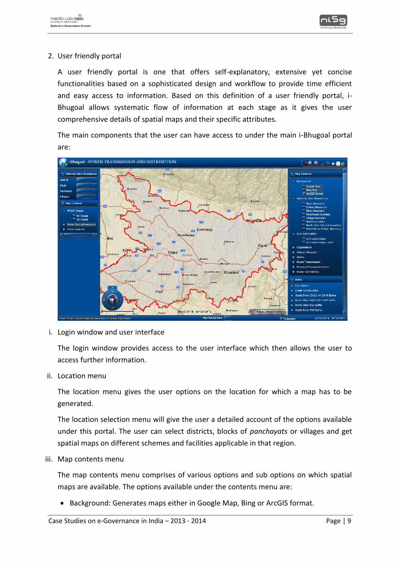
Project Overview
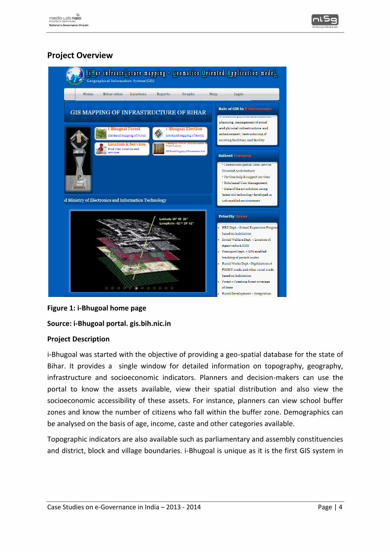
Figure 1: i-Bhugoal home page
Source: i-Bhugoal portal. gis.bih.nic.in
Project Description
i-Bhugoal was started with the objective of providing a geo-spatial database for the state of
Bihar. It provides a single window for detailed information on topography, geography,
infrastructure and socioeconomic indicators. Planners and decision-makers can use the
portal to know the assets available, view their spatial distribution and also view the
socioeconomic accessibility of these assets. For instance, planners can view school buffer
zones and know the number of citizens who fall within the buffer zone. Demographics can
be analysed on the basis of age, income, caste and other categories available.
Topographic indicators are also available such as parliamentary and assembly constituencies
and district, block and village boundaries. i-Bhugoal is unique as it is the first GIS system in
Case Studies on e-Governance in India – 2013 - 2014 Page | 5
Initiated in: 2011
Number of departments using it: 8
Salient Features:
1. Provides a comprehensive
framework for spatial and MIS data
through a service- oriented
architecture.
2. Helps in using GIS technology for
spatial mapping of key areas.
3. Generates thematic maps on key
infrastructural aspects across various
levels.
4. Facilitates a role based user
management system.
5. Provides online help and support
services for users.
the country that provides data upto the 1:4000 levels. Such detail, used mainly for cadastral4
purposes, is a pioneering effort and is all the more laudable as it has been implemented in a
state with no prior GIS coverage. It also provides geographic information on various
indicators such as soils, forest cover and watersheds.
This information, accessible on a single portal
(http://gis.bih.nic.in/), enables data-driven decision-
making. It removes errors that occur owing to lack of
information, eliminates duplication of efforts, and
enables a scientific approach to planning and
management. Furthermore, as it is based on GIS, it is
also used for monitoring and evaluation purposes,
and is used by various departments to keep track of
physical and financial progress.
The system is dynamically updated through backend
re-engineering that has enabled it to be updated
automatically as the various user departments update
their own information. Citizens can also update the
spatial database.
i-Bhugoal’s impact has been immediate and significant and it has fulfilled an urgent need
felt by the government of Bihar. It was developed by NIC Bihar beginning in 2010 and was
finished in a year and a half, with funding provided by the state government’s Department
of Information Technology (DIT). For its contributions the project won the Gold Medal in the
National e-Governance Awards 2012-13 under the category ‘Innovative Use of Technology
in e-Governance’.
i-Bhugoal is currently being used in the following ways for eight priority departments:
1. Human Resource Development: School expansion programmes are assessed based
on habitation data.
2. Social Welfare: Anganwadis and Integrated Child Development Centres (ICDS) are
being located using i-Bhugoal.
3. Transport: Permit routes are being tracked using Global Positioning System (GPS)
technology.
4 Cadastre, in terms of mapping, refers to lines showing boundaries, property lines etc.
Case Studies on e-Governance in India – 2013 - 2014 Page | 6
4. Rural Works: Records of Pradhan Mantri Gram Sadak Yojana (PMGSY) roads and
other rural roads based on habitation are being digitised.
5. Forests: The forest coverage in Bihar is being mapped.
6. Rural Development: Below Poverty Line (BPL) and National Rural Employment
Guarantee Act (NREGA) data currently available through MIS are being integrated.
7. Irrigation: Works pertaining to embankment and canals are being carried out using i-
Bhugoal.
8. Land Registration: Minimum Value Register (MVRs) are being mapped.
Objectives
i-Bhugoal aims at achieving the following objectives :
1. Creating a digital spatial database for the entire state. i-Bhugoal comprises of
primary layers5 and the ability to generate secondary layers6 and composite maps
based upon those. The database would also enable the generation of location-
specific thematic maps and Action Plan maps for location-specific problems.
2. Developing a GIS-based query system and enabling GIS analysis.
3. Introducing ‘entitlement-based’ planning on the basis of authentic data so as to
enable balanced regional development and the creation of uniform infrastructure
across the state.
4. Moving towards data-driven decision-making.
5. Enabling monitoring and evaluation of work sites.
The long term objectives of the project are not only state specific but have national level
applications as well. i-Bhugoal aims to continue the existing online platform for research on
rural development, and assist planners and decision-makers in the following ways7:
1. Analyse regional divergences in the economic, social, demographic and
environmental development of the nation by applying a multi-disciplinary approach.
5 Primary layers refer to resource data such as that on soils, land use, contours, geology and drainage. 6 Secondary layers refer to parameters such as slope, erosion class, soil depth and land capability. 7 Shailesh Kumar Shrivastava, Prabhat Kumar and Amar Nath Pandey. ‘iBhugoal - Bihar
Infrastructure Mapping Geomatics Oriented Application Model’. International Journal of Advanced
Computer Engineering and Architecture. Vol.1 No.1, June 2011.
Case Studies on e-Governance in India – 2013 - 2014 Page | 7
2. Analyse and project divergences between rural and urban-industrial areas in the
nation so as to assist planners and decision-makers in formulating rural development
policies both at the regional and national levels.
3. Further help the rural development of Bihar by identifying innovative initiatives in
backward rural regions and developing alternative development scenarios that rely
less upon traditional sectors.
Stakeholders
National Informatics Centre (NIC), Bihar: The NIC state centre for Bihar has designed,
developed and deployed the project, and is also in charge of training and capacity building.
Information Technology Department, Government of Bihar: The Department has funded
the project.
State Departments of the Government of Bihar: Various state departments use the
facilities provided by i-Bhugoal. Currently, the priority departments under the project are
Education, Human Resources, Social Welfare, Transport, Rural Works, Rural Development,
Forest, Irrigation and Land Registration.
Program Components
i-Bhugoal is an information generating portal used by the Bihar government to map,
organize and manage data spatially on infrastructural and policy related services up to the
village level. It uses comprehensive GIS software which enables viewing, understanding,
interpreting and visualizing data in ways that reveal relationships and patterns in the format
of extensive maps, reports and charts. The main program components of i-Bhugoal are:
1. Generation of spatial maps
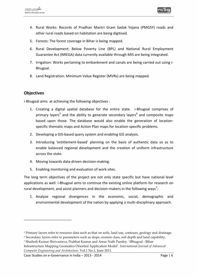
i-Bhugoal enables users to map spatial entities coterminous with data quantities. In doing
so, the user can relate spatial locations to particular quantities. For example, public
health officials might want to map physicians per thousand people in each census tract in
order to identify which areas are inadequately served. Election booth mapping can be
used by Election Commission officials while planning elections. Spatial activity in defined
locations can also be mapped. For example, the crime rate and pattern in a particular
location can be mapped and incidence with other factors can be matched using the GIS
mapping service. Figure 2 shows samples of the various map types that can be generated
using i-Bhugoal.
Case Studies on e-Governance in India – 2013 - 2014 Page | 8
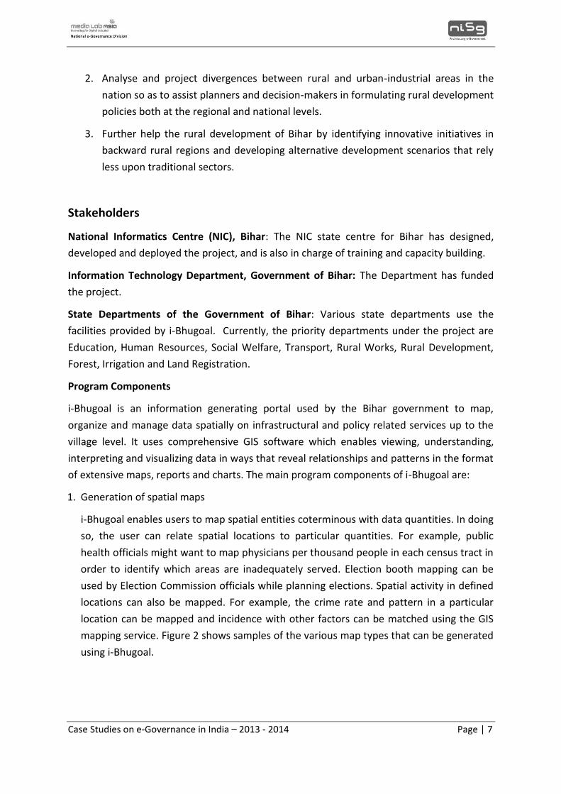
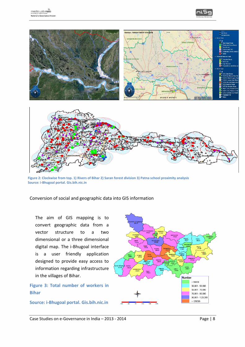
Conversion of social and geographic data into GIS information
The aim of GIS mapping is to
convert geographic data from a
vector structure to a two
dimensional or a three dimensional
digital map. The i-Bhugoal interface
is a user friendly application
designed to provide easy access to
information regarding infrastructure
in the villages of Bihar.
Figure 3: Total number of workers in
Bihar
Source: i-Bhugoal portal. Gis.bih.nic.in
Figure 2: Clockwise from top. 1) Rivers of Bihar 2) Saran forest division 3) Patna school proximity analysis Source: i-Bhugoal portal. Gis.bih.nic.in
Case Studies on e-Governance in India – 2013 - 2014 Page | 9
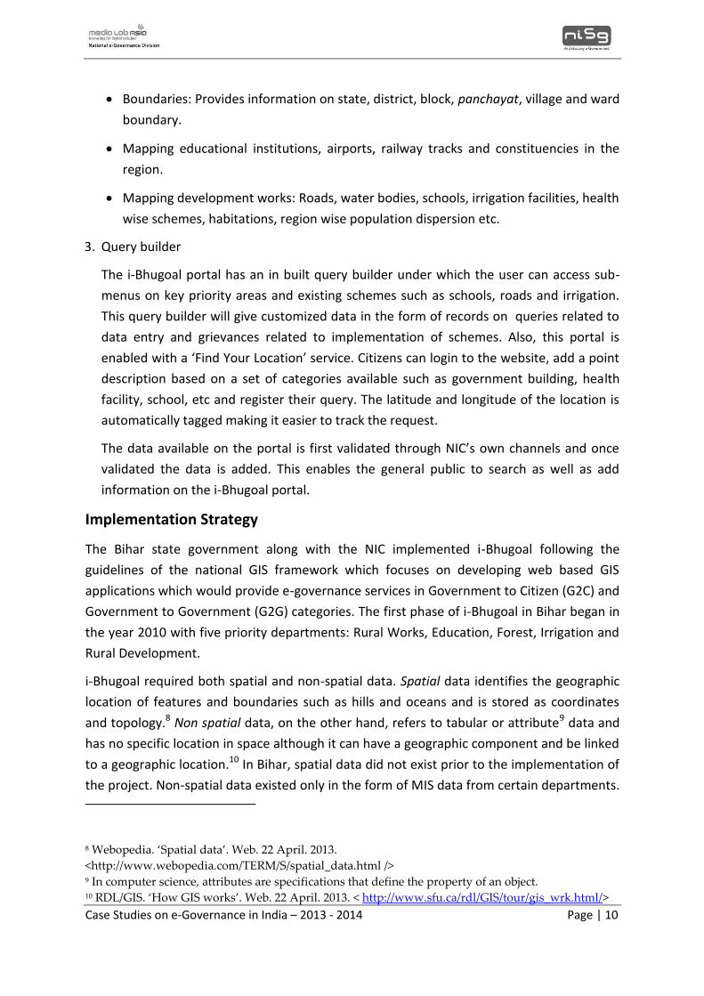
2. User friendly portal
A user friendly portal is one that offers self-explanatory, extensive yet concise
functionalities based on a sophisticated design and workflow to provide time efficient
and easy access to information. Based on this definition of a user friendly portal, i-
Bhugoal allows systematic flow of information at each stage as it gives the user
comprehensive details of spatial maps and their specific attributes.
The main components that the user can have access to under the main i-Bhugoal portal
are:
i. Login window and user interface
The login window provides access to the user interface which then allows the user to
access further information.
ii. Location menu
The location menu gives the user options on the location for which a map has to be
generated.
The location selection menu will give the user a detailed account of the options available
under this portal. The user can select districts, blocks of panchayats or villages and get
spatial maps on different schemes and facilities applicable in that region.
iii. Map contents menu
The map contents menu comprises of various options and sub options on which spatial
maps are available. The options available under the contents menu are:
Background: Generates maps either in Google Map, Bing or ArcGIS format.
Case Studies on e-Governance in India – 2013 - 2014 Page | 10
Boundaries: Provides information on state, district, block, panchayat, village and ward
boundary.
Mapping educational institutions, airports, railway tracks and constituencies in the
region.
Mapping development works: Roads, water bodies, schools, irrigation facilities, health
wise schemes, habitations, region wise population dispersion etc.
3. Query builder
The i-Bhugoal portal has an in built query builder under which the user can access sub-
menus on key priority areas and existing schemes such as schools, roads and irrigation.
This query builder will give customized data in the form of records on queries related to
data entry and grievances related to implementation of schemes. Also, this portal is
enabled with a ‘Find Your Location’ service. Citizens can login to the website, add a point
description based on a set of categories available such as government building, health
facility, school, etc and register their query. The latitude and longitude of the location is
automatically tagged making it easier to track the request.
The data available on the portal is first validated through NIC’s own channels and once
validated the data is added. This enables the general public to search as well as add
information on the i-Bhugoal portal.
Implementation Strategy
The Bihar state government along with the NIC implemented i-Bhugoal following the
guidelines of the national GIS framework which focuses on developing web based GIS
applications which would provide e-governance services in Government to Citizen (G2C) and
Government to Government (G2G) categories. The first phase of i-Bhugoal in Bihar began in
the year 2010 with five priority departments: Rural Works, Education, Forest, Irrigation and
Rural Development.
i-Bhugoal required both spatial and non-spatial data. Spatial data identifies the geographic
location of features and boundaries such as hills and oceans and is stored as coordinates
and topology.8 Non spatial data, on the other hand, refers to tabular or attribute9 data and
has no specific location in space although it can have a geographic component and be linked
to a geographic location.10 In Bihar, spatial data did not exist prior to the implementation of
the project. Non-spatial data existed only in the form of MIS data from certain departments.
8 Webopedia. ‘Spatial data’. Web. 22 April. 2013.
<http://www.webopedia.com/TERM/S/spatial_data.html /> 9 In computer science, attributes are specifications that define the property of an object. 10 RDL/GIS. ‘How GIS works’. Web. 22 April. 2013. < http://www.sfu.ca/rdl/GIS/tour/gis_wrk.html/>
Case Studies on e-Governance in India – 2013 - 2014 Page | 11
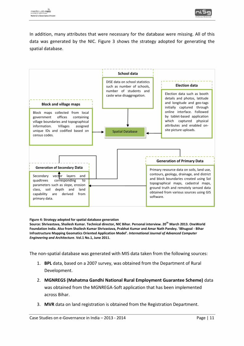
In addition, many attributes that were necessary for the database were missing. All of this
data was generated by the NIC. Figure 3 shows the strategy adopted for generating the
spatial database.
The non-spatial database was generated with MIS data taken from the following sources:
1. BPL data, based on a 2007 survey, was obtained from the Department of Rural
Development.
2. MGNREGS (Mahatma Gandhi National Rural Employment Guarantee Scheme) data
was obtained from the MGNREGA-Soft application that has been implemented
across Bihar.
3. MVR data on land registration is obtained from the Registration Department.
School data
Block and village maps
Generation of Secondary Data
Generation of Primary Data
Election data
Spatial Database
Primary resource data on soils, land use, contours, geology, drainage, and district and block boundaries created using SoI topographical maps, cadastral maps, ground truth and remotely sensed data obtained from various sources using GIS software.
Secondary vector layers and quadtrees corresponding to parameters such as slope, erosion class, soil depth and land capability are derived from primary data.
Block maps collected from local government offices containing village boundaries and topographical information. Villages assigned unique IDs and codified based on census codes.
DISE data on school statistics such as number of schools, number of students and caste wise disaggregation. Election data such as booth
details and photos, latitude and longitude and geo-tags initially captured through online interface. Followed by tablet-based application which captured physical attributes and enabled on-site picture uploads.
Figure 4: Strategy adopted for spatial database generation Source: Shrivastava, Shailesh Kumar. Technical director, NIC Bihar. Personal interview. 20
th March 2013. OneWorld
Foundation India. Also from Shailesh Kumar Shrivastava, Prabhat Kumar and Amar Nath Pandey. ‘iBhugoal - Bihar Infrastructure Mapping Geomatics Oriented Application Model’. International Journal of Advanced Computer Engineering and Architecture. Vol.1 No.1, June 2011.
Case Studies on e-Governance in India – 2013 - 2014 Page | 12
After generation, the spatial and non-spatial databases were integrated. The tables of
spatial village map and non-spatial census information were opened in Arc/View, the GIS
software used for i-Bhugoal, and joined together using the table-join function available
through the software. This resulted in a village map which displays boundaries as well as
socioeconomic dimensions. The last stage was the development of a menu-driven
interactive Graphical User Interface (GUI).
The portal is currently updated dynamically as the NIC has carried out backend re-
engineering which has resulted in the i-Bhugoal portal being updated when departments
update their databases. Bihar’s Common Service Centres, called Vasudha Kendras, also play
a role in updating the database. They identify anganwadi kendras in their local areas, take
photographs and upload these to the site.
i-Bhugoal was completed in a year and a half. However, it is still very much a work in
progress with new additions and innovations in the pipeline. Upon i-Bhugoals’ successful
implementation, the Centre for Good Governance (CGG) Bihar recommended the project’s
upscaling for the entire state and so, the final phase was carried out by the end of 2011.
Currently, the project is being implemented across eight departments. The government of
Bihar has extended the project for two years and notified authorities that if other
departments want to integrate their data representation and monitoring measures then
they can integrate their systems into i-Bhugoal. Additional details on scaling-up the i-
Bhugoal portal have been mentioned in the section on Key Lessons.
Technology
i-Bhugoal’s web-based GIS system is currently hosted on the NIC data centre and is based on
five core components:
1. User interface for clients to access and analyse data
2. Web server and application server for getting the clients’ request and sending it to
map server
3. Data analysis and queries based on clients’ request
4. Data server for retrieving data from a database and serving them to map server for
analysis
5. Database that includes spatial data and non-spatial data
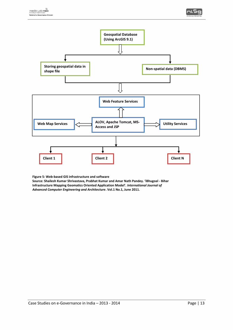
Case Studies on e-Governance in India – 2013 - 2014 Page | 13
Geospatial Database (Using ArcGIS 9.1)
Non-spatial data (DBMS) Storing geospatial data in shape file
Web Feature Services
Utility Services ALOV, Apache Tomcat, MS-Access and JSP
Web Map Services
Client N Client 2 Client 1
Figure 5: Web-based GIS infrastructure and software Source: Shailesh Kumar Shrivastava, Prabhat Kumar and Amar Nath Pandey. ‘iBhugoal - Bihar Infrastructure Mapping Geomatics Oriented Application Model’. International Journal of Advanced Computer Engineering and Architecture. Vol.1 No.1, June 2011.
Case Studies on e-Governance in India – 2013 - 2014 Page | 14
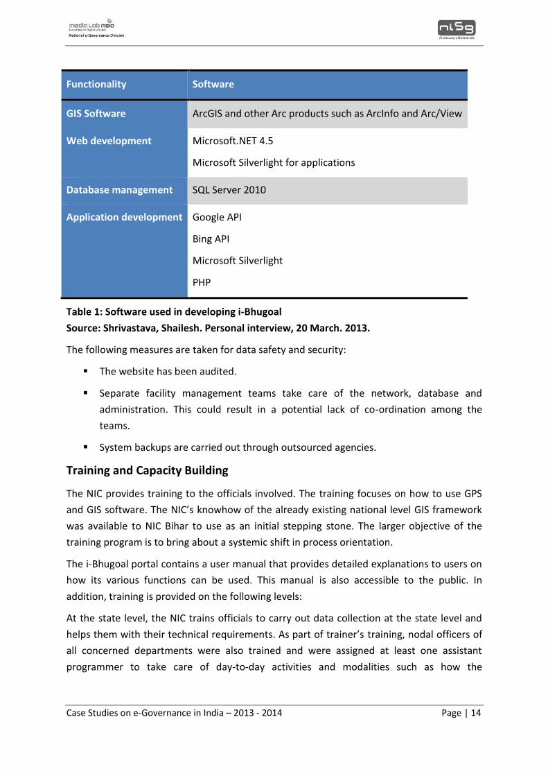
Functionality Software
GIS Software ArcGIS and other Arc products such as ArcInfo and Arc/View
Web development Microsoft.NET 4.5
Microsoft Silverlight for applications
Database management SQL Server 2010
Application development Google API
Bing API
Microsoft Silverlight
PHP
Table 1: Software used in developing i-Bhugoal
Source: Shrivastava, Shailesh. Personal interview, 20 March. 2013.
The following measures are taken for data safety and security:
The website has been audited.
Separate facility management teams take care of the network, database and
administration. This could result in a potential lack of co-ordination among the
teams.
System backups are carried out through outsourced agencies.
Training and Capacity Building
The NIC provides training to the officials involved. The training focuses on how to use GPS
and GIS software. The NIC’s knowhow of the already existing national level GIS framework
was available to NIC Bihar to use as an initial stepping stone. The larger objective of the
training program is to bring about a systemic shift in process orientation.
The i-Bhugoal portal contains a user manual that provides detailed explanations to users on
how its various functions can be used. This manual is also accessible to the public. In
addition, training is provided on the following levels:
At the state level, the NIC trains officials to carry out data collection at the state level and
helps them with their technical requirements. As part of trainer’s training, nodal officers of
all concerned departments were also trained and were assigned at least one assistant
programmer to take care of day-to-day activities and modalities such as how the
Case Studies on e-Governance in India – 2013 - 2014 Page | 15
department should progress. For GIS handling, operators were trained by the NIC and
stationed in departments for taking care of daily requirements.
At the district level, the District Informatics Officer (DIO) is the NIC functionary and
trains district officials as well as assists with data collection operations.
For officials located in remote areas, training was provided on:
1. Data entry onto the portal
2. Visualising data in spatial form
With respect to the time period involved, 2 – 3 months are required for an official to
become well-versed in GIS applications and mapping. For officials in remote areas, a week’s
training is provided in sets of two days with three intervals in between.
Training review is carried out through common video-conferencing sessions where the NIC
along with the Department Head review the progress of the capacity building exercise. The
letters issued by various departments to their field functionaries are also passed on to the
NIC so that it is kept in the loop of their training requirements.
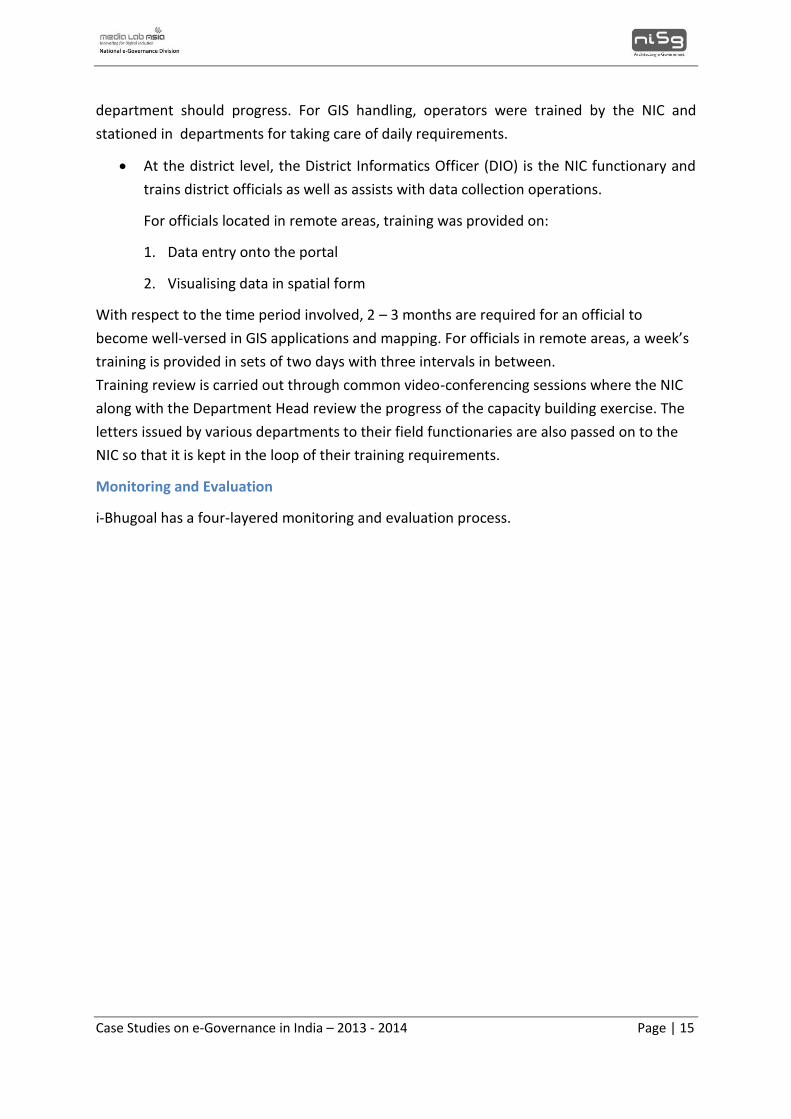
Monitoring and Evaluation
i-Bhugoal has a four-layered monitoring and evaluation process.
Case Studies on e-Governance in India – 2013 - 2014 Page | 16
Figure 6: Monitoring process for i-Bhugoal
Source: Shrivastava, Shailesh Kumar. Technical director, NIC Bihar. Personal interview.
20th March 2013.
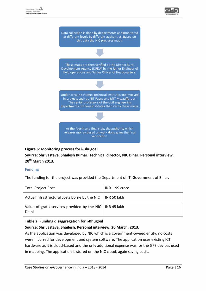
Funding
The funding for the project was provided the Department of IT, Government of Bihar.
Total Project Cost INR 1.99 crore
Actual infrastructural costs borne by the NIC INR 50 lakh
Value of gratis services provided by the NIC Delhi
INR 45 lakh
Table 2: Funding disaggregation for i-Bhugoal
Source: Shrivastava, Shailesh. Personal interview, 20 March. 2013.
As the application was developed by NIC which is a government-owned entity, no costs
were incurred for development and system software. The application uses existing ICT
hardware as it is cloud-based and the only additional expense was for the GPS devices used
in mapping. The application is stored on the NIC cloud, again saving costs.
Data collection is done by departments and monitored at different levels by different authorities. Based on
this data the NIC prepares maps.
These maps are then verified at the District Rural Development Agency (DRDA) by the Junior Engineer of
field operations and Senior Officer of Headquarters.
Under certain schemes technical institutes are involved in projects such as NIT Patna and MIT Muzzaffarpur.
The senior professors of the civil engineering departments of these institutes then verify these maps.
At the fourth and final step, the authority which releases money based on work done gives the final
verification.
Case Studies on e-Governance in India – 2013 - 2014 Page | 17
Outcomes and Benefits Realized
i-Bhugoal is the first GIS-enabled application implemented in Bihar and has made it the first
state in the country to have maps of up to 250 persons of the population in the 4000 scale.
No other state so far has maps at such low levels of scale. The impact of this application is as
follows:
Works carried out through i-Bhugoal:
Owing to lack of data on the core network the Centre did not release funds under
PMGSY to Bihar for more than three years. However after submission of satellite-
image based core map of roads generated through i-Bhugoal the Centre released
funds over INR 4,000 crore to the state under PMGSY and more is to be released.
The application is being used to create a database for implementing Mukhya Mantri
Gram Sampark Yojana which entails construction of 34,000 km of all-weather roads
to connect more than 1 lakh habitations having population of 250 each at a cost of
INR 23,881 crore.11
Departments for which infrastructure mapping has been carried out so far are
Health, Education, Social Welfare, Rural Works, Road Construction, Rural
Development, Minor Irrigation and Water Resources.
Integration of geo-spatial data and MIS data of different departments such as
Education, Rural Works, Social Welfare, Election, Building Construction and Irrigation
has been completed.
Complete road network has been covered.
Improves planning and management
i-Bhugoal’s first and foremost contribution is that it enables data driven decision-making. It
provides planners and decision makers with information on available assets, and based on
this realistic and accurate planning can be carried out. This was a major change from the
previously dominant form of planning where there would be inefficiencies as assets would
be unevenly distributed during the planning stage owing to lack of information.
Partially automated and open-access based thematic map updation
The system has been configured in such a way that data entry by one department would
result in the updation of the maps on i-Bhugoal. As previously mentioned, the public can
also update the map. This means that a centralised database is being dynamically updated
11Telegraph India. ‘Satellite images to monitor growth’. 26 December. 2012. Web. 21 March. 2014. <
http://www.telegraphindia.com/1121226/jsp/bihar/story_16359899.jsp#.UywGw_mSzSA>
Case Studies on e-Governance in India – 2013 - 2014 Page | 18
from decentralised sources. This coordinates the activities of many different departments
and eliminates duplication of work. The portal is centrally accessible and, therefore, all the
stakeholders can benefit from each other’s collaborative efforts.
Enables real-time monitoring of worksites
On-site monitoring is very important for various works departments. To this end, geo-tagged
photographs are being captured, and physical and financial progress from worksites is being
uploaded. I-Bhugoal is also being used to validate data about habitations generated during
the National Habitation Survey, 2003.12 Thus, i-Bhugoal also enables implementing agencies
to carry out GIS-based monitoring and evaluation.
Systematic check on regional disparity
Often the same scheme is implemented multiple times within the same region while other
regions are neglected. Political compulsions and demands on resource allocation, especially
prior to elections, result in a somewhat haphazard regional distribution of development
programmes. i-Bhugoal, by providing an asset inventory, helps planners and decision-
makers view the spatial distribution of assets and enables them to allocate resources in a
more equitable manner. Taking schools for instance, the system enables planners to view
the proximity location or the area covered by the school, and accordingly allocates schools
in a way that reduces the distance students have to travel.
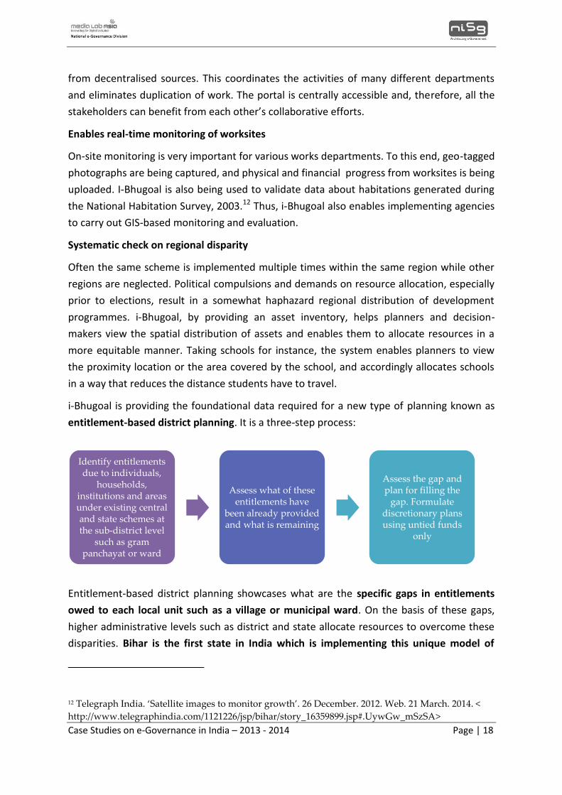
i-Bhugoal is providing the foundational data required for a new type of planning known as
entitlement-based district planning. It is a three-step process:
Entitlement-based district planning showcases what are the specific gaps in entitlements
owed to each local unit such as a village or municipal ward. On the basis of these gaps,
higher administrative levels such as district and state allocate resources to overcome these
disparities. Bihar is the first state in India which is implementing this unique model of
12 Telegraph India. ‘Satellite images to monitor growth’. 26 December. 2012. Web. 21 March. 2014. <
http://www.telegraphindia.com/1121226/jsp/bihar/story_16359899.jsp#.UywGw_mSzSA>
Identify entitlements due to individuals,
households, institutions and areas under existing central and state schemes at the sub-district level
such as gram panchayat or ward
Assess what of these entitlements have
been already provided and what is remaining
Assess the gap and plan for filling the
gap. Formulate discretionary plans using untied funds
only
Case Studies on e-Governance in India – 2013 - 2014 Page | 19
decentralised planning which is designed to address regional disparities and the data for
this planning comes from i-Bhugoal.
Challenges in Implementation
The NIC and the state government of Bihar faced several challenges during the introduction
and implementation of the i-Bhugoal project due to several institutional and operational
reasons which can be highlighted as follows:
Maintaining co-ordination among various departments
One of the foremost challenges faced by the NIC was gathering and organizing data from the
priority departments for spatial and infrastructural mapping so as to provide an asset
register for the entire state. To make this spatial data accessible on a centralized portal
required complete coordination between all the departments. The process of organizing and
providing capacity building to various departments involved a long process of training and
capacity building. According to the Technical Director of the project at NIC Bihar, it would
require at least 2-3 years more to provide a complete state asset register and to bring more
departments under the purview of i-Bhugoal.
Use of complex GIS technology
i-Bhugoal was the first ever GIS project implemented in the state of Bihar. Prior to the i-
Bhugoal project, the concept of spatial database did not exist in Bihar, and both the
knowledge and awareness of spatial dimensions in decision-making was absent. Hence,
initially it was difficult to convince top authorities that the use of GIS-enabled tools can be
highly effective in decision-making on infrastructure, policy and other thematic concerns.
The NIC successfully overcame this challenge by demonstrating its effective functionality in
the concerned departments.
Maintaining digital records
The other important challenge faced during the implementation process was digitising
spatial data. Prior to the i-Bhugoal, most of the data records were maintained manually.
One of the major concerns arose from the fact that i-Bhugoal aimed to cover many
departments but each had its specific way of functioning and managing data. So the NIC
faced the challenge of streamlining the processes of each department and organizing it
under a centralized web portal.
Thus, organising data from various departments, converting large volumes of manual data
into a digital format and carrying out spatial mapping required a continuous and sustained
process where different departments were progressively included.
Challenges in training and capacity building
Case Studies on e-Governance in India – 2013 - 2014 Page | 20
The effective implementation of a technology or practice requires building the capacity of
public officials for strengthening its functioning and enabling a timely flow of services. The
implementation of i-Bhugoal was managed by the NIC but they faced a major technical
challenge in terms of GPS handling. The staff/public officials particularly at the level of small
villages and districts were not able to understand the technical functions and operations of
the GPS system. The NIC conducted regular training sessions to capacitate the officials with
software handling techniques. As part of follow-up monitoring, video conferencing was used
to ensure that the technical challenges do not underscore the sustainability of the project.
Operational challenges
In terms of access to technology, the NIC faced hardware issues related to -- ,
Life of the GPS device’s battery and its portability during village surveys was
problematic.
In remote villages and districts, receptiveness of the people towards GPS mapping
and support in terms of logistical issues and information was crucial. In this regard,
NIC officials faced several issues in remote villages of Bihar where people were not
very receptive and accurate in giving information about projects. .
The implementing agencies however have worked towards sorting out these
operational issues. In fact the GPS mapping device is in-built with verification and
authentication tools.. For example, if an official is conducting a GPS mapping of
anganwadis and have been misinformed with contradictory information, then the
GPS system would check for fallacies and update the existing gap in information.
Key lessons
Need for a geomatics project
i-Bhugoal filled an administrative gap felt by the Government of Bihar which requested the
Planning Commission for a geo-spatial database. Thus, the project was not implemented for
abstract, aesthetic reasons but rather filled a pressing, practical need which was felt at all
levels. This initial condition had several ramifications which are given below.
Support from the top vital for ensuring a project’s sustainability
i-Bhugoal had support from the Chief Minister as well as the Chief Secretary. This ensured
that the project was constantly in motion. According to the NIC, had the project been
started at a lower level, it would have run into several problems and could not have reached
the scope and scale it currently has.
Case Studies on e-Governance in India – 2013 - 2014 Page | 21
Immediate benefits combined with comprehensive training catalyses stakeholder
acceptance
The benefits of i-Bhugoal have been immediate to its stakeholders who have seen it
improve monitoring capacities, unlock Central funds, and optimise the planning and
decision-making process, to cite a few of its functionalities. This made them eager to accept
the new application. This intention was actualised through the comprehensive training
made available by the NIC. The NIC is now planning to create ‘GIS cells’ in each department
which would contain 4–5 dedicated permanent personnel who would assist with the
management of i-Bhugoal. This move would further strengthen capacity building.
To enhance i-Bhugoal’s features relating to decision-making, a Decision Support System
(DSS) is being developed for decentralised planning at the district and block levels. A
prototype community GIS tool is also being expanded in this regard.
Data sharing between departments becomes easier when uploaded on a common
platform
Data updation is carried out through back-end process re-engineering which updates the i-
Bhugoal server automatically. This does not require any major administrative changes and in
addition all the departments can benefit from the cumulative information made available on
the spatial database. NIC Bihar’s job was made easier as they drew upon already existing
digitised data. An important planned upgrade to i-Bhugoal is the integration of Survey of
India maps with online map services such as Google, Bing and Environmental Systems
Research Institute (ESRI) applications to ensure a wider source database for procuring
spatial information.
State specific policy with consensus of all stakeholders must
Different works departments (such as public works and rural works) should first be brought
on board. Components such as data sharing, updation framework, layer sharing and layer
creation should come as a policy within the department and must be accepted by all the
stakeholders.
Formalization of change is a standard principle of process re-engineering. This was widely
followed by i-Bhugoal as well and ensured that the changes it brought about became
systemic and not person-centric. ‘Champion’ driven projects are helpful to the extent that
innovations are given a thrust but once implemented the change has to be formally
accepted as part of the system through policies or government orders. If this is not done,
the system can wither away.
Case Studies on e-Governance in India – 2013 - 2014 Page | 22
Increasing the outreach of the project would further enhance acceptability
The more i-Bhugoal is shown to have an impact, the greater would be the demand for it.
There are many works being carried out through the system currently. They are:
Schools: It is being used for proximity analysis in deciding where new schools are
required.
Irrigation: It is being used by the department works for checking requirements on
the use and functioning of baandhs (dams). For this specification, a core network has
been developed which is accessed through i-Bhugoal.
Agriculture: The state government of Bihar is planning to have a separate electricity
network for agriculture. This will monitor connectivity to pumps and for this purpose
a core network is being created.
Forest Department: Earlier GIS mapping was used in forests only to capture
boundaries. The expansion of the use of i-Bhugoal to the Forest Department has
allowed three important things –
Forest area and its classification.
Covering green spaces - Through satellite imagery the forest department
wants to make an analysis of what the coverage was in 2007 and what it is
presently to estimate how much greenery has been created because of
different schemes, in which areas, and through which schemes.
In different areas there are many existing schemes running and i-Bhugoal is
being used to monitor implementation and identify gaps in these schemes.
Mapping habitations: A very important usage of the GIS-enabled i-Bhugoal would be
to create a database for implementing the Mukhya Mantri Gram Sampark Yojana
which involves constructing approximately 34,000 km all-weather roads to connect
more than one lakh habitations having a population of 250 persons each in the next
five years at a cost of INR 23,881 crore. i-Bhugoal would provide information by
generating maps of various types of existing roads connecting habitations and
validate data on existing habitations generated during the National Habitation
Survey, 2003.
A proposed addition involves Urban Local Bodies (ULBs) which want to expand their
operations and carry out advanced functions using i-Bhugoal. These departments are
looking for mapping land patterns or habitations at highly detailed levels. There could be
problems in disseminating information from various sources and maintaining
Case Studies on e-Governance in India – 2013 - 2014 Page | 23
synchronization of operations under i-Bhugoal. However, there is an understanding that any
data originating outside the purview of the current scheme should be shared with NIC Bihar.
Work must be done within a set time-frame
Poetically stated, the difference between dreaming and planning is that the latter is time-
bound. Similarly, if one is to replicate a project such as this, it must be done with a clear goal
and deadline in mind so that progress can be monitored accordingly.
Accounting for ample time and patience in the implementation of such a project
A project like i-Bhugoal requires about 3–5 years before the state spatial infrastructure
comes into existence and implementing agencies must have the requisite patience to see it
through.
Research methodology
I-Bhugoal has provided a comprehensive database on which users can access data on Bihar’s
natural resources, administrative typologies, physical and social assets and track the
performance of ongoing projects as well as access demographic and statistical data. The
unique element of the portal is its integration of MIS and GIS data and the consequent
presentation of this information to the user in an easy to use yet comprehensive spatial
format. For its efforts, it won a gold medal for its efforts at the National e-Governance
Awards and accordingly was selected for documentation.
In order to document the innovation, the OneWorld research team conducted both primary
and secondary research. The secondary sources comprised of credible media articles,
scientific papers published on i-Bhugoal and the portal’s user manual. A list is provided in
the references section. Based on this data, the OneWorld team identified gaps in the
existing literature.
The primary source of data for the case study was the chief executive responsible for the
implementation of i-Bhugoal, the Technical Director of NIC Bihar, Mr. Shailesh Kumar
Shrivastava. A semi-structured interview was conducted with him and he provided extensive
details on the genesis and need for the project, the implementation strategy adopted, the
process flow for the portal, the monitoring and evaluation mechanism used for the project,
the training and capacity building mechanisms, the chief challenges faced, key lessons learnt
from the initiative and future plans for the project.
Following the analysis of the secondary material and the information gathered from the
interview questionnaires, the project was documented in order to ensure that it significantly
contributes to the enhancement of available knowledge resources and practice.
Case Studies on e-Governance in India – 2013 - 2014 Page | 24
Conclusion
i-Bhugoal is a pioneering initiative in many ways. It is the first GIS-based initiative in the
state of Bihar and is the first system which provides data at the 1:4000 cadastral levels. It
has filled an urgent administrative need felt by the Government of Bihar. For this reason it
received support at all levels of the government. The immediate and tangible benefits it
brought about hastened its acceptance by the stakeholders and resulted in its winning a
Gold Medal in just two years of its implementation. However, along with the demand side
the supply side too played a major role in its implementation. NIC Bihar could draw upon
the pre-existing expertise of the NIC in the sector and also provided valuable technical
resources and training that were essential to the sustenance of the project.
Today, i-Bhugoal is being used in a wide range of functions. Right from the planning stage to
the monitoring and evaluation stage, it is providing planners, administrators and politicians
with a powerful tool that in the long run enables a more balanced and equitable pattern of
growth founded on sound scientific understandings.
Case Studies on e-Governance in India – 2013 - 2014 Page | 25
References
GIS Team, NIC Bihar. ‘i-Bhugoal User Manual’. 28th September. 2012. Web. 19th March.
2013. <http://gis.bih.nic.in/Help/Help.aspx/>
i-Bhugoal portal. Web. 18th March. 2013. <http://gis.bih.nic.in/>
National Spatial Data Infrastructure India. ‘Introduction’. Web. 23rd December. 2013.
<http://nsdiindia.gov.in/nsdi/nsdiportal/questionnaire/THE.pdf/>
NIC projects. ‘i-Bhugoal’. Web. 18th March. 2013. <http://www.nic.in/projects?nid=5077/>
RDL/GIS. ‘How GIS works’. Web. 22 April. 2013.
<http://www.sfu.ca/rdl/GIS/tour/gis_wrk.html />
Shailesh Kumar Shrivastava, Prabhat Kumar and Amar Nath Pandey. ‘iBhugoal - Bihar
Infrastructure Mapping Geomatics Oriented Application Model’. International Journal of
Advanced Computer Engineering and Architecture. Vol.1 No.1, June 2011.
Shrivastava, Shailesh Kumar. Technical director, NIC Bihar. Personal interview. 20th March
2013.
The Bihar Times. ‘Bihar gets Gold Medal for “i-Bhugoal”’. 18th February. 2013. Web. 18th
March. 2013. <http://www.bihartimes.in/Newsbihar/2013/Feb/newsbihar18Feb8.html/>
The World Bank. Bihar: Towards a Development Strategy. 2005.
UNDP portal. ‘About Bihar’. Web. 5th April 2013.
<http://www.undp.org/content/india/en/home/operations/about_undp/undp-in-
bihar/about-bihar/>
Webopedia. ‘Spatial data’. Web. 22 April. 2013.
<http://www.webopedia.com/TERM/S/spatial_data.html />
Case Studies on e-Governance in India – 2013 - 2014 Page | 26
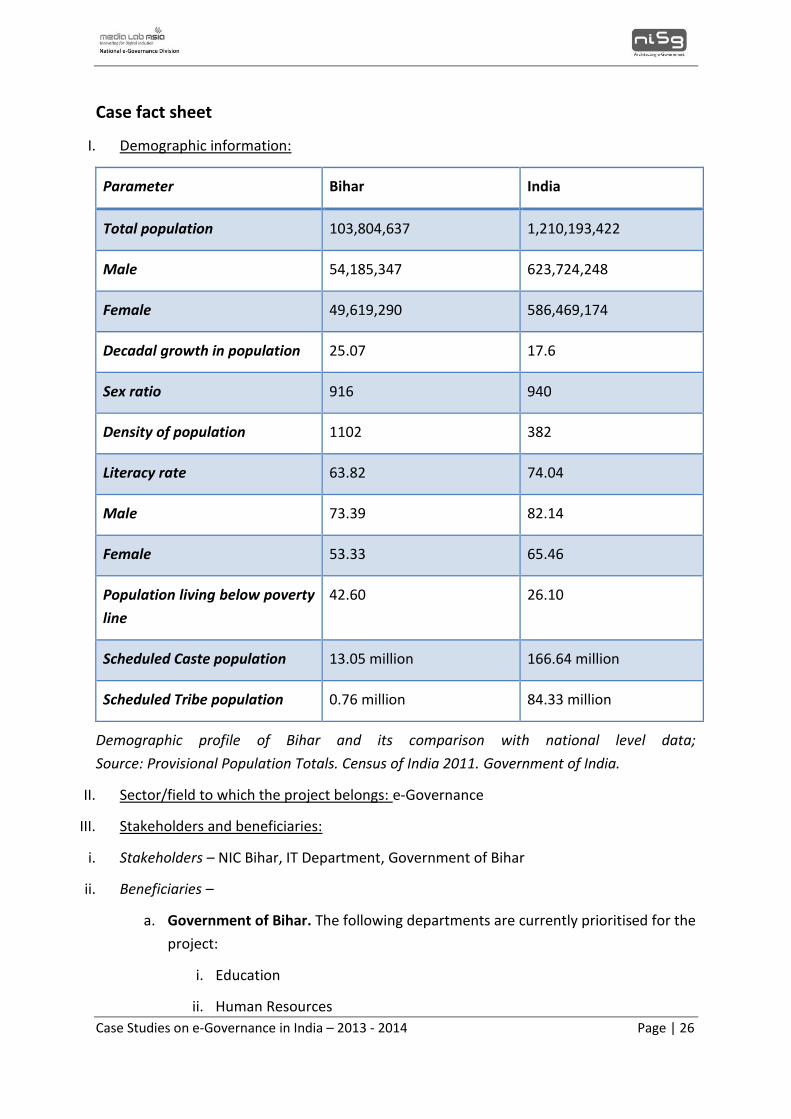
Case fact sheet
I. Demographic information:
Parameter Bihar India
Total population 103,804,637 1,210,193,422
Male 54,185,347 623,724,248
Female 49,619,290 586,469,174
Decadal growth in population 25.07 17.6
Sex ratio 916 940
Density of population 1102 382
Literacy rate 63.82 74.04
Male 73.39 82.14
Female 53.33 65.46
Population living below poverty
line
42.60 26.10
Scheduled Caste population 13.05 million 166.64 million
Scheduled Tribe population 0.76 million 84.33 million
Demographic profile of Bihar and its comparison with national level data;
Source: Provisional Population Totals. Census of India 2011. Government of India.
II. Sector/field to which the project belongs: e-Governance
III. Stakeholders and beneficiaries:
i. Stakeholders – NIC Bihar, IT Department, Government of Bihar
ii. Beneficiaries –
a. Government of Bihar. The following departments are currently prioritised for the
project:
i. Education
ii. Human Resources
Case Studies on e-Governance in India – 2013 - 2014 Page | 27
iii. Social Welfare
iv. Transport
v. Rural Works
vi. Rural Development
vii. Forest
viii. Irrigation
ix. Land Registration
b. Citizens of Bihar
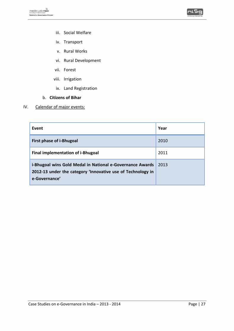
IV. Calendar of major events:
Event Year
First phase of i-Bhugoal 2010
Final implementation of i-Bhugoal 2011
i-Bhugoal wins Gold Medal in National e-Governance Awards
2012-13 under the category ‘Innovative use of Technology in
e-Governance’
2013
Case Studies on e-Governance in India – 2013 - 2014 Page | 28
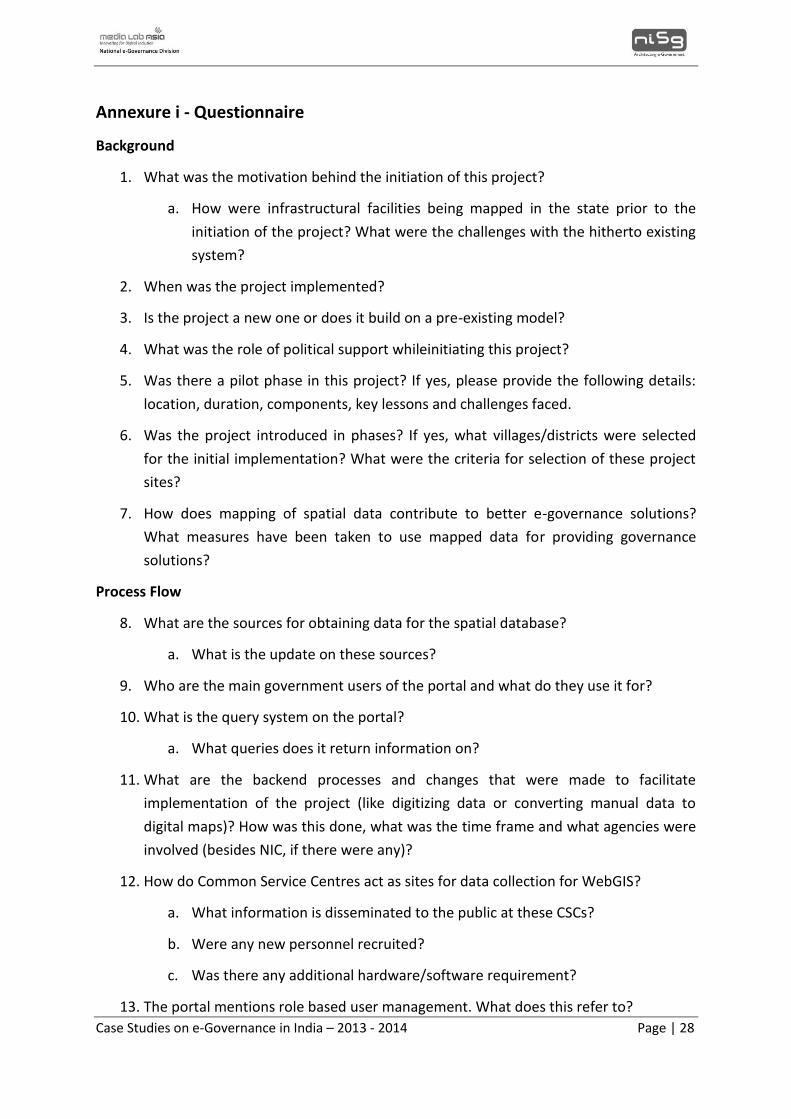
Annexure i - Questionnaire
Background
1. What was the motivation behind the initiation of this project?
a. How were infrastructural facilities being mapped in the state prior to the
initiation of the project? What were the challenges with the hitherto existing
system?
2. When was the project implemented?
3. Is the project a new one or does it build on a pre-existing model?
4. What was the role of political support whileinitiating this project?
5. Was there a pilot phase in this project? If yes, please provide the following details:
location, duration, components, key lessons and challenges faced.
6. Was the project introduced in phases? If yes, what villages/districts were selected
for the initial implementation? What were the criteria for selection of these project
sites?
7. How does mapping of spatial data contribute to better e-governance solutions?
What measures have been taken to use mapped data for providing governance
solutions?
Process Flow
8. What are the sources for obtaining data for the spatial database?
a. What is the update on these sources?
9. Who are the main government users of the portal and what do they use it for?
10. What is the query system on the portal?
a. What queries does it return information on?
11. What are the backend processes and changes that were made to facilitate
implementation of the project (like digitizing data or converting manual data to
digital maps)? How was this done, what was the time frame and what agencies were
involved (besides NIC, if there were any)?
12. How do Common Service Centres act as sites for data collection for WebGIS?
a. What information is disseminated to the public at these CSCs?
b. Were any new personnel recruited?
c. Was there any additional hardware/software requirement?
13. The portal mentions role based user management. What does this refer to?
Case Studies on e-Governance in India – 2013 - 2014 Page | 29
a. What are the different roles assigned within the portal?
14. What are the bases on which key priority areas have been selected for mapping and
archiving data?
a. Why was the need felt to focus on these areas only?
Technology
15. What is the GIS software used? Is there any prior technological model on which it is
based?
16. Was it developed in-house?
17. If yes, how long did it take to develop it and what was the human resource involved?
18. Where is the portal hosted?
19. What steps are taken for data safety and security?
20. Are there provisions for data back-up?
21. How is the portal maintained in terms of periodicity and agency?
Capacity Building
22. Can you provide the following details regarding training: resource persons, content,
methodology, participants, duration and follow up mechanisms.
23. What were the difficulties faced when training personnel and how were they
overcome?
24. What has been the status of the three level Master’s training program to
management?
25. Have any new personnel been recruited?
Monitoring and evaluation
26. How is the data authenticated and verified?
27. How frequently is it updated?
28. Does the system have any in-built checks for authenticating the data and checking
for mismatches and duplicate entries?
29. How is the data collected used? Is it accessible to the public?
Funding
30. Are there any other funding sources besides the IT department of the Government
of Bihar? Who is funding the data sources from the various departmental

Case Studies on e-Governance in India – 2013 - 2014 Page | 30
information like HRD related information, social welfare, transport or rural works. Is
there a funding collaboration with these departments as well?
31. What are the major heads of expenditure in this project?
32. Who is covering the managing costs and the technology upgradation cost for the
portal?
33. What is the average monthly expenditure incurred?
Impact
34. How has WebGIS based i-Bhugoal initiative helped in planning for infrastructural
facilities?
a. Has it led to an upgradation of existing facilities?
35. Could you provide data to compare previous infrastructural records and current
changes in facilities since the introduction of i-Bhugoal?
36. How is the current information/reports/maps being used for effective evaluation and
planning of social and physical infrastructure by the key departments listed?
37. What have the user experiences been about the portal?
What is the average learning curve for users? Can the users access information related to
his/her use?
Challenges
38. What were the initial challenges faced during implementation? How were they
overcome?
39. What are the current major implementation challenges and how are they being
overcome? Was any difficulty faced in procuring and collaborating the data from
various departments?
40. What are the challenges faced in organzing habitation data? Was any population
census referred to in case of mapping various districts in Bihar?
41. What is the status of integrating MGNREGA data with i-Bhugoal?
42. What is the status of capturing data on land registration?
43. What is the status of forest coverage area maps as a source of information for forest
cover?
44. On canals and roadways, how has the information been organized and what are
sources?

Case Studies on e-Governance in India – 2013 - 2014 Page | 31
Planned Additions
45. What is the status of Web GIS G2C for Bihar State 1: 250 k and 1 : 50 k?
46. What is the status of GIS/ICT infrastructure project aka ‘Geo Portal’?
47. What is the status of the framework architecture?
48. Are there any other planned additions?
49. Is this technology being used by any other state? has Bihar been contacted by any
state governments for inputs on this?
50. What are the necessary conditions for the replication of a project like this?