Hydrological Changes after the Last Ice Retreat in Northern Poland Using Radiocarbon Dating
12
© 2013 by the Arizona Board of Regents on behalf of the University of Arizona Proceedings of the 21st International Radiocarbon Conference edited by A J T Jull & C Hatté RADIOCARBON, Vol 55, Nr 2–3, 2013, p 1712–1723 1712 HYDROLOGICAL CHANGES AFTER THE LAST ICE RETREAT IN NORTHERN POLAND USING RADIOCARBON DATING Danuta J MichczyÒska 1,2 • Leszek Starkel 3 • Dorota Nalepka 4 • Anna Pazdur 1 ABSTRACT. A simplified model of hydrological changes during the Late Glacial and Holocene is presented for the northern Polish regions that were ice covered during the Last Glacial. This reconstruction is based on a group of 197 radiocarbon dates from about 120 localities reflecting the sequence of alternating lake transgressions and regressions. The earliest transgres- sions were related to dead-ice melting (sometimes in 2–3 phases), while the later ones started during more humid phases. However, these were usually followed by regressions, which may have been connected with the formation of new drainage systems and with the overgrowing of shallow lakes by peat bogs. INTRODUCTION Reconstructions of climate changes in Poland are based mainly on the dating of samples from sites in southern Poland. The richness of the sedimentation environments in this region has allowed the reconstruction not so much of the thermal fluctuations, but rather of the amount of rainfall and fluc- tuations in the water cycle over a long period. The reconstructions have included the study and dat- ing of the following records: fluvial sediments (e.g. Starkel 1983; Macklin et al. 2006; Starkel et al. 1996b, 2006); peatbog cores (MichczyÒska and Pazdur 2004; MichczyÒska et al. 2007); landslides (Margielewski 2006); speleothems (Pazdur et al. 1995; MichczyÒska et al. 2007); calcareous tufa (Pazdur et al. 1988, 2002a,b); and debris flows and lake sediments in the Tatra Mountains (Kotarba and Baumgart-Kotarba 1997). The most commonly used proxies were pollen and macrofossil anal- ysis, especially for lake and peatbog environments (e.g. Ralska-Jasiewiczowa 1989; Ralska-Jas- iewiczowa and Lata≥owa 1996; Ralska-Jasiewiczowa et al. 1998b, 2004), as well as Cladocera (Sze- roczyÒska 1998). The occurrence of a series of synchronous, alternately wet and dry phases, clearly indicated in the sedimentary archives, has been the subject of many previous studies (e.g. Starkel 1983, 1991, 2002, 2003; Ralska-Jasiewiczowa and Starkel 1988). Recently, these studies, together with those men- tioned above, were summarized and a chronostratigraphic subdivision of the Holocene for Polish territory, in calendar years, was proposed (Starkel et al. 2013). Moreover, these records are in accord with fluctuations in the upper limit of forests and advances of glaciers in the Alps (Magny 1993). Northern Poland (Figure 1) does not have such a diversity of records. Most of the existing records are associated with 2 sedimentation environments: lakes and mires. It is nevertheless worth stressing that numerous papers dealing with climate and environmental reconstructions from the area covered by the last glaciation have been published. These are primarily in the form of extensive paleobotan- ical data (e.g. Kupryjanowicz 2007; Wacnik 2009; Lauterbach et al. 2011; Ga≥ka and Sznel 2013; Ko≥aczek et al. 2013), but also increasingly in the form of geochemical and isotopic data, e.g. Apo- linarska et al. (2012), Lauterbach et al. (2010), or papers concerning permafrost (B≥aszkiewicz 2011; van Loon et al. 2012). The recorded changes show the complexity of the phenomena associated with 1 GADAM Centre of Excellence, Institute of Physics - CSE, Silesian University of Technology, Krzywoustego 2, 44-100 Gliwice, Poland. 2 Corresponding author. Email: [email protected]. 3 Institute of Geography and Spatial Organization, Department of Geomorphology and Hydrology of Mountains and Uplands PAS, åw. Jana 22, 31-018 Kraków, Poland. 4 W. Szafer Institute of Botany PAS, Lubicz 46, 31-512 Kraków, Poland.
Transcript of Hydrological Changes after the Last Ice Retreat in Northern Poland Using Radiocarbon Dating

© 2013 by the Arizona Board of Regents on behalf of the University of ArizonaProceedings of the 21st International Radiocarbon Conference edited by A J T Jull & C HattéRADIOCARBON, Vol 55, Nr 2–3, 2013, p 1712–1723
1712
HYDROLOGICAL CHANGES AFTER THE LAST ICE RETREAT IN NORTHERN POLAND USING RADIOCARBON DATING
Danuta J MichczyÒska1,2 • Leszek Starkel3 • Dorota Nalepka4 • Anna Pazdur1
ABSTRACT. A simplified model of hydrological changes during the Late Glacial and Holocene is presented for the northernPolish regions that were ice covered during the Last Glacial. This reconstruction is based on a group of 197 radiocarbon datesfrom about 120 localities reflecting the sequence of alternating lake transgressions and regressions. The earliest transgres-sions were related to dead-ice melting (sometimes in 2–3 phases), while the later ones started during more humid phases.However, these were usually followed by regressions, which may have been connected with the formation of new drainagesystems and with the overgrowing of shallow lakes by peat bogs.
INTRODUCTION
Reconstructions of climate changes in Poland are based mainly on the dating of samples from sitesin southern Poland. The richness of the sedimentation environments in this region has allowed thereconstruction not so much of the thermal fluctuations, but rather of the amount of rainfall and fluc-tuations in the water cycle over a long period. The reconstructions have included the study and dat-ing of the following records: fluvial sediments (e.g. Starkel 1983; Macklin et al. 2006; Starkel et al.1996b, 2006); peatbog cores (MichczyÒska and Pazdur 2004; MichczyÒska et al. 2007); landslides(Margielewski 2006); speleothems (Pazdur et al. 1995; MichczyÒska et al. 2007); calcareous tufa(Pazdur et al. 1988, 2002a,b); and debris flows and lake sediments in the Tatra Mountains (Kotarbaand Baumgart-Kotarba 1997). The most commonly used proxies were pollen and macrofossil anal-ysis, especially for lake and peatbog environments (e.g. Ralska-Jasiewiczowa 1989; Ralska-Jas-iewiczowa and Lata≥owa 1996; Ralska-Jasiewiczowa et al. 1998b, 2004), as well as Cladocera (Sze-roczyÒska 1998).
The occurrence of a series of synchronous, alternately wet and dry phases, clearly indicated in thesedimentary archives, has been the subject of many previous studies (e.g. Starkel 1983, 1991, 2002,2003; Ralska-Jasiewiczowa and Starkel 1988). Recently, these studies, together with those men-tioned above, were summarized and a chronostratigraphic subdivision of the Holocene for Polishterritory, in calendar years, was proposed (Starkel et al. 2013). Moreover, these records are in accordwith fluctuations in the upper limit of forests and advances of glaciers in the Alps (Magny 1993).
Northern Poland (Figure 1) does not have such a diversity of records. Most of the existing recordsare associated with 2 sedimentation environments: lakes and mires. It is nevertheless worth stressingthat numerous papers dealing with climate and environmental reconstructions from the area coveredby the last glaciation have been published. These are primarily in the form of extensive paleobotan-ical data (e.g. Kupryjanowicz 2007; Wacnik 2009; Lauterbach et al. 2011; Ga≥ka and Sznel 2013;Ko≥aczek et al. 2013), but also increasingly in the form of geochemical and isotopic data, e.g. Apo-linarska et al. (2012), Lauterbach et al. (2010), or papers concerning permafrost (B≥aszkiewicz 2011;van Loon et al. 2012). The recorded changes show the complexity of the phenomena associated with
1GADAM Centre of Excellence, Institute of Physics - CSE, Silesian University of Technology, Krzywoustego 2, 44-100 Gliwice, Poland.
2Corresponding author. Email: [email protected] of Geography and Spatial Organization, Department of Geomorphology and Hydrology of Mountains and UplandsPAS, åw. Jana 22, 31-018 Kraków, Poland.
4W. Szafer Institute of Botany PAS, Lubicz 46, 31-512 Kraków, Poland.

D J MichczyÒska et al.
1713
the formation of new landscape after the retreat of the Scandinavian ice sheet. Among these phe-nomena were, initially, dead-ice melting (melting of blocks of ice preserved in the ground), followedby the formation of lakes, with their alternate phases of expansion and recession, which shouldreflect fluctuations in precipitation. However, in northern Poland, these fluctuations have a morecomplex history. The formation of a new network of rivers led to the incorporation of lakes into thisnetwork, along with their drainage, while they were simultaneously being overgrown from theshore, and gradually filled in.
The dead-ice melting took place in the former systems of subglacial channels with evortional kettleholes, buried channels over outwash plains filled in by ice, or the separated dead-ice blocks in thehilly relief of ice marginal zones. In all these depressions, a short phase of peat formation was fol-lowed by the growth of lake basins, which should reflect fluctuations in precipitation and the wholewater balance. However, these natural trends displayed several deviations in this young landscape,which led to the raising or lowering of water levels.
The rise in lake level resulted from the filling in of the lake basin by gyttja and other limnic deposits.This was a natural trend during the entire Holocene. Such a lake transgression was combined withsurficial overgrowing of the littoral zone by biogenic sediments, and may finally, owing to the risein evaporation, have resulted in a lowering of the lake level. An additional factor causing a rise ingroundwater level in closed depressions, and even the formation of bogs and shallow new lakes, isconnected with deforestation, which causes a rapid decline in evapotranspiration. This was docu-mented in Roman times (in Great Poland; Borówko 1990).
Figure 1 River system and transfluent lakes in the Polish Lowland. There are marked types of valley floor reflectingthe Holocene climatic changes (modified after Starkel 2008). The area presented in Figure 2 is marked by the roundedrectangle. 1 – rivers, 2 – valleys of the large transitional rivers, 3 – valleys of other large rivers with developed systemsof fills and palaeochannels, 4 – inherited ice-marginal stream ways, 5 – deltaic and coastal plains, 6 – tributary rivervalleys incised or still not rejuvenated, 7 – system of young river valleys with transfluent lakes, 8 – extent of youngpostglacial landscape (extent of the ice sheet during the Last Glacial Maximum), 9 – boundary of lowland relief.

Hydrological Changes after Last Ice Retreat in N. Poland
1714
On the other hand, the lowering of the water level is a function of the formation of a new drainagesystem and the gradual inclusion of higher and higher elevated lakes on the morainic plateau. A verygood example is that of the elevated ridge of the Pomeranian stage, with rivers draining off transflu-ent lakes (which are sometimes totally overgrown) and the start of streams from the uppermost lakesin the elevated part of the marginal zone. We may observe both of these on the northern slope of thePomeranian elevation, e.g. the rivers S≥upia, £upawa (Florek 1991; Florek et al. 1999), and Radunia(Koutaniemi and Rachocki 1981) flowing directly to the Baltic Sea, as well as on the southern slope,towards the ToruÒ-Eberswalde ice marginal streamway, e.g. the rivers Wierzyca, Wda, and Brda(B≥aszkiewicz 1998, 2005; Starkel 2008). An example of a river flowing through numerous transflu-ent lakes is presented in Figure 2. Only in the watershed zone do there still exist small depressionsthat were not drained, and these probably reflect fluctuations in rainfall and water budget, similar tothose observed in southern Poland.
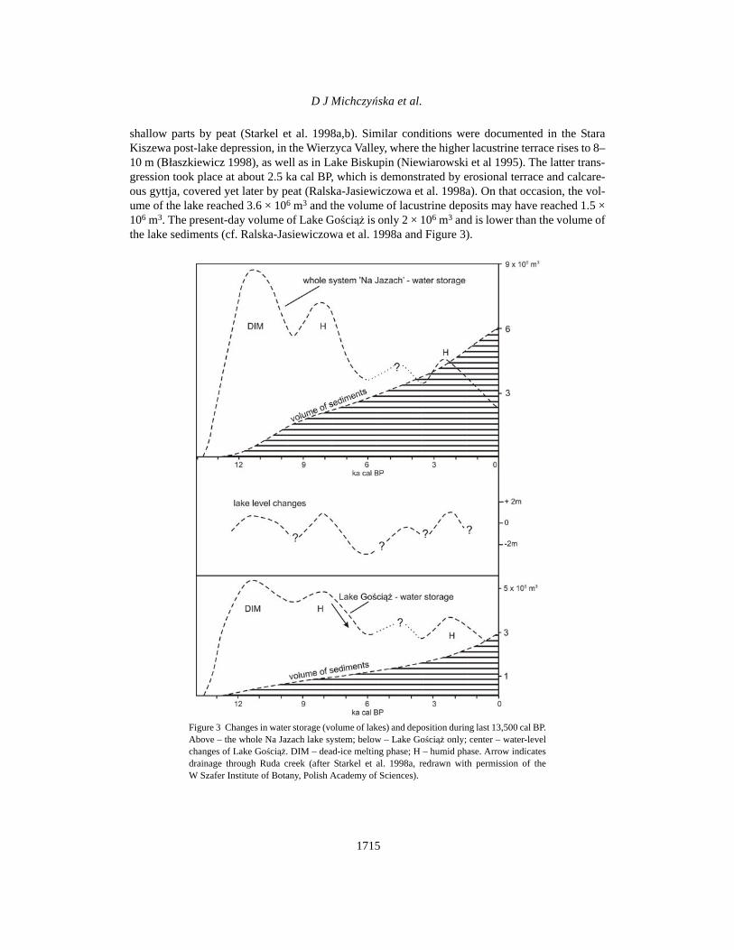
Theoretically, all these factors have been taken into consideration by many authors (e.g.B≥aszkiewicz 2005; Starkel 2008; Kaiser et al. 2012), but they still have usually not been sufficientlydated and well illustrated. A unique example is offered by Lake Goúciπˇz and its surrounding depres-sion, which is drained by a small creek, the Ruda. Several dozen borings in the littoral zone, welldated by 14C, and the basic (reference) profile of the deep kettle (with its annually laminated sedi-ment), enabled the reconstruction of the lake-level changes and established the influence of the var-ious factors involved (Starkel et al. 1996a; Ralska-Jasiewiczowa et al. 1998a).
The reconstructed volume of Lake Goúciπˇz, in the Allerød, had reached 8.3 × 10⁶ m3 after a fall;then, during the next rise, about 9.5–8.5 ka cal BP, Lake Goúciπˇz had been joined to 3 other shallowlakes. After this, there started the gradual drainage of the whole system and overgrowing of all the
Figure 2 Part of the upper Brda River catchment (Pomeranian Lakeland), with numerous trans-fluent lakes, as an example of a young river (modified after Starkel 2008). Such a river graduallyincorporates dead-ice depressions, subglacial channels with lakes, outwash plains, and the nar-row gaps between them. Its presence is critical for the alternating phases of peat formation andlacustrine sedimentation. The phenomena observed in bogs, mires, and the river networkdepend on each other.
D J MichczyÒska et al.
1715
shallow parts by peat (Starkel et al. 1998a,b). Similar conditions were documented in the StaraKiszewa post-lake depression, in the Wierzyca Valley, where the higher lacustrine terrace rises to 8–10 m (B≥aszkiewicz 1998), as well as in Lake Biskupin (Niewiarowski et al 1995). The latter trans-gression took place at about 2.5 ka cal BP, which is demonstrated by erosional terrace and calcare-ous gyttja, covered yet later by peat (Ralska-Jasiewiczowa et al. 1998a). On that occasion, the vol-ume of the lake reached 3.6 × 10⁶ m3 and the volume of lacustrine deposits may have reached 1.5 ×10⁶ m3. The present-day volume of Lake Goúciπˇz is only 2 × 10⁶ m3 and is lower than the volume ofthe lake sediments (cf. Ralska-Jasiewiczowa et al. 1998a and Figure 3).
Figure 3 Changes in water storage (volume of lakes) and deposition during last 13,500 cal BP.Above – the whole Na Jazach lake system; below – Lake Goúciπˇz only; center – water-levelchanges of Lake Goúciπˇz. DIM – dead-ice melting phase; H – humid phase. Arrow indicatesdrainage through Ruda creek (after Starkel et al. 1998a, redrawn with permission of theW Szafer Institute of Botany, Polish Academy of Sciences).

Hydrological Changes after Last Ice Retreat in N. Poland
1716
Taking all these factors into consideration, we can understand why particular lakes within the degla-ciation area of the last Scandinavian ice sheet showed different patterns of lake-level changes,depending on local conditions (Starkel 2003). The example of the detailed study of Lake Goúciπˇzshows that, without such investigations, it is not possible to document and separate out the roles ofthe various factors. Nevertheless, the dating of the sequence of changes, from peat to lacustrine, andback, from gyttja to peat, may demonstrate some regularities in the evolution of lake systems andchanges in the hydrological budget.
MATERIALS AND METHODS
The reconstruction of the hydrological changes in the area of the last ice retreat is based on a groupof 197 14C dates. The ages of the transitions from lacustrine sedimentation to peat formation, andfrom peat formation to the lacustrine stage, as well as the ages of the so-called basal-peat, i.e. the ini-tial organic deposits that formed in the dead-ice depressions, were used as a proxy. The records from128 lakes and bogs were used. The locations of the sampling sites are presented in Figure 4, togetherwith the extension of the ice sheet during the Last Glacial Maximum. It was decided to use peat sam-ples in the analysis primarily because the dates obtained for the lacustrine sediments may be bur-dened by a reservoir effect. For this reason, in order to study the transitions from peat formation tothe lacustrine stage, dates for the samples collected from the top of the peat layers below the lacus-trine sediments were used. To study transitions from the lacustrine sedimentation to peat formation,dates for the samples from the bottom of the peat layers, above the lacustrine sediments (176 datesaltogether). Only 19 dates obtained from gyttja, 1 from wood, and 1 from organic matter were used.Most of the dates are recorded in the Gliwice Radiocarbon Laboratory Data Base (RoS; Piotrowskaet al. 2004). The remaining dates were taken from a paper by B≥aszkiewicz (2011).
Figure 4 Locations of analyzed sampling sites within the range of the Last Gla-cial Maximum extent. Samples were collected from 128 lakes and bogs.

D J MichczyÒska et al.
1717
An analysis of the frequency distribution of transition dates can be helpful in assessing regionalhydrological changes. A rather obvious rule was applied here: if data are collected from manyplaces, the signs in common are then increased, and the signs concerning local changes (or con-nected with random dates) are smoothed. As a result, if there is any common sign in the chosengroup, we can expect peaks in the frequency distribution of the dates. The use of summed probabil-ity curves of 14C dates is widespread in paleoclimatic studies, as well as in archaeology. They havebeen used for the analysis of sea-level changes (e.g. Geyh 1980), fluvial activity (e.g. Macklin et al.2006; Starkel et al. 2006; Hoffmann et al. 2008), environmental changes (MichczyÒska et al. 2007),chronostratigraphic reconstruction (MichczyÒska and Hajdas 2010; Starkel et al. 2013), and innumerous archaeological papers as a proxy record of human occupation (Williams 2012 and refer-ences therein). The limitations of the method have been discussed in a number of studies (Michc-zyÒska and Pazdur 2004; MichczyÒski and MichczyÒska 2006; MichczyÒska et al. 2007; Surovellet al. 2009).
To study the chronological order of the appearance of lakes and the peat formation processes on acalendar timescale, probability density functions (PDFs) were constructed by summing up the prob-ability distributions for particular dates. These PDFs were constructed using the Sum option in theOxCal program (Bronk Ramsey 2009) and the IntCal09 calibration curve (Reimer et al. 2009).
RESULTS AND DISCUSSION
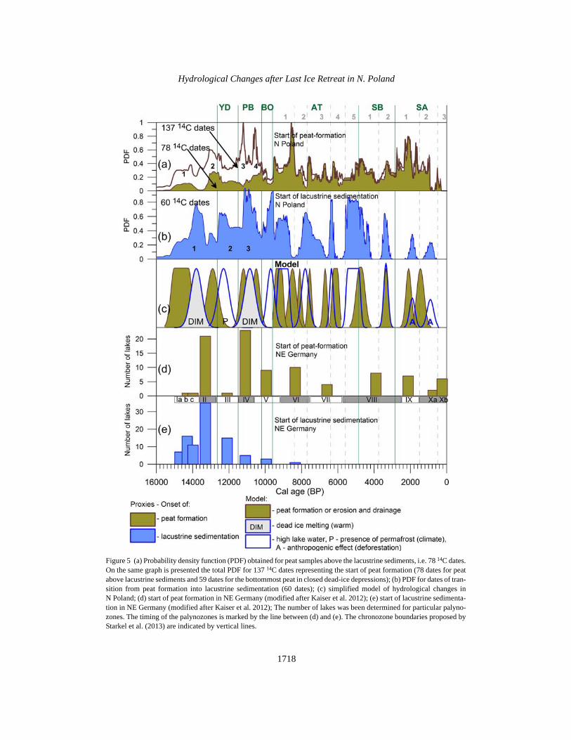
The results of this study are presented in Figure 5. A PDF curve for the 14C ages obtained from thepeat formed above the lacustrine sediments is shown in Figure 5a (78 14C dates). In addition, in thesame figure, the total PDF curve is presented for peat formed on top of the lacustrine sediments, andfor the bottommost peat in closed dead-ice depressions (137 14C dates altogether). In the lower panel(Figure 5b), a PDF curve for the lacustrine sediments deposited on top of the peat layer is shown(60 14C dates). Even though the amount of data is relatively modest, the probability density func-tions (PDFs) of 14C dates from northern Poland enable the identification of hydrological changesduring the past 15,000 yr.
The first 4 maxima of the curve in Figure 5a (marked by numbers 1–4 on the curve for 137 14Cdates) represent the dating of material from the bottommost peat sections in the closed dead-icedepressions, and they prove the existence of peat formation processes at the end of the Late Glacialand beginning of the Holocene. The dates obtained from the lowermost peat layers covering thelacustrine sediments indicate a lowering of the lake level. A very rapid change to lowering only 1–3 centuries after the maximum rise may not be explained only by a drop in precipitation. In the opin-ion of the authors, it resulted from inclusion of lakes into the drainage system or by the overgrowthof lakes.
The first and third maxima on the PDF curve for lacustrine sedimentation on top of peat (marked bynumbers in Figure 5b), observed at 14,500–13,500, 11,300–10,500 cal BP, result from dead-icemelting. The first appearance of the lake reservoirs dated to the Allerød, recorded in a number ofpaleoenvironmental publications (e.g. Lake Goúciπˇz [Ralska-Jasiewiczowa 1989], Lake Biskupin[Niewiarowski et al. 1995], Lake Miko≥ajki [Pawlikowski et al. 1982], Lake Skrzynka [Apolinarskaet al. 2012], the Osonki site [Nalepka 2005; Nowaczyk 2008], Eastern Pomeranian [B≥aszkiewicz2011; van Loon et al. 2012]), indicates the melting of dead-ice blocks. The younger maximum, at11,300–10,500 cal BP, from the beginning of the Holocene, was clearly delayed by 200–300 yr incomparison with the climate change at the YD/PB transition. It should be seen as linked to the grad-ual warming of the deeper layers of the ground.
Hydrological Changes after Last Ice Retreat in N. Poland
1718
Figure 5 (a) Probability density function (PDF) obtained for peat samples above the lacustrine sediments, i.e. 78 14C dates.On the same graph is presented the total PDF for 137 14C dates representing the start of peat formation (78 dates for peatabove lacustrine sediments and 59 dates for the bottommost peat in closed dead-ice depressions); (b) PDF for dates of tran-sition from peat formation into lacustrine sedimentation (60 dates); (c) simplified model of hydrological changes inN Poland; (d) start of peat formation in NE Germany (modified after Kaiser et al. 2012); (e) start of lacustrine sedimenta-tion in NE Germany (modified after Kaiser et al. 2012); The number of lakes was been determined for particular palyno-zones. The timing of the palynozones is marked by the line between (d) and (e). The chronozone boundaries proposed byStarkel et al. (2013) are indicated by vertical lines.

D J MichczyÒska et al.
1719
The middle maximum (12,600–11,800) from the Younger Dryas (YD) may be connected with thefrozen ground. The appearance of shallow water reservoirs above the peat in the YD are connectednot so much with the humid phase, but may be explained by the appearance of periodic permafrostin depressions. This is confirmed by contemporary observations: namely, the appearance of shallowwater bodies in depressions, while the ground is still frozen after a cold winter. The presence of fro-zen ground during the YD is evidenced in periglacial structures throughout the central Europeanlowland (e.g. Kozarski 1986, 1993; Vandenberghe 2006). The start of lacustrine sedimentation hasbeen noted for the whole YD, but it seems to have been more intensive during the first half of theYD. It is interesting that the first phase of the YD was humid in the Netherlands (cf. Hoek andBohncke 2002), but the authors did draw conclusions that are too far-reaching. It is difficult to com-pare both regions, as the Netherlands was not ice-covered during the LGM and was under the stronginfluence of the Atlantic Ocean.
The next 2 “lacustrine” peaks (from 9700 ± 200 and 9000 ± 400 cal BP) correlate well with the highhumidity phase, 9500–8500 cal BP, registered in various litho-facies of sediments throughoutPoland (Starkel 1999; Starkel et al. 2006, 2013). This phase resulted in an increase in the numberand depth of lakes. This wet period was followed by the expansion of peat formation, which over-grew the lakes, and was probably also due to their drainage during their incorporation into river net-work systems (Koutaniemi and Rachocki 1981).
It is worth stressing that, as indicated above, the oldest periods of lacustrine sedimentation are ingeneral accord with the periods of lacustrine sedimentation near Lake Goúciπˇz (Pazdur et al. 1994).The beginning of lacustrine sedimentation in this area has been established as having been severalcenturies before 11,440 ± 300 14C BP, which, on the calendar scale, corresponds to several centuriesbefore 13,700–12,900 cal BP. The next lacustrine sedimentation was noted as having been between8200 and 7000 14C BP, which, on the calendar scale, corresponds to 9500–7700 cal BP (cf.Figure 3). The low precision of the calendar ages for these periods was due to the need for reservoireffect corrections (2000 ± 120 yr having been assumed; for details, see Pazdur et al. 1994).
The next few phases of lake transgression correspond to the humid periods 7800 ± 200, 6350 ± 100,5150 ± 400, and 3350 ± 120 cal BP. The Subatlantic period was a time when the overgrowth of lakeswas common. Some individual dates from Figure 5b indicate elevated water levels, well docu-mented as humid phase in Lake Goúciπˇz about 2500 cal BP (see Figure 3). The younger 2 peaks areprobably due to anthropogenic effects. Deforestation and agriculture might have led to a reductionin evapotranspiration and to the emergence of new reservoirs (cf. Borówko 1990).
This appears to be a pattern. Lake transgression is observed as a result of the humid phase (or dead-ice melting); next, after a short delay (of 100–300 yr), the recession of lakes and expansion of peatis usually recorded. The latter has its source in the drainage of lakes (Koutaniemi and Rachocki1981; Starkel 2008) and their being overgrown (Iversen 1958; Birks 1986). In particular cases, it isdifficult to separate these 2 processes, but both have been documented by the authors for severallake systems (e.g. in Lake Goúciπˇz; see previous section).
The alternating processes observed—the onset of lacustrine sedimentation (Figure 5b) and the onsetof peat formation (Figure 5a)—are simplified and summarized in Figure 5c (Model). Each of thesephases is presented as a Gaussian-type peak (though some of the peaks are flat-topped). The lacus-trine phases were the result of climate change. Two of them are the result of warming and dead-icemelting depressions (peaks with the letters DIM in Figure 5c), 1 is the result of permafrost (the peakwith the letter P in Figure 5c), and the rest are the result of humid conditions. Environmentalchanges after 4000 cal BP were under the influence of human activity, and the last 2 lacustrine
Hydrological Changes after Last Ice Retreat in N. Poland
1720
phases were the effect of deforestation (peaks with the letter A in Figure 5c). Deforestation resultsin a rise of the groundwater table and the appearance of shallow lakes in the depressions. “Peatphases” are the result of the overgrowth of lakes, frequently combined with an incorporation of lakesinto the river network. These 2 processes are not distinguished in Figure 5c.
Hydrological changes in northern Poland were compared with analogous changes in northeasternGermany. Information about the onsets of lacustrine sedimentation and onsets of peat formationfrom NE German regions that were also ice-covered during the Last Glacial has recently been pre-sented by Kaiser et al. (2012). The general accord of the lacustrine sedimentation and peat formationphases is visible (see Figure 5d–e). A more detailed comparison is not possible, because the resultsfor NE Germany were presented only for particular palynozones, without providing detailed infor-mation about calendar age or discussion about the genesis of the recorded phases.
SUMMARY
The authors selected 197 14C dates from the area of the last ice sheet deglaciation in northern Poland.Samples from the lowermost parts of the peat profiles on top of lacustrine sediments or mineral frac-tions, as well as samples from the uppermost parts of the peat profiles directly under lacustrine sed-iments, were taken for analysis. PDFs of the 14C dates were built to establish the sequence of events.There is a clearly visible anti-correlation of the curves from Figures 5a and 5b. The observedsequences of events allowed the building of a simplified model of environmental changes(Figure 5c). Each “lacustrine phase” was followed by a “peat formation phase.” The expansion ofpeat appeared, as was usual, 100–300 yr after the lake transgression, and was connected with theincision of a river channel and the drainage of lakes. The general consistency between the hydrolog-ical changes recorded in both the Polish and German young postglacial areas was presented.
ACKNOWLEDGMENTS
This study was supported by means of grant nr N N306 034040 (Polish National Science Centregrant, “Application of statistical methods to reconstruct climate change on Polish territory in theLate Glacial and Holocene”). The research was also partly supported by the W Szafer Institute ofBotany PAS. This study is a contribution to the INTIMATE project, supported by INQUA andfunded as an EU COST Action. The authors are grateful 2 anonymous reviewers for inspiring com-ments, significantly improving the manuscript.
REFERENCES
Apolinarska K, Woszczyk M, Obremska M. 2012. LateWeichselian and Holocene palaeoenvironmentalchanges in northern Poland based on the LakeSkrzynka record. Boreas 41(2):292–307.
Birks HJB. 1986. Late-Quaternary biotic changes in ter-restrial and lacustrine environments, with particularreference to north-west Europe. In: Berglund BE, ed-itor. Handbook of Holocene Palaeoecology andPalaeohydrology. New York: John Wiley & Sons.
B≥aszkiewicz M. 1998. Dolina Wierzycy jej geneza orazrozwój w pÛünym plejstocenie oraz wczesnym holo-cenie. Dokumentacja Geograficzna 10:116. In Polish.
B≥aszkiewicz M. 2005. Pónoglacjalna i wczesnoholoceÒska ewolucja obnieÒ jeziornych na Pojezierzu Ko-ciewskim (wschodnia czÍúÊ Pomorza) (Late Glacialand early Holocene evolution of the lake basin in the
Kociewskie Lakeland [Eastern part of the PomeranianLakeland]). Prace Geograficzne IG i PZ PAN nr 201.192 p. In Polish with English summary.
B≥aszkiewicz M. 2011. Timing of the final disappearanceof permafrost in the central European low land, as re-constructed from the evolution of lakes in N Poland.Geological Quarterly 55(4):361–74.
Borówko K. 1990. Late Vistulian and Holocene denuda-tion magnitude in morainic plateaux: case studies inthe zone of maximum extend of the last ice sheet. Qua-ternary Studies in Poland 9:5–31.
Bronk Ramsey C. 2009. Bayesian analysis of radiocar-bon dates. Radiocarbon 51(1):337–60.
Florek W. 1991. Postglacjalny rozwój dolin rzekúrodkowej czÍúci pÛ≥nocnego sk≥onu Pomorza, WSPS≥upsk. 238 p. In Polish.

D J MichczyÒska et al.
1721
Florek W, Alexandrowicz SW, Pazdur A. 1999. Zmianypoziomu wody w jeziorze JasieÒ na tle ewolucjiúrodowiska w pÛünym vistulianie i holocenie. In: Paz-dur A, Bluszcz A, Stankowski W, Starkel L, editors.Geochronologia Górnego Czwartorzdu Polski.Wroc≥aw: J. Wojewoda. p 199–206. In Polish.
Ga≥ka M, Sznel M. 2013. Late Glacial and Early Ho-locene development of lakes in northeastern Poland inview of plant macrofossil analyses. Quaternary Inter-national 292:124–35.
Geyh MA. 1980. Holocene sea-level history: case studyof the statistical evaluation of 14C dates. Radiocarbon22(3):695–704.
Hoek WZ, Bohncke SJP. 2002. Climatic and environ-mental events over the Last Termination, as recordedin the Netherlands: a review. Netherlands Journal ofGeosciences 81(1):123–37.
Hoffmann T, Lang A, Dikau R. 2008. Holocene river ac-tivity: analysing 14C-dated fluvial and colluvial sedi-ments from Germany. Quaternary Science Reviews27(21–22):2031–40.
Iversen J. 1958. The bearing of glacial and interglacialepochs on the formation and extinction of plant taxa.In: Hedberg O, editor. Systematics of Today. Proceed-ings of a symposium held at the University of Uppsalain commemoration of the 250th anniversary of Caro-lus Linnaeus. Acta Universitatis Upsaliensis/UppsalaUniversitets Årsskrift 6:210–5.
Kaiser K, Lorenz S, Germer S, Juschus O, Küster M, Li-bra J, Bens O, Hüttl RF. 2012. Late Quaternary evolu-tion of rivers, lakes and peatlands in northeast Ger-many reflecting past climatic and human impact – anoverview. E&G Quaternary Science Journal 61(2):103–32.
Ko≥aczek P, Kupryjanowicz M, KarpiÒska-Ko≥aczek M,Szal M, Winter H, Danel W, Pochocka-Szwarc K, Sta-chowicz-Rybka R. 2013. The Late Glacial and Ho-locene development of vegetation in the area of a fos-sil lake in the Skaliska Basin (north-eastern Poland)inferred from pollen analysis and radiocarbon dating.Acta Palaeobotanica 53(1):23–52.
Kotarba A, Baumgart-Kotarba M. 1997. Holocene debrisflow activity in the light of lacustrine sediments stud-ies in the High Tatra Mountains. Palaeoclimate Re-search 19:147–58.
Koutaniemi Z, Rachocki A. 1981. Palaeohydrology andlandscape development in the middle course of theRadunia basin, North Poland. Fennia 159(2):335–42.
Kozarski S. 1986. Early Vistulian permafrost occurrencein north-west Poland. Biuletyn Peryglacjalny 31:163–70.
Kozarski S. 1993. Late Plenivistulian deglaciation andthe expansion of the periglacial zone in NW Poland.Geologie en Mijnbouw 72:143–57.
Kupryjanowicz M. 2007. Postglacial development ofvegetation in the vicinity of the Wigry Lake. Geochro-nometria 27:53–66.
Lauterbach S, Brauer A, Andersen N, Danielopol DL,Dulski P, Hüls M, Milecka K, Namiotko T, Plessen B,von Grafenstein U. 2010. Multi-proxy evidence forearly to mid-Holocene environmental and climaticchanges in northeastern Poland. Boreas 40(1):57–72.
van Loon AJ, B≥aszkiewicz M, Degórski M. 2012. Therole of permafrost in shaping the Late Glacial relief ofnorthern Poland. Netherlands Journal of Geosciences91(1/2):223–31.
Macklin MG, Benito G, Gregory KJ, Johnstone E, LewinJ, MichczyÒska DJ, Soja R, Starkel L, ThorndycraftVR. 2006. Past hydrological events reflected in theHolocene fluvial record of Europe. Catena 66:145–54.
Magny M. 1993. Holocene fluctuation of lake levels inthe French Jura and Sub-Alpine ranges, and their im-plications for past general circulation patterns. TheHolocene 3:306–13.
Margielewski W. 2006. Records of the Late Glacial- Ho-locene palaeoenvironmental changes in landslideforms and deposits of the Beskid Makowski and Be-skid Wyspowy Mts. Area (Polish Outer Carpathians).Folia Quaternaria 76:149 p.
MichczyÒska DJ, Hajdas I. 2010. Frequency distributionof 14C ages for chronostratigraphic reconstructions:Alaska region study case. Radiocarbon 52(3):1041–55.
MichczyÒska DJ, Pazdur A. 2004. A shape analysis ofcumulative probability density function of radiocar-bon dates set in the study of climate change in LateGlacial and Holocene. Radiocarbon 46(2):733–44.
MichczyÒska DJ, MichczyÒski A, Pazdur A. 2007. Fre-quency distribution of radiocarbon dates as a tool forreconstructing environmental changes. Radiocarbon49(2):799–806.
MichczyÒski A, MichczyÒska DJ. 2006. The effect ofPDF peaks’ height increase during calibration of ra-diocarbon date sets. Geochronometria 25:1–4.
Nalepka D. 2005. Late Glacial and Holocene palaeoeco-logical conditions and changes of vegetation cover un-der early Farming activity in the south Kujawy region(central Poland). Kraków: W. Szafer Institute of Bot-any. Acta Palaeobotanica. Supplement Nr. 6.
Niewiarowski W, Noryúkiewicz B, Piotrowski W, Sink-iewicz M. 1995. An outline of natural and anthropo-genic changes of geographical environment in theBiskupin area during the last 7000 years. QuaternaryStudies in Poland 13:77–88.
Nowaczyk B. 2008. Changes in natural environment inthe vicinity of Os≥onki (Kujawy, Central Poland) inthe light of geological and geomorphological investi-gations. Folia Quaternaria 78:7–31.
Pawlikowski M, Ralska-Jasiewiczowa M, Schönborn W,Stupnicka E, SzeroczyÒska K. 1982. Woryty nearGietrzwa≥d, Olsztyn Lake District, NE Poland vegeta-tional history and lake development during the last12,000 years. Acta Palaeobotanica 22(1):85–116.
Hydrological Changes after Last Ice Retreat in N. Poland
1722
Pazdur A, Pazdur MF, Szulc J. 1988. Radiocarbon datingof Holocene calcareous tufa from south Poland. Ra-diocarbon 30(2):133–46.
Pazdur A, Pazdur MF, Goslar T, Wicik B, Arnold M.1994. Radiocarbon chronology of Late Glacial andHolocene sedimentation and water level changes inthe Goúciπˇz Lake basin and its surroundings. Radio-carbon 36(2):187–202.
Pazdur A, Pazdur MF, Pawlyta J, Górny A, Olszewski M.1995. Paleoclimatic implications of radiocarbon dat-ing of speleothems from the Cracow-WieluÒ upland,southern Poland. Radiocarbon 37(2):103–10.
Pazdur A, Dobrowolski R, Mohanti M, Piotrowska N,Srikanta D. 2002a. Radiocarbon time scale for depo-sition of the holocene calcareous tufaceous sedimentsfrom Poland and India (Orissa). Geochronometria 21:85–96.
Pazdur A, Dobrowolski R, Durakiewicz T, Piotrowska N,Mohanti M, Sirkanta D. 2002b. 13C and 18O timerecord and palaeoclimatic implications of the Ho-locene calcareous tufa from south-eastern Poland andEastern India (Orissa). Geochronometria 21:97–108.
Piotrowska N, Szczepanek M, Pazdur A, Zajadacz W.2004. RoS – a new database system in the Gliwice Ra-diocarbon Laboratory. Geochronometria 23:51–7.
Ralska-Jasiewiczowa M, editor. 1989. Environmentalchanges recorded in lakes and mires of Poland duringthe last 13,000 years. Acta Palaeobotanica 29:1–120.
Ralska-Jasiewiczowa M, Lata≥owa M. 1996. Synthesisof palaeoecological events in Poland. In: BerglundBE, Birks HJB, Ralska-Jasiewiczowa M, Wright HE,editors. Palaeoecological Events During the Last15,000 Years. Regional Syntheses of PalaeoecologicalStudies of Lakes and Mires. Chichester: John Wiley &Sons Ltd.
Ralska-Jasiewiczowa M, Starkel L. 1988. Record of thehydrological changes during the Holocene in the lake,mire and fluvial deposits of Poland. Folia Quaterna-ria 57:91–127.
Ralska-Jasiewiczowa M, Goslar T, Madeyska T, StarkelL, editors. 1998a. Lake Goúciπˇz, Central Poland, aMonographic Study. Part 1. Kraków: W. Szafer Insti-tute of Botany, Polish Academy of Sciences. 340 p.
Ralska-Jasiewiczowa M, van Geel, Demske D. 1998b.Holocene regional vegetation history recorded in theLake Goúciπˇz sediments. In: Ralska-Jasiewiczowa,Goslar T, Madeyska T, Starkel L, editors. LakeGoúciπ̌z, Central Poland. A Monographic Study. Part1. Kraków: W. Szafer Institute of Botany, PolishAcademy of Sciences. p 202–19.
Ralska-Jasiewiczowa M, Lata≥owa M, Wasylikowa K,Tobolski K, Madeyska T, Wright HE, Turner C, edi-tors. 2004. Late Glacial and Holocene History of Veg-etation in Poland Based on Isopollen Maps. Kraków:W Szafer Institute of Botany, Polish Academy of Sci-ences. 444 p.
Reimer PJ, Baillie MGL, Bard E, Bayliss A, Beck JW,
Blackwell PG, Bronk Ramsey C, Buck CE, Burr GS,Edwards RL, Friedrich M, Grootes PM, GuildersonTP, Hajdas I, Heaton T, Hogg AG, Hughen KA, KaiserKF, Kromer B, McCormac FG, Manning SW, ReimerRW, Richards DA, Southon JR, Talamo S, TurneyCSM, van der Plicht J, Weyhenmeyer CE. 2009.IntCal09 and Marine09 radiocarbon age calibrationcurves, 0–50,000 years cal BP. Radiocarbon 51(4):1111–50.
Starkel L. 1977. Paleogeografia holocenu (Palaeogeog-raphy of the Holocene). Warsaw: PWN. 362 p. InPolish.
Starkel L. 1983. The reflection of hydrological changesin the fluvial environment of the temperate zone dur-ing the last 15 000 years. In: Gregory KJ, editor. Back-ground to Palaeo-Hydrology. Chichester: John Wiley& Sons. p 213–35.
Starkel L. 1991. Environmental changes at the YoungerDryas-Preboreal transition and during the early Ho-locene. The Holocene 1(3):234–42.
Starkel L. 1999. 8500–8000 yrs BP humid phase – globalor regional? Science Reports of Tohoku University,7th Series. Geography 49(2):105–33.
Starkel L. 2002. Change in the frequency of extremeevents as the indicator of climatic change in the Ho-locene (in fluvial systems). Quaternary International91:25–32.
Starkel L. 2003. Palaeohydrology of Central Europe(Chapter 7). Short-Term Hydrological Changes(Chapter 20). In: Gregory KJ, Benito G, editors.Palaeohydrology: Understanding Global Change.Chicester: John Wiley & Sons. p 87–104, 337–56.
Starkel L. 2008. OdrÍbnoúÊ zapisu holoceÒskich zmianklimatu w dolinie Niøu Polskiego (The diverse effectsof Holocene climatic changes on the river valleys ofthe Polish Lowland). Botanical Guidebooks 30:169–82.
Starkel L, Pazdur A, Pazdur MF, Wicik B, Wickowski K.1996a. Lake level and groundwater level changes inthe Lake Goúciπˇz area, Poland – palaeoclimatic impli-cations. The Holocene 6(2):213–24.
Starkel L, Kalicki T, Krπpiec M, Soja R, GÍbica P, Czy-owska E. 1996b. Hydrological changes of valleyfloors in Upper Vistula Basin during the last 15 000years. Geographical Studies (Special Issue) IGiPZPAN, Warsaw 9:7–128.
Starkel L, Goslar T, Ralska Jasiewiczowa M, Demske D,RóøaÒski K, £πcka B, Pelisiak A, SzeroczyÒska K,Wicik B, Wickowski K. 1998a. Discussion of the Ho-locene events recorded in the Lake Goúciπˇz sediments.In: Ralska-Jasiewiczowa M, Goslar T, Madeyska T,Starkel L, editors. Lake Goúciπˇz, Central Poland, aMonographic Study. Part 1. Kraków: W Szafer Insti-tute of Botany, Polish Academy of Sciences. p 239–51.
Starkel L, Wicik B, Wickowski K. 1998b. Formation andevolution of the Na Jazach lakes in the Late Vistulian.

D J MichczyÒska et al.
1723
In: Ralska-Jasiewiczowa M, Goslar T, Madeyska T,Starkel L, editors. Lake Goúciπˇz, Central Poland AMonographic Study, Part 1. p 117–9.
Starkel L, Soja R, MichczyÒska DJ. 2006. Past hydrolog-ical events reflected in Holocene history of Polish riv-ers. Catena 66:24–33.
Starkel L, MichczyÒska DJ, Krπpiec M, Margielewski W,Nalepka D, Pazdur A. 2013. Progress in the Holocenechrono-climatostratigraphy of Polish territory. Geo-chronometria 40:1–21.
Surovell TA, Finley JB, Smith GM, Brantingham PJ,Kelly R. 2009. Correcting temporal frequency distri-butions for taphonomic bias. Journal of Archaeologi-cal Science 36(8):1715–24.
SzeroczyÒska K. 1998. Palaeolimnological investiga-tions in Poland based on Cladocera (Crustacea).Palaeogeography, Palaeoclimatology, Palaeoecology140:335–45.
Vandenberghe J. 2006. Cryoturbation structures. In: EliasSA, editor. Encyclopedia of Quaternary Science. Am-sterdam: Elsevier. p 2147–53.
Wacnik A. 2009. Vegetation development in the LakeMi≥kowskie area, north-eastern Poland, from thePlenivistulian to the late Holocene. Acta Palaeobotan-ica 49(2):287–335.
Williams A. 2012. The use of summed radiocarbon prob-ability distributions in archaeology: a review of meth-ods. Journal of Archaeological Science 39(3):578–89.