Mechano-topographic modulation of stem cell nuclear shape on nanofibrous scaffolds
Upload
independentCategory
view
6download
0
1 23
Carbonates and Evaporites ISSN 0891-2556Volume 28Combined 1-2 Carbonates Evaporites (2013) 28:13-21DOI 10.1007/s13146-013-0157-2
Hydrogeologic and topographic controlson evolution of karst features in Illinois’sinkhole plain
Samuel V. Panno, Walton R. Kelly, JulieC. Angel & Donald E. Luman

1 23
Your article is protected by copyright and
all rights are held exclusively by Springer-
Verlag Berlin Heidelberg. This e-offprint is
for personal use only and shall not be self-
archived in electronic repositories. If you wish
to self-archive your article, please use the
accepted manuscript version for posting on
your own website. You may further deposit
the accepted manuscript version in any
repository, provided it is only made publicly
available 12 months after official publication
or later and provided acknowledgement is
given to the original source of publication
and a link is inserted to the published article
on Springer's website. The link must be
accompanied by the following text: "The final
publication is available at link.springer.com”.
ORIGINAL ARTICLE
Hydrogeologic and topographic controls on evolution of karstfeatures in Illinois’ sinkhole plain
Samuel V. Panno • Walton R. Kelly •
Julie C. Angel • Donald E. Luman
Accepted: 8 February 2013 / Published online: 9 March 2013
� Springer-Verlag Berlin Heidelberg 2013
Abstract In the sinkhole plain of southwestern Illinois,
the size and morphology of cover-collapse sinkholes can be
used as an indicator of the size of the associated underlying
crevice/conduit system. Sinkholes that lead to relatively
small crevices and small conduit systems (sinkhole vol-
umes [103 m3, but \105 m3) typically are found in areas
with relatively high water tables and, based on storage
capacity of conduits and secondary porosity of adjacent
bedrock, are incapable of accepting large, rapidly inflowing
volumes of surface-water runoff without backflooding.
Once flooded, sinkholes become low-energy environments
and sites of deposition of fine sediments; consequently,
their growth potential (via erosion by runoff within and at
the margins of the sinkhole) is limited. Conversely, in those
areas where sinkholes lead to relatively large, branchwork-
type cave systems, water tables are typically deeper and the
storage capacities of the cave system and adjacent bedrock
can be one or more orders of magnitude greater. Because
these large cave systems can accept greater volumes of
rapidly inflowing runoff without backflooding, the
sinkholes associated with large cave systems typically
become sites of extensive erosion. The aerial extent of a
sinkhole draining to large cave systems may continue to
increase and incorporate other sinkholes within its drainage
area, thereby creating large, compound sinkholes up to
30 ha in area. These sinkholes can have direct or indirect
connections to cave passages and have volumes that can be
as small as 104 m3 and as large as 106 m3. Beneath the
glacial till and loess cover, and in the vicinity of the largest
cover-collapse sinkholes, irregularities in bedrock topogra-
phy appear to have had an effect on the location of the ini-
tiation of large caves in the sinkhole plain. The coincidence
of bedrock depressions and swales in close proximity to the
initiation point of the large caves suggests that focused
recharge to fractures leading to bedding-plane partings in
bedrock played a major role in the initiation and evolution of
the large branchwork-type caves of Illinois’ sinkhole plain.
Keywords Cover-collapse sinkhole � Cave formation �Solution-enlarged crevices � Erosion
Introduction
A systematic study of the size and morphology of sinkholes
with respect to openings in the underlying geology (i.e.,
crevices and conduits) has been conducted by few
researchers (Palmer 1969). In the course of mapping and
characterizing cover-collapse sinkholes in southwestern
Illinois’ sinkhole plain, sinkholes in this area were
observed to exhibit distinct characteristics that reflect the
size and character of the underlying conduit systems within
the St. Louis Limestone. Similar observations were made
by Palmer (1969, 2007) in Indiana in the vicinity of Blue
Springs Cave, also in the St. Louis Limestone. Palmer
S. V. Panno (&) � D. E. Luman
Illinois State Geological Survey, 615 E. Peabody Drive,
Champaign, IL 61820, USA
e-mail: [email protected]
D. E. Luman
e-mail: [email protected]
W. R. Kelly
Illinois State Water Survey, 2204 Griffith Drive,
Champaign, IL 61820, USA
e-mail: [email protected]
J. C. Angel
Parkland College, 2400 W. Bradley Ave.,
Champaign, IL 61821, USA
e-mail: [email protected]
123
Carbonates Evaporites (2013) 28:13–21
DOI 10.1007/s13146-013-0157-2
Author's personal copy
examined the depth of sinkholes overlying and in close
proximity to the cave and found that the deepest sinkholes
were located over the main stream passage of Blue Springs
Cave.
Similarly, the bedrock topography of Illinois’ sinkhole
plain may have played a major role in the formation of
large branchwork-type cave systems along bedding planes
in southwestern Illinois. Branchwork caves typically begin
forming where fractured, soluble bedrock is exposed or lies
beneath soil cover where recharge waters are most
aggressive (Palmer 2007). Recharge waters enter the
fractures, infiltrate the bedrock, and slowly enlarge
numerous fractures (initially and most intensely near their
point of entry). Solutionally enlarged fractures tend to
become narrower with depth and along flow paths. At some
point in their enlargement and subsequent cave develop-
ment, the largest pathways grow the fastest and ultimately
became the major flow paths (Palmer 2007). Preliminary
work by the authors suggested that large-scale swales and
depressions in the bedrock may have been focal points for
recharge that were responsible for the initiation and growth
of the large caves.
For this investigation, the authors took a holistic view of
Illinois’ sinkhole plain and examined the relations among
the size and morphology of sinkholes (including sinkhole
axis orientation); sinkhole distribution and densities; the
distribution of ponded sinkholes, springs, and swallow
holes; the degree of localized limestone dissolution; and
bedrock topography. The objectives of this investigation
were to characterize the relations among these observations
and explore the possible mechanisms responsible for such
relations. In addition, the underlying bedrock within the
groundwater basins of four of the largest caves in the
sinkhole plain was examined to explore the relations
among sinkholes and bedrock surface depressions and
swales near initiation points of the caves.
Geology and hydrogeology
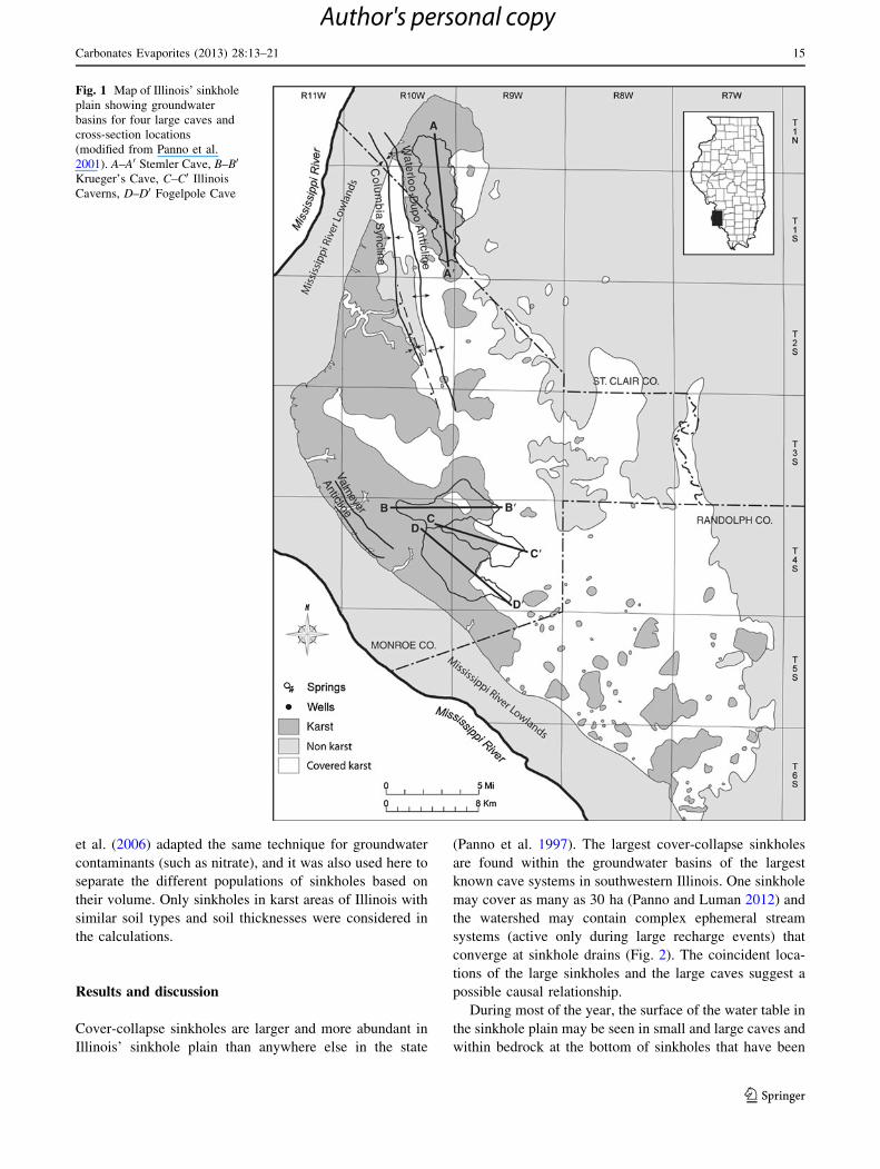
Illinois’ sinkhole plain is on the western margin of the
Illinois Basin where Mississippian-age carbonate bedrock
dips gently several degrees to the east toward the center of
the basin (Fig. 1). This region is referred to as Illinois’
sinkhole plain because of its high density of cover-collapse
sinkholes (Panno 1996) and is part of the Salem Plateau
Section of the physiographic provinces of Leighton et al.
(1948). Over 10,000 sinkholes with densities as high as
95/km2, numerous large springs and the largest caves in the
state are all located in the sinkhole plain (Angel et al. 2004;
Panno et al. 2008b, c, d). The upland area is covered, for
the most part, by a relatively thin layer of loess and Illi-
noisan glacial till and residuum that is typically 0–15 m
thick with an average thickness of about 10 m (Piskin and
Bergstrom 1975). This material, especially loess, is easily
eroded and forms steep embankments and gullies.
Most karst bedrock and caves in the study area occur in
the Mississippian-age St. Louis, Ste. Genevieve, and Salem
Limestones. Cover-collapse sinkholes overlie these rocks,
producing the widespread karst terrain in southwestern
Illinois (Panno et al. 1997; Weibel and Panno 1997).
Geologic structures also appear to play a role in cave
development in the sinkhole plain. Specifically, the
Waterloo-Dupo Anticline, Columbia Syncline, Valmeyer
Anticline, and Monroe City Syncline occur in the study
area and trend northwest-southeast (Nelson 1995), and
three of the largest known caves in Illinois developed
parallel to and just northeast of the axis of the Valmeyer
Anticline (Panno et al. 2008b, d).
Methods
Cover-collapse sinkholes were identified on 7.5 min, US
Geological Survey (USGS) topographic maps and on aerial
photographs from 1940 and 2005. All data were uploaded into
an ARC-GIS� format and examined (Panno and Luman
2012). The morphology, size, and distribution of cover-col-
lapse sinkholes were compared to existing cave maps for four
major caves in southwestern Illinois (Stemler Cave, Krue-
ger’s Cave, Illinois Caverns, and Fogelpole Cave). Bedrock
topography in the vicinity of the cave systems (Panno et al.
2008a, e, f) was examined and cross sections were drawn
along the axes of the groundwater basins using well logs from
the Illinois State Geological Survey’s database. In addition,
water table maps of the sinkhole plain were prepared in the
regions of the large caves and compared to those in areas with
no known caves. It was found that water tables were from 5 to
15 m or more deeper in the vicinity of large cave systems than
in areas of no known cave systems (Panno, Illinois State
Geological Survey, unpublished data).
Characterization of sinkhole morphology, crevice and cave
size and morphology was done by inspection and exploration
of sinkholes between the early 1990s and 2010. Some crevices
and caves beneath sinkholes were accessible and others were
exposed during excavations by local landowners and following
major recharge events. In the sinkhole plain, over 1,000 sink-
holes and sinkhole drains and over 250 crevices and caves were
inspected in the field, and over 13,000 sinkholes were identi-
fied, examined, and cataloged using 1940 and 2005 aerial
photographs (Panno and Luman 2012).
A cumulative probability plot was made of the sinkhole
volume for 254 sinkholes throughout the state of Illinois to
study the distribution of sinkhole size, as it relates to
underlying conduit size. The technique was developed by
Sinclair (1991) for identifying thresholds between back-
ground and anomalies in searching for ore deposits. Panno
14 Carbonates Evaporites (2013) 28:13–21
123
Author's personal copy
et al. (2006) adapted the same technique for groundwater
contaminants (such as nitrate), and it was also used here to
separate the different populations of sinkholes based on
their volume. Only sinkholes in karst areas of Illinois with
similar soil types and soil thicknesses were considered in
the calculations.
Results and discussion
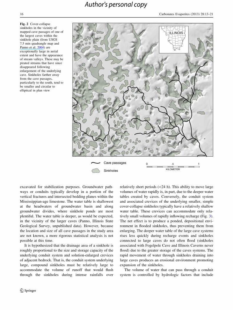
Cover-collapse sinkholes are larger and more abundant in
Illinois’ sinkhole plain than anywhere else in the state
(Panno et al. 1997). The largest cover-collapse sinkholes
are found within the groundwater basins of the largest
known cave systems in southwestern Illinois. One sinkhole
may cover as many as 30 ha (Panno and Luman 2012) and
the watershed may contain complex ephemeral stream
systems (active only during large recharge events) that
converge at sinkhole drains (Fig. 2). The coincident loca-
tions of the large sinkholes and the large caves suggest a
possible causal relationship.
During most of the year, the surface of the water table in
the sinkhole plain may be seen in small and large caves and
within bedrock at the bottom of sinkholes that have been
Fig. 1 Map of Illinois’ sinkhole
plain showing groundwater
basins for four large caves and
cross-section locations
(modified from Panno et al.
2001). A–A0 Stemler Cave, B–B0
Krueger’s Cave, C–C0 Illinois
Caverns, D–D0 Fogelpole Cave
Carbonates Evaporites (2013) 28:13–21 15
123
Author's personal copy
excavated for stabilization purposes. Groundwater path-
ways or conduits typically develop in a portion of the
vertical fractures and intersected bedding planes within the
Mississippian-age limestone. The water table is shallowest
at the headwaters of groundwater basin and along
groundwater divides, where sinkhole ponds are most
plentiful. The water table is deeper, as would be expected,
in the vicinity of the larger caves (Panno, Illinois State
Geological Survey, unpublished data). However, because
the location and size of all cave passages in the study area
are not known, a more rigorous statistical analysis is not
possible at this time.
It is hypothesized that the drainage area of a sinkhole is
roughly proportional to the size and storage capacity of the
underlying conduit system and solution-enlarged crevices
of adjacent bedrock. That is, the conduit system underlying
large, compound sinkholes must be relatively large to
accommodate the volume of runoff that would flush
through the sinkholes during intense rainfalls over
relatively short periods (\24 h). This ability to move large
volumes of water rapidly is, in part, due to the deeper water
tables created by caves. Conversely, the conduit system
and associated crevices of the underlying smaller, simple
cover-collapse sinkholes typically have a relatively shallow
water table. These crevices can accommodate only rela-
tively small volumes of rapidly inflowing recharge (Fig. 3).
The net effect is to produce a ponded, depositional envi-
ronment in flooded sinkholes, thus preventing them from
enlarging. The deeper water table of the large cave systems
rises less quickly during recharge events and sinkholes
connected to large caves do not often flood (sinkholes
associated with Fogelpole Cave and Illinois Caverns never
flood) due to the greater storage of the caves systems. The
rapid movement of water through sinkholes draining into
large caves produces an erosional environment promoting
expansion of the sinkholes.
The volume of water that can pass through a conduit
system is controlled by hydrologic factors that include
Fig. 2 Cover-collapse
sinkholes in the vicinity of
mapped cave passages of one of
the largest caves within the
sinkhole plain (from USGS
7.5 min quadrangle map and
Panno et al. 2004) are
exceptionally large in aerial
extent and have the appearance
of stream valleys. These may be
pirated streams that have since
disappeared following
enlargement of the underlying
cave. Sinkholes farther away
from the cave passages,
particularly to the south, tend to
be smaller and circular to
elliptical in plan view
16 Carbonates Evaporites (2013) 28:13–21
123
Author's personal copy
hydraulic gradient, hydraulic conductivity, matrix storage
of adjacent bedrock, cross-sectional area of the conduit,
and factors associated with turbulent flow regimes. The
size of a cover-collapse sinkhole is controlled by erosion of
the loess and glacial till mantle. As a sinkhole grows, the
increasingly larger capture zone causes it to receive more
runoff with greater energy. High-energy runoff into a
sinkhole can cause erosion of the margins and interior of
the sinkhole via gullying, resulting in over-steepening of
the walls that will eventually collapse (Fig. 4). This ero-
sional growth is limited by the rate at which the conduit
system can dispose of the incoming sediment-laden water
discharged through the conduits systems. In addition, the
larger influx of surface water into the cave system can
result in a more rapid enlargement of the underlying cave
by dissolution and abrasion (Palmer 2007); this combina-
tion appears to be responsible for the concomitant
enlargement of both the overlying sinkholes and the
underlying cave systems in the sinkhole plain. For exam-
ple, the volume of Illinois Caverns, located in the study
area, was estimated based on length and ceiling height and
passage width, to be approximately 2.83 9 105 m3. For
sinkholes feeding a solution-enlarged crevice system,
pathways may flood completely during a recharge event
slowing down recharge of the sediment-laden water to the
underlying aquifer. This lower energy environment within
the sinkhole (an ephemeral sinkhole pond) would more
likely be depositional than erosional and be less likely to
promote sinkhole growth. In fact, if deposition is great
enough, the sinkhole drain and portions of the underlying
crevice, or both, may plug with sediment and debris and
create a temporary or permanent sinkhole pond; these
ponds are most commonly found along margins of
groundwater basins within the sinkhole plain. For example,
crevice-controlled sinkholes draining an area similar to that
drained by Illinois Caverns and assuming three, 20 cm
wide crevices about 3 m apart and 9.65 km long, and 5 m
of vertical unsaturated space from the base of the sinkholes
to the top of the water table could accommodate
2.7 9 104 m3 of water. This is an order of magnitude lower
than the volume of water that could be accommodated by
Illinois Caverns.
A number of sinkholes in the sinkhole plain that had
been excavated prior to their stabilization were physically
examined with a standpipe. Sinkholes 60–120 m in diam-
eter tended to be nearly circular and typically had an
underlying crevice ranging from 15 to 45 cm wide with a
localized cavity roughly a meter across and 1–2 m deep.
Very large irregularly shaped sinkholes ([120 m in
diameter) often had more continuous crevices large enough
to crawl into leading to small to large caves with active
cave streams.
Measurements of sinkhole volume were conducted in
the field along transects following roadways that crossed
karst topography in 11 counties in Illinois including the
sinkhole plain using a range finder and an inclinometer in
1998 (Panno and Weibel, Illinois State Geological Survey,
unpublished data). The volumes of each of 254 sinkholes
were calculated and used in cumulative probability plots to
identify threshold values separating different sinkhole
Fig. 3 Idealized cross section
of two types of cover-collapse
sinkhole drainage in a covered-
karst terrain. The sinkhole
draining into a large cave (left)remains open during recharge
resulting in continuous erosion,
whereas the sinkhole draining
into a small cave or crevice
(right) can backflood during
recharge events resulting in
deposition of sediments within
the sinkhole
Carbonates Evaporites (2013) 28:13–21 17
123
Author's personal copy
populations (Panno et al. 2006). Threshold values between
separate populations were found at approximately 102, 104,
and 105 m3. Sinkholes with the smallest volumes
(\102 m3) were found in northern Illinois in sediment
overlying crevice-dominated Silurian-age dolomite. Sink-
holes with the greatest volumes ([105 m3) were found in
Monroe and St. Clair Counties in the heart of the sinkhole
plain in sediment overlying Mississippian-age limestone.
Within this population, the sinkholes with the largest vol-
umes ([106 m3) were found within the groundwater basins
of Stemler Cave and Fogelpole Cave. The volumes of
sinkholes in groundwater basins of caves in Illinois were at
least 103 m and up to 106 m3 for areas overlying the largest
caves and up to 105 m3 for areas overlying smaller caves.
Sinkhole volumes for crevice-dominated sinkholes in the
sinkhole plain are typically [104 m3, but \105 m3. From
this, it was concluded that the thresholds indicate that,
while there is considerable overlap, crevice-dominated
sinkholes of the sinkhole plain have volumes[103 m3, but
\105 m3, whereas cave-dominated sinkholes (with direct
or indirect connections to cave passages) have volumes that
can be as small as 104 m3 and as large as 106 m3.
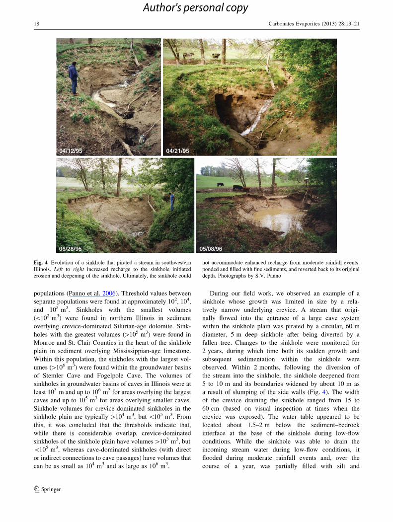
During our field work, we observed an example of a
sinkhole whose growth was limited in size by a rela-
tively narrow underlying crevice. A stream that origi-
nally flowed into the entrance of a large cave system
within the sinkhole plain was pirated by a circular, 60 m
diameter, 5 m deep sinkhole after being diverted by a
fallen tree. Changes to the sinkhole were monitored for
2 years, during which time both its sudden growth and
subsequent sedimentation within the sinkhole were
observed. Within 2 months, following the diversion of
the stream into the sinkhole, the sinkhole deepened from
5 to 10 m and its boundaries widened by about 10 m as
a result of slumping of the side walls (Fig. 4). The width
of the crevice draining the sinkhole ranged from 15 to
60 cm (based on visual inspection at times when the
crevice was exposed). The water table appeared to be
located about 1.5–2 m below the sediment–bedrock
interface at the base of the sinkhole during low-flow
conditions. While the sinkhole was able to drain the
incoming stream water during low-flow conditions, it
flooded during moderate rainfall events and, over the
course of a year, was partially filled with silt and
Fig. 4 Evolution of a sinkhole that pirated a stream in southwestern
Illinois. Left to right increased recharge to the sinkhole initiated
erosion and deepening of the sinkhole. Ultimately, the sinkhole could
not accommodate enhanced recharge from moderate rainfall events,
ponded and filled with fine sediments, and reverted back to its original
depth. Photographs by S.V. Panno
18 Carbonates Evaporites (2013) 28:13–21
123
Author's personal copy
reverted back to its original depth of 5 m (Fig. 4). The
low-energy nature of this sinkhole, in spite of the rela-
tively high-energy input of the stream during flooding
conditions, is an example of the limiting conditions of
relatively high water tables and drainage controlled by
crevices and relatively small conduit size or both.
Bedrock topography and cave formation
Bedrock topography can play a major role in the formation
of caves, their groundwater basins, and associated karst
terrain. Palmer (2007) stated ‘‘cave origin is enhanced
where surface runoff is concentrated into small areas of
infiltration.’’ It has been the authors’ observation that large
caves in the sinkhole plain are frequently initiated at pla-
teaus or swales where rainwater and snowmelt can focus
recharge into the Ste. Genevieve and St. Louis Limestones.
Cross sections of each of four large caves (Fogelpole Cave,
Illinois Caverns, Stemler Cave and Krueger’s Cave) in
southwestern Illinois show that there is a distinct and rel-
atively large topographic depression in the bedrock near
the entrances or beginning of each cave (Fig. 5). These
swales or depressions in bedrock would likely collect
surface drainage directly and by movement of recharge
along the soil–bedrock interface allow it to recharge into
the underlying fractured bedrock. Surface water would
eventually enter fractures in the bedrock and flow along
dissolution-enhanced bedding-plane partings. Subtle
irregularities in the bedding-plane surface, as seen in
exposures in the field, probably control the sinuosity of the
bedding-plane channels (Panno et al. 2011). With time,
some of these bedding-plane channels (or proto-caves) and
their initial sinuous patterns increase in size to become
caves where active streams continue to flow through and
enlarge their passages. As a result, the sinuosity of these
caves in plan view resembles that of surface stream
channels.
Because the large caves of southwestern Illinois are
located at the Illinoisan glacial maximum, and based on
unpublished data on stalagmite ages by Panno (Illinois
State Geological Survey) and cave sediment ages (Panno
et al. 2004), the authors suggest that meltwaters of the
Illinoisan glacier (ca. 135,000 years BP) infiltrated and
enlarged bedrock crevices and bedding-plane partings and
conduits. During this time, the water table would have been
lower than today’s because of the cold, dry conditions that
prevailed at that time. Recharge would have migrated
deeper into bedrock before encountering the water table
and flowing horizontally along bedding-plane partings. The
bedrock depressions at the sediment–bedrock interface
would have created focal points and pathways down near-
vertical crevices to bedding-plane partings for meltwaters
and later meteoric waters to migrate (Figs. 1, 5).
Conclusions
The mechanisms that control the initiation, growth and
evolution of caves and cover-collapse sinkholes in Illinois’
sinkhole plain are governed by the glacial geology, local
hydrology, and the geology and hydrogeology of the
Mississippian-age limestone bedrock. Caves in the sink-
hole plain can be up to 15 km in length and 10 m in
diameter, are branchwork type with active cave streams,
and usually form along bedding planes. Cross sections
extending the length of each of the four relatively large
cave systems studied revealed depressions in the bedrock
surface at the farthest updip and upgradient portions of the
caves where surface-water recharge could concentrate and
flow into bedrock crevices and along bedding planes.
The sinkholes of this region are abundant, typically
circular to oval in plan view, range from centimeters to tens
of meters in diameter and depth, and form in loess and fine
glacial sediment deposits. Clusters of the largest and often
compound sinkholes are found overlying and in the vicinity
of the state’s largest known cave systems. Cover-collapse
sinkholes near some of these large cave systems appear to
have fluvial drainage and can approach 0.5 km2 in aerial
extent where relatively thick Quaternary-age deposits are
present. The size and morphology of these sinkholes are
distinctly different than those in the vicinity of smaller
crevice-karst bedrock features. Sinkholes associated with
solution-enlarged crevices and smaller caves and conduits
are typically circular to elliptical depressions from 60 to
120 m in diameter.
Surficial glacial till and loess deposits are easily eroded
by running water and their thicknesses in western Illinois
(10 m or greater) allow for the development of well-
defined cover-collapse sinkholes. The authors suggest that
the higher the energy of surface runoff flowing into a
sinkhole, during and following a relatively large rainfall,
the more erosion that will occur at its margins and its
interior. Because caves and conduits in Illinois’ sinkhole
plain are formed along bedding planes, and because these
conduits are morphologically and hydrologically similar,
but at different scales, the erosive growth of a sinkhole is
limited primarily by the underlying conduit system’s abil-
ity to channel, store, and discharge incoming water. If a
conduit system is too small, the conduit drainage system
may be overwhelmed during and following a large rain
event resulting in flooding of the sinkhole or sinkholes
feeding it. Sinkhole flooding, in turn, creates a low-energy
environment that is more depositional than erosive, and
sinkhole growth is inhibited or stabilized. In fact, the
sinkhole may be partially filled with fine sediments. Con-
versely, if the conduit system is large and the inflow of
water into and through the sinkhole drain is uninhibited at
even the highest recharge rate, the energy of inflowing
Carbonates Evaporites (2013) 28:13–21 19
123
Author's personal copy
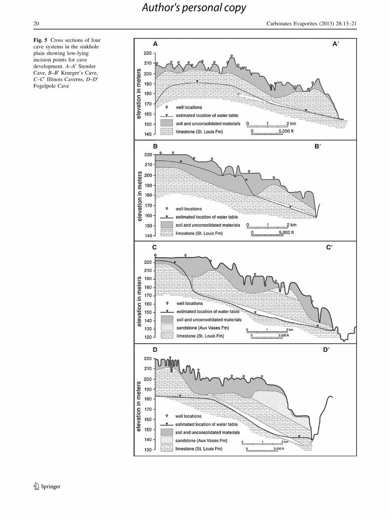
Fig. 5 Cross sections of four
cave systems in the sinkhole
plain showing low-lying
incision points for cave
development. A–A0 Stemler
Cave, B–B0 Krueger’s Cave,
C–C0 Illinois Caverns, D–D0
Fogelpole Cave
20 Carbonates Evaporites (2013) 28:13–21
123
Author's personal copy
water can become and remain very high. Incoming runoff
water will continue to erode the margins and interiors of
sinkholes resulting in internal gully formation, concomitant
slumping, and cover-collapse sinkhole enlargement.
Threshold calculations indicate that crevice-dominated
sinkholes of the sinkhole plain have volumes[103 m3, but
\105 m3, whereas cave-dominated sinkholes (with direct
or indirect connections to cave passages) have volumes that
can be as small as 104 m3 and as large as 106 m3.
Finally, longitudinal sections of the four largest caves in
the sinkhole plain suggest that these caves were initiated
along depressions and swales in the bedrock surface. The
authors suggest that these bedrock depressions similarly
focused recharge to the underlying bedrock pathways
(fractures and bedding planes), thereby initiating the caves
along bedding-plane partings.
Acknowledgments The authors acknowledge the Illinois State
Geological Survey (ISGS) for their support of this work. We thank
Cheryl Nimz and Mike Knapp (ISGS) for their generous help with the
graphics and editing, and Keith Hackley and Don Keefer for their
insightful comments on the manuscript. Publication of this article has
been authorized by the Director of the Illinois State Geological Sur-
vey and by the Institute of Natural Resource Sustainability, University
of Illinois.
References
Angel JC, Nelson DO, Panno SV (2004) Comparison of a new GIS-
based technique and a manual method for determining sinkhole
density—an example from Illinois’ sinkhole plain. J Cave Karst
Stud 66(1):9–17
Leighton MM, Ekblaw GE, Horberg CL (1948) Physiographic
divisions of Illinois. J Geol 56(1):16–33
Nelson JW (1995) Structural features in Illinois: Champaign, Ill.,
Illinois State Geological Survey. Bulletin 100:144 (2 pls)
Palmer AN (1969) A hydrologic study of the Indiana karst:
Bloomington, Ind. Ph.D. dissertation, Indiana University, p 181
Palmer AN (2007) Cave geology: Dayton. Cave Books, Ohio, p 454
Panno SV (1996) Water quality in karst terrain: The Karst Window
2(2):2–4
Panno SV, Angel JC, Grimley DA, Weibel CP, Stiff BJ (2008a)
Bedrock topography of Columbia Quadrangle—Monroe and St.
Clair Counties, Illinois. Illinois State Geological Survey, Illinois
Geologic Quadrangle Map, IGQ Columbia-BT, scale 1:24,000
Panno SV, Angel JC, Nelson DO, Weibel CP, Luman DE (2008b)
Sinkhole distribution and density of Columbia Quadrangle—
Monroe and St. Clair Counties, Illinois. Illinois State Geological
Survey, Illinois Geologic Quadrangle Map, IGQ Columbia-SD,
scale 1:24,000
Panno SV, Angel JC, Nelson DO, Weibel CP, Luman DE, Denny FB
(2008c) Sinkhole distribution and density of Waterloo Quadran-
gle: Monroe County, Illinois. Illinois State Geological Survey,
Illinois Geologic Quadrangle Map, IGQ Waterloo-SD, scale
1:24,000
Panno SV, Angel JC, Nelson DO, Weibel CP, Luman DE, Devera JA
(2008d) Sinkhole distribution and density of Renault Quadran-
gle: Monroe County, Illinois. Illinois State Geological Survey,
Illinois Geologic Quadrangle map, IGQ Renault-SD, scale
1:24,000
Panno SV, Angel JC, Weibel CP, Stiff BJ (2008e) Bedrock
topography of Renault Quadrangle—Monroe County, Illinois.
Illinois State Geological Survey, Illinois Geologic Quadrangle
Map, IGQ Renault-BT, scale 1:24,000
Panno SV, Curry BB, Wang H, Hackley KC, Liu C-L, Lundstrom C,
Zhou J (2004) Climate change in southern Illinois, USA, based
on the age and d13C of organic matter in cave sediments. Quat
Res 61(3):301–313
Panno SV, Denny FB, Angel JC, Crockett JE (2008f) Bedrock
topography of Waterloo Quadrangle—Monroe County, Illinois.
Illinois State Geological Survey, Illinois Geologic Quadrangle
Map, IGQ Waterloo-BT, scale 1:24,000
Panno SV, Hackley KC, Hwang HH, Kelly WR (2001) Determination
of the sources of nitrate contamination in karst springs using
isotopic and chemical indicators. Chem Geol 179(1–4):113–128
Panno SV, Hackley KC, Kelly WR, Luman DE (2011) Illinois’
sinkhole plain—classic karst terrain of the Midwestern United
States. In: Geological field trip guidebook for the 12th multi-
disciplinary conference on sinkholes and the engineering and
environmental impacts of karst, 10–14 January 2011, St. Louis,
Missouri, USA. Illinois State Geological Survey Guidebook, vol
39, p 45
Panno SV, Kelly WR, Martinsek AT, Hackley KC (2006) Estimating
background and threshold nitrate concentrations using probabil-
ity graphs. Ground Water 44(5):697–709
Panno SV, Luman DE (2012) Mapping palimpsest karst features of
Illinois’ sinkhole plain. Carbonates Evaporites doi:10.1007/s13146-
012-0107-4
Panno SV, Weibel CP, Li W (1997) Karst regions of Illinois:
Champaign, Ill. Illinois State Geological Survey, Open File
Series 1997-2, p 42
Piskin K, Bergstrom RE (1975) Glacial drift in Illinois—thickness
and character: Urbana, Ill. Illinois State Geological Survey,
Circular 490, p 35, (2 pls)
Sinclair AJ (1991) A fundamental approach to threshold estimation in
exploration geochemistry—probability plots revisited. J Geo-
chem Explor 41(1–2):1–22
Weibel CP, Panno SV (1997) Karst terrains and carbonate rocks of
Illinois (note: title on envelope, Karst terrains and carbonate
bedrock in Illinois): Urbana, Ill. Illinois State Geological Survey,
Illinois Map IMAP 8 Statewide map, scale 1:500,000
Carbonates Evaporites (2013) 28:13–21 21
123
Author's personal copy
Copyright © 2022 FDOKUMEN