“Traincost”, Point-to-Point Railway Traffic Costing Model 2014
Upload
khangminh22Category
view
1download
0
HUNGRY POINT RESERVE, CRONULLA
2016 DRAFT STRATEGIC MASTERPLAN

Cover Image:Photo of the Eastern Shoreline, Hungry Point Reserve, Cronulla

Prepared bySutherland Shire Council4-20 Eton StreetSutherland NSW 2232www.sutherlandshire.nsw.gov.au
With acknowledgment to CLOUSTON AssociatesLandscape Architects • Urban Designers • Landscape PlannersLevel 2, 17 Bridge Street • Sydney NSW 2000PO Box R1388 • Royal Exchange NSW 1225 • AustraliaTelephone +61 2 8272 4999 • Facsimile +61 2 8272 4998Contact: Crosbie LorimerEmail • [email protected] • www.clouston.com.au for their assistance in the preparation of Hungry Point Reserve Draft Masterplan 2014 and facilitating workshops in 2012-2013
for The Hungry Point Reserve Trust
Issue Date Issue No. Status Issued By19.09.13 MP-001 DRAFT-PCG REVIEW G. Cleeves02.10.13 MP-002 FINAL DRAFT-PCG REVW. G. Cleeves11.10.13 MP-003 FINAL DRAFT G. Cleeves10.01.14 MP-004 FINAL DRAFT- ST COMMENTS G. Cleeves25.05.16 MP-005 REVISED DRAFT-TRUST RVW J. Nimmo 11.07.16 A DRAFT STRATEGIC MASTERPLAN J. Nimmo09.09.16 B DRAFT STRATEGIC MASTERPLAN J. Nimmo

DRAFT STRATEGIC MASTERPLANJULY 20164
TABLE OF CONTENTS
EXECUTIVE SUMMARY 6BACKGROUND & STRATEGIES
BACKGROUND 11OBJECTIVES AND METHODOLOGY 13SITE DESCRIPTION AND HISTORY 15SITE ANALYSIS 18STRATEGIC MASTERPLAN PRINCIPLES 26STRATEGIC MASTERPLAN SUMMARY 30BUILDINGS STRATEGY 35ARCHEOLOGICAL STRATEGY 46LANDSCAPE STRATEGY 50BUSINESS STRATEGY 56PRECINCTS AND PHASING 63
IMPLEMENTATION WELCOMING THE PUBLIC TO THE RESERVE 70EARLY WORKS STAGES 73STAGE 1 WORKS 75BUSINESS PLAN 76ACHIEVEMENTS TO DATE 78NEXT STEPS 80
BIBLIOGRAPHY

DRAFT STRATEGIC MASTERPLAN JULY 2016 5
TABLE OF CONTENTS LIST OF FIGURES
Figure 1 Aerial Photograph Regional Context. Figure 2 Aerial Photograph, Hungry Point Reserve site. Figure 3 Site Analysis Summary Figure 4 Strategic Masterplan Figure 5 Building Plan Figure 6 Landscape Strategy Plan Figure 7 Precinct Plan Figure 8 Overall Context Plan Figure 9 Early Works Plan Figure 10 Stage 1 Plan

DRAFT STRATEGIC MASTERPLANJULY 20166
Located at the southern-most tip of the Cronulla peninsula and forming the northern head to Port Hacking, Hungry Point Reserve (the reserve) is a prominent Sutherland Shire landmark providing spectacular views across Port Hacking.
The NSW State government is keen to see this unique site open to the public and has provided funding to begin planning for this. The reserve, with its scenic landscape, sensitive ecology, historic buildings, multiple land uses and important Aboriginal heritage, is a rich and complex public asset that will need to be sustainably managed.
The Vision for the site is
“Hungry Point is a place that celebrates the European, Aboriginal and natural values of the site and enriches the lives of Cronulla, Shire and Sydney residents, visitors and workers”.
Key principles for this site embodied in the document are:• be a key element in the open space opportunities for Sutherland Shire and beyond;
• protect and enhance the European, Aboriginal and natural values of the site;
• provide a place for residents, visitors and workers to reflect on and appreciate the unique locality and spiritual connections of the site;
• provide a social place for leisure and recreation;
• connect the site to the Esplanade, Cronulla, and beyond; and
• respond positively and sensitively to the site’s complexity.
This document is a draft 2016 Strategic Masterplan for the Hungry Point Reserve, developed by Sutherland Shire Council on behalf of the Hungry Point Trust (the Trust). The draft Strategic Masterplan is dynamic and evolving as more information becomes available. It is a long term document that draws together the threads of the known information on the site and flags areas for further investigation.
The Strategic Masterplan is one of a suite of documents (described below) that will inform and contribute to the delivery of the Hungry Point Reserve Vision.
Strategic Masterplan This document provides a framework for the long term design vision and to guide changes
• Business Plan Is a section in the Strategic Masterplan and describes the financial and business feasibility / opportunities of the site
EXECUTIVE SUMMARY
DRAFT STRATEGIC MASTERPLAN JULY 2016 7
• Implementation Plan Is a section in the Strategic Masterplan and describes the proposed implementation of the Strategic Masterplan, subject to funding and financial opportunities
Conservation Management Plan (CMP) Is a separate document that provides the framework for decision making and direction relating to Aboriginal and European heritage and landscape
Asset Management Plan Is a separate document that will provide a framework for the management and maintenance of the site’s assets
Plan of Management Will describe the overall operation of the site based on the land tenure.
Hungry Point Reserve is a Crown Reserve and in 2012 the Hungry Point Reserve Trust (the Trust) was appointed to oversee the reserve following its closure as a fisheries research centre. One of the first priorities of the Trust has been to prepare a Strategic Masterplan so that the reserve’s future can be properly managed. This masterplan will provide a strongly coordinated and comprehensive response to a wide range of factors to be considered. Its focus is to establish the reserve as a regional destination for the public, which both conserves and capitalises on the reserve’s significant environmental, cultural and heritage qualities. This strategic masterplan document:• updates the earlier draft masterplan completed in January 2012;
• responds to the recommendations of the Conservation Management Plan (CMP) endorsed by the Trust in April 2016; and
• incorporates recent progress to provide enhanced pedestrian access and amenities within the reserve for the public.
EXECUTIVE SUMMARY
DRAFT STRATEGIC MASTERPLANJULY 20168
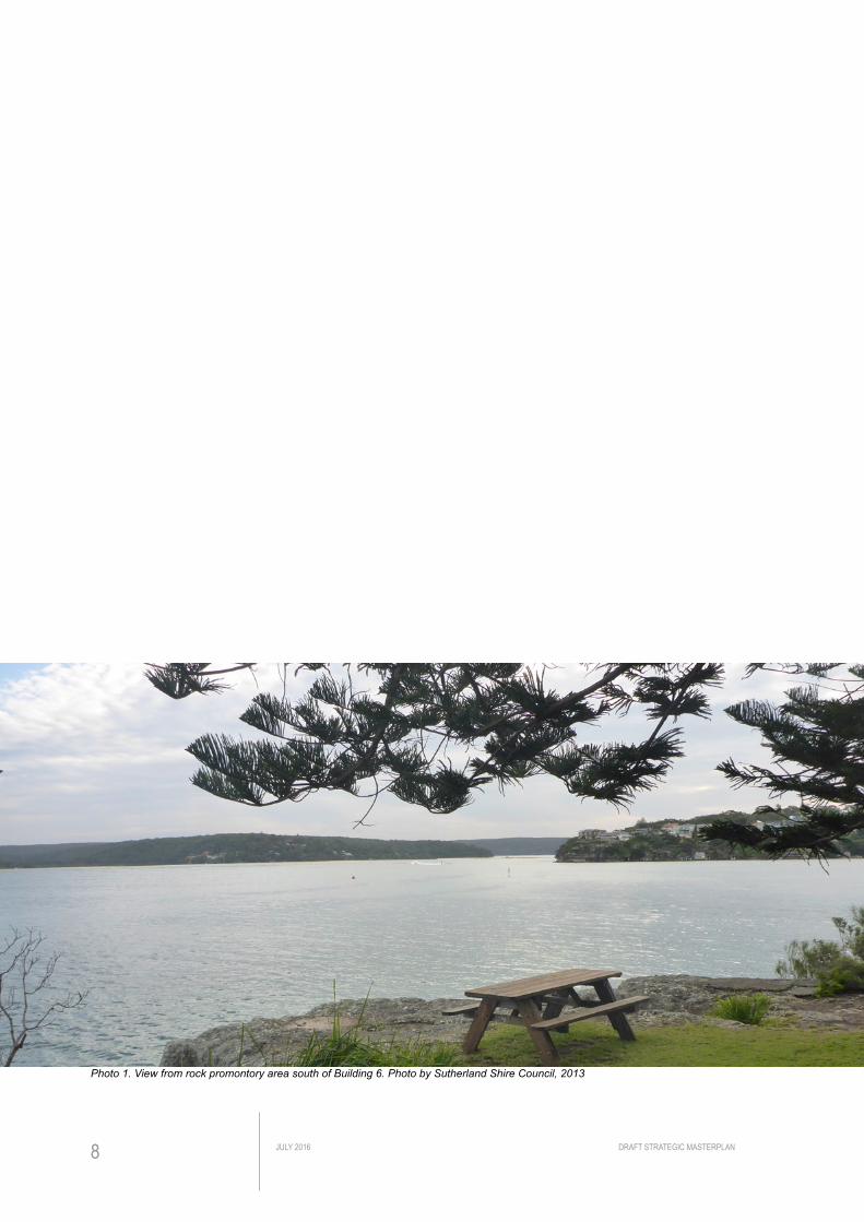
Photo 1. View from rock promontory area south of Building 6. Photo by Sutherland Shire Council, 2013

DRAFT STRATEGIC MASTERPLAN JULY 2016 9
BA
CK
GR
OU
ND
& S
TRAT
EGIE
S

DRAFT STRATEGIC MASTERPLANJULY 201610
This map has been produced with the most current data
available to Council as supplied by various sources.
INFORMATION IN THIS MAP IS SUBJECT TOCOPYRIGHT.
Council is not responsible for any inaccuracies in the data
provided. Contact Council’s Land Information Unit (ph. 9710
0116) for more information.
Sutherland Shire Council Mapping
380
Printed:
Metres
19,000Scale 1:
6/07/2016
7600
at A4
Legend
This map has been produced with the most current data
available to Council as supplied by various sources.
INFORMATION IN THIS MAP IS SUBJECT TOCOPYRIGHT.
Council is not responsible for any inaccuracies in the data
provided. Contact Council’s Land Information Unit (ph. 9710
0116) for more information.
Sutherland Shire Council Mapping
40
Printed:
Metres
2,000Scale 1:
6/07/2016
800
at A4
Legend
Fig 2. An aerial photograph of Hungry Point Reserve site, Cronulla. Source: SSC E-view Aerial Image 2015
Fig 1. An aerial photograph showing the regional context of the Hungry Point Reserve site. Source: SSC E-view Aerial Image 2015
Gun
nam
atta
Bay
Port Hacking
Wangi Avenue
Salmon Haul Reserve
Cowra Place
Nic
hols
on P
arad
e
Maianbar
Dolans Bay
Burraneer
Burra
neer
Bay
Woolooware
Caringbah South
Cronulla
CronullaBeach
Bate Bay
Hungry Point
Salmon Haul Bay

DRAFT STRATEGIC MASTERPLAN JULY 2016 11
BACKGROUND
The three-hectare Hungry Point Reserve site in Cronulla is a spectacular promontory, jutting out into Gunnamatta Bay. It boasts important Aboriginal heritage, historic buildings and significant landscape features. It sits amongst and alongside Cronulla streetscapes and adjacent houses (See Fig. 1 and 2).
The site most recently operated as the Cronulla Fisheries Research Centre of Excellence (Fisheries Site); however on the 8th September 2011, the Minister for Primary Industries Katrina Hodgkinson MP, together with Deputy Premier Andrew Stoner MP, announced its closure.
The NSW State Government confirmed that the site will remain in public ownership and under the management of a Trust. In 2012 the Hungry Point Trust was appointed. It is made up of representatives from Sutherland Shire Council, Cronulla Chamber of Commerce, Crown Lands, Roads and Maritime Service, the La Perouse Aboriginal Land Council, NSW Police, Marine Rescue NSW, Government Property NSW and the Sutherland Shire Historical Society.
One of the first priorities of the Trust had been to prepare a Masterplan so that the opportunities inherent in the site can be pursued and realised. CLOUSTON Associates was commissioned by Sutherland Shire Council on behalf of the Trust to project manage the development of a Masterplan and Business Plan as a tool to guide the long term management of Hungry Point Reserve. To undertake this masterplan Sutherland Shire Council convened a Project Control Group (PCG) comprising senior Council staff members.
STATUS OF THIS STRATEGIC MASTERPLANA draft Strategic Masterplan was completed in January 2014. A Conservation Management Plan (CMP) for the site was prepared by Architectural Projects Pty Ltd. The CMP was adopted by the Trust on 12 April 2016 and has been submitted to the Heritage Council for endorsement. As the CMP is now complete, it is appropriate to update and refine the Masterplan in response to the recommendations contained in the CMP. It is also appropriate to include other progress made towards opening up of the site for the public. This has resulted in the 2016 Draft Strategic Masterplan.
It is intended to exhibit the draft Strategic Masterplan for public comment. This document remains in draft form until such time as the public exhibition is completed and any necessary refinements are made in response to comment received.

DRAFT STRATEGIC MASTERPLANJULY 201612
Photo 4. Gunnamatta Bay jetty on the west of the site.
Source: All photos courtesy of CLOUSTON Associates, September 2013
Photo 3. A plaque commemorating the Cronulla Fisheries Research Centre.
Photo 6. Terraced lawns cascading down to the foreshore characterise the more undeveloped areas of the site.
Photo 5. Cave formed by overhanging rock, forming a key landscape feature to the site.
Photo 2. The site is occupied by a variety of institutional buildings.

DRAFT STRATEGIC MASTERPLAN JULY 2016 13
OBJECTIVE OF THE STRATEGIC MASTERPLANThe Hungry Point Reserve is a complex site with competing imperatives. It is on the cusp of change. With the closure of the Cronulla Fisheries Research Centre there are many potential uses for the site and many interested parties who have expressed an interest in occupying part of the site, making use of its facilities and/or taking advantage of its unique location.
The site offers opportunity for the establishment of marine related government organisations, non-government organisations, cafe/restaurant and community groups. In addition, the closure of the Fisheries Office offers the opportunity for greater access to the site by the general public to appreciate the magnificent views and enjoy a pedestrian link through to the adjacent regional Esplanade Walk and Darook Park.
All of this and more demands a strongly coordinated approach to land use planning and development issues. In the absence of an overall planning approach, consideration of individual use proposals as they arise may result in a number of opportunities being overlooked, ongoing community concern, and conflicting or inconsistent outcomes for Hungry Point.
The development of this strategic masterplan aims to provide design principles to guide development within the context of the site and contribute to the quality of its natural and built environment. The Strategic Masterplan will provide coherent guidelines for the future use of the site. It will assist in co-ordinating activities and proposals for the site by providing a consolidated documentary reference for information and proposals relating to the site.
METHODOLOGYTo prepare this Strategic Masterplan, the following study process and methodology were adopted:
• Review of existing data, site investigation, analysis and photography including a review of the report “Cronulla Fisheries Site: Recommendations for Future Use” by David Harley AM;
• Analysis across all significant site/facility characteristics and the identification of site opportunities and constraints for the strategic masterplan;
• Two half day workshops with the PCG:
– To discuss issues, opportunities and constraints and undertake site analysis;
– Establish principles for the development of a concept masterplan.
• One half day workshop with residents invited from the immediately adjoining properties and members of the Hungry Point Trust;
• Review of Opportunities and Constraints for the site;
• Development of Draft Masterplan and Business Plan;
• Preparation of the Draft Masterplan;
• Preparation of a Conservation Management Plan (CMP); and
• Review of the draft Masterplan and incorporation of recent developments, including outcomes of the CMP and grant applications for construction of pathway and visitor amenities.
OBJECTIVES AND METHODOLOGY

DRAFT STRATEGIC MASTERPLANJULY 201614
Photo 7. Aquaria building looking South East, circa 1907-1911
Photo 10. Migrant Hostels on Hungry Point site, circa 1949
Photo 8. Interior of Hatchery Building (Building 6) with Manager Frederick Aldrich, circa 1907-1911
Photo 9. View looking South East, circa 1940s
Source: Sutherland Shire Council Library - Local Studies

DRAFT STRATEGIC MASTERPLAN JULY 2016 15
SITE DESCRIPTION AND HISTORY
SITE DESCRIPTIONThe Hungry Point Reserve is located on the southernmost tip of the Cronulla Peninsula, forming the northern head to Port Hacking. To the north of the site are low density residential areas of Cronulla. Darook Park is located on the north western boundary and Salmon Haul Reserve is to the east of the site. The site is secured by a 2m fence. The site comprises three lots and occupies an area of 3ha. It has a natural vegetated character. There are 22 buildings on site dating from 1902 – 2010 and substantial car parking areas. The lower western part of the site is accessed by a steep driveway.
HISTORY OF THE SITEThe Hungry Point Reserve has a rich and varied history of use and occupation since pre European settlement. As a promontory which accesses the water’s edge at Port Hacking it has long been a strategically important and attractive site. To this day it retains many of its original features and characteristics.
Aboriginal significance of Hungry PointThe Hungry Point Reserve was a highly utilised Aboriginal site before European settlement. The landscape of the foreshore would have been considered important due to its association with Port Hacking, neighbouring areas of Burraneer and Cabbage Tree Point and the abundance of food and water resources. The rockshelters on the site would have offered protection and privacy while providing sweeping views of the waterways and surrounding land. The site itself contains three rockshelters with possible occupation deposits, as well as at least four distinct shell middens. There is documented recording of at least one Aboriginal burial on site. Grinding grooves are present on the site. This evidence indicates that the peninsula was a significant resource zone, showing intense exploitation of the coastal marine resources over a considerable period of time.
Early European EncountersIn 1796 Bass and Flinders camped adjacent to the site and liaised with two of the local native people – an example of friendly relations between Europeans and members of the local native population.
European SettlementThe Hungry Point Reserve is strategically located at the entrance to the Port Hacking River. A Cumberland County Map published in the Baker Australian Country Atlas 1843-1945 indicates the Cronulla Peninsula as ‘government reserve’. In 1861, a Government Reserve including Hungry Point was gazetted. In 1895 when the Cronulla peninsula was subdivided, 7 acres of land at Hungry Point was held as a reserve for ‘defence purposes’. A second subdivision in 1900 also notes a ‘Reserve for Access’ along the foreshore east of the subject site.

DRAFT STRATEGIC MASTERPLANJULY 201616
In the latter part of the 19th century, the NSW government became concerned about depleting local fish stocks. In 1902, Norwegian scientist Harald Dannevig was appointed as Superintendent of Fisheries Investigations and Marine Hatcheries and selected Hungry Point as the site for a new sea hatchery. In December 1902 an area on the western side of the site was transferred from the Commonwealth to the NSW Government for piscicultural purposes. Dannevig oversaw the establishment of the hatchery building, laboratory and aquaria. The hatchery operated until 1914.
In 1938 the CSIR’s Fisheries Investigation Section took over the site and carried out restoration works to existing buildings as well as the construction of new buildings on the site. Between 1938 and 2011, research programs and investigations into oceanography, fish biology and population dynamics were carried out on the site under the CSIR (later named the CSIRO) and later the NSW Fisheries Research Institute. Additions and renovations to the buildings on site were made. In circa 1946 a Fisheries School forming part of the Commonwealth Reconstruction Training Scheme for ex-servicemen was established adjacent to the aquaria.
Between 1949 and 1967 the Cronulla Migrant Hostel operated on the eastern side of the site. In February 1967, the hostel closed permanently and the land was transferred to the CSIRO. All but two of the hostels and associated buildings were demolished in the 1970s and new fisheries facilities were constructed in the late 1970s. The Cronulla Fisheries Centre was closed by the NSW State Government in 2011. In 2012 the Hungry Point Reserve Trust was founded to oversee management and operation of this key site. Existing facilities on the site are currently being used by Marine Rescue NSW and the Marine Stewardship Council. Negotiations are currently underway for SES to occupy premises on site.
Since 1977 there has been a pedestrian pathway along the northern edge of the site, linking the eastern and western foreshores of the south Cronulla peninsula. Efforts have been made to achieve broader open space community use of the site since 1983.
THE HARLEY REPORTFollowing the Fisheries site closure in 2011, the NSW Department of Primary Industries appointed an external consultant David Harley AM to complete a study of the site, which produced a report titled ‘Cronulla Fisheries Site: Recommendation for Future Use’, completed in November 2012. This report provided a history of the site and concluded with a number of key recommendations, many of which have been considered in the preparation of this Masterplan.
The three over arching principles established in the Harley Report are:• The site should reflect the community and the majority of their views;

DRAFT STRATEGIC MASTERPLAN JULY 2016 17
• The Aboriginal and heritage aspects of the site should be protected and conserved; and
• People and organisations invited onto the site should serve the interests of the local community in undertaking their activities.
The Harley Report also outlined twenty five detailed recommendations for the site, of those the priority recommendations were:• The site should remain in public ownership;
• The existing buildings, with one possible exception, should remain intact in the short to medium term;
• There should be no large-scale commercial or hotel development.
• The site should be open to the public by continuing the walkway connecting Bass and Flinders Point and Darook Park;
• Three marine rescue groups should be invited to occupy selected buildings on the site;
• Two educational centres should be established, featuring Aboriginal heritage, marine scientific research history and local Cronulla history and heritage;
• The site can be used by NSW secondary schools for excursions;
• A kiosk/restaurant would provide a revenue stream for the site; and
• A Site Management Trust should be established to manage the site.
The Trust is not bound by the recommendations of the Harley Report but has considered them in the development of this Strategic Masterplan.

DRAFT STRATEGIC MASTERPLANJULY 201618
The following is a summary of the analysis developed during the stakeholders and PCG workshops held during the Masterplan project. The workshops analysed site issues and opportunities and mapped them under the six headings outlined below. The analysis has been updated to incorporate changes to tenancies and include relevant information from the CMP. The analysis is summarised in Figure 3.
CONTEXTThe site is important within the context of open space, leisure and recreation in Sutherland Shire and beyond:
• The site lies in an important location on the Port Hacking foreshore, adjoining the Bass and Flinders foreshore path and being the halfway point on a popular walking circuit of the peninsula, starting and finishing at Cronulla Beach;
• The site lies on the southern tip of the peninsula at the end of a cul de sac (Nicholson Parade);
• The adjoining land uses comprise quiet residential areas and the popular Darook Park on the foreshore to the north west of the site; and
• The site enjoys extensive views along and across the Port Hacking waterway.
ACCESS, STREET FRONTAGE AND CIRCULATIONThe prominence and importance of this site requires that access, street presentation and circulation are given the highest priority:
• The site is moderately well served by public transport with the nearest rail being 2km to the north. The nearest bus stop is approximately 150m from the site’s entrance;
• The vehicle entrance is gated, and the fenced front address of the site is not welcoming;
• There is a small network of internal roads and ample parking on site, but the layout is highly fragmented;
• There is presently no direct public access to the site by footpath; however the site can be approached from the east along The Esplanade walking track;
• The public foreshore route on the east is currently separated from the main body of the site by a fence and ends with a steep drop where further access to the site is fenced off. Visitors must backtrack to Nicholson Parade to continue this walk, and the route does not allow universal access with steps and steep ramps;
• A concrete footpath connecting the eastern and western side of the peninsula runs outside the northern boundary of the site;
• From Darook Park, access is possible along the foreshore of Gunnamatta Bay providing a “round the peninsula” walk at all but high to mid tide;
• During the summer months Nicholson Parade is often heavily parked-out by
SITE ANALYSIS

DRAFT STRATEGIC MASTERPLAN JULY 2016 19
visitors to Darook Park;
• Gradients on the site are steep on its boundaries and would not readily permit universal access in many places;
• A pontoon and boat ramp on the west side of the site permits boat access and berthing, but this is currently limited to use by Marine Rescue NSW; and
• Wayfinding on the site is made difficult by the fragmented layout of roads, car parks, paths, walls and fences;
LAND USES AND BUILDINGSThe diversity of buildings from different development periods and activity types should be noted including:
• There are 22 buildings on the site of varying size, age and condition (Building 17, the Chemical Store has been demolished). Several of the buildings are currently licensed to Marine Rescue NSW. The rear of Building 6 is currently licensed to the Marine Stewardship Council;
• Marine Rescue NSW is currently using Building 1, 2, 3, 5, 9, 11 and 22 and some of the car parking and undercover areas for trailers and temporary storage. It also has two vessels berthed at the jetty permanently;
• Marine Rescue has indicated that it expects there to be a minimum of two persons on site 24 hours a day manning their communications centre as well as up to 20 staff during the day. One evening a month up to 70 volunteers will be on site;
• The fisheries aquaria/pool has been decommissioned; and
• Negotiations are currently underway with SES to occupy Building 7 at a future date.
CULTURAL HERITAGEThe site has a rich cultural heritage with many layers including:
• The site is significant for both Aboriginal and non-Aboriginal cultural heritage;
• The site is listed on the State Heritage Register. The listing also identified 4 individual buildings and 3 Aboriginal middens as having heritage significance;
• Extensive Aboriginal shell middens and multiple rockshelters with occupational deposits along the foreshores suggest that the area is representative of past activity by Aboriginal people due to its abundance of food and water resources;
• Portions of the site have the potential to contribute archeological information relating to Aboriginal diet, occupation patterns and burial customs;
• Parts of the site have been partially disturbed by past development, vegetation clearing and the creation of formal gardens, and it is likely that shell material has been extensively reworked and damaged in these areas;

DRAFT STRATEGIC MASTERPLANJULY 201620
Photo 11. Residential streets define the north of the site
Photo 12. The site offers attractive views of Port Hacking
Photo 13. DDA compliant access is not catered in the existing condition
Photo 14. Existing fragmented parking and road network
Photo 18. Rocky promontory south of site, a key feature with commemorative plaques highlighting a local significance
Photo 19. Spectacular Fig tree specimen found behind Building 16
Photo 17. Open space areas with selective, filtered views of the water
Photo 16. Many unused, locked buildings exist on site
Source: Photo 11-18 courtesy of CLOUSTON Associates, Photo 19 by Sutherland Shire Council, September 2013
Photo 15. Existing securable gate. This gate (western gate) is typically not opened for day to day/public access

DRAFT STRATEGIC MASTERPLAN JULY 2016 21
• The site was reserved for defence purposes in 1861;
• The site provides evidence of the first marine fisheries research establishment in Australia and has been associated with fisheries research for over 100 years, beginning in 1904;
• The site is of historical significance as the location for the Cronulla Migrant Hostel and its association with the postwar migration program;
• The Hatchery Precinct has the ability to interpret and evoke its historical associations as a visually cohesive area that retains much of its Twentieth Century character;
• The former CSIR building (Building 1) is a good substantially intact example of the Interwar Functionalist Style;
• The Conservation Management Plan has identified 9 buildings as having heritage significance and worthy of retaining on site; and
• Many other buildings on site have limited aesthetic values due to their functional design and degree of alterations.
The CMP articulates the cultural heritage significance of the site. Through understanding the cultural heritage significance of the site place, the CMP defines the actions needed to protect that significance in the future use and development of the site.
NATURAL HERITAGE AND ENVIRONMENTThe natural heritage and the environment are key features of this site, notably: • The site is prominently located on the northern headland of the Port Hacking and
has landmark and scenic qualities;
• The site is ecologically sensitive including largely undisturbed areas and endangered species;
• The headland setting is representative of the natural topography (rocky foreshores and sandstone outcrops) and indigenous vegetation of Port Hacking;
• There are examples of cultural planting and significant specimen trees on site;
• The site has groups of planting and open grassland with specimen trees and native vegetation;
• There is variable foreshore vegetation, dense and weedy along the foreshore; and
• The landscape of the area is significant due to its association with Port Hacking and the neighbouring areas of Burraneer and Cabbage Tree Point, Bundeena.

DRAFT STRATEGIC MASTERPLANJULY 201622
IMAGE AND CHARACTERThe image and character of the site can give a sense of place, as:• The site has a prime location on Port Hacking commanding extensive views and
is a scenic landmark in its own right on the waterway;
• The site entry and northern boundary prevent any significant view of the site from adjoining streets;
• The site is heavily punctuated by roads, car parks, fences and walls to no coherent layout, impeding the site’s legibility, walkability and compromising its significant natural scenic qualities; and
• There are selective views of the water from various locations on site, with the sandstone promontory on the southern tip of the headland forming a highly scenic viewpoint.
MANAGEMENT, OPERATIONS AND MAINTENANCEOngoing management, operations and maintenance will ensure a sustainable site, noting the following: • The site entrance gate is controlled by the present site users and is generally
only open during the day;
• The site is generally well maintained and tidy;
• Many of the buildings are locked and not in use. Full condition reports have not yet been prepared;
• There are areas of weedy understorey throughout the site that will continue to need to be managed. Bushcare and Marine Rescue volunteers group is working on site;
• The fisheries pool is not in use;
• Services and stormwater networks require mapping;
• Council’s maintenance teams provide lawnmowing and minor works; and
• There is no asset management plan for the site.
PLANNING CONTROLS Local planning controls will direct some activities on the site, in keeping with the following:• The site has two main zones: SP1 Special Activities (Pisciculture) and RE1 Public
Recreation under SSLEP 2015. A third zone, W1 – Natural Waterways applies to the boat access and service area on Gunnamatta Bay;
• SSLEP 2015 Heritage Provisions (Clause 5.10) apply to the site. A range of developments may be permissible irrespective of the zone, if heritage outcomes are achieved; and
• There are presently no building development standards applied to the site (eg. FSR, building height).

DRAFT STRATEGIC MASTERPLAN JULY 2016 23
Photo 21. Key view taken on the rock promontory to the south of Building 6
Photo 22. Potential key view taken from west upper lawn. Filtered view to Gunnamatta Bay.
Photo 20. Potential key view taken from open area between Building 13, 15 & 16. Selective clearing of perimeter vegetation (weed and low value trees) to be undertaken and managed with Bushcare
Source: Photos by Sutherland Shire Council, Photo 20 & 23, April 2016; Photo 22, September 2013

DRAFT STRATEGIC MASTERPLANJULY 201624
Photo 23. Marine Rescue NSW operates from the wharf adjacent to the Aquaria (Building 23)
Photo 25. Existing Aquarium pool construction viewed from Darook Park is not complimentary to the natural bushland in the background. This structure is heritage listed for its association with pisciculture
Source: Photos 23-25 by Sutherland Shire Council, April 2016
Photo 24. Looking north towards Darook Park shows the interface between the cultural and natural heritage of the site - its maritime past, the bushland and the foreshore of the Point

DA
RO
OK
PAR
K
PORT
HAC
KING
GUNNAMATTA BAY
CO
WR
A PL
ACE
NICHOLSON PARADE
23
10
11
9
20
19
8
22
7
65
1
3
4
15
13
16
1814
12
2
21H
H H
* * *
**
**
*
9
11 HH
**
LEG
EN
D
O
pen
Spa
ce &
Law
n
Exi
stin
g P
arki
ng A
reas
Boa
t Acc
ess
& M
arin
e A
ctiv
ity A
rea
(
curr
ently
ope
ratio
nal)
End
ange
red
Ecol
ogic
al C
omm
unity
Rem
nant
veg
etat
ion
over
grow
n
with
wee
d sp
ecie
s
Sig
nific
ant l
ands
cape
feat
ure
K
now
mid
den
loca
tion
R
emna
nt s
truct
ure
with
ar
chae
olog
ical
val
ue
S
teep
/ se
vere
cha
nge
of g
rade
(haz
ard)
Ste
ep G
radi
ent
Maj
or V
ehic
le C
ircul
atio
n
Exi
stin
g pa
th e
xter
nal t
o si
te
Reg
iona
l Coa
stal
Wal
k
Pan
oram
ic &
Sig
nific
ant V
iew
s
Filt
ered
or P
artly
obs
cure
d Vi
ews
Her
itage
list
ed b
uild
ing,
I
ndiv
idua
lly li
sted
Bui
ldin
g w
ith h
erita
ge v
alue
to b
e
reta
ined
B
uild
ing
with
occ
upan
cy
N
on-c
ompl
imen
tary
bui
lt fo
rm to
th
e re
serv
e ch
arac
ter
* H
Hig
hly
fragm
ente
d an
d un
sigh
tly
larg
e bi
tum
en p
arki
ng a
rea
Reg
iona
l Coa
stal
Wal
k (B
ass
& F
linde
rs P
oint
)
Sign
ifican
t vie
ws a
cros
s Po
rt Ha
ckin
g. P
artly
obs
ecur
ed
by C
oral
Tre
es
Larg
e no
n-co
mpl
emen
tary
build
ing
in p
rom
inen
t loc
atio
n
Cre
st o
f site
dom
inat
ed b
y pa
rkin
g ar
ea &
Bui
ldin
g 4
No
conn
ectin
g pa
th
onto
Dar
ook
Par
k
Bui
ldin
g bl
ocks
vie
w o
f si
gnifi
cant
Fig
tree
in
gard
en a
rea
behi
nd
Sig
nific
ant c
ultu
ral p
lant
ing
Hig
h fe
ncin
g an
d ga
te
crea
tes
unw
elco
min
g fir
st im
pres
sion
Hig
hly
scen
ic ro
ck o
utcr
op
Pat
h te
rmin
ates
22
7
3
1
88
*****
88888
*******E
EC
EE
C
****
FIGU
RE 3.
SIT
E AN
ALYS
IS S
UMMA
RYPL
AN N
TS0
1020
40m

DRAFT STRATEGIC MASTERPLANJULY 201626
STRATEGIC MASTERPLAN PRINCIPLES
The principles which guide and shape this Strategic Masterplan have been grouped under six distinct themes and were developed through the workshops and residents’ initial consultation. They have been augmented and refined by the recommendations contained in the CMP.
CONTEXTPrinciples based on context include the following:
• The tranquil and secluded character of the site on the end of the peninsula should be retained;
• The natural environment and recreation connections of the site to its peninsula should be enhanced;
• The uses of the site should be compatible with the adjoining land uses and character; and
• Provide for continuity of vegetation and landform to Darook Park and the foreshore to the north east.
ACCESS, STREET PRESENTATION AND CIRCULATIONPrinciples focused on access, street presentation and circulation include the following:
• Vehicle access to the site should principally be confined to the operational users’ day-to-day needs;
• The site should form a destination and stop-off point on the coastal walk around the peninsula;
• The public should be able to gain pedestrian access to and around the headland where possible (safety in design principles must be considered as well as the security of assets owned by occupants);
• Universal access to all retained buildings and around the site should be optimised where possible;
• Opportunities to provide public access to the water’s edge should be provided where safe to do so and where it does not propose a security risk or operational risk to occupants;
• Retain circa 1930’s roadway as the primary vehicular entry to the site; and
• Downplay other access ways as gravel paths or other materials sympathetic to the heritage nature of the site.

DRAFT STRATEGIC MASTERPLAN JULY 2016 27
STRATEGIC MASTERPLAN PRINCIPLES
LAND USE AND BUILDINGSPrinciples focused on land use and buildings include the following:
• Buildings that have high and moderate heritage significance should be retained;
• Only those buildings that can clearly provide for appropriate operational or public amenity or have heritage significance should be retained;
• Removal of buildings that detract from the setting and interpretation of the key periods of significance should be encouraged. In the case of where buildings are occupied, this should be on vacation or by agreement;
• Make plans for the removal of all intrusive buildings;
• Operational and recreational uses of the site should generally be associated with its maritime heritage and cultural qualities and values;
• Uses of the site should not impact adversely on the amenity of the adjoining neighbourhood;
• The site should offer opportunity for walking, picnicking, accessing the water, discovering the site’s history and enjoying the natural environment, taking into account the tenant’s operational needs; and
• Provide outdoor open space in areas already cleared.
CULTURAL AND NATURAL HERITAGEPrinciples focused on the cultural and natural heritage of the site include the following:
• The natural and cultural heritage values of the site should be conserved and enhanced;
• The heritage and cultural significance of the site should be interpreted for the public and other users;
• The Aboriginal heritage and long working history of the site should be protected, documented and conserved and interpreted in a way that can be accessed by the public;
• Management and design of planting on the site should optimise ecological values; and
• The marine archaeology sites as highlighted on the CMP should be protected, documented, conserved and interpreted on site.
DRAFT STRATEGIC MASTERPLANJULY 201628
IMAGE AND CHARACTERPrinciples focused on the image and character of the site include the following:
• The scenic values of the site’s natural and cultural heritage qualities should be conserved and enhanced;
• Significant views across and from the site to the water should be available for all to enjoy;
• Important views to, across and from the site should be documented and conserved; and
• The address of the site on its northern boundary should be open, welcoming and readily identify the location.
MANAGEMENT, OPERATION AND MAINTENANCEPrinciples focused on management, operation and maintenance include the following:
• The site should be able to be secured, subject to consultation with the Trust;
• Lighting on the site should be confined to that required to ensure user safety;
• Uses of the site’s buildings and landscape should include appropriate activities that assist in covering the site’s maintenance costs; and
• Landscape maintenance and proposals should reflect the 2013 Tree survey and landscape strategy principles envisioned for the site, to maximise amenity, safety and sustainability and support public use.

DA
RO
OK
PAR
K
PORT
HAC
KING
GUNNAMATTA BAY
CO
WR
A PL
ACE
NICHOLSON PARADE
23
10
11
9
20
19
8
22
7
65
1
3
4
15
13
16
1814
12
2
21
16
5
1
3
4
2
Key
vie
ws
Key
land
scap
e fe
atur
e to
be
enha
nced
and
mad
e ac
cess
ible
Enh
ance
/recr
eate
gre
en o
pen
spac
e lin
k th
roug
hout
the
site
Cur
rent
bus
h re
gene
ratio
n ar
eas
to b
e en
hanc
ed a
nd m
aint
aned
Pro
visi
on o
f ped
estri
an a
cces
s
(Indi
cativ
e on
ly)
Bol
lard
Inte
rnal
Fen
ce
Vehi
cula
r circ
ulat
ion
Con
trolle
d Ve
hicl
e A
cces
s P
oint
Prin
cipa
l par
king
are
as
Ope
ratio
nal p
reci
nct
Opp
ortu
nity
for o
utdo
or e
vent
venu
e
Opp
ortu
nity
for v
enue
hire
or
mul
ti-pu
rpos
e bu
ildin
g, to
be
inve
stig
ated
dur
ing
early
sta
ge
Opp
ortu
nity
for o
ther
use
s an
d/or
adap
tive
reus
e of
bui
ldin
g
Bui
ldin
g w
ith h
erita
ge v
alue
to b
e re
tain
ed
Bui
ldin
g w
ith li
mite
d he
ritag
e va
lue.
Prio
ritis
e fo
r rem
oval
whe
n no
t in
use/
licen
sed
(Als
o re
fer t
o B
uild
ing
Stra
tegy
Cha
pter
of t
his
docu
men
t for
build
ing
actio
n an
d su
mm
ary
ofC
MP
reco
mm
enda
tion)
*Vi
sito
rs m
ain
gate
, co
ntro
lled
hour
s
Con
nect
ion
to R
egio
nal
Coa
stal
Wal
k
Bui
ldin
g 16
site
is e
asily
acc
essi
ble,
pot
entia
l for
kio
sk/
cafe
with
opp
ortu
nity
of v
enue
hire
(mul
ti-us
e)
Pot
entia
l loc
atio
n of
out
door
hire
spa
ce
acce
ssib
le fr
om th
e m
ain
road
Opp
ortu
nity
for l
ow o
r hig
h gr
ound
ped
estri
an
conn
ectio
n to
Dar
ook
Par
k
Opp
ortu
nity
to u
pgra
de
and
reus
e B
uild
ing
23 a
nd
high
light
vie
ws
to th
e B
ay
Toile
ts to
be
upgr
aded
to
allo
w a
ll ac
cess
faci
lity
Opp
ortu
nity
for l
ower
fo
otpa
th if
ther
e is
dem
and
gene
rate
d by
Bui
ldin
g 23
Hea
dlan
d vi
ewin
g pl
ace
Boo
m g
ate
to o
pera
tiona
l pa
rkin
g ar
ea a
nd je
tty
Inte
rnal
sec
ure
fenc
ing
and
gate
s to
con
trol
afte
r hou
r acc
ess.
Fin
al
alig
nmen
t sub
ject
to
furth
er c
onsu
ltatio
n
Cen
tralli
sed
and
cons
olid
ated
pu
blic
par
king
Sec
onda
ry /
emer
genc
y /
oper
atio
nal a
cces
s on
ly
Bar
rier d
evic
e fo
r saf
ety
as re
quire
d to
be
com
plem
enta
ry w
ith la
ndsc
ape.
Fo
rmal
ise
entry
to im
prov
e se
nse
of
arriv
al to
site
**
* *11
9
222222222
LEG
EN
D
22
7
*
*
***
*
******
88
*****
FIGU
RE 4.
STR
ATEG
IC M
ASTE
RPLA
N PL
AN N
TS0
1020
40m

DRAFT STRATEGIC MASTERPLANJULY 201630
STRATEGIC MASTERPLAN SUMMARY
The constraints and opportunities identified through the Harley report, by the Project Team, through the consultation process outlined in the project methodology and the Conservation Management Plan have informed the development of the draft strategic masterplan.
The strategic masterplan is conceptual in nature providing a focus for ongoing planning, design and management of the site but it is not intended to provide a definitive design solution. The plan establishes broad principles for the site and establishes limits to development, broad use and landscape character zones.
In response to the analysis, key proposals are illustrated in Figure 4 and are briefly described below. The preliminary recommendations for potential building uses are identified in the Building Strategy section of this document.
CONTEXT Key proposals focused on context include the following:• Low key development that emphasises the natural and cultural values of the
site whilst establishing the site as a regional recreational cultural and business destination;
• Identification of the site as a key recreational destination on the peninsula;
• Existing remnant vegetation on the site should be retained;
• Existing landform of the site should be retained;
• Evidence links to Darook Park and continuity of vegetation around Peninsula;
• Limit new development to areas that have been disturbed; and
• Revegetate crest of the peninsula (west of buildings 13 and 15).
ACCESS, ADDRESS AND CIRCULATIONKey proposals focused on access, street presentation and circulation include the following: • Provision of a connection to the regional coastal walk around the Cronulla
peninsula;
• Provision of a path connection to Darook Park;
• Establishment of a major public circulation path through the site;
• Provision of centralised and consolidated public parking with controlled access to parking for building users;
• Consider removing parking from crest/ridge of the peninsula (west of buildings 13 and 15) unless these spaces are critical to building occupation;
• Screen parking from circa 1930’s roadway and from public circulation paths;
• Securing northern boundary with the use of bollards and vehicular gates, and

DRAFT STRATEGIC MASTERPLAN JULY 2016 31
potentially controlling after-hour access for the southern part of site with an internal fence, subject to user demand and risk analysis; and
• Mindful of safety and security, minimise fencing to establish a feeling of ‘openness’ for the community.
LAND USE AND BUILDINGS Key proposals focused on land use and buildings include the following:• Re-use of a range of buildings (see Buildings Strategy);
• Demolition of low-value buildings that do not or cannot serve an appropriate purpose, are not of heritage significance and do not meet the long-term objectives of the masterplanning;
• Opportunity to open up the aquaria (Building 23) to Gunnamatta Bay subject to safety and risk considerations;
• Provision of outdoor spaces for hire (eg. weddings, celebration venues etc);
• Maintenance of a maritime focused operational precinct;
• Retain buildings 1, 3, 6, 7, 10 ,11, 13, 15, 21, 23;
• Retain or demolish buildings 2, 9; and
• Demolish buildings 4, 5, 8, 12, 14, 16, 18, 19, 20, 22 in the short term or long term, and where occupied on vacation or by agreement.
CULTURAL AND NATURAL HERITAGE Key proposals focused on cultural and natural heritage include the following:• Protection and management of native vegetation to capitalise on local plant
communities, reinforce the Greenweb, and habitat links;
• Establishment of a register of significant trees and cultural planting to ensure that they are considered and preserved in any future proposal. Significant cultural planting should be retained and protected;
• Ensure that adaptive design and reuse of the heritage listed buildings and open space conforms with the Burra Charter;
• Identification and conservation of Aboriginal heritage sites, and interpretation of the Aboriginal history of the peninsula;
• Interpretation of the site’s history through signage, historic artefacts and public art; and
• The key periods of significance of the site, pre 1902, pre European settlement, 1902-1914 establishment of a hatchery, 1938-1949 CSIR Fisheries Investigations

DRAFT STRATEGIC MASTERPLANJULY 201632
should be interpreted.
IMAGE AND CHARACTERKey proposals focused on image and character include the following:• Protection of three major views and filtered views throughout the site;
• Opening up of the northern part of the site to more public green space;
• Reducing the fragmented character of the site by removing walls and fences where practical;
• Maintenance of the existing natural landscape character;
• Remove intrusive buildings and rationalise car parking;
• Screen development that does not relate to key periods of significance; and
• Provide landscape screening to car parking areas.
MANAGEMENT, OPERATION AND MAINTENANCEKey proposals focused on management, operation and maintenance include the following:• Control of vehicle access to and within the site;
• Securing of operational uses of buildings and the wharf;
• Lighting of the major vehicle routes and building frontages only;
• Security activities which may include opening of main vehicle gate and internal pedestrian gates in daylight hours; and
• Long-term maintenance program of assets (duration of tenancy and expectation).

DRAFT STRATEGIC MASTERPLAN JULY 2016 33
This page has been left blank intentionally.

DA
RO
OK
PAR
K
PORT
HAC
KING
GUNNAMATTA BAY
CO
WR
A PL
ACE
NICHOLSON PARADE
23
10
11
9
20
19
8
22
7
65
1
3
4
15
13
16
1814
12
2
21
LEG
EN
D
Hat
cher
y pr
ecin
ct a
s no
ted
in th
e
CM
P
BU
ILD
ING
STA
TUS
E
xist
ing
build
ing
with
occ
upan
cy
E
xist
ing
build
ing
inve
stig
ated
for f
utur
e re
-use
Exi
stin
g he
ritag
e bu
ildin
g or
not
ed w
ith c
ultu
ral s
igni
fican
ce
in th
e C
MP
E
xist
ing
build
ing
note
d w
ith li
ttle
cul
tura
l sig
nific
ance
or a
s
intru
sive
- su
itabl
e fo
r fut
ure
d
emol
ition
(DA
requ
ired)
BU
ILD
ING
STR
ATE
GY
R
etai
n bu
ildin
g
R
etai
n or
dem
olis
h bu
ildin
g
D
emol
ish
build
ing
whe
n no
lo
nger
requ
ired
# ## ##
23
710
6
11
9
2
2020220
88
22
4
16
18
12
14
5
1911
2123
15
133
1
FIGU
RE 5.
BUI
LDIN
G PL
ANPL
AN N
TS0
1020
40m

DRAFT STRATEGIC MASTERPLAN JULY 2016 35
BUILDINGS STRATEGY
There are a total of twenty-two existing buildings present on site. The planning, location and architectural character of these buildings appear to be built mostly based on use and convenience rather than complementing the landscape potential and aesthetic of the site.
BUILDING RETENTION OR DEMOLITIONThe CMP has recommended the retention of nine buildings, based on their heritage significance: Buildings 1, 3, 6, 7, 10, 11, 13, 15, 21 and 23. Adaptive reuse of these buildings is recommended.
The CMP has recommended the demolition of ten buildings 4, 5, 8, 12, 14, 16, 18, 19, 20 and 22 in the short term or the long term, as they are not required to be retained on heritage grounds. Where the buildings are currently occupied, demolition should be on vacation of the building by the current tenant or by mutual agreement.
The CMP has identified that buildings 2 and 9 could be retained or demolished.
Following completion of a building condition assessment, a more detailed evaluation of suitable adaptive re-use opportunities will be carried out for the all the buildings (including their curtilage), with priority given to the buildings to be retained or possibly retained to ensure that the proposed uses of the buildings will meet the Principles espoused in this document.
Assessment of the retention or removal of buildings will not be based solely on the merits of each individual building, but will also involve an evaluation of their landscape context and contribution collectively or in groups to the broader goals of the Strategic Masterplan. To that end, the additional considerations will include an assessment of their values with respect to:• Ensuring clarity and legibility of the landscape, i.e. minimising site fragmentation
and built form clutter;
• Contribution to and connection with adjoining open spaces and public access;
• Providing a complimentary character with the landscape and other buildings;
• Creating operational synergies between buildings; and
• Optimising views from the site without obscuring other views.
These principles will be applied as part of the next steps in the Strategic Masterplan development following the condition assessment report.
RECOMMENDATIONSThe table on the following page lists all the buildings identified on site and summarises their potential as the outcome of the investigation process by the Project Team, residents’ initial consultation and the findings of the CMP.

DRAFT STRATEGIC MASTERPLANJULY 201636
Figure 5 summarises these recommendations in distinct precinct groups: • Buildings proposed to be retained
• Buildings recommended for demolition in the CMP;
• Buildings currently in use; and
• Buildings with potential for adaptive re-use.
Table 1. Building Retention & Removal Status* Note that the ‘Retain’ column in the recommendation shown below was determined using the design principles considered for the development of the Strategic Masterplan.
Bld. No.
Identifying Character
Comments & Recommendations Retain Planning Notes
1 Former CSIR Fisheries LaboratoryLargest building on site, arrow shaped on plan
Eastern section of the building has access to a secluded grassed area with a view to Port Hacking, suitable for small gathering. Building close to southern perimeter of the peninsula, and being a 24/7 office, it will offer some capacity for passive supervision to proposed public access nearby. Presently in use by Marine Rescue NSW as offices and noted for ongoing tenancy.The circa 1950s addition (east wing) which detracts from the heritage significance should be considered for removal when the building is vacated.
Yes (Y) Above the threshold for individual listing in the Heritage Schedule of the LEP
2 Computer room Brick building located adjacent to Building 1 on the upper part of site, easily accessible from the adjacent car park. Building noted to be the IT Hub for the site; however demolition of this building will offer improved visibility to and from Building 1 and some filtered view to the water. Impact assessment required for the removal of this building and whether this function can be facilitated elsewhere at a better suited location or as part of other retained building.
No (N) This facility may need to be provided on site, pending the final operational use agreed for the site.
3 Conference Room with kitchen & toilet
Easily accessible with universal access available from the main car park (in front of the building). Commemorative plaque in front of the building.Presently in use by Marine Rescue NSW. Retention of the building is not required on heritage grounds. Demolition would enhance the setting of Building 1 and enhance understanding of the key periods of significance.
Y/N The building may be crucial to the commercial viability of the site
4 Records Shed Large building sits atop the crest of site. Universal access available straight from the car park in front of building. Within proximity to the operational Marine Rescue NSW building. Presently not in use, this building detracts from the original landscape setting of the headland and the site of the Migrant Hostels. The removal of this building would open up potential views and improve the visual connection between the operational precinct and the areas designated to be publicly accessible as laid out in the strategic masterplan.
N

DRAFT STRATEGIC MASTERPLAN JULY 2016 37
a. Viewed from adjacent grassed area
a. Viewed from upper grassed area b. Viewed from upper grassed area c. Rear view
a. Viewed from adjacent carpark
a. Viewed from adjacent carpark
b. Side view of Building 2 c. Viewed from the carpark
b. Rear view of Building 3 (T-junction of lower & upper walkway)
BUILDING 1
BUILDING 2
BUILDING 3
BUILDING 4

DRAFT STRATEGIC MASTERPLANJULY 201638
a. Viewed from walkway/driveway
a. Front view
a. Front view a. Viewed from walkway
b. Side of building & water view in the background
c. Rear view
BUILDING 5
BUILDING 6
BUILDING 7 BUILDING 8
BUILDING 9
a. Building 9 with carport extension

DRAFT STRATEGIC MASTERPLAN JULY 2016 39
5 Garage A garage brick structure that nestles between Building 1 & 6. Currently in use by Marine Rescue NSW. Demolition is recommended to enhance appreciation of Buildings 1 and 6 and enable interpretation of their original relationship in the key period of fisheries research between 1938 and 1949.
N Currently in use. Demolition will be considered when vacated.
6 Hatchery Building (Heritage Listed)
Heritage listed brick building with commemorative ‘H.C Dannevig Fisheries Laboratory’ plaque in front of building. The enclosed verandah on the southern side of the building is currently occupied by the Marine Stewardship Council under a Trust Licence. The rear of this building together with Building 1 & 5 form an edge to a pleasant secluded grassed area that is fondly known as the ‘Secret Fishing Spot’ revealing a 180o view to Port Hacking. The building is located in a maritime setting that has maintained much of its historic context. The building setting is informally landscaped and features lawn, mature trees, cultural planting and indigenous vegetation.
Y Above the threshold for individual listing in the Heritage Schedule of the LEP
7 Fisheries School(Weatherboard House)
The building is easily accessible within the site. It is substantially intact and in good condition. It has partially lost its historic context as the bitumen roadway and additions of steel frame canopy carport detracts from the setting. Presently not in use. Negotiations for use by SES currently underway.
Y
8 Toilet Block Small toilet block which is prominent on the site. Current design does not offer universal access, however it is a necessary facility and should not be removed unless a suitable replacement has been considered. Demolition of the building will provide opportunity for reinstatement of the original landscape setting for the Hatchery precinct. It would also allow a better understanding of the relationship between the Aquaria (Building 23), Header Tank (21) and the Hatchery (Building 6).
N Removal should not be endorsed until provision for new facility has been considered.
9 Cooler Shed Located adjacent to the heritage listed Boat Shed Building 11. Its location together with Building 11, almost completely blocks all water view from the nearby walkway. It is currently not in use.The building could be removed, which would allow better interpretation of Building 11, the Hatchery Precinct and the key period of significance 1902-1914. Removal of the tank is acceptable and removal of the adjacent canopy desirable. The building could be retained and is suitable for storage.
Y/N Future decision

DRAFT STRATEGIC MASTERPLANJULY 201640
10 Waterfront Laboratory
Building adjacent to the heritage listed Aquaria Building 23. Highly accessible location from the water’s edge. Currently not in use.Provides opportunities for adaptive reuse. Could provide facilities to support the use of the aquaria as a function area/café/restaurant.Building may have flooding issue in high tide.
Y Above the threshold for individual listing in the Heritage Schedule of the LEP. Further flood investigation required.
11 Boat Shed (Heritage Listed)
Located on the water’s edge with functioning boat ramp. Building has received minor refurbished and presently in use by Marine Rescue NSW. No additions to the building should occur. The building should be conserved in its circa 1904 form. Removal of the adjacent canopy is desirable.
Y Above the threshold for individual listing in the Heritage Schedule of the LEP
12 Garage Located in the upper part of site, a freestanding brick building. Presently in use as storage being easily accessible from road/walkway.It detracts from an important view opportunity towards Gunnamatta Bay. Retention of the building is not required on heritage grounds. Demolition is recommended as opportunities for reuse are limited. This would allow better understanding of the significance of the site and allow enhanced linkages to Darook Park.
N Storage areas should be rationalised and combined where possible, and located in a more suitable area of the site.
13 & 15
A Pair of Weatherboard Buildings
A pair of long and narrow shaped weatherboard building with single person width veranda. These are rare examples of Postwar Migrant Hostel accommodation. Main access to both buildings is from the adjacent car park in front of building with secondary access (steps) from the side. Building 13 allows universal access (concrete ramp available). The position of Building 15 allows for better views to Port Hacking. Both are attractive buildings and should be kept as a pair of complementary buildings. Potential for adaptive reuse. A landscape buffer to Building 16 should be provided.
Y Above the threshold for individual listing in the Heritage Schedule of the LEP
14 Garage Located close to the secondary gate at the end of Nicholson Parade. Presently used for storage. Demolition is recommended to better interpret the site.
N Storage areas should be rationalised and combined where possible, and located in a more suitable area of the site.

DRAFT STRATEGIC MASTERPLAN JULY 2016 41
BUILDING 10
a. View approaching from walkway b. View approaching from pier
BUILDING 13 & 15
BUILDING 14
BUILDING 12BUILDING 11
a.Building 13 from ramp access
a.Front view with Building 12 in the background
b.Building 15 (left) & 13 (right) viewed from grassed area c.Building 13 side view
a. Rear view (boat ramp) b.View from the water a. View from walkway

DRAFT STRATEGIC MASTERPLANJULY 201642
a.View from the T-junction of upper and lower walkway
b.View from upper walkway
BUILDING 21
a. Building 20 at the background with Building 9 in the foreground
BUILDING 20
a.View showing high stair access a.View from pier b View from walkway
BUILDING 18 BUILDING 19
BUILDING 16
a. View to Building 1 approaching from driveway
b. General appearance of Building 16

DRAFT STRATEGIC MASTERPLAN JULY 2016 43
16 Large Concrete and Brick Building
First noticeable building upon arrival to site from the main gate. The building dominates the site, but is not complementary to site. The building is not currently in use.Retention of the building is not required on heritage grounds. Demolition of the building is recommended to provide opportunities to improve the setting of Buildings 13 and 15. The location is recognised to be highly accessible. There may be opportunities for reuse, subject to findings of a Building Assessment and costs of conversion.
Y/N Potential for Kiosk/Cafe, multi-use venue hire. Future decision
17 Chemical Store Building already removed. Not shown on plan N
18 Caretaker’s Cottage
Building located adjacent to an open grassed area north west of site. Building is not easily accessible or universally accessible. Not currently in use.Its location blocks potential view to the bay and also to a significant Fig tree in the garden bed behind. It also blocks potential visual connection to Darook Park. Demolition will open up views to the bay, and to the Fig tree behind, emphasize connection to Darook Park and create potential green linkages to the upper part of the site.
N
19 Dive Store Located near the Aquarium (Building 23) and Waterfront Laboratory (Building 10) as former dive storage. Building presently not in use.Retention not required on heritage grounds.Demolition will enhance appreciation of the Hatchery Precinct, significance of Buildings 10, 23 and 11 and enable re-establishment of the original landscape setting.
N Any storage facility should be rationalised and ideally should be contained in a single building where suitable to operational need.
20 Pump Store A small building located adjacent to Building 9. Building presently not in use.Retention not required on heritage grounds.Demolition would improve water views, and allow better interpretation of the Hatchery Precinct.
N
21 Header Tank Located at the junction of upper and lower walkway, the storage tank is a key functional structure of the 1904 Fisheries works. The Header Tank should be retained, but demolition of the superstructure is recommended. This will provide opportunity for better interpretation of the circa 1904 Hatchery and its water supply, and improve views of the precinct.
Y Above the threshold for individual listing in the Heritage Schedule of the LEP

DRAFT STRATEGIC MASTERPLANJULY 201644
22 Boat shed Large shed located between Building 7 and Building 21. Presently used for vehicle parking and storage by Marine Rescue NSW. It is recommended to demolish this shed when the building is vacated. The removal of all or part of this building (i.e. back wall) will create filtered views towards the water through the natural vegetation area. Demolition would allow improved setting and interpretation for Building 21 and Building 7.
N Storage and vehicle parking areas should be rationalised and combined where possible, and/or allocated in a more suitable area of the site.
23 Aquarium (Heritage listed)
The largest structure on site, presently not in use. An important element of the 1904 Hatchery. Location provides views across Gunnamatta Bay.Marine Rescue NSW note that the pool is a high maintenance structure and a high cost facility to run (pump, temperature regulator etc). Damage occurred during storm event of 16 December 2015.The CMP identifies that the structure should ideally be retained as a pool, but also suggests that an alternative approach could be to infill and interpret the structure at ground level.There was a high desire from all workshop sessions to remove this structure (process of removal from heritage list required) if an appropriate continuing activity cannot be found.
Its position & appearance contrast with the landscape surround and are not considered complementary to the surrounds. Removal of the structure will expose the existing cut rock wall and the natural vegetation behind. To be further considered.
Y Above the threshold for individual listing in the Heritage Schedule of the LEP

DRAFT STRATEGIC MASTERPLAN JULY 2016 45
a. Photo prior 2015 showing tanks & shade cover b. Aerial view south-west of building with tanks and cover already removed
BUILDING 23
Source: All building photos by Sutherland Shire Council, 2013-2015
a.Viewed from the road/walkway
BUILDING 22

DRAFT STRATEGIC MASTERPLANJULY 201646
ARCHEOLOGICAL STRATEGY
The Hungry Point Reserve is rich in archaeological sites – both Aboriginal archaeology and archaeology relating to the long working history of the site. These sites and their significance should be protected and interpreted for the public.
Significant Aboriginal sites on the site include rockshelters, a burial and middens. The strategy in relation to the Aboriginal sites and places is to conserve the condition and integrity of Aboriginal places on the site by:• Avoiding potential impacts to Aboriginal archaeology from ground breaking works;
• Protecting midden deposits from degradation and destruction. This includes stabilisation of the middens through the re-establishment of vegetation cover on the middens and introduction of mulch material to control erosion impacts;
• Removal of demolition material and rubbish which is scattered on the site, particularly under Building 13; and
• Controlling and limiting access to rockshelters. This may be achieved by installing fencing within formal gardens around the shelters.
There are 8 archaeological sites on the site. Six of these relate to the maritime use of the site. The location and historical significance of these sites should inform key elements in the landscape strategy. Any works in the vicinity of these sites should be done with care.
The table on the following page lists all the archaeological sites identifies on the site and summarises the potential outcomes and future management of these sites.

DRAFT STRATEGIC MASTERPLAN JULY 2016 47
Table 2. Archeological Findings
SiteNo.
Identifying Character
Comments & Recommendations Retain Planning Notes
A1 Site of Former Caretakers Cottage
The former Caretakers Cottage was located in the northern part of the site, but demolished in the 1970s. Building 12 was erected on this site. The site of the cottage contains a low drystone wall on the western side of the driveway to the garage (Building 12) and another to the north of the site. There is high potential for archaeological relics associated with the former Caretakers Cottage to be present. Opportunity for archaeological relics to be interpreted.
Y Above the threshold for individual listing in the Heritage Schedule of the LEP Any works in the vicinity of the former caretaker’s cottage should be done with care and an archaeological management plan should be prepared to prevent impacts to the identified archaeology and potential relics.
MA2 circa 1920 Slipway
The slipway is located adjacent to the existing jetty near Building 11. The slipway consists of two iron girders running on an east-west direction. The remains of the slipway extends into the water and the eastern end has been built over with the footpath to Building 19. The slipway appears to be intact, but in poor condition. It is a significant element dating back to the original establishment of the Fisheries site.
Y Reinstatement should be considered due to its significance. Removal is only possible if further maritime archaeological recording of the site is undertaken.
MA5 circa 1920 to circa 1960 Jetty and current West Jetty
The first jetty was constructed at the same time as Building 10 in circa 1945. Very few physical remains of this jetty remain. The present jetty is T-shaped and is utilised for the berthing of Maritime NSW vessels. The current jetty is not considered significant and can be repaired, modified or removed.
Y/N Future construction of maritime structures could occur between Building 11 and Building 10.

DRAFT STRATEGIC MASTERPLANJULY 201648
MA6 Header Tank Former Water Wheel/Pump
The header tank appears to be the original storage tank, used to store sea water pumped from the bay before distribution around the site. The header tank is considered to be in good condition. The location of the water wheel is overgrown and the wheel is not visible.
Y Header Tank above the threshold for individual listing in the Heritage Schedule of the LEP Any works in the vicinity of the water wheel location should be done with care and an archaeological monitoring plan should be prepared in case the remains are uncovered during the works.
MA7 Marine Structure
This is a remnant of a former marine structure, possibly a gantry or jetty used to load and unload vessels. The item is in poor condition. It does not meet the threshold for retention. The item can be removed after appropriate archival recording.
N
MA8 Stone Steps Steps carved out of the rock platform to the east of Building 11. They provided access from the hatchery to the boatshed and aquaria. Indicated on the 1904 survey.
Y Above the threshold for individual listing in the Heritage Schedule of the LEP
MA9 Stone Steps, Former Wharf
Two flights of stairs and former wharf located at the water edge at the rock overhang on the southern edge of the site. The stairs and wharf/landing were used almost exclusively by three local residents given permission to use the site for recreational purposes. Two memorials to the fishermen have been erected. The first flight of stairs and memorials should be retained. The lower flight of stairs and remnant concrete foundation of the wharf can be removed.
Y (part)
The lower flight of stairs and remnant concrete foundation of the wharf can be removed.
MA10 Historic Survey Mark
The historic survey mark was placed in the 1800s. It is covered by grass and vegetation, and located southwest of the southernmost corner of Building 1. The marker is in poor condition as the engravings have worn away.
Y

DRAFT STRATEGIC MASTERPLAN JULY 2016 49
This page has been left blank intentionally.

DRAFT STRATEGIC MASTERPLANJULY 201650
LANDSCAPE STRATEGY
As outlined in the previous chapters of this document, and informed by the CMP, the landscape of Hungry Point Reserve is rich with evidence of cultural and ecologically endangered remnant vegetation, Aboriginal and European history unique to the area. Being located in the peninsula, the site also has a number of vantage points offering spectacular views of the Port Hacking waterways and across to Bundeena. Any future planning for the site must take consideration of protection and enhancement of the original vegetation communities, endeavour to interpret the significant and cultural era that has given the site its heritage status and enhance public access throughout the site and to the landscape vantage points appropriately.
This chapter summarises the landscape investigation to date and proposed recommendation in line with the Strategic Masterplan principles and long-term strategy of the site. These recommendations should be considered during process of detail design as the site uses and functions evolve.
A CMP, Tree Survey and detailed Site Survey has been completed between 2013-2016. The studies reveal:
TOPOGRAPHY The Hungry Point Reserve site has distinctive topography that includes: • Topography of the site varies greatly with natural surface levels between 0-22.5
metre above waterway/marina level;
• The high points of the site exist at Nicholson Parade entrance, and the crest between Building 4, 13 & 15; and
• Topography of the outer perimeter of the site is challenging with steep banks, sheer drop (cliff), and steep lawn areas.
VEGETATIONAs a result of climate, topography and human intervention, the current vegetation on the site has altered over time, notably: • The original vegetation is littoral rainforest, which is listed as an Endangered
Ecological Community (EEC) under the NSW Threatened Species Conservation Act 1995;
• Identification of a number of significant trees (11 at time of survey), these include Ficus rubiginosa (Port Jackson Fig), Araucaria heterophylla (Norfolk Island Pine) and Cupaniopsis anacardioides (Tuckaroo);
• Identification of natural location of Prostantra densa, a Villous Mintbush on the northern perimeter of the site (listed as vulnerable to extinction on NSW Threatened Species Conservation Act 1995 and the Commonwealth Environmental Protection and Biodiversity Conservation Act 1999);
• Identification of dominant vegetation community along the coastal escarpment such as Banksia integrifolia (Coastal Banksia) and Casuarina glauca (Swamp Oak);

DRAFT STRATEGIC MASTERPLAN JULY 2016 51
LANDSCAPE STRATEGY
• Identification of other successful native plants within the remnant vegetation community of Eucalyptus maculata (Spotted Gum), Hymenosporum flavum (Native Frangipani), Melaleuca quinquenervia (Broad-leaf Paperbark) and Brachychiton acerifolius (Illawara Flame Tree);
• Identification of a large number of weed tree species such as Phoenix canariensis (Canary Island Date Palms) and Erythina x skykesii (Coral Tree), which should be removed; and
• Majority of native and remnant trees on site identified to be in good health and should be preserved where possible.
FORM AND FUNCTIONHuman intervention, introduced activities, and management of the site have caused the form and function of the site to evolve over time. The present analysis shows: • Approximately 55% of the site is vegetated/soft landscape area. This includes
garden beds and natural coastal escarpment that consist of remnant vegetation and weed species; and
• Approximately 45% of the site is built/hard surface area with 83 existing marked carparking spaces including 1 accessible space.
The existing condition studies provide valuable information for landscape opportunities that should be considered in the long-term development of the site, together with best landscape practice standards and Crime Prevention through Environmental Design (CPTED) guidelines.
The opportunities and recommendations are outlined below. Also refer to Figure 6 for a summary diagram.
ACCESS STRATEGY Access is an important component of contemporary landscapes and the site should: • Provide Information and Wayfinding signages to get to the site and to navigate
within the site;
• Eliminate heavy duty fencing at the main entry to the site at Nicholson Parade;
• Use less intrusive methods to delineate access, sharedways or roadways;
• Retain circa 1930s roadway as primary vehicular access to site;
• Use materials that are complementary and sympathetic to the heritage nature of the site;
• Provide pedestrian connection throughout the site compliant with Disability Discrimination Act (DDA) where feasible;
• Provide connection and walkability to Darook Park and Salmon Haul Reserve; and
• Provide DDA compliant toilet facility.

DRAFT STRATEGIC MASTERPLANJULY 201652
OPEN SPACE STRATEGY The site is intended to be developed as a publicly accessible park that can be enjoyed by the local community and a destination for the greater Sydney. Existing open spaces should be enhanced and improved to provide diversity of use and function that can cater to different type of users: • Provide usable open space in areas already cleared with essential public amenities
such as lighting, seating, picnic setting, bins and water fountain;
• Improve drainage and landform as appropriate to encourage diversity of use of open space areas;
• Create open space areas that highlight vistas, views or appreciation towards significant landscape or heritage;
• Rationalise carparking areas, and increase accessible parking space as appropriate; and
• Provide artwork and interpretive signage to interpret the significant landscaping and history of the site.
VEGETATION STATEGY The reserve has a strong perimeter of natural landscape with internal areas of introduced landscape. The vegetation management of the site should include: • Significant trees, cultural planting and remnant vegetation to be protected and
retained;
• Enhance open space areas with specimen trees or shade trees appropriate to the landscape and heritage setting;
• Enhancement of EEC planting and native species planting through programmed bush regeneration activity;
• Future planting areas should be enhanced with appropriate EEC indigenous species planting and species resilient to the site environment specific;
• Revegetate crest of the peninsula to reflect landscape and heritage setting (this should be staged when car parking has been rationalised);
• Provide natural screening to carparking areas; and
• Remove weed species trees.

DRAFT STRATEGIC MASTERPLAN JULY 2016 53
Photos 26 a & b. Examples of exotic trees/weed species to be removed, May 2016
Photos 27(clockwise from top left): a. Remnant garden bed EEC; b. Significant Fig trees for retention; c. Cultural planting of Norfolk Island Pines; d. Significant mature Fig tree behind Building 18
Source: All photos by Sutherland Shire Council, May 2016
DRAFT STRATEGIC MASTERPLANJULY 201654
CONSERVATION STRATEGY (CMP RECOMMENDATIONS) The CMP and Aboriginal Heritage reports provide direction for the landscape conservation, specifically: • Retain natural landscape features;
• Prevent erosion and further degradation of midden material and stabilise exposed midden material;
• Limit access to rock shelters and archeologically significant foreshore area;
• Limit use of herbicide and intensive mowing;
• Establishment of vegetation cover, and dense layer of indigenous grass species such as Dianella spp. and Lomandra spp. around identified midden sites;
• Limit soil disturbance to midden sites by using minimum pot size, or smaller growing cells when planting;
• In areas of insufficient natural soils, introduce clean fill in line with Aboriginal Heritage Impact Permit (AHIP) using approved conservation work method to create natural and sustainable soil profile;
• On steep slopes with removed vegetation, introduce clean fill with laying of geotextile followed by planting; and
• Conserve original remnant archeological structures within the landscape as identified in the Archeological Strategy.

DRAFT STRATEGIC MASTERPLAN JULY 2016 55
FIGU
RE 6.
LAND
SCAP
E ST
RATE
GY
PLAN
NTS
To B
ass
& Fl
inde
rs P
oint
Pedestrian lane
No.
12
No.
190
No.
211
No.
213
No.
10
No.
8N
o. 6
N
CO
WR
A P
LAC
E
PORT HACKIN
G
GNNAMATTA BAY
GUNGUNNA
NNAGUN
NICHOLSON PARADE
DA
RO
OK
PAR
K
S
S
S
S
S
S
S
S
S
S
S
S
S
S
S
SS
SSSSS
SSS
SSSSSSSSSSSSSSSSSSSSSSSSSSSSSSSSSSSSSSS
23
10
11
9
20202
1919
888888821
7
655555555555555555
1
3
4
15
13
1811111111118888888888888888144111111111444144444444444
12111111211122222222222221
222222222222222222
1
22
16
SSS
SSSSSS2222
119
S
LEG
EN
D
Ped
estri
an a
cces
s - D
DA
com
plia
nt
Ped
estri
an a
cces
s - d
irect
rout
e op
tion
Ped
estri
an a
cces
s - n
on D
DA
com
plia
nt
Ped
estri
an a
cces
s - t
o be
inve
stig
ated
su
bjec
t to
Bui
ldin
g 23
use
Vehi
cula
r acc
ess/
shar
ed w
ay -
maj
or
and
min
or ro
ute
Land
scap
ing
- con
side
r fea
ture
/ ave
nue
plan
ting
com
plem
enta
ry to
the
cultu
ral
and
rem
nant
veg
etat
ion
Land
scap
ing
- enh
ance
with
pla
ntin
g co
mpl
emen
tary
to E
EC
veg
etat
ion
Land
scap
ing
- bus
h re
gera
tion
area
Gre
en o
pen
spac
e
Mai
ntai
n st
rong
con
nect
ion
betw
een
open
spa
ces
Gro
uped
car
par
king
are
a (in
tent
onl
y)
Bik
e pa
rkin
g
Form
alis
ed s
eatin
g/pi
cnic
are
a
Sig
nific
ant t
ree
spec
imen
to b
e pr
otec
ted
and
enha
nced
Exi
stin
g tre
es -
maj
ority
to b
e re
tain
ed,
refe
r to
Tree
Sur
vey
Rep
ort
Info
rmat
ion
sign
/way
findi
ng
Inte
rpre
tive
sign
Sig
nific
ant w
ater
way
vie
ws
Kno
wn
mid
den
loca
tion
Bui
ldin
g to
be
reta
ined
long
term
Bui
ldin
g/lo
catio
n m
ay b
e re
deve
lope
d fo
r fut
ure
use
Bui
ldin
g w
ith h
erita
ge s
igni
fican
ce to
be
reta
ined
long
term
and
inve
stig
ated
for
futu
re u
se
Pot
entia
l siti
ng o
f acc
essi
ble
toile
t/kio
sk
Pro
visi
on fo
r ped
estri
an/d
ecor
ativ
e lig
htin
g as
app
ropr
iate
NO
TES
:1.
DD
A ac
cess
(com
plia
nt p
ath
& s
tairs
) sha
ll be
pro
vide
d w
here
pos
sibl
e. A
lignm
ent s
how
n to
be
c
onfir
med
with
det
ail d
esig
n;2.
Veh
icle
acc
ess
indi
cate
d is
sub
ject
to tr
affic
stu
dy o
f the
site
& th
e gr
eate
r Cro
nulla
pre
cinc
t;3.
Par
king
are
as s
hall
be ra
tiona
lised
with
futu
re
u
se o
f site
.
S S
1930
s hi
stor
ic a
cces
s ro
adw
ay to
be
reta
ined
as
shar
ed ro
ad, N
icho
lson
Par
ade
gate
as
vehi
cle
entry
onl
y
Enh
ance
and
reta
in E
EC
pl
antin
g th
roug
hout
the
site
Pot
entia
l loc
atio
n fo
r a li
ghtw
eigh
t st
ruct
ure
for a
cces
sibl
e to
ilet
faci
lity
and/
or k
iosk
Feat
ure
plan
ting
to e
nhan
ce s
ense
of a
rriv
al
to s
ite a
nd fr
ame
the
1930
his
toric
acc
ess
road
and
scr
een
carp
arki
ng a
rea
Enh
ance
nat
ive
and
ende
mic
veg
etat
ion
thro
ugh
bush
rege
nera
tion
prog
ram
, whi
le
taki
ng c
onsi
dera
tion
of v
iew
& v
ista
s
Inve
stig
ate
and
prov
ide
DD
A ac
cess
ible
pat
h to
key
de
stin
atio
n ar
eas
with
min
imal
inte
rven
tion
and
good
und
erst
andi
ng o
f the
com
plex
ity o
f the
site
Pro
vide
DD
A ac
cess
ible
dire
ct a
cces
s ro
ute
such
as
ram
ps a
nd s
tairs
whe
re a
ppro
pria
te
Info
rmat
ion
& w
ayfin
dng
sign
ages
. Con
side
r des
ign
that
is
com
plem
enta
ry to
the
arch
eolo
gica
l nat
ure
of th
e si
t
Cen
tral t
imed
lim
ited
visi
tor p
arki
ng a
rea
to m
atch
lo
wer
road
leve
l, su
bjec
t to
arch
eolo
gica
l & g
eote
ch
inve
stig
atio
n. A
llow
pro
visi
on o
f acc
essi
ble
park
ing
Rat
iona
lise
park
ing
area
aga
inst
ser
vici
ng d
eman
d of
futu
re
build
ing
use.
Con
side
r pro
visi
on o
f acc
essi
ble
park
ing
Bui
ldin
g 16
upg
rade
sho
uld
be c
ompl
emen
tary
of t
he s
ite &
sy
mpa
thet
ic to
the
herit
age
natu
re o
f Bui
ldin
g 13
& 1
5
Ope
n sp
ace
enha
ncem
ent t
o al
low
bet
ter a
ppre
ciat
ion
of
Bui
ldin
g 13
& 1
5. P
rovi
de D
DA
acce
ss to
all
open
law
n ar
ea(s
) w
ith k
ey v
iew
to th
e P
ort H
acki
ng w
ater
way
whe
reev
er p
ossi
ble
Rev
eget
ate
the
cres
t of s
ite (a
rea
betw
een
Bui
ldin
g 4,
13
& 1
5) fu
rther
as
appr
opria
te w
hen
park
ing
dem
and
can
be re
duce
d ov
er ti
me.
O
ffice
sta
ff ca
rpar
king
are
a to
be
sign
aged
/gat
ed
as a
ppro
pria
te. P
rovi
de a
cces
sibl
e pa
rkin
g
Max
imis
e op
en s
pace
are
as w
hen
Bui
ldin
g 2,
B
uild
ing
4 &
par
t of B
uild
ing
1 ha
s be
en
dem
olis
hed
as p
er C
MP
reco
mm
enda
tion,
to a
llow
be
tter a
ppre
ciat
ion
of B
uild
ing
1, 1
3 &
15
faca
de
Pro
vide
Aus
tralia
n S
tand
ard
com
plia
nt
light
ing
to a
ll m
ajor
ped
estri
an, v
ehic
le
rout
es a
nd c
arpa
rkin
g
Sig
nific
ant t
ree:
Tuc
karo
o x1
Max
imis
e op
en s
pace
are
a an
d en
hanc
e cu
ltura
l pl
antin
g of
the
form
er H
atch
ery
Pre
cinc
t whe
n B
uild
ing
5 ha
d be
en d
emol
ishe
d. O
ppor
tuni
ty to
re
solv
e D
DA
conn
ectio
n to
rock
look
out
Roc
k st
eps
acce
ss to
be
mad
e sa
fe
as p
er C
MP
reco
mm
enda
tion
Rem
ove
conc
rete
sla
b an
d en
hanc
e op
en s
pace
to c
reat
e in
form
al v
iew
ing
and
picn
icki
ng a
rea
Inte
rpre
tive
& h
erita
ge s
igna
ge
appr
opria
te to
the
arch
elog
ical
na
ture
of t
he s
ite
Bui
ldin
g 23
rede
velo
pmen
t to
be
light
wei
ght s
truct
ure
to
com
plem
ent t
he h
erita
ge &
la
ndsc
ape
fabr
ic o
f the
site
Sig
nific
ant t
rees
: Por
t Jac
kson
Fi
g x2
Inte
rpre
t rem
nant
stru
ctur
e as
ap
prop
riate
with
in th
e la
ndsc
ape.
Vehi
cle
exit
only
Pro
vide
DD
A co
mpl
iant
acc
ess
to
Dar
ook
Par
k. A
ppro
pria
te
alig
nmen
t to
be d
eter
min
ed w
ith
deta
il de
sign
Bui
ldin
g 22
site
act
ivity
to
be
dete
rmin
ed w
ith
futu
re u
se/d
eman
d
Sig
nific
ant t
rees
(cul
tura
l pla
ntin
g):
Nor
folk
Isla
nd P
ine
x3
Sig
nific
ant t
rees
: Por
t Jac
kson
Fig
x2
Sig
nific
ant t
ree:
Por
t Jac
kson
Fig
All
mid
dens
to b
e pr
otec
ted
and/
or s
tabi
lised
Max
imis
e op
en s
pace
are
as th
roug
hout
the
site
&
enha
nce
amen
ities
with
sha
de tr
ees
and
form
alis
ed
seat
/pic
nic
setti
ngs
Opp
ortu
nity
for s
mal
l car
park
ing
area
with
con
side
ratio
n to
pr
ovid
e ac
cess
ibili
ty to
the
mar
ina
& lo
wer
leve
l bui
ldin
gs
SSS
SS
SSSSSS
3
SSSSSSSS
202
21888
K
2
010
2040
m

DRAFT STRATEGIC MASTERPLANJULY 201656
BUSINESS STRATEGY
BACKGROUND A key thread in the Harley Report recommendations was that any future uses of the site need to sustainably fund activities, building uses, site servicing and landscape maintenance. As the Hungry Point Reserve Trust presently has no significant funding source and this Master Plan proposes a range of works on site requiring budgets and funding plans, there is a need for Business Plan that complements the Strategic Masterplan proposals.
As there are a number of steps that need to be undertaken before a comprehensive financial plan for the site can be prepared (see Next Steps) this Business Strategy is necessarily a framework proposal at this juncture.
PRECEDENTSThere are a number of precedent sites across Sydney that provide exemplars of business activities that have been established on foreshore land returned to the public from prior industrial or defence lands uses. These include lands at:• Georges Heights, Sydney Harbour (formerly Defence);
• Brays Bay, Parramatta River (formerly shipbuilding);
• Woolwich Dock ( formerly shipbuilding);
• Waverton Peninsula, Berry’s Bay (formerly oil and coal storage);
• North Head, Sydney Harbour (formerly Defence); and
• Cockatoo Island (formerly shipbuilding and Defence).
The range of business activities across these sites varies according to the size, accessibility and nature of the lands. As with Hungry Point, many of these sites are peninsula or head-of- the-bay lands where vehicle access in a city context is necessarily limited, encouraging visitor access by water, walking, cycle and bus.
There are some common businesses across many of the sites that are complementary to the values and characteristics of the land and that recognise and reflect the sites’ primary role in offering public recreation and leisure; these include:• Maritime operations (rescue, emergency, patrol);
• Markets (food, art, crafts);
• Food and refreshment outlets (café, kiosk, restaurant);
• Event hire (weddings, celebrations, conferences);
• Visitor Centres (environmental, historical, maritime);
• Arts facilities (artist’s studios and performance amphitheatres);
• Historical collections and interpretation (museums);
• Educational uses (environment, marine, cultural heritage);
• Community facilities (rooms for periodic community and club hire);

DRAFT STRATEGIC MASTERPLAN JULY 2016 57
BUSINESS STRATEGY
Photo 34 & 35. Q-Station, North Head, Sydney Harbour. This site presently operates as cultural tourism based facility, including site tour, restaurant, accommodation and a visitor centre. Source: Google Images Search ‘Q-Station North Head’, September 2013
Photo 28 & 29. Headland Park, Georges Heights, Sydney Harbour. This site offers self guide and guided tour, kiosk/cafe and multi-purpose venue. Highly popular for weddings. Source: Google Images Search ‘Georges Heights’, September 2013
Photo 30 & 31. Brays Bay Reserve, Parramatta River, Rhodes. Formerly shipbuilding yard now a park with picnic and BBQ facility, and a site for restaurant offering casual dining and event hire. Source: Google Images Search ‘Brays Bay; September 2013
Photo 32 & 33. Coal Loader Site, Waverton Peninsula, Berry’s Bay. A site that is rich with Aboriginal heritage and industrial history, it is now developed as a Centre of Sustainability. Popular with local community groups and also a site for Artisan’s Market organised by the local Council. Source: CLOUSTON Associates, September 2013

DRAFT STRATEGIC MASTERPLANJULY 201658
• Marine/ Maritime Research (tertiary institutes); and
• Accommodation (hotels, motels and overnight accommodation for school children on education visits).
In many cases the managers of these sites also offer visitor programs and events ranging from seven days a week services to one-off annual events. Such programs include:• Guided walking tours and self guided tours;
• Cycle hire;
• Art teaching;
• Arts and sculpture installations;
• Community events and celebrations; and
• Pop Up events.
Other community uses for which a nominal one-off charge might be levied include community gardens, while most sites also charge for special uses of the sites, such as for filming.
BUSINESS PLANNING PRINCIPLESGiven that there may be many current and future business opportunities that have not yet been identified and which may prove complementary to the site’s values and public recreation opportunities, it is essential that a suite of principles be adopted that guide the evaluation of all business opportunities.
The following Business Plan Principles mirror those in the Strategic Masterplan and are intended as a guideline for evaluating appropriate businesses on the site. They should not however be seen as prescriptive or exhaustive, particularly where a merit case that does not meet some of these principles can still be demonstrated.
GenerallyThe following principles should be applied: • Any business opportunity that is established on the site must first and foremost
add value to the site’s existing qualities and values. In particular such businesses should recognise, respect and draw upon the site’s maritime location, strong Aboriginal and non Aboriginal heritage, its historic association with fisheries research, its high natural values and its extraordinary scenic qualities derived from its prominent location on Port Hacking; and
• Businesses that could just as easily be located elsewhere and that do not depend on the site’s characteristics and qualities as described above should not generally be considered suitable.

DRAFT STRATEGIC MASTERPLAN JULY 2016 59
Site Size, Location and ContextIn evaluating the proposals, consideration should be given to the size, location and context including: • Recognise the small scale of the site and the limitations that this imposes on
business scale/user numbers; and
• Minimise impacts on adjoining residences (hours of operation, noise, traffic etc).
AccessibilityProposals should consider in terms of accessibility the following: • Limit dependence on private vehicle access and parking (optimising park and
ride, small bus, cycle, walk etc);
• Draw on the passing business of pedestrians using the peninsula, e.g. Bass and Flinders Walk; and
• Optimise public pedestrian circulation around the site (i.e. minimised fenced off areas).
Cultural Environment Proposals should consider in terms of cultural environment the following: • Protect and conserve all Aboriginal heritage;
• Respond to the site’s cultural, maritime and research history; and
• Respond to the recommendations of the Conservation Management Plan.
Natural Environment and Landscape CharacterProposals in terms of natural environment and landscape character should: • Protect and conserve the site’s natural values (rock outcrops, native vegetation
and habitat, etc);
• Minimise built form footprint including road access and associated parking;
• Protect the site’s landscape character; and
• Maintain and conserve identified views to, across and out of the site.
Buildings and FacilitiesProposals in terms of buildings and facilities should: • Conserve heritage values of the buildings where applicable;• Fully fund required refit or repairs of the building including special servicing needs*• Demonstrate ability to sustainably fund upkeep of the building over a full lease period;• Provide premise security within the building structure (i.e. not requiring fenced
external areas).

DRAFT STRATEGIC MASTERPLANJULY 201660
Management and MaintenanceProposals in terms of management and maintenance should: • Encourage passive surveillance (day and evening casual surveillance of the site);• Ensure public safety on the site at all times; and• Meet the terms of the lease conditions.
*With respect to the adaptive re-use of existing buildings that have not been identified as above the threshold for heritage listing, there may be circumstances in which it is appropriate to consider demolition of the existing building and replacement with a new building of appropriate character and similar scale that can more cost effectively meet the needs of the proposed user. The business proponent would need to provide clear supporting evidence for that proposition.
APPROPRIATE BUSINESSES AND ACTIVITIESBased on the Principles outlined above and the particular characteristics of the site, the following are considered appropriate business activities for this site:
• Food and Refreshment outlets (café, kiosk, restaurant);
• Small to medium scale event hire (eg weddings, celebrations);
• Historical collection and interpretation (marine and maritime);
• Educational uses (marine environment, cultural heritage);
• Marine/ Maritime Research (tertiary institutes);
• Maritime operations (rescue, emergency, patrol); and
• Visitor programs (as listed under Precedents).
USES NOT APPROPRIATE TO THE SITEThe relatively small size of the site, its limited accessibility at the end of a peninsula in a residential zone and its physical geography (limited level land and steep shoreline) limits some uses. The following uses would be deemed not appropriate to the site:• Hotels and motels;
• Boat storage and launching for the community (the shoreline is not readily accessible for ease of launching);
• Office (general office use, not connected with site’s location and nature); and
• Major event venue.
It is important to recognise that the above is not an exhaustive list and that any business proposition not listed here should be evaluated for its suitability against the Business Plan Principles described above.

DRAFT STRATEGIC MASTERPLAN JULY 2016 61
This page has been left blank intentionally.

DRAFT STRATEGIC MASTERPLANJULY 201662
FIGU
RE 7.
PRE
CINC
T P
LAN
PLAN
NTS
010
2040
m
23
10
11
9
20
19
8
22
21
7
65
1
3
4
15
13
16
1814
12
2
To B
ass
& Fl
inde
rs P
oint
Pedestrian lane
No.
12
No.
190
No.
211
No.
213
No.
10
No.
8N
o. 6
CO
WR
A P
LAC
E
PORT HACKIN
G
GUNNAMATTA BAY
NICHOLSON PARADE
DA
RO
OK
PA
RK
02.
55
1015
mH
UN
GR
Y P
OIN
T R
ES
ER
VE
PR
OJE
CT,
CR
ON
ULL
AIN
DIC
ATIV
E ST
ATEG
Y &
PR
ECIN
CT
MA
PFO
R F
UR
THE
R IN
FOR
MAT
ION
CO
NTA
CT
SU
THE
RLA
ND
SH
IRE
CO
UN
CIL
ON
97
10 0
333
OR
WW
W.S
UTH
ERLA
ND
.NSW
.GO
V.A
U
GR
AN
T A
PP
LIC
ATIO
N
MA
RC
H 2
016
SS
C D
ES
IGN
SE
RV
ICE
SN
SC
ALE
1:2
50 @
A1
DR
AWIN
G N
O.:
C
P-0
3P
LAN
NO
.:
1686
1 D
RAW
N B
Y:
KTR
Res
erve
Pre
cinc
t
Are
as n
ot h
ighl
ight
ed to
be
cons
ider
ed
as e
xclu
sive
bus
h re
gene
ratio
n ar
ea.
TBC
upo
n co
nsul
tatio
n w
ith B
ushc
are
&
Cou
ncil
Par
ks O
pera
tion.
Clif
f Top
Wal
k P
reci
nct
Mig
rant
Hos
tel P
reci
nct
Wat
erfro
nt P
reci
nct
Ope
ratio
nal P
reci
nct
Bay
Pan
oram
a P
reci
nct
The
offic
e be
hind
Bui
ldin
g 6
is
curr
ently
leas
ed. D
ue to
the
herit
age
sign
ifica
nce
of th
e bu
ildin
g an
d its
lo
catio
n, s
trong
inte
ract
ion
with
pub
lic
area
/act
ivity
will
be
expe
cted
(ie.
w
indo
ws
front
ing
view
ing
area
).
LEG
EN
D
RE
SE
RV
E P
RE
CIN
CT
- 900
0 m
2
CLI
FFTO
P W
ALK
PREC
INC
T - 2
900
m2
OP
ER
ATIO
NA
L P
RE
CIN
CT
- 620
0 m
2
WAT
ER
FRO
NT
PR
EC
INC
T - 2
200
m2
MIG
RAN
T H
OST
EL P
REC
INC
T - 2
800m
2
BAY
PA
NO
RA
MA
PR
EC
INC
T - 2
500
m2
STA
GE
1 W
OR
K L
IMIT
BU
ILD
ING
CU
RR
EN
TLY
LEA
SE
D
BU
ILD
ING
INV
ES
TIG
ATE
D F
OR
CO
MM
ER
CIA
L U
SE
BU
ILD
ING
MAY
BE
DE
MO
LIS
HE
D (S
TAG
ED
, S
UB
JEC
T TO
FU
TUR
E U
SE
)
EX
ISTI
NG
STE
EL
FEN
CE
RE
TAIN
ED
EX
ISTI
NG
CH
AIN
WIR
E F
EN
CE
RE
TAIN
ED
PR
OP
OS
ED
1.8
M H
IGH
TE
MP
OR
AR
Y FE
NC
ING
PR
OP
OS
ED
TE
MP
OR
AR
Y B
AR
RIE
R
PR
OP
OS
ED
OP
ER
ATIO
NA
L A
CC
ES
S G
ATE
PR
OP
OS
ED
RE
SE
RV
E A
CC
ES
S G
ATE
EX
ISTI
NG
BA
MB
OO
SC
RE
EN
RE
MO
VE
D
W:\I
P&S\
A_PR
OJEC
TS\H
ungR
y PO
InT_
FISH
ERIE
S_CR
Onul
lA_D
MS
REF
nO\D
ESIg
n SE
RvIC
ES\S
TATu
S_DR
AFT
STRA
TEgI
C M
ASTE
RPlA
n\gR
APHI
CS W
ORkI
ng F
IlES
\201
6 DR
AFT
STRA
TEgI
C M
ASTE
RPlA
n\PR
ECIn
CT P
lAn.
InDD

DRAFT STRATEGIC MASTERPLAN JULY 2016 63
PRECINCTS AND PHASING
The Hungry Point Reserve is a complex site. To open the site to the public for recreation and enjoyment involves numerous actions and activities. In order to co-ordinate and prioritise actions across the different parts of the site, a number of precincts and phases have been identified. This will also allow the site to become progressively more accessible to the public as appropriate facilities are provided.
Six precinct areas have been identified within the Hungry Point Reserve. These respond to the history and character of the site, its current use and the future intentions for the site. The timing of each phase is subject to funding being identified. Each subsequent phase will need to link with the activities taking place on the site and the future planning of each precinct. The complete scope of works for each phase is subject to further design development.
An outline of the proposed precincts and phases is provided below and in Figure 7.
RESERVE PRECINCT (APPROXIMATELY 9000 m2)The Reserve Precinct occupies an area on the northern part of the site. This part of the site is prioritised for allowing public access to the Reserve. It is characterised by areas of open space, grassy areas and views across Port Hacking and Gunnamatta Bay. Most of the parking areas on the site are located within this precinct. Development within this precinct will provide a public pathway to link with Salmon Haul Reserve to the east and Darook Park to the west. Embellishment of the area will make it an inviting area for picnicking, relaxing and contemplation. Interpretive signing relating to the Reserve’s history is also to be provided.
CLIFFTOP WALK PRECINCT (APPROXIMATELY 2900 m2)The eastern foreshore of the site has spectacular views across Port Hacking. There is currently a foreshore path at the water’s edge, but this is not readily accessible for all members of the public.
A cliff top path/ walkway looping around the headland linking to Salmon Haul Reserve and to Darook Park is proposed. This will provide opportunities for the public to appreciate the vantage points along the site. Construction of the cliff top path /elevated walkway will be undertaken in stages as funding becomes available and there is greater clarity regarding the commercial use of the retained buildings. The existing rope trail could be retained subject to risk analysis.

DRAFT STRATEGIC MASTERPLANJULY 201664
OPERATIONAL PRECINCT (APPROXIMATELY 6200 m2)Many of the buildings currently occupied by tenants are located within the central parts of the site. It can reasonably be anticipated that these buildings will be occupied in the long term. The precinct also includes waterfront facilities utilised by Marine Rescue NSW. While public access to the site is highly desirable, this must be balanced with the operational and security needs of the tenants. It will be necessary to manage the operational site activities whilst examining opportunities for access and connection to the waterfront. Works in the precinct will include demolition of redundant buildings, rationalisation/upgrade of car parking area, and review of the securable operational area.
MIGRANT HOSTEL PRECINCT (APPROXIMATELY 2800 m2)Buildings 13 and 15 are a pair of surviving Postwar Migrant Hostel accommodation wings. They are located within an estuarine setting. There are opportunities to enhance the physical and visual relationships of the buildings to each other and to improve the setting of the buildings. The precinct also offers views over the Port Hacking. Opportunities for the adaptive reuse of the buildings, as well as venue hire can be explored. Final development proposals will be based on feasibility study and demand and will aim to assist the site to become financially viable. The proposed type of works and timing of works are still to be determined.
BAY PANORAMA PRECINCT (APPROXIMATELY 2500 m2)The southern tip of the precinct offers panoramic views across Port Hacking and the Royal National Park. The former Hatchery Building is located in this precinct, as are numerous maritime archaeological sites. Future actions in this precinct should aim to open the precinct for public access and enhance interpretation of its historical and cultural context. Possible interfaces between the public and tenants of buildings within the precinct will need to be addressed. Final development proposals will be based on feasibility study and demand and will aim to assist the site to become financially viable. The proposed type of works and timing of works are still to be determined.
WATERFRONT PRECINCT (APPROXIMATELY 2200 m2)The western edge of the precinct offers panoramic views across Gunnamatta Bay. The Aquaria is located in this precinct, as are the former Fisheries School, jetty and maritime archaeological sites. Public access to this precinct from within the site is difficult due to the steep gradients, there may be opportunities for direct linkages with Darook Park. The future of this precinct could include either the retention of the aquaria as a pool, or adaptive re-use of the structure. Final development proposals will be based on feasibility study and demand and will aim to assist the site to become financially viable. The proposed type of works and timing of works are still to be determined.
The overall context of the key actions on the site is provided in Overall Context Plan (Figure 8). More specific details relating to the proposed Early Stage Works and Stage 1 Reserve Precinct Works are provided under Implementation Plan - Details of Early Stage Works and Stage 1 Works.

DRAFT STRATEGIC MASTERPLAN JULY 2016 65
Photo 36. Bay Panorama precinct
Photo 37. Clifftop precinct
Photo 38. Operational precinct

DRAFT STRATEGIC MASTERPLANJULY 201666
Photo 39. Reserve Precinct East
Photo 40. Reserve Precinct West
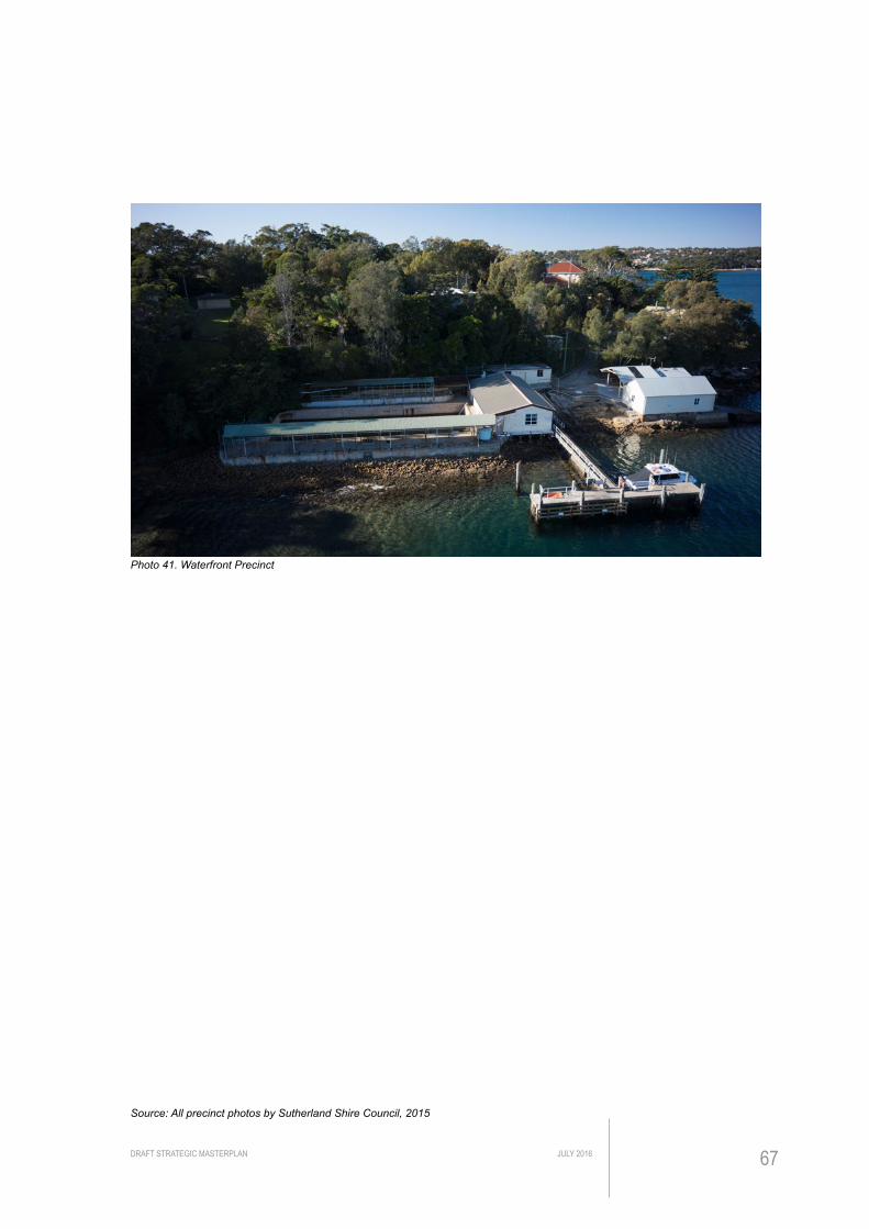
DRAFT STRATEGIC MASTERPLAN JULY 2016 67
Source: All precinct photos by Sutherland Shire Council, 2015
Photo 41. Waterfront Precinct

DRAFT STRATEGIC MASTERPLANJULY 201668
FIGU
RE 8.
OVE
RALL
CON
TEXT
PLA
NPL
AN N
TS0
1020
40m
23
10
11
9
20
19
8
22
21
7
65
1
3
4
15
13
16
1814
12
2
LEG
EN
D
E
arly
wor
ks a
rea
E
xist
ing
law
n ar
ea
E
xist
ing
gard
en b
ed a
rea
K
now
n m
idde
n lo
catio
n
P
rese
rvat
ion
of re
mna
nt
vege
tatio
n
S
tage
d re
mov
al o
f wee
d tre
e
sp
ecie
s
P
ropo
sed
new
tree
P
ropo
sed
bush
rege
nera
tion
E
xist
ing
build
ing
with
occ
upan
cy
E
xist
ing
build
ing
inve
stig
ated
for f
utur
e re
-use
E
xist
ing
herit
age
build
ing
or
no
ted
with
cul
tura
l sig
nific
ance
in th
e C
MP
E
xist
ing
build
ing
iden
tifie
d in
CM
P fo
r pot
entia
l fut
ure
de
mol
ition
(pen
ding
DA
)
To B
ass
& Fl
inde
rs P
oint
Pedestrian lane
No.
12
No.
190
No.
211
No.
213
No.
10
No.
8N
o. 6
N
E
xist
ing
driv
eway
/pat
h to
be
dem
olis
hed
E
xist
ing
road
reta
ined
(s
hare
d zo
ne)
C
ar p
arki
ng im
prov
emen
t
P
ropo
sed
road
impr
ovem
ent
P
ropo
sed
new
gar
den
be
d/re
vege
tate
d ar
ea
E
xist
ing
pede
stria
n ac
cess
to b
e re
tain
ed
E
xist
ing
info
rmal
wal
king
trai
l
to b
e re
tain
ed in
the
shor
t
te
rm u
ntil
new
pat
h is
bui
lt
P
ropo
sed
in-s
itu s
hare
d pa
th,
m
in. 3
m w
ide
P
ropo
sed
elev
ated
3m
w
ide
shar
ed w
alkw
ay
w
ith b
alus
trade
P
ropo
sed
ram
p w
ith h
andr
ail
P
ropo
sed
stai
r acc
ess
Fu
ture
ele
vate
d ra
mp/
w
alkw
ay (p
endi
ng fu
rther
in
vest
igat
ion)
Fu
ture
in-s
itu p
ath
(pen
ding
furth
er in
vest
igat
ion)
E
xist
ing
fenc
ing
& g
ate
to b
e
de
mol
ishe
d &
rem
oved
P
ropo
sed
boom
gat
e
(Ope
ratio
nal &
pub
lic p
reci
nct)
P
ropo
sed
bolla
rd
P
ropo
sed
seat
/pic
nic
setti
ng
P
ropo
sed
wat
er b
ubbl
er
P
ropo
sed
bike
par
king
P
ropo
sed
bin
P
ropo
sed
pede
stria
n lig
htin
g
CO
WR
A P
LAC
E
PORT HACKIN
G
GNNAMATTA BAY
GUNGUNNA
NNAGUN
NICHOLSON PARADE
DA
RO
OKK
PAR
K
Impr
oved
ped
estr
ian
acce
ss.
Exi
stin
g pe
dest
rian
acce
ss to
be
upgr
aded
with
3m
wid
e ne
w s
tairs
and
pat
h, a
djac
ent a
rea
to b
e re
vege
tate
d.
Hun
gry
Poin
t Clif
f Top
Wal
k.
Exi
stin
g w
alki
ng tr
ail t
o be
form
alis
ed w
ith 3
m
elev
ated
pat
h &
hig
h-qu
ality
bal
ustra
ding
.
Seat
ing
area
.P
rovi
sion
of s
eat/r
est s
top
area
at r
egul
ar
inte
rval
s an
d/or
pot
entia
l vie
win
g sp
ot.
Ada
ptiv
e re
use
of B
uild
ing
13, 1
5 &
16.
Bui
ldin
gs to
be
inve
stig
ated
for p
oten
tial f
utur
e us
e. B
uild
ing
16 to
be
dem
olis
hed
shou
ld th
ere
be n
o fu
ther
use
.
Bus
h re
gene
ratio
n al
ong
the
cliff
edg
e.
Are
a be
twee
n pr
opos
ed p
ath
and
the
cliff
to
be
reve
geta
ted
with
nat
ive
plan
ts.
Coo
rdin
atio
n w
ith b
ushc
are
requ
ired.
Look
out/v
iew
ing
plat
form
opp
ortu
nity
. P
rovi
sion
for v
iew
ing
plat
form
/term
inus
poi
nt fo
r fir
st s
tage
wor
ks.
Futu
re u
nive
rsal
acc
ess.
Pot
entia
l loc
atio
n of
DD
A ac
cess
ible
ram
p, fi
nal
loca
tion
subj
ect t
o pr
opos
ed u
seag
e of
Bui
ldin
g 16
.
Pede
stria
n lig
htin
gLi
ghtin
g lo
catio
ns a
re in
dica
tive
only.
Lig
htin
g de
sign
is
requ
ired
and
will
be
dete
rmin
ed d
urin
g de
sign
de
velo
pmen
t pha
se.
Dire
ct a
cces
s.
Pro
visi
on fo
r DD
A co
mpl
iant
sta
ir ac
cess
to
the
uppe
r lev
el o
f the
site
. Fin
al
loca
tion
subj
ect t
o fu
ture
use
rs’ d
eman
d.
Exis
ting
rope
trai
l ret
aine
d.
Pro
visi
on o
f dire
ct a
cces
s to
the
rope
tra
il an
d ne
w s
afet
y si
gns
to b
e pr
ovid
ed
subj
ect t
o ris
k an
alys
is.
Dem
oliti
on o
f Bui
ldin
g 4
& 5
(fut
ure
stag
ing)
. D
emol
ition
of b
uild
ing
will
enh
ance
app
reci
atio
n of
oth
er s
igni
fican
tbu
ildin
gs &
may
allo
w a
cces
s /
impr
ovem
ent w
ithin
the
land
scap
e
Dem
oliti
on o
f Bui
ldin
g 8,
9, 1
9 &
20
(fut
ure
stag
ing)
. D
emol
ition
of b
uild
ing
will
enh
ance
ap
prec
iatio
n of
oth
er s
igni
fican
tbu
ildin
gs &
may
allo
w a
cces
s/im
prov
emen
t with
in th
e la
ndsc
ape
Futu
re d
emol
ition
of 1
950’
s bu
ildin
g ad
ditio
n.
As
reco
mm
ende
d in
the
CM
P th
e ea
st w
ing
addi
tion
may
be
dem
olis
hed
whe
re th
ere
is n
o fu
ture
long
-term
us
e. R
esto
ratio
n of
stru
ctur
es (f
acad
e &
ent
ries)
sho
uld
be c
onsi
dere
d.
Pres
erva
tion
of re
mna
nt v
eget
atio
n.A
ll re
mna
nt v
eget
atio
n to
be
iden
tifie
d,
prot
ecte
d an
d en
hanc
ed.
Ref
er to
168
61-C
P-02
Sta
ge 1
Pro
pose
d W
orks
Pla
n fo
r fur
ther
det
ails
.
Dem
oliti
on o
f Bui
ldin
g 12
& 1
4.B
uild
ing
slab
and
driv
eway
to b
e re
tain
ed fo
r sh
ort t
erm
use
dur
ing
stag
e 1
of w
orks
Dem
oliti
on o
f Bui
ldin
g 18
(fun
ding
ava
ilabl
e).
Dem
olis
hed
build
ing
and
driv
eway
are
as to
be
retu
rfed
to in
crea
se g
reen
ope
n sp
ace,
ad
ditio
nally
new
tree
pla
ntin
g fo
r sha
de.
New
furn
iture
to im
prov
e us
er e
xper
ienc
e.In
clud
es n
ew b
ike
park
ing
faci
lity,
bin
& b
olla
rd
adja
cent
to n
ew s
hare
d pa
th.
Safe
ty im
prov
emen
ts to
car
park
are
a.M
inor
impr
ovem
ent w
orks
to m
eet s
afet
y gu
idel
ines
sub
ject
to ri
sk s
tudy
.
Futu
re a
cces
s im
prov
emen
t on
Dar
ook
Park
.O
ppor
tuni
ty to
impr
ove
acce
ssib
ility
to S
tace
y S
t/Red
gum
Ave
nue
to th
e no
rth.
DD
A co
mpl
iant
acc
ess
to D
aroo
k Pa
rk a
nd
shar
ed z
one
road
s.
All
inte
rnal
road
s ar
e pr
opos
ed to
be
shar
ed z
one
(10k
m/h
r). U
pgra
de o
f exi
stin
g ro
ad to
cur
rent
sa
fety
sta
ndar
d su
itabl
e fo
r sha
red
path
.
Secu
red
vehi
cle
entr
y to
ope
ratio
nal a
rea.
B
oom
gat
e(s)
and
bol
lard
s to
con
trol p
ublic
acce
ss to
ope
ratio
nal a
reas
.
Dem
oliti
on o
f exi
stin
g fe
nce
& e
lect
ric g
ate.
Par
tial d
emol
ition
of f
ence
and
ele
ctric
gat
e to
allo
w
open
ing
up o
f site
and
new
pla
ntin
g to
def
ine
pede
stria
n ar
eas.
Sub
ject
to ri
sk a
naly
sis.
Futu
re p
ath
impr
ovem
ent a
long
Nic
hols
on P
arad
e.Fu
ture
pla
nnin
g fo
r pat
h co
nnec
tion
alon
g N
icho
lson
P
arad
e. S
ubje
ct to
Cou
ncil
budg
et a
nd p
rogr
ams.
180o v
iew
ing
area
acr
oss
Gun
nam
atta
Bay
& P
ort H
acki
ng.
Pro
visi
on o
f DD
A co
mpl
iant
acc
ess
to
the
view
ing
poin
t req
uire
s ex
tens
ive
switc
hbac
k ar
rang
emen
t and
ve
geta
tion
clea
ring.
To
be
inve
stig
ated
with
det
ail d
esig
n.
Vaca
nt b
uild
ings
with
cul
tura
l sig
nific
ance
. B
uild
ing
2 &
21
are
reco
gnis
ed in
the
CM
P to
hav
e cu
ltura
l si
gnifi
canc
e. L
ong-
term
rete
ntio
n to
be
revi
ewed
sub
ject
to fu
ture
use
.
Impr
oved
acc
ess
& p
rivat
e pr
oper
ty in
terf
ace
agai
nst p
edes
tria
n la
ne.
Exi
stin
g ve
ry s
teep
ped
estri
an a
cces
s pa
th &
sta
irs to
be
dem
olis
hed.
Futu
re a
cces
s im
prov
emen
t of t
he C
oast
al W
alk.
Futu
re u
pgra
de o
f ped
estri
an p
aths
& la
ne ju
nctio
n fo
r D
DA
(Dis
abili
ty D
iscr
imin
atio
n A
ct) c
ompl
iant
con
nect
ion.
Hun
gry
Poin
t Clif
f Top
Wal
k.P
ropo
sed
elev
ated
wal
kway
to c
ompl
ete
conn
ectio
n to
sou
ther
n po
int o
f the
site
and
join
s at
gra
de b
ehin
d B
uild
ing
1.
Upg
rade
of e
xist
ing
acce
ss.
Rat
iona
lisat
ion
and
upgr
ade
of e
xist
ing
acce
ss a
roun
d B
uild
ing
1, 5
& 6
to s
uit p
ropo
sed
adjo
inin
g D
DA
com
plia
nt
grad
es. S
ome
entry
alte
ratio
n to
bui
ldin
g m
ay b
e re
quire
d.

DRAFT STRATEGIC MASTERPLAN JULY 2016 69
IMPL
EMEN
TATI
ON

DRAFT STRATEGIC MASTERPLANJULY 201670
WELCOMING THE PUBLIC TO THE RESERVE
The initial works to be undertaken on site are focused on opening up the Reserve Precinct for public access, there will be no major enhancement to be undertaken on site other than to make good/safe the area with non-invasive methods and safety signage.
Works programme had been prepared in detail for the purposes of a grant application under the 2016 Public Reserves Management Fund Program to include asset planning and commercial feasibility studies as well as the detailed design and construction of access path and associated landscape works described below. The full scope of works programme was subject to a successful result of the grant application. However, the outcome of the grant application has not been successful, therefore the Trust with Council’s assistance has reviewed the works proposal to suit the available funding.
The work is proposed to occur in two stages – early works to make the precinct safe for public access and Stage 1 works to facilitate recreational use of the precinct with specific amenities such as seats and bins.
Additionally the early stage works (see Figure 9) will be broken down into two stages to work with DA process timing:
• Early Works Stage A: To allow north eastern to central reserve precinct to be open for public access (Anticipated opening date in December 2016, scope subject to funding). This will include erection of temporary signage, removal of pest tree species, erection of temporary fencing to delineate the operational perimeter, temporary bollards to delineate pedestrian way and road linemarking;
• Early Works Stage B: To allow north western reserve precinct to be open for public access (Anticipated to commence January 2017 pending DA approval). Similar works program as Stage A with additional demolition/dismantling of Building 12 and 18.
Once the early stage works are completed, the following works can be programmed, subject to available funding:
• Stage 1 Works (see Figure 10): Detail design, construction of a public pathway and associated landscape works. It is hoped that this may commenced in 2017, subject to successful grant application;
• Works in the Clifftop Walk Precinct are proposed to be commenced in 2018-2019; and
• Works in the Operational Precinct are proposed to commence in 2018-2019.

DRAFT STRATEGIC MASTERPLAN JULY 2016 71
Full implementation of the Strategic Masterplan will be depended on sources of funding for the Hungry Point Trust which includes fees from the leases of on-site buildings and grant funding. Grant applications were made in 2014 (successful), 2015 (successful) and 2016 (not successful). The details of these grants are as follows:
• Grant 1: 2014-15 Public Reserves Management Fund Program for land survey and demolition of building;
• Grant 2: 2015 Restoration and Rehabilitation Grant application for funds for removal of pest species palms, Bushcare and nursery propagation of Prosanthera densa; and
• Grant 3: 2016 Public Reserves Management Fund Program for detailed design and construction of access path and associated landscape works, asset planning and commercial feasibility studies.

DRAFT STRATEGIC MASTERPLANJULY 201672
22
21
7
3
4
15
13
16
1814
12
LEG
EN
D
E
arly
wor
ks a
rea
E
xist
ing
law
n ar
ea
C
144
12
18 18
12
LEG
END
S
tudy
are
a fo
r Hun
gry
Poi
nt
R
eser
ve o
peni
ng
E
arly
wor
ks fe
ncin
g ar
ea, r
efer
to
E
arly
Wor
ks P
rogr
am n
otes
E
xten
t of f
enci
ng to
con
stru
ctio
n
st
orag
e ar
ea
E
xist
ing
law
n ar
ea
E
xist
ing
gard
en b
ed
E
xist
ing
arch
aeol
ogic
al
re
mna
nt s
truct
ure
to b
e pr
otec
ted
K
now
n m
idde
n lo
catio
n
P
rese
rvat
ion
of E
EC
veg
etat
ion
S
tage
d re
mov
al o
f wee
d tre
e
sp
ecie
s
P
ropo
sed
new
tree
(sta
ged
with
rem
oval
of e
x. tr
ees)
B
ush
rege
nera
tion
wor
k ar
ea
B
uild
ing
to b
e de
mol
ishe
d
E
xist
ing
driv
eway
/pat
h
asso
ciat
ed to
Bui
ldin
g 12
, 14,
18 to
be
reta
ined
E
xist
ing
road
reta
ined
and
con
-
verte
d to
one
-way
traf
fic
B
itum
en a
rea
not a
cces
sibl
e to
publ
ic d
ue to
saf
ety
E
xist
ing
pede
stria
n ac
cess
to
be
re
tain
ed
P
ropo
sed
tem
pora
ry e
ntry
sig
n
NIC
HO
LSO
N P
ARAD
E
P
ropo
sed
way
findi
ng s
igna
ge
P
ropo
sed
inte
rpre
tive
sign
age
P
ropo
sed
bolla
rd
P
ropo
sed
acce
ssib
le to
ilet
P
ropo
sed
publ
ic p
arki
ng a
rea
P
ropo
sed
acce
ssib
le p
arki
ng
14
Pro
pose
d bu
sh re
gene
ratio
n w
ork
on b
ank
area
. Inc
lude
s w
eed
clea
ranc
e, p
lant
ing,
est
ablis
hmen
t &
ongo
ing
mai
nten
ance
.
Lim
ited
park
ing
spac
es p
rovi
ded
in E
arly
W
orks
per
iod.
Thr
ee s
pace
s to
be
rese
rved
for m
aint
enan
ce v
ehic
le a
nd
bush
care
gro
up
Pro
pose
d ac
cess
ible
par
king
. Inc
lude
s ro
ad re
surfa
cing
(reg
radi
ng),
min
or w
ork
to g
arde
n be
d, s
ignp
ostin
g an
d ne
w
linem
arki
ng.
EAR
LY W
OR
KS
PRO
GR
AM
NO
TES
The
early
wor
ks p
rogr
am in
clud
es fe
ncin
g ar
eas
not o
pen
for
gene
ral p
ublic
acc
ess,
rem
oval
of w
eed
tree
spec
ies
(onl
y tre
es
with
in a
rea
are
show
n on
this
pla
n), d
emol
ition
wor
k an
d m
akin
g go
od a
nd s
afe
area
for p
ublic
acc
ess.
The
pro
gram
will
be
impl
emen
ted
in tw
o st
ages
:
Sta
ge A
O
peni
ng u
p th
e no
rth e
aste
rn a
nd c
entra
l par
t of t
he R
eser
ve in
its
cur
rent
con
ditio
n w
ith n
o in
vasi
ve w
orks
or m
inor
gro
und
wor
ks o
nly
to a
llow
for s
igna
ge a
nd s
ecur
able
gat
es to
the
Ope
ratio
nal a
rea.
Sta
ge B
Ope
ning
up
the
north
wes
tern
par
t of t
he R
eser
ve o
nce
Bui
ldin
g 12
and
18
are
dem
olis
hed.
Pot
entia
l to
open
up
toile
t fac
ility
in B
uild
ing
16 fo
r sho
rt-te
rm u
se. E
ntra
nce
to th
e fa
cilit
y to
be
conf
irmed
.
All
rem
nant
veg
etat
ion
to b
e id
entif
ied,
pr
otec
ted
and
enha
nced
.
Top
carp
ark
area
not
ope
n fo
r pub
lic v
ehic
le
use
and
to b
e m
ade
safe
in S
tage
1 w
ork
subj
ect t
o de
tail
desi
gn a
nd fu
ture
pro
gram
.
Exi
stin
g ro
ad to
be
conv
erte
d to
sha
red
zone
ro
ad, o
ne w
ay tr
affic
onl
y. In
clud
es s
ome
road
re
pair
and
sign
age.
Lock
able
gat
e to
eac
h op
erat
iona
l acc
ess
road
and
san
dsto
ne b
olla
rd a
s sa
fety
bar
rier
and
to d
elin
eate
sha
red
path
.
Bui
ldin
g 12
to b
e de
mol
ishe
d to
the
base
sl
ab.R
etai
n ba
se s
lab
and
mak
e sa
fe e
xpos
ed
surfa
ces.
Bui
ldin
g 18
dem
olis
hed/
dism
antle
d to
gro
und.
Bui
ldin
g 14
may
be
dem
olis
hed
whe
n th
ere
is n
o de
man
d fo
r use
.
Pro
pose
d sa
ndst
one
bolla
rd in
stal
led
as
requ
ired
to a
ddre
ss s
afet
y re
quire
men
ts.
AR
EA
SH
OW
N IN
GR
AY IS
NO
T PA
RT
OF
EA
RLY
W
OR
KS
PR
OG
RA
MM
E.
RE
FER
TO
STA
GE
1 W
OR
KS
PLA
N F
OR
MO
RE
IN
FOR
MAT
ION
.
Exi
stin
g ga
te a
nd fe
nce
to re
mai
n.
Pro
vide
sho
rt-te
rm e
ntry
sig
nage
with
key
mes
sage
s an
d in
form
atio
n.
Tem
pora
ry e
ntry
sig
nage
to H
ungr
y P
oint
Res
erve
. Par
king
to b
e re
stric
ted
on n
atur
e st
rip, a
cces
s to
priv
ate
prop
erty
driv
eway
to b
e re
tain
ed.
Rem
ove
exis
ting
Kop
pers
Log
s ed
ging
bet
wee
n pr
opos
ed s
hare
d zo
ne ro
ad a
nd la
wn
area
.
Sta
ged
rem
oval
of e
xist
ing
3x C
oral
tree
s.
Rep
lace
d w
ith 3
new
tree
s m
inim
um.
STA
GE
A
STA
GE
A
CO
NST
RU
CTI
ON
STO
RA
GE
STA
GE
B
DR
AFT
FO
R R
EV
IEW
- E
AR
LY W
OR
KS
PLA
N9/
9/16
FIGU
RE 9.
EAR
LY W
ORKS
PLA
NPL
AN N
TS

DRAFT STRATEGIC MASTERPLAN JULY 2016 73
EARLY WORKS STAGES
The early works program will be completed over two stages as outlined in the previous chapter. The full scope of both stages include:
• Demolition of Buildings 12 & 18 to increase open space, view opportunities and the sense of connectivity to Darook Park. These buildings are not required to be retained on heritage grounds and do not make a positive contribution to the open space. The existing slab of each building is to be retained temporarily but made good/safe until detail design informs the required finished work in subsequent stages. The existing paths and driveways associated within these buildings are to be retained and made good/safe until further detailed design is undertaken as part of Stage 1 works;
• Temporary fencing and lockable gates to delineate the Reserve Precinct from the Operational Precinct. A 1.8m high ATF style fence will allow passive surveillance between precincts, and will be secured between panels and fixed to above ground footing. Vehicle access beyond the fenced area will be for operational and authorised staff only;
• Temporary signage/banner signs with key objectives of the project and/or artistic visualisation;
• Place a temporary low visual impact barrier to the upper level car park. The upper car park has an existing risk/safety issue that would need to be addressed before this car park can be open to the public;
• Removal of the bamboo screen adjacent to the upper car park;
• Installation of temporary signage for wayfinding and public access information;
• Removal of tree weed species across the site, where these can be removed from the hard stand areas;
• Planting of new generation of trees; and
• Installation of low-key, low cost interpretive structure to highlight important context or view found in the site.

DRAFT STRATEGIC MASTERPLANJULY 201674
22
21
7
3
4
15
13
16
1814
12
LEG
EN
D
E
arly
wor
ks a
rea
E
xist
ing
law
n ar
ea
C
18818818818818144
12
LEG
EN
D
S
tudy
are
a fo
r Sta
ge 1
wor
k
A
rea
rese
rved
for c
onst
ruct
ion
stor
age
with
sec
urab
le fe
ncin
g
E
xist
ing
law
n ar
ea
N
ew tu
rf ar
ea s
ubje
ct to
det
ail
de
sign
E
xist
ing
gard
en b
ed
P
ropo
sed
gard
en b
ed
E
xist
ing
arch
aeol
ogic
al re
mna
nt
st
ruct
ure
to b
e pr
o tec
ted
K
now
n m
idde
n lo
catio
n
P
rese
rvat
ion
of E
EC
veg
etat
ion
P
ropo
sed
new
tree
B
ush
rege
nera
tion
wor
k ar
ea
E
xist
ing
road
sur
face
upg
rade
d
su
bjec
t to
deta
il de
sign
B
itum
en a
rea
conv
erte
d to
mul
ti-
pu
rpos
e ac
tivity
. Pot
entia
l
pr
ogra
m u
nder
inve
stig
atio
n
E
xist
ing
pede
stria
n ac
cess
to b
e re
tain
ed a
nd m
ade
safe
P
ropo
sed
form
alis
ed d
esig
nate
d
pe
dest
rian
wal
kway
E
xist
ing
wal
king
trai
l ret
aine
d
w
ith fu
rther
risk
ass
essm
ent
P
ropo
sed
elev
ated
3m
wid
e
sh
ared
wal
kway
with
bal
ustra
de
P
ropo
sed
stai
r acc
ess
E
xist
ing
fenc
ing
& g
ate
to b
e
de
mol
ishe
d &
rem
oved
P
ropo
sed
secu
rabl
e bo
om g
ate
(ope
ratio
nal &
pub
lic p
reci
nct)
NIC
HO
LSO
N P
ARAD
E
P
ropo
sed
entry
sig
n
P
ropo
sed
way
findi
ng s
ign
P
ropo
sed
inte
rpre
tive
sign
P
ropo
sed
bolla
rd
P
ropo
sed
seat
P
ropo
sed
picn
ic s
ettin
g
P
ropo
sed
wat
er b
ubbl
er w
here
conn
ectio
n pe
rmits
P
ropo
sed
bike
par
king
P
ropo
sed
bin
P
ropo
sed
pede
stria
n lig
htin
g
su
bjec
t to
light
ing
desi
gn
A
cces
sibl
e to
ilet (
TBC
with
early
wor
ks d
etai
l des
ign)
P
ublic
par
king
are
a
A
cces
sibl
e pa
rkin
g
CO
NST
RU
CTI
ON
STO
RE
Upg
rade
d pe
dest
rian
acce
ss to
3m
wid
e. In
clud
es
dem
oliti
on o
f exi
stin
g pa
th, n
ew fo
otpa
th, e
leva
ted
stai
rs a
nd h
andr
ail w
ith re
cess
ed li
ghtin
g.
Opp
ortu
nity
for b
ush
rege
nera
tion
activ
ity to
enh
ance
re
mna
nt v
eget
atio
n.
Pro
pose
d H
ungr
y P
oint
clif
f top
wal
k to
term
inat
e at
lo
okou
t/vie
win
g ar
ea. I
nclu
des
3m s
hare
d pa
th/e
leva
ted
boar
dwal
k &
alu
min
ium
bal
ustra
ding
.
Pro
pose
d vi
ewin
g pl
atfo
rm/te
rmin
us p
oint
. In
clud
es 2
x se
ats,
a w
ater
bu
bble
r & a
ssoc
iate
d w
ater
co
nnec
tion.
Fin
al lo
catio
n su
bjec
t to
deta
il de
sign
.
Pro
pose
d S
SC
sta
ndar
d w
ayfin
ding
sig
ns.
Pro
pose
d bu
sh re
gene
ratio
n w
ork
on b
ank
area
con
tinue
s.
Incl
udes
wee
d cl
eara
nce,
pl
antin
g, e
stab
lishm
ent &
on
goin
g m
aint
enan
ce.
Par
king
spa
ces
and
num
bers
pro
vide
d is
sub
ject
to c
hang
e ba
sed
on
addi
tiona
l stu
dy (i
e. ri
sk a
sses
smen
t &
traffi
c st
udy)
.
NO
TE:
All
prop
osed
fini
shes
, fur
nitu
re a
nd
fixin
g (in
clud
ing
sign
s) s
ubje
ct to
fu
rther
des
ign
and
cons
ulta
tion
with
S
take
hold
ers
Pro
pose
d ca
r par
king
im
prov
emen
t to
allo
w fo
r 2x
acce
ssib
le p
arki
ng. I
nclu
des
road
re
surfa
cing
(reg
radi
ng),
min
or
wor
k to
gar
den
bed,
sig
npos
ting
and
new
line
mar
king
.
All
rem
nant
veg
etat
ion
to b
e id
entif
ied,
pro
tect
ed a
nd e
nhan
ced.
S
afet
y im
prov
emen
ts to
car
park
are
a.In
clud
es re
pair
to e
xist
ing
wal
l, ne
w g
arde
n be
d, s
tone
bol
lard
to w
este
rn s
ide
of c
arpa
rk,
rem
oval
of e
xist
ing
linem
arki
ng a
nd n
ew
linem
arki
ng to
reco
nfig
ure
park
ing
bays
to
curr
ent s
afet
y st
anda
rds.
Upg
rade
of e
xist
ing
road
to c
urre
nt s
afet
y st
anda
rd s
uita
ble
for s
hare
d pa
th/z
one
(10k
m/h
r). I
nclu
des
drai
nage
impr
ovem
ent,
kerb
& g
utte
r, si
gnpo
stin
g an
d bi
tum
en ro
ad
resu
rfaci
ng w
ork
whe
re re
quire
d.
DR
AFT
FO
R R
EV
IEW
- S
TAG
E 1
WO
RK
S P
LAN
9/9/
16
Pro
pose
d sh
ared
zon
e w
ith s
ands
tone
bo
llard
to fo
rmal
ise
desi
gnat
ed a
reas
Lock
able
boo
m g
ate
to e
ach
oper
atio
nal a
cces
s ro
ad a
nd s
ands
tone
bol
lard
as
safe
ty b
arrie
r and
to
delin
eate
sha
red
path
.
Pro
pose
d 2x
sea
t on
exis
ting
conc
rete
sla
b. F
inal
lo
catio
n su
bjec
t to
deta
il de
sign
.
18x
pede
stria
n lig
ht p
oles
with
in w
orks
lim
it su
bjec
t to
fina
l lig
htin
g de
sign
. Allo
w fo
r con
duit
trenc
hing
an
d el
ectri
cal c
onne
ctio
n.
Pro
pose
d S
SC
sta
ndar
d in
terp
retiv
e si
gnag
e to
pr
ovid
e in
form
atio
n on
sig
nific
ant c
ultu
ral r
emna
nts.
Pro
pose
d st
ainl
ess
stee
l bik
e ra
ck a
s pe
r SS
C P
ublic
Dom
ain
Des
ign
Man
ual.
Pro
pose
d pi
cnic
set
tings
inst
alle
d on
exi
stin
g sl
abas
per
SS
C P
ublic
Dom
ain
Des
ign
Man
ual.
Dem
olis
h ex
istin
g fe
nce
and
gate
to th
e ex
tent
sho
wn.
Pro
pose
d en
tranc
e tre
atm
ent t
o th
e re
serv
e. In
clud
es m
ass
plan
ting,
fe
atur
e tre
es s
ands
tone
bol
lard
and
form
alis
ed e
ntry
sig
nage
.
Pro
pose
d lo
ckab
le S
SC
sta
ndar
d bo
om g
ate
at re
serv
e ac
cess
.
Sta
ged
rem
oval
of e
xist
ing
3x C
oral
tree
s an
d re
plan
t with
12x
nat
ive
tree
spec
ies
(in a
ccor
danc
e to
SS
C 4
:1 tr
ee re
plac
emen
t pol
icy)
.
FIGU
RE 10
. STA
GE 1
PLAN
PLAN
NTS

DRAFT STRATEGIC MASTERPLAN JULY 2016 75
STAGE 1 WORKS
The full scope of Stage 1 works include:
• Stage 1 of the cliff-top walk and connection to Esplanade;
• Returf or make good the building platform of Building 12, 14 & 18 site where required as per detail design;
• Minor repair to roads and damaged service(s) to an acceptable safety standard;
• Construction of new pedestrian access from Salmon Haul Reserve to Hungry Point Reserve where funding allows;
• Construction of new pedestrian path and make good all shared pedestrian and vehicle zone areas within the site;
• Partial removal of the northern fence, on the eastern side of the entrance;
• Installation of new lighting and furniture (bollards, seat, picnic setting, bubbler & bins);
• New tree planting and revegetation;
• Upgrade of carparking areas to safety standard and provision of accessible parking; and
• New interpretive signage.

DRAFT STRATEGIC MASTERPLANJULY 201676
BUSINESS PLAN
ELEMENTS OF THE BUSINESS PLANAs with any Business Plan the core elements of the strategy are:• A clear concept and planning principles;
• Establishment of capital and recurrent costs;
• Identification of business revenue and other funding sources (grants etc); and
• An implementation plan.
The Strategic Masterplan proposals provided the first of these elements and the nature of the remaining four is briefly summarised below:
Capital and Recurrent CostsThe costs for all works not immediately associated with building uses by lessees will need to be established once detailed design is completed to establish budget requirements for the Trust. Importantly, the considered design of all landscape areas and native vegetation management should be focused on minimising recurrent maintenance costs. Volunteers such as bushcare groups could further assist in this regard with benefits for community involvement and reduced cost.
Business Revenue and Other Funding SourcesThe range of business activities on the site will form the principal sources of income to the Trust through leases and licences. The funding of upgrades to the site and its maintenance will need to match the progressive establishment of these business activities and this will likely take a number of years to evolve. Sourcing other funding such as through grants for green space should therefore be an early step in the Business Plan.
Implementation ProgramThe progressive implementation of the Business Plan should follow a clear chronology of tasks as outlined in ‘Implementing the Business Plan’ and this would also include periodic reviews.
OBJECTIVESThe objectives of this Business Plan, as a key element in the development of a Strategic Masterplan for the site’s future use and enjoyment are to:
• Establish the basis on which the financial sustainability of the site can be assured;
• Determine the nature and scale of appropriate businesses operating on the site;
• Set the business principles for future uses of the site and buildings; and
• Identify means of optimising returns and minimising costs for the upkeep of the site by the Trust.
Importantly, the goal is not to find uses for the site and buildings simply for the purposes of generating revenue, but rather to determine appropriate uses that extend the site’s values and enjoyment and which are able to ‘wash their face’ in respect of costs incurred in their refit and operation.

DRAFT STRATEGIC MASTERPLAN JULY 2016 77
BUSINESS PLAN
IMPLEMENTING THE BUSINESS PLANThere is a number of critical steps that must be followed in the further development and implementation of this Business Plan which can be summarised in a chronology as follows:
• Undertaking scoping studies/feasibility analysis of commercial options for buildings .
• Undertaking investigations for Asset Management Plan including Building Conditions Appraisal & Asbestos Register to determine constraints and opportunities for future site and building uses (including demolition and adaptive use requirements);
• Undertaking a survey of the numbers and regularity of people walking past the site on the peninsula walk and Darook Park. This will help establish baseline footfall numbers for businesses such as kiosk and cafes;
• Finalising operational and financial arrangements with the existing organisations that are approved to operate on the site;
• Continuing discussion and negotiations already in train with potential building users. It is recommended that these organisations sight the Conservation Management Plan and this Draft Business Plan so that they can identify how they would respond to the recommendations of the CMP and meet the Objectives and Principles of the Draft Business Plan
• Refining Masterplan proposals to establish capital and recurrent costs and identifying works necessary for businesses to operate;
• Identifying appropriate funding sources, including government grant;
• Preparing a public Call for Expressions of Interest from businesses that can meet the principles in this Plan;
• Evaluating such submissions and undertaking more detailed negotiations with businesses that best meet the business parameters; and
• Preparing universal leasing, licensing and hire policies and terms.
Finally, this Business Plan must necessarily be carried out in parallel with the progression and implementation of the Strategic Masterplan visions.

DRAFT STRATEGIC MASTERPLANJULY 201678
ACHIEVEMENTS TO DATE
The following activities have been completed, or are in progress for implementation of the masterplan and the development of the site:
REVIEW AND UPDATE OF DRAFT STRATEGIC MASTERPLAN This has involved a complete revision of the document and update to include• Archaeological Strategy;
• Landscape Strategy;
• Precincts & Phasing rationale for the site;
• Incorporation of information from the adopted Conservation Management Plan (2016);
• Details of early stage and first stage works;
• Revision of the Next Steps and identification of Achievements; and
• Recognition of grant funding secured and applied for.
The following activities have been completed, or are in progress for the implementation of the Strategic Masterplan. A number of the key steps identified for implementation have been achieved.
INVESTIGATIONThe opening up of the site has required a number of investigation including: • Conservation Management Plan (CMP) for the Hungry Point Site. The CMP has
been completed by Architectural Projects and was adopted by the Hungry Point Trust in April 2016. It has been submitted to the Heritage Office for review and endorsement. This Draft Masterplan has been updated to include the findings of the CMP. The CMP develops an understanding of the heritage values of the site through investigation of its historical and geographical context, its history, fabric, research potential, and importance to the community. The final findings of the CMP will also need to be considered for the development of detailed Masterplan design and Business Plan;
• A building condition appraisal report has been prepared for Building 7 to inform negotiations for the use of the building by the State Emergency Services (SES);
• Preparation of Tree Survey, identifying significant trees, vegetation group and less significance planting for consideration in the masterplan design;
• Complete and detailed land survey of the site.

DRAFT STRATEGIC MASTERPLAN JULY 2016 79
ACHIEVEMENTS TO DATE
PLANNING AND DESIGNFinding design solutions for this complex site has involved: • Preparation of concept plans for Early works and Stage 1 including landscape
upgrades, path installation and works program; these concepts will lead to detailed documentation and tender of the works;
• Preparation of a precinct plan forming part of this draft Masterplan, including identification of early works and subsequent staging over a period of years;
• Preparation of a Landscape Plan (tree and vegetation management plan) for the site to ensure the preservation of significant trees, removal of weed and species and reinforcement of landscape character;
• Development of a detailed sketch design of the site to include defined spaces, paths, walls, fences, planting, materials and finishes (in part);
• Works staging; identification of early works and subsequent staging over a period of years, tied to the funding strategy; and
• Early works design concepts; these works will be designed, detailed and costed to a tender/construction ready stage (in part).
CONSULTATION AND COMMUNICATION Two key tasks have been: • Adoption of the Draft CMP by the Hungry Point Trust;
• Discussion with Bushcare groups on their potential to be involved with the management of native vegetation on site.
COSTINGAs a complex site the activities to be developed will have uncertainties in terms of their costings. Studies are proposed to reduce the risk of this uncertainties include: • Whilst the Harley report 2012 provides some initial costing for major works on
site, these costings have been expanded in the process of preparing for the opening up of the site;
• Grant applications have been completed for demotion of buildings, vegetation removal of pest species and other works associated with opening up of the site; and
• Grant application included request for funding for the development of Asset Management Plan, Risk analysis and Commercial opportunities.

DRAFT STRATEGIC MASTERPLANJULY 201680
NEXT STEPS
The following key steps have been identified for implementation of the Strategic Masterplan and the development of the site. A schedule that indicates the key elements, time frame and indicative cost plan will be prepared to provide further detail to the next steps described below.
INVESTIGATIONA number of investigations are required for the next steps including: • Preparation of a building condition appraisal, asbestos register and management
plan. The building appraisal and the asbestos register will be a reference tool to assess the soundness and condition of individual building, and identify areas where works proposed may contain asbestos or otherwise. Both documents will advise how to deal with building management and asbestos related issues;
• Stormwater assessment and management plan. The stormwater management plan will facilitate catchment based management of stormwater quality and quantity across the site. This will also permit preparation of Water Sensitive Urban Design (WSUD) for the site;
• A survey count of pedestrian passing the site on peninsula walk;
• Undertake necessary investigations to improve safety and work health safety requirements for proposed activities;
• Feasibility investigation and planning for income generating activities at two precincts, the Waterfront Precinct and the Migrant Hostels;
• Geotechnical and contaminated land investigations; and
• Traffic and transport review.
PLANNING, DESIGN AND COSTINGSteps in the area of planning, design and costing include: • Preparation of Development Application to secure approvals to undertake Early
and Stage 1 works;
• Preparation of a Plan of Management (POM) for the site. The POM plan as informed by the CMP will provide a blueprint for the future management and operation of the site;
• Preparation of concept plans for landscape upgrades, path installation and works program; these concepts would lead to detailed documentation and tender of the works;
• Development of a detailed sketch design of the site to include defined spaces, paths, walls, fences, planting, materials and finishes for Stages 2-5;
• Preliminary cost plan providing indication of the overall probable cost of the works, allowing the Trust to determine a funding strategy and define the staging of the works for Stages 2-5; and
• Prepare Asset Management Plan including asset condition and the identification of services and conduit locations.

DRAFT STRATEGIC MASTERPLAN JULY 2016 81
NEXT STEPS
CONSULTATION AND COMMUNICATIONConsultation and communication steps include: • Public exhibition of the Draft Masterplan and Business Plan in parallel with the
CMP which will inform the update to the Masterplan;
• Wider stakeholder consultation as the Trust may deem necessary;
• Adoption of the Draft Masterplan, POM, Business Plan by the Hungry Point Trust and/or other key stakeholders as required;
• Open days on the site to assist the community in becoming familiar with the site and its opportunities; and
• Consult with the local, heritage and Aboriginal communities on this important site as the site is State Heritage Listed and is especially complex requiring sensitivity to both european and Aboriginal Heritage. Ongoing consultation will be required for the commercial feasibility proposals, park construction and to provide information to community as the site is progressively opened up.
PROGRAM The program to open up the site is described in Early Stage and Stage 1 Works. Given the length of the program before public access to the site is formalised it will be important to communicate to the community how the program will evolve and to provide regular updates on progress.
COSTING The completion of feasibility studies regarding possible commercial opportunities for the site will assist in meeting the long term sustainability of the site. Feasibility studies are proposed (subject to funding) for the Waterfront precinct and the Migrant Hostel precinct.
EARLY CONSTRUCTION WORKSWhile the further development of the Strategic Masterplan will more clearly define the staging and costing of implementation, it is anticipated that some of the early stage construction will comprise works that permit safe public access to the site and ensure the effective operational use of the site by organisations that already have or will shortly have leases on buildings.
The following expands on some of these potential early construction works and their application is illustrated in outline form in the Strategic Masterplan (see Figure 4).

DRAFT STRATEGIC MASTERPLANJULY 201682
Public AccessThe implementation of early works and Stage 1 works subject to funding being available will secure early public access to the site with the work including: • Directional signage and a map of the site located at key entry points, identifying
public access paths and the core features of the reserve;
• A formalised footpath around Hungry Point Reserve extending out to the rock outcrop on the headland and joining Darook Park to the west of the site and Salmon Haul Bay and the Bass and Flinders walk to the east of the site;
• Relocation of the public footpath immediately to the north of the site’s northern boundary to a route through the Reserve further to the south;
• Formalised access to the beach to permit access around the headland in lower tides (this should also include warning signage indicating that such access cannot be achieved at high tide); and
• Design of site security measures on the northern boundary including fencing, gates and vehicle bollards.
Subject to available funding these early works might also include:• A rationalised internal road alignment from the entry to the core of the site including
control gates; and
• A consolidated small public car park close to the northern boundary of the site, principally for reserve visitors accessing the buildings.
These works would also need to be carried out in concert with the proposed open space works.
Open SpaceThe opening up of the northern part of the site to public use is an important dimension of early access. Early construction works would entail:• Creating lawn areas, including the necessary levelling of the ground to ensure
usability;
• Planting to define spaces and add amenity and shade; and
• Management of native vegetation.
This is the implementation of Early works and Stage 1 works is subject to funding being available.

DRAFT STRATEGIC MASTERPLAN JULY 2016 83
Associated WorksEarly works and Phase 1 • Demolition of buildings not deemed to serve an appropriate use and that would
prevent completion of the above works (Buildings 12, 14 and 18); and
• Vegetation management to ensure key views are retained or enhanced.
Such works might also include enabling works to ensure safe access to buildings for which leases have been signed.
Stages 2-5 As the project develops various components of associated works will need to be undertaken.

DRAFT STRATEGIC MASTERPLANJULY 201684
Photo 42. View looking out to Port Hacking from site, Photo by Sutherland Shire Council, 2015

DRAFT STRATEGIC MASTERPLAN JULY 2016 85
BIB
LIO
GR
APH
Y
• Cronulla Fisheries Site: Recommendation for Future Use, David Harley AM, November 2012
• The Burra Charter, Australia ICOMOS, 1999
• Sutherland Shire Council Local Environmental Plan, Sutherland Shire Council, 2015
• Historical images from Sutherland Shire Council Local Studies
• The Cronulla Fisheries Centre, ID 5045100, Australian Heritage Places Inventory website, 2013
• Hungry Point Reserve, Cronulla Conservation Management Plan, Architectural Projects, 2016
• Tree Survey, Sutherland Shire Council, 2013
• Detailed Site Survey, Sutherland Shire Council, 2015
• Summary of Notes, Workshop 2 Resident Consultation (to follow).
Copyright © 2022 FDOKUMEN